rweyemamu_phd.pdf - research@lincoln
TRANSCRIPT
Lincoln University Digital Thesis
Copyright Statement
The digital copy of this thesis is protected by the Copyright Act 1994 (New Zealand).
This thesis may be consulted by you, provided you comply with the provisions of the Act and the following conditions of use:
you will use the copy only for the purposes of research or private study you will recognise the author's right to be identified as the author of the thesis and
due acknowledgement will be made to the author where appropriate you will obtain the author's permission before publishing any material from the
thesis.
Understanding the Factors Leading to Conflicts among
Agropastoralist and Farming Communities in Morogoro region,
Tanzania, and their implications for wellbeing
A thesis
submitted in partial fulfilment
of the requirements for the Degree of
Doctor of Philosophy
at
Lincoln University
by
Dennis Rugeiyamu Rweyemamu
Lincoln University
2019
ii
Abstract
In Africa, access to resources such as land, water, forest and wildlife reserve areas is a key factor for
sustainable development. The scarcity and degradation of these resources in rural environments
threatens human security, leading to conflicts. Tanzania is a developing country in the East Africa,
where nearly 70% of the land is village land supporting 80% of the population as farmers and
agropastoralists. Agropastoralists practice a production system in which they depend (>50% of
income generation and sustenance) on livestock, with the remaining portion on crop farming for
food. This system entails some family members seasonally travelling large distances with their stock
in search of water and pasture for grazing, while others remain at home and practice crop farming
during the growing season. Despite the economic importance of pastoralism, most economic
development policies in Tanzania perceive pastoralism as unproductive, unorganised, and
environmentally destructive. Therefore, agropastoralists are persistently evicted and/or forced to
move to marginal areas along the periphery where basic services are lacking. This movement is
creating serious land use conflicts and violence between agropastoralists and farmers due to
conflicting goals and interests over the same land resources.
Land resource use conflicts related to pastoralism in Tanzania are well documented, but the
mechanisms underlying these conflicts are not. Consequently, there is limited understanding of the
mechanisms by which agropastoralists gain access to and use of land resources in Morogoro region,
and how these mechanisms contribute to conflict between farmers and agropastoralists. To address
this gap, an analytical framework was developed (based on Ribot and Peluso’s Access Theory) and
modified to fit the Tanzania context. This modified Theory together with the Sustainable Livelihoods
Framework were used to identify mechanisms by which agropastoralists gain and control access to
and use of land resources, and how these mechanisms contribute positively and negatively to both
their wellbeing and the wellbeing of the natural resource base, and to conflicts with farmers in
Morogoro region. Additionally, this research employed Social Conflict Theory, which focuses on the
dynamics and transformations of conflicts for a better understanding of why and how conflict
between farmers and agropastoralists escalate into violence. Lastly, this research assessed the trend
and extent of environmental and rangeland degradation, perceived to be caused by the increasing
numbers of humans and livestock in Morogoro region.
This research is interdisciplinary, involving both social science and biophysical science (i.e., analysis of
land use and cover changes), thus employed multi and interdisciplinary approaches including
ethnography, multi-data collection methods, GIS and Remote Sensing techniques, checklist of
rangeland assessment indicators, and qualitative (i.e., interviews and discussions) and highly
quantitative spatial analysis of Landsat images.
iii
Results demonstrate that agropastoralists use legal and illegal mechanisms to gain and control access
to and use of land resources. The legal mechanism involves possession of a certificate for village land.
Illegal mechanisms involve: (1) bribing corrupt individuals in authorities, (2) force and coercion, and
(3) deceptive and stealthy approaches against farmers and village leaders. These mechanisms helped
agropastoralists to sustain their material and financial wellbeing while concurrently compromising
other aspects of their current and future wellbeing and compromising the wellbeing of farmers and
the natural resources that both communities depend on. The way farmers lose their land by illegal
mechanisms (e.g., bribes, force and coercion, and deception and stealth) is a critical factor that
contributes significantly to land resource conflicts. However, in contrast to West African countries,
where labour and social identity play significant roles in enabling pastoralists to gain and control
access to land resources, this study revealed that three mechanisms identified in Access Theory,
namely, labour, social identity and knowledge, made no significant contribution in this region of
Tanzania. With these findings, a new analytical framework (model) was created that appears to fit
well in the East Africa context as opposed to the West African.
Conflicts between farmers and agropastoralists in Morogoro region escalated to violence following
the general patterns and transformation dynamics (i.e., process variables) described in Social Conflict
Theory. These process variables involve tactics shifting from light to heavy, goals shifting from
specific to general, and involvement shifting from few to many. The analysis of conflicts, undertaken
by focusing on process variables (conflict dynamics), enabled the identification of new factors
(culture, age and gender of participant in the conflict) that helped explain why some conflicts
between farmers and agropastoralists escalate to deadly violence. The study recommends that
formation of a loose coalition (e.g., Elders’ Tribunal) which includes equal representation of members
from the farmer and agropastoralist communities may help solve the current conundrum caused by
top-down administrative procedures and practices, which often leads to outcomes that are
ineffective and unsatisfactory to all parties.
There are huge changes in land cover and use in the study areas with associated links to
environmental and rangeland degradation. The areas covered by forests, woodland/grassland and
water have decreased, whereas bare land has increased. These changes were largely associated with
a combination of factors such as increased population density of both humans and livestock, and
subsequent economic activities including but not limited to charcoal business, timber harvesting,
mineral mining, extensive and large-scale cultivation, and keeping of excessive numbers of livestock.
Also, this research identified 30 indicators classified into five categories used by agropastoralist and
farmer interviewees to assess environmental and rangeland degradation. Of the 30 indicators, 25
came from a pre-prepared checklist of 31 indicators derived from the literature, and the remaining
five – soil crusting and cracking and soil muddiness, risk of wildfires, and diversification of livelihoods
iv
activities and conflicts over land resources – emerged during interviews. It is recommended that
government invest in education that will create greater awareness of the impacts of individual and
collective choices of, e.g., livelihood activities for both individual wellbeing and the wellbeing of the
natural resource base.
Keywords: access mechanisms, agropastoralists, farmers, conflict, land resources, climate change,
wellbeing, Tanzania
v
Acknowledgements
In the end, perseverance; hardwork; devotion; dedication; sacrifice and God’s timing have
triumphed. I would like to thank God Almighty for bringing me this far!
Firstly, I am indebted to my employer, the Muhimbili University of Health and Allied Sciences for
granting me the study leave to pursue my scholarship here at Lincoln University in New Zealand.
Many thanks also goes to all research participants (the householders, group discussants, Morogoro
government officials and NGOs) for sharing their experiences and opinions that made this study
technically possible. Your valuable input has hugely contributed to the successful completion of this
research.
I would especially like to thank my supervisors, Prof. Ken hughey and Dr. Lin Roberts, for their trust in
me as a person, and my abilities. Thank you for your academic guidence, insightful comments
throughout my research writing. Your undoubted trust, dedication, and honest guidance and
encouragement throughout my research journey is something I will remember for as long as I live.
I feel extremely honoured to be among many scholars who pursued their education career here at
Lincoln University. Therefore, I am very grateful to my sponsors: NZAID scholarship for according me
the opportunity to pursue my studies in this wonderful coountry, New Zealand. Special thanks goes
to Sue Bowie, Jayne Borrill and Mandy Buller from the scholarship office for making my stay at
Lincoln University and New Zealand at large so sowonderful with fond of memories. Many thanks to
Douglas Broughton and Tracey Shields from the Faculty of Environment, Society and Design for their
support.
My best friend and lovely wife Joyce, thank you so much for the love, support and encouragement
you gave me throughout this journey. I can imagine how difficult it has been sometimes, assuming all
responsibilities as a Mother and Dad during my absence, but you did that exeptionally well. To my
beautiful daughters: Dyness (Koku), Jocelyne (Kisha) and Danette (Siima), I say Dad will be home
soon, so no more asking “Baba, unarudi lini?” in English (Dad, when are you coming back?).
To my Dad Mr. Leopold Rweyemamu and Moms Ms. Restituta and Ms. Theodosia (RIP) and my
siblings Alistidia, Davis, Joan, Alice, Clavery, Anna and Maria; I say thank you so much for your
encouragement and support. You have always been a source of inspiration for me to explore new
horizon in the academic world.
Nothing has been more important to me than having quality times for a glass of wine/beer with
friends after hardwork of reading and writing. I owe much thanks to Tali, Parry, George and Hassan.
vi
Table of Contents
Abstract ....................................................................................................................................... ii
Acknowledgements ...................................................................................................................... v
Table of Contents ........................................................................................................................ vi
List of Tables ................................................................................................................................ x
List of Figures .............................................................................................................................. xi
List of Plates ............................................................................................................................... xii
List of Acronyms ........................................................................................................................ xiii
Chapter 1 Introduction ............................................................................................................ 1
1.1 The changing face of pastoralism in East Africa .......................................................................1
1.2 Statement of the problem ........................................................................................................3
1.3 Research objectives and questions ...........................................................................................5
1.4 Structure of the thesis ..............................................................................................................6
Chapter 2 Context .................................................................................................................... 7
2.1 Introduction ..............................................................................................................................7
2.2 History of land ownership and land tenure system in Tanzania ...............................................7
2.3 Overview of ‘land acquisition’ in Africa ................................................................................. 10 2.3.1 Political transformation and ‘land acquisition’ in Tanzania .......................................11
2.4 Timeline of pastoralist evictions over the past decade in Tanzania ...................................... 15 2.4.1 Pastoralists eviction in Mbeya region ........................................................................16 2.4.2 Pastoralists eviction in Morogoro region ...................................................................17
2.5 The role and impacts of development policies on pastoralism ............................................. 20 2.5.1 Policy deficiencies and contradictions .......................................................................20
2.6 Rangeland degradation impacts on agropastoral systems .................................................... 22
2.7 Farmer – pastoralist conflicts over land resources in sub-Saharan Africa ............................. 24 2.7.1 Causes of land resource use-related conflicts in Tanzania ........................................24 2.7.2 Land resource use conflicts escalation ......................................................................26
2.8 Conclusions ............................................................................................................................ 27
Chapter 3 Theoretical frameworks and approach .................................................................... 29
3.1 Introduction ........................................................................................................................... 29
3.2 Review of theories and frameworks ...................................................................................... 29
3.3 Access Theory ........................................................................................................................ 31 3.3.1 Access Theory vs Property Theory .............................................................................31 3.3.2 Access mechanisms ....................................................................................................32 3.3.3 Structural, Power and Social relations mechanisms ..................................................35
3.4 The Sustainable Livelihoods Approach (SLA) ......................................................................... 38 3.4.1 The origin and development of the SLA .....................................................................38 3.4.2 Formalising the SLA and Frameworks ........................................................................42 3.4.3 Key features and strengths of the SLA .......................................................................49 3.4.4 Critique of the SLA .....................................................................................................50 3.4.5 The Sustainable Livelihoods Framework and Wellbeing relationship .......................51
vii
3.5 Social Conflict Theory ............................................................................................................. 52 3.5.1 Conflict escalation ......................................................................................................53
3.6 Conclusions ............................................................................................................................ 54
Chapter 4 Research Methodology and Approach ..................................................................... 56
4.1 Introduction ........................................................................................................................... 56
4.2 Methodology .......................................................................................................................... 56
4.3 Research design and Approach .............................................................................................. 57
4.4 General description of the study areas .................................................................................. 59 4.4.1 Kilosa District ..............................................................................................................60 4.4.2 Mvomero District .......................................................................................................61
4.5 Selection of study villages ...................................................................................................... 62
4.6 Data collection methods ........................................................................................................ 63 4.6.1 Head of Household interviews (HHIs) ........................................................................63 4.6.2 Key informant interviews (KIIs) ..................................................................................64 4.6.3 Focus group discussions (FGDs) .................................................................................65 4.6.4 Personal observation and transect walks ..................................................................66 4.6.5 Desk/literature review ...............................................................................................67 4.6.6 GIS and Remote Sensing ............................................................................................75
4.7 Human ethical issues ............................................................................................................. 76
4.8 Data analysis .......................................................................................................................... 76
4.9 Limitations of the study ......................................................................................................... 77
4.10 Conclusions ............................................................................................................................ 78
Chapter 5 Mechanisms to gain access to and use of land resources .......................................... 79
5.1 Introduction ........................................................................................................................... 79
5.2 Access to and ownership of land resources ........................................................................... 79 5.2.1 Land categories and classification..............................................................................79 5.2.2 Land administration system .......................................................................................80 5.2.3 Overview of ways to access land and land ownership in Tanzania ...........................81
5.3 Mechanisms in Access Theory ............................................................................................... 86
5.4 Mechanisms to gain and control access to and use of land resources.................................. 89 5.4.1 Legal mechanisms to access land resources ..............................................................89 5.4.2 Illegal mechanisms to access land resources .............................................................92
5.5 Perception of land resources access mechanisms in relation to wellbeing .......................... 98 5.5.1 Agropastoralists’ perceptions of wellbeing attributes ...............................................98 5.5.2 Agropastoralists’ perceptions on access mechanisms in relation to wellbeing ......101 5.5.3 Farmers’ perceptions of access mechanisms used by agropastoralists ..................102
5.6 Contribution of access mechanisms to agropastoralist – farmer conflicts ......................... 104
5.7 Conclusions .......................................................................................................................... 105
Chapter 6 Proximate causes of farmer – agropastoralist conflict escalation ............................ 109
6.1 Introduction ......................................................................................................................... 109
6.2 Social Conflict Theory ........................................................................................................... 109
6.3 Conceptualizing land resource use-related conflicts ........................................................... 110 6.3.1 Types of land resource use-related conflicts ...........................................................110
6.4 Causes of land resource use conflicts and reasons for escalation ....................................... 113 6.4.1 Perceived reasons for conflicts escalation to deadly violence ................................117
viii
6.5 Farmers and agropastoralists’ perceptions of impacts of conflicts on production systems 121 6.5.1 Farmers’ perceptions ...............................................................................................121 6.5.2 Agropastoralists’ perceptions ..................................................................................122
6.6 Conflict management practices and challenges .................................................................. 124 6.6.1 Legal framework governing land dispute settlement in Tanzania ...........................124 6.6.2 Conflict management practices and challenges in the study areas .........................125
6.7 Conclusions .......................................................................................................................... 128
Chapter 7 Trend and extent of environmental and rangeland degradation ............................. 130
7.1 Introduction ......................................................................................................................... 130
7.2 Indicators used to assess environmental and rangeland degradation ................................ 130 7.2.1 Eco-physical ..............................................................................................................135 7.2.2 Vegetation ................................................................................................................135 7.2.3 Climate .....................................................................................................................135 7.2.4 Social ........................................................................................................................136 7.2.5 Livestock ...................................................................................................................136
7.3 Land use and cover changes (July 1995 – October 2017) .................................................... 136 7.3.1 Agropastoralists’ views and opinions.......................................................................140 7.3.2 Farmers’ views and opinions....................................................................................143
7.4 Perceived causes for the environmental and rangeland degradation ................................ 145
7.5 Agropastoralists and Farmers’ perceptions of impacts of degradation .............................. 147 7.5.1 Agropastoralists’ perceptions ..................................................................................147 7.5.2 Farmers’ perceptions ...............................................................................................149
7.6 Conclusions .......................................................................................................................... 151
Chapter 8 Discussion ............................................................................................................. 153
8.1 Introduction ......................................................................................................................... 153
8.2 Village land access and ownership in Tanzania ................................................................... 153
8.3 Mechanisms to gain and control access to and use of land resources................................ 155 8.3.1 Corruption and Enticement .....................................................................................155 8.3.2 Deception and stealth ..............................................................................................157 8.3.3 Force and coercion ...................................................................................................158
8.4 The contributions of access mechanisms to agropastoralist and farmer wellbeing ........... 159 8.4.1 Adapting Access Theory to the East African Context ...............................................160 8.4.2 Combining Access Theory with the Sustainable Livelihoods Aproach .....................161 8.4.3 Contribution of access mechanisms to agropastoralists’ livelihoods ......................164 8.4.4 Contribution of access mechanisms to agropastoralist and farmer’ livelihood
outcomes..................................................................................................................167 8.4.5 Contribution of access mechanisms to farmers and agropastoralists conflicts ......173
8.5 Proximate causes of farmer and agropastoralist conflict escalation ................................... 174 8.5.1 Perceived causes for conflict and reasons for conflict escalation ...........................174 8.5.2 The dynamics and transformation patterns of conflict escalation ..........................176
8.6 Overall discussion ................................................................................................................ 179
Chapter 9 Conclusions and Recommendations ....................................................................... 181
9.1 Introduction ......................................................................................................................... 181
9.2 The roles of access mechanisms in agropastoralists and farmers wellbeing ...................... 181
9.3 Causes of conflict and reasons for conflict escalation ......................................................... 182
9.4 Trend and extent of environmental and rangeland degradation ........................................ 182
ix
9.5 The integration of Access, Social Conflict Theories and Natural Asset Degradation findings ............................................................................................................................................. 183
9.6 Contribution to Theory and practice ................................................................................... 183
9.7 Recommendations ............................................................................................................... 185 9.7.1 Education and awareness ........................................................................................185 9.7.2 Appropriate and effective land use plans ................................................................186 9.7.3 Economic and land policy reforms ...........................................................................186 9.7.4 Governance institutions and effective conflict resolution mechanisms..................187
9.8 Suggestions for future research ........................................................................................... 187
References..............................................................................................................................189
Appendix A Household Interview .......................................................................................... 198
Appendix B Key Informant Interview ..................................................................................... 202
Appendix C Focus Group Discussion Guide ............................................................................ 205
Appendix D Consent Form .................................................................................................... 207
Appendix E Research Information Sheet ................................................................................ 208
x
List of Tables
Table 2.1 Summary of key events that led to pastoralists eviction in Mbeya region. ......................17
Table 2.2 Timeline over pastoralists eviction carried out in Morogoro Region. ...............................17
Table 2.3 Summary of key events that led to pastoralists eviction from the KVFP. .........................19
Table 2.4 Overview of land resource-related conflicts in northern Tanzania. ..................................25
Table 3.1 Summary of theories and methods applied in research involving farmer – pastoralist land
resource use conflicts........................................................................................................................30
Table 3.2 Matrix of needs and satisfiers ...........................................................................................41
Table 4.1 Classification of household interviewees and identification codes...................................64
Table 4.2 Classification of KIIs and the identification codes .............................................................65
Table 4.3 Summary of participant breakdown ..................................................................................67
Table 4.4 Criteria and indicators developed by the SRR for assessing the rangeland health
(Mitchell, 2010) .................................................................................................................................68
Table 4.5 Indicators on environmental degradation reported by pastoralists (Kassahun et al.,
2008) .................................................................................................................................................70
Table 4.6 Methods and/or techniques employed in research to assess environmental and
rangeland degradation ......................................................................................................................73
Table 4.7 Indicators for assessing environmental and rangeland degradation in Morogoro region
...........................................................................................................................................................74
Table 5.1 Responses by village interviewees (HHIs and KIIs) to the question “Would you like to continue
with the customary tenure system of land ownership (without a CCRO)?”.....................................84
Table 5.2 Responses by village interviewees (HHIs and KIIs) about use of illegal mechanisms to
access land resources ........................................................................................................................93
Table 5.3 Wellbeing attributes identified by discussants in agropastoralist FGDs ...........................98
Table 5.4 Interviewees (HHIs and KIIs) responses to the question “do illegal access mechanisms
contribute to resource-use related conflicts between farmer and Agropastoralist?” ...................105
Table 6.1 Interviewees responses to the question “are there any land resource use-related conflicts in
your village?” ..............................................................................................................................111
Table 6.2 Types of land resource use-related conflicts identified by village interviewees.............112
Table 6.3 Interviewees responses to the question “what are the possible causes for resource use-
related conflicts in your community?” ............................................................................................114
Table 7.1 Agropastoralist and farmer interviewees’ perceptions of environmental and rangeland
assessment indicator changes (Interviewees could tick more than one category)........................132
Table 7.2 Emergent rangeland assessment indicators mentioned during interviews ....................134
Table 7.3 Analysis of significance of land use/cover changes at Kilosa (1995-2017) .....................139
xi
Table 7.4 Analysis of significance of land use/cover changes at Mvomero (1995-2017) ...............139
List of Figures
Figure 3.1 Mechanisms (means, processes and relations) for gaining, maintaining and
controllingaccess to and use of land resources (a visual representation developed from the text of
Ribot & Peluso, 2003) ....................................................................................................... ................34
Figure 3.2 DFID Sustainable Livelihood Framework (Carney & Ashley, 1998) ..................................44
Figure 4.1 (a and b) - Africa and Tanzania (URT, 2002), (c) location of study districts - Kilosa and
Mvomero, and (d) study villages in Kilosa and Mvomero Districts ..................................................60
Figure 5.1 Mechanisms (means, processes and relations) for gaining, maintaining and controlling
access to and use of land resources (a visual representation developed from text of Ribot & Peluso,
2003, with initial adaptation to the Tanzanian context by omission of their mechanism
“labour”)..........................................................................................................................................88
Figure 5.2 Access mechanisms employed by agropastoralists to gain, maintain and control access
to, and use of land resources in Kilosa and Mvomero Districts.....................................................107
Figure 7.1 Agropastoralists and farmers’ perceptions of the environmental and rangeland
trends............................................................................................................................................134
Figure 7.2 (a) Land use/cover map of Mvomero District in July 1995; (b) Land use/cover map of
Mvomero District in October 2017...............................................................................................137
Figure 7.3 (a) Land use/cover map of Kilosa District in July 1995; (b) Land use/cover map of Kilosa
District in October 2017...............................................................................................................138
Figure 7.4 Land use and cover change statistics for the period July 1995 – 2017.......................139
Figure 8.1 Resource Access Mechanisms and their connections to the SLF, as applied to East
Africa............................................................................................................................................163
xii
List of Plates
Plate 5.1 Excavated trench and heaped soil between Kambala and Dihombo Villages ...................91
Plate 7.1 Watering trough that has gone dry due to extended drought in Twatwatwa Village in 2016.................................................................................................................................................141 Plate 7.2 (a) Morans wandering with livestock searching for pasture and water; (b) Cattle taking
cover in Twatwatwa Village ............................................................................................................142
Plate 7.3 Livestock feeding on dry grass remains in Kambala.........................................................143
Plate 7.4 Paddy field located in the farmers’ village of Rudewa-mbuyuni .....................................145
Plate 7.5 Agropastoralists attending a cow unable to stand on its feet in Twatwatwa Village ......148
xiii
List of Acronyms
ACHPR: African Commission on Human and People’s Rights ASAL: Arid and Semi-arid Land CBO: Community Based Organisation CCRO: Certificate of Customary Rights of Occupancy CCWT: Chama cha Wafugaji Tanzania – Tanzania Pastoralists Association CSO: Civil Society Organisation CVL: Certificate for Village Land COSTECH: Tanzania Commission for Science and Technology DALO: District Agricultural and Livestock Officer DAS: District Administrative Secretary DC: District Commissioner DED: District Executive Director DFID: Department for International Development DLHT: District Land and Housing Tribunal DLO: District Land Officer FGD: Focus Group Discussion GIS: Geographical Information System GR: Game Reserve HHI: Household Interview IWGIA: International Work Group for Indigenous Affairs KDC: Kilosa District Council KII: Key Informant Interview KVFP: Kilombero Valley Floodplain LULC: Land Use Land Cover Changes MDC: Mvomero District Council MLHHSD: Ministry of Lands, Housing and Human Settlements Development NARCO: National Ranching Company NGO: Non-Governmental Organisation NP: National Park PINGO: Pastoralists Indigenous Non-Governmental Organisation RAS: Regional Administrative Secretary RC: Regional Commissioner SLA: Sustainable Livelihood Approach TANAPA: Tanzania National Parks Authority TANU: Tanganyika African National Union UK: United Kingdom UNDP: United Nations Development Programme URT: United Republic of Tanzania VALO: Village Agricultural and Livestock Officer VEO: Village Executive Officer WCED: World Commission on Environment and Development WEO: Ward Executive Officer WMA: Wildlife Management Area TNRF: Tanzania Natural Resources Forum
1
Chapter 1
Introduction
Africa is known for its diverse natural resources including those in arid and semi-arid areas that
include biodiversity hotspots (UNEP, 2007). Apart from their contribution to national economies from
tourism income earnings, these drylands also provide a favourable environment for grazing (Reda,
2015). About 40% of the world’s 200 million pastoralists1 and agropastoralists2 live in Africa (Behnke
& Freudenberger, 2013). While pastoralists depend entirely on animal production for their livelihood,
agropastoralists earn their income from a mixture of livestock husbandry and agriculture. In the
African context, pastoralism is referred to as a form of livestock production in which livestock
keepers move with their livestock from place to place to exploit pasture and water availability at
different seasons during the year (Kileli, 2014; Reda, 2015). Livestock serve many roles in a pastoral
society: as both the means and outcomes of production, as sources and objects of labour, as value,
and as social pride, culture and capital goods (Galaty & Johnson, 1990; Herrero, Thornton, Gerber, &
Reid, 2009). Therefore, in African countries with large pastoralist and agropastoralist communities,
livestock production is not only the main livelihood activity of these communities, but also their
source of social pride and security (Worku, Pretzsch, Kassa, & Auch, 2014). There are challenging
aspects to the relationships between these groups – this thesis explores these within the context of
the changing face of pastoralism in East Africa.
1.1 The changing face of pastoralism in East Africa
Before the late 1960s, pastoralists and agropastoralists in East Africa often lived more sustainably
through a series of institutionalized, customary-based, and adaptive strategies where flexibility in
time and space for accessing resources (i.e., pasture and water) was crucial. However, since the
colonial3 period (1885-1960), pastoralists and agropastoralists have been perceived by authorities
and development organizations as unproductive, unorganized (i.e., they roam around) and
environmentally destructive, i.e., causing overgrazing and desertification (Tsegaye, Vedeld, & Moe,
2013). National development policies of modern East African states tend to favour agriculture, which
1 Pastoralists: People practicing the production system in which they depend solely on livestock and their products for sustenance and income. In the African context, it entails seasonal movement in search of water and pasture. 2 Agropastoralists: People practicing the production system in which they depend (>50% of income and sustenance) on livestock, with the remaining portion on crop farming for food. Agropastoralists can also practice seasonal movement by allowing some family members to graze stock at a far distance while others remain at home and practice agricultural activities, especially during growing season.
3 Colonial period: This refers to the period of Western Colonialism when East African land was under the mandate of the Germans (1886-1916), then the British (1919-1960). Tanganyika (now Tanzania) obtained its Independence in 1961.
2
leaves a visible trace in the landscape as evidence of land use, while pastoral use is more invisible
and considered as a ‘waning mode of life’ and therefore cannot easily be used to justify prioritized
access or property rights. Since land use rights are granted to those who clear the land and add
‘productive value’ to it, pastoralists and agropastoralists have difficulties policing their rights
(Benjaminsen, Maganga, & Abdallah, 2009). As a result, the sustainability of agropastoralists’
livelihoods is threatened through increased vulnerability to shocks, and farmer–agropastoralists
conflicts start to emerge and increase both in number and severity (Campbell, Lusch, Smucker, &
Wangui, 2005; Reid et al., 2000).
Tanzania’s total land area is 94 million hectares, of which 70% is rural village land supporting 80% of
the population as farmers and agropastoralists, 28% is reserved land, and 2% is urban land
supporting the rest of the population (Askew, Maganga, Odgaard, Lund, & Boone, 2013; Martin,
2010). Of the country’s total area, nearly 80% (60 million hectares) is classified as semi-arid
(Mwakaje, 2013), and receives sufficient rainfall seasonally to be suitable for grazing (URT, 2006). The
national census shows that farming and livestock keeping is the main economic activity (65%) for
most Tanzanians (URT, 2014 ). Tanzania has the third largest livestock population in Africa,
comprising 25 million cattle and 16.7 million goats (URT, 2015b). Pastoralists and agropastoralists
own 98% of the cattle, with 80% of the cattle in the agropastoral system and 18% are in the pastoral
system (Mwakaje, 2013). The big ranches and dairy farms own only 1% of the cattle (Martin, 2010).
The livestock industry has maintained a steady annual income growth rate of 2.2% during the last
decade, which is lower than the 2.8% growth rate of the human population (URT, 2006, 2015b). This
growth mostly reflects an increase in livestock numbers rather than productivity gains (Mwambene
et al., 2014).
Livelihood sustenance and changes in rangeland resource use are major concerns in the context of
pastoral development in sub-Saharan Africa (Tsegaye et al., 2013). Since the mid-1980s, the
agropastoral production system in Tanzania has been facing a shortage of natural pastures and water
for livestock. Pastoralists and agropastoralists’ village lands and rangelands are increasingly being
converted to other land uses including extensive farming and wildlife conservation (Benjaminsen &
Bryceson, 2012; Fratkin & Mearns, 2003; Ibrahim, Abdurrahman, & Umar, 2015). In Tanzania, game
reserve expansion and additions and appropriation of customary land by local and foreign investors
facilitated by ongoing government economic policy reforms has further contributed to the shortage
of grazing land (Mwambene, Mwakalile, Udo, & Mbuya, 2010). These policy reforms have been
advocating pastoral land alienation in favour of small and large-scale agriculture, and conservation in
the form of game parks (Chachage & Mbunda, 2009b; Martin, 2010; Peters, 2004). Climate change
also threatens the agropastoral production system in East Africa (Oluwole, Tumushabe, Katongole, &
Onu, 2017; Owuor, Mauta, & Eriksen, 2011), and Tanzania in particular (Mwakaje, 2013; Sendalo,
3
2009; Shem, Mtengeti, & Mutayoba, 2005), and future predictions indicate the agropastoral sector
will be severely impacted.
The factors mentioned above, together with others such as increases to the livestock and human
populations, poor infrastructure (e.g., lack of cattle dips4 and/or water points5), livestock diseases
(tsetse flies), hostile market mechanisms, and inadequate and poor social services (schools, health
centres) have contributed to increased movement of agropastoralists with their livestock into areas
which traditionally had few livestock, such as Mbeya, Iringa, Rukwa, Coast regions, and Morogoro
region of Tanzania (Martin, 2010). This movement is creating serious land use conflicts6 and violence
between agropastoralists and farmers due to conflicting goals and interests over the same land
resources (Mwamfupe, 2015; Shem et al., 2005). For instance, in Kilosa and Mvomero Districts in
Morogoro region, conflicts between farmers and agropastoralists have escalated into violence that
claimed people’s lives (Benjaminsen et al., 2009; Kisoza, 2007; Mwamfupe, 2015).
1.2 Statement of the problem
Despite the economic importance of pastoralism, most economic development policies in Tanzania
are based on the implicit notion that pastoralism is not the most efficient use of land resources
(Gonin & Gautier, 2015; Mwambene et al., 2014). Therefore, agropastoralists are persistently evicted
and/or forced to move to marginal areas along the periphery where basic services such as cattle dips,
water points, health centres, and schools are lacking (Benjaminsen et al., 2009; Kajembe, Silayo,
Mwakalobo, & Mutabazi, 2013; Mwambene et al., 2014). Thus, the pastoral production system is
severely affected because of challenges in accessing, using and controlling available land resources in
line with the regulations, bylaws and economic development policies formulated to manage land
resources (Mandara, 2007). This research stems from the argument that land resource use conflicts
related to pastoralism in Tanzania are well documented in the literature (Benjaminsen et al., 2009;
Kisoza, 2007; Mwambene et al., 2010; Mwamfupe, 2015), but that the mechanisms underlying these
conflicts are not. The literature is largely silent on the mechanisms (means, processes and relations)
by which agropastoralists gain, maintain and control access to and use of land resources, and how
these mechanisms contribute to their wellbeing and to conflicts with farmers. Access Theory, as
proposed by Ribot and Peluso (2003), was chosen to address the question of how, without always
4 Dips: Constructed structures/trenches used to treat livestock for parasites. Usually they are under communal ownership; if owned by the state department, they are operated under fees. 5 Water points: These are built structures/earth dams used to store water for livestock consumption.
6 The term “conflict,” is used as an umbrella term to encompass a range of phenomena like lack of convergence of goals, interests, and expectations among social groups; the intentional pursuit of actions or livelihood strategies that result in damage to others; open confrontations resulting from conflicting interests or damaging actions; and various forms of violence (Hagberg, 1998; Hussein, 1998).
4
having legal ownership of land resources, agropastoralists have benefited from land resources in
Morogoro region in Tanzania.
The literature shows that explanations of farmer – agropastoralist conflicts in Tanzania have
generally been structural in nature including factors such as limited resource, climate change, and
corrupt practices (Kajembe, Mbwilo, Kidunda, & Nduwamungu, 2003; Kisoza, 2007; Mandara,
Hyandye, & Lawuo, 2012); biased economic polices, institutional failures to resolve conflicts, and
political context (Mandara et al., 2012; Mustafa, 1997; Mwambene et al., 2014); and insecure land
tenure, poor coordination in resettling the migrants, lack of village land use plans, and the heavy
handed approaches used to resolve conflicts (Mwamfupe, 2015, p. 1). However, there is a need to
know not just why the friction or conflict begins, but also why and how some conflicts escalate7 to
deadly violence. Moritz (2010) suggests that farmer – pastoralist conflicts are complex, products of
both structures and processes, and cannot be explained solely in terms of either. Structural variables
are necessary to explain the causes of conflict, while process variables can explain the outcomes of
conflict. In other words, the structural explanation does not explain why disputes between farmers
and agropastoralists escalate into widespread violence. These arguments raise another important
research gap that this study seeks to address. This research employed Social Conflict Theory, as
described by Kriesberg (2007) and Pruitt and Kim (2004), which focuses on the dynamics and
transformations ‘process variables’ of conflicts for a better understanding of why and how the
conflict between farmers and agropastoralists have escalated into deadly violence in Kilosa and
Mvomero Districts, Morogoro region.
The ‘Access’ and ‘Social Conflict’ related theories and research explained above have implications for
the overall wellbeing of both agropastoralists and farmers wellbeing, including ultimately for the
underlying natural resources wellbeing that both groups rely on. Existing literature on natural
resources degradation (Campbell et al., 2005; Mung'ong'o & Mwamfupe, 2003; Sangeda & Malole,
2014) suggests that climate change has altered water resources and vegetation cover (i.e., caused
rangeland degradation) in arid and semi-arid areas, forcing changes in climate-dependent production
systems, e.g., pastoralism and agriculture in Tanzania. Also, Benjaminsen et al. (2009, p. 11) reported
that there are frequent complaints linking overgrazing and environmental and rangeland degradation
in Kilosa District and consequent calls for agropastoralists to destock and adhere to the carrying
capacity of the range. While a substantial amount of research has been done on rangeland
composition and changes in relation to climate change, little, with inconclusive evidence, has been
7 Escalation: refers to an increase in severity and widening of conflict (Kriesberg, 2007). It is a situation when a party to a conflict uses heavier contentious tactics than before, i.e., demands in place of requests, angry statements in place of demands, and threats in place of angry statements which finally end up into irreversible actions like deaths and killings.
5
undertaken on the trend and extent of environmental and rangeland degradation, especially that
due to the increase of immigrant agropastoralists in Morogoro region. This is another research gap
that this research seeks to address.
1.3 Research objectives and questions
This study aims to provide a comprehensive analysis to improve understanding of the factors leading
to conflicts among agropastoralist and farming communities in Morogoro region, Tanzania, and their
implications for agropastoralists’ and farmers’ wellbeing and the natural resources wellbeingthat
both groups depend on. The following three specific research objectives and related questions are
the focus of the thesis:
1. To determine the mechanisms by which agropastoralists gain, maintain and control access to’
and use of land resources, and how these mechanisms contribute to or reduced farmers and
agropastoralists’ wellbeing and to land resource use conflicts between them;
• How do agropastoralists gain, maintain and control access to and use of land resources?
• How do the mechanisms for gaining, maintaining and controlling access to and use of land
resources contribute to or reduce the agropastoralists’ wellbeing?
• What is the farmers’ perception of these mechanisms in relation to their wellbeing?
• How do these mechanisms contribute to farmer – agropastoralist’ conflicts?
2. To determine the proximate causes of farmer – agropastoralist conflict escalation and their
impacts on both farming and agropastoral production systems;
• What types of resource-use related conflicts occurs in the community?
• What are the causes of conflict and reasons for conflict escalation?
• What are the impacts of the conflicts to farming and agropastoral production systems?
• What are the existing conflict management practices for handling and mitigating conflicts?
• What are the challenges to resolve conflicts and why? and
3. To assess the trend and extent of environmental and rangelands degradation and
agropastoralists and farmers’ perception of how the degradation has impacted their production
systems;
6
• What is the trend and extent of environmental and rangeland degradation over time (20yrs)?
• What are the causes for the trend of environmental and rangeland health observed?
• How do agropastoralists and farmers assess the rangeland degradation, and which indicators
are mostly used?
• How do agropastoralists and farmers perceive the impacts of rangeland degradation on their
production system and livelihoods?
1.4 Structure of the thesis
This thesis consists of nine chapters inclusive of this introduction which introduced the research
gaps, research objectives and research questions the study seeks to address. Chapter 2 provides a
detailed review regarding the research gaps; and reviews of Tanzania’s history of land ownership and
land tenure system, land ‘acquisition’ in Africa, trends of pastoralist evictions, impacts of
development policies on pastoralism, farmer – pastoralist conflict over land resources in sub-Saharan
Africa, and rangeland degradation impacts on agropastoral systems are also reported in this chapter
in order to complete the research context.
Chapter 3 builds on the research gaps raised in chapters 1 and 2. To address the research gaps,
chapter 3 reviews the literature on the appropriate theoretical frameworks (i.e., Access Theory,
Social Conflict Theory, and the Sustainable Livelihood Approach) used in this study. Chapter 4 details
the rationale for the chosen methodology, methods and approach used. The chapter also explains
how the qualitative data analysis was carried out and describes the ethical considerations and
limitations of the study. Chapters 5, 6 and 7 present the research findings for objective 1, 2 and 3
respectively. These findings are then discussed in chapter 8 and linked to the theoretical frameworks
detailed in chapter 3. Chapter 9 draws together the conclusions and recommendations of the study,
the contribution to theory and practices, and identifies future research areas.
7
Chapter 2
Context
2.1 Introduction
The main aim of this chapter is to present a detailed review regarding the knowledge gaps and
describe how this research can address these gaps. The chapter starts by reviewing the literature on
the history of land ownership and land tenure system in Tanzania in section 2.2. Section 2.3 presents
an overview of ‘land acquisition’ in Africa. The timeline and trends of pastoralist evictions over the
past decade follows next in section 2.4. The influence and impacts of development policies on
pastoralism is explained in section 2.5. Section 2.6 reports on farmer-pastoralist conflicts over land
resources in sub-Saharan Africa. The rangeland degradation impacts on agropastoral systems are
presented in section 2.7, and finally, section 2.8 provides a summary of the chapter.
2.2 History of land ownership and land tenure system in Tanzania
Tanzania’s property rights and resource governance systems have been in flux ever since
independence in 1961. Just prior to independence, the British colonial government attempted to
introduce the concept of freehold land ownership, but the proposal was rejected by TANU8, the
Tanzanian political party that took power when independence was granted in December 1961.
Instead, the first President of Tanganyika (now Tanzania) developed and applied the concept of
“African socialism,” an initiative that transferred the customary land rights of ethnic groups and clans
to newly established elected village councils and encouraged collective cultivation of the land
(USAID, 2011). In 1967 Tanzania declared a policy of Socialism and Self-reliance with its focus on rural
development because 85% of the people lived in the villages and were engaged in agriculture and
livestock keeping (Lugoe, 2011). During this formative post-independence socialist period, running
approximately from 1967 (the Arusha Declaration),9 national policies discouraged foreign investment
and private accumulation. The government’s leadership code prohibited involvement in private
enterprise on the part of government officials and senior party leaders, thus serving some function in
segregating the public and private sectors (Nelson, Sulle, & Lekaita, 2012).
In 1973 the Government declared that living in Ujamaa10 villages would be compulsory. It was no
longer voluntary as it had been hitherto. In the period between 1973 and 1976, Tanzania therefore
8 TANU: Tanganyika African National Union 9 Arusha Declaration: A manifesto aimed among other things, at concentrating the commanding heights of the economy in the hands of the developmentalist state 10 Ujamaa: A variant of ‘African Socialism’ loosely translated as ‘Family-hood’
8
engaged in a process of massive villagisation called “operation villages.” The aim of Ujamaa villages
was to enable easy provision of basic services such as schools, health facilities, water supply, and
where modern farming methods would be demonstrated through experimental farms by agricultural
extension officers. The villagisation program was a huge exercise in which people were removed,
often forcefully, from their isolated homesteads and brought together in planned settlements. Each
family was given a piece of land to construct a house and was expected to participate in communal
farming. Land for communal services, such as schools, was reserved. By 1979 there were about 15
million people living in 8,300 registered Ujamaa villages with a population of 250‐500 families or
1,500 to 7,500 people in each (Lugoe, 2011). Shivji (1998) revealed the following as the adverse
effects of the massive villagisation process which took place in the period between 1973 and 1976:
• Population concentrations - the relocation of scattered households into more compact
residential villages, often away from their ancestral lands. This measure was often not guided
by land use plans but sheer gut feelings of authorities.
• Land re‐distribution - the distribution of land (without owner consent) among groups and
individuals without due compensation for loss. Most ancestral lands have now been lost to
recipients of land under operation vijiji and cannot be reversed as per sections 15 and 16 of
the Village Land Act of 1999;
• New untested land administration system at the village level ‐ replacement of a rather
permanent customary land allocation system, operated under clan authorities, with elected
Village Councils, by a fast and short‐term turnover. The transition was too fast to enable a
smooth handling of land administration processes at the village level; and
• Production by peasants in the “Ujamaa villages” plummeted, due to tenure insecurity, high
population densities, newly introduced communal farming system and long distances to
nearest farms. As a result, considerable confusion was sown as people’s locations and
territories were reconfigured, without accompanying re-allocation of rights over lands
(Nelson et al., 2012).
The Ujamaa and Development Villages Act No. 21 was passed in 1975 giving powers, among others,
to village governments to acquire and plan lands within their boundaries. The Act was a logical
outcome of the second ‘post-Arusha’ policy paper, Nyerere’s (1967) Socialism and Rural
Development that envisaged permanent settlement schemes for pastoralists (Chachage & Mbunda,
2009a, p. 2). In 1982, the Act of 1975 was repealed, and village settlements were incorporated into
the Local (District) Authorities Act No. 7 of 1982 which is operative today. As further development,
the agricultural policy of 1983 was intended to give villagers very long leases over village lands (999
9
years). The enactment of this law and its policy meant also that individualized land tenure could not
be allowed as new land rights cannot be superimposed on existing ones. It was intended that anyone
living in a village would not receive individual title to land but would be collective part-owners of long
leases (Lugoe, 2011).
Tanzania’s economy collapsed in the late 1970s due to unfavourable external conditions combined
with policy mistakes and war with Uganda in 1979. This led eventually in early 1980s to the
abandonment of socialist economic policies, and witnessed the gradual opening up of liberalization
of internal and external trade, withdrawal of government support to the cooperative movement,
privatization of numerous parastatal companies, and an increasingly open attitude towards foreign
investment (Kelsall, 2002, p. 609). The transition to more liberalized and capitalist-oriented economic
policies after 1985 had profound implications for land tenure and ownership, setting off the first, and
to this day probably the most significant, period of land ‘acquisition’ in the post-independence era.
Several changes worked in concert to facilitate large-scale alienation of local communities’ lands.
Private investment and property rights began to be encouraged, including promotion of foreign
investment in line with doctrinaire structural adjustment policies (Isinika, 1994). The leadership code
was rescinded, removing constraints, both legal and normative, on public officials’ engagement in
private business (Chachage & Mbunda, 2009a, p. 3). Moreover, the divestiture of national assets,
including the land holdings of various insolvent parastatals, began in earnest. Kelsall (2002, p. 610)
describes the political economic shifts that took place in this post-liberalization period, highlighting
the way private interests and public office began to be more interconnected in the development of
both private elite accumulation and patronage-based politics:
Economic liberalization increased the desire and ability of members of the political elite to enrich themselves...other lucrative areas were to be found in land grabbing, urban real estate, and the exploitation of tax loopholes. Divestiture of parastatals also introduced a spoils character into Tanzanian politics, as politicians positioned themselves to receive kickbacks or to become part-owners of the newly privatized companies.
In addition to elite capture of former state properties, land ‘acquisition’ at this time focused on rural
areas, particularly those lands with agricultural or other notable economic potential, such as lands in
northern Tanzania valued for pastoral production and wildlife tourism. As a result, numerous land
tenure and land resources conflicts in pastoralist areas of northern Tanzania, where much land was
grabbed for either agriculture or tourism in the late 1980s and early 1990s, persist to this day as a
legacy of fraudulently acquired titles from that period (Benjaminsen & Bryceson, 2012; Nelson et al.,
2012; Shivji, 1998). While numerous land tenure conflicts and challenges have continued, it has been
demonstrated in a number of comparative analyses over the past decade, that Tanzania’s legal
framework for community level and land tenure, particularly with respect to common property
10
forests, woodlands and rangelands, is among the more progressive in Africa (Wily, 2011). It is also
notable that despite the concerns about land ‘acquisition’ at present, Tanzania is not amongst the
African countries where the largest areas of land have been allocated or acquired in recent years
(Nelson et al., 2012; Wily, 2014). The next section presents an overview of land ‘acquisition’ in Africa
and Tanzania in particular.
2.3 Overview of ‘land acquisition’ in Africa
Large-scale acquisitions of farmland in Africa involve outright land purchases or, more commonly,
long-term leases mainly on government-owned land. The reviewed media reports featured on the
blog of the International Land Coalition (ILC) for the period 2008 to 2010 states that land deals in
Africa alone covered somewhere between 51 and 63 million hectares (Friis & Reenberg, 2010). An
inventory review of media reports by Deininger et al. (2011), documented land acquisitions for 56.6
million hectares worldwide over the period of one year between 2008 and 2009. According to this
review, two-thirds (40 million ha) of the land area transacted globally was in Africa. For example, its
updated website shows that there are more than 49 million (ha) of concluded land deals, 19.8 million
(ha) of intended land deals and 8.3 million (ha) of failed land deals across the globe.11 Cotula (2012,
p. 651) states that media reports and/or research drawing on media reports, suggest that Sudan,
Ethiopia, Madagascar and Mozambique are among the key recipients of land-based investments in
Africa. However, media reports are not always reliable, and data from these sources must be treated
with caution. Also, media reports tend to emphasize global over national processes. For example,
attention usually focuses on international players, to the detriment of reporting acquisitions by
national agents, elites, and political authorities.
Although foreign nationalities have been engaged in agriculture in Africa for many years, the scale of
the business has increased hugely in recent years. According to Friis and Reenberg (2010, p. 1), Africa
has notably become an attractive destination for land investments because of its relatively low
population density. For example, the common image of Africa as land-rich and sparsely populated
still holds when the continent is compared with Asia where large rural populations exist depending,
to varying degrees, on the land (Peters, 2004). Because of the private sector’ expectations of higher
agricultural commodity prices and concerns about long-term food and energy security, the lands of
the Global South, and Africa to be specific, are increasingly perceived as a potential factor of
production for increasing global demand for alternative energy (e.g., biofuels), food crops, mineral
deposits and reservoirs of environmental services (Cotula, 2012; Friis & Reenberg, 2010). Ongoing
research by the ILC shows that commercial pressures on land are increasing in many parts of the
world because of multiple forces beyond agriculture – including extractive industries, tourism and
11 Data from the Land matrix’s Website (www.landmatrix.org); last accessed on 29 June 2018.
11
national parks.12 The large-scale land ‘acquisitions’ in Africa have kindled much international
discourse, in which strong positions are taken on the impacts of such investments on the
environment, rights, sovereignty, livelihoods of the local rural poor, and land resource use conflicts at
local, national and international levels (Cotula, 2012). The next sub-section presents an overview of
the political transformation and land ‘acquisition’ in Tanzania.
2.3.1 Political transformation and ‘land acquisition’ in Tanzania
Since 2009, Tanzania, like many African countries south of Sahara, have been implementing major
agricultural transformation initiatives. These initiatives occur against the backdrop of a sustained
influx of foreign companies acquiring large-scale land areas for commercial production of food,
tourism, forest plantations and industrial purposes referred to as ‘land grabbing’ (Sulle, 2015). From
2005 to date, Tanzania has experienced a growing number of cases of land acquisition by both
foreign and domestic investors, and eventually, this trend of land acquisition has risen to the
vanguard of social and political discourse in Tanzania in recent years. In the period 2005 to 2008, up
to 4 million hectares of land were requested for biofuels, mostly jatropha as well as some large
sugarcane schemes in river basins along the coast (Sulle & Nelson, 2009). The large majority of the
investment in biofuels was driven by European companies, including some with their own
government financing or public ownership, and most production targeted European export markets.
Nevertheless, the majority of Tanzania’s large-scale biofuel investments have since collapsed due to
factors such as the global financial crisis from 2008 and subsequent loss of cheap credit and other
forms of financing for many projects, as well as a lack of clear business plans and the disappointing
performance of jatropha in many of the trial plantations (Nelson et al., 2012).
While interest in European biofuel investments has faded, public concern around land grabbing has
continued to grow, particularly since 2009. To a large degree, the increased prominence of land
grabbing in the public discourse is a function of wider political reconfigurations and economic policy
reforms occurring in Tanzania. The ongoing political reconfigurations is marked by the departure
from the prior monopolization on power of the ruling CCM13 party, ushering in strong opposition, led
by the CHADEMA14 party. The CHADEMA’s rise into becoming a strong opposition party was driven
significantly by revealing and publicizing a string of major corruption scandals, most of which revolve
around public officials’ misuse of public resources, ranging from corruption in awarding of public
contracts to improper uses of public accounts. Cooksey and Kelsall (2011, p. 29) provide a useful
summary of these dynamics:
12 Commercial Pressures on Land. International Land Coalition. Available from:http://www.landcoalition.org/cpl [accessed on 29 June 2018]. 13 Chama cha Mapinduzi (CCM), or ‘Party of the Revolution’. 14 Chama cha Demokrasia (CHADEMA), or ‘Party of Democracy’.
12
Bribes to traffic policemen, health inspectors, customs officers, immigration officials, tax inspectors, land officers – in fact, officials in almost every department of government are par for the course and part of what it takes to do business or merely go about one’s daily life in Tanzania. For example, in 2005, the Kiwira Coal Mine was sold in a non-transparent manner to TANPOWER Resources, a company owned by former President, Minister of Energy and Minerals and their close family members. Similar stories can be told concerning the undervaluation of land for agriculture, livestock, or urban development. Senior government officials obtain land free or at below-market prices, and land owned by public agencies is sold for private development in exchange for kickbacks.
While such private capture of state resources by the political and non-political elites has been a
central part of governance and patronage politics in Tanzania since the onset of the liberalization
period in the mid-1980s, two things have stood out in recent times. First, a growing sense of
pervasive land grabs encroaching on local rights, marginalizing rural smallholder farmers and
pastoralists who depend on land, water, pasture, and other natural resources, and further
concentrating wealth and assets in the hands of political and economic elites. Second, there is a
vastly more open public discourse around corruption scandals, individual accumulation of wealth by
the political and non-political elites, use of resources, and policy decisions than prevailed for decades
(Nelson et al., 2012). It is against this setting of political transformation that the current land
grabbing, with its links to corruption, preferential appropriation of public assets by state officials, and
leading politicians’ financial interests, has been taken up as a central issue in public debates over
governance and transparency in Tanzania. Having described the overarching political-economic
transformation in Tanzania, including the ongoing economic policy reforms, the next sub-sections
present notable case examples involving large-scale land acquisition, or land tenure conflicts, set in
different parts of the country. These cases highlight the diversity in root causes and drivers of land
acquisitions in Tanzania, and their link to the wider political dynamics in the country.
2.3.1.1 Large-scale land acquisition for biofuel plantantions
As previously stated, biofuels investments waxed in Tanzania between 2005 and 2008, becoming a
major cause of large-scale land acquisition during that time. By 2009, an estimated 4 million (ha) had
been requested from the Tanzanian government through the Tanzania Investment Centre (TIC) for
biofuels projects, with roughly 640,000 (ha) having been formally allocated (Sulle & Nelson, 2009).
The allocation of these parcels of land for biofuels triggered widespread concern amongst the media
and civil society in Tanzania about the negative impacts of biofuel investments, which are twirled
around a familiar set of issues shared with biofuels investments across Africa, which have been well
documented in a range of studies carried out since 2008 in Tanzania (Gordon-Maclean, Laizer,
Harrison, & Shemdoe, 2008; Harnesk & Brogaard, 2017; Kamanga, 2008; Sulle & Nelson, 2009). These
issues include:
13
• displacement of rural populations because a large amount of land is being allocated for
investors for biofuel production. As a result, the rural poor are deprived of communal lands
which provide the basis for rural livelihoods.
• village lands are being sold off primarily due to a lack of knowledge about land rights
amongst local people. This change in land ownership has led to further displacement of many
rural poor and thus creates serious effects on the country’s long-term political stability.
• displacement of food production by biofuel crops used for export markets. This threatens
food security because many villages opted to stop cultivating food crops in order to cultivate
biofuel feedstock.
• loss of forests and many endangered ecosystems, including portions of Tanzania’s highly
biodiverse coastal forests which has many endemic species.
As far as large-scale biofuel investments in Tanzania are concerned, attention has shifted to the fact
that many of the most high-profile European-led biofuel investments have, over the past few years,
either collapsed or been sold. This is the case for the three largest biofuel investments, i.e., Bioshape
(Dutch company), SEKAB (Swedish company), and Sun-Biofuels (British company) planned or initiated
in southern coastal Tanzania in 2008 (Nelson et al., 2012). The demand for land for jatropha,
particularly, has essentially vanished, due to:
• problems with production (attributed variously to water, soil, and disease conditions in
coastal East Africa),
• loss of cheap financing for highly speculative investments which was available prior to 2008,
• jatropha’s low productivity, and policy-level reflection on the negative social and
environmental implications of the deals that were being made during the 2005-2008 period.
2.3.1.2 Village land rights and state interests in wildlife in northern Tanzania
Along with the biofuels investments, perhaps the most internationally well-publicized land tenure
conflicts in history are: firstly, the so-called ‘Steyn Lease’ of northern Tanzania’s Monduli District (in
present-day Monduli and Simanjiro Districts), whereby in 1979 the government gave one individual
farmer (a foreigner by the name of Steyn) title to 379,000 acres of land along the eastern border of
Tarangire National Park (Nelson et al., 2012, p. 4; Shivji, 1998). This land encompassed the traditional
grazing territories of several Maasai villages, whose land and water sources had already been
enclosed to some degree by Tarangire National park and has created enduring challenges for those
communities’ territorial claims to this day (Lugoe, 2011, pp. 14-15). Secondly, one that involved the
14
leasing of a hunting block, which overlapped with seven Maasai pastoralists village lands in the
Loliondo area of northern Tanzania to a foreign ecotourism and recreational hunting company,
known as Ortello Business Corporation (OBC). This company represents a senior official in the
military of the United Arab Emirates based in Dubai, who acquired the right to hunt wildlife in
Loliondo from the Tanzanian government in 1992 (Nelson et al., 2012). The land tenure conflict in
Loliondo, notably known as ‘Loliondogate’, has been exhaustively described in both popular and
academic media in Tanzania and beyond (Gardner, 2012; Honey, 2008), and has also been one of the
most prominent land scandals discussed within Tanzania. The basic facts of the conflict are framed as
(Gardner, 2012; Honey, 2008; Nelson et al., 2012):
• Tanzania village lands situated within and/or next to wildlife protected areas, which often
contain large number of wild animals, were leased out by the Ministry of Natural Resources
and Tourism as trophy hunting concessions from the 1980s when hunting was officially
opened to private operators.
• Even though there is often some ambiguity about the boundaries and extent of village lands,
in Loliondo case, all seven villages involved in the land conflict with OBC obtained title deeds
with the assistance of several church-based or pastoralist development NGOs in the early
1990s.
The land conflict in Loliondo was thus driven by several of factors, including firstly, that the Maasai
communities whose land was allocated for hunting already possessed clear land rights but were not
consulted; secondly, that those same communities had a long history of land loss and resistance, due
mainly to their historic displacement from the adjacent Serengeti National Park; and thirdly, the
foreign perceptions and prejudices associated with allocating hunting rights to an ‘Arab’ operator in
Maasai land. The Maasai pastoralist communities came to associate this project with a state led
effort to secure territory and assert national economic and political power over Maasai interests. As
a result, the Maasai leaders and activists in Loliondo have consistently framed their struggle for land
rights and access to land resources in terms of local versus national rights.
In 2009 this long state of uneasy overlapping claims exploded into violence, bringing the Loliondo
conflict back into the spotlight of the national and international media (Ngoitiko, Sinandei, & Nelson,
2010). The Tanzania Field Force Unit (FFU), a paramilitary internal security unit, carried out a forced
relocation of up to 300 households from the Maasai communities, essentially attempting to carve
out a wide livestock-free zone around the OBC hunting concession (Renton, 2009). The relocation
was seemingly brought on by increasing numbers of livestock in the Loliondo area along the border
with Serengeti National Park; this in turn was partly due to 2009 being one of the worst droughts in
recent years in northern Tanzania and Kenya. State officials justified the eviction with a range of
15
explanations, including that the land had been given by the government to a valuable private
investment and that local people had ‘invaded’, or, claiming that those evicted had not been
Tanzanians but were in fact Kenyan herders who had no rights to utilize the area (Nelson et al., 2012,
p. 14). This eviction caused extensive property damage, including the loss of an estimated tens of
thousands of livestock, internal displacement of hundreds of Maasai pastoralists, and several reports
of assault, including sexual assault, during the forced eviction (Gardner, 2012; Renton, 2009).
Following the evictions, the government attempted to consolidate a new land use system for the
area by establishing a ‘corridor’ based on the new Wildlife Conservation Act of 2009. This land use
plan was however rejected by the villages and by the Ngorongoro District Council, despite strong
pressure from higher levels of government seeking to protect OBC’s zone of operations. To this day,
the formal land use and land tenure arrangements that govern the area are the same as prior to the
2009 eviction, with no formal statutory restrictions on community land use or exercise of their
traditional rights within their village lands. The next section describes the trend of pastoralist
evictions in Tanzania.
2.4 Timeline of pastoralist evictions over the past decade in Tanzania
Contemporary Tanzanian pastoralism involves both pastoralist and agropastoralist communities
including the Maasai tribe (the large majority) and other tribes such as Datoga, Sukuma, Gogo,
Sangu, mang’ati and Hehe. Most of these groups are categorized as pastoralists practicing
transhumance and nomadic life which involve moving with livestock in well-defined socially
sanctioned annual cycles, responding to rainfall and drought to make best use of the rangelands
where they live (IWGIA, 2016). But in recent times, these pastoralist groups have transformed into
becoming agropastoralists, practicing extensive livestock keeping combined with crop cultivation. As
livestock keepers, the pastoralists together with agropastoralists, manage more than 25 million cattle
and 27.5 million small stock (URT, 2015b), which position Tanzania as the third biggest cattle holding
country in Africa (A conservate estimate of the total value of the stock is USD 13.4 billion15). Despite
this achievement, many national policies and associated regulations undermine the pastoralism
system and the knowledge that pastoralists and agropastoralists use to manage rangelands for
livestock production (Kipuri & Sorensen, 2008; Shem et al., 2005). The state has evicted and forced
the pastoralists and agropastoralists to move out of very large areas of what used to be their
traditional rangelands in order to create “protected areas”. These protected areas include National
Parks, Game Reserves and more recently Wildlife Management Areas (WMAs). As a result, many
15 This is a conservative estimate of the current (as of 16th June 2018) market value [LINKS: http://www.lmistz.net/Pages/Public/Home.aspx] of the existing herds of cattle and small stock belonging to pastoralists and agropastoralists, and is based on the (URT, 2015) figures, which states that there are 25 million cattle and 27.5 million small-stock. If cattle are worth USD 425 each on average, the total is USD 10, 625,000,000; and small-stock worth USD 100 each, the total is USD 2,750,000,000.
16
pastoralists and agropastoralists have moved from northern Tanzania regions to other parts of the
country (e.g., Morogoro region) in search of pasture and water for their livestock. With this
contemporary land appropriation by the state, it is obvious why more evictions of pastoralists and
agropastoralists from their native village lands have occurred over the past decade than any period
since colonial times (IWGIA, 2016). The following sub-sections present an overview of the main
events and trends of pastoralists and agropastoralists eviction carried out in Tanzania over the past
decade as documented and reported by IWGIA (2015, 2016) and Nelson et al. (2012). The
appropriately named “National Anti-Livestock Operation” set a trend for how evictions were carried
out in later years, characterized by massive corruption scandals and extortion accompanied by
violation of human rights.
2.4.1 Pastoralists eviction in Mbeya region
In the early 1950s, pastoralist villages were established in and around Usangu and Ihefu wetlands of
the Great Ruaha River (Mbarali District) in Mbeya region, co-existing with small-scale wet-rice
farmers and fishermen. Later, the Great Ruaha Project was initiated in the 1970s with two dams and
two hydropower plants, planned to generate 50% of Tanzania’s electricity. However, in the 1990s,
electricity rationing, and cuts began posing challenges to the country’s economy. In April 2006, the
Tanzania government announced stringent measures aimed at protecting water sources, one of
which was to evict people from river basins to mitigate the problem. The government argued that
the Great Ruaha River flow was decreasing due to the increasing number of livestock [though no
evidence produced that presence of livestock reduced river flow] and human populations, thus
impaired the performance of the hydropower plants. As a result, the National Anti-Livestock
Operation was launched to evict all pastoralists with their livestock from the Usangu/Ihefu in order to
protect the Great Ruaha River which supplies water to the hydro power stations. Civil societies
documented numerous legal and human rights violations committed during the evictions, including
the systematic dispossession of pastoralists’ livestock assets. A Presidential Commission of Enquiry
was established, and the report was handed to the president in June 2007, but it has remained
confidential and no action has been taken to address the alleged abuses. Those pastoralists who
were evicted and now live in other regions (e.g., Morogoro, Pwani and Lindi) have found it difficult to
adapt and make a new living – they do not have land, and the majority have lost most of their herds.
Table 2.1 shows summary of key events that led to the pastoralists’ eviction from the Usangu/Ihefu
wetlands in Mbarali District, Mbeya Region.
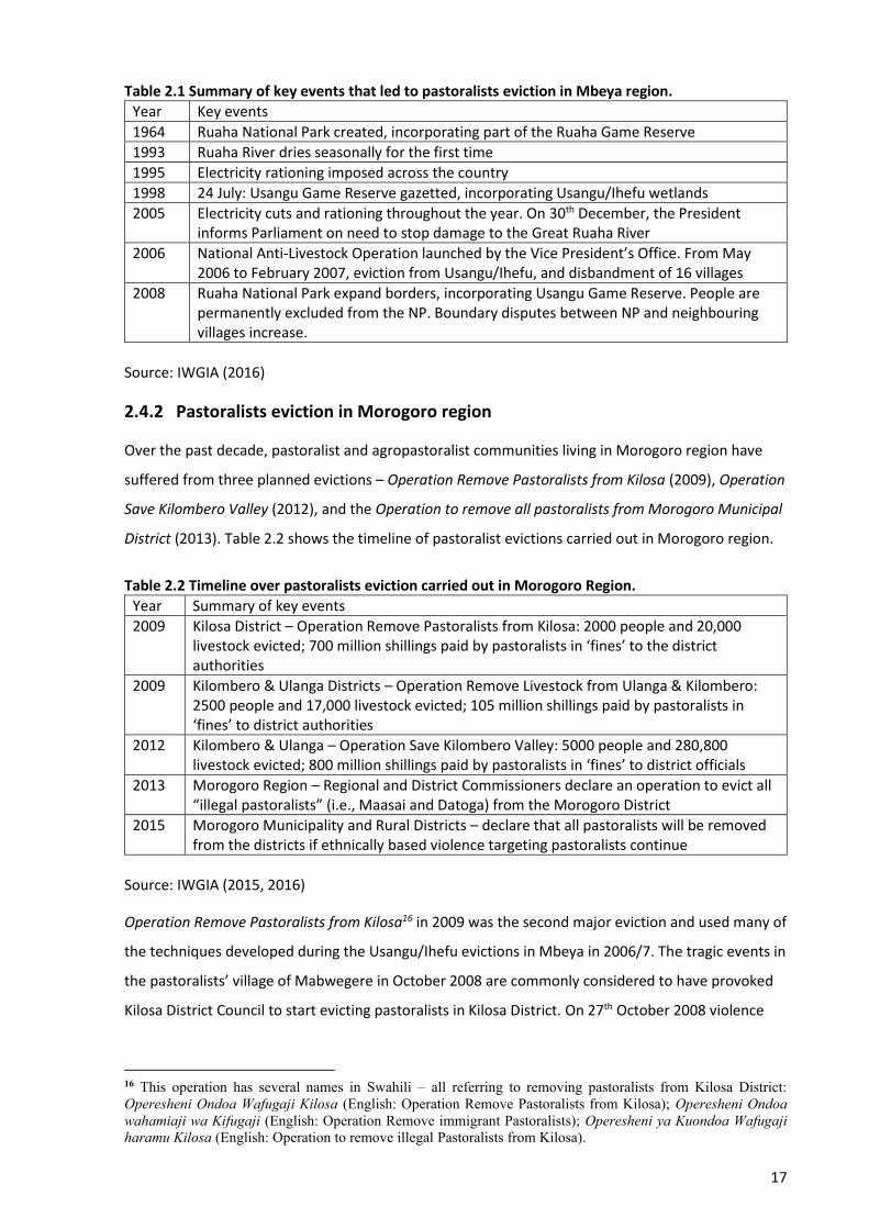
17
Table 2.1 Summary of key events that led to pastoralists eviction in Mbeya region.
Year Key events
1964 Ruaha National Park created, incorporating part of the Ruaha Game Reserve
1993 Ruaha River dries seasonally for the first time
1995 Electricity rationing imposed across the country
1998 24 July: Usangu Game Reserve gazetted, incorporating Usangu/Ihefu wetlands
2005 Electricity cuts and rationing throughout the year. On 30th December, the President informs Parliament on need to stop damage to the Great Ruaha River
2006 National Anti-Livestock Operation launched by the Vice President’s Office. From May 2006 to February 2007, eviction from Usangu/Ihefu, and disbandment of 16 villages
2008 Ruaha National Park expand borders, incorporating Usangu Game Reserve. People are permanently excluded from the NP. Boundary disputes between NP and neighbouring villages increase.
Source: IWGIA (2016)
2.4.2 Pastoralists eviction in Morogoro region
Over the past decade, pastoralist and agropastoralist communities living in Morogoro region have
suffered from three planned evictions – Operation Remove Pastoralists from Kilosa (2009), Operation
Save Kilombero Valley (2012), and the Operation to remove all pastoralists from Morogoro Municipal
District (2013). Table 2.2 shows the timeline of pastoralist evictions carried out in Morogoro region.
Table 2.2 Timeline over pastoralists eviction carried out in Morogoro Region.
Year Summary of key events
2009 Kilosa District – Operation Remove Pastoralists from Kilosa: 2000 people and 20,000 livestock evicted; 700 million shillings paid by pastoralists in ‘fines’ to the district authorities
2009 Kilombero & Ulanga Districts – Operation Remove Livestock from Ulanga & Kilombero: 2500 people and 17,000 livestock evicted; 105 million shillings paid by pastoralists in ‘fines’ to district authorities
2012 Kilombero & Ulanga – Operation Save Kilombero Valley: 5000 people and 280,800 livestock evicted; 800 million shillings paid by pastoralists in ‘fines’ to district officials
2013 Morogoro Region – Regional and District Commissioners declare an operation to evict all “illegal pastoralists” (i.e., Maasai and Datoga) from the Morogoro District
2015 Morogoro Municipality and Rural Districts – declare that all pastoralists will be removed from the districts if ethnically based violence targeting pastoralists continue
Source: IWGIA (2015, 2016)
Operation Remove Pastoralists from Kilosa16 in 2009 was the second major eviction and used many of
the techniques developed during the Usangu/Ihefu evictions in Mbeya in 2006/7. The tragic events in
the pastoralists’ village of Mabwegere in October 2008 are commonly considered to have provoked
Kilosa District Council to start evicting pastoralists in Kilosa District. On 27th October 2008 violence
16 This operation has several names in Swahili – all referring to removing pastoralists from Kilosa District: Operesheni Ondoa Wafugaji Kilosa (English: Operation Remove Pastoralists from Kilosa); Operesheni Ondoa wahamiaji wa Kifugaji (English: Operation Remove immigrant Pastoralists); Operesheni ya Kuondoa Wafugaji haramu Kilosa (English: Operation to remove illegal Pastoralists from Kilosa).
18
flared up when one agropastoralist from Mabwegere was trying to get his livestock to a watering
point through the farms that were blocking access to the water point in Kikenke wetland area (a
wetland that borders the farmers’ village of Mambegwa and the pastoralists’ village of Mabwegere
and which is part of Mabwegere village land). He started a struggle with a farmer, who allegedly got a
gun from his hut and shot him dead. Agropastoralists in Mabwegere then mobilized themselves to
chase out the farmers, who were still cultivating within Mabwegere village land despite the on-going
case raised in 2006. Sadly, many people were killed (numbers unclear) in the fight, mostly those
cultivating in the disputed area. The crop farmers then mobilized the UJAKI17 (a local paramilitary
militia), and on 27th November 2008 UJAKI entered Mabwegere and set fire to 70 houses (PINGO's
Forum, 2011). Shortly after the UJAKI attack on Mabwegere, the Kilosa District Commissioner (DC)
issued a notice launching Operesheni Ondoa Wafugaji Kilosa – in English Operation to Remove
Pastoralists from Kilosa. On 29th January 2009 armed police and a Field Force Unit (FFU) entered
Mabwegere Village and drove away livestock, and pastoralists were forced to pay fines and penalties,
allegedly for owning an excessive number of livestock.
Operation Save Kilombero Valley in 2012 removed pastoralists, agropastoralists and small-scale
farmers from the Kilombero Valley Floodplain (KVFP) situated in Ulanga and Kilombero Districts of
Morogoro region. This operation apparently aimed to remove local people and livestock from the
Ramsar18 site which was established in 2002 (PINGO's Forum, 2013). In his inaugural speech to
Parliament on December 30, 2005, the then President of the United Republic of Tanzania (URT)
directed Morogoro regional authorities to resettle pastoralists and their livestock from the wetlands
in order to save the wetlands from further environmental degradation. On April 1, 2006, the then
Vice-President of the URT told pastoralists settled in game-protected areas, including the KVFP, to
leave voluntarily, short of which they would be removed by force (Nindi, Maliti, Bakari, & Machoke,
2014). However, the pastoralists did not obey either of these directives from the country’s top
leadership. In 2012, the Morogoro Regional Commissioner (RC) launched Operation Save Kilombero
Valley, stating that he was implementing the directives issued in 2006 by the Vice-President, which
directly required pastoralists to vacate all wetlands immediately. The eviction was reported to be
accompanied by massive extortion, corruption, and dispossession of pastoralists’ livestock assets, as
well as extensive violation of human rights, including arbitrary arrests and killings. Table 2.3 shows a
summary of key events that led to the pastoralists’ evictions from Kilombero Valley Floodplain.
17 UJAKI stands for Ulinzi wa Jadi Kilosa (roughly translated as Kilosa Traditional/Local Defence Force). 18 In 2000, Tanzania ratified the “Ramsar Convention of Wetlands of 1971” that stipulates wise use of wetland resources maintaining the ecological character of the site while contributing to people’s livelihood (Nindi, 2014). In 2002, the Kilombero Valley Floodplain Ramsar Site was designated and added to the Ramsar Convention’s List of Wetlands of International Importance.
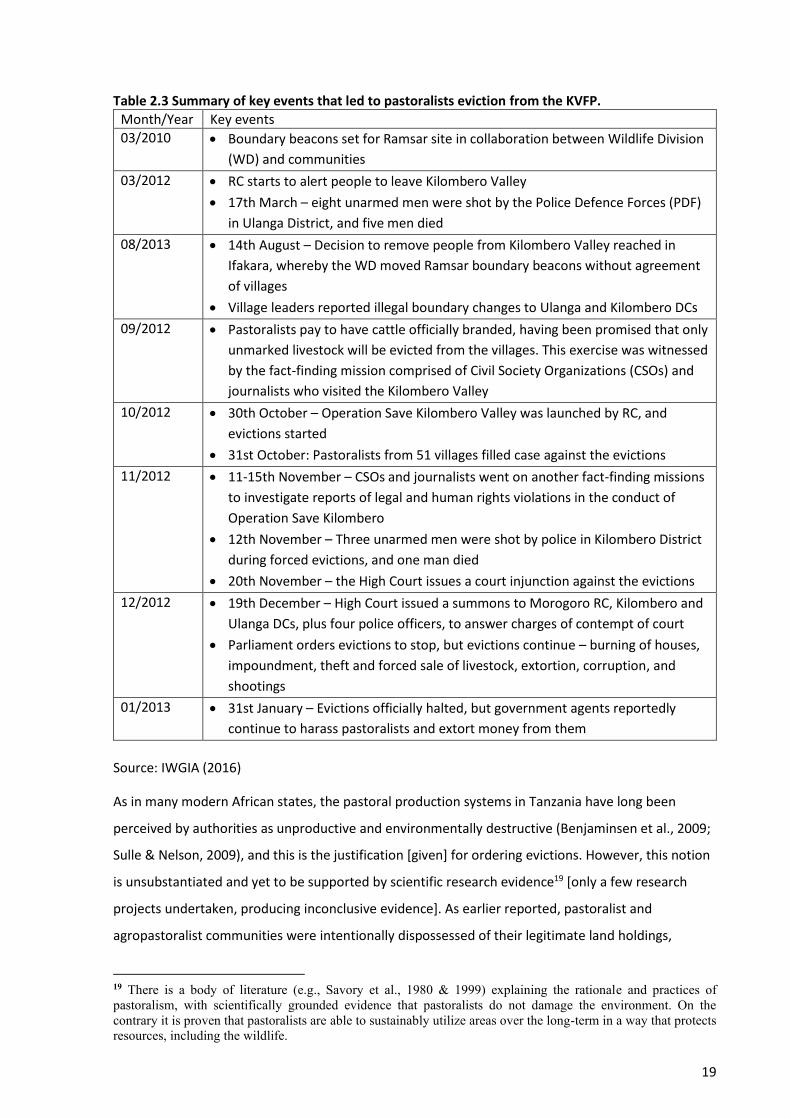
19
Table 2.3 Summary of key events that led to pastoralists eviction from the KVFP.
Month/Year Key events
03/2010 • Boundary beacons set for Ramsar site in collaboration between Wildlife Division
(WD) and communities
03/2012 • RC starts to alert people to leave Kilombero Valley
• 17th March – eight unarmed men were shot by the Police Defence Forces (PDF)
in Ulanga District, and five men died
08/2013 • 14th August – Decision to remove people from Kilombero Valley reached in
Ifakara, whereby the WD moved Ramsar boundary beacons without agreement
of villages
• Village leaders reported illegal boundary changes to Ulanga and Kilombero DCs
09/2012 • Pastoralists pay to have cattle officially branded, having been promised that only
unmarked livestock will be evicted from the villages. This exercise was witnessed
by the fact-finding mission comprised of Civil Society Organizations (CSOs) and
journalists who visited the Kilombero Valley
10/2012 • 30th October – Operation Save Kilombero Valley was launched by RC, and
evictions started
• 31st October: Pastoralists from 51 villages filled case against the evictions
11/2012 • 11-15th November – CSOs and journalists went on another fact-finding missions
to investigate reports of legal and human rights violations in the conduct of
Operation Save Kilombero
• 12th November – Three unarmed men were shot by police in Kilombero District
during forced evictions, and one man died
• 20th November – the High Court issues a court injunction against the evictions
12/2012 • 19th December – High Court issued a summons to Morogoro RC, Kilombero and
Ulanga DCs, plus four police officers, to answer charges of contempt of court
• Parliament orders evictions to stop, but evictions continue – burning of houses,
impoundment, theft and forced sale of livestock, extortion, corruption, and
shootings
01/2013 • 31st January – Evictions officially halted, but government agents reportedly
continue to harass pastoralists and extort money from them
Source: IWGIA (2016)
As in many modern African states, the pastoral production systems in Tanzania have long been
perceived by authorities as unproductive and environmentally destructive (Benjaminsen et al., 2009;
Sulle & Nelson, 2009), and this is the justification [given] for ordering evictions. However, this notion
is unsubstantiated and yet to be supported by scientific research evidence19 [only a few research
projects undertaken, producing inconclusive evidence]. As earlier reported, pastoralist and
agropastoralist communities were intentionally dispossessed of their legitimate land holdings,
19 There is a body of literature (e.g., Savory et al., 1980 & 1999) explaining the rationale and practices of pastoralism, with scientifically grounded evidence that pastoralists do not damage the environment. On the contrary it is proven that pastoralists are able to sustainably utilize areas over the long-term in a way that protects resources, including the wildlife.
20
property and assets (in the evictions carried out in Mbeya and Morogoro regions). The loss of land
and grazing areas has severely impaired pastoralists’ livelihoods. The continuing harassment they
experience from local authorities and other government agencies has further intensified the
incitement to hatred between pastoralist and non-pastoralist communities, and between pastoralists
and government agencies. The next section analyses the influence and impacts of Tanzania
development policies on pastoralism.
2.5 The role and impacts of development policies on pastoralism
The pastoral policy discourse in Tanzania, like elsewhere in Africa, has been largely influenced by
modernization ideology viewing pastoralism as irrational, economically inefficient and unproductive,
ecologically destructive and environmentally damaging (Homewood & Rodgers, 1991; Mattee &
Martin, 2006). These perceptions have consequently resulted in efforts by government policy makers
to re-distribute pastoral lands directly to commercial investors in the belief that this is an
economically rational policy (Nelson et al., 2012). While development policies by the government
have encouraged farmers to expand their fields in order to make the country self-sufficient in food,
pastoralists and agropastoralists have been told to reduce livestock numbers to prevent overgrazing
and soil erosion. For instance, Benjaminsen et al. (2009, p. 14) states that a District Livestock Officer
in Kilosa complained that livestock numbers were increasing, whereas in any other economic sector,
‘growth’ would usually be a reason for celebration. The more recently reformed Livestock Policy
(URT, 2006) has been guided by the modernization goals of encouraging the development of a
commercially oriented, efficient and internationally competitive livestock industry, while the
communal and mobile system of exploiting rangeland resources is condemned. The National Land
Policy (URT, 1995), Land Act (1999) and Village Land Act (1999) further strengthened the idea of
enclosing and registering village lands in addition to opening it up for privatization of holdings. While
this might be considered a positive development in many farming communities, it could lead to
further obstacles for pastoralists and agropastoralists who depend on flexibility in their rangeland
resources’ management.
2.5.1 Policy deficiencies and contradictions
Mwamfupe (2015, pp. 3-4) states there are several factors contributing to the persistence of farmer–
agropastoralist conflicts in Tanzania, including policy deficiencies and contradictions. The Land Policy
in Tanzania (through the Land Act and Village Act of 1999) classifies land as: Reserved land, Village
land, and General land. Reserved land is statutorily protected as national parks, land for public
utilities, wildlife and game reserves and other land designated by sectoral legislation. Village land is
land which is within the demarcated or agreed boundaries of any of Tanzania’s villages. This land is
under the managerial authority of the Village Councils, which are answerable for land management
21
decisions to the Village Assembly. General land is a residual category and includes all public land
which is not reserved land or village land “and includes unoccupied or unused village land”.
The definition of General Land is ambiguous because unoccupied or unused village land is considered
as “excess” and thus falls under the jurisdiction of the Land Commissioner20 rather than the village
authorities. The seemingly unoccupied (village) lands may be important areas for seasonal livestock
grazing, and other important livelihood uses (Mattee & Martin, 2006, p. 23). Certainly, this
classification ignores the fact that as the population grows this “excess’ village land will be brought
into use (e.g., grazing). However, this is the same land which is in most cases identified as suitable for
agricultural investment. The land policy has deficiencies because it does not guarantee security of
land tenure and an appropriate mechanism for land acquisition for users such as smallholder groups
(Mattee & Martin, 2006, p. 12). In effect, this has led to large areas of land being converted to
alternative uses and consequently marginalizing the agropastoral populations, hence fuelling conflict
between farmers and agropastoralists (Mwamfupe, 2015).
The Grazing Land and Animal Feed Resources Act (2010) translates and implements the National
Livestock Policy of 2006 (URT, 2010). The Act provides guidance for the management and control of
grazing lands and animal feed resources. Some of the problems Mwamfupe (2015, pp. 3-4) identified
in the Act include interpretation of terminology. For example, the Act defines “communal grazing
land” to mean grazing land owned by a “livestock keeper” and it defines the “livestock keeper” as a
person who engages in modern livestock keeping for “production.” The term “production” is defined
as rearing animals for commercial purpose only. The pastoralists and agropastoralists hence argue
that the Act does not provide for the protection and promotion of pastoralism but exclusively
focuses on commercial livestock keeping. It is argued that the persistence of farmer-agropastoralist
conflicts in the country reflects the government’s failure to strike a balance between the promotion
of investment (in which government policymakers may themselves have private interests), and the
land access interests of farmers and agropastoralists.
In addition to deficiencies within the policies, there is also a problem of contradictions between the
policies (Mattee & Martin, 2006; Mwamfupe, 2015). This is supported by Lugoe (2011, p. 19) who
asserts that there is some misalignment between the Livestock Policy (of 2006) and the National
Land Policy (of 1995). The Livestock Policy recognizes seasonal movement as an important
characteristic of pastoralism and thus encourages livestock owners in overgrazed areas to move to
lower stocked areas. The Livestock Policy has gone further and facilitated modalities for new
20 Land Commissioner: A person appointed by the President. A person shall be the principal administrative and professional officer of, and adviser to, the Government on all matters connected with the administration of land and shall be responsible to the Minister for the administration of the Land Act and the matters contained in it (National Land Policy: URT, 1995).

22
settlements for both pastoralists and agropastoralists. In contrast, the National Land Policy prohibits
nomadism and all its different forms of “modern transhumanic pastoralism”. Such contradictions
help to sow seeds of hostilities between the agropastoralists and implementers of the policies. From
the above analysis, it is potentially crucial for the Tanzania government to address the policy
deficiencies and contradictions, because it is through policies where the rights and freedom to have
access to and use of land resources are construed. The following section analyses the rangeland
degradation impacts on the agropastoral production systems.
2.6 Rangeland degradation impacts on agropastoral systems
Rangeland degradation is a global concern, affecting not only agropastoralists who rely on healthy
rangelands for their survival, but also others who suffer from resultant hydrological disturbances,
commodity scarcity, and other social consequences. Rangeland health also affects biodiversity
directly and indirectly because all native flora and fauna of the region have adapted to the long-term
evolutionary forces that have shaped these rangeland environments (Harris, 2010). The communal
semi-arid rangelands in Tanzania are constrained by challenges such as seasonal variation in quantity
and quality of forage. High quality forage is available for a short period of the rainy season and
livestock are frequently exposed to periods of prolonged under-nutrition in dry seasons (Selemani,
2014). Studies in Asia (Harris, 2010; Ho & Azadi, 2010), eastern Ethiopia (Kassahun, Snyman, & Smit,
2008) and Tanzania (Sangeda & Malole, 2014) suggest that the readily observable factors for
environmental and rangeland degradation include reductions in total vegetation cover and palatable
plant species and depletion in soil quality and nutrients due to soil erosion.
Savory (1999, pp. 4-5) asserts that the reasons that scientists, politicians, and others most often give
for environmental and rangeland deterioration in Africa, are just suspicious. These reasons include
overpopulation, poverty, lack of education, capital, and technology, collective ownership of the land
(by the state, rather than the individuals who use it), government corruption, poor farming methods
(e.g., slash and burn cropping in the forests, and cultivation of steep slopes), lack of agricultural
extension services, and overstocking. He argues that if one or all these things were indeed the causes
of the degradation, then the environment should be improving in places where the opposite
conditions and practices prevailed. But this was not the case, as lands elsewhere in North America,
Europe, and Asia were experiencing many of the same problems regardless of the fact that their
population was very low; the land was owned privately; the owners had access to good education
and plenty of capital and the latest technologies; and the governments ensured provision of financial
aids and sophisticated agricultural extension services. He concluded that the only common
denominator, in past and present civilizations, and in Africa, west Texas, and communities
everywhere, was that human management was involved, and that it had resulted in decisions that
23
had led to deterioration of the environment and rangelands (Savory, 1999). Moreover, Savory and
Stanley (1980, p. 235) recognize the importance animal impact, i.e., hoof impact, dung, and urine, in
maintaining healthy grassland. These authors state that the constant movement of large herds in
response to predation pressure naturally prevents overgrazing of plants, while periodic trampling of
vegetation ensures protective covering of the soil. They further argue that human decisions to
decrease the number of herds, can lead to a decrease in the beneficial animal effects on the land,
leading to increasing bare ground and environmental deterioration.
Harris (2010) states that rangeland degradation is mostly caused by overpopulation, overgrazing, and
adverse effects of droughts exacerbated by climate change. Campbell et al. (2005) supports the
notion by suggesting that climate change has altered water access and vegetation cover (i.e., caused
rangeland degradation) in arid and semi-arid areas, forcing changes in climate-dependent production
systems such as agropastoral systems. Sangeda and Malole (2014), suggests that an increase in
temperature and low rainfall has increased vegetation flammability and fire frequencies, resulting in
changes in rangeland species composition. The amount and timing of rainfall has also influenced
rangeland species composition, hence the spread of bushy vegetation in most rangelands in
Tanzania. Bush encroachment has been a common phenomenon in Kongwa ranch (Dodoma region),
which leads to an increase in biomass but reduces rangeland productivity. Also, Msofe, Lyimo, and
Josephat (2014) revealed that the increased demand for land for agriculture, settlement and
establishment of teak tree plantations in Kilombero District of Morogoro region has considerably
decreased the quantity and quality of grazing lands. Such circumstances have compelled some
livestock keepers to take their animals far away in search of pasture, while others remain behind
competing for the limited available resources, consequently causing conflict among resource users.
Benjaminsen et al. (2009, p. 11) reported that there are frequent complaints linking environmental
and rangeland degradation to overgrazing in Kilosa District and calls for pastoralists to destock and
adhere to the carrying capacity of the range. However, the authors stated that this notion is
unsubstantiated and yet to be supported by scientific research evidence, i.e., only a few studies with
inconclusive evidence have been undertaken. Kisoza (2007), studying satellite images from 1975,
1991 and 2000, also concluded that considerable bush encroachment had taken place through the
transformation of grasslands to shrub-land. However, this process seems to have been more marked
in the period 1975 – 1991 than during 1991 – 2000. This research gap brings the need for this
research to investigate the trend and extent of environmental and rangeland degradation, especially
that due to the increase of immigrant agropastoralists in Morogoro region. The next section presents
an overview of land resource use conflicts in sub-Saharan Africa with particular attention to
Morogoro region in Tanzania.
24
2.7 Farmer – pastoralist conflicts over land resources in sub-Saharan Africa
Frequently reiterated land resource use conflicts in sub-Saharan Africa involve farmers and
pastoralists competing for patchy multiple-use resources especially in arid and semi-arid areas. A
wide body of literature on sub-Saharan Africa has consistently acknowledged the historical co-
existence of farmers and pastoralists in symbiotic relationships (Mwamfupe, 2015). Host-client or
host-stranger relationships have been considered critical to integrating pastoralists into agricultural
societies and preventing and resolving farmer-pastoralist conflicts across Africa. The basis of these
long-term symbiotic relationships is reciprocity, which either party may initiate with small gifts, and
later shift to more substantive gifts and commodities. For example, male-pastoralists take entrusted
animals from their male-farmer friends with them on transhumance, while male-farmers build wet
season huts for their male-pastoralist friends on their fallow fields (Moritz, 2010, p. 139). This
however, does not mean that conflicts between farmers and pastoralists were non-existent.
Olaniyan, Michael, and Okeke-Uzodike (2015) report that in West Africa, for example, conflicts
between farmers and herders have been a common feature of economic livelihoods there. These
conflicts, however, were contained by customary institutions that functioned following the principles
of reciprocity and resolutions which were found within the confinement of the local communities.
Reda (2015) reports that in recent decades, pastoralists and agropastoralists’ resilience in ASAL21
regions of East Africa have been significantly challenged by demographic, ecological and socio-
political factors. Population pressure from within the agropastoral system and its surroundings,
climate change and drought occurrences, as well as government policies (i.e., privatized land tenure
systems, commercial agriculture and development projects) have undermined the customary
practices that were instrumental in maintaining ecosystem balance. When customary agropastoral
institutions of land administration and resource management are threatened, the problem of natural
resource degradation is further exacerbated and violent conflicts occur among multiple resource
users, including agropastoralists, farmers and the state. The next sub-section reports on land
resource use related conflicts in Tanzania.
2.7.1 Causes of land resource use-related conflicts in Tanzania
Conflicts over land resources in Tanzania have been intensifying as interest in land resources
increases and powerful people use their influence with the authorities at different levels to acquire
land. Communities in northern Tanzania, of whom the large majority are pastoralists and
agropastoralists, contend that the underlying causes of land resource use conflicts are: illegal
appropriation of pastoralists’ village lands, which enable access to wildlife resources for the lucrative
21 ASAL: Arid and Semi-arid Land
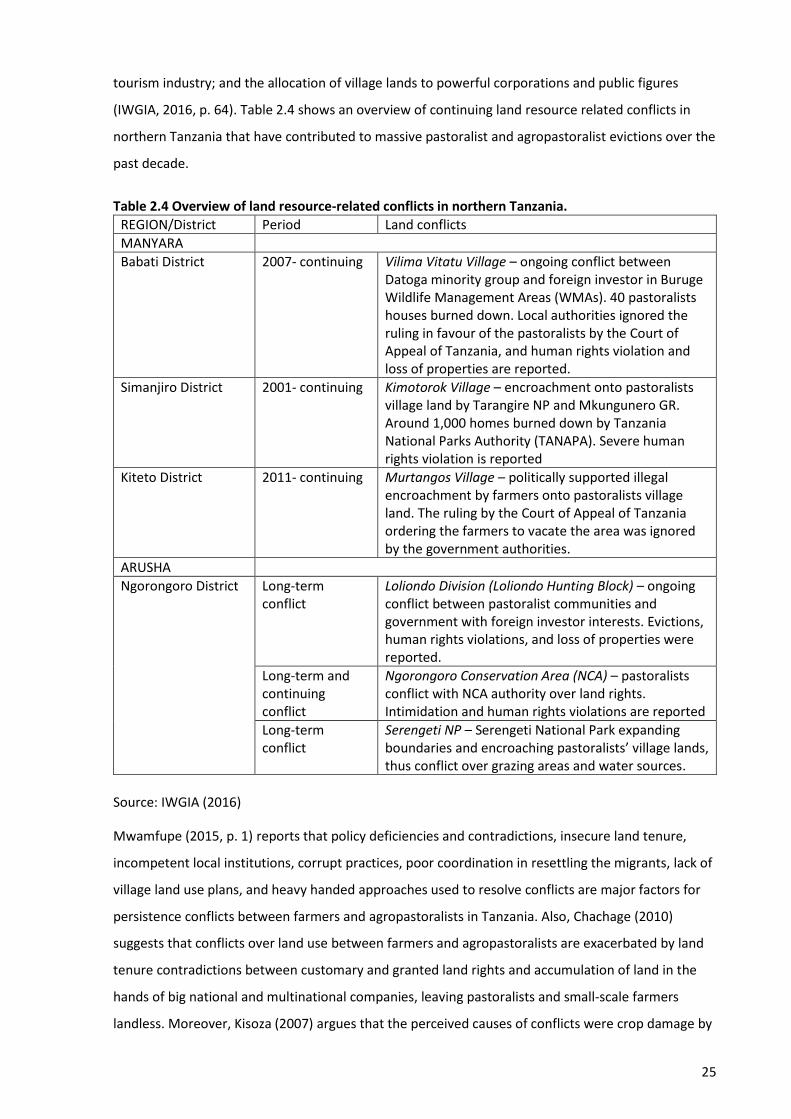
25
tourism industry; and the allocation of village lands to powerful corporations and public figures
(IWGIA, 2016, p. 64). Table 2.4 shows an overview of continuing land resource related conflicts in
northern Tanzania that have contributed to massive pastoralist and agropastoralist evictions over the
past decade.
Table 2.4 Overview of land resource-related conflicts in northern Tanzania.
REGION/District Period Land conflicts
MANYARA
Babati District 2007- continuing Vilima Vitatu Village – ongoing conflict between Datoga minority group and foreign investor in Buruge Wildlife Management Areas (WMAs). 40 pastoralists houses burned down. Local authorities ignored the ruling in favour of the pastoralists by the Court of Appeal of Tanzania, and human rights violation and loss of properties are reported.
Simanjiro District 2001- continuing Kimotorok Village – encroachment onto pastoralists village land by Tarangire NP and Mkungunero GR. Around 1,000 homes burned down by Tanzania National Parks Authority (TANAPA). Severe human rights violation is reported
Kiteto District 2011- continuing Murtangos Village – politically supported illegal encroachment by farmers onto pastoralists village land. The ruling by the Court of Appeal of Tanzania ordering the farmers to vacate the area was ignored by the government authorities.
ARUSHA
Ngorongoro District Long-term conflict
Loliondo Division (Loliondo Hunting Block) – ongoing conflict between pastoralist communities and government with foreign investor interests. Evictions, human rights violations, and loss of properties were reported.
Long-term and continuing conflict
Ngorongoro Conservation Area (NCA) – pastoralists conflict with NCA authority over land rights. Intimidation and human rights violations are reported
Long-term conflict
Serengeti NP – Serengeti National Park expanding boundaries and encroaching pastoralists’ village lands, thus conflict over grazing areas and water sources.
Source: IWGIA (2016)
Mwamfupe (2015, p. 1) reports that policy deficiencies and contradictions, insecure land tenure,
incompetent local institutions, corrupt practices, poor coordination in resettling the migrants, lack of
village land use plans, and heavy handed approaches used to resolve conflicts are major factors for
persistence conflicts between farmers and agropastoralists in Tanzania. Also, Chachage (2010)
suggests that conflicts over land use between farmers and agropastoralists are exacerbated by land
tenure contradictions between customary and granted land rights and accumulation of land in the
hands of big national and multinational companies, leaving pastoralists and small-scale farmers
landless. Moreover, Kisoza (2007) argues that the perceived causes of conflicts were crop damage by
26
livestock, pastoralists disregarding village boundaries, farmers overcharging for compensation for
crop damage, and ineptness of government officials in intervening to prevent conflicts.
However, Mwambene et al. (2014) report the historical fact that land resource use conflicts have not
been entirely brought about by the uncontrolled movement of pastoralists with their livestock but
also by the uncontrolled migration of crop farmers. For example, over time, farmers from Babati,
Kondoa, Kongwa, Kilosa and Same Districts have been migrating and set up large-scale farms in areas
that are exclusively for grazing in Kiteto District (Arusha region), and this has exacerbated land use
conflicts between farmers and pastoralists. The fact that both farmers and agropastoralists are
migrating from various regions of the country with different historical backgrounds and diverse
cultures, customs and norms – means there will always be trade-off challenges, especially when it
comes to gaining, maintaining and controlling access to, and use of the already declining natural
resource base. The next sub-section reviews the reasons given in the literature for farmer –
agropastoralist conflict escalation.
2.7.2 Land resource use conflicts escalation
In Africa, conflicts between farmers and pastoralists are often presented as being driven by
‘environmental scarcity’, but political ecologists argue these conflicts should be analysed within a
broader historical and policy context (Benjaminsen et al., 2009). There is a need to know not just why
the friction begins, but also why and how, as some conflicts unfold, they articulate with religious,
ethnic, and political motives (Moritz, 2010). Perhaps the most important question should be why
some conflicts between farmers and pastoralists escalate into widespread violence. In Papua New
Guinea, Banks (2008) argues that what appear to be ‘resource’ use conflicts are actually better
conceived as conflicts around identity and social relationships. This means that ‘resources’ become a
conduit for social and political agendas and tensions to be expressed. Ibrahim et al. (2015) in Nigeria,
found that past farmer-herder conflicts were solely due to overlap of farmlands with cattle routes,
where farmers grow crops on the routes. But recently, these conflicts have escalated, taking another
dimension of ethnic and religious differences with little effort from the government or community
leaders aimed at addressing them. Also, in Kenya, Bond (2014) found that critical features of the
conflicts from the perpective of agropastoralists and farmers were related to trust, communication,
security, governance, and marginalization.
The literature shows that explanations of farmer–pastoralist conflicts in Tanzania (Benjaminsen et al.,
2009; Kisoza, 2007; Mwamfupe, 2015) have generally been structural in nature, focusing on factors
such as climate change, biased economic policies, corrupt practices, political contexts, and
institutional failure to resolve conflicts. While structural factors may and do give rise to many
farmer–pastoralist conflicts, it is not the case that all disagreements occurring under the same
27
structural conditions escalate into large-scale, violent clashes that engage whole communities. In
Tanzania, for example, crop damages have on numerous occasions resulted in widespread conflict
escalation between farmers and pastoralists (Kajembe et al., 2003; Mandara et al., 2012; Mustafa,
1997; Mwambene et al., 2014), which progressed into claiming peoples’ lives, but this certainly is not
always the case (Benjaminsen et al., 2009; Kisoza, 2007). In other words, this structural explanation
does not explain why some disputes between farmers and agropastoralists escalate into widespread
violence but not others. Structural variables are necessary to explain the causes of conflicts, while
process variables can explain the outcomes of conflicts (Moritz, 2010). Therefore, this research
suggests that it is necessary to consider both structural and process variables (i.e., dynamics and
transformation patterns) for a better explanation of conflict escalation in Morogoro region.
2.8 Conclusions
The transition from socialist to more liberalized and capitalist-oriented economic policies had
profound implications for land tenure and ownership in Tanzania. Several changes happened, which
facilitated large-scale alienation of rural communities’ lands, particularly those lands in northern
Tanzania valued for pastoral production and wildlife tourism. As a result, numerous land tenure and
land resources use conflicts in pastoralist areas of northern Tanzania, persist to this day.
The pastoral policy discourse in Tanzania has been largely influenced by modernization ideology
viewing pastoralism as irrational, economically inefficient and unproductive, ecologically destructive,
and environmentally damaging. These perceptions have consequently resulted in efforts by
government policy makers to evict pastoralists and re-distribute their lands directly to the local and
international investors with interests in agriculture and tourism investments. In effect, this has led to
marginalizing the agropastoral populations, hence fuelling conflict between farmers and
agropastoralists. In summary this context review has identified that while there is much international
literature and Tanzanian research into the causes of rangeland degradation and farmer – pastoralist
conflicts over land resources, there is a large gap in the areas of:
• Understanding the mechanisms (means, processes and relations) by which agropastoralists
gain, maintain and control access to and use of land resources and the contribution of these
mechanisms to farmers and agropastoralists’ wellbeing and to land resource use conflicts;
• Measuring the trend and extent of environmental and rangeland degradation, especially
that due to the increase of immigrant agropastoralists in Morogoro region, and how the
farmers and agropastoralists perceive the rangelands degradation and its impact on their
respective production systems; and
28
• An indepth understanding of why and how (use of structural and process variables) farmer –
agropastoralist conflicts in Morogoro region escalate into deadly violence.
These areas relate specifically to the research gaps identified in the problem statement. The next
chapter (Chapter 3) presents the review of the theoretical frameworks employed in this research.
29
Chapter 3
Theoretical frameworks and approach
3.1 Introduction
To address the research gap identified in Chapter 1 and 2, this chapter will draw on a wide body of
literature of relevant theories and frameworks to better understand mechanisms to access and
control resources, impacts on communities’ livelihoods, and conflicts related to the use of resources.
The chapter starts with a review of relevant theories and frameworks in section 3.2. Then, a
description of Access Theory in section 3.3, followed next in section 3.4 by an overview of the
Sustainable Livelihoods Approach (SLA) and its key elements, strengths, and potential concerns.
Section 3.5 describes the relationship between Access Theory and the SLA. Social Conflict Theory is
then discussed in section 3.6. Finally, in section 3.7, the chapter is concluded with key points for
consideration in the methodology and methods highlighted.
3.2 Review of theories and frameworks
A review of a wide body of literature revealed that the DFID-SLA has been widely applied in research
related to land use conflicts, while theories and/or approaches such as Access Theory and Social
Conflict Theory have been used less often. In the few studies where Social Conflict Theory has been
applied, only structural and not process variables have been addressed. Access Theory seems to have
been rarely applied, despite its relevance especially in research involving conflicts related to land
resource use.
Lescuyer, Cerutti, and Robiglio (2013) used Access Theory to study the development of informal
chainsaw milling (CSM) in rural societies of Central Africa. This analysis was applied to the informal
CSM sector that developed without legal rights being granted to local populations. Access Theory
proved appropriate to understand why the formal models of decentralized forest management failed
in the Congo basin countries, where granting legal rights to communities was preferred at the
expense of developing powers and capacities at the local scale. Also, Langridge, Christian-Smith, and
Lohse (2006) employed Access Theory to examine, first, the different processes and relations that
enabled four communities in northern California to acquire access to water, and second, how access
contributed to their differential levels of resilience to potential water scarcity. The study concluded
that given the variety of mechanisms that can generate access, strengthening and diversifying a
range of structural and relational mechanisms to access water can enhance a community’s resilience
to water scarcity. Table 3.1 presents a summary of theories and methods applied in research
involving farmer – pastoralist land resource use conflicts.
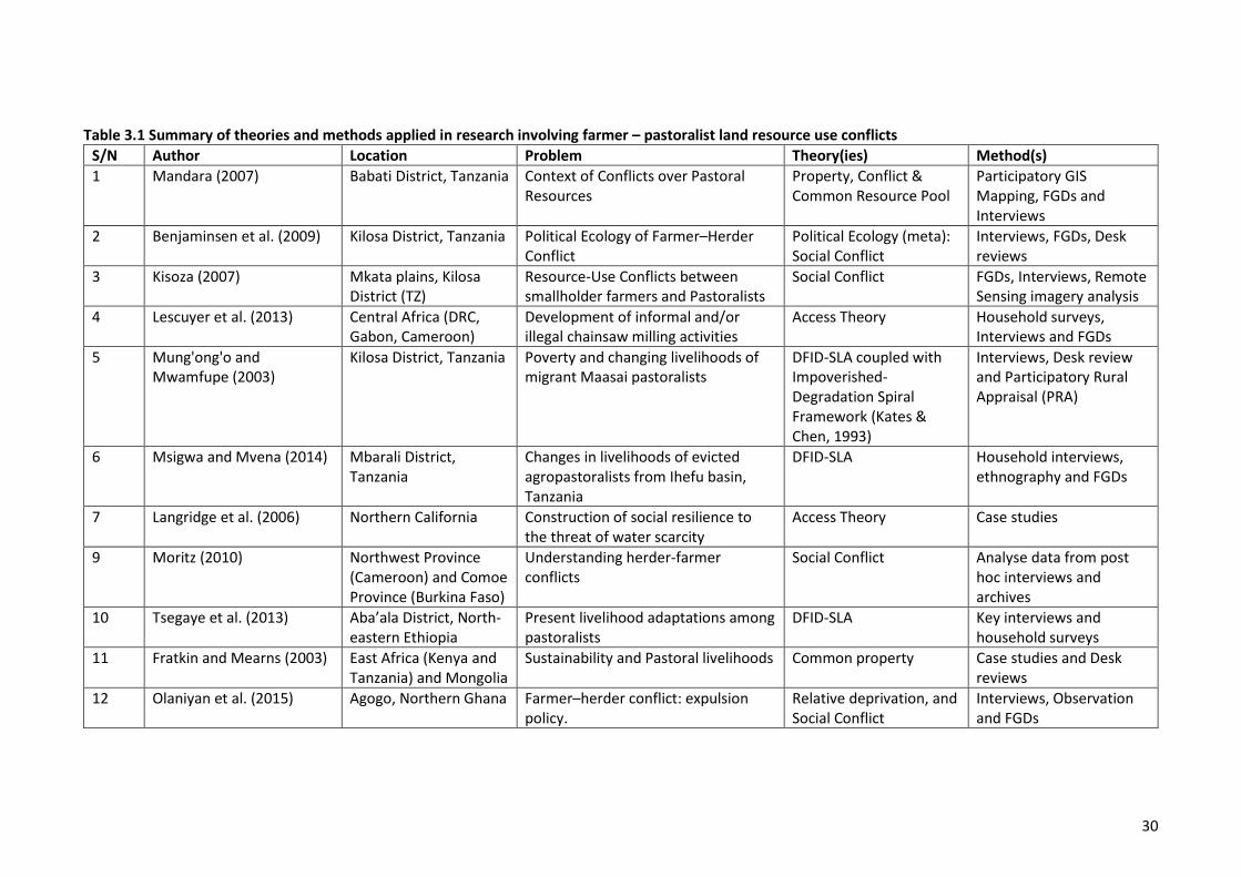
30
Table 3.1 Summary of theories and methods applied in research involving farmer – pastoralist land resource use conflicts
S/N Author Location Problem Theory(ies) Method(s)
1 Mandara (2007) Babati District, Tanzania Context of Conflicts over Pastoral Resources
Property, Conflict & Common Resource Pool
Participatory GIS Mapping, FGDs and Interviews
2 Benjaminsen et al. (2009) Kilosa District, Tanzania Political Ecology of Farmer–Herder Conflict
Political Ecology (meta): Social Conflict
Interviews, FGDs, Desk reviews
3 Kisoza (2007) Mkata plains, Kilosa District (TZ)
Resource-Use Conflicts between smallholder farmers and Pastoralists
Social Conflict FGDs, Interviews, Remote Sensing imagery analysis
4 Lescuyer et al. (2013) Central Africa (DRC, Gabon, Cameroon)
Development of informal and/or illegal chainsaw milling activities
Access Theory Household surveys, Interviews and FGDs
5 Mung'ong'o and Mwamfupe (2003)
Kilosa District, Tanzania Poverty and changing livelihoods of migrant Maasai pastoralists
DFID-SLA coupled with Impoverished-Degradation Spiral Framework (Kates & Chen, 1993)
Interviews, Desk review and Participatory Rural Appraisal (PRA)
6 Msigwa and Mvena (2014) Mbarali District, Tanzania
Changes in livelihoods of evicted agropastoralists from Ihefu basin, Tanzania
DFID-SLA Household interviews, ethnography and FGDs
7 Langridge et al. (2006) Northern California Construction of social resilience to the threat of water scarcity
Access Theory Case studies
9 Moritz (2010) Northwest Province (Cameroon) and Comoe Province (Burkina Faso)
Understanding herder-farmer conflicts
Social Conflict Analyse data from post hoc interviews and archives
10 Tsegaye et al. (2013) Aba’ala District, North-eastern Ethiopia
Present livelihood adaptations among pastoralists
DFID-SLA Key interviews and household surveys
11 Fratkin and Mearns (2003) East Africa (Kenya and Tanzania) and Mongolia
Sustainability and Pastoral livelihoods Common property Case studies and Desk reviews
12 Olaniyan et al. (2015) Agogo, Northern Ghana Farmer–herder conflict: expulsion policy.
Relative deprivation, and Social Conflict
Interviews, Observation and FGDs
31
Thus, consistent with the above review and the multi and interdisciplinary nature of this research, it
was concluded that the most relevant theories and frameworks are Access Theory, Social Conflict
Theory, and the Sustainable Livelihoods Approach (SLA). This research, therefore, will employ a
combination of theories (i.e., Access Theory and Social Conflict Theory) and the DFID Sustainable
Livelihood Approach to provide a comprehensive analysis that will improve our understanding of:
1. the mechanisms by which agropastoralists gain, maintain and control access to, and use of
land resources, and the contribution of these mechanisms to farmers and agropastoralists’
wellbeing and to conflicts with farmers
2. the proximate causes of conflict escalation and its impacts on both farmers and agropastoral
production systems
3. the trend and extent of environmental and rangelands degradation, and agropastoralists and
farmers’ perception of how the degradation has impacted their production systems
3.3 Access Theory
Ribot and Peluso (2003, p. 154) defined access as “the ability to derive benefits from things”,
broadening from property’s classical definition of access as “the right to benefit from things.” Ribot
and Peluso (2003) identified eight kinds of structural, power and social relations mechanisms that
can affect rights-based (i.e., legal and illegal) mechanisms of access: technology, capital, markets,
labour, knowledge, authority, identity, and social relations. These categories are heuristic; none is
distinct or complete. Each form of access may enable, conflict with, or complement other access
mechanisms and result in complex social patterns of benefit distribution. Access Theory can be used
to analyze specific resource conflicts (e.g, farmer – agropastoralist conflict) to understand how those
conflicts can become the very means by which different actors gain or lose the benefits from tangible
and intangible resources.
3.3.1 Access Theory vs Property Theory
The notion of access has not been adequately theorized, even though it is used frequently by
property analysts and other social theorists. Access differs from property in multiple ways that have
not been systematically accounted for within the property and access literature. Ribot and Peluso
(2003) developed a concept of access and examined a broad set of factors that differentiate access
from property. They defined access as the ability to benefit from things including material objects,
persons, institutions, and symbols. By focusing on ability, rather than rights as in Property Theory,
their formulation brings attention to a wider range of social relationships that can constrain or
enable people to benefit from resources without focusing on property relations alone. Focusing on
32
natural resources as the “things” in question, Ribot and Peluso (2003) explored the range of powers
embodied in and exercised through various mechanisms, processes, and social relations that affect
people’s ability to benefit from resources. Some people and institutions control resource access
while others must maintain their access through those who have control. Access analysis also helps
understand why some people or institutions benefit from resources, whether or not they have rights
to them. This implies that if the study of property is concerned with understanding claims (i.e.,
rights), then the study of access is concerned with understanding the multiplicity of ways people
derive benefits from resources, including, but not limited to, property relations. A key distinction
between access and property lies in the difference between “ability” and “right.” Ability is akin to
power, which we define in two senses: first, as the capacity of some actors to affect the practices and
ideas of others and second, power as emergent from, though not always attached to, people. Power
is inherent in certain kinds of relationships and can emerge from or flow through the intended and
unintended consequences or effects of social relationships (Weber, 1978, p. 53). Therefore, access is
about all possible means by which a person is able to benefit from things (i.e., legal and illegal
means), whereas, property generally evokes some kind of socially acknowledged and supported
claims or rights (i.e., law, customs, or convention).
3.3.2 Access mechanisms
Access mechanisms are categorized as right-based, i.e., sanctioned by law, customs, and convention,
including illegal access (when benefits are obtained through illegal means, e.g., by bribe or force). It
is important to recognize that sanctioned and unsanctioned mechanisms are right-based in so far as
rights define the bounds of illegal activities (Ribot & Peluso, 2003, p. 161). The following subsection
identifies right-based access mechanisms under legal access.
3.3.2.1 Legal access
Right-based means of access imply the involvement of a community, state, or government that will
enforce a claim. Law-based property rights include access via the holding of titles or deeds of real
property as well as permits and licenses (Ribot & Peluso, 2003). Property rights holders can assert
their sanctioned rights, with the associated enforcement mechanisms, to control access. Individuals
who do not have such rights must come to rights holders to gain or maintain access, by paying a fee
or exchanging a service if they desire to benefit from the resource in question (Weber, 1978).
Ambiguities and contradictions within laws, policies, customs, and conventions are not uncommon in
the present world. Sometimes new policies or laws do not clearly delineate all the powers associated
with rights, as a result, conflict ensues over the resolution of these ambiguities and contradictions.
Ambiguity also plays an important role in overlapping systems of legitimacy, i.e., where a plurality of
legal, customary, or conventional notions of rights are used to make claims. Nevertheless, with this
33
plurality, some actors may be able to enhance their own benefits by maintaining their access to, or
gain control over others’ access to resources (Ribot & Peluso, 2003). In these cases, rights defined by
law, custom and convention are mechanisms that shape who controls and who maintains access to
resources.
3.3.2.2 Illegal access
Access gained “illegally” is also right-based because it is a form of direct access defined against those
based on the sanctions of law, custom and convention (Ribot & Peluso, 2003, p. 164). Criminality is a
matter of perspective, that depends on the actor’s relationship to the law or other form of rules or
sanctioned conventional practices (Peluso, 1992). Overt use of force, deception and stealth can also
be a form of direct access to resources. Access can be controlled illegally through these means, and
people can illegally maintain access by cultivating relations with or posing counter threats to those
who control access. Meanwhile, their actions may be considered illegitimate or corrupt by other
claimants who justify their rights through other laws, customs, or conventions (Peluso, 1992; Peluso,
1995). Legal means, therefore, are not the only rights-based way of gaining, controlling, or
maintaining benefits from resources. Illegal means must also be considered as rights-denied
mechanisms of access (Ribot & Peluso, 2003, p. 164). Figure 3.1 presents a visual representation of
the Access Theory developed from the text of Ribot and Peluso (2003).
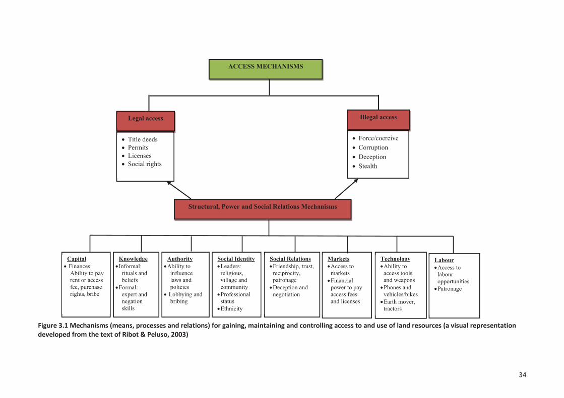
34
Figure 3.1 Mechanisms (means, processes and relations) for gaining, maintaining and controlling access to and use of land resources (a visual representation developed from the text of Ribot & Peluso, 2003)
35
The next section presents the structural, power, and social relations access mechanisms of Access
Theory.
3.3.3 Structural, Power and Social relations mechanisms
The ability to benefit from resources is mediated by constraints established by the specific political-
economic and cultural frames within which access to resources is sought. This brings into play a
number of structural, power and social relations mechanisms (Ribot & Peluso, 2003, p. 164). The
following sub-sections explores how technology, capital, markets, labour, knowledge, authority,
social identities, and social relations can shape or influence access to resources.
3.3.3.1 Technology
Access to technology mediates resource access in several ways. For example, a fence is simple
technology for access control because it physically keeps some people away from a resource and it
symbolizes or communicates intent to restrict access (Fortmann, 1995). Many resources cannot be
extracted without the use of tools or technology – more advanced technology benefits those who
have access to them. Less direct are the technologies that increase or facilitate the ability to
physically reach a resource. For example, a road alters the number of people and types of vehicles
able to reach remote localities, changing the nature of physical access (Peluso, 1992). Weapons are
also technologies that can facilitate the upholding of rights-based and illicit access to resources
(Ribot, 2000; Ribot & Peluso, 2003).
3.3.3.2 Capital
Access to capital is clearly a factor shaping who is able to benefit from resources by controlling or
maintaining access to them (Berry, 1993; Blaikie, 1985; de Janvry & Sadoulet, 2001, pp. 4-5). Access
to capital is generally thought of as access to wealth in the form of finances and equipment (noted
under technology) that can be put into the service of extraction, production, conversion, labour
mobilization, and other processes associated with deriving benefits from things and people. Access
to capital can be used for resource access control through the purchase of rights. It can also be used
to maintain resource access when used to pay rents, formal access fees, or to buy influence over
people who control access to resources (Ribot & Peluso, 2003, p. 165). These can also be right-based
means of gaining resource access, through legal, sanctioned, or informal processes. Wealth or capital
also affects other types of access since wealth, social identity, and power are mutually constituted
(Berry, 1993).
3.3.3.3 Markets
Access to markets affects the ability to benefit from resources in many ways. The ability to
commercially benefit from a resource can depend more on whether its owner has access to markets
36
than whether someone has rights to it (de Janvry & Sadoulet, 2001, p. 15; Ribot, 2000). Generally,
market access is the ability of individuals or groups to gain, control, or maintain entry into exchange
relations. Market access is controlled through a multitude of structures and processes. These may
include access to capital for both equipment and credit, and forms of collusion among market actors,
or support by state policies delimiting the acquisition of professional licenses and access fees (Ribot
& Peluso, 2003, p. 166).
3.3.3.4 Labour
Access to labour and labour opportunities also shape who can benefit from resources. Those who
control access to labour and labour opportunities (e.g., jobs) can benefit from a resource at any stage
where labour is required by allocating labour opportunities for favours as part of patronage relations
(Peluso, 1992). Although an individual may have no access to a resource through property rights and
may not have capital to buy technology and/or buy rights to access a resource, he/she may gain
resource access by entering into a working relationship with the resource access controller, the
holder of a permit, or other market-based access mechanisms. Workers may thus have to invest in
social relations with resource owners in order to maintain access to both labour opportunities and
resources (Berry, 1993).
3.3.3.5 Knowledge
Access to knowledge is important in shaping who can benefit from resources. Beliefs, ideological
controls, and discursive practices, as well as negotiated systems of meaning, shape all forms of
access. For some resources, access might be driven by more than economics or moral claims to
subsistence rights; it serves social, political, and ritual purposes as well, representing kinship, power
relations, or ritual harmony (Peluso, 1995). The ability to shape discursive terms and the power to
produce categories of knowledge deeply influence entire frameworks of resource access. Similarly,
expert status acquired through access to privileged information, higher education, and specialized
training or apprenticeship, or even from the ability to employ the signifiers of such status (e.g.,
degrees, titles), can give people privileged access to labour opportunities, group or network
membership, or privileged physical access to resources (Ribot & Peluso, 2003). Expert status also
carries authority that may allow individuals to manipulate others’ beliefs or the categories of
resource access and use.
3.3.3.6 Authority
Access to authority shapes an individual’s ability to benefit from resources. In reality, laws partially
shape access to resources, capital, markets, and labour. Privileged access to the individuals or
institutions with the authority to make laws can strongly influence who benefits from the resource in
question (Thongchai, 1994; Weber, 1978). The mobilization of this kind of access can be done
37
through legal channels, as in making an application for a permit or lobbying through official channels.
Both legal and illegal access to state and other authorities tends to be selective along a number of
economic and social lines (Ribot, 1995). Economic selectivity, for example, means that those without
money may not be able to afford even the cost of communication with agents and officials of the
state, or to pay for a bus ticket to a state representative’s office, thus restricting their access (Blaikie,
1985). Legal, customary, and conventional authorities may also compete or conflict in the sense of
having overlapping jurisdictions of authority. Such overlaps allow well-positioned individuals to take
advantage of different social identities to acquire or accumulate resources using different notions of
legitimate or authoritative access (Ribot & Peluso, 2003). Therefore, authorities are nodes of direct
or indirect forms of access control where multiple access mechanisms or strands are bundled
together in one person or institution.
3.3.3.7 Social identity
Social identity profoundly affects the distribution of benefits from things. Access is often mediated by
membership in a community or group, including groupings by age, gender, ethnicity, religion, status,
profession, place of birth, common education, or other attributes that contribute social identity
(Berry, 1993; Li, 2000). Some individuals are subject to the law, while others may be exempted
because of their status or membership in some identity-based social grouping. Non-state authorities,
such as religious leaders, tribal leaders, and village chiefs, can also control resources and allocate
access selectively along identity lines. The contemporary discourse on “tribes” and “native” groups
has become a tactic for both inclusionary and exclusionary strategies (Ribot & Peluso, 2003, p. 171).
Some groups strategically constitute themselves as “indigenous people,” their practices as
“customary law,” or their land as “tribal land,” and by doing so gain access to resources in question
(Li, 2000). Another example of identity-based access is when rights or claims are attached to or
explicitly detached from localities or professions. Local users are often excluded from nature
reserves, particularly if they intend to extract resources (Ribot, 1995), although conservation and
development activists often expect local people to protect endangered wildlife and habitats (Agrawal
& Ostrom, 2001). Scientists, on the other hand, most of whom tend not to be “local” in the sense of
villagers, often have privileged access to the resources in a reserve and may even extract or modify
those resources for the purpose of their scientific work. This kind of access stems from access to
capital (grant money) and authority (government permission) and results in salary increases,
prestige, and power, including sometimes greater resource access for the scientists (Ribot & Peluso,
2003, pp. 171-172).
3.3.3.8 Social relations
Access via negotiation and social relations i.e., friendship, trust, reciprocity, patronage, dependence,
and obligation form critical strands in access webs. Like identity, social relations are central to
38
virtually all other elements of access. Sara Berry, in her work on access to resources in West Africa,
explains “... since access to resources depends, in part, on the ability to negotiate successfully,
people tended to invest in the means of negotiation as well as the means of production per se”
(Berry, 1993, p. 15). Berry’s analysis stresses the importance of the development of economically
based ties, in addition to other identity-based relationships, as means of being included in certain
kinds of benefits. In summary, all the mechanisms of access discussed above are forms of social
relations. Understanding the multiplicity of ways that these work is key to understanding the
complexities of resource access. The following section presents the DFID Sustainable Livelihoods
Approach.
3.4 The Sustainable Livelihoods Approach (SLA)
The term ‘sustainable livelihoods’ is widely used in development literature, but meanings attributed
to the term vary widely (Scoones & Wolmer, 2003). Despite this divergence, since the late 1980s the
SLA has emerged and been refined in response to the need for more effective ways of approaching
poverty reduction. Although the SLA has been modified and adapted for a wide range of purposes, its
inherent concepts have remained remarkably constant (Cahn, 2006).
3.4.1 The origin and development of the SLA
The concept of ‘sustainable livelihoods’ first became prominent in the report of an advisory panel of
the World Commission on Environment and Development (WCED) in 1987 in the publication ‘Food
2000’. The report links sustainable livelihoods security to basic human needs, food security,
sustainable agricultural practices and poverty. The WCED panel argued that sustainable livelihoods
security is fundamental for three reasons. Firstly, it is a precondition for a stable human population;
secondly, it is a prerequisite for good husbandry and sustainable management; and thirdly, it is a
means of reversing destabilising processes such as urban migration (WCED, 1987, pp. 3-4). In its
definition of a livelihood the WCED panel referred to access to resources and income earning
activities, including assets and reserves to offset risk, ease shocks and meet contingencies. Also
mentioned in the WCED’s definition is sustainability in terms of the maintenance and enhancement
of resource productivity on a long-term basis, and the diversity of ways in which a household could
gain sustainable livelihoods (WCED, 1987, p. 3). The report points to a focus on sustainable
livelihoods security, and the redistribution and allocation of resources to the poor, as key factors in
the challenge of food security and poverty (WCED, 1987, p. 4).
Building on the concepts developed in the WCED-Food 2000 report, Chambers and Conway (1992, p.
3) challenge ‘conventional’ ways of thinking on production, employment and poverty. Lack of food is
seen as a function of production and producing enough food, whereas in fact lack of food security is
39
more a function of ‘entitlements’ or what food people have access and rights to (Chambers &
Conway, 1992, p. 3). Also, ‘conventional’ thinking regards a means of living as employment and the
problems of the poor are seen as a lack of employment. However, the concept of sustainable
livelihoods is broader than employment and income generation (Cahn, 2006). In reality the poor
sustain their livelihoods through a complex mix of livelihood strategies and activities that may or may
not involve employment, i.e., doing a whole range of things that allows them to survive (Helmore,
2001, p. 7). The fight against rural poverty is no longer limited to stimulating employment through
commercial agricultural development, rather it is recognized that people derive their livelihoods from
a range of both subsistence and commercial activities that often include agriculture, livestock
keeping and fisheries (Cahn, 2006, p. 12; Carney & Ashley, 1999, pp. 4-5; Chambers, 1995, p. 11;
Nowak, 2003, p. 294). Similarly, while conventional development economics considers deprivation
and poverty in terms of the poverty line, an economic measurement of income and consumption, in
reality, poverty is multi-dimensional (Cahn, 2006; Chambers & Conway, 1992, p. 3). Income-poverty,
though important, is only one aspect of deprivation (Chambers, 1995, p. 173). In addition to income-
poverty, any fundamental human need that is not adequately satisfied, reveals human poverty and
deprivation, thus threatening human wellbeing (Chambers, 1995; Kabeer, 1994; Krantz, 2001; Max-
Neef, 1992).
Another way of viewing poverty is a ‘means’ perspective, whereby poverty is viewed as when people
do not have the capabilities, entitlements, resources, or assets to acquire a decent livelihood
(Kabeer, 1994, pp. 138-141). Important to achieving a sustainable livelihood are the capabilities a
person or household has. Sen (1985) used the term ‘capability’ to refer to the ability of people to
realise their entitlements or potential. For example, to be adequately nourished, to be comfortably
clothed, to avoid escapable morbidity and preventable mortality, to appear in public without shame,
to be able to visit and entertain one’s friends, and to be acceptably well informed (Sen, 1985, p. 199).
Within the generality of Sen’s use of capability, there is a subset of livelihood capabilities that include
being able to cope with stress and shocks, being able to adapt, and being able to find and make use
of livelihood opportunities. Such livelihood capabilities to respond to adverse changing conditions,
include gaining access to and using services and information, exercising foresight, experimenting and
innovating, competing and collaborating with others, and exploiting new conditions and resources
(Chambers & Conway, 1992, p. 4). Understanding the capability concept can help explain why two
persons can have very different substantial opportunities even when they have exactly the same set
of means. Sen (2005, p. 154) argues that differences in the capability to function can arise even with
the same set of personal means because of:
1) variations in non-personal resources (e.g., societal cohesion and the helpfulness of the
community);
40
2) environmental diversities (e.g., climatic conditions, or varying threats from epidemic
diseases or from local violence and crime); and
3) physical or mental heterogeneities among persons (related, for example, to disability, or
proneness to illness).
Capabilities can be outcomes of livelihood strategies or enhanced access to assets, e.g., enhanced
human capital capabilities in terms of training. Capabilities can also be regarded as assets
themselves, or as activities, or could be considered as the choices people have (Cahn, 2006, p. 16).
Clearly, therefore, factors other than personal income are important in reducing poverty and
increasing wellbeing. Because human wellbeing is the enormous question for this thesis, therefore,
there is a need to define what is wellbeing?
3.4.1.1 What is wellbeing?
Chambers (1995, p. 175) describes wellbeing as ‘the experience of good quality of life’. Wellbeing
includes a range of diverse factors such as self-esteem, security, happiness, peace, harmony,
freedom from anxiety, peace of mind, as well as more conventionally measured material concerns
(Scoones, 1998, p. 6; WorldBank, 2000). For example, in Russia people say, “Wellbeing is a life free
from daily worries about lack of money”; in Bangladesh, “to have a life free from anxiety”; in Brazil,
“not having to go through so many rough spots” (WorldBank, 2000, p. 16). Ill-being is described as a
lack of material things, as bad experiences, and as bad feelings about oneself (Chambers, 1995;
WorldBank, 2000). Although the nature of wellbeing varies among locations and people, there are
commonalities across countries. Not surprisingly, material wellbeing, income, food, shelter, and
clothing are mentioned everywhere as important for wellbeing. However, while income, food
security, and other necessities are basic wellbeing attributes, people aspire to a range of other
important attributes of wellbeing that may be less tangible and less obvious to make their lives
fulfilling and worthwhile. For example, increased choices, improved status, empowerment, dignity,
and reduced vulnerability are difficult to measure but equally important for wellbeing. Defra and
National-Statistics (2010, p. 106) defined wellbeing as:
…a positive physical, social, and mental state; it is not just the absence of pain, discomfort, and incapacity. It requires that basic needs be met, that individuals have a sense of purpose, that they feel able to achieve important personal goals and participate in society. It is enhanced by conditions that include supportive personal relationships, strong and inclusive communities, good health, financial and personal security, rewarding employment, and a healthy and attractive environment.
The satisfaction of human needs contributes to human wellbeing. In part because of the persistence
of poverty around the world despite significant economic growth in some countries, there has been a
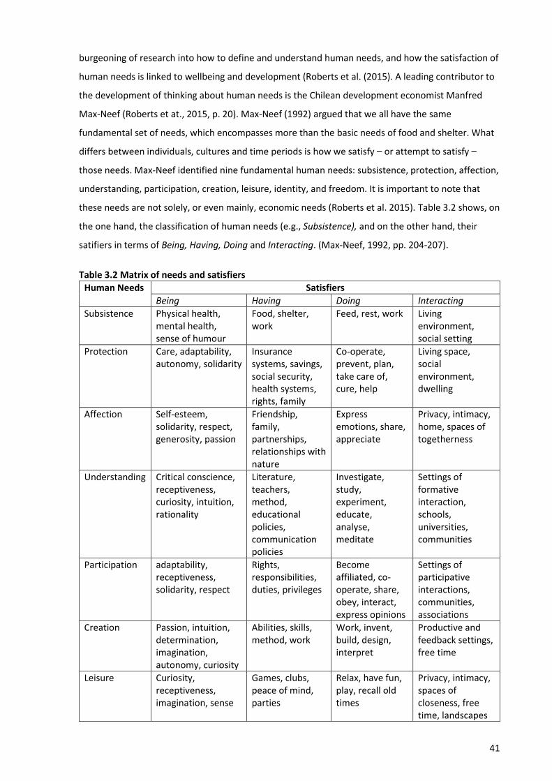
41
burgeoning of research into how to define and understand human needs, and how the satisfaction of
human needs is linked to wellbeing and development (Roberts et al. (2015). A leading contributor to
the development of thinking about human needs is the Chilean development economist Manfred
Max-Neef (Roberts et at., 2015, p. 20). Max-Neef (1992) argued that we all have the same
fundamental set of needs, which encompasses more than the basic needs of food and shelter. What
differs between individuals, cultures and time periods is how we satisfy – or attempt to satisfy –
those needs. Max-Neef identified nine fundamental human needs: subsistence, protection, affection,
understanding, participation, creation, leisure, identity, and freedom. It is important to note that
these needs are not solely, or even mainly, economic needs (Roberts et al. 2015). Table 3.2 shows, on
the one hand, the classification of human needs (e.g., Subsistence), and on the other hand, their
satifiers in terms of Being, Having, Doing and Interacting. (Max-Neef, 1992, pp. 204-207).
Table 3.2 Matrix of needs and satisfiers
Human Needs Satisfiers
Being Having Doing Interacting
Subsistence Physical health, mental health, sense of humour
Food, shelter, work
Feed, rest, work Living environment, social setting
Protection Care, adaptability, autonomy, solidarity
Insurance systems, savings, social security, health systems, rights, family
Co-operate, prevent, plan, take care of, cure, help
Living space, social environment, dwelling
Affection Self-esteem, solidarity, respect, generosity, passion
Friendship, family, partnerships, relationships with nature
Express emotions, share, appreciate
Privacy, intimacy, home, spaces of togetherness
Understanding Critical conscience, receptiveness, curiosity, intuition, rationality
Literature, teachers, method, educational policies, communication policies
Investigate, study, experiment, educate, analyse, meditate
Settings of formative interaction, schools, universities, communities
Participation adaptability, receptiveness, solidarity, respect
Rights, responsibilities, duties, privileges
Become affiliated, co-operate, share, obey, interact, express opinions
Settings of participative interactions, communities, associations
Creation Passion, intuition, determination, imagination, autonomy, curiosity
Abilities, skills, method, work
Work, invent, build, design, interpret
Productive and feedback settings, free time
Leisure Curiosity, receptiveness, imagination, sense
Games, clubs, peace of mind, parties
Relax, have fun, play, recall old times
Privacy, intimacy, spaces of closeness, free time, landscapes
42
of humour, tranquillity
Identity Sense of belonging, consistency, self-esteem, assertiveness
Symbols, language, religion, habits, customs, values, norms, historical memory
Commit oneself, integrate oneself, confront, decide on, recognize oneself, grow
Social rhythms, everyday settings
Freedom Autonomy, self-esteem, determination, passion, open-mindedness
Equal rights Dissent, choose, run risks, be different from, commit oneself, disobey
Temporary/spatial plasticity
Source: Max-Neef (1992)
The desire to increase human wellbeing is the driver for most of the negative impacts that humans
have on ecosystems and ecosystem services. However, there is increasing evidence that when
ecosystem services are reduced, human wellbeing also declines – and so, some of the actions we
take in striving to improve our wellbeing may in fact be jeopardising it (Roberts et al., 2015, p. 15). As
Roberts et al. (2015, p. 15) note, it is very important that we gain a much better understanding of the
key contributors to human wellbeing so that we can explore whether wellbeing can be enhanced
without negatively impacting on ecosystems and their services. Jackson, Jager, and Stagl (2004)
argued that Max-Neef’s matrix of human needs is particularly useful when considering wellbeing in
the context of sustainability. In a world in which economic consumption is threatening to erode the
integrity of global ecosystems, it is particularly vital to be able to identify which elements of
consumption contribute to the satisfaction of human needs and hence wellbeing, and which simply
operates as pseudo-satisfiers, or worse, impair our ability to satisfy our needs (Roberts et al., 2015).
Given the pervasive nature of wellbeing, this thesis employs the Max-Neef’s matrix of human needs,
which describes wellbeing in terms of human needs satisfaction, in order to understand how the
mechanisms for gaining and controlling the use of land resources impact on the farmers and
agropastoralists’ wellbeing.
3.4.2 Formalising the SLA and Frameworks
In 1997, the United Kingdom (UK) Government’s White Paper on International Development
committed its Department for International Development (DFID) to support policies and actions that
guarantee sustainable livelihoods and better education, health and opportunities for poor people
and protection, and better management of the natural and physical environment. The overall aim
was to create a supportive environment for poverty elimination (Carney & Ashley, 1999, p. 8; DFID,
1999, p. 1), and reverse trends in environmental degradation (Solesbury, 2003, p. 15). During the
1990s other organizations and agencies also adopted the SLA as part of their strategies. For example,
43
CARE and Oxfam (Great Britain) in 1990, and donors, e.g., UNDP in 1995 (Carney & Ashley, 1999, p.
5). At the basis of the SLA are frameworks that have been deveopled to clearly set out the factors
involved in attaining sustainable livelihoods, and the relationships between these factors. The most
well known, but by no means the only livelihoods implementation framework is the DFID Sustainable
Livelihoods Framework (Carney & Ashley, 1999; DFID, 1999). This framework draws heavily on the
work of University of Sussex Institute of Development Studies (IDS) (Carney & Ashley, 1999). It is this
framework that has been employed in this thesis. Figure 3.2 shows the key components of the DFID
Sustainable Livelihoods Framework, including a set of livelihood asset ‘capitals’, institutional
structures and processes that individuals and communities work through in order to transform those
assets into the outcomes they seek, in accordance with particular chosen strategies.
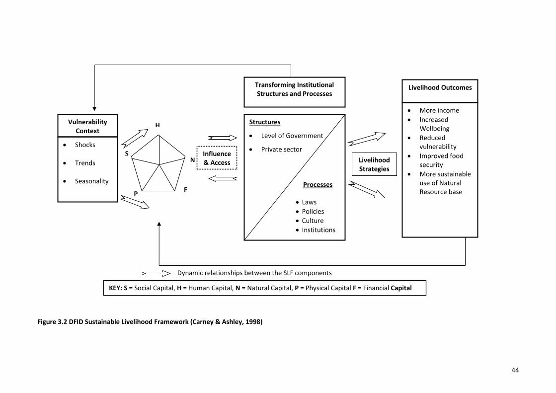
44
Dynamic relationships between the SLF components
Figure 3.2 DFID Sustainable Livelihood Framework (Carney & Ashley, 1998)
Livelihood Outcomes
• More income
• Increased Wellbeing
• Reduced vulnerability
• Improved food security
• More sustainable use of Natural Resource base
Livelihood Strategies
Vulnerability Context
• Shocks
• Trends
• Seasonality
Transforming Institutional Structures and Processes
Structures
• Level of Government
• Private sector
• Laws
• Policies
• Culture
• Institutions
Influence & Access
H
N
F P
S
KEY: S = Social Capital, H = Human Capital, N = Natural Capital, P = Physical Capital F = Financial Capital
Processes
45
3.4.2.1 Livelihood assets
At the heart of the DFID framework are the assests or resources that people have. These are also
referred to as ‘capitals’ depending on the context in which they are being discussed. In this thesis the
words resources, assets and capitals are used interchangeably. Bebbington (1999, p. 2022) points out
that people’s assets are not just means of living but also give meaning to a person’s world. Assets are
both the resources people use in building livelihoods, and the assets that give people the capabilities
‘to be and to act’. Moreover, access to resources could be considered the most important of all in
terms of building sustainable livelihoods (Bebbington, 1999). For example, Bebbington (1999, p.
2028) argues that households with more viable rural livelihoods seem to be able to sustain or
increase their access to resources (e.g., land, credit, skills and labour), increase their opportunities to
use those resources to enhance livelihoods, and increase access to networks, organizations and
market intermediaries. It seems that access to networks and organizations ‘social capital’ is very
important in gaining access to other resources and opportunities. The DFID framework identifies five
types of livelihood assets ‘capitals’ which people can build up and/or draw upon: natural, human,
physical, financial and social (DFID, 1999; Scoones, 1998). The following describes each asset
according to the DFID framework (DFID, 1999; Scoones, 1998):
• Human capital (H): represents skills, knowledge, ability to labour and good health, that
together, enable people to pursue different livelihood strategies and achieve their livelihood
objectives.
• Natural capital (N): the natural resource stocks from which resources flow and services (e.g.,
nutrient cycling) useful for livelihoods derived. There is a wide variation in the resources that
make up natural capital, from intangible public goods, such as the atmosphere and
biodiversity, to divisible assets used directly for production (e.g., water, land, wildlife, and
forests).
• Physical capital (P): comprises the basic infrastructure and producer goods needed to
support livelihoods. Infrastructure consists of changes to the physical environment that help
people to meet their basic needs and become more productive, whereas producer goods are
the tools and equipment that people use to function more productively, i.e., transport,
shelter and storage buildings, water supply and sanitation, clean and reliable energy, and
access to information and/or communication.
• Financial capital (F): denotes the financial resources that people use to achieve their
livelihood objectives. There are two main sources of financial capital: (1) savings, which can
be held in forms such as cash, supplies from credit-providing institutions, bank deposits or
46
liquid assets such as livestock and jewellery; and (2) regular inflows of money, i.e., pensions,
or other transfers from the state, and remittances.
• Social capital (S): means the social resources upon which people rely on when pursuing their
livelihood objectives. These resources are developed through social networks and
connectedness, membership of formal and/or informal groups, relationships of trust,
reciprocity and exchanges that facilitate co-operation, and access to wider institutions of
society which provides the basis for informal safety nets among the rural poor.
Cahn (2006) argues that culture should be regarded as a separate asset that must be sustained and
enhanced. She emphasize that the livelihoods that people aspire to and the strategies they choose to
achieve those outcomes are both influenced by culture. However, in this research culture is treated
within social capital. An analysis of assets, therefore, is a review of what people have (and
recognition of what people don’t have) rather than an analysis of needs (Cahn, 2006, p. 21). The
assets that people draw upon for their livelihoods vary between context and social groups (gender,
race and age) (Bebbington, 1999, p. 2022). The asset analysis also considers how access to assets
changes over time, what changes are predicted, what the causes of changes are, and how access and
control of assets differ between social groups (Cahn, 2003; Carney & Ashley, 1999).
3.4.2.2 Transforming institutional structures and processes
Central to the framework is the analysis of the range of formal and informal organisational and
institutional structures (private sector, government institutions) and processes (laws, policies,
legislations) that influence sustainable livelihood outcomes. While more attention may be directed to
access and control of livelihood assets, Scoones and Wolmer (2003, p. 4) suggest this may lead to
downplaying the important role that policies, institutional structures, and processes play in access,
control and use of assets, and the choice and interaction of different livelihood strategies that are
used. Moreover, understanding issues of rights, power, and institutions are critical in understanding
the influencing policy, which has long term implications for sustainable livelihoods (Carney, 2003, p.
28). The value of, and access to, some assets are influenced by the policies, rules, and laws that
surround them and the way in which they can be accessed, controlled and used (land resources are
examples of this). The ability of one asset to be converted to another is also influenced by structures,
such as institutions and markets, and processes such as legal restrictions (Cahn, 2006, p. 22). For
example, the ability to turn natural capital into financial capital depends on the market. Policies,
institutional structures and processes can also influence the livelihood strategies that people choose
and the way these strategies are played out (Scoones & Wolmer, 2003, p. 4).
47
In summary, an analysis of policies, institutional structures and processes provides an understanding
of the interaction between the micro (individual, household and community) and the macro, i.e.,
regional, government and private enterprise (Cahn, 2003; DFID, 1999; Scoones, 1998), as they
effectively determine access, control and use of assests (Cahn, 2003; DFID, 1999). Understanding of
policies, institutional structures and processes, and their relationship with governance, rights and
power, helps to explain why people choose certain livelihood strategies and helps to identify where
strengths are, and where restrictions (barriers or constraints) occur (Scoones, 1998, p. 12).
Furthermore, analysis of policies, institutions and processes helps shed light on the social processes
which underlie livelihoods sustainability (Cahn, 2003; Scoones, 1998), and identify where
intervention could lead to a more enabling environment for sustainable livelihoods.
3.4.2.3 Livelihoods strategies
Livelihood strategies is a term used to signify the combination of activities undertaken, and choices
people make, in order to achieve their livelihood outcomes (DFID, 1999). Depending on the assets
people have access to and control over, the policy, institutional structures and processes that impact
on them; Cahn (2006) adds culture and tradition, and the vulnerability context under which they
operate, people choose livelihood strategies that they expect to best provide them with the
livelihood outcomes that they aspire to (Ming'ate, 2012). Livelihood strategies are not static, they
change as the external environment alters, as policies, institutional structures and processes shift
and evolve, as access to and control over assets change, and as opportunities arise (Cahn, 2006, p.
26). Sometimes unsustainable and unproductive livelihood strategies continue because of tradition
and habit; at other times livelihood activities are introduced as coping strategies in difficult times
(Cahn, 2003).
Scoones (1998, p. 9) identified three types of livelihood strategies covering the range of options open
to rural poor communities. Firstly, agriculture (including livestock keeping)
intensification/extensification, involving using land resources for agriculture and livestock rearing as
a livelihood strategy either by intensifying resource use (i.e., through capital investment) or bringing
more land into use. Secondly, livelihood diversification as a livelihood strategy, whereby people
develop a wide income portfolio, temporary or permanent (i.e., off-farm/livestock keeping, petty
trading, and micro-enterprises), either to cope with adverse conditions or for accumulation and
reinvestment. And thirdly, migration, which includes moving away, either voluntarily or involuntarily,
to seek income-generating activities. Understanding the diverse and dynamic livelihood strategies is
important so that support and interventions can be directed appropriately (Cahn, 2003). A key issue
in the analysis of livelihood strategies is the scale at which an assessment takes place. For example,
livelihood strategies can be described at an individual household, village level, and at regional or
national levels (Scoones, 1998).
48
3.4.2.4 Livelihoods outcomes
The term ‘livelihood outcomes’ is used in the DFID-SLF rather than ‘livelihood objectives’, because a
focus on ‘outcomes’ leads to a focus on achievements, indicators and progress; whereas using the
word ‘objectives’ could imply top-down objectives (Cahn, 2003). Cahn (2006) and DFID (1999) argue
that while the difference between objectives and outcomes is subtle, the understanding of potential
livelihood outcomes is intended to provide, through participatory inquiry, a range of outcomes that
will improve wellbeing and reduce poverty. For example, outcomes may include such things as more
income, increased wellbeing, reduced vulnerability, improved food security, recovered human
dignity, and more sustainable use of the natural resource base (Cahn, 2006; Ming'ate, 2012).
However, the outcomes will be context specific because not only will the outcomes vary between
individuals, households and communities but so will the trade-offs between outcomes (DFID, 1999).
For example, there will be a trade-off between immediate benefits from agriculture and/or livestock
keeping and long-term sustainability of the natural resource base.
3.4.2.5 Vulnerability context
People’s livelihoods and the wider availability of assets are fundamentally affected by critical events
as well as by shocks and seasonality – over which they have little or no control (DFID, 1999; Glavovic
& Boonzaier, 2007). The events are ‘disturbances’ which could be environmental, economic, social or
ecological and vary in intensity, scale, location, duration and character (Cahn, 2006). There are two
ways to describe the vulnerability context. Firstly, the vulnerability context includes the external
environment in which people exist. For example: trends in population growth, natural resource
trends (degradation and resource use conflicts), national and international economic trends, trends
in governace (e.g., politics), technological trends, human health shocks (e.g., illness, injuries and
deaths), crops and livestock health shocks, and climate change shocks (e.g., floods, droughts) can
have a direct impact upon people’s options in pursuit of livelihood outcomes (Chambers & Conway,
1992; DFID, 1999). Secondly, the vulnerability context is about how people cope with and adapt to
stresses and shocks. Strategies for adaptation may include hoarding, diversifying, and migrating
(Chambers & Conway, 1992, p. 15). However, when people are less able to ‘adapt’ to disturbances
(e.g., people subjected to abject poverty) the changing circumstances can be experienced as waves
of adversity (Glavovic, Scheyvens, & Overton, 2003, p. 290).
Based on the above, it is important to understand the vulnerability context within each livelihood
system so that interventions and new livelihood strategies make the livelihoods of poor people more
secure rather than exposing them to further risk and vulnerability. Moreover, Cahn (2006) argues
that risks are culturally defined and the perception of risks are influenced by socially entrenched
values and beliefs of a particular culture. Resilience is the ability to deal with disturbances, stress and
shocks (Glavovic et al., 2003, p. 290). The resilience of individuals, households, communities, ethnic
49
groups and nations, change over time and may be socially differentiated (Cahn, 2006). When
livelihood assets are depleted, or institutions are unable to adapt to change, livelihood strategies
become risky, and resilience decreases leading to increased vulnerability. Layers of resilience can be
thickened by retaining ecological resilience, building social capital and reinforcing cultural capital
(Glavovic et al., 2003, pp. 290-291), while Nowak (2003, p. 297) suggests that livelihood resilience
can be based on livelihood diversification.
3.4.3 Key features and strengths of the SLA
The SLA provides a framework for addressing the whole range of policy issues relevant to the poor,
not just access to health and education, but issues of access to finance, markets, and personal
security (Carney & Ashley, 1999). The approach facilitates an understanding of the underlying causes
of poverty by focusing on a variety of factors, at different levels, that directly or indirectly determine
or constrain poor people’s access to resource ‘assets’ of different kinds, and thus affects their
livelihoods (Ming'ate, 2012, p. 30). The SLA is underpinned by the following normative principles,
which also guides its operational strength over other approaches (Carney & Ashley, 1999; DFID,
1999; Glavovic & Boonzaier, 2007; Scoones, 1998):
i. People-centred – prioritizing the concerns of poor people as opposed to the resources,
facilities, or services, they might use. The SLA is people-centred in that it is based on the
perspective of individuals, households, or communities, analysing their livelihoods and how
these have changed over time.
ii. Empowering – giving ‘voice’ to the concerns, needs and wellbeing of the poor people.
iii. Inherently responsive and participatory – actively involving poor people so that they identify
livelihood priorities and develop strategies for improving their livelihoods. According to
Chambers (1987), the approach is potentially participatory because it fully involves people,
not only in the analysis of their situation, but also in the determination of, and control over,
their future strategies. It is by starting with the priorities of the poorer and enabling them to
gain the livelihoods they want and need, that both they and sustainable development can be
best served (Chambers, 1987, p. 15)
iv. Grounded on sustainability – distinguishes between social, economic, environmental, and
institutional sustainability. Livelihoods are sustainable when they are resilient to external
shocks and stresses, maintain the long-term productivity of natural resources and other
assets (DFID, 1999, p. 7).
50
v. Multi-level and holistic – it is a way of thinking about livelihoods that is manageable and
holistic. The approach is ‘holistic’ by trying to ‘gain a realistic understanding of what shapes
people’s livelihoods and how the various influencing factors can be adjusted so that,
together, they produce more beneficial livelihood outcomes (DFID, 1999, p. 5). The approach
is non-sectoral and is applicable across geographical areas and social groups with much
emphasis on the integration of social, economic and environmental factors (DFID, 1999, p. 5;
Scoones, 1998, p. 14). It is multi-dimensional in that it focuses on the relationships between
‘levels’ of society and emphasizes the importance of relationships between macro-level
policy and institutions to the livelihoods of the rural poor. Most development activity tends
to focus on either the macro or the micro; the SLA attempts to bridge the gap (DFID, 1999, p.
6; Scoones, 1998, pp. 12-13).
3.4.4 Critique of the SLA
The SLA, in its diverse forms, has been accepted by a number of organisations, government, non-
government and multi-lateral institutions, as a basis for development research and practices.
However, the following critiques are already evident and could limit the usefulness and impact of the
approach:
• One major concern is that the SLA is too complex and difficult to implement in development
processes. The holistic nature of the approach and recognition of the complexity of rural life
may encourage gathering massive amounts of information in an initial analysis which, while
adding to the understanding of the situation, may be costly and result in insignificant real
change (Drinkwater & Rusinow, 1999, p. 20). To address this concern, identifying the
minimum level of detail is important, and data needs to be critically analysed with relevance
to livelihoods (Carney, 2003, p. 19). Moreover, sometimes people ‘miss the point’ of the
approach and simply go through the motions using the ‘headings’ without understanding the
holistic nature of the approach (Carney, 2003, p. 20).
• There is concern that the approach is over-ambitious and offers insufficient practical
guidance on the way forward (Carney & Ashley, 1999). To address this concern, some users
prefer more specific methodologies and tools for each step of the approach, but the large
majority others (including this research) who are perhaps more familiar with the approach,
feel comfortable using a wide range of existing methodologies within the overall thinking of
the sustainable livelihoods approach (Cahn, 2006, p. 45).
• The SLA is designed to work across sectors. However, in reality, most government institutions
and organisations are operated and funded on a sector basis. Nevertheless, it is still possible
51
to apply the SLA within a sector by analysing the whole situation first, and then focusing on
the particular factors that apply to that sector.
• In the DFID framework, culture is considered as part of the vulnerability context. However,
Cahn (2006) argues that the SLF, and the literature associated with the SLA, make scarce
reference to culture, gender, political ecology and social exclusion, despite a number of
authors noting that sustainable livelihoods analyses need to take more account of gender,
age, ethnicity and class (Bebbington, 1999; Glavovic et al., 2003), or that aspects of cultural
sustainability are important to sustainable development (Glavovic et al., 2003). Cahn (2003)
mentions rules, customs and land tenure as cultural institutional aspects that could modify
access to resources in a way that is not particularly highlighted by SLA which see culture as
part of the vulnerability context.
• There has been concern that the SLA does not adequately address the structure and
functioning of markets, despite issues surrounding markets often being raised during
sustainable livelihoods analysis (Carney, 2003, p. 15). One approach to incorporating markets
is to perceive markets as institutions, and a network of relationships, and consider the role
that the state has in this (Cahn, 2006, p. 47). To address this concern, this reasearch has
employed Access Theory which consists of Markets as one of the structural, power and social
relations mechanisms that complement the SLF for better understanding of the relationships
and power structures within the market environment.
In summary, the critiques and concerns of the SLA appear to be more a case of poor practice and
overly narrow conceptualization of the institutions rather than anything fundamentally wrong with
the DFID approach and/or framework. Significantly for this research, the critiques do not touch on
matters that would affect the use of the approach and its framework. The following section presents
Social Conflict Theory.
3.4.5 The Sustainable Livelihoods Framework and Wellbeing relationship
The SLA framework evolved primarily in response to the narrow economic view that sees poverty
solely in terms of income-poverty (Chambers, 1995). A deeper understanding of the multiple
dimensions of poverty, deprivation, and bad quality of life (‘ill-being’) as seen by poor people
themselves (Chambers, 1995) enables a better understanding of what people seek in terms of both
present and future wellbeing. As noted above, livelihoods are sustainable [i.e., can be sustained into
the future] when they are resilient to external shocks and stresses, and maintain the long-term
productivity of natural resources and other assets (DFID, 1999, p. 7). This protection of future
wellbeing contributes to present wellbeing by reducing feelings of insecurity and vulnerability, e.g.,
52
access to food and employment. For present wellbeing, people also seek livelihoods that allow them
to satisfy their basic needs (broadly defined, e.g., as by Max-Neef, 1992) and to minimise dimensions
of deprivation (e.g., the eight dimensions listed by Chambers, 1995).
A sustainable livelihood outcome can therefore be viewed as one which enables and protects both
present and future wellbeing. In this framing, enhanced wellbeing is the desired end goal or overall
outcome, and livelihood outcomes such as improved food security, reduced vulnerability, reduced
income poverty, and enhanced dignity, happiness, peace, harmony and empowerment, are
recognised as contributors to wellbeing or intermediate outcomes. This aligns with the conclusions of
Cahn (2006), who identified various monetary, non-monetary and food security livelihood outcomes
as contributors to wellbeing. This distinction between means and ends is not always clear in the
literature. For example, in Figure 3.2, the box on the right-hand side of the figure lists a number of
[sustainable] livelihood outcomes, and includes wellbeing as one of these, along with several that
contribute to present and future well-being, such as reduced vulnerability, improved food security
and more sustainable use of the natural resource base. A clearer framing would remove wellbeing
from the list, amend the title of the box to “Sustainable Livelihood Outcomes”, and either add a
subtitle “outcomes that enable present and future wellbeing” or add an arrow to the right leading to
“Enhanced present and future wellbeing”. Therefore, it is proposed here that all the other items on
the outcomes list (Cahn, 2006; Mang’ate, 2012) are contributors to wellbeing – hence there is clear
relationship between the SLF and wellbeing.
3.5 Social Conflict Theory
The use of the term ‘Social Conflicts’ presumes that there is such a general phenomenon capable of
study (Kriesberg, 2007, p. 2). This concept is suitable for theory bulding, in that there are several
strategies a party can employ in reaction to subjective conflict (Pruitt, 2007). Kriesberg (2007, p. 2)
states that ‘Social Conflict’ arises when two or more persons or groups manifest the belief that they
have incompatible goals, interests, and expectations. Nearly every word in that definition needs
elaboration. “Social” indicates that we are concerned with conflicts among interacting people. “Two
or more” means that the persons involved in a conflict view each other as adversaries in trying to
achieve their goals. “Persons or groups” include individuals and organizations that claim to represent
larger collectivities such as governments, classes, or ethnic communities. “Manifest” means that
significant members of at least one of the contending groups exhibit the belief that some of its goals
are incompatible with those of another party. This is indicated by attacking the other party, by
proclaiming that the adversary must change, or by arousing and mobilizing members of their group
for the struggle. The word “belief” is used in the definition because how adversaries view a situation
53
is crucial. Circumstances that some observers might regard as putting people in a competitive or
exploitative relationship do not in themselves constitute a conflict. A relationship that an observer
assesses as conflicting, but is not so regarded by the parties involved, is not a conflict as defined
here. Competition may or may not involve awareness, while conflict always does. Finally, conflict is
not a static condition, but a changing relationship marked by continuing contention. This may be an
hour long quarrel, a month-long confrontation, a year-long war, or even decades of feuding. Conflict
gains its bad reputation because overt conflict sometimes becomes too severe; heavy threats or
violence are employed. People or property are hurt, relationships deteriorate, and some participants
lose their health because their immune systems have been undermined. The problem in such cases is
not conflict per se, but the escalation of conflict (Pruitt, 2007, p. 1).
3.5.1 Conflict escalation
Escalation occurs when a party to a conflict uses heavier and more contentious tactics than before,
i.e., demands in place of requests, angry statements in place of demands, and threats in place of
angry statements (Pruitt & Kim, 2004). Escalation sequences are common features in conflict
escalation, which occurs when parties become increasingly contentious over time. Pruitt (2007, p.
152) states that escalation sequences are sometimes unilateral (contender–defender model), with
one party doing all the escalating in response to persistent annoyance from the other party. Most
escalation sequences are bilateral (spiral model), though, with both sides escalating in tandem.
Bilateral escalation involves a conflict spiral, in which each side's escalation is a response to the
other's most recent escalation. In other words, a vicious cycle of blow and counterblow. Each hostile
action in a conflict spiral adds a new grievance to the other side's list and makes the other side more
hostile and punitive. This, in turn, provides a renewed basis for the first side's hostile action, and so
on. Most escalation sequences subside quickly. However, if conflict spirals go too far or too long,
escalation can become a semi-permanent affair, that is, an intractable conflict.
Another common occurrence on the way to intractable conflicts is that structural changes take place
on one or both sides or in the community surrounding them. Structural changes are produced by
escalation, and they can keep escalation going. Some structural changes are in the psychological
realm. Hostile attitudes and perceptions set in, trust breaks down, and new, more competitive goals
develop (Pruitt, 2007, pp. 152-153). One is no longer simply motivated to succeed in the conflict; one
wants "to look better than, punish, discredit, defeat, or even destroy" the other party (Pruitt & Kim,
2004, p. 109). If groups are involved in escalation, changes may also occur in normative and social
structures within the groups. Hostile attitudes, perceptions, and goals often become group norms,
which are perpetuated by the processes of norm enforcement. Furthermore, groups may become
more mobilized as a reaction to continued conflict; it is often hard to put the genie back into the
54
bottle once strong group identities are formed, group grievances are crystallized, group leaders
emerge, and/or activist sub-groups form (Pruitt, 2007). These structural changes frequently have
functions for the people involved in the conflict because there are vested interests in maintaining
them. As a result, they tend to persist, keeping the conflict in a perpetually escalated state.
Explanations of conflicts between farmers and agropastoralists by various researchers in Africa and
Tanzania in particular, have been structural in nature. Many structural factors have been mentioned
as causal factors to the increasing incidence of conflict between farmers and agropastoralists,
including resource scarcity (Braukamper, 2000; Kajembe et al., 2013; Kisoza, 2007), institutional
failures to resolve conflicts and the larger political context (Mandara et al., 2012; Mustafa, 1997;
Mwambene et al., 2014), and historical context and cultural differences between farmers and
agropastoralists (Benjaminsen et al., 2009; Mung'ong'o & Mwamfupe, 2003). But these explanations
based on structural factors alone do not explain the variation in conflict outcomes. For example, why
some conflicts between farmers and agropastoralists escalate into widespread violence while other
conflicts of the same nature are being solved peacefully. Pruitt and Kim (2004, p. 91) present five
general transformations (process variables) that occur during conflict escalation:
1) shift from small to large, i.e., increasing investment in the conflict
2) shift from light to heavy tactics (e.g., from persuasion to violence)
3) shift from specific to general (e.g., from crop damage to ethnic conflict)
4) shift from few to many, i.e., increase in the number of people involved in the conflict, and
5) shifts in goals from winning to hurting the other party (e.g., from solving the problem to
killing all opponents).
Therefore, this thesis will employ ‘Social Conflict Theory’ as described by Kriesberg (2007) and Pruitt
and Kim (2004), which focuses on the dynamics and transformations of conflicts for better
understanding of why and how conflict between farmers and agropastoralists escalate in deadly
violence in Kilosa and Mvomero districts, Morogoro region.
3.6 Conclusions
This chapter has reviewed the literature on the Access Theory, the Sustainable Livelihoods Approach
and its framework, and Social Conflict Theory. The review has shown that the SLA is a way of thinking
that can help in understanding the diversity of livelihoods and support a people-centred approach to
development. This approach can be used for identifying and planning development interventions,
formulating policy for poverty reduction, evaluating interventions and for guiding development
55
research. The SLA is useful for considering how existing assets and a range of different livelihood
strategies can be utilised to achieve livelihood outcomes which enhance present and future
wellbeing. This chapter also reviewed some of the major criticisms of the SLA, including, among
others, the danger of using the approach to oversimplify complex livelihoods, the perceived
complexity of some of the framework and difficulties in implementing the approach. However, the
critiques of the SLA appear to be more a case of poor practice and overly narrow conceptualization of
the institutions rather than anything fundamentally wrong with the DFID approach and/or
framework. Hence, the raised concerns about the SLA will not affect the use of the approach and its
framework in this research.
The analysis of Access Theory showed that the theory expands beyond the “bundle of rights” notion
of property to a “bundle of powers” approach to access and has advocated for locating these
“powers” within the social and political-economic contexts that shape people’s abilities to benefit
from resources. The categories used to illustrate the structural, power, and social relations
mechanisms that can affect rights-based access are technology, capital, markets, knowledge,
authority, identity, labour, and social relations. Access Theory can be used to analyse specific
resource conflicts to understand how those conflicts can become the very means by which different
actors gain or lose the benefits from tangible and intangible resources. The theory serves as a tool for
identifying the larger range of policy mechanisms beyond property and other forms of rights that can
affect changes in resource management and use efficiency, equity, and sustainability with
consequences for wellbeing, justice, conflict, and cooperation. It can also be asserted that the
combined model consisting of Access Theory and the SLA will help explain how access to and control
of some of the SLA’s capitals (e.g., financial, physical and social) can directly (or indirectly) influence
the institutional structures and processes in order to gain, maintain and control access to, and use of
another SLA’s capital, in this case, natural capital (i.e., land resources).
The review of Social Conflict Theory revealed that escalation of conflict can be well understood by
examining the sequence of interactions between the two parties involved in the conflict. It is
important to recognize that there are general patterns in how conflicts metamorphose into
widespread violence. Furthermore, the structural variables may be necessary to explain the conflict-
as-start-up, but they cannot exclusively explain the escalation itself. Therefore, a step by step
analysis of the dynamics and transformation patterns (i.e., process variables) is necessary for a better
explanation of conflict escalation. Social Conflict Theory seems potentially useful for conceptualizing
the problem of farmer and agropastoralist conflict escalation because it offers a well-articulated
approach to study conflict escalation. The next chapter (Chapter 4) presents the research
methodology and approach employed in this research.
56
Chapter 4
Research Methodology and Approach
4.1 Introduction
This chapter describes in detail the rationale for the chosen methodology, methods and approach
used in this research. The chapter is organized in nine sections. It starts with a description of the
research methodology in section 4.2. The next section 4.3 explains the research design and approach
used. The description of the study area follows next in section 4.4. Section 4.5 explains the selection
of study villages. The next section, 4.6, discusses the data collection methods. The data analysis
approach and techniques used for this research are described in section 4.7. Human ethical issues
and approval processes are explained in section 4.8. The limitations of the study associated with the
methods are discussed in section 4.9, and finally, section 4.10 provides a summary of the chapter.
4.2 Methodology
The research methodology justifies, guides and evaluates the methods used in data collection and
analysis (Petty, Thomson, & Stew, 2012). According to Sarantakos (2005, p. 30), the methodology is
“a research strategy that translates ontological and epistemological principles into guidelines that
show how the research is to be conducted”. Scholars hold differing views on how to classify the types
of research methodologies commonly used (Hapuarachchi, 2014). For instance, Sarantakos (2005)
identifies qualitative, quantitative and mixed methodologies consistent with the gathering of
research data as research methodologies, whereas Petty et al. (2012) recognize case study, grounded
theory, ethnography, phenomenology, and narrative as research methodologies. However, according
to Sarantakos, a case study is neither a methodology nor a data collection method, but a field
research design and approach. It is therefore important to develop a clear position on the
methodology used at the very beginning of the research.
The research gaps identified in Chapter 1, the context in Chapter 2 and the review of theories and
frameworks in Chapter 3, have shown that the nature and characteristics of this research are both
qualitative and quantitative. This research is interdisciplinary – social science and biophysical science
(i.e., analysis of land use and cover changes) – and thus needs to employ multi- and inter-disciplinary
approaches including ethnography, multiple data collection methods, GIS and Remote Sensing
techniques, checklist of rangeland assessment indicators, and qualitative (i.e., interviews and
discussions) and highly quantitative spatial analysis of Landsat images. The qualitative methodology,
as classified by Sarantakos (2005), entails the collection of information in the form of expressions of
views or feelings and as such aims at discovering the underlying motives and desires, using
57
interviews and discussions for that purpose (Kothari, 2009; Punch, 2014). Tolich and Davidson (2011,
p. 33) state that the fundamental point underpinning a qualitative methodology is the “assumption
of multiple, socially constructed realities” and that social behaviour can be understood through
interpreting meanings which participants display. Unlike the quantitative approach which imposes
categories and simplifies what is profoundly complex, qualitative research because of its iterative
nature allows a researcher to gain in-depth insights of facts and realities from the research fieldwork.
Semi-structured and open-ended questions were used to provide participants with the opportunity
to freely express their perspectives, and share thoughts, for instance about the mechanisms used by
agropastoralists to gain, maintain and control access to and use of land resources, and the
contribution of these mechanisms to conflicts with other land resource beneficieries. Other research
on farmer–pastoralist conflicts over land resources (Benjaminsen et al., 2009; Kisoza, 2007; Mandara,
2007; Moritz, 2010; Mwamfupe, 2015; Olaniyan et al., 2015) and rangeland degradation (Kassahun et
al., 2008; Kisoza, 2007; Mandara, 2007) has also employed multi- and inter-disciplinary approaches.
4.3 Research design and Approach
Hammersley and Atkinson (2007, p. 1) state that ethnography is one of many approaches that can be
found within social research today. They also note that “ethnography” is not an entirely standard
fashion; its meaning can vary. A consequence of this is that there is considerable overlap with other
labels, such as ‘qualitative inquiry’, ‘fieldwork’, ‘interpretive method’, and ‘case study’; these also
having fuzzy semantic boundaries. In fact, there is no sharp distinction even between ethnography
and the study of individual life histories. Therefore, while recognizing that this does not capture all its
meaning in all contexts, a core definition of ethnographic research usually has most of the following
features:
1. People’s actions and accounts are studied in everyday contexts, rather than under conditions
created by the researcher – such as in experimental setups or in a highly structured interview
situation. In other words, research takes place ‘in the field’.
2. Data are gathered from a range of sources, including documentary evidence of various kinds,
but participant observation and/or relatively informal conversations are usually the main
ones.
3. Data collection is, for the most part, relatively ‘unstructured’, in two senses. First, it does not
involve following through a fixed and detailed research design specified at the start. Second,
the categories that are used for interpreting what people say or do are not built into the data
collection process using observation schedules or questionnaires. Instead, they are
generated out of the process of data analysis.
58
4. The focus is usually on a few cases, generally small-scale, perhaps a single setting or group of
people. This is to facilitate in-depth study.
5. The analysis of data involves interpretation of the meanings, functions, and consequences of
human actions and institutional practices, and how these are implicated in local, and perhaps
also wider, contexts. What are produced, for the most part, are verbal descriptions,
explanations, and theories; quantification and statistical analysis play a subordinate role at
most.
As this list of features makes clear, about what is referred to in methodological texts as ‘research
design’, ethnographers typically employ a relatively open-ended approach (Maxwell, 2005). The
decision to use ethnographic design is strongly influenced by the characteristics of the population
(e.g., multi-ethnic), the condition of the research setting and what the researcher needs to know
(LeCompte & Schensul, 1999). Various reasons led to the selection of the ethnographic approach for
this research: (1) the farmer–agropastoralist conflicts involve many cross-cutting sectors with
complexities; (2) the study wanted to prompt information from the farmer and agropastoralist
communities dependent on land resources for their livelihoods in their own cultural context; and (3)
the intention was to fully understand the mechanisms by which agropastoralists gain, maintain and
control access to and use of land resources, and the impacts of these mechanisms for both farmers
and agropastoralists’ livelihood outcomes, as well as conflicts among land resources beneficiaries.
The use of ethnographic research has limitations. Ethnographic research takes time and, therefore is
relatively expensive compared to other research approaches. The findings from ethnographic
research may not be readily encapsulated into a series of neat bullet points. However, the richness,
diversity and complexity of human cultural life from the perspective of ‘insiders’ is likely to be
reflected in good ethnographic research, and this can generate invaluable insights and contribution
to knowledge that would not emerge using any other research method (Ming'ate, 2012). Therefore,
while doing my22 field data collection, I chose to focus on understanding the culture of the residents
22 Situating myself as a researcher: I was born in January 1980 in Mwanza region (but my parents originate from Kagera region - both regions are situated beside Lake Victoria in northern Tanzania). I and my parents migrated to Dar es Saalam in 1988 where I have spent the rest of my life (except for my study time in New Zealand). I became interested in carrying out this study because I grew up listening, reading, and watching news about land use related conflicts in different parts of our country, and specifically in Morogoro region (which is 210 km from Dar es Salaam). Having acquired sufficient knowledge on how to protect the environment and conserve the natural resources during my BSc. Environmental Engineering and MSc. Environmental Technology and Management, I became curious and interested to explore further to understand why land use related conflicts are increasing in number and severity, and how these conflicts are linked to environmental and rangeland health. The fact that these conflicts involve two ethnic groups which are completely different from mine better positioned me to analyze each group’s views and opinions with an open-minded impartiality. An opportunity to carry out a research using multi and interdisciplinary approaches presented another fascinating opportunity which comes with learning new things that I had not experienced before.
59
in the study villages, and how it influences their decisions and actions such that sometimes I
participated in their activities, interacted with them, and observed their daily undertakings and
conversations.
LeCompte and Schensul (1999) state that, early in the 20th century, ethnographers lived in a
community for 2 to 3 years, learning aspects of community life as much as possible, but now
ethnographers work for a much shorter time in communities because, generally, they are focused on
a particular theme or dimension of culture and because it is simply no longer possible for most
researchers to spend years in a single site. The latter is the approach adopted in this research. I spent
two months in each of the two districts (4 months in total), with a timeframe of not less than two
weeks (14 days) in each of the six villages involved in this research. The maximum of 14 days per
village was chosen purposely to allow ample time for the researcher to study and interact with the
communities and gather as much information until the time he felt there was little further relevant
data coming forward.
4.4 General description of the study areas
Morogoro region is the second largest (73,039 km2) of 30 regions in Tanzania. Administratively,
Morogoro is divided into six districts, namely Morogoro municipality, Kilombero, Mvomero, Kilosa,
Ulanga and Gairo. This research was conducted in Kilosa and Mvomero Districts. Figure 4.1 shows the
location of Kilosa and Mvomero Districts in Morogoro region in Tanzania, and the study villages
involved in this research.
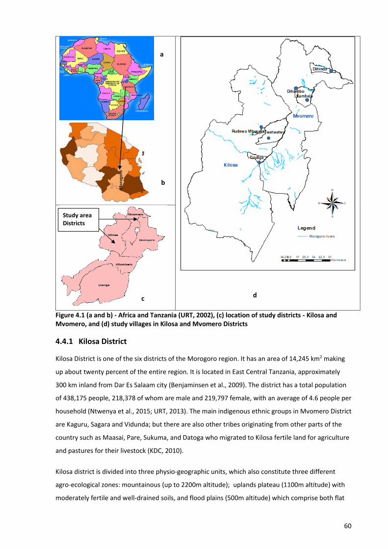
60
Figure 4.1 (a and b) - Africa and Tanzania (URT, 2002), (c) location of study districts - Kilosa and Mvomero, and (d) study villages in Kilosa and Mvomero Districts
4.4.1 Kilosa District
Kilosa District is one of the six districts of the Morogoro region. It has an area of 14,245 km2 making
up about twenty percent of the entire region. It is located in East Central Tanzania, approximately
300 km inland from Dar Es Salaam city (Benjaminsen et al., 2009). The district has a total population
of 438,175 people, 218,378 of whom are male and 219,797 female, with an average of 4.6 people per
household (Ntwenya et al., 2015; URT, 2013). The main indigenous ethnic groups in Mvomero District
are Kaguru, Sagara and Vidunda; but there are also other tribes originating from other parts of the
country such as Maasai, Pare, Sukuma, and Datoga who migrated to Kilosa fertile land for agriculture
and pastures for their livestock (KDC, 2010).
Kilosa district is divided into three physio-geographic units, which also constitute three different
agro-ecological zones: mountainous (up to 2200m altitude); uplands plateau (1100m altitude) with
moderately fertile and well-drained soils, and flood plains (500m altitude) which comprise both flat
a
b
d
Study area Districts
Mor
ogor
o
c
61
and undulating plains extending to the foothills. Many rivers, principally the Wami and Ruaha incise
the plains which are thus subject to seasonal flooding. This zone is mainly occupied by Maasai
agropastoralists (Mung'ong'o & Mwamfupe, 2003). The district experiences rainfall on average
during eight months of the year (October–May), with the highest levels between February and
March. Rainfall distribution is bimodal, with short rains (October–January), followed by long rains
(mid-February–May). Mean annual rainfall ranges between 800mm in low-lying areas to 1300mm in
the high-altitude areas. Mean annual temperature in Kilosa is about 25°C (Kajembe et al., 2013). The
vegetation is characterized by miombo woodland in the hilly areas and grassland on the alluvial
plains.
More than 80% of the population in Kilosa depends on agriculture – a wide range of crops including
maize, paddy, sorghums, sisal, sugarcane, millet, beans, mangoes, oranges, lemons, coffee, banana,
sunflower, cotton, soy beans, sesame, and vegetables including onions, cabbages, tomatoes, egg
plants, carrots and peppers are grown (Ntwenya et al., 2015). Livestock keeping has become another
important economic activity in the district following the large influx of pastoralists and
agropastoralists. The Morogoro region authority allocated eight village lands for agropastoral
communities, namely: Twatwatwa, Kiduhi, Madoto (Mbwade), Ngaite, Mabwegere, Kimamba, Godes
and Mfilisi. These villages carry over half of the livestock population in the district (KDC, 2010, p. 28).
Recently, the district has been severely hit with persistent land use conflicts especially between
agropastoralists and crop farmers.
4.4.2 Mvomero District
Mvomero district (7,325 km2) is a new district formed after dividing the former Morogoro District
into two halves, i.e., Morogoro urban and Mvomero, in 2002. The district has an estimated
population of 312,109 people, 154,843 of whom are male and 157,266 female, with an average of
4.5 people per household (URT, 2013). The main indigenous ethnic groups in Mvomero District are
Luguru, Zigua, Kagulu and Nguu; but there are also other tribes originating from other parts of the
country such as Maasai, Pare, Sukuma, and Gogo, who migrated to Mvomero’s fertile land for
agriculture and pastures for their livestock (MDC, 2006). The district is divided into three agro-
ecological zones: highland and mountainous zone, i.e., Nguru mountain ranges (1200 – 2000m above
sea level); Miombo woodland zone, i.e., flat lowland (600 – 1200m); and Savannah river basin
alongside the great rivers of Mkata, Wami and Ruvu. Mvomero is characterized by high rainfall
between March and May and from October to December when predominantly easterly trade winds
bring moisture from the Indian Ocean. Annual rainfall is between 600mm and 2000mm, being lowest
in the foothills and highest between 400m to 2000m above sea level. The temperature range in the
district is 18 – 30oC (Lyatuu, 2013).
62
More than 80% of the population in Mvomero are farmers cultivating both cash crops and
subsistence crops – cotton, coffee, sesame, sunflower, sugarcane, bananas, vegetables, paddy,
millet, and cassava (Lyatuu, 2013). Livestock keeping is another economic activity practiced mostly by
people coming from other parts of the country, e.g., Pare and Maasai agropastoralists (MDC, 2006, p.
1). From the early 1990s there has been a rapid increase in the number of agropastoralists (Maasai)
with a large number of herds, a situation that triggered a response from the district council to
establish Kambala Village (part of land from Dihombo Village) as a legally registered agropastoralists’
village. Like Kilosa District, Mvomero District has been severely hit with persistent land use conflicts
especially between agropastoralists and crop farmers who are fighting for the already strained land
resources. The following sections explain the selection of study villages and the data collection
methods used in this research.
4.5 Selection of study villages
One village from each of three wards in Kilosa District and one village from each of three wards in
Mvomero District were examined. Each set of three villages consists of two farmers’ villages and one
registered agropastoralists’ village. These villages are: the farmers’ villages of Tindiga (Tindiga ward)
and Rudewa-mbuyuni (Rudewa ward) and the agropastoralists’ village of Twatwatwa (Parakuyo
ward) in Kilosa District; and the farmers’ villages of Dihinda (Kanga ward) and Dihombo (Hembeti
ward) and the agropastoralists’ village of Kambala (Mkindo ward) in Mvomero District. Similarities in
rangeland vegetation types, farming and livestock production systems, and availability of sufficient
numbers of older farmers and agropastoralists (≥30 years old) for interviewing were the main criteria
used for selecting the villages. The ≥30 years age group was preferred to tap into participants’
knowledge for then analysing and explaining the mechanisms by which gaining, maintaining and
controlling access to, and use of land resources leads to wellbeing as well as to conflicts between
farmers and agropastoralists. Also, this age group was preferred to help determine local knowledge
on indicators used to assess environmental and rangeland health over a span of 20 years, i.e., it
ensured respondents had the knowledge and experience to be able to respond to questions about
changes over time. The six villages were also purposely selected due to their peculiar situation of
being prone to conflicts between farmers and agropastoralists that have escalated recently into
deadly violence. Despite their sedentarization, the agropastoralists are still very mobile people –
moving between villages searching for pasture and water for their livestock. Therefore, the
agropastoralists’ villages were selected according to the likelihood of meeting as many
agropastoralists as were needed for interviews and discussions at any particular moment.
63
4.6 Data collection methods
Despite its strength, qualitative research methodology has weaknesses such as subjectivity of the
data and questions of validity and reliability (Sarantakos, 2005). I addressed these qualitative
research weaknesses by triangulation of data, which involves using different methods of data
collection (Hapuarachchi, 2014). To minimise bias response, the triangulation of data was done by
cross-checking written field notes with the responses from other interviews, focus group discussions
(FGDs) and observations. The review of literature (Chapter 2) shows that a combination of methods
such as interviews, FGDs, desk reviews, observation and transect walks, and Geographical
Information System (GIS) and Remote Sensing applications, have been widely used to collect
qualitative and quantitative data in research which involves conflicts over land resources in Africa.
Therefore, this research adopted a range of methods and techniques to collect data from both
primary and secondary sources that facilitated answering the research questions and achieving the
research objectives. The review of literature, observation and transect walks, head of household
interviews, focus group discussions (FGDs) and GIS and Remote Sensing techniques were the
methods employed to collect data in this research. Field data collection occurred during November
2016 to March 2017. This matched the period when most farmers prepare and sow their farm crops
during the short rains (October – January), followed by the long rains (February – March). During this
crucial time most conflicts between farmers and agropastoralists occur, because in most agro-
pastoralists’ villages there are insufficient pastures, so the agropastoralists wander around farmers’
villages looking for pastures for their livestock. The next sub-sections describe the data collection
methods used this research.
4.6.1 Head of Household interviews (HHIs)
In the African cultural context and in Tanzania, a man is the head of the household. He is the one
with authority and responsibilities to participate and/or give permission for his wife and/or children
to participate in any matters (e.g., development issues, ceremonies) concerning the wellbeing of the
family, and normally his decision is final and should be honoured and/or respected. That being the
case, it is always necessary to ask permission from the head of the household before starting to
interview family members. In exceptional circumstances where the husband has died, divorced, or
otherwise not present at home, the wife assumes the responsibilities as the head of the household
and will participate or give permission for her children to participate instead.
This research employed a semi-structured format for all interviews and group discussions. The
interview and group discussion guides were originally prepared in English then translated into Swahili
by the researcher. Interviews and discussions were conducted in Swahili, Tanzania’s national
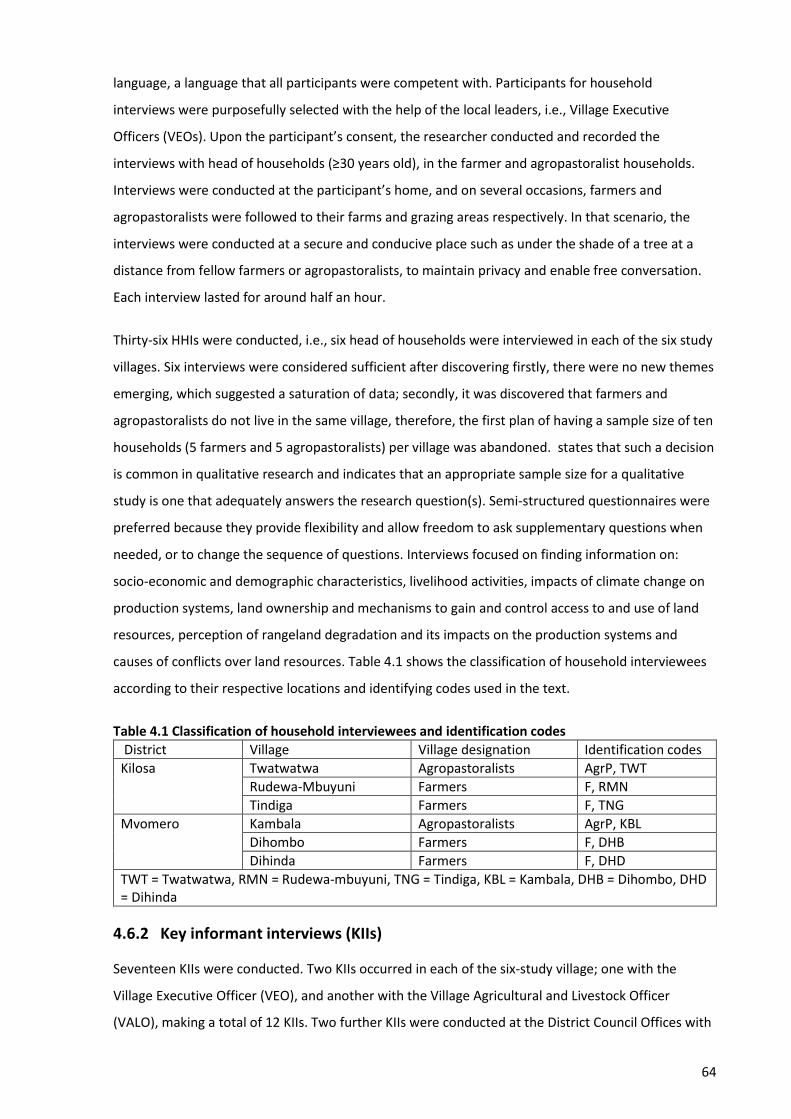
64
language, a language that all participants were competent with. Participants for household
interviews were purposefully selected with the help of the local leaders, i.e., Village Executive
Officers (VEOs). Upon the participant’s consent, the researcher conducted and recorded the
interviews with head of households (≥30 years old), in the farmer and agropastoralist households.
Interviews were conducted at the participant’s home, and on several occasions, farmers and
agropastoralists were followed to their farms and grazing areas respectively. In that scenario, the
interviews were conducted at a secure and conducive place such as under the shade of a tree at a
distance from fellow farmers or agropastoralists, to maintain privacy and enable free conversation.
Each interview lasted for around half an hour.
Thirty-six HHIs were conducted, i.e., six head of households were interviewed in each of the six study
villages. Six interviews were considered sufficient after discovering firstly, there were no new themes
emerging, which suggested a saturation of data; secondly, it was discovered that farmers and
agropastoralists do not live in the same village, therefore, the first plan of having a sample size of ten
households (5 farmers and 5 agropastoralists) per village was abandoned. states that such a decision
is common in qualitative research and indicates that an appropriate sample size for a qualitative
study is one that adequately answers the research question(s). Semi-structured questionnaires were
preferred because they provide flexibility and allow freedom to ask supplementary questions when
needed, or to change the sequence of questions. Interviews focused on finding information on:
socio-economic and demographic characteristics, livelihood activities, impacts of climate change on
production systems, land ownership and mechanisms to gain and control access to and use of land
resources, perception of rangeland degradation and its impacts on the production systems and
causes of conflicts over land resources. Table 4.1 shows the classification of household interviewees
according to their respective locations and identifying codes used in the text.
Table 4.1 Classification of household interviewees and identification codes
District Village Village designation Identification codes
Kilosa Twatwatwa Agropastoralists AgrP, TWT
Rudewa-Mbuyuni Farmers F, RMN
Tindiga Farmers F, TNG
Mvomero Kambala Agropastoralists AgrP, KBL
Dihombo Farmers F, DHB
Dihinda Farmers F, DHD
TWT = Twatwatwa, RMN = Rudewa-mbuyuni, TNG = Tindiga, KBL = Kambala, DHB = Dihombo, DHD = Dihinda
4.6.2 Key informant interviews (KIIs)
Seventeen KIIs were conducted. Two KIIs occurred in each of the six-study village; one with the
Village Executive Officer (VEO), and another with the Village Agricultural and Livestock Officer
(VALO), making a total of 12 KIIs. Two further KIIs were conducted at the District Council Offices with
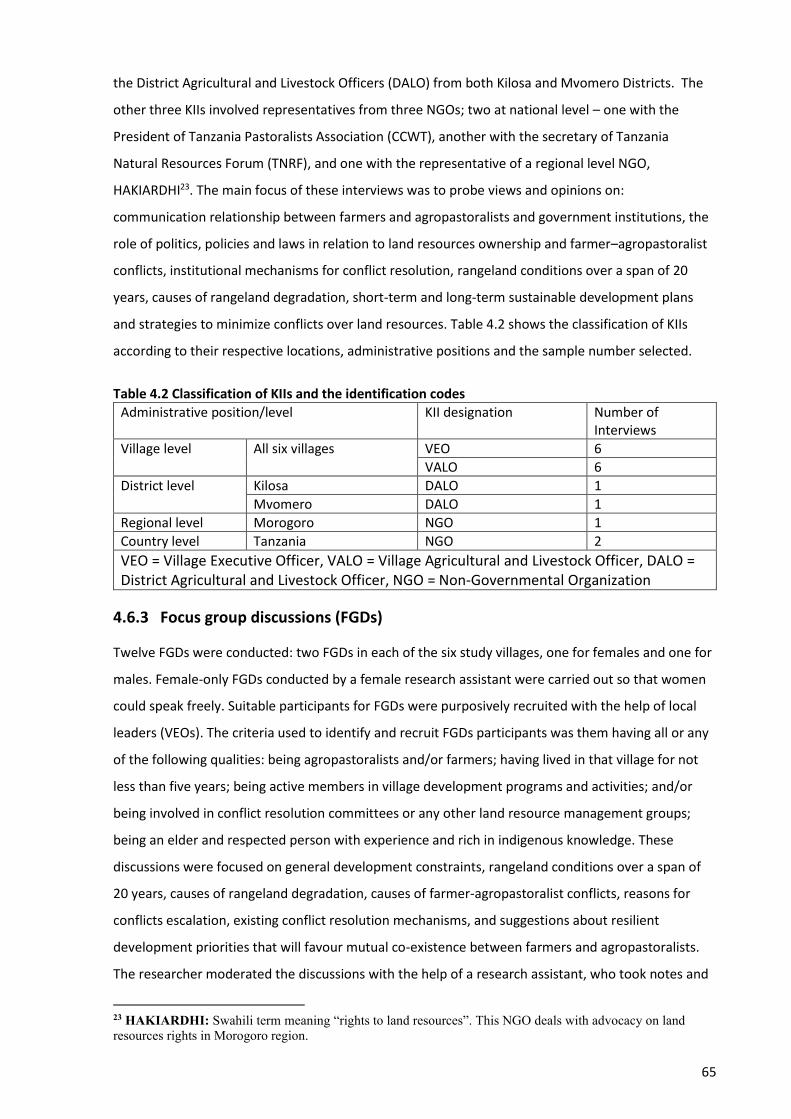
65
the District Agricultural and Livestock Officers (DALO) from both Kilosa and Mvomero Districts. The
other three KIIs involved representatives from three NGOs; two at national level – one with the
President of Tanzania Pastoralists Association (CCWT), another with the secretary of Tanzania
Natural Resources Forum (TNRF), and one with the representative of a regional level NGO,
HAKIARDHI23. The main focus of these interviews was to probe views and opinions on:
communication relationship between farmers and agropastoralists and government institutions, the
role of politics, policies and laws in relation to land resources ownership and farmer–agropastoralist
conflicts, institutional mechanisms for conflict resolution, rangeland conditions over a span of 20
years, causes of rangeland degradation, short-term and long-term sustainable development plans
and strategies to minimize conflicts over land resources. Table 4.2 shows the classification of KIIs
according to their respective locations, administrative positions and the sample number selected.
Table 4.2 Classification of KIIs and the identification codes
Administrative position/level KII designation Number of Interviews
Village level All six villages VEO 6
VALO 6
District level Kilosa DALO 1
Mvomero DALO 1
Regional level Morogoro NGO 1
Country level Tanzania NGO 2
VEO = Village Executive Officer, VALO = Village Agricultural and Livestock Officer, DALO = District Agricultural and Livestock Officer, NGO = Non-Governmental Organization
4.6.3 Focus group discussions (FGDs)
Twelve FGDs were conducted: two FGDs in each of the six study villages, one for females and one for
males. Female-only FGDs conducted by a female research assistant were carried out so that women
could speak freely. Suitable participants for FGDs were purposively recruited with the help of local
leaders (VEOs). The criteria used to identify and recruit FGDs participants was them having all or any
of the following qualities: being agropastoralists and/or farmers; having lived in that village for not
less than five years; being active members in village development programs and activities; and/or
being involved in conflict resolution committees or any other land resource management groups;
being an elder and respected person with experience and rich in indigenous knowledge. These
discussions were focused on general development constraints, rangeland conditions over a span of
20 years, causes of rangeland degradation, causes of farmer-agropastoralist conflicts, reasons for
conflicts escalation, existing conflict resolution mechanisms, and suggestions about resilient
development priorities that will favour mutual co-existence between farmers and agropastoralists.
The researcher moderated the discussions with the help of a research assistant, who took notes and
23 HAKIARDHI: Swahili term meaning “rights to land resources”. This NGO deals with advocacy on land resources rights in Morogoro region.
66
kept time. All discussions and conversations were recorded then transcribed. Two (one male and one
female) FGDs were executed each day, and each FGD session lasted, on average, two hours. This
scheduling allowed for reflection and consolidation of emerging issues for further cross-examination.
The identification codes for FGDs in the text indicates whether it is a female or male FGD, and the
location where it was conducted (e.g., FGD, female, DHD).
4.6.4 Personal observation and transect walks
Some researchers have recommended that personal observations and transect walks be used in
research and studies which are ethnographic in nature, because it helps to generate practical and
theoretical truths about human life grounded in realities of daily existence (Kabwe, 2010, p. 51;
Ming'ate, 2012, p. 61). Observation is used to complement and/or supplement household interviews
by addressing their shortcomings. The method was complemented with geo-coded transect walks,
which involves systematic walking with local people through the study villages while observing,
asking, and listening. Hand-held GPS was used to collect and record positional data (spatial data) of
grazing areas, farms, and areas where conflicts occurred. The attribute data associated with these
spatial data were recorded in a field book. The transect walks provided an opportunity to see the
landscape and on the ground practices. Some information and data were gathered by way of the
researcher’s own direct observation and taking pictures of public places. Upon their consent, pictures
with peoples’ faces were taken and where necessary, blurring applied to the faces if the picture
happened to be used in the production of this thesis. Information gathered by this method included:
living conditions, access to water sources, farming and livestock keeping practices, water and soil
conservation practices, grazing and watering areas, and boundaries separating farmers and
agropastoralists’ villages. The main advantage of this method is that subjective bias is eliminated if
observation is done accurately. Secondly, the information obtained by this method relates to what is
currently happening; it is not complicated by either past behaviour or future intentions or attitudes.
However, the observation method has limitations. Firstly, the researcher may be seen as intrusive.
Secondly, information provided is very limited especially when private information is observed that
the researcher cannot report (Kothari, 2009; Punch, 2014). These limitations were minimized and/or
avoided by establishing and maintaining good relationships with villagers in the study communities.
The researcher achieved this by following formal procedure and protocols to secure entry into the
study villages, which included introducing himself and the purpose of the research to the Morogoro
Regional Administrative Secretary (RAS), who also provided the researcher with the introduction
letter which directs the District Administrative Secretary (DAS) or the District Executive Director
(DED) to provide maximum cooperation. The DAS/DED provided the researcher with an introduction
letter that directs other lower chains of command such as Ward Executive Officers (WEOs) and
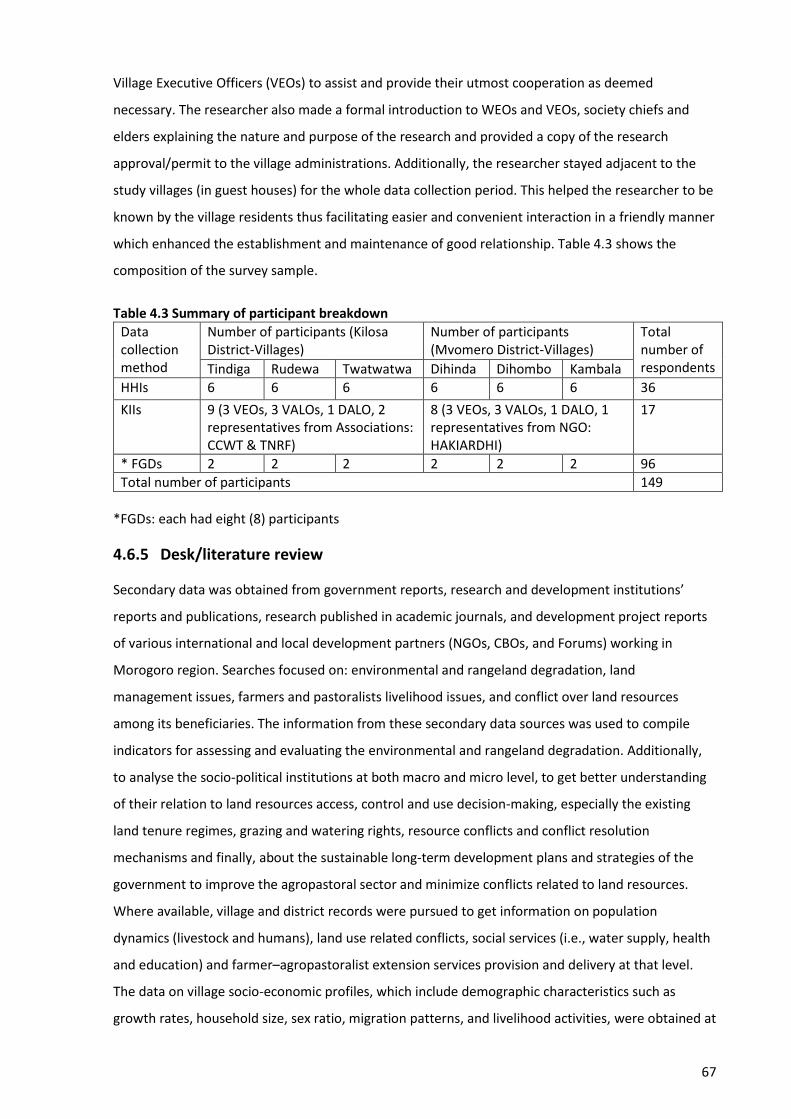
67
Village Executive Officers (VEOs) to assist and provide their utmost cooperation as deemed
necessary. The researcher also made a formal introduction to WEOs and VEOs, society chiefs and
elders explaining the nature and purpose of the research and provided a copy of the research
approval/permit to the village administrations. Additionally, the researcher stayed adjacent to the
study villages (in guest houses) for the whole data collection period. This helped the researcher to be
known by the village residents thus facilitating easier and convenient interaction in a friendly manner
which enhanced the establishment and maintenance of good relationship. Table 4.3 shows the
composition of the survey sample.
Table 4.3 Summary of participant breakdown
Data collection method
Number of participants (Kilosa District-Villages)
Number of participants (Mvomero District-Villages)
Total number of respondents Tindiga Rudewa Twatwatwa Dihinda Dihombo Kambala
HHIs 6 6 6 6 6 6 36
KIIs 9 (3 VEOs, 3 VALOs, 1 DALO, 2 representatives from Associations: CCWT & TNRF)
8 (3 VEOs, 3 VALOs, 1 DALO, 1 representatives from NGO: HAKIARDHI)
17
* FGDs 2 2 2 2 2 2 96
Total number of participants 149
*FGDs: each had eight (8) participants
4.6.5 Desk/literature review
Secondary data was obtained from government reports, research and development institutions’
reports and publications, research published in academic journals, and development project reports
of various international and local development partners (NGOs, CBOs, and Forums) working in
Morogoro region. Searches focused on: environmental and rangeland degradation, land
management issues, farmers and pastoralists livelihood issues, and conflict over land resources
among its beneficiaries. The information from these secondary data sources was used to compile
indicators for assessing and evaluating the environmental and rangeland degradation. Additionally,
to analyse the socio-political institutions at both macro and micro level, to get better understanding
of their relation to land resources access, control and use decision-making, especially the existing
land tenure regimes, grazing and watering rights, resource conflicts and conflict resolution
mechanisms and finally, about the sustainable long-term development plans and strategies of the
government to improve the agropastoral sector and minimize conflicts related to land resources.
Where available, village and district records were pursued to get information on population
dynamics (livestock and humans), land use related conflicts, social services (i.e., water supply, health
and education) and farmer–agropastoralist extension services provision and delivery at that level.
The data on village socio-economic profiles, which include demographic characteristics such as
growth rates, household size, sex ratio, migration patterns, and livelihood activities, were obtained at
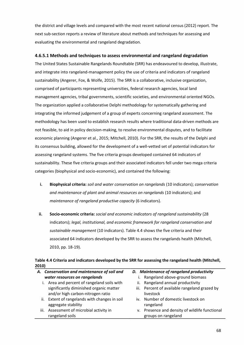
68
the district and village levels and compared with the most recent national census (2012) report. The
next sub-section reports a review of literature about methods and techniques for assessing and
evaluating the environmental and rangeland degradation.
4.6.5.1 Methods and techniques to assess environmental and rangeland degradation
The United States Sustainable Rangelands Roundtable (SRR) has endeavoured to develop, illustrate,
and integrate into rangeland-management policy the use of criteria and indicators of rangeland
sustainability (Angerer, Fox, & Wolfe, 2015). The SRR is a collaborative, inclusive organization,
comprised of participants representing universities, federal research agencies, local land
management agencies, tribal governments, scientific societies, and environmental oriented NGOs.
The organization applied a collaborative Delphi methodology for systematically gathering and
integrating the informed judgement of a group of experts concerning rangeland assessment. The
methodology has been used to establish research results where traditional data-driven methods are
not feasible, to aid in policy decision-making, to resolve environmental disputes, and to facilitate
economic planning (Angerer et al., 2015; Mitchell, 2010). For the SRR, the results of the Delphi and
its consensus building, allowed for the development of a well-vetted set of potential indicators for
assessing rangeland systems. The five criteria groups developed contained 64 indicators of
sustainability. These five criteria groups and their associated indicators fell under two mega criteria
categories (biophysical and socio-economic), and contained the following:
i. Biophysical criteria: soil and water conservation on rangelands (10 indicators); conservation
and maintenance of plant and animal resources on rangelands (10 indicators); and
maintenance of rangeland productive capacity (6 indicators).
ii. Socio-economic criteria: social and economic indicators of rangeland sustainability (28
indicators); legal, institutional, and economic framework for rangeland conservation and
sustainable management (10 indicators). Table 4.4 shows the five criteria and their
associated 64 indicators developed by the SRR to assess the rangelands health (Mitchell,
2010, pp. 18-19).
Table 4.4 Criteria and indicators developed by the SRR for assessing the rangeland health (Mitchell, 2010)
A. Conservation and maintenance of soil and water resources on rangelands
i. Area and percent of rangeland soils with significantly diminished organic matter and/or high carbon-nitrogen ratio
ii. Extent of rangelands with changes in soil aggregate stability
iii. Assessment of microbial activity in rangeland soils
D. Maintenance of rangeland productivity i. Rangeland above-ground biomass
ii. Rangeland annual productivity iii. Percent of available rangeland grazed by
livestock iv. Number of domestic livestock on
rangeland v. Presence and density of wildlife functional
groups on rangeland
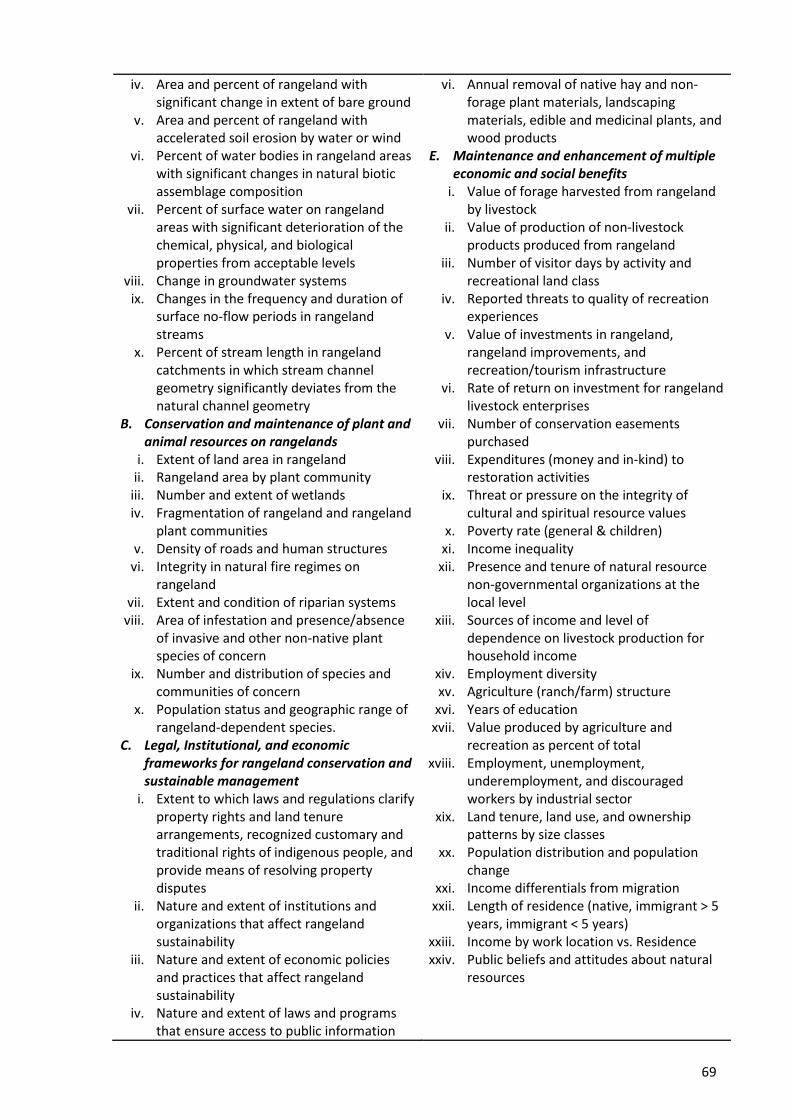
69
iv. Area and percent of rangeland with significant change in extent of bare ground
v. Area and percent of rangeland with accelerated soil erosion by water or wind
vi. Percent of water bodies in rangeland areas with significant changes in natural biotic assemblage composition
vii. Percent of surface water on rangeland areas with significant deterioration of the chemical, physical, and biological properties from acceptable levels
viii. Change in groundwater systems ix. Changes in the frequency and duration of
surface no-flow periods in rangeland streams
x. Percent of stream length in rangeland catchments in which stream channel geometry significantly deviates from the natural channel geometry
B. Conservation and maintenance of plant and animal resources on rangelands
i. Extent of land area in rangeland ii. Rangeland area by plant community
iii. Number and extent of wetlands iv. Fragmentation of rangeland and rangeland
plant communities v. Density of roads and human structures
vi. Integrity in natural fire regimes on rangeland
vii. Extent and condition of riparian systems viii. Area of infestation and presence/absence
of invasive and other non-native plant species of concern
ix. Number and distribution of species and communities of concern
x. Population status and geographic range of rangeland-dependent species.
C. Legal, Institutional, and economic frameworks for rangeland conservation and sustainable management
i. Extent to which laws and regulations clarify property rights and land tenure arrangements, recognized customary and traditional rights of indigenous people, and provide means of resolving property disputes
ii. Nature and extent of institutions and organizations that affect rangeland sustainability
iii. Nature and extent of economic policies and practices that affect rangeland sustainability
iv. Nature and extent of laws and programs that ensure access to public information
vi. Annual removal of native hay and non-forage plant materials, landscaping materials, edible and medicinal plants, and wood products
E. Maintenance and enhancement of multiple economic and social benefits
i. Value of forage harvested from rangeland by livestock
ii. Value of production of non-livestock products produced from rangeland
iii. Number of visitor days by activity and recreational land class
iv. Reported threats to quality of recreation experiences
v. Value of investments in rangeland, rangeland improvements, and recreation/tourism infrastructure
vi. Rate of return on investment for rangeland livestock enterprises
vii. Number of conservation easements purchased
viii. Expenditures (money and in-kind) to restoration activities
ix. Threat or pressure on the integrity of cultural and spiritual resource values
x. Poverty rate (general & children) xi. Income inequality
xii. Presence and tenure of natural resource non-governmental organizations at the local level
xiii. Sources of income and level of dependence on livestock production for household income
xiv. Employment diversity xv. Agriculture (ranch/farm) structure
xvi. Years of education xvii. Value produced by agriculture and
recreation as percent of total xviii. Employment, unemployment,
underemployment, and discouraged workers by industrial sector
xix. Land tenure, land use, and ownership patterns by size classes
xx. Population distribution and population change
xxi. Income differentials from migration xxii. Length of residence (native, immigrant > 5
years, immigrant < 5 years) xxiii. Income by work location vs. Residence xxiv. Public beliefs and attitudes about natural
resources
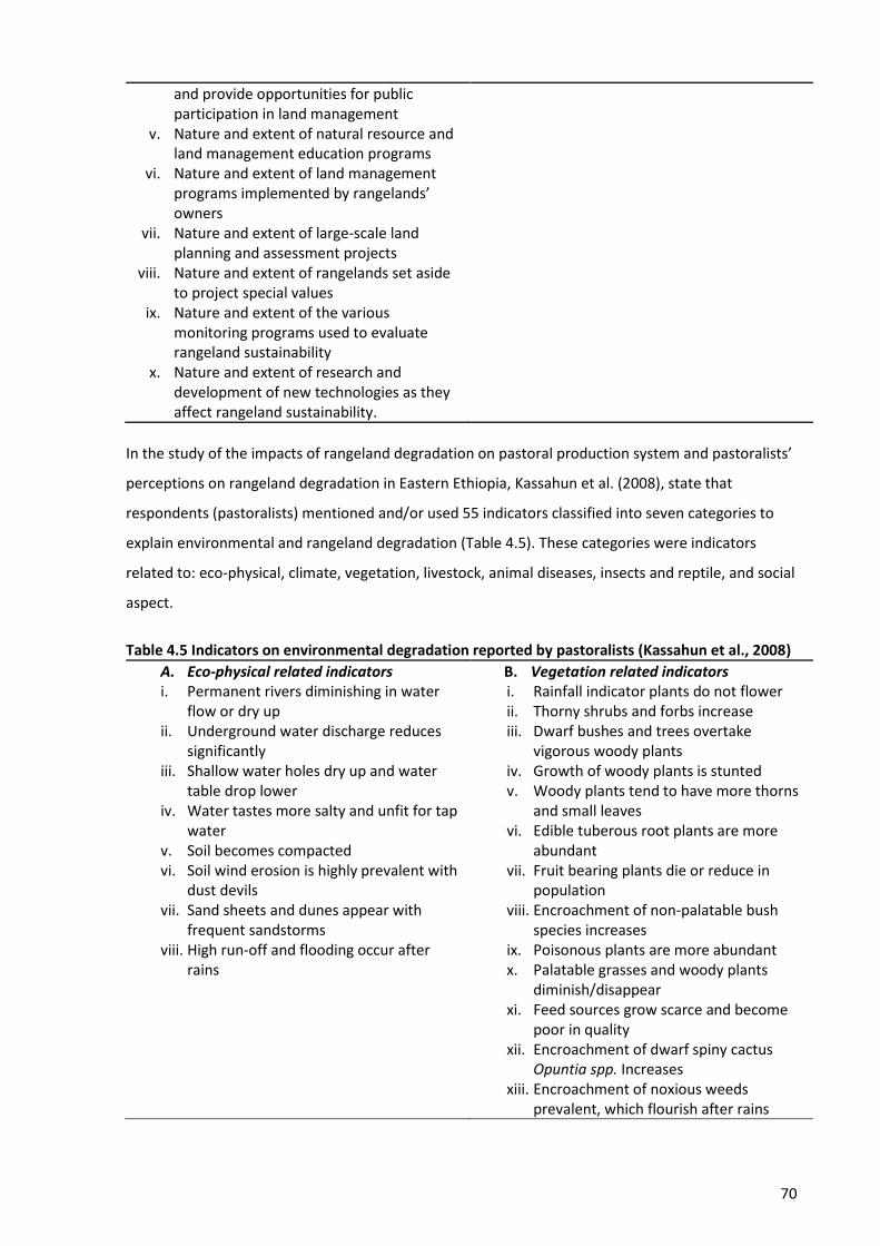
70
and provide opportunities for public participation in land management
v. Nature and extent of natural resource and land management education programs
vi. Nature and extent of land management programs implemented by rangelands’ owners
vii. Nature and extent of large-scale land planning and assessment projects
viii. Nature and extent of rangelands set aside to project special values
ix. Nature and extent of the various monitoring programs used to evaluate rangeland sustainability
x. Nature and extent of research and development of new technologies as they affect rangeland sustainability.
In the study of the impacts of rangeland degradation on pastoral production system and pastoralists’
perceptions on rangeland degradation in Eastern Ethiopia, Kassahun et al. (2008), state that
respondents (pastoralists) mentioned and/or used 55 indicators classified into seven categories to
explain environmental and rangeland degradation (Table 4.5). These categories were indicators
related to: eco-physical, climate, vegetation, livestock, animal diseases, insects and reptile, and social
aspect.
Table 4.5 Indicators on environmental degradation reported by pastoralists (Kassahun et al., 2008)
A. Eco-physical related indicators i. Permanent rivers diminishing in water
flow or dry up ii. Underground water discharge reduces
significantly iii. Shallow water holes dry up and water
table drop lower iv. Water tastes more salty and unfit for tap
water v. Soil becomes compacted vi. Soil wind erosion is highly prevalent with
dust devils vii. Sand sheets and dunes appear with
frequent sandstorms viii. High run-off and flooding occur after
rains
B. Vegetation related indicators i. Rainfall indicator plants do not flower ii. Thorny shrubs and forbs increase iii. Dwarf bushes and trees overtake
vigorous woody plants iv. Growth of woody plants is stunted v. Woody plants tend to have more thorns
and small leaves vi. Edible tuberous root plants are more
abundant vii. Fruit bearing plants die or reduce in
population viii. Encroachment of non-palatable bush
species increases ix. Poisonous plants are more abundant x. Palatable grasses and woody plants
diminish/disappear xi. Feed sources grow scarce and become
poor in quality xii. Encroachment of dwarf spiny cactus
Opuntia spp. Increases xiii. Encroachment of noxious weeds
prevalent, which flourish after rains

71
C. Climate related indicators i. Drought increases in frequency to every
3 years ii. Drought lasts more than 1 year when
occurring iii. Temperature increases above normal iv. Soil temperature is high and burns bare
feet v. More thirst is experienced and
dehydration increases vi. More shading and less grazing/browsing
of animals vii. Incidence of predators increase with
time
D. Livestock related indicators i. Camels become leading arid animal ii. Production of small ruminants increases iii. Cattle production declines iv. Animals spend more time in shade v. Animal productivity and growth decline vi. Stunted animals become a common
problem vii. High calf mortality and weaning takes
longer viii. Longer interval between calving/kidding ix. Reduced supply of cattle at livestock
market x. Higher supply of camel milk than cow
milk
E. Social indicators i. Population pressure on land increases ii. Poverty increases iii. More dependence on food aid iv. More migration of households takes
place v. Rich households face problems vi. Medium households grow poor/fragile
F. Animal disease indicators i. Contagious animal diseases are common ii. Disease outbreaks increase sporadically iii. Ticks and tick-borne diseases increase iv. Higher internal parasite problems v. Skin diseases become a common
problem vi. Respiratory diseases are often chronic
G. Insect and reptile related indicators i. Termite problems increase ii. Mice and rats increase in population iii. Snake population and problems increase iv. Locusts can occur sporadically v. Beetles and cattle biting flies increase
In Northern Ethiopia, Gebreyowhans (2015), revealed that farmers used indicators such as reduction
in herbaceous biomass, poor vegetation cover, emengence of unwanted plant species, and poor
animal body condition to explain their understanding of rangeland degradation. Another study by
Behmanesh, Barani, Sarvestani, Shahraki, and Sharafatmandrad (2016), in Iran, of how indigenous
people (pastoralists) assess rangeland degradation and how their ecological knowledge can be used
for rangeland degradation assessment, revealed that pastoralists were able to integrate their
indigenous and ecological knowledge and came up with three categories of indicators, which when
interpreted from their local language seemed to mimic the list of indicators extracted from scientific
literature:
i. Vegetation indicators: decrease of vegetation, loss of phyto-diversity, decrease of palatable
plants, increase of poisonous plants and loss of litter mass
ii. Soil (edaphic) indicators: soil salination, decrease of ground cover, decrease of soil filtration
and increase of soil looseness
72
A review of many other studies show that GIS and RS technique coupled with other methods, such as
rangeland degradation assessment indicators (Angerer et al., 2015; Gebreyowhans, 2015; Kassahun
et al., 2008; Mitchell, 2010), household survey and case studies (Campbell et al., 2005; Ho & Azadi,
2010), and local indigenous cum ecological knowledge (Behmanesh et al., 2016; Kong, Marsh, van
Rooyen, Kellner, & Orr, 2015), results into detailed and better findings of rangeland degradation than
when GIS and RS applied as a stand-alone method. Table 4.6 shows the range of different methods
and techniques applied to assess rangeland degradation.
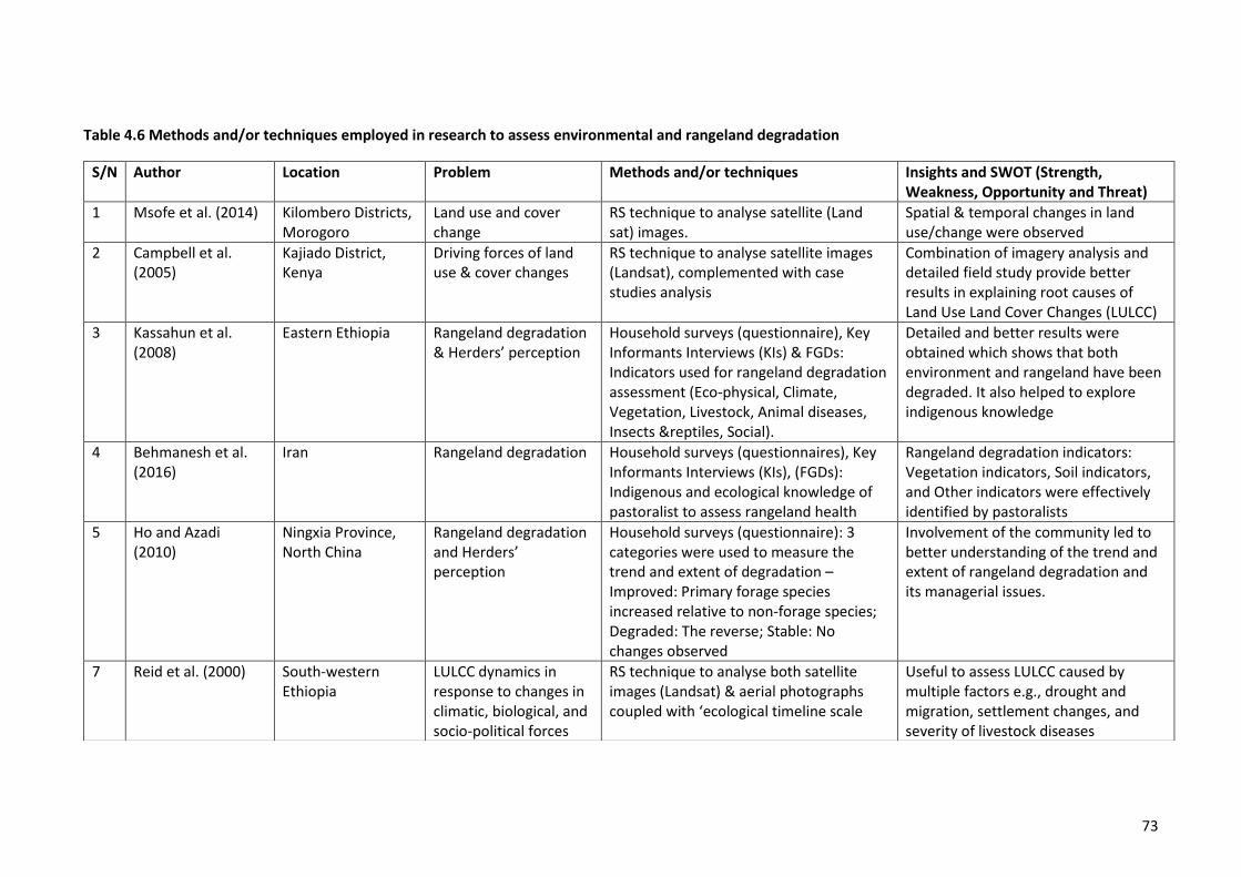
73
Table 4.6 Methods and/or techniques employed in research to assess environmental and rangeland degradation
S/N Author Location Problem Methods and/or techniques Insights and SWOT (Strength, Weakness, Opportunity and Threat)
1 Msofe et al. (2014) Kilombero Districts, Morogoro
Land use and cover change
RS technique to analyse satellite (Land sat) images.
Spatial & temporal changes in land use/change were observed
2 Campbell et al. (2005)
Kajiado District, Kenya
Driving forces of land use & cover changes
RS technique to analyse satellite images (Landsat), complemented with case studies analysis
Combination of imagery analysis and detailed field study provide better results in explaining root causes of Land Use Land Cover Changes (LULCC)
3 Kassahun et al. (2008)
Eastern Ethiopia Rangeland degradation & Herders’ perception
Household surveys (questionnaire), Key Informants Interviews (KIs) & FGDs: Indicators used for rangeland degradation assessment (Eco-physical, Climate, Vegetation, Livestock, Animal diseases, Insects &reptiles, Social).
Detailed and better results were obtained which shows that both environment and rangeland have been degraded. It also helped to explore indigenous knowledge
4 Behmanesh et al. (2016)
Iran Rangeland degradation Household surveys (questionnaires), Key Informants Interviews (KIs), (FGDs): Indigenous and ecological knowledge of pastoralist to assess rangeland health
Rangeland degradation indicators: Vegetation indicators, Soil indicators, and Other indicators were effectively identified by pastoralists
5 Ho and Azadi (2010)
Ningxia Province, North China
Rangeland degradation and Herders’ perception
Household surveys (questionnaire): 3 categories were used to measure the trend and extent of degradation – Improved: Primary forage species increased relative to non-forage species; Degraded: The reverse; Stable: No changes observed
Involvement of the community led to better understanding of the trend and extent of rangeland degradation and its managerial issues.
7 Reid et al. (2000) South-western Ethiopia
LULCC dynamics in response to changes in climatic, biological, and socio-political forces
RS technique to analyse both satellite images (Landsat) & aerial photographs coupled with ‘ecological timeline scale
Useful to assess LULCC caused by multiple factors e.g., drought and migration, settlement changes, and severity of livestock diseases
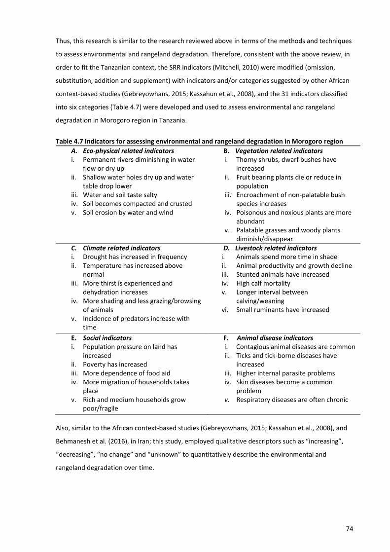
74
Thus, this research is similar to the research reviewed above in terms of the methods and techniques
to assess environmental and rangeland degradation. Therefore, consistent with the above review, in
order to fit the Tanzanian context, the SRR indicators (Mitchell, 2010) were modified (omission,
substitution, addition and supplement) with indicators and/or categories suggested by other African
context-based studies (Gebreyowhans, 2015; Kassahun et al., 2008), and the 31 indicators classified
into six categories (Table 4.7) were developed and used to assess environmental and rangeland
degradation in Morogoro region in Tanzania.
Table 4.7 Indicators for assessing environmental and rangeland degradation in Morogoro region
A. Eco-physical related indicators i. Permanent rivers diminishing in water
flow or dry up ii. Shallow water holes dry up and water
table drop lower iii. Water and soil taste salty iv. Soil becomes compacted and crusted v. Soil erosion by water and wind
B. Vegetation related indicators i. Thorny shrubs, dwarf bushes have
increased ii. Fruit bearing plants die or reduce in
population iii. Encroachment of non-palatable bush
species increases iv. Poisonous and noxious plants are more
abundant v. Palatable grasses and woody plants
diminish/disappear
C. Climate related indicators i. Drought has increased in frequency ii. Temperature has increased above
normal iii. More thirst is experienced and
dehydration increases iv. More shading and less grazing/browsing
of animals v. Incidence of predators increase with
time
D. Livestock related indicators i. Animals spend more time in shade ii. Animal productivity and growth decline iii. Stunted animals have increased iv. High calf mortality v. Longer interval between
calving/weaning vi. Small ruminants have increased
E. Social indicators i. Population pressure on land has
increased ii. Poverty has increased iii. More dependence of food aid iv. More migration of households takes
place v. Rich and medium households grow
poor/fragile
F. Animal disease indicators i. Contagious animal diseases are common ii. Ticks and tick-borne diseases have
increased iii. Higher internal parasite problems iv. Skin diseases become a common
problem v. Respiratory diseases are often chronic
Also, similar to the African context-based studies (Gebreyowhans, 2015; Kassahun et al., 2008), and
Behmanesh et al. (2016), in Iran; this study, employed qualitative descriptors such as “increasing”,
“decreasing”, “no change” and “unknown” to quantitatively describe the environmental and
rangeland degradation over time.
75
4.6.6 GIS and Remote Sensing
Mandara et al. (2012) highlighted that maps can be instrumental in addressing local land use changes
and their associated conflicts. The use of remote sensing imagery for assessing rangeland
degradation is attractive because of the large areal coverage it provides, the ability to examine
remote areas that may be inaccessible, and the ability to receive information at greater temporal
frequencies (Adjorlolo & Mutanga, 2013; Angerer et al., 2015). Remote sensing imaging techniques
provide the potential to monitor land use and landcover changes, thus enabling an assessment of
areas of severe land degradation and allows for timely interventions (Kibena, Nhapi, & Gumindoga,
2014).
4.6.6.1 Acquisition and analysis of satellite imagery
The Bulk Downloading Application (BDA) was used to acquire free satellite images from the USGS-
earthexplorer using Landsat 8 Operational Land Imager Sensor (OLI/TIRS) and Landsat Thematic
Mapper (TM) sensors. The Landsat Thematic Mapper (TM) satellite images of July 1995 and Landsat 8
Operational Land Imager Sensor (OLI/TIRS) satellite images of October 2017 were used to assess the
land use and land cover changes (LULC) of the study villages and visualize rangeland resource
conditions and changes between 1995 and 2017 (i.e., span of 22 years). The irregular intervals (i.e.,
July 1995 and October 2017) occurred because of unavailability of cloud-free images in most years.
Landsat TM and OLI/TIRS satellite images were used because of their relatively high spatial resolution
(30 m) and their wide application for landcover classification across the world (Kibena et al., 2014).
Landsat images have the optimal ground resolution and spectral bands to efficiently track land use
and to document landcover changes due to climate change, urbanization, drought, wildfire, biomass
changes (carbon assessment), and a host of other natural and anthropogenic changes (Oguro, Suga,
Takeuchi, Ogawa, & Tsuchiya, 2003). ArcGIS 10.5 software was used to process, analyse and visualize
land use and landcover changes.
The Maximum Likelihood method using the Supervised Classification technique was used, which
involved clustering pixels into training classes followed by developing the spectral signatures. Six
regions of interest (ROIs), i.e., main training sample classes were created: forest,
woodland/grassland, water bodies, bareland, farms/cultivation and settlement. The training classes
simplified the identification of pixels that represents spectral variation in each region of interest. The
maximum likelihood classification technique assumes that the statistics for each class in each band
are normally distributed and calculates the probability that a given pixel belongs to a specific class
(Kibena et al., 2014; Oguro et al., 2003). Each pixel is assigned to the class that has the highest
probability (i.e., the maximum likelihood). If the highest probability is smaller than a threshold
specified, the pixel remains unclassified. The area weighted land use change from 1995 to 2017 was
76
also calculated in order to visualize changes in land use and landcover area in space and time. The
classification results were also compared to additional ground truth information obtained from a
2017 Google Earth image. The validation with Google Earth was meant to ensure that classes were
properly assigned to the respective landcover feature on the ground.
4.7 Human ethical issues
Prior to commencement of data collection in Tanzania, the required research permit and approvals
from the Tanzania Commission for Science and Technology (COSTECH) and the Lincoln University
Human Ethics Committee were sought and obtained. The researcher also obtained permission to
conduct the study from the regional, district, wards and village authorities. Individual verbal consent
was sought and obtained from study participants prior to their participation in the FGDs and
interviews. The following steps were taken to ensure participants’ rights and confidentiality were
observed and respected: (1) voluntary participation, (2) names excluded from the recorded materials
(anonymity), (3) ability to withdraw from participation and information provided at any stage up until
May 2017, and (4) ability to contact the research team for any queries. The information acquired
from participants was kept confidential and treated with privacy and was only accessed by the
research team.
4.8 Data analysis
Many research designs relegate analysis and interpretation of data to the final stages of the research
process. However, ethnographers and researchers conducting qualitative research begin the analysis
of data almost as soon as they enter the field site, and continue with the process of analysis,
hypothesis creation and testing and interpretation throughout the process of collecting data until the
final page of the report is complete (LeCompte & Schensul, 1999). That process was used here.
Field data were classified into two categories; spatial and non-spatial data. Spatial data from the geo-
coded transect walks, village maps (shapefiles) and satellite images were analysed by GIS (ArcGIS
10.5) and Remote Sensing techniques, complemented with attribute data from observation and
interview methods (rangeland assessment indicators). This is how the land use and land cover
changes, and rangeland condition (for 20 years span) was assessed in the study villages. Content
analysis was carried out following the Graneheim and Lundman (2004) guidelines. Data were sorted
and analysed manually by initiating coding and assigning categories. These modes of data
organization enabled identification, sorting and arranging of the data and examination of the
connections and relations between the key elements identified. Coding helped in summarizing
information, without losing the importance, meaning and credibility of the information, as well as
capturing key concepts. Qualitative descriptors are applied quantitatively in some circumstances: i.e.,
77
“a few” is 10% or less, “a small minority” is up to 25%, “a large minority” is between 25% and 40%,
“about half” is between 40% and 60%, “a majority” is between 60% and 75%, and “a large majority”
is more than 75%. The codes and categories that emerged from the data were later sorted to form
the main themes as presented in the findings reported in the next chapters.
4.9 Limitations of the study
There were limitations in this research in terms of the methodology and methods used. The ongoing
land resource use related conflicts in Morogoro region are heavily linked with political context and
dishonesty among government officials. Therefore, some government officials, especially at the
district level, either for reasons beyond their control or otherwise, did not want to be interviewed.
They gave reasons for being out of office whenever the scheduled interview meeting was
approaching. Therefore, only those district officials who were willing to participate in this research
were interviewed. The two district level officials and two of the village level interviewees chose not
to answer the question regarding political issues and dishonesty among government officials in
relation to the ongoing land resource use related conflicts. Even though these were desirable
questions to provide useful information to help to address the research objectives set out in Chapter
1, such questions were either amended and/or avoided during the interviews to minimize any risks
to both the interviewer and the interviewees. However, these data needs were checked by
triangulating other data from FGDs, interviews and literature to overcome these limitations.
Although qualitative data is good for revealing nuance and depth of understanding, it can be difficult
to identify generalizable and representative statements with policy and related implications,
especially when the sample size is small. However, in this study, eight interviews were considered
sufficient after discovering firstly, there were no new themes emerging (after six interviews), which
suggested data saturation; secondly, it was discovered that farmers and agropastoralists do not live
in the same village – the initial plan of having a sample size of 10 (five farmers and five
agropastoralists) per village was thus abandoned.
Another limitation could be potential gender bias linked to interviewing only men as heads of
household, and not their wives. The wives may have different perspectives, one that is equally
important. However, this study employed an approach basing on the African cultural context
whereby a man is the head of household, but in exceptional circumstances where the husband has
died, divorced, or not at home, the wife assumed the responsibility as the head of household, and
was interviewed. Given the context, this approach was considered appropriate for this study.
However, as a complementary approach and way of cross-checking, female FGDs (conducted by a
female research assistant) captured female views and opinions which have been fully considered
within the remainder of the thesis.
78
4.10 Conclusions
This chapter presented the methodology, approach and methods used for this research along with
the sampling and criteria for selecting participants, description of the study areas, data collection and
analysis methods, and human ethics issues. As presented, a qualitative research methodology was
adopted as the overall framework to guide data collection methods and strategies. Given the
weaknesses of the qualitative methodology, multiple methods and data sources were used for data
triangulation to improve the validity and reliability of the data collected and the subsequent analysis
undertaken. The findings and insights from the data analysis are presented in the chapters to follow.
79
Chapter 5
Mechanisms to gain access to and use of land resources
5.1 Introduction
This chapter addresses the first objective of this thesis, which is to assess the mechanisms (means,
processes and relations) by which agropastoralists gain, maintain and control access to and use of
land resources and how these mechanisms contribute to their wellbeing and to conflicts with
farmers. The chapter begins by providing an overview and reporting experiences on the ground of
the general procedures that are followed, and the qualifications required for a person to have access
to and own land resources at the village level in Tanzania. A brief description of different access
mechanisms (as explained in Access Theory) follows next. The next section presents findings on key
mechanisms (means, processes, and relations) by which agropastoralists gain and control access to
and use of land resources, namely: right-based access mechanisms and structural, power, and social
relations mechanisms. This is followed by the findings about how agropastoralists and farmers
perceive these mechanisms contribute to or reduce their wellbeing. The chapter ends by reporting
on how these mechanisms contribute to farmer – agropastoralist conflicts in Kilosa and Mvomero
districts.
The information presented in this chapter is based on interviews with the head of households,
government officials and NGO representatives, group discussions (male and female), and the review
of relevant documents. For this chapter and the following chapters, qualitative descriptors are
sometimes applied quantitatively: i.e., “a few” is 10% or less, “a small minority” is up to 25%, “a large
minority” is between 25% and 40%, “about half” is between 40% and 60%, “a majority” is between
60% and 75%, and “a large majority” is more than 75%.
5.2 Access to and ownership of land resources
5.2.1 Land categories and classification
The Land Policy in Tanzania, through the Land Act of 1999 and Village Act of 1999, classifies land as:
Reserved land, Village land, and General land. Reserved land is statutorily protected as national
parks, land for public utilities, wildlife and game reserves and other land designated by sectoral
legislation. The administration of activities taking place in reserved lands is under the different
responsible authorities, e.g., Ministries, TANAPA24, and District and Municipal authorities, but the
land remains under the control of the Commissioner for Lands and he/she alone can grant right of
24 TANAPA: Tanzania National Parks Authority
80
occupancy in any land category. General land is a residual category and includes all public land which
is not reserved land or village land “and includes unoccupied or unused village land”. Village land is
defined as land declared to be village land under, and in accordance with, section 4 of the Land Act of
1999 and includes any land transferred to a village.
As Tanzania consists of a vast countryside with only a few urban areas, more than fifty percent of
Tanzania is categorized as village land. To fulfil the provisions of the Land Act 1999, the village must
acquire a certificate of village land (CVL). This certificate affirms occupation and use of village land by
villagers, and is issued by order of the President, and confers upon the Village Council the powers of
management of the village land. The village land certification procedure includes:
1) agreement over the borders and boundaries between and/or among neighbouring villages
2) resolution of conflicts, if any, and survey of village land
3) preparation of CVL by District Land Officer (DLO)
4) signing and sealing of CVL by village leaders
5) DLO sending the CVL to Commissioner for Lands for signing, and
6) CVL then returning to the DLO for registration and delivery to respective village leaders.
5.2.2 Land administration system
Because land is divided into three categories its administration falls within different jurisdictions.
Village land, which is the focus of this thesis is administered by the Village Council25 that is
accountable and answerable for land management decisions to the Village Assembly26, i.e., a meeting
of all adult village residents. The Village Assembly is an organ vested with powers to endorse village
land allocations to villagers and non-villagers. This land administration system was commented on by
a key interviewee who stated that:
We have a formal procedure to follow when allocating the land to villagers. We normally allocate the land through calling the Village Assembly, whereby the reserved land which was reserved for future village use is allocated to villagers who have submitted their applications to the Village Council. What villagers need to do, is to show their commitment by paying a little amount of money like 3,000 to 5,000 Tshs. (US$ 1.5-2), which will be
25 Village Council: An organ consisting of not less than 15 and not more than 25 members elected by the Village Assembly. All Village Executive Officers (VEOs) and Division chairmen are ex-officio members of the Council (REPOA, 2008). 26 Village Assembly: An organ composed of all adults (male and female – 18 years of age and above) resident in the village (REPOA, 2008).
81
deposited into the village bucket fund for taking care of expenses incurred during the land allocation exercise (VEO, RMN).
This study, however, found that even though the Land Policy and Land Act are in place, problems
regarding administration of village land have occurred on the ground. First, there is an overlap of
jurisdiction between village land and reserve land, and between village land and game-controlled
areas in the villages. As a result, there are pieces of general land in village lands in the name of
defunct farms/estates (e.g., NARCO ranch area and sisal estates in Kilosa District). Hence, it is unclear
whether these estates/defunct farms should be managed as general land or village land. Because of
this confusion, these areas have become sites of new land use conflicts. These conflicts might be
among individual farmers, between farmers and agropastoralists, or between the former owners and
the present users (Benjaminsen et al., 2009, p. 430). Second, cumbersome procedures with so many
forms and steps, make village land administration very difficult to implement. Complex legislation
(i.e., bulky and difficult to understand for lay people especially in villages), as well as conflict of
power and functions between Village Councils and Village Assemblies (e.g., who reports to who?)
makes the village land administration even more difficult (Mvula, 2011). Third, there were incidents
reported of higher authorities interfering in village governance (i.e., unauthorized officials dictating
decisions on village land administration), for example: District Commissioners (DCs), District
Executives and Secretaries (DASs & DEDs), and other highly influential political figures at regional and
national levels (NGO1, MRG; NGO3, TZ). This was echoed by one agropastoralist who said:
We have a very big challenge in this village. This challenge comes from the government officials, politicians, and other highly influential people who use their financial muscle to grab our land without asking for permission from the Village Assembly through the Village Council. Since the late 1990s, there have been people from outside this Village (Kambala), who want to cultivate rice in the Mgongola floodplains (Bonde la Mgongola), which is part of the Kambala village land. These people encroaching on our village land are well organized and financed by politicians, public servants and other well-connected people, mostly from Morogoro municipality and others from nearby and surrounding villages with economic interests in this village land. Meanwhile on 22nd January 2015, the Regional Commissioner ordered police to protect farmers who want to cultivate on our village land. Police and hired vigilantes are ensuring that encroaching farmers can cultivate on Kambala Village without any problem (AgrP6, KBL).
5.2.3 Overview of ways to access land and land ownership in Tanzania
Village land in Tanzania can be accessed in various ways, including at least one, and often many of
the following means: clearing un-owned or un-occupied bush, inheritance from parents or
grandparents, allocation by village authority or Commissioner for Land, paying lease and/or access
fees, and by purchase, i.e. transfer of rights of occupancy (NGO2, TZ). There are three ways of
acquiring land ownership:
82
i. Right of Occupancy via customary tenure without a Certificate of Customary Rights of
Occupancy (CCRO)
ii. Right of Occupancy via customary tenure with a CCRO
iii. Right of Occupancy through title deed.
The CCRO is a document issued by the Village Council to individual villagers, which affirms customary
occupation and use of land by owners. It is normally issued in a prescribed form signed by the Village
Chairperson, VEO and the owner (villager). The conditions for a person to be given a CCRO include:
the occupier must be a resident and remain a resident of the village; the land is issued for use
purposes, i.e., the occupier will use the land not just hoard it; the occupier pays rent, fees and other
dues; the occupier keeps safe boundaries around the land; and non-villagers shall pay lease rent
(DALO, KLS; VEO, TNG; VEO, KBL). One agropastoralist commented that:
I came from Meru region (Northern Tanzania), but some of us came from Kenya, that was long time ago in 1970s. We came and found this area unoccupied, we decided to stay here with our livestock because there were nice pastures and the land was very fertile. Slowly we started to clear the land, and we established our settlement here until when the Morogoro regional authority declared officially that this land is our village (AgrP1, TWT).
The findings from interviews conducted in agropastoralists’ villages (Twatwatwa and Kambala) and
farmers’ villages (Dihombo, Dihinda, Tindiga and Rudewa-mbuyuni) revealed that the large majority
(>75%) of villagers get access to land resources by at least one, and often many of the following
means: firstly, inheriting from their grandparents and parents; secondly, by allocation via village
authority; thirdly, by paying lease rent and/or access fees; and finally, by purchasing land. It was also
reported by the majority (70%) of interviewees in farmers’ villages that the third and fourth options
are mostly used by outsiders and non-villagers. Nomadic agropastoralists mainly used the latter two
of these methods because as outsiders and non-villagers, they allowed them access to and
ownership of far more village lands (e.g., thousands of acres) than native villagers who can only be
allocated a maximum of 50 acres. One agropastoralist commented that:
…when our grandfathers secured a CCRO for this land, it officially became our village. Young people like me who were born here in late 1980s, are inheriting small portions of land for farming and building houses from our parents and grandparents. Our village land is communally shared by each one of us, anyone who prefers extra land should either ask the Village chairman via the Village Assembly to allocate him/her additional portion of land, or purchase land from somewhere else in the neighbouring villages (AgrP4, KBL).
83
On the other hand, the majority of interviewees reported that cumbersome procedures, red tape,
corruption, and political conflicts are obstacles for locals and outsiders in accessing land resources;
but this has predominantly worked in favour of outsiders creating opportunities for ‘investors’ to
access and use of land resources either legitimately, or illegitimately, facilitated by bribing corrupt
officials. One farmer commented that:
One of the issues which infuriates us (villagers) is the tendency of the village authority working hand in hand with the high officials at the district to allocate large chunks of village land to wealthy people who are famously known as ‘investors.’ For example, in this village (Rudewa-mbuyuni), one individual (outsider) was allocated 500 acres of land. It is very strange to imagine that for us villagers we are told that the maximum we can get is 50 acres only. But someone who is not a resident in this village, can accumulate as much as thousands of acres. It is obvious that our leaders are being bribed by these individuals (F3, RMN).
Another farmer said:
We have enough land resources in this village, but the former village leaders (members of the ruling party CCM) were very reluctant to allocate land portions to villagers. Instead, there have been a series of attempted land grabs, whereby people, especially government officials, influential politicians and wealthy individuals from other regions have used their political influence, power and financial muscles to accumulate lands (> 1000 acres) for themselves. These people hardly utilize one third of the accumulated land, the rest is either being leased in small portions to small holder farmers who want to farm by paying land rent, approximately 80,000 Tshs. (US$ 35) per acre for maize cultivation and 100,000 Tshs. (US$ 45) per acre for rice cultivation; or it is left uncultivated. The money collected from rent goes into the land grabbers’ pockets instead of the village bucket fund. This is also a cause of conflicts between villagers and the land grabbers ‘investors’ and conflicts between farmers and agropastoralists, because most of the agropastoralists use this opportunity (un-cultivated land) for camping and finally establish their settlements in our village land (F1, TNG).
Land ownership by right of occupancy via customary tenure without a CCRO has been practiced since
1950s colonial times. A large majority (77%) of interviewees (i.e., all the farmers and a few of the
agropastoralists) complained about this archaic mode of land ownership practice with claims that
this traditional mode of land ownership is not beneficial to them as it does not offer security of land
ownership (i.e., with a CCRO) that could be used as collateral for loans from banks and small micro-
finance institutions. Table 5.1 shows the response from interviewees when asked whether they
would like to continue with the customary tenure system of land ownership (without a CCRO). All
respondents in farmers’ villages and only five respondents in agropastoralists’ villages were against
the land ownership by customary tenure system without provision of CCROs.
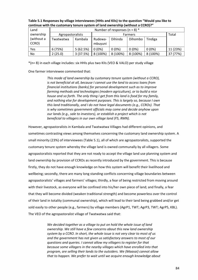
84
Table 5.1 Responses by village interviewees (HHIs and KIIs) to the question “Would you like to continue with the customary tenure system of land ownership (without a CCRO)?”
Land ownership (without a CCRO)
Number of responses (n = 8) *
Agropastoralists Farmers Total
Twatwatwa
Kambala
Rudewa-mbuyuni
Dihinda
Dihombo
Tindiga
Yes 6 (75%) 5 (62.5%) 0 (0%) 0 (0%) 0 (0%) 0 (0%) 11 (23%)
No 2 (25.0) 3 (37.5%) 8 (100%) 8 (100%) 8 (100%) 8 (100%) 37 (77%)
*(n= 8) in each village includes: six HHIs plus two KIIs (VEO & VALO) per study village
One farmer interviewee commented that:
This mode of land ownership by customary tenure system (without a CCRO), is not beneficial at all, because I cannot use the land to access loans from financial institutions (banks) for personal development such as to improve farming methods and technologies (modern agriculture), or to build a nice house and so forth. The only thing I get from this land is food for my family, and nothing else for development purposes. This is largely so, because I own this land traditionally, and I do not have legal documents (e.g., CCROs). That is why sometimes government officials may come and decide anyhow upon our lands (e.g., sale to investors), or establish a project which is not beneficial to villagers in our own village land (F5, RMN).
However, agropastoralists in Kambala and Twatwatwa Villages had different opinions, and
sometimes contrasting views among themselves concerning the customary land ownership system. A
small minority (23%) of interviewees (Table 5.1), all of which are agropastoralists, supported the
customary tenure system whereby the village land is owned communally by all villagers. Some
agropastoralists reported that they are not ready to accept the village land use planning system and
land ownership by provision of CCROs as recently introduced by the government. This is because
firstly, they do not have enough knowledge on how this system will benefit their livelihood and
wellbeing; secondly, there are many long standing conflicts concerning village boundaries between
agropastoralists’ villages and farmers’ villages; thirdly, a fear of being restricted from moving around
with their livestock, as everyone will be confined into his/her own piece of land; and finally, a fear
that they will become divided (weaken traditional strength) and become powerless over the control
of their land in totality (communal ownership), which will lead to their land being grabbed and/or get
sold easily to other people (e.g., farmers) by village members (AgrP1, TWT; AgrP3, TWT; AgrP5, KBL).
The VEO of the agropastoralist village of Twatwatwa said that:
We decided together as a village to put on hold the whole issue of land ownership. We still have a few concerns about this new land ownership system by a CCRO. In short, the whole issue is not very clear to most of us and the government has not given us satisfactory answers to most of our questions and queries. I cannot allow my villagers to register for that because some villagers in the nearby villages which have enrolled into that program, are selling their lands to the outsiders. We (Maasai) cannot allow that to happen. We prefer to wait until we acquire enough knowledge about

85
the land ownership by a CCRO, and how and to what extent this system is going to make our life better. Even when we come to an agreement to enrol into this system, we shall put in place very strict rules and regulations that will prevent village residents from selling our land anyhow (VEO, TWT).
Similar to the interviews, contrasting views and opinions concerning land ownership under a
customary tenure system without provision of a CCRO, were observed in the FGDs conducted in
farmers and agropastoralists’ villages. The majority of FGD discussants in farmers’ villages opposed
land ownership without a CCRO, claiming that this system was not only unprofitable, but also it is the
main cause of conflicts among themselves (farmers), and between farmers and agropastoralists. One
discussant in the male FGD in the farmers’ village of Dihinda commented that:
I would like to point out that this mode of land ownership without a CCRO, is the main cause of conflicts among ourselves and between farmers and agropastoralists. For example, the agropastoralist comes (with cattle) and establishes his settlement on uncultivated land somewhere in our village without knowing that may be that land is already owned by a farmer, who for some reason (financial or illness) hasn’t been able to attend the land for some time. When the farmer tries to stop the agropastoralist from invading his/her land, the agropastoralist may ask a very simple question that – if you really own this land, show me any legal documents that proves you own this place legally. The fact that you do not have any legal document like a CCRO, it becomes very difficult to reclaim your land. This may become even more difficult especially when the agropastoralists use their financial power to bribe village and district officials, and that is when the conflicts between us ensue (FGD, male, DHD).
On the other hand, the large majority of discussants in the FGDs conducted in agropastoralists’
villages defended land ownership without a CCRO, stating clearly that the system makes them feel
secure with possession of their land, which is the secret behind their unity and strength as the
Maasai tribe. One discussant in the female FGD in the agropastoralists’ village of Kambala said that:
Although we are practicing both agriculture and livestock keeping, there is no conflict among ourselves in this village. We own and share our village land together (communally), each one of us is free to graze the cattle anywhere in this village and nobody will ask him why are you grazing in my land? This works well for our togetherness as Maasai community. This system of land ownership (with a CCRO) being introduced by the government, whereby each villager will have ownership of a piece of village land, will bring conflicts among ourselves (FGD, female, KBL).
Kisoza (2007, p. 109) reported that: “there are intra-ethnic group resource-use conflicts in
Twatwatwa Village, where the elders, who are also large herd owners, were proposing to partition
the village communal grazing land, so that each villager owns his/her portion with legal documents.
This was being challenged by the young Maasai generation who were worried about losing land
access if the village grazing land was to be partitioned”. Interestingly, this study found the opposite:
those who oppose this new land ownership approach are the ones keeping large herds of cattle and
86
are powerful financially regardless of their age and/or status in the agropastoral community and
wanted to retain the freedom to move their cattle anywhere on the communal village land. One key
interviewee, who is the VEO of one of the two agropastoralists’ villages, commented that:
The land use plan has not been implemented in this village. The major excuse given by most of the villagers, is that this village land is owned communally by all villagers, therefore, there is no need for each one of them to have his/her own CCRO. They continue saying, if everyone owns his/her piece of land, it will be easy for other people (wa-swahili)27 to grab their village land, and eventually all their livestock will die due to lack of enough pastureland. We have tried to sensitize the community that each one of them will be allocated with 50 acres of land of which one will be free to decide the size of land for grazing (depending on livestock numbers). The problem is, those with lots of cattle are the ones with voices in making decision against this new approach and are the same people with financial power in the agropastoral community. Those with few cattle in this Maasai community have no voices in decision making even if one is an elder person.
The following section presents a brief description of different access mechanisms (as proposed in
Access Theory) by which one can access and use land resources.
5.3 Mechanisms in Access Theory
This research stems from the argument that land resource use related conflicts and pastoralism
issues in Tanzania are well understood (Benjaminsen et al., 2009; Kisoza, 2007; Mwambene et al.,
2010; Mwamfupe, 2015), but that the mechanisms underlying these conflicts are not. The literature
is largely silent on the mechanisms (means, processes and relations) by which agropastoralists gain,
maintain and control access to and use of land resources, and how these mechanisms contribute to
their wellbeing and to conflicts with farmers in Morogoro region. Access Theory, as proposed by
Ribot and Peluso (2003), was chosen to address the question of how, without always having legal
ownership of the land resources, agropastoralists have benefited from land resources in Morogoro
region. Ribot and Peluso (2003, p. 154) defined access as “the ability to derive benefits from things”,
broadening from property’s classical definition of access as “the right to benefit from things.” Ribot
and Peluso (2003) identified eight kinds of structural, power and social relations mechanisms that
can affect rights-based mechanisms (i.e., legal and illegal) of access: technology, capital, markets,
labour, knowledge, authority, identity, and social relations. These categories are heuristic – none is
distinct or complete. Each form of access may enable, conflict with, or complement other access
mechanisms and result in complex social patterns of benefit distribution.
27 Wa-Swahili: Is a common terminology used by Maasai people to differentiate themselves (Maasai tribe) from other tribes in Tanzania, because other tribes can more fluently speak Swahili language (National language) than the Maasai people. In this research wa-swahili means other people (farmers), apart from the Agropastoralists Maasai.
87
The access framework presented earlier in Chapter 3 (Figure 3.1) can be used to analyse specific
resource conflicts (e.g., farmer – agropastoralist) to understand how those conflicts can become the
very means by which different actors gain or lose the benefits from tangible and intangible
resources. Unlike in West African countries, where herders are employed by farmers as ‘salaried
herders’ and sometimes patronage relationships exist between farmers and herders (Olaniyan et al.,
2015), such relationships are uncommon for the agropastoralists (e.g., Maasai) migrating with their
livestock to Morogoro region. Therefore, to fit the Tanzanian context, Ribot and Peluso’s Access
Theory (2003) was modified, reducing their 8 categories of structural, power and social relations
mechanisms to 7 by omitting ‘labour’. ‘Patronage’, in their model a subset of labour, was instead
included as a subset of social relations (Figure 5.1).

88
Figure 5.1 Mechanisms (means, processes and relations) for gaining, maintaining and controlling access to and use of land resources (a visual representation developed from text of Ribot & Peluso, 2003, with initial adaptation to the Tanzanian context by omission of their mechanism “labour”)
89
The following section presents findings about the mechanisms used by agropastoralists to access
land resources in Mvomero and Kilosa Districts in Morogoro region. The mechanisms identified were
primarily rights-based (legal and illegal) access mechanisms plus some use of structural, power and
social relations mechanisms.
5.4 Mechanisms to gain and control access to and use of land resources
This empirical research was carried out in six villages. Of the six villages, Kambala (Mvomero District)
and Twatwatwa (Kilosa District) are legally registered agropastoralists’ villages with recognized
boundaries, and CVLs provided by the Tanzania government. The remaining four villages; Dihinda and
Dihombo (Mvomero District), and Tindiga and Rudewa-mbuyuni (Kilosa District) are legally
recognized as farmers’ villages. The following sub-section describes the legal and illegal access
mechanisms used by agropastoralists in Twatwatwa (Kilosa) and Kambala (Mvomero) to access and
use of land resources in Morogoro region.
5.4.1 Legal mechanisms to access land resources
This study identified one obvious legal (right-based) mechanism used by agropastoralists to gain,
maintain, and control access to, and use of land resources in Mvomero and Kilosa Districts. This
mechanism involves possession of a certificates for village land (CVL) for those villages which are
specifically allocated and registered as pastoralists’ villages by the government and Morogoro Region
Authority. Another mechanism, which appeared legal, involves paying the access fee for the land
resources and/or purchasing land from other villages that are basically registered as farmers’ villages.
But in this study, this second option has been categorized as an illegal mechanism because of the
way it is conducted – as was reported by the large majority of interviewees and discussants in the
FGDs.
5.4.1.1 Possession of Certificates for Village Land (CVLs)
Kambala (Mvomero District) and Twatwatwa (Kilosa District) are legally registered agropastoralists’
villages with recognized boundaries, and CVLs provided by the Tanzania government through the
Ministry of Lands, Housing and Human Settlements Development (MLHHSD). Most residents in these
villages are Maasai people, although other tribes like the Sukuma, Datoga, Mang’ati and Pare are also
present. Kambala was established as a result of the decision made by the Morogoro Region Authority
to divide Dihombo Village into two halves and was officially recognized and registered as an
agropastoralists’ village in 1989 (AgrP4, KBL; F2, DHB; DALO, MVR). Although the decision to establish
Kambala Village came in the late 1980s, the agropastoralists (Maasai) had migrated to the area in the
early 1960s. Among the reasons for their immigration were to search for pastureland for their
90
livestock and because of favourable conditions and arable land in Morogoro region for agriculture
(AgrP1, KBL; AgrP3, KBL; F3, DHB; F4, DHB). One interviewee explained that:
It was in 1963 when two Maasai from the northern part of our country came into our village with three cows each and met one old man who was the first Village Chairman by that time. They asked for a place to establish their settlement and a piece of land for farming. During that time most of this village was still un-occupied with only few households. The Village Chairman decided to offer these two Maasai a bush land situated in the flood plains famously known as ‘Mgongola basin.’ After few months, they brought large herds of cattle and started to invite fellow Maasai who also came with herds of cattle. The population of both humans and livestock was increasing, as a result, in the end of 1987 is when skirmishes between us started. They started grazing their cattle in our farms especially during the night. This forced the Morogoro Region Authority to divide our village into two halves and call the other half where the agropastoralists now live, Kambala Village. It was in 1989 when Kambala was officially registered, but before that, we were all living in Dihombo Village (F3, DHB).
Although Kambala is a registered agropastoralists’ village, its legitimacy is still contested by all
surrounding villages, with claims that the agropastoralists claimed ownership through bribing
officials from both the Morogoro regional and Mvomero District offices. The complaints stem from
the claim by agropastoralists in Kambala that they have complete ownership of ‘Mgongola basin’ as
part of their village land (F1, DHB; F3, DHB). ‘Mgongola basin’ is the most fertile land in Mvomero
District, in which farmers from all six surrounding villages had their farms long ago before the
establishment of Kambala Village. One interviewee commented that:
It is very disappointing that these immigrants (agropastoralists) whom we invited and gave them portions of land to stay are now turning against us. They now claim to have legal possession of ‘Mgongola basin’ as part of their village land, something which is not true at all. We had our farms in Mgongola basin long ago before they (agropastoralists) came to this part of the country. As we speak, if a farmer wants to cultivate in Mgongola basin, he/she must pay the access fee. This is not fair, we cannot negotiate with immigrants to have access to our farms, and that is among the reasons why we have conflict between us (F6, DHB).
On the other hand, the majority of discussants in the FGDs in Kambala reported that the village
boundaries, specifically the one on the side of ‘Mgongola basin’ which separates Kambala from
surrounding villages, has been changed three times (1989, 2008 and 2015), in favour of villages
surrounding Kambala. In addition to that, there has been a series of encroachment and attempted
land grabs by people coming from outside Kambala and surrounding villages, who want to cultivate
rice in Mgongola basin without asking permission from the village authority (FGD, male, KBL; FGD,
female, KBL). This means, for Kambala Village, the actual area of land that can be used for grazing
purposes has been decreasing progressively. One agropastoralist discussant in the FGD said that:
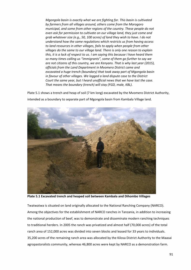
91
Mgongola basin is exactly what we are fighting for. This basin is cultivated by farmers from all villages around, others come from the Morogoro municipal, and some from other regions of the country. These people do not even ask for permission to cultivate on our village land, they just come and grab whatever size (e.g., 50, 100 acres) of land they wish to have. I do not understand how the same regulations which restricts us from having access to land resources in other villages, fails to apply when people from other villages do the same to our village land. There is only one reason to explain this, it is a lack of respect to us. I am saying this because I have heard them so many times calling us “immigrants”, some of them go further to say we are not citizens of this country, we are Kenyans. That is why last year (2015), officials from the Land Department in Mvomero District came and excavated a huge trench (boundary) that took away part of Mgongola basin in favour of other villages. We logged a land dispute case to the District Court the same year, but I heard unofficial news that we have lost the case. That means the boundary (trench) will stay (FGD, male, KBL).
Plate 5.1 shows a trench and heap of soil (7 km long) excavated by the Mvomero District Authority,
intended as a boundary to separate part of Mgongola basin from Kambala Village land.
Plate 5.1 Excavated trench and heaped soil between Kambala and Dihombo Villages
Twatwatwa is situated on land originally allocated to the National Ranching Company (NARCO).
Among the objectives for the establishment of NARCO ranches in Tanzania, in addition to increasing
the national production of beef, was to demonstrate and disseminate modern ranching techniques
to traditional herders. In 2005 the ranch was privatized and almost half (70,000 acres) of the total
ranch area of 152,000 acres was divided into seven blocks and leased for 33 years to individuals.
35,200 acres of the remaining ranch area was allocated by the Kilosa District Authority to the Maasai
agropastoralists community, whereas 46,800 acres were kept by NARCO as a demonstration farm.
92
The former Twatwatwa Village chairman, who was one of the first agropastoralists to arrive in Kilosa
District got involved in acquiring all the legal documents to claim Twatwatwa Village and reported:
I and my parents came all the way from Kiteto District in Manyara region (Northern Tanzania). We camped for a while in Mabwegere Village (Kilosa) in 1954. In 1955, the Kilosa District Authority carried out a survey to allocate village lands, four village land areas were surveyed including Twatwatwa, Kidui, Luosa and Mabwegere itself. These were the first villages legally allocated for agropastoralists in Kilosa District. The district authority decided that some of us should leave Mabwegere Village because we were becoming too many in the village. The year 1966 is when we officially came here in Twatwatwa, and in 1994 we got all the legal documents (CVL) and maps which shows Twatwatwa is a registered and legally recognized as agropastoralists’ village in Kilosa District. It was not easy, because in 1983 officials from NARCO ranch confronted us claiming that this land belongs to them, we were very lucky that the Regional Commissioner (RC) of that time was in our favour (AgrP4, TWT).
While the ranch has a title-deed issued in 1969 to this land, the village holds a CVL to some of the
same land dated 1994 (DALO, KLS; AgrP4, TWT). This certificate was obviously contested by the ranch
management, which claims that the agropastoralists obtained it through bribing officials in the Kilosa
District land office. Nevertheless, the certificate appears to be acknowledged by the present local
authorities (Benjaminsen et al., 2009). The following section presents the findings on the illegal
mechanisms used by agropastoralists to gain, maintain, and control access to and use of land
resources.
5.4.2 Illegal mechanisms to access land resources
When livestock numbers exceed the capacity of existing land to supply enough pasture and water,
livestock become stressed and weakened, and agropastoralists will leave the present land in search
of pasture and water for their livestock. The reasons given by the majority of farmer and
agropastoralist interviewees for agropastoralists leaving their legally registered villages and seeking
water and pasture around farmers’ villages included:
• increased population pressure of both humans and livestock
• encroachment onto agropastoralists’ village lands (e.g., Mgongola basin in Kambala) by
farmers from neighbouring villages, Morogoro municipality, and others from outside
Morogoro region
• allocation of huge chunks of village lands to foreign investors by the Tanzania government
• diversification of rural land use (i.e. ranching, national parks, new settlements)
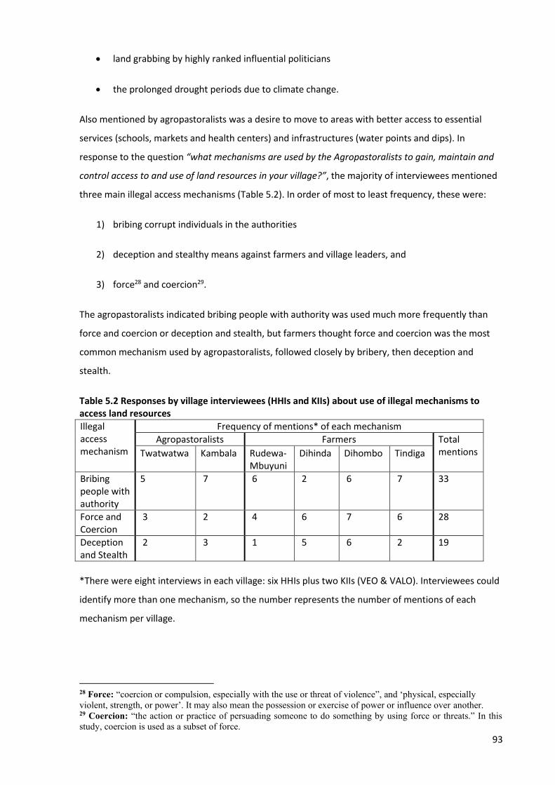
93
• land grabbing by highly ranked influential politicians
• the prolonged drought periods due to climate change.
Also mentioned by agropastoralists was a desire to move to areas with better access to essential
services (schools, markets and health centers) and infrastructures (water points and dips). In
response to the question “what mechanisms are used by the Agropastoralists to gain, maintain and
control access to and use of land resources in your village?”, the majority of interviewees mentioned
three main illegal access mechanisms (Table 5.2). In order of most to least frequency, these were:
1) bribing corrupt individuals in the authorities
2) deception and stealthy means against farmers and village leaders, and
3) force28 and coercion29.
The agropastoralists indicated bribing people with authority was used much more frequently than
force and coercion or deception and stealth, but farmers thought force and coercion was the most
common mechanism used by agropastoralists, followed closely by bribery, then deception and
stealth.
Table 5.2 Responses by village interviewees (HHIs and KIIs) about use of illegal mechanisms to access land resources
Illegal access mechanism
Frequency of mentions* of each mechanism
Agropastoralists Farmers Total mentions Twatwatwa Kambala Rudewa-
Mbuyuni Dihinda Dihombo Tindiga
Bribing people with authority
5 7 6 2 6 7 33
Force and Coercion
3 2 4 6 7 6 28
Deception and Stealth
2 3 1 5 6 2 19
*There were eight interviews in each village: six HHIs plus two KIIs (VEO & VALO). Interviewees could
identify more than one mechanism, so the number represents the number of mentions of each
mechanism per village.
28 Force: “coercion or compulsion, especially with the use or threat of violence”, and ‘physical, especially violent, strength, or power’. It may also mean the possession or exercise of power or influence over another. 29 Coercion: “the action or practice of persuading someone to do something by using force or threats.” In this study, coercion is used as a subset of force.
94
The illegal mechanisms identified in the interviews with the agropastoralists (Table 5.2) were
mentioned and ranked in the same order of priority by the majority of discussants in both the male
and female FGDs conducted in agropastoralists’ villages. In the farmers’ villages, the large majority of
discussants in the male FGDs mentioned and ranked the illegal mechanisms as reported in the
agropastoralist interviews and FGDs (i.e., bribery followed equally by force and coercion and
deception and stealth). However, in contrast to their counterpart discussants in male FGDs, the large
majority of discussants in female FGDs conducted in farmers’ villages ranked illegal mechanisms the
same as farmer interviewees, i.e., in priority order: force and coercion, bribing officials, and
deception-stealth. The research findings suggest the women are more exposed to violence and
intimidation and more at risk from it. In a society where males are deemed heads of households,
women are not probably the ones offered the bribes [or get to see the money], if a bribe is provided.
This could be the reason why female discussants in the FGDs conducted in farmers’ villages ranked
force and coercion highest. It could also be argued that self-image protection is at play for the male
and female discussants in the FGDs conducted in the agropastoralists’ villages. Agropastoralists
would much rather portray themselves as ‘good and fair’ by reporting they are paying and/or bribing
people for land rather than admitting they were coercive and deceptive. Additionally,
agropastoralists may not consider ‘peace and security’ as the most important attribute for their
family wellbeing, because for them livestock survival comes first over all other wellbeing attributes.
Therefore, any means (i.e., coercion, deception) that will favour the survival of their livestock is a
viable option. The next sub-section describes how these illegal access mechanisms used by
agropastoralists were affected by the structural, power, and social relations mechanisms of Access
Theory.
5.4.2.1 Corruption and Enticement
The majority of interviewees from both farmers and agropastoralists’ villages reported that
corruption is a serious problem at all levels, i.e., at regional, district and village levels. The laws, rules,
and regulations for one to purchase or to have rights of access to land resources in villages are being
violated by officials in their respective authorities. One interviewee commented that:
If agropastoralists were only occupying village lands by forceful means, where are the state organs like police and other related authorities to take actions against them? But the fact that they enter and occupy any village land they wish to live in, and no action is taken against them, then it is obvious that some village officials or higher authorities at regional and district levels are being bribed to facilitate these unlawful acts. Agropastoralists can manage to have one million Tanzania Shillings (US$ 450) in their pocket by selling one cow at the local market. It is easy for them to spend huge sum of cash in situations where some rules and regulations are against them (F4, RMN).
95
Similar opinions were reported by the majority of discussants in the FGDs from both farmers and
agropastoralists’ villages. One discussant in the female FGD in the farmers’ village of Tindiga
commented that:
This village belongs to farmers, but there are lots of agropastoralists living in this village and others coming every day. Their presence in this village is illegal because they did not follow the village rules and procedures to claim their rights to live here. The village leadership for the past few years was very corrupt, as a result, agropastoralists took advantage of that weakness to bribe our village officials and occupy some portions of the village land. It seems our villages leaders are doing this in collaboration with district officials because when we file our complaints to the district offices, their response has always been “go back to your village leaders and sort out your problems.” It is obvious that they have turned this issue into business deals from which a few individuals are benefiting financially by taking money from agropastoralists (FGD, female, TNG).
Use of bribery or ‘unofficial payments’ was also reported by another discussant in the male FGD in
the agropastoralists’ village of Kambala, who commented:
Do you think we can occupy any village land in the neighbourhood just anyhow? No, it is not easy at all. We normally go and have an informal meeting with the Village Chairman, we tell him that we want to bring our cattle into their villages because in our villages there is not enough pastures, and water sources have gone dry as a result of prolonged drought period. We just call the Village Chairman telling him that we are coming, and we pay him (unofficial/undocumented) some cash like 600,000 Tshs (US$ 270), depending on how many days/months we would like to stay in the village (FGD, male, KBL).
In summary, agropastoralists employed structural, power and social relations mechanisms, i.e.,
Capital (financial power), which is thought to be obtained from the ability to sell their livestock at a
reasonable price at both local and regional Markets; and the ability to use Capital to influence laws,
rules, regulations and decision making of Authorities in relation to gaining, maintaining and
controlling access to, and use of land resources. The next sub-section analyses access to land
resources by deception and stealth.
5.4.2.2 Deception and stealth
Agropastoralists have gained, maintained, and controlled access to and use of land resources by
deceiving both farmers and village officials. They have been purchasing lands in farmers’ villages by
deceiving villagers and village officials into believing that they need land for farming purposes, but
later use the land for grazing their livestock (VEO, DHD; VEO, DHB; VEO, KBL; F1, DHD; F5, DHD).
Some agropastoralists ‘negotiated’ with farmers to lease their farms for grazing for a short period of
time for financial gains. However, on many occasions, agropastoralists became reluctant to vacate
96
the land after the agreed land lease period passed and told lies by claiming that the farmer sold the
land to them. One key interviewee stated:
Most times, farmers lease their farms to agropastoralists for a short period of time only, they do not sell their farms to them. This normally happens in two situations: first, when farmers fail to cultivate their farms for whatever reasons (e.g., sickness, financial constraints), they lease the farms to be used for grazing for a short time for financial gains; second, once farmers finished crop harvesting in June and July, they invite agropastoralists with payment of a negotiable fee, to feed their cattle on crop residues. In recent times, the agropastoralists have developed a habit of being reluctant to vacate the land after the agreed land lease period has passed. They would rather tell lies by claiming that the farmer sold the land to them. Because the farmer entered into the lease agreement with the agropastoralists without involving the village authorities, it becomes very difficult to defend him/her to get his farmland back (VALO, DHD).
It was also reported that when agropastoralists want to purchase or plead for an allocation of village
land, they first come without livestock. However, soon after the land has been allocated to them,
they bring large numbers of herds in succession, followed by inviting fellow agropastoralists, i.e.,
friends and relatives who also come with many cattle to live in the same tiny portion of land. As the
population of both humans and livestock increases, they find out that the land that was originally
allocated to their fellow agropastoralist(s) is not enough, and that is when they start taking village
lands by force and coercion (F3, DHD; F8, DHD; F2, TNG; VALO, DHD). One discussant in the male FGD
in the Agropastoralists’ village of Kambala stated:
It is very challenging to some of us really, because when I go and ask for a permission to graze my cattle in another village, and may be the permission is granted, with some conditions and restrictions to which I must abide with. [Then] other fellows of mine from the village where I come from will always follow me, some of them are my friends, brothers, uncles; I cannot push them away, but the problem comes when they start behaving different from the conditions provided in the agreement, of which I am the one responsible. This is a very big problem, so often we have conflicts among ourselves because of that (FGD, male, KBL).
Interviewees in Rudewa-mbuyuni and Dihombo Villages reported that, agropastoralists used ‘stealth
approach’ to shift village boundaries by removing and destroying beacons, with an intention to claim
the village land on their side. In summary, agropastoralists employed the structural, power and social
relations mechanisms of Access Theory, i.e., Social relations (i.e., deception, negotiation, friendship,
kinship, favours to friends and relatives) to pave the way to gaining and controlling access to and use
of land resources. Deception and stealth sometimes lead to the use of force and coercion to grab
more land to cater for excessive livestock and the agropastoralists’ population, and as a result the
conflicts between farmers and agropastoralists begin. The next sub-section analyses access to land
resources by force and coercion.
97
5.4.2.3 Force and coercion
The majority of farmer interviewees accused agropastoralists of using force and coercion, i.e.,
weapons including firearms, spears and knives to threaten, wound and on several occasions, claim
peoples’ lives in their efforts to gain and control access to and use of land resources in villages. As
reported in the previous section, agropastoralists [Maasai] from Twatwatwa Village tampered with
the Rudewa-mbuyuni Village boundaries on more than three occasions, and successfully achieved
their claim to a place known as ‘Ngaiti’ which used to be part of Rudewa-mbuyuni Village land (F4,
RMN; VEO, RMN; F1, TNG). In their efforts to defend the ownership of their land, farmers in Rudewa-
mbuyuni continued to cultivate their farms situated in the Ngaiti area (F1, RMN; F6, RMN; AgrP4,
TWT). This act annoyed the agropastoralists, and as a result, on the eve of 8th December 2000, a
group of Maasai people with firearms and spears attacked the village while most villagers were
asleep; hundreds of houses were burnt, hundreds of people were severely injured, and 5230 were
killed (VEO, RMN; F1, RMN; F2, RMN; F1, TNG). The Guardian (31 January 2001)31 also reported that
this tragic event took place in Rudewa-mbuyuni Village at around 5 a.m. on 8th December 2000 when
many Maasai warriors attacked the village with firearms and other weapons, killed 38 villagers and
wounded many others. As a result of this tragedy, the Kilosa District Commissioner was sacked, and
the Police Commander of Kilosa District was demoted and transferred. One interviewee stated:
We were preparing our farms ready for seeding, and suddenly, a group of Maasai holding sticks, knives, spears, machetes and daggers, came and asked, “why are you cultivating on our land?” We were puzzled, because this land we are cultivating is part of our village land, how come the Maasai are claiming to be theirs? Before we realized, they started whipping us, some of us were severely wounded by being stabbed and we had to run to save our lives. We have reported this to the village and ward authorities and to the police. This is not the first time this has happened, we have been robbed of our village lands several times by the Maasai using similar tactics, even fellow farmers in the neighbouring villages are complaining about these unlawful acts (F1, RMN).
On the other hand, the Maasai-tribe chief in Kambala Village admitted that often the youth-Maasai
[Morans] who are the ones entrusted by Maasai elders to care for and graze the cattle, have been
disappointing due to their unlawful and shameful acts of using extreme force and weapons to force
their way into farmers’ villages and graze cattle on farms or sometimes destroy the villagers’ houses
by feeding the cattle with thatches [roofing materials]. He commented that:
We do not have a choice, sometimes we are bound to cross our village boundaries to go and feed our cattle in the nearby villages. We understand it is illegal, but we are compelled to do it otherwise all our cattle will die for
30 This figure has been reported in various forms (news media and literature). Some reported 38 people died, others 46. Those who reported 52 people died, claimed that the list of names (38) printed on the graveyard monument is for those who were Christians. Those who were Muslims were buried somewhere else. 31 Tanzania based English newspaper
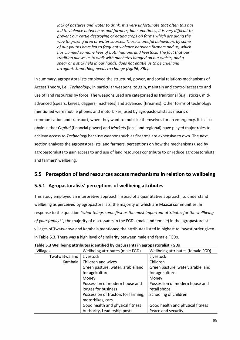
98
lack of pastures and water to drink. It is very unfortunate that often this has led to violence between us and farmers, but sometimes, it is very difficult to prevent our cattle destroying or eating crops on farms which are along the way to grazing area or water sources. These shameful behaviours by some of our youths have led to frequent violence between farmers and us, which has claimed so many lives of both humans and livestock. The fact that our tradition allows us to walk with machetes hanged on our waists, and a spear or a stick held in our hands, does not entitle us to be cruel and arrogant. Something needs to change (AgrP6, KBL).
In summary, agropastoralists employed the structural, power, and social relations mechanisms of
Access Theory, i.e., Technology, in particular weapons, to gain, maintain and control access to and
use of land resources by force. The weapons used are categorized as traditional (e.g., sticks), mid-
advanced (spears, knives, daggers, machetes) and advanced (firearms). Other forms of technology
mentioned were mobile phones and motorbikes, used by agropastoralists as means of
communication and transport, when they want to mobilize themselves for an emergency. It is also
obvious that Capital (financial power) and Markets (local and regional) have played major roles to
achieve access to Technology because weapons such as firearms are expensive to own. The next
section analyses the agropastoralists’ and farmers’ perceptions on how the mechanisms used by
agropastoralists to gain access to and use of land resources contribute to or reduce agropastoralists
and farmers’ wellbeing.
5.5 Perception of land resources access mechanisms in relation to wellbeing
5.5.1 Agropastoralists’ perceptions of wellbeing attributes
This study employed an interpretive approach instead of a quantitative approach, to understand
wellbeing as perceived by agropastoralists, the majority of which are Maasai communities. In
response to the question “what things come first as the most important attributes for the wellbeing
of your family?”, the majority of discussants in the FGDs (male and female) in the agropastoralists’
villages of Twatwatwa and Kambala mentioned the attributes listed in highest to lowest order given
in Table 5.3. There was a high level of similarity between male and female FGDs.
Table 5.3 Wellbeing attributes identified by discussants in agropastoralist FGDs
Villages Wellbeing attributes (male FGD) Wellbeing attributes (female FGD)
Twatwatwa and Kambala
Livestock Livestock Children and wives Children Green pasture, water, arable land for agriculture
Green pasture, water, arable land for agriculture
Money Money Possession of modern house and lodges for business
Possession of modern house and retail shops
Possession of tractors for farming, motorbikes, cars
Schooling of children
Good health and physical fitness Good health and physical fitness Authority, Leadership posts Peace and security
99
The large majority of discussants (male and female), regarded livestock as wealth and social pride,
hence its primary ranking amongst the attributes representing wellbeing. Explaining the positioning
of livestock, one discussant commented that:
Being Maasai is defined by possession of livestock. How do you speak of a Maasai if one does not keep lots of cattle? In our tradition, one’s wealth is measured by the number of herds of cattle one possesses, the more cattle you have, the wealthier you are (FGD, male, TWT).
Male agropastoralists viewed having many offspring as the second most important attribute of
wellbeing, generally because children, particularly male, play an important role in pastoral duties.
The majority of discussants appear to believe that possession of many children is the second most
important attribute of wellbeing – the more you have the better your wellbeing. Additionally, the
possession of children was regarded as affording male elders’ leisure time, as one discussant in the
male FGD commented that:
We use this leisure time to sit here and relax because our children are looking after the cattle; they are our right hand, and we trust them (FGD, male, TWT).
Moreover, as a polygamous tribe, the possession (cultural translation) of multiple wives to run a
homestead, was also regarded as an important wellbeing attribute for male agropastoralists. This
was echoed by one discussant who said that:
Traditionally, we (Maasai) are a polygamous tribe. We prefer many wives because it is very difficult for one wife to handle all duties alone. Tasks like milking hundreds of cattle in a day, at the same time taking care of children and run other homestead activities, is too much for one wife. Therefore, as the herds of cattle increases, we marry another woman who will help to shoulder tasks with other wives around (FGD, male, KBL).
The large minority of female discussants (but only a few male agropastoralists) mentioned education
as an important attribute of wellbeing. They expressed how ‘joyful and proud’ they would be if their
children had an opportunity for education. The agropastoral Maasai communities are well known for
their reluctance to take their children to school, because male children are the ones responsible for
grazing cattle very far from the village, which may take the whole day or even days (Hedges,
Borgerhoff, James, & Lawson, 2016, p. 149). Female children tend to have lower social status
compared to male counterparts, and are subjected to early marriages, as bride price is the means to
accumulate cattle (Buzinde, Kalavar, & Melubo, 2014; Hedges et al., 2016). Also significant was the
availability of green pasture to graze livestock, and natural resources such as water and arable land
for farming. Material wellbeing such as, possession of modern houses, lodges and retail shops, and
tractors for farming and transport means (e.g., bikes and cars) were also mentioned by about half of
100
the discussants in the FGDs. Lastly, peace and security, good health and physical fitness, and
leadership positions were viewed as enabling factors to oversee and enjoy all other attributes of
wellbeing.
The large majority of agropastoralist interviewees (85%) and the majority of discussants in the
agropastoralist FGDs reported that their income, which depends largely on livestock, has decreased
hugely since 2005. The sharp fall is linked to decline in herd size, and a small number of herds left
that are unhealthy, thus attracting low market value (VEO, KBL; VEO, TWT; AgrP2, KBL; AgrP4, TWT).
The following, as reported by the large majority of agropastoralist interviewees, are factors that have
contributed to the decline in average herd size:
1) lack of green pasture and water due to prolonged drought periods, hence most cattle have
died and those few left that are malnourished
2) increase of cattle diseases due to climate change and variability
3) cattle being killed and/or stolen during violence escalation involving farmers and
agropastoralists
4) diminishing area of grazing land due to continuous land grabbing and encroachment of
agropastoralists’ village lands
5) cattle being seized and auctioned by government officials during operations famously known
as “cattle marking and destocking”
6) selling a portion of the stock to get financial capital to buy land in other villages for crop
cultivation, and by others to start a new trading business.
These factors reportedly pose severe and long-term impacts to the agropastoral production system,
something that threatens the wellbeing and long-term existence of agropastoral communities.
Similar findings were reported by Mung'ong'o and Mwamfupe (2003) who found that some
agropastoral communities in Kilosa and Mvomero Districts have not been able to recover from the
loss due to some of the factors mentioned above, and hence they had to diversify their livelihood
activity, with large-scale crop cultivation becoming the new livelihood activity. These views, opinions,
and experiences were echoed by the majority of agropastoralist interviewees who reported that
subsistence crop cultivation has increased over the past decade, because limited grazing areas have
forced the majority of agropastoralists to adopt crop cultivation as a means of boosting their
earnings to sustain their families. The adoption of crop cultivation to supplement livestock, and the
need to continue searching for green pastures and water has forced agropastoralists to find means
101
(e.g., illegal) to gain and control access to and use of land resources (arable land, water, and pasture)
in farmers’ villages. The agropastoralists’ perception of land resources’ access mechanisms in relation
to their wellbeing is presented in the following sub-section.
5.5.2 Agropastoralists’ perceptions on access mechanisms in relation to wellbeing
The perceived anti-pastoral policy environment, and the state-backed ‘land acquisition’ for large-
scale agriculture have contributed to the squeezing out of agropastoral communities from their
traditional and key grazing lands, impairing their wellbeing and making means of survival increasingly
difficult. This study confirmed that agropastoralists regard livestock keeping as vital to their material
and financial wellbeing. The mechanisms used by agropastoralists to gain access to and use of land
resources provided a strong indirect contribution to their wellbeing. Access mechanisms played a
major role in enabling agropastoralists to continue sustaining their already impaired wellbeing by
allowing access to pastures and water in other villages for their livestock, and by allowing them to
acquire land for crop cultivation in addition to stock keeping. However, this access, and means by
which access was gained, came at a cost to other wellbeing attributes – stock could be killed or
stolen, human lives lost, and feelings of shame, dishonesty, and insecurity experienced due to
recurring conflicts between farmers and agropastoralists. Interviewees and discussants reported that
diversification of livelihood activities, by practicing both livestock keeping and subsistence crop
farming, has helped agropastoralists to broaden the likelihood of having various sources of food and
income to sustain their families, which has brought relief compared to when they were dependent
entirely on keeping livestock (VEO, KBL; NGO1, MRG; NGO2, TZ; AgrP4, TWT). One interviewee in
Twatwatwa Village commented:
Yes, I do grow subsistence crops, and keep livestock at the same time. I sold a few of cattle and managed to buy the land, and sometimes I pay lease fee to get portions of land for farming in the neighbouring villages. I decided to practice farming because things have changed a lot, famine has become prone in this village due to prolonged drought period; cattle have lost market value completely because they are very skinny due to lack of pasture and water. One must sell 2 to 3 cows to get one sack of maize (100kgs), which can only feed my family for a month. Now, I do not need to sell cattle to buy food, I get food for my family from the farm, and sometimes I feed my cattle with the leftovers after harvesting season (AgrP2, TWT).
However, while some agropastoralists are willing to adapt and diversify, the evidence collected
suggests others are ready to take risks, employing whatever means possible for the sake of their
livestock. Because they saw livestock keeping as vital to their material and financial wellbeing and
their sense of identity and social status, they were willing to compromise other wellbeing attributes
in order to gain, maintain and control the access to, and use of land resources. This was evident from
the statement by one interviewee:
102
If we stay in our village lands and do nothing, it is obvious that the situation will get worse for our families and our livestock. If there are means to gain access to grazing land and water sources somewhere into other villages, it is worth taking the options regardless of how costly and risky they may be. We must sacrifice and take these bold decisions for the sake of our families’ wellbeing, because livestock keeping is vital for our wellbeing, we depend on livestock to get money to buy food, pay school fees for our children and healthcare, building a standard house, almost everything. You see almost every one of us here has a motorbike or a vehicle, we buy them from the money we get by selling our cattle (AgrP6, KBL).
Another interviewee expressed discomfort with the current situation:
I remember we used to sit down and discuss with farmers on the compensation fee for the crops that have been destroyed, but now things are different, farmers are fed-up with our shameful acts. A simple argument between one agropastoralist and one farmer may escalate to violence involving a group of youth fighters from both sides, a situation which has so often led to loss of lives (humans & cattle), cattle being stolen, and lots of people left injured. I am also tired with this kind of life (AgrP5, TWT).
Although agropastoralists reported their income had dropped hugely since 2005, and herd sizes had
dropped (which is difficult to prove), the observation shows agropastoralists appeared to be
wealthier than farmers in so far as they possess many more physical assets (e.g. cars and houses)
than farmers due to the income earned from practicing both livestock keeping and agricultural
activities. Agropastoralists have managed to maintain (or increase) the livestock numbers (i.e., by re-
stocking) and acquire land for grazing and crop cultivation. The farmers’ perception of land
resources’ access mechanisms used by agropastoralists and their impacts on farmers’ wellbeing is
presented in the following sub-section.
5.5.3 Farmers’ perceptions of access mechanisms used by agropastoralists
Farmers believe that agropastoralists benefit hugely (while farmers suffer) from the means they use
to access land resources, which include invasion and feeding their cattle on farms and from buying
huge parts of farmers’ village lands by bribing corrupt government officials (F3, TNG; F6, RMN; F1,
DHB). Many farmers operate their farms supported by loans from microfinance groups and
institutions, e.g., Savings and Credit Cooperative Organizations (SACOSS), so when agropastoralists
feed their cattle on farms, they struggle to repay their debts, and as a result, they lose possession of
physical assets such as houses, tractors, and any valuable materials because these assets are being
auctioned to pay their debt (VEO, DHD; VALO, DHB; VEO, RMN).
The large majority of farmers interviewed argued that the means used by agropastoralists to gain
access to farmers’ village lands have impeded farmers’ efforts to sustain their income generating
activity, which is farming. Many farmer interviewees reported that the impacts of these means were:
103
• some of them not being able to provide their families with essential needs such as food,
healthcare, school fees, standard shelter, and
• losing family manpower in recent years because some family members were killed by
agropastoralists when they tried to defend their farms from cattle destruction (F1, DHB; F2,
DHB; F5, DHB; F6, DHD). Additionally, farmers reported that they now live an insecure and
restless life. They are uncertain what may happen to their homes, families, or crops on farms
today or tomorrow (F6, DHD; F4, DHB; F1, RMN). One interviewee commented:
We sometimes abandon our homes and find somewhere to settle for a while especially when the situation becomes worse in our villages due to violence escalation. In doing so, children miss their classes because are not attending school, thieves take that opportunity to steal everything that seems valuable in our house. In short, everything now is not pleasing to hear or to see, and we have really gone steps backward in terms of personal and family economic development (F1, RMN).
Another interviewee said:
When you wake up in the morning, you find lots of cattle scattered all around. They (agropastoralists) destroy our houses and public toilets by feeding the roofing materials (thatches) to the cattle. Our village has turned to desert, because they have cut down the trees around the village and fed the leaves to the cattle (F5, TNG).
Furthermore, farmers expressed concern over an increasing number of villages calling for food aid
(F3, DHD; F2, TNG; F4, RMN). Among reasons mentioned for the low harvest were crop damage by
livestock, climate change impacts, and increasing numbers of livestock that have damaged village
lands by causing soil erosion (thus loss of fertile soil) and causing the land to become brittle and
difficult to plough using a hand hoe, a tool that many farmers can afford. One interviewee expressed
his concerns with the current situation:
The rain season has already started but I cannot grow anything like cassava or vegetables, because they will come and feed their cattle on my farm. It is either you leave your home to go and camp on the farm until the harvest season comes, or you will never have any crops to harvest. I used to harvest 10 to 15 sacks (100kgs each) of maize when I cultivate one acre of land, but now I can hardly harvest five sacks from the same size of land, even if I apply fertilizer. Our land has lost its fertility and it has become very hard to plough; all this has happened because there are too many livestock in this village now compared to a decade ago. For the first time after so many decades, we may cry for food aid in our village (F3, DHB).
Some female farmers reported that they are more vulnerable and worried about being raped by
notorious youth-Maasai (Morans), especially when they remain until late hours of the day to guard
104
the crops on farms (F2, DHB; F5, DHB; F6, DHB). Similar concerns were reported by discussants in the
female FGDs conducted at Dihombo and Rudewa-mbuyuni Villages. One discussant commented:
Whenever we grow crops the agropastoralists brings their cattle to feed on our farms, sometimes in the last days before the harvest period in July. If you try to stop them, they beat you badly. They normally say: “hey, shut-up, these are just grasses like any other grasses around, let our cattle enjoy a delicious meal” We used to remain until late hours of the day to guard our crops, but now we stopped doing that because some of us have been raped by agropastoralists [Morans]. That is why a woman cannot go alone on her farm, we walk and farm in groups (FGD, female, DHD).
However, not all farmers suffered from the presence of the agropastoralists – those who had
accepted bribes and/or payments in cash ‘inducement’ offered by the agropastoralists undoubtedly
benefited financially (F3, TNG; F2, RMN; AgrP6, TWT; AgrP4, KBL). One agropastoralist interviewee
commented:
I dare to say, if you can and time allows, just carry out a simple investigation to identify the material-wealth that some farmers, police officers and district officials have accrued to themselves, and ask yourself whether it is justifiable to their earnings in terms of salaries and/or agricultural harvests. If not, where are they getting extra money to accumulate all sorts of wealthy stuffs such as fancy cars and several houses and lodges in different locations within and outside Mvomero District? The conflicts between us and farmers will never end anytime soon, because for some people this is an opportunity to take money from us and create fortunes for themselves (AgrP5, KBL).
The following section reports on how the mechanisms used by agropastoralists to gain, maintain, and
control access to and use of land resources, contribute to conflicts between farmers and
agropastoralists.
5.6 Contribution of access mechanisms to agropastoralist – farmer conflicts
The large majority (83.3%) of interviewees agreed that the illegal mechanisms (Table 5.2) used by
agropastoralists to gain, maintain, and control access to and use of land resources are the major
cause of conflicts between farmers and agropastoralists. Bribing officials for preferential treatment in
land resources allocation is mentioned among the factors responsible for conflicts between
agropastoralists and farmers in Mvomero and Kilosa Districts. Table 5.4 shows responses when
interviewees were asked about the contribution of these illegal mechanisms to conflicts between
farmers and agropastoralists.
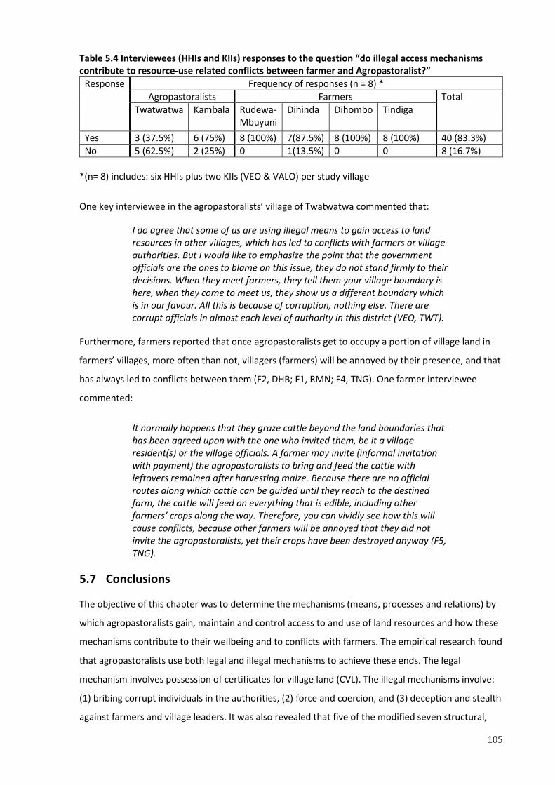
105
Table 5.4 Interviewees (HHIs and KIIs) responses to the question “do illegal access mechanisms contribute to resource-use related conflicts between farmer and Agropastoralist?”
Response Frequency of responses (n = 8) *
Agropastoralists Farmers Total
Twatwatwa
Kambala
Rudewa-Mbuyuni
Dihinda
Dihombo
Tindiga
Yes 3 (37.5%) 6 (75%) 8 (100%) 7(87.5%) 8 (100%) 8 (100%) 40 (83.3%)
No 5 (62.5%) 2 (25%) 0 1(13.5%) 0 0 8 (16.7%)
*(n= 8) includes: six HHIs plus two KIIs (VEO & VALO) per study village
One key interviewee in the agropastoralists’ village of Twatwatwa commented that:
I do agree that some of us are using illegal means to gain access to land resources in other villages, which has led to conflicts with farmers or village authorities. But I would like to emphasize the point that the government officials are the ones to blame on this issue, they do not stand firmly to their decisions. When they meet farmers, they tell them your village boundary is here, when they come to meet us, they show us a different boundary which is in our favour. All this is because of corruption, nothing else. There are corrupt officials in almost each level of authority in this district (VEO, TWT).
Furthermore, farmers reported that once agropastoralists get to occupy a portion of village land in
farmers’ villages, more often than not, villagers (farmers) will be annoyed by their presence, and that
has always led to conflicts between them (F2, DHB; F1, RMN; F4, TNG). One farmer interviewee
commented:
It normally happens that they graze cattle beyond the land boundaries that has been agreed upon with the one who invited them, be it a village resident(s) or the village officials. A farmer may invite (informal invitation with payment) the agropastoralists to bring and feed the cattle with leftovers remained after harvesting maize. Because there are no official routes along which cattle can be guided until they reach to the destined farm, the cattle will feed on everything that is edible, including other farmers’ crops along the way. Therefore, you can vividly see how this will cause conflicts, because other farmers will be annoyed that they did not invite the agropastoralists, yet their crops have been destroyed anyway (F5, TNG).
5.7 Conclusions
The objective of this chapter was to determine the mechanisms (means, processes and relations) by
which agropastoralists gain, maintain and control access to and use of land resources and how these
mechanisms contribute to their wellbeing and to conflicts with farmers. The empirical research found
that agropastoralists use both legal and illegal mechanisms to achieve these ends. The legal
mechanism involves possession of certificates for village land (CVL). The illegal mechanisms involve:
(1) bribing corrupt individuals in the authorities, (2) force and coercion, and (3) deception and stealth
against farmers and village leaders. It was also revealed that five of the modified seven structural,
106
power and social relations mechanisms identified by Ribot and Peluso (2003) together create a
strong combination of legal and illegal access mechanisms that facilitated agropastoralists to derive
benefits from land resources in Morogoro region. These were: Capital (financial power), Authority
(ability to bribe law makers and enforcers), Social relations (deception, negotiation, friendship,
kinship and partiality), Markets (local and regional) and Technology (weapons, equipment,
communication and transportation facilities). It was also identified that these mechanisms enhanced
the ability of agropastoralists to diversify their livelihood activities, i.e., practicing both farming and
keeping livestock. This helped them sustain their material and financial wellbeing, while on the other
hand, compromising other wellbeing attributes, as well as reducing farmers’ wellbeing.
However, the two structural, power and social relations mechanisms of Access Theory, i.e.,
Knowledge (formal and informal) and Social identity (leadership, ethnicity) made no significant
contribution towards helping agropastoralists to gain, maintain and control access to, and use of land
resources in Morogoro region. It can be argued that although agropastoralists have sufficient
informal (or indigenous) knowledge about nature and the way of life to enable them to successfully
raise cattle and survive day to day challenges, to influence legal access to land resources they would
need more formal knowledge (i.e., know-how, proficiency, skills and competency) which could be
gained via formal education, which the Maasai communities are known to reluctantly pursue. As
stated by Blaikie (1985), people need to have a certain kind of formal knowledge and certification of
that knowledge or education by a professional organization in order to receive community
recognition and access to labour and other opportunities in the community. Also Ribot and Peluso
(2003, p. 169) state that the ability to shape discursive terms, and expert status acquired through
access to privileged information, higher education and specialized training, can give people privileged
physical access to resources as individuals or in groups. Similarly, it might be difficult for
agropastoralists to use social identity to influence decision making on matters related to land
resources allocation in areas where they are in minority. Unlike in their indigenous lands in northern
Tanzania, agropastoralists in Kilosa and Mvomero Districts are in the minority with limited or no
representation in village and ward level institutions. Figure 5.3 presents a summary of the five
structural, power and social relations mechanisms which were found in this study to directly
contribute to creating a strong combination of legal and illegal mechanisms by which agropastoralists
gained, maintained and controlled access to, and use of land resources in Morogoro region.
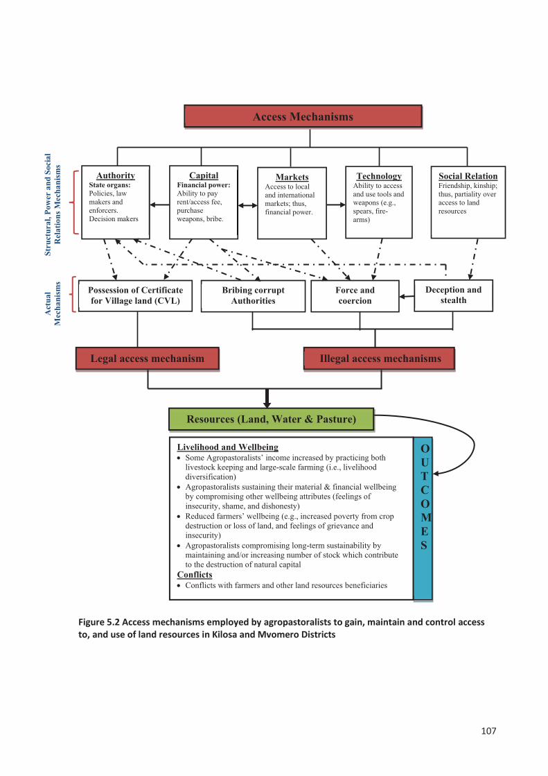
107
Figure 5.2 Access mechanisms employed by agropastoralists to gain, maintain and control access to, and use of land resources in Kilosa and Mvomero Districts

108
This study found that the increase in the number of livestock has led to perceived negative impacts
on land resources in Kilosa and Mvomero Districts. Loss of vegetation cover was even more evident
in the agropastoralists’ villages of Twatwatwa and Kambala. It can be argued that, if agropastoralists
continue keeping large numbers of stock, then farmers and agropastoralists’ long-term wellbeing and
sustainability are also in jeopardy, due to the extreme pressure exerted on the already limited and
declining stocks of natural capital. The large majority of interviewees and discussants in the FGDs
agreed that the illegal mechanisms used by agropastoralists to gain, maintain, and control access to
and use of land resources are the cause of conflicts between farmers and agropastoralists. The next
chapter (Chapter 6) presents findings on the proximate causes of farmer – agropastoralist conflict
escalation and their impacts on both farmers and agropastoral production systems.
109
Chapter 6
Proximate causes of farmer – agropastoralist conflict escalation
6.1 Introduction
This chapter addresses the second objective of this thesis, which is to examine the proximate causes
of farmer – agropastoralist conflict escalation and their impacts on both farmers and agropastoral
production systems. The chapter begins with a brief description of Social Conflict Theory. The next
section presents an overview of the types of land resource use-related conflicts that exist in Kilosa
and Mvomero districts. The causes for the occurrence of farmer – agropastoralist conflict, and
reasons for conflict escalation follows next. This is followed by perceptions of the impacts of the land
resource use-related conflicts on both farmers and agropastoral production systems. The chapter
ends by reporting the existing conflict management practices for handling, mitigating, and resolving
land resource use conflicts as well as challenges towards conflicts resolution. The information
presented in this chapter is based on interviews with head of households, government officials and
NGO representatives, group discussions (male and female) and a literature review of relevant
documents.
6.2 Social Conflict Theory
Social Conflict Theory was mostly reviewed in Chapter 3. To recap, Pruitt and Kim (2004, p. 91)
presented five general transformations (process variables) that occur during conflict escalation:
1) shift from small to large, i.e., increasing investment in the conflict
2) shift from light to heavy tactics (e.g., from persuasion to violence)
3) shift from specific to general (e.g., from crop damage to ethnic conflict)
4) shift from few to many, i.e., increase in the number of people involved in the conflict, and
5) shifts in goals from winning to hurting the other party (e.g., from solving the problem to
killing all opponents)
Within this context, this thesis uses “Social Conflict Theory” as described by Kriesberg (2007) and
Pruitt and Kim (2004), which focuses on the dynamics and transformations (process variables) of
conflicts for better understanding why and how conflict between farmers and agropastoralists
escalate in deadly violence in Kilosa and Mvomero Districts, Morogoro region. The next section
110
begins with conceptualizing land resource use-related conflicts, and then presents an overview of the
types of land resource use conflicts that exist in Kilosa and Mvomero districts.
6.3 Conceptualizing land resource use-related conflicts
Natural resources conflicts commonly occur in relation to land, water, forest and/or wildlife reserved
areas (Mandara, 2007, p. 31). Land related conflicts are associated with extension boundaries,
encroachment and competing uses on the same land. These conflicts are sometimes linked to land
scarcity based on suitability and availability for different or specific uses. Water related conflicts are
caused by disputes over sources, different water uses such as farming, livestock and domestic
purposes, and impacts on water quality and upstream and downstream users (Mandara et al., 2012).
All causes of water related conflicts link with scarcity in quantity, quality and user rights (Mandara,
2007). Forest and/or wildlife reserved areas conflicts are caused by restricted access of use and
control of forest and/or wildlife products among actors (Mandara et al., 2012). The land resource
use-related conflicts examined in this study encompass all these types of conflict, as entirely or
partially, agropastoralists depend on forest, land, and water for grazing resources.
In this study, the term ‘conflict’ has been used as an umbrella term to encompass a range of
phenomena such as lack of compatibility of goals, interests, and expectations among social groups
(i.e., farmers and agropastoralists); pursuit of actions or livelihood strategies that result in damage to
others; open confrontations resulting from conflicting interests or damaging actions; and various
forms of violence (Hagberg, 2005; Mwamfupe, 2015, p. 2). Idrissou, van-Paassen, Vodouhè, and
Leeuwis (2013) argue that resource use conflicts occur when different categories of resource users
have competing demands for diminishing resources and may attach different values to the resource
base. Thus, resource use conflicts occur in settings that involve an array of cultural, economic, and
political arrangements that may influence the outcomes of the conflict process. Therefore, resource
use conflicts tend to vary in dimension, level and intensity, and may take place at different levels,
from within the household to local, regional and societal scale (Kisoza, 2007). This implies that there
is a reason to not only find the causes for the occurrence of farmer – agropastoralist conflict, but also
the types and intensity of land resource use conflicts that exist in the study villages.
6.3.1 Types of land resource use-related conflicts
This study found that land resource use-related conflicts exist between the farmer and
agropastoralist communities in the study villages. The large majority of interviewees (89.6%)
acknowledged that land resource use conflicts were prevalent in their villages. In four of the villages,
all interviewees agreed there were conflicts, but in two of the villages the percent of interviewees
acknowledging the existence of conflicts was much lower. In the agropastoralists’ village of
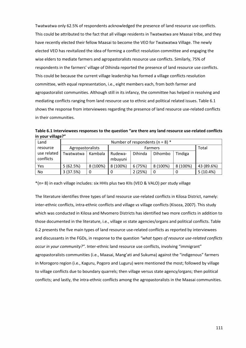
111
Twatwatwa only 62.5% of respondents acknowledged the presence of land resource use conflicts.
This could be attributed to the fact that all village residents in Twatwatwa are Maasai tribe, and they
have recently elected their fellow Maasai to become the VEO for Twatwatwa Village. The newly
elected VEO has revitalized the idea of forming a conflict resolution committee and engaging the
wise elders to mediate farmers and agropastoralists resource use conflicts. Similarly, 75% of
respondents in the farmers’ village of Dihinda reported the presence of land resource use conflicts.
This could be because the current village leadership has formed a village conflicts resolution
committee, with equal representation, i.e., eight members each, from both farmer and
agropastoralist communities. Although still in its infancy, the committee has helped in resolving and
mediating conflicts ranging from land resource use to ethnic and political related issues. Table 6.1
shows the response from interviewees regarding the presence of land resource use-related conflicts
in their communities.
Table 6.1 Interviewees responses to the question “are there any land resource use-related conflicts in your village?”
Land resource use related conflicts
Number of respondents (n = 8) *
Agropastoralists Farmers Total
Twatwatwa
Kambala
Rudewa-mbuyuni
Dihinda
Dihombo
Tindiga
Yes 5 (62.5%) 8 (100%) 8 (100%) 6 (75%) 8 (100%) 8 (100%) 43 (89.6%)
No 3 (37.5%) 0 0 2 (25%) 0 0 5 (10.4%)
*(n= 8) in each village includes: six HHIs plus two KIIs (VEO & VALO) per study village
The literature identifies three types of land resource use-related conflicts in Kilosa District, namely:
inter-ethnic conflicts, intra-ethnic conflicts and village vs village conflicts (Kisoza, 2007). This study
which was conducted in Kilosa and Mvomero Districts has identified two more conflicts in addition to
those documented in the literature, i.e., village vs state agencies/organs and political conflicts. Table
6.2 presents the five main types of land resource use-related conflicts as reported by interviewees
and discussants in the FGDs, in response to the question “what types of resource use-related conflicts
occur in your community?”. Inter-ethnic land resource use conflicts, involving “immigrant”
agropastoralists communities (i.e., Maasai, Mang’ati and Sukuma) against the “indigenous” farmers
in Morogoro region (i.e., Kaguru, Pogoro and Luguru) were mentioned the most; followed by village
to village conflicts due to boundary quarrels; then village versus state agency/organs; then political
conflicts; and lastly, the intra-ethnic conflicts among the agropastoralists in the Maasai communities.
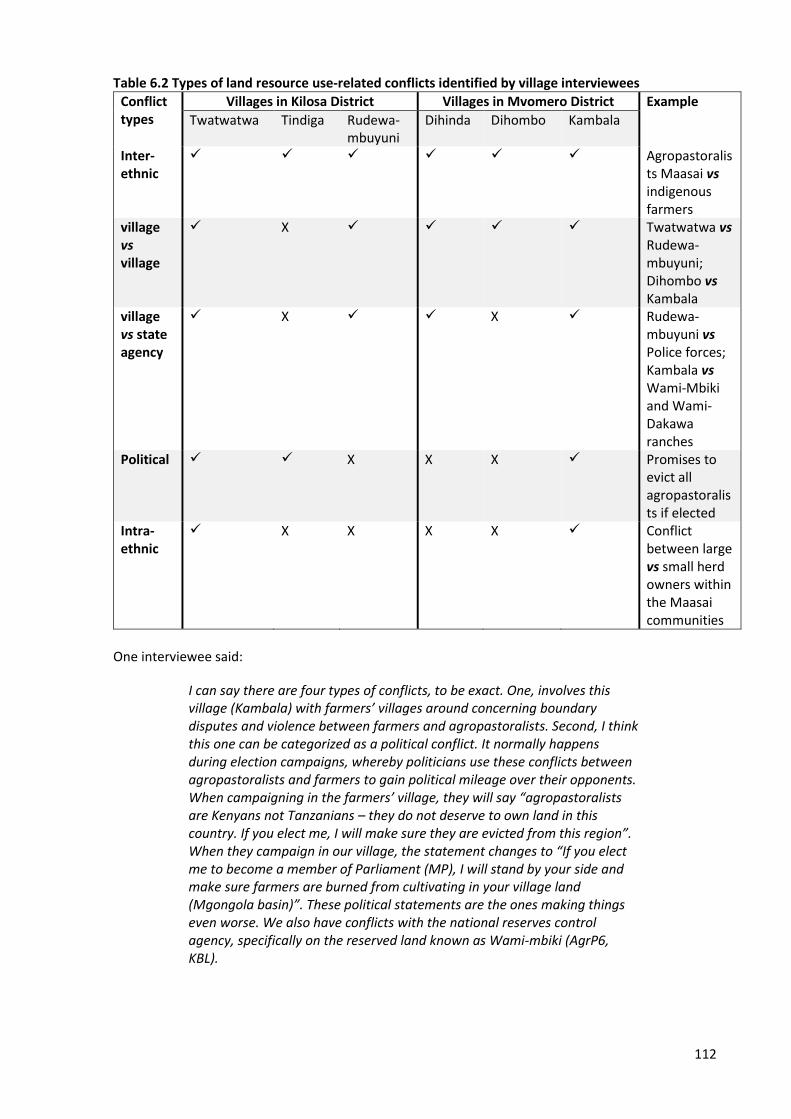
112
Table 6.2 Types of land resource use-related conflicts identified by village interviewees
Conflict types
Villages in Kilosa District Villages in Mvomero District Example
Twatwatwa Tindiga Rudewa-mbuyuni
Dihinda Dihombo Kambala
Inter-ethnic
✓ ✓ ✓ ✓ ✓ ✓ Agropastoralists Maasai vs indigenous farmers
village vs village
✓ X ✓ ✓ ✓ ✓ Twatwatwa vs Rudewa-mbuyuni; Dihombo vs Kambala
village vs state agency
✓ X ✓ ✓ X ✓ Rudewa-mbuyuni vs Police forces; Kambala vs Wami-Mbiki and Wami-Dakawa ranches
Political ✓ ✓ X X X ✓ Promises to evict all agropastoralists if elected
Intra-ethnic
✓ X X X X ✓ Conflict between large vs small herd owners within the Maasai communities
One interviewee said:
I can say there are four types of conflicts, to be exact. One, involves this village (Kambala) with farmers’ villages around concerning boundary disputes and violence between farmers and agropastoralists. Second, I think this one can be categorized as a political conflict. It normally happens during election campaigns, whereby politicians use these conflicts between agropastoralists and farmers to gain political mileage over their opponents. When campaigning in the farmers’ village, they will say “agropastoralists are Kenyans not Tanzanians – they do not deserve to own land in this country. If you elect me, I will make sure they are evicted from this region”. When they campaign in our village, the statement changes to “If you elect me to become a member of Parliament (MP), I will stand by your side and make sure farmers are burned from cultivating in your village land (Mgongola basin)”. These political statements are the ones making things even worse. We also have conflicts with the national reserves control agency, specifically on the reserved land known as Wami-mbiki (AgrP6, KBL).
113
Another key interviewee commented:
There are several land resource use-related conflicts in Mvomero District. Speaking of this village, major conflicts are between farmers and agropastoralists. This happens when agropastoralists cross their village boundaries and come to feed their cattle on farms in our village lands. Agropastoralists do not respect other village’s boundaries, and I think that is why you find this village (Dihombo) and many farmers’ villages around here, conflict with the agropastoralists’ village of Kambala. One more thing, there have been “contemptuous” feelings between these two groups. We (farmers) argue that being indigenous to this region, then we have more rights to our land resources than the “immigrants” agropastoralists. In recent times, these inter-ethnic differences have led to violence and some people have been severely injured (VEO, DHB).
The higher number of inter-ethnic conflicts were reported by the majority of respondents in farmers’
villages. It was identified that the majority of residents in the agropastoral villages are from Maasai,
Mang’ati and Sukuma tribes, who were collectively blamed by farmers for incidences of crop damage
by cattle in neighbouring farmers’ villages occupied by the indigenous tribes (Kaguru, Luguru and
Pogoro), leading to violence and conflicts between farmers and agropastoralists. The intra-ethnic
group conflicts were reported in Twatwatwa and Kambala Villages, where the minority Maasai elites
(elders) were proposing to partition the village communal grazing land. This was being challenged by
the majority large herds owners (youth generation), who were worried about losing access to grazing
land if village land was partitioned. From the literature (Benjaminsen et al., 2009; Kisoza, 2007) and
this study’s finding, it can be argued that the motive behind a proposal by minority Maasai elites and
local leaders to partition the communally-owned village land is to enable those who currently have
few cattle, and some who are not interested in keeping livestock anymore, to acquire land ownership
in terms of an immovable asset that could be used as collateral for loans from banks and other small
micro-finance institutions. The next section presents the findings on the causes for the occurrence of
conflicts between farmers and agropastoralists, and reasons for conflict escalation to deadly
violence.
6.4 Causes of land resource use conflicts and reasons for escalation
This study identified that farmers and agropastoralists hold slightly different views and perceptions
on the causes for conflict, whereby on many occasions, one party blames the other as being the
cause for conflict between them. Despite their differences, Table 6.3 presents the perceived causes
of land resource use conflicts in order of importance as reported by the large majority of
interviewees from the two groups.
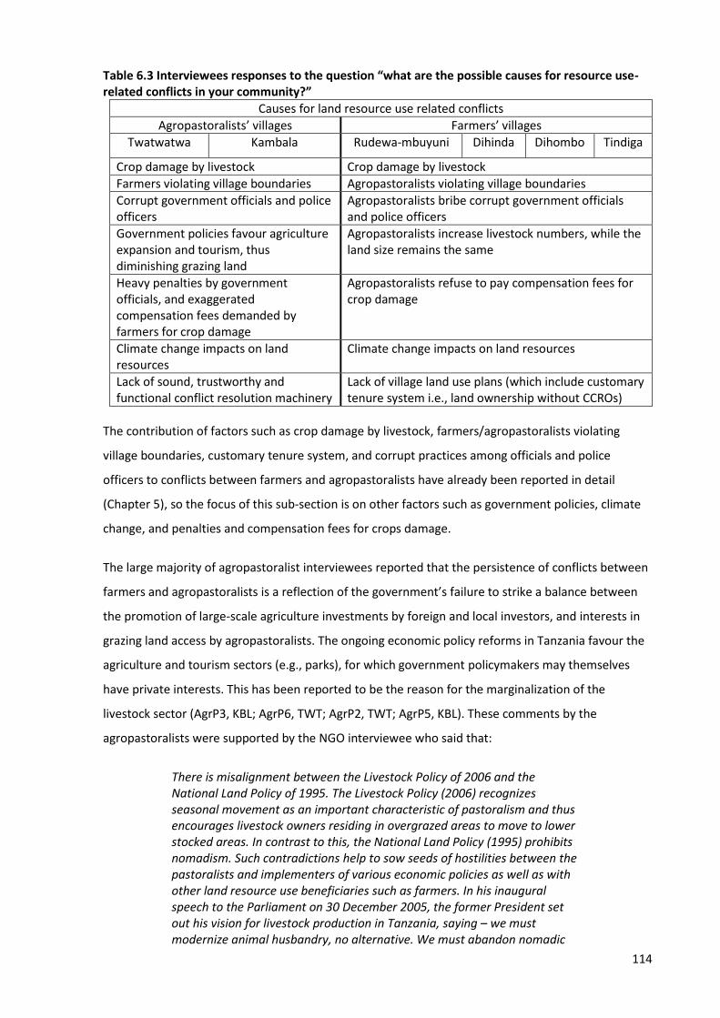
114
Table 6.3 Interviewees responses to the question “what are the possible causes for resource use-related conflicts in your community?”
Causes for land resource use related conflicts
Agropastoralists’ villages Farmers’ villages
Twatwatwa Kambala Rudewa-mbuyuni Dihinda Dihombo Tindiga
Crop damage by livestock Crop damage by livestock
Farmers violating village boundaries Agropastoralists violating village boundaries
Corrupt government officials and police officers
Agropastoralists bribe corrupt government officials and police officers
Government policies favour agriculture expansion and tourism, thus diminishing grazing land
Agropastoralists increase livestock numbers, while the land size remains the same
Heavy penalties by government officials, and exaggerated compensation fees demanded by farmers for crop damage
Agropastoralists refuse to pay compensation fees for crop damage
Climate change impacts on land resources
Climate change impacts on land resources
Lack of sound, trustworthy and functional conflict resolution machinery
Lack of village land use plans (which include customary tenure system i.e., land ownership without CCROs)
The contribution of factors such as crop damage by livestock, farmers/agropastoralists violating
village boundaries, customary tenure system, and corrupt practices among officials and police
officers to conflicts between farmers and agropastoralists have already been reported in detail
(Chapter 5), so the focus of this sub-section is on other factors such as government policies, climate
change, and penalties and compensation fees for crops damage.
The large majority of agropastoralist interviewees reported that the persistence of conflicts between
farmers and agropastoralists is a reflection of the government’s failure to strike a balance between
the promotion of large-scale agriculture investments by foreign and local investors, and interests in
grazing land access by agropastoralists. The ongoing economic policy reforms in Tanzania favour the
agriculture and tourism sectors (e.g., parks), for which government policymakers may themselves
have private interests. This has been reported to be the reason for the marginalization of the
livestock sector (AgrP3, KBL; AgrP6, TWT; AgrP2, TWT; AgrP5, KBL). These comments by the
agropastoralists were supported by the NGO interviewee who said that:
There is misalignment between the Livestock Policy of 2006 and the National Land Policy of 1995. The Livestock Policy (2006) recognizes seasonal movement as an important characteristic of pastoralism and thus encourages livestock owners residing in overgrazed areas to move to lower stocked areas. In contrast to this, the National Land Policy (1995) prohibits nomadism. Such contradictions help to sow seeds of hostilities between the pastoralists and implementers of various economic policies as well as with other land resource use beneficiaries such as farmers. In his inaugural speech to the Parliament on 30 December 2005, the former President set out his vision for livestock production in Tanzania, saying – we must modernize animal husbandry, no alternative. We must abandon nomadic
115
pastoralism which makes the whole country pastureland. The cattle are bony, and the pastoralists are sacks of skeletons. We cannot move forward with this type of pastoralism in the twenty first century. Over the years, national policies have reflected the directives to ‘modernize’ livestock production and do away with pastoralism (NGO1, TZ).
Another NGO interviewee commented:
We have seen the influx of ‘investors’ who take large portions of land to start large and extensive commercial farming (e.g., sisal and sugarcane), ranching and sometimes mining activities. In the process of doing so, agropastoralists are being evicted from their land without any prior arrangements to resettle them somewhere else. In short, the government is responsible for this, because we are about to witness what could be the largest land grab in the history of the country due to the on-going land policy reforms under the Southern Agricultural Growth Corridor of Tanzania (SAGCOT) program funded by the USAID involving several agro-industrial multi-nationals. The SAGCOT goals align well with the longstanding government objective to end traditional mode of livestock keeping and forcibly settle pastoralists in one geographical area, a process which has been conducted by mass eviction of pastoralists and, to a lesser degree, of small-scale farmers (NGO2, TZ).
The large majority of interviewees, both farmers and agropastoralists, reported that climate has
changed over recent decades resulting in prolonged droughts, unpredictable rainfall, floods, and new
outbreaks of animal, crop and human diseases. Drought-induced migration, which may be forceful
and/or voluntary between communities (farmers and agropastoralists), is linked to land resource use
conflicts (F2, RMN; F4, DHB; F1, DHD; F5, TNG; AgrP4, TWT; AgrP1, KBL). One agropastoralist
interviewee commented:
Climate has changed a lot in recent years. I remember in 1990s when I was a young boy, we used to graze our cattle just around our homestead because there were lots of quality pastures and water. There were no conflicts at all with our neighbours. But for the past decade the condition has become worse, the quality of grasses has deteriorated, water sources have gone dry because there is no rainfall. Now, our animals have nothing to eat and drink in this village. To rescue our animals, some family members must move with animals to other villages to search for pastures and water. It is very unfortunate that this has led to misunderstanding, and thus conflicts between us and farmers (AgrP2, TWT).
Similar opinions were reported by the large majority of discussants in the FGDs (male and female)
from both farmers and agropastoralists’ villages. One discussant in the female FGD in Kambala said:
Sometimes it is not always our fault, farmers are facing the same climate change impacts like us. For example, we have conflict with farmers from the neighbouring villages because they are encroaching and cultivating rice and vegetables in our village land ‘Mgongola basin’. This is obvious that we are not the only ones migrating from place to place, farmers do that as well due to prolonged draught periods in their villages. Up to this moment, crop
116
farms have crossed our village boundaries, and the farming activities are progressively increasing. In my opinion it is not us to blame when crops are destroyed by the cattle, farmers are to blame because they are the ones invading our village land, the land we use to graze and take our cattle to drink water along the river (FGD, female, KBL).
The agropastoralist and farmer interviewees had different opinions, and contrasting views
concerning penalties and compensation fees for crop damage. The majority of interviewees in the
farmers’ villages are of the opinions that agropastoralists refuse to pay compensation fees for crop
damage. Farmers reported that in recent times, agropastoralists have become more reluctant to
negotiate for compensation fees at the village level, and they prefer to take the dispute to the
District Courts instead, because it is more likely for these cases to be settled in their favour (F1, RMN;
F4, DHD; F1, TNG; F6, DHB; F4, RMN). One farmer interviewee in Dihinda Village explained:
Nowadays, agropastoralists do not want to negotiate and pay the compensation fee for the damage caused by their cattle. In December 2015, 180 cattle were caught on farms and a group of vigilant farmers ‘MWANO’ detained the cattle at the village offices. The intention was to wait for the cattle owner to come and negotiate with the farmers whose crops have been destroyed. To our surprise, it was the police officers who came first and took the cattle to the police station. The police requested the farmers to report at the district court the next day for the case hearing proceedings. The court officials kept postponing the hearing knowing that the farmers cannot afford to attend in court every time they were called for due to costs associated with travelling and other expenses. This practice by police officers and court officials is highly linked to receiving bribes from agropastoralists, and I personally think this is among reasons we (farmers) have decided to take matters into our own hands and strike back by whatever means necessary to hurt them (F3, DHD).
On the other hand, the large majority of interviewees in the agropastoralists’ villages made
accusations against the government officials and farmers by imposing heavy penalties against them,
and sometimes exaggerating the compensation fees for crop damage. Some agropastoralists
reported that farmers collude with their village officials to table ‘false claims’ and sometimes
exaggerate the magnitude of the crop damaged by cattle in order to maximize the compensation fee
(AgrP3, KBL; AgrP5, KBL; AgrP2, TWT; AgrP4, TWT). One agropastoralist interviewee commented:
Farmers and some district officials are taking advantage of us lacking formal education and knowledge on legal issues, to earn money from us. Once cattle are caught on farms, heavy fines and compensation fees are imposed against us even when the crop damage is very little. Sometimes the farmers use their traditional militia group called ‘MWANO’ to confiscate, detain and steal our cattle, and state false claims that cattle were found eating crops on farms while it was not so. In some villages they have village regulations which state that for each head of animal found on farm regardless of the extent of the damage caused, will be charged 25,000 Tshs. (US$12). Farmers and some village officials have been using these regulations to pursue financial gains for their own benefits. On several
117
occasions we are forced to pay the penalties to district officials who claim that our cattle are degrading the environment. That is lots of money, and sometimes we need to find the best way to handle the situation, which often lead to more disputes (AgrP2, KBL).
The following sub-section presents the findings on the perceived reasons for conflict escalation.
6.4.1 Perceived reasons for conflicts escalation to deadly violence
Farmers and agropastoralists hold contrasting views and opinions on the causes of conflict
escalation. Each side blames the behaviour and ways of conduct of the other as the cause. The large
majority of interviewees in farmers’ villages reported the following main causes of escalation:
1. Livestock eating and destroying crops on farms
2. Farmers getting injured and some killed by the agropastoralists
3. Unresponsiveness and deliberate delays by government officials and other state organs (e.g.,
police) to intervene in a timely way to diffuse tensions between farmers and agropastoralists
4. Arrogance and cruel behaviour by agropastoralist warriors (Morans), which is contributed to
by their superiority in ‘fighting skills’ using all sorts of weapons
5. Hatred between agropastoralists and farmers, i.e., farmers perceive they are being
disrespected by their counterpart agropastoralists, because agropastoralists are believed to
be relatively affluent compared to farmers
6. Divisive politics and discriminatory propaganda employed by politicians and government
officials against agropastoralists, to gaining political mileage
7. Mistrust in the ability of local conflict resolution institutions, e.g., District Courts, to
adjudicate fair and just decisions.
With regarding to the mistrust of local institutions to resolve conflicts, one farmer interviewee
commented:
The clashes between farmers and agropastoralist are often violent, resulting in murder and/or the destruction of peoples’ properties. The regional and district commissioners and their security committees always tend to intervene, and sometimes (not often) culprits are arrested, investigated, prosecuted and convicted. Often these processes are led by politicians who, we (farmers) believe, are the instigators of the conflicts, corrupt people, and have vested interests in the outcomes of these conflicts. Neither farmers nor pastoralists trust them. For example, since pastoralists are believed to have money and or have easy access to money, politicians and police often take
118
advantage of the conflicts to solicit bribes. This intensifies hostilities, and creates mistrust, as those who have been arrested are released after bribing police and/or politicians, while those whose properties are destroyed are not compensated (F5, DHB).
It was reported by the large majority of interviewees and discussants in both male and female FGDs
in the farmers’ villages that the reluctance and deliberate delays by government officials and police
forces to intervene in a timely manner to diffuse tensions between farmers and agropastoralists was
due to corrupt practices, i.e., waiting until the violence has escalated provides an opportunity for
government officials and police officers to receive bribes from agropastoralists, in order to negotiate
and/or manipulate the outcome of the criminal and/or civil offense. One interviewee reported:
It is disappointing and very shocking to see that when the agropastoralists’ cattle have been caught on farms; it takes less than five minutes for the police officers to arrive in the village. But it is absolutely the opposite when the crops are destroyed, and the farmer gets severely beaten and/or killed in the contest. When the farmer reports the incident to the police post, the police officers always give many excuses like “we don’t have gas (fuel) in our cars” or “we have a shortage of police officers at present.” They will request some cash in a range of 50,000 to 100,000 Tshs. (US$ 23 to 45) so that they fill the gas/fuel tanks of their cars. This always leaves me with two profound questions. Firstly, how can the very important state organ like the police force, lack funds to purchase gas/fuel for the cars? Secondly, where do they get money to fuel the cars and respond timely when it is the agropastoralists who have reported that the cattle have been caught on farms? There is nothing else one can think of here, other than the truth that these police officers are corrupt (F3, DHB).
However, the large majority of interviewees and discussants in both male and female FGDs in the
agropastoralists’ villages reported the following as the main causes for conflict escalation:
1. Farmers through their traditional militia group famously known as ‘MWANO’, use forceful
means to confiscate and steal cattle, sometimes even when there is no evidence of crop
destruction on farms. The role of ‘MWANO’ was to catch and confiscate cattle invading farms
and bring the cattle to the village authority offices. Livestock owners are supposed to report
to the village authority or to the police posts and pay compensation for the damage caused
by the cattle as evaluated by the VALO before they reclaim their cattle.
2. Killing of cattle by farmers, and some agropastoralists getting injured and/or killed in the
contest.
3. Ethnic hatred between agropastoralists and farmers, i.e., agropastoralists perceive being
disrespected by their counterpart farmers “indigenous people”, who call them names such as
“immigrants from Kenya”, “you look skinny like your animals” and “uncivilized humans.”
119
4. Divisive politics and discriminative propaganda employed by politicians and government
officials against agropastoralists, to gain political mileage.
5. Mistrust in the ability of local conflict resolution institutions, e.g., Village Committees, to
adjudicate fair and just decisions.
6. Corrupt practices by government officials, politicians, court officials and police officers.
The local ‘Swahili’ newspaper (The Jamhuri, 02 June 2015) reported that residents in Kilosa and
Mvomero districts mentioned names of the Members of Parliaments (MPs) representing Morogoro
region as culprits involved in the contentious politics and involved in sponsoring the ‘MWANO’,
which causes escalation of conflicts between farmers and agropastoralists in Twatwatwa and
Rudewa-mbuyuni Villages in Kilosa District, and in Kambala and Dihombo Villages in Mvomero
District. In the interview with the Jamhuri reporter, one Member of Parliament (the former Mvomero
MP and Deputy Minister for Water and Irrigation) refuted the allegations and stated that:
I am deeply sorry for the loss of lives of both people and livestock, and the ongoing robbery incidents in which peoples’ properties and the livestock have been stolen, and houses set on fire. However, I am disappointed with the allegations against me that I’m the root cause of what is happening in my political constituency (Mvomero District). I would like to tell you ‘Mr reporter’ that these skirmishes have long history since 1991 when I was still a very young boy, and two people were killed – one farmer and one agropastoralist. The same happened in 2005 before I became the MP for Mvomero constituency. For all these incidents, the district officials and other state organs (e.g., police forces) have always been showing an impassive gesture to intervene in a timely manner to diffuse tensions until the violence has escalated. This vividly shows there is a problem somewhere within the government institutions and it has nothing to do with an individual like me. The blame should be pointed to the police officers for not doing their job regardless of being informed early enough that violence is about to occur in the villages. Second, the central government through the Ministry for Lands, Housing and Human Settlements Development has to be blamed as well for the failure to put in place clear and permanent boundaries which separates villages belonging to farmers from those legally recognized as agropastoralists’ villages.
The newspaper concluded that the former Mvomero MP and fellow MPs representing various
constituents in Morogoro region were reluctant to answer and reserved their comments regarding
the accusation that they are involved in sponsoring the ‘MWANO’. Likewise, the reporter made
several attempts to interview (i.e., face to face and by phone) the former Morogoro region Police
Commander (RPC) to obtain his comments and views on the allegations regarding his police officers,
but his phone was either busy or not answered, and when answered, the reporter was told the RPC
has a busy schedule to take care of at that moment in time. Similar to what was reported in the local
newspaper, one agropastoralist interviewee commented that:
120
The MWANO combatants wear black traditional attire, holding arrows and machetes in their hands. It is a large group of young men (18-30 years of age) from farmers’ villages, hired by the farmers with the support from the village leaders, government officials and Members of Parliament representing various constituents in Morogoro region. When they find cattle wandering around (not necessarily on farms), they start throwing arrows to our ‘Morans’ in order to scare them. If our Morans run away and leave the cattle behind, the MWANO combatants use that opportunity to steal and sell some of the cattle to the pre-arranged potential buyers. They also slaughter some of the cattle on-site (serve themselves with meat) and leave the calves in the bush or along the road. They take the remaining animals to the village offices, waiting for the cattle owner to come and pay millions of money (in Tshs.)32 as a compensation fee for something which did not actually happen (false claims). Now, remember that I have lost lots of cattle, and yet someone wants me to pay lots of cash for false claims. Who on earth can endure such humiliation feelings? I will do everything possible to strike back so that I reclaim my dignity, and if need be, I will die for that (AgrP2, KBL).
Also reported by the majority of agropastoralist interviewees is the extreme hatred between them
and farmers due to the biased reports written in the majority of local newspapers and news media.
One interviewee in the agropastoralists’ village of Twatwatwa commented:
The newspaper reports of the violence that happened in the year 2000 were influenced by biased reporters. They generally favoured farmers and portrayed livestock keepers as ‘arrogant Maasai pastoralists’ and ‘rough’ against the normally peaceful village farmers. This is not surprising, since it was our young Maasai soldiers (Morans) who carried out the bloody act that caught the national attention. Newspapers and other news media (Radio and Television) often echoed claims from farmers that the pastoralists were ‘outsiders’ rather than ‘indigenous’ to Morogoro region. The idea that the Twatwatwa Village Maasai do not belong in the Kilosa area also forms part of a local story (AgrP6, TWT).
In summary, this research has identified that the following Social Conflict Theory transformation
processes (process variable) helps understanding of why and how conflict between farmers and
agropastoralists escalate to violence in Morogoro region:
1. Shift from specific to general, i.e., from crop damage by cattle to inter-ethnic hatred and
conflicts between agropastoralist (e.g., Maasai) and farmers.
2. Shift from few to many, i.e., increase in the number of people involved in the conflict (e.g.,
the confrontation between a farmer and agropastoralist regarding crop damage by cattle on
farm leads to each side mobilizing more people from their villages, thus creating an intense
atmosphere and favourable environment for conflict escalation).
32 Tanzanian currency called Tanzanian Shillings (Tshs): 1US$ is equivalent to 2200 Tshs.
121
3. Shift from light to heavy tactics, i.e., from persuasion to violence (e.g., instead of
reconciliation by forming the mutual conflict mediation and resolution committees, farmers
created the MWANO group to fight with agropastoralists).
4. Shift in goals from solving the problem to hurting the other party, i.e., farmers and MWANO
vigilantes steal and kill cattle instead of detaining them while waiting for compensation;
agropastoralists destroy and burn farmers’ houses, injuring and killing farmers instead of
compensating for crop damage.
The next section presents farmers and agropastoralists’ perceptions of the impacts of conflicts on
their production systems.
6.5 Farmers and agropastoralists’ perceptions of impacts of conflicts on production systems
6.5.1 Farmers’ perceptions
The large majority of farmer interviewees reported the following as the impacts of conflicts on their
agricultural production system:
1. Women have stopped practicing farming, especially the leasing of farms far from home, due
to fear of being raped by the agropastoralists (Moran-Maasai).
2. Family insecurity as often families are compelled to abandon their homes and farms and seek
refuge in more secure and peaceful villages.
3. Loss of financial capital and sometimes private property being auctioned due to failure to pay
back loans acquired from the micro-finance institutions, which were intended to boost
and/or expand their agricultural production potential.
4. Loss of manpower as members of families and loved ones become disabled and some are
killed during fights with agropastoralists.
5. Loss of soil fertility, as the soil becoming brittle and difficult to cultivate due to excessive
livestock in the villages. As a result, farmers experience lower harvests than ever before.
In line with the above, one key interviewee in the farmers’ village of Tindiga reported:
The reason why farmers hate the agropastoralists is because the livestock keepers are regarded as responsible for the extreme poverty observed in the farmer communities. Every time when farmers cultivate their farms with expectations that they will have good harvests, which will ensure them enough food for their families and opportunity to sell the excess to earn
122
more income, then the agropastoralists brings the cattle to feed on farms that have few days left before the harvest period. The worst situation comes when farmers’ private properties like houses and tractors are publicly auctioned due to the failure to pay back the loans acquired by farmers with an intention to modernize and expand their agricultural production. This has hampered farmers’ efforts to free themselves from poverty and achieve their personal and family development dreams (VEO, TNG).
Similar views and experiences were reported in both male and female FGDs conducted in the
farmers’ villages. One discussant in the female FGD conducted in the farmers’ village of Rudewa-
mbuyuni commented:
We (farmers) have gone several steps backward, poverty has increased, our children want to go to school but we cannot manage to pay for school fees. In this situation of conflicts between us, we are afraid to send our children to school because they may be injured and/or get killed along the way. Sometimes we are bound to abandon our homes and our farms and seek for refuge into other villages until the amicable situation get restored in our native villages. I personally used to cultivate 100 acres and I was getting very good harvests. But since the agropastoralists started coming in our villages with lots of cattle, the land has lost its natural fertility and it has become very hard to plough. As a result, we have been experiencing low agricultural yields as compared to the past few decades before the influx of the agropastoralists. How can one expect to develop in this kind of situation? It is impossible. Our lives depend on agriculture, if they keep flooding into our villages, feed their cattle on our farms and threatening to kill us when we try to stop them, and the government is doing nothing to rescue us from this tragedy, then we are doomed for extreme poverty (FGD, male, RMN).
6.5.2 Agropastoralists’ perceptions
The large majority of agropastoralist interviewees reported the following as the impacts of conflicts
on their livestock production system:
1. A huge decrease of livestock numbers per homestead due to cattle killings by farmers during
combats on farms, and hundreds of cattle being stolen by farmer combatants forming the
traditional MWANO militia group.
2. Extreme hatred, resulting from conflicts between agropastoralists and farmers has resulted
in restricted access to quality pastures and water in other villages that previously the
agropastoralists had a symbiotic and social relationship with. This has caused more deaths of
cattle and to the small number of cattle which are left unhealthy [low prices on the market]
due to lack of quality pasture and water.
123
3. Loss of livestock caretakers especially young males (Morans), as some of the family members
get killed and others are left disabled from injuries sustained during fights between the two
groups.
4. Difficulties accessing local livestock markets in the region due to prolonged conflicts has
resulted into a substantial decrease in income, which largely depends on selling and/or
auctioning the livestock at the local village markets.
In explaining the above-mentioned impacts, one agropastoralist interviewee in the agropastoralists’
village of Kambala reported:
The number of herds of cattle per household has decreased dramatically as compared to the past two decades. There are a number of reasons to explain this sharp decrease. Firstly, many cattle are killed by farmers (MWANO group) when it happens that the cattle have been caught eating crops on farms and/or wandering around in farmers’ villages; secondly, hundreds of cattle are being stolen by the MWANO combatants; and thirdly, so often we are bound to sell our cattle in order to get quick cash to cater for emergence situations such as: compensation fees to farmers, and bribing officials, police officers and magistrates. These emergency situations sometimes consume millions of money (in Tshs), thus we are forced to sell lots of cattle to be able to rescue our people from being held in custody and save our cattle from being killed or auctioned by the government (AgrP1, KBL).
Similar views and experiences were reported in both male and female FGDs conducted in the
agropastoralists’ villages. One discussant in the male FGD conducted in the agropastoralists’ village of
Twatwatwa reported that:
The conflict between us and farmers has contributed the most to our downfall economically and socially. Because the mutual relationship that used to exist between our village and villages around, does not exist anymore. You know when communities collaborate and live peacefully together, the cash-flow and daily income increases due to the interactions offered by the local markets. Now, due to the intensified hatred amongst us, we have lost that mutual relationship that used to exist. Sometimes, it becomes very difficult and challenging to take our cattle to the market for auction because one is not certain sure of what will happen along the way to the market. This has really affected our wellbeing and the livestock production system in general (FGD, male, TWT).
The next section reports on the existing conflict management practices and challenges in Mvomero
and Kilosa districts in Morogoro region.
124
6.6 Conflict management practices and challenges
6.6.1 Legal framework governing land dispute settlement in Tanzania
For administrative purposes, Tanzania is divided into regions, districts, divisions, wards33 and
villages34, as provided for in the country’s constitution. The territorial jurisdiction of the court system
has been developed in accordance with these administrative structures in order to facilitate access to
the judicial system and create a hierarchy of appeals from lower to higher levels. While not all
specialized courts35 have established systems from the village to the national level, the land courts do
(Massay, 2017). The Land Act, No.4 of 1999, Village Land Act, No. 5 of 1999, and the Land Dispute
Courts Act of 2002 establish five institutions at various levels of government that are responsible for
the settlement of land disputes. They are the Village Land Council, the Ward Tribunal, the District
Land and Housing Tribunal, the High Court and the Court of Appeal. The Land Dispute Courts Act was
enacted to implement one of the underlying principles of the Land Act and Village Land Act,
specifically, to ensure the establishment of an independent, expeditious and just system for
adjudicating land disputes.
The Village Land Council has jurisdiction within a village. It has seven members, including at least
three women, who are appointed by the Village Council and approved by the Village Assembly. This
is a mediating body only, so litigants may choose to submit their claim at a higher level of the judicial
system.36 The Ward Tribunal’s mandate is limited to the ward level, and its functions are to maintain
peace and harmony, secure the amicable settlement of disputes, reconcile marriages and enforce by-
laws passed by the relevant council. This tribunal handles disputes regarding both registered and
unregistered land. Its jurisdiction as a Land Court is established under section 167 of the Land Act of
1999 and section 10 of the Land Dispute Courts Act, with a pecuniary jurisdiction in land cases limited
to TZS 3 million (around US$1,340). It has a maximum of eight members (including at least three
women), who are appointed by the Ward Development Committee.
The District Land and Housing Tribunal (DLHT) is established under section 167 of the Land Act of
1999 and section 22 of the Land Dispute Courts Act, and operates at a district, regional or zone level.
The DLHT consists of a chairperson and at least two assessors. The Minister responsible for land
appoints a chairperson for three years. The original jurisdiction of the DLHT is confined to the fiscal
value of the subject in dispute. If the property is immovable, the limit is TZS 50 million ($22,360), and
if movable, TZS 40 million ($17,890). The DLHT has both appellate and revisionary jurisdiction over
33 In urban areas, wards are composed of a number of streets/neighbourhoods/suburbs instead of villages. 34 In rural areas, villages are composed of several hamlets. 35 Currently in Tanzania, the specialized courts are Land, Labour and Commercial. 36 This is one of the reasons why the Law Reform Commission of Tanzania recommended in 2013 that the Land Dispute Courts Act be amended to allow the Village Land Council to make binding decisions (Massay, 2017).
125
matters emanating from the ward tribunals. The High Court is the court of unlimited original
jurisdiction. The High Court Land Division was established under section 167 of the Land Act of 1999
and section 37 of the Land Dispute Courts Act, with exclusive original pecuniary jurisdiction over land
cases exceeding TZS 50 million (possession cases) or TZS 40 million in other cases, as well as
supervisory and revisionary powers over proceedings determined in the DLHT. The following
subsection outlines on the existing land resource-related conflict management practices in Mvomero
and Kilosa Districts.
6.6.2 Conflict management practices and challenges in the study areas
This study found that the existing land resources dispute settlement machinery remains vague about
the appropriate institutions to deal with farmer–agropastoralist conflicts (NGO1, MRG; NGO2, TZ;
DALO, KLS). Often land resource related conflicts between farmers and agropastoralists are handled
by administrative mechanisms that often involve politicians, police forces and the judiciary. These
mechanisms do not yield significant positive results, but rather they often deepen and complicate
the conflicts (NGO1, MRG; NGO2, TZ; NGO3, TZ; DALO, KLS; DALO, MVR). One interviewee
commented:
It is very rare for the disputes to be resolved at village or ward level. Villagers have noticed that the village and ward leaders have proven failure in resolving these kind of disputes, consequently, have opted to forward their cases to the police station or the court of law. Even when the cattle have been caught eating on farms, one will never consult the Village Land Council or the Ward Tribunal members, instead he/she will call the police to come and take the cattle to the police post. The next morning an audit on the farm will be conducted to determine loss that has occurred due to crops damage, and if the cattle owner refuse to pay the compensation fee as per the audit report, then the claimant will take the matter to the court of law. A few decades ago, we had a different practice whereby negotiations and reconciliation played a big role, but things have changed. Our traditional way of dealing with misunderstanding and conflicts among ourselves has been weakened and replaced with the statutory approaches based on formal procedures. This is the existing practice in most of the villages in Kilosa District (F4, TNG).
Another key interviewee commented:
The land resource use conflicts are reported through the system that deals with criminal cases, while land resources issues are left unattended until the criminal cases are resolved. This creates tension and complicates the conflict resolution processes because the primary cause of the conflicts, which is in many cases land, is left unattended (NGO2, TZ).
The large majority of farmer and agropastoralist interviewees reported that many villages lack
effective institutional machinery for handling and managing land resource conflicts. The Village Land
Councils are the ones entrusted to resolve and manage land resource disputes at village level, but
126
these organs have no power to make binding decisions; likewise, for the Wards Tribunal. The litigants
mostly choose to by-pass these institutions (i.e., Village Land Council, Ward Tribunal and DLHT) and
submit their claim at the highest level of the judicial system, which involves the police and courts
(AgrP2, KBL; AgrP6, KBL; AgrP4, TWT; F3, RMN; F1, DHB; F5, DHB). One key interviewee in the
agropastoralists’ village of Kambala commented that:
I remember in the year 2009 the Mvomero District Commissioner urged all VEOs in their respective villages to formulate functional village land conflict resolution committees, which shall be responsible for handling and mitigating conflicts related to the use of land resources. It was very unfortunate that only few villages (e.g., Twatwatwa and Dihinda) were able to initiate those committees. Among the reasons for the failure to establish these committees in farmers’ villages was the fact that farmers believe if they accept this idea, then it will be perceived by the agropastoralists that they have been granted an approval to enter and stay in the farmers’ villages for good (VEO, KBL).
The next sub-section reports on the land resource use conflict management challenges in the study
areas.
6.6.2.1 Land resource conflict management challenges
Interviewees reported that the role of lower level institutions (i.e., Village Land Councils and Ward
Tribunals) in settling land disputes involving farmers and agropastoralists is problematic for three
main reasons. Firstly, farmer and agropastoralist conflicts often involve more than one village and
may entail the destruction of property valued well in excess of the limits over which these tribunals
have pecuniary jurisdiction. The defined and limited territorial and pecuniary jurisdiction of the
relevant Village Council and Ward Tribunal thus limits the role that they can play in these disputes
(NGO1, MRG; DALO, MVR; DALO, KLS; VEO, KBL). Secondly, in most wards pastoralists are in the
minority, with limited or no representation in village and ward-level institutions. As a result,
pastoralists do not trust these institutions (NGO2, TZ; NGO3, TZ; DALO, KLS; VEO, KBL; VEO, TWT;
AgrP6, TWT; AgrP5, KBL). Thirdly, there are allegations that Village Land Councils and Ward Tribunals
have become politicised. The politicians are said to favour farmers, as farmers form the larger voting
bloc of the two groups. There is thus a widespread perception that agropastoralists do not receive a
fair hearing at the village and ward level (NGO1, MRG; NGO2, TZ; NGO3, TZ; DALO, MVR; AgrP2,
TWT; AgrP1, KBL). One key interviewee from Kilosa District commented:
Unlike parts of Arusha and Monduli regions in northern Tanzania, agropastoralists in Kilosa and Mvomero districts are the minority group. It might be easier for agropastoralists to influence politics and decision making in areas where they are in the majority, but when they are in the minority, they have traditionally bribed officials in the authorities to compensate for this lack of political influence. Since they own huge number of livestock, pastoralists have easier access to cash than farmers, and this
127
can be used to bribe officials. This unhealthy relationship between the agropastoralists and state officials and/or state organs have made the whole task of conflict resolution even more challenging and difficult (DALO, KLS).
Other challenges mentioned by a small minority of interviewees from both farmer and
agropastoralist’ villages include: lack of funds for running day-to-day activities of the village conflict
resolution committees, e.g., transport and airtime credit, risk of resolving conflicts during late hours
in the night, and villagers not respecting the decisions made by the resolution committees. All these
factors make the whole process of conflict handling, mitigation and resolution even more difficult
(VEO, KBL; VEO, TNG; VEO, DHB; AgrP3, KBL; F1, DHD; F3, DHD; F6, DHD). One informant commented
that:
As leaders we do face some challenges as well. For example, so often we receive midnight calls from a farmer with claims that cattle have invaded his/her farm. These calls normally require immediate response like walking 5 to 6 kilometers to the location, otherwise the situation will be out of control the next morning. As a leader, you need to be enthusiastic and committed to resolve these conflicts amicably. In addition to that, there is no budget allocated to the conflict resolution committees to cover for transportation and credits for communication purposes. I believe it is due to the lack of funds, that is why some unscrupulous village leaders and other members of the conflict resolution committees tend to ask for money from one party (claimant or defendant). The act of one asking for money to attend and/or resolve the conflict, is translated by villagers and parties in conflict the same way as asking for bribe, thus lead to one part on the losing side not to agree with the decisions made by the conflict resolution committee (VEO, KBL).
The large majority of discussants in both male and female FGDs conducted in farmer and
agropastoralist’ villages revealed the following as reasons for the failure of the existing institutions to
handle, resolve and mitigate conflicts between farmers and agropastoralists and challenges to
establishing effective conflict resolution systems:
1. In many wards and villages agropastoralists are in the minority, with limited or no
representation in village and ward level institutions. This is a point of contention, especially
from the perspective of the agropastoralists who argue that they are not fairly represented
in the village goverments. As a result, the agropastoralists become reluctant to cooperate in
resolving conflicts because they do not trust these institutions. On the other hand, farmers
also become reluctant to participate in forming the conflict resolution committees as they
fear that by doing so they will legitimize the presence of the agropastoralists in their villages.
128
2. Corrupt practices and divisive politics by government officials, politicians and other state
organs (e.g., police and magistrates) have further created the negative attitude and mistrust
by both farmers and agropastoralists towards these conflict resolution bodies.
3. The traditional conflict resolution machinery has been weakened partly by the emergence of
statutory approaches based on formal procedures, and on the other, by the influx of the
agropastoralists with different traditions, customs, values and beliefs upon which these
mechanisms were anchored.
4. Insufficient knowledge of land laws and Land Acts, and lack of training in conflict resolution
skills such as mediation and negotiation for land dispute committee members at all levels.
This forces the land dispute committee members to use their own experience in resolving
land conflicts placed before them.
6.7 Conclusions
The objective of this chapter was to examine the proximate causes of farmer – agropastoralist
conflict escalation and their impacts on both farmer and agropastoral production systems. While
addressing this objective, this research identified two more conflicts (i.e., village vs state agencies
and political conflicts) to make a total five main types of land use-related conflicts in the study areas,
namely:
• inter-ethnic conflicts
• intra-ethnic group conflicts
• village vs village conflicts
• village vs state agencies/organs, and
• political conflicts.
The inter-ethnic land resource-use conflicts, involving the agropastoralist communities against the
farmers in Morogoro region were mentioned the most, followed by village vs village conflicts due to
boundary quarrels, then village vs state agency/organs, then by political conflicts, and lastly, the
intra-ethnic conflicts among the agropastoralists in the Maasai communities.
The study also found that farmers and agropastoralists hold slightly different views and perceptions
about the causes of conflict. On many occasions, one party blames the other for being the cause.
Despite their differences, the large majority of interviewees from the two groups reported factors
129
such as: crop damage by livestock, violation of village boundaries, excessive large numbers of herds
of cattle, corrupt practices by officials, climate change impacts and biased government policies as the
main contributing factors for land resource-use conflicts. As with the causes of conflict, it was
identified that famers and agropastoralists share contrasting views, opinions, and experiences on the
reasons for conflict escalating to deadly violence. Farmers reported factors such as: crop destruction
on farms, farmers getting injured and/or killed by the agropastoralists, and deliberate delays of
government officials to intervene in a timely manner to diffuse tensions, as the major reasons for
conflict escalation. On the other hand, the agropastoralists reported factors such as: stealing and
killings of cattle which is done by the farmers’ traditional militia group (MWANO), divisive politics
employed by politicians and disrespect from their counterpart farmers, i.e., calling them names such
as “immigrants from Kenya” or “uncivilized humans”, as the reasons for conflict escalation. Finally,
this research revealed that Social Conflict Theory transformation processes (process variable) helps
understanding why and how conflict between farmers and agropastoralists escalate to violence in
Morogoro region. These transformation processes are:
• Shift from specific to general, e.g., from crop damage by cattle to inter-ethnic conflicts.
• Shift from few to many, e.g., increase in the number of people involved in the conflict.
• Shift from light to heavy tactics, e.g., from reconciliation to violence.
• Shift in goals from solving the problem to hurting the other party, e.g., farmers stealing and
killing the cattle; and agropastoralists destroying and burn farmers’ houses, injuring and
killing farmers.
The next chapter (Chapter 7) present findings on the trend and extent of environmental and
rangeland degradation in the study areas.
130
Chapter 7
Trend and extent of environmental and rangeland degradation
7.1 Introduction
This chapter addresses the third objective of this thesis, which is to assess the trend and extent of
environmental and rangeland degradation and examine the agropastoralists and farmers’
perceptions of how any such degradation has impacted their production systems. The chapter begins
by presenting findings on the indicators most used by agropastoralists and farmers to assess
environmental and rangeland degradation. The next section reports on land use and cover changes
observed between 1995 and 2017, and the agropastoralists and farmers’ views and opinions
regarding trend and extent of environmental and rangeland degradation. The perceived causes of
environmental and rangeland degradation logically follow next. The chapter ends by reporting the
perceptions of farmers and agropastoralists on the impacts of environmental and rangeland
degradation on their respective production systems. The information presented in this chapter is
based on interviews with head of households, government officials and NGO representatives, group
discussions (male and female), observation and transect walks, satellite image analysis using
Geographical Information System (GIS) and Remote Sensing, and a review of relevant documents.
7.2 Indicators used to assess environmental and rangeland degradation
To understand how agropastoralists and farmers assess and analyse the nature and magnitude of
environmental and rangeland degradation over time, the following key questions were asked in
order to explore their knowledge of the indicators for assessing and evaluating the environmental
and rangeland degradation:
1. Can you describe the current environmental and rangeland condition, and how it has
changed over the past 20 years?
2. What indicators do you use to assess environmental and rangeland degradation?
Some participants were clearly knowledgeable about environmental and rangeland degradation and
suggested a number of indicators, and these were ticked/checked by the researcher against the pre-
prepared checklist of 31 indicators compiled from the review of relevant literature (Table 4.7 in
Chapter 4). It was deemed unnecessary to show them the full list.
Other participants did not suggest any indicators, so for these participants the researcher showed
them the pre-prepared list of 31 indicators to consider. For this part of the research, qualitative
131
descriptors: “increasing”, “decreasing”, “no change” and “unknown” are applied quantitatively to
describe the environmental and rangeland degradation over time.
During the interviews, the agropastoralist and farmer interviewees mentioned 25 of the 31 indicators
on the pre-prepared list – the six indicators not mentioned were water and soil taste salty, water
table drop lower, increase of predators, animal respiratory diseases, animal skin diseases, and rich
and medium households grow fragile. However, in addition to the remaining 25 indicators on the
pre-prepared checklist, the five additional indicators emerged during interview: soil crusting and
cracking, and soil muddiness (eco-physical), risk of wildfires (climate), and diversification of livelihood
activities and conflicts over land resources (social). In total, therefore, the interviewees identified 30
indicators in five categories to assess environmental and rangeland degradation. Of these 30
indicators, seven (23.3%) were related to climate, six (20%) to social aspects, six (20%) to eco-
physical aspects, six (20%) to livestock performance, and five (16.7%) to rangeland vegetation. Table
7.1 shows agropastoralist and farmer interviewees’ perceptions of the environmental and rangeland
assessment indicator changes. The signs (+ve and -ve) inside the brackets represent the implications
of indicator changes (increase or decrease) to environmental and rangeland health. According to
Table 7.1, both farmer and agropastoralist interviewees reported negative trend in all categories (i.e.,
eco-physical, climate, vegetation, livestock and social), thus declining conditions of environmental
and rangeland health.
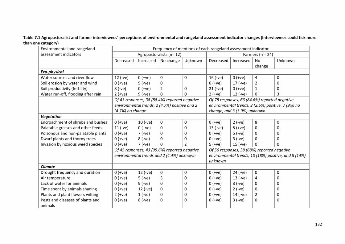
132
Table 7.1 Agropastoralist and farmer interviewees’ perceptions of environmental and rangeland assessment indicator changes (Interviewees could tick more than one category)
Environmental and rangeland assessment indicators
Frequency of mentions of each rangeland assessment indicator
Agropastoralists (n= 12) Farmers (n = 24)
Decreased Increased No change Unknown Decreased Increased No change
Unknown
Eco-physical
Water sources and river flow 12 (-ve) 0 (+ve) 0 0 16 (-ve) 0 (+ve) 4 0 Soil erosion by water and wind 0 (+ve) 9 (-ve) 0 0 (+ve) 17 (-ve) 2 0 Soil productivity (fertility) 8 (-ve) 0 (+ve) 2 0 21 (-ve) 0 (+ve) 1 0 Water run-off, flooding after rain 2 (+ve) 9 (-ve) 0 0 2 (+ve) 12 (-ve) 0 3
Of 43 responses, 38 (88.4%) reported negative environmental trends, 2 (4.7%) positive and 2 (4.7%) no change
Of 78 responses, 66 (84.6%) reported negative environmental trends, 2 (2.5%) positive, 7 (9%) no change, and 3 (3.9%) unknown
Vegetation
Encroachment of shrubs and bushes 0 (+ve) 10 (-ve) 0 0 0 (+ve) 2 (-ve) 8 0 Palatable grasses and other feeds 11 (-ve) 0 (+ve) 0 0 13 (-ve) 5 (+ve) 0 0 Poisonous and non-palatable plants 0 (+ve) 7 (-ve) 0 0 0 (+ve) 5 (-ve) 0 0 Dwarf plants and thorny trees 0 (+ve) 8 (-ve) 0 0 0 (+ve) 3 (-ve) 0 0 Invasion by noxious weed species 0 (+ve) 7 (-ve) 0 2 5 (+ve) 15 (-ve) 0 0
Of 45 responses, 43 (95.6%) reported negative environmental trends and 2 (4.4%) unknown
Of 56 responses, 38 (68%) reported negative environmental trends, 10 (18%) positive, and 8 (14%) unknown
Climate
Drought frequency and duration 0 (+ve) 12 (-ve) 0 0 0 (+ve) 24 (-ve) 0 0 Air temperature 0 (+ve) 5 (-ve) 3 0 0 (+ve) 13 (-ve) 4 0 Lack of water for animals 0 (+ve) 9 (-ve) 0 0 0 (+ve) 3 (-ve) 0 0 Time spent by animals shading 0 (+ve) 12 (-ve) 0 0 0 (+ve) 2 (-ve) 0 0 Plants and plant flowers wilting 2 (+ve) 1 (-ve) 0 0 0 (+ve) 14 (-ve) 2 0 Pests and diseases of plants and animals
0 (+ve) 8 (-ve) 0 0 0 (+ve) 3 (-ve) 0 0
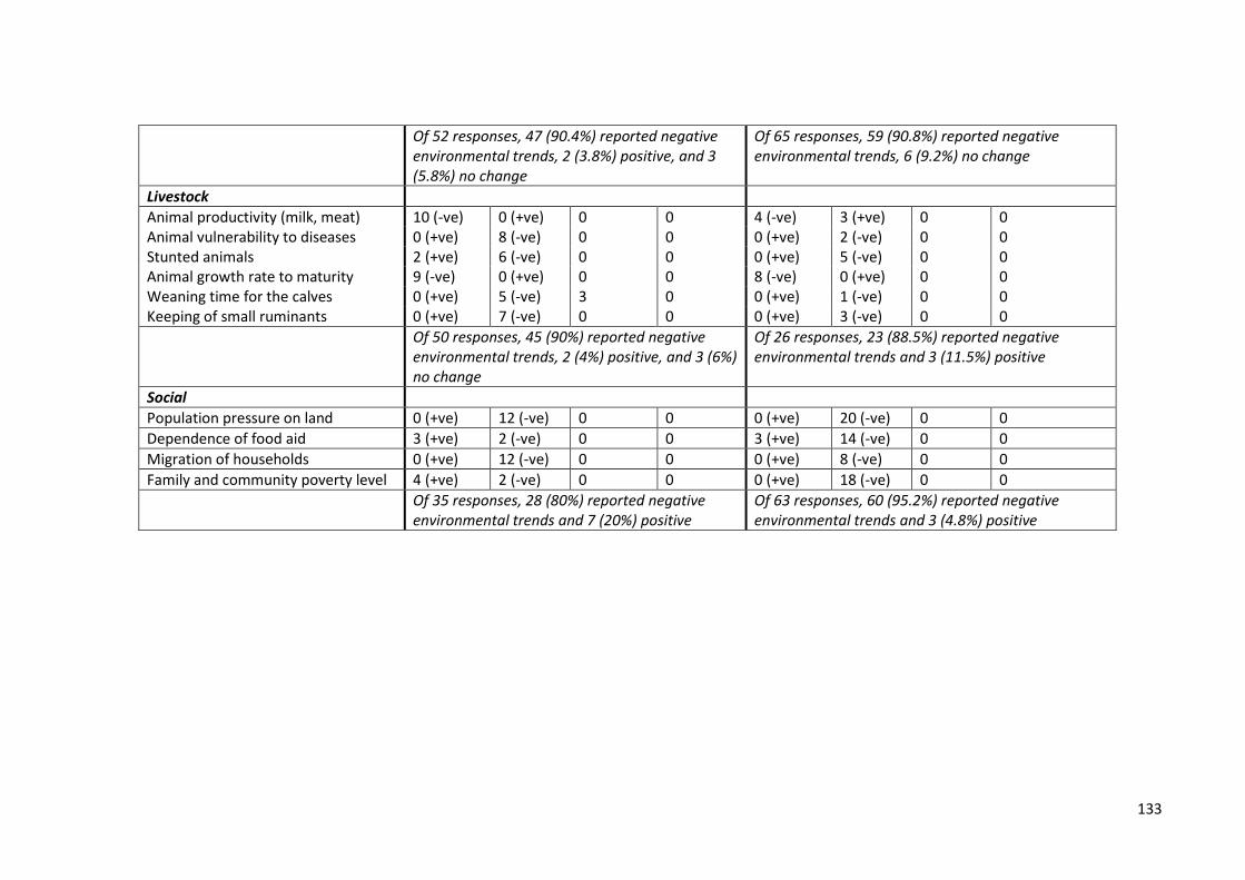
133
Of 52 responses, 47 (90.4%) reported negative environmental trends, 2 (3.8%) positive, and 3 (5.8%) no change
Of 65 responses, 59 (90.8%) reported negative environmental trends, 6 (9.2%) no change
Livestock
Animal productivity (milk, meat) 10 (-ve) 0 (+ve) 0 0 4 (-ve) 3 (+ve) 0 0 Animal vulnerability to diseases 0 (+ve) 8 (-ve) 0 0 0 (+ve) 2 (-ve) 0 0 Stunted animals 2 (+ve) 6 (-ve) 0 0 0 (+ve) 5 (-ve) 0 0 Animal growth rate to maturity 9 (-ve) 0 (+ve) 0 0 8 (-ve) 0 (+ve) 0 0 Weaning time for the calves 0 (+ve) 5 (-ve) 3 0 0 (+ve) 1 (-ve) 0 0 Keeping of small ruminants 0 (+ve) 7 (-ve) 0 0 0 (+ve) 3 (-ve) 0 0
Of 50 responses, 45 (90%) reported negative environmental trends, 2 (4%) positive, and 3 (6%) no change
Of 26 responses, 23 (88.5%) reported negative environmental trends and 3 (11.5%) positive
Social
Population pressure on land 0 (+ve) 12 (-ve) 0 0 0 (+ve) 20 (-ve) 0 0
Dependence of food aid 3 (+ve) 2 (-ve) 0 0 3 (+ve) 14 (-ve) 0 0
Migration of households 0 (+ve) 12 (-ve) 0 0 0 (+ve) 8 (-ve) 0 0
Family and community poverty level 4 (+ve) 2 (-ve) 0 0 0 (+ve) 18 (-ve) 0 0
Of 35 responses, 28 (80%) reported negative environmental trends and 7 (20%) positive
Of 63 responses, 60 (95.2%) reported negative environmental trends and 3 (4.8%) positive
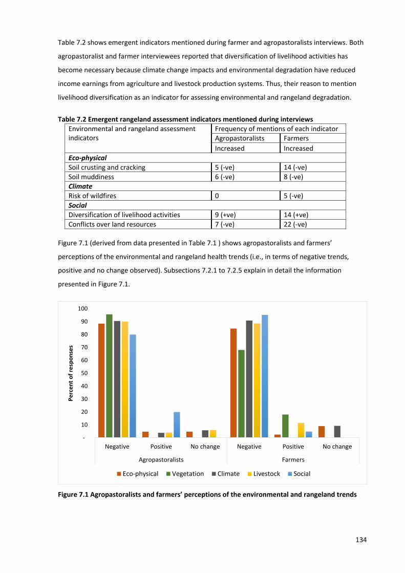
134
Table 7.2 shows emergent indicators mentioned during farmer and agropastoralists interviews. Both
agropastoralist and farmer interviewees reported that diversification of livelihood activities has
become necessary because climate change impacts and environmental degradation have reduced
income earnings from agriculture and livestock production systems. Thus, their reason to mention
livelihood diversification as an indicator for assessing environmental and rangeland degradation.
Table 7.2 Emergent rangeland assessment indicators mentioned during interviews
Environmental and rangeland assessment indicators
Frequency of mentions of each indicator
Agropastoralists Farmers
Increased Increased
Eco-physical
Soil crusting and cracking 5 (-ve) 14 (-ve)
Soil muddiness 6 (-ve) 8 (-ve)
Climate
Risk of wildfires 0 5 (-ve)
Social
Diversification of livelihood activities 9 (+ve) 14 (+ve)
Conflicts over land resources 7 (-ve) 22 (-ve)
Figure 7.1 (derived from data presented in Table 7.1 ) shows agropastoralists and farmers’
perceptions of the environmental and rangeland health trends (i.e., in terms of negative trends,
positive and no change observed). Subsections 7.2.1 to 7.2.5 explain in detail the information
presented in Figure 7.1.
Figure 7.1 Agropastoralists and farmers’ perceptions of the environmental and rangeland trends
-
10
20
30
40
50
60
70
80
90
100
Negative Positive No change Negative Positive No change
Agropastoralists Farmers
Pe
rce
nt
of
resp
on
ses
Eco-physical Vegetation Climate Livestock Social
135
7.2.1 Eco-physical
Both agropastoralists and farmers reported negative trends for the four eco-physical indicators on
the pre-prepared list – 88.4% of agropastoralist and 84.6% of farmer responses were that condition
was declining. Some agropastoralist and farmer interviewees mentioned soil crusting and cracking
and soil muddiness as additional indicators, meaning that overall eco-physical changes were
perceived in terms of water stress (e.g., decline of river flow), soil erosion, soil crusting and
muddiness, which collectively give rise to poor soil fertility. Both agropastoralist and farmer
interviewees reported that aridity has increased, characterized by decrease of water sources.
However, 4.7% of responses from agropastoralists and 9% from farmers were that nothing has
changed in terms of eco-physical environments. This could be because some farmers spend more of
their time in the most fertile wetlands around their villages, which also receives water from rivers
originating from mountains in Morogoro. Similarly, some agropastoralists nearby may also benefit
from these conditions.
7.2.2 Vegetation
Agropastoralists were more concerned with rangeland vegetation changes than farmers, thus 95.6%
of agropastoralists’ responses reported negative environmental trends compared to 68% of
responses from farmers. Agropastoralists mentioned the Loss of vegetation cover (e.g., palatable
grasses), and increase of shrubs, bushes and noxious weed species as the main negative changes to
the rangeland vegetation. Agropastoralists concern over rangeland vegetation is logical because they
depend on rangeland vegetation for quality pastures to graze their stock.
7.2.3 Climate
90.4% of agropastoralist and 90.8% of farmer responses reported negative environmental trends
related to the climate. The majority of agropastoralists and some farmer interviewees reported that
the huge decline of the agricultural yields and livestock productivity was associated with the
deterioration of the environmental and rangeland conditions, i.e., poor quality pasture, shortages of
water and loss of fertile soil, recurrent and extended drought periods, increase of atmospheric
temperature, and increase of plants and animals’ pests and diseases. However, 5.8% of responses
from agropastoralists and 9.2% from farmers were that nothing related to climate has changed. This
could be due to the same reason as reported earlier on the eco-physical conditions. Also a few
farmer interviewees mentioned risk of wildfires as an indicator to assess environmental and
rangeland degradation.
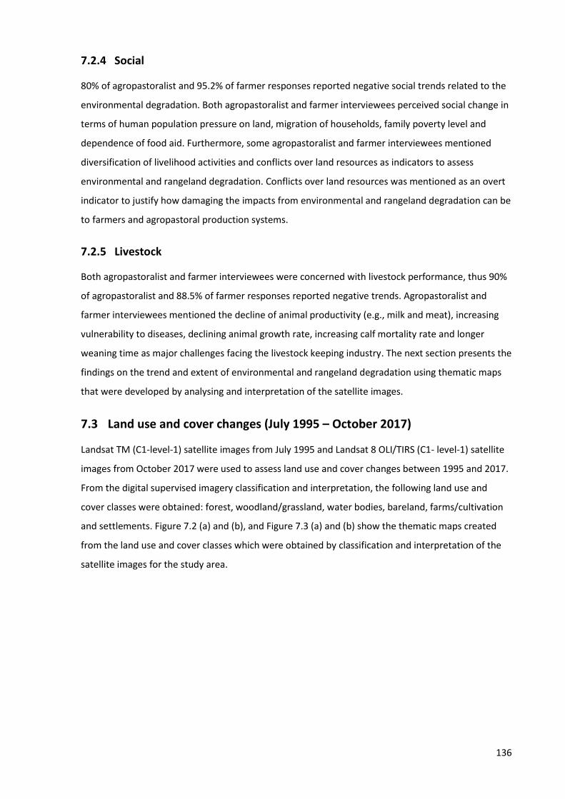
136
7.2.4 Social
80% of agropastoralist and 95.2% of farmer responses reported negative social trends related to the
environmental degradation. Both agropastoralist and farmer interviewees perceived social change in
terms of human population pressure on land, migration of households, family poverty level and
dependence of food aid. Furthermore, some agropastoralist and farmer interviewees mentioned
diversification of livelihood activities and conflicts over land resources as indicators to assess
environmental and rangeland degradation. Conflicts over land resources was mentioned as an overt
indicator to justify how damaging the impacts from environmental and rangeland degradation can be
to farmers and agropastoral production systems.
7.2.5 Livestock
Both agropastoralist and farmer interviewees were concerned with livestock performance, thus 90%
of agropastoralist and 88.5% of farmer responses reported negative trends. Agropastoralist and
farmer interviewees mentioned the decline of animal productivity (e.g., milk and meat), increasing
vulnerability to diseases, declining animal growth rate, increasing calf mortality rate and longer
weaning time as major challenges facing the livestock keeping industry. The next section presents the
findings on the trend and extent of environmental and rangeland degradation using thematic maps
that were developed by analysing and interpretation of the satellite images.
7.3 Land use and cover changes (July 1995 – October 2017)
Landsat TM (C1-level-1) satellite images from July 1995 and Landsat 8 OLI/TIRS (C1- level-1) satellite
images from October 2017 were used to assess land use and cover changes between 1995 and 2017.
From the digital supervised imagery classification and interpretation, the following land use and
cover classes were obtained: forest, woodland/grassland, water bodies, bareland, farms/cultivation
and settlements. Figure 7.2 (a) and (b), and Figure 7.3 (a) and (b) show the thematic maps created
from the land use and cover classes which were obtained by classification and interpretation of the
satellite images for the study area.
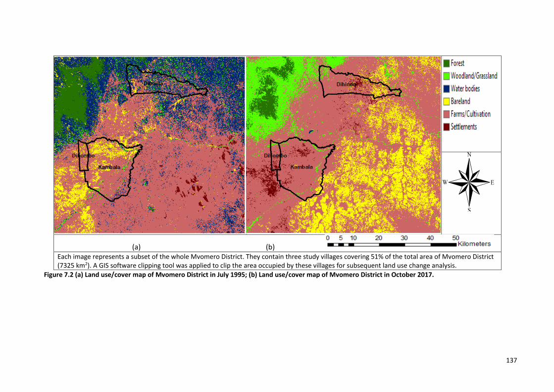
137
(a) (b) Each image represents a subset of the whole Mvomero District. They contain three study villages covering 51% of the total area of Mvomero District (7325 km2). A GIS software clipping tool was applied to clip the area occupied by these villages for subsequent land use change analysis.
Figure 7.2 (a) Land use/cover map of Mvomero District in July 1995; (b) Land use/cover map of Mvomero District in October 2017.
®
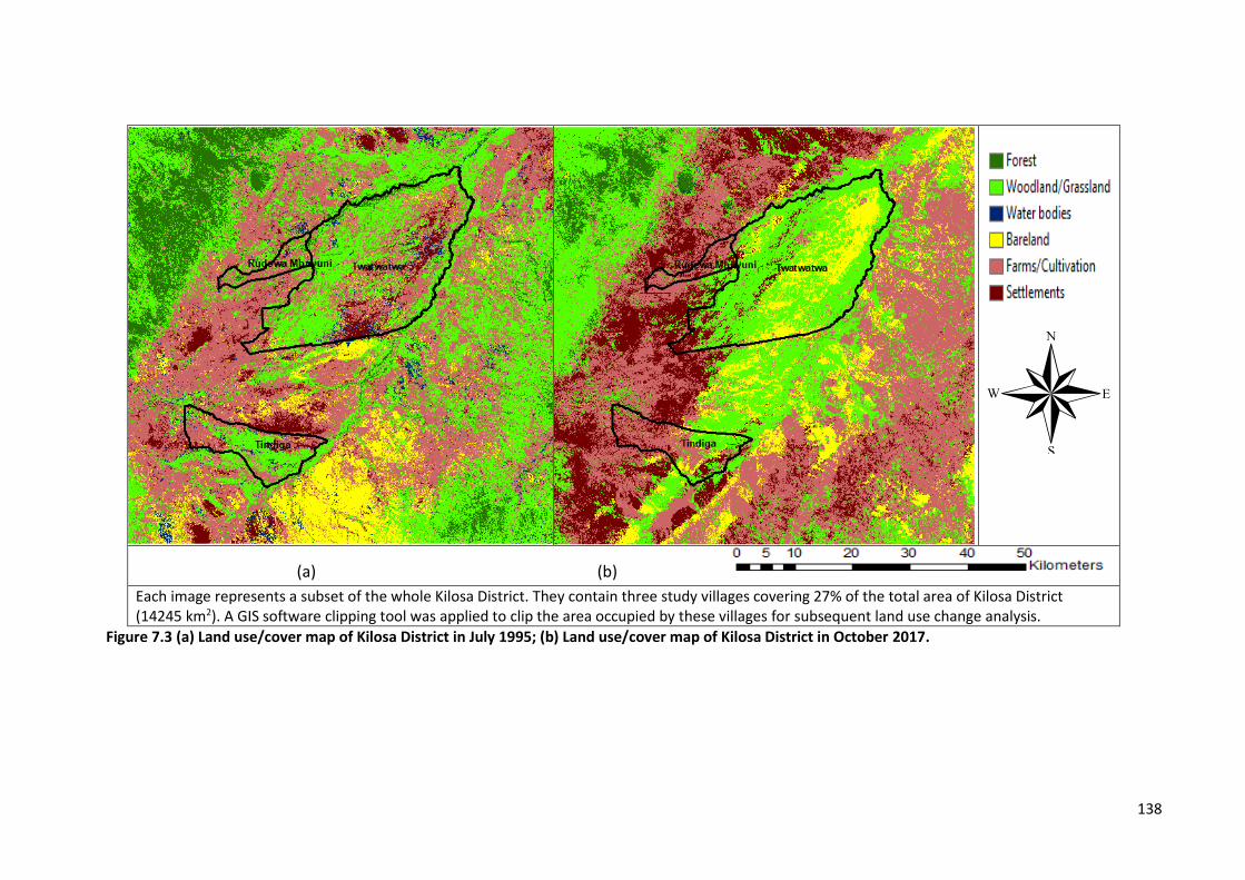
138
(a) (b)
Each image represents a subset of the whole Kilosa District. They contain three study villages covering 27% of the total area of Kilosa District (14245 km2). A GIS software clipping tool was applied to clip the area occupied by these villages for subsequent land use change analysis.
Figure 7.3 (a) Land use/cover map of Kilosa District in July 1995; (b) Land use/cover map of Kilosa District in October 2017.
®
139
Statistical analysis of land use and cover changes between July 1995 and October 2017 are presented
in Figure 7.4. Analysis shows forest, woodland/grassland and water bodies classes have decreased,
while bareland, farms/cultivation and settlements have increased for a period between 1995 – 2017.
Figure 7.4 Land use and cover change statistics for the period July 1995 – 2017
Tables 7.3 and 7.4 show the analysis of significance of changes within land use/cover classes (Chi
square test) for Kilosa (1995-2017) and Mvomero (1995-2017) respectively.
Table 7.3 Analysis of significance of land use/cover changes at Kilosa (1995-2017)
Year Land Use/cover types in Kilosa
Forest Woodland/Grassland Water bodies
Bareland Farms/Cultivation Settlements
1995 353 1,335 100 343 1,497 170
2017 101 1,101 41 436 1,597 522
454 2,435 141 779 3,093 692
Chi square P = 2.2491E-80 P<0.001
The land use/cover changes at Kilosa between 1995 and 2017 was found to be statistically significant
(X2 = 2.2491E-80, P<0.001).
Table 7.4 Analysis of significance of land use/cover changes at Mvomero (1995-2017)
Year Land use/cover types in Mvomero
Forest Woodland/Grassland Water bodies
Bareland Farms/Cultivation Settlements
1995 250 122 876 240 2,241 35
2017 109 106 367 593 2,500 89
359 228 1,243 833 4,741 124
Chi square P = 2.1948E-96 P<0.001
35
3
1,3
35
10
0 34
3
1,4
97
17
0
10
1
1,1
01
41
43
6
1,5
97
52
2
25
0
12
2
87
6
24
0
2,2
41
35
10
9
10
6 3
67
59
3
2,5
00
89
- 200 400 600 800
1,000 1,200 1,400 1,600 1,800 2,000 2,200 2,400 2,600
Lan
d u
se/c
ove
r ch
ange
s (k
m2)
Land use/cover types
Kilosa 1995 Kilosa 2017 Mvomero 1995 Mvomero 2017
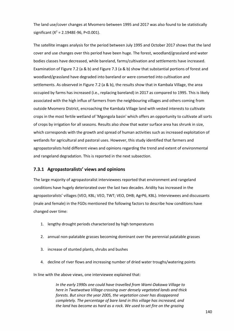
140
The land use/cover changes at Mvomero between 1995 and 2017 was also found to be statistically
significant (X2 = 2.1948E-96, P<0.001).
The satellite images analysis for the period between July 1995 and October 2017 shows that the land
cover and use changes over this period have been huge. The forest, woodland/grassland and water
bodies classes have decreased, while bareland, farms/cultivation and settlements have increased.
Examination of Figure 7.2 (a & b) and Figure 7.3 (a & b) show that substantial portions of forest and
woodland/grassland have degraded into bareland or were converted into cultivation and
settlements. As observed in Figure 7.2 (a & b), the results show that in Kambala Village, the area
occupied by farms has increased (i.e., replacing bareland) in 2017 as compared to 1995. This is likely
associated with the high influx of farmers from the neighbouring villages and others coming from
outside Mvomero District, encroaching the Kambala Village land with vested interests to cultivate
crops in the most fertile wetland of 'Mgongola basin' which offers an opportunity to cultivate all sorts
of crops by irrigation for all seasons. Results also show that water surface area has shrunk in size,
which corresponds with the growth and spread of human activities such as increased exploitation of
wetlands for agricultural and pastoral uses. However, this study identified that farmers and
agropastoralists hold different views and opinions regarding the trend and extent of environmental
and rangeland degradation. This is reported in the next subsection.
7.3.1 Agropastoralists’ views and opinions
The large majority of agropastoralist interviewees reported that environment and rangeland
conditions have hugely deteriorated over the last two decades. Aridity has increased in the
agropastoralists’ villages (VEO, KBL; VEO, TWT; VEO, DHB; AgrP6, KBL). Interviewees and discussants
(male and female) in the FGDs mentioned the following factors to describe how conditions have
changed over time:
1. lengthy drought periods characterized by high temperatures
2. annual non-palatable grasses becoming dominant over the perennial palatable grasses
3. increase of stunted plants, shrubs and bushes
4. decline of river flows and increasing number of dried water troughs/watering points
In line with the above views, one interviewee explained that:
In the early 1990s one could have travelled from Wami-Dakawa Village to here in Twatwatwa Village crossing over densely vegetated lands and thick forests. But since the year 2005, the vegetation cover has disappeared completely. The percentage of bare land in this village has increased, and the land has become as hard as a rock. We used to set fire on the grazing
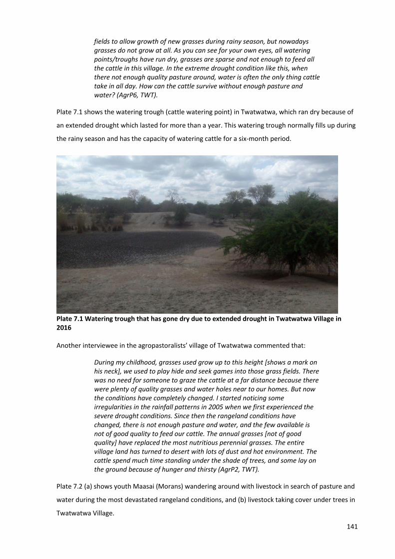
141
fields to allow growth of new grasses during rainy season, but nowadays grasses do not grow at all. As you can see for your own eyes, all watering points/troughs have run dry, grasses are sparse and not enough to feed all the cattle in this village. In the extreme drought condition like this, when there not enough quality pasture around, water is often the only thing cattle take in all day. How can the cattle survive without enough pasture and water? (AgrP6, TWT).
Plate 7.1 shows the watering trough (cattle watering point) in Twatwatwa, which ran dry because of
an extended drought which lasted for more than a year. This watering trough normally fills up during
the rainy season and has the capacity of watering cattle for a six-month period.
Plate 7.1 Watering trough that has gone dry due to extended drought in Twatwatwa Village in 2016 Another interviewee in the agropastoralists’ village of Twatwatwa commented that:
During my childhood, grasses used grow up to this height [shows a mark on his neck], we used to play hide and seek games into those grass fields. There was no need for someone to graze the cattle at a far distance because there were plenty of quality grasses and water holes near to our homes. But now the conditions have completely changed. I started noticing some irregularities in the rainfall patterns in 2005 when we first experienced the severe drought conditions. Since then the rangeland conditions have changed, there is not enough pasture and water, and the few available is not of good quality to feed our cattle. The annual grasses [not of good quality] have replaced the most nutritious perennial grasses. The entire village land has turned to desert with lots of dust and hot environment. The cattle spend much time standing under the shade of trees, and some lay on the ground because of hunger and thirsty (AgrP2, TWT).
Plate 7.2 (a) shows youth Maasai (Morans) wandering around with livestock in search of pasture and
water during the most devastated rangeland conditions, and (b) livestock taking cover under trees in
Twatwatwa Village.
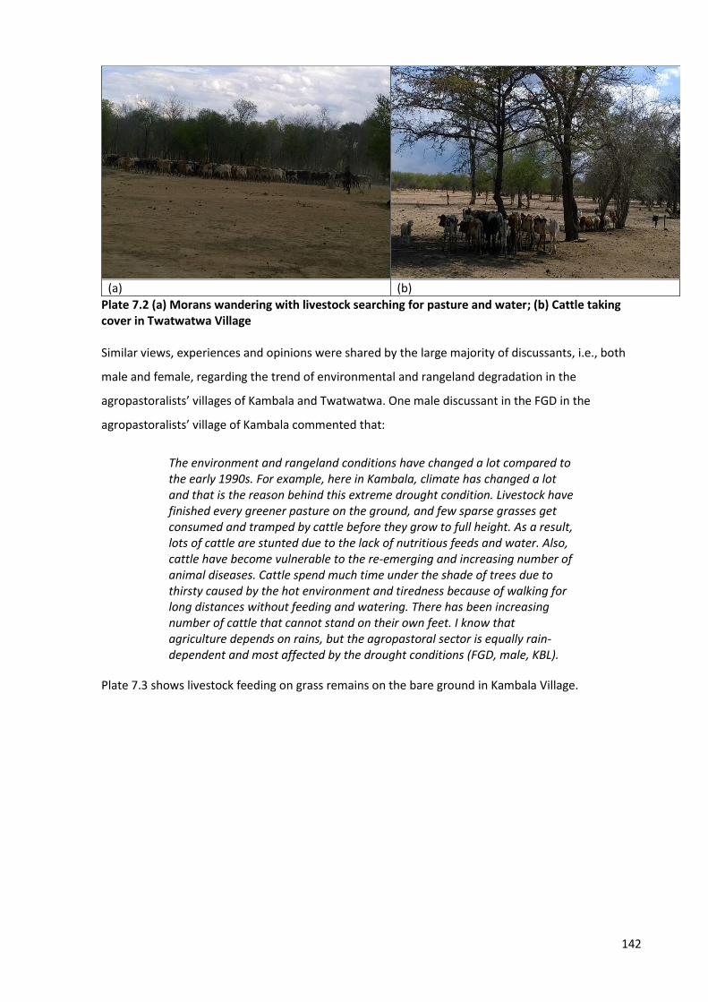
142
(a) (b)
Plate 7.2 (a) Morans wandering with livestock searching for pasture and water; (b) Cattle taking cover in Twatwatwa Village Similar views, experiences and opinions were shared by the large majority of discussants, i.e., both
male and female, regarding the trend of environmental and rangeland degradation in the
agropastoralists’ villages of Kambala and Twatwatwa. One male discussant in the FGD in the
agropastoralists’ village of Kambala commented that:
The environment and rangeland conditions have changed a lot compared to the early 1990s. For example, here in Kambala, climate has changed a lot and that is the reason behind this extreme drought condition. Livestock have finished every greener pasture on the ground, and few sparse grasses get consumed and tramped by cattle before they grow to full height. As a result, lots of cattle are stunted due to the lack of nutritious feeds and water. Also, cattle have become vulnerable to the re-emerging and increasing number of animal diseases. Cattle spend much time under the shade of trees due to thirsty caused by the hot environment and tiredness because of walking for long distances without feeding and watering. There has been increasing number of cattle that cannot stand on their own feet. I know that agriculture depends on rains, but the agropastoral sector is equally rain-dependent and most affected by the drought conditions (FGD, male, KBL).
Plate 7.3 shows livestock feeding on grass remains on the bare ground in Kambala Village.
143
Plate 7.3 Livestock feeding on dry grass remains in Kambala Another female discussant in the FGD in the agropastoralists’ village of Kambala commented:
The rangeland condition is not the same as it used to be in the early 1990s. The conditions changed dramatically in the year 2005 [marked as severe drought year in Tanzania], but I can cite few drought incidences that happened before 2005. In 1995 we noticed patchy drought periods, and in December 2004 is when we started experiencing extended drought periods that forced some families to leave this village with their livestock and look for a place into other villages or regions far from here where they can find enough pasture and water. In 2010/2011 we had enough rainfall which resulted in improved conditions in terms of pasture and water, and some families started coming back. But in recent times the situation has become worse than ever before. When it rains, it comes with high intensity for a short time, causing floods because water does not percolate into the soil. As a result, some families lose their homes and become displaced due to floods. Floods also brings other severe impacts such as soil erosion [loss of fertile soil], cattle go missing and others get drowned, and grasses do not grow as they are sub-merged in the water. It is very difficult time we are facing now (FGD, female, KBL).
The next sub-section presents the findings of farmer views and opinions on the trend of the
environmental and rangeland degradation.
7.3.2 Farmers’ views and opinions
In contrast to the agropastoralists’ villages, farmers’ villages in Kilosa and Mvomero Districts are
strategically located in the most fertile basins (e.g., Wami, Mkata and Mgongola), which receive
enough water from various rivers originating from mountains in Morogoro region (DALO, KLS; DALO,
MVR; VEO, RMN; VEO, TNG; VEO, DHD). Therefore, farmers can afford to carry out agricultural
activities even during extreme drought conditions because these wetlands consist of fertile soil and
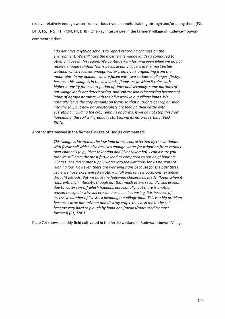
144
receive relatively enough water from various river channels draining through and/or along them (F2,
DHD; F5, TNG; F1, RMN; F4, DHB). One key interviewee in the farmers’ village of Rudewa-mbuyuni
commented that:
I do not have anything serious to report regarding changes on the environment. We still have the most fertile village lands as compared to other villages in this region. We continue with farming even when we do not receive enough rainfall. This is because our village is in the most fertile wetland which receives enough water from rivers originating from the mountains. In my opinion, we are faced with two serious challenges: firstly, because this village is in the low lands, floods occur when it rains with higher intensity for a short period of time; and secondly, some portions of our village lands are deteriorating, and soil erosion is increasing because of influx of agropastoralists with their livestock in our village lands. We normally leave the crop remains on farms so that nutrients get replenished into the soil, but now agropastoralists are feeding their cattle with everything including the crop remains on farms. If we do not stop this from happening, the soil will gradually start losing its natural fertility (VEO, RMN).
Another interviewee in the farmers’ village of Tindiga commented:
This village is located in the low land areas, characterized by the wetlands with fertile soil which also receives enough water for irrigation from various river channels (e.g., River Mkondoa and River Myombo). I can assure you that we still have the most fertile land as compared to our neighbouring villages. The rivers that supply water into the wetlands shows no signs of running low. However, there are worrying signs because for the past three years we have experienced erratic rainfall and, on few occasions, extended drought periods. But we have the following challenges: firstly, floods when it rains with high intensity, though not that much often; secondly, soil erosion due to water run-off which happens occasionally, but there is another reason to explain why soil erosion has been increasing, it is because of excessive number of livestock invading our village land. This is a big problem because cattle not only eat and destroy crops, they also make the soil become very hard to plough by hand hoe [means/tools used by most farmers] (F1, TNG).
Plate 7.4 shows a paddy field cultivated in the fertile wetland in Rudewa-mbuyuni Village.
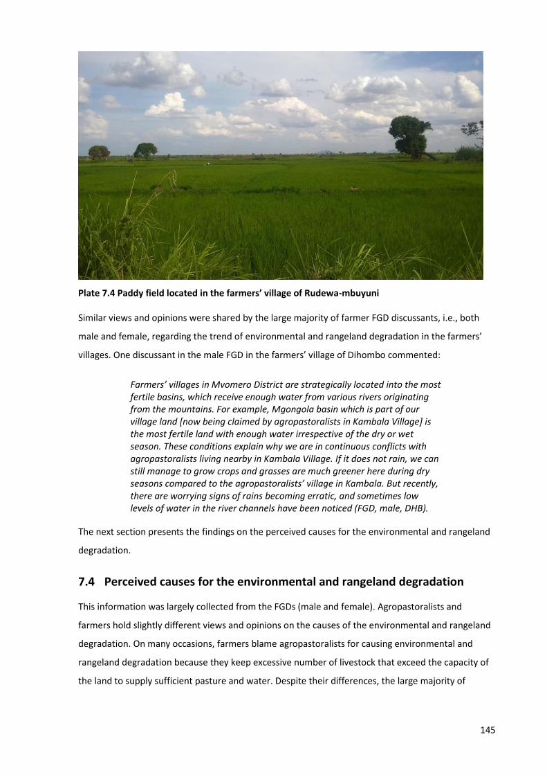
145
Plate 7.4 Paddy field located in the farmers’ village of Rudewa-mbuyuni Similar views and opinions were shared by the large majority of farmer FGD discussants, i.e., both
male and female, regarding the trend of environmental and rangeland degradation in the farmers’
villages. One discussant in the male FGD in the farmers’ village of Dihombo commented:
Farmers’ villages in Mvomero District are strategically located into the most fertile basins, which receive enough water from various rivers originating from the mountains. For example, Mgongola basin which is part of our village land [now being claimed by agropastoralists in Kambala Village] is the most fertile land with enough water irrespective of the dry or wet season. These conditions explain why we are in continuous conflicts with agropastoralists living nearby in Kambala Village. If it does not rain, we can still manage to grow crops and grasses are much greener here during dry seasons compared to the agropastoralists’ village in Kambala. But recently, there are worrying signs of rains becoming erratic, and sometimes low levels of water in the river channels have been noticed (FGD, male, DHB).
The next section presents the findings on the perceived causes for the environmental and rangeland
degradation.
7.4 Perceived causes for the environmental and rangeland degradation
This information was largely collected from the FGDs (male and female). Agropastoralists and
farmers hold slightly different views and opinions on the causes of the environmental and rangeland
degradation. On many occasions, farmers blame agropastoralists for causing environmental and
rangeland degradation because they keep excessive number of livestock that exceed the capacity of
the land to supply sufficient pasture and water. Despite their differences, the large majority of
146
interviewees from the two groups reported the following as the main contributing factors for the
observed environmental and rangeland degradation:
1. Increased human population pressure on the same area of village lands.
2. Unevenly distributed and unpredictable rainfall characterized by extended drought periods.
3. Lack of proper and effective rural land use planning with clear distinctions of settlement
areas, agricultural fields, reserved lands, and grazing areas.
4. The rise of divergent rural land use activities such as mineral mining, charcoal making, and
timber harvesting.
One key interviewee in the farmers’ village of Dihombo commented:
Yes, I do concur with most people in this village that climate change has contributed to the observed rangeland degradation. But I also believe that there are more contributing factors other than climate change itself. Keeping excessive number of livestock and the increase of human population in this region could be other crucial factors contributing to environmental and rangeland degradation. The lack of proper land use plans in most villages could be another factor contributing to degradation as well, though not so many people mentioning it (VEO, DHB).
Another key interviewee from the agropastoralists’ village of Twatwatwa commented:
Extended drought due to climate change is the main cause of rangeland degradation. Some people say that we are at fault for keeping large numbers of livestock, I totally disagree with that. For me personally, keeping excessive number of livestock has nothing to do with rangeland degradation. For example, I do not hear people mentioning other activities such as cutting logs [deforestation] for commercial timber, or massive land clearing for large scale agriculture as contributing to environmental and rangeland degradation. Therefore, it is high time people should stop being biased when addressing this issue (VEO, TWT).
However, a small minority of agropastoralists acknowledge that keeping large numbers of livestock
by the large majority of agropastoralists is one among other factors contributing to rangeland
degradation. One interviewee from the agropastoralists’ village of Twatwatwa commented:
In my opinion, in addition to climate change impacts, human and livestock population have increased significantly over the past few years, which I think has contributed to environmental and rangeland degradation we are experiencing today. When my family came here in 2000 there were few people living in this village. As family size expand, more children inherit livestock from their parents and start their own families. As a result, both human population and livestock number increases, but the land area remain the same. Eventually the land becomes exhausted and lose its capacity to accommodate both human and livestock needs. To be honest, the number
147
of cattle has exceeded by far the number of people present in this village (AgrP6, TWT).
Similar opinions were reported by the large majority of discussants in the FGDs (male and female)
from both farmers and agropastoralists villages. One discussant in the female FGD in Kambala said:
Climate change is the obvious reason but other factors such as increasing human population and keeping excessive numbers of livestock deserved to be mentioned. In my opinion I think other human activities such as intensive and large-scale agriculture and timber harvesting have contributed significantly to the environmental degradation. To my little knowledge I know that forests brings rain. I remember in the early 1980s until late the 1990s we used to receive lots of rain in this area because there was a thick and natural forest located in the nearby area that used to be the national ranch. The government decided to privatize the ranch, and later sold the land to foreign investors. The investors decided to use the land for large scale agricultural activities. In the process of doing so, all native trees including those along the catchment of River Wami were harvest and processed into timber products. Few years later we started noticing irregularities in rainfall patterns, sometimes it rains for two months only in the entire year. Therefore, I think it is not right to put the blame on keeping excessive numbers of stock, while other issues like agriculture and deforestation are left unmentioned (FGD, female, KBL).
The following section presents findings on the agropastoralists and farmers’ perception of the
impacts of degradation on their respective production systems.
7.5 Agropastoralists and Farmers’ perceptions of impacts of degradation
7.5.1 Agropastoralists’ perceptions
The large majority of agropastoralist interviewees reported the following impacts of environmental
and rangeland degradation on their production system:
1. Many cattle have died, and the few left have poor body condition because of the decline of
quality pasture and water.
2. Cattle diseases have increased, and more cattle have died. The few that have survived
produce little milk, poor-quality meat, and poor skin and hoof products. As a result,
agropastoralists’ income has hugely declined due to low prices of livestock products in the
local and regional markets.
3. Livestock care and maintenance costs have increased due to additional expenses in
purchasing animal food and paying for veterinary services.
4. Land resource-related conflicts and violence between agropastoralists and farmers have
increased, which puts the pastoral production system in jeopardy.
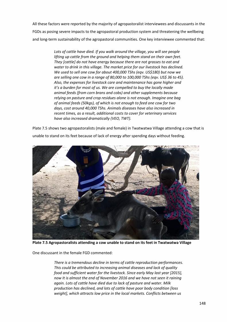
148
All these factors were reported by the majority of agropastoralist interviewees and discussants in the
FGDs as posing severe impacts to the agropastoral production system and threatening the wellbeing
and long-term sustainability of the agropastoral communities. One key interviewee commented that:
Lots of cattle have died. If you walk around the village, you will see people lifting up cattle from the ground and helping them stand on their own feet. They [cattle] do not have energy because there are not grasses to eat and water to drink in this village. The market price for our livestock has declined. We used to sell one cow for about 400,000 TShs (eqv. US$180) but now we are selling one cow in a range of 80,000 to 100,000 TShs (eqv. US$ 36 to 45). Also, the expenses for livestock care and maintenance has gone higher and it’s a burden for most of us. We are compelled to buy the locally made animal feeds (from corn brans and cobs) and other supplements because relying on pasture and crop residues alone is not enough. Imagine one bag of animal feeds (50kgs), of which is not enough to feed one cow for two days, cost around 40,000 TShs. Animals diseases have also increased in recent times, as a result, additional costs to cover for veterinary services have also increased dramatically (VEO, TWT).
Plate 7.5 shows two agropastoralists (male and female) in Twatwatwa Village attending a cow that is
unable to stand on its feet because of lack of energy after spending days without feeding.
Plate 7.5 Agropastoralists attending a cow unable to stand on its feet in Twatwatwa Village One discussant in the female FGD commented:
There is a tremendous decline in terms of cattle reproduction performances. This could be attributed to increasing animal diseases and lack of quality food and sufficient water for the livestock. Since early May last year [2015], now It is almost the end of November 2016 and we have not seen it raining again. Lots of cattle have died due to lack of pasture and water. Milk production has declined, and lots of cattle have poor body condition [loss weight], which attracts low price in the local markets. Conflicts between us
149
and farmers have also increased because of competition for the wetlands which have plenty of grasses and water during dry seasons, but at the same time the wetland is equally preferred and used by farmers for agricultural purposes. The majority of families are progressively becoming very poor (FGD, female, KBL).
The following section presents findings on the farmers’ perception of the impacts of degradation on
production systems.
7.5.2 Farmers’ perceptions
The large majority of farmer interviewees and discussants in the FGDs (male and female) reported
the following as the impacts of environmental and rangeland degradation on their production
system:
1. The number of families depending on food aid [food insecurity] from the government has
increased. This is because of low harvests in recent times, associated with unpredictable
rains, extended drought periods, decline of soil fertility, and to an increase of pests and
invasive weeds.
2. Families’ incomes have declined, and the number of families living below the poverty line
(less than one dollar per day) has increased. As a result, families are unable to afford
essential needs such as food, healthcare, education, and standard shelter.
3. Agricultural related costs have increased which has caused some families to stop farming.
The additional expenses are associated with purchasing fertilizers, herbicides and pesticides,
costs for hiring a tractor, and costs for construction/installation of irrigation infrastructure
(rain-fed agriculture is unreliable).
4. Land resource-related conflicts and violence between farmers and agropastoralists have
increased, which puts the agricultural production system under threat.
A combination of all these factors was reported as contributing to severe impacts to the agricultural
production system and threatens the wellbeing and long-term sustainability of the farmer
communities.
Regarding food insecurity, some farmer interviewees reported that famine may hit some villages in
2017, and requests for food aid is inevitable (F3, DHB; F2, DHD; F4, TNG). One farmer interviewee
expressed his concerns with the current situation:
There is not a sign that it is going to rain anytime soon. I have already prepared my farm, but I cannot start sowing seeds on farm because I am not certain of when it is going to rain. The start and end of the rain season

150
has become so unpredictable nowadays, which affects us in making a timely decision on when exactly we should sow seeds on farms. That is why I think the year 2017 will be a bad year for most of us, because most farmers will not grow maize and rice this time around, and for that case famine is inevitable. For the first time after so many decades, we may cry for food aid in our village (F3, DHB).
Furthermore, farmer interviewees reported that though most farmers’ village lands are still suitable
for agriculture, there are worrying signs that this condition is gradually changing due to the
increasing rate of soil erosion (exacerbated by livestock and water run-offs), and sporadic decline of
fertile soils (F1, DHD; F6, DHB; F5, TNG). Other farmer interviewees reported the land has become
brittle, making it difficult to plough using a hand hoe, and only a few villagers can afford to hire a
tractor (F2, DHB; F5, DHB; F3, DHD; F1, TNG). As a result, farmers are experiencing low harvest rates
in recent years, as compared to a decade ago (VEO, TNG; F1, DHD; F6, DHD). One farmer interviewee
commented that:
I used to harvest 10 to 15 sacks (100kgs each) of maize when I cultivate one acre of land, but now I can hardly harvest 5 sacks from the same size of land, even if I add fertilizer into the soil. The land has lost its natural fertility and it has become very hard to plough especially now when we are experiencing extreme drought condition. Unless you incur additional costs to hire a tractor and purchase artificial fertilizer, which only few of us can afford, you will not be able to cultivate your land and enjoy good harvests. This has affected us economically, because most of us do not have any other source of income apart from agriculture (F4, DHD).
In line with the context of increasing land resource use conflicts and violence between farmers and
agropastoralists, one discussant in the male FGD in the farmers’ village of Dihinda commented:
I would say these changes on our environment have contributed to more conflicts between farmers and agropastoralists. In the 1980s up to early 1990s one could hardly hear conflicts related to land resources between us. We had plenty of rainfall and enough fertile land which allowed both groups to practice their production systems without compromising each group’s needs and benefits. Now the climate has changed, we are not receiving enough rainfall anymore, crop yields and quality pasture have declined, the soil has lost its natural fertility, and population of both humans and livestock has increased. This means the only easy option that both farmers and agropastoralists think of, is to cultivate crops and graze livestock within and/or along the wetlands, which are not many in this region. For example, Mgongola basin is exactly what farmers and agropastoralists in Mvomero District are fighting for. This most fertile land offers quality pasture and water throughout a year. Farmers from all villages around prefer to cultivate all sorts of crops in the same wetland. One can see why there are tensions and frequent fights between these two groups due to competing interests on the wetland (FGD, male, DHD).
151
7.6 Conclusions
The objective of this chapter was to assess the trend and extent of environmental and rangeland
degradation and examine agropastoralists and farmers’ perceptions of how the degradation has
impacted their production systems. While addressing this objective, this research identified 30
indicators classified into five categories used by agropastoralist and farmer interviewees to assess
environmental and rangeland degradation. Of the 30 indicators, 25 came from the pre-prepared
checklist of 31 indicators derived from the literature, and the remaining five – soil crusting and
cracking and soil muddiness, risk of wildfires, and diversification of livelihoods activities and conflicts
over land resources – emerged during interviews.
Farmers and agropastoralists hold different views and opinions regarding the trend of and extent of
environmental and rangeland degradation. While the large majority of agropastoralist interviewees
reported that the environment and rangeland conditions have vastly deteriorated over the last two
decades, their counterpart farmer interviewees reported that there have not been massive changes
to environmental and rangeland conditions. But the results obtained from satellite images analysis
and interpretation for the period between July 1995 and October 2017 shows that the land use and
cover changes are huge in all study villages. The areas covered by forests, woodland/grassland and
water have decreased, while bareland, farms and settlements have increased. It can therefore be
argued that there is substantial evidence for environmental and rangeland degradation in the study
areas, which has been triggered by factors such as climate change, increased population density of
both humans and livestock, and other subsequent economic activities including charcoal business,
timber harvesting, mineral mining, extensive and large-scale cultivation, and keeping excessive
numbers of livestock.
This study also identified that agropastoralists and farmers share contrasting views, opinions, and
perceptions on the causes for environmental and rangeland degradation. On many occasions,
farmers blame agropastoralists as being the cause for environmental and rangeland degradation
because they keep excessive numbers of livestock. Despite their differences, the large majority of
interviewees from the two groups reported factors such as: increased population density, lengthy
droughts, lack of effective village land use plans, and competing land use activities as the main
contributing factors for the observed environmental and rangeland degradation. Finally, it was
reported by the large majority of farmer and agropastoralist interviewees and discussants in the
FGDs (male and female) in both famers and agropastoralists’ villages that environmental and
rangeland degradation has posed severe impacts to both agricultural and agropastoral production
systems, and the wellbeing and long-term sustainability of these two communities is under threat.
Both communities mentioned an increase in land resource-related conflicts and violence between
152
them as an evident indicator to justify how damaging the impacts from environmental and rangeland
degradation can be to the sustainability of their production systems. The next chapter (Chapter 8)
discusses the findings reported in chapters 5, 6 and 7.
153
Chapter 8
Discussion
8.1 Introduction
Chapters 5, 6 and 7 reported the empirical findings of this study. These chapters were organized
around three research objectives: 1) to assess the mechanisms (means, processes and relations) by
which agropastoralists gain, maintain and control access to and use of land resources and how these
mechanisms contributed to or reduced agropastoralists and farmers’ wellbeing and to land resource
use conflicts between them (Chapter 5); 2) to examine the proximate causes of farmer-
agropastoralist conflict escalation and their impacts on both farmers and agropastoral production
systems (Chapter 6); and 3) to assess the trend and extent of environmental and rangeland
degradation and examine the agropastoralists and farmers’ perceptions of how the degradation has
impacted their production systems (Chapter 7). In this chapter, the key findings from these chapters
are discussed and linked to the theoretical frameworks, i.e., Access Theory (Ribot & Peluso, 2003, p.
6), Social Conflict Theory (Kriesberg, 2007; Pruitt & Kim, 2004), and the Sustainable Livelihoods
Approach (Chambers & Conway, 1992) as identified in the theoretical frameworks review (Chapter
3). The next section presents a discussion of village land access and ownership in Tanzania.
8.2 Village land access and ownership in Tanzania
The findings revealed that villagers and non-villagers get access to land resources by utilizing at least
one, and often many of the following means:
i. inheriting from their grandparents and parents
ii. allocation via village authority
iii. paying lease and/or access fees
iv. purchasing land
Nomadic agropastoralists mainly used the latter two methods because as outsiders and non-villagers,
these methods allowed them access to and ownership of far more village lands (e.g., thousands of
acres) than native villagers who can only be allocated a maximum of 50 acres. There are three ways
of acquiring village land ownership:
i. right of occupancy via customary tenure without a Certificate of Customary Rights of
Occupancy (CCRO)
154
ii. right of occupancy via customary tenure with a CCRO
iii. granted Right of Occupancy through title deed.
Land ownership by right of occupancy via customary tenure without a CCRO has been practiced since
1950s colonial times. Farmers in the farmers’ villages and a few of the agropastoralists complained
about this archaic mode of land ownership practice with claims that this traditional mode of land
ownership is not beneficial to them as it does not offer security of land ownership (i.e., with a CCRO)
that could be used as collateral for loans from banks and small micro-finance institutions. This lack of
security of land ownership, and the constraint this places on land development, is one reason why
the Tanzania government in 2016 through the Ministry of Lands, Housing and Human Settlements
Development (MLHHSD) initiated a ten-year national program for land use planning and land
ownership in all of the country’s 181 municipalities. This program is part of the Tanzania
Government’s effort to transform the country from low to middle-income economy status by 2025.
The initial 5 years (2016/2017 – 2020/2021) will involve village land use planning (VLUP), provision of
Certificates for Village Lands (CVLs) and issuance of CCROs for village lands to villagers (URT, 2015a).
However, the views of the agropastoralists in the agropastoralists’ villages concerning customary
tenure land ownership differed from those of the farmers, and on a few occasions, they expressed
contrasting views among themselves. The vast majority of agropastoralist interviewees oppose the
VLUP system and the formalization of landholding by customary rights through the issuing of CCROs
as recently introduced by the government. According to the agropastoralists, CCROs have been of
limited practical use to agropastoralists because creating landholdings with exclusive individual rights
of occupancy within agropastoralist village lands would fragment the rangelands, limiting mobility
and threatening the communal nature of pastoral land use and management. Although the vast
majority oppose the formalization of landholding, some agropastoralist interviewees supported the
newly introduced VLUP system because they see it as beneficial. Kisoza (2007, p. 109) reported that:
“…the elders in Twatwatwa, who are also large herd owners, were proposing to partition the village
communal grazing land so that each villager owns his/her portion with legal documents. This was
being challenged by the young Maasai generation who were worried about losing land access if the
village grazing land was to be partitioned.” Interestingly, this study found the opposite: those who
oppose this new land ownership approach are the ones keeping large herds of cattle and are
powerful financially regardless of their age and/or status in the agropastoral community and wanted
to retain the freedom to move their cattle anywhere on the communal village land. It is a cultural
practice in the Maasai tradition for elders to give a portion of their wealth (mainly in terms of
livestock) to their sons to take care of and to build wealth of their own. In this way, young male
Maasais collectively possess larger herds than their elders and become more powerful and influential
155
with time. It is this power imbalance between those possessing large herds of cattle and those with
small herds that has led to intra-ethnic group resource use conflicts in agropastoralist villages.
Both farmers and agropastoralists reported that cumbersome procedures, red tape, corruption, and
political conflicts are obstacles for locals and outsiders in accessing land resources. These obstacles
have predominantly worked in favour of outsiders, creating opportunities for ‘investors’ to gain,
maintain and control the access to and use of land resources either legitimately, or illegitimately. This
finding is consistent with Barume (2014) and IWGIA (2016), who also found that the option of getting
an individual CCRO was cumbersome and time-consuming and, in the end, provided little, if any
security against agropastoralists’ and sometimes farmers’ evictions. The lack of clear communication
and enough information from government officials was also observed to be a contributing factor
explaining why most agropastoralists oppose the VLUPs and the formalization of landholding through
issuing CCROs. The next section presents a discussion on the mechanisms used by agropastoralists to
gain access to and use of land resources in Morogoro region.
8.3 Mechanisms to gain and control access to and use of land resources
One of the study objectives (Chapter 5) was to assess the mechanisms (means, processes, and
relations) by which agropastoralists gained, maintained and controlled access to, and use of land
resources, and how these mechanisms contribute to or reduce farmers and agropastoralists’
wellbeing, and contribute to land resources use conflicts. To achieve this, Ribot and Peluso’s (2003)
Access Theory was employed to develop an understanding of how, without always having legal
ownership of land resources, agropastoralists have benefited from land resources in the Morogoro
region in Tanzania. Agropastoralists used both legal and illegal mechanisms to gain, maintain and
control access to, and use of land resources. The legal mechanism involves obtaining possession of a
certificate for village land (CVL). The illegal mechanisms involve: (1) bribing corrupt individuals in the
authorities, (2) use of deception and stealth against farmers and village leaders, and (3) force and
coercion. The illegal mechanisms used by agropastoralists to gain, maintain, and control access to
and use of land resources are discussed next.
8.3.1 Corruption and Enticement
It became apparent in the research that corrupt practices by state officials have led to a loss of trust
in authorities such as village leaders and district officials, the police and the judiciary, and in the
ability of these authorities to make rational and unbiased decisions in allocating land resources as
well as preventing conflicts between farmers and agropastoralists. Agropastoralists, are a minority in
Morogoro region, but have relatively higher capacity for bribing officials due to their livestock-based
wealth. Consequently they resorted to bribing government officials to compensate for their lack of
156
political influence, and hence their limited ability to influence by-laws, regulations, and policies which
are not in their favour. Benjaminsen et al. (2009) and Mwamfupe (2015) also reported that corrupt
practices by officials play a major role in gaining access to land resources in Morogoro region. These
findings support those of Olaniyan et al. (2015) in Ghana’s Agogo state, where the expulsion policy to
evict all Fulani herders failed due to the ability of Fulani herders (from Nigeria) to bribe local chiefs, in
return for permission to occupy portions of village lands. The possession of financial wealth can help
an individual to control access to and use of land resources through the purchase of rights. Blaikie
(1985) argues that access to financial capital is clearly a factor shaping who can benefit from
resources by controlling or maintaining access to them. For example, financial capital can be used to
maintain resource access when used to pay leases, rents, or formal access fees, or (by bribing corrupt
officials) to buy influence over people who control resources. Wealth also affects other types of
access since wealth, social identity, and power are mutually constituted (Berry, 1993). In other
words, because of the status and power that wealthy people have, those with wealth may also have
privileged access to opportunities such as production and exchange, and realms of authority. It can
be argued that agropastoralists were wealthy enough to bribe individuals in the authorities in order
to gain access to land resources (i.e., could exert) but not enough to have political clout. Politicians
need to be able to say how the majority will benefit from any new policies, and as agropastoralists
are clearly a minority, politicians are unwilling to be seen publicly amending or creating laws or
policies in their favour.
Access to Authority shapes an individual’s ability to benefit from resources. Privileged access to
individuals or institutions with the authority to make and implement laws and policies (e.g.,
politicians, police officers and magistrates) can strongly influence who benefits from the resource in
question (Thongchai, 1994; Weber, 1978). The mobilization of this kind of access can be done
through legal channels, as in making an application for a permit or lobbying through official channels.
Both legal and illegal access to state organs and other authorities tend to be selective along a
number of economic and social lines (Ribot, 1995; Sturgeon & Sikor, 2004). Those without money
(e.g., farmers) may not be able to afford even the cost of communication with agents and
government officials. Moreover, they may not be able to afford a day off to bike and/or pay for a 60
kilometers bus trip to a state representative’s office, thus restricting their access to authorities. In
other words, authorities are nodes of direct or indirect forms of access control where multiple access
mechanisms or strands are bundled together in one person or institution.
From the preceding discussion, it can be argued that agropastoralists have effectively employed the
structural, power and social relations mechanisms, i.e., Capital (financial power), which is thought to
be obtained from the ability to access and sell their livestock at a reasonable price at both local and
regional Markets. Generally, market access is the ability of individuals or groups to gain, control, or
157
maintain entry into exchange relations locally, regionally, or internationally. Markets also shape
access to benefits at different scales and in much more subtle and indirect ways. As a result, wealth
‘capital’ obtained from having access to ‘markets’ has enhanced agropastoralists’ ability to influence
the decision making of Authorities in relation to gaining, maintaining and controlling access to and
use of land resources.
8.3.2 Deception and stealth
Social relations like friendship, trust, reciprocity, patronage, and dependence form critical strands in
access webs. Like identity, social relations are central to virtually all other elements of access (Ribot
& Peluso, 2003). Sara Berry, in her work on access to resources in West Africa, explains “... since
access to resources depends, in part, on the ability to negotiate successfully, people tended to invest
in the means of negotiation as well as the means of production per se” (Berry, 1993, p. 15). Berry’s
analysis stresses the importance of the development of economically based ties, in addition to other
identity-based relationships, as means of accessing certain kinds of benefits. Social relations may also
involve less positive actions like deception, or neutral activities like negotiation. In this study,
agropastoralists used social relations which were based on ‘deception’ to gain, maintain, and control
access to and use of land resources. There were numerous examples of this. When agropastoralists
wanted to purchase or plead for village lands allocation, they first came without livestock, and
deceived both farmers and village officials into believing that they needed land for farming purposes,
but soon after the land had been allocated to them, they brought in huge herds of cattle and
changed the land uses for grazing their cattle.
Some agropastoralists used social relations to enable negotiation. For example, some negotiated
with farmers to lease their farms for grazing for a short period of time for financial gains. This
happened in two situations: first, when farmers failed to cultivate their farms for whatever reasons
(e.g., sickness, financial constraints); second, once farmers finished crop harvesting in June and July,
they invited agropastoralists with payment of a negotiable fee, to feed their cattle on crop residues.
On many occasions, agropastoralists became reluctant to vacate the land after the agreed land lease
period passed and told lies by claiming that the farmer sold the land to them (stealth). In another
scenario, soon after the land had been allocated to them, they invited fellow agropastoralists, i.e.,
friends and relatives who also came with many cattle to live in the same tiny portion of land. As a
result, they shifted to taking village lands by forceful means because the portion of land that was
earlier allocated to them was not enough to accommodate both the increased human population
and the excessive number of livestock.
This finding concurs with Olaniyan et al. (2015) in Ghana, who found that Fulani herders in southern
Ghana were able to acquire permission to come and occupy lands and erect their homesteads by
158
developing a mutual social relationship with indigenous Ghanaians. According to Olaniyan et al.
(2015), every Fulani herder spoken to holds cattle for indigenous Ghanaians. If a Fulani herder has 50
head of cattle, 20 were sure to belong to indigenous Ghanaians, particularly “big men” and those
that are in government. Also, in the Sahel and Ivory Coast, social relations were among the means
used by Fulani herders from Burkina Faso to gain land-use rights (Bassett, 1988; Turner, 2004). In
Ivory Coast, it was noted that 11% of immigrant Fulani herders already had relatives residing and
working there and did not feel obliged to seek permission from indigenous landholders (Senufo
farmers). A large percentage (44%) claimed to be guests of the Ivorian government and did not feel
compelled to inform the village chiefs of their arrival. Those who did seek authorization (45%) only
obtained temporary residential and grazing rights because herders are given access to land only
under the stipulation that they will move when the landholder wishes to farm in that area (Bassett,
1988, p. 467). Thus, we have seen how agropastoralists employed another structural, power, and
social relations mechanisms of Access Theory, i.e., Social relations to pave the way to gaining,
maintaining, and controlling access to and use of land resources. Social relations form critical strands
in the access web, and are central to virtually all other elements of access (Ribot & Peluso, 2003).
Deception, negotiation, and stealth sometimes lead to the use of forceful and coercive means to grab
more land portions to cater for excessive livestock and agropastoralists population, and as a result,
the conflicts between farmers and agropastoralists begin.
8.3.3 Force and coercion
The ongoing economic policy reforms have increased the marginalization of pastoralists and
agropastoralists in Tanzania (Mwamfupe, 2015). This anti-pastoral policy environment has gradually
pushed pastoralists and agropastoralists into a corner, making their access to grazing lands and water
increasingly difficult. The state-backed ‘land grabbing’ for large-scale agricultural investments by
local and foreign investors, and expansion of reserved lands (e.g., national parks and game reserves)
have all contributed to squeezing of agropastoralists from their traditional and key grazing land
resources. This has resulted in a lack of secure access to the land resources that agropastoralists
depend on for their livelihoods. The flow on effects of such displacement and evictions due to land
resources appropriation have been felt in farmer communities in the form of violence due to
attempts by agropastoralists to gain and control access to and use of land resources by forceful and
coercive means. When livestock numbers in the agropastoralist villages exceed the capacity of
existing land to supply sufficient pasture and water, livestock become stressed and are weakened. In
this situation the agropastoralists felt forced to leave their village lands in search of pasture and
water for their livestock in other villages. For them, livestock survival comes first over all other
wellbeing attributes. Therefore, in situations where they lacked enough money to bribe officials
(and/or failed to purchase lands by legal means), they opted for coercive means that included the
159
use of weapons (e.g., firearms, spears, and knives) in order to gain, maintain and control access to
and use of land resources. This finding concurs with Oluwole et al. (2017) for the Karamoja region in
Uganda, where conflicts between herders and farmers have become dangerous and fatal since the
majority of the herders use guns to protect their herds from raiders when seeking grazing within and
outside Karamoja, and often use weapons to forcefully access grazing sites. Also, in Kenya, Bond
(2014) found that farmers spoke of being afraid of agropastoralists as they are armed and when a
pastoralist’s cows enter the farmers’ crop fields, they feel unable to pursue their compensation case
with that pastoralist, for fear that the pastoralist will attack them physically.
From the preceding discussion, it can be argued that another structural, power and social relations
mechanism of Access Theory, i.e., Technology, in particular weapons, played a role in helping
agropastoralists to gain, maintain and control access to and use of land resources by force. Many
natural resources cannot be extracted without the use of tools or technology; more advanced
technology benefits those who have access to them (Ribot & Peluso, 2003, p. 165). Weapons, tools,
and transport and communication facilities are technologies that can facilitate the upholding of both
right-based and illicit access to land resources. For example, when wood-fuel merchants wanted to
cut wood in the forests in Eastern Senegal, the local authority exercised its control over forest access
by threatening to shoot anyone who cut trees anywhere near the village (Ribot, 2000). The weapons
used by agropastoralists are categorized as traditional (e.g., sticks), mid-advanced (spears, knives,
daggers, machetes) and advanced (firearms). Other forms of technology mentioned were mobile
phones and motorbikes, used by agropastoralists as a means of communication and transport, when
they want to mobilize themselves for an emergency. It is also obvious that Capital (financial power)
and Markets (local and regional) mechanisms have played major roles in achieving access to
Technology because weapons such as firearms are expensive to own. The following section presents
a discussion on the contribution of access mechanisms to farmer and agropastoralist wellbeing.
8.4 The contributions of access mechanisms to agropastoralist and farmer wellbeing
The preceding sections have discussed the illegal mechanisms used by agropastoralists to gain access
to and use of land resources by drawing on results from research objective 1. Part of objective 1
involved assessing the contribution of these mechanisms to agropastoralists and farmers’ wellbeing,
and land resources conflicts between them. To link access mechanisms and wellbeing and other
livelihood outcomes, the next sub-section first discusses the relationship and linkage between Access
Theory and the Sustainable Livelihoods Approach as per these research findings, and then discusses
the contribution of access mechanisms in relation to agropastoralists and farmers’ wellbeing and
other livelihood outcomes.
160
8.4.1 Adapting Access Theory to the East African Context
Access Theory (as proposed by Ribot and Peluso 2003) expands beyond the “bundle of rights” notion
of property to an approach that considers the “bundle of powers” that shapes people’s abilities to
benefit from resources. This research identified five of the eight structural, power and social relations
mechanisms identified by Ribot and Peluso (2003) together creating a strong combination of legal
and illegal access mechanisms that enabled agropastoralists to gain, maintain and control access to,
and use of land resources and, thus derive benefits from land resources in Morogoro region. These
were: Capital (financial power), Authority (ability to bribe lawmakers and enforcers), Social relations
(friendship, networks, deception, negotiation and stealth), Markets (local and regional) and
Technology (weapons, equipment, communication and transportation facilities). These mechanisms
enhanced the ability of agropastoralists not only to gain access to grazing land, but also to diversify
their livelihood activities, i.e., practicing both farming and keeping livestock. As a result,
agropastoralists were able to sustain their material and financial wellbeing, while on the other hand,
compromising other wellbeing attributes, as well as reducing farmers’ wellbeing. However, this
research also found that in Morogoro region three of Access Theory’s structural, power and social
relations mechanisms, i.e., Labour, Knowledge (formal and informal) and Social identity (leadership
and ethnicity) made no significant contribution towards helping agropastoralists to gain, maintain
and control access to, and use of land resources in Morogoro region.
Unlike in West African countries, where labour and social identity play significant roles in enabling
pastoralists to gain and control access to and use of land resources, such relationships are
uncommon for the agropastoralists in East African countries. For example, in West African countries,
herders (e.g., Fulani and Fulbe) are employed by farmers as ‘salaried herders’ and sometimes
patronage relationships exist between farmers and herders (Olaniyan et al., 2015). Such relationships
are unusual for agropastoralists (e.g., Maasai) in Tanzania and other countries in East Africa.
Furthermore, agropastoralists in East Africa are categorized as the ‘minority group’ with limited or no
representation in political matters and policy decision-making institutions. In this way, it becomes
extremely difficult for them to use social identity to influence policies, by-laws and regulations which
enables access to, and use of land resources (refer section 8.4.4 for more details concerning
agropastoralists’ social identity).
Knowledge is another element of Access Theory that was found not to make a significant
contribution towards helping agropastoralists to gain access to and use of land resources. Although
agropastoralists have sufficient informal (or indigenous) knowledge about nature and the way of life
to enable them to successfully raise cattle and survive day to day challenges, to influence legal access
to land resources one needs more formal knowledge (i.e., know-how, proficiency, skills and
161
competency). Such knowledge can be gained via formal education, which the Maasai communities
are known to be reluctant to pursue (Hedges et al., 2016, p. 149). (For more detail concerning
agropastoralists’ knowledge (education), see Chapter 5 and sub-section 8.4.3.1). In this study, the
large majority of female agropastoralists expressed how pleased and proud they would be if their
children had an opportunity for education. Therefore, the involvement and enrolment of more
Maasai women and girls into formal education could be a catalyst for change in the agropastoralist
communities and other communities around them.
The context differences between West African and East African countries explain why when applying
Access Theory to the Morogoro region, one of the elements was dropped (labour), and some were
found not to make a significant contribution (social identity and knowledge) towards enabling
agropastoralists to gain, maintain and control access to and use of land resources.
8.4.2 Combining Access Theory with the Sustainable Livelihoods Aproach
Scoones (1998, pp. 3-4) states that the Sustainable Livelihoods Approach (SLA) shows how, given a
particular vulnerability context (e.g., shocks, political and policy settings), sustainable livelihood
outcomes (e.g., increased wellbeing and reduced poverty) are achieved through access to a range of
livelihood resources ‘capitals or assets’ which are combined in the pursuit of different livelihood
strategies. Of particular interest in this approach are the institutional processes embedded in a
matrix of formal and informal institutions and organizations, which mediate the ability of individuals
or groups to carry out such livelihood strategies and achieve (or not) such livelihood outcomes.
Drawing on an economic metaphor, Scoones (1998) argues that livelihood resources may be seen as
the ‘capitals’ base from which different product streams are derived and livelihoods are constructed.
The Sustainable Livelihoods Approach identifies five types of ‘capital’ (Chapter 3), i.e., natural capital
(e.g., water, soil, air), economic or financial capital (e.g., cash from savings, bank deposits; liquid
assets like livestock; credit-providing institutions), human capital (e.g., skills, knowledge, ability to
labour, good health), physical capital (e.g., equipment and tools, transport and communication
facilities, technology), and social capital (e.g., networks, social claims, social relations). In order to
establish livelihoods, therefore, people must combine the ‘capital’ endowments that they have
access to and control over. This may be achieved through personal capabilities, and the tangible
assets (e.g., material resources) and intangible assets (e.g., claims and access) that people have
access to, which are fundamental in securing livelihoods (Chambers, 1995, p. 24; Chambers &
Conway, 1992, pp. 10-11). Therefore, different people and communities clearly have different access
to different livelihood resources, which is also largely dependent on institutional arrangements,
organizational issues, power and the political environment in the community. The key question being
addressed by the SLA is – given a particular context (e.g., shocks, policy setting), what combination of

162
livelihood resources [types of ‘capitals’] result in the ability to follow what combination of livelihood
strategies (e.g., migration, livelihood diversification) with what livelihood outcomes (e.g., increased
wellbeing, reduced poverty, reduced conflicts)?
From the above discussion, Access Theory can be seen to complement the SLA because it helps
explain how access to and control of some of the SLA’s capitals (e.g., financial, physical, and social)
can directly (or indirectly) influence the institutional structures and processes (e.g., bribing
lawmakers and enforcers) in order to gain access to and use of another capital, in this case, natural
capital (i.e., land resources). The ability to have a direct or indirect influence on the institutional
structures and processes is crucial because it is through them that the ability to carry out various
livelihood strategies and achieve (or not) livelihood outcomes can be mediated (Thongchai, 1994;
Weber, 1978). Figure 8.1 presents a framework (model) that fits well in the Tanzanian and East
African context and as such helps demonstrate this research’s contribution to knowledge. The
diagram shows how the Sustainable Livelihoods Framework is combined with the mechanisms in
Access Theory found relevant to this study to demonstrate the mechanisms employed by
agropastoralists to gain, maintain and control access to and use of natural capital (land, water,
pasture). The SLF’s capitals/assets – human, social, financial and physical are accommodated in
Access Theory in top half of diagram, leaving only natural capital (i.e., land resources) in bottom half.
It also shows the livelihood strategies employed in pursuit of livelihood activities and the resulting
outcomes. The next sections and subsections explain the diagram further.
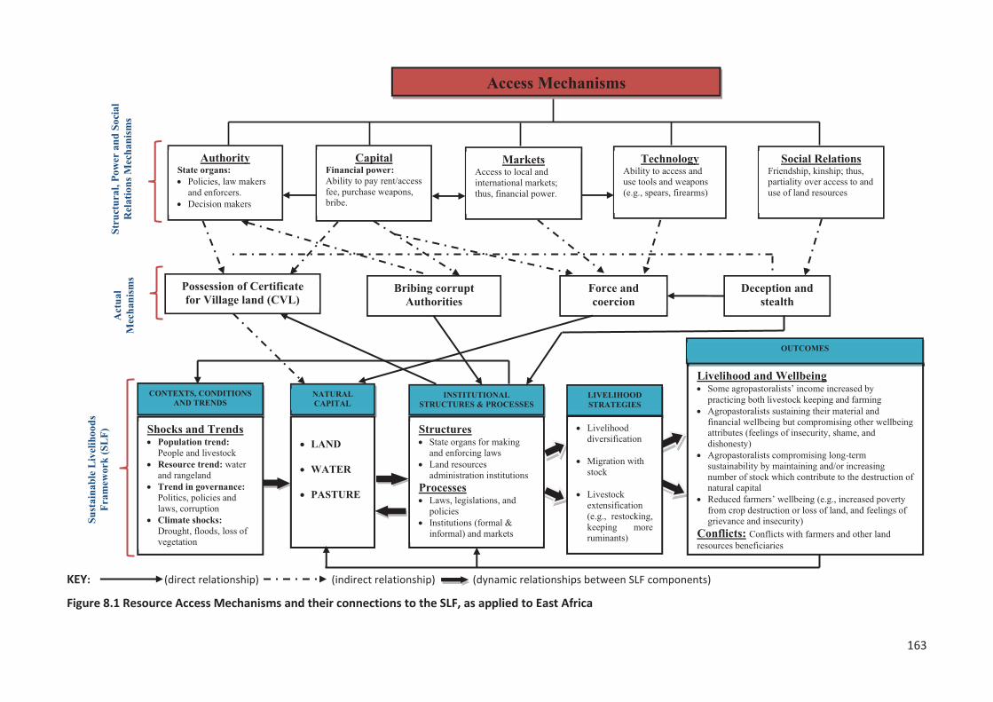
163
KEY: (direct relationship) (indirect relationship) (dynamic relationships between SLF components)
Figure 8.1 Resource Access Mechanisms and their connections to the SLF, as applied to East Africa
164
8.4.3 Contribution of access mechanisms to agropastoralists’ livelihoods
The identification of livelihood resources (i.e., combinations of ‘capitals’) required for different
livelihood strategy combinations is crucial for achieving sustainable livelihood outcomes and
enhanced wellbeing (Chambers & Conway, 1992). A livelihood comprises the capabilities, assets (e.g.,
material and social resources) and activities required for a desired livelihood outcome (Scoones,
1998). For livelihoods to be sustainable, therefore, the way that the livelihood needs of one person
or group of people are met should not damage the resource base on which their own or another
person’s or group of people’s livelihood depends (Cahn, 2006; Helmore, 2001). Drawing on Chambers
and Conway (1992, pp. 12-17), a livelihood is sustainable when it can cope with and recover from
stresses and shocks, and provide livelihood outcomes while maintaining the natural resource base
and assets upon which it relies. Such resilience in the face of stress and shocks is key to both
livelihood adaptation and coping (Davies, 1996). Those who are unable to cope (i.e., make temporary
or permanent adjustments in the face of change) or adapt (i.e., make long term shifts in livelihood
strategies) are inevitably vulnerable and unlikely to achieve sustainable livelihoods.
8.4.3.1 The role of policies and institutional structures in agropastoralists’ livelihoods
While more attention may be directed to access and control of livelihood assets, Scoones and
Wolmer (2003, p. 4) suggest that this may lead to downplaying the important role that policies,
institutional structures, and processes play in access, control and use of assets, and the choice and
interaction of different livelihood strategies that are used. Assets are highly influenced by the
‘institutional and policy mediation’ that impact on the community, household, and individual (Cahn,
2006). Moreover, understanding issues of rights, power, and institutions are critical in understanding
the influence of policy, which has long terms implications for sustainable livelihoods (Carney, 2003, p.
28). The value of, and access to, assets such as land resources is influenced by the policies, rules, and
laws that surround them and the way in which they can be accessed, controlled and used. For
example, the findings from this study show that the on-going national economic modernization
policies, which are characterized by anti-pastoral policy and state-backed land acquisition for large-
scale agricultural investments by local and foreign investors, and the expansion of reserved lands
(e.g., national parks) have contributed to the squeezing out of agropastoralists from their traditional
and key grazing lands. This has resulted in a lack of security of access to land resources that
agropastoralists depend on for their livelihoods. The flow on effects of such displacement and
evictions have been felt in farmers’ communities in the form of land resource use conflicts in
Morogoro region.
The ability of an asset to be converted from one use to another is also influenced by structures, such
as institutions and markets, and processes such as legal restrictions. For example, the use of money
165
(financial capital) to pay for access and ownership of village lands (natural capital) is influenced by
the existence of land administration institutions from the village level to the national level. In support
of the above example, this research found that the institutions responsible for land administration at
the village level operate under legal restrictions which state that villagers (the majority of whom are
farmers) can only be allocated a maximum of 50 acres of village land, but there is also an option to
gain more access to land resources by paying lease rent and/or an access fee (using financial capital).
This has created an added advantage for non-villager outsiders (such as migrating agropastoralists
and investors with more financial capital) to have more access to village lands (natural capital) than
native villagers, and to gain ownership of thousands of acres of village lands.
Scoones and Wolmer (2003, p. 5) argue that poor people in Sub-Saharan Africa face a ‘complex and
messy institutional context’ when trying to achieve sustainable livelihoods, and that ‘lines of
authority and control are constructed in overlapping and often corrupt and contested institutional
settings’. This is evident from this research as the large majority (>90%) of research participants
reported that ineffective government institutions, poor governance and accountability, cumbersome
procedures, red tape, corruption and ‘politics of the belly’ are obstacles for locals seeking to access
and use land resources. But this, in turn, creates opportunities for outsider ‘investors’ to gain,
maintain and control the access to and use of land resources either legitimately, or illegitimately,
facilitated by bribing corrupt government officials. For example, as noted earlier agropastoralists
were able to use their financial capital (derived from livestock) to bribe officials to influence the
decision making of the institutional structures and processes which are not in their favour. It can be
argued that the policies, institutional and structural weaknesses, and deficiencies enabled
agropastoralists to identify restrictions/barriers and exploit the opportunities (or ‘gateways’) to
manipulate their way towards gaining, maintaining and controlling access to, and use of land
resources. As a result, agropastoralists were able to sustain their dominant livelihood activity, namely
livestock keeping, whereas farmers’ ability to sustain crop cultivation was compromised.
Drawing from the discussion above, therefore, the policies, institutional structures, and processes
provide an understanding of the link between the micro (i.e., individual, household and community)
and the macro (e.g., regional, government and powerful private enterprise), as they effectively
determine access, control and use of assets (Cahn, 2006; Ming'ate, 2012; Scoones, 1998), through
which the route to positive or negative livelihood adaptation is certain (Davies, 1996, p. 24). Thus,
understanding of policies, institutional structures, and processes, and their relationship with
governance, rights, and power help explain why people choose certain livelihood strategies (Scoones,
1998, p. 12), as discussed next.
166
8.4.3.2 Livelihood strategies employed by agropastoralists
People choose livelihood strategies that they expect to best provide them with the livelihood
outcomes that they aspire to, based on the assets (capitals) people have access to and control over,
the policies, institutional structures and processes that impact on them, culture and tradition, and
the vulnerability context under which they operate (Ming'ate, 2012). Livelihood strategies are not
static; they change as the external environment (over which people have little control) alters, as
policies, institutional structures and processes shift and evolve, as access to and control over assets
change, and as opportunities arise (Cahn, 2006, p. 26). Sometimes unsustainable and unproductive
livelihood strategies continue because of tradition and habit; at other times livelihood activities are
introduced as coping strategies in difficult times (Cahn, 2003). Scoones (1998, p. 9) identified three
types of livelihood strategies which cover the range of options open to rural poor communities.
Firstly, agriculture (including livestock keeping) intensification/extensification. This means using land
resources for agriculture and livestock rearing as a livelihood strategy either by intensifying resource
use (i.e., through capital investment) or bringing more land into use. Secondly, livelihood
diversification as a livelihood strategy, meaning that people develop a wide income portfolio,
temporary or permanent (e.g., off-farm/livestock keeping, petty trading, and micro-enterprises),
either to cope with adverse conditions or for accumulation and reinvestment. And thirdly, migration,
which includes moving away, either voluntarily or involuntarily, to seek income-generating activities
elsewhere.
From the research findings, we have seen how access mechanisms play a crucial role in enabling
agropastoralists to gain, maintain and control access to pastures and water in other villages for their
livestock. Moreover, agropastoralists increased the number and size of herds to make use of the
additional land acquired from other villages (i.e., extensification and restocking). The mechanisms
were also used to acquire more land to practice crop cultivation in addition to livestock keeping. The
diversification of livelihood activities, by practicing both livestock keeping and subsistence crop
farming, has helped agropastoralists to broaden their livelihood by having various sources of income
and enough food to sustain their families, which has brought relief compared to when they were
dependent entirely on keeping livestock. However, Nowak (2003, pp. 295-297) points out that
livelihood diversification occurs for a range of reasons other than as a coping strategy alone. She
states that the Hma’ Btsisi’ people of Malaysia diversify their livelihoods in order to take advantage
of new opportunities resulting from individual initiatives, due to seasonality, and to allocate work
amongst household members. Likewise, this study’s findings showed that some agropastoralists took
advantages of new opportunities to diversify by practicing both livestock keeping and agriculture,
and some ventured into micro-enterprises, such as establishing local retail shops, petty trading and
167
running guest houses and lodges. This helped them sustain their livelihoods and improve their
financial and material wellbeing.
Apart from extensification and diversification strategies, agropastoralists also practiced seasonal
movement (migration) by allowing some family members to graze stock at a far distance in search of
water and pasture (especially during the drought season) while others remained at home to practice
agricultural activities during the growing (rainy) season. This livelihood strategy helped
agropastoralists to spread their livelihood activities over space or over time, so that a particular risk,
such as a drought event, does not affect all livelihood activities at once. Chambers and Conway
(1992) argue that this strategy has been used by the Maasai pastoralists for centuries as a coping
strategy during adverse conditions. However, such livelihood strategies and combinations may
involve the use of a range of legitimate and illegitimate tactics. For example, people may hoard,
protect, deplete, claim, borrow, and steal other people’s rights and claims to resources (Chambers &
Conway, 1992). This was evident in this study, wherein by pursuing extensification, diversification
and migration strategies, agropastoralists employed both legitimate tactics (e.g., lobbying,
borrowing, paying access fees) and illegitimate tactics (e.g., corrupt means, hoarding, forceful and
deceptive means). These tactics were reported as the major contributing factors for land resource-
use related conflicts between farmers and agropastoralists in Morogoro region. Whether such
livelihood pathways and a combination of strategies led to a positive (or negative) change in relation
to the range of sustainable livelihood outcome indicators for both agropastoralists and farmers is
considered next.
8.4.4 Contribution of access mechanisms to agropastoralist and farmer’ livelihood outcomes
The Sustainable Livelihoods Approach is designed to focus attention on the range of potential multi-
dimensional outcomes. A focus on outcomes leads to attention on achievements, indicators, and
progress in poverty elimination (Cahn, 2003; DFID, 1999). Cahn (2006) and DFID (1999) argue that an
understanding of potential livelihood outcomes is intended to reveal, through participatory inquiry, a
range of outcomes that will increase wellbeing including such things as more income, reduced
vulnerability, improved food security, recovered human dignity, reduced poverty, and more
sustainable use of the natural resource base. The authors list wellbeing as one of the list, whereas I
would argue all the other items on list are contributors to wellbeing. The most important question
concerns the extent to which the mechanisms used by agropastoralists to gain access to land
resources influenced the livelihood outcomes, and specifically, did they enhance or reduce
agropastoralists and farmers’ present and potential future wellbeing. The following sub-sections
discuss livelihood outcomes in terms of wellbeing and capabilities, poverty and deprivation,
vulnerability, food security, and sustainability of the natural resource base.

168
8.4.4.1 Agropastoralists and farmers’ wellbeing and capabilities
Chambers (1995, p. 175) describes wellbeing as ‘the experience of good quality of life’. Ill-being is
described as a lack of material things, as bad experiences, and as bad feelings about oneself
(Chambers, 1995; WorldBank, 2000). Although the nature of ill-being and poverty varies among
locations and people, there are commonalities across countries. Not surprisingly, material wellbeing
is very important. For example, lack of food, shelter, and clothing is mentioned everywhere as critical
for both ill-being and poverty. However, while income, food security, and other necessities are basic
wellbeing attributes, people aspire to a range of other important attributes of wellbeing that may be
less tangible and less obvious to make their lives fulfilling and worthwhile. For example, increased
choices, improved status, empowerment, dignity, and reduced vulnerability are difficult to measure
but equally important for wellbeing.
This study’s findings show that both male and female agropastoralists (e.g., Maasai) regard livestock
as wealth and social identity, and place it first of many attributes representing wellbeing. Male
agropastoralists viewed having many offspring (in particular, male progeny) as the second most
important attribute, followed by multiple wives. Peace and security, good health and physical fitness,
material wealth, quality pasture, education, and leadership positions were viewed as enabling factors
to oversee and enjoy all other attributes of wellbeing (Chapter 5).
The large majority of female agropastoralists (compared to only a few male agropastoralists)
mentioned education as an important attribute of wellbeing. They expressed how pleased and proud
they would be if their children had an education opportunity. Agropastoral communities such as the
Maasai are known for their reluctance to take their children to school, because male children are
responsible for grazing cattle very far from the village, which may take the whole day or even days
(Hedges et al., 2016, p. 149). Female children tend to have lower social status compared to their
male counterparts, and are subjected to early marriages, as the bride price is a means to accumulate
cattle (Buzinde et al., 2014; Hedges et al., 2016). Also notable is that modern infrastructures and
‘essential services’ such as schools, health centers, waterholes, cattle dips and markets, are
uncommon in the agropastoralists’ villages in Morogoro region. This finding concurs with Dafinger
and Pelican (2006) in Burkina Faso, who found that most FulBe agropastoral communities in the
region are quite reluctant to invest in education or engage in the application processes to secure
modern services. This is because one precondition to apply for and eventually be granted a health
post or a modern safe water pump is that the applicants be an organized local community, i.e., an
officially recognizable village. To do so, the FulBe community needs to be identified with a delineated
area of land, it needs a minimum number of inhabitants (200-300) and must fulfil several other
criteria (some of them are fuzzy) showing signs of permanence. None of the FulBe community
members, however, aims at complying with these preconditions (Dafinger & Pelican, 2006). In the
169
African context, it is common for pastoralists and agropastoralists not to conceive of their villages as
territorially defined units and, besides, they often split up and move with their livestock into different
regions looking for quality pasture and water.
Livestock serve many roles in a pastoral society: as both the means and outcomes of production, as
sources and objects of labour, as value, as social pride, culture and capital goods (Galaty & Johnson,
1990; Herrero et al., 2009). Therefore, in African countries with large livestock populations (such as
Tanzania which has 3rd largest in Africa) shared among pastoralist and agropastoralist communities,
livestock production is not only their main livelihood activity, but also their social pride and security
(Worku et al., 2014). The existing anti-pastoral policy environment and the state-backed ‘land
acquisition’ for large-scale agriculture have contributed to the squeezing out of agropastoral
communities from their traditional and key grazing lands, impairing their wellbeing and making
means of survival increasingly difficult. As mentioned earlier, this study confirmed that
agropastoralists regard livestock keeping as vital to their material and financial wellbeing and their
identity. This helps explain why agropastoralists were willing to compromise other wellbeing
attributes such as peace, harmony, security, dignity, and happiness in order to maintain their
livestock. The mechanisms used by agropastoralists to gain, maintain and control access to land
resources played major roles in enabling agropastoralists to continue sustaining their already
impaired wellbeing, while on the other hand, compromising their current wellbeing (e.g., through
loss of stock and human lives, and feelings of shame, dishonesty, and insecurity due to recurring
conflicts), their future wellbeing (through degradation of the habitat needed to support livestock), as
well as reducing farmers’ wellbeing.
On the other hand, farmers’ wellbeing was severely hindered by the means agropastoralists used to
have access to land resources, which include using coercive means and feeding the livestock on
farms. Farmers stated that they are living an insecure and restless life because they are uncertain of
what may happen to their homes, families or crops on farms today or tomorrow. Some female
farmers reported that they are more vulnerable and worried about being raped by notorious youth-
Maasai (Morans), especially when they remain until late hours of the day to guard their crops on
farms. However, this study also found that some farmers’ material and financial wellbeing had
improved tremendously because they had received bribes and/or payments in cash ‘inducement’
offered by agropastoralists in return for access to village land. It is evident that both farmers and
agropastoralists lacked a clear understanding of the main contributors to wellbeing, and the ways in
which their choices can affect both the level of wellbeing and the level of environmental impacts.
Therefore, reflecting the conclusions of Roberts et al. (2015, pp. 108-109), fostering discussion,
research and education on the different components of wellbeing will broaden farmers and
agropastoralists’ understanding of the many factors that contribute to personal and national
170
wellbeing, including a greater awareness of the impacts of their individual and collective choices of
satisfiers on both their own current wellbeing and wellbeing of the natural resource base on which
their current and future wellbeing depends.
8.4.4.2 Poverty and deprivation
The opposite of wellbeing is poverty and deprivation. In ‘conventional’ thinking, deprivation and
poverty are considered in terms of the poverty line, an economic measurement of income and
consumption, whereas, in reality, poverty is multi-dimensional (Cahn, 2006; Chambers & Conway,
1992, p. 3; Max-Neef, 1992). Income-poverty, though important, is only one aspect of deprivation
(Chambers, 1995, p. 173). In addition to income-poverty, any fundamental human need that is not
adequately satisfied, reveals a level of human poverty and deprivation (Max-Neef, 1992). For
example, poverty in relation to human needs for subsistence (i.e., insufficient income, food and
shelter), protection (i.e., violence and bad health systems), affection (i.e., oppression, deprivation,
exploitative relations), understanding (i.e., poor quality of education), participation (social inferiority,
isolation, marginalization and discrimination against minorities), and identity (physical weakness,
powerlessness, humiliation, social exclusion, and forced migration) all contribute to poverty and
deprivation (Chambers, 1995; Kabeer, 1994; Krantz, 2001; Max-Neef, 1992; WorldBank, 2000).
Clearly, therefore, factors other than personal income are important in reducing poverty and
increasing wellbeing.
Despite the wide and diverse views that poor people may have on poverty, there seem to be two
fundamental points which recur, and which underly all other concerns. First is the issue of
voicelessness, powerlessness and exclusion, i.e., the ability to have access to and influence over
decisions which influence their lives (Max-Neef, 1992; WorldBank, 2000, p. 11). The study findings
show both farmers and agropastoralists expressed (in varying degree) feelings of being voiceless and
powerless, which in return affects their overall abilities to influence policies and decisions over their
lives. But of the two groups, the agropastoralists (who belong to ethnic minorities) appear the most
voiceless, powerless and excluded. As a result, agropastoralists are faced with challenges closely
linked to inequality in economic, social and institutional arenas. In their analysis of the impacts of
existing and emerging policies and laws with regard to pastoralism in Tanzania, Mattee and Martin
(2006) reported that while some policies do provide opportunities for pastoralists, many others show
little understanding of pastoral production systems or recognition of pastoralism as a sustainable
livelihood. The authors suggested that this is probably due to pastoralists lacking a clearly articulated
voice and influence in the policy-making debate. It is in this context that a large majority of
agropastoralists in Kilosa and Mvomero districts, despite having more financial power than most
farmers, still felt they were living in extreme poverty due to being isolated (i.e., socially, politically
and economically), humiliated (called names, e.g., uncivilized people), insecure and vulnerable (e.g.,
171
evictions/forced migration and livestock confiscation), and deprived of access to, and use of land
resources as well as entitlements to, and ownership of land resources.
The second point should not surprise. This is the basic issue of poor income-earning opportunities,
expressed as “low earnings for both livestock and agricultural outputs”, or “lack of access to assets”.
For example, agropastoralists reported their income, which depends largely on livestock, has
decreased hugely since 2005. The sharp fall is linked to decline in herd size, and to a small number of
herds left that are unhealthy, thus attracting low market value. Factors such as diminishing area of
grazing lands, cattle being seized and auctioned by government officials (e.g., operations carried out
to evict pastoralists), cattle being killed and/or stolen during violence, and the lack of quality pasture
and water due to prolonged drought periods were mentioned as having contributed to the decline in
herd size. Similar findings were reported by Mung'ong'o and Mwamfupe (2003) who found that
some agropastoral communities in Kilosa and Mvomero districts have not been able to recover due
to some of the factors mentioned above, and hence had to diversify their livelihood activity, with
large-scale crop cultivation becoming the new livelihood activity.
The discussion above notwithstanding, this study also found that access mechanisms (i.e., both legal
and illegal) have the potential to substantially increase the extent to which agropastoralists can
access livelihood assets. Although agropastoralists reported their income had dropped hugely since
2005, and herd sizes had dropped (which is difficult to verify), the observation shows agropastoralists
appeared to be wealthier than farmers in so far as they possess many more physical assets (e.g. cars
and houses) than farmers due to the income earned from practicing livestock keeping and
agricultural activities. Agropastoralists have managed to maintain (or increase) the livestock numbers
(i.e., by re-stocking and store wealth in livestock) and acquire land for grazing and crop cultivation.
In contrast, farmers believe that the means used by agropastoralists to gain access to land resources
have impeded their efforts to sustain their own income generating activity, which is farming. This has
led to some not being able to provide their families with essential needs such as food, standard
shelter, healthcare, and paying school fees for their children. Many farmers operate their farms
helped by loans from micro-finance groups and institutions, so when agropastoralists feed their
cattle on farms, they struggle to repay their debts, and as a result, they lose possession of physical
assets such as houses, tractors, and any other valuable materials because these assets are auctioned
to pay their debts. The study also found (chapter 5) that farmers were concerned that an increasing
number of farmers’ villages were calling for food aid. Among the reasons mentioned for the low
harvest were crop damage by livestock, climate change impacts, and increasing numbers of livestock
that have damaged village lands by causing soil erosion (thus loss of fertile soil) and causing the land
to become brittle and difficult to plough using a hand hoe, a tool that many farmers can afford.
172
It can therefore be argued that the means used by agropastoralists to gain, maintain and control
access to, and use of land resources have worked to the agropastoralists’ advantage, whereas, they
are the major stumbling blocks impeding farmers’ progress out of poverty. The narratives from the
two communities reveal how important it is for economic policies and intervention programs to work
together with all poor communities to increase both wellbeing and human development, and
eventually, to reduce vulnerability. In other words, while the on-going national economic policy
reforms present opportunities for poverty reduction and aim to have Tanzania become a middle-
income economy by 2025, they also pose risks of growing inequalities and marginalization of large
numbers of people. Assessing the opportunities for poverty reduction and deprivation, while thinking
about how to manage the risks which these same opportunities bring, is a policy challenge to be
revisited and acted upon by the Tanzania government.
8.4.4.3 Natural resource base sustainability
Drawing on Blaikie (1985), Conway (1985) and many others, natural resource base sustainability
refers to the ability of a system to return to similar productivity when subject to disturbing forces,
whether a ‘stress’ or a ‘shock’. This implies avoiding depleting stocks of natural resources to levels
which results in permanent decline in the rate at which the natural resource base yields useful
products or services for livelihoods. Various studies in Asia (Harris, 2010; Ho & Azadi, 2010), Eastern
Ethiopia (Kassahun et al., 2008) and Tanzania (Sangeda & Malole, 2014) suggest that readily
observable factors promoting environmental and rangeland degradation include reduction in total
vegetation cover and palatable plant species and depletion in soil quality and nutrients due to soil
erosion. This study found that increasing numbers of livestock has led to negative impacts on land
resources in Kilosa and Mvomero Districts. Loss of vegetation cover was even more evident in the
agropastoralists’ villages of Twatwatwa and Kambala. Farmers’ narratives that the increasing number
of livestock have damaged village lands by causing soil erosion (loss of fertile soil), and that the land
has become brittle and difficult to plough are further evidence of the unsustainable use of land
resources by agropastoralists. However, the notion that humans and/or animal activities are the
main or sole cause of soil erosion must be treated with caution. Blaikie (1985, p. 1) argues that it is
often difficult to single out the effect of humans on soil erosion and sedimentation rates, from other
effects such as climate change, and ongoing ‘natural’ environmental erosion processes. In a
geological context, soil erosion occurs with or without human agencies. Moreover, the impact of
stock on land is not necessarily all negative, with Savory and Stanley (1980, p. 235) recognizing the
importance of the animals’ impact, i.e., hoof impact, dung, and urine, in maintaining healthy
grassland. These authors state that the constant movement of large herds in response to predation
pressure naturally prevents overgrazing of plants, while periodic trampling of vegetation ensures a
protective covering of the soil. They further argue that human decisions to decrease the number of
173
herds, can lead to a decrease in the beneficial animal effects on the land, leading to increasing bare
ground and environmental deterioration.
This study’s findings on the trend and extent of environmental and rangeland degradation (Chapter
7) shows recent land cover and use changes in the study areas are very large. Forest,
woodland/grassland, and water bodies have decreased in area while bareland, cultivated fields, and
settlement areas have increased. A substantial area of forest and woodland/grassland has degraded
into bare land and/or been converted into cultivated fields and settlements. The water surface area
has shrunk in size, corresponding with the growth, and spread of human activities such as increased
exploitation of wetlands for agricultural and pastoral uses. Additionally, both farmers and
agropastoralists reported that the huge decline of agricultural yields and livestock productivity was
associated with the environmental and rangeland degradation, characterized by increased aridity,
recurrent and extended drought periods, decline of water sources, soil erosion, loss of fertility soil,
poor quality pasture, increase of shrubs and noxious weeds, and increase of plant and animal pests
and diseases. According to agropastoralists and farmers, the observed environmental and rangeland
degradation, and land cover and use changes were largely associated with climate change impacts on
land resources. Other factors mentioned include increased population density of both humans and
livestock, and subsequent economic activities including but not limited to charcoal business, timber
harvesting, mineral mining, extensive and large-scale cultivation, and keeping of excessive numbers
of livestock. It can be argued that, if agropastoralists continue keeping large numbers of stock, and
more forests and water sources areas (e.g., wetlands) are converted into cultivation fields, then
farmers and agropastoralists’ long-term wellbeing and sustainability are also in jeopardy. This will be
a result of the extreme pressure exerted on the already limited and declining stocks of natural
capital. The next sub-section presents a discussion on the contribution of access mechanisms to
conflicts between farmers and agropastoralists.
8.4.5 Contribution of access mechanisms to farmers and agropastoralists conflicts
The large majority of research participants agreed that the illegal mechanisms used by
agropastoralists to gain, maintain, and control access to, and use of land resources are the major
cause of conflicts between agropastoralists and farmers. Agropastoralists exploited the lack of
appropriate governance and accountability, and corrupt practices by some government officials to
gain access to land resources. Bribing government officials to give preferential treatment to
agropastoralists in land resources allocation, deceiving both farmers and village officials, and the use
of force and coercion were the factors most respondents mentioned as contributing to conflicts
between farmers and agropastoralists. In other words, the way farmers lose their land by illegal
means (e.g., bribes, force and coercion, and deception and stealth) is a critical factor that contributes
174
significantly to land resource conflicts. However, Burns (2004) argues that any access gained
“illegally” is also right-based, i.e., it is a form of direct access defined against those based on the
sanctions of customs, convention, or law. The distinction between rights-based “property”
approaches and illegal forms of access based on violence or theft is predicated on notions of morality
and legitimacy. Legitimacy, in turn, is linked to a set of moral judgements about what is right and
what constitutes a right or an entitlement. What one group calls theft can be considered moral or
legitimate by others – an individual or a neighbouring community. Criminality is a matter of
perspective, one that depends on the actor’s relationship to the law or to another form of rules or to
sanctioned conventional practices (Peluso, 1992). For example, access can be controlled illegally by
cultivating relations with or posing counter threats to those who control access. Legal means,
therefore, are not the only rights-based way of gaining, controlling, or maintaining benefits from
resources. Violence and theft must also be considered as rights-denied mechanisms of access (Ribot
& Peluso, 2003). The following section presents a discussion of the proximate causes of the farmer-
agropastoralist conflicts and reasons for conflict escalation into widespread violence.
8.5 Proximate causes of farmer and agropastoralist conflict escalation
This section discusses the findings of the second objective of this study (Chapter 6), which was to
examine the proximate causes of farmer – agropastoralist conflict escalation. Social Conflict Theory,
as described by Kriesberg (2007) and Pruitt and Kim (2004), focuses on the dynamics and
transformations of conflicts and was used to obtain a better understanding of why and how conflicts
between farmers and agropastoralists have escalate into deadly violence in Kilosa and Mvomero
Districts, Morogoro region. The next sub-section presents a discussion on the perceived causes of
conflict and reasons for conflict escalation.
8.5.1 Perceived causes for conflict and reasons for conflict escalation
Farmers and agropastoralists hold contrasting views and opinions about the causes of conflict, and
reasons for conflict escalation. On many occasions, each side blames the behaviour and the conduct
of the other as being the cause for conflict, and the reason for conflict escalation between them.
Despite their differences, both farmers and agropastoralists reported crop damage by livestock,
violation of village boundaries, lack of village land use plans, excessive number of livestock, climate
change impacts on land resources, corrupt practices by officials, incompetent conflict management
institutions, and biased economic policies, as the main contributing factors for land resources-related
conflicts. These findings corroborate those of other studies across Africa, which emphasizes that
explanations for farmer – agropastoralists conflicts have generally been structural in nature, focusing
on factors such as climate change (Mwakaje, 2013; Oluwole et al., 2017; Owuor et al., 2011), biased
economic policies (Benjaminsen & Bryceson, 2012; Ibrahim et al., 2015; Martin, 2010), institutional
175
failure to resolve conflicts, corrupt practices, and the larger political context (Bond, 2014; Dafinger &
Pelican, 2006; Harshbarger, 1995; Mwamfupe, 2015). For example, Hagberg’s (1998; Hagberg, 2005)
study on conflict escalation between farmers and agropastoralists in Southwest Burkina Faso, argues
that frustration with the authorities’ corruption and the consequent impunity of the agropastoralists
was the ultimate reason for conflict escalation. Also, Dafinger and Pelican (2006) state that the
Aghem women [farmers] in Northwest Cameroon accused traditional and state authorities of
partiality and prioritizing their personal gain over the farmers’ wellbeing.
Crop damage by grazing cattle, and the hurting or killing of humans or livestock pre-emptively or in
retaliation, were reported as factors causing conflicts, and in one way or another were mentioned as
the reasons for conflict escalation. More frequent crop damage on farms, caused by either farmers
or agropastoralists violating their village boundaries, and consequent losses in crop yields or cattle
being confiscated and/or killed, led to each side’s response in terms of violence. The instigating
factor for violence was mostly based on arguments and misunderstanding concerning actual damage,
its degree and compensation costs, as well as the legitimacy of the respective claims. Deliberate
delays by the local administration and state organs and their reluctance to resolve the conflict
amicably, was associated with corrupt practices, i.e., waiting until the violence has escalated provides
an opportunity for government officials and police officers to solicit bribes from agropastoralists, in
order to negotiate and/or manipulate the outcome of the criminal offence. A similar finding is
reported by Harshbarger (1995), who argues that herders, farmers, state officials, and local chiefs in
Northwest Cameroon use the mediation of herder-farmer conflicts to compete for political power,
social control, and natural resources in local villages. She describes how farmers suffering from cattle
trespassing and crop damage are becoming impatient with the corruption of authorities, who
collaborate with herders, and therefore, take the law into their own hands. Regarding the role of
intermediaries and third parties (i.e., authorities), there is much evidence of the institutional failure
of traditional and governmental authorities in Morogoro region that have contributed hugely to
conflict escalation.
In their discussion of conflict escalation between Aghem farmers and Aku herders in northern
Cameroon, Kum (1983) and Moritz (2010) claim that conflict between these two groups transformed
from an economic into an ethnic conflict because of continuous destruction of farms, delay in
settlement of cases, and the fact that farmers generally lost cases against herders and were left
uncompensated or not compensated enough. Ethnicity is an important variable in conflicts between
farmers and agropastoralists in Morogoro region because farmers are indigenous and/or native
residents, whereas agropastoralists are immigrant Maasai (the large majority), Sukuma and Mang’ati
communities. With agropastoralists being non-native, they constantly get moved further away from
essential social services and quality grazing areas. As a result, agropastoralists are continually and
176
increasingly frustrated with local farmers, but also with government and local authorities whom they
hold responsible for their suffering. Similar situations have been described in West African countries.
For example, Dafinger and Pelican (2006, p. 133) argue that the farming communities in Northwest
Cameroon claim the status of ‘first-comers’ and see themselves as “owners” or “guardians” of the
land. They consider the FulBe agropastoralists their guests, or “strangers,” and expect them to
respect their political and territorial primacy. Also, Ibrahim et al. (2015) in Nigeria concludes that past
farmer-herder conflicts were solely due to an overlap of farmlands with cattle routes, where farmers
grow crops on the routes. But recently, these conflicts have escalated, taking another dimension of
ethnic and religious differences with little effort from government or community leaders aimed at
addressing them.
The discussion above has explained the escalation of conflicts between farmers and agropastoralists
in terms of conflict as start-up or structural variables, in particular, institutional failures to resolve
conflicts and challenges emanating from land resources competition. The structural variables may be
necessary conditions for the escalation of farmer – agropastoralist conflicts, but they cannot solely
explain the escalation itself. In other words, this structural explanation does not explain why disputes
between farmers and agropastoralists escalate into widespread violence. Thus, it is necessary to
consider how process variables (i.e., dynamics and transformation patterns) identified by this
research have contributed to a better explanation of conflict escalation in Morogoro region. The next
sub-section discusses the dynamics and transformation patterns (process variables) of conflict
escalation between farmers and agropastoralists.
8.5.2 The dynamics and transformation patterns of conflict escalation
Social Conflict Theory is particularly useful for conceptualizing the problem of farmer and
agropastoralist conflict escalation because it offers a well-articulated approach (i.e., process
variables) to conflict escalation generally. Crucially, reasons for escalation can be identified by
examining the sequence of interactions to explain why some conflicts escalate and others do not
(Kriesberg, 2007). Conflict theorists argue that parties do not seek to escalate the conflicts they have
engaged in. Escalation is instead usually an unintended consequence of conflict behaviour and may
occur inadvertently, step by step, without the opponents having carefully considered the
implications of their actions (Kriesberg, 2007, p. 157). It is, therefore, important to recognize that
there are general patterns and processes in how conflicts metamorphose into widespread, violent
engagements. These patterns of transformation can be found in who or what groups of people are
involved, in the actions they take, and in the stakes they hold or the goals they pursue during the
conflict (Moritz, 2010, p. 141).
177
Conflicts between farmers and agropastoralists in Morogoro region escalate into violence following
the general patterns and transformation dynamics ‘process variables’ described by Pruitt and Kim
(2004) in Social Conflict Theory. The tactics shifted from light to heavy, i.e., from persuasion to
violence. It was noted that farmers first pursued administrative and legal actions before they
resorted to physical violence. When farmers realized that the administrative and legal procedures did
not work in their favour, then they changed tactics from reconciliation to creating the MWANO group
to fight agropastoralists. Further, the goal shifted from specific to general, i.e., from crop damage by
cattle to inter-ethnic hatred and violence. It was reported that farmers first demanded compensation
for crop damage caused by cattle caught eating and/or destroying crops on the farm. But when the
agropastoralists become increasingly stubborn about compensating the farmers, and occasionally,
used forceful means to rescue their cattle from being confiscated (to evade penalties), the farmers
resorted to seeking the eviction of all agropastoralists in Morogoro region.
As the conflict evolved, there was also greater investment in the conflict and an increase in
participation, i.e., shift from few to many. A good example is a tragic event that took place in
Rudewa-mbuyuni Village on the eve of 8th December 2000, when a group of Maasai warriors
attacked the village with firearms and other weapons, which left many fatalities and many severely
injured. This tragic event resulted from a confrontation between a few Twatwatwa agropastoralists
and a few Rudewa-mbuyuni farmers regarding the ownership of Rudewa-mbuyuni sub-village (also
known as ‘Ngaiti’), a place which used to be part of the farmers’ village of Rudewa-mbuyuni, but now
was a place under the ownership of agropastoralists from Twatwatwa Village. The ownership
disagreement annoyed the agropastoralists, and as they returned home, they mobilized more people
from their villages. When the agropastoralists came together and decided to “take the law into their
own hands”, there was a greater likelihood that the conflict would escalate. Social psychologists and
conflict theorists have long noted that group dynamics tend to escalate conflicts for a number of
reasons, including the development of group cohesiveness and militant leadership (Moritz, 2010;
Pruitt & Kim, 2004). Similar group dynamics happened among FulBe agropastoralists and Karaboro
farmers in Burkina Faso (Harshbarger, 1995).
The research findings also suggest that direct face-to-face contact between the two parties,
particularly during the initial stages of the conflict when emotions run high, may contribute to
conflict escalation. This makes the relatively immediate moments when crop damage is detected
and/or cattle are caught on farms especially crucial. Delays and reluctance (for whatever reasons) of
government officials and state organs to intervene in a timely manner to diffuse tensions between
farmers and agropastoralists at this critical time play a major role in creating an intense atmosphere
and favourable environment for conflict escalation. For example, the two parties involved in this
research shifted their goals from solving the problem to hurting the other party, i.e., farmers and
178
MWANO vigilantes stole and killed cattle instead of detaining them while waiting for compensation;
similarly, agropastoralists destroyed and burned to ashes farmers’ houses and, injured and killed
farmers instead of compensating for crop damage. Moritz (2010) argues that when direct
interactions led to injuries or fatalities, they increase the chance of conflict escalating into
widespread violence between communities and can quickly lead to more violence between people
that were not involved in the first place.
One other factor is central to the field of anthropology but is not covered well in Social Conflict
Theory: culture. Agropastoralists and farmers in Tanzania, and across East Africa are generally
members of different ethnic groups who may or may not share beliefs and practices relating to their
way of life, and on how to manage conflicts. With this observation, there is no doubt that the cultural
repertoires of conflict management mechanisms of farmers and agropastoralists are different, and
sometimes incompatible. Farmers, especially women, felt that they were being disrespected by the
Maasai-Morans. For example, farmers reported that it is extremely difficult to argue and negotiate
with agropastoralist Maasai warriors [Morans] because of their arrogance and cruel behaviour, which
is contributed to by their superiority in ‘fighting skills’ using all sorts of weapons. It can also be
argued that the contemptuous behaviour shown by the youth-Maasai [Morans] to women farmers is
attributed to the fact that, in the Maasai tradition, women unless considered older (i.e., Western
equivalent of senior citizens), tend to have a lower social status in comparison to their male
counterparts be they younger or older (Buzinde et al., 2014, p. 26).
Another factor that may contribute to conflict escalation is the age of the participants and gender.
Violence much less likely if it was young women looking after cattle. Hedges et al. (2016) note that in
the African context, pastoralism is labour-intensive, with pastoral communities traditionally
recruiting youths, and both Hagberg (1998) and Tonah (2006) argue that participants’ age in the
farmer – herder conflicts is the immediate reason for conflict escalation. Hagberg (1998, p. 180)
quoted one elder: “The way of children and the way of adults are not the same. So [the son of the
farm owner] took the firearm and went to the field to fight the [son of the herder].” This study had a
similar finding. Research participants reported that often the youth-Maasai (Morans]), who are the
ones entrusted by Maasai elders to take care and graze the cattle, have disappointed their elders due
to their unlawful and shameful acts of using extreme force and weapons to force their way into
farmers’ villages.
From this discussion, it is evident that the farmer – agropastoralist conflicts in Morogoro region
follow the general patterns described in Social Conflict Theory. The process approach, focusing on
conflict dynamics rather than structural context alone, leads to the identification of new variables
that may explain why some conflicts between farmers and agropastoralists escalate and others do

179
not. It is important, however, to keep in mind that farmer – agropastoralist conflicts are complex,
and their escalation cannot be explained by one single factor. Rather, different causal combinations
of structural and process variables may lead to that particular outcome.
8.6 Overall discussion
The key findings reported in chapters 5, 6 and 7 have been discussed and linked to the theoretical
frameworks explored in the thesis, i.e., Access Theory, Social Conflict Theory, and the Sustainable
Livelihoods Approach. The research findings revealed that agropastoralists used both legal and illegal
mechanisms to gain, maintain and control access to, and use of land resources. The legal mechanism
involves possession of a certificate for village land (CVL). The illegal mechanisms involve (1) bribing
corrupt individuals in the authorities, (2) deception and stealth against farmers and village leaders,
and (3) force and coercion. Five of Access Theory’s structural, power and social relations mechanisms
were identified as directly contributing to the creation of a strong combination of legal and illegal
access mechanisms that facilitated agropastoralists to gain, maintain, and control access to, and use
of land resources: Capital (financial power), Authority (ability to bribe lawmakers and enforcers),
Social relations (friendship, kinship, networks), Markets (local and regional) and Technology
(weapons, equipment, communication and transportation facilities). The Access Theory is thus
shown to complement the Sustainable Livelihoods Approach (SLA) by showing how the access and
control of some SLA capitals (e.g., financial, physical, and social capitals) can directly or indirectly
influence the policies and institutional structures in order to gain, maintain and control access to, and
use of natural capital (i.e., land resources). However, the research findings show that in the east
African context, three of the structural, power and social relations mechanisms identified in Access
Theory, namely Labour, Knowledge and Social identity, made no significant contribution towards
helping agropastoralists to gain, maintain and control access to, and use of land resources.
Despite overarching government policies that are marginalising agropastoral communities, policy
deficiencies, institutional and structural weaknesses, and their relationship with governance, rights,
and power, enabled agropastoralists to pursue three major livelihood strategies: (1) diversification
(i.e., crop cultivation in addition to livestock keeping); (2) extensification (i.e., increasing the number
of herds to make use of the additional land acquired from other villages); and, (3) seasonal
movement (i.e., migration). These livelihood strategies helped agropastoralists to broaden the
likelihood of having various sources of income and enough food to sustain their families. This has
brought relief compared to being completely dependent on livestock in a situation of increased
stress on natural capital because of human and livestock population increase and climate change. In
relation to agropastoralists and farmers’ wellbeing and capabilities, the discussion shows that the
mechanisms used by agropastoralists to gain, maintain and control access to, and use of land
180
resources played a major role in enabling agropastoralists to continue sustaining their already
impaired wellbeing, while on the other hand, compromising their current and future wellbeing
attributes, as well as reducing both farmers’ wellbeing and the wellbeing of the natural capital.
Despite both farmers and agropastoralists expressing (in varying degree) feelings of poverty and
deprivation, the discussion shows that agropastoralists appeared to be wealthier than farmers in so
far as they possess a lot more physical assets than farmers due to the income earned from practicing
both livestock keeping and agricultural activities.
The conflicts between farmers and agropastoralists in Morogoro region escalate to violence following
the general patterns and transformation dynamics described in Social Conflict Theory. The tactics
shifted from light to heavy, the goals shifted from specific to general, and involvement shifted from
few to many. It was evident that the process approach, focusing on conflict dynamics rather than
structural context alone, leads to the identification of new variables (e.g., culture and age of
participant in the conflict) that may explain why some conflicts between farmers and agropastoralists
escalate and others do not. The discussion also revealed that the conflict resolution mechanism in
the study areas is less embedded in local relations but depends on the (often absent) intervention of
state agents and organs such as police forces and courts, and often leads to outcomes that are
ineffective and unsatisfactory to all parties involved. This is a potentially crucial area of intervention
because claims and conflicts over land resources cannot solely be resolved through top-down
administrative procedures and legal enforcement by state organs.
There have been huge changes in land cover and use in the study areas with associated links to
environmental and rangeland degradation. These changes were largely associated with a
combination of factors such as presumed climate change, increased population density of both
humans and livestock, and subsequent economic activities including but not limited to charcoal
business, timber harvesting, mineral mining, extensive and large-scale cultivation, and keeping of
excessive numbers of livestock. This is another potentially crucial area that requires an immediate
intervention because if agropastoralists continue keeping large numbers of stock, and more forests
and water sources areas are converted into cultivation fields, then farmers and agropastoralists’
long-term wellbeing and sustainability are in jeopardy due to the extreme pressure exerted on the
already limited and declining stocks of natural capital. Both communities reported land resources
related conflict as a new indicator to assess the environmental and rangeland health. The next
chapter (Chapter 9) presents the conclusion and recommendations of the thesis.
181
Chapter 9
Conclusions and Recommendations
9.1 Introduction
The previous chapter presented a discussion of the research findings based on the three research
objectives. The main purpose of this chapter is to draw conclusions from these findings. In addition,
this chapter highlights the theoretical and applied contributions of the study and will conclude with
brief recommendations and thoughts for future research. This research is multi and interdisciplinary
– social science and biophysical science, and thus employed multi and interdisciplinary approaches
including ethnography, multi-data collection methods including qualitative individual respondent
open ended surveys and focus group discussions, GIS and Remote Sensing techniques linked to highly
quantitative spatial analysis of Landsat images, and a checklist of rangeland assessment indicators for
respondent assessment.
9.2 The roles of access mechanisms in agropastoralists and farmers wellbeing
The research reported here found that agropastoralists used both legal and illegal mechanisms to
gain, maintain and control access to, and use of, land resources. These access mechanisms helped
agropastoralists to sustain their material and financial wellbeing while concurrently compromising
other aspects of their current and future wellbeing and compromising the wellbeing of farmers. The
way farmers lose their land by illegal means is a critical factor that contributes significantly to land
resource conflicts. It was thus concluded that land resource related conflicts in Tanzania cannot be
explained solely by a single driver (e.g., limited resources), but by a combination of drivers including
the illegal mechanisms used to gain and control access to and use of land resources.
Although agropastoralists reported their income had dropped hugely since 2005, and herd sizes had
dropped (which is difficult to prove), direct observation shows agropastoralists appeared wealthier
than farmers in so far as they possess many more physical assets due to income earned from
practicing both livestock keeping and agricultural activities. However, not all farmers suffered from
the presence of the agropastoralists – those who had accepted bribes and/or payment in cash
‘inducement’ offered by the agropastoralists benefited financially, at least in the short term.
However, it was evident that farmers and agropastoralists lacked a clear understanding of the main
contributors to wellbeing, and the ways in which their choices can affect both the level of wellbeing
and the levels of environmental impact.
182
9.3 Causes of conflict and reasons for conflict escalation
Crop damage by livestock, violation of village boundaries, lack of village land use plans, excessive
number of livestock, presumed climate change impacts on land resources, corrupt practices by
officials, incompetent conflict management institutions, and biased economic policies, were found to
be the main causes of land resource use conflicts in Morogoro region. Though necessary, this causal
explanation (structural variables) does not explain why disputes between farmers and
agropastoralists escalate into widespread violence. Instead, Social Conflict Theory helped
conceptualize the problem of farmer and agropastoralist conflict escalation because it offers a well-
articulated approach to conflict escalation.
Conflicts between farmers and agropastoralists in Morogoro region escalated to violence following
the general patterns and transformation dynamics (i.e., process variables) described in Social Conflict
Theory. These process variables involved: tactics shifting from light to heavy, goals shifting from
specific to general, and involvement shifting from few to many. It was also evident that the process
approach, focusing on conflict dynamics and processes rather than structural context alone, enabled
the identification of new factors (e.g., culture, and age and gender of participants in the conflict) that
helped explain why some conflicts between farmers and agropastoralists escalated. The research
findings also revealed that the usual conflict resolution mechanism in the study areas is less
embedded in local relations but depends on the (often absent) intervention of state agents and
organs such as police forces and courts, and often leads to outcomes that are ineffective and
unsatisfactory to all parties involved. This is a potentially crucial area of intervention because claims
and conflicts over land resources cannot solely be resolved through top-down administrative
procedures and legal enforcement by state organs.
9.4 Trend and extent of environmental and rangeland degradation
There have been huge changes in land cover and use in the study areas with associated links to
environmental and rangeland degradation. The areas covered by forests, woodland/grassland and
water have decreased, whereas bareland has increased. Loss of vegetation cover was more evident
in the agropastoralists’ villages of Twatwatwa and Kambala. These changes were largely associated
with a combination of factors such as increased population density of both humans and livestock,
and subsequent economic activities including but not limited to charcoal business, timber harvesting,
mineral mining, extensive and large-scale cultivation, and keeping of excessive numbers of livestock.
This is another potentially crucial area that requires an immediate intervention because if
agropastoralists continue keeping large numbers of stock, and more forests and water source areas
are converted into cultivation fields, then farmers and agropastoralists’ long-term wellbeing and
183
sustainability are in jeopardy due to the extreme pressure exerted on the already limited and
declining stocks of natural capital.
9.5 The integration of Access and Social Conflict Theory findings with Natural Asset Degradation findings
Findings based on applying and considering ‘Access’ and ‘Social Conflict’ related theories have
implications for overall agropastoralist and farmer wellbeing, including ultimately the wellbeing of
the natural resources wellbeingthat both communities rely on. The findings show that when the
agropastoralist village lands are degraded and unable to supply sufficient pasture and water then the
agropastoralists used force and coercion to control access to and use of natural capital in farmer
village lands (Figure 8.1). This was reported as the cause for land resources related conflict between
farmers and agropastoralists. Also, both communities mentioned an increase in land resource-
related conflicts and violence between them as a new indicator to assess environmental and
rangeland health (Table 7.2), and to justify how damaging the impacts from environmental and
rangeland degradation can be to the sustainability of their production systems.
9.6 Contribution to Theory and practice
This thesis reports on a crisis unfolding in Tanzania’s Morogoro region that is leading to poverty,
environmental degradation and deadly violence emanating from land resource use conflicts between
farmer and agropastoralist communities. It is a crisis caused by a variety of drivers, e.g., forced
migration both human and livestock, population growth, presumed climate change impacts,
inappropriate economic development policies, politics and corruption practices. Several researchers
have studied this crisis, but from a limited range of perspectives. And despite this work the crisis
appears to be growing. Thus, a new approach was needed perhaps underpinned by new ways of
thinking and understanding. In this context, I have used two theories and one framework,
representing a variety of multi and interdisciplinary perspectives to drive this new approach. The
theories are Access Theory and Social Conflict Theory – these are related, and I have used qualitative
and quantitative research techniques to apply them to the study populations, and then to think
about the implications of the study findings within a broader context of wellbeing which in part can
be measured via the Sustainable Livelihoods Approach. This study’s contributions are therefore in
three areas of:
i. Development of an analytical framework, derived from Access Theory as defined by Ribot
and Peluso (2003), and then modified to fit the Tanzanian context. The eight categories of
structural, power and social relations mechanisms identified by Ribot and Peluso (2003) were
initially reduced to seven by omitting ‘labour’ as not relevant in the Tanzania context.
184
‘Patronage’, in their model a subset of labour, was instead included as a subset of social
relations. However, the empirical research revealed that in total three of Ribot and Peluso’s
mechanisms, namely, labour, social identity and knowledge, made no significant contribution
in this region of Tanzania. Unlike in West African countries, where labour and social identity
play significant roles in enabling pastoralists to gain and control access to and use of land
resources (Olaniyan et al., 2015), such relationships are uncommon for agropastoralists in
Tanzania. In order to influence legal access to land resources one needs more formal
knowledge (i.e., know-how, proficiency, skills and competency). Such knowledge can be
gained via formal education, which the Maasai communities (agropastoralists) are known to
be reluctant to pursue.
Because the Tanzanian context is similar to the other five countries forming the East Africa
region (i.e., Kenya, Uganda, Rwanda, Burundi and South Sudan), a new analytical framework
(model) was therefore created that appears to fit well in the East African context as opposed
to the West African. In the new model, Ribot and Peluso’s eight mechanisms are reduced to
five. The structural, power and social relations mechanisms of Access Theory which were
identified as directly contributing to the creation of a strong combination of legal and illegal
access mechanisms that facilitated agropastoralists to gain, maintain, and control access to,
and use of land resources in the East African context were: Capital (financial power),
Authority (ability to bribe lawmakers and enforcers), Social relations (friendship, kinship,
networks), Markets (local and regional) and Technology (weapons, equipment,
communication and transportation facilities). Reflecting the conclusions of Burns (2004, cited
in Ribot and Peluso, 2003, p. 164), access gained “illegally” is also right-based, i.e., it is a form
of direct access defined against those forms of access based on the sanctions of customs,
convention, or law. Legal means, therefore, are not the only rights-based way of gaining,
controlling, or maintaining benefits from resources. Violence and theft must also be
considered as rights-denied mechanisms of access (Ribot & Peluso, 2003). This study
concludes that the illegal mechanisms used by agropastoralists to gain access to and use of
land resources are survival techniques to which people and communities adopt in a resource
constrained situation. While the importance of providing formal and legal rights of access
and use of land resources cannot be overlooked, this study shows that an understanding of
the ways in which people and communities adjust to changes in a resource constrained
and/or resources deprived situations can be valuable to inform policies aimed at building
resilience and adaptive strategies in these rural poor communities.
ii. The analysis of conflicts by the process approach (employed by this study), focusing on
process variables rather than structural context alone, enabled the identification of new
185
factors (culture, age and gender of participant in the conflict) which are particularly relevant
to the Maasai communities, and that helped explain why some conflicts between farmers
and agropastoralists escalate to deadly violence. This insight helps confirm that farmer and
agropastoralist conflicts are complex, and their escalation cannot be explained by one single
factor. Rather, different causal combinations of structure and process variables may lead to
that particular outcome.
iii. This research identified 30 indicators, classified into five categories, that are used by
agropastoralist and farmer interviewees to assess environmental and rangeland degradation.
Of the 30 indicators, 25 came from the pre-prepared checklist of 31 indicators derived from
the literature, and the remaining five – soil crusting and cracking and soil muddiness (eco-
physical), risk of wildfires (climate), and diversification of livelihoods activities and conflicts
over land resources (social) – emerged during interviews. These indicators reflect the
observations that the agropastoralists and farmers are making about the how their
environment is changing, and which changes are having most impact on them. The addition
of five indicators which capture issues of significance to the local population creates a more
comprehensive and useful list of indicators for future researchers.
All the above have been integrated into a meta theory (see Figure 8.1) to help explain trends in
conflict, linked to land resources access, in turn underpinned by understanding wellbeing within a
Sustainable Livelihoods Framework. Underpinning all this thinking is fundamental environmental
degradation of the natural resources in the study areas, as determined by temporal changes to
biophysical indicators measured from satellite images. Insights from all the above enable the drawing
of recommendations and insights that can better drive policy development and implementation –
these are outlined in the next section.
9.7 Recommendations
9.7.1 Education and awareness
Although the majority of agropastoralists lack formal knowledge (i.e., know-how, proficiency, skills
and competency) gained via formal education, their indigenous ‘informal’ knowledge which supports
a pastoralism way of life is considered crucial. Further education support programs should seek
approaches that acknowledge and build on this knowledge-base when promoting sustainable
development programs and enhancing resilience in pastoral communities. Education would also
open up opportunities for the agropastoralist youth to take on other careers besides herding. As a
long-term target, the government should invest in education and public awareness creation
programs that will improve agropastoralists’ understanding of how to have fewer stock but be more
186
productive while reducing environmental impacts. Finally, reflecting the conclusions of Roberts et al.
(2015, pp. 108-109), fostering discussion, research, education and awareness creation on the
different components of wellbeing will broaden farmers and agropastoralists’ understanding of the
many factors that contribute to personal and national wellbeing, including a greater awareness of
the impacts of their individual and collective choices of satisfiers on both their own wellbeing and the
wellbeing of the natural resource base on which collective long term wellbeing depends.
9.7.2 Appropriate and effective land use plans
Although government officials and politicians in Tanzania constantly cite Village Land Use Plans
(VLUPs) with the provision of CCROs ‘as a vital’ part of assisting to resolve conflicts involving farmer
and agropastoralist communities, such plans should be closely scrutinised, and their implementation
should be evidence-based in terms of applicability. This is because, according to the research findings
reported here and other studies (Barume, 2014; IWGIA, 2016; Walwa, 2017), the large majority of
pastoralists and agropastoralists oppose the VLUPs which involve the issuing of CCROs. The CCROs
have been seen as of limited practical use by agropastoralist communities, because creating land
holdings with exclusive individual rights of occupancy within agropastoralist village lands would
fragment the rangelands, limiting mobility and threatening the communal nature of pastoral land use
and management. Recently, pastoralists in the northern regions of Tanzania have identified an
opportunity to strengthen their rights to the rangelands through registering communal land as
group-CCROs (UCRT, 2014). This newly tested and legally recognized strategy could be adopted and
implemented in Morogoro region to help agropastoralists strengthen their land tenure security,
while also facilitating more sustainable management of unfragmented rangelands.
9.7.3 Economic and land policy reforms
Pastoral livelihoods will become increasingly vulnerable if current government policies continue to
focus more on agriculture ‘modernization’ and tourism sector development while marginalizing the
pastoral sector. Managing the risks of growing inequalities and marginalization of large numbers of
people by striking a balance between the agriculture and pastoral sectors in economic modernization
policies is potentially crucial. The government should implement secure land policy reforms that
embrace and recognize agropastoral communities and the contribution of the pastoral sector to the
national economy. This can be done by making sure that the structure – political, economic, and
social – through which land access is mediated, is revisited and where necessary reformed to
accommodate the pastoral and agropastoral communities. This form of land reform is thought to be
the way forward towards ending land resource use related conflicts in Morogoro region (Massoi,
2015).
187
Economic policies directed at improving livestock governance in a context of climate change and
changes in land cover and land tenure need to focus on securing the network of resources that
pastoralists depend on – corridors, watering facilities, flexible and opportunistic grazing management
practices, dips and market places (Gonin & Gautier, 2015; Herrero et al., 2009; Hoffman & Vogel,
2008). For example, just like the ‘Kilimo Kwanza’ [in English: Agriculture first] policy, similar attention
should be given to assisting the pastoral sector to develop as a sustainable livelihood by providing
essential infrastructure (e.g., watering points, cattle dips, markets). Moreover, the government
should put in place institutions and mechanisms to support agropastoralists in asset building (e.g.,
converting cattle into equity). This could form an entry point, for transformation of the subsistence
traditional and nomadic pastoral production system into a sustainable commercial and more resilient
livestock production system.
9.7.4 Governance institutions and effective conflict resolution mechanisms
Strengthening of informal and/or traditional conflict resolution mechanisms by embracing local
relations is another potentially crucial area that needs attention. For example, in the
agropastoralists’ village of Twatwatwa, wise elders are engaged to mediate land resource use
conflicts between farmers and agropastoralists, thus minimum conflicts were recorded. Similarly, in
the farmers’ village of Dihinda, minimum conflicts were reported because the current village
leadership has formed a resolution committee with equal representation of members from farmer
and agropastoralist communities. Therefore, the formation of a loose coalition (similar to an Elders’
Tribunal) which include members from both the farmer and agropastoralist communities may help
shift from the current top-down administrative procedures and practices (involving state agents,
police force, and courts), which often leads to outcomes that are ineffective and unsatisfactory to all
parties. Additionally, authorities, politicians and state organs must refrain from corrupt practices and
use of divisive and discriminatory tactics which favour farmers over agropastoralists, and appropriate
governance and accountability should instead be the main priority. This will help restore the trust in
authorities and improve willingness of these authorities to make rational and unbiased decisions in
matters related to land resources management, thus preventing conflicts between farmers and
agropastoralists.
9.8 Suggestions for future research
This research found that both farmers and agropastoralists lacked a clear understanding of the main
contributors to their own wellbeing and the ways in which their choices can affect both the level of
wellbeing and the level of environmental impacts. Therefore, this is a potentially crucial area for
further research, whereby a follow-up study on the impact of education to wellbeing and to the
wellbeing of the natural resource base can be conducted. One of the most crucial challenges for
188
future research is the climate change phenomenon. Thus, future research could assess the
vulnerability of the agropastoral communities by developing a comprehensive understanding of the
complex interactions between climate, demographic and biophysical factors, gender, livestock and
human diseases, and political and economic systems.
189
References
Adjorlolo, C., & Mutanga, O. (2013). Integrating remote sensing and geostatistics to estimate woody vegetation in an African savanna. Journal of Spatial Science, 58(2), 303-322. doi:10.1080/14498596.2013.815577
Agrawal, A., & Ostrom, E. (2001). Collective Action, Property Rights, and Decentralization in Resource Use in India and Nepal. Politics & Society, 29(4), 485-514. doi:10.1177/0032329201029004002
Angerer, J. P., Fox, W. E., & Wolfe, J. E., &. (2015). Land Degradation in Rangeland Ecosystems [Biological and Environmental Hazards, Risks, and Disasters]. Texas, USA: Elsevier Science.
Askew, K., Maganga, F., Odgaard, R., Lund, C., & Boone, C. (2013). Of Land and Legitimacy: A Tale of Two Lawsuits. Africa, 83(1), 120-141. doi:10.1017/S0001972012000745
Banks, G. (2008). Understanding ‘resource’ conflicts in Papua New Guinea. Asia Pacific Viewpoint, 49(1), 23-34. doi:10.1111/j.1467-8373.2008.00358.x
Barume, A. K. (2014). Land Rights of Indigenous peoples in Africa-with special focus on Central, Eastern and Southern Africa (Second-revised and updated ed.). Copenhagen, Denmark: IWGIA.
Bassett, T. J. (1988). The Political Ecology of Peasant-Herder Conflicts in the Northern Ivory Coast. Annals of the Association of American Geographers, 78(3), 453-472. doi:10.1111/j.1467-8306.1988.tb00218.x
Bebbington, A. (1999). Capitals and Capabilities: A Framework for Analyzing Peasant Viability, Rural Livelihoods and Poverty. World Development, 27(12), 2021-2044. doi:10.1016/S0305-750X(99)00104-7
Behmanesh, B., Barani, H., Sarvestani, A. A., Shahraki, R. M., & Sharafatmandrad, M. (2016). Rangeland degradation assess: a new strategy based on the ecological knowledge of indigenous pastoralists. Solid Earth, 7, 611-619. doi:10.5194/se-7-611-2016
Behnke, R., & Freudenberger, M. (2013). Pastoral Land Rights and Resource Governance: Overview and recommendations for managing conflicts and strengtherning pastoralist' rights. Washington, DC: USAID.
Benjaminsen, T. A., & Bryceson, I. (2012). Conservation, green/blue grabbing and accumulation by dispossession in Tanzania. The Journal of Peasant Studies, 39(2), 335-355. doi:10.1080/03066150.2012.667405
Benjaminsen, T. A., Maganga, F. P., & Abdallah, J. M. (2009). The Kilosa Killings: Political Ecology of a Farmer–Herder Conflict in Tanzania. Development and Change, 40(3), 423-445. doi:10.1111/j.1467-7660.2009.01558.x
Berry, S. (1993). No Condition Is Permanent: The Social Dynamics of Agrarian Change in sub-Saharan Africa. London, England: The University of Wisconsin Press.
Blaikie, P. (1985). The political economy of soil erosion in developing countries. New York, USA: Longman.
Bond, J. (2014). A holistic approach to natural resource conflict: The case of Laikipia County, Kenya. Journal of Rural Studies, 34, 117-127. doi:10.1016/j.jrurstud.2014.01.008
Braukamper, U. (2000). Management of Conflicts over Pastures and Fields Among the Baggara Arabs of the Sudan Belt. Nomadic Peoples, 4(1), 37-49.
Burns, P. (2004). The Leiden Legacy: Concepts of Law in Indonesia: KITLV. Retrieved from https://books.google.co.nz/books?id=McckAQAAIAAJ2016/May/Wednesday18
Buzinde, C. N., Kalavar, J. M., & Melubo, K. (2014). Tourism and community well-being: The case of the Maasai in Tanzania. Annals of Tourism Research, 44, 20-35. doi:10.1016/j.annals.2013.08.010
Cahn, M. (2003). Sustainable livelihoods approach: Concept and practice In Story D., J. Overton & B. Nowak (Chair), Development Studies Network (Dev-Net). Symposium conducted at the meeting of the Contesting development: Pathways to better practices. Proceedings of the third biennial conference (pp. 284-288). Aotearoa/New Zealand.
190
Cahn, M. (2006). Sustainable rural livelihoods, micro-enterprises and culture in the Pacific Islands: Case studies from Samoa. Massey Univerity, Palmerston North, New Zealand. Retrieved from https://mro.massey.ac.nz/bitstream/handle/10179/1532/02_whole.pdf2018/January/Monday21
Campbell, D. J., Lusch, D. P., Smucker, T. A., & Wangui, E. E. (2005). Multiple methods in the study of driving forces of land use and land cover change: A case study of SE Kajiado District, Kenya. Human Ecology, 33(6), 763-794. doi:10.1007/s10745-005-8210-y
Carney, D. (2003). Sustainable livelihoods approaches: progress and possibilities for change: Department for International Development London, UK.
Carney, D., & Ashley, C. (1999). Sustainable livelihoods: Lessons from early experience (Vol. 7): Department for International Development London, UK.
Chachage, C. (2010). Land acquisition and accumulation in Tanzania: The case of Morogoro, Iringa and Pwani regions. Retrieved from Report Commissioned by Pelum, available at: www. eed. de/fix/files/doc/110406_Land_ Acquisition_ Tanzania. pdf (accessed 13 September 2011)
Chachage, C., & Mbunda, R. (2009a). The State of the then NAFCO, NARCO and Absentee Landlords' Farms/Ranches in Tanzania: Land Rights Research and Resources Institute (LARRRI/HAKIARDHI).
Chachage, C., & Mbunda, R. (2009b). The State of the then NAFCO, NARCO and Absentee Landlords' Farms/Ranches in Tanzania. Dar es Salaam, Tanzania: Land Rights Research and Resources Institute (LARRRI/HAKIARDHI).
Chambers, R. (1987). 'Sustainable livelihoods, environment and development: putting poor rural people first', IDS Discussion Paper 240. Institute of Development Studies. Brighton, UK.
Chambers, R. (1995). Poverty and livelihoods: whose reality counts? Environment and Urbanization, 7(1), 173-204. doi:10.1177/095624789500700106
Chambers, R., & Conway, G. (1992). Sustainable rural livelihoods: practical concepts for the 21st century. IDS Discussion Paper 296. Institute of Development Studies. Brighton, UK.
Conway, G. R. (1985). Agroecosystem analysis. Agricultural Administration, 20(1), 31-55. doi:10.1016/0309-586X(85)90064-0
Cooksey, B., & Kelsall, T. (2011). The political economy of the investment climate in Tanzania. London, UK.: Africa Power and Politics Research Report 01
Retrieved from https://www.gov.uk/dfid-research-outputs/appp-research-report-01-the-political-economy-of-the-investment-climate-in-tanzania2017/March/Tuesday6
Cotula, L. (2012). The international political economy of the global land rush: A critical appraisal of trends, scale, geography and drivers. The Journal of Peasant Studies, 39(3-4), 649-680. doi:10.1080/03066150.2012.674940
Dafinger, A., & Pelican, M. (2006). Sharing or Dividing the Land? Land Rights and Farmer-Herder Relations in Burkina Faso and Northwest Cameroon. Canadian Journal of African Studies, 40(1), 127-179.
Davies, S. (1996). Adaptable Livelihoods. Coping with Food Insecurity in the Malian Sahel. London, UK: MacMillan Press.
de Janvry, A., & Sadoulet, E. (2001). Access to Land and Land Policy Reforms. Oxford Oxford University Press.
Defra, & National-Statistics. (2010). Sustainable development indicators in your pocket. Defra Publications. London, UK: UK Department for Environment, Food & Rural Affairs (DEFRA). Retrieved from https://webarchive.nationalarchives.gov.uk/20140305034711/http://sd.defra.gov.uk/progress/national/annual-review/archive/
Deininger, K., Byerlee, D., Lindsay, J., Norton, A., Selod, H., & Stickler, M. (2011). Rising Global Interest in Farmland: can it yield sustainable and equitable benefits? Washington, D.C.: The World Bank. Retrieved from https://siteresources.worldbank.org/DEC/Resources/Rising-Global-Interest-in-Farmland.pdf2018/August/Friday10
DFID. (1999). Sustainable livelihood guidance sheets. London, UK: Department for International Development (DFID). Retrieved from
191
http://www.livelihoodscentre.org/documents/20720/100145/Sustainable+livelihoods+guidance+sheets/8f35b59f-8207-43fc-8b99-df75d3000e862016/February/Monday15
Drinkwater, M., & Rusinow, T. (1999). Application of CARE's livelihoods approach. Paper presented at the meeting of the NRAC 1999, Retrieved from https://www.eldis.org/document/A402532016/February/Monday15
Fortmann, L. (1995). Talking Claims: Discursive Strategies in Contesting Property. World Development, 23(6), 1053-1063.
Fratkin, E., & Mearns, R. (2003). Sustainability and Pastoral Livelihoods: Lessons from East African Maasai and Mongolia. Human Organization, 62(2), 112-122. doi:10.17730/humo.62.2.am1qpp36eqgxh3h1
Friis, C., & Reenberg, A. (2010). Land grab in Africa: Emerging land systems drivers in a teleconnected world. Copenhagen, Denmark University of Copenhagen. Retrieved from http://www.ihdp.unu.edu/docs/Publications/GLP/GLP_report_01.pdf2018/January/Thursday4
Galaty, J., & Johnson, D. (1990). Pastoral systems in global perspectives. . New York, USA: The Guilford Press.
Gardner, B. (2012). Tourism and the politics of the global land grab in Tanzania: markets, appropriation and recognition. The Journal of Peasant Studies, 39(2), 377-402. doi:10.1080/03066150.2012.666973
Gebreyowhans, S. (2015). Community perception on rangeland degradation: a case study in two different settled areas of Northern Ethiopia. Agriculture Research and Development, 5(1), 101-107.
Glavovic, B., Scheyvens, R., & Overton, J. (2003). Waves of adversity, layers of resilience. Exploring the sustainable livelihoods approach. In Story D., J. Overton & B. Nowak (Chair), International Development Studies Network (DevNet). Symposium conducted at the meeting of the Contesting development: Pathways to better practice, Proceedings of the third biennial conference of Aotearoa New Zealand.
Glavovic, B. C., & Boonzaier, S. (2007). Confronting coastal poverty: Building sustainable coastal livelihoods in South Africa. Ocean & Coastal Management, 50(1), 1-23. doi:10.1016/j.ocecoaman.2006.07.001
Gonin, A., & Gautier, D. (2015). Shift in herders’ territorialities from regional to local scale: the political ecology of pastoral herding in western Burkina Faso. Pastoralism, 5(1), 1-12. doi:10.1186/s13570-015-0023-z
Gordon-Maclean, A., Laizer, J., Harrison, P. J., & Shemdoe, R. (2008). Biofuel Industry Study, Tanzania. Tanzania & Sweden: World Wide Fund for Nature (WWF). Retrieved from https://www.tnrf.org/files/E-INFO-WWF-TPO_Biofuel_Industry_Study_Tanzania.pdf2018/September/Monday10
Graneheim, U. H., & Lundman, B. (2004). Qualitative content analysis in nursing research: concepts, procedures and measures to achieve trustworthiness. Nurse Education Today, 24(2), 105-112. doi:10.1016/j.nedt.2003.10.001
Hagberg, S. (1998). Between Peace and Justice: Dispute Settlement between Karaboro Agriculturalists and Fulbe Agro-Pastoralists in Burkina Faso. Department of Cultural Anthropology and Entomology, Acta Universitatis Upsaliensis. Uppsala, Sweden.
Hagberg, S. (2005). "Dealing with dilemmas: violent agriculturalist-pastoralist conflicts in Burkina Faso". In P. Richards (Ed.), No peace, no war: learning to live with violent conflict: Currey, Oxfard.
Hammersley, M., & Atkinson, P. (2007). Ethnography: Principles in Practice: Taylor & Francis. Retrieved from https://books.google.co.nz/books?id=3WRQ0Pl0mPAC2016/March/Thursday3
Hapuarachchi, B. A. (2014). Effectiveness of Environmental Impact Assessment (EIA) in addressing development-induced disasters: A comparison of the EIA processes of Sri Lanka and New Zealand (PhD Thesis). Lincoln University, Lincoln, New Zealand.
192
Harnesk, D., & Brogaard, S. (2017). Social Dynamics of Renewable Energy—How the European Union’s Renewable Energy Directive Triggers Land Pressure in Tanzania. The Journal of Environment & Development, 26(2), 156-185. doi:10.1177/1070496516681043
Harris, R. B. (2010). Rangeland degradation on the Qinghai-Tibetan plateau: A review of the evidence of its magnitude and causes. Journal of Arid Environments, 74(1), 1-12. doi:10.1016/j.jaridenv.2009.06.014
Harshbarger, C. L. (1995). Farmer-Herder Conflict and State Legitimacy in Cameroon. University of Florida, Florida, USA.
Hedges, S., Borgerhoff, M., James, S., & Lawson, D. (2016). Sending children to school: rural livelihoods and parental investment in education in northern Tanzania. Evolution and Human Behavior, 37(2), 142-151. doi:10.1016/j.evolhumbehav.2015.10.001
Helmore, K. (2001). Sustainable livelihoods : building on the wealth of the poor. Bloomfield, CT: Kumarian Press.
Herrero, M., Thornton, P., Gerber, P., & Reid, R. (2009). Livestock, livelihoods and the environment: understanding the trade-offs. Current Opinion in Environmental Sustainability, 1(2), 111-120. doi:10.1016/j.cosust.2009.10.003
Ho, P., & Azadi, H. (2010). Rangeland degradation in North China: Perceptions of pastoralists. Environmental Research, 110(3), 302-307. doi:10.1016/j.envres.2009.12.007
Hoffman, T. M., & Vogel, C. (2008). Climate Change Impacts on African Rangelands. University of Cape Town & University of the Witwatersrand. South Africa. Retrieved from http://www.rangelands.org/climatechange/Hoffman_and_Vogel_Additional_Readings[1].pdf/2017/July/Friday7
Homewood, K., & Rodgers, A. (1991). Maasailand Ecology: Pastoralist Development and Wildlife Conservation in Ngorongoro, Tanzania,. Cambridge.
Honey, M. (2008). Ecotourism and sustainable development: Who owns paradise? (2nd ed.). Washington, DC: Island Press.
Ibrahim, M., Abdurrahman, B. I., & Umar, M. B. (2015). An assessment of farmer-pastoralist conflict in Nigeria using GIS. International Journal of Engineering Science Invention, 4(7), 23-33.
Idrissou, L., van-Paassen, A., Vodouhè, S., & Leeuwis, C. (2013). Trust and hidden conflict in participatory natural resources management: The case of the Pendjari national park (PNP) in Benin. Forest Policy and Economics, 27, 65-74. doi:10.1016/j.forpol.2012.11.005
Isinika, A., &. (1994). Book reviews -- The Dynamics of Liberalization: Tanzania and the IMF (1st ed.) edited by Horace Campbell and Howard Stein Lexington: Blackwell Publishing Ltd.
IWGIA. (2015). Breafing note: Ethnic Violence in Morogoro Region, Tanzania. International Work Group for Indigenous Affairs (IWGIA). Copenhagen, Denmark.
IWGIA. (2016). Tanzania Pastoralists Threatened: Evictions, Human Rights Violations and Loss of Livelihoods. Copenhagen, Denmark.
Jackson, T., Jager, W., & Stagl, S. (2004). Beyond insatiability: needs theory, consumption and sustainability. ESRC Sustainable Technologies Programme Working Paper Series (2004/2).
Kabeer, N. (1994). Beyond the poverty line. Measuring poverty and impoverished measures. In N. Kabeer (Ed.), Reversed realities (pp. 136-162). London and New York: Verso
Kabwe, G. (2010). Uptake of Agroforestry Technologies among Smallholder Farmers in Zambia (PhD Thesis). Lincoln University, Lincoln, New Zealand.
Kajembe, G. C., Mbwilo, A. J., Kidunda, R. S., & Nduwamungu, J. (2003). "Resource use Conflicts in Usangu Plains, Mbarali District, Tanzania". International Journal of Sustainable Development and World Ecology., 10, 333-343.
Kajembe, G. C., Silayo, D. A., Mwakalobo, A. B. S., & Mutabazi, K. (2013). The Kilosa District REDD+ Pilot Project, Tanzania. A socio-economic baseline study. London: IIED.
Kamanga, K. C. (2008). The agrofuel industry in Tanzania: A critical enquiry into challenges and opportunities. Dar es Salaam: Land Rights Research and Resources Institute (LARRRI), Joint Oxfam Livelihood Initiative for Tanzania (Jolit).
Kassahun, A., Snyman, H. A., & Smit, G. N. (2008). Impact of rangeland degradation on the pastoral production systems, livelihoods and perceptions of the Somali pastoralists in Eastern Ethiopia. Journal of Arid Environments, 72(7), 1265-1281. doi:10.1016/j.jaridenv.2008.01.002
193
KDC. (2010). Kilosa District Profile. Morogoro: Kilosa District Office Kelsall, T. (2002). Shop windows and smoke-filled rooms: governance and the re-politicisation of
Tanzania. The Journal of Modern African Studies, 40(4), 597-619. doi:10.1017/S0022278X02004068
Kibena, J., Nhapi, I., & Gumindoga, W. (2014). Assessing the relationship between water quality parameters and changes in landuse patterns in the Upper Manyame River, Zimbabwe. Phyisics and Chemistry of the Earth, 67-69, 153-163. doi:10.1016/j.pce.2013.09.017
Kileli, E. O. (2014). The Struggle for Pastoralism Recognition in Tanzania: The way forward. St. Francis Xavier University, Canada.
Kipuri, N., & Sorensen, C. (2008). Poverty, Pastoralism and Policy in Ngorongoro,: 2008 ERETO, NPP (Government of Tanzania).
Kisoza, L. J. A. (2007). Empirical Analysis of Resource-Use Conflicts Between Smallholder Farmers and Pastoralists in Semi-Arid Areas: A Case of Mkata Plains, Eastern Tanzania. The Journal Of Open University of Tanzania, 16.
Kong, T. M., Marsh, S. E., van Rooyen, A. F., Kellner, K., & Orr, B. J. (2015). Assessing rangeland condition in the Kalahari Duneveld through local ecological knowledge of livestock farmers and remotely sensed data. Journal of Arid Environments, 113, 77-86. doi:10.1016/j.jaridenv.2014.10.003
Kothari, C. R. (2009). Research Methodology: Methods and Techniques. Delhi, India: New Age International.
Krantz, L., &. (2001). The Sustainable Livelihood Approach to Poverty Reduction Sweden: Division for Policy and Socio-Economic Anakysis, Sida.
Kriesberg, L. (2007). Constructive conflicts: From escalation to resolution: Rowman & Littlefield. Kum, J. S. (1983). The Farmer-Grazier Dispute in Aghem: An Ethnic or an Economic Problem? (Masters
(M.A) Thesis). University of Younde, Younde, Cameroon. Langridge, R., Christian-Smith, J., & Lohse, A. K. (2006). Access and Resilience: Analysing the
Construction of Social Resilience to the Threat of Water Scarcity. Ecology & Society, 11(2). LeCompte, M. D., & Schensul, J. J. (1999). Analyzing and interpreting ethnographic data. In Theory in
Practice. Ohio State University, USA: Rowman Altamira. Lescuyer, G., Cerutti, P. O., & Robiglio, V. (2013). Artisanal chainsaw milling to support decentralized
management of timber in Central Africa? An analysis through the theory of access. Forest Policy and Economics, 32, 68-77. doi:http://dx.doi.org/10.1016/j.forpol.2013.02.010
Li, T. (2000). Articulating Indigenous Identity in Indonesia: Resource Politics and the Tribal Slot. Institute of International Studies. University of California. Retrieved from http://www.escholarship.org/uc/item/6h82r72h2017/March18
Lugoe, F. N., &. (2011). Aligning and harmonizing the livestock and land policies of Tanzania [ESRF Discussion Paper No. 35]. Dar es Salaam: Economic and Social Research Foundation.
Lyatuu, P. M. (2013). Effects of Land Access on Livelihood Strategies in Rural Densely Populated Areas of Tanzania. Paper presented at the meeting of the REPOA's 18th Annual Research Workshop, Kunduchi Beach Hotel, Dar es Salaam, Tanzania.
Mandara, C. G. (2007). Participatory GIS in Mapping Local Context of Conflicts over Pastoral Resources: A case study of Duru Haitemba-Babati, Tanzania (Masters Thesis). International Institute for Geo-information Science and Earth Observation (ITC), Enschede, The Netherlands.
Mandara, C. G., Hyandye, C., & Lawuo, Z. (2012). Participatory GIS in Mapping Local Context of Conflicts over Pastoral Resources: Case ofDuru HaitembaCommunity Forest in Babatidistrict, Tanzania. International Journal of Research in Chemistry and Environment, 2(3), 63-74.
Martin, N. S. (2010). Impacts of Government Policies on Pastoralist Livelihoods in the Semi-Arid Areas of Tanzania. Paper presented at the meeting of the ICID+18, Fortaleza-Ceara, Brazil.
Massay, E. G. (2017). In Search of the Solution to Farmer-Pastoralist Conflicts in Tanzania. Governance of Africa's Resources Programme. South African Institute of International Affairs (SAIIA). South Africa.
Massoi, W. L. (2015). Land conflicts and the livelihood of Pastoral Maasai Women in Kilosa district of Morogoro, Tanzania. Africa Focus 28(2), 107-120.
194
Mattee, A., & Martin, N. S. (2006). Ambivalence and Contradiction-A Review of the Policy Environment in Tanzania in relation to Pastoralism,International Institute for Environment and Development [IIED]. London, UK.
Max-Neef, M. (1992). Development and human needs. In A. Elizalde & M. Hopenhayn (Eds.), Real-life economics: Understanding wealth creation (pp. 197-213). London, UK: Routledge.
Maxwell, J. A. (2005). Qualitative Research Design: An Interactive Approach (2nd Ed. ed.): Thousands Oaks, CA: Sage.
MDC. (2006). Mvomero District Profile. Morogoro: Mvomero District Council Ming'ate, F. L. M. (2012). Potential for Co-management Approaches to Strengthern Livelihoods of
Forest-Dependent Communities: A Case Study of the Arabuko-Sokoke Forest Reserve, Kenya (PhD Thesis). Lincoln University, Christchurch, New Zealand.
Mitchell, J. E. (2010). Criteria and Indicators of Sustainable Rangeland Management. Moritz, M. (2010). Understanding Herder-Farmer Conflicts in West Africa: Outline of a Processual
Approach. Human Organization, 69(2), 138-148. Msigwa, G. B., & Mvena, Z. K. (2014). Changes in livelihoods of evicted agro-pastoralists from Ihefu
Basin in Tanzania. Livestock Research for Rural Development. , 26(1). Msofe, N. K., Lyimo, J., & Josephat, S. (2014). Anthropogenic Drivers on Land Use/Cover Change and
their Implications to Rural Livelihood in Kilombero Wetlands, Tanzania. Journal of the Open University of Tanzania, 16.
Mung'ong'o, C., & Mwamfupe, D. (2003). Poverty and Changing Livelihoods of Migrant Maasai Pastoralists in Morogoro and Kilosa District, Tanzania. Dar es Salaam, Tanzania: Research and Poverty Alleviation (REPOA).
Mustafa, K. (1997). 'Eviction of Pastoralist from the Mkomazi Game Reserve in Communities'. Institute of Finance Management. Dar es Salaam, Tanzania.
Mvula, E. (2011). Land Act No. 4 and Village land Act No. 5 of 1999. Content, Experiences and Challenges. HAKIARDHI and MS DANISH-Tanzania. Dar Es Salaam, Tanzania.
Mwakaje, A. G. (2013). The impact of climate change and variability on agro-pastoralists' economy in Tanzania. Environmental Economics, 4(1), 30-38.
Mwambene, P. L., Mbwile, R. P., Hoeggel, F. U., Kimbi, E. C., Materu, J., Mwaiganju, A., & Madoffe, S. (2014). Assessing dynamics of forced livestock movements, livelihoods and future development options for pastoralists/agro-pastoralists in Ruvuma and Lindi Regions, in the Southern Tanzania. Livestock Research for Rural Development., 26(1).
Mwambene, P. L., Mwakalile, I. N. F., Udo, H., & Mbuya, L. (2010). Understanding pastoral - farmer conflicts over natural resources in semi-arid regions of Tanzania: A case of Lake Rukwa Basin. Animal Genetic Resources. Symposium conducted at the meeting of the Proceedings of Pastoralism Climate Change Adapt in Africa Scientific Conference, , Egerton University, Njolo, Kenya.
Mwamfupe, D. (2015). Persistence of Farmer-Herder Conflicts in Tanzania. International Journal of Science and Research Publications, 5(2).
Nelson, F., Sulle, E., & Lekaita, E. (2012). Land Grabbing and Political Transformation in Tanzania. Paper presented at the meeting of the Global Land Grabbing II, Cornell University, Ithaca, New York, USA.
Ngoitiko, M. M., Sinandei, P. M., & Nelson, F. (2010). "Pastoralist Activists: Negotiating Power Imbalances in the Tanzania Serengeti." In Community Rights, Conservation and Contested Land. In F. Nelson (Ed.), The Politics of Natural Resource Governance in Africa (pp. 269-289). London, UK: Earthscan.
Nindi, S. J., Maliti, H., Bakari, S., & Machoke, M. (2014). Conflicts over land and water resources in the Kilombero valley floodplain, Tanzania. African Study Monographs, Suppl., 50, 173-190.
Nowak, B. (2003). Livelihood diversification. Optimising livelihood strategies among Hma' Btsisi' households of peninsular Malaysia. . In S. D., J. Overton & B. Nowak (Chair), New Zealand International Development Studies Network (DevNet). Symposium conducted at the meeting of the Contesting development: Pathways to better practices. Proceedings of the third biennial conference of Aotearoa., New Zealand.
195
Ntwenya, J., Kinabo, J., Msuya, J., Mamiro, P., Mamiro, D., & Katalambula, L. (2015). Household food insecurity and associated factors in rural communities: A case of Kilosa District, Tanzania. Academic Journals, 10(52), 4783-4794. doi:DOI: 10.5897/AJAR2012.1718
Oguro, Y., Suga, Y., Takeuchi, S., Ogawa, H., & Tsuchiya, K. (2003). Monitoring of a rice field using landsat-5 TM and landsat-7 ETM+ data. Advances in Space Research, 32(11), 2223-2228. doi:10.1016/S0273-1177(03)90546-1
Olaniyan, A., Michael, F., & Okeke-Uzodike, U. (2015). The Cattle are "Ghanaians" but the Herders are Strangers: Farmer-Herder Conflicts, Expulsion Policy, and Pastoralist Question in Agogo, Ghana. African Studies Quarterly, 15(2).
Oluwole, O. A., Tumushabe, A., Katongole, H., & Onu, P. (2017). Climate change, Food security and Environmental security: A conflict inclination assessment of Karamoja region of Uganda. International Journal of Scientific World, 5(2), 172-176. doi:10.14419/ijsw.v5i2.8458
Owuor, B., Mauta, W., & Eriksen, S. (2011). Sustainable adaptation and human security: Interactions between pastoral and agropastoral groups in dryland Kenya. Climate and Development, 3(1), 42-58. doi:10.3763/cdev.2010.0063
Peluso, N. L. (1992). The Ironwood Problem: (Mis)Management and Development of an Extractive Rainforest Product. Conservation Biology, 6(2), 210-219. doi:10.1046/j.1523-1739.1992.620210.x
Peluso, N. L. (1995). Whose Woods are These? Counter-Mapping Forest Terrotories in Kalimantan, Indonesia. Antipode, 27(4), 383-406.
Peters, E. P. (2004). Inequality and Social Conflict Over Land in Africa. Agrarian Change, 4(3), 269-314.
Petty, N. J., Thomson, O. P., & Stew, G. (2012). Ready for a paradigm shift? Part 1: Introducing the philosophy of qualitative research. Manual Therapy, 17(4), 267-274. doi:10.1016/j.math.2012.03.006
PINGO's Forum. (2011). Shadow report: concerning the situation of economic social and cultural rights of indigenous pastoralists and hunter gatherers of the United Republic of Tanzania. Tanzania: PINGO's Forum Retrieved from http://www.pingosforum.or.tz2018/June/Tuesday23
PINGO's Forum. (2013). Eviction of Pastoralists from Kilombero and Rufiji Valleys, Tanzania. Dar Es Salaam, Tanzania: Pastoralists Indigenous Non Governemental Organization's Forum (PINGO).
Pruitt, D. G. (2007). Social Conflict: Some Basic Principles. Dispute Resolution, 2007(1). Pruitt, D. G., & Kim, S. (2004). Social Conflict: Escalation, Stalemate, and Settlement New York:
McGraw-Hill. Punch, K. F. (2014). Introduction to social research: Quantitative and Qualitative Approaches. London,
UK: SAGE publications. Reda, K. T. (2015). Natural resource degradation and conflict in the East African pastoral drylands.
African Security Review, 24(3), 270-278. doi:10.1080/10246029.2015.1059350 Reid, R. S., Kruska, R. L., Muthui, N., Taye, A., Wotton, S., Wilson, C. J., & Mulatu, W. (2000). Land-use
and land-cover dynamics in response to changes in climatic, biological and socio-political forces: the case of southwestern Ethiopia. Landscape Ecology, 15(4), 339-355. doi:10.1023/A:1008177712995
Renton, A. (2009). 'Tourism is a curse to us.'. The Observer, 9 September 2009. Retrieved from https://www.theguardian.com/world/2009/sep/06/masai-tribesman-tanzania-tourism
REPOA. (2008). The Oversight Process of Local Councils in Tanzania. Dar Es Salaam, Tanzania: Research on Poverty Alleviation (REPOA).
Ribot, J. (2000). Rebellion, Representation, and Enfranchisement in the Forest Villages of Makacoulibantang, Eastern Senegal. In C. Zerner (Ed.), People, Plants, and Justice: The Politics of Nature Conservation (pp. 134-158). New York, USA: Columbia University Press. doi:10.7312/zern10810-008
Ribot, J. C. (1995). From exclusion to participation: Turning Senegal's forestry policy around? World Development, 23(9), 1587-1599. doi:10.1016/0305-750X(95)00060-P
Ribot, J. C., & Peluso, L. N. (2003). A Theory of Access. Rural Sociology, 68(2), 153-181.
196
Roberts, L., Brower, A., Kerr, G., Lambert, S., McWilliam, W., Moore, K., . . . Hughey, K., Wratten, S. (2015). The nature of wellbeing: how nature's ecosystem services contribute to the wellbeing of New Zealand and New Zealanders. Wellington, New Zealand: Department of Conservation.
Sangeda, A. Z., & Malole, J. L. (2014). Tanzania rangelands in a changing climate: Impacts, adaptations and mitigation. Net Journal of Agricultural Science, 2(1), 1-10.
Sarantakos, S. (2005). Social research. New York, USA: Palgrave Macmillan. Savory, A. (1999). Holistic Management: A New Framework for Decision Making. Washington, D.C.:
ISLAND PRESS. Retrieved from http://www.jstor.org/stable/39008472017/July/Wednesday17
Savory, A., & Stanley, D. P. (1980). The Savory Grazing Method. Rangelands, 2(6), 234-237. Scoones, I. (1998). Sustainable rural livelihoods: a framework for analysis. Institute of Development
Studies (IDS). London, UK. Scoones, I., & Wolmer, W. (2003). Introduction: Livelihoods in crisis. IDS Bulletin, 34(3), 1-14.
doi:10.1111/j.1759-5436.2003.tb00073.x Selemani, I. S. (2014). Communal rangelands management and challenges underpinning pastoral
mobility in Tanzania. Livestock Research for Rural Development, 26. Sen, A. (1985). Well-Being, Agency and Freedom: The Dewey Lectures 1984. The Journal of
Philosophy, 82(4), 169-221. doi:10.2307/2026184 Sen, A. (2005). Human Rights and Capabilities. Journal of Human Development, 6(2), 151-166.
doi:10.1080/14649880500120491 Sendalo, D. S. C. (2009). Review of Land Tenure Policy Implications on Pastoralism in Tanzania. Dar es
Salaam, Tanzania. Shem, M. N., Mtengeti, E., & Mutayoba, K. S. (2005). Development of Livestock Management and
Policy Strategies for Pastoralists in Kilosa. Morogoro Region, Tanzania. Shivji, I. G. (1998). Not yet Democracy: Reforming Land Tenure in Tanzania. Dar es Salaam, Tanzania:
University of Dar es Salaam. Solesbury, W. (2003). Sustainable livelihoods: A case study of the evolution of DFID policy. London, UK Sturgeon, J. C., & Sikor, T. (2004). Post-socialist Property in Asia and Europe: Variations on 'Fuzziness'.
Conservation and Society, 2(1), 1-17. Sulle, E. (2015). Land grabbing and agricultural commercialisation duality: Insights from Tanzania's
transformation agenda. Afriche e Orienti, 17(3), 109-128. Sulle, E., & Nelson, F. (2009). Biofuels, Land access and Rural livelihoods in Tanzania. London, UK:
IIED. The Guardian. (31 January 2001). 'Kilosa Killinga: Government Accepts Probe Team's Suggestions'.
The Guardian 31 January. The Jamhuri. (02 June 2015). Polisi tatizo migogoro Morogoro - Makalla (MP). Jamhuri Retrieved
from http://www.jamhurimedia.co.tz/polisi-tatizo-migogoro-morogoro-makalla/2017/April/Saturday14
Thongchai, W. (1994). Siam Mapped: a history of the geo-body of a nation. Honolulu: University of Hawaii Press.
Tolich, M., & Davidson, C. (2011). Getting started: an introduction to research methods. Auckland, New Zealand: Auckland, N.Z. Pearson.
Tonah, S. (2006). Migration and Farmer-Herder Conflicts in Ghana’s Volta Basin. Canadian Journal of African Studies / Revue canadienne des études africaines, 40(1), 152-178. doi:10.1080/00083968.2006.10751339
Tsegaye, D., Vedeld, P., & Moe, S. R. (2013). Pastoralists and livelihoods: A case study from northern Afar, Ethiopia. Journal of Arid Environments, 91, 138-146. doi:10.1016/j.jaridenv.2013.01.002
Turner, M. D. (2004). Political ecology and the moral dimensions of “resource conflicts”: the case of farmer–herder conflicts in the Sahel. Political Geography, 23(7), 863-889. doi:10.1016/j.polgeo.2004.05.009
UCRT. (2014). Securing Communal Land Tenure in Northern Tanzania Using Certificates of Customary Right of Occupancy. Briefing note. Ujamaa Community Resource Team (UCRT). Arusha, Tanzania. Retrieved from http://www.ujamaa-crt.org/uploads/1/2/5/7/12575135/ucrt_ccro_brief_2014.pdf
197
UNEP. (2007). Eastern Africa and biodiversity. Nairobi, Kenya: United Nations Environment Programme (UNEP). Retrieved from www.eoearth.org/article/Eastern_Africa_and_biodiversity2018/January/Thursday4
URT. (1995). National Land Policy. Dar es Salaam, Tanzania: Government Printer. URT. (2006). National Livestock Policy. Dar es Salaam, Tanzania: Government Printers. Retrieved from
Retreaved from http://www.mawallainitiatives.com/National%20Livetock%20Policy%202006.pdf2017/May27
URT. (2010). Grazing-Land And Animal Feed Resources Act. Dodoma, Tanzania: (Hansard), Parliament Office.
URT. (2013). 2012 Population and Housing Census: Population Distribution by Administrative Areas. Dar es Salaam: National Bureau of Statistics (NBS), Ministry of Finance.
URT. (2014 ). Population and Housing Census (2012): Basic Demographic and Socio-Economic Profile Key Findings. Dar es Salaam, Tanzania: NBS.
URT. (2015a). Programu ya Kupanga, Kupima na Kumilikisha Ardhi Nchini. Dar Es Salaam, Tanzania: Ministry of Lands, Housing and Human Settlements Development (MLHHSD), PMO-RALG & National Bureau of Statistics (NBS).
URT. (2015b). Tanzania Livestock Modernization Initiative. Dar es Salaam, Tanzania. USAID. (2011). USAID Country Profile: Property Rights and Resource Governance in Tanzania: United
States Agency for International Development (USAID). Walwa, J. W. (2017). Land use plans in Tanzania: repertoires of domination or solutions to rising
farmer–herder conflicts? Journal of Eastern African Studies, 11(3), 408-424. doi:10.1080/17531055.2017.1359878
WCED. (1987). Food 2000 : Global policies for sustainable agriculture. A report of the advisory panel on food Security, agriculture, forestry, and environment to the World Commission on Environment and Development. London, UK and New Jersey, USA: Zed Books.
Weber, M. (1978). Economy and Society: An Outline of Interpretive Sociology. London, England: University of California Press, Ltd., London, England.
Wily, L. A. (2011). ‘The Law is to Blame’: The Vulnerable Status of Common Property Rights in Sub‐Saharan Africa. Development and Change, 42(3), 733-757. doi:10.1111/j.1467-7660.2011.01712.x
Wily, L. A. (2014). The law and land grabbing: Friend or foe? . Law and Development Review, 7(2), 207-242. doi:10.1515/ldr-2014-0005
Worku, A., Pretzsch, J., Kassa, H., & Auch, E. (2014). The significance of dry forest income for livelihood resilience: The case of the pastoralists and agro-pastoralists in the drylands of southeastern Ethiopia. Forest Policy and Economics, 41, 51-59. doi:10.1016/j.forpol.2014.01.001
WorldBank. (2000). World Development Report 2000/2001. Attacking poverty. New York: Oxford University Press.
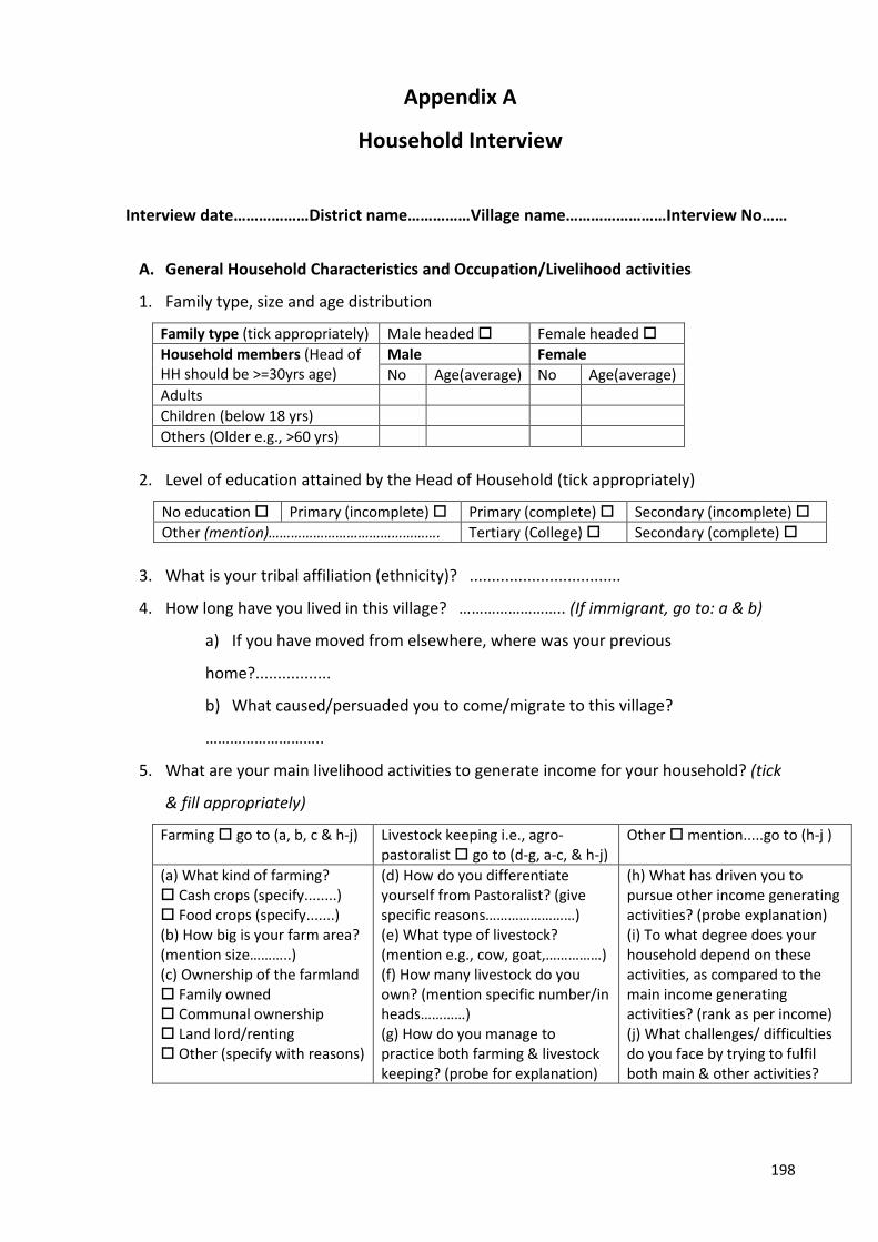
198
Appendix A
Household Interview
Interview date………………District name……………Village name……………………Interview No……
A. General Household Characteristics and Occupation/Livelihood activities
1. Family type, size and age distribution
Family type (tick appropriately) Male headed Female headed
Household members (Head of HH should be >=30yrs age)
Male Female
No Age(average) No Age(average)
Adults
Children (below 18 yrs)
Others (Older e.g., >60 yrs)
2. Level of education attained by the Head of Household (tick appropriately)
No education Primary (incomplete) Primary (complete) Secondary (incomplete)
Other (mention)………………………………………. Tertiary (College) Secondary (complete)
3. What is your tribal affiliation (ethnicity)? ..................................
4. How long have you lived in this village? …………………….. (If immigrant, go to: a & b)
a) If you have moved from elsewhere, where was your previous
home?.................
b) What caused/persuaded you to come/migrate to this village?
………………………..
5. What are your main livelihood activities to generate income for your household? (tick
& fill appropriately)
Farming go to (a, b, c & h-j) Livestock keeping i.e., agro-pastoralist go to (d-g, a-c, & h-j)
Other mention.....go to (h-j )
(a) What kind of farming? Cash crops (specify........) Food crops (specify.......) (b) How big is your farm area? (mention size………..) (c) Ownership of the farmland Family owned Communal ownership Land lord/renting Other (specify with reasons)
(d) How do you differentiate yourself from Pastoralist? (give specific reasons……………………) (e) What type of livestock? (mention e.g., cow, goat,……………) (f) How many livestock do you own? (mention specific number/in heads…………) (g) How do you manage to practice both farming & livestock keeping? (probe for explanation)
(h) What has driven you to pursue other income generating activities? (probe explanation) (i) To what degree does your household depend on these activities, as compared to the main income generating activities? (rank as per income) (j) What challenges/ difficulties do you face by trying to fulfil both main & other activities?
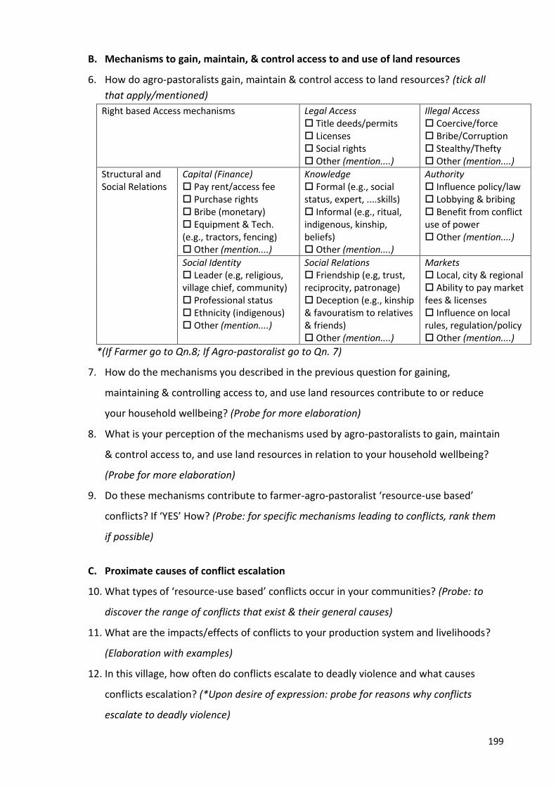
199
B. Mechanisms to gain, maintain, & control access to and use of land resources
6. How do agro-pastoralists gain, maintain & control access to land resources? (tick all
that apply/mentioned)
Right based Access mechanisms Legal Access Title deeds/permits Licenses Social rights Other (mention....)
Illegal Access Coercive/force Bribe/Corruption Stealthy/Thefty Other (mention....)
Structural and Social Relations
Capital (Finance) Pay rent/access fee Purchase rights Bribe (monetary) Equipment & Tech. (e.g., tractors, fencing) Other (mention....)
Knowledge Formal (e.g., social status, expert, ....skills) Informal (e.g., ritual, indigenous, kinship, beliefs) Other (mention....)
Authority Influence policy/law Lobbying & bribing Benefit from conflict use of power Other (mention....)
Social Identity Leader (e.g, religious, village chief, community) Professional status Ethnicity (indigenous) Other (mention....)
Social Relations Friendship (e.g, trust, reciprocity, patronage) Deception (e.g., kinship & favouratism to relatives & friends) Other (mention....)
Markets Local, city & regional Ability to pay market fees & licenses Influence on local rules, regulation/policy Other (mention....)
*(If Farmer go to Qn.8; If Agro-pastoralist go to Qn. 7)
7. How do the mechanisms you described in the previous question for gaining,
maintaining & controlling access to, and use land resources contribute to or reduce
your household wellbeing? (Probe for more elaboration)
8. What is your perception of the mechanisms used by agro-pastoralists to gain, maintain
& control access to, and use land resources in relation to your household wellbeing?
(Probe for more elaboration)
9. Do these mechanisms contribute to farmer-agro-pastoralist ‘resource-use based’
conflicts? If ‘YES’ How? (Probe: for specific mechanisms leading to conflicts, rank them
if possible)
C. Proximate causes of conflict escalation
10. What types of ‘resource-use based’ conflicts occur in your communities? (Probe: to
discover the range of conflicts that exist & their general causes)
11. What are the impacts/effects of conflicts to your production system and livelihoods?
(Elaboration with examples)
12. In this village, how often do conflicts escalate to deadly violence and what causes
conflicts escalation? (*Upon desire of expression: probe for reasons why conflicts
escalate to deadly violence)
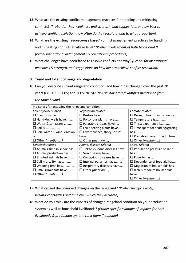
200
13. What are the existing conflict management practices for handling and mitigating
conflicts? (Probe: for their weakness and strength, and suggestions on how best to
achieve conflict resolution, how often do they escalate, and to what proportion)
14. What are the existing ‘resource-use based’ conflict management practices for handling
and mitigating conflicts at village level? (Probe: involvement of both traditional &
formal institutional arrangements & operational procedures)
15. What challenges have been faced to resolve conflicts and why? (Probe: for institutional
weakness & strength, and suggestions on how best to achieve conflict resolution)
D. Trend and Extent of rangeland degradation
16. Can you describe current rangeland condition, and how it has changed over the past 20
years (i.e., 1995-2005; and 2005-2015)? (tick all indicators/examples mentioned from
the table below)
Indicators for assessing the rangeland condition
Eco-physical related River flow has............ Hand-dug wells have........ Water & soil tastes …....... Soil is ….............. Soil (water & wind) erosion is …........ Other (mention....)
Vegetation related Bushes have........... Poisonous plants have....... Palatable grasses have..... Fruit bearing plants have.... Dwarf bushes, thory shrubs have............ Other (mention....)
Climate related Drought has.......in frequency Temperature is............. Thirst experience is........... Time spent for shading/grazing has......... Predators have........with time Other (mention....)
Livestock related Animals-time in shade has.. Animal production has....... Stunted animals have........ Calf mortality has... ....... Weaning time has.............. Small ruminants have......... Other (mention....)
Animal disease related Ticks/tick-bone diseases have.. Skin diseases have.......... Contagious diseases have...... Internal parasites have........ Respiratory diseases have..... Other (mention....)
Social related Population pressure on land has...... Poverty has....... Dependence of food aid has... Migration of households has.. Rich & medium households have......... Other (mention....)
17. What caused the observed changes on the rangeland? (Probe: specific events,
livelihood activities and time over which they occurred)
18. What do you think are the impacts of changed rangeland condition on your production
system as well as household livelihoods? (Probe: specific example of impacts for both
livelihoods & production system, rank them if possible)
201
E. Recommendations on Sustainable Adaptation Strategies
19. How do you address and adapt to the constraints facing your production system?
(Probe: for constraints e.g., climate change, rangeland degradation, conflicts,
infrastructure & extension services, markets)
20. What do you suggest are the most sustainable adaptation practices and development
strategies, which will improve your household wellbeing and enhance your (farmers &
agro-pastoralists) mutual co-existence?
Reminder: You may withdraw any information you have provided, at any time you feel like doing so
(up to May 2017) by contacting me (Dennis Rweyemamu) or my supervisors (Ken Hughey & Lin
Roberts) through the contact details below. We will be happy to discuss any concerns and
queries regarding your participation in this research.
Researcher: Dennis Rweyemamu, PhD Student, Faculty of Environment, Society and Design
Ph: 0210647988 & 0717781543
Supervisor: Prof. Ken Hughey, Faculty of Environment, Society and Design
Associate supervisor: Dr. Lin Roberts, Senior Lecturer, Faculty of Environment, Society and Design
This marks the end of our interview, is there anything you would like to add/explain
more?
THANK YOU FOR YOUR TIME!
202
Appendix B
Key Informant Interview
Title/Affiliation……………………………………..
Date……….…………………………………………….
District…………………………………………………
Ward……………………………………………………
Village…………………………………………………
General development issues
1. How long and in what capacity have you been working in this region/district/village?
2. What is your role(s) in the community?
3. What are the main livelihood activities in the district/village and what changes have been
observed over time in these livelihood activities? (If any changes, probe why?)
4. What is the approximate number and percentage distribution of farmers, pastoralists and
agro-pastoralists within the district/village? (Probe: how do he/she distinguish pastoralists
from agro-pastoralists)
5. What are the district/village development priorities and what has been achieved over the past
ten (10) years? (probe: development plans & strategies in relation to agriculture & livestock
keeping)
Mechanisms to gain, maintain & control access to and use of land resources
6. What are the general procedures to be followed, and criteria/qualification required for a
person to own land? (probe: challenges of land ownership among farmers & agro-pastoralists)
7. How do immigrant agro-pastoralists gain, maintain & control access to land resources? (Probe:
right/legal-based, Illegal-based, Structural & Relations-based mechanisms)
8. How do the mechanisms you describe in the last question for gaining, maintaining &
controlling access to, and use land resources contribute to or reduce agro-pastoralists’
wellbeing? (Probe: specific mechanisms being preferred most, and why?)
9. What is the farmers’ perception of these mechanisms in relation to their wellbeing? (Probe:
which specific mechanisms have the most +/- effects)
10. Do these mechanisms contribute to ‘resource-use based’ conflicts i.e., farmer-agro-pastoralist
conflicts? If ‘YES’ How? (Probe: for specific mechanisms leading to conflicts, rank them if
possible)
203
Proximate causes of conflict escalation
11. What types of ‘resource-use based’ conflicts are there in your district/village and how often
do they occur? (Probe: to discover the range of conflicts that exist in the study area and their
general causes)
12. What are the impacts/effects of the conflicts to the production systems and livelihoods of both
farmers and agro-pastoralists? (Elaborate with examples)
13. In this district/village, how often do conflicts escalate to deadly violence and what causes
conflicts escalation? (Probe: how often do conflicts escalate, and to what proportion)
14. What are the existing resource-use based conflict management practices for handling and
mitigating conflicts at regional/district/village level? (probe: provision & elaboration of both
traditional and formal institutional arrangements and operational procedures)
15. What challenges have been faced to resolve conflicts and why? (Probe: for institutional
weakness and strength, and suggestions on how best to achieve conflict resolution)
Trend and extent of rangeland degradation
1. Can you describe current rangeland condition, and how it has changed over the past 20 years
(i.e., 1995-2005; and 2005-2015)? (Probe: if there are any changes, and specific characteristics
used to describe rangeland changes)
2. What caused the observed changes on the rangeland? Probe: for specific events and/or
livelihood activities (e.g., immigrant pastoralists, severe droughts etc) and time over which they
occurred
3. What do you think are the impacts of changed rangeland condition on farmers & agro-
pastoralists production systems as well as their livelihoods? (Probe: for specific example of
impacts for both livelihoods and production system, rank them if possible)
4. What initiatives have been taken by the government/NGOs and other development partners
to help communities cope and adapt to impacts due of rangeland condition changes? (probe:
successive stories and vivid examples)
Recommendations on Sustainable development Strategies
5. What plans and development strategies are in place to enhance the capacity of farmers and
agro-pastoralists livelihoods activities, which will in turn improve their wellbeing?
6. What strategies are in place, and how far have the goals been achieved with regard to effective
land use planning at regional/district and village level?
7. What do you suggest are the most sustainable adaptation practices and development
strategies, which will minimize conflicts over land resources and enhance (farmers & agro-
pastoralists) mutual co-existence?
204
Reminder: You may withdraw any information you have provided, at any time you feel like doing so
(up to May 2017) by contacting me (Dennis Rweyemamu) or my supervisors (Ken Hughey & Lin
Roberts) through the contact details below. We will be happy to discuss any concerns and
queries regarding your participation in this research.
Researcher: Dennis Rweyemamu, PhD Student, Faculty of Environment, Society and Design
Ph: 0210647988 & 0717781543
Supervisor: Prof. Ken Hughey, Faculty of Environment, Society and Design
Associate supervisor: Dr. Lin Roberts, Senior Lecturer, Faculty of Environment, Society and Design
This marks the end of our discussion, would you like to add anything else?
THANK YOU FOR YOUR TIME!
205
Appendix C
Focus Group Discussion Guide
FGD No…………… No of Participants………..
Date……….…………………………………………….
District…………………………………………………
Ward……………………………………………………
Village…………………………………………………
Ground rules
Please note that this is a discussion and not an educational session. Each individual should feel free to
express his/her thoughts. It is advised that one person speaks at a time. If you feel you want to share
your thoughts, please raise your hand and the moderator will notice. Please try not to interrupt your
colleagues while they are talking. Remember that everything discussed here is confidential.
Self-introductions
The introduction only involves mentioning what you do for a living………………………… Mechanisms to gain, maintain & control access to and use of land resources
1. How do you gain, maintain & control access to land resources? (Probe: right/legal-based, Illegal-
based, Structural & Relations-based) mechanisms
2. What do you use the acquired land resources for? (Probe: for livelihoods & wellbeing activities)
3. What things come first as the most important attributes for the wellbeing of your family?
4. How do the mechanisms you described in the previous question for gaining, maintaining &
controlling access to, and use land resources contribute to or reduce your wellbeing? (Probe:
specific mechanisms being preferred most, and why?)
5. What is your perception of these mechanisms in relation to your wellbeing? (Probe: which
specific mechanisms have the most +/- effects)
6. Do these mechanisms contribute to ‘resource-use based’ conflicts, i.e., farmer-agro-pastoralist
conflicts? If ‘YES’ How? (Probe: for specific mechanisms leading to conflicts, rank them if
possible)
Proximate causes of conflict escalation
7. What types of ‘resource-use based’ conflicts occur in your communities? (Probe: to discover the
range of conflicts that exist in the study area and their general causes)
8. What are the impacts/effects of the conflicts to your production system and livelihoods?
(Elaborate with examples)
9. In this village, how often do conflicts escalate to deadly violence and what causes conflicts
escalation? (Probe: how often do conflicts escalate, and to what proportion)
206
10. What are the existing ‘resource-use based’ conflict management practices for handling and
mitigating conflicts in your village? (Probe: for their weakness and strength, and suggestions on
how best to achieve conflict resolution)
Trend and extent of rangeland degradation
11. Can you describe current rangeland condition, and how it has changed for the past twenty
years (i.e., 1995-2005; and 2005-2015)? (Probe: if there are any changes, and specific
characteristics used to describe rangeland changes)
12. What caused the observed changes on the rangeland? Probe: for specific events and/or
livelihood activities (e.g., immigrant pastoralists, severe droughts etc) and time over which they
occurred
13. What do you think are the impacts of changed rangeland condition on your production system
as well as livelihoods? (Probe: for specific example of impacts for both livelihoods and
production system, rank them if possible)
Recommendations on Sustainable development Strategies
14. How do you address and adapt to the constraints facing your production system? (Probe: for
constraint e.g., climate change, rangeland degradation, conflicts, infrastructure & extension
services, markets, politics & policy issues)
15. What do you suggest are the most sustainable adaptation practices and development
strategies, which will enhance your (farmers & agro-pastoralists) mutual co-existence?
Reminder: You may withdraw any information you have provided, at any time you feel like doing so
(up to May 2017) by contacting me (Dennis Rweyemamu) or my supervisors (Ken Hughey & Lin
Roberts) through the contact details below. We will be happy to discuss any concerns and
queries regarding your participation in this research.
Researcher: Dennis Rweyemamu, PhD Student, Faculty of Environment, Society and Design
Ph: 0210647988 & 0717781543
Supervisor: Prof. Ken Hughey, Faculty of Environment, Society and Design
Associate supervisor: Dr. Lin Roberts, Senior Lecturer, Faculty of Environment, Society and Design
This marks the end of our discussion, anyone else would like to add something?
THANK YOU FOR YOUR TIME!
207
Appendix D
Consent Form
Research title: “Building and Enhancing Resilience in a changing climate among Agropastoral
Communities in Kilosa and Mvomero Districts, Morogoro region, Tanzania”
I have read/listened and understood the description of the above-named research project. On this
basis I agree to participate in the research project, and I consent to publication of the results of the
research with the understanding that anonymity will be preserved. I understand also that I may
withdraw from the research project, including withdrawal of any information I have provided, up to
May 2017. In addition to agreeing to the above:
I consent to having an audio made of my discussion(s) in the group.
I do not consent to having an audio recording made of my discussion(s) but agree to notes
being made.
I will respect the privacy of information given to me by others participating in the focus group
discussions and not discuss the information they have provided, with other people outside of the focus
group discussions.
Name: ……………………………………………………………………………… Signed: ……………………………………….. Date: ……………………………………………….
208
Appendix E
Research Information Sheet
Lincoln University
Environment, Society and Design Faculty
I would like to invite you to participate in a research project entitled “Building and Enhancing Resilience in a changing climate among Agro-pastoral communities in Kilosa and Mvomero Districts, Morogoro region, Tanzania”. The aim of this research is to get your views to help improve our understanding of: 1) mechanisms by which agro-pastoralists gain, maintain & control access to and use of land resources, and the contribution of these mechanisms to conflicts with other land resources beneficiaries; 2) trend and extent of environmental and rangelands degradation and agro-pastoralists and farmers’ perception of how the degradation has impacted their production system and livelihood; 3) proximate causes of conflict escalation and its impacts on both farmers and agro-pastoral production systems; 4) documenting existing adaptation strategies and recommend the most practicable and resilient development priorities that will favour mutual co-existence between farmers and agro-pastoralists. The research is being funded by the New Zealand Aid Scholarship (NZAID) in collaboration with Lincoln University in New Zealand. The findings of this research will help to address the challenges being faced by farmers and agro-pastoral communities, especially due to the ongoing national policy reforms related to agriculture and livestock sector. You have been selected to participate in the research because you are among of the stakeholders (district official, NGO, Development partner) playing an important role in development issues pertinent to both farmers and agro-pastoralists in the district. However, your participation in this research is voluntary and there is no obligation to take part. Your participation in this research will involve responding, to and where appropriate engaging in detailed discussions, about questions that I will be asking you. The questions will cover aspects such as general development issues; mechanisms to gain, maintain and control access to and use of land resources; causes of land resources-based conflicts; trend and extent of rangeland degradation; and sustainable development strategies. The interview should take about 60 minutes; and upon your consent, I would like to record your interview. You may decline to answer any question, or withdraw your participation from the research, including withdrawing any information you have provided, at any time you feel like doing so during the interview, or any time later (up to May 2017) by contacting me (Dennis Rweyemamu) or my supervisors (Ken Hughey & Lin Roberts) through the contact details below.
The results of the research will be submitted for publication as a PhD thesis, also presented and published at both (local & International) conferences and in academic journals. However, you may be assured of your anonymity in this investigation: the identity of any participant will not be made public, or made known to any person other than me. To ensure anonymity, consent forms and individual interview data will be seen by me, my supervisors and the Human Ethics Committee in the event of an audit. The data will be stored in an electronic form with password protection. Only aggregated data will be presented in any publications and no information will be reported in a way that might identify individuals. This research project has been reviewed and approved by the Lincoln University Human Ethics Committee. If you have any queries or concerns about your participation in the research, please contact me or my supervisors; we would be happy to discuss any concerns you have about participation in the research.
209
Researcher: Dennis Rweyemamu, PhD Student, Faculty of Environment, Society and Design [email protected] Ph 0210647988 & 0717781543 Supervisor: Prof. Ken Hughey, Faculty of Environment, Society and Design [email protected] Associate supervisor: Dr. Lin Roberts, Senior Lecturer, Faculty of Environment, Society and Design [email protected]