motuihe island - research@lincoln
TRANSCRIPT

Lincoln University Digital Dissertation
Copyright Statement
The digital copy of this dissertation is protected by the Copyright Act 1994 (New Zealand).
This dissertation may be consulted by you, provided you comply with the provisions of the Act and the following conditions of use:
you will use the copy only for the purposes of research or private study you will recognise the author's right to be identified as the author of the dissertation and due acknowledgement will be made
to the author where appropriate you will obtain the author's permission before publishing any material from the dissertation.

MOTUIHE ISLAND
DEVELOPMENT PROPOSALS FOR A RECREATIONAL
A major design study submitted for
the Diploma of Landscape Architecture
in the
University of Canterbury
by
D.JScott
Lincoln College
1974
RESOURCE
CONTENTS
CONTENTS · . . . . . . . . . . . . . . . . . . . . . LIST OF FIGURES
LIST .OF MAPS
ACKNOWLEDGEMENTS
BRIEF
. -.' ................ -.. . · .' ................... . · . . . . . . . . . . . . . . . . . . . . . · . . . . . . . . . . . . . . . . . . . . .
THE HAURAKI GULF MARITIIVIE PARK
BACKGROUND OF THE PARK
LOCATION AND DESCRIPTION
ACCESSIBILITY OF THE ISLANDS
THE MANAGEMENT PLAN
MOTUIHE ISLAND
• • ~ • • e.- ••••••••
· . . . . . . . . . . . . . . · . . . . . . . . . . . . . . · . . . . . . . . . . . . . .
LOCATION AND BRIEF DESCRIPTION
HISTORY · . . . . . . . . . . . . · . . . . . . . . . . . .
ARCHAEOLOGY · . . . . . . . . . . . . ENVIRONIVIENTAL FACTORS
CLIMATE
GEOLOGY AND SOILS
TOPOGRAPHY AND DRAINAGE
VEGETATION
FAUNA
MARINE ECOLOGY
· . . . . . . . . . . . . . . . . . · . . . . . . . . . . . . . . . . . · . . . . . . . . . . . . . . . . . · . . . . . . . . . . . . . . . . . · . . . . . . . . . . . . . . . . . · . . . . . . . . . . . . . . . . .
Page
I.
III •
IV.
V.
VIII.
1.
4.
8.
11.
15.
19.
31.
34.
38.
43.
45.
62.
65.
I.
SITE APPRAISAL
INTRODUCTION
VISUAL SURVEY
PHYSICAL SURVEY
SHORELINE SURVEY
· . . . . . . . . . . . . . . . . . . · . . . . . . . . . . . . . . . . . . · . . . . . . . . . . . . . . . . ~ . · . . . . . . . . . . . . . . . . . .
Page
66.
68.
89.
99.
MDTUIHE ISLAND AS A RECREATIONAL RESOURCE
INTRODUCTION
RECREATION TRENDS
fvIOTUIHE I S ROLE
MANAGEMENT OBJECTIVES
CARRYING CAPACITY
. CONTROLS ON USE
THE FARMING STATEMENT
· . . . . . . . . . . . . . . . . . . · . . . . . . . . . . . . . . . . . . · . . . . . . . . . . . . . . . . . . • • • • • • • • • • • • • • • • • • •
• • • • • • • • • • • • • • • • • • •
• • • • • • • • • • • • • • • • • • • · .. ~ ...•....••••...•
CONCEPT AND DESIGN PROPOSALS
DESIGN CONCEPT
DETAIL PROPOSALS · . . . . . . . . . . . . . . . . . .
APPENDIX
APPENDIX A
APPENDIX B
APPENDIX C
APPENDIX D
APPENDIX E
APPENDIX F
REFERENCES
· . . . . . . . . . . . . . . . . . .
ISLANDS OF THE HAURAKI
GULF MARITIME PARK
MAORI PLACE NAMES
CLIMATIC DATA
THE FLORA
ANIrilAL AND BIRDLIFE
COASTAL BIOLOGY
· . . . . . . · . . . . . . · . . . . . . · . . . . . . • • • • • • • · . . . . . . • ••••••
117.
119.
123.
126.
131.
148 •
151.
153.
166
190.
207.
218.
223.
233.
235.
239. II.

LIST OF FIGURES
OCEAN BEACH
LOGAN CAMPBELL'S OLIVE GROVE
BIG MOTUIHE PA
METEROSIDEROS EXCELSA
TOPOGRAPHY OF ISLAND
NORFOLK PINE AVENUE
CONCENTRATED RECREATION AREA
MARITIME PINE SHELTER BELT
PURIRI STAND
FLOOR UNDER TARAIRE STAND
POHUTUKAWA ON 'ELBOWS'
SHAGS NESTING
VISUAL SURVEY ILLUSTRATIONS
PHYSICAL SURVEY ILLUSTRATIONS
SHORELINE SURVEY ILLUSTRATIONS
26.
33.
35.
44.
47.
49.
53.
54.
57.
59.
64.
69 - 88.
89 - 98.
101 - 116.
. III.

LIST OF MAPS
HAURAKI GULF fvIARITIME PARK - LOCATION
MOTUIHE ISLAND - LOCATION MAP
ARCHAEOLOGY SITES
SOILS
GEOLOGY
SHORELINE SURVEY GUIDE
MAORI PLACE NAMES
MAP 5.
16.
32.
39.
40.
100.
209.
IV.
ACKNOWLEDGMENTS
J.D. O'Brien
R. B •. Lang'
N.B. Hassler
D.F. Watson
liJ. W. Sanders
Mr. and Mrs. J. Paul.
Mr. and Mrs. A. Screen
Mr. and Mrs. H. Norton
Lands and Survey Department,
Auckland.
Lands and Survey Department,
Auckland.
Lands and Survey Department,
Hauraki Gulf Maritime Park,
Auckland.
Lands and Survey Department,
Hauraki Gulf Maritime Park,
Auckland.
Lands and Survey Department,
Hauraki Gulf Maritime Park,
Auckland.
Lands and Jurvey Department,
Hauraki Gulf Maritime Park,
Auckland ..
Lands and Survey Department,
Auckland.
Canteen proprietors,
Motuihe Island.
v.
J.E. Mo.rton
E.C. Young,
A. Esler
F.T. Boffa
E.G. Fox
Environmental Design
Section - with special
thanks to:
T.M. Lund
L. ',vahrlich
W.~V. Hill
S.c. Challenger
Zoology Department,
Auckland University.
Zoology Department,
Auckland University.
Botany Division,
D.S.I.R., Auckland.
Frank Boffa and Associates,
Christchurch.
Ministry of Works and
Development, Wellington.
Ministry of TJ.Jorks and
Development~ Wellington.
'Reader in Landscape Architecture,
Lincoln College.,
VI.

A.E. Jackman
Marlene Neems
Senior Lecturer in Architecture,
Lincoln College.
Typist.
VII.

THE BRIEF
The Lands and Survey Department (Hauraki Gulf Maritime
Park Board) is desirous of upgrading Motuihe Island as a
recreational reSource. I t is envis ed thCl t ~~6tu Island
will continue "it:.:; role within the park as a multi-pur~ose
farm unit and recreational facility_
Research and study are to focalise uoon ~n lnventorv c .1 ,
an 1 ;;15 :lnd evo.luat:_<o c.f l:h:~ natural and scenic resources
of the island, to ex~lore development potentials with con-
sideration for the impact and effect of existing dnd potential
land uses upon the environm2 and to determine the role
of Motuihe Island more fully in relation to the rest of the
Hauraki Gulf Mari Park"
The study is requ ed to produce a desi cone t
rec ising the problems of economic maintenance, and which
shows detailed ~lacement of bull sand genernl aeili es.
VIII.

he u I III III arl I~e
BACKGROUND OF THE PARK
liThe creation of a Maritime Park embracing islands·and
coastal areas in this r ion represents a completely new
concept in reserves •••• oa Maritime playground within easy
reach of New Zealand's most heavily concentrated urban area.
At the same time it ensures the conservation and protec n
of areas containing outstanding natural features of geolog-
ical interest as well as the servation of native and
plant life."
- Hon. Do MacIntyre, Minister of Lands Haur i Gulf
Maritime P Bill debate the House of Represent-
atives, 8th November, 1967.
The idea of a Maritime Park in the Hauraki Gulf was
st mooted in 1955/56. The value of this maritime pI
ground close to New Zealands most heavily concentrated
urban area had long been appreciated and several trends
prompted th development, viz:
• Many of the islands were already under public
control as domains or reserves but responsibility,
administration and policy were var
• Other areas were under vate ownership and several
of the islands were changing hands at inflated prices, some
of these had traditionally been open to public but there
were signs that conditions may alter.
1.
• The explosion of the boating population in Auckland
brought within the reach of the public, areas which previously
had been relatively safe. The areas rich in scien fic
mate al 'requi~ed greater safeguards and demands increased
for recreational 'facilities on some of the other islands.
These trends and increasing pressure of population
demanded that some of the islands be preserved completely or
conserved for their est us in public ownership_ Fortun
ately the Lands and Survey Department had reacted to the
needs and it was with this background that the Government
announced the proposal to establish a Maritime Park.
The Hauraki Gulf Maritime park was established in 1967.
It is made up of dozens of islands and certain coastal areas
which by purchase, deed or gift, or transfer from local
authority, have been added to.those already publicly owned
Crown lands and established as a Maritime Park by Act
Parliament. The Hauraki Gulf Maritime Park Act 1967 created
both the Park and its controlling Board. This Act should
be read together with and deemed part of the Reserves and
Domains Act 1953.
The Park is administered by a Board which is known as
the Hauraki Gulf Mari Park Board consist of:

The Commiss of Crown Lands.
A represent of the Auckland City Council.
A repreSent ive of the Devonport Borough Council.
;'.. represent of the Auckland Regional,\.uthoritY3
Not more than nine other members to be
the ('linis ter.
At present the Bo~rd c08prises:-
Ivir. J"D. O'Brien - Chairman
I'lr. J. Seabrook
Mr. _~~ J. Holdaway
Mr. D.A" Parsons
Mr. H.E. ',valls
Mr. C. J<~. Lavell
Mr. A.D. Baldwin
Mr. D.Eo Lees
Mrs. R.N. Zister
Mr. J.~" Butland.
inted by
3.
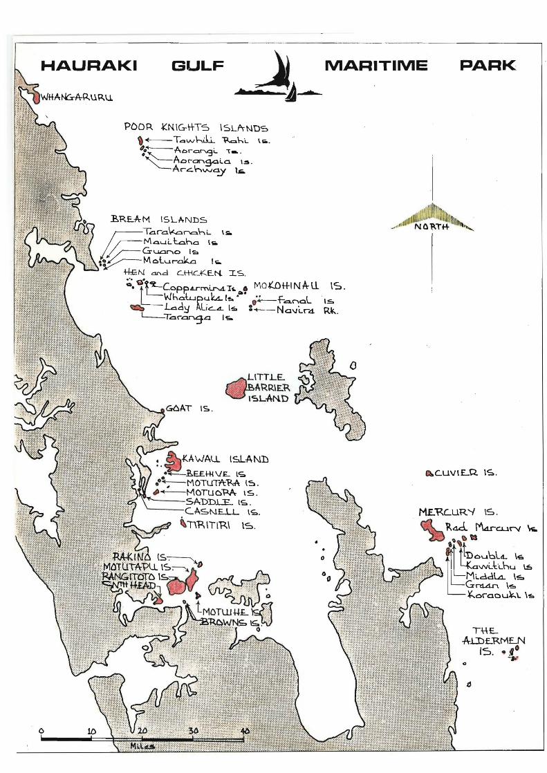
LOCATION AND DESCRIPTION
"The Hauraki Gulf lies between the eastern side of North
Auckland and the western sides of Coromandel Peninsula and
Great Barrier Island. It has no natural boundaries to the.
north but Bream Head, the Hen and Chickens, Moko naus
Great Barrier and Colville are often regarded as its
seaward imits. This contains over 7450 square kilometres
of South Pacific Ocean but the areas and islands in the Park
at present end well beyond this area as far north s the
North Head of ~hangaruru Harbour and south to the Alderman
Islands off the east coast of Coromandel Peninsula.
Alto ther it covers 13600 square Kilometres of ocean (See
location Map).
The Gulf is fronted by the Auckland Me litan Reg
the 1 est urban ed area in New Zealand as well as the City
of Whangarei. It is within four hours ing of 1,246,928
people, concentrated in the South Central and North Auckland
Regions, which represents 42.
popula ona
of ~ew Zealand's tot3l
The Gulf itself is a large, relat ly shallow bay,
extending from the fertile tida~ mudflats of the Firth of
Thames and sheltered Auckland Harbours, out to the exposed
outer islands. The western and southern coastline of the
coast is ly indented th bays and harbours, and the sea~
floor shelves gradually out to a th of 20 metres. On the
north-eastern side the sea-floor drops steeply down to 40
4.
HAURAKI GULF ~ MARITIME
t me ~.-.......
LITTLE. ~~ARR\E.R ~~LAI'lD
PARK
c.uvtLQ. IS, .
o
netres and 100 metres deep. Bottom sediments range from fine
mud in the shallow water to sandy mud at 100 metres
with areas of fine sand in Colville channel and off the
beaches north of Jellicoe Channel.
There are over 40 islands scattered across the Gulf -
more if the many rocky ou are included. lJot all of
se are in the a;Jraki Gulf ]\;ari time Park 2nd in some ccses
only certain ions of an island are inclJded. Indeed, of
the two largest islands in the Gulf - Waiheke and Great
Barrier, the Park Board administers only G hectares on the
latter. However, the Board controls islands outside the G;Jlf
area, south,to include the ~lderman Islands. In all it is
cesponsible for all of or parts of forty-four islands, which
constitute twenty-two main islands or groups. Two mainland
coastal areas on North Head of Whangaruru Harbour and North
Head of Waitemata Harbour are also in the Park. Total land
area of the park is 8514 hectares. The islands and areas in
the Fark are set out Ap;:endix A.
Most of the islands have been gazet d either flora and
fauna, scenic or Recreation Reserves. Seven of the island
groups (4613 hectares) are at present imarily preserved
for the preservation of the flora and fauna and require a
perrnit landing. Beeh Island off Kawau is admi stere
by the Park Board for its private owner, and Browns Island
was gifted to the citizens of Auckland by Sir Earnest Davies nRoww:::' l5.. Moiu i"-DR...t-ft
6.

and is administered by the Board for them as a recreation
reserveo The islands are varied in their size, topography
and accessibility; in their geology, ve tation cover and
wild 1 they support; in their interest and use together
they provide a natural resource, important to the national
interests as well as the Auckland, Northland and Coromandel
regions.
Use of the islands varies considerably some are so remote
and difficult of access they are not 5 table for direct
phys 1 recreational activi and yet, by their very isolated
nature they are ideal for the preserva on and study of New
Zealand vegetation and wild life in its natural state. Some
have been closely linked with the h tory of the Hauraki Gulf
and Northland and carry reminders of early Maori life,
exploration and European settlement of Auckland, including
its development through threats of Russian invasion and two
World ~arso ~any of the inner islands have been traditional
holiday areas and offer many opportunities for outdoor
recreationo They contin~e to offer scenic setti for-both
land and water based activit Some of the islands or areas
in the Gulf but not in the Park, particularly Waiheke, Kawau
and Great Barrier support quite. large residential population,
of a holiday or permanent nature,,"
Bob Lang - Surveyor-Planner.
Lands & Survey Department, Auckland.
- From Draft Management Plan Hauraki Gulf Maritime Park.
7 ..
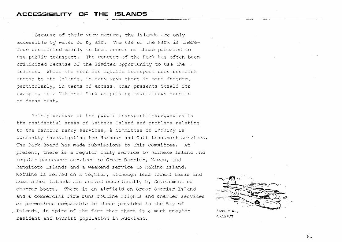
ACCESSIBILITV OF THE ISLANOS
"Because of their very nature, islands are only
accessible by water or by air. The use of the Park there-
fore restricted mainly to boat owners or those prepared to
use public tr~risport. The concept of the Park ha~ often been
criticized because of the limited opportuni to use the
islands. While the need for aquatic transport does restrict
access to the l5nds, in many ways there is more freedom,
particularly, in terms of access, than presents itself for
example, in a National Park compr ing mountainous terrain
or dense bush.
Mainly because of the public transport inadequacies to
the residential areas Waiheke Island and problems relating
to the harbour ferry services, a Committee of Inquiry is
currently investigating the Harbour and Gulf transport services.
The Park Board has made submissions to this committee. At
ent, there is a regular ly service to ~·Jaiheke Island and
regular passenger services to Great Barrier, Kawau, and
Rangitoto Islands and a weekend service to Rakino Island.
Motuihe i~ served on a lar, although less formal basis and
some other islands are served occasionally by Government or
charter boats. There an airf Id on Great Barrier Island
and a commercial firm runs routine flights and charter services
or promotions comparable to those provided in the Bay of ,-
Islands, in spite of the fact that there is a much eater
resident and tour t populat n in AUCkland.
8 ..

of the islands are only small and others have been
set aside primarily for the tection of flora and fauna,
so regular transport services are neither required nor desir-
able, except in some cases for servicing ranger st
transporting scientific parties or Park staff.
or for
Wharves or jetties are required in association with ferry
transport and the Board currently owns and maintains seven.
These are located at;-
lVlotutapu
Rangitoto
Motuihe
Kawau
Home Bayo
Islington
Rangi toto \Jharf"
Motuihe Wharf.
Mansio~ House Bay
Two House Bay
Sunny Bay"
The only reV2nues earned the Board in respect of the
wharves is by tolls of ten cents for adults and five cents
for childreno These are inadequate to cover m~intenance and
replacement costs. For example, the replacement of Motuihe
~harfis estimated to be $250,000
The 1 islands with resident population have
internal road systems with private motor cars. Some of the
~~~~~l=:~k !~~~n:; :~: :::~~:n;n:O~:::l b~r:::mW::~i~anagement~~~~~~~~;~_" ....
9.

park are se ced by formed roads and the public is allowed
controlled use of these by motor vehicleso lt
Bob Lang.
Lands &
Draft
Surveyor-Planner
Department, Auckland.
ement Plan Hauraki Gulf Mari Park.
Much of the physical recreational use of the inner
islands of the Gulf is related directly to the routes and
timetables of the passenger ferry services. ared with
the general boating public, the passengers disembarked from
the ferries are less mobile and more reliant upon the facili-
s and amenities provided on the island. The planning and
develop~ent of the park is therefore closely linked with the
future of the transport services. As stated the smaller and
tected islands do not require regular servi ,however
the more intens ly used islands present greater difficulties~
The real needs for transport to these is difficult to assess,
particularly in ard to likely future needs. One of the
more critical planning issues Ived with the ark is in
establishing the desirable intensity and frequency of use
which any particular island or area can tolerate, and therehy
deciding upon what level trans t services shou d be allowed
to operate to the island concerned. However, on this Doint
there must also be an awareness of the conflict that can
occur between the objectives f improvement of services and
the preserva on of natural assets.
10~
THE MANAGEMENT PLAN
Many of the ini al problems that could 0 have been
expected with the constitution of a park cont ning scattered
areas of.widely differing character and state of developfuent
have been large overcome and the park is now being treated
more as one entity. With increas demands on the usage of
the f and with the continuing expansion of the park it
beca~e increasin~ necessary to make decis affecting its
future. To facilitate management there was an diate need
to jus and give stabili to the principles underl ng
Board policies and decisions made over the first tent ve
years and to establish goals and formulate further policy on
this basis.
Because the Park was the forerunner of maritime parks
in New Zealand and not a park constituted under the National
Parks Act and therefore not subject to the principles or
policies of the National Parks Authority, there was also a
need to clari its function in terms of the total park
system of this country. A management plan has been produced
to satis both these needs.
What was required for the Park was a broad statement of
objec ves and policy to provide a framework within which the
30ard could make decisions when the need arose. was
oased on the idea that the best way to plan for the future is
to understand the present and within this framework of know-
11.
ledge operate to influence or direct ch
ultimate goal.
The ~lan set out to understand the
situation in the Hauraki Gulf by having
towards an
ent overall
ard to the exist-
ing needs or proposals of the community and to the particular
problems and confl ts. After identifying the purposes of
the park within the r ion and in terms
system, the plan established the object
of the total park
the Board
and set up a number of restraints which des the basis
by which park use, man ement and development are reconciled
with the t of the Park's natural value and amenity.
The plan draws attention to the need for a more detailed
resource assessment and for more information. It establishes
objectives and based upon cert suppositions and
therefore sets the parameters -for data collection. The
collection of data should be a continual process to test or
support the Park objectives and poli - these will be
influenced by increased knowledge and in turn will provide a
clearer idea of a requirements.
The plan is therefore only one stage in the
planning of the park and satisfies only the immediate require-
ments in a continuing process. It needs be subject to
continual review and professional advice should be availed

upon to evaluate each and every sal in terms of the
over I concept of the Park before the Board makes a final
de s
PR~PARATION OF THE PLAN:
The scattered nature of the Park lent itself to the
of a manage~~nt plan stages. This was con-
ven in that certain decisions relating to specific areas
were requ d to be made urgent and to delay the whole
plan because of the need to complete certain policies relat-
i some remote island would only compound problems and
lties of management in relation to more in tens
used areas of the Park. However, each sector of the Park
contained in the different s s of the plan must be consid-
ered relation to the total park and overall concept.
The team approach to pI with many discipl being
esented was oreferred. Although the plan was basically
ared by the 30ard's pl officer it was undertaken in
close consultation with the Chief Ranger and his s ,Park
Board members and with scienti c advisors. Also the Board
was fortunate in having access to many planning studies under
taken in the region by the Auckland Regional Authority and to
many re
area.
ts on scientific research carried out in the Gulf
13 ..
Several interests: geology, flora and fauna, marine
biology, history, and access and transportation; and activities:
recreation, commercial shipping, commercial fishing, marine
farming, minint, defence and coastal development; as well as
other parks and reserves of the Gulf: Regional Parks, Forest
Parks, New Zealand Walkways, Coastal and Local Reserves,
Coromandel Park and Bay of Islands; were examined to illustrate
the extent of de~ands made upon the region to serve these
activities or uses, each will require some permanent provis-
ions in the way of the use of water space, or of the islands
or surrounding coastal areas of the mainland. These require-
ments will often be in conflict with those of other competing
uses. In conclusion the Hauraki Gulf Maritime Park is only
one component of a comprehensive recreation and open-space
system which would be more effective if each component was
required to be located and managed in terms of the total
system so that the values of anyone can contribute signifi
cantly to the values of another.
- .
lVIatuihe Island _ __ __ .~ _il:i ___ ilti;. :--
LOCATION AND BRIEF DESCRIPTION
Motuihe Island lies in the Hauraki Gulf and i~ situated
between Rangitoto-Motut Islands and Waiheke Island, some
15 Km east of Auckland City. (See Location ).
It has an area of 180 Hectares its st dimension is
2.5 Km, and it encompasses some 8 Km of shoreline.
Due to its proximity to New Zealand's largest urban
population this attract island has become a popular pleas
area a basically rural setting for thousands of boat-owners
and day trippers.
The island is farmed on behalf of the Park Board by the
~ands & Survey Department, in this way both taining the
ater portion of the island and providing a certain amount
of revenue for devel t within the Hauraki Gulf Maritime
Fark in general.
There are three formal picnic groundS which may be booked
in advance by organised par s. Facilities include changing
sheds, tOilets, barbecues and a canteen.
As this is one of closer islands of the Gulf in
reI to the mainland it is a popular day r boat
owners, the varied aspect of beaches offering sheltered con
ditions in any prevailing wihd. A ferry service 0 ates from
AUckland daily for the period between Labour and Easter. weekends.
15.
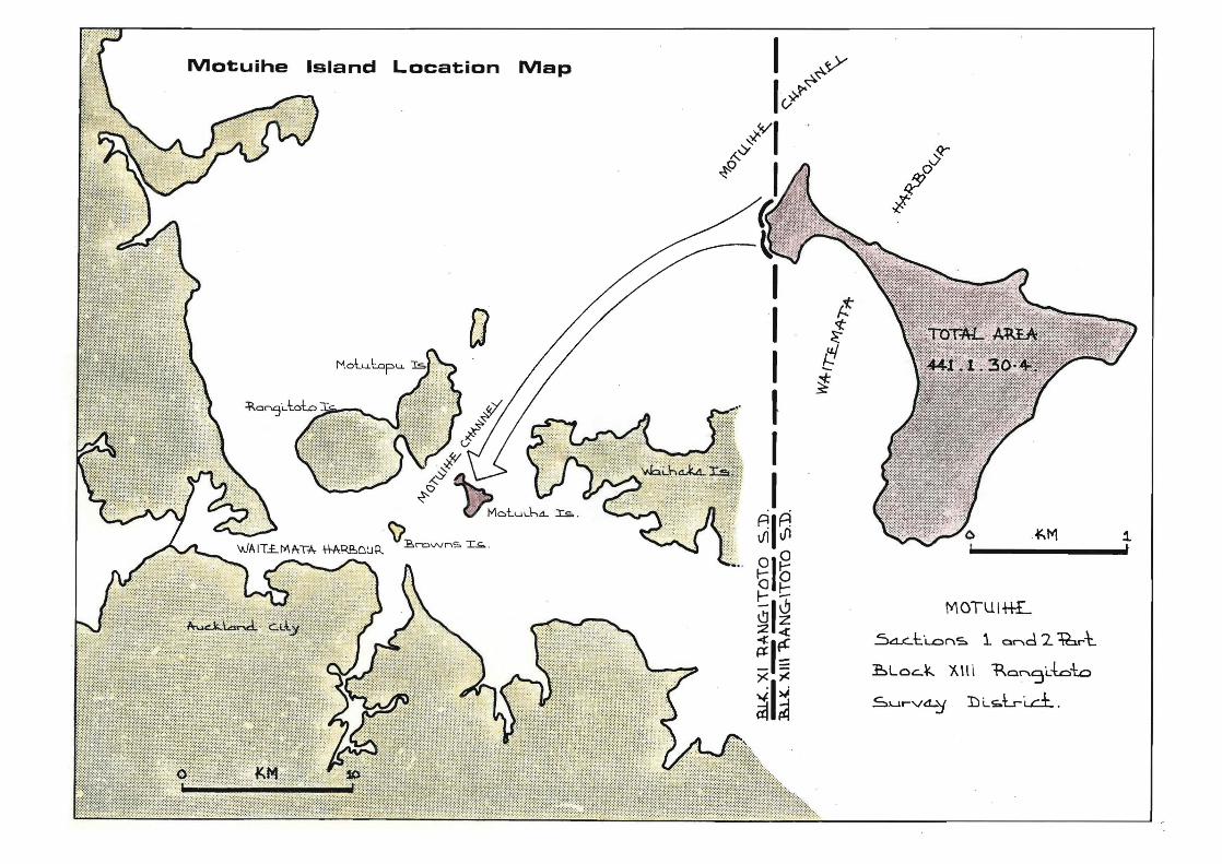
Motuihe Island Location Map
MOTU I++£.
Sa...c:..t:L...Onc;:. 1 Qr'\d 216rt.
~Loc...¥.. XIII 'RO~5L6-\:.o
Sur-Vd-Y I::l i...~Lr-i ... c:±" .
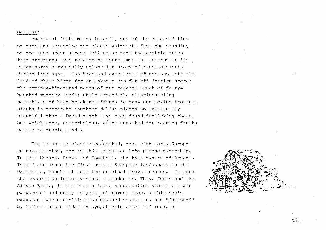
fVI0TUIHI:
"Motu-ihi (motu means island), one of the extended line
of barriers screening the placid ~aitemata from the pounding
of the long green surges welling up from the Pacific ocean
that stl:'etches away to dis tant South ,America, records in its
place names a typically Polynesian story of race movements
during long es. The headland names tell of men who left the
land of their ~irth for an unknown and far off foreign shol:'e;
the romance-tinctured names of the beaches speak of fairy
haunted mystery lands; while around the clearings cling
narratives of heat-breaking efforts to grow sun-loving tropical
plants in temperate southern dells; places so idyllically
beautiful that a Dryad might have been found frolicking there,
but which were, nevertheless, quite unsuited for rearing fruits
native to tropic lands.
The island is closely connected, too, with early Europe
an colonisation, for in 1839 it passed into pakeha ownership.
In 1843 Messrs. Brown and Campbell, the then owners of Brown's
Island and among the first actual Suropean landowners in the
~aitemata, bought it from the original Crown grantee. In turn
the lessees during many years included Mr. Thos. Duder and the
Alison Bros.; it has been a farm, a quarantine station; a war
prisoners' and enemy subject internment camp, a children's
paradise (where civilisation crushed youngsters are "doctored"
by Mother Nature aided by sympathetic women and men), a

Mar Park under the administration of the Auckland City
Council," a Naval tr ning centre ratings, and finally
it has be~ome part of the Hauraki Gulf Maritime Park, under
the administration of the Lands and Survey.
- Lorrie 'NaIsh. (1937)
18.
HISTORY
The history of Motuihe Island up to 1930 has been adequately
covered in an essay by Lorrie Walsh, thus the following is
1 y direct extracts from this work.
POLYNESIAN HISTORY:
Pre-statement:
"New Zealand, known to the Polynesians as Aotearoa, was
colonised at some early date, which has yet to be determined,
by peop from the Pacific Islands to the north and west.
Pbout 925 A.D. a Polynesian sea rover, Kupe, while exploring
this land visi d the Waitemata, and returned to Tahiti to
tell of finding Ita mist moistened land in a far away southern
:.,ea. fl His information sent other adventurous folk to seek a
homeland in th new country. A sudden storm at Tahiti about
1150 A.D., was responsible the visit of another prominent
Tahi an, Toi-te-Huatahi. His grandson, Whatonga, was blown
out to sea while racing his canoe in a challenge match and the
grandfather, in his search for him, came to New Zealand; call
ing in at the Waitemata and Tamaki; eventually set ing in the
Bay of Plenty. The grandson, surviving the buffeting of the
waves, returned home to learn that his grandfather was search
ing the south Pacific for him. Immediately he set out to seek
his relative; nding the old gentleman comfortably settled
here in Aotearoa, he promptly joined forces wtth him. The
Tine-o~Toi (Toi's people) possibly because of superior methods
of warfare, gradually subdued many of the sea coast tribes
19.
around the Bay of Plenty and worked right up to the waitemata
where they established themselves on the islands, including
Motui , and on the adjacent mainlahd~ In the middle of the
14th cen~ury p0litical upheavals in the Pacific islands sent
many refugees to Aotearoa; the last big migration (known to
historians as the Seven Canoe migration) being dated about
1350. Some of these people made a,base in the ~aitemata, and
overran the northern half of the No~th Island, being the
dominant caste when European migration b an in the early
19th century. One of their tr a1 sub visions, the Ngati
paoa, were in occupation of the Hauraki Gulf islands when
European settlement commenced."
1\10TU-IHENGA:
Was Maori Name of Island:
"The Maori folk had named pract ally every mountain,
hill, vall ,river, lake and promontory in Aotearoa; a
natural result of many centuries of intimate and thorough
knowlc e of the islands. Just as the Europeans have brought
Auckland and een Street, Princes street, waterloo Crescent,
etc. so the Polynesians brought innumerable old place names
with them and attached them to places in this new country;
some of these place names are repeated about the Pacific,
bestowed by the Polynesians wherever they have rested, and
form in themselves a highly interesting record of thousands
of years of restless migrations ever towards the rising sun; each name a revealing light in a glamorous heroic narrative.
2 rl v"

30me of the names, of course, are merely descriptive, Long
Beach or Red Hilljothers arose from some incident of local war
or a deed of valour or maybe a tragic happening; many are
unmatchable gems of poetic.· ari ty as Wai takerei, "The
Tinkling of Hidden Cascades", I;Jai tangi, "The sighing of the
II'Jaters", Manapouri, "The .Lake of the Sorrowing Heart."
Thoroughly Polynesian are the names given to the parts
of this small island in the Hauraki Gulf. The island name
as used by Europeans, often pronounced tlMota-hee," is not the
Maori one; it should be Motu-a-Ihenga, (in early European
documents it appears as Motu-ihe), Ihenga's island; from the
historic fact that it was appropriated by Ihenga, a son of
Tametekapua, commander of the Arawa canoe which arrived in
New Zealand from Tahiti about 1350 A.D. The land was in
habited or inally by Maru-iwi folk, the first native people
of whom we have definite information; they were spossessed by
descendant~ of Toi (who came about 1150 A.D.) who, in turn,
were conquered and assimilated by Arawa people who had reached
here in the middle of the 14th century. These newcomers event
ually owned the gUlf islands with some of the mainland and
were knoHn as Ngati-Huarere (Ihenga mentioned above being
Huarere's brother). In me, some of the descendants of the
Tainui canoe migrants asserted control over the islands and the
Tamaki area (called by the Maori poets "Tamaki-maka-rau,"
"Tamaki of the Hundred Lovers," from the continual struggles
21 ..

to possess the fertile district. When tain Cook visited
the gulf he passed outside the islands of Waiheke and Motuihi,
at that time these places were dominated by Ngati-Paoa; and
despite repeated attempts dislodge them they were still in
possession in 1839 when much of the land about the Waitemata
was being sold to Queen Victoria, or "any man or woman who
might be king ot:' queen of England;" as the old deeds quaintly
pht"ased it."
EUROPEAN HISTORY;
A Brief Chronological Survey:
"1837
1839
About 1837, a man named Butler appears to have
negotiated with the native owners, or some of them,
for the purchase of the island; it is very-likely
that he came from Sydney. On a well executed litho-
graphed chart of the temata and Hauraki Gulf,
issued in Sydney in 1837, the island appears as
Butler's Island.
On November 5th, 1839 a Mr. W.H. Fairburn bought the
island from the nat owners (see of deed printed
in this booklet); the island is called Motu-ihe in
the deed recording the sale.
22.
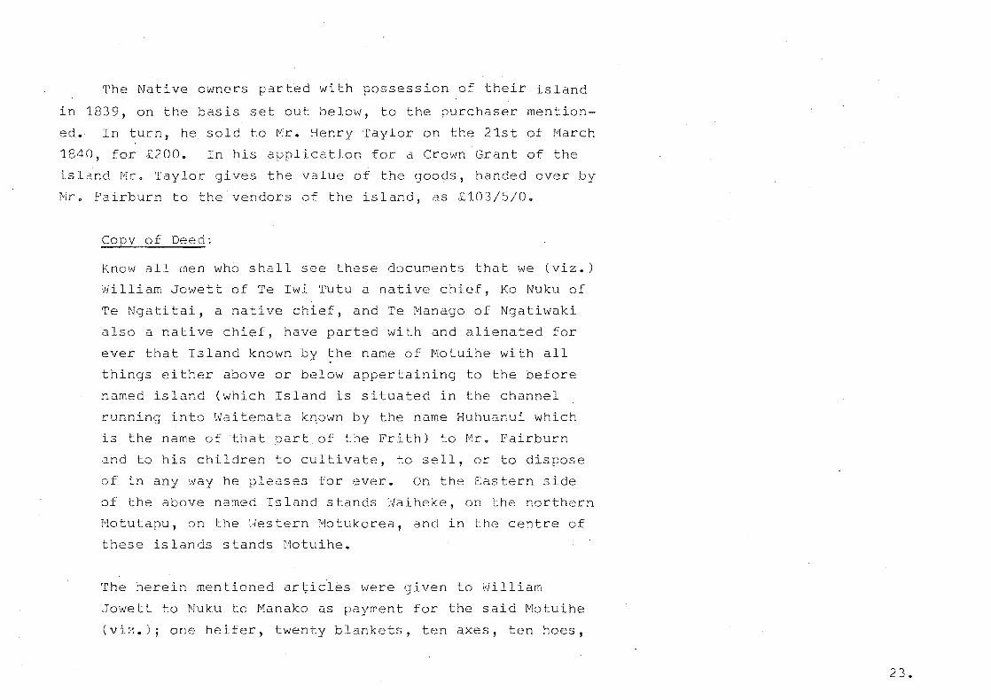
The Native owners parted with session of their island
in 1839, on the basis set out below, to the purchaser mention
ed. In turn, he sold to Mr. Henry Taylor on the 21st of March
1840, for £200~ In his application for a Crown Grant of the
island Mr. Taylor gives t value of the goods, handed over by
Mr. Fairburn to the vendors of the island, as £103/5/0.
CoPy of Deed:
Know all men wh6 shall see these documents that we (viz.)
William Jowett of Te Iwi Tutu a native chief, Ko Nuku of
Te Nga tai, a native chief, and Te Manago of Ngatiwaki
also a native chief, have parted with and alienated for
ever that Island known by the name of Motuihe with all
things either above or below appertaining to the before
named land (which Island is situated in the channel
running into Waitemata kDown by the name Huhuanui which
is the name of that part of the th) to Mr. Fairburn
and to his children to cultivate, to sell, or to pose
of in any way he pleases for ever. On the Sastern side
of the above named Island stands Waiheke, on the northern
Motutapu, on the ;Jestern Motukorea, and in the centre of
these islands stands Motuihe.
The herein men oned artici~s were given to William
~owett to Nuku to Manako as payment for the said Motuihe
(viz.); one heifer, twenty blankets, ten axes, ten hoes,
23.
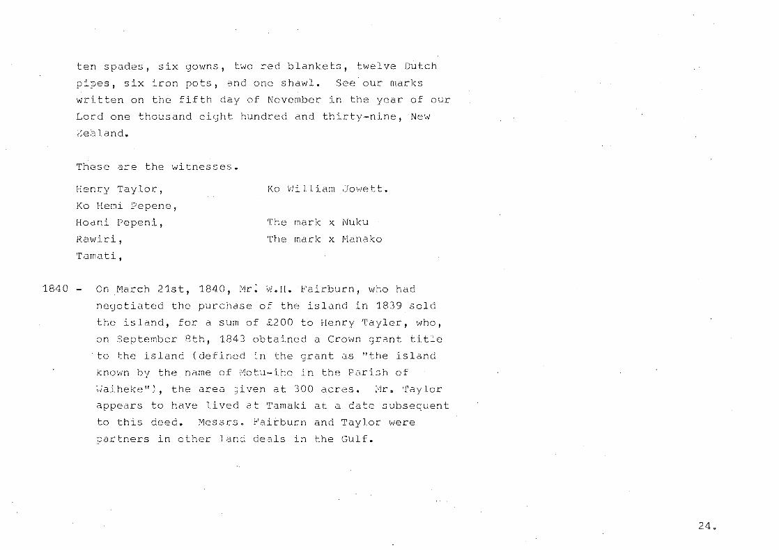
ten spades, s gowns, two red blankets, twelve Dutch
pipes, six n pots, and one shawl. See our marks
written on the fifth day of November in the year of our
Lord one thousand eight hundred and thirty-nine, New
Zealand.
These are the witnesses.
Henry lor,
Ko Hemi Pepene,
Hoani Pepeni,
Rawiri,
'rama ti,
Ko William Jowett.
The mark x Nuku
The mark x Manako
1840 - On March 21st, 1840, Mr: W.H. Fairburn, who had
negotiated the purchase of the island in 1839 sold
the island, for a sum of £200 to Henry Tayler, who,
on September 8th, 1843 obt ned a Crown grant tIe
·to the island (defined in the grant as lithe island
known by the name of Motu-ihe in the PariBh of
~iaihekel!), the area iven at 300 acres. [VIr. Taylor
appears to have I d at Tamaki at a date subsequent
to this deed. Messrs. rburn and Taylor were
partners in other land deals in the Gulf.
24.
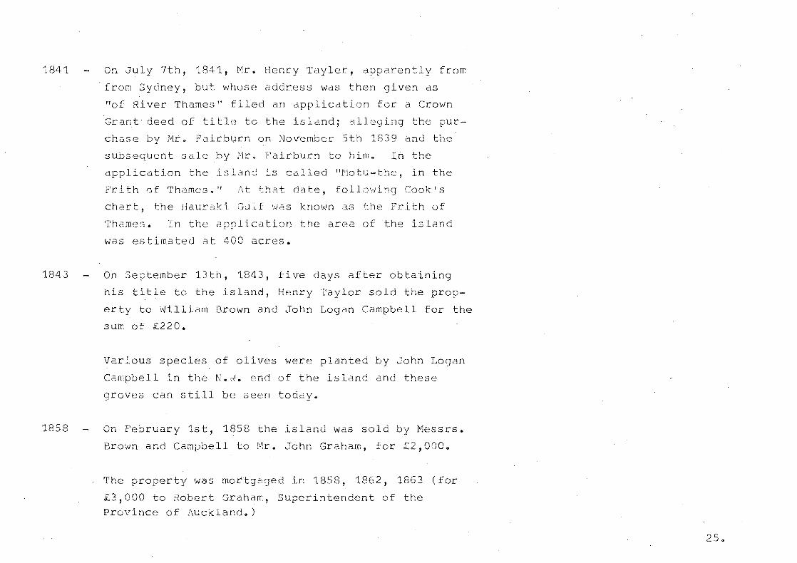
1841
1843
1858
On July 7th, 1841, Mr. Henry Tayler, apparently from
from Sydney, but whose address was then given as
"of River Thames" filed an applicat n for a Crown
Grant- deed of title to the island; alleging the pur
chase by Mr. Fairburn on November 5th 1839 and the
subsequent sale by Mr. Fairburn to him. In the
appl ica tion the is land is called 11]\'10 tu- the, in the
Frith of Thames." f\t that date, foll()'~Ji::'1g Cook's
chart, the Hauraki Gulf was known as the Frith of
Thames. In the application the area of the island
was estimated at 400 acres.
On September 13th, 1843, five days after obtaini
his title to the island, Henry Taylor sold the prop
erty to William Brown and John Logan Campbell for the
sum of 20.
Various s ies of olives were planted John Logan
Campbell in the N • • J. end of the island and these
groves can still be seen today.
On February 1st, 1858 the island was sold by Messrs.
Brown and Campbell to r-1r. John Graham, for £2,0000
The property was mottgaged in 1858, 1862, 1863
£3,000 to Robert Graham, Superintendent of the Province of Auckland.)
25 ..

-,ri2':'}
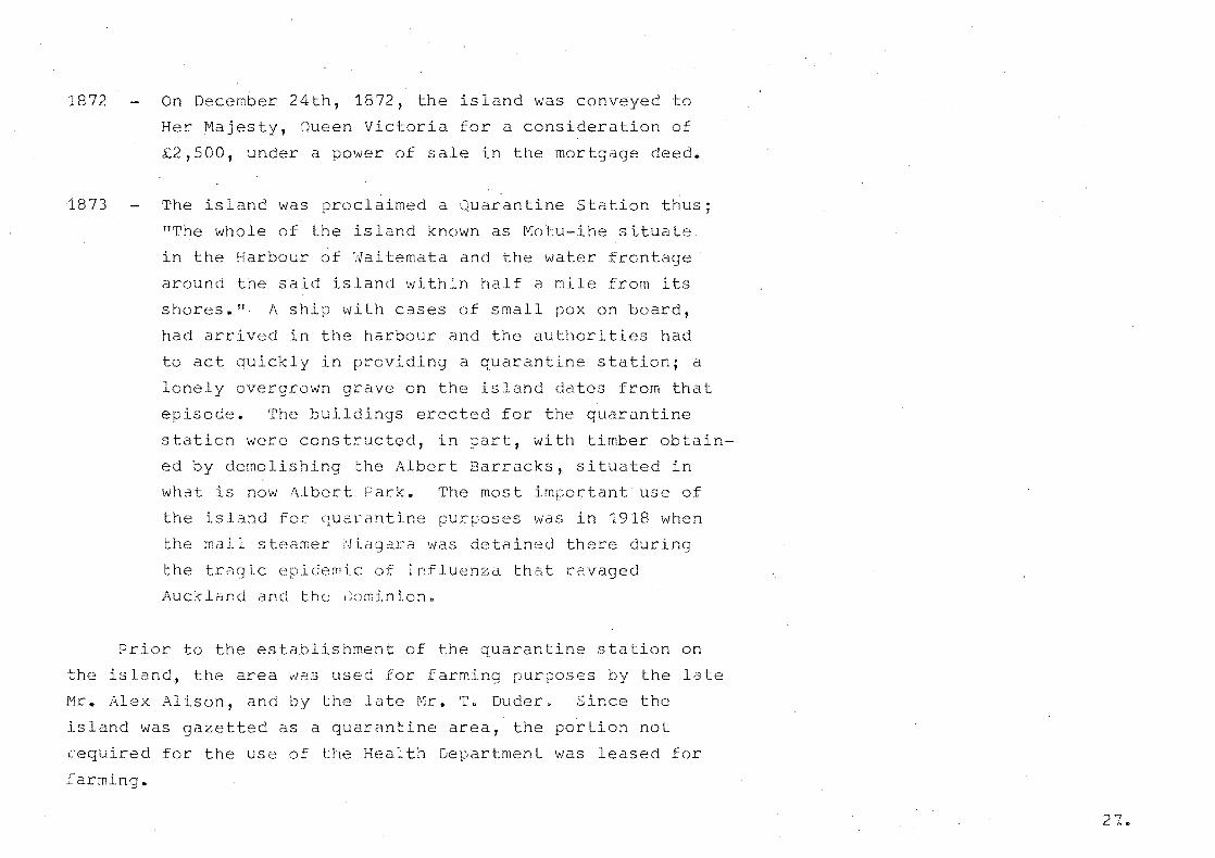
1872
1873
On December 24th, 1872, the island was conveyed to
Her Majesty, Oueen Victoria for a consideration of
£2,500, under a power of sale in the mortg deed.
The island was claimed a Quarantine station thus;
liThe whole of the island known as Motu-ihe situate
in the Harbour of ~aitemata and the water frontage
around the said island within half a mile from its
shores. II. A ship with cases of small pox on board,
had arrived in the harbour and the authorities had
to act quickly in providing a quarantine station; a
lonely overgrown ave on the island dates from that
episode. The buildings erected for the quarantine
station were construc d, in part, with timber obtain-
ed by demolishing Albert Barracks, situated in
what is now Albert Park. The most important use of
the island for arantine pur~oses was in 1918 when
the mail steamer Niagara was detained there during
the tragic idemic of influenza that ravaged
Auckland and the ~ominion.
Prior to the establishment of the quarantine station on
the island, the area was used for farming pur ses by the late
Mr. Alex Alison, and by the late Mr. T. Duder. Since the
island was gazetted as a quarantine area, the par on not
cequ d for the use of the Health Department was leased
farming.
27..

In the early seventies, when a portion of the island was
still bush covered, a number of deer had a hODe. there; who
f t brought them to the island is not known now. In dry
summers Ehere is not any water the springs on the island,
water having to be pumped for the stock; and it appened that
one very dry year during the occupancy of the island by Mra
Thos. Guder, the deer, frightened to come near the homestead
for water, perished with the except n of one small doe, which
was rescued and became a great ~et, being brought to Devonport
at a later date.
1914 In 1914 the quarantine station was utilised for the
accommodation of some of the pr oners of war who
fell to the hands of-New Zealand military forces
when Samoa surrendered. Later, the famous Count
Felix Von Luckner and his boat's crew were imprisoned
on the island. The Count made a sensational attempt
at escape on December 13th, 1917, reaching the
Kermedecs before h recapture. A second escape was
planned but the war ended.
(In the gully in the South side of the island there is the
remains of a dugout measuring 9ft. by 10ft. by 8ft. Count von
Luckner, in a second attempt at escape, planned and directed
construction of this dugbut, which was timbered up, fitted
with bunks and equipped with stores to last 5 men for at least
six weeks. The plan was for the prisoners to vanish by hi ng
in this dugout, and to remain hidden for some weekso 1.oJhen the
hue and cry had subsided somewhat they would then attempt to
seize a boat and sail away. The plan was on the point of being
carried out v..;hen news of the armistice arr d. )
Subsequently a number of New Zealand residents of German
and Austrian nationality were interned there.
1918
1929
-1930
fluenze epidemic swept the country and a small
line of seaman's graves to. the north dates from this
time.
About 1929 the Community Sunshine Association was
permitted to use the QUarantine Station for the
establishment of children's health camps; this organ
isation, with others, cared for a large number of
children who were huiriedly evacuated from Napier after
the severe earthquake in 1931 and sent to Motuihi.
Legislation was enacted declaring that a portion of
the island (410 acres) not required for quaran ne
purposes should be set aside for recreation purposes
under the provisions o~ the Public Reserves, Domains
and National Parks Act, and the Auckland ty Council
was cons ti tuted thei'iotuihi Is land Domain Board. fI
?O ~-'.
1939
1963
1967
At the outbreak of World War II the quarantine sta on
was ccmmissioned as H.fvIoN.Z.S. "Tamaki" to tr n some
,600 ratings per yeJr. It continued in peacetime to
be used for basic training in seamanship, fitness and
discir.;line.
H. [1 0 N. :.::. S. "Tamaki f! 'das moved to the Nor th Shore and
the base reverted to Domain Board control. The larger
portion of the IsIJnti was farmed and maintained by
sheep and fat cattle by farm manager Darryl Cotter on
behalf of the Auckland City Council.
The Hauraki Gulf Maritime park was established and the
Auckland City Council handed over Motuihe Island to be
part of the new Park.
It is now farmed and maintained on behalf of the
Hauraki Gulf Maritime Park Board by the Lands and Survey
Block development under the management of Bert Screen.
A full time ranger, m Paul, is respons le for
recreation activit and publ relations. Also full-
time resident on the islanc a couple r"lr. & ~I)rs. H.
Morton who manage the canteen.
30.

ARCHAEOLOGY
Motuihe Island exhibits a number of historical si
however only one of these' Motuihe Pat (See Map) is of
major archaeological importanceo
site is located on Pa Foint, an excellent view and
van point and exhibits a well defined trench enclosing
a large area, some very 1
inner tch and bank~
The site as classified
pits, flattened areas, and an
the ins tion officers falls
into Classification 'A', that is, "Sites essential for
protec on." It is in reasonable condition, but has suffered
some stock damage and also a farm access track crosses an
outer trench. A farm fence bis€cts the site.
Although the site is tially protec d, accor ng to
the ins ction officers report it requires proper management
and should be recognised in the Management plan or the sland.
The added tection could take the form of additional fencing
coupled with control of the scattered gorse. Paspalum is also
a problem on the outer ungrazed portion of the site. Pur i
trees have been planted out in this portion of the site and
apparently if left could destroy arch3.e:>logical features such
as s tor pi ts.
> I
\ .
MOTUIHE ISLAND PAPK
Archaeology S ites
Dt~TINLI
I,N4-.l ! Is"
/ .....J \
NgE.1::). ra &"~1o(.1Lb 0. )0,1
CrA.oI..I ...... b. , I c;.l.
./
i
)
!
/ I I I
I
!
o 5 --o
PI\-
Prls.
N4-1. J 1-4-5 AIlJ::.f+AE..Q La:; 'I NUMe..£.R .
-- 2 5 C' r, -I dl .... --sqo M I?"'-"'s
~ robably the most ap?ropriate ~etho t of p rotecting this
site would be tc remeve ~he existin] fence 2nd re~loce this
fence immediately sout h of the si te with both
gate an~ s~yle access. The site co~ld then be mdintaincd by
con crol grazing using sheep o~ly. Grazing could extend ~s
close 1·· ,L-U
renci.r,,; .
, hD , .• 1. • ...,.._
_, r;.-
:':lS by th ~: tlS e -s f elE"~ c :..ric
;. l; _' ''': 0
,~.r'" 11:::'- " .. ~. ,
~~~~~~:~~:-c .~~:.. t ~~~""._.~ :~ •• ~
33.

EnvirDn~
Fact r n al
CLIMATE
Motuihe Island exper nces a climate typical of that
found in the Auckland Regiono
Temperatures are not a major limiting fac r in the
choice of plant species, the mean ratures being in the 1q - ?_O oC range d J 1 F b 1 • Id . _ ~ aroun anuary anu e ruary, ana ml In
winter 1n the 9 - 11°C. ange around July and ust. This
is Iso reinforced by the fact that ground and screen frosts
are unknown on the island due to the marine influence. How-
ever in spite of this reasonably non-limiti factor plant
spec choice does tend to be I ted more to those of a salt
tolerant nature, this being especially so in close proximity
to the sea and exemplified by the profusion of Pohutukawa
(Meterosideros excelsa) growing'out over the cliffs and
beaches.
Relat humidity of the area is high, ranging from 85%
in July to 72% in December.
Motuihe Island received approximately 970.00 m.mo of
r all last year (1973) and although this was :n aty~ically dry
ar for Auckland (approximately 1000 m.m. in 1973) which
usually receives a mean annual rainfall of 1270 m.m., this
shows that the Island receives slightly less rai all than the
mainland.
34.


Although this seems more than sufficient r nfall for
plant growth it does not preclude the necessity of watering new
plantings as summer r nfall is often low, Auckland experienc
ing a winter maximum of approximately 400 m.m. mean in June,
July and Augusto Local records show that January and February
(1974) received 25.4 m.m. of r n, indicating the necessity of
watering for at least the first two years in the establishment
of any new planting. The occurence of sudden Its lIs" "dhich
catch picnicers unawares indicates a requirement for shelter.
Due to its olated nature Motuihe Island is afforded
litt protection from any larger land mass in res ct to the
influence of winds. The prevailing wind is from the south
westerly direction although the'strongest winds come from the
North North-easterly direction. It is interesting to note
that the most frequent and strongest occurrence of south-
wes ly winds coincide with £he period of peak recreati6nal
Use. Also the smallest percentage of calms coincides with
this od. (See vflnd i<oses in dix C.) fVluch of the
island, expecially the higher altitude areas are protected
by the high cliffs that surround much of the island, although
this also has the unfortunate result of creating a micro
climatic effect and wind funnel at the narrow and low isthmus.
When a wind is blowing from either direction, temperatures are
markedly cooler in this area 'as compared with higher areas to
the North West and bulk of the island in the East.
36.
The occurrence of winds has little effect on plant growth
other than the fact that these obviously are salt-laden and
only species tolerant of this. condition are likely to establish
well.
Relevant climatic data can be found in ndix C and
although the charts are not s fic to the area under study,
they are a record of the closest comparative figures avail le
and are thus included for the completeness of the record Q
37~

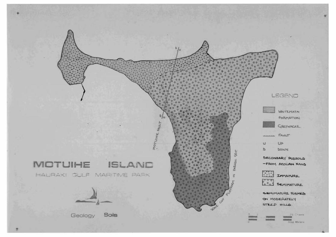
GEOLOGY AND SOILS
(~EOLOGY :
Motuihe Island is an irregularly shaped island, roughly
30 to 80 ch ns wide. It lies to the east of Rangitoto Island
near the entrance to waitemata Harbour. Apart from the isthmus
of sand which joins the small western portion to the main part
of the island, ~otuihe is composed of Tertiary rocks (W temata
~orrnation) overl ng sozoic
The temata Formation strata of obable Otaian age,
uncomfortably overl a high irregular, unweathered surface
cut in rocks of Mesozoic age. A tuffaceous sandstone within the
former is correlated within the Parnell Grit horizon. It contains
large blocks of Waitemata sandstone and mudstone.
The majority of dips are consi d to be the result of
compaction rather than tectonic movement.
Al though the land is 205 feet above mean sea level, except
for a grass-covered ra ed beach at a little more than 1.5 M
above mean sea-level, no terrace remnants exist. outcrops are
mainly confined to the coast.
38.
+
IHE LF
m -Geology Soils --
+
LEGEND
WIIITLM'-'Th
Fo~A-T1ON
- CtIl.E.'1W~.
~ac.oNDAR..'1 ~\.S
-FPD"" N'.DuAN "SANt)
~ ~
<bRMIMhWR.E.. tO~
ON MObE..A.ATEJ... '1
s.~ ~1L.-L..6.
,' 5 - ''' '"'S - --- -. OU M""er"


SOILS:
rhe soils of Motuihe Island are Secondary Podzolic soils.
These are" formed from sediments relatively high in" sil a and
have usually developed under a forest cover '""here t,he rainfall
exceeds 1016 m.m. r annum." These soils have formed over a
longer period than have the primary podzolic soils and hence
the degree 0 weathering of their neral constituents is ~ore
closely related to the climatic condi ons of the various
districts in which they are formed.
These soils are derived either from aeolian sands or from
sedimentary rocks and are classif d according to the degree of
development reached under differEnt conditions of climate,
vegetation and parent rock - i.e. young, immature, semimature,
and mature. The soils of Motuihe Island are de~ived from
sedimentary rocks and only two stages of the classification
exist, viz: immature and semimature.
The immature soils (a ~aiotira clay loam) have been formed
under mixed forest in which mull-forming trees predominated.
They are characterized by brown to grey-brown aranular topsoils
and yellowish-brown, blocky or nutty subsoils with some
irregular prismatic structure es cially in the heavier soils.
The topsoils are for the most part so~ewhat lighter in texture
than the subsoils but the difference is not a marked one. The
soils are moderately acid in reaction and contain a moderate
supply of exchangeable bases. 41"

From 3ite observations the soils of the isl~nd do not
appear to be extremely Ii ting to plant growth. It is not
considered th3t fertilizer dpplic ions will be necessary for
p 12.n t :]rOvl th, t he is 12nd dIre receiving te aerial
lio','/ever ,30me forE1 of org c ITI2t '.:.er or I
ranLre could Loast esta~l'shnent of any han 13nted trees.
i::::) ~;ummer u;hts, and it must oe stressed that this form of
maintenanc is aspeci lly critical in the f~rmer years of
tr2e establls~ment. does,
a ~e[i1 l,·d til soakage in terms ·of S'2VJer
ver, indicate
This is especidlly
notice~ble at peak recreationai periods when ndtural so
is insuf cient and effluent overflow SC::2rges ,..;es t 3ay.
leD Is not lnsuc~cuntable, however it is important
the 3i f buildi n
oreer that correct anC _2 i~le measures can ~ taken to :rovi~c
42,
TOPOGRAPHY ANO ORAINAGE
Motuihe Island general is a pleasant undulating land
scape, the bulk of the island being a sUbstantial height above
sea-level and almost exclusively surrounded ty high steep
cliffs. As most of the farmland is located on this rolling
landscape, with grades in the medium slope Slope
stability under farming can is good, with only a few
potentially unstable slopes exis ng, mainly on the S.S. side
of the island.
Much of the visual character of the island is a result
of the topographical pattern, with good visu containment
emanating from vantage points lower areas to expansive
views both across the island and out over the Gulf from hi r
vantage points.
The dr pattern and topography are closely inter-
related, with the major surface water run-off being directed
into a few major drainage channels leadiGg to the sea, this
reinforcing the visual character resulting from <the topogr
ical pattern. Also directed surface run-off into the gullies
could partially account for the remnant patches of bush,
especially the taraire gulliGS in the S.E. During the higher
winter rainfall period, water does collect and I in these
larger gullies, this giving op tuclty for the planting of
water loving 5 cies and the creatioc of wildlife habitats.
43 ..

"" - ...
, _~ .c ..... ,-
-::. - ~-
me
VEGETATION
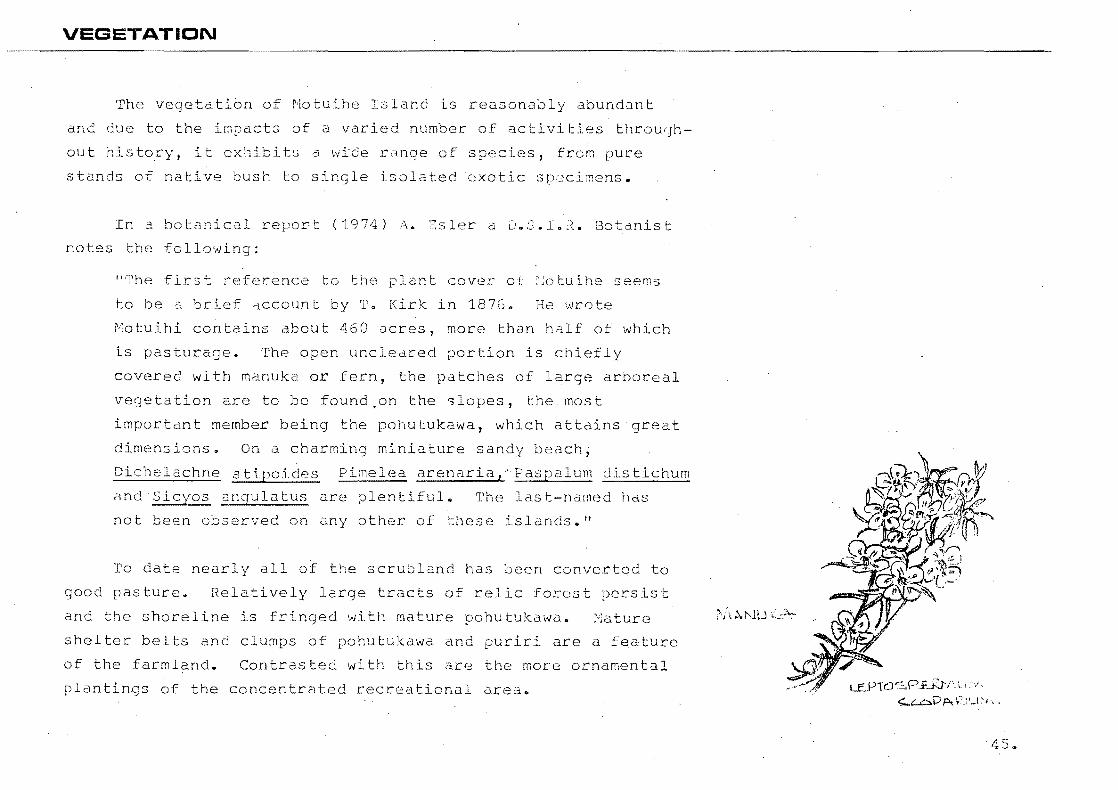
The vegetation of Motuihe Island is reasonably abundant
and due the impacts of a varied number of activities throu0h -
out histo~y, it exhibits a wide range of species, frem pure
stands of native bush to single isolated exotic s lmens.
In 3 botanical report (1974) A. 381er a D.S.I.~. Botanist
notes the following:
lIThe first reference to the j:'lant cover of lotuihe seems
to be a br f account by T. k in 187G. He wrote
Motuihi contains about 460 acres, more than half of which
is pasturage. The open uncleared portion is efly
covered with manuka or fern, the patches of large arboreal
vegetation are to be found,on the slopes, the. most
important member being the pohutukawa, which att ns at
dimensions. On a charming miniature sandy beach;
chelachne lea arenaria,·Paspalum distichum
and Slcyos angulatus are plentiful. The last-named has
not been observed on any other of these islands .. "
To date nearly all of the scrUbland has been conver d to
good pasture. Relatively 1 tracts of relic forest sist
and the shoreline is fringed with mature pohutukawa. Y;a ture
shelter belts and clumps of pohutukawa and puriri are a featUre
of the farmland.. Contrasted with this are the more ornamental
plantings of the concentrated recrea anal area .. LEYTc.JSFf.Rtl'. \. ;'i ';:"'-'--:.Dp.V.:\_\~" .
45 ..
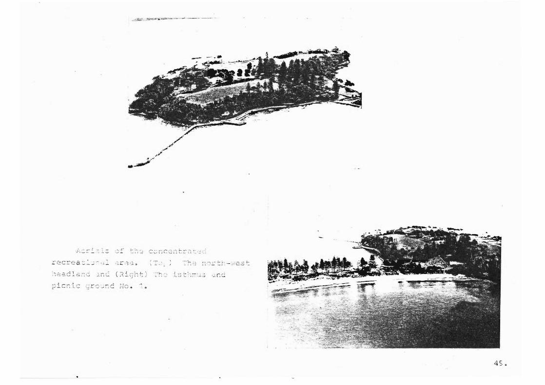
THE RECREATION AREA:
As the northwestern end of the island, including the
narrow isthmus, has been the site favoured by any concentrated
development activi es ·it is he~e that there can be found a
more varied type af vegetation in the form of aesthetic and
ornamental plantingso The ual character, re5ulting largely
frOin the of tatien present, is therefore very much
different to that the island as a whole.
Norfolk pine, b ng the most dominant specie, and well
suited to a marine environment, leaves a lasting visual
impression on the visitor. other prominent species in this
area include Maritime pine, Aleppo pine (many of which are
past their best ~ although still,functioning in a shading
capacity for picnicers) and macrocarpa.
An avenue of alternating Norfolk pine and pohutukawa
(stunted due to inhibited light) leads the north-western
headland where many additional and ed s ies are grow-
ing, probably planted during the navy's occupation of the
land. A subsidary avenue of puriri trees leads to a
series of spaces (formerly containing naval buil ngs)
del ated by ornamental plantings including s ies such
as Eugenia paniculata, pittosDorum sp, Quercus sp, Cuppressus
sp, and Eucalyptus sp. (See Site Survey Plan.)

.. 0 L:: -', ~ ',. -..J ...... .""\...

An olive grove, said to have been planted by Logan
Campbell in about the 1840's still exists today in this area.
A thick n~turally maintaining area of vegetation exists
on the northwestern headlands in the fenced-out rtions
surrounding the coastal cliffs. This cant ns both native
and exotic plantings, poh0tukdwa and maritime pine being the
dominant speci s. Much of the maritime pine within this belt
are })ecoming l.:'emnan ts, are II to Lng au t" and qe net' 11 y
ating in condition. They however add much to the
atmosphere of the area and often enclose and frame views
out dcr03S the harbour. This area should remain fenced out
and be petuated using native species only.
Patches of Rhamnus exist on the headland and will tend
to suppress regenerating na ve seedlings. Control of this
weed plant is difficult, however in some areas here it should
be cut and controlled until some form of natural control takes
over. Gorse also exists in small patches. It is probably
not necessary control it however, especially within fenced
out areas, as it acts as d good nurse crop for native seed~
lings and is ultimately naturally suppressed.
The condi on of trees the northwestern area range
from excellent to poor and itGmay be necessary to remove those
trees of little worth at the t of implementing new planting
proposals. (See Site Analysis Plan for more .de~ailed information)
48 ..
,...: .~'
-~."
't.-.
~ ........ ..... . . ~ . .... ,: • - • :~ I , _
i <~ i - :.. ........ . _ .. .J ..... . : · '; .3
.:... ~', -- ", '.:C:S~:
. ' r . r __ I .........
4So
It is important to note that the planting of ornamental
trees has extended in recent years, many of which are doing
well especially in fenced out por ons of the coastal fringe
whece they are being supported and protec d by existing
veget tion. However, some of these newer planti are not
establishing well, this being mainly due to lack of care and
maintenance. Motuihe Island owes much of its character today
to plantings by inhabi rs who saw the value and
necessity of care ahd attention as a precequ ito to the
successful establishment of healthy vegetat n. It is bas
ally the results of this that has determined the character of
the recreation area as it stands today.
THE f' ARt·1LAND:
Pasture occupys the greater part of the island presentLng
an open and 'clean' appearance. to the farmland.
"The pasture is of good qU2.1ity, the major component.s being
peronni I rye grass, Yorksh , white clover narrow-
leaved plantain and fiddle dock. Paspalumis dominant in a
few places. Dantho a, microlaena and anthium grow on the
coast in dry areas of a limited ~xtent. Indian doab, buffalo
grass, goose grass and some others occur nlynear the shore.
BarleY,grass is of some importance as a weed. In wetter places
rennyroyal is prominent.
50.
There are a number of weeds of some significance.
Variegated thistle grovls up to nearly 3m tall. Although
there are some la patches, it is not as wides8read as
slender wingedth tIe. ~inyed, Scotch and C21ifornian
thistle appears to be of less impartance.
le of Sodom is ve~y troublesome and is most plentiful
on those ts ~f the coast w have been fenced out.
Thece i,s little rse on the fa~m12nd but it is p entiful in
places where control not practicable. Inkweed persists
around trees on the farmland, particularly."
(I,. E:sler, 1974)
Where practicable large areas of thistle has been con
trolled by aerial spray using helicopters, but weed control in
isolated areas is often a diff It task. It is probably
better not to control gorse but rather let it act as a nurse
r seedlings which will le d to ultimate natural suppression.
::::lELT£::R:
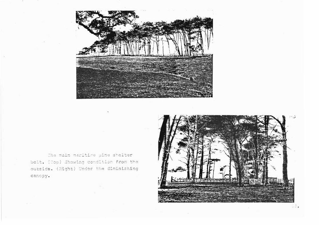
Many of the existing shelter belts on the farm area have
ceased to fulfill ir specified func ooal role, and although
they add to the ual quality of the farm thought should be
";iven to their lacement. The pr amme for replacement
would not be an immediate measure, but rather a phased
510

programme taking into account initial s Iter requirements and
the consequential removal of 'spent' shelter ther with a
poli for shelter lacement in the future as it becomes
necessary.
~ cies used to date on the island for this purpose have
been the common seec used nationally such as macrocarpa
and pines. As a replacement programme is necessary opportunity
exists for recommendation of suitable na ve species. A more
detailed discussion and recommendations for types of species
will follow in a later sectiona
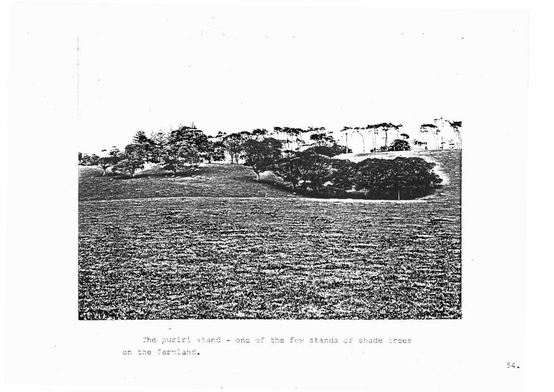
Included under this heading are those clumps of trees
offering shade to stock. Puriri and pohutukawa are distribut
ed around the farm and function in this capacity. However
most are mature and in some par have fallen, this being a
danger to stock. Therefore an.overall replacement policy is
necess Also additional shade giving planting is required
as at the moment stock are forced to usc the tar ire llies
and other forest ~rac~s 1n the west [or shade, , \.' "I •
Clll.S oe1ng
detrimental to the cant uea surviv 1 of these 2reas of bush,
due to trampling and grazing of undercanopy species and seed-
lings. PuQIR..\
. 52.
''':2 ._1': 0
' " r. fe' .3 t. 2. r: ci .s
:4 .
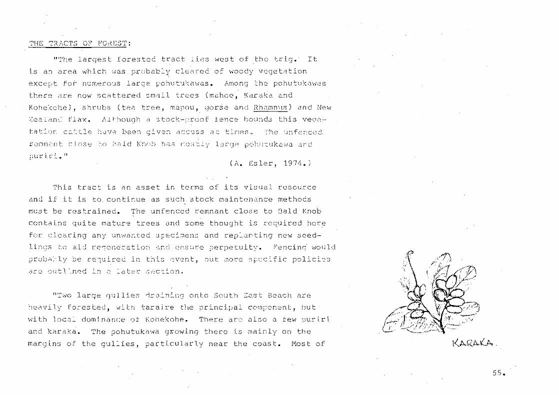
THE TRACTS OF FOrtEST:
"The largest forested tract lies west of the trig. It
is an area which was probably cleared of woo vege tion
except fot numero~s 1 e pohutukawas. Among the pohutu s
there Jre now scattered small trees (mahoe, Karaka and
Kohekohe), shrubs (tea tree, mapou, gorse and Rhamnus) and New
~ealand flax. Although d stock-proof fence bounds this veg2
tat ~ cattle have en ivan access at timeso ~he unfence~
rernnan t close ;-::0 aId Knob ha . .3 r:~os tly 1
puriri."
po1:u uk2 1tJa and
(A. Esler, 1974.)
This tract is an asset in terms of its visual resource
and if it to. con nue as such stock maintenance methods
must be restrained. The unfenced remnant close to Bald Knob
contains quite mature trees and some thought is required here
for clearing unwanted spec and lanting new seed-
lings tc d reqeneration anti nsure perpetuity. F'encinq would
prob,=;.;~ly be cequired in this "~vent, ';')ut ;:core;:; eific policies
dre outlLned :n lati::'c ,J etion.
"T'rlo large qUIl s 'ir n:-l10 onto South ::::ast Beach are
heavily forested, 'lIfit,h taraire the incipal component, hut
with local dominance of Kohekohe. There arc also a few puriri
and karaka. The pohutukawa growing there is mainly on the
ins of the gullies, particularly near the coast. Most of
55.
the tar have stems th diameters of 30 - 40 em. and
are apparently not old, probably having established last
century after a fireo
devoid of'vegetationo
The und beneath the trees is almost
This is caused in part by the trampling
and browsing by farm animals but it is common for dense stands
of tara elsewhere in N.Z. to have little undergrowth because
of the c-lose canopy and very heavy lit ter fall."
(A. ~sler, 19740)
These taraire stands are also a recreational asset, both
from the visual experience had when wing from higher areas
of rolling extremely dense crowns and the enclosed experience
had while walki beneath the dense canopy. As the stands arc
situated in extremely steep-sided gullies surface erosion and
subsequent root exposure has taken place due to stock browsing
and trampli ~herefore a stock proof fence will need to be
erected here in raer to preserve this asset.
THE CCASTAL FRINC~:
"The j:1ohutukill;Ja fri e has grossly 'DO fied, the
degree indicated by the number of its associated species which
have rsisted3 Normally pohutukawa would hdve these specIes
growing with it - Asteli~ banksii, karo, houpara, kawa~awa,
Gahnia lacera and Coprosma macrocarpa.
56.

;i .
--- - p. ~ .. -. .. ~ --"... ~ I -..,.....-f- .,,+ .
\ . - -. - .A
'I i e~,:.J
- ., '= I 0
In many places these arc absent, their place being taken
by grasses where azing animals have access and by Rhamnus
and gorse where t have been excluded. These two shrubs
have now occupied the open eroding sites where pohutukawa seed
lings would have es ablislled. Consequently, natural spread of
pohutukawa has almost ceased. The lar trees which are be-
coming undermined eroiion are not bei replaced naturally.
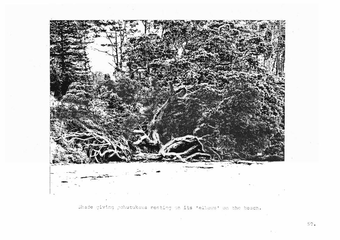
Some which have been dislodged are still rooted to the bank
while the tree sts on its 'el~ows' on the sandy beach.
There are some good exam~les of these on Ocean Beach. l!
(A. Ssler, 1974)
The coastal fringe presents a pleasant visual feature
both from the sea; with the rounded forms of pohutukawa giving
a soft undulati form to the coastline; rtnJ from the,land;
directing and fram g views out and across the harbour. The
vegetation also a fords physical protection to ~roding cliff
tops 3nd also aids in deflecting winds and sheltering stoCk.
It also functions in a shading cap ty for stock. It is the~e-
fore important to
this area. This
ensure the conservation of perpetuation of
require additional effort in terms of
physical maintenance to establish new plan s in order that
ultimately a naturally maintaining and nerating area of
bush is establ hed. This will ensure the suppression of gorse
clnd grass and will n te the necessity of givi stock acces to
these areas at lar intervals for maintenance purposes.
58~
i I I I-I
I" I
.---
its
r- n .j -" •

THE CLIFF FACES:
"The cliff faces are almost de d of tatipn because
erosion is too act to allovJ t ata, the New Zealand ice
plant an6 S 0 lautus to take root. ~;.,;,.....;;...;;;.;;;;..,;;.,
Consequently these
plants are very poorly represented in the island's flora. In
th~ limited areas where parnell grit outcrops on the cliffs
face is more convex and offers a potentidl foothold for
native plants but Rhamnus and Ale pine os tab 1 ::.s h
However it matters little what the vegeta on is because it
ntually slides off with the soil it is rooted in."
(A. Esler, 19740)
THE SANDY BEACHES:
liThe sa:1dy beaches have little of the natural cover
r~maining. ~here the beaches ~re backed by cliffs vegetation
has little chance to est~blish because the h st tides
reach to the base of the cliffs. south ~ast Beach has an
accumula n of sand cJ metre or two aeove the l~iCJh tide mark.
There is enough moving sand in orne places for spinnifex to
grow but it is not a thriving species~ The more stable sand
behind it is occupied by exotic annuals such as King Island
meliot, hawksbeard, harestail and Bromus cliandrus. At a
hi level there are the pe~2nnial grasses, cocksfoot,
rye grass, r tail, Indian doab, paspalum and buffalo grass,
60"
the latter growing down to the high tide mark in some places.
About the strand line sand convolvulus and orache are common
and there are a f~w plants of salsola. It is n~t unusual to
find tomato se~dlings here, also pumpkins and some other
cucurbits. Seeds are carried by the sea but are 3eldom washed
ashore high enough for them to survive beyond the seedling
stage.
( ,\. ~~ s l c r, 1 9 74. )
A list of the flora of Motuihe Island appears in Appendix D.
61,.
FAUNA
"'iii 1 dlife is an integ.t'al part of the cons tan t in play
between the many forces of the environment, and both the
comne tion and co-operation of animals and plants contribute
to ing equilibrium".
I, ~ l=e,
( R • Ar viII, 1 969 )
lant life, the prinary sou.t'ee of food for dll animal
is itself modified by the activity of anima s. The
variety and abundance of wildlife species is often a reflect
ion of the nature of the ve tation, this being modi ed by
the presence or absence of natural predators and by the degree
of interference by man.
The importance of wildlife as an item in this inventory
a twofold one. stly, the Landsca Architect Can con-
sciously create s table habitats by providing conditions
favourable to certain s cies, and he can also serve exist-
i habitats, in both capacit s aiding conservation. The
converse is also true and the ~andscape Architect should be
aware of any detrimental effects a design may have as lithe
exter~ination of animal and plant 3 ies may start a chain
reaction of '",hose long-term effects ~ve are ignorant lt•
( B. Co 1 vi n, . 1970).
62 ..
Motui ~sland supports a variety of wildlife species
although many exis ng on the mainlan~ are absent. Develop
ment proposals and future management policies should not inter
fere with' those existing but preferably provi for increasing
populations, es ially native birds such as pukeko, fantail
and tui. Wetter areas could support suitable plant species,
and farmland larger berrying trees providing homes and sub
sistence for wildlife. Mature pohutukawa overhanging shoreline
areas support sea-birds such as shag and suitable nesting
sites should be preserved and thought given to replacement
and support planting to attract nesting and provide protect
ion to suitable b d species as well as adding to the visual
character of the shoreline.
Secondly unawareness on the part of the Landscape Architect
can crea over-simplified habitats, resulting in favourable
conditions to unwanted species which ultimately become a pest
and a nuisance. In conjunction with this the Lan cape
Architect should be able to assess damage to eiisting vegetation
and resulting indirect consequences of this damage to other
facets of the environment such as loss of soil stability.
Rabbits exist in large quantit s on the island but it is
difficult to es rna direct vegetation damage or if they are
a threat to the vegetation of the island. Luckily no oppossum
exist on the island.
63.

,;ildcClts present 2. ;-.r::;blem, their existence ,-~tt;:-ib'-1ted to
unwanted pets a b andone d on the isJand. These -;r e sent a s pecial
t h reat to gro~nd nesting birds such as the white -fronted tern
~nd to c~he~ h ir d life s pecies .
:s13nc lS
\. .... ~ .
MARINE ECOLOGY
Owing to the island nature of this site a mention here
made of the marine biology for completeness of the inventory.
The marine biology of the Motuihe Island shoreline is
both abundant and diverse and a complete recording here is
beyond the scope of this treatise. Ag n, the Landscape
Architect must be aware of the impact of any development pro
posals on this resource.
~he main likely impact on marine resources in relation
to recreation would be in depletion of shellfish populations
under this form of exploitation but any conclusions as to the
effect of this on shellfish populations could only be the
result of an independent in depth study. In reI on to this
point it has been observed that it is in fact "dangerQus" to
collect shellf h from ~est Bay at peak recreation periods
as raw sewer overflow empties into this area due to:in
adequate ph ieal facilities.
A coverag of the likely COdsta bioloqy type to be
found on Motuihe Island is in Appendix Fo
65.
Si e p r isal
INTI=IODUCTION
Following on from th2 detailed natural factors inventory
is th site a~ ai5al. This a~sessment is undertaken order
to grasp the trinsic nature of the site and Uive a basic
appreciation of the overall existing characterw
The site ~ppratsal ;riD2rily takes the .cmof a visual
record. ~ rental picture of ~he spatial form of the site,
~,~-:: the S Ci.ces c.r: d t l: e i r ceLl t
another is esse~tial for reference duri the design process.
An ~eciation of this a"lows outstanding views to be pre-
served cnd focal points and positive visual features to
be enhanced and emphasised. .·.n analysis of the lerrelation-
ships of the natural factors togethec with the visual scene
allows the designer to consciously produce the overall visual
framework within which richness, variety of interest and
stimUlation can be achieved.
Incl d within the site appraisal Chapter is a survey
of the physical ele~ent3 existing GO tne site as these are
quite often a do ant visu~l 2lement in the scene being
viev··led.
66.
For completeness of the record a shoreline survey has
been included. Because of the island nature of the site, the
shoreline plays a large part in the v ual ression of
overall $ite. It also the shoreline which becomes the
dominant use area for recrect I activity. It there-
fore importar.t to assess t existing character of these areas
in order to become fully aware of the conse
crea tion'11 impac t on theEl.
l1CCS of re~
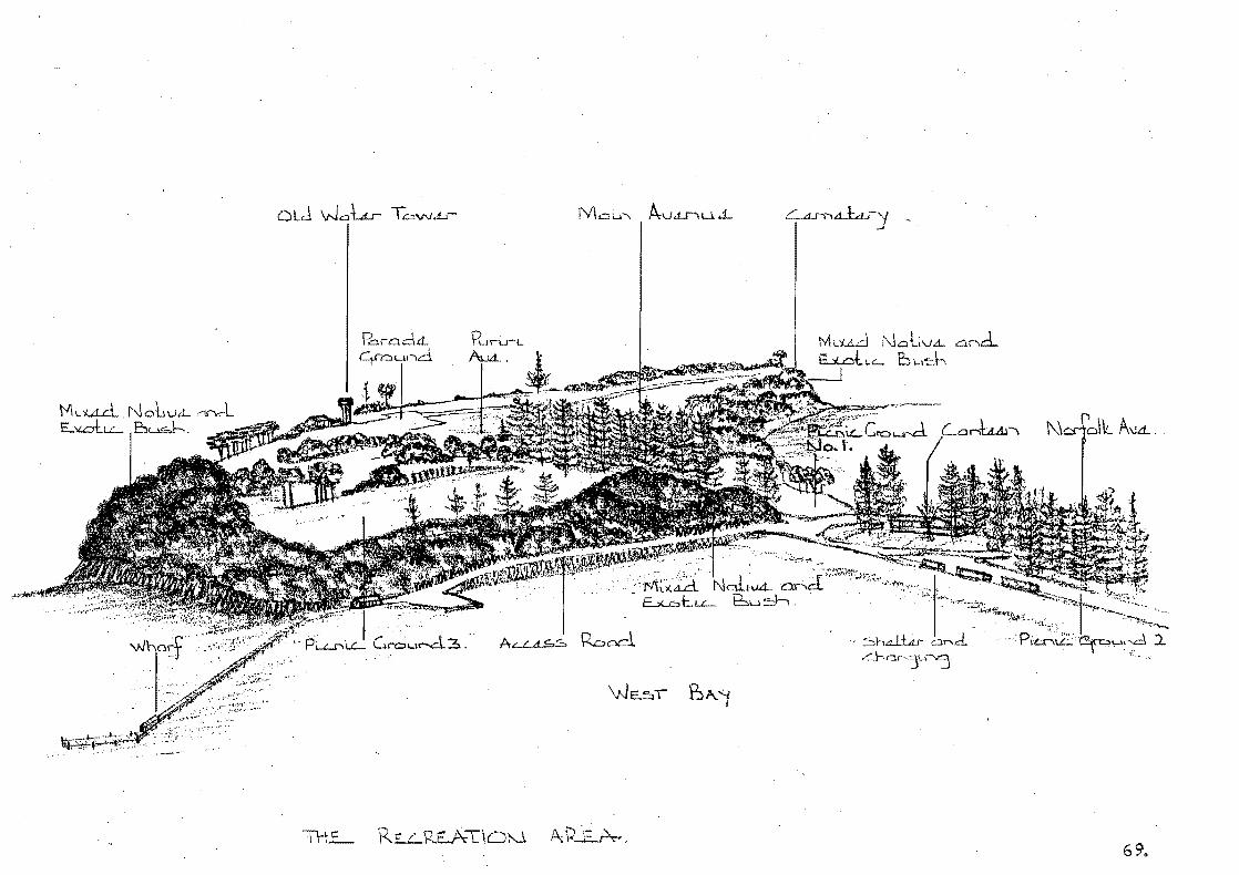
VISUAL SURVEY
To facilitate an overall ation of the visual
character of r';otui.he Isli:F,d the apPLoach to th<2 follolt/i
surveyh~s bee~ to
lets th,,,: broae
ide series of illustrations that
:::.t the observer .n~cei'Jes, and at
sa~e ti~e provides Q coverage of the eh and d
detail d visua~ stimuldtion ex~er need durl s e~;uen tial
out tr si te ~
It is im rta'll thdt fall PC] information L:::: j:020 in
conju~ction with the Analysis drawirgs (Plans 2 ~~d 4)
which aLe an inter~reta on of this survey into a useable
form whereby site re-development pcoposals can reflect and
enhance this exist visual actero
68.
P.::::lrn.::::lcL Rln.rL c;'n::::,u,-,d
"""":'-~."':'''1
tvkud t'\J Cl L V.d.. Cl. r'\d. E...:LoLL t:n .. ld"\
~- _.- ' ' ~ . ""';Z"~~tt: .• ~
E...:,u:::, t.. '-'- bu ~ ~" "" ,""'""--, """'~;Jt~ ~
.. ~·'·'i-.L,
.. ""'~XA.d.. NaLvA- c,..,.,d '--'-.. ,"'!'.> ,·"'t
R.oocl shd-Lu- Cl.-.d. . Pi~~ .. ·"""'---.• ,'-v-\
L:.ha·"-'3L1~
69.

View back to wharf from immediately below
View from wharf on approach to recreation
area.
- ~uch of scene is revealed immediately on (eog. canteen, toilets, changing
sheds, and picnic ground 2.)
- However, there is a sense of
a~ticipation as to what lies to the
t i3'£Dund corner, and beyond the
narrow sandy thmus.
- Good sense of enclosure given by vegetated
cliff on left directing views out to the right
over West Bay and the southern end of island.
- The vertical accent of Norfolk pines
contrasts with softer flowing shapes of na
vegetation on the bulk southern shoreline.
I
(' / I
70.
\/ie"';s -,.ToC" ~ • J <: .. :) l .
vi::;. :..: ~, 11 Y •
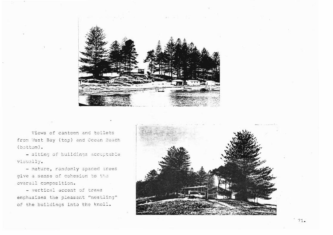
of canteen and toilets
Bay (top) and CC2cin 2e2 c~
CJ i '1 e 0. sen s::; 0:: C c; he s i 8 n ': 0 L ~"
ov2~211 composi t i o n.
- vertical accent of crees
of the bu il d ings into the kno ll.
71.
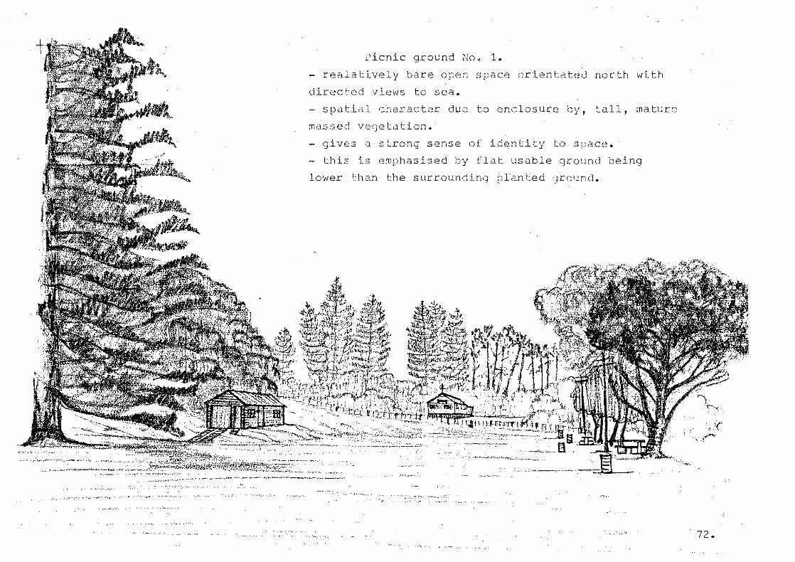
Picnic ground No.1.
- realatively b~re open space orientated north with
directed vie~s to sea.
- spatial character due to enclosure by, tall, mature
massed etation.
gives a strong sense of identity to space.
this is e~phasised by flat usable ground being
lower than the surrounding plan d ground.
. ,," 72 •
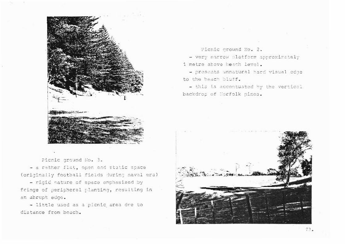
(originally football
; 7"". -- ;. ~
, l-dnrup,- ecC] c: •
di s ': 2.nce f rop.t 1::0. 2.C h 0
.- ' .... ( . ~

ave;-;ue ." ..... ~ :~~-""~'-':"' . - a ~lcas2~t shaded a rea beneath the
-:... .
close c ano py o f Loga n Campbel l' s olive
grove.
p12nting of ~orfolk ~i~e ard ~Ghutu~0~d
(s~unted due to shadi~g) . , lC it :::; effect in
tends to be ~irect iona l
- importance o f o rigi nal ~estination less ri Gidly definin g th a n ~ revi ous
nm·/ his tcric3.1 0
cxa:nr:: 1e. '7 '
I I. ," 0
':he
." ... T/'P' S
., r L ~
:-:c· ;-:
flc.t
cliff-too location .
Gcs ~ i~e the ccndl ti~~ of remnant
a rea a nd dllow fi ltered views ou t ac~ass
h·arbouc 0
75.

IJ :: i ~ .. ' ,.. ,
~-,-.,::, ..:.. L :
t-.h is i ~ ~,. r~ooc
2 ittos pocu~ te~ ufo]. ium, ?odocac~u~ tctecR , ~ert v~ -i~c 10 Cii , _'. 1.....l (::: .c c us ,
·:J. nd ·::.nd
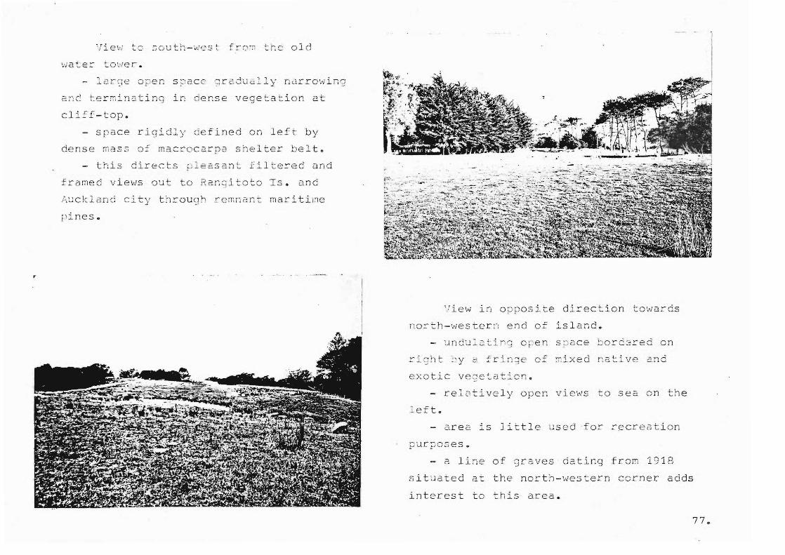
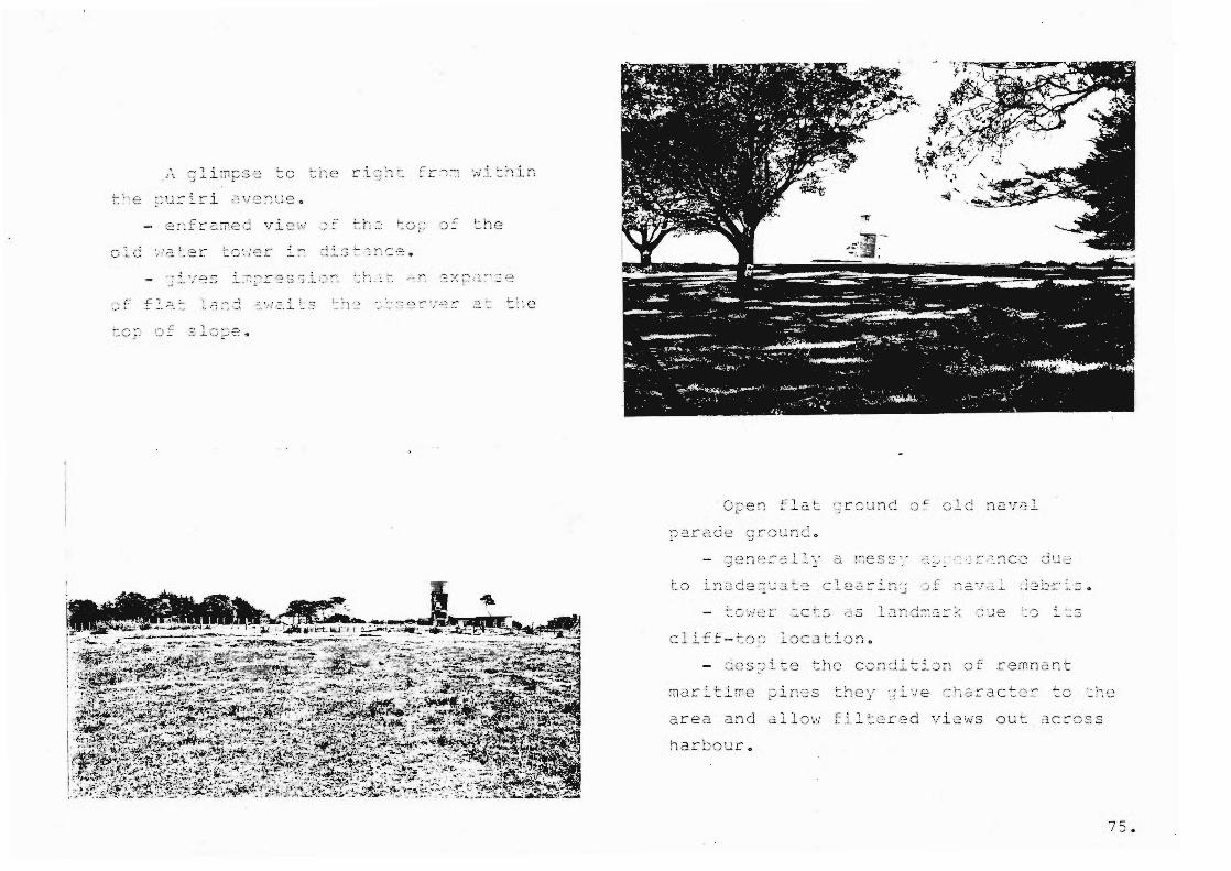
Vie~ ~c s ou t h -wes ~ f~ o~ the o ld
\:i ate r~ ~()\;Je r •
- large open spac e 2 radu 21 1 y n2rro win g
a ~~ te r~ inating in dense v e g etati o n at
cliff-top .
- s pace ri g idly de fined on left by
dens e mass o f macr o car pa s helter b e lt.
- thi s c irec t s~; 1 e b'.3 an t f iltered und
f ramed views out t o Ran ~ itoto Is. a nd
t h rouCJh .::' err, n cl n t • .j... • ma rlL-line
pines.
View in o ppo s ite dir e ction to wards
nort h -western e nd of island.
- undu l~ tin J o ~en s~ ace bo r d 2red on
e xotic v e a elaticn .
- rel o tively o p en views t o sea on t h e
le ft.
- a re a is little use d f o r recreat i o n
p urposes.
- 2 line of g raves dating fro m 1918
sit uat e d at the north-we s t ern corner adds
intere st t o this area.

h\Al'uk'L. fLRli21
s .. IA DE... "-""t.6 N\A(.:.1 TllY\ E..
5i-\ELTf:,R
N\AJI'\.\ NA'ilUE..
\:)\,.,\':::,\--\ 'nz,~
fAU,)
I I
/ ....
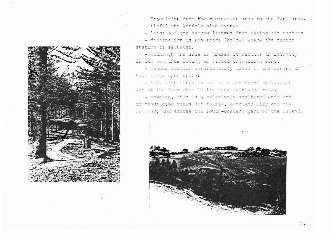
... . '
Transit i o n fr om the r ecreation ar ea to the far m a rea.
(le f t ) the No r f o l k pi ne avenue
- - - ... ,," " ~! 1,.-. • • _ _ • • ' __ 0" ' -4 "..:' : , , ;rc~ zcc
d C ~. l ~-, .~ ,,; ,=} S
to
a cro s s sou th -e~s te= ~ ~a rt
r- , . -, ~ -,- .-, '-- ' ...... . -..:.... '-. .
, .:..... • ....>
. , l .; _.d ;1C ..
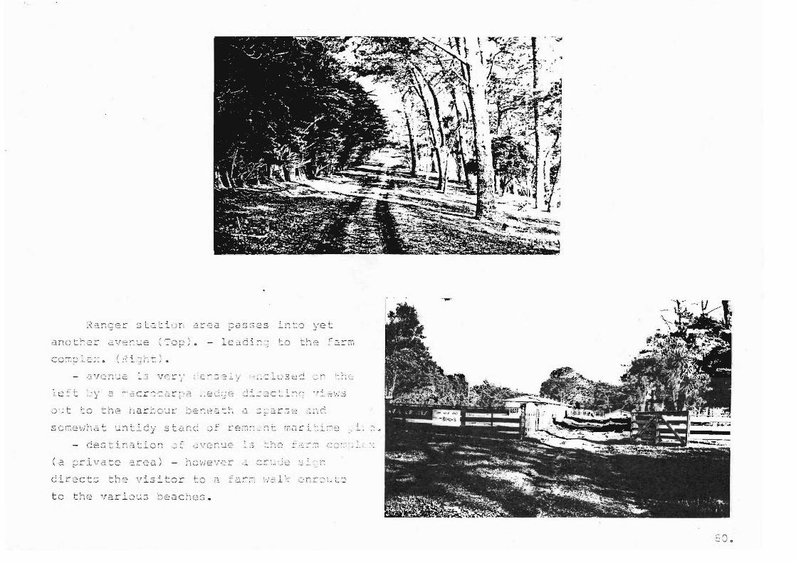
( a
c:'ir 2ct:;
to
11 ""'" ; . ~ ~, • ....... ~ lL.. -V..i
.'.~ "': - . ·~i r~ """",,!,~' ..... - - .~.~ , ~ - '
:.... ~ )
,- -. y'"'~
J... C!._ , ;
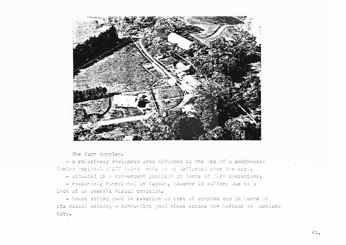
( . . ~ ,.-..-.
J.a y ou ~~,
c": .. , . cc·hes .:'c r:.
its vi sus l se tt i~g
City.
81.
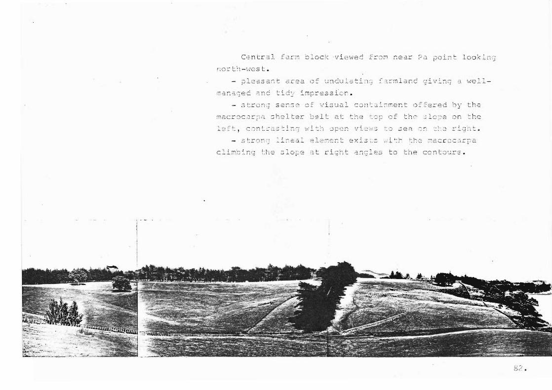
Ce ntr a l t2 r m bl oc k v i ewe d f r ~ n near ?2 ~oi~ ~ l o okI nG
c:. .c e a ~~J n cu . ~ ~ t i "-, ,",
. , -,f l S \,1 cJ. ~. the
:C :=: (J f
. ( ".\ ' . -' . , ,_ L. _.., ... . ~ ... .. :- .l
..... ' >- ' ~ , ~ '- 0

~r c c:s
of :: 2 ..:.. _i.. ' " Co
_, ,~ u
, """'\ . .'- .. -~ . • • l
2'. e -i. _ '.1 n CL b ~. C':
~ ,-,' .:.,
- - , r /~ r ' .. ---. ~ .... ....;
i. ,.',
.- ":r-o: " - ., -, _ J.. _
O ?
1 ,-I I ,
'.' -J •
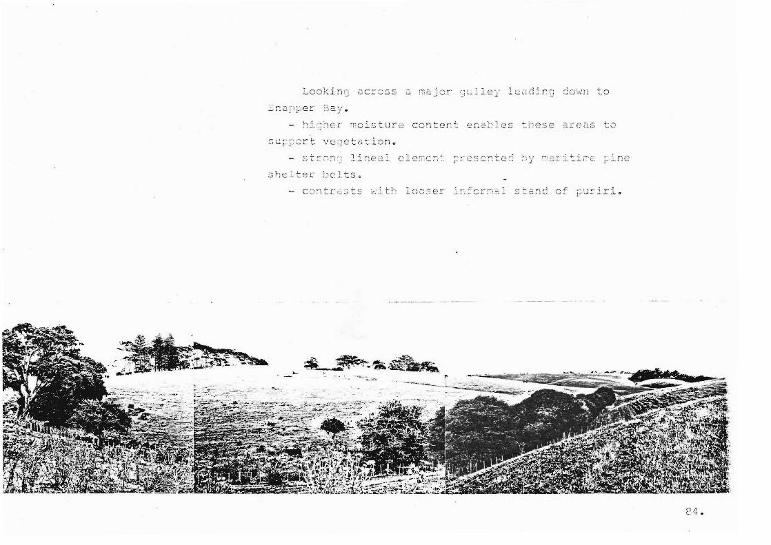
~i ~ ~ er ~oistur e content ena~les ~hese are2S to
c :>nt r~::. sts
~ ... ~
~ .~- :i.i..~ . ... i~ ~ -.~ , ~~
-- ... -- :. .. ~ ...
........ ~ 1 y-'; Y'" i 1-........... - -- ..... -"- 0
,..
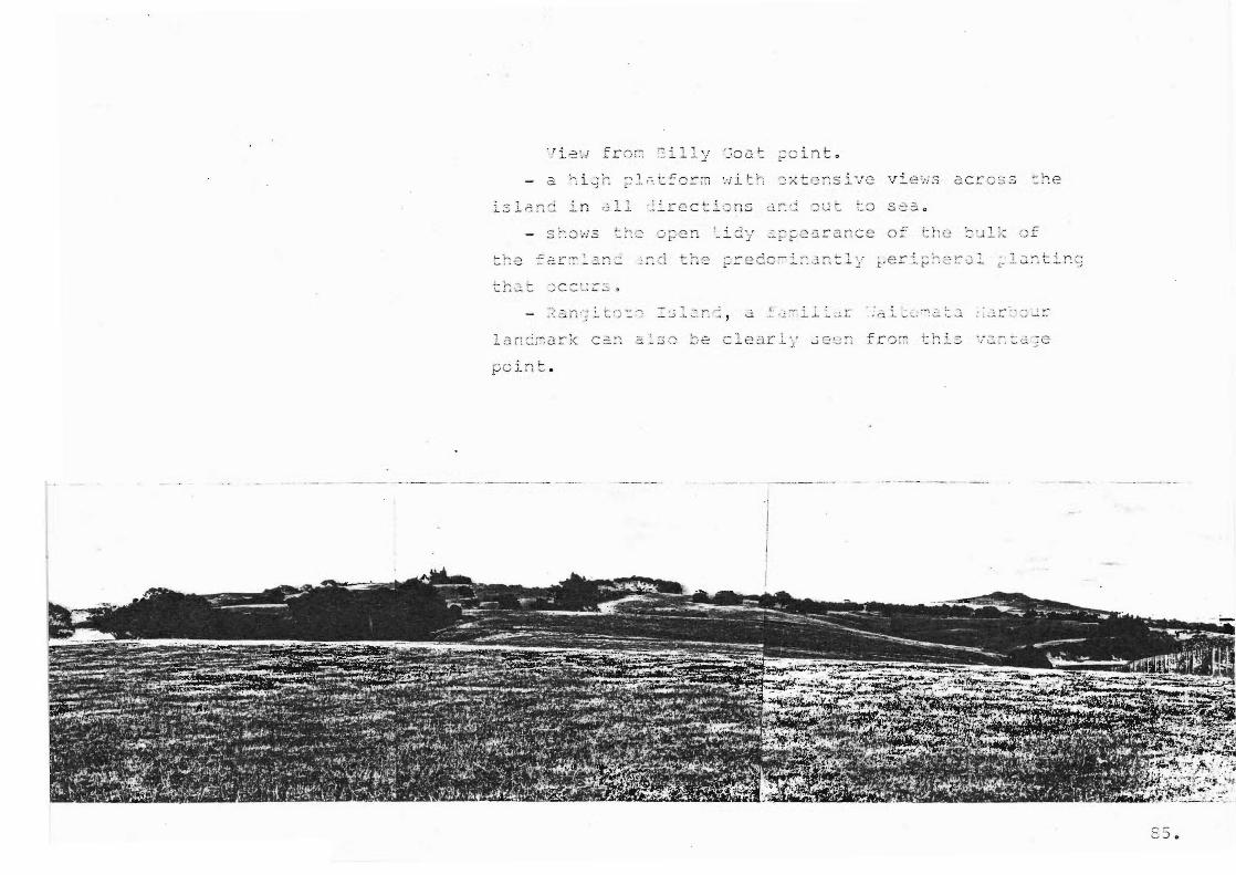
... . . .l.3J..(;.n:: 2..rl
-; , c "':" ..l....
; r--. (1 t ]-; e
'I

( lef t) Vi e~ of t ri; a n d water t a nk .
s ituate d e n a domi n2 ~t f l a t c idJ2 l~
t he sou t~ -we s tcrn ~ortlon o f t he islcn j
th ~ t- onr " '--. ,- - te ;, ::::5 co
( teL; .. ';
isl2.nds.
£ ci r~ lan d t r 2e s cc n tr as t s wi th t h e stron;er
for m o f g ull y ar. d per i f~ l:er a l ve geta ti o n.
,-
. . . - -~--"-T'" ..
sr:.
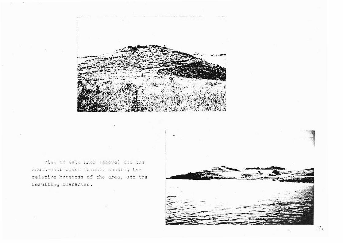
rel~tive bareness of
r esu lti ng char2c~er .
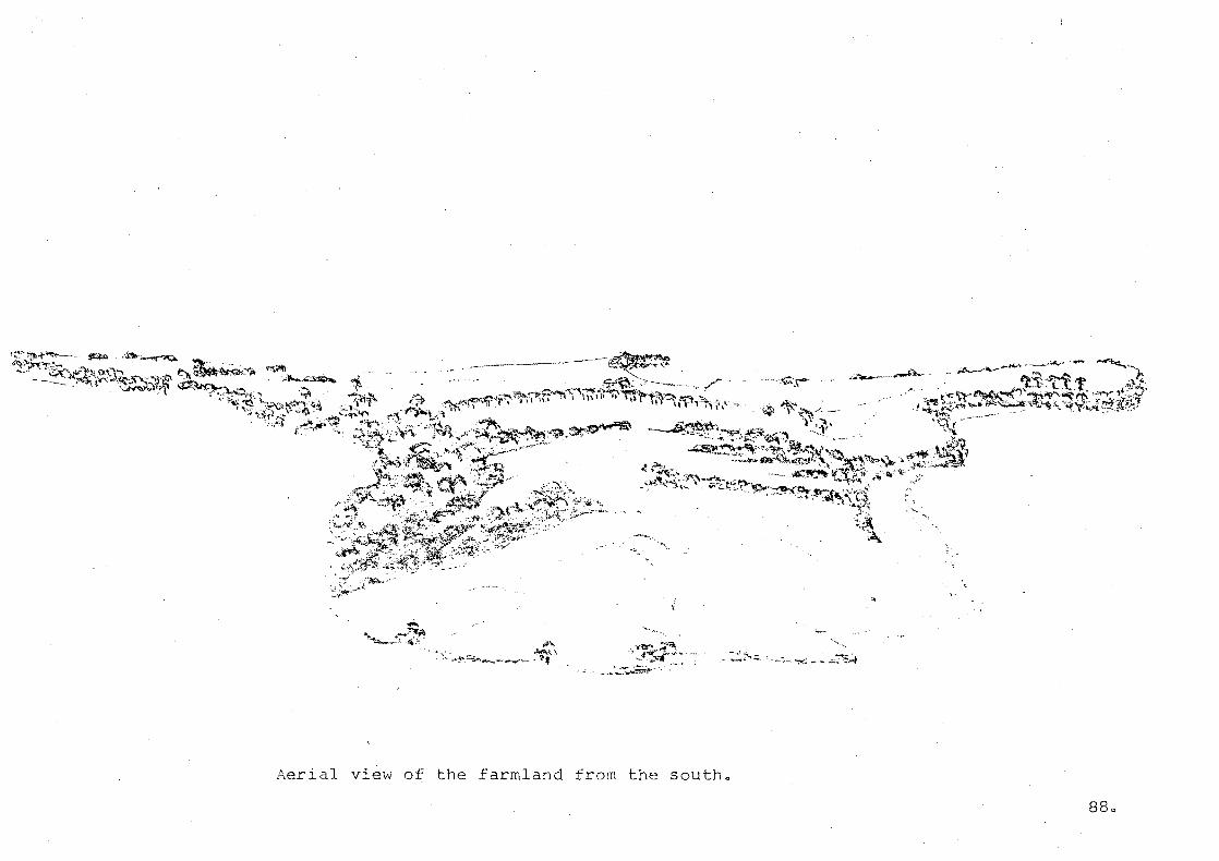
....... -....
Aerial view the farmland from the southo
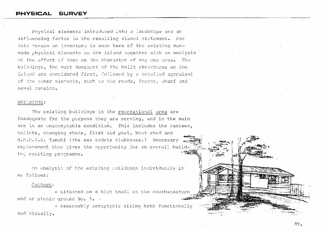
PHYSICAL SURVEY
Physical elements introduced into a landsc are an
luencing factor in the resulting visual statement. For
this reason an inventory is made here of the existing man
made physical ~lements on the island together with an analysis
of the effect of the~ on the character of one area. The
buildings, the ~Ost dominant of the built structures on the
islLlncl Llr2 considered first, "ollowed by a detailed apprLlisal
of tr-:e ()ther [=:leren ts, such u.~; tt~e roads, fencc~s, 'dt1a.r'f and
naval remains.
BUI1~DINGS :
The existi buildings in the recreational ~ are
dequate for the purpose they are serving, and in the main
are in an unac table condition. This includes the canteen,
toilets, chang sheds, first d post, bo t shed and
E. .N.Z.S. Tamaki (the
lacement thus gives
sea c~dets clubhouse.) Necessary
the () ty for an overall
in resiting
An Llnalysis of the existi ;)uildings in dually is
as follows:
Canteen:
- situated on a hi knoll at outh-eastern
end of picnic ground No.1.
- reasonably acceptable siting both functionally
and visually.
89.
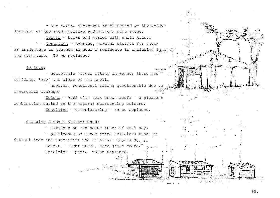
- the visual statement is supportecl by the randof:1
location of isola d maritime and norfolk ne trees.
Colour - brown and yellow with white trims.
Condition - average, however stor for stock
is inade ate as canteen manager's residence is inclusive
the structure. To be replaced.
Toilets:
aecer aLl~ Vlsua~ siting in man~er these two
'ou; , ril' r1CS ! 1,u9, I , -'- -'- '"::J -, the lope of the knoll.
- ho~ever, functional siting
quate soak e~
stionable
Colour Buff 'dith brown roofs - a pleasant
combination suited to the natur~l surrounding colours.
Con on - deter ..:;...:...;..;...:...;;;....;;..;;:;..;;..- ting - be repl
Chanqing 3heds & S~elter 3hed:
situated on the beach front of west bay_
prominence of hase three 1 (Hnc;::; Lends
detr ct from the functional use of picnic ground No.2.
Colour - Ii t green, dark green roofs.:
Condition - pooro To be replcce
, , ..

Boat '::;hed:
- situated on the southern edge of picnic
grour.d 1.
Colour - liclht een ~ith dark qceen roof.
Cor tion - Foor - to be re~laceda
- 10cC'ted at \'i;c:}l'F-LOi.lC juncti n.
- fUnctional in ~erms f shelt~ci visitors
while waitir.g for ferries.
Colour - 1 t green -
Condition - Average -
dark green roof.
unknown. (Probably
laced ',vhen wharf ilt)
First idd Post:
- si d close to recreation area imme ately
below canteen on ocean beach side.
Colour - lic;ht een - dark reen roof.
Condition - ?oor-to replaced"
Buil n':js in the ITt drca in neral are lr. a reasonably
d condition, and thos~ that are not are in the process of
being ased out in a rebuildi~~ programme. The farm complex
is well-sited functionally, and facilitates conven t access
to all ts of farmland. As the detailed layout of the
complex is somewhat fixed a ~lanting programme for this area
91.
could serve to upgrade the visual statement. lding colours
to date are not totally unacceptable, but it is 3u9ges d that
in future fainting programmes, colour choice should be a re
flection of those existing na rally in the area. More specific
les ivan in a later ch l:e t:' •
other bLilei on the farm area include the various
con itior, but possibly servi~g their requireC unction a
licy unkno',vD. In rder to soften the lrnpac t
in the landscape a sensitive colour scheme together with support
planting could be implemented.
Occu
tank, an
ng a prominent situ ion is the reservoir and water
d and run down structure, however still s ng its
fUnct I purpose. some form of support planting nere
could softer the visual impactb
Also occufying a position n the farml ~ i~ the ranger
stat n. .~ this building is re12~ively new it Ls in excellent
con tiona However, unfortunate siti tends create a bar.::ier
to visitor use of the island as a whole. In order to overcome
this some sort of a support r::lantim; programr::e, defin and
dire circula on movements, is necess to encour (3
d rse use of the island.
92.
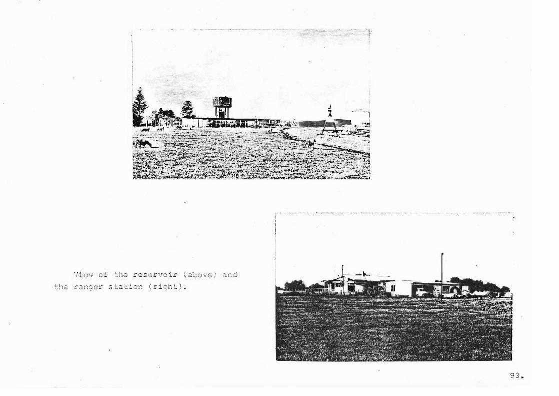
J
View of ~he ~eservoir aboIJe.
~he ranger stat~on (right).
93.
[WADS:
The minimal roa ng network existing on Motuihe Is and
ce copaci hoth for the recreational and fUnct ns in a
farming a,cli s. The hierarchy of ,roads bein tarseal,
formed and farm track.
The tarseal roads artd ar d3 re~~ln fr the naval era ana
th ir condit ~ Var1es acCOCdlO] to the amo~nt of currant use.
condition dnd wi~l require dcE Areas f
tarscaling in the ex-navy encampment should be removed as they
de no func onal pur se to the current use of the island.
Tarseal roads leading to the headland are in reasonably good
condi on, due to minimal usc, ~owever, removal or replacement
polic s for these will depend on new development proposals and
corresponding rculation patterns.
The single formed road leading from the narrow isthmus up
to the ranger stat and [arm complex consLsts of a sCDria 1· v .. ~3 this ~oad 15 not in goo c nd~tion and is not
suited to walking with ~i t footwear, it is suggeste that it
be reformed a material ooth keeping with the marine
character of the island and of ~ suitable wal n9 surfacea
Further details will be given in 2 later ch ~ter.
94.
The farm tracks are naturally worn areas that have formed
during the course of normal f ng activities. They follow
lines at least resistance giving a circulation pattern which
facilitates functional movement around the farm paddocks. In
general t yare in an adequate co tion although slight
L I occurs in the wetter areas during winterg
FENC~S:
there is G re-feDcing amme curren~ly underway
most of the fences on Motuihe tend to be in good condition,
and those that are not are in the
Fenci patterns and the resul
ss of being replacedo
line can often have a
dominant visual effect on an area, however in the case o£
Motu Island, topographical undula ns form d more dominant
visual element often masking the effect of conflicting fence
al ts.
Fenci reco~mendations are covered in a la~er chapter.
as
Motuihe :sland wharf is in a state of disrepair and
for replacement tend to be high, if not prohibi
R work is undertaken at intervals
safe con tion for holiday season use,
of the wharf at the most is ars.
to keep the wharf
but the expected 1
a
95.
The following article appedred in the Auckland star,
in October, 1974:
flIVIOTUI!.{E 'fJHARF 'DANGEROUS'
The wharf at Motuihe Island is dangerous and beyond
repair, according to the report of the Hauraki Gulf
Transport Improvement Committee.
Early approval should be given to its reconstruction,
says the report"
It adds that park facilities on the island are
insuf cient and inadequate to meet the needs of visitors."
Another article appeared in the Auckland star, in
December, 1975:
"SECTION OF MOTUIHE ~VHARF CLOSED
Deterioration and lack finance caused the outer section
of the Motuihe wharf to be closed to traffic yesterdayo
The chairman of the Hauraki Gulf Maritime Park Board,
Mr. J.D. O'Brien, s d the wharf would have to be laced
but the board had not been able to obtain from its own or
government sources the $200,000 required.
Keanwhile, the inner sect n would remain and be available
for public use but the depth of water avail~ble at low tide
would restrict the type of vessel that could berth there.
96.
~r. O'Brien said the park board had not given up the
idea of wharf replacement. The board re nised the
important part Motuihe p d the park in providing
an island picnic ground easily accessible by lic
trans to
But the boa~d had to he realistic becaus there were many
demands on public fundso
The cost of buildinQ a new strLcture would be high because
of the length of wharf required.
Special consi
picnic areas.1!
~tion would be given to the stion of
This later move has a at bearing on the level of
recreational use, and also on the of user. ~ore
scussion on this aspect will follow in the next chapter.
The remains of partly demol hed naval buildings and other
elements cause quite a signific~t amount of visual clutter,
especially on the north-western headland" Some add historical
interest to the island anc these should be identified and be
ret d. However, remains without historical merit should be
removed.
97 "

Lh · , ~ '....... 1 1 .. : \.....
--l' • ~.: e ,O rlS
EX2i\,p l e of ~li::va l rerl =:!l!,S (r':' c;h t)
causir.g ' visual clutter '.
Ce ta':'l of ,:h ar f (le:=-t) showing
state o f , . .
cl lsrepdlr 0
SHORELINE SURVEY
A ~urvey of the shoreline is included as part of the
overall site ra al for camp eteness of the record. It
is .these parts uf the island that attract the major portion
of recre~tional USCa
Due to the var d nature of the shoreline, no two , shorelines could be It is therefore proposed to
'inal e each beach dnc rock oU tcrop ar ? inoi eLl]. j in tenr::>
of the physicdl features, 0CCCSS, vegetaticn, cxis~ing use and
po tial recreational use.
On the following p ~ appears a map, iden fying the
various beaches and rock outcrops.
99.
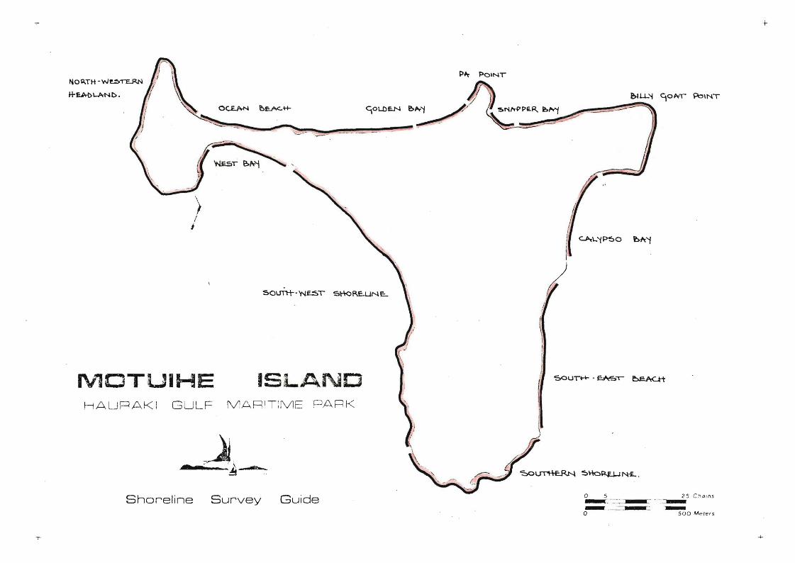
+-
> I i
,/
1 I I
rv10TUIHE ISLAND HAUR AK! G ULF MARIT:ME PARK
Shoreline Survey Guide o 5 25 C_oa'ns -- -' --, -=-- -:--~ ---o SOD M pte'5

lIE S": J!\Y :
Phvsj_c~l ~~'t ~ c es :
fl :-:! t 0
, L
, c --->
fl~t is sxtre~e ly sh d llcw .
t able s 82. rt'eC~ . .:es •
: 0 ' __
r'~ ,--) 1. r.- ',) ~t:
-fii C;S .
Le ";:; t ide t he Vi ~w lo c ki~ J we st.
::; (-:: :-'(..: :'- .~. -
. 1.:; c
Jiew look ing east .
.r 0. ..., _ ..... ' l. •
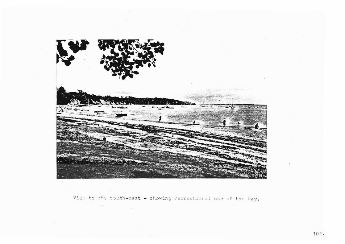
'J i t ~ '."': t J
102 .

~ lmost t he 2~ tirc a ~ock
.'·~_CC2S S is ;= Y' - ,
The steep cliffs ~ r2 ~ l~cst de void 8f veget2 tton, what
s o i.l ..: 1-...L '_
Fossible o nly at low t o mi d-t ide .
Vi e w l ookir ~ 22St
View looki ng south
- on the ~otuihe channel
side o f the headl~nd .
103
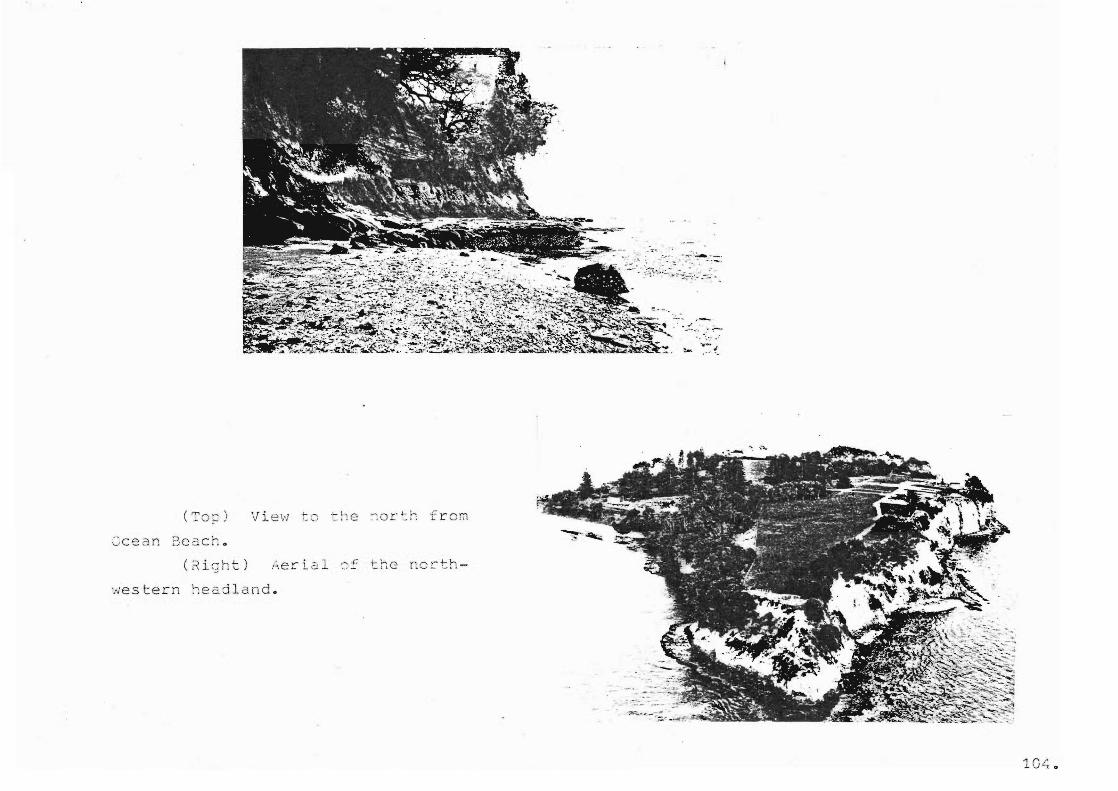
--:.: . ..:..... -_ . - . '::. ,,, . ~ - . -. --- .
,_ . , .. ' " " .
. " .. "- : ~
-. '.:.
(':'0'[:) 'J i e';l r r- on
Cc ean 3ce.c h o
(~ i gh t) Aer-i al ~~ thG ~o c th -
we stern ~eaj l and .

OCE AN 3~ACH AN D GOL DEN RAY :
Physice l Peat~r2s:
This is 2. long san c: ~r be (c c h d i vicled at hic:; h ti ce into bJO
beac he s by a ~ave ~ldtfGrn . 1.'he northern scct i :.; :: of th e bea c 1-
enc omp asses the ma i n recre a tion a r 2~ of t h e is lanc , thi s being
b a c k e d by a flat area of land a pproximCltely blo 're t rcs above
t he beach phasing to the south into s teep c l iffs . The south-
ern section of the b each l3 a lmo ~ t t ot2. l1y backe d b y steep
clif f s , exce ~ ting f o r a i o~ a re a whe re ~arm ~CC2 ~3 lS ~os3i~l c o
err.
:-'Le:: 2::.s ;
Acce3S ~s po ssible vi
, -., ~...,," .J..
... ':.J . ...... the -~. : 1 -, le n-:;tl; 0::'"
t r.e be dc ~~ 13 1. s
o nto
ti en .
- ;--, ,- ... :
: - ; ''' ,' ~ '. 1 .•
" .. - - "- -.- ....
th~ b e2c hoffcring
. ..;" , . : ". ,--",- ,-t " . !
All cevelo p~on t on Cccan 3C2C h exist3 in t he ::~ r thQrn sec -
~he l ow 2. r e2. t o the south p rcvi des po t enti 1 for ~ n 1s o 12t-
l-JreS3 ure s. Toilet and chan~ ing f a cilities would n0ed to be ~rovl ded .
- northern 2 n d o f COdcn .
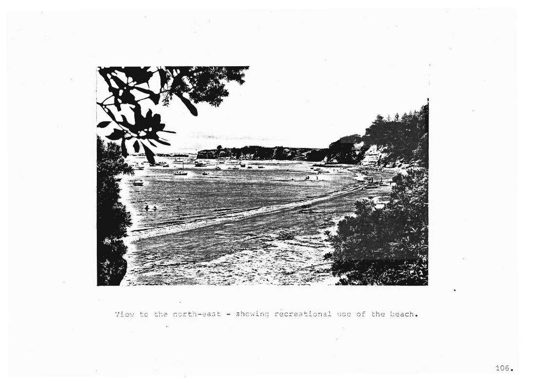
105 .
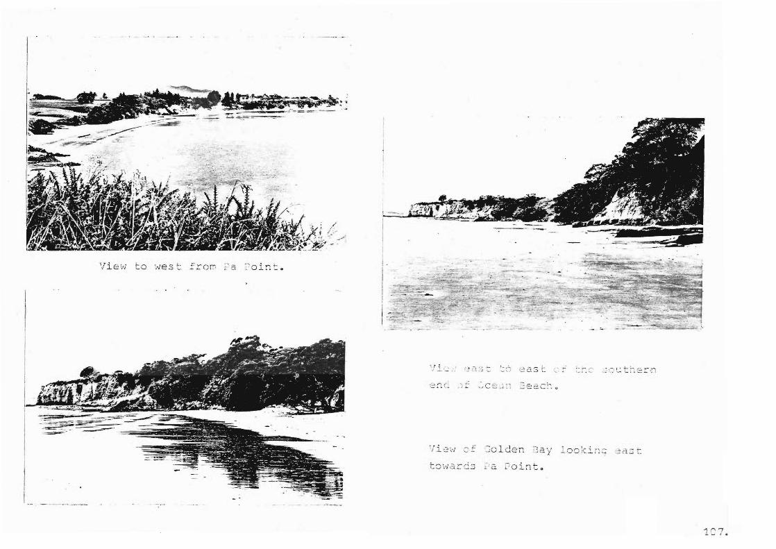
View to west fro~ _ ~ ~ o in t .
t , ~ ~ ...!.... -- .".
_ r
~;::::::01 F' . - ==-_ ~-?T-%--==-- =:;;;~~!!!lI
--. 11 ·...;oJ..uen ::2y
t8war d ~ .a ~ o i n to
~ 0 f .1 1
...... I CI
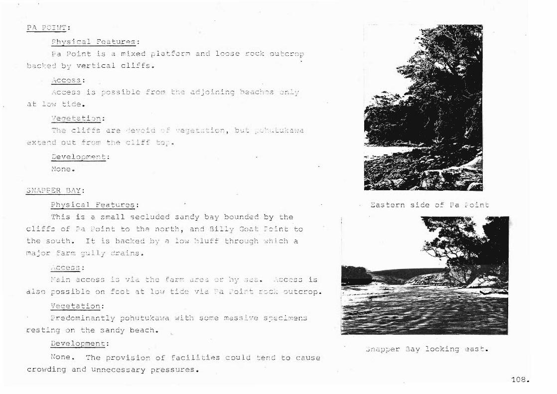
b ~C ~ 2 ~ ~y vertical cliffs •
. ::·.cc.:ess
'e ' l C' l ( ;.
.. , ' ; -t:.r ', _ 0;' -"":"' ....L.:'"
~'ec~tur2S :
0 ' (.- oJ .': , 0,...., " :"'I ~ O--... " .,
1_ ... -; •
r"-.1 1 !-,-. ........ , .... , ...... , .J ....... -~-'- - "'to'
' ..... ..:. --.1
This is a small secluded 5an~y b ay bounded by the
··:h! ::11 a
.-.c..:C 2 S.3 is
c.. ' 0 i-- t_ .~o:::.. :~ ~ t C r.- 0 p •
res ti~g on t he sandy beach.
Th e ~rovisio~ of Cacili tiAs c oul d ten~ to c ause
crowding and Un necessary ~ressures.
Easte rn side F a ~" 01 r: t
~ ~~~~er 3 ay l ocking 2as t .
1 08 .

.: 3. 1'
r'" , ., <J ....i. .l.. -- 1.
2: i2. ~- -:).~ c. t 0
lC9 .
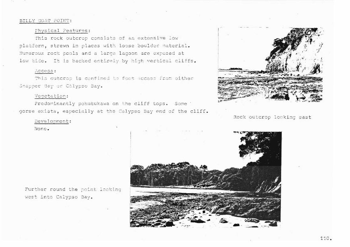
BILLY SO~T POIrT:
~hysica l ?eatures:
rock outcro p c~nslsts _0':.'
?latfcrG , strewn in ~ lac es w it ~ lo~se bould2r ~2terial .
is backed e~ tirpl y by high vectic al c li~~s.
<Jorse e:<~Lsts, es p ecia.lly
Oevelo;:;l",e n t:
None:.
?urther round the ~o ~nt l~~ ki n;
~est into Ca lypso 3ay .
-r-"-...,r ~ :... " -/' \... ,' -
cliff. ~ock outcrop lo~king 2ast
110.
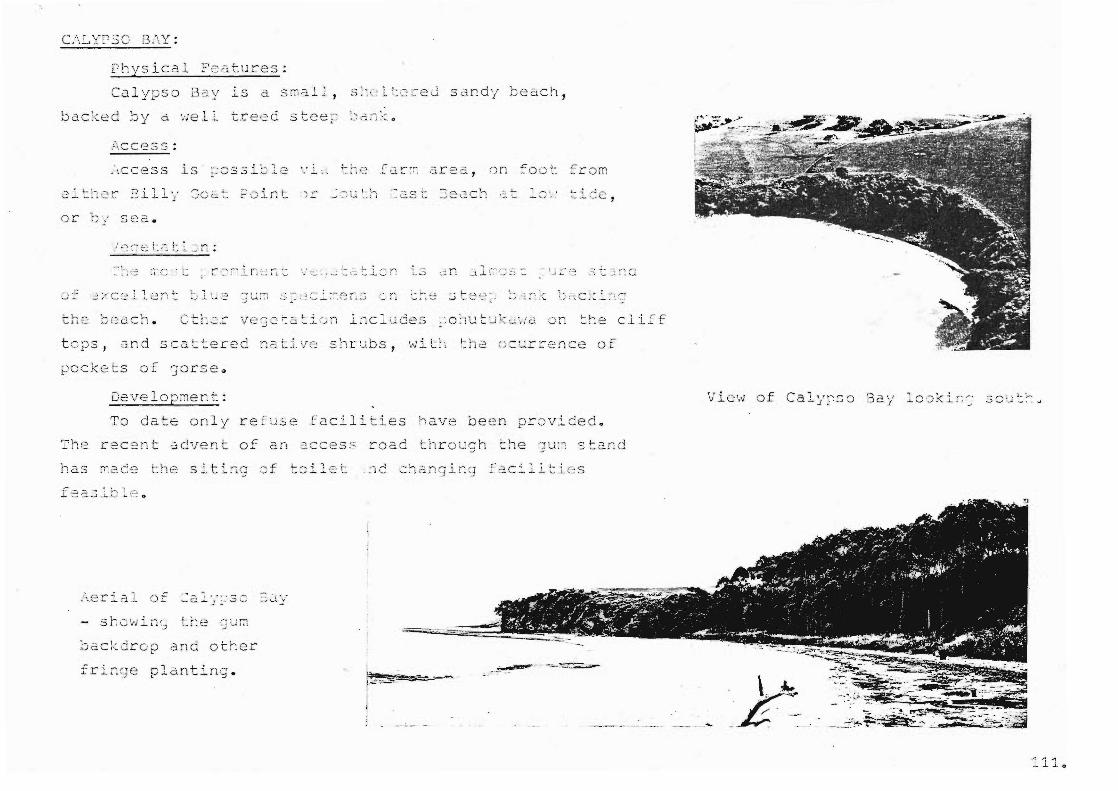
Physical Fc~tures:
/-\cces s :
~ockets of gorse~
Oe\re lormer, t :
,. , ' . ...:...
" -;~~ . 1 -
· .·....,1· I ~ ,-' "_' ........... : I
.. , ::. l ::: 2 ,
i:;
To date only re fuse facilities have been provi~edo
Th~:: recent Clcvent of an :>.c ces:c road through the ']U:l stand
ha.s 0.2. C:? the
~erial of ~a~; : so ~~y
backdrop and other
plarltirlg . . -~. '" -.:;.....--.: . . ---
View o f Caly~so 3ay lo~ki ~~ scu~~~
. t ·~ _£ -~ . -
..... ""i -1 _. J.. ...L. 0

SCUTH-EAST BEACH:
Physical Features: ,
This is a l ong white sandy beach which remains un
popular due to a shallow mixed mud and rock bottom. The
sand meets a wide flat g rassy platform which stretches for
almost the entire lenc;th of the beach . .\ t t~he ~lor tLern
end this sto ps abruptly at the foot of stee p cliffs. At
the sout hern end the p latform phases into steep rolling
f arml ar~d 0 Three drain onto the b e a ch.
/ CC2SS:
Access is ~o ssible via the farmlan d or around the
shoreline at low tide. Sea access is possible only at
tide due to the risk of strar.din g boats on the sh2.11ow fl . L .
Vecetation : ,
The gullies consist main l y of taraire So rr~e ~G. Lche3
of ,Jorse existo COnSl:3t.::;
improved ~as tu~e.
View to the south.
-~ 12.
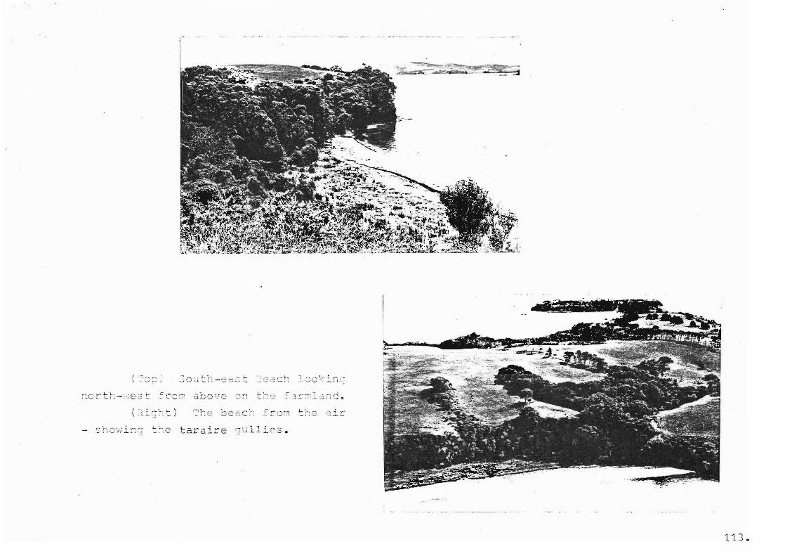
113.
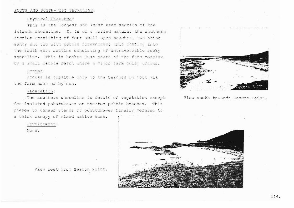
Physical fC2Luces:
This is longest
lsl~nds ~horeline.
32ct i un cu~sisti~~
:'.C:::':--'.'3-:J;
the ~2r:7'l arl~a ·r:;r '..--,\r -'-'J s E~a.
a[,o ,. .... C ''--'.!.. the
The southern shoreline devoid of vegetation except
fcc .i s c 1 2. ted po hut u k d ltJ a son the > t \r;O p e: . :01 e be a c h e S 0 This
phases to denser stands of pchutukawas finally ~ecging to
u t:~.-Lck Cc.rlop~/ of mixed :~ati"ve ~)ush.
to ' .. ,Jar CS Jeaccr: .-oint.
114.
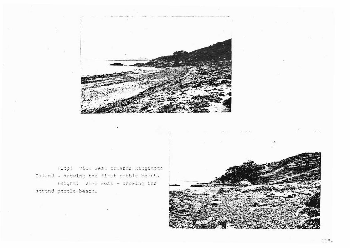
(Ri;ht)
::5 .

'I i ';.: . -~ .-., --. ! .:;. ,i . _" ._
!. . ..: ~T.~ . . . -- ~ ... ", , .~
'I i =:':!
from
IVIDtuihe I land s Recrea iDnal ResDurce~_~~~~
INTROOUCTION
In New Zealand recreational development has been modifying
our coastal areas for over a century and with the unprecedented
rise in recreational acti ty over the last two decades modi a-
tion is accelerating at an ever ncreas rateo Motuihe Island
has not escaped the act of is ~o flcation.
The islan~ has been mo~i~ied several types of development
throughout hist~ry, the asis tOGa)' }Je on recreation and
farming. ~ost of the recent development, especially that of a
concentrated and ph ically changeable nature (also sual
change) has occurred at the north-western end of the island. It
this that is the primary concern of this ch 0 The res.t
of the island has remained unchanged in recent arsand has
rather mostly being improved by farm management.
As it is the north-western end of the island that
most recreation 1 ~ote~tial it is also area that exh its
m2n~ of the detail ranmental and recreational problems to
bE' solved.
ts
In order to solve these lems, it lS ed to hriefly
outline the recreation trends of Auckland that effect Motuihe
Island and from this assess its role in the Hauraki Gulf Maritime
Park and thus the type of experience that is requ d there.
Broad management objectivesCboth regional and thin park
in terms of how they affect Motuihe) can be briefly covered
117.
gether \-vi tIl
or, the islanc1a)
tailed man~0em0n1 objectives (facili needs
te~ the parameters of development ?re achieved it is
feasible to attempt to ~rrive at a carrying capacity
the concentrated recreational ~rea. It is envisaged that
~stabli5hing the 'loolc o~ the 2~pr0ach! ort-
~nt end ~cint th ~ estat~ishin some 'c8~r0ctnFssl of the results.
The outcome of this will be valuable to ~rrive at conclusions
as to the amount of control on use that will be necessary for the
ability of this resource to continue supplying the required
recreaticnal ex ience.
For completeness a state~ent on the impact of farming
activities 11 conclude this chapter.
118.
RECREATION TRENDS.
I\ECRSl''.TION TREi'JDS IN AUCKL1l..ND CITY THAT
EFFECT MCTUIHE ISLAND:
Increased leisure time, more discre onary income, greater
mobility and modero educa ooal ~ethods available today has
tended to diversify recreational tunities available to a
1 proportion of the population.
onerel in the i.uckland region, but particular water-based
activit s, particularly on the itemata h rbour have
accelerated, and 11 continue do so.
The temata Harbour may be regarded as the focal area
~or coastal recreati6n in the Auckland region and the 1
numbers of pleasure boaters us the harbour i)crhaps its most
v21uable attr ute is the high level of na protec on it
affords. Another factor contributing to the harbour'S popular-. t . .. t 2- j' l? l' 2ccessibili
ered around its shores.
to Lhe lar urban ;:)OLJUJ. tion clust-
Des~ite the greatly increased mobili
o t~rlays society there is a significant section of ~uckland's
population who, fora varia of reasons, take their ,recred tion
~leasures close to their laces of residence. P. t esent, it
lS pcss Ie for these people to age in a de range of
water-related recreation at ties with6ut having to travel
long distances. In relation to this another aspect contribut
ing to the harbour'S value is its str egic loc ion relative
tD the ldaters and islands of the Haura.ki Gulf. Increasingly,
119,
activities such as power bating and yachting are using the
harbour as a base from which to venture out into more distant
waters ..
As the,Jai t is suitable: r a wide range of recreat-
iOGal activities increased demands and ssures for facility '1 .l.- • oeVC.l.OpmenL lS ding and
increasingly leisure-consciou~ popUlation. s facility
development demand is going to be especially high in both the
already pODular areas of the mainland coast and the closer
outlying
Island.
lands of the Hauraki Gulf, this including Motuihe
In order to place this demand in some quan tative s
pective, a brief summary of the levels of participation in the
water-based a~tivities in Auckland will follow.
The follcndng fi?ures are from 1',uck J. '''lnd Regiona 1 Au th 0.::' i ty
I'ubl ic ons on 'Recreation ~atterns in ~uck13n '(lS71) and
t ~ecrea :'i-on - temata Harbour! (1973).
Results from the former publication nc that sw g
at 21% participation was bv .L
far the most popular activity
partic ated in, and 25% of the people interviewed said they
would like to participate. The par pation level for boating/
sailing/yachting at 7% seems low but comparisons with other
120.
popular recrea anal activities such as rugby, tennis and
camping are favourable. This ure contrasts markedly with
the "would Ii to dol! figure of 13';~ for boating/sailing/
yachting, if the opportunity presented itself.
Actual numbers participat in the water-based activities
are given in the latter • The Auckland Yachting Assoc-
iation places the total membership of Yach clubs in the
Auckland region at approximately 8,000 with aps an overall
total of 40,000 persons participating, to some extent, in
tinge The eatest on of these Ie sail on or
the ~aitemata Harbour.
POI'ler boating in Auckland has, in recent years, experienc
ed a remarkable owth in po larity. A survey undertaken by
e ;',ucklanu Regional /,uthority Flanning sion revealed
that in the an estimated 1,300 outhoard
mot':Jrs ,,:ere sold 3nnuully in the ~>,uckland
In 1969 there were, in the same area, a
;:::oli tan arC2.
mately G,4GO
ard and 13,100 QutJ:-,;),:xc: l~ower boats. 1'rends since that I
time point to even greater increases in the total number of
craft, a large propor n of which have made use the
harbour.
While the general growth is evident in all types of power
boats it apr ears to have heen most pronounced in the case of
outboard runabouts. This is a significant factor as there is
121.
good evidence to sug st t:-'at a 1 e proportion of
of craft are purchased for the sale reason of obtai ng access
to beaches, such as those existing on the various islands o~
the Ha Gulf, that ,'JOul d othervJise be inaccess ible by
other meanso
In addition to this ~rivat boat use o~ the
the arge number of botl': recu1 ar an J hirer: ferry s ervi ces
which transport peopJe fror the mainland t thE~ various recreat
ional opportunities available on the outlyin; islands of the
lIaur Gulfo
From the tential level of use that promulgated from
this intense recreational activity outlined above, it can be
established that certain pressure spots are 9 ng to occur in
various popular areaso Motuihe :sland presents one of these
ssure s~cts, and from a conscious appraisal of the facility
needs or) the island, the level of use that can be tolerated,
and the mcmner iIi vl/hic!; this use is q to be catered for
it is hoped that the effect of recreational pressures can be
lessened ..
MOTUIHE'S ROLE
'l'ht: r~,'1 c, of tui}lf~ I Gulf
to date .has been L recre2Lional
opportunit} lG terms of ~icnic j t:ln s th
,ysle J f llitic,-~
n t produce
It can be inferred from this that the type .r: J
'::"ecr-ea tional tunity offered by ~otuih0 is in deman~ and
the level of use is not likely t~ decline.
/'.1 th 11 the bulk of the island with its rural activity is
o~en to ~ublic use, it appears that few peopJ,e arc aware of
this access
th
tl1C othe~'" p
~rivate boat owners.
7]JeJ.:'efore tLere seer:,.s to be d COl"";l::entrnen:': on the pa.::.-t of
the recreat st to usc the easily aCCess Ie aLee close to
the 'dh arf .. Thus, the ex ience in demand on ~otuihe seems to
be a boat trip, leading to plGasant picnic conditions in semi-
natural surroundings, clos2 to the
~ajor role nust be compiti~le wi
rnl' n··t n+ 1-' -' <.J...L
this.
access" I'lotui ''0 I s
123,
Uncantrall d usc, howcvc~, caul
on he co~cenLrat d recre~ti~n areo o T11C
d their immediate heach environs •
• L
iced ng in terms of space av lable has probab1y
not been t:1E::: atest facter in the recreational impact on
rot he Island, except on th
~2rfect weather, f~Ily booked
occassional peak day where
cnics, crowded ferries and
ave: I" rucLced crowded, un leasant
a ~rL~leG docs exist w~ Ute effccts
in de at
Toilet f ci Ii tiE::s are ole: iJ.nd iniJ
loads cease to work due to poor soakage causing raw of
•.. .r::
to bc::: schar8ed into ~est B y. /\S V.id ter s 1,: :i on the ~ o.r;d
comes from artesian wells, the c6paci of these lowering
-Juring s:Jrr.:T:er, cri tical levels of viater for stock mean that
sUpplies t::J the recreation area are often ceased.
1 ') I' . ( ,

inadC':s~.:ate 0
or conscious ferm bl refuse ~is~os~l.
I)u etc }J .:; t h
bC,Jcl1 bl'Jffs anc some clicci-: t:::., this li.:ill be necessary to
prevent any further erosion.
At the present time, therefore, Motuihe Island is supply
ing a recre'ation demand greater than its actual carrying
capacity_ However, carrying capacity is not a primary factor
in the interaction of people and a resource but is a derived
or dependent factor which is subject to precise definition
after the parameters of park development have been determined.
As outlined by the brief Motuihe Island is to be upqraded as
a recreational resource, and any number estimates or ,guidelines
can only evolve after the primary factors of carrying capacity,
the elements to be planned and developed that determine how
people are to be accommodated and contained within the park,
have been determineq.
MANAGEMENT .CB..JECTIVES
:3TW/~D OBJECTIV=S:
Capacity snould be judged in the light of the particular
These objec yes and
thus e ~01ic s 0 m~n ~eGent are to deL nc:: the
th i11~~
dL..i ci
will bo n excrcis in fut'}ity~
These ob j ecti yes s he;ul d tab:: into accoun the broader
ects c~ recreational ~lanning. For t::;')'" ~ ,_A Ie, the goal of
2~dr1izing user sati;:';facti n for a given ge
as the j,uckland ;:~egion C'1r: be n~et only bjl the'
ic Clrea such
is of a
s~ectrum of cpportunit s tt:at meets the diverse and often
flicting tastes of the rublic. ;lan , such
~ecrc2tion21 La~te~. N~ -ne r creation suo 'ior need ~eol
t:~inc:; more, Jes:::, or differ nt to 2. more a" iate area.
'-..nly by 7110.\:1 n'J sure that a ft'1 range of OhX)l-ttmi ties exists
(regardless of e organisa on that provides t:,m) , \!Jill
i i'23 ruther than t ng to develop recreation areas ~or
the IT, Y t h i c a I " u v era 9 e use r , "
126,'
r" 1. , }., /, t kin S 0 r: 0 f t :~I Botany vis
D.S.I.R. h s 0rjtten ~ outlinins measures for protecti8~
and uses of the i.~;land~; of tiT:. G~][ ~ aritime Vark~
7:i1nce from the
i"rest 'll1mar: settlementso i~rary ~isti~ctic~
m " 1 r~ 1 c n c1 -1 "ti'nn'Y"' _'--- I " ~ _ !
(el ses ~., , p Cino C) say ir19 "ecJch islar::d hes its individuality ~, , ;:)":Jt il c1 ssification, .' u. ed 0"" usc and the d"> ee of protection " ~'-.;:~s;ded is necessa for long term planning.
l·lotuiho Isla;-;d is one of the inner isl·::lIlds which "hold
].1 C1 1 f . ..- -: 211(:3
rlt~ -
'iot u 5 he i j this broad c C.L.'2; it i:s nov·'
t!le l:-pose of this re + de ne ;norl2c10:-;;21y the tv::e J ,
of recrea jona1 eX~2riencc that the island should rovid~,
the faci1itie~ reo
crder of the level of use t at can be t8lerated.

din; since i
~nce t an as 2 rec~eati n resou~-ce i;) 1 30 under the Auckland
C~it;/ Thui- is, ;r idc.' s2f2 ond
us c' of th ~ r-.' j".,
,1- .J ~L
p~ovidinq ~\ dition 1 ic~ic faciliti s for fer~y-horne
recreationists at the soutllE:,rr: c:::-"C c: Selden
vL=_ th farnla~d is pass leo
" encourcging 1 t use thE' farmland and bush oreas .
C' si s te d vJaJ k-tr3c)(s"
:Lc.:inr:; thE' a ity and associated facilities for
n for s~l;:)rt C ,in~ for ccrt "
is considered compat Ie for the mal:Jtcrc3nce role of
the f DS activities to conti;)ue, completing the multi-
128,
The most crtticai are in tprms of f~cility ne ds is
the concontr tert recre~tion are •
tho:"3
the f~cilitiis are to be urqr~ded,
which in terms of this study calls for an over 11 r8placement
qrc:IT::r:e 0 This2nab~es lete site re-org nisatioh,
especially in detail building siting with corres~on y
improv d sp2ti 1 org~nisation of the area.
If MotuiheIsland is to retain its present quality it
must remain essentially a 'soft J landscape free from
introduced hard elements of surfac c:tnd an over-
encumberance of built forms. Therefore it is e 53-ged that
the built f~cility needs in the concentrated recreation are2
arc:
Canteen
Infor~ation Centre
's Office tructure
F st Aid Post
Toilet
Changing facilities
3ar-b-que facilities

lity needs in the additional picnic area at
Golden Bay will.be minimal and comprise:
fToil
eli inC] .r . ... . 1_ • J. aCLLl Ll
=ilitic~ for the or
th an outdoor c -fire area
.leI (~:;, r;;3te
tso::t' 11
( p,. J.
',t-... "cr,r'
\\ ...L. '_.
'~ils L:sec1 on
e cJ[lOVC'
l' :~,,., •• :'J
130.
CARRVING CAPAC lTV
It cons~dered t~ t sone estim~te of the maximum
ly visitor nu~be~8 is necessary to event adverSE effects
of ove~use of pl~nned ~~cilities on ~ot~ihe Island.
r te~ of ~cverre~t into
!~C
,! l J r, L J.. ~ n.tj
The determlr:atL)n of L,e care
fore requires =ose qualific tiona
Island it is ~ot the total 195
:-;V:!2Ver,
to t
, but will relate to
d areas 0f the park.
P it¥ of a Pdr~ there
For example, on Motuihe
t res whlc~ is 1D qUEstion,
but r-aeler the s:rall istlr:us are Itfhere rec~e tional use is
concentrated.
-, d ci 1 i~:_), :: n ;:1,; f: e th t:r
mai~tonancc of the n2t~~~1 resource.
forMula for determininn carr~'~nq c p city of ~n 0cea such as
meots arc incorpor~ted ~nto it, for without 121(' the concept
of carryin0 c~pacity ~~S .~o rracticJl meaning.

The area in '1ues tLm then, is the re la. ti vel y small are2
on the isth~us incorporati
associated s ce f::lciliti
centre and toilets and ch i
cnie ground 1 ar.d 2 and the
of 3 canteen, infor~ation
facilities.
In ordec to carry out 3 ca.r~city stu assl!mptions I
mU3t be m de using data which is avai12ble, viz:
• yearly visitor nu .
• capacities ~f ferries servicing the island.
o estim~tes of private launches visit t h ,C' i;] 1 an d •
onal observation, and
onal communlca n th th,,:;sc Ii v
is lcr1d 111
but 2n any mere ,sophisticcl
unwarranted because of the 1 L::d ':i11:o'Jn t of
In addit n to this the f ures req~ired nee only he estimates
to tl';e order of cecre tional C:::';2cl t~', not r. ~""Xdc:t es L-ll:l2 te.
J,s it is the cZi:'aci ty f t: c,': acti vi ty I on !:::ainers I,
1 cOliipartmen an d I f '=l C iIi s' tho.t are ul ti:na to
132.

par meters of c~rryi
have 2. capacity naximun, the ,=, A 1. Tf' U ff:, d II I lIt i n~ 2. t 1 :l
I~l n~ ~ pear be:
~ater av~il bility.
Refu32 disposi3.1 n
Biologic:.l impact.
It J:::; c;rc frOfTI t:r"':is
t
(}ssessir~g
~~sed 3up~o~Livc facilit12~ c~n l::::vel )f e,
overJll d ly car~yi~g ca~aci~y Fi urea

~'Jur;,l::ei's of ~)eoph-, 1.13in9 the isLFld~vc:~r t!:'::c last 5 Y2cXS
19(,9
~.970
1': 7 C
:. C) 7 ~l "1 n r--, .........
'- ;' i ,_-.:,.
- '~973
.'21,Sc)1
'::2,?'::1.
15,1C,C
':' c:. ('(':n . -. , - .
t~e "r!ee~~e!i'l only, '~xcept=,'!er tbr:' school surnl~·.~~r holid2Y perioc
when it opprates daily. However, from obs2rv~tion, by far
the heaviest use level is at tl'2 '"lee1zr::nr:ls cin:~ th~ above figures
wil~ be inter~retcd as such.
or
'1"" cnn , i ,
'.'/t2eKcnc1o
1340
HowQver, this is only ~n sti~ te of the number of
s
f.i -'ure h~ nunber of ~rivdte rd:
tal of
pprozLn" te y '1,000 t ere tionists / Vie '--::1::'1(: I':d'l on
.\ t" +--
te
(an ~os fluctuated) feum 2: low as under 100 visitors
d~y to over *1,OOO/weeken d0Y. Thes 2k use occur (c' on Llne when Auckland recre tionis t:-; ,J.r out in their
myriads and when the island is being used to catee for 1
risecl picnics.
I is thes e peak ,:1 a ';is ',Ii L. l"l crowds t~at lead to
the ~ressure~ on exl~ their ~ sultino
ir: lJ·3.ci23 Q
ade at~ water 3U
s ~is teE1 to re3 ~re aff ictej on this
maintenance a decline
in the::~ual i I.:y of both the recre t resource and experience.
* Fers Comma - Motuihe Island.
The first estimdte therefore will be the ft ure tha~ the
area of picnic grcund availabl
(i'sycoloc;1cal
The area of !~nd availabl ricir1(;
~3 I , t/f
" l~3 heach ~r~0 ••••• ~ " II "
" " " rmd if eachjro ()f 3 perSC)rL3 ;::::qu1.red
20 sq. n. of :.::oicnic space (i,e" 'Jpprox ately ,);'; bebteen each
group)
thi:...-; gives an are~ capacity. of
imately 3,000 persons.
?O,CnO 20 x 3
i~ CLltJaci can aSl.ly C2 reached ~lth:
" 'Har.bour 20 rd :c'erry •••• 0 ~ •••••• 0 ••••• 0.·· 2SD "1..
and 500 le ~ur ~r~ft
* Figures from L.S. oole - Perry Opera
1 Accuracy of figure estioned.
136.
The qu~stion now is - can the more fragile variables
contributing to recreation~l pressure withstand peak use of
up 3,000 people on the island at anyone time.
THE: IC!\L C-P"'.CITY:
From personal comm:lnica tion th hc:;al th c~nCJ ineers UfI 0"'. C. ) ,
it seerns that tr,ere are three fr1cthDoS of sewer disposal
ecor:omically f eas ib Ie for i10tuihc Is J. and.
c Tank (vJith· in ttent sand filter and
dispos 1 into running 3e water)
CI i vus lI'Iu 1 trurn
o [Jeep rits
DE 3, 00 fiL I 2. f:ion pI
\11 r:;
The antity ~f water av~il ~_ however ( a min -n of ?- 3
CEll ons/person te~) woul be d limiting
fae r. (::'ewer an~ water ~v ilability being inter-
require a w te~ upply c~ 7 ,000 9 Ilans (25,000 x 3) annua ly
-137 q
~for sewerage alone without taking into account other
recreat nal needs) and unless this amount of ~atec could
be drawn off ~uring w er f:lO. t:,s anz::: s tcred in tc'.nks, the
eli 'Iu.s ::'J 1 ~r 'J.m r a ~o i~: d fcr~ of)
se~ce
" "': j , !- t-~'. '-, I, ..... ,-" 6 cs in
s
~utting on the Jarden, initiJlly after 2 a,rs Ir: 1:[12 uni t
and then at intervals of 1 - 2 years. This nit presupposes
a compost user - this being poss th three
far~ily gardens. The author prefers this method, however
expense and thedi~ficulty of controlling picnicers to
separate out ina
in this situation.
Therefore deep
n refuse could make the unit impractical
is the metllcd recomrnended~ * The
method has two distinct advnn in that it is not water
borne, and also a s s of single or double units can be
dispersed throughout the recreation area overcoming the
problem of a centralised inconvenient toilet block (See ~lan
7 for siting, and plan 9 for construc on details). Also it
is not considered necessary ~o provide water-borne sewer
systems in recrea
.jI By the Author,
I' Gordon Fox -• W. 'do Hill
l.areas such as this, especially where
Health Engineer - M.W.D. Engineer - Environment. M.W.D.

re ctitical during :;umrr:r.::r
Pr.cm Uu';"
, <
.L Cl '-- 0 ~~ L< '
L
()r: 27 1 ro ; "1 F\ ..-, ("', ........ /'~ \
This ~Lg r see~s to be ~xce~sive,
cop'::: \.li tit ccntlnunl us"'" 0
occur on "" 1il;.i ted number of t:i.J: :) d year. Some riegree of
overcro\'id is considered acce~tabJe, id€ri ~n ade~uate
pcri~j far rec~ve
>: ublG ['GlIb 1,=;
.-, Leub 1. 1;1 n il~:;le L L J ;
1 :"3 irtrf.~ e F ,3rc <" l nr] _L.~':: /, c.'
Tn t ,::':1
9 L'"vlQeJ a riltio of rJF 7I.'; 0
139.
(Ratio higher ti-, -en '-,.s being
(-',' ijTr . . ~_. " ' .. ) '-' c\. . ..
')
,.- / r L,I ," ,_ U
" J 0 (~ "0 , 0 '_ '" ..J g
te]. y1 ,000 t ;eo pIc . ccomo eLi tc Uv(-:: ~ thi~ t reG k mi d-
d.::-J':l U~(~ periodo
If this is one third of a ~e2k day crowd, it is considered
thCi.t the number of ';. C. 's 'osed _ould accomo~ate the usage.
Some ~ueins wOlJld be inevitable and c~p city af these toilets
A.l.-';
3111) -: ct
d :-:r-- .t-
1 tirn~'f:(".:
peak: [i t h .J. n ttl F) t
certaj.nly b~ lower.
The s :sen tid L e leonents f water demand include the ~ver
140.

~aily w~ter con=u~pt n 2nd c ~~Ak r te of demand. The
f tl:f-? ~J'Jater S81: ):-ce to rncet
t bJ.e level i[ lo~, lnri
stor ~equirements necessary to supply sufficient water
during periods of peak recreational use.
It is considered that wate~ avail ility on Motuihe is
an extremely critical factor in th ~ecreat a1 capacity.
(Choice of sewer2ge s telfl cons is ten t ;,Ii th this",) Concern
in this direction was expressed by the mi.~n in
personal communication with him on t s problem. Hence the
complete severenC3 of water surpl to ~he recreational during
4ater availability sets up one of the few conflicts
between recreational re~uircments and farmi activity ire-
ments, peak recreational use coincidinq with critical summer
water shor s. tock, especially cattle arc high consumers
of ~·Jater. ~ven without water-borne sewerage facilities, recrc-
ational water demand is i to be considerable.
141.
in
~ i .20r on the ccndltlo~ , '.
u2.
r,' 11
hyrlrologi3t be cdrric~ ~)u :::
[Grstor
nc·::::r'
t ()
1 , ..t.
ak
(~ f c)r f ,1r~T, ,).n. d
['lolu , being an island situation, presents a special
1 e lr. 3 it is not close to any
form of centr21 c~lJecti0~ ; o~nt, ~nd therefore:
In
Ideally th'2 third suSqc..st
I\faticr::::.l Trust h
1 ! LJ..
, : ~
1 .b2 introduced.
n '10U'J be werth ach~eving.
1JCC2
30me 3i s, \:Ji th Lei::; ~~olic'/ worki
1. r-; ~:
142.
,:,co::Jornics f t G s2cord ffiethod could be prch itlve,
however the ~o3sibility 3 uld be explored before res eli
to t112 VJ11i Cf1 bds.;.c<}lly th}t '.!hi:-'l~ has een
c) E.)c;c: r
t:-:cu
wil! ~robably ~ot ~c e
recr2cltional syst It wo~ld als be difficult lniti 111'
to 2ssess amounts of refu8c Gft by recreat~onist ther'2fore
scm ~ssessmcnt ma; b re~ ~r2j fter the "-;(led facili ty
h23 be~n in aticn for a S2 seD.
~43 ..
~ - - ~ ~ ... .~ .:. .. " h :'
--.I ..L ' . . " . _)
.:.... . J
. ;- , '\ " " :,~ .;... ~ .-.. ~:;. ....... '_'V 'j_ ,--" . '_ ..L..
o c:c u r ..3
: . J.... : -'- ~ - , . ~ .
- ,- -
/.!.- ~ •• : :~ ' . : C ~ =
-~ ; ........
=- : . :~ : "'-.i ~
,.....,
L _
/' ___ ,,_ •. IF' ,., ' •• J '- • , ;....
- ~-
--
! ", ., L ":" J.
~ - :.. '- .. ' ..
fi' '".
"';..J... .. .
,.,
c:
~-' :_ .. ~{l .. ' . . . -;'
: ,c: c ':':., -, '-- '- .-.1- : ...... .. ,
., . -,
.. :
::: .:..: c: i 1 .... ~:i
:.:3 t- ~ - : - :.... 2' d :; c:
'-' ~ : . . -'-- ",. -
-t o,
\ , ~ - . ' , ' .... , .. , _..L.- '_ ...... -'
~ i -. ;
' " r ':- ..... _ ..... _, J ', .
y' ! -
'-"r ' J..L.
i ,-...... ...,)
- ~ , .
: ... -:'.~
')
; , - .- -- .- r-, ••.
:....,;. '-
, .~ :-.
-, I' Ll - '" % -.

3 dllfe r2sting ~ites are r t v,11ent in the
co~ccntratect recr22tion~1 are-l, recreational pres~ res there-
fore ha vine]
eristic
1 i tt Ie bear i r1g em th is '"'esC'urce ..
/d y.
charclct
te
re ource ~as sub5ect to 1 f use const~ntly, de acl-
of the resource ~ould t 13.CB. The.::efor the
optimum evel of recreat 1 us is going to ~e a s at
re t~an that of 3,OCO ple/day.
Iso reolistic results are not golng Lo je obt ned .only
r.d opt but to be of use the
i
120,OC8 visitors/year
,;' ..... ,
~,
.' I
145.

f use to cidb~:-
e.~. 1973-74 se~ on, n '3 ti. ted 50,OC8 p20ple visit0d
c:nc, V2"1 f2cilit~~~ could not
1 0,000 v itors
il::.bill , accurilte assessme~t
is i 03si~leo
Emiever, to comple the exercise, an oc)timufil use level
somewhere between levels to date (50,000) and the excessive
seasonal assessment (120,000) would seem comfortable.
giving eln timum use level of 2, 000 peopL~/,,,,eekend day.
Results may seem ~rbitra , but due to the restricted
nature of backup data a.nd information i:1v:'til~ble, more '3ccurste
assessment (if that is attainable) was not possible. The
validity of the exercise is the ress n through the
process, establi.3hing the various 1 ts of recreational clpaci tj!,
and finally arriving at a gi ng some order of carrying
capacity.
146.

From personal experience and close observation obtained
from .long periods on the island, 2,000 people/weekend day,
would seem to be a comfortable and feasible optimum recreat-
ional carrying cap ty for Notuihe Island.
(Note: since the c aci study WilS done, the outer
par:: the w~arf has 1sen clos~d (see addi~i n~l ne~s~
ntrcls
I veL; .:J , .
t'eiJ _!~ aCGc: 0
lTIent £")05 ells, es ally .C nor2 ragile faclli es.
pressures ',/ill also be l:;eneficial in terms of establish
.--:1. ... -! ~_
.L l.l .. ;~u
Lt;;SS
CONTROLS ON USE
ceNTRaLS ON LEVE;L3 OF U3S 0
To protect I:his resource from overuse, irnt=Jlemen ta tion
of contrC?ls is going to be neces3ary. Private boat owners
are going to be the most diff~ 1 t t Cl C :) nl: r G 1 0 u;.Jl ic ;lse
th 5e fartunat eno to own or have access to boat transport
cf their own, and
• in ter::lS this ~res3ur~ would be bought to bear the
fact that 10 cents / ferry aS3 is :Levie by the Harauki
Gulf ::;aritirre t::2rk BOc"lrcl,:;hic', of is arlO
f cili tL::s.
C t:v:::l:'
l '-, (j .L ~.~
(Hc,',;ev:r,
Atkinson's c10s C c1 s lfic ion.)
I: 'J rers (I.] i;: f~cul t cc) enfor
publ
,3nc: o03t clubs, the for:rer outlining pU;b e:l1S ;Cic":;tiil(} "'1hich t,he
di:3Cl':'::,:tion and dsen1f~nto
149.
I ... C I~IO~J:
lictir~9
The pt'ovis of water-ski Ian S LS absol~tly essential
on both :::;ic.es :] the isl nd for ldequat co,;i:rol of this usea
(see Plns f r detail siting).
150.

THE FARMING STATEMENT
c t i 'ri. ': i c~ s i ifl 1 de 1 of the
i
than adequately (1
,"'].re f2.;;, t::
the watar situation.
solution .ay be found·' fter thorcu0I: ir: 'res tL] C) tion.
conflict ftcr se~sor:s of ~rou~~t, solu
1
+: .L
fAnn
i f ferti 1 i sers r"c.s l t il1 L~OO.r'
151.
bco:si
f t~e fOC0st s~ecieso In its present state the area is
I~: is
Xl
LCJn
culties
ie 1 planting of
It
is agreed t~~t ~n area coulrl b fenced to beco~e part of the
on
. -, ,
ill
152.

Concept and Design Proposals

DESIGN CONCEPT
As stated by I.A.C. Atkinson, Motuihe Island comes under
a classlfic3tion '",here "recreational value5 ,should be
consideccd ;::3.raP.1ount tt" Therefore t::e bas of the design
concept is tn the w~ole island 25 a recreational
resource, ~';hilst at tile s(~,;":? t1~e -
integrating the r2cr2 tiona 1 al:\:' far;ningcti vi ties,
• preservl and enh0ncing ~ll site lualitie3 and
restoring those diminished throug!l hi toric development ..
In order to upgrade th2 island as a recre tional
resource, re~development proposals are re~uired to -
" i=lccomodate intensive season,?l '13'2 'dithotJ.t destroying
the essential character of t!le island,
tenance, and
" divers::' :c'eCL'2
The design concept is therefor2 bCifJed funrlcll"ent.all.'y on
t~;e follo"v'ing Iterr.s, all-:; ';lhich b,::v::; both ::; u, 1 c: nd
functional significonce -

the ~ctivity areas
~he c:ccul~tion s stem
the ~~cilitj ~covis nd
t t~: n,
>,~ee
154- •

Bra dIy, the activi iJ-C e as' 'I i 11 r e tn a ina s the '/
traditionally have: the concentrated recceat n renaini
on the na rCeJ'd is t:ifl,US ,:c.c l\crth- 'les tern headL:lnd t due to
ease of ~ccc s, develop~ent op~ortunities Jnd proximity to
two good beaches; , • 1 1 naslca.-L..Lji .: 2 to the si e of op2rations,
"1 t-~y\Jl ~_ c':Jn ~
It is osed in the recre~tion area to
• rete:'. picnic grounds 1 and ~, exten
No. 1 into the existing H •• ~ •• ~. Tamaki site. ,
picnic
Irr:prove-
men t 14i thin thes e two ilre2S ,;>,s I acti vi ty con tdiliers I is
3dinS spatial disposition.
cf the Nort~- estern he~dland. It is
e f .~. r- () c']:~ n r0tlps ~d will function ii
development f it2 ~ot~nt
divt~r3ify s onal use of the isl~ndo
larger ocqr}n.iseri. grour:.':-; could site sl-:crt-term C The
d
purpose of this ~eing s~mili C to th2t of th~ ove mentioned
develo(Aoen t.
1550

In the farm area -
·fielcJ layout \·!ill ch~nGe ~liahtl'Y to 2ccomad~te wI :
In ~ddition, in r~er tc intear te recre~ti Gal rd
it 1s further ~roposed to -
• rc~ lieve es sure of the in tens i V2 recrea t rl3.rec," by
developing other beach picnic s es .'Ii th .3.CC2S S fc;[': the farm
.rea, es cially the low are~ at tho junction of Ocean Beach
and Golden
,"111 rgani 3d grotlpS
could camp informally under it for certain urposeso
156.
CIRCUL~TION 3YSTSM.
As Motuihe Island is free from any major vehicle
movement Cother than fars vehicles) circulation atterns
can be both r:1ir. 1 in extent Rnd in the width of carriage-
C~~culation re irements 0re as follows. -
• The main acces~ coadfro~ thewh~rf to the recreation
area is a state of sre and will re4uire 3.dingo
• Existing sealed roads leading to the north-western
headland are n00 obsole ,and not all are compatible with c
cUlation patterns of re-developrnent. Other walk-tracks will be
provided to encourage visitors to 'explore' this area o
• It not considered necessary to provide formed walk-
thin the concentrated recee narc, in th W6Y
keeping the area infor~al in c~aracter. . , , _1 J...l.. 1. .~:.: .\_ 2 \T:-::
f r ~~!;·,-i e recreation ace! to t~e f rm
157.
• Other farm tracks are ~de~uate and 1 1. r2:~iain 2.5
forrrer: tracl~ is rec;:ui L:::d to link. the sting
recrea ::re q 'if' ~ j' ·'.CC2SS only:::tr2
• T~e anIj other re~uir2~ent for far~e tr:::c;:s .1..3
fo~tpath system th 3reas of fra Ie bus ! ~esigned to
leC:cd t\-~2 user over duri3.ble '::a15. In areas of eztreme
fragility (e.g. ste p gully bottams) parts of this track
may need to be ted to a board-walk system. It is
considered unecessary to provid~ formed tracks across open
farmland, but rat~jer, to ,~rovide siJitable si sts to
indiccJ. te rou tes
site, incorporating
d g sequential movement around the
ew~nints and areas 0 interest to
Coastal walks can ~c left tacally to r ::::cretiono
158 ..
ill c:~-::i~
on2So Fs.ciliti,=s
- ,
t"'2cu.ircci
_ .... ~r, c· ~4 '_..._' :_ 'j -:.
,:~ : . '--
l .~ -1 t ,_....J -,-,--,:
~nc1 l' n "'
:::: ll;: 1 i C,J i 11 ~dd to the hum~n
. ..L - • ,... 1-- '. ~ .- ,
'.' r
r.: iCC -:-: J _ L -! ,_ ---' __ '.I. _ ,
. ' ~
" :. '- ~i
'159.
ci 1 i ti~'s
the
. , . ·~~I=':"--,--I..,-=~-
l.,., \..- _.
s~u211s ~ft~n CQtc~~cn'ccrs unawares.
1,1"
.L 'J
i,~tQrc3t in dctlviti +. \ ,
,:J
-- ,'.j .L
n
160.

org nised groups that may want to use the island for
special pur~osei. The development will be s le - blo
long-huts, an ablution block, roess are dnd ~ames hall
as oci~ted with ~n ou~door camp- are: a 0 It is
envisac;ec: t~_:::t the sea-scouts llse this develorJme<'t
instc ~ of re-establlshins their own a~ea. ( ee detctils
later - ?l~n 7 for detail siting).
prCllllSe.; ,"ot a tol:ally satisf'lctory s: tuation due n1y
to stor ge and domest space conflicts ..
develo t3, it proposed to site the manager his own
dwelling, the position to be let on contract as is the
situation no"'l. I t is '2nvis d that the canteen manager
would also control the proposed cabin development and other
camping ventures, This leaves the c free for public
relations, ('lDd 'othc;r Li';;ledi te pL'obL':IT's involv-2(: _~n the
intensive recreation ~rea.
pi
1il1 be pL'ovide~ in 3uitdbl
. step 3.cces() ~,:Iill b,~ !-~c lt~~~""ed to thl:= tld~J :?:~.:.c1-·es t·:) V,'.-. td
continued erosion of the beach bluff •
• IL is envis ed t~at art of the i2nce offered
161.

o anised gro s usi the c3bin developffient would be
ing opportunitie. This will mean ,the ~rovision of a
s d and storage on the shoreline. Also the r~~ger will
require storage space (and boat star e) to L::.ce the
existing shelter shcj n ar t~e wharf.
Iso re~uire these cili tie3 0 ':;hc"l !:::er is Iso r:e'~L:irc:d
for iting fe~r:
resuire~eGts in c~njunctiGn wit~ the re-building of the new
' .. vb.rlrf 0 This ;,.;ill uire sensitive execut n in order that
it does not vl~~~lly detract •
• Toilet and changing facilities 11 be required on the
with increasing demands, especially
at the ~icnic ground proposed at Golden • For the '''':;olden
picnic area to function in i ~ressurc-relieving cil~~city
For '=:XF;r;-,Ple, ':3or'e
forrr. of trClns port ,J 1.11 bc: n:~ces S '2rv, ,:::ven ~. f it is onl IO
tra sport prospective r lcers gear i~nd reli2ve ~:'~e;-:- of this
burden for the~r s~ort walk over the farm area. This could
be simple, a tractor drawn cart, or a more novel suggest
a horse-drawn cart to transport the gear, children and aged.
The horse and cart could further be empl d for farm
excurs ns.
162,
RE-VCG~TATION P TTERN.
The p':ittern 1:..; ul ly th overall visual
are,J.3, +:1 n E.:? C i 1 i t i ~ s
C~ ~ccd~ to be devel
1 ~ ..... ...... , . ~
ar2
1)-->2r.efore ~tt2r~ ~f vegetation has b
c:::sult refl-2c
rest,:-t::cts ccoloc'j ~-'
()f l:h'= is 1 fJ.fld.
" 1 ,-,t ~L -'- .• J
i-J.-'.L.\
r' :' .
~2 C'2-V2 t t
The
n of
, . '] [: ( ,
Justification for this is
• Results in 0 natural s u 1 t flm\! t to the overc:lll is 1 and
• Follo~s t~e patt~rr ~f e l: 'J t n e ;(l S t 1.11 'J i nth e sou t h -
~est2rn gullies.
improviw:i th':::: visil,'",1 c,.:;::;ect of the f r:c1lrmd.
• precludes the planting of rid -to , 'Iii th improved
visual results.
• Fr~es fl~ts and ~Or2 rrt12 unduL.t t land for farr:1ing
undo actilfi ties r;ivin'] optim;.lt1l c..:.; of v
• p~ecludes the n~2d ror
to ~aintain gr3ss swards to st 12.'
an erasion co~trol cap2ci
1 c P cit~ - i.e. reduces
ln er lid~l ~one.
edge shelte~ to grazing ani~~~.s. nIso,
164.
without any conflicti lineal tterns such as those axis
• c0ntributes initi31 y to ease of establ hme~t of e
vegct L'. ~lon.
165.
DESIGN PROPOSALS
(Detailing to the level of Plan No's 8 and 9 for the
entire project is beyond the scope of this report.)
The following proposals therefore are intended to be a
general clarification of the previous design concept (Plan
No.5) and should be read in conjunction with the Master Plan
(No.6) and the Letail Design (No.7). These proposals are
not intended to be exhaustive, but are rather a further
explanation of the designer's ideas in order that those who
carry out any detailing may act in sympathy with them.
Ultimately the visual results will be a reflection of how
skilfully the design detailing is carried out.
PICNIC GROUNDS:
These have been extended and upgraded. By removing the
existing buildings, i.e. Canteen, toilets, changing sheds and
shelter, boat shed and H.h.N.L.S. 'Tamaki' and re-siting these,
it has been feasible to extend the usable area for picnic
grounds. This also results in a variety of areas previously
not available for intensive picnicing - for example, the mound
where the canteen and toilets were previously situated and the
high area to the north where H.M.N.Z.S. 'Tamaki' was situated.
Removal of the foreshore buildings in front of picnic ground
No. 2 has also produced more effective usable ground here too,
with the additional benefit of improved visual presentation
from the wharf and west Bay.
166 ..

Upgrading of the picnic grounds includes building re-siting
and planting. Buildings have been re-sited for maximum function
and visual integration with the site. For compactness the canteen,
visitors ce~tre, ranger's office, and first aid post have been
included under one roof. This building has been sited on a flat
area to the north of the main wharf road, at the junction of the
roads serving the farmland and the rest of the recreation area.
This central location allows convenience of access, with sufficient
space for casual sitting on grassed arid treed surrounds, with
views retained both out to sea past Ocean Beach and over west Bay.
(See detailed relationship of building to external spaces under
heading 'Buildings'). Pive small toilet and changing buildings
have been sited at strategic points around the picnic grounds
to over-come the inconvenience of a single centralised block,
and to control use. (See det Is 1 ). Three shelter build-
ings are also strategically located.
Planting, modul the spaces, and give better spatial
definition to the area, will actually also increase the amount of
usable space available for cnicing. This due mainly to the
fact that people do not like to linger in the middle of empty
spaces, instead they prefer defined spaces. Trees also provide
shade and shelter - a special requirement to lessen the wind
funnel effect across the narrow sandy isthmus. Foreshore
planting shelters and protects against continued erosion of the
steep bluff. step access to the beach is provided.
167.
Barbeques and picnics under a well-treed open glade area
will be a featured addition to the northern end of picnic
ground No.1.
In addition a new picnic ground is proposed at the junction
of Ocean Beach and Golden Bay. (See location on Map No.6.)
Facilities here will be minimal; toilet and changing will be all
that is required. Extensive planting will delineate spaces
and provide shade and shelter.
CABIN DEVELOPMENT:
Using an existing framework of planting it has been possible
to site the required buildings for this development in regular
formal juxtaposition, and at the same time retain an atmosphere of
informality and naturalness. Selective thinning of existing
vegetation of poor quality, together with proposed group planting
around the existing framework of trees, compliments the build
ings in defining the appropriate associated outdoor spaces.
To obtain unbroken flow of spaces between buildings the
access road serving the development does not penetrate the
immediate building environs. Terminating this road in a service
area for the toilet block and kitchen/mess building results in
function and ease of access. Pedestrian movement between the
buildings is informal, with no defined pathways. It is
168.
envisaged that levels of use will be compatible with this.
(See details on Plan 8 and under heading 'Buildings').
CAJVIP GROUNDS:
The large open on the north-western headland are
well-suited to camping activities. It ~s envisaged that this
be an extension of the prdposed cabin development, in that
the facility be used organised groups on special purpose
camps. In this way it possible to overcome the necessity
of providing permanent f lities (as would required if the
opportunity was to be extended to the realms of casual public
campers). It is envis d that these organised groups provide
their own temporary facilities.
At other times these two large open spaces can be used
for general recreational use: passive and active pursuits by
picnicers, additional picnic areas on days of ak recreational
use, and active recreation areas in relation to the proposed
cabin development.
Two other areas on the farmland also have potential for
a similar style of camping on a smaller scale. These are:
south-east of the farm complex in the proposed grazed
park-like area, and
just west of the major tarairegully on a h~gh, flat,
169.
sheltered area of ground. (See Plan 6 for location of these).
It is envisaged that these are only potentially useful -
and that they should only be opened up for this purpose should
this form of camping prove popular and water availability
permits.
Note: The above two areas and associated potential camping
uses should not be confused with the idea stated in the concept
for small organised groups camping under permit for special
purposes. This latter idea is considered to give more diverse
opportunity and should encouraged as soon as possible.
(e.g. half-a-dozen scouts on a special course or assignment etc.)
RESIDENT SITES:
These include the farm complex, ranger station and canteen
manager/caretaker's area.
As the first two areas in question, the farm complex and
ranger station, are existing, improvement by building siting
is limited. Broad planting frameworks within which the res
pective residents can 'do their own thing' would be appropriate.
Planting required, however, to screen and direct
visitors past the ranger station. This planting (shown generally
170.
on Plan 6) is outside the private environs of the station,
allows for sun and shelter, and retains views out.
The proposed canteen manager/caretaker's dwelling has
been sited in a prime position, on the north-western headland.
This allows privacy, good views out beneath the canopy of
existing mature periphery vegetation, sun and shelter, amp
space for servicing,outdoor living and gardening, and is not
situated too distant from areas of his concern. Periphery
planting around this complex completes privacy_
ROADING:
Minor changes to the existing roading pattern occur. The
main access way remains in its present alignment, as do the
. roads leading to both the farmland and the north-western
headland. The road to the proposed cabin- development tially
llows the existing alignment of the puriri avenue, but veers
off to terminate at the edge of the building site. These roads
allow functional movement about the site, and in addition retain
historical interest. The only entirely new road is that serving
the proposed canteen manager/caretaker residence. This
curvilinear alignment is in sympathy with the ground form
through a proposed major area of vegetation.
171.
The width and surfacing of these roads are major design
considerations. The main determinant of these is the level of,
use, which is extremely low. Three metres is considered to be
an adequate width for all formed roads. Surfacing needs to
tolerate wear and tear, but sealing is corisidered to be urban
and out of character with the atmosphere of the island. It
considered that a well-formed, compacted base-course with a
sand and shell composite top-course, well compacted with a
slight crown to facilitate drainage would be adequate. Exist
ing roads of this type on the farm area have proven to be
adequate. All existing scoria and tar-seal roads are in a
state of disrepair, are out of char , and should be removed
and replaced by the above mentioned construction.
BUILDINGS:
Although building design is not the concern of the Landscape
Architect, the following suggestions outline principles that
will allow those who carry out building detailing to act in
sympathy with overall proposals. Further, these suggestions
demonstrate how the designer is attempting to establish both
visual and functional coherence between exterior and interior.
The design concept for the overall island is one of in
formality and semi-naturalness in the bas lly rural setting.
Therefore, building forms must reflect th atmosphere and be
172.
of a design in harmony with the site. It is envisaged that the
form of the buildings be simple, not over-designed, and of
materials and colours that fit the setting. It is suggested
therefore that the buildings be of timber construction, being
either tanalised or pressure-treated creosote, these left to
naturally weather - the ultimate colour being evident.
Canteen, Visitor's Centre, Ranger Office and
First Aid Post:
These have been included within the same structure for
compactness and convenience.
For detail siting see Plan No.7.
173.
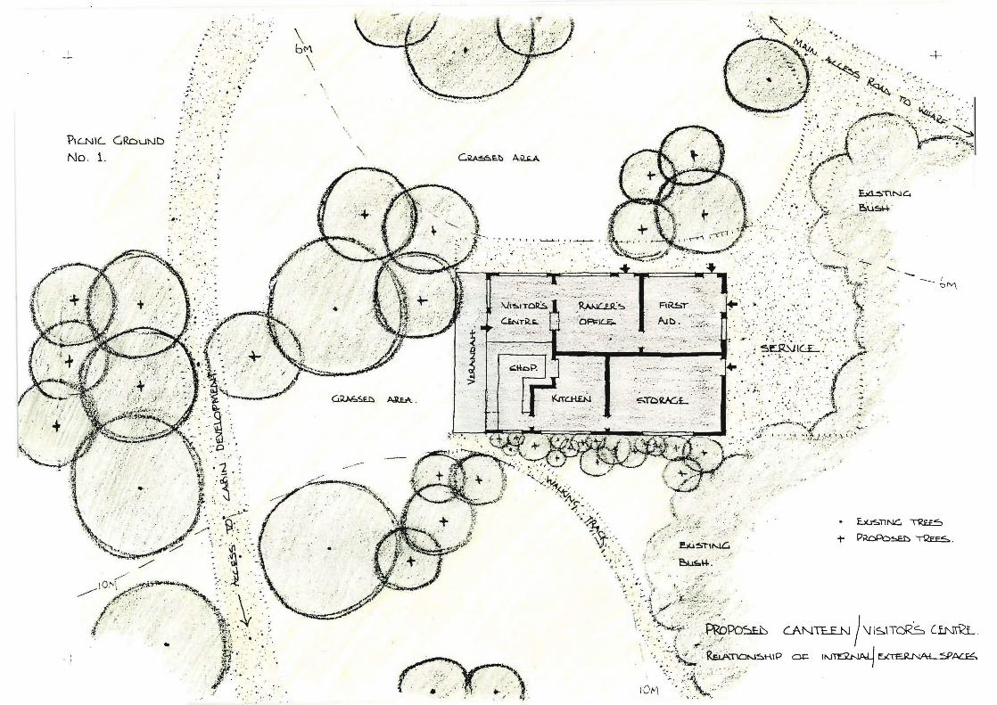
-.
... '. . ... ~ ~ 0" ' . ,'.
~ . ': . ,.'.
?IL.NIL GRDuND -
No. 1.
,- -
I - I
. , ..... .. .. I
: . ...
.":'
.' .
. . , .. . '
," ,;
.;; , . . ·Ao
;' .' .. .. . ' .... . '.~~
. .-:,'iJJ '/ .. . . . ~" \ -' .. , t ' . ~TlNC.
c<" ";'.'-. ,< -_ /'.)~ .. ..".. ~- : . .. . ~. . - '-
, - -- ____ I
~M .
.. ) ", '.' .. '" .. -:.
Toilets and Changing:
Siting of these is dispersed (See location on Map 7):
to avoid inconvenience of centralised toilet block.
to enable siting of smaller buildings in harmony with
the setting.
to control use. For example during times of low use,
certain units could be locked for 'recovery', to ensure break
down of wastes, and avoid pressures at peak use times (when all
units will be required to be functioning). (For details see
Plan 8.)
Shelter:
Due to the occurrence of su?den squalls of rain which
catch picnicers unaware, minimal shelter buildings have been
sited at three points around the picnic grounds. (See Plan 7
for detail location.)
Canteen Manager/Caretaker ~esidence:
This building should be of a style in keeping with that of
other proposed building, and of a less suburban nature than the
other residences built on the island to date. It is important,
also, on this and other islands in the Gulf that are not supplied
with mainland power, to explore the potentials of alternative
sources of natural energy, rather than to rely on noisy
generators.
175.

Cabins and Associated Facilities:
Overall detail layout and suggested building layouts
ap pear on Plan No.8.
men t) •
(See Plan 10 for perspective of develop-
" Below is a notated sketch oi the layout.
'") .-,
.. /
- - ,
,\( .,.. I ,
"(,---'
> ..
. ~
o .:' . ;' ....
/
/
• L<.1!:.nr-L ~
/
176.
Boat Sheds and Wharf:
The boat shed development presents a tight cluster of
foreshore buildings adding to the marine character of the island.
As visitors alight from the ferry they will pass through a
pleasant space enclosed by these buildings and cliff-top vegeta
tion.
The existing shelter-shed will remain. The storage shed is
primarily intended for use by the ranger. However, the sea-s
scouts may require space here if they continue to use the island
for activities. One boat shed is intended for the ranger's
boat, (which to date has been stored up at the station). The
other shed will house small boats (e.g. dinghys or sailing
dinghys) that are intended to become part of the experience for
those organised groups using the proposed cabin development.
It is suggested that the new wharf be sited in basically
the same alignment as that existing, and be of natural timber
materials, if these are deemed durable. A concrete structure
may detract from the atmosphere of the island.
Building Colours:
Colours of proposed buildings as pr~viously mentioned
should ultimately become the colour of the naturally weathered
material pf which they are constructed. It is suggest~d that
when painting existing farm buildings (including those in the
177.
farm complex, pump-houses and gates) that colours be chosen
from combinations of the buff, brown, brown-green and brown
red range.
OTHER PHYSICAL ELEMENTS:
This includes items such as picnic tables, barbeques,
refuse bins, signs, steps, styles and fences.
These items are covered quite extensively in such publica
tions as 'Designed for Recreation' by Elizabeth Beazley and
the U.S. Forest Service Manuals. For more complete and addition
al information these two pUblications should be consulted.
Tables - can be out of character and have an urbanizing
effect, or they can be used as decoy to suggest where people
might picnic - therefore having uses. As the picnic areas on
the island are grassed and major use is in summer, the ground is
quite conducive to picnicing. Therefore it is envisaged that
very few tables need be supplied. The elderly may require this
facility and tables can also be handy in barbeque areas. Siting
is important. Tables dumped at random can look absurd. There
fore it is important to integrate them into the landscape, for
example, grouped in a space defined by trees. Timber tables
of the styles outlined in 'Beazley' would be more appropriate
than the bright blue and white metal tables used to date.
178.
Barbeques - these can be minimal and sited in the area
designated (See Plan No.7) away from general picnic facilities.
This overcomes smoke annoyance to other picnicers. Wood should
be supplied to avoid visitors cutting their own. As no natural
rock suitable for barbeque construction exists on the island,
dark red fire bricks would be the preferred construction
material.
Refuse Bins and Disposal - this is dependent on the system
chosen out of the three mentioned in a previous chapter. What
ever system is chosen (unless a take-your-litter-home policy is
adopted) bins will be required. Siting of these is important -
at the greatest potential sources of litter. Some suggestions
are - in the immediate vicinity pf the canteen, at toilets and
changing sheds, at the top of steps and at barbeque si
Some experimentation with sites may be inevitable. The style
of bin is important; it must be easy to deposit in, easy to
empty, visible but absorbed into the landscape. The blue drums
to date are inadequate. Lids will be requ d to deter birds
and cats.
Disposal of litter should be confined to one site. (See
location on Plan No.6). The site should be adequately screened
by vegetation, and a system of controlled disposal be implemented.
An incinerator to assist decomposition should be provided.
179.
Signs - natural timber signs are preferred. Positioning
of signs is important in order that they can be clearly seen
and read. Signs will be required for the canteen, toilets and
changing shedS, and for directions to farm walks.
Steps - these are required in order to control beach access
and prevent further erosion of the foreshore bluff. (See Plan
No.7 for detailed location). Steps are to be of timber
(e.g. tanalised pine), have non-slLp treads and a smooth no
splinter hand-rail.
Styles - these are required to protect fences and prevent
the necessity of opening gates and letting stock wander. (See
references for designs).
Fencing - the general fencing pattern has changed due to
planting proposals, and the resulting fencing requirements.
Fencing patterns that follow natural boundaries and contours
result in improved visual results. Future fencing programmes
should take this policy into account.
VEGETATION:
Species:
It is proposed to use those species naturally occurring on
the island. Apart from the aesthetic merits of this approach,
180.
other functional benefits accrue, these being the ecologically
based factors of ease of establishment and maintenance. Also
it is hoped that this will encourage the establishment of suit
able habitats for native birds, these aiding in the perpetuation
of naturally maintained areas of native vegetation.
Species have been chosen in groups, depending on their
suitability to the conditions in which they will be growing and
the function they are to fulfil.
Therefore the major groups that have been set aside are:
the coastal fringe, larger areas of re-vegetation, and the shade
and shelter trees for both the recreation area and the farmland.
The species are as follows:~
The Coastal Fringe:
Meterosideros excelsa
Myoporum laetum
Pittosporum crassifolium
Dodonea viscosa
Macropiper excelsum
Pseudopanax lessonii
Coprosma repens
Coprosma macrocarpa
Phormium tenax
Cortaderia fulvida
As lia banksii
pohutukawa
ngaio
karo
akeake
kawakawa
houpara
taupata
shore coprosma
flax
toetoe wharawhara
181.
Gahnia lacera
Hebe stricta
Muehlenbeckia complexa
sedge
koromiko
It is not envisaged that every single one of the above
mentioned species be used in a random fashion. Group planting
using a few species is preferred. The eff~ct required or function
to be fulfilled will determine the species to be used in detail.
For example, at strategic points around the periphery of the
farm area where views are to be retained out, lower growing
species in the list would be used. Similarly, in the recreation
area, on the foreshore of both picnic ground 1 and 2, low shelter
and erosion control is required, this depictirig the use of suit
able combinations.
It is important, however, to completely 'cover' the ground,
especially in the fenced off portions of the coast. This is
necessary in order to suppress other potential competitors, such
as gorse, rhamnus and long grass. On the picnic ground foreshores,
it is also necessary to plant thickly in order to encourage
visitors to use the step access to the beach provided, to prevent
further erosion to the bluffs.
Mid-zones:
Meterosideros excelsa
Corynocarpus laevigatus
Knightia excelsa
pohutukawa
karaka
rewarewa
182.
Vietex lucens
Brachyglottis repanda
Carmichaelia aligera
Coriaria arborea
Cordyline australis
Geniostoma ligustrifolium
Hedycarya arborea
Leptospermum ericoides
Leptospermum scoparium
Macropiper excelsum
Melicope ternata
Melicytus ramiflorus
Myrsine australis
Phormium tenax
Sophora microphylla
Cyathea dealbata
Cyathea medullaris
Dicksonia squarrosa
Parsonsia heterophylla
Rubus cissoides
puriri
rangiora
tutu
broom
cabbage tree
hangehange
pigeonwood
kanuka
man uk a
kawakawa
wharangi
mahoe
mapou
flax
kowhai
ponga
mamaku
wheki
kaihua
lawyer
In addition to these there are also the numerous ferns
and herbs (see lists in Appendix) that will establish naturally
with the provision of suitable conditions.
In very wet gully bottoms, especially nearer the coast
where water tends to collect, the mid-zone vegetation could
phase to almost pure stands of pharmium tenax. Sedges and
183.
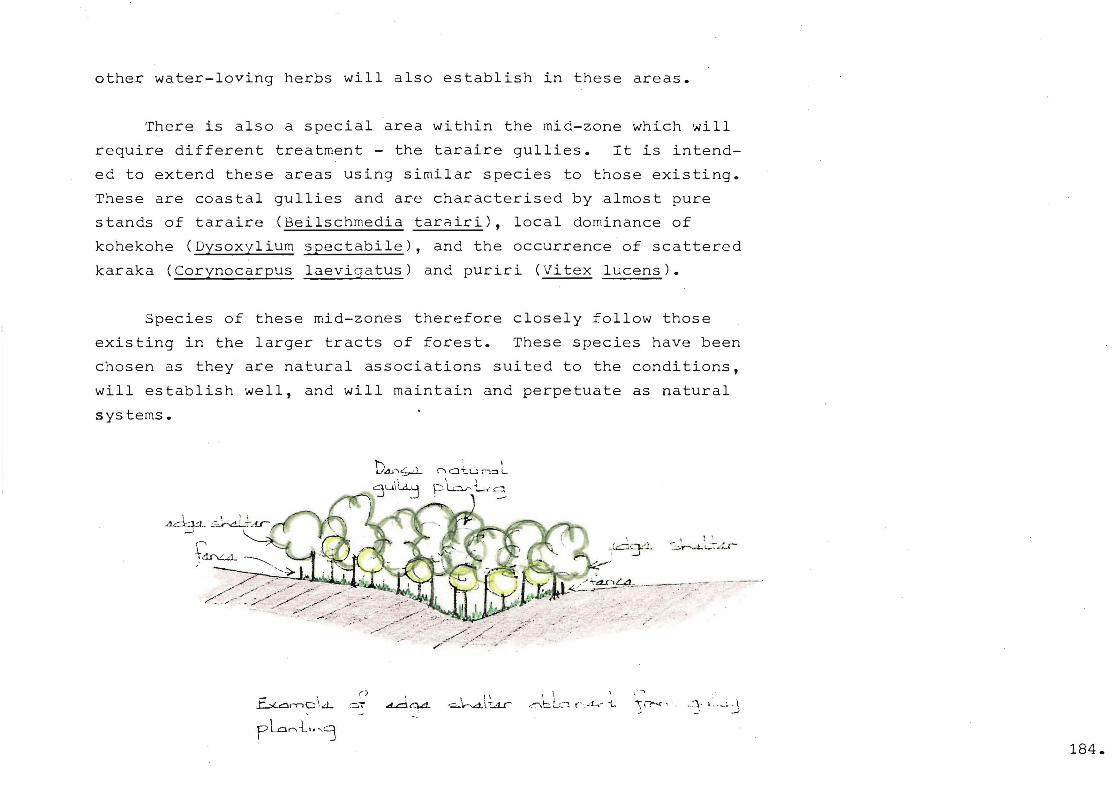
other water-loving herbs will also establish in these areas.
There is also a special area within the mid-zone which will
require different treatment - the taraire gullies. It is intend
ed to extend these areas using similar species to those existing.
These are coastal gullies and are characterised by almost pure
stands of taraire (Beilschmedia tarairi), local dominance of
kohekohe (Dysoxylium spectabile), and the occurrence of scattered
karaka (Corynocarpus laevigatus) and puriri (Vitex lucens).
Species of these mid-zones therefore closely follow those
existing in the larger tracts of forest. These species have been
chosen as they are natural associations suited to the conditions,
will establish well, and will maintain and perpetuate as natural
systems.
" ~dr\L.d.. ~ , ~.~"-~>~~~~= /'<~':'~':';:::~:>~::--' "
. ,.,. ~ ,. ~ -; , -: .. /~---
\
r\ CJ 't:..u fC:]. L " ,
P lL.-~ L t' ,c::l
\ \ ~bLC1(- "t~· i..
. ' : ",r-W. . .. ::-.Lr
, . ....,
184.
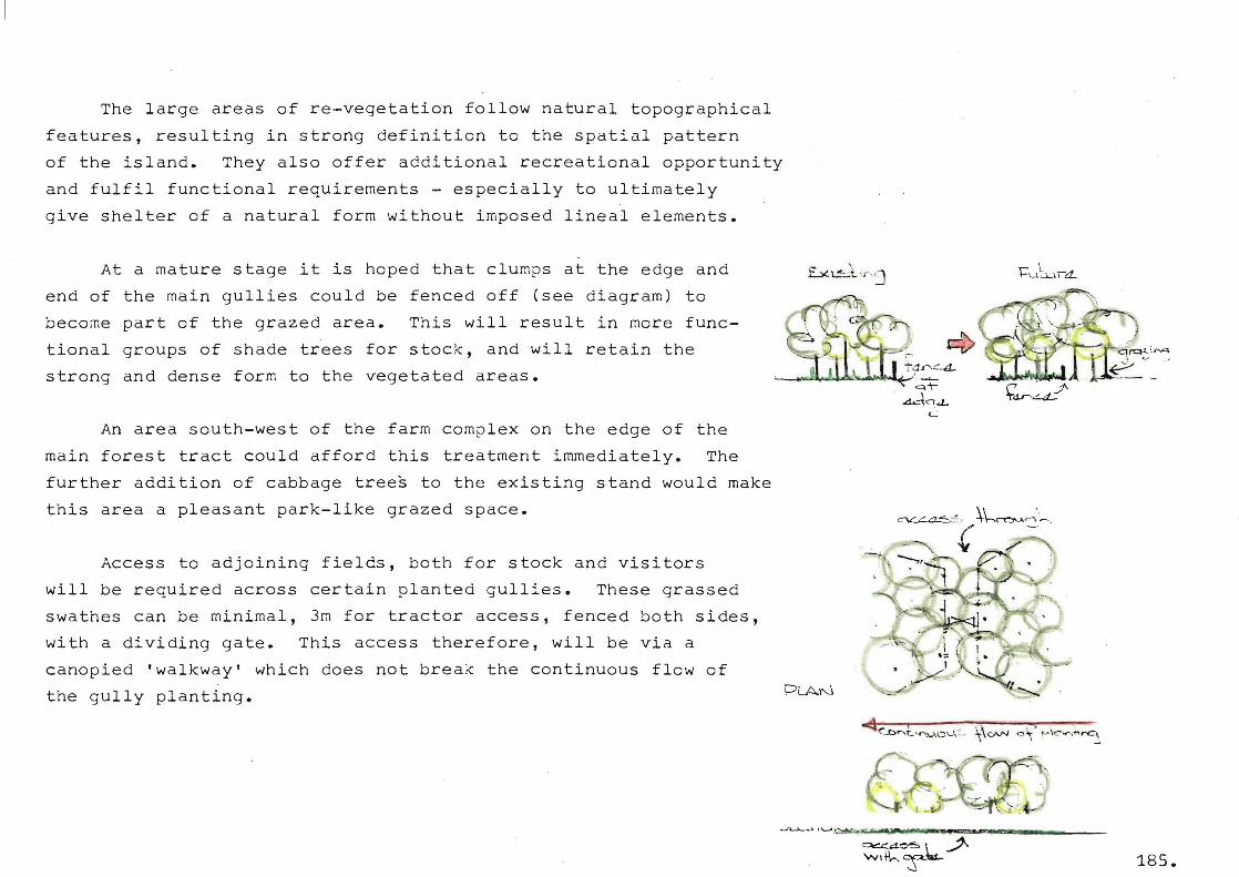
The large areas of re-vegetation follow natural topographical
features, resulting in strong definition to the spatial pattern
of the island. They also offer additional recreational opportunity
and fulfil functional requirements - especially to ultimately
give shelter of a natural form without imposed lineal elements.
At a mature stage it is hoped that clumps at the edge and
end of the main gullies could be fenced off (see diagram) to
become part of the grazed area. This will result in more func
tional groups of shade trees for stock, and will retain the
strong and dense form to the vegetated areas.
An area south-west of the farm complex on the edge of the
main forest tract could afford this treatment immediately. The
further addition of cabbage trees to the existing stand would make
this area a pleasant park-like grazed space.
Access to adjoining fields, both for stock and visitors
will be required across certain planted gullies. These grassed
swathes can be minimal, 3m for tractor access, fenced both sides,
with a dividing gate. This access therefore, will be via a
canopied 'walkway' which does not break the continuous flow of
the gully planting.
~~~~~~~~. ~ q-r . .ct.:d"d..
'-
Shade and Shelter Trees:
Combinations using species selected from:-
Meterosideros excelsa
Corynocarpuslaevigatus
Knightia excelsa
Vitex lucens
Myoporum laetum
Pittosporum crassifolium
Macropiper excelsum
Pseudopanax lessonii
Coprosma repens
Phormium tenax
pohutukawa
karaka
rewarewa
puriri
ngaio
karo
kawakawa
houpara
taupata
flax.
- this list covers both those species suggested for shade and
shelter on both the farmland and'in the recreation area.
The effect required on the farmland is to have large
canopy trees under which stock can graze and rest. Therefore
the first four species in the above list would be the most
appropriate. Protective fences will be required until indiv
idual trees are hardy enough to withstand pressures of brows
ing stock. (Special care should be taken with karaka, as it
is considered t6 be toxic to stock). The number of species
in each group should be kept to a minimum, and should be planted
to produce effects similar to the existing puriri stand.
In the recreation area, the required effect is slightly
different. Canopy shade trees are also required. In addition
186.

lower growing species planted in association with the larger
trees are needed. The purpose of this is to provide smaller
scale spaces within those defined by the larger trees, thus
producing more secluded picnic 'spots'.
Techniques for Planting:
It is envisaged that the following methods of re-vegetation
could be used:-
• hand-planting of suitable seedlings.
• distribution of appropriate seed beneath a suitable
hand planted or seed-established nurse crop.
• combinations of the above two methods.
• hydroseeding.
Hand-planting - this method can be carried out where
• difficulties occur with other competing plants.
• certain desired effects are required and defined detail
placement is necessary. (e.g. to define spaces)
• special functions (such as erosion control on cliff tops)
are required.
Care should be taken in planting out young seedlings.
Trees respond to good treatment, but only too frequently they
~re given little care at planting or subsequently. Watering and
weeding (if these are competing) will be required for at least
the first two years ·of establishment.
187.

Seeding - In large areas where it is'not practicable to
hand-plant out seedlings, seeding out with appropriate seeds
from a suitable source is recommended. For best results it is
recommended that the areas for re-vegetation be fenced off and
a nurse crop such as manuka (Leptospermum scoparium) be esta
blished~ The purpose of this is to shelter and protect young
seedlings and also to suppress undesirous competitors such as
rhamnus and gorse. To ensure establishment of the nurse crop it
may be best to hand plant, manuka being a poor 'striker' from
seed. Benefits could also accrue fro~ the inclusion at this
stage of some of the native nitrogen-fixers such as broom
(Carmichaelia aligera) and tutu (Coriaria arborea).
Hand-seeding can then take place beneath the established
nurse crop. It is envisaged that the most suitable source for
seed collection would be from the trees existing on the island.
(For information on seed collecting and preparation see the
'National Conservation Campaign Activity Leaflet No.1').
Alternatively, appropriate seedlings could be randomly
hand-planted beneath the nurse crop, these ultimately to act as
mother plants and a potential seed source to aid natural processes.
As stated previously, one of the purposes of establishing
large areas of native bush on the island, is to provide suitable
habitats for native birds. An increased bird population would
aid in establishing these new areas of vegetation by distributing
seed.
188.
Hydroseeding - this is a method of seeding by machine. The
hydroseeder sprays a mixture of seed in a mulch which adheres to
the soil and promotes growth. Its application on Motuihe Island
would be for areas such as banks and cl tops where difficulty
in establishing vegetation experienced.
Experimentation using native seeds directly in the mixture
has been carried out lately. (More research may be needed in
this area). Alternatively, grass seed is used. Once established
this prevents slips and forms a basis for the growth of native
plants.
189.

Appendix
APPENDIX A
ISLl,NDS OF THE HAURA.I<I GULF ]vJARITIlI-1E PARK:
* Permits are required before landing on those islands
marked with an asterisk.
POOR KN:LGHTS *
482 acres of k land.
":>itu2ted if teen mi~es north-east of Tutukaka 7 this 9
has an 3bundance of relatively un stlJrbed "",ildlLfe.
The po~icy of the Board is to issue landing perm! to
scientific parties, and then only under strict conditions.
Scientists are attracted to the Poor Kniahts for many
reasons - the rare Xeronema ca~listemon lily, the abundance
of lizard species and tuataras to be found, the rare mar
life in the sur waters, and the nestins araunds of
sed birds.
On ,'~,or''lngi~ there are stc.;iF~ ':lilll,s, cu~Lt Lltlc:n t)it~:~ olnd ot:her:
signs of the r idence of ~aoris, who left the is!and fall ng
an inter-tribal massacre in about 1823.
190.
WHANGARURU:
688 acres of park land.
This is the most northern area in the Park, and just
south of the Bay of Islands. A small peninsula of rolling bush
and pasture, it is partly farmed. There are limited camping
facilities for a small charge on its unspoiled beaches, whRre
there are fresh water and toilets. A rare New Zealand land
snail and its albino sub-species are found among the dry leaves
on the forest floor of isolated parts of the coast.
A farm manager is resident and controls the camping
facilities.
GREAT BARRIER ISLAND:
16 acres of park land.
Fourteen acres in Kaiarara Bay, ?ort Fitzroy, are included
in the park. This very attractive headland on the western
coast has a sheltered anchbrage, although there are no facilities
for public accommodation at the moment.
A further area of 2 acres on the foreshore hehind the shop
at Port Fitzroy has also recently been included in the Fark.
191.

BRSiJij ISLANDS:
19 acres of park land.
These four rugged islands are little more than rocky out-
crops \-/here the taupata
burrows of the petrels.
. , 1 lS a.l.~ that protects the nesting
Apart from M~turaka, where access is
pass ib Ie from th~ mainland u. t 10','1 tide, r i tb not easy to land.
There is no cestricticn set by the Park Board on landing,
but i t doe~; ask that the r::,ubllc take care, as though tless
stumbling through the bush can easily destroy the burrows a
HEn .';ND CHICKENS:;'
2082 acres of park land.
This group is designated a scenic reserve, although it
lS not yet formally added to the park.
,\t Tar::J nga (the ;'~en), L:H'r;res t in the gC)!:P, there is an
automatic light 3erving the ~;rowinJ a~ount~f tdnker movement
to and from the ~"arsc:en L'oi:lt oil refineryo
Another automatic light is situated on Co~permine Island.
192
There are eleven isl~nds in the Marotiri grbup, known as
the IlChickens ", includinq Co[:.'psr:nine, Alice and ~hatapuks
Is lur.ds .. The smallee, .·Jostern Chickens dre knmJD to be
biologically fferent from the rest of the group, and several
specles of pl~nt and ~nim31 are found here that re no longer
present on the mainland.
the bush birds th~ s0~~leback is i
birds ta~en fro~ ~ar a.
The nesting grounds of se birds are an important feature
of t ht.:::. .. ~ oup. Flutteri~g shearwatees, di pe els, P f ts
petrel and the flesh footed ~:etr,el arG some "vh nest here"
LITTLE Qj\I<RIS~. ISLJ.j\!D:
6950 cres of ~ark land.
arci, it
prolific bied life, tuis and ~~ Ihirds abound. The stitchb d
larly importctnt beC2use it :Ls nov! confir:.ed to :,ittL?
Barrier, hel'll in. the ~orth 131and at one time.
193.
This island is also a main nestin<] und for the
petrel.
~ountainous and hea ly forested, it is possibly the only
rem nl large forest ~rea in ~ew Zealand which is s eel
by introduced browsi dni~als.
s fc:..mtlJ arc the only r~sidents ~n
the " , lSlanc. t to lanc o
267 acres of park landm
The largest of these, Rurgess Island, is not included in
the park, being a Ii hou['.e s ta tion.
~here are three 0 er m~ln islands and seven smaller ones
reeks anc: reefs. Veoetation is Gtu~t2d ~nd the fauna
~ tion is in ~h2
spite the dif 1t on C02.st-
line, the EQori ~eople of ~re3t 2arrier, 15 miles to th south-
east, still exercise lege to land dnd sndre
mut n birds fer t o',,,n use,.
194.

Deep sea fishermen in the area find ~reat sport in the
kingfish, hapuku, shark and marlin to be found.
GOAT ISLAND: *
23 acres of park land.
A small bush-covered island near the settl~ment of Leigh,
which is used a great deal by the students of the University
of Auckland in their studies of marine life.
CUVISR ISLAND: * 423 acres of park land.
steep hillsides rise straight from the sea a~ound this
island, which has a dual role in the Hauraki Gulf.
Fifty-eight acres is~arine Depart:nent reserve, where
three lighthouse keep~rs live with their families. The rest,
42] acres, is a reserV2 for the preservation of flora and
fauna, and included in the ~arka
In 1960 it was considered by ecologists to be depleted,
goat-ridden, cat-infested and apparently of little value.
Today it is a valuable reserve. The ~ildlife 3ervice
eradicated the cats and goats, thus allowing the rest to
195.
regenerate and become a suitable habitat for the reintroduction
of the North Island Saddleback o
A number of these birds were then transferred from the
Hen and Chickens Islands, their only location until then, and
have established a breeding population which is thriving.
~ERCU~Y GRCUP: •
856 acres of park land.
Although Great Mercury is privately owned, six islands of
the group are included in the park. Four of them were gifted
by the Karaua, Whanaunga and Hako families of the Ngati-Maru
on the understanding that they be kept as a reS2rve for scenic
purposes.
They are particularly valuable to ecologists at present for
the study fo the effects of the kiare, or Polynesian rat.
Those islands in the group where the kiore lives show a :narked
difference in vegetation and bird life to those free of the
rodent.
Landing is very difficult, even dangerous on some islands
in the groupo
196.
Red Mercury is one of the islands in the park selected
for the re-introduction of the North Island saddleback, a
bush bird found only on off-shorB islands, although formerly
0idespread in the North Island.
THE: ALDSRM2N; •
330 acres of rark land.
This group, comprising three main islands in a triangle,
with a chain of pinnacle rocks across the centre, was named
"The Court of Aldermen" by Captain Cook, no doubt because
of its imposing appearance and formation.
They were gifted to the Crown by the descendents of
Maru-tuahu, Hako and Hei of the Ngati Maru, in 1970 and are
now reserved as a sanctuary.
Their appearance from the sea is one of craggy and for
bidding rocks, and apart from occasional fishing and mutton
birding parties, have been little visited. Despite this
appearance, there are some workable landings, and a permit
is required for all visitors.
The vegetation is prolific in sheltered areas, while in
exposed,places it is scrubby but it supports a considerable
native bird population.
197.
On onG, Flat Island, exists the largest colony in New
Zealand. of the white-faced storm petrel, usually known as
"Mother Carey's chicken" or the "Skip Jack".
International interest is focused on the abundance of
tuataras living on the islands.
366 acres of park lando
This public domain situated in the south-west of this
island with Mansio~ House as l' ;- C' ~U hub, is one of th2 most
popular parts of the Gulf.
At one time the island belonged to Sir Geor]e Grey,
a [Jew ~~edland :3overnor i.r. l:he early colonie.l (:ilY':; I (lnd r:..s
hOG8 has since beco~e es~~bli3hed ~s ~ licensed hotel.
dczen~--:
vlall::.::;i~::;, emu.:;,
is still growing
zebra.'s
there,
':':ome of
:::r:c p r.- ~) .lL f _-:.. C A
198.
The are~ offers walks through pine forest and ferny glens,
secluded beaches, the ruins of old coppermine workings and
therp are picnic and baibecue sites.
A small cam~ing area is situated near the hotel.
Services for pleasur2 boats includ~ fresh ~ater and marirle
fuel available fo~ sale.
other small areas on Kawau are included in the Park:
there are 3 acres at the head of smeltinghouse Say; another 7
acres at the entrance to North Cove, called Edwards Point; while
Sharp Point, which was gifted to the Park by Mr. H.~. Goodwin,
includes 10 acres at the entrance to Vivian Bay.
A Park Ranger lives in the bay adjoining ~an3ion House Q
BEEHIVE;
2 acres of park land.
Privately owned by Mr~. I.rl. ~ilson, this lsl~nd is a
small knoll surrounded by broken shells, makirlq it appear to
float above the water.
199.
MOTUORA:
197 acr~s of park land.
An attractive farm that is l~ased for grazing. The public
has access to the foreshore, and on the northern coast there are
~ome good beaches with anchorage in south easterly conditions.
MC~UTARA:
2 acres of park land.
Most of this island is privately owned, but the western end,
where a quarry was sited some years ago, is included in the park.
The old quarry is arena sh~ped and with the remnants of a
sturdy stone wharf still standing is ~n ideal place for boating
parties to land and picnic.
SADDLE ISLAND: (Te Haupa)
12 acres of park land.
~ feature ~f this small island i~ ~ 10n0 curving beach on
the western side where some old pohutukawas cast their shade on
the soft sand. It is ideal for water skiing. The bush includes
mature pohutukawa and kowhai.
200.
It is a traditional picnic ~12ce for bo~t-n~nGrs as it
is ,) short run feom ':fender-hoLn RcsC?rve and trio r·~a.hurangi
Feninsula.
Vi~itors ar Q asked to take care when walki~g inland not to
destroy the burrows of nestin9 ~e2 birds.
1 7 :3. C r·~ s () f f) a r]( 1 a. n d 0
In the sheltered ~~hu=~ngi H~rbour, thi~ island is linked
to the mainland by a natural causeway or ridge ~hich can be
walked alona at low tide. ThlS rldge extends right around the
island dnd there is no sandy ~e~ch. Lov/ever, s,-:;ve:ral tcacks
amont] the trees make ple;}sar.t c,x;;lo.cir:g and it is a short boat
run to nearby holiday settJ.ements.
Ilarious sm'a::'l reser'r(=s3.motlnting to some "1 ~rTC::S "~ere
owned by the park on ~~kino.
Cne such spot is on the western coast, where ~h~re is very
al:tr",ctive heacl2.nd and be2ch~ncluGed in the ;:"H":.
~nchor2ge makes it ideQl for ~s~ily boats. ~nothec 3mall 2rea
201.
of park land is Qdjacent to the wharf in the south east.
NORTH HEAD:
21 acres of park land.
A long-time military fort, where emplacements and tunnels
date from every time of military crisis in Auckldnd since 1865,
it was originally called Fort Cdutley. The fort was Regimental
Headquarters for the 9th Coastal ReGiment of the New Zealand
Arti llery dur ing ~'lorl d ',lar II .'inc} during the ia t ter part of the
war was Fire Command for all Coastal Batteries froffi the Bay of
Islands to ~aiheke.
The summit area is closed to the public and under Navy
control, but the r~st is open for the public to vie'"1 the Gulf
and harbour.
1\ track at '/Iater l(~vel circle~ the hill an(~ dnother half
sites.
TIRITIl1I:
350 acres of park land.
Eighteen miles north of ~uckland, Tiritiri L3 the site of
~n impor~ant lighthouse station and has a vital role in
202.
communication for the port of Auckland. The Marine Department
Reserves includes 194 acres while the rest of the 544 acre
reserve is included in the park.
This land had been grazed by stock for most of this century
but recently the Board decided to terminate the grazing lease
and allow the island to revert to native: bush.
There 1s only one good sandy beach, the rest of the coast
line rising sharply in cliffs. Several forested gUllies with
giant pohutukawas and fresh water streams hold promise of
attractive camping sites,but until facilities are built public
access is limited to daylight use only.
RMJGITOTO:
5709 acres of park land.
The younges t of the is lands in the Haurak.i Gulf, it is a
volcano thought to have erupted for the last tiri1G about
years ago. Today, bc:.r2 lav;:, dlterna.tE:s ~'Jlt[' i".'e'Tklc!cable veget::l-
tion where plants grow in fissures and thrivG in app~rently
barren conditions.
It is a favourite picnic place .for j\ucklanders, small
launches ferrying visitors out every holiday morning.
203.
Runabout owners enjoy the only sandy beaches on the
island, ~hites Beach and ~cKenzie Bay, on the north-west side.
Roads and other facilities were built by prisoners in the
1920's, the flat surfaces and metitulously built walls bearing
witness to their very hard labour.
There is a shup and ?ost Cffice at both Rangitoto 0harf
and Islington Bay. The wharf area has the ~dded attractions
of swimming pool and tearooms. ~vening barbecues are populdr.
MOTU'::'APU;
3728 acres of park lando
This large island is farmed extensively on behalf of the
Park BOard. For this reason, public access is restricted to
the landings at Islington Bay and Home Bay and on other parts
of the island up to the cliff top or nearest fence line.
Located on the farm is an 8 acre youth camp leased by the
North Shore Y.M.C.A. There is limited space for camping near
the causeway at Islington Bay, with toilets and fresh water
nearby. Above the cause'way is the house of the Park Ranger.
SPECIAL NOTICE.
Motutapu Island is a hydatids control area. No visitors' dogs
can be allowed on the island at any timeo
204.
Rangitoto, Motuihe and Mot~tapu Islands played an
important part in the coastal defence network of Auckland
Harbour during World War II. Barracks,gun and searchlight
installations are to be seen on all three islands.
JVIO'l'UIHE:
441 acres of park land.
Another small farming island being worked on behalf of
the Board. Here the public is allowed ac~ess to all parts
except the homestead area. There are toilets and changing
sheds for the many visitors who come on day trips during
December to February. A canteen operated during these months
sells refreshments.
Attractive beaches on the south east are favourites
with the boating public.
i;' P ar)c Ral1g er lives ,-3- t the t:o p ;.)£ the hill r)c: hind t:he
canteen. Landiny on Motuihe after ~ark is forbidden.
BRO'ims: (Motukorea)
148 acres of ~ark land.
A low volcanic hill of pastureland which has been farmed
ever since 1840 when John Logan Campbell and William Brown
205 ..
set up a pig farm there the year before the settlement of
Auckland was founded. Both men wer~ to become prominent in
the growth of the city.
Today it is administered by the Park Board on behalf of
the Auckland city Council, to ''''hom it IJ'/c3S prcser:.ted by .:..:iir
Ernest Davis, its last ~rivate owner, and dnother benefactor
of
Although it is leased for grazing, access to it is quite
free in the hours of daylight, and it is a pleasant destina
tion for runabouts, being only a short run from the suburbs
of Howick and st. Heliersa
A shallow coastline dotted with rocky outcrops means
that care is required in landing which is only advisable for
two hours before and after high tide.
206.
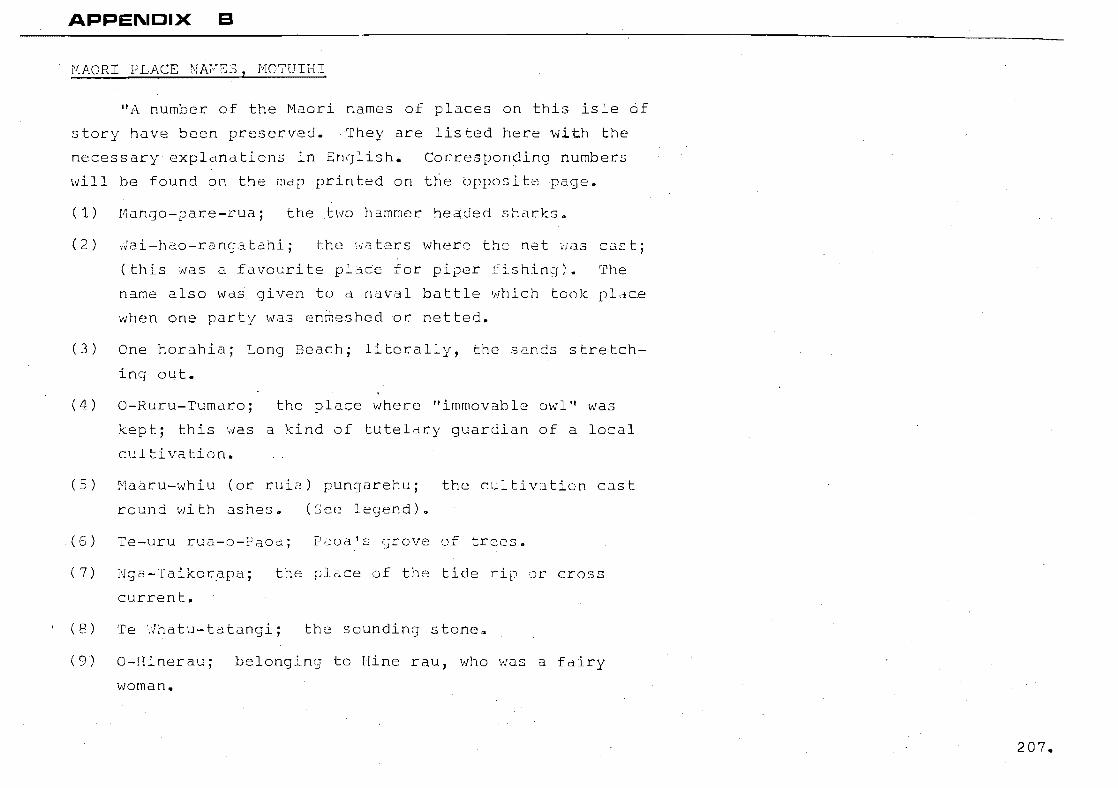
APPEI\.ICIX a
MACRI PLACE .NAEES, MOTUIHI
itA number of the Haori names of places on this isle cif
story have been preserved. They are listed here with the
necessary explanations in English. Corresponding numbers
will be found on the map printed on t~e bppositepage.
(1) Mango-pare-rua; the two h~mmcr he~ded sharks.
( 2 ) the '"fa ters where t!le net i,ias cas t;
(this was a favourite pla~e for piper fishing). The
name also was given to a naval battle which took place
when one party was enmeshed or netted.
(3) One horahia; Long Beach; literally, the sands stretch
ing out.
(4) O-Ruru-Tumaro; the place where "immovable owl" was
kept; this was a kind of tutelary guardian of a local
cUltivation.
(5) Ma~ru-whiu (or ruia) pungarehu; the cultivdtion cast
rouhd with ashes. (See? lec;end) Q
(6) Te-uru rua-o-Faoa; Paoa's grove of trees.
(7) Nga-Taikorapa; the pl~ce of the tide rip or cross
current.
(8) Te ~hatu-tatangi; the sounding stonea
(9) O-Hinerauj belonging to Hine rau, Tdho '/'Jas a fairy
~..;ornan •
207.
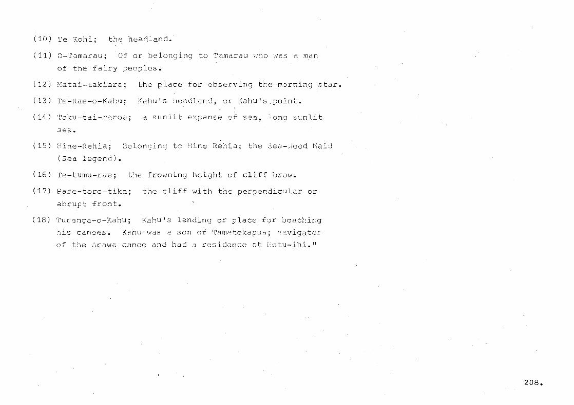
(10) Te Kohi; the headland.
(11) O-Tamarauj Of or belonging to Tamarau who was a man
of the fairy peoples.
(12) ~atai-takiara; the place for observing the morning stdrn
(13) Te-Rae-o-Kahu; Kahu's headland, or Kahu's.point. I
(14) Taku-tai-raroa; a sunlit expanse of sea, long sunlit
(15) Hine-Rehia; 8elonc;ing to iiine Hehidj the :32CJ-,,;eed r!;aid
(Sea legend).
(16) Te-tumu-rae; the frowning height of cliff brow.
(17) Pare-toro-tikaj
abrupt front.
the cliff with the perpendicular or
(18) Turanga-o-Kahu; Kahu's landing or place for beaching
his canoes. Kahu was a son of TametekapuCJ; navigator
of the :\rawa canoe and had a residence ::It ::otu-ihi."
208.
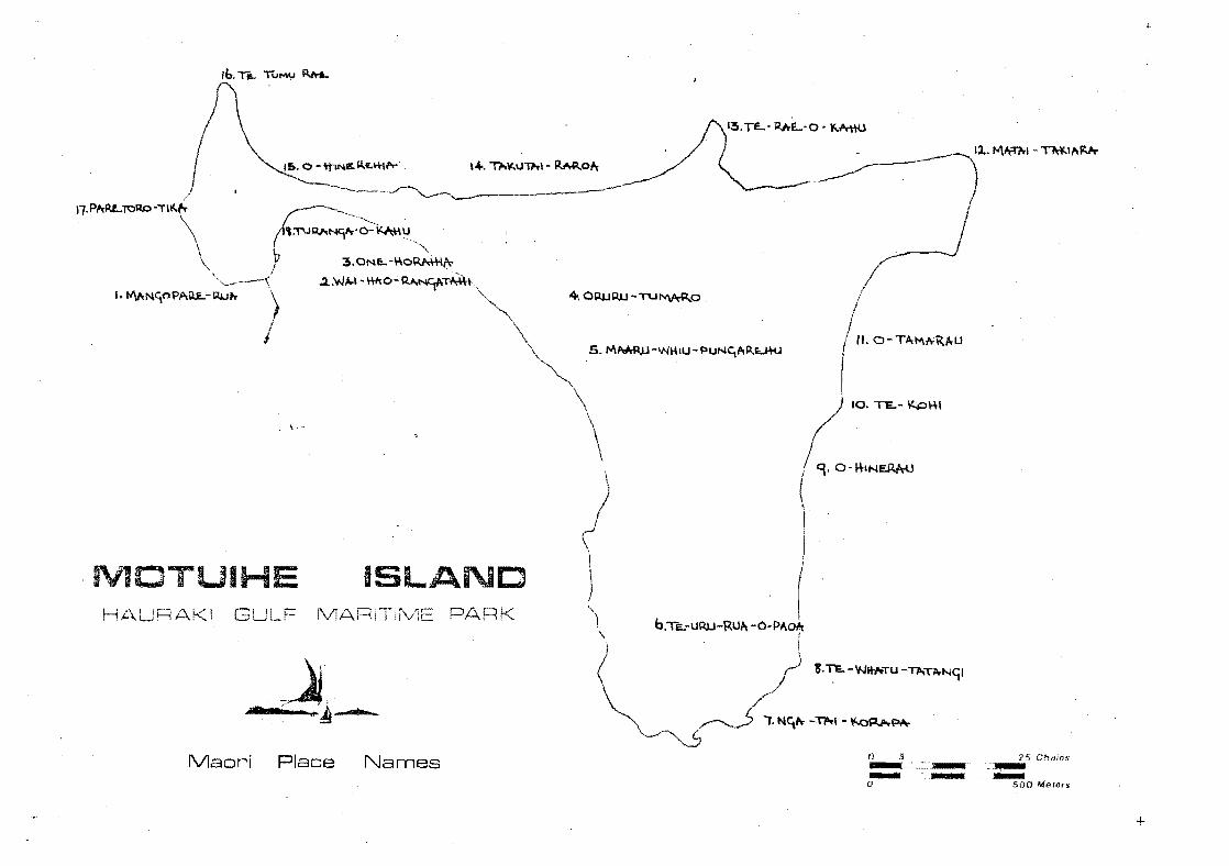
\ ...
MOTUIHE ISLAND HAURAKI LF MARl k
Maori Place Names
+.O~Q1J-TU~O
o 5 - ..... -- .-o
25 Chams '---500 Me"".
+

(LEGEND)
O-RUT{U-TUU-'!ARC:
The Owl That Did Not Move.
"Far back in story, perhaps before ','/illiar,1 the No):"man
had forced himself on the Snglish people, an enterprising
Maru-iwi settler, named Te Ihu Pate, ha~ made a home for him
self and his folk on Motuihi; trusting t'o the encirclinq sea
to save him from sudden raids by envious neighbours. In a
clearinq he planted hue (gourd) and taro, which foods his
fathers had brought to these islands, but when the sun rose
one morning after a very foggy cold night, the plants were
blackened and wilted. Te Ihu knew then that his crop had been
raided by the patupaiarehe folk (fairies), who had come, under
cover of the fog, to the is land ·in their phan tom canoe, "fre
Rehu 0 te tai," and had stolen the "shadovJs of the plants" as
Te Ihu said, "the life essence," thClt is, and therefore the
plants had died.
Assuming that thc~se acquisitive ~eople hdVi:1c:; once
succeeded so easily, wou~d risk coming back again, ~e Ihu, in
the next crop season set an ambush for the fairy raj.ders. He
knew by legend that they did not cross wood oSh25, so he laid a
line of ashes around the confines of his plantation except on
the seaward side. One foggy night, when his guardian owl,
Ruru tumaro, had solemnly forewarned that a visit from the
plunderers was iminent, Te Ihu gathered his folk for battle
with the mystery men.
210.
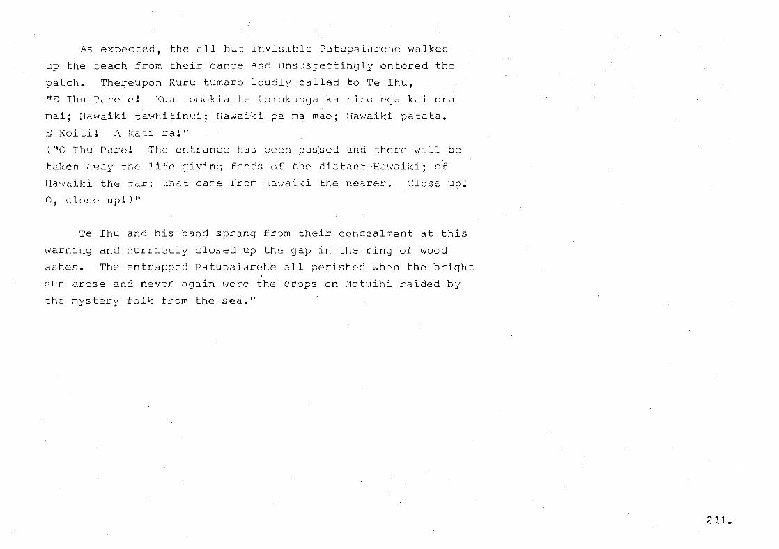
As expected, the all but invisible Patupaiarehe walked
up the beach from their canoe and unsuspectingly entered the
patch. Thereupon Ruru tumaro loudly called to Te Ihu,
"E Ihu Pare e! Kua tomokia te tomokanga ka riro nga kai ora
mai; 1 ial",aiki ta'tJhi tinui; Hawaiki pa rna mao; rfawaiki pa to ta.
E [<oiti! A kati ra!'t
The entrance has been pas~ed ahd there will be
taken away the life giving foods uf the distant Hawaiki; of
Hawaiki the far; that came fron Hawaiki the nearer.
o , c los e up!) It
Close Up!
Te Ihu and his band sprang from their concealment at this
warning and hurriedly closed up the gap in the ring of wood
ashes. The entrapped Patupaiarehe all perished when the bright
sun arose and never again were the crops on Motuihi raided by
the mystery folk frolT' the sea."
211.
(LEGEND)
HINE-REHIA.
The Maid Who Gathered Sea Weed.
"Edible sea weeds, gathered on the beaches of many of the
islands in the Hauraki Gulf formed a welcome change in the
son,evlha t monotonous diet of the aborigin~l families who lived
there before the white man. Busi~d at break of day on the
eas tern o'2ach at j'lotuihi ir. col.Lec!.::ing the sea '-'feed food and
placing it to dry in the sun, 1:1 maid of the ratu paiarehe or
fairy folk, was surprised and taken captive by a chief of the
rl[aru iv;i, by name Karanga roa, vlho had landed on the is 1 ando
The Maru iwi never learned the fairy girl's real name and to
them she 'rlaS always the 1I~1aid of the Sea weed." The place
where she was seized is still' kn6wn as CHine Rehia (see map).
Karanga 20a made a romentic marriage with his fairy
priso~er and legend depicts her as a model wife and mother;
her am~zing deftness in p~eparing flax fibre, dyeing it and
"'leaving it into beautiful gC:d::ment:s 'lias the L31:~ ~)£ the tribe.
She '"as eCiually clever at ba.3kr=~c :nakinq and uthr::l::' l~Clndcrafts
and had a wonderful knowledge of the culinary 3rt. :.ihe had
been taught these things by her own folk, who were lnu~h further
advanced in these branches of knowledge than wer2 the Maru iwi.
It was i~evitable that her accomplishments should be the subject
of many "ca t ty" remarks (as we rnodern3 '..Jould say) on the part
of the less Skilled Maru iwi womerl and the fact that she did
212.

her weaving and other work at night or on foggy days when the
sun was not visible made matters mUch worse, for it excited
suspicions that she was not willing to impart her knowledge to
the other women. In vain she pleaded that by the teachings of
her people she would lose the deftness of her hands if any un
finished work was exhibited in the sunshine; dn~ th~t Tamatea
nui, the Sun God, would destroy or undo ~he work in punishment
for hreaking the laws.
The Maru iwi wo~en then planned with an evil tohunga to
bewitch Hine Rehia, so that whe would not know the correct time
and would work on into daylight while some of their number
wocld secretly watch and discover the methods of weaving etc.
The scheme succeeded admirably. The chief's wife worked away
patiently, until utterly wearied she laid down her work only to
reali3e that the sun ~as shining brightly. ~urmising the ruse
played on her she bravely faced th~ crowd gathered to witness
her discomfiture and with infinite ratho3 sang a song of regret
the dece~tion practised by cense
no r:;ore. Her irirangi, or bre~ze-wafted lament for ~er husband
and children was heard as the fog-clOUd moved ~way eastwards
across the sea. Someti:T1es, ';fiICD ~he :n:Ls t envelops the is lrtnd,
this lament may be heard as if coming throu0h the rafters of
the whare, or maybe, echoing down a valley; and then the ~eople
knm'J that death is near for someone.
213 ..

The knowledge filched from Hine Rehia by deception has
to be carefully guarded; unfinished work must be covered 0hen
night approaches; nor must work be carried on after the sun
has set behind the :raitakeres, for otherwise the Patu paiarehe
may recapture the knowledge stalen from them."
- from Lorrie ialsh, whose information was supplied
by the Aucklan~ ~aori l.ssociation' and Mr. George Graham.
214.

"fl:otu-ihi (motu meaninq an is land) has had r.:cmy names,
particularly in the last century. The most Qncient Maori
nal~e recorded i::c; r:lotu-ihen'J'", 1~/hich even in ~r~-c:>lropean times
seems to haVe been shortened to ~otu-ihe. Baron Dumont D'Urville,
who visited and charted the fi3uraki in 1~27, noted the island
as :;:le Ilie, which is presu;~cibli tr.~ Ihe t:lf :Li:::; ~"a.ori inform,~,r<t.
On a very excellert chdrt cf theaitemata River an~ islands
at Lts mouth, published in Sydney in 1837, our Motuihi is shewn
as gutler's Island; in all probability Mr. 3utler was a trader
from Sydney. In the deed elAted 1839, by which :';2:'. ".,J.l--!. ~:~ai.cburn
obtained a transfer of the n~tive owners' rights to himself,
the island is designated Motu-i~e. In 1841, Mr. Henry Taylor,
"of the River Thames", filed an. application for a Cro1ttn gra.nt
title to the island and in all the printed references, extend
ing over a period of nearly two yeQrs, to this application the
island is referred to as Motu-the. There is, however, one
printed mention during that period of the island as Motu-a-lhe.
On a plan ~ublished at an early ddte by the Department of Lands
and Survey the i~land is labelled ~ea-ihi. Among the very
first European settlers the island was known as Taylor's
Island; from the fact that Mr. Taylor had at one time owned it.
The present spelling of Motu-ihi seems to have become general
about the late '80's of last century; a corru~tion of Motu-ihe,
possibly, but it is also cldi~ed that the name signifies Piper
Is land, as that fish ':ldS ~len t:l fu 1 ·3round the coas ts .. "
- from Lorrie rialsh 215,

_J.PELL1i'JG OF [{lOTU1H::::!
"The spellinej P;:otuihe is an approved form and decisions
were taken first by the *~onorary Geogr~phic Goard in 1933,
("nomenclature in New ~::::l~aland" by Johannes C., ,\nc;erson for the
Hono~ary Gecgraphic Soard and published in 1934.) and again
by the N.Z. Geogr6~hic Goard in 1951.
;:'.t (',bout:: :'0 D D
Tini-o-toi, whose peo~lc were in possession when the Araw~
canoe arrived about A.D. 1350. Kdhumatamoomoe, son of Tama-
te-Kapua, named various places after himself and the island
itself he named Te ~otu 0 Ihenga (1henga being his nephew)
this being given as the origina~ name of the island or the
original form of the name. Huarere, a brother af 1henga was
the founder of thG ;;raWd sub-tribe Ngati ilu6.rere '.'/ho dis-
possessed Te Tini 0 Toi. Later in warface wi~h the Tainui
tribes (the Marutuahu) the dtihuarere ',/ere displJ.ced t,'l
t h 0. r r...-... ~ t l' .....-~ -... ......... a ,.I n' l4,. h ..-., e , ......... ~ I Cl 1·-, ':::l ] (-1 ~ ~ r::.. ~~ ('"" 1 ~ n d ~ I 'l·l f- -j! -~., I , ,..- a 1 .... ~ -J r\ , __ "'-j'-::' t-'cu " -" L" -"-'lJ C. ,,0.:: .• - L.1.e .'-.--' u.. )..) _., '.'-~'"'. ~~, .... t1e·._.
ti:nes despite :nuch fis;hting ';Jit:l ~ 2te'.,/hatucJ )f:'.'·Jrnaki unr:1
;,Jgapuhi under HODgi ni;(a ane: 0 the!:'3 cicd 'f/ere the:! vendors to
the Crown.
216.

The Act provides a penalty (a fine not exceeding £5) for
using a name other than the name approved by the Ooard.
However, the use of the spelling Motuihi, lS doubtful
cause for a charge:
1. The Act uses the word ~ubl13h dnd publications, so excludes
noticeboards.
Gppears) cn a mdp [Jrevious ly pUblished by the ~:;urveyor-
GeneralJ The name ~otuihi was the accepted spellin~ on
early maps and appeared on the 2nd edition of the Auckland
mile cadastral map ,':13 lace as 1964 before being altered."
Members of the Board included Hon. 3ir Apir2na Ngata,
Pei Te Hurinui Jones, ~nd Johannes C. Anderson.
217.

APPENDIX c:
218.
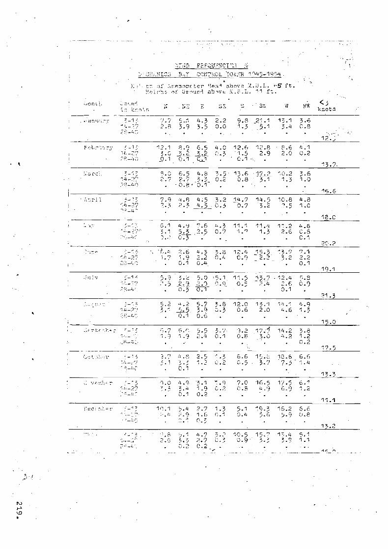
,
,. 1
~_ :Jr:f~'-:
10-0- ~).r .~\r;r.:n0m( t~r !rA~1.~ aOOVf1 ;.,~ • .:J .. L .. G5 ft. :~(:,.!.f"~!~. 0f Gr~un":'l a!J:"\'lE;- ;\:.~: .. L. 11 ft
i~: ~(. ..... t.1 ;.~ S
~ -~1 ..
"!~-?.7 ::::/_4::
"-' ~. l t! _~r,..,
;:-:~_ltC;
3-~ ~ ':4-~?7 :»:'-'"-0
;-~:: "~'.-2? '];':'-4 -.,
}.7 5. j 4.3 2.2 2.0 3.9 3.5 0.0
4·2 '1 ,. C D.1
4.0
9.8 _21.1 1.5 5. 1
12.6 1.5 0.1
12.B 2.9
13.1 3.6 3.4 0.8
8.6 2.0
'i .1 0.2
3.0 6.5 4.8 2.7 2 .. '-;- 3.3
-J).8 -0.1-
3.5 13.6 17.2 10.2 C • 2 0 • 8 -3.1 '1 • 3
3.6 1.0
G.1 z 4 ; , -; .. ,:~
,~. 8 4; 5 3.2 2.3 ~ C.3
4.'1 ".6 ?_~.2... 2·5 C'·3 .
[;..3 C.?
14.7 -0.7
11.1 " . ..,
14·5 3.2
_11.~L 1.3
1C.8 '") c: ' .. ./
1'1.2 2.6
4.8 1.0
4.6 C.5 C.1
<.5 knot~
16.6
18.C
'. - ~ .
_____ ~ _________________ ·_' _________________________________________________ ~2~C~·.~2~. ____ __
_-.1, • __ '. __
""_""' ,1,
r.1! _;~;
,:,,;_1, ;-;
~ _1 "
.~ [--:7
'1~-?"}
~?E_Lt-'-=
." .. J - , .'!..'.,; _~:ri
"_""3 ~.11-2f -:.-: -~~ ~
.-: 7"
'F,.1'.. 2.6 4.;; 3. {3 12.4 ":;5,;; 1.7 1.9 2.2 a.~ C.~ 2.2
0.1 0.4
'13.7 7.1 3.2 2 .• 2
0.1
" • 7 f, J: ;;. • 5 !:; '';.9 2.4
'1.0 7 " ..,'
C, 4 . , 4.9 3. -4 0.1
2·5 " ') , .~
'7j .1 1.9 0.2
2.7 1.6
11.) 0·5
13.7 12.4 - ";;; :'4 .2 .6 ().1
".812.0 1 3.'1 J.3 0.6 2.0
!l!..~l 4.9 4.6 1.,
3 "' . . , 0.1
" .3 (;.2
~1 .9 0.2
" '7 , . -' (;.1
1.2 17.:5 0.8 '5.0
5.€) C.5
7.0 C.8
5.1 0.4
-,
~,9· 3 5.6
10.5 15.7 0·9- 3·5
11f.2 3.8 .:t..2 1.2
0.2
17.5 " <) c .....
16.2 5·9
6.5 '1.4
b .. 1
i.e:
f..6 0.8
1 7,.4 5.1 3.Q 1.1
19.1
21.:;
13.3
1":.1
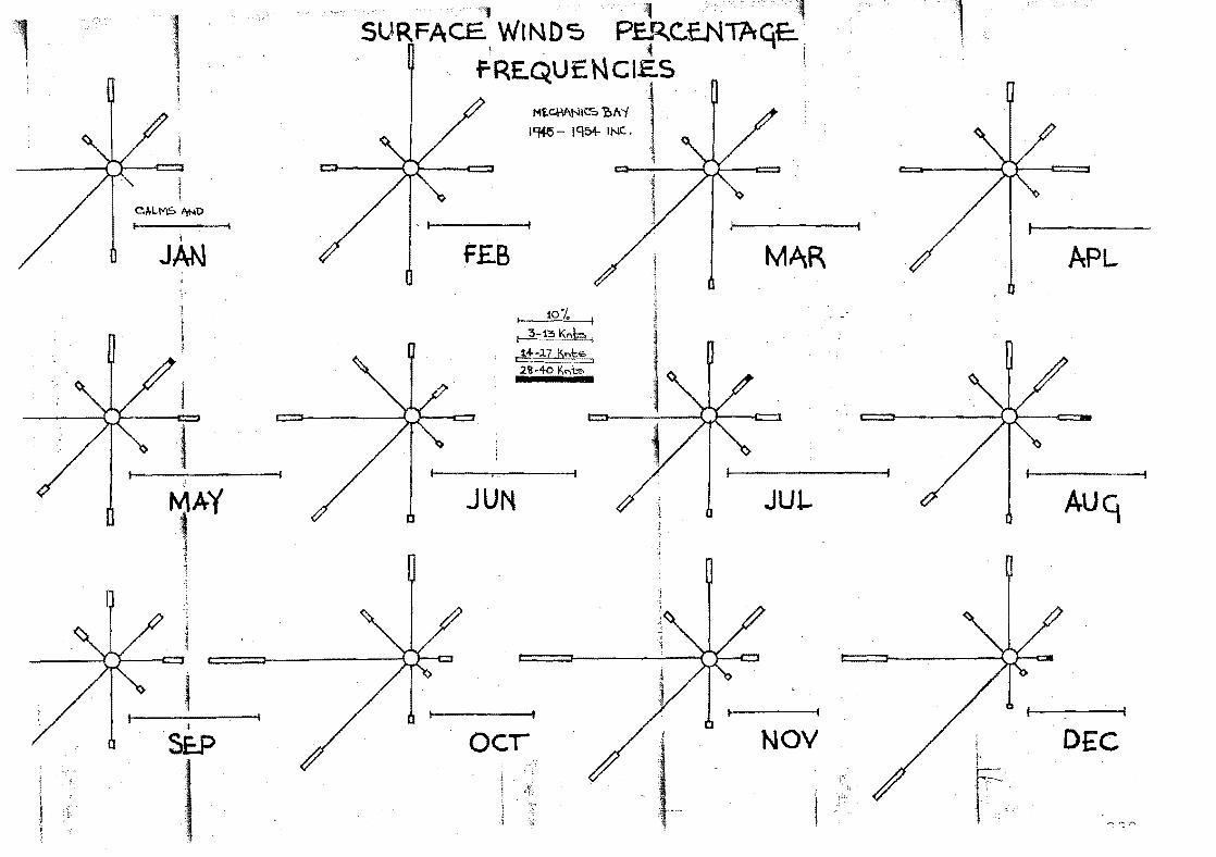
1
JAN
I
SE..P
1
FEB
I 10% I
~"':J~K,,61 ..!±-17 K..,t~ 2'a -40 I',,,b;:, • •
JUN
ocr
MAR APL
•• Jut-
NOV DE,C
i
AUCKLA.ND,
~ JAN. FEB. MAI1. APR.
SUNSHINE ,Bright Sunshine Hours (Mean) 231.6 196.0 189.9 161·5 CeChal'lics Bay ~nJ Victoria Street 1950- 1970, Bright Sunshine Hours (Mean) 231.7 195.8 189.8 157.0 All Sites 1909-1970 Highest Total Recorded each 316.3 266.3 253.1 200.9 Month 1909-1970 1957 197~ 1930 1950 Lowest Total Recor~~d each 157.5 154.6 124.5 95.5 Month 1909-1970 1918 1912 1912 1956 Cloud Amount CKT~S 1909-1955 4.7 4.8 4·5 4.6
Rh I I':'? ALIJ , , Rainfall in mID (Mean) 76 103 83 115
1909-1970 Maximum fall in 24 hours 97.0 162.3 116.1 131 .6 1353-1970 1911-0 1869 1866 1947 iettest Month 1853-1970 213.4 359.4 267.7 359.2 Year 1930 1869 1954 1956 Driest Month 1853-1970 4.1 0.0 1·5 10.9
I Year' 1854 1909 1856 1864
. -.vettest Year 1917 mm 1956 , Driest Year 668.5mm 1859 , .Rain Days' 1909-1970 10 10 12 15
Sites:
NE',v ZEALAND '\ . ~ \ \, ~V.y • Jtn'l'. JUL. AUG. SEP. OCT. NOV. DEC.
YEA I' \. , \
135.4 118.2 134.0 152.2 162.0 186.1 202.9 224.9 2094. '\
\ 1;6.6 120.2 130.3 153.1 161.6 182.4 202.2 223.8 2084.5'
193. ? 174.1 182.2 18').7 214.7 239.2 240.2 297.0 2335. 1 19313 1945 1%2 1922 1940 1966 1970 1937 1940 83.0 74.6 91.6 112.0 96.3 114.0 145.2 136.6 1775.7 1969 1969 1964 1917 1960 1916 1916 1921 1910 4·5 4·5 4.6 4.4 4.6 5.0 4.9 4.8 4.6
127 137 139 126 95 102 86 81 1270
91.4 91.2 85.9 99.1 62.0 63.8 80.0 136.9 162.3' 19211- 1920 1~ 35 1955 . 1961 1890 1894 1863 Feb. 1869
34'3.0 .'?85.1) 304.8 324.1 229.4 259.3 253.5 224.5 359.4 1926 1860 1938 1965 1960 1890 24.1 24.4 34.3 29·5 18.8 10.2 1881 1942 1877 1914 .1951 1870
18 19 20 19 16 17
Domain 186&-1883 alt. 25B ft. Museum Roof 1883-1909 alt. 125 ft. Albert Park 1909-1970 aU. 160 ft'.
1967 1863 Feb. 1869 12.2 3.3 0.0 1945 1897 Feb. 1909
14 13 183
Mechanics Bay Highest Barnmetric Pressure
Mechanics Bay Lowest Bar"metric Pressure
New Zealand Lowest Barometric PresBure
1041.2 30. 71~7
972.8 '" 28.727
954.5 • 28.19
1045.9 • 30.885
15 July 1952 10 a.m.
19 May 1954 2110111.
16 January 1939 at Tairoa Head.
30 August 1889 at WQllington. New Zealand Highest Barometric Pressure
"
"
221.

; 'fEII:FF.RATlJRS 1.'",',1"3 : ":1909-1970 e0 .
Approx. lean Temperature ~ean Daily ~aximum 1~ean Daily lHnir:1um ~ean Daily Range l,;ean Daily Gr9.SS I,:inimur.l T:':r;,PE2,','-:'Ulit:: -S;':1'RErrLES PC9-1 9'lO 8e It. on thy lLaximum Year ~!.ollthly l'.inirr.um Yeur
Lowest ~onthly ~aximum ., Year
HiGhest ':;'lnthly l£iniJ:!UTIl Year ~onthly Grass ~inimum 'Year O!3~:::::t~"!·,.liIIr~·r:; ~l' 89CO E~~LTj.3 0(';
ury bulb 1928-1970 ~et Bulb 192E-1970 RelatiVe ~u~iiity 1928-1970 Earth TelliD. 10cm 10 66-1970 Earth Te~~. 20c~ 1~~G-1970 :arth ~exo. 3Ccm 19~5-1970 Zar~h Te~~. 100cm 1910-1970 ~in~ Run t~ilcs) 1909-1970
I Vapour Pressure (mbs) to 1950
DAY~ CF: (1909-1960) Gale Snow Hail Thunder FoC Ground Frost l?s:reen Frost
19 23 16 07 13
FE"3.
20 23 16 07 13
19 22 15 07 12
16 20 13 07 10
ff,\Y.
14 17 11 06 C8
JU!'i.
12 15 09 05 06
JUL.
11 14 08 06 05
. AU(.i..
11 15 08 07 05
(""0 .::>t,_ •
13 16 09 07 I. •
07
OCT. 14 18 11 07 09
!,;CJ'I.
16 ·1,) 12 07 10
29.030.3 27.8 1938 1935 19G8 C7.3 C8.9 C5.G 1931 1928 1931
26.2 19;;8 05.0 'lQ17 19:?7 1;,.6· 1920
23.6 20.6 1957 1963 03.3 -0.1 1C,20 1951 16(04
18.9 1949
C.7 '1930
1,).6 22.0 1971 1973 01.1 0;',.2 1'330 1929
23.7 1949 OJ.7 1969
25.5 1954 05.0 1919
13.9· 16.7 191:.J 1917
16.1 191 5 1949
22.4 22.S 1929 1~33 02.4 01.7 19l!.3 194C
. 21 •. 1
20 17 73 21 22 22 20
127
16.1
2D 17' 73 21 22 • 22 21
121
16.4
19:/5 02.'2 194<]
19 16 76 1 0
,I
21 21 2C
114·
16.0
21.1 1938
0.1 1964
17 15 eo 15 1? 18 19
'108
14.3
OS-.2 08.4 1914 1945
18.3 15.7 1955 1.955
1~?6 '1~5~ 14 12' 83 12 13 1 ~) 17
111
11 10 8':'· 09 11 ~12
15 " ... ~ , ':;I
12.6 11.3
07.2 1 '-i4 5
15.0 1q42 -4.2 1939
'l0 C9 8) 08 09 11 13
'i11
1C.G
09.2 191 5
14.~ Y)56 _I~ .4 1954
11 10 81 09 11 11 12
115
10.2
0.9 0.6 0.3 O.G 1.0 1.0 1.1 1.1 Au=!Ust 1871 ani 1833. September '11';94, C'uly'1930 0;0 C.O 0.0 0.1 0.3 0.8 O.b 0.7 0.6 0.5 0.3 0.8 0.6 0.9 1.1 0.8 0.1 ",.0.1 0.3 0.5 1 . 3 1 . 5 1 .8 1 .4 0.0 0.0 0.0 0.0 0.1 0.9 1.9 0.9 1 screen frost, 30 June 1951.
..
10.6 1914
15.1 195/•
2 ~, - .~-
1942
13 11. n 12 13 ~13
13 127
11 • '7
12.4 "940
16.8 19:'6 -O.S 1969
15 1') 76 15 16 16 15
131
12.5
13.9 1C)?6
18.';1 1931 0.0
194.6
17 1L. 73 17 18 15 16 .
139
1.4 1.0 0.9 an~ 1939, ~uEust C.6 0.5 0.3 O.S O.S 0.9 0.6 0.2 0.0 0.2 0.0 0.0
D.2:C •
18 21 14 07 12
15 19 12 07 09
29.2 30.3 1930 1935 Feb .. 06. I. -u. 1 191') 1 '?51 June
15.( C';".2 1926 194~ July
21.7 22.S 192.::: 1933 Feb. C2.2 -4.4 1945 '19)4 Aug.
1 j 1:7 16 13 72 70 20 '15 21 16 20 17 18 17
132 121
1 II •. :~ . 1 3 . 4
0.7 1965.
O " .<-
0.6 0.0 0.0
11.3
4.1 8.7 7.8 4.0
i , .
:c.22.
APPENDIX D
THE FLORA;
"The following list contains the names of wild plants
recorded on Motuihe in April 1974. As only two part days
were spent on the island it is certain that there will be
some omissions.
Although the native vegetation is now only a minor part
of the plant cover, native species are still numerous (97
s~ecies) and only slightly exceeded by the exotics (118 species).
~here is no way of knowing ho~ many native plants have been
lost from Motuihe. SicY8s angulatus (a native cucumber) and
Pimelea arenaria recorded by Kirk have certainly gone. Pasealum
distichum, a grass of salt marshes and coastal rocks, was not
seen recently .on Motuihe but is' easily overlooked. Kirk's
"Dlchelachne stipoides II is the coastal grass we kn01;J nO'/I as
Sti8d teretifolia. It st~ll survives. !
In this list the foll'J • .ring sy:nbols <].re used:
o CCC6.S ion,} 1
m many
p plent::'ful
" G r ass y p lac e s" ref e r s to l) a .:; t u res d n dot her p 1 d C e s ".J her e
grasses are prominent ~.e. on beaches, under trees in open
forest, in former pastures no',\' fenced from ":lri1zinCJ ClnimCllso"
223.
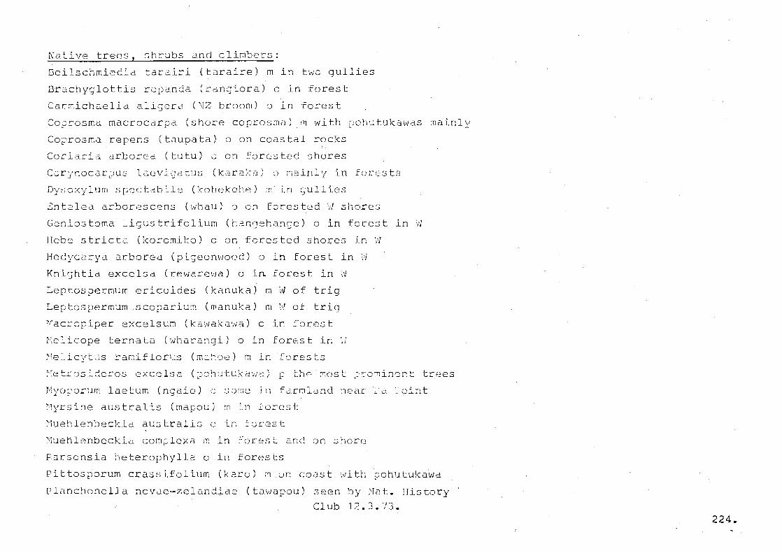
Native trees, shrubs and climbers:
Beilschmiedia tarairi (taraire) m in two gullies
Brachyglottis ropanda (canglora) 0 in forest
Car~ichaelia aligera (NZ broom) 0 in forest
Coprosma macrocarpa (shore coprosma) m with pohutukawas mainly
Coprosma repens (taupata) 0 on coastal rocks
Coeiacia arborea (tutu) a on forasted shores
Dysoxylum sp:c:ct'ib=-le (kohekoh-:o) rfl in gullies
Gll t2lea arborescens ('_"hau) 0 on f0res ted ',J shores
Geniostoma ligustrifolium (hangehange) 0 in forest in W
Hebe stricta (koromiko) 0 on forested shores in ~
Hedycarya arbor~a (pigeonwood) 0 in forest in W
Knightia excelsa (rewarewa) 0 in forest in W
Leptospermum ericoides (kanuka)
Leptospermum .scoparium (manuka)
"acre piper excelsum (k3wakawa) 0
Kelicope ternata (wharangi) 0 in
m
m
11'1 of trig
:-'1 of trig
in Lore.st
forest in
~:elicvtus ramiflor1J.s (m:::.~·:)e) "1 lnforests
H
~etrusideros excelsa (~ch~tukawa) p thn~ost ~~omincnt trees
Myoporum laetum (ngaio) ~ some in farDland ~ear .2 'oint
Nyrsine australis (mapou) ~ ~n :orcst
Muehlenbeckia aUstrali3 0 in ~~rest
Muehlenbeckia complexa ~ in forest 2nd on shore
Farsonsia heterophylla 0 in forests
Pittosporum crassifolium (karol m un coast with pohutukiwa
Planchonella novQe-zelandiae (lQ\"apou) sec=n by Nut. History
Club 12. J • 73 • 224.
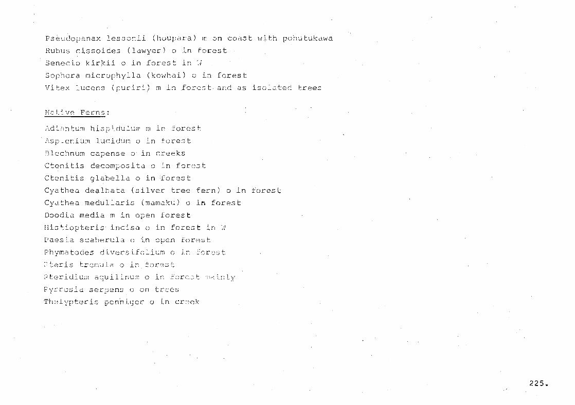
Pseudopanax les.5o:1ii (houpara) m on coast with pohutukawa
Rubus cissoides (lawyer) 0 in forest
Senecio kirk.ii 0 in foc~s t it; ',.j
Sophora microphylla (kowhai) 0 i~ forest
Vitex lucens (puriri) m in forest and as isolated trees
NotiV0! Ferns:
~di~ntum hispidulum m in forest
Asplenium lucidurn 0 in £ore~t
Blechnum capense 0 in creeks
Ctenitis decomposita 0 in forest
Ctenitis glabella 0 in fore~t
Cyathea dealbata (silver tree fern) 0 in forest
Cyathea medullaris (mamaku) 0 in forest
Doodio. media m in open forest
His tiopteris inc is a 0 in fores t in ',,/
Paesia scaberula 0 in open forest
Phymatodes diversifolium 0 in farest
~t2ris trenula 0 in forest
L) tt=r i di um d qu i 1 ir,UI;: 0 in rc)rc:; t ",01 ~_!-: 1 y
pyrrosia serpens 0 on trees
Thelypteris pen~iger 0 in creek
225e
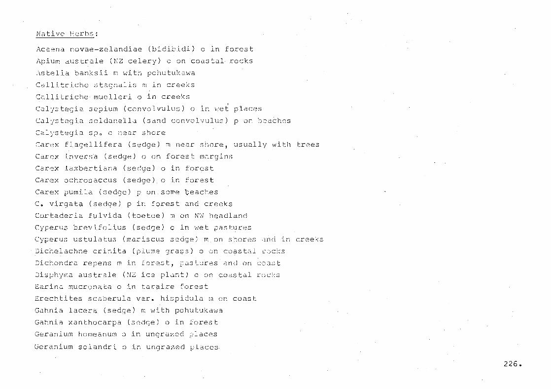
Native Herbs:
Ac:::ena novae-zelandiae (bidibidi) 0 in forest
Apium australe (NZ celery) 0 on coastal rocks
Astelia banksii m with pohutukawa
Callitriche stagnalis m in creeks
C~llitriche muelleri 0 in creeks ,
C2ljstegia sepium (convolvulus) 0 in "let places
Calystegia soldanella (sand convolvulus) p on beaches
C2lystegia spo 0 nea;:- shore
Carex flagellifera (sedge) lTi near shore, usually with trees
Carex inversa (sedge) 0 on forest m~rgins
Carex lambertiana (sedge) 0 in forest
Carex ochrosaccus (sedge) 0 in forest
Carex pumila (sedge) p on some Qeaches
c. virgata (sedge) p in forest and creeks
Cortaderia fulvida (toetoe) m on Nfl headland
CYferus brevifolius (sedQe) 0 in wet pastures
Cyperus ustulatus (mariscus sedge) m on shores ~nd in creeks
Dichelachne crinita (plume grass) 0 on coastal CGcks
Dichondra repens m in forest, ;astures and on coast
Disphyma australe (NZ ice pldnt) 0 on coastal roc~s
Earina mucrona~a 0 in taraire forest
Erecht:Ltes scaberula var. hispidula In on coast
Gahnia lacera (sedge) m with pohutukawa
Gahnia xanthocarpa (sedge) 0 In ~orest
Geranium home anum 0 in ungrazad places
Geranium solandri 0 in ungrazed places
226.

Juncus australis (rush) m in pastures
Juncus pallidus (rush) 0 in pastures
Juncus sarophorus (rush) 0 in ?astures
Juncus usitatus (rush) m in pastures and open forest
Lach~agrosti3 filL~ormis (grass) 0 on beaches
Lobelia anceps 0 on wet coastal rocks
Microlaena stipoides (grass) p in forest and some pastures
Notodanthonia penicillata ((~anthonia) p 1n riry pastures
Notodanthonia racemosa (dant!1onia) p In dry pa3tures
Oplismenus imbecillus (gcass) ~ in forest
Oxalis corniculata m in pastures and open forest
2eperomia urvilleana 0 in forest
Phormium tenax (NZ flax) p in forest in W
Poa anceps (grass) a with trees-on coastal slopes
Salicornia australis 0 on rocks washed by sea
Samolus repens 0 on wet coastal rocks
Scirpus cernuus (sedge) 0 on ~et coastal rocks
Scirpusmedianus (sedge) 0 at outfall of creek
Scir~us nodosus (sedge) 0 on beaches
Senecio lautus 0 on coastal rocks
Spinifex hirsutus m on some beaches
Solanum aviculare (poroporo) 0 in forest
Solanum nodiflorum p in forest
Stipa teretifolia (grass) 0 on rocks washed by sea
Triglochin striatum 0 on wet coastal rocks
227.
Sxotic plants:
Agrostis semiverticillata (grass) 0 on beaches
Agrostis t~nuis (browntop) 0 mainly on beaches
Allium vineale (wild onion) 0 on beaches
Amaranthus deflexus 0 on paths
Amaranthus hydriduso in cultivated soil
Amaranthus lividus 0 in cultivated soil
Ammophila arenaria (marram) 0 on Ocean Beach only
Anagallis arvensis (scarlet pimpernel) p on coast
Anthoxanthum odoratum (sweet vernal) 0 in grassy places
Araujia hortorum (moth plant) 0 in forest
Arren~therum elatius (tall oatgrass) 0 in grassy places
Arum italicum (Italian arum) m about buildings
Aster subulatus (sea aster) 0 on coast
Atriplex hastata (orache) p on beaches
Bellis perennis 0 in pastures
Bri.za minor (shivery ~jTass) p in 'Jrassy places
L3ro:n'...ls breviaristatus (gra.:..,s) ::J in grassy i)laces
3romtlS
BrQmus il1011is (goose grass) t-:;.1! 3()rr~(~ £~cistures
3romus unioloide:3 (~rdir 1.e gL1SS) r:; in !Jrassy places, rnainly
beaches
Carduus pycnocep~alus (slender winged thistle) ~ in ~astures
Carduus tenuiflorus (winged thistle) a in grassy places
Carex div~lsa (sedge) p in pasture on N~ headland
Centaurium erythrae~ (centaury) 0 on disturbed ground
228.
Cirsium arvense (Californian thistle) 0 on beach
Cirsium vulgare (Scotch thistle) m in pastures mainly
Chenopodium album (Eathen) 0 in disturbed ground
Chenopodium murale (red fathen) 0 in disturbed ground
Coronopus didynus (~~Jin cress) pastures and disturbed ground
Cortaderia selloana (pam~as) 0 on NW ileadland
Cotoneaster glauccphylla var. serotina ci on r;~ headland
Crataegus monogyra (hawthorn) m in Corestc ~ainly
Crepis capillari3 (ha~ksbeard) p in all open places
Crocosmia crocosmiflora (montbretia) 0 near houses
Cynosurus cristat~s (crested dogstail) 0 in grassy places
Cynodon dactylon (Indian doab) p mainly near beaches
Cyperus eragostis (sedge) 0 in wet places
Dactylis glomerata (cocksfoot) ~ in grassy places
Dicanthium annulaturn (grass) m in some dry pastures
Elaeagnus pungens 0 in forest mainly
Erechtites atkinsoniae (Australian fireweed) 0 under
pchut~kawas
=rigeron floribundus (f12abane) m in ~en ~lac?s
Fe~tuca arundinacea (tall fesc~e) 0 mainly o~ he aches
Galium aparine lcleaversl 0 in some uD0cazed laces
Geranium dissectum (cut-leaved geranium) 0 in di3t\Jrbed soil
Geranium molle (dovesfoot) p in open ~laces, ~articularly on
sand
Gnaphalium simplicicdule (cudweed) 0 in open forest
l{olcus lanatus (Yorkshire fog) p in grassy ~laces
229
Hor~eum murinus (barley grass) p in pastures and on beaches
Hypochaeris radicata (catsear) m mainly on beaches
Juncus effusu~ (rush) 0 in pastures
Lagurus ovatus (hares tail) p on beaches
r~<~cn todon tarG~-::Gcotdes (1:.3.'.l/kbi t) m rncL~nly on beaches
Lolium perenne (~erenni2l ryegrass) p the main ~asture grass
I ~t'u n"usL~~~~~'l~ --. ",.., d~c,I-"rbr~d ~o~lc J U :; a ':J L ~_ .::, ,-, ~:, '- _-.. '.J.d " , -,--.J L ,-, ,._ ,J.J.. '"
::a~va nicaeen3is (F~ench mallo~) ? in open ~laces in pastures
~edicago arabica (spotted bur medick) p in sandy soils mainly
~edicago lupulina (black medick) a mainly on beaches
r,1edicago polymor;:ha (bur rneclick) a mainly on beaches
Melilotus indica (King Island melilot) p on beaches
Mentha pUlegium (pennyroyal) p ~n wet pastures
~odiola caroliniana (creeping mallow) a in grassy places
Nasturtium officinale (water cress) a in creeks
Olea europaea (or C. africana?) (olive).3eedlings in many ?laces
Orobanche minor (broornrape) 0 in unc;rcized pl=.ces
exalis pes-cap~a2 (oxalis) 0 on b~ach
F~ra~holis inc~rva (sickle grass) 0 O~ cOdstal rocks
di 1 a t6 t'_im ( 1, .
paspa Urn) r In ~om~ ~astuccs ~nd on some
beach(:;s
P2s;:=:alum p2sraL;r:ies (gri'~ss) iT; on heaches
Physalis peruviana (cape goo~eberry) 0 in forest
Phy to I acca octand::-a (ink~veed) fll mainl y near \ trees in t:-,cs ture
Picris echioidcs (oxtungue) m on beaches
Pinus halepense (Aleppo rine) m - above Oc~an Beach
230.

Foa annua (grass) p in open ~laces
Poa trivialis (grass) m in pastures
rolycarpon tetra~hylla (all seed) m in droughty places
Polygala myrtifolia 0 in ungrazed places
Polypogon mons~eliensis (beard grass) 0 on beaches
Portulaca oleracea (portulaca) p in open pasture and on beaches
Plantago lanceolata (narrow-leaved plan~ain) p in pastures
mainly
Plantago major (broad-leaved plantain) 0 on ~isturbed ground
Prunella vulgaris (selfheal) 0 in some grassy places
Ranunculus sardous (hairy buttercup) 0 in moist grassy places
Rhamnus alaternus p in ungrazed places around trees
Rosa rubiginosa (sweet briar) 0 in open places
Rumex brownii (hooked dock) 0 on coast
Rumex conglomeratus (clustered dock) 0 in wet places
Rumex crispus (curled dock) 0 mainly on beaches
Rumex obtusifolius (broad-leaved dock) 0 in moist places
Rumex pulcher (fiddle dock) p mainly in pastures
3a1s01a Kali 0 on beaches
Senecio vulgaris (gr0undsel) a ~~ dl~t~rbcd soil
.311yl,um marianum (vi'lri2'Jatc3c! ::hl.:.d:le) p fl1.J.in1'l out::ide farmed
dreas
3isymhrium officinale (hedJe mustard) 0 in disturbed ground
Solanum mauritianum (~oolly nlJ~tshade) 0 on N Coast
Solanum nigrum (black nightshade) 0 mainly on disturbed ground
Solanum sodomaeum (apple of 30dom) p mainly outsid~ farmed
areas
231.
Soliva valdiviana (Cnehunga weed) 0 in grassy places
Sonchus asper (~rickly sow thistile) 0 in disturbed ground
Sonchus oleraceus (sow thistle) m on beaches and disturbed·
ground
Sporo~olus africanu3 (ratstail) p on beaches and other grassy
places
StollGria media (chic~we2d) a in disturbed ground
Stenataphrum secundatum p on be~ches and picnic grounds
TaraX2c~m offici~ale (dandeliun) 0 in pastures and Jisturbed
soil
Trifolium dubium (suckling clOVEr) m in grassy places
Trifolium repens (white clover) p mainly in pastures
Trifolium resupinatum (reversed clover) 0 on road margins
Trifolium striatum (striated clover) m in grassy places
Trifolium subterraneum (subterranean clover) p in some pastures
Ulex europaeus (gorse) p mainly outside farmed areas
Veronica arvensis (veronic2) 0 on disturbed soil
Ver~nica serpyllifolia (speedwell) 0 mainly in :a~tures
Vici~ tetras~erma (four-seeded ~etch) 0 in uncr32~d placas
'Jicicl .Jativa (vetch) i~ J.n u ra2;E:~cl L~lClc2s
Xanthium spinosum (Bathurst ~ur) c in qrassy places
Zantedcischia aethiopica (tir~~ lily) a dbout houses
232.
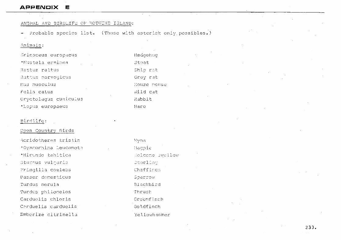
APPENCIX E
J'..NHL;L AND 13IRDLIFE OF' 0~OTGIHE 13L/,ND:
erobable species list.
~rin~ceus europaeus
·~ustela er~inea
::l. at t L; S rat r. u S
2attus norveyicus
r~ us :r usc u 1 us
Felis catus
Cryctolagus cuniculus
"Lepus europaeus
Birc!l.ife:
Open Country Girds
Acridotheres tristis
"Gymnorhina leuconota
*Hicundo tahitica
3turnus vulcaris
Fringilla co~lebs
Passer domesticus
Turdus rn8rula
Turdus philomelos
Carduelis chloris
Carduelis carduelis
Emberize citrinella
(Those with asterisk only possibles.)
HedgGhocj
stoat
Shi.p rc:.t
Grey L.il~
:I01~se Fl0l1S2
rJild cat
2abbit
Hare
i\!yna
~12qpic
Chaffinch
::3 parroi:j
Blackbird
Thrusl,
Gre'enf ir.ch
Goldfinch
Ye llowha.rnmer
233.

*Alaucla arvensis
c acoroxi::',ans L •
Rh id~ra fuliginosa
igata
Anthus nov~eseelandide
Hale sanr..:tiJ
io pori:~hyrio
Pros ra novaeseelan ae
Larus novaehollandiae scopulinus
sterna. striata
Larus dominicanus
Phalacrocarax varius varius
.:::udyptula minClr
:Jkyl
Harri
rub:::ko
Tui
Re
alo-lk
1
lIed gUll
White nted tern
B acked gUll
Sh
234.
APPENDIX F
':'he follo':/ing is the cocisU!.l biology Df the.:: sheltered
" r ....... ..L,l.1
., . 13 1 ~J. n ·~_:3 . r- ~ ~f'" H' -' ~ I ,_, _ ar~·:,
d shelvirg lrtcr-tidal
'Jhere t!1e CC)dsts are buil t of papa nud:J tunes, the platform
is generally near 1m.; tide, 'iJith a wide ,:::xrat,::e of loose
h8ulders. Cn greywacke isl~rds, as at KGwau, there will
be 2 narrower, hiSh tidal shelf of hard, ~ut brittle
r.c::k, itJithout nuch loose cover.
235.
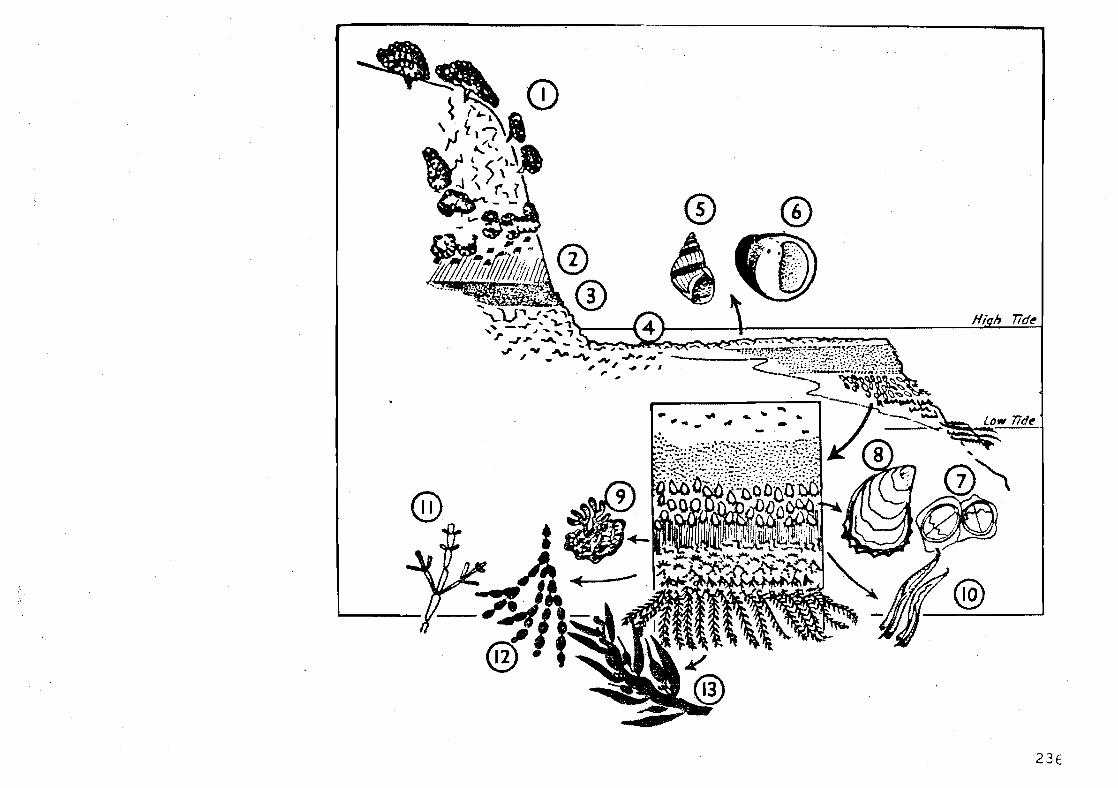
23E
As pictured, a grey0acke platform and slop~ has strictly
horizontal zones of animals and plants. These cut
clearly across the dark rock face. A pohutukawa fringe
(1) ge~erally overhangs, from coastal bush above. On
the rc-::< ~ ace may be pros tra te mirror-leaf, Coprosrna repens (t" -u~~+--')-\ C! l/c ..... ::::.· •
~h2 fiest of th~ shore zones, moist with spr2y will be of
patches (Xanth8ria) (2). Further down is a regular band
of the 500ty black licLen, Verrucaria (3).
At the ?latform level, the rock is bare or with only
stubby ~lack lichens (Lichina) and many small pools (~).
T~o hi~h tidal snails live here on lichens and blue gre~n
Melara2ha oliveri (5) and the larger Merita
melano~ra~us (6).
~rey-br8~n with 0 ~onc of ~2rndc12s:
:lext
~elow is a conspiccous ~and of white, crinkle-edged
oysters, ~rassostrca 01o~crata (8); or where the shore
is more ~ave exposed there may be the large, ridged surf
~arnac:e ~lminius ~licatus forming its own zone.
237

Geyond here the algae begin. The first is a crust
looking like dull red congealed blood; it is the alga
Apophloea sinclairii (9). Next, like a dull pink paint,
comes a film of the calcareous red alga Corallina officinalis,
sometimes mingled with white tubeworms Pomatoceros caeruleus
( 10. )
Further down, the coralline paint may produce small
limey segments (11) forming a compact pink or mauve-grey
turf; and amongst this are scattered the strings of
bladders known as Hormosira banksii (Venus' necklace)(12).
Finally, just visible at low tide come the tresses of large
brown algae, buoyant in the breaking waves. The commonest
on inner Park islands is the flap-jack, Carpophyllum
maschalocarpum (13) with small, dark leaves, finely
pointed. Above it is somet:mes a fringe of :lnother brol:tn
alga, Xiphophora chondro~hvlla.
Gulf coasts, Mainlands ond islands alike. varies
v;ith different sorts :If cock, <'lt1C; changes ~.h Sre.d ter
exposure or shelter. But you can pick out its same
elements wherever you go."
238.
REFERENCES
THE HAURAKI GULF MARITIME PARK:
LANG, R.B.
MOTUIHE ISLAND:
WALSH, LORRIE
(1973); Hauraki Gulf Maritime
Park Draft Management Plan;
Unpubl hed document - Department
of Lands and Survey, Auckland.
(1937); MOTUIHI - The History of
Auckland t s Lovely t>larine Park;
Walsh printing Co., Auckland.
PARCELL, J.B. and DAVIDSON, J. (1973); Archaeological Survey
- Motuihe Island; Unpublished
report to the Hauraki Gulf
Maritime Park Board.
ENVIRONMENTAL FACTORS:
NEW ZEALAND METEROLOGICAL
SERVICE; Auckland.
SCHOFIELD, C.J. (1958); Geology of Motuihe Island,
Waitemata Harbour; Reprint from the
New Zealand Journal of Geology and
Geophysics. (Received for Publica
tion, 21 March 1958).
239.
SOIL BUREAU BULLETIN (n.s.) 5
ESLER, A.
(1954); General Survey of the
Soils of North Island, New Zealand;
New Zealand Department of Scientific.
and Industrial Research.
(1974); Veg~tation of the Inner
Islands of the Hauraki Gulf -
Motuihe Island; Unpublished report
to the Hauraki Gulf Maritime Park
Board.
AUCKLAND NATURAL HISTORY CLUB. (1973); Report to Hauraki Gulf
rvlari time Park Board.
ARVILL, R.
COLVIN, 3.
MORTON, J.E.
YOUNG, E.C.
(1969); Man and Environment -
Crisis and the Strategy of Choice;
Penguin Books Ltd, Middlesex,
England.
(1970); Land and Landscape;
William Clowes and Sons, Ltd.,
London.
(1974); pers. comm.
(1974); Pers. camm.
240.
SITE APPRAISAL:
ZUBE and DEGA ASSOCIATES
(Landscape Architects,
Planning Consultants
(1964); Recreation Potential
of the Lake Superior South Shore
Area, Numbers 3 and 4.
MOTUIHE ISLAND AS A REC~EATIONAL
RESOURCE:
PLANNING DIVLSICN, J\UCKLJ\ND
REGIONAL AUTHORITY
(1973); Recreation - Waitemata
Harbour; Report for the waitemata
Harbour Study.
CmlJMUNITY ACTIVITIES SECTION (1$71); Recreation Patterns in
AUCKLAND REGIONAL AUTHORITY
ATKINSON, I.A.E.
PAUL, J •.
SCREEN, A
Auckland.
(1973); Protection and Use of the
Islands in Hauraki Gulf Maritime
Park; reprint from the Proceed
ings of the New Zealand Ecological
Society, Volume 20: 103-114,
'tle ington.
(1974); • comma
(1974); Pers. comma
241.
· DR 0 f'lIO GOOLE , L • .3. (1974); pers. comm.
FOX, G. (1974); pers. comm.
HILL, W. '/J • (1974); pers •. comm~
BACKGRCUND READING FOR CARRYING CAPACITY
STUDY:
B0U:CH.t\RD, A.
DUFFY, E.
HERRINGTON, R.3. and
BEARDSLEY, ~J. G.
(1974); Carrying Capacity -
Management Tool for Parks;
Reprint in Recreation Canada,
Pp. 13 - 19. February.
(1967); The Biotic Effects of
Public Pressures on the Environ
ment; Monks il/ood Experiment
Station Symposium No. 3 for the
Nature Conservancy Natural
Environment Research Council.
(1~70); Improvement and Mainten
ance of Campground Vegetation in
Central Idaho; U.S.D.A. Forest
Service Research Paper INT - 87.
24~
LA PAGE, W.F. (1967); Some Observations on
Campground Trampling and Ground
Cover Response; U.S. Forest
Service Research Paper NE-68.
LIME, D.~. and STANKEY, G.H. (1971); Carrying Capacity: Main
taining Outdoor Recreation Quality;
U.S.D.A. Forest Service, U.S.
Government Printing Office.
MAGILL, A.~. and NARD, E.C.
RIPLEY, T.H.
SUDIA, T.W. and SIMPSON, J.M.
(1963); An Evaluation of Camp
ground Conditions and Needs for
Research; U.S. Forest Service
Research Note, P.S.W.-4.
(1962); Recreation Impact on
Southern Appalachian Campgrounds
and Picnic Sites; u.S. Department
of Agriculture Paper Number 153.
(1973); Recreational Carrying
Capacity of National Parks; Extract
from GUIDELINE, a Publication of
the Park Practice Programme; Vol. 3.
No.3.
243.

TIVY, J.
WAGER, J.A.
CONCEPT AND DESIGN PROPOSALS:
BEAZLEY, E.
(1972); The Concept and Determin
ation of Carrying Capacity of
Recreational Land in the U.S.A.;
Report to the Countryside
Commission for.Scotland.
(1964); The Carrying Capacity of
Wild Lands for Recreation; Society
of American Foresters, Washington
D.C. Monograph - 7.
(1~69): Designed for Recreation;
Faber and Faber, London.
244.