regional road connectivity bangladesh perspective
TRANSCRIPT
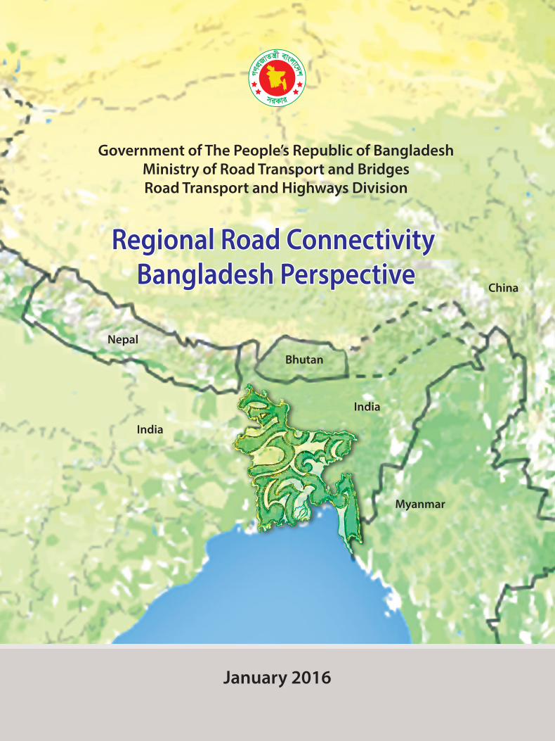
Government of The People’s Republic of BangladeshMinistry of Road Transport and BridgesRoad Transport and Highways Division
January 2016
India
India
Nepal
Bhutan
Myanmar
China
Regional Road Connectivity Regional Road Connectivity Bangladesh PerspectiveBangladesh Perspective
Regional Road Connectivity Bangladesh Perspective
Regional Road Connectivity Bangladesh Perspective
January 2016
i Message from Honorable Minister 5
ii Preface by Secretary, RTHD 7
1. Introduction 9
Regional/Sub regional Initiatives
2. Asian Highway 13
3. SAARC Highway Corridor 23
4. SASEC Road Corridor 33
5. BCIM-Economic Corridor 43
6 BIMSTEC Road Corridor 51
7 BBIN Motor Vehicles Agreement 61
8. Challenges and Way Forward 75
9. Annexures 81
Contents
Regional Road Connectivity: Bangladesh Perspective 05
Message from Honorable Minister
I am delighted to learn that Road Transport and Highways Division of the Ministry of Road Transport and Bridges is going to publish a book on Regional Road Connectivity: Bangladesh Perspective focusing the recent regional initiatives.
Recognizing the importance of regional connectivity in the globalized world, Bangladesh is pursuing transport connectivity with many Asian countries under various regional initiatives. The overarching goal of promoting the seamless transport connectivity with emerging economies of Asia is to integrate us with the global production network so that we can accelerate and sustain our economic growth. Besides this, transport connectivity can play an important role in making economic growth more inclusive by sharing the benefits with the poor within the country as well as in the neighboring landlocked countries or territories. For achieving Sustainable Development Goals (SDGs), Facilitation of regional road connectivity is very essential.
I am glad to see that the publication has elaborately explored all the regional initiatives that promote transport connectivity with the south, south-east and east Asian countries and recommended interventions, required to upgrade them in the light of current status of the infrastructure of the highway network.
However, the need for infrastructure investment in this sub-region is huge. It is our shared responsibility that all the South, South-east and East Asian countries will come forward to provide the substantial amount of financial resources for improvement of road infrastructure. To address the challenges, the Development Partners and Financial Institutions also may come forward to provide necessary financial and technical assistance in this regard.
I hope, this publication will be a guiding document for implementation of regional connectivity corridors in Bangladesh.
Obaidul Quader, MPMinisterMinistry of Road Transport & BridgesGovernment of the People’s Republic of Bangladesh
Regional Road Connectivity: Bangladesh Perspective 07
PREFACE
Despite the strong commitment and willingness to develop cross-border seamless trade, limited references and publication exist on how to facilitate its implementation in Bangladesh and beyond. Pertinent to this fact, we felt need for publication of this book with an aim of assessing current cross border connectivity status within Bangladesh.
Road Transport and Highways Division is actively involved in different regional connectivity initiatives namely, Asian Highway Network, South Asia Sub regional Economic Cooperation (SASEC) Road Corridors, Bangladesh-China-India-Myanmar Economic Corridor (BCIM-EC), Bay of Bengal Initiatives for Multi-Sectoral Technical and Economic Cooperation (BIMSTEC) Road Corridor, SAARC Highway Corridor and Bangladesh Bhutan India Nepal Motor Vehicles Agreement (BBIN MVA). This Division is in the forefront of developing regional arrangements for the facilitation of cross-border seamless road corridors.
The publication focuses in-depth assessment of road infrastructure, explores opportunities and identifies key challenges in promoting regional road connectivity in Bangladesh context. It will therefore, enhance the understanding of ongoing regional road connectivity issues including prioritization and investment needs.
The book is organized into eight chapters. While the introductory chapter provides an overview of regional connectivity initiatives, the concluding chapter deals with the overall challenges and opportunities of establishing the cross border road connectivity. Remaining six chapters highlight six different individual regional connectivity initiatives.
The book is prepared by the Thematic Group on Regional Connectivity comprising officials from Road Transport and Highways Division and Roads & Highways Department. I sincerely thank the thematic group members for their painstaking effort to this publication.
I hope, this paper would be very helpful for the policy makers, academia, researchers, planners, investors, development partners in advancing cross border connectivity in the region.
M.A.N SiddiqueSecretaryRoad Transport and Highways DivisionMinistry of Road Transport and Bridges

2.0 Asian Highway Network
The Asian Highway project was conceived by UN-ESCAFE (United Nations Economic and Social Commission for Asia and the Far East) in 1959 with the aim of establishing regional cooperation among the main land countries of Asia, based on road transport linkages. Potential Routes were identified and analyzed during 1960-1970. In early 1990s, Political and economic changes in the region spurred renewed interest in the network. In 1992, the Asian Land Transport Infrastructure Development Project (ALTIDP) was launched. The project is the foremost among the existing pan-Asian infrastructure initiatives. It consists of three pillars: the Asian Highway (AH), the Trans-Asian Railway (TAR), and the Facilitation of land transport projects through intermodal transport terminals (dry ports and inland ports). The Asian Highway follows framework for internationally agreed routes and infrastructural standards.
• The Asian Highway network currently comprises about 144,630 kilometer of roads, including 15,400 kilometer of potential Asian Highway routes in China, passing through 32 Asian member States with linkages to Europe (UNESCAP 2014). In order to formalize the establishment of the Asian Highway network and ensure commitment of the governments of the member countries towards its further development, standardization and maintenance, an Intergovernmental Agreement on the Asian Highway Network was adopted on 18 November 2003 in Bangkok. It was opened for signature in Shanghai, China from 26 to 28 April, 2004 and thereafter, at United Nations Headquarters in New York from 01May, 2004 to 31December, 2005. The Agreement entered into force on 04 July 2005. As of 17 June, 29 Member States are parties to the Agreement.
• The Cabinet Meeting chaired by the Honorable Prime Minister Sheikh Hasina approved the accession of Bangladesh in Asian Highway Network on 15 June 2009. Bangladesh signed the Instrument of Accession on 05 July 2009 which was effected on 10 August 2009. The Agreement entered into force for Bangladesh on 08 November 2009.
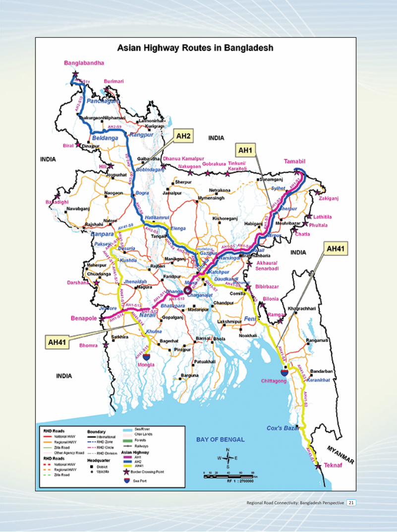
In Bangladesh, there are three Asian Highway Routes namely, Asian Highway-1 (AH1), Asian Highway-2 (AH2) and Asian Highway-41 (AH41). Of these three routes, AH41 remains within Bangladesh, but could be extended to neighboring countries. Total length of the AH routes in Bangladesh is 1771 kilometer.
AH1 Route inside Bangladesh : {Guwahati (India) - Dawki (India)}/Tamabil - Sylhet - Shaistaganj - Narshingdi - Katchpur - Dhaka - Mawa - Charjanajat - Bhanga - Bhatiapara - Kalna Ferry Ghat - Narail - Jessore- Benapole/{Petrapole (India)} .Total Length is 492km.
AH2 Route inside Bangladesh : {Guwahati (India) - Dawki (India)} - Tamabil - Sylhet - Shaistaganj - Narshingdi - Katchpur - Dhaka South (Jatrabari) – Dhaka North (Banani Rail Crossing) – Joydevpur - Kaliakoir - Elenga - Hatikamrul - Bogra - Rangpur - Beldanga - Panchgarh - Banglabandha/[Fulbari (India)]. Total Length is 517 km (excluding common part of 294 km of AH1).
AH41 Route within Bangladesh: Teknaf - Cox’sBazaar - Keranirhat - Feni - Moinamoti - Katchpur - Dhaka (Jatrabari) - Dhaka North(Banani Rail Crossing) - Joydevpur - Kaliakoir - Hatikamrul - Banpara - Dasuria - Paksey - Kushtia - Jenaidah - Jessore - Khulna - Mongla. Total Length is 762 km (excluding common part of 162 km of AH2).
2.1 Current Status
Asian Highway-1 (AH1) The most of the sections along this route is 2-lane with some 4-lane sections in urban areas and bazaar locations. There are currently two missing links in this corridor: (a) the Padma Bridge gap at Bhanga and (b) Kalna Bridge gap at Bhatiapara. In addition, there is one sub-standard section between Bhatiapara-Narial-Jes-sore (bellow AH standard II, See Table 1).
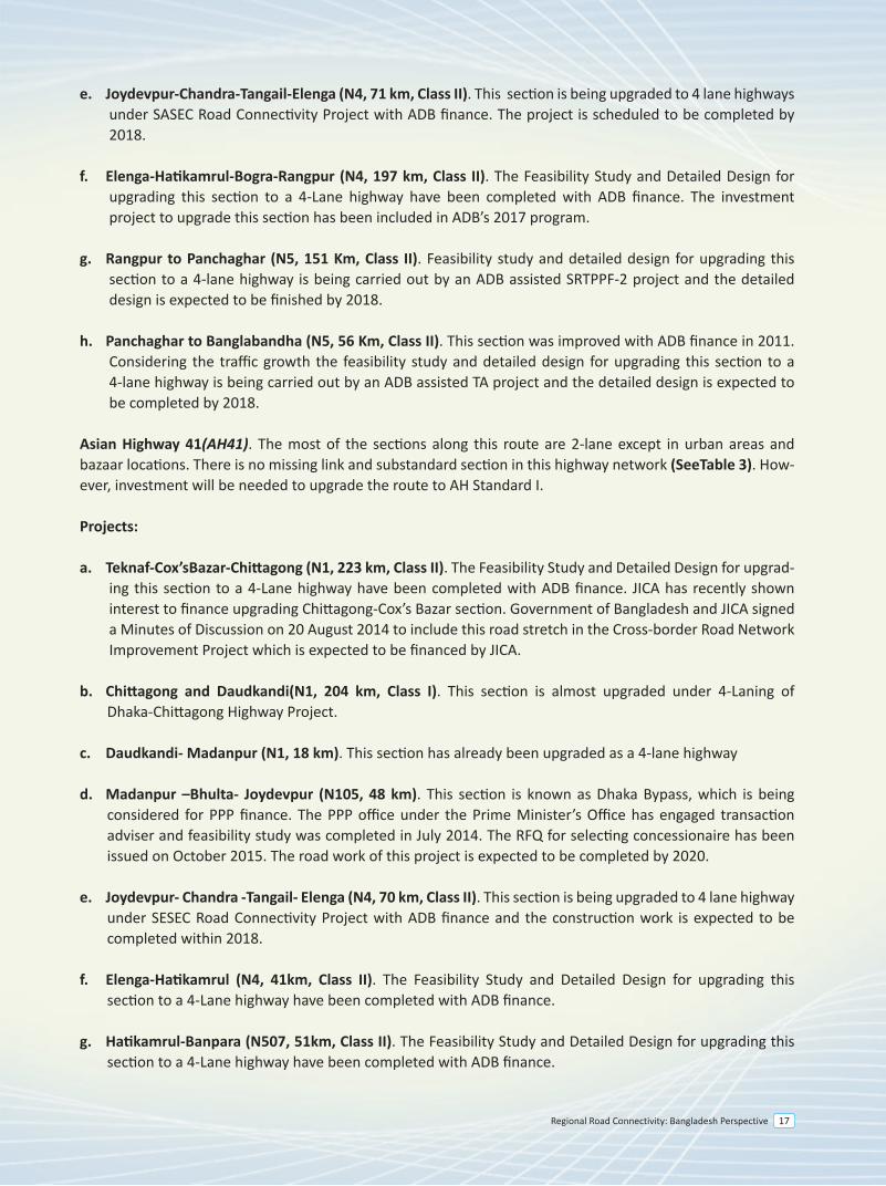
e. Joydevpur-Chandra-Tangail-Elenga (N4, 71 km, Class II). This section is being upgraded to 4 lane highways under SASEC Road Connectivity Project with ADB finance. The project is scheduled to be completed by 2018.
f. Elenga-Hatikamrul-Bogra-Rangpur (N4, 197 km, Class II). The Feasibility Study and Detailed Design for upgrading this section to a 4-Lane highway have been completed with ADB finance. The investment project to upgrade this section has been included in ADB’s 2017 program.
g. Rangpur to Panchaghar (N5, 151 Km, Class II). Feasibility study and detailed design for upgrading this section to a 4-lane highway is being carried out by an ADB assisted SRTPPF-2 project and the detailed design is expected to be finished by 2018.
h. Panchaghar to Banglabandha (N5, 56 Km, Class II). This section was improved with ADB finance in 2011. Considering the traffic growth the feasibility study and detailed design for upgrading this section to a 4-lane highway is being carried out by an ADB assisted TA project and the detailed design is expected to be completed by 2018.
Asian Highway 41(AH41). The most of the sections along this route are 2-lane except in urban areas and bazaar locations. There is no missing link and substandard section in this highway network (SeeTable 3). How-ever, investment will be needed to upgrade the route to AH Standard I.
Projects:
a. Teknaf-Cox’sBazar-Chittagong (N1, 223 km, Class II). The Feasibility Study and Detailed Design for upgrad-ing this section to a 4-Lane highway have been completed with ADB finance. JICA has recently shown interest to finance upgrading Chittagong-Cox’s Bazar section. Government of Bangladesh and JICA signed a Minutes of Discussion on 20 August 2014 to include this road stretch in the Cross-border Road Network Improvement Project which is expected to be financed by JICA.
b. Chittagong and Daudkandi(N1, 204 km, Class I). This section is almost upgraded under 4-Laning of Dhaka-Chittagong Highway Project.
c. Daudkandi- Madanpur (N1, 18 km). This section has already been upgraded as a 4-lane highway
d. Madanpur –Bhulta- Joydevpur (N105, 48 km). This section is known as Dhaka Bypass, which is being considered for PPP finance. The PPP office under the Prime Minister’s Office has engaged transaction adviser and feasibility study was completed in July 2014. The RFQ for selecting concessionaire has been issued on October 2015. The road work of this project is expected to be completed by 2020.
e. Joydevpur- Chandra -Tangail- Elenga (N4, 70 km, Class II). This section is being upgraded to 4 lane highway under SESEC Road Connectivity Project with ADB finance and the construction work is expected to be completed within 2018.
f. Elenga-Hatikamrul (N4, 41km, Class II). The Feasibility Study and Detailed Design for upgrading this section to a 4-Lane highway have been completed with ADB finance.
g. Hatikamrul-Banpara (N507, 51km, Class II). The Feasibility Study and Detailed Design for upgrading this section to a 4-Lane highway have been completed with ADB finance.
Introduction
1
Regional Road Connectivity: Bangladesh Perspective 11
2.0 Asian Highway Network
The Asian Highway project was conceived by UN-ESCAFE (United Nations Economic and Social Commission for Asia and the Far East) in 1959 with the aim of establishing regional cooperation among the main land countries of Asia, based on road transport linkages. Potential Routes were identified and analyzed during 1960-1970. In early 1990s, Political and economic changes in the region spurred renewed interest in the network. In 1992, the Asian Land Transport Infrastructure Development Project (ALTIDP) was launched. The project is the foremost among the existing pan-Asian infrastructure initiatives. It consists of three pillars: the Asian Highway (AH), the Trans-Asian Railway (TAR), and the Facilitation of land transport projects through intermodal transport terminals (dry ports and inland ports). The Asian Highway follows framework for internationally agreed routes and infrastructural standards.
• The Asian Highway network currently comprises about 144,630 kilometer of roads, including 15,400 kilometer of potential Asian Highway routes in China, passing through 32 Asian member States with linkages to Europe (UNESCAP 2014). In order to formalize the establishment of the Asian Highway network and ensure commitment of the governments of the member countries towards its further development, standardization and maintenance, an Intergovernmental Agreement on the Asian Highway Network was adopted on 18 November 2003 in Bangkok. It was opened for signature in Shanghai, China from 26 to 28 April, 2004 and thereafter, at United Nations Headquarters in New York from 01May, 2004 to 31December, 2005. The Agreement entered into force on 04 July 2005. As of 17 June, 29 Member States are parties to the Agreement.
• The Cabinet Meeting chaired by the Honorable Prime Minister Sheikh Hasina approved the accession of Bangladesh in Asian Highway Network on 15 June 2009. Bangladesh signed the Instrument of Accession on 05 July 2009 which was effected on 10 August 2009. The Agreement entered into force for Bangladesh on 08 November 2009.
In Bangladesh, there are three Asian Highway Routes namely, Asian Highway-1 (AH1), Asian Highway-2 (AH2) and Asian Highway-41 (AH41). Of these three routes, AH41 remains within Bangladesh, but could be extended to neighboring countries. Total length of the AH routes in Bangladesh is 1771 kilometer.
AH1 Route inside Bangladesh : {Guwahati (India) - Dawki (India)}/Tamabil - Sylhet - Shaistaganj - Narshingdi - Katchpur - Dhaka - Mawa - Charjanajat - Bhanga - Bhatiapara - Kalna Ferry Ghat - Narail - Jessore- Benapole/{Petrapole (India)} .Total Length is 492km.
AH2 Route inside Bangladesh : {Guwahati (India) - Dawki (India)} - Tamabil - Sylhet - Shaistaganj - Narshingdi - Katchpur - Dhaka South (Jatrabari) – Dhaka North (Banani Rail Crossing) – Joydevpur - Kaliakoir - Elenga - Hatikamrul - Bogra - Rangpur - Beldanga - Panchgarh - Banglabandha/[Fulbari (India)]. Total Length is 517 km (excluding common part of 294 km of AH1).
AH41 Route within Bangladesh: Teknaf - Cox’sBazaar - Keranirhat - Feni - Moinamoti - Katchpur - Dhaka (Jatrabari) - Dhaka North(Banani Rail Crossing) - Joydevpur - Kaliakoir - Hatikamrul - Banpara - Dasuria - Paksey - Kushtia - Jenaidah - Jessore - Khulna - Mongla. Total Length is 762 km (excluding common part of 162 km of AH2).
2.1 Current Status
Asian Highway-1 (AH1) The most of the sections along this route is 2-lane with some 4-lane sections in urban areas and bazaar locations. There are currently two missing links in this corridor: (a) the Padma Bridge gap at Bhanga and (b) Kalna Bridge gap at Bhatiapara. In addition, there is one sub-standard section between Bhatiapara-Narial-Jes-sore (bellow AH standard II, See Table 1).
1.0 Introduction
In the process of globalization, the world has experienced surges of regional integration initiatives in the last century. South and South-east Asian countries, however, have lagged behind the rest of the world in the process of regional integration and hence remained relatively isolated from each other for many years. Recognizing the benefits that enhanced connectivity may offer, many Asian countries are now pursuing regional connectivity under various regional initiatives.
A strong connectivity not only strengthens the intra and inter regional trade but also generates higher income and prosperity. Increased connectivity between South and South-east Asia can play an important role in achieving efficiency and enhanced productivity. Transport connectivity along with trade facilitation measures may spur regional trade and commerce by reducing cost of transportation and logistics.
Located in an advantageous geographical position, Bangladesh can play a crucial and strategic role in connecting South and South-east Asia. Accordingly, Bangladesh has undertaken a wide range of programs to upgrade its highway and transport network to facilitate trades and cross-border movement of vehicles. While the Sixth Five Year Plan of Bangladesh emphasized corridor based road development with a view to accommodating regional as well as international traffic in Bangladesh, the Seventh Five Year Plan of Bangladesh is set to make investment projects along these route alignment. To this end, Road Transport and Highways Division (RTHD) has already completed a good number of feasibility studies as well as detailed design along these corridor.
In the process of promoting regional cooperation and integration, Bangladesh has deeply been involved in several regional initiatives and identified strategic transport routes under the umbrella of UN-ESCAP, SAARC, SASEC, BIMSTEC and BCIM Forum. These transport routes will allow Bangladesh to connect with regional and global supply chain as well as provide landlocked countries and territories access to seaports at Chittagong, Mongla and Paira.
Movement of vehicles along cross-border corridors is crucially important for enhancing connectivity to improve linkages among neighboring countries for increased cross-border trade, tourism and investment. Four geographically contiguous countries inked the Motor Vehicles Agreement for the Regulation of Passenger, Personal and Cargo Vehicular Traffic between Bangladesh, Bhutan, India and Nepal on 15 June 2015. In the process of making the Agreement operational, contracting parties to the Agreement are now finalizing protocols for implementation of the Agreement. This Agreement is also expected to induce investment in transport infrastructure and trade facilitation measures.
e. Joydevpur-Chandra-Tangail-Elenga (N4, 71 km, Class II). This section is being upgraded to 4 lane highways under SASEC Road Connectivity Project with ADB finance. The project is scheduled to be completed by 2018.
f. Elenga-Hatikamrul-Bogra-Rangpur (N4, 197 km, Class II). The Feasibility Study and Detailed Design for upgrading this section to a 4-Lane highway have been completed with ADB finance. The investment project to upgrade this section has been included in ADB’s 2017 program.
g. Rangpur to Panchaghar (N5, 151 Km, Class II). Feasibility study and detailed design for upgrading this section to a 4-lane highway is being carried out by an ADB assisted SRTPPF-2 project and the detailed design is expected to be finished by 2018.
h. Panchaghar to Banglabandha (N5, 56 Km, Class II). This section was improved with ADB finance in 2011. Considering the traffic growth the feasibility study and detailed design for upgrading this section to a 4-lane highway is being carried out by an ADB assisted TA project and the detailed design is expected to be completed by 2018.
Asian Highway 41(AH41). The most of the sections along this route are 2-lane except in urban areas and bazaar locations. There is no missing link and substandard section in this highway network (SeeTable 3). How-ever, investment will be needed to upgrade the route to AH Standard I.
Projects:
a. Teknaf-Cox’sBazar-Chittagong (N1, 223 km, Class II). The Feasibility Study and Detailed Design for upgrad-ing this section to a 4-Lane highway have been completed with ADB finance. JICA has recently shown interest to finance upgrading Chittagong-Cox’s Bazar section. Government of Bangladesh and JICA signed a Minutes of Discussion on 20 August 2014 to include this road stretch in the Cross-border Road Network Improvement Project which is expected to be financed by JICA.
b. Chittagong and Daudkandi(N1, 204 km, Class I). This section is almost upgraded under 4-Laning of Dhaka-Chittagong Highway Project.
c. Daudkandi- Madanpur (N1, 18 km). This section has already been upgraded as a 4-lane highway
d. Madanpur –Bhulta- Joydevpur (N105, 48 km). This section is known as Dhaka Bypass, which is being considered for PPP finance. The PPP office under the Prime Minister’s Office has engaged transaction adviser and feasibility study was completed in July 2014. The RFQ for selecting concessionaire has been issued on October 2015. The road work of this project is expected to be completed by 2020.
e. Joydevpur- Chandra -Tangail- Elenga (N4, 70 km, Class II). This section is being upgraded to 4 lane highway under SESEC Road Connectivity Project with ADB finance and the construction work is expected to be completed within 2018.
f. Elenga-Hatikamrul (N4, 41km, Class II). The Feasibility Study and Detailed Design for upgrading this section to a 4-Lane highway have been completed with ADB finance.
g. Hatikamrul-Banpara (N507, 51km, Class II). The Feasibility Study and Detailed Design for upgrading this section to a 4-Lane highway have been completed with ADB finance.
2.0 Asian Highway Network
The Asian Highway project was conceived by UN-ESCAFE (United Nations Economic and Social Commission for Asia and the Far East) in 1959 with the aim of establishing regional cooperation among the main land countries of Asia, based on road transport linkages. Potential Routes were identified and analyzed during 1960-1970. In early 1990s, Political and economic changes in the region spurred renewed interest in the network. In 1992, the Asian Land Transport Infrastructure Development Project (ALTIDP) was launched. The project is the foremost among the existing pan-Asian infrastructure initiatives. It consists of three pillars: the Asian Highway (AH), the Trans-Asian Railway (TAR), and the Facilitation of land transport projects through intermodal transport terminals (dry ports and inland ports). The Asian Highway follows framework for internationally agreed routes and infrastructural standards.
• The Asian Highway network currently comprises about 144,630 kilometer of roads, including 15,400 kilometer of potential Asian Highway routes in China, passing through 32 Asian member States with linkages to Europe (UNESCAP 2014). In order to formalize the establishment of the Asian Highway network and ensure commitment of the governments of the member countries towards its further development, standardization and maintenance, an Intergovernmental Agreement on the Asian Highway Network was adopted on 18 November 2003 in Bangkok. It was opened for signature in Shanghai, China from 26 to 28 April, 2004 and thereafter, at United Nations Headquarters in New York from 01May, 2004 to 31December, 2005. The Agreement entered into force on 04 July 2005. As of 17 June, 29 Member States are parties to the Agreement.
• The Cabinet Meeting chaired by the Honorable Prime Minister Sheikh Hasina approved the accession of Bangladesh in Asian Highway Network on 15 June 2009. Bangladesh signed the Instrument of Accession on 05 July 2009 which was effected on 10 August 2009. The Agreement entered into force for Bangladesh on 08 November 2009.
In Bangladesh, there are three Asian Highway Routes namely, Asian Highway-1 (AH1), Asian Highway-2 (AH2) and Asian Highway-41 (AH41). Of these three routes, AH41 remains within Bangladesh, but could be extended to neighboring countries. Total length of the AH routes in Bangladesh is 1771 kilometer.
AH1 Route inside Bangladesh : {Guwahati (India) - Dawki (India)}/Tamabil - Sylhet - Shaistaganj - Narshingdi - Katchpur - Dhaka - Mawa - Charjanajat - Bhanga - Bhatiapara - Kalna Ferry Ghat - Narail - Jessore- Benapole/{Petrapole (India)} .Total Length is 492km.
AH2 Route inside Bangladesh : {Guwahati (India) - Dawki (India)} - Tamabil - Sylhet - Shaistaganj - Narshingdi - Katchpur - Dhaka South (Jatrabari) – Dhaka North (Banani Rail Crossing) – Joydevpur - Kaliakoir - Elenga - Hatikamrul - Bogra - Rangpur - Beldanga - Panchgarh - Banglabandha/[Fulbari (India)]. Total Length is 517 km (excluding common part of 294 km of AH1).
AH41 Route within Bangladesh: Teknaf - Cox’sBazaar - Keranirhat - Feni - Moinamoti - Katchpur - Dhaka (Jatrabari) - Dhaka North(Banani Rail Crossing) - Joydevpur - Kaliakoir - Hatikamrul - Banpara - Dasuria - Paksey - Kushtia - Jenaidah - Jessore - Khulna - Mongla. Total Length is 762 km (excluding common part of 162 km of AH2).
2.1 Current Status
Asian Highway-1 (AH1) The most of the sections along this route is 2-lane with some 4-lane sections in urban areas and bazaar locations. There are currently two missing links in this corridor: (a) the Padma Bridge gap at Bhanga and (b) Kalna Bridge gap at Bhatiapara. In addition, there is one sub-standard section between Bhatiapara-Narial-Jes-sore (bellow AH standard II, See Table 1).
e. Joydevpur-Chandra-Tangail-Elenga (N4, 71 km, Class II). This section is being upgraded to 4 lane highways under SASEC Road Connectivity Project with ADB finance. The project is scheduled to be completed by 2018.
f. Elenga-Hatikamrul-Bogra-Rangpur (N4, 197 km, Class II). The Feasibility Study and Detailed Design for upgrading this section to a 4-Lane highway have been completed with ADB finance. The investment project to upgrade this section has been included in ADB’s 2017 program.
g. Rangpur to Panchaghar (N5, 151 Km, Class II). Feasibility study and detailed design for upgrading this section to a 4-lane highway is being carried out by an ADB assisted SRTPPF-2 project and the detailed design is expected to be finished by 2018.
h. Panchaghar to Banglabandha (N5, 56 Km, Class II). This section was improved with ADB finance in 2011. Considering the traffic growth the feasibility study and detailed design for upgrading this section to a 4-lane highway is being carried out by an ADB assisted TA project and the detailed design is expected to be completed by 2018.
Asian Highway 41(AH41). The most of the sections along this route are 2-lane except in urban areas and bazaar locations. There is no missing link and substandard section in this highway network (SeeTable 3). How-ever, investment will be needed to upgrade the route to AH Standard I.
Projects:
a. Teknaf-Cox’sBazar-Chittagong (N1, 223 km, Class II). The Feasibility Study and Detailed Design for upgrad-ing this section to a 4-Lane highway have been completed with ADB finance. JICA has recently shown interest to finance upgrading Chittagong-Cox’s Bazar section. Government of Bangladesh and JICA signed a Minutes of Discussion on 20 August 2014 to include this road stretch in the Cross-border Road Network Improvement Project which is expected to be financed by JICA.
b. Chittagong and Daudkandi(N1, 204 km, Class I). This section is almost upgraded under 4-Laning of Dhaka-Chittagong Highway Project.
c. Daudkandi- Madanpur (N1, 18 km). This section has already been upgraded as a 4-lane highway
d. Madanpur –Bhulta- Joydevpur (N105, 48 km). This section is known as Dhaka Bypass, which is being considered for PPP finance. The PPP office under the Prime Minister’s Office has engaged transaction adviser and feasibility study was completed in July 2014. The RFQ for selecting concessionaire has been issued on October 2015. The road work of this project is expected to be completed by 2020.
e. Joydevpur- Chandra -Tangail- Elenga (N4, 70 km, Class II). This section is being upgraded to 4 lane highway under SESEC Road Connectivity Project with ADB finance and the construction work is expected to be completed within 2018.
f. Elenga-Hatikamrul (N4, 41km, Class II). The Feasibility Study and Detailed Design for upgrading this section to a 4-Lane highway have been completed with ADB finance.
g. Hatikamrul-Banpara (N507, 51km, Class II). The Feasibility Study and Detailed Design for upgrading this section to a 4-Lane highway have been completed with ADB finance.
Asian Highway
2
Regional Road Connectivity: Bangladesh Perspective 15
2.0 Asian Highway Network
The Asian Highway project was conceived by UN-ESCAFE (United Nations Economic and Social Commission for Asia and the Far East) in 1959 with the aim of establishing regional cooperation among the main land countries of Asia, based on road transport linkages. Potential Routes were identified and analyzed during 1960-1970. In early 1990s, Political and economic changes in the region spurred renewed interest in the network. In 1992, the Asian Land Transport Infrastructure Development Project (ALTIDP) was launched. The project is the foremost among the existing pan-Asian infrastructure initiatives. It consists of three pillars: the Asian Highway (AH), the Trans-Asian Railway (TAR), and the Facilitation of land transport projects through intermodal transport terminals (dry ports and inland ports). The Asian Highway follows framework for internationally agreed routes and infrastructural standards.
• The Asian Highway network currently comprises about 144,630 kilometer of roads, including 15,400 kilometer of potential Asian Highway routes in China, passing through 32 Asian member States with linkages to Europe (UNESCAP 2014). In order to formalize the establishment of the Asian Highway network and ensure commitment of the governments of the member countries towards its further development, standardization and maintenance, an Intergovernmental Agreement on the Asian Highway Network was adopted on 18 November 2003 in Bangkok. It was opened for signature in Shanghai, China from 26 to 28 April, 2004 and thereafter, at United Nations Headquarters in New York from 01May, 2004 to 31December, 2005. The Agreement entered into force on 04 July 2005. As of 17 June, 29 Member States are parties to the Agreement.
• The Cabinet Meeting chaired by the Honorable Prime Minister Sheikh Hasina approved the accession of Bangladesh in Asian Highway Network on 15 June 2009. Bangladesh signed the Instrument of Accession on 05 July 2009 which was effected on 10 August 2009. The Agreement entered into force for Bangladesh on 08 November 2009.
In Bangladesh, there are three Asian Highway Routes namely, Asian Highway-1 (AH1), Asian Highway-2 (AH2) and Asian Highway-41 (AH41). Of these three routes, AH41 remains within Bangladesh, but could be extended to neighboring countries. Total length of the AH routes in Bangladesh is 1771 kilometer.
AH1 Route inside Bangladesh : {Guwahati (India) - Dawki (India)}/Tamabil - Sylhet - Shaistaganj - Narshingdi - Katchpur - Dhaka - Mawa - Charjanajat - Bhanga - Bhatiapara - Kalna Ferry Ghat - Narail - Jessore- Benapole/{Petrapole (India)} .Total Length is 492km.
AH2 Route inside Bangladesh : {Guwahati (India) - Dawki (India)} - Tamabil - Sylhet - Shaistaganj - Narshingdi - Katchpur - Dhaka South (Jatrabari) – Dhaka North (Banani Rail Crossing) – Joydevpur - Kaliakoir - Elenga - Hatikamrul - Bogra - Rangpur - Beldanga - Panchgarh - Banglabandha/[Fulbari (India)]. Total Length is 517 km (excluding common part of 294 km of AH1).
AH41 Route within Bangladesh: Teknaf - Cox’sBazaar - Keranirhat - Feni - Moinamoti - Katchpur - Dhaka (Jatrabari) - Dhaka North(Banani Rail Crossing) - Joydevpur - Kaliakoir - Hatikamrul - Banpara - Dasuria - Paksey - Kushtia - Jenaidah - Jessore - Khulna - Mongla. Total Length is 762 km (excluding common part of 162 km of AH2).
2.1 Current Status
Asian Highway-1 (AH1) The most of the sections along this route is 2-lane with some 4-lane sections in urban areas and bazaar locations. There are currently two missing links in this corridor: (a) the Padma Bridge gap at Bhanga and (b) Kalna Bridge gap at Bhatiapara. In addition, there is one sub-standard section between Bhatiapara-Narial-Jes-sore (bellow AH standard II, See Table 1).
e. Joydevpur-Chandra-Tangail-Elenga (N4, 71 km, Class II). This section is being upgraded to 4 lane highways under SASEC Road Connectivity Project with ADB finance. The project is scheduled to be completed by 2018.
f. Elenga-Hatikamrul-Bogra-Rangpur (N4, 197 km, Class II). The Feasibility Study and Detailed Design for upgrading this section to a 4-Lane highway have been completed with ADB finance. The investment project to upgrade this section has been included in ADB’s 2017 program.
g. Rangpur to Panchaghar (N5, 151 Km, Class II). Feasibility study and detailed design for upgrading this section to a 4-lane highway is being carried out by an ADB assisted SRTPPF-2 project and the detailed design is expected to be finished by 2018.
h. Panchaghar to Banglabandha (N5, 56 Km, Class II). This section was improved with ADB finance in 2011. Considering the traffic growth the feasibility study and detailed design for upgrading this section to a 4-lane highway is being carried out by an ADB assisted TA project and the detailed design is expected to be completed by 2018.
Asian Highway 41(AH41). The most of the sections along this route are 2-lane except in urban areas and bazaar locations. There is no missing link and substandard section in this highway network (SeeTable 3). How-ever, investment will be needed to upgrade the route to AH Standard I.
Projects:
a. Teknaf-Cox’sBazar-Chittagong (N1, 223 km, Class II). The Feasibility Study and Detailed Design for upgrad-ing this section to a 4-Lane highway have been completed with ADB finance. JICA has recently shown interest to finance upgrading Chittagong-Cox’s Bazar section. Government of Bangladesh and JICA signed a Minutes of Discussion on 20 August 2014 to include this road stretch in the Cross-border Road Network Improvement Project which is expected to be financed by JICA.
b. Chittagong and Daudkandi(N1, 204 km, Class I). This section is almost upgraded under 4-Laning of Dhaka-Chittagong Highway Project.
c. Daudkandi- Madanpur (N1, 18 km). This section has already been upgraded as a 4-lane highway
d. Madanpur –Bhulta- Joydevpur (N105, 48 km). This section is known as Dhaka Bypass, which is being considered for PPP finance. The PPP office under the Prime Minister’s Office has engaged transaction adviser and feasibility study was completed in July 2014. The RFQ for selecting concessionaire has been issued on October 2015. The road work of this project is expected to be completed by 2020.
e. Joydevpur- Chandra -Tangail- Elenga (N4, 70 km, Class II). This section is being upgraded to 4 lane highway under SESEC Road Connectivity Project with ADB finance and the construction work is expected to be completed within 2018.
f. Elenga-Hatikamrul (N4, 41km, Class II). The Feasibility Study and Detailed Design for upgrading this section to a 4-Lane highway have been completed with ADB finance.
g. Hatikamrul-Banpara (N507, 51km, Class II). The Feasibility Study and Detailed Design for upgrading this section to a 4-Lane highway have been completed with ADB finance.
Regional Road Connectivity: Bangladesh Perspective16
2.0 Asian Highway Network
The Asian Highway project was conceived by UN-ESCAFE (United Nations Economic and Social Commission for Asia and the Far East) in 1959 with the aim of establishing regional cooperation among the main land countries of Asia, based on road transport linkages. Potential Routes were identified and analyzed during 1960-1970. In early 1990s, Political and economic changes in the region spurred renewed interest in the network. In 1992, the Asian Land Transport Infrastructure Development Project (ALTIDP) was launched. The project is the foremost among the existing pan-Asian infrastructure initiatives. It consists of three pillars: the Asian Highway (AH), the Trans-Asian Railway (TAR), and the Facilitation of land transport projects through intermodal transport terminals (dry ports and inland ports). The Asian Highway follows framework for internationally agreed routes and infrastructural standards.
• The Asian Highway network currently comprises about 144,630 kilometer of roads, including 15,400 kilometer of potential Asian Highway routes in China, passing through 32 Asian member States with linkages to Europe (UNESCAP 2014). In order to formalize the establishment of the Asian Highway network and ensure commitment of the governments of the member countries towards its further development, standardization and maintenance, an Intergovernmental Agreement on the Asian Highway Network was adopted on 18 November 2003 in Bangkok. It was opened for signature in Shanghai, China from 26 to 28 April, 2004 and thereafter, at United Nations Headquarters in New York from 01May, 2004 to 31December, 2005. The Agreement entered into force on 04 July 2005. As of 17 June, 29 Member States are parties to the Agreement.
• The Cabinet Meeting chaired by the Honorable Prime Minister Sheikh Hasina approved the accession of Bangladesh in Asian Highway Network on 15 June 2009. Bangladesh signed the Instrument of Accession on 05 July 2009 which was effected on 10 August 2009. The Agreement entered into force for Bangladesh on 08 November 2009.
In Bangladesh, there are three Asian Highway Routes namely, Asian Highway-1 (AH1), Asian Highway-2 (AH2) and Asian Highway-41 (AH41). Of these three routes, AH41 remains within Bangladesh, but could be extended to neighboring countries. Total length of the AH routes in Bangladesh is 1771 kilometer.
AH1 Route inside Bangladesh : {Guwahati (India) - Dawki (India)}/Tamabil - Sylhet - Shaistaganj - Narshingdi - Katchpur - Dhaka - Mawa - Charjanajat - Bhanga - Bhatiapara - Kalna Ferry Ghat - Narail - Jessore- Benapole/{Petrapole (India)} .Total Length is 492km.
AH2 Route inside Bangladesh : {Guwahati (India) - Dawki (India)} - Tamabil - Sylhet - Shaistaganj - Narshingdi - Katchpur - Dhaka South (Jatrabari) – Dhaka North (Banani Rail Crossing) – Joydevpur - Kaliakoir - Elenga - Hatikamrul - Bogra - Rangpur - Beldanga - Panchgarh - Banglabandha/[Fulbari (India)]. Total Length is 517 km (excluding common part of 294 km of AH1).
AH41 Route within Bangladesh: Teknaf - Cox’sBazaar - Keranirhat - Feni - Moinamoti - Katchpur - Dhaka (Jatrabari) - Dhaka North(Banani Rail Crossing) - Joydevpur - Kaliakoir - Hatikamrul - Banpara - Dasuria - Paksey - Kushtia - Jenaidah - Jessore - Khulna - Mongla. Total Length is 762 km (excluding common part of 162 km of AH2).
2.1 Current Status
Asian Highway-1 (AH1) The most of the sections along this route is 2-lane with some 4-lane sections in urban areas and bazaar locations. There are currently two missing links in this corridor: (a) the Padma Bridge gap at Bhanga and (b) Kalna Bridge gap at Bhatiapara. In addition, there is one sub-standard section between Bhatiapara-Narial-Jes-sore (bellow AH standard II, See Table 1).
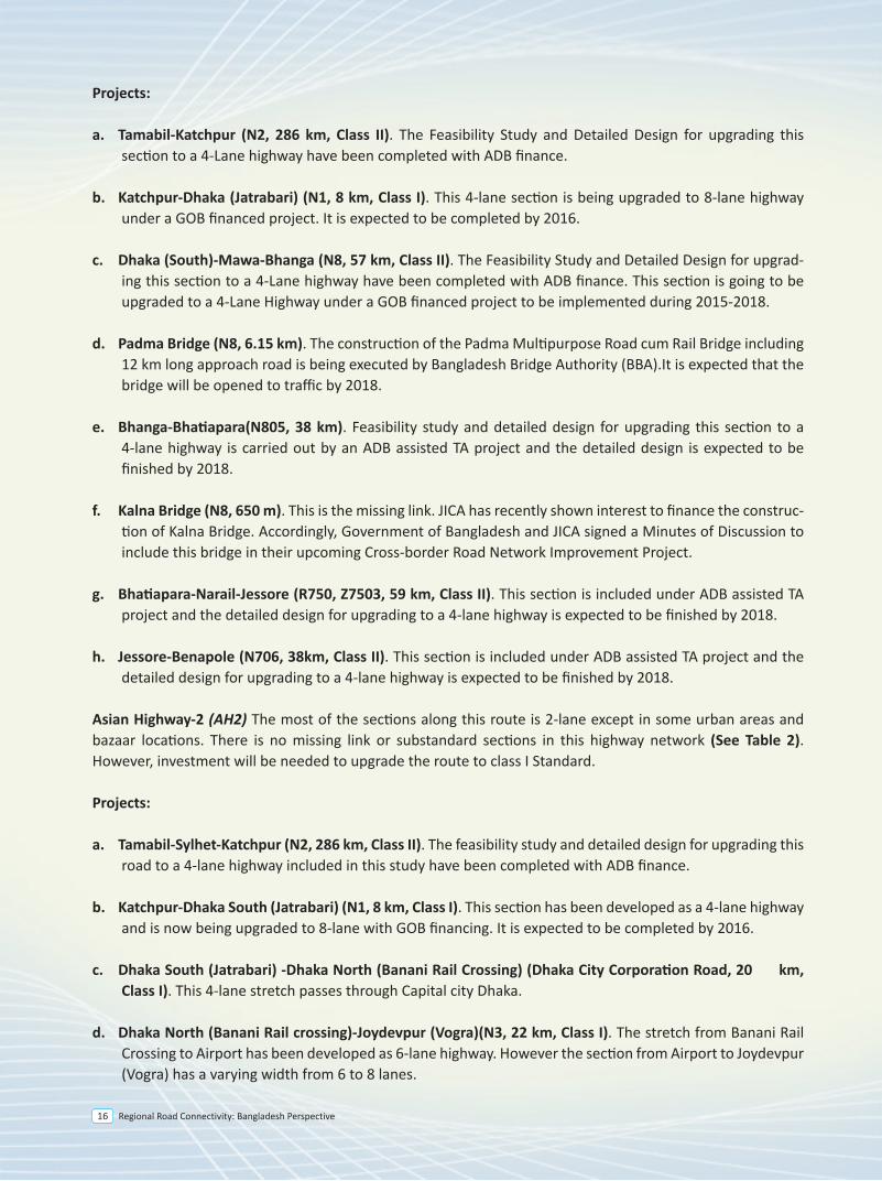
Projects:
a. Tamabil-Katchpur (N2, 286 km, Class II). The Feasibility Study and Detailed Design for upgrading this section to a 4-Lane highway have been completed with ADB finance.
b. Katchpur-Dhaka (Jatrabari) (N1, 8 km, Class I). This 4-lane section is being upgraded to 8-lane highway under a GOB financed project. It is expected to be completed by 2016.
c. Dhaka (South)-Mawa-Bhanga (N8, 57 km, Class II). The Feasibility Study and Detailed Design for upgrad-ing this section to a 4-Lane highway have been completed with ADB finance. This section is going to be upgraded to a 4-Lane Highway under a GOB financed project to be implemented during 2015-2018.
d. Padma Bridge (N8, 6.15 km). The construction of the Padma Multipurpose Road cum Rail Bridge including 12 km long approach road is being executed by Bangladesh Bridge Authority (BBA).It is expected that the bridge will be opened to traffic by 2018.
e. Bhanga-Bhatiapara(N805, 38 km). Feasibility study and detailed design for upgrading this section to a 4-lane highway is carried out by an ADB assisted TA project and the detailed design is expected to be finished by 2018.
f. Kalna Bridge (N8, 650 m). This is the missing link. JICA has recently shown interest to finance the construc-tion of Kalna Bridge. Accordingly, Government of Bangladesh and JICA signed a Minutes of Discussion to include this bridge in their upcoming Cross-border Road Network Improvement Project.
g. Bhatiapara-Narail-Jessore (R750, Z7503, 59 km, Class II). This section is included under ADB assisted TA project and the detailed design for upgrading to a 4-lane highway is expected to be finished by 2018.
h. Jessore-Benapole (N706, 38km, Class II). This section is included under ADB assisted TA project and the detailed design for upgrading to a 4-lane highway is expected to be finished by 2018.
Asian Highway-2 (AH2) The most of the sections along this route is 2-lane except in some urban areas and bazaar locations. There is no missing link or substandard sections in this highway network (See Table 2). However, investment will be needed to upgrade the route to class I Standard.
Projects:
a. Tamabil-Sylhet-Katchpur (N2, 286 km, Class II). The feasibility study and detailed design for upgrading this road to a 4-lane highway included in this study have been completed with ADB finance.
b. Katchpur-Dhaka South (Jatrabari) (N1, 8 km, Class I). This section has been developed as a 4-lane highway and is now being upgraded to 8-lane with GOB financing. It is expected to be completed by 2016.
c. Dhaka South (Jatrabari) -Dhaka North (Banani Rail Crossing) (Dhaka City Corporation Road, 20 km, Class I). This 4-lane stretch passes through Capital city Dhaka.
d. Dhaka North (Banani Rail crossing)-Joydevpur (Vogra)(N3, 22 km, Class I). The stretch from Banani Rail Crossing to Airport has been developed as 6-lane highway. However the section from Airport to Joydevpur (Vogra) has a varying width from 6 to 8 lanes.
e. Joydevpur-Chandra-Tangail-Elenga (N4, 71 km, Class II). This section is being upgraded to 4 lane highways under SASEC Road Connectivity Project with ADB finance. The project is scheduled to be completed by 2018.
f. Elenga-Hatikamrul-Bogra-Rangpur (N4, 197 km, Class II). The Feasibility Study and Detailed Design for upgrading this section to a 4-Lane highway have been completed with ADB finance. The investment project to upgrade this section has been included in ADB’s 2017 program.
g. Rangpur to Panchaghar (N5, 151 Km, Class II). Feasibility study and detailed design for upgrading this section to a 4-lane highway is being carried out by an ADB assisted SRTPPF-2 project and the detailed design is expected to be finished by 2018.
h. Panchaghar to Banglabandha (N5, 56 Km, Class II). This section was improved with ADB finance in 2011. Considering the traffic growth the feasibility study and detailed design for upgrading this section to a 4-lane highway is being carried out by an ADB assisted TA project and the detailed design is expected to be completed by 2018.
Asian Highway 41(AH41). The most of the sections along this route are 2-lane except in urban areas and bazaar locations. There is no missing link and substandard section in this highway network (SeeTable 3). How-ever, investment will be needed to upgrade the route to AH Standard I.
Projects:
a. Teknaf-Cox’sBazar-Chittagong (N1, 223 km, Class II). The Feasibility Study and Detailed Design for upgrad-ing this section to a 4-Lane highway have been completed with ADB finance. JICA has recently shown interest to finance upgrading Chittagong-Cox’s Bazar section. Government of Bangladesh and JICA signed a Minutes of Discussion on 20 August 2014 to include this road stretch in the Cross-border Road Network Improvement Project which is expected to be financed by JICA.
b. Chittagong and Daudkandi(N1, 204 km, Class I). This section is almost upgraded under 4-Laning of Dhaka-Chittagong Highway Project.
c. Daudkandi- Madanpur (N1, 18 km). This section has already been upgraded as a 4-lane highway
d. Madanpur –Bhulta- Joydevpur (N105, 48 km). This section is known as Dhaka Bypass, which is being considered for PPP finance. The PPP office under the Prime Minister’s Office has engaged transaction adviser and feasibility study was completed in July 2014. The RFQ for selecting concessionaire has been issued on October 2015. The road work of this project is expected to be completed by 2020.
e. Joydevpur- Chandra -Tangail- Elenga (N4, 70 km, Class II). This section is being upgraded to 4 lane highway under SESEC Road Connectivity Project with ADB finance and the construction work is expected to be completed within 2018.
f. Elenga-Hatikamrul (N4, 41km, Class II). The Feasibility Study and Detailed Design for upgrading this section to a 4-Lane highway have been completed with ADB finance.
g. Hatikamrul-Banpara (N507, 51km, Class II). The Feasibility Study and Detailed Design for upgrading this section to a 4-Lane highway have been completed with ADB finance.
Regional Road Connectivity: Bangladesh Perspective 17
2.0 Asian Highway Network
The Asian Highway project was conceived by UN-ESCAFE (United Nations Economic and Social Commission for Asia and the Far East) in 1959 with the aim of establishing regional cooperation among the main land countries of Asia, based on road transport linkages. Potential Routes were identified and analyzed during 1960-1970. In early 1990s, Political and economic changes in the region spurred renewed interest in the network. In 1992, the Asian Land Transport Infrastructure Development Project (ALTIDP) was launched. The project is the foremost among the existing pan-Asian infrastructure initiatives. It consists of three pillars: the Asian Highway (AH), the Trans-Asian Railway (TAR), and the Facilitation of land transport projects through intermodal transport terminals (dry ports and inland ports). The Asian Highway follows framework for internationally agreed routes and infrastructural standards.
• The Asian Highway network currently comprises about 144,630 kilometer of roads, including 15,400 kilometer of potential Asian Highway routes in China, passing through 32 Asian member States with linkages to Europe (UNESCAP 2014). In order to formalize the establishment of the Asian Highway network and ensure commitment of the governments of the member countries towards its further development, standardization and maintenance, an Intergovernmental Agreement on the Asian Highway Network was adopted on 18 November 2003 in Bangkok. It was opened for signature in Shanghai, China from 26 to 28 April, 2004 and thereafter, at United Nations Headquarters in New York from 01May, 2004 to 31December, 2005. The Agreement entered into force on 04 July 2005. As of 17 June, 29 Member States are parties to the Agreement.
• The Cabinet Meeting chaired by the Honorable Prime Minister Sheikh Hasina approved the accession of Bangladesh in Asian Highway Network on 15 June 2009. Bangladesh signed the Instrument of Accession on 05 July 2009 which was effected on 10 August 2009. The Agreement entered into force for Bangladesh on 08 November 2009.
In Bangladesh, there are three Asian Highway Routes namely, Asian Highway-1 (AH1), Asian Highway-2 (AH2) and Asian Highway-41 (AH41). Of these three routes, AH41 remains within Bangladesh, but could be extended to neighboring countries. Total length of the AH routes in Bangladesh is 1771 kilometer.
AH1 Route inside Bangladesh : {Guwahati (India) - Dawki (India)}/Tamabil - Sylhet - Shaistaganj - Narshingdi - Katchpur - Dhaka - Mawa - Charjanajat - Bhanga - Bhatiapara - Kalna Ferry Ghat - Narail - Jessore- Benapole/{Petrapole (India)} .Total Length is 492km.
AH2 Route inside Bangladesh : {Guwahati (India) - Dawki (India)} - Tamabil - Sylhet - Shaistaganj - Narshingdi - Katchpur - Dhaka South (Jatrabari) – Dhaka North (Banani Rail Crossing) – Joydevpur - Kaliakoir - Elenga - Hatikamrul - Bogra - Rangpur - Beldanga - Panchgarh - Banglabandha/[Fulbari (India)]. Total Length is 517 km (excluding common part of 294 km of AH1).
AH41 Route within Bangladesh: Teknaf - Cox’sBazaar - Keranirhat - Feni - Moinamoti - Katchpur - Dhaka (Jatrabari) - Dhaka North(Banani Rail Crossing) - Joydevpur - Kaliakoir - Hatikamrul - Banpara - Dasuria - Paksey - Kushtia - Jenaidah - Jessore - Khulna - Mongla. Total Length is 762 km (excluding common part of 162 km of AH2).
2.1 Current Status
Asian Highway-1 (AH1) The most of the sections along this route is 2-lane with some 4-lane sections in urban areas and bazaar locations. There are currently two missing links in this corridor: (a) the Padma Bridge gap at Bhanga and (b) Kalna Bridge gap at Bhatiapara. In addition, there is one sub-standard section between Bhatiapara-Narial-Jes-sore (bellow AH standard II, See Table 1).
e. Joydevpur-Chandra-Tangail-Elenga (N4, 71 km, Class II). This section is being upgraded to 4 lane highways under SASEC Road Connectivity Project with ADB finance. The project is scheduled to be completed by 2018.
f. Elenga-Hatikamrul-Bogra-Rangpur (N4, 197 km, Class II). The Feasibility Study and Detailed Design for upgrading this section to a 4-Lane highway have been completed with ADB finance. The investment project to upgrade this section has been included in ADB’s 2017 program.
g. Rangpur to Panchaghar (N5, 151 Km, Class II). Feasibility study and detailed design for upgrading this section to a 4-lane highway is being carried out by an ADB assisted SRTPPF-2 project and the detailed design is expected to be finished by 2018.
h. Panchaghar to Banglabandha (N5, 56 Km, Class II). This section was improved with ADB finance in 2011. Considering the traffic growth the feasibility study and detailed design for upgrading this section to a 4-lane highway is being carried out by an ADB assisted TA project and the detailed design is expected to be completed by 2018.
Asian Highway 41(AH41). The most of the sections along this route are 2-lane except in urban areas and bazaar locations. There is no missing link and substandard section in this highway network (SeeTable 3). How-ever, investment will be needed to upgrade the route to AH Standard I.
Projects:
a. Teknaf-Cox’sBazar-Chittagong (N1, 223 km, Class II). The Feasibility Study and Detailed Design for upgrad-ing this section to a 4-Lane highway have been completed with ADB finance. JICA has recently shown interest to finance upgrading Chittagong-Cox’s Bazar section. Government of Bangladesh and JICA signed a Minutes of Discussion on 20 August 2014 to include this road stretch in the Cross-border Road Network Improvement Project which is expected to be financed by JICA.
b. Chittagong and Daudkandi(N1, 204 km, Class I). This section is almost upgraded under 4-Laning of Dhaka-Chittagong Highway Project.
c. Daudkandi- Madanpur (N1, 18 km). This section has already been upgraded as a 4-lane highway
d. Madanpur –Bhulta- Joydevpur (N105, 48 km). This section is known as Dhaka Bypass, which is being considered for PPP finance. The PPP office under the Prime Minister’s Office has engaged transaction adviser and feasibility study was completed in July 2014. The RFQ for selecting concessionaire has been issued on October 2015. The road work of this project is expected to be completed by 2020.
e. Joydevpur- Chandra -Tangail- Elenga (N4, 70 km, Class II). This section is being upgraded to 4 lane highway under SESEC Road Connectivity Project with ADB finance and the construction work is expected to be completed within 2018.
f. Elenga-Hatikamrul (N4, 41km, Class II). The Feasibility Study and Detailed Design for upgrading this section to a 4-Lane highway have been completed with ADB finance.
g. Hatikamrul-Banpara (N507, 51km, Class II). The Feasibility Study and Detailed Design for upgrading this section to a 4-Lane highway have been completed with ADB finance.
Regional Road Connectivity: Bangladesh Perspective18
2.0 Asian Highway Network
The Asian Highway project was conceived by UN-ESCAFE (United Nations Economic and Social Commission for Asia and the Far East) in 1959 with the aim of establishing regional cooperation among the main land countries of Asia, based on road transport linkages. Potential Routes were identified and analyzed during 1960-1970. In early 1990s, Political and economic changes in the region spurred renewed interest in the network. In 1992, the Asian Land Transport Infrastructure Development Project (ALTIDP) was launched. The project is the foremost among the existing pan-Asian infrastructure initiatives. It consists of three pillars: the Asian Highway (AH), the Trans-Asian Railway (TAR), and the Facilitation of land transport projects through intermodal transport terminals (dry ports and inland ports). The Asian Highway follows framework for internationally agreed routes and infrastructural standards.
• The Asian Highway network currently comprises about 144,630 kilometer of roads, including 15,400 kilometer of potential Asian Highway routes in China, passing through 32 Asian member States with linkages to Europe (UNESCAP 2014). In order to formalize the establishment of the Asian Highway network and ensure commitment of the governments of the member countries towards its further development, standardization and maintenance, an Intergovernmental Agreement on the Asian Highway Network was adopted on 18 November 2003 in Bangkok. It was opened for signature in Shanghai, China from 26 to 28 April, 2004 and thereafter, at United Nations Headquarters in New York from 01May, 2004 to 31December, 2005. The Agreement entered into force on 04 July 2005. As of 17 June, 29 Member States are parties to the Agreement.
• The Cabinet Meeting chaired by the Honorable Prime Minister Sheikh Hasina approved the accession of Bangladesh in Asian Highway Network on 15 June 2009. Bangladesh signed the Instrument of Accession on 05 July 2009 which was effected on 10 August 2009. The Agreement entered into force for Bangladesh on 08 November 2009.
In Bangladesh, there are three Asian Highway Routes namely, Asian Highway-1 (AH1), Asian Highway-2 (AH2) and Asian Highway-41 (AH41). Of these three routes, AH41 remains within Bangladesh, but could be extended to neighboring countries. Total length of the AH routes in Bangladesh is 1771 kilometer.
AH1 Route inside Bangladesh : {Guwahati (India) - Dawki (India)}/Tamabil - Sylhet - Shaistaganj - Narshingdi - Katchpur - Dhaka - Mawa - Charjanajat - Bhanga - Bhatiapara - Kalna Ferry Ghat - Narail - Jessore- Benapole/{Petrapole (India)} .Total Length is 492km.
AH2 Route inside Bangladesh : {Guwahati (India) - Dawki (India)} - Tamabil - Sylhet - Shaistaganj - Narshingdi - Katchpur - Dhaka South (Jatrabari) – Dhaka North (Banani Rail Crossing) – Joydevpur - Kaliakoir - Elenga - Hatikamrul - Bogra - Rangpur - Beldanga - Panchgarh - Banglabandha/[Fulbari (India)]. Total Length is 517 km (excluding common part of 294 km of AH1).
AH41 Route within Bangladesh: Teknaf - Cox’sBazaar - Keranirhat - Feni - Moinamoti - Katchpur - Dhaka (Jatrabari) - Dhaka North(Banani Rail Crossing) - Joydevpur - Kaliakoir - Hatikamrul - Banpara - Dasuria - Paksey - Kushtia - Jenaidah - Jessore - Khulna - Mongla. Total Length is 762 km (excluding common part of 162 km of AH2).
2.1 Current Status
Asian Highway-1 (AH1) The most of the sections along this route is 2-lane with some 4-lane sections in urban areas and bazaar locations. There are currently two missing links in this corridor: (a) the Padma Bridge gap at Bhanga and (b) Kalna Bridge gap at Bhatiapara. In addition, there is one sub-standard section between Bhatiapara-Narial-Jes-sore (bellow AH standard II, See Table 1).
e. Joydevpur-Chandra-Tangail-Elenga (N4, 71 km, Class II). This section is being upgraded to 4 lane highways under SASEC Road Connectivity Project with ADB finance. The project is scheduled to be completed by 2018.
f. Elenga-Hatikamrul-Bogra-Rangpur (N4, 197 km, Class II). The Feasibility Study and Detailed Design for upgrading this section to a 4-Lane highway have been completed with ADB finance. The investment project to upgrade this section has been included in ADB’s 2017 program.
g. Rangpur to Panchaghar (N5, 151 Km, Class II). Feasibility study and detailed design for upgrading this section to a 4-lane highway is being carried out by an ADB assisted SRTPPF-2 project and the detailed design is expected to be finished by 2018.
h. Panchaghar to Banglabandha (N5, 56 Km, Class II). This section was improved with ADB finance in 2011. Considering the traffic growth the feasibility study and detailed design for upgrading this section to a 4-lane highway is being carried out by an ADB assisted TA project and the detailed design is expected to be completed by 2018.
Asian Highway 41(AH41). The most of the sections along this route are 2-lane except in urban areas and bazaar locations. There is no missing link and substandard section in this highway network (SeeTable 3). How-ever, investment will be needed to upgrade the route to AH Standard I.
Projects:
a. Teknaf-Cox’sBazar-Chittagong (N1, 223 km, Class II). The Feasibility Study and Detailed Design for upgrad-ing this section to a 4-Lane highway have been completed with ADB finance. JICA has recently shown interest to finance upgrading Chittagong-Cox’s Bazar section. Government of Bangladesh and JICA signed a Minutes of Discussion on 20 August 2014 to include this road stretch in the Cross-border Road Network Improvement Project which is expected to be financed by JICA.
b. Chittagong and Daudkandi(N1, 204 km, Class I). This section is almost upgraded under 4-Laning of Dhaka-Chittagong Highway Project.
c. Daudkandi- Madanpur (N1, 18 km). This section has already been upgraded as a 4-lane highway
d. Madanpur –Bhulta- Joydevpur (N105, 48 km). This section is known as Dhaka Bypass, which is being considered for PPP finance. The PPP office under the Prime Minister’s Office has engaged transaction adviser and feasibility study was completed in July 2014. The RFQ for selecting concessionaire has been issued on October 2015. The road work of this project is expected to be completed by 2020.
e. Joydevpur- Chandra -Tangail- Elenga (N4, 70 km, Class II). This section is being upgraded to 4 lane highway under SESEC Road Connectivity Project with ADB finance and the construction work is expected to be completed within 2018.
f. Elenga-Hatikamrul (N4, 41km, Class II). The Feasibility Study and Detailed Design for upgrading this section to a 4-Lane highway have been completed with ADB finance.
g. Hatikamrul-Banpara (N507, 51km, Class II). The Feasibility Study and Detailed Design for upgrading this section to a 4-Lane highway have been completed with ADB finance.
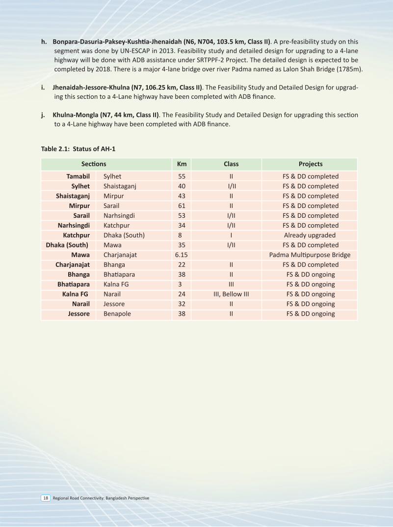
h. Bonpara-Dasuria-Paksey-Kushtia-Jhenaidah (N6, N704, 103.5 km, Class II). A pre-feasibility study on this segment was done by UN-ESCAP in 2013. Feasibility study and detailed design for upgrading to a 4-lane highway will be done with ADB assistance under SRTPPF-2 Project. The detailed design is expected to be completed by 2018. There is a major 4-lane bridge over river Padma named as Lalon Shah Bridge (1785m).
i. Jhenaidah-Jessore-Khulna (N7, 106.25 km, Class II). The Feasibility Study and Detailed Design for upgrad-ing this section to a 4-Lane highway have been completed with ADB finance.
j. Khulna-Mongla (N7, 44 km, Class II). The Feasibility Study and Detailed Design for upgrading this section to a 4-Lane highway have been completed with ADB finance.
Table 2.1: Status of AH-1
Sections Km Class Projects Tamabil Sylhet 55 II FS & DD completed Sylhet Shaistaganj 40 I/II FS & DD completed Shaistaganj Mirpur 43 II FS & DD completed Mirpur Sarail 61 II FS & DD completed Sarail Narhsingdi 53 I/II FS & DD completed Narhsingdi Katchpur 34 I/II FS & DD completed Katchpur Dhaka (South) 8 I Already upgraded Dhaka (South) Mawa 35 I/II FS & DD completed Mawa Charjanajat 6.15 Padma Multipurpose Bridge Charjanajat Bhanga 22 II FS & DD completed Bhanga Bhatiapara 38 II FS & DD ongoing Bhatiapara Kalna FG 3 III FS & DD ongoing Kalna FG Narail 24 III, Bellow III FS & DD ongoing Narail Jessore 32 II FS & DD ongoing Jessore Benapole 38 II FS & DD ongoing
Regional Road Connectivity: Bangladesh Perspective 19
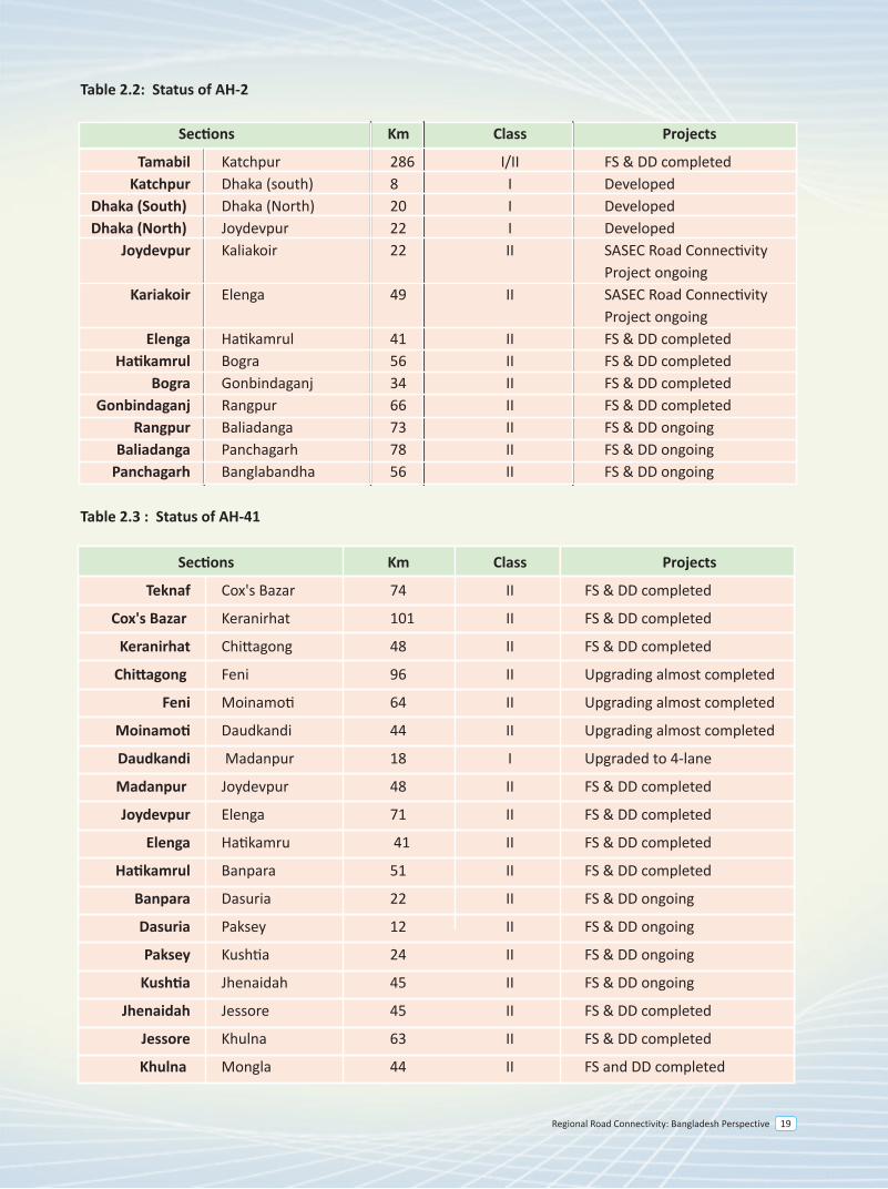
Table 2.3 : Status of AH-41
Sections Km Class Projects
Teknaf Cox's Bazar 74 II FS & DD completed
Cox's Bazar Keranirhat 101 II FS & DD completed
Keranirhat Chittagong 48 II FS & DD completed
Chittagong Feni 96 II Upgrading almost completed
Feni Moinamoti 64 II Upgrading almost completed
Moinamoti Daudkandi 44 II Upgrading almost completed
Daudkandi Madanpur 18 I Upgraded to 4-lane
Madanpur Joydevpur 48 II FS & DD completed
Joydevpur Elenga 71 II FS & DD completed
Elenga Hatikamru 41 II FS & DD completed
Hatikamrul Banpara 51 II FS & DD completed
Banpara Dasuria 22 II FS & DD ongoing
Dasuria Paksey 12 II FS & DD ongoing
Paksey Kushtia 24 II FS & DD ongoing
Kushtia Jhenaidah 45 II FS & DD ongoing
Jhenaidah Jessore 45 II FS & DD completed
Jessore Khulna 63 II FS & DD completed
Khulna Mongla 44 II FS and DD completed
Table 2.2: Status of AH-2
Sections Km Class Projects Tamabil Katchpur 286 I/II FS & DD completed Katchpur Dhaka (south) 8 I Developed Dhaka (South) Dhaka (North) 20 I Developed Dhaka (North) Joydevpur 22 I Developed Joydevpur Kaliakoir 22 II SASEC Road Connectivity Project ongoing Kariakoir Elenga 49 II SASEC Road Connectivity Project ongoing Elenga Hatikamrul 41 II FS & DD completed Hatikamrul Bogra 56 II FS & DD completed Bogra Gonbindaganj 34 II FS & DD completed Gonbindaganj Rangpur 66 II FS & DD completed Rangpur Baliadanga 73 II FS & DD ongoing Baliadanga Panchagarh 78 II FS & DD ongoing Panchagarh Banglabandha 56 II FS & DD ongoing
Regional Road Connectivity: Bangladesh Perspective20
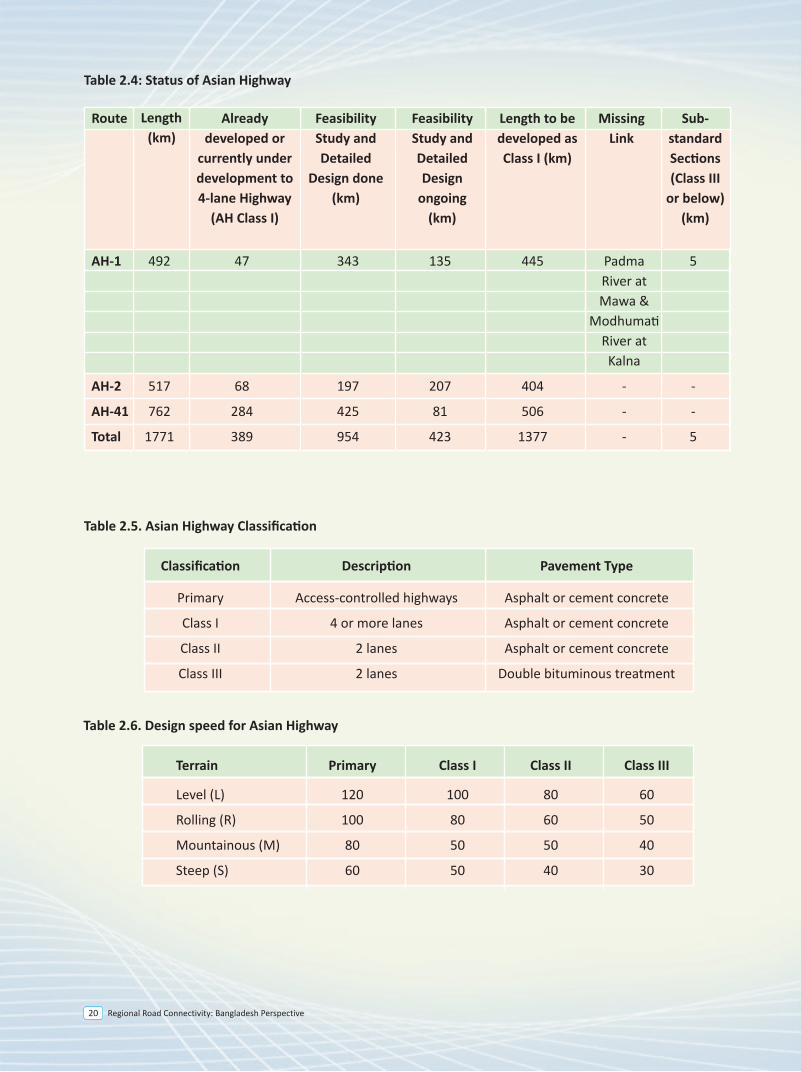
Table 2.4: Status of Asian Highway
Route
Length(km)
Alreadydeveloped or
currently underdevelopment to4-lane Highway
(AH Class I)
FeasibilityStudy andDetailed
Design done(km)
FeasibilityStudy andDetailedDesign
ongoing(km)
Length to bedeveloped asClass I (km)
MissingLink
Sub-standardSections(Class III
or below)(km)
Table 2.5. Asian Highway Classification
Classification Description Pavement Type
Primary Access-controlled highways Asphalt or cement concrete
Class I 4 or more lanes Asphalt or cement concrete
Class II 2 lanes Asphalt or cement concrete
Class III 2 lanes Double bituminous treatment
Table 2.6. Design speed for Asian Highway
Terrain Primary Class I Class II Class III
Level (L) 120 100 80 60
Rolling (R) 100 80 60 50
Mountainous (M) 80 50 50 40
Steep (S) 60 50 40 30
AH-1 492 47 343 135 445 Padma 5 River at Mawa & Modhumati River at Kalna
AH-2 517 68 197 207 404 - -
AH-41 762 284 425 81 506 - -
Total 1771 389 954 423 1377 - 5
Regional Road Connectivity: Bangladesh Perspective 21
SAARC Highway Corridor
3
Regional Road Connectivity: Bangladesh Perspective 25
3.0 Introduction
The South Asian Association for Regional Cooperation (SAARC) is an economic and geopolitical union of eight member nations namely, Bangladesh, India, Pakistan, Nepal, Bhutan, Sri Lanka, Maldives and Afghanistan. SAARC countries are committed to enhance regional cooperation among the countries to promote the welfare and improve the quality of life of the people of the region.
Recognizing the importance of transport integration in South Asia as one of the key elements to promote economic cooperation, the Islamabad SAARC Summit in 2004 decided to strengthen transport, transit and communication links across the region. It was in pursuance of this decision that the SAARC, with financial and technical support from the ADB, initiated the SAARC Regional Multimodal Transport Study (SRMTS) with the main objective of enhancing multimodal transport connectivity among SAARC member states.
SRMTS recommended 10 road corridors (Annexure-2) for future development based on several criteria namely, volume and trend of traffic, potential to provide direct connectivity, ability to provide access to landlocked countries/states to ports or to major transit transport networks, potential to provide to reducing distance and thereby saving transport costs and revitalizing historical links or provide linkages for meeting socio-political requirements. Out of the 10 SAARC Highway Corridors (SHC), six corridors namely SHC1, SHC4, SHC5, SHC6, SHC8, SHC9 involve Bangladesh (Table 3.1).
SHC 1 Pakistan, India &Bangladesh
Potential to carry major intraregional traffic and Potential to providing shorter route leading to transport cost savings
SHC 4 Kathmandu–Kakarvitta–Phulbari–Banglabandha–Mongla/Chittagong
Lahore – New Delhi – Kolkata – Petrapole/Benapole – Dhaka – Akhaura/Agartala
Nepal, India &Bangladesh
Access to landlocked Nepal to Bangladeshi ports
SHC 5 SandropJongkhar–Guwahati–Shillong– Sylhet–Dhaka–Kolkata
Bhutan, India & Bangladesh
Potential to providing shorter route leading to transport cost savings
SHC 6 Agartala–Akhaura–Chittagong India &Bangladesh
Shorter access to Chittagong port for Indian North Eastern States
SHC 8 Thimphu–Phuentsholing–Jaigaon– Burimari–Mongla/Chittagong
Bhutan, India & Bangladesh
Access to landlocked Bhutan to Bangladeshi ports
SHC 9 Maldha–Shibganj–Jamuna Bridge (Bangladesh)
India &Bangladesh
Potential to provide direct connectivity to carry future traffic
Table 3.1: SAARC Highway Corridors involve Bangladesh
Corridor Countries Basis of Selection
Regional Road Connectivity: Bangladesh Perspective26
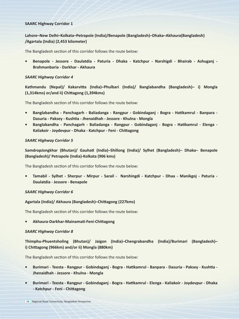
SAARC Highway Corridor 1
Lahore–New Delhi–Kolkata–Petrapole (India)/Benapole (Bangladesh)–Dhaka–Akhaura(Bangladesh) /Agartala (India) (2,453 kilometer)
The Bangladesh section of this corridor follows the route below:
• Benapole - Jessore - Daulatdia - Paturia - Dhaka - Katchpur - Narshigdi - Bhairab - Ashuganj - Brahmanbaria - Darkhar - Akhaura
SAARC Highway Corridor 4
Kathmandu (Nepal)/ Kakarvitta (India)–Phulbari (India)/ Banglabandha (Bangladesh)– i) Mongla (1,314kms) or/and ii) Chittagong (1,394kms)
The Bangladesh section of this corridor follows the route below:
• Banglabandha - Panchagarh - Baliadanga - Rangpur - Gobindaganj - Bogra - Hatikamrul - Banpara - Dasuria - Paksey - Kushtia - Jhenaidhah - Jessore - Khulna - Mongla
• Banglabandha - Panchagarh - Baliadanga - Rangpur - Gobindaganj - Bogra - Hatikamrul - Elenga - Kaliakoir - Joydevpur - Dhaka - Katchpur - Feni - Chittagong
SAARC Highway Corridor 5
SamdropJongkhar (Bhutan)/ Gauhati (India)–Shillong (India)/ Sylhet (Bangladesh)– Dhaka– Benapole (Bangladesh)/ Petrapole (India)-Kolkata (906 kms)
The Bangladesh section of this corridor follows the route below:
• Tamabil - Sylhet - Sherpur - Mirpur - Sarail - Narshingdi - Katchpur - Dhaa - Manikgoj - Paturia - Daulatdia - Jessore - Benapole
SAARC Highway Corridor 6
Agartala (India)/ Akhaura (Bangladesh)–Chittagong (227kms)
The Bangladesh section of this corridor follows the route below:
• Akhaura-Darkhar-Mainamati-Feni-Chittagong
SAARC Highway Corridor 8
Thimphu-Phuentsholing (Bhutan)/ Jaigon (India)–Chengrabandha (India)/Burimari (Bangladesh)–i) Chittagong (966km) and/or ii) Mongla (880km)
The Bangladesh section of this corridor follows the route below:
• Burimari - Teesta - Rangpur - Gobindaganj - Bogra - Hatikamrul - Banpara - Dasuria - Paksey - Kushtia - Jhenaidhah - Jessore - Khulna - Mongla
• Burimari - Teesta - Rangpur - Gobindaganj - Bogra - Hatikamrul - Elenga - Kaliakoir - Joydevpur - Dhaka - Katchpur - Feni - Chittagong
Regional Road Connectivity: Bangladesh Perspective 27
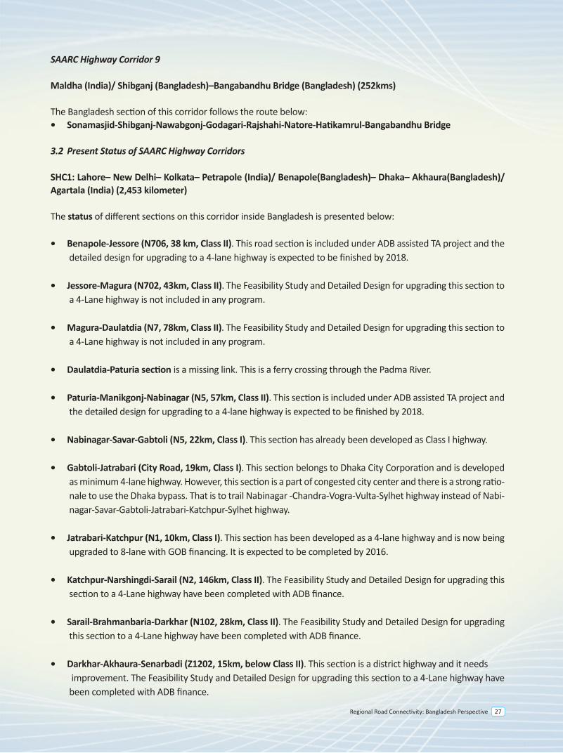
SAARC Highway Corridor 9
Maldha (India)/ Shibganj (Bangladesh)–Bangabandhu Bridge (Bangladesh) (252kms)
The Bangladesh section of this corridor follows the route below:• Sonamasjid-Shibganj-Nawabgonj-Godagari-Rajshahi-Natore-Hatikamrul-Bangabandhu Bridge
3.2 Present Status of SAARC Highway Corridors
SHC1: Lahore– New Delhi– Kolkata– Petrapole (India)/ Benapole(Bangladesh)– Dhaka– Akhaura(Bangladesh)/ Agartala (India) (2,453 kilometer)
The status of different sections on this corridor inside Bangladesh is presented below:
• Benapole-Jessore (N706, 38 km, Class II). This road section is included under ADB assisted TA project and the detailed design for upgrading to a 4-lane highway is expected to be finished by 2018.
• Jessore-Magura (N702, 43km, Class II). The Feasibility Study and Detailed Design for upgrading this section to a 4-Lane highway is not included in any program.
• Magura-Daulatdia (N7, 78km, Class II). The Feasibility Study and Detailed Design for upgrading this section to a 4-Lane highway is not included in any program.
• Daulatdia-Paturia section is a missing link. This is a ferry crossing through the Padma River.
• Paturia-Manikgonj-Nabinagar (N5, 57km, Class II). This section is included under ADB assisted TA project and the detailed design for upgrading to a 4-lane highway is expected to be finished by 2018.
• Nabinagar-Savar-Gabtoli (N5, 22km, Class I). This section has already been developed as Class I highway.
• Gabtoli-Jatrabari (City Road, 19km, Class I). This section belongs to Dhaka City Corporation and is developed as minimum 4-lane highway. However, this section is a part of congested city center and there is a strong ratio-nale to use the Dhaka bypass. That is to trail Nabinagar -Chandra-Vogra-Vulta-Sylhet highway instead of Nabi-nagar-Savar-Gabtoli-Jatrabari-Katchpur-Sylhet highway.
• Jatrabari-Katchpur (N1, 10km, Class I). This section has been developed as a 4-lane highway and is now being upgraded to 8-lane with GOB financing. It is expected to be completed by 2016.
• Katchpur-Narshingdi-Sarail (N2, 146km, Class II). The Feasibility Study and Detailed Design for upgrading this section to a 4-Lane highway have been completed with ADB finance.
• Sarail-Brahmanbaria-Darkhar (N102, 28km, Class II). The Feasibility Study and Detailed Design for upgrading this section to a 4-Lane highway have been completed with ADB finance.
• Darkhar-Akhaura-Senarbadi (Z1202, 15km, below Class II). This section is a district highway and it needs improvement. The Feasibility Study and Detailed Design for upgrading this section to a 4-Lane highway have been completed with ADB finance.
• Bonpara-Dasuria-Pakshey-Kushtia-Jheinaidah(N6, N704, 105 km, Class II). A pre-feasibility study on this segment was done by UN-ESCAP in 2013. Feasibility study and detailed design for upgrading to a 4-lane highway will be done with ADB assistance. The detailed design is expected to be completed by 2018. There is a major 4-lane bridge over river Padma named as Lalon Shah Bridge (1785m).
• Jhenaidah-Jessore-Khulna (N7, 107 km, Class II). The Feasibility Study and Detailed Design for upgrading this section to a 4-Lane highway have been completed with ADB finance.
• Khulna-Mongla (N7, 43 km, Class II). The Feasibility Study and Detailed Design for upgrading this section to a 4-Lane highway have been completed with ADB finance.
The road section from Banglabandha to Mongla (670km) has an average pavement width of 7.3m with 2.4 - 4.0m shoulders on both sides. The condition of the entire road is good. The Banglabandha–Dhaka–Chittagong corridor (750km) uses the same road N5 up to Hatikamrul and then crosses the Jamuna river through Bangabandhu Bridge to reach Dhaka and then to Chittagong. The entire road has an average pavement width 7.5m and shoulder width 2.0–4.0m on both sides. The road condition is good.
SHC5. SamdropJongkhar–Shillong–Sylhet–Dhaka–Kolkata (906 km)
The status of different sections on this corridor inside Bangladesh is presented below:
• Tamabil-Sylhet (N2, 53km, Class II). The feasibility study and detailed design for upgrading this road to a 4-lane highway have been completed with ADB finance.
• Sylhet- Madhabpur-Sarail-Narshingdi-Katchpur (N2, 230km, Class II). The feasibility study and detailed design for upgrading this road to a 4-lane highway have been completed with ADB finance.
• Katchpur-Jatrabari (N1, 10km, Class I). This section has been developed as a 4-lane highway and is now being upgraded to 8-lane with GOB financing. It is expected to be completed by 2016.
• Jatrabari-Gabtoli (City Road, 19km, Class I). This section is described above.
• Gabtoli-Savar-Nabinagar (N5, 22km, Class I). This section has already been developed as Class I highway.
• Nabinagar-Manikgonj-Paturia (N5, 57km, Class II). This section is included under ADB assisted TA project and the detailed design for upgrading to a 4-lane highway is expected to be finished by 2018.
• Paturia-Daulatdia. This section is a missing link. This is a ferry crossing through the Padma River.
• Daulatdia-Magura (N7, 78km, Class II). The feasibility study and detailed design for upgrading this road to a 4-lane highway is not included in any program.
• Magura-Jessore (N702, 43km, Class II). The feasibility study and detailed design for upgrading this road to a 4-lane highway is not included in any program.
• Jessore-Benapole (N706, 38 km, Class II). The feasibility study and detailed design for upgrading this road to a 4-lane highway will be completed with ADB finance by 2018.
Regional Road Connectivity: Bangladesh Perspective28
SAARC Highway Corridor 9
Maldha (India)/ Shibganj (Bangladesh)–Bangabandhu Bridge (Bangladesh) (252kms)
The Bangladesh section of this corridor follows the route below:• Sonamasjid-Shibganj-Nawabgonj-Godagari-Rajshahi-Natore-Hatikamrul-Bangabandhu Bridge
3.2 Present Status of SAARC Highway Corridors
SHC1: Lahore– New Delhi– Kolkata– Petrapole (India)/ Benapole(Bangladesh)– Dhaka– Akhaura(Bangladesh)/ Agartala (India) (2,453 kilometer)
The status of different sections on this corridor inside Bangladesh is presented below:
• Benapole-Jessore (N706, 38 km, Class II). This road section is included under ADB assisted TA project and the detailed design for upgrading to a 4-lane highway is expected to be finished by 2018.
• Jessore-Magura (N702, 43km, Class II). The Feasibility Study and Detailed Design for upgrading this section to a 4-Lane highway is not included in any program.
• Magura-Daulatdia (N7, 78km, Class II). The Feasibility Study and Detailed Design for upgrading this section to a 4-Lane highway is not included in any program.
• Daulatdia-Paturia section is a missing link. This is a ferry crossing through the Padma River.
• Paturia-Manikgonj-Nabinagar (N5, 57km, Class II). This section is included under ADB assisted TA project and the detailed design for upgrading to a 4-lane highway is expected to be finished by 2018.
• Nabinagar-Savar-Gabtoli (N5, 22km, Class I). This section has already been developed as Class I highway.
• Gabtoli-Jatrabari (City Road, 19km, Class I). This section belongs to Dhaka City Corporation and is developed as minimum 4-lane highway. However, this section is a part of congested city center and there is a strong ratio-nale to use the Dhaka bypass. That is to trail Nabinagar -Chandra-Vogra-Vulta-Sylhet highway instead of Nabi-nagar-Savar-Gabtoli-Jatrabari-Katchpur-Sylhet highway.
• Jatrabari-Katchpur (N1, 10km, Class I). This section has been developed as a 4-lane highway and is now being upgraded to 8-lane with GOB financing. It is expected to be completed by 2016.
• Katchpur-Narshingdi-Sarail (N2, 146km, Class II). The Feasibility Study and Detailed Design for upgrading this section to a 4-Lane highway have been completed with ADB finance.
• Sarail-Brahmanbaria-Darkhar (N102, 28km, Class II). The Feasibility Study and Detailed Design for upgrading this section to a 4-Lane highway have been completed with ADB finance.
• Darkhar-Akhaura-Senarbadi (Z1202, 15km, below Class II). This section is a district highway and it needs improvement. The Feasibility Study and Detailed Design for upgrading this section to a 4-Lane highway have been completed with ADB finance.
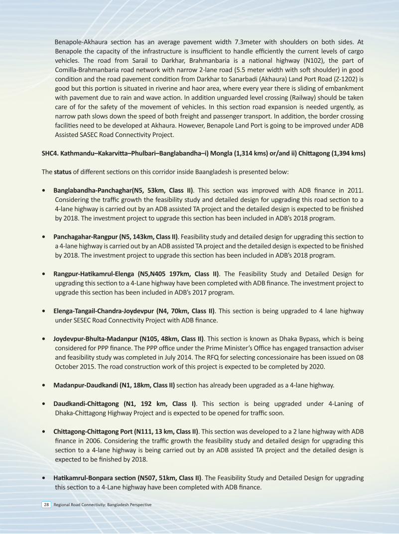
Benapole-Akhaura section has an average pavement width 7.3meter with shoulders on both sides. At Benapole the capacity of the infrastructure is insufficient to handle efficiently the current levels of cargo vehicles. The road from Sarail to Darkhar, Brahmanbaria is a national highway (N102), the part of Comilla-Brahmanbaria road network with narrow 2-lane road (5.5 meter width with soft shoulder) in good condition and the road pavement condition from Darkhar to Sanarbadi (Akhaura) Land Port Road (Z-1202) is good but this portion is situated in riverine and haor area, where every year there is sliding of embankment with pavement due to rain and wave action. In addition unguarded level crossing (Railway) should be taken care of for the safety of the movement of vehicles. In this section road expansion is needed urgently, as narrow path slows down the speed of both freight and passenger transport. In addition, the border crossing facilities need to be developed at Akhaura. However, Benapole Land Port is going to be improved under ADB Assisted SASEC Road Connectivity Project.
SHC4. Kathmandu–Kakarvitta–Phulbari–Banglabandha–i) Mongla (1,314 kms) or/and ii) Chittagong (1,394 kms)
The status of different sections on this corridor inside Baangladesh is presented below:
• Banglabandha-Panchaghar(N5, 53km, Class II). This section was improved with ADB finance in 2011. Considering the traffic growth the feasibility study and detailed design for upgrading this road section to a 4-lane highway is carried out by an ADB assisted TA project and the detailed design is expected to be finished by 2018. The investment project to upgrade this section has been included in ADB’s 2018 program.
• Panchagahar-Rangpur (N5, 143km, Class II). Feasibility study and detailed design for upgrading this section to a 4-lane highway is carried out by an ADB assisted TA project and the detailed design is expected to be finished by 2018. The investment project to upgrade this section has been included in ADB’s 2018 program.
• Rangpur-Hatikamrul-Elenga (N5,N405 197km, Class II). The Feasibility Study and Detailed Design for upgrading this section to a 4-Lane highway have been completed with ADB finance. The investment project to upgrade this section has been included in ADB’s 2017 program.
• Elenga-Tangail-Chandra-Joydevpur (N4, 70km, Class II). This section is being upgraded to 4 lane highway under SESEC Road Connectivity Project with ADB finance.
• Joydevpur-Bhulta-Madanpur (N105, 48km, Class II). This section is known as Dhaka Bypass, which is being considered for PPP finance. The PPP office under the Prime Minister’s Office has engaged transaction adviser and feasibility study was completed in July 2014. The RFQ for selecting concessionaire has been issued on 08 October 2015. The road construction work of this project is expected to be completed by 2020.
• Madanpur-Daudkandi (N1, 18km, Class II) section has already been upgraded as a 4-lane highway.
• Daudkandi-Chittagong (N1, 192 km, Class I). This section is being upgraded under 4-Laning of Dhaka-Chittagong Highway Project and is expected to be opened for traffic soon.
• Chittagong-Chittagong Port (N111, 13 km, Class II). This section was developed to a 2 lane highway with ADB finance in 2006. Considering the traffic growth the feasibility study and detailed design for upgrading this section to a 4-lane highway is being carried out by an ADB assisted TA project and the detailed design is expected to be finished by 2018.
• Hatikamrul-Bonpara section (N507, 51km, Class II). The Feasibility Study and Detailed Design for upgrading this section to a 4-Lane highway have been completed with ADB finance.
• Bonpara-Dasuria-Pakshey-Kushtia-Jheinaidah(N6, N704, 105 km, Class II). A pre-feasibility study on this segment was done by UN-ESCAP in 2013. Feasibility study and detailed design for upgrading to a 4-lane highway will be done with ADB assistance. The detailed design is expected to be completed by 2018. There is a major 4-lane bridge over river Padma named as Lalon Shah Bridge (1785m).
• Jhenaidah-Jessore-Khulna (N7, 107 km, Class II). The Feasibility Study and Detailed Design for upgrading this section to a 4-Lane highway have been completed with ADB finance.
• Khulna-Mongla (N7, 43 km, Class II). The Feasibility Study and Detailed Design for upgrading this section to a 4-Lane highway have been completed with ADB finance.
The road section from Banglabandha to Mongla (670km) has an average pavement width of 7.3m with 2.4 - 4.0m shoulders on both sides. The condition of the entire road is good. The Banglabandha–Dhaka–Chittagong corridor (750km) uses the same road N5 up to Hatikamrul and then crosses the Jamuna river through Bangabandhu Bridge to reach Dhaka and then to Chittagong. The entire road has an average pavement width 7.5m and shoulder width 2.0–4.0m on both sides. The road condition is good.
SHC5. SamdropJongkhar–Shillong–Sylhet–Dhaka–Kolkata (906 km)
The status of different sections on this corridor inside Bangladesh is presented below:
• Tamabil-Sylhet (N2, 53km, Class II). The feasibility study and detailed design for upgrading this road to a 4-lane highway have been completed with ADB finance.
• Sylhet- Madhabpur-Sarail-Narshingdi-Katchpur (N2, 230km, Class II). The feasibility study and detailed design for upgrading this road to a 4-lane highway have been completed with ADB finance.
• Katchpur-Jatrabari (N1, 10km, Class I). This section has been developed as a 4-lane highway and is now being upgraded to 8-lane with GOB financing. It is expected to be completed by 2016.
• Jatrabari-Gabtoli (City Road, 19km, Class I). This section is described above.
• Gabtoli-Savar-Nabinagar (N5, 22km, Class I). This section has already been developed as Class I highway.
• Nabinagar-Manikgonj-Paturia (N5, 57km, Class II). This section is included under ADB assisted TA project and the detailed design for upgrading to a 4-lane highway is expected to be finished by 2018.
• Paturia-Daulatdia. This section is a missing link. This is a ferry crossing through the Padma River.
• Daulatdia-Magura (N7, 78km, Class II). The feasibility study and detailed design for upgrading this road to a 4-lane highway is not included in any program.
• Magura-Jessore (N702, 43km, Class II). The feasibility study and detailed design for upgrading this road to a 4-lane highway is not included in any program.
• Jessore-Benapole (N706, 38 km, Class II). The feasibility study and detailed design for upgrading this road to a 4-lane highway will be completed with ADB finance by 2018.
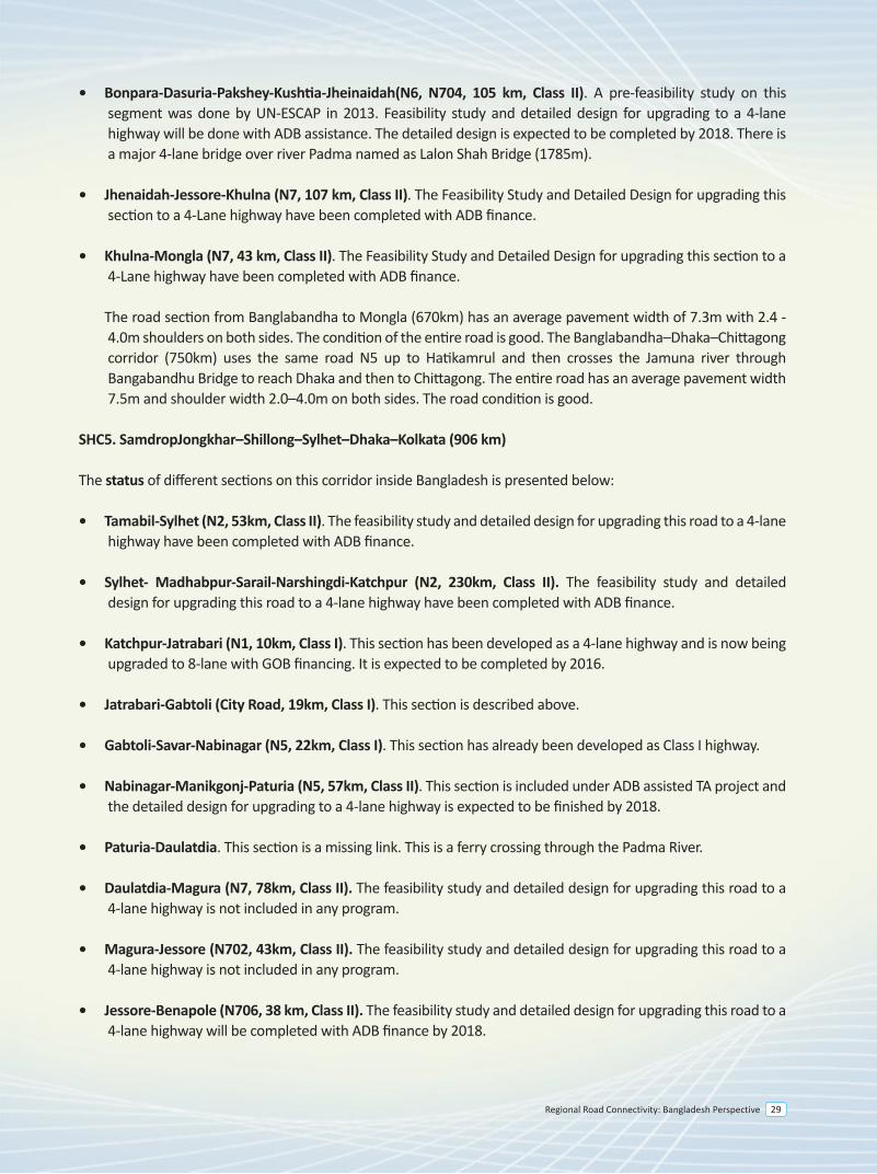
Regional Road Connectivity: Bangladesh Perspective 29
SAARC Highway Corridor 9
Maldha (India)/ Shibganj (Bangladesh)–Bangabandhu Bridge (Bangladesh) (252kms)
The Bangladesh section of this corridor follows the route below:• Sonamasjid-Shibganj-Nawabgonj-Godagari-Rajshahi-Natore-Hatikamrul-Bangabandhu Bridge
3.2 Present Status of SAARC Highway Corridors
SHC1: Lahore– New Delhi– Kolkata– Petrapole (India)/ Benapole(Bangladesh)– Dhaka– Akhaura(Bangladesh)/ Agartala (India) (2,453 kilometer)
The status of different sections on this corridor inside Bangladesh is presented below:
• Benapole-Jessore (N706, 38 km, Class II). This road section is included under ADB assisted TA project and the detailed design for upgrading to a 4-lane highway is expected to be finished by 2018.
• Jessore-Magura (N702, 43km, Class II). The Feasibility Study and Detailed Design for upgrading this section to a 4-Lane highway is not included in any program.
• Magura-Daulatdia (N7, 78km, Class II). The Feasibility Study and Detailed Design for upgrading this section to a 4-Lane highway is not included in any program.
• Daulatdia-Paturia section is a missing link. This is a ferry crossing through the Padma River.
• Paturia-Manikgonj-Nabinagar (N5, 57km, Class II). This section is included under ADB assisted TA project and the detailed design for upgrading to a 4-lane highway is expected to be finished by 2018.
• Nabinagar-Savar-Gabtoli (N5, 22km, Class I). This section has already been developed as Class I highway.
• Gabtoli-Jatrabari (City Road, 19km, Class I). This section belongs to Dhaka City Corporation and is developed as minimum 4-lane highway. However, this section is a part of congested city center and there is a strong ratio-nale to use the Dhaka bypass. That is to trail Nabinagar -Chandra-Vogra-Vulta-Sylhet highway instead of Nabi-nagar-Savar-Gabtoli-Jatrabari-Katchpur-Sylhet highway.
• Jatrabari-Katchpur (N1, 10km, Class I). This section has been developed as a 4-lane highway and is now being upgraded to 8-lane with GOB financing. It is expected to be completed by 2016.
• Katchpur-Narshingdi-Sarail (N2, 146km, Class II). The Feasibility Study and Detailed Design for upgrading this section to a 4-Lane highway have been completed with ADB finance.
• Sarail-Brahmanbaria-Darkhar (N102, 28km, Class II). The Feasibility Study and Detailed Design for upgrading this section to a 4-Lane highway have been completed with ADB finance.
• Darkhar-Akhaura-Senarbadi (Z1202, 15km, below Class II). This section is a district highway and it needs improvement. The Feasibility Study and Detailed Design for upgrading this section to a 4-Lane highway have been completed with ADB finance.
• Bonpara-Dasuria-Pakshey-Kushtia-Jheinaidah(N6, N704, 105 km, Class II). A pre-feasibility study on this segment was done by UN-ESCAP in 2013. Feasibility study and detailed design for upgrading to a 4-lane highway will be done with ADB assistance. The detailed design is expected to be completed by 2018. There is a major 4-lane bridge over river Padma named as Lalon Shah Bridge (1785m).
• Jhenaidah-Jessore-Khulna (N7, 107 km, Class II). The Feasibility Study and Detailed Design for upgrading this section to a 4-Lane highway have been completed with ADB finance.
• Khulna-Mongla (N7, 43 km, Class II). The Feasibility Study and Detailed Design for upgrading this section to a 4-Lane highway have been completed with ADB finance.
The road section from Banglabandha to Mongla (670km) has an average pavement width of 7.3m with 2.4 - 4.0m shoulders on both sides. The condition of the entire road is good. The Banglabandha–Dhaka–Chittagong corridor (750km) uses the same road N5 up to Hatikamrul and then crosses the Jamuna river through Bangabandhu Bridge to reach Dhaka and then to Chittagong. The entire road has an average pavement width 7.5m and shoulder width 2.0–4.0m on both sides. The road condition is good.
SHC5. SamdropJongkhar–Shillong–Sylhet–Dhaka–Kolkata (906 km)
The status of different sections on this corridor inside Bangladesh is presented below:
• Tamabil-Sylhet (N2, 53km, Class II). The feasibility study and detailed design for upgrading this road to a 4-lane highway have been completed with ADB finance.
• Sylhet- Madhabpur-Sarail-Narshingdi-Katchpur (N2, 230km, Class II). The feasibility study and detailed design for upgrading this road to a 4-lane highway have been completed with ADB finance.
• Katchpur-Jatrabari (N1, 10km, Class I). This section has been developed as a 4-lane highway and is now being upgraded to 8-lane with GOB financing. It is expected to be completed by 2016.
• Jatrabari-Gabtoli (City Road, 19km, Class I). This section is described above.
• Gabtoli-Savar-Nabinagar (N5, 22km, Class I). This section has already been developed as Class I highway.
• Nabinagar-Manikgonj-Paturia (N5, 57km, Class II). This section is included under ADB assisted TA project and the detailed design for upgrading to a 4-lane highway is expected to be finished by 2018.
• Paturia-Daulatdia. This section is a missing link. This is a ferry crossing through the Padma River.
• Daulatdia-Magura (N7, 78km, Class II). The feasibility study and detailed design for upgrading this road to a 4-lane highway is not included in any program.
• Magura-Jessore (N702, 43km, Class II). The feasibility study and detailed design for upgrading this road to a 4-lane highway is not included in any program.
• Jessore-Benapole (N706, 38 km, Class II). The feasibility study and detailed design for upgrading this road to a 4-lane highway will be completed with ADB finance by 2018.
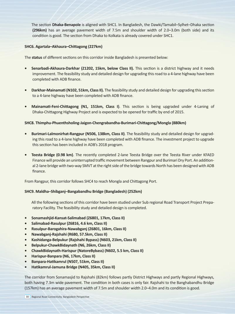
Regional Road Connectivity: Bangladesh Perspective30
SAARC Highway Corridor 9
Maldha (India)/ Shibganj (Bangladesh)–Bangabandhu Bridge (Bangladesh) (252kms)
The Bangladesh section of this corridor follows the route below:• Sonamasjid-Shibganj-Nawabgonj-Godagari-Rajshahi-Natore-Hatikamrul-Bangabandhu Bridge
3.2 Present Status of SAARC Highway Corridors
SHC1: Lahore– New Delhi– Kolkata– Petrapole (India)/ Benapole(Bangladesh)– Dhaka– Akhaura(Bangladesh)/ Agartala (India) (2,453 kilometer)
The status of different sections on this corridor inside Bangladesh is presented below:
• Benapole-Jessore (N706, 38 km, Class II). This road section is included under ADB assisted TA project and the detailed design for upgrading to a 4-lane highway is expected to be finished by 2018.
• Jessore-Magura (N702, 43km, Class II). The Feasibility Study and Detailed Design for upgrading this section to a 4-Lane highway is not included in any program.
• Magura-Daulatdia (N7, 78km, Class II). The Feasibility Study and Detailed Design for upgrading this section to a 4-Lane highway is not included in any program.
• Daulatdia-Paturia section is a missing link. This is a ferry crossing through the Padma River.
• Paturia-Manikgonj-Nabinagar (N5, 57km, Class II). This section is included under ADB assisted TA project and the detailed design for upgrading to a 4-lane highway is expected to be finished by 2018.
• Nabinagar-Savar-Gabtoli (N5, 22km, Class I). This section has already been developed as Class I highway.
• Gabtoli-Jatrabari (City Road, 19km, Class I). This section belongs to Dhaka City Corporation and is developed as minimum 4-lane highway. However, this section is a part of congested city center and there is a strong ratio-nale to use the Dhaka bypass. That is to trail Nabinagar -Chandra-Vogra-Vulta-Sylhet highway instead of Nabi-nagar-Savar-Gabtoli-Jatrabari-Katchpur-Sylhet highway.
• Jatrabari-Katchpur (N1, 10km, Class I). This section has been developed as a 4-lane highway and is now being upgraded to 8-lane with GOB financing. It is expected to be completed by 2016.
• Katchpur-Narshingdi-Sarail (N2, 146km, Class II). The Feasibility Study and Detailed Design for upgrading this section to a 4-Lane highway have been completed with ADB finance.
• Sarail-Brahmanbaria-Darkhar (N102, 28km, Class II). The Feasibility Study and Detailed Design for upgrading this section to a 4-Lane highway have been completed with ADB finance.
• Darkhar-Akhaura-Senarbadi (Z1202, 15km, below Class II). This section is a district highway and it needs improvement. The Feasibility Study and Detailed Design for upgrading this section to a 4-Lane highway have been completed with ADB finance.
• Bonpara-Dasuria-Pakshey-Kushtia-Jheinaidah(N6, N704, 105 km, Class II). A pre-feasibility study on this segment was done by UN-ESCAP in 2013. Feasibility study and detailed design for upgrading to a 4-lane highway will be done with ADB assistance. The detailed design is expected to be completed by 2018. There is a major 4-lane bridge over river Padma named as Lalon Shah Bridge (1785m).
• Jhenaidah-Jessore-Khulna (N7, 107 km, Class II). The Feasibility Study and Detailed Design for upgrading this section to a 4-Lane highway have been completed with ADB finance.
• Khulna-Mongla (N7, 43 km, Class II). The Feasibility Study and Detailed Design for upgrading this section to a 4-Lane highway have been completed with ADB finance.
The road section from Banglabandha to Mongla (670km) has an average pavement width of 7.3m with 2.4 - 4.0m shoulders on both sides. The condition of the entire road is good. The Banglabandha–Dhaka–Chittagong corridor (750km) uses the same road N5 up to Hatikamrul and then crosses the Jamuna river through Bangabandhu Bridge to reach Dhaka and then to Chittagong. The entire road has an average pavement width 7.5m and shoulder width 2.0–4.0m on both sides. The road condition is good.
SHC5. SamdropJongkhar–Shillong–Sylhet–Dhaka–Kolkata (906 km)
The status of different sections on this corridor inside Bangladesh is presented below:
• Tamabil-Sylhet (N2, 53km, Class II). The feasibility study and detailed design for upgrading this road to a 4-lane highway have been completed with ADB finance.
• Sylhet- Madhabpur-Sarail-Narshingdi-Katchpur (N2, 230km, Class II). The feasibility study and detailed design for upgrading this road to a 4-lane highway have been completed with ADB finance.
• Katchpur-Jatrabari (N1, 10km, Class I). This section has been developed as a 4-lane highway and is now being upgraded to 8-lane with GOB financing. It is expected to be completed by 2016.
• Jatrabari-Gabtoli (City Road, 19km, Class I). This section is described above.
• Gabtoli-Savar-Nabinagar (N5, 22km, Class I). This section has already been developed as Class I highway.
• Nabinagar-Manikgonj-Paturia (N5, 57km, Class II). This section is included under ADB assisted TA project and the detailed design for upgrading to a 4-lane highway is expected to be finished by 2018.
• Paturia-Daulatdia. This section is a missing link. This is a ferry crossing through the Padma River.
• Daulatdia-Magura (N7, 78km, Class II). The feasibility study and detailed design for upgrading this road to a 4-lane highway is not included in any program.
• Magura-Jessore (N702, 43km, Class II). The feasibility study and detailed design for upgrading this road to a 4-lane highway is not included in any program.
• Jessore-Benapole (N706, 38 km, Class II). The feasibility study and detailed design for upgrading this road to a 4-lane highway will be completed with ADB finance by 2018.
The section Dhaka-Benapole is aligned with SHC1. In Bangladesh, the Dawki/Tamabil–Sylhet–Dhaka section (296km) has an average pavement width of 7.5m and shoulder width of 2.0–3.0m (both side) and its condition is good. The section from Dhaka to Kolkata is already covered under SHC1.
SHC6. Agartala–Akhaura–Chittagong (227km)
The status of different sections on this corridor inside Bangladesh is presented below:
• Senarbadi-Akhaura-Darkhar (Z1202, 15km, below Class II). This section is a district highway and it needs improvement. The feasibility study and detailed design for upgrading this road to a 4-lane highway have been completed with ADB finance.
• Darkhar-Mainamati (N102, 51km, Class II). The feasibility study and detailed design for upgrading this section to a 4-lane highway have been completed with ADB finance.
• Mainamati-Feni-Chittagong (N1, 151km, Class I). This section is being upgraded under 4-Laning of Dhaka-Chittagong Highway Project and is expected to be opened for traffic by end of 2015.
SHC8. Thimphu-Phuenthsholing-Jaigon-Chengrabandha-Burimari-Chittagong/Mongla (880km)
• Burimari-Lalmonirhat-Rangpur (N506, 138km, Class II). The feasibility study and detailed design for upgrad-ing this road to a 4-lane highway have been completed with ADB finance. The investment project to upgrade this section has been included in ADB’s 2018 program.
• Teesta Bridge (0.98 km). The recently completed 2-lane Teesta Bridge over the Teesta River under KFAED Finance will provide an uninterrupted traffic movement between Rangpur and Burimari Dry Port. An addition-al 2-lane bridge with two-way SMVT at the right side of the bridge towards North has been designed with ADB finance.
From Rangpur, this corridor follows SHC4 to reach Mongla and Chittagong Port.
SHC9. Maldha–Shibganj–Bangabandhu Bridge (Bangladesh) (252km)
All the following sections of this corridor have been studied under Sub regional Road Transport Project Prepa-ratory Facility. The feasibility study and detailed design is completed.
• Sonamashjid-Kansat-Salimabad (Z6801, 17km, Class II) • Salimabad-Rasulpur (Z6816, 4.6 km, Class II)• Rasulpur-Barogahira-Nawabganj (Z6801, 16km, Class II)• Nawabganj-Rajshahi (R680, 57.5km, Class II)• Kashidanga-Belpukur (Rajshahi Bypass) (N603, 21km, Class II)• Belpukur-ChawkBidaynath (N6, 26km, Class II)• ChawkBidaynath-Harispur (NatoreBybass) (N602, 5.5 km, Class II) • Harispur-Banpara (N6, 17km, Class II)• Banpara-Hatikamrul (N507, 51km, Class II)• Hatikamrul-Jamuna Bridge (N405, 35km, Class II)
The corridor from Sonamasjid to Rajshahi (82km) follows partly District Highways and partly Regional Highways, both having 7.3m wide pavement. The condition in both cases is only fair. Rajshahi to the Banghabandhu Bridge (157km) has an average pavement width of 7.5m and shoulder width 2.0–4.0m and its condition is good.
Regional Road Connectivity: Bangladesh Perspective 31
SASEC Road Corridor
4
Regional Road Connectivity: Bangladesh Perspective 35
4.0 Introduction
The South Asia Sub regional Economic Cooperation (SASEC) Program brings together Bangladesh, Bhutan, India, the Maldives, Nepal, and Sri Lanka in a project-based partnership that aims to promote regional prosperity, improve economic opportunities, and build a better quality of life for the people of the sub region. SASEC countries share a common vision of boosting intraregional trade and cooperation in South Asia, while also connecting to South-east Asia through Myanmar, to the People’s Republic of China and the global market.
Integration of the transport network of South Asia is particularly crucial to countries such as Nepal and Bhutan and regions such as north-east India. Such integration, on the one hand, could serve to end their landlocked or semi-isolated status by providing shorter transport links to the sea ports and, on the other hand, could benefit Bangladesh through facilitation of trade with these regions. Effective integration of the transport system in South Asia could also contribute greatly in enhancing economic development.
Recognizing the importance of regional integration, SASEC seeks to strengthen cross-border transport network that boost intraregional trade and open up trade opportunities with East and South-east Asia. The program emphasizes building modern and effective customs facilities to reduce time and rationalize the costs of moving goods, vehicles, and people across borders. Better connectivity will help unleash the tremendous potential for mutually beneficial trade between the six SASEC countries, which remain among some of the least integrated regions in the world.
4.1 SASEC Road Corridor
In 1996, four of the then seven member countries of the South Asian Association for Regional Cooperation (SAARC), namely, Bangladesh, Bhutan, India and Nepal formed the South Asian Growth Quadrangle (SAGQ), with the primary objective of accelerating sustainable economic development among these countries. This sub regional initiative was endorsed at the SAARC summit in Male, Maldives in 1997. Subsequently, these four countries requested ADB’s assistance in facilitating their economic cooperation initiative. This request led to the foundation of the SASEC program.
ADB's support for SASEC was undertaken mainly through:
• capacity building and institutional strengthening of the program, • various regional cooperation initiatives and • ADB-financed projects and technical assistance
Since the inception of SASEC, ADB has informally continued to function as its secretariat.
Priority areas are:
• Energy and power • Transport • Trade, investment and private sector
Other areas of work include Information and Communications Technology (ICT), Tourism, Environment.
4.2 Status inside Bangladesh
SASEC Corridor 9
• Banglabandha to Panchaghar (N5, 53 Km, Class II). This section was improved with ADB finance in 2011. Considering the traffic growth the feasibility study and detailed design for upgrading this section to a 4-lane highway is carried out by an ADB assisted TA project and the detailed design is expected to be finished by 2018. The investment project to upgrade this section has been included in ADB’s 2018 program.
• Panchagahar to Rangpur (N5, 143 Km, Class II). Feasibility study and detailed design for upgrading this section to a 4-lane highway is carried out by an ADB assisted TA project and the detailed design is expected to be finished by 2018. The investment project to upgrade this section has been included in ADB’s 2018 program.
• Rangpur-Hatikamrul-Elenga(N5/N4, 197 km, Class II). The Feasibility Study and Detailed Design for upgrading this section to a 4-Lane highway have been completed with ADB finance. The investment project to upgrade this section has been included in ADB’s 2017 program.
• Elenga-Tangail-Chandra-Joydevpur(N4, 70 km, Class II). This section is being upgraded to 4 lane highway under SESEC Road Connectivity Project with ADB finance and the construction work is expected to be completed within 2018.
• Joydevpur-Bhulta-Madanpur (N105, 48 km). This section is known as Dhaka Bypass, which is being considered for PPP finance. The PPP office under the Prime Minister’s Office has engaged transaction adviser and feasibility study was completed in July 2014. The RFQ for selecting concessionaire has been issued on October 2015. The road work of this project is expected to be completed by 2020.
• Madanpur-Daudkandi (N1, 18 km). This section has already been upgraded as a 4-lane highway.
• Daudkandi-Chittagong (N1, 192 km, Class I). This section is being upgraded under 4-Laning of Dhaka-Chittagong Highway Project and is expected to be opened for traffic soon.
• Chittagong to Chittagong Port (N111, 13 km, Class II). This section was developed to a 2 lane highway with ADB finance in 2006. Considering the traffic growth the feasibility study and detailed design for upgrading this section to a 4-lane highway is being carried out by an ADB assisted TA project and the detailed design is expected to be finished by 2018.
• Hatikamrul-Banpara section (N507, 51km, Class II). The Feasibility Study and Detailed Design for upgrading this section to a 4-Lane highway have been completed with ADB finance.
• Bonpara-Dasurai-Pakshey-Kushtia-Jheinadah(N6, N704, 105 km, Class II). A pre-feasibility study on this segment was done by UN-ESCAP in 2013. Feasibility study and detailed design for upgrading to a 4-lane highway will be done with ADB assistance. The detailed design is expected to be completed by 2018. There is a major 4-lane bridge over river Padma named as Lalon Shah Bridge (1785m).
route instead of Nabinagar-Savar-Gabtoli-Jatrabari-Katchpur-Sylhet.
• Jatrabari-Katchpur (N1, 10km, Class I). This section has been developed as a 4-lane highway and is now being upgraded to 8-lane with GOB financing. It is expected to be completed by 2016.
• Katchpur-Daudkandi (N1, 26 km, Class I). This section has been upgraded to a 4-lane highway in 2005 by JBARP project.
• Daudkandi-Chittagong (N1, 194 km, Class I). This section is being upgraded under 4-Laning of Dhaka-Chittagong Highway Project and is expected to be opened for traffic soon.
4.3 Investment required for the corridor
The Joint Communiqué signed by Bangladesh and India in New Delhi in January 2010 also laid special emphasis on allowing India, Nepal and Bhutan to access to Mongla Port and Chittagong Port for movement of bilateral and third country trade. Improving these two corridors will benefit India, Bhutan and Nepal to access to the seaports at Mongla and Chittagong.
However, last several SASEC Transport and Trade facilitation Working Group meetings discussed mainly the upper segments of these corridors, i.e. Kathmandu-Kakarvitta-Panitanki-Phulbari- Banglabandha segment and Thimphu–Phuentsholing–Jaigaon–Burimari segment. These two segments have reached to an investment level and India has started up gradation of Indian part of both these segments recently.
Asian Development Bank has come forward to assist in improvement of some road segments in Bangladesh along these two corridors—either through project aid or technical assistance for feasibility studies and detailed design.
In terms of readiness, Bangladesh has already undertaken feasibility study and detailed design for significant stretches of highway. Besides, Bangladesh has already started up gradation of 70 km long Joydevpur-Chandra-Tangail-Elenga Highway which is part of SASEC Corridor 4 and 9. Improvement of 197 km long Elenga-Hatikamrul-Rangpur segment which is common to SASEC Corridor 4 and SASEC Corridor 9 has been included in ADB’s 2017 program. It is therefore, expected that other SASEC member states will take necessary actions to put these two corridors into operation.
4.4 Recent SASEC Transport and Trade facilitation Working Group Meetings:
v SASEC Transport and TRADE facilitation Working Group (TFTWG) meeting was held in Dhaka on 2 December 2010 regarding identification and improvement of regional corridors for trade facilitation.
v TFTWG meeting held in Bangkok on 20-21 October 2011 Bangladesh requested ADB to include 143 kilometer long road segment from Panchaghar to Rangpur
and 105 kilometer road segment from Bonpara to Jhenaidah for technical assistance for feasibility study and detailed design.
v TFTWG meeting in Bhutan on 8 November 2012 discussed following investment projects:
Regional Road Connectivity: Bangladesh Perspective36
4.0 Introduction
The South Asia Sub regional Economic Cooperation (SASEC) Program brings together Bangladesh, Bhutan, India, the Maldives, Nepal, and Sri Lanka in a project-based partnership that aims to promote regional prosperity, improve economic opportunities, and build a better quality of life for the people of the sub region. SASEC countries share a common vision of boosting intraregional trade and cooperation in South Asia, while also connecting to South-east Asia through Myanmar, to the People’s Republic of China and the global market.
Integration of the transport network of South Asia is particularly crucial to countries such as Nepal and Bhutan and regions such as north-east India. Such integration, on the one hand, could serve to end their landlocked or semi-isolated status by providing shorter transport links to the sea ports and, on the other hand, could benefit Bangladesh through facilitation of trade with these regions. Effective integration of the transport system in South Asia could also contribute greatly in enhancing economic development.
Recognizing the importance of regional integration, SASEC seeks to strengthen cross-border transport network that boost intraregional trade and open up trade opportunities with East and South-east Asia. The program emphasizes building modern and effective customs facilities to reduce time and rationalize the costs of moving goods, vehicles, and people across borders. Better connectivity will help unleash the tremendous potential for mutually beneficial trade between the six SASEC countries, which remain among some of the least integrated regions in the world.
4.1 SASEC Road Corridor
In 1996, four of the then seven member countries of the South Asian Association for Regional Cooperation (SAARC), namely, Bangladesh, Bhutan, India and Nepal formed the South Asian Growth Quadrangle (SAGQ), with the primary objective of accelerating sustainable economic development among these countries. This sub regional initiative was endorsed at the SAARC summit in Male, Maldives in 1997. Subsequently, these four countries requested ADB’s assistance in facilitating their economic cooperation initiative. This request led to the foundation of the SASEC program.
ADB's support for SASEC was undertaken mainly through:
• capacity building and institutional strengthening of the program, • various regional cooperation initiatives and • ADB-financed projects and technical assistance
Since the inception of SASEC, ADB has informally continued to function as its secretariat.
Priority areas are:
• Energy and power • Transport • Trade, investment and private sector
Other areas of work include Information and Communications Technology (ICT), Tourism, Environment.
At the meeting of the SASEC Transport Working Group held in Bangkok on 2-3 February 2004, it was agreed that 21 transport corridors would form the SASEC framework. Among those corridors the following three road corridors involve Bangladesh:
SASEC Corridor 9: Kathmandu–Kakarvitta–Phulbari (India)/Banglabandha (Bangladesh)–i) Mongla (1,314km) or/and ii) Chittagong (1,394km)
Kathmandu to Khakarvitta (Kankorvita), and via the Phulbari Corridor, to Banglabandha – thence to Khulna and Mongla or Dhaka and Chittagong (Gateways: Khakarbitta on the Nepalese/Indian border, Banglabandha on the Indian/Bangladesh border, Dhaka, Mongla and Chittagong ports):
The Bangladesh section of this corridor follows the route below:
• Banglabandha - Panchagarh - Baliadanga - Rangpur - Bogra - Hatikamrul - Banpara - Dasuria - Paksey - Kushtia - Jhenaidhah - Jessore - Khulna - Mongla (659 kilometer)
• Banglabandha - Panchagarh - Baliadanga - Rangpur - Bogra - Hatikamrul - Elenga - Kaliakoir - Joydevpur - Dhaka - Katchpur - Feni - Chittagong (736 kilometer)
SASEC Corridor 4: Thimphu–Phuentsholing (Bhutan)/ Jaigon (India)–Chengrabandha (India)/ Burimari (Bangladesh)–i) Chittagong (966km) or/and ii) Mongla (880km)
Thimphu/Paro to Phuentisholing to Burimari to Khulna or via the Jamuna Bridge to Dhaka or Chittagong (Gateways: Dhaka and Chittagong ports, Burimari on the Bangladesh/Indian border; Phuentsholing/Jaigaon on the Bhutanese/Indian border and Burimari as possible intermodal transfer point)
The Bangladesh section of this corridor follows the route below:
• Burimari - Teesta - Rangpur - Gobindaganj - Bogra - Hatikamrul - Banpara - Dasuria - Paksey - Kushtia - Jhenaidhah - Jessore - Khulna - Mongla (601 kilometer)
• Burimari - Teesta - Rangpur - Gobindaganj - Bogra - Hatikamrul - Elenga - Kaliakoir - Joydevpur - Dhaka - Katchpur - Feni - Chittagong (678 kilometer)
SASEC Corridor 5A: Kolkata– Petrapole (India)/Benapole (Bangladesh) – Jessore - Khulna - Mongla/Magura - Rajbari - Dhaka - Chittagong
From Kolkata there is a road connection on the N35 and state roads to Petrapole/Benapole, then on to Jessore from which via the N7 to Khulna or via the Goalanda/Paturia Ghats to Dhaka and with branches to Mongla and Chittagong Ports
The Bangladesh section of this corridor follows the route below:
• Benapole–Jessore-Khulna- Mongla (161 kilometer)• Benapole–Jessore-Magura-Rajbari-Dhaka-Chittagong (491 kilometer)
4.2 Status inside Bangladesh
SASEC Corridor 9
• Banglabandha to Panchaghar (N5, 53 Km, Class II). This section was improved with ADB finance in 2011. Considering the traffic growth the feasibility study and detailed design for upgrading this section to a 4-lane highway is carried out by an ADB assisted TA project and the detailed design is expected to be finished by 2018. The investment project to upgrade this section has been included in ADB’s 2018 program.
• Panchagahar to Rangpur (N5, 143 Km, Class II). Feasibility study and detailed design for upgrading this section to a 4-lane highway is carried out by an ADB assisted TA project and the detailed design is expected to be finished by 2018. The investment project to upgrade this section has been included in ADB’s 2018 program.
• Rangpur-Hatikamrul-Elenga(N5/N4, 197 km, Class II). The Feasibility Study and Detailed Design for upgrading this section to a 4-Lane highway have been completed with ADB finance. The investment project to upgrade this section has been included in ADB’s 2017 program.
• Elenga-Tangail-Chandra-Joydevpur(N4, 70 km, Class II). This section is being upgraded to 4 lane highway under SESEC Road Connectivity Project with ADB finance and the construction work is expected to be completed within 2018.
• Joydevpur-Bhulta-Madanpur (N105, 48 km). This section is known as Dhaka Bypass, which is being considered for PPP finance. The PPP office under the Prime Minister’s Office has engaged transaction adviser and feasibility study was completed in July 2014. The RFQ for selecting concessionaire has been issued on October 2015. The road work of this project is expected to be completed by 2020.
• Madanpur-Daudkandi (N1, 18 km). This section has already been upgraded as a 4-lane highway.
• Daudkandi-Chittagong (N1, 192 km, Class I). This section is being upgraded under 4-Laning of Dhaka-Chittagong Highway Project and is expected to be opened for traffic soon.
• Chittagong to Chittagong Port (N111, 13 km, Class II). This section was developed to a 2 lane highway with ADB finance in 2006. Considering the traffic growth the feasibility study and detailed design for upgrading this section to a 4-lane highway is being carried out by an ADB assisted TA project and the detailed design is expected to be finished by 2018.
• Hatikamrul-Banpara section (N507, 51km, Class II). The Feasibility Study and Detailed Design for upgrading this section to a 4-Lane highway have been completed with ADB finance.
• Bonpara-Dasurai-Pakshey-Kushtia-Jheinadah(N6, N704, 105 km, Class II). A pre-feasibility study on this segment was done by UN-ESCAP in 2013. Feasibility study and detailed design for upgrading to a 4-lane highway will be done with ADB assistance. The detailed design is expected to be completed by 2018. There is a major 4-lane bridge over river Padma named as Lalon Shah Bridge (1785m).
route instead of Nabinagar-Savar-Gabtoli-Jatrabari-Katchpur-Sylhet.
• Jatrabari-Katchpur (N1, 10km, Class I). This section has been developed as a 4-lane highway and is now being upgraded to 8-lane with GOB financing. It is expected to be completed by 2016.
• Katchpur-Daudkandi (N1, 26 km, Class I). This section has been upgraded to a 4-lane highway in 2005 by JBARP project.
• Daudkandi-Chittagong (N1, 194 km, Class I). This section is being upgraded under 4-Laning of Dhaka-Chittagong Highway Project and is expected to be opened for traffic soon.
4.3 Investment required for the corridor
The Joint Communiqué signed by Bangladesh and India in New Delhi in January 2010 also laid special emphasis on allowing India, Nepal and Bhutan to access to Mongla Port and Chittagong Port for movement of bilateral and third country trade. Improving these two corridors will benefit India, Bhutan and Nepal to access to the seaports at Mongla and Chittagong.
However, last several SASEC Transport and Trade facilitation Working Group meetings discussed mainly the upper segments of these corridors, i.e. Kathmandu-Kakarvitta-Panitanki-Phulbari- Banglabandha segment and Thimphu–Phuentsholing–Jaigaon–Burimari segment. These two segments have reached to an investment level and India has started up gradation of Indian part of both these segments recently.
Asian Development Bank has come forward to assist in improvement of some road segments in Bangladesh along these two corridors—either through project aid or technical assistance for feasibility studies and detailed design.
In terms of readiness, Bangladesh has already undertaken feasibility study and detailed design for significant stretches of highway. Besides, Bangladesh has already started up gradation of 70 km long Joydevpur-Chandra-Tangail-Elenga Highway which is part of SASEC Corridor 4 and 9. Improvement of 197 km long Elenga-Hatikamrul-Rangpur segment which is common to SASEC Corridor 4 and SASEC Corridor 9 has been included in ADB’s 2017 program. It is therefore, expected that other SASEC member states will take necessary actions to put these two corridors into operation.
4.4 Recent SASEC Transport and Trade facilitation Working Group Meetings:
v SASEC Transport and TRADE facilitation Working Group (TFTWG) meeting was held in Dhaka on 2 December 2010 regarding identification and improvement of regional corridors for trade facilitation.
v TFTWG meeting held in Bangkok on 20-21 October 2011 Bangladesh requested ADB to include 143 kilometer long road segment from Panchaghar to Rangpur
and 105 kilometer road segment from Bonpara to Jhenaidah for technical assistance for feasibility study and detailed design.
v TFTWG meeting in Bhutan on 8 November 2012 discussed following investment projects:
Regional Road Connectivity: Bangladesh Perspective 37
4.0 Introduction
The South Asia Sub regional Economic Cooperation (SASEC) Program brings together Bangladesh, Bhutan, India, the Maldives, Nepal, and Sri Lanka in a project-based partnership that aims to promote regional prosperity, improve economic opportunities, and build a better quality of life for the people of the sub region. SASEC countries share a common vision of boosting intraregional trade and cooperation in South Asia, while also connecting to South-east Asia through Myanmar, to the People’s Republic of China and the global market.
Integration of the transport network of South Asia is particularly crucial to countries such as Nepal and Bhutan and regions such as north-east India. Such integration, on the one hand, could serve to end their landlocked or semi-isolated status by providing shorter transport links to the sea ports and, on the other hand, could benefit Bangladesh through facilitation of trade with these regions. Effective integration of the transport system in South Asia could also contribute greatly in enhancing economic development.
Recognizing the importance of regional integration, SASEC seeks to strengthen cross-border transport network that boost intraregional trade and open up trade opportunities with East and South-east Asia. The program emphasizes building modern and effective customs facilities to reduce time and rationalize the costs of moving goods, vehicles, and people across borders. Better connectivity will help unleash the tremendous potential for mutually beneficial trade between the six SASEC countries, which remain among some of the least integrated regions in the world.
4.1 SASEC Road Corridor
In 1996, four of the then seven member countries of the South Asian Association for Regional Cooperation (SAARC), namely, Bangladesh, Bhutan, India and Nepal formed the South Asian Growth Quadrangle (SAGQ), with the primary objective of accelerating sustainable economic development among these countries. This sub regional initiative was endorsed at the SAARC summit in Male, Maldives in 1997. Subsequently, these four countries requested ADB’s assistance in facilitating their economic cooperation initiative. This request led to the foundation of the SASEC program.
ADB's support for SASEC was undertaken mainly through:
• capacity building and institutional strengthening of the program, • various regional cooperation initiatives and • ADB-financed projects and technical assistance
Since the inception of SASEC, ADB has informally continued to function as its secretariat.
Priority areas are:
• Energy and power • Transport • Trade, investment and private sector
Other areas of work include Information and Communications Technology (ICT), Tourism, Environment.
4.2 Status inside Bangladesh
SASEC Corridor 9
• Banglabandha to Panchaghar (N5, 53 Km, Class II). This section was improved with ADB finance in 2011. Considering the traffic growth the feasibility study and detailed design for upgrading this section to a 4-lane highway is carried out by an ADB assisted TA project and the detailed design is expected to be finished by 2018. The investment project to upgrade this section has been included in ADB’s 2018 program.
• Panchagahar to Rangpur (N5, 143 Km, Class II). Feasibility study and detailed design for upgrading this section to a 4-lane highway is carried out by an ADB assisted TA project and the detailed design is expected to be finished by 2018. The investment project to upgrade this section has been included in ADB’s 2018 program.
• Rangpur-Hatikamrul-Elenga(N5/N4, 197 km, Class II). The Feasibility Study and Detailed Design for upgrading this section to a 4-Lane highway have been completed with ADB finance. The investment project to upgrade this section has been included in ADB’s 2017 program.
• Elenga-Tangail-Chandra-Joydevpur(N4, 70 km, Class II). This section is being upgraded to 4 lane highway under SESEC Road Connectivity Project with ADB finance and the construction work is expected to be completed within 2018.
• Joydevpur-Bhulta-Madanpur (N105, 48 km). This section is known as Dhaka Bypass, which is being considered for PPP finance. The PPP office under the Prime Minister’s Office has engaged transaction adviser and feasibility study was completed in July 2014. The RFQ for selecting concessionaire has been issued on October 2015. The road work of this project is expected to be completed by 2020.
• Madanpur-Daudkandi (N1, 18 km). This section has already been upgraded as a 4-lane highway.
• Daudkandi-Chittagong (N1, 192 km, Class I). This section is being upgraded under 4-Laning of Dhaka-Chittagong Highway Project and is expected to be opened for traffic soon.
• Chittagong to Chittagong Port (N111, 13 km, Class II). This section was developed to a 2 lane highway with ADB finance in 2006. Considering the traffic growth the feasibility study and detailed design for upgrading this section to a 4-lane highway is being carried out by an ADB assisted TA project and the detailed design is expected to be finished by 2018.
• Hatikamrul-Banpara section (N507, 51km, Class II). The Feasibility Study and Detailed Design for upgrading this section to a 4-Lane highway have been completed with ADB finance.
• Bonpara-Dasurai-Pakshey-Kushtia-Jheinadah(N6, N704, 105 km, Class II). A pre-feasibility study on this segment was done by UN-ESCAP in 2013. Feasibility study and detailed design for upgrading to a 4-lane highway will be done with ADB assistance. The detailed design is expected to be completed by 2018. There is a major 4-lane bridge over river Padma named as Lalon Shah Bridge (1785m).
route instead of Nabinagar-Savar-Gabtoli-Jatrabari-Katchpur-Sylhet.
• Jatrabari-Katchpur (N1, 10km, Class I). This section has been developed as a 4-lane highway and is now being upgraded to 8-lane with GOB financing. It is expected to be completed by 2016.
• Katchpur-Daudkandi (N1, 26 km, Class I). This section has been upgraded to a 4-lane highway in 2005 by JBARP project.
• Daudkandi-Chittagong (N1, 194 km, Class I). This section is being upgraded under 4-Laning of Dhaka-Chittagong Highway Project and is expected to be opened for traffic soon.
4.3 Investment required for the corridor
The Joint Communiqué signed by Bangladesh and India in New Delhi in January 2010 also laid special emphasis on allowing India, Nepal and Bhutan to access to Mongla Port and Chittagong Port for movement of bilateral and third country trade. Improving these two corridors will benefit India, Bhutan and Nepal to access to the seaports at Mongla and Chittagong.
However, last several SASEC Transport and Trade facilitation Working Group meetings discussed mainly the upper segments of these corridors, i.e. Kathmandu-Kakarvitta-Panitanki-Phulbari- Banglabandha segment and Thimphu–Phuentsholing–Jaigaon–Burimari segment. These two segments have reached to an investment level and India has started up gradation of Indian part of both these segments recently.
Asian Development Bank has come forward to assist in improvement of some road segments in Bangladesh along these two corridors—either through project aid or technical assistance for feasibility studies and detailed design.
In terms of readiness, Bangladesh has already undertaken feasibility study and detailed design for significant stretches of highway. Besides, Bangladesh has already started up gradation of 70 km long Joydevpur-Chandra-Tangail-Elenga Highway which is part of SASEC Corridor 4 and 9. Improvement of 197 km long Elenga-Hatikamrul-Rangpur segment which is common to SASEC Corridor 4 and SASEC Corridor 9 has been included in ADB’s 2017 program. It is therefore, expected that other SASEC member states will take necessary actions to put these two corridors into operation.
4.4 Recent SASEC Transport and Trade facilitation Working Group Meetings:
v SASEC Transport and TRADE facilitation Working Group (TFTWG) meeting was held in Dhaka on 2 December 2010 regarding identification and improvement of regional corridors for trade facilitation.
v TFTWG meeting held in Bangkok on 20-21 October 2011 Bangladesh requested ADB to include 143 kilometer long road segment from Panchaghar to Rangpur
and 105 kilometer road segment from Bonpara to Jhenaidah for technical assistance for feasibility study and detailed design.
v TFTWG meeting in Bhutan on 8 November 2012 discussed following investment projects:
Regional Road Connectivity: Bangladesh Perspective38
4.0 Introduction
The South Asia Sub regional Economic Cooperation (SASEC) Program brings together Bangladesh, Bhutan, India, the Maldives, Nepal, and Sri Lanka in a project-based partnership that aims to promote regional prosperity, improve economic opportunities, and build a better quality of life for the people of the sub region. SASEC countries share a common vision of boosting intraregional trade and cooperation in South Asia, while also connecting to South-east Asia through Myanmar, to the People’s Republic of China and the global market.
Integration of the transport network of South Asia is particularly crucial to countries such as Nepal and Bhutan and regions such as north-east India. Such integration, on the one hand, could serve to end their landlocked or semi-isolated status by providing shorter transport links to the sea ports and, on the other hand, could benefit Bangladesh through facilitation of trade with these regions. Effective integration of the transport system in South Asia could also contribute greatly in enhancing economic development.
Recognizing the importance of regional integration, SASEC seeks to strengthen cross-border transport network that boost intraregional trade and open up trade opportunities with East and South-east Asia. The program emphasizes building modern and effective customs facilities to reduce time and rationalize the costs of moving goods, vehicles, and people across borders. Better connectivity will help unleash the tremendous potential for mutually beneficial trade between the six SASEC countries, which remain among some of the least integrated regions in the world.
4.1 SASEC Road Corridor
In 1996, four of the then seven member countries of the South Asian Association for Regional Cooperation (SAARC), namely, Bangladesh, Bhutan, India and Nepal formed the South Asian Growth Quadrangle (SAGQ), with the primary objective of accelerating sustainable economic development among these countries. This sub regional initiative was endorsed at the SAARC summit in Male, Maldives in 1997. Subsequently, these four countries requested ADB’s assistance in facilitating their economic cooperation initiative. This request led to the foundation of the SASEC program.
ADB's support for SASEC was undertaken mainly through:
• capacity building and institutional strengthening of the program, • various regional cooperation initiatives and • ADB-financed projects and technical assistance
Since the inception of SASEC, ADB has informally continued to function as its secretariat.
Priority areas are:
• Energy and power • Transport • Trade, investment and private sector
Other areas of work include Information and Communications Technology (ICT), Tourism, Environment.
4.2 Status inside Bangladesh
SASEC Corridor 9
• Banglabandha to Panchaghar (N5, 53 Km, Class II). This section was improved with ADB finance in 2011. Considering the traffic growth the feasibility study and detailed design for upgrading this section to a 4-lane highway is carried out by an ADB assisted TA project and the detailed design is expected to be finished by 2018. The investment project to upgrade this section has been included in ADB’s 2018 program.
• Panchagahar to Rangpur (N5, 143 Km, Class II). Feasibility study and detailed design for upgrading this section to a 4-lane highway is carried out by an ADB assisted TA project and the detailed design is expected to be finished by 2018. The investment project to upgrade this section has been included in ADB’s 2018 program.
• Rangpur-Hatikamrul-Elenga(N5/N4, 197 km, Class II). The Feasibility Study and Detailed Design for upgrading this section to a 4-Lane highway have been completed with ADB finance. The investment project to upgrade this section has been included in ADB’s 2017 program.
• Elenga-Tangail-Chandra-Joydevpur(N4, 70 km, Class II). This section is being upgraded to 4 lane highway under SESEC Road Connectivity Project with ADB finance and the construction work is expected to be completed within 2018.
• Joydevpur-Bhulta-Madanpur (N105, 48 km). This section is known as Dhaka Bypass, which is being considered for PPP finance. The PPP office under the Prime Minister’s Office has engaged transaction adviser and feasibility study was completed in July 2014. The RFQ for selecting concessionaire has been issued on October 2015. The road work of this project is expected to be completed by 2020.
• Madanpur-Daudkandi (N1, 18 km). This section has already been upgraded as a 4-lane highway.
• Daudkandi-Chittagong (N1, 192 km, Class I). This section is being upgraded under 4-Laning of Dhaka-Chittagong Highway Project and is expected to be opened for traffic soon.
• Chittagong to Chittagong Port (N111, 13 km, Class II). This section was developed to a 2 lane highway with ADB finance in 2006. Considering the traffic growth the feasibility study and detailed design for upgrading this section to a 4-lane highway is being carried out by an ADB assisted TA project and the detailed design is expected to be finished by 2018.
• Hatikamrul-Banpara section (N507, 51km, Class II). The Feasibility Study and Detailed Design for upgrading this section to a 4-Lane highway have been completed with ADB finance.
• Bonpara-Dasurai-Pakshey-Kushtia-Jheinadah(N6, N704, 105 km, Class II). A pre-feasibility study on this segment was done by UN-ESCAP in 2013. Feasibility study and detailed design for upgrading to a 4-lane highway will be done with ADB assistance. The detailed design is expected to be completed by 2018. There is a major 4-lane bridge over river Padma named as Lalon Shah Bridge (1785m).
• Jhenaidah-Jessore-Khulna (N7, 107 km, Class II). The Feasibility Study and Detailed Design for upgrading this section to a 4-Lane highway have been completed with ADB finance.
• Khulna-Mongla (N7, 43 km, Class II). The Feasibility Study and Detailed Design for upgrading this section to a 4-Lane highway have been completed with ADB finance.
SASEC Corridor 4
• Burimari-Lalmonirhat-Rangpur (N509, N506, 138 km). The Feasibility Study and Detailed Design for upgrading this section to a 4-Lane highway have been completed with ADB finance.
• Teesta Bridge (0.98 km). The recently completed 2-lane Teesta Bridge over the Teesta River under KFAED Finance will provide an uninterrupted traffic movement between Rangpur and Burimari Dry Port. An additional 2-lane bridge with two-way SMVT at the right side of the bridge towards North has been designed with ADB finance.
The remaining sections of corridor 4 are the same as those mentioned in corridor 9.
SASEC Corridor 5A
• Benapole-Jessore (N706, 38 km, Class II). The Feasibility Study and Detailed Design for upgrading this section to a 4-Lane highway will be completed with ADB finance by 2018.
• Jessore-Khulna (N7, 60 km, Class II). The Feasibility Study and Detailed Design for upgrading this section to a 4-Lane highway have been completed with ADB finance.
• Khulna-Mongla (N7, 43 km, Class II). The Feasibility Study and Detailed Design for upgrading this section to a 4-Lane highway have been completed with ADB finance.
• Jessore-Magura (N702, 43km, Class II). The Feasibility Study and Detailed Design for upgrading this section to a 4-Lane highway is not included in any program.
• Magura-Daulatdia (N7, 78km, Class II). The Feasibility Study and Detailed Design for upgrading this section to a 4-Lane highway is not included in any program.
• Daulatdia-Paturia section. This is a missing link. There is a ferry crossing through the Padma River.
• Paturia-Manikgonj-Nabinagar (N5, 57km, Class II). This section is included under ADB assisted TA project and the detailed design for upgrading to a 4-lane highway is expected to be finished by 2018.
• Nabinagar-Savar-Gabtoli (N5, 22km, Class I). This section has already been developed as Class I highway.
• Gabtoli-Jatrabari (City Road, 19km, Class I). This section belongs to Dhaka City Corporation and is developed as minimum 4-lane highway. However, this section is a part of congested city center and there is a strong rationale to use the Dhaka bypass through Nabinagar -Chandra-Vogra-Bhulta-Sylhet.
route instead of Nabinagar-Savar-Gabtoli-Jatrabari-Katchpur-Sylhet.
• Jatrabari-Katchpur (N1, 10km, Class I). This section has been developed as a 4-lane highway and is now being upgraded to 8-lane with GOB financing. It is expected to be completed by 2016.
• Katchpur-Daudkandi (N1, 26 km, Class I). This section has been upgraded to a 4-lane highway in 2005 by JBARP project.
• Daudkandi-Chittagong (N1, 194 km, Class I). This section is being upgraded under 4-Laning of Dhaka-Chittagong Highway Project and is expected to be opened for traffic soon.
4.3 Investment required for the corridor
The Joint Communiqué signed by Bangladesh and India in New Delhi in January 2010 also laid special emphasis on allowing India, Nepal and Bhutan to access to Mongla Port and Chittagong Port for movement of bilateral and third country trade. Improving these two corridors will benefit India, Bhutan and Nepal to access to the seaports at Mongla and Chittagong.
However, last several SASEC Transport and Trade facilitation Working Group meetings discussed mainly the upper segments of these corridors, i.e. Kathmandu-Kakarvitta-Panitanki-Phulbari- Banglabandha segment and Thimphu–Phuentsholing–Jaigaon–Burimari segment. These two segments have reached to an investment level and India has started up gradation of Indian part of both these segments recently.
Asian Development Bank has come forward to assist in improvement of some road segments in Bangladesh along these two corridors—either through project aid or technical assistance for feasibility studies and detailed design.
In terms of readiness, Bangladesh has already undertaken feasibility study and detailed design for significant stretches of highway. Besides, Bangladesh has already started up gradation of 70 km long Joydevpur-Chandra-Tangail-Elenga Highway which is part of SASEC Corridor 4 and 9. Improvement of 197 km long Elenga-Hatikamrul-Rangpur segment which is common to SASEC Corridor 4 and SASEC Corridor 9 has been included in ADB’s 2017 program. It is therefore, expected that other SASEC member states will take necessary actions to put these two corridors into operation.
4.4 Recent SASEC Transport and Trade facilitation Working Group Meetings:
v SASEC Transport and TRADE facilitation Working Group (TFTWG) meeting was held in Dhaka on 2 December 2010 regarding identification and improvement of regional corridors for trade facilitation.
v TFTWG meeting held in Bangkok on 20-21 October 2011 Bangladesh requested ADB to include 143 kilometer long road segment from Panchaghar to Rangpur
and 105 kilometer road segment from Bonpara to Jhenaidah for technical assistance for feasibility study and detailed design.
v TFTWG meeting in Bhutan on 8 November 2012 discussed following investment projects:
Regional Road Connectivity: Bangladesh Perspective 39
4.0 Introduction
The South Asia Sub regional Economic Cooperation (SASEC) Program brings together Bangladesh, Bhutan, India, the Maldives, Nepal, and Sri Lanka in a project-based partnership that aims to promote regional prosperity, improve economic opportunities, and build a better quality of life for the people of the sub region. SASEC countries share a common vision of boosting intraregional trade and cooperation in South Asia, while also connecting to South-east Asia through Myanmar, to the People’s Republic of China and the global market.
Integration of the transport network of South Asia is particularly crucial to countries such as Nepal and Bhutan and regions such as north-east India. Such integration, on the one hand, could serve to end their landlocked or semi-isolated status by providing shorter transport links to the sea ports and, on the other hand, could benefit Bangladesh through facilitation of trade with these regions. Effective integration of the transport system in South Asia could also contribute greatly in enhancing economic development.
Recognizing the importance of regional integration, SASEC seeks to strengthen cross-border transport network that boost intraregional trade and open up trade opportunities with East and South-east Asia. The program emphasizes building modern and effective customs facilities to reduce time and rationalize the costs of moving goods, vehicles, and people across borders. Better connectivity will help unleash the tremendous potential for mutually beneficial trade between the six SASEC countries, which remain among some of the least integrated regions in the world.
4.1 SASEC Road Corridor
In 1996, four of the then seven member countries of the South Asian Association for Regional Cooperation (SAARC), namely, Bangladesh, Bhutan, India and Nepal formed the South Asian Growth Quadrangle (SAGQ), with the primary objective of accelerating sustainable economic development among these countries. This sub regional initiative was endorsed at the SAARC summit in Male, Maldives in 1997. Subsequently, these four countries requested ADB’s assistance in facilitating their economic cooperation initiative. This request led to the foundation of the SASEC program.
ADB's support for SASEC was undertaken mainly through:
• capacity building and institutional strengthening of the program, • various regional cooperation initiatives and • ADB-financed projects and technical assistance
Since the inception of SASEC, ADB has informally continued to function as its secretariat.
Priority areas are:
• Energy and power • Transport • Trade, investment and private sector
Other areas of work include Information and Communications Technology (ICT), Tourism, Environment.
4.2 Status inside Bangladesh
SASEC Corridor 9
• Banglabandha to Panchaghar (N5, 53 Km, Class II). This section was improved with ADB finance in 2011. Considering the traffic growth the feasibility study and detailed design for upgrading this section to a 4-lane highway is carried out by an ADB assisted TA project and the detailed design is expected to be finished by 2018. The investment project to upgrade this section has been included in ADB’s 2018 program.
• Panchagahar to Rangpur (N5, 143 Km, Class II). Feasibility study and detailed design for upgrading this section to a 4-lane highway is carried out by an ADB assisted TA project and the detailed design is expected to be finished by 2018. The investment project to upgrade this section has been included in ADB’s 2018 program.
• Rangpur-Hatikamrul-Elenga(N5/N4, 197 km, Class II). The Feasibility Study and Detailed Design for upgrading this section to a 4-Lane highway have been completed with ADB finance. The investment project to upgrade this section has been included in ADB’s 2017 program.
• Elenga-Tangail-Chandra-Joydevpur(N4, 70 km, Class II). This section is being upgraded to 4 lane highway under SESEC Road Connectivity Project with ADB finance and the construction work is expected to be completed within 2018.
• Joydevpur-Bhulta-Madanpur (N105, 48 km). This section is known as Dhaka Bypass, which is being considered for PPP finance. The PPP office under the Prime Minister’s Office has engaged transaction adviser and feasibility study was completed in July 2014. The RFQ for selecting concessionaire has been issued on October 2015. The road work of this project is expected to be completed by 2020.
• Madanpur-Daudkandi (N1, 18 km). This section has already been upgraded as a 4-lane highway.
• Daudkandi-Chittagong (N1, 192 km, Class I). This section is being upgraded under 4-Laning of Dhaka-Chittagong Highway Project and is expected to be opened for traffic soon.
• Chittagong to Chittagong Port (N111, 13 km, Class II). This section was developed to a 2 lane highway with ADB finance in 2006. Considering the traffic growth the feasibility study and detailed design for upgrading this section to a 4-lane highway is being carried out by an ADB assisted TA project and the detailed design is expected to be finished by 2018.
• Hatikamrul-Banpara section (N507, 51km, Class II). The Feasibility Study and Detailed Design for upgrading this section to a 4-Lane highway have been completed with ADB finance.
• Bonpara-Dasurai-Pakshey-Kushtia-Jheinadah(N6, N704, 105 km, Class II). A pre-feasibility study on this segment was done by UN-ESCAP in 2013. Feasibility study and detailed design for upgrading to a 4-lane highway will be done with ADB assistance. The detailed design is expected to be completed by 2018. There is a major 4-lane bridge over river Padma named as Lalon Shah Bridge (1785m).
route instead of Nabinagar-Savar-Gabtoli-Jatrabari-Katchpur-Sylhet.
• Jatrabari-Katchpur (N1, 10km, Class I). This section has been developed as a 4-lane highway and is now being upgraded to 8-lane with GOB financing. It is expected to be completed by 2016.
• Katchpur-Daudkandi (N1, 26 km, Class I). This section has been upgraded to a 4-lane highway in 2005 by JBARP project.
• Daudkandi-Chittagong (N1, 194 km, Class I). This section is being upgraded under 4-Laning of Dhaka-Chittagong Highway Project and is expected to be opened for traffic soon.
4.3 Investment required for the corridor
The Joint Communiqué signed by Bangladesh and India in New Delhi in January 2010 also laid special emphasis on allowing India, Nepal and Bhutan to access to Mongla Port and Chittagong Port for movement of bilateral and third country trade. Improving these two corridors will benefit India, Bhutan and Nepal to access to the seaports at Mongla and Chittagong.
However, last several SASEC Transport and Trade facilitation Working Group meetings discussed mainly the upper segments of these corridors, i.e. Kathmandu-Kakarvitta-Panitanki-Phulbari- Banglabandha segment and Thimphu–Phuentsholing–Jaigaon–Burimari segment. These two segments have reached to an investment level and India has started up gradation of Indian part of both these segments recently.
Asian Development Bank has come forward to assist in improvement of some road segments in Bangladesh along these two corridors—either through project aid or technical assistance for feasibility studies and detailed design.
In terms of readiness, Bangladesh has already undertaken feasibility study and detailed design for significant stretches of highway. Besides, Bangladesh has already started up gradation of 70 km long Joydevpur-Chandra-Tangail-Elenga Highway which is part of SASEC Corridor 4 and 9. Improvement of 197 km long Elenga-Hatikamrul-Rangpur segment which is common to SASEC Corridor 4 and SASEC Corridor 9 has been included in ADB’s 2017 program. It is therefore, expected that other SASEC member states will take necessary actions to put these two corridors into operation.
4.4 Recent SASEC Transport and Trade facilitation Working Group Meetings:
v SASEC Transport and TRADE facilitation Working Group (TFTWG) meeting was held in Dhaka on 2 December 2010 regarding identification and improvement of regional corridors for trade facilitation.
v TFTWG meeting held in Bangkok on 20-21 October 2011 Bangladesh requested ADB to include 143 kilometer long road segment from Panchaghar to Rangpur
and 105 kilometer road segment from Bonpara to Jhenaidah for technical assistance for feasibility study and detailed design.
v TFTWG meeting in Bhutan on 8 November 2012 discussed following investment projects:
Regional Road Connectivity: Bangladesh Perspective40
4.0 Introduction
The South Asia Sub regional Economic Cooperation (SASEC) Program brings together Bangladesh, Bhutan, India, the Maldives, Nepal, and Sri Lanka in a project-based partnership that aims to promote regional prosperity, improve economic opportunities, and build a better quality of life for the people of the sub region. SASEC countries share a common vision of boosting intraregional trade and cooperation in South Asia, while also connecting to South-east Asia through Myanmar, to the People’s Republic of China and the global market.
Integration of the transport network of South Asia is particularly crucial to countries such as Nepal and Bhutan and regions such as north-east India. Such integration, on the one hand, could serve to end their landlocked or semi-isolated status by providing shorter transport links to the sea ports and, on the other hand, could benefit Bangladesh through facilitation of trade with these regions. Effective integration of the transport system in South Asia could also contribute greatly in enhancing economic development.
Recognizing the importance of regional integration, SASEC seeks to strengthen cross-border transport network that boost intraregional trade and open up trade opportunities with East and South-east Asia. The program emphasizes building modern and effective customs facilities to reduce time and rationalize the costs of moving goods, vehicles, and people across borders. Better connectivity will help unleash the tremendous potential for mutually beneficial trade between the six SASEC countries, which remain among some of the least integrated regions in the world.
4.1 SASEC Road Corridor
In 1996, four of the then seven member countries of the South Asian Association for Regional Cooperation (SAARC), namely, Bangladesh, Bhutan, India and Nepal formed the South Asian Growth Quadrangle (SAGQ), with the primary objective of accelerating sustainable economic development among these countries. This sub regional initiative was endorsed at the SAARC summit in Male, Maldives in 1997. Subsequently, these four countries requested ADB’s assistance in facilitating their economic cooperation initiative. This request led to the foundation of the SASEC program.
ADB's support for SASEC was undertaken mainly through:
• capacity building and institutional strengthening of the program, • various regional cooperation initiatives and • ADB-financed projects and technical assistance
Since the inception of SASEC, ADB has informally continued to function as its secretariat.
Priority areas are:
• Energy and power • Transport • Trade, investment and private sector
Other areas of work include Information and Communications Technology (ICT), Tourism, Environment.
4.2 Status inside Bangladesh
SASEC Corridor 9
• Banglabandha to Panchaghar (N5, 53 Km, Class II). This section was improved with ADB finance in 2011. Considering the traffic growth the feasibility study and detailed design for upgrading this section to a 4-lane highway is carried out by an ADB assisted TA project and the detailed design is expected to be finished by 2018. The investment project to upgrade this section has been included in ADB’s 2018 program.
• Panchagahar to Rangpur (N5, 143 Km, Class II). Feasibility study and detailed design for upgrading this section to a 4-lane highway is carried out by an ADB assisted TA project and the detailed design is expected to be finished by 2018. The investment project to upgrade this section has been included in ADB’s 2018 program.
• Rangpur-Hatikamrul-Elenga(N5/N4, 197 km, Class II). The Feasibility Study and Detailed Design for upgrading this section to a 4-Lane highway have been completed with ADB finance. The investment project to upgrade this section has been included in ADB’s 2017 program.
• Elenga-Tangail-Chandra-Joydevpur(N4, 70 km, Class II). This section is being upgraded to 4 lane highway under SESEC Road Connectivity Project with ADB finance and the construction work is expected to be completed within 2018.
• Joydevpur-Bhulta-Madanpur (N105, 48 km). This section is known as Dhaka Bypass, which is being considered for PPP finance. The PPP office under the Prime Minister’s Office has engaged transaction adviser and feasibility study was completed in July 2014. The RFQ for selecting concessionaire has been issued on October 2015. The road work of this project is expected to be completed by 2020.
• Madanpur-Daudkandi (N1, 18 km). This section has already been upgraded as a 4-lane highway.
• Daudkandi-Chittagong (N1, 192 km, Class I). This section is being upgraded under 4-Laning of Dhaka-Chittagong Highway Project and is expected to be opened for traffic soon.
• Chittagong to Chittagong Port (N111, 13 km, Class II). This section was developed to a 2 lane highway with ADB finance in 2006. Considering the traffic growth the feasibility study and detailed design for upgrading this section to a 4-lane highway is being carried out by an ADB assisted TA project and the detailed design is expected to be finished by 2018.
• Hatikamrul-Banpara section (N507, 51km, Class II). The Feasibility Study and Detailed Design for upgrading this section to a 4-Lane highway have been completed with ADB finance.
• Bonpara-Dasurai-Pakshey-Kushtia-Jheinadah(N6, N704, 105 km, Class II). A pre-feasibility study on this segment was done by UN-ESCAP in 2013. Feasibility study and detailed design for upgrading to a 4-lane highway will be done with ADB assistance. The detailed design is expected to be completed by 2018. There is a major 4-lane bridge over river Padma named as Lalon Shah Bridge (1785m).
route instead of Nabinagar-Savar-Gabtoli-Jatrabari-Katchpur-Sylhet.
• Jatrabari-Katchpur (N1, 10km, Class I). This section has been developed as a 4-lane highway and is now being upgraded to 8-lane with GOB financing. It is expected to be completed by 2016.
• Katchpur-Daudkandi (N1, 26 km, Class I). This section has been upgraded to a 4-lane highway in 2005 by JBARP project.
• Daudkandi-Chittagong (N1, 194 km, Class I). This section is being upgraded under 4-Laning of Dhaka-Chittagong Highway Project and is expected to be opened for traffic soon.
4.3 Investment required for the corridor
The Joint Communiqué signed by Bangladesh and India in New Delhi in January 2010 also laid special emphasis on allowing India, Nepal and Bhutan to access to Mongla Port and Chittagong Port for movement of bilateral and third country trade. Improving these two corridors will benefit India, Bhutan and Nepal to access to the seaports at Mongla and Chittagong.
However, last several SASEC Transport and Trade facilitation Working Group meetings discussed mainly the upper segments of these corridors, i.e. Kathmandu-Kakarvitta-Panitanki-Phulbari- Banglabandha segment and Thimphu–Phuentsholing–Jaigaon–Burimari segment. These two segments have reached to an investment level and India has started up gradation of Indian part of both these segments recently.
Asian Development Bank has come forward to assist in improvement of some road segments in Bangladesh along these two corridors—either through project aid or technical assistance for feasibility studies and detailed design.
In terms of readiness, Bangladesh has already undertaken feasibility study and detailed design for significant stretches of highway. Besides, Bangladesh has already started up gradation of 70 km long Joydevpur-Chandra-Tangail-Elenga Highway which is part of SASEC Corridor 4 and 9. Improvement of 197 km long Elenga-Hatikamrul-Rangpur segment which is common to SASEC Corridor 4 and SASEC Corridor 9 has been included in ADB’s 2017 program. It is therefore, expected that other SASEC member states will take necessary actions to put these two corridors into operation.
4.4 Recent SASEC Transport and Trade facilitation Working Group Meetings:
v SASEC Transport and TRADE facilitation Working Group (TFTWG) meeting was held in Dhaka on 2 December 2010 regarding identification and improvement of regional corridors for trade facilitation.
v TFTWG meeting held in Bangkok on 20-21 October 2011 Bangladesh requested ADB to include 143 kilometer long road segment from Panchaghar to Rangpur
and 105 kilometer road segment from Bonpara to Jhenaidah for technical assistance for feasibility study and detailed design.
v TFTWG meeting in Bhutan on 8 November 2012 discussed following investment projects:
Indiaa. Improvement of Kakarvitta (Nepal)-Panitanki-Fulbari (India)-Banglabandha (Bangladesh) (37
kilometer) b. Improvement of Phuentsholing (Bhutan)-Jaigaon (India)-Changrabandha (India)-Burimari
(Bangladesh) (91 km)
v TFTWG meeting in Singapore on 30 October 2013 discussed following investment projects:
Bangladesh
70 km Dhaka Northwest Corridor upgrading to 4 lanes (Joydevpur-Chandra-Tangail-Elenga Road) and Land Port Benapole and Burimari-Approved in November 2012 (Loan 2949) and physical works to commence in 2014.
v TFTWG Meeting, 4 November 2014, Kathmandu, Nepal:
The Meeting endorsed the membership of Sri Lanka and Maldives. The meeting also endorsed in principle, the following possible future SASEC transport projects:
SASEC road and trade facilitation program in Bangladesh, including (a) Hatikamrul to Rangpur to Burimari, (b) Rangpur to Banglabandha, (c) Hatikamrul to Sonamasjid, and (d) Dhaka-Sylhet-Tamabil.
TFTWG will look into projects that will complete missing links and “last-mile” connectivity of other high-priority road connections (both hard and soft components), e.g., BAN (Gundum) to MYA (Taungbro-Bawlibazar-Kyauktaw) for improving regional road connectivity.
v TFTWG meeting in Singapore on 14-15 October 2015 ADB noted the key sector findings in transport as follows: Emphasis on IWT and coastal shipping: including road safety and intelligent traffic management: and
strengthen national transport systems to enable better connectivity with neighbors.
v TFTWG meeting in Tokyo, Japan on 26 November 2015
The meeting agreed on Bangladesh SASEC Road Connectivity Project II (2017).Bangladesh Dhaka Metro Project (TA Loan 2017) was noted as future national project with regional implications to be financed by ADB
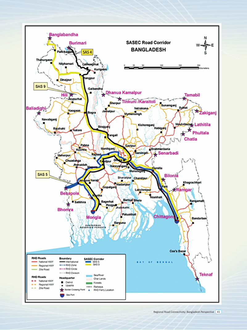
Regional Road Connectivity: Bangladesh Perspective 41
4.0 Introduction
The South Asia Sub regional Economic Cooperation (SASEC) Program brings together Bangladesh, Bhutan, India, the Maldives, Nepal, and Sri Lanka in a project-based partnership that aims to promote regional prosperity, improve economic opportunities, and build a better quality of life for the people of the sub region. SASEC countries share a common vision of boosting intraregional trade and cooperation in South Asia, while also connecting to South-east Asia through Myanmar, to the People’s Republic of China and the global market.
Integration of the transport network of South Asia is particularly crucial to countries such as Nepal and Bhutan and regions such as north-east India. Such integration, on the one hand, could serve to end their landlocked or semi-isolated status by providing shorter transport links to the sea ports and, on the other hand, could benefit Bangladesh through facilitation of trade with these regions. Effective integration of the transport system in South Asia could also contribute greatly in enhancing economic development.
Recognizing the importance of regional integration, SASEC seeks to strengthen cross-border transport network that boost intraregional trade and open up trade opportunities with East and South-east Asia. The program emphasizes building modern and effective customs facilities to reduce time and rationalize the costs of moving goods, vehicles, and people across borders. Better connectivity will help unleash the tremendous potential for mutually beneficial trade between the six SASEC countries, which remain among some of the least integrated regions in the world.
4.1 SASEC Road Corridor
In 1996, four of the then seven member countries of the South Asian Association for Regional Cooperation (SAARC), namely, Bangladesh, Bhutan, India and Nepal formed the South Asian Growth Quadrangle (SAGQ), with the primary objective of accelerating sustainable economic development among these countries. This sub regional initiative was endorsed at the SAARC summit in Male, Maldives in 1997. Subsequently, these four countries requested ADB’s assistance in facilitating their economic cooperation initiative. This request led to the foundation of the SASEC program.
ADB's support for SASEC was undertaken mainly through:
• capacity building and institutional strengthening of the program, • various regional cooperation initiatives and • ADB-financed projects and technical assistance
Since the inception of SASEC, ADB has informally continued to function as its secretariat.
Priority areas are:
• Energy and power • Transport • Trade, investment and private sector
Other areas of work include Information and Communications Technology (ICT), Tourism, Environment.
4.2 Status inside Bangladesh
SASEC Corridor 9
• Banglabandha to Panchaghar (N5, 53 Km, Class II). This section was improved with ADB finance in 2011. Considering the traffic growth the feasibility study and detailed design for upgrading this section to a 4-lane highway is carried out by an ADB assisted TA project and the detailed design is expected to be finished by 2018. The investment project to upgrade this section has been included in ADB’s 2018 program.
• Panchagahar to Rangpur (N5, 143 Km, Class II). Feasibility study and detailed design for upgrading this section to a 4-lane highway is carried out by an ADB assisted TA project and the detailed design is expected to be finished by 2018. The investment project to upgrade this section has been included in ADB’s 2018 program.
• Rangpur-Hatikamrul-Elenga(N5/N4, 197 km, Class II). The Feasibility Study and Detailed Design for upgrading this section to a 4-Lane highway have been completed with ADB finance. The investment project to upgrade this section has been included in ADB’s 2017 program.
• Elenga-Tangail-Chandra-Joydevpur(N4, 70 km, Class II). This section is being upgraded to 4 lane highway under SESEC Road Connectivity Project with ADB finance and the construction work is expected to be completed within 2018.
• Joydevpur-Bhulta-Madanpur (N105, 48 km). This section is known as Dhaka Bypass, which is being considered for PPP finance. The PPP office under the Prime Minister’s Office has engaged transaction adviser and feasibility study was completed in July 2014. The RFQ for selecting concessionaire has been issued on October 2015. The road work of this project is expected to be completed by 2020.
• Madanpur-Daudkandi (N1, 18 km). This section has already been upgraded as a 4-lane highway.
• Daudkandi-Chittagong (N1, 192 km, Class I). This section is being upgraded under 4-Laning of Dhaka-Chittagong Highway Project and is expected to be opened for traffic soon.
• Chittagong to Chittagong Port (N111, 13 km, Class II). This section was developed to a 2 lane highway with ADB finance in 2006. Considering the traffic growth the feasibility study and detailed design for upgrading this section to a 4-lane highway is being carried out by an ADB assisted TA project and the detailed design is expected to be finished by 2018.
• Hatikamrul-Banpara section (N507, 51km, Class II). The Feasibility Study and Detailed Design for upgrading this section to a 4-Lane highway have been completed with ADB finance.
• Bonpara-Dasurai-Pakshey-Kushtia-Jheinadah(N6, N704, 105 km, Class II). A pre-feasibility study on this segment was done by UN-ESCAP in 2013. Feasibility study and detailed design for upgrading to a 4-lane highway will be done with ADB assistance. The detailed design is expected to be completed by 2018. There is a major 4-lane bridge over river Padma named as Lalon Shah Bridge (1785m).
route instead of Nabinagar-Savar-Gabtoli-Jatrabari-Katchpur-Sylhet.
• Jatrabari-Katchpur (N1, 10km, Class I). This section has been developed as a 4-lane highway and is now being upgraded to 8-lane with GOB financing. It is expected to be completed by 2016.
• Katchpur-Daudkandi (N1, 26 km, Class I). This section has been upgraded to a 4-lane highway in 2005 by JBARP project.
• Daudkandi-Chittagong (N1, 194 km, Class I). This section is being upgraded under 4-Laning of Dhaka-Chittagong Highway Project and is expected to be opened for traffic soon.
4.3 Investment required for the corridor
The Joint Communiqué signed by Bangladesh and India in New Delhi in January 2010 also laid special emphasis on allowing India, Nepal and Bhutan to access to Mongla Port and Chittagong Port for movement of bilateral and third country trade. Improving these two corridors will benefit India, Bhutan and Nepal to access to the seaports at Mongla and Chittagong.
However, last several SASEC Transport and Trade facilitation Working Group meetings discussed mainly the upper segments of these corridors, i.e. Kathmandu-Kakarvitta-Panitanki-Phulbari- Banglabandha segment and Thimphu–Phuentsholing–Jaigaon–Burimari segment. These two segments have reached to an investment level and India has started up gradation of Indian part of both these segments recently.
Asian Development Bank has come forward to assist in improvement of some road segments in Bangladesh along these two corridors—either through project aid or technical assistance for feasibility studies and detailed design.
In terms of readiness, Bangladesh has already undertaken feasibility study and detailed design for significant stretches of highway. Besides, Bangladesh has already started up gradation of 70 km long Joydevpur-Chandra-Tangail-Elenga Highway which is part of SASEC Corridor 4 and 9. Improvement of 197 km long Elenga-Hatikamrul-Rangpur segment which is common to SASEC Corridor 4 and SASEC Corridor 9 has been included in ADB’s 2017 program. It is therefore, expected that other SASEC member states will take necessary actions to put these two corridors into operation.
4.4 Recent SASEC Transport and Trade facilitation Working Group Meetings:
v SASEC Transport and TRADE facilitation Working Group (TFTWG) meeting was held in Dhaka on 2 December 2010 regarding identification and improvement of regional corridors for trade facilitation.
v TFTWG meeting held in Bangkok on 20-21 October 2011 Bangladesh requested ADB to include 143 kilometer long road segment from Panchaghar to Rangpur
and 105 kilometer road segment from Bonpara to Jhenaidah for technical assistance for feasibility study and detailed design.
v TFTWG meeting in Bhutan on 8 November 2012 discussed following investment projects:
BCIM-Economic Corridor
5
Regional Road Connectivity: Bangladesh Perspective 45
5.0 Background
Despite many regional initiatives to enhance regional connectivity, Asian Countries have remained relatively disconnected. However, there existed several overland connections that facilitated movement of people and goods in the past. The historic Southern Silk Road played important roles in trade and commerce in this region. The famed Stilwell Road (or Ledo Road) constructed during World War II by U.S. Army Engineers provided an important connection between India and China through Myanmar. The historic Grand Trunk Road (GTR) constructed by Sher Shah Suri symbolizes the importance of overland transportation in expanding trade and commerce across regions. But these lessons of history seemed to have lost in oblivion for many years until South Asian nations realized the importance of regional integration for the benefit of people of this region. Consequently, the concept of regional integration has gained popularity in recent years particularly, under the umbrella of regional initiatives, such as UN-ESCAP, SAARC, SASEC, BIMSTEC etc. However, the progress remains unmatched with the rising expectation of the people of this sub-region.
5.1 BCIM Initiatives
The BCIM spans three recognized regions of Asia namely, South Asia, South-east Asia and East Asia. The Centre for Policy Dialogue (CPD) in Bangladesh, Yunnan Academy of Social Sciences (YASS) in Kunming, China, the Centre for Policy Research (CPR) in India and the Ministry of Border Trade of Myanmar were the pioneering institutions which agreed to launch the BCIM initiative in Kunming, capital of China’s southwestern Yunnan province in 1999. The Civil Society initiative (Track II) in Kunming sought to explore the possibilities of regional and sub-regional cooperation involving the BCIM countries with a view to identifying concrete modalities to implement the recommendations put forward by the initiative through intergovernmental efforts, private sector participation and public-private partnerships. With the `Track II’ engagement between researchers in the four countries, the BCIM Forum took on a uniquely `multi-track’ character, involving government, business, civil society and academic institutions in partnership. Since 1999, meetings have been held in turn in India, Bangladesh and Myanmar, with a third round starting in Kunming in 2011. In 2012, the BCIM forum attained a breakthrough in the mechanism establishment and entered the phase of Track I. Track I is “a technique of state action, which is essentially a process whereby communications from one government go directly to the decision-making apparatus of another government”. The BCIM Initiative is one of the sub-regional initiatives to explore the prospects of cooperation of Bangladesh, China, India and Myanmar, specifically the land-locked and relatively backward regions. The Bangladesh-China-India-Myanmar (BCIM) Forum for Regional Cooperation aims to recapture for contemporary time the historic dynamism that had once characterized the flows of goods, people and culture over the famed “Southern Silk Route”. With the aim of stimulating interest of people to revive the historic trade route, BCIM Forum at its meeting in 2006 in Delhi decided to organize a Car Rally from Kolkata to Kunming. In line with the decision, BCIM Forum at its meeting in Kunming in 2011 selected the following BCIM corridor:
Kolkata (India) - Petrapole (India)/Benapole(Bangladesh) – Jessore (Bangladesh) – Dhaka (Bangladesh) – Sylhet (Bangladesh) – Sheola (Bangladesh)/Sutarkandi(India) – Silchar (India) – Imphal (India) - Morreh(India)/Tamu(Myanmar) – Ka Lay (Myanmar) – Mandalay (Myanmar) – Mose(Myanmar)/ Ruili (China) – Tengchong (China) – Erhai Lake (China) – Dali (China) – Kunming (China).
(Myanmar)-Mandalay (Myanmar)-Lashio (Myanmar)-Ruili (China)-Kunming (China).
In Bangladesh side, the condition of this route which is mostly part of AH-41 is good. With the finance from Asian Development Bank, the feasibility study and detailed design for upgrading Chittagong-Cox’s Bazar-Ukhia-Balukhali-Ghundum stretch has been done. The Memorandum of Understanding (MoU) signed in 2004 and the bilateral Agreement signed in 2007 between Bangladesh and Myanmar for direct road link between the two countries can be reinvigorated in the light of renewed interest of Bangladesh, China, India and Myanmar. The total length of the missing link to be developed to put this alternative route into operation will be less than 140 km, inside Myanmar.
Reliance on single mode of transport is often considered environmentally unsustainable and it may lead to higher transportation cost. Considering the integration of different modes of transportation along BCIM Corridor, member countries should agree on developing a Master Plan to identify all modes such as road, rail, and waterway along the corridor and identify their comparative advantages and disadvantages, and recommend intermodal arrangements.
Map 2: BCIM Alternative Route Map
* Existing route is shown by blue line* Alternative route is shown by red line
More options for BCIM alternative corridor inside Bangladesh could be the following:
• Dhaka – Chittagong - Keranirhat - Thanchi - Rimakri - Modwok - Likri (Bangladesh) - Napraitaung (Bangladesh - Myanmar Border) - Daletme (Myanmar) - Kyauktaw (Myanmar) - Mandalay (Myanmar) - Lashio (Myanmar) - Ruili (China) - Kunming (China).
• Jatrabari-Katchpur (N1, 10km, Class I). This section has been developed as a 4-lane highway and is now being upgraded to 8-lane with GOB financing. It is expected to be completed by 2016.
• Katchpur-Sylhet (N2, 230 km, Class II). The Feasibility Study and Detailed Design for upgrading this section to a 4-Lane highway have been completed with ADB finance.
• Sylhet-Golapgonj-Charkhai (R250, 32km, Class II). The Feasibility study including detailed design for upgrading this roadsection to a 4-lane highway is being carried out by an ADB assisted TA project and the detailed design is expected to be completed by 2018.
• Charkhai-Sheola (R281, 8km, Class II). Feasibility study and detailed design for upgrading this roadsection to a 4-lane highway is carried out by an ADB assisted TA project and the detailed design is expected to be finished by 2018.
• Sheola-Sutarkandi (Z2014, 4km, Class III). Feasibility study and detailed design for upgrading this roadsection to a 4-lane highway is carried out by an ADB assisted TA project and the detailed design is expected to be finished by 2018.
There is a strong rationale to use the Dhaka bypass for this corridor to avoid congested city center. Nabinagar - Chandra - Vogra - Vulta - Sylhet route instead of Nabinagar - Savar - Gabtoli - Jatrabari - Katchpur-Vulta-Sylhet route may be considered.
Status of the Alternative BCIM corridor and more options inside Bangladesh
• Benapole-Katchpur. The status has been outlined above.
• Katchpur-Daudkandi (N1, 26 km, Class I). This section has been upgraded to a 4-lane highway in 2005 by JBARP project.
• Daudkandi-Chittagong (N1, 194 km, Class I). This section is being upgraded under 4-Laning of Dhaka-Chittagong Highway Project and is expected to be opened for traffic soon.
• Chittagong-Cox’s Bazar-Balukhali (N1, 243 km, Class II). The Feasibility Study and Detailed Design for upgrading this section to a 4-Lane highway have been completed with ADB finance. JICA has recently shown its interest to finance upgrading Chittagong-Cox’s Bazar section. Government of Bangladesh and JICA signed a Minutes of Discussion on 20 August 2014 to include this road stretch in the Cross-border Road Network Improvement Project which is expected to be financed by JICA.
• Balukhali-Gundum (2 km). This section is being included for upgrading to provide connectivity of National Highway with the border point with Myanmar.
• Chittagong - Keranirhat - Thanchi - Rimakri - Modwok - Likri (Bangladesh)-Napraitaung (Bangladesh - Myanmar Border). The proposed Road Construction Project of Thanchi - Rimakri - Modwok -Likri (80km) is sent to Planning Commission. The project will be implemented by Bangladesh Army.
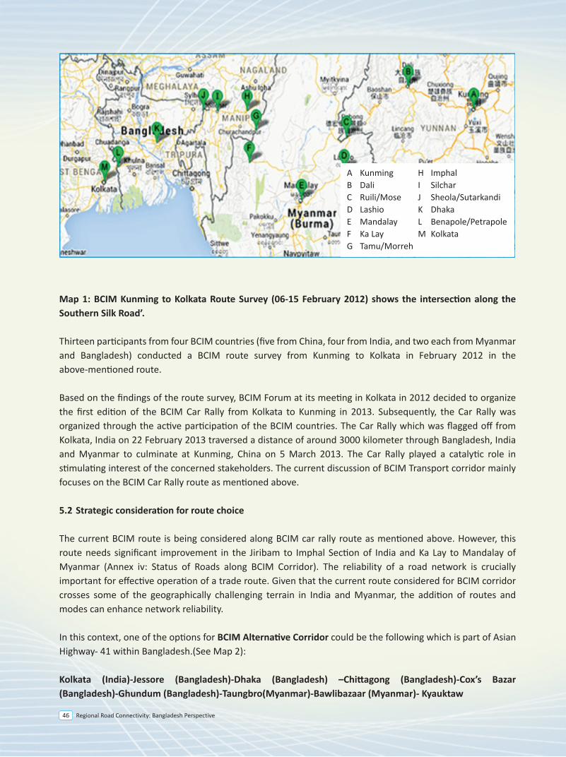
Regional Road Connectivity: Bangladesh Perspective46
5.0 Background
Despite many regional initiatives to enhance regional connectivity, Asian Countries have remained relatively disconnected. However, there existed several overland connections that facilitated movement of people and goods in the past. The historic Southern Silk Road played important roles in trade and commerce in this region. The famed Stilwell Road (or Ledo Road) constructed during World War II by U.S. Army Engineers provided an important connection between India and China through Myanmar. The historic Grand Trunk Road (GTR) constructed by Sher Shah Suri symbolizes the importance of overland transportation in expanding trade and commerce across regions. But these lessons of history seemed to have lost in oblivion for many years until South Asian nations realized the importance of regional integration for the benefit of people of this region. Consequently, the concept of regional integration has gained popularity in recent years particularly, under the umbrella of regional initiatives, such as UN-ESCAP, SAARC, SASEC, BIMSTEC etc. However, the progress remains unmatched with the rising expectation of the people of this sub-region.
5.1 BCIM Initiatives
The BCIM spans three recognized regions of Asia namely, South Asia, South-east Asia and East Asia. The Centre for Policy Dialogue (CPD) in Bangladesh, Yunnan Academy of Social Sciences (YASS) in Kunming, China, the Centre for Policy Research (CPR) in India and the Ministry of Border Trade of Myanmar were the pioneering institutions which agreed to launch the BCIM initiative in Kunming, capital of China’s southwestern Yunnan province in 1999. The Civil Society initiative (Track II) in Kunming sought to explore the possibilities of regional and sub-regional cooperation involving the BCIM countries with a view to identifying concrete modalities to implement the recommendations put forward by the initiative through intergovernmental efforts, private sector participation and public-private partnerships. With the `Track II’ engagement between researchers in the four countries, the BCIM Forum took on a uniquely `multi-track’ character, involving government, business, civil society and academic institutions in partnership. Since 1999, meetings have been held in turn in India, Bangladesh and Myanmar, with a third round starting in Kunming in 2011. In 2012, the BCIM forum attained a breakthrough in the mechanism establishment and entered the phase of Track I. Track I is “a technique of state action, which is essentially a process whereby communications from one government go directly to the decision-making apparatus of another government”. The BCIM Initiative is one of the sub-regional initiatives to explore the prospects of cooperation of Bangladesh, China, India and Myanmar, specifically the land-locked and relatively backward regions. The Bangladesh-China-India-Myanmar (BCIM) Forum for Regional Cooperation aims to recapture for contemporary time the historic dynamism that had once characterized the flows of goods, people and culture over the famed “Southern Silk Route”. With the aim of stimulating interest of people to revive the historic trade route, BCIM Forum at its meeting in 2006 in Delhi decided to organize a Car Rally from Kolkata to Kunming. In line with the decision, BCIM Forum at its meeting in Kunming in 2011 selected the following BCIM corridor:
Kolkata (India) - Petrapole (India)/Benapole(Bangladesh) – Jessore (Bangladesh) – Dhaka (Bangladesh) – Sylhet (Bangladesh) – Sheola (Bangladesh)/Sutarkandi(India) – Silchar (India) – Imphal (India) - Morreh(India)/Tamu(Myanmar) – Ka Lay (Myanmar) – Mandalay (Myanmar) – Mose(Myanmar)/ Ruili (China) – Tengchong (China) – Erhai Lake (China) – Dali (China) – Kunming (China).
Map 1: BCIM Kunming to Kolkata Route Survey (06-15 February 2012) shows the intersection along the Southern Silk Road’.
Thirteen participants from four BCIM countries (five from China, four from India, and two each from Myanmar and Bangladesh) conducted a BCIM route survey from Kunming to Kolkata in February 2012 in the above-mentioned route.
Based on the findings of the route survey, BCIM Forum at its meeting in Kolkata in 2012 decided to organize the first edition of the BCIM Car Rally from Kolkata to Kunming in 2013. Subsequently, the Car Rally was organized through the active participation of the BCIM countries. The Car Rally which was flagged off from Kolkata, India on 22 February 2013 traversed a distance of around 3000 kilometer through Bangladesh, India and Myanmar to culminate at Kunming, China on 5 March 2013. The Car Rally played a catalytic role in stimulating interest of the concerned stakeholders. The current discussion of BCIM Transport corridor mainly focuses on the BCIM Car Rally route as mentioned above.
5.2 Strategic consideration for route choice
The current BCIM route is being considered along BCIM car rally route as mentioned above. However, this route needs significant improvement in the Jiribam to Imphal Section of India and Ka Lay to Mandalay of Myanmar (Annex iv: Status of Roads along BCIM Corridor). The reliability of a road network is crucially important for effective operation of a trade route. Given that the current route considered for BCIM corridor crosses some of the geographically challenging terrain in India and Myanmar, the addition of routes and modes can enhance network reliability.
In this context, one of the options for BCIM Alternative Corridor could be the following which is part of Asian Highway- 41 within Bangladesh.(See Map 2):
Kolkata (India)-Jessore (Bangladesh)-Dhaka (Bangladesh) –Chittagong (Bangladesh)-Cox’s Bazar (Bangladesh)-Ghundum (Bangladesh)-Taungbro(Myanmar)-Bawlibazaar (Myanmar)- Kyauktaw
(Myanmar)-Mandalay (Myanmar)-Lashio (Myanmar)-Ruili (China)-Kunming (China).
In Bangladesh side, the condition of this route which is mostly part of AH-41 is good. With the finance from Asian Development Bank, the feasibility study and detailed design for upgrading Chittagong-Cox’s Bazar-Ukhia-Balukhali-Ghundum stretch has been done. The Memorandum of Understanding (MoU) signed in 2004 and the bilateral Agreement signed in 2007 between Bangladesh and Myanmar for direct road link between the two countries can be reinvigorated in the light of renewed interest of Bangladesh, China, India and Myanmar. The total length of the missing link to be developed to put this alternative route into operation will be less than 140 km, inside Myanmar.
Reliance on single mode of transport is often considered environmentally unsustainable and it may lead to higher transportation cost. Considering the integration of different modes of transportation along BCIM Corridor, member countries should agree on developing a Master Plan to identify all modes such as road, rail, and waterway along the corridor and identify their comparative advantages and disadvantages, and recommend intermodal arrangements.
Map 2: BCIM Alternative Route Map
* Existing route is shown by blue line* Alternative route is shown by red line
More options for BCIM alternative corridor inside Bangladesh could be the following:
• Dhaka – Chittagong - Keranirhat - Thanchi - Rimakri - Modwok - Likri (Bangladesh) - Napraitaung (Bangladesh - Myanmar Border) - Daletme (Myanmar) - Kyauktaw (Myanmar) - Mandalay (Myanmar) - Lashio (Myanmar) - Ruili (China) - Kunming (China).
• Jatrabari-Katchpur (N1, 10km, Class I). This section has been developed as a 4-lane highway and is now being upgraded to 8-lane with GOB financing. It is expected to be completed by 2016.
• Katchpur-Sylhet (N2, 230 km, Class II). The Feasibility Study and Detailed Design for upgrading this section to a 4-Lane highway have been completed with ADB finance.
• Sylhet-Golapgonj-Charkhai (R250, 32km, Class II). The Feasibility study including detailed design for upgrading this roadsection to a 4-lane highway is being carried out by an ADB assisted TA project and the detailed design is expected to be completed by 2018.
• Charkhai-Sheola (R281, 8km, Class II). Feasibility study and detailed design for upgrading this roadsection to a 4-lane highway is carried out by an ADB assisted TA project and the detailed design is expected to be finished by 2018.
• Sheola-Sutarkandi (Z2014, 4km, Class III). Feasibility study and detailed design for upgrading this roadsection to a 4-lane highway is carried out by an ADB assisted TA project and the detailed design is expected to be finished by 2018.
There is a strong rationale to use the Dhaka bypass for this corridor to avoid congested city center. Nabinagar - Chandra - Vogra - Vulta - Sylhet route instead of Nabinagar - Savar - Gabtoli - Jatrabari - Katchpur-Vulta-Sylhet route may be considered.
Status of the Alternative BCIM corridor and more options inside Bangladesh
• Benapole-Katchpur. The status has been outlined above.
• Katchpur-Daudkandi (N1, 26 km, Class I). This section has been upgraded to a 4-lane highway in 2005 by JBARP project.
• Daudkandi-Chittagong (N1, 194 km, Class I). This section is being upgraded under 4-Laning of Dhaka-Chittagong Highway Project and is expected to be opened for traffic soon.
• Chittagong-Cox’s Bazar-Balukhali (N1, 243 km, Class II). The Feasibility Study and Detailed Design for upgrading this section to a 4-Lane highway have been completed with ADB finance. JICA has recently shown its interest to finance upgrading Chittagong-Cox’s Bazar section. Government of Bangladesh and JICA signed a Minutes of Discussion on 20 August 2014 to include this road stretch in the Cross-border Road Network Improvement Project which is expected to be financed by JICA.
• Balukhali-Gundum (2 km). This section is being included for upgrading to provide connectivity of National Highway with the border point with Myanmar.
• Chittagong - Keranirhat - Thanchi - Rimakri - Modwok - Likri (Bangladesh)-Napraitaung (Bangladesh - Myanmar Border). The proposed Road Construction Project of Thanchi - Rimakri - Modwok -Likri (80km) is sent to Planning Commission. The project will be implemented by Bangladesh Army.
A Kunming H ImphalB Dali I SilcharC Ruili/Mose J Sheola/SutarkandiD Lashio K DhakaE Mandalay L Benapole/PetrapoleF Ka Lay M KolkataG Tamu/Morreh
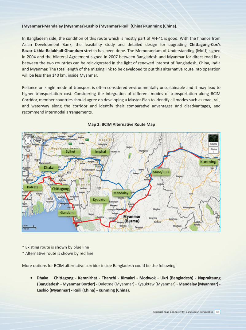
Regional Road Connectivity: Bangladesh Perspective 47
5.0 Background
Despite many regional initiatives to enhance regional connectivity, Asian Countries have remained relatively disconnected. However, there existed several overland connections that facilitated movement of people and goods in the past. The historic Southern Silk Road played important roles in trade and commerce in this region. The famed Stilwell Road (or Ledo Road) constructed during World War II by U.S. Army Engineers provided an important connection between India and China through Myanmar. The historic Grand Trunk Road (GTR) constructed by Sher Shah Suri symbolizes the importance of overland transportation in expanding trade and commerce across regions. But these lessons of history seemed to have lost in oblivion for many years until South Asian nations realized the importance of regional integration for the benefit of people of this region. Consequently, the concept of regional integration has gained popularity in recent years particularly, under the umbrella of regional initiatives, such as UN-ESCAP, SAARC, SASEC, BIMSTEC etc. However, the progress remains unmatched with the rising expectation of the people of this sub-region.
5.1 BCIM Initiatives
The BCIM spans three recognized regions of Asia namely, South Asia, South-east Asia and East Asia. The Centre for Policy Dialogue (CPD) in Bangladesh, Yunnan Academy of Social Sciences (YASS) in Kunming, China, the Centre for Policy Research (CPR) in India and the Ministry of Border Trade of Myanmar were the pioneering institutions which agreed to launch the BCIM initiative in Kunming, capital of China’s southwestern Yunnan province in 1999. The Civil Society initiative (Track II) in Kunming sought to explore the possibilities of regional and sub-regional cooperation involving the BCIM countries with a view to identifying concrete modalities to implement the recommendations put forward by the initiative through intergovernmental efforts, private sector participation and public-private partnerships. With the `Track II’ engagement between researchers in the four countries, the BCIM Forum took on a uniquely `multi-track’ character, involving government, business, civil society and academic institutions in partnership. Since 1999, meetings have been held in turn in India, Bangladesh and Myanmar, with a third round starting in Kunming in 2011. In 2012, the BCIM forum attained a breakthrough in the mechanism establishment and entered the phase of Track I. Track I is “a technique of state action, which is essentially a process whereby communications from one government go directly to the decision-making apparatus of another government”. The BCIM Initiative is one of the sub-regional initiatives to explore the prospects of cooperation of Bangladesh, China, India and Myanmar, specifically the land-locked and relatively backward regions. The Bangladesh-China-India-Myanmar (BCIM) Forum for Regional Cooperation aims to recapture for contemporary time the historic dynamism that had once characterized the flows of goods, people and culture over the famed “Southern Silk Route”. With the aim of stimulating interest of people to revive the historic trade route, BCIM Forum at its meeting in 2006 in Delhi decided to organize a Car Rally from Kolkata to Kunming. In line with the decision, BCIM Forum at its meeting in Kunming in 2011 selected the following BCIM corridor:
Kolkata (India) - Petrapole (India)/Benapole(Bangladesh) – Jessore (Bangladesh) – Dhaka (Bangladesh) – Sylhet (Bangladesh) – Sheola (Bangladesh)/Sutarkandi(India) – Silchar (India) – Imphal (India) - Morreh(India)/Tamu(Myanmar) – Ka Lay (Myanmar) – Mandalay (Myanmar) – Mose(Myanmar)/ Ruili (China) – Tengchong (China) – Erhai Lake (China) – Dali (China) – Kunming (China).
(Myanmar)-Mandalay (Myanmar)-Lashio (Myanmar)-Ruili (China)-Kunming (China).
In Bangladesh side, the condition of this route which is mostly part of AH-41 is good. With the finance from Asian Development Bank, the feasibility study and detailed design for upgrading Chittagong-Cox’s Bazar-Ukhia-Balukhali-Ghundum stretch has been done. The Memorandum of Understanding (MoU) signed in 2004 and the bilateral Agreement signed in 2007 between Bangladesh and Myanmar for direct road link between the two countries can be reinvigorated in the light of renewed interest of Bangladesh, China, India and Myanmar. The total length of the missing link to be developed to put this alternative route into operation will be less than 140 km, inside Myanmar.
Reliance on single mode of transport is often considered environmentally unsustainable and it may lead to higher transportation cost. Considering the integration of different modes of transportation along BCIM Corridor, member countries should agree on developing a Master Plan to identify all modes such as road, rail, and waterway along the corridor and identify their comparative advantages and disadvantages, and recommend intermodal arrangements.
Map 2: BCIM Alternative Route Map
* Existing route is shown by blue line* Alternative route is shown by red line
More options for BCIM alternative corridor inside Bangladesh could be the following:
• Dhaka – Chittagong - Keranirhat - Thanchi - Rimakri - Modwok - Likri (Bangladesh) - Napraitaung (Bangladesh - Myanmar Border) - Daletme (Myanmar) - Kyauktaw (Myanmar) - Mandalay (Myanmar) - Lashio (Myanmar) - Ruili (China) - Kunming (China).
• Jatrabari-Katchpur (N1, 10km, Class I). This section has been developed as a 4-lane highway and is now being upgraded to 8-lane with GOB financing. It is expected to be completed by 2016.
• Katchpur-Sylhet (N2, 230 km, Class II). The Feasibility Study and Detailed Design for upgrading this section to a 4-Lane highway have been completed with ADB finance.
• Sylhet-Golapgonj-Charkhai (R250, 32km, Class II). The Feasibility study including detailed design for upgrading this roadsection to a 4-lane highway is being carried out by an ADB assisted TA project and the detailed design is expected to be completed by 2018.
• Charkhai-Sheola (R281, 8km, Class II). Feasibility study and detailed design for upgrading this roadsection to a 4-lane highway is carried out by an ADB assisted TA project and the detailed design is expected to be finished by 2018.
• Sheola-Sutarkandi (Z2014, 4km, Class III). Feasibility study and detailed design for upgrading this roadsection to a 4-lane highway is carried out by an ADB assisted TA project and the detailed design is expected to be finished by 2018.
There is a strong rationale to use the Dhaka bypass for this corridor to avoid congested city center. Nabinagar - Chandra - Vogra - Vulta - Sylhet route instead of Nabinagar - Savar - Gabtoli - Jatrabari - Katchpur-Vulta-Sylhet route may be considered.
Status of the Alternative BCIM corridor and more options inside Bangladesh
• Benapole-Katchpur. The status has been outlined above.
• Katchpur-Daudkandi (N1, 26 km, Class I). This section has been upgraded to a 4-lane highway in 2005 by JBARP project.
• Daudkandi-Chittagong (N1, 194 km, Class I). This section is being upgraded under 4-Laning of Dhaka-Chittagong Highway Project and is expected to be opened for traffic soon.
• Chittagong-Cox’s Bazar-Balukhali (N1, 243 km, Class II). The Feasibility Study and Detailed Design for upgrading this section to a 4-Lane highway have been completed with ADB finance. JICA has recently shown its interest to finance upgrading Chittagong-Cox’s Bazar section. Government of Bangladesh and JICA signed a Minutes of Discussion on 20 August 2014 to include this road stretch in the Cross-border Road Network Improvement Project which is expected to be financed by JICA.
• Balukhali-Gundum (2 km). This section is being included for upgrading to provide connectivity of National Highway with the border point with Myanmar.
• Chittagong - Keranirhat - Thanchi - Rimakri - Modwok - Likri (Bangladesh)-Napraitaung (Bangladesh - Myanmar Border). The proposed Road Construction Project of Thanchi - Rimakri - Modwok -Likri (80km) is sent to Planning Commission. The project will be implemented by Bangladesh Army.
Kunming
Muse/Ruili
Mandalay
Kyauktu
Gundum
Chittagong
Dhaka
Sylhet Imphal
Kolkata
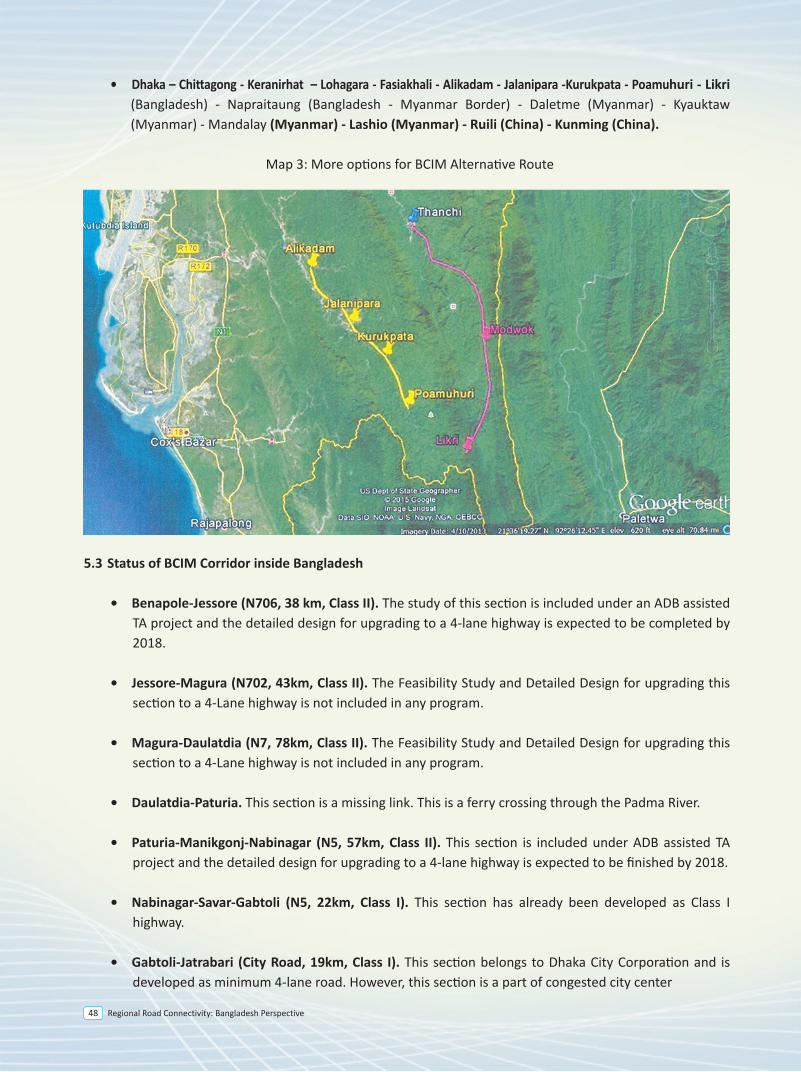
Regional Road Connectivity: Bangladesh Perspective48
5.0 Background
Despite many regional initiatives to enhance regional connectivity, Asian Countries have remained relatively disconnected. However, there existed several overland connections that facilitated movement of people and goods in the past. The historic Southern Silk Road played important roles in trade and commerce in this region. The famed Stilwell Road (or Ledo Road) constructed during World War II by U.S. Army Engineers provided an important connection between India and China through Myanmar. The historic Grand Trunk Road (GTR) constructed by Sher Shah Suri symbolizes the importance of overland transportation in expanding trade and commerce across regions. But these lessons of history seemed to have lost in oblivion for many years until South Asian nations realized the importance of regional integration for the benefit of people of this region. Consequently, the concept of regional integration has gained popularity in recent years particularly, under the umbrella of regional initiatives, such as UN-ESCAP, SAARC, SASEC, BIMSTEC etc. However, the progress remains unmatched with the rising expectation of the people of this sub-region.
5.1 BCIM Initiatives
The BCIM spans three recognized regions of Asia namely, South Asia, South-east Asia and East Asia. The Centre for Policy Dialogue (CPD) in Bangladesh, Yunnan Academy of Social Sciences (YASS) in Kunming, China, the Centre for Policy Research (CPR) in India and the Ministry of Border Trade of Myanmar were the pioneering institutions which agreed to launch the BCIM initiative in Kunming, capital of China’s southwestern Yunnan province in 1999. The Civil Society initiative (Track II) in Kunming sought to explore the possibilities of regional and sub-regional cooperation involving the BCIM countries with a view to identifying concrete modalities to implement the recommendations put forward by the initiative through intergovernmental efforts, private sector participation and public-private partnerships. With the `Track II’ engagement between researchers in the four countries, the BCIM Forum took on a uniquely `multi-track’ character, involving government, business, civil society and academic institutions in partnership. Since 1999, meetings have been held in turn in India, Bangladesh and Myanmar, with a third round starting in Kunming in 2011. In 2012, the BCIM forum attained a breakthrough in the mechanism establishment and entered the phase of Track I. Track I is “a technique of state action, which is essentially a process whereby communications from one government go directly to the decision-making apparatus of another government”. The BCIM Initiative is one of the sub-regional initiatives to explore the prospects of cooperation of Bangladesh, China, India and Myanmar, specifically the land-locked and relatively backward regions. The Bangladesh-China-India-Myanmar (BCIM) Forum for Regional Cooperation aims to recapture for contemporary time the historic dynamism that had once characterized the flows of goods, people and culture over the famed “Southern Silk Route”. With the aim of stimulating interest of people to revive the historic trade route, BCIM Forum at its meeting in 2006 in Delhi decided to organize a Car Rally from Kolkata to Kunming. In line with the decision, BCIM Forum at its meeting in Kunming in 2011 selected the following BCIM corridor:
Kolkata (India) - Petrapole (India)/Benapole(Bangladesh) – Jessore (Bangladesh) – Dhaka (Bangladesh) – Sylhet (Bangladesh) – Sheola (Bangladesh)/Sutarkandi(India) – Silchar (India) – Imphal (India) - Morreh(India)/Tamu(Myanmar) – Ka Lay (Myanmar) – Mandalay (Myanmar) – Mose(Myanmar)/ Ruili (China) – Tengchong (China) – Erhai Lake (China) – Dali (China) – Kunming (China).
(Myanmar)-Mandalay (Myanmar)-Lashio (Myanmar)-Ruili (China)-Kunming (China).
In Bangladesh side, the condition of this route which is mostly part of AH-41 is good. With the finance from Asian Development Bank, the feasibility study and detailed design for upgrading Chittagong-Cox’s Bazar-Ukhia-Balukhali-Ghundum stretch has been done. The Memorandum of Understanding (MoU) signed in 2004 and the bilateral Agreement signed in 2007 between Bangladesh and Myanmar for direct road link between the two countries can be reinvigorated in the light of renewed interest of Bangladesh, China, India and Myanmar. The total length of the missing link to be developed to put this alternative route into operation will be less than 140 km, inside Myanmar.
Reliance on single mode of transport is often considered environmentally unsustainable and it may lead to higher transportation cost. Considering the integration of different modes of transportation along BCIM Corridor, member countries should agree on developing a Master Plan to identify all modes such as road, rail, and waterway along the corridor and identify their comparative advantages and disadvantages, and recommend intermodal arrangements.
Map 2: BCIM Alternative Route Map
* Existing route is shown by blue line* Alternative route is shown by red line
More options for BCIM alternative corridor inside Bangladesh could be the following:
• Dhaka – Chittagong - Keranirhat - Thanchi - Rimakri - Modwok - Likri (Bangladesh) - Napraitaung (Bangladesh - Myanmar Border) - Daletme (Myanmar) - Kyauktaw (Myanmar) - Mandalay (Myanmar) - Lashio (Myanmar) - Ruili (China) - Kunming (China).
• Dhaka – Chittagong - Keranirhat – Lohagara - Fasiakhali - Alikadam - Jalanipara -Kurukpata - Poamuhuri - Likri (Bangladesh) - Napraitaung (Bangladesh - Myanmar Border) - Daletme (Myanmar) - Kyauktaw (Myanmar) - Mandalay (Myanmar) - Lashio (Myanmar) - Ruili (China) - Kunming (China).
Map 3: More options for BCIM Alternative Route
5.3 Status of BCIM Corridor inside Bangladesh
• Benapole-Jessore (N706, 38 km, Class II). The study of this section is included under an ADB assisted TA project and the detailed design for upgrading to a 4-lane highway is expected to be completed by 2018.
• Jessore-Magura (N702, 43km, Class II). The Feasibility Study and Detailed Design for upgrading this section to a 4-Lane highway is not included in any program.
• Magura-Daulatdia (N7, 78km, Class II). The Feasibility Study and Detailed Design for upgrading this section to a 4-Lane highway is not included in any program.
• Daulatdia-Paturia. This section is a missing link. This is a ferry crossing through the Padma River.
• Paturia-Manikgonj-Nabinagar (N5, 57km, Class II). This section is included under ADB assisted TA project and the detailed design for upgrading to a 4-lane highway is expected to be finished by 2018.
• Nabinagar-Savar-Gabtoli (N5, 22km, Class I). This section has already been developed as Class I highway.
• Gabtoli-Jatrabari (City Road, 19km, Class I). This section belongs to Dhaka City Corporation and is developed as minimum 4-lane road. However, this section is a part of congested city center
• Jatrabari-Katchpur (N1, 10km, Class I). This section has been developed as a 4-lane highway and is now being upgraded to 8-lane with GOB financing. It is expected to be completed by 2016.
• Katchpur-Sylhet (N2, 230 km, Class II). The Feasibility Study and Detailed Design for upgrading this section to a 4-Lane highway have been completed with ADB finance.
• Sylhet-Golapgonj-Charkhai (R250, 32km, Class II). The Feasibility study including detailed design for upgrading this roadsection to a 4-lane highway is being carried out by an ADB assisted TA project and the detailed design is expected to be completed by 2018.
• Charkhai-Sheola (R281, 8km, Class II). Feasibility study and detailed design for upgrading this roadsection to a 4-lane highway is carried out by an ADB assisted TA project and the detailed design is expected to be finished by 2018.
• Sheola-Sutarkandi (Z2014, 4km, Class III). Feasibility study and detailed design for upgrading this roadsection to a 4-lane highway is carried out by an ADB assisted TA project and the detailed design is expected to be finished by 2018.
There is a strong rationale to use the Dhaka bypass for this corridor to avoid congested city center. Nabinagar - Chandra - Vogra - Vulta - Sylhet route instead of Nabinagar - Savar - Gabtoli - Jatrabari - Katchpur-Vulta-Sylhet route may be considered.
Status of the Alternative BCIM corridor and more options inside Bangladesh
• Benapole-Katchpur. The status has been outlined above.
• Katchpur-Daudkandi (N1, 26 km, Class I). This section has been upgraded to a 4-lane highway in 2005 by JBARP project.
• Daudkandi-Chittagong (N1, 194 km, Class I). This section is being upgraded under 4-Laning of Dhaka-Chittagong Highway Project and is expected to be opened for traffic soon.
• Chittagong-Cox’s Bazar-Balukhali (N1, 243 km, Class II). The Feasibility Study and Detailed Design for upgrading this section to a 4-Lane highway have been completed with ADB finance. JICA has recently shown its interest to finance upgrading Chittagong-Cox’s Bazar section. Government of Bangladesh and JICA signed a Minutes of Discussion on 20 August 2014 to include this road stretch in the Cross-border Road Network Improvement Project which is expected to be financed by JICA.
• Balukhali-Gundum (2 km). This section is being included for upgrading to provide connectivity of National Highway with the border point with Myanmar.
• Chittagong - Keranirhat - Thanchi - Rimakri - Modwok - Likri (Bangladesh)-Napraitaung (Bangladesh - Myanmar Border). The proposed Road Construction Project of Thanchi - Rimakri - Modwok -Likri (80km) is sent to Planning Commission. The project will be implemented by Bangladesh Army.
Regional Road Connectivity: Bangladesh Perspective 49
5.0 Background
Despite many regional initiatives to enhance regional connectivity, Asian Countries have remained relatively disconnected. However, there existed several overland connections that facilitated movement of people and goods in the past. The historic Southern Silk Road played important roles in trade and commerce in this region. The famed Stilwell Road (or Ledo Road) constructed during World War II by U.S. Army Engineers provided an important connection between India and China through Myanmar. The historic Grand Trunk Road (GTR) constructed by Sher Shah Suri symbolizes the importance of overland transportation in expanding trade and commerce across regions. But these lessons of history seemed to have lost in oblivion for many years until South Asian nations realized the importance of regional integration for the benefit of people of this region. Consequently, the concept of regional integration has gained popularity in recent years particularly, under the umbrella of regional initiatives, such as UN-ESCAP, SAARC, SASEC, BIMSTEC etc. However, the progress remains unmatched with the rising expectation of the people of this sub-region.
5.1 BCIM Initiatives
The BCIM spans three recognized regions of Asia namely, South Asia, South-east Asia and East Asia. The Centre for Policy Dialogue (CPD) in Bangladesh, Yunnan Academy of Social Sciences (YASS) in Kunming, China, the Centre for Policy Research (CPR) in India and the Ministry of Border Trade of Myanmar were the pioneering institutions which agreed to launch the BCIM initiative in Kunming, capital of China’s southwestern Yunnan province in 1999. The Civil Society initiative (Track II) in Kunming sought to explore the possibilities of regional and sub-regional cooperation involving the BCIM countries with a view to identifying concrete modalities to implement the recommendations put forward by the initiative through intergovernmental efforts, private sector participation and public-private partnerships. With the `Track II’ engagement between researchers in the four countries, the BCIM Forum took on a uniquely `multi-track’ character, involving government, business, civil society and academic institutions in partnership. Since 1999, meetings have been held in turn in India, Bangladesh and Myanmar, with a third round starting in Kunming in 2011. In 2012, the BCIM forum attained a breakthrough in the mechanism establishment and entered the phase of Track I. Track I is “a technique of state action, which is essentially a process whereby communications from one government go directly to the decision-making apparatus of another government”. The BCIM Initiative is one of the sub-regional initiatives to explore the prospects of cooperation of Bangladesh, China, India and Myanmar, specifically the land-locked and relatively backward regions. The Bangladesh-China-India-Myanmar (BCIM) Forum for Regional Cooperation aims to recapture for contemporary time the historic dynamism that had once characterized the flows of goods, people and culture over the famed “Southern Silk Route”. With the aim of stimulating interest of people to revive the historic trade route, BCIM Forum at its meeting in 2006 in Delhi decided to organize a Car Rally from Kolkata to Kunming. In line with the decision, BCIM Forum at its meeting in Kunming in 2011 selected the following BCIM corridor:
Kolkata (India) - Petrapole (India)/Benapole(Bangladesh) – Jessore (Bangladesh) – Dhaka (Bangladesh) – Sylhet (Bangladesh) – Sheola (Bangladesh)/Sutarkandi(India) – Silchar (India) – Imphal (India) - Morreh(India)/Tamu(Myanmar) – Ka Lay (Myanmar) – Mandalay (Myanmar) – Mose(Myanmar)/ Ruili (China) – Tengchong (China) – Erhai Lake (China) – Dali (China) – Kunming (China).
(Myanmar)-Mandalay (Myanmar)-Lashio (Myanmar)-Ruili (China)-Kunming (China).
In Bangladesh side, the condition of this route which is mostly part of AH-41 is good. With the finance from Asian Development Bank, the feasibility study and detailed design for upgrading Chittagong-Cox’s Bazar-Ukhia-Balukhali-Ghundum stretch has been done. The Memorandum of Understanding (MoU) signed in 2004 and the bilateral Agreement signed in 2007 between Bangladesh and Myanmar for direct road link between the two countries can be reinvigorated in the light of renewed interest of Bangladesh, China, India and Myanmar. The total length of the missing link to be developed to put this alternative route into operation will be less than 140 km, inside Myanmar.
Reliance on single mode of transport is often considered environmentally unsustainable and it may lead to higher transportation cost. Considering the integration of different modes of transportation along BCIM Corridor, member countries should agree on developing a Master Plan to identify all modes such as road, rail, and waterway along the corridor and identify their comparative advantages and disadvantages, and recommend intermodal arrangements.
Map 2: BCIM Alternative Route Map
* Existing route is shown by blue line* Alternative route is shown by red line
More options for BCIM alternative corridor inside Bangladesh could be the following:
• Dhaka – Chittagong - Keranirhat - Thanchi - Rimakri - Modwok - Likri (Bangladesh) - Napraitaung (Bangladesh - Myanmar Border) - Daletme (Myanmar) - Kyauktaw (Myanmar) - Mandalay (Myanmar) - Lashio (Myanmar) - Ruili (China) - Kunming (China).
• Jatrabari-Katchpur (N1, 10km, Class I). This section has been developed as a 4-lane highway and is now being upgraded to 8-lane with GOB financing. It is expected to be completed by 2016.
• Katchpur-Sylhet (N2, 230 km, Class II). The Feasibility Study and Detailed Design for upgrading this section to a 4-Lane highway have been completed with ADB finance.
• Sylhet-Golapgonj-Charkhai (R250, 32km, Class II). The Feasibility study including detailed design for upgrading this roadsection to a 4-lane highway is being carried out by an ADB assisted TA project and the detailed design is expected to be completed by 2018.
• Charkhai-Sheola (R281, 8km, Class II). Feasibility study and detailed design for upgrading this roadsection to a 4-lane highway is carried out by an ADB assisted TA project and the detailed design is expected to be finished by 2018.
• Sheola-Sutarkandi (Z2014, 4km, Class III). Feasibility study and detailed design for upgrading this roadsection to a 4-lane highway is carried out by an ADB assisted TA project and the detailed design is expected to be finished by 2018.
There is a strong rationale to use the Dhaka bypass for this corridor to avoid congested city center. Nabinagar - Chandra - Vogra - Vulta - Sylhet route instead of Nabinagar - Savar - Gabtoli - Jatrabari - Katchpur-Vulta-Sylhet route may be considered.
Status of the Alternative BCIM corridor and more options inside Bangladesh
• Benapole-Katchpur. The status has been outlined above.
• Katchpur-Daudkandi (N1, 26 km, Class I). This section has been upgraded to a 4-lane highway in 2005 by JBARP project.
• Daudkandi-Chittagong (N1, 194 km, Class I). This section is being upgraded under 4-Laning of Dhaka-Chittagong Highway Project and is expected to be opened for traffic soon.
• Chittagong-Cox’s Bazar-Balukhali (N1, 243 km, Class II). The Feasibility Study and Detailed Design for upgrading this section to a 4-Lane highway have been completed with ADB finance. JICA has recently shown its interest to finance upgrading Chittagong-Cox’s Bazar section. Government of Bangladesh and JICA signed a Minutes of Discussion on 20 August 2014 to include this road stretch in the Cross-border Road Network Improvement Project which is expected to be financed by JICA.
• Balukhali-Gundum (2 km). This section is being included for upgrading to provide connectivity of National Highway with the border point with Myanmar.
• Chittagong - Keranirhat - Thanchi - Rimakri - Modwok - Likri (Bangladesh)-Napraitaung (Bangladesh - Myanmar Border). The proposed Road Construction Project of Thanchi - Rimakri - Modwok -Likri (80km) is sent to Planning Commission. The project will be implemented by Bangladesh Army.
Regional Road Connectivity: Bangladesh Perspective50
5.0 Background
Despite many regional initiatives to enhance regional connectivity, Asian Countries have remained relatively disconnected. However, there existed several overland connections that facilitated movement of people and goods in the past. The historic Southern Silk Road played important roles in trade and commerce in this region. The famed Stilwell Road (or Ledo Road) constructed during World War II by U.S. Army Engineers provided an important connection between India and China through Myanmar. The historic Grand Trunk Road (GTR) constructed by Sher Shah Suri symbolizes the importance of overland transportation in expanding trade and commerce across regions. But these lessons of history seemed to have lost in oblivion for many years until South Asian nations realized the importance of regional integration for the benefit of people of this region. Consequently, the concept of regional integration has gained popularity in recent years particularly, under the umbrella of regional initiatives, such as UN-ESCAP, SAARC, SASEC, BIMSTEC etc. However, the progress remains unmatched with the rising expectation of the people of this sub-region.
5.1 BCIM Initiatives
The BCIM spans three recognized regions of Asia namely, South Asia, South-east Asia and East Asia. The Centre for Policy Dialogue (CPD) in Bangladesh, Yunnan Academy of Social Sciences (YASS) in Kunming, China, the Centre for Policy Research (CPR) in India and the Ministry of Border Trade of Myanmar were the pioneering institutions which agreed to launch the BCIM initiative in Kunming, capital of China’s southwestern Yunnan province in 1999. The Civil Society initiative (Track II) in Kunming sought to explore the possibilities of regional and sub-regional cooperation involving the BCIM countries with a view to identifying concrete modalities to implement the recommendations put forward by the initiative through intergovernmental efforts, private sector participation and public-private partnerships. With the `Track II’ engagement between researchers in the four countries, the BCIM Forum took on a uniquely `multi-track’ character, involving government, business, civil society and academic institutions in partnership. Since 1999, meetings have been held in turn in India, Bangladesh and Myanmar, with a third round starting in Kunming in 2011. In 2012, the BCIM forum attained a breakthrough in the mechanism establishment and entered the phase of Track I. Track I is “a technique of state action, which is essentially a process whereby communications from one government go directly to the decision-making apparatus of another government”. The BCIM Initiative is one of the sub-regional initiatives to explore the prospects of cooperation of Bangladesh, China, India and Myanmar, specifically the land-locked and relatively backward regions. The Bangladesh-China-India-Myanmar (BCIM) Forum for Regional Cooperation aims to recapture for contemporary time the historic dynamism that had once characterized the flows of goods, people and culture over the famed “Southern Silk Route”. With the aim of stimulating interest of people to revive the historic trade route, BCIM Forum at its meeting in 2006 in Delhi decided to organize a Car Rally from Kolkata to Kunming. In line with the decision, BCIM Forum at its meeting in Kunming in 2011 selected the following BCIM corridor:
Kolkata (India) - Petrapole (India)/Benapole(Bangladesh) – Jessore (Bangladesh) – Dhaka (Bangladesh) – Sylhet (Bangladesh) – Sheola (Bangladesh)/Sutarkandi(India) – Silchar (India) – Imphal (India) - Morreh(India)/Tamu(Myanmar) – Ka Lay (Myanmar) – Mandalay (Myanmar) – Mose(Myanmar)/ Ruili (China) – Tengchong (China) – Erhai Lake (China) – Dali (China) – Kunming (China).
(Myanmar)-Mandalay (Myanmar)-Lashio (Myanmar)-Ruili (China)-Kunming (China).
In Bangladesh side, the condition of this route which is mostly part of AH-41 is good. With the finance from Asian Development Bank, the feasibility study and detailed design for upgrading Chittagong-Cox’s Bazar-Ukhia-Balukhali-Ghundum stretch has been done. The Memorandum of Understanding (MoU) signed in 2004 and the bilateral Agreement signed in 2007 between Bangladesh and Myanmar for direct road link between the two countries can be reinvigorated in the light of renewed interest of Bangladesh, China, India and Myanmar. The total length of the missing link to be developed to put this alternative route into operation will be less than 140 km, inside Myanmar.
Reliance on single mode of transport is often considered environmentally unsustainable and it may lead to higher transportation cost. Considering the integration of different modes of transportation along BCIM Corridor, member countries should agree on developing a Master Plan to identify all modes such as road, rail, and waterway along the corridor and identify their comparative advantages and disadvantages, and recommend intermodal arrangements.
Map 2: BCIM Alternative Route Map
* Existing route is shown by blue line* Alternative route is shown by red line
More options for BCIM alternative corridor inside Bangladesh could be the following:
• Dhaka – Chittagong - Keranirhat - Thanchi - Rimakri - Modwok - Likri (Bangladesh) - Napraitaung (Bangladesh - Myanmar Border) - Daletme (Myanmar) - Kyauktaw (Myanmar) - Mandalay (Myanmar) - Lashio (Myanmar) - Ruili (China) - Kunming (China).
• Jatrabari-Katchpur (N1, 10km, Class I). This section has been developed as a 4-lane highway and is now being upgraded to 8-lane with GOB financing. It is expected to be completed by 2016.
• Katchpur-Sylhet (N2, 230 km, Class II). The Feasibility Study and Detailed Design for upgrading this section to a 4-Lane highway have been completed with ADB finance.
• Sylhet-Golapgonj-Charkhai (R250, 32km, Class II). The Feasibility study including detailed design for upgrading this roadsection to a 4-lane highway is being carried out by an ADB assisted TA project and the detailed design is expected to be completed by 2018.
• Charkhai-Sheola (R281, 8km, Class II). Feasibility study and detailed design for upgrading this roadsection to a 4-lane highway is carried out by an ADB assisted TA project and the detailed design is expected to be finished by 2018.
• Sheola-Sutarkandi (Z2014, 4km, Class III). Feasibility study and detailed design for upgrading this roadsection to a 4-lane highway is carried out by an ADB assisted TA project and the detailed design is expected to be finished by 2018.
There is a strong rationale to use the Dhaka bypass for this corridor to avoid congested city center. Nabinagar - Chandra - Vogra - Vulta - Sylhet route instead of Nabinagar - Savar - Gabtoli - Jatrabari - Katchpur-Vulta-Sylhet route may be considered.
Status of the Alternative BCIM corridor and more options inside Bangladesh
• Benapole-Katchpur. The status has been outlined above.
• Katchpur-Daudkandi (N1, 26 km, Class I). This section has been upgraded to a 4-lane highway in 2005 by JBARP project.
• Daudkandi-Chittagong (N1, 194 km, Class I). This section is being upgraded under 4-Laning of Dhaka-Chittagong Highway Project and is expected to be opened for traffic soon.
• Chittagong-Cox’s Bazar-Balukhali (N1, 243 km, Class II). The Feasibility Study and Detailed Design for upgrading this section to a 4-Lane highway have been completed with ADB finance. JICA has recently shown its interest to finance upgrading Chittagong-Cox’s Bazar section. Government of Bangladesh and JICA signed a Minutes of Discussion on 20 August 2014 to include this road stretch in the Cross-border Road Network Improvement Project which is expected to be financed by JICA.
• Balukhali-Gundum (2 km). This section is being included for upgrading to provide connectivity of National Highway with the border point with Myanmar.
• Chittagong - Keranirhat - Thanchi - Rimakri - Modwok - Likri (Bangladesh)-Napraitaung (Bangladesh - Myanmar Border). The proposed Road Construction Project of Thanchi - Rimakri - Modwok -Likri (80km) is sent to Planning Commission. The project will be implemented by Bangladesh Army.
• Chittagong - Keranirhat – Lohagara - Fasiakhali - Alikadam - Jalanipara - Kurukpata - Poamuhuri - Likri (Bangladesh) - Napraitaung (Bangladesh - Myanmar Border) The proposed Road Construction Project of Alikadam-Jalanipara-Kurukpata-Poamuhuri(37.5 km) is sent to Planning Commission. The project will be implemented by Bangladesh Army.
From Katchpur to Chittagong, Dhaka-Chittagong Expressway is being considered on Public Private Partnership basis. Feasibility study has been completed in May 2015. Detailed design of the Expressway is going on now with ADB Finance.
5.4 Improvement of Ports
Alongside Intergovernmental Agreement on land route for economic corridor, it is crucially important to improve border facilities to ensure seamless international movement of passengers and goods. In order to reduce logistic costs, countries must strengthen trade facilitation programs to ensure improved performance in trade across borders. National Single Window (NSW) Project Implementation Unit (PIU) and National Single Window Working Group(NSW WG) have been constituted already under National Board of Revenue(NBR). Recognizing the importance of strengthening relations and promoting international trade along BCIM Economic Corridor, it is crucially important to develop dry ports to the requirement of international transport and to reduce the adverse impact of transport on the environment. Bangladesh signed the Instrument of Accession for Intergovernmental Agreement on Dry Ports on 25 September 2014 and its ratification by Bangladesh is under process.
The Agreement adopts a list of dry ports, as the basis for the coordinated development of important nodes in an international integrated intermodal transport and logistic system. The Parties intend to develop these dry ports within the framework of their national programs and in accordance with national laws and regulations. The Agreement has outlined a set of guiding principles for the development and operation of dry ports in terms of their basic functions, regulatory framework, infrastructure design, and equipment facilities. This would be one of the significant steps towards ensuring basic facilities of dry ports along international corridors. Bangladesh, China, India and Myanmar being the members of UN-ESCAP, can adopt the agreement for developing their dry ports.
The proposed BCIM Corridor has eight dry ports:
• Petrapole (India)• Benapole (Bangladesh)• Sheola (Bangladesh)• Sutarkandi (India)• Moreh (India)• Tamu (Myanmar)• Mose (Myanmar)• Ruili (China)
Except for Ruili (China) ports, the rest of the ports are characterized with inadequate warehousing, cargo handling equipments, customs and immigration facilities. All the dry ports need to be brought under a common standard to improve border facilities to ensure seamless transport of passengers and vehicles.
BIMSTEC Road Corridor
6
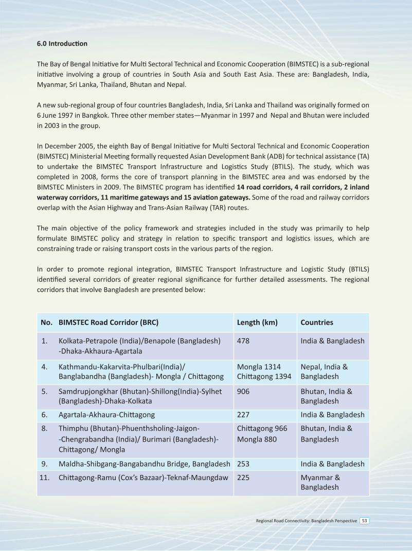
Regional Road Connectivity: Bangladesh Perspective 53
6.0 Introduction
The Bay of Bengal Initiative for Multi Sectoral Technical and Economic Cooperation (BIMSTEC) is a sub-regional initiative involving a group of countries in South Asia and South East Asia. These are: Bangladesh, India, Myanmar, Sri Lanka, Thailand, Bhutan and Nepal.
A new sub-regional group of four countries Bangladesh, India, Sri Lanka and Thailand was originally formed on 6 June 1997 in Bangkok. Three other member states—Myanmar in 1997 and Nepal and Bhutan were included in 2003 in the group.
In December 2005, the eighth Bay of Bengal Initiative for Multi Sectoral Technical and Economic Cooperation (BIMSTEC) Ministerial Meeting formally requested Asian Development Bank (ADB) for technical assistance (TA) to undertake the BIMSTEC Transport Infrastructure and Logistics Study (BTILS). The study, which was completed in 2008, forms the core of transport planning in the BIMSTEC area and was endorsed by the BIMSTEC Ministers in 2009. The BIMSTEC program has identified 14 road corridors, 4 rail corridors, 2 inland waterway corridors, 11 maritime gateways and 15 aviation gateways. Some of the road and railway corridors overlap with the Asian Highway and Trans-Asian Railway (TAR) routes.
The main objective of the policy framework and strategies included in the study was primarily to help formulate BIMSTEC policy and strategy in relation to specific transport and logistics issues, which are constraining trade or raising transport costs in the various parts of the region.
In order to promote regional integration, BIMSTEC Transport Infrastructure and Logistic Study (BTILS) identified several corridors of greater regional significance for further detailed assessments. The regional corridors that involve Bangladesh are presented below:
Corridor 4: Kathmandu-Kakarvita-Phulbari (India)/Banglabandha (Bangladesh)-Mongla/Chittagong
The length of corridor inside Bangladesh is 1,042 km. Following table provides a snapshot of the status of this corridor inside Bangladesh.
The status of different sections on this corridor is presented below:
• Banglabandha-Panchaghar(N5, 53km, Class II). This section was improved with ADB finance in 2011. Considering the traffic growth the feasibility study and detailed design for upgrading this section to a 4-lane highway is carried out by an ADB assisted TA project and the detailed design is expected to be finished by 2018. The investment project to upgrade this section has been included in ADB’s 2018 program.
• Panchagahar-Rangpur (N5, 143km, Class II). Feasibility study and detailed design for upgrading this road section to a 4-lane highway is carried out by an ADB assisted TA project and the detailed design is expected to be finished by 2018. The investment project to upgrade this section has been included in ADB’s 2018 program.
• Rangpur-Hatikamrul (N5, 157km, Class II). The Feasibility Study and Detailed Design for upgrading this section to a 4-Lane highway have been completed with ADB finance. The investment project to upgrade this section has been included in ADB’s 2017 program.
• Hatikamrul-Elenga (N405, 40km, Class II). The Feasibility Study and Detailed Design for upgrading this section to a 4-Lane highway have been completed with ADB finance.
• Elenga-Tangail-Chandra-Joydevpur (N4, 70km, Class II). This section is being upgraded to 4 lane highway under SASEC Road Connectivity Project with ADB finance.
• Joydevpur-Bhulta-Madanpur (N105, 48km, Class II). This section is known as Dhaka Bypass, which is being considered for PPP finance. The PPP office under the Prime Minister’s Office has engaged transaction adviser and feasibility study was completed in July 2014. The RFQ for selecting concessionaire has been issued on October 2015. The road work of this project is expected to be completed by 2020.
• Madanpur-Daudkandi (N1, 18km, Class I). This section has already been upgraded as a 4-lane highway.
• Daudkandi-Chittagong (N1, 194km, Class II). This section is being upgraded under 4-Laning of Dhaka-Chittagong Highway Project and is expected to be opened for traffic soon.
• Chittagong to Chittagong Port (N111, 13 km, Class II). This section was developed to a 2 lane highway
• Nabinagar-Manikgonj-Paturia (N5, 57km, Class II). This section is included under ADB assisted TA project and the detailed design for upgrading to a 4-lane highway is expected to be finished by 2018.
• Paturia-Daulatdia. This section is a missing link. There is a ferry crossing through the Padma River.
• Daulatdia-Magura (N7, 78km, Class II). The feasibility study and detailed design for upgrading this section to a 4-lane highway is not included in any program.
• Magura-Jessore (N702, 43km, Class II). The feasibility study and detailed design for upgrading this section to a 4-lane highway is not included in any program.
• Jessore-Benapole (N706, 38 km, Class II). The feasibility study and detailed design for upgrading this section to a 4-lane highway will be completed with ADB finance by 2018.
Corridor 6: Agartala-Akhaura-Chittagong
The length of corridor inside Bangladesh is 230 km. Following table provides a snapshot of the status of this corridor inside Bangladesh
The status of different sections on this corridor is presented below:
• Senarbadi-Akhaura-Darkhar (Z1202, 15km, below Class II). This section is a district road and it needs improvement. The feasibility study and detailed design for upgrading this section to a 4-lane highway have been completed with ADB finance.
• Darkhar-Mainamati (N102, 51km, Class II). The feasibility study and detailed design for upgrading this section to a 4-lane highway have been completed with ADB finance.
• Mainamati-Feni-Chittagong (N1, 151km, Class I). This section is being upgraded under 4-Laning of Dhaka-Chittagong Highway Project and is expected to be opened for traffic soon.
• Chittagong-Chittagong Port (N1, 13km, Class II). This section was developed to a 2 lane highway with ADB finance in 2006. Considering the traffic growth the feasibility study and detailed design for upgrading this section to a 4-lane highway is being carried out by an ADB assisted TA project and the detailed design is expected to be finished by 2018.
No. BIMSTEC Road Corridor (BRC) Length (km) Countries
1. Kolkata-Petrapole (India)/Benapole (Bangladesh) 478 India & Bangladesh -Dhaka-Akhaura-Agartala
4. Kathmandu-Kakarvita-Phulbari(India)/ Mongla 1314 Nepal, India & Banglabandha (Bangladesh)- Mongla / Chittagong Chittagong 1394 Bangladesh
5. Samdrupjongkhar (Bhutan)-Shillong(India)-Sylhet 906 Bhutan, India & (Bangladesh)-Dhaka-Kolkata Bangladesh
6. Agartala-Akhaura-Chittagong 227 India & Bangladesh 8. Thimphu (Bhutan)-Phuenthsholing-Jaigon- Chittagong 966 Bhutan, India & -Chengrabandha (India)/ Burimari (Bangladesh)- Mongla 880 Bangladesh Chittagong/ Mongla
9. Maldha-Shibgang-Bangabandhu Bridge, Bangladesh 253 India & Bangladesh 11. Chittagong-Ramu (Cox’s Bazaar)-Teknaf-Maungdaw 225 Myanmar & Bangladesh
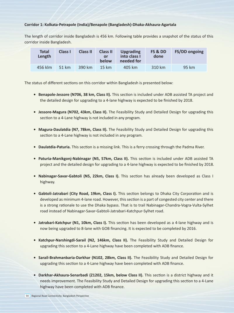
Regional Road Connectivity: Bangladesh Perspective54
Corridor 1: Kolkata-Petrapole (India)/Benapole (Bangladesh)-Dhaka-Akhaura-Agartala
The length of corridor inside Bangladesh is 456 km. Following table provides a snapshot of the status of this corridor inside Bangladesh.
The status of different sections on this corridor within Bangladesh is presented below:
• Benapole-Jessore (N706, 38 km, Class II). This section is included under ADB assisted TA project and the detailed design for upgrading to a 4-lane highway is expected to be finished by 2018.
• Jessore-Magura (N702, 43km, Class II). The Feasibility Study and Detailed Design for upgrading this section to a 4-Lane highway is not included in any program.
• Magura-Daulatdia (N7, 78km, Class II). The Feasibility Study and Detailed Design for upgrading this section to a 4-Lane highway is not included in any program.
• Daulatdia-Paturia. This section is a missing link. This is a ferry crossing through the Padma River.
• Paturia-Manikgonj-Nabinagar (N5, 57km, Class II). This section is included under ADB assisted TA project and the detailed design for upgrading to a 4-lane highway is expected to be finished by 2018.
• Nabinagar-Savar-Gabtoli (N5, 22km, Class I). This section has already been developed as Class I highway.
• Gabtoli-Jatrabari (City Road, 19km, Class I). This section belongs to Dhaka City Corporation and is developed as minimum 4-lane road. However, this section is a part of congested city center and there is a strong rationale to use the Dhaka bypass. That is to trail Nabinagar-Chandra-Vogra-Vulta-Sylhet road instead of Nabinagar-Savar-Gabtoli-Jatrabari-Katchpur-Sylhet road.
• Jatrabari-Katchpur (N1, 10km, Class I). This section has been developed as a 4-lane highway and is now being upgraded to 8-lane with GOB financing. It is expected to be completed by 2016.
• Katchpur-Narshingdi-Sarail (N2, 146km, Class II). The Feasibility Study and Detailed Design for upgrading this section to a 4-Lane highway have been completed with ADB finance.
• Sarail-Brahmanbaria-Darkhar (N102, 28km, Class II). The Feasibility Study and Detailed Design for upgrading this section to a 4-Lane highway have been completed with ADB finance.
• Darkhar-Akhaura-Senarbadi (Z1202, 15km, below Class II). This section is a district highway and it needs improvement. The Feasibility Study and Detailed Design for upgrading this section to a 4-Lane highway have been completed with ADB finance.
Corridor 4: Kathmandu-Kakarvita-Phulbari (India)/Banglabandha (Bangladesh)-Mongla/Chittagong
The length of corridor inside Bangladesh is 1,042 km. Following table provides a snapshot of the status of this corridor inside Bangladesh.
The status of different sections on this corridor is presented below:
• Banglabandha-Panchaghar(N5, 53km, Class II). This section was improved with ADB finance in 2011. Considering the traffic growth the feasibility study and detailed design for upgrading this section to a 4-lane highway is carried out by an ADB assisted TA project and the detailed design is expected to be finished by 2018. The investment project to upgrade this section has been included in ADB’s 2018 program.
• Panchagahar-Rangpur (N5, 143km, Class II). Feasibility study and detailed design for upgrading this road section to a 4-lane highway is carried out by an ADB assisted TA project and the detailed design is expected to be finished by 2018. The investment project to upgrade this section has been included in ADB’s 2018 program.
• Rangpur-Hatikamrul (N5, 157km, Class II). The Feasibility Study and Detailed Design for upgrading this section to a 4-Lane highway have been completed with ADB finance. The investment project to upgrade this section has been included in ADB’s 2017 program.
• Hatikamrul-Elenga (N405, 40km, Class II). The Feasibility Study and Detailed Design for upgrading this section to a 4-Lane highway have been completed with ADB finance.
• Elenga-Tangail-Chandra-Joydevpur (N4, 70km, Class II). This section is being upgraded to 4 lane highway under SASEC Road Connectivity Project with ADB finance.
• Joydevpur-Bhulta-Madanpur (N105, 48km, Class II). This section is known as Dhaka Bypass, which is being considered for PPP finance. The PPP office under the Prime Minister’s Office has engaged transaction adviser and feasibility study was completed in July 2014. The RFQ for selecting concessionaire has been issued on October 2015. The road work of this project is expected to be completed by 2020.
• Madanpur-Daudkandi (N1, 18km, Class I). This section has already been upgraded as a 4-lane highway.
• Daudkandi-Chittagong (N1, 194km, Class II). This section is being upgraded under 4-Laning of Dhaka-Chittagong Highway Project and is expected to be opened for traffic soon.
• Chittagong to Chittagong Port (N111, 13 km, Class II). This section was developed to a 2 lane highway
• Nabinagar-Manikgonj-Paturia (N5, 57km, Class II). This section is included under ADB assisted TA project and the detailed design for upgrading to a 4-lane highway is expected to be finished by 2018.
• Paturia-Daulatdia. This section is a missing link. There is a ferry crossing through the Padma River.
• Daulatdia-Magura (N7, 78km, Class II). The feasibility study and detailed design for upgrading this section to a 4-lane highway is not included in any program.
• Magura-Jessore (N702, 43km, Class II). The feasibility study and detailed design for upgrading this section to a 4-lane highway is not included in any program.
• Jessore-Benapole (N706, 38 km, Class II). The feasibility study and detailed design for upgrading this section to a 4-lane highway will be completed with ADB finance by 2018.
Corridor 6: Agartala-Akhaura-Chittagong
The length of corridor inside Bangladesh is 230 km. Following table provides a snapshot of the status of this corridor inside Bangladesh
The status of different sections on this corridor is presented below:
• Senarbadi-Akhaura-Darkhar (Z1202, 15km, below Class II). This section is a district road and it needs improvement. The feasibility study and detailed design for upgrading this section to a 4-lane highway have been completed with ADB finance.
• Darkhar-Mainamati (N102, 51km, Class II). The feasibility study and detailed design for upgrading this section to a 4-lane highway have been completed with ADB finance.
• Mainamati-Feni-Chittagong (N1, 151km, Class I). This section is being upgraded under 4-Laning of Dhaka-Chittagong Highway Project and is expected to be opened for traffic soon.
• Chittagong-Chittagong Port (N1, 13km, Class II). This section was developed to a 2 lane highway with ADB finance in 2006. Considering the traffic growth the feasibility study and detailed design for upgrading this section to a 4-lane highway is being carried out by an ADB assisted TA project and the detailed design is expected to be finished by 2018.
TotalLength
Class I Class II Class IIor
below
Upgrading into class I needed for
FS & DD done
FS/DD ongoing
456 klm 51 km 390 km 15 km 405 km 310 km 95 km
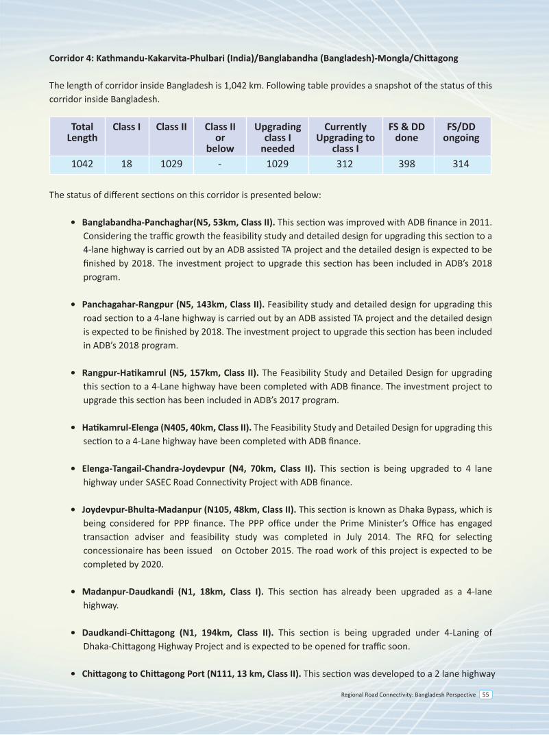
Regional Road Connectivity: Bangladesh Perspective 55
Corridor 4: Kathmandu-Kakarvita-Phulbari (India)/Banglabandha (Bangladesh)-Mongla/Chittagong
The length of corridor inside Bangladesh is 1,042 km. Following table provides a snapshot of the status of this corridor inside Bangladesh.
The status of different sections on this corridor is presented below:
• Banglabandha-Panchaghar(N5, 53km, Class II). This section was improved with ADB finance in 2011. Considering the traffic growth the feasibility study and detailed design for upgrading this section to a 4-lane highway is carried out by an ADB assisted TA project and the detailed design is expected to be finished by 2018. The investment project to upgrade this section has been included in ADB’s 2018 program.
• Panchagahar-Rangpur (N5, 143km, Class II). Feasibility study and detailed design for upgrading this road section to a 4-lane highway is carried out by an ADB assisted TA project and the detailed design is expected to be finished by 2018. The investment project to upgrade this section has been included in ADB’s 2018 program.
• Rangpur-Hatikamrul (N5, 157km, Class II). The Feasibility Study and Detailed Design for upgrading this section to a 4-Lane highway have been completed with ADB finance. The investment project to upgrade this section has been included in ADB’s 2017 program.
• Hatikamrul-Elenga (N405, 40km, Class II). The Feasibility Study and Detailed Design for upgrading this section to a 4-Lane highway have been completed with ADB finance.
• Elenga-Tangail-Chandra-Joydevpur (N4, 70km, Class II). This section is being upgraded to 4 lane highway under SASEC Road Connectivity Project with ADB finance.
• Joydevpur-Bhulta-Madanpur (N105, 48km, Class II). This section is known as Dhaka Bypass, which is being considered for PPP finance. The PPP office under the Prime Minister’s Office has engaged transaction adviser and feasibility study was completed in July 2014. The RFQ for selecting concessionaire has been issued on October 2015. The road work of this project is expected to be completed by 2020.
• Madanpur-Daudkandi (N1, 18km, Class I). This section has already been upgraded as a 4-lane highway.
• Daudkandi-Chittagong (N1, 194km, Class II). This section is being upgraded under 4-Laning of Dhaka-Chittagong Highway Project and is expected to be opened for traffic soon.
• Chittagong to Chittagong Port (N111, 13 km, Class II). This section was developed to a 2 lane highway
• Nabinagar-Manikgonj-Paturia (N5, 57km, Class II). This section is included under ADB assisted TA project and the detailed design for upgrading to a 4-lane highway is expected to be finished by 2018.
• Paturia-Daulatdia. This section is a missing link. There is a ferry crossing through the Padma River.
• Daulatdia-Magura (N7, 78km, Class II). The feasibility study and detailed design for upgrading this section to a 4-lane highway is not included in any program.
• Magura-Jessore (N702, 43km, Class II). The feasibility study and detailed design for upgrading this section to a 4-lane highway is not included in any program.
• Jessore-Benapole (N706, 38 km, Class II). The feasibility study and detailed design for upgrading this section to a 4-lane highway will be completed with ADB finance by 2018.
Corridor 6: Agartala-Akhaura-Chittagong
The length of corridor inside Bangladesh is 230 km. Following table provides a snapshot of the status of this corridor inside Bangladesh
The status of different sections on this corridor is presented below:
• Senarbadi-Akhaura-Darkhar (Z1202, 15km, below Class II). This section is a district road and it needs improvement. The feasibility study and detailed design for upgrading this section to a 4-lane highway have been completed with ADB finance.
• Darkhar-Mainamati (N102, 51km, Class II). The feasibility study and detailed design for upgrading this section to a 4-lane highway have been completed with ADB finance.
• Mainamati-Feni-Chittagong (N1, 151km, Class I). This section is being upgraded under 4-Laning of Dhaka-Chittagong Highway Project and is expected to be opened for traffic soon.
• Chittagong-Chittagong Port (N1, 13km, Class II). This section was developed to a 2 lane highway with ADB finance in 2006. Considering the traffic growth the feasibility study and detailed design for upgrading this section to a 4-lane highway is being carried out by an ADB assisted TA project and the detailed design is expected to be finished by 2018.
TotalLength
Class I Class II Class IIor
below
Currently Upgrading to
class I
Upgradingclass I
needed
FS & DD done
FS/DDongoing
1042 18 1029 312 3143981029-
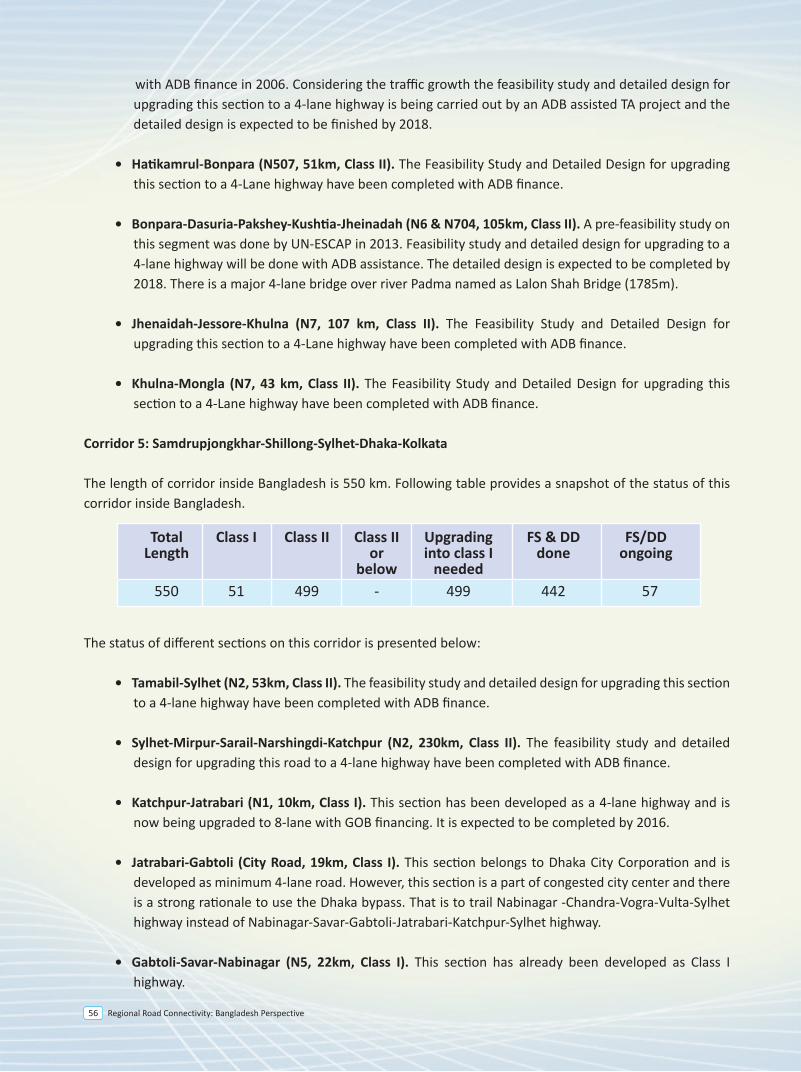
Regional Road Connectivity: Bangladesh Perspective56
Corridor 4: Kathmandu-Kakarvita-Phulbari (India)/Banglabandha (Bangladesh)-Mongla/Chittagong
The length of corridor inside Bangladesh is 1,042 km. Following table provides a snapshot of the status of this corridor inside Bangladesh.
The status of different sections on this corridor is presented below:
• Banglabandha-Panchaghar(N5, 53km, Class II). This section was improved with ADB finance in 2011. Considering the traffic growth the feasibility study and detailed design for upgrading this section to a 4-lane highway is carried out by an ADB assisted TA project and the detailed design is expected to be finished by 2018. The investment project to upgrade this section has been included in ADB’s 2018 program.
• Panchagahar-Rangpur (N5, 143km, Class II). Feasibility study and detailed design for upgrading this road section to a 4-lane highway is carried out by an ADB assisted TA project and the detailed design is expected to be finished by 2018. The investment project to upgrade this section has been included in ADB’s 2018 program.
• Rangpur-Hatikamrul (N5, 157km, Class II). The Feasibility Study and Detailed Design for upgrading this section to a 4-Lane highway have been completed with ADB finance. The investment project to upgrade this section has been included in ADB’s 2017 program.
• Hatikamrul-Elenga (N405, 40km, Class II). The Feasibility Study and Detailed Design for upgrading this section to a 4-Lane highway have been completed with ADB finance.
• Elenga-Tangail-Chandra-Joydevpur (N4, 70km, Class II). This section is being upgraded to 4 lane highway under SASEC Road Connectivity Project with ADB finance.
• Joydevpur-Bhulta-Madanpur (N105, 48km, Class II). This section is known as Dhaka Bypass, which is being considered for PPP finance. The PPP office under the Prime Minister’s Office has engaged transaction adviser and feasibility study was completed in July 2014. The RFQ for selecting concessionaire has been issued on October 2015. The road work of this project is expected to be completed by 2020.
• Madanpur-Daudkandi (N1, 18km, Class I). This section has already been upgraded as a 4-lane highway.
• Daudkandi-Chittagong (N1, 194km, Class II). This section is being upgraded under 4-Laning of Dhaka-Chittagong Highway Project and is expected to be opened for traffic soon.
• Chittagong to Chittagong Port (N111, 13 km, Class II). This section was developed to a 2 lane highway
with ADB finance in 2006. Considering the traffic growth the feasibility study and detailed design for upgrading this section to a 4-lane highway is being carried out by an ADB assisted TA project and the detailed design is expected to be finished by 2018.
• Hatikamrul-Bonpara (N507, 51km, Class II). The Feasibility Study and Detailed Design for upgrading this section to a 4-Lane highway have been completed with ADB finance.
• Bonpara-Dasuria-Pakshey-Kushtia-Jheinadah (N6 & N704, 105km, Class II). A pre-feasibility study on this segment was done by UN-ESCAP in 2013. Feasibility study and detailed design for upgrading to a 4-lane highway will be done with ADB assistance. The detailed design is expected to be completed by 2018. There is a major 4-lane bridge over river Padma named as Lalon Shah Bridge (1785m).
• Jhenaidah-Jessore-Khulna (N7, 107 km, Class II). The Feasibility Study and Detailed Design for upgrading this section to a 4-Lane highway have been completed with ADB finance.
• Khulna-Mongla (N7, 43 km, Class II). The Feasibility Study and Detailed Design for upgrading this section to a 4-Lane highway have been completed with ADB finance.
Corridor 5: Samdrupjongkhar-Shillong-Sylhet-Dhaka-Kolkata The length of corridor inside Bangladesh is 550 km. Following table provides a snapshot of the status of this corridor inside Bangladesh.
The status of different sections on this corridor is presented below:
• Tamabil-Sylhet (N2, 53km, Class II). The feasibility study and detailed design for upgrading this section to a 4-lane highway have been completed with ADB finance.
• Sylhet-Mirpur-Sarail-Narshingdi-Katchpur (N2, 230km, Class II). The feasibility study and detailed design for upgrading this road to a 4-lane highway have been completed with ADB finance.
• Katchpur-Jatrabari (N1, 10km, Class I). This section has been developed as a 4-lane highway and is now being upgraded to 8-lane with GOB financing. It is expected to be completed by 2016.
• Jatrabari-Gabtoli (City Road, 19km, Class I). This section belongs to Dhaka City Corporation and is developed as minimum 4-lane road. However, this section is a part of congested city center and there is a strong rationale to use the Dhaka bypass. That is to trail Nabinagar -Chandra-Vogra-Vulta-Sylhet highway instead of Nabinagar-Savar-Gabtoli-Jatrabari-Katchpur-Sylhet highway.
• Gabtoli-Savar-Nabinagar (N5, 22km, Class I). This section has already been developed as Class I highway.
• Nabinagar-Manikgonj-Paturia (N5, 57km, Class II). This section is included under ADB assisted TA project and the detailed design for upgrading to a 4-lane highway is expected to be finished by 2018.
• Paturia-Daulatdia. This section is a missing link. There is a ferry crossing through the Padma River.
• Daulatdia-Magura (N7, 78km, Class II). The feasibility study and detailed design for upgrading this section to a 4-lane highway is not included in any program.
• Magura-Jessore (N702, 43km, Class II). The feasibility study and detailed design for upgrading this section to a 4-lane highway is not included in any program.
• Jessore-Benapole (N706, 38 km, Class II). The feasibility study and detailed design for upgrading this section to a 4-lane highway will be completed with ADB finance by 2018.
Corridor 6: Agartala-Akhaura-Chittagong
The length of corridor inside Bangladesh is 230 km. Following table provides a snapshot of the status of this corridor inside Bangladesh
The status of different sections on this corridor is presented below:
• Senarbadi-Akhaura-Darkhar (Z1202, 15km, below Class II). This section is a district road and it needs improvement. The feasibility study and detailed design for upgrading this section to a 4-lane highway have been completed with ADB finance.
• Darkhar-Mainamati (N102, 51km, Class II). The feasibility study and detailed design for upgrading this section to a 4-lane highway have been completed with ADB finance.
• Mainamati-Feni-Chittagong (N1, 151km, Class I). This section is being upgraded under 4-Laning of Dhaka-Chittagong Highway Project and is expected to be opened for traffic soon.
• Chittagong-Chittagong Port (N1, 13km, Class II). This section was developed to a 2 lane highway with ADB finance in 2006. Considering the traffic growth the feasibility study and detailed design for upgrading this section to a 4-lane highway is being carried out by an ADB assisted TA project and the detailed design is expected to be finished by 2018.
TotalLength
Class I Class II Class IIor
below
Upgrading into class I
needed
FS & DD done
FS/DDongoing
550 51 499 - 499 442 57
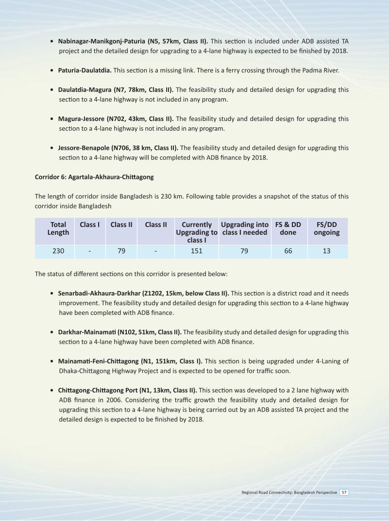
Regional Road Connectivity: Bangladesh Perspective 57
Corridor 4: Kathmandu-Kakarvita-Phulbari (India)/Banglabandha (Bangladesh)-Mongla/Chittagong
The length of corridor inside Bangladesh is 1,042 km. Following table provides a snapshot of the status of this corridor inside Bangladesh.
The status of different sections on this corridor is presented below:
• Banglabandha-Panchaghar(N5, 53km, Class II). This section was improved with ADB finance in 2011. Considering the traffic growth the feasibility study and detailed design for upgrading this section to a 4-lane highway is carried out by an ADB assisted TA project and the detailed design is expected to be finished by 2018. The investment project to upgrade this section has been included in ADB’s 2018 program.
• Panchagahar-Rangpur (N5, 143km, Class II). Feasibility study and detailed design for upgrading this road section to a 4-lane highway is carried out by an ADB assisted TA project and the detailed design is expected to be finished by 2018. The investment project to upgrade this section has been included in ADB’s 2018 program.
• Rangpur-Hatikamrul (N5, 157km, Class II). The Feasibility Study and Detailed Design for upgrading this section to a 4-Lane highway have been completed with ADB finance. The investment project to upgrade this section has been included in ADB’s 2017 program.
• Hatikamrul-Elenga (N405, 40km, Class II). The Feasibility Study and Detailed Design for upgrading this section to a 4-Lane highway have been completed with ADB finance.
• Elenga-Tangail-Chandra-Joydevpur (N4, 70km, Class II). This section is being upgraded to 4 lane highway under SASEC Road Connectivity Project with ADB finance.
• Joydevpur-Bhulta-Madanpur (N105, 48km, Class II). This section is known as Dhaka Bypass, which is being considered for PPP finance. The PPP office under the Prime Minister’s Office has engaged transaction adviser and feasibility study was completed in July 2014. The RFQ for selecting concessionaire has been issued on October 2015. The road work of this project is expected to be completed by 2020.
• Madanpur-Daudkandi (N1, 18km, Class I). This section has already been upgraded as a 4-lane highway.
• Daudkandi-Chittagong (N1, 194km, Class II). This section is being upgraded under 4-Laning of Dhaka-Chittagong Highway Project and is expected to be opened for traffic soon.
• Chittagong to Chittagong Port (N111, 13 km, Class II). This section was developed to a 2 lane highway
• Nabinagar-Manikgonj-Paturia (N5, 57km, Class II). This section is included under ADB assisted TA project and the detailed design for upgrading to a 4-lane highway is expected to be finished by 2018.
• Paturia-Daulatdia. This section is a missing link. There is a ferry crossing through the Padma River.
• Daulatdia-Magura (N7, 78km, Class II). The feasibility study and detailed design for upgrading this section to a 4-lane highway is not included in any program.
• Magura-Jessore (N702, 43km, Class II). The feasibility study and detailed design for upgrading this section to a 4-lane highway is not included in any program.
• Jessore-Benapole (N706, 38 km, Class II). The feasibility study and detailed design for upgrading this section to a 4-lane highway will be completed with ADB finance by 2018.
Corridor 6: Agartala-Akhaura-Chittagong
The length of corridor inside Bangladesh is 230 km. Following table provides a snapshot of the status of this corridor inside Bangladesh
The status of different sections on this corridor is presented below:
• Senarbadi-Akhaura-Darkhar (Z1202, 15km, below Class II). This section is a district road and it needs improvement. The feasibility study and detailed design for upgrading this section to a 4-lane highway have been completed with ADB finance.
• Darkhar-Mainamati (N102, 51km, Class II). The feasibility study and detailed design for upgrading this section to a 4-lane highway have been completed with ADB finance.
• Mainamati-Feni-Chittagong (N1, 151km, Class I). This section is being upgraded under 4-Laning of Dhaka-Chittagong Highway Project and is expected to be opened for traffic soon.
• Chittagong-Chittagong Port (N1, 13km, Class II). This section was developed to a 2 lane highway with ADB finance in 2006. Considering the traffic growth the feasibility study and detailed design for upgrading this section to a 4-lane highway is being carried out by an ADB assisted TA project and the detailed design is expected to be finished by 2018.
TotalLength
Class I Class II Class II Upgrading into class I needed
Currently Upgrading to
class I
FS & DD done
FS/DDongoing
230 - 79 - 151 79 1366
Regional Road Connectivity: Bangladesh Perspective58
Corridor 4: Kathmandu-Kakarvita-Phulbari (India)/Banglabandha (Bangladesh)-Mongla/Chittagong
The length of corridor inside Bangladesh is 1,042 km. Following table provides a snapshot of the status of this corridor inside Bangladesh.
The status of different sections on this corridor is presented below:
• Banglabandha-Panchaghar(N5, 53km, Class II). This section was improved with ADB finance in 2011. Considering the traffic growth the feasibility study and detailed design for upgrading this section to a 4-lane highway is carried out by an ADB assisted TA project and the detailed design is expected to be finished by 2018. The investment project to upgrade this section has been included in ADB’s 2018 program.
• Panchagahar-Rangpur (N5, 143km, Class II). Feasibility study and detailed design for upgrading this road section to a 4-lane highway is carried out by an ADB assisted TA project and the detailed design is expected to be finished by 2018. The investment project to upgrade this section has been included in ADB’s 2018 program.
• Rangpur-Hatikamrul (N5, 157km, Class II). The Feasibility Study and Detailed Design for upgrading this section to a 4-Lane highway have been completed with ADB finance. The investment project to upgrade this section has been included in ADB’s 2017 program.
• Hatikamrul-Elenga (N405, 40km, Class II). The Feasibility Study and Detailed Design for upgrading this section to a 4-Lane highway have been completed with ADB finance.
• Elenga-Tangail-Chandra-Joydevpur (N4, 70km, Class II). This section is being upgraded to 4 lane highway under SASEC Road Connectivity Project with ADB finance.
• Joydevpur-Bhulta-Madanpur (N105, 48km, Class II). This section is known as Dhaka Bypass, which is being considered for PPP finance. The PPP office under the Prime Minister’s Office has engaged transaction adviser and feasibility study was completed in July 2014. The RFQ for selecting concessionaire has been issued on October 2015. The road work of this project is expected to be completed by 2020.
• Madanpur-Daudkandi (N1, 18km, Class I). This section has already been upgraded as a 4-lane highway.
• Daudkandi-Chittagong (N1, 194km, Class II). This section is being upgraded under 4-Laning of Dhaka-Chittagong Highway Project and is expected to be opened for traffic soon.
• Chittagong to Chittagong Port (N111, 13 km, Class II). This section was developed to a 2 lane highway
• Nabinagar-Manikgonj-Paturia (N5, 57km, Class II). This section is included under ADB assisted TA project and the detailed design for upgrading to a 4-lane highway is expected to be finished by 2018.
• Paturia-Daulatdia. This section is a missing link. There is a ferry crossing through the Padma River.
• Daulatdia-Magura (N7, 78km, Class II). The feasibility study and detailed design for upgrading this section to a 4-lane highway is not included in any program.
• Magura-Jessore (N702, 43km, Class II). The feasibility study and detailed design for upgrading this section to a 4-lane highway is not included in any program.
• Jessore-Benapole (N706, 38 km, Class II). The feasibility study and detailed design for upgrading this section to a 4-lane highway will be completed with ADB finance by 2018.
Corridor 6: Agartala-Akhaura-Chittagong
The length of corridor inside Bangladesh is 230 km. Following table provides a snapshot of the status of this corridor inside Bangladesh
The status of different sections on this corridor is presented below:
• Senarbadi-Akhaura-Darkhar (Z1202, 15km, below Class II). This section is a district road and it needs improvement. The feasibility study and detailed design for upgrading this section to a 4-lane highway have been completed with ADB finance.
• Darkhar-Mainamati (N102, 51km, Class II). The feasibility study and detailed design for upgrading this section to a 4-lane highway have been completed with ADB finance.
• Mainamati-Feni-Chittagong (N1, 151km, Class I). This section is being upgraded under 4-Laning of Dhaka-Chittagong Highway Project and is expected to be opened for traffic soon.
• Chittagong-Chittagong Port (N1, 13km, Class II). This section was developed to a 2 lane highway with ADB finance in 2006. Considering the traffic growth the feasibility study and detailed design for upgrading this section to a 4-lane highway is being carried out by an ADB assisted TA project and the detailed design is expected to be finished by 2018.
Corridor 8: Thimphu-Phuenthsholing-Jaigon-Chengrabandha-Burimari-Chittagong/ Mongla
The status of different sections on this corridor is presented below:
• Burimari-Lalmonirhat-Rangpur (N506, 138km, Class II). The feasibility study and detailed design for upgrading this section to a 4-lane highway have been completed with ADB finance. The investment project to upgrade this section has been included in ADB’s 2018 program.
• Teesta Bridge (0.98 km). The recently completed 2-lane Teesta Bridge over the Teesta River under KFAED Finance will provide an uninterrupted traffic movement between Rangpur and Burimari Dry Port. An additional 2-lane bridge with two-way SMVT at the right side of the bridge towards North has been designed with ADB finance.
The remaining sections of this corridor are the same as those mentioned for corridor 2.
Corridor 9: Maldha-Shibganj-Bangabandhu Bridge (Jamuna Bridge)
All the following sections of this corridor have been studied under Sub regional Road Transport Project Preparatory Facility with ADB financing. The feasibility study and detailed design is completed.
• Sonamashjid-Kansat-Salimabad (Z6801, 17km, Class II) • Salimabad-Rasulpur (Z6816, 4.6 km, Class II)• Rasulpur-Barogahira-Nawabganj (Z6801, 16km, Class II)• Nawabganj-Rajshahi (R680, 57.5km, Class II)• Kashidanga-Belpukur (Rajshahi Bypass) (N603, 21km, Class II)• Belpukur-ChawkBidaynath (N6, 26km, Class II)• ChawkBidaynath-Harispur (Natore Bypass) (N602, 5.5 km, Class II)• Harispur-Banpara (N6, 17km, Class II)• Banpara-Hatikamrul (N507, km, Class II)• Hatikamrul-Bangabandhu Bridge (N405, km, Class II)
Corridor 11: Chittagong-Ramu (Cox’s Bazaar)-Teknaf (Bangladesh)/Maungdaw (Myanmar)
The status of this corridor within Bangladesh is presented below:
Chittagong-Keranirhat-Cox’s Bazaar-Teknaf (N1, 228km, Class II). The Feasibility Study and Detailed Design for upgrading this section to a 4-Lane highway have been completed with ADB finance. JICA has recently shown its interest to finance upgrading Chittagong-Cox’s Bazar section. Government of Bangladesh and JICA signed a Minutes of Discussion on 20 August 2014 to include this road stretch in the Cross-border Road Network Improvement Project which is expected to be financed by JICA.
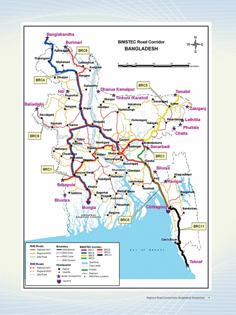
Regional Road Connectivity: Bangladesh Perspective 59
BBIN Motor Vehicles Agreement
7
Regional Road Connectivity: Bangladesh Perspective 63
7.0 Background
A sub-regional meeting of the Secretaries of Transport of Bangladesh, Bhutan, India, and Nepal (BBIN) on Road Transport Connectivity was held in Kolkata, India on 2-3 February 2015. The objectives of the Meeting were to (i) reach consensus on a draft framework agreement titled, “Motor Vehicles Agreement (MVA) for the Regulation of Passenger, Personal, and Cargo Vehicular Traffic Between Bangladesh, Bhutan, India, and Nepal”, (ii) discuss and make recommendations to the BBIN Transport Ministers on general approaches to implementing the MVA and broad institutional arrangements, and (iii) discuss a road map of future sub-regional road projects in the BBIN countries.
Building on the progress made in negotiating and finalizing the SAARC Motor Vehicles Agreement, the MVA was drafted to facilitate cross-border transport between the four countries. The delegations gave their comments on the draft MVA, which were duly incorporated. They agreed that the text so finalized would be recommended to the Transport Ministers for consideration. They further recommended to propose the convening of a meeting of the Transport Ministers of the BBIN countries to, among other things, serve as a forum to sign the MVA and to reach agreement on the implementation and institutional mechanisms for the MVA.
The delegations considered a proposed general approach to finalizing and implementing the MVA. They agreed on an indicative road map of customizing and finalizing the MVA by next three months, formalizing the MVA by six months, and implementing it by 12 months. It was recognized that the MVA is a framework Agreement. Its implementation details, including, inter alia, customs formalities, routes of application, traffic volume, applicable fees and charges, and local permits will have to be set out in detailed bilateral, and, possibly plurilateral arrangements or protocols.
The delegations considered possible institutional structures for implementing and monitoring the MVA. They agreed to recommend (i) to establish National Land Transport Facilitation Committee, or its equivalent, in each of the countries, whose primary purpose is to coordinate, implement, and monitor the MVA; and (ii) to establish a Joint Land Transport Facilitation Committee (JLTFC) to monitor and assess the functioning of the MVA. The JLTFC will be composed of the heads or chairs of the National Land Transport Facilitation Committees and may co-opt other entities as may be required. They further agreed to request the ADB to, in the interim, continue providing coordination, technical, and financial support in implementing the MVA.
7.1 BBIN Initiatives
Motor Vehicles Agreement for the Regulation of Passenger, Personal and Cargo Vehicular Traffic between Bangladesh, Bhutan, India, And Nepal (BBIN MVA) was signed in the BBIN Transport Ministers Meeting on 15 June 2015 in Thimphu, Bhutan.
The Meeting recognized the need to accelerate cross-border transport facilitation to deepen and enhance regional integration. The Ministerial statement mentioned that the finalization of the BBIN MVA would allow moving forward, in an accelerated fashion, with implementation of land transport facilitation arrangements between and among these countries. This, in turn, would enable the exchange of traffic rights and ease cross-border movement of goods, vehicles and people, thereby helping expand people-to-people contact, trade, and economic exchanges among the countries. In that Ministerial statement it was endeavored to accelerate the preparatory steps for the effective and sustainable implementation of the BBIN MVA, starting with the formulation, negotiation, and finalization of the necessary legal instruments and operating procedures.
Bangladesh – India - Nepal
1. Dhaka-Banglabandha/Fulbari-Siliguri-Panitanki/Kakarvita-Kathmandu2. Kathmandu-Kakarvita/Panitanki-Siliguri-Chengrabandha/Burimari-Dhaka
Bangladesh – India - Bhutan
1. Dhaka-Burimari/Chengrabandha-Jaigaon/Phuentsholing-Thimphu2. Dhaka-Tamabil/Dawki-Guwahati/Samdrukzongkhar-
India - Nepal
1. Siliguri-Panitanki/Kakarvita-Kathmandu
India - Bhutan
1. Siliguri-Jaigaon/Phuentsholing-Thimphu2. Gelephu-Bangaigaon3. Guwahati-Samdrukzongkhar
Nepal-Bhutan
1. [Kathmandu-Kakarvita/Panitanki-Siliguri-Jaigaon/Phuentsholing-Thimpu] Proposed by Nepal and Bhutan will discuss the offer further.
The following routes were identified for Cargo Vehicles
Bhutan
1. Phuentsholing/ Jaigaon- Chengrabandha/Burimari-Dhaka Next phase-1. Samdrupjongkhar- Dawki/Tamabil- Dhaka2. Gelaphu- Dawki/Tamabil- Nakugaon-Dhaka3. Samtse-Chamarchi- Chengrabandha/Burimari
Bangladesh
1. Teknaf - Cox Bazaar - Chittagong - Dhaka - Hatikamrul - Rangpur - Burimari/ Chengrabandha - Jaigaon /Phuentsholing - Thimphu
2. Mongla - Khulna - Jessore - Kushthia - Hatikamrul - Rangpur - Burimari / Chengrabandha - Jaigaon / Phuentsholing - Thimphu
3. Teknaf - Cox Bazaar - Chittagong - Dhaka - Hatikamrul - Rangpur - Banglabandha / Phulbari - Panitanki / Kakarvita - Kathmandu
4. Mongla - Khulna - Jessore - Kushthia - Hatikamrul - Rangpur - Banglabandha/ Phulbari - Panitanki/ Kakarvita - Kathmandu
According to Article XVI of the Agreement, Bangladesh, India and Nepal have ratified the BBIN MVA for making it enforceable. Bhutan is yet to ratify the Agreement due to the Parliamentary procedure But the Government of Bhutan is hopeful about the ratification in the next Parliament session. In line with the decision of the first negotiation meeting in Dhaka during 08-09 September 2015, a Workshop on online tracking system for all kinds of vehicle under the BBIN MVA was held at Kolkata, India on 3-4 December, 2015. To finalize the passengers’ protocol and commence the preparations of Cargo Protocol, the second negotiation meeting is scheduled to be held in Dhaka on 29-30 March 2016.
7.6 Status of BBIN routes inside Bangladesh
7.6.1 Status of Passenger routes
Bangladesh is related to a total of 9 passenger routes of which 5 are connected with India, 2 with India and Nepal and 2 with India and Bhutan. Current status of each route is described in the subsequent sections:
A. Routes between Bangladesh-India
1. Khulna-Jessore-Benapole/Petrapole-Kolkata
The route coincide with SASEC Corridor 5A inside Bangladesh
• Benapole-Jessore (N706, 38 km, Class II). The Feasibility Study and Detailed Design for upgrading this section to a 4-Lane highway will be completed with ADB finance by 2018
• Jessore-Khulna (N7, 60 km, Class II). The Feasibility Study and Detailed Design for upgrading this section to a 4-Lane highway have been completed with ADB finance.
2. Chittagong- Dhaka- Banglabandha/Fulbari-Siliguri
The route inside Bangladesh is similar to SASEC Corridor 9 as mentioned in section 7.5.2.of SASEC chapter.
3. Chittagong- Dhaka- Burimari/Chengrabandha-Siliguri
The route inside Bangladesh is similar SASEC Corridor 4 mentioned in section 7.5.2.of SASEC chapter.
4. Chittagong- Dhaka- Benapole/Petrapole-Kolkata
Chittagong-Dhaka is aligned with SASEC 4/9 corridor as mentioned in section 7.5.2 of SASEC chapter. Dhaka-Kolkata route is aligned with SAARC Highway Corridor 1 as mentioned in section 6.2 of SAARC chapter.
5. Guwahati-Shillong-Dawki/Tamabil-Dhaka-Benapole/Petrapole-Kolkata
This route coincides mostly with Asian Highway-1 (AH1) inside Bangladesh. The most of the road sections along this route is 2-lane with some 4-lane sections in urban areas and bazaar location. There are currently two missing links in this corridor: (a) the Padma Bridge gap at Bhanga and (b) Kalna Bridge gap at Bhatiapara. In addition, there is one sub-standard section between Bhatiapara-Narail-Jessore (bellow AH standard II, See Table 1).
Regional Road Connectivity: Bangladesh Perspective64
7.0 Background
A sub-regional meeting of the Secretaries of Transport of Bangladesh, Bhutan, India, and Nepal (BBIN) on Road Transport Connectivity was held in Kolkata, India on 2-3 February 2015. The objectives of the Meeting were to (i) reach consensus on a draft framework agreement titled, “Motor Vehicles Agreement (MVA) for the Regulation of Passenger, Personal, and Cargo Vehicular Traffic Between Bangladesh, Bhutan, India, and Nepal”, (ii) discuss and make recommendations to the BBIN Transport Ministers on general approaches to implementing the MVA and broad institutional arrangements, and (iii) discuss a road map of future sub-regional road projects in the BBIN countries.
Building on the progress made in negotiating and finalizing the SAARC Motor Vehicles Agreement, the MVA was drafted to facilitate cross-border transport between the four countries. The delegations gave their comments on the draft MVA, which were duly incorporated. They agreed that the text so finalized would be recommended to the Transport Ministers for consideration. They further recommended to propose the convening of a meeting of the Transport Ministers of the BBIN countries to, among other things, serve as a forum to sign the MVA and to reach agreement on the implementation and institutional mechanisms for the MVA.
The delegations considered a proposed general approach to finalizing and implementing the MVA. They agreed on an indicative road map of customizing and finalizing the MVA by next three months, formalizing the MVA by six months, and implementing it by 12 months. It was recognized that the MVA is a framework Agreement. Its implementation details, including, inter alia, customs formalities, routes of application, traffic volume, applicable fees and charges, and local permits will have to be set out in detailed bilateral, and, possibly plurilateral arrangements or protocols.
The delegations considered possible institutional structures for implementing and monitoring the MVA. They agreed to recommend (i) to establish National Land Transport Facilitation Committee, or its equivalent, in each of the countries, whose primary purpose is to coordinate, implement, and monitor the MVA; and (ii) to establish a Joint Land Transport Facilitation Committee (JLTFC) to monitor and assess the functioning of the MVA. The JLTFC will be composed of the heads or chairs of the National Land Transport Facilitation Committees and may co-opt other entities as may be required. They further agreed to request the ADB to, in the interim, continue providing coordination, technical, and financial support in implementing the MVA.
7.1 BBIN Initiatives
Motor Vehicles Agreement for the Regulation of Passenger, Personal and Cargo Vehicular Traffic between Bangladesh, Bhutan, India, And Nepal (BBIN MVA) was signed in the BBIN Transport Ministers Meeting on 15 June 2015 in Thimphu, Bhutan.
The Meeting recognized the need to accelerate cross-border transport facilitation to deepen and enhance regional integration. The Ministerial statement mentioned that the finalization of the BBIN MVA would allow moving forward, in an accelerated fashion, with implementation of land transport facilitation arrangements between and among these countries. This, in turn, would enable the exchange of traffic rights and ease cross-border movement of goods, vehicles and people, thereby helping expand people-to-people contact, trade, and economic exchanges among the countries. In that Ministerial statement it was endeavored to accelerate the preparatory steps for the effective and sustainable implementation of the BBIN MVA, starting with the formulation, negotiation, and finalization of the necessary legal instruments and operating procedures.
The ministerial statement endorsed a six-month work plan from July to December 2015 for the implementation of the BBIN MVA in accordance with the following activities and milestones:
• Formalization of the BBIN MVA, including the Protocols in Annexure 1 and 2, by August 2015;• Preparation of bilateral (and perhaps trilateral/quadrilateral) agreements/protocols for implementation of
the BBIN MVA, by July 2015;• Negotiation and approval of bilateral (and perhaps trilateral/quadrilateral) agreements/ protocols, by
September 2015;• Installation of the prerequisites for implementing the approved agreements (e.g., IT systems, infrastructure,
tracking, regulatory systems), by December 2015; and• Staged implementation from October 2015.
7.2 Significant Features of the BBIN Motor Vehicles Agreement
The significant aspects of the BBIN Motor Vehicles Agreement are given below:
• Derived from the draft SAARC MVA to formulate a sub regional framework agreement for motor vehicles
• Provisions for regular, non regular passenger vehicles, personal vehicles and cargo vehicles.• Third country traffic allowed• Mutual recognition of permit for vehicles• Provisions for authorized operators included• Protocols required for implementation of BBIN MVA.• Provisions for fees and charges included• Provision of Institutional Arrangement• Provision of business facilitation included• Provision of right to inspect and search by any authorized officer included• Comprehensive insurance policy for regular passenger and cargo vehicles• Applicability of local laws• Entry and withdrawal by any other country• Dispute settlement, Amendments and Review mechanism introduced
7.3 Identified Routes under the BBIN MVA
The following routes were identified for Regular and Non-Regular Passenger Vehicles
India - Bangladesh
1. Khulna-Jessore-Benapole/Petrapole-Kolkata2. Chittagong- Dhaka- Banglabandha/Fulbari-Siliguri3. Chittagong- Dhaka- Burimari/Chengrabandha-Siliguri4. Chittagong- Dhaka- Benapole/Petrapole-Kolkata5. Guwahati-Shillong-Dawki/Tamabil-Dhaka-Benapole/Petrapole-Kolkata
Bangladesh – India - Nepal
1. Dhaka-Banglabandha/Fulbari-Siliguri-Panitanki/Kakarvita-Kathmandu2. Kathmandu-Kakarvita/Panitanki-Siliguri-Chengrabandha/Burimari-Dhaka
Bangladesh – India - Bhutan
1. Dhaka-Burimari/Chengrabandha-Jaigaon/Phuentsholing-Thimphu2. Dhaka-Tamabil/Dawki-Guwahati/Samdrukzongkhar-
India - Nepal
1. Siliguri-Panitanki/Kakarvita-Kathmandu
India - Bhutan
1. Siliguri-Jaigaon/Phuentsholing-Thimphu2. Gelephu-Bangaigaon3. Guwahati-Samdrukzongkhar
Nepal-Bhutan
1. [Kathmandu-Kakarvita/Panitanki-Siliguri-Jaigaon/Phuentsholing-Thimpu] Proposed by Nepal and Bhutan will discuss the offer further.
The following routes were identified for Cargo Vehicles
Bhutan
1. Phuentsholing/ Jaigaon- Chengrabandha/Burimari-Dhaka Next phase-1. Samdrupjongkhar- Dawki/Tamabil- Dhaka2. Gelaphu- Dawki/Tamabil- Nakugaon-Dhaka3. Samtse-Chamarchi- Chengrabandha/Burimari
Bangladesh
1. Teknaf - Cox Bazaar - Chittagong - Dhaka - Hatikamrul - Rangpur - Burimari/ Chengrabandha - Jaigaon /Phuentsholing - Thimphu
2. Mongla - Khulna - Jessore - Kushthia - Hatikamrul - Rangpur - Burimari / Chengrabandha - Jaigaon / Phuentsholing - Thimphu
3. Teknaf - Cox Bazaar - Chittagong - Dhaka - Hatikamrul - Rangpur - Banglabandha / Phulbari - Panitanki / Kakarvita - Kathmandu
4. Mongla - Khulna - Jessore - Kushthia - Hatikamrul - Rangpur - Banglabandha/ Phulbari - Panitanki/ Kakarvita - Kathmandu
According to Article XVI of the Agreement, Bangladesh, India and Nepal have ratified the BBIN MVA for making it enforceable. Bhutan is yet to ratify the Agreement due to the Parliamentary procedure But the Government of Bhutan is hopeful about the ratification in the next Parliament session. In line with the decision of the first negotiation meeting in Dhaka during 08-09 September 2015, a Workshop on online tracking system for all kinds of vehicle under the BBIN MVA was held at Kolkata, India on 3-4 December, 2015. To finalize the passengers’ protocol and commence the preparations of Cargo Protocol, the second negotiation meeting is scheduled to be held in Dhaka on 29-30 March 2016.
7.6 Status of BBIN routes inside Bangladesh
7.6.1 Status of Passenger routes
Bangladesh is related to a total of 9 passenger routes of which 5 are connected with India, 2 with India and Nepal and 2 with India and Bhutan. Current status of each route is described in the subsequent sections:
A. Routes between Bangladesh-India
1. Khulna-Jessore-Benapole/Petrapole-Kolkata
The route coincide with SASEC Corridor 5A inside Bangladesh
• Benapole-Jessore (N706, 38 km, Class II). The Feasibility Study and Detailed Design for upgrading this section to a 4-Lane highway will be completed with ADB finance by 2018
• Jessore-Khulna (N7, 60 km, Class II). The Feasibility Study and Detailed Design for upgrading this section to a 4-Lane highway have been completed with ADB finance.
2. Chittagong- Dhaka- Banglabandha/Fulbari-Siliguri
The route inside Bangladesh is similar to SASEC Corridor 9 as mentioned in section 7.5.2.of SASEC chapter.
3. Chittagong- Dhaka- Burimari/Chengrabandha-Siliguri
The route inside Bangladesh is similar SASEC Corridor 4 mentioned in section 7.5.2.of SASEC chapter.
4. Chittagong- Dhaka- Benapole/Petrapole-Kolkata
Chittagong-Dhaka is aligned with SASEC 4/9 corridor as mentioned in section 7.5.2 of SASEC chapter. Dhaka-Kolkata route is aligned with SAARC Highway Corridor 1 as mentioned in section 6.2 of SAARC chapter.
5. Guwahati-Shillong-Dawki/Tamabil-Dhaka-Benapole/Petrapole-Kolkata
This route coincides mostly with Asian Highway-1 (AH1) inside Bangladesh. The most of the road sections along this route is 2-lane with some 4-lane sections in urban areas and bazaar location. There are currently two missing links in this corridor: (a) the Padma Bridge gap at Bhanga and (b) Kalna Bridge gap at Bhatiapara. In addition, there is one sub-standard section between Bhatiapara-Narail-Jessore (bellow AH standard II, See Table 1).
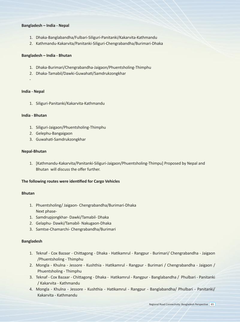
Regional Road Connectivity: Bangladesh Perspective 65
7.0 Background
A sub-regional meeting of the Secretaries of Transport of Bangladesh, Bhutan, India, and Nepal (BBIN) on Road Transport Connectivity was held in Kolkata, India on 2-3 February 2015. The objectives of the Meeting were to (i) reach consensus on a draft framework agreement titled, “Motor Vehicles Agreement (MVA) for the Regulation of Passenger, Personal, and Cargo Vehicular Traffic Between Bangladesh, Bhutan, India, and Nepal”, (ii) discuss and make recommendations to the BBIN Transport Ministers on general approaches to implementing the MVA and broad institutional arrangements, and (iii) discuss a road map of future sub-regional road projects in the BBIN countries.
Building on the progress made in negotiating and finalizing the SAARC Motor Vehicles Agreement, the MVA was drafted to facilitate cross-border transport between the four countries. The delegations gave their comments on the draft MVA, which were duly incorporated. They agreed that the text so finalized would be recommended to the Transport Ministers for consideration. They further recommended to propose the convening of a meeting of the Transport Ministers of the BBIN countries to, among other things, serve as a forum to sign the MVA and to reach agreement on the implementation and institutional mechanisms for the MVA.
The delegations considered a proposed general approach to finalizing and implementing the MVA. They agreed on an indicative road map of customizing and finalizing the MVA by next three months, formalizing the MVA by six months, and implementing it by 12 months. It was recognized that the MVA is a framework Agreement. Its implementation details, including, inter alia, customs formalities, routes of application, traffic volume, applicable fees and charges, and local permits will have to be set out in detailed bilateral, and, possibly plurilateral arrangements or protocols.
The delegations considered possible institutional structures for implementing and monitoring the MVA. They agreed to recommend (i) to establish National Land Transport Facilitation Committee, or its equivalent, in each of the countries, whose primary purpose is to coordinate, implement, and monitor the MVA; and (ii) to establish a Joint Land Transport Facilitation Committee (JLTFC) to monitor and assess the functioning of the MVA. The JLTFC will be composed of the heads or chairs of the National Land Transport Facilitation Committees and may co-opt other entities as may be required. They further agreed to request the ADB to, in the interim, continue providing coordination, technical, and financial support in implementing the MVA.
7.1 BBIN Initiatives
Motor Vehicles Agreement for the Regulation of Passenger, Personal and Cargo Vehicular Traffic between Bangladesh, Bhutan, India, And Nepal (BBIN MVA) was signed in the BBIN Transport Ministers Meeting on 15 June 2015 in Thimphu, Bhutan.
The Meeting recognized the need to accelerate cross-border transport facilitation to deepen and enhance regional integration. The Ministerial statement mentioned that the finalization of the BBIN MVA would allow moving forward, in an accelerated fashion, with implementation of land transport facilitation arrangements between and among these countries. This, in turn, would enable the exchange of traffic rights and ease cross-border movement of goods, vehicles and people, thereby helping expand people-to-people contact, trade, and economic exchanges among the countries. In that Ministerial statement it was endeavored to accelerate the preparatory steps for the effective and sustainable implementation of the BBIN MVA, starting with the formulation, negotiation, and finalization of the necessary legal instruments and operating procedures.
Bangladesh – India - Nepal
1. Dhaka-Banglabandha/Fulbari-Siliguri-Panitanki/Kakarvita-Kathmandu2. Kathmandu-Kakarvita/Panitanki-Siliguri-Chengrabandha/Burimari-Dhaka
Bangladesh – India - Bhutan
1. Dhaka-Burimari/Chengrabandha-Jaigaon/Phuentsholing-Thimphu2. Dhaka-Tamabil/Dawki-Guwahati/Samdrukzongkhar-
India - Nepal
1. Siliguri-Panitanki/Kakarvita-Kathmandu
India - Bhutan
1. Siliguri-Jaigaon/Phuentsholing-Thimphu2. Gelephu-Bangaigaon3. Guwahati-Samdrukzongkhar
Nepal-Bhutan
1. [Kathmandu-Kakarvita/Panitanki-Siliguri-Jaigaon/Phuentsholing-Thimpu] Proposed by Nepal and Bhutan will discuss the offer further.
The following routes were identified for Cargo Vehicles
Bhutan
1. Phuentsholing/ Jaigaon- Chengrabandha/Burimari-Dhaka Next phase-1. Samdrupjongkhar- Dawki/Tamabil- Dhaka2. Gelaphu- Dawki/Tamabil- Nakugaon-Dhaka3. Samtse-Chamarchi- Chengrabandha/Burimari
Bangladesh
1. Teknaf - Cox Bazaar - Chittagong - Dhaka - Hatikamrul - Rangpur - Burimari/ Chengrabandha - Jaigaon /Phuentsholing - Thimphu
2. Mongla - Khulna - Jessore - Kushthia - Hatikamrul - Rangpur - Burimari / Chengrabandha - Jaigaon / Phuentsholing - Thimphu
3. Teknaf - Cox Bazaar - Chittagong - Dhaka - Hatikamrul - Rangpur - Banglabandha / Phulbari - Panitanki / Kakarvita - Kathmandu
4. Mongla - Khulna - Jessore - Kushthia - Hatikamrul - Rangpur - Banglabandha/ Phulbari - Panitanki/ Kakarvita - Kathmandu
According to Article XVI of the Agreement, Bangladesh, India and Nepal have ratified the BBIN MVA for making it enforceable. Bhutan is yet to ratify the Agreement due to the Parliamentary procedure But the Government of Bhutan is hopeful about the ratification in the next Parliament session. In line with the decision of the first negotiation meeting in Dhaka during 08-09 September 2015, a Workshop on online tracking system for all kinds of vehicle under the BBIN MVA was held at Kolkata, India on 3-4 December, 2015. To finalize the passengers’ protocol and commence the preparations of Cargo Protocol, the second negotiation meeting is scheduled to be held in Dhaka on 29-30 March 2016.
7.6 Status of BBIN routes inside Bangladesh
7.6.1 Status of Passenger routes
Bangladesh is related to a total of 9 passenger routes of which 5 are connected with India, 2 with India and Nepal and 2 with India and Bhutan. Current status of each route is described in the subsequent sections:
A. Routes between Bangladesh-India
1. Khulna-Jessore-Benapole/Petrapole-Kolkata
The route coincide with SASEC Corridor 5A inside Bangladesh
• Benapole-Jessore (N706, 38 km, Class II). The Feasibility Study and Detailed Design for upgrading this section to a 4-Lane highway will be completed with ADB finance by 2018
• Jessore-Khulna (N7, 60 km, Class II). The Feasibility Study and Detailed Design for upgrading this section to a 4-Lane highway have been completed with ADB finance.
2. Chittagong- Dhaka- Banglabandha/Fulbari-Siliguri
The route inside Bangladesh is similar to SASEC Corridor 9 as mentioned in section 7.5.2.of SASEC chapter.
3. Chittagong- Dhaka- Burimari/Chengrabandha-Siliguri
The route inside Bangladesh is similar SASEC Corridor 4 mentioned in section 7.5.2.of SASEC chapter.
4. Chittagong- Dhaka- Benapole/Petrapole-Kolkata
Chittagong-Dhaka is aligned with SASEC 4/9 corridor as mentioned in section 7.5.2 of SASEC chapter. Dhaka-Kolkata route is aligned with SAARC Highway Corridor 1 as mentioned in section 6.2 of SAARC chapter.
5. Guwahati-Shillong-Dawki/Tamabil-Dhaka-Benapole/Petrapole-Kolkata
This route coincides mostly with Asian Highway-1 (AH1) inside Bangladesh. The most of the road sections along this route is 2-lane with some 4-lane sections in urban areas and bazaar location. There are currently two missing links in this corridor: (a) the Padma Bridge gap at Bhanga and (b) Kalna Bridge gap at Bhatiapara. In addition, there is one sub-standard section between Bhatiapara-Narail-Jessore (bellow AH standard II, See Table 1).
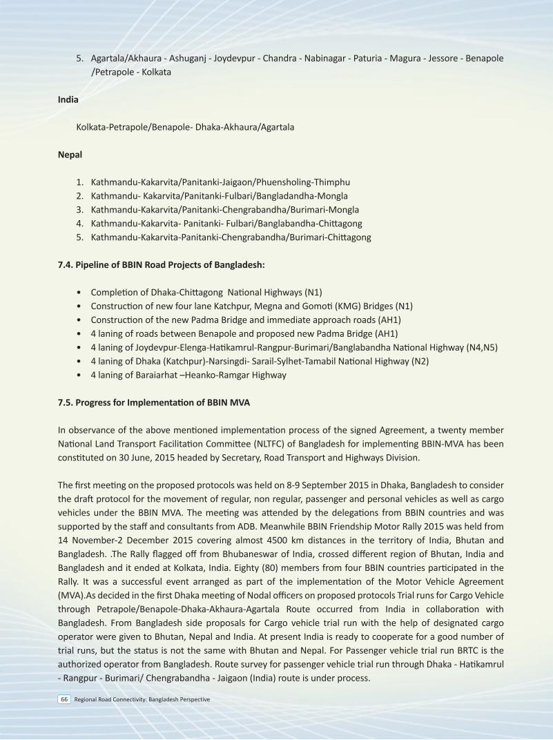
Regional Road Connectivity: Bangladesh Perspective66
7.0 Background
A sub-regional meeting of the Secretaries of Transport of Bangladesh, Bhutan, India, and Nepal (BBIN) on Road Transport Connectivity was held in Kolkata, India on 2-3 February 2015. The objectives of the Meeting were to (i) reach consensus on a draft framework agreement titled, “Motor Vehicles Agreement (MVA) for the Regulation of Passenger, Personal, and Cargo Vehicular Traffic Between Bangladesh, Bhutan, India, and Nepal”, (ii) discuss and make recommendations to the BBIN Transport Ministers on general approaches to implementing the MVA and broad institutional arrangements, and (iii) discuss a road map of future sub-regional road projects in the BBIN countries.
Building on the progress made in negotiating and finalizing the SAARC Motor Vehicles Agreement, the MVA was drafted to facilitate cross-border transport between the four countries. The delegations gave their comments on the draft MVA, which were duly incorporated. They agreed that the text so finalized would be recommended to the Transport Ministers for consideration. They further recommended to propose the convening of a meeting of the Transport Ministers of the BBIN countries to, among other things, serve as a forum to sign the MVA and to reach agreement on the implementation and institutional mechanisms for the MVA.
The delegations considered a proposed general approach to finalizing and implementing the MVA. They agreed on an indicative road map of customizing and finalizing the MVA by next three months, formalizing the MVA by six months, and implementing it by 12 months. It was recognized that the MVA is a framework Agreement. Its implementation details, including, inter alia, customs formalities, routes of application, traffic volume, applicable fees and charges, and local permits will have to be set out in detailed bilateral, and, possibly plurilateral arrangements or protocols.
The delegations considered possible institutional structures for implementing and monitoring the MVA. They agreed to recommend (i) to establish National Land Transport Facilitation Committee, or its equivalent, in each of the countries, whose primary purpose is to coordinate, implement, and monitor the MVA; and (ii) to establish a Joint Land Transport Facilitation Committee (JLTFC) to monitor and assess the functioning of the MVA. The JLTFC will be composed of the heads or chairs of the National Land Transport Facilitation Committees and may co-opt other entities as may be required. They further agreed to request the ADB to, in the interim, continue providing coordination, technical, and financial support in implementing the MVA.
7.1 BBIN Initiatives
Motor Vehicles Agreement for the Regulation of Passenger, Personal and Cargo Vehicular Traffic between Bangladesh, Bhutan, India, And Nepal (BBIN MVA) was signed in the BBIN Transport Ministers Meeting on 15 June 2015 in Thimphu, Bhutan.
The Meeting recognized the need to accelerate cross-border transport facilitation to deepen and enhance regional integration. The Ministerial statement mentioned that the finalization of the BBIN MVA would allow moving forward, in an accelerated fashion, with implementation of land transport facilitation arrangements between and among these countries. This, in turn, would enable the exchange of traffic rights and ease cross-border movement of goods, vehicles and people, thereby helping expand people-to-people contact, trade, and economic exchanges among the countries. In that Ministerial statement it was endeavored to accelerate the preparatory steps for the effective and sustainable implementation of the BBIN MVA, starting with the formulation, negotiation, and finalization of the necessary legal instruments and operating procedures.
Bangladesh – India - Nepal
1. Dhaka-Banglabandha/Fulbari-Siliguri-Panitanki/Kakarvita-Kathmandu2. Kathmandu-Kakarvita/Panitanki-Siliguri-Chengrabandha/Burimari-Dhaka
Bangladesh – India - Bhutan
1. Dhaka-Burimari/Chengrabandha-Jaigaon/Phuentsholing-Thimphu2. Dhaka-Tamabil/Dawki-Guwahati/Samdrukzongkhar-
India - Nepal
1. Siliguri-Panitanki/Kakarvita-Kathmandu
India - Bhutan
1. Siliguri-Jaigaon/Phuentsholing-Thimphu2. Gelephu-Bangaigaon3. Guwahati-Samdrukzongkhar
Nepal-Bhutan
1. [Kathmandu-Kakarvita/Panitanki-Siliguri-Jaigaon/Phuentsholing-Thimpu] Proposed by Nepal and Bhutan will discuss the offer further.
The following routes were identified for Cargo Vehicles
Bhutan
1. Phuentsholing/ Jaigaon- Chengrabandha/Burimari-Dhaka Next phase-1. Samdrupjongkhar- Dawki/Tamabil- Dhaka2. Gelaphu- Dawki/Tamabil- Nakugaon-Dhaka3. Samtse-Chamarchi- Chengrabandha/Burimari
Bangladesh
1. Teknaf - Cox Bazaar - Chittagong - Dhaka - Hatikamrul - Rangpur - Burimari/ Chengrabandha - Jaigaon /Phuentsholing - Thimphu
2. Mongla - Khulna - Jessore - Kushthia - Hatikamrul - Rangpur - Burimari / Chengrabandha - Jaigaon / Phuentsholing - Thimphu
3. Teknaf - Cox Bazaar - Chittagong - Dhaka - Hatikamrul - Rangpur - Banglabandha / Phulbari - Panitanki / Kakarvita - Kathmandu
4. Mongla - Khulna - Jessore - Kushthia - Hatikamrul - Rangpur - Banglabandha/ Phulbari - Panitanki/ Kakarvita - Kathmandu
5. Agartala/Akhaura - Ashuganj - Joydevpur - Chandra - Nabinagar - Paturia - Magura - Jessore - Benapole /Petrapole - Kolkata
India
Kolkata-Petrapole/Benapole- Dhaka-Akhaura/Agartala
Nepal
1. Kathmandu-Kakarvita/Panitanki-Jaigaon/Phuensholing-Thimphu2. Kathmandu- Kakarvita/Panitanki-Fulbari/Bangladandha-Mongla3. Kathmandu-Kakarvita/Panitanki-Chengrabandha/Burimari-Mongla4. Kathmandu-Kakarvita- Panitanki- Fulbari/Banglabandha-Chittagong5. Kathmandu-Kakarvita-Panitanki-Chengrabandha/Burimari-Chittagong
7.4. Pipeline of BBIN Road Projects of Bangladesh:
• Completion of Dhaka-Chittagong National Highways (N1)• Construction of new four lane Katchpur, Megna and Gomoti (KMG) Bridges (N1)• Construction of the new Padma Bridge and immediate approach roads (AH1)• 4 laning of roads between Benapole and proposed new Padma Bridge (AH1)• 4 laning of Joydevpur-Elenga-Hatikamrul-Rangpur-Burimari/Banglabandha National Highway (N4,N5)• 4 laning of Dhaka (Katchpur)-Narsingdi- Sarail-Sylhet-Tamabil National Highway (N2)• 4 laning of Baraiarhat –Heanko-Ramgar Highway
7.5. Progress for Implementation of BBIN MVA
In observance of the above mentioned implementation process of the signed Agreement, a twenty member National Land Transport Facilitation Committee (NLTFC) of Bangladesh for implementing BBIN-MVA has been constituted on 30 June, 2015 headed by Secretary, Road Transport and Highways Division.
The first meeting on the proposed protocols was held on 8-9 September 2015 in Dhaka, Bangladesh to consider the draft protocol for the movement of regular, non regular, passenger and personal vehicles as well as cargo vehicles under the BBIN MVA. The meeting was attended by the delegations from BBIN countries and was supported by the staff and consultants from ADB. Meanwhile BBIN Friendship Motor Rally 2015 was held from 14 November-2 December 2015 covering almost 4500 km distances in the territory of India, Bhutan and Bangladesh. .The Rally flagged off from Bhubaneswar of India, crossed different region of Bhutan, India and Bangladesh and it ended at Kolkata, India. Eighty (80) members from four BBIN countries participated in the Rally. It was a successful event arranged as part of the implementation of the Motor Vehicle Agreement (MVA).As decided in the first Dhaka meeting of Nodal officers on proposed protocols Trial runs for Cargo Vehicle through Petrapole/Benapole-Dhaka-Akhaura-Agartala Route occurred from India in collaboration with Bangladesh. From Bangladesh side proposals for Cargo vehicle trial run with the help of designated cargo operator were given to Bhutan, Nepal and India. At present India is ready to cooperate for a good number of trial runs, but the status is not the same with Bhutan and Nepal. For Passenger vehicle trial run BRTC is the authorized operator from Bangladesh. Route survey for passenger vehicle trial run through Dhaka - Hatikamrul - Rangpur - Burimari/ Chengrabandha - Jaigaon (India) route is under process.
According to Article XVI of the Agreement, Bangladesh, India and Nepal have ratified the BBIN MVA for making it enforceable. Bhutan is yet to ratify the Agreement due to the Parliamentary procedure But the Government of Bhutan is hopeful about the ratification in the next Parliament session. In line with the decision of the first negotiation meeting in Dhaka during 08-09 September 2015, a Workshop on online tracking system for all kinds of vehicle under the BBIN MVA was held at Kolkata, India on 3-4 December, 2015. To finalize the passengers’ protocol and commence the preparations of Cargo Protocol, the second negotiation meeting is scheduled to be held in Dhaka on 29-30 March 2016.
7.6 Status of BBIN routes inside Bangladesh
7.6.1 Status of Passenger routes
Bangladesh is related to a total of 9 passenger routes of which 5 are connected with India, 2 with India and Nepal and 2 with India and Bhutan. Current status of each route is described in the subsequent sections:
A. Routes between Bangladesh-India
1. Khulna-Jessore-Benapole/Petrapole-Kolkata
The route coincide with SASEC Corridor 5A inside Bangladesh
• Benapole-Jessore (N706, 38 km, Class II). The Feasibility Study and Detailed Design for upgrading this section to a 4-Lane highway will be completed with ADB finance by 2018
• Jessore-Khulna (N7, 60 km, Class II). The Feasibility Study and Detailed Design for upgrading this section to a 4-Lane highway have been completed with ADB finance.
2. Chittagong- Dhaka- Banglabandha/Fulbari-Siliguri
The route inside Bangladesh is similar to SASEC Corridor 9 as mentioned in section 7.5.2.of SASEC chapter.
3. Chittagong- Dhaka- Burimari/Chengrabandha-Siliguri
The route inside Bangladesh is similar SASEC Corridor 4 mentioned in section 7.5.2.of SASEC chapter.
4. Chittagong- Dhaka- Benapole/Petrapole-Kolkata
Chittagong-Dhaka is aligned with SASEC 4/9 corridor as mentioned in section 7.5.2 of SASEC chapter. Dhaka-Kolkata route is aligned with SAARC Highway Corridor 1 as mentioned in section 6.2 of SAARC chapter.
5. Guwahati-Shillong-Dawki/Tamabil-Dhaka-Benapole/Petrapole-Kolkata
This route coincides mostly with Asian Highway-1 (AH1) inside Bangladesh. The most of the road sections along this route is 2-lane with some 4-lane sections in urban areas and bazaar location. There are currently two missing links in this corridor: (a) the Padma Bridge gap at Bhanga and (b) Kalna Bridge gap at Bhatiapara. In addition, there is one sub-standard section between Bhatiapara-Narail-Jessore (bellow AH standard II, See Table 1).
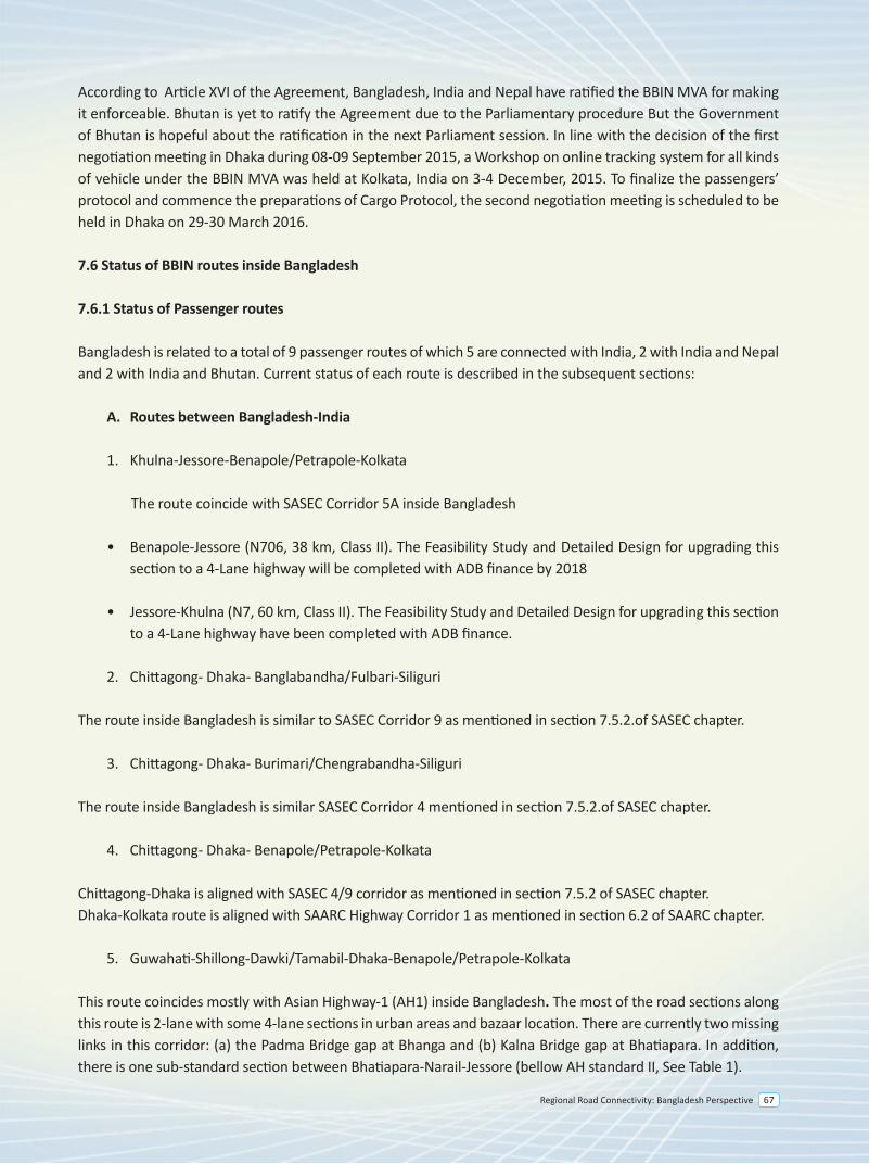
Regional Road Connectivity: Bangladesh Perspective 67
7.0 Background
A sub-regional meeting of the Secretaries of Transport of Bangladesh, Bhutan, India, and Nepal (BBIN) on Road Transport Connectivity was held in Kolkata, India on 2-3 February 2015. The objectives of the Meeting were to (i) reach consensus on a draft framework agreement titled, “Motor Vehicles Agreement (MVA) for the Regulation of Passenger, Personal, and Cargo Vehicular Traffic Between Bangladesh, Bhutan, India, and Nepal”, (ii) discuss and make recommendations to the BBIN Transport Ministers on general approaches to implementing the MVA and broad institutional arrangements, and (iii) discuss a road map of future sub-regional road projects in the BBIN countries.
Building on the progress made in negotiating and finalizing the SAARC Motor Vehicles Agreement, the MVA was drafted to facilitate cross-border transport between the four countries. The delegations gave their comments on the draft MVA, which were duly incorporated. They agreed that the text so finalized would be recommended to the Transport Ministers for consideration. They further recommended to propose the convening of a meeting of the Transport Ministers of the BBIN countries to, among other things, serve as a forum to sign the MVA and to reach agreement on the implementation and institutional mechanisms for the MVA.
The delegations considered a proposed general approach to finalizing and implementing the MVA. They agreed on an indicative road map of customizing and finalizing the MVA by next three months, formalizing the MVA by six months, and implementing it by 12 months. It was recognized that the MVA is a framework Agreement. Its implementation details, including, inter alia, customs formalities, routes of application, traffic volume, applicable fees and charges, and local permits will have to be set out in detailed bilateral, and, possibly plurilateral arrangements or protocols.
The delegations considered possible institutional structures for implementing and monitoring the MVA. They agreed to recommend (i) to establish National Land Transport Facilitation Committee, or its equivalent, in each of the countries, whose primary purpose is to coordinate, implement, and monitor the MVA; and (ii) to establish a Joint Land Transport Facilitation Committee (JLTFC) to monitor and assess the functioning of the MVA. The JLTFC will be composed of the heads or chairs of the National Land Transport Facilitation Committees and may co-opt other entities as may be required. They further agreed to request the ADB to, in the interim, continue providing coordination, technical, and financial support in implementing the MVA.
7.1 BBIN Initiatives
Motor Vehicles Agreement for the Regulation of Passenger, Personal and Cargo Vehicular Traffic between Bangladesh, Bhutan, India, And Nepal (BBIN MVA) was signed in the BBIN Transport Ministers Meeting on 15 June 2015 in Thimphu, Bhutan.
The Meeting recognized the need to accelerate cross-border transport facilitation to deepen and enhance regional integration. The Ministerial statement mentioned that the finalization of the BBIN MVA would allow moving forward, in an accelerated fashion, with implementation of land transport facilitation arrangements between and among these countries. This, in turn, would enable the exchange of traffic rights and ease cross-border movement of goods, vehicles and people, thereby helping expand people-to-people contact, trade, and economic exchanges among the countries. In that Ministerial statement it was endeavored to accelerate the preparatory steps for the effective and sustainable implementation of the BBIN MVA, starting with the formulation, negotiation, and finalization of the necessary legal instruments and operating procedures.
Bangladesh – India - Nepal
1. Dhaka-Banglabandha/Fulbari-Siliguri-Panitanki/Kakarvita-Kathmandu2. Kathmandu-Kakarvita/Panitanki-Siliguri-Chengrabandha/Burimari-Dhaka
Bangladesh – India - Bhutan
1. Dhaka-Burimari/Chengrabandha-Jaigaon/Phuentsholing-Thimphu2. Dhaka-Tamabil/Dawki-Guwahati/Samdrukzongkhar-
India - Nepal
1. Siliguri-Panitanki/Kakarvita-Kathmandu
India - Bhutan
1. Siliguri-Jaigaon/Phuentsholing-Thimphu2. Gelephu-Bangaigaon3. Guwahati-Samdrukzongkhar
Nepal-Bhutan
1. [Kathmandu-Kakarvita/Panitanki-Siliguri-Jaigaon/Phuentsholing-Thimpu] Proposed by Nepal and Bhutan will discuss the offer further.
The following routes were identified for Cargo Vehicles
Bhutan
1. Phuentsholing/ Jaigaon- Chengrabandha/Burimari-Dhaka Next phase-1. Samdrupjongkhar- Dawki/Tamabil- Dhaka2. Gelaphu- Dawki/Tamabil- Nakugaon-Dhaka3. Samtse-Chamarchi- Chengrabandha/Burimari
Bangladesh
1. Teknaf - Cox Bazaar - Chittagong - Dhaka - Hatikamrul - Rangpur - Burimari/ Chengrabandha - Jaigaon /Phuentsholing - Thimphu
2. Mongla - Khulna - Jessore - Kushthia - Hatikamrul - Rangpur - Burimari / Chengrabandha - Jaigaon / Phuentsholing - Thimphu
3. Teknaf - Cox Bazaar - Chittagong - Dhaka - Hatikamrul - Rangpur - Banglabandha / Phulbari - Panitanki / Kakarvita - Kathmandu
4. Mongla - Khulna - Jessore - Kushthia - Hatikamrul - Rangpur - Banglabandha/ Phulbari - Panitanki/ Kakarvita - Kathmandu
According to Article XVI of the Agreement, Bangladesh, India and Nepal have ratified the BBIN MVA for making it enforceable. Bhutan is yet to ratify the Agreement due to the Parliamentary procedure But the Government of Bhutan is hopeful about the ratification in the next Parliament session. In line with the decision of the first negotiation meeting in Dhaka during 08-09 September 2015, a Workshop on online tracking system for all kinds of vehicle under the BBIN MVA was held at Kolkata, India on 3-4 December, 2015. To finalize the passengers’ protocol and commence the preparations of Cargo Protocol, the second negotiation meeting is scheduled to be held in Dhaka on 29-30 March 2016.
7.6 Status of BBIN routes inside Bangladesh
7.6.1 Status of Passenger routes
Bangladesh is related to a total of 9 passenger routes of which 5 are connected with India, 2 with India and Nepal and 2 with India and Bhutan. Current status of each route is described in the subsequent sections:
A. Routes between Bangladesh-India
1. Khulna-Jessore-Benapole/Petrapole-Kolkata
The route coincide with SASEC Corridor 5A inside Bangladesh
• Benapole-Jessore (N706, 38 km, Class II). The Feasibility Study and Detailed Design for upgrading this section to a 4-Lane highway will be completed with ADB finance by 2018
• Jessore-Khulna (N7, 60 km, Class II). The Feasibility Study and Detailed Design for upgrading this section to a 4-Lane highway have been completed with ADB finance.
2. Chittagong- Dhaka- Banglabandha/Fulbari-Siliguri
The route inside Bangladesh is similar to SASEC Corridor 9 as mentioned in section 7.5.2.of SASEC chapter.
3. Chittagong- Dhaka- Burimari/Chengrabandha-Siliguri
The route inside Bangladesh is similar SASEC Corridor 4 mentioned in section 7.5.2.of SASEC chapter.
4. Chittagong- Dhaka- Benapole/Petrapole-Kolkata
Chittagong-Dhaka is aligned with SASEC 4/9 corridor as mentioned in section 7.5.2 of SASEC chapter. Dhaka-Kolkata route is aligned with SAARC Highway Corridor 1 as mentioned in section 6.2 of SAARC chapter.
5. Guwahati-Shillong-Dawki/Tamabil-Dhaka-Benapole/Petrapole-Kolkata
This route coincides mostly with Asian Highway-1 (AH1) inside Bangladesh. The most of the road sections along this route is 2-lane with some 4-lane sections in urban areas and bazaar location. There are currently two missing links in this corridor: (a) the Padma Bridge gap at Bhanga and (b) Kalna Bridge gap at Bhatiapara. In addition, there is one sub-standard section between Bhatiapara-Narail-Jessore (bellow AH standard II, See Table 1).
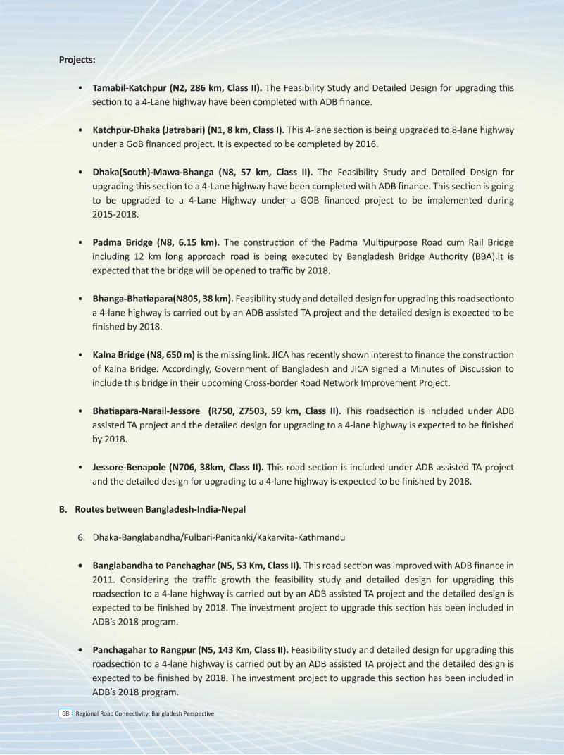
Regional Road Connectivity: Bangladesh Perspective68
7.0 Background
A sub-regional meeting of the Secretaries of Transport of Bangladesh, Bhutan, India, and Nepal (BBIN) on Road Transport Connectivity was held in Kolkata, India on 2-3 February 2015. The objectives of the Meeting were to (i) reach consensus on a draft framework agreement titled, “Motor Vehicles Agreement (MVA) for the Regulation of Passenger, Personal, and Cargo Vehicular Traffic Between Bangladesh, Bhutan, India, and Nepal”, (ii) discuss and make recommendations to the BBIN Transport Ministers on general approaches to implementing the MVA and broad institutional arrangements, and (iii) discuss a road map of future sub-regional road projects in the BBIN countries.
Building on the progress made in negotiating and finalizing the SAARC Motor Vehicles Agreement, the MVA was drafted to facilitate cross-border transport between the four countries. The delegations gave their comments on the draft MVA, which were duly incorporated. They agreed that the text so finalized would be recommended to the Transport Ministers for consideration. They further recommended to propose the convening of a meeting of the Transport Ministers of the BBIN countries to, among other things, serve as a forum to sign the MVA and to reach agreement on the implementation and institutional mechanisms for the MVA.
The delegations considered a proposed general approach to finalizing and implementing the MVA. They agreed on an indicative road map of customizing and finalizing the MVA by next three months, formalizing the MVA by six months, and implementing it by 12 months. It was recognized that the MVA is a framework Agreement. Its implementation details, including, inter alia, customs formalities, routes of application, traffic volume, applicable fees and charges, and local permits will have to be set out in detailed bilateral, and, possibly plurilateral arrangements or protocols.
The delegations considered possible institutional structures for implementing and monitoring the MVA. They agreed to recommend (i) to establish National Land Transport Facilitation Committee, or its equivalent, in each of the countries, whose primary purpose is to coordinate, implement, and monitor the MVA; and (ii) to establish a Joint Land Transport Facilitation Committee (JLTFC) to monitor and assess the functioning of the MVA. The JLTFC will be composed of the heads or chairs of the National Land Transport Facilitation Committees and may co-opt other entities as may be required. They further agreed to request the ADB to, in the interim, continue providing coordination, technical, and financial support in implementing the MVA.
7.1 BBIN Initiatives
Motor Vehicles Agreement for the Regulation of Passenger, Personal and Cargo Vehicular Traffic between Bangladesh, Bhutan, India, And Nepal (BBIN MVA) was signed in the BBIN Transport Ministers Meeting on 15 June 2015 in Thimphu, Bhutan.
The Meeting recognized the need to accelerate cross-border transport facilitation to deepen and enhance regional integration. The Ministerial statement mentioned that the finalization of the BBIN MVA would allow moving forward, in an accelerated fashion, with implementation of land transport facilitation arrangements between and among these countries. This, in turn, would enable the exchange of traffic rights and ease cross-border movement of goods, vehicles and people, thereby helping expand people-to-people contact, trade, and economic exchanges among the countries. In that Ministerial statement it was endeavored to accelerate the preparatory steps for the effective and sustainable implementation of the BBIN MVA, starting with the formulation, negotiation, and finalization of the necessary legal instruments and operating procedures.
Bangladesh – India - Nepal
1. Dhaka-Banglabandha/Fulbari-Siliguri-Panitanki/Kakarvita-Kathmandu2. Kathmandu-Kakarvita/Panitanki-Siliguri-Chengrabandha/Burimari-Dhaka
Bangladesh – India - Bhutan
1. Dhaka-Burimari/Chengrabandha-Jaigaon/Phuentsholing-Thimphu2. Dhaka-Tamabil/Dawki-Guwahati/Samdrukzongkhar-
India - Nepal
1. Siliguri-Panitanki/Kakarvita-Kathmandu
India - Bhutan
1. Siliguri-Jaigaon/Phuentsholing-Thimphu2. Gelephu-Bangaigaon3. Guwahati-Samdrukzongkhar
Nepal-Bhutan
1. [Kathmandu-Kakarvita/Panitanki-Siliguri-Jaigaon/Phuentsholing-Thimpu] Proposed by Nepal and Bhutan will discuss the offer further.
The following routes were identified for Cargo Vehicles
Bhutan
1. Phuentsholing/ Jaigaon- Chengrabandha/Burimari-Dhaka Next phase-1. Samdrupjongkhar- Dawki/Tamabil- Dhaka2. Gelaphu- Dawki/Tamabil- Nakugaon-Dhaka3. Samtse-Chamarchi- Chengrabandha/Burimari
Bangladesh
1. Teknaf - Cox Bazaar - Chittagong - Dhaka - Hatikamrul - Rangpur - Burimari/ Chengrabandha - Jaigaon /Phuentsholing - Thimphu
2. Mongla - Khulna - Jessore - Kushthia - Hatikamrul - Rangpur - Burimari / Chengrabandha - Jaigaon / Phuentsholing - Thimphu
3. Teknaf - Cox Bazaar - Chittagong - Dhaka - Hatikamrul - Rangpur - Banglabandha / Phulbari - Panitanki / Kakarvita - Kathmandu
4. Mongla - Khulna - Jessore - Kushthia - Hatikamrul - Rangpur - Banglabandha/ Phulbari - Panitanki/ Kakarvita - Kathmandu
According to Article XVI of the Agreement, Bangladesh, India and Nepal have ratified the BBIN MVA for making it enforceable. Bhutan is yet to ratify the Agreement due to the Parliamentary procedure But the Government of Bhutan is hopeful about the ratification in the next Parliament session. In line with the decision of the first negotiation meeting in Dhaka during 08-09 September 2015, a Workshop on online tracking system for all kinds of vehicle under the BBIN MVA was held at Kolkata, India on 3-4 December, 2015. To finalize the passengers’ protocol and commence the preparations of Cargo Protocol, the second negotiation meeting is scheduled to be held in Dhaka on 29-30 March 2016.
7.6 Status of BBIN routes inside Bangladesh
7.6.1 Status of Passenger routes
Bangladesh is related to a total of 9 passenger routes of which 5 are connected with India, 2 with India and Nepal and 2 with India and Bhutan. Current status of each route is described in the subsequent sections:
A. Routes between Bangladesh-India
1. Khulna-Jessore-Benapole/Petrapole-Kolkata
The route coincide with SASEC Corridor 5A inside Bangladesh
• Benapole-Jessore (N706, 38 km, Class II). The Feasibility Study and Detailed Design for upgrading this section to a 4-Lane highway will be completed with ADB finance by 2018
• Jessore-Khulna (N7, 60 km, Class II). The Feasibility Study and Detailed Design for upgrading this section to a 4-Lane highway have been completed with ADB finance.
2. Chittagong- Dhaka- Banglabandha/Fulbari-Siliguri
The route inside Bangladesh is similar to SASEC Corridor 9 as mentioned in section 7.5.2.of SASEC chapter.
3. Chittagong- Dhaka- Burimari/Chengrabandha-Siliguri
The route inside Bangladesh is similar SASEC Corridor 4 mentioned in section 7.5.2.of SASEC chapter.
4. Chittagong- Dhaka- Benapole/Petrapole-Kolkata
Chittagong-Dhaka is aligned with SASEC 4/9 corridor as mentioned in section 7.5.2 of SASEC chapter. Dhaka-Kolkata route is aligned with SAARC Highway Corridor 1 as mentioned in section 6.2 of SAARC chapter.
5. Guwahati-Shillong-Dawki/Tamabil-Dhaka-Benapole/Petrapole-Kolkata
This route coincides mostly with Asian Highway-1 (AH1) inside Bangladesh. The most of the road sections along this route is 2-lane with some 4-lane sections in urban areas and bazaar location. There are currently two missing links in this corridor: (a) the Padma Bridge gap at Bhanga and (b) Kalna Bridge gap at Bhatiapara. In addition, there is one sub-standard section between Bhatiapara-Narail-Jessore (bellow AH standard II, See Table 1).
Projects:
• Tamabil-Katchpur (N2, 286 km, Class II). The Feasibility Study and Detailed Design for upgrading this section to a 4-Lane highway have been completed with ADB finance.
• Katchpur-Dhaka (Jatrabari) (N1, 8 km, Class I). This 4-lane section is being upgraded to 8-lane highway under a GoB financed project. It is expected to be completed by 2016.
• Dhaka(South)-Mawa-Bhanga (N8, 57 km, Class II). The Feasibility Study and Detailed Design for upgrading this section to a 4-Lane highway have been completed with ADB finance. This section is going to be upgraded to a 4-Lane Highway under a GOB financed project to be implemented during 2015-2018.
• Padma Bridge (N8, 6.15 km). The construction of the Padma Multipurpose Road cum Rail Bridge including 12 km long approach road is being executed by Bangladesh Bridge Authority (BBA).It is expected that the bridge will be opened to traffic by 2018.
• Bhanga-Bhatiapara(N805, 38 km). Feasibility study and detailed design for upgrading this roadsectionto a 4-lane highway is carried out by an ADB assisted TA project and the detailed design is expected to be finished by 2018.
• Kalna Bridge (N8, 650 m) is the missing link. JICA has recently shown interest to finance the construction of Kalna Bridge. Accordingly, Government of Bangladesh and JICA signed a Minutes of Discussion to include this bridge in their upcoming Cross-border Road Network Improvement Project.
• Bhatiapara-Narail-Jessore (R750, Z7503, 59 km, Class II). This roadsection is included under ADB assisted TA project and the detailed design for upgrading to a 4-lane highway is expected to be finished by 2018.
• Jessore-Benapole (N706, 38km, Class II). This road section is included under ADB assisted TA project and the detailed design for upgrading to a 4-lane highway is expected to be finished by 2018.
B. Routes between Bangladesh-India-Nepal
6. Dhaka-Banglabandha/Fulbari-Panitanki/Kakarvita-Kathmandu
• Banglabandha to Panchaghar (N5, 53 Km, Class II). This road section was improved with ADB finance in 2011. Considering the traffic growth the feasibility study and detailed design for upgrading this roadsection to a 4-lane highway is carried out by an ADB assisted TA project and the detailed design is expected to be finished by 2018. The investment project to upgrade this section has been included in ADB’s 2018 program.
• Panchagahar to Rangpur (N5, 143 Km, Class II). Feasibility study and detailed design for upgrading this roadsection to a 4-lane highway is carried out by an ADB assisted TA project and the detailed design is expected to be finished by 2018. The investment project to upgrade this section has been included in ADB’s 2018 program.
Regional Road Connectivity: Bangladesh Perspective 69
• Rangpur-Hatikamrul-Elenga(N5/N4, 197 km, Class II). The Feasibility Study and Detailed Design for upgrading this section to a 4-Lane highway have been completed with ADB finance. The investment project to upgrade this section has been included in ADB’s 2017 program.
• Elenga-Tangail-Chandra-Joydevpur(N4, 70 km, Class II). This road section is being upgraded to 4 lane highway under SESEC Road Connectivity Project with ADB finance and the construction work is expected to be completed within 2018
• Joydevpur-Dhaka This section is 4-6 lane highway.
7. Kathmandu-Kakarvita/Panitanki-Siliguri-Chengrabandha/Burimari-Dhaka
• Burimari-Lalmonirhat-Rangpur (N509, N506, 138 km). The Feasibility Study and Detailed Design for upgrading this section to a 4-Lane highway have been completed with ADB finance.
• Teesta Bridge (0.98 km). The recently completed 2-lane Teesta Bridge over the Teesta River under KFAED Finance will provide an uninterrupted traffic movement between Rangpur and Burimari Dry Port. An additional 2-lane bridge with two-way SMVT at the right side of the bridge towards North has been designed with ADB finance.
• Rangpur-Hatikamrul-Elenga(N5/N4, 197 km, Class II). The Feasibility Study and Detailed Design for upgrading this section to a 4-Lane highway have been completed with ADB finance. The investment project to upgrade this section has been included in ADB’s 2017 program.
• Elenga-Tangail-Chandra-Joydevpur(N4, 70 km, Class II). This road section is being upgraded to 4 lane highway under SESEC Road Connectivity Project with ADB finance and the construction work is expected to be completed within 2018
• Joydevpur-Dhaka This section is 4-6 lane highway.
C. Routes between Bangladesh-India-Bhutan
8. Dhaka-Burimari/Chengrabandha-Jaigaon/Phuentsholing-Thimphu
The route inside Bangladesh is similar SASEC Corridor 4 mentioned in section 7.5.2.of SASEC chapter
9. Dhaka-Tamabil/Dawki-Guwahati/Samdrukzongkhar
This route is along the Asian Highway-1 (AH1) inside Bangladesh. The most of the road sections along this route is 2-lane with some 4-lane sections in urban areas and bazaar location. There are currently two missing links in this corridor: (a) the Padma Bridge gap at Bhanga and (b) Kalna Bridge gap at Bhatiapara. In addition, there is one sub-standard section between Bhatiapara-Narial-Jessore (bellow AH standard II, See Table 1).
• Joydevpur-Bhulta-Madanpur (N105, 48 km). This section is known as Dhaka Bypass, which is being considered for PPP finance. The PPP office under the Prime Minister’s Office has engaged transaction adviser and feasibility study was completed in July 2014. The RFQ for selecting concessionaire has been issued on October 2015. The road work of this project is expected to be completed by 2020.
• Madanpur-Daudkandi (N1, 18 km). This section has already been upgraded as a 4-lane highway.
• Daudkandi-Chittagong (N1, 192 km, Class I). This road section is being upgraded under 4-Laning of Dhaka-Chittagong Highway Project and is expected to be opened for traffic soon.
• Chittagong to Chittagong Port (N111, 13 km, Class II). This section was developed to a 2 lane highway with ADB finance in 2006. Considering the traffic growth the feasibility study and detailed design for upgrading this roadsection to a 4-lane highway is being carried out by an ADB assisted TA project and the detailed design is expected to be finished by 2018.
• Chittagong -Cox’sBazar- Teknaf (N1, 223 km, Class II). The Feasibility Study and Detailed Design for upgrading this section to a 4-Lane highway have been completed with ADB finance. JICA has recently shown interest to finance upgrading Chittagong-Cox’sBazar section. Government of Bangladesh and JICA signed a Minutes of Discussion on 20 August 2014 to include this road stretch in the Cross-border Road Network Improvement Project which is expected to be financed by JICA.
• Hatikamrul-Banpara section (N507, 51km, Class II). The Feasibility Study and Detailed Design for upgrading this section to a 4-Lane highway have been completed with ADB finance.
• Bonpara-Dasurai-Pakshey-Kushtia-Jheinadah(N6, N704, 105 km, Class II). A pre-feasibility study on this segment was done by UN-ESCAP in 2013. Feasibility study and detailed design for upgrading to a 4-lane highway will be done with ADB assistance. The detailed design is expected to be completed by 2018. There is a major 4-lane bridge over river Padma named as Lalon Shah Bridge (1785m).
• Jhenaidah-Jessore-Khulna (N7, 107 km, Class II). The Feasibility Study and Detailed Design for upgrading this section to a 4-Lane highway have been completed with ADB finance.
• Khulna-Mongla (N7, 43 km, Class II). The Feasibility Study and Detailed Design for upgrading this section to a 4-Lane highway have been completed with ADB finance.
3. Teknaf - Cox Bazaar - Chittagong - Dhaka - Hatikamrul - Rangpur - Banglabandha / Phulbari - Panitanki / Kakarvita - Kathmandu
4. Mongla - Khulna - Jessore - Kushthia - Hatikamrul - Rangpur - Banglabandha / Phulbari - Panitanki / Kakarvita - Kathmandu
The above routes are along the SASEC Corridor 9
• Banglabandha to Panchaghar (N5, 53 Km, Class II). This road section was improved with ADB finance in 2011. Considering the traffic growth the feasibility study and detailed design for upgrading this roadsection to a 4-lane highway is carried out by an ADB assisted TA project and the detailed design is expected to be finished by 2018. The investment project to upgrade this section has been included in ADB’s 2018 program.
Regional Road Connectivity: Bangladesh Perspective70
• Rangpur-Hatikamrul-Elenga(N5/N4, 197 km, Class II). The Feasibility Study and Detailed Design for upgrading this section to a 4-Lane highway have been completed with ADB finance. The investment project to upgrade this section has been included in ADB’s 2017 program.
• Elenga-Tangail-Chandra-Joydevpur(N4, 70 km, Class II). This road section is being upgraded to 4 lane highway under SESEC Road Connectivity Project with ADB finance and the construction work is expected to be completed within 2018
• Joydevpur-Dhaka This section is 4-6 lane highway.
7. Kathmandu-Kakarvita/Panitanki-Siliguri-Chengrabandha/Burimari-Dhaka
• Burimari-Lalmonirhat-Rangpur (N509, N506, 138 km). The Feasibility Study and Detailed Design for upgrading this section to a 4-Lane highway have been completed with ADB finance.
• Teesta Bridge (0.98 km). The recently completed 2-lane Teesta Bridge over the Teesta River under KFAED Finance will provide an uninterrupted traffic movement between Rangpur and Burimari Dry Port. An additional 2-lane bridge with two-way SMVT at the right side of the bridge towards North has been designed with ADB finance.
• Rangpur-Hatikamrul-Elenga(N5/N4, 197 km, Class II). The Feasibility Study and Detailed Design for upgrading this section to a 4-Lane highway have been completed with ADB finance. The investment project to upgrade this section has been included in ADB’s 2017 program.
• Elenga-Tangail-Chandra-Joydevpur(N4, 70 km, Class II). This road section is being upgraded to 4 lane highway under SESEC Road Connectivity Project with ADB finance and the construction work is expected to be completed within 2018
• Joydevpur-Dhaka This section is 4-6 lane highway.
C. Routes between Bangladesh-India-Bhutan
8. Dhaka-Burimari/Chengrabandha-Jaigaon/Phuentsholing-Thimphu
The route inside Bangladesh is similar SASEC Corridor 4 mentioned in section 7.5.2.of SASEC chapter
9. Dhaka-Tamabil/Dawki-Guwahati/Samdrukzongkhar
This route is along the Asian Highway-1 (AH1) inside Bangladesh. The most of the road sections along this route is 2-lane with some 4-lane sections in urban areas and bazaar location. There are currently two missing links in this corridor: (a) the Padma Bridge gap at Bhanga and (b) Kalna Bridge gap at Bhatiapara. In addition, there is one sub-standard section between Bhatiapara-Narial-Jessore (bellow AH standard II, See Table 1).
Projects:
• Tamabil-Katchpur (N2, 286 km, Class II). The Feasibility Study and Detailed Design for upgrading this section to a 4-Lane highway have been completed with ADB finance.
• Katchpur-Dhaka (Jatrabari) (N1, 8 km, Class I). This 4-lane section is being upgraded to 8-lane highway under a GoB financed project. It is expected to be completed by 2016.
7.6.2 Status of Cargo Routes
Bangladesh identified five different routes connecting India, Nepal and Bhutan for Cargo vehicular traffic movement. Current status of each route is described in the subsequent section.
1. Teknaf - Cox Bazaar - Chittagong - Dhaka - Hatikamrul - Rangpur - Burimari / Chengrabandha - Jaigaon / Phuentsholing - Thimphu
2. Mongla - Khulna - Jessore - Kushthia - Hatikamrul - Rangpur - Burimari / Chengrabandha - Jaigaon / Phuentsholing - Thimphu
The above routes are along the alignment of SASEC Corridor 4: Thimphu–Phuentsholing (Bhutan)/ Jaigon (India)–Chengrabandha (India)/ Burimari (Bangladesh)–i) Chittagong (966km) or/and ii) Mongla (880km)
Thimphu/Paro to Phuentisholing to Burimari to Khulna or via the Jamuna Bridge to Dhaka or Chittagong (Gateways: Dhaka and Chittagong ports, Burimari on the Bangladesh/Indian border; Phuentsholing/Jaigaon on the Bhutanese/Indian border and Burimari as possible intermodal transfer point)
The Bangladesh section of this corridor follows the following route:
• Burimari - Teesta - Rangpur - Gobindaganj - Bogra - Hatikamrul - Elenga - Kaliakoir - Joydevpur - Dhaka - Katchpur - Feni - Chittagong (678 kilometer) - Coxsbazar - Teknaf (223 km)
• Burimari - Teesta - Rangpur - Gobindaganj - Bogra - Hatikamrul - Banpara - Dasuria - Paksey - Kushtia - Jhenaidhah - Jessore - Khulna - Mongla (601 kilometer)
Current Status
• Burimari-Lalmonirhat-Rangpur (N509, N506, 138 km). The Feasibility Study and Detailed Design for upgrading this section to a 4-Lane highway have been completed with ADB finance. This section is included in ADB’s 2018 program.
• Teesta Bridge (0.98 km). The recently completed 2-lane Teesta Bridge over the Teesta River under KFAED Finance will provide an uninterrupted traffic movement between Rangpur and Burimari Dry Port. An additional 2-lane bridge with two-way SMVT at the right side of the bridge towards North has been designed with ADB finance.
• Rangpur-Hatikamrul-Elenga(N5/N4, 197 km, Class II). The Feasibility Study and Detailed Design for upgrading this section to a 4-Lane highway have been completed with ADB finance. The investment project to upgrade this section has been included in ADB’s 2017 program.
• Elenga-Tangail-Chandra-Joydevpur(N4, 70 km, Class II). This road section is being upgraded to 4 lane highway under SESEC Road Connectivity Project with ADB finance and the construction work is expected to be completed within 2018
• Joydevpur-Bhulta-Madanpur (N105, 48 km). This section is known as Dhaka Bypass, which is being considered for PPP finance. The PPP office under the Prime Minister’s Office has engaged transaction adviser and feasibility study was completed in July 2014. The RFQ for selecting concessionaire has been issued on October 2015. The road work of this project is expected to be completed by 2020.
• Madanpur-Daudkandi (N1, 18 km). This section has already been upgraded as a 4-lane highway.
• Daudkandi-Chittagong (N1, 192 km, Class I). This road section is being upgraded under 4-Laning of Dhaka-Chittagong Highway Project and is expected to be opened for traffic soon.
• Chittagong to Chittagong Port (N111, 13 km, Class II). This section was developed to a 2 lane highway with ADB finance in 2006. Considering the traffic growth the feasibility study and detailed design for upgrading this roadsection to a 4-lane highway is being carried out by an ADB assisted TA project and the detailed design is expected to be finished by 2018.
• Chittagong -Cox’sBazar- Teknaf (N1, 223 km, Class II). The Feasibility Study and Detailed Design for upgrading this section to a 4-Lane highway have been completed with ADB finance. JICA has recently shown interest to finance upgrading Chittagong-Cox’sBazar section. Government of Bangladesh and JICA signed a Minutes of Discussion on 20 August 2014 to include this road stretch in the Cross-border Road Network Improvement Project which is expected to be financed by JICA.
• Hatikamrul-Banpara section (N507, 51km, Class II). The Feasibility Study and Detailed Design for upgrading this section to a 4-Lane highway have been completed with ADB finance.
• Bonpara-Dasurai-Pakshey-Kushtia-Jheinadah(N6, N704, 105 km, Class II). A pre-feasibility study on this segment was done by UN-ESCAP in 2013. Feasibility study and detailed design for upgrading to a 4-lane highway will be done with ADB assistance. The detailed design is expected to be completed by 2018. There is a major 4-lane bridge over river Padma named as Lalon Shah Bridge (1785m).
• Jhenaidah-Jessore-Khulna (N7, 107 km, Class II). The Feasibility Study and Detailed Design for upgrading this section to a 4-Lane highway have been completed with ADB finance.
• Khulna-Mongla (N7, 43 km, Class II). The Feasibility Study and Detailed Design for upgrading this section to a 4-Lane highway have been completed with ADB finance.
3. Teknaf - Cox Bazaar - Chittagong - Dhaka - Hatikamrul - Rangpur - Banglabandha / Phulbari - Panitanki / Kakarvita - Kathmandu
4. Mongla - Khulna - Jessore - Kushthia - Hatikamrul - Rangpur - Banglabandha / Phulbari - Panitanki / Kakarvita - Kathmandu
The above routes are along the SASEC Corridor 9
• Banglabandha to Panchaghar (N5, 53 Km, Class II). This road section was improved with ADB finance in 2011. Considering the traffic growth the feasibility study and detailed design for upgrading this roadsection to a 4-lane highway is carried out by an ADB assisted TA project and the detailed design is expected to be finished by 2018. The investment project to upgrade this section has been included in ADB’s 2018 program.
Regional Road Connectivity: Bangladesh Perspective 71
• Rangpur-Hatikamrul-Elenga(N5/N4, 197 km, Class II). The Feasibility Study and Detailed Design for upgrading this section to a 4-Lane highway have been completed with ADB finance. The investment project to upgrade this section has been included in ADB’s 2017 program.
• Elenga-Tangail-Chandra-Joydevpur(N4, 70 km, Class II). This road section is being upgraded to 4 lane highway under SESEC Road Connectivity Project with ADB finance and the construction work is expected to be completed within 2018
• Joydevpur-Dhaka This section is 4-6 lane highway.
7. Kathmandu-Kakarvita/Panitanki-Siliguri-Chengrabandha/Burimari-Dhaka
• Burimari-Lalmonirhat-Rangpur (N509, N506, 138 km). The Feasibility Study and Detailed Design for upgrading this section to a 4-Lane highway have been completed with ADB finance.
• Teesta Bridge (0.98 km). The recently completed 2-lane Teesta Bridge over the Teesta River under KFAED Finance will provide an uninterrupted traffic movement between Rangpur and Burimari Dry Port. An additional 2-lane bridge with two-way SMVT at the right side of the bridge towards North has been designed with ADB finance.
• Rangpur-Hatikamrul-Elenga(N5/N4, 197 km, Class II). The Feasibility Study and Detailed Design for upgrading this section to a 4-Lane highway have been completed with ADB finance. The investment project to upgrade this section has been included in ADB’s 2017 program.
• Elenga-Tangail-Chandra-Joydevpur(N4, 70 km, Class II). This road section is being upgraded to 4 lane highway under SESEC Road Connectivity Project with ADB finance and the construction work is expected to be completed within 2018
• Joydevpur-Dhaka This section is 4-6 lane highway.
C. Routes between Bangladesh-India-Bhutan
8. Dhaka-Burimari/Chengrabandha-Jaigaon/Phuentsholing-Thimphu
The route inside Bangladesh is similar SASEC Corridor 4 mentioned in section 7.5.2.of SASEC chapter
9. Dhaka-Tamabil/Dawki-Guwahati/Samdrukzongkhar
This route is along the Asian Highway-1 (AH1) inside Bangladesh. The most of the road sections along this route is 2-lane with some 4-lane sections in urban areas and bazaar location. There are currently two missing links in this corridor: (a) the Padma Bridge gap at Bhanga and (b) Kalna Bridge gap at Bhatiapara. In addition, there is one sub-standard section between Bhatiapara-Narial-Jessore (bellow AH standard II, See Table 1).
• Joydevpur-Bhulta-Madanpur (N105, 48 km). This section is known as Dhaka Bypass, which is being considered for PPP finance. The PPP office under the Prime Minister’s Office has engaged transaction adviser and feasibility study was completed in July 2014. The RFQ for selecting concessionaire has been issued on October 2015. The road work of this project is expected to be completed by 2020.
• Madanpur-Daudkandi (N1, 18 km). This section has already been upgraded as a 4-lane highway.
• Daudkandi-Chittagong (N1, 192 km, Class I). This road section is being upgraded under 4-Laning of Dhaka-Chittagong Highway Project and is expected to be opened for traffic soon.
• Chittagong to Chittagong Port (N111, 13 km, Class II). This section was developed to a 2 lane highway with ADB finance in 2006. Considering the traffic growth the feasibility study and detailed design for upgrading this roadsection to a 4-lane highway is being carried out by an ADB assisted TA project and the detailed design is expected to be finished by 2018.
• Chittagong -Cox’sBazar- Teknaf (N1, 223 km, Class II). The Feasibility Study and Detailed Design for upgrading this section to a 4-Lane highway have been completed with ADB finance. JICA has recently shown interest to finance upgrading Chittagong-Cox’sBazar section. Government of Bangladesh and JICA signed a Minutes of Discussion on 20 August 2014 to include this road stretch in the Cross-border Road Network Improvement Project which is expected to be financed by JICA.
• Hatikamrul-Banpara section (N507, 51km, Class II). The Feasibility Study and Detailed Design for upgrading this section to a 4-Lane highway have been completed with ADB finance.
• Bonpara-Dasurai-Pakshey-Kushtia-Jheinadah(N6, N704, 105 km, Class II). A pre-feasibility study on this segment was done by UN-ESCAP in 2013. Feasibility study and detailed design for upgrading to a 4-lane highway will be done with ADB assistance. The detailed design is expected to be completed by 2018. There is a major 4-lane bridge over river Padma named as Lalon Shah Bridge (1785m).
• Jhenaidah-Jessore-Khulna (N7, 107 km, Class II). The Feasibility Study and Detailed Design for upgrading this section to a 4-Lane highway have been completed with ADB finance.
• Khulna-Mongla (N7, 43 km, Class II). The Feasibility Study and Detailed Design for upgrading this section to a 4-Lane highway have been completed with ADB finance.
3. Teknaf - Cox Bazaar - Chittagong - Dhaka - Hatikamrul - Rangpur - Banglabandha / Phulbari - Panitanki / Kakarvita - Kathmandu
4. Mongla - Khulna - Jessore - Kushthia - Hatikamrul - Rangpur - Banglabandha / Phulbari - Panitanki / Kakarvita - Kathmandu
The above routes are along the SASEC Corridor 9
• Banglabandha to Panchaghar (N5, 53 Km, Class II). This road section was improved with ADB finance in 2011. Considering the traffic growth the feasibility study and detailed design for upgrading this roadsection to a 4-lane highway is carried out by an ADB assisted TA project and the detailed design is expected to be finished by 2018. The investment project to upgrade this section has been included in ADB’s 2018 program.
Regional Road Connectivity: Bangladesh Perspective72
• Rangpur-Hatikamrul-Elenga(N5/N4, 197 km, Class II). The Feasibility Study and Detailed Design for upgrading this section to a 4-Lane highway have been completed with ADB finance. The investment project to upgrade this section has been included in ADB’s 2017 program.
• Elenga-Tangail-Chandra-Joydevpur(N4, 70 km, Class II). This road section is being upgraded to 4 lane highway under SESEC Road Connectivity Project with ADB finance and the construction work is expected to be completed within 2018
• Joydevpur-Dhaka This section is 4-6 lane highway.
7. Kathmandu-Kakarvita/Panitanki-Siliguri-Chengrabandha/Burimari-Dhaka
• Burimari-Lalmonirhat-Rangpur (N509, N506, 138 km). The Feasibility Study and Detailed Design for upgrading this section to a 4-Lane highway have been completed with ADB finance.
• Teesta Bridge (0.98 km). The recently completed 2-lane Teesta Bridge over the Teesta River under KFAED Finance will provide an uninterrupted traffic movement between Rangpur and Burimari Dry Port. An additional 2-lane bridge with two-way SMVT at the right side of the bridge towards North has been designed with ADB finance.
• Rangpur-Hatikamrul-Elenga(N5/N4, 197 km, Class II). The Feasibility Study and Detailed Design for upgrading this section to a 4-Lane highway have been completed with ADB finance. The investment project to upgrade this section has been included in ADB’s 2017 program.
• Elenga-Tangail-Chandra-Joydevpur(N4, 70 km, Class II). This road section is being upgraded to 4 lane highway under SESEC Road Connectivity Project with ADB finance and the construction work is expected to be completed within 2018
• Joydevpur-Dhaka This section is 4-6 lane highway.
C. Routes between Bangladesh-India-Bhutan
8. Dhaka-Burimari/Chengrabandha-Jaigaon/Phuentsholing-Thimphu
The route inside Bangladesh is similar SASEC Corridor 4 mentioned in section 7.5.2.of SASEC chapter
9. Dhaka-Tamabil/Dawki-Guwahati/Samdrukzongkhar
This route is along the Asian Highway-1 (AH1) inside Bangladesh. The most of the road sections along this route is 2-lane with some 4-lane sections in urban areas and bazaar location. There are currently two missing links in this corridor: (a) the Padma Bridge gap at Bhanga and (b) Kalna Bridge gap at Bhatiapara. In addition, there is one sub-standard section between Bhatiapara-Narial-Jessore (bellow AH standard II, See Table 1).
• Joydevpur-Bhulta-Madanpur (N105, 48 km). This section is known as Dhaka Bypass, which is being considered for PPP finance. The PPP office under the Prime Minister’s Office has engaged transaction adviser and feasibility study was completed in July 2014. The RFQ for selecting concessionaire has been issued on October 2015. The road work of this project is expected to be completed by 2020.
• Madanpur-Daudkandi (N1, 18 km). This section has already been upgraded as a 4-lane highway.
• Daudkandi-Chittagong (N1, 192 km, Class I). This road section is being upgraded under 4-Laning of Dhaka-Chittagong Highway Project and is expected to be opened for traffic soon.
• Chittagong to Chittagong Port (N111, 13 km, Class II). This section was developed to a 2 lane highway with ADB finance in 2006. Considering the traffic growth the feasibility study and detailed design for upgrading this roadsection to a 4-lane highway is being carried out by an ADB assisted TA project and the detailed design is expected to be finished by 2018.
• Chittagong -Cox’sBazar- Teknaf (N1, 223 km, Class II). The Feasibility Study and Detailed Design for upgrading this section to a 4-Lane highway have been completed with ADB finance. JICA has recently shown interest to finance upgrading Chittagong-Cox’sBazar section. Government of Bangladesh and JICA signed a Minutes of Discussion on 20 August 2014 to include this road stretch in the Cross-border Road Network Improvement Project which is expected to be financed by JICA.
• Hatikamrul-Banpara section (N507, 51km, Class II). The Feasibility Study and Detailed Design for upgrading this section to a 4-Lane highway have been completed with ADB finance.
• Bonpara-Dasurai-Pakshey-Kushtia-Jheinadah(N6, N704, 105 km, Class II). A pre-feasibility study on this segment was done by UN-ESCAP in 2013. Feasibility study and detailed design for upgrading to a 4-lane highway will be done with ADB assistance. The detailed design is expected to be completed by 2018. There is a major 4-lane bridge over river Padma named as Lalon Shah Bridge (1785m).
• Jhenaidah-Jessore-Khulna (N7, 107 km, Class II). The Feasibility Study and Detailed Design for upgrading this section to a 4-Lane highway have been completed with ADB finance.
• Khulna-Mongla (N7, 43 km, Class II). The Feasibility Study and Detailed Design for upgrading this section to a 4-Lane highway have been completed with ADB finance.
3. Teknaf - Cox Bazaar - Chittagong - Dhaka - Hatikamrul - Rangpur - Banglabandha / Phulbari - Panitanki / Kakarvita - Kathmandu
4. Mongla - Khulna - Jessore - Kushthia - Hatikamrul - Rangpur - Banglabandha / Phulbari - Panitanki / Kakarvita - Kathmandu
The above routes are along the SASEC Corridor 9
• Banglabandha to Panchaghar (N5, 53 Km, Class II). This road section was improved with ADB finance in 2011. Considering the traffic growth the feasibility study and detailed design for upgrading this roadsection to a 4-lane highway is carried out by an ADB assisted TA project and the detailed design is expected to be finished by 2018. The investment project to upgrade this section has been included in ADB’s 2018 program.
• Panchagahar to Rangpur (N5, 143 Km, Class II). Feasibility study and detailed design for upgrading this roadsection to a 4-lane highway is carried out by an ADB assisted TA project and the detailed design is expected to be finished by 2018. The investment project to upgrade this section has been included in ADB’s 2018 program.
• Rangpur-Hatikamrul-Elenga(N5/N4, 197 km, Class II). The Feasibility Study and Detailed Design for upgrading this section to a 4-Lane highway have been completed with ADB finance. The investment project to upgrade this section has been included in ADB’s 2017 program.
• Elenga-Tangail-Chandra-Joydevpur(N4, 70 km, Class II). This road section is being upgraded to 4 lane highway under SESEC Road Connectivity Project with ADB finance and the construction work is expected to be completed within 2018
• Joydevpur-Bhulta-Madanpur (N105, 48 km). This section is known as Dhaka Bypass, which is being considered for PPP finance. The PPP office under the Prime Minister’s Office has engaged transaction adviser and feasibility study was completed in July 2014. The RFQ for selecting concessionaire has been issued on October 2015. The road work of this project is expected to be completed by 2020.
• Madanpur-Daudkandi (N1, 18 km). This section has already been upgraded as a 4-lane highway.
• Daudkandi-Chittagong (N1, 192 km, Class I). This road section is being upgraded under 4-Laning of Dhaka-Chittagong Highway Project and is expected to be opened for traffic soon.
• Chittagong to Chittagong Port (N111, 13 km, Class II). This section was developed to a 2 lane highway with ADB finance in 2006. Considering the traffic growth the feasibility study and detailed design for upgrading this roadsection to a 4-lane highway is being carried out by an ADB assisted TA project and the detailed design is expected to be finished by 2018.
Chittagong -Cox’sBazar- Teknaf (N1, 223 km, Class II). The Feasibility Study and Detailed Design for upgrading this section to a 4-Lane highway have been completed with ADB finance. JICA has recently shown interest to finance upgrading Chittagong-Cox’sBazar section. Government of Bangladesh and JICA signed a Minutes of Discussion on 20 August 2014 to include this road stretch in the Cross-border Road Network Improvement Project which is expected to be financed by JICA.
• Hatikamrul-Banpara section (N507, 51km, Class II). The Feasibility Study and Detailed Design for upgrading this section to a 4-Lane highway have been completed with ADB finance.
• Bonpara-Dasurai-Pakshey-Kushtia-Jheinadah(N6, N704, 105 km, Class II). A pre-feasibility study on this segment was done by UN-ESCAP in 2013. Feasibility study and detailed design for upgrading to a 4-lane highway will be done with ADB assistance. The detailed design is expected to be completed by 2018. There is a major 4-lane bridge over river Padma named as Lalon Shah Bridge (1785m).
• Jhenaidah-Jessore-Khulna (N7, 107 km, Class II). The Feasibility Study and Detailed Design for upgrading this section to a 4-Lane highway have been completed with ADB finance.
• Khulna-Mongla (N7, 43 km, Class II). The Feasibility Study and Detailed Design for upgrading this section to a 4-Lane highway have been completed with ADB finance.
5. Agartala / Akhaura - Ashuganj - Joydevpur - Chandra - Nabinagar - Paturia - Magura - Jessore - Benapole/ Petrapole - Kolkata
The route is along the SAARC Highway Corridor SHC1: Lahore– New Delhi– Kolkata– Petrapole (India)/ Benapole(Bangladesh)– Dhaka– Akhaura(Bangladesh)/ Agartala (India) (2,453 kilometer)
The status of different sections on this corridor inside Bangladesh is presented below:
• Benapole-Jessore (N706, 38 km, Class II). This road section is included under ADB assisted TA project and the detailed design for upgrading to a 4-lane highway is expected to be finished by 2018.
• Jessore-Magura (N702, 43km, Class II). The Feasibility Study and Detailed Design for upgrading this section to a 4-Lane highway is not included in any program.
• Magura-Daulatdia (N7, 78km, Class II). The Feasibility Study and Detailed Design for upgrading this section to a 4-Lane highway is not included in any program.
• Daulatdia-Paturia section is a missing link. This is a ferry crossing through the Padma River.
• Paturia-Manikgonj-Nabinagar (N5, 57km, Class II). This road section is included under ADB assisted TA project and the detailed design for upgrading to a 4-lane highway is expected to be finished by 2018.
• Nabinagar-Savar-Gabtoli (N5, 22km, Class I). This road section has already been developed as Class I highway.
• Gabtoli-Jatrabari (City Road, 19km, Class I). This section belongs to Dhaka City Corporation and is developed as minimum 4-lane road. However, this section is a part of congested city center and there is a strong rationale to use the Dhaka bypass. That is, to trail Nabinagar-Chandra-Vogra-Vulta-Sylhet road instead of Nabinagar-Savar-Gabtoli-Jatrabari-Katchpur-Sylhet road.
• Jatrabari-Katchpur (N1, 10km, Class I). This road section has been developed as a 4-lane highway and is now being upgraded to 8-lane with GOB financing. It is expected to be completed by 2016.
• Katchpur-Narshingdi-Sarail (N2, 146km, Class II). The Feasibility Study and Detailed Design for upgrading this section to a 4-Lane highway have been completed with ADB finance.
• Sarail-Brahmanbaria-Darkhar (N102, 28km, Class II). The Feasibility Study and Detailed Design for upgrading this section to a 4-Lane highway have been completed with ADB finance.
• Darkhar-Akhaura-Senarbadi (Z1202, 15km, below Class II) section is a district road and it needs improvement..The Feasibility Study and Detailed Design for upgrading this section to a 4-Lane highway have been completed with ADB finance.
Regional Road Connectivity: Bangladesh Perspective 73
Challenges And Way Forward
8
Regional Road Connectivity: Bangladesh Perspective 77
8.0 Challenges and Way Forward
Although several initiatives are underway to promote regional connectivity, challenges still remain to make the regional connectivity initiatives partly and fully functional. In order to establish effective regional transport connectivity among the countries, the challenges need to be addressed. Some of the challenges are described below.
8.1 Regular Challenges
8.1.1 Securing funds for restoring missing links
a. Assistance from Development Partners Securing finance for upgrading Regional Connectivity Corridors is a major challenge for many countries. It is therefore, crucially important that development partners would come forward with the assistance for infrastructure development. In Bangladesh, Asian Development Bank (ADB) with the co-financing from OPEC Fund for Infrastructure Development (OFID) and Abu Dhabi Fund for Development (ADFD) is going to provide USD 258 million for a 70-km stretch on AH-2 under SASEC Road Connectivity Project. However, the fast-track development of entire Asian Highway needs injection of huge investment. Development partners can play a significant role in bridging the gap between government financing and the total financing need for infrastructure development. In this regard each country needs to a realistic development plan in consultation with neighboring countries.
b. Regional Development Fund. The development of regional road network should be seen as regional asset for facilitation of regional integration, enhancing trade and commerce and thereby contributing to economic development and poverty reduction. Hence, the argument for a Regional Development Fund becomes stronger when it comes to develop cross-border infrastructure facilities. Under SAARC, the SAARC Development Fund (SDF) was inaugurated in 2010 during the 16th SAARC Summit in Thimphu to promote the welfare of the people, to improve the quality of life and to accelerate economic growth, social progress and poverty alleviation in the SAARC region.SDF has three windows i.e. Social, Economic and Infrastructure. Social Window of SDF is in operation. Economic and infrastructure windows SDF is now actively soliciting projects under BBIN MVA for financing.
c. Enhancing Private Sector Participation in infrastructure. Public Private Partnership (PPP) could be one of the best options to attract private investment for commercially viable infrastructure projects. However, the experience of PPP projects in many South Asian countries has been very limited. South Asian countries therefore, can learn from the successful examples of PPP projects implemented by some countries such as India and Sri Lanka. The institutional capacity can be enhanced through exchange of knowledge and experience.
8.1.2 Harmonization of standards
a. Harmonization of design standards for roads, bridges including sign and signals, design speed, axle load etc. are crucially important for cross-border road infrastructure (Table 2.5 and 2.6). Sub regional collaboration through exchange of ideas and practice is extremely important to ensure such harmonization.
b. In order to ensure desired level of service and road safety, all national highways within Bangladesh for regional connectivity need to be upgraded in to minimum 4 lanes with separate provisions for non-motorized and slow-moving vehicles. However, widening of highways becomes challenging when acquisition of agricultural land is involved. In addition, design speed designated for AH routes requires flatter side slope (3:1) for road embankment and milder radius for road curves than those we provide for our roads (2:1). Clearly, it requires additional land acquisition for road embankment. Hence, participating countries need to come to a consensus on acceptable standards so that the need for land acquisition can be minimized.
8.1.3 Overloading: Overloading of vehicles accelerates deterioration of road pavement and hence standardization of vehicle loading is crucially important for development of cross-border road network. Bangladesh has already put in place a policy, “Motor Vehicle’s Axle Load Control Station Management Policy-2012”.
8.1.4 Prioritization of projects
a. Bangladesh emphasizes improving those highway corridors that allow landlocked countries to access two sea ports in Bangladesh—Mongla and Chittagong. Hence, fast track improvement of AH41 and Joydevpur-Rangpur-Burimari/Banglabandha section of AH2 can enhance regional integration of four countries namely, Bangladesh, Bhutan, India and Nepal. This corridor is also being focused under South Asia Sub regional Economic Cooperation (SASEC). It is mentioned here that the joint communiqué signed in 2010 between Bangladesh and India has opened up the opportunity of connectivity between Bangladesh, Bhutan, Nepal and India, particularly the north eastern part of India.
b. The development of road infrastructure involves huge land acquisition and resettlement activities. As a land scarce country, Bangladesh confronts with the challenges of acquiring land for road infrastructure. Hence, Bangladesh attaches priority on those road stretches that will see concurrent development on both sides of the border and ensure greater regional economic benefits.
c. The improvement of substandard sections is crucially important for reaping the benefit of a highway network. Each country should identify the substandard sections in its territory and evaluate the improvement of those stretches. For example, the access of traffic from Nepal to Mongla and Chittagong Ports can be greatly enhanced if improvement of only 37 kilometer stretch (Panitanki to Fulbari section in India) is completed. Similarly, improvement of 91 kilometer stretch (Jaigaon to Changrabandha section in India) can ensure easy access of traffic from Bhutan to Mongla and Chittagong Ports. Clearly, the improvement of small stretches can put the above mentioned two important corridors into operation and thus benefit neighboring countries.
8.1.5 Multimodal Transportation
Each mode of transportation has its comparative advantage in terms of cost, flexibility and accessibility. The integration of mode can lead to lowering overall cost of transportation as well as minimizing environmental externalities. The National Integrated Multi-modal Transport Policy 2013 is in place for multi modal transportation under the initiative of Road Transport and Highways Division. Hence we will prepare a sustainable integrated multimodal transportation plan for cross-border connectivity.
Regional Road Connectivity: Bangladesh Perspective78
8.0 Challenges and Way Forward
Although several initiatives are underway to promote regional connectivity, challenges still remain to make the regional connectivity initiatives partly and fully functional. In order to establish effective regional transport connectivity among the countries, the challenges need to be addressed. Some of the challenges are described below.
8.1 Regular Challenges
8.1.1 Securing funds for restoring missing links
a. Assistance from Development Partners Securing finance for upgrading Regional Connectivity Corridors is a major challenge for many countries. It is therefore, crucially important that development partners would come forward with the assistance for infrastructure development. In Bangladesh, Asian Development Bank (ADB) with the co-financing from OPEC Fund for Infrastructure Development (OFID) and Abu Dhabi Fund for Development (ADFD) is going to provide USD 258 million for a 70-km stretch on AH-2 under SASEC Road Connectivity Project. However, the fast-track development of entire Asian Highway needs injection of huge investment. Development partners can play a significant role in bridging the gap between government financing and the total financing need for infrastructure development. In this regard each country needs to a realistic development plan in consultation with neighboring countries.
b. Regional Development Fund. The development of regional road network should be seen as regional asset for facilitation of regional integration, enhancing trade and commerce and thereby contributing to economic development and poverty reduction. Hence, the argument for a Regional Development Fund becomes stronger when it comes to develop cross-border infrastructure facilities. Under SAARC, the SAARC Development Fund (SDF) was inaugurated in 2010 during the 16th SAARC Summit in Thimphu to promote the welfare of the people, to improve the quality of life and to accelerate economic growth, social progress and poverty alleviation in the SAARC region.SDF has three windows i.e. Social, Economic and Infrastructure. Social Window of SDF is in operation. Economic and infrastructure windows SDF is now actively soliciting projects under BBIN MVA for financing.
c. Enhancing Private Sector Participation in infrastructure. Public Private Partnership (PPP) could be one of the best options to attract private investment for commercially viable infrastructure projects. However, the experience of PPP projects in many South Asian countries has been very limited. South Asian countries therefore, can learn from the successful examples of PPP projects implemented by some countries such as India and Sri Lanka. The institutional capacity can be enhanced through exchange of knowledge and experience.
8.1.2 Harmonization of standards
a. Harmonization of design standards for roads, bridges including sign and signals, design speed, axle load etc. are crucially important for cross-border road infrastructure (Table 2.5 and 2.6). Sub regional collaboration through exchange of ideas and practice is extremely important to ensure such harmonization.
b. In order to ensure desired level of service and road safety, all national highways within Bangladesh for regional connectivity need to be upgraded in to minimum 4 lanes with separate provisions for non-motorized and slow-moving vehicles. However, widening of highways becomes challenging when acquisition of agricultural land is involved. In addition, design speed designated for AH routes requires flatter side slope (3:1) for road embankment and milder radius for road curves than those we provide for our roads (2:1). Clearly, it requires additional land acquisition for road embankment. Hence, participating countries need to come to a consensus on acceptable standards so that the need for land acquisition can be minimized.
8.1.3 Overloading: Overloading of vehicles accelerates deterioration of road pavement and hence standardization of vehicle loading is crucially important for development of cross-border road network. Bangladesh has already put in place a policy, “Motor Vehicle’s Axle Load Control Station Management Policy-2012”.
8.1.4 Prioritization of projects
a. Bangladesh emphasizes improving those highway corridors that allow landlocked countries to access two sea ports in Bangladesh—Mongla and Chittagong. Hence, fast track improvement of AH41 and Joydevpur-Rangpur-Burimari/Banglabandha section of AH2 can enhance regional integration of four countries namely, Bangladesh, Bhutan, India and Nepal. This corridor is also being focused under South Asia Sub regional Economic Cooperation (SASEC). It is mentioned here that the joint communiqué signed in 2010 between Bangladesh and India has opened up the opportunity of connectivity between Bangladesh, Bhutan, Nepal and India, particularly the north eastern part of India.
b. The development of road infrastructure involves huge land acquisition and resettlement activities. As a land scarce country, Bangladesh confronts with the challenges of acquiring land for road infrastructure. Hence, Bangladesh attaches priority on those road stretches that will see concurrent development on both sides of the border and ensure greater regional economic benefits.
c. The improvement of substandard sections is crucially important for reaping the benefit of a highway network. Each country should identify the substandard sections in its territory and evaluate the improvement of those stretches. For example, the access of traffic from Nepal to Mongla and Chittagong Ports can be greatly enhanced if improvement of only 37 kilometer stretch (Panitanki to Fulbari section in India) is completed. Similarly, improvement of 91 kilometer stretch (Jaigaon to Changrabandha section in India) can ensure easy access of traffic from Bhutan to Mongla and Chittagong Ports. Clearly, the improvement of small stretches can put the above mentioned two important corridors into operation and thus benefit neighboring countries.
8.1.5 Multimodal Transportation
Each mode of transportation has its comparative advantage in terms of cost, flexibility and accessibility. The integration of mode can lead to lowering overall cost of transportation as well as minimizing environmental externalities. The National Integrated Multi-modal Transport Policy 2013 is in place for multi modal transportation under the initiative of Road Transport and Highways Division. Hence we will prepare a sustainable integrated multimodal transportation plan for cross-border connectivity.

Regional Road Connectivity: Bangladesh Perspective 79
8.2 Strategic Challenges
8.2.1. Facilitating landlocked countries
Priority should be given to improvement of sections than can provide landlocked countries with immediate access to nearest seaports. Hence, Bangladesh emphasizes improving those sections that allow landlocked countries such as Nepal and Bhutan to access two seaports in Bangladesh—Mongla and Chittagong.
8.2.2. Concurrent Cross-border development
Bangladesh attaches priority on those road stretches that will see concurrent development on both sides of the border and ensure greater regional economic benefits.
8.2.3. Improvement of substandard section
The improvement of substandard sections is crucially important for reaping the benefit of a road network. Each country should identify the substandard sections in its territory and evaluate the improvement of those stretches. In many cases, we can derive greater benefits if we can ensure improvement of a small stretch.
8.2.4 Creating Environment for facilitating international transport and logistic
In context of globalization, Asian countries are witnessing increase in international goods transport. However, ensuring seamless international movement of goods remains a major challenge. In order to reduce logistic costs, countries must strengthen trade facilitation programs to ensure improved performance in trades across borders. Recognizing the importance of strengthening relations and promoting international trade among member countries, it is crucially important to develop dry ports of international importance. Bangladesh signed the Instrument of Accession on 25 September 2014 for the Intergovernmental Agreement on Dry Ports. The Agreement has identified 17 Dry Ports/Inland Container Depot—Existing (E) and Potential (P)—for development and operation. These are listed below:
No. Dry Ports/Inland Container Deport 1 Kamalapur, Dhaka (Under Bangladesh Railway) (E) 2 Benapole (E) 3 Teknaf (E) 4 Akhaura (E) 5 Bibirbazar(E) 6 Hilli (E) 7 Sonamasjid (E) 8 Burimari (E) 9 Dhirasram, Gazipur (Proposed under Bangladesh Railway) (P) 10 Banglabandha (P) 11 Tamabil (P) 12 Bilonia (P) 13 Gobrakura (P)
14 Nakugaon (P) 15 Bhomra (P) 16 Koraitoli (P) 17 Ramgarh (P)
8.4 Way Forward: Few regions of the Asia and the Pacific had succeeded in forging meaningful partnerships with the neighboring countries of that region. South Asia is far behind to get the benefit of regional partnership due to historical and political differences. As the developing nations are making concerted efforts to integrate their markets with the fastest growing economies by improving connectivity, South Asian countries cannot remain spectators in the arena of trade and cooperation in their neighborhood. Efforts should be taken to operationalize traffic movement in a quickest possible time. In this regard BBIN MVA may trigger expedition of operationalization of other regional connectivity initiatives involving Bangladesh.
The sixth & seventh Five Year Plan and Perspective Plan of Bangladesh emphasize corridor based road development with a view to accommodating regional as well as international traffic in Bangladesh. Accordingly, the Government of Bangladesh has taken up programs to improve different corridors on priority basis. The Road Transport and Highways Division is currently undertaking major investment projects along some important corridors. In parallel, RHD is also carrying out feasibility study and detailed design for road segments along regional connectivity corridors. Improvement of Bangladesh’s transport infrastructure for which Government has given emphasis is set to increase volume of trade and investment in the country. Bangladesh’s strategic location and unique topography could make it a land bridge between South Asia and economically vibrant Southeast Asia and other parts of the Globe. The regional connectivity initiatives described in this publication may be linked with other sub regional and regional initiatives in future to maximize the benefit for the people living in this region.
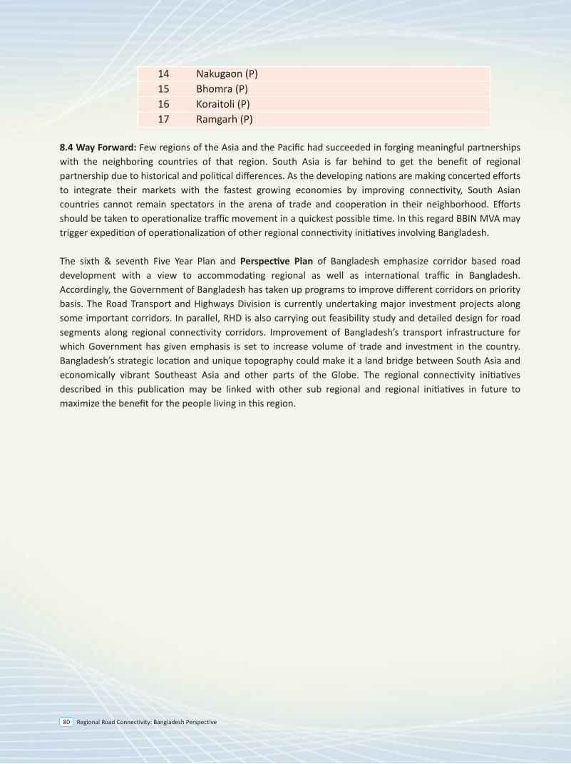
Regional Road Connectivity: Bangladesh Perspective80
8.2 Strategic Challenges
8.2.1. Facilitating landlocked countries
Priority should be given to improvement of sections than can provide landlocked countries with immediate access to nearest seaports. Hence, Bangladesh emphasizes improving those sections that allow landlocked countries such as Nepal and Bhutan to access two seaports in Bangladesh—Mongla and Chittagong.
8.2.2. Concurrent Cross-border development
Bangladesh attaches priority on those road stretches that will see concurrent development on both sides of the border and ensure greater regional economic benefits.
8.2.3. Improvement of substandard section
The improvement of substandard sections is crucially important for reaping the benefit of a road network. Each country should identify the substandard sections in its territory and evaluate the improvement of those stretches. In many cases, we can derive greater benefits if we can ensure improvement of a small stretch.
8.2.4 Creating Environment for facilitating international transport and logistic
In context of globalization, Asian countries are witnessing increase in international goods transport. However, ensuring seamless international movement of goods remains a major challenge. In order to reduce logistic costs, countries must strengthen trade facilitation programs to ensure improved performance in trades across borders. Recognizing the importance of strengthening relations and promoting international trade among member countries, it is crucially important to develop dry ports of international importance. Bangladesh signed the Instrument of Accession on 25 September 2014 for the Intergovernmental Agreement on Dry Ports. The Agreement has identified 17 Dry Ports/Inland Container Depot—Existing (E) and Potential (P)—for development and operation. These are listed below:
No. Dry Ports/Inland Container Deport 1 Kamalapur, Dhaka (Under Bangladesh Railway) (E) 2 Benapole (E) 3 Teknaf (E) 4 Akhaura (E) 5 Bibirbazar(E) 6 Hilli (E) 7 Sonamasjid (E) 8 Burimari (E) 9 Dhirasram, Gazipur (Proposed under Bangladesh Railway) (P) 10 Banglabandha (P) 11 Tamabil (P) 12 Bilonia (P) 13 Gobrakura (P)
14 Nakugaon (P) 15 Bhomra (P) 16 Koraitoli (P) 17 Ramgarh (P)
8.4 Way Forward: Few regions of the Asia and the Pacific had succeeded in forging meaningful partnerships with the neighboring countries of that region. South Asia is far behind to get the benefit of regional partnership due to historical and political differences. As the developing nations are making concerted efforts to integrate their markets with the fastest growing economies by improving connectivity, South Asian countries cannot remain spectators in the arena of trade and cooperation in their neighborhood. Efforts should be taken to operationalize traffic movement in a quickest possible time. In this regard BBIN MVA may trigger expedition of operationalization of other regional connectivity initiatives involving Bangladesh.
The sixth & seventh Five Year Plan and Perspective Plan of Bangladesh emphasize corridor based road development with a view to accommodating regional as well as international traffic in Bangladesh. Accordingly, the Government of Bangladesh has taken up programs to improve different corridors on priority basis. The Road Transport and Highways Division is currently undertaking major investment projects along some important corridors. In parallel, RHD is also carrying out feasibility study and detailed design for road segments along regional connectivity corridors. Improvement of Bangladesh’s transport infrastructure for which Government has given emphasis is set to increase volume of trade and investment in the country. Bangladesh’s strategic location and unique topography could make it a land bridge between South Asia and economically vibrant Southeast Asia and other parts of the Globe. The regional connectivity initiatives described in this publication may be linked with other sub regional and regional initiatives in future to maximize the benefit for the people living in this region.
Annexure
Regional Road Connectivity: Bangladesh Perspective 83
Annexure-I
Legal Arrangements on Regional Road Transport Participation in Intergovernmental/Sub regional/Multilateral/Bilateral Agreements
• Motor Vehicles Agreement for the Regulation of Passenger, Personal and Cargo Vehicular Traffic between Bangladesh, Bhutan, India, And Nepal: Signed by BBIN Transport Ministers on 15 June 2015 in Thimphu, Bhutan;
• Agreement between the Government of People’s Republic of Bangladesh and the Government of the Republic of India for the regulation of Motor Vehicle Passenger Traffic between the two Countries: Regarding Bus services for Kolkata - Dhaka - Agartala (signed on 06 June 2015) and Dhaka - Sylhet - Shilong - Gwahati (signed on 06 June 2015);
• Protocol regarding operation of Passenger Bus Services between Kolkata-Dhaka-Agartala (06 June 2015) and Dhaka-Sylhet-Shilong-Gwahati (06 June 2015) in terms of the Agreement;
• Draft Motor Vehicle Agreement for the Regulation of Passenger and Cargo Vehicular Traffic amongst SAARC Member States: Approved by Cabinet on 17 November 2014;
• Intergovernmental Agreement on Dry Ports: UN-ESCAP adopted the agreement and Signing Ceremony was held on 07 November 2013. Bangladesh signed the Instrument of Accession on 25 September 2014;
• India-Bangladesh Customs Standard Operating Procedure (SOP) for movement of vehicles from and to India, Nepal and Bhutan up to custom point sides;
• Intergovernmental Agreement on the Asian Highway Network: Adopted by UNESCAP on 18 November 2003 in Bangkok opened for signature in Shanghai, China from 26 to 28 April 2004 and thereafter at United Nations Headquarters in New York from 01 May, 2004 to 31December 2005. Bangladesh signed the Instrument of Accession on 05 July 2009 which was effected on 10 August 2009. The Agreement entered into force for Bangladesh on 08 November 2009;
• Agreement between the Government of People’s Republic of Bangladesh and the Government of the Union of Myanmar for direct road link, 2007;
• Protocol regarding operation of Passenger Bus Services between Dhaka-Kolkata-Dhaka (17 June 1999) and Dhaka-Agartala-Dhaka (10 July 2001) in terms of the Agreement;
• Agreement between the Government of People’s Republic of Bangladesh and the Government of the Republic of India for the regulation of Motor Vehicle Passenger Traffic between the two Countries regarding Bus services for Dhaka-Kolkata-Dhaka(17 June 1999) and Dhaka-Agartala-Dhaka(10 July 2001).
Regional Road Connectivity: Bangladesh Perspective84
Domestic Legislations
• The Metro Rail Act 2014(Under the Act, MRT system will be introduced);
• Toll Policy 2014;
• Road Maintenance Fund Board Act 2013;
• National Integrated Multimodal Transport Policy 2013;
• The Dhaka Transport Coordination Authority Act 2012;
• Motor Vehicles Axle Load Control Station Management Policy 2012;
• Sixth Five Year Plan(2011-2015): Accelerating Growth and reducing poverty, Strategic Directions, Policy
Framework and the Sectoral Plan;
• Policy and Strategy for Public Private Partnership (PPP) 2010;
• Perspective Plan 2010-2021: Aimed at implementing Vision 2021. Infrastructure Development will
improve integrated multimodal transport encompassing roads, railways and inland water transport
having connectivity with our neighbor;
• National Sustainable Development Strategy (2010-2021);
• Road Master Plan 2009: Intended to be the guiding document for investment in the road sector over the
next twenty years;
• The Motor Vehicles Ordinance 1983, The Motor Vehicles Rules, 1984 and The Motor Vehicles Rules, 1940;
• The Custom Act 1969;
• The Road Transport Corporation Ordinance 1961 (An ordinance to establish Road Transport Corporation
for operating road services in Bangladesh);
• The Tolls Act 1951;
• The Motor Vehicle Tax Act 1932;
• The Highways Act 1925.
Planned Participation in regional/ sub-regional/multilateral agreements
• Proposed SAARC Motor Vehicle Agreement;
• Proposed SAARC Regional Railways Agreement.
Expected Amendments and Formulation of Domestic Legislations
• Draft Bangladesh Road Transport Authority Act 2016 finalized;
• Draft Road Transport Act 2016 finalized (The Act will replace the Motor Vehicles Ordinance1983);
• Draft Bus Rapid Transit Act 2016 finalized.
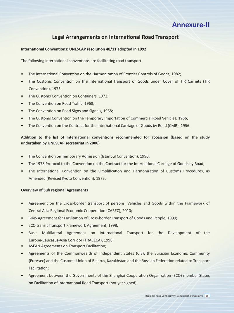
Regional Road Connectivity: Bangladesh Perspective 85
Annexure-IILegal Arrangements on International Road Transport
International Conventions: UNESCAP resolution 48/11 adopted in 1992
The following international conventions are facilitating road transport:
• The International Convention on the Harmonization of Frontier Controls of Goods, 1982;
• The Customs Convention on the international transport of Goods under Cover of TIR Carnets (TIR
Convention), 1975;
• The Customs Convention on Containers, 1972;
• The Convention on Road Traffic, 1968;
• The Convention on Road Signs and Signals, 1968;
• The Customs Convention on the Temporary Importation of Commercial Road Vehicles, 1956;
• The Convention on the Contract for the International Carriage of Goods by Road (CMR), 1956.
Addition to the list of International conventions recommended for accession (based on the study undertaken by UNESCAP secretariat in 2006)
• The Convention on Temporary Admission (Istanbul Convention), 1990;
• The 1978 Protocol to the Convention on the Contract for the International Carriage of Goods by Road;
• The International Convention on the Simplification and Harmonization of Customs Procedures, as
Amended (Revised Kyoto Convention), 1973.
Overview of Sub regional Agreements
• Agreement on the Cross-border transport of persons, Vehicles and Goods within the Framework of
Central Asia Regional Economic Cooperation (CAREC), 2010;
• GMS Agreement for Facilitation of Cross-border Transport of Goods and People, 1999;
• ECO transit Transport Framework Agreement, 1998;
• Basic Multilateral Agreement on International Transport for the Development of the
Europe-Caucasus-Asia Corridor (TRACECA), 1998;• ASEAN Agreements on Transport Facilitation;
• Agreements of the Commonwealth of Independent States (CIS), the Eurasian Economic Community
(EurAsec) and the Customs Union of Belarus, Kazakhstan and the Russian Federation related to Transport
Facilitation;
• Agreement between the Governments of the Shanghai Cooperation Organization (SCO) member States
on Facilitation of International Road Transport (not yet signed).
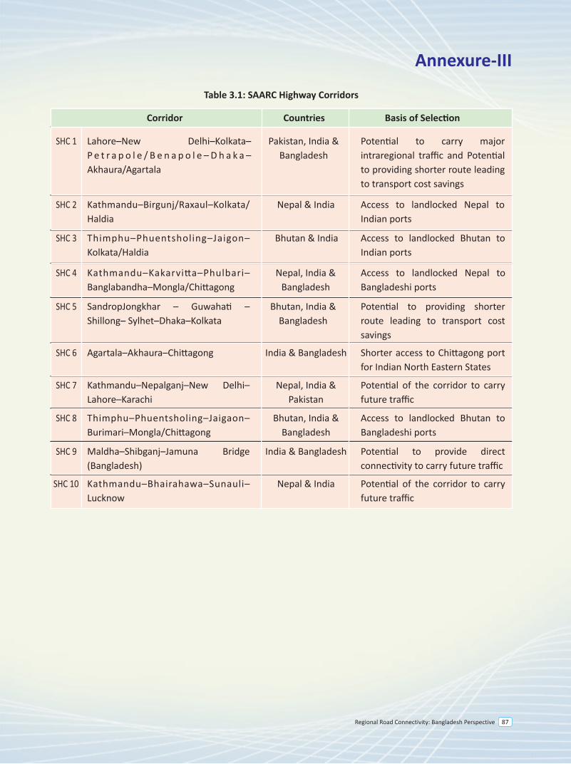
SHC 1 Lahore–New Delhi–Kolkata– P e t r a p o l e / B e n a p o l e – D h a k a – Akhaura/Agartala
Pakistan, India & Bangladesh
Potential to carry major intraregional traffic and Potential to providing shorter route leading to transport cost savings
SHC 2 Kathmandu–Birgunj/Raxaul–Kolkata/ Haldia
Nepal & India Access to landlocked Nepal to Indian ports
SHC 3 Thimphu–Phuentsholing–Jaigon– Kolkata/Haldia
Bhutan & India Access to landlocked Bhutan to Indian ports
SHC 4 Kathmandu–Kakarvitta–Phulbari– Banglabandha–Mongla/Chittagong
Nepal, India & Bangladesh
Access to landlocked Nepal to Bangladeshi ports
SHC 5 SandropJongkhar – Guwahati – Shillong– Sylhet–Dhaka–Kolkata
Bhutan, India & Bangladesh
Potential to providing shorter route leading to transport cost savings
SHC 7 Kathmandu–Nepalganj–New Delhi– Lahore–Karachi
Nepal, India & Pakistan
Potential of the corridor to carry future traffic
SHC 8 Thimphu–Phuentsholing–Jaigaon– Burimari–Mongla/Chittagong
Bhutan, India & Bangladesh
Access to landlocked Bhutan to Bangladeshi ports
SHC 9 Maldha–Shibganj–Jamuna Bridge (Bangladesh)
India & Bangladesh Potential to provide direct connectivity to carry future traffic
SHC 10 Kathmandu–Bhairahawa–Sunauli– Lucknow
Nepal & India Potential of the corridor to carry future traffic
SHC 6 Agartala–Akhaura–Chittagong India & Bangladesh Shorter access to Chittagong port for Indian North Eastern States
Table 3.1: SAARC Highway Corridors
Corridor Countries Basis of Selection
Annexure-III
Regional Road Connectivity: Bangladesh Perspective 87
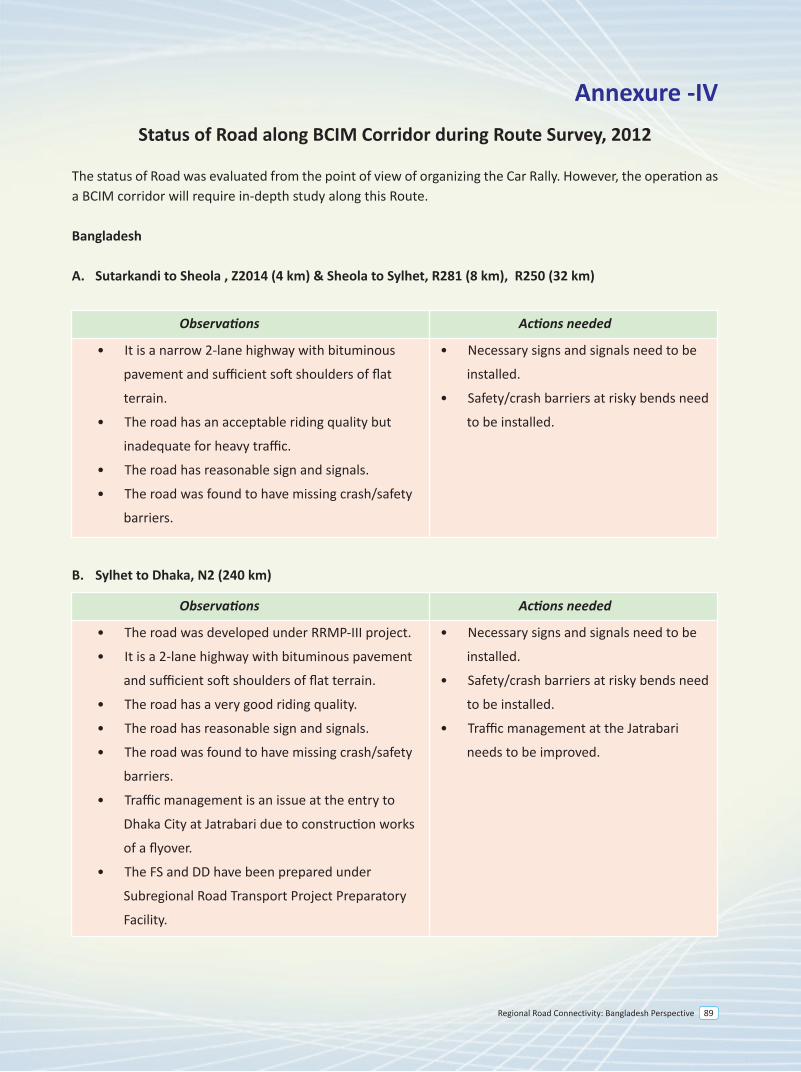
Regional Road Connectivity: Bangladesh Perspective 89
Annexure -IVStatus of Road along BCIM Corridor during Route Survey, 2012
The status of Road was evaluated from the point of view of organizing the Car Rally. However, the operation as a BCIM corridor will require in-depth study along this Route.
Bangladesh
A. Sutarkandi to Sheola , Z2014 (4 km) & Sheola to Sylhet, R281 (8 km), R250 (32 km)
B. Sylhet to Dhaka, N2 (240 km)
• It is a narrow 2-lane highway with bituminous
pavement and sufficient soft shoulders of flat
terrain.
• The road has an acceptable riding quality but
inadequate for heavy traffic.
• The road has reasonable sign and signals.
• The road was found to have missing crash/safety
barriers.
• Necessary signs and signals need to be
installed.
• Safety/crash barriers at risky bends need
to be installed.
Observations Actions needed
• The road was developed under RRMP-III project.
• It is a 2-lane highway with bituminous pavement
and sufficient soft shoulders of flat terrain.
• The road has a very good riding quality.
• The road has reasonable sign and signals.
• The road was found to have missing crash/safety
barriers.
• Traffic management is an issue at the entry to
Dhaka City at Jatrabari due to construction works
of a flyover.
• The FS and DD have been prepared under
Subregional Road Transport Project Preparatory
Facility.
• Necessary signs and signals need to be
installed.
• Safety/crash barriers at risky bends need
to be installed.
• Traffic management at the Jatrabari
needs to be improved.
Observations Actions needed
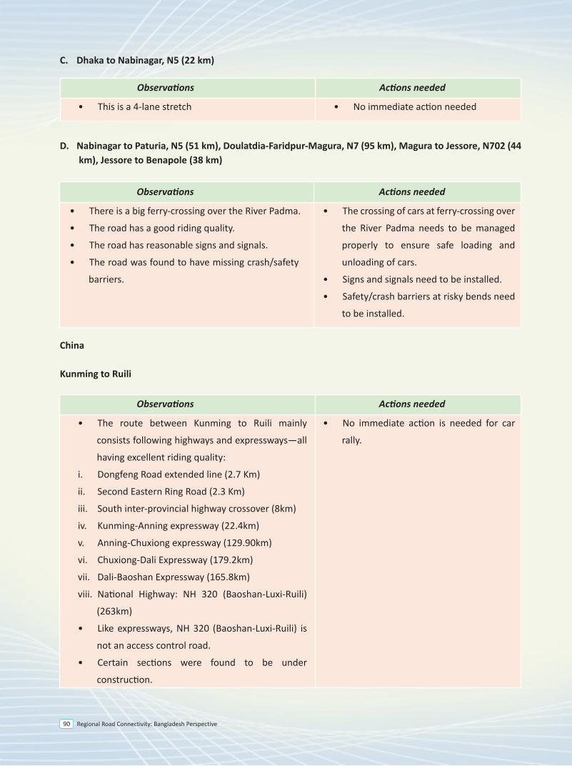
Regional Road Connectivity: Bangladesh Perspective90
C. Dhaka to Nabinagar, N5 (22 km)
D. Nabinagar to Paturia, N5 (51 km), Doulatdia-Faridpur-Magura, N7 (95 km), Magura to Jessore, N702 (44 km), Jessore to Benapole (38 km)
China
Kunming to Ruili
• There is a big ferry-crossing over the River Padma.
• The road has a good riding quality.
• The road has reasonable signs and signals.
• The road was found to have missing crash/safety
barriers.
• The crossing of cars at ferry-crossing over
the River Padma needs to be managed
properly to ensure safe loading and
unloading of cars.
• Signs and signals need to be installed.
• Safety/crash barriers at risky bends need
to be installed.
Observations Actions needed
• The route between Kunming to Ruili mainly
consists following highways and expressways—all
having excellent riding quality:
i. Dongfeng Road extended line (2.7 Km)
ii. Second Eastern Ring Road (2.3 Km)
iii. South inter-provincial highway crossover (8km)
iv. Kunming-Anning expressway (22.4km)
v. Anning-Chuxiong expressway (129.90km)
vi. Chuxiong-Dali Expressway (179.2km)
vii. Dali-Baoshan Expressway (165.8km)
viii. National Highway: NH 320 (Baoshan-Luxi-Ruili)
(263km)
• Like expressways, NH 320 (Baoshan-Luxi-Ruili) is
not an access control road.
• Certain sections were found to be under
construction.
• No immediate action is needed for car
rally.
Observations Actions needed
• This is a 4-lane stretch • No immediate action needed
Observations Actions needed
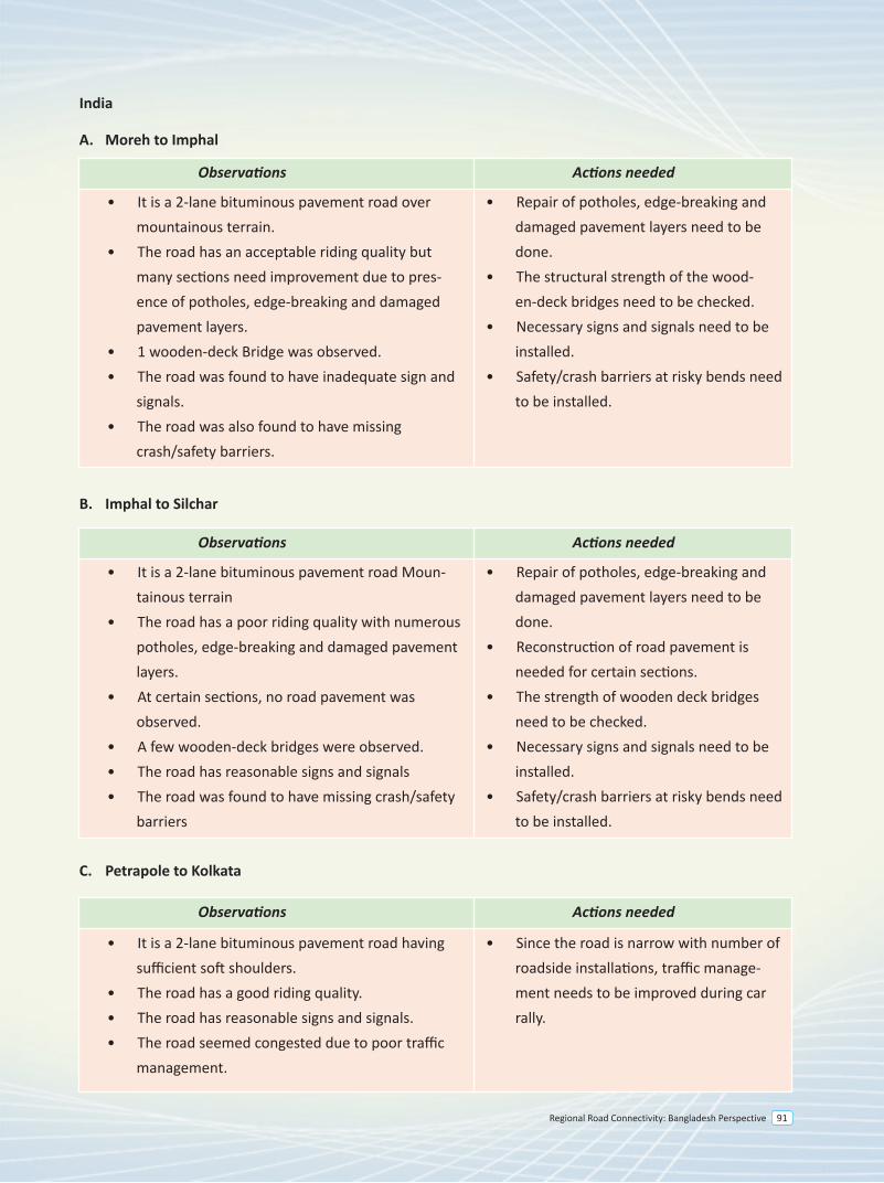
Regional Road Connectivity: Bangladesh Perspective 91
India
A. Moreh to Imphal
B. Imphal to Silchar
C. Petrapole to Kolkata
• It is a 2-lane bituminous pavement road Moun-tainous terrain
• The road has a poor riding quality with numerous potholes, edge-breaking and damaged pavement layers.
• At certain sections, no road pavement was observed.
• A few wooden-deck bridges were observed.• The road has reasonable signs and signals• The road was found to have missing crash/safety
barriers
• Repair of potholes, edge-breaking and damaged pavement layers need to be done.
• Reconstruction of road pavement is needed for certain sections.
• The strength of wooden deck bridges need to be checked.
• Necessary signs and signals need to be installed.
• Safety/crash barriers at risky bends need to be installed.
Observations Actions needed
• It is a 2-lane bituminous pavement road having sufficient soft shoulders.
• The road has a good riding quality.• The road has reasonable signs and signals.• The road seemed congested due to poor traffic
management.
• Since the road is narrow with number of roadside installations, traffic manage-ment needs to be improved during car rally.
Observations Actions needed
• It is a 2-lane bituminous pavement road over mountainous terrain.
• The road has an acceptable riding quality but many sections need improvement due to pres-ence of potholes, edge-breaking and damaged pavement layers.
• 1 wooden-deck Bridge was observed. • The road was found to have inadequate sign and
signals.• The road was also found to have missing
crash/safety barriers.
• Repair of potholes, edge-breaking and damaged pavement layers need to be done.
• The structural strength of the wood-en-deck bridges need to be checked.
• Necessary signs and signals need to be installed.
• Safety/crash barriers at risky bends need to be installed.
Observations Actions needed
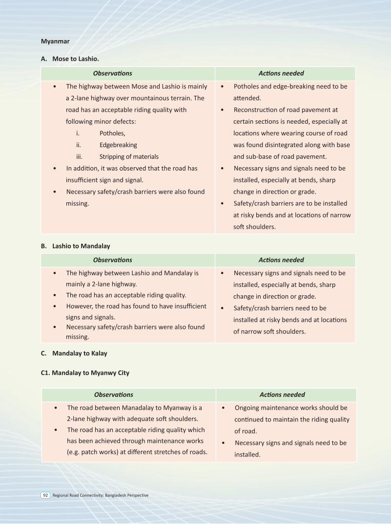
Regional Road Connectivity: Bangladesh Perspective92
Myanmar
A. Mose to Lashio.
B. Lashio to Mandalay
C. Mandalay to Kalay
C1. Mandalay to Myanwy City
• The road between Manadalay to Myanway is a 2-lane highway with adequate soft shoulders.
• The road has an acceptable riding quality which has been achieved through maintenance works (e.g. patch works) at different stretches of roads.
• Ongoing maintenance works should be
continued to maintain the riding quality
of road.
• Necessary signs and signals need to be
installed.
Observations Actions needed
• The highway between Mose and Lashio is mainly
a 2-lane highway over mountainous terrain. The
road has an acceptable riding quality with
following minor defects:
i. Potholes,
ii. Edgebreaking
iii. Stripping of materials
• In addition, it was observed that the road has
insufficient sign and signal.
• Necessary safety/crash barriers were also found
missing.
• Potholes and edge-breaking need to be
attended.
• Reconstruction of road pavement at
certain sections is needed, especially at
locations where wearing course of road
was found disintegrated along with base
and sub-base of road pavement.
• Necessary signs and signals need to be
installed, especially at bends, sharp
change in direction or grade.
• Safety/crash barriers are to be installed
at risky bends and at locations of narrow
soft shoulders.
Observations Actions needed
• The highway between Lashio and Mandalay is mainly a 2-lane highway.
• The road has an acceptable riding quality.• However, the road has found to have insufficient
signs and signals. • Necessary safety/crash barriers were also found
missing.
• Necessary signs and signals need to be
installed, especially at bends, sharp
change in direction or grade.
• Safety/crash barriers need to be
installed at risky bends and at locations
of narrow soft shoulders.
Observations Actions needed
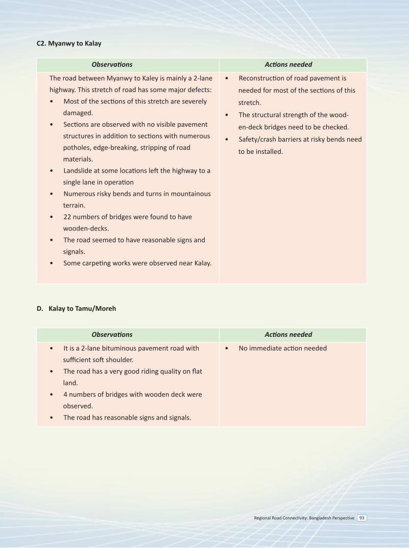
Regional Road Connectivity: Bangladesh Perspective 93
C2. Myanwy to Kalay
D. Kalay to Tamu/Moreh
• It is a 2-lane bituminous pavement road with sufficient soft shoulder.
• The road has a very good riding quality on flat land.
• 4 numbers of bridges with wooden deck were observed.
• The road has reasonable signs and signals.
• No immediate action needed
Observations Actions needed
The road between Myanwy to Kaley is mainly a 2-lane highway. This stretch of road has some major defects: • Most of the sections of this stretch are severely
damaged. • Sections are observed with no visible pavement
structures in addition to sections with numerous potholes, edge-breaking, stripping of road materials.
• Landslide at some locations left the highway to a single lane in operation
• Numerous risky bends and turns in mountainous terrain.
• 22 numbers of bridges were found to have wooden-decks.
• The road seemed to have reasonable signs and signals.
• Some carpeting works were observed near Kalay.
• Reconstruction of road pavement is
needed for most of the sections of this
stretch.
• The structural strength of the wood-
en-deck bridges need to be checked.
• Safety/crash barriers at risky bends need
to be installed.
Observations Actions needed
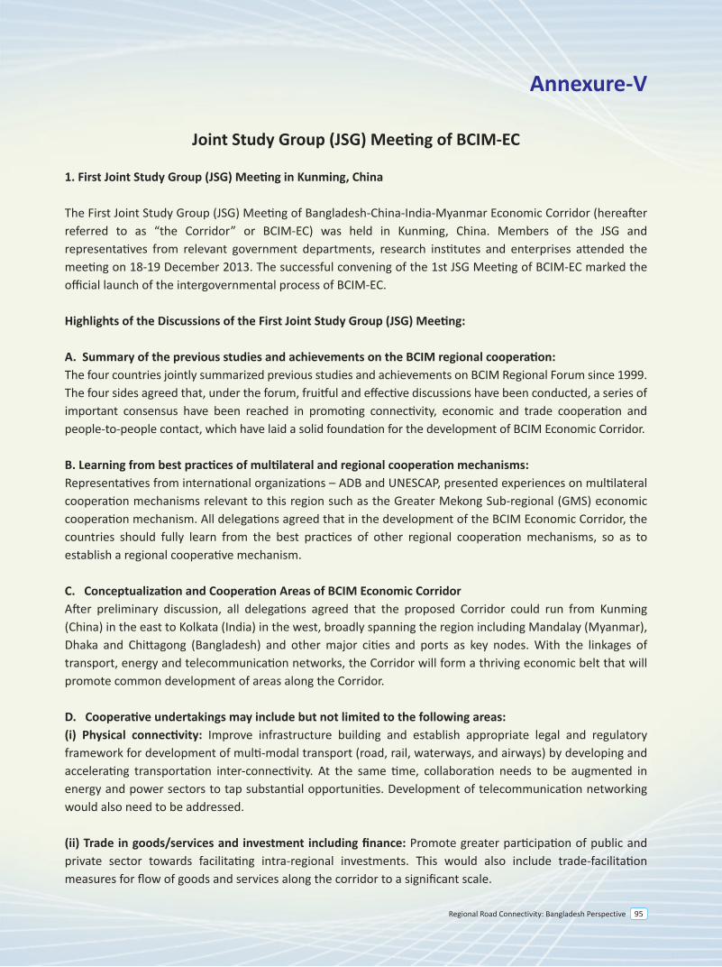
Regional Road Connectivity: Bangladesh Perspective 95
Annexure-V
Joint Study Group (JSG) Meeting of BCIM-EC
1. First Joint Study Group (JSG) Meeting in Kunming, China
The First Joint Study Group (JSG) Meeting of Bangladesh-China-India-Myanmar Economic Corridor (hereafter referred to as “the Corridor” or BCIM-EC) was held in Kunming, China. Members of the JSG and representatives from relevant government departments, research institutes and enterprises attended the meeting on 18-19 December 2013. The successful convening of the 1st JSG Meeting of BCIM-EC marked the official launch of the intergovernmental process of BCIM-EC.
Highlights of the Discussions of the First Joint Study Group (JSG) Meeting: A. Summary of the previous studies and achievements on the BCIM regional cooperation:The four countries jointly summarized previous studies and achievements on BCIM Regional Forum since 1999. The four sides agreed that, under the forum, fruitful and effective discussions have been conducted, a series of important consensus have been reached in promoting connectivity, economic and trade cooperation and people-to-people contact, which have laid a solid foundation for the development of BCIM Economic Corridor.
B. Learning from best practices of multilateral and regional cooperation mechanisms:Representatives from international organizations – ADB and UNESCAP, presented experiences on multilateral cooperation mechanisms relevant to this region such as the Greater Mekong Sub-regional (GMS) economic cooperation mechanism. All delegations agreed that in the development of the BCIM Economic Corridor, the countries should fully learn from the best practices of other regional cooperation mechanisms, so as to establish a regional cooperative mechanism. C. Conceptualization and Cooperation Areas of BCIM Economic CorridorAfter preliminary discussion, all delegations agreed that the proposed Corridor could run from Kunming (China) in the east to Kolkata (India) in the west, broadly spanning the region including Mandalay (Myanmar), Dhaka and Chittagong (Bangladesh) and other major cities and ports as key nodes. With the linkages of transport, energy and telecommunication networks, the Corridor will form a thriving economic belt that will promote common development of areas along the Corridor.
D. Cooperative undertakings may include but not limited to the following areas: (i) Physical connectivity: Improve infrastructure building and establish appropriate legal and regulatory framework for development of multi-modal transport (road, rail, waterways, and airways) by developing and accelerating transportation inter-connectivity. At the same time, collaboration needs to be augmented in energy and power sectors to tap substantial opportunities. Development of telecommunication networking would also need to be addressed.
(ii) Trade in goods/services and investment including finance: Promote greater participation of public and private sector towards facilitating intra-regional investments. This would also include trade-facilitation measures for flow of goods and services along the corridor to a significant scale.
Regional Road Connectivity: Bangladesh Perspective96
(iii) Environmentally sustainable development: Actively advance cooperation in agriculture and environmental industries to create a basis for sustainable development and livelihoods for the benefit of the people and reduce poverty along the Corridor. Also, water resources may be conserved, developed and tapped beneficially. Initiatives may also be undertaken to tackle climate change challenges facing the Corridor.
(iv) People to people contact: Enhance exchanges and cooperation in areas such as education, science and technology, culture, healthcare, sports as well as human resource development. Further strengthen infrastructure facilities and explore the tourism potential of the region to create a BCIM tourism circle.
E. Mechanism building for BCIM Economic Corridor
All delegations agreed to the “Joint Study Program of Bangladesh-China-India-Myanmar Economic Corridor”. The minutes was agreed and signed by the delegation heads of Bangladesh, China, India and Myanmar on the 19th day of December 2013 in Kunming, Yunnan Province, China.
The joint study aims to arrive at a consensus report for the proposed Bangladesh-China-India-Myanmar Economic Corridor (BCIM-EC). The joint study group report with recommendations on inter-governmental cooperation shall be presented to the respective governments for their consideration/ collective decision.
In the course of its study, the joint study group may, inter alia, assess earlier work done within and beyond the region, consult and seek views, conduct field studies, hold workshops and site visits, carry out research and assessments and also co-opt subject or field experts and officials, as and when required, and to the extent possible.
2. The Second Joint Study Group (JSG) Meeting of BCIM-EC in Cox’s Bazar, Bangladesh:
In keeping with the decisions taken in the first Joint Study Group (JSG) Meeting of Bangladesh-China-India-Myanmar Economic Corridor held in Kunming, China, the Government of Bangladesh hosted the second BCIM-EC Joint Study Group (JSG) meeting at Cox’s Bazar on 17-18 December 2014. The meeting discussed the draft country reports as presented on the agreed eleven chapters by each country delegation.
Way Forward
It was agreed in the second Joint Study Group (JSG) Meeting that the countries would transmit the finalized country reports to the designated focal persons of the respective countries by 15 February, 2015. Subsequently the designated countries would finalize respective synthesized chapters by 31 may 2015. The draft synthesized chapters would be circulated to the other countries for comments where feedback would be sent by 30 June 2015. India agreed to host the 3rd meeting in the second half of 2015.
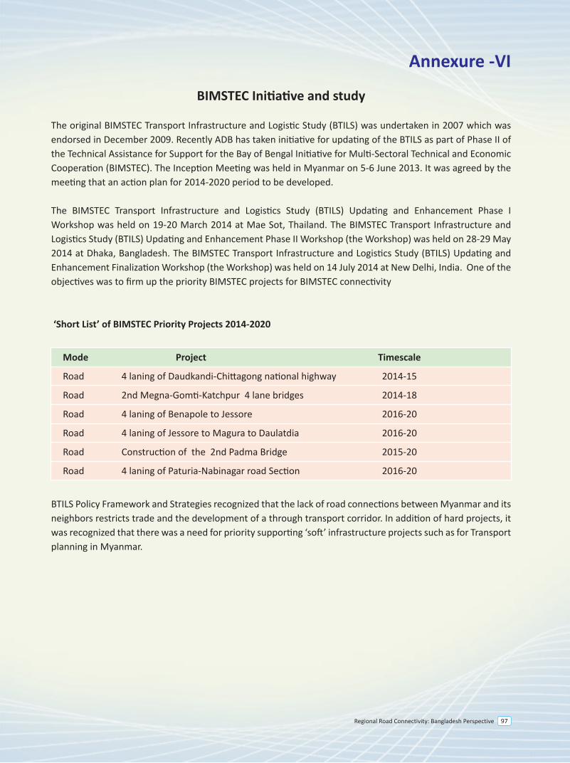
Regional Road Connectivity: Bangladesh Perspective 97
Annexure -VI
BIMSTEC Initiative and study
The original BIMSTEC Transport Infrastructure and Logistic Study (BTILS) was undertaken in 2007 which was endorsed in December 2009. Recently ADB has taken initiative for updating of the BTILS as part of Phase II of the Technical Assistance for Support for the Bay of Bengal Initiative for Multi-Sectoral Technical and Economic Cooperation (BIMSTEC). The Inception Meeting was held in Myanmar on 5-6 June 2013. It was agreed by the meeting that an action plan for 2014-2020 period to be developed.
The BIMSTEC Transport Infrastructure and Logistics Study (BTILS) Updating and Enhancement Phase I Workshop was held on 19-20 March 2014 at Mae Sot, Thailand. The BIMSTEC Transport Infrastructure and Logistics Study (BTILS) Updating and Enhancement Phase II Workshop (the Workshop) was held on 28-29 May 2014 at Dhaka, Bangladesh. The BIMSTEC Transport Infrastructure and Logistics Study (BTILS) Updating and Enhancement Finalization Workshop (the Workshop) was held on 14 July 2014 at New Delhi, India. One of the objectives was to firm up the priority BIMSTEC projects for BIMSTEC connectivity
‘Short List’ of BIMSTEC Priority Projects 2014-2020
Mode Project Timescale
Road 4 laning of Daudkandi-Chittagong national highway 2014-15
Road 2nd Megna-Gomti-Katchpur 4 lane bridges 2014-18
Road 4 laning of Benapole to Jessore 2016-20
Road 4 laning of Jessore to Magura to Daulatdia 2016-20
Road Construction of the 2nd Padma Bridge 2015-20
Road 4 laning of Paturia-Nabinagar road Section 2016-20
BTILS Policy Framework and Strategies recognized that the lack of road connections between Myanmar and its neighbors restricts trade and the development of a through transport corridor. In addition of hard projects, it was recognized that there was a need for priority supporting ‘soft’ infrastructure projects such as for Transport planning in Myanmar.
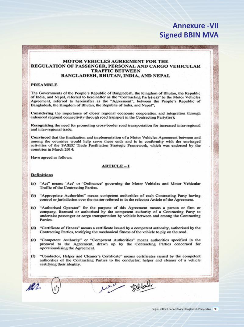
Regional Road Connectivity: Bangladesh Perspective 99
Annexure -VIISigned BBIN MVA
Regional Road Connectivity: Bangladesh Perspective100
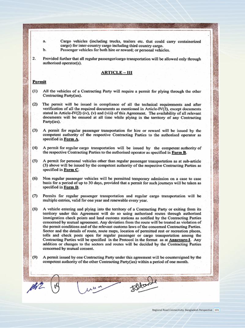
Regional Road Connectivity: Bangladesh Perspective 101
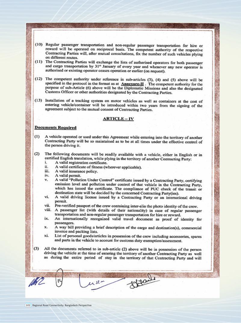
Regional Road Connectivity: Bangladesh Perspective102
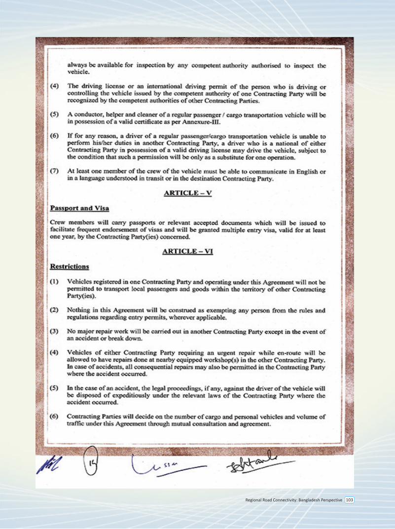
Regional Road Connectivity: Bangladesh Perspective 103
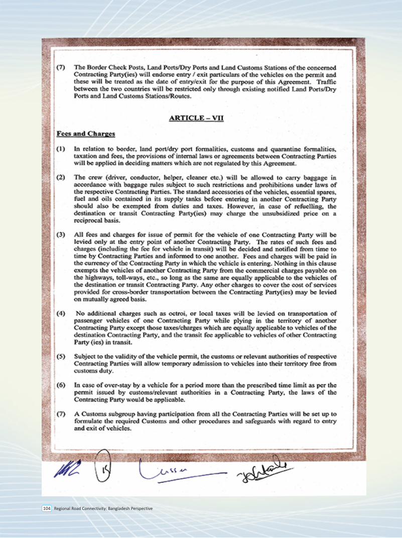
Regional Road Connectivity: Bangladesh Perspective104
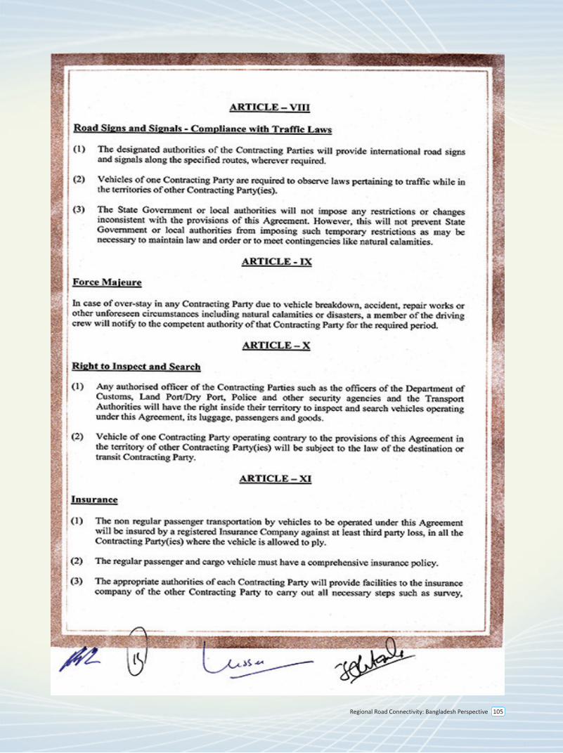
Regional Road Connectivity: Bangladesh Perspective 105
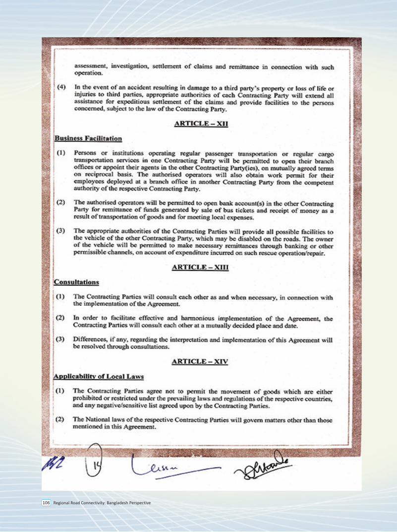
Regional Road Connectivity: Bangladesh Perspective106
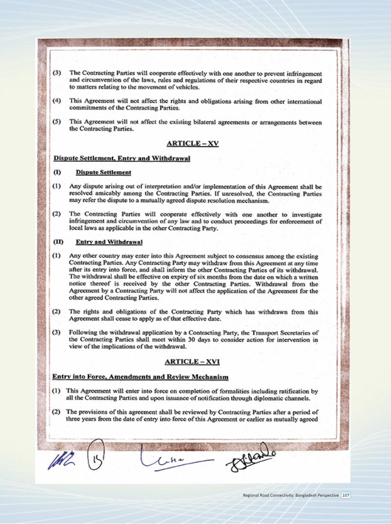
Regional Road Connectivity: Bangladesh Perspective 107
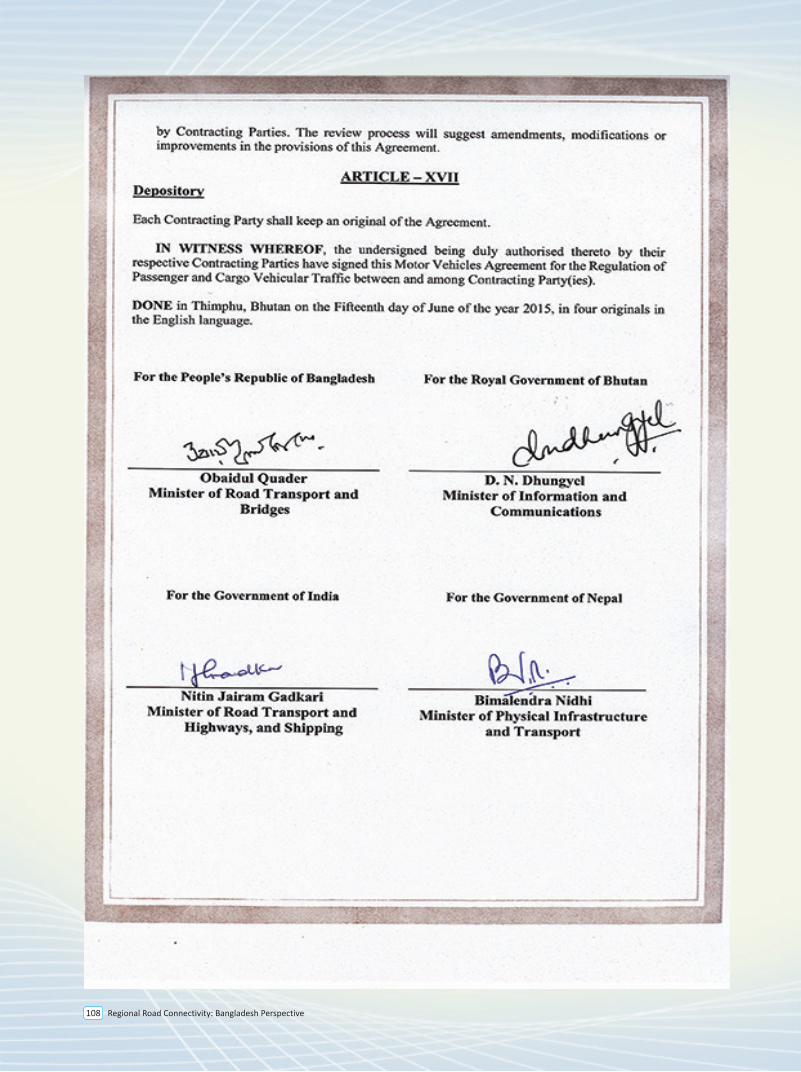
Regional Road Connectivity: Bangladesh Perspective108
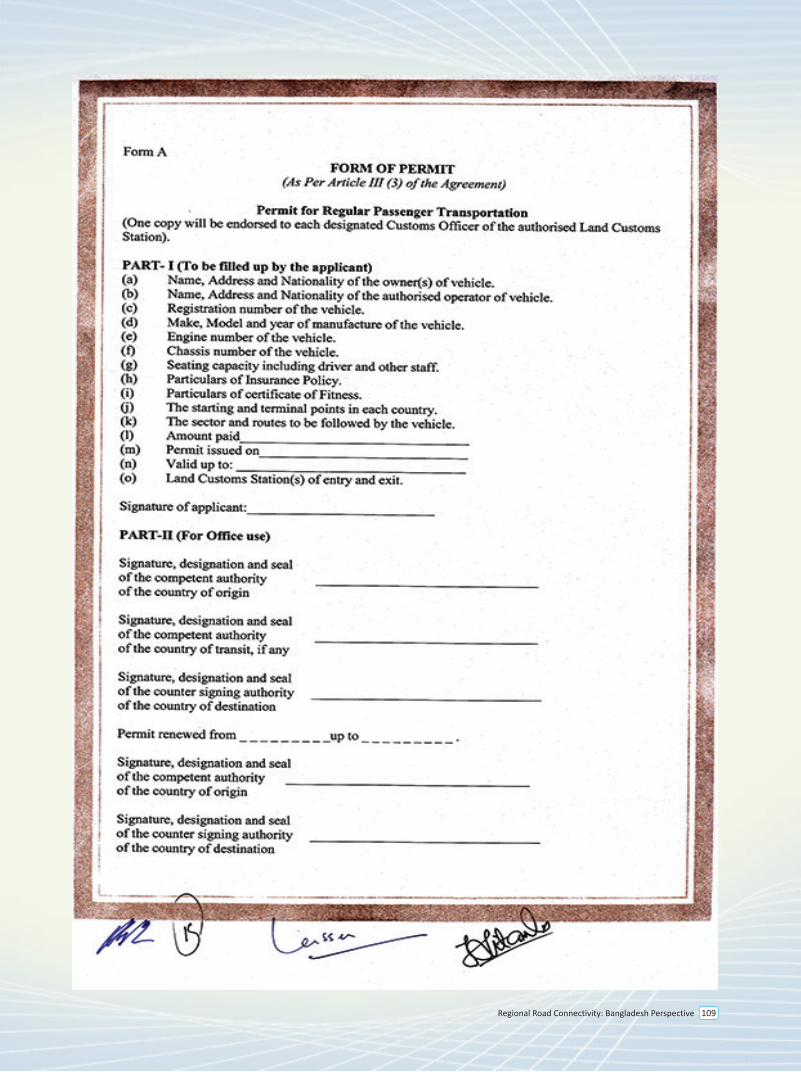
Regional Road Connectivity: Bangladesh Perspective 109
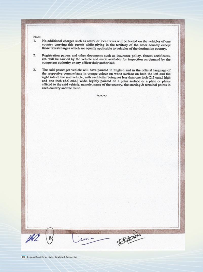
Regional Road Connectivity: Bangladesh Perspective 110
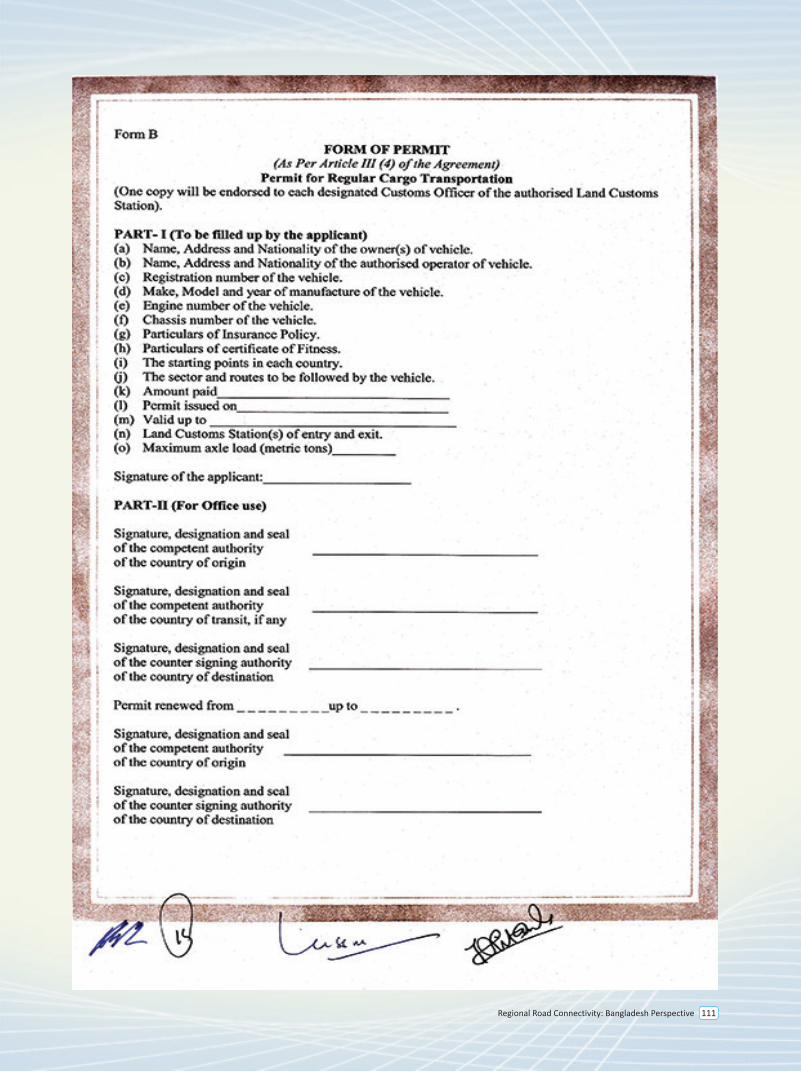
Regional Road Connectivity: Bangladesh Perspective 111
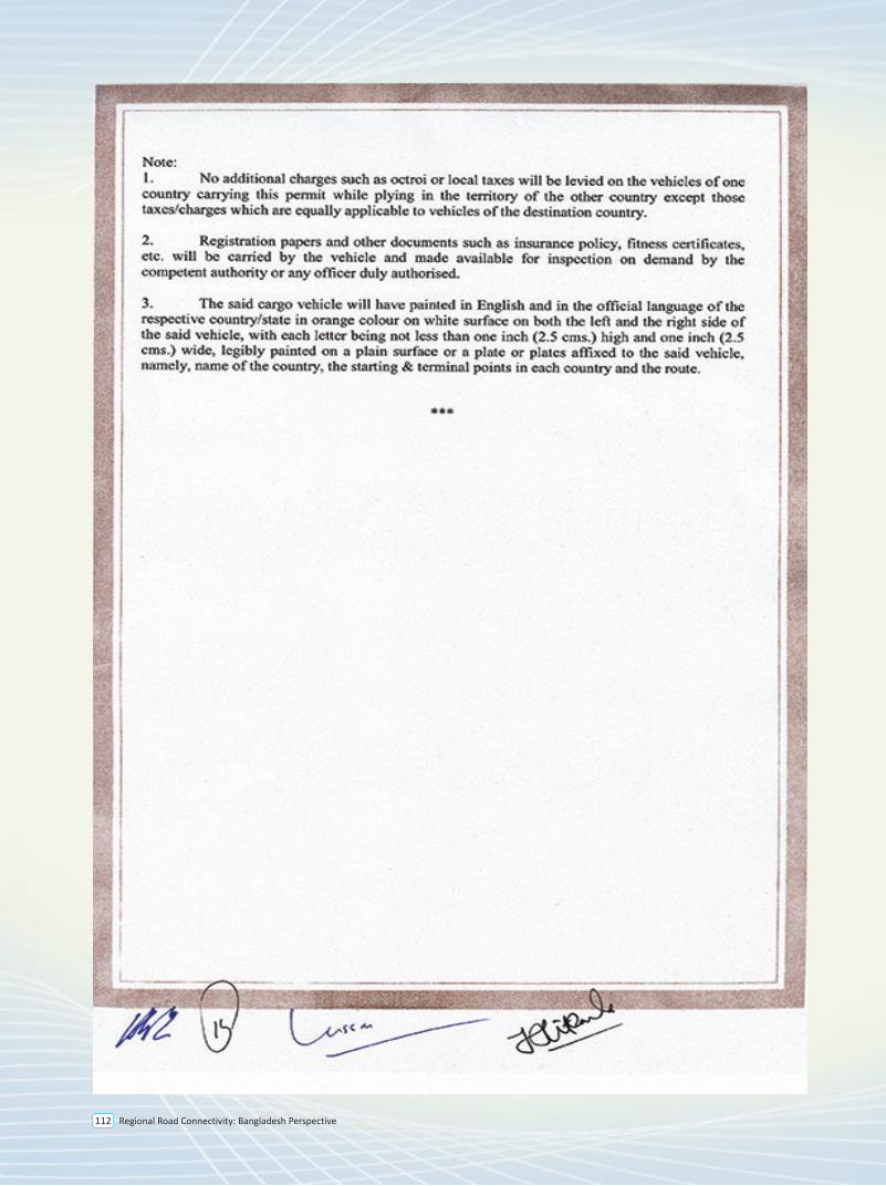
Regional Road Connectivity: Bangladesh Perspective112
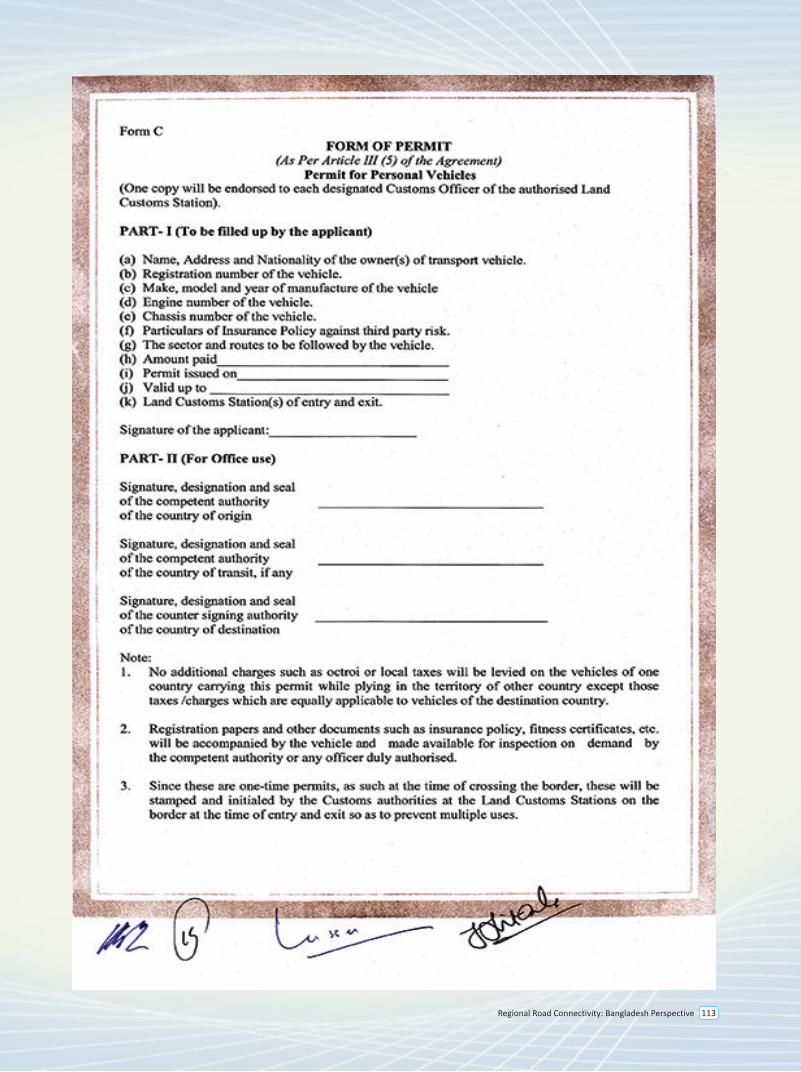
Regional Road Connectivity: Bangladesh Perspective 113
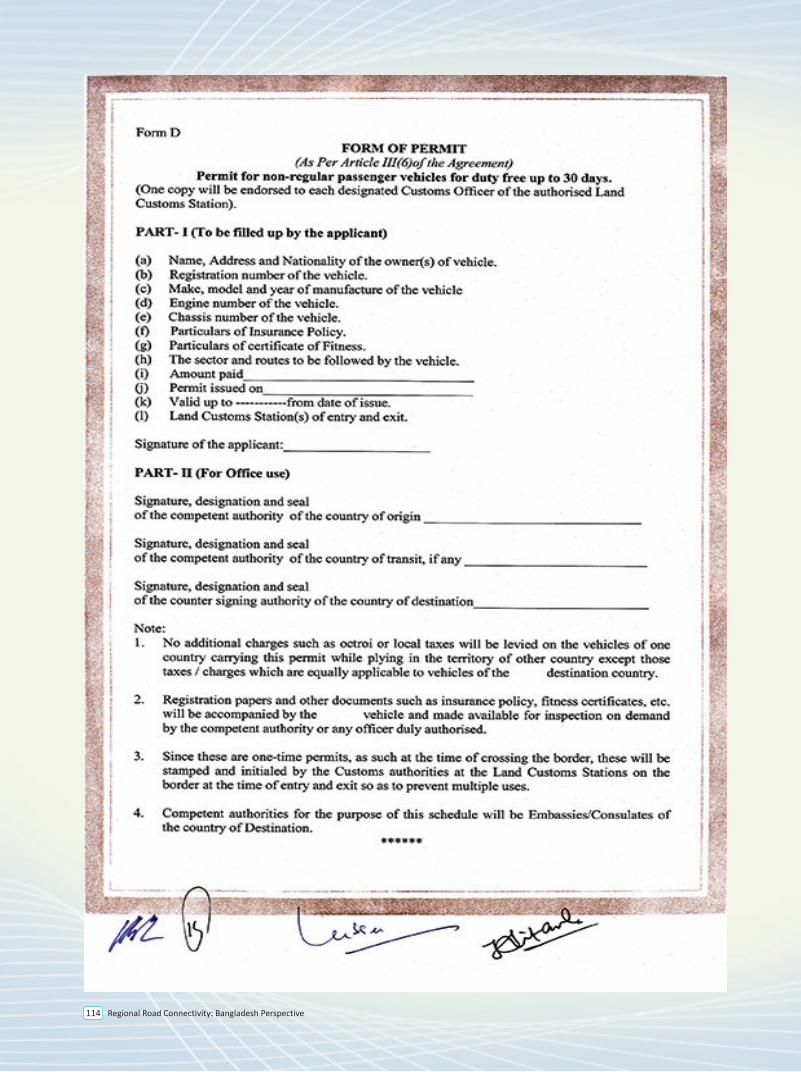
Regional Road Connectivity: Bangladesh Perspective114
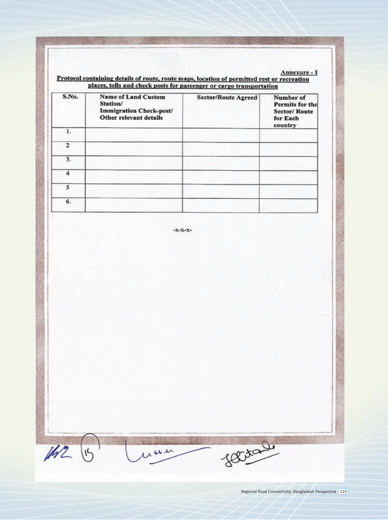
Regional Road Connectivity: Bangladesh Perspective 115
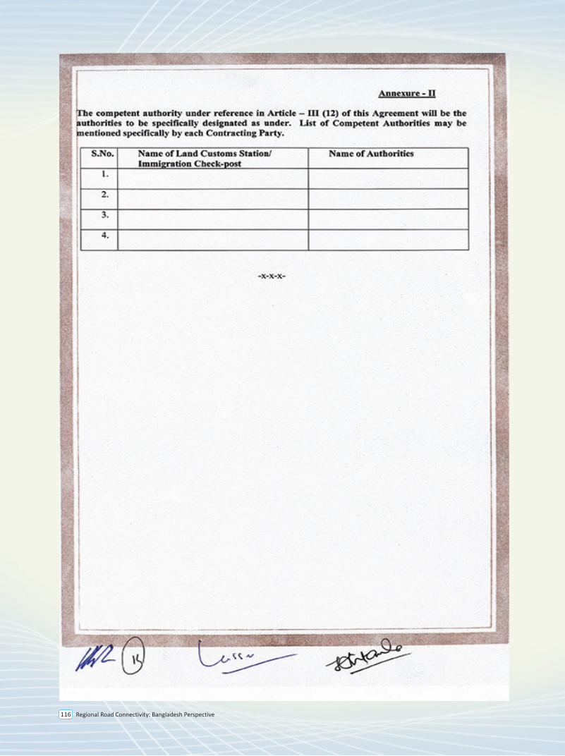
Regional Road Connectivity: Bangladesh Perspective116
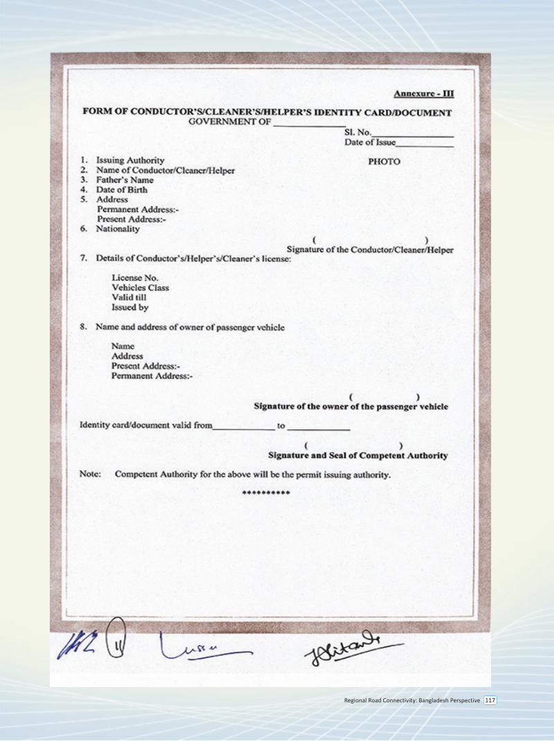
Regional Road Connectivity: Bangladesh Perspective 117
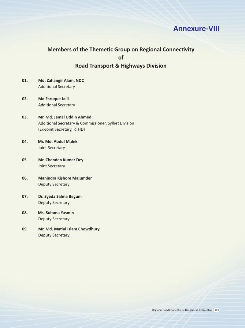
Regional Road Connectivity: Bangladesh Perspective 119
Annexure-VIII
Members of the Themetic Group on Regional Connectivity of
Road Transport & Highways Division
01. Md. Zahangir Alam, NDC Additional Secretary
02. Md Faruque Jalil Additional Secretary 03. Mr. Md. Jamal Uddin Ahmed Additional Secretary & Commissioner, Sylhet Division (Ex-Joint Secretary, RTHD)
04. Mr. Md. Abdul Malek Joint Secretary
05 Mr. Chandan Kumar Dey Joint Secretary
06. Manindra Kishore Majumder Deputy Secretary
07. Dr. Syeda Salma Begum Deputy Secretary
08. Ms. Sultana Yasmin Deputy Secretary
09. Mr. Md. Matiul Islam Chowdhury Deputy Secretary
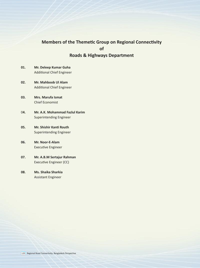
Regional Road Connectivity: Bangladesh Perspective120
Members of the Themetic Group on Regional Connectivity of
Roads & Highways Department
01. Mr. Deleep Kumar Guha Additional Chief Engineer
02. Mr. Mahboob Ul Alam Additional Chief Engineer
03. Mrs. Marufa Ismat Chief Economist
04. Mr. A.K. Mohammad Fazlul Karim Superintending Engineer
05. Mr. Shishir Kanti Routh Superintending Engineer
06. Mr. Noor-E-Alam Executive Engineer
07. Mr. A.B.M Sertajur Rahman Executive Engineer (CC)
08. Ms. Shaika Sharkia Assistant Engineer