recovering a lost baseline: missing kelp forests from a metropolitan coast
TRANSCRIPT

MARINE ECOLOGY PROGRESS SERIESMar Ecol Prog Ser
Vol. 360: 63–72, 2008doi: 10.3354/meps07526
Published May 22
INTRODUCTION
What of the natural world is ‘natural’? This questionmotivates a substantial amount of ecological researchthat seeks to separate natural processes from the over-riding influence of human activity in the maintenanceof the natural environment (Jackson et al. 2001). The
answers are not only central to the science of ecology,but also to the societies that depend on this informationfor their management of natural resources. In mostcases, the answers and forecasted benefits of manage-ment (i.e. manipulations of human activities) requireknowledge of the ‘natural’ or original state of a system.The reality, however, is that very little of the ‘natural’
© Inter-Research 2008 · www.int-res.com*Email: [email protected]
Recovering a lost baseline: missing kelp forests froma metropolitan coast
Sean D. Connell1,*, Bayden D. Russell1, David J. Turner2, Scoresby A. Shepherd3, Timothy Kildea4, David Miller5, Laura Airoldi6, Anthony Cheshire7
1Southern Seas Ecology Laboratories DX 650 418, School of Earth and Environmental Sciences, University of Adelaide, South Australia 5005, Australia
2Regional Conservation, Department for Environment and Heritage, GPO Box 1047, Adelaide, South Australia 5001, Australia3South Australian Research and Development Institute (Aquatic Sciences), PO Box 120, Henley Beach, South Australia 5022, Australia
4Australian Water Quality Centre, PMB 3, Salisbury, South Australia 5108, Australia5Coast & Marine Conservation Branch, Natural and Cultural Heritage Directorate, Dept of Environment and Heritage, Keswick,
South Australia 5035, Australia6Università di Bologna, Via S. Alberto 163, 48100 Ravenna, Italy
7Science to Manage Uncertainty, 24 Winding Way, Belair, South Australia 5052, Australia
ABSTRACT: There is concern about historical and continuing loss of canopy-forming algae across theworld’s temperate coastline. In South Australia, the sparse cover of canopy-forming algae on theAdelaide metropolitan coast has been of public concern with continuous years of anecdotal evidenceculminating in 2 competing views. One view considers that current patterns existed before the onset ofurbanisation, whereas the alternate view is that they developed after urbanisation. We tested hypothe-ses to distinguish between these 2 models, each centred on the reconstruction of historical covers ofcanopies on the metropolitan coast. Historically, the metropolitan sites were indistinguishable from con-temporary populations of reference sites across 70 km (i.e. Gulf St. Vincent), and could also represent arandom subset of exposed coastal sites across 2100 km of the greater biogeographic province. Thusthere was nothing ‘special’ about the metropolitan sites historically, but today they stand out becausethey have sparser covers of canopies compared to equivalent locations and times in the gulf and thegreater province. This is evidence of wholesale loss of canopy-forming algae (up to 70%) on parts of theAdelaide metropolitan coast since major urbanisation. These findings not only set a research agendabased on the magnitude of loss, but they also bring into question the logic that smaller metropolitanpopulations of humans create impacts that are trivial relative to that of larger metropolitan centres.Instead, we highlight a need to recognise the ecological context that makes some coastal systems morevulnerable or resistant to increasing human-domination of the world’s coastlines. We discuss challengesto this kind of research that receive little ecological discussion, particularly better leadership andadministration, recognising that the systems we study out-live the life spans of individual researchgroups and operate on spatial scales that exceed the capacity of single research providers.
KEY WORDS: Urban coast · Turf · Canopy algae · Human impact · Anthropogenic · Nutrient ·Historical baseline · Habitat loss
Resale or republication not permitted without written consent of the publisher
OPENPEN ACCESSCCESS

Mar Ecol Prog Ser 360: 63–72, 2008
environment is unaffected by human activity, a forcethat continues to modify and dominate the ecology ofmost systems (Vitousek et al. 1997). It is problematicthat little is understood of past environments, becausedegradation has gone unrecognised for generations ofscientists, and the identification of what was ‘natural’becomes increasingly difficult with each passing gen-eration. Indeed, as each generation accepts a progres-sively more degraded state as ‘natural’, i.e. the so-called ‘shifting-baseline’ syndrome (Pauly 1995,Dayton et al. 1998), both scientists and managers con-tinually reduce their expectations of the environment.
The greatest challenge facing the recovery of lostbaselines is not so much the science, but a culture ofscience that is reluctant to accept anecdotal evidence(Pauly 1995). Such conservatism is an important hall-mark of science (Kuhn 1996), but is particularlytroublesome to the recovery of baselines when fewlong-term data sets are available for most systems. Al-though effects of humans may be difficult to separatefrom natural changes in systems for which disturbancesare fundamental to their dynamics (e.g. kelp forests;Connell 2007a), early effects of humans on systemswere often quite dramatic (Pauly 1995), and recoveringthese lost baselines may be possible in many cases.
Globally, there is concern about widespread loss ofcanopy-forming algae across many parts of the world’srocky coastlines (e.g. Australia, Connell 2007b; Europe,Airoldi & Beck 2007, America, Steneck et al. 2002). Innorthern Europe, where coastal inhabitation by largepopulations of humans has a relatively long history, theloss of large canopies of macroalgae appears to havebeen permanent (e.g. Baltic Sea, Elmgren 2001; NorthSea, Eriksson et al. 2002) and has parallels to theMediterranean Sea, where tall canopies of macroalgaeare puzzlingly rare or under severe regression (e.g.Thibaut et al. 2005, Mangialajo et al. 2008). In this re-gard, South Australia presents one of the more promis-ing global locations to understand such subtidal changebecause of its very recent history of major coastal use byhumans (i.e. occupation by Europeans since 1836 andaccelerated coastal development since the late 1970s).
South Australia’s major city has a small metropolitanpopulation (i.e. Adelaide City has 1.2 million people onthe eastern side of Gulf St. Vincent), and this presentsecological research with an accessible system in whichto study anthropogenic effects over the recent past(e.g. collapse of kelp forests, Jackson et al. 2001).Moreover, the archival evidence needed to reconstructlost baselines of South Australia’s metropolitan subti-dal coast is unusually robust for such historical recon-structions. This is because most losses have occurred inrecent history, and scientific divers have kept logbooks of research dives since the 1960s, when subtidalecology was pioneered with the use of SCUBA (for a
review of the early years of subtidal ecology, see Shep-herd 2007). In this regard, recovering a lost baseline ofsubtidal habitat on this particular coast may shed lighton other subtidal systems for which human activitiesare linked to massive changes that took place longbefore humans donned SCUBA and began studies ofsubtidal ecology (e.g. Europe, Airoldi & Beck 2007).
In South Australia, the apparent loss of canopy-forming algae on the Adelaide metropolitan coast hasbeen of public concern with continuous years of anec-dotal evidence culminating in community groups ded-icated to observing subtidal flora and fauna (ReefWatch), reports commissioned by local state agencies(Cheshire et al. 1999) and postgraduate theses thatquantified recent loss and experimentally attemptedrestoration (e.g. Turner 2004). Until now, however,there has been no estimation of the proportion of lossat impacted sites as judged relative to either longer-term historical or broader-scale spatial reference sites.In other words, alternate models about the existence ofloss have not been eliminated. This particular lack ofevidence has been used by some managers to suggestthat historical losses are a myth (S.D.C. & D.J.T. pers.obs.). That is, there is a view that current sparse pat-terns of canopies adjacent to urban catchments are‘natural’ and probably already existed before the onsetof intense coastal urbanisation of the late 1970s.
The key issue, therefore, is to distinguish between 2equally plausible models, i.e. (1) sparse canopy coversat large urban catchments fall within the natural rangeof variability in the distribution of canopies in theregion and existed before major coastal developmentof the late 1970s versus (2) sparse canopy covers atlarge urban catchments do not fall within the naturalrange of variability of canopy covers in the region anddeveloped after the late 1970s. If the latter model isaccepted, the evidence supporting it represents therecovery of a lost baseline that can serve as a basis forfuture studies that assess whether, or how, these pat-terns occur as a result of human activity (see Under-wood et al. 2000 on logic of observational studies). Thispaper proceeds in 3 steps by testing hypotheses aboutthe cover of canopy-forming algae at the impactedsites relative to (1) regional patterns across the broaderAdelaide coast (Gulf St. Vincent), (2) large geographi-cal patterns across southern Australia’s greaterprovince (Flindersian Province), and (3) historical pat-terns across the last 3 decades (i.e. before and duringmajor coastal development of the late 1970s). Thisapproach not only identifies the magnitude of potentialimpact by reference to historical data, but also by ref-erence to a population of regional (gulf) and biogeo-graphic (province) sites that comprise the world’slongest east–west rocky coastline (i.e. unaffected bynorth–south gradients).
64

Connell et al.: Recovering a lost baseline
MATERIALS AND METHODS
Urbanisation patterns. The metropolitan coast ofAdelaide is centred on the Gulf St. Vincent and is sur-rounded by rural catchments to the north and south(Fig. 1a). The metropolitan coast is also centred withina catchment (Mt. Lofty catchment) that contains resi-dential housing, along with light and heavy industry.While patches of reef environment occur offshorealong the whole length of the metropolitan coastline, itis the southern half with its rocky shores where theyare most prevalent. It is also in these southern areaswhere urban development has been most pronouncedover the last 2 decades and, hence, where recentimpacts are likely to be detected. Wilkinson et al.(2003) reviewed the history of coastal water pollutiondischarged from this catchment from 1945 to 2003.
This report stated that a single largest source of land-based pollution is associated with a wastewater treat-ment plant (~43% of land-based discharge in 2003)that was commissioned in 1971, and then initially ser-viced 13 000 people in 1973, and ~150 000 people by2003. This plant discharges through an outfall placed300 m offshore at 6 m depth, and volumes of dischargehave increased exponentially from no discharge priorto 1973, then 20 452 million litres (ML) to 1980, then63 485 ML to 1990, and then another 103 891 ML to2000. Land-based inflow to the coast includes ground-water from the urban catchment (Mt. Lofty catchment)and creek (Christies Creek) from which a natural reedbed was cleared in the early 1970s, and discharge of anestuary (Onkaparinga River, 2 to 3 km south) on whichsewage ponds are located and seepage into the groundwater occurs. The population within the urban catch-ment saw 2 periods of growth and expansion of landuse, 1971 to 1981 (33 804 to 67 365 people, respec-tively) and 1986 to 1991 (77 232 to 132 179 people,respectively) (Australian Bureau of Statistics CensusReports). Since 1991, the human population of thiscatchment has remained relatively stable (2006 popu-lation: 149 736 people).
The 2 rocky sites considered impacted, HorseshoeReef and Noarlunga Reef (Fig. 1a), are in close proxim-ity to the outfall (~1 to 2 km north), the creek (betweenboth sites and within ~2 km) and discharge of the estu-ary (2 to 3 km south). These impacted sites are sepa-rated by sand, and our observations of them wereseparated by >1 km. We recognise that these sites re-present pseudo-replicates by virtue of their close prox-imity and lack of reference sites between them (i.e. thefactors affecting them may not be independent). Allobservations of canopies were taken at 5 to 10 mdepth. The reference sites closest to impacted siteswere >5 km north (Hallett Cove) and adjacent to anurban catchment, albeit less densely occupied by resi-dential housing due to the position of a large oil refin-ery, and >10 km south (Aldinga Reef), which is alsoless densely occupied by residential housing. All othersites were adjacent to small rural or natural catch-ments. We emphasise that we tested hypotheses aboutwhether loss has occurred at the impacted sites and didnot seek to test hypotheses about the spatial scale ofimpact of urbanisation and its relationship to the inten-sity of land use. The additional data needed to assesswhether adjacent reference sites are independent fromimpacted sites would not greatly improve the differen-tiation between our primary hypotheses, but wouldprovide a basis for future tests of hypotheses aboutlinks between land use and ecology of marine habitats.
Regional patterns. First, we tested the hypothesisthat the sparse covers of canopies at the 2 impactedsites do not fall within the natural range of variability
65
Western Australia
South Australia
BrB Al
CL Es PL
N CJ WC
3800 km
b
Australia
N70 km
Second ValleyCarrickalinga
AldingaMyponga
Horseshoe Reef
Rapid Head
SeafordNoarlunga Reef
Hallett Cove Adelaide
a
FleurieuPeninsula
Fig. 1. (a) Gulf St. Vincent, South Australia, showing the sitesfor regional comparisons of canopy-forming algae, AdelaideCity and its metropolitan area (shaded dark grey) andFleurieu Peninsula. (b) Australia, showing the localities (eachcontaining 3 sites) used for the biogeographic comparisonsacross the Flindersian Province. CL: Cape Leeuwin, Al: Al-bany, BrB: Bremer Bay, Es: Esperance, PL: Port Lincoln, WC:
West Cape, CJ: Cape Jervis, N: Newland Head

Mar Ecol Prog Ser 360: 63–72, 2008
of canopy covers within the region of Gulf St. Vincent.Canopy cover was estimated on the eastern side ofGulf St. Vincent (City of Adelaide) within 9 sites (span-ning ~70 km), including the 2 potentially impactedsites on the metropolitan coast (Fig. 1a). The scarcity ofrocky shoreline north of Hallett Cove precluded theinclusion of more northerly sites.
Within each of these sites, the size (linear extent) ofpatches of habitat (see description of habitats below)were quantified using replicate 1 × 100 m transects(n = 4 per site) separated by >10 m. At a 1 m2 scale,habitat was identified as canopy-forming algae whereat least 1 individual canopy-forming alga was present.The decision to classify habitat at 1 m2 was based onthe knowledge that the covers of canopy-formingalgae are negatively related to turf-forming algae atscales of 1 m2 in the presence of mixed-species ormonospecific canopies (Irving & Connell 2006). Thisnegative association has important implications for thesubtidal ecology of temperate coasts (see ‘Discussion’on turf-forming algae). Transects were oriented per-pendicular to the shoreline and started as close tomean low water as the prevailing conditions wouldallow. The distance along each transect at which thetype of habitat changed was recorded, providing infor-mation on the relative proportion each habitat occu-pied under each transect. At sites where the seawardextent of rocky substrata was less than 100 m, sam-pling ended at that distance. For each habitat quanti-fied, the percentage of the total recorded habitat wascalculated (minus any sandy substrate). Asymmetrical2-way analysis of variance (ANOVA) was used to testfor impact (fixed and orthogonal factor) between 2 lev-els (2 impacted sites versus 7 reference areas), withinwhich the second factor ‘sites’ (random and nested)had an equal number of levels (i.e. 4 sites) within eacharea.
Biogeographical patterns. Second, we tested thehypothesis that the sparse covers of canopy-formingspecies at the 2 impacted sites also fall outside the nor-mal range of variability in canopy distribution acrossthe extended biogeographic province, i.e. the Flinder-sian Province (Fig. 1b; 33° 37’ S to 37° 06’ S; Connell &Irving 2008). Within this province, 24 sites about 10 to1000 km apart were identified and randomly sampledusing the same methods above (i.e. 1 × 100 m transects,n = 4 per site). To assess the whether this comparisonwas reasonable (i.e. whether gulf sites could be com-pared to open coastal sites across Flindersia), we testedfor differences in canopy cover between the referencesites in both the gulf (n = 7 sites) and broader province(n = 24 sites). Asymmetrical 2-way ANOVA was usedto test for the effect of ‘coast’ (fixed and orthogonal fac-tor) between the 2 levels (7 ‘gulf’ versus 24 ‘exposed’reference sites), within which the second factor ‘sites’
(random and nested) had an equal number of levels(i.e. 3 sites) within each type of coast.
Historical patterns. Four co-authors (S.A.S., D.J.T.,T.K. and D.M.) had independent data about the pastcovers of canopy-forming algae at Horseshoe and PortNoarlunga Reefs, the 2 impacted sites. These data orig-inated from 3 very different areas of research enquiryand motivation, and methods of collection. The impor-tance and challenges in the retrieval of historicalarchival records became apparent in this research (see‘Discussion’). These historical observations were notacquired for the purposes of quantifying patterns ofpercentage cover of canopies on those reefs, and no for-mal replicate estimates of cover were taken. All histori-cal observations were made during SCUBA studies ofthe distribution and relative covers of subtidal habitatsin Gulf St. Vincent (methods described below).
The oldest data relate to the percentage cover ofcanopies in October 1968 (Port Noarlunga) and October1969 and 1973 (Horseshoe Reef) observed by S.A.S.These data were acquired from qualitative estimates(using SCUBA) of the distribution and relative covers ofsubtidal habitats in Gulf St. Vincent (Shepherd &Sprigg 1976). Data from the 1990s were provided by3 authors (D.J.T., T.K. and D.M.). These data includedvisual estimates of canopy cover that were recorded indive log records of D.J.T. (1996) and counts of indi-vidual canopy-forming algae per m2 quadrat (1998).Data from 1999 and 2005 where collected within theReef Health Program (S. Bryars pers. comm.) using aline intercept method (e.g. Turner & Cheshire 2003) toestimate percentage cover within 4 replicate 20 m tran-sects at Horseshoe Reef and Port Noarlunga Reef.
Historical records often do not contain estimates ofvariation, which makes it difficult to use formal statisti-cal tests. Further, in our case, historical data were onlyavailable for the impacted sites, preventing a formaldirect test of hypotheses of change at impacted versusreference sites. Using an alternative approach, wetested the probability that the historical estimates atimpacted sites fell within the current range of variabil-ity in the distribution of canopies at regional and bio-geographical scales. This test was achieved by com-paring historical impacted estimates to the 95%confidence limits of the standard normal distribution ofestimates across the gulf (regional scale) and theprovince (biogeographical scale). We transformed theupper and lower boundary of the standard normal dis-tribution (which we set at the convention of 0.05) to theequivalent boundaries for the normal distribution ofour mean and variance of regional and biogeographi-cal estimates. This calculation identifies the criticalvalues that define the statistical null hypothesis (i.e.region of rejection). If our historical estimates fellwithin the range of null values, historical canopy cov-
66
Connell et al.: Recovering a lost baseline
ers at impacted sites would be equivalent to contempo-rary canopy covers at regional and biogeographicalscales. This result would not support the model thatcurrent sparse canopy covers at impacted sites existedhistorically. Alternatively, if historical estimates felloutside the range of null values, historical canopy cov-ers at impacted sites would be different from contem-porary canopy covers at regional and biogeographicalscales. This result would support the model thatcanopy covers at impacted sites were historically dif-ferent from canopy covers at regional and biogeo-graphical scales.
Contemporary patterns of water quality at regionaland local scales. Water quality was observed at the 2impacted (Horseshoe Reef and Noarlunga Reef) and 2reference sites, 1 to the north (Hallett Cove) and 1 tothe south (Aldinga Reef). Within each of these sites,we quantified nitrogen (NOx), chlorophyll (chl) a andturbidity (Secchi depth). For NOx, water samples werecollected in separate sterile 250 ml vials (n = 3 per site),acidified with 1 ml of H2SO4 for transport, and analysedusing a flow injection analyser. For chl a, 1 l sampleswere collected in separate sterile bottles (n = 3 per site),filtered through Whatman GF/F filters, digested with100% ethanol, and analysed in a spectrophotometerfor concentration of chl a (mg l–1). Secchi depth wasmeasured using a Secchi disc to assess the depth atwhich its image was extinguished (n = 3 deploymentsper site). Data were collected during May and June,the time of year when periods of rainfall are often great-est (winter months; June to August).
Comparisons across space, time and taxonomy.Natural variation in space, time and taxonomy andscales at which we observe them is a subtle source ofconflict in marine ecology (Connell 2007a) but a con-spicuous source of concern for historical reconstruc-tions because of the prominence of historical and envi-ronmental variation that may confound comparisons.With respect to potential biases, this section providesdetails of prominent variation associated with space(i.e. wave exposure), time (i.e. timing of sampling) andtaxonomy (i.e. covers of constituent species) betweenour impacted and reference sites.
Spatially, the most conspicuous environmental dif-ference among comparisons centres on the lower waveexposure of the metropolitan coast (gulf coast) than itsbroader province (open coast). This natural variationwould bias our comparison in favour of the hypothesisof loss if canopy gaps are naturally more extensive onsheltered than exposed coasts. In South Australia,however, canopy gaps are naturally smaller on wave-sheltered than exposed coasts (Wernberg & Connell inpress), a pattern that is opposite that predicted forcoasts considered to be more susceptible to humanactivity (i.e. sheltered coasts, Connell 2007b). These
observations suggest that natural variation (exposure)would bias comparisons against our capacity to distin-guish impacted sites from reference sites (i.e. a conser-vative test of the null-hypothesis of no difference). Dif-ferences in depth are unlikely to account fordifferences between impacted and reference sites, asall sampling started shallow (within 1 m of low water)and finished at a similar average depth (impacted =7.8 ± 1.7 m, reference for regional sites = 8.1 ± 0.6, andreference for biogeographic sites = 9.0 ± 0.5 m).
Temporally, unrecognised variation at smaller scales(e.g. seasonal variation among alternate data sets) mayconfound broader scale patterns (e.g. interpretations ofdecadal decline). In our case, such confounding couldapply to species of canopy-forming algae that undergolarge seasonal variation, namely some species ofSargassum that can lose their entire canopy duringtheir non-reproductive season. In South Australia,canopies comprise many species (Acrocarpia, Caulo-cystis, Cystophora, Ecklonia, Scaberia, Scytothalia,Seirococcus and Sargassum), but the most commonand widespread canopies are perennial (i.e. E. radiataand Cystophora species). For every 1 m2 of rock cov-ered by canopy, our results revealed that E. radiataoccurs across 51% of the rocky Gulf and 67% of thebroader rocky coastline of the Flindersian Province,with fucoids monopolising the remaining proportion. Ifour test of differences between impacted and refer-ence sites was biased by seasonal variation, we wouldhave needed to sample the temporal and spatial refer-ence sites in seasons of naturally extensive cover, andcontemporary impacted sites in seasons on naturallysparse cover. Our sampling did not match these condi-tions of bias.
Of the 3 species of Sargassum present at impactedsites, S. decipiens loses some laterals from austral mid-summer to late autumn, S. spinuligerum loses very lit-tle canopy from summer to autumn (Womersley 1987)and S. fallax (sub nom. S. bracteolosum) loses buoy-ancy in mid-summer, leaving only basal leaves duringautumn, before reappearing in winter until mid-sum-mer (Edgar 1983). The oldest sampling of impactedsites was done in the fertile season (mid-winter to latespring) as was the contemporary sampling of impactedsites (mid-winter to early-summer). Contemporarysampling of reference sites (both biogeographic andregional) occurred in mid- to late summer, whencanopies were absent or sparse (i.e. sterile season ofmid-summer to late autumn; Womersley 1987), but theimpacted sites were sampled during the fertile period(mid-winter to early summer), when canopies werepresent and extensive. This latter comparison wouldbias against detecting differences between impactedand reference sites, and therefore provides a conser-vative test and estimate of loss.
67
Mar Ecol Prog Ser 360: 63–72, 2008
RESULTS
Contemporary versus historical patterns at regionalscales
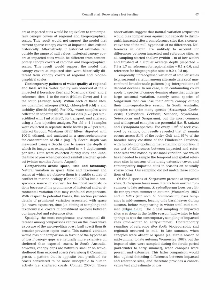
Comparison of contemporary north–south covers ofcanopy algae along the gulf revealed that the 2impacted sites had sparser covers than comparablegulf sites within the region (Fig. 2; asymmetrical 2-wayANOVA; F1,7 = 53.12, p < 0.001). Contemporary coversat impacted sites (Horseshoe and Noarlunga Reefs,15.3 and 20.3%, respectively) fell outside the 95% con-fidence intervals (61.6% to 100%) of the standard nor-mal distribution of estimates across the gulf, also iden-tifying impacted sites to be different from referencesites.
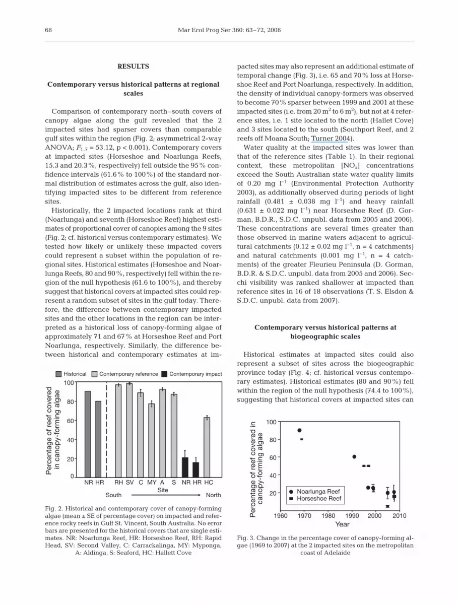
Historically, the 2 impacted locations rank at third(Noarlunga) and seventh (Horseshoe Reef) highest esti-mates of proportional cover of canopies among the 9 sites(Fig. 2; cf. historical versus contemporary estimates). Wetested how likely or unlikely these impacted coverscould represent a subset within the population of re-gional sites. Historical estimates (Horseshoe and Noar-lunga Reefs, 80 and 90%, respectively) fell within the re-gion of the null hypothesis (61.6 to 100%), and therebysuggest that historical covers at impacted sites could rep-resent a random subset of sites in the gulf today. There-fore, the difference between contemporary impactedsites and the other locations in the region can be inter-preted as a historical loss of canopy-forming algae ofapproximately 71 and 67% at Horseshoe Reef and PortNoarlunga, respectively. Similarly, the difference be-tween historical and contemporary estimates at im-
pacted sites may also represent an additional estimate oftemporal change (Fig. 3), i.e. 65 and 70% loss at Horse-shoe Reef and Port Noarlunga, respectively. In addition,the density of individual canopy-formers was observedto become 70% sparser between 1999 and 2001 at theseimpacted sites (i.e. from 20 m2 to 6 m2), but not at 4 refer-ence sites, i.e. 1 site located to the north (Hallet Cove)and 3 sites located to the south (Southport Reef, and 2reefs off Moana South; Turner 2004).
Water quality at the impacted sites was lower thanthat of the reference sites (Table 1). In their regionalcontext, these metropolitan [NOx] concentrationsexceed the South Australian state water quality limitsof 0.20 mg l–1 (Environmental Protection Authority2003), as additionally observed during periods of lightrainfall (0.481 ± 0.038 mg l–1) and heavy rainfall(0.631 ± 0.022 mg l–1) near Horseshoe Reef (D. Gor-man, B.D.R., S.D.C. unpubl. data from 2005 and 2006).These concentrations are several times greater thanthose observed in marine waters adjacent to agricul-tural catchments (0.12 ± 0.02 mg l–1, n = 4 catchments)and natural catchments (0.001 mg l–1, n = 4 catch-ments) of the greater Fleurieu Peninsula (D. Gorman,B.D.R. & S.D.C. unpubl. data from 2005 and 2006). Sec-chi visibility was ranked shallower at impacted thanreference sites in 16 of 18 observations (T. S. Elsdon &S.D.C. unpubl. data from 2007).
Contemporary versus historical patterns atbiogeographic scales
Historical estimates at impacted sites could alsorepresent a subset of sites across the biogeographicprovince today (Fig. 4; cf. historical versus contempo-rary estimates). Historical estimates (80 and 90%) fellwithin the region of the null hypothesis (74.4 to 100%),suggesting that historical covers at impacted sites can
68
1960 1970 1980 1990 2000 2010Year
20
40
60
80
100
Per
cent
age
of r
eef c
over
ed in
ca
nop
y-fo
rmin
g al
gae
Noarlunga ReefHorseshoe Reef
Fig. 3. Change in the percentage cover of canopy-forming al-gae (1969 to 2007) at the 2 impacted sites on the metropolitan
coast of Adelaide
0
20
40
60
80
100
Per
cent
age
of r
eef c
over
ed
in c
anop
y-fo
rmin
g al
gae
Historical Contemporary reference Contemporary impact
RH
South
SV C MY A S HRNR HCHRNRSite
North
Fig. 2. Historical and contemporary cover of canopy-formingalgae (mean ± SE of percentage cover) on impacted and refer-ence rocky reefs in Gulf St. Vincent, South Australia. No errorbars are presented for the historical covers that are single esti-mates. NR: Noarlunga Reef, HR: Horseshoe Reef, RH: RapidHead, SV: Second Valley, C: Carrackalinga, MY: Myponga,
A: Aldinga, S: Seaford, HC: Hallett Cove

Connell et al.: Recovering a lost baseline
represent a random subset of reference sites across2100 km of the continent. This comparison is reason-able on the basis that covers of canopies among refer-ence sites in the gulf were not distinguishable fromthose of the broader province (asymmetrical 2-wayANOVA: F1,29 = 2.00, p = 0.18).
DISCUSSION
The key result is that historically, the impacted met-ropolitan sites were indistinguishable from the con-temporary population of regional sites (~70 km of thegulf), and could also represent a random subset ofopen coastal sites across the greater province ofFlindersia (~2100 km of coast). This evidence suggeststhat there was nothing ‘special’ about the impactedsites historically, but today they stand out because theyhave sparser covers of canopies compared to equiva-
lent locations and times in the gulf andthe greater province. Contemporarycovers at the impacted sites are 65 to70% less than surrounding sites, andour evidence rejects the model that thispattern existed before major coastaldevelopment (i.e. since increasingurbanisation of the late 1970s). Weinterpret these patterns as evidence ofloss of canopy-forming algae on theAdelaide metropolitan coast (Fig. 5).
The modern challenge is to under-stand the conditions and mechanismsthat lead to habitat loss, with the intentof predicting or preventing futurelosses. We recognise models of habitatloss that centre on harvesting, wheredeforestation occurs by direct harvest-ing of canopies (Castilla et al. 2007), oroverharvesting of vertebrate predatorsthat triggers an increase in herbivorepopulations and the overconsumptionof algal canopies (Steneck et al. 2002).The direct harvesting of seaweeds,however, does not occur on the Ade-laide metropolitan coast and is not amodel commonly used to explain thewidespread and long-term losses ob-served globally. More commonly usedmodels centre on the influence of fish-ing (trophic cascades or top-down mod-els) and have the capacity to accountfor the presence and absence ofcanopies in eastern Australia (PeronianProvince), but has extremely limitedcapacity in the region we studied
(Flindersian Province; Connell & Irving 2008). Instead,Flindersian models centre on changes to water quality(Connell 2007b) and share a common basis with othersystems that have documented long-term and wide-spread loss across human-dominated coasts (e.g. BalticSea, Elmgren 2001; North Sea, Eriksson et al. 2002).
Ecological theory predicts that human-dominatedenvironments favour small fast-growing or ‘weedy’species that are able to displace slower-growing spe-cies (Tilman & Lehman 2001). This model appears tobe applicable to human-dominated coasts, such as theAdelaide metropolitan coast, where canopy-formingalgae have undergone widespread replacement byturf-forming species that trap large amounts of sedi-ment (present paper on canopies; Gorgula & Connell2004 on turfs). The novel environments created byhuman pollution (e.g. sedimentation and eutrophica-tion) do not appear to have direct negative effects oncanopies, but rather act in conjunction with natural
69
Impact/ Site Nitrogen Turbidity Chl aReference (NOx, mg l–1) (Secchi depth, m) (µg l–1)
Impact Horseshoe Reef 0.522 ± 0.107 3.2 ±0.152 15.75 ± 2.45Impact Noarlunga Reef 0.274 ± 0.173 2.9 ± 0.190 15.29 ± 0.80Reference Hallett Cove 0.0392 ± 0.003 7.3 ± 1.45 8.34 ± 0.80Reference Aldinga 0.025 ± 0.0039 5.9 ± 0.67 9.27 ± 0.46
Table 1. Observations of water quality (mean ± SEM) among impacted and ref-erence sites (n = 3 observations per site) during a rainfall event in 2007. See ‘Re-sults’ for comparison of these results to additional sampling times, noting thatthe NOx concentrations exceed the South Australian state water quality limits of0.20 mg l–1 (Environmental Protection Authority 2003). ANOVA detected allparameters to be greater at impacted sites than reference sites (F3, 8, p < 0.05).
Lower values for Secchi depth correspond to greater turbidity
Al BrB Es WCCL PL CJ NHR HRNR NR
EastWest
0
20
40
60
80
100
Per
cent
age
of r
eef c
over
ed
in c
anop
y-fo
rmin
g al
gae
Site
Historical Contemporary reference Contemporary impact
Fig. 4. Comparison of the historical and contemporary covers of canopy-form-ing algae (mean ± SE) on impacted and reference rocky sites across WesternAustralia and South Australia. Data are presented for 3 sites within each local-ity. NR: Noarlunga Reef, HR: Horseshoe Reef, RH: Rapid Head, CL: CapeLeeuwin, Al: Albany, BrB: Bremer Bay, Es: Esperance, PL: Port Lincoln, WC:West Cape, CJ: Cape Jervis, N: Newland Head. No error bars are presented for
the historical covers that are single estimates

Mar Ecol Prog Ser 360: 63–72, 2008
disturbances that remove canopies (e.g. storms) to cre-ate conditions needed for the rapid colonisation byturfs that accumulate sediment (Irving & Connell2006). These short, densely packed turfs have limitedcapacity to store nitrogen and are normally ephemeral(Pedersen & Borum 1996), but persist under conditionsof high nutrient and sediment loads (Gorgula & Con-nell 2004). A key condition is sediment accumulation,which inhibits the recruitment of kelp (Devinny &Volse 1978). Vulnerable localities appear to be associ-ated with conditions that enhance sediment deposition(e.g. dredging and intensive land use) or sedimentaccumulation (e.g. rocky substratum that is low-lyingand of low relief or in close proximity to sand or cov-ered in turfs). Turfs can inhibit kelp recruitment (Ken-nelly 1987) and its experimental removal can increasekelp recruitment after 12 mo (D. Gorman & S.D.C.unpubl. data), possibly because of the large amount ofsediment they trap (reviewed by Airoldi 2003). Onsome coasts, this switch between canopy and turf-forming algae may not be reversed over several gener-ations of canopy-forming taxa (Benedetti-Cecchi et al.2001, Eriksson et al. 2002).
This model of human modification of water chem-istry and ensuing habitat shifts (above) may prove to
be very general, but we warn against its uncritical use.Some of the most compelling evidence for this model isderived from enclosed seas (e.g. bays and gulfs) thatare fringed by populations of humans and heavyindustry, thereby restricting circulation of water bodiesof degraded quality (e.g. Baltic Sea, Elmgren 2001;North Sea, Eriksson et al. 2002). Indeed, there is grow-ing recognition of the ecological contexts (e.g. biogeo-graphy and geomorphology) that make some coastalsystems more vulnerable, and others more resistant, toincreasing human-domination of the world’s coastlines(e.g. Connell & Irving 2008). We, therefore, highlightthe unreasonable use of the logical argument thathuman population size is proportional to the magni-tude and onset of human-driven change to biogenichabitats. Human activities that alter water chemistryand consumption rates of herbivores are unlikely to actindependently of natural variation in coastal produc-tivity (e.g. rates of natural gain of biomass by produc-tion) and functional types of their consumers (e.g. ratesof natural loss of biomass to herbivores). For example,spatial differences in coastal nutrient concentrationsalter the magnitude of ecological response to suddenincreases in nutrient concentrations (e.g. run-off; Rus-sell & Connell 2007) and account for disproportionately
70
Fig. 5. Canopy-forming algae characterise most temperate coasts (e.g. kelp forests pictured on the left), but some forests havebeen replaced by extensive covers of turf-forming algae (e.g. the Adelaide metropolitan coast on the right). Models that accountfor this switch from topographically complex and productive habitat to simpler and less productive habitat are needed if we are
predict or manage against future change. Photographs by S.D.C.

Connell et al.: Recovering a lost baseline
larger responses of nutrient enrichment on nutrient-poor coasts (Russell et al. 2005, S. D. Connell et al.unpubl. data).
Future progress may rely on some productive debateabout methodology. One of the most recurring metho-dological issues centres on the choice of variables weuse to observe the response of ecosystems to theirhuman assaults (e.g. molecules, species, groups, habi-tats). Our work specifically tested hypotheses aboutcanopies as a habitat and not about their componentspecies. We recognise that the use of alternate classifi-cations (e.g. morphology versus species) and indices(e.g. Shannon index versus ABC curves versus phylo-genetic relatedness) largely predetermine our percep-tion of ecological change and prediction of future envi-ronments (Roberts & Connell 2008). There is littlewonder, therefore, that subtidal ecologists researchingsimilar systems will alternately highlight the informa-tion lost (Phillips et al. 1997) or the information gainedwith the use of broader-based classifications (Ander-son et al. 2005) with particular methods of classifica-tion. In this regard, there would be some value inunderstanding the costs and benefits of using alternateclassifications in descriptions of ecological changesthat concern societal perceptions.
In conclusion, forecasted changes to abiotic environ-ments at local and global scales (Harley et al. 2006)may be compounded by historical changes that havegone unnoticed. There has, therefore, never been amore pressing need for longer-term datasets to inter-pret the influence of human activities. The predomi-nance of research focusing on local spatial scales overshort time scales appears particularly counterproduc-tive to our ability to detect change. While acquiringdata for this research, we also identified that some ofthe greatest challenges to longer-term datasets maynot be scientific. The storage and retrieval of data hasbecome increasingly more problematic as rapidimprovements in technology (e.g. computer softwareand hardware) chain current archival efforts to anti-quated technology. Already, some ‘modern’ technol-ogy has become redundant, so that stored informationis impossible to retrieve (e.g. tape drives and specifickinds of image projectors that no longer exist). Perhapsclay tablets that record human history represent someof our longest lasting archival media (albeit of low stor-age capacity) that capture change on time-scales weare becoming more aware of and increasingly con-cerned about (e.g. climate change).
Finally, we emphasise the lack of coherent researchacross time, matched by discordant research acrossspace and taxonomic scales, and a need for a broadervision by those charged with the administration of sci-ence (i.e. its accountability and fundability). Indeed,never has there been a greater need for better leader-
ship of the ecological sciences. The discipline of ecol-ogy needs leadership that encourages rather thanpenalises collaboration and inheritance of data. Ourlife spans are often less than the duration of the organ-isms we study, and our expertise and capacity toresearch multiple localities and levels of biologicalorganisation are limited. We are not naïve in under-standing that institutional reform is difficult and slow,and good leaders occur infrequently across genera-tions; hence, we encourage some of this progress to fallon the shoulders of individuals with an ability to focuson collective rather than personal goals, and on long-term progress. Indeed, many of the environmentalchanges we only now recognise were set in motionlong ago.
Acknowledgements. Over many years, this project wasassisted by numerous people and supported by researchfunding from the Department of Environment and Heritage,National Land and Water Resources Audit, FRDC Reef HealthProject, Australian Research Council, SA Environmental Pro-tection Authority and SA Water. This manuscript benefitedfrom network discussions within the ARC EnvironmentalFutures Network. International support was given by a MarcoPolo grant from the Università di Bologna to L.A. The cooper-ation among authors reflects a common bond and pioneeringspirit caused by the common dangers and limitations of work-ing under temperate seas. We acknowledge The University ofAdelaide, which forged Australian subtidal ecology in the1950s (with home-made SCUBA) and subsequently sup-ported and safeguarded SCUBA as a research tool for its staff,students and all authors here.
LITERATURE CITED
Airoldi L (2003) The effects of sedimentation on rocky coastassemblages. Oceanogr Mar Biol Annu Rev 41:161–236
Airoldi L, Beck MW (2007) Loss, status and trends for coastalmarine habitats of Europe. Oceanogr Mar Biol Annu Rev45:345–405
Anderson MJ, Connell SD, Gillanders BM, Diebel CE,Blom WM, Saunders JE, Landers TJ (2005) Relationshipsbetween taxonomic resolution and spatial scales of multi-variate variation. J Anim Ecol 74:636–646
Benedetti-Cecchi L, Pannacciulli F, Bulleri F, Moschella PS,Airoldi L, Relini G, Cinelli F (2001) Predicting the conse-quences of anthropogenic disturbance: large-scale effectsof loss of canopy algae on rocky shores. Mar Ecol Prog Ser214:137–150
Castilla JC, Campo MA, Bustamante RH (2007) Recovery ofDurvillaea antarctica (Durvilleales) inside and outside LasCruces marine reserve, Chile. Ecol Appl 17:1511–1522
Cheshire AC, Miller DJ, Stewart R (1999) Effect of dispersedsediment plumes from beach and sand replenishmentdredging on recruitment of phaeophycean algae torocky reefs in Gulf St. Vincent, South Australia. A report tothe Environmental Protection Authority of South Aus-tralia. Department of Environmental Biology, University ofAdelaide
Connell SD (2007a) Subtidal temperate rocky habitats: habi-tat heterogeneity at local to continental scales. In: ConnellSD, Gillanders BM (eds) Marine ecology. Oxford Univer-sity Press, Melbourne, p 378–401
71

Mar Ecol Prog Ser 360: 63–72, 2008
Connell SD (2007b) Water quality and the loss of coral reefsand kelp forests: alternative states and the influence offishing. In: Connell SD, Gillanders BM (eds) Marine ecol-ogy. Oxford University Press, Melbourne, p 556–568
Connell SD, Irving AD (2008) Integrating ecology with bio-geography using landscape characteristics: a case study ofsubtidal habitat across continental Australia. J Biogeogrdoi:10.1111/j.1365-2699.2008.01903.x
Dayton PK, Tegner MJ, Edwards PB, Riser KL (1998) Slidingbaselines, ghosts, and reduced expectations in kelp forestcommunities. Ecol Appl 8:309–322
Devinny JS, Volse LA (1978) Effects of sediments on thedevelopment of Macrocystis pyrifera gametophytes. MarBiol 48:343–348
Edgar GJ (1983) The ecology of south-east Tasmanian phytalanimal communities. II. Seasonal change in plant and ani-mal populations. J Exp Mar Biol Ecol 70:159–179
Elmgren R (2001) Understanding human impact on the Balticecosystem: changing views in recent decades. Ambio 30:222–231
Environment Protection Authority (2003) Environment pro-tection (water quality) policy 2003 and explanatory report,Environment Protection Authority, Adelaide
Eriksson BK, Johansson G, Snoeijs P (2002) Long-termchanges in the macroalgal vegetation of the inner GullmarFjord, Swedish Skagerrak coast. J Phycol 38:284–296
Gorgula SK, Connell SD (2004) Expansive covers of turf-form-ing algae on human-dominated coast: the relative effectsof increasing nutrient and sediment loads. Mar Biol 145:613–619
Harley CDG, Hughes AR, Hultgren KM, Miner BG and others(2006) The impacts of climate change in coastal marinesystems. Ecol Lett 9:228–241
Irving AD, Connell SD (2006) Physical disturbance by kelpabrades erect algae from the understorey. Mar Ecol ProgSer 324:127–137
Jackson JBC, Kirby MX, Berger WH, Bjorndal KA and others(2001) Historical overfishing and the recent collapse ofcoastal ecosystems. Science 293:629–638
Kennelly SJ (1987) Inhibition of kelp recruitment by turf-forming algae and consequences for an Australian kelpcommunity. J Exp Mar Biol Ecol 112:49–60
Kuhn TS (1996) The structure of scientific revolutions. TheUniversity of Chicago Press, Chicago, IL
Mangialajo L, Chiantore M, Cattaneo-Vietti R (2008) Loss offucoid algae along a gradient of urbanisation, and struc-ture of benthic assemblages. Mar Ecol Prog Ser 358:63–74
Pauly D (1995) Anecdotes and the shifting base-line syn-drome of fisheries. Trends Ecol Evol 10:430
Pedersen MF, Borum J (1996) Nutrient control of algal growthin estuarine waters. Nutrient limitation and the impor-tance of nitrogen requirements and nitrogen storageamong phytoplankton and species of macroalgae. MarEcol Prog Ser 142:261–272
Phillips JC, Kendrick GA, Lavery PS (1997) A test of a func-tional group approach to detecting shifts in macroalgal
communities along a disturbance gradient. Mar Ecol ProgSer 153:125–138
Roberts BK, Connell SD (2008) Detecting benthic responses tohuman-induced change: effectiveness of alternate taxo-nomic classification and indices. Mar Ecol Prog Ser 358:75–84
Russell BD, Connell SD (2007) Response of grazers to suddennutrient pulses in oligotrophic versus eutrophic condi-tions. Mar Ecol Prog Ser 349:73–80
Russell BD, Elsdon TS, Gillanders BM, Connell SD (2005)Nutrients increase epiphyte loads: broad-scale obser-vations and an experimental assessment. Mar Biol 147:551–558
Shepherd SA (2007) The early years of subtidal ecology. In:Connell SD, Gillanders BM (eds) Marine ecology. OxfordUniversity Press, Melbourne, p 614–615
Shepherd SA, Sprigg RC (1976) Substrate, sediments andsubtidal ecology of Gulf St Vincent and Investigator Strait.In: Twidale CR (ed) Natural history of the Adelaide region.Royal Society of South Australia, Adelaide, p 162–172
Steneck RS, Graham MH, Bourget BJ, Corbett D, ErlandsonJM, Estes JA, Tegner MJ (2002) Kelp forest ecosystems:biodiversity, stability, resilience and future. Environ Con-serv 29:436–459
Thibaut T, Pinedo S, Torras X, Ballesteros E (2005) Long-termdecline of the populations of Fucales (Cystoseira spp. andSargassum spp.) in the Albères coast (France, North-west-ern Mediterranean). Mar Pollut Bull 50:1472–1489
Tilman D, Lehman C (2001) Human-caused environmentalchange: impacts on plant diversity and evolution. ProcNatl Acad Sci USA 98:5433–5440
Turner DJ (2004) Effects of sedimentation on the structure ofa phaeophycean dominated macroalgal community. PhDthesis, University of Adelaide
Turner DJ, Cheshire AC (2003) Encounter 2002 expedition tothe Isles of St Francis, South Australia: structure and pro-ductivity of benthic macroalgal communities. Trans R SocS Aust 127:153–166
Underwood AJ, Chapman MC, Connell SD (2000) Observa-tions in ecology: You can’t make progress on processeswithout understanding the patterns. J Exp Mar Biol Ecol250:97–115
Vitousek P, Mooney H, Lubchenco J, Melillo J (1997) Humandomination of earth’s ecosystems. Science 277:494–499
Wernberg T, Connell SD (in press) Physical disturbance andsubtidal habitat structure on open rocky coasts: effects ofwave exposure, extent and intensity. J Sea Res, doi:10.1016/j.seares.2008.02.005
Wilkinson J, Pearce M, Cromar N, Fallowfield H (2003) Auditof the quality and quantity of treated wastewater dis-charging from wastewater treatment plants (WWTPs) tothe marine environment. Department of EnvironmentalHealth, Flinders University of South Australia, Adelaide
Womersley HBS (1987) The marine benthic flora of SouthernAustralia, Part II. South Australian Government PrintingDivision, Adelaide
72
Editorial responsibility: Morten Pederson,Roskilde, Denmark
Submitted: December 6, 2007; Accepted: April 14, 2008Proofs received from author(s): May 15, 2008