rainfall-triggered lahars at volcán de colima, mexico: surface hydro-repellency as initiation...
TRANSCRIPT
Journal of Volcanology and Geothermal Research 189 (2010) 105–117
Contents lists available at ScienceDirect
Journal of Volcanology and Geothermal Research
j ourna l homepage: www.e lsev ie r.com/ locate / jvo lgeores
Rainfall-triggered lahars at Volcán de Colima, Mexico: Surface hydro-repellency asinitiation process
L. Capra a,⁎, L. Borselli b, N. Varley c, J.C. Gavilanes-Ruiz c, G. Norini a,d, D. Sarocchi e, L. Caballero f, A. Cortes g
a Centro de Geociencias, UNAM, Campus Juriquilla, 76230 Queretaro, Mexicob CNR-IRPI, Firenze, Italyc Universidad de Colima, Facultad de Ciencias, Colima, Col. 28045 Mexicod Dipartimento di Scienze Geologiche e Geotecnologie, Università degli Studi di Milano Bicocca, P.zza della Scienza 4, 20126, Milano, Italye Instituto de Geología, UASLP, Mexicof Posgrado en Ciencias de la Tierra, Instituto de Geologia, UNAM, 04510, México DF., Mexicog Observatorio Vulcanológico, Universidad de Colima, Col. 28045 Mexico
⁎ Corresponding author.E-mail address: [email protected] (L. Cap
0377-0273/$ – see front matter © 2009 Elsevier B.V. Aldoi:10.1016/j.jvolgeores.2009.10.014
a b s t r a c t
a r t i c l e i n f oArticle history:Received 4 June 2009Accepted 20 October 2009Available online 30 October 2009
Keywords:Volcán de ColimaMexicolaharsdebris flowrainfallhydro-repellency
Volcán de Colima is currently the most active volcano in Mexico. Since 1998 intermittent activity has beenobserved with vulcanian eruptions, lava flows and growing domes that have collapsed producing severalblock-and-ash flow deposits. During the period of heightened activity since 1998 at Volcán de Colima,pyroclastic flows from dome or column collapse have not reached long distances, most of the time less than6 km from the crater. In contrast, rain-induced lahars were more frequent and have reached relatively longdistances, up to 15 km, causing damage to infrastructure and affecting small villages. In 2007 two rain gaugestationswere installed on the southern flank of the volcano registering events from June through to October,the period when rains are intense and lahars frequent. By comparing lahar frequency with rainfall intensityand the rainfall accumulated during the previous 3 days, lahars more frequently occur at the beginning ofthe rainfall season, with low rain accumulation (<10 mm) and triggered by low rain intensities (<20 mm/h). During the months with more rainfall (July and August) lahars are less frequent and higher peakintensities (up to 70 mm/h) are needed to trigger an event. In both cases, lahars were initiated as dilute,sediment-laden streamflows, which transformed with entrainment of additional sediment into hypercon-centrated and debris flows, with alternations between these two flow types. A hydro-repellencymechanismin highly vegetated areas (i.e. evergreen tree types with considerable amount of resins and waxes such aspines) with sandy soils can probably explain the high frequency of lahars at the beginning of the rain seasonduring low rainfall events. Under hydrophobic conditions, infiltration is inhibited and runoff is facilitated atmore highly peaked discharges that are more likely to initiate lahars.
ra).
l rights reserved.
© 2009 Elsevier B.V. All rights reserved.
1. Introduction
Rainfall-triggered lahars are probably the most hazardous type ofsecondary event at an active volcano, during or after magmaticactivity (i.e. Umbal and Rodolfo, 1996; Rodolfo and Arguden, 1991;Barclay et al., 2007). Unconsolidated pyroclastic material can be easilyeroded by superficial water forming dilute sediment-laden flows thatcan bulk-up to debris flows whose magnitude will depend upon thevolume of both the water and remobilized material.
Volcán de Colima is currently the most active volcano in Mexico(Fig. 1). Since 1998 intermittent activity has been observed withvulcanian eruptions, lava flows and growing domes that have collapsedproducing several block-and-ash flow deposits (Saucedo et al., 2002,2004, 2005). Pyroclastic flows have yet to reach long distances, most of
the time less than 5 km from the crater; however, in some casesevacuation was considered necessary. In contrast, rain-induced laharshave been more frequent and have reached long distances, damagingthe infrastructure of villages such as La Becerrera in July, 2000 (Davilaet al., 2007).
This paper documents the rainfall-induced lahars at Colima as theyevolved over two rainy seasons from 2007 to 2008. Flows and theirdeposits are here described based on their textural and othersedimentological characteristics, and correlated with rainfall frequencyand intensity. The soil hydro-repellency process (or hydrophobicity,Doerr et al., 2000) is here explored as a possible mechanism to explaintheobservedhigh frequencyof lahars triggered by low rain intensities atthe beginning of the rain season.
In this paperweuse the term lahar in the generally accepted sense ofa rapidly flowing mixture of debris, rocks and water on or from avolcano; it encompasses a range of sediment-ladenflow types includingdebris flows and hyperconcentrated flows (Smith and Fritz, 1989). The
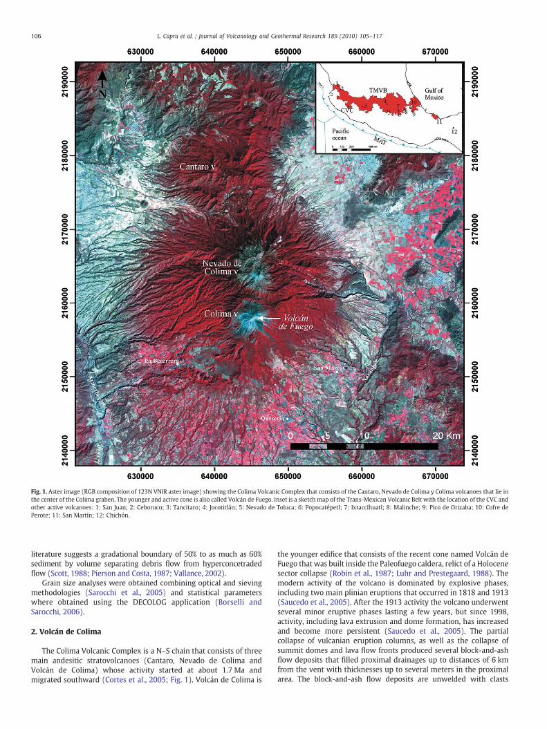
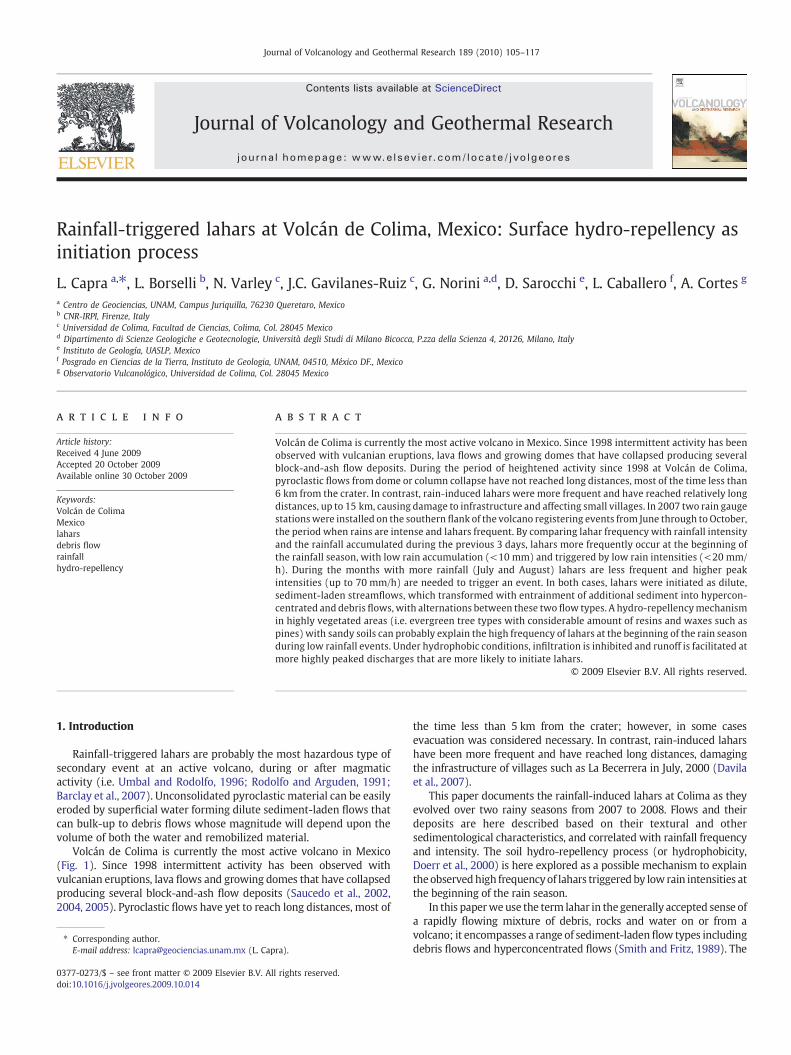
Fig. 1. Aster image (RGB composition of 123N VNIR aster image) showing the Colima Volcanic Complex that consists of the Cantaro, Nevado de Colima y Colima volcanoes that lie inthe center of the Colima graben. The younger and active cone is also called Volcán de Fuego. Inset is a sketch map of the Trans-Mexican Volcanic Belt with the location of the CVC andother active volcanoes: 1: San Juan; 2: Ceboruco; 3: Tancitaro; 4: Jocotitlán; 5: Nevado de Toluca; 6: Popocatépetl; 7: Ixtaccíhuatl; 8: Malinche; 9: Pico de Orizaba; 10: Cofre dePerote; 11: San Martín; 12: Chichón.
106 L. Capra et al. / Journal of Volcanology and Geothermal Research 189 (2010) 105–117
literature suggests a gradational boundary of 50% to as much as 60%sediment by volume separating debris flow from hyperconcetradedflow (Scott, 1988; Pierson and Costa, 1987; Vallance, 2002).
Grain size analyses were obtained combining optical and sievingmethodologies (Sarocchi et al., 2005) and statistical parameterswhere obtained using the DECOLOG application (Borselli andSarocchi, 2006).
2. Volcán de Colima
The Colima Volcanic Complex is a N–S chain that consists of threemain andesitic stratovolcanoes (Cantaro, Nevado de Colima andVolcán de Colima) whose activity started at about 1.7 Ma andmigrated southward (Cortes et al., 2005; Fig. 1). Volcán de Colima is
the younger edifice that consists of the recent cone named Volcán deFuego that was built inside the Paleofuego caldera, relict of a Holocenesector collapse (Robin et al., 1987; Luhr and Prestegaard, 1988). Themodern activity of the volcano is dominated by explosive phases,including two main plinian eruptions that occurred in 1818 and 1913(Saucedo et al., 2005). After the 1913 activity the volcano underwentseveral minor eruptive phases lasting a few years, but since 1998,activity, including lava extrusion and dome formation, has increasedand become more persistent (Saucedo et al., 2005). The partialcollapse of vulcanian eruption columns, as well as the collapse ofsummit domes and lava flow fronts produced several block-and-ashflow deposits that filled proximal drainages up to distances of 6 kmfrom the vent with thicknesses up to several meters in the proximalarea. The block-and-ash flow deposits are unwelded with clasts
107L. Capra et al. / Journal of Volcanology and Geothermal Research 189 (2010) 105–117
embedded in a silty–sandy matrix (Saucedo et al., 2004; Sarocchi,2007). Specifically, in recent years eruptive episodes occurred in 1991,1994, 1998–1999, 2001–2003, 2004 and 2005, and dome formation
Fig. 2. a) Aerial view from the east of the Nevado de Colima and Volcán de Colima complex. NoBlack arrow points to a pyroclastic flow deposit that was emplaced in the La Arena ravine dVolcán de Colima and topographic profiles in the E–W (I) and N–S (II) direction. Black linesperiodically occur.
resumed in 2007. Despite this intense eruptive activity, the emittedproducts have not had a significant direct impact on the inhabitedarea. During heavy rains, which usually occur from June through to
te that the younger Volcán de Fuego edifice is built on a slope dipping toward the south.uring 2005 (picture taken by A. Zuarzo-Cuevas during October 2008). b) Slope map ofshow the main basins at Volcán de Colima, that feed the principal ravines where lahars
108 L. Capra et al. / Journal of Volcanology and Geothermal Research 189 (2010) 105–117
October at this latitude, these deposits are easily remobilized as laharsthat have reached distances up to 15 km, causing some damage toinfrastructure (Davila et al., 2007). Since January 2007, a dome hasbeen growing in the crater, and in January 2009 it had reached avolume of ~2×10⁶m3. If major explosive activity does not destroy thedome, in the short term (weeks to months) it will grow above thecrater rim, and probably collapse down the flanks, initiatingpyroclastic flows like those occurring in 2004 (Macias et al., 2006).
3. Morpho-hydrological features of the volcano
A Digital ElevationModel with 5 m horizontal resolution from LiDARdata acquired in 2005 (see Davila et al., 2007 for details) is here used toperform a morpho-hydrological analysis of the volcano. Volcán theColima is an almost perfect cone, slightly inclined southwards (Fig. 2a).The slope varies between 40° and 35° from the summit (3850 m) to3200m a.s.l, and decreases to ~10° at its base, at 2500 m a.s.l (Fig. 2b).Duringheavy rains, largeflooddischargesoccur in themajor drainages—such as the La Lumbre, San Antonio-Montegrande, and La Arena ravines.Basin analysis illustrates a heterogeneous distribution of watersheds(Fig. 2b). La Lumbre is fed by the largest basin with an area of 10 km2
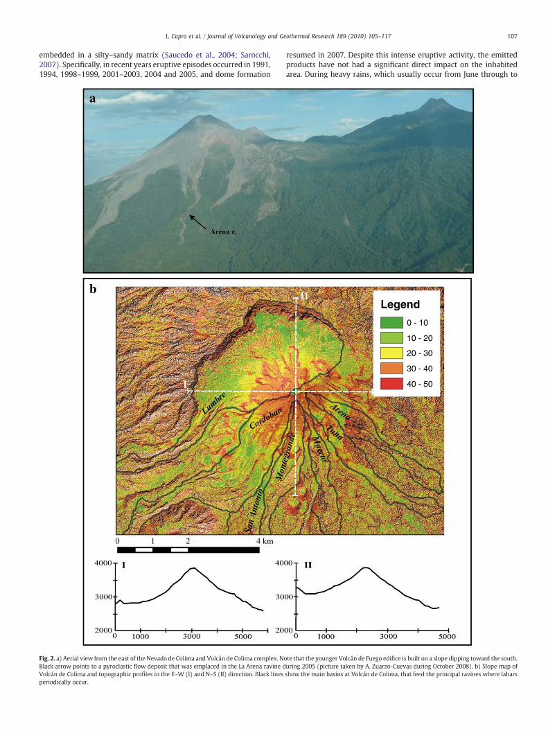
while Montegrande and La Arena ravines have small watershed areas,less than 2 km2. On the cone, the ravines are narrow, up to 6–8 m inwidth, and frequently they are interrupted by old lava flows formingsmall rampsor stairs up to30 m inheight,where lahars falls form(Fig. 3aand b). After the main break in slope of the cone, the ravines becamewider, 15–20 m on average (Fig. 3c and d). Finally they open to formalluvial fans approximately 15 km from the crater, discharging volumesof clastic material with associated damage to infrastructure such aselectricity pylons and bridges.
Fig. 3. a) Panoramic view of the SW flank of the volcano, where it is possible to observe amorbreak-in-slope formed by a lava flow where lahar falls can form. c) La Arena ravine at a dista6 m/s value refers to the estimated lahar velocity calculated at this location (see text for ex
4. Distribution and magnitude
Based on a spatial and temporal analysis with satellite images(Davila et al., 2007), lahars occur in five main ravines, from west toeast: La Lumbre, Cordobán, San Antonio, Montegrande and La Arena(Fig. 4). Lahars sometimes reach distances up to 15 km but because ofthe monolithologic composition of components (andesite) and therapid erosion, it is difficult to correlate individual flow deposits andthus estimate the volume of individual events. In several places, waterand mud marks on trees and bedrock channel boundaries record flowdepths of 1.5–2 m for recent events.
In the Montegrande ravine, its curvilinear path led to an indirectestimation of the flow velocity in one location based on the simplestsuperelevationmethod (Chow, 1959), as already used in other studies(i.e. Pierson, 1985; Muñoz-Salinas et al., 2007). The superelevationequation is based on the tilting of the free surface in a bend due to theaction of centrifugal force. The difference in water-surface elevation(in this case the Δh between the two levees) is defined as thesuperelevation. At the selected site (Fig. 3d) we measured the radiusof curvature of the bend (rc), the superelevation (Δh) and the channelwidth (w).We obtained a velocity (u) of 6 ms−1 applying the formula(Chow, 1959):
U =gΔhrcw
� �1=2
were g is gravitational acceleration.Peak discharge of 200–300 m3s−1 was estimated by multiplying
the calculated velocity by the surveyed cross sectional area of thelahar taking into account water marks on trees. This value is only an
phological rampwhere pyroclastic flows and lahars erode the substratum. b) Example ofnce of 3.2 km from the crater and (d) Montegrande ravine at 8 km from the crater. Theplanation).

Fig. 4. Aster image (RGB combination of VNVIR bands) where lahar deposits are clearly visible in main ravines. Green triangles refer to the location of two rain gauge stations. Whitepoints refer to stratigraphic sections described along the text. The white star indicates the location where electricity-distribution pylons are periodically damaged by lahars.
109L. Capra et al. / Journal of Volcanology and Geothermal Research 189 (2010) 105–117
average estimation for an event at a specific site, but it still gives agood approximation of flow magnitude.
Based on the extent of inundated area within the main ravines,flow volumes reached ~1–2*105m3, considering an average flowdepth of 1 m, value that is consistent with previous works (Gavilanes-Ruiz, 2003; Davila et al., 2007).
5. Textural characteristics
Along the main ravines, two main types of sequences wererecognized based on their textural characteristics.
Type I consists of massive debris flow deposits, up to 2 m inthickness, (Fig. 5a and b), with angular, gray andesitic clasts, up to20 cm in diameter, and a significant amount of wood fragments,embedded in abundant finematrix (fraction<2 mm, 60 wt.%, samples3a and 25 in Table 1). Strong imbrication is easily visible, both for clastand organic fragments. Granulometric analyses show a bimodal topolymodal distribution, with mean grain size between −0.3 and0.3 phi and poor sorting (σϕ~3) (Table 1 and Fig. 5c). Block-and-ashflow deposits (BAFs) from the 2004–2005 eruptive phase lie belowthese debrisflowdeposits and they are similar in content in the coarserfraction but contain a higher percent of silt (Fig. 5c). These debris flowdeposits are scarce, and theywere observed only in the La Lumbre andMontegrande ravines, at a distance of 3 km from the crater (Fig. 5d)and their basal contacts are not erosive over the block-and-ash flowdeposits.
Type II consists of sequences of debris flow and hyperconcentratedflow deposits intercalated with fluvial layers forming several terracesalong main ravines, varying from a few cm to as much as 2 m inthickness. Higher on the cone, in steeper and narrower channels,
terraces are discontinuous and unlikely to survive subsequent events.Lower on the flank, where ravines widen and the slope decreases,deposition prevails (Fig. 6a) and several units can be observed. Debrisflow deposits contain sub-rounded to rounded clasts (up to 1.2 m indiameter) embedded in a coarse sandymatrix. They can bemassive orwith a clast-rich basal layer (Fig. 6b). Large clasts (diameter up to150 cm) are abundant on lateral levees (Fig. 6c) and up to the flowfront. Hyperconcentrated flow deposits up to 50 cm thick generallycrown massive debris flow deposits with the grain size varying fromgravel to sand. The superimposition of different events could bedetermined by the presence of layers of pine needles separatingdeposits.
Granulometric analysis of the debris flow deposits shows a bimodaldistribution (Fig. 7a), with the mean grain size varying from ~0.8 phito −3 phi and with poor sorting, from 2.5 to 4.7 phi (Table 1). Theanalyzed hyperconcentrated flow deposit (sample 27, Table 1) shows aunimodal grain size distribution with a mean grain size of 0.85 phiand good sorting (2 phi). In the La Lumbre ravine we were able tocorrelate sections from the same event, and the spatial variation ofthe gravel/matrix ratio indicates a variation in the coarser fraction,with an initial decrease and a final increase (Fig. 7b).
6. Lahar frequency vs. rain intensity
6.1. Meteorological data
From June to October heavy rains affect the volcano, with anannual average of 800–1000 mm (Comision Nacional del Agua, CNA,http://smn.cna.gob.mx/). Since rainfall episodes are often localized,two rain gauges stations (HOBO water station with a rain gauge
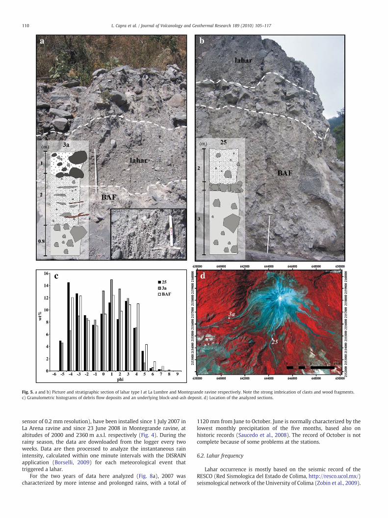
Fig. 5. a and b) Picture and stratigraphic section of lahar type I at La Lumbre and Montegrande ravine respectively. Note the strong imbrication of clasts and wood fragments.c) Granulometric histograms of debris flow deposits and an underlying block-and-ash deposit. d) Location of the analyzed sections.
110 L. Capra et al. / Journal of Volcanology and Geothermal Research 189 (2010) 105–117
sensor of 0.2 mm resolution), have been installed since 1 July 2007 inLa Arena ravine and since 23 June 2008 in Montegrande ravine, ataltitudes of 2000 and 2360 m a.s.l. respectively (Fig. 4). During therainy season, the data are downloaded from the logger every twoweeks. Data are then processed to analyze the instantaneous rainintensity, calculated within one minute intervals with the DISRAINapplication (Borselli, 2009) for each meteorological event thattriggered a lahar.
For the two years of data here analyzed (Fig. 8a), 2007 wascharacterized by more intense and prolonged rains, with a total of
1120 mm from June to October. June is normally characterized by thelowest monthly precipitation of the five months, based also onhistoric records (Saucedo et al., 2008). The record of October is notcomplete because of some problems at the stations.
6.2. Lahar frequency
Lahar occurrence is mostly based on the seismic record of theRESCO (Red Sismologica del Estado de Colima, http://resco.ucol.mx/)seismological network of the University of Colima (Zobin et al., 2009).
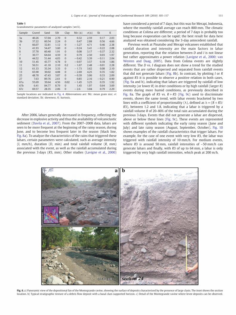
Table 1Granulometric parameters of analyzed samples (wt.%).
Sample Gravel Sand Silt Clay Mz (ϕ) σ(ϕ) Sk K
3a 40.26 57.04 2.70 0 0.32 2.59 0.17 2.033b 37.22 60.54 2.24 0 0.47 2.88 0.56 4.664 66.07 32.81 1.12 0 −3.27 4.71 0.46 2.385 41.93 54.47 3.60 0 −0.24 3.41 −0.22 2.086 37.70 60.40 1.91 0 0.08 3.17 −0.37 2.327 30.77 64.64 4.59 0 0.79 2.50 0.03 1.978 44.52 51.44 4.03 0 −0.42 3.39 −0.11 2.0410 51.45 43.77 4.78 0 −0.97 3.57 0.18 1.8611 56.51 41.18 2.10 0.2 −1.67 2.48 −0.01 2.2812 61.33 35.34 3.33 0 −1.73 3.62 0.08 2.1013 65.90 30.02 4.08 0 −2.69 4.25 0.35 1.8225 48.70 47.43 3.87 0 −0.39 3.06 0.33 2.0927 7.63 89.76 2.61 0 0.85 2.16 −0.21 0.9067a 55.69 39.64 4.56 0.02 −1.45 3.25 0.35 1.9267b 6.41 84.77 8.79 0 1.45 1.97 0.64 3.6967c 69.57 28.35 2.06 0 −2.6 3.04 0.79 2.29
Sample locations are indicated in Fig. 4. Abbreviations are: Mz: mean grain size; σ:standard deviation; Sk: skewness; K: kurtosis.
111L. Capra et al. / Journal of Volcanology and Geothermal Research 189 (2010) 105–117
After 2006, lahars generally decreased in frequency, reflecting thedecrease in explosive activity and thus the availability of volcaniclasticsediment (Davila et al., 2007). From the 2007–2008 data, lahars areseen to be more frequent at the beginning of the rainy season, duringJune, and to become less frequent later in the season (black line,Fig. 8a). To analyze the characteristics of the rains that triggered theselahars, certain parameters were calculated, such as average intensity(I, mm/h), duration (D, min) and total rainfall volume (R, mm)associated with the event, as well as the rainfall accumulated duringthe previous 3 days (R3, mm). Other studies (Lavigne et al., 2000)
Fig. 6. a) Panoramic view of the depositional fan of the Montegrande ravine, showing the surflocation. b) Typical stratigraphic texture of a debris flow deposit with a basal clast-supporte
have considered a period of 7 days, but this was for Merapi, Indonesia,where the monthly rainfall average can reach 800 mm. The climaticconditions at Colima are different; a period of 7 days is probably toolong because evaporation can be rapid; the best result for data hereanalyzed was obtained considering the 3-day antecedent rainfall.
Previous work at Pinatubo and Merapi volcanoes established thatrainfall duration and intensity are the main factors in lahargeneration, reporting that the relation between D and I is not linearbut rather approximates a power relation (Lavigne et al., 2000; vanWesten and Daag, 2005). Data from Colima events are slightlydifferent. The D vs. I diagram does not show a trend for the studiedevents that are rather dispersed and separated from rainfall eventsthat did not generate lahars (Fig. 8b). In contrast, by plotting I or Ragainst R3 it is possible to observe a positive relation in both cases,(Fig. 9a and b), indicating that lahars are triggered by rainfall of lowintensity (or lower R) in drier conditions or by high rainfall (larger R)events during more humid conditions, as previously described inFig. 8a. The graph of R3 vs. R+R3 (Fig. 9c) used to discriminateevents, shows the same trend, with lahar events bracketed by twolines with a coefficient of proportionality (λ), defined as λ=(R+R3/R3), between 1.2 and 1.8, indicating that a lahar is triggered by arainfall volume R of 20–80% of the total rain accumulated during theprevious 3 days. Events that did not generate a lahar are dispersed,above or below these lines (Fig. 9c). These events are representedwith different symbols indicating the early rainy season (June andJuly) and late rainy season (August, September, October). Fig. 10shows examples of the rainfall characteristics that trigger lahars. Forexample, for the case of one event with very low R3, the lahar wastriggered with rainfall intensity of 10 mm/h. For medium events,where R3 is around 50 mm, rainfall intensities of ~50 mm/h cangenerate lahars and finally, with R3 of up to 64 mm, a lahar is onlytriggered by very high rainfall intensities, which peak at 200 m/h.
ace of deposits characterized by the presence of large clasts. The inset shows the sectiond horizon. c) Detail of the Montegrande ravine where levee deposits can be observed.
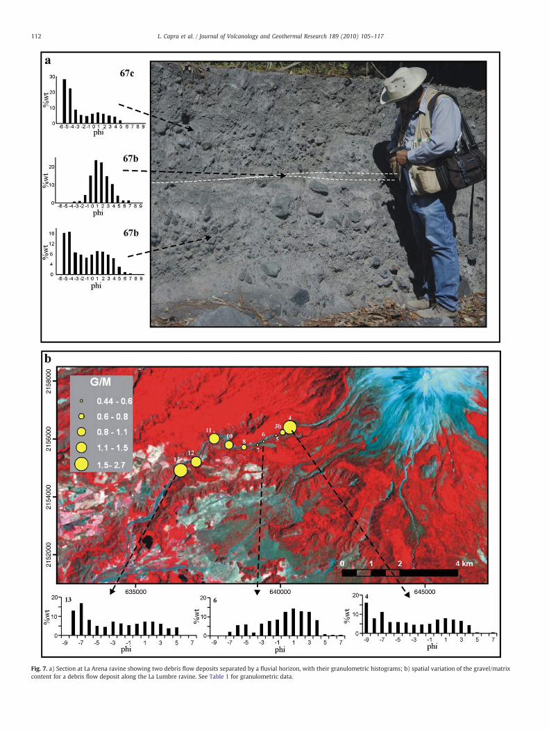
Fig. 7. a) Section at La Arena ravine showing two debris flow deposits separated by a fluvial horizon, with their granulometric histograms; b) spatial variation of the gravel/matrixcontent for a debris flow deposit along the La Lumbre ravine. See Table 1 for granulometric data.
112 L. Capra et al. / Journal of Volcanology and Geothermal Research 189 (2010) 105–117
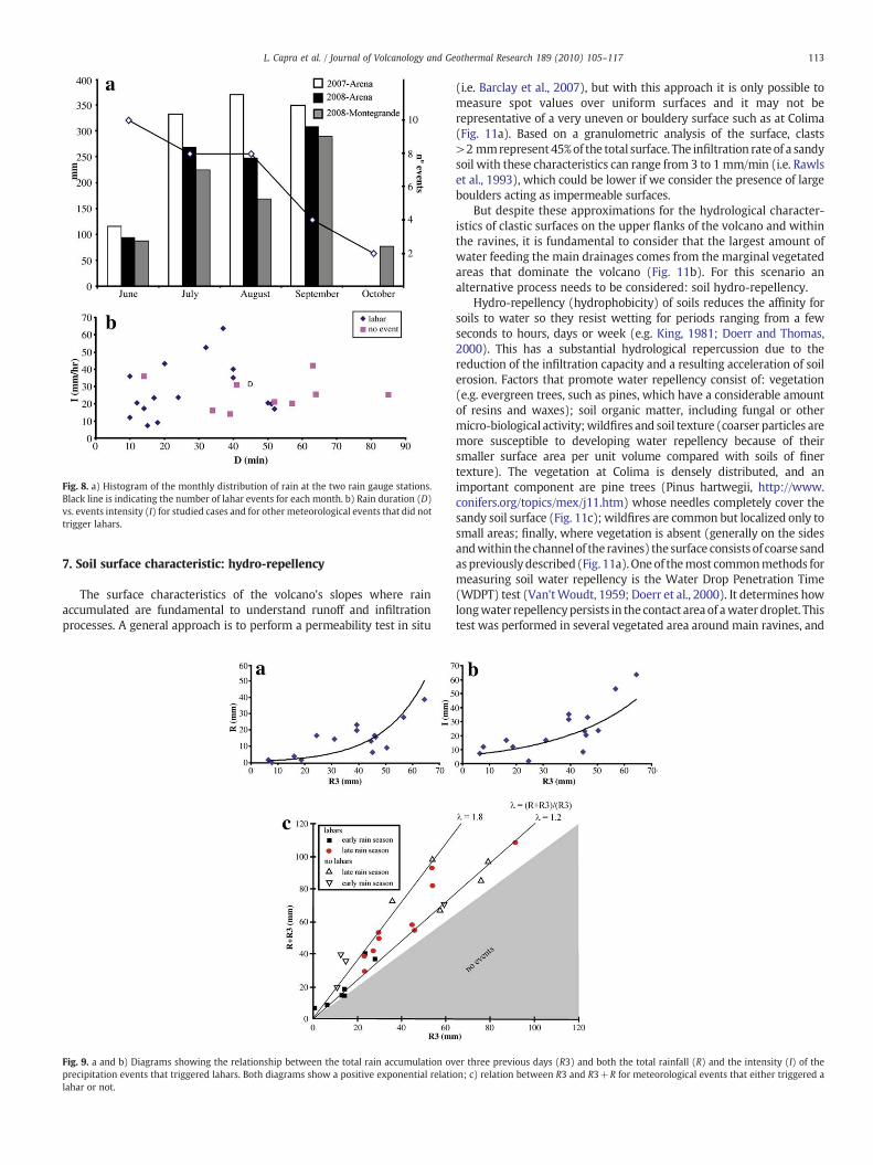
Fig. 8. a) Histogram of the monthly distribution of rain at the two rain gauge stations.Black line is indicating the number of lahar events for each month. b) Rain duration (D)vs. events intensity (I) for studied cases and for other meteorological events that did nottrigger lahars.
113L. Capra et al. / Journal of Volcanology and Geothermal Research 189 (2010) 105–117
7. Soil surface characteristic: hydro-repellency
The surface characteristics of the volcano's slopes where rainaccumulated are fundamental to understand runoff and infiltrationprocesses. A general approach is to perform a permeability test in situ
Fig. 9. a and b) Diagrams showing the relationship between the total rain accumulation ovprecipitation events that triggered lahars. Both diagrams show a positive exponential relatilahar or not.
(i.e. Barclay et al., 2007), but with this approach it is only possible tomeasure spot values over uniform surfaces and it may not berepresentative of a very uneven or bouldery surface such as at Colima(Fig. 11a). Based on a granulometric analysis of the surface, clasts>2 mmrepresent 45%of the total surface. The infiltration rate of a sandysoil with these characteristics can range from 3 to 1 mm/min (i.e. Rawlset al., 1993), which could be lower if we consider the presence of largeboulders acting as impermeable surfaces.
But despite these approximations for the hydrological character-istics of clastic surfaces on the upper flanks of the volcano and withinthe ravines, it is fundamental to consider that the largest amount ofwater feeding the main drainages comes from the marginal vegetatedareas that dominate the volcano (Fig. 11b). For this scenario analternative process needs to be considered: soil hydro-repellency.
Hydro-repellency (hydrophobicity) of soils reduces the affinity forsoils to water so they resist wetting for periods ranging from a fewseconds to hours, days or week (e.g. King, 1981; Doerr and Thomas,2000). This has a substantial hydrological repercussion due to thereduction of the infiltration capacity and a resulting acceleration of soilerosion. Factors that promote water repellency consist of: vegetation(e.g. evergreen trees, such as pines, which have a considerable amountof resins and waxes); soil organic matter, including fungal or othermicro-biological activity;wildfires and soil texture (coarser particles aremore susceptible to developing water repellency because of theirsmaller surface area per unit volume compared with soils of finertexture). The vegetation at Colima is densely distributed, and animportant component are pine trees (Pinus hartwegii, http://www.conifers.org/topics/mex/j11.htm) whose needles completely cover thesandy soil surface (Fig. 11c); wildfires are common but localized only tosmall areas; finally, where vegetation is absent (generally on the sidesandwithin the channel of the ravines) the surface consists of coarse sandaspreviouslydescribed (Fig. 11a). Oneof themost commonmethods formeasuring soil water repellency is the Water Drop Penetration Time(WDPT) test (Van'tWoudt, 1959; Doerr et al., 2000). It determines howlongwater repellencypersists in the contact areaof awater droplet. Thistest was performed in several vegetated area around main ravines, and
er three previous days (R3) and both the total rainfall (R) and the intensity (I) of theon; c) relation between R3 and R3+R for meteorological events that either triggered a
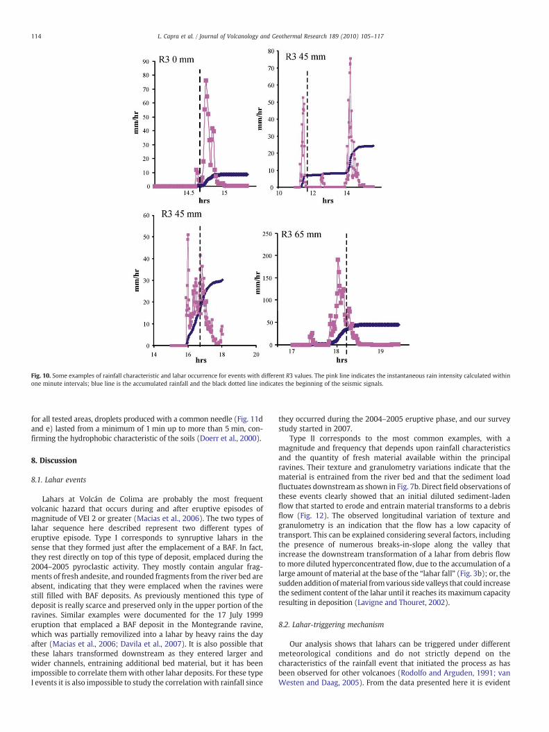
Fig. 10. Some examples of rainfall characteristic and lahar occurrence for events with different R3 values. The pink line indicates the instantaneous rain intensity calculated withinone minute intervals; blue line is the accumulated rainfall and the black dotted line indicates the beginning of the seismic signals.
114 L. Capra et al. / Journal of Volcanology and Geothermal Research 189 (2010) 105–117
for all tested areas, droplets produced with a common needle (Fig. 11dand e) lasted from a minimum of 1 min up to more than 5 min, con-firming the hydrophobic characteristic of the soils (Doerr et al., 2000).
8. Discussion
8.1. Lahar events
Lahars at Volcán de Colima are probably the most frequentvolcanic hazard that occurs during and after eruptive episodes ofmagnitude of VEI 2 or greater (Macias et al., 2006). The two types oflahar sequence here described represent two different types oferuptive episode. Type I corresponds to synruptive lahars in thesense that they formed just after the emplacement of a BAF. In fact,they rest directly on top of this type of deposit, emplaced during the2004–2005 pyroclastic activity. They mostly contain angular frag-ments of fresh andesite, and rounded fragments from the river bed areabsent, indicating that they were emplaced when the ravines werestill filled with BAF deposits. As previously mentioned this type ofdeposit is really scarce and preserved only in the upper portion of theravines. Similar examples were documented for the 17 July 1999eruption that emplaced a BAF deposit in the Montegrande ravine,which was partially removilized into a lahar by heavy rains the dayafter (Macias et al., 2006; Davila et al., 2007). It is also possible thatthese lahars transformed downstream as they entered larger andwider channels, entraining additional bed material, but it has beenimpossible to correlate themwith other lahar deposits. For these typeI events it is also impossible to study the correlation with rainfall since
they occurred during the 2004–2005 eruptive phase, and our surveystudy started in 2007.
Type II corresponds to the most common examples, with amagnitude and frequency that depends upon rainfall characteristicsand the quantity of fresh material available within the principalravines. Their texture and granulometry variations indicate that thematerial is entrained from the river bed and that the sediment loadfluctuates downstream as shown in Fig. 7b. Direct field observations ofthese events clearly showed that an initial diluted sediment-ladenflow that started to erode and entrain material transforms to a debrisflow (Fig. 12). The observed longitudinal variation of texture andgranulometry is an indication that the flow has a low capacity oftransport. This can be explained considering several factors, includingthe presence of numerous breaks-in-slope along the valley thatincrease the downstream transformation of a lahar from debris flowto more diluted hyperconcentrated flow, due to the accumulation of alarge amount of material at the base of the “lahar fall” (Fig. 3b); or, thesudden addition ofmaterial fromvarious sidevalleys that could increasethe sediment content of the lahar until it reaches its maximum capacityresulting in deposition (Lavigne and Thouret, 2002).
8.2. Lahar-triggering mechanism
Our analysis shows that lahars can be triggered under differentmeteorological conditions and do not strictly depend on thecharacteristics of the rainfall event that initiated the process as hasbeen observed for other volcanoes (Rodolfo and Arguden, 1991; vanWesten and Daag, 2005). From the data presented here it is evident
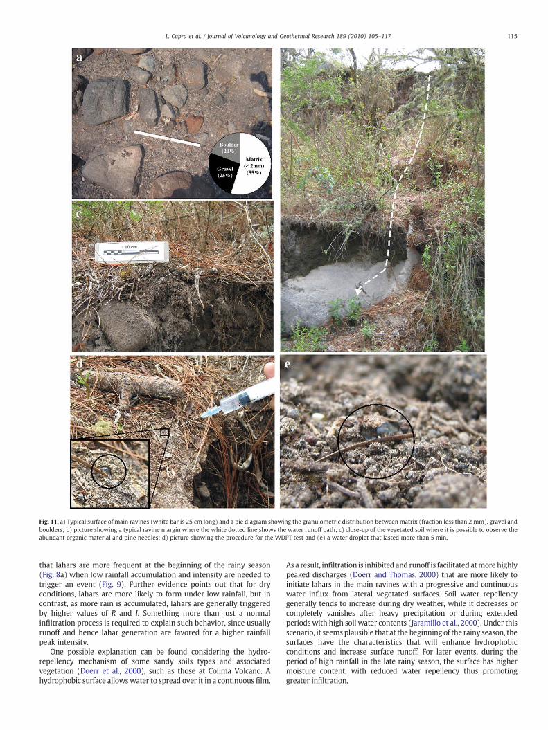
Fig. 11. a) Typical surface of main ravines (white bar is 25 cm long) and a pie diagram showing the granulometric distribution between matrix (fraction less than 2 mm), gravel andboulders; b) picture showing a typical ravine margin where the white dotted line shows the water runoff path; c) close-up of the vegetated soil where it is possible to observe theabundant organic material and pine needles; d) picture showing the procedure for the WDPT test and (e) a water droplet that lasted more than 5 min.
115L. Capra et al. / Journal of Volcanology and Geothermal Research 189 (2010) 105–117
that lahars are more frequent at the beginning of the rainy season(Fig. 8a) when low rainfall accumulation and intensity are needed totrigger an event (Fig. 9). Further evidence points out that for dryconditions, lahars are more likely to form under low rainfall, but incontrast, as more rain is accumulated, lahars are generally triggeredby higher values of R and I. Something more than just a normalinfiltration process is required to explain such behavior, since usuallyrunoff and hence lahar generation are favored for a higher rainfallpeak intensity.
One possible explanation can be found considering the hydro-repellency mechanism of some sandy soils types and associatedvegetation (Doerr et al., 2000), such as those at Colima Volcano. Ahydrophobic surface allowswater to spread over it in a continuous film.
As a result, infiltration is inhibited and runoff is facilitated atmore highlypeaked discharges (Doerr and Thomas, 2000) that are more likely toinitiate lahars in the main ravines with a progressive and continuouswater influx from lateral vegetated surfaces. Soil water repellencygenerally tends to increase during dry weather, while it decreases orcompletely vanishes after heavy precipitation or during extendedperiodswith high soil water contents (Jaramillo et al., 2000). Under thisscenario, it seems plausible that at the beginning of the rainy season, thesurfaces have the characteristics that will enhance hydrophobicconditions and increase surface runoff. For later events, during theperiod of high rainfall in the late rainy season, the surface has highermoisture content, with reduced water repellency thus promotinggreater infiltration.
Fig. 12. Still images extracted from a video illustrating how lahars start as a dilutesediment-laden flow (a) to then transform into a debris flow (b).
116 L. Capra et al. / Journal of Volcanology and Geothermal Research 189 (2010) 105–117
The dispersion of events that do not generate lahars (Fig. 9c), withvalues of λ>1.8, probably indicates that the water-repellency mecha-nism is very sensitive to a series of factors, such as the cyclic breakdownand restoration of hydrophobicity, critical soil water content, andinfiltrationbyfingeredflow(Doerr andThomas, 2000;Doerr et al., 2000,2006, 2009; Gomi et al., 2008) that, during heavy rainfall, limits therunoff volume.
9. Conclusion
This paper describes lahar-generation mechanisms and conditionsduring the rainy season at Volcán de Colima. Since the last Plinianeruption in 1913, rain-triggered lahars are probably the volcanichazard that has caused the most damage to the surrounding areas.Only few people lost their life during events originating on the slopesof Volcán de Colima, however, debris flows originating in the similar,but more extensive ravines of Nevado de Colima have resulted inseveral deaths (Saucedo et al., 2008). Notable damage to bridges,electricity-distribution pylons, and houses has occurred during thelast ten years. Lahar occurrence is directly related to the character-istics of the rainfall season and the textural and environmentalcharacteristics of the slope surface. Lahars are more frequent at thebeginning of the season, typically during June, when the water-repellency mechanism facilitates water runoff and subsequent lahargeneration. This mechanism is still poorly understood and has notbeen documented for a volcanic area; we propose it here for Volcán de
Colima, and it is probably applicable to numerous other stratovolca-noes throughout the Trans-Mexican Volcanic Belt or for volcanoes atsimilar latitudes. This new idea could have important implicationssince it shows that lahars are not occurring only for rainfall valueshigher than an estimated threshold, but rather in a more limitedinterval depending on several factors that control water runoff.
Acknowledgements
This project was founded by the IN-103107 to LC. The authors aregrateful to Roberto Sulpizio for helpful discussions during our fieldinvestigations. We appreciate the detailed reviews of Kevin Scott andan anonymous reviewer who helped to clarify the ideas stated in thismanuscript. We also thank the editorial support of Joan Martí.
References
Barclay, J., Alexander, J., Susnik, J., 2007. Rainfall-induced lahars in the Belham Valley,Montserrat, West Indies. Journal of the Geological Society London 164, 815–827.
Borselli, L., 2009. DISRAINS 1.3.1. Usage for Single Storm Analysis. CNR-IRPI, SestoFiorentino (Italy). http://www.irpi.fi.cnr.it/disrains_package.zip.
Borselli, L., Sarocchi, D., 2006. DECOLOG 2.0: Deconvolution of Mixtures of LognormalComponents fromParticle SizeDistributions. http://www.decolog.org/decolog_manual.pdf.
Chow, V.T., 1959. Open Channel Hydraulics. McGraw-Hill New York. 698 pp.Cortes, A., Garduño, V.H., Navarro, C., Komorowski, J.C., Saucedo, R., Macias, J.L.,
Gavilanes, J.C., 2005. Carta Geológica del Complejo Volcánico de Colima, conGeología del Complejo Volcánico de Colima, 10. Cartas Geológicas Y MinerasInstituto de Geología UNAM México. 37 pp.
Davila, N., Capra, L., Gavilanes, J.C., Varley, N., Norini, G., Gomez, A., 2007. Recent laharsat Volcán de Colima (México): drainage variation and spectral classification.Journal of Volcanology and Geothermal Research 165, 127–141.
Doerr, S.H., Thomas, A.D., 2000. The role of soil moisture in controlling waterrepellency: new evidence from forest soils in Portugal. Journal of Hydrology 231–232, 134–147.
Doerr, S.H., Shakesby,R.A.,Walsh,R.P.D., 2000. Soilwater repellency: its causes, characteristicsand hydro-geomorphological significance. Earth-Science Review 51, 33–65.
Doerr, S.H., Shakesby, R.A., Blake, W.H., Chafer, C.J., Humphreys, G.S., Wallbrink, P.J.,2006. Effects of differing wildfire severities on soil wettability and implications forhydrological response. Journal of Hydrology 319, 295–311.
Doerr, S.H., Woods, S.W., Martin, D.A., Casimiro, M., 2009. ‘Natural background’ soilwater repellency in conifer forests of the north-western USA: its prediction andrelationship to wildfire occurrence. Journal of Hydrology 37, 12–21.
Gavilanes-Ruiz, J.C., 2003. Simulación de escenarios eruptivos del volcán de Colima yaportaciones al plan de contingencia del estado de Colima. Master Thesis, Posgradoen Geografía, Facultad de Filosofía y Letras, UNAM, Mexico, 165 pp.
Gomi, T., Sidle, R.C., Ueno, M., Miyata, S., Kosugi, K., 2008. Characteristics of overlandflow generation on steep forested hillslopes of central Japan. Journal of Hydrology361, 275–290.
Jaramillo, D.F., Dekker, L.W., Ritsema, C.J., Hendrickx, J.M.H., 2000. Occurrence of soil waterrepellency in arid and humid climates. Journal of Hydrology 231–232, 105–111.
King, P.M., 1981. Comparison of methods for measuring severity of water repellence ofsandy soils and assessment of some factors that affect its measurement. AustralianJournal of Soil Research 19, 275–285.
Lavigne, F., Thouret, J.C., 2002. Sediment transport and deposition by rain-triggeredlahars at Merapi Volcano, Central Java, Indonesia. Geomorphology 49, 45–69.
Lavigne, F., Thouret, J.C., Voight, B., Suwa, H., Sumaryono, A., 2000. Lahars at Merapivolcano, Central Java: an overview. Journal of Volcanology and GeothermalResearch 100, 423–456.
Luhr, J.F., Prestegaard, K.L., 1988. Caldera formation at Volcán de Colima, Mexico, bylarge Holocene volcanic debris avalanche. Journal of Volcanology and GeothermResearch 35, 335–348.
Macias, J.L., Saucedo, R., Gavilanes, J.C., Varley, N., Velasco-Garcia, S., Bursik, M.I., Vargas-Gutierres, V., Cortes, A., 2006. Flujos piroclásticos asociados a la actividad explosivadel volcán de Colima y perspectivas futuras. GEOS 25 (3), 340–351.
Muñoz-Salinas, E., Manea, V.C., Palacios, D., Castillo-Rodriguez, M., 2007. Estimation oflahar flow velocity on Popocatépetl Volcano (México). Geomorphology 92, 91–99.
Pierson, T.C., 1985. Initiation and flow behavior of the 1980 Pine Creek andMuddy Riverlahars, Mount St Helens. Washington, Geol Soc Amer Bull 96, 1056–1069.
Pierson, T.C., Costa, J.E., 1987. A rheologic classification of subaerial sediment–waterflows. In: Costa, J.E., Wieczorek, G.F. (Eds.), Debris Flows/Avalanches: Process,Recognition, and Mitigation. Geological Society of America Reviews in EngineeringGeology, pp. 1–12.
Robin, C., Mossand, P., Camus, G., Cantagrel, J.-M., Gourgaud, A., Vincent, P.M., 1987.Eruptive history of the Colima volcanic complex (Mexico). Journal of Volcanologyand Geothermal Research 31, 99–113.
Rodolfo, K.S., Arguden, A.T., 1991. Rain–lahar generation and sedimentation-deliverysystems at Mayon Volcano, Philippines. In: Fisher, R.V., Smith, G.A. (Eds.),Sedimentation in Volcanic Settings. SEPM Special Publication, pp. 71–87.
Rawls, W.J., Ahuja, L.R., Brakensiek, D.L., Shirmohammadi, A., 1993. Infiltration and soilwater movement. In: Maid, D.R. (Ed.), Handbook of Hydrology. McGraw-Hill NewYork, pp. 5.1–5.51.
117L. Capra et al. / Journal of Volcanology and Geothermal Research 189 (2010) 105–117
Sarocchi, D., 2007. Estudio sedimentológico del deposito de flujo de bloques y ceniza del17 de julio de 1999 en el volcán de Colima, 10. Monografia del Instituto de GeofisicaUniversidad Nacional Autonoma de Mexico, Mexico City. 91 pp.
Sarocchi, D., Borselli, L., Macias, J.L., 2005. Construcción de perfiles granulométricos dedepósitos piroclásticos por métodos ópticos. Revista Mexicana de CienciasGeológicas 23, 371–382.
Saucedo, R., Macias, J.L., Bursik, M.I., Mora, J.C., Gavilanes, J.C., Cortes, A., 2002. Emplacementof pyroclastic flows during the 1998–1999 eruption of Volcan de Colima, Mexico.Journal of Volcanology and Geothermal Research 117 (1–2), 129–153.
Saucedo, R., Macias, J.L., Bursik, M.I., 2004. Pyroclastic flow deposits of the 1991eruption of Volcán de Colima, Mexico. Bulletin of Volcanology 66, 291–306.
Saucedo, R., Macías, J.L., Sheridan, M.F., Bursik, M.I., Komorowski, J.C., 2005. Modeling ofpyroclastic flows of Colima Volcano, Mexico: implications for hazard assessment.Journal of Volcanology and Geothermal Research 139 (1–2), 103–115.
Saucedo, R., Macias, J.L., Sarocchi, D., Bursik, M.I., Rupp, B., 2008. The rain-triggeredAtenquique volcaniclastic debris flow of October 16, 1955 at Nevado de ColimaVolcano, Mexico. Journal of Volcanology and Geothermal Research 132 (1–2),69–83.
Scott, K.M., 1988. Origin, Behavior, and Sedimentology of Lahars and Lahar-runoutFlows in the Toutle-Cowlitz River System. U.S. Geological Survey Professional Paper1447-A. 74 pp.
Smith, G.A., Fritz, W.J., 1989. Volcanic influences on terrestrial sedimentation. Geology17, 375–376.
Umbal, J.V., Rodolfo, K.S., 1996. The 1991 lahars of southwestern Mount Pinatubo andevolution of the lahar-dammedMapanuepe lake. In: Newhall, C.G., Punongbayan, R.S.(Eds.), Fire andMud; Eruptions and Lahars ofMount Pinatubo, Philippines. Universityof Washington Press, Quezon, Philippines, pp. 951–970.
Vallance, J.W., 2002. Lahars. In: Sigurdsson, H. (Ed.), Encyclopedia of Volcanoes.Academic Press, pp. 601–616.
Van't Woudt, B.D., 1959. Particle coatings affecting the wettability of soils. Journal ofGeophysical Research 64, 263–267.
vanWesten, C.J., Daag, A.S., 2005. Analysing the relation between rainfall characteristicsand lahar activity at Mount Pinatubo, Philippines. Earth and Surface Processes andLandform 30, 1663–1674.
Zobin, V.M., Placencia, I., Reyes, G., Navarro, C., 2009. The characteristics of seismicsignal produced by lahars and pyroclastic flows: Volcán de Colima, Mexico. Journalof Volcanology and Geothermal Research 179, 157–167.