the frequency and magnitude of post-glacial explosive eruptions at volcán mocho-choshuenco,...
TRANSCRIPT

� ����� ��� � ��
The frequency and magnitude of post-glacial explosive eruptions at Volcan
Mocho-Choshuenco, southern Chile
Harriet Rawson, Jose A. Naranjo, Victoria Smith, Karen Fontijn, David
M. Pyle, Tamsin A. Mather, Hugo Moreno
PII: S0377-0273(15)00110-9
DOI: doi: 10.1016/j.jvolgeores.2015.04.003
Reference: VOLGEO 5527
To appear in: Journal of Volcanology and Geothermal Research
Received date: 20 November 2014
Accepted date: 16 April 2015
Please cite this article as: Rawson, Harriet, Naranjo, Jose A., Smith, Victoria, Fontijn,Karen, Pyle, David M., Mather, Tamsin A., Moreno, Hugo, The frequency and magnitudeof post-glacial explosive eruptions at Volcan Mocho-Choshuenco, southern Chile, Journal
of Volcanology and Geothermal Research (2015), doi: 10.1016/j.jvolgeores.2015.04.003
This is a PDF file of an unedited manuscript that has been accepted for publication.As a service to our customers we are providing this early version of the manuscript.The manuscript will undergo copyediting, typesetting, and review of the resulting proofbefore it is published in its final form. Please note that during the production processerrors may be discovered which could affect the content, and all legal disclaimers thatapply to the journal pertain.
AC
CEPTED
MAN
USC
RIP
T
ACCEPTED MANUSCRIPT
1
The frequency and magnitude of post-glacial explosive eruptions at Volcán Mocho-
Choshuenco, southern Chile
Harriet Rawson1, José A. Naranjo
2, Victoria Smith
3, Karen Fontijn
1, 4, David M. Pyle
1, Tamsin A. Mather
1,
Hugo Moreno5.
1Dept. Earth Sciences, University of Oxford, South Parks Road, Oxford, OX1 3AN, UK.;
[email protected], [email protected]
2Servicio Nacional de Geología y Minería; Avenida Santa María 0104, Santiago, Chile.
3Research Lab. for Archaeology, University of Oxford, South Parks Road, Oxford OX1 3QY, UK
4 Dept. Geology and Soil Science, Ghent University, Krijgslaan 281-S8, 9000 Gent, Belguim
5Observatorio Volcanológico de Los Andes del Sur, Servicio Nacional de Geología y Minería; Dinamarca
691, Temuco, Chile
Key words: Tephrochronology, Mocho-Choshuenco Volcano, Southern Volcanic Zone, Fe-Ti oxides,
Plinian eruptions, tephra
ABSTRACT
Volcán Mocho-Choshuenco (39°55’S 72°2’W) is one of the most hazardous volcanoes in Chile’s Southern
Volcanic Zone (SVZ). To better evaluate these hazards, we have reconstructed a high resolution eruption
history, the most detailed to date for a volcano in Chile, from detailed field observations and geochemical
analyses. Mocho-Choshuenco has experienced ca. 75 post-glacial (<18 ka) explosive eruptions, including
three large (volume ≥1 km3) Plinian eruptions (Neltume, Pirehueico and Huilo) and a large pyroclastic
density current and associated sub-Plinian event (Enco). Poor preservation and lack of exposure made it
difficult to distinguish between medial to distal deposits solely on field observations. Instead, deposits have
been correlated using a combination of glass chemistry and Fe-Ti oxide compositions. New radiocarbon
dates were obtained and integrated with existing dates in a Bayesian age model (OxCal) to constrain the
tempo of the volcanism. Based on preserved deposits, we derive a post-glacial eruptive frequency of one
explosive eruption every ~ 220 years with the youngest, confirmed eruption from Mocho-Choshuenco in
1864. The total post-glacial volume of tephra erupted is estimated at ≥20 km3 (ca. 50% with a dacitic or
rhyolitic glass composition) with ≥4 km3 erupted from the monogenetic cones on the flanks, making Mocho-
Choshuenco one of the most productive (ca. 1 km3/kyr) and active volcanoes in the SVZ during post-glacial
times. Many tephra deposits from Mocho-Choshuenco could be preserved in one or more lakes in the region,
and have the potential to form regional tephra markers. In particular the Neltume deposits, which are
dispersed to the NNE, are found interbedded with tephra deposits from the Villarrica – Quetrupillán – Lanín
chain and should be preserved around Sollipulli and Llaima (~140 km NNE of Mocho-Choshuenco). This
AC
CEPTED
MAN
USC
RIP
T
ACCEPTED MANUSCRIPT
2
study highlights how a multi-technique approach enables a complicated tephrostratigraphy to be unravelled
so more robust estimates of the past eruptive frequency and size can be determined.
1. Introduction
Active volcanoes pose a significant natural hazard, and in order to evaluate the likelihoods of future
scenarios it is necessary to understand the frequency, scale and impact of past eruptions. In particular, there
is a pressing need to better understand the products of medium to large magnitude explosive events. This
requires detailed work in both proximal and distal localities to construct the stratigraphic framework of
significant events. Identifying and correlating the deposits of explosive eruptions is also important to enable
their potential use as regional chronostratigraphic markers in palaeoenvironmental records (e.g., Naranjo and
Stern, 1998; Watt et al., 2013a; Fontijn et al., 2014).
Tephra deposits are commonly poorly preserved, or exposed. This is most problematic in temperate and
humid climates where weathering rates are high, such as southern Chile (e.g., Fontijn et al., 2014); or in very
arid regions, such as northern Chile or eastern Patagonia, where the lack of vegetation enables tephra to be
easily eroded (e.g., Fontijn et al., 2014). Poor preservation and lack of exposure can make it difficult to
distinguish between the medial to distal deposits of eruptions of magmas of similar composition solely on
field observations. Scarcity of outcrops is also problematic at volcanoes with a complex tephrostratigraphy
as a result of high eruptive frequencies, such as at Mocho-Choshuenco. Microanalysis of glass and mineral
components provides a tool to fingerprint these deposits as the products of different eruptions typically have
distinct glass and/or mineral compositions (e.g., Fierstein, 2007; Lowe, 2011; Smith et al., 2011a), and only
small amounts of sample are needed for analysis.
In southern Chile most prior work has relied on field observations (relative stratigraphic position of
identified layers, their physical measurements and mapping their geometry) and limited whole-rock
geochemical data to correlate tephra deposits (e.g., Stern, 1991). As whole-rock chemistry may vary with
distance from the vent (as crystal content varies i.e., decreases with distance from the vent), is susceptible to
the effects of weathering and tends not to vary much between units it is not a very robust technique for
correlating tephra deposits. Increasingly tephra studies use the analysis of glass shards to fingerprint and
correlate deposits (e.g., see Lowe, 2011 for a review). In southern Chile, the high weathering rates and rapid
degradation of pumice samples pose a significant challenge to the use of glass for chemical correlation.
Mineral chemistry is another less commonly used tool for correlating tephra. Biotite, hornblende, pyroxenes
and Fe-Ti oxides have all previously been used for tephra correlation (e.g., Lowe, 1988; Froggatt and
Rogers, 1990; Shane, 1998; Shane, 2000; Shane et al., 2003; Fierstein, 2007; Smith et al., 2011a). The Fe-Ti
oxides offer an excellent and underexploited potential for use as a discriminant between the deposits of
different eruptions. Fe-Ti oxides are almost ubiquitous in tephra samples, they equilibrate rapidly with the
melt (e.g., Bacon and Hirschmann, 1988; Venezky and Rutherford, 1999; Devine et al., 2003) and their
AC
CEPTED
MAN
USC
RIP
T
ACCEPTED MANUSCRIPT
3
compositions are sensitive to magmatic conditions, such as temperature and oxygen fugacity (Carmichael
and Nicholls, 1967; Ghiorso and Evans, 2008). As a result, Fe-Ti oxides can be sensitive tracers of
individual eruptive events (e.g., Shane, 1998; Fierstein, 2007; Marcaida et al., 2014).
Volcán Mocho-Choshuenco is a large compound stratovolcano in the Southern Volcanic Zone (SVZ) of
Chile (Fig. 1). It lies in a region which is popular with tourists and close to several major population centres
(over 400,000 people live within 100 km of the volcano), and presents a moderate level of volcanic hazard to
the region. Nonetheless, the eruptive history of Mocho-Choshuenco is still poorly known, though it is clear
that it that has experienced multiple large explosive eruptions during the Holocene whose timing and size
remain poorly constrained (Moreno and Naranjo, 2006; Moreno and Lara, 2007; Fontijn et al., 2014). In this
study we use field observations and major element chemistry of glass and Fe-Ti oxides to correlate the
deposits of explosive eruptions from Mocho-Choshuenco between different locations in the region. This
enables us to confidently correlate numerous deposits, despite variable preservation and distance from the
eruptive source. This multi-technique approach also enables us to recognise many units for the first time,
including a Plinian eruption (Huilo, MC9). Consequently the new event stratigraphy includes more eruptive
units, and more quantitative details on the ages and sizes of past eruptions, than prior work. Our new high
resolution stratigraphy of post-glacial explosive eruptions allows us to better constrain the past explosive
activity, and reveals Mocho-Choshuenco to be one of the most productive and active volcanoes, in terms of
explosivity, in the SVZ of Chile.
We present the work in three main sections; field stratigraphy (section 3), tephra correlations (section 4) and
eruption size (section 5). Section 3 focuses on the physical characteristics of the deposits, dispersal and their
relative stratigraphic positions. Section 4 presents the geochemical data used to chemically fingerprint and
correlate deposits, along with new radiocarbon dates and an age model to constrain eruption ages. Finally, in
section 5 we use these correlations to estimate the size of the eruptions. Although separate all three sections
are intrinsically linked; for example, units described in section 3 could not have been identified without the
chemical analyses presented in section 4.
2. Geological setting
Mocho-Choshuenco is a late Quaternary volcanic complex located at 39°55’S 72°02’W in the SVZ (33°-
46°S; Fig. 1) of Southern Chile. It lies between Volcán Villarrica, 55 km to the north, and the Puyehue-
Cordón Caulle volcanic complex, 70 km to the south. Mocho-Choshuenco is a glacially-capped complex that
is interpreted as a compound volcano: Volcán Mocho has a 4 km wide caldera, infilled by a glacier, with a
young scoria cone in the centre, called Mocho and Volcán Choshuenco, which forms part of the north-
western rim of the caldera, has only been partially affected by the collapse so retains its conical form.
Additionally there are circa (ca.) 40 minor scoria cones on the flanks (Moreno and Lara, 2007). The cones
are subdivided into three groups: Fui (ca. 25 cones to the north-east and east of the edifice), Caunahue (ca.
10 cones on the south-west flank), and Ranquil (four cones on the north-east flank; Fig. 1). During the

AC
CEPTED
MAN
USC
RIP
T
ACCEPTED MANUSCRIPT
4
Llanquihue glaciation, the last glacial period in southern Chile, Mocho-Choshuenco would have been
extensively glaciated until ca. 18 ka, when deglaciation began at these latitudes (Hulton et al., 2002; Glasser
et al., 2008; Kaplan et al., 2008).
2.1 Previous work
Moreno and Lara (2007) grouped the volcanic deposits from the Mocho-Choshuenco edifice into eight units,
classified by age and source. Deposits from the Choshuenco peak are labelled Unidad Choshuenco (UC) and
those from Mocho are labelled Unidad Mocho (UM). Additionally units are grouped by age from oldest
UM1 to youngest UM5 (illustrated in Table 2). The eighth unit, Secuencia Piroclástica, comprises all the
deposits from explosive eruptions preserved within the other seven units. As glaciers often erode down to the
‘bedrock’, the only tephra deposits that are widely preserved in proximal and medial locations are those that
post-date the most recent deglaciation (i.e., UM4 and UM5). This study focuses on these post-glacial tephra
deposits. The base of unit UM4 is placed at ca. 18 ka, the present estimate of when deglaciation began (e.g.,
Watt et al., 2013b). The boundary between UM4 and UM5, which is marked by an eruption called ‘Enco’, is
placed at ca. 1.7-1.5 cal. ka BP using newly calibrated and modelled radiocarbon ages (see section 4.2.2).
In their previous work, Moreno and Lara (2007) presented evidence for three large post-glacial eruptions.
Two formed widespread dacitic pumice fall deposits, which are called Neltume and Pirehueico (Table 2),
each named after the village closest to the edifice that lies on the dispersal axis. The Neltume deposits are
considered to be the oldest and largest preserved Plinian fall deposits from Mocho-Choshuenco and were
first described by Echegaray et al. (1994). The Pirehueico deposits are the products of another major Plinian
eruption, first identified by Pérez (2005) and are considered to be the second oldest and second largest
preserved Plinian fall deposits from Mocho-Choshuenco. The third is a scoria fall deposit overlain by a
pyroclastic density current (PDC; interpreted in previous studies as an ignimbrite), which is called Enco, the
village where the thickest PDC deposits are found (Moreno and Lara, 2007; Table 2). This unit is the
youngest of the three major eruptions. Further, possible historic events are summarised in Table 2 including
1864, the youngest confirmed eruption from Mocho-Choshuenco. Our work draws on seven field seasons at
Mocho-Choshuenco between 1998 and 2014, focusing on the post-glacial tephra deposits. This work reveals
the presence of many previously undescribed tephra deposits and expands our knowledge of the late
Quaternary eruption record of this major volcanic centre.
3. Field stratigraphy
Late Quaternary tephra deposits from Mocho-Choshuenco are found in scattered exposures around the
edifice as far north as Volcán Quetrupillán (ca. 70 km) and as far east as San Martín de Los Andes (ca. 65
km),. Approximately 400 localities were visited during fieldwork. Outcrops at these localities were
predominantly road-cuttings where tephra layers were preserved either bounded by well-developed
palaeosols or draped over glacially eroded basement or the post-glacial scoria cones that also form part of the
Mocho-Choshuenco Complex. Outcrop exposure varies considerably in scale (1-20 m), as does unit

AC
CEPTED
MAN
USC
RIP
T
ACCEPTED MANUSCRIPT
5
thickness (from < 5 cm to 8 m) and soil thickness (from a few cm to 60 cm). Dense vegetation, temperate
climate and high annual rainfall contribute to the often poor exposure and preservation, making stratigraphic
markers difficult to distinguish; even deposits from reasonably large explosive events (VEI~4) may only be
preserved in very few localities (e.g., MC3, 3 localities). The best exposures were found in road-cuttings.
However, few localities preserve multiple tephra units, and there is no known outcrop that preserves the
complete stratigraphy. Many localities visited in early field seasons (by JAN and HM) no longer exist or are
no longer accessible due to changes in the road network.
Field work in proximal locations revealed tephra deposits from numerous eruptions. Each tephra deposit
bounded by a palaeosol is attributed to a separate eruption, however we acknowledge that there may be
insufficient time between two eruptions for soils to develop. Hence what we interpret as a ‘single eruption’
could still represent multiple events, or events sustained over an extended period of time. This has potential
consequences for the predicted frequency, intensity and scale of explosive eruptions. We describe deposits
from 34 explosive eruptions in the post-glacial succession. These we assign to 27 eruptive units, which we
label from oldest (MC1) to youngest (MC25; relative stratigraphic position illustrated in Table 1).
Additionally we categorise these 27 units by their relative distribution and preservation. Units widely
distributed and well preserved are assigned to category ‘α’, those moderately distributed and preserved to
category ‘β’ and finally those that have limited distribution and poorly preservation to category ‘γ’. As there
is an inherent bias in the rock record these categories do not always directly correlate to eruption size. For
example, older deposits have a greater likelihood of being deeply buried and hence require deeper road cuts
to be exposed. Therefore older units are not always exposed at the surface and hence may appear poorly
distributed and preserved relative to younger units formed by eruptions of comparable size. Equally, the
products of eruptions with narrow or uni-directional dispersal axes may be undersampled, compared to the
products of eruptions of equivalent size that had a more even distribution.
Of the 27 eruption units identified we confirm the recognition of the previously identified pumice fall
deposits of Neltume (MC4) and Pirehueico (MC5) and the large scoria fall and PDC unit of Enco (MC15). In
addition to these 27 units, we identify numerous scoria fall deposits interbedded with the pumice fall
deposits and palaeosols. These typically are nondescript, black-red, well sorted, fine-medium lapilli scoria
fall deposits with microlite-rich glass and rare Fe-Ti oxides, which are rarely possible to chemically
fingerprint and correlate. Most of these scoria deposits are likely to record small Strombolian eruptions
originating from one of the many scoria cones that can be found on the flanks of Mocho-Choshuenco (ca. 40
cones). However, unless there are associated lava flows (e.g., column I, Fig. 2) or the clasts are very large
and clearly have a proximal origin (e.g., column K, Fig. 2) it is not possible to confidently assign the origin
of most deposits to a specific scoria cone or to the main edifice (central vent). To avoid duplication, these
deposits were only labelled if they could be chemically fingerprinted (e.g., MC1). Consequently only 34 of
the ca. 75 post-glacial eruptions are described and assigned a unit name. Furthermore since the

AC
CEPTED
MAN
USC
RIP
T
ACCEPTED MANUSCRIPT
6
palaeoenvironments are highly variable, it has not yet proved possible to correlate palaeosols, and we make
no attempt to formalise their stratigraphy.
3.1 Field sampling
Samples and measurements were taken of the tephra deposits preserved in both proximal and distal locations.
Measurements of deposit thickness and maximum clast size of pumice, scoria, lithics and, if present, ballistic
bombs, were made where possible. Any evidence of slumping, avalanche bedding, fragmented clasts and
bombs were noted and taken into account when constructing the isopach and isopleth maps (see section 5).
Maximum clast size was determined from the geometric mean of the three axes of each of the five largest
clasts at an outcrop. The geometric mean of these five measurements gives the maximum clast estimate. In
early field seasons (1998 to 2006), we determined maximum clast size by measuring only the maximum
diameter of the five largest, most spherical clasts. This difference in method is taken into account when
drawing isopleth maps of maximum clast size. However, it is unlikely to be significant compared to the
effects of post-depositional compaction and weathering.
Bulk samples of tephra and samples of individual pumice, scoria or lithic clasts were taken at ca. 175 sites,
providing a set of more than 275 samples. Preliminary correlations in the field were made based on
stratigraphic position and physical characteristics such as colour, lithic abundance, lithic type and grain size.
3.2 Field descriptions
We identify 27 volcanic deposits that are described below and in Table 3. We interpret each unit to be the
products of a separate explosive eruption. Sub-units are labelled with a letter after the name (e.g., MC15A).
Within the text we describe the units assigned to preservation category α, β and γ, as defined in Table 1.
Within each category we describe the units from oldest to youngest. Deposit and clast descriptions, type
localities and deposit interpretations are described in Table 3. Key field photos (Fig. 3) and SEM images of
typical glass shards (Fig. 4) are also included for units in categories α and β. The notation maximum pumice
(MP), maximum scoria (MS) and maximum lithic (ML) is used. Key localities, not illustrated in Fig. 2, are
presented in the text with their locality name (e.g., 120114-13) and GPS co-ordinates (latitude, longitude;
WGS84 datum). All distances (km), from summit, are measured from the centre of the Mocho scoria cone
within the caldera of Mocho-Choshuenco.
3.2.1 Category α
These units are the most widely dispersed and preserved from the Mocho-Choshuenco Volcanic Complex.
Typically deposits are found at more than 10 localities up to at least 15 km from the summit. Four pumice
fall deposits, one scoria fall and PDC unit, and a scoria package are assigned to this category: MC4
(Neltume), MC5 (Pirehueico), MC9 (Huilo), MC10 (Grupo Fui Tephra), MC15 (Enco) and MC18 (Hua-
Hum).

AC
CEPTED
MAN
USC
RIP
T
ACCEPTED MANUSCRIPT
7
3.2.1.1 MC4 (Neltume Pumice)
The Plinian-style Neltume eruption produced a major pumice fall deposit, dispersed to the NNE and
normally found resting conformably on top of a well-developed palaeosol and/or glacially eroded basement
(typically either the Jurassic Tonalite of the Plutón Panguipulli, or the Triassic metasediments of the
Formación Panguipulli, Moreno and Lara, 2007). In some proximal localities Neltume Pumice deposits
overlie pumice deposits of MC3 and/or minor scoria fall deposits (e.g., MC1) that likely originate from
nearby scoria cones (e.g., columns A, C, Fig. 2).
Internally, MC4 is a tripartite unit (e.g., column B, Fig. 2, 3.B): at its base is a fine grey ash, interpreted as a
vent clearing event (MC4A); This is overlain by a minor, fine-lapilli sized, orange-weathered pumice deposit
(MC4B); and capped by the main sub-unit, an orange-weathered, well-sorted, lithic-poor pumice deposit
(MC4C). In distal localities (when total thickness ca. < 15 cm) the main sub-unit appears zoned as a result of
variations in componentry (Fig. 3.D). This is clearly seen at 030114-4 (39°30’S 71°33’W; MP of 0.4 cm and
thickness of 11 cm) where the bottom two thirds (bottom 7cm; Fig. 3.D) weathers orange, as in more
proximal localities, and changes sharply to dark-grey-yellow weathering in the upper third. This main unit,
and underlying finer pumice unit, are interpreted as the deposits of a Plinian-style eruption as they are widely
dispersed and thicknesses greater than 1 m are commonly preserved.
Deposits from the Neltume unit (MC4) are abundant and narrowly dispersed to the NNE. The thickest
deposits of this unit are found NNE of the edifice, along the dispersal axis mid-way between the villages of
Neltume and Choshuenco (Fig. 1). Here fallout deposit thicknesses (MC4C) reach 8 m and bombs up to 19
cm are preserved (e.g., 160114-1 at 39°50’S 72°3’W, 12 km from summit). The most continuous deposits are
found along Ruta 203, along the eastern shore of Lago Panguipulli. The most distal localities with confirmed
Neltume deposits are on the northern flank of Volcán Villarrica (63 cm thick, locality 030113-1 at 39°21’S
71°59’W, 65 km north of summit), near the town of Curarrehue (7 cm thick, 310100-3 at 39°21’S 71°36’W,
75 km NNE of summit) and on the northern flank of Volcán Lanín (27 cm thick, CLD163 at 39°34’S
71°32’W, 60 km north-east of summit).
The Neltume deposits are typically capped by a well-developed palaeosol that commonly includes reworked
pumice clasts from the underlying fall deposit. This palaeosol separates the Neltume deposits from those of
the overlying Pirehueico unit (MC5), described next.
3.2.1.2 MC5 (Pirehueico Pumice)
The Plinian-style Pirehueico eruption produced a major pumice fall deposit that typically rests conformable
on top of a well-developed soil and, in places, MC4 (Neltume) deposits (e.g., 130207-01 at 39°49’S
71°39’W). In a few outcrops, a thin (<2 cm) fine-lapilli scoria fall unit is found at the base of MC5, with no
clear palaeosol horizon between (e.g., column F, Fig. 2).
AC
CEPTED
MAN
USC
RIP
T
ACCEPTED MANUSCRIPT
8
The Pirehueico Pumice is the most complex of the large pumice units from Mocho-Choshuenco with 6
distinct beds preserved (e.g., column E, Fig. 2; Table 3; Fig. 3.E-G). The deposits, dispersed to the east, are
primarily orange weathered, well to moderately sorted, pumice-rich, with variable lithic and clast sizes
between the sub-units. Two minor, grey-brown, fine-medium ash layers (MC5B and MC5E) are interbedded
within the sequence. The deposits are interpreted as the result of a Plinian-style pumice fall with possible
interbedded minor PDC deposits. Alternatively these fine ash layers (MC5B, E) could represent the time
between eruption pulses, during which finer ash, from within the main fallout, was able to settle.
Deposits from this event are best preserved along the road parallel to the southern shore of Lago Curruhué,
30 km due west of Junín de los Andes, Argentina. The thickest fall deposits of Pirehueico pumice are found
east of the edifice, along the dispersal axis and within the Huilo-Huilo Biological Reserve. Here thicknesses
up to 3 m and bombs up to 25 cm are preserved (e.g., 130117-06 at 39°56’S 71°50’W, 16 km east of
summit). The most distal locality where Pirehueico deposits are confirmed is near Junín de Los Andes (27
cm thick, 170399-11 at 39°58’S 71°16’W, 66 km east of summit)
The Pirehueico deposits are capped by a well-developed palaeosol, commonly with pumice clasts and
charcoal pieces. At one locality (column E, Fig. 2) there is a pumice-rich horizon within the palaeosol, which
we interpret as a reworked pumice fall (MC6) based on geochemical data (see section 4).
3.2.1.3 MC9 (Huilo Pumice)
The Plinian-style Huilo eruption produced a major pumice fall deposit that typically rests conformably on
top of a well-developed palaeosol and deposits from the Neltume (MC4) eruption (e.g., 130120-02, 39°49’S
71°58’W). At rare outcrops to the east it sits above, separated by a palaeosol, the Pirehueico (MC5) deposits
(e.g., column D, Fig. 2) and the scoria fall and flow MC8 (e.g., 130131-03, 39°55’S 71°55’W; MC8
described in section 3.2.2).
Internally two distinct beds are preserved. The main, lower bed (MC9A) is an orange-weathered, well-sorted,
massive, lithic-poor (ca. <5%) pumice deposit (e.g., column D, Fig. 2), interpreted as the deposits of a
Plinian-style eruption. At rare outcrops, where the thickest Huilo Pumice deposits are preserved, a second,
upper bed (MC9B) is visible (e.g., column C, Fig. 2). Here the pumice deposit has a sharp upper contact (i.e.,
no gradation between beds) with a thin continuous scoria layer (Fig. 3G, H) resting conformably on top. This
layer is often <10 cm thick and oxidised red. Its limited preservation and presence only to the east of the
edifice suggests this scoria unit may originate from a nearby scoria cone, which erupted immediately after
the Plinian-style eruption.
Deposits are relatively abundant and quite broadly dispersed to the east. The thickest fallout deposits
(MC9A) are found east of the edifice, just south of the dispersal axis, which trends east, and within the
Huilo-Huilo Biological Reserve. Here thicknesses up to 3.3 m are preserved (e.g., 100114-5 at 39°5’S
AC
CEPTED
MAN
USC
RIP
T
ACCEPTED MANUSCRIPT
9
71°52’W, 15 km east of summit). The most distal locality where Huilo deposits are confirmed is near Lago
Huechulafquen (20 cm thick, 130207-04 at 39°49’S 71°37’W, 38 km ENE of summit).
The Huilo deposits are overlain by a well-developed palaeosol commonly with reworked pumice clasts from
MC9A. This palaeosol separates the Huilo deposits from those of the Grupo Fui Tephra package (MC10),
described next. At one locality (column H, Fig. 2), immediately above the Huilo unit, a light-grey, 95 cm
thick laminated succession of fines-depleted layers (each 1-10 cm thick), which are primarily planar bedded
although some preserve cross bedding, is interpreted as a reworked ash deposit with some characteristic lahar
features (e.g., matrix supported and sub-angular clasts; Fig. 3.H).
3.2.1.4 MC10 (The Grupo Fui Tephra)
The Grupo Fui Tephra comprises multiple coarse-ash to medium-lapilli sized, scoria and ash deposits
separated by palaeosols (Fig. 3.I-K); we define 8 sub-units in Table 3. Preservation of this unit is poor. Most
of the scoria is moderately vesicular, weathers orange, and often has little to no fresh glass preserved. The
deposits are predominantly preserved to the east and ENE of the main edifice in the area between the
volcano and Lago Pirehueico (Fig. 1). This area is also where the greatest concentration of scoria cones is
found, and it is inferred that the majority of these deposits, most of which are falls, originate from the cones,
rather than from the main edifice. A poorly dispersed scoria unit (MC11; e.g., column I, Fig. 2) overlies the
Grupo Fui Tephra deposits. This is bound by a palaeosol, which is overlain in turn by deposits from MC12
and MC13 (section 3.2.2).
3.2.1.5 MC15 (Enco)
The Enco eruption produced a sub-Plinian scoria fall and a major scoriaceous PDC unit. Deposits typically
rest conformably on top of a well-developed palaeosol and, separated by the palaeosol, the deposits of
Neltume (MC4), Huilo (MC9) or the Grupo Fui Tephra (MC10). The base of the Enco deposit is not exposed
to the west (e.g., 130106-01 at 39°56’S 72°06’W), while few Enco deposits have been found to the south due
to limited road access. Here, deposits typically infill the paleotopography such that the base of the deposit is
not exposed (e.g., 050300-2 at 40°0’S 72°7’W).
Internally five separate sub-units are preserved (detailed descriptions in Table 3): MC15A is a well sorted,
black scoria fall, which rests conformably on top of a well-developed palaeosol; MC15B deposits comprise
mm-scale, grey-black-yellow, parallel bands of ash, which have a diffuse, gradational basal contact with
MC15A; MC15C is a moderately-well sorted, black scoria fall that rests conformable on top of MC15B;
MC15D is a poorly sorted, cross-bedded, grey-weathered PDC deposit that sharply erodes MC15C; Finally
MC15E is a grey, ash deposit containing ash pellets and rare accretionary lapilli, with a diffuse, gradational
contact with MC15D.
AC
CEPTED
MAN
USC
RIP
T
ACCEPTED MANUSCRIPT
10
A grey ash (MC15E) at the top of the Enco sequence typically grades into a well-developed palaeosol, which
separates the Enco deposits from those of the overlying Hua-Hum event (MC18). At one outcrop (130106-03
at 39°56’S 72°06’W) the PDC deposits of MC15D are sharply eroded by another scoriaceous PDC deposit
(MC26), which is thought to originate from the lateral collapse of the Tumba Buey Scoria cone, a large
collapsed scoria cone on the western flank of Mocho-Choshuenco 3 km east of this locality. Substantial lahar
deposits, with thicknesses <10 m, are also associated with the Enco units. These are principally found to the
north-west, along the road between the villages of Enco and Choshuenco (e.g., 150114-11 at 39°53’S
72°09’W), and to the south, in Pampa-Pilmaiquén along the valley of the Pillanleufú River (e.g., 090114-3 at
40°1’S 71°57’W), where they clearly postdate the main PDC deposits of the Enco eruption. The lahar
deposits are a succession of grey beds that can be divided into three main levels; the base (<2.5 m thick) is a
fines-depleted, densely laminated deposit with scarce, sub-angular lithic fragments of lavas <20 cm; the
middle deposit (<2 m thick) is characterised by abundant lava blocks (<50 cm) in a sandy matrix; the top
level reaches <6 m thick and contains imbricated blocks immersed in a predominantly sand-rich matrix that
shows diffuse bedding. These deposits possibly represent the interstratification of lahar flood-plain,
transition and lahar-runout facies (Scott, 1988).
The Enco deposits are widespread radially around the volcano. The thickest fall deposits are found east of
the edifice, along the dispersal axis and mid-way between the edifice and Lago Pirehueico. Here thicknesses
of 2.1 m and bombs of 13 cm are preserved (e.g., 130129-10 at 39°57’S 71°54’W, 11 km east of summit).
The thickest PDC deposits are found to the west, near the Refugio Universidad Austral, with thicknesses up
to 70 m and clasts up to 30 cm (e.g., 130106-01 at 39°56’S 72°06’W, 6 km west of summit). On the eastern
flank, just above the tree line, bombs >1 m are preserved (e.g., 070114-8 at 39°55’S 71°59’W, 4.5 km east of
summit).
3.2.1.6 MC18 (Hua-Hum)
These pumice deposits typically sit conformably on top of a well-developed palaeosol and deposits from the
Enco (MC15) eruption (e.g., column K, Fig. 2). To the north-east, where often they constitute the youngest
unit preserved, MC18 deposits commonly grade into the overlying palaeosol. However, to the east between
the summit and Lago Pirehueico, they normally sit beneath, separated by a palaeosol, deposits from MC20
and Pilmaiquén (MC21). The deposits, dispersed to the north-east and south-east, vary in thickness from 80
cm, 10.4 km south-east of the summit, to 15 cm, 23.8 km ESE and 48cm thick at 6.7 km to 30 cm at 12.9 km
to the north-east of the summit.
Internally unit MC18 comprises three sub-units (Fig. 3.O): a basal orange-brown pumice deposit inferred to
be a sub-Plinian fall deposit (MC18A); a grey, moderately sorted, fine-ash unit interpreted as a PDC (surge;
MC18B) deposit; and a sub-rounded, lithic-rich and pumice-rich deposit with a vesicular ashy matrix that
could be interpreted as a wet PDC deposit (MC18C). MC18B and MC18C (column L, Fig. 2) are only
preserved at one locality; this is near the mouth of one of the deepest flank valleys to the south-east of the

AC
CEPTED
MAN
USC
RIP
T
ACCEPTED MANUSCRIPT
11
summit. The Hua-Hum deposits are overlain by a well-developed palaeosol. At rare localities, to the SSE,
deposits are interbedded with deposits from Puyehue-Cordón Caulle (e.g., CLD153, 40°14’S 71°57’W).
3.2.2 Category β
Deposits assigned to category β are moderately dispersed and preserved, and typically found at 5 - 10
localities at distances less than 15 km from the summit. Eight units are assigned to this category: three
pumice falls (MC3, MC12 and MC13), four scoria falls (MC8, MC21, MC23 and MC25) and one scoria fall
and PDC unit (MC20). A short description of each is given below and in Table 3.
MC3 is a pumice fall deposit found between the villages of Neltume and Puerto Fui. The deposit, dispersed
to the north-east, varies in thickness from 75 cm, at 12 km ENE of the summit, to 26 cm, at 12.5 km north-
east. At some localities it can be identified by the high lithic abundance and/or sharp change in lithic content
from ca. 40%, at the base, to ca. 15% above (e.g., Fig 3.A). Locally, MC3 deposits sit conformably on top of
a scoria deposit MC1 and below a palaeosol (Fig 3.A), which is in turn overlain directly by MC4 (Neltume)
deposits. At the type locality (column K, Fig. 2) the overlying palaeosol contains many reworked pumice,
scoria and lithic clasts.
MC8 is a red and black scoria deposit found around Pampa-Pilmaiquén. The deposit, probably dispersed to
the east, varies in thickness from 15 cm, 10.3 km south-east of the summit, to 90 cm, 11 km north-east
Deposits are intercalated between the pumice deposits of Pirehueico (MC5) and Huilo (MC9; e.g., column E,
Fig. 2). The highly oxidised appearance, especially in the lower part of the deposit, may suggest water was
involved in its genesis. The deposits unusually preserve both flow (e.g., cross-bedding) and fall (e.g.,
rhythmic bedding) features (see Table 3).
MC12 is a pumice fall with deposits dispersed to the north-east where thicknesses of 28 cm, 13.2 km from
the summit, and 15 cm, 14.5 km from the summit are preserved., Deposits are always bedded within a
palaeosol sequence, and overlying deposits from the Huilo Unit (MC9, e.g., column F, Fig. 2). At a few
localities MC12 overlies multiple scoria fall deposits (e.g., column G, Fig. 2) that may comprise part of the
Grupo Fui Tephra (MC10) sequence. Typically, MC12 lies beneath deposits from the Enco (MC15) eruption
(e.g., column H, Fig. 2). The juvenile clasts in this deposit characteristically have a bimodal appearance; both
weather yellow-brown but one is more angular, less vesicular, darker and typically smaller than the second
pumice type.
MC13 is an orange-weathered pumice fall deposit, confirmed at four localities, dispersed to the ENE and
preserved 11.5 km ENE (64 cm thick) and 11 km ESE (60 cm thick) of the summit. The deposits look very
similar to MC9 (Huilo), and are indistinguishable in the field unless the distinctive scoria bed of MC9B is
preserved, or the tephra deposit is greater than 1 m thick, in which case it must be part of the MC9 unit;

AC
CEPTED
MAN
USC
RIP
T
ACCEPTED MANUSCRIPT
12
inferred from relative thicknesses preserved at outcrops with both MC9 and MC13 deposits. MC13 deposits
lie between deposits from MC10 (The Grupo Fui Tephra) and MC15 (Enco; e.g., column G, J, Fig. 2).
MC20 is a distinctive bi-partite unit comprising two beds, whose appearance differs with proximity to the
source (Fig. 3.P, Q; described in Table 3). The lower bed, a scoria fall (MC20A), often weathers yellow and
is only black in very proximal localities. The upper bed, a PDC (surge; MC20B), is typically a grey, medium
ash and only preserves characteristic PDC features, such as low-angle cross-bedding, in very proximal sites.
Deposits of MC20 are dispersed to the NNE and preserved up to 11 km ESE (10 cm thick) of the summit and
6.2 km ENE (22 cm thick) in Pampa-Pilmaiquén where they overlie the Hua-Hum Unit (MC18), separated
by a palaeosol.
MC21 (Pilmaiquén) is a grey, indurated, parallel bedded unit comprising medium ash to fine-lapilli sized
clasts (Table 3; columns J and M, Fig. 2; Fig. 3.R, S). Beds are continuous, parallel-bedded, well-sorted and
often indurated, so we infer that MC21 is the deposit of a wet scoria fall eruption. MC21 deposits commonly
overlie MC20, and lie below those from Arauco (MC23) and, more rarely, Riñihue (MC25), all of which are
separated by palaeosols. The deposits of MC21 are dispersed to the east and vary in thickness from 18 cm,
11 km ESE of the summit, to 13 cm, 11 km ENE of the summit.
MC23 (Arauco) deposits comprise a well-sorted, massive, scoria deposit (Fig. 3.T). At localities on the
edifice (e.g., column P, Fig. 2) iridescent scoria bombs (<25 cm) with a black to grey glassy texture are
preserved. At the base a thin, grey, coarse lithic-rich ash is sometimes preserved. MC23 deposits typically
overlie deposits from Pilmaiquén (MC21) and lie beneath deposits from Riñihue (MC25), all of which are
normally separated by palaeosols. The deposits of MC23 are dispersed to the north and vary in thickness
from 25 cm, 11.2 km north-east of the summit, to 5 cm, 10.3 km east of the summit.
MC25 (Riñihue) is a scoria fall unit (Fig.3. S-U; Fig. 2, column P) and the youngest deposit found from
Mocho-Choshuenco. It lies on the surface of the edifice (thicknesses up to 47 cm are observed) and at rare
outcrops to the east (dispersal direction) where it is preserved up to 11 km from the summit (8 cm thick).
Deposits are inferred to have formed during the last known eruption from Mocho-Choshuenco in 1864; a
thin soil and no other tephra deposits overly these deposits. This fatal eruption reportedly lasted for many
days with “corrientes de fuego” (“streams of fire”) flowing down the valleys mournfully illuminating the
elevated waters of Lago Riñihue (Vidal Gormaz, 1869). Local stories describe how the waters of Rio Enco
boiled as a result of the eruption, causing the death of a young Mapuche man trying to flee by canoe
(Bernales, 1990). These historic accounts coupled with the preserved deposits comprising well-sorted,
vesicular scoria clasts and, on the edifice, bombs (< 20 cm diameter) imply this was probably a Strombolian
event.
3.2.3 Category γ

AC
CEPTED
MAN
USC
RIP
T
ACCEPTED MANUSCRIPT
13
Category γ units are poorly dispersed and preserved. Typically deposits are found at fewer than 5 localities
and at distances <15 km from the summit. This group comprises thirteen units, described in Table 3.
Primarily units in this group are dark coloured scoria falls (e.g., MC11 and MC22), many of which are likely
to originate from one of the many monogenetic cones. However a few units are white-yellow weathered,
pumice falls (e.g., MC2 and MC7), which may originate from the main edifice (central vent). Although
poorly preserved, MC2 and MC7 may record significant past eruptions as lapilli-size deposits are preserved
over 10 km from the Mocho cone. For example, a 12 cm thick, MP of 2.6 cm deposit of MC2 is observed 11
km south-east of the summit (column C, Fig. 2). As these units have limited preservation it is not possible to
infer, with any certainty, the dispersal direction or quantify their size.
3.3 Petrography
Most tephra produced at Mocho-Choshuenco is crystal-poor with variable microlite contents and
vesicularity. In general the chemically more evolved units (e.g., MC9 (Huilo); ca. 66.7 wt% SiO2; Fig. 4.E)
have a more skeletal morphology with larger (<100 µm) and less spherical vesicles than the more mafic
samples. The more mafic samples (e.g., MC25 (Riñihue); ca. 55.5 wt% SiO2; Fig. 4.Q) tend to have a higher
concentration of microlites. The mineralogical assemblage comprises plagioclase, orthopyroxene ±
clinopyroxene ± olivine ± magnetite ± ilmenite ± apatite. Rare crystals of chromite and pyrite are also
observed.
3.4 Summary of units
We recognise three major pumice fall deposits (MC4 (Neltume), MC5 (Pirehueico) and MC9 (Huilo)) and a
large scoria fall and scoriaceous PDC unit (MC15). The MC15 (Enco) unit is very distinctive in the field as it
is the only widespread scoria fall deposit from Mocho-Choshuenco, and commonly multiple beds are
preserved. The three pumice fall deposits, on the other hand, all have a very similar appearance in the field:
orange-weathered, lithic-poor, pumice fall deposits with few other characteristic features. There are few
localities where more than one large tephra unit is preserved.
In addition, there are nine further pumice fall deposits (MC1, MC3, MC6, MC7, MC12, MC13, MC18 and
MC19), a scoria fall package (MC10), two combined scoria fall and PDC deposits (MC8 and MC20) and a
PDC deposit (MC26). The remaining ten units are all scoria fall deposits. The predominance of fall deposits
could be due to preservation. Many of the tephra units are overlain by brown-black deposits that includes
clasts of variable size and composition, which we interpret as palaeosols. High eruptive frequencies, rapid
weathering, poor preservation and common reworking mean it is sometimes difficult to confidently
distinguish between palaeosols/weathering horizons, and primary volcanic units, particularly PDCs. Hence it
is likely that, despite the high-resolution stratigraphy developed here, we underestimate the scale and
frequency of moderate to large eruptions from Mocho-Choshuenco.
AC
CEPTED
MAN
USC
RIP
T
ACCEPTED MANUSCRIPT
14
The temperate climate and dense vegetation of the region results in exposures often limited to road-cuttings,
which makes tracing the deposits from a single event challenging. Measurements of thickness and maximum
clast size can help when compared to nearby outcrops where the deposits have been confidently assigned to
an event. However, although this approach helps in places (e.g., north of Mocho-Choshuenco and near
Coñaripe where only MC4 (Neltume) deposits are preserved), in most areas this is not possible where
multiple deposits of a similar appearance are found. This is often the case for MC5 (Pirehueico) and MC9
(Huilo) fall deposits, which are deposits of similar scale that both extend east from the edifice and have
similar field parameters in this region. Hence, unless both deposits are preserved in the same locality it is
difficult to assign an event to a particular deposit. However, as we show in section 4, these units are clearly
distinguishable chemically.
Pumice samples from the three large eruptions have the same crystal phases: plagioclase, orthopyroxene,
clinopyroxene, magnetite, ilmenite and apatite. They are all crystal- and microlite-poor and highly vesicular.
Consequently, petrographic observations cannot be used as a diagnostic tool to correlate units. Therefore, to
verify stratigraphic correlations, geochemical analyses of glass and Fe-Ti oxides were required.
4. Tephra correlations
4.1 Methods
The deposits were correlated using a combination of field observations (relative stratigraphic position of
identified layers, their physical measurements and mapping their geometry) and their composition (glass and
mineral chemistry). Outcrops with multiple tephra units preserved (Fig. 2 e.g., column C, D and F), were
chemically analysed first to check whether each unit had a distinct chemical composition, both in terms of
glass and Fe-Ti oxides. Outcrops where units had been sub-sampled were analysed next to check for possible
internal chemical variability (Fig. 2 e.g., columns D and H). Once units at these key localities had been well
characterised, chemically and physically, and the relative ages determined, the remaining tephra samples
were correlated. This was done by using the geochemical characteristics of the units to correlate deposits,
which were complemented and verified with field observations (e.g., checking whether the thickness and
grain size was consistent with nearby outcrops). At outcrops where samples were not taken, the units were
deduced by relative stratigraphic order and physical characteristics (e.g., grain size, thickness and colour).
4.1.1 Chemical Analysis
Major element glass compositions of ca. 275 samples were determined with a JEOL JXA-8600 wavelength-
dispersive electron microprobe (EMP), equipped with four spectrometers, at the Research Laboratory for
Archaeology and the History of Art, University of Oxford. To reduce alkali loss in the glass during analyses,
an accelerating voltage of 15 kV, a low beam current (6 nA), and a defocused (10 µm) beam were used. For
a few highly vesicular samples a narrower beam (5µm) was needed and therefore the beam current was
reduced (4 nA). Continuity between data from the two beam conditions was checked by analysing a few
samples using both setups; no difference was found. Na was analysed first to minimise the effect of possible

AC
CEPTED
MAN
USC
RIP
T
ACCEPTED MANUSCRIPT
15
Na migration. Counts for each element were collected on the peak for 30s (Si, Ca, K, Al, Ti, Fe, Mg), except
for Na (10s), P (60s), Mn (40s) and Cl (50s), and background counts were collected for half the time on
either side of the peak. The EMP was calibrated using a suite of mineral standards. This calibration was
verified using a range of secondary glass standards, which for all runs were within 2 standard deviations of
the preferred values (see Supplementary Material; Jochum et al., 2006). Approximately 2150 glass analyses
were obtained for which a threshold of 91% was used but totals were mostly >95%. These were normalised
to 100% to account for variable secondary hydration (see Supplementary Material for raw data and Table 4
for average values). Glass analyses were only possible for ca. 135 samples (i.e., half of those crushed)
because of alteration and/or the glass being either too skeletal or microlite-rich.
Magnetite and ilmenite were analysed for ca. 275 samples by EMP with an accelerating voltage of 15 kV, a
beam current of 20 nA and a focussed beam. Element counts were collected for 30s (on-peak; Fe, Mg, Al, Si,
Ca, Ti) or 40s (Mn). This calibration was verified using a range of secondary mineral standards, which for all
runs were within 2 standard deviations of the preferred values (see Supplementary Material; Jarosewich et
al., 1980). Approximately 2700 analyses were obtained (data presented in Table 5 and Supplementary
Material) for which totals were typically >94 wt%, >98.5wt% after accounting for the Fe oxidation state so
that the stoichiometry is correct (Droop, 1987). All the Fe-Ti oxide pairs presented in this paper (except
those noted in 4.2.1.2), are in equilibrium (determined using the method of Bacon and Hirschmann, 1988).
Over 600 temperature and oxygen fugacity estimates were calculated using the method of Ghiorso and Evans
(2008). As with glass, it was not possible to get Fe-Ti oxide analyses for all samples due to limited
abundance and/or size.
4.1.2 Radiocarbon dating
The ages of the explosive eruptions from Mocho-Choshuenco have been constrained through a combination
of 14C dating and Bayesian age modelling (e.g., using OxCal; Bronk-Ramsey, 2009a). 48 samples have been
14C-dated, of which 29 were previously published by Lara and Moreno (2007). 19 new samples were
analysed at the NERC Radiocarbon Facility-East Kilbride (code SUERC) using the same methodology
outlined in Watt et al., (2011).
Full details of these results including uncalibrated and calibrated ages, can be found in Supplementary
Material. The ages are calibrated with OxCal 4.2.3 (e.g., Bronk-Ramsey, 2009a) using the Southern
Hemisphere ShCal13 curve (Hogg et al., 2013). The dated carbon samples are typically organic-rich
palaeosols or small pieces of charcoal within palaeosols bounding the tephra deposits. Most samples are
collected below the tephra deposit within the top 5 cm of the palaeosol (Fig. 3; Supplementary Material).
Only three charcoal samples (within MC15 and MC18; XG-251, 100303-2B and Ch-3; Supplementary
Material) were recovered from within the deposits themselves. Hence, as most of these samples date the
palaeosols that seal, or are sealed by, the eruptive deposits, rather than the eruptions themselves, we create an
age model (code included in Supplementary Material) to constrain eruption ages. The age model uses a

AC
CEPTED
MAN
USC
RIP
T
ACCEPTED MANUSCRIPT
16
Bayesian statistical approach to combine multiple radiocarbon ages for sequences of events along with
constraints provided from field stratigraphy. The approach is outlined by Bronk-Ramsey (2009a, b) and
Blockley et al. (2008).
The Bayesian model takes uncalibrated radiocarbon dates as input values. An outlier function was included
to identify any radiocarbon analyses that were inconsistent with the age model (e.g., analyses of more
modern or reworked older carbon). Three (from 48) radiocarbon dates were found to be outliers, a further
three had a <95% probability range and 17 could not be included in the model as they could not be
confidently placed within the stratigraphy, and were instead just calibrated. The results from this model are
presented in the Supplementary Material and Table 6.
4.2 Results
4.2.1 Unit chemistry
Glass and Fe-Ti oxide analyses were attempted for all units (MC1-MC27; Table 3) to aid correlation of the
units. The glass geochemistry is plotted in Fig. 5 and summarised in Table 4. The Fe-Ti oxide data and
estimated temperature and oxygen fugacity are plotted in Fig. 4 and summarised in Table 5. All raw
geochemical data is presented in the Supplementary Material.
4.2.1.1 Glass geochemistry
A total of ~2150 glass shards were analysed from 22 tephra units (Fig. 5). Magmas erupted from Mocho-
Choshuenco during the last ca. 18 ka are calc-alkaline and range from basaltic andesite to rhyolite in
composition. The average major element glass composition is given for each unit in Table 4. The only
chemically zoned deposit is MC3, which becomes more evolved up the deposit, from ~60wt% SiO2 at the
base to ~70wt% SiO2 towards the top (Fig. 5). The remaining sub-sampled units (MC4, MC5, MC9 and
MC18) are relatively compositionally homogeneous and typically span 2 to 3wt% SiO2, which is greater than
the calculated error.
Robust chemical correlation ideally requires distinct compositional fields with a narrow distribution from
each unit, however this is rarely achieved at volcanoes that are frequently active and experience repeated
eruptions across a narrow range of magma compositions (e.g., Smith et al., 2011b). The post-glacial tephra
from Mocho-Choshuenco show overlap in glass major element composition between several of the units.
Seven units have sufficiently unique major element glass compositions to allow discrimination with just a
few glass analyses. Unfortunately, the deposits of the three largest pumice eruptions (MC4, MC5 and MC9)
cannot be confidently discriminated using major element glass chemistry alone (Fig. 5).
4.2.1.2 Oxide geochemistry
Analysis of the Fe-Ti oxide compositions of the post-glacial explosive deposits from Mocho-Choshuenco
was attempted for all units. A total of ~2700 Fe-Ti oxides were analysed from 19 tephra units (Fig. 6; Table

AC
CEPTED
MAN
USC
RIP
T
ACCEPTED MANUSCRIPT
17
5). We observe no systematic changes in Fe-Ti oxide chemistry within any eruptive units. Units with a
distinct compositional field typically span 2 to 4 wt% Fe2O3 for both the ilmenite and magnetite chemical
composition.
Six of the major Mocho-Choshuenco units can be discriminated from each other by Fe-Ti oxide composition
alone: MC3, MC4 (Neltume), MC5 (Pirehueico), MC18 (Hua-Hum), MC20 and MC23 (Arauco). Two
further units, MC12 and MC9 (Huilo), have compositional fields that overlap with one other unit; MC12
with MC7 and MC9 (Huilo) with MC13. In these cases the stratigraphic position and location relative to the
edifice, helps us to distinguish between them: MC12 postdates and MC7 predates both MC9 (Huilo) and
MC10 (Grupo Fui Tephra) deposits; MC13 deposits are only found in very proximal localities, compared to
MC9 (Huilo) and MC13 glasses are slightly more mafic than those of MC9 (Huilo; Fig. 5). Of the minor
events (category γ), MC2, MC19, MC27 and MC17 all define distinct compositional fields. Fe-Ti oxide data
are not sufficient for distinguishing the remaining units, which are typically andesitic, or more mafic in
composition. Most major units (categories α and β), with the exception of MC9, MC15, MC21, MC23 and
MC25, contain both magnetite and ilmenite. There are a further five minor units (MC17, MC19, MC24,
MC26, MC27) that also no not have pairs i.e., the ilmenite phase is not found in samples.
4.2.2 Chronology
In Table 6 we present the first detailed, calibrated chronology for Volcán Mocho-Choshuenco. The earliest
post-glacial explosive activity occurred before 14.9-12.2 cal. ka BP (95% confidence level). The four large
(volume>1 km3, see section 5) explosive eruptions occurred at 12.4-10.4 cal. ka BP (MC4, Neltume), 11.5-
8.8 cal. ka BP (MC5, Pirehueico), 8.4-8.0 cal. ka BP (MC9, Huilo) and 1.7-1.5 cal. ka BP (MC15, Enco).
These ages supersede previous estimates, which used only uncalibrated 14
C dates to constrain eruption ages
(e.g., Moreno and Lara, 2007). Our new age model, coupled with the high-resolution stratigraphy, gives
further constraints on the tempo of volcanism from Mocho-Choshuenco. The geological record preserves, on
average, one explosive event every ~440 years (34 events including the 8 eruptions within Grupo Fui
Tephra). However, when taking all the monogenetic cone deposits (ca. 40 eruptions) into account the
complex is more active with one explosive event preserved every ~220 years.
4.3 Discussion
By combining field stratigraphy, glass and Fe-Ti oxide compositional data, we are able to identify and
chemically fingerprint 27 explosive units (34 eruptions) from Mocho-Choshuenco from post-glacial times,
and confirm the existence of three, rather than two (Moreno and Lara, 2007), major dacitic pumice fall
deposits. In turn, these data provide a more complete picture of the style, frequency, distribution and size of
past explosive eruptions. This is invaluable not just for evaluating potential future volcanic hazards, but also
for understanding how the system has changed over time and may have been affected by changes in the
regional climatic and/or tectonic regimes.

AC
CEPTED
MAN
USC
RIP
T
ACCEPTED MANUSCRIPT
18
5. Eruption sizes
Having established tools to discriminate between the deposits of different eruptions, we now explore
constraints on eruption size and frequency from the dispersal and grain size characteristics of the deposits.
Measurements of unit thickness, maximum pumice, scoria and lithic sizes enable eruption parameters, such
as eruption volume, column height, dispersal and magnitude to be estimated (Pyle, 1989, 1995, 2000; Carey
and Sparks, 1986). The eruptive parameters were determined for the five most widely dispersed and well
preserved fall units: MC4 (Neltume), MC5 (Pirehueico), MC9 (Huilo), MC15 (Enco) and MC18 (Hua-
Hum).
Fall deposit volumes were estimated by constructing isopach maps (Fig. 7) and plotting the ln (thickness)
against the square root of the isopach area. Deposit volumes were determined with the AshCalc tool (Daggitt
et al., 2014), using the exponential thickness decay model of Pyle (1989, 1995), with one (MC9A, MC15C,
MC18A) or two (MC4C, MC5) segments (Fierstein and Nathenson, 1992). The absence of distal material
and post-depositional compaction means that the volume estimates represent minimal values. Total
(preserved) deposit mass was determined using an assumed (medial) deposit density of 1000 kg/m3 for
Neltume (MC4), Pirehueico (MC5), Huilo (MC9) and Hua-Hum (MC18), and 1500 kg/m3 for Enco (MC15),
with denser scoria and more abundant lithics present in the deposit; these assumed density values have been
estimated for similar tephra deposits by Scasso et al. (1994) and Cobeñas et al. (2012). The estimates were
then used to calculate the approximate magnitude of these eruptions, using the relationship
magnitude=log10[erupted mass, kg] - 7 (Pyle, 2000). Eruption column heights were estimated using the
Carey and Sparks (1986) model, based on the maximum pumice isopleths (MP and ML measurements
included in Supplementary Material). As a result of pumice clasts breaking upon impact and unconstrained
pumice density the eruption column heights are considered indicative rather than absolute. Maximum lithic
measurements, although taken, unfortunately were too sparse and variable to construct isopleths. Estimates
of eruption volume, mass, magnitude and column height are presented in Table 6 along with the dispersal
direction and modelled ages for the 27 units identified.
Four deposits exceed magnitude 5: MC4 (Neltume), MC5 (Pirehueico), MC9 (Huilo) and MC15 (Enco). The
Neltume unit (MC4) is the largest and oldest of these four events (magnitude ~5.7). Its deposits are abundant
and narrowly dispersed to the NNE (Fig. 7.A). Enco (MC15), the second largest and youngest of the large
units, comprises a sub-Plinian fall and PDC deposit, with a combined magnitude of ~5.4. The PDC deposit
volume was estimated from field thickness measurements and measuring the area of valleys, on Google
Earth, where deposits were found. Deposits (PDC and fall) from this event are widespread radially around
the volcano (Fig. 7.D). The Huilo unit (MC9) is the third largest unit preserved (magnitude ~5.3). Deposits
are relatively abundant and quite broadly dispersed to the east (Fig. 7.C). Pirehueico (MC5) is the smallest of
the four large units (magnitude ~5.3) with deposits dispersed to the east (Fig. 7.B).
AC
CEPTED
MAN
USC
RIP
T
ACCEPTED MANUSCRIPT
19
As well as four units having a magnitude >5, six units are estimated to have a magnitude ~4, 19 units
(including the 8 within Grupo Fui Tephra) have a magnitude ~3 and five units have a magnitude ~<3 (Table
6). For units with magnitude <5 these estimates are indicative as they are not based on isopach
measurements, due to absence of data, instead they are approximated from comparing their thickness, with
distance from the edifice, to well constrained events. The 27 units (34 eruptions) have a combined estimated
volume of ~16 km3 of pyroclastic material. Using the monogenetic cone dimensions given in Moreno and
Lara (2007), i.e., base diameter 1250 m, height 150-250 m and crater diameter of 200-750 m, the cones are
estimated to contribute a further ~4 km3 of pyroclastic material. Therefore it is estimated that ≥20 km3 of
pyroclastic material (circa 50% with a dacitic or rhyolitic glass composition) has been erupted from the
Mocho-Choshuenco complex during the last ca. 18 ka.
5.1 Eruptive frequency and scale
The estimated magnitude and age of the 27 identified units is summarised in Fig. 8. The large eruptions are
not evenly spaced in time. The three Plinian events all occurred between 12.4-8.0 ka cal. BP (maximum
modelled range). The most recent large (magnitude >5) event, Enco (MC15), occurred 1.5-1.7 ka cal. BP.
Between Enco and Huilo (MC9), the youngest of the Plinian eruptions, deposits from only a few minor
eruptions from the main edifice are preserved on the volcano flanks (MC11, MC12 and MC13), with the
oldest estimated to have occurred 3.5-2.3 cal. ka BP. Between ca. 3.5 ka and ca. 8 ka (Huilo), the only tephra
units that are preserved are the minor scoria fall deposits of the Grupo Fui Tephra (8 sub-units MC10A-H,
i.e., 8 eruptions). Most of these deposits are likely to originate from one of the many cones on the flanks
inferred from their limited dispersal, proximity to the Fui cones and mafic composition. The geological
record therefore suggests there was a relatively long period (ca. >4.5 ka) of low explosivity from the central
vent, apart from possible effusive activity. In contrast, we identify 11 tephra units, including the sub-Plinian
Hua-Hum (MC18), eruption that are younger than Enco. This implies an increase in explosive frequency
from the central volcano (one eruption every ~150 years compared to one every ~550 years prior to the Enco
eruption, when the monogenetic cone eruptions are not considered). Given the limited dispersal of deposits
associated with the monogenetic cones it is not yet possible to integrate these eruptions within the
tephrostratigraphy established for the more explosive eruptions. Thus, the tempo of the monogentic
volcanism cannot be constrained.
The apparent temporal variations in central vent eruption frequency and size could reflect changes in the
volcanic system or, instead, it may simply be an artefact of preservation due to variations in the regional
climate. Pollen and sedimentological studies in Lago Puyehue and Los Mallines peat bog (both ca. 90 km
south of Mocho-Choshuenco; Betrand et al., 2008; Vargas-Ramirez et al., 2008) indicate that the
temperature, humidity and vegetation density has varied since deglaciation began (ca. 18 ka; Fig. 8).
Between 17.4 ka and 15.5 ka cal. BP low pollen concentrations and low carbon contents are found in the
Lago Puyehue core (Vargas-Ramirez et al., 2008) suggesting sparse vegetation cover, and presumably poor
soil development. This is an unfavourable environment for tephra preservation (e.g., Fontijn et al., 2014, for

AC
CEPTED
MAN
USC
RIP
T
ACCEPTED MANUSCRIPT
20
further discussion) and could explain why no deposits are found from this period. Between 5.3 ka and 0.52
ka cal. BP the peat core suggests the climate was highly variable with both warm pulses (e.g., 4.6-4.3 ka cal.
BP) and cold-humid periods (e.g., 3.4-2.9 ka cal. BP) recorded. The ca. 3 ka cold-humid period is linked to
glacial advances in the central Andes (e.g., Bertrand et al., 2008). One implication of this is that proximal
deposits on the flanks may have been eroded by advancing glaciers, removing evidence for older, smaller
central vent events (e.g., sub-Plinian, magnitude ~< 4) from the geological record. This could also explain
the apparent low explosivity from the central vent between ca. 8-3.5 ka cal. BP where only the lower altitude
cone forming eruptions (MC10 Grupo Fui Tephra) are preserved. Consequently, despite the high-resolution
stratigraphy, we may still significantly underestimate eruption frequency, particularly for the activity pre-
dating the most recent glacier advance (> ca. 2.9 ka cal. BP). We suggest that only central vent eruptions
with a magnitude >4, or with a narrow dispersion (and magnitude >3), are expected to be preserved prior to
the last glacier advance. Hence the more recent activity (< 2.9 ka) is a truer reflection of the eruption
behaviour at Mocho-Choshuenco.
Although changes in preservation might account for the apparent heightened eruption frequency in recent
times it cannot explain the temporal spacing of the largest, magnitude >5, events. The three Plinian eruptions
all occurred early in the post-glacial period over a relatively short period of time (12.4-8 ka cal. BP). Since
Huilo (MC9), the last of the Plinian eruptions, Enco (MC15) is the only magnitude >5 eruption preserved. If
there had been younger Plinian eruptions (or magnitude >5 events) they would have been detected.
Therefore the geological record implies there has been a change in eruption behaviour through time, with
large eruptions more prevalent prior to 8 ka ca. BP. This may reflect a change in the magmatic system,
perhaps as a response to changes in regional ice cover during deglaciation (e.g., Watt et al., 2013b), or to
long-term fluctuations in magma supply rates and storage timescales.
Sixty volcanic centres in the SVZ have been active since the last glacial period. However, the published
literature suggests only seven volcanoes have had more than 10 eruptions; Nevados de Chillán (12
eruptions), Lonquimay (23), Llaima (11), Villarica (23), Puyehue-Cordón Caulle (15), Calbuco (28) and
Hudson (17) (references within Fontijn et al., 2014). At the majority of the volcanic centres (n=36) only one
to three post-glacial events are indentified. Our study shows that Mocho-Choshuenco has had at least 34
eruptions (with magnitude >~3; prior work only identified 4 eruptions) and therefore indicates that it is one
of the most active volcanoes in the SVZ. However many volcanoes in the SVZ have an incomplete record as
they are still poorly studied or difficult to access. Around Mocho-Choshuenco there is a recently expanded
road network (and hence outcrops) enabling easy access to the summit and flanks (east, north and west side).
However, at other volcanoes the infrastructure is not as well developed, for example, at Volcán Hudson the
nearest road is 30 km from the summit. Therefore finding any evidence of smaller past eruptions (magnitude
<5) is highly challenging and consequently many studies focus solely on the largest, widespread events (e.g.,
Naranjo and Stern, 1998). Furthermore the high number of active volcanoes in the SVZ (60 volcanic centres)
means many are still poorly studied (or the work has not yet been published in easily accessible or

AC
CEPTED
MAN
USC
RIP
T
ACCEPTED MANUSCRIPT
21
international literature). Therefore, presently, it is difficult to compare the explosive activity and eruptive
frequency estimated for Mocho-Choshuenco to other volcanoes in the region with much certainty.
Only 18 volcanoes within the SVZ have known deposits from a large eruption (magnitude >5; Fontijn et al.,
2014), of which just nine, including Mocho-Choshuenco, have had multiple large events according to the
published literature (Llaima, Villarrica, Puyehue-Cordón Caulle, Antillanca, Calbuco, Minchinmávida,
Chaitén and Hudson). Further large eruptions have been identified but with insufficient published details to
critically evaluate eruption parameters (e.g., Naranjo et al., 2001; Fierstein et al., 2013). Hudson is the only
other volcano where more than two large units are recognised; H0, H1, H2 and H3, all of which have Plinian
deposits (Weller et al., 2014; Naranjo and Stern, 1998). Plinian eruptions with volumes >1 km3 are rare in
the SVZ (23 eruptions, including this work, are identified in the published literature; references within
Fontijn et al., 2014), with only Hudson, Chaitén, Calbuco, Mocho-Choshuenco and Puyehue-Cordón Caulle
known to have more than one large fall deposit. Three large Plinian eruptions are identified from Mocho-
Choshuenco (MC4 (Neltume), MC5 (Pirehueico) and MC9 (Huilo)), all of which have a dacitic melt
composition. Therefore Mocho-Choshuenco is unusual in the SVZ in having evidence of four large
eruptions, three of which generated by sustained Plinian eruption columns; hence it is potentially one of the
most hazardous volcanoes in SVZ in terms of explosivity.
5.2 Regional tephra markers
Most deposits from Mocho-Choshuenco are dispersed to the north and east (due to prevailing wind
directions, Fig. 7). Only two units are found in terrestrial sequences interbedded with deposits from
neighbouring volcanoes; Neltume (MC4) and Hua-Hum (MC18). Hence Pirehueico (MC5), Huilo (MC9)
and Enco (MC15), the other large and widely dispersed eruptions, are not useful regional markers, probably
as their dispersion directions are roughly perpendicular to the volcanic arc. Neltume, the largest preserved
deposits from an explosive eruption from Mocho-Choshuenco, has a NNE dispersion, which is uncommon in
this region. Cha1, from Chaitén, is the only other Plinian eruption known to have a NNE dispersal in the
SVZ (Watt et al., 2013a; Fontijn et al., 2014); the majority are dispersed east, ENE or ESE. Neltume deposits
are confirmed, with chemistry, at more than nine outcrops (north of Lago Calafquén), interbedded with
tephra deposits from the Villarrica – Quetrupillán – Lanín chain. The reconstructed isopach map (Fig. 7.A)
suggests that deposits could originally have been deposited around Sollipulli and Llaima too. Hence this unit
is an invaluable regional marker.
Hua-Hum (MC18), a smaller and younger deposit than Neltume (MC4), is dispersed to the north-east and
south-east. To the south-east, the larger lobe, deposits are found interbedded with deposits from Puyehue-
Cordón Caulle (e.g., CLD153, 40°14’S 71°57’W). Unfortunately it has not been possible to assign the PCC
deposits to known events or correlate to the Puyehue-Cordón Caulle deposit interbedded with deposits from
MC10 (Grupo Fui Tephra; Fig. 3.J) and hence gain further stratigraphic constraints. They are inferred to
come from Puyehue-Cordón Caulle as the glass chemistry of the deposits does not correlate to any proximal

AC
CEPTED
MAN
USC
RIP
T
ACCEPTED MANUSCRIPT
22
Mocho-Choshuenco deposit, it lies off the Mocho-Choshuenco compositional trend (particularly for K2O vs.
SiO2; Supplementary Material) and the glass has a rhyolitic composition similar to that of the 2011 Puyehue-
Cordón Caulle 2011 eruption (Bertrand et al., 2014). No other rhyolite producing volcano has known
eruptions that are likely to have deposits preserved near Puyehue-Cordón Caulle or Mocho-Choshuenco.
Although deposits from Mocho-Choshuenco are found interbedded around the Villarrica – Quetrupillán –
Lanín chain there are only three localities around Mocho-Choshuenco where deposits from other volcanoes
are observed; CLD153 (40°14’S 71°57’W), 115-03 (Fig. 3.J) and 130112-3 (40°13’S 71°51’W). All three of
these localities lie to the south of the edifice and preserve deposits from Puyehue-Cordón Caulle. This result
illustrates two important features of the SVZ, which restricts the number of potential regional tephra marker
beds. Firstly, the wind direction is predominantly to the east and consequently most volcanic eruptions in
Chile get blown perpendicular to the volcanic arc and into Argentina. Secondly, only large eruptions (i.e.,
magnitude ≥ 5) are likely to be preserved at neighbouring volcanoes due to the typical wide spacing (> 60
km) of volcanoes along the arc. This scale of eruption is uncommon in Chile (see section 5.1 and Fontijn et
al., 2014). Therefore in the SVZ it is rare to find interbedded tephra deposits from more than one volcanic
centre preserved in terrestrial sites. On the other hand, preservation of the tephra in lake sediments is
significantly better as they are not eroded or weathered in the same way that land deposits are. Consequently
lakes in the region form excellent repositories for finer material (from smaller or more distal eruptions) and
hence there is a greater potential for finding deposits from more than one volcano in lake cores. However,
interpretations may be complicated by the delivery of tephra from run-off, rather than fallout, and from
tectonic disturbances (e.g., Juvigné et al., 2008; Van Daele et al., 2014; Betrand et al., 2014; Moernaut et al.,
2014; Van Daele et al., 2015). Since the post-glacial tephra from Mocho-Choshuenco now have well
constrained chemistry, dispersion and ages they could be invaluable markers in the regional lake cores, both
in Chile and Argentina.
6. Conclusions
A detailed study of the post-glacial tephra deposits from Volcán Mocho-Choshuenco has enabled the
explosive activity to be accurately reconstructed. This new tephrostratigraphy shows that Mocho-
Choshuenco is the source of more than 34 explosive eruptions and ~40 smaller eruptions forming
monogenetic cones during the last 18 ka; this is the highest number of post-glacial explosive eruptions
identified from a single volcanic centre in the SVZ. Analysis indicates that the eruptive frequency at Mocho-
Choshuenco is one moderate-large (magnitude ≥3) eruption every ~440 years. During the past 1.7 kyrs,
radiocarbon dating of formation UM5 suggests an eruptive frequency of one explosive eruption every ~150
years. This may be a truer reflection of the eruption frequency at Mocho-Choshuenco. This is particularly
important to consider as the last known eruption from Mocho-Choshuenco was in 1864. Mocho-Choshuenco
is estimated to have erupted ≥20 km3 of pyroclastic material (ca. 50% with a dacitic to rhyolitic glass

AC
CEPTED
MAN
USC
RIP
T
ACCEPTED MANUSCRIPT
23
composition) during the last 18 ka, making it one of the most productive and active volcanoes in the SVZ
since deglaciation.
The large new compositional dataset and eruption chronology means that the major late Quaternary tephra
deposits from Mocho-Choshuenco are now well characterised, and may be used as regional stratigraphic
marker beds. The Neltume deposits, which have a rare NNE dispersion, are found interbedded with tephra
deposits from the Villarrica – Quetrupillán – Lanín chain and are expected to be preserved around Sollipulli
and Llaima (~140 km NNE of Mocho-Choshuenco), which could be used to help constrain the eruption
chronology at these volcanoes.
The success of using this multi-phase approach to unravel the complicated volcanic stratigraphy at Mocho-
Choshuenco suggests a similar approach at other SVZ volcanoes could prove worthwhile. This would enable
robust comparisons of eruption style and frequency between different volcanic centres, and could be used for
hazard assessments in the region.
Acknowledgements
This work was supported by the Natural Environment Research Council (NERC) project ‘Tempo of post-
glacial volcanism in southern Chile’ (NE/I013210/1). Full data associated with this paper are available in the
online supplementary datasets, and at DOI: 10.6084/m9.figshare.1360020. HR is further supported by grants
from the Old Members Trust (University College, Oxford) and Santander Academic Travel Award. DMP
and TAM are supported by and contribute to the NERC National Centre for Earth Observation, of which the
Centre for the Observation and Modelling of Earthquakes, Volcanoes and Tectonics (COMET+) is a part.
We are greatly appreciative to Stefan Lachowycz, José Barrientos, Monse Cascante, Rogelio Fuentealba,
Leandro Iturra, Rebecca Neely and Antonio Vásquez for invaluable assistance in the field, Huilo-Huilo
Biological Reserve, in particular Tania Altamirano, for enabling vital access to the reserve to carry out
essential field work and Norman Charnley for assistance with the EMP analyses. The work was supported by
the NERC Radiocarbon Facility NRCF010001 (allocation number 1753.1013). We are grateful for all the
support and advice given by the NERC Radiocarbon Facility and SUERC AMS laboratory in East Kilbride,
UK, particularly Steve Moreton. We thank Margaret Mangan for editorial handling and Judy Fierstein and an
anonymous reviewer for constructive reviews that greatly improved the manuscript.
AC
CEPTED
MAN
USC
RIP
T
ACCEPTED MANUSCRIPT
24
References
Bacon, C. R., and Hirschmann, M. M. (1988). Mg/Mn partitioning as a test for equilibrium between
coexisting Fe-Ti oxides. American Mineralogist, 73(1-2), 57-61.
Bernales, (1990). Toponimia de Valdivia, Temuco, Ediciones Universidad de la Frontera
Bertrand, S., Charlet, F., Charlier, B., Renson, V., and Fagel, N. (2008). Climate variability of southern Chile
since the Last Glacial Maximum: a continuous sedimentological record from Lago Puyehue (40°S). Journal
of Paleolimnology, 39(2), 179-195. DOI: 10.1007/s10933-007-9117-y
Bertrand, S., Daga, R., Bedert, R., and Fontijn, K. (2014). Deposition of the 2011–2012 Cordón Caulle
tephra (Chile, 40°S) in lake sediments: Implications for tephrochronology and volcanology. Journal of
Geophysical Research: Earth Surface, 119, 2555-2573. DOI: 10.1002/2014JF003321
Blockley, S. P., Ramsey, C. B., and Pyle, D. M. (2008). Improved age modelling and high-precision age
estimates of late Quaternary tephras, for accurate palaeoclimate reconstruction. Journal of Volcanology and
Geothermal Research, 177(1), 251-262. DOI: 10.1016/j.jvolgeores.2007.10.015
Bronk-Ramsey, C. B. (2009a). Bayesian analysis of radiocarbon dates. Radiocarbon, 51(1), 337-360.
Bronk-Ramsey, C. B. (2009b). Dealing with outliers and offsets in radiocarbon dating. Radiocarbon, 51(3),
1023-1045
Carey, S., and Sparks, R. S. J. (1986). Quantitative models of the fallout and dispersal of tephra from
volcanic eruption columns. Bulletin of Volcanology, 48(2-3), 109-125. DOI: 10.1007/BF01046546
Carmichael, I. S. E., and Nicholls, J. (1967). Iron‐titanium oxides and oxygen fugacities in volcanic rocks.
Journal of Geophysical Research, 72(18), 4665-4687. DOI: 10.1029/JZ072i018p04665
Cobeñas, G., Thouret, J. C., Bonadonna, C., and Boivin, P. (2012). The c. 2030yr BP Plinian eruption of El
Misti volcano, Peru: Eruption dynamics and hazard implications. Journal of Volcanology and Geothermal
Research, 241, 105-120. DOI: 10.1016/j.jvolgeores.2012.06.006
Daggitt, M. L., Mather, T. A., Pyle, D. M., and Page, S. (2014). AshCalc–a new tool for the comparison of
the exponential, power-law and Weibull models of tephra deposition. Journal of Applied Volcanology, 3(1),
7. DOI:10.1186/2191-5040-3-7
Devine, J. D., Rutherford, M. J., Norton, G. E., and Young, S. R. (2003). Magma storage region processes
inferred from geochemistry of Fe–Ti oxides in andesitic magma, Soufriere Hills Volcano, Montserrat, WI.
Journal of Petrology, 44(8), 1375-1400. DOI: 10.1093/petrology/44.8.1375
Droop, G. T. R. (1987). A general equation for estimating Fe3+ concentrations in ferromagnesian silicates
and oxides from microprobe analyses, using stoichiometric criteria. Mineralogical magazine, 51(361), 431-
435.
Echegaray, J. (2004). Evolución geológica y geoquímica del Centro Volcánico Mocho-Choshuenco, Andes
del Sur. Master Thesis, Universidad de Chile, Chile
Echegaray, J, Moreno, H., and Lopez-Escobar, L. (1994). El Deposito de Pomez Pliniana del Grupo
Volcanico Mocho-Choshuenco, Andes del Sur (40°S), Chile. Congreso Geologico Chileno 1:269-272.
Fierstein, J. (2007). Explosive eruptive record in the Katmai region, Alaska Peninsula: an overview. Bulletin
of volcanology, 69(5), 469-509. DOI: 10.1007/s00445-006-0097-y
Fierstein, J., and Nathenson, M. (1992). Another look at the calculation of fallout tephra volumes. Bulletin of
Volcanology, 54(2), 156-167. DOI: 10.1007/BF00278005
Fierstein, J., Sruoga, P., Amigo, A., Elissondo., M., and Rosas, M. (2013). Tephra in Argentina establishes
postglacial eruptive history of Laguna del Maule volcanic field in Chile: IAVCEI 2013 Scientific Assembly
(abstract 3A2_3F–O11, 23 July)
AC
CEPTED
MAN
USC
RIP
T
ACCEPTED MANUSCRIPT
25
Fontijn, K., Lachowycz, S. M., Rawson, H., Pyle, D. M., Mather, T. A., Naranjo, J. A., and Moreno, H.
(2014). Late Quaternary tephrostratigraphy of southern Chile and Argentina. Quaternary Science Reviews,
89, 70-84. DOI: 10.1016/j.quascirev.2014.02.007
Froggatt, P. C., and Rogers, G. M. (1990). Tephrostratigraphy of high-altitude peat bogs along the axial
ranges, North Island, New Zealand. New Zealand journal of geology and geophysics, 33(1), 111-124. DOI:
10.1080/00288306.1990.10427577
Ghiorso, M. S., and Evans, B. W. (2008). Thermodynamics of rhombohedral oxide solid solutions and a
revision of the Fe-Ti two-oxide geothermometer and oxygen-barometer. American Journal of Science,
308(9), 957-1039. DOI: 10.2475/09.2008.01
Glasser, N. F., Jansson, K. N., Harrison, S., and Kleman, J. (2008). The glacial geomorphology and
Pleistocene history of South America between 38°S and 56°S. Quaternary Science Reviews, 27(3), 365-390.
DOI: 10.1016/j.quascirev.2007.11.011
Hildreth, W., Drake, R. E. (1992) Volcán Quizapu, Chilean Andes. Bulletin of Volcanology 54 (2), 93–125.
DOI: 10.1007/BF00278002
Hogg, A. G., Hua, Q., Blackwell, P. G., Niu, M., Buck, C. E., Guilderson, T. P., Heaton, T. J., Palmer, J. G.,
Reimer, P. J., Reimer, R. W., Turney, C. S. M., and Zimmerman, S. R. (2013). SHCal13 Southern
Hemisphere calibration, 0–50,000 cal yr BP. Radiocarbon, 55(4), 1889-1903. DOI:
10.2458/azu_js_rc.55.16783
Hulton, N. R., Purves, R. S., McCulloch, R. D., Sugden, D. E., and Bentley, M. J. (2002). The last glacial
maximum and deglaciation in southern South America. Quaternary Science Reviews, 21(1), 233-241. DOI:
10.1016/S0277-3791(01)00103-2
Jarosewich, E., Nelen, J. A., and Norberg, J. A. (1980). Reference Samples for Electron Microprobe
Analysis. Geostandards Newsletter, 4(1), 43-47. DOI: 10.1111/j.1751-908X.1980.tb00273.x
Jochum, K. P., Stoll, B., Herwig, K., Willbold, M., Hofmann, A. W., Amini, M., Aarburg, S., Abouchami,
W., Hellebrand, E., Mocek, B., Raczek, I., Stracke, A., Alard, O., Bouman, C., Becker, S., Dücking, M.,
Brätz, H., Klemd, R., de Bruin, D., Canil, D., Cornell, D., de Hoog, C., Dalpé, C., Danyushevsky, L.,
Eisenhauer, A., Gao, Y., Snow, J. E., Groschopf, N., Günther, D., Latkoczy, C., Guillong, M., Hauri, E.,
Höfer, H. E., Lahaye, Y., Horz, K., Jacob, D. E., Kasemann, S. A., Kent, A. J. R., Ludwig, T., Zack, T.,
Mason, P. R. D., Meixner, A., Rosner, M., Misawa, K., Nash, B. P., Pfänder, J., Premo, W. R., Sun, W. D.,
Tiepolo, M., Vannucci, R., Vennemann, T., Wayne, D., Woodhead, J. D., (2006). MPI‐DING reference
glasses for in situ microanalysis: New reference values for element concentrations and isotope ratios.
Geochemistry, Geophysics, Geosystems, 7(Q02008). DOI: 10.1029/2005GC001060
Juvigné, E., Bertrand, S., Heuschen, B. and Tallier, E. (2008). Téphrostratigraphie de sediments lacustres
situés en context géodynamique actif: exemple des sediments du lac Icalma, (Chili, zone volcanique sud,
38°S). Quaternaire, 19, 175-189. DOI: 10.4000/quaternaire.3532
Kaplan, M. R., Fogwill, C. J., Sugden, D. E., Hulton, N. R. J., Kubik, P. W., and Freeman, S. P. H. T.
(2008). Southern Patagonian glacial chronology for the Last Glacial period and implications for Southern
Ocean climate. Quaternary Science Reviews, 27(3), 284-294. DOI: 10.1016/j.quascirev.2007.09.013
Lowe, D. J. (1988). Stratigraphy, age, composition, and correlation of late Quaternary tephras interbedded
with organic sediments in Waikato lakes, North Island, New Zealand. New Zealand journal of geology and
geophysics, 31(2), 125-165. DOI: 10.1080/00288306.1988.10417765
Lowe, D. J. (2011). Tephrochronology and its application: a review. Quaternary Geochronology, 6(2), 107-
153. DOI: 10.1016/j.quageo.2010.08.003

AC
CEPTED
MAN
USC
RIP
T
ACCEPTED MANUSCRIPT
26
Marcaida, M., Mangan, M. T., Vazquez, J. A., Bursik, M., and Lidzbarski, M. I. (2014). Geochemical
fingerprinting of Wilson Creek formation tephra layers (Mono Basin, California) using titanomagnetite
compositions. Journal of Volcanology and Geothermal Research, 273, 1-14. DOI:
10.1016/j.jvolgeores.2013.12.008
Moernaut, J., Daele, M. V., Heirman, K., Fontijn, K., Strasser, M., Pino, M., Urrutia, R., and De Batist, M.
(2014). Lacustrine turbidites as a tool for quantitative earthquake reconstruction: New evidence for a
variable rupture mode in south central Chile. Journal of Geophysical Research: Solid Earth, 119(3), 1607-
1633. DOI: 10.1002/2013JB010738
Moreno, H., and Lara, L. (2007). Geologia del Complejo Volcánico Mocho-Choshuenco. Carta Geológica de
Chile, Serie Geología Básica, No. 107, 1-27.
Moreno, H., and Naranjo, J.A. (2006) Peligros del Complejo Volcánico Mocho-Choshuenco, Región de los
Lagos, escala 1:50.000. Servicio Nacional de Geología y Minería, Carta Geológica de Chile, Serie Geología
Ambiental Nº 9.
Naranjo, J. A., and Stern, C. R. (1998). Holocene explosive activity of Hudson Volcano, southern Andes.
Bulletin of Volcanology, 59(4), 291-306. DOI: 10.1007/s004450050193
Naranjo, J. A., Polanco, E., Lara, L., Moreno, H., and Stern, C. R. (2001). Holocene tephra-fall deposits of
Southern and Austral Andes Volcanic Zones (33-54°S): Eruption recurrence. Comunicaciones No. 52, 109
(abstract).
Newhall, C. G., and Self, S. (1982). The Volcanic Explosivity Index (VEI) an estimate of explosive
magnitude for historical volcanism. Journal of Geophysical Research: Oceans (1978–2012), 87(C2), 1231-
1238. DOI: 10.1029/JC087iC02p01231
Pérez, S. (2005). Volcanismo Explosivo Postglacial del Complejo Volcánico Mocho-Choshuenco. Master
Thesis, Universidad de Concepción, Facultad de Ciencias Quimicas, Chile
Pyle, D. M. (1989). The thickness, volume and grainsize of tephra fall deposits. Bulletin of Volcanology,
51(1), 1-15. DOI: 10.1007/BF01086757
Pyle, D. M. (2000). Sizes of volcanic eruptions. H.Sigurdsson (Ed.), Encyclopedia of Volcanoes, Academic
Press, San Diego, 1, 263-269.
Pyle, D. M. (1995). Assessment of the minimum volume of tephra fall deposits. Journal of Volcanology and
Geothermal Research, 69(3), 379-382. DOI: 10.1016/0377-0273(95)00038-0
Sarna-Wojcicki, A. M., Shipley, S., Waitt Jr, R. B., Dzurisin, D., and Wood, S. H. (1981). Areal distribution,
thickness, mass, volume, and grain size of air-fall ash from the six major eruptions of 1980. In: Lipman PW,
Mullineaux DR (eds) The 1980 eruptions of Mount St Helens, Washington. USGS Prof Paper 1250, 577–600
Scasso, R. A., Corbella, H., and Tiberi, P. (1994). Sedimentological analysis of the tephra from the 12–15
August 1991 eruption of Hudson volcano. Bulletin of Volcanology, 56(2), 121-132. DOI:
10.1007/BF00304107
Scott, K. M. (1988). Origins, behavior, and sedimentology of lahars and lahar-runout flows in the Toutle–
Cowlitz River system. U.S. Geol. Surv. Prof. Pap. 1447-A.
Sepulveda, M. E. P. (2004). La historia eruptiva de los volcanes hispanoamericanos (Siglos XV1 al XX): El
model Chileno
Shane, P. (2000). Tephrochronology: a New Zealand case study. Earth-Science Reviews, 49(1), 223-259.
DOI: 10.1016/S0012-8252(99)00058-6
Shane, P. (1998). Correlation of rhyolitic pyroclastic eruptive units from the Taupo volcanic zone by Fe–Ti
oxide compositional data. Bulletin of Volcanology, 60(3), 224-238. DOI: 10.1007/s004450050229

AC
CEPTED
MAN
USC
RIP
T
ACCEPTED MANUSCRIPT
27
Shane, P., Smith, V. C., and Nairn, I. (2003). Biotite composition as a tool for the identification of
Quaternary tephra beds. Quaternary Research, 59(2), 262-270. DOI: 10.1016/S0033-5894(03)00012-7
Smith, V. C., Pearce, N. J., Matthews, N. E., Westgate, J. A., Petraglia, M. D., Haslam, M., Lane, C. S.,
Korisettar, R., and Pal, J. N. (2011a). Geochemical fingerprinting of the widespread Toba tephra using
biotite compositions. Quaternary International, 246(1), 97-104. DOI: 10.1016/j.quaint.2011.05.012
Smith, V. C., Isaia, R., and Pearce, N. J. G. (2011b). Tephrostratigraphy and glass compositions of post-
15 kyr Campi Flegrei eruptions: implications for eruption history and chronostratigraphic markers.
Quaternary Science Reviews, 30(25-26), 3638–3660. DOI:10.1016/j.quascirev.2011.07.012
Stern, C. R. (1991). Mid-Holocene tephra on Tierra del Fuego (54°S) derived from the Hudson volcano
(46°S): evidence for a large explosive eruption. Andean Geology, 18(2), 139-146. DOI:
10.5027/andgeoV18n2-a04
Van Daele, M., Moernaut, J., Silversmit, G., Schmidt, S., Fontijn, K., Heirman, K., Vandoorne, W., De
Clercq, M., van Acker, J., Wolff, C., Pino, M., Urrutia, R., Robert, S.J., Vincze, L., and De Batist, M.
(2014).The 600 yr eruptive history of Villarrica Volcano (Chile) revealed by annually laminated lake
sediments. Geological Society of America Bulletin, 126, 481-498. DOI: 10.1130/B30798.1
Van Daele, M., Moernaut, J., Doom, L., Boes, E., Fontijn, K., Heirman, K., Vandoorne, W., Hebbeln, D.,
Pino, M., Urrutia, R., Brümmer, R., and De Batist, M. (2015). A comparison of the sedimentary records of
the 1960 and 2010 great Chilean earthquakes in 17 lakes: Implications for quantitative lacustrine
palaeoseismology. Sedimentology. DOI: 10.1111/sed.12193
Vargas-Ramirez, L., Roche, E., Gerrienne, P., and Hooghiemstra, H. (2008). A pollen-based record of late
glacial–Holocene climatic variability in the southern lake district, Chile. Journal of Paleolimnology, 39(2),
197-217. DOI: 10.1007/s10933-007-9115-0
Venezky, D. Y., and Rutherford, M. J. (1999). Petrology and Fe–Ti oxide reequilibration of the 1991 Mount
Unzen mixed magma. Journal of Volcanology and Geothermal Research, 89(1), 213-230. DOI:
10.1016/S0377-0273(98)00133-4
Vidal Gormaz, F. (1869). Esploración del río Calle-Calle, provincia de Valdivia, Anales de la Universidad
de Chile, tomo XXXII, p34-35
Watt, S. F., Pyle, D. M., Naranjo, J. A., Rosqvist, G., Mella, M., Mather, T. A., and Moreno, H. (2011).
Holocene tephrochronology of the Hualaihue region (Andean southern volcanic zone, ∼42°S), southern
Chile. Quaternary International, 246(1), 324-343. DOI: 10.1016/j.quaint.2011.05.029
Watt, S. F., Pyle, D. M., and Mather, T. A. (2013a). Evidence of mid-to late-Holocene explosive rhyolitic
eruptions from Chaitén Volcano, Chile. Andean Geology, 40(2), 216-226. DOI: 10.5027/andgeoV40n2-a02
Watt, S. F., Pyle, D. M., and Mather, T. A. (2013b). The volcanic response to deglaciation: Evidence from
glaciated arcs and a reassessment of global eruption records. Earth-Science Reviews, 122, 77-102. DOI:
10.1016/j.earscirev.2013.03.007
Weller, D., Miranda, C. G., Moreno, P. I., Villa-Martínez, R., and Stern, C. R. (2014). The large late-glacial
Ho eruption of the Hudson volcano, southern Chile. Bulletin of Volcanology, 76(6), 1-18. DOI:
10.1007/s00445-014-0831-9
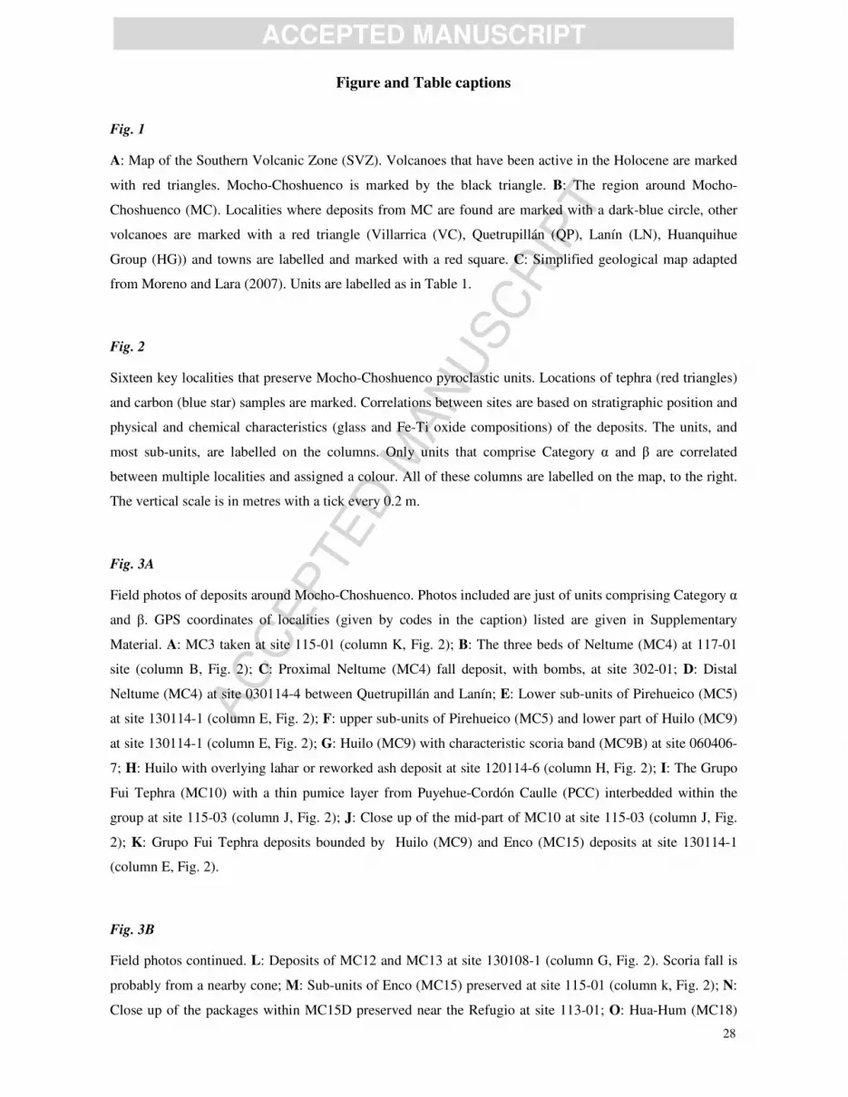
AC
CEPTED
MAN
USC
RIP
T
ACCEPTED MANUSCRIPT
28
Figure and Table captions
Fig. 1
A: Map of the Southern Volcanic Zone (SVZ). Volcanoes that have been active in the Holocene are marked
with red triangles. Mocho-Choshuenco is marked by the black triangle. B: The region around Mocho-
Choshuenco (MC). Localities where deposits from MC are found are marked with a dark-blue circle, other
volcanoes are marked with a red triangle (Villarrica (VC), Quetrupillán (QP), Lanín (LN), Huanquihue
Group (HG)) and towns are labelled and marked with a red square. C: Simplified geological map adapted
from Moreno and Lara (2007). Units are labelled as in Table 1.
Fig. 2
Sixteen key localities that preserve Mocho-Choshuenco pyroclastic units. Locations of tephra (red triangles)
and carbon (blue star) samples are marked. Correlations between sites are based on stratigraphic position and
physical and chemical characteristics (glass and Fe-Ti oxide compositions) of the deposits. The units, and
most sub-units, are labelled on the columns. Only units that comprise Category α and β are correlated
between multiple localities and assigned a colour. All of these columns are labelled on the map, to the right.
The vertical scale is in metres with a tick every 0.2 m.
Fig. 3A
Field photos of deposits around Mocho-Choshuenco. Photos included are just of units comprising Category α
and β. GPS coordinates of localities (given by codes in the caption) listed are given in Supplementary
Material. A: MC3 taken at site 115-01 (column K, Fig. 2); B: The three beds of Neltume (MC4) at 117-01
site (column B, Fig. 2); C: Proximal Neltume (MC4) fall deposit, with bombs, at site 302-01; D: Distal
Neltume (MC4) at site 030114-4 between Quetrupillán and Lanín; E: Lower sub-units of Pirehueico (MC5)
at site 130114-1 (column E, Fig. 2); F: upper sub-units of Pirehueico (MC5) and lower part of Huilo (MC9)
at site 130114-1 (column E, Fig. 2); G: Huilo (MC9) with characteristic scoria band (MC9B) at site 060406-
7; H: Huilo with overlying lahar or reworked ash deposit at site 120114-6 (column H, Fig. 2); I: The Grupo
Fui Tephra (MC10) with a thin pumice layer from Puyehue-Cordón Caulle (PCC) interbedded within the
group at site 115-03 (column J, Fig. 2); J: Close up of the mid-part of MC10 at site 115-03 (column J, Fig.
2); K: Grupo Fui Tephra deposits bounded by Huilo (MC9) and Enco (MC15) deposits at site 130114-1
(column E, Fig. 2).
Fig. 3B
Field photos continued. L: Deposits of MC12 and MC13 at site 130108-1 (column G, Fig. 2). Scoria fall is
probably from a nearby cone; M: Sub-units of Enco (MC15) preserved at site 115-01 (column k, Fig. 2); N:
Close up of the packages within MC15D preserved near the Refugio at site 113-01; O: Hua-Hum (MC18)

AC
CEPTED
MAN
USC
RIP
T
ACCEPTED MANUSCRIPT
29
deposits at site 080114-2 (column L, Fig. 2); P: Proximal deposits of MC20 at site 080114-6 (column N; Fig.
2); Q: More distal appearance of MC20 and MC18 at site 130129-1; R: Pilmaiquén (MC21) overlying MC20
and within the overlying soil there is scoria from MC25 at site 150114-4; S: Pilmaiquén (MC21) and Riñihue
(MC25) at site 130117-1E (column M, Fig. 2); T:Arauco (MC23) and Riñihue (MC25) near the summit at
site 070114-8; U: Proximal Riñihue (MC25) on the surface of the edifice at site 080114-8 (column P, Fig. 2).
The yellow and green ruler is 30 cm long, the tape measure has 10 cm intervals labelled and notches on a 1
cm scale.
Fig. 4
SEM images of typical glass shards for the tephra units that comprise Category α and β and an example of
touching Fe-Ti oxide pairs. A: MC3 pumice; B: MC4B (Neltume) pumice; C: MC5 (Pirehueico) pumice; D:
MC8 scoria; E: MC9A (Huilo) pumice; F: MC9B (Huilo) scoria; G: MC10D (Group Fui Tephra) microlite-
rich glass; H: MC10C (Grupo Fui Tephra) altered scoria clast; I: MC12 pumice; J: MC13 pumice; K:
MC10A (Enco) scoria; L: MC10C (Enco) scoria; M: MC18A (Hua-Hum) pumice; N: MC20A scoria; O:
MC21 (Pilmaiquén) scoria; P: MC23 (Arauco) scoria; Q: MC25 (Riñihue) scoria; R: Touching Fe-Ti oxide
pair in MC4B pumice. Magnetite (mg), ilmenite (il), apatite (ap), plagioclase (pl), pyroxene (px), olivine
(ol).
Fig. 5
Major element composition for the matrix glass (anhydrous) for the different tephra units from Mocho-
Choshuenco. The different colour and/or symbols represent the data from different units, as labelled in the
legend. The filled symbols represent data from the type localities for category α and β units, as defined in
Table 3. All the units that form part of categories α and β are given coloured symbols whereas units in
category γ are grey. The error bars are calculated from the relative percentage errors on the compositionally
similar secondary standards.
Fig. 6
Fe-Ti oxide (magnetite and ilmenite) composition of the different Mocho-Choshuenco tephra units. The
notation is the same as in Fig. 5 with the filled symbols representing data from the type localities for
category α and β units, as defined in Table 3. The error bars are calculated from the relative percentage errors
on the secondary standards. The bottom left graph is the temperature and log (fO2) estimates, determined
using Ghiorso and Evans (2008) Fe-Ti oxide geothermometer plotted with respect to the Ni-Ni-O (NNO)
buffer. All units have filled symbols for temperature and oxygen fugacity estimates.
Fig. 7

AC
CEPTED
MAN
USC
RIP
T
ACCEPTED MANUSCRIPT
30
Isopach maps (cm) for the five largest fall deposits from Mocho-Choshuenco. The volumes (V; bulk rock)
and unit names are shown on the figure. Dashed lines are used instead of solid lines when there is greater
uncertainty due to an absence of data. Localities, where the deposits are found, are marked with circles;
selected sites have their corresponding thickness (cm) annotated. Green circles are sites where the deposit
was additionally confirmed with glass and/or Fe-Ti oxide chemistry and dark-blue circles are sites where just
field observations and stratigraphic position is used. Red triangles mark the regional volcanoes: MC=Mocho-
Choshuenco, VC=Villarrica, QP=Quetrupillán, LN=Lanín, SP=Sollipulli, LL=LLaima and HG=Huanquihue
Group. The towns and villages are labelled and marked with red squares. Graph F shows how the
log(thickness) vs. area½ varies between the different deposits from Mocho-Choshuenco and compared to
those estimated from Volcán Hudson (Weller et al., 2014; Naranjo and Stern, 1998; Scasso et al., 1994),
Quizapu 1932 (Hildreth and Drake, 1992) and Mount St Helens (MSH; Sarna-Wojcicki et al., 1981).
Fig. 8
Summary of the explosive history from Mocho-Choshuenco since deglaciation (~18 ka). Each unit is
represented by its age probability distribution determined using Bayesian analysis of radiocarbon data, the
height corresponds to the approximate magnitude (dashed lines used where magnitude is not well
constrained) and the colour corresponds to the average SiO2 glass composition. Magnitude=log10[eruption
mass (kg) – 7] (Pyle, 2000). The erosion rates, temperature, humidity, climate and vegetation densities are
inferred from the interpretations made on the Lago Puyehue core (ca. 90 km south of Mocho-Choshuenco;
Betrand et al., 2008; Vargas-Ramirez et al., 2008).
Highlights
• High resolution, post-glacial, explosive record is reconstructed for Mocho-Choshuenco
• 75 post-glacial explosive eruptions are described
• Four large (V>1km3) eruptions, including 3 dacitic Plinian eruptions, are recognised
• Large dataset of Fe-Ti oxide and glass chemistry analyses has been compiled

AC
CEPTED
MAN
USC
RIP
T
ACCEPTED MANUSCRIPT
31
Figure 1

AC
CEPTED
MAN
USC
RIP
T
ACCEPTED MANUSCRIPT
32
Figure 2

AC
CEPTED
MAN
USC
RIP
T
ACCEPTED MANUSCRIPT
33
Figure 3a

AC
CEPTED
MAN
USC
RIP
T
ACCEPTED MANUSCRIPT
34
Figure 3b

AC
CEPTED
MAN
USC
RIP
T
ACCEPTED MANUSCRIPT
35
Fig. 4
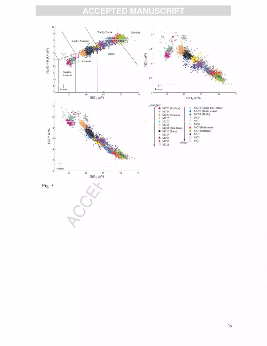
AC
CEPTED
MAN
USC
RIP
T
ACCEPTED MANUSCRIPT
36
Fig. 5

AC
CEPTED
MAN
USC
RIP
T
ACCEPTED MANUSCRIPT
37
Fig. 7

AC
CEPTED
MAN
USC
RIP
T
ACCEPTED MANUSCRIPT
38
Fig. 7

AC
CEPTED
MAN
USC
RIP
T
ACCEPTED MANUSCRIPT
39
Fig. 8
Table 1
Stratigraphic summary and propose nomenclature of the volcanic deposits from Mocho-Choshuenco.
Units Sub-units Category
Unidad Mocho 5 (ca. 1.7 cal. ka BP -present)
MC25 (Riñihue) β
MC24 γ
MC23 (Arauco) β
MC22 γ
MC21 (Pilmaiquén) β
MC20 MC20B
β MC20A
MC19 γ
MC18 (Hua-hum)
MC18C
α MC18B
MC18A
MC17 γ
MC16 γ
Unidad Mocho 4 (ca. 18-1.7 cal. ka BP) MC15 (Enco)
MC15E
α MC15D
MC15C
AC
CEPTED
MAN
USC
RIP
T
ACCEPTED MANUSCRIPT
40
MC15B
MC15A
MC14 γ
MC13 β
MC12 β
MC11 γ
MC10 (Grupo Fui Tephra)
MC10H
α
MC10G
MC10F
MC10E
MC10D
MC10C
MC10B
MC10A
MC9 (Huilo) MC9B
α MC9A
MC8 β
MC7 γ
MC6 γ
MC5 (Pirehueico)
MC5F
α
MC5E
MC5D
MC5C
MC5B
MC5A
MC4 (Neltume)
MC4C
α MC4B
MC4A
MC3 β
MC2 γ
MC1 γ
Unidad Choshuenco 2 (ca. 80-20 ka)
Unidad Mocho 3 (ca. >60 ka)
Unidad Choshuenco 1 (ca. >100 ka)
Unidad Mocho 2 (ca. <200-130 ka)

AC
CEPTED
MAN
USC
RIP
T
ACCEPTED MANUSCRIPT
41
Unidad Mocho 1 (ca. >350-200 ka)
The seven formations are taken from Moreno and Lara (2007). Units, and sub-units, are ordered by stratigraphic position
with the oldest at the base. Units are given a name from MC1 (oldest) to MC25 (youngest); MC26 and MC27 have poor
stratigraphic constraint so are not included. Some units have an additional name (given in brackets). The units are
assigned to a category: Category α, Category β, Category γ depending on their distribution and preservation (see text for
more details). Age estimates for the formations are given in brackets. All, apart from Unidad Mocho 4 and 5 (UM4 and
UM5), are the values given in Moreno and Lara (2007). UM4 and UM5, the focus of this study, include updated ages
from newly calibrated and modeled radiocarbon ages within this study
Table 2
Summary of previous knowledge of the post-glacial explosive history of Mocho-Choshuenco.
Eruption name Other names
in literature Description Dispersal
Volume
(km3) VEI Age (uncalibrated) Reference
MC25 (Riñihue) 1864, FP4 pyroclastic flows,
surges, lahars SW 2
1-3 (± 1day)
November 1864
AD
1, 2, 3
1822 possible small
historic eruption 2 1822 AD 3
1777 possible small
historic eruption 2 1777 AD 3
1759 possible small
historic eruption 2 1759 AD 3
MC15 (Enco)
FPPJB,
OPFUY, OPL,
FP3
Ignimbrite and
scoria fall Radial 1700 BP 1, 4, 5
MC5 (Pirehueico) Pp2 Andesitic pumice
fall E and NE ~ 1 8200-6700 BP 1, 4
MC4 (Neltume) PpCh1, PpN Dacitic pumice
fall NNE 2.5-2.9 5 10700-9700 BP 1, 4, 5, 6
Previous names for
Volcán Mocho-Choshuenco
Valdivia, Rauco, Lajara, Penguipulli, Panguipulli, Riñihue, Quetrupillan, Renihue,
Shoshuenco 3
Volcanic Explosivity Index (VEI) devised by Newhall and Self (1982). References: [1] Moreno and Lara (2007) [2]
Vidal Gormaz (1869) [3] Sepùlveda (2004) [4] Pérez (2005) [5] Echegaray (2004) [6] Echegaray et al. (1994).

AC
CEPTED
MAN
USC
RIP
T
ACCEPTED MANUSCRIPT
42
Table 3
Field descriptions, interpretations and type localities for the post-glacial tephra deposits.

AC
CEPTED
MAN
USC
RIP
T
ACCEPTED MANUSCRIPT
43
Unit Field description
Interpretation
Type locality Phot
o in
Fig.
3
SE
M in
Fig.
4 Name
Subunit
s
Deposit
appearance Clasts
Colum
n in
Fig. 2
MP/M
S (cm)
ML
(cm
)
Th
(cm)
MC25 (Riñihue)
Well-
moderately
sorted, black,
fine to
coarse-lapilli
size scoria
deposit. On
edifice bombs
up to 20 cm
are found.
Black, vesicular,
iridescent,
scoria
Scoria fall P 39°56’S
72°0’W 47 T, U Q
MC24
Black, fine-
medium
lapilli sized
scoria deposit
Black, vesicular
scoria Scoria fall
39°55’S
71°59’
W
MC23 (Arauco)
Well sorted,
ungraded,
scoria
deposit. On
edifice bombs
are preserved
(<25 cm)
Medium-lapilli
sized, vesicular,
black, iridescent
scoria
Scoria fall O 39°51’S
72°6’W 25 T P
MC22
Thin, well-
sorted, dense,
fine-lapilli
scora deposit
Black, dense,
vesicular scoria. Scoria fall M
39°55’S
71°53’
W
MC21 (Pilmaiquén)
Indurated, cm
scale
thickness,
well-sorted,
parallel bands
comprising
grey,
medium-ash
to fine-lapilli
sized clasts.
Coarser
layers are
more loosely
consolidated,
particularly
the top layer,
which is not
always
preserved.
The well-
sorted top
layer
weathers
grey, is ca.
75% the total
thickness of
lower bands
and
comprises
fine-lapilli-
sized, scoria
Fine-lapilli
sized, vesicular,
black, scoria
Wet scoria fall.
Bands may
record pulsating.
Flow-like
features may be
secondary and
arise from
reworking
100m
south
of M
39°55’S
71°54’
W
1.4 31 R, S O
AC
CEPTED
MAN
USC
RIP
T
ACCEPTED MANUSCRIPT
44
clasts.
Deposits
commonly
drape over
topography
and have a
roughly
uniform
thickness
over
distances of
10s of meters.
Rare
localities
preserve
cross-
bedding.
MC20
MC20B
Well-
moderately
sorted, grey,
fine ash to
fine-lapilli
sized
deposits.
Sorting is
poorer in
more
proximal
localities
where cm-
scale, low-
angle, cross
bedding
structures are
preserved.
PDC (surge)
N
39°54’S
71°58’
W
30 P, Q,
R
MC20A
Moderate-
poorly sorted
yellow
weathered
scoria
deposit. In
proximal
localities
fine-coarse
lapilli sized
clasts with
abundant
bombs (up to
20 cm).
Yellow
weathered, very
vesicular,
crystal poor,
scoria clasts.
Large clasts
(>10 cm) retain
their black
appearance in
the cores. In
more distal
localities the
scoria appears
less vesicular
and has a
pumice-like
appearance.
Scoria fall
20
(bombs
) 23
P, Q,
R N
MC19
Grey-brown
ash with
yellow
weathered
pumice clasts
Weathered,
yellow,
vesicular,
crystal poor
pumice clasts.
Pumice fall
39°53’S
71°58’
W
1.1 5
MC18
(Hua-
Hum)
MC18C
sub-rounded
lithic-rich and
pumice-rich
deposit with a
bubble-rich
PDC Only
preserved at one
locality
L
40°1’S
71°57’
W
28 O
AC
CEPTED
MAN
USC
RIP
T
ACCEPTED MANUSCRIPT
45
ashy matrix
MC18B
Moderately-
poorly sorted,
grey, coarse
ash to fine
lapilli sized
deposit
PDC (surge)
Only preserved
at one locality
13 O
MC18A
Well sorted,
ungraded,
orange-brown
weathered,
lithic-poor,
medium-
lapilli sized
pumice
deposit.
Orange-brown
weatherd, very
vesicular and
crystal poor
pumice. Lithics
are rare (ca.
<5%), black,
angular, glassy,
poorly vesicular
clasts.
Subplinian
pumice fall 7.1 3.6 40
O, Q,
R M
MC17
Moderately-
well sorted,
dark-grey-
brown,
medium
lapilli sized
scoria
deposit.
Comprises
rare small
bombs (up to
6 cm).
Grey-brown,
vesicular scoria Scoria fall
39°54’S
71°58’
W
18
MC16
Well sorted,
brown-black
weathered,
fine-lapilli
sized scoria
deposit
Brown-black,
slightly
vesicular scoria
Scoria fall
39°54’S
71°58’
W
15
MC15
(Enco)
MC15E
Normally
graded,
medium, grey
ash, rich,
particularly
near the
contact with
MC15D, in
both coated
ash pellets
and, more
rarely,
accretionary
lapilli
(typically <2
cm). Top
usually
grades into a
well-
developed
palaeosol.
Heterogeneous
ash with no
modal glass
morphology and
abundant
xenoliths of
country rock
and glass shards
of older tephra
units.
PDC
K
39°52’S
71°55’
W
<55
MC15D
Poorly-
sorted,
indurated,
cross-bedded
(low-angle,
Lithics are
predominantly
grey-black,
pitted, sub-
angular, lava
PDC
(ignimbrite)
with multiple
different flow
packages
110 M, N

AC
CEPTED
MAN
USC
RIP
T
ACCEPTED MANUSCRIPT
46
10's cm-
scale), grey-
weathered
deposit with
abundant
lithics
supported in a
medium-
coarse ash
matrix.
Separate flow
packages
distinguishabl
e in proximal
localities.
Each package
is typically 1-
2 m thick and
inversely
graded. The
base is a
well-sorted
cemented ash,
10-20 cm
thick, with
red-brown
oxidised top
and base. The
top is marked
by a scoria
rich layer, or
pinching lens,
or a thin layer
of black
glassy clasts.
Typically the
lithic
component
decreases up
the package.
clasts, red-
orange
hydrothermally
altered clasts
and chalky-
weathered clasts
of a felsic
intrusive rock.
Brown-
weathered,
medium lapilli
sized, black,
sub-
rounded,vesicul
ar scoria and
fine lapilli sized,
black, glassy
clasts mark the
top of the flow
packages.
cont.
MC15
(Enco)
MC15C
Moderately-
well sorted,
black scoria
deposit with a
moderate
amount of
lithics and
abundant
bombs. No
grading or
shower-
bedding
preserved.
Medium-coarse
lapilli sized,
black, vesicular,
crystal poor,
commonly
iridescent scoria
,which typically
has a fresh
appearance.
Lithics (ca. 5-
10%) are
heterogeneous.
Most are dense
grey or black,
angular glassy
lava fragments
or, more rarely,
red-orange
coloured
(hydrothermal
alteration),
slightly
Subplinian
scoria fall 3 12 M L

AC
CEPTED
MAN
USC
RIP
T
ACCEPTED MANUSCRIPT
47
iridescent, non-
vesicular clasts.
MC15B
mm-scale
grey, black
and yellow,
parallel bands
of medium
ash to fine
lapilli.
Heterogeneous
clasts with no
modal glass
morphology and
abundant
xenoliths of
glass shards of
older tephra
units.
Recording
pulsating plume
activity
9 M
MC15A
Well sorted,
black scoria
deposit with
rare lithics.
Inverse
grading, in
top fifth
preserved
only in
proximal
localities.
Medium-lapilli
sized, black,
crystal poor,
angular, glassy
scoria with
small vesicles.
Lithics (ca. 5%)
are weathered,
milky white,
medium-
grained,
crystalline
clasts, probably
diorite.
Scoria fall 2 21 M K
MC14
Orange-
brown
weathered,
medium-
lapilli sized,
scoria
deposit.
Charcoal at
base. In one
locality cut
by a minor,
black, lava
flow from a
nearby cone.
Orange-brown
weathered,
black-brown,
crystal poor,
vesicular scoria
Scoria fall from
nearby cone G
39°52’S
71°53’
W
100
MC13
Moderately-
well sorted,
massive,
orange-white
weathered,
lithic-poor
medium-
lapilli sized
pumice
deposit.
Orange
weathered, very
vesicular,
crystal poor
pumice
Pumice fall I
39°53’S
71°55’
W
4.8 1.9 20-
50 L J
MC12
Well sorted,
ungraded,
yellow-brown
weathered,
medium-fine-
lapilli sized
pumice
deposit.
Clasts have a
bimodal
appearance.
Both weather
yellow-brown
but one type is
more angular,
less vesicular,
darker and
typically smaller
than the second
pumice type,
which has a
Pumice fall G
39°52’S
71°53’
W
1.3 20 L I

AC
CEPTED
MAN
USC
RIP
T
ACCEPTED MANUSCRIPT
48
more pumice,
rather than
scoria,
appearance.
MC11
Brown
weathered,
lithic-rich
(particularly
in bottom
fifth),
medium-
lapilli sized
scoria deposit
Black, very
vesicular scoria Scoria fall I
39°53’S
71°55’
W
100
MC10
(Grupo Fui
Tephra)
MC10H
Well sorted,
indurated,
dark-grey,
coarse ash
with fine
laminations,
comprising
slightly finer
layers. Some
oxidisation
Ash is
heterogenous in
composition and
microlite rich.
Abundant
xenoliths of
country rock.
Wet ash fall
J
39°58’S
71°54’
W
10 I, K
MC10G
Well sorted,
orange
weathered,
fine-lapilli
sized, scoria
deposit that
grades into
overlying
paleosol.
same as MC10A Scoria fall <0.5 6
MC10F
Moderately-
well sorted,
orange-
weathered,
medium-
lapilli sized
deposit
same as MC10A Scoria fall 1 15
MC10E
Well sorted,
orange
weathered,
medium-
lapilli sized
scoria deposit
same as MC10A Scoria fall 0.5 4
MC10D
Banded, cm
scale
thickness,
well sorted,
grey-orange-
yellow
weathered,
medium-ash
to medium-
lapilli sized
ash and scoria
deposit.
same as MC10A Scoria and ash
falls 1.5 45
I, J,
K G
MC10C
Indurated,
dark-grey
coarse ash,
overlain by a
same as MC10A Scoria fall 2.4 25 H
AC
CEPTED
MAN
USC
RIP
T
ACCEPTED MANUSCRIPT
49
well sorted,
orange-
weathered,
lithic-poor,
medium-
lapilli sized
scoria
deposit.
MC10B
Well-sorted,
orange
weathered,
fine-lapilli
sized, scoria
deposit
same as MC10A Scoria fall 10
MC10A
Well-sorted,
orange
weathered,
fine-lapilli
sized, scoria
deposit
Orange-yellow
weathered,
vesicular scoria.
Very weathered
with little to no
glass preserved
that has not
altered to clay.
Scoria fall 15 I, K
MC9
(Huilo)
MC9B
Thin,
continuous,
black,
medium-
lapilli sized,
scoria deposit
that is often
oxidised.
Sharply cuts
MC9A.
Black, vesicular
scoria Scoria fall
C
40°00’S
71°56’
W
4.5 10 G, H F
MC9A
Well sorted,
massive,
orange-white
weathered,
lithic-poor
pumice
deposit.
Orange
weathered, very
vesicular,
crystal poor
pumice with
red-pink cores.
At rare localities
they retain
original white
appearance.
Minor amounts
of both grey and
banded,
vesicular,
crystal poor
pumice (ca.
<5%) of a
similar size to
the dominant
white pumice.
Lithics are
black-grey, sub-
rounded,
slightly-
vesicular dense
clasts (ca.<5%)
and dense, grey,
angular lava
fragments (ca.
<5%).
Plinian-style
pumice fall 7.5 166
F, G,
H, K E

AC
CEPTED
MAN
USC
RIP
T
ACCEPTED MANUSCRIPT
50
MC8
Moderately
sorted, black-
red
weathered,
coarse ash to
fine-lapilli
sized scoria
rich deposit.
Some
localities
preserve
cross-
bedding. In
the thickest
deposits
shower-
bedding is
preserved.
Black-red,
weathered,
vesicular scoria
Scoria fall and
PDC from
nearby cone
39°55’S
71°55’
W
>10
0 F D
MC7
Moderately-
well sorted,
brown
weathered,
coarse ash to
fine-lapilli
sized pumice
deposit
Brown
weathered,
crystal poor,
vesicular
pumice
Pumice fall I
39°53’S
71°55’
W
13
MC6
Moderately
sorted, orange
weathered,
medium-
lapilli sized
pumice held
in a fine ash
sized, brown-
grey matrix
with charcoal.
Yellow-pink
weathered,
crystal poor,
vesicular
pumice.
Paleosol with
reworked clasts
from a potenital
pumice fall
E
39°57’S
71°52’
W
2.8 12 F
MC5
(Pirehueico
)
MC5F
Moderately
sorted,
orange-
weathered,
fine-coarse-
lapilli sized
pumice
deposit.
same as MC5D
Plinian-style
pumice fall with
possible
interbedded
minor PDCs
(surges?; i.e.
MC5B and
MC5E)
E
39°57’S
71°52’
W
5 18 F, G
MC5E
Grey-brown,
medium-fine
ash layer
containing a
moderate
amount of,
possibly
reworked,
pumice clasts.
Sharp contact
with MC3D
and MC3F
Yellow-
weathered,
crystal poor,
vesicular
pumice.
9 F
MC5D
Moderately-
well sorted,
orange-red
weathered,
moderate
lithcs,
same as MC5A.
>7.5
(bombs
<25
cm)
4.5 80 F

AC
CEPTED
MAN
USC
RIP
T
ACCEPTED MANUSCRIPT
51
medium-
lapilli to
bomb-size
pumice
deposit. High
concentration
of bombs (up
to 25 cm),
particularly in
bottom 75%
of the
deposit.
Sharp contact
with MC3C
and MC3E.
MC5C
Well sorted,
yellow-
weathered,
lithic-rich,
fine-medium-
lapilli sized,
pumice
deposit. The
base is
slightly finer;
fine-lapilli
sized clasts.
same as MC5A 4 62 E C
MC5B
Fine, grey ash
with no
internal
structures.
Sharp contact
with MC5A
and MC5B.
Very weathered,
heterogeneous
ash, with glass
having a
devitrified
appearance on
the edges where
it has altered to
clay.
10 E
MC5A
Moderately
sorted,
yellow-
weathered,
coarse ash to
medium-
lapilli sized
pumice
deposit.
Pumice are
set in a lithic-
rich (ca.
30%) and
grey, ash-rich
matrix.
Yellow-
weathered,
crystal poor,
vesicular
pumice, some
with a mingled
appearance.
Lithics are
predominately
black-grey,
angular, glassy,
non-vesicular
clasts and minor
amounts of
black-grey
scoria.
3.3 60 E
MC4
(Neltume) MC4C
Well-sorted,
orange-
yellow-
weathered,
lithic-poor
pumice
deposit.
Normal
grading in the
upper quarter
Primarily,
orange-yellow
weathered,
crystal poor,
vesicular
pumice with, at
rare localities,
white cores.
Moderate
amounts (ca.
Plinian-style
pumice fall B
39°39’S
71°55’
W
2.5 0.7 300 B, C,
D B

AC
CEPTED
MAN
USC
RIP
T
ACCEPTED MANUSCRIPT
52
observed at
rare localities.
Typically at
distal
localities
(when
thickness ca.
<15 cm) the
bottom two-
thirds, of the
deposit,
weathers
orange, as in
more
proximal
localities, and
this sharply
changes to
dark-grey-
yellow
weathering in
the upper
part.
5%) of grey and
banded
vesicular,
crystal poor
pumice and
dense
cauliform-
shaped clasts
(<5%) are
uniformly
distributed
through the
deposit and
more
abundantly
preserved in
proximal
localities. Some
proximal
pumice preserve
tuffsite veins
and cauliform
shaped black
clasts trapped
within vesicles.
MC4B
Very-well
sorted,
orange-
yellow
weathered,
lithic-poor,
fine-lapilli
sized, pumice
deposit that is
typically <15
cm.
Fine-lapilli
sized, orange-
yellow-
weathered,
vesicular,
pumice that
only have small
patches of glass
not altered to
clay
Pumice fall 0.7 10 B
MC4A
Well-sorted,
grey, fine ash
bounded by
red-brown
oxidised
layers and
typically <10
cm
Ash is
heterogenous in
composition and
only small
patches of glass
not altered to
clay. Abundant
xenoliths of
country rock
and glass shards
of older tephra
units.
Phreatomagmati
c, vent-clearing
event
fine
ash 9 B
MC3
Well sorted,
orange-
yellow
weathered,
fine-medium
lapilli sized,
pumice
deposit.
Lithic content
changes
sharply from
ca. 40%, in
the bottom
half of the
Orange-yellow
weathered,
vesicular,
crystal poor
pumice,
sometimes with
a mingled
appearance.
Two lithic
types: black,
angular, non-
vesicular lava-
like clast and a
black, vesicular
Pumice fall K
39°52’S
71°55’
W
3 3 75 A A

AC
CEPTED
MAN
USC
RIP
T
ACCEPTED MANUSCRIPT
53
deposit, to ca.
15%.
scoria.
MC2
Orange-
weathered,
fine-lapilli
sized pumice
deposit
orange-
weathered,
vesicular,
crystal poor
pumice
Pumice fall C 40°00’S
72°0’W 2.6 12
MC1
Moderately
sorted, slight
reverse
grading, non-
welded,
black-red
weathered,
fine-lapilli to
coarse-bombs
sized clasts
(up to 35 cm)
scoria
deposit.
Black, dense,
vesicular scoria.
Scoria fall from
nearby cone K
39°52’S
71°55’
W
35 >20
0
MC26
Poorly-
moderately
sorted, black,
medium-
lapilli to
bombs sized
scoria
deposit.
Black, vesicular
scoria with
abundant
xenoliths of a
milky-white,
medium-
grained,
crystalline,
felsic intrusive
rock.
Scoriaceous
PDC
39°56’S
72°06’
W
>20 >18
0
MC27
MC27D
Well sorted,
brown-black
weathered
scoria
desposit
Brown-black,
vesicular,
microlite rich
scoria
Scoria fall. Sub-
units may record
pulsating
activity of the
plume
O 39°51’S
72°6’W
33
MC27C
Thin, coarse,
grey ash with
fine
laminations.
Sharp contact
with MF27B
and MF27D
Heterogeneous
clasts with no
modal glass
morphology and
abundant
xenoliths of
country rock.
5
MC27B
Well sorted,
brown-black
weathered,
medium-
lapilli scoria
rich deposit.
Brown-black,
slightly
vesicular scoria,
which is often
altered to clay,
and xenoliths of
country rock.
5
MC27A
Thin, fine,
grey ash with
a sharp
contact with
MC27B
2
Units are ordered in stratigraphic order from youngest (MC25; at the top) to oldest (MC1; at the base). MC26 and
MC27, described last, have a poor age constraint so are not included within the stratigraphy. Units in Category α, are in
bold, those in Category β are unformatted and those pertaining to Category γ are in italics. The letters correspond to the
stratigraphic column label in Fig. 2, the associate field photos in Fig. 3 and SEM images in Fig. 4. The maximum
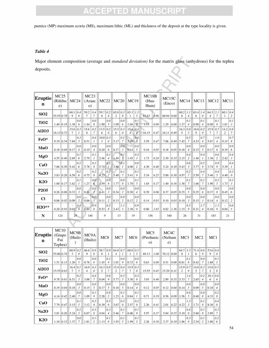
AC
CEPTED
MAN
USC
RIP
T
ACCEPTED MANUSCRIPT
54
pumice (MP) maximum scoria (MS), maximum lithic (ML) and thickness of the deposit at the type locality is given.
Table 4
Major element composition (average and standard deviation) for the matrix glass (anhydrous) for the tephra
deposits.
Eruptio
n
MC25
(Riñihu
e) MC24
MC23
(Arauc
o) MC22 MC20 MC19
MC18B
(Hua-
Hum) MC15C
(Enco) MC14 MC13 MC12 MC11
SiO2 55.55 0.78
60.19
0.4
9 59.2
7 0.4
7 59.7
8 0.2
4 65.0
2 0.3
8 65.3
1 1.3
5 63.43 0.96 60.94 0.68 60.2
8 1.1
4 65.4
6 1.4
0 64.3
4 2.1
7 60.1
1 0.4
2
TiO2 1.40 0.18 1.38
0.0
6 1.44 0.0
8 1.90 0.0
5 1.09 0.0
6 1.04 0.1
0 1.13 0.09 1.29 0.08 1.37 0.1
4 0.90 0.1
4 0.98 0.1
9 1.81 0.1
3
Al2O3 16.13 0.73
15.67
0.3
1 15.6
0 0.2
7 13.5
6 0.2
8 15.5
6 0.3
0 15.4
4 0.4
4 16.15 0.47 16.11 0.49 16.3
5 0.8
5 16.0
9 0.2
9 15.9
7 0.5
7 14.2
2 0.8
7
FeO* 9.19 0.54 7.84
0.3
5 8.51 0.4
1 10.0
3 0.3
0 5.17 0.2
7 5.09 0.6
8 5.59 0.47 7.06 0.49 7.45 0.5
7 4.53 0.7
4 5.67 1.0
4 9.15 0.7
8
MnO 0.18 0.04 0.17
0.0
4 0.19 0.0
4 0.20 0.0
6 0.17 0.0
3 0.14 0.0
5 0.16 0.05 0.18 0.05 0.18 0.0
4 0.15 0.0
5 0.17 0.0
6 0.19 0.0
6
MgO 4.55 0.46 2.69
0.1
6 2.79 0.1
1 2.46 0.1
4 1.49 0.1
5 1.45 0.2
3 1.73 0.24 2.30 0.33 2.15 0.4
2 1.46 0.4
1 1.36 0.6
2 2.42 0.4
3
CaO 7.86 0.50 5.42
0.2
6 5.78 0.1
8 5.74 0.2
1 3.86 0.1
1 4.00 0.6
2 4.30 0.40 5.24 0.30 5.43 0.6
3 3.77 0.5
9 3.74 0.9
9 5.39 0.4
1
Na2O 3.83 0.26 4.59
0.2
6 4.75 0.2
0 4.23 0.2
7 5.40 0.1
7 5.41 0.1
9 5.34 0.25 5.00 0.30 4.97 0.2
7 5.59 0.4
7 5.46 0.4
5 4.40 0.3
0
K2O 1.00 0.17 1.62
0.1
1 1.27 0.0
6 1.59 0.0
8 1.77 0.0
8 1.70 0.1
5 1.65 0.17 1.40 0.16 1.38 0.1
7 1.66 0.1
7 1.90 0.2
5 1.73 0.1
3
P2O5 0.26 0.06 0.33
0.0
3 0.34 0.0
3 0.41 0.0
3 0.34 0.0
2 0.30 0.0
4 0.39 0.06 0.37 0.05 0.35 0.0
5 0.25 0.0
6 0.37 0.0
8 0.45 0.0
6
Cl 0.06 0.02 0.09
0.0
2 0.06 0.0
5 0.11 0.0
2 0.13 0.0
2 0.12 0.0
2 0.14 0.03 0.10 0.03 0.10 0.0
3 0.15 0.0
3 0.14 0.0
4 0.12 0.0
2
H2O** 0.20 0.93
-
0.02 0.4
8 0.84 0.9
0 0.53 0.2
8 2.43 1.1
3 2.38 0.9
0 0.06 1.65 0.82 1.36 1.15 0.5
9 0.31 1.7
4 -
0.10 1.3
9 -
0.04 0.6
5
N 124 29 140 9 13 19 156 340 26 31 183 21
Eruptio
n
MC10
(Grupo
Fui
Tephra)
MC9B
(Huilo
) MC9A
(Huilo) MC8 MC7 MC6
MC5
(Pirehueic
o)
MC4C
(Neltum
e) MC3 MC2 MC1
SiO2 55.80 0.74
60.93
0.2
9 66.6
9 0.9
6 58.7
0 0.9
1 64.8
4 0.7
1 68.0
1 0.5
5 69.13 1.06 70.12 0.69 64.7
8 3.3
1 71.4
6 0.6
9 53.6
9 0.4
0
TiO2 1.51 0.13 1.20
0.0
5 0.78 0.0
9 1.45 0.1
9 1.01 0.0
9 0.72 0.0
6 0.63 0.08 0.51 0.08 0.81 0.1
8 0.42 0.0
7 1.88 0.1
3
Al2O3 15.55 0.63
16.4
7 0.1
5 16.0
4 0.3
0 16.3
5 0.8
7 15.4
2 0.4
7 15.9
7 0.3
0 15.55 0.45 15.29 0.31 15.9
2 0.7
9 14.8
5 0.3
7 15.0
2 0.5
8
FeO* 9.78 0.61 6.51
0.2
5 3.88 0.4
7 8.04 0.6
9 5.77 0.3
5 3.36 0.2
8 3.03 0.40 2.89 0.35 5.33 1.4
7 2.65 0.2
4 10.1
6 0.6
4
MnO 0.19 0.04 0.18
0.0
3 0.15 0.0
5 0.17 0.0
5 0.18 0.0
5 0.14 0.0
4 0.12 0.05 0.12 0.04 0.14 0.0
5 0.09 0.0
5 0.18 0.0
4
MgO 4.14 0.42 2.40
0.0
7 1.09 0.1
9 2.28 0.8
2 1.23 0.1
6 0.84 0.1
1 0.71 0.19 0.56 0.09 1.56 0.6
5 0.40 0.0
8 4.33 0.2
8
CaO 7.79 0.47 5.15
0.1
5 3.12 0.3
9 6.39 0.5
6 3.67 0.3
0 2.57 0.2
0 2.26 0.41 2.01 0.22 4.22 1.3
3 1.71 0.1
8 8.36 0.4
0
Na2O 3.81 0.26 5.24
0.2
2 6.07 0.3
0 4.94 0.3
4 5.46 0.1
7 6.06 0.1
9 5.97 0.27 5.84 0.25 5.10 0.4
0 5.60 0.1
8 3.89 0.3
7
K2O 1.10 0.12 1.37
0.0
7 1.81 0.1
2 1.13 0.1
8 1.93 0.1
5 1.99 0.1
2 2.26 0.16 2.37 0.10 1.86 0.3
9 2.54 0.1
2 1.80 0.2
6

AC
CEPTED
MAN
USC
RIP
T
ACCEPTED MANUSCRIPT
55
P2O5 0.28 0.03 0.43
0.0
3 0.20 0.0
5 0.48 0.0
7 0.34 0.0
4 0.16 0.0
3 0.15 0.04 0.10 0.04 0.14 0.0
4 0.07 0.0
3 0.60 0.0
6
Cl 0.06 0.01 0.11
0.0
2 0.18 0.0
3 0.08 0.0
2 0.15 0.0
3 0.18 0.0
3 0.20 0.03 0.19 0.03 0.13 0.0
4 0.20 0.0
2 0.09 0.0
2
H2O** 1.76 0.73 0.19
0.6
6 0.31 1.7
9 0.80 0.8
3 -
0.13 0.5
4 -
0.16 0.6
4 0.84 1.73 1.12 2.06 1.14 1.4
3 0.19 0.6
9 0.36 0.5
6
N 64 26 179 19 34 21 262 282 110 28 13
Average and standard deviations (italics) for tephra deposits. Compositions were determined using a wavelength-
dispersive EMP (see section 4.1). N=number of analyses, **H2O by difference. See Supplementary Material for the ca.
2150 raw analyses. Glass analysis was not possible for all samples. For the more evolved samples (i.e., the dacites and
rhyolites) this was as a result of extensive weathering (e.g., the deposits in Argentina) or the material being too highly
vesicular, which is often the case with MC9 (Huilo) pumice (vesicle walls commonly thinner than 1 µm). For the more
mafic samples (i.e., basaltic andesites and basalts; particularly the scoria from the cones) the microlite density was often
too high (e.g., Fig. 4.G) for glass analysis to be possible. Therefore the melt chemistry is likely to be biased towards the
more silicic compositions.
Table 5
Major element compositions (average and standard deviation) of the Fe-Ti oxides for the tephra deposits.
Erupt
ion
M
C2
7
M
C2
6
M
C2
4
MC
23
(Ar
auc
o)
MC2
1
(Pil
maiq
uén)
M
C2
0
M
C1
9
M
C1
8B
(H
ua-
Hu
m)
M
C1
7
M
C1
6
M
C1
5C
(En
co)
M
C1
3
M
C1
2
M
C9
B
(H
uil
o)
M
C9
A
(H
uil
o)
M
C7
M
C6
MC5
(Pire
huei
co)
MC
4
(Nel
tum
e)
M
C3
M
C
2
Magne
tite
Si
O
2
0.
0
8
0
.
0
2
0.
0
6
0
.
0
5
0.
0
6
0
.
0
2
0.
0
7
0.
0
2 0.1
1 0.
13
0.
0
5
0
.
0
2
0.
0
6
0
.
0
6
0.
0
5
0
.
0
2
0.
0
5
0
.
0
2
0.
1
4
0
.
1
4
0.
0
7
0
.
0
5
0.
0
4
0
.
0
2
0.
0
5
0
.
0
2
0.
0
4
0
.
0
2
0.
0
4
0
.
0
3
0.
0
5
0
.
0
2
0.
0
4
0
.
0
1 0.0
5 0.
08 0.
05
0.
0
9
0.
0
4
0
.
0
2
0.0
30.
01
Ti
O
2
1
2.5
9
0
.
3
5
1
1.9
7
2
.
9
2
1
3.0
1
1
.
1
0
1
1.5
2
0.
1
9 12.
05 2.
82
1
3.1
2
0
.
3
3
1
4.5
4
0
.
2
8
1
3.5
4
0
.
7
9
1
5.7
1
0
.
3
4
1
2.7
9
1
.
7
6
1
3.5
7
4
.
9
0
1
2.2
0
0
.
2
1
1
7.2
4
0
.
3
2
1
3.4
0
6
.
6
7
1
2.3
1
0
.
2
0
1
7.1
4
0
.
2
9
1
2.5
6
0
.
1
2 11.
44 0.
38
13.2
1
1.
5
3
1
4.1
7
3
.
4
6
14.150
.28
Al2
O
3
3.
5
4
0
.
1
3
3.
1
7
0
.
8
7
3.
1
2
0
.
3
8
3.
8
1
0.
0
9 3.4
8 0.
83
2.
9
1
0
.
1
1
2.
7
7
0
.
0
8
3.
1
5
0
.
2
3
2.
8
7
0
.
1
6
3.
6
9
0
.
5
5
3.
3
9
0
.
6
3
2.
6
4
0
.
0
9
2.
6
7
0
.
0
7
2.
9
0
0
.
8
8
2.
6
5
0
.
1
0
2.
6
7
0
.
0
4
2.
4
9
0
.
0
7 2.4
0 0.
10 2.
07
0.
2
1
2.
1
1
0
.
2
1
1.9
80.
16
Fe
O
*
73.
81
0
.
8
5
75.
83
3
.
5
7
74.
31
0
.
4
5
74.
62
0.
4
9 74.47
3.
57
74.
72
0
.
9
2
73.
76
0
.
3
7
74.
17
1
.
1
6
72.
39
0
.
6
3
73.
06
1
.
5
8
73.
68
4
.
0
7
75.
98
0
.
4
7
72.
06
0
.
5
4
74.
13
5
.
8
0
75.
98
0
.
7
7
72.
57
0
.
3
4
75.
79
0
.
5
2 76.91
1.
13
76
.57
1.
6
8
76.
03
3
.
1
4
76.
520
.37
M
n
O
0.4
4
0
.
0
4
0.5
4
0
.
2
0
0.4
6
0
.
0
7
0.4
0
0.
0
3 0.3
8 0.
05
0.6
5
0
.
0
4
0.5
7
0
.
0
3
0.5
6
0
.
0
5
0.5
9
0
.
0
3
0.4
2
0
.
0
5
0.4
8
0
.
0
6
0.7
9
0
.
0
4
0.6
5
0
.
0
3
0.7
1
0
.
1
5
0.7
8
0
.
0
4
0.6
6
0
.
0
3
0.7
7
0
.
0
3 0.8
3 0.
04 0.
85
0.
0
8
0.7
9
0
.
0
5
0.830.
05
M
gO
3.
41
0
.
3
4
2.
96
0
.
9
2
3.
30
0
.
2
8
3.
60
0.
0
8 3.12
0.
66
2.
85
0
.
1
8
3.
15
0
.
1
9
3.
29
0
.
2
4
2.
80
0
.
2
0
3.
29
0
.
2
6
3.
48
0
.
4
0
2.
74
0
.
1
0
2.
61
0
.
0
9
3.
07
0
.
5
2
2.
74
0
.
1
1
2.
64
0
.
0
6
2.
56
0
.
0
7 2.35
0.
10 1.84
0.
2
4
2.
06
0
.
1
7
1.6
00.
20
C
a
O
0.
0
8
0
.
0
3
0.
0
4
0
.
0
4
0.
0
2
0
.
0
2
0.
0
2
0.
0
1 0.1
2 0.
06
0.
0
3
0
.
0
2
0.
0
3
0
.
0
3
0.
0
3
0
.
0
4
0.
0
2
0
.
0
1
0.
1
1
0
.
0
6
0.
0
5
0
.
0
5
0.
0
3
0
.
0
5
0.
0
5
0
.
1
0
0.
0
5
0
.
1
2
0.
0
3
0
.
0
5
0.
0
4
0
.
0
6
0.
0
2
0
.
0
2 0.0
3 0.
04 0.
02
0.
0
3
0.
0
2
0
.
0
3
0.0
30.
04
T
otal
93.9
5
0
.
7
5
94.5
6
1
.
7
4
94.2
8
0
.
6
3
94.0
3
0.
5
5 93.
72 1.
34
94.3
2
1
.
1
2
94.8
9
0
.
4
8
94.7
8
0
.
8
8
94.4
4
0
.
8
2
93.5
0
0
.
6
7
94.7
1
1
.
3
1
94.4
3
0
.
5
8
95.3
3
0
.
6
5
94.2
9
0
.
7
9
94.5
4
0
.
8
3
95.7
6
0
.
4
2
94.2
5
0
.
5
2 94.
01 1.
31
94.6
1
0.
8
5
95.2
2
1
.
0
2
95.150
.34

AC
CEPTED
MAN
USC
RIP
T
ACCEPTED MANUSCRIPT
56
Fe
O
37.
0
8
0
.
7
1
37.
3
0
2
.
3
5
37.
6
8
1
.
4
1
36.
0
2
0.
3
1 37.
02 2.
11
38.
2
3
0
.
6
8
39.
2
7
0
.
6
3
38.
2
0
0
.
7
3
40.
6
5
0
.
5
3
37.
3
8
1
.
6
5
37.
5
0
1
.
7
5
37.
4
5
0
.
4
0
42.
4
5
0
.
5
0
36.
6
5
1
.
8
1
37.
5
9
0
.
4
1
42.
4
8
0
.
4
0
37.
9
8
0
.
2
8 37.
18 0.
67
39
.6
3
1.
1
5
40.
0
2
0
.
8
6
41.
411
.56
Fe
2
O
3
4
0.8
2
0
.
9
4
4
2.8
1
5
.
6
3
4
0.7
0
1
.
5
9
4
2.8
9
0.
4
3 41.
61 5.
74
4
0.5
5
0
.
6
4
3
8.3
3
0
.
4
8
3
9.9
7
1
.
6
0
3
5.2
8
0
.
6
7
3
9.6
5
3
.
4
6
4
0.2
1
4
.
7
2
4
2.8
2
0
.
3
4
3
2.9
0
0
.
5
8
4
1.6
5
5
.
1
1
4
2.6
7
0
.
5
5
3
3.4
4
0
.
4
9
4
2.0
1
0
.
4
2 44.
15 0.
85
41.0
5
2.
9
3
4
0.0
2
2
.
8
2
39.021
.74
T
ot
al
9
7.
96
0
.
8
2
9
8.
81
1
.
5
7
9
8.
30
0
.
5
4
9
8.
26
0.
5
8 97.78
1.
21
9
8.
34
1
.
1
6
9
8.
67
0
.
4
8
9
8.
74
0
.
9
1
9
7.
97
0
.
8
5
9
7.
33
0
.
9
9
9
8.
68
1
.
1
1
9
8.
70
0
.
5
9
9
8.
58
0
.
6
6
9
8.
42
0
.
4
8
9
8.
78
0
.
8
7
9
9.
06
0
.
4
3
9
8.
41
0
.
5
5 98.39
1.
37
98
.68
0.
8
2
9
9.
19
0
.
9
8
99.
020
.41
N 18 50 18 39 26 53 18 402 17 13 182 81 122 23 274 17 11 250 446 88 13
Erupt
ion
M
C2
7
M
C2
6
M
C2
4
MC
23
(Ar
auc
o)
MC2
1
(Pil
maiq
uén)
M
C2
0
M
C1
9
M
C1
8B
(H
ua-
Hu
m)
M
C1
7
M
C1
6
M
C1
5C
(En
co)
M
C1
3
M
C1
2
M
C9
B
(H
uil
o)
M
C9
A
(H
uil
o)
M
C7
M
C6
MC5
(Pire
huei
co)
MC
4
(Nel
tum
e)
M
C3
M
C
2
Ilm
enit
e
Si
O
2
0.0
0
0
.
0
1
0.0
0
0
.
0
1
0.0
0
0
.
0
1
0.0
0
0
.
0
0
0.0
1
0
.
0
3
0.0
0
0
.
0
1
0.0
0
0
.
0
0
0.0
1
0
.
0
2
0.0
0
0
.
0
0
0.0
0
0
.
0
0 0.0
0 0.
01 0.
00
0.
0
2
0.0
0
0
.
0
0
0.000.
00
Ti
O
2
4
5.
02
1
.
4
0
4
4.
77
0
.
3
9
4
5.
42
0
.
6
9
4
7.
02
0
.
2
7
4
4.
67
0
.
4
2
4
8.
38
0
.
3
5
4
4.
76
0
.
3
6
4
4.
80
0
.
4
0
4
8.
40
0
.
2
6
4
5.
31
0
.
4
1 44.90
0.
39
47
.07
0.
4
6
4
7.
17
1
.
0
5
47.
640
.30
Al
2
O3
0.2
4
0
.
1
1
0.3
5
0
.
0
3
0.3
4
0
.
0
3
0.3
6
0
.
0
3
0.3
0
0
.
0
2
0.2
6
0
.
0
1
0.3
0
0
.
0
1
0.3
0
0
.
0
3
0.2
5
0
.
0
2
0.2
7
0
.
0
2 0.2
5 0.
02 0.
18
0.
0
2
0.2
0
0
.
0
1
0.150.
02
Fe
O
*
4
7.3
1
1
.
2
0
4
8.3
1
0
.
4
6
4
6.9
6
0
.
8
0
4
5.3
5
0
.
0
4
4
7.6
7
0
.
3
8
4
5.4
0
0
.
3
3
4
7.5
1
0
.
2
6
4
7.7
1
0
.
4
3
4
5.4
6
0
.
1
7
4
7.2
4
0
.
3
1 47.
64 0.
51
46.7
7
0.
4
6
4
6.7
2
0
.
5
9
46.820
.39
Mn
O
1.47
1
.
0
7
0.68
0
.
0
5
0.63
0
.
0
5
0.58
0
.
0
6
0.87
0
.
0
5
0.72
0
.
0
4
0.81
0
.
0
6
0.85
0
.
0
6
0.73
0
.
0
3
0.90
0
.
0
4 0.98
0.
06 1.09
0.
0
7
0.93
0
.
0
6
1.110.
11
M
g
O
2.
8
7
0
.
9
9
3.
7
8
0
.
3
0
4.
1
6
0
.
3
4
4.
4
0
0
.
4
2
4.
0
2
0
.
0
9
3.
7
3
0
.
1
2
4.
0
5
0
.
0
5
3.
9
8
0
.
1
7
3.
6
8
0
.
0
9
3.
8
1
0
.
1
8 3.5
9 0.
18 3.
06
0.
1
7
3.
4
9
0
.
3
5
2.6
40.
26
C
a
O
0.
0
6
0
.
0
2
0.
0
5
0
.
0
4
0.
0
7
0
.
1
1
0.
1
0
0
.
0
9
0.
0
4
0
.
0
4
0.
0
4
0
.
0
4
0.
0
5
0
.
0
5
0.
0
5
0
.
0
7
0.
0
4
0
.
0
1
0.
0
4
0
.
0
3 0.0
5 0.
07 0.
03
0.
0
3
0.
0
3
0
.
0
2
0.0
40.
03
T
ot
al
9
6.9
6
1
.
5
3
9
7.9
6
0
.
6
8
9
7.5
7
0
.
7
3
9
7.8
1
0
.
0
1
9
7.5
8
0
.
6
2
9
8.5
4
0
.
5
6
9
7.4
7
0
.
4
9
9
7.7
0
0
.
6
3
9
8.5
7
0
.
3
4
9
7.5
7
0
.
3
7 97.
39 0.
54
98.2
1
0.
6
7
9
8.5
4
1
.
3
2
98.390
.30
Fe
O
33.
8
3
1
.
5
0
32.
7
8
0
.
6
7
32.
7
4
0
.
7
6
33.
7
3
0
.
8
2
32.
0
9
0
.
4
5
36.
1
0
0
.
3
9
32.
1
7
0
.
2
6
32.
2
9
0
.
5
1
36.
2
0
0
.
3
5
33.
0
1
0
.
6
4 32.
95 0.
46
35
.7
5
0.
5
9
35.
2
4
0
.
8
0
36.
980
.57
Fe
2O
3
14.
98
2
.
1
5
17.
26
0
.
6
5
15.
80
1
.
0
5
12.
91
0
.
8
6
17.
31
0
.
5
2
10.
34
0
.
5
4
17.
04
0
.
4
3
17.
14
0
.
6
5
10.
30
0
.
2
2
15.
82
0
.
7
6 16.32
0.
70
12
.24
0.
8
0
12.
75
0
.
7
9
10.
941
.04
T
ot
al
9
8.
46
1
.
4
4
9
9.
68
0
.
7
0
9
9.
15
0
.
7
3
9
9.
10
0
.
0
7
9
9.
32
0
.
6
2
9
9.
57
0
.
5
7
9
9.
17
0
.
4
9
9
9.
41
0
.
6
5
9
9.
60
0
.
3
2
9
9.
15
0
.
3
5 99.02
0.
56
99
.43
0.
7
0
9
9.
82
1
.
2
7
99.
490
.39
N 8 28 27 2 28 40 8 141 3 8 141 128 28 7

AC
CEPTED
MAN
USC
RIP
T
ACCEPTED MANUSCRIPT
57
Temperature
(°C)
96
3 9
95
5 1
2
95
4 1
1
93
3 6
93
2 6
93
0 9
93
4 8
92
4 1
92
4 1
1 90
3 11 88
8 1
2
90
5 9 876
16
log10(f
O2)
0.
5
5
0
.
0
4
0.
3
8
0
.
0
8
0.
0
3
0
.
1
3
0.
5
4
0
.
0
3
-0.
3
6
0
.
1
0
0.
5
1
0
.
0
3
0.
5
3
0
.
0
5
-0.
3
7
0
.
0
6
0.
4
1
0
.
0
6 0.4
8 0.
08
-
0.
04
0.
1
1
0.
0
6
0
.
0
6
-0.2
60.
19
Average and standard deviations (italics) for tephra deposits. Compositions in weight percent (wt%) were determined
using a wavelength-dispersive EMP (see section 4.1). N=number of analyses. FeO and Fe2O3 calculated as in Droop
(1987). Temperature (T) and oxygen fugacity (fO2) calculated as in Ghiorso and Evans (2008). See Supplementary
Material for the ca. 2700 raw analyses.
Table 6
Summary of the stratigraphic relationship and characteristics of the explosive units.
Eruption Unit type Chemical
Analyses Dispersal
Volume
(km3)
Mass
(kg) Magnitude
Column
Height
(km)
Wind
Speed
(ms-1)
Modelled
age cal. yrs
BP
MC25 (Riñihue) Basaltic-
andesite fall Glass E ~3 278-48
MC24 Andesitic fall Glass &
oxides E? ~<3 374-96
MC23 (Arauco) Andesitic fall Glass &
oxides N ~3 460-215
MC22 Andesitic fall Glass E? ~<3 495-325
MC21
(Pimaiquén)
Wet scoria
fall Oxides E ~4 543-365
MC20
Dacitic fall
and
overlying
PDC
Glass &
oxides NNE ~4 1228-842
MC19 Andesite-
dacitic fall
Glass &
oxides NE? ~<3 1328-1061
MC18 (Hua-
hum)
Andesite-
dacitic fall
Glass &
oxides NE & SE 0.4 4.0E+11 4.6 ~30 ~30 1375-1155
MC17 Scoria fall Oxides NE? ~<3 1490-1303
MC16 Scoria fall Oxides NE? ~<3 1624-1340
MC15
(Enco)
MC15D Andesitic
PDC
Glass &
oxides Radial 1 1.5E+12
5.0
1695-1465
MC15C Andesitic fall Glass &
oxides SE 0.7 1.1E+12 ~30 ~30
MC14 Andesitic
cone eruption Glass E? ~3 2083-1594
MC13 Dacitic fall Glass &
oxides ENE ~4 2324-1806
MC12 Andesite-
dacitic fall
Glass &
oxides NE ~4 2832-2158
MC11 Andesitic fall Glass E? ~3 3494-2302
MC10
(Grupo
MC10H Scoria fall
package Glass NE, E, SE
~3 3692-2755
MC10G ~3 5415-3580
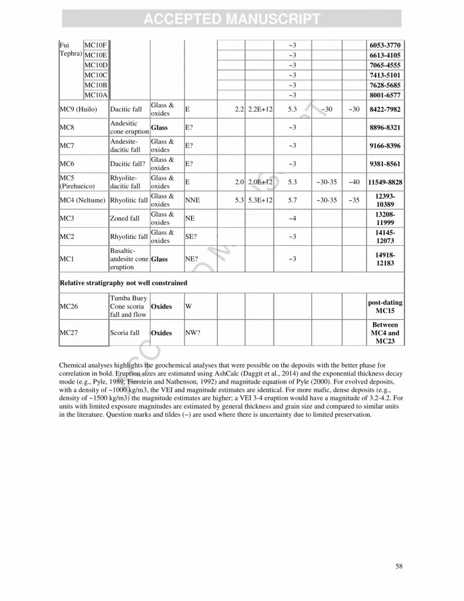
AC
CEPTED
MAN
USC
RIP
T
ACCEPTED MANUSCRIPT
58
Fui
Tephra)
MC10F ~3 6053-3770
MC10E ~3 6613-4105
MC10D ~3 7065-4555
MC10C ~3 7413-5101
MC10B ~3 7628-5685
MC10A ~3 8001-6577
MC9 (Huilo) Dacitic fall Glass &
oxides E 2.2 2.2E+12 5.3 ~30 ~30 8422-7982
MC8 Andesitic
cone eruption Glass E? ~3 8896-8321
MC7 Andesite-
dacitic fall
Glass &
oxides E? ~3 9166-8396
MC6 Dacitic fall? Glass &
oxides E? ~3 9381-8561
MC5
(Pirehueico)
Rhyolite-
dacitic fall
Glass &
oxides E 2.0 2.0E+12 5.3 ~30-35 ~40 11549-8828
MC4 (Neltume) Rhyolitic fall Glass &
oxides NNE 5.3 5.3E+12 5.7 ~30-35 ~35
12393-
10389
MC3 Zoned fall Glass &
oxides NE ~4
13208-
11999
MC2 Rhyolitic fall Glass &
oxides SE? ~3
14145-
12073
MC1
Basaltic-
andesite cone
eruption
Glass NE? ~3 14918-12183
Relative stratigraphy not well constrained
MC26
Tumba Buey
Cone scoria
fall and flow
Oxides W post-dating
MC15
MC27 Scoria fall Oxides NW?
Between
MC4 and
MC23
Chemical analyses highlights the geochemical analyses that were possible on the deposits with the better phase for
correlation in bold. Eruption sizes are estimated using AshCalc (Daggit et al., 2014) and the exponential thickness decay
mode (e.g., Pyle, 1989; Fierstein and Nathenson, 1992) and magnitude equation of Pyle (2000). For evolved deposits,
with a density of ~1000 kg/m3, the VEI and magnitude estimates are identical. For more mafic, dense deposits (e.g.,
density of ~1500 kg/m3) the magnitude estimates are higher; a VEI 3-4 eruption would have a magnitude of 3.2-4.2. For
units with limited exposure magnitudes are estimated by general thickness and grain size and compared to similar units
in the literature. Question marks and tildes (~) are used where there is uncertainty due to limited preservation.