preparatory survey for nacala corridor road network
TRANSCRIPT
18-013
JR6 R
PREPARATORY SURVEY
FOR NACALA CORRIDOR ROAD NETWORK
UPGRADING PROJECT IN
THE REPUBLIC OF MOZAMBIQUE
FINAL REPORT SUMMARY
MAY 2018
JAPAN INTERNATIONAL COOPERATION AGENCY
ORIENTAL CONSULTANTS GLOBAL CO., LTD. EIGHT-JAPAN ENGINEERING CONSULTANTS INC.
KOKUSAI KOGYO CO., LTD.
NATIONAL ROAD ADMINISTRATION (ANE) GOVERNMENT OF REPUBLIC OF MOZAMBIQUE
Preparatory Survey for
Nacala Corridor Road Network Upgrading Project
in the Republic of Mozambique
TABLE OF CONTENTS
Page
1. Introduction ......................................................................................................................................... 1
1.1 Background of the Project ............................................................................................................. 1 1.2 Objectives of the Survey ................................................................................................................ 2 1.3 Project Scope: Study Area and Target Roads ................................................................................. 2 1.4 Scope of the Survey ....................................................................................................................... 3 1.5 Rationale of Target Roads .............................................................................................................. 5
1.5.1 Nacala Port Access Road ....................................................................................................... 5 1.5.2 Nampula Southern Bypass Road ............................................................................................ 6 1.5.3 Cuamba Bypass Road ............................................................................................................ 7
2. Overview of Road Sector and Development Plan ............................................................................ 8
2.1 Overview of Road Sector ............................................................................................................... 8 2.1.1 Road System in Mozambique ................................................................................................ 8 2.1.2 Budget Allocation and Expenditure of ANE .......................................................................... 8
2.2 Development Plans related to Road Sector .................................................................................... 8 2.2.1 Road Sector Strategy (RSS) and Integrated Road Sector Program (PRISE) ......................... 8 2.2.2 PEDEC-Nacala (Nacala Corridor Economic Development Strategies) ................................. 9
2.3 Provincial and Municipal Information and Development Plans .................................................. 11 2.3.1 Overview of Nampula and Niassa Provinces ....................................................................... 11 2.3.2 Nampula City and Surroundings .......................................................................................... 12 2.3.3 Nacala City and Nacala-a-Velha District ............................................................................. 12 2.3.4 Cuamba City ........................................................................................................................ 13
3. Present Condition of the Target Road ............................................................................................. 14
3.1 Natural Condition ........................................................................................................................ 14 3.1.1 Meteorology ......................................................................................................................... 14 3.1.2 Topography and Geology around the Target Roads ............................................................. 14 3.1.3 Hydrology around the Target Roads .................................................................................... 15
3.2 Socioeconomic Conditions .......................................................................................................... 16 3.2.1 Population ............................................................................................................................ 16 3.2.2 Regional Economy ............................................................................................................... 17
4. Traffic Survey .................................................................................................................................... 18
4.1 Nacala .......................................................................................................................................... 18 4.2 Nampula ....................................................................................................................................... 18 4.3 Cuamba ........................................................................................................................................ 18
5. Traffic Demand Forecast .................................................................................................................. 22
5.1 Summary of Traffic Demand Forecast Results ............................................................................ 22
6. Road Design Conditions ................................................................................................................... 23
6.1 Road Design Standard ................................................................................................................. 23 6.1.1 Road Classification .............................................................................................................. 23 6.1.2 Geometric Standards ............................................................................................................ 23 6.1.3 Right of Way (ROW) ........................................................................................................... 23 6.1.4 Standard Width ..................................................................................................................... 23 6.1.5 Control Points ...................................................................................................................... 25
6.2 Clearance from Facilities ............................................................................................................. 25 6.2.1 Railways ............................................................................................................................... 25 6.2.2 Bridges over the Sea ............................................................................................................ 26 6.2.3 Power Line (High Voltage Electric Transmission Line)....................................................... 26 6.2.4 River Bridge and Embankment ............................................................................................ 26
6.3 Road Development with Urban Land Use Plan (Proposal) ......................................................... 26
7. Route Selection (Alternative Analysis) ............................................................................................ 28
7.1 Outline of Proposed Alternatives ................................................................................................. 28 7.1.1 Nacala Port Access Road ..................................................................................................... 28 7.1.2 Nampula Southern Bypass Road .......................................................................................... 29 7.1.3 Cuamba Bypass Road .......................................................................................................... 30
7.2 Evaluation Criteria for Route Selection ....................................................................................... 30 7.3 Results of Alternative Analysis/Selected Road ............................................................................ 31
7.3.1 Nacala Port Access Road ..................................................................................................... 31 7.3.2 Nampula Southern Bypass Road .......................................................................................... 31 7.3.3 Cuamba Bypass Road .......................................................................................................... 32
7.4 Road Development Plans/Image for each Target Road ............................................................... 33
8. Preliminary Design and Cost Estimation ........................................................................................ 37
8.1 Design Procedure ......................................................................................................................... 37 8.2 Natural Condition Survey ............................................................................................................ 37
8.2.1 Geological and Soil Survey .................................................................................................. 37 8.2.2 Topographic Survey ............................................................................................................. 39 8.2.3 Meteorological, Hydrological and Hydraulic Survey .......................................................... 39
8.3 Pavement Design ......................................................................................................................... 41 8.3.1 Basic Conditions for the Pavement Design .......................................................................... 41 8.3.2 Pavement Design .................................................................................................................. 42 8.3.3 Recommended Pavement Composition ............................................................................... 43
8.4 Drainage ....................................................................................................................................... 44 8.4.1 Current Drainage Conditions/Issues .................................................................................... 44
8.5 Structural and Road Design Concept ........................................................................................... 47 8.5.1 Road Design ......................................................................................................................... 47 8.5.2 Structural Design .................................................................................................................. 49
8.6 Traffic Safety and Ancillary Facilities ......................................................................................... 53 8.6.1 Approach .............................................................................................................................. 53 8.6.2 Considerable Facilities ......................................................................................................... 53
8.7 Construction Planning ................................................................................................................. 54 8.7.1 Construction Outline ............................................................................................................ 54 8.7.2 Construction Method ............................................................................................................ 54 8.7.3 Construction Schedule Plan ................................................................................................. 55 8.7.4 Procurement Plan ................................................................................................................. 56
8.8 Cost Estimation ............................................................................................................................ 58
9. Technologies to enhance the Project Effects ................................................................................... 59
9.1 Proposed Technologies ................................................................................................................ 59
10. Project Evaluation............................................................................................................................. 60
10.1 Economic Internal Rate of Return (EIRR) .................................................................................. 60
11. Implementation Plan ........................................................................................................................ 61
11.1 Implementation Organization ...................................................................................................... 61 11.1.1 Establishment of PMU ......................................................................................................... 61
11.2 Project Packaging ........................................................................................................................ 62 11.3 Project Implementation Schedule ................................................................................................ 63 11.4 Management Plan for the Project................................................................................................. 64
12. Environmental and Social Considerations ...................................................................................... 65
12.1 Introduction ................................................................................................................................. 65 12.2 Points of Improvement for SER and PR ...................................................................................... 66 12.3 State of Nacala Port Access Road Project ................................................................................... 69 12.4 State of the Remaining Two Projects ........................................................................................... 69
13. Findings and Recommendation ....................................................................................................... 70
13.1 Findings ....................................................................................................................................... 70 13.2 Recommendations on the Project ................................................................................................ 71
LIST OF FIGURES Page
Figure 1.1 Locations of Target Roads ....................................................................................................... 4 Figure 1.2 Passenger and Freight Vehicles in Nacala City ....................................................................... 5 Figure 1.3 Traffic Congestion on N1 Road in Nampula City ................................................................... 6 Figure 1.4 Traffic on N13 Road in Cuamba City ...................................................................................... 7 Figure 2.1 Image of Integrated Development Strategy and Sector/Regional Approach ......................... 10 Figure 2.2 Area Programmes with High Priority Projects including the Target Roads .......................... 11 Figure 3.1 Geomorphic Classification Map for Northern Mozambique ................................................. 15 Figure 3.2 River Basins in the ARA Centro-Norte Region ..................................................................... 15 Figure 4.1 Traffic Volume by Survey Location around Nacala City ....................................................... 19 Figure 4.2 Traffic Volumes by Survey Locations in/around Nampula City ............................................ 20 Figure 4.3 Traffic Volumes by Survey Locations in/around Cuamba City ............................................. 21 Figure 5.1 Results of Traffic Demand Forecast (Left: Nacala, Right: Nampula, Below: Cuamba) ....... 22 Figure 6.1 Typical Cross Section for Nacala Port Access Road (At Completion) .................................. 23 Figure 6.2 Typical Cross Sections for Nampula Southern Bypass Road (At Completion) ..................... 24 Figure 6.3 Typical Cross Sections for Cuamba Bypass Road ................................................................. 25 Figure 6.4 Image of Urban Development with the Study Road in Nampula .......................................... 27 Figure 7.1 Alternatives for the Nacala Port Access Road ....................................................................... 28 Figure 7.2 Alternatives for the Nampula Southern Access Road (1/2) ................................................... 29 Figure 7.3 Alternatives for the Nampula Southern Access Road (2/2) ................................................... 29 Figure 7.4 Alternatives for the Cuamba Bypass Road ............................................................................ 30 Figure 7.5 Selected Route/Alignment of Nacala Port Access Road ....................................................... 31 Figure 7.6 Selected Route/Alignment of Nampula Southern Bypass Road ............................................ 32 Figure 7.7 Selected Route/Alignment of Cuamba Bypass Road ............................................................ 33 Figure 7.8 Road Development Plan for Nacala Port Access Road ......................................................... 34 Figure 7.9 Road Development Plan for Nampula Southern Bypass Road .............................................. 35 Figure 7.10 Road Development Plan for Cuamba Bypass Road .............................................................. 36 Figure 8.1 Preliminary Design Procedure ............................................................................................... 37 Figure 8.2 Existing Drainage Structures in Nacala ................................................................................. 44 Figure 8.3 Swamp Area and Existing Drainage Facilities in Nampula ................................................... 45 Figure 8.4 Existing Water Streams in Cuamba ....................................................................................... 46 Figure 8.5 Locations for Structures in the three Road ............................................................................ 50 Figure 11.1 Project Implementation Schedule .......................................................................................... 63
LIST OF TABLES Page
Table 3.1 Population and Average Annual Growth Rate by Province (1997-2007) ................................ 16 Table 3.2 Population Projection by Province in the Nacala Corridor Region ......................................... 16 Table 3.3 GRDP and Growth Rate by Province in Mozambique ............................................................ 17 Table 3.4 Economic Framework for the Nacala Corridor Region*(2011-2035) ............................... 17 Table 6.1 River Bridge/Embankment Clearance from HWL .................................................................. 26 Table 7.1 Crossing Types at each Road .................................................................................................. 34 Table 7.2 Crossing Types at each Road and Railway ............................................................................. 35 Table 7.3 Crossing Types of each Road, River and Railway .................................................................. 36 Table 8.1 Items and Quantity for Geological and Soil Survey (Nacala Port Access Road) .................... 38 Table 8.2 Items and Quantity for Geological and Soil Survey (Nampula Southern Bypass Road) ........ 38 Table 8.3 Items and Quantity for Geological and Soil Survey (Cuamba Bypass Road) ......................... 39 Table 8.4 Design High Water-Levels and Discharges at each Bridge ..................................................... 40 Table 8.5 Traffic Volume and Axle Load for 15 years (Y2038) ............................................................. 41 Table 8.6 Pavement Composition Calculated by AASHTO Method ...................................................... 42 Table 8.7 Check of DBST’s Pavement by Mechanistic Design Approach ............................................. 43 Table 8.8 Recommended Pavement Compositions ................................................................................. 43 Table 8.9 Issues and Solutions for Nacala .............................................................................................. 44 Table 8.10 Issues and Solutions for Nampula ........................................................................................... 45 Table 8.11 Issues and Solutions for Cuamba ............................................................................................ 46 Table 8.12 2-Lane Temporary Stage Option (High-Spec Option/ Basic Option) ..................................... 47 Table 8.13 Bridge Design Criteria ............................................................................................................ 49 Table 8.14 Bridge specifications for the provisional stage (High-Spec Option) ...................................... 52 Table 8.15 Bridge specifications for the provisional stage (Basic Option) ............................................... 52 Table 8.16 Construction Outline ............................................................................................................... 54 Table 8.17 Main materials procurement plan ............................................................................................ 56 Table 8.18 Main equipment procurement plan ......................................................................................... 57 Table 8.19 Project Cost (provisional) ....................................................................................................... 58 Table 9.1 Summary of Proposed Advanced Technology ........................................................................ 59 Table 10.1 Results of Sensitivity Analysis ................................................................................................ 61 Table 11.1 Nacala Port Access Road Road (3 packages) .......................................................................... 62 Table 11.2 Nampula Southern Bypass Road (3 packages) ....................................................................... 62 Table 11.3 Preconditions for consideration of Implementation Schedule ................................................ 63 Table 11.4 Cost Estimation for Maintenance(million JPY/ Year) ....................................................... 65 Table 12.1 JICA Study Team’s Comments on the Simplified Environmental Report .............................. 66 Table 12.2 JICA Study Team’s Comments on the Resettlement Plan ....................................................... 67 Table 12.3 Major Points raised by MITADER/DPTADER and Understanding of ANE .......................... 69
Preparatory Survey for Nacala Corridor Road Network Upgrading Project Final Report
List of Abbreviations AADT ............. Annual Average Daily Traffic AASHTO ........ American Association of State Highway and Transportation Officials ANE ................ National Road Administration / Administração Nacional de Estradas ARA ................ Regional Water Administration / Administração Regional de Águas CBD ................ Central Business District CFM ................ Mozambique Ports and Railways / Portos e Caminhos de Ferro de Moçambique DPTADER: ... Provincial Directorate of Land, Environmental and Rural Development Direcção Provincial da Terra, Ambiente e Desenvolvimento Rural DUAT ............. Right to Use and Benefit from the Land /Direito de Uso e Aproveitamento da Terra EIA : ................ Environmental Impact Assessment ENDE: ............. National Development Strategy / Estratégia Nacional de Desenvolvimento ESAL: ............. Equivalent Standard Axle Load FDI: ................. Foreign Direct Investment IFZ: ................. Industrial Free Zone INAM: ............. National Institute of Meteorology / Instituto Nacional de Meteorologia ITS: ................. Intelligent Transport Systems MITADER: ..... Ministry of Land, Environment and Rural Development /
Ministério da Terra, Ambiente e Desenvolvimento Rural OD ................... Origin and Destination PARP : ............ Action Plan for Reducing Poverty / Plano de Acção de Redução da Pobreza PCU ................. Passenger Car Unit PC: .................. Prestressed Concrete PES: ................ Economic and Social Plan/Plano Económico e Social PMU: ............... Project Management Unit PQG: ............... Government Five Year Programme/Plano Quinquenal do Governo PR: .................. Resettlement Plan PRISE: ............ Integrated Road Sector Programme/Programa Integrado do Sector de Estradasl RAP : ............... Resettlement Action Plan RSS: ................ Road Sector Strategy SATCC: .......... Southern Africa Transport and Communications Commission SER: ................ Simplified Environmental Report SEZ: ................ Special Economic Zones TIA: ................. Traffic Impact Assessment
Preparatory Survey for Nacala Corridor Road Network Upgrading Project Final Report
Summary-1
Summary
1. Introduction 1.1 Background of the Project
The Republic of Mozambique has developed her road network mainly on intercity arterial roads which connect major cities in the country. Roads are classified into national roads comprising primary roads and secondary roads, and regional roads comprising tertiary roads and vicinal roads, urban roads and unclassified roads. The National Road Administration (Administração Nacional de Estradas, ANE) is in charge of 30,464 km of roads which consist of 7,344 km (24%) paved sections, and 23,120 km (76%) unpaved sections. When it comes to the road condition by province in 2015, about 70% of the road was “good” or “reasonable” in Maputo Province, Inhambane Province, Manica Province and Niassa Province, whereas it was less than 50% in Nampula Province1.
Development of social and economic infrastructure is prioritised in the Mozambican Government Five Year Programme (Plano Quinquenal do Governo, PQG) (2015 – 2019), and, maintenance and improvement of roads and bridges are strategic targets to achieve the goal. The Poverty Reduction Strategy Paper (2011 – 2014) (Plano de Acção de Redução da Pobreza, PARP), as an action plan of the previous PQG (2010-2014) focusing on the poverty reduction, sets increasing production and efficiency of agricultural and fishery industries as primary targets. To achieve these primary targets, maintenance of roads and bridges as well as pavement level is selected as PARP’s outcome index. This means that development of the road sector is one of the key issues in Mozambique to be taken into consideration. In terms of the road development plan, the third Road Sector Strategy (RSS) defines seven international corridors including Nacala Corridor and the national arterial roads connecting the international corridors to be developed.
Among these major corridors, Mozambique Highway (N1), which penetrates the country from North to South, and Maputo Corridor and Beira Corridor, which connect the capital city of Maputo and adjacent countries, maintain a high level of service. Due to the civil war, road development of Nacala Corridor and Pemba Corridor, which connect the eastern coastal area and the western border area in the northern region, is still left behind. Especially, the ratio of paved roads in Nacala Corridor region is far below the national average. The unpaved condition restricts vehicles to very low speeds, and causes less visibility due to dust, which is unsafe for driving. Especially, there are a lot of sections of unpaved roads that are impassable during the rainy season. Pavement of regional roads is considered as a national issue.
Prior to this survey, JICA and other international development partners have assisted with a series of projects in the road sector of this region. In the post evaluation mission of “The Project for Reconstruction of Bridges on Main Roads(Phase 2)” including reconstruction of Natete Bridge (Road Number 8) (Exchange of Note in September 2000), the importance of road development of this corridor was identified. Then, a feasibility study and detail design of the “Montepuez Lichinga Road Project” (L/A in March 2007) and “Nampula Cuamba Road Upgrading Project” (L/A in March 2010) were conducted by the JICA and counterpart fund of Japan, respectively. These projects are currently under construction. The “Mandimba Lichinga Road Upgrading
1 Economic and Social Plan Integrated Road Sector Program (PES/PRISE 2016)
Preparatory Survey for Nacala Corridor Road Network Upgrading Project Final Report
Summary-2
Project” (L/A in November 2013) is also ongoing with assistance from AfDB and JICA. The “Project for Nacala Corridor Economic Development Strategies in the Republic of Mozambique” or PEDEC-Nacala, which was conducted by JICA and the Ministry of Economy and Finance from 2012, formulates development strategies to guide appropriate development and investment in the Nacala Corridor. The project was officially endorsed by the Cabinet in November 2016. PEDEC-Nacala also features a road sector and three proposed roads; Nacala Port Access Road, Nampula Southern Bypass Road and Cuamba Bypass Road; as high priority roads. Other related projects in this region and the road sector include the “Project for Capacity Development of Road Maintenance by JICA” (from August 2011 to July 2014), the “Project for Urgent Rehabilitation of Nacala Port Development” (Japanese grant aid agreed in December 2012) and the “Project for Improvement of Nacala Port” (Japanese ODA Loan, Phase 1 L/A in March 2013, Phase 2 L/A in June 2015).
Under these circumstances, passenger and cargo traffic volumes are drastically increasing in Nacala, Nampula and Cuamba Cities on the Nacala Corridor as population grows. Since intercity and arterial roads penetrate the cores of these cities, the surge in traffic volume results in traffic congestion in the centres of the cities. There are also issues of traffic safety of pedestrians and living environment of residents along the roads. In addition, under the the railway track rehabilitation from Tete province to Nacala Port, the cargo volumes handled by Nacala Port are predicted to be almost 10 times the current volume in the next 15 years. Therefore, the significant increase of frequency of railway operation as well as cargo vehicle volume is expected. It is evident that this could cause deterioration of the urban function and urban environment.
In order to alleviate traffic congestion and minimise the negative impact on the urban environment, the development of bypass roads to detour around urban residential areas and to reduce railway crossing points for Nampula and Cuamba as well as the road development of the new port access for Nacala Port are essential.
1.2 Objectives of the Survey This study aims to conduct the Feasibility Study including preliminary design, preliminary cost estimation and to formulate institutional arrangements for project implementation, operation and maintenance systems and to support the social and environmental considerations by the government of Mozambique on the “Nacala Corridor Road Network Upgrading Project” which comprises three components. The result of this feasibility study on the Project will be utilised as basic information for appraisal of a Japanese Yen-Loan project, but it is not decided if it will be a Japanese Yen-Loan project yet.
The Environmental Impact Assessment (EIA) and Resettlement Action Plan (RAP) are to be prepared by the Mozambican government by subcontracting to a local consultant using the budget of the ANE. This survey supports the Mozambican side by providing technical advice to ANE throughout the process including reviewing and commenting on the reports produced by the environmental local consultant. Since ANE’s procurement of the environmental consultants was continuously being delayed, JICA and ANE agreed on June 28, 2016 that JICA concentrates its technical support for environmental and social considerations on the Nacala Port Access Road Project leaving the other two components out of its scope..
1.3 Project Scope: Study Area and Target Roads This project, namely the “Nacala Corridor Road Network Upgrading Project”, aims to develop and promote the Nacala Corridor Region by providing a new essential road network, especially providing the road to ensure the traffic diversion and to promote urban development with urban roads.

Preparatory Survey for Nacala Corridor Road Network Upgrading Project Final Report
Summary-3
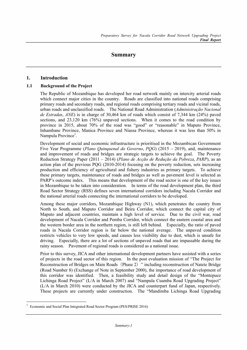
The target areas and roads of the study are located within the Nacala Corridor Region and especially those located in Nampula City and Nacala City in Nampula Province, and Cuamba City in Niassa Province. The target roads are listed as follows2;
Nacala Port Access Road (Nacala City)
Nampula Southern Bypass Road (Nampula City)
Cuamba Bypass Road (Cuamba City)
1.4 Scope of the Survey
This preparatory survey shall cover the following items;
Review and confirmation of background and necessity of the project
Road design and engineering for three target roads, which include a) natural condition survey, b) visual site survey, c) preliminary design, d) cost estimate, e) economic analysis and f) traffic analysis.
Formulation of the project, which consists of implementation schedule, procurement packages and project effect indicators
Confirmation of institutional and organisational setups for the project implementation
Formulation of operation and maintenance plan
Assistance for execution of EIA and RAP by ANE
2 As explained in ‘1.2 Objectives of the Survey’, technical support for environmental and social considerations was provided only to Nacala Port Access Road Project leaving the other two road projects out of its scope.
Preparatory Survey for Nacala Corridor Road Network Upgrading Project Final Report
Summary-4
Source: The Study Team
Figure 1.1 Locations of Target Roads
Lot-B Lot-A Lot-C
Nacala Port Access Road
(13.5km, 2 lanes/direction)
Montepuez Lichinga
Road Project
Project for Urgent Rehabilitation
of Nacala Port Development
Project for Urgent Rehabilitation
of Nacala Port Development (I, II)
Cuamba Bypass Road
(11km, 1lane /direction)
Mandimba Lichinga
Road Upgrading Project
Malawi
Coal Railway Transport
Nampula Cuamba
Road Upgrading
Nampula Southern Bypass Road
(32.5km, 2 lanes/direction)
Bridg
Ile Cuamba Bridge
Rehabilitation
Montepuez
Lichinga
Cuamba Nampula Mandimba Nacala Corridor
Ile
R7
N1
R1
Nacala Port
N1
N1
N13
R686
N104
City Center N13
N13 N360
Muanda RIver City Center
Preparatory Survey for Nacala Corridor Road Network Upgrading Project Final Report
Summary-5
1.5 Rationale of Target Roads 1.5.1 Nacala Port Access Road
Situation and Issues in the Road Sector in the Area (1)
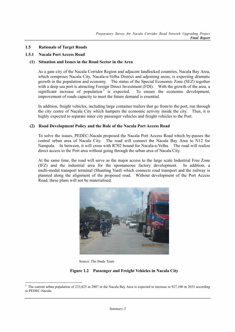
As a gate city of the Nacala Corridor Region and adjacent landlocked countries, Nacala Bay Area, which comprises Nacala City, Nacala-a-Velha District and adjoining areas, is expecting dramatic growth in the population and economy. The status of the Special Economic Zone (SEZ) together with a deep sea port is attracting Foreign Direct Investment (FDI). With the growth of the area, a significant increase of population 3 is expected. To ensure the economic development, improvement of roads capacity to meet the future demand is essential.
In addition, freight vehicles, including large container trailers that go from/to the port, run through the city centre of Nacala City which hampers the economic activity inside the city. Thus, it is highly expected to separate inner city passenger vehicles and freight vehicles to the Port.
Road Development Policy and the Role of the Nacala Port Access Road (2)
To solve the issues, PEDEC-Nacala proposed the Nacala Port Access Road which by-passes the central urban area of Nacala City. The road will connect the Nacala Bay Area to N12 for Nampula. In between, it will cross with R702 bound for Nacala-a-Velha. The road will realize direct access to the Port area without going through the urban area of Nacala City.
At the same time, the road will serve as the major access to the large scale Industrial Free Zone (IFZ) and the industrial area for the spontaneous factory development. In addition, a multi-modal transport terminal (Shunting Yard) which connects road transport and the railway is planned along the alignment of the proposed road. Without development of the Port Access Road, these plans will not be materialised.
Source: The Study Team
Figure 1.2 Passenger and Freight Vehicles in Nacala City
3 The current urban population of 233,825 in 2007 in the Nacala Bay Area is expected to increase to 927,100 in 2035 according to PEDEC-Nacala.

Preparatory Survey for Nacala Corridor Road Network Upgrading Project Final Report
Summary-6
1.5.2 Nampula Southern Bypass Road Situation and Issues in the Road Sector in the Area (1)
Nampula City is a dominant city in the Northern Region of Mozambique and it is estimated that the Greater Nampula, which includes Nampula City and 3 administrative posts (Anchilo, Namaita and Rapale) in Nampula District, will continue steady growth in line with the development of Nacala Corridor Region. The Nampula City will continue to play a key role as an administrative and commercial centre. Thus, it is estimated that the urban population of the Greater Nampula will be 1,328,900 in 2035 while it was 471,171 in 2007.
One of the key obstacles to development is concentration of traffic in the city centre. As the national corridor of the Mozambique Highway (N1 Road) located in the centre of the city, intercity long distance through traffic and inner city traffic share the same road space. This causes traffic congestion and hinders economic activity. Therefore, these two types of traffic should be separated.
Road Development Policy and the Role of the Nampula Southern Bypass Road (2)
The Nampula Municipal Government developed a land use plan together with a ring road plan including the Northern and Southern Bypass Roads. The Nampula Southern Bypass Road is proposed as a high priority project in the road sector for the Grater Nampula Area Programme.
The Southern Bypass Road starts from N1 Road in the east of the city and ends at the intersection with N13 Road in the west of the city, bypassing the traffic from/to the Nacala Port to/from inland. In between, it will cross with R686 and N104 radially.
The bypass road is expected to reduce the traffic congestion caused by the through traffic. In addition to that, the construction of the road will stimulate the demand for industrial area development along it, which will contribute further growth of the Greater Nampula Area..
Source: The Study Team
Figure 1.3 Traffic Congestion on N1 Road in Nampula City
Preparatory Survey for Nacala Corridor Road Network Upgrading Project Final Report
Summary-7
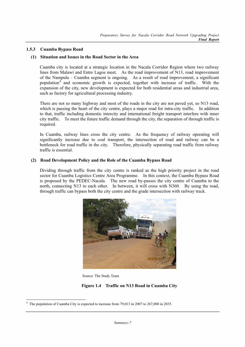
1.5.3 Cuamba Bypass Road Situation and Issues in the Road Sector in the Area (1)
Cuamba city is located at a strategic location in the Nacala Corridor Region where two railway lines from Malawi and Entre Lagos meet. As the road improvement of N13, road improvement of the Nampula – Cuamba segment is ongoing. As a result of road improvement, a significant population4 and economic growth is expected, together with increase of traffic. With the expansion of the city, new development is expected for both residential areas and industrial area, such as factory for agricultural processing industry.
There are not so many highway and most of the roads in the city are not paved yet, so N13 road, which is passing the heart of the city centre, plays a major road for intra-city traffic. In addition to that, traffic including domestic intercity and international freight transport interfere with inner city traffic. To meet the future traffic demand through the city, the separation of through traffic is required.
In Cuamba, railway lines cross the city centre. As the frequency of railway operating will significantly increase due to coal transport, the intersection of road and railway can be a bottleneck for road traffic in the city. Therefore, physically separating road traffic from railway traffic is essential.
Road Development Policy and the Role of the Cuamba Bypass Road (2)
Dividing through traffic from the city centre is ranked as the high priority project in the road sector for Cuamba Logistics Centre Area Programme. In this context, the Cuamba Bypass Road is proposed by the PEDEC-Nacala. The new road by-passes the city centre of Cuamba to the north, connecting N13 to each other. In between, it will cross with N360. By using the road, through traffic can bypass both the city centre and the grade intersection with railway track.
Source: The Study Team
Figure 1.4 Traffic on N13 Road in Cuamba City 4 The population of Cuamba City is expected to increase from 79,013 in 2007 to 267,000 in 2035.
Preparatory Survey for Nacala Corridor Road Network Upgrading Project Final Report
Summary-8
2. Overview of Road Sector and Development Plan 2.1 Overview of Road Sector 2.1.1 Road System in Mozambique
Road Classification (1)
The classified roads consist of national roads (primary and secondary) and regional roads (tertiary and vicinal roads). These roads are administrated by the National Road Administration (ANE). Urban roads and unclassified roads fall under the jurisdiction of the municipal councils and the district administrations respectively.
Condition of Roads (2)
According to PRISE in 2016, ANE managed the total length of the 30,464km of roads with 24% (7,344km) of paved roads. In the case of Nampula province, only 54% of the primary roads have been paved, Niassa has only 59%, Zambézia has 75% and Cabo Delgado has 67%, and the other 6 provinces have 100%.
2.1.2 Budget Allocation and Expenditure of ANE PRISE 2016 Budget and Expenditure (1)
According to the PRISE 2016, the total resources provided was estimated as 25.0 billion MZM, equivalent to USD 403 million5, comprising 25.8% of internal resources and 74.2% of foreign funds (external resources).
According to PRISE 2016, the total expenditure in 2016 was 10.7 billion MZN, which was 42.4% of the required budget. The expenditures with internal component amounted to 6.66 billion MZN (62.1%) and expenditures with external component amounted to 4.06 million MZN (37.9%). This implies that the support from the donors has dramatically decreased.
2.2 Development Plans related to Road Sector
The implementation plan in the road sector is developed based on the strategic objective of the national and regional development plan.
2.2.1 Road Sector Strategy (RSS) and Integrated Road Sector Program (PRISE)
In the Road Sector, there was the Road Sector Strategy (RSS) (Estratégia do Sector de Estradasl ESE), which presented the main elements of the Government of Mozambique’s (GOM’s) strategy for developing and managing the classified road network. The RSS adds a level of detail to the GOM’s Road Sector Policy to establish the main principles, approaches, and activities.
Sustainability: the policy that what is upgraded and rehabilitated continues to be maintained,
Connectivity: the policy of identifying critical road links between important points and focusing development efforts to enhance these links, and
5 1 USD = 62.7 MZN in March 2018
Preparatory Survey for Nacala Corridor Road Network Upgrading Project Final Report
Summary-9
Accessibility: the policy of providing minimal or better access to all inhabitants of the country.
Asset Preservation: the policy of prioritising maintenance works over improvement works to ensure that the investment made in the infrastructure is not lost through lack of maintenance,
Enhanced Transitability: the policy of providing at least minimal access to communities to which existing roads have deteriorated to the point where these areas are cut off from the trunk highway system, and
Maintainability: the policy of incorporating into the design of an improvement work, the features and materials that make maintaining the work easier or less expensive.
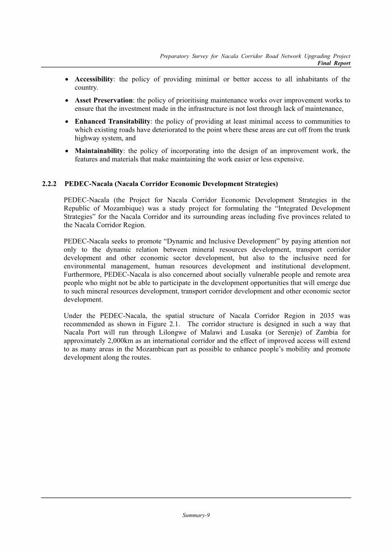
2.2.2 PEDEC-Nacala (Nacala Corridor Economic Development Strategies)
PEDEC-Nacala (the Project for Nacala Corridor Economic Development Strategies in the Republic of Mozambique) was a study project for formulating the “Integrated Development Strategies” for the Nacala Corridor and its surrounding areas including five provinces related to the Nacala Corridor Region.
PEDEC-Nacala seeks to promote “Dynamic and Inclusive Development” by paying attention not only to the dynamic relation between mineral resources development, transport corridor development and other economic sector development, but also to the inclusive need for environmental management, human resources development and institutional development. Furthermore, PEDEC-Nacala is also concerned about socially vulnerable people and remote area people who might not be able to participate in the development opportunities that will emerge due to such mineral resources development, transport corridor development and other economic sector development.
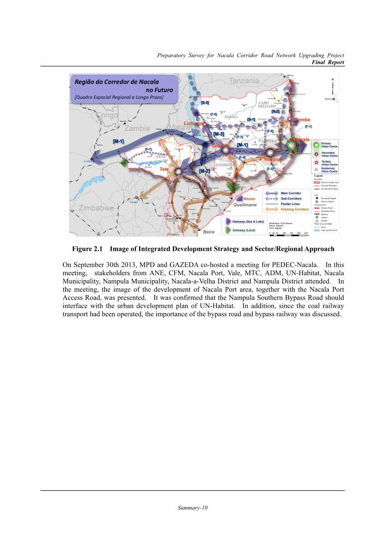
Under the PEDEC-Nacala, the spatial structure of Nacala Corridor Region in 2035 was recommended as shown in Figure 2.1. The corridor structure is designed in such a way that Nacala Port will run through Lilongwe of Malawi and Lusaka (or Serenje) of Zambia for approximately 2,000km as an international corridor and the effect of improved access will extend to as many areas in the Mozambican part as possible to enhance people’s mobility and promote development along the routes.
Preparatory Survey for Nacala Corridor Road Network Upgrading Project Final Report
Summary-10
Figure 2.1 Image of Integrated Development Strategy and Sector/Regional Approach
On September 30th 2013, MPD and GAZEDA co-hosted a meeting for PEDEC-Nacala. In this meeting, stakeholders from ANE, CFM, Nacala Port, Vale, MTC, ADM, UN-Habitat, Nacala Municipality, Nampula Municipality, Nacala-a-Velha District and Nampula District attended. In the meeting, the image of the development of Nacala Port area, together with the Nacala Port Access Road, was presented. It was confirmed that the Nampula Southern Bypass Road should interface with the urban development plan of UN-Habitat. In addition, since the coal railway transport had been operated, the importance of the bypass road and bypass railway was discussed.
Preparatory Survey for Nacala Corridor Road Network Upgrading Project Final Report
Summary-11
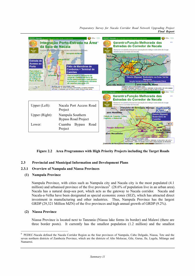
Figure 2.2 Area Programmes with High Priority Projects including the Target Roads
2.3 Provincial and Municipal Information and Development Plans 2.3.1 Overview of Nampula and Niassa Provinces
Nampula Province (1)
Nampula Province, with cities such as Nampula city and Nacala city is the most populated (4.1 million) and urbanised province of the five provinces6 (28.6% of population live in an urban area). Nacala has a natural deep-sea port, which acts as the gateway to Nacala corridor. Nacala and Nacala-a-Velha have been designated as special economic zones (SEZ), which has attracted direct investment in manufacturing and other industries. Thus, Nampula Province has the largest GRDP (29,321 Million MZN) of the five provinces and high annual growth of GRDP (9.2%).
Niassa Province (2)
Niassa Province is located next to Tanzania (Niassa lake forms its border) and Malawi (there are three border posts). It currently has the smallest population (1.2 million) and the smallest
6 PEDEC-Nacala defined the Nacala Corridor Region as the four provinces of Nampula, Cabo Delgado, Niassa, Tete and the seven northern districts of Zambezia Province, which are the districts of Alto Molocue, Gile, Gurue, Ile, Lugela, Milange and Namarroi.
Upper (Left): Nacala Port Access Road Project
Upper (Right): Nampula Southern Bypass Road Project
Lower: Cuamba Bypass Road Project
Preparatory Survey for Nacala Corridor Road Network Upgrading Project Final Report
Summary-12
economic activities (5,930.7 Million MZN in GRDP) among the five provinces. On the other hand, it has the largest land area (129,600 km2), which is mainly covered by forest (76% of the total land area in Niassa, which is 39% of the forest area in the Nacala Corridor Region). Niassa Province is situated at a comparatively high altitude and has the lowest temperature. Its urban population is relatively low.
2.3.2 Nampula City and Surroundings Present Situation in Nampula City and its Surroundings (1)
Nampula is the capital city of Nampula Province, and is considered to be a centre of the northern region. The Nampula urban area is the third largest in the country in terms of population and extension of infrastructure. The territory of Nampula City is completely surrounded by the district of Nampula/Rapale, which has its headquarters in Rapale. The city is located along the railway line from Nacala to Malawi and the road link to the Provinces of Zambézia and Cabo Delgado. According to the second census taken in 1997, the city of Nampula had about 303,000 inhabitants. The population increased by 4.6% per year and the third census taken in 2007 indicated a population of 477,771.
Direction of Urban Development proposed in the PEDEC-Nacala (2)
Being a dominant city in the Northern Region of the country, development of Nampula will maintain a steady pace, even after significant development takes place in Nacala Bay Area. The city will continue to be the administration centre, as well as a centre of production and consumption on a significant scale. However, there are various risks for healthy development of Nampula City brought as side effects of being a major node of the Nacala transport corridor. The most explicit example is the increase of railway traffic caused by mass-scale coal transport. Significant efforts will be required by all relevant organisations to help avoid the risks of traffic accidents and degradation of the urban environment for ordinary people. These efforts also need to consider effective contributions to create/enhance conditions for industry, services and other economic activities.
The most critical factor for the development of the area is to divert the existing concentrated traffic to prevent creating risks for both human lives and the city’s efficiency. The effort to match the changed nature of the transport is required even though it is costly. A ring road has been proposed as a result of the joint effort by the municipality and UN-HABITAT. The general alignment is set to serve as the trunk road of the city as well as encouraging the through traffic to avoid reaching the city centre.
2.3.3 Nacala City and Nacala-a-Velha District Present Situation in Nacala City and Nacala-a-Velha District (1)
The seaport of Nacala, the starting point of the Nacala Corridor, is situated on the eastern coast of Nacala Bay, belonging to Nacala City. On the western coast of Nacala Bay, a largescale bulk port is under construction for the export of coal, to be operated by the mining company. The western coast of Nacala Bay mostly belongs to Nacala-a-Velha District. The combined area of Nacala and Nacala-a-Velha is designated as the Nacala SEZ.According to the census, Nacala had about 206,449 inhabitants in 2007, distributed over an area of around 370 km2, with a density of 558 persons per km2.
Preparatory Survey for Nacala Corridor Road Network Upgrading Project Final Report
Summary-13
Direction of Urban Development proposed in the PEDEC-Nacala (2)
The existing deep seaport, together with the status of SEZ, will continue to attract FDIs heading into the area of the Nacala SEZ. The start of coal handling at the new port in Nacala-a-Velha will change the shape of the spatial structure. Employment opportunities will extend to the western side of Nacala Bay and dynamic movements of goods will take place along the coast.
The components of the Conceptual Spatial Structure which are related to the target road in this study are listed as follows.
Two wider access roads will connect the Nacala Bay Area with Nampula and Pemba. A circular road will be introduced to accept the traffic from the wider access roads as well as
regional and urban trunk roads. This circular road may be completed by introduction of a great bridge over the mouth of the bay to link the two currently separated areas for promotion of urbanisation, and establish the location of the Airport City at the central part between the urban areas of the east coast and west coast.
The port-expressway, proposed by the Port Study funded by JICA, needs to be realised for the entire success of the efforts of Nacala Corridor development. The route is proposed to bypass the NE-12 which is heading to the Nacala seaport across the central area of the city of Nacala. The alignment of the port-express way is proposed to by-pass the central urban area of Nacala City. At the same time the road will serve as the major access to the above mentioned large scale IFZ and the industrial area for the spontaneous factory development.
2.3.4 Cuamba City Present Situation in Cuamba City (1)
Cuamba is located at the junction of the railways from Nampula Nacala to the east with the one to Lichinga to the north-west and the other to Malawi to the south-west. The national roads also follow the railway, thus making the city strategically important.
The urbanisation of Cuamba has been generally calm until now but it is expected to experience a drastic change soon after the completion of the road Upgrading project between Cuamba and Nampula. The start of operation of the coal industry will also affect the shape of urbanisation as the traffic movements will dramatically increase.
Direction of Urban Development proposed in the PEDEC-Nacala (2)
Following are the documents extracted from the PEDEC-Nacala Draft Final Report which presents the direction of urban development in Cuamba area in line with the regional economic development strategies in Nacala Corridor Region, which are the basis of the Cuamba Bypass Road.
The strategic location of the city has not been utilised effectively due largely to the poor condition of national roads connecting Cuamba to other regions of the country. The urbanisation, however, will be dramatically accelerated after completion of the improvement of the N-13 Nampula- Cuamba segment. Despite the fact that the past urbanisation was at a moderate pace, the city is already facing the shortage of land for housing use of the migrants. It is necessary to expand the area for urbanisation by connecting the flat area located north-east of the city centre across the river running roughly from west to east.
Preparatory Survey for Nacala Corridor Road Network Upgrading Project Final Report
Summary-14
Similar to the case of Nampula City, the railway crosses the geographical centre of the urban area of the City. Therefore, it is necessary to deal with the expected division of the city brought by the operation of the coal forwarding by the railway. At the same time, it is necessary to expand the urban area to the north-east by crossing the river course. Taking these issues into account, three alternatives can be generated as follows:
A bypass road will be introduced to the north side of the river to ease the influx of traffic to the city centre as well as to facilitate the development of new urbanisation areas on the north-eastern side of the river. The railway will be kept as it is to support locating of distribution and logistics industries by transforming the south side of the city into an industrial zone.
A bypass road will be introduced in the same manner as in the above alternative, but the railway will be relocated to the south end of the city. By doing this, the south part can be used as a residential area, as the division of the city will be avoided.
A bypass road will be introduced in the same manner. The junction of the railway will be relocated to the east of the city and the line toward Lichinga will be realigned along the proposed bypass. By doing this, the introduction of an agro-processing complex may be better located on the north side of the river, while the distribution industry will be located in the south part of the city.
3. Present Condition of the Target Road 3.1 Natural Condition 3.1.1 Meteorology
According to Köppen climate classification system, the study areas are classified as a tropical rain savannah climate ("Aw", a part of Nacala is "As".) The rainy season, which is a hot and wet period, runs from November to March, and is followed by a dry and relatively cooler season between April and October.
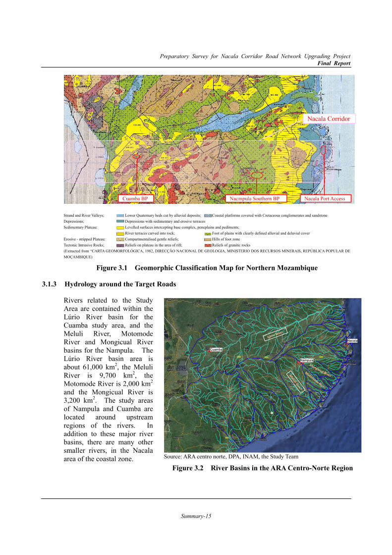
3.1.2 Topography and Geology around the Target Roads The morphology of Mozambique can be characterised by distinct units: coastal lowlands, middle plateaus, upland plateaus and mountainous areas. This division generally coincides with certain altitudinal intervals: 0 to 200 m (44 % of the surface area), 200 to 500 m (29%), 500 to 1,000 m (21 %) and over 1,000 m (6%). The units are bounded by more or less pronounced escarpments, giving rise to a step-like cross section, rising from the coast toward inland. The coastal lowlands mainly coincide with the sedimentary terrains, whereas the other units are underlain by the crystalline rocks of the Basement Complex.
The topography of the terrain of Nacala Corridor, which lies across the northern part of Mozambique from east to west, is divided into the following characteristics as shown in Figure 3.1.
a. Coastal lowlands (blueish coloured in the map) in the vicinity of Nacala,
b. Middle plateau (yellow and olive) occupying most of the eastern part, including Nampula, and
c. Upland plateau (light brownish coloured) in the western part including Cuamba.
The many prominent mountains (reddish or purplish coloured) that mainly consist of intrusive igneous rocks are distributed in the Middle Plateau and Upland Plateau.
Preparatory Survey for Nacala Corridor Road Network Upgrading Project Final Report
Summary-15
Strand and River Valleys; Lower Quaternary beds cut by alluvial deposits; Coastal platforms covered with Cretaceous conglomerates and sandstone Depressions; Depressions with sedimentary and erosive terraces Sedimentary Plateau: Levelled surfaces intercepting base complex, peneplains and pediments; River terraces carved into rock; Foot of plains with clearly defined alluvial and deluvial cover Erosive - stripped Plateau: Compartmentalised gentle reliefs; Hills of foot zone Tectonic Intrusive Rocks; Reliefs on plateau in the area of rift; Reliefs of granitic rocks (Extracted from “CARTA GEOMORFOLÓGICA, 1982, DIRECÇÃO NACIONAL DE GEOLOGIA, MINISTERIO DOS RECURSOS MINERAIS, REPÚBLICA POPULAR DE MOÇAMBIQUE)
Figure 3.1 Geomorphic Classification Map for Northern Mozambique
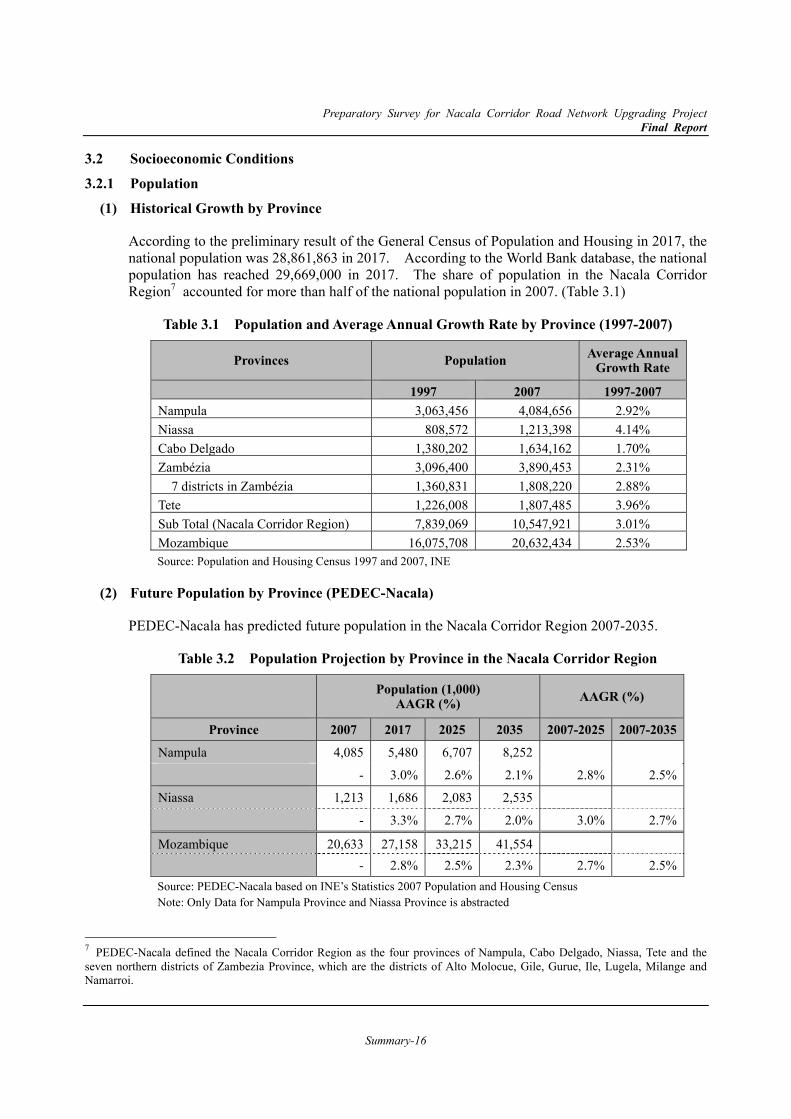
3.1.3 Hydrology around the Target Roads
Rivers related to the Study Area are contained within the Lúrio River basin for the Cuamba study area, and the Meluli River, Motomode River and Mongicual River basins for the Nampula. The Lúrio River basin area is about 61,000 km2, the Meluli River is 9,700 km2, the Motomode River is 2,000 km2 and the Mongicual River is 3,200 km2. The study areas of Nampula and Cuamba are located around upstream regions of the rivers. In addition to these major river basins, there are many other smaller rivers, in the Nacala area of the coastal zone.
Nacala Corridor
Nacala Port AccessNacmpula Southern BP Cuamba BP
Source: ARA centro norte, DPA, INAM, the Study Team
Figure 3.2 River Basins in the ARA Centro-Norte Region
Preparatory Survey for Nacala Corridor Road Network Upgrading Project Final Report
Summary-16
3.2 Socioeconomic Conditions 3.2.1 Population
Historical Growth by Province (1)
According to the preliminary result of the General Census of Population and Housing in 2017, the national population was 28,861,863 in 2017. According to the World Bank database, the national population has reached 29,669,000 in 2017. The share of population in the Nacala Corridor Region7 accounted for more than half of the national population in 2007. (Table 3.1)
Table 3.1 Population and Average Annual Growth Rate by Province (1997-2007)
Provinces Population Average Annual Growth Rate
1997 2007 1997-2007Nampula 3,063,456 4,084,656 2.92% Niassa 808,572 1,213,398 4.14% Cabo Delgado 1,380,202 1,634,162 1.70% Zambézia 3,096,400 3,890,453 2.31% 7 districts in Zambézia 1,360,831 1,808,220 2.88% Tete 1,226,008 1,807,485 3.96% Sub Total (Nacala Corridor Region) 7,839,069 10,547,921 3.01% Mozambique 16,075,708 20,632,434 2.53% Source: Population and Housing Census 1997 and 2007, INE
Future Population by Province (PEDEC-Nacala) (2)
PEDEC-Nacala has predicted future population in the Nacala Corridor Region 2007-2035.
Table 3.2 Population Projection by Province in the Nacala Corridor Region
Population (1,000) AAGR (%) AAGR (%)
Province 2007 2017 2025 2035 2007-2025 2007-2035 Nampula 4,085 5,480 6,707 8,252
- 3.0% 2.6% 2.1% 2.8% 2.5%
Niassa 1,213 1,686 2,083 2,535
- 3.3% 2.7% 2.0% 3.0% 2.7%
Mozambique 20,633 27,158 33,215 41,554 - 2.8% 2.5% 2.3% 2.7% 2.5%Source: PEDEC-Nacala based on INE’s Statistics 2007 Population and Housing Census Note: Only Data for Nampula Province and Niassa Province is abstracted
7 PEDEC-Nacala defined the Nacala Corridor Region as the four provinces of Nampula, Cabo Delgado, Niassa, Tete and the seven northern districts of Zambezia Province, which are the districts of Alto Molocue, Gile, Gurue, Ile, Lugela, Milange and Namarroi.
Preparatory Survey for Nacala Corridor Road Network Upgrading Project Final Report
Summary-17
3.2.2 Regional Economy Past Trend of GRDP (Gross Regional Domestic Product) (1)
Table 3.3 shows the historical GDP and GRDP by province in Mozambique. As shown in the table GDP in constant prices in 2003 in Mozambique reached 197 billion MZN in 2011. According to the latest information of INE statics, it has reached 226 billion MZN in 20138. The AAGR has hovered around 7-8 percent between 1997 and 2011. Among the 5 provinces in the Nacala Corridor Region, Nampula province has the largest proportion in Mozambique (14.8%).
Table 3.3 GRDP and Growth Rate by Province in Mozambique
GRDP
(Million MZN, 2003 Constant Prices) AAGR (%)
Province 1997 2000 2007 2011 97-'00 00-’07 07-'11
Nampula 10,635 13,118 22,192 29,321 7.2 7.8 7.2
Niassa 2,368 2,652 4,587 5,931 3.8 8.1 6.6
Cabo Delgado 3,518 4,038 6,904 9,199 4.7 8.0 7.4
Zambézia 7,250 8,102 13,977 18,506 3.8 8.1 7.3
Tete 3,553 5,731 9,218 11,291 17.3 7.0 5.2
Sub Total (5 Provinces) 27,324 33,641 56,879 74,248 7.2 7.8 6.9
Others 41,750 51,348 94,421 123,277 7.1 9.1 6.9
Mozambique 69,074 84,989 151,300 197,524 7.2 8.6 6.9Source: PEDEC-Nacala based on INE, 1997, 2000, 2007 and 2011
Economic Framework for the Nacala Corridor Region (2)
The PEDEC-Nacala developed GRDP projections for the Nacala Corridor Region in 2025 and 2035 based on the plans or projections.
Table 3.4 Economic Framework for the Nacala Corridor Region*(2011-2035)
2011 2017 2025 2035
GRDP of the Five Provinces in Nacala Corridor Region (million MZN in 2003 prices) 64,254 101,000 203,000 503,000
Annual Growth Rate (%) - 7.8% 9.1% 9.5%
GRDP per Capita (thousand MZN in 2003 prices) 4,597 6,080 9,900 19,449
Annual Growth Rate (%) - 4.8% 6.3% 7.0%Sources: PEDEC-Nacala based on INE’s Statistics Note*: The figures in this table include districts in Zambézia Province which are not part of the Nacala
Corridor Region
8 GDP constant price in 2009 was 338,281 million MZN in 2011 and 388,696 million MZN in 2013.
Preparatory Survey for Nacala Corridor Road Network Upgrading Project Final Report
Summary-18
4. Traffic Survey
For the demand forecast of the Nacala Port Access Road, Nampula Southern Bypass Road and Cuamba Bypass Road, several transport data were collected and analysed.
The National Roads Administration (ANE) has collected traffic count data since 2010, estimating annual average daily traffic (AADT) for nation-wide survey locations. The AADT database was utilised to understand the historical trend of traffic in the region as it is reliable time-series data.
In addition, traffic surveys were conducted for this study to understand the latest travel demand and origin-destination flow in the three cities. The traffic surveys consisted of the traffic count surveys, directional traffic count surveys at intersections and roadside origin-destination (OD) interview surveys. The survey results are utilised to understand current traffic volume at major sections and traffic flow including origin-destination.
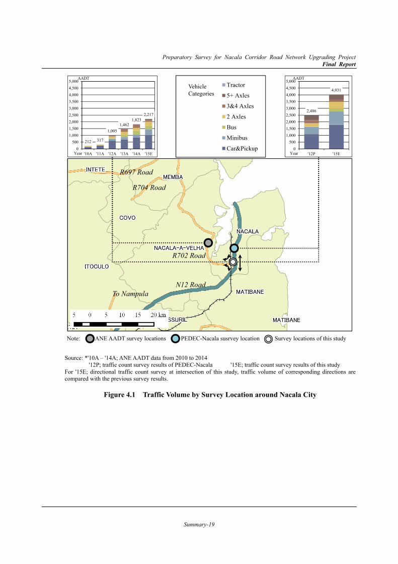
4.1 Nacala
Traffic count results were summarised in Figure 4.1. The results of 2 survey locations presented a similar trend of drastic increase in AADT during the last half decade. This might be caused by an increase of cargo handling volume at Nacala port and development around Nacala city supported by rapid economic growth. As the increase is rapid, it is inferred that current transport infrastructures will not meet the increasing demand in the near future.
4.2 Nampula
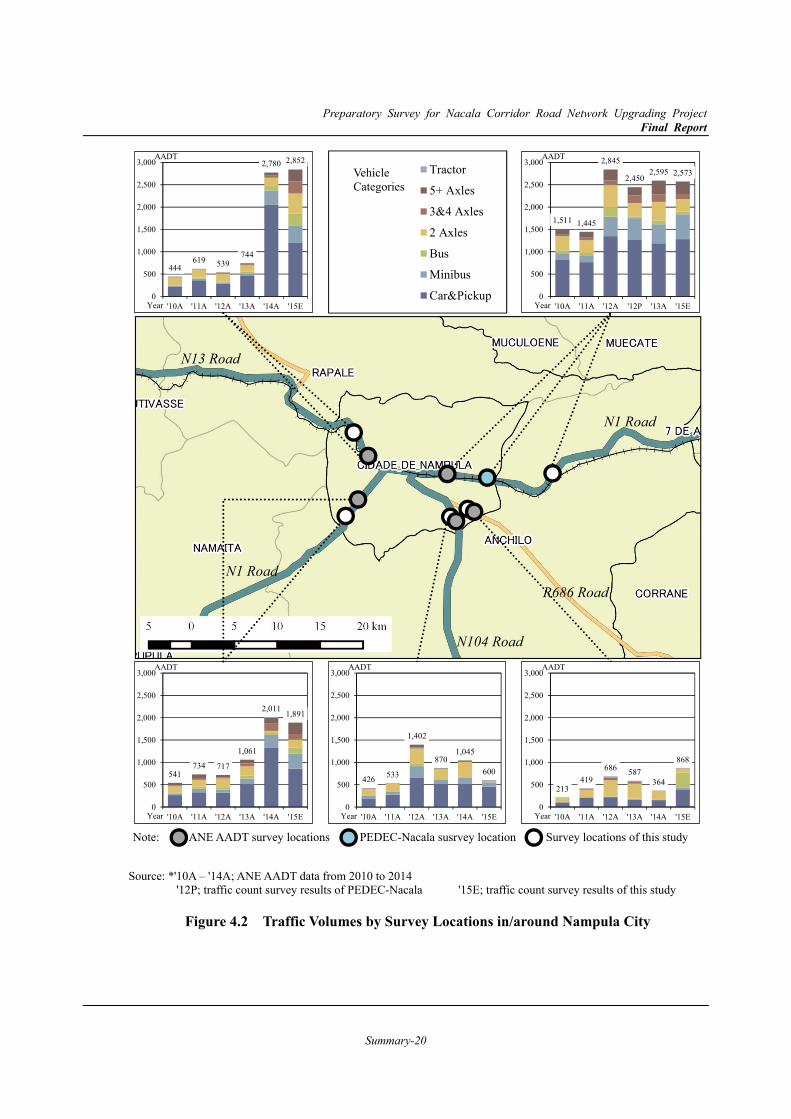
The traffic volumes by survey locations are depicted in Figure 4.2. As of 2015, a total of approximately 9,000 vehicles are entering/exiting the city every day. Surge increase in the number of vehicles is obvious since 2010 while annual fluctuation is observed. It is also noteworthy that the number of large trucks such as more than 3 axles is rapidly increasing, and that many large trucks entering the city centre of Nampula.
4.3 Cuamba
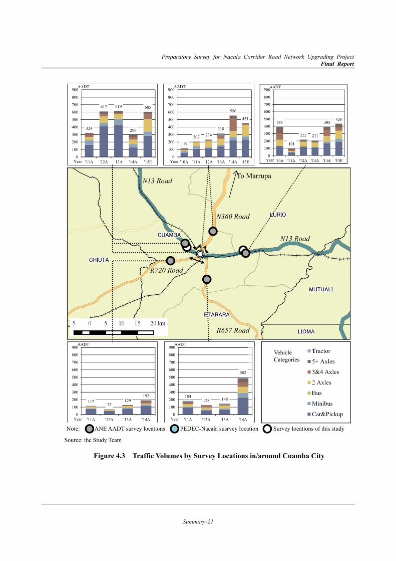
The traffic volumes by survey locations are depicted in Figure 4.3. As of 2015, a total of approximately 2,000 vehicles are entering/exiting the city every day. In addition to passenger cars and pickups, the number of trucks is rapidly increasing. This might be affected by the completion of Lot A and Lot B of Nampula – Cuamba section of N13 as well as construction works of Lot C.
Preparatory Survey for Nacala Corridor Road Network Upgrading Project Final Report
Summary-19
Source: *'10A – '14A; ANE AADT data from 2010 to 2014 '12P; traffic count survey results of PEDEC-Nacala '15E; traffic count survey results of this study For '15E; directional traffic count survey at intersection of this study, traffic volume of corresponding directions are compared with the previous survey results.
Figure 4.1 Traffic Volume by Survey Location around Nacala City
Tractor
5+ Axles
3&4 Axles
2 Axles
Bus
Minibus
Car&Pickup
Vehicle Categories
Note: ANE AADT survey locations PEDEC-Nacala susrvey location Survey locations of this study
N12 Road
R702 Road
212 317
1,0051,462
1,8232,217
0500
1,0001,5002,0002,5003,0003,5004,0004,5005,000
'10A '11A '12A '13A '14A '15EYear
AADT
2,486
4,031
0500
1,0001,5002,0002,5003,0003,5004,0004,5005,000
'12P '15EYear
AADT
R704 Road
R697 Road
To Nampula
Preparatory Survey for Nacala Corridor Road Network Upgrading Project Final Report
Summary-20
Source: *'10A – '14A; ANE AADT data from 2010 to 2014 '12P; traffic count survey results of PEDEC-Nacala '15E; traffic count survey results of this study
Figure 4.2 Traffic Volumes by Survey Locations in/around Nampula City
444619 539
744
2,780 2,852
0
500
1,000
1,500
2,000
2,500
3,000
'10A '11A '12A '13A '14A '15EYear
AADT
1,511 1,445
2,845
2,4502,595 2,573
0
500
1,000
1,500
2,000
2,500
3,000
'10A '11A '12A '12P '13A '15EYear
AADT
541734 717
1,061
2,011 1,891
0
500
1,000
1,500
2,000
2,500
3,000
'10A '11A '12A '13A '14A '15EYear
AADT
426 533
1,402
8701,045
600
0
500
1,000
1,500
2,000
2,500
3,000
'10A '11A '12A '13A '14A '15EYear
AADT
213419
686 587364
868
0
500
1,000
1,500
2,000
2,500
3,000
'10A '11A '12A '13A '14A '15EYear
AADT
Tractor
5+ Axles
3&4 Axles
2 Axles
Bus
Minibus
Car&Pickup
Vehicle Categories
Note: ANE AADT survey locations PEDEC-Nacala susrvey location Survey locations of this study
N1 Road
N1 Road
N104 Road
N13 Road
R686 Road
Preparatory Survey for Nacala Corridor Road Network Upgrading Project Final Report
Summary-21
Source: the Study Team
Figure 4.3 Traffic Volumes by Survey Locations in/around Cuamba City
N13 Road
N13 Road
R720 Road
N360 Road
R657 Road
324
612 619
296
605
0
100
200
300
400
500
600
700
800
900
'11A '12A '13A '14A '15EYear
AADT
119207 234
318
556
451
0
100
200
300
400
500
600
700
800
900
'10A '11A '12A '13A '14A '15EYear
AADT
11773
129192
0
100
200
300
400
500
600
700
800
900
'11A '12A '13A '14AYear
AADT
184128 148
502
0
100
200
300
400
500
600
700
800
900
'11A '12A '13A '14AYear
AADTTractor
5+ Axles
3&4 Axles
2 Axles
Bus
Minibus
Car&Pickup
Vehicle Categories
Note: ANE AADT survey locations PEDEC-Nacala susrvey location Survey locations of this study
To Marrupa
Preparatory Survey for Nacala Corridor Road Network Upgrading Project Final Report
Summary-22
5. Traffic Demand Forecast 5.1 Summary of Traffic Demand Forecast Results
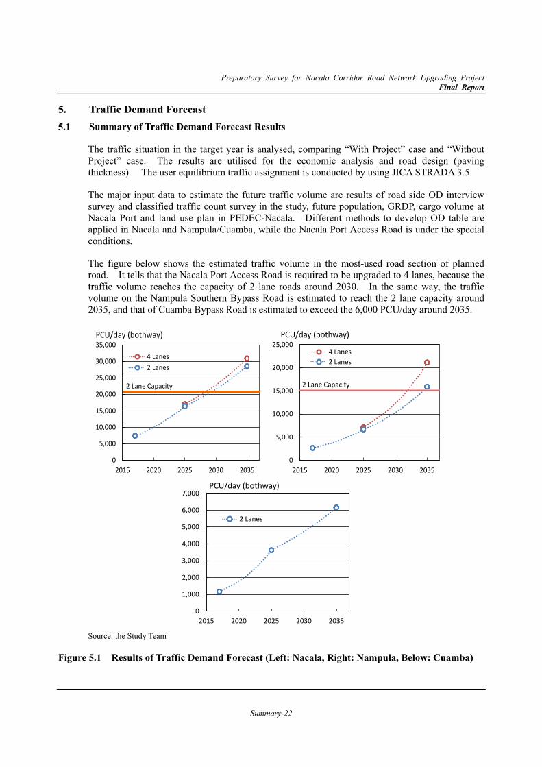
The traffic situation in the target year is analysed, comparing “With Project” case and “Without Project” case. The results are utilised for the economic analysis and road design (paving thickness). The user equilibrium traffic assignment is conducted by using JICA STRADA 3.5.
The major input data to estimate the future traffic volume are results of road side OD interview survey and classified traffic count survey in the study, future population, GRDP, cargo volume at Nacala Port and land use plan in PEDEC-Nacala. Different methods to develop OD table are applied in Nacala and Nampula/Cuamba, while the Nacala Port Access Road is under the special conditions.
The figure below shows the estimated traffic volume in the most-used road section of planned road. It tells that the Nacala Port Access Road is required to be upgraded to 4 lanes, because the traffic volume reaches the capacity of 2 lane roads around 2030. In the same way, the traffic volume on the Nampula Southern Bypass Road is estimated to reach the 2 lane capacity around 2035, and that of Cuamba Bypass Road is estimated to exceed the 6,000 PCU/day around 2035.
Source: the Study Team
Figure 5.1 Results of Traffic Demand Forecast (Left: Nacala, Right: Nampula, Below: Cuamba)
PCU/day (bothway)
0
5,000
10,000
15,000
20,000
25,000
30,000
35,000
2015 2020 2025 2030 2035
4 Lanes2 Lanes
2 Lane Capacity
0
5,000
10,000
15,000
20,000
25,000
2015 2020 2025 2030 2035
4 Lanes2 Lanes
2 Lane Capacity
PCU/day (bothway)
0
1,000
2,000
3,000
4,000
5,000
6,000
7,000
2015 2020 2025 2030 2035
2 Lanes
PCU/day (bothway)

Preparatory Survey for Nacala Corridor Road Network Upgrading Project Final Report
Summary-23
6. Road Design Conditions 6.1 Road Design Standard 6.1.1 Road Classification
The Study roads, such as Nacala Port Access Road, Nampula Southern Bypass Road and Cuamba Bypass Road, are categorised as the “Primary Road” with paved roads in the ANE Standard.
6.1.2 Geometric Standards
The design speed for “Primary” roads defined in ANE standard is 100 km/h. The 80km/h of design speed would be applied within some sections under special conditions such as residential areas, hilly and mountainous areas, etc. Through a series of discussions, the ANE Standard was applied for the Study Roads.
6.1.3 Right of Way (ROW)
Based on the Land Law (Law 19/97) of Mozambique of July 1997, the ROW of the Nacala Port Access Road and Nampula Southern Bypass Road shall be set at 50m from the edge of the shoulder of the road. As for the Cuamba Bypass Road shall be set at 30m.
6.1.4 Standard Width
Based on ANE Standards, its function to carry the expected traffic flow and to coordinate with future urban land use plans, the Study Team proposes the following typical cross sections for each study road.
Nacala Port Access Road (1)
The proposed typical cross section is shown in Figure 6.1, which has the total road reserve and the ROW width of 120.50 m.
Figure 6.1 Typical Cross Section for Nacala Port Access Road (At Completion)
In the initial stage the current limited traffic volume can be adequately served with a two lane road (one lane for each direction). The typical cross section operated in two-lane temporarily was examined during the preliminary design period.
Preparatory Survey for Nacala Corridor Road Network Upgrading Project Final Report
Summary-24
Nampula Southern Bypass Road (2)
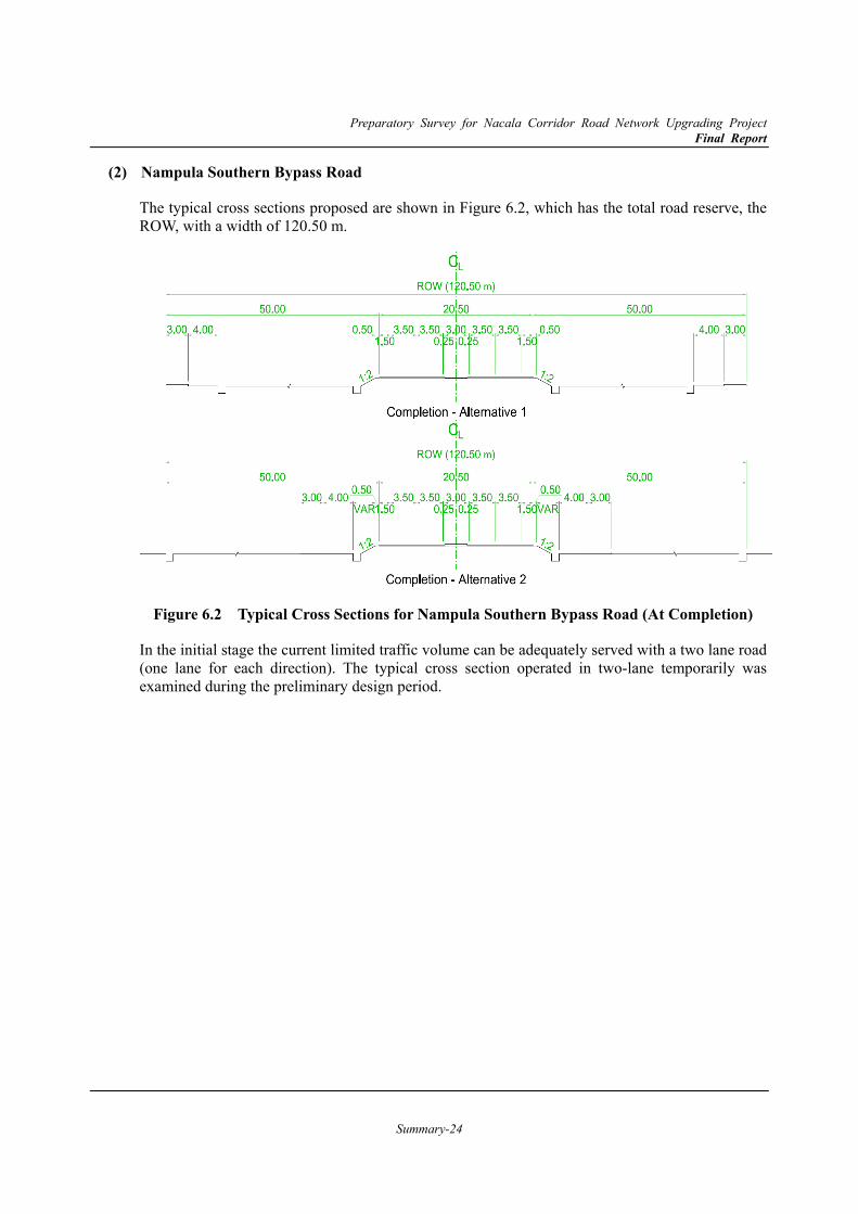
The typical cross sections proposed are shown in Figure 6.2, which has the total road reserve, the ROW, with a width of 120.50 m.
Figure 6.2 Typical Cross Sections for Nampula Southern Bypass Road (At Completion)
In the initial stage the current limited traffic volume can be adequately served with a two lane road (one lane for each direction). The typical cross section operated in two-lane temporarily was examined during the preliminary design period.
Preparatory Survey for Nacala Corridor Road Network Upgrading Project Final Report
Summary-25
Cuamba Bypass Road (3)
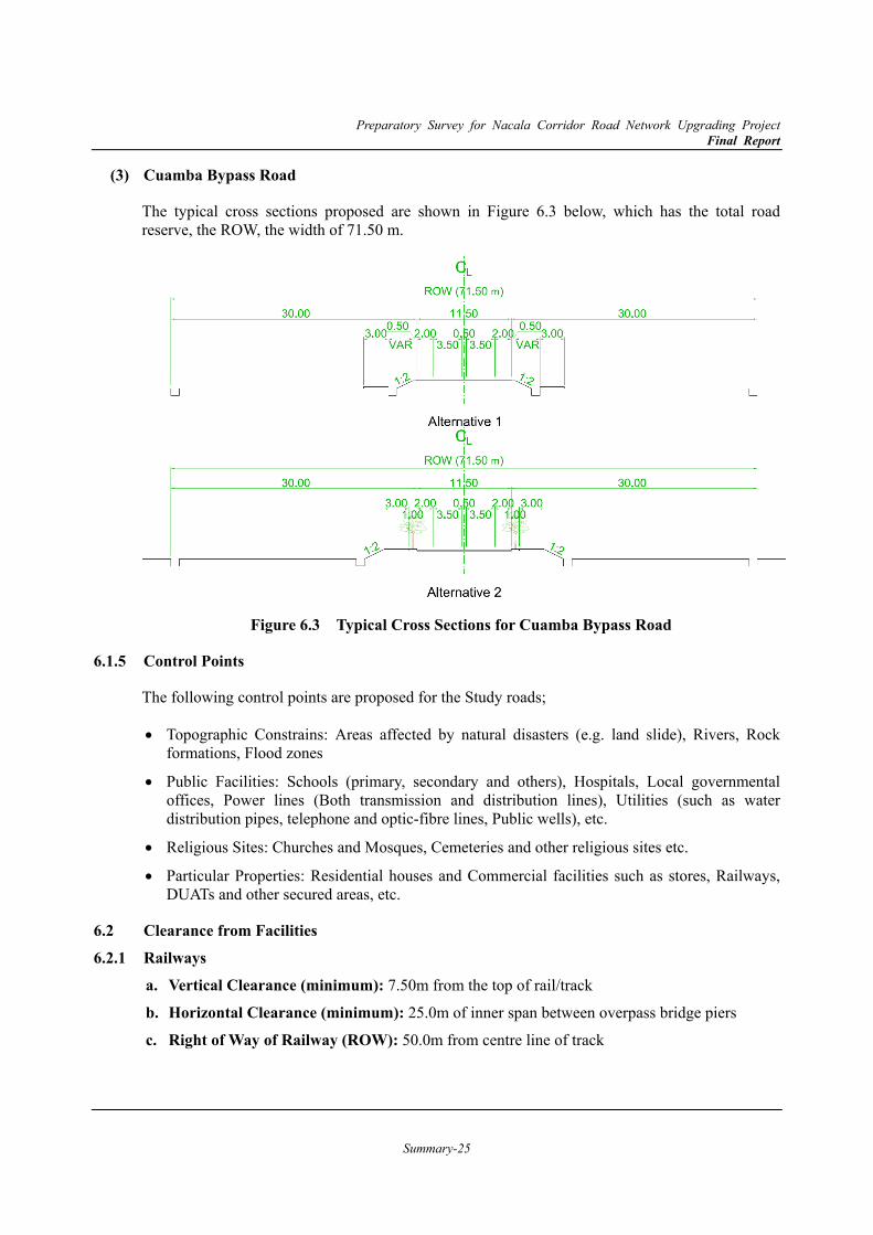
The typical cross sections proposed are shown in Figure 6.3 below, which has the total road reserve, the ROW, the width of 71.50 m.
Figure 6.3 Typical Cross Sections for Cuamba Bypass Road
6.1.5 Control Points
The following control points are proposed for the Study roads;
Topographic Constrains: Areas affected by natural disasters (e.g. land slide), Rivers, Rock formations, Flood zones
Public Facilities: Schools (primary, secondary and others), Hospitals, Local governmental offices, Power lines (Both transmission and distribution lines), Utilities (such as water distribution pipes, telephone and optic-fibre lines, Public wells), etc.
Religious Sites: Churches and Mosques, Cemeteries and other religious sites etc.
Particular Properties: Residential houses and Commercial facilities such as stores, Railways, DUATs and other secured areas, etc.
6.2 Clearance from Facilities 6.2.1 Railways
a. Vertical Clearance (minimum): 7.50m from the top of rail/track
b. Horizontal Clearance (minimum): 25.0m of inner span between overpass bridge piers
c. Right of Way of Railway (ROW): 50.0m from centre line of track
Preparatory Survey for Nacala Corridor Road Network Upgrading Project Final Report
Summary-26
6.2.2 Bridges over the Sea
The Study Team understands that there are no developments in the area with larger barges, so 2.00m of clearance shall be enough, which is also referred in the guidelines of “Technical Standards and Commentaries for Port and Harbour Facilities in Japan”.
6.2.3 Power Line (High Voltage Electric Transmission Line) Horizontal Clearance (1)
The reserved area from the transmission line shall be at least 50.0m distance from the centre of the power line.
Vertical Clearance (2)
If the road crosses the transmission line, a minimum 10.00m clearance between road surface and the lowest power cable shall be required by EDM.
Future Plan for New Transmission Line in the Nampula Area (3)
Based on the discussion, EDM requested that the road alignment should consider horizontal and vertical clearances based on the expansion plan for the transmission line in the Nampula Area.
6.2.4 River Bridge and Embankment
The following clearances from the HWL shall be secured for the bridge and embankment based on the Japanese Standard, at the different categories of river volume flow level.
Table 6.1 River Bridge/Embankment Clearance from HWL
River Volume Flow (m³/s) Clearance: H (m) < 200 0.60
200 ~ 500 0.80 500 ~ 2,000 1.00
2,000 ~ 5,000 1.20 5,000 ~ 10,000 1.50
> 10,000 2.00
6.3 Road Development with Urban Land Use Plan (Proposal)
The area along the Study road “Nampula Southern Bypass Road” is envisioned to start development by their own urban economic activities once the road is opened. Under the current land law and regulations a partial protected zone for the road is in the form of a ROW and extends 50m from the edge of the shoulder of the road. This means that no one can build within the ROW in the future. The residential buildings are allowed to be built more than 50m from the road. If the urban development which can be seen in various countries shall be allowed along the road, there is some possibility to develop facilities within the ROW area for only public purposes under ANE or for commercial and logistics development authorised by the local government, which has been illustrated in the partial urbanisation plan in Nampula Municipality.
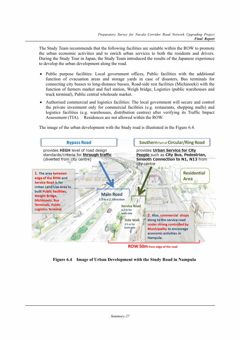
Preparatory Survey for Nacala Corridor Road Network Upgrading Project Final Report
Summary-27
The Study Team recommends that the following facilities are suitable within the ROW to promote the urban economic activities and to enrich urban services to both the residents and drivers. During the Study Tour in Japan, the Study Team introduced the results of the Japanese experience to develop the urban development along the road.
Public purpose facilities: Local government offices, Public facilities with the additional function of evacuation areas and storage yards in case of disasters, Bus terminals for connecting city busses to long-distance busses, Road-side rest facilities (Michinoeki) with the function of farmers market and fuel station, Weigh bridge, Logistics (public warehouses and truck terminal), Public central wholesale market.
Authorised commercial and logistics facilities: The local government will secure and control the private investment only for commercial facilities (e.g. restaurants, shopping malls) and logistics facilities (e.g. warehouses, distribution centres) after verifying its Traffic Impact Assessment (TIA). Residences are not allowed within the ROW.
The image of the urban development with the Study road is illustrated in the Figure 6.4.
Figure 6.4 Image of Urban Development with the Study Road in Nampula
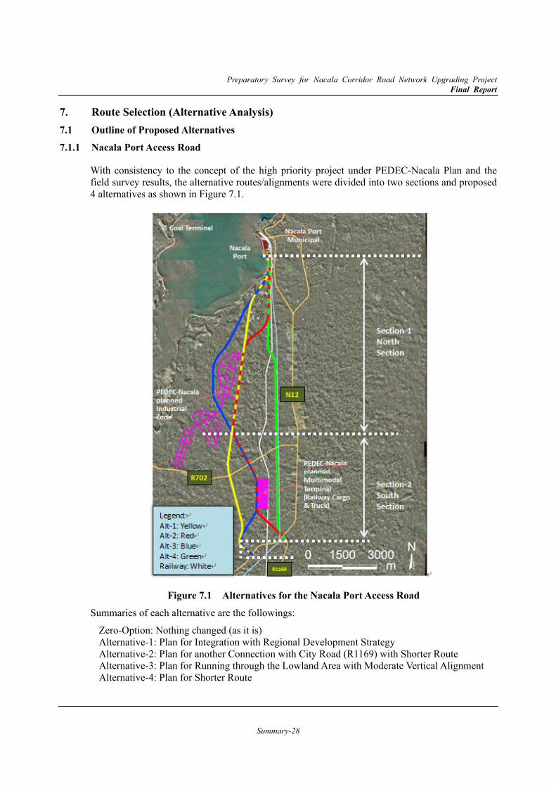
Preparatory Survey for Nacala Corridor Road Network Upgrading Project Final Report
Summary-28
7. Route Selection (Alternative Analysis) 7.1 Outline of Proposed Alternatives 7.1.1 Nacala Port Access Road
With consistency to the concept of the high priority project under PEDEC-Nacala Plan and the field survey results, the alternative routes/alignments were divided into two sections and proposed 4 alternatives as shown in Figure 7.1.
Figure 7.1 Alternatives for the Nacala Port Access Road
Summaries of each alternative are the followings:
Zero-Option: Nothing changed (as it is) Alternative-1: Plan for Integration with Regional Development Strategy Alternative-2: Plan for another Connection with City Road (R1169) with Shorter Route Alternative-3: Plan for Running through the Lowland Area with Moderate Vertical Alignment Alternative-4: Plan for Shorter Route
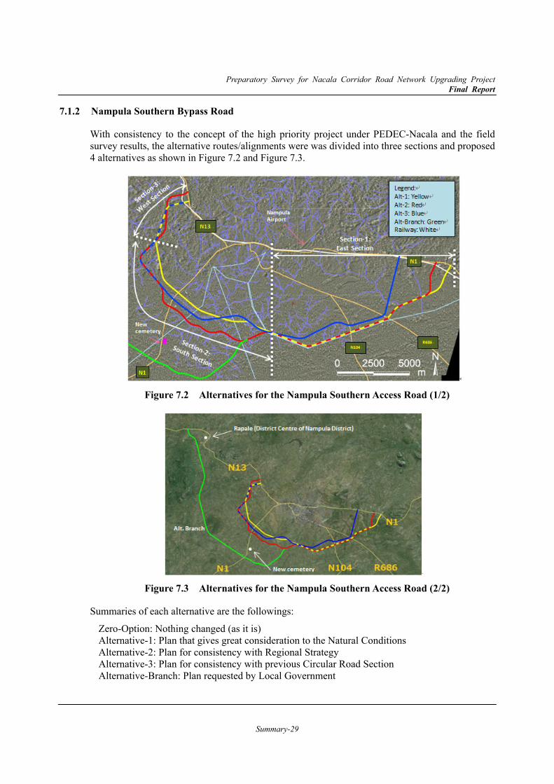
Preparatory Survey for Nacala Corridor Road Network Upgrading Project Final Report
Summary-29
7.1.2 Nampula Southern Bypass Road
With consistency to the concept of the high priority project under PEDEC-Nacala and the field survey results, the alternative routes/alignments were was divided into three sections and proposed 4 alternatives as shown in Figure 7.2 and Figure 7.3.
Figure 7.2 Alternatives for the Nampula Southern Access Road (1/2)
Figure 7.3 Alternatives for the Nampula Southern Access Road (2/2)
Summaries of each alternative are the followings:
Zero-Option: Nothing changed (as it is) Alternative-1: Plan that gives great consideration to the Natural Conditions Alternative-2: Plan for consistency with Regional Strategy Alternative-3: Plan for consistency with previous Circular Road Section Alternative-Branch: Plan requested by Local Government
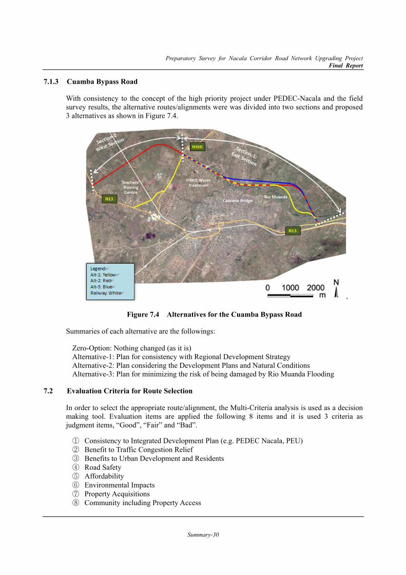
Preparatory Survey for Nacala Corridor Road Network Upgrading Project Final Report
Summary-30
7.1.3 Cuamba Bypass Road
With consistency to the concept of the high priority project under PEDEC-Nacala and the field survey results, the alternative routes/alignments were was divided into two sections and proposed 3 alternatives as shown in Figure 7.4.
Figure 7.4 Alternatives for the Cuamba Bypass Road
Summaries of each alternative are the followings:
Zero-Option: Nothing changed (as it is) Alternative-1: Plan for consistency with Regional Development Strategy Alternative-2: Plan considering the Development Plans and Natural Conditions Alternative-3: Plan for minimizing the risk of being damaged by Rio Muanda Flooding
7.2 Evaluation Criteria for Route Selection
In order to select the appropriate route/alignment, the Multi-Criteria analysis is used as a decision making tool. Evaluation items are applied the following 8 items and it is used 3 criteria as judgment items, “Good”, “Fair” and “Bad”.
① Consistency to Integrated Development Plan (e.g. PEDEC Nacala, PEU) ② Benefit to Traffic Congestion Relief ③ Benefits to Urban Development and Residents ④ Road Safety ⑤ Affordability ⑥ Environmental Impacts ⑦ Property Acquisitions ⑧ Community including Property Access
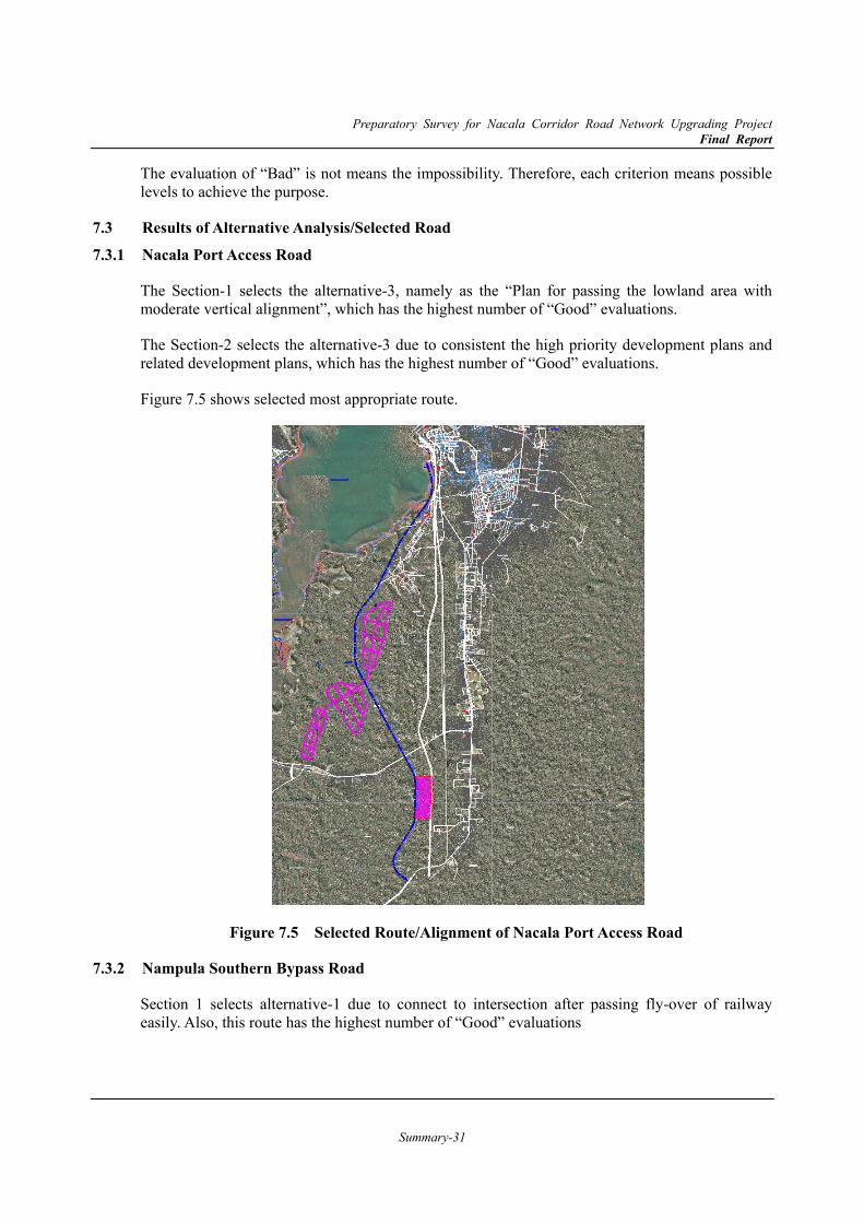
Preparatory Survey for Nacala Corridor Road Network Upgrading Project Final Report
Summary-31
The evaluation of “Bad” is not means the impossibility. Therefore, each criterion means possible levels to achieve the purpose.
7.3 Results of Alternative Analysis/Selected Road 7.3.1 Nacala Port Access Road
The Section-1 selects the alternative-3, namely as the “Plan for passing the lowland area with moderate vertical alignment”, which has the highest number of “Good” evaluations.
The Section-2 selects the alternative-3 due to consistent the high priority development plans and related development plans, which has the highest number of “Good” evaluations.
Figure 7.5 shows selected most appropriate route.
Figure 7.5 Selected Route/Alignment of Nacala Port Access Road
7.3.2 Nampula Southern Bypass Road
Section 1 selects alternative-1 due to connect to intersection after passing fly-over of railway easily. Also, this route has the highest number of “Good” evaluations
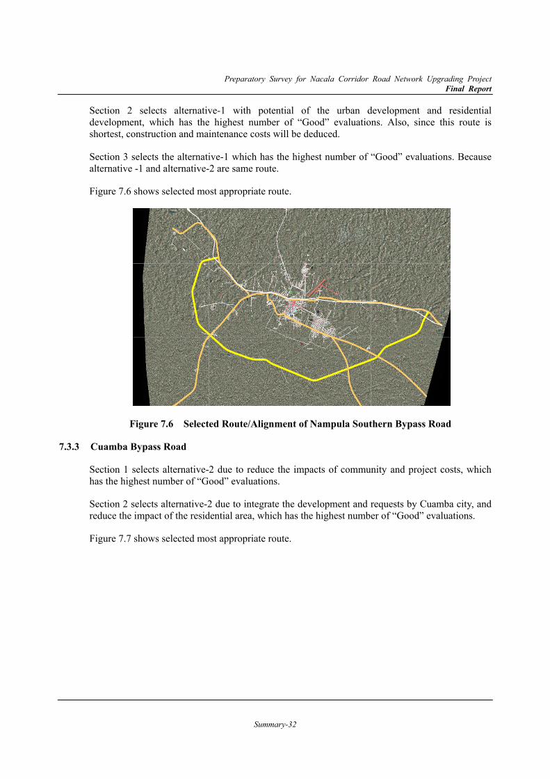
Preparatory Survey for Nacala Corridor Road Network Upgrading Project Final Report
Summary-32
Section 2 selects alternative-1 with potential of the urban development and residential development, which has the highest number of “Good” evaluations. Also, since this route is shortest, construction and maintenance costs will be deduced.
Section 3 selects the alternative-1 which has the highest number of “Good” evaluations. Because alternative -1 and alternative-2 are same route.
Figure 7.6 shows selected most appropriate route.
Figure 7.6 Selected Route/Alignment of Nampula Southern Bypass Road
7.3.3 Cuamba Bypass Road
Section 1 selects alternative-2 due to reduce the impacts of community and project costs, which has the highest number of “Good” evaluations.
Section 2 selects alternative-2 due to integrate the development and requests by Cuamba city, and reduce the impact of the residential area, which has the highest number of “Good” evaluations.
Figure 7.7 shows selected most appropriate route.

Preparatory Survey for Nacala Corridor Road Network Upgrading Project Final Report
Summary-33
Figure 7.7 Selected Route/Alignment of Cuamba Bypass Road
7.4 Road Development Plans/Image for each Target Road
These Target Roads are expected to provide not only a diversion route for through traffic, but also opportunities to enjoy urban development and accessibility to the benefits of urban services. Therefore, the future vision for the service roads and crossing/connecting types of other roads should be thought of in terms that are in accordance with the local conditions and needs.
This section describes draft ideas of the future visions around the target roads for discussion until the implementation of this project, even though they partly go beyond the scope of the preliminary design.
Nacala Port Access Road (1)
The function of this road is to provide direct access to Nacala port for the heavy vehicles diverted from passing within the Nacala city area, and to connect to the future planned industrial park and multi-modal terminal. The route is mainly in the protected area that prohibits buildings; therefore, there are not many communities along the road. In this, therefore, the services road along the main road is planned in the limited section which is indicated by the green colour line in the drawing.
The north-end point of the service road is connected to the salt pan and communities near the sea-side, where it requires crossing the main-road with a separated-grade. And the service road is provided to connect the planed industrial park and the R702.
The southern section between N12 and R702 is expected to be used by not only heavy vehicles but also the vehicles shortcutting to Nacala-a-Velha from The Nampula side, and there is a difficult area to build-up due to steep undulations. Therefore, the service road is planned in a limited section to connect the multi-modal terminal from R702.
The proposed crossing types at each road for the initial stage and completion stage are shown in Table 7.1, based on the expected traffic volume.
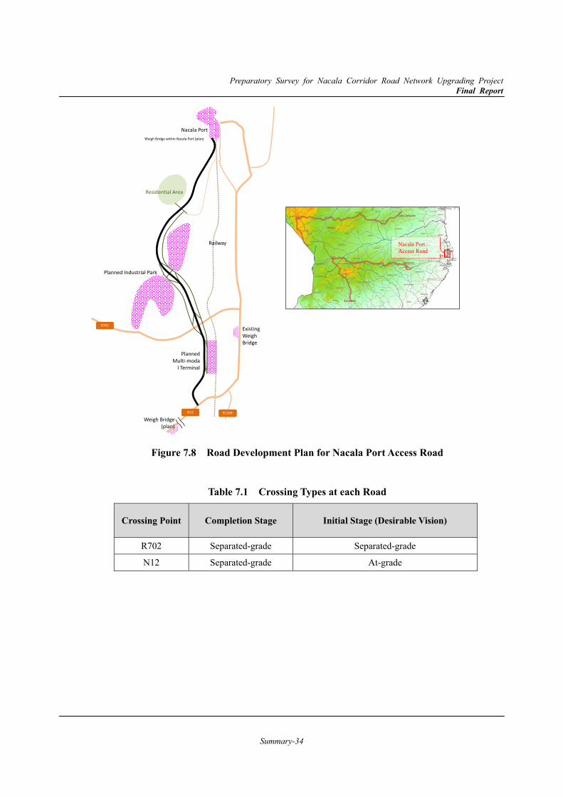
Preparatory Survey for Nacala Corridor Road Network Upgrading Project Final Report
Summary-34
Figure 7.8 Road Development Plan for Nacala Port Access Road
Table 7.1 Crossing Types at each Road
Crossing Point Completion Stage Initial Stage (Desirable Vision)
R702 Separated-grade Separated-grade
N12 Separated-grade At-grade
R702
N12 R1169
Hous
Planned Industrial Park
Planned Multi-moda
l Terminal
Railway
Nacala Port
Residential Area
Existing Weigh Bridge
Weigh Bridge (plan)
Weigh Bridge within Nacala Port (plan)
Nacala Port Access Road
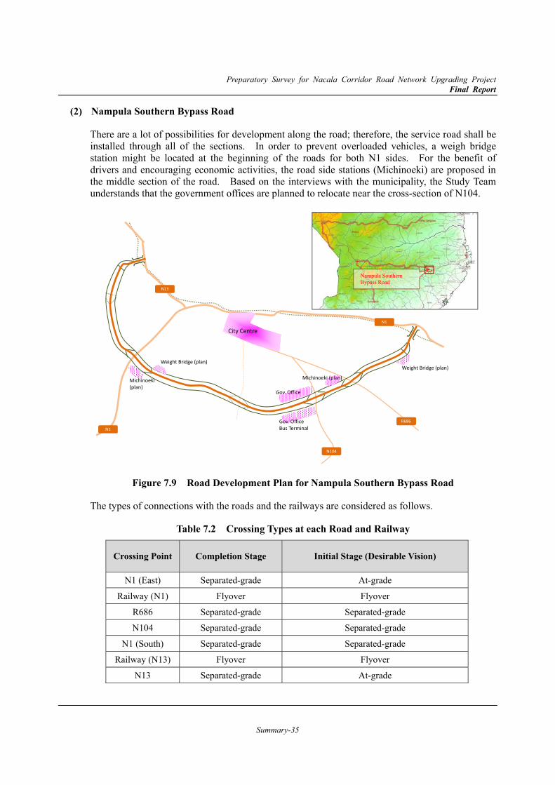
Preparatory Survey for Nacala Corridor Road Network Upgrading Project Final Report
Summary-35
Nampula Southern Bypass Road (2)
There are a lot of possibilities for development along the road; therefore, the service road shall be installed through all of the sections. In order to prevent overloaded vehicles, a weigh bridge station might be located at the beginning of the roads for both N1 sides. For the benefit of drivers and encouraging economic activities, the road side stations (Michinoeki) are proposed in the middle section of the road. Based on the interviews with the municipality, the Study Team understands that the government offices are planned to relocate near the cross-section of N104.
Figure 7.9 Road Development Plan for Nampula Southern Bypass Road
The types of connections with the roads and the railways are considered as follows.
Table 7.2 Crossing Types at each Road and Railway
Crossing Point Completion Stage Initial Stage (Desirable Vision)
N1 (East) Separated-grade At-grade
Railway (N1) Flyover Flyover
R686 Separated-grade Separated-grade
N104 Separated-grade Separated-grade
N1 (South) Separated-grade Separated-grade
Railway (N13) Flyover Flyover
N13 Separated-grade At-grade
N1
N1
N13
R686
N104
Weight Bridge (plan) Weight Bridge (plan)
Michinoeki (plan) Michinoeki (plan)
Gov. Office Bus Terminal
Gov. Office
City Centre
Nampula Southern Bypass Road
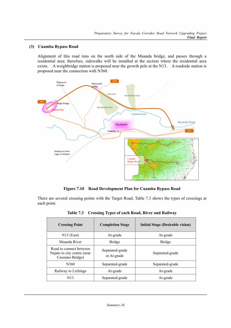
Preparatory Survey for Nacala Corridor Road Network Upgrading Project Final Report
Summary-36
Cuamba Bypass Road (3)
Alignment of this road runs on the north side of the Muanda bridge, and passes through a residential area; therefore, sidewalks will be installed at the section where the residential area exists. A weighbridge station is proposed near the growth pole at the N13. A roadside station is proposed near the connection with N360.
Figure 7.10 Road Development Plan for Cuamba Bypass Road
There are several crossing points with the Target Road, Table 7.3 shows the types of crossings at each point.
Table 7.3 Crossing Types of each Road, River and Railway
Crossing Point Completion Stage Initial Stage (Desirable vision)
N13 (East) At-grade At-grade
Muanda River Bridge Bridge
Road to connect between Najato to city centre (near
Cassiano Bridge)
Separated-grade or At-grade
Separated-grade
N360 Separated-grade Separated-grade
Railway to Lichinga At-grade At-grade
N13 Separated-grade At-grade
N13
N13
N360
Flooded Area
Cuamba St.
Michinoeki (plan)
Weigh Bridge ( l )
Growth Pole
Sidewalk
Muanda River
Residential Area
Residential Area
City Centre
Railway to Lichinga
Railway to Entre Lagos to Malawi
Cuamba Bypass Road
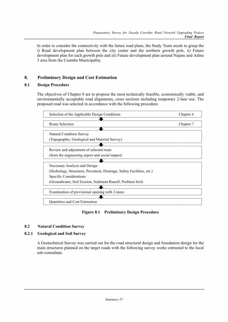
Preparatory Survey for Nacala Corridor Road Network Upgrading Project Final Report
Summary-37
In order to consider the connectivity with the future road plans, the Study Team needs to grasp the i) Road development plan between the city centre and the northern growth pole, ii) Futuredevelopment plan for each growth pole and iii) Future development plan around Najane and Adine 3 area from the Cuamba Municipality.
8. Preliminary Design and Cost Estimation8.1 Design Procedure
The objectives of Chapter 8 are to propose the most technically feasible, economically viable, and environmentally acceptable road alignments, cross sections including temporary 2-lane use. The proposed road was selected in accordance with the following procedure.
Figure 8.1 Preliminary Design Procedure
8.2 Natural Condition Survey 8.2.1 Geological and Soil Survey
A Geotechnical Survey was carried out for the road structural design and foundation design for the main structures planned on the target roads with the following survey works entrusted to the local sub-consultant.
Selection of the Applicable Design Conditions Chapter 6
Route Selection Chapter 7
Natural Condition Survey (Topographic, Geological and Material Survey)
Review and adjustment of selected route (from the engineering aspect and social impact)
Necessary Analysis and Design (Hydrology, Structures, Pavement, Drainage, Safety Facilities, etc.) Specific Considerations
(Groundwater, Soil Erosion, Sediment Runoff, Problem Soil)
Examination of provisional opening with 2-lanes
Quantities and Cost Estimation
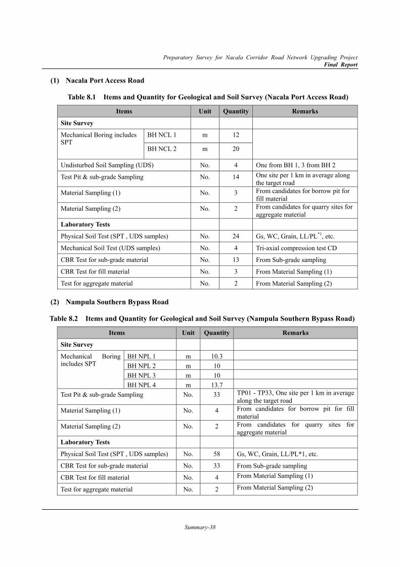
Preparatory Survey for Nacala Corridor Road Network Upgrading Project Final Report
Summary-38
Nacala Port Access Road (1)
Table 8.1 Items and Quantity for Geological and Soil Survey (Nacala Port Access Road)
Items Unit Quantity Remarks
Site Survey
Mechanical Boring includes SPT
BH NCL 1 m 12
BH NCL 2 m 20
Undisturbed Soil Sampling (UDS) No. 4 One from BH 1, 3 from BH 2
Test Pit & sub-grade Sampling No. 14 One site per 1 km in average along the target road
Material Sampling (1) No. 3 From candidates for borrow pit for fill material
Material Sampling (2) No. 2 From candidates for quarry sites for aggregate material
Laboratory Tests
Physical Soil Test (SPT , UDS samples) No. 24 Gs, WC, Grain, LL/PL*1, etc.
Mechanical Soil Test (UDS samples) No. 4 Tri-axial compression test CD
CBR Test for sub-grade material No. 13 From Sub-grade sampling
CBR Test for fill material No. 3 From Material Sampling (1)
Test for aggregate material No. 2 From Material Sampling (2)
Nampula Southern Bypass Road (2)
Table 8.2 Items and Quantity for Geological and Soil Survey (Nampula Southern Bypass Road)
Items Unit Quantity Remarks
Site Survey
Mechanical Boring includes SPT
BH NPL 1 m 10.3 BH NPL 2 m 10 BH NPL 3 m 10 BH NPL 4 m 13.7
Test Pit & sub-grade Sampling No. 33 TP01 - TP33, One site per 1 km in average along the target road
Material Sampling (1) No. 4 From candidates for borrow pit for fill material
Material Sampling (2) No. 2 From candidates for quarry sites for aggregate material
Laboratory Tests
Physical Soil Test (SPT , UDS samples) No. 58 Gs, WC, Grain, LL/PL*1, etc.
CBR Test for sub-grade material No. 33 From Sub-grade sampling
CBR Test for fill material No. 4 From Material Sampling (1)
Test for aggregate material No. 2 From Material Sampling (2)
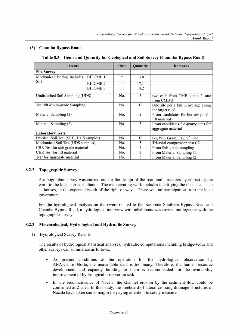
Preparatory Survey for Nacala Corridor Road Network Upgrading Project Final Report
Summary-39
Cuamba Bypass Road (3)
Table 8.3 Items and Quantity for Geological and Soil Survey (Cuamba Bypass Road)
Items Unit Quantity Remarks Site Survey Mechanical Boring includes SPT
BH CMB 1 m 13.0 BH CMB 2 m 17.1 BH CMB 3 m 14.2
Undisturbed Soil Sampling (UDS) No. 5 two each from CMB 1 and 2, one from CMB 3
Test Pit & sub-grade Sampling No. 12 One site per 1 km in average along the target road
Material Sampling (1) No. 2 From candidates for borrow pit for fill material
Material Sampling (2) No. 5 From candidates for quarry sites for aggregate material
Laboratory Tests Physical Soil Test (SPT , UDS samples) No. 12 Gs, WC, Grain, LL/PL*1, etc. Mechanical Soil Test (UDS samples) No. 5 Tri-axial compression test CD CBR Test for sub-grade material No. 5 From Sub-grade sampling CBR Test for fill material No. 2 From Material Sampling (1) Test for aggregate material No. 5 From Material Sampling (2)
8.2.2 Topographic Survey
A topographic survey was carried out for the design of the road and structures by entrusting the work to the local sub-consultant. The map creating work includes identifying the obstacles, such as houses, in the expected width of the right of way. There was no participation from the local government.
For the hydrological analysis on the rivers related to the Nampula Southern Bypass Road and Cuamba Bypass Road, a hydrological interview with inhabitants was carried out together with the topographic survey.
8.2.3 Meteorological, Hydrological and Hydraulic Survey
1) Hydrological Survey Results
The results of hydrological statistical analyses, hydraulic computations including bridge-scour and other surveys can summarize as follows;
As present conditions of the operation for the hydrological observation by ARA-Centro-Norte, the unavailable data is too many. Therefore, the human resource development and capacity building to them is recommended for the availability improvement of hydrological observation task.
In site reconnaissance of Nacala, the channel erosion by the sediment-flow could be confirmed at 2 sites. In this study, the freeboard of lateral crossing drainage structures of Nacala have taken some margin for paying attention to safety measures.

Preparatory Survey for Nacala Corridor Road Network Upgrading Project Final Report
Summary-40
The study area of Nacala and Nampula is a hilly area. Of them, the flow regime of Muepelume (Nam-13) and Muhara (Nam-17) rivers of Nampula is under conditions of the super critical flow, and the velocity is very fast. Most of river-bed materials will be washed out, if the amount of peak flood continues. Therefore, the surrounding of bridge sites shall be adequately protected for the erosion.
The contraction scour will occur to the extent of 0.06m-0.65m at bridge openings. This means that the river section flow area is small. However, the value of the contraction scour is not so big, and it might be no problem as necessary river section area.
As the computation results in the local scouring, it occurs in most of piers each bridge. Therefore, the riverbed around abutments and piers which are occurred the scouring, have taken costs for the appropriate bed-protection works into account.
Also, the planned hydraulic structures (bridges and culverts) are followings;
33 structures (1 bridge / 32 culverts) for Nacala Port Access Road,
29 structures (4 bridges / 25 culverts) for Nampula Bypass Road, and
10 structures (3 bridges / 7 culverts) for Cuamba Bypass Road.
The design high water levels and discharges are shown in Table 8.4.
Table 8.4 Design High Water-Levels and Discharges at each Bridge
ID Chainage Bridge / River Name Design Return Period
Design Discharge
Design High Water Level Remarks
< Nacala > m3/s m
Nac-15 No.042+14.0 (Small stream) 50 years 109.7 10.77 From calculation of uniform flow
< Nampula >
Nam-6 No.047+98.0 Mutomote River 50 years 214.8 353.24 With RTW
Nam-13 No.126+84.0 Muepelume River 50 years 247.7 332.74 With RTW
Nam-17 No.158+86.0 Muhara River 50 years 151.9 327.15
Nam-20 No.183+49.0 Muepelume B River 100 years 416.9 323.08
< Cuamba >
Cua-1 No.003+54.0 Muwanda River 100 years 2121 559.70
Cua-3 No.020+66.0 (Muwanda Tributary 2) 50 years 223.3 561.54
Cua-6 No.052+69.0 (Muwanda Tributary 3) 50 years 184.9 563.66 Source: the Study Team
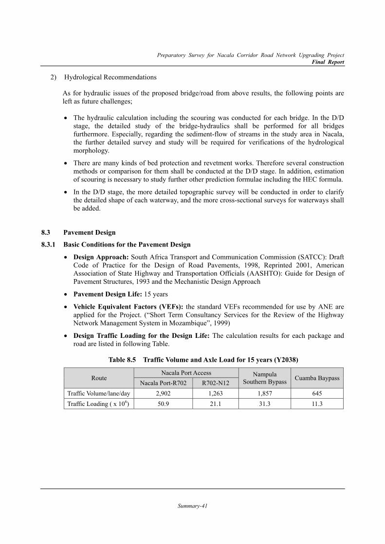
Preparatory Survey for Nacala Corridor Road Network Upgrading Project Final Report
Summary-41
2) Hydrological Recommendations
As for hydraulic issues of the proposed bridge/road from above results, the following points are left as future challenges;
The hydraulic calculation including the scouring was conducted for each bridge. In the D/D stage, the detailed study of the bridge-hydraulics shall be performed for all bridges furthermore. Especially, regarding the sediment-flow of streams in the study area in Nacala, the further detailed survey and study will be required for verifications of the hydrological morphology.
There are many kinds of bed protection and revetment works. Therefore several construction methods or comparison for them shall be conducted at the D/D stage. In addition, estimation of scouring is necessary to study further other prediction formulae including the HEC formula.
In the D/D stage, the more detailed topographic survey will be conducted in order to clarify the detailed shape of each waterway, and the more cross-sectional surveys for waterways shall be added.
8.3 Pavement Design 8.3.1 Basic Conditions for the Pavement Design
Design Approach: South Africa Transport and Communication Commission (SATCC): Draft Code of Practice for the Design of Road Pavements, 1998, Reprinted 2001, American Association of State Highway and Transportation Officials (AASHTO): Guide for Design of Pavement Structures, 1993 and the Mechanistic Design Approach
Pavement Design Life: 15 years
Vehicle Equivalent Factors (VEFs): the standard VEFs recommended for use by ANE are applied for the Project. (“Short Term Consultancy Services for the Review of the Highway Network Management System in Mozambique”, 1999)
Design Traffic Loading for the Design Life: The calculation results for each package and road are listed in following Table.
Table 8.5 Traffic Volume and Axle Load for 15 years (Y2038)
Route Nacala Port Access Nampula
Southern Bypass Cuamba BaypassNacala Port-R702 R702-N12
Traffic Volume/lane/day 2,902 1,263 1,857 645 Traffic Loading ( x 106) 50.9 21.1 31.3 11.3
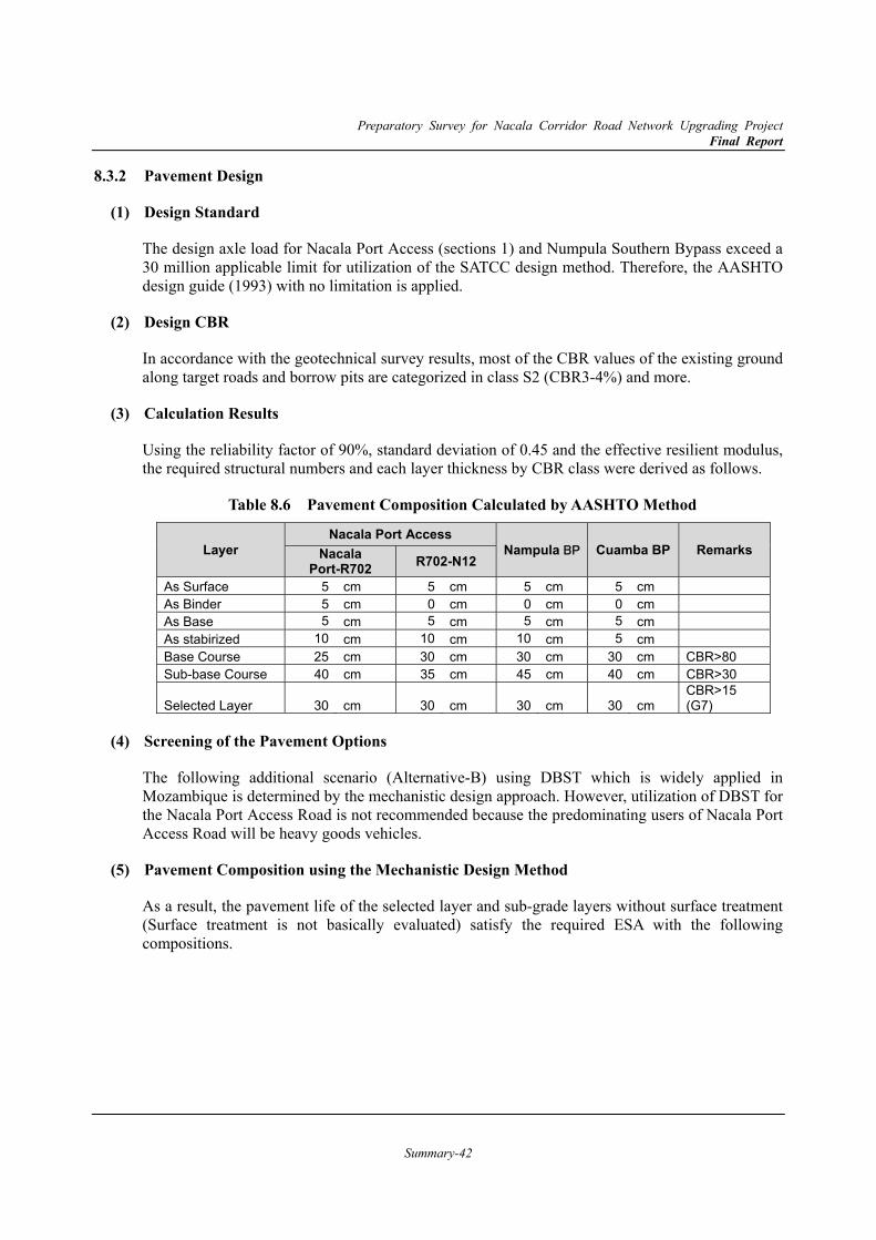
Preparatory Survey for Nacala Corridor Road Network Upgrading Project Final Report
Summary-42
8.3.2 Pavement Design
Design Standard (1)
The design axle load for Nacala Port Access (sections 1) and Numpula Southern Bypass exceed a 30 million applicable limit for utilization of the SATCC design method. Therefore, the AASHTO design guide (1993) with no limitation is applied.
Design CBR (2)
In accordance with the geotechnical survey results, most of the CBR values of the existing ground along target roads and borrow pits are categorized in class S2 (CBR3-4%) and more.
Calculation Results (3)
Using the reliability factor of 90%, standard deviation of 0.45 and the effective resilient modulus, the required structural numbers and each layer thickness by CBR class were derived as follows.
Table 8.6 Pavement Composition Calculated by AASHTO Method
Layer Nacala Port Access
Nampula BP Cuamba BP Remarks Nacala Port-R702 R702-N12
As Surface 5 cm 5 cm 5 cm 5 cm As Binder 5 cm 0 cm 0 cm 0 cm As Base 5 cm 5 cm 5 cm 5 cm As stabirized 10 cm 10 cm 10 cm 5 cm Base Course 25 cm 30 cm 30 cm 30 cm CBR>80 Sub-base Course 40 cm 35 cm 45 cm 40 cm CBR>30
Selected Layer 30 cm 30 cm 30 cm 30 cm CBR>15 (G7)
Screening of the Pavement Options (4)
The following additional scenario (Alternative-B) using DBST which is widely applied in Mozambique is determined by the mechanistic design approach. However, utilization of DBST for the Nacala Port Access Road is not recommended because the predominating users of Nacala Port Access Road will be heavy goods vehicles.
Pavement Composition using the Mechanistic Design Method (5)
As a result, the pavement life of the selected layer and sub-grade layers without surface treatment (Surface treatment is not basically evaluated) satisfy the required ESA with the following compositions.
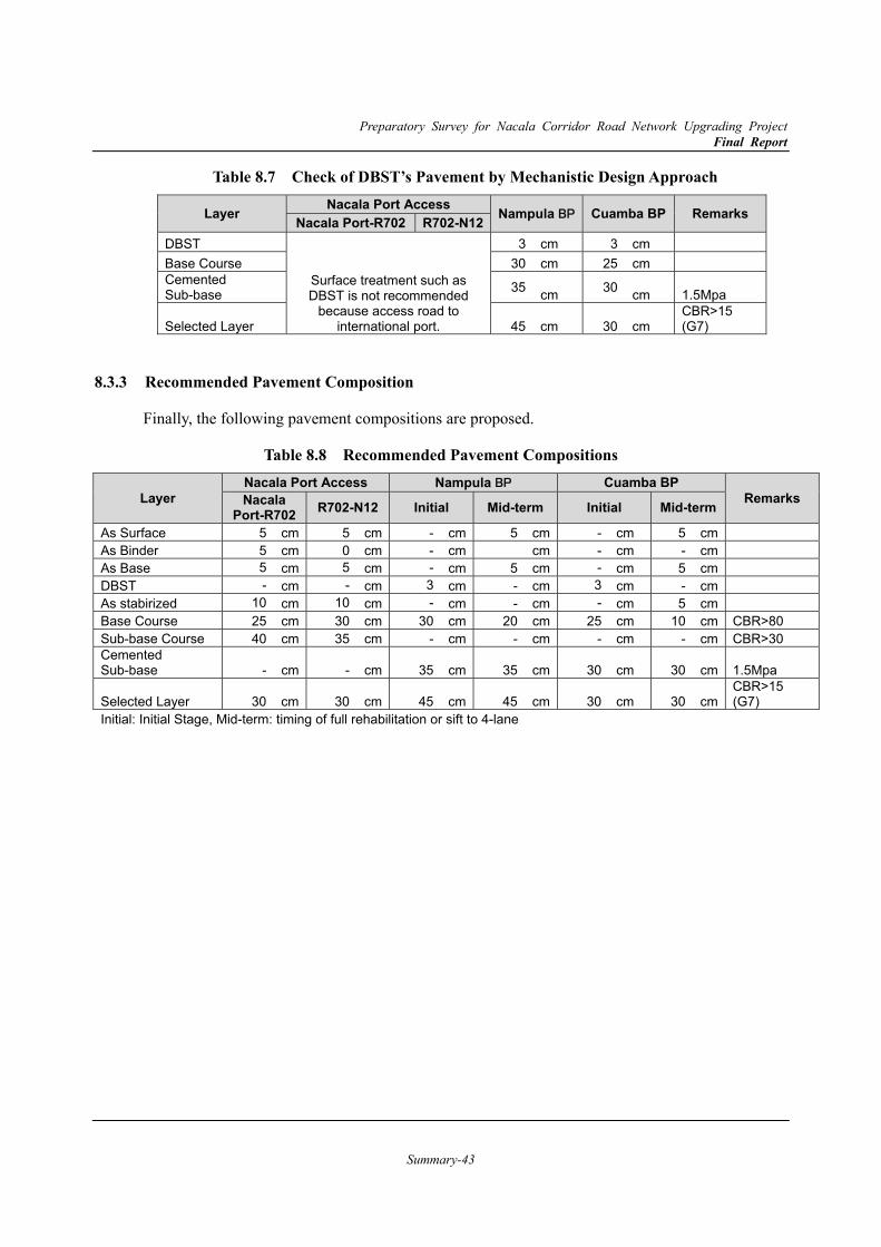
Preparatory Survey for Nacala Corridor Road Network Upgrading Project Final Report
Summary-43
Table 8.7 Check of DBST’s Pavement by Mechanistic Design Approach
Layer Nacala Port Access Nampula BP Cuamba BP Remarks Nacala Port-R702 R702-N12DBST
Surface treatment such as DBST is not recommended
because access road to international port.
3 cm 3 cm Base Course 30 cm 25 cm Cemented Sub-base 35 cm 30 cm 1.5Mpa
Selected Layer 45 cm 30 cm CBR>15 (G7)
8.3.3 Recommended Pavement Composition
Finally, the following pavement compositions are proposed.
Table 8.8 Recommended Pavement Compositions
Layer Nacala Port Access Nampula BP Cuamba BP
Remarks Nacala Port-R702 R702-N12 Initial Mid-term Initial Mid-term
As Surface 5 cm 5 cm - cm 5 cm - cm 5 cm As Binder 5 cm 0 cm - cm cm - cm - cm As Base 5 cm 5 cm - cm 5 cm - cm 5 cm DBST - cm - cm 3 cm - cm 3 cm - cm As stabirized 10 cm 10 cm - cm - cm - cm 5 cm Base Course 25 cm 30 cm 30 cm 20 cm 25 cm 10 cm CBR>80 Sub-base Course 40 cm 35 cm - cm - cm - cm - cm CBR>30 Cemented Sub-base - cm - cm 35 cm 35 cm 30 cm 30 cm 1.5Mpa
Selected Layer 30 cm 30 cm 45 cm 45 cm 30 cm 30 cm CBR>15 (G7)
Initial: Initial Stage, Mid-term: timing of full rehabilitation or sift to 4-lane
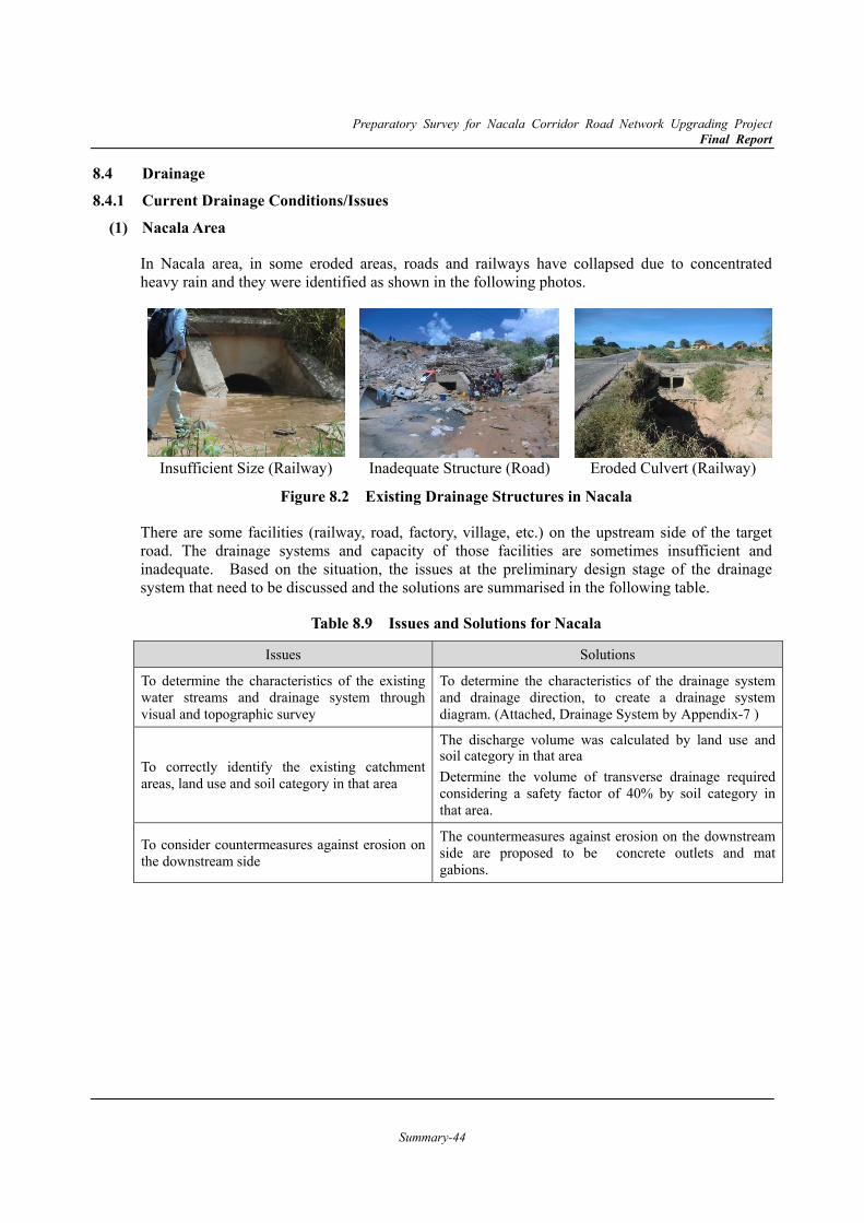
Preparatory Survey for Nacala Corridor Road Network Upgrading Project Final Report
Summary-44
8.4 Drainage 8.4.1 Current Drainage Conditions/Issues
Nacala Area (1)
In Nacala area, in some eroded areas, roads and railways have collapsed due to concentrated heavy rain and they were identified as shown in the following photos.
Insufficient Size (Railway) Inadequate Structure (Road) Eroded Culvert (Railway)
Figure 8.2 Existing Drainage Structures in Nacala
There are some facilities (railway, road, factory, village, etc.) on the upstream side of the target road. The drainage systems and capacity of those facilities are sometimes insufficient and inadequate. Based on the situation, the issues at the preliminary design stage of the drainage system that need to be discussed and the solutions are summarised in the following table.
Table 8.9 Issues and Solutions for Nacala
Issues Solutions
To determine the characteristics of the existing water streams and drainage system through visual and topographic survey
To determine the characteristics of the drainage system and drainage direction, to create a drainage system diagram. (Attached, Drainage System by Appendix-7 )
To correctly identify the existing catchment areas, land use and soil category in that area
The discharge volume was calculated by land use and soil category in that area Determine the volume of transverse drainage required considering a safety factor of 40% by soil category in that area.
To consider countermeasures against erosion on the downstream side
The countermeasures against erosion on the downstream side are proposed to be concrete outlets and mat gabions.
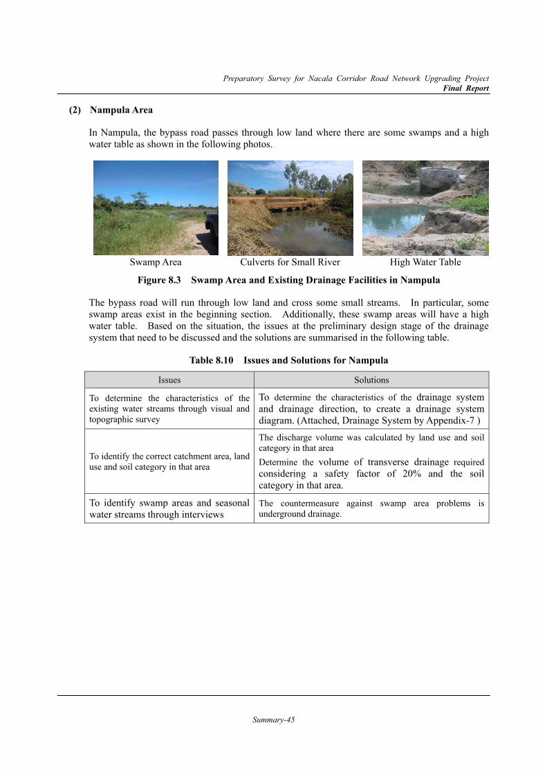
Preparatory Survey for Nacala Corridor Road Network Upgrading Project Final Report
Summary-45
Nampula Area (2)
In Nampula, the bypass road passes through low land where there are some swamps and a high water table as shown in the following photos.
Swamp Area Culverts for Small River High Water Table
Figure 8.3 Swamp Area and Existing Drainage Facilities in Nampula
The bypass road will run through low land and cross some small streams. In particular, some swamp areas exist in the beginning section. Additionally, these swamp areas will have a high water table. Based on the situation, the issues at the preliminary design stage of the drainage system that need to be discussed and the solutions are summarised in the following table.
Table 8.10 Issues and Solutions for Nampula
Issues Solutions
To determine the characteristics of the existing water streams through visual and topographic survey
To determine the characteristics of the drainage system and drainage direction, to create a drainage system diagram. (Attached, Drainage System by Appendix-7 )
To identify the correct catchment area, land use and soil category in that area
The discharge volume was calculated by land use and soil category in that area Determine the volume of transverse drainage required considering a safety factor of 20% and the soil category in that area.
To identify swamp areas and seasonal water streams through interviews
The countermeasure against swamp area problems is underground drainage.
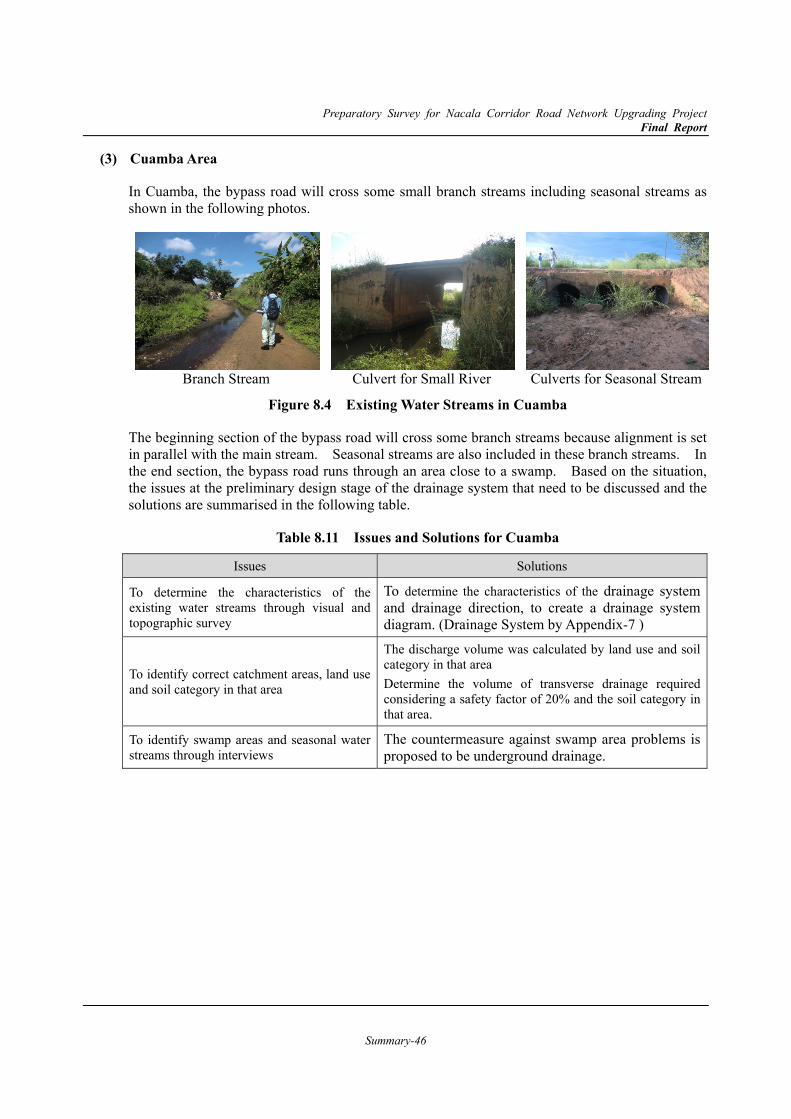
Preparatory Survey for Nacala Corridor Road Network Upgrading Project Final Report
Summary-46
Cuamba Area (3)
In Cuamba, the bypass road will cross some small branch streams including seasonal streams as shown in the following photos.
Branch Stream Culvert for Small River Culverts for Seasonal Stream
Figure 8.4 Existing Water Streams in Cuamba
The beginning section of the bypass road will cross some branch streams because alignment is set in parallel with the main stream. Seasonal streams are also included in these branch streams. In the end section, the bypass road runs through an area close to a swamp. Based on the situation, the issues at the preliminary design stage of the drainage system that need to be discussed and the solutions are summarised in the following table.
Table 8.11 Issues and Solutions for Cuamba
Issues Solutions
To determine the characteristics of the existing water streams through visual and topographic survey
To determine the characteristics of the drainage system and drainage direction, to create a drainage system diagram. (Drainage System by Appendix-7 )
To identify correct catchment areas, land use and soil category in that area
The discharge volume was calculated by land use and soil category in that area Determine the volume of transverse drainage required considering a safety factor of 20% and the soil category in that area.
To identify swamp areas and seasonal water streams through interviews
The countermeasure against swamp area problems is proposed to be underground drainage.
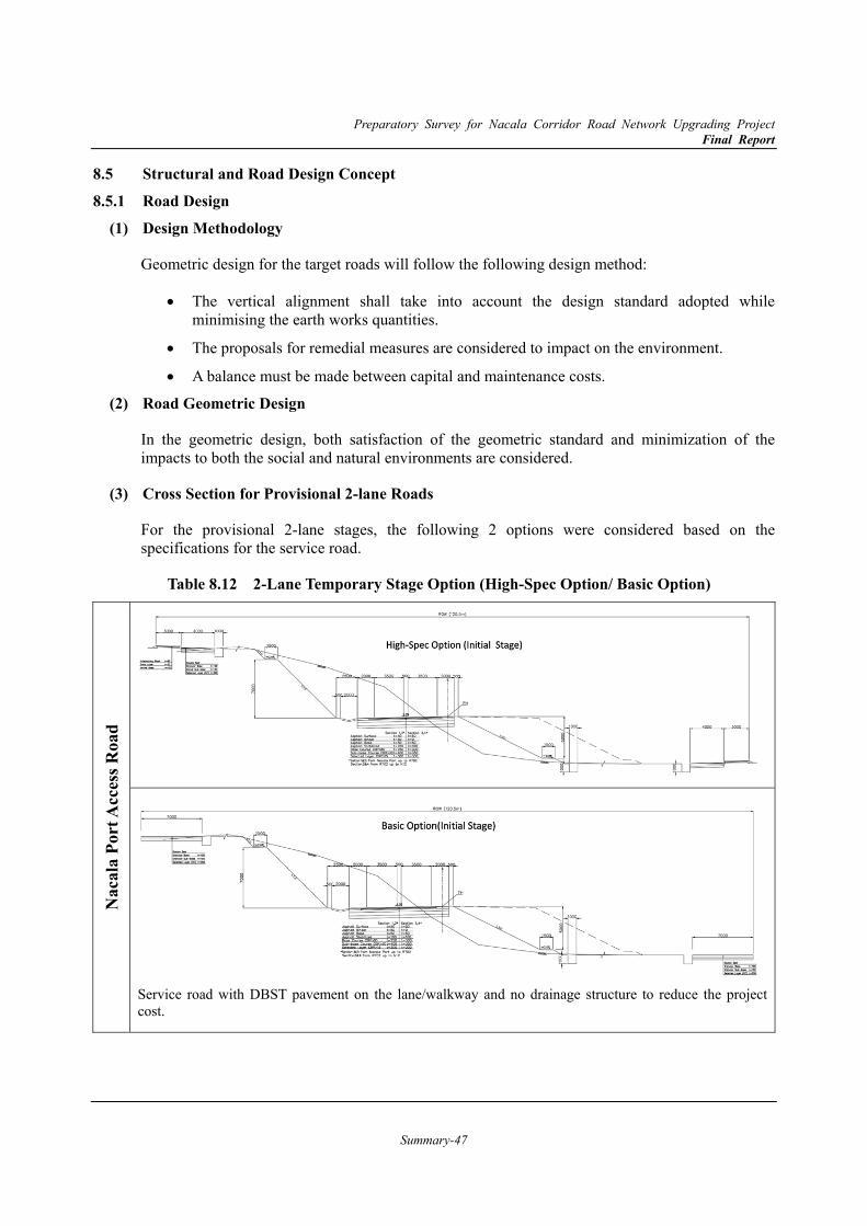
Preparatory Survey for Nacala Corridor Road Network Upgrading Project Final Report
Summary-47
8.5 Structural and Road Design Concept 8.5.1 Road Design
Design Methodology (1)
Geometric design for the target roads will follow the following design method:
The vertical alignment shall take into account the design standard adopted while minimising the earth works quantities.
The proposals for remedial measures are considered to impact on the environment.
A balance must be made between capital and maintenance costs.
Road Geometric Design (2)
In the geometric design, both satisfaction of the geometric standard and minimization of the impacts to both the social and natural environments are considered.
Cross Section for Provisional 2-lane Roads (3)
For the provisional 2-lane stages, the following 2 options were considered based on the specifications for the service road.
Table 8.12 2-Lane Temporary Stage Option (High-Spec Option/ Basic Option)
Nac
ala
Port
Acc
ess R
oad
Service road with DBST pavement on the lane/walkway and no drainage structure to reduce the project cost.
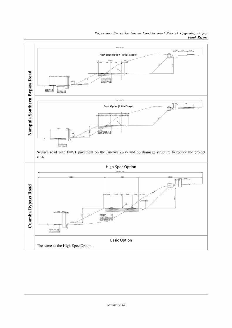
Preparatory Survey for Nacala Corridor Road Network Upgrading Project Final Report
Summary-48
Nam
pula
Sou
ther
n By
pass
Roa
d
Service road with DBST pavement on the lane/walkway and no drainage structure to reduce the project cost.
Cua
mba
Byp
ass R
oad
High-Spec Option
Basic Option The same as the High-Spec Option.

Preparatory Survey for Nacala Corridor Road Network Upgrading Project Final Report
Summary-49
8.5.2 Structural Design Applied Design Criteria for Bridges (1)
In principle, bridges design criteria shall be followed by the “SATCC Code of Practice for the Design of Road Bridges and Culverts” (hereinafter referred to as “SATCC”), based on the discussion with ANE DIPRO. Next table shows the criteria applied in the bridge design.
Table 8.13 Bridge Design Criteria
Item Unit Design Criteria Notes, References
Live Load According to NA, NB, NC loads SATCC-SECTION 2.6
Seismic Load vi(kh = 0.03) SATCC-SECTION 3.10
Wind Load Method A SATCC-SECTION 3.8
Flooding Load Water pressure + Debris load SATCC-SECTION 3.9
Earth Pressure Coulomb/Rankine Earth Pressure Upon material properties
Temperature Load 0°~49°C SATCC-SECTION 4.5
Construction Clearance: Earth Covering
Bridge Clearance m 5.5 4.5
Operation Stage Construction Stage
Railway Clearance m 7.5
Earth Covering m Roadway : 1.5 Sidewalk: 0.5 Rivers : 1.0
Install gabions in the river bed near the bridges
Concrete Nominal Resistance
PC Girder N/mm2 40
RC Slab N/mm2 30
Substructure N/mm2 30
Cast-in-place pile N/mm2 30
Rebar Nominal Resistance
Rebar N/mm2 450
Dead Load: Unit Weight
Plain Concrete kN/m3 24.0
Reinforced Concrete kN/m3 25.0
Asphalt kN/m3 21.0
Steel kN/m3 77.0
Backfill kN/m3 (19.0) Might change according to site survey
Soil kN/m3 (18.0) Might change according to site survey
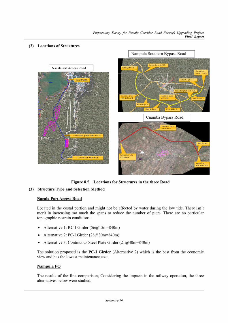
Preparatory Survey for Nacala Corridor Road Network Upgrading Project Final Report
Summary-50
Locations of Structures (2)
Figure 8.5 Locations for Structures in the three Road Structure Type and Selection Method (3)
Nacala Port Access Road
Located in the costal portion and might not be affected by water during the low tide. There isn’t merit in increasing too much the spans to reduce the number of piers. There are no particular topographic restrain conditions.
Alternative 1: RC-I Girder (56@15m=840m)
Alternative 2: PC-I Girder (28@30m=840m)
Alternative 3: Continuous Steel Plate Girder (21@40m=840m)
The solution proposed is the PC-I Girder (Alternative 2) which is the best from the economic view and has the lowest maintenance cost,
Nampula FO
The results of the first comparison, Considering the impacts in the railway operation, the three alternatives below were studied.
NacalaPort Access Road
Nampula Southern Bypass Road
Cuamba Bypass Road
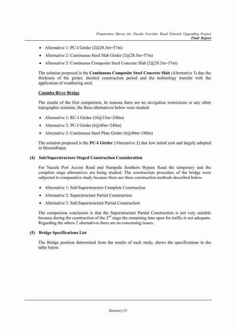
Preparatory Survey for Nacala Corridor Road Network Upgrading Project Final Report
Summary-51
Alternative 1: PC-I Girder ([email protected]=57m)
Alternative 2: Continuous Steel Slab Girder ([email protected]=57m)
Alternative 3: Continuous Composite Steel Concrete Slab ([email protected]=57m)
The solution proposed is the Continuous Composite Steel Concrete Slab (Alternative 3) due the thickness of the girder, shortest construction period and the technology transfer with the application of weathering steel.
Cuamba River Bridge
The results of the first comparison, In reasons there are no navigation restrictions or any other topographic restrains, the three alternatives below were studied.
Alternative 1: RC-I Girder (16@15m=240m)
Alternative 2: PC-I Girder (6@40m=240m)
Alternative 3: Continuous Steel Plate Girder (6@40m=240m)
The solution proposed is the PC-I Girder (Alternative 2) due low initial cost and largely adopted in Mozambique.
Sub/Superstructure Staged Construction Consideration (4)
For Nacala Port Access Road and Nampula Southern Bypass Road the temporary and the complete stage alternatives are being studied. The construction procedure of the bridge were subjected to comparative study because there are three construction methods described below.
Alternative 1: Sub/Superstructure Complete Construction
Alternative 2: Superstructure Partial Construction
Alternative 3: Sub/Superstructure Partial Construction
The comparison conclusion is that the Superstructure Partial Construction is not very suitable because during the construction of the 2nd stage the remaining lane open for traffic is not adequate. Regarding the others 2 alternatives there are no concerning issues.
Bridge Specifications List (5)
The Bridge position determined from the results of each study, shows the specifications in the table below.
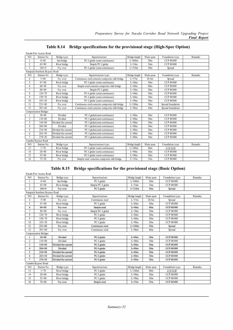
Preparatory Survey for Nacala Corridor Road Network Upgrading Project Final Report
Summary-52
Table 8.14 Bridge specifications for the provisional stage (High-Spec Option)
Table 8.15 Bridge specifications for the provisional stage (Basic Option)
Nacala Port Access RoadNO Station No Bridge type Superstructure Bridge length Main span Foundation type Remarks1 0+60 Sea bridge PC-I girder (semi-continuous) L=840m 30m CCP Φ10002 42+00 River bridge Simple PC-I girder L=34m 34m CCP Φ10003 104+0 Fry over PC-I girder (semi-continuous) L=210m 30m Spread
Nampula Southern Bypass RoadNO Station No Bridge type Superstructure type Bridge length Main span Foundation type Remarks4 5+00 Fry over Continuous steel-concrete composite slab bridge L=57m 28.5m Spread5 47+80 River bridge PC-I girder (semi-continuous) L=60m 30m CCP Φ10006 60+40 Fry over Simple steel-concrete composite slab bridge L=40m 40m CCP Φ10007 88+00 Fry over Simple PC-I girder L=30m 30m CCP Φ10008 126+70 River bridge PC-I girder (semi-continuous) L=60m 30m CCP Φ10009 158+70 River bridge PC-I girder (semi-continuous) L=60m 30m CCP Φ100010 183+30 River bridge PC-I girder (semi-continuous) L=90m 30m CCP Φ100011 221+00 Fry over Continuous steel-concrete composite slab bridge L=240m 30m Spread foundation12 301+60 Fry over Continuous steel-concrete composite slab bridge L=86m 44m Spread foundation
Compensation Bridges1 30+00 Divided PC-I girder(semi-continuous) L=80m 30m CCP Φ10002 118+00 Divided PC-I girder(semi-continuous) L=80m 30m CCP Φ10003 144+00 Divided the current PC-I girder(semi-continuous) L=80m 30m CCP Φ10004 204+00 Divided PC-I girder(semi-continuous) L=80m 30m CCP Φ10005 234+90 Divided the current PC-I girder(semi-continuous) L=80m 30m CCP Φ10006 263+30 Divided the current PC-I girder(semi-continuous) L=80m 30m CCP Φ10007 278+20 Divided the current PC-I girder(semi-continuous) L=80m 30m CCP Φ1000
Cuamba Bypass RoadNO Station No Bridge type Superstructure type Bridge length Main span Foundation type Remarks13 1+70 River bridge PC-I girder (semi-continuous) L=240m 40m 直接基礎14 20+00 River bridge PC-I girder (semi-continuous) L=90m 30m CCP Φ100015 52+00 River bridge PC-I girder (semi-continuous) L=90m 30m CCP Φ100016 72+20 Fry over Simple steel -concrete composite slab bridge L=35m 35m CCP Φ1000
Nacala Port Access RoadNO Station No Bridge type Superstructure Bridge length Main span Foundation type Remarks1 0+60 Sea bridge PC-I girder L=840m 30m CCP Φ10002 42+00 River bridge Simple PC-I girder L=34m 34m CCP Φ10003 104+0 Fry over PC-I girder L=210m 30m Spread
Nampula Southern Bypass RoadNO Station No Bridge type Superstructure Bridge length Main span Foundation type Remarks4 5+00 Fry over Continuous steel L=57m 28.5m Spread5 47+80 River bridge PC-I girder L=60m 30m CCP Φ10006 60+40 Fry over Simple steel L=40m 40m CCP Φ10007 88+00 Fry over Simple PC-I girder L=30m 30m CCP Φ10008 126+70 River bridge PC-I girder L=60m 30m CCP Φ10009 158+70 River bridge PC-I girder L=60m 30m CCP Φ100010 183+30 River bridge PC-I girder L=90m 30m CCP Φ100011 221+00 Fry over Continuous steel L=240m 30m Spread12 301+60 Fry over Continuous steel L=86m 44m Spread
Compensation Bridges1 30+00 Divided PC-I girder L=80m 30m CCP Φ10002 118+00 Divided PC-I girder L=80m 30m CCP Φ10003 144+00 Divided the current PC-I girder L=80m 30m CCP Φ10004 204+00 Divided PC-I girder L=80m 30m CCP Φ10005 234+90 Divided the current PC-I girder L=80m 30m CCP Φ10006 263+30 Divided the current PC-I girder L=80m 30m CCP Φ10007 278+20 Divided the current PC-I girder L=80m 30m CCP Φ1000
Cuamba Bypass RoadNO Station No Bridge type Superstructure Bridge length Main span Foundation type Remarks13 1+70 River bridge PC-I girder L=240m 40m 直接基礎14 20+00 River bridge PC-I girder L=90m 30m CCP Φ100015 52+00 River bridge PC-I girder L=90m 30m CCP Φ100016 72+20 Fry over Simple steel L=35m 35m CCP Φ1000
Preparatory Survey for Nacala Corridor Road Network Upgrading Project Final Report
Summary-53
8.6 Traffic Safety and Ancillary Facilities 8.6.1 Approach
It is now a requirement around the World for all roads to provide appropriate traffic safety facilities in view of the increase in traffic deaths. The Mozambique government, “especially ANE”, is also challenged to decrease traffic accidents by both enhancement of safety facilities and traffic safety education.
According to the concept of the target roads, these will have the bypass road function for heavy goods vehicles and through traffic with high speed service, whilst Non-Motorised Transport (NMT) infrastructure for vulnerable road users should be considered because these roads are located in peri-urban areas consisting of some small villages. Therefore the Survey Team will propose solutions involving systematic and effectual traffic safety facilities. Each facility proposed in the process of examination will be designed in the preliminary design.
8.6.2 Considerable Facilities
So far, the following fundamental road safety facilities will be considered for road users.
Traffic Safety Signs, Information Signs and Standard Worded Signs
Road Marking and Road Studs
Guardrails
Road Lighting
Space for Utilities
Bus Bays (if required)
In addition to these, the following facilities will be examined for user convenience, road protection, land development and local economic activities in the near future.
Footbridges
Weighbridges
Roadside Stations (Michinoeki) and/or Truck Terminals
Intelligent Transport System (ITS)
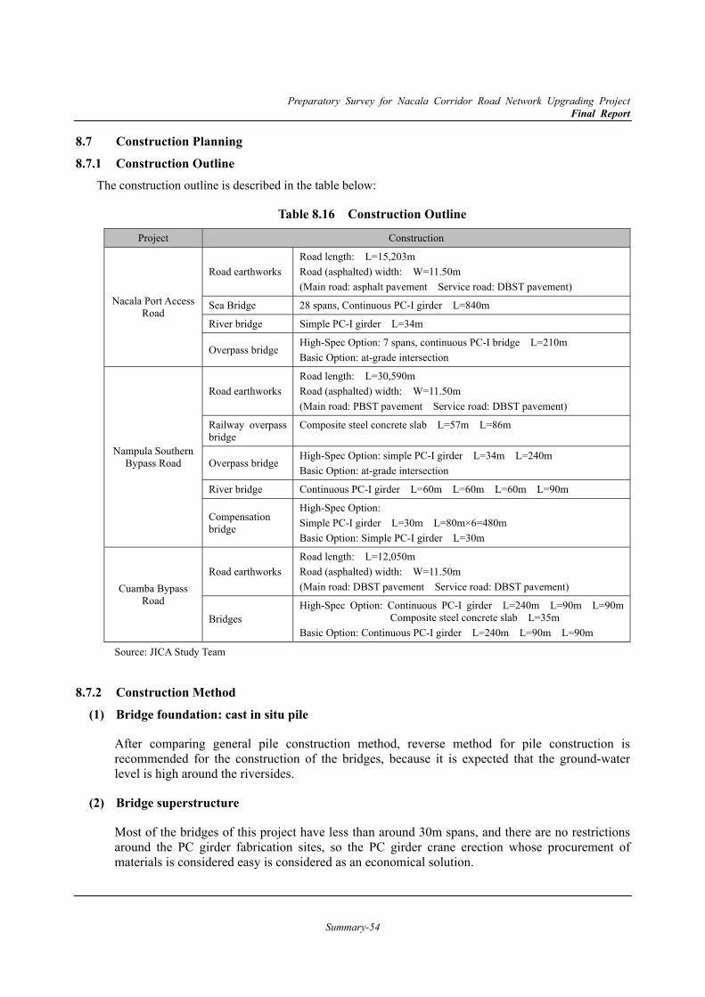
Preparatory Survey for Nacala Corridor Road Network Upgrading Project Final Report
Summary-54
8.7 Construction Planning 8.7.1 Construction Outline
The construction outline is described in the table below:
Table 8.16 Construction Outline
Project Construction
Nacala Port Access Road
Road earthworks Road length: L=15,203m Road (asphalted) width: W=11.50m (Main road: asphalt pavement Service road: DBST pavement)
Sea Bridge 28 spans, Continuous PC-I girder L=840m
River bridge Simple PC-I girder L=34m
Overpass bridge High-Spec Option: 7 spans, continuous PC-I bridge L=210m Basic Option: at-grade intersection
Nampula Southern Bypass Road
Road earthworks Road length: L=30,590m Road (asphalted) width: W=11.50m (Main road: PBST pavement Service road: DBST pavement)
Railway overpass bridge
Composite steel concrete slab L=57m L=86m
Overpass bridge High-Spec Option: simple PC-I girder L=34m L=240m Basic Option: at-grade intersection
River bridge Continuous PC-I girder L=60m L=60m L=60m L=90m
Compensation bridge
High-Spec Option: Simple PC-I girder L=30m L=80m×6=480m Basic Option: Simple PC-I girder L=30m
Cuamba Bypass Road
Road earthworks Road length: L=12,050m Road (asphalted) width: W=11.50m (Main road: DBST pavement Service road: DBST pavement)
Bridges High-Spec Option: Continuous PC-I girder L=240m L=90m L=90m
Composite steel concrete slab L=35m Basic Option: Continuous PC-I girder L=240m L=90m L=90m
Source: JICA Study Team
8.7.2 Construction Method Bridge foundation: cast in situ pile (1)
After comparing general pile construction method, reverse method for pile construction is recommended for the construction of the bridges, because it is expected that the ground-water level is high around the riversides.
Bridge superstructure (2)
Most of the bridges of this project have less than around 30m spans, and there are no restrictions around the PC girder fabrication sites, so the PC girder crane erection whose procurement of materials is considered easy is considered as an economical solution.
Preparatory Survey for Nacala Corridor Road Network Upgrading Project Final Report
Summary-55
Sea bridge (3)
For the construction of the sea bridge for Nacala Port Access Road a temporary bridge – as described previously – that can be constructed during the low tide, when the water depth is near 0m is necessary. Therefore, the use of barges is not considered necessary
Road construction (4)
For this project, because the roads to be constructed are all new, the access ways to the constructions zones will be from the intersections with the existing roads.
Railway overpass bridge (5)
For the bridges crossing the railway a composite steel concrete slab bridge was proposed to reduce the girder weight allowing the crane construction method, and also this type of bridge doesn’t require formworks, scaffolding or falsework allowing the operation of the railway as much as possible even during the construction period..
Construction yard, temporary site and future diversion space (6)
Because a construction yard is necessary for the construction (standard size: 10,000~30,000m2), the Study Team recommends that ANE create one or more, as necessary, within the ROW or other lands along the roads that belong to Mozambique and provide them for the contractor’s use.
8.7.3 Construction Schedule Plan
Mozambique weather can be defined as: rainy season (from Oct. to Mar.) and dry season (from Apr. to Sep.). There are sections inside wetlands or river areas that should be constructed during the dry season. However, the critical path is believed to include the bridge superstructures that can be built even during the rainy season. For shortening the construction period, it is supposed that earthworks and substructure works can be done in the first and last month of the rainy season, therefore it is supposed that the construction during Nov. to Feb. is not possible due to rain.
Nacala Port Access Road: 4 years (48 months) Road: 2 teams Bridge: 3 teams
Nampula Southern Bypass Road: 5 years (60 months) Road: 2 teams Bridge: 2 teams
Cuamba Bypass Road: 3 years (36 months) Road: 1 teams Bridge: 1 teams

Preparatory Survey for Nacala Corridor Road Network Upgrading Project Final Report
Summary-56
8.7.4 Procurement Plan Main materials procurement plan (1)
The origin of the main materials used in the construction of the main road and the bridges are shown in Table 8.17.
Table 8.17 Main materials procurement plan
Material Supplier Origin
Remarks Mozambique Japan or other country
Earthworks Earth ○ Crushed stone ○ Concrete Cement ○ Coarse aggregate ○ Fine aggregate ○ Sand ○ Fresh concrete ○ Rebar ○ Including anti rust materials Steel materials Steel plate ○ For steel girder H shapes ○ For temporary bridge, steel girder Steel pipe ○ For pile foundation Bolts, nuts, etc. ○ Welding materials ○ Coating material ○ Temporary materials Steel sheet ○ Marine cofferdam Lining plate ○ Marine temporary bridge H shapes ○ Marine temporary bridge pile Bent ○ Bridge materials Bearing pad ○ Expansion joint ○ Parapet ○ Stainless
Waterproof layer ○
PC Strands ○ Including anti-rust materials Road materials Illumination ○ Guardrail ○ Semaphore ○ Drainage materials ○ Combustible ○ Asphalt ○
Source: JICA Study Team

Preparatory Survey for Nacala Corridor Road Network Upgrading Project Final Report
Summary-57
Main equipment’s procurement plan (2)
The procurement plan for the main equipment is shown in Table 8.18.
Table 8.18 Main equipment procurement plan
Equipment Supplier Origin
Remarks Mozambique Japan or other country
Backhoe ○ 0.8m3, 1.4m3
Bulldozer ○ 21t, 32t
Rough terrain crane ○ ○ 25t
Truck crane ○ ○ 50t~150t
Crawler crane ○ ○ 55t
Concrete pump vehicle ○ 90~110m3/h
Pile driver ○ Cast in situ reverse pile
Vibro hammer ○ 60kw
Motor grader ○ 3.1m
Tire roller ○ 8~20t
Vibration roller ○ 3~4t
Road roller ○ 10~12t
Asphalt finisher ○ 2.4~6.0m
Dump truck ○ ○ 10t
PC Bridge Construction Equipment
○ Anti-rust materials
Source: JICA Study Team
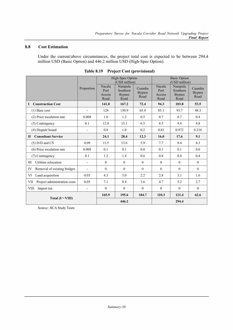
Preparatory Survey for Nacala Corridor Road Network Upgrading Project Final Report
Summary-58
8.8 Cost Estimation
Under the current/above circumstances, the project total cost is expected to be between 294.4 million USD (Basic Option) and 446.2 million USD (High-Spec Option).
Table 8.19 Project Cost (provisional)
Proportion
High-Spec Option (USD million)
Basic Option (USD million)
Nacala Port
Access Road
Nampula Southern Bypass Road
Cuamba Bypass Road
Nacala Port
Access Road
Nampula Southern Bypass Road
Cuamba Bypass Road
I Construction Cost 141.8 167.2 72.4 94.3 103.8 53.5
(1) Base cost - 128 150.9 65.4 85.1 93.7 48.3
(2) Price escalation rate 0.008 1.0 1.2 0.5 0.7 0.7 0.4
(3) Contingency 0.1 12.8 15.1 6.5 8.5 9.4 4.8
(4) Dispute board - 0.8 1.0 0.2 0.81 0.972 0.216
II Consultant Service 24.1 28.4 12.3 16.0 17.6 9.1
(5) D/D and CS 0.09 11.5 13.6 5.9 7.7 8.4 4.3
(6) Price escalation rate 0.008 0.1 0.1 0.0 0.1 0.1 0.0
(7) Contingency 0.1 1.2 1.4 0.6 0.8 0.8 0.4
III Utilities relocation - 0 0 0 0 0 0
IV Removal of existing bridges - 0 0 0 0 0 0
VI Land acquisition 0.03 4.3 5.0 2.2 2.8 3.1 1.6
VII Project administration costs 0.05 7.1 8.4 3.6 4.7 5.2 2.7
VIII Import tax - 0 0 0 0 0 0
Total (I~VIII) 165.9 195.6 184.7 110.3 121.4 62.6
446.2 294.4
Source: JICA Study Team
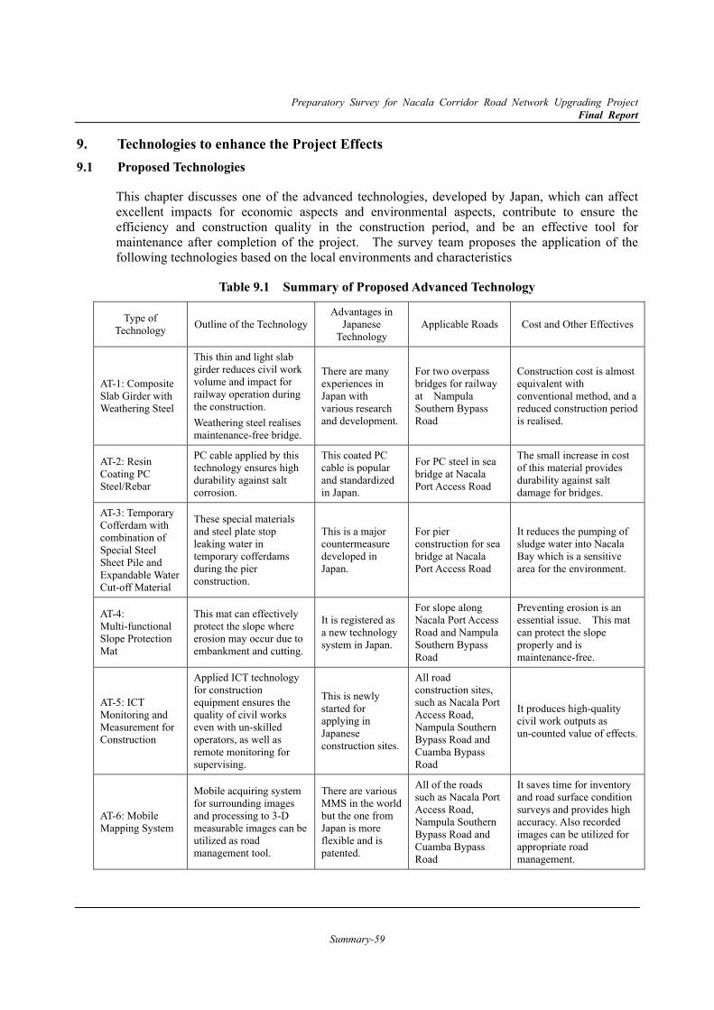
Preparatory Survey for Nacala Corridor Road Network Upgrading Project Final Report
Summary-59
9. Technologies to enhance the Project Effects 9.1 Proposed Technologies
This chapter discusses one of the advanced technologies, developed by Japan, which can affect excellent impacts for economic aspects and environmental aspects, contribute to ensure the efficiency and construction quality in the construction period, and be an effective tool for maintenance after completion of the project. The survey team proposes the application of the following technologies based on the local environments and characteristics
Table 9.1 Summary of Proposed Advanced Technology
Type of Technology Outline of the Technology
Advantages in Japanese
Technology Applicable Roads Cost and Other Effectives
AT-1: Composite Slab Girder with Weathering Steel
This thin and light slab girder reduces civil work volume and impact for railway operation during the construction. Weathering steel realises maintenance-free bridge.
There are many experiences in Japan with various research and development.
For two overpass bridges for railway at Nampula Southern Bypass Road
Construction cost is almost equivalent with conventional method, and a reduced construction period is realised.
AT-2: Resin Coating PC Steel/Rebar
PC cable applied by this technology ensures high durability against salt corrosion.
This coated PC cable is popular and standardized in Japan.
For PC steel in sea bridge at Nacala Port Access Road
The small increase in cost of this material provides durability against salt damage for bridges.
AT-3: Temporary Cofferdam with combination of Special Steel Sheet Pile and Expandable Water Cut-off Material
These special materials and steel plate stop leaking water in temporary cofferdams during the pier construction.
This is a major countermeasure developed in Japan.
For pier construction for sea bridge at Nacala Port Access Road
It reduces the pumping of sludge water into Nacala Bay which is a sensitive area for the environment.
AT-4: Multi-functional Slope Protection Mat
This mat can effectively protect the slope where erosion may occur due to embankment and cutting.
It is registered as a new technology system in Japan.
For slope along Nacala Port Access Road and Nampula Southern Bypass Road
Preventing erosion is an essential issue. This mat can protect the slope properly and is maintenance-free.
AT-5: ICT Monitoring and Measurement for Construction
Applied ICT technology for construction equipment ensures the quality of civil works even with un-skilled operators, as well as remote monitoring for supervising.
This is newly started for applying in Japanese construction sites.
All road construction sites, such as Nacala Port Access Road, Nampula Southern Bypass Road and Cuamba Bypass Road
It produces high-quality civil work outputs as un-counted value of effects.
AT-6: Mobile Mapping System
Mobile acquiring system for surrounding images and processing to 3-D measurable images can be utilized as road management tool.
There are various MMS in the world but the one from Japan is more flexible and is patented.
All of the roads such as Nacala Port Access Road, Nampula Southern Bypass Road and Cuamba Bypass Road
It saves time for inventory and road surface condition surveys and provides high accuracy. Also recorded images can be utilized for appropriate road management.
Preparatory Survey for Nacala Corridor Road Network Upgrading Project Final Report
Summary-60
10. Project Evaluation 10.1 Economic Internal Rate of Return (EIRR)
The feasibility of the projects is evaluated from a viewpoint of the national economy, where the quantified economic benefits are compared with the economic cost of the project.
The economic benefit is defined as the difference of the social cost between “With Project” case and “Without Project” case. In this project, the social cost consists of vehicle operation cost (VOC) and travel time cost of passengers and freights. The economic cost consists of the initial cost, cost for upgrading to 4 lane and operation and management cost. In this study, 2 options of project cost are considered for each project, 1) High-spec option and 2) Basic option. Other assumption is set as follows.
1) Shadow Rate : 0.8811
2) Construction start year : from 2019 (Nacala, Nampula), 2020 (Cuamba)
3) Operation start year : 2024 (All Location)
4) 4 lanes operation start year : 2035 (Nacala, Nampula)
5) Project life : 30 years after the start of operation
6) Price : 2016 fixed price
7) Residual value : Nothing
8) Discount rate : 12 %
9) Exchange rate : 120.45 JPY/USD
Table 10.1 shows the results of sensitivity analysis of Economic Internal Rate of Return (EIRR). Additional cases are examined for the sensitivity analysis, cases of “2 lane operation without upgrading to 4 lane” in Nacala and Nampula, and cases of “postpone the operation start year until 2034” in Cuamba. Major findings are as follows.
EIRRs exceed 12% in almost all cases in Nacala. Only in the high-spec option “2→4 Lane” case, EIRR is lower than 12% if “Benefit -10%” or “Cost +10% and Benefit -10%”.
EIRRs exceed 12% in most cases in Nampula. In the high spec option, EIRR of “2→4 Lane” case and “2 Lane” case with “Cost +10% and Benefit -10%” are lower than 12%.
EIRR of the basic option for Cuamba Bypass Road is higher than 10% in case the operation start in 2034, but EIRR is lower than 12% in any case.
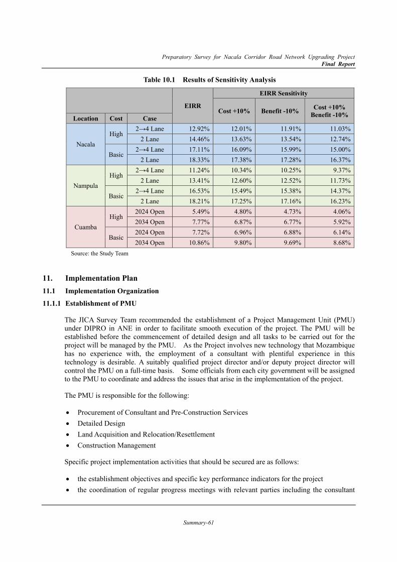
Preparatory Survey for Nacala Corridor Road Network Upgrading Project Final Report
Summary-61
Table 10.1 Results of Sensitivity Analysis
EIRR
EIRR Sensitivity
Cost +10% Benefit -10% Cost +10% Benefit -10%Location Cost Case
Nacala High
2→4 Lane 12.92% 12.01% 11.91% 11.03%2 Lane 14.46% 13.63% 13.54% 12.74%
Basic 2→4 Lane 17.11% 16.09% 15.99% 15.00%
2 Lane 18.33% 17.38% 17.28% 16.37%
Nampula High
2→4 Lane 11.24% 10.34% 10.25% 9.37%2 Lane 13.41% 12.60% 12.52% 11.73%
Basic 2→4 Lane 16.53% 15.49% 15.38% 14.37%
2 Lane 18.21% 17.25% 17.16% 16.23%
Cuamba High
2024 Open 5.49% 4.80% 4.73% 4.06%2034 Open 7.77% 6.87% 6.77% 5.92%
Basic 2024 Open 7.72% 6.96% 6.88% 6.14%2034 Open 10.86% 9.80% 9.69% 8.68%
Source: the Study Team
11. Implementation Plan 11.1 Implementation Organization 11.1.1 Establishment of PMU
The JICA Survey Team recommended the establishment of a Project Management Unit (PMU) under DIPRO in ANE in order to facilitate smooth execution of the project. The PMU will be established before the commencement of detailed design and all tasks to be carried out for the project will be managed by the PMU. As the Project involves new technology that Mozambique has no experience with, the employment of a consultant with plentiful experience in this technology is desirable. A suitably qualified project director and/or deputy project director will control the PMU on a full-time basis. Some officials from each city government will be assigned to the PMU to coordinate and address the issues that arise in the implementation of the project.
The PMU is responsible for the following:
Procurement of Consultant and Pre-Construction Services Detailed Design Land Acquisition and Relocation/Resettlement Construction Management
Specific project implementation activities that should be secured are as follows:
the establishment objectives and specific key performance indicators for the project the coordination of regular progress meetings with relevant parties including the consultant
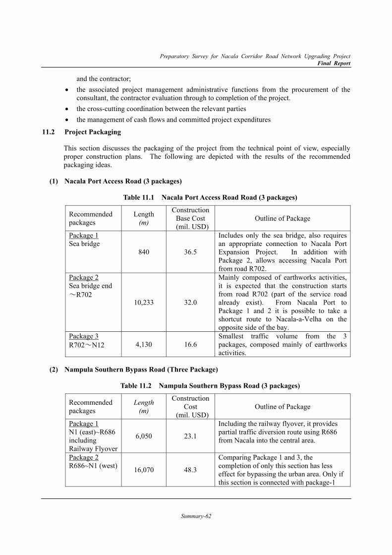
Preparatory Survey for Nacala Corridor Road Network Upgrading Project Final Report
Summary-62
and the contractor; the associated project management administrative functions from the procurement of the
consultant, the contractor evaluation through to completion of the project. the cross-cutting coordination between the relevant parties the management of cash flows and committed project expenditures
11.2 Project Packaging
This section discusses the packaging of the project from the technical point of view, especially proper construction plans. The following are depicted with the results of the recommended packaging ideas.
Nacala Port Access Road (3 packages) (1)
Table 11.1 Nacala Port Access Road Road (3 packages)
Recommended packages
Length (m)
Construction Base Cost
(mil. USD) Outline of Package
Package 1 Sea bridge
840 36.5
Includes only the sea bridge, also requires an appropriate connection to Nacala Port Expansion Project. In addition with Package 2, allows accessing Nacala Port from road R702.
Package 2 Sea bridge end ~R702
10,233 32.0
Mainly composed of earthworks activities, it is expected that the construction starts from road R702 (part of the service road already exist). From Nacala Port to Package 1 and 2 it is possible to take a shortcut route to Nacala-a-Velha on the opposite side of the bay.
Package 3 R702~N12 4,130 16.6
Smallest traffic volume from the 3 packages, composed mainly of earthworks activities.
Nampula Southern Bypass Road (Three Package) (2)
Table 11.2 Nampula Southern Bypass Road (3 packages)
Recommended packages
Length (m)
Construction Cost
(mil. USD) Outline of Package
Package 1 N1 (east)~R686 including Railway Flyover
6,050 23.1
Including the railway flyover, it provides partial traffic diversion route using R686 from Nacala into the central area.
Package 2 R686~N1 (west) 16,070 48.3
Comparing Package 1 and 3, the completion of only this section has less effect for bypassing the urban area. Only if this section is connected with package-1
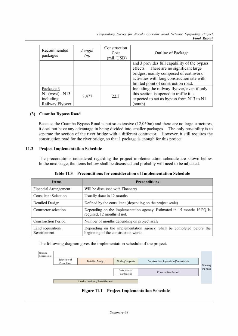
Preparatory Survey for Nacala Corridor Road Network Upgrading Project Final Report
Summary-63
Recommended packages
Length (m)
Construction Cost
(mil. USD) Outline of Package
and 3 provides full capability of the bypass effects. There are no significant large bridges, mainly composed of earthwork activities with long construction site with limited point of construction road.
Package 3 N1 (west) ~N13including Railway Flyover
8,477 22.3
Including the railway flyover, even if only this section is opened to traffic it is expected to act as bypass from N13 to N1 (south)
Cuamba Bypass Road (3)
Because the Cuamba Bypass Road is not so extensive (12,050m) and there are no large structures, it does not have any advantage in being divided into smaller packages. The only possibility is to separate the section of the river bridge with a different contractor. However, it still requires the construction road for the river bridge, so that 1 package is enough for this project.
11.3 Project Implementation Schedule
The preconditions considered regarding the project implementation schedule are shown below. In the next stage, the items bellow shall be discussed and probably will need to be adjusted.
Table 11.3 Preconditions for consideration of Implementation Schedule
Items Preconditions
Financial Arrangement Will be discussed with Financers
Consultant Selection Usually done in 12 months
Detailed Design Defined by the consultant (depending on the project scale)
Contractor selection Depending on the implementation agency. Estimated in 15 months If PQ is required, 12 months if not.
Construction Period Number of months depending on project scale
Land acquisition/ Resettlement
Depending on the implementation agency. Shall be completed before the beginning of the construction works
The following diagram gives the implementation schedule of the project.
Figure 11.1 Project Implementation Schedule
Land acquisition/ Resettlement
FinancialArraganemnt
Openingthe road
Selection ofConsultant
Detailed Design Bidding Supports Construction Supervison (Consultant)
Selection ofContractor Construction Period
Preparatory Survey for Nacala Corridor Road Network Upgrading Project Final Report
Summary-64
11.4 Management Plan for the Project Outline (1)
The 3 target routes are by-pass roads or a harbour access road located in the important points for traffic on Nacala international corridor. Therefore, a plan for suitable maintenance should be drawn up and also implemented, because it is important for the facilities to be well kept and it is necessary for traffic flow to be smooth as always. As mentioned, the Directorate of Maintenance (DIMAN) is in charge of the road maintenance in ANE. There are 3 categories of maintenance as follows in the maintenance of the target routes of this project.
Routine Maintenance
This includes removing those things which could be an obstacle for traffic such as garbage, debris, soil and stones, mowing on slopes, cleaning drainage facilities and etc. The frequency of routine maintenance varies from every 1 day to every 1 year and usually depends on some conditions such as traffic volume. However, it is desirable for the roads in this project to be cleaned and maintained at least every 1 week, because they are forecast to have a large amount of traffic in the future as the main roads. Moreover, a repair will be implemented as soon as possible if they find damages, such as Rutting and Crack.
Periodic Maintenance
It includes overall repairs in the mid-and-long term such as the whole repair of pavement and repaving, and a large-scale patching, sealing and etc. and it is supposed to be implemented about every 15-20 years in general. The traffic should be regulated on a comparably large scale by this maintenance.
Emergency Maintenance
It will be implemented when the road or bridge structures have a severe damage to be seen and need to be repaired as soon as possible because of natural disasters, big accidents and etc. This maintenance is necessary in unanticipated accidents such as Landslide and Damage to bridge because of the collision of large vehicles in Mozambique.
Proposed Management Framework and System (2)
As the international main roads will have been constructed on Nacala Corridor, ANE should formulate a management system focusing on them due to the increasing total length of roads to be maintained. To develop more efficient management system, the Study Team recommends the installation of the integrated system to utilize 3600 images, and comprehend damage situations and maintenance features with 3-dimension data as shown in Chapter 9.7. This will enable ANE headquarters to make the procurement of engineers, surveys and maintenance tasks more efficient than before, and naturally decrease the cost for the maintenance.
Cost Estimation for Maintenance (3)
The cost for maintenance in both the High-spec and Basic-spec plans at the time of starting the operation of the temporary two-lanes has been estimated in following way. This estimation result will be calculated as the cost in the economic analysis.
Annual cost for pavement maintenance: 3% of initial cost for pavement ( in distinction from main lanes to side lanes )
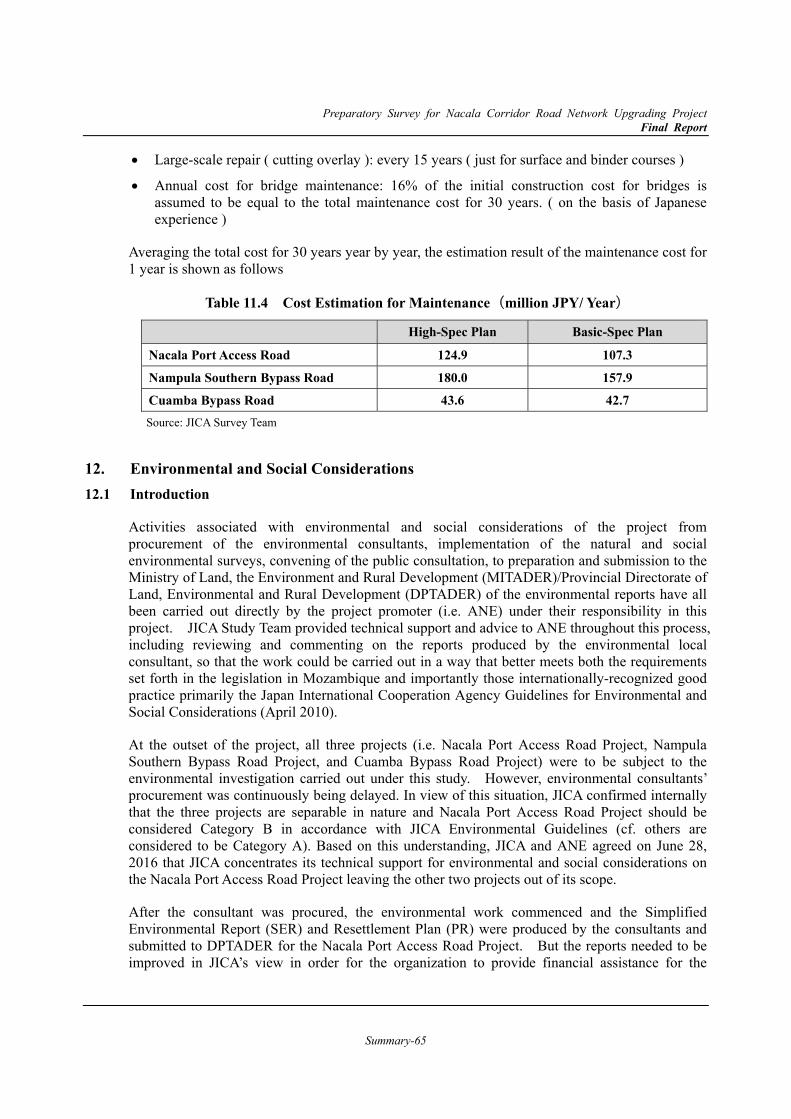
Preparatory Survey for Nacala Corridor Road Network Upgrading Project Final Report
Summary-65
Large-scale repair ( cutting overlay ): every 15 years ( just for surface and binder courses )
Annual cost for bridge maintenance: 16% of the initial construction cost for bridges is assumed to be equal to the total maintenance cost for 30 years. ( on the basis of Japanese experience )
Averaging the total cost for 30 years year by year, the estimation result of the maintenance cost for 1 year is shown as follows
Table 11.4 Cost Estimation for Maintenance(million JPY/ Year)
High-Spec Plan Basic-Spec Plan
Nacala Port Access Road 124.9 107.3 Nampula Southern Bypass Road 180.0 157.9 Cuamba Bypass Road 43.6 42.7 Source: JICA Survey Team
12. Environmental and Social Considerations 12.1 Introduction
Activities associated with environmental and social considerations of the project from procurement of the environmental consultants, implementation of the natural and social environmental surveys, convening of the public consultation, to preparation and submission to the Ministry of Land, the Environment and Rural Development (MITADER)/Provincial Directorate of Land, Environmental and Rural Development (DPTADER) of the environmental reports have all been carried out directly by the project promoter (i.e. ANE) under their responsibility in this project. JICA Study Team provided technical support and advice to ANE throughout this process, including reviewing and commenting on the reports produced by the environmental local consultant, so that the work could be carried out in a way that better meets both the requirements set forth in the legislation in Mozambique and importantly those internationally-recognized good practice primarily the Japan International Cooperation Agency Guidelines for Environmental and Social Considerations (April 2010).
At the outset of the project, all three projects (i.e. Nacala Port Access Road Project, Nampula Southern Bypass Road Project, and Cuamba Bypass Road Project) were to be subject to the environmental investigation carried out under this study. However, environmental consultants’ procurement was continuously being delayed. In view of this situation, JICA confirmed internally that the three projects are separable in nature and Nacala Port Access Road Project should be considered Category B in accordance with JICA Environmental Guidelines (cf. others are considered to be Category A). Based on this understanding, JICA and ANE agreed on June 28, 2016 that JICA concentrates its technical support for environmental and social considerations on the Nacala Port Access Road Project leaving the other two projects out of its scope.
After the consultant was procured, the environmental work commenced and the Simplified Environmental Report (SER) and Resettlement Plan (PR) were produced by the consultants and submitted to DPTADER for the Nacala Port Access Road Project. But the reports needed to be improved in JICA’s view in order for the organization to provide financial assistance for the

Preparatory Survey for Nacala Corridor Road Network Upgrading Project Final Report
Summary-66
project. JICA hence decided to step up its support and not only review the reports but make modifications to them to the extent feasible within the time and resources available. This was done by JICA Study Team in November, 2017 in Mozambique in close consultation with ANE and the local consultant. The reports produced as a result of this work are shown in Appendix 8 and 9.
Despite the improvements made by JICA Study Team to the SER and PR, some limitations still remain for especially the PR and the way in which the survey was carried out to produce it. These points will be elaborated in this section in hope that they will serve as a reference when carrying out a supplementary study for project implementation in the future. Following the Study Team’s observation, the current state in which Nacala Port Access Road Project lies as well as that of the projects in Nampula and Cuamba will be described in brief.
12.2 Points of Improvement for SER and PR
An evaluation and revision was made by the JICA Study Team of the content of the SER and PR prepared by the local consultant. The evaluation and major points considered to be improved into the future are shown in Table 12.1 for SER and Table 12.2 for PR, respectively.
Table 12.1 JICA Study Team’s Comments on the Simplified Environmental Report Items Comments and Way Forward (applicable page No.)
Components of the Project with Environmental Impacts
No notable point is made under this section.
Baseline Conditions of the Environment and Society
No notable point is made under this section.
Legislations and Organizations concerned with the Environment
No notable point is made under this section.
Alternatives of the Project No notable point is made under this section.
Scoping and TOR of the Environmental Survey
No notable point is made under this section.
Results of the Environmental Survey No notable point is made under this section.
Environmental Impact Assessment Under the EMP, discovery of historical and archeological traces are regarded as a positive impact of the project. However, the project site is not located in an area where such discovery is expected. In light of the low probability, it is considered more appropriate to judge that such impact is not foreseeable in order to avoid undue confusion. It should be noted that graves and worship places should be considered different from such historical sites (Section 7.1; P160).
Some numbers written in the SER are different from those written in the PR (cf. number of project-affected trees is said to be 22,984 in the SER but 22,971 according to the PR/Section 6.13.1; P143).
There is no forest to be seen in the project area. Hence, the use of ‘deforestation’ as a word to refer to vegetation clearance as part of the project impact is considered misleading (Section 6.3.1/P109-110; Section 6.20/P150; Section 7.3.2/P174).
Spillage in the ‘shipyard’ is considered to be out of the scope of this road project (*It should be considered part of Nacala Port Project). Accordingly, it should be deleted (Section 6.20/P157).
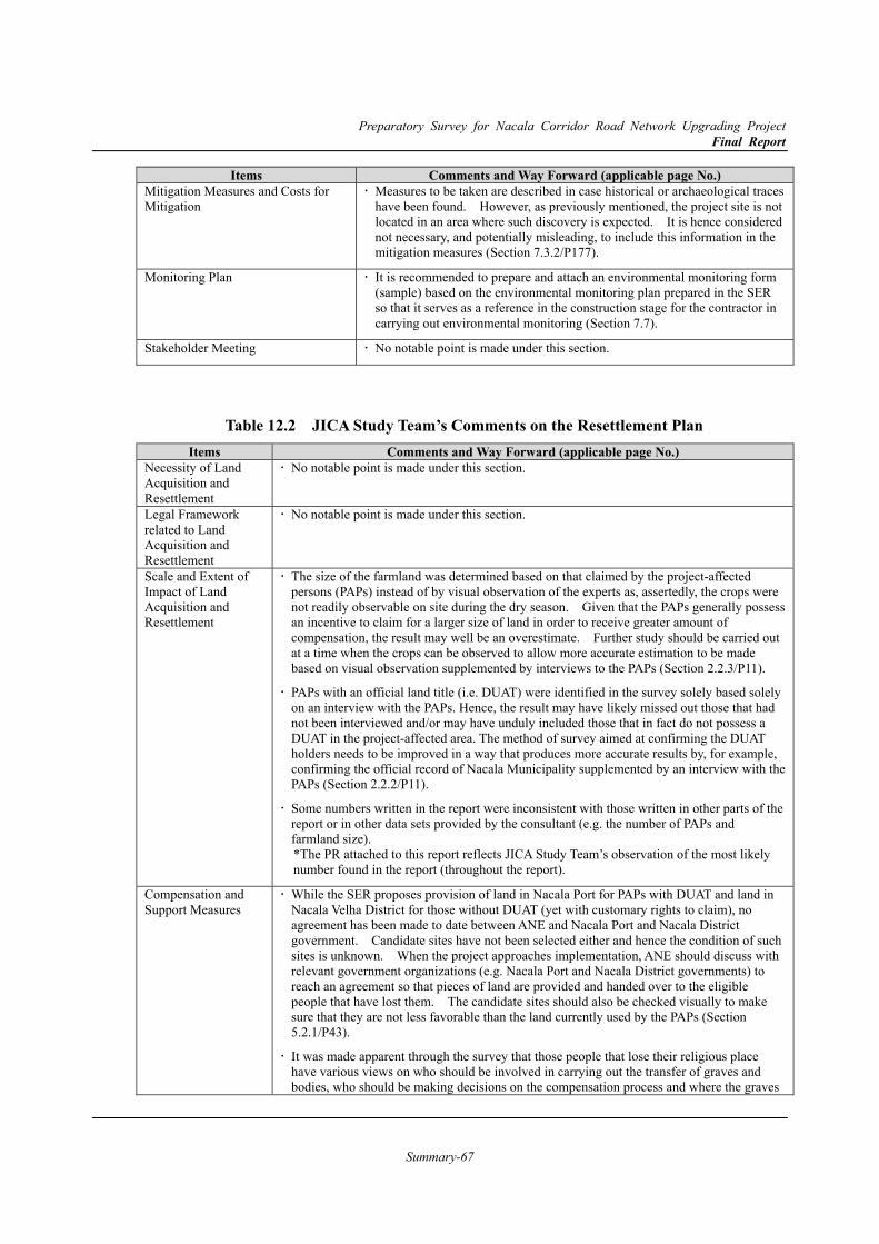
Preparatory Survey for Nacala Corridor Road Network Upgrading Project Final Report
Summary-67
Items Comments and Way Forward (applicable page No.) Mitigation Measures and Costs for Mitigation
Measures to be taken are described in case historical or archaeological traces have been found. However, as previously mentioned, the project site is not located in an area where such discovery is expected. It is hence considered not necessary, and potentially misleading, to include this information in the mitigation measures (Section 7.3.2/P177).
Monitoring Plan It is recommended to prepare and attach an environmental monitoring form (sample) based on the environmental monitoring plan prepared in the SER so that it serves as a reference in the construction stage for the contractor in carrying out environmental monitoring (Section 7.7).
Stakeholder Meeting No notable point is made under this section.
Table 12.2 JICA Study Team’s Comments on the Resettlement Plan Items Comments and Way Forward (applicable page No.)
Necessity of Land Acquisition and Resettlement
No notable point is made under this section.
Legal Framework related to Land Acquisition and Resettlement
No notable point is made under this section.
Scale and Extent of Impact of Land Acquisition and Resettlement
The size of the farmland was determined based on that claimed by the project-affected persons (PAPs) instead of by visual observation of the experts as, assertedly, the crops were not readily observable on site during the dry season. Given that the PAPs generally possess an incentive to claim for a larger size of land in order to receive greater amount of compensation, the result may well be an overestimate. Further study should be carried out at a time when the crops can be observed to allow more accurate estimation to be made based on visual observation supplemented by interviews to the PAPs (Section 2.2.3/P11).
PAPs with an official land title (i.e. DUAT) were identified in the survey solely based solely on an interview with the PAPs. Hence, the result may have likely missed out those that had not been interviewed and/or may have unduly included those that in fact do not possess a DUAT in the project-affected area. The method of survey aimed at confirming the DUAT holders needs to be improved in a way that produces more accurate results by, for example, confirming the official record of Nacala Municipality supplemented by an interview with the PAPs (Section 2.2.2/P11).
Some numbers written in the report were inconsistent with those written in other parts of the report or in other data sets provided by the consultant (e.g. the number of PAPs and farmland size). *The PR attached to this report reflects JICA Study Team’s observation of the most likely number found in the report (throughout the report).
Compensation and Support Measures
While the SER proposes provision of land in Nacala Port for PAPs with DUAT and land in Nacala Velha District for those without DUAT (yet with customary rights to claim), no agreement has been made to date between ANE and Nacala Port and Nacala District government. Candidate sites have not been selected either and hence the condition of such sites is unknown. When the project approaches implementation, ANE should discuss with relevant government organizations (e.g. Nacala Port and Nacala District governments) to reach an agreement so that pieces of land are provided and handed over to the eligible people that have lost them. The candidate sites should also be checked visually to make sure that they are not less favorable than the land currently used by the PAPs (Section 5.2.1/P43).
It was made apparent through the survey that those people that lose their religious place have various views on who should be involved in carrying out the transfer of graves and bodies, who should be making decisions on the compensation process and where the graves
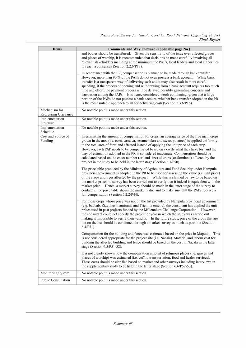
Preparatory Survey for Nacala Corridor Road Network Upgrading Project Final Report
Summary-68
Items Comments and Way Forward (applicable page No.) and bodies should be transferred. Given the sensitivity of the issue over affected graves and places of worship, it is recommended that decisions be made carefully involving all relevant stakeholders including at the minimum the PAPs, local leaders and local authorities to reach a consensus (Section 2.2.6/P13).
In accordance with the PR, compensation is planned to be made through bank transfer. However, more than 90 % of the PAPs do not even possess a bank account. While bank transfer is a transparent way of delivering cash and it may also result in more careful spending, if the process of opening and withdrawing from a bank account requires too much time and effort, the payment process will be delayed possibly generating concerns and frustration among the PAPs. It is hence considered worth confirming, given that a large portion of the PAPs do not possess a bank account, whether bank transfer adopted in the PR is the most suitable approach to all for delivering cash (Section 2.3.6/P16).
Mechanism for Redressing Grievance
No notable point is made under this section.
Implementation Structure
No notable point is made under this section.
Implementation Schedule
No notable point is made under this section.
Cost and Source of Funding
In estimating the amount of compensation for crops, an average price of the five main crops grown in the area (i.e. corn, cassava, sesame, okra and sweet potatoes) is applied uniformly to the total area of farmland affected instead of applying the unit price of each crop. However, each PAP needs to be compensated based on exactly what they have lost and the way of estimation adopted in the PR is considered inaccurate. Compensation should be calculated based on the exact number (or land size) of crops (or farmland) affected by the project in the study to be held in the latter stage (Section 6.3/P50).
The price table produced by the Ministry of Agriculture and Food Security under Nampula provincial government is adopted in the PR to be used for assessing the value (i.e. unit price) of the crops and trees affected by the project. While this is claimed by law to be based on the market price, no survey has been carried out to verify that it indeed is equivalent with the market price. Hence, a market survey should be made in the latter stage of the survey to confirm if the price table shows the market value and to make sure that the PAPs receive a fair compensation (Section 5.2.2/P44).
For those crops whose price was not on the list provided by Nampula provincial government (e.g. baobab, Zizyphus mauritania and Trichilia emetic), the consultant has applied the unit prices used in past projects funded by the Millennium Challenge Corporation. However, the consultant could not specify the project or year in which the study was carried out making it impossible to verify their validity. In the future study, price of the crops that are not on the list should be confirmed through a market survey as much as possible (Section 6.4/P51).
Compensation for the building and fence was estimated based on the price in Maputo. This is not considered appropriate for the project site (i.e. Nacala). Material and labour cost for building the affected building and fence should be based on the cost in Nacala in the latter stage (Section 6.5/P51-52).
It is not clearly shown how the compensation amount of religious places (i.e. graves and places of worship) was estimated (i.e. coffin, transportation, food and healer services). These costs should be clarified based on market and other surveys including interviews in the supplementary study to be held in the latter stage (Section 6.6/P52-53).
Monitoring System No notable point is made under this section.
Public Consultation No notable point is made under this section.
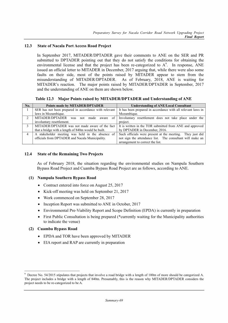
Preparatory Survey for Nacala Corridor Road Network Upgrading Project Final Report
Summary-69
12.3 State of Nacala Port Access Road Project
In September 2017, MITADER/DPTADER gave their comments to ANE on the SER and PR submitted to DPTADER pointing out that they do not satisfy the conditions for obtaining the environmental license and that the project has been re-categorized to A9. In response, ANE issued an official letter to MITADER in December, 2017 arguing that, while there were also some faults on their side, most of the points raised by MITADER appear to stem from the misunderstanding of MITADER/DPTADER. As of February, 2018, ANE is waiting for MITADER’s reaction. The major points raised by MITADER/DPTADER in September, 2017 and the understanding of ANE on them are shown below.
Table 12.3 Major Points raised by MITADER/DPTADER and Understanding of ANE No. Points made by MITADER/DPTADER Understanding of ANE/Local Consultant 1 SER has not been prepared in accordance with relevant
laws in Mozambique. It has been prepared in accordance with all relevant laws in Mozambique.
2 MITADER/DPTADER was not made aware of involuntary resettlement.
Involuntary resettlement does not take place under the project.
3 MITADER/DPTADER was not made aware of the fact that a bridge with a length of 840m would be built.
It is written in the TOR submitted from ANE and approved by DPTADER in December, 2016.
4 A stakeholder meeting was held in the absence of officials from DPTADER and Nacala Municipality.
Such officials were present at the meeting. They just did not sign the attendance list. The consultant will make an arrangement to correct the list.
12.4 State of the Remaining Two Projects
As of February 2018, the situation regarding the environmental studies on Nampula Southern Bypass Road Project and Cuamba Bypass Road Project are as follows, according to ANE.
Nampula Southern Bypass Road (1)
Contract entered into force on August 25, 2017 Kick-off meeting was held on September 21, 2017 Work commenced on September 28, 2017 Inception Report was submitted to ANE in October, 2017 Environmental Pre-Viability Report and Scope Definition (EPDA) is currently in preparation First Public Consultation is being prepared (*currently waiting for the Municipality authorities
to indicate the venue)
Cuamba Bypass Road (2)
EPDA and TOR have been approved by MITADER EIA report and RAP are currently in preparation
9 Decree No. 54/2015 stipulates that projects that involve a road bridge with a length of 100m of more should be categorized A. The project includes a bridge with a length of 840m. Presumably, this is the reason why MITADER/DPTADER considers the project needs to be re-categorized to be A.
Preparatory Survey for Nacala Corridor Road Network Upgrading Project Final Report
Summary-70
13. Findings and Recommendation 13.1 Findings
This Report summarizes the results of Feasibility Study for Nacala Corridor road network upgrading project which consists of the Nacala Port Access Road, Nampula Southern Bypass Road and Cuamba Bypass Road for future project. As the summary of the result, following points are the findings of the project:
1) The three road projects which include civil works for bypass road with bridges and frontage roads were designed as a technically and economically suitable and effective solution for the introduction of bypass roads by the ANE to alleviate future road traffic congestion due to heavy tracks as international corridor, and to form new urban residence along to the bypass roads. Followings shows the each result of economic viability;
a. Nacala Port Access road project: The project costs for the implementation of the project under both high and basic development levels will be economically covered by the large amount of benefits from the project road. It means the Project is the economical viable one, especially it is most recommendable project among three sections.
b. Nampula Southern Bypass Road project: The project costs for the implementation of the project by only basic development level will have economical viability. However, the high level development with future widening will not cover the costs, therefore, it should take into consideration of some additional effects and benefits from the integrated urban developments along the road.
c. Cuamba Bypass Road project: Among the three sections, this project faces the worst case for economic analysis due to less traffic volume for current and future traffic estimation. Since it is still under rehabilitation between Malema to Cuamba, so that the demand of traffic is not envisioned at this moment. However, this diversion route for avoiding through traffic such as international and intercity cargo may help to alleviate future traffic congestion and provide further potential of urban development.
2) In terms of operation and maintenance of the Project roads, it is envisioned that proper maintenance organization should be setup and appropriate budgets should be secured. In addition, because the heavy traffic volume is estimated to use these roads, safety measurements and devices are also required.
3) In terms of environment and social aspect, EIA study revealed that the potential impacts of the proposed project take place mainly during the construction stage, especially protecting the erosion of embankment and cutting area. Latest technical solutions for construction method proposed by the Study team will help to mitigate these impacts.
4) Social study revealed that a certain scale of agricultural land and graves at Nacala Port Access Road, and of residences along the Nampula Southern Bypass Road. However, the number of houses and commercial establishments to be relocated due to the project is relatively low, since these routes are mainly through un-developed area.
Therefore, the project is expected to be implemented as new bypass roads not to avoid future congestion, but to promote and form to future integrated urban development along the roads.
Preparatory Survey for Nacala Corridor Road Network Upgrading Project Final Report
Summary-71
13.2 Recommendations on the Project Nacala Port Access Road Project (1)
Since this road aims to connect directly to Nacala Port to ease heavy cargo traffic related to the port, it is highly recommended to coordinate with port expansion project which is implemented by JICA ODA loan. The connected sections and operational methods around the port are carefully designed during the detailed design stage.
In addition, the area along this road is planned as integrated development together with industrial park, shunting yards and track terminal to promote the industry of exporting and processing goods for the people in Nacala corridor. Therefore, it is recommended to coordinate with relevant stakeholders and institutions to share the same view for development along the road. Note that water and electricity are essential items for development, so that these utility lines can be installed in/along the roads.
For Nacala Port Access Road, considering the local environments and characteristics, the application of the following technologies, which is introduced in Chapter 9, is recommended.
Resin Coating Film (Coating) for Pre-stressed Concrete (PC) Steel/ Rebar (Epoxy Resin, Polyethylene Injection, etc.)
Temporary Cofferdam by combined use of Special Steel Sheet Pile and Expandable Water Cut-off Material
Multi-functional Slope Protection Mat
ICT Monitoring and Measurement for construction supervision of impacts around construction site
Pavement Management by Mobile Mapping System, including road assets management
Nampula Southern Bypass Road Project (2)
It is envisioned that the proposed bypass road runs at outside of urbanization area and will form the new urban area along the road in line with logistics and transport related facilities. This road can also provide a inter-city public transport terminal. Therefore, the coordination with urban development plan and inter-city transport related facilities are essential at the implementation stage.
In addition, there are two points where it flyovers the railway, the technical solution for bridges may affect the cost and construction period. Therefore, it is recommended that proposed Japanese technology such as steel-concrete composite slab girder bridge shall be applied to reduce the height of approach and its civil work's cost.
Cuamba Bypass Road (3)
Cuamba has not been urbanized and is envisioned once the Nacala corridor will be opened as intentional corridor. Since the North-side area made the limitation of urbanization and causes the difficulties of flood control, this road will play a role of opportunity to create the new urban area and protection barrier for its flooding. In addition, the west-side of road has enough vacant area for future industrial development for agro-processing to encourage the regional economy.
Preparatory Survey for Nacala Corridor Road Network Upgrading Project Final Report
Summary-72
Therefore, the integrated considerations together with urban planning and industrial development are recommended. The close communication with local government is an essential to realize the new urban are with this bypass road.
Environmental and Social Considerations (4)
1) Early Mobilization of the Supplementary Environmental Survey
Given that the project is not expected to be implemented any time soon, a supplementary survey is considered necessary to be carried out in the future before project implementation in order to update the ARAP10. Among others, it is particularly important to confirm and update the information on the people, land, crops, religious places and other assets that are expected to be affected by the project, and to estimate the amount of compensation to be made to the PAPs through a census, lost-asset inventory and socioeconomic survey. These surveys should be carried out with in mind the points raised in ’12.3 Points of Improvement for SER and PR and Way Forward’. In light of the volume of work needed for this environmental survey, it is recommended that commencement of the survey precedes other technical surveys that may be needed in order to secure enough time to complete it in a rigorous manner and to avoid any delay in commencement of the project.
2) Stakeholder Involvement based on Patience, Due Diligence and Sincerity
In light of the fact that the project involves impact on some sensitive issues (e.g. graves and worship places) and that consensus is far from being reached to date, it is considered particularly important for ANE to ensure that decisions related to this issue and others are made based on a sense of trust with, and support for the project from, the local people. While the project, as more or less any other infrastructure development projects, entails some negative impacts, the benefits accrued from the project are expected to largely outweigh the costs. This point should be clearly explained and understood by the local community. Consensus building with the community should not be carried out in haste. Instead, every step should be taken with patience, due diligence and sincerity. This best ensures ANE to earn people’s endorsement and avoid social problems from arising.
10 ARAP is considered valid for approximately two years.