morava corridor motorway project, serbia - multilateral
TRANSCRIPT
we have enough v
Morava Corridor Motorway Project, Serbia
Supplemental Lenders Information Package - Ecosystem Services Assessment
March 2021
Morava Corridor Motorway Project SLIP - Ecosystem Services Assessment
March 2021
Issue and Revision Record
Revision Date Originator Checker Approver Narrative
00 13/01/2021 J. Treweek;
B. Butcher;
L.Leigh-
Browne
Olivia
Vannello
Teresa
Cinar
Draft for issue
01 16/02/2021 J. Treweek;
B. Butcher; L.
Leigh-Browne
Olivia
Vannello
Teresa
Cinar
Second Draft for
issue
02 31/03/2021 J. Treweek;
B. Butcher; L.
Leigh-Browne
Olivia
Vannello
Teresa
Cinar
Final issue
Disclaimer
This document has been prepared for the titled project or named part thereof and should not be
relied upon or used for any other project without an independent check being carried out as to its
suitability and prior written authority of RINA Consulting being obtained. RINA Consulting accepts
no responsibility or liability for the consequence of this document being used for a purpose other
than those for which it was commissioned. Any person using or relying on the document for such
other purpose will by such use or reliance be taken to confirm his agreement to indemnify RINA
Consulting for all loss or damage resulting therefrom. RINA Consulting accepts no responsibility or
liability for this document to any party other than the person by whom it was commissioned.
As provided for in RINA Consulting’s proposal, to the extent that this report is based on information
supplied by other parties, RINA Consulting accepts no liability for any loss or damage suffered by
the client, whether contractual or tortious, stemming from any conclusions based on data supplied
by parties other than RINA Consulting and used by RINA Consulting in preparing this report.
Morava Corridor Motorway Project SLIP - Ecosystem Services Assessment
March 2021 3
Contents
List of Tables .................................................................................................................................... 5
List of Figures ................................................................................................................................... 6
Frequently Used Acronyms .............................................................................................................. 7
1 Introduction ................................................................................................................................ 8
1.1 Objectives of the Study ................................................................................................... 9
1.2 Contents of this Report.................................................................................................... 9
2 Approach and Methodology .................................................................................................... 10
2.1 Requirements and Standards ....................................................................................... 10
2.2 Guidance ....................................................................................................................... 10
2.3 Spatial Scope ................................................................................................................ 11
2.4 Definitions and key concepts ........................................................................................ 13
2.5 Sources of Information .................................................................................................. 14
2.5.1 ESIA and associated studies ............................................................................ 15
2.5.2 Meetings and consultation ................................................................................ 15
2.5.3 Spatial Data ....................................................................................................... 16
3 Identification of Relevant Ecosystem Services ....................................................................... 17
3.1 Ecosystems in the AOI .................................................................................................. 17
3.2 Ecosystems affected by the Project .............................................................................. 20
3.3 ES supplied and used in the AOI .................................................................................. 22
3.3.1 Provisioning Services ........................................................................................ 22
3.3.2 Regulating ES in the AOI .................................................................................. 23
3.3.3 Other ES............................................................................................................ 24
3.4 Beneficiaries can be confirmed ..................................................................................... 24
3.4.1 Freshwater from Rivers and Streams ............................................................... 25
3.4.2 Food from irrigated crops .................................................................................. 28
3.4.3 Protein from Fish ............................................................................................... 28
3.4.4 Flood protection to people, property and farmland ........................................... 29
3.4.5 Food and income from farming ......................................................................... 30
3.4.6 Wood from Forests and Woodlands ................................................................. 30
3.4.7 Wild food ........................................................................................................... 31
3.4.8 Bee-keeping ...................................................................................................... 32
3.4.9 Overview of beneficiaries .................................................................................. 32
4 Priority Ecosystem Services ................................................................................................... 35
4.1 Prioritisation Criteria ...................................................................................................... 35
4.2 Identification of Priority Ecosystem Services for Operational Performance of Project . 46
5 Baseline: priority ES in the absence of the project ................................................................. 47
5.1 Freshwater for drinking and domestic use .................................................................... 47
5.2 Freshwater supply for irrigation ..................................................................................... 49
5.3 Food, good nutrition and income from farming ............................................................. 52
5.4 Flood Protection to people, property and farmland....................................................... 52
Morava Corridor Motorway Project SLIP - Ecosystem Services Assessment
March 2021 4
5.5 Heating from firewood ................................................................................................... 53
5.6 Leisure activity of fishing and protein from fish caught from the River ......................... 55
5.7 Hunting and wild food .................................................................................................... 56
6 Assessment of Project-impacts on Priority ES ....................................................................... 57
6.1 Overview of Project-impacts ......................................................................................... 57
6.2 Changes in ES supply, use and benefit ........................................................................ 57
6.2.1 ES supply .......................................................................................................... 58
6.3 Changes in use/ benefit................................................................................................. 63
6.5 ES depended on by the Project .................................................................................... 69
6.5.1 Groundwater ..................................................................................................... 69
6.5.2 Earth Materials .................................................................................................. 69
7 Identification of Mitigation Measures ...................................................................................... 70
8 References .............................................................................................................................. 76
Tabl e of
Morava Corridor Motorway Project SLIP - Ecosystem Services Assessment
March 2021 5
List of Tables
Table 1-1: Summary of content ............................................................................................ 9
Table 3-1: Relationship between Ecosystems and EUNIS/ Corine Land Cover categories.
........................................................................................................................... 18
Table 3-2: Natural and Modified Habitat in the Environmental AOI (2U1K, 2020) ............ 20
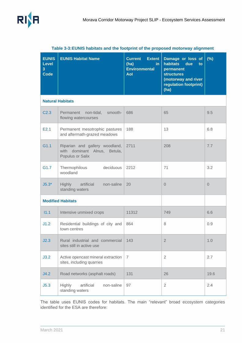
Table 3-3: EUNIS habitats and the footprint of the proposed motorway alignment .......... 21
Table 3-4: Provisioning services in the AOI (obtained from Community Relations Officers of
BEJV) ........................................................................................................................... 23
Table 3-5: Regulating services in the AOI ......................................................................... 23
Table 3-6: Sources of freshwater used by selected municipalities .................................... 26
Table 3-7: Number and % of households conducting activities to obtain ES (ESIA Chapter
5) ........................................................................................................................... 33
Table 4-1: ES Prioritisation ................................................................................................. 37
Table 5-1: Settlements using groundwater sources for fresh water.
........................................................................................................................... 48
Table 5-2: Use of the River for irrigation ............................................................................ 50
Table 5-3: Agricultural land within AOI ............................................................................... 52
Table 5-4: Settlements where all households use firewood for heating ............................ 53
Table 6-1: direct physical footprint of the Project on ecosystems supplying priority ES* .. 58
Table 6-2: Direct physical footprint of the Project on EUNIS habitat types using the buffer
zone applied by TBC. ..................................................................................................................... 59
Table 6-3: Summary of Project-related changes and potential ES impacts ...................... 64
Table 6-4: Amount of water used during the construction of the project ........................... 69
Table 6-5: Amount of “earth” materials used during the construction of the project ......... 69
Table 7-1: Summary of mitigation measures ..................................................................... 72
Morava Corridor Motorway Project SLIP - Ecosystem Services Assessment
March 2021 6
List of Figures
Figure 2.1: ESA Spatial Scope extending environmental EOI by 2km ............................... 12
Figure 3.1: Ecosystems in the AOI (Corine Land Cover and EUNIS habitat mapping) ..... 18
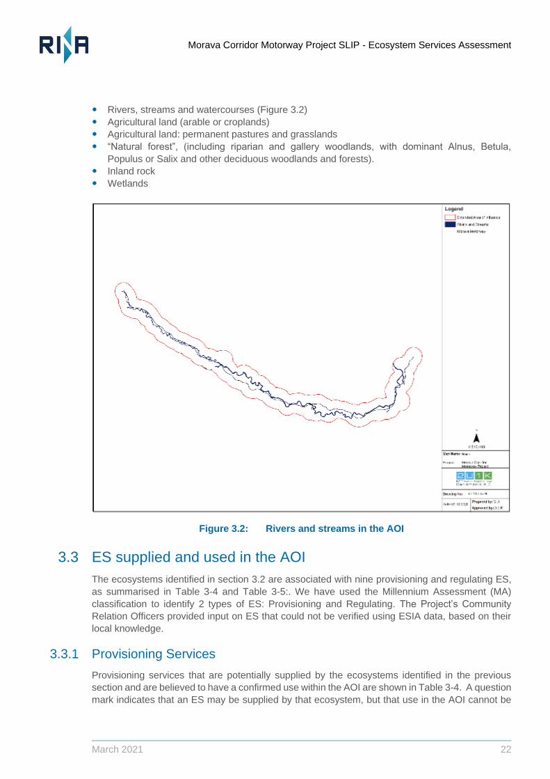
Figure 3.2: Rivers and streams in the AOI .......................................................................... 22
Figure 3.3: Potential beneficiaries of ES (population by settlement) Data source: (ESIA,
2020) ................................................................................................................. 25
Figure 3.4: Estimate of number of residents by settlement reliant on well water. Data source:
(ESIA, 2020) ...................................................................................................... 27
Figure 3.5: Estimate of number of residents by settlement that use irrigation. Data source:
(ESIA, 2020) ...................................................................................................... 28
Figure 3.6: Estimate of number of residents by settlement using the West Morava River for
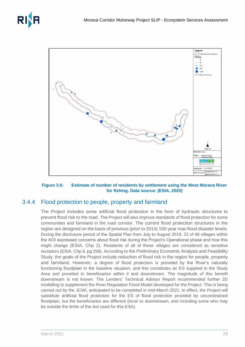
fishing. Data source: (ESIA, 2020).................................................................... 29
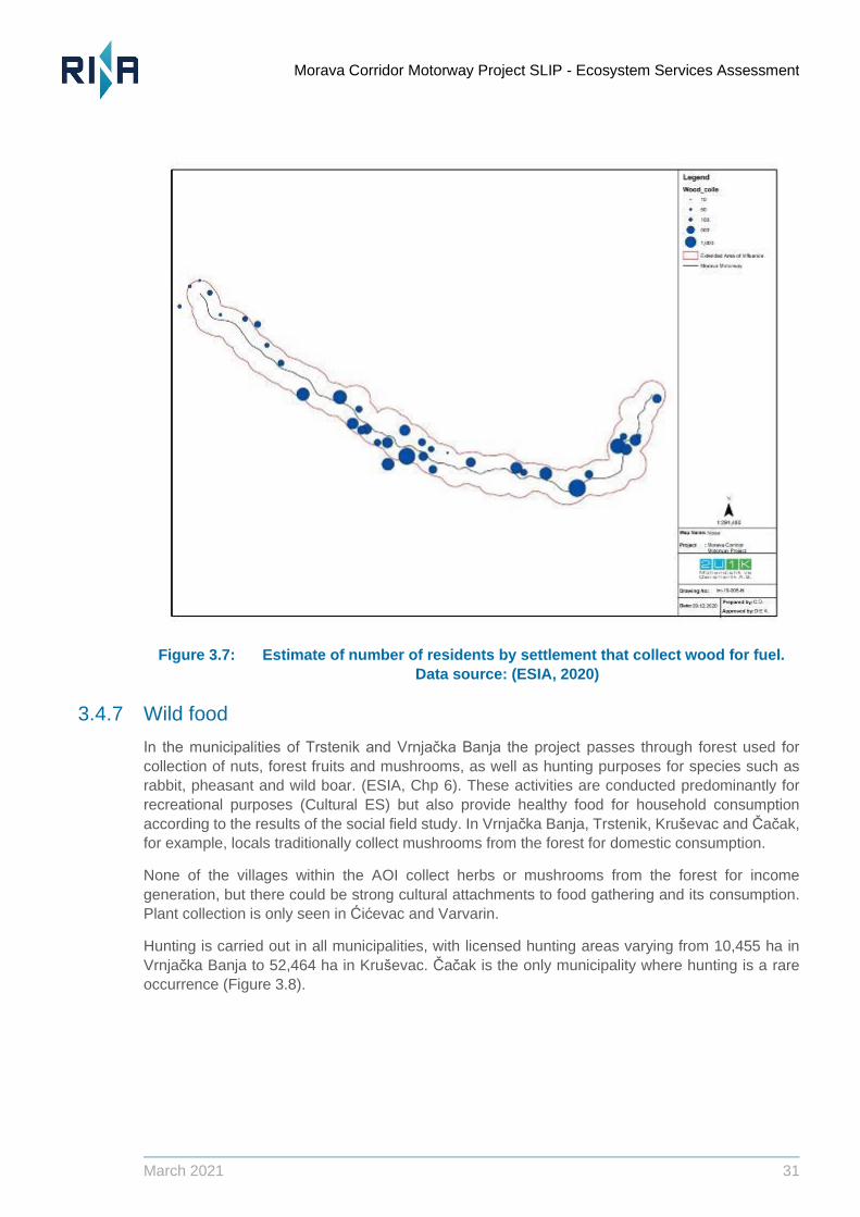
Figure 3.7: Estimate of number of residents by settlement that collect wood for fuel. Data
source: (ESIA, 2020) ......................................................................................... 31
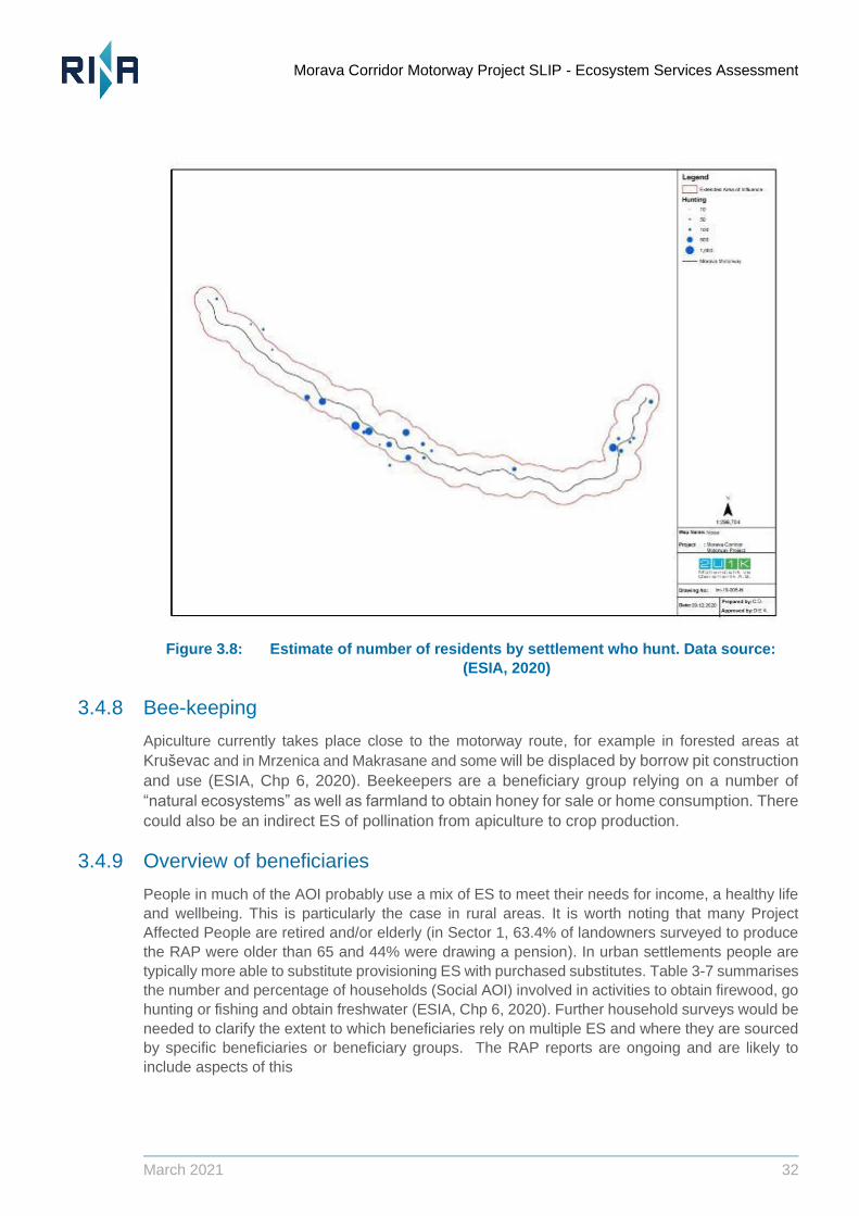
Figure 3.8: Estimate of number of residents by settlement who hunt. Data source: (ESIA,
2020) ................................................................................................................. 32
Figure 3.9: Framework diagram for Morava Corridor, arrows representing pathways for
people to derive benefits from ecosystems.
Figure 4.1: Prioritisation flowchart (note that a Priority ES is identified if the answer to question 3 is
“No”. We also included ES for which the answer to question 3 is “unknown” on a precautionary
basis, so that measures could be put in place to reduce uncertainty) ........................................... 36
Figure 5.1: Map showing the Vrnjci community detail Note: Quarry extent indicative only 55
Figure 6.1: Project impacts on ecosystems in section 3 (Sokolici to Obrva) ...................... 60
Figure 6.2: Project impacts on ecosystems in sections 2 and 3 (Obrva to Vrba) Note: Quarry
extent indicative only ...................................................................................................................... 60
Figure 6.3: Project impacts on ecosystems in section 2 (Sumarice to Trstenik) Note: Quarry
extent indicative only ...................................................................................................................... 61
Figure 6.4: Project impacts on ecosystems in section 2 (Trstenik to Kuklkin) .................... 61
Morava Corridor Motorway Project SLIP - Ecosystem Services Assessment
March 2021 7
Frequently Used Acronyms
AOI Project’s area of influence
BEJV Bechtel-ENKA Joint Venture
BMP Biodiversity Management Plan
CHA Critical Habitat Assessment
CoS Corridors of Serbia
EHS Environmental, Health and Safety
EIA Environmental Impact Assessment
EN Endangered
ES Ecosystem Service
ESA Ecosystem Service Assessment
ESA Ecosystem Services Assessment
ESHS Environmental, Social, Health and Safety
ESIA Environmental and Social Impact Assessment
ESMP Environmental and Social Management Plan
ESMS Environmental and Social Management System
IFC International Finance Corporation
IUCN International Union for Conservation of Nature
MA Millennium Assessment
MIGA Multilateral Investment Guarantee Agency
NNL No Net Loss
OHS Occupational Health and Safety
PS Performance Standard
RLRF Resettlement and Livelihood Restoration Framework
SLIP Supplementary Lender Information Package
TBC The Biodiversity Consultancy
Morava Corridor Motorway Project SLIP - Ecosystem Services Assessment
March 2021 8
1 Introduction
The Morava Corridor Motorway Project (the Project) is a 112 km motorway development in the
West Morava River Valley in the Republic of Serbia (Serbia). The Project is approximately 200 km
south of Belgrade city, in the West Morava River Valley, with the planned motorway running from
the Pojate village to Preljina near Cacak city. Section-1 provides a connection between Cicevac
and Varvarin municipalities and the city of Krusevac, Section-2 provides a connection between
Trstenik and Vrnjacka Banja municipalities and the city of Kraljevo and Section-3 provides a
connection between the cities of Kraljevo and Cacak.
The Project is jointly designed and built by Bechtel and ENKA (BEJV), on behalf of the Ministry of
Construction, Transport and Infrastructure and Corridors of Serbia (the Project owners).
Construction of the Project will require approximately 2,495 hectares (ha) of land for project facilities
such as construction campsites, borrow pits, material storage sites, asphalt plants and concrete
batching plants (ESIA, Chp1). Substantial modification of the Morava River and its floodplain is also
involved as part of the Project, including 18 hydrotechnical structures, ‘cut-offs’ (straightened,
channelised sections of river), revetments and reconstruction of embankments. River regulation
design is the responsibility of Jaroslav Cerni Water Institute (JCWI). Further indirect modifications
may occur.
Bechtel-ENKA joint venture (BEJV) is the contractor responsible for the design and construction of
the Project. An Environmental and Social Impact Assessment (ESIA) has been conducted for the
Project by 2U1K Engineering and Consultancy Inc. (hereafter referred to as 2U1K). RINA
Consulting S.p.A. (RINA) was commissioned to develop a Supplementary Lender Information
Package (SLIP) to address specific lender requirements, including the requirement to conduct an
Ecosystem Services Assessment (ESA) (this document).
The Morava River Corridor is Natural Habitat, based on the IFC PS6 definitions and supports
threatened or priority ecosystems and biodiversity of national importance, as indicated in the Critical
Habitat Assessment conducted for the Project (TBC, 2020). People living in and near the corridor
benefit from Ecosystem Services (ES) to obtain food, fresh water supply, enjoyment of traditional
rural activities such as hunting, fishing and collection of wild foods and a degree of protection from
flooding. Decline in ES-supply or use/access due to the Project could therefore affect the livelihoods
or wellbeing of people living in the project affected area. The Project could exacerbate existing
pressures on ecosystems supplying services or introduce new pressures.
The ESA was desk-based and did not include any direct engagement with users or beneficiaries
of ES but results of stakeholder engagement that took place as part of the ESIA process by 2U1K
were used. The ESA also drew on the results of consultations carried out as part of the Informed
Consultation and Participation (ICP) for river regulation and operational noise conducted by RINA,
the Biodiversity Offset Strategy Workshop conducted by TBC and the Resettlement Action Plan
(RAP) developed by ARUP. Ecosystem services were not the primary objective of these
consultations, but relevant discussions took place. This report addresses potential impacts of the
Project on ES, in accordance with financial lenders’ requirements (UKEF, JPM and MIGA), to the
extent possible based on available data and information.
Morava Corridor Motorway Project SLIP - Ecosystem Services Assessment
March 2021 9
1.1 Objectives of the Study
The ESA aims to identify how the productivity and capacity of ecosystems to supply ES and the
ability of different people to use and access them may change as a result of the Project; then to
consider how these changes can be expected to play out in terms of people’s livelihoods or
wellbeing.
The Project has developed various environmental and social mitigation plans (including the
Resettlement and Livelihood Restoration Framework (RLRF) and Resettlement Action Plan) to
ensure that people and communities affected by the Project through physical or economic
displacement do not experience any significant economic or social impact. The ESA identifies
requirements for mitigation to maintain the productivity of ecosystems supplying ES to people or to
maintain the benefits derived where these are not already addressed through existing management
or mitigation arrangements. It is assumed that existing plans address or mitigate for changing
access to agricultural land and other livelihood impacts, however further specific interventions may
be needed to ensure that people and the project can continue to benefit from use of/ access to
priority ES.
1.2 Contents of this Report
This report presents the results of a desk-based ESA for the Morava Corridor of Serbia. Gaps in
data are identified and steps needed to fill them are suggested.
Table 1-1: Summary of content
Section Summary of Content
1 (this section) Introduces the report, provides brief information on the background to the
assessment and lists the objectives.
2 Summarises the approach and methods used to undertake the ESA,
including information sources, guidance and standards, spatial scope, an
explanation of the approach used to identify and classify ecosystems and
an outline of key terms and definitions.
3 Identifies “relevant ecosystem services” based on the ecosystem types
that are represented in the AOI and a review of ES supplied by those
ecosystems for which there are confirmed uses (within the AOI or
downstream)
4 A determination of priority ES (ES on which users or beneficiaries depend
strongly, with limited access to acceptable alternatives)
5 Baseline based on available information, describing levels of use and
benefit in the absence of the Project
6 Anticipated changes in priority ES as a result of the Project.
7 Mitigation measures.
Morava Corridor Motorway Project SLIP - Ecosystem Services Assessment
March 2021 10
2 Approach and Methodology
2.1 Requirements and Standards
In accordance with the Terms of Reference, this ESA was conducted in accordance with IFC
Performance Standard 6 (PS6) and its Guidance Note (GN6), which MIGA and UKEF align with.
IFC’s PS6 was updated in 2012 and the accompanying guidance in 2019 (IFC 2012, 2019). These
documents refer to the need to maintain the capacity of ecosystems to supply services and the
levels of benefit derived. The ESA also needs to ensure that the Project’s dependencies on ES for
planned operational performance can be met.
2.2 Guidance
The Terms of Reference for this ESA referred to use of WRI’s guidance on Ecosystem Services
Review for Impact Assessment (ESR and IA) (Landsberg et al. 2013). This provides step-by-step
guidance on how to address ES impacts and dependencies for third party users of ES and for
Projects depending on ES for their planned operational performance. To the extent possible with
existing data, the WRI Guidance has been followed for this review. The WRI outlines the following
6 steps:
Step 1
• Identify relevant services
Step 2
• Prioritise relevant services
Step 3
• Define Scope and information needs
Step 4
• Establish baseline for priority services
Step 5
• Assess project impacts and dependencies
Step 6
• Mitigate impacts, manage project dependencies
The WRI guidance is intended to inform ESIA scoping and provide input to stakeholder
engagement and data gathering from the beginning of the ESIA process: it suggests use of ES-
prioritisation workshops to conduct steps 1, 2 and 3, for example. This ESA is based on existing
data and information and has not included any direct stakeholder engagement. As a result, it has
been necessary to make certain assumptions regarding levels of dependence on ES and the
likely adequacy of livelihood restoration proposals.
Morava Corridor Motorway Project SLIP - Ecosystem Services Assessment
March 2021 11
The outputs of the ESR for IA include:
Identification of ecosystems supplying ES that will change as a result of the Project.
Ecosystem services supplied by these ecosystems.
Identification of ES users or beneficiaries.
Identification of Priority ES (for people affected by the project and for the project itself).
Assessment of project impacts and dependencies on priority ES.
Measures to mitigate project impacts and manage project dependencies on priority ES, for
inclusion in environmental and social management plans.
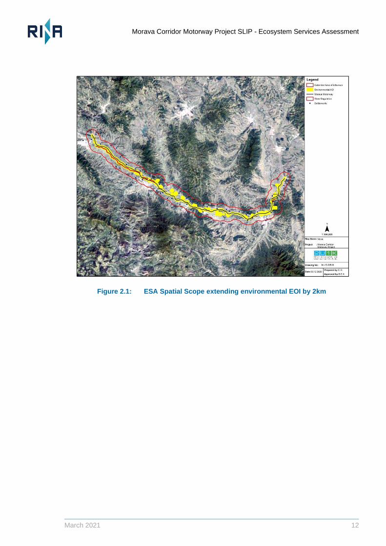
2.3 Spatial Scope
The spatial scope for ESA needs to incorporate areas where ES are supplied and also areas where
they are used. For ES such as water supply or flood attenuation, ES may be used at some distance
from where they are supplied.
The scale at which ES should be assessed may vary depending on the relationship between where
they are supplied and where they are used or accessed (adapted from Balmford et al., 2008), for
example
Local ES: when beneficiaries access the ES within the ecosystem that supplies it (e.g.,
mushroom collecting within a forest). Note that beneficiaries may live locally or travel
considerable distances when accessing local services.
Long-distance directional ES: when beneficiaries access the ES far from the ecosystem
supplying it, with services flowing in specific directions (e.g., people benefitting from flood
protection downstream as a result of flood attenuation within the Project area) and;
Globally distributed ecosystem services: when beneficiaries access the ecosystem service
anywhere irrespective of where the ecosystem supplying it is located (e.g., carbon
sequestration by forests).
The ESIA used an Environmental AOI which incorporates the Zapadna Morava River and the
surrounding area. As well as the proposed Motorway alignment, this includes locations of access
roads, quarries, asphalt and batch plants, maintenance areas, and construction camps, as well as
the limits of receptors such as surface- and groundwater that may be affected by the Project.
A Social AOI was also established for the ESIA which incorporates wider areas of indirect and
induced (socio-economic) impacts (but a map is not included in the ESIA).
The Environmental and Social AOIs were not designed explicitly to incorporate locations of ES
supply and use. For this ESA the Environmental AOI was buffered by an additional 2km (see figure
below) to incorporate ecosystems directly affected by the Project and the main users and
beneficiaries of the ES they supply. This means there is some difference in total study area between
this ESA and the Critical Habitat Assessment for the Project. The ESA study area does not
necessarily include all communities or beneficiaries that could experience a change in flood regime/
risk from the Project, but this cannot be confirmed until ongoing 2D modelling is completed.
Morava Corridor Motorway Project SLIP - Ecosystem Services Assessment
March 2021 12
Figure 2.1: ESA Spatial Scope extending environmental EOI by 2km
Morava Corridor Motorway Project SLIP - Ecosystem Services Assessment
March 2021 13
2.4 Definitions and key concepts
ES are the direct and indirect contributions made by ecosystems to human wellbeing and also to
project-performance.
The Millennium Assessment (MA) categorised ES into four main categories (MA, 2005). This ESA
focuses primarily on provisioning and regulating ES as required by relevant standards and
guidance. However, implications for supporting services were considered due to the presence of
Natural Habitat1 (per IFC PS6, 2012) and there are some important cultural services supplied and
used in the Study Area also.
(i) Provisioning services: goods or products obtained from ecosystems, such as food, timber,
fuelwood, fibres, and freshwater (for consumption, washing etc.),
(ii) Regulating services: contributions to human well-being arising from an ecosystem’s
control of natural processes, such as climate regulation, disease control, erosion
prevention, water flow regulation, and protection from natural hazards,
(iii) Cultural services: non-material contributions of ecosystems to human well-being, such as
recreation, spiritual values, and aesthetic enjoyment,
(iv) Supporting services: natural processes, such as nutrient cycling and primary production,
that maintain ecological and evolutionary processes.
To represent both the environmental and social components of ES, we need to differentiate
between ecosystems themselves (their different types and conditions), the services they provide,
the different ways in which these are used by particular beneficiaries and benefits obtained as a
result of this use. The definitions below are taken from the MEA (2005) and WRI (2013).
An ecosystem is a dynamic complex of plant, animal, and microorganism communities and their
nonliving environment interacting as a functional unit (UN, 1992). When the environmental
practitioners are using finer units of analysis than ecosystems (e.g., habitat or land cover / use
classes), these units of analysis can be used as long as these units can be linked to the supply
of ecosystem services.
Ecosystem service supply is the maximum level of ecosystem service that the ecosystem can
provide without undermining its future provisioning capacity (adapted from UNEP-WCMC.,
2011 and Kareiva et al., 2011).
1 E-DNA studies were completed after the ESA was conducted which confirmed that the Morava River is
Natural Habitat per IFC PS6 criteria, and that Sections 1 and 2 are Critical Habitat for Striped nerite.
Morava Corridor Motorway Project SLIP - Ecosystem Services Assessment Morava Corridor Motorway Project, Serbia
Morava Corridor Motorway Project SLIP - Ecosystem Services Assessment Morava Corridor Motorway Project, Serbia
March 2021 13
Morava Corridor Motorway Project SLIP - Ecosystem Services Assessment
March 2021 14
Ecosystem service use is the level of ecosystem service actually consumed or enjoyed by the
beneficiaries (adapted from Boyd and Banzhaf, 2007). It can be consumptive (e.g., agriculture
crops for food, water for drinking) or non-consumptive (e.g., recreational and spiritual
appreciation of a landscape or wildlife, pollination of crops by bees).
Ecosystem service benefit is the gain in human wellbeing derived from the use of an ecosystem
service, often in combination with other inputs (e.g., labor and capital) (adapted from van
Oudenhoven et al., 2012).
This differentiation enables us to understand the various relationships between them.
Relationship between ecosystem and ecosystem service supply: Ecosystem service supply
depends on ecosystem type and condition. It is usually modelled based on ecological
production functions (Kareiva et al., 2011; NRC, 2005). For example, the type and condition of
agricultural land determines its inherent maximum productivity and crop yields; the type and
condition of vegetation cover determines its maximum soil retention; and the type and condition
of a forest determines its maximum sustainable timber yield. As a function of ecosystem type
and condition, changes in ecosystem service supply can be linear (e.g., decrease in freshwater
quality directly relates to the increased pollution of a river); or non-linear, where small
ecosystem change may have disproportionate effects on ecosystem service supply (e.g., small
additional nutrient loading leads to algal blooms and kills fish).
Relationship between ecosystem service supply and ecosystem service use at a given time:
The relationship (or absence thereof) between ecosystem service supply and use depends on
whether the use is consumptive or non-consumptive:
o When non-consumptive, ecosystem service use equates with ecosystem service
supply (e.g., the decrease in flooding events experienced by floodplain households is
equal to the maximum flood protection that the wetland, based on its type and condition,
can provide).
o When consumptive, ecosystem service use does not always have a direct relationship
with ecosystem service supply: if the level of use is below the level of supply, the
ecosystem service is being underexploited. Conversely, if the level of use exceeds the
level of supply, the ecosystem service is being overexploited. In the latter case, the
level of use undermines the capacity of the ecosystem to supply the service in the future
and is therefore unsustainable. When dealing with consumptive use, maximum
sustainable use is determined by ecosystem service supply, which in turn depends on
the type and condition of ecosystem.
Relationship between ecosystem service use and ecosystem service benefit: The relationship
between ecosystem service benefit and use can be linear or non-linear:
o In a linear relationship, the benefit is proportional to the use (e.g., the more floodwater
stored, the more the avoided real property damage).
o In a non-linear relationship, benefit and use are not proportional (e.g., the cleaner the
water, the healthier the population up to a certain water quality level beyond which an
increase in water quality leads to negligible gain in health).
2.5 Sources of Information
Available sources of information were reviewed to identify important gaps in data needed to support
development of an effective method for ESA. They included published literature, the ESIA report
Morava Corridor Motorway Project SLIP - Ecosystem Services Assessment
March 2021 15
and associated technical annexes and results of meetings and consultations. This includes
correspondence with 2U1K, JCWI and BEJV regarding specialist technical studies that have been
conducted for the Project or were ongoing when the ESA was conducted.
2.5.1 ESIA and associated studies
Morava Corridor Motorway Project Environmental and Social Impact Assessment Report
(2U1K, 2020, Chapters 1-10)
Morava Corridor Motorway Project Environmental and Social Impact Assessment Report Non-
Technical Summary (2U1K, Sep 2020).
Morava Corridor Motorway Project National Environmental Impact Assessment Report –
Sector-1 (RoS, 2019)
Morava Corridor Motorway Project National Environmental Impact Assessment Report –
Sector-8 (RoS, 2019)
Morava Corridor Motorway Project National Environmental Impact Assessment Report –
Sector-9 (RoS, 2019)
Morava Corridor Motorway Project Lender’s Technical Advisor Report (Ramboll, 2020)
Morava Corridor Motorway Project Gap Analysis Report (Ramboll, 2020)
Morava Corridor Motorway Project, Serbia. Supplementary Lenders Information Package –
Cultural Heritage Impact Assessment (CHIA)
• Critical Habitat Assessment, Morava Corridor Motorway Project (TBC, 2020)
• Updated Biodiversity Impact Assessment, Morava Corridor Motorway Project (TBC, 2020)
• Resettlement and Livelihood Restoration Framework for Morava Corridor Motorway Project
(2U1K, 2020
• Regulation of The Zapadna Morava River Within the Infrastructure Corridor of the E-761
Motorway Basic information and key viewpoints (JCWI, May 2020).
• Resettlement Action Plan Execution Plan (ARUP, 2020)
• Resettlement Action Plan- Sectors 1 and 3 (ARUP, 2021)
• Morava Corridor Motorway Project, Climate Change Risk Assessment (Ramboll, 2020).
• Various emails including discussions with 2U1K, emails from JCWI and technical information
from BEJV.
• Kmz, Shapefiles and technical documents for the route alignment, facilities and constraints
Informed Consultation and Participation Report for River Regulation Works. Report by RINA,
February 2021
2.5.2 Meetings and consultation
Results of stakeholder consultation carried out for the ESIA were used (as summarised in Chapter
5 of the ESIA) to identify ES-beneficiaries, as well as the extent to which the project can be
expected to impact the levels of benefit derived from a particular service.
Some additional consultations and meetings were held with Project engineering and environmental
consultants and specialists (JCWI, TBC, RINA and Arup) to discuss:
River regulation works and restoration plans, including proposals for borrow pits; how river flow
regime will be maintained and the rationale for removal of river meanders due to their close
proximity to the proposed motorway route (JCWI and RINA as part of the ICP process).
How the riverine environment will change and its implications for aquatic species and quality of
water abstracted by people in the catchment.
Biodiversity Offset strategy (workshop conducted by TBC).
Morava Corridor Motorway Project SLIP - Ecosystem Services Assessment
March 2021 16
Risks to local communities from flooding within the project and downstream due to river
modification, including shortening and straightening. Flood risk assessment in the river valley
is ongoing, using hydrological and hydraulic models, with a report anticipated in March. The
main emphasis is on flood protection for the motorway itself as well as management of erosion
risk, but it is understood that flood protection to communities is also being given further
consideration and it is assumed that the ongoing study will consider implications for
downstream settlements and land. Engineers state that the flood regime will remain the same,
but also that positive impacts are anticipated in terms of flood risk, suggesting the situation is
not entirely clear-cut. (ARUP).
2.5.3 Spatial Data
Figures included in this report are based on analysis of data contained in ESIA and other Lender
Support package documents and GIS layers supplied by the client.
Morava Corridor Motorway Project SLIP - Ecosystem Services Assessment
March 2021 17
3 Identification of Relevant Ecosystem Services
An ES is considered relevant to assessment of project impacts in ESIA (World Resources Institute,
WRI, 2014) if:
1. it occurs in the AOI;
2. it is potentially affected by the Project;
3. it potentially provides an ES to someone; and
4. beneficiaries of the impacted service can be confirmed.
In other words, ES are relevant if a pathway can be established from a Project-related change in
an ecosystem, to a specific benefit to someone. People may obtain benefits from several ES to
meet their needs, especially in rural areas where there is a high level of dependence on natural
resources. The purpose of this section of the ESA is simply to establish, in broad terms, whether
there are any “relevant ES” for which these conditions are met.
3.1 Ecosystems in the AOI
Existing project information on CORINE land-cover, EUNIS habitats (2U1K, 2020) and analysis of
Natural and Modified Habitat (TBC, 2020) was reviewed to determine the types, extent and
distribution of ecosystems in the ES AOI (see Figure 3.1 below). Table 3-1 shows the broad types
of ecosystem types used for the ESA (there isn’t sufficient precision around how people use specific
habitat types to make more detailed classification necessary or appropriate).
Morava Corridor Motorway Project SLIP - Ecosystem Services Assessment
March 2021 18
Figure 3.1: Ecosystems in the AOI (Corine Land Cover and EUNIS habitat mapping)
Table 3-1: Relationship between Ecosystems and EUNIS/ Corine Land Cover categories.
Ecosystem categories used in the ESA
EUNIS Habitat Types (including EUNIS code)
Corine LandCover
Farmland I1.1 Intensive unmixed crops
Non-irrigated arable land
Pastures
Complex cultivation patterns
Rivers and Streams C2.3 Permanent non-tidal, smooth-flowing watercourses
Water courses
River floodplain J5.3 Highly artificial non-saline standing waters
Woodland and forest (“natural forest”)
G1.1 Riparian and gallery woodland, with dominant Alnus, Betula, Populus or Salix
Broad-leaved forest
G1.7 Thermophilous deciduous woodland Mixed forest
Morava Corridor Motorway Project SLIP - Ecosystem Services Assessment
March 2021 19
Shrub and/or herbaceous vegetation
E2.1 Permanent mesotrophic pastures and aftermath-grazed meadows
Land principally occupied by agriculture, with significant areas of natural vegetation
Transitional woodland-shrub
Urban J1.2 Residential buildings of city and town centres
Discontinuous urban fabric
J2.3 Rural industrial and commercial sites still in active use
Industrial or commercial units
J3.2 Active opencast mineral extraction sites, including quarries
Airports
Mineral extraction sites
Green urban areas
Sport and leisure facilities
Wetlands Inland marshes
The capacity of ecosystems to supply ES generally declines as landscapes become increasingly
modified. The Project has assessed and identified areas of Natural and Modified Habitat in the
areas exposed to direct impacts from construction and operation (i.e., within a corridor of 1 km
width along the proposed motorway alignment). Figure 3.1 shows the importance of some parts of
the floodplain for gallery woodlands and forest which are classified as “natural habitat” according
to IFC PS6 (2012) criteria and include vegetation types listed as Annex 1 priority habitats by the
EU Habitats Directive. Table 3-1 shows the main “natural” and “modified” habitats in the AOI based
on the EUNIS classification.
68% of the total 18306 ha in the environmental AOI was identified in the ESIA as having more
‘modified’ land cover types (including agricultural fields, borrow areas in the alluvial plain and
settlements) (ESIA, Chapter 5, 2U1K, CHA, 2020, TBC, 2020) (Table 3-2). Agricultural areas
dominate along the proposed highway alignment, represented by different types of cultivated crops
of orchards and vegetable gardens (ESIA, 2018, p 141). The entire area has become increasingly
modified by agricultural activity, settlements and related infrastructure, resulting in decline of the
pedunculate oak and ash tree forests that were characteristic of the area in the past and more
extensive. In general, forests have become increasingly fragmented. Some land has been partially
abandoned and become occupied by ruderal vegetation such as areas of scrub. Previously
abandoned borrow pits for sand and gravel have also resulted in creation of artificial water bodies
and wet areas. (ESIA, 2018, p 139).
Morava Corridor Motorway Project SLIP - Ecosystem Services Assessment
March 2021 20
Table 3-2: Natural and Modified Habitat in the Environmental AOI (2U1K, 2020)
*A proportion of borrow pits defined as EUNIS type J5.3 have become naturalised over time, to the
point where some meet criteria for Natural Habitat included in IFC PS6.
3.2 Ecosystems affected by the Project
Ecosystems that could undergo changes beyond natural variations as a result of the project were
identified.
The proposed project is located in the West Morava River Basin, with the proposed motorway route
following the river opposite to the flow direction (west to south). The River catchment area is 7,925
km2, providing significant benefits to those in the AOI and further. Based on the description of the
project’s activities, the project may alter the morphology and flow regime of the River and its
tributary streams due to the installation of hydrotechnical structures for river regulation, channel
straightening, bank reinforcement and other activities. The Project will have a direct physical
footprint on areas of riverine and other woodland and agricultural land (arable and pasture) and will
also modify the floodplain in terms of its morphology and potentially its function.
Some areas of inland rock or aggregate will be used for construction material. Other ecosystem
types such as shrub vegetation and wetlands are also affected but no statistics are available in the
ESIA to know the extent of likely change from the Project.
Based on the description of the project’s activities, the existing land cover map, and the extent of
damage or loss of habitats as provided in Table 2 of the ESIA, the ecosystems, (or parts thereof),
identified in Table 3-3 are considered to be impacted (or potentially impacted) by the Project.
Impacts on the capacity of ecosystems to supply ES are considered further in Section 5.
EUNIS Level 3
Code
EUNIS Name Current Extent
(ha)
Natural Habitats
C2.3 Permanent non-tidal, smooth-flowing watercourses 686
E2.1 Permanent mesotrophic pastures and aftermath-
grazed meadows
188
G1.1 Riparian and gallery woodland, with dominant Alnus,
Betula, Populus or Salix
2711
G1.7 Thermophilous deciduous woodland 2212
J5.3* Highly artificial non-saline standing waters 20
Modified Habitats
I1.1 Intensive unmixed crops 11312
J1.2 Residential buildings of city and town centres 864
J2.3 Rural industrial and commercial sites still in active
use
143
J3.2 Active opencast mineral extraction sites, including
quarries
74
J5.3 Highly artificial non-saline standing waters 97
Morava Corridor Motorway Project SLIP - Ecosystem Services Assessment
March 2021 21
Table 3-3: EUNIS habitats and the footprint of the proposed motorway alignment
EUNIS
Level
3
Code
EUNIS Habitat Name Current Extent
(ha) in
Environmental
AoI
Damage or loss of
habitats due to
permanent
structures
(motorway and river
regulation footprint)
(ha)
(%)
Natural Habitats
C2.3 Permanent non-tidal, smooth-
flowing watercourses
686 65 9.5
E2.1 Permanent mesotrophic pastures
and aftermath-grazed meadows
188 13 6.8
G1.1 Riparian and gallery woodland,
with dominant Alnus, Betula,
Populus or Salix
2711 208 7.7
G1.7 Thermophilous deciduous
woodland
2212 71 3.2
J5.3* Highly artificial non-saline
standing waters
20 0 0
Modified Habitats
I1.1 Intensive unmixed crops 11312 749 6.6
J1.2 Residential buildings of city and
town centres
864 8 0.9
J2.3 Rural industrial and commercial
sites still in active use
143 2 1.0
J3.2 Active opencast mineral extraction
sites, including quarries
7 2 2.7
J4.2 Road networks (asphalt roads) 131 26 19.6
J5.3 Highly artificial non-saline
standing waters
97 2 2.4
The table uses EUNIS codes for habitats. The main “relevant” broad ecosystem categories
identified for the ESA are therefore:
Morava Corridor Motorway Project SLIP - Ecosystem Services Assessment
March 2021 22
Rivers, streams and watercourses (Figure 3.2)
Agricultural land (arable or croplands)
Agricultural land: permanent pastures and grasslands
“Natural forest”, (including riparian and gallery woodlands, with dominant Alnus, Betula,
Populus or Salix and other deciduous woodlands and forests).
Inland rock
Wetlands
Figure 3.2: Rivers and streams in the AOI
3.3 ES supplied and used in the AOI
The ecosystems identified in section 3.2 are associated with nine provisioning and regulating ES,
as summarised in Table 3-4 and Table 3-5:. We have used the Millennium Assessment (MA)
classification to identify 2 types of ES: Provisioning and Regulating. The Project’s Community
Relation Officers provided input on ES that could not be verified using ESIA data, based on their
local knowledge.
3.3.1 Provisioning Services
Provisioning services that are potentially supplied by the ecosystems identified in the previous
section and are believed to have a confirmed use within the AOI are shown in Table 3-4. A question
mark indicates that an ES may be supplied by that ecosystem, but that use in the AOI cannot be
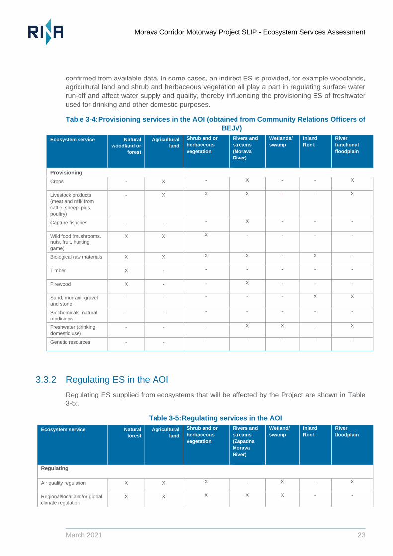
Morava Corridor Motorway Project SLIP - Ecosystem Services Assessment
March 2021 23
confirmed from available data. In some cases, an indirect ES is provided, for example woodlands,
agricultural land and shrub and herbaceous vegetation all play a part in regulating surface water
run-off and affect water supply and quality, thereby influencing the provisioning ES of freshwater
used for drinking and other domestic purposes.
Table 3-4: Provisioning services in the AOI (obtained from Community Relations Officers of
BEJV)
3.3.2 Regulating ES in the AOI
Regulating ES supplied from ecosystems that will be affected by the Project are shown in Table
3-5:.
Table 3-5: Regulating services in the AOI
Ecosystem service Natural
woodland or
forest
Agricultural
land
Shrub and or
herbaceous
vegetation
Rivers and
streams
(Morava
River)
Wetlands/
swamp
Inland
Rock
River
functional
floodplain
Provisioning
Crops - X - X - - X
Livestock products
(meat and milk from
cattle, sheep, pigs,
poultry)
- X X X - - X
Capture fisheries - - - X - - -
Wild food (mushrooms,
nuts, fruit, hunting
game)
X X X - - - -
Biological raw materials X X X X - X -
Timber X - - - - - -
Firewood X - - X - - -
Sand, murram, gravel
and stone
- - - - - X X
Biochemicals, natural
medicines
- - - - - - -
Freshwater (drinking,
domestic use)
- - - X X - X
Genetic resources - - - - - - -
Ecosystem service Natural
forest
Agricultural
land
Shrub and or
herbaceous
vegetation
Rivers and
streams
(Zapadna
Morava
River)
Wetland/
swamp
Inland
Rock
River
floodplain
Regulating
Air quality regulation X X X - X - X
Regional/local and/or global
climate regulation
X X X X X - -
Morava Corridor Motorway Project SLIP - Ecosystem Services Assessment
March 2021 24
3.3.3 Other ES
The focus of this ESA is on provisioning and regulating ES. Implications for cultural heritage have
been considered primarily through the Cultural Heritage Impact Assessment which was done as
part of the Supplementary Lenders’ Information Package (which included consideration of natural
Cultural Heritage) and the ESIA process which noted the presence of river-transportation and
leisure activities based on the River. People have strong cultural attachments to hunting, fishing
and collection of wild foods and may object to loss of benefit from these ES when the Project is
constructed and operated.
Ecosystems in the AOI also provide essential supporting services to habitats and species of
conservation importance and stakeholder interest. The Critical Habitat Assessment (CHA)
conducted by The Biodiversity Consultancy (TBC, 2020) and subsequent e-DNA studies
determined that the Zapadna Morava River is Natural Habitat according to the criteria and
thresholds in IFC PS6 (IFC, 20212). It supports species of stakeholder interest and conservation
importance, notably freshwater mussel and crayfish.
3.4 Beneficiaries can be confirmed
To confirm which of the ES identified in the previous section are “relevant” to the ESA, it is
necessary to confirm their use by specific beneficiaries: ES do not exist without beneficiaries or
users. Beneficiaries are those individuals or communities that depend on a particular ES to maintain
their livelihoods or wellbeing. Beneficiaries can also include institutions and companies. Precise
definition of users and beneficiaries improves the ability to identify appropriate mitigation
interventions in the event that significant impacts occur, sometimes reducing the need for general
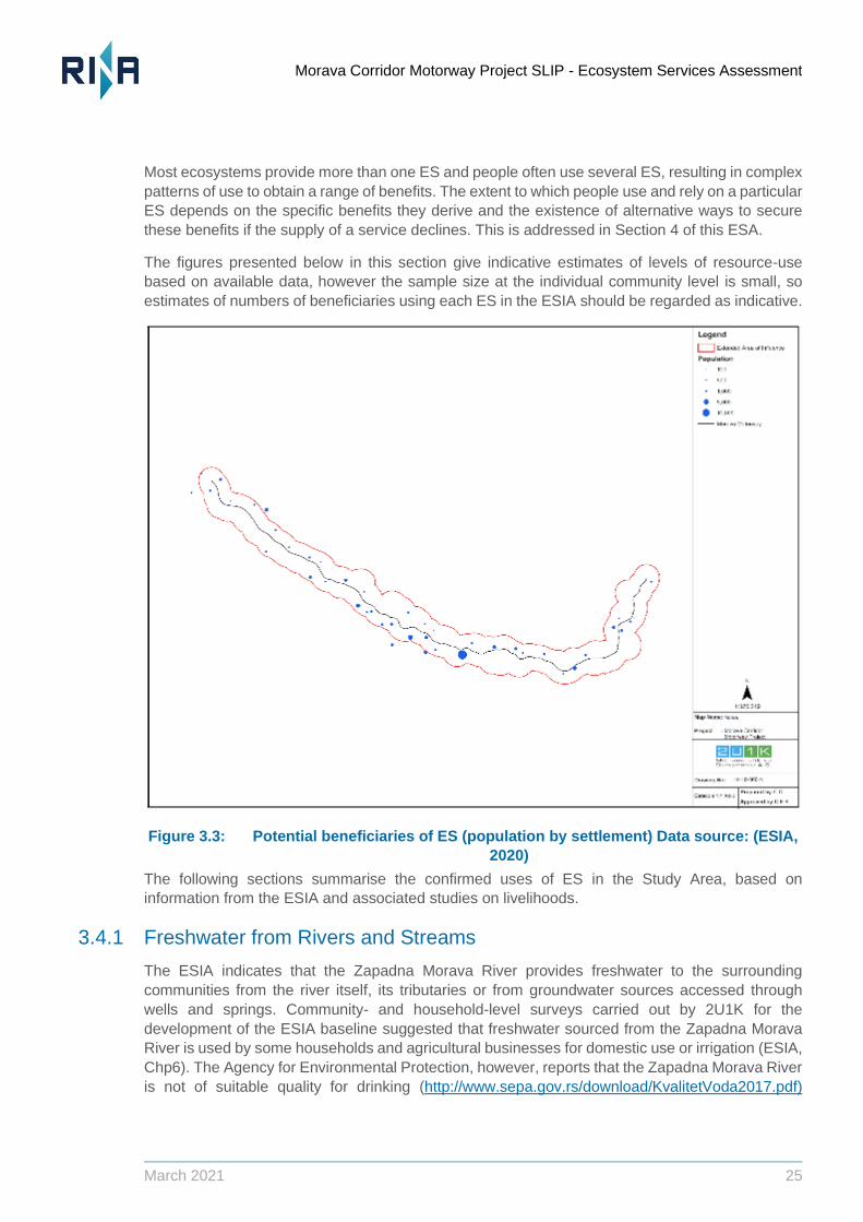
compensation Figure 3.3 illustrates the main settlements in the AOI, giving an indication of
population size.
Benefits from ES typically fall into the following categories (MA, 2005):
Basic material for a good life (e.g., secure and adequate livelihoods, enough food at all times,
shelter, clothing, access to goods).
Health (e.g., clean air and access to clean water).
Security (e.g., secure access to natural and other resources, personal safety, security from
natural and human-made disasters).
Good social relations (e.g., social cohesion, mutual respect, ability to help others).
Water regulation X X X X X - X
Erosion regulation X X X X X - X
Water purification X X X X X - X
Waste Treatment - - - - - - -
Disease regulation - - - - - - -
soil quality regulation X X X X X - -
Pest/invasive species
regulation
X - - - X - -
Morava Corridor Motorway Project SLIP - Ecosystem Services Assessment
March 2021 25
Most ecosystems provide more than one ES and people often use several ES, resulting in complex
patterns of use to obtain a range of benefits. The extent to which people use and rely on a particular
ES depends on the specific benefits they derive and the existence of alternative ways to secure
these benefits if the supply of a service declines. This is addressed in Section 4 of this ESA.
The figures presented below in this section give indicative estimates of levels of resource-use
based on available data, however the sample size at the individual community level is small, so
estimates of numbers of beneficiaries using each ES in the ESIA should be regarded as indicative.
Figure 3.3: Potential beneficiaries of ES (population by settlement) Data source: (ESIA,
2020)
The following sections summarise the confirmed uses of ES in the Study Area, based on
information from the ESIA and associated studies on livelihoods.
3.4.1 Freshwater from Rivers and Streams
The ESIA indicates that the Zapadna Morava River provides freshwater to the surrounding
communities from the river itself, its tributaries or from groundwater sources accessed through
wells and springs. Community- and household-level surveys carried out by 2U1K for the
development of the ESIA baseline suggested that freshwater sourced from the Zapadna Morava
River is used by some households and agricultural businesses for domestic use or irrigation (ESIA,
Chp6). The Agency for Environmental Protection, however, reports that the Zapadna Morava River
is not of suitable quality for drinking (http://www.sepa.gov.rs/download/KvalitetVoda2017.pdf)
Morava Corridor Motorway Project SLIP - Ecosystem Services Assessment
March 2021 26
unless treated. Correspondence with JCWI suggests that direct use of the River for dinking water
purposes is highly unlikely.
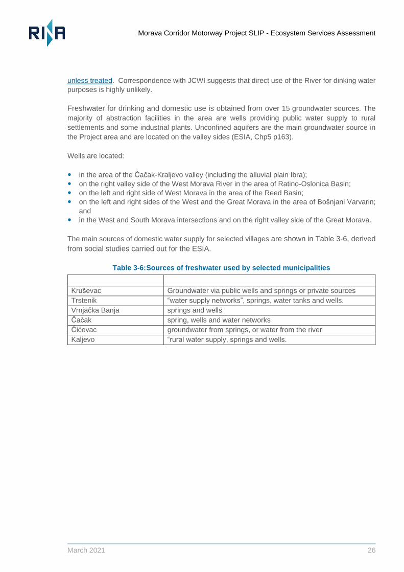
Freshwater for drinking and domestic use is obtained from over 15 groundwater sources. The
majority of abstraction facilities in the area are wells providing public water supply to rural
settlements and some industrial plants. Unconfined aquifers are the main groundwater source in
the Project area and are located on the valley sides (ESIA, Chp5 p163).
Wells are located:
in the area of the Cacak-Kraljevo valley (including the alluvial plain Ibra);
on the right valley side of the West Morava River in the area of Ratino-Oslonica Basin;
on the left and right side of West Morava in the area of the Reed Basin;
on the left and right sides of the West and the Great Morava in the area of Bosnjani Varvarin;
and
in the West and South Morava intersections and on the right valley side of the Great Morava.
The main sources of domestic water supply for selected villages are shown in Table 3-6, derived
from social studies carried out for the ESIA.
Table 3-6: Sources of freshwater used by selected municipalities
Municipality Primary domestic water source
Krusevac Groundwater via public wells and springs or private sources
Trstenik “water supply networks”, springs, water tanks and wells.
Vrnjacka Banja springs and wells
Cacak spring, wells and water networks
Cicevac groundwater from springs, or water from the river
Kaljevo “rural water supply, springs and wells.
Morava Corridor Motorway Project SLIP - Ecosystem Services Assessment
March 2021 27
Figure 3.4: Estimate of number of residents by settlement reliant on well water. Data
source: (ESIA, 2020)
Groundwater is not usually considered to be an ecosystem and does not appear in the ecosystem
classification; however, groundwater recharge depends on water balance from precipitation,
evapotranspiration and surface water ‘yields’. Several ecosystems in the project affected area
provide an intermediate service to the provisioning ES of freshwater for drinking, domestic use or
irrigation by regulating surface water run-off and influencing water quality. There is also potentially
some connectivity between the Zapadna Morava River and its tributaries and groundwater supply.
This needs to be better understood to evaluate potential risks to drinking water supply from
modification of the River and its floodplain. Consultation with the JCWI as part of the ESA suggests
that most water supply systems in this area use groundwater springs and springs for water supply,
some of which are in the zone of influence of the highway and the River Zapadna Morava. In the
Municipality of Vrnjacka Banja, some drinking water is taken from the alluvium of the River. Springs
"Vitojevac" and "Ugljarevo" are in the zone of influence of the highway and the Zapadna Morava
River. In the Municipality of Trstenik, the springs "Zvezdan" and "Staro korito" are located between
the old and the new riverbed of the West Morava and are also in the zone of possible impact of the
highway (JCWI, 2021|). The term “zone of influence” was used by JCWI in correspondence to
indicate springs that could be potentially affected in some way, hence further investigation is
recommended to preclude risks to any users of these sources.
Morava Corridor Motorway Project SLIP - Ecosystem Services Assessment
March 2021 28
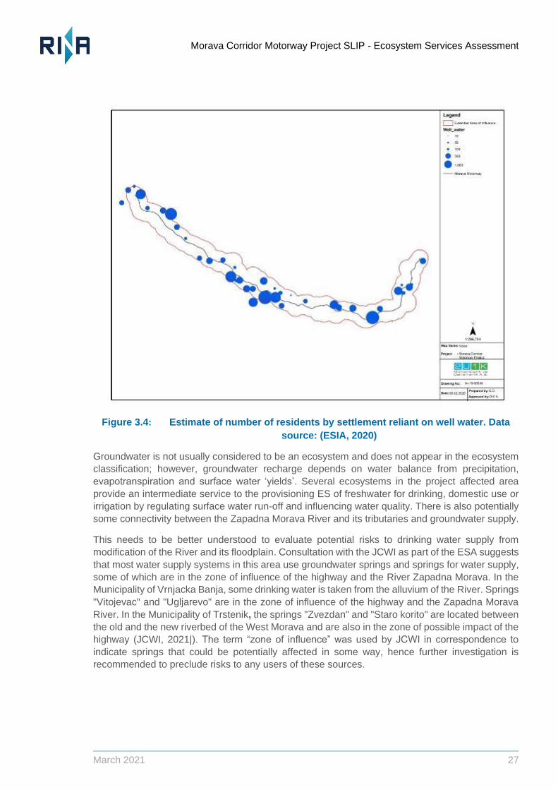
3.4.2 Food from irrigated crops
Water from the river and groundwater are used by farmers for irrigation purposes to provide water
and nutrients to agriculture to support the yield of crops. The Zapadna Morava River was reported
to be used to provide irrigation water for crops by 7,797 households out of 60,000 households in
the social AOI (13% of households), with systems of irrigation channels in place to deliver irrigation
water to the fields where it is used. The river was named as the source of water for irrigation of
crops in the Municipality of Cacak, for example.
Figure 3.5: Estimate of number of residents by settlement that use irrigation. Data
source: (ESIA, 2020)
3.4.3 Protein from Fish
Approximately 15% of residents in all municipalities use the West Morava River and its tributaries
to catch fish for household consumption (ESIA, 2020). Fishing is an important recreational activity
(Cultural ES), but also provides protein in the diet (provisioning ES) for households with members
who fish. Pike, chub, catfish, skobalj and “white” are caught in the Spring and Autumn. In the Cacak
Municipality the annual quantity of fish caught and consumed per household is 18 kg a year on
average. Sale of fish is not a significant source of income in the area (ESIA, Chp6).
Morava Corridor Motorway Project SLIP - Ecosystem Services Assessment
March 2021 29
Figure 3.6: Estimate of number of residents by settlement using the West Morava River
for fishing. Data source: (ESIA, 2020)
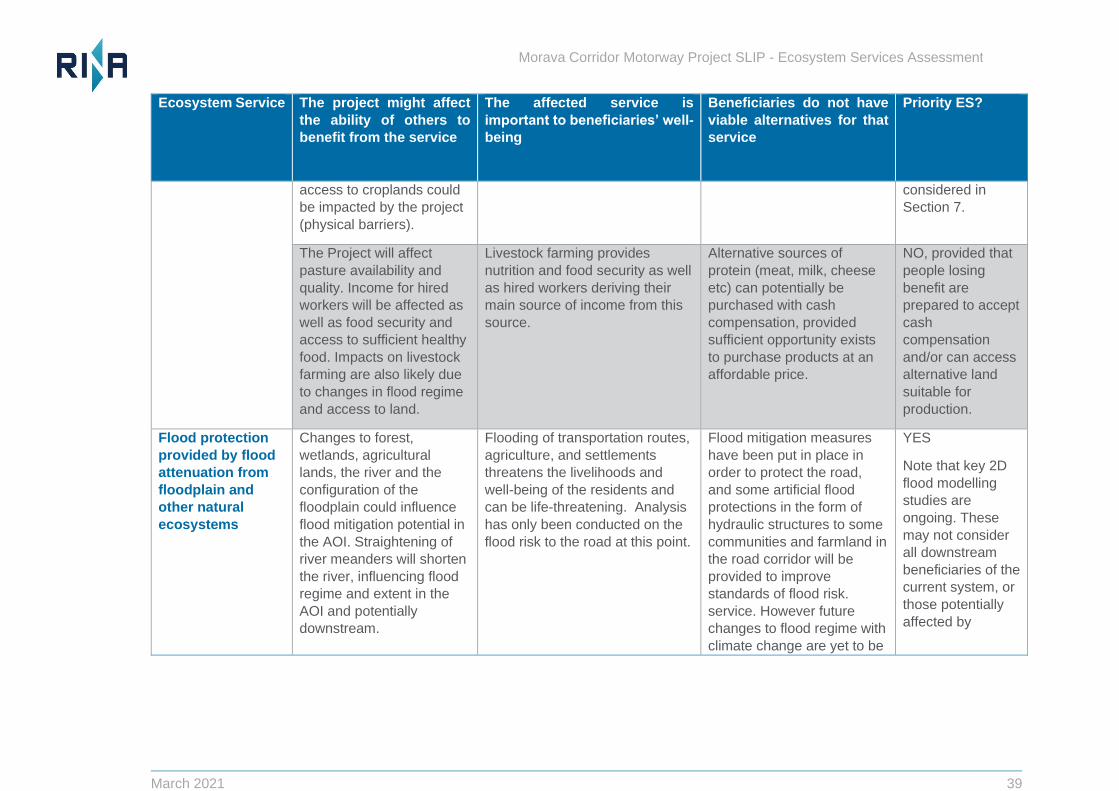
3.4.4 Flood protection to people, property and farmland
The Project includes some artificial flood protection in the form of hydraulic structures to
prevent flood risk to the road. The Project will also improve standards of flood protection for some
communities and farmland in the road corridor. The current flood protection structures in the
region are designed on the basis of previous (prior to 2014) 100-year max flood disaster levels.
During the disclosure period of the Spatial Plan from July to August 2019, 22 of 48 villages within
the AOI expressed concerns about flood risk during the Project’s Operational phase and how this
might change (ESIA, Chp 2). Residents of all of these villages are considered as sensitive
receptors (ESIA, Chp 6, pg 258). According to the Preliminary Economic Analysis and Feasibility
Study, the goals of the Project include reduction of flood risk in the region for people, property
and farmland. However, a degree of flood protection is provided by the River’s naturally
functioning floodplain in the baseline situation, and this constitutes an ES supplied in the Study
Area and provided to beneficiaries within it and downstream. The magnitude of this benefit
downstream is not known. The Lenders’ Technical Advisor Report recommended further 2D
modelling to supplement the River Regulation Flood Model developed for the Project. This is being
carried out by the JCWI, anticipated to be completed in mid-March 2021. In effect, the Project will
substitute artificial flood protection for the ES of flood protection provided by unconstrained
floodplain, but the beneficiaries are different (local vs downstream, and including some who may
be outside the limits of the AoI used for this ESA).
Morava Corridor Motorway Project SLIP - Ecosystem Services Assessment
March 2021 30
In addition to modelling, the Project has also undertaken a process of Informed Consultation and
Participation (ICP) with affected communities with respect to potentially significant impacts
associated with river regulation work (RINA, 2021). Stakeholder meetings were conducted by
21UK with residents of 6 settlements in close proximity to planned river regulation works (0 to 1km).
These were the settlements of Mrzenica, Sirca, Grdica, Popovici, Milocaj and Stancici.
3.4.5 Food and income from farming
Agricultural activities are the major source of livelihood and income in the rural settlements.
Households grow produce for home-consumption and as a source of income. The area has a mixed
farming system. Some people are employed in farming and derive income from employment.
Arable production dominates and although the majority of the villages in the AOI are engaged in
livestock farming to some extent, produce is generally for household consumption and not for
income-generation. Crops cultivated on agricultural land in the AOI include wheat (19%), barley
(8%), oats (8%) and corn (65%). A proportion of grain is fed to pigs, cattle, sheep and poultry and
some is sold for income. Meat is primarily consumed within the households (ESIA, 2020).
There are therefore several groups of beneficiaries for the ES of food or income from farming,
including landowners, farmers, farmworkers and households who consume crops of animal
products (meat, milk, eggs).
3.4.6 Wood from Forests and Woodlands
The majority of households in rural settlements use locally sourced wood to heat their homes
in winter, 13.4 m3, 14.8m3 and 16.25 m3 being consumed per household during the winter
season in all the villages of the municipalities Cacak, Trstenik and Vrnjacka Banja
respectively (ESIA, Chp 5 pg 241). Firewood for heating is generally purchased from local
suppliers. Tree-cutting is illegal in Serbia, but local collection of fallen or dead wood occurs
(see Figure 3.7).
Timber collection for income generation only occurs in the municipality of Krusevac (70% of
the local residents in Jasika Village collect timber to generate income). Commercial timber
production for income generation takes place in Milocaj village of Kraljevo (ESIA, 2020).
Morava Corridor Motorway Project SLIP - Ecosystem Services Assessment
March 2021 31
Figure 3.7: Estimate of number of residents by settlement that collect wood for fuel.
Data source: (ESIA, 2020)
3.4.7 Wild food
In the municipalities of Trstenik and Vrnjacka Banja the project passes through forest used for
collection of nuts, forest fruits and mushrooms, as well as hunting purposes for species such as
rabbit, pheasant and wild boar. (ESIA, Chp 6). These activities are conducted predominantly for
recreational purposes (Cultural ES) but also provide healthy food for household consumption
according to the results of the social field study. In Vrnjacka Banja, Trstenik, Krusevac and Cacak,
for example, locals traditionally collect mushrooms from the forest for domestic consumption.
None of the villages within the AOI collect herbs or mushrooms from the forest for income
generation, but there could be strong cultural attachments to food gathering and its consumption.
Plant collection is only seen in Cicevac and Varvarin.
Hunting is carried out in all municipalities, with licensed hunting areas varying from 10,455 ha in
Vrnjacka Banja to 52,464 ha in Krusevac. Cacak is the only municipality where hunting is a rare
occurrence (Figure 3.8).
Morava Corridor Motorway Project SLIP - Ecosystem Services Assessment
March 2021 32
Figure 3.8: Estimate of number of residents by settlement who hunt. Data source:
(ESIA, 2020)
3.4.8 Bee-keeping
Apiculture currently takes place close to the motorway route, for example in forested areas at
Krusevac and in Mrzenica and Makrasane and some will be displaced by borrow pit construction
and use (ESIA, Chp 6, 2020). Beekeepers are a beneficiary group relying on a number of
“natural ecosystems” as well as farmland to obtain honey for sale or home consumption. There
could also be an indirect ES of pollination from apiculture to crop production.
3.4.9 Overview of beneficiaries
People in much of the AOI probably use a mix of ES to meet their needs for income, a healthy life
and wellbeing. This is particularly the case in rural areas. It is worth noting that many Project
Affected People are retired and/or elderly (in Sector 1, 63.4% of landowners surveyed to produce
the RAP were older than 65 and 44% were drawing a pension). In urban settlements people are
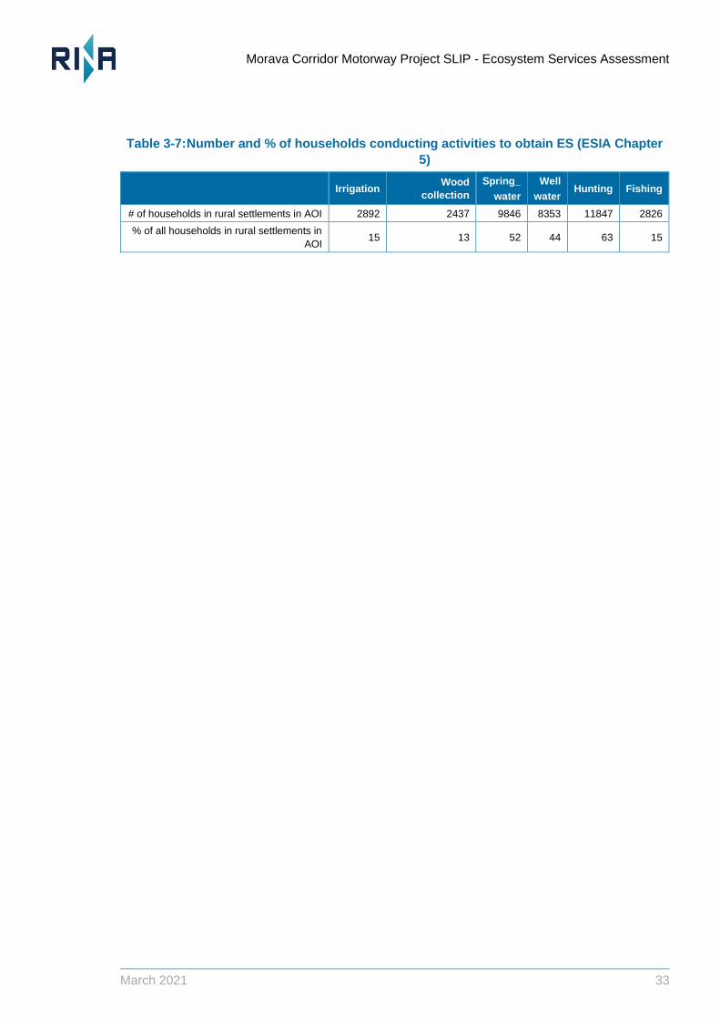
typically more able to substitute provisioning ES with purchased substitutes. Table 3-7 summarises
the number and percentage of households (Social AOI) involved in activities to obtain firewood, go
hunting or fishing and obtain freshwater (ESIA, Chp 6, 2020). Further household surveys would be
needed to clarify the extent to which beneficiaries rely on multiple ES and where they are sourced
by specific beneficiaries or beneficiary groups. The RAP reports are ongoing and are likely to
include aspects of this
Morava Corridor Motorway Project SLIP - Ecosystem Services Assessment
March 2021 33
Table 3-7: Number and % of households conducting activities to obtain ES (ESIA Chapter
5)
Irrigation Wood
collection
Spring_
water
Well
water Hunting Fishing
# of households in rural settlements in AOI 2892 2437 9846 8353 11847 2826
% of all households in rural settlements in
AOI 15 13 52 44 63 15
Morava Corridor Motorway Project SLIP - Ecosystem Services Assessment
March 2021 34
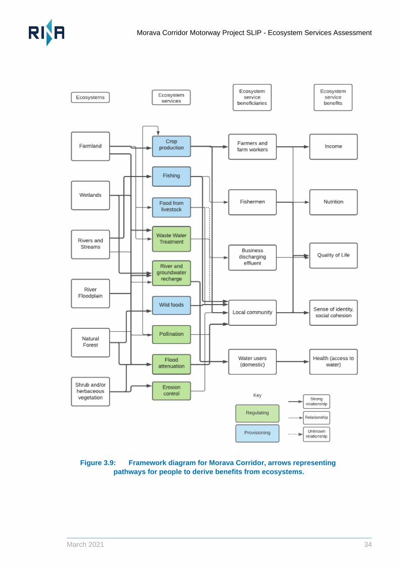
Figure 3.9: Framework diagram for Morava Corridor, arrows representing
pathways for people to derive benefits from ecosystems.
Morava Corridor Motorway Project SLIP - Ecosystem Services Assessment
March 2021 35
4 Priority Ecosystem Services
Some services are a particular ‘Priority’ because people depend on them to obtain essential
benefits for life and are not able to access alternatives to maintain these benefits. If supply of these
services is reduced, or access to them is blocked, people’s livelihoods and wellbeing’s are placed
at risk. IFC PS6 (2012) and the WRI ESR for IA method require explicit prioritisation of ES. The
ESA assesses impacts only on priority ES, whether these are ES depended on by third parties or
by the Project itself.
Dependence on ES is generally high in the area either because people rely on them directly to
obtain their basic requirements for life (such as freshwater), or because their income is derived
from ES.
4.1 Prioritisation Criteria
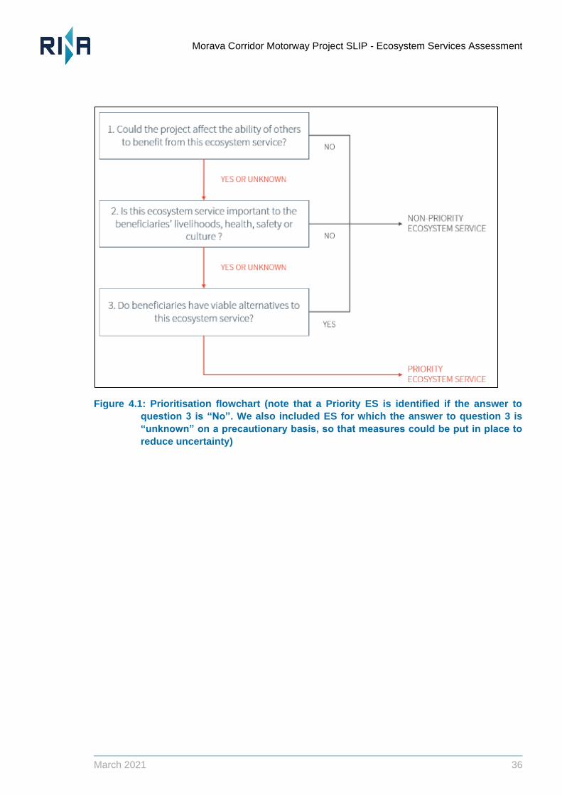
IFC PS6 (2012) does not prescribe an approach to prioritisation. This ESA has used the definitions
and criteria presented in WRI (2013). Priority ES used by others (Type 1 ES in IFC PS6) are those
where:
a) the benefits from the service are likely to be adversely affected by the Project; and
b) beneficiaries have a high level of dependence on the service; and
c) alternatives to the service are either unavailable or limited or are considered unsatisfactory
by beneficiaries.
To prioritise ES needed by the Project for its operational performance (Type 2 ES in IFC PS6), the
main consideration is sustainable supply for the Project lifetime.
The results of the ES prioritisation process for Type I ES are summarised in Table 4-1:. They align
with the conclusions of the social study conducted by 2U1K, which identified “freshwater” and
“agriculture” as important ecosystem services in the AOI, though additional priority ES have been
identified, including capture fisheries and an obvious dependence on locally sourced firewood for
domestic heating.
Morava Corridor Motorway Project SLIP - Ecosystem Services Assessment
March 2021 36
Figure 4.1: Prioritisation flowchart (note that a Priority ES is identified if the answer to
question 3 is “No”. We also included ES for which the answer to question 3 is
“unknown” on a precautionary basis, so that measures could be put in place to
reduce uncertainty)
Morava Corridor Motorway Project SLIP - Ecosystem Services Assessment
March 2021 37
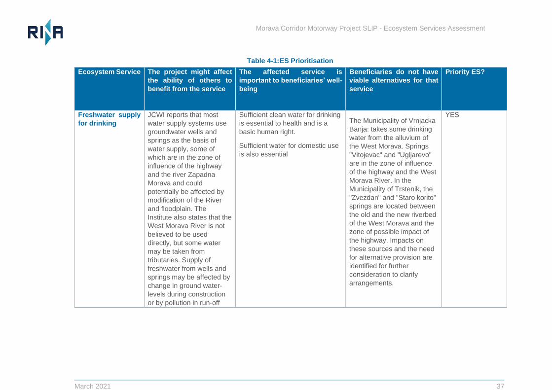
Table 4-1: ES Prioritisation
Ecosystem Service The project might affect
the ability of others to
benefit from the service
The affected service is
important to beneficiaries’ well-
being
Beneficiaries do not have
viable alternatives for that
service
Priority ES?
Freshwater supply
for drinking
JCWI reports that most
water supply systems use
groundwater wells and
springs as the basis of
water supply, some of
which are in the zone of
influence of the highway
and the river Zapadna
Morava and could
potentially be affected by
modification of the River
and floodplain. The
Institute also states that the
West Morava River is not
believed to be used
directly, but some water
may be taken from
tributaries. Supply of
freshwater from wells and
springs may be affected by
change in ground water-
levels during construction
or by pollution in run-off
Sufficient clean water for drinking
is essential to health and is a
basic human right.
Sufficient water for domestic use
is also essential
The Municipality of Vrnjacka
Banja: takes some drinking
water from the alluvium of
the West Morava. Springs
"Vitojevac" and "Ugljarevo"
are in the zone of influence
of the highway and the West
Morava River. In the
Municipality of Trstenik, the
"Zvezdan" and "Staro korito"
springs are located between
the old and the new riverbed
of the West Morava and the
zone of possible impact of
the highway. Impacts on
these sources and the need
for alternative provision are
identified for further
consideration to clarify
arrangements.
YES
Morava Corridor Motorway Project SLIP - Ecosystem Services Assessment
March 2021 38
Ecosystem Service The project might affect
the ability of others to
benefit from the service
The affected service is
important to beneficiaries’ well-
being
Beneficiaries do not have
viable alternatives for that
service
Priority ES?
during construction/
operation.
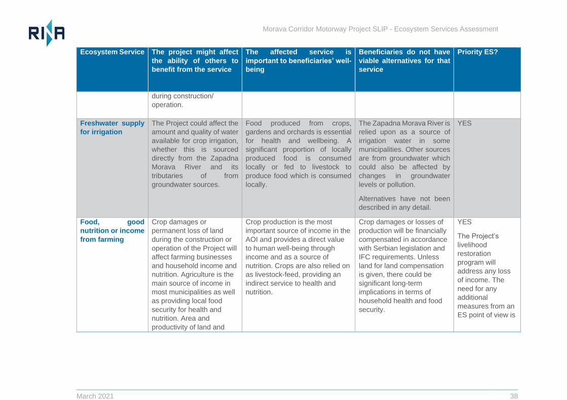
Freshwater supply
for irrigation
The Project could affect the
amount and quality of water
available for crop irrigation,
whether this is sourced
directly from the Zapadna
Morava River and its
tributaries of from
groundwater sources.
Food produced from crops,
gardens and orchards is essential
for health and wellbeing. A
significant proportion of locally
produced food is consumed
locally or fed to livestock to
produce food which is consumed
locally.
The Zapadna Morava River is
relied upon as a source of
irrigation water in some
municipalities. Other sources
are from groundwater which
could also be affected by
changes in groundwater
levels or pollution.
Alternatives have not been
described in any detail.
YES
Food, good
nutrition or income
from farming
Crop damages or
permanent loss of land
during the construction or
operation of the Project will
affect farming businesses
and household income and
nutrition. Agriculture is the
main source of income in
most municipalities as well
as providing local food
security for health and
nutrition. Area and
productivity of land and
Crop production is the most
important source of income in the
AOI and provides a direct value
to human well-being through
income and as a source of
nutrition. Crops are also relied on
as livestock-feed, providing an
indirect service to health and
nutrition.
Crop damages or losses of
production will be financially
compensated in accordance
with Serbian legislation and
IFC requirements. Unless
land for land compensation
is given, there could be
significant long-term
implications in terms of
household health and food
security.
YES
The Project’s
livelihood
restoration
program will
address any loss
of income. The
need for any
additional
measures from an
ES point of view is
Morava Corridor Motorway Project SLIP - Ecosystem Services Assessment
March 2021 39
Ecosystem Service The project might affect
the ability of others to
benefit from the service
The affected service is
important to beneficiaries’ well-
being
Beneficiaries do not have
viable alternatives for that
service
Priority ES?
access to croplands could
be impacted by the project
(physical barriers).
considered in
Section 7.
The Project will affect
pasture availability and
quality. Income for hired
workers will be affected as
well as food security and
access to sufficient healthy
food. Impacts on livestock
farming are also likely due
to changes in flood regime
and access to land.
Livestock farming provides
nutrition and food security as well
as hired workers deriving their
main source of income from this
source.
Alternative sources of
protein (meat, milk, cheese
etc) can potentially be
purchased with cash
compensation, provided
sufficient opportunity exists
to purchase products at an
affordable price.
NO, provided that
people losing
benefit are
prepared to accept
cash
compensation
and/or can access
alternative land
suitable for
production.
Flood protection
provided by flood
attenuation from
floodplain and
other natural
ecosystems
Changes to forest,
wetlands, agricultural
lands, the river and the
configuration of the
floodplain could influence
flood mitigation potential in
the AOI. Straightening of
river meanders will shorten
the river, influencing flood
regime and extent in the
AOI and potentially
downstream.
Flooding of transportation routes,
agriculture, and settlements
threatens the livelihoods and
well-being of the residents and
can be life-threatening. Analysis
has only been conducted on the
flood risk to the road at this point.
Flood mitigation measures
have been put in place in
order to protect the road,
and some artificial flood
protections in the form of
hydraulic structures to some
communities and farmland in
the road corridor will be
provided to improve
standards of flood risk.
service. However future
changes to flood regime with
climate change are yet to be
YES
Note that key 2D
flood modelling
studies are
ongoing. These
may not consider
all downstream
beneficiaries of the
current system, or
those potentially
affected by
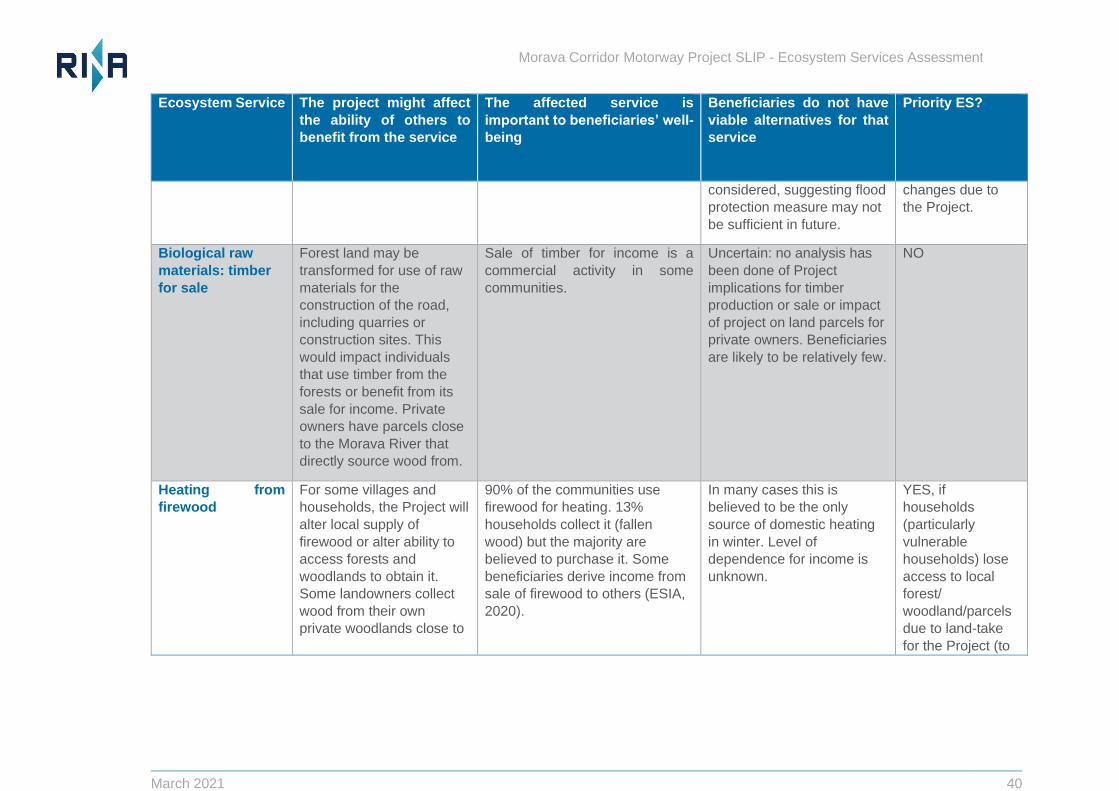
Morava Corridor Motorway Project SLIP - Ecosystem Services Assessment
March 2021 40
Ecosystem Service The project might affect
the ability of others to
benefit from the service
The affected service is
important to beneficiaries’ well-
being
Beneficiaries do not have
viable alternatives for that
service
Priority ES?
considered, suggesting flood
protection measure may not
be sufficient in future.
changes due to
the Project.
Biological raw
materials: timber
for sale
Forest land may be
transformed for use of raw
materials for the
construction of the road,
including quarries or
construction sites. This
would impact individuals
that use timber from the
forests or benefit from its
sale for income. Private
owners have parcels close
to the Morava River that
directly source wood from.
Sale of timber for income is a
commercial activity in some
communities.
Uncertain: no analysis has
been done of Project
implications for timber
production or sale or impact
of project on land parcels for
private owners. Beneficiaries
are likely to be relatively few.
NO
Heating from
firewood
For some villages and
households, the Project will
alter local supply of
firewood or alter ability to
access forests and
woodlands to obtain it.
Some landowners collect
wood from their own
private woodlands close to
90% of the communities use
firewood for heating. 13%
households collect it (fallen
wood) but the majority are
believed to purchase it. Some
beneficiaries derive income from
sale of firewood to others (ESIA,
2020).
In many cases this is
believed to be the only
source of domestic heating
in winter. Level of
dependence for income is
unknown.
YES, if
households
(particularly
vulnerable
households) lose
access to local
forest/
woodland/parcels
due to land-take
for the Project (to
Morava Corridor Motorway Project SLIP - Ecosystem Services Assessment
March 2021 41
Ecosystem Service The project might affect
the ability of others to
benefit from the service
The affected service is
important to beneficiaries’ well-
being
Beneficiaries do not have
viable alternatives for that
service
Priority ES?
the River that are
potentially affected.
be confirmed
when design is
finalised).
Protein from Fish
caught from the
River (and cultural
enjoyment)
Changes to freshwater
river morphology and
regime and the potential
pollution from surface run-
off or spillage during
construction/ operation
could reduce fish species
composition and biomass
in the river, as well as
access for fishing.
For people who fish there are
strong traditional or cultural
attachments to fishing, and fish
are a supplementary source of
nutrition.
Cultural enjoyment of fishing
can potentially be substituted
by relocating fishing activity
to other locations/ rivers,
however people who fish
may have strong
attachments to current
locations, local to where they
live. There are also potential
alternative sources of protein
if these are considered to be
acceptable or affordable.
YES, but only for
people who fish
and their
households
(primarily the
cultural ES of
enjoying fishing
rather than the
provisional ES of
deriving protein
from home-
consumed fish).
Willingness to
accept alternatives
needs to be
reviewed for
affected people.
Pollination of
crops
Natural ecosystems and
orchards providing habitat
for pollinating insects may
be lost or damaged. This
This ES provides an indirect
contribution to human well-being
by producing crop and plant
species.
There is probably sufficient
alternative natural habitat
and vegetation available to
NO
Morava Corridor Motorway Project SLIP - Ecosystem Services Assessment
March 2021 42
Ecosystem Service The project might affect
the ability of others to
benefit from the service
The affected service is
important to beneficiaries’ well-
being
Beneficiaries do not have
viable alternatives for that
service
Priority ES?
includes areas used for
apiculture (see below).
support pollination from wild
insects or bees.
Honey for income
or consumption
The motorway alignment,
quarries, borrow pits and
construction activities are
close to apicultural activity
areas and will displace
some (extent unknown).
Provides income and honey
consumed locally by
apiculturalists, their families and
other households in the AOI.
Some apiculturalists make hives
and frames for sale (using locally
sourced wood). E.g.,
https://www.hivesandframes.com/
There will be some provision
through the RAP to identify
new locations and provide
assistance with relocation of
hives. It is not clear whether
alternative locations are
acceptable, or whether
quality of honey would also
be affected by road
operation for some
apiculturalists long term.
UNCERTAIN
For a small
number of
beekeepers and
businesses this
could be a priority
ES, but it is not
clear how many
beekeepers are
affected or
whether they are
willing to accept
alternative
locations for
production or
have, longer term
alternatives to
income if honey
produced near the
road is of poor
quality or can’t be
sold. There are
proposals to
monitor livelihood
Morava Corridor Motorway Project SLIP - Ecosystem Services Assessment
March 2021 43
Ecosystem Service The project might affect
the ability of others to
benefit from the service
The affected service is
important to beneficiaries’ well-
being
Beneficiaries do not have
viable alternatives for that
service
Priority ES?
impacts through
the RAP and these
are expected to
ensure that
apiculturalists can
maintain levels of
benefit from bee
keeping.
Hunting and wild
food collection from
woodlands, forests
and other natural
ecosystems
Hunting activities are
carried out by people in all
municipalities in the region
and are relied upon as a
source of nutrition and a
sense of identity in
numerous villages.
Although not generally
relied upon as a source of
income, hunting of meat
and collection of plants,
mushrooms and herbs is
used for household
consumption.
Recreational use and traditional
value of hunting may be deemed
important to cultural identity. The
source of nutrition provided by
hunting contributes to a healthy
diet and well-being.
For some people alternatives
(in terms of cultural
experience) may be limited
due to distance, or
competition with others.
Alternative sources of
nutrition are available but
may not be considered an
acceptable substitute.
UNCERTAIN
(more detail
needed on
implications for
hunters and wild
food gatherers
from borrow pit
impacts and
willingness to
accept
alternatives).
Regulation of air
quality by forests,
Dust generation during
construction and the
increased emissions from
traffic during operation will
Regulation of this service ensures
local communities health and well-
Air quality is anticipated to
recover after construction in
terms of dust. There should
be sufficient alternative
NO
Morava Corridor Motorway Project SLIP - Ecosystem Services Assessment
March 2021 44
Ecosystem Service The project might affect
the ability of others to
benefit from the service
The affected service is
important to beneficiaries’ well-
being
Beneficiaries do not have
viable alternatives for that
service
Priority ES?
wetlands and
agricultural land
influence air quality and
therefore affect the ability
of others to benefit from the
service. Forests, wetlands,
agricultural land and soils
contribute to regulation of
air quality. Removal of this
service may impact air
quality for the local
communities.
being considering air quality in
Serbia is already a major concern.
ecosystem available to
regulate air quality despite
losses due to the Project and
most households are
sufficiently distant from the
road due to the wide
floodplain.
Water purification
and waste treatment
Wastewater generation
during construction
activities. Wetlands remove
harmful pollutants from
water by trapping metals
and organic materials.
Increased erosion may
cause increase in stored
pollutants impacting
vegetation quality and the
ability of landowners to
make an income.
Water purification from wetlands
and forests ensures that
freshwater is available for drinking
water in the local communities
benefiting health and well-being.
Compensating with man-
made substitutes such as
wastewater treatment
facilities to substitute for loss
of wetlands or forests that act
as water purifiers is seen as a
viable alternative for this
service.
NO
Erosion control
provided by
terrestrial
ecosystems or
River regulation works are
likely to alter erosion rates
and patterns in some
locations (by altering
Terrestrial land surrounding the
river is important cropland for
landowners and is a source of
income. Erosion also increases
The project is providing with
man-made substitutes to
control erosional riverine
processes. These may be
NO but
downstream
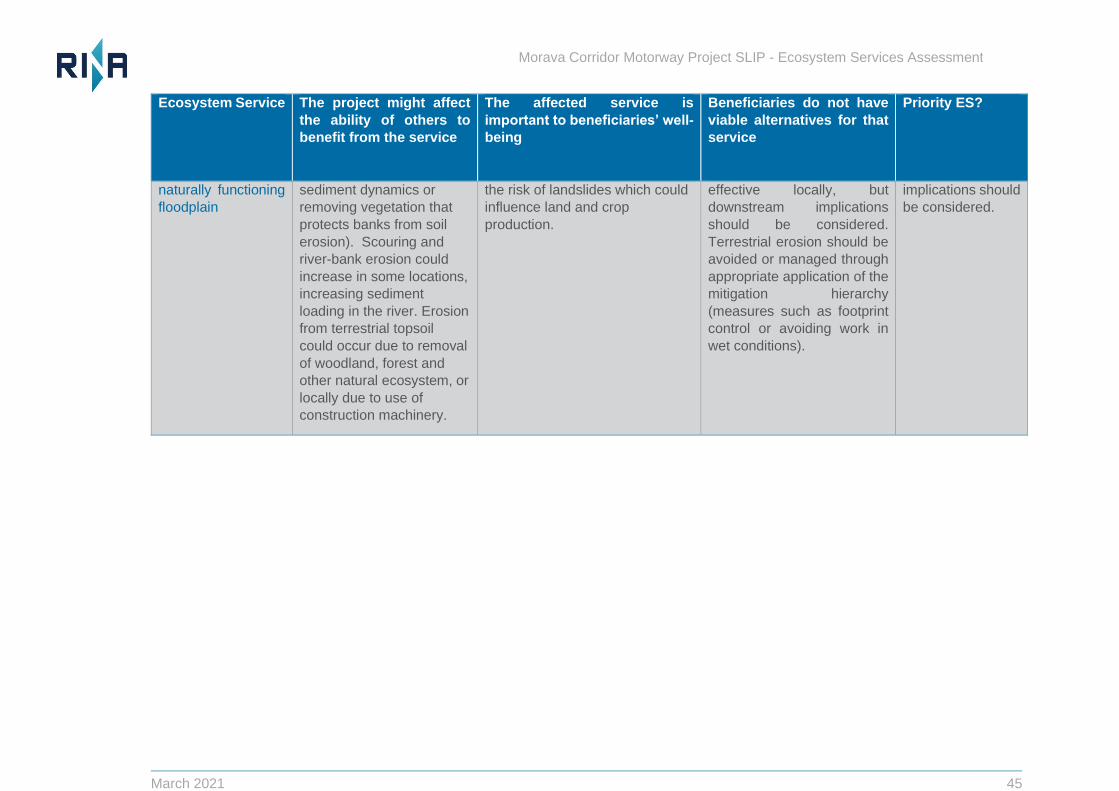
Morava Corridor Motorway Project SLIP - Ecosystem Services Assessment
March 2021 45
Ecosystem Service The project might affect
the ability of others to
benefit from the service
The affected service is
important to beneficiaries’ well-
being
Beneficiaries do not have
viable alternatives for that
service
Priority ES?
naturally functioning
floodplain
sediment dynamics or
removing vegetation that
protects banks from soil
erosion). Scouring and
river-bank erosion could
increase in some locations,
increasing sediment
loading in the river. Erosion
from terrestrial topsoil
could occur due to removal
of woodland, forest and
other natural ecosystem, or
locally due to use of
construction machinery.
the risk of landslides which could
influence land and crop
production.
effective locally, but
downstream implications
should be considered.
Terrestrial erosion should be
avoided or managed through
appropriate application of the
mitigation hierarchy
(measures such as footprint
control or avoiding work in
wet conditions).
implications should
be considered.
Morava Corridor Motorway Project SLIP - Ecosystem Services Assessment
March 2021 46
4.2 Identification of Priority Ecosystem Services for Operational Performance of Project
The road development requires significant amounts of water to support construction and operation
and the implications of this have been discussed as a concern. A projected figure of 411,000 tons
per year of water required for construction poses the risk to alteration of the groundwater level from
the design and construction state of the Project (ESIA, Chp. 8).
The Project has secured permits from Serbia Water to cover its requirements, but implications of
this Project-demand for access to freshwater should be reviewed in terms of whether supply is
sustainable for the Project and also its implications for uses by others. Another aspect that should
be considered is proposed policy for procurement of food for construction teams, and how this
could affect local demand and supply relationships.
The Project will also use significant volumes of aggregate and requires a sustainably supply to
support construction.
Morava Corridor Motorway Project SLIP - Ecosystem Services Assessment
March 2021 47
5 Baseline: priority ES in the absence of the project
This chapter summarises the baseline situation for the priority ES identified in chapter 4, i.e., their
current status and how future supply might change in the absence of the Project. In the following
sections we have attempted to evaluate baseline levels of supply, use and benefit for the priority
ES.
There are many pressures already operating in the AOI that could affect future supply of ES in the
baseline situation (i.e., without development of the Project). These include:
Population and demographic change (e.g., in- or out-migration) affecting types and intensity of
land use.
Flooding (farmers in affected villages stated that the income from agriculture has decreased
because of the floods from recent years). However, people downstream benefit from a degree
of flood attenuation provided by naturally functioning floodplain in this area.
Ongoing modification of the landscape, including fragmentation of woodland and forest.
Climate change (e.g., increased need for irrigation).
Market and economic changes (e.g., transition to more cash-based economy and potentially
increased market access through improved road networks).
Changes in technology (e.g., rural electrification or shift from shallow wells to piped drinking
water supplies), which might improve ability of people to access and benefit from ES but could
also increase per capita water demand.
It is important to note that data on the number of households using an ES in the following sections
was derived from percentages of a sample of households included in the ESIA household surveys.
As the sample size was small at the individual community level, these should be regarded as
indicative estimates, used for general illustrative purposes.
5.1 Freshwater for drinking and domestic use
In terms of water quality, an ecological status assessment of the Zapadna Morava River
concluded that it is impacted by moderate organic pollution as well as various types of
structures and modifications at present. Water quality is affected by hydrological and
geomorphological pressures from land use activities such as agriculture, industry and mining
and therefore the overall status of the river has been assessed as moderate (Novakovic 2013).
Any households using the Zapadna Morava directly for water would potentially experience
some impact on water quality from river regulation works, however subsequent consultation
with JCWI suggests that direct abstraction from the Zapadna Morava for drinking purposes
does not occur and prior water treatment is necessary for it to be safe for consumption. Based
on this information we have assumed that direct use of the Zapadna Morava river for drinking
water does not occur.
Households relying on groundwater sources could also be potentially affected by the Project
(Table 5-1). The JWCI has indicated that some springs used for domestic water in the
Municipality of Vrnjacka Banja (the Springs "Vitojevac" and "Ugljarevo") and in the Municipality
of Trstenik (the springs "Zvezdan" and "Staro korito") are in the zone of possible impact of the
highway. Residents of Trstenik requested detailed consideration of the implications of river
regulation works for their water supply during stakeholder meetings (see Report by RINA,
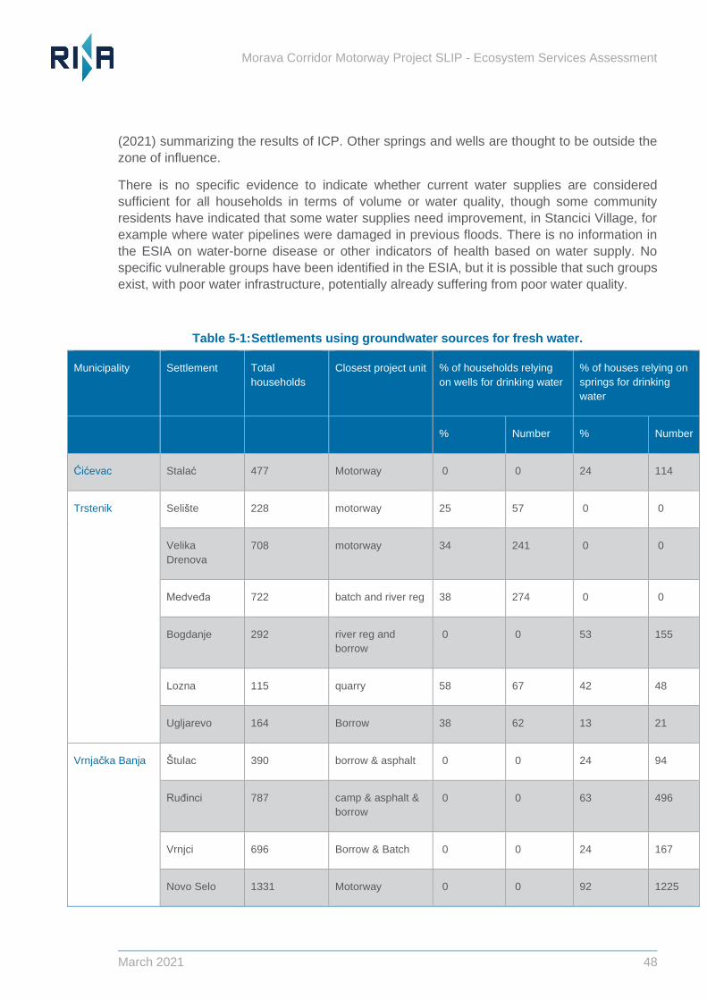
Morava Corridor Motorway Project SLIP - Ecosystem Services Assessment
March 2021 48
(2021) summarizing the results of ICP. Other springs and wells are thought to be outside the
zone of influence.
There is no specific evidence to indicate whether current water supplies are considered
sufficient for all households in terms of volume or water quality, though some community
residents have indicated that some water supplies need improvement, in Stancici Village, for
example where water pipelines were damaged in previous floods. There is no information in
the ESIA on water-borne disease or other indicators of health based on water supply. No
specific vulnerable groups have been identified in the ESIA, but it is possible that such groups
exist, with poor water infrastructure, potentially already suffering from poor water quality.
Table 5-1: Settlements using groundwater sources for fresh water.
Municipality Settlement Total
households
Closest project unit % of households relying
on wells for drinking water
% of houses relying on
springs for drinking
water
% Number % Number
Cicevac Stalac 477 Motorway 0 0 24 114
Trstenik Seliste 228 motorway 25 57 0 0
Velika
Drenova
708 motorway 34 241 0 0
Medveđa 722 batch and river reg 38 274 0 0
Bogdanje 292 river reg and
borrow
0 0 53 155
Lozna 115 quarry 58 67 42 48
Ugljarevo 164 Borrow 38 62 13 21
Vrnjacka Banja Stulac 390 borrow & asphalt 0 0 24 94
Ruđinci 787 camp & asphalt &
borrow
0 0 63 496
Vrnjci 696 Borrow & Batch 0 0 24 167
Novo Selo 1331 Motorway 0 0 92 1225
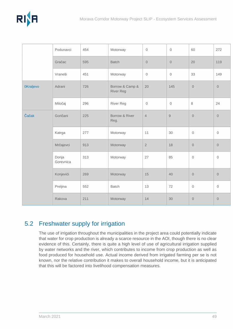
Morava Corridor Motorway Project SLIP - Ecosystem Services Assessment
March 2021 49
Podunavci 454 Motorway 0 0 60 272
Gracac 595 Batch 0 0 20 119
Vranesi 451 Motorway 0 0 33 149
0Kraljevo Adrani 726 Borrow & Camp &
River Reg
20 145 0 0
Milocaj 296 River Reg 0 0 8 24
Cacak Goricani 225 Borrow & River
Reg.
4 9 0 0
Katrga 277 Motorway 11 30 0 0
Mrcajevci 913 Motorway 2 18 0 0
Donja
Gorevnica
313 Motorway 27 85 0 0
Konjevici 269 Motorway 15 40 0 0
Preljina 552 Batch 13 72 0 0
Rakova 211 Motorway 14 30 0 0
5.2 Freshwater supply for irrigation
The use of irrigation throughout the municipalities in the project area could potentially indicate
that water for crop production is already a scarce resource in the AOI, though there is no clear
evidence of this. Certainly, there is quite a high level of use of agricultural irrigation supplied
by water networks and the river, which contributes to income from crop production as well as
food produced for household use. Actual income derived from irrigated farming per se is not
known, nor the relative contribution it makes to overall household income, but it is anticipated
that this will be factored into livelihood compensation measures.
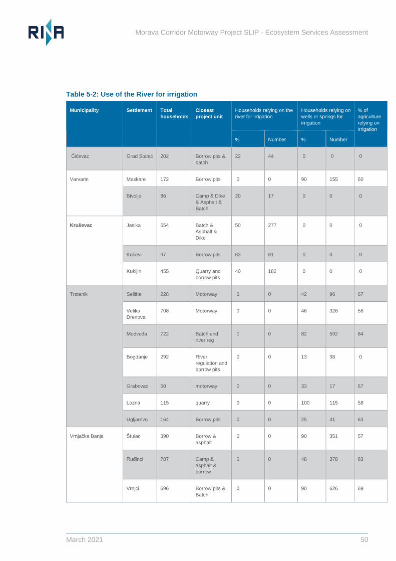
Morava Corridor Motorway Project SLIP - Ecosystem Services Assessment
March 2021 50
Table 5-2: Use of the River for irrigation
Municipality Settlement Total
households
Closest
project unit
Households relying on the
river for irrigation
Households relying on
wells or springs for
irrigation
% of
agriculture
relying on
irrigation
% Number % Number
Cicevac Grad Stalac 202 Borrow pits &
batch
22 44 0 0 0
Varvarin
Maskare 172 Borrow pits 0 0 90 155 60
Bivolje 86 Camp & Dike
& Asphalt &
Batch
20 17 0 0 0
Krusevac
Jasika 554 Batch &
Asphalt &
Dike
50 277 0 0 0
Kosevi 97 Borrow pits 63 61 0 0 0
Kukljin 455 Quarry and
borrow pits
40 182 0 0 0
Trstenik
Seliste 228 Motorway 0 0 42 96 67
Velika
Drenova
708 Motorway 0 0 46 326 58
Medveđa 722 Batch and
river reg
0 0 82 592 84
Bogdanje 292 River
regulation and
borrow pits
0 0 13 38 0
Grabovac 50 motorway 0 0 33 17 67
Lozna 115 quarry 0 0 100 115 58
Ugljarevo 164 Borrow pits 0 0 25 41 63
Vrnjacka Banja
Stulac 390 Borrow &
asphalt
0 0 90 351 57
Ruđinci 787 Camp &
asphalt &
borrow
0 0 48 378 83
Vrnjci 696 Borrow pits &
Batch
0 0 90 626 69
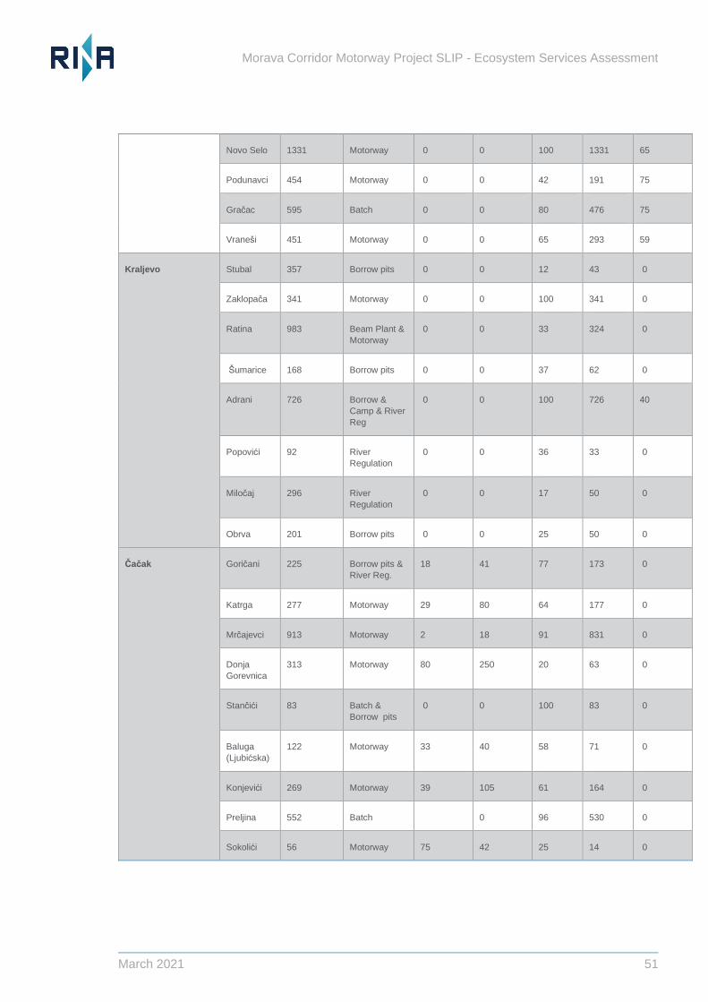
Morava Corridor Motorway Project SLIP - Ecosystem Services Assessment
March 2021 51
Novo Selo 1331 Motorway 0 0 100 1331 65
Podunavci 454 Motorway 0 0 42 191 75
Gracac 595 Batch 0 0 80 476 75
Vranesi 451 Motorway 0 0 65 293 59
Kraljevo
Stubal 357 Borrow pits 0 0 12 43 0
Zaklopaca 341 Motorway 0 0 100 341 0
Ratina 983 Beam Plant &
Motorway
0 0 33 324 0
Sumarice 168 Borrow pits 0 0 37 62 0
Adrani 726 Borrow &
Camp & River
Reg
0 0 100 726 40
Popovici 92 River
Regulation
0 0 36 33 0
Milocaj 296 River
Regulation
0 0 17 50 0
Obrva 201 Borrow pits 0 0 25 50 0
Cacak
Goricani 225 Borrow pits &
River Reg.
18 41 77 173 0
Katrga 277 Motorway 29 80 64 177 0
Mrcajevci 913 Motorway 2 18 91 831 0
Donja
Gorevnica
313 Motorway 80 250 20 63 0
Stancici 83 Batch &
Borrow pits
0 0 100 83 0
Baluga
(Ljubicska)
122 Motorway 33 40 58 71 0
Konjevici 269 Motorway 39 105 61 164 0
Preljina 552 Batch 0 96 530 0
Sokolici 56 Motorway 75 42 25 14 0
Morava Corridor Motorway Project SLIP - Ecosystem Services Assessment
March 2021 52
5.3 Food, good nutrition and income from farming
The vast majority of local residents in the AOI rely on crops as a source of food and nutrition through
direct consumption as well as indirect through food for livestock. Crop production for household
income is also relied upon by farmers and farm workers.
In the area surrounding the proposed highway, arable land amounts to 81.6% of all agricultural
land (Table 5-3), which is considerably higher than the national average (ESIA, 2018, pg. 134).
98% of agricultural land currently in use is privately owned, with the properties managed by 16,585
agricultural households, so that one household uses around 2.8 ha of land, significantly below the
national average. To a lesser extent the area has pastures and hay meadows used for livestock.
In the baseline situation, the intensity of agriculture is declining in some areas, with some evidence
for rural depopulation. The degree of abandonment suggests there is sufficient supply of land to
meet current user requirements, however the productivity of land for crop production is constrained
by water supply, hence the importance of irrigation in the AOI. For the purposes of ESA, we are
not able to evaluate the extent to which current benefits from farming (income and food) are
regarded as “sufficient” by beneficiaries.
Table 5-3: Agricultural land within AOI
5.4 Flood Protection to people, property and farmland
The Zapadna Morava River in the Project location meanders within a wide floodplain, providing
some flood storage and flood attenuation, with both local and downstream benefits. However,
significant flood events occur and settlement / infrastructure within the floodplain is at risk. The
last major event was in 2014 and after this, the Jaroslav Cerni Water Institute (JCWI) conducted
a Hydrotechnical Study of E-761 Motorway Route, Section Pojate-Preljina to re-determine the 100
year-flood zone line. Significant further changes could occur over the lifetime of the Project and
further into the future as a result of climate change, but it is understood that implications of climate
change have been considered. The Hydrotechnical study proposed river regulation on the Zapadna
Morava River primarily to protect the Project but there could also be some benefit to settlements in
the floodplain.
Land use Current
extent
(ha)
Arable land / crop production (Kosztra et al. 2019; 2U1K 2020). 8000
Pastures or meadows with varying frequencies and intensities of mowing and/or
grazing covered in natural or sown herbaceous species are located within the wider
AOI (Kosztra et al. 2019). Within the AOI, regularly grazed mesotrophic pastures are
located along the dry riverbed sections of the Zapadna Morava River (2U1K 2020).
56.9
Heterogenous agricultural areas with complex cultivation patterns 5113
Morava Corridor Motorway Project SLIP - Ecosystem Services Assessment
March 2021 53
The Zapadna Morava River does not currently have a continuous flood protection system and
retains long stretches of watercourses without dikes (or with dikes only along one riverbank).
Urban areas have “hard defences”, and agricultural areas are left to flood, currently conferring
a degree of flood protection. Establishment of some settlements, farming activity and
infrastructure within the floodplain appears to have exposed more receptors to significant local
flood risk, however. Current (baseline) flood protection benefits from the attenuation provided
by the floodplain in the AOI are probably experienced downstream as much as locally. The
ESIA does not discuss floodplain functioning in any detail and it is not possible to quantify the
level of flood attenuation provided by the floodplain and its associated ecosystems in the
baseline situation for the Project. Numbers of households and people exposed to significant
flood risk are also unclear at this stage. It is important to note that unregulated stretches of
river with naturally functioning floodplains are increasingly rare, making them of considerable
ecological importance. The full extent of potential downstream changes in flood regime is not
known at this stage. Ongoing 2D models appear to be limited to the downstream limits of the
Project but the possibility of impacts further downstream should be excluded.
A degree of flood protection is derived from ecosystems in the Zapadna Morava River catchment
which slow surface run-off, hence modification of land use in river catchments is used increasingly
in Europe to attenuate flooding. The original vegetation of the AOI has changed over time with
reduced areas of oak forest and more areas with modified, anthropogenic vegetation through the
development of agricultural land, settlements and related infrastructure. This will have reduced the
functionality of the floodplain in terms of slowing surface run-off, flood storage and attenuation, but
there are likely to be opportunities for planned biodiversity mitigation to restore some of this
functionality. Further information is on flood regimes and how they will change is being developed
through ongoing modelling.
5.5 Heating from firewood
Residents in the AOI use wood sourced from local forests and woodland to heat their homes. In
many cases this is the primary source of domestic heating in winter. In 27 settlements all household
heating is based on firewood, with a high proportion of households collecting wood for their own
use, as shown in Table 5-4.
Firewood is mostly derived from forests and woodlands located out of the floodplain, some of which
are identified as areas for borrow pits (Figure 5.1). 90% of communities currently collect firewood
from the forest, but the number of households reported to collect wood themselves is smaller than
the number saying they use it for heating, so some households must purchase wood from others.
Table 5-4: Settlements where all households use firewood for heating
Settlement Total
households
Closest
project
component
% of firewood
sourced from
neighbouring
forests
Number of households
collecting firewood
from forests for
household use
Grad Stalac 202 Borrow &
Batch
100 202
Jasika 554 Batch &
Asphalt & Dike
60 332
Morava Corridor Motorway Project SLIP - Ecosystem Services Assessment
March 2021 54
Seliste 228 Motorway 42 96
Velika
Drenova
708 Motorway 83 588
Bogdanje 292 River
regulation and
borrow pits
73 213
Grabovac 50 Motorway 33 17
Lozna 115 Quarry 83 95
Stulac 390 Borrow pits &
asphalt
49 191
Ruđinci 787 Camp &
asphalt &
borrow pits
28 220
Vrnjci 696 Borrow pits &
batch plant
30 209
Ugljarevo 164 Borrow pits 100 164
Novo Selo 1331 Motorway 52 692
Vranesi 451 Motorway 29 131
Vrba 432 Motorway 60 259
Ratina 983 Beam Plant &
Motorway
33 324
Sirca 436 River
regulation and
borrow pits
80 349
Grdica 251 Borrow & River
regulation
0 0
Popovici 92 River Reg 88 81
Obrva 201 Borrow pits 50 101
Goricani 225 Borrow pits &
river Reg.
14 32
Katrga 277 Motorway 21 58
Donja
Gorevnica
313 Motorway 27 85
Stancici 83 Batch &
borrow pits
25 21
Baluga
(Ljubicska)
122 Motorway 17 21
Konjevici 269 Motorway 8 22
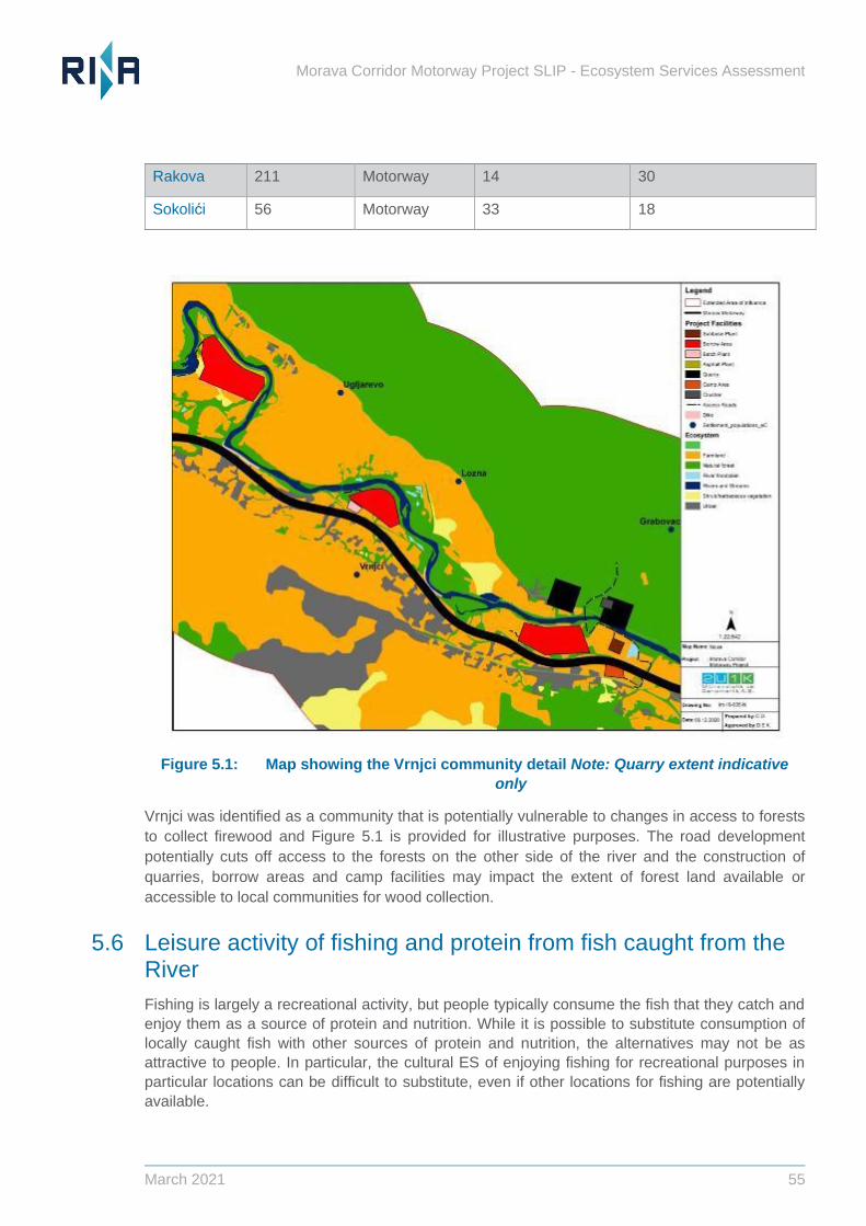
Morava Corridor Motorway Project SLIP - Ecosystem Services Assessment
March 2021 55
Rakova 211 Motorway 14 30
Sokolici 56 Motorway 33 18
Figure 5.1: Map showing the Vrnjci community detail Note: Quarry extent indicative
only
Vrnjci was identified as a community that is potentially vulnerable to changes in access to forests
to collect firewood and Figure 5.1 is provided for illustrative purposes. The road development
potentially cuts off access to the forests on the other side of the river and the construction of
quarries, borrow areas and camp facilities may impact the extent of forest land available or
accessible to local communities for wood collection.
5.6 Leisure activity of fishing and protein from fish caught from the River
Fishing is largely a recreational activity, but people typically consume the fish that they catch and
enjoy them as a source of protein and nutrition. While it is possible to substitute consumption of
locally caught fish with other sources of protein and nutrition, the alternatives may not be as
attractive to people. In particular, the cultural ES of enjoying fishing for recreational purposes in
particular locations can be difficult to substitute, even if other locations for fishing are potentially
available.
Morava Corridor Motorway Project SLIP - Ecosystem Services Assessment
March 2021 56
5.7 Hunting and wild food
Hunting and wild food collection from woodland, forests and other natural ecosystems are a
common activity, constituting important provisioning and cultural ES. It is not clear whether there is
sufficient area to meet demand in the baseline situation, but it seems likely given the presence of
extensive hunting reserves.
Morava Corridor Motorway Project SLIP - Ecosystem Services Assessment
March 2021 57
6 Assessment of Project-impacts on Priority ES
6.1 Overview of Project-impacts
The ESIA provides a description of the Project and its impacts during construction and operation.
A very brief overview is provided here.
The construction of the motorway will involve direct (temporary and permanent) physical
infrastructure, causing some loss of ecosystem in the Project corridor.
Some sections of the road pass through the floodplain of the Zapadna Morava river and some
modifications to the course of the river are planned, as well as extensive riverbank “protection”
using revetments, stone and re-profiling for many kilometres.
The construction of the Motorway and associated river structures may affect the chemical and
ecological status of the Zapadna Morava water body and groundwater. Chapter 6 of the ESIA
states that impacts are also possible on the Južna Morava and Velika Morava water bodies,
downstream from the confluence of the Zapadna Morava. Further information is needed on the
extent of these changes and the specific water supplies affected, however it is clear that the
Project may affect the supply (volumes and quality) of freshwater to beneficiaries for drinking,
domestic use and crop irrigation. Ability to access water may also be affected due to
reconfiguration of the River and alteration of its location in relation to users. Finally, the level of
benefit derived may be affected, with potential impacts on access to sufficient volumes of water
of a suitable quality for healthy life. Altered ability to irrigate crops may also affect income from
arable farming.
The Project design makes provision for collection of surface run-off in trenches with concrete
channels (ESIA, 2018), also for some water treatment (e.g., separators to remove
hydrocarbons). Water bodies to receive treated run-off have not been identified at this stage.
All sections of the road currently pass through the potential flood zone of the river and significant
modifications to the course of the River are planned, as well as extensive riverbank “protection”
using revetments, stone and re-profiling for many kilometres.
Large amounts of construction material will be transported during highway construction. New
borrow pits and unsuitable soil waste areas will be opened. These activities can cause land
degradation or permanent soil loss. Land degradation due to landfills and borrow pit-formation,
and the excavation of construction material cannot be quantified at this stage as locations and
volumes have not been confirmed.
6.2 Changes in ES supply, use and benefit
The Project may affect ES supply, use/ access or benefit either directly (for example by removing
an area of ecosystem) or indirectly (for example by altering patterns of land use or causing
additional areas of Natural Habitat to become degraded because of concentration of activities in a
smaller overall area. Ideally changes in these parameters would be quantified, allowing their
significance to be evaluated in terms of the ability of affected people to derive the benefits they
need. Reduced supply of an ES will not necessarily be significant if people can still derive sufficient
benefit to meet their needs (in other words, level of supply remains sufficient despite project-
impacts).
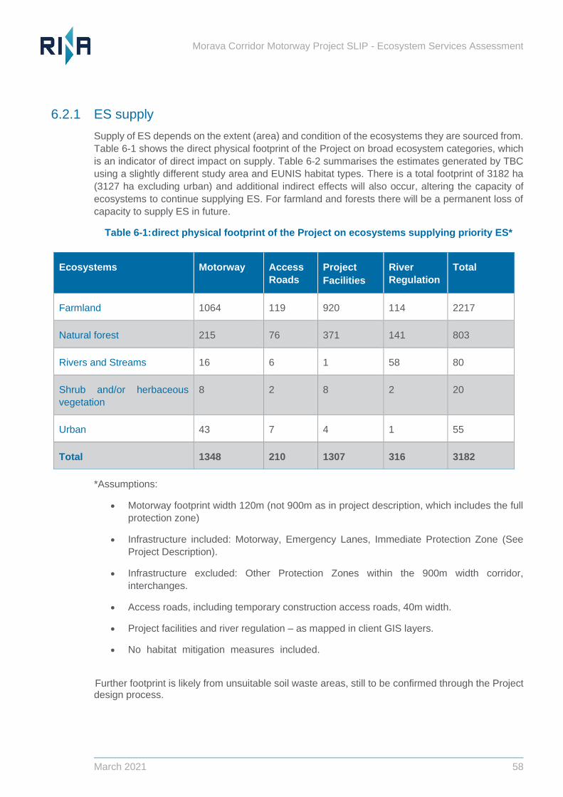
Morava Corridor Motorway Project SLIP - Ecosystem Services Assessment
March 2021 58
6.2.1 ES supply
Supply of ES depends on the extent (area) and condition of the ecosystems they are sourced from.
Table 6-1 shows the direct physical footprint of the Project on broad ecosystem categories, which
is an indicator of direct impact on supply. Table 6-2 summarises the estimates generated by TBC
using a slightly different study area and EUNIS habitat types. There is a total footprint of 3182 ha
(3127 ha excluding urban) and additional indirect effects will also occur, altering the capacity of
ecosystems to continue supplying ES. For farmland and forests there will be a permanent loss of
capacity to supply ES in future.
Table 6-1: direct physical footprint of the Project on ecosystems supplying priority ES*
*Assumptions:
• Motorway footprint width 120m (not 900m as in project description, which includes the full
protection zone)
• Infrastructure included: Motorway, Emergency Lanes, Immediate Protection Zone (See
Project Description).
• Infrastructure excluded: Other Protection Zones within the 900m width corridor,
interchanges.
• Access roads, including temporary construction access roads, 40m width.
• Project facilities and river regulation – as mapped in client GIS layers.
• No habitat mitigation measures included.roject facilities is overestimated, precise
extent of final quarry extraction unknown.
Further footprint is likely from unsuitable soil waste areas, still to be confirmed through the Project design process.
Ecosystems Motorway Access
Roads
Project
Facilities
River
Regulation
Total
Farmland 1064 119 920 114 2217
Natural forest 215 76 371 141 803
Rivers and Streams 16 6 1 58 80
Shrub and/or herbaceous
vegetation
8 2 8 2 20
Urban 43 7 4 1 55
Total 1348 210 1307 316 3182
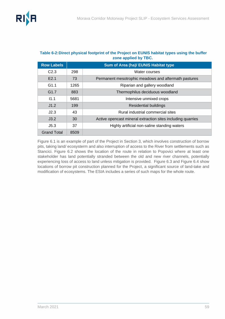
Morava Corridor Motorway Project SLIP - Ecosystem Services Assessment
March 2021 59
Table 6-2: Direct physical footprint of the Project on EUNIS habitat types using the buffer
zone applied by TBC.
Row Labels Sum of Area (ha)/ EUNIS Habitat type
C2.3 298 Water courses
E2.1 73 Permanent mesotrophic meadows and aftermath pastures
G1.1 1265 Riparian and gallery woodland
G1.7 883 Thermophilus deciduous woodland
I1.1 5681 Intensive unmixed crops
J1.2 199 Residential buildings
J2.3 43 Rural industrial commercial sites
J3.2 30 Active opencast mineral extraction sites including quarries
J5.3 37 Highly artificial non-saline standing waters
Grand Total 8509
Figure 6.1 is an example of part of the Project in Section 3, which involves construction of borrow
pits, taking land/ ecosysterm and also interruption of access to the River from settlements such as
Stancici. Figure 6.2 shows the location of the route in relation to Popovici where at least one
stakeholder has land potentially stranded between the old and new river channels, potentially
experiencing loss of access to land unless mitigation is provided. Figure 6.3 and Figure 6.4 show
locations of borrow pit construction planned for the Project, a significant source of land-take and
modification of ecosystems. The ESIA includes a series of such maps for the whole route.
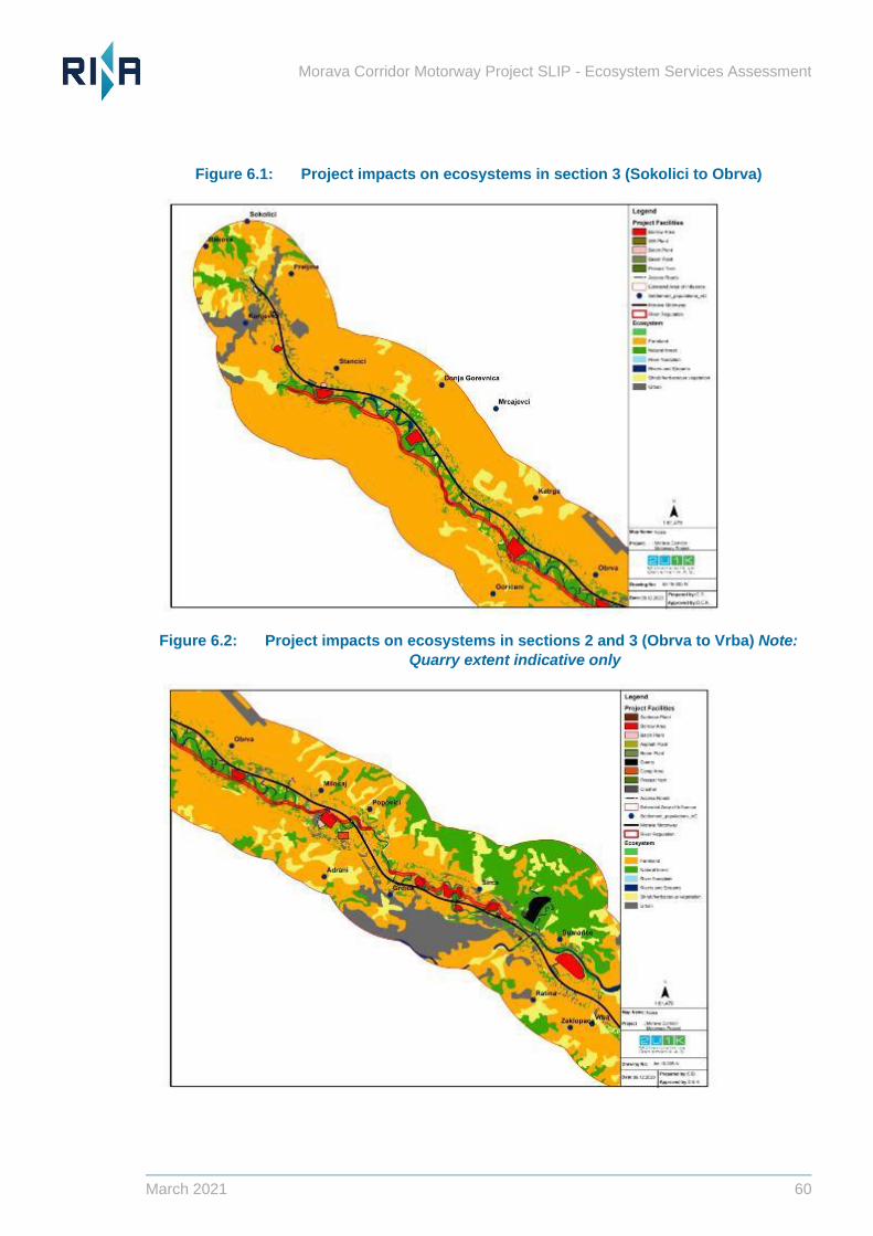
Morava Corridor Motorway Project SLIP - Ecosystem Services Assessment
March 2021 60
Figure 6.1: Project impacts on ecosystems in section 3 (Sokolici to Obrva)
Figure 6.2: Project impacts on ecosystems in sections 2 and 3 (Obrva to Vrba) Note:
Quarry extent indicative only
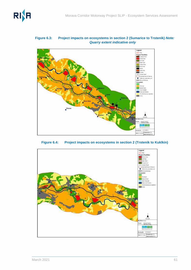
Morava Corridor Motorway Project SLIP - Ecosystem Services Assessment
March 2021 61
Figure 6.3: Project impacts on ecosystems in section 2 (Sumarice to Trstenik) Note:
Quarry extent indicative only
Figure 6.4: Project impacts on ecosystems in section 2 (Trstenik to Kuklkin)
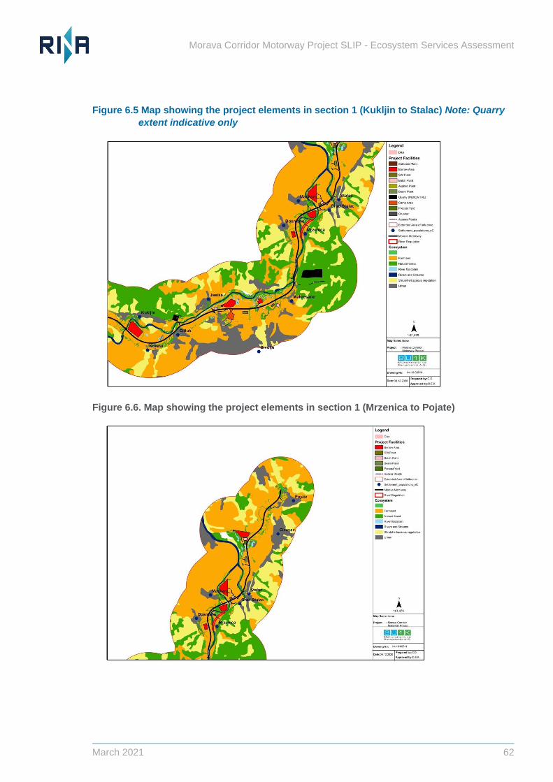
Morava Corridor Motorway Project SLIP - Ecosystem Services Assessment
March 2021 62
Figure 6.5 Map showing the project elements in section 1 (Kukljin to Stalac) Note: Quarry
extent indicative only
Figure 6.6. Map showing the project elements in section 1 (Mrzenica to Pojate)
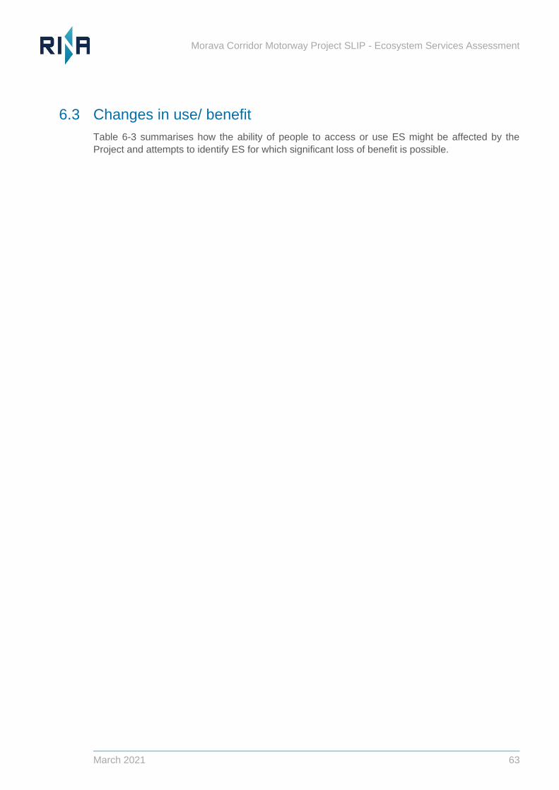
Morava Corridor Motorway Project SLIP - Ecosystem Services Assessment
March 2021 63
6.3 Changes in use/ benefit
Table 6-3 summarises how the ability of people to access or use ES might be affected by the
Project and attempts to identify ES for which significant loss of benefit is possible.

Morava Corridor Motorway Project SLIP - Ecosystem Services Assessment
March 2021 64
Table 6-3: Summary of Project-related changes and potential ES impacts
Ecosystem Service Impact from the project Change in ES supply, use or benefit
Freshwater obtained
from the River or from
groundwater in
connectivity with the
River
- Use of water by the Project during
construction for camps, batch plants, asphalt
plants.
- Alteration of the river regime and
hydrogeomorphology.
- Alteration of land use: the new regime could
support intensification of farming, with
implications for quality of water obtained from
groundwater due to increased agricultural run-
off.
- Unknown effects on the height of the
groundwater table and its accessibility via
springs and wells, caused by river modification
and additional excavation in the floodplain for
sand and aggregate.
- Polluted surface water run-off to surface water
bodies if road drainage is not 100% effective.
- Accidental spills of fuel or hazardous wastes
affecting water quality and potential toxic
effects on aquatic organisms and vegetation.
- Supply of water from the River system will change in terms of
flow/volume due to project-related abstraction.
- Flows and volumes may not alter significantly due to modification
of the river system, but designs are not finalised.
- Water quality impacts are possible during construction and
operation.
- Physical access to abstract river water could be altered by river
modifications and the road alignment (changes in access points,
water supply infrastructure.
- Benefits could be affected if there is any interruption to water use
or any deterioration in water quality for any user.
- Potential risks are greatest for the households with 100%
dependence on “the river” for domestic freshwater requirements.
JCWI considers it unlikely that any households fall into this
category.
- Villages in some municipalities use springs that could be affected
by construction or operation of the Project
o Municipality of Vrnjacka Banja: some drinking water
taken from the alluvium of the West Morava and the
Springs “Vitojevac” and “Ugljarevo” are in the zone of
influence of the highway and the river Zapadna Morava.
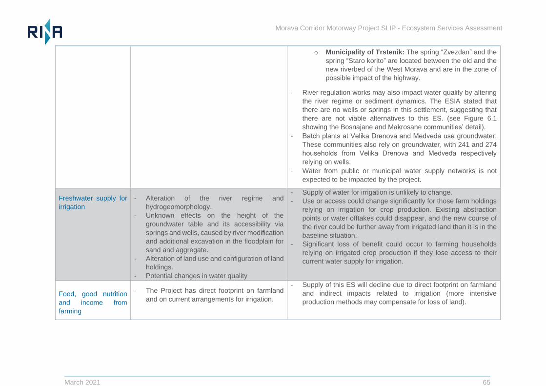
Morava Corridor Motorway Project SLIP - Ecosystem Services Assessment
March 2021 65
o Municipality of Trstenik: The spring “Zvezdan” and the
spring “Staro korito” are located between the old and the
new riverbed of the West Morava and are in the zone of
possible impact of the highway.
- River regulation works may also impact water quality by altering
the river regime or sediment dynamics. The ESIA stated that
there are no wells or springs in this settlement, suggesting that
there are not viable alternatives to this ES. (see Figure 6.1
showing the Bosnajane and Makrosane communities’ detail).
− Batch plants at Velika Drenova and Medveđa use groundwater.
These communities also rely on groundwater, with 241 and 274
households from Velika Drenova and Medveđa respectively
relying on wells.
− Water from public or municipal water supply networks is not
expected to be impacted by the project.
Freshwater supply for
irrigation
- Alteration of the river regime and
hydrogeomorphology.
- Unknown effects on the height of the
groundwater table and its accessibility via
springs and wells, caused by river modification
and additional excavation in the floodplain for
sand and aggregate.
- Alteration of land use and configuration of land
holdings.
- Potential changes in water quality
- Supply of water for irrigation is unlikely to change.
- Use or access could change significantly for those farm holdings
relying on irrigation for crop production. Existing abstraction
points or water offtakes could disappear, and the new course of
the river could be further away from irrigated land than it is in the
baseline situation.
- Significant loss of benefit could occur to farming households
relying on irrigated crop production if they lose access to their
current water supply for irrigation.
6.4 Food, good nutrition
and income from
farming
- The Project has direct footprint on farmland
and on current arrangements for irrigation.
- Supply of this ES will decline due to direct footprint on farmland
and indirect impacts related to irrigation (more intensive
production methods may compensate for loss of land).
Morava Corridor Motorway Project SLIP - Ecosystem Services Assessment
March 2021 66
- Access to land for management will be altered. For some
producers this could be a significant impact, affecting costs of
land management.
- The majority of settlements in the AOI rely on crop production as
a source of food and income and some will lose nutrition or
income.
- Vulnerable groups that have no alternative source of income are
vulnerable to any change related to the project. Although
compensation is offered for any damages through the RAP
process, the compensation does not account for the sense of
identity or cultural importance of crop production for many of the
local settlements.
Flood protection to
people, property and
farmland
- Change in level of flood protection provided by
the floodplain to people, property and farming
in AOI and downstream (unknown impacts at
this stage).
- Loss of flood storage capacity in the floodplain
due to construction of borrow pits which will be
water-filled.
- Permanent loss of floodplain as a supporting
service to habitats and farming.
- Change in soil stability and quality, affecting
crop yields and ultimately income from
farmers and farm workers
- Reduction in natural fertility provided by the
floodplain
- Decrease in supporting service of floodplain to
threatened ecosystems and endangered/
aquatic species.
- Supply of this ES to users and beneficiaries in the AOI and
downstream could be permanently reduced through floodplain
modifications and cumulative effects of hydro-structures. The
ESIA states that the river regime will not alter, but this is work in
progress.
- Flood attenuation through surface run-off will be reduced by
removal of riverine woodland and other natural habitat in the
floodplain.
- Changes in levels of protection for people, property and farmland
in the AOI and primarily downstream, are uncertain (further
analysis is ongoing with reports due in March).
- Alternative means of substituting flood protection are possible but
come at a future maintenance cost.
- The supporting service of the floodplain to threatened
ecosystems and endangered aquatic species will also be
impacted by the project.
Morava Corridor Motorway Project SLIP - Ecosystem Services Assessment
March 2021 67
- Benefits of natural defences replaced with
hard defences which may offer a higher level
of protection locally but potentially increase
risks downstream.
- Benefits of the project include the installation of hard flood
defences, potentially offering higher levels of protection to
flooding locally but potentially increasing downstream.
Heating from firewood - Some direct loss of forest/ woodland will
occur, both due to footprint of the motorway
and excavation of borrow pits (800 ha footprint
on forest/ woodland).
- Supply of firewood for heating will go down. This may include
areas formally and legally harvested for firewood for sale to
others and local collection of dead or fallen wood, It is not known
if this reduction will affect the ability of specific beneficiaries to
meet their needs.
- For some users, ability to access forests and woodlands to collect
firewood may alter. These effects are expected to be local to a
sub-set of communities with traditional dependence on local
forest where habitat loss will occur.
- Benefits could be significantly affected for some households.
Current livelihood compensation arrangements don’t appear to
cover loss of this ES. Further investigation is needed to ensure
that no households or vulnerable groups suffer significant loss of
ability to heat their homes in winter because of loss of access to
local woodlands or other ecosystems to collect fallen wood.
Fish/ protein in the diet
and cultural enjoyment
of fishing
- Modified river regulation may impact aquatic
species that are relied upon by the local
communities
- Reduces supply of protein
- Access to fishing areas may be reduced,
reducing level of benefit
- Change in habitats may result in a loss of fish
stocks, reducing supply
- Supply of fish (fish stocks and species composition) could be
affected by river regulation works and habitat alteration at least in
the short term, particularly in Section 2 of the Project.
- Development of new habitat in the stretches of replacement
channel may take a while to develop.
- Access to fishing could change for some settlements due to
reconfiguration of the river channel or barrier effect of the new
motorway (depending on bridges and new access
arrangements).
- There could be loss of benefit from fishing for some people due
to reduced supply/ access at least during construction.
Morava Corridor Motorway Project SLIP - Ecosystem Services Assessment
March 2021 68
- Alternative locations to fish may be available, or planned bridges
and crossings may maintain access to preferred, customary
locations.
- It is likely that people can enjoy a balanced diet without
consumption of fish they catch themselves, but they may not
prefer or accept the alternatives.
Wildfood collection
and hunting
- Some direct loss of forest/ woodland will
occur, both due to footprint of the motorway
and excavation of borrow pits (800 ha footprint
on forest/ woodland).
- Woodlands and forests are preferred for collection of wild food
and hunting.
- For some people there will be altered arrangements and levels of
access to woodland and forest for hunting (reduced area and new
barriers to access).
- There will be some loss of benefit for affected people in terms of
amount of food obtained and potentially their cultural enjoyment
of the cultural ES of collecting or hunting (road disturbance and
noise, loss of “natural” landscape.
Beekeeping for honey
and income
- For a small number of beekeepers and
businesses, hives will need to be relocated
For a small number of beekeepers and businesses this could be a
priority ES, but available data suggest that a small number of keepers
are affected. There are proposals to monitor livelihood impacts
through the RAP and these are expected to ensure that apiculturalists
can maintain levels of benefit from bee keeping, but it is important to
ensure that they are willing to accept alternative locations for
production and/or have, longer term alternatives to income if honey
produced near the road is of poor quality or can’t be sold.
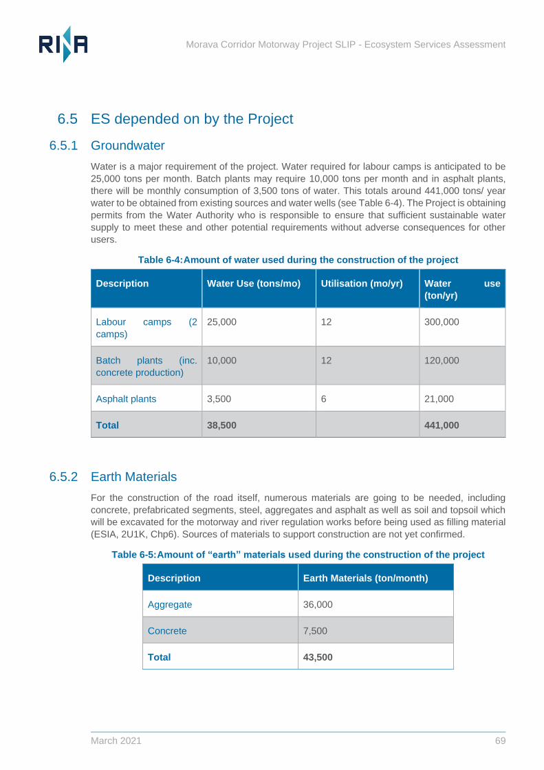
Morava Corridor Motorway Project SLIP - Ecosystem Services Assessment
March 2021 69
6.5 ES depended on by the Project
6.5.1 Groundwater
Water is a major requirement of the project. Water required for labour camps is anticipated to be
25,000 tons per month. Batch plants may require 10,000 tons per month and in asphalt plants,
there will be monthly consumption of 3,500 tons of water. This totals around 441,000 tons/ year
water to be obtained from existing sources and water wells (see Table 6-4). The Project is obtaining
permits from the Water Authority who is responsible to ensure that sufficient sustainable water
supply to meet these and other potential requirements without adverse consequences for other
users.
Table 6-4: Amount of water used during the construction of the project
Description Water Use (tons/mo) Utilisation (mo/yr) Water use
(ton/yr)
Labour camps (2
camps)
25,000 12 300,000
Batch plants (inc.
concrete production)
10,000 12 120,000
Asphalt plants 3,500 6 21,000
Total 38,500 441,000
6.5.2 Earth Materials
For the construction of the road itself, numerous materials are going to be needed, including
concrete, prefabricated segments, steel, aggregates and asphalt as well as soil and topsoil which
will be excavated for the motorway and river regulation works before being used as filling material
(ESIA, 2U1K, Chp6). Sources of materials to support construction are not yet confirmed.
Table 6-5: Amount of “earth” materials used during the construction of the project
Description Earth Materials (ton/month)
Aggregate 36,000
Concrete 7,500
Total 43,500
Morava Corridor Motorway Project SLIP - Ecosystem Services Assessment
March 2021 70
7 Identification of Mitigation Measures
This ESA has identified the relevant and priority ES affected by the Project and the main potential
impacts on the supply of these ES or the ability of people to use or benefit from them.
The best way to safeguard ES is to maintain the capacity of ecosystems to provide them by avoiding
impacts on them. Several efforts have been made to avoid or minimise the destruction and
degradation of some Natural Habitats in the Project AOI, notably avoidance of deforestation
through sensitive siting of infrastructure to avoid depletion of forest resources. Naturalised borrow
pits have also been avoided, with more modified borrow pits being prioritised for disposal of waste
soil. The Project has also explored ways to retain floodplain functioning, by limiting use of “hard”
flood defences.
Some follow up is advised to remove residual uncertainty, particularly where results of ongoing
assessments are needed to confirm residual impacts, notably 2-D modelling of flood risk and
finalisation of afforestation plans. In addition to the need to clarify residual forest losses once exact
afforestation plans are known, other issues relate to coverage of the RAP and groundwater issues.
The following actions are required to give assurance that potential risks will not be realised:
- assessment of whether specific groundwater sources (those identified by JCWI as being in
connectivity with the River) might change as a result of the Project and whether this would have
implications for any users of those sources in terms of water supply or quality.
- based on results of 2D modelling, confirm that nobody will experience a significant change in flood
protection (whether within or outside the AOI).
- based on final design and plans for afforestation, confirmation that compensation will be provided
for any vulnerable households relying on local collection of firewood so that they can heat their
homes and/ or that proposed afforestation/woodland planting compensation will ensure that no
vulnerable households lose local access for firewood collection in the longer term.
- residual implications of changes in the state and configuration of the River and access to it to
enjoy the cultural ES of recreational fishing is discussed with stakeholders and that planned
mitigation such as motorway crossings allow them to continue to access customary fishing
locations or they have other alternative locations in which to enjoy fishing.
- follow-up to ensure that any land access issues are resolved.
- special provision for vulnerable families (for example elderly landowners) to ensure they can
continue to produce or purchase the food they need.
For some priority ES, further investigation is recommended, to exclude the possibility of significant
loss of benefit for some users/ beneficiaries due to Project-related changes (ie to establish whether
levels of supply or level of use could drop below the level needed for benefits to be maintained. In
particular, further information is needed to ensure that no vulnerable people lose benefits from
priority ES, as some of them may depend disproportionately on ES for their livelihoods or wellbeing.
Additional recommended mitigation measures which target the ability of people to use or access
priority ES are summarised in Table 7-1 and include:
JCWI and BEJV to ensure or confirm that the Project has a sustainable supply of water to meet
its own needs and that abstraction of water for the Project from the River/ groundwater sources
will not affect other users.
Morava Corridor Motorway Project SLIP - Ecosystem Services Assessment
March 2021 71
JCWI and BEJV to ensure or confirm that the Project has a sufficient supply of earth materials
secured without further implications for ecosystems in the ESA spatial scope than those
identified in this report.
JCWI and BEJV and other specialists as appropriate to review results of 2D modelling when
available to assess the implications of river and floodplain modification in the AOI for people
downstream (as far as impacts could extend) in terms of flood protection. Ideally the level of
flood protection afforded by the naturally functioning floodplain should be quantified. Although
hard defences can be constructed to provide flood protection, climate change impacts over the
lifetime of the Project could mean that sufficient defences become increasingly expensive and
challenging to maintain, making natural flood attenuation more important over time.
The Project Owner with BEJV/ their social consultants to verify that:
– Project mitigation plans make provision for adequate winter heating for any household
losing access to land currently providing their firewood, particularly if any vulnerable people
(elderly households, single women households or other) are affected. Follow-up is advised
for the small number of locations where project infrastructure is within ecosystems used to
collect fallen wood locally. It is assumed that commercial sale of firewood will not be
significantly affected.
– Livelihood restoration arrangements cover necessary measures to fix irrigation systems for
farmers retaining their land holdings but experiencing any disruption.
– Livelihood restoration arrangements cover necessary measures to ensure beekeepers
have alternative suitable locations for their hives.
– The motorway does not act as a physical barrier preventing anyone from accessing their
land for farm management purposes or add significantly to the cost of management.
– All households have access to sufficient freshwater for drinking and domestic use, in
particular those relying on groundwater sources that are affected by hydrological change or
river regulation works.
– The motorway / new river alignment does not act as a physical barrier to fishers wishing to
access the River in their local area.
– Loss of access to hunting and wild food collection does not affect any vulnerable people
who depend on locally collected food for a nutritious diet and that beneficiaries accept
arrangements for compensation or alternative provision.
If the RAP monitoring and Completion Report identified that land abandonment was occurring
or there were grievances indicating that such impacts were occurring, an assessment should
be conducted to ensure that this has not resulted in loss of access to priority ES by vulnerable
families (for example elderly landowners) and/ or to identify any mitigation required to ensure
that they can continue to obtain the relevant benefits.
Many of these proposed mitigation measures can be incorporated in the Project’s proposed
management plans. Most are intended to exclude risks, based on additional stakeholder
engagement or collection of additional technical information that would allow a less precautionary
position to be adopted.
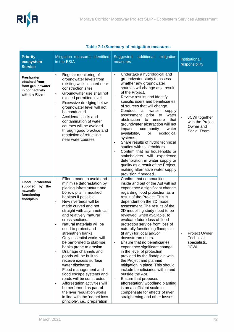
Morava Corridor Motorway Project SLIP - Ecosystem Services Assessment
March 2021 72
Table 7-1: Summary of mitigation measures
Priority
ecosystem
Service
Mitigation measures identified
in the ESIA
Suggested additional mitigation
measures Institutional
responsibility
Freshwater
obtained from
from groundwater
in connectivity
with the River
− Regular monitoring of groundwater levels from existing wells located near construction sites
− Groundwater use shall not exceed permitted level
− Excessive dredging below groundwater level will not be conducted
− Accidental spills and contamination of water courses will be avoided through good practice and restriction of refuelling near watercourses
- Undertake a hydrological and groundwater study to assess whether any groundwater sources will change as a result of the Project.
- Review results and identify specific users and beneficiaries of sources that will change.
- Conduct a water supply assessment prior to water abstraction to ensure that groundwater abstraction will not impact community water availability, or ecological systems.
- Share results of hydro technical studies with stakeholders.
- Confirm that no households or stakeholders will experience deterioration in water supply or quality as a result of the Project, making alternative water supply provision if needed.
- JCWI together with the Project Owner and Social Team
Flood protection
supplied by the
naturally
functioning
floodplain
- Efforts made to avoid and minimise deforestation by placing infrastructure and borrow pits in modified habitats if possible.
- New riverbeds will be made curved and not straight with asymmetrical and relatively “natural” cross sections.
- Natural materials will be used to protect and strengthen banks.
- Only essential works will be performed to stabilise banks prone to erosion.
- Drainage channels and ponds will be built to receive excess surface water discharge.
- Flood management and flood escape systems and roads will be constructed
- Afforestation activities will be performed as part of the river regulation works in line with the ‘no net loss principle’, i.e., preparation
- Confirm that communities inside and out of the AoI will not experience a significant change regarding flood protection as a result of the Project. This is dependent on the 2D model assessment. The results of the 2D modelling study need to be reviewed, when available, to evaluate future loss of flood protection service from loss of naturally functioning floodplain (if any) for local and/or downstream users.
- Ensure that no beneficiaries experience significant change in the level of protection provided by the floodplain with the Project and planned mitigation in place. This should include beneficiaries within and outside the AoI.
- Ensure that proposed afforestation/ woodland planting is on a sufficient scale to compensate for effects of river straightening and other losses
- Project Owner, Technical specialists, JCWI.
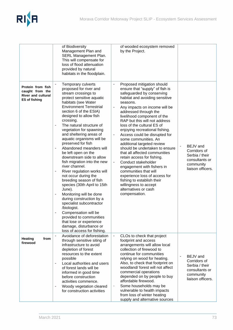
Morava Corridor Motorway Project SLIP - Ecosystem Services Assessment
March 2021 73
of Biodiversity Management Plan and SERL Management Plan. This will compensate for loss of flood attenuation provided by natural habitats in the floodplain.
of wooded ecosystem removed by the Project.
Protein from fish
caught from the
River and cultural
ES of fishing
− Temporary culverts proposed for river and stream crossings to protect sensitive aquatic habitats (see Water Environment Terrestrial section 6 of the ESIA) designed to allow fish crossing.
− The natural structure of vegetation for spawning and sheltering areas of aquatic organisms will be preserved for fish
− Abandoned meanders will be left open on the downstream side to allow fish migration into the new river channel.
− River regulation works will not occur during the breeding season of fish species (30th April to 15th June).
− Monitoring will be done during construction by a specialist subcontractor /biologist.
− Compensation will be provided to communities that lose or experience damage, disturbance or loss of access for fishing.
− Proposed mitigation should ensure that “supply” of fish is safeguarded by conserving habitat and avoiding sensitive seasons.
− Any impacts on income will be addressed through the livelihood component of the RAP but this will not address loss of the cultural ES of enjoying recreational fishing.
− Access could be disrupted for some communities. An additional targeted review should be undertaken to ensure that all affected communities retain access for fishing.
− Conduct stakeholder engagement with fishers in communities that will experience loss of access for fishing to establish their willingness to accept alternatives or cash compensation.
− BEJV and Corridors of Serbia / their consultants or community liaison officers.
Heating from
firewood
− Avoidance of deforestation through sensitive siting of infrastructure to avoid depletion of forest resources to the extent possible
− Local authorities and users of forest lands will be informed in good time before construction activities commence.
− Woody vegetation cleared for construction activities
− CLOs to check that project footprint and access arrangements will allow local collection of firewood to continue for communities relying on wood for heating. Also, to check that footprint on woodland/ forest will not affect commercial operations depended on by people to buy affordable firewood.
− Some households may be vulnerable to health impacts from loss of winter heating supply and alternative sources
− BEJV and Corridors of Serbia / their consultants or community liaison officers.
Morava Corridor Motorway Project SLIP - Ecosystem Services Assessment
March 2021 74
will be made available to settlements.
− Households who obtain income from timbering activities commercially will receive compensation according to IFI requirements.
− Afforestation activities will take place in line with No net loss principle- e.g., Biodiversity Management Plan and SERL Management Plan
of heating should be provided to compensate for this ES-related loss of benefit if CLOs identify any such risks.
− Afforestation plans under SERL should include NATIVE and locally appropriate species, to provide longer term substitution of supply. This is consistent with recommendations arising out of the CHA and no additional compensatory planting is required to compensate for impacts on this ES unless in specific cased identified by CLOs.
Food, good
nutrition or
income from crop
production
• All users of land will be financially compensated at a full replacement value where crops are lost or affected by damage during construction activities according to Serbian legislation and IFC requirements.
• Users of the land will be informed of construction activities planned.
• Users of land will be informed a timely fashion when construction is planned to begin and what provision will be made for lost crops and damages will be compensated.
• Impacts on crop lands will be minimised as far as possible by narrowing project construction footprint and restoring any damaged areas including re-planting any damaged vegetation.
Arrangements through the RAP will
address loss of livelihood through
cash compensation. The area of
land available for farming will
decrease overall. The ability of
people to access their land for
efficient production and farming
activities may also alter and this has
been identified by some
stakeholders (e.g. landowner in
Popovici with land potentially
stranded between the old and new
river courses). Implications for
access therefore need to be
assessed when details are
available.
Cash compensation (instead of
“land for land” compensation could
have several impacts on future
farming, which may intensify (more
cash investment in modern methods
and equipment) or alternatively
further land abandonment could
occur. RAP monitoring should
consider these impacts in terms of
implications for any vulnerable
families in the event that (a) the RAP
monitoring and completion report
identified that land abandonment
was occurring or (b) there were
grievances that indicated such
impacts were occurring.
The need for special provision for
vulnerable families (for example
elderly landowners) to ensure they
BEJV and Corridors
of Serbia / their
social consultants
(as part of RAP
monitoring)

Morava Corridor Motorway Project SLIP - Ecosystem Services Assessment
March 2021 75
can continue to produce or purchase
the food they need should also be
checked as part of the livelihood
restoration and RAP monitoring
process.
Morava Corridor Motorway Project SLIP - Ecosystem Services Assessment
March 2021 76
8 References
Balmford, A., A.S.L. Rodrigues, M. Walpole, P. ten Brink, M. Kettunen, L. Braat, and R. de Groot.
2008. The Economics of Biodiversity and Ecosystems: Scoping the Science. Cambridge, UK:
European Commission (contract: ENV/070307/2007/486089/ETU/B2). Available at:
http://ec.europa.eu/environment/nature/biodiversity/economics/pdf/scoping_science_report.pdf.
Boyd, J. and S. Banzhaf. 2007. “What are ecosystem services? The need for standardized
environmental accounting units.” Ecological Economics, Volume 63, pp. 616–626. Available at:
http://www.sciencedirect.com/science/article/pii/S0921800907000341.
Climate change risk assessment for the Morava Motorway Corridor Project, Ramboll (Oct 2020).
Environmental and Social Impact Assessment for the Morava Motorway Corridor Project (ESIA),
Final Draft Report, May 2020 (2U1K 2020) Chapter 1-10.
Gap Analysis Report for the Morava Motorway Corridor Project, Ramboll (July 2020).
IFC (2019) International Finance Corporation (IFC). 2012a. IFC Performance Standards on
Environmental and Social Sustainability. Washington, DC: IFC. Available at:
http://www1.ifc.org/wps/wcm/connect/c8f524004a73daeca09afdf998895a12/IFC_Performance_S
tandards.pdf?MOD=AJPERES.
International Finance Corporation (IFC). 2012b. International Finance Corporation’s Guidance
Notes: Performance Standards on Environmental and Social Sustainability. DC: IFC. Available at
http://www1.ifc.org/wps/wcm/connect/e280ef804a0256609709ffd1a5d13d27/GN_English_2012_
Full-Document.pdf?MOD=AJPERES.
Kareiva, P., H. Tallis, T. H. Ricketts, G. C. Daily, and S. Polansky. 2011. Natural Capital: Theory
and Practice of Mapping Ecosystem Services. New York: Oxford University Press.
Kosztra, B., Buttner, G., Hazeu, G. & Arnold, S. (2019) Updated CLC illustrated nomenclature
guidelines (No. ETCULS 9/2017). European Environment Agency (EEA), Copenhagen, Denmark.
Landsberg, F., J. Treweek, M.M. Stickler, N. Henninger, and O. Venn. (2013). Weaving Ecosystem
Services Into Impact Assessment: A Step-By-Step Method (Version 1.0). Washington, DC: World
Resources Institute. Available at: www.wri.org/publication/weaving-ecosystem-services-into-
impact-assessment.
Ramboll, May 2020, Morava Corridor Motorway Project Gap Analysis Report.
MIGA Performance Standards 6 Supplemental Biodiversity Assessment.
Millennium Ecosystem Assessment (MA). 2003. Ecosystems and Human Well-being: A Framework
for Assessment. Washington, DC: Island Press. Available at:
http://www.unep.org/maweb/en/Framework.aspx.
Millennium Ecosystem Assessment (MA). 2005. Ecosystems and Human Well-being: Synthesis.
Washington, DC: Island Press. Available at:
http://www.unep.org/maweb/documents/document.356.aspx.pdf.
Morava Corridor Motorway Project SLIP - Ecosystem Services Assessment
March 2021 77
Morava Corridor Environmental and Social Impact Assessment Report Non-Technical Summary
(Sep 2020).
National Research Council of the National Academies (NRC). 2005. Valuing ecosystem services:
Towards better environmental decision-making. Washington, DC: National Academies Press.
Available at: http://www.nap.edu/openbook.php?isbn=030909318X.
Novakovic, B., 2013. Indicative ecological status assessment of the Zapadna Morava River based
on aquatic macroinvertebrate community. Water research and management, 3(2), pp.37-42.
Regulation of The Zapadna Morava River Within the Infrastructure Corridor of the E-761 Motorway
Basic information and key viewpoints. JCWI (May, 2020)
Resettlement Action Plan Execution Plan for the Morava Motorway Corridor Project (ARUP, Nov
2020)
Resettlement and Livelihood Restoration Framework for the Morava Motorway Corridor Project
(2U1K, July 2020).
The Biodiversity Consultancy (TBC, 2020). Critical Habitat Assessment, Morava Corridor Motorway
Project, Serbia. Final. November 2020, The Biodiversity Consultancy Ltd, Cambridge, UK, 54
pp.
United Nations (UN). 1992. Convention on Biological Diversity. Available at:
http://www.cbd.int/doc/legal/cbd-en.pdf.
United Nations Environment Programme-World Conservation Monitoring Centre (UNEP-WCMC).
2011. Developing ecosystem service indicators: Experiences and lessons learned from sub-
global assessments and other initiatives. Montréal, Canada: Secretariat of the Convention on
Biological Diversity. Available at
http://www.bipindicators.net/LinkClick.aspx?fileticket=QxjjDuqt2Qk%3d&tabid=155.
van Oudenhoven, A.P.E., K. Petz, R. Alkemade, L. Hein, R.S. de Groot. 2012. “Framework for
systematic indicator selection to assess effects of land management on ecosystem services.”
Ecological Indicators, Volume 21, pp. 110–122. Available at:
http://www.sciencedirect.com/science/article/pii/S1470160X12000271#


Morava Corridor Motorway Project SLIP - Ecosystem Services Assessment
March 2021 79
RINA Consulting Ltd.
2nd Floor Offices
Nile House, Nile Street
Brighton, BN1 1HW, UK
+44 (0)1273 819 429
rina.org