observatory of spatial impacts of the egnatia motorway observatory of spatial impacts of the egnatia...
TRANSCRIPT
EGNATIA ODOS Α.Ε.: Innovations, Research, and Modern Management Systems, Conference 15/02/2006, Thessalonica, Greece
Observatory of Spatial Impacts of the Egnatia Motorway 27. - 1
Observatory of Spatial Impacts of the Egnatia Motorway
VASSILY FOURKAS, ZOË PAPASIOPI * Translated in English by Antonis Perpatidis, Division of Human Resources, EGNATIA ODOS A.E
Abstract This paper presents the effort of Egnatia Odos A.E. Company to develop a mechanism for monitoring the spatial impacts of the Egnatia motorway and its vertical axes. The scope of the Observatory is to collect and process data in a scientifically documented way, and calculate indicators that monitor the impacts over time on the social, economic and territorial cohesion, on the spatial structure, on the transportation system, and on the environment of N. Greece and the greater area of SE Europe. The paper comprises a summary review of the general scientific framework and policies of the EU, as well as of the international experience in the systematic monitoring and assessment of the interaction between transportation infrastructures and spatial development. Then the Egnatia Observatory is presented in detail and the following are described: (a) its establishment and action plan, (b) its organization, infrastructure, and productive operation, (c) the system of indicators, (d) the diffusion and networking activities, and (e) the main points of assessment and perspectives. The paper closes by summarizing the general crucial issues, and identifies the special characteristics of the Egnatia Observatory that make it an innovative and useful tool for information, decision support, and policy making – not only for the Company but for all Regional and National bodies and agencies involved in spatial planning and development. 1. INTRODUCTION
The issues that usually become the centre of decision-making in Greece regarding the construction of new transport infrastructures are the technical characteristics and the financing terms. Nevertheless, the discussion that delimitates the quality difference of works should regard also the expected spatial impacts on the environment, the general transportation system, the development level and quality of life, as well as the spatial planning and structure of activities in the areas directly and/ or indirectly influenced [12].
The Egnatia Motorway is one of the largest transport projects constructed lately in Europe, and was included in the top priority projects of the Trans European Transport Networks (TENs-T). It links Greece to Europe and the Middle East, while it operates as a collection axis of Pan European Transport Corridors that cross SE Europe from North to South through vertical axes. The motorway, 670 km long, crosses Northern Greece horizontally, and links all major urban centres, 4 ports and 6 airports. Through vertical axes it secures the connection with the network of neighbouring Balkan states, providing accessibility to some of the most isolated and least developed Regions of Greece and Europe (Epirus, Western Macedonia, and Thrace).
To the construction of the Egnatia mainline and three main vertical axes the amount of € 6.7 bn is allocated from national and EU sources. The importance of the project and the investment size necessitate supplementary actions, beyond construction, that would multiply benefits and mitigate the impacts from operation. It is necessary to monitor and assess the impacts of the Egnatia motorway, not only on transports and the operation of the road network, but also on the economic, social and territorial cohesion, the environment, and the general spatial arrangement of the geographical zone crossed and influenced.
In this context Egnatia Odos A.E. (EOAE) established and operates the Observatory of the Egnatia Motorway, in order to: (a) support the integrated management of the motorway, (b) contribute to the utilization of the project in the cohesion and development of a greater area, and (c) contribute to the harmonized assessment of TENs-T impacts on the cohesion of the European area.
According to documented scientific methods and the development of a modern infrastructure of information systems, the Observatory collects, processes, and provides valid and updated data regarding parameters such as:
• the mobility and ease of access to regions, urban centres, markets, and services,
• the development level, the convergence degree and the intraregional inequalities,
• the urban development and networking of urban centres,
• the characteristics of the transport system and the operation of the road network, and
• the quality of the environment. The results, the reports and generally the output of the
Observatory are provided to the public and the agencies interested via the Internet, as well as with documents, information leaflets, events etc. Apart from the diffusion of the output, the operation and development of the Observatory comprises also the networking and cooperation with similar organizations, research centres, and public or private bodies.
Before the detailed presentation of the Observatory, the next three chapters summarise the scientific and political framework regarding the interaction of transport infrastructures and spatial development, as well as the main issues that arise from the international experience of organization and operation of mechanisms for monitoring this interaction.
EGNATIA ODOS Α.Ε.: Innovations, Research, and Modern Management Systems, Conference 15/02/2006, Thessalonica, Greece
Observatory of Spatial Impacts of the Egnatia Motorway 27. - 2
2. TRANSPORT INFRASTRUCTURES AND SPATIAL DEVELOPMENT
2.1. Scientific framework
An extended analysis and presentation of all scientific
approaches is impossible in the context of this paper. Besides, the direction and the content of interaction between transport infrastructure and spatial development remain open for scientific discussion and research.
In an attempt for a very brief overview of related scientific approaches, as well as in empirical studies, on the basis of the excellent overview by Tranos [38], a main starting point is established: Transport infrastructures are considered a priori as regional development projects. A better level of transport infrastructures, and specifically a modern system of road axes, leads to the reduction of the transport cost and the improvement of accessibility of a region. This improvement makes the productive system of the region more competitive and may lead to an upgrading of the related position of a regional economy. Nevertheless, this is not the only condition for regional development. Investments in transport infrastructures should not be the final stage of the policy included in the field of spatial development and regional planning [36, 37]. Transport infrastructures are considered very important for the creation of conditions - not of guarantees - for regional convergence and development [13, 10, 6, 14]. It is a characteristic example that in the European Area the differences of transport infrastructures follow a similar geographical distribution as the Gross Domestic Product (GDP) per capita, and may finally reinforce spatial inequalities instead of mitigating them [23, 28, 9, 22].
On the other hand, the environmental impacts of road transport infrastructures are generally found at two levels [32]. The first level regards their positioning, while the second one their use. With reference to their positioning, concerns focus on the change in land uses and possible changes and impacts on natural ecosystems and the aesthetic downgrading of the landscape [1, 11]. As regards their use, concerns focus on the emission of pollutants in the air, water, and soil by vehicles, as well as on the increase in noise levels in crossed areas [33, 8].
In an attempt for an integrated approach, Giannakou [25] suggests that the impacts of a new transport infrastructure project may be described as the following sequence of steps: The new project reduces the transport cost, resulting in the improvement (as well as a change in relevant position) of accessibility of impact zones. This improvement affects the demand for movements and results in an increase (as well as a change in relevant position) of both business productivity and housing demand, further resulting in a change in the concentration of population and activities. These changes then result to a change in the demand for movements, generating pressures for the construction of a new transport infrastructure, and general changes in the transport system. As a whole, the above change affects the environment (natural and built).
According to this approach, the interactions between transport infrastructure and spatial development may be classified in three general categories:
• direct impacts related to changes in mobility and accessibility.
• indirect impacts related to the spatial performance of businesses and households, as well as to the mobility of businesses and human resources.
• diffusion impacts, i.e. impacts generated by the two impacts above, which concern the diffusion of results on the socio-economic development and the environment [ibid].
Therefore, the assessment and evaluation of interactions between transport infrastructures and spatial development requires systematic investigation and monitoring. The use of new technologies is of paramount importance. Specifically the Geographical Information Systems (GIS) are considered valuable tools for the investigation – design approach in various geographical scales, contributing to the flexible management and processing of a large volume of data [18, 20]. Generally speaking, the development of information systems that support the management of credible and comparable data and the monitoring of a scientifically documented system of indicators, are considered to be a fundamental principle for assessing the spatial impacts of transport infrastructures [8, 10]. The value added of this effort is the securing of the validity and comparability of results at various geographical levels and in the long run [9, 22].
2.2. EU policies
At a general level, and according to the renewed
“Lisbon strategy”, basic transport infrastructures and services should be created, upgraded, and widened, in order to be available to regional and local economies, functioning as tools of development and spatial rearrangement [29]. Therefore, in the context of determining the overall benefit expected from such investments, the environmental, territorial and socio-economic consequences of transport infrastructure projects should be monitored [28, 29].
Specifically, the new European transport policy has acquired a clear development dimension, and is directly linked to the policies for the social, economic and territorial cohesion of Europe [27]. The objectives of the European transport policy comprise a wide range of strategic issues, with TENs-T and Pan-European corridors at the centre. These networks are expected to operate in the form of sustainable development axes, creating new development spatial entities, enhancing new opportunities for the dynamic urban centres [9], and contributing at the same time to the minimizing of environmental impacts of the transport system [33, 8].
At the same time, the European Spatial planning Perspective (ESDP) explicitly refers to the significance and the consequences of the European transport policy for the organization and development of the European area [26]. It is suggested to assess the spatial impacts of European transport infrastructures on the basis of the following criteria: (a) impact on land use, (b) impact on productive systems of regions, (c) impact on spatial structure, (d) impact on the income and production, (e) impact through regional reinforcement measures, and (f) impact through the spatial differentiation of public intervention. In order to promote the most effective territorial organization of the
EGNATIA ODOS Α.Ε.: Innovations, Research, and Modern Management Systems, Conference 15/02/2006, Thessalonica, Greece
Observatory of Spatial Impacts of the Egnatia Motorway 27. - 3
EU, the ESDP sets the following targets: (a) equal access to infrastructures, innovation, and knowledge, (b) balance of urban system and organization of rural areas, and (c) preservation and protection of the natural and cultural environments.
2.3. Transport Observatories: The European experience
The European Union has funded a number of research
programmes regarding the provision of documented information on policies, issues of operation and spatial impacts of transport infrastructures, the most important being: SASI1, ASSEMBLING2, BRIDGES3, ΤΕΝ-SΤΑC4, CODE-TEN5, IASON6, ΕΕΑ-TERM7, ΙNSPIRE8, ETIS9, ESPON10, ESTIA-SPOSE11, and TRKC12. The ultimate end is, apart from producing and diffusing formal statistical data, to monitor and document transport infrastructure development issues, including decision-making procedures and/ or spatial impacts. It is worth noting that many initiatives developed in the form of research programmes, although completed, were not further utilized as permanent monitoring and information mechanisms.
Apart from European programmes, there are also special mechanisms that could be considered as Transports Observatories (even without actually bearing that name) because they record and monitor indicators that concern the integrated management and assessment of transport infrastructures. In-depth investigation of their business operation, especially in relation to infrastructure, staffing, and financial data, is beyond the scope of this paper.
Nevertheless, four main issues were identified that are of special interest:
First, the establishment and operation of Transport Observatories meets the following needs: (a) Monitoring of characteristics of traffic and transport operation, (b) assessment and monitoring of environmental impacts, (c) monitoring of development impacts, (d) monitoring of changes in spatial organisation, (e) support to the systematic assessment on the basis of requirements set by EU funding programmes. These Observatories are classified according to their main scope: (a) organisations related to general transport issues, (b) organizations specialized in a specific field or transport means or geographical area, (c) organizations involved in a specific transport infrastructure project (e.g. a motorway).
Second, the assessment of spatial impacts caused by transport infrastructures is a special multidisciplinary task.
1 http://www.raumplanung.uni-dortmund.de/irpud/pro/sasi/sasid8.htm 2 http://www.mcrit.com/ASSEMBLING/ 3 http://www.mcrit.com/bridges/ 4 http://www.nea.nl/ten-stac/ 5 http://www.iccr-international.org/code-ten/ 6 http://www.wt.tno.nl/iason/ 7 http://themes.eea.eu.int/Sectors_and_activities/transport 8 http://inspire.jrc.it 9 http://www.etis-eu.org 10 http://www.espon.lu 11 http://www.uehr.panteion.gr/ospe/greek/index_gr.htm 12 http://europa.eu.int/comm/transport/extra
Its evolution depends on the development of know-how that involves disciplines like physical/ urban planning, design and management of transport systems, regional development, geography and environmental sciences, as well as other disciplines depending on the focus and processing. Combining the above with information technology and new technologies provides the utmost modern aspect of the scope and signals the digital operation of other similar organizations.
Third, the initiatives characterized by constant and consistent operation are, in most cases, organization units or joint ventures of competent organizations in cooperation with research centres. Such examples are the Observatories of French motorways and specifically the Observatory of Α39 (Autoroutes Paris-Rhin-Rhône13) [2, 11, 12].
Fourth, an ever increasing trend of Internet use is established for promotion and diffusion, without the free supply of all output and products being considered a given thing. For example, the Observatory of the Pyrenees14
(Observatoire Franco-Εspagnol des Τraffics dans les Pyrénées) provides for free its annual reports [15], but does not provide access to individual pieces of data and indicators monitored. A similar approach is taken by the Italian Autostrade S.p.A15, where external partners/ consultants study and monitor spatial impacts without a corporate Observatory mechanism [4].
One should also note the increased use of Observatories at a cross-national level. For example, the cross-border Observatory of Portugal and Spain16 (Observatorio Transfronteirico Espana-Portugal), operates since 2001 and monitors both the circulation of people and goods and the socio-economic consequences from the operation of the cross-border transport infrastructure. Similar cases are (a) the Thematic Network on Transalpine Crossing17, (β) the Observatory of Transport Policies and Strategies in Europe18 (Observatoire des Politiques et des Strategies de Transport en Europe), and (c) the South-East Europe Transport Observatory, currently being established19 [16, 20].
2.3.1. The Greek experience
The Greek experience to date indicates that efforts to establish and operate Greek Observatories similar to European ones were fruitless. The most ambitious effort, the Transport East Mediterranean Observatory (TEMO), was established in 1997 in the context of the ASSEMBLING programme. Although the establishment of an information database was completed, with mobility counts, data on commercial and combined transports, socio-economic data, and information on transport infrastructures [40], monitoring and updating was discontinued after the end of the ASSEMBLING programme, and the relevant website ceased its operation. 13 http://www.parisrhinrhone.com 14 http://www3.midi-pyrenees.equipement.gouv.fr 15 http://www.autostrade.it 16 http://www.gep-mopth.pt 17 http://www.alp-net.org 18 http://www.cnt.fr/VIEWDOC/004_-
_Observatoire_des_Politiques_et_des_Strategies_de_Transport_en_Europe.shtml
19 http://www.seetoint.org
EGNATIA ODOS Α.Ε.: Innovations, Research, and Modern Management Systems, Conference 15/02/2006, Thessalonica, Greece
Observatory of Spatial Impacts of the Egnatia Motorway 27. - 4
Similarly, the Greek Institute of Transport20 (ΙΜΕΤ) started the creation of an electronic transport node over the Internet, which included the operation of an Observatory monitoring management, impacts, and trends indicators. Nevertheless, to this day no specific output exists, nor any application on the IMET website, so that the positive evolution of this initiative be considered as granted.
In the general field of spatial development the efforts for the permanent establishment and operation of Observatories in Greece have not been successful either. There is a characteristic case of a Ministry of Environment, Planning and Public Works initiative for the “Spatial Planning Observatory”. While designs were prepared since 1998 on the investigation of thematic, methodological, organizational and managerial prerequisites, as well as on the development of an information system, the “Spatial Planning Observatory” has not been established and operated yet.
Large-scale transport projects such as the Attiki Odos, the Athens Metro, the Rio-Antirio Bridge have not taken any action for the monitoring of their spatial impacts. In discussions on the implementation of new large-scale transport infrastructure such as the Ionian Odos and the A65 motorways, although various bodies (Technical Chamber of Greece, local governments, environmental organizations) have raised the issue of establishing Observatories, nothing actual has been done.
3. THE OBSERVATORY OF THE
EGNATIA MOTORWAY
The Observatory of the Egnatia Motorway is the only Greek Transport Observatory with a permanent organization and operation. Through the Observatory, EOAE Company caters for the assessment of spatial impacts of the Egnatia motorway and vertical axes system, directly related to the project implementation progress, i.e. “before” and “after”. In this way the impacts on the social and economic cohesion, on the physical planning arrangement, on the transport system and the environment in Northern Greece shall be documented. The ultimate end of the Observatory is to provide support services both for the integrated management of the Egnatia motorway, and for policies and programmes of development/ spatial planning in the greater impact area. 3.1. Establishment and action plan
In 1999-2002, with the support and financing of the EU,
EOAE proceeded with the necessary preliminary action to establish the Observatory of the Egnatia Motorway. Specifically, a contract was concluded with the Directorate -General of Energy and Transport for € 295,000 to co-fund the initial stage of establishment of the Observatory. In the context of this contract a Feasibility Study [30] and a Pilot Study for the Implementation of the System of Indicators [31] were prepared, and then on that basis also a Business Plan followed [39]. To design the Observatory, apart from
20 http://www.hit.certh.gr/
the findings of the above studies, also the guidelines and best practices of the ASSEMBLING [3] programme were taken into account regarding the harmonized development and operation of European Transport Observatories. In parallel, the initial procurements were made and the development of the information system as a pilot scheme began. In November 2001 an International Conference was held, titled “Transport Infrastructures and Regional Development, the Impacts of the Egnatia Motorway on the Spatial Integration and Regional Development of N.Greece”. In June 2002 an event took place in Brussels, following an invitation by the Directorate-General of Energy and Transport, where the results from this initial period of the establishment of the Observatory were presented and commented on.
From 2003 on the Observatory enters the main phase of development, organization, and productive operation according to the approved 5-year Action Plan [34]. The activity of the Observatory for this period is expected to be funded by the national Operational Programme “Road Axes, Ports, Urban Development” of CSF III (2000-2006).
The Action Plan comprises the following main activities:
• Collection, recording, and processing of data, information, and measurements in a safe and easy-to-use information system. • Calculation, processing, and routine monitoring of
indicators. • Drafting of reports to support development policies
and programmes. • Award and management of studies and research
programmes. • Diffusion of results. • Networking and widening of activities. • Cooperation with external partners – consultants to
scientifically support and effectively implement the above.
3.2. Organisation and operation
At this phase the Observatory is organized and operates
as a unit integrated in the structure of EOAE. This unit is directly supervised by the Head of Support Services Division. It is staffed with company employees (two full-timers and three part-timers), and is supported in its operation by two external consultants. The executives and collaborators of the Observatory are expert scientists, experienced in spatial planning, transport, environment, and information technology.
By establishing and initially incorporating the Observatory in the existing EOAE structure we secure its operation at the minimum possible cost in relation to the output. The human resources and equipment available are utilized in a more rational and effective way, while the maximum compatibility and complementarity with the rest of corporate activities is achieved.
A central element for the operation of the Observatory is the organization of the information system that provides a potential for recording, calculating, and monitoring of various indicators, as well as the geographical analysis thereof.
EGNATIA ODOS Α.Ε.: Innovations, Research, and Modern Management Systems, Conference 15/02/2006, Thessalonica, Greece
Observatory of Spatial Impacts of the Egnatia Motorway 27. - 5
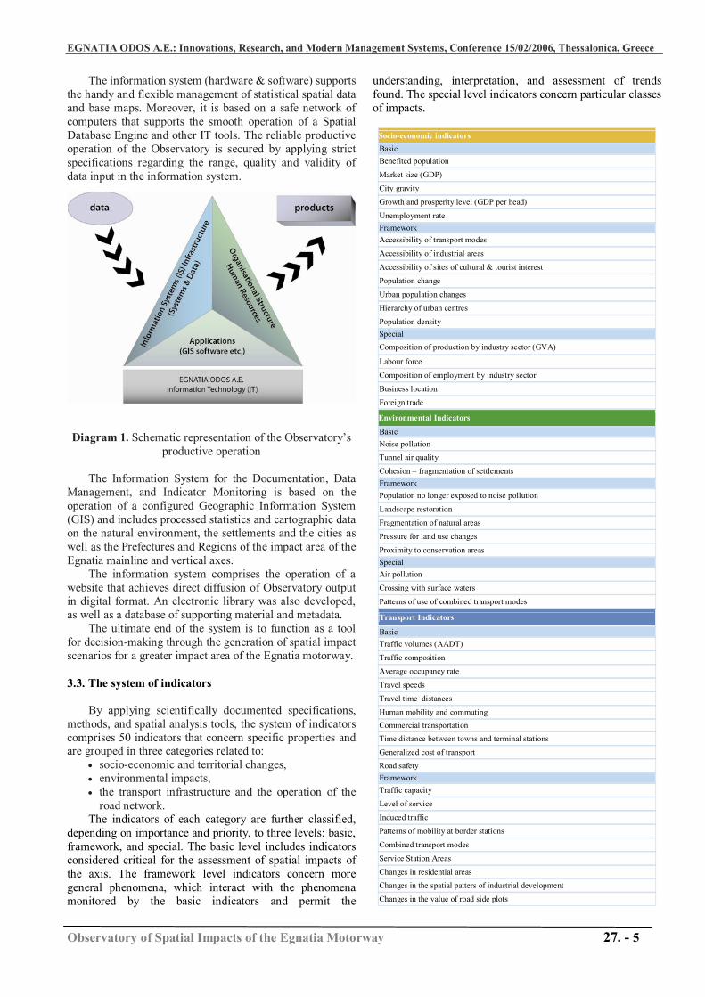
The information system (hardware & software) supports the handy and flexible management of statistical spatial data and base maps. Moreover, it is based on a safe network of computers that supports the smooth operation of a Spatial Database Engine and other IT tools. The reliable productive operation of the Observatory is secured by applying strict specifications regarding the range, quality and validity of data input in the information system.
Diagram 1. Schematic representation of the Observatory’s productive operation
The Information System for the Documentation, Data
Management, and Indicator Monitoring is based on the operation of a configured Geographic Information System (GIS) and includes processed statistics and cartographic data on the natural environment, the settlements and the cities as well as the Prefectures and Regions of the impact area of the Egnatia mainline and vertical axes.
The information system comprises the operation of a website that achieves direct diffusion of Observatory output in digital format. An electronic library was also developed, as well as a database of supporting material and metadata.
The ultimate end of the system is to function as a tool for decision-making through the generation of spatial impact scenarios for a greater impact area of the Egnatia motorway.
3.3. The system of indicators
By applying scientifically documented specifications,
methods, and spatial analysis tools, the system of indicators comprises 50 indicators that concern specific properties and are grouped in three categories related to:
• socio-economic and territorial changes, • environmental impacts, • the transport infrastructure and the operation of the
road network. The indicators of each category are further classified,
depending on importance and priority, to three levels: basic, framework, and special. The basic level includes indicators considered critical for the assessment of spatial impacts of the axis. The framework level indicators concern more general phenomena, which interact with the phenomena monitored by the basic indicators and permit the
understanding, interpretation, and assessment of trends found. The special level indicators concern particular classes of impacts.
Socio-economic indicators Basic Benefited population Market size (GDP) City gravity Growth and prosperity level (GDP per head) Unemployment rate Framework Accessibility of transport modes Accessibility of industrial areas Accessibility of sites of cultural & tourist interest Population change Urban population changes Hierarchy of urban centres Population density Special Composition of production by industry sector (GVA) Labour force Composition of employment by industry sector Business location Foreign trade Environmental Indicators Basic Noise pollution Tunnel air quality Cohesion – fragmentation of settlements Framework Population no longer exposed to noise pollution Landscape restoration Fragmentation of natural areas Pressure for land use changes Proximity to conservation areas Special Air pollution Crossing with surface waters Patterns of use of combined transport modes Transport Indicators Basic Traffic volumes (AADT) Traffic composition Average occupancy rate Travel speeds Travel time distances Human mobility and commuting Commercial transportation Time distance between towns and terminal stations Generalized cost of transport Road safety Framework Traffic capacity Level of service Induced traffic Patterns of mobility at border stations Combined transport modes Service Station Areas Changes in residential areas Changes in the spatial patters of industrial development
Changes in the value of road side plots

EGNATIA ODOS Α.Ε.: Innovations, Research, and Modern Management Systems, Conference 15/02/2006, Thessalonica, Greece
Observatory of Spatial Impacts of the Egnatia Motorway 27. - 6
Special Trip generation rates due to special land uses Change in the choice of location for residence and work Change in the modal split
Each indicator has specific spatial application levels
that are the impact zones of the Egnatia Motorway.
Map 1. Impact Zones of the Egnatia Motorway Considering the basic macroscopic impacts, the most
important zone where the study of the development of indicators focuses on is Zone ΙV, i.e. the Zone of the five Regions crossed by the Egnatia mainline and vertical axes: Eastern Macedonia & Thrace, Central Macedonia, Western Macedonia, Epirus, and Thessaly.
For each indicator the following are drafted: (a) The Technical Bulletin providing the scientific and technical – methodological specifications for calculating the indicator. (b) The Calculation Bulletin detailing each step of the calculation and monitoring method. (c) The Results Fact Sheet, presenting the processed results and the long-term and geographical evolution of each indicator
Raw data and base maps originate from official and reviewed sources only (e.g. Greek National Statistics Agency, Eurostat, European Environmental Agency, EuroGeographics). Raw data for some traffic and environmental indicators (e.g. traffic volumes, tunnel air quality) originate from measurements undertaken by competent EOAE Units.
In general, the system of indicators is not static – it undergoes a constant review and is being adapted to new conditions, requirements, and scientific developments. For
example, in the current period it is being revised in order to provide fuller measurement of indicators such as accessibility, land use, combined & commercial transports, tourist development, and competitiveness.
Finally, one should also note that the indicators monitored by the Observatory are compatible and comparable with the indicators used by basic EU programmes (e.g. ESPON, ASSEMBLING, EEA-TERM). A specific and detailed comparison of the Observatory indicator system with the indicators used by the above programmes is illustrated in the “Report on Impact Zone Status” [32] where it reads:
“Given the particularities of the Observatory (reference to a specific road project, ad hoc geographical units) it seems that its system of indicators is overall closely related to the evolution at the European level and follows the state-of-the-art of the scientific field, despite minor deviations at individual indicators” [see Appendix IV, page 213, in Greek].
To analyse, interpret, and compile the output of indicators, the changes in results should be monitored over time and in various impact zones on the one hand, while their gravity in the economic development, territorial cohesion, the environment, and the quality of life should be assessed on the other. In that respect, the combined assessment and evaluation of indicator output is carried out with reference to four main parameters related to the main objectives of EU policy:
(1) mobility and accessibility, (2) economic, social and territorial cohesion, (3) the balance and networking of settlements, and (4) environment quality. Four indicative maps are provided that illustrate the
indicators’ output corresponding to each one of these main parameters.
Map 2. Change in accessibility (%) to urban centres
with full use of the Egnatia Motorway21
21 Calculation by using the SASI model (Socio-Economic and Spatial Impacts of Trans-European Transport Networks), (Shürmann, Spiekermann and Wegener, 1997).
EGNATIA ODOS Α.Ε.: Innovations, Research, and Modern Management Systems, Conference 15/02/2006, Thessalonica, Greece
Observatory of Spatial Impacts of the Egnatia Motorway 27. - 7
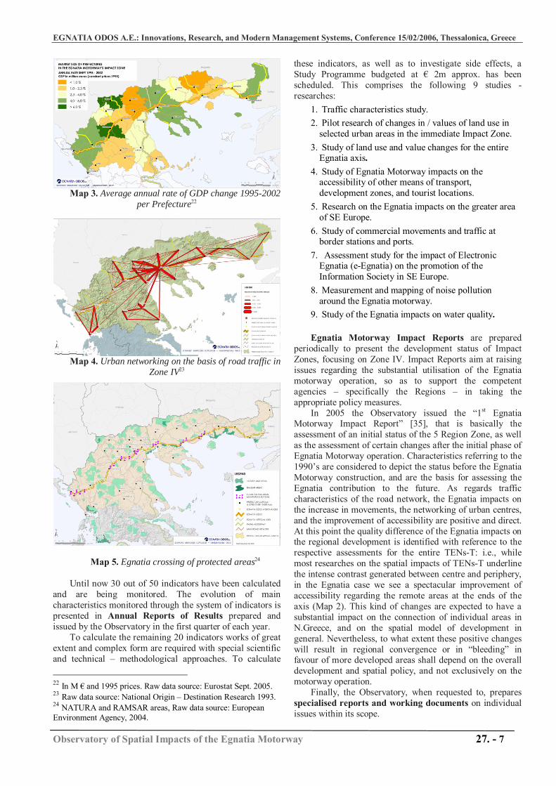
Map 3. Average annual rate of GDP change 1995-2002 per Prefecture22
Map 4. Urban networking on the basis of road traffic in Zone IV23
Map 5. Egnatia crossing of protected areas24
Until now 30 out of 50 indicators have been calculated
and are being monitored. The evolution of main characteristics monitored through the system of indicators is presented in Annual Reports of Results prepared and issued by the Observatory in the first quarter of each year.
To calculate the remaining 20 indicators works of great extent and complex form are required with special scientific and technical – methodological approaches. To calculate
22 In M € and 1995 prices. Raw data source: Eurostat Sept. 2005. 23 Raw data source: National Origin – Destination Research 1993. 24 NATURA and RAMSAR areas, Raw data source: European Environment Agency, 2004.
these indicators, as well as to investigate side effects, a Study Programme budgeted at € 2m approx. has been scheduled. This comprises the following 9 studies - researches:
1. Traffic characteristics study. 2. Pilot research of changes in / values of land use in
selected urban areas in the immediate Impact Zone. 3. Study of land use and value changes for the entire
Egnatia axis. 4. Study of Egnatia Motorway impacts on the
accessibility of other means of transport, development zones, and tourist locations.
5. Research on the Egnatia impacts on the greater area of SE Europe.
6. Study of commercial movements and traffic at border stations and ports.
7. Assessment study for the impact of Electronic Egnatia (e-Egnatia) on the promotion of the Information Society in SE Europe.
8. Measurement and mapping of noise pollution around the Egnatia motorway.
9. Study of the Egnatia impacts on water quality. Egnatia Motorway Impact Reports are prepared
periodically to present the development status of Impact Zones, focusing on Zone IV. Impact Reports aim at raising issues regarding the substantial utilisation of the Egnatia motorway operation, so as to support the competent agencies – specifically the Regions – in taking the appropriate policy measures.
In 2005 the Observatory issued the “1st Egnatia Motorway Impact Report” [35], that is basically the assessment of an initial status of the 5 Region Zone, as well as the assessment of certain changes after the initial phase of Egnatia Motorway operation. Characteristics referring to the 1990’s are considered to depict the status before the Egnatia Motorway construction, and are the basis for assessing the Egnatia contribution to the future. As regards traffic characteristics of the road network, the Egnatia impacts on the increase in movements, the networking of urban centres, and the improvement of accessibility are positive and direct. At this point the quality difference of the Egnatia impacts on the regional development is identified with reference to the respective assessments for the entire TENs-T: i.e., while most researches on the spatial impacts of TENs-T underline the intense contrast generated between centre and periphery, in the Egnatia case we see a spectacular improvement of accessibility regarding the remote areas at the ends of the axis (Map 2). This kind of changes are expected to have a substantial impact on the connection of individual areas in N.Greece, and on the spatial model of development in general. Nevertheless, to what extent these positive changes will result in regional convergence or in “bleeding” in favour of more developed areas shall depend on the overall development and spatial policy, and not exclusively on the motorway operation.
Finally, the Observatory, when requested to, prepares specialised reports and working documents on individual issues within its scope.
EGNATIA ODOS Α.Ε.: Innovations, Research, and Modern Management Systems, Conference 15/02/2006, Thessalonica, Greece
Observatory of Spatial Impacts of the Egnatia Motorway 27. - 8
3.4. Promotion - Diffusion - Networking
3.4.1. Promotion and diffusion The action “promotion and diffusion” aims at
publicising the activities and outputs of the Observatory to interested bodies and the public. The objective is to support procedures for planning and decision-making, while there is the potential for special information activities for citizens and enterprises. Besides, according to an interest research undertaken in the context of the Observatory Business Plan Study [39] it was found that: (a) public and private development agencies express interest in all indicators, and (b) the agencies interested would like to use the data mainly for planning, documenting, and supporting proposals for development interventions.
The action “promotion-diffusion” of output also aims at informing the General Management and Units of EOAE on the impacts of the axis, as well as to identify and address potential adverse impacts from the road network operation.
The actions of “promotion-diffusion” are specialised according to the following classification:
1. Continuous updating and optimisation of the website operation. Investigation and proceeding with the procurement of equipment and the development of a WebGIS system. Development and operation of a full English version.
2. Design and development of multimedia CD-ROM, using Flash and HTML on the basis (a) of Observatory presentation data, (b) indicator results, and (c) reports and studies.
3. Issue and diffusion of Reports, Working Documents, and Information Leaflets.
4. Organisation of information events and workshops. 5. Participations and presentations at events and
scientific conferences.
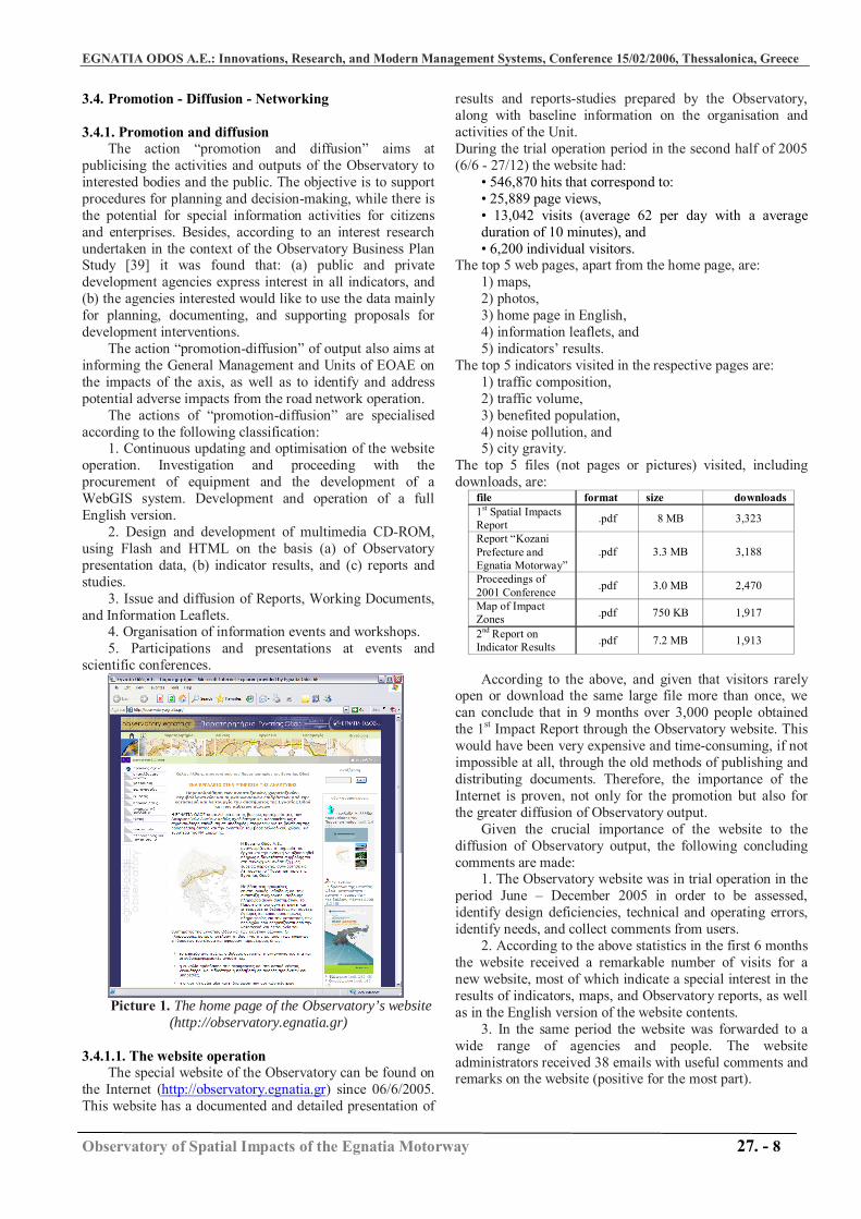
Picture 1. The home page of the Observatory’s website
(http://observatory.egnatia.gr)
3.4.1.1. The website operation The special website of the Observatory can be found on
the Internet (http://observatory.egnatia.gr) since 06/6/2005. This website has a documented and detailed presentation of
results and reports-studies prepared by the Observatory, along with baseline information on the organisation and activities of the Unit. During the trial operation period in the second half of 2005 (6/6 - 27/12) the website had:
• 546,870 hits that correspond to: • 25,889 page views, • 13,042 visits (average 62 per day with a average duration of 10 minutes), and • 6,200 individual visitors.
The top 5 web pages, apart from the home page, are: 1) maps, 2) photos, 3) home page in English, 4) information leaflets, and 5) indicators’ results.
The top 5 indicators visited in the respective pages are: 1) traffic composition, 2) traffic volume, 3) benefited population, 4) noise pollution, and 5) city gravity.
The top 5 files (not pages or pictures) visited, including downloads, are:
file format size downloads 1st Spatial Impacts Report .pdf 8 ΜΒ 3,323
Report “Kozani Prefecture and Egnatia Motorway”
.pdf 3.3 ΜΒ 3,188
Proceedings of 2001 Conference .pdf 3.0 ΜΒ 2,470
Map of Impact Zones .pdf 750 ΚΒ 1,917
2nd Report on Indicator Results .pdf 7.2 ΜΒ 1,913
According to the above, and given that visitors rarely
open or download the same large file more than once, we can conclude that in 9 months over 3,000 people obtained the 1st Impact Report through the Observatory website. This would have been very expensive and time-consuming, if not impossible at all, through the old methods of publishing and distributing documents. Therefore, the importance of the Internet is proven, not only for the promotion but also for the greater diffusion of Observatory output.
Given the crucial importance of the website to the diffusion of Observatory output, the following concluding comments are made:
1. The Observatory website was in trial operation in the period June – December 2005 in order to be assessed, identify design deficiencies, technical and operating errors, identify needs, and collect comments from users.
2. According to the above statistics in the first 6 months the website received a remarkable number of visits for a new website, most of which indicate a special interest in the results of indicators, maps, and Observatory reports, as well as in the English version of the website contents.
3. In the same period the website was forwarded to a wide range of agencies and people. The website administrators received 38 emails with useful comments and remarks on the website (positive for the most part).
EGNATIA ODOS Α.Ε.: Innovations, Research, and Modern Management Systems, Conference 15/02/2006, Thessalonica, Greece
Observatory of Spatial Impacts of the Egnatia Motorway 27. - 9
4. Finally, it should be noted that the Observatory website passed a special assessment held by the Special Service of Strategy, Planning, and Assessment of Development Programmes of the Ministry of National Economy and Finance, according to guidelines set by the “Publicity Guide”, the " CSF III Guide for the Organisation and Implementation of Websites” and the related rules and comments by the European Commission. According to the findings of the assessment notified to us no deficiencies or faults were found in the structure and information services provided.
3.4.2. Networking “Networking” comprises activities aiming at developing
contacts and cooperations with other similar organisations in Greece and abroad, as well as with development agents in the greater impact area of the axis.
The title EGNATIA – KNOW-HOW is being used to cover the activities implemented for the stable networking and cooperation of the Observatory with similar organisations (Spatial Planning and Transports Observatories), both nationally and internationally. The expected benefits regard the monitoring of best practices, as well as the harmonisation with methods and indicators used to assess the impacts of TENs-T on spatial development. In the same sense the networking and cooperation of the Observatory with research centres and other organisations is incorporated in the contexts of EU or national funding programmes of research and development.
The title EGNATIA – DEVELOPMENT is being used to cover the activities of stable networking and cooperation of the Observatory with development agencies, so that the planning and decision-making procedures are supported effectively in the context of promoting development policies. It is underlined that in the approved Regional Frameworks of Spatial Planning of the three Regions of N.Greece a special reference is made to the Egnatia Motorway Observatory, and it is stressed that
“the need for the Observatory to cooperate with the current physical planning at the Region’s level is obvious, specifically on issues regarding the intraregional area and the impacts on the spatial organisation and the border area” (GG issue No: 1471Β΄/9-10-2003, 218 Β΄/6-2-2004 and 1472Β΄/9-10-2003, in Greek). In this context, the Observatory carries out a Region-
and Prefecture-specific processing and presentation of results and information material, in order to achieve a direct and effective promotion of its purpose and usefulness.
3.5. Conclusion and Perspectives
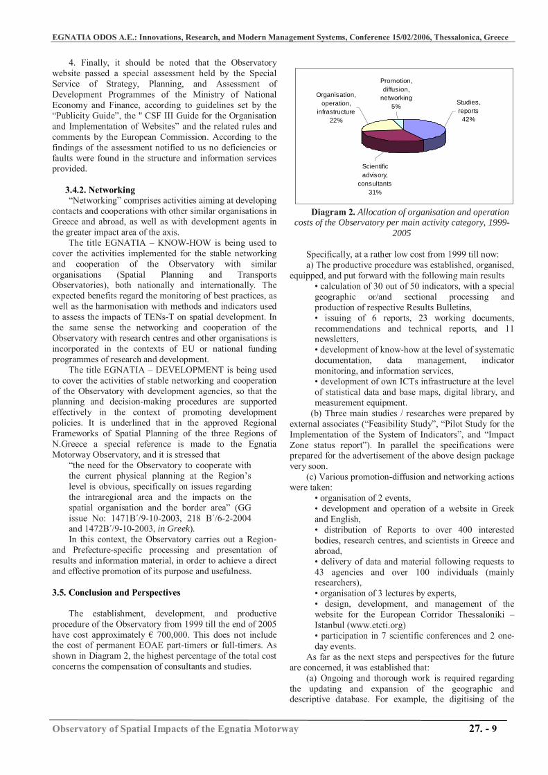
The establishment, development, and productive
procedure of the Observatory from 1999 till the end of 2005 have cost approximately € 700,000. This does not include the cost of permanent EOAE part-timers or full-timers. As shown in Diagram 2, the highest percentage of the total cost concerns the compensation of consultants and studies.
Diagram 2. Allocation of organisation and operation costs of the Observatory per main activity category, 1999-
2005 Specifically, at a rather low cost from 1999 till now: a) The productive procedure was established, organised,
equipped, and put forward with the following main results • calculation of 30 out of 50 indicators, with a special geographic or/and sectional processing and production of respective Results Bulletins, • issuing of 6 reports, 23 working documents, recommendations and technical reports, and 11 newsletters, • development of know-how at the level of systematic documentation, data management, indicator monitoring, and information services, • development of own ICTs infrastructure at the level of statistical data and base maps, digital library, and measurement equipment.
(b) Three main studies / researches were prepared by external associates (“Feasibility Study”, “Pilot Study for the Implementation of the System of Indicators”, and “Impact Zone status report”). In parallel the specifications were prepared for the advertisement of the above design package very soon.
(c) Various promotion-diffusion and networking actions were taken:
• organisation of 2 events, • development and operation of a website in Greek and English, • distribution of Reports to over 400 interested bodies, research centres, and scientists in Greece and abroad, • delivery of data and material following requests to 43 agencies and over 100 individuals (mainly researchers), • organisation of 3 lectures by experts, • design, development, and management of the website for the European Corridor Thessaloniki – Istanbul (www.etcti.org) • participation in 7 scientific conferences and 2 one-day events.
As far as the next steps and perspectives for the future are concerned, it was established that:
(a) Ongoing and thorough work is required regarding the updating and expansion of the geographic and descriptive database. For example, the digitising of the
Studies, reports
42%
Scientific advisory,
consultants31%
Organisation, operation,
infrastructure22%
Promotion, diffusion,
networking5%
EGNATIA ODOS Α.Ε.: Innovations, Research, and Modern Management Systems, Conference 15/02/2006, Thessalonica, Greece
Observatory of Spatial Impacts of the Egnatia Motorway 27. - 10
detailed road network for the greater area of Thessaloniki using orthophotomaps can directly serve EOAE and the competent bodies in relation to the formation of proposals for new road works in the area.
(b) The calculation of indicators is based on a complex system of interlinking of databases and methodological manipulations, which should secure the continuation of the operation results production. For this reason the Observatory is currently developing a system of automated update of data relevant to the calculation and processing of indicators.
(c) The system of indicators requires thorough scientific reviewing, updating and restructuring, in order to comply with (i) the important comments – suggestions included in the design “Impact Zones Status Report” [32], and (ii) the amendments in respective indicators used by EU organisations. In this context are included all works required for the finalisation of the list, of the new Technical Bulletins and the calculation method, processing, interpretation, and presentation of indicators. The system of indicators requires processing and inputting new accessibility indicators that are now being calculated by the Observatory (e.g. density of the road network, distances, time distances) as well as calculating indicators related to commercial movements and combined transport, tourist development, competitiveness and land use/value. The investigation and assessment of the situation in the Regions of Balkan countries in relation to main indicators is also considered important
(d) An overall conclusion regards the fact that all parties have highlighted the great importance of the integrated digital development and operation of the Observatory. Apart from the procurement of the necessary equipment the issue of continuous technical and scientific improvement and support is under investigation, as well as the more automated and flexible operation of the information system. For example, to this direction the design of a special application (use of Flash and WebGIS technologies) is being developed for the presentation of indicator results for each Region and Prefecture through a dynamic map and an interactive menu on the Observatory website.
(e) Finally, the most important evolution, and challenge for the future at the same time, is to establishment the Observatory as a “valid system of monitoring and information” in the minds of agencies and citizens in N.Greece. The open concept adopted regarding the diffusion of the produced material, assisted by the wide range of provided data and information from the Internet and the increased demand thereof, set up the framework of this perspective. Special care is now required for maintaining a high level of information services regarding both the validity and updating of results, and the development of elegant and handy applications on the website.
4. CONCLUDING REMARKS
The main question of theoretical and research approaches regarding the spatial impacts of transport infrastructures is directly linked to the concerns, guidelines, and content of EU policies. For instance, the study of spatial impacts of TENs-T, part of which is also the Egnatia
Motorway, is considered a necessary action so that one can assess the extent of improvement of competitiveness in the EU and of mitigation in inequalities in the European area achieved by such an ambitious programme.
Several Transport Observatories of general or/and specific character already operate in European countries, whereas a number of important cross-national research programmes address such issues from different angles. Unfortunately, in Greece no such initiatives exist or have produced fruits, although major transport infrastructure projects are underway in the last few years. The only exception is the case of the Egnatia Motorway Observatory established by EOAE.
The Observatory records and studies the Egnatia Motorway mainline and vertical axes impacts regarding development, spatial planning, environment, and transport. It is a permanent organization with scientific/ technical structure, capable of providing valid and updated services of information and documentation on critical phenomena and characteristics, beyond the usual statistics.
The various forms used to express the direct or indirect spatial impacts of the Egnatia Motorway are investigated and documented in an integrated and systematic manner, through a system of 50 indicators. Indicators measuring the operation of the road network are linked to indicators measuring socio-economic and spatial developments, as well as to indicators assessing environmental impacts.
Through this integrated approach, it is possible to assess both the positive contribution and the unutilised opportunities, as well as any adverse impacts of the motorway, in order to achieve a global assessment of the interaction of the project with the development of Northern Greece. Such a procedure is fully complying with the policies and requirements of respective programmes and funding schemes of the EU. The integrated scientific approach adopted by the Egnatia Observatory is the first point that differentiates in a positive manner this observatory from most European cases [2], [17].
An important characteristic of the Observatory is also the fact that since the beginning of the establishment it does not operate only to serve EOAE needs. Apart from monitoring and assessment, it provides documented and updated information and analyses on development trends, the evolution of environmental pressures, and the territorial changes in the project’s impact zone. In this way it offers general services of information and documentation on the needs of development planning, being basically an open data base.
Further development and operation of the Observatory shall contribute to the overall effort for a systematic assessment of the spatial impacts of major transport infrastructure projects in Greece and the greater area of SE Europe.
ACKNOWLEDGEMENTS Special reference should be made to the excellent
scientific work of the research teams of (a) Spatial Development Research Unit (Scientific Responsible Prof. G. Kafkalas) and (b) Transport Engineering Laboratory
EGNATIA ODOS Α.Ε.: Innovations, Research, and Modern Management Systems, Conference 15/02/2006, Thessalonica, Greece
Observatory of Spatial Impacts of the Egnatia Motorway 27. - 11
(Scientific Responsible Prof. M. Pitsiava) Aristotle’s University of Thessaloniki, and the continuous cooperation with the Observatory thereof. Special reference should also be made to experts Dr Athena Yiannakou (PhD Urban & Regional Planning) and Elias Dimitriadis (Surveyor Engineer, GIS specialist) Special acknowledgments for the consistent and effective cooperation should also be granted to the following EOAE Units: (a) Information Technology, (b) Traffic and Telematics, (c) Environment, (d) Electronic Systems, (e) GIS, (f) Project Reporting, (g) Public Relations, (h) Community Programmes (i) Design/ Services Contracts, (j) Human Resources, (k) Procurements.
REFERENCES [1] APRR, Autoroutes Paris-Rhin-Rhone and the Environment, a
Long-Term Challenge, Oikos: Paris, 2003. [2] APRR, Colloque Scientifique sur les Observatoires
Autoroutiers et d'Infrastructures Lineaires: Incidences Environnementales et Socio-Economiques, a Partir du Cas d'A39, Paris, 17-18/4/2005.
[3] ASSEMBLING programme, A European Network of Monitoring Centres for Transport Infrastructures, http://www.mcrit.com/ASSEMBLING, visited 20/12/2005.
[4] Autostrade Group, Social and Environmental Report 2003, available at www.autostrade.it, accessed at 14/10/2005.
[5] Banister D. and Berechman Y., Transport Investment and the Promotion of Economic Growth, Journal of Transport Geography, 9 pp. 209-218, 2001.
[6] Canaleta, C.G, Arzoz, P.P., and Gárate M.R., Structural Change, Infrastructure and Convergence in the Regions of European Union, European Urban and Regional Studies 9(2): 115–135, 2002.
[7] EC, Transport and Energy infrastructure in South East Europe, Developed by the working group of the Commission services, Directorate General for Energy and Transport, Directorate General for External Relations, EuropeAid Co-operation Office: Brussels, 2001.
[8] EEA, Ten Key Transport and Environment Issues for Policy-Makers, TERM 2004: indicators tracking transport and environment integration in the European Union, European Environmental Agency, European Commission: Copenhagen, 2004.
[9] ESPON, Transport Services and Networks: Territorial Trends and Basic Supply of Infrastructure for Territorial Cohesion: ESPON project 1.2.1, Luxemburg. URL: http://www.espon.lu, accessed 19/12/2005.
[10] JRC, Transport and Land-Use Interaction, Joint Research Centre, Institute for Perspective Technological Studies, European Commission: Brussels, 2001, available at http://www.jrc.es, last accessed 4/11/2005.
[11] Lagumier, J.F., Motorways and Sustainable Development: A Scientific Evaluation Method : the Case of the Environmental and Socio-Economic Observatory of the A39 Motorway in South-Eastern France, paper presented at the 1st European Road Congress, 24-26/11/2004: Lisbon, available at http://www.erf.be/content/article/detail/2707, accessed 28/12/2005.
[12] Langumier, J.F. and Joignaux G., Les Observatoires Autoroutiers: L’ Expereince des Autoroutes Paris-Rhin-Rhone et Quelques Enseignements, Les Cahiers Sceintifiques du Transport, No 46/2004, pp. 3-24, 2004.
[13] McQuaid, R.W., Greig, M., Smyth A., and Cooper, J., The Importance of Transport in Business' Location Decisions, Napier University, 2004, available at
http://www.dft.gov.uk/stellent/groups/dft_science/documents/pdf/dft_science_pdf_027294.pdf, last visit and download 22/12/2004.
[14] Ockwell, A., Assessing the Impact of Investment in Transport Infrastructure on Regional Development, Department of Transport and Regional Services, Canberra, 25th Australasian Transport Research Forum, 2002.
[15] OTP, Observatoire Franco-Espagnol des Trafics dans les Pyrenees: Document No3, Ministere de l’ Equipement des Transports du Logement du Tourisme et da la Mer: Paris, 2003.
[16] REBIS, Regional Balkans Infrastructure Study – Transport: Concept Paper for Western Balkans Transport Observatory – SEETO, European Commission: Brussels, 2003.
[17] Schürmann C., First Impact Report, email memo, 20/01/2006. [18] Schurmann C. and Schwarze, Β., Five Interfaces Coupling
Two Worlds: linking GIS and Transport Models, in School of Environmental Sciences (Ed.): Proceedings of the GIS Research UK 12th Annual Conference. University of East Anglia, Norwich. Norwich: UEA, pp. 440-444, 2004.
[19] Schürmann C., Spiekermann K. and Wegener M., Accessibility Indicators, Berichte aus dem Institute für Raumplanung 39, Universität Dortmund, 1997.
[20] SEETO, South-East Europe Transport Observatory Technical Note: Review of Planning, SEETO Joint Venture: GOPA Consultants – SGI-TRADEMCO, EC Enlargement Directorate-General: Brussels, 2005.
[21] Schürmann C., Spiekermann K. and Wegener M., Accessibility Indicators, Berichte aus dem Institute für Raumplanung 39, Universität Dortmund, 1997.
[22] Spiekerman K. and Neubauer J., European Accessibility and Peripherality: Concepts, Models and Indicators, Sweden: Nordregio, 2002.
[23] Vickerman R., Location, Accessibility and Regional Development: the Appraisal of Trans-European Networks, Transport Policy, Vol. 2.4, pp. 225-234, 1996.
[24] Vickerman R. W., Spiekermann K. and Wegener M., Accessibility and Economic Development in Europe, Regional Studies, Vol. 33, pp. 1: 1-15, 1999.
[25] Giannakou Α., Planning and Environment Components of the Spatial Impact Observatory, in Proceedings of International Conference “Transport Infrastructures and Regional Development: the Impacts of the Egnatia Motorway on the Spatial Integration and Regional Development of N.Greece”, 5/10/2001, EGNATIA ODOS A.E.: Thessaloniki, page 104-106, 2001 (in Greek).
[26] EU – European Commission, European Spatial Development Perspective - Towards a Balanced and Sustainable Development of the Union Territory, Office for the Official Publications of the European Communities: Luxemburg, 1999.
[27] EU – European Commission, White Paper – European Transport Policies for 2010: A time to decide, Office for the Official Publications of the European Communities: Luxemburg, 2002.
[28] EU – European Commission, Third Report on Economic and Social Cohesion, Office for the Official Publications of the European Communities: Luxemburg, 2004.
[29] EU – European Commission, Community Strategic Guidelines on Cohesion 2007-2013, available at URL: http://europa.eu.int/comm/regional_policy/index_en.htm, 27/12/2005.
[30] SDRU-TEL, Feasibility Study for the Establishment and Operation of an Observatory for Recording, Analysing, and Assessing Egnatia Motorway Impacts, final deliverable of a research programme prepared by the Spatial Development Research Unit and the Transport Engineering Laboratory of the Aristotle University of Thessaloniki, under the scientific responsibility of Professors Gr. Kafkalas and M. Pitsiava,
EGNATIA ODOS Α.Ε.: Innovations, Research, and Modern Management Systems, Conference 15/02/2006, Thessalonica, Greece
Observatory of Spatial Impacts of the Egnatia Motorway 27. - 12
EGNATIA ODOS A.E.: Thessaloniki, 1999 (available in Greek).
[31] SDRU-TEL, Egnatia Motorway Observatory of Spatial Impacts – Pilot Application of System of Indicators, final deliverable of a research programme prepared by the Spatial Development Research Unit and the Transport Engineering Laboratory of the Aristotle University of Thessaloniki, under the scientific responsibility of Professors Gr. Kafkalas and M. Pitsiava, EGNATIA ODOS A.E.: Thessaloniki, 2001 (available in Greek).
[32] SDRU-TEL, Egnatia Motorway Spatial Impacts: Impact Zone Status Report, final deliverable of a research programme prepared by the Spatial Development Research Unit and the Transport Engineering Laboratory of the Aristotle University of Thessaloniki, under the scientific responsibility of Professors Gr. Kafkalas and M. Pitsiava, EGNATIA ODOS A.E.: Thessaloniki, 2004 (available in Greek).
[33] EEA, Preparing the Ground for the EU enlargement: Indicators of Integration of the Transport and Environment Field TERM 2002, European Environment Agency: Copenhagen, 2002.
[34] Egnatia Motorway Observatory, Observatory Five-year Action Plan 2003–2007, EGNATIA ODOS A.E.: Thessaloniki, 2002.
[35] Egnatia Motorway Observatory, Status of Regions Crossed by the Egnatia Motorway: Cohesion – Mobility – Balance – Environment: 1st Impact Report, EGNATIA ODOS A.E.: Thessaloniki, 2005.
[36] Petrakos, G, Economy and Space: Towards a Revolution in Relations and Policies, in Seventeen Texts on Planning, Cities, and Development (Collective volume for the ten year anniversary of the operation of the Τ.Μ.Χ.Π.Π.Α.), Volos: Thessaly University Publications, 2002.
[37] Polyzos, S., Trans-Regional Transport Infrastructures and Regional Development: A Theoretical Investigation, TOPOS Review of Spatial Development, Planning, and Environment, p. 25-49, 2003 (full paper available only in Greek).
[38] Tranos, Μ., Road Axis and Regional Development: The Development Impacts of the Egnatia Motorway on N.Greece by using Accessibility Indicators, thesis, Department of Planning and Regional Development, University of Thessaly: Volos, 2004 (full paper available only in Greek).
[39] Triantafyllidou, R, and Gakis, K, Business Plan of the Egnatia Motorway Observatory of Spatial Impacts, EGNATIA ODOS A.E.: Thessaloniki, 2001.
[40] Tsamboulas, D, and Koryzi, D., The International Experience from Transport Infrastructure Observatories: Application for the SE Europe Transport Observatory, in the Proceedings of the International Conference “Transport Infrastructures and Regional Development: the Impacts of the Egnatia Motorway on the Spatial Integration and Regional Development of N.Greece”, 5/10/2001, Egnatia Odos A.E.: Thessaloniki, p. 74-87, 2001.
EGNATIA ODOS Α.Ε.: Innovations, Research, and Modern Management Systems, Conference 15/02/2006, Thessalonica, Greece
Observatory of Spatial Impacts of the Egnatia Motorway 27. - 13
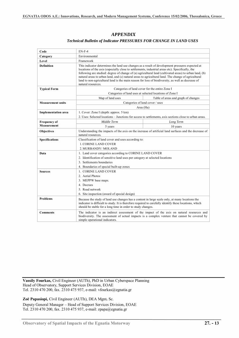
APPENDIX
Technical Bulletin of Indicator PRESSURES FOR CHANGE IN LAND USES
Code EN-F-4 Category Environmental Level Framework Definition This indicator determines the land use changes as a result of development pressures expected at
locations of the axis (especially close to settlements, industrial areas etc). Specifically, the following are studied: degree of change of (a) agricultural land (cultivated areas) to urban land, (b) natural areas to urban land, and (c) natural areas to agricultural land. The change of agricultural land to non-agricultural land is the main reason for loss of biodiversity, as well as decrease of natural resources.
Categories of land cover for the entire Zone I Categories of land uses at selected locations of Zone I
Typical Form
Map of land uses Table of areas and graph of changes Categories of land cover / uses Measurement units
Area (Ha) Implementation area 1. Cover: Zone Ι (depth: approx. 5 km)
2. Uses: Selected locations – Junctions for access to settlements, axis sections close to urban areas. Middle Term Long Term Frequency of
Measurement 5 years 10 years Objectives Understanding the impacts of the axis on the increase of artificial land surfaces and the decrease of
natural resources. Specifications Classification of land cover and uses according to:
1. CORINE LAND COVER 2. MURBANDY/ MOLAND
Data 1. Land cover categories according to CORINE LAND COVER 2. Identification of sensitive land uses per category at selected locations 3. Settlements boundaries 4. Boundaries of special built-up zones
Sources 1. CORINE LAND COVER 2. Aerial Photos 3. MEPPW base maps. 4. Decrees 5. Road network 6. Site inspection (award of special design)
Problems Because the study of land use changes has a content in large scale only, at many locations the indicator is difficult to study. It is therefore required to carefully identify these locations, which should be stable for a long time in order to study changes.
Comments The indicator is an indirect assessment of the impact of the axis on natural resources and biodiversity. The assessment of actual impacts is a complex venture that cannot be covered by simple operational indicators.
Vassily Fourkas, Civil Engineer (AUTh), PhD in Urban Cyberspace Planning Head of Observatory, Support Services Division, EOAE Tel. 2310 470 200, fax. 2310 475 937, e-mail: [email protected] Zoë Papasiopi, Civil Engineer (AUTh), DEA Mgnt. Sc. Deputy General Manager – Head of Support Services Division, EOAE Tel. 2310 470 200, fax. 2310 475 937, e-mail: [email protected]