powys local development plan annual monitoring report 2020
TRANSCRIPT
Powys Local Development
Plan (LDP)
Background Paper 2 to
Annual Monitoring Report
2021
Annual Monitoring
Report 2020
1st April 2019 to 31st March
2020.
Powys Local Development Plan – Annual Monitoring Report 2020 (1st April 2019 to 31st March 2020).
2
CONTENTS
Chapters:
EXECUTIVE SUMMARY ....................................................................................................................... 5
MONITORING ACTIONS ....................................................................................................................... 6
KEY FINDINGS FOR THIS AMR MONITORING PERIOD: ......................................................................... 7
FURTHER POINTS OF INTEREST: .......................................................................................................... 9
1. ANALYSIS OF SIGNIFICANT CONTEXTUAL CHANGE / INDICATORS .............................................. 10
1.1 NATIONAL CONTEXT .............................................................................................................. 10
1.2 CHIEF PLANNING OFFICER LETTERS ....................................................................................... 16
1.3 REGIONAL CONTEXT .............................................................................................................. 17
1.4 LOCAL CONTEXT .................................................................................................................... 19
1.5 SUPPLEMENTARY PLANNING GUIDANCE (SPG) ..................................................................... 20
1.6 UPDATED LOCAL EVIDENCE ................................................................................................... 21
1.7 OTHER CONTEXTUAL CHANGES ............................................................................................ 21
2. ANALYSIS OF CORE/KEY INDICATORS ........................................................................................ 22
3. ANALYSIS OF LOCAL INDICATORS .............................................................................................. 46
THEME 1 – PLANNING FOR GROWTH IN SUSTAINABLE PLACES ................................................... 47
THEME 2 – SUPPORTING THE POWYS ECONOMY ........................................................................ 95
THEME 3 – SUPPORTING INFRASTRUCTURE AND SERVICES ...................................................... 109
THEME 4 – GUARDIANSHIP OF NATURAL, BUILT AND HISTORIC ASSETS ................................... 117
THEME 5 – SUPPORTING HEALTHY COMMUNITIES .................................................................... 134
4. RESULTS OF SA INDICATORS ................................................................................................... 146
SEA TOPIC: BIODIVERSITY ........................................................................................................... 147
SEA TOPIC: POPULATION AND HUMAN HEALTH ........................................................................ 152
SEA TOPIC: SOIL ........................................................................................................................... 161
SEA TOPIC: WATER ...................................................................................................................... 165
SEA TOPIC: AIR ............................................................................................................................ 169
SEA TOPIC: CLIMATIC FACTORS .................................................................................................. 174
SEA TOPIC: STRATEGIC RESOURCES AND ASSETS ....................................................................... 178
SEA TOPIC: CULTURAL HERITAGE ................................................................................................ 183
SEA TOPIC: LANDSCAPE .............................................................................................................. 193
SEA TOPIC: GEODIVERSITY .......................................................................................................... 198
5. CONCLUSION AND RECOMMENDATIONS ............................................................................... 202
Powys Local Development Plan – Annual Monitoring Report 2020 (1st April 2019 to 31st March 2020).
3
Annexes:
ANNEX 1 – TABLE 19 HOUSING ALLOCATIONS
ANNEX 2 – TABLE 20 HOUSING COMMITMENTS
Tables:
TABLE 1. SUMMARY OF MONITORING ASSESSMENT AND ACTIONS FROM DEVELOPMENT PLANS
MANUAL (EDITION 3) .............................................................................................................................. 6
TABLE 2. SUMMARY OF ACTIONS FROM THE 60 INDICATORS INCLUDED WITHIN THE AMR DURING
THE MONITORING PERIOD ...................................................................................................................... 8
TABLE 3. ANNUAL NET HOUSING COMPLETIONS AGAINST THE ANNUAL AVERAGE REQUIREMENT
(AAR) ..................................................................................................................................................... 26
TABLE 4. (21A) HOUSING TRAJECTORY AT 1ST APRIL 2020 ................................................................... 27
TABLE 5. ACTUAL CUMULATIVE COMPLETIONS AGAINST THE CUMULATIVE COMPLETIONS TARGET . 31
TABLE 6. ACTUAL CUMULATIVE AFFORDABLE DWELLING COMPLETIONS AGAINST THE CUMULATIVE
COMPLETIONS TARGET ......................................................................................................................... 34
TABLE 7. AVERAGE AFFORDABLE HOUSING CONTRIBUTIONS SECURED AGAINST THE TARGET
CONTRIBUTION FOR THE SUB-MARKET AREA DURING THE MONITORING PERIOD. ............................. 37
TABLE 8. AMOUNT OF EMPLOYMENT LAND PERMITTED ON ALLOCATED EMPLOYMENT SITES SINCE
LDP ADOPTION ...................................................................................................................................... 42
TABLE 9. RESIDENTIAL PLANNING PERMISSIONS GRANTED ON SITES ALLOCATED FOR HOUSING
DURING MONITORING PERIOD. ............................................................................................................ 49
TABLE 10. RESIDENTIAL COMPLETIONS ON SITES ALLOCATED FOR HOUSING. ..................................... 52
TABLE 11. TOTAL NUMBER OF RESIDENTIAL UNITS COMPLETED THAT WERE CLASSED AS WINDFALLS,
SPLIT BETWEEN LARGE AND SMALL SITES DURING MONITORING PERIOD. .......................................... 54
TABLE 12. AFFORDABLE HOUSING CONTRIBUTIONS SECURED BY TYPE DURING MONITORING PERIOD.
.............................................................................................................................................................. 57
TABLE 13. AFFORDABLE HOUSING SECURED BY TENURE DURING MONITORING PERIOD. ................... 60
TABLE 14. NET NUMBER OF DWELLINGS PERMITTED IN THE MONITORING PERIOD AND SINCE THE
LDP WAS ADOPTED AGAINST THE SETTLEMENT HIERARCHY TARGETS IN LDP POLICY SP6. ................. 67
TABLE 15. NUMBER OF NEW DWELLINGS GRANTED PLANNING PERMISSION IN SMALL VILLAGES IN
MONITORING PERIOD. .......................................................................................................................... 69
TABLE 16. DISTRIBUTION OF EMPLOYMENT LAND PERMITTED IN MONITORING PERIOD ACROSS THE
SETTLEMENT HIERARCHY. ..................................................................................................................... 71
TABLE 17. TYPES OF RESIDENTIAL DEVELOPMENT PERMITTED ON GREENFIELD SITES IN THE OPEN
COUNTRYSIDE DURING MONITORING PERIOD...................................................................................... 76
TABLE 18. AVERAGE DENSITY PERMITTED BY SETTLEMENT TIER/DEVELOPMENT TYPE DURING
MONITORING PERIOD. .......................................................................................................................... 79
Powys Local Development Plan – Annual Monitoring Report 2020 (1st April 2019 to 31st March 2020).
4
TABLE 19. TAN8 IDENTIFIED INDICATIVE CAPACITY TARGETS, IN MEGAWATTS, FOR EACH SSA. ......... 86
TABLE 20. APPLICATIONS PERMITTED IN MONITORING PERIOD, FOR EMPLOYMENT DEVELOPMENTS
ON NON-ALLOCATED SITES IN THE OPEN COUNTRYSIDE AGAINST LDP POLICY. ................................ 100
TABLE 21. PLANNING PERMISSIONS GRANTED DURING THE MONITORING PERIOD WITH SECTION 106
CONTRIBUTIONS. ................................................................................................................................. 110
TABLE 22. DOCUMENTATION DETAILING LANDSCAPE CONSIDERATION SUBMITTED FOR MAJOR
APPLICATIONS PERMITTED IN THE OPEN COUNTRYSIDE IN MONITORING PERIOD. ........................... 131
TABLE 23. LIFE AND HEALTH EXPECTANCY FOR THE COUNTY OF POWYS (INCLUDING BRECON
BEACONS NATIONAL PARK) AVERAGES FOR 2010 TO 2014. ............................................................... 154
TABLE 24. NUMBERS OF POLICE RECORDED CRIMES IN POWYS ......................................................... 158
TABLE 25. LEVELS OF AVERAGE NO2, PM2.5 AND PM10 CONCENTRATIONS (IN µG/M3) (RECORDED AS
AIR QUALITY EXPOSURE INDICATORS) ACROSS POWYS. ..................................................................... 170
TABLE 26. NO2 ANNUAL MEAN CONCENTRATION (µ/M3) ................................................................. 172
TABLE 27. EMISSIONS OF GREENHOUSE GASES IN POWYS ................................................................. 176
TABLE 28. NET GAIN OR LOSS OF HISTORIC ENVIRONMENT DESIGNATIONS IN POWYS .................... 185
TABLE 29. PERCENTAGE OF LISTED BUILDINGS THAT ARE ‘AT RISK’, ‘VULNERABLE’ OR ‘NOT AT RISK’ IN
POWYS (2015). .................................................................................................................................... 188
TABLE 30. PERCENTAGE OF LISTED BUILDINGS IN POWYS BY RISK SCORE (2015). ............................. 188
TABLE 31. NUMBERS AND PERCENTAGES OF PEOPLE WITH WELSH LANGUAGE SKILLS IN POWYS.... 191
TABLE 32. - PERCENTAGES OF ASPECT AREAS WITHIN, OR INTERSECTING, THE PLAN AREA THAT ARE
OF ‘HIGH’ OR ‘OUTSTANDING’ QUALITY (2018 – 2019). ..................................................................... 197
Figures:
FIGURE 1. HOUSING DEVELOPMENT TRAJECTORY 2011 – 2026 AT 1ST APRIL 2020. ............................. 28
FIGURE 2. CHART SHOWING THE NUMBER OF ADDITIONAL DWELLINGS SINCE HOUSING PROVISION
BASE DATE OF APRIL 2015 AGAINST THE NET ADDITIONAL DWELLING REQUIREMENT ....................... 32
FIGURE 3. CHART SHOWING AFFORDABLE HOUSING DELIVERY RATES COMPARED TO THE ANNUAL
TARGETS. ............................................................................................................................................... 35
FIGURE 4. CHART SHOWING THE LOCATION OF WINDFALL DEVELOPMENT PERMITTED IN HECTARES
ACROSS THE SETTLEMENT HIERARCHY BY PREVIOUSLY DEVELOPED LAND / GREENFIELD LAND IN
MONITORING PERIOD. .......................................................................................................................... 75
FIGURE 5. CHART SHOWING PERCENTAGE AND AREA PERMITTED FOR DIFFERENT DEVELOPMENT
PROPOSALS ON GREENFIELD LAND IN THE OPEN COUNTRYSIDE IN MONITORING YEAR. .................... 75
FIGURE 6. CHART SHOWING THE NUMBER OF PLANNING APPLICATIONS PERMITTED ON NON-
ALLOCATED EMPLOYMENT SITES BY SETTLEMENT HIERARCHY AND DEVELOPMENT TYPE DURING
MONITORING YEAR. ............................................................................................................................ 100
FIGURE 7. CHART SHOWING THE TOTAL TYPE AND NUMBER OF UNITS OF ACCOMMODATION
PERMITTED IN THE MONITORING YEAR. ............................................................................................. 106
Powys Local Development Plan – Annual Monitoring Report 2020 (1st April 2019 to 31st March 2020).
5
Executive Summary
This is the first Annual Monitoring Report (AMR) for the Powys Local Development Plan
(LDP). It covers the period 1st April 2019 to 31st March 2020 and is preceded by the
Monitoring Review 2019 which covers the period from the Plan adoption, 17th April 2018, to
31st March 2019.
The Monitoring Framework and the purpose of the AMR is explained in Chapter 5 of the
Powys LDP. It is generally a requirement for the AMR to be submitted to the Welsh
Government by 31st October each year, but this requirement was revoked for 2020 by letter
from Welsh Government dated 7th July 2020, due to the unprecedented circumstances of the
Covid 19 pandemic (although data collection was strongly encouraged). Therefore, this AMR
with its analysis, is being published as an Appendix to AMR 2021 (monitoring period 1st April
2020 to 31st March 2021) due to be submitted to Welsh Government by 31st October 2021.
Each AMR provides an assessment of whether the underlying LDP strategy remains sound,
the impact of policies at the local and wider level and whether policies and related targets
have been met or what progress is being made towards meeting them. The AMR provides
an opportunity to capture the prevailing economic, social or cultural circumstances and
contextual changes since the Plan’s adoption which may have a bearing on the meeting of
policy objectives.
The LDP monitoring framework on which Annual Monitoring Framework and subsequent
AMRs is based contains a total of 60 monitoring indicators, which are set out in Chapter 5 of
the LDP or are a requirement of the Local Development Plans Manual (Edition 3) published
March 2020. The monitoring indicators are used to monitor the effectiveness of the Plan
and its policies.
The AMR includes an analysis and a recommended action for each monitoring indicator. The
colour codes and actions align with Table 1 and are consistent with the Local Development
Plans Manual (Edition 3).
Powys Local Development Plan – Annual Monitoring Report 2020 (1st April 2019 to 31st March 2020).
6
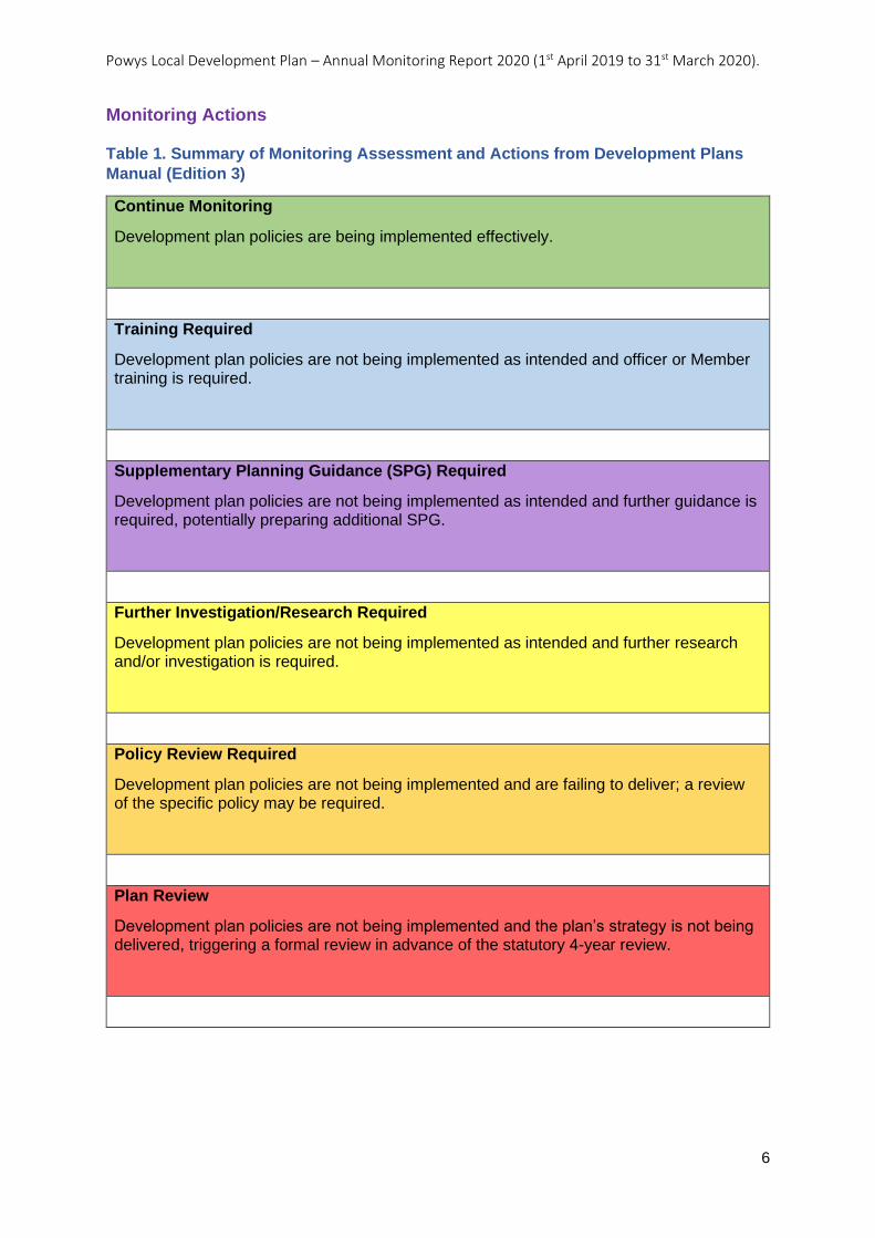
Monitoring Actions
Table 1. Summary of Monitoring Assessment and Actions from Development Plans
Manual (Edition 3)
Continue Monitoring
Development plan policies are being implemented effectively.
Training Required
Development plan policies are not being implemented as intended and officer or Member training is required.
Supplementary Planning Guidance (SPG) Required
Development plan policies are not being implemented as intended and further guidance is required, potentially preparing additional SPG.
Further Investigation/Research Required
Development plan policies are not being implemented as intended and further research and/or investigation is required.
Policy Review Required
Development plan policies are not being implemented and are failing to deliver; a review of the specific policy may be required.
Plan Review
Development plan policies are not being implemented and the plan’s strategy is not being delivered, triggering a formal review in advance of the statutory 4-year review.
Powys Local Development Plan – Annual Monitoring Report 2020 (1st April 2019 to 31st March 2020).
7
Key Findings for This AMR Monitoring Period:
• The Plan is delivering in many of its policy areas and meeting the objectives set out in
the LDP.
• The sustainable settlement hierarchy which controls the scale and location of growth is
being followed in accordance with the Spatial Strategy.
• Within the Plan area a total of 237 dwellings were completed in the AMR period against
the calculated annual average requirement figure of 353 dwellings.
• The number of cumulative completions for the Plan period so far, from its start date in
2011 to 1st April 2020, amounts to 1,786 residential units. This is 40% of the LDP’s
Dwelling Requirement Figure (DRF).
• Housing completions in the Plan area are below the annual and cumulative targets of the
LDP. It should be noted that housing completions have not reached the required 353 per
year, in any one year to date.
• If these delivery trends continue the LDP will not have delivered enough additional
dwellings to meet the LDP Dwelling Requirement of 4,500 additional dwellings by 2026.
This AMR therefore recommends further investigation and analysis of issues, including
market factors, which are limiting the delivery of new homes.
• The Housing Trajectory has been compiled with the involvement of a LDP Housing
Stakeholder Group. It is encouraging that the Housing Trajectory (Figure 1)
demonstrates that the Plan does include sufficient suitable, available and deliverable
sites to enable additional homes to be delivered in line with the annual average
requirement figure of 353 additional dwellings per year.
• It is apparent that the number of additional dwellings being delivered on LDP Housing
Allocations is considerably lower than anticipated at this current time. More momentum is
required if the Plan’s house building targets are to be met. Further analysis on the
causes behind the delays in bringing sites forward is recommended.
• The performance on windfall housing sites remains strong with completions on windfall
sites above expectation in this AMR period (168 units compared to the assumption of
110 units annually).
• In total there were, 69 net additional affordable homes completed in this AMR period.
This means that since the Plan’s start date in 2011, 495 affordable homes have been
delivered, this equates to 52% of the LDP target of 952 new additional affordable homes.
• The number of affordable homes completed increased in this AMR period compared to
the past three years, this upward trend is expected to continue to the end of the Plan
period reflecting the priorities of the Social Housing sector. However, further analysis is
recommended to ascertain if the LDPs overall target of 952 affordable dwellings is likely
be met by 2026.
• LDP policies relating to; new-build housing density, viability assumptions and the
securing of affordable housing (as part of market development), are performing as
planned.
• The development of five permanent pitches at the Machynlleth Gypsy and Traveller Site
is on target with delivery expected during the financial year 2020/2021.
• During the AMR period, planning permission was granted on 1.96 hectares of land for
employment uses (B1, B2 and B8). Proposals were either on existing employment sites
(employment safeguarding areas) 0.754 hectares (total net floorspace of 2,558 square
metres), or windfall development 1.203 hectares, (4,208 square metres).
• Allocated Employment Sites are not being eroded by other development proposals
meaning they remain available for new employment proposals.
• The performance of Allocated Employment Sites will continue to be kept under review.
Powys Local Development Plan – Annual Monitoring Report 2020 (1st April 2019 to 31st March 2020).
8
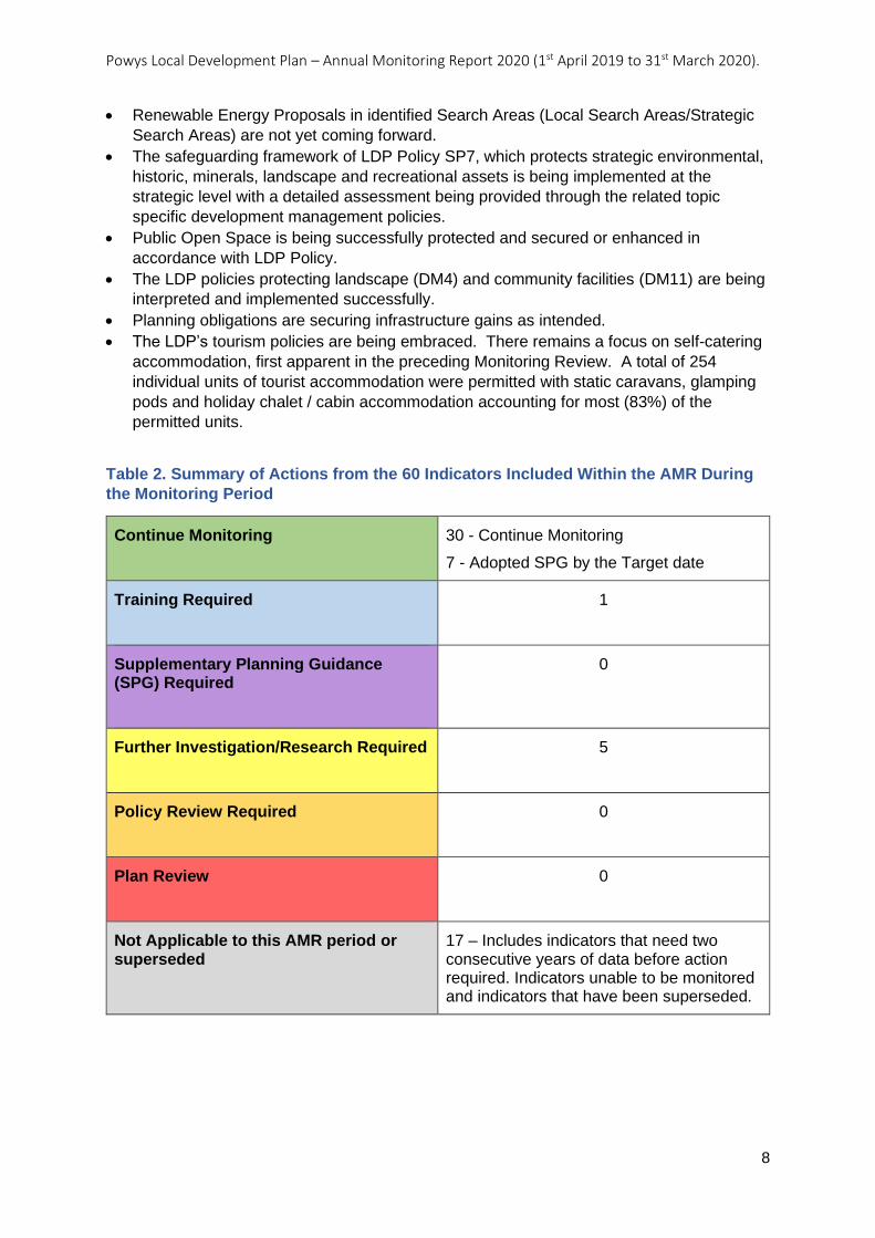
• Renewable Energy Proposals in identified Search Areas (Local Search Areas/Strategic
Search Areas) are not yet coming forward.
• The safeguarding framework of LDP Policy SP7, which protects strategic environmental,
historic, minerals, landscape and recreational assets is being implemented at the
strategic level with a detailed assessment being provided through the related topic
specific development management policies.
• Public Open Space is being successfully protected and secured or enhanced in
accordance with LDP Policy.
• The LDP policies protecting landscape (DM4) and community facilities (DM11) are being
interpreted and implemented successfully.
• Planning obligations are securing infrastructure gains as intended.
• The LDP’s tourism policies are being embraced. There remains a focus on self-catering
accommodation, first apparent in the preceding Monitoring Review. A total of 254
individual units of tourist accommodation were permitted with static caravans, glamping
pods and holiday chalet / cabin accommodation accounting for most (83%) of the
permitted units.
Table 2. Summary of Actions from the 60 Indicators Included Within the AMR During
the Monitoring Period
Continue Monitoring
30 - Continue Monitoring
7 - Adopted SPG by the Target date
Training Required
1
Supplementary Planning Guidance (SPG) Required
0
Further Investigation/Research Required
5
Policy Review Required
0
Plan Review
0
Not Applicable to this AMR period or superseded
17 – Includes indicators that need two consecutive years of data before action required. Indicators unable to be monitored and indicators that have been superseded.
Powys Local Development Plan – Annual Monitoring Report 2020 (1st April 2019 to 31st March 2020).
9
Further Points of Interest:
The Supplementary Planning Guidance (SPG) programme is progressing successfully. In
April 2019, the Council adopted SPGs relating to Renewable Energy and Landscape and in
January 2020, the Council adopted SPGs relating to Conservation Areas and Residential
Design. In total seven of the SPG have been adopted since the LDP was adopted.
Work commenced during this AMR monitoring period on the final set of SPG, although it is
recognised there is likely to be some disruption to the schedule, due to the pandemic and
the Council’s move to Business-Critical mode in March 2020.
The publication of the Development Plans Manual, Edition 3 (March 2020) has influenced
the structure and content of the AMR, updating that published in the LDP. This includes the
replacement of Joint Housing Land Availability Studies (JHLAS) and the need to
demonstrate a 5-year supply of housing land with a system of monitoring based on a
Housing Trajectory.
The implications of Covid-19 and Brexit are as yet uncertain but can be expected to have
some impact, possibly significant impact, on the performance of the LDP in forthcoming
years. This will be kept under review.
Powys Local Development Plan – Annual Monitoring Report 2020 (1st April 2019 to 31st March 2020).
10
1. Analysis of significant contextual change / indicators
1.01 Since the LDP was adopted in April 2018, changes have been made to planning
policy and guidance, and to legislation and guidance in other areas related to planning. This
section provides a summary and review of contextual changes at national, regional and local
level.
1.1 National Context
Planning Policy Wales, Edition 10 (December 2018)
1.1.1 Planning Policy Wales (PPW) sets out the land use planning policies of the Welsh
Government. It is supplemented by a series of Technical Advice Notes (TANs), Welsh
Government Circulars, and policy clarification letters, which together with PPW provide the
national planning policy framework for Wales. PPW, the TANs, MTANs and policy
clarification letters comprise national planning policy.
1.1.2 PPW Edition 10 differs from previous versions in that it has been prepared in line with
the Well-being of Future Generations (Wales) Act 2015 (WFGA), the objectives of which
represent the central thread that runs through the document. The document also promoted
the concept of Placemaking within the planning system; this relates to the delivery of
Sustainable Places to support the well-being of people and communities across Wales.
1.1.3 Decision-makers are expected to take account of updated advice in PPW including
the national sustainable placemaking outcomes which both inform the preparation of
development plans and the assessment of development proposals.
1.1.4 PPW explains how development proposals will become subject to a development
plan hierarchy comprising of three types of statutory development plan, the National
Development Framework (NDF), the regional Strategic Development Plan (SDP) and the
Local Development Plan (LDP). The Plans should all be prepared in accordance with
national planning policies and work in unison. Lower tier plans must be in conformity with
the highest tier (the NDF). Until the NDF and any SDP are adopted, the Council’s sole
statutory development plan is the Powys Local Development Plan (2011-2026).
Development Plans Manual Edition 3 (March 2020)
1.1.5 A new edition of the Development Plans Manual was published in March 2020,
updated to take account of significant changes to planning legislation and national policy
since the second edition (2015), including the Planning (Wales) Act 2015, The Well-being of
Future Generations (Wales) Act 2015 and Planning Policy Wales (PPW) (10th Edition).
1.1.6 The Manual is not national policy; however it provides guidance for practitioners
involved in the preparation and implementation of development plans. It is intended to be
read alongside PPW and other relevant legislation and guidance, and contains practical
guidance on how to prepare, monitor and revise a development plan, underpinned by robust
evidence to ensure that plans are effective and deliverable and contribute to placemaking.
The Manual clarifies the expectations of Welsh Government with regards to the plan making
process.
Powys Local Development Plan – Annual Monitoring Report 2020 (1st April 2019 to 31st March 2020).
11
Revocation of Technical Advice Note 1 Joint Housing Land Availability Studies (March
2020) and Monitoring of Delivery through a Housing Trajectory
1.1.7 In March 2020, the Welsh Government announced changes to the way in which
housing delivery should be monitored. The changes to PPW removed the five-year housing
land supply policy and replaced it with a policy statement making it explicit that the housing
trajectory, as set out in the adopted LDP, will be the basis for monitoring the delivery of
development plan housing requirements as part of LDP Annual Monitoring Reports (AMRs).
It also involved the revocation of Technical Advice Note (TAN) 1: Joint Housing Land
Availability Studies (January 2015) in its entirety, as a consequence of the policy change to
PPW. A Welsh Government letter announced the revisions to the housing delivery section
of PPW, revocation of Technical Advice Note (TAN) 1 and publication of the Development
Plans Manual (Edition 3). The letter explains that this approach will ensure that the
monitoring of housing delivery, including the response to under-delivery, is an integral part of
the process of LDP preparation, monitoring and review.
1.1.8 In accordance with these changes, the Council has prepared a housing trajectory as
part of this AMR and agreed it in consultation with a Housing Stakeholder Group. The work
includes additional information on Powys’ current housing land availability, including dwelling
completions/permissions and their locations. See Figure 1 for the Trajectory and Annexes 1
and 2 for the Tables of Housing Allocations and Commitments.
Affordable Housing Supply Review (May 2019)
1.1.9 The final report of the Independent Review of Affordable Housing Supply (1 May
2019) commissioned by Rebecca Evans AM, Minister for Housing and Regeneration,
included a range of recommendations. The following recommendations from the Review are
particularly relevant to planning:
• Welsh Government to mandate the provision of Local Housing Market Assessments
(LHMA) based on a consistent timetable, data and methodology across housing
tenures.
• For the Welsh Government statistical service to work with local authorities to agree
data sets for use in the LHMA, LDP and other housing requirements work.
• A regular refresh of LHMAs ever two years and rewriting of LHMAs every five years,
with joint LHMAs to be explored.
• LHMAs to better capture a range of needs - older and younger age groups, people
with disabilities - as well as giving more detailed attention to sub-market home
ownership, rural housing, small settlement and the demand for community housing
trusts and self-build.
• Better integration of the production and reconciliation of the conclusions of LHMA
and LDP processes.
• Local Authorities to consider resources devoted to the LHMA and LDP processes
and skills sufficiency of staff.
• Development of new consolidated and simplified standards for new build grant
funded homes and homes delivered through Section 106 or planning conditions.
• Introduction of a requirement for new affordable homes to be near zero carbon /
Energy Performance Certificate (EPC) ‘A’, using a fabric first approach from 2021
and for this requirement to apply to all housing tenures by 2025.
• A set of core / minimum principles to be produced for Section 106 agreements to
include minimum acceptable criteria for such developments.
Powys Local Development Plan – Annual Monitoring Report 2020 (1st April 2019 to 31st March 2020).
12
• Local Authorities to make better use of Compulsory Purchase Order (CPO) powers to
help bring forward more land for housing and to facilitate the development of public
sector land.
1.1.10 The Welsh Government published its own response to the Review in July 2019,
accepting or accepting in principle all but one (deferred) of the recommendations and
confirming that the Welsh Government officials will undertake appropriate further work to
consider the possibilities and implications of implementing the recommendations.
1.1.11 In September 2019, Head of Housing Supply, Homes and Places at the Welsh
Government wrote to all Housing Strategy Officers explaining how the accepted housing
need recommendations were being taken forward. The letter sets out the intention to review
the LHMA processes, guidance and data sources by autumn 2020 with a view to issuing
updated guidance/advice in early 2021.
Rural housing delivery in Wales: How effective is rural exception site policy (January
2019)
1.1.12 This research commissioned by the Royal Town Planning Institute (RTPI) in Wales
was undertaken by Cardiff University to understand the role and use of rural exception site
policies in Wales. The Report recommendations relate to the need to clarify guidance and
improve data, to expand local flexibility, to increase support for delivery, and to further
explore the impact of market housing. The recommendations of the Report highlight the
need for:
• Clarity on data and definitions on affordable housing exception site permission and
delivery between Welsh Government and Local Planning Authorities.
• Clarity on references to rural exception site and affordable housing exception sites,
which are often used interchangeably.
• Further guidance on the development management aspects of exception sites.
• Local Authorities to consider removing restrictions on the type of housing provider
that can develop, and also to consider removing specific caps on the number of units
that can be provided, on rural exception sites.
• Exploration of the role of the Development Bank for Wales in providing mortgages for
affordable housing in perpetuity.
• A rural affordable housing toolkit to be developed that explains rural exception site
processes, engagement and links to other affordable housing options and tools.
1.1.13 The Report also concluded that there was no compelling evidence to suggest that
cross-subsidy of market housing delivers more affordable housing, however that this should
be kept under review. Where cross-subsidy is introduced, this should be subject to a
maximum cap of 25% market housing, limits on land area for market housing, a minimum
absolute number of affordable housing units, and for affordable housing to be developed
concurrently with market housing.
Welsh Government Circular 005/2018: Planning for Gypsy, Traveller and Showpeople
Sites (June 2018)
1.1.14 The Circular provides updated guidance on the planning aspects of identifying
sustainable sites for Gypsies and Travellers and outlines how planning authorities and
Gypsies and Travellers can work together to achieve this aim. The Circular outlines the duty
to provide sites, the necessity of involving Gypsies and Travellers proactively in the process
Powys Local Development Plan – Annual Monitoring Report 2020 (1st April 2019 to 31st March 2020).
13
and the steps required to assess the need for sites, identify suitable sites, and include
policies in development plans.
Changes to the Consenting Regime of Energy Infrastructure and Permitted
Development.
1.1.15 Consenting for the following was devolved to Wales with effect from 1st April 2019:
• Onshore generating stations between 50 Megawatts (MW) and 350MW (with the
exception of consenting for generating stations up to 50MW and all onshore wind, for
which the Welsh Ministers and Local Planning Authorities already have functions);
• Offshore generating stations up to 350MW (with the exception of renewable
generating stations up to 1MW, which will continue to require a Marine Licence alone
from Natural Resources Wales); and
• Overhead electricity lines up to and including 132KV associated with devolved Welsh
generating stations.
1.1.16 This has required changes to legislation and other consequential measures setting
out procedures and permitted development rights.
Prosperity for All: A Low Carbon Wales (March 2019)
1.1.17 This Plan sets out the Welsh Government’s approach to cut emissions and increase
energy efficiency in a way that maximises wider benefits for Wales, ensuring a fairer and
healthier society. It sets out policies and proposals that are intended to reduce emissions
and support the growth of the low carbon economy.
1.1.18 Of particular note in relation to planning are the targets and policies introduced for
the following sectors: Power; Buildings; Transport; Industry; Land Use, Land Use Change
and Forestry; Agriculture; and Waste Management.
Noise and Soundscape Action Plan 2018-2023 (December 2018)
1.1.19 This Welsh Government Action Plan outlines the Welsh public sector’s strategic
policy direction in relation to noise and soundscape management for the next five years. It
has a broader focus than reducing noise levels alone, recognising also the need to create
appropriate soundscapes, meaning the right acoustic environment at the right time and in
the place.
Welsh Government Circular 008/2018: Planning requirement in respect of the use of private sewerage in new development, incorporating septic tanks and small sewage treatment plants (July 2018)
1.1.20 This Circular has updated the information and guidance to be used by planning
authorities when considering proposals for new development in areas with no public
sewerage system. It has replaced Welsh Office Circular 10/99 (Planning Requirement in
respect of the Use of Non-mains Sewerage incorporating Septic Tanks in New
Development). It provides guidance on the exercise of planning controls on non-mains
sewerage and associated sewage disposal aspects of new development in order to avoid
public health, amenity or environmental problems.
Powys Local Development Plan – Annual Monitoring Report 2020 (1st April 2019 to 31st March 2020).
14
1.1.21 The Circular provides guidance for both planning policy and development
management. With regards to Local Development Plans, the Circular states that Planning
Authorities may wish to include appropriate policies in their development plans to reflect a)
the contents of the Circular, b) its own knowledge and experience of the circumstances and
conditions in various localities within its area; and c) the views of appropriate bodies on the
issue of private sewerage and its likely effect on public health, amenity and the environment.
Schedule 3 of the Flood and Water Management Act (2010) – Disposal of Surface
Water through SuDs (January 2019)
1.1.22 Schedule 3 of the Flood and Water Management Act (FWMA) 2010 provides a
framework for the approval and adoption of surface water systems serving new
developments. The Welsh Government introduced five statutory instruments to implement
this requirement. The statutory instruments made it a requirement from the 7th January 2019
for all new developments of more than one dwelling, or where the construction area is 100
square metres or more, to dispose of surface water through a sustainable drainage system
(SuDS).
1.1.23 The Welsh Government produced two documents: Sustainable Drainage (SuDS)
Statutory Guidance (2019)” and “Statutory standards for sustainable drainage systems –
designing, constructing, operating and maintaining surface water drainage systems (2019)”
which outline the process and standards to be applied.
1.1.24 All applications for SuDS need to be submitted to and approved by the SuDs
Approval Body (SAB). This is a separate consenting process to the planning application
process; developers cannot commence works until both consents have been granted. In
order for a SuDS application to be granted approval it needs to demonstrate compliance with
the Statutory SuDS Standards. The standards contain:
1.1.25 A set of Principles, which need to be applied in the design of the surface water
drainage scheme, and
Six standards, numbered S1 to S6:
• S1 – Runoff destination
• S2 – Hydraulic control
• S3 - Water Quality
• S4 – Amenity
• S5 – Biodiversity
• S6 – Construction, operation and maintenance.
Welsh National Marine Plan (Nov 2019)
1.1.26 The Welsh National Marine Plan was published in November 2019 and is intended to
support the sustainable development of the seas around Wales, covering inshore and
offshore areas for the next 20 years. It sets out the Welsh Government's ambitions for the
future use of marine natural resources and how various users of the seas should interact
and consider each other's activities and future plans.
1.1.27 The Marine and Coastal Access Act (2009) requires public authorities to take
relevant authorisation or enforcement decisions in accordance with the Welsh National
Marine Plan unless relevant considerations indicate otherwise. Public authorities are also
required to have regard to the appropriate marine policy documents in making any decision
Powys Local Development Plan – Annual Monitoring Report 2020 (1st April 2019 to 31st March 2020).
15
which relates to the exercise of any function capable of affecting the whole or any part of the
UK marine area.
State of Natural Resources (SoNaRR) Interim Report 2019
1.1.28 This report provides an assessment of whether Wales is achieving the sustainable
management of natural resources. It is compiled annually by Natural Resources Wales and
the 2019 Interim Report provides evidence of the challenges that our natural resources are
facing, with the two issues of climate change and biodiversity loss being the most pressing. It
also provides some recommendations that will help to address these important issues. The
recommendations include creating a circular economy and providing a green infrastructure in
both urban and rural settings. Green infrastructure is mentioned extensively in Edition 10 of
PPW (2018) and will need to be incorporated into any future LDP.
Managing Scheduled Monuments in Wales (November 2018)
1.1.29 This Cadw best-practice guidance has set out the general principles to consider
when managing and making changes to scheduled monuments. It has been written to
inform owners, occupies and managers of scheduled monuments. It is also intended for use
by decision-making authorities, alongside Planning Policy Wales, TAN 24, and Cadw’s
Conservation Principles, to inform policies, advice, and the statutory decision-making
process.
Managing Change to Listed Places of Worship in Wales: the Ecclesiastical Exemption
(November 2018)
1.1.30 This Cadw best-practice guidance explains the operation of the Ecclesiastical
Exemption (Listed Buildings and Conservation Areas) (Wales) Order 2018. It sets out the
guiding principles to consider when planning changes to listed places of worship covered by
the Order. It also sets out a code of practice for denominational consent procedures, which
explains how those principles should be included in the control and decision-making
process.
1.1.31 It clarifies the need to obtain separate planning permission for development affecting
the exterior of a building. It explains that proposals for total demolition of a listed building
requires listed building consent from the LPA and that conservation area consent is also
needed when it is proposed to demolish an unlisted building in a conservation area.
Decision-making bodies are also required to make full use of the Historic Environment
Record.
Understanding Listing in Wales (September 2018)
1.1.32 This Cadw guidance is aimed at helping anyone who wants or needs to know why
and how buildings are listed. It also explains how to ask for a building to be listed or
delisted, and how to request a review of a listing decision. It provides an introduction to
owners, occupiers and agents about what listing means for them.
Powys Local Development Plan – Annual Monitoring Report 2020 (1st April 2019 to 31st March 2020).
16
1.2 Chief Planning Officer Letters
Intensive Poultry Units (June 2018)
1.2.1 This letter requires the planning system to take a constructive approach towards
agricultural development whist ensuring significant consideration is given to environmental
protection as well as the wellbeing of people and the impacts on natural and cultural
resources.
Increasing Supply of Affordable Homes Through Planning (July 2019)
1.2.2 When reviewing LDPs local planning authorities must make provision for affordable
housing led housing sites. Such sites will include at least 50% affordable housing. This is
defined as social rented housing provided by local authorities and registered social
landlords, and intermediate housing where prices or rents are above those of social rent but
below market levels. There must be secure arrangements to recycle receipts to use for
future affordable housing in cases where full ownership is achieved.
“Securing Biodiversity Improvements” (October 2019)
1.2.3 This letter drew the attention of LPA’s to the Section 6 Duty of the Environment
(Wales) Act 2016 and the need for planning authorities to ‘seek to maintain and enhance
biodiversity in the exercise of their functions’. The letter sought to clarify the interpretation of
this duty and stated that ‘where biodiversity enhancement is not proposed as part of an
application, significant weight will be given to its absence, and unless other significant
material considerations indicate otherwise it will be necessary to refuse permission’. It goes
on to state that ‘planning authorities should be proactive and embed appropriate policies into
local development plans to protect against biodiversity loss and secure enhancement’.
Legal Status of the Draft National Development Framework (NDF) November 2019
1.2.4 This letter states the intention to publish the NDF in September 2020, which will set
out the Welsh Government’s spatial planning policy up to 2040. It states that conformity with
the NDF is not a legal requirement until its publication. However, it is important that LDPs
consider the outcomes, spatial strategy and policies set out in the draft NDF and how
emerging LDPs fit with these, which should not cause delay given that the NDF and LDPs
are being prepared in the context of PPW 10. Where there is a significant difference in
direction of travel between the NDF and an individual LDP, this will be an issue for
Inspector’s to consider at Examination. LPAs should review the draft NDF and consider
what its draft policies may mean for proposals that are anticipated or likely to be determined
after the publication of NDF, which will assist Inspectors in considering proposals submitted
before publication of the NDF but likely to be determined after.
Cornonavirus: Guidance to Planning Authorities (March 2020)
1.2.5 This letter provides guidance by the Welsh Government to Local Planning Authorities
regarding changes to planning services in light of the Covid-19 outbreak. It highlighted the
potential delays to the Senedd’s scrutiny process of the NDF due to the prioritisation of work
around the current emergency and urgent matters. It also confirmed that Technical Advice
Notes TAN 11, TAN 15 and the proposed new intensive agriculture TAN are under review
and that any new or further consultation will take place after the end of the current Covid-19
outbreak. Regional Technical Statements for Aggregates (RTS 2) were also due to be
published in April 2020, and that this would be undertaken as soon as appropriate in the
coming months.
Powys Local Development Plan – Annual Monitoring Report 2020 (1st April 2019 to 31st March 2020).
17
Local Development Plan (LDP) Preparation – Novel Coronavirus (COVID-19) (March 2020) 1.2.6 This letter provides guidance to Local Planning Authorities on progressing Local Development Plans during the Covid-19 outbreak. It summarises key issues identified so far for LDPs, including local authority resources/capacity, plan engagement/consultation, and delivery agreement/timetable. It recognised that progressing an LDP in line with the legal obligations set out in both the Delivery Agreement and the Community Involvement Scheme will not be possible. 1.2.7 The Welsh Government sets out the proposed approach for LDPs based on their stage in the process, specifically mentioning those at consultation stage, submission and examination stage, and those that are due to formally commence review (NOTE: the review of the Powys LDP is not due to commence at this stage). It is stressed that as much technical work as possible should be undertaken during this period. It is also explained that the Welsh Government would be taking a pragmatic view on the implications and delays on plan preparation may have on other legislative requirements, such as the end dates of plans.
Planning and the Post Covid 19 Recovery (July 2020)
1.2.8 This letter will be discussed in detail in the next AMR (2021). However, it included a
paragraph stating there would be no requirement for Annual Monitoring Reports (AMR) to be
submitted in October 2020, but encouraged LPAs to continue with data collection, as this will
help shape and inform policy and plan development.
1.3 Regional Context
Mid and South West Wales Regional Planning Group
1.3.1 Work has been continuing at the regional level to support and contribute towards
planning within the Mid and South West Wales region.
Regional Housing Market Assessment
1.3.2 As reported in the Monitoring Review (2018-2019), the Authorities in the Mid and
South West Wales region (Swansea, Neath Port Talbot, Pembrokeshire, Pembrokeshire
Coast National Park, Ceredigion, Powys, Carmarthenshire, Brecon Beacons National Park)
have collaborated on updating their Local Housing Market Assessments (LHMA). Opinion
Research Services (ORS) were commissioned in January 2019 to undertake a cross border
Housing Market Assessment (HMA) for the authorities within the region.
1.3.3 The regional HMA will consist of a report at the Mid and West Wales regional level
and a report at the local authority level. The HMA reports have been drafted and are
currently being considered by Housing and Planning Policy Officers from the LPAs within the
region. Consultation on the draft HMA is due to take place with stakeholders before the
reports are finalised for adoption by the Authority later in 2020.
Powys Local Development Plan – Annual Monitoring Report 2020 (1st April 2019 to 31st March 2020).
18
Regional Viability Model
1.3.4 Andrew Burrows of Burrows Hutchinson Ltd. was appointed in January 2019 to
undertake a financial viability project for the Mid and South West Wales region. The project
involves producing a regional viability model and associated training and support.
1.3.5 Stakeholder events were held at Llanelli and Llandrindod Wells during May 2019 to
discuss the site-specific model and viability assumptions, and also to engage with the
development industry. Developers, the Homebuilders Federation, Agents, Estate Agents,
RSLs, Welsh Government, valuers and housing officers were invited to the meetings.
Specialist training also took place later in 2019 for Council Officers on the practical use of
the new regional viability model.
1.3.6 The commission has also produced a high-level viability model (HLVM) for use for
LDP purposes and a site-specific development viability model (DVM) for use in assessing
the viability of Candidate Sites and planning applications. The HLVM is intended to be used
to carry out viability testing of proposed policies and affordable housing targets at LDP
review stage, as evidence to support the delivery of the LDP. In the meantime, the HLVM
will be used for annual monitoring purposes to assess changes to residual values (see
indicator AMR9).
1.3.7 House price values at sub-market level area will be informed by evidence provided in
the house price database that has been set up as part of this commission, which will be
updated by Officers using the Land Registry’s Price Paid Data and online EPC register
(floorspace data). The database will also provide data on local comparable developments in
order to verify house prices values assumed by developers using the DVM for site specific
viability assessments.
1.3.8 Work has been continuing on making the DVM ready for public release in order that it
can be used by developers to support candidate site submissions and in support of planning
applications. This has involved the development of a public user guide and screencasts to
accompany the model, along with establishing an agreed set of fees for release of the model
to site promoters, which will also cover the LPA’s high-level review of the submission.
Regional Employment Study
1.3.9 A “larger than local” sites and premises employment study and sectoral analysis was
scoped out and commissioned in October 2019 for the Mid Wales region (Powys, Ceredigion
and BBNPA area). Outcomes and recommendations are due to be delivered by April 2020.
Mid Wales Growth Deal
1.3.10 The Mid Wales region was invited by the UK Government and the Welsh
Government in 2017 to develop a Growth Deal. In December 2019, Powys County Council
and Ceredigion County Council entered into an Inter-Authority Agreement to formalise
collaboration and governance required to bring forward the development of the Mid Wales
Growth Deal and to agree a Heads of Terms document with the Governments. The Deal will
play a key role alongside a range of other strategies and investments from the public and
private sector to bring prosperity to the communities and businesses of the region.
Powys Local Development Plan – Annual Monitoring Report 2020 (1st April 2019 to 31st March 2020).
19
Growing Mid Wales Partnership
1.3.11 Growing Mid Wales is a regional partnership that was established in 2015 to
progress jobs, growth and the wider economy in Mid Wales. It comprises of representative
bodies and key stakeholders from across the private, public and voluntary services across
the region. The initiative seeks to represent the region’s interest and priorities for
improvement to the local economy.
1.3.12 In February 2019, Growing Mid Wales published “Strategic Economic Priorities for
the Mid Wales Region”, which presents the strategic economic priorities that aim to deliver
growth across the region over the next 15 years. It is a strategic document that outlines the
priority programme required to deliver sustainable economic growth, more productive jobs
and support prosperous communities in Mid Wales by 2033. It is intended as a living
document that will be reviewed on a regular basis to guide future investment.
NRW Area Statements (March 2020)
1.3.13 The Environment (Wales) Act 2016 required Natural Resources Wales (NRW) to
prepare and publish regional statements, referred to as “Area Statements”, for the areas of
Wales that it considers appropriate for the purpose of facilitating the implementation of the
national Natural Resources Policy. Area Statements outline the key challenges facing the
respective region, what collectively can be done to meet those challenges, and how natural
resources can be better managed for the benefit of future generations.
1.3.14 The Powys LPA area is within the region, which is covered by the Mid Wales Area
Statement, which also includes the LPA areas for Ceredigion and the Brecon Beacons
National Park. It sets out the following five themes for the Mid Wales area:
• Improving biodiversity – responding to the nature emergency.
• Sustainable land, water and air.
• Reconnecting people and places – improving health, well-being and the economy.
• Forest resources – managing timber resources effectively.
• Climate emergency – adaptation and mitigation.
1.3.15 Area statements are a key piece of evidence for LPAs to consider in preparing their
LDPs. They provide evidence of environmental and natural resources issues and should be
used as part of the evidence base for the LDP and when fulfilling the LPA’s duty to maintain
and enhance biodiversity in exercising its planning functions.
1.4 Local Context
Vision 2025: Our Corporate Improvement Plan (April 2018)
1.4.1 In April 2018, Vision 2025 was launched by Powys County Council as its Corporate
Improvement Plan which has set out a seven-year vision for the County and plans for how
the Council would achieve it. Vision 2025 has set out four well-being and equality
objectives:
• Well-being Objective 1: We will develop a vibrant economy.
• Well-being Objective 2: We will lead the way in providing effective, integrated health
and care in a rural environment.
Powys Local Development Plan – Annual Monitoring Report 2020 (1st April 2019 to 31st March 2020).
20
• Well-being Objective 3: We will strengthen learning and skills.
• Well-being Objective 4: We will support our residents and communities.
1.4.2 Progress made by the Council in terms of meeting its wellbeing objectives is reported
on an annual basis. The Corporate Improvement Plan Annual Performance Report (April
2019 - March 2020) presented the Council’s performance during 2019-2020 against the
Well-being objectives and activities set out in Vision 2025.
Towards 2024, the Powys Well-being Plan (May 2018)
1.4.3 The first Well-being Plan for Powys was published in May 2018. The Public Service
Board (PSB) for the Powys Local Authority Area is responsible for developing a local Well-
being Assessment and Well-being Plan for the area. The Well-being Plan provides a long-
term vision of well-being in Powys and details the actions that will be taken to address local
issues and contribute to the national Well-being goals. It has set out four local well-being
objectives and 12 initial well-being steps to deliver these local objectives.
1.4.4 The Powys Public Service Board Annual Report highlights the work that the PSB has
done during 2019-2020 to deliver the objectives in Towards 2040.
1.4.5 Planning Authorities have a duty to have regard to the local Well-being Plan during
development plan preparation and review and they form a key part of the evidence base.
Powys Digital Strategy (December 2019)
1.4.6 PCC has published ‘Digital Powys 2019-2025 – A Digital transformation Strategy’
outlining the vision of embracing new technologies to improve customer experience. It sets
out how the Council will work together with partners to make the most of new technology and
the opportunities it provides for the communities of Powys and to improve connectivity
across the county. It is aimed at ensuring Powys is a place where people can connect,
communicate and access the council services they need both quickly and efficiently. The
delivery of the strategy will be driven through the Digital Powys Programme.
1.5 Supplementary Planning Guidance (SPG)
1.5.1 The following SPGs have been adopted since the LDP was adopted in April 2018:
• Affordable Housing (October 2018)
• Planning Obligations (October 2018)
• Biodiversity and Geodiversity (October 2018)
• Renewable Energy (April 2019)
• Landscape (April 2019)
• Conservation Areas SPG (January 2020)
• Residential Design SPG (January 2020)
1.5.2 Work has commenced on the final batch of agreed SPG comprising:
• Archaeology
• The Historic Environment
• Land Drainage and Flooding
These SPG will be due for adoption during April 2020.
1.5.3 Newtown Town Council has commenced on preparing a Place Plan for the Newtown
and Llanwchaiarn Town Council area with support from the Planning Policy team. The Town
Powys Local Development Plan – Annual Monitoring Report 2020 (1st April 2019 to 31st March 2020).
21
Council is involving both a professional planning consultancy and Planning Aid Wales in the
preparation of the Place Plan and is engaging widely with the local community and
stakeholders. It is important that the Place Plan is adopted as SPG for it to carry weight as a
material consideration, the Council will be publishing a Consultation version of the Place
Plan in accordance with the SPG Protocol before it is considered for Adoption.
1.6 Updated Local Evidence
Open Space Assessment (2018)
1.6.1 The Open Space Assessment (originally undertaken as part of the evidence base for
the LDP) was updated in 2018. The assessment provides an overview of the current
provision of open space in the key settlements across the Powys LDP area. It sets out those
areas which are to receive protection through LDP Policy DM3 and provides a framework for
the provision of new open spaces to support implementation of the policy.
1.7 Other Contextual Changes
Brexit
1.7.1 In June 2016 the UK electorate voted in favour of leaving the European Union (EU)
and the UK formally left the EU at the end of 2019. Until the end of 2020 a transition period
remains in place while the UK and EU negotiate additional arrangements. The pre-existing
rules on trade, travel, and business for the UK and EU continue to apply during the transition
period.
1.7.2 Brexit will include legislative changes that will need to be taken into consideration by
the LDP going forward. An example of this is the Conservation of Species and Habitats
Regulations 2017 (Habitat Regulations) which includes protection for European protected
sites as specified in Policy DM2 of the LDP. It is anticipated that these requirements will be
incorporated directly into domestic legislation and therefore no changes in process will
occur.
Covid-19 Pandemic
1.7.3 On 23rd March 2020, following increases in the Covid-19 infection rate, the United
Kingdom (UK) entered a National Lockdown ordering people to stay at home. This led to a
wide scale disruption to services including planning, where the Council has had to re-direct
resources to those services identified as business critical.
1.7.4 The impact of the pandemic on Powys will not be truly known for some time. The
closure of businesses and services for prolonged periods may result in widescale economic
disruption. Some actions may lead to long term changes across the County, these include
movement and work patterns which have been affected by measures such as increased
homeworking. Looking forward towards the future the Powys LDP will need to be responsive
to the priorities and actions promoted by the UK and Welsh Governments and the Powys
Local Authority to assist in the post Covid-19 recovery.
Powys Local Development Plan – Annual Monitoring Report 2020 (1st April 2019 to 31st March 2020).
22
2. Analysis of Core/Key Indicators
2.0.1 Core / Key Indicators are identified in the Development Plans Manual published by
Welsh Government.
2.0.2 Unless stated otherwise only Full and Outline planning applications permitted have
been considered to prevent any double counting.
Powys Local Development Plan – Annual Monitoring Report 2020 (1st April 2019 to 31st March 2020).
23
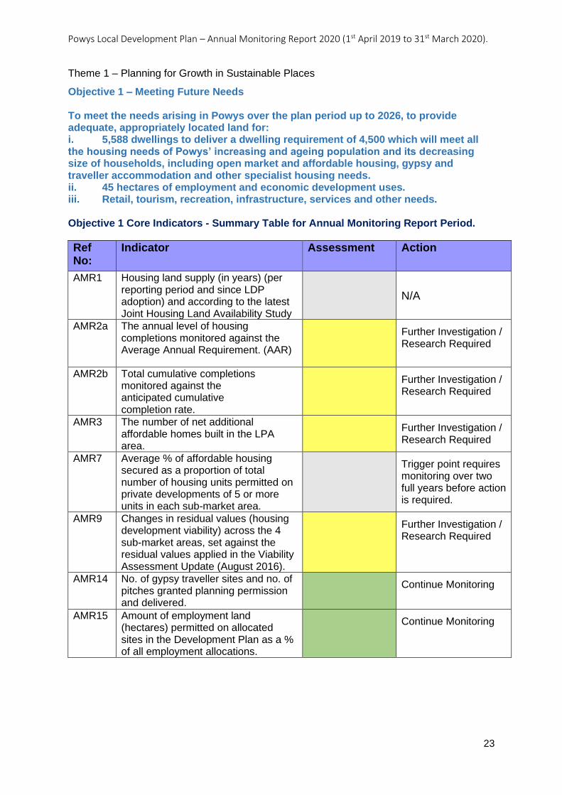
Theme 1 – Planning for Growth in Sustainable Places
Objective 1 – Meeting Future Needs To meet the needs arising in Powys over the plan period up to 2026, to provide adequate, appropriately located land for: i. 5,588 dwellings to deliver a dwelling requirement of 4,500 which will meet all the housing needs of Powys’ increasing and ageing population and its decreasing size of households, including open market and affordable housing, gypsy and traveller accommodation and other specialist housing needs. ii. 45 hectares of employment and economic development uses. iii. Retail, tourism, recreation, infrastructure, services and other needs. Objective 1 Core Indicators - Summary Table for Annual Monitoring Report Period.
Ref No:
Indicator Assessment Action
AMR1 Housing land supply (in years) (per reporting period and since LDP adoption) and according to the latest Joint Housing Land Availability Study
N/A
AMR2a The annual level of housing completions monitored against the Average Annual Requirement. (AAR)
Further Investigation / Research Required
AMR2b Total cumulative completions monitored against the anticipated cumulative completion rate.
Further Investigation / Research Required
AMR3 The number of net additional affordable homes built in the LPA area.
Further Investigation / Research Required
AMR7 Average % of affordable housing secured as a proportion of total number of housing units permitted on private developments of 5 or more units in each sub-market area.
Trigger point requires monitoring over two full years before action is required.
AMR9 Changes in residual values (housing development viability) across the 4 sub-market areas, set against the residual values applied in the Viability Assessment Update (August 2016).
Further Investigation / Research Required
AMR14 No. of gypsy traveller sites and no. of pitches granted planning permission and delivered.
Continue Monitoring
AMR15 Amount of employment land
(hectares) permitted on allocated sites in the Development Plan as a % of all employment allocations.
Continue Monitoring
Powys Local Development Plan – Annual Monitoring Report 2020 (1st April 2019 to 31st March 2020).
24
AMR1: Housing land supply (in years) (per reporting period and since LDP adoption)
and according to the latest Joint Housing Land Availability Study
Objective: Meeting Future Needs
Indicator: Housing land supply (in years) (per reporting period and since LDP adoption) and according to the latest Joint Housing Land Availability Study
Key Policies: Strategic Policy SP1 – Housing Growth
Related Policies: N/A
Target: Maintain a minimum 5-year supply of land for housing (as required by TAN1).
Trigger Point: JHLAS Study records a housing land supply of less than 5 years in any one year following adoption of the Plan
Outcome / actions, year on year:
LDP Adopted: 17/04/2018
AMR 2020 (2019-2020):
Action
N/A
Analysis
This is no longer a core indicator. The need to demonstrate at least a 5 year supply of housing land has been replaced by monitoring against the Housing Trajectory. See AMR2b.
Powys Local Development Plan – Annual Monitoring Report 2020 (1st April 2019 to 31st March 2020).
25
AMR2. Number of net additional dwellings (general market and affordable) built in the
LPA area (per reporting period and since LDP adoption).
Due to the publication of Development Plans Manual Edition 3 (March 2020) AMR2 has
been revised and split between AMR2a and AMR2b.
AMR2a. The annual level of housing completions monitored against the Average
Annual Requirement. (AAR)
For those plans published prior to the publication of Development Plans Manual Edition 3,
completions will be measured against the Average Annual Requirement (AAR) set out in the
plan. This must be presented clearly in the AMR both in numerical and percentage terms
(plus/minus x %).
Objective: Meeting Future Needs
Indicator: AMR2a. The annual level of housing completions monitored against the Average Annual Requirement. (AAR)
Key Policies: Strategic Policy SP1 – Housing Growth
Related Policies: N/A
Target: To provide 4,500 (average 300 per annum) net additional dwellings over the Plan period 2011-2026.
Trigger Point: The number of annual net additional dwellings completed falls below the Average Annual Requirement (for two consecutive years).
Outcome / actions, year on year:
LDP Adopted: 17/04/2018
AMR 2020 (2019-2020):
Analysis
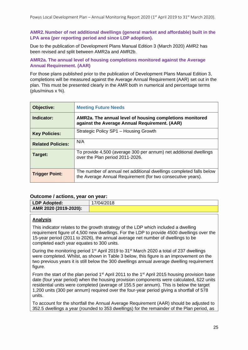
This indicator relates to the growth strategy of the LDP which included a dwelling requirement figure of 4,500 new dwellings. For the LDP to provide 4500 dwellings over the 15-year period (2011 to 2026), the annual average net number of dwellings to be completed each year equates to 300 units.
During the monitoring period 1st April 2019 to 31st March 2020 a total of 237 dwellings were completed. Whilst, as shown in Table 3 below, this figure is an improvement on the two previous years it is still below the 300 dwellings annual average dwelling requirement figure.
From the start of the plan period 1st April 2011 to the 1st April 2015 housing provision base date (four year period) when the housing provision components were calculated, 622 units residential units were completed (average of 155.5 per annum). This is below the target 1,200 units (300 per annum) required over the four-year period giving a shortfall of 578 units.
To account for the shortfall the Annual Average Requirement (AAR) should be adjusted to 352.5 dwellings a year (rounded to 353 dwellings) for the remainder of the Plan period, as
Powys Local Development Plan – Annual Monitoring Report 2020 (1st April 2019 to 31st March 2020).
26
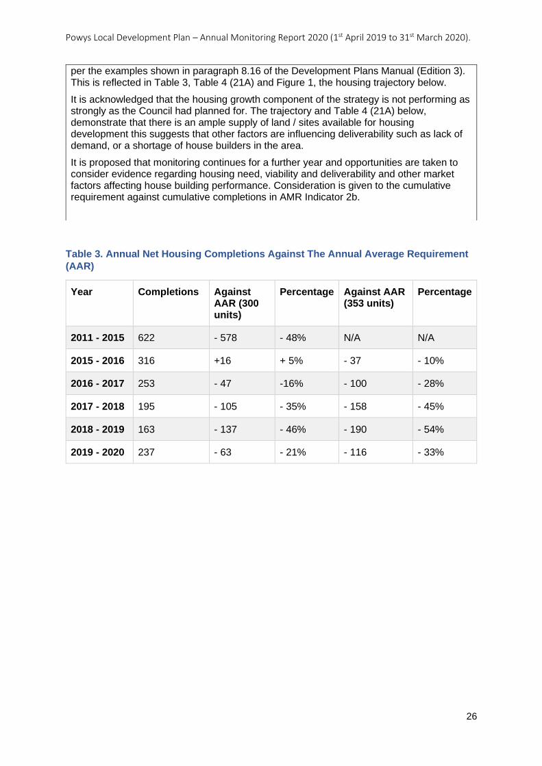
Table 3. Annual Net Housing Completions Against The Annual Average Requirement
(AAR)
Year Completions Against AAR (300 units)
Percentage Against AAR (353 units)
Percentage
2011 - 2015 622 - 578 - 48% N/A N/A
2015 - 2016 316 +16 + 5% - 37 - 10%
2016 - 2017 253 - 47 -16% - 100 - 28%
2017 - 2018 195 - 105 - 35% - 158 - 45%
2018 - 2019 163 - 137 - 46% - 190 - 54%
2019 - 2020 237 - 63 - 21% - 116 - 33%
per the examples shown in paragraph 8.16 of the Development Plans Manual (Edition 3). This is reflected in Table 3, Table 4 (21A) and Figure 1, the housing trajectory below.
It is acknowledged that the housing growth component of the strategy is not performing as strongly as the Council had planned for. The trajectory and Table 4 (21A) below, demonstrate that there is an ample supply of land / sites available for housing development this suggests that other factors are influencing deliverability such as lack of demand, or a shortage of house builders in the area.
It is proposed that monitoring continues for a further year and opportunities are taken to consider evidence regarding housing need, viability and deliverability and other market factors affecting house building performance. Consideration is given to the cumulative requirement against cumulative completions in AMR Indicator 2b.
Powys Local Development Plan – Annual Monitoring Report 2020 (1st April 2019 to 31st March 2020).
27
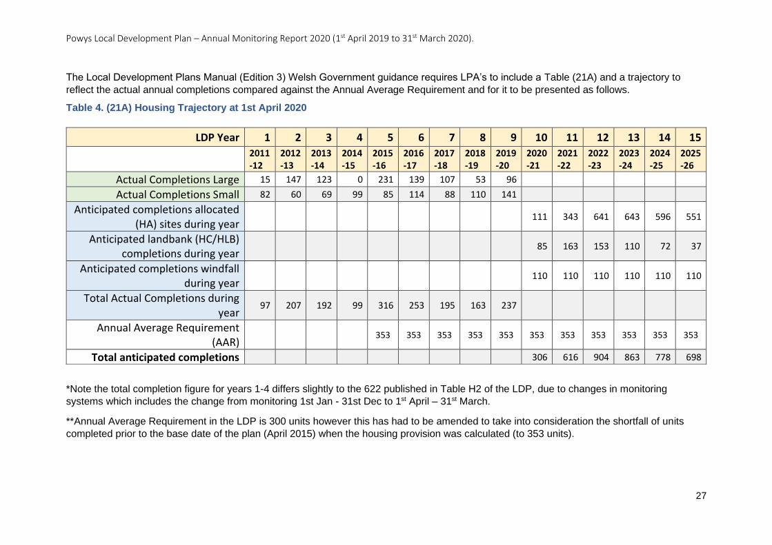
The Local Development Plans Manual (Edition 3) Welsh Government guidance requires LPA’s to include a Table (21A) and a trajectory to
reflect the actual annual completions compared against the Annual Average Requirement and for it to be presented as follows.
Table 4. (21A) Housing Trajectory at 1st April 2020
*Note the total completion figure for years 1-4 differs slightly to the 622 published in Table H2 of the LDP, due to changes in monitoring
systems which includes the change from monitoring 1st Jan - 31st Dec to 1st April – 31st March.
**Annual Average Requirement in the LDP is 300 units however this has had to be amended to take into consideration the shortfall of units
completed prior to the base date of the plan (April 2015) when the housing provision was calculated (to 353 units).
LDP Year 1 2 3 4 5 6 7 8 9 10 11 12 13 14 15
2011-12
2012-13
2013-14
2014-15
2015-16
2016-17
2017-18
2018-19
2019-20
2020-21
2021-22
2022-23
2023-24
2024-25
2025-26
Actual Completions Large 15 147 123 0 231 139 107 53 96
Actual Completions Small 82 60 69 99 85 114 88 110 141
Anticipated completions allocated (HA) sites during year
111 343 641 643 596 551
Anticipated landbank (HC/HLB) completions during year
85 163 153 110 72 37
Anticipated completions windfall during year
110 110 110 110 110 110
Total Actual Completions during year
97 207 192 99 316 253 195 163 237
Annual Average Requirement (AAR)
353 353 353 353 353 353 353 353 353 353 353
Total anticipated completions 306 616 904 863 778 698
Powys Local Development Plan – Annual Monitoring Report 2020 (1st April 2019 to 31st March 2020).
28
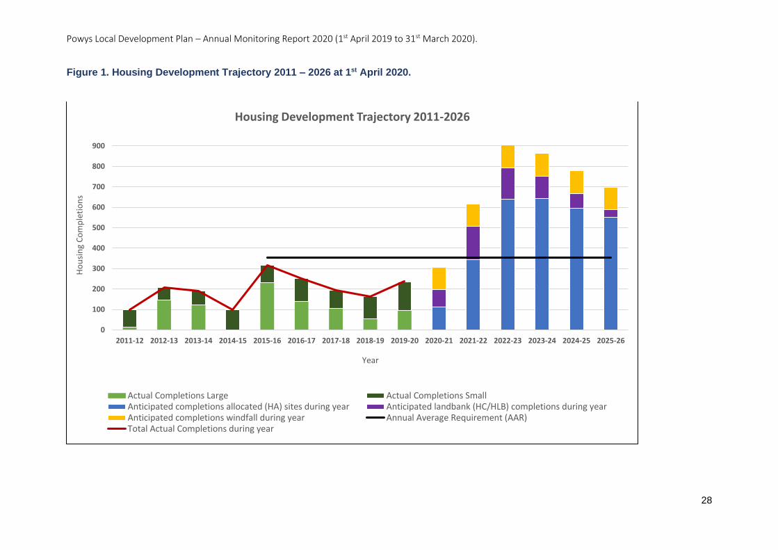
Figure 1. Housing Development Trajectory 2011 – 2026 at 1st April 2020.
0
100
200
300
400
500
600
700
800
900
2011-12 2012-13 2013-14 2014-15 2015-16 2016-17 2017-18 2018-19 2019-20 2020-21 2021-22 2022-23 2023-24 2024-25 2025-26
Ho
usi
ng
Co
mp
leti
on
s
Year
Housing Development Trajectory 2011-2026
Actual Completions Large Actual Completions SmallAnticipated completions allocated (HA) sites during year Anticipated landbank (HC/HLB) completions during yearAnticipated completions windfall during year Annual Average Requirement (AAR)Total Actual Completions during year

Action
Further Investigation/Research Required – look at evidence regarding housing need, viability and deliverability.
Powys Local Development Plan – Annual Monitoring Report 2020 (1st April 2019 to 31st March 2020).
30
AMR2b. The annual level of housing completions monitored against the cumulative
Average Annual Requirement. (AAR)
Due to the publication of Development Plans Manual Edition 3 (March 2020) AMR2 has
been revised and split between AMR2a and AMR2b.
Objective: Meeting Future Needs
Indicator: AMR2b. The annual level of housing completions monitored against the cumulative Average Annual Requirement. (AAR)
Key Policies: Strategic Policy SP1 – Housing Growth
Related Policies: N/A
Target: To provide 4,500 (average 300 per annum) net additional dwellings over the Plan period 2011-2026.
Annual net additional dwelling requirement for remainder of the Plan period:
2015-2016: 322 2016-2017: 321 2017-2018: 325 2018-2019: 357 2019-2020: 356 2020-2021: 356 2021-2022: 377 2022-2023: 354 2023-2024: 367 2024-2025: 361 2025-2026: 352
Trigger Point: The number of annual net additional dwellings completed falls below the cumulative dwelling requirement (identified in the target as the annual net additional dwelling requirement for the remainder of the Plan) for two consecutive years.
Outcome / actions, year on year:
LDP Adopted: 17/04/2018
AMR 2020 (2019-2020):
Analysis
This indicator relates to the growth strategy of the LDP which included a dwelling requirement figure of 4,500 new dwellings. The LDP housing provision components were calculated at the base date of 1st April 2015, at this time, 622 dwellings had been completed since the beginning of the Plan period (2011). A further 3,878 dwellings are therefore required to be built before the end of the Plan period (2026) in order to meet the LDP’s dwelling requirement.
Within the Plan area a total of 237 dwellings were built within the period 1st April 2019 to 31st March 2020. Small sites (including conversions) accounted for a significant number of these completions (141 units) (59%).
Powys Local Development Plan – Annual Monitoring Report 2020 (1st April 2019 to 31st March 2020).
31
Table 5. Actual Cumulative Completions against the Cumulative Completions Target
Year Cumulative Target
Actual Cumulative Completions
Cumulative
Completions Against Target
Percentage
2015 - 2016 322 316 - 6 - 2%
2016 - 2017 643 569 - 74 - 12%
2017 - 2018 968 764 - 204 - 21%
2018 - 2019 1,325 927 - 398 - 30%
2019 - 2020 1,681 1164 - 517 - 31%
The 237 dwellings together with the completion of 927 dwellings recorded during the four previous years, means that a total of 1,164 completions have been recorded since the 1st April 2015 housing provision base date.
The figure of 237 residential completions recorded is significantly lower than the LDP AMR net additional dwelling requirement for the same period which is 356 units. The cumulative total of the net additional dwelling requirement figures identified in monitoring indicator AMR2, for the period 1st April 2015 to 31st March 2020 is 1,681 units. By comparing the 1,164 completions against the 1,681-net additional dwelling requirement figure it can be seen that there has been a shortfall of 517 completions over the five-year period.
The number of dwellings completed this year is an increase of 74 dwellings from last year’s figure. Whilst it can be seen in Table 5 and Figure 2, that the number of annual completions may be on the rise it is acknowledged that the housing growth component of the strategy is not performing as strongly as the Council had planned for. Monitoring should continue and opportunities should be taken to consider the evidence around housing need, viability and deliverability.
Powys Local Development Plan – Annual Monitoring Report 2020 (1st April 2019 to 31st March 2020).
32
Figure 2. Chart Showing The Number Of Additional Dwellings Since Housing Provision Base Date Of April 2015 Against The Net Additional Dwelling Requirement
Action
Further Investigation/Research Required – look at evidence regarding housing need, viability and deliverability.
0
50
100
150
200
250
300
350
400
2015-2016 2016-2017 2017-2018 2018-2019 2019-2020
No
. Ad
dit
ion
al D
wel
lings
Year
Dwelling Requirement Actual Completions
Powys Local Development Plan – Annual Monitoring Report 2020 (1st April 2019 to 31st March 2020).
33
AMR3: The number of net additional affordable homes built in the LPA area.
Objective: Meeting Future Needs
Indicator: The number of net additional affordable homes built in the LPA area.
Key Policies: Strategic Policy SP3 – Affordable Housing Target
Related Policies: N/A
Target: To provide 952 (average 63 per annum) net additional affordable homes over the Plan period (2011-2026).
Annual net additional affordable housing target for the remainder of the Plan period (2015-2026):
2015-2016: 90 2016-2017: 89 2017-2018: 69 2018-2019: 72 2019-2020: 69 2020-2021: 68 2021-2022: 60 2022-2023: 54 2023-2024: 66 2024-2025: 71 2025-2026: 67
Trigger Point: The number of net additional affordable homes completed falls below the cumulative target (identified in the target as the annual net additional affordable housing target for the remainder of the Plan) for two consecutive years.
Outcome / actions, year on year:
LDP Adopted: 17/04/2018
AMR 2020 (2019-2020):
Analysis
The LDP housing provision components were calculated at the housing provision base date of 1st April 2015, at this time, 186 affordable homes had been completed since the beginning of the Plan period. A further 766 affordable homes are required to be built before the end of the Plan period in order to meet the LDP’s target of delivering 952 affordable homes - 659 of which are expected to be delivered on the LDP’s housing allocations, and 107 are expected to come forward on windfall sites.
The Annual Monitoring Framework sets an annual affordable housing target for the remaining years of the Plan period. The rates of affordable housing delivery against the annual and cumulative targets are summarised in Table 6 below. The affordable housing delivery rates compared to the annual targets are also illustrated in Figure 3.
The 69 affordable dwellings completed during this monitoring period together with the completion rate of 240 dwellings recorded during the four previous years, means that a total of 309 completions have been recorded since the 1st April 2015 housing provision base date. This shows that progress is being made towards delivery of the LDPs
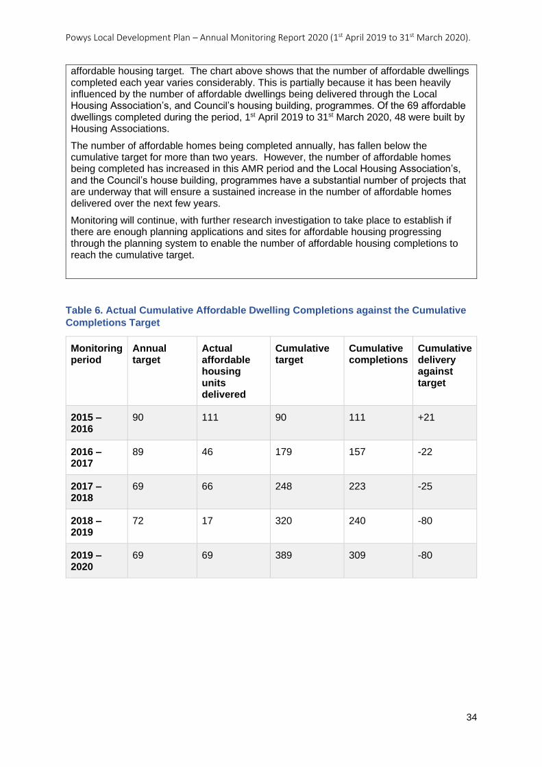
Powys Local Development Plan – Annual Monitoring Report 2020 (1st April 2019 to 31st March 2020).
34
Table 6. Actual Cumulative Affordable Dwelling Completions against the Cumulative
Completions Target
Monitoring period
Annual target
Actual affordable housing units delivered
Cumulative target
Cumulative completions
Cumulative delivery against target
2015 – 2016
90 111 90 111 +21
2016 – 2017
89 46 179 157 -22
2017 – 2018
69 66 248 223 -25
2018 – 2019
72 17 320 240 -80
2019 – 2020
69 69 389 309 -80
affordable housing target. The chart above shows that the number of affordable dwellings completed each year varies considerably. This is partially because it has been heavily influenced by the number of affordable dwellings being delivered through the Local Housing Association’s, and Council’s housing building, programmes. Of the 69 affordable dwellings completed during the period, 1st April 2019 to 31st March 2020, 48 were built by Housing Associations.
The number of affordable homes being completed annually, has fallen below the cumulative target for more than two years. However, the number of affordable homes being completed has increased in this AMR period and the Local Housing Association’s, and the Council’s house building, programmes have a substantial number of projects that are underway that will ensure a sustained increase in the number of affordable homes delivered over the next few years.
Monitoring will continue, with further research investigation to take place to establish if there are enough planning applications and sites for affordable housing progressing through the planning system to enable the number of affordable housing completions to reach the cumulative target.
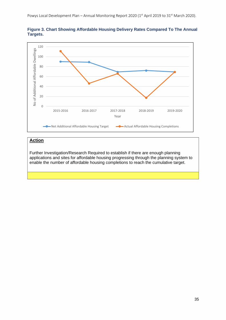
Powys Local Development Plan – Annual Monitoring Report 2020 (1st April 2019 to 31st March 2020).
35
Figure 3. Chart Showing Affordable Housing Delivery Rates Compared To The Annual Targets.
Action
Further Investigation/Research Required to establish if there are enough planning applications and sites for affordable housing progressing through the planning system to enable the number of affordable housing completions to reach the cumulative target.
0
20
40
60
80
100
120
2015-2016 2016-2017 2017-2018 2018-2019 2019-2020
No
of
Ad
dit
ion
al A
ffo
rdab
le D
wel
lings
Year
Net Additional Affordable Housing Target Actual Affordable Housing Completions
Powys Local Development Plan – Annual Monitoring Report 2020 (1st April 2019 to 31st March 2020).
36
AMR7: Average % of affordable housing secured as a proportion of total number of
housing units permitted on private developments of 5 or more units in each sub-
market area.
Objective: Meeting Future Needs
Indicator: Average % of affordable housing secured as a proportion of total number of housing units permitted on private developments of 5 or more units in each sub-market area.
Key Policies: Strategic Policy SP3 – Affordable Housing Target
Related Policies: Topic Based Policy H5 – Affordable Housing Contributions
Target: % of affordable housing as a proportion of all housing units secured annually on private developments of 5 or more units to be in accordance with sub-market targets as follows: 30% Central Powys 20% Severn Valley 10% North Powys 0% South West Powys.
Trigger Point: % of affordable housing secured as a proportion of total housing units permitted on private developments of 5 or more units within any sub-market area falls below the target contributions set out in Policy H5 for two consecutive years.
Outcome / actions, year on year:
LDP Adopted: 17/04/2018
AMR 2020 (2019-2020):
Analysis
The monitoring indicator sets out the policy targets for affordable housing contributions to be secured across the four different sub-market areas, based on the targets set out in LDP Policy H5. The monitoring target requires a calculation of the average contribution secured for each sub-market area.
Thirteen planning applications have been permitted under LDP Policy H5 during this monitoring period – two in the Central sub-market area, five in the Severn Valley, four in North Powys and two in the South-West. A breakdown of the average contributions secured in connection with these developments set against the target contribution for the sub-market area, is set out in Table 7.
The policy targets were secured in connection with all developments in the Central and Severn Valley sub-market areas.
In North Powys, the average affordable housing contribution is significantly higher than the 10% expected by Policy H5 for this sub-market area. One development in this area involved seven affordable dwellings on a site, partly within and partly outside the development boundary of Four Crosses, put forward and determined as a 100% affordable housing scheme. In the case of two other developments, it had been resolved to grant planning permission by Committee prior to adoption of the LDP and the level of
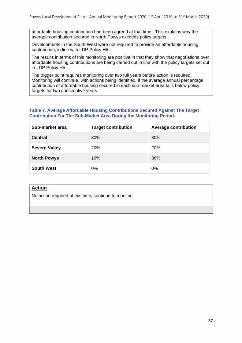
Powys Local Development Plan – Annual Monitoring Report 2020 (1st April 2019 to 31st March 2020).
37
Table 7. Average Affordable Housing Contributions Secured Against The Target
Contribution For The Sub-Market Area During the Monitoring Period.
Sub-market area Target contribution Average contribution
Central 30% 30%
Severn Valley 20% 20%
North Powys 10% 36%
South West 0% 0%
Action
No action required at this time, continue to monitor.
affordable housing contribution had been agreed at that time. This explains why the average contribution secured in North Powys exceeds policy targets.
Developments in the South-West were not required to provide an affordable housing contribution, in line with LDP Policy H5.
The results in terms of this monitoring are positive in that they show that negotiations over affordable housing contributions are being carried out in line with the policy targets set out in LDP Policy H5.
The trigger point requires monitoring over two full years before action is required. Monitoring will continue, with actions being identified, if the average annual percentage contribution of affordable housing secured in each sub-market area falls below policy targets for two consecutive years.
Powys Local Development Plan – Annual Monitoring Report 2020 (1st April 2019 to 31st March 2020).
38
AMR9: Changes in residual values (housing development viability) across the 4 sub-
market areas, set against the residual values applied in the Viability Assessment
Update (August 2016).
Objective: Meeting Future Needs
Indicator: Changes in residual values (housing development viability) across the 4 sub-market areas, set against the residual values applied in the Viability Assessment Update (August 2016).
Key Policies: Strategic Policy SP3 – Affordable Housing Target
Related Policies: Topic Based Policy H5 – Affordable Housing Contributions
Target: To keep the viability of affordable housing delivery under review to enable the maximum level to be achieved and to reflect changes in viability.
Trigger Point: Change in residual values of 5% or more from the residual values in the Viability Assessment Update (August 2015) or from residual values in any future update in any one year.
Outcome / actions, year on year:
LDP Adopted: 17/04/2018
AMR 2020 (2019-2020):
Analysis
The LDP’s Viability Assessment Update (July, 2016) assessed the economic viability of market housing development sites, and in particular, looked at the contribution that developers could make towards the provision of affordable housing in the four sub-market areas. This evidence informed the affordable housing targets set out in LDP Policy H5.
The purpose of this indicator is to keep the viability of delivering the affordable housing targets under review by identifying any significant changes in residual values that may impact on the policy targets. A positive change in residual values may indicate that schemes may have become more viable and, therefore, able to make a greater contribution towards affordable housing. Whilst a negative change in residual values may indicate that schemes have become less viable and, therefore, that the policy targets may no longer be realistic. A change of 5% in residual values either way will trigger the need for action.
A high-level viability model (HLVM) developed as part of the regional viability work is now available for use for planning policy purposes and is intended to be used for monitoring and future review purposes. The LDP’s Viability Assessment (July, 2016) was undertaken by the District Valuer Services (DVS) on behalf of the Council using an industry standard Argus model. The difference in the model used means that it is not possible to directly compare figures generated by the HLVM model to those generated by the DVS in 2016. However, the results from this monitoring period will be used as the benchmark against which future results will be compared.
Data available from the Land Registry’s House Price Index indicates that average new-build sales values in Powys have increased by approximately 18% since August 2016. As part of the assessment, Officers have used the Price Paid Data for new-build properties obtained from the Land Registry, along with floorspace data available from the online Energy Performance Certificate (EPC) register, in order to establish average sales values
Powys Local Development Plan – Annual Monitoring Report 2020 (1st April 2019 to 31st March 2020).
39
Action
Further Investigation/Research Required
Development plan policies are not being implemented as intended and further research and/or investigation is required.
(£ per sqm) achieved on recent housing developments within each sub-market area. No new build data was available for the South-West Powys sub-market area, however analysis of re-sales of existing properties indicate that there has been an increase in house prices generally in this area, to a similar extent as experienced at the Powys level.
Officers have also obtained the relevant build cost rates from the Build Cost Information Service (BCIS) re-based to Powys (March 2020), which indicates that rates have increased by over 20% compared to the rates applied by the DVS in August 2016. At the time of the LDP’s Viability Assessment (2016) an additional allowance was made for sprinkler requirements, however it is understood that such costs will by now be reflected in the BCIS rates, and therefore should not be accounted for separately.
The assessment uses the same site typologies and housing mix as those applied by the DVS, as they continue to reflect developments approved and put forward under the LDP. Updates have been made to other assumptions used, such as interest rates and land transaction tax rates. A review of Section 106 agreements entered into under the LDP found that an allowance of £1,000 per unit continued to be appropriate, including on larger site typologies.
The results generated by using the HLVM based on the main typologies indicate that, whilst residual values continue to be positive in the Central, Severn Valley and North sub-market areas, these values are not sufficient to meet the benchmark land value set by the DVS of £300,000 per hectare, resulting in marginal viability. The results for South-West Powys show that residual values continue in negative figures. The results for this period may be partly attributed to the use of a different model.
Changes to the assumptions applied in the HLVM will continue to be monitored closely over the next monitoring period. Further work will be undertaken on these assumptions to ensure that they continue to reflect the nature of developments and circumstances locally in the Powys LDP area. This work is also likely to benefit from site specific viability assessments undertaken using the DVM and further work on gathering viability information regionally.
Powys Local Development Plan – Annual Monitoring Report 2020 (1st April 2019 to 31st March 2020).
40
AMR14: No. of gypsy traveller sites and no. of pitches granted planning permission
and delivered.
Objective: Meeting Future Needs
Indicator: No. of gypsy traveller sites and no. of pitches granted planning permission and delivered.
Key Policies: Strategic Policy SP1 – Housing Growth
Related Policies: Topic Based Policy H11 – Gypsy and Traveller Site Provision
Target: 5 pitches provided in Machynlleth by 2021. 2 pitches provided in Welshpool by 2026.
Trigger Point: Failure to deliver the 5 pitches in Machynlleth by 2021.
Failure to deliver the 2 pitches in Welshpool by 2026.
Outcome / actions, year on year:
LDP Adopted: 17/04/2018
AMR 2020 (2019-2020):
Action Continue Monitoring
Development plan policies are being implemented effectively.
Analysis
LDP Policy H11 makes provision for seven gypsy and traveller pitches situated in Machynlleth and Welshpool as identified in the 2008 Gypsy and Traveller Accommodation Needs Assessment.
Up to the end of the current monitoring period (by 31st March 2020) the two Welshpool pitches had been completed. In Machynlleth conditional planning permission P/2016/1227 was approved on 2nd August 2017 for five families. This permission enables five pitches for static caravans and for up to 10 caravans to be present at any time. The Council’s housing department confirm that development of the five permanent pitches is planned to commence in the financial year 2020/2021, meaning that by the end of 2021, this monitoring indicator is expected to be successfully completed.
Powys Local Development Plan – Annual Monitoring Report 2020 (1st April 2019 to 31st March 2020).
41
AMR15: Amount of employment land (hectares) permitted on allocated sites in the
Development Plan as a % of all employment allocations.
Objective: Meeting Future Needs
Indicator: Amount of employment land (hectares) permitted on allocated sites in the Development Plan as a % of all employment allocations.
Key Policies: Strategic Policy SP2 – Employment Growth
Related Policies: Topic Based Policy E1 – Employment Proposals on Allocated Employment Sites Topic Based Policy E2 - Employment Proposals on Non-allocated Employment Sites
Target: Total of 2ha of employment land to be permitted per annum on allocated sites in order to meet the minimum requirement of 30 hectares over the Plan period.
Trigger Point: The total amount of employment land permitted falls below the cumulative requirement of 4ha for two consecutive years.
Outcome / actions, year on year:
LDP Adopted: 17/04/2018
AMR 2020 (2019-2020):
Analysis
The Annual Monitoring Framework sets out an annual target of two hectares of employment land to be permitted on employment allocations in order to meet the employment requirement of 30 hectares over the lifespan of the LDP. The purpose of this indicator is to test whether the employment allocations are delivering employment land in line with the growth strategy and LDP Policies SP2 and E2.
During the monitoring period (1st April 2019 to 31st March 2020) no applications were permitted on allocated employment sites. The results show that the planning applications permitted for employment uses within the period, were either on existing employment sites (employment safeguarding areas), 0.754 hectares (total net floorspace of 2,558 square metres), or windfall development 1.203 hectares, (4,208 square metres).
The trigger for this indicator is if the total amount of employment land permitted falls below the cumulative requirement of four hectares for two consecutive years. Therefore, although no new employment development has been secured on an employment allocation this year, Table 8 demonstrates that the LDP is on track when it comes to meeting its employment requirement.
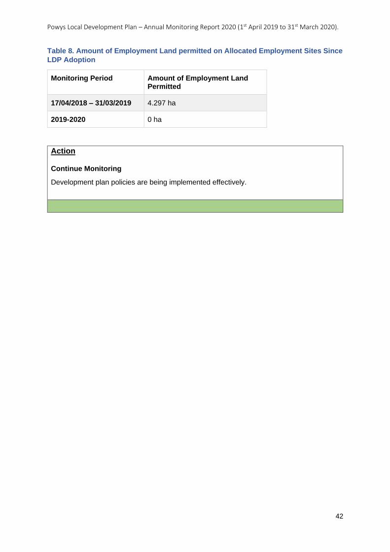
Powys Local Development Plan – Annual Monitoring Report 2020 (1st April 2019 to 31st March 2020).
42
Table 8. Amount of Employment Land permitted on Allocated Employment Sites Since
LDP Adoption
Monitoring Period Amount of Employment Land Permitted
17/04/2018 – 31/03/2019 4.297 ha
2019-2020 0 ha
Action Continue Monitoring
Development plan policies are being implemented effectively.
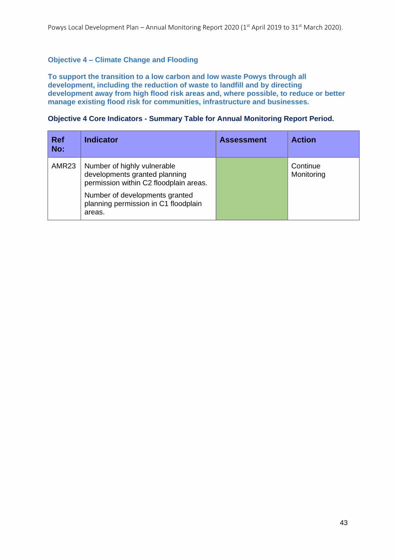
Powys Local Development Plan – Annual Monitoring Report 2020 (1st April 2019 to 31st March 2020).
43
Objective 4 – Climate Change and Flooding To support the transition to a low carbon and low waste Powys through all development, including the reduction of waste to landfill and by directing development away from high flood risk areas and, where possible, to reduce or better manage existing flood risk for communities, infrastructure and businesses. Objective 4 Core Indicators - Summary Table for Annual Monitoring Report Period.
Ref No:
Indicator Assessment Action
AMR23 Number of highly vulnerable developments granted planning permission within C2 floodplain areas.
Number of developments granted planning permission in C1 floodplain areas.
Continue Monitoring

Powys Local Development Plan – Annual Monitoring Report 2020 (1st April 2019 to 31st March 2020).
44
AMR23:
Number of highly vulnerable developments granted planning permission within C2
floodplain areas.
Number of developments granted planning permission in C1 floodplain areas.
Objective: Climate Change and Flooding
Indicator: Number of highly vulnerable developments granted planning permission within C2 floodplain areas.
Number of developments granted planning permission in C1 floodplain areas.
Key Policies: Development Management Policy DM5 – Development and Flood Risk
Related Policies:
Target: No highly vulnerable developments units to be permitted within C2 floodplain areas. No developments to be permitted within C1 floodplain areas without meeting all TAN 15 tests.
Trigger Point: 1 or more highly vulnerable developments permitted within C2 floodplain areas in any one year.
1 or more developments permitted within C1 floodplain areas where not all TAN 15 tests are met in any one year.
Outcome / actions, year on year:
LDP Adopted: 17/04/2018
AMR 2020 (2019-2020):
Analysis
This monitoring indicator looks at the number of highly vulnerable developments permitted within the C1 (areas of the floodplain served by flood defences) and C2 (areas of the floodplain with no flood defences) floodzones of the TAN 15 Development Advice Maps. It is designed to test the implementation of LDP Policy DM5, however it also allows an observation on how applications permitted accord with TAN 15.
Highly vulnerable development is classed in TAN 15 as “all residential premises (including hotels and caravan parks), public buildings (e.g. schools, libraries, leisure centres) especially vulnerable industrial development (e.g. power stations, chemical plants, incinerators), and waste disposal sites.”
Development permitted in C2.
In this monitoring period, 1st April 2019 to 31st March 2020, a total of 10 planning applications were permitted for highly vulnerable development that encroached either partially or wholly into the C2 flood zone. Eight of these applications, partially encroached on the C2 flood zone. However, all buildings, which included holiday cabins and dwellings, were located outside of any areas at risk from flooding.
In two cases planning permission was granted against the LDP and national policy due to case law, meaning a refusal would be likely to be overturned at appeal. The reasons for
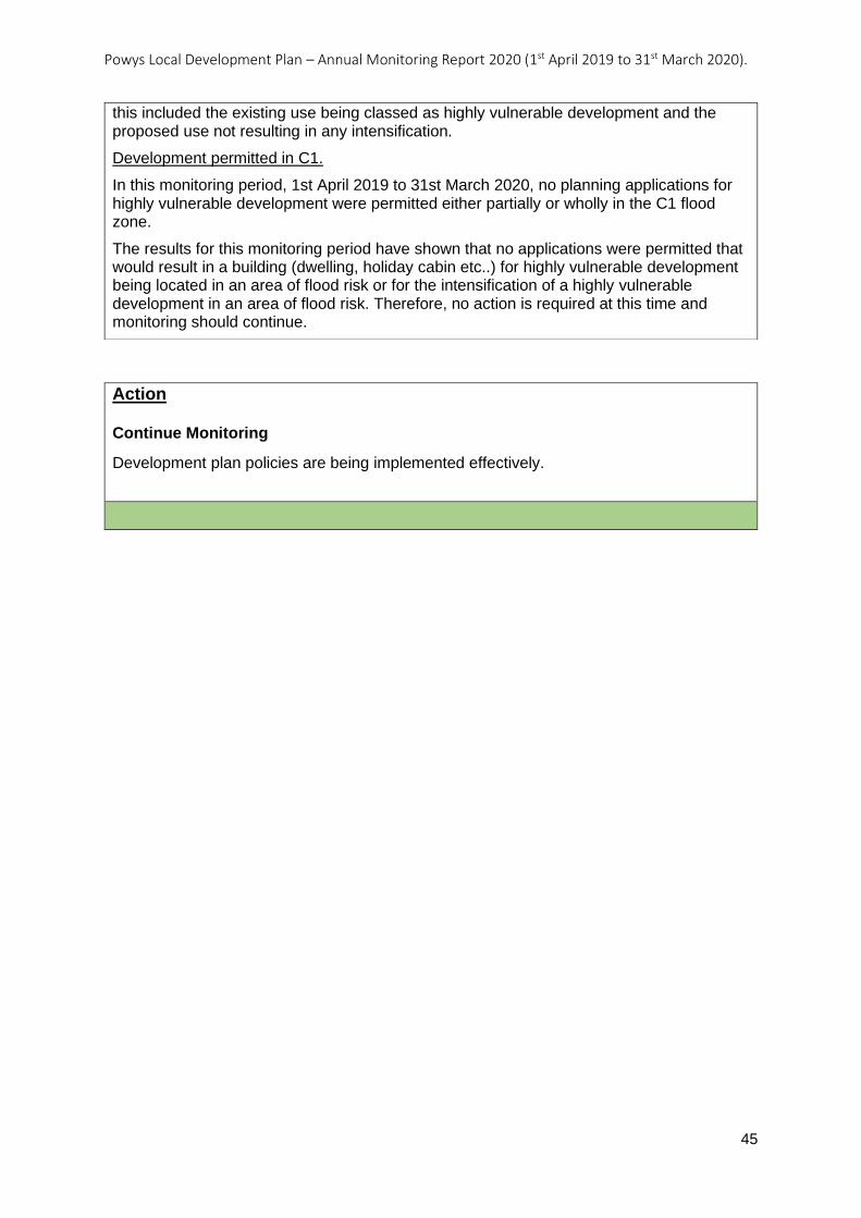
Powys Local Development Plan – Annual Monitoring Report 2020 (1st April 2019 to 31st March 2020).
45
Action Continue Monitoring
Development plan policies are being implemented effectively.
this included the existing use being classed as highly vulnerable development and the proposed use not resulting in any intensification.
Development permitted in C1.
In this monitoring period, 1st April 2019 to 31st March 2020, no planning applications for highly vulnerable development were permitted either partially or wholly in the C1 flood zone.
The results for this monitoring period have shown that no applications were permitted that would result in a building (dwelling, holiday cabin etc..) for highly vulnerable development being located in an area of flood risk or for the intensification of a highly vulnerable development in an area of flood risk. Therefore, no action is required at this time and monitoring should continue.

Powys Local Development Plan – Annual Monitoring Report 2020 (1st April 2019 to 31st March 2020).
46
3. Analysis of local indicators
3.0.1 Local Indicators are identified in the Annual Monitoring Framework which forms
Chapter 5 of the Adopted LDP.
3.0.2 Unless stated otherwise only Full and Outline planning applications permitted have
been considered to prevent any double counting.
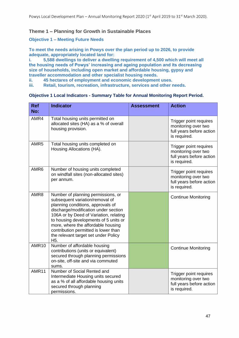
Powys Local Development Plan – Annual Monitoring Report 2020 (1st April 2019 to 31st March 2020).
47
Theme 1 – Planning for Growth in Sustainable Places
Objective 1 – Meeting Future Needs To meet the needs arising in Powys over the plan period up to 2026, to provide adequate, appropriately located land for: i. 5,588 dwellings to deliver a dwelling requirement of 4,500 which will meet all the housing needs of Powys’ increasing and ageing population and its decreasing size of households, including open market and affordable housing, gypsy and traveller accommodation and other specialist housing needs. ii. 45 hectares of employment and economic development uses. iii. Retail, tourism, recreation, infrastructure, services and other needs. Objective 1 Local Indicators - Summary Table for Annual Monitoring Report Period.
Ref No:
Indicator Assessment Action
AMR4 Total housing units permitted on allocated sites (HA) as a % of overall housing provision.
Trigger point requires monitoring over two full years before action is required.
AMR5 Total housing units completed on Housing Allocations (HA).
Trigger point requires monitoring over two full years before action is required.
AMR6 Number of housing units completed on windfall sites (non-allocated sites) per annum.
Trigger point requires monitoring over two full years before action is required.
AMR8 Number of planning permissions, or subsequent variation/removal of planning conditions, approvals of discharge/modification under section 106A or by Deed of Variation, relating to housing developments of 5 units or more, where the affordable housing contribution permitted is lower than the relevant target set under Policy H5.
Continue Monitoring
AMR10 Number of affordable housing contributions (units or equivalent) secured through planning permissions on-site, off-site and via commuted sums.
Continue Monitoring
AMR11 Number of Social Rented and Intermediate Housing units secured as a % of all affordable housing units secured through planning permissions.
Trigger point requires monitoring over two full years before action is required.
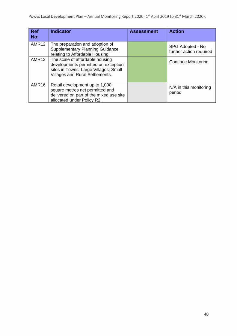
Powys Local Development Plan – Annual Monitoring Report 2020 (1st April 2019 to 31st March 2020).
48
Ref No:
Indicator Assessment Action
AMR12 The preparation and adoption of Supplementary Planning Guidance relating to Affordable Housing.
SPG Adopted - No further action required
AMR13 The scale of affordable housing developments permitted on exception sites in Towns, Large Villages, Small Villages and Rural Settlements.
Continue Monitoring
AMR16 Retail development up to 1,000 square metres net permitted and delivered on part of the mixed use site allocated under Policy R2.
N/A in this monitoring period
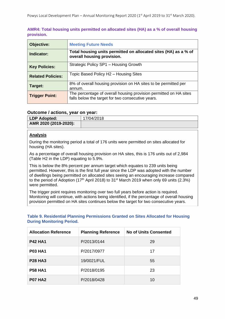
Powys Local Development Plan – Annual Monitoring Report 2020 (1st April 2019 to 31st March 2020).
49
AMR4: Total housing units permitted on allocated sites (HA) as a % of overall housing
provision.
Objective: Meeting Future Needs
Indicator: Total housing units permitted on allocated sites (HA) as a % of overall housing provision.
Key Policies: Strategic Policy SP1 – Housing Growth
Related Policies: Topic Based Policy H2 – Housing Sites
Target: 8% of overall housing provision on HA sites to be permitted per annum.
Trigger Point: The percentage of overall housing provision permitted on HA sites falls below the target for two consecutive years.
Outcome / actions, year on year:
LDP Adopted: 17/04/2018
AMR 2020 (2019-2020):
Table 9. Residential Planning Permissions Granted on Sites Allocated for Housing
During Monitoring Period.
Allocation Reference Planning Reference No of Units Consented
P42 HA1 P/2013/0144 29
P03 HA1 P/2017/0977 17
P28 HA3 19/0021/FUL 55
P58 HA1 P/2018/0195 23
P07 HA2 P/2018/0428 10
Analysis
During the monitoring period a total of 176 units were permitted on sites allocated for housing (HA sites).
As a percentage of overall housing provision on HA sites, this is 176 units out of 2,984 (Table H2 in the LDP) equating to 5.9%.
This is below the 8% percent per annum target which equates to 239 units being permitted. However, this is the first full year since the LDP was adopted with the number of dwellings being permitted on allocated sites seeing an encouraging increase compared to the period of Adoption (17th April 2018) to 31st March 2019 when only 69 units (2.3%) were permitted.
The trigger point requires monitoring over two full years before action is required. Monitoring will continue, with actions being identified, if the percentage of overall housing provision permitted on HA sites continues below the target for two consecutive years.

Powys Local Development Plan – Annual Monitoring Report 2020 (1st April 2019 to 31st March 2020).
50
Allocation Reference Planning Reference No of Units Consented
P58 HA3 18/0663/OUT 42
Action No action required at this time, continue to monitor.
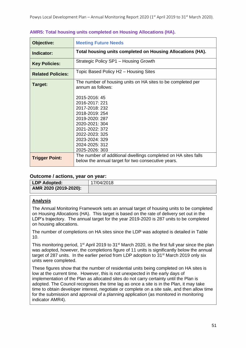
Powys Local Development Plan – Annual Monitoring Report 2020 (1st April 2019 to 31st March 2020).
51
AMR5: Total housing units completed on Housing Allocations (HA).
Objective: Meeting Future Needs
Indicator: Total housing units completed on Housing Allocations (HA).
Key Policies: Strategic Policy SP1 – Housing Growth
Related Policies: Topic Based Policy H2 – Housing Sites
Target: The number of housing units on HA sites to be completed per annum as follows: 2015-2016: 45 2016-2017: 221 2017-2018: 232 2018-2019: 254 2019-2020: 287 2020-2021: 304 2021-2022: 372 2022-2023: 325 2023-2024: 329 2024-2025: 312 2025-2026: 303
Trigger Point: The number of additional dwellings completed on HA sites falls below the annual target for two consecutive years.
Outcome / actions, year on year:
LDP Adopted: 17/04/2018
AMR 2020 (2019-2020):
Analysis
The Annual Monitoring Framework sets an annual target of housing units to be completed on Housing Allocations (HA). This target is based on the rate of delivery set out in the LDP’s trajectory. The annual target for the year 2019-2020 is 287 units to be completed on housing allocations.
The number of completions on HA sites since the LDP was adopted is detailed in Table 10.
This monitoring period, 1st April 2019 to 31st March 2020, is the first full year since the plan was adopted, however, the completions figure of 11 units is significantly below the annual target of 287 units. In the earlier period from LDP adoption to 31st March 2019 only six units were completed.
These figures show that the number of residential units being completed on HA sites is low at the current time. However, this is not unexpected in the early days of implementation of the Plan as allocated sites do not carry certainty until the Plan is adopted. The Council recognises the time lag as once a site is in the Plan, it may take time to obtain developer interest, negotiate or complete on a site sale, and then allow time for the submission and approval of a planning application (as monitored in monitoring indicator AMR4).
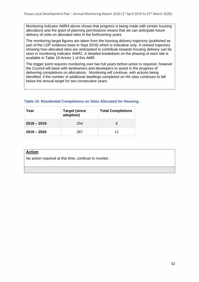
Powys Local Development Plan – Annual Monitoring Report 2020 (1st April 2019 to 31st March 2020).
52
Table 10. Residential Completions on Sites Allocated for Housing.
Year Target (since adoption)
Total Completions
2018 – 2019 254 6
2019 – 2020 287 11
Action
No action required at this time, continue to monitor.
Monitoring indicator AMR4 above shows that progress is being made with certain housing allocations and the grant of planning permissions means that we can anticipate future delivery of units on allocated sites in the forthcoming years.
The monitoring target figures are taken from the housing delivery trajectory (published as part of the LDP evidence base in Sept 2016) which is indicative only. A revised trajectory showing how allocated sites are anticipated to contribute towards housing delivery can be seen in monitoring indicator AMR2. A detailed breakdown on the phasing of each site is available in Table 19 Annex 1 of this AMR.
The trigger point requires monitoring over two full years before action is required, however the Council will liaise with landowners and developers to assist in the progress of delivering completions on allocations. Monitoring will continue, with actions being identified, if the number of additional dwellings completed on HA sites continues to fall below the annual target for two consecutive years.
Powys Local Development Plan – Annual Monitoring Report 2020 (1st April 2019 to 31st March 2020).
53
AMR6: Number of housing units completed on windfall sites (non-allocated sites) per
annum.
Objective: Meeting Future Needs
Indicator: Number of housing units completed on windfall sites (non-allocated sites) per annum.
Key Policies: Strategic Policy SP1 – Housing Growth
Related Policies:
Target: For the amount of development delivered on windfall sites to align with that anticipated by the windfall projection of 110 dwellings per annum.
Trigger Point: The number of housing units delivered on windfall sites deviates from the cumulative projection of 220 dwellings over two consecutive years.
Outcome / actions, year on year:
LDP Adopted: 17/04/2018
AMR 2020 (2019-2020):
Analysis
The Annual Monitoring Framework sets a target for the delivery of housing developments on windfall sites. This is intended to test delivery on windfall sites against the anticipated windfall projection that was allowed for within the Plan’s housing provision figure. The annual target is 110 dwellings per annum. Action is required where the number of housing units delivered on windfall sites deviates from the cumulative projection of 220 dwellings over two consecutive years.
Table 11 shows the total number of residential units completed that were classed as windfalls split between large and small sites. The total of 168 residential units completed is above the target figure of 110 units. This is partially because of improvements to the LPA’s monitoring systems which now identifies new dwelling completions on small sites based on whether a dwelling is being occupied.
Data from previous years relied heavily on building control completion certificates for small site completions. A more advanced system has now been developed that identifies completions from council tax records, building control occupation inspections and building control completion certificates (the system is robust enough to ensure that no double counting takes place).
Due to the changes to the monitoring system the total completion figure for the 2019-2020 monitoring period has included some units that were under recorded in previous years. Under recording has taken place, where dwellings have been built and occupied, within the Plan period, but a completion certificate has not been applied for. This more advanced system, based on occupation, is considered to be a more accurate reflection on how small sites are contributing towards the LDP’s dwelling requirement.
The completion rate for the period indicates that the windfall projection for the LDP is accurate and that windfall sites are contributing to housing provision in the scale anticipated.
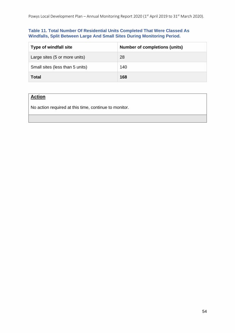
Powys Local Development Plan – Annual Monitoring Report 2020 (1st April 2019 to 31st March 2020).
54
Table 11. Total Number Of Residential Units Completed That Were Classed As
Windfalls, Split Between Large And Small Sites During Monitoring Period.
Type of windfall site Number of completions (units)
Large sites (5 or more units) 28
Small sites (less than 5 units) 140
Total 168
Action No action required at this time, continue to monitor.
Powys Local Development Plan – Annual Monitoring Report 2020 (1st April 2019 to 31st March 2020).
55
AMR8: Number of planning permissions, or subsequent variation/removal of planning
conditions, approvals of discharge/modification under section 106A or by Deed of
Variation, relating to housing developments of 5 units or more, where the affordable
housing contribution permitted is lower than the relevant target set under Policy H5.
Objective: Meeting Future Needs
Indicator: Number of planning permissions, or subsequent variation/removal of planning conditions, approvals of discharge/modification under section 106A or by Deed of Variation, relating to housing developments of 5 units or more, where the affordable housing contribution permitted is lower than the relevant target set under Policy H5.
Key Policies: Strategic Policy SP3 – Affordable Housing Target
Related Policies: Topic Based Policy H5 – Affordable Housing Contributions
Target: No reduction in or removal of the target contributions permitted, unless in accordance with the provision made within Policy H5 for reduction/removal of this requirement.
Trigger Point: 1 or more housing developments permitted, or subsequent variation/removal of planning conditions, approvals for discharge/modification under section 106A or by Deed of Variation, relating to housing developments of 5 units or more, where the affordable housing contribution permitted is lower than the relevant target set under Policy H5 and not in accordance with Policy H5 in any one year.
Outcome / actions, year on year:
LDP Adopted: 17/04/2018
AMR 2020 (2019-2020):
Analysis
This monitoring indicator seeks to identify cases where lower percentages of affordable housing than those required to meet the policy targets have been permitted. It captures the percentage secured as part of original permissions, along with any subsequent applications that may have been made to reduce or remove the affordable housing contribution below that expected by the target. Provision is made within LDP Policy H5 for contributions to be negotiated on individual developments were supported by site specific viability evidence.
The results of monitoring indicator AMR7 above already indicate that LDP Policy H5 targets are being met at the original planning permission stage.
With regards to subsequent applications, an application was approved for removal of a condition requiring an affordable local needs housing phasing statement on a development in Trefeglwys (also subject to a Section 106 agreement). An affordable housing contribution of six dwellings had been secured as part of the original planning permission in 2016. The application for removal of the condition was supported by a site-specific viability assessment, which was verified on behalf of the Council by the District Valuer, who concluded that the development did not generate a surplus to provide an affordable housing contribution whilst achieving a competitive return. On this basis, the
Powys Local Development Plan – Annual Monitoring Report 2020 (1st April 2019 to 31st March 2020).
56
Action Continue to monitor - Development plan policies are being implemented effectively.
removal of the affordable housing requirement associated with this development was considered to be justified.
An application was also approved to vary a planning condition relating to affordable housing provision on a housing association development that was partly an LDP allocation (P12 HC3) and partly outside the development boundary of Churchstoke. Planning permission had originally been granted subject to a condition requiring the provision of 28 affordable units, however it was considered that the number could reasonably be reduced to 17 affordable units, given the location of part of the site within the development boundary where an affordable housing contribution of 20% would be expected from market developments.
Seven applications for discharge/modification of a Section 106 relating to affordable housing originally granted as part of a market development, were approved during the monitoring period. Of these, two applications involved discharge of the Section 106 agreement where approval was given for removal of the original affordable housing restrictions on the basis that the agreements no longer served a useful purpose. This was due to the fact that the specific clauses within these agreements have been found to be no longer defendable at appeal, as they do not provide mechanisms to ensure the affordability and availability of the affordable housing in perpetuity. The other five applications gave approval for modification of Section 106 agreements, four of which related to the same development in Four Crosses to address mortgage issues, and another in Llangadfan to widen the definition of ‘Local Community’ to include Llanfair Caereinion.
Importantly, the original decisions, relating to developments where Section 106s have been discharged, were made prior to LDP adoption. LDP Policy SP3 requires affordable housing to be controlled in order to ensure that dwellings remain affordable and available to those in local need in perpetuity and the LDP’s Affordable Housing SPG sets out the mechanisms to be used to ensure this is the case.
No applications for Deed of Variation of Section 106 (used where a Section 106 has been entered into within the past five years) were determined during this monitoring period.
The results of this monitoring indicate that affordable housing policy targets are being met and maintained, unless the case for removal/reduction of affordable housing contributions is evidenced and justified on site specific viability grounds. It was also reasonable to reduce the affordable housing contribution made by housing associations to the level expected from market developments within development boundaries. Where affordable housing restrictions on historic permissions are removed, this is for reasons other than viability, and the modification route for defendable Section 106s is also being used, where appropriate.
The Affordable Housing SPG adopted in October 2018 provides additional practical guidance regarding the approach towards negotiating affordable housing and carrying out viability assessments to support the implementation of LDP Policy H5. The Council has also published a set of templates to be used by applicants for different types of Affordable Housing Schemes at discharge of condition stage in order to improve consistency of such schemes and ensure enforceability.

Powys Local Development Plan – Annual Monitoring Report 2020 (1st April 2019 to 31st March 2020).
57
AMR10: Number of affordable housing contributions (units or equivalent) secured
through planning permissions on-site, off-site and via commuted sums.
Objective: Meeting Future Needs
Indicator: Number of affordable housing contributions (units or equivalent) secured through planning permissions on-site, off-site and via commuted sums.
Key Policies: Strategic Policy SP3 – Affordable Housing Target
Related Policies: Topic Based Policy H5 – Affordable Housing Contributions
Target: For the majority of affordable housing contributions secured through planning permission to be provided on-site.
Trigger Point: The total number of affordable housing contributions secured through planning permissions off-site and via commuted sums exceeds the total number of affordable housing contributions (units) secured on-site in any one year.
Outcome / actions, year on year:
LDP Adopted: 17/04/2018
AMR 2020 (2019-2020):
Table 12. Affordable Housing Contributions Secured By Type During Monitoring
Period.
Analysis
This monitoring indicator looks at the type of affordable housing contribution that has been secured through planning permissions i.e., whether the contribution secured is to be made on-site, off-site or via a financial contribution. It is designed to test the implementation of the part of LDP Policy H5 that sets a presumption in favour of on-site contributions rather than other types of contributions unless on-site provision would be inappropriate.
The results for this monitoring period are summarised Table 12 below.
A total of 10 applications have been permitted for market developments where affordable housing contributions have been secured, amounting to a total of 118 affordable housing units. All affordable housing units granted under LDP Policy H5 appear to have been secured on-site, with no examples at the application stage of any units proposed off-site or financial contributions in lieu of on-site provision.
The results of this monitoring indicate that this part of LDP Policy H5 is being implemented correctly in that affordable housing provision is being secured on-site, which demonstrates that affordable housing will be provided in the location where it is needed.
The approach set out within LDP Policy H5 is supported by further practical guidance in the Affordable Housing SPG. This provides guidance on the circumstances where alternative types of provision may be appropriate and also on the method for calculating financial contributions and how financial contributions obtained will be used by the Council for the purpose of affordable housing provision.
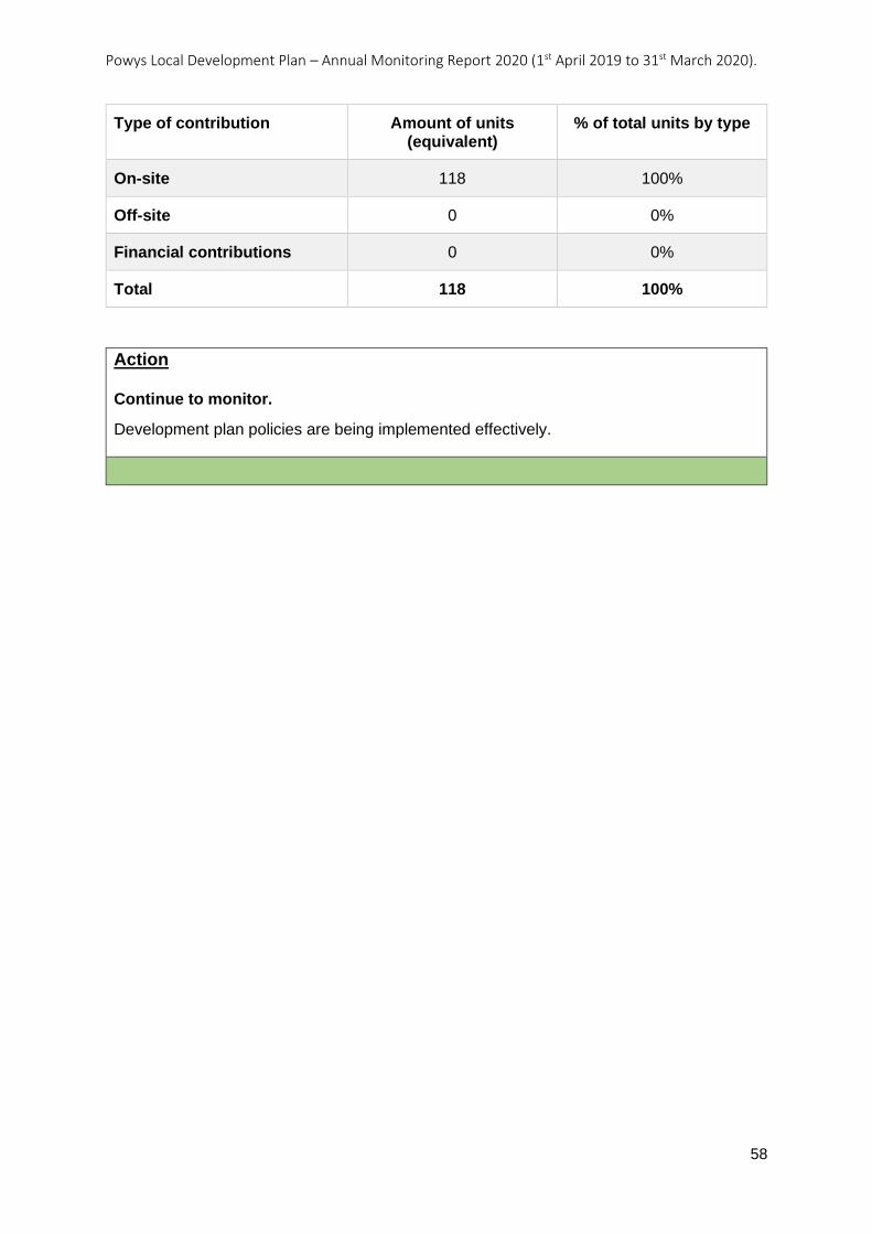
Powys Local Development Plan – Annual Monitoring Report 2020 (1st April 2019 to 31st March 2020).
58
Type of contribution Amount of units (equivalent)
% of total units by type
On-site 118 100%
Off-site 0 0%
Financial contributions 0 0%
Total 118 100%
Action Continue to monitor.
Development plan policies are being implemented effectively.
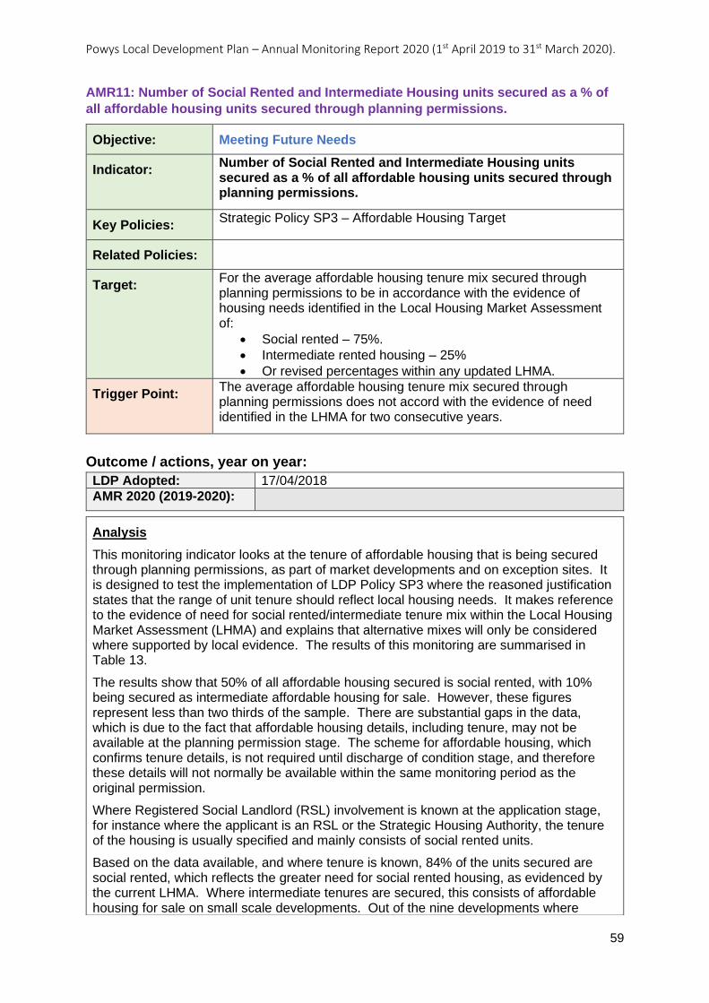
Powys Local Development Plan – Annual Monitoring Report 2020 (1st April 2019 to 31st March 2020).
59
AMR11: Number of Social Rented and Intermediate Housing units secured as a % of
all affordable housing units secured through planning permissions.
Objective: Meeting Future Needs
Indicator: Number of Social Rented and Intermediate Housing units secured as a % of all affordable housing units secured through planning permissions.
Key Policies: Strategic Policy SP3 – Affordable Housing Target
Related Policies:
Target: For the average affordable housing tenure mix secured through planning permissions to be in accordance with the evidence of housing needs identified in the Local Housing Market Assessment of:
• Social rented – 75%.
• Intermediate rented housing – 25%
• Or revised percentages within any updated LHMA.
Trigger Point: The average affordable housing tenure mix secured through planning permissions does not accord with the evidence of need identified in the LHMA for two consecutive years.
Outcome / actions, year on year:
LDP Adopted: 17/04/2018
AMR 2020 (2019-2020):
Analysis
This monitoring indicator looks at the tenure of affordable housing that is being secured through planning permissions, as part of market developments and on exception sites. It is designed to test the implementation of LDP Policy SP3 where the reasoned justification states that the range of unit tenure should reflect local housing needs. It makes reference to the evidence of need for social rented/intermediate tenure mix within the Local Housing Market Assessment (LHMA) and explains that alternative mixes will only be considered where supported by local evidence. The results of this monitoring are summarised in Table 13.
The results show that 50% of all affordable housing secured is social rented, with 10% being secured as intermediate affordable housing for sale. However, these figures represent less than two thirds of the sample. There are substantial gaps in the data, which is due to the fact that affordable housing details, including tenure, may not be available at the planning permission stage. The scheme for affordable housing, which confirms tenure details, is not required until discharge of condition stage, and therefore these details will not normally be available within the same monitoring period as the original permission.
Where Registered Social Landlord (RSL) involvement is known at the application stage, for instance where the applicant is an RSL or the Strategic Housing Authority, the tenure of the housing is usually specified and mainly consists of social rented units.
Based on the data available, and where tenure is known, 84% of the units secured are social rented, which reflects the greater need for social rented housing, as evidenced by the current LHMA. Where intermediate tenures are secured, this consists of affordable housing for sale on small scale developments. Out of the nine developments where
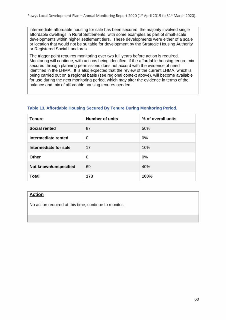
Powys Local Development Plan – Annual Monitoring Report 2020 (1st April 2019 to 31st March 2020).
60
Table 13. Affordable Housing Secured By Tenure During Monitoring Period.
Tenure Number of units % of overall units
Social rented 87 50%
Intermediate rented 0 0%
Intermediate for sale 17 10%
Other 0 0%
Not known/unspecified 69 40%
Total 173 100%
Action No action required at this time, continue to monitor.
intermediate affordable housing for sale has been secured, the majority involved single affordable dwellings in Rural Settlements, with some examples as part of small-scale developments within higher settlement tiers. These developments were either of a scale or location that would not be suitable for development by the Strategic Housing Authority or Registered Social Landlords.
The trigger point requires monitoring over two full years before action is required. Monitoring will continue, with actions being identified, if the affordable housing tenure mix secured through planning permissions does not accord with the evidence of need identified in the LHMA. It is also expected that the review of the current LHMA, which is being carried out on a regional basis (see regional context above), will become available for use during the next monitoring period, which may alter the evidence in terms of the balance and mix of affordable housing tenures needed.
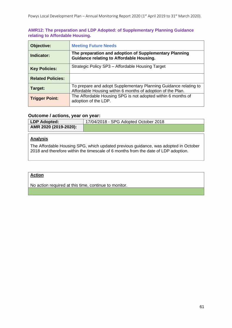
Powys Local Development Plan – Annual Monitoring Report 2020 (1st April 2019 to 31st March 2020).
61
AMR12: The preparation and LDP Adopted: of Supplementary Planning Guidance
relating to Affordable Housing.
Objective: Meeting Future Needs
Indicator: The preparation and adoption of Supplementary Planning Guidance relating to Affordable Housing.
Key Policies: Strategic Policy SP3 – Affordable Housing Target
Related Policies:
Target: To prepare and adopt Supplementary Planning Guidance relating to Affordable Housing within 6 months of adoption of the Plan.
Trigger Point: The Affordable Housing SPG is not adopted within 6 months of adoption of the LDP.
Outcome / actions, year on year:
LDP Adopted: 17/04/2018 - SPG Adopted October 2018
AMR 2020 (2019-2020):
Action
No action required at this time, continue to monitor.
Analysis
The Affordable Housing SPG, which updated previous guidance, was adopted in October 2018 and therefore within the timescale of 6 months from the date of LDP adoption.
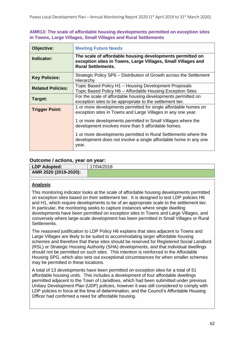
Powys Local Development Plan – Annual Monitoring Report 2020 (1st April 2019 to 31st March 2020).
62
AMR13: The scale of affordable housing developments permitted on exception sites
in Towns, Large Villages, Small Villages and Rural Settlements
Objective: Meeting Future Needs
Indicator: The scale of affordable housing developments permitted on exception sites in Towns, Large Villages, Small Villages and Rural Settlements.
Key Policies: Strategic Policy SP6 – Distribution of Growth across the Settlement Hierarchy
Related Policies: Topic Based Policy H1 – Housing Development Proposals Topic Based Policy H6 – Affordable Housing Exception Sites
Target: For the scale of affordable housing developments permitted on exception sites to be appropriate to the settlement tier.
Trigger Point: 1 or more developments permitted for single affordable homes on exception sites in Towns and Large Villages in any one year.
1 or more developments permitted in Small Villages where the development involves more than 5 affordable homes.
1 or more developments permitted in Rural Settlements where the development does not involve a single affordable home in any one year.
Outcome / actions, year on year:
LDP Adopted: 17/04/2018
AMR 2020 (2019-2020):
Analysis
This monitoring indicator looks at the scale of affordable housing developments permitted on exception sites based on their settlement tier. It is designed to test LDP policies H6 and H1, which require developments to be of an appropriate scale to the settlement tier. In particular, the monitoring seeks to capture instances where single dwelling developments have been permitted on exception sites in Towns and Large Villages, and conversely where large-scale development has been permitted in Small Villages or Rural Settlements.
The reasoned justification to LDP Policy H6 explains that sites adjacent to Towns and Large Villages are likely to be suited to accommodating larger affordable housing schemes and therefore that these sites should be reserved for Registered Social Landlord (RSL) or Strategic Housing Authority (SHA) developments, and that individual dwellings should not be permitted on such sites. This intention is reinforced in the Affordable Housing SPG, which also sets out exceptional circumstances for when smaller schemes may be permitted in these locations.
A total of 13 developments have been permitted on exception sites for a total of 51 affordable housing units. This includes a development of four affordable dwellings permitted adjacent to the Town of Llanidloes, which had been submitted under previous Unitary Development Plan (UDP) policies, however it was still considered to comply with LDP policies in force at the time of determination, and the Council’s Affordable Housing Officer had confirmed a need for affordable housing.
Powys Local Development Plan – Annual Monitoring Report 2020 (1st April 2019 to 31st March 2020).
63
Action
Continue to monitor.
Development plan policies are being implemented effectively.
Four developments were permitted on sites adjacent to Large Villages, including a major development of 24 dwellings adjacent to the settlement of Four Crosses. The application was not submitted by an RSL or the SHA, however Officers considered that it was reflective of housing need as evidenced by the Common Housing Register. A development of three affordable dwellings adjacent to the settlement of Tregynon was considered to align with the SPG and details of transfer to an RSL would be conditioned. A development of five affordable dwellings adjacent to the settlement of Kerry was recognised by Officers as not provided by an RSL or equivalent, however highway constraints would prevent a larger development on the site. A development of seven affordable dwellings partly within and partly adjacent to the settlement boundary of Four Crosses was not considered to be suitable for larger development, hence no interest had been shown by an RSL or SHA.
In Small Villages, three developments for single open market dwellings have been permitted on infill sites. Another development involved a mixed scheme of three affordable unts and two market units on a site that represented part infill and part logical extension to the settlement. The scale of these developments complied with the approach applied by LDP Policy H1 towards housing development in Small Villages.
A total of five developments of single affordable dwellings have been permitted in Rural Settlements, in accordance with the scale expected by LDP Policy H1.
The results of this monitoring demonstrate that the scale of affordable housing exception sites permitted across all settlement tiers complies with LDP policies H1 and H6. Whilst not all sites adjacent to Towns and Large Villages are being reserved for large scale RSL/SHA development, non-RSL/SHA and smaller schemes have been justified on the grounds of site suitability, in line with the guidance in the Affordable Housing SPG, or on the basis of local housing needs. Developments permitted as affordable housing exceptions in lower tier settlements also comply with LDP policies H1 and H6.
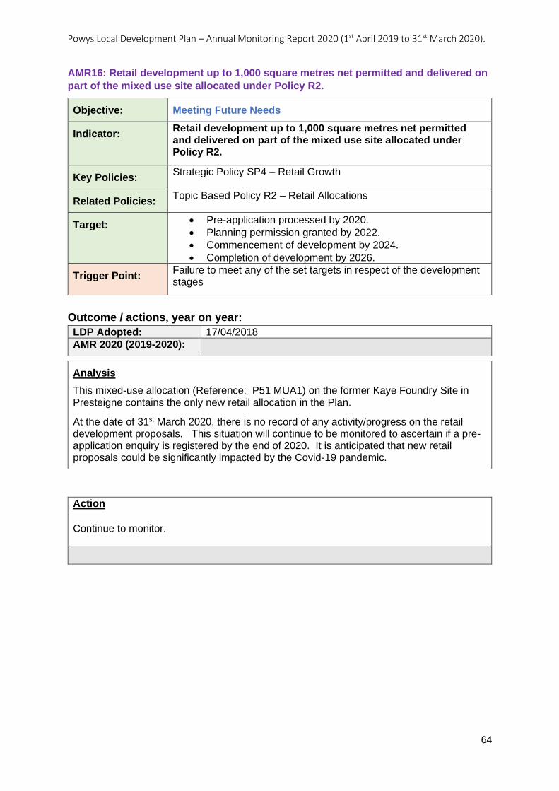
Powys Local Development Plan – Annual Monitoring Report 2020 (1st April 2019 to 31st March 2020).
64
AMR16: Retail development up to 1,000 square metres net permitted and delivered on
part of the mixed use site allocated under Policy R2.
Objective: Meeting Future Needs
Indicator: Retail development up to 1,000 square metres net permitted and delivered on part of the mixed use site allocated under Policy R2.
Key Policies: Strategic Policy SP4 – Retail Growth
Related Policies: Topic Based Policy R2 – Retail Allocations
Target: • Pre-application processed by 2020.
• Planning permission granted by 2022.
• Commencement of development by 2024.
• Completion of development by 2026.
Trigger Point: Failure to meet any of the set targets in respect of the development stages
Outcome / actions, year on year:
LDP Adopted: 17/04/2018
AMR 2020 (2019-2020):
Action
Continue to monitor.
Analysis
This mixed-use allocation (Reference: P51 MUA1) on the former Kaye Foundry Site in Presteigne contains the only new retail allocation in the Plan.
At the date of 31st March 2020, there is no record of any activity/progress on the retail development proposals. This situation will continue to be monitored to ascertain if a pre-application enquiry is registered by the end of 2020. It is anticipated that new retail proposals could be significantly impacted by the Covid-19 pandemic.
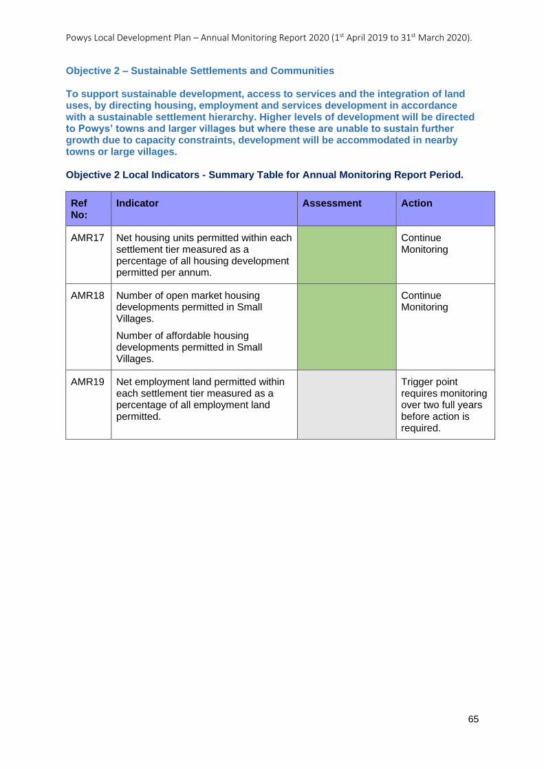
Powys Local Development Plan – Annual Monitoring Report 2020 (1st April 2019 to 31st March 2020).
65
Objective 2 – Sustainable Settlements and Communities To support sustainable development, access to services and the integration of land uses, by directing housing, employment and services development in accordance with a sustainable settlement hierarchy. Higher levels of development will be directed to Powys’ towns and larger villages but where these are unable to sustain further growth due to capacity constraints, development will be accommodated in nearby towns or large villages. Objective 2 Local Indicators - Summary Table for Annual Monitoring Report Period.
Ref No:
Indicator Assessment Action
AMR17 Net housing units permitted within each settlement tier measured as a percentage of all housing development permitted per annum.
Continue Monitoring
AMR18 Number of open market housing developments permitted in Small Villages.
Number of affordable housing developments permitted in Small Villages.
Continue Monitoring
AMR19 Net employment land permitted within each settlement tier measured as a percentage of all employment land permitted.
Trigger point requires monitoring over two full years before action is required.
Powys Local Development Plan – Annual Monitoring Report 2020 (1st April 2019 to 31st March 2020).
66
AMR17: Net housing units permitted within each settlement tier measured as a
percentage of all housing development permitted per annum.
Objective: Sustainable Settlements and Communities
Indicator: Net housing units permitted within each settlement tier measured as a percentage of all housing development permitted per annum.
Key Policies: Strategic Policy SP6 – Distribution of Growth across the Settlement Hierarchy
Related Policies: Topic Based Policy H1 – Housing Development Proposals
Target: % of net housing units permitted by tier of hierarchy per annum to accord with the following distribution:
• Towns – at least 50% of total housing growth permitted.
• Large Villages – at least 25% of total housing growth permitted.
• Small Villages – no more than 10% of total housing growth permitted.
• Rural Settlements / Open Countryside including the undeveloped coast no more than 15% of total housing growth permitted.
Trigger Point: Proportion of total housing development permitted:
a) falls below the targets for Towns and Large Villages; b) exceeds the targets for Small Villages and Rural Settlements / Open Countryside including the undeveloped coast;
for two consecutive years.
Outcome / actions, year on year:
LDP Adopted: 17/04/2018
AMR 2020 (2019-2020):
Analysis
This monitoring indicator looks at the distribution of housing developments permitted across the settlement hierarchy, it is designed to test LDP policies SP6 and H1. In particular, the monitoring looks at whether residential development is being permitted in a way that distributes growth across the settlement hierarchy in consistence with Strategic LDP Policy SP6.
Table 14 below shows the net number of dwellings permitted in the monitoring period against the settlement hierarchy. This figure is then used to calculate the percentage of residential growth that has been permitted for each of the settlement tiers. Two further columns show the cumulative total and percentage, these relate to the number of units permitted since the LDP was adopted 17th April 2018. The final column shows the monitoring target which comes from LDP Policy SP6.
The results of this monitoring indicate that the residential distribution parts of LDP policies SP6 and H1, are being implemented correctly; with the majority of residential development being permitted in the upper two tiers of the settlement hierarchy within the expectations set out in the settlement strategy of the LDP.
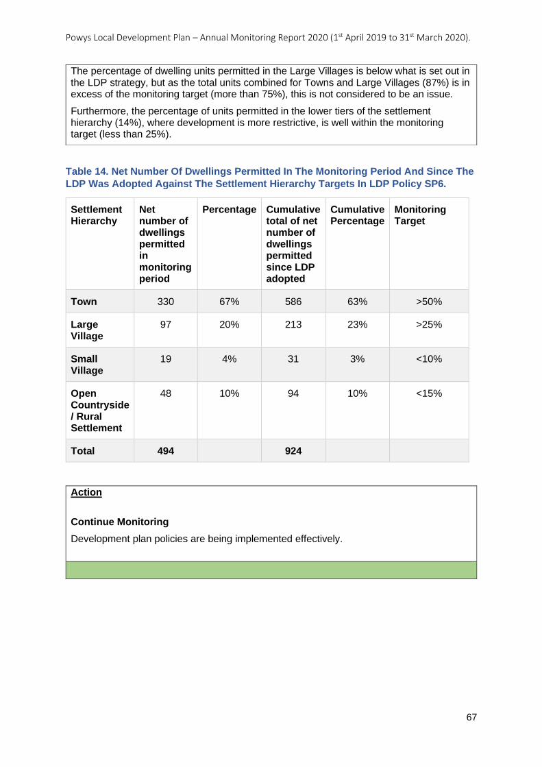
Powys Local Development Plan – Annual Monitoring Report 2020 (1st April 2019 to 31st March 2020).
67
Table 14. Net Number Of Dwellings Permitted In The Monitoring Period And Since The
LDP Was Adopted Against The Settlement Hierarchy Targets In LDP Policy SP6.
Settlement Hierarchy
Net number of dwellings permitted in monitoring period
Percentage Cumulative total of net number of dwellings permitted since LDP adopted
Cumulative Percentage
Monitoring Target
Town 330 67% 586 63% >50%
Large Village
97 20% 213 23% >25%
Small Village
19 4% 31 3% <10%
Open Countryside / Rural Settlement
48 10% 94 10% <15%
Total 494
924
Action
Continue Monitoring
Development plan policies are being implemented effectively.
The percentage of dwelling units permitted in the Large Villages is below what is set out in the LDP strategy, but as the total units combined for Towns and Large Villages (87%) is in excess of the monitoring target (more than 75%), this is not considered to be an issue.
Furthermore, the percentage of units permitted in the lower tiers of the settlement hierarchy (14%), where development is more restrictive, is well within the monitoring target (less than 25%).
Powys Local Development Plan – Annual Monitoring Report 2020 (1st April 2019 to 31st March 2020).
68
AMR18:
Number of open market housing developments permitted in Small Villages.
Number of affordable housing developments permitted in Small Villages
Objective: Sustainable Settlements and Communities
Indicator: Number of open market housing developments permitted in Small Villages.
Number of affordable housing developments permitted in Small Villages
Key Policies: Strategic Policy SP6 – Distribution of Growth across the Settlement Hierarchy
Related Policies: Topic Based Policy H1 – Housing Development Proposals
Target: • No open market housing developments of more than 2 units
to be permitted in Small Villages.
• No affordable housing developments of more than 5 units to be permitted in Small Villages.
Trigger Point: • 1 or more open market housing developments of more than
2 units permitted in Small Villages.
• 1 or more affordable housing developments of more than 5 units permitted in Small Villages.
Outcome / actions, year on year:
LDP Adopted: 17/04/2018
AMR 2020 (2019-2020):
Analysis
This monitoring indicator helps to assess whether the LDPs more restrictive approach to housing in lower tier settlements is being implemented. Not every Small Village will be suitable for growth, but in those that have suitable available land, the Plan provides for small-scale housing growth. Housing should only be permitted on small sites (of up to 0.25ha) with further restrictions on open market housing in this tier (two dwellings maximum on each site and a presumption for infill sites only).
Table 15 below shows the Small Villages where planning permission was granted for new dwellings between 1st April 2019 and 31st March 2020.
It can be seen from Table 15 that the Small Village of Llandyssil has had a total of eight units permitted, five open market and three affordable dwellings. The eight units were permitted through two separate planning applications.
The first planning application, 18/1090/OUT, comprised of two open market and three affordable dwellings and is considered to comply with LDP Policy H1. The second planning application 19/0067/FUL was for the conversion of agricultural buildings to three open market dwellings. Planning applications for the re-use/adaptation of rural buildings are considered under Technical Advice Note (TAN) 23 rather than LDP policy, so although this application is for more than two open market residential dwellings in a Small Village, it does comply with planning policy.
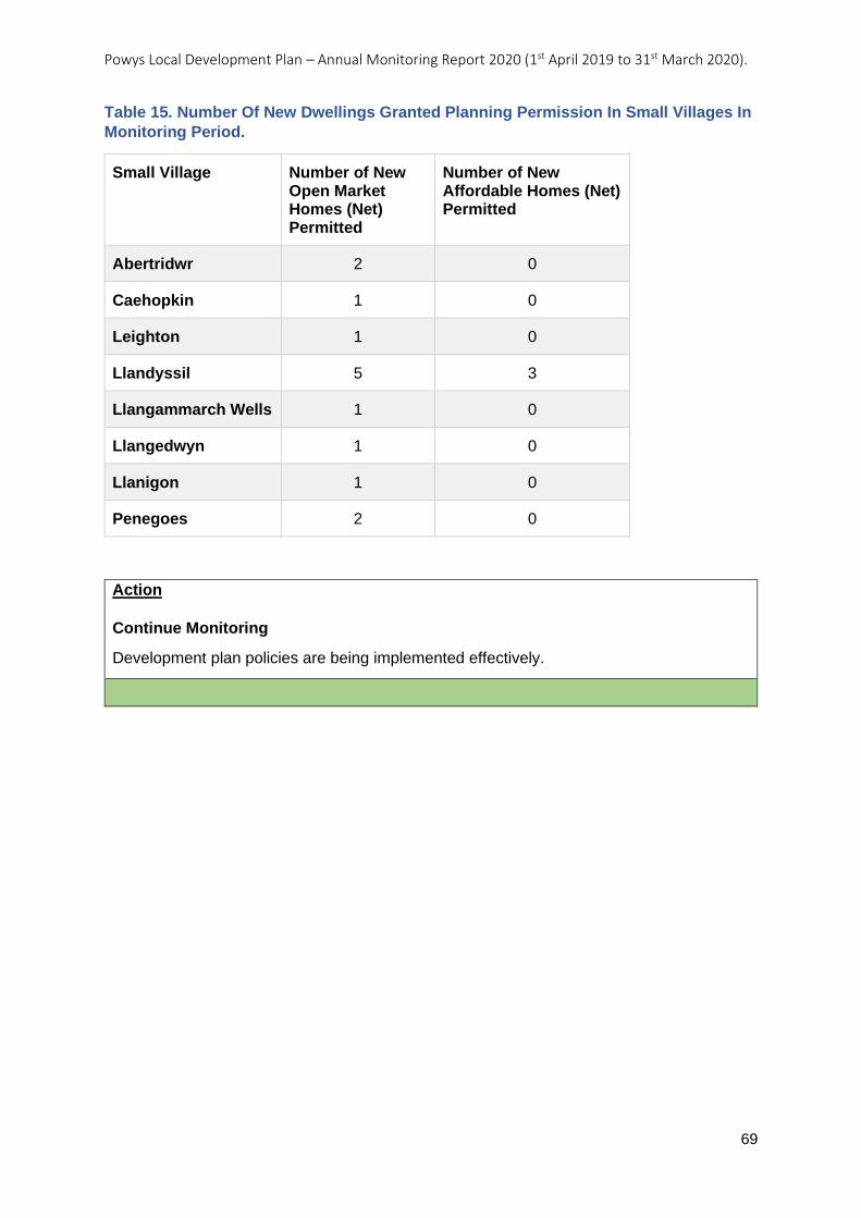
Powys Local Development Plan – Annual Monitoring Report 2020 (1st April 2019 to 31st March 2020).
69
Table 15. Number Of New Dwellings Granted Planning Permission In Small Villages In
Monitoring Period.
Small Village Number of New Open Market Homes (Net) Permitted
Number of New Affordable Homes (Net) Permitted
Abertridwr 2 0
Caehopkin 1 0
Leighton 1 0
Llandyssil 5 3
Llangammarch Wells 1 0
Llangedwyn 1 0
Llanigon 1 0
Penegoes 2 0
Action
Continue Monitoring
Development plan policies are being implemented effectively.
Powys Local Development Plan – Annual Monitoring Report 2020 (1st April 2019 to 31st March 2020).
70
AMR19: Net employment land permitted within each settlement tier measured as a
percentage of all employment land permitted
Objective: Sustainable Settlements and Communities
Indicator: Net employment land permitted within each settlement tier measured as a percentage of all employment land permitted
Key Policies: Strategic Policy SP6 – Distribution of Growth across the Settlement Hierarchy
Related Policies:
Target: % of net employment land permitted by tier of hierarchy per annum to accord with the following distribution:
• Towns – at least 50% of total employment growth permitted.
• Large Villages – no more than 20% of total employment growth permitted.
• Sites located outside the settlement hierarchy – no more than 30% of total employment growth.
Trigger Point: Proportion of employment land permitted:
a) falls below the target for Towns; b) exceeds the targets for Large Villages and Sites outside the settlement hierarchy;
for two consecutive years.
Outcome / actions, year on year:
LDP Adopted: 17/04/2018
AMR 2020 (2019-2020):
Analysis
This monitoring indicator looks at the distribution of employment developments permitted across the settlement hierarchy; it is designed to test Strategic Policy SP6. In particular, the monitoring looks at whether employment development is being permitted in a way that distributes growth across the settlement hierarchy consistent with LDP Strategic Policy SP6.
Table 16 shows the net area of employment land (in hectares) permitted across the settlement hierarchy in the monitoring period (1st April 2019 to 31st March 2020) and since the LDP was adopted (17th April 2018 to 31st March 2020). The net area of employment land is used to calculate the percentage of employment land growth that has been permitted for each of the settlement tiers. The final column shows the ‘Monitoring Target’ which comes from LDP Policy SP6.
LDP Policy SP6 directs the majority of employment development to the Towns. During the monitoring period the employment development permitted in the Towns was consistent with the policy exceeding the 50% target.
The percentage of employment land permitted (42%) in the lower tiers of the settlement hierarchy exceeds the monitoring target (<30%) during the monitoring period. This is primarily because of two planning applications, 19/1204/FUL (0.272 hectares) and 19/1795/FUL (0.292 hectares). Analysis of the applications provides the justification to the locations:
Planning application 19/1204/FUL included the conversion of part of an existing agricultural building into a mix of offices and warehouse space for the production, storage and distribution of goods. The proposed development was for the re-use of an existing
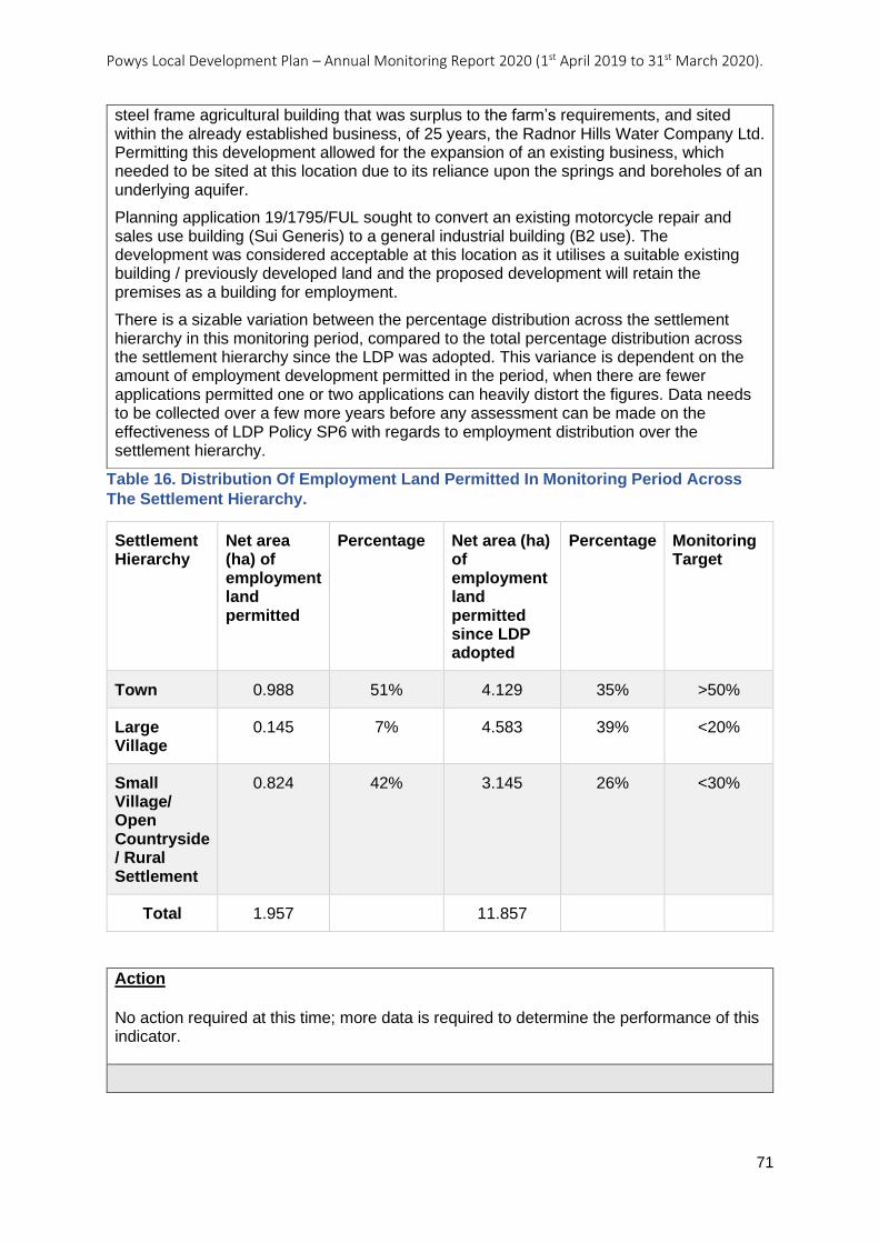
Powys Local Development Plan – Annual Monitoring Report 2020 (1st April 2019 to 31st March 2020).
71
Table 16. Distribution Of Employment Land Permitted In Monitoring Period Across
The Settlement Hierarchy.
Settlement Hierarchy
Net area (ha) of employment land permitted
Percentage Net area (ha) of employment land permitted since LDP adopted
Percentage Monitoring Target
Town 0.988 51% 4.129 35% >50%
Large Village
0.145 7% 4.583 39% <20%
Small Village/ Open Countryside / Rural Settlement
0.824 42% 3.145 26% <30%
Total 1.957
11.857
Action
No action required at this time; more data is required to determine the performance of this indicator.
steel frame agricultural building that was surplus to the farm’s requirements, and sited within the already established business, of 25 years, the Radnor Hills Water Company Ltd. Permitting this development allowed for the expansion of an existing business, which needed to be sited at this location due to its reliance upon the springs and boreholes of an underlying aquifer.
Planning application 19/1795/FUL sought to convert an existing motorcycle repair and sales use building (Sui Generis) to a general industrial building (B2 use). The development was considered acceptable at this location as it utilises a suitable existing building / previously developed land and the proposed development will retain the premises as a building for employment.
There is a sizable variation between the percentage distribution across the settlement hierarchy in this monitoring period, compared to the total percentage distribution across the settlement hierarchy since the LDP was adopted. This variance is dependent on the amount of employment development permitted in the period, when there are fewer applications permitted one or two applications can heavily distort the figures. Data needs to be collected over a few more years before any assessment can be made on the effectiveness of LDP Policy SP6 with regards to employment distribution over the settlement hierarchy.
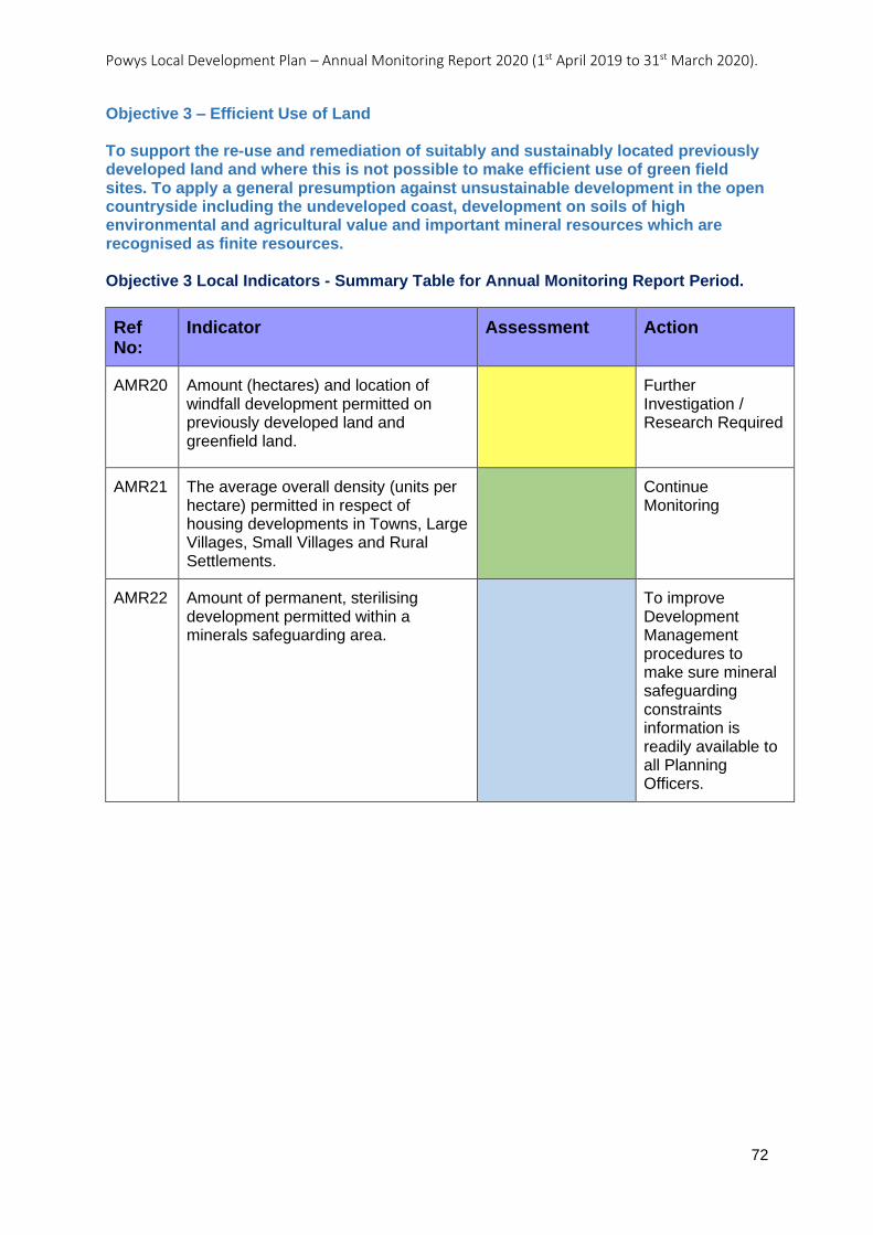
Powys Local Development Plan – Annual Monitoring Report 2020 (1st April 2019 to 31st March 2020).
72
Objective 3 – Efficient Use of Land To support the re-use and remediation of suitably and sustainably located previously developed land and where this is not possible to make efficient use of green field sites. To apply a general presumption against unsustainable development in the open countryside including the undeveloped coast, development on soils of high environmental and agricultural value and important mineral resources which are recognised as finite resources. Objective 3 Local Indicators - Summary Table for Annual Monitoring Report Period.
Ref No:
Indicator Assessment Action
AMR20 Amount (hectares) and location of windfall development permitted on previously developed land and greenfield land.
Further Investigation / Research Required
AMR21 The average overall density (units per hectare) permitted in respect of housing developments in Towns, Large Villages, Small Villages and Rural Settlements.
Continue Monitoring
AMR22 Amount of permanent, sterilising development permitted within a minerals safeguarding area.
To improve Development Management procedures to make sure mineral safeguarding constraints information is readily available to all Planning Officers.
Powys Local Development Plan – Annual Monitoring Report 2020 (1st April 2019 to 31st March 2020).
73
AMR20: Amount (hectares) and location of windfall development permitted on
previously developed land and greenfield land.
Objective: Efficient Use of Land
Indicator: Amount (hectares) and location of windfall development permitted on previously developed land and greenfield land.
Key Policies: Strategic Policy SP6 – Distribution of Growth across the Settlement Hierarchy
Related Policies:
Target: Amount (hectares) and location of windfall development permitted on previously developed land and greenfield land.
Trigger Point: The majority of windfall development permitted is on greenfield land located outside the development boundaries of Towns and Large Villages.
Outcome / actions, year on year:
LDP Adopted: 17/04/2018
AMR 2020 (2019-2020):
Analysis
This monitoring indicator looks at the distribution of planning applications on windfall sites permitted, for all development types, across the settlement hierarchy. Further analysis is given as to whether the proposal was on a greenfield site or previously developed land as defined in Planning Policy Wales (Edition 10) published December 2018.
Initial findings show that during the monitoring period (1st April 2019 to 31st March 2020) planning permission was granted on windfall sites for an area totalling 133.173 hectares (ha). From the 133.173 ha, 17.781 ha (13%) of it was on previously developed land with 112.505 ha (85%) on greenfield sites and 2.887 ha (13%) on a mixture of previously developed land and greenfield.
On closer inspection it can be seen that some of the applications on greenfield sites will continue to be classified as greenfield when the development proposal is completed. This includes all permissions for agricultural developments (67.93 ha), open space proposals (1.023 ha) and renewable energy - where the majority of the original land use remains the same (1.594 ha).
As a consequence, in order to properly assess and analyse this indicator against the LDP policies in detail, all applications for renewable energy - where the majority of the original land use remains the same, together with agricultural and open space development proposals will be excluded from the data. The analysis will concentrate solely on housing, employment, tourism and infrastructure and any other development in the Open Countryside that would bring about a change from greenfield to previously developed land.
The revised results show that during the monitoring period, planning permission was granted on windfall sites for an area totalling 62.963 ha. From the 62.963 ha, 17.719 ha (28%) of it was on previously developed land, with 43.357 ha (67%) on greenfield sites and 2.887 ha (5%) on sites containing a mixture of greenfield and previously developed land.
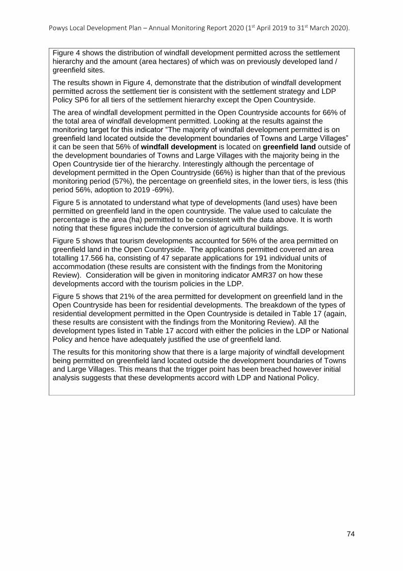
Powys Local Development Plan – Annual Monitoring Report 2020 (1st April 2019 to 31st March 2020).
74
Figure 4 shows the distribution of windfall development permitted across the settlement hierarchy and the amount (area hectares) of which was on previously developed land / greenfield sites.
The results shown in Figure 4, demonstrate that the distribution of windfall development permitted across the settlement tier is consistent with the settlement strategy and LDP Policy SP6 for all tiers of the settlement hierarchy except the Open Countryside.
The area of windfall development permitted in the Open Countryside accounts for 66% of the total area of windfall development permitted. Looking at the results against the monitoring target for this indicator “The majority of windfall development permitted is on greenfield land located outside the development boundaries of Towns and Large Villages” it can be seen that 56% of windfall development is located on greenfield land outside of the development boundaries of Towns and Large Villages with the majority being in the Open Countryside tier of the hierarchy. Interestingly although the percentage of development permitted in the Open Countryside (66%) is higher than that of the previous monitoring period (57%), the percentage on greenfield sites, in the lower tiers, is less (this period 56%, adoption to 2019 -69%).
Figure 5 is annotated to understand what type of developments (land uses) have been permitted on greenfield land in the open countryside. The value used to calculate the percentage is the area (ha) permitted to be consistent with the data above. It is worth noting that these figures include the conversion of agricultural buildings.
Figure 5 shows that tourism developments accounted for 56% of the area permitted on greenfield land in the Open Countryside. The applications permitted covered an area totalling 17.566 ha, consisting of 47 separate applications for 191 individual units of accommodation (these results are consistent with the findings from the Monitoring Review). Consideration will be given in monitoring indicator AMR37 on how these developments accord with the tourism policies in the LDP.
Figure 5 shows that 21% of the area permitted for development on greenfield land in the Open Countryside has been for residential developments. The breakdown of the types of residential development permitted in the Open Countryside is detailed in Table 17 (again, these results are consistent with the findings from the Monitoring Review). All the development types listed in Table 17 accord with either the policies in the LDP or National Policy and hence have adequately justified the use of greenfield land.
The results for this monitoring show that there is a large majority of windfall development being permitted on greenfield land located outside the development boundaries of Towns and Large Villages. This means that the trigger point has been breached however initial analysis suggests that these developments accord with LDP and National Policy.
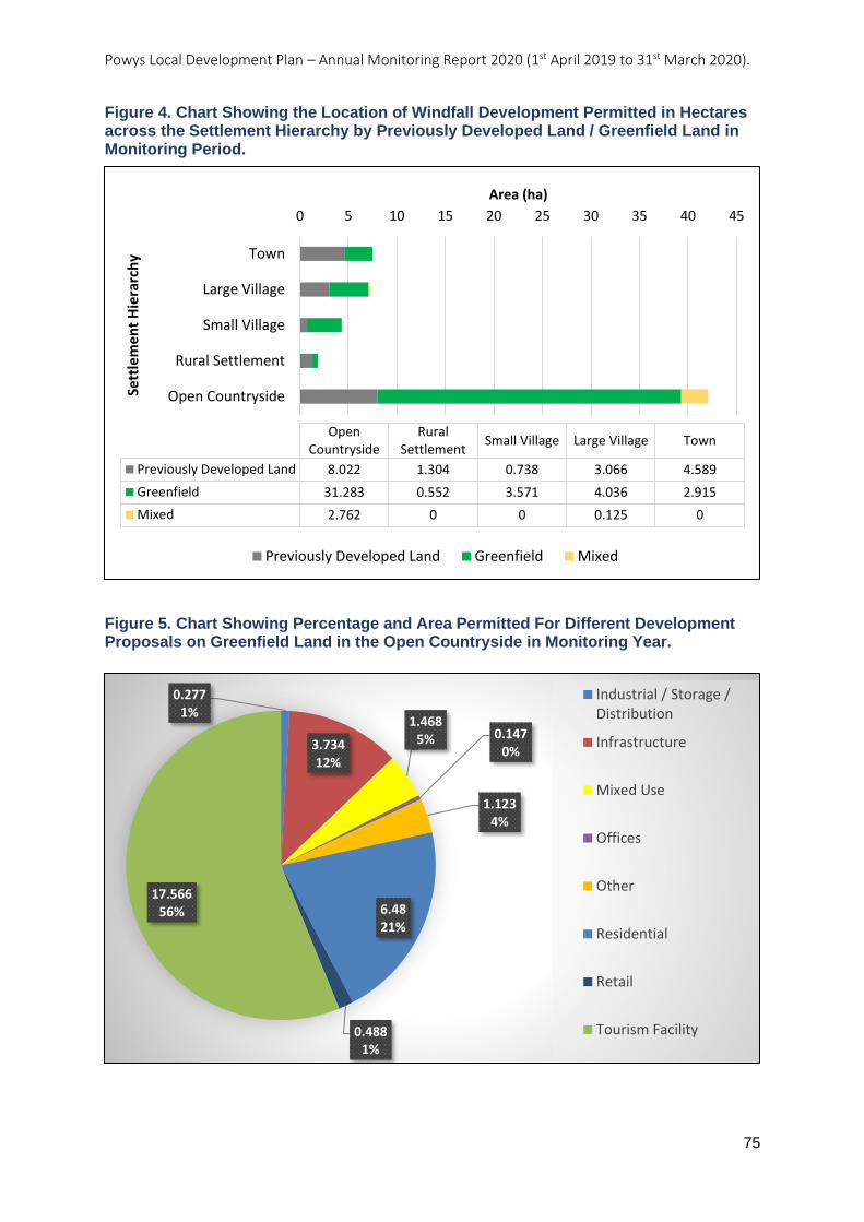
Powys Local Development Plan – Annual Monitoring Report 2020 (1st April 2019 to 31st March 2020).
75
Figure 4. Chart Showing the Location of Windfall Development Permitted in Hectares across the Settlement Hierarchy by Previously Developed Land / Greenfield Land in Monitoring Period.
Figure 5. Chart Showing Percentage and Area Permitted For Different Development Proposals on Greenfield Land in the Open Countryside in Monitoring Year.
0 5 10 15 20 25 30 35 40 45
Town
Large Village
Small Village
Rural Settlement
Open Countryside
Area (ha)
Sett
lem
en
t H
iera
rch
y
TownLarge VillageSmall VillageRural
SettlementOpen
Countryside
Previously Developed Land 4.5893.0660.7381.3048.022
Greenfield 2.9154.0363.5710.55231.283
Mixed 00.125002.762
Previously Developed Land Greenfield Mixed
0.2771%
3.73412%
1.4685% 0.147
0%
1.1234%
6.4821%
0.4881%
17.56656%
Industrial / Storage /Distribution
Infrastructure
Mixed Use
Offices
Other
Residential
Retail
Tourism Facility
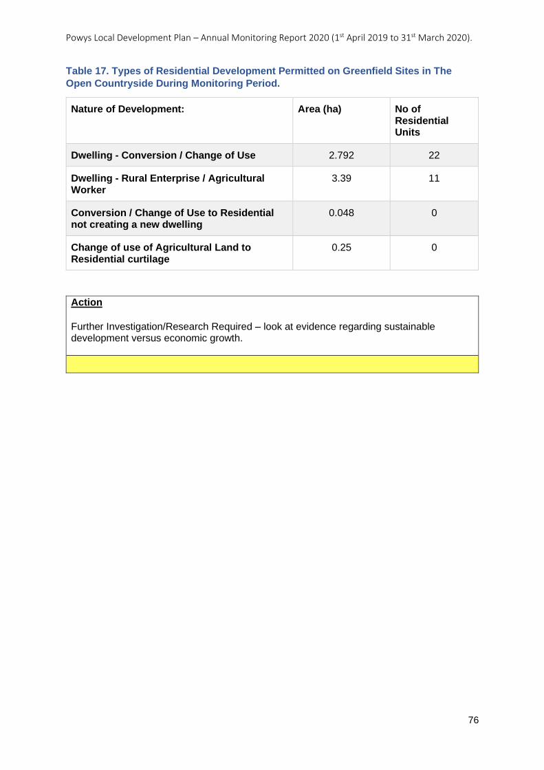
Powys Local Development Plan – Annual Monitoring Report 2020 (1st April 2019 to 31st March 2020).
76
Table 17. Types of Residential Development Permitted on Greenfield Sites in The
Open Countryside During Monitoring Period.
Nature of Development: Area (ha) No of Residential Units
Dwelling - Conversion / Change of Use 2.792 22
Dwelling - Rural Enterprise / Agricultural Worker
3.39 11
Conversion / Change of Use to Residential not creating a new dwelling
0.048 0
Change of use of Agricultural Land to Residential curtilage
0.25 0
Action
Further Investigation/Research Required – look at evidence regarding sustainable development versus economic growth.
Powys Local Development Plan – Annual Monitoring Report 2020 (1st April 2019 to 31st March 2020).
77
AMR21: The average overall density (units per hectare) permitted in respect of
housing developments in Towns, Large Villages, Small Villages and Rural
Settlements.
Objective: Efficient Use of Land
Indicator: The average overall density (units per hectare) permitted in respect of housing developments in Towns, Large Villages, Small Villages and Rural Settlements.
Key Policies: Topic Based Policy H4 – Housing Density
Related Policies:
Target: For the average overall density of housing permitted on sites to accord with the guide ranges set out in Policy H4 in respect of:
• Towns and Large Villages - 27 units per hectare.
• Small Villages – 20-25 units per hectare.
• Rural Settlements – 10-15 units per hectare.
Trigger Point: The average overall density of housing developments permitted within each settlement category falls below the targets for each settlement type in any one year.
Outcome / actions, year on year:
LDP Adopted: 17/04/2018
AMR 2020 (2019-2020):
Analysis
This monitoring indicator looks at the density of development achieved on developments permitted across the settlement tiers. It is designed to test the implementation of LDP Policy H4 and specifically the guide ranges for density set out within the Policy. Developments permitted at lower densities than those specified in the Policy indicate less efficient use of land. However, as stated in LDP Policy H4, densities may be varied where justified by evidence of local circumstances or constraints.
The overall average density for housing developments across the settlement tiers is approximately 26 dwellings per hectare. The policy targets in relation to density and monitoring results for each settlement tier are summarised in Table 18.
The results above show that, on average, the density guideline is being met and significantly exceeded in Towns, which is positive, particularly given that Towns are the primary focus for development and therefore the policy appears to be most effective in this location.
On average, the densities of housing developments permitted in Large Villages fall short of the density guideline by five dwellings per hectare. Where lower densities have been accepted, justification is provided by Officers in their reports taking into account site specific circumstances and local context, as is allowed for by the policy.
With regards to the lower densities permitted in Small Villages, five developments involved multiple units in these locations, three of which related to conversions, where density is largely dictated by the scale and layout of the existing building and scope for subdivision. The two other permissions related to a site that benefitted from the fallback position of previous permissions. This provides a reasonable explanation as to why lower densities have been permitted in Small Villages in these instances.
Powys Local Development Plan – Annual Monitoring Report 2020 (1st April 2019 to 31st March 2020).
78
Within Rural Settlements, densities permitted are within but at the lower end of the guide range set by policy for this settlement tier. All developments within these settlements involved single dwellings with curtilages of no more than 0.1 ha, in line with the guidance set out in the Affordable Housing SPG.
The data in respect of single dwellings covers dwellings permitted across all settlement tiers, including Open Countryside. A total of 65 single dwelling developments were permitted during the monitoring period, almost half of which related to conversion or change of use of existing buildings. On average, the density of single dwelling developments exceeded the guide range set within policy. However, the higher densities appear to have been achieved on conversion schemes (34 dwellings per hectare), whilst single dwelling developments fall within, but again at the lower end of, the range at 11 dwellings per hectare, and therefore at a similar density to those in Rural Settlements.
At an individual application level, density matters are being considered within Officer reports, with lower densities being justified in certain cases due to site constraints (e.g., specific highway and parking requirements, footpaths, watercourses, residential amenity, heritage) but also due to local context, particularly where detached properties are predominant, and in view of the fallback position provided by previous permissions on sites. Higher densities have also been permitted where proposals involve smaller house types, including flats and conversions.
There was also an example of a site in Ystradgynlais where LDP Policy H4 had been used to require an additional dwelling to be included in the development, specifically to achieve an appropriate density.
With regards to the density achieved on housing allocations, permission has been granted on several LDP allocations. The indicative capacities for these sites (as indicated in Appendix 1 of the LDP), generally based on an anticipated density of 27 units per hectare, have been achieved in all instances, apart from on an allocation in Ystradgynlais (P58 HA1). The Officer’s report for this development details the reasons for accepting a lower density of 16.4 dwellings per hectare on this particular site, which include certain site constraints that reduce the developable area of the site (topography, trees and pumping station) and taking into account the fallback provided by permission already existing on part of the allocation. The site was also intended to be developed for self-build detached properties. Where developments have only involved parts of allocations, it has been demonstrated that the initial phase of development is designed to enable the remainder of the site to be developed to the scale anticipated by the LDP.
The results of this monitoring demonstrate that, whilst proposals may not always meet the density guide ranges set out within LDP Policy H4, deviations from policy have been justified based on site specific circumstances, as is enabled under Policy H4. It is, therefore, clear that LDP Policy H4 is being implemented as intended.
Furthermore, LDP Objective 3 aims to support the re-use and remediation of suitably and sustainably located previously developed land and where this is not possible to make efficient use of green field sites. Therefore, whilst the results of the previous monitoring indicator (AMR20) show that a substantial amount of greenfield land is being released for development, the results of this monitoring indicator (AMR21) demonstrate that where greenfield land is released for housing development, this land is being used efficiently, where possible.
Powys Local Development Plan – Annual Monitoring Report 2020 (1st April 2019 to 31st March 2020).
79
Table 18. Average Density Permitted By Settlement Tier/Development Type During
Monitoring Period.
Settlement tier / development type
Average density (dwellings per ha)
Guide range
Town 37 27+
Large Village 22 27+
Small Village 11 20-25
Rural Settlement 11 10-15
Single dwellings 22 10-15
Action Continue Monitoring
Development plan policies are being implemented effectively.
Powys Local Development Plan – Annual Monitoring Report 2020 (1st April 2019 to 31st March 2020).
80
AMR22: Amount of permanent, sterilising development permitted within a minerals
safeguarding area.
Objective: Efficient Use of Land
Indicator: Amount of permanent, sterilising development permitted within a minerals safeguarding area.
Key Policies: Development Management Policy DM8 – Minerals Safeguarding
Related Policies:
Target: No permanent, sterilising development to be permitted within a minerals safeguarding area, unless in accordance with Policy DM8.
Trigger Point: 1 or more developments permitted for permanent, sterilising development, within a minerals safeguarding area not in accordance with Policy DM8, in any one year.
Outcome / actions, year on year:
LDP Adopted: 17/04/2018
AMR 2020 (2019-2020):
Action
To improve Development Management procedures to make sure mineral safeguarding constraints information is readily available to all Planning Officers.
Analysis
The aim of this monitoring indicator is to test the effectiveness of LDP Policy DM8 Minerals Safeguarding. The policy states that Mineral Safeguarding Areas have been designated for deposits of sand and gravel, sandstone, limestone, igneous rocks and surface coal, and these areas are shown on the LDP Proposals Map in accordance with National Policy requirements. Defining such areas does not imply any presumption that they will be worked but merely aims to ensure they remain available as and when future generations may need to access them.
During the monitoring period 1st April 2019 to 31st March 2020, 145 applications were permitted within a minerals safeguard area. Of the 145, 95 were for proposals considered not to have any impact, examples include the conversion or redevelopment of existing buildings, minor extensions to existing buildings or proposals for the siting of camping pods and static caravans.
For the remaining 50 applications there were instances where the identification of the minerals safeguarding area as a constraint had been missed. Where it had been identified as a constraint, every proposal was in accordance with LDP Policy DM8 with the reasoning explained in the Officer’s report. Where the constraint had been missed, it does not necessarily mean the development proposal did not comply with LDP Policy DM8, but that it had not been given consideration.
The trigger point for this indicator may have been reached, however this not due to the wording of the Policy itself, but due to procedural issues regarding the way constraints are identified.
Powys Local Development Plan – Annual Monitoring Report 2020 (1st April 2019 to 31st March 2020).
81
Objective 4 – Climate Change and Flooding To support the transition to a low carbon and low waste Powys through all development, including the reduction of waste to landfill and by directing development away from high flood risk areas and, where possible, to reduce or better manage existing flood risk for communities, infrastructure and businesses. Objective 4 Local Indicators - Summary Table for Annual Monitoring Report Period.
Ref No:
Indicator Assessment Action
AMR24 The preparation and adoption of Supplementary Planning Guidance relating to Land Drainage.
This SPG will be due for adoption by 17 April 2020 so the indicator falls outside the scope of this Monitoring Review.
AMR25 Number of waste developments permitted on:
a) employment allocations listed under Policy E1;
b) within development boundaries;
c) in open countryside.
Continue Monitoring
Powys Local Development Plan – Annual Monitoring Report 2020 (1st April 2019 to 31st March 2020).
82
AMR24: The preparation and adoption of Supplementary Planning Guidance relating
to Land Drainage.
Objective: Climate Change and Flooding
Indicator: The preparation and adoption of Supplementary Planning Guidance relating to Land Drainage.
Key Policies: Development Management Policy DM6 – Flood Prevention Measures and Land Drainage
Related Policies:
Target: To prepare and adopt Supplementary Planning Guidance relating to Land Drainage within 24 months of adoption of the LDP.
Trigger Point: Supplementary Planning Guidance relating to Land Drainage not adopted within 24 months of adoption of the LDP.
Outcome / actions, year on year:
LDP Adopted: 17/04/2018
AMR 2020 (2019-2020):
Action
N/A
Analysis
This SPG will be due for adoption by 17th April 2020 so the indicator falls outside the scope of this Annual Monitoring Report.
Powys Local Development Plan – Annual Monitoring Report 2020 (1st April 2019 to 31st March 2020).
83
AMR25: Number of waste developments permitted on:
a) employment allocations listed under Policy E1;
b) within development boundaries;
c) in open countryside.
Objective: Climate Change and Flooding
Indicator: Number of waste developments permitted on:
a) employment allocations listed under Policy E1; b) within development boundaries; c) in open countryside.
Key Policies: Topic Based Policy W1 – Location of Waste Development
Related Policies:
Target: No waste developments permitted in open countryside, unless in accordance with Policy W1.
Trigger Point: 1 or more waste developments permitted in open countryside not in accordance with Policy W1.
Outcome / actions, year on year:
LDP Adopted: 17/04/2018
AMR 2020 (2019-2020):
Action
Continue Monitoring
Development plan policies are being implemented effectively.
Analysis
The purpose of this monitoring indicator is to identify those instances where the LDP is used to permit waste developments in the Open Countryside.
LDP Policy W1 aims to focus and support the location of waste development proposals either within the employment sites identified in LDP Policies E1 and E4 or within the defined development boundaries of Towns and Large Villages. It goes on to describe the five criteria that would need to be met before such developments would be permitted in the open countryside. This indicator therefore aims to test the efficacy of these five criteria in protecting the open countryside from inappropriate developments.
During the lifetime of this monitoring period no planning applications were permitted in the open countryside, therefore no further actions are necessary.
Powys Local Development Plan – Annual Monitoring Report 2020 (1st April 2019 to 31st March 2020).
84
Objective 5 – Energy and Water To support the conservation of energy and water and to generate energy from appropriately located renewable resources where acceptable in terms of the economic, social, environmental and cumulative impacts.
In particular, to: i. Contribute to the achievement of the Water Framework Directive targets in
Powys. ii. Deliver the county’s contribution to the national targets for renewable
energy generation.
Objective 5 Local Indicators - Summary Table for Annual Monitoring Report Period.
Ref No:
Indicator Assessment Action
AMR26 Additional installed capacity (MW) of wind turbine developments permitted within SSAs per annum.
Trigger point requires monitoring over two full years before action is required.
AMR27 Additional installed capacity (MW) of solar PV developments permitted within LSAs per annum.
Trigger point requires monitoring over two full years before action is required.
AMR28 Number of community/district heating schemes permitted under Policy DM13 (criterion 15) per annum.
Trigger point requires monitoring over two full years before action is required.
AMR29 Additional installed capacity (MW) renewable, low or zero carbon electricity permitted per annum.
Additional installed capacity (MW) of renewable, low or zero carbon thermal permitted per annum.
Continue Monitoring
AMR30 The preparation and adoption of Supplementary Planning Guidance relating to Renewable Energy.
SPG Adopted - No Action Required
AMR31 Number of developments permitted for wind and solar PV energy greater than 5MW.
Continue Monitoring
Powys Local Development Plan – Annual Monitoring Report 2020 (1st April 2019 to 31st March 2020).
85
AMR26: Additional installed capacity (MW) of wind turbine developments permitted
within SSAs per annum.
Objective: Energy and Water
Indicator: Additional installed capacity (MW) of wind turbine developments permitted within SSAs per annum.
Key Policies: Topic Based Policy RE1– Renewable Energy
Related Policies:
Target: To contribute towards achieving the TAN 8 SSA capacity targets
Trigger Point: No additional installed capacity of wind turbine developments permitted within SSAs for two consecutive years.
Outcome / actions, year on year:
LDP Adopted: 17/04/2018
AMR 2020 (2019-2020):
Analysis
This monitoring indicator aims to monitor the effectiveness of LDP Policy RE1 in contributing towards achieving the TAN 8 SSA capacity targets.
SSA (or Strategic Search Areas) are a land use designation that arose from Technical Advice Note 8 (TAN8) on Renewable Energy. TAN8 recognised the need to identify areas where large scale onshore wind farm proposals of 25MW or over could be accommodated. The aim of designating areas of land as SSA are to ensure that the technical efficiency of wind power generation is maximised and environmental impacts are minimised as much as possible. TAN8 identified indicative capacity targets (Table 19), in Megawatts, for each SSA based on the assumption that the majority of the theoretically technically suitable land within each SSA was utilised. However, it also recognised that it is possible for each SSA’s realised capacity to be more or less than that indicated. There are two SSA that fall entirely within Powys and part of a third, these are detailed in Table 19 below.
In this monitoring period of the LDP no applications for wind turbines within the Powys Strategic Search Areas have been permitted.
The previous Monitoring Review listed a number of factors that will have contributed to this performance. One of these is the protracted lead in time for applications that would have needed to wait until the LDP was adopted before developing their proposals. However, chief amongst the other factors were national trends such as changes in the support regime and the devolving of parts of the consenting regime that are continuing to have profound influences on the continued roll out of onshore wind energy generating sites in the UK.
The Monitoring Review also looked to an emerging national trend which it was hoped would help to stimulate activity in this field in Powys, however clearly that trend has not yet yielded any results in the county.
With the lack of any onshore wind planning permissions being granted within the identified SSAs for this monitoring period, the efficacy of the policy itself cannot be adequately tested. This monitoring indicator’s trigger point requires two consecutive, full, years of monitoring and so with this monitoring period representing the first full year, it remains to
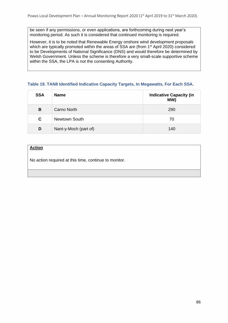
Powys Local Development Plan – Annual Monitoring Report 2020 (1st April 2019 to 31st March 2020).
86
Table 19. TAN8 Identified Indicative Capacity Targets, In Megawatts, For Each SSA.
SSA Name Indicative Capacity (in MW)
B Carno North 290
C Newtown South 70
D Nant-y-Moch (part of) 140
Action
No action required at this time, continue to monitor.
be seen if any permissions, or even applications, are forthcoming during next year’s monitoring period. As such it is considered that continued monitoring is required.
However, it is to be noted that Renewable Energy onshore wind development proposals which are typically promoted within the areas of SSA are (from 1st April 2020) considered to be Developments of National Significance (DNS) and would therefore be determined by Welsh Government. Unless the scheme is therefore a very small-scale supportive scheme within the SSA, the LPA is not the consenting Authority.
Powys Local Development Plan – Annual Monitoring Report 2020 (1st April 2019 to 31st March 2020).
87
AMR27: Additional installed capacity (MW) of solar PV developments permitted within
LSAs per annum.
Objective: Energy and Water
Indicator: Additional installed capacity (MW) of solar PV developments permitted within LSAs per annum.
Key Policies: Topic Based Policy RE1– Renewable Energy
Related Policies:
Target: For contributions to be made towards renewable energy generation through new solar developments permitted within LSAs.
Trigger Point: No additional installed capacity of solar PV developments permitted within LSAs for two consecutive years.
Outcome / actions, year on year:
LDP Adopted: 17/04/2018
AMR 2020 (2019-2020):
Analysis
The aim of this monitoring indicator is to monitor how effective LDP Policy RE1 is at ensuring proposals for solar PV between 5 and 50 Megawatts (MW) are focused within the LDP’s designated Local Search Areas (LSA).
The LDP identified 20 LSA across the county. These have been identified as areas within Powys that are considered to contain the least constraint for medium to larger scale solar photovoltaic renewable electricity generation projects.
In this monitoring period of the LDP there has been no additional installed capacity permitted within any of the 20 LSA in Powys.
The Monitoring Review listed a number of factors that will have contributed to this performance. One of these is the protracted lead in time for applications that would have needed to wait until the LDP was adopted before developing their proposals. However, chief amongst the other factors were national trends, such as changes in the support regime, the Feed-in Tariff and lack of grid capacity that are continuing to have profound influences on the continued roll out of onshore renewable energy generating sites in Powys and the wider UK and are beyond the control of the LDP.
The Monitoring Review also looked to an emerging national trend which it was hoped would help to stimulate activity in this field in Powys, however clearly that trend has not yet yielded any results in the county.
The apparent lack of any planning applications pending determination also may lend weight to the national factors having a bearing upon such proposals being brought forward. And without any applications the efficacy of the policy itself cannot be adequately tested. However, it should be noted that interest and applications have been forthcoming in the past outside of the LSA areas in mid Powys (Moat Lane) and South-west Powys (Brynhenllys).
The monitoring indicator’s trigger point requires two consecutive, full, years of monitoring and so, with this monitoring period representing the first full year, it remains to be seen if any permissions, or even applications, are forthcoming during next year’s monitoring period to avoid the trigger point being reached.

Powys Local Development Plan – Annual Monitoring Report 2020 (1st April 2019 to 31st March 2020).
88
Action
No action required at this time, continue to monitor.
It is recommended that he most appropriate course of action is to continue to monitor activities recognising the lead-in time necessary to prepare a non-domestic renewable energy scheme application.
Powys Local Development Plan – Annual Monitoring Report 2020 (1st April 2019 to 31st March 2020).
89
AMR28: Number of community/district heating schemes permitted under Policy DM13
(criterion 14) per annum.
Objective: Energy and Water
Indicator: Number of community/district heating schemes permitted under Policy DM13 (criterion 14) per annum.
Key Policies: Development Management Policy DM13 – Design and Resources (Criterion 14)
Related Policies:
Target: For additional community/district heating schemes to be permitted under Policy DM13 (criterion 14)
Trigger Point: No additional community/district heating schemes permitted under Policy DM13 (criterion 14) for two consecutive years.
Outcome / actions, year on year:
LDP Adopted: 17/04/2018
AMR 2020 (2019-2020):
Analysis
This monitoring indicator seeks to test the performance of Criteria 14 of policy DM13, in the permitting of community/district heating schemes. The criterion requires that investigations are “undertaken into the technical feasibility and financial viability of community and/or district heating networks wherever the development proposal’s Heat Demand Density exceeds 3MW/Km2”.
Community or District Heating Networks work on the principle of a shared network of heating pipes that heat one or more buildings, usually in heavily populated or urban areas, where there is a reliable or near constant demand. They usually involve one heat source and heavily insulated pipes running underground between the properties involved. In European towns and cities where the technology is relatively common, they usually involve a Combined Heat and Power (CHP) or a Combined Cooling Heat and Power (CCHP) plant. These utilise the excess heat that is created by the generation of electricity. The electricity is either used by the building/s that are a part of the network or is sold to the National Grid. The CHP/CCHP generators themselves can use a variety of fuels from diesel through to biomass and so are considered to be either low carbon or completely renewable.
Only one application involving a CHP unit was approved in this monitoring period and this was located in a rural setting and so would not have been required to undertake the investigative work.
In considering how effective this part of the policy is a number of factors need to be borne in mind when interpreting this outcome.
The policy requires the developer to carry out an investigation to be carried out in order to determine whether the use of such a network is financially and technically viable. Where it is found that a scheme is not feasible and/or viable there is no requirement that they must implement one. No such investigations are recorded in the Council’s monitoring activities so it is not possible to know how many proposals undertook this investigation and then discounted it due to it not being feasible or viable.
Powys Local Development Plan – Annual Monitoring Report 2020 (1st April 2019 to 31st March 2020).
90
Action
No action required at this time, continue to monitor.
If it is found to be viable and feasible, as with other forms of larger scale renewable energy proposals, bringing them to application stage can be a long and expensive process. As this is only the second year of the newly adopted LDP being applied to development proposals, developers would have waited until the LDP was adopted before developing their proposals, so it is possibly still the case that schemes may yet be in the pipeline.
Also, district heating networks are only likely to be feasible and viable where the proposal involves a high enough demand (e.g., A (usually urban) residential setting such as a block of flats, a hospital, or old people’s home, public swimming pool, or leisure centre etc.) and/or is in proximity to other similar users that require a regular or high demand. Therefore, the opportunity to permit such a scheme relies entirely upon there being applications from appropriate settings in the first place, followed by those applications establishing the feasibility and viability of such a network. Hence the lack of any permitted scheme may not point to a failing in the policy, but wider factors such as the number, scale and locations of applications in the first place.
The trigger point requires monitoring over two full years before action is required. Monitoring will continue, with actions being identified to establish how many applications in subsequent years are carrying out investigations and how many are subsequently permitted to determine whether this Policy is performing as anticipated. It may also be necessary to further promote the requirement for an investigation, and the associated technology involved in district networks, amongst Officers, developers and their agents to maximise potential uptake in the future.
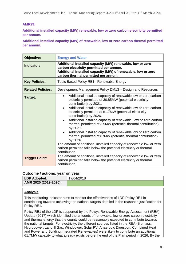
Powys Local Development Plan – Annual Monitoring Report 2020 (1st April 2019 to 31st March 2020).
91
AMR29:
Additional installed capacity (MW) renewable, low or zero carbon electricity permitted
per annum.
Additional installed capacity (MW) of renewable, low or zero carbon thermal permitted
per annum.
Objective: Energy and Water
Indicator: Additional installed capacity (MW) renewable, low or zero carbon electricity permitted per annum. Additional installed capacity (MW) of renewable, low or zero carbon thermal permitted per annum.
Key Policies: Topic Based Policy RE1– Renewable Energy
Related Policies: Development Management Policy DM13 – Design and Resources
Target: • Additional installed capacity of renewable low or zero carbon electricity permitted of 30.85MW (potential electricity contribution) by 2021.
• Additional installed capacity of renewable low or zero carbon electricity permitted of 61.7MW (potential electricity contribution) by 2026.
• Additional installed capacity of renewable, low or zero carbon thermal permitted of 3.5MW (potential thermal contribution) by 2021.
• Additional installed capacity of renewable low or zero carbon thermal permitted of 87MW (potential thermal contribution) by 2026.
The amount of additional installed capacity of renewable low or zero carbon permitted falls below the potential electricity or thermal contribution.
Trigger Point: The amount of additional installed capacity of renewable low or zero carbon permitted falls below the potential electricity or thermal contribution.
Outcome / actions, year on year:
LDP Adopted: 17/04/2018
AMR 2020 (2019-2020):
Analysis
This monitoring indicator aims to monitor the effectiveness of LDP Policy RE1 in contributing towards achieving the national targets detailed in the reasoned justification for Policy RE1.
Policy RE1 of the LDP is supported by the Powys Renewable Energy Assessment (REA) Update (2017) which identified the amounts of renewable, low or zero carbon electricity and thermal energy that the county could be reasonably expected to contribute towards the national targets. For electricity, the different sources listed in the REA (Biomass, Hydropower, Landfill Gas, Windpower, Solar PV, Anaerobic Digestion, Combined Heat and Power and Building Integrated Renewables) were likely to contribute an additional 61.7MW capacity to what already exists before the end of the Plan period in 2026. By the
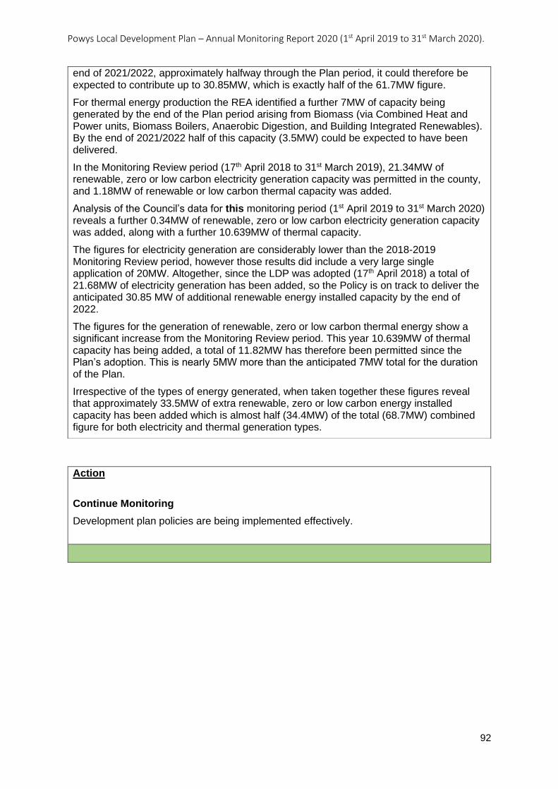
Powys Local Development Plan – Annual Monitoring Report 2020 (1st April 2019 to 31st March 2020).
92
Action
Continue Monitoring
Development plan policies are being implemented effectively.
end of 2021/2022, approximately halfway through the Plan period, it could therefore be expected to contribute up to 30.85MW, which is exactly half of the 61.7MW figure.
For thermal energy production the REA identified a further 7MW of capacity being generated by the end of the Plan period arising from Biomass (via Combined Heat and Power units, Biomass Boilers, Anaerobic Digestion, and Building Integrated Renewables). By the end of 2021/2022 half of this capacity (3.5MW) could be expected to have been delivered.
In the Monitoring Review period (17th April 2018 to 31st March 2019), 21.34MW of renewable, zero or low carbon electricity generation capacity was permitted in the county, and 1.18MW of renewable or low carbon thermal capacity was added.
Analysis of the Council’s data for this monitoring period (1st April 2019 to 31st March 2020) reveals a further 0.34MW of renewable, zero or low carbon electricity generation capacity was added, along with a further 10.639MW of thermal capacity.
The figures for electricity generation are considerably lower than the 2018-2019 Monitoring Review period, however those results did include a very large single application of 20MW. Altogether, since the LDP was adopted (17th April 2018) a total of 21.68MW of electricity generation has been added, so the Policy is on track to deliver the anticipated 30.85 MW of additional renewable energy installed capacity by the end of 2022.
The figures for the generation of renewable, zero or low carbon thermal energy show a significant increase from the Monitoring Review period. This year 10.639MW of thermal capacity has being added, a total of 11.82MW has therefore been permitted since the Plan’s adoption. This is nearly 5MW more than the anticipated 7MW total for the duration of the Plan.
Irrespective of the types of energy generated, when taken together these figures reveal that approximately 33.5MW of extra renewable, zero or low carbon energy installed capacity has been added which is almost half (34.4MW) of the total (68.7MW) combined figure for both electricity and thermal generation types.
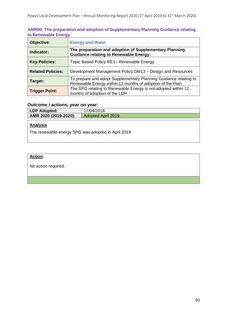
Powys Local Development Plan – Annual Monitoring Report 2020 (1st April 2019 to 31st March 2020).
93
AMR30: The preparation and adoption of Supplementary Planning Guidance relating
to Renewable Energy.
Objective: Energy and Water
Indicator: The preparation and adoption of Supplementary Planning Guidance relating to Renewable Energy.
Key Policies: Topic Based Policy RE1– Renewable Energy
Related Policies: Development Management Policy DM13 – Design and Resources
Target: To prepare and adopt Supplementary Planning Guidance relating to Renewable Energy within 12 months of adoption of the Plan.
Trigger Point: The SPG relating to Renewable Energy is not adopted within 12 months of adoption of the LDP
Outcome / actions, year on year:
LDP Adopted: 17/04/2018
AMR 2020 (2019-2020): Adopted April 2019.
Action No action required.
Analysis
The renewable energy SPG was adopted in April 2019

Powys Local Development Plan – Annual Monitoring Report 2020 (1st April 2019 to 31st March 2020).
94
AMR31: Number of developments permitted for wind and solar PV energy greater than
5MW.
Objective: Energy and Water
Indicator: Number of developments permitted for wind and solar PV energy greater than 5MW.
Key Policies: Topic Based Policy RE1– Renewable Energy
Related Policies:
Target: No developments permitted, unless the size and location is in accordance with criteria 1 and 2 of Policy RE1.
Trigger Point: 1 or more developments permitted of a size (MW) and location not in accordance with criteria 1 and 2 of Policy RE1.
Outcome / actions, year on year:
LDP Adopted: 17/04/2018
AMR 2020 (2019-2020):
Action
Continue Monitoring
Development plan policies are being implemented effectively.
Analysis
Criteria 1 and 2 of LDP Policy RE1 are concerned with ensuring that the Strategic Search Areas (SSA) for renewable wind developments, and Local Search Areas (LSA) for solar PV developments, accommodate renewable energy developments of an appropriate size (25MW and upwards for wind and between 5 and 50MW for solar). They also safeguard their designations by ensuring that they are not sterilised by other renewable or low or zero carbon developments that would be incompatible with the purpose of the SSA/LSA. Such incompatible developments would include other wind developments in an SSA that were smaller than 25MW, or solar developments in an LSA under 5MW, if their presence created an unacceptable cumulative impact that would render the SSA/LSA unavailable to other larger scale developments for which the Area has been designated.
The two whole and one part of an SSA that are present in the county are intended to accommodate large scale renewable wind developments of greater than 25MW. The 20 LSAs in Powys are intended to accommodate solar PV developments of between 5 and 50MW.
Analysis of the Development Management data for the monitoring period (1st April 2019 to 31st March 2020) reveal that there were no applications in the county for wind or solar that were over 5MW in size, therefore none of the SSA or LSA will have had their purposes compromised.
No further action is therefore required but monitoring will continue.
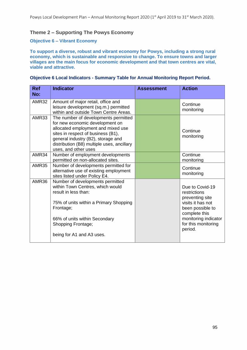
Powys Local Development Plan – Annual Monitoring Report 2020 (1st April 2019 to 31st March 2020).
95
Theme 2 – Supporting The Powys Economy
Objective 6 – Vibrant Economy To support a diverse, robust and vibrant economy for Powys, including a strong rural economy, which is sustainable and responsive to change. To ensure towns and larger villages are the main focus for economic development and that town centres are vital, viable and attractive. Objective 6 Local Indicators - Summary Table for Annual Monitoring Report Period.
Ref No:
Indicator Assessment Action
AMR32 Amount of major retail, office and leisure development (sq.m.) permitted within and outside Town Centre Areas.
Continue monitoring
AMR33 The number of developments permitted for new economic development on allocated employment and mixed use sites in respect of business (B1), general industry (B2), storage and distribution (B8) multiple uses, ancillary uses, and other uses
Continue monitoring
AMR34 Number of employment developments permitted on non-allocated sites.
Continue monitoring
AMR35 Number of developments permitted for alternative use of existing employment sites listed under Policy E4.
Continue monitoring
AMR36 Number of developments permitted within Town Centres, which would result in less than: 75% of units within a Primary Shopping Frontage;
66% of units within Secondary Shopping Frontage; being for A1 and A3 uses.
Due to Covid-19 restrictions preventing site visits it has not been possible to complete this monitoring indicator for this monitoring period.
Powys Local Development Plan – Annual Monitoring Report 2020 (1st April 2019 to 31st March 2020).
96
AMR32: Amount of major retail, office and leisure development (sq.m.) permitted
within and outside Town Centre Areas.
Objective: Vibrant Economy
Indicator: Amount of major retail, office and leisure development (sq.m.) permitted within and outside Town Centre Areas.
Key Policies: Topic Based Policy E2 – Employment Proposals on Non-allocated Employment Sites
Related Policies: Topic Based Policy TD1 –Tourism Developments
Target: No major retail, office or leisure development to be permitted outside Town Centre Areas, unless in accordance with national policy, TAN 4, or LDP policies E2 and TD1.
Trigger Point: 1 or more major retail, office or leisure developments permitted outside Town Centre Areas not in accordance with national policy, TAN 4, or LDP policies E2 and TD1 in any one year.
Outcome / actions, year on year:
LDP Adopted: 17/04/2018
AMR 2020 (2019-2020):
Action
Continue Monitoring
Development plan policies are being implemented effectively
Analysis
This monitoring indicator aims to test the implementation of LDP Policies E2 and TD1 to ensure that major retail, office or leisure development is located only within town centre areas unless it complies with national policy, TAN 4, or LDP policies E2 and TD1.
LDP policy supports small scale, appropriate development opportunities for employment in areas that are not allocated for such purposes. Any applications received that do not accord with the relevant criteria set out within the policies would be contrary to policy.
During the monitoring period, the only application for major development permitted that fell within the categories of retail, office or leisure, was for the redevelopment of a caravan park. The redevelopment of the caravan park complied with LDP Policy TD1, therefore it is considered that the development plan policies are being implemented effectively with regards to this indicator.
Powys Local Development Plan – Annual Monitoring Report 2020 (1st April 2019 to 31st March 2020).
97
AMR33: The number of developments permitted for new economic development on
allocated employment and mixed use sites in respect of business (B1), general
industry (B2), storage and distribution (B8) multiple uses, ancillary uses, and other
uses.
Objective: Vibrant Economy
Indicator: The number of developments permitted for new economic development on allocated employment and mixed use sites in respect of business (B1), general industry (B2), storage and distribution (B8) multiple uses, ancillary uses, and other uses.
Key Policies: Strategic Policy SP2 – Employment Growth
Related Policies: Topic Based Policy E1 – Employment Proposals on Allocated Employment Sites
Topic Based Policy E3 – Employment Proposals on Allocated Mixed Use Employment Sites
Target: Employment uses within classes B1, B2 and B8, or ancillary uses, only to be permitted on allocated employment and mixed use sites, unless in accordance with policies E1 and E3.
Trigger Point: 1 or more other employment developments permitted on allocated employment and mixed use sites not in accordance with policies E1 and E3 in any one year.
Outcome / actions, year on year:
LDP Adopted: 17/04/2018
AMR 2020 (2019-2020):
Analysis
This monitoring indicator aims to test the implementation of LDP Policies E1 and E3 to ensure that the allocations in the LDP continue to provide employment land across the Plan area.
LDP policy promotes the employment allocations (and some of the mixed use allocations) for B1, B2 and B8 uses, but also enables proposals for complimentary ancillary employment uses that are not within a B use class order that improve site viability and enables new site development. Any applications which do not comply with this criterion would be contrary to policy.
During the monitoring period (1st April 2019 to 31st March 2020) no applications were permitted on any of the sites allocated for employment uses within the plan. As shown in monitoring indicator AMR15, the planning applications permitted for employment uses within the period, were either on existing employment sites (employment safeguarding areas), 0.754 hectares (total net floorspace of 2,558 square metres), or for windfall development 1.203 hectares, (4,208 square metres).
This monitoring indicator looks at whether any of the employment allocations have been lost (either entirely or in part) to other land uses. From the results it can be seen that there has been no loss of land allocated in the Plan for employment use, to non-employment uses during the period.

Powys Local Development Plan – Annual Monitoring Report 2020 (1st April 2019 to 31st March 2020).
98
Action
Continue Monitoring
Development plan policies are being implemented effectively
Powys Local Development Plan – Annual Monitoring Report 2020 (1st April 2019 to 31st March 2020).
99
AMR34: Number of employment developments permitted on non-allocated sites.
Objective: Vibrant Economy
Indicator: Number of employment developments permitted on non-allocated sites.
Key Policies: Topic Based Policy E2 – Employment Proposals on Non-allocated Employment Sites
Related Policies:
Target: No employment development to be permitted on non-allocated sites, unless in accordance with Policy E2.
Trigger Point: 1 or more employment developments permitted on non-allocated sites not in accordance with Policy E2 in any one year.
Outcome / actions, year on year:
LDP Adopted: 17/04/2018
AMR 2020 (2019-2020):
Analysis
A total of 11 planning applications were permitted for employment proposals on non-allocated employment sites (not on an employment allocation or within an employment safeguarding area) during the monitoring period.
Figure 6 shows where the employment proposals were in terms of the settlement hierarchy and the nature of the development (e.g., conversion/change of use, extension or new build).
LDP Policy E2 requires development proposals on non-allocated sites to consider locations on existing employment sites or previously developed land in the first instance if an allocated employment site is not suitable. Following on from this the policy requires at least one of the following criteria to be met:
1. The proposal is up to 0.5ha. and is located within or adjoining a settlement with a development boundary.
2. The proposal is for the limited expansion, extension or environmental improvement of existing employment sites and buildings.
3. The proposal is appropriate in scale and nature to its location and is supported by a business case which demonstrates that its location is justified.
All of the proposals in the Towns and Large Villages are on are on previously developed sites within a settlement, so can automatically be considered as complying with LDP Policy E2. The single proposal in a Small Village is adjacent to an existing storage building and is viewed as being for the limited expansion of the business and therefore complies with LDP Policy E2, criterion 2.
The remaining proposals in the Open Countryside were granted due to compliance with the policies listed in Table 20. From Table 20, it can be seen that there have been a number of employment developments permitted on non-allocated sites. With the exception of one, they were all in accordance with Policy E2.
It is considered that all of the planning applications for employment uses permitted, that were not on an allocated employment site, accorded with the policies in the LDP.
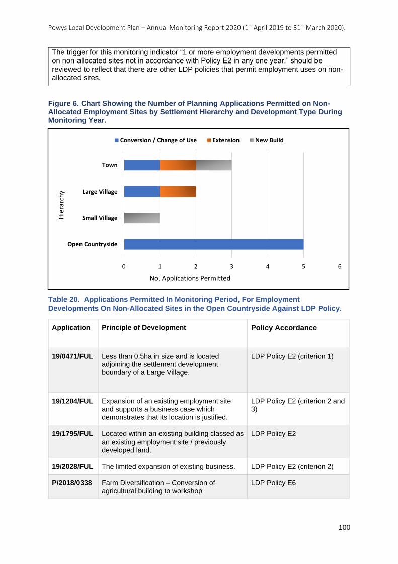
Powys Local Development Plan – Annual Monitoring Report 2020 (1st April 2019 to 31st March 2020).
100
Figure 6. Chart Showing the Number of Planning Applications Permitted on Non-Allocated Employment Sites by Settlement Hierarchy and Development Type During Monitoring Year.
Table 20. Applications Permitted In Monitoring Period, For Employment
Developments On Non-Allocated Sites in the Open Countryside Against LDP Policy.
Application Principle of Development Policy Accordance
19/0471/FUL Less than 0.5ha in size and is located adjoining the settlement development boundary of a Large Village.
LDP Policy E2 (criterion 1)
19/1204/FUL Expansion of an existing employment site and supports a business case which demonstrates that its location is justified.
LDP Policy E2 (criterion 2 and 3)
19/1795/FUL Located within an existing building classed as an existing employment site / previously developed land.
LDP Policy E2
19/2028/FUL The limited expansion of existing business. LDP Policy E2 (criterion 2)
P/2018/0338 Farm Diversification – Conversion of agricultural building to workshop
LDP Policy E6
0 1 2 3 4 5 6
Open Countryside
Small Village
Large Village
Town
No. Applications Permitted
Hie
rarc
hy
Conversion / Change of Use Extension New Build
The trigger for this monitoring indicator “1 or more employment developments permitted on non-allocated sites not in accordance with Policy E2 in any one year.” should be reviewed to reflect that there are other LDP policies that permit employment uses on non-allocated sites.

Powys Local Development Plan – Annual Monitoring Report 2020 (1st April 2019 to 31st March 2020).
101
Action
Continue Monitoring
Development plan policies are being implemented effectively.
Powys Local Development Plan – Annual Monitoring Report 2020 (1st April 2019 to 31st March 2020).
102
AMR35: Number of developments permitted for alternative use of existing
employment sites listed under Policy E4
Objective: Vibrant Economy
Indicator: Number of developments permitted for alternative use of existing employment sites listed under Policy E4
Key Policies: Topic Based Policy E4 – Safeguarded Employment Sites
Related Policies: Development Management Policy DM16 – Protection of Existing Employment Sites
Target: No developments permitted for alternative use of existing employment sites listed under Policy E4 unless in accordance with Policy DM16.
Trigger Point: 1 or more developments permitted for alternative use of existing employment sites listed under Policy E4 not in accordance with Policy DM16 in any one year.
Outcome / actions, year on year:
LDP Adopted: 17/04/2018
AMR 2020 (2019-2020):
Action
Continue Monitoring
Development plan policies are being implemented effectively.
Analysis
This monitoring indicator aims to test the implementation of LDP policies E4 and DM16 to ensure that the safeguarded employment sites in the LDP continue to protect the function of existing employment areas across the Plan area.
LDP Policy DM16 only allows for alternative uses on safeguarded employment sites where proposals can demonstrate that the employment site is no longer required, that the proposal would not result in an under provision of employment land or premises and that the development proposal doesn’t prejudice the surrounding employments sites and premises.
During the monitoring period all of the planning applications permitted on employment safeguarding sites were for B1/B2/B8 use class orders. Therefore, no applications were permitted for an alternative use of an employment safeguarding site.
Powys Local Development Plan – Annual Monitoring Report 2020 (1st April 2019 to 31st March 2020).
103
AMR36: Number of developments permitted within Town Centres, which would result
in less than:
• 75% of units within a Primary Shopping Frontage;
• 66% of units within Secondary Shopping Frontage;
being for A1 and A3 uses.
Objective: Vibrant Economy
Indicator: Number of developments permitted within Town Centres, which would result in less than: • 75% of units within a Primary Shopping Frontage; • 66% of units within Secondary Shopping Frontage; being for A1 and A3 uses.
Key Policies: Topic Based Policy R3 – Development Within Town Centre Areas o
Related Policies:
Target: No development permitted that results in less than the percentage of units set by Policy R3 for the respective Shopping Frontages being for A1 and A3 uses, unless in accordance with Policy R3.
Trigger Point: 1 or more developments permitted that result in less than the percentage of units set by Policy R3 for the respective Shopping Frontages being for A1 or A3 uses not in accordance with Policy R3, in any one year.
Outcome / actions, year on year:
LDP Adopted: 17/04/2018
AMR 2020 (2019-2020):
Action
N/A
Analysis
Due to Covid 19 restrictions preventing site visits it has not been possible to complete this monitoring indicator (AMR36) for this monitoring period.
Powys Local Development Plan – Annual Monitoring Report 2020 (1st April 2019 to 31st March 2020).
104
Objective 7 – Key Economic Sectors To maintain and strengthen key economic sectors within Powys including manufacturing in the Severn Valley and Ystradgynlais, sustainable year-round tourism opportunities, agriculture and the rural economy. Objective 7 Local Indicators - Summary Table for Annual Monitoring Report Period.
Ref No:
Indicator Assessment Action
AMR37 Number of new tourism facilities, attractions or extensions to existing development permitted.
Continue Monitoring
AMR38 Number of developments permitted for alternative use of existing tourism development in rural areas.
Continue Monitoring
Powys Local Development Plan – Annual Monitoring Report 2020 (1st April 2019 to 31st March 2020).
105
AMR37: Number of new tourism facilities, attractions or extensions to existing
development permitted.
Objective: Key Economic Sectors
Indicator: Number of new tourism facilities, attractions or extensions to existing development permitted.
Key Policies: Topic Based Policy TD1 – Tourism Development
Related Policies:
Target: No developments permitted for new tourism facilities or attractions or for extensions to existing development, unless in accordance with Policy TD1.
Trigger Point: 1 or more developments permitted for new tourism accommodation, facilities or attractions, or for extensions to existing development not in accordance with Policy TD1 in any one year.
Outcome / actions, year on year:
LDP Adopted: 17/04/2018
AMR 2020 (2019-2020):
Analysis
The purpose of this indicator is to ensure that tourism development is in accordance with LDP Policy TD1 and that inappropriate, unacceptable development is not permitted either in settlements or the open countryside. Supporting tourism is a key tenet of the LDP because of its contribution to the economy, but the LPA seeks to ensure that developments are sustainable and do not have an unacceptable adverse impact and effect upon the character and appearance of an area, the natural and historic environment or existing amenities, assets or designations.
During this monitoring period 74 applications for tourism development were given planning permission and all were in accordance with LDP Policy TD1 which indicates that the policy is being implemented appropriately.
The distribution of the tourism developments across the settlement hierarchy was found to be that 97% of applications were in the Open Countryside.
Analysis of the 74 planning applications permitted found that a total of 254 of individual units of tourist accommodation were permitted. Figure 7 breaks the 254 units into type, showing that static caravans, glamping pods and holiday chalet / cabin accommodation accounted for most of the units 83%. In addition to these three applications were permitted for campsites.
The analysis for monitoring indicator AMR20 identified that 191 (75%) of the units of tourism accommodation were on greenfield sites in the Open Countryside.
All 74 planning applications for tourism development permitted, were considered to comply with LDP Policy DM4 – Landscape. However, consideration should be given at the review stage regarding whether this policy is adequately worded with regards to tourism developments including any cumulative impacts.
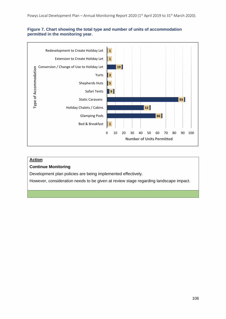
Powys Local Development Plan – Annual Monitoring Report 2020 (1st April 2019 to 31st March 2020).
106
Figure 7. Chart showing the total type and number of units of accommodation permitted in the monitoring year.
Action
Continue Monitoring
Development plan policies are being implemented effectively.
However, consideration needs to be given at review stage regarding landscape impact.
1
66
52
93
9
5
2
19
1
1
0 10 20 30 40 50 60 70 80 90 100
Bed & Breakfast
Glamping Pods
Holiday Chalets / Cabins
Static Caravans
Safari Tents
Shepherds Huts
Yurts
Conversion / Change of Use to Holiday Let
Extension to Create Holiday Let
Redevelopment to Create Hoilday Let
Number of Units Permitted
Typ
e o
f A
cco
mm
od
atio
n
Powys Local Development Plan – Annual Monitoring Report 2020 (1st April 2019 to 31st March 2020).
107
AMR38: Number of developments permitted for alternative use of existing tourism
development in rural areas.
Objective: Key Economic Sectors
Indicator: Number of developments permitted for alternative use of existing tourism development in rural areas.
Key Policies: Topic Based Policy TD2 – Alternative Uses of Existing Tourism Development
Related Policies:
Target: No developments permitted for change of use of existing tourism developments to alternative uses in rural areas, unless in accordance with Policy TD2.
Trigger Point: 1 or more developments permitted for alternative (non-tourism) use of existing tourism developments in rural areas not in accordance with Policy TD2 in any one year.
Outcome / actions, year on year:
LDP Adopted: 17/04/2018
AMR 2020 (2019-2020):
Action
Continue Monitoring
Development plan policies are being implemented effectively.
Analysis
This monitoring indicator looks at developments that change the use of an existing tourism facility to some other use. Existing tourist accommodation, facilities and attractions in Powys make an important contribution to the local tourism and business economies and the LDP seeks to avoid any significant loss of such facilities, in order to protect the economy of Powys which is heavily dependent on tourism.
During this monitoring period, one application was given consent that permitted a change of use from a tourism facility to another use. The application was for the conversion of part of a hotel to residential use. The building of concern was a listed building in a poor state of repair, following being on the market for two and a half years and failing to sell at auction. According to the applicants the repair bills to get the building watertight were not viable as a business proposition (to obtain funding from the bank). It is therefore considered that the proposal was granted in accordance with LDP Policy TD2.
Powys Local Development Plan – Annual Monitoring Report 2020 (1st April 2019 to 31st March 2020).
108
Objective 8 – Regeneration To support the regeneration and renewal of Powys’ built environment, its historic towns and employment premises and to support regeneration activities such as the Powys Local Growth Zone initiative. Objective 8 Local Indicators - Summary Table for Monitoring Review Period.
Ref No:
Indicator Assessment Action
AMR39 Employment development (ha) permitted and delivered within Powys Local Growth Zones.
This Local Indicator has been removed from the AMR due to the nature of the LGZ initiative and an absence of robust data.
Powys Local Development Plan – Annual Monitoring Report 2020 (1st April 2019 to 31st March 2020).
109
Theme 3 – Supporting Infrastructure and Services Objective 9 – Infrastructure and Services To support the provision of new infrastructure and services to meet the future needs of Powys’ communities. Objective 9 Local Indicators - Summary Table for Annual Monitoring Report Period.
Ref No:
Indicator Assessment Action
AMR40 Number of major developments permitted where new or improved infrastructure has been secured through developer contributions.
Continue Monitoring
AMR41 Preparation and adoption of Supplementary Planning Guidance relating to Planning Obligations.
SPG Adopted - No Action Required
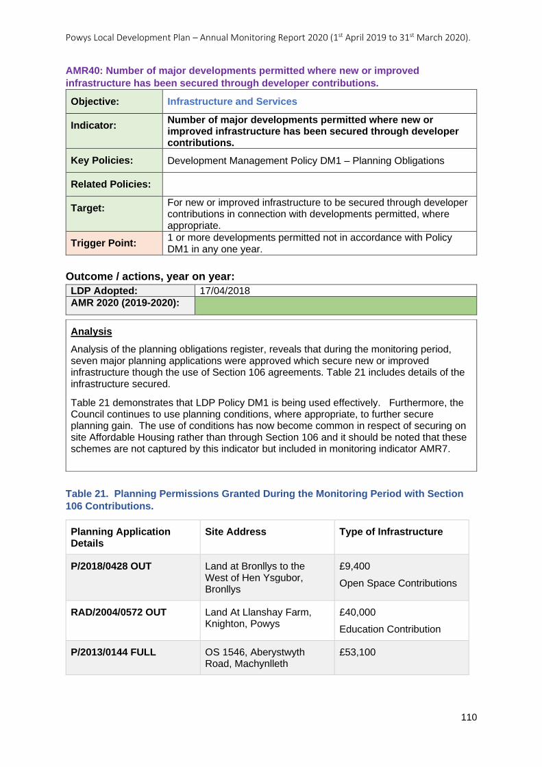
Powys Local Development Plan – Annual Monitoring Report 2020 (1st April 2019 to 31st March 2020).
110
AMR40: Number of major developments permitted where new or improved
infrastructure has been secured through developer contributions.
Objective: Infrastructure and Services
Indicator: Number of major developments permitted where new or improved infrastructure has been secured through developer contributions.
Key Policies: Development Management Policy DM1 – Planning Obligations
Related Policies:
Target: For new or improved infrastructure to be secured through developer contributions in connection with developments permitted, where appropriate.
Trigger Point: 1 or more developments permitted not in accordance with Policy DM1 in any one year.
Outcome / actions, year on year:
LDP Adopted: 17/04/2018
AMR 2020 (2019-2020):
Table 21. Planning Permissions Granted During the Monitoring Period with Section
106 Contributions.
Planning Application Details
Site Address Type of Infrastructure
P/2018/0428 OUT Land at Bronllys to the West of Hen Ysgubor, Bronllys
£9,400
Open Space Contributions
RAD/2004/0572 OUT Land At Llanshay Farm, Knighton, Powys
£40,000
Education Contribution
P/2013/0144 FULL OS 1546, Aberystwyth Road, Machynlleth
£53,100
Analysis
Analysis of the planning obligations register, reveals that during the monitoring period, seven major planning applications were approved which secure new or improved infrastructure though the use of Section 106 agreements. Table 21 includes details of the infrastructure secured.
Table 21 demonstrates that LDP Policy DM1 is being used effectively. Furthermore, the Council continues to use planning conditions, where appropriate, to further secure planning gain. The use of conditions has now become common in respect of securing on site Affordable Housing rather than through Section 106 and it should be noted that these schemes are not captured by this indicator but included in monitoring indicator AMR7.
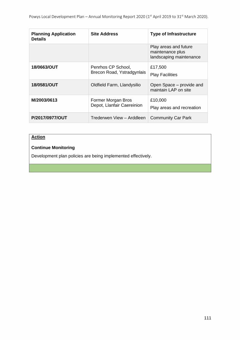
Powys Local Development Plan – Annual Monitoring Report 2020 (1st April 2019 to 31st March 2020).
111
Planning Application Details
Site Address Type of Infrastructure
Play areas and future maintenance plus landscaping maintenance
18/0663/OUT Penrhos CP School, Brecon Road, Ystradgynlais
£17,500
Play Facilities
18/0581/OUT Oldfield Farm, Llandysilio Open Space – provide and maintain LAP on site
M/2003/0613 Former Morgan Bros Depot, Llanfair Caereinion
£10,000
Play areas and recreation
P/2017/0977/OUT Trederwen View – Arddleen Community Car Park
Action
Continue Monitoring
Development plan policies are being implemented effectively.
Powys Local Development Plan – Annual Monitoring Report 2020 (1st April 2019 to 31st March 2020).
112
AMR41: Preparation and adoption of Supplementary Planning Guidance relating to
Planning Obligations.
Objective: Infrastructure and Services
Indicator: Preparation and adoption of Supplementary Planning Guidance relating to Planning Obligations.
Key Policies: Development Management Policy DM1 – Planning Obligations
Related Policies: Development Management Policy DM12 – Development in Welsh Speaking Strongholds
Development Management Policy DM13 – Design and Resources
Topic Based Policy H5 – Affordable Housing Contributions
Target: To prepare and adopt Supplementary Planning Guidance relating to Planning Obligations within 6 months of adoption of the LDP.
Trigger Point: Supplementary Planning Guidance relating to Planning Obligations not adopted within 6 months of adoption of the LDP
Outcome / actions, year on year:
LDP Adopted: 17/04/2018
AMR 2020 (2019-2020): SPG Adopted October 2018
Action
No further action required.
Analysis
The Planning Obligations SPG was adopted in October 2018 and therefore within the timescale of six months from the date of LDP adoption.
Powys Local Development Plan – Annual Monitoring Report 2020 (1st April 2019 to 31st March 2020).
113
Objective 10 – Important Assets To support the operation and development of locally, regionally and nationally important assets located in Powys.
Objective 10 Local Indicators - Summary Table for Annual Monitoring Report Period.
Ref No:
Indicator Assessment Action
AMR42 Developments permitted within the Sennybridge Training Area for operational purposes.
Continue Monitoring
AMR43 Number of developments permitted that would have an impact on strategic resources or assets, or their operation, as identified in Policy SP7.
Continue Monitoring
Powys Local Development Plan – Annual Monitoring Report 2020 (1st April 2019 to 31st March 2020).
114
AMR42: Developments permitted within the Sennybridge Training Area for operational
purposes.
Objective: Important Assets
Indicator: Developments permitted within the Sennybridge Training Area for operational purposes.
Key Policies: Strategic Policy SP7 – Safeguarding of Strategic Resources and Assets
Related Policies: Topic Based Policy MD1– Development Proposals by the MOD
Target: For the Sennybridge Training Area to continue as a nationally significant training facility and for its operation to be generally supported by the Plan.
Trigger Point: 1 or more developments proposed for operational reasons refused planning permission in any one year.
Outcome / actions, year on year:
LDP Adopted: 17/04/2018
AMR 2020 (2019-2020):
Action
Continue Monitoring
Development plan policies are being implemented effectively.
Analysis
This monitoring indicator aims to identify instances when the LDP fails to support the operational effectiveness of the Sennybridge military training area.
The training area is included within LDP Policy SP7 due to its strategic importance both in the County itself and nationally. The policy states that only development proposals that will not have an unacceptable impact on the asset/resource and the purposes for which it is safeguarded should be permitted. LDP Policy MD1 also safeguards the training area from any development that would compromise its operation and supports proposals that will sustain the operational use of the existing facility.
During the timeframe of this monitoring period no planning applications have been received for any proposals on land within the safeguarded area. Consequently, there has been no opportunity to test the LDP’s effectiveness in either supporting or refusing development that may be relevant to this indicator.

Powys Local Development Plan – Annual Monitoring Report 2020 (1st April 2019 to 31st March 2020).
115
AMR43: Number of developments permitted that would have an impact on strategic
resources or assets, or their operation, as identified in Policy SP7.
Objective: Important Assets
Indicator: Number of developments permitted that would have an impact on strategic resources or assets, or their operation, as identified in Policy SP7.
Key Policies: Strategic Policy SP7 – Safeguarding of Strategic Resources and Assets
Related Policies:
Target: No developments permitted that would have an unacceptable adverse impact on identified strategic resources and assets identified, or on their operation.
Trigger Point: 1 or more developments permitted that would have an unacceptable adverse impact on identified strategic resources or assets, or on their operation, not in accordance with Policy SP7, and, where applicable, there is an outstanding objection from a statutory consultee (i.e. NRW, CADW) or the relevant Council Officer in any one year.
Outcome / actions, year on year:
LDP Adopted: 17/04/2018
AMR 2020 (2019-2020):
Analysis
Further to the commentary and reasoning provided in the Monitoring Review regarding the usefulness of this monitoring indicator as currently worded, the analysis will focus on cases where a development has been:
1. Granted permission by the Planning Committee against an Officer’s recommendation for refusal on grounds of LDP Policy SP7,
2. Granted on Appeal where the Council had originally refused permission on grounds of LDP Policy SP7.
This approach is more suited to finding out which planning decisions might be found to have an “unacceptable adverse impact” as opposed to any impact. To identify the planning decisions which could fall into this category, the Minutes of every Planning Committee held over the monitoring period have been studied with a view to investigating cases which were decided against Officer recommendation. Appeal decisions upheld (against the Council’s original refusal) have also been investigated. Cases relevant to the LDP Policy SP7 monitoring indicator (AMR43) can then be assessed. The results are as follows:
No decisions have been made by the Planning Committee to approve a planning application against the officer’s recommendation for refusal. This means the trigger point has not been breached. However, from the committee proceedings there are two examples which help to demonstrate how well LDP Policy SP7 is performing:
In May, the Planning Committee determined an application for refusal on LDP Policy SP7 grounds (against Officer recommendation for approval). This decision was later upheld at Appeal. 19/0236/FUL – siting of three holiday lodges. The reasons for the Planning Committee’s refusal were:

Powys Local Development Plan – Annual Monitoring Report 2020 (1st April 2019 to 31st March 2020).
116
Action
Continue Monitoring
Development plan policies are being implemented effectively.
The proposed development would have an unacceptable impact upon the character and appearance of the landscape contrary Planning Policy Wales (10th Edition, 2018) and LDP policies SP7, DM4, DM13 and TD1 of the Powys Local Development Plan (2018).
In August, the Committee upheld the Officer recommendation to refuse 19/0407/FUL – overspill car park to shopping centre and boundary alterations. The refusal reasons were:
The proposed development would adversely harm the setting of Newtown Baptist Church including perimeter railings (Grade ll*) contrary to Policy SP7 of the Powys Local Development Plan (2018), Technical Advice Note 24 (2017), Planning Policy Wales (2018) and Section 66 of the Planning (Listed Buildings and Conservation areas) Act 1990.
The proposed development would fail to preserve or enhance the character and appearance of Newtown Conservation Area contrary to Policy SP7 of the Powys Local Development Plan (2018), Technical Advice Note 24 (2017), Planning Policy Wales (2018) Section 72 of the Planning (Listed Buildings and Conservation Areas) Act 1990.
In relation to Appeal decisions, during the monitoring period only one Appeal decision relating to LDP Policy SP7 grounds was upheld by the Inspector (overturning the Council’s refusal): P/2017/1048 – Erection of an affordable dwelling within a residential curtilage. The Inspector did not concur with the LPA’s assessment that the development would cause material harm to the character and appearance of the area and thereby conflict with policies SP7, DM4 or DM13 of the adopted LDP.
In analysing this case, it is considered that LDP Policy DM13 was in fact the most relevant policy here as concerns were centred on the effect on the immediate area (“a cramped layout and the ad hoc appearance of a new dwelling within the established area”), rather than the proposal’s effect on a Strategic Resource. Therefore, alongside the decision being outside of the powers of the Council, it is not considered that this case represents a breach of the monitoring indicator AMR43 trigger point.

Powys Local Development Plan – Annual Monitoring Report 2020 (1st April 2019 to 31st March 2020).
117
Theme 4 – Guardianship of Natural, Built and Historic Assets Objective 11 – Natural Heritage To conserve and protect Powys’ land, air and water resources important for environmental quality, geodiversity and biodiversity and where possible to ensure development enhances them. Objective 11 Local Indicators - Summary Table for Annual Monitoring Report Period.
Ref No:
Indicator Assessment Action
AMR44 Preparation and adoption of Supplementary Planning Guidance relating to biodiversity.
SPG Adopted - No Action Required
AMR45 The number of developments permitted on or affecting locally important site designations as identified in Policy DM2 (3).
Continue Monitoring
Powys Local Development Plan – Annual Monitoring Report 2020 (1st April 2019 to 31st March 2020).
118
AMR44: Preparation and adoption of Supplementary Planning Guidance relating to
biodiversity.
Objective: Natural Heritage
Indicator: Preparation and adoption of Supplementary Planning Guidance relating to biodiversity.
Key Policies: Strategic Policy SP7 – Safeguarding of Strategic Resources and Assets
Related Policies: Development Management Policy DM2 – The Natural Environment
Target: To prepare and adopt Supplementary Planning Guidance relating to biodiversity within 6 months of adoption of the LDP.
Trigger Point: Supplementary Planning Guidance relating to biodiversity not adopted within 6 months of adoption of the LDP.
Outcome / actions, year on year:
LDP Adopted: 17/04/2018
AMR 2020 (2019-2020): SPG Adopted October 2018
Action
No further action required.
Analysis
The Biodiversity SPG was adopted in October 2018 and therefore within the timescale of six months from the date of LDP adoption.
Powys Local Development Plan – Annual Monitoring Report 2020 (1st April 2019 to 31st March 2020).
119
AMR45: The number of developments permitted on or affecting locally important site
designations as identified in Policy DM2 (3).
Objective: Natural Heritage
Indicator: The number of developments permitted on or affecting locally important site designations as identified in Policy DM2 (3).
Key Policies: Management Policy DM2 – The Natural Environment
Related Policies:
Target: No developments permitted on or affecting identified locally important site designations unless in accordance with Policy DM2 (3).
Trigger Point: 1 or more developments permitted on or affecting identified locally important site designations not in accordance with Policy DM2 and where there is an outstanding objection from the County Ecologist or the Local Wildlife Trust.
Outcome / actions, year on year:
LDP Adopted: 17/04/2018
AMR 2020 (2019-2020):
Analysis
LDP Policy DM2 The Natural Environment provides protection for a range of sites, habitats and species that are designated at international, European, national and local level. This monitoring indicator aims to test the policy’s ability to protect the locally important site designations listed under section 3 of the policy, namely Local Nature Reserves (LNR), Regionally Important Geodiversity Sites (RIGS) and Geological Conservation Review Sites (GCRS). Within the county, and external to the Brecon Beacons National Park, there is one LNR (Lake Park, Llandrindod Wells), 74 RIGS and 53 GCRS.
Section 3 of the policy also includes local Biodiversity Action Plan Habitats and Species, but these are not included under this monitoring indicator as they are not classified as a site designation. These however are the subject of indicator no.2 within the Strategic Environmental Assessment (SEA) monitoring framework.
In this monitoring period a total of seven individual applications have been permitted, which were close to a local designation. One of them was close to Llandrindod Lake LNR but this was recognised in the consultation responses and the Officer report. Six however, upon closer analysis did not appear to recognise the proximity of the local geological designations to the proposal site. Three were close to a RIGS and three were close to a GCRS. However, in all of these cases they were relatively minor applications (e.g. involving householder extensions, installing a biomass boiler etc) that would not have any negative impact on the nearby site. Whilst none of these applications mentioned the proximity of the RIGS or GCRS, the Officer reports for two of the planning applications, both close to a GCRS, did refer to the presence of an SSSI within which the GCRS is located.
None of the six applications involved received any objections from the County Council Ecologist or the Wildlife Trust.
Powys Local Development Plan – Annual Monitoring Report 2020 (1st April 2019 to 31st March 2020).
120
Action
Continue Monitoring
Development plan policies are being implemented effectively.
However, officers should be reminded to take account of and acknowledge the proximity of locally designated sites to development proposals.
In order to strengthen Development Management understanding and application of LDP Policy DM2 it is recommended that further Officer training is required to ensure that this part of the policy is being considered in the determination of future applications.
NB this indicator is similar to SEA Indicator 34.
Powys Local Development Plan – Annual Monitoring Report 2020 (1st April 2019 to 31st March 2020).
121
Objective 12 – Resources To facilitate the sustainable management of Powys’ natural and environmental resources whilst enabling development to take place including the provision of at least a 25 year land bank of crushed rock aggregates. Objective 12 Local Indicators - Summary Table for Annual Monitoring Report Period.
Ref No:
Indicator Assessment Action
AMR46 Extent of primary land – won aggregates permitted in accordance with the Regional Technical Statement for Aggregates expressed as a percentage of the total capacity required as identified in the Regional Technical Statement (MTAN requirement).
Continue Monitoring
AMR47 Number of developments permitted within the defined mineral working buffer zones.
Continue Monitoring
Powys Local Development Plan – Annual Monitoring Report 2020 (1st April 2019 to 31st March 2020).
122
AMR46: Extent of primary land – won aggregates permitted in accordance with the
Regional Technical Statement for Aggregates expressed as a percentage of the total
capacity required as identified in the Regional Technical Statement (MTAN
requirement).
Objective: Resources
Indicator: Extent of primary land – won aggregates permitted in accordance with the Regional Technical Statement for Aggregates expressed as a percentage of the total capacity required as identified in the Regional Technical Statement (MTAN requirement).
Key Policies: Topic Based Policy M1– Existing Minerals Sites
Related Policies: Topic Based Policy M2– New Minerals Sites
Target: Percentage of crushed rock aggregates compared against the annual target for the LDP area identified in the Regional Technical Statement.
Trigger Point: Less than a 25 year land bank of permitted aggregate reserves in any one year.
Outcome / actions, year on year:
LDP Adopted: 17/04/2018
AMR 2020 (2019-2020):
Action
Continue Monitoring
Development plan policies are being implemented effectively.
Analysis
This indicator aims to monitor the performance of LDP policies M1 - Existing Minerals Sites, and M2 - New Minerals Sites, with regards to their ability to maintain a supply of aggregates when compared to the MTAN requirement as expressed in the Regional Technical Statement for Aggregates (RTSA) (1st Review, 2014).
Table 5.1 on page 52 of the RTSA states that for Powys there is no apportionment of land-won sand and gravel and a total apportionment of 62.75 million tonnes of crushed rock aggregates over a 25 year period. When this is expressed as an annual apportionment it equates to 2.51million tonnes per annum.
During the monitoring period there were no applications permitted for the working of primary won aggregates. This means that there have been no new permissions granted that could impact on the aggregate reserve identified in the RTSA.
Powys Local Development Plan – Annual Monitoring Report 2020 (1st April 2019 to 31st March 2020).
123
AMR47: Number of developments permitted within the defined mineral working buffer
zones.
Objective: Resources
Indicator: Number of developments permitted within the defined mineral working buffer zones.
Key Policies: Development Management Policy DM9 – Existing Mineral Workings
Related Policies:
Target: No development is permitted within the defined mineral working buffer zones, unless in accordance with the criteria set out under Policy DM9.
Trigger Point: 1 or more developments permitted within the defined mineral working buffer zones not in accordance with Policy DM9 in any one year.
Outcome / actions, year on year:
LDP Adopted: 17/04/2018
AMR 2020 (2019-2020):
Action
Continue Monitoring - Development plan policies are being implemented effectively.
Analysis
This indicator aims to monitor the effectiveness of LDP Policy DM9 – Existing Mineral Workings, and its ability to protect existing mineral working buffer zones from development that constrain the operations of the mineral site.
The policy includes the criteria under which development may be allowed and these are:
The proposal would not constrain the operations of the mineral site;
1. The proposal would not be unacceptably affected by the mineral extraction operations at the site; and
2. The proposal can demonstrate the appropriate mitigation measures.
Two planning applications were permitted which were located within a mineral working buffer zone. One of the applications was for an agricultural building, however a trunk road separates the proposed location of the agricultural building and the minerals site. It is therefore considered that the proposal will not constrain the operations of the mineral site and would not be unacceptably affected by mineral extraction operations.
The second application was for an extension to an existing bed and breakfast to create a self- contained holiday let. The location of the bed and breakfast is alongside three dwellings. The application site is located right on the very edge of the minerals permitted working area buffer which extends into an area of residential use. Due to the existing use, it is not considered that the proposal would cause any further constraints to the operations of the mineral site and will not be unacceptable affected by any mineral extraction operations.
Powys Local Development Plan – Annual Monitoring Report 2020 (1st April 2019 to 31st March 2020).
124
Objective 13 – Landscape and the Historic Environment
i. Landscape To protect, preserve and/or enhance the distinctive landscapes of Powys and adjoining areas, including protected landscapes.
ii. The Historic Environment To protect, preserve and/or enhance the distinctive historic environment, heritage and cultural assets of Powys, in particular local assets that are not statutorily protected or designated under national legislation, and to ensure that development respects local distinctiveness.
Objective 13 Local Indicators - Summary Table for Annual Monitoring Report Period.
Ref No:
Indicator Assessment Action
AMR48 Preparation and adoption of Supplementary Planning Guidance relating to Archaeology.
N/A in this monitoring period
AMR49 Preparation and adoption of Supplementary Planning Guidance relating to Landscapes.
SPG Adopted - No Action Required
AMR50 Preparation and adoption of Supplementary Planning Guidance relating to Residential Design.
SPG Adopted - No Action Required
AMR51 Preparation and adoption of Supplementary Planning Guidance relating to Historic Environment including the Historic Environment Records.
N/A in this monitoring period
AMR52 Preparation and adoption of Supplementary Planning Guidance relating to Conservation Areas.
SPG Adopted - No Action Required
AMR53 The number of wind energy and major developments permitted and accompanied by a Landscape and Visual Impact Assessment.
Continue Monitoring
AMR54 The number of developments permitted within or affecting the setting of a Conservation Area.
Continue Monitoring
Powys Local Development Plan – Annual Monitoring Report 2020 (1st April 2019 to 31st March 2020).
125
AMR48: Preparation and adoption of Supplementary Planning Guidance relating to
Archaeology.
Objective: Landscape and the Historic Environment
Indicator: Preparation and adoption of Supplementary Planning Guidance relating to Archaeology.
Key Policies: Strategic Policy SP7 – Safeguarding of Strategic Resources and Assets
Related Policies:
Target: To prepare and adopt Supplementary Planning Guidance relating to Archaeology within 24 months of adoption of the LDP.
Trigger Point: Supplementary Planning Guidance relating to Archaeology not adopted within 24 months of adoption of the LDP.
Outcome / actions, year on year:
LDP Adopted: 17/04/2018
AMR 2020 (2019-2020):
Action
N/A
Analysis
This SPG is scheduled for adoption by 17th April 2020 therefore the monitoring indicator falls outside the scope of this Annual Monitoring Report.
Powys Local Development Plan – Annual Monitoring Report 2020 (1st April 2019 to 31st March 2020).
126
AMR49: Preparation and adoption of Supplementary Planning Guidance relating to
Landscapes
Objective: Landscape and the Historic Environment
Indicator: Preparation and adoption of Supplementary Planning Guidance relating to Landscapes
Key Policies: Development Management Policy DM4 – Landscape
Related Policies: Strategic Policy SP7 – Safeguarding of Strategic Resources and Assets
Target: To prepare and adopt Supplementary Planning Guidance relating to Landscapes within 12 months of adoption of the LDP.
Trigger Point: Supplementary Planning Guidance relating to Landscapes not adopted within 12 months of adoption of the LDP.
Outcome / actions, year on year:
LDP Adopted: 17/04/2018
AMR 2020 (2019-2020): Adopted April 2019
Action
No further action required.
Analysis
The Landscape SPG was adopted in April 2019 and therefore within the timescale of 12 months from the date of LDP adoption.
Powys Local Development Plan – Annual Monitoring Report 2020 (1st April 2019 to 31st March 2020).
127
AMR50: Preparation and adoption of Supplementary Planning Guidance relating to
Residential Design
Objective: Landscape and the Historic Environment
Indicator: Preparation and adoption of Supplementary Planning Guidance relating to Residential Design
Key Policies: Development Management Policy DM13 – Design and Resources
Related Policies:
Target: To prepare and adopt Supplementary Planning Guidance relating to Residential Design within 18 months of adoption of the LDP.
Trigger Point: Supplementary Planning Guidance relating to Residential Design not adopted within 18 months of adoption of the LDP.
Outcome / actions, year on year:
LDP Adopted: 17/04/2018
AMR 2020 (2019-2020): Adopted January 2020
Action
No further action required.
Analysis
The Residential Design Guide SPG was adopted in January 2020 and therefore within the timescale of 18 months from the date of LDP adoption.
Powys Local Development Plan – Annual Monitoring Report 2020 (1st April 2019 to 31st March 2020).
128
AMR51: Preparation and adoption of Supplementary Planning Guidance relating to
Historic Environment including the Historic Environment Records.
Objective: Landscape and the Historic Environment
Indicator: Preparation and adoption of Supplementary Planning Guidance relating to Historic Environment including the Historic Environment Records.
Key Policies: Strategic Policy SP7 – Safeguarding of Strategic Resources and Assets
Related Policies:
Target: To prepare and adopt Supplementary Planning Guidance relating to Historic Environment including the Historic Environment Records within 24 months of adoption of the LDP.
Trigger Point: Supplementary Planning Guidance relating to Historic Environment including the Historic Environment Records not adopted within 24 months of adoption of the LDP.
Outcome / actions, year on year:
LDP Adopted: 17/04/2018
AMR 2020 (2019-2020):
Action
N/A
Analysis
This SPG is scheduled for adoption by 17th April 2020 therefore the monitoring indicator falls outside the scope of this Annual Monitoring Report.
Powys Local Development Plan – Annual Monitoring Report 2020 (1st April 2019 to 31st March 2020).
129
AMR52: Preparation and adoption of Supplementary Planning Guidance relating to
Conservation Areas.
Objective: Landscape and the Historic Environment
Indicator: Preparation and adoption of Supplementary Planning Guidance relating to Conservation Areas.
Key Policies: Strategic Policy SP7 – Safeguarding of Strategic Resources and Assets
Related Policies: Development Management Policy DM13 – Design and Resources
Target: To prepare and adopt Supplementary Planning Guidance relating to Conservation Areas within 18 months of adoption of the LDP.
Trigger Point: Supplementary Planning Guidance relating to Conservation Areas not adopted within 18 months of adoption of the LDP.
Outcome / actions, year on year:
LDP Adopted: 17/04/2018
AMR 2020 (2019-2020): Adopted January 2020
Action
No further action required.
Analysis
The Conservation Areas SPG was adopted in January 2020 and therefore within the timescale of 18 months from the date of LDP adoption.
Powys Local Development Plan – Annual Monitoring Report 2020 (1st April 2019 to 31st March 2020).
130
AMR53: The number of wind energy and major developments permitted and
accompanied by a Landscape and Visual Impact Assessment.
Objective: Landscape and the Historic Environment
Indicator: The number of wind energy and major developments permitted and accompanied by a Landscape and Visual Impact Assessment.
Key Policies: Development Management Policy DM4 – Landscape
Related Policies:
Target: No developments permitted that could have a significant landscape or visual impact, unless accompanied by a Landscape and Visual Impact Assessment.
Trigger Point: 1 or more developments permitted that could have a significant landscape or visual impact permitted without an accompanying Landscape and Visual Impact Assessment.
Outcome / actions, year on year:
LDP Adopted: 17/04/2018
AMR 2020 (2019-2020):
Analysis
This monitoring indicator aims to test the implementation of LDP Policy DM4 – Landscape which seeks to prevent development from having an unacceptable adverse effect, on the valued characteristics and qualities of the Powys landscape. The Policy requires proposals which are likely to have a significant impact on the landscape and/or visual amenity to undertake a Landscape and Visual Impact Assessment (LVIA). This is elaborated upon in paragraph 4.2.33 of the LDP Written Statement: “Proposals which could have a significant impact on the landscape and/or visual amenity will require a landscape and visual Impact assessment to be undertaken in accordance with relevant guidance. This will include all wind energy proposals (excluding anemometry masts) and most major developments…”
During the monitoring period (1st April 2019 to 31st March 2020), 24 applications were permitted that fit the description of either being a “wind energy proposal “or a “major development” in the Open Countryside. From the 24 there were three applications that submitted the planning application prior to the adoption of the LDP. It would have been unreasonable to expect additional information to be submitted, for the three applications, unless landscape concerns were raised by the Planning Officer or the statutory consultees.
The submitted information, demonstrating how landscape was taken into consideration for the remaining 21 applications, is summarised in Table 22.
During the monitoring period judicial review was sought, challenging the LPA’s decision to grant consent for a major planning application in the Open Countryside, without an LVIA being submitted with the application (listed among several reasons).
The judge stated the following in the letter detailing the outcome of the judicial review:
“Neither policy DM4 nor the guidance (referring to the SPG) referred to made a formal Visual Impact Assessment mandatory. Whether one should be required in the particular case was a matter for the officers and/or committee members, and given their own assessment, made with the assistance of a site visit, that there would be no significant
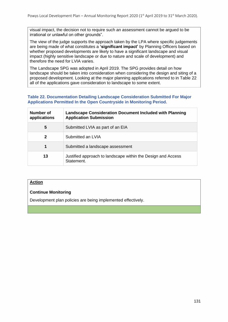
Powys Local Development Plan – Annual Monitoring Report 2020 (1st April 2019 to 31st March 2020).
131
Table 22. Documentation Detailing Landscape Consideration Submitted For Major
Applications Permitted In the Open Countryside in Monitoring Period.
Number of applications
Landscape Consideration Document Included with Planning Application Submission
5 Submitted LVIA as part of an EIA
2 Submitted an LVIA
1 Submitted a landscape assessment
13 Justified approach to landscape within the Design and Access Statement.
Action
Continue Monitoring
Development plan policies are being implemented effectively.
visual impact, the decision not to require such an assessment cannot be argued to be irrational or unlawful on other grounds”.
The view of the judge supports the approach taken by the LPA where specific judgements are being made of what constitutes a ‘significant impact’ by Planning Officers based on whether proposed developments are likely to have a significant landscape and visual impact (highly sensitive landscape or due to nature and scale of development) and therefore the need for LVIA varies.
The Landscape SPG was adopted in April 2019. The SPG provides detail on how landscape should be taken into consideration when considering the design and siting of a proposed development. Looking at the major planning applications referred to in Table 22 all of the applications gave consideration to landscape to some extent.
Powys Local Development Plan – Annual Monitoring Report 2020 (1st April 2019 to 31st March 2020).
132
AMR54: The number of developments permitted within or affecting the setting of a
Conservation Area
Objective: Landscape and the Historic Environment
Indicator: The number of developments permitted within or affecting the setting of a Conservation Area
Key Policies: Development Management Policy DM13 – Design and Resources
Related Policies:
Target: No developments to be permitted in or affecting a Conservation Area, unless in accordance with Policy DM13 or national guidance.
Trigger Point: 1 or more developments permitted in or affecting a Conservation Area not in accordance with Policy DM13 or national guidance and where there is an outstanding objection from the Council’s Built Heritage Officer.
Outcome / actions, year on year:
LDP Adopted: 17/04/2018
AMR 2020 (2019-2020):
Analysis
This monitoring indicator looks at developments that have been permitted which are either located in or affect the setting of a Conservation Area. The purpose of the indicator is to test the implementation of LDP policies DM13 (3) and SP7 (2 v.) and, in particular, to capture instances where development is permitted where there is an outstanding objection from the Council’s Built Heritage Conservation Officer (BHCO) and where it does not comply with these policies.
Fifty-four permissions have been recorded involving development within or affecting the setting of a Conservation Area, two of which relate to Conservation Area Consent. Of these applications, only two developments have been permitted where there was an outstanding objection from the Council’s Built Heritage Conservation Officer.
The first development involved the installation of an ATM cash machine within a shop front of a listed building located adjacent to the clock tower in the Conservation Area of Machynlleth. The Built Heritage Conservation Officer objected on the grounds that the proposal would adversely affect the external view of this listed shop in a prominent location within the Conservation Area and would fail to preserve or enhance the character or appearance of the Conservation Area. The BHCO recommended consideration of alternative shops or business in the town, or a free-standing ATM. However, the Planning Officer considered the location to be justified and that the economic benefits of the proposal outweighed the impact to heritage assets. A condition would also be attached requiring the ATM to be removed when no longer required and associated restoration. The Planning Officer, therefore, applied a balanced judgement to the proposed development and concluded that the principle of development was acceptable in this instance.
The second development involved the variation of a condition attached to an outline planning permission for a new dwelling within the New Radnor Conservation Area in order to extend the time limit for submission of reserved matters. The BHCO objected to the indicative chalet type design of the proposed dwelling, however the Planning Officer noted that matters of appearance, layout and scale were reserved, and therefore suggested that careful consideration of the proposed design would be needed at reserved matters stage.
Powys Local Development Plan – Annual Monitoring Report 2020 (1st April 2019 to 31st March 2020).
133
Action
Continue Monitoring
Development plan policies are being implemented effectively.
There are also several examples of applications that have been approved following submission of amended plans that have addressed the initial concerns of the BHCO.
The results of this monitoring indicate that developments permitted in or adjacent to Conservation Areas are largely in accordance with LDP Policy DM13. Deviation from the policy has only occurred once, where the need for the development was judged to override the impact on the character and appearance of the Conservation Area. It should be noted that the Conservation Areas SPG (adopted in January 2020) provides guidance aimed at ensuring a consistent approach towards assessing character and designing appropriate developments in and adjacent to Conservation Areas.
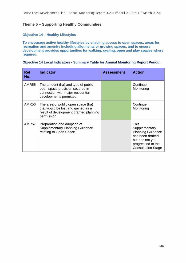
Powys Local Development Plan – Annual Monitoring Report 2020 (1st April 2019 to 31st March 2020).
134
Theme 5 – Supporting Healthy Communities
Objective 14 – Healthy Lifestyles To encourage active healthy lifestyles by enabling access to open spaces, areas for recreation and amenity including allotments or growing spaces, and to ensure development provides opportunities for walking, cycling, open and play spaces where required. Objective 14 Local Indicators - Summary Table for Annual Monitoring Report Period.
Ref No:
Indicator Assessment Action
AMR55 The amount (ha) and type of public open space provision secured in connection with major residential developments permitted.
Continue Monitoring
AMR56 The area of public open space (ha) that would be lost and gained as a result of development granted planning permission.
Continue Monitoring
AMR57 Preparation and adoption of Supplementary Planning Guidance relating to Open Space
This Supplementary Planning Guidance has been drafted but has not yet progressed to the Consultation Stage
Powys Local Development Plan – Annual Monitoring Report 2020 (1st April 2019 to 31st March 2020).
135
AMR55: The amount (ha) and type of public open space provision secured in
connection with major residential developments permitted.
Objective: Healthy Lifestyles
Indicator: The amount (ha) and type of public open space provision secured in connection with major residential developments permitted.
Key Policies: Development Management Policy DM3 – Public Open Space
Related Policies:
Target: That major residential developments contribute towards addressing the open space deficiencies identified in the Open Space Assessment in terms of the amount and type of public open space provided.
Trigger Point: 1 or more major residential developments permitted where no amount of provision is secured for public open space where deficiencies have been identified by the Open Space Assessment in any one year. 1 or more major residential developments permitted where the type of public open space secured is not of the type required by the Open Space Assessment in any one year.
Outcome / actions, year on year:
LDP Adopted: 17/04/2018
AMR 2020 (2019-2020):
Analysis
This monitoring indicator looks at the amount (ha) and type of public open space provision secured in connection with all major residential developments permitted. The purpose of the indicator is to test the implementation of LDP Policy DM3, whereby the nature of open space provision secured should be guided by deficiencies in the published Open Space Assessment (2018).
Planning permission was granted for eleven major residential developments during the period. Eight of the residential developments, included a local area of play within the development site. In all of the eight circumstances this provision of open space was considered appropriate, because the sites did not fall within the accessibility buffers of any other children’s play area.
One of the applications made provision for car parking for people to access nearby community facilities (including public open space) instead. This is considered an enhancement to the existing facilities. Whilst a further application made a financial contribution towards existing provision within the settlement.
The one application that made no provision for open space was a Housing Association site. Where development is not seeking to provide a contribution towards open space provision (on viability grounds) there needs to be strong justification.
The provision of open space has focussed on local areas of play. This may not always be the direct result of deficiencies identified in the Open Space Assessment. However, it needs to be recognised that the provision of other forms of open space maybe restricted
Powys Local Development Plan – Annual Monitoring Report 2020 (1st April 2019 to 31st March 2020).
136
Action
Continue Monitoring
Development plan policies are being implemented effectively.
by the size of the area of land available, viability and the intended users arising from the proposed development.
It is considered that overall, development proposals for major residential developments are in accordance with LDP Policy DM3. Within the monitoring period, applications have been permitted that will result in local of areas of play being created in areas where the open space assessment has identified a deficit (accessibility standards), or provision will be made towards the enhancement of nearby existing facilities.
Powys Local Development Plan – Annual Monitoring Report 2020 (1st April 2019 to 31st March 2020).
137
AMR56: The area of public open space (ha) that would be lost and gained as a result
of development granted planning permission.
Objective: Healthy Lifestyles
Indicator: The area of public open space (ha) that would be lost and gained as a result of development granted planning permission.
Key Policies: Development Management Policy DM3 – Public Open Space
Related Policies:
Target: Net gain of public open space as a result of development granted planning permission. No net loss of public open space identified or as defined in the Open Space Assessment as a result of development granted planning permission.
Trigger Point: No net gain of public open space as a result of development granted planning permission in any one year. A net loss of public open space identified or as defined in the Open Space Assessment as a result of development granted planning permission in any one year.
Outcome / actions, year on year:
LDP Adopted: 17/04/2018
AMR 2020 (2019-2020):
Analysis
This monitoring indicator looks at the amount (ha) of open space lost and gained as a result of planning applications granted during the monitoring period (1st April 2019 to 31st March 2020). The purpose of the indicator is to test the implementation of LDP Policy DM3 where areas identified as open space in the Open Space Assessment are protected and where housing developments of ten more contribute towards the provision of open space.
Net gain of public open space
It has not been possible to record the amount of open space granted due to the fact that the majority of open space provision secured has been done via a planning or Section 106 condition. The condition requires the details (location, size maintenance etc...) of the provision to be submitted at a later date. This was the case for seven of the nine applications where new open space provision has been secured. For the remaining two applications a total of 3,272 square metres of open space was secured through planning condition / Section 106 agreement.
Within the period two applications were permitted for improvements to existing areas of open space; one for the erection of two spectators stands (in association with existing football pitches) whilst the second was also for the upgrading of facilities associated with a football club.
Three planning applications were granted during the period for new open spaces. One was for a new local equipped area of play (LEAP) which was provided to create alternative provision to the existing play area which secured planning permission for housing, this resulted in a net increase of 470 square metres between the two sites. One was for a
Powys Local Development Plan – Annual Monitoring Report 2020 (1st April 2019 to 31st March 2020).
138
Action
Continue Monitoring
Development plan policies are being implemented effectively.
woodland mountain bike trail and one was the for new tennis courts / sports area. The latter two applications are not in the Towns or Large Villages so will not appear in the Open Space Assessment but still provide an additional 5,740 square metres of open space provision to the plan area.
Net loss of public open space
There have been several planning applications permitted on open spaces, mapped in the Open Space Assessment, that can be considered as ancillary / enhancing the existing open spaces. This includes facilities for spectators, clubhouses, multi-purpose running tracks, bike tracks, sensory gardens and paddle sport / cycle hire facilities none are considered as a change of use or result in a loss of open space.
No planning applications were permitted during the period that resulted in a net loss of open space.
Powys Local Development Plan – Annual Monitoring Report 2020 (1st April 2019 to 31st March 2020).
139
AMR57: Preparation and adoption of Supplementary Planning Guidance relating to
Open Space.
Objective: Healthy Lifestyles
Indicator: Preparation and adoption of Supplementary Planning Guidance relating to Open Space.
Key Policies: Development Management Policy DM3 – Public Open Space
Related Policies:
Target: To prepare and adopt Supplementary Planning Guidance on relating to Open Space within 18 months of adoption of the LDP.
Trigger Point: Supplementary Planning Guidance relating to Open Space not adopted within 18 months of adoption of the LDP.
Outcome / actions, year on year:
LDP Adopted: 17/04/2018
AMR 2020 (2019-2020):
Action
Whilst the Open Space SPG has not progressed beyond drafting stage, the published Open Space Assessment (2018) provides an effective mechanism to test development proposals and their loss or provision of Open Space. The Planning Obligations SPG also includes guidance for Open Space provision, so the non-publication of the Open Space SPG is not considered to be a detriment.
Analysis
This Supplementary Planning Guidance has been drafted. The SPG Programme scheduled the Open Space SPG for adoption by October 2019.
Powys Local Development Plan – Annual Monitoring Report 2020 (1st April 2019 to 31st March 2020).
140
Objective 15 – Welsh Language and Culture To support and protect Welsh language and culture in Powys and specifically the Welsh Speaking Strongholds of the north-west and south-west.
Objective 15 Local Indicators - Summary Table for Annual Monitoring Report Period.
Ref No:
Indicator Assessment Action
AMR58 The number of major housing developments permitted within or forming logical extensions to the Towns and Large Villages identified within Policy DM12 (in Welsh Speaking Strongholds) accompanied by a Language Action Plan setting out mitigation measures to protect, promote and enhance the Welsh language and Culture.
Continue Monitoring
Powys Local Development Plan – Annual Monitoring Report 2020 (1st April 2019 to 31st March 2020).
141
AMR58: The number of major housing developments permitted within or forming
logical extensions to the Towns and Large Villages identified within Policy DM12 (in
Welsh Speaking Strongholds) accompanied by a Language Action Plan setting out
mitigation measures to protect, promote and enhance the Welsh language and
Culture.
Objective: Welsh Language and Culture
Indicator: The number of major housing developments permitted within or forming logical extensions to the Towns and Large Villages identified within Policy DM12 (in Welsh Speaking Strongholds) accompanied by a Language Action Plan setting out mitigation measures to protect, promote and enhance the Welsh language and Culture.
Key Policies: Development Management Policy DM12 – Development in Welsh Speaking Strongholds
Related Policies:
Target: For all major housing developments within or forming logical extensions to the Towns and Large Villages identified to be accompanied by a Language Action Plan which includes mitigation measures to protect, promote and enhance Welsh language and Culture.
Trigger Point: 1 or more major housing developments permitted within or forming logical extensions to the Towns and Large Villages identified, without a Language Action Plan setting out mitigation measures to protect, promote and enhance the Welsh language and Culture in any one year
Outcome / actions, year on year:
LDP Adopted: 17/04/2018
AMR 2020 (2019-2020):
Analysis
This monitoring indicator tests the implementation of LDP Policy DM12, which applies to major windfall development within Welsh Speaking Strongholds. Three such developments were granted planning permission during this monitoring period.
The first development related to a development of 41 dwellings on an LDP housing allocation (P58 HA3) in Ystradgynlais. The second development, also located in Ystradgynlais, for 23 dwellings, related to part of an LDP housing allocation (P58 HA1). Officers considered the principle of development was considered to comply with relevant planning policy. Both developments involved housing allocations, rather than windfall developments, and therefore the requirements of LDP Policy DM12 do not apply in these instances.
The third development, relating to an LDP housing allocation (P42 HA1) in Machynlleth, was granted planning permission following the signing of a Section 106 agreement. Given not only the allocated status of the site, but also that it had been resolved to grant planning permission prior to adoption of the LDP, the requirements of LDP Policy DM12 did not apply to this development either.
This monitoring has not captured any developments where LDP Policy DM12 applies. The implementation of this policy will continue to be monitored.

Powys Local Development Plan – Annual Monitoring Report 2020 (1st April 2019 to 31st March 2020).
142
Action
Continue Monitoring
Development plan policies are being implemented effectively.
Powys Local Development Plan – Annual Monitoring Report 2020 (1st April 2019 to 31st March 2020).
143
Objective 16 – Community Well-being To promote development that supports community wellbeing and cohesion, especially in communities suffering from multiple deprivation and social exclusion. Objective 16 Local Indicators - Summary Table for Annual Monitoring Report Period.
Ref No:
Indicator Assessment Action
AMR59 Number of developments permitted resulting in the loss of an existing community or indoor recreation facility, or neighbourhood/village shop, public house or service.
Continue Monitoring
Powys Local Development Plan – Annual Monitoring Report 2020 (1st April 2019 to 31st March 2020).
144
AMR59: Number of developments permitted resulting in the loss of an existing
community or indoor recreation facility, or neighbourhood/village shop, public house
or service.
Objective: Community Well-being
Indicator: Number of developments permitted resulting in the loss of an existing community or indoor recreation facility, or neighbourhood/village shop, public house or service.
Key Policies: Development Management Policy DM11 – Protection of Existing Community Facilities and Services
Related Policies:
Target: No developments permitted that result in the loss of an existing community or indoor recreation facility, or neighbourhood/village shop, public house or service, unless in accordance with Policy DM11.
Trigger Point: 1 or more developments permitted resulting in the loss of an existing community or indoor recreation facility, or neighbourhood/village shop, public house or service not in accordance with Policy DM11 in any one year.
Outcome / actions, year on year:
LDP Adopted: 17/04/2018
AMR 2020 (2019-2020):
Analysis
LDP Policy DM11 seeks to protect community facilities and services unless an alternative use can be justified in accordance with the policy. This policy indicator monitors the number of planning permissions given for a change of use involving loss of an existing community facility or service, in order to test the implementation of LDP Policy DM11.
During this monitoring period, 10 developments of this type have been permitted, seven of which involved change of use or redevelopment to residential use, two involved change of use to alternative economic uses, and one involved change of use of shop to a mixed used of retail and office space. These developments have resulted in the loss of a range of facilities and services, including a public house, a chapel, a dental surgery, a library, former schools and part of a retail unit.
LDP Policy DM11 is being applied and considered by Officers, where relevant to a specific proposal. Applications have also been supported by evidence relating to viability, marketing and alternative provision, in order to demonstrate compliance with the criteria set out in LDP Policy DM11.
Two developments involved new dwellings on the car parks of former community services, namely a former public house and former medical practice. On both occasions, permission had already been granted for the change of use of the community service itself, and therefore the loss of the service had already been accepted at that time and the car parks were redundant, which explains why LDP Policy DM11 was not considered relevant in these cases.
With regards to a development involving mixed use of a shop for retail and office, this solution was considered acceptable by Officers in that it would ensure the viability of the shop, whilst enabling the applicant’s business to operate from the premises and expand in the future into retail. It was also noted that the post office that formerly occupied this
Powys Local Development Plan – Annual Monitoring Report 2020 (1st April 2019 to 31st March 2020).
145
Action
Continue Monitoring
Development plan policies are being implemented effectively.
space had already been incorporated into another retail unit in the village, and therefore would not result in the loss of this community service from the village.
There are occasions where Officers have also used other LDP policies, such as LDP policies R3, T1 and H1, and guidance within TAN 23, to assess proposals. For example, a development that involved change of use of a basement wine bar in the centre of Llandrindod Wells was assessed against LDP Policy R3 and was noted as not being within a Primary Shopping Frontage, and therefore residential use was considered acceptable. The location of this proposal within the centre of a Town, rather than within a local neighbourhood or village, may explain why LDP Policy DM11 may not have been used in this instance.
In terms of the distribution of the developments permitted across the settlement tier, the majority were located in Towns (six), with three permitted in Large Villages and one permitted in Open Countryside. Therefore, most of these developments have come forward in the most sustainable locations, according to the LDP. The case in the Open Countryside, involved a former school, that had been closed for a number of years and its location was not considered suitable for alternative community uses.
The redevelopment of the site of a former school at Ystradgynlais was considered acceptable, in principle, as the site had been allocated for housing development by the LDP, which explains why LDP Policy DM11 was not considered relevant to that case.
The results of this monitoring show that LDP Policy DM11 is being implemented as intended and where appropriate. Whilst there are cases where LDP Policy DM11 has not been used to assess proposals, there are explanations for this, and the objectives of this policy to protect community facilities and services, where possible, have not been undermined as a result.
No further action is required at this stage. The implementation of this policy will continue to be monitored.
Powys Local Development Plan – Annual Monitoring Report 2020 - 1st April 2019 to 31st March 2020
146
4. Results of SA indicators
4.0.1 Relating to the SA Report and integrated assessment.
Results for Monitoring period 1st April 2019 to 31st March 2020
4.0.2 Local Development Plans should help deliver sustainable development. To ensure that this is the case, it is a legal requirement that the
sustainability of the LDP is tested as the plan is prepared. Part of this process is referred to as the Strategic Environmental Assessment (SEA).
The SEA for the Powys LDP is accompanied by a monitoring framework which includes 34 SEA indicators used to test the sustainability
performance of the Plan.
4.0.3 This section details these SEA indicators along with an analysis of the results for each indicator. External influences which are outside
the control of the Authority are also identified. The triggers included in the monitoring regime provide an early indication on the sustainability
performance of the LDP and possibly how wide ranging the review of the LDP needs to be.
4.0.4 The monitoring process is dependent upon a wide range of statistical information that is sourced from both local authority and external
sources. Whilst the council can control information that it supplies, there is a significant risk of change in respect of external data as that
information is out of the control of the local planning authority. For consistency across the lifetime of the Plan the sources have, where
necessary, been identified for each SEA indicator. However, if these sources change over time, then it will be necessary to substitute them for
other data sources that provide as high a degree of equivalence with the previous source as possible.
4.0.5 It is also important to recognise that a number of data sources are published on a time interval greater than one year. This means that
from one year of monitoring to the next the data used may stay the same which may impact the possible performance of the SEA indicator.
Subsequent monitoring over longer periods of time should address this issue and where appropriate, identify trends. A note is made for each
SEA Indicator, where it is known that this problem may occur.
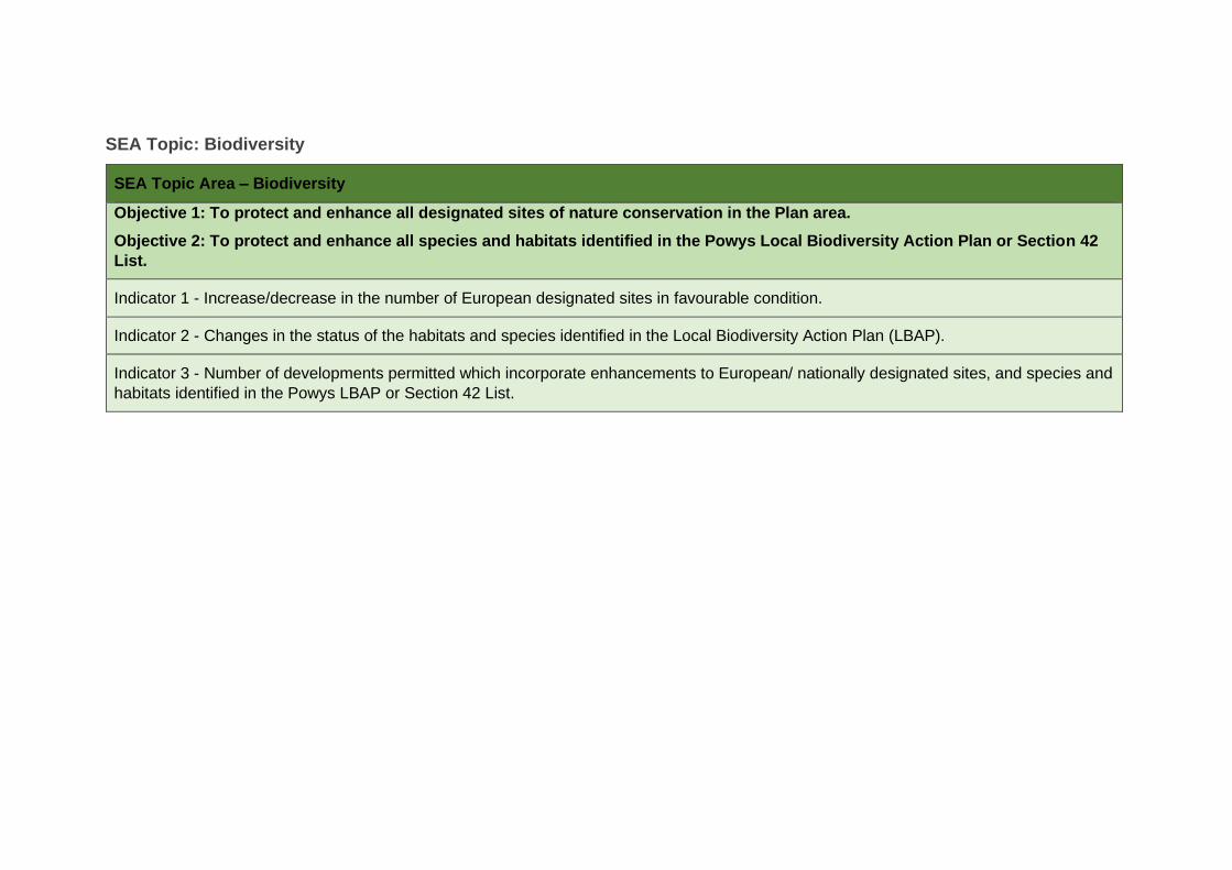
SEA Topic: Biodiversity
SEA Topic Area – Biodiversity
Objective 1: To protect and enhance all designated sites of nature conservation in the Plan area.
Objective 2: To protect and enhance all species and habitats identified in the Powys Local Biodiversity Action Plan or Section 42
List.
Indicator 1 - Increase/decrease in the number of European designated sites in favourable condition.
Indicator 2 - Changes in the status of the habitats and species identified in the Local Biodiversity Action Plan (LBAP).
Indicator 3 - Number of developments permitted which incorporate enhancements to European/ nationally designated sites, and species and
habitats identified in the Powys LBAP or Section 42 List.
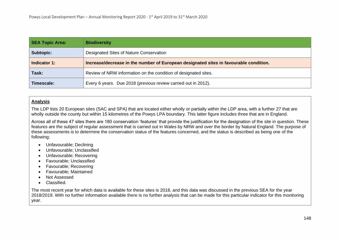
Powys Local Development Plan – Annual Monitoring Report 2020 - 1st April 2019 to 31st March 2020
148
SEA Topic Area: Biodiversity
Subtopic: Designated Sites of Nature Conservation
Indicator 1: Increase/decrease in the number of European designated sites in favourable condition.
Task: Review of NRW information on the condition of designated sites.
Timescale: Every 6 years. Due 2018 (previous review carried out in 2012).
Analysis
The LDP lists 20 European sites (SAC and SPA) that are located either wholly or partially within the LDP area, with a further 27 that are wholly outside the county but within 15 kilometres of the Powys LPA boundary. This latter figure includes three that are in England.
Across all of these 47 sites there are 180 conservation ‘features’ that provide the justification for the designation of the site in question. These features are the subject of regular assessment that is carried out in Wales by NRW and over the border by Natural England. The purpose of these assessments is to determine the conservation status of the features concerned, and the status is described as being one of the following;
• Unfavourable; Declining
• Unfavourable; Unclassified
• Unfavourable; Recovering
• Favourable; Unclassified
• Favourable; Recovering
• Favourable; Maintained
• Not Assessed
• Classified.
The most recent year for which data is available for these sites is 2018, and this data was discussed in the previous SEA for the year 2018/2019. With no further information available there is no further analysis that can be made for this particular indicator for this monitoring year.
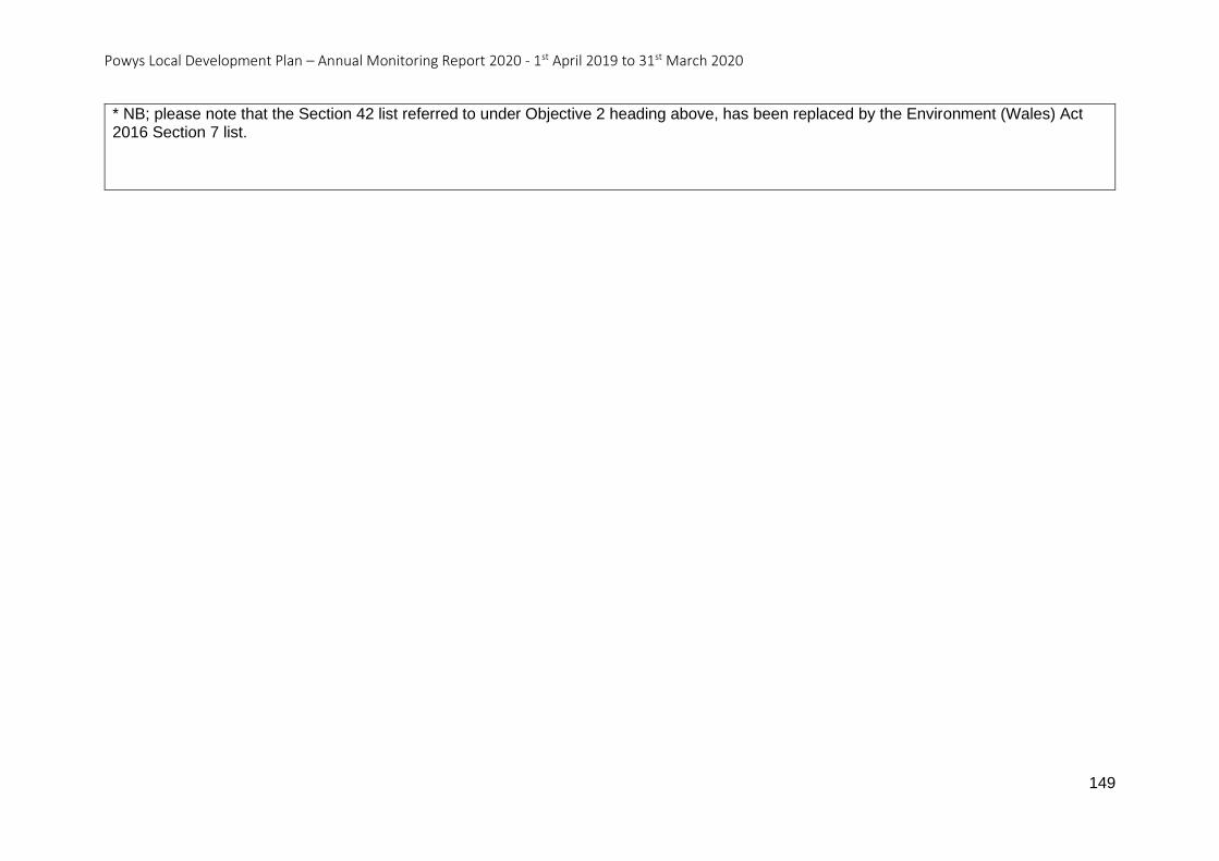
Powys Local Development Plan – Annual Monitoring Report 2020 - 1st April 2019 to 31st March 2020
149
* NB; please note that the Section 42 list referred to under Objective 2 heading above, has been replaced by the Environment (Wales) Act 2016 Section 7 list.
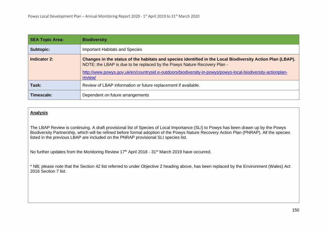
Powys Local Development Plan – Annual Monitoring Report 2020 - 1st April 2019 to 31st March 2020
150
SEA Topic Area: Biodiversity
Subtopic: Important Habitats and Species
Indicator 2: Changes in the status of the habitats and species identified in the Local Biodiversity Action Plan (LBAP).
NOTE: the LBAP is due to be replaced by the Powys Nature Recovery Plan -
http://www.powys.gov.uk/en/countrysid e-outdoors/biodiversity-in-powys/powys-local-biodiversity-actionplan-
review/
Task: Review of LBAP information or future replacement if available.
Timescale: Dependent on future arrangements
Analysis
The LBAP Review is continuing. A draft provisional list of Species of Local Importance (SLI) to Powys has been drawn up by the Powys Biodiversity Partnership, which will be refined before formal adoption of the Powys Nature Recovery Action Plan (PNRAP). All the species listed in the previous LBAP are included on the PNRAP provisional SLI species list.
No further updates from the Monitoring Review 17th April 2018 - 31st March 2019 have occurred.
* NB; please note that the Section 42 list referred to under Objective 2 heading above, has been replaced by the Environment (Wales) Act 2016 Section 7 list.
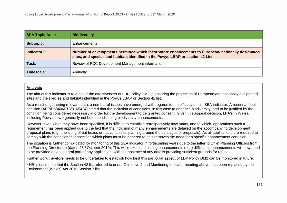
Powys Local Development Plan – Annual Monitoring Report 2020 - 1st April 2019 to 31st March 2020
151
SEA Topic Area: Biodiversity
Subtopic: Enhancements
Indicator 3: Number of developments permitted which incorporate enhancements to European/ nationally designated
sites, and species and habitats identified in the Powys LBAP or section 42 List.
Task: Review of PCC Development Management information.
Timescale: Annually
Analysis
The aim of this indicator is to monitor the effectiveness of LDP Policy DM2 in ensuring the protection of European and nationally designated sites and the species and habitats identified in the Powys LBAP or Section 42 list.
As a result of gathering relevant data, a number of issues have emerged with regards to the efficacy of this SEA indicator. A recent appeal decision (APP/E6840/A/16/3165424) stated that the inclusion of conditions, in this case to enhance biodiversity, had to be justified by the condition being considered necessary in order for the development to be granted consent. Given this Appeal decision, LPA’s in Wales, including Powys, have generally not been conditioning biodiversity enhancements.
However, even when they have been specified, it is difficult to establish retrospectively how many, and to which, applications such a requirement has been applied due to the fact that the inclusion of many enhancements are detailed on the accompanying development proposal plans (e.g., the siting of bat boxes or native species planting around the curtilages of proposals). As all applications are required to comply with the condition that specifies which plans must be adhered to, this removes the need for a specific enhancement condition,
The situation is further complicated for monitoring of this SEA indicator in forthcoming years due to the letter to Chief Planning Officers from the Planning Directorate (dated 23rd October 2019). This will make conditioning enhancements more difficult as enhancements will now need to be provided as an integral part of any application, with the absence of any details providing sufficient grounds for refusal.
Further work therefore needs to be undertaken to establish how best this particular aspect of LDP Policy DM2 can be monitored in future.
* NB; please note that the Section 42 list referred to under Objective 2 and Monitoring Indicator heading above, has been replaced by the Environment (Wales) Act 2016 Section 7 list.
Powys Local Development Plan – Annual Monitoring Report 2020 - 1st April 2019 to 31st March 2020
152
SEA Topic: Population and Human Health
SEA Topic Area – Population and Human Health
Objective 3: Enhance the provision of housing, employment, and community services to meet the needs of the population and in response to demographic changes (e.g., the ageing population and the need to retain the young working age population). Objective 4: Promote improvement in community safety.
Objective 5: Promote improvement in human health and opportunities for healthy living.
Objective 6: To prevent or minimise exposure to potential sources of nuisance and risk to human health.
Indicator 4 - Change in average life expectancy.
Indicator 5 - Ratio of working age population to children and retired population.
Indicator 6 - Percentage of population aged 75 and over.
Indicator 7 - Migration trends of younger adults (aged 20-34).
Indicator 8 - The number of police recorded road accidents involving personal injury.
Indicator 9 - Number of police recorded crimes.
Indicator 10 - Percentage of people participating in sporting activities three or more times a week.
Indicator 11 - Number of planning applications referred to the Health and Safety Executive.
Powys Local Development Plan – Annual Monitoring Report 2020 - 1st April 2019 to 31st March 2020
153
SEA Topic Area: Population and Human Health
Subtopic: Population (demographic profile).
Indicator 4: Change in average life expectancy.
Task: Review Census information. Welsh Government Stats Wales:
https://statswales.gov.wales/Catalogue/H ealth-and-Social-Care/Life-
Expectancy/lifeexpectancyandhealthylifee xpectancyatbirth-by-localhealthboardlocalauthority
Timescale: Census (2021) data available 2022.
Average life expectancy every 2-4 years (in line with Welsh Government timescales).
Analysis
The most recently available Welsh Government statistics (October 2016) for Powys (including the Brecon Beacons National Park) average life expectancy are shown in Table 23.
Although these figures were last updated in October 2016, they relate to averages for the years 2010 to 2014.
As these figures are unchanged from the previous SEA assessment from the Monitoring Review (17th April 2018- 31st March 2019) it is not possible to indicate the impact of the Powys LDP policies.
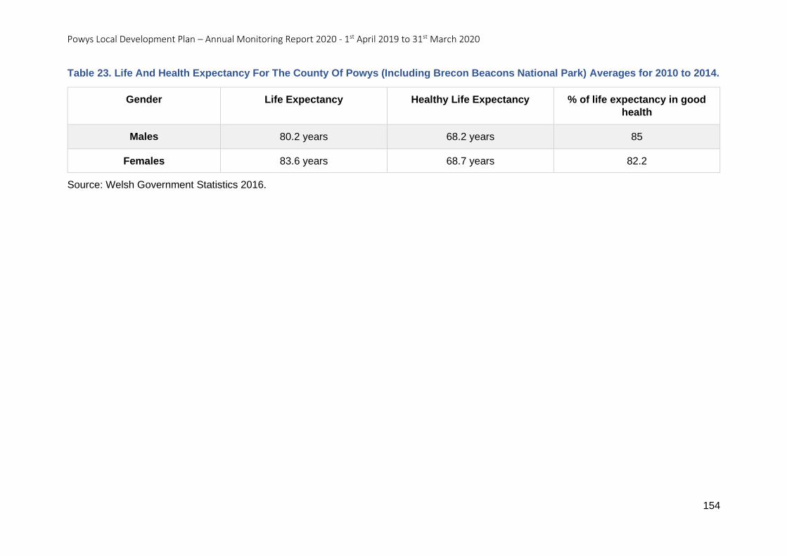
Powys Local Development Plan – Annual Monitoring Report 2020 - 1st April 2019 to 31st March 2020
154
Table 23. Life And Health Expectancy For The County Of Powys (Including Brecon Beacons National Park) Averages for 2010 to 2014.
Gender Life Expectancy Healthy Life Expectancy % of life expectancy in good
health
Males 80.2 years 68.2 years 85
Females 83.6 years 68.7 years 82.2
Source: Welsh Government Statistics 2016.
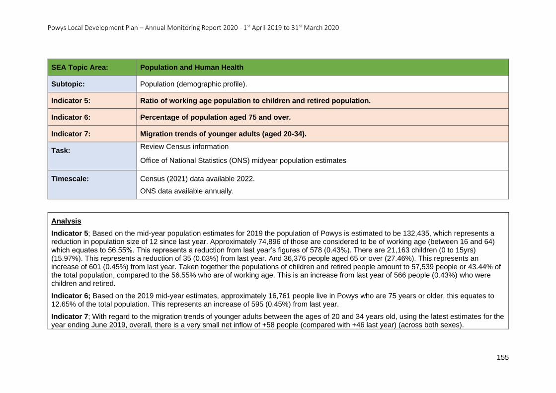
Powys Local Development Plan – Annual Monitoring Report 2020 - 1st April 2019 to 31st March 2020
155
SEA Topic Area: Population and Human Health
Subtopic: Population (demographic profile).
Indicator 5: Ratio of working age population to children and retired population.
Indicator 6: Percentage of population aged 75 and over.
Indicator 7: Migration trends of younger adults (aged 20-34).
Task: Review Census information
Office of National Statistics (ONS) midyear population estimates
Timescale: Census (2021) data available 2022.
ONS data available annually.
Analysis
Indicator 5; Based on the mid-year population estimates for 2019 the population of Powys is estimated to be 132,435, which represents a reduction in population size of 12 since last year. Approximately 74,896 of those are considered to be of working age (between 16 and 64) which equates to 56.55%. This represents a reduction from last year’s figures of 578 (0.43%). There are 21,163 children (0 to 15yrs) (15.97%). This represents a reduction of 35 (0.03%) from last year. And 36,376 people aged 65 or over (27.46%). This represents an increase of 601 (0.45%) from last year. Taken together the populations of children and retired people amount to 57,539 people or 43.44% of the total population, compared to the 56.55% who are of working age. This is an increase from last year of 566 people (0.43%) who were children and retired.
Indicator 6; Based on the 2019 mid-year estimates, approximately 16,761 people live in Powys who are 75 years or older, this equates to 12.65% of the total population. This represents an increase of 595 (0.45%) from last year.
Indicator 7; With regard to the migration trends of younger adults between the ages of 20 and 34 years old, using the latest estimates for the year ending June 2019, overall, there is a very small net inflow of +58 people (compared with +46 last year) (across both sexes).
Powys Local Development Plan – Annual Monitoring Report 2020 - 1st April 2019 to 31st March 2020
156
Differentiation based on gender reveals that for males there was a net decrease of -13, and for females +71 in this time period (+2 and +44 respectively in the previous year).
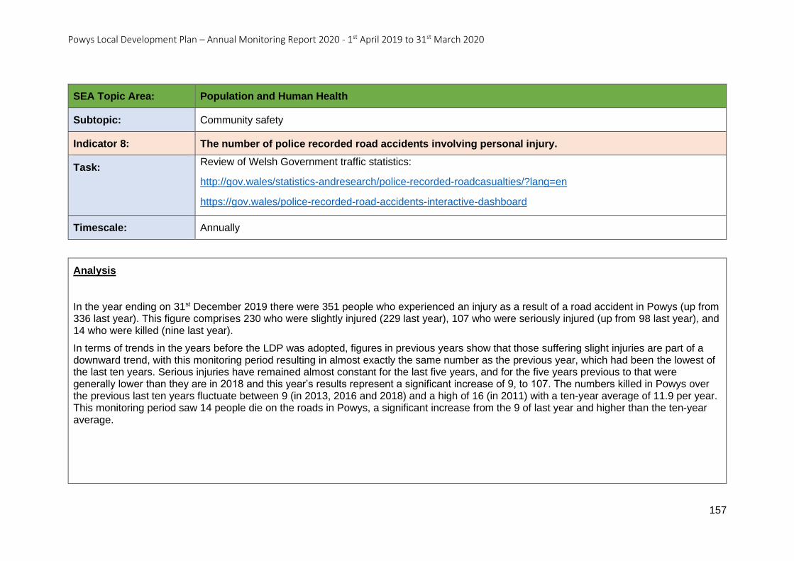
Powys Local Development Plan – Annual Monitoring Report 2020 - 1st April 2019 to 31st March 2020
157
SEA Topic Area: Population and Human Health
Subtopic: Community safety
Indicator 8: The number of police recorded road accidents involving personal injury.
Task: Review of Welsh Government traffic statistics:
http://gov.wales/statistics-andresearch/police-recorded-roadcasualties/?lang=en
https://gov.wales/police-recorded-road-accidents-interactive-dashboard
Timescale: Annually
Analysis
In the year ending on 31st December 2019 there were 351 people who experienced an injury as a result of a road accident in Powys (up from 336 last year). This figure comprises 230 who were slightly injured (229 last year), 107 who were seriously injured (up from 98 last year), and 14 who were killed (nine last year).
In terms of trends in the years before the LDP was adopted, figures in previous years show that those suffering slight injuries are part of a downward trend, with this monitoring period resulting in almost exactly the same number as the previous year, which had been the lowest of the last ten years. Serious injuries have remained almost constant for the last five years, and for the five years previous to that were generally lower than they are in 2018 and this year’s results represent a significant increase of 9, to 107. The numbers killed in Powys over the previous last ten years fluctuate between 9 (in 2013, 2016 and 2018) and a high of 16 (in 2011) with a ten-year average of 11.9 per year. This monitoring period saw 14 people die on the roads in Powys, a significant increase from the 9 of last year and higher than the ten-year average.
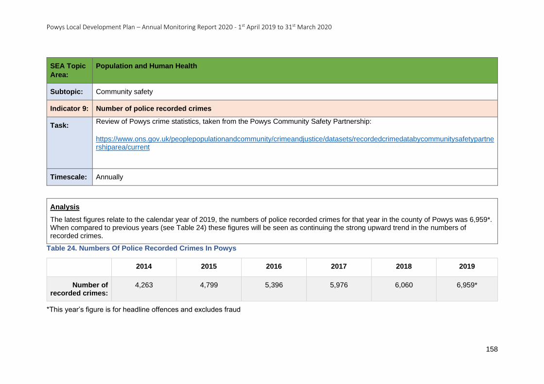
Powys Local Development Plan – Annual Monitoring Report 2020 - 1st April 2019 to 31st March 2020
158
SEA Topic
Area:
Population and Human Health
Subtopic: Community safety
Indicator 9: Number of police recorded crimes
Task: Review of Powys crime statistics, taken from the Powys Community Safety Partnership:
https://www.ons.gov.uk/peoplepopulationandcommunity/crimeandjustice/datasets/recordedcrimedatabycommunitysafetypartnershiparea/current
Timescale: Annually
Analysis
The latest figures relate to the calendar year of 2019, the numbers of police recorded crimes for that year in the county of Powys was 6,959*. When compared to previous years (see Table 24) these figures will be seen as continuing the strong upward trend in the numbers of recorded crimes.
Table 24. Numbers Of Police Recorded Crimes In Powys
2014 2015 2016 2017 2018 2019
Number of recorded crimes:
4,263 4,799 5,396 5,976 6,060 6,959*
*This year’s figure is for headline offences and excludes fraud
Powys Local Development Plan – Annual Monitoring Report 2020 - 1st April 2019 to 31st March 2020
159
SEA Topic
Area:
Population and Human Health
Subtopic: Human Health
Indicator 10: Percentage of people participating in sporting activities three or more times a week.
Task: Review of National Survey for Wales and School Sport Survey statistics:
https://gov.wales/national-survey-wales-results-viewer
Timescale: National Survey for Wales Annually.
Analysis
The data for the monitoring period 2019/2020 has been taken from the National Survey for Wales. Of the respondents located in Powys, 29% answered that they did participate in a sporting activity three or more times a week. This result is unchanged from the previous year’s result.
NB this statistic has only been available since 2016 and local authority breakdowns only began in 2018.
Powys Local Development Plan – Annual Monitoring Report 2020 - 1st April 2019 to 31st March 2020
160
SEA Topic
Area:
Population and Human Health
Subtopic: Human Health
Indicator 11: Number of planning applications referred to the Health and Safety Executive.
Task: Review of PCC Development Management information.
Timescale: Annually.
Analysis
In the monitoring year 2019 to 2020, one planning application was referred to the Health and Safety Executive. with regards to the proximity of the development to a gas pipeline. The HSE confirmed that they had no interest in commenting on the application. There was an intermediate sized pipeline in proximity to the site and this belonged to Wales and West Utilities. An appropriately worded Informative was therefore added to the Decision Notice.
Powys Local Development Plan – Annual Monitoring Report 2020 - 1st April 2019 to 31st March 2020
161
SEA Topic: Soil
SEA Topic Area – Soil
Objective 7: To protect soils that are classified as being important for carbon storage and agriculture.
Objective 8: To prevent contamination of land and support remediation as part of new development.
Indicator 12 - Amount (ha) of development permitted on thick peat areas (mapped by the British Geological Survey).
Indicator 13 - Amount (ha) of development permitted on greenfield land outside development boundaries.
Indicator 14 - Number of developments where a Verification Report has been approved by the Local Planning Authority demonstrating the
remediation of contaminated land.
Powys Local Development Plan – Annual Monitoring Report 2020 - 1st April 2019 to 31st March 2020
162
SEA Topic
Area:
Soil
Subtopic: Carbon storage
Indicator 12: Amount (ha) of development permitted on thick peat areas (mapped by the British Geological Survey).
Task: Review of PCC Development Management information.
Timescale: Annually.
Analysis
This SEA indicator monitors the performance of section 13 of LDP Policy DM13, with regards to the policy’s ability to protect important carbon sinks (bullet point v.), such as thick peat, that exist within the Powys LPA area.
Carrying out an analysis of the Development Management data, alongside the Unified Peat Map of Wales taken from the Lle website, established that there were no planning applications, and therefore no hectares of development, permitted on the areas of thick peat that lie within the LPA area during the monitoring year (1st April 2019 to 31st March 2020).
Powys Local Development Plan – Annual Monitoring Report 2020 - 1st April 2019 to 31st March 2020
163
SEA Topic
Area:
Soil
Subtopic: Agricultural Land
Indicator 13: Amount (ha) of development permitted on greenfield land outside development boundaries.
Task: Review of PCC Development Management information.
Timescale: Annually.
Analysis
This SEA monitoring indicator is similar to monitoring indicator AMR20. Initial findings for this monitoring period (1st April 2019 to 31st March 2020) permission was granted on windfall sites for an area totalling 133.173 hectares. From the 133.173 ha, 17.781 ha (13%) was on previously developed land with 112.505 hectares (85%) on greenfield sites and 2.887 ha (13%) on a mixture of previously developed land and greenfield.
It should be noted that some of the greenfield sites will continue to be classified as greenfield even when the development proposal is completed. This includes all permissions for agricultural developments (67.93 ha), open space proposals (1.023 ha) and renewable energy proposals - where the majority of the original land use remains the same (1.594 ha).
In order to look at this indicator against the LDP policies in detail, all applications for renewable energy - where the majority of the original land use remains the same, together with agricultural and open space development proposals shall be excluded from the data. The revised results show that during the monitoring period, planning permission was granted on windfall sites for an area totalling 62.963 ha. From the 62.963 ha, 17.719 ha (28%) of it was on previously developed land, with 43.357 ha (67%) on greenfield sites and 2.887 ha (5%) on sites containing a mixture of greenfield and previously developed land.
The results of further analysis (monitoring indicator AMR20) show that the distribution of windfall development permitted across the settlement tier is consistent with the settlement strategy and LDP Policy SP6 for all tiers of the settlement hierarchy except the Open Countryside.
Powys Local Development Plan – Annual Monitoring Report 2020 - 1st April 2019 to 31st March 2020
164
SEA Topic
Area:
Soil
Subtopic: Contaminated Land
Indicator 14: Number of developments where a Verification Report has been approved by the Local Planning Authority demonstrating the remediation of contaminated land.
Task: Review of PCC Development Management information.
Timescale: Annually.
Analysis
The aim of this indicator is to assess the effectiveness of LDP Policy DM10 Contaminated and Unstable Land.
For the monitoring period 1st April 2019 to 31st March 2020, a total of 20 sites had planning conditions placed on them relating to the need for either a Remediation Strategy or a Verification Report. Fourteen of these involved the submission of a Verification Report and all of these were approved by the Authority.
Powys Local Development Plan – Annual Monitoring Report 2020 - 1st April 2019 to 31st March 2020
165
SEA Topic: Water
SEA Topic Area – Water
Objective 9: To maintain and improve water quality and quantity.
Indicator 15 - By River Basin Management Plan Area for Western Wales River Basin Management Plan and Severn River Basin Management Plan:
• % of surface waters are at ‘good’ status.
• % of groundwater bodies at ‘good’ status.
Indicator 16 - Number of planning permissions that incorporate SUDs.
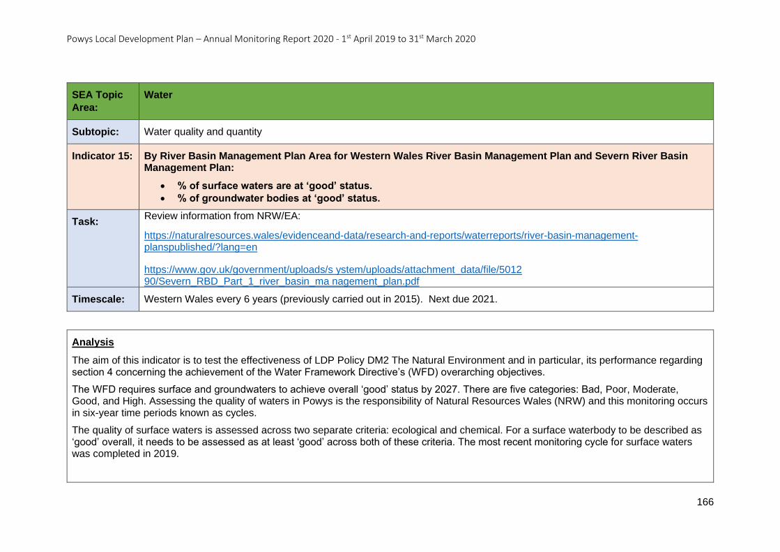
Powys Local Development Plan – Annual Monitoring Report 2020 - 1st April 2019 to 31st March 2020
166
SEA Topic
Area:
Water
Subtopic: Water quality and quantity
Indicator 15: By River Basin Management Plan Area for Western Wales River Basin Management Plan and Severn River Basin Management Plan:
• % of surface waters are at ‘good’ status.
• % of groundwater bodies at ‘good’ status.
Task: Review information from NRW/EA:
https://naturalresources.wales/evidenceand-data/research-and-reports/waterreports/river-basin-management-planspublished/?lang=en
https://www.gov.uk/government/uploads/s ystem/uploads/attachment_data/file/5012 90/Severn_RBD_Part_1_river_basin_ma nagement_plan.pdf
Timescale: Western Wales every 6 years (previously carried out in 2015). Next due 2021.
Analysis
The aim of this indicator is to test the effectiveness of LDP Policy DM2 The Natural Environment and in particular, its performance regarding section 4 concerning the achievement of the Water Framework Directive’s (WFD) overarching objectives.
The WFD requires surface and groundwaters to achieve overall ‘good’ status by 2027. There are five categories: Bad, Poor, Moderate, Good, and High. Assessing the quality of waters in Powys is the responsibility of Natural Resources Wales (NRW) and this monitoring occurs in six-year time periods known as cycles.
The quality of surface waters is assessed across two separate criteria: ecological and chemical. For a surface waterbody to be described as ‘good’ overall, it needs to be assessed as at least ‘good’ across both of these criteria. The most recent monitoring cycle for surface waters was completed in 2019.
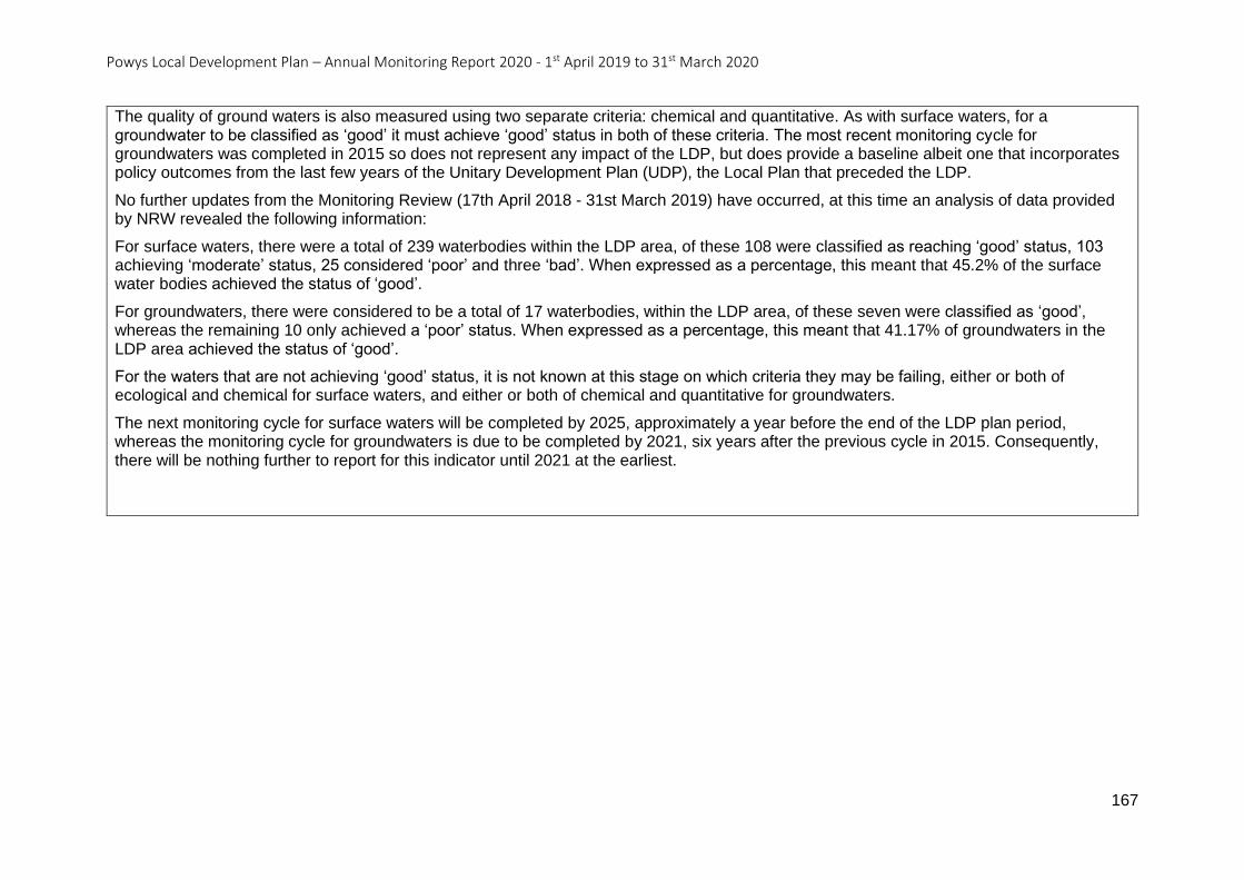
Powys Local Development Plan – Annual Monitoring Report 2020 - 1st April 2019 to 31st March 2020
167
The quality of ground waters is also measured using two separate criteria: chemical and quantitative. As with surface waters, for a groundwater to be classified as ‘good’ it must achieve ‘good’ status in both of these criteria. The most recent monitoring cycle for groundwaters was completed in 2015 so does not represent any impact of the LDP, but does provide a baseline albeit one that incorporates policy outcomes from the last few years of the Unitary Development Plan (UDP), the Local Plan that preceded the LDP.
No further updates from the Monitoring Review (17th April 2018 - 31st March 2019) have occurred, at this time an analysis of data provided by NRW revealed the following information:
For surface waters, there were a total of 239 waterbodies within the LDP area, of these 108 were classified as reaching ‘good’ status, 103 achieving ‘moderate’ status, 25 considered ‘poor’ and three ‘bad’. When expressed as a percentage, this meant that 45.2% of the surface water bodies achieved the status of ‘good’.
For groundwaters, there were considered to be a total of 17 waterbodies, within the LDP area, of these seven were classified as ‘good’, whereas the remaining 10 only achieved a ‘poor’ status. When expressed as a percentage, this meant that 41.17% of groundwaters in the LDP area achieved the status of ‘good’.
For the waters that are not achieving ‘good’ status, it is not known at this stage on which criteria they may be failing, either or both of ecological and chemical for surface waters, and either or both of chemical and quantitative for groundwaters.
The next monitoring cycle for surface waters will be completed by 2025, approximately a year before the end of the LDP plan period, whereas the monitoring cycle for groundwaters is due to be completed by 2021, six years after the previous cycle in 2015. Consequently, there will be nothing further to report for this indicator until 2021 at the earliest.
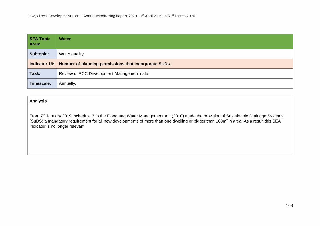
Powys Local Development Plan – Annual Monitoring Report 2020 - 1st April 2019 to 31st March 2020
168
SEA Topic
Area:
Water
Subtopic: Water quality
Indicator 16: Number of planning permissions that incorporate SUDs.
Task: Review of PCC Development Management data.
Timescale: Annually.
Analysis
From 7th January 2019, schedule 3 to the Flood and Water Management Act (2010) made the provision of Sustainable Drainage Systems
(SuDS) a mandatory requirement for all new developments of more than one dwelling or bigger than 100m2 in area. As a result this SEA
Indicator is no longer relevant.
Powys Local Development Plan – Annual Monitoring Report 2020 - 1st April 2019 to 31st March 2020
169
SEA Topic: Air
SEA Topic Area – Air
Objective 10: To protect and improve air quality in Powys.
Indicator 17 - Levels of average NO2, PM2.5 and PM10 concentrations (recorded as Air Quality Exposure Indicators) across Powys.
Indicator 18 - Specific levels of NO2 against National Air Quality Strategy Objectives across Powys.
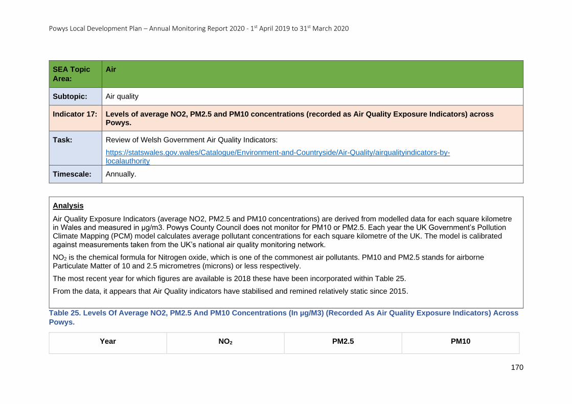
Powys Local Development Plan – Annual Monitoring Report 2020 - 1st April 2019 to 31st March 2020
170
SEA Topic
Area:
Air
Subtopic: Air quality
Indicator 17: Levels of average NO2, PM2.5 and PM10 concentrations (recorded as Air Quality Exposure Indicators) across Powys.
Task: Review of Welsh Government Air Quality Indicators:
https://statswales.gov.wales/Catalogue/Environment-and-Countryside/Air-Quality/airqualityindicators-by-localauthority
Timescale: Annually.
Analysis
Air Quality Exposure Indicators (average NO2, PM2.5 and PM10 concentrations) are derived from modelled data for each square kilometre in Wales and measured in µg/m3. Powys County Council does not monitor for PM10 or PM2.5. Each year the UK Government’s Pollution Climate Mapping (PCM) model calculates average pollutant concentrations for each square kilometre of the UK. The model is calibrated against measurements taken from the UK’s national air quality monitoring network.
NO2 is the chemical formula for Nitrogen oxide, which is one of the commonest air pollutants. PM10 and PM2.5 stands for airborne Particulate Matter of 10 and 2.5 micrometres (microns) or less respectively.
The most recent year for which figures are available is 2018 these have been incorporated within Table 25.
From the data, it appears that Air Quality indicators have stabilised and remined relatively static since 2015.
Table 25. Levels Of Average NO2, PM2.5 And PM10 Concentrations (In µg/M3) (Recorded As Air Quality Exposure Indicators) Across
Powys.
Year NO2 PM2.5 PM10
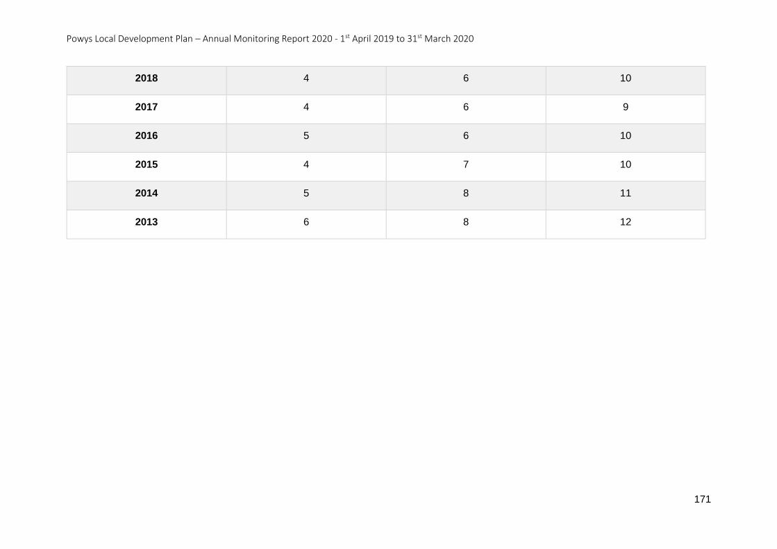
Powys Local Development Plan – Annual Monitoring Report 2020 - 1st April 2019 to 31st March 2020
171
2018 4 6 10
2017 4 6 9
2016 5 6 10
2015 4 7 10
2014 5 8 11
2013 6 8 12
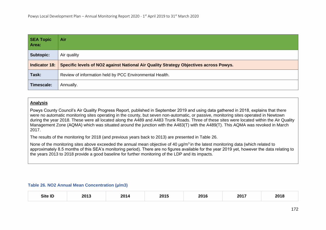
Powys Local Development Plan – Annual Monitoring Report 2020 - 1st April 2019 to 31st March 2020
172
SEA Topic
Area:
Air
Subtopic: Air quality
Indicator 18: Specific levels of NO2 against National Air Quality Strategy Objectives across Powys.
Task: Review of information held by PCC Environmental Health.
Timescale: Annually.
Analysis
Powys County Council’s Air Quality Progress Report, published in September 2019 and using data gathered in 2018, explains that there were no automatic monitoring sites operating in the county, but seven non-automatic, or passive, monitoring sites operated in Newtown during the year 2018. These were all located along the A489 and A483 Trunk Roads. Three of these sites were located within the Air Quality Management Zone (AQMA) which was situated around the junction with the A483(T) with the A489(T). This AQMA was revoked in March 2017.
The results of the monitoring for 2018 (and previous years back to 2013) are presented in Table 26.
None of the monitoring sites above exceeded the annual mean objective of 40 µg/m3 in the latest monitoring data (which related to approximately 8.5 months of this SEA’s monitoring period). There are no figures available for the year 2019 yet, however the data relating to the years 2013 to 2018 provide a good baseline for further monitoring of the LDP and its impacts.
Table 26. NO2 Annual Mean Concentration (µ/m3)
Site ID 2013 2014 2015 2016 2017 2018
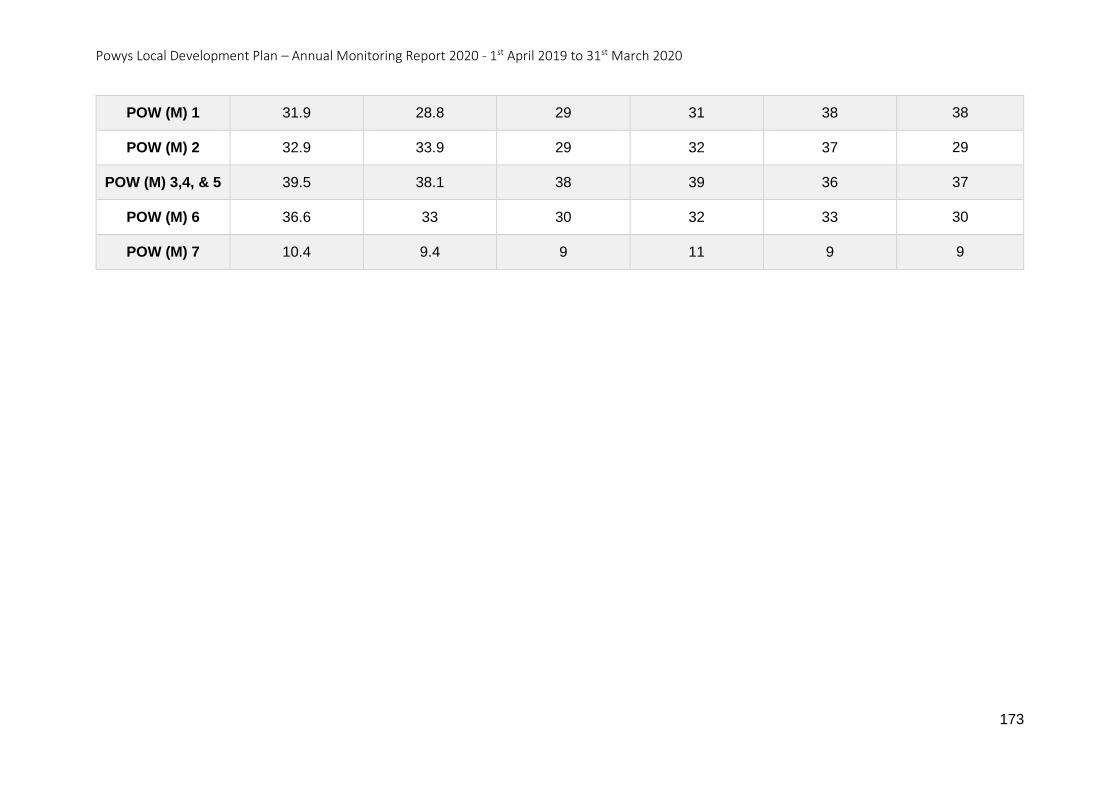
Powys Local Development Plan – Annual Monitoring Report 2020 - 1st April 2019 to 31st March 2020
173
POW (M) 1 31.9 28.8 29 31 38 38
POW (M) 2 32.9 33.9 29 32 37 29
POW (M) 3,4, & 5 39.5 38.1 38 39 36 37
POW (M) 6 36.6 33 30 32 33 30
POW (M) 7 10.4 9.4 9 11 9 9
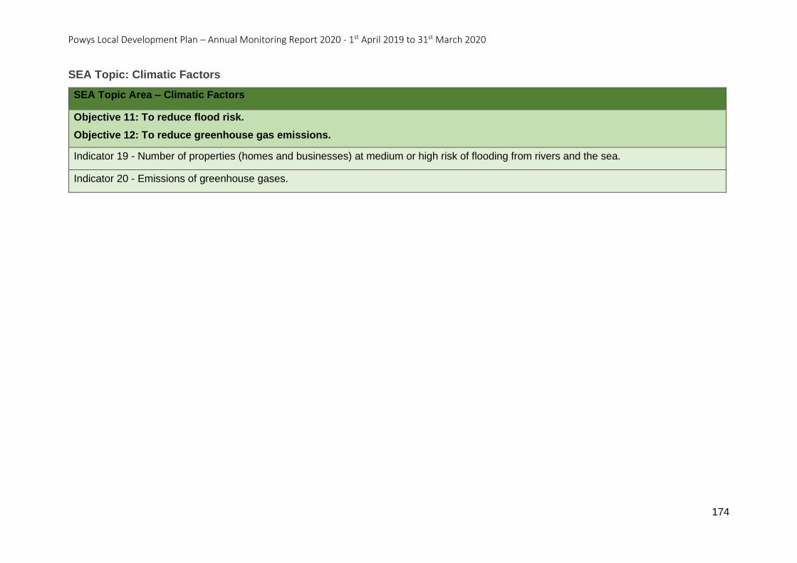
Powys Local Development Plan – Annual Monitoring Report 2020 - 1st April 2019 to 31st March 2020
174
SEA Topic: Climatic Factors
SEA Topic Area – Climatic Factors
Objective 11: To reduce flood risk.
Objective 12: To reduce greenhouse gas emissions.
Indicator 19 - Number of properties (homes and businesses) at medium or high risk of flooding from rivers and the sea.
Indicator 20 - Emissions of greenhouse gases.
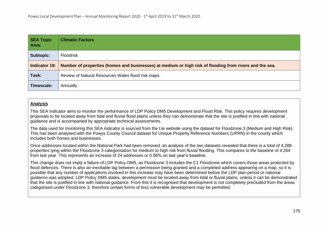
Powys Local Development Plan – Annual Monitoring Report 2020 - 1st April 2019 to 31st March 2020
175
SEA Topic
Area:
Climatic Factors
Subtopic: Floodrisk
Indicator 19: Number of properties (homes and businesses) at medium or high risk of flooding from rivers and the sea.
Task: Review of Natural Resources Wales flood risk maps.
Timescale: Annually.
Analysis
This SEA Indicator aims to monitor the performance of LDP Policy DM5 Development and Flood Risk. This policy requires development proposals to be located away from tidal and fluvial flood plains unless they can demonstrate that the site is justified in line with national guidance and is accompanied by appropriate technical assessments.
The data used for monitoring this SEA indicator is sourced from the Lle website using the dataset for Floodzone 3 (Medium and High Risk). This has been analysed with the Powys County Council dataset for Unique Property Reference Numbers (UPRN) in the county which includes both homes and businesses.
Once addresses located within the National Park had been removed, an analysis of the two datasets revealed that there is a total of 4,288 properties lying within the Floodzone 3 categorisation for medium to high risk from fluvial flooding. This compares to the baseline of 4,264 from last year. This represents an increase of 24 addresses or 0.56% on last year’s baseline.
This change does not imply a failure of LDP Policy DM5, as Floodzone 3 includes the C1 Floodzone which covers those areas protected by flood defences. There is also an inevitable lag between a permission being granted and a completed address appearing on a map, so it is possible that any number of applications involved in this increase may have been determined before the LDP plan period or national guidance was adopted. LDP Policy DM5 states, development must be located away from tidal or fluvial plains, unless it can be demonstrated that the site is justified in line with national guidance. From this it is recognised that development is not completely precluded from the areas categorised under Floodzone 3, therefore certain forms of less vulnerable development may be permitted.
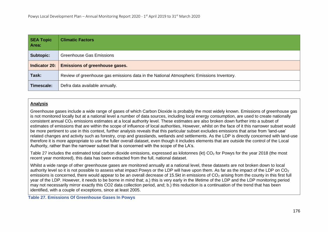
Powys Local Development Plan – Annual Monitoring Report 2020 - 1st April 2019 to 31st March 2020
176
SEA Topic
Area:
Climatic Factors
Subtopic: Greenhouse Gas Emissions
Indicator 20: Emissions of greenhouse gases.
Task: Review of greenhouse gas emissions data in the National Atmospheric Emissions Inventory.
Timescale: Defra data available annually.
Analysis
Greenhouse gases include a wide range of gases of which Carbon Dioxide is probably the most widely known. Emissions of greenhouse gas is not monitored locally but at a national level a number of data sources, including local energy consumption, are used to create nationally consistent annual CO2 emissions estimates at a local authority level. These estimates are also broken down further into a subset of estimates of emissions that are within the scope of influence of local authorities, However, whilst on the face of it this narrower subset would be more pertinent to use in this context, further analysis reveals that this particular subset excludes emissions that arise from ‘land-use’ related changes and activity such as forestry, crop and grasslands, wetlands and settlements. As the LDP is directly concerned with land-use therefore it is more appropriate to use the fuller overall dataset, even though it includes elements that are outside the control of the Local Authority, rather than the narrower subset that is concerned with the scope of the LA’s.
Table 27 includes the estimated total carbon dioxide emissions, expressed as kilotonnes (kt) CO2 for Powys for the year 2018 (the most recent year monitored), this data has been extracted from the full, national dataset.
Whilst a wide range of other greenhouse gases are monitored annually at a national level, these datasets are not broken down to local authority level so it is not possible to assess what impact Powys or the LDP will have upon them. As far as the impact of the LDP on CO2
emissions is concerned, there would appear to be an overall decrease of 15.5kt in emissions of CO2 arising from the county in this first full year of the LDP. However, it needs to be borne in mind that; a.) this is very early in the lifetime of the LDP and the LDP monitoring period may not necessarily mirror exactly this CO2 data collection period, and; b.) this reduction is a continuation of the trend that has been identified, with a couple of exceptions, since at least 2005.
Table 27. Emissions Of Greenhouse Gases In Powys
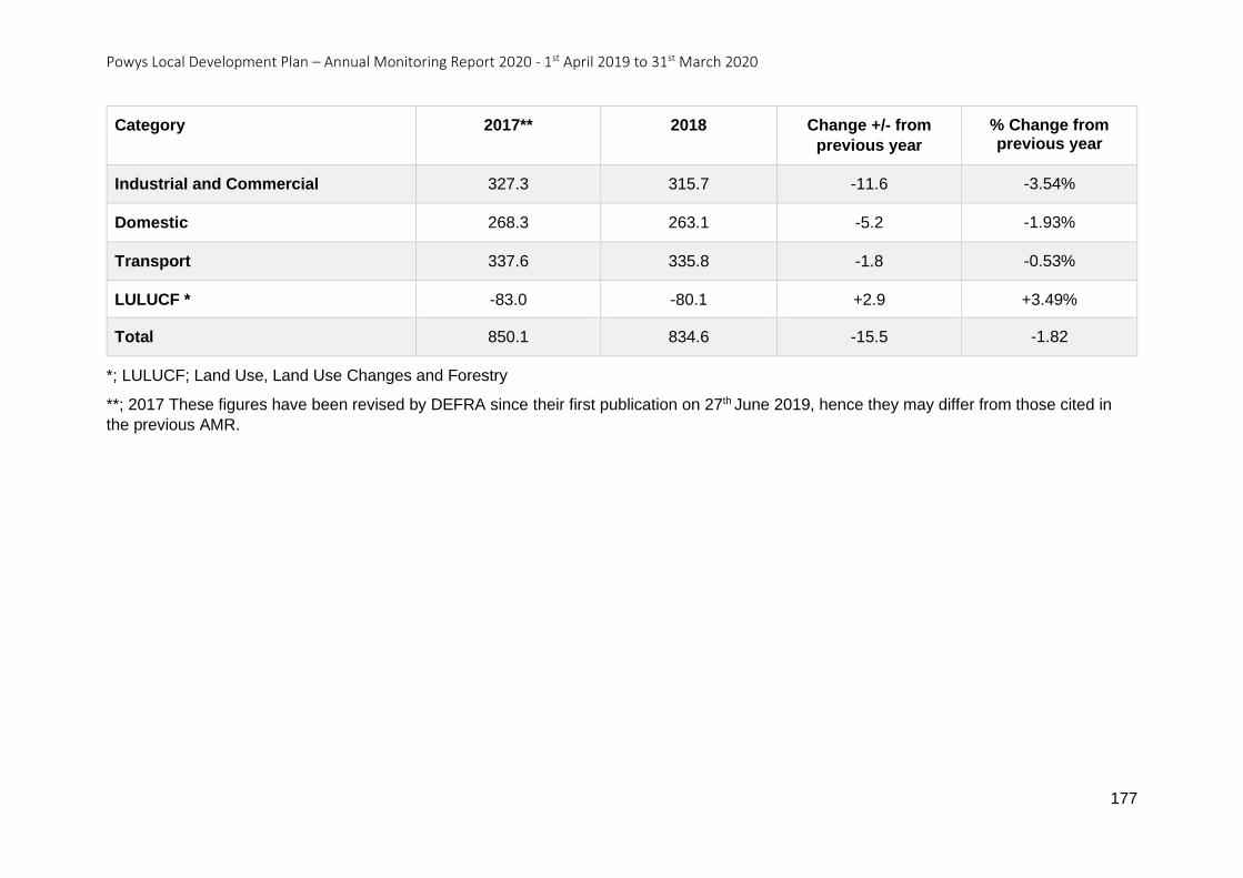
Powys Local Development Plan – Annual Monitoring Report 2020 - 1st April 2019 to 31st March 2020
177
Category 2017** 2018 Change +/- from
previous year
% Change from previous year
Industrial and Commercial 327.3 315.7 -11.6 -3.54%
Domestic 268.3 263.1 -5.2 -1.93%
Transport 337.6 335.8 -1.8 -0.53%
LULUCF * -83.0 -80.1 +2.9 +3.49%
Total 850.1 834.6 -15.5 -1.82
*; LULUCF; Land Use, Land Use Changes and Forestry
**; 2017 These figures have been revised by DEFRA since their first publication on 27th June 2019, hence they may differ from those cited in
the previous AMR.
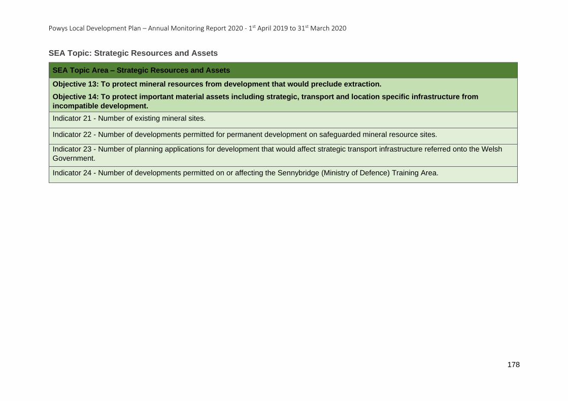
Powys Local Development Plan – Annual Monitoring Report 2020 - 1st April 2019 to 31st March 2020
178
SEA Topic: Strategic Resources and Assets
SEA Topic Area – Strategic Resources and Assets
Objective 13: To protect mineral resources from development that would preclude extraction.
Objective 14: To protect important material assets including strategic, transport and location specific infrastructure from
incompatible development.
Indicator 21 - Number of existing mineral sites.
Indicator 22 - Number of developments permitted for permanent development on safeguarded mineral resource sites.
Indicator 23 - Number of planning applications for development that would affect strategic transport infrastructure referred onto the Welsh
Government.
Indicator 24 - Number of developments permitted on or affecting the Sennybridge (Ministry of Defence) Training Area.
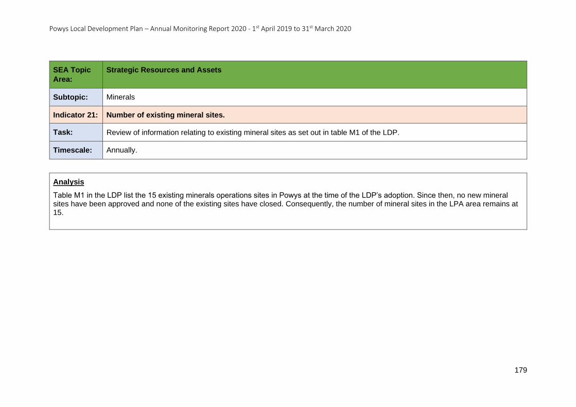
Powys Local Development Plan – Annual Monitoring Report 2020 - 1st April 2019 to 31st March 2020
179
SEA Topic
Area:
Strategic Resources and Assets
Subtopic: Minerals
Indicator 21: Number of existing mineral sites.
Task: Review of information relating to existing mineral sites as set out in table M1 of the LDP.
Timescale: Annually.
Analysis
Table M1 in the LDP list the 15 existing minerals operations sites in Powys at the time of the LDP’s adoption. Since then, no new mineral sites have been approved and none of the existing sites have closed. Consequently, the number of mineral sites in the LPA area remains at 15.

Powys Local Development Plan – Annual Monitoring Report 2020 - 1st April 2019 to 31st March 2020
180
SEA Topic
Area:
Strategic Resources and Assets
Subtopic: Minerals
Indicator 22: Number of developments permitted for permanent development on safeguarded mineral resource sites.
Task: Review of PCC Development Management information.
Timescale: Annually.
Analysis
The aim of this SEA indicator is to test the effectiveness of LDP Policy DM8 Minerals Safeguarding. The policy states that Mineral Safeguarding Areas have been designated for deposits of sand and gravel, sandstone, limestone, igneous rocks and surface coal, and these areas are shown on the LDP Proposals Map. Defining such areas does not imply any presumption that they will be worked but merely aims to ensure they remain available as and when future generations may need to access them.
During the monitoring period 1st April 2019 to 31st March 2020, 145 applications were permitted within a mineral safeguarding area. Of the 145, 95 were for proposals considered not to have any impact, examples include the conversion or redevelopment of existing buildings, minor extensions to existing buildings or proposals for the siting of camping pods and static caravans.
For the remaining 50 applications there were instances where the identification of the mineral safeguarding area as a constraint had been missed. Where it had been identified as a constraint, every proposal was in accordance with LDP Policy DM8 with the reasoning explained in the officer’s report. Where the constraint had been missed, it does not necessarily mean the development proposal did not comply with Policy DM8, but that it had not been given consideration.
The trigger point for this indicator may have been reached, however this not due to the wording of the Policy itself, but due to procedural issues regarding the way constraints are identified.
NB; this indicator is similar to Monitoring Indicator AMR22.
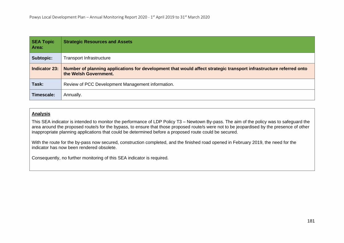
Powys Local Development Plan – Annual Monitoring Report 2020 - 1st April 2019 to 31st March 2020
181
SEA Topic
Area:
Strategic Resources and Assets
Subtopic: Transport Infrastructure
Indicator 23: Number of planning applications for development that would affect strategic transport infrastructure referred onto the Welsh Government.
Task: Review of PCC Development Management information.
Timescale: Annually.
Analysis
This SEA indicator is intended to monitor the performance of LDP Policy T3 – Newtown By-pass. The aim of the policy was to safeguard the area around the proposed route/s for the bypass, to ensure that those proposed route/s were not to be jeopardised by the presence of other inappropriate planning applications that could be determined before a proposed route could be secured. With the route for the by-pass now secured, construction completed, and the finished road opened in February 2019, the need for the indicator has now been rendered obsolete. Consequently, no further monitoring of this SEA indicator is required.
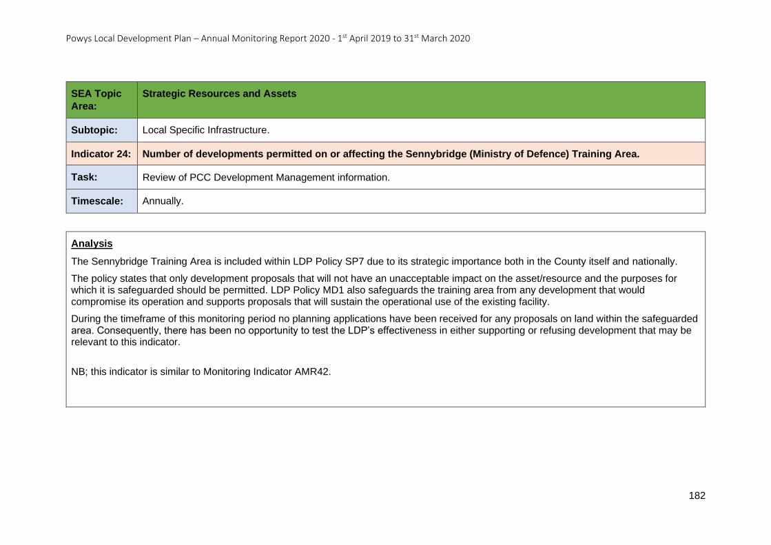
Powys Local Development Plan – Annual Monitoring Report 2020 - 1st April 2019 to 31st March 2020
182
SEA Topic
Area:
Strategic Resources and Assets
Subtopic: Local Specific Infrastructure.
Indicator 24: Number of developments permitted on or affecting the Sennybridge (Ministry of Defence) Training Area.
Task: Review of PCC Development Management information.
Timescale: Annually.
Analysis
The Sennybridge Training Area is included within LDP Policy SP7 due to its strategic importance both in the County itself and nationally.
The policy states that only development proposals that will not have an unacceptable impact on the asset/resource and the purposes for which it is safeguarded should be permitted. LDP Policy MD1 also safeguards the training area from any development that would compromise its operation and supports proposals that will sustain the operational use of the existing facility.
During the timeframe of this monitoring period no planning applications have been received for any proposals on land within the safeguarded area. Consequently, there has been no opportunity to test the LDP’s effectiveness in either supporting or refusing development that may be relevant to this indicator.
NB; this indicator is similar to Monitoring Indicator AMR42.

Powys Local Development Plan – Annual Monitoring Report 2020 - 1st April 2019 to 31st March 2020
183
SEA Topic: Cultural Heritage
SEA Topic Area – Cultural Heritage
Objective 15: To understand, value, protect and enhance Powys’ historic environment including its diversity, local distinctiveness and heritage.
Objective 16: To protect and enhance Welsh language and culture.
Indicator 25 - Net gain or loss of historic environment designations – Listed Buildings, Scheduled Ancient Monuments, Conservation Areas, Registered Historic Parks and Gardens and Registered Historic Landscapes.
Indicator 26 - Percentage of scheduled monuments in Wales that are in stable or improving condition.
Indicator 27 - Percentage of listed buildings that are neither ’vulnerable’ nor ‘at risk’.
Indicator 28 - Number, percentage and distribution of Welsh Speakers.
Indicator 29 - Changes in the Welsh language skills of the population.
Indicator 30 - Percentage of the population aged 3 and over who say they can speak Welsh.
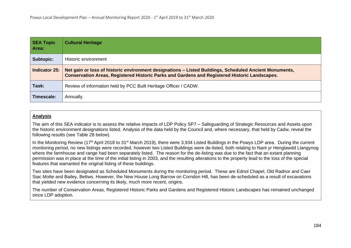
Powys Local Development Plan – Annual Monitoring Report 2020 - 1st April 2019 to 31st March 2020
184
SEA Topic
Area:
Cultural Heritage
Subtopic: Historic environment
Indicator 25: Net gain or loss of historic environment designations – Listed Buildings, Scheduled Ancient Monuments, Conservation Areas, Registered Historic Parks and Gardens and Registered Historic Landscapes.
Task: Review of information held by PCC Built Heritage Officer / CADW.
Timescale: Annually.
Analysis
The aim of this SEA indicator is to assess the relative impacts of LDP Policy SP7 – Safeguarding of Strategic Resources and Assets upon the historic environment designations listed. Analysis of the data held by the Council and, where necessary, that held by Cadw, reveal the following results (see Table 28 below).
In the Monitoring Review (17th April 2018 to 31st March 2019), there were 3,934 Listed Buildings in the Powys LDP area. During the current monitoring period, no new listings were recorded, however two Listed Buildings were de-listed, both relating to Nant yr Henglawdd Llangynog where the farmhouse and range had been separately listed. The reason for the de-listing was due to the fact that an extant planning permission was in place at the time of the initial listing in 2003, and the resulting alterations to the property lead to the loss of the special features that warranted the original listing of these buildings.
Two sites have been designated as Scheduled Monuments during the monitoring period. These are Ednol Chapel, Old Radnor and Caer Siac Motte and Bailey, Bettws. However, the New House Long Barrow on Corndon Hill, has been de-scheduled as a result of excavations that yielded new evidence concerning its likely, much more recent, origins.
The number of Conservation Areas, Registered Historic Parks and Gardens and Registered Historic Landscapes has remained unchanged since LDP adoption.
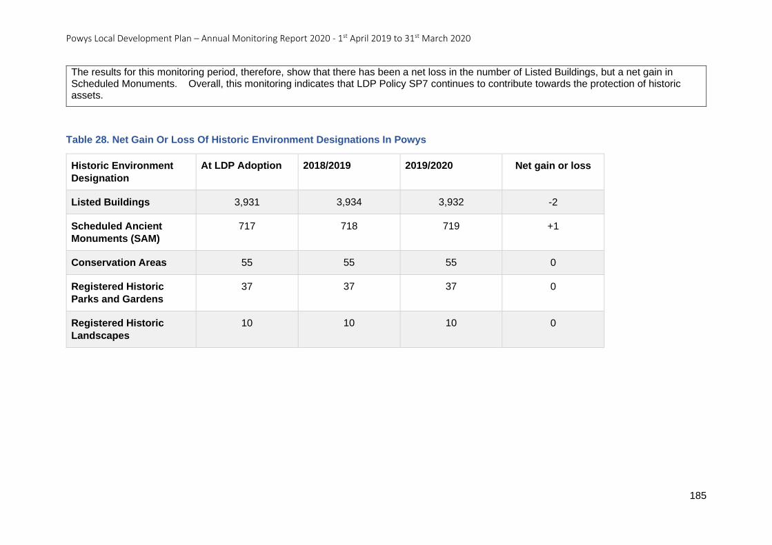
Powys Local Development Plan – Annual Monitoring Report 2020 - 1st April 2019 to 31st March 2020
185
The results for this monitoring period, therefore, show that there has been a net loss in the number of Listed Buildings, but a net gain in Scheduled Monuments. Overall, this monitoring indicates that LDP Policy SP7 continues to contribute towards the protection of historic assets.
Table 28. Net Gain Or Loss Of Historic Environment Designations In Powys
Historic Environment
Designation
At LDP Adoption 2018/2019 2019/2020 Net gain or loss
Listed Buildings 3,931 3,934 3,932 -2
Scheduled Ancient
Monuments (SAM)
717 718 719 +1
Conservation Areas 55 55 55 0
Registered Historic
Parks and Gardens
37 37 37 0
Registered Historic
Landscapes
10 10 10 0
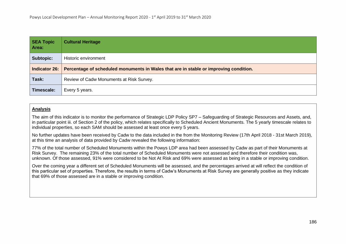
Powys Local Development Plan – Annual Monitoring Report 2020 - 1st April 2019 to 31st March 2020
186
SEA Topic
Area:
Cultural Heritage
Subtopic: Historic environment
Indicator 26: Percentage of scheduled monuments in Wales that are in stable or improving condition.
Task: Review of Cadw Monuments at Risk Survey.
Timescale: Every 5 years.
Analysis
The aim of this indicator is to monitor the performance of Strategic LDP Policy SP7 – Safeguarding of Strategic Resources and Assets, and, in particular point iii. of Section 2 of the policy, which relates specifically to Scheduled Ancient Monuments. The 5 yearly timescale relates to individual properties, so each SAM should be assessed at least once every 5 years.
No further updates have been received by Cadw to the data included in the from the Monitoring Review (17th April 2018 - 31st March 2019), at this time an analysis of data provided by Cadw revealed the following information:
77% of the total number of Scheduled Monuments within the Powys LDP area had been assessed by Cadw as part of their Monuments at Risk Survey. The remaining 23% of the total number of Scheduled Monuments were not assessed and therefore their condition was, unknown. Of those assessed, 91% were considered to be Not At Risk and 69% were assessed as being in a stable or improving condition.
Over the coming year a different set of Scheduled Monuments will be assessed, and the percentages arrived at will reflect the condition of this particular set of properties. Therefore, the results in terms of Cadw’s Monuments at Risk Survey are generally positive as they indicate that 69% of those assessed are in a stable or improving condition.
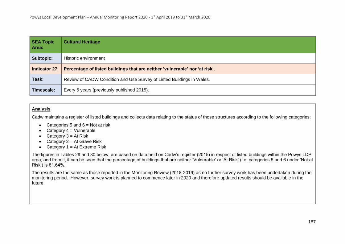
Powys Local Development Plan – Annual Monitoring Report 2020 - 1st April 2019 to 31st March 2020
187
SEA Topic
Area:
Cultural Heritage
Subtopic: Historic environment
Indicator 27: Percentage of listed buildings that are neither ’vulnerable’ nor ‘at risk’.
Task: Review of CADW Condition and Use Survey of Listed Buildings in Wales.
Timescale: Every 5 years (previously published 2015).
Analysis
Cadw maintains a register of listed buildings and collects data relating to the status of those structures according to the following categories;
• Categories 5 and 6 = Not at risk
• Category 4 = Vulnerable
• Category 3 = At Risk
• Category 2 = At Grave Risk
• Category 1 = At Extreme Risk
The figures in Tables 29 and 30 below, are based on data held on Cadw’s register (2015) in respect of listed buildings within the Powys LDP area, and from it, it can be seen that the percentage of buildings that are neither ‘Vulnerable’ or ‘At Risk’ (i.e. categories 5 and 6 under ‘Not at Risk’) is 81.64%.
The results are the same as those reported in the Monitoring Review (2018-2019) as no further survey work has been undertaken during the monitoring period. However, survey work is planned to commence later in 2020 and therefore updated results should be available in the future.
Powys Local Development Plan – Annual Monitoring Report 2020 - 1st April 2019 to 31st March 2020
188
Table 29. Percentage Of Listed Buildings That Are ‘At Risk’, ‘Vulnerable’ Or ‘Not At Risk’ In Powys (2015).
Risk Assessment %
At Risk 7.59
Vulnerable 10.76
Not At Risk 81.64
Table 30. Percentage Of Listed Buildings In Powys By Risk Score (2015).
Risk Assessment Risk Score %
At Risk 1 - At Extreme Risk 2.02
At Risk 2 - At Grave Risk 0.26
At Risk 3 - At Risk 5.32
Vulnerable 4 - Vulnerable 10.76
Not At Risk 5 - Not At Risk 31.83
Not At Risk 6 - Not At Risk 49.81
Powys Local Development Plan – Annual Monitoring Report 2020 - 1st April 2019 to 31st March 2020
189
SEA Topic
Area:
Cultural Heritage
Subtopic: Welsh Language
Indicator 28: Number, percentage and distribution of Welsh Speakers.
Task: Review of Census information on Welsh speakers available from the Office for National Statistics in 2021.
https://statswales.gov.wales/Catalogue/Welsh-Language
Timescale: Census (2021) data available 2022.
Analysis
Based on the results of the 2011 Census, Powys contains approximately 23,990 Welsh speakers. This represents 18.6% of the total Powys population of 129,083 as recorded in in the 2011 census.
With regards to their distribution within the county, the highest densities of Welsh speakers are found in the north and far south of the county. Three wards, all in the north have more than 50% of their populations describing themselves as Welsh speakers (Glantwymyn (57.8), Banwy (56%) and Machynlleth (51.6%)). There are five wards with between 40 and 49% Welsh speakers, and three of these are again in the north (Llanbrynmair (48.2%), Llanfihangel (43%) and Llanwddyn (42.7%). There are also two wards in the far south of Powys with a similar percentage (Cwm-twrch (46.2%) and Ynyscedwyn (45.9%). There are six wards with between 30 and 39% Welsh speakers, and four of these are found in the north (Llanfair Caereinion (36%), and Llanfyllin, Llanrhaeadr-ym-Mochnant, and Llansilin (all with 34.1%), and two again in the far south (Ystradgynlais (39.9%) and Abercraf (38.6))
Conversely, the lowest percentages of Welsh speakers can be found in eleven wards that all contain 10% or under of their populations speaking Welsh. These are Beguildy (10%), Berriew (9.5%), Bronllys (9.7%), Churchstoke (4.3%), Glasbury (8.7%), Gwernyfed (10%), Knighton (8.5%), Llangunllo (8%), Old Radnor (6.8%), Presteigne (9.3%) and Welshpool Castle (9.9%). All of these wards are in the eastern half of the county.
As these data were collected at the last national Census in 2011, they will not be updated until the results of the next national Census in 2021 are published in 2022. This implies that any changes in the statistics will be hard to ascribe solely to the presence of the LDP and its individual policies.
Powys Local Development Plan – Annual Monitoring Report 2020 - 1st April 2019 to 31st March 2020
190
SEA Topic
Area:
Cultural Heritage
Subtopic: Welsh Language
Indicator 29: Changes in the Welsh language skills of the population.
Task: Review of Census information on Welsh language skills available from the Office for National Statistics in 2021.
https://statswales.gov.wales/Catalogue/Welsh-Language
Timescale: Census (2021) data available 2022.
Analysis
This indicator is based upon the results of the national Census in 2011. The data is presented in Table 31 below as both a number of individuals and a percentage of the county’s population of 129,083 (as at 2011). After the results of the next Census have been published in 2022, after approximately six or seven years of the UDP and approximately four years of the LDP, a comparison can then be made to assess the degree of change that has occurred, although it will be hard to ascribe any changes solely to the LDP and its policies.
As this data was collected at the last national Census in 2011, they will not change until the results of the next national Census in 2021 are published in 2022.
Powys Local Development Plan – Annual Monitoring Report 2020 - 1st April 2019 to 31st March 2020
191
Table 31. Numbers And Percentages Of People With Welsh Language Skills In Powys.
2011 - Number 2011 - % of Powys Population
Can speak, read and write Welsh 17,724 13%
Can speak and read but cannot write Welsh
2,025 1.56%
Can speak but cannot read or write Welsh
3,932 3.04%
Can understand spoken Welsh only 8,616 6.67%
Other combination of skills 3,898 3.01%
No skills 92,888 71.95%
Powys Local Development Plan – Annual Monitoring Report 2020 - 1st April 2019 to 31st March 2020
192
SEA Topic
Area:
Cultural Heritage
Subtopic: Welsh Language
Indicator 30: Percentage of the population aged 3 and over who say they can speak Welsh.
Task: Review of Welsh Government Annual Population Survey estimates.
https://statswales.gov.wales/Catalogue/Welsh-Language
Timescale: Annually.
Analysis
The Welsh Government Annual Population Survey (APS) is carried out using a representative sample of 18,000 households selected randomly from across Wales according to certain characteristics (e.g., address, age etc). With a different selection of households being used each year the results may show fluctuations which may account for the relatively large differences that these results are showing. Whilst the APS is not the more thorough and comprehensive National Census that is carried out every 10 years, it also consistently shows a higher proportion of people who say they can speak Welsh. It is worth noting that the population estimates for Powys vary between the APS, the Census and the Mid-Year Estimates, whilst the Census is the most accurate data source, the APS is useful for identifying trends, between Census periods.
Based on the results of the Annual Population Survey for the year ending 31st March 2020, Powys contains approximately 34,600 people, who are aged three or over who say they can speak Welsh. This represents 27.3% of the total population of 126,900 people in Powys who are aged three or over. Last year these same figures equated to 37,500, 29.9% and 125,900 respectively.
These results show an apparent dramatic 12 month reduction of 2,900 in the numbers of people who say they can speak Welsh, which equates to approximately 2.6% of a total population size of people aged 3 or over that has grown in the same period by 1,000.
Powys Local Development Plan – Annual Monitoring Report 2020 - 1st April 2019 to 31st March 2020
193
SEA Topic: Landscape
SEA Topic Area – Landscape
Objective 17: To protect and enhance Powys rich natural landscape.
Indicator 31 - Area (ha) / proportion of development permitted that falls outside of development boundaries and is within LANDMAP aspect
areas classified as outstanding / high quality.
Indicator 32 - Proportion of outstanding / high quality aspect areas identified in LANDMAP.
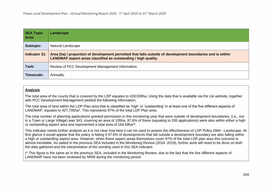
Powys Local Development Plan – Annual Monitoring Report 2020 - 1st April 2019 to 31st March 2020
194
SEA Topic
Area:
Landscape
Subtopic: Natural Landscape
Indicator 31: Area (ha) / proportion of development permitted that falls outside of development boundaries and is within LANDMAP aspect areas classified as outstanding / high quality.
Task: Review of PCC Development Management information.
Timescale: Annually.
Analysis
The total area of the county that is covered by the LDP equates to 428,930ha. Using the data that is available via the Lle website, together with PCC Development Management yielded the following information;
The total area of land within the LDP Plan area that is classified as ‘high’ or ‘outstanding’ in at least one of the five different aspects of LANDMAP, equates to 427,700ha*. This represents 97% of the total LDP Plan area.
The total number of planning applications granted permission in this monitoring year that were outside of development boundaries, (i.e., not in a Town or Large Village) was 343, covering an area of 105ha. 97.6% of these (equating to 335 applications) were also within either a high or outstanding aspect area and represented a total area of 164.59ha**.
This indicator needs further analysis as it is not clear how best it can be used to assess the effectiveness of LDP Policy DM4 - Landscape. At first glance it would appear that the policy is failing if 97.6% of developments that fall outside a development boundary are also falling within a high or outstanding aspect area. However, when these aspect areas themselves cover 97% of the total LDP plan area this outcome is almost inevitable. As stated in the previous SEA included in the Monitoring Review (2018 -2019), further work will need to be done on both the data gathered and the interpretation of the wording used in this SEA indicator.
(* This figure is the same as in the previous SEA, included in the Monitoring Review, due to the fact that the five different aspects of LANDMAP have not been reviewed by NRW during the monitoring period.
Powys Local Development Plan – Annual Monitoring Report 2020 - 1st April 2019 to 31st March 2020
195
NB; The Cultural Landscape Aspect Area is no longer classified (since the publication of LANDMAP Guidance Note 2 by NRW on the 8th June 2020) into ‘High’ or ‘Outstanding’, therefore this aspect area will need to be omitted from analysis in future monitoring.
(** The area of development outside of development boundaries AND within High or Outstanding aspects of LANDMAP is seen to be higher than the total area of all permitted developments outside of development boundaries. This apparent anomaly arises from the double counting that occurs when a particular development lies within more than one aspect area.)
Powys Local Development Plan – Annual Monitoring Report 2020 - 1st April 2019 to 31st March 2020
196
SEA Topic
Area:
Landscape
Subtopic: Natural Landscape
Indicator 32: Proportion of outstanding / high quality aspect areas identified in LANDMAP.
Task: Review of NRW LANDMAP data: https://naturalresources.wales/guidance-and-advice/business-sectors/planning-and-development/evidence-to-inform-development-planning/landmap-the-welsh-landscape-baseline/?lang=en
Timescale: Every five years.
Analysis
This indicator aims to measure how well LDP Policy DM4 - Landscape performs in protecting the different characteristics of the Powys landscapes.
The five different aspect areas that make up LANDMAP have not been reviewed by NRW since the previous SEA included in the Monitoring Review (2018-2019) so there is no change to report in this monitoring period. For ease of reference last year’s percentages are shown in Table 32 below.
Whilst this data does not provide any insight into the effectiveness of the Landscape Policy DM4 at this stage, it does provide a baseline for monitoring the policy moving forwards, once further, five-yearly reassessments of the aspect areas have been conducted.
NB; The Cultural Landscape Aspect Area is no longer classified into ‘High’ or ‘Outstanding’ classified (since the publication of LANDMAP Guidance Note 2 by NRW on the 8th June 2020), therefore this aspect area will need to be omitted from analysis in future monitoring.
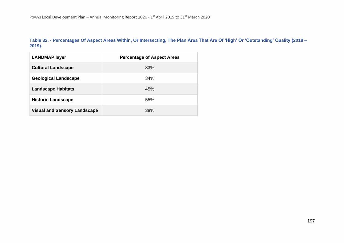
Powys Local Development Plan – Annual Monitoring Report 2020 - 1st April 2019 to 31st March 2020
197
Table 32. - Percentages Of Aspect Areas Within, Or Intersecting, The Plan Area That Are Of ‘High’ Or ‘Outstanding’ Quality (2018 –
2019).
LANDMAP layer Percentage of Aspect Areas
Cultural Landscape 83%
Geological Landscape 34%
Landscape Habitats 45%
Historic Landscape 55%
Visual and Sensory Landscape 38%
Powys Local Development Plan – Annual Monitoring Report 2020 - 1st April 2019 to 31st March 2020
198
SEA Topic: Geodiversity
SEA Topic Area – Geodiversity
Objective 18: To protect Regionally Important Geo-diversity Sites (RIGS) from incompatible development.
Indicator 33 - Number of RIGS and Geological Conservation Review sites.
Indicator 34 - Number of developments permitted on or affecting RIGS or Geological Conservation Review sites.
Powys Local Development Plan – Annual Monitoring Report 2020 - 1st April 2019 to 31st March 2020
199
SEA Topic
Area:
Geodiversity
Subtopic: Regionally Important Geodiversity Sites (RIGS)
Indicator 33: Number of RIGS and Geological Conservation Review sites.
Task: Review of information from JNCC, Central RIGS Group and South East Wales RIGS Group:
http://jncc.defra.gov.uk/default.aspx?page=4177&authority=UKL24 http://www.geologywales.co.uk/centralwales-rigs/ https://sewrigs.wordpress.com/
Timescale: Annually
Analysis
This indicator aims to monitor the performance of LDP Policy DM2, particularly with regards to the Regionally Important Geodiversity Sites (RIGS) and Geological Conservation Review Sites (GCRS) that are the subject of Criterion C of Section 3 of the policy.
Visiting the data sources listed above yielded conflicting or incomplete data so alternative data used to monitor this indicator was also sourced from the Lle website and the JNCC websites, these sources reveal the following results;
RIGS
According to the Lle data within Powys there is a total of 85 RIGS, with 11 of these being found within the boundaries of the Brecon Beacons National Park. This results in a total of 74 RIGS found within the Powys LDP area. It is noted that this dataset is incomplete, but it is useful for identifying trends regarding whether the number of RIGS is increasing or decreasing.
GCRS
The Lle and JNCC data sources revealed a total of 78 GCRS within the county of Powys, of which 25 were located within the Brecon Beacons National Park. This results in a total of 53 GCRS within the Powys LDP area. This includes three (Deadman’s and Spywood
Powys Local Development Plan – Annual Monitoring Report 2020 - 1st April 2019 to 31st March 2020
200
Dingles, Ynyslas and Afon Dyfi) that are listed under neighbouring counties as these either share a boundary with, or partially extend into, the County of Powys.
It can be seen from these results that there has been no change in the numbers of RIGS or GCRS from these data sources since the last monitoring period, however it is acknowledged that the analysis does not include all the RIGS in the Powys LDP area.
Powys Local Development Plan – Annual Monitoring Report 2020 - 1st April 2019 to 31st March 2020
201
SEA Topic
Area:
Geodiversity
Subtopic: Regionally Important Geodiversity Sites (RIGS)
Indicator 34: Number of developments permitted on or affecting RIGS or Geological Conservation Review sites.
Task: Review of PCC Development Management information.
Timescale: Annually
Analysis
LDP Policy DM2 - The Natural Environment provides protection for a range of sites, habitats and species that are designated at international, European, national and local level. This SEA indicator aims to test the policy’s ability to protect the locally important site designations listed under section 3 of the policy, namely Regionally Important Geodiversity Sites (RIGS) and Geological Conservation Review Sites (GCRS). Within the county, and external to the Brecon Beacons National Park, there are 74 RIGS and 53 GCRS.
A superficial analysis of the Council’s Development Management data has revealed that there are a total of six planning applications that were sufficiently close to a RIGS or GCRS designation to warrant further investigation which revealed the following details;
In this monitoring period a total of six individual applications have been permitted, which were close to a RIGS or GCRS but, upon closer analysis did not appear to recognise the proximity of the local designation to the proposal site. Three were close to a RIGS and three were close to a GCRS. However, in all of these cases they were relatively minor applications (e.g. involving householder extensions, installing a biomass boiler etc) that would not have any negative impact on the nearby site. Whilst none of these applications mentioned the proximity of the RIGS or GCRS, the reports for two of the sites, both GCRS, did however mention the presence of an SSSI within which the GCRS is located.
In order to strengthen Development Management understanding and the application of LDP Policy DM2 it is recommended that Officer training is required to ensure that this part of the policy is being considered in the determination of future applications.
NB this indicator is similar to Monitoring Indicator AMR45.
Powys Local Development Plan – Annual Monitoring Report 2020 - 1st April 2019 to 31st March 2020
202
5. Conclusion and recommendations
5.0.1 This AMR for the monitoring period 1st April 2019 to 31st March 2020 indicates that
the LDP policies are largely delivering and meeting their targets with thirty of the monitoring
indicators showing positive policy implementation. As this is the first full year of the LDP with
associated monitoring it is considered that for fifteen of the monitoring indicators no trends
can be identified at this stage.
5.0.2 There are five indicators where it is recommended that investigation or research is
required. Three of these relate to housing delivery (completions) which is lower than the
annual and cumulative targets set by the LDP. The Housing Trajectory demonstrates that
the Plan has enough suitable and available sites, so housing land supply is not considered
to be the issue. However, current trends suggest that there is a risk that the LDP may not
achieve the target Dwelling Requirement Figure of 4,500 new homes by 2026.
5.0.3 The LDP is delivering on its spatial strategy for the location of new housing
development, and employment growth, both areas which are key to the delivery of the Plan's
vision and objectives. The number of tourism developments being permitted on greenfield
sites in the Open Countryside, whilst having a positive economic impact on the Plan area, do
not align with the settlement hierarchy. It is recommended that research is undertaken to
address the cumulative impact the growth of this sector may have on the landscape.
5.0.4 It has been observed that the mineral safeguarding constraint is not always being
identified within the planning application process. Recommendations have therefore been
made so that the data relating to this constraint is more readily available in a variety of
formats as part of wider Officer training.
5.0.5 Monitoring will continue and the LDP policies and proposals can be expected to
accrue traction as the Plan period progresses from the adoption date. There are no factors
at present to suggest that changes are required to the Plan and consequently, an early
review of the Plan (either partial or full) is not necessary at this time.