keel-berriew pipeline, powys. dba
TRANSCRIPT
birmingham archaeology
IFA
RE
GISTEREDO
RGANISATION
PN 1715
Proposed Keel Berriew,Powys water pipelinescheme: Desk-Based
Assessment 2008
Project No. 1715
Proposed Keel Berriew, Powys water pipeline scheme:
Desk-Based Assessment 2008
By
Shane Kelleher
For Grontmij
For further information please contact: Alex Jones (Director)
Birmingham Archaeology The University of Birmingham
Edgbaston Birmingham B15 2TT Tel: 0121 414 5513 Fax: 0121 414 5516
E-Mail: [email protected] Web Address: http://www barch.bham.ac.uk/bufau
Proposed Keel Berriew, Powys water pipeline scheme Desk-Based Assessment 2008
Birmingham Archaeology i
Proposed Keel Berriew, Powys water pipeline scheme:
DRAFT Desk-Based Assessment 2008
CONTENTS
1 INTRODUCTION................................................................................................... 1
2 LOCATION AND GEOLOGY.................................................................................... 1 2.1 PIPELINE ROUTES AND OPTIONAL ROUTES.................................................................... 1
3 AIMS AND OBJECTIVES........................................................................................ 2
4 METHODOLOGY.................................................................................................... 2
5 ARCHAEOLOGICAL AND HISTORICAL CONTEXT ................................................... 2 Route A (Figs. 4 and 5) .......................................................................................... 3
5.1 PREHISTORIC .................................................................................................... 3 5.2 ROMAN ........................................................................................................... 3 5.3 EARLY MEDIEVAL ................................................................................................ 4 5.4 MEDIEVAL........................................................................................................ 4 5.5 POST-MEDIEVAL................................................................................................. 4
Route B (Fig 6) ..................................................................................................... 5 5.6 PREHISTORIC .................................................................................................... 5 5.7 ROMAN ........................................................................................................... 5 5.8 EARLY MEDIEVAL ................................................................................................ 5 5.9 MEDIEVAL........................................................................................................ 5 5.10 POST-MEDIEVAL................................................................................................. 6
6 LISTED BUILDINGS AND STRUCTURES ................................................................ 6
7 WALKOVER SURVEY............................................................................................. 6 7.1 ROUTE A: REFAIL TO LOWER LUGGY ......................................................................... 6 7.2 ROUTE B: WELSHPOOL SOUTH RIDING TO RED LANE...................................................... 7
8 STATEMENT OF EFFECTS...................................................................................... 8 8.1 CRITERIA......................................................................................................... 8 8.2 PALAEO-ENVIROMENTAL POTENTIAL......................................................................... 12
9 CONCLUSIONS AND RECOMMENDATIONS.......................................................... 13 9.1 SUGGESTED ROUTE CHANGES................................................................................ 14
10 PROPOSED MITIGATION ................................................................................ 15
11 ACKNOWLEDGEMENTS ................................................................................... 18 11.1 REFERENCES................................................................................................... 19
Proposed Keel Berriew, Powys water pipeline scheme Desk-Based Assessment 2008
Birmingham Archaeology ii
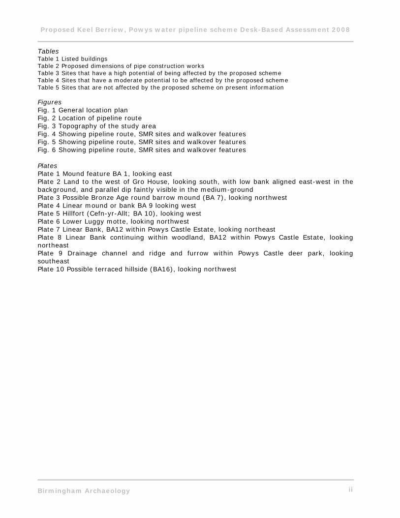
Tables Table 1 Listed buildings Table 2 Proposed dimensions of pipe construction works Table 3 Sites that have a high potential of being affected by the proposed scheme Table 4 Sites that have a moderate potential to be affected by the proposed scheme Table 5 Sites that are not affected by the proposed scheme on present information Figures Fig. 1 General location plan Fig. 2 Location of pipeline route Fig. 3 Topography of the study area Fig. 4 Showing pipeline route, SMR sites and walkover features Fig. 5 Showing pipeline route, SMR sites and walkover features Fig. 6 Showing pipeline route, SMR sites and walkover features Plates Plate 1 Mound feature BA 1, looking east Plate 2 Land to the west of Gro House, looking south, with low bank aligned east-west in the background, and parallel dip faintly visible in the medium-ground Plate 3 Possible Bronze Age round barrow mound (BA 7), looking northwest Plate 4 Linear mound or bank BA 9 looking west Plate 5 Hillfort (Cefn-yr-Allt; BA 10), looking west Plate 6 Lower Luggy motte, looking northwest Plate 7 Linear Bank, BA12 within Powys Castle Estate, looking northeast Plate 8 Linear Bank continuing within woodland, BA12 within Powys Castle Estate, looking northeast Plate 9 Drainage channel and ridge and furrow within Powys Castle deer park, looking southeast Plate 10 Possible terraced hillside (BA16), looking northwest
Proposed Keel Berriew, Powys water pipeline scheme Desk-Based Assessment 2008
Birmingham Archaeology iii
SUMMARY A desk-based assessment was undertaken by Birmingham Archaeology on behalf of Grontmij in advance of a proposed Severn Trent Ltd Keel Berriew water pipeline scheme. This comprised two routes A and B between Refail (NGR 319264, 300368) to Lower Luggy (NGR 319938, 302086) and Red Lane (NGR 322279, 306181) to Welshpool South Riding (NGR 321704, 307215), Powys. A walkover survey was conducted across the entire route, where permission and access was available. The Sites and Monuments record at Clwyd-Powys Archaeological Trust, the online Archaeological Data Service, Coflein (the National Monuments Record of Wales online data service for the RCAHMW), were consulted, alongside published and unpublished documentary and cartographic sources available at the University of Birmingham. The assessment identified that sections of the route passed adjacent to the Dyffryn Lane complex which is an area of high ritual and funerary activity dating from the Neolithic and Bronze Age. The route is also located close to Luggy Motte, a scheduled ancient monument, and runs through the deer `park of Powys Castle. The potential impact of the scheme on each archaeological site was assessed. The walkover survey also identified some previously unknown possible earthworks and archaeological features. The potential for the presence and identification of palaeoenvironmental deposits was also assessed. The report concludes with a list of sites affected and provides proposals to minimise the effects of the scheme on the archaeology.
Proposed Keel Berriew, Powys water pipeline scheme Desk-Based Assessment 2007
Birmingham Archaeology 1
Proposed Keel Berriew, Powys: Severn Trent Water pipeline scheme 2007
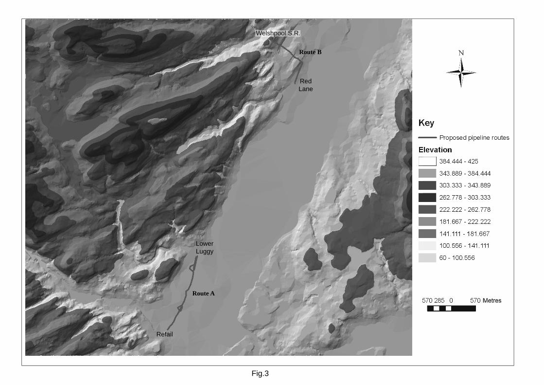
1 INTRODUCTION Between October 2007 and January 2008 Birmingham Archaeology carried out an archaeological desk-based assessment of land between Route A; Refail (NGR 319264, 300368) and Lower Luggy (NGR 319938, 302086) and Route B: from Red Lane (NGR 322279, 306181) extending to the southwest of Welshpool (NGR 321704, 307215), Powys. The work was commissioned by Grontmij on behalf of Severn Trent Water Ltd in advance of a proposed pipeline scheme. This report outlines the results of the assessment which was prepared in accordance with the Institute of Field Archaeologists Standard and Guidance for Archaeological Desk-Based Assessment (IFA 1999). 2 LOCATION AND GEOLOGY The route of the proposed pipeline is located in the upper Severn Valley to the southwest of Welshpool, Powys (Fig. 1). The first section of pipeline (Route A) runs between Refail in the southwest, (NGR 319264, 300368), and Lower Luggy c.2km to the northeast (centred on NGR 319938, 302086) and the other (Route B) from Red Lane (NGR 322279, 306181) to a position southwest of Welshpool (NGR 321704, 307215), for a total length of c. 3.4km (Figs. 2 and 3).
Almost the entire stretch of the two Keel Berriew pipeline routes is located on low ground between 80 and 100m above OD in the Severn Valley rising only at the extreme north of the route where it slopes up to higher ground at above 143m OD. High ground rising to over 400m OD exists to the northwest and southeast of this valley (Fig. 3).
Drift Geological information is not available for some areas of the upper Severn Valley. The underlying solid geology for almost the entire route comprises Wenlock and Ludlow Rocks with a section of Llandovery Rocks to the extreme north at the higher ground (British Geological Survey 1:250,000 Bedrock and Linear feature data). The Severn Valley is made up largely of alluvium with gravels to the west.
2.1 Pipeline routes and optional routes
The preferred route largely follows that of the existing water main, though not consistently, and there are slight deviations from this in places (Figs. 4 to 6). At Refail the pipeline runs alongside an existing main, largely following the west side of the A483 to a point to the south of Luggy Bridge. Divergence from the route of the existing main occurs around existing dispersed settlement and at the crossroads of the A483 and the B4390. Optional routes are proposed on the east side of the road at Lower Luggy and following the existing pipeline through the dispersed settlement. At Red Lane the proposed route runs parallel to the existing main through the grounds of Powys Castle and then turns to the northwest loosely following the route of the existing pipeline to an upland reservoir 1km to the southwest of Welshpool. The width of the proposed pipe is between 0.6m and 2.5m, and a working width of between 15m and 20m is assumed for the purposes of this report.
Proposed Keel Berriew, Powys water pipeline scheme Desk-Based Assessment 2007
Birmingham Archaeology 2
3 AIMS AND OBJECTIVES The principle aim of the project was to assess the survival and potential significance of any above and below-ground archaeology within the study area by collating existing archaeological information for the study area and its immediate environs and placing it in its local, regional and national context.
More specific aims were to:
• Assess the location of known archaeological and historical sites from available SMR and published data
• To assess the presence of potential above-ground archaeological earthwork features by a close examination of the local topography through a walkover survey
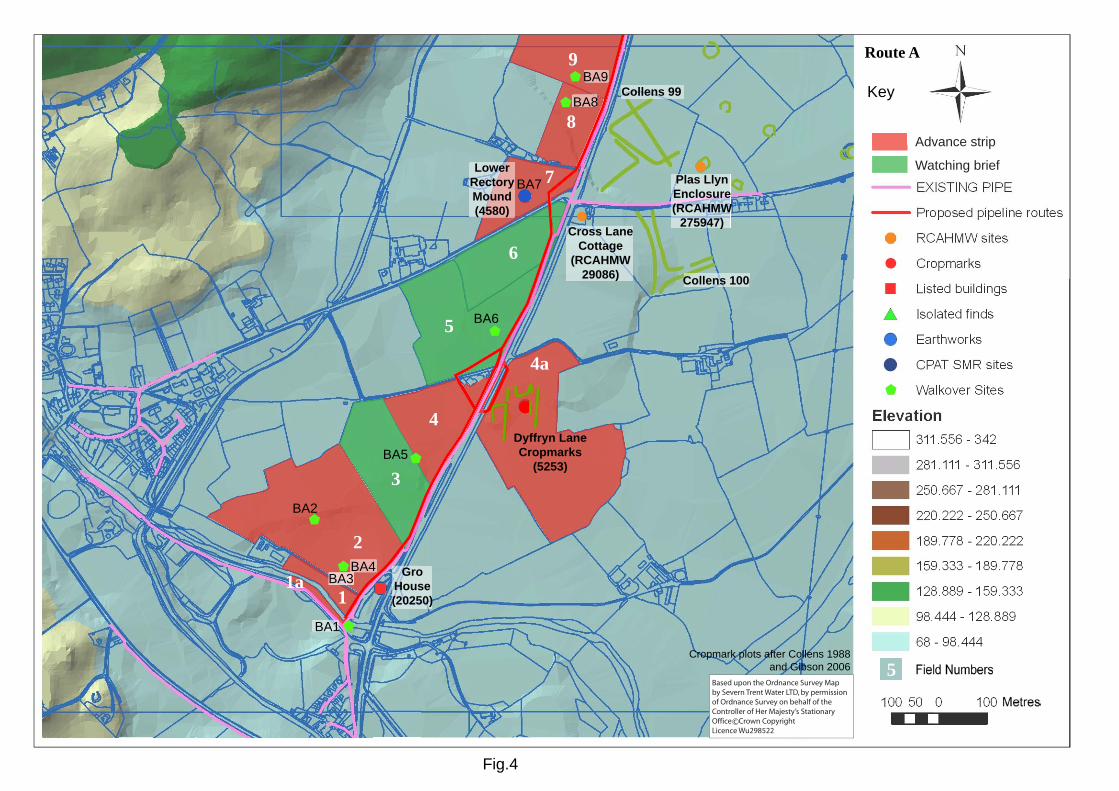
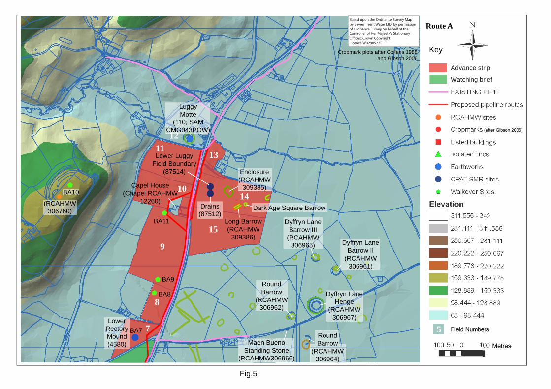
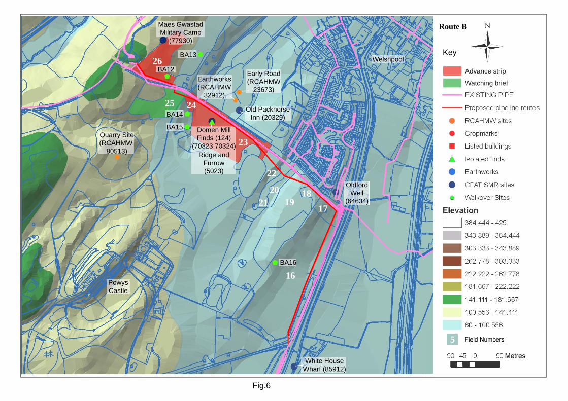
This information will be used to inform a mitigation strategy for future archaeological work on the pipeline route (see Section 9 below). 4 METHODOLOGY The Clwyd-Powys Sites and Monuments Record, the main source of archaeological information for the county was consulted and a list of relevant archaeological and historical sites along the route of the pipeline was obtained. The study area was defined by a 100m transect centred on the proposed pipeline routes. The Sites and Monuments Record was also visited in order to carry out more detailed research and to consult relevant published and non-published documentary sources. The RCAHMW website, Coflein (http://www.coflein.gov.uk/) was also consulted, together with the ADS (http://ads.ahds.ac.uk/) online database. Further published and non-published documentary sources were consulted at the library of the University of Birmingham. A walkover of the study area was undertaken in order to assess the topography and any visible above-ground archaeology. The route of the pipeline was walked in October 2007. Certain fields were not walked where landowners did not give permission or where farm animals were considered a threat to Health and Safety. Potential archaeological sites identified during the walkover survey have been numbered with a ‘BA’ prefix. 5 ARCHAEOLOGICAL AND HISTORICAL CONTEXT The two pipeline sections Routes A and B are illustrated in Figs. 4 to 6. Route A beginning in the southwest at Refail, and ending to the northeast at Lower Luggy, and Route B starting at Red Lane to the northeast of this and ending at Welshpool South Riding to the northwest of Red Lane. Each figure depicts the recorded SMR sites located within c. 50m of the pipeline. In addition, certain sites that lie over 50m from the pipeline are referred to where relevant, in order to provide a broader understanding of the archaeological and historical development of the area. Route A is in the locality of Luggy Motte; a Scheduled Ancient Monument; and a important prehistoric ritual complex; whilst Route B passes through the grounds of Powys Castle; a Grade I listed building with important gardens and grounds. The following sections (5.1-5.10) represent a summary of the known archaeological and historic sites currently recorded in the study area. It must be noted that the potential exists for archaeological sites located beyond the specific study area to extend within it. In addition further unknown sites, not presently recorded, are also likely to be identified during fieldwork.
Proposed Keel Berriew, Powys water pipeline scheme Desk-Based Assessment 2007
Birmingham Archaeology 3
Route A (Figs. 4 and 5)
5.1 Prehistoric Recent archaeological work on the Dyffryn Lane prehistoric ritual complex has revealed an area of important ritual and funerary prehistoric activity (Gibson 2006; www.cpat.org.uk). The Dyffryn Lane complex is found directly to the east of the proposed pipeline between Refail and Lower Luggy (Fig. 4 and 5) (Cropmarks transposed from Collens 1988; and Gibson 2006, 166) Alex Gibson’s archaeological work which included aerial photography, topographic survey, geophysical prospection, and excavation revealed “a fascinating and important complex of ritual monuments” (www.cpat.org.uk) which were constructed and used in this area in the Neolithic and Bronze Age. The oldest sites in the complex are a Neolithic long barrow at Lower Luggy (RCAHMW 309386; Gibson 2000) and a nearby Neolithic enclosure (RCAHMW 309385; Gibson 2006) The Long barrow has produced radiocarbon dates from in-situ burnt oak posts within a palisade trench (Gibson 2000). Two samples from the long barrow site (BM-2954 and BM-2955) have been combined to produce a date of 3640-3500 BC (ibid. 11). The Neolithic enclosure has been dated to c.3650-3350 BC (Beta 177037 & 206282; Gibson 2006, 178). Both the long barrow and enclosure are relatively rare (Gibson 2000, 13). Other Neolithic enclosure sites have been identified; ibid. 187-188), and may be one of a number of earlier Neolithic enclosures in the region (ibid). This site, however, has produced clearer dating evidence than others such as that at Brynderwen (Gibson and Musson 1990) near Abermule to the west and is clearly of national significance (Gibson 2006, 185-189), particularly in view of its association with a long barrow (ibid. 187). Another important part of the complex is a henge (RCAHMW 306967), this monument, which has a single entrance and is enclosed by a ditch, dates from c.3,000 to 2,500 BC. This type of site is quite rare in Wales, and the Dyffryn Lane henge is even more unusual as sometime after its construction it was converted for use as a burial mound. A number of cropmarks and mounds were also revealed at the Dyffryn Lane complex including (RCAHMW nos. 306961, 306964, 306962, 306965) most of which are believed to be round barrows. In addition a Dark Age square barrow was found to the east of the Neolithic long barrow, and Maen Bueno, (RCAHMW 306966) a standing stone of an unknown date, which is found to the southwest of the henge. It must be noted that the proposed pipeline does not run through any of these sites, however it is possible that this ritual and funerary landscape extended westwards into the line of the pipeline. The likelihood of this is further supported by the existence of the Bronze Age Lower Rectory Mound (CPAT 4580; Fig. 4) on the west side of the existing pipeline. This has been almost completely ploughed away over the centuries. Further cropmarks were observed to the south of the Dyffryn Lane complex (CPAT 5253; Fig. 4); this series of intersecting linear cropmarked features is thought to have been part of a former field system which could be prehistoric or medieval in date. It is notable that these are included in Collens’ theses on Iron Age and Romano-British enclosures in the upper Severn Valley (Collens 1988). It would seem that the proposed pipeline, at The Meadows may partially cut through these features. There is no evidence for any later prehistoric activity or settlement in the immediate vicinity of the study area. However it must be noted that Cefn-yr-allt (RCAHMW 306760; Fig. 5) an Iron Age defended enclosure is found c. 600m to the west of the pipeline between Refail and Lower Luggy. 5.2 Roman There is no evidence for any Roman settlement or activity along this section of the pipeline route.
Proposed Keel Berriew, Powys water pipeline scheme Desk-Based Assessment 2007
Birmingham Archaeology 4
5.3 Early medieval There is evidence for early medieval activity in the vicinity of the proposed pipeline route at the Plas LLyn enclosure (RCAHMW 275947; Fig. 4), which is found within the Dyffryn Lane complex, c. 250m to the east of the proposed route and thus not within the pipeline scheme. It has been suggested that the church at Berriew , the birthplace of St. Beueno may have been an early medieval foundation (Silvester 1992, 19). This is nevertheless beyond the pipeline route. In addition evidence of a Dark Age square barrow exists within the Dyffryn Lane complex (Gibson 2006, 166), but again this is c. 250m to the east of the proposed route and thus not within the pipeline scheme. 5.4 Medieval In much the same way that the area to the east of the Refail to Lower Luggy pipeline could be described as a prehistoric ritual landscape, parts of the area surrounding both sections of pipeline could be described as a medieval landscape. Two of the most prominent medieval sites in this area are Luggy Motte (Fig. 5; CPAT 110, SAM Mg 043 POW) and Powys Castle (Fig. 6; see description below) are found in the locality of both pipeline routes. The proposed pipeline route does not run through either of these sites but it does run through the grounds of Powys Castle and very close to Luggy Motte. To the northwest of Route A, the village of Berriew dates from at least 1100, when ‘Eberrw’ is referred to (Silvester 1992, 19). Other possible medieval features identified in the landscape are the Lower Luggy field boundaries (CPAT 87514; Fig. 5) and field drains which are more likely to be post medieval in date (CPAT 87512; Fig. 5) to the east of the pipeline between Refail and Lower Luggy, and ridge and furrow which may be a post-medieval feature (CPAT 5023; Fig. 6) in the Powys Castle deer park to the west of the other proposed pipeline route. Luggy Motte Luggy Motte, which is a Scheduled Ancient Monument (CPAT 110/58145, SAM Mg 043 POW; Fig. 5), is located c.80m to the northwest of the Lower Luggy terminal of the proposed pipeline. This is a steep sided circular mound measuring c.42m in diameter at the base, and c.20m at the summit which is approximately 36 x 43m. This type of site is common in the Welsh borderlands and Luggy Motte is one of half a dozen such earthworks in upper Severn Valley (Silvester 1997,1), and is located 5km to the northwest of the best known of these; Hen Domen. In fact in this border area a case can be made that these mottes formed part of an overall defensive scheme comprising of a chain of strong points linking the major castles of Roger de Montgomery at Shrewsbury and Hen Domen and protecting the English plain from a Welsh attack (Pounds 1990, 55). No accurate date has been given for this motte however it is likely that it dates from soon after the Norman invasion of this area in the 1080s. Buildings of medieval origin Gro House (CPAT 20250; Fig. 4) is found close to the southern terminal of the Refail to Lower Luggy Pipeline. This Grade II listed building is medieval in date and is half timbered with four hexagonal brick chimneys. This important building is not directly affected by the proposed pipeline (See Listed Buildings, Section 6 below). 5.5 Post-medieval There are no post-medieval features or structures of note along this pipeline route apart from Capel House (RCAHMW 12260; Fig. 5) and Cross Lane Cottage (RCAHMW 29086, Fig. 5). Capel House is a pair of 19th century red brick cottages with a slate roof and red brick chimney stack and may have originally been used as a chapel. Cross Lane Cottage is also a significant post-medieval building. The pipeline route does not affect either structure.
Proposed Keel Berriew, Powys water pipeline scheme Desk-Based Assessment 2007
Birmingham Archaeology 5
Route B (Fig 6) 5.6 Prehistoric Prehistoric sites are not as prominent along Route B (Fig. 6). There is a possible barrow to the southeast of the pipeline (not illustrated), whilst the finds of a Bronze Age palstave and spearhead (CPAT 70323 and 70324; Fig. 6 as Domen Mill Finds), are likely to be isolated finds; however they could be indicative of votive deposits in a wet area. The proposed pipeline does not run directly through any of these sites. 5.7 Roman There is sparse evidence for Roman activity or settlement within the vicinity of Route B. Some items of Roman metalwork (CPAT 124; Fig 6 as Domen Mill Finds) were uncovered at Domen Mill to the west of the pipeline route. These finds consisted of three brasses of Hadrian or Commodus and two small colonial finds. It is likely that these are isolated finds, however it must be mentioned that the purported medieval fairground platform at Maes Gwastad (RCAHMW 32912; Fig; 6), to the north of this section of pipeline has “a remarkable resemblance to a Roman fort” (ADS record no. CPATSMR_5643). Neither of these sites is located within the proposed pipeline scheme. 5.8 Early medieval There is no evidence for early medieval settlement or activity along this section of the proposed pipeline route. However there is a possible early road to the northeast of the pipeline (RCAHMW 23673; Fig. 6). 5.9 Medieval As note above could parts of the area surrounding both sections of pipeline could be described as a medieval landscape. Powys Castle (see description below) is located to the southwest of the proposed route, this runs through its grounds. These grounds contain medieval ridge and furrow in close proximity to the proposed route (CPAT 5023; Fig. 6) Powys Castle Powys Castle or Castell Coch is located c.700m to the northwest of the Red Lane terminus of the proposed pipeline route (Fig. 6). Despite being too far away to be affected by the proposed pipeline route, the proposed pipeline does run through the castle deer park. The red sandstone castle is built on the site of a fort of the Welsh princes and became a border stronghold of Owain Cyfeiliog from c.1170. Sections of the present day castle were constructed at this time and in the late 13th-century timber outbuildings and the bailey wall were reconstructed in stone. From the 15th century the castle was gradually transformed into a mansion, and was bought by Sir Edward Herbert in 1587, who set about converting the castle into an Elizabethan great house (Pettifer 2000, 151). What is relevant for the current proposed pipeline route is the treatment of the grounds and gardens. It would appear that the majority of the internationally renowned landscaped gardens of Powys castle are located on the south and west sides of the castle. These include “the finest surviving Baroque late 17th-century/early 18th-century garden terraces in the United Kingdom… and 18th-century landscaping in the great lawn and wilderness by William Emes” a follower of Capability Brown (CADW 1999, 217). In addition Ladies Mount (not illustrated), a motte and bailey is found c.500m to the west of the castle within the current gardens. The areas to the north and east of the castle, where the proposed pipeline route is located appear to have been part of the deer park or had an agricultural function. Historic maps show an old quarry (RCHMAW 80513) in this section of the park and the SMR records the presence of ridge and furrow. The proposed pipeline does not appear to affect any of these sites.
Proposed Keel Berriew, Powys water pipeline scheme Desk-Based Assessment 2007
Birmingham Archaeology 6
Buildings of medieval origin Gro House (CPAT 20250; Fig. 4) is found close to the southern terminal of the Refail to Lower Luggy Pipeline. This Grade II listed building is medieval in date and is half timbered with four hexagonal brick chimneys. This important building is not directly affected by the proposed pipeline (See Listed Buildings, Section 6 below). 5.10 Post-medieval The main post-medieval site of interest in the vicinity of the pipeline route is Maes Gwastad military training camp (CPAT 77930; Fig. 6). This dates from the late 1850s to 1870s and was used by local militia who had 28 days each year training at this site. The extent is not clear and it may contain the remains of trenches and rifle ranges. Buildings of post- medieval origin The Old Packhorse Inn (CPAT 20329; Fig. 6) which is a significant post medieval building located close to the pipeline route is a simple timber framed building with a near central chimney dividing the house into two. Evidence from its fabric suggests that this has Elizabethan origins however the majority of the building is of 18th century date. The pipeline does not affect this structure.
6 LISTED BUILDINGS AND STRUCTURES
Table1. Listed buildings Name SMR No. Date Figure No. Gro House 20250 Medieval 4
Other significant structures recorded on the SMR are as follows: Oldford Well (CPAT 64634; Fig. 6), and the White House Canal Wharf (CPAT 85912; Fig. 6), are both of post-medieval date, and not affected by the proposed pipeline route. 7 WALKOVER SURVEY The walkover survey, which was carried out in October 2007, began near Refail to the southeast of Berriew following the line of the A483 to Lower Luggy (Route A). Route B passed through the grounds of the Powys Castle Estate from Welshpool S.R. to Red Lane.
7.1 Route A: Refail to Lower Luggy
The route begins at the River Rhiw. To the south of the river a flat-topped mounded area was recorded (BA 1; Fig. 4; Plate 1;). It is possible that this is either a modern feature, or may be part of a former river crossing here, since the line of the old road and ‘Rhiw Bridge’ was west of the present one, as shown on the First Edition Ordnance Survey map of c.1896 (not illustrated). A public footpath runs alongside the river on its northern side, with some post-medieval building materials making up a raised area to the north of the river, generally covered with long grass. The field to the north contained a prominent former field boundary (BA 2; Fig. 4) visible as a bank with trees to the west of the pipeline, running in a southwest to northeast line. A low bank (BA 3; Fig. 4) was present in the field to the west of Gro Cottage running northwest to southeast (Plate 2), and may represent another former field boundary. A similarly aligned dip in the field (BA 4; Fig 4; Plate 2) was recorded parallel to this. To the north the land generally sloped westwards behind Gro Cottage, where the land to the rear (west) may be made up of a raised platform (Plate 2), which may represent a former road delineated on the First Edition Ordnance Survey map (not illustrated).
Proposed Keel Berriew, Powys water pipeline scheme Desk-Based Assessment 2007
Birmingham Archaeology 7
A former field boundary (BA 5; Fig. 4) was recorded aligned northwest to southeast in the field to the north of Gro Cottage. North of The Meadows a hollow (BA 6; Fig. 4) overgrown with nettles (indicating disturbed ground) was recorded aligned southwest to northeast across the field. To the north the land was characterised by pasture fields on land rising slightly to the west. To the north of the B4390 a raised area to the west of the pipeline route was interpreted as a possible round barrow site (BA7; CPAT 4580; Plate 3), though this may be natural. Between this feature and the road the land was generally disturbed, and may have contained ridge and furrow (Fig. 4). The length of the grass and thistles, however, made this difficult to discern with confidence. To the north of Plas Llwyn a linear hollow (BA 8; Figs. 4 and 5) was noted aligned northwest to southeast within a pasture field. On the other side of the field boundary was a low linear mound or bank (BA 9; Figs. 4 and 5; Plate 4). It is worth noting that a relatively prominent hillfort (Cefn-yr-allt; BA 10; Fig. 5; Plate 5) was visible directly to the west. At Capel House (RCAHMW 12260), a possible bank (BA 11; Fig. 5) was present to the rear of the plot, following the property boundary aligned southeast to northwest. Unfortunately access beyond this point was refused. Therefore fields were not walked directly between here and Luggy Motte. Luggy Motte (CPAT 110; Fig. 5; Plate 6) and its associated bailey are clearly visible as earthworks and the pipeline route terminated in the field directly to the south. No obvious features were apparent here. The field was not, however, walked directly due to uncertainties regarding permission for access. On the opposite side of the road the pipeline route extended through a level area with planted young trees, adjacent to the road to the west of Allt Lower. A field of maize stubble was present to the south where the pipeline route crossed the road at Capel House. No obvious archaeological features were noted here. It is important to note, however, that this is an area of important Neolithic and other monuments, enclosures and features revealed through recent research excavations and geophysics (Gibson 2006; www.cpat.org.uk). These include a long barrow and a Neolithic enclosure, both regionally and nationally significant and a possible ‘Dark Age’ square barrow (ibid.).
7.2 Route B: Welshpool South Riding to Red Lane
The pipeline route was walked from Welshpool South Riding which is to the north of Powys Castle (Field 26), to Red Lane which is to the southwest of Welshpool town centre towards the entrance of Powys Castle deer park (Field 16). To the northwest of the access road (Fields 26 and 27) the route extended uphill through a grazed area and into woodland to an existing reservoir site. At the base of the slope, was a small pond, and a low bank aligned east-west (BA 12; Fig. 6; Plate 7). The bank could be traced extending uphill to the west (Plate 8) and into deciduous woodland, where its identification in the vicinity of the reservoir was possible. The feature was level within the woodland on its eastern side, particularly in the vicinity of the reservoir, and it is possible that a natural contour has been modified here and extended downhill, or that a barrier has been formed in this area by terracing. It was assumed that this feature may be a former deer park boundary bank, since the current boundary fence was only c. 40m to the south. To the southeast the route of the pipeline extended through the current deer park. The ground dropped away markedly to the southeast of the current drive. At the base of the slope a bank was visible broadly parallel with the drive. A modern drainage ditch forming a square enclosed area was present alongside the northwestern boundary of the deer park. Within the enclosed area was a sub-square hollow (BA 14; Fig 6; Plate 9), possibly representing a former pond. To Some traces of ridge and furrow were present to the south (BA 15; Fig. 6, Field 23) below a
Proposed Keel Berriew, Powys water pipeline scheme Desk-Based Assessment 2007
Birmingham Archaeology 8
low hillock with mature trees. The ridge and furrow was aligned southwest-northeast. The pipeline route extended eastwards into higher ground and passed to the north of a pocket of woodland. The deer park was not walked through due to the presence of a stag and deer. To the east the proposed pipeline route followed the line of the A490 to its west, within land used for both grazing and as a showground. The land was higher to the west where it appeared to have been terraced in places (BA 16; Fig 6;Plate 10). The route was not walked further west due to it being part of the deer park. 8 STATEMENT OF EFFECTS Tables 3 and 4 list archaeological sites identified which may potentially be affected by the proposed pipeline routes. A number of points need to be considered in addition to the identification of known sites:
• Co-ordinates represent approximate locations of sites. However, the full extent of each site is likely to extend beyond these co-ordinates.
• A number of sites recorded on the Sites and Monuments Record have the potential to
be larger in extent that the current archaeological record indicates. Additional archaeological deposits may be present in association which are currently unknown.
• A number of additional archaeological sites are likely to exist along the pipeline routes
which have not been previously identified or predicted and may be unable to be identified through desk-based methods.
• The width of the pipeline scheme has been assumed to be 20m for the purpose of this
survey, although this width may be less along specific lengths of the scheme (Table 2 below).
Table 2. Proposed dimensions of pipe construction works
Pipe size Working Width
(metre)
Pipe Trench width
(metre)
Remarks
450mm dia 20 1.5 to 2.5
250mm dia 15 0.75 to 0.6
150mm dia 15 0.75 to 0.6
Depending upon pipe depth
8.1 Criteria
The following tables (Tables 3 and 4) list sites which have a high or moderate potential to be affected by the proposed pipeline scheme. This has been assessed on the basis of the proximity of the proposed pipeline scheme to known sites and the known extent of these sites. Sites with a high potential to be affected may be directly impacted by the scheme. Sites with a moderate potential to be affected are those whose extent may not be clearly definable, and therefore have the potential to be impacted by the pipeline. A further table lists sites that may not be impacted by the scheme, based on present information. This includes sites that are beyond the assumed 20m working width of the scheme and listed buildings which the pipeline clearly avoids.
Proposed Keel Berriew, Powys water pipeline scheme Desk-Based Assessment 2007
Birmingham Archaeology 9
Within these tables the archaeological sites have been categorised into high, moderate, or low according to their significance. The criteria for these categories are outlined below:
• High archaeological potential. The site has the potential to provide a unique or significant contribution to the understanding of the past. It may contribute unique data to the archaeological record and may be of regional or national significance.
• Moderate archaeological potential. The site has the potential to contribute to the
understanding of the past and provide an informative contribution to an existing body of data within the regional archaeological record.
• Low archaeological potential. The site may not significantly contribute to the
understanding of the past and may provide a limited contribution to the archaeological record. May be of some local significance. The preservation of the site may have been compromised by, for instance, modern development in the recent past.
Table 3. Sites that have a high potential of being affected by the proposed scheme SITE National
Grid Ref. SMR/ BA No.
Description Archaeological potential
Figure No.
Dyffryn Lane Cropmarks II
319650, 300830
5253 Prehistoric/ medieval linear cropmarks which relating to a field system.
Moderate 4/5
Lower Rectory Mound
319650, 301270
4580 (BA 7)
Bronze Age Round Barrow- potential for associated archaeology.
High 4/5
Lower Luggy field boundaries
319980, 301900
87514 Possible medieval Field System identified with geophysics.
Low 5
Lower Luggy field drains or ridge and furrow
319980, 301930
87512 Possible post medieval field drains or ridge and furrow
Low 5
Possible former field bank
BA 11 BA 11 Possible former field-bank / bank associated with Capel House property. Observed during walkover survey.
Low 5
Domen Mill 322000, 307000
124, 70323, 70324
Find spot of Roman metalwork, and Bronze Age palstave and spearhead. Potential for
High 6
Proposed Keel Berriew, Powys water pipeline scheme Desk-Based Assessment 2007
Birmingham Archaeology 10
associated finds and archaeology
Possible former field boundary
319294, 300458
BA 3 & BA 4
Possible former field boundary visible as a low bank.
Low 4
Former field boundary
319405, 300744
BA 5 Former field boundary. Post-medieval/ modern field boundary
Low 4
Possible ridge and furrow
319725, 301291
Disturbed ground identified as possible ridge and furrow
Low 4
Possible deer park boundary bank
321864, 307155 to 321746, 307208
BA 12 Pipeline runs parallel with this feature and may cross it close to the existing reservoir
Moderate 6
Possible former pond
321919, 307085
BA 14 Pipeline runs through this location. Note Domen Mill finds close by.
Moderate 6
Table 4. Sites that have a moderate potential to be affected by the proposed scheme SITE National
Grid Ref.
SMR/ BA No.
Description Archaeological potential
Figure number
Possible former river crossing
319299, 300342
BA 1 Possible former river crossing or modern feature.
Moderate/Low 4
Dyffryn Lane field system/ enclosures
319878, 301384
Collens 1988 (No. 99)
Cropmarks relating to field system or enclosures, identified by Collens 1988 (No. 99), Potential to extend into fields 8 & 9 to the west.
Moderate
Enclosure, Lower Luggy
320059, 301909
RCAHMW 309385;
Neolithic Enclosure (Gibson 2006). Potential for associated archaeology
High
Long Barrow, Lower Luggy
320092, 301839
RCAHMW 309386;
Neolithic Long barrow (Gibson 2000). Potential for associated archaeology
High
Dark Age barrow
320130, 301856
Potential for associated archaeology.
High 5
Proposed Keel Berriew, Powys water pipeline scheme Desk-Based Assessment 2007
Birmingham Archaeology 11
Field hollow 319580, 300970
BA 6 Amorphous hollow Low 4
Maes Gwastad Military Training Camp
321820, 307300
77930 19th century military training camp. EXTENT UNKNOWN.
Moderate 6
Table 5. Sites that may not be affected by the proposed scheme on present information Site National
Grid Ref. SMR/ BA No.
Description Archaeological potential
Figure number
Gro House 319346, 300445
20250 Significant timber framed medieval house. Pipe runs c. 30m from building
High 4
Cross Lane Cottage
319782, 301231
RCAHMW 29086
Post medieval cottage. Pipe avoid building.
Low 4
Plas Llyn Enclosure
320022, 301337
RCAHMW 275947
Site of early medieval enclosure . Pipe avoids feature.
High 4
Former field boundary
319211, 300600
BA 2 Prominent former field boundary. Pipe avoids feature.
Low 4
Linear hollow 319751, 301486
BA 8 Linear hollow. Possibly natural Pipe avoids feature.
Low 4/5
Linear mound or bank
319763, 301502
BA 9 Linear mound. Pipe avoids feature.
Moderate 4/5
Luggy Motte 319890, 302140
110 Medieval motte and bailey. Pipe avoids feature.
High 5
Mae Bueno standing stone
320315, 301304
RCAHMW 306966
Pipe avoids feature.
High 5
Round barrow 320411, 301253
RCAHMW 306964
Pipe avoids feature.
High 5
Round Barrow 320335, 301365
RCAHMW 306962
Pipe avoids feature.
High 5
Dyffryn Lane Henge
320439, 301405
RCAHMW 306967
Pipe avoids this feature.
High 5
Dyffryn Lane Barrow II
318289, 301173
RCAHMW 306961
Pipe avoids feature
High 5
Dyffryn Lane Barrow III
320440, 301618
RCAHMW 306965
Pipe avoids feature
High 5
Proposed Keel Berriew, Powys water pipeline scheme Desk-Based Assessment 2007
Birmingham Archaeology 12
Possible former post medieval chapel, now domestic building
319826, 301841
RCAHMW 12260
Pipe avoids feature
High 5
Cefn-yr-allt Iron Age enclosure
319343, 301937
RCAHMW 306760
Pipe avoid site High 5
White House Wharf
322302, 306097
85912 19th century canal wharf. Pipe avoids this feature
Moderate/Low 6
Oldford Well 322455, 306739
64634 Site of post medieval well.
Low 6
Old Packhorse Inn
322100, 307040
20329 Building of possible Elizabethan origins. Pipeline avoids the building.
Moderate/High 6
Post medieval quarry site
321648, 306878
RCAHMW 80513
Pipeline avoids this feature.
Low 6
Earthwork platform
322086, 307085
RCAHMW 32912
Possible medieval fairground or roman fort. Pipeline avoids this feature.
Moderate/High 6
Possible early road
3220921, 307104
RCAHMW 23673
Possible early road. Pipeline avoids this feature.
Moderate/Low 6
Ridge and furrow 321926, 306483
BA 13 Pipeline avoids this feature.
Low 6
Ridge and furrow 321908, 306966
BA 15 Pipeline avoids this feature.
Low 6
Possible terracing
322213, 306483
BA 16 Pipeline avoids this feature.
Low 6
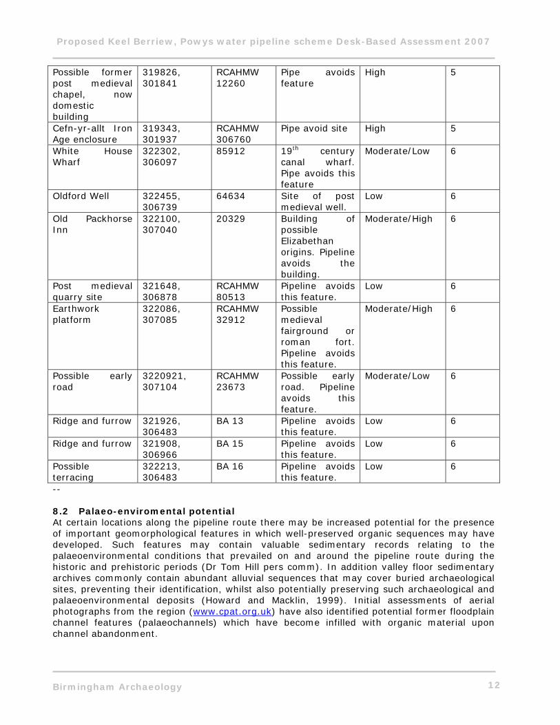
-- 8.2 Palaeo-enviromental potential At certain locations along the pipeline route there may be increased potential for the presence of important geomorphological features in which well-preserved organic sequences may have developed. Such features may contain valuable sedimentary records relating to the palaeoenvironmental conditions that prevailed on and around the pipeline route during the historic and prehistoric periods (Dr Tom Hill pers comm). In addition valley floor sedimentary archives commonly contain abundant alluvial sequences that may cover buried archaeological sites, preventing their identification, whilst also potentially preserving such archaeological and palaeoenvironmental deposits (Howard and Macklin, 1999). Initial assessments of aerial photographs from the region (www.cpat.org.uk) have also identified potential former floodplain channel features (palaeochannels) which have become infilled with organic material upon channel abandonment.
Proposed Keel Berriew, Powys water pipeline scheme Desk-Based Assessment 2007
Birmingham Archaeology 13
The pipeline route is located to the west of the Dyffryn Lane and Lower Luggy prehistoric monument complex, which lies upon a gravel terrace to the west of the River Severn floodplain (Gibson 2006). Previous studies on the River Severn floodplain have demonstrated three phases of deposition within the valley. The first and oldest relating to river terrace gravels of late Devensian date, followed by an ‘older floodplain’ at the western margins of the valley, with radiocarbon dates placing palaeochannel silting from the later Bronze Age onwards, and a ‘younger floodplain’, closer to the existing River Severn channel (Taylor and Lewin 1996, 81-83). Palaeolchannels have the potential to preserve organic anthropogenic remains such as those recorded at Shardlow, in the middle Trent Valley (Krawiec 2006). These have the potential to provide significant palaeoenvironmental data possibly in direct relation to archaeological sites. Aerial photography (http://www.cpat.org.uk/projects/longer/dyffryn/dyffryn.htm) shows the presence of palaeochannels or former river channels in the vicinity of the Dyffryn Lane ritual complex, to the east of pipeline Route A. The River Rhiw lies to the south of the pipeline Route A, and the Luggy Brook to the northern end of this route. It is uncertain to what extent these watercourses are associated with alluvial deposits or palaeochannels, though the presence of both clearly remains a possibility. Therefore pipeline Route A is proposed within an area on the western margins of the Severn valley, where the presence of palaeochannels has been recorded, and where there is a general potential for the presence of palaeoenvironmental deposits. It must be noted that superficial geological data is not published for the study area, and therefore the potential exists for peat deposits or further alluvial deposits to exist along the route of the pipeline. It is possible that any borehole data from the pipeline scheme may be able to actively contribute to an assessment of palaeoenvironmental potential along the route. Until such geotechnical assessments are undertaken, at present, the specific locations of such archaeological and palaeoenvironmental features remains unresolved. Therefore the depths of deposits and their potential for the preservation of palaeo-environmental data is unclear. In addition the low-lying area to the southwest of Llyn Du in the grounds of Powys Castle (Route B) may also have the potential for paleo-environmental deposits. The recorded Bronze Age and Roman finds from the immediate vicinity (Domen Mill finds CPAT 70323 and 70324), may suggest the deposition of metal objects into a wetland environment, which was a common phenomenon, particularly in prehistory (Bradley 1998). Again the nature of sub-surface deposits here is unknown at present and borehole data may be able to inform an understanding of this location.
9 CONCLUSIONS AND RECOMMENDATIONS
It is clear that a number of archaeological sites and monuments exist along the proposed Keel Berriew pipeline route. A particularly significant concentration of prehistoric ritual monuments has been previously located to the east of the pipeline Route A. Apart from field system/ enclosures (5263 and possibly Collens site 99) to the north and south of Dyffryn Lane, it cannot be demonstrated that the pipeline route directly truncates any known archaeological feature or monument. However, a cautionary note must be made here though, in that the Refail to Lower Luggy section of the pipeline is in an area of high ritual and funerary prehistoric activity which is certainly of regional if not national significance. The majority of previously identified sites in this area are located to the east of the proposed pipeline; however there is no specific reason for the complex not to continue to the west. There may be a disparity in site identification due to different agricultural practices or geological conditions on either side of the pipeline (hence archaeology being less visible to the
Proposed Keel Berriew, Powys water pipeline scheme Desk-Based Assessment 2007
Birmingham Archaeology 14
west through aerial photography). It has been demonstrated by Gibson, that even with aerial photographic and geophysical survey data, additional previously unknown archaeological features can be discovered through excavation (Gibson 2000, 11). Therefore where the pipeline passes to the west of known prehistoric features and monuments at Lower Luggy and Dyffryn Lane, there remains the potential for previously unidentified archaeology, associated with this significant monument complex, to be present. The only known prehistoric monument on the west side of the pipeline Lower Rectory Mound (CPAT 4580) is located rather close to a section of the proposed pipeline. It must be noted that such prehistoric (and potentially early medieval) archaeology may not necessarily be readily identifiable within the context of an archaeological watching brief. The area of pipeline Route A generally has the potential for the presence of palaeochannels, which on the basis of previous study elsewhere, southeast of Welshpool, may lie upon the ‘older floodplain’ (Taylor and Lewin 1996) and contain palaeo-environmental deposits potentially dating from the later Bronze Age. The specific location of any palaeochannels on the pipeline route is at present unknown. Route B largely runs through the Powys Castle Estate. The pipeline runs parallel with and potentially cuts across a possible former deer park boundary feature of unknown date, where the route runs uphill towards a covered reservoir. A former 19th century military training camp is recorded in this area also. To the southeast a low-lying area within the deer park appears to drain into an existing lake to the northeast. This area has recorded Bronze Age and Romano-British metalwork finds at Domen Mill, which, may, potentially indicate an area of intentional metalwork deposition into a formerly wet context. This location therefore has archaeological and potentially palaeo-environmental potential.
9.1 Suggested route changes
This section of the report provides details of suggested route changes, not related to existing identified route options.
• Lower rectory Mound (4580/ BA 7; Figs. 4&5). Re-route pipeline adjacent to road, to avoid possible prehistoric burial mound and potential associated features. Potential remains for further previously unrecorded, nevertheless.
• Lower Luggy (Fig. 5). Pipeline to avoid fields 14 and 15 and to be placed through fields
9, 10 & 11. This would avoid field 14 where known significant archaeology has been previously excavated and recorded. The area remains one of high potential, nevertheless.
• Dyffryn Lane Cropmarks (5253; Fig. 4). Pipeline to run to west of road through fields 4
& 5 to avoid cropmarks in field 4a. Potential remains for further previously unrecorded archaeology to the west, nevertheless.
Mitigation measures outlined below are relevant to all current proposed routes and do not take into account the suggested route changes above.
Proposed Keel Berriew, Powys water pipeline scheme Desk-Based Assessment 2007
Birmingham Archaeology 15
10 PROPOSED MITIGATION
The archaeological sites affected/potentially affected by the scheme are described in Sections 5-8 above, and are illustrated in Figs. 4-6. Figs. 4-6 show as colour coding the proposed mitigation response. A list of the presently identified archaeological locations affected or potentially affected is set down in Tables A & B. A staged approach to the further archaeological input to the scheme is proposed, as follows: 1) Early access to parts of the revised preferred route Where sites of high archaeological potential have been identified which are likely to be affected by construction, a single (toothless) bucket width trench should be excavated within the identified fields, following the line of the pipe trench (Table A). Excavation should be monitored by a single archaeologist. This work could be undertaken concurrently at two locations, each monitored by a single archaeologist. Table A: Sites recommended for early land access for topsoil strip and archaeological recording
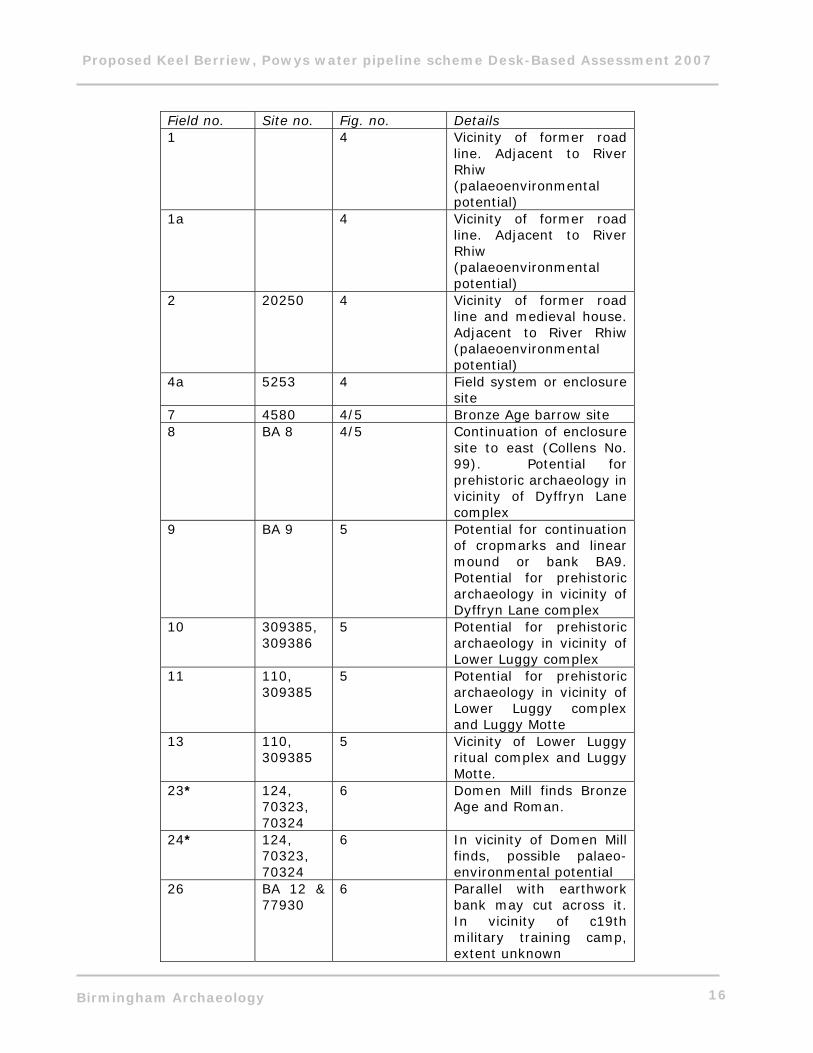
Proposed Keel Berriew, Powys water pipeline scheme Desk-Based Assessment 2007
Birmingham Archaeology 16
Field no. Site no. Fig. no. Details 1 4 Vicinity of former road
line. Adjacent to River Rhiw (palaeoenvironmental potential)
1a 4 Vicinity of former road line. Adjacent to River Rhiw (palaeoenvironmental potential)
2 20250 4 Vicinity of former road line and medieval house. Adjacent to River Rhiw (palaeoenvironmental potential)
4a 5253 4 Field system or enclosure site
7 4580 4/5 Bronze Age barrow site 8 BA 8 4/5 Continuation of enclosure
site to east (Collens No. 99). Potential for prehistoric archaeology in vicinity of Dyffryn Lane complex
9 BA 9 5 Potential for continuation of cropmarks and linear mound or bank BA9. Potential for prehistoric archaeology in vicinity of Dyffryn Lane complex
10 309385, 309386
5 Potential for prehistoric archaeology in vicinity of Lower Luggy complex
11 110, 309385
5 Potential for prehistoric archaeology in vicinity of Lower Luggy complex and Luggy Motte
13 110, 309385
5 Vicinity of Lower Luggy ritual complex and Luggy Motte.
23* 124, 70323, 70324
6 Domen Mill finds Bronze Age and Roman.
24* 124, 70323, 70324
6 In vicinity of Domen Mill finds, possible palaeo-environmental potential
26 BA 12 & 77930
6 Parallel with earthwork bank may cut across it. In vicinity of c19th military training camp, extent unknown
Proposed Keel Berriew, Powys water pipeline scheme Desk-Based Assessment 2007
Birmingham Archaeology 17
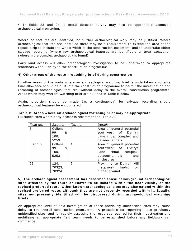
* In fields 23 and 24, a metal detector survey may also be appropriate alongside archaeological monitoring. Where no features are identified, no further archaeological work may be justified. Where archaeological features are identified there may be a requirement to extend the area of the topsoil strip to include the whole width of the construction easement, and to undertake either salvage recording (where few archaeological features are identified), or area excavation (where more complex archaeology is found). Early land access will allow archaeological investigation to be undertaken to appropriate standards without delay to the construction programme. 4) Other areas of the route – watching brief during construction In other areas of the route where an archaeological watching brief is undertaken a suitable time allowance should be built into the construction programme to permit the investigation and recording of archaeological features, without delay to the overall construction programme. Areas which may warrant watching brief are outlined in Table B below. Again, provision should be made (as a contingency) for salvage recording should archaeological features be encountered. Table B: Areas where an archaeological watching brief may be appropriate (Excludes sites where early access is recommended, Table A)
Field no. Site no. Fig. no. Details 3 Collens
99 & 100, 5253
4 Area of general potential southwest of Dyffryn Lane ritual complex and palaeochannels
5 and 6 Collens 99 & 100, 5253
4 Area of general potential southwest of Dyffryn Lane ritual complex, palaeochannels and enclosures
25 124, 70323, 70324
6 Proximity to Domen Mill metalwork finds, on higher ground.
5) The archaeological assessment has described those below-ground archaeological sites affected by the route or known to be located within the near vicinity of the revised preferred route. Other known archaeological sites may also extend within the revised preferred route, although they are not presently recorded within it. Equally, sites not presently identified will be discovered during archaeological watching briefs. An appropriate level of field investigation at these previously unidentified sites may cause delay to the overall construction programme. A procedure for reporting these previously unidentified sites, and for rapidly assessing the resources required for their investigation and mobilising an appropriate field team needs to be established before any fieldwork can commence.
Proposed Keel Berriew, Powys water pipeline scheme Desk-Based Assessment 2007
Birmingham Archaeology 18
6) Post-excavation reporting and publication Although not directly impacting on the construction programme, following the completion of fieldwork a programme of post-excavation assessment and analysis leading to publication in a recognised archaeological journal will need to be undertaken by the archaeological contractor. The costs of post-fieldwork programme will need to be borne by Severn Trent. NOTES
• The proposals contained in this appendix must be subject to review by Mark Walters, Planning Archaeologist, Clywd Powys Archaeological Trust.
• Details of construction accesses and construction compounds are not available at
present, but their archaeological effects need to be considered, and appropriate assessment or mitigation measures agreed.
• The scope of further work should be defined in a Written Scheme of Investigation. This
should provide details of the archaeological background, and the archaeological mitigation required. In addition to the watching brief salvage recording and/or excavation may be required, in which case contingency day/weekly costs for this purpose should be identified, together with a procedure for reporting unexpected discoveries, so that salvage recording/excavation without undue delay.
• Because of the likely size of the further archaeological investigations competitive
tenders will need to be sought.
• Details of construction need to be considered. If the preliminary topsoil strip does not expose the first archaeological horizon (usually the topsoil/subsoil interface) an archaeological watching brief will not be productive. Archaeological watching brief will also be maintained during excavation of the pipe trench. Where shoring etc is employed the visibility of archaeological deposits will be greatly reduced. Archaeological staff will need to enter pipe trenches for the purposes of hand-cleaning and testing/recording of the archaeological features, or possible features present, if it is safe to do so.
• Health and safety. All archaeological staff should be CSCS accredited, and follow the
health and safety guidelines set down in the SCAUM (Standing Conference of Archaeological Unit Managers) Health and Safety Manual 2007.
11 ACKNOWLEDGEMENTS
The project was commissioned by Grontmij, on behalf of Severn Trent Water Ltd. Thanks are due to Jonathan Burns and Jaydip Mahida for their co-operation and assistance throughout the project. Thanks are also due to Mark Walters, CPAT Planning Archaeologist for his help and useful suggestions. The assessment and walkover survey was undertaken by John Halsted. Shane Kelleher produced the written report and collaborated with Helen Moulden to produce the illustrations. Laurence Jones monitored the project for Birmingham Archaeology. The report was edited by Laurence Jones and John Halsted.
Proposed Keel Berriew, Powys water pipeline scheme Desk-Based Assessment 2007
Birmingham Archaeology 19
11.1 References
Birmingham Archaeology 2007. Written Scheme of Investigation for archaeological desk-based assessment: Proposed Keel Berriew pipeline, Powys.
Birmingham Archaeology Forthcoming. Geo-technical Test Pits on the Proposed Keel Berriew Water Pipeline, Powys. An Archaeological Watching Brief 2007.
Bradley, R. 1998. The Passage of Arms: an archaeological analysis of prehistoric hoards and votive deposits, 2nd edn., Oxford: Oxbow Books
CADW 1999. Register of Landscapes, Parks and Gardens of Special Historic Interest in Wales-Powys: Cardiff, CADW.
Collens, J. 1988. Iron Age and Romano-British settlement in the upper Severn valley, Unpublished PhD thesis, University of Birmingham.
Department of the Environment (DoE) 1990 Planning Policy Guidance Note 16: Archaeology and Planning. Gibson, A. 2000. ‘Survey and excavation at a newly discovered long barrow at Lower Luggy, Berriew, Powys’, Studia Celtica 34, 1-16. Gibson, A. 2006. ‘Exacavations at a Neolithic Enclosure at Lower Luggy, near Welshpool, Powys, Wales’, Proceedings of the Prehistoric Society 72, 163-191. Gibson, A. and Musson, C. 1990. ‘A cropmark enclosure and a sherd of later Neolithic pottery from Brynderwen, Llandyssil, Powys’, Montgomeryshire Collections 78, 11-15.
Halsted, J. 2007. Proposed Llandinam to Abermule, Powys water pipeline scheme 2007: desk-based assessment. Birmingham Archaeology Reports project no. 1667.
Institute of Field Archaeologists (IFA) 1999 Standard and Guidance for Archaeological Desk-Based Assessment, rev. edn. Krawiec, K. 2006. An Archaeological Watching Brief at Shardlow Quarry, Derbyshire. Birmingham Archaeology Reports project no. 1332. Howard, A.J. & Macklin, M.G. 1999. ‘A generic geomorphological approach to archaeological interpretation and prospection in British river valleys: a guide for archaeologists investigating Holocene landscapes’. Antiquity 73, 527-541. Pettifer, A. 2000. Welsh Castles: A Guide by Counties: Suffolk, The Boydell Press. Pounds, N. J. G. 1990. The Medieval Castle in England and Wales: A Social and Political History: Cambridge, Cambridge University Press. Silvester, R.J. 1992. Montgomeryshire Historic Settlements 1, CPAT Report 40.

Proposed Keel Berriew, Powys water pipeline scheme Desk-Based Assessment 2007
Birmingham Archaeology 20
Silvester, R.J. 1997 ‘Luggy Moat, Berriew: Recording and Conservation’ Montgomeryshire Collections 85, 1-12. Taylor, M.P. and Lewin, J. 1996. ‘River behaviour and Holocene alluviation: the River Severn at Welshpool, mid-Wales, UK’, Earth Surface Processes and Landforms 21, 77-91. Internet Resources http://ads.ahds.ac.uk/ http://www.coflein.gov.uk/ http://www.cpat.org.uk/projects/longer/dyffryn/dyffryn.htm
Fig.1
Keel Berriew
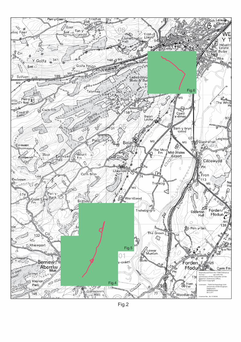
Fig.2
Fig.6
Fig.5
Fig.4
Reproduced from the 1998 OrdnanceSurvey 1:50,000 map with thepermission of the Controller of HerMajesty's Stationary O�ce,c Crown Copyright
Licensee : Field Archaeology Unit University of Birmingham Edgbaston BIRMINGHAM B15 2TT
Licence No. AL 51303A
c
RedLane
Welshpool S.R.
LowerLuggy
Refail
Route A
Route B
Fig.3
Collens 99
Collens 100
BA9
BA8
BA6
BA4BA3
BA1
BA2
BA5
GroHouse(20250)
Dyffryn LaneCropmarks
(5253)
LowerRectoryMound(4580)
Cross LaneCottage
(RCAHMW29086)
Plas LlynEnclosure(RCAHMW
275947)
2
1
3
4
5
6
7
8
9
5
Key
1a
4a
Cropmark plots after Collens 1988and Gibson 2006
Based upon the Ordnance Survey Map by Severn Trent Water LTD, by permission of Ordnance Survey on behalf of the Controller of Her Majesty’s Stationary Office c Crown CopyrightLicence Wu298522
Route A
BA7Watching brief
Advance strip
Fig.4
Cropmark plots after Collens 1988and Gibson 2006
Based upon the Ordnance Survey Map by Severn Trent Water LTD, by permission of Ordnance Survey on behalf of the Controller of Her Majesty’s Stationary Office c Crown CopyrightLicence Wu298522
LuggyMotte
(110; SAMCMG043POW)
(RCAHMW306760)
BA10Capel House
(Chapel RCAHMW12260)
Lower LuggyField Boundary
(87514)
Drains(87512)
Enclosure(RCAHMW
309385)
Dark Age Square Barrow
Long Barrow(RCAHMW
309386)
Dyffryn LaneBarrow III
(RCAHMW306965) Dyffryn Lane
Barrow II(RCAHMW
306961)
Dyffryn LaneHenge
(RCAHMW306967)
RoundBarrow
(RCAHMW306964)
RoundBarrow
(RCAHMW306962)
Maen BuenoStanding Stone
(RCAHMW306966)
BA8
BA9
LowerRectoryMound(4580)
BA11
5
Route A
7
8
9
10
1113
14
15
12
BA7
Key
Watching brief
Advance strip
Fig.5
5
Route B
White HouseWharf (85912)
OldfordWell
(64634)
BA15 Domen MillFinds (124)
(70323,70324)Quarry Site(RCAHMW
80513)
BA14
BA12
Maes GwastadMilitary Camp
(77930)
BA13
Old PackhorseInn (20329)
Welshpool
Early Road(RCAHMW
23673)Earthworks(RCAHMW
32912)
PowysCastle
BA16
Ridge andFurrow(5023)
23
26
25 24
22
2120
1918
17
16
Key
Watching brief
Advance strip
Fig.6
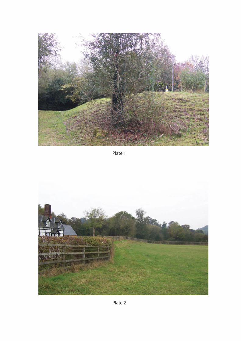
Plate 1
Plate 2
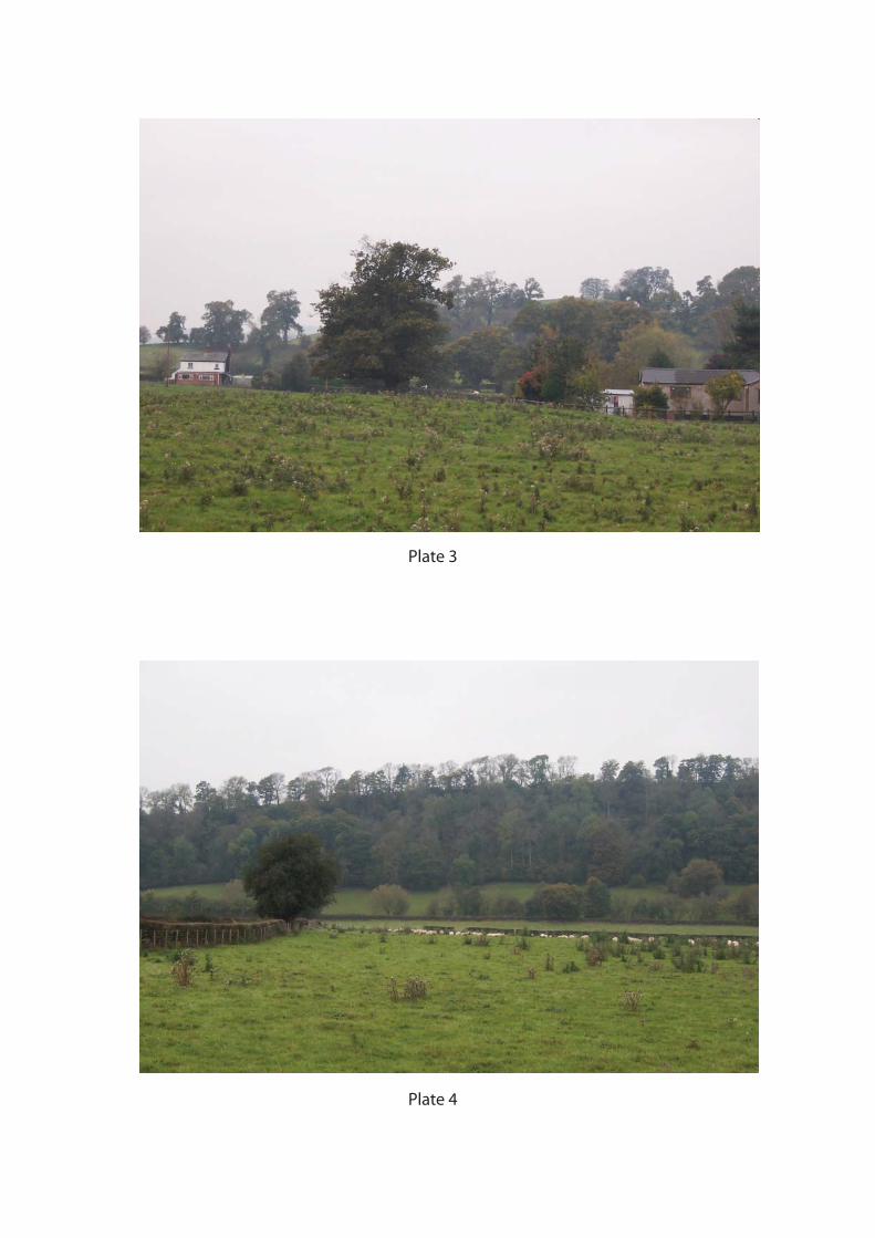
Plate 3
Plate 4
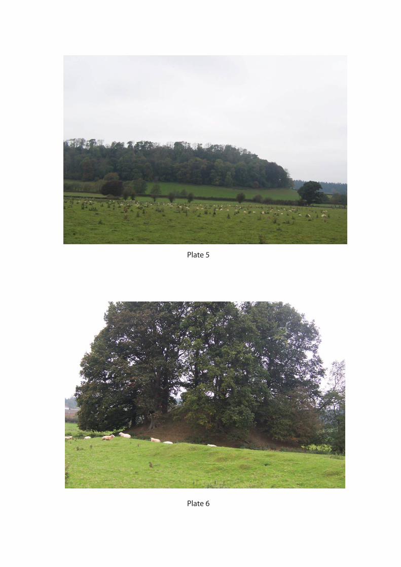
Plate 5
Plate 6
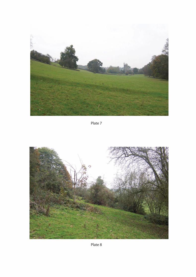
Plate 7
Plate 8
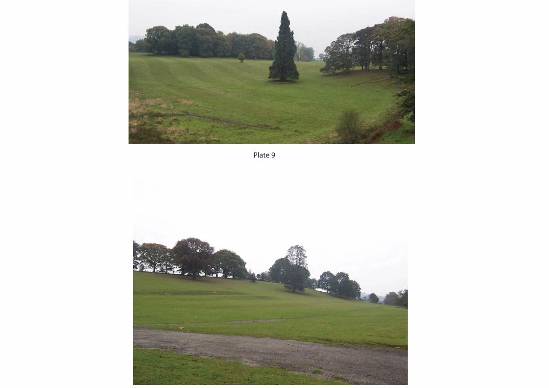
Plate 9