barton ropewalk, barton-on-humber dba and hbr
TRANSCRIPT

PN 1868 Barton Ropewalk, Barton-upon-Humber DESK-BASED and HISTORIC BUILDINGS ASSESSMENT
Prepared by: .................... Date: ............. Checked by: ..................... Date: .............
Project No. 1868
October 2008
BARTON ROPEWALK,
Waterside Road, Barton-upon-Humber, Lincolnshire
ARCHAEOLOGICAL DESK-BASED and HISTORIC BUILDINGS ASSESSMENT
Shane Kelleher AIFA
BIRMINGHAM ARCHAEOLOGY
For
Development Planning Partnership LLP on behalf of
Tesco Stores Ltd.
For further information please contact:
Alex Jones (Director) Birmingham Archaeology
The University of Birmingham Edgbaston
BIRMINGHAM B15 2TT
Tel: 0121 414 5513 e-mail: [email protected]
Web Address: http://www.barch.bham.ac.uk
PN: 1868 Barton Ropewalk, Barton-upon-Humber: DBA and Historic Buildings Assessment
birmingham archaeology
i
Barton Ropewalk, Barton-upon-Humber, Lincolnshire
Archaeological Desk-Based and Historic Buildings Assessment, October 2008
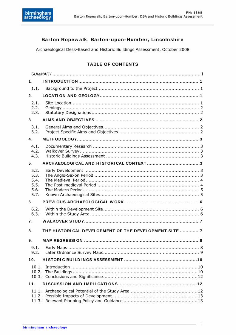
TABLE OF CONTENTS
SUMMARY ...................................................................................................... i 1. INTRODUCTION.....................................................................................1
1.1. Background to the Project ..................................................................... 1 2. LOCATION AND GEOLOGY......................................................................1
2.1. Site Location........................................................................................ 1 2.2. Geology .............................................................................................. 2 2.3. Statutory Designations.......................................................................... 2
3. AIMS AND OBJECTIVES .........................................................................2 3.1. General Aims and Objectives.................................................................. 2 3.2. Project Specific Aims and Objectives ....................................................... 2
4. METHODOLOGY......................................................................................3 4.1. Documentary Research ......................................................................... 3 4.2. Walkover Survey .................................................................................. 3 4.3. Historic Buildings Assessment ................................................................ 3
5. ARCHAEOLOGICAL AND HISTORICAL CONTEXT.....................................3 5.2. Early Development ............................................................................... 3 5.3. The Anglo-Saxon Period ........................................................................ 3 5.4. The Medieval Period.............................................................................. 4 5.5. The Post-medieval Period ...................................................................... 4 5.6. The Modern Period................................................................................ 5 5.7. Known Archaeological Sites.................................................................... 5
6. PREVIOUS ARCHAEOLOGICAL WORK.....................................................6 6.2. Within the Development Site.................................................................. 6 6.3. Within the Study Area ........................................................................... 6
7. WALKOVER STUDY.................................................................................7
8. THE HISTORICAL DEVELOPMENT OF THE DEVELOPMENT SITE ..............7
9. MAP REGRESSION .................................................................................8 9.1. Early Maps .......................................................................................... 8 9.2. Later Ordnance Survey Maps.................................................................. 9
10. HISTORIC BUILDINGS ASSESSMENT ...................................................10 10.1. Introduction .......................................................................................10 10.2. The Buildings ......................................................................................10 10.3. Conclusions and Significance.................................................................12
11. DISCUSSION AND IMPLICATIONS .......................................................12 11.1. Archaeological Potential of the Study Area ..............................................12 11.2. Possible Impacts of Development...........................................................13 11.3. Relevant Planning Policy and Guidance ...................................................13
PN: 1868 Barton Ropewalk, Barton-upon-Humber: DBA and Historic Buildings Assessment
birmingham archaeology
ii
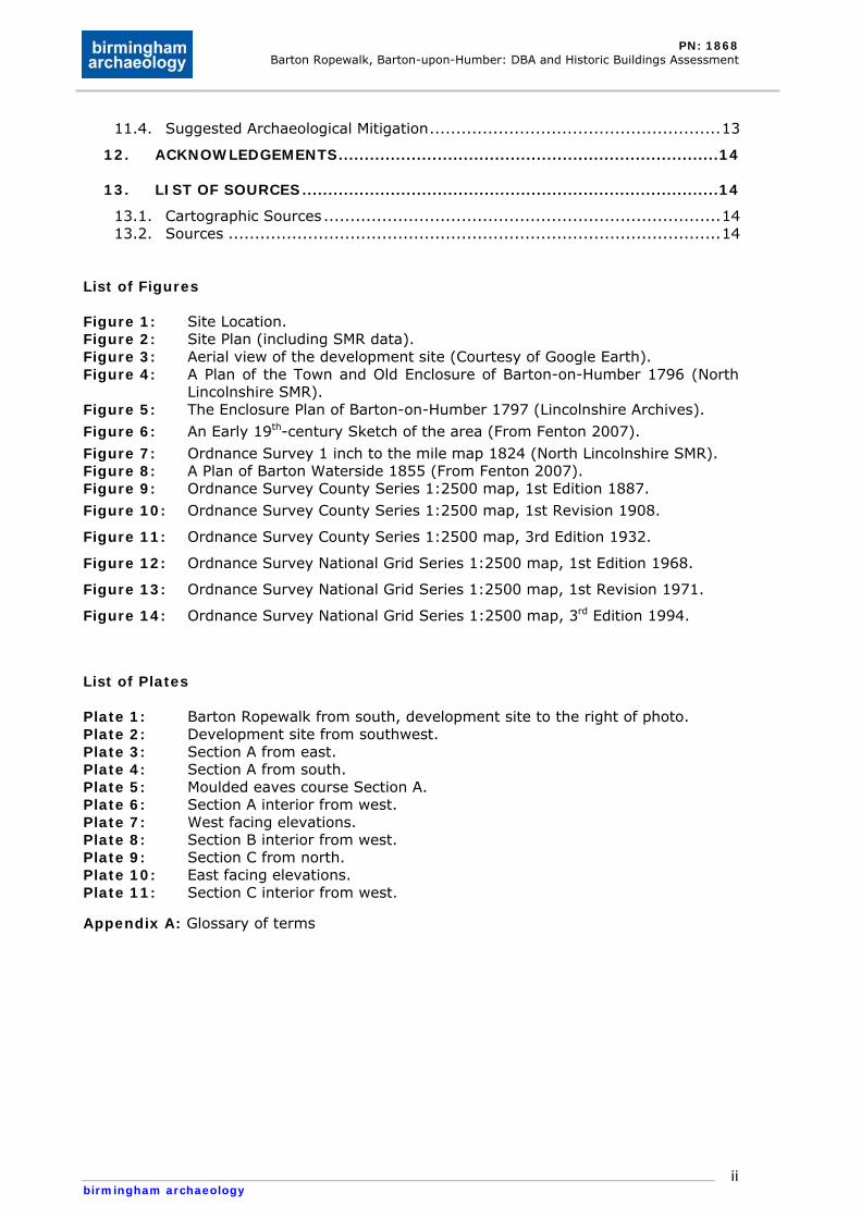
11.4. Suggested Archaeological Mitigation.......................................................13 12. ACKNOWLEDGEMENTS.........................................................................14
13. LIST OF SOURCES................................................................................14 13.1. Cartographic Sources...........................................................................14 13.2. Sources .............................................................................................14
List of Figures Figure 1: Site Location. Figure 2: Site Plan (including SMR data). Figure 3: Aerial view of the development site (Courtesy of Google Earth). Figure 4: A Plan of the Town and Old Enclosure of Barton-on-Humber 1796 (North
Lincolnshire SMR). Figure 5: The Enclosure Plan of Barton-on-Humber 1797 (Lincolnshire Archives).
Figure 6: An Early 19th-century Sketch of the area (From Fenton 2007).
Figure 7: Ordnance Survey 1 inch to the mile map 1824 (North Lincolnshire SMR). Figure 8: A Plan of Barton Waterside 1855 (From Fenton 2007). Figure 9: Ordnance Survey County Series 1:2500 map, 1st Edition 1887.
Figure 10: Ordnance Survey County Series 1:2500 map, 1st Revision 1908.
Figure 11: Ordnance Survey County Series 1:2500 map, 3rd Edition 1932.
Figure 12: Ordnance Survey National Grid Series 1:2500 map, 1st Edition 1968.
Figure 13: Ordnance Survey National Grid Series 1:2500 map, 1st Revision 1971.
Figure 14: Ordnance Survey National Grid Series 1:2500 map, 3rd Edition 1994.
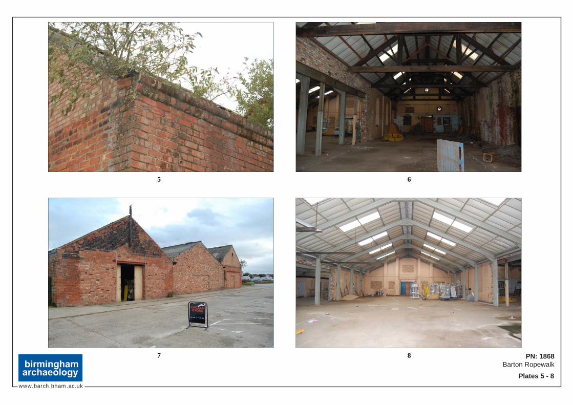
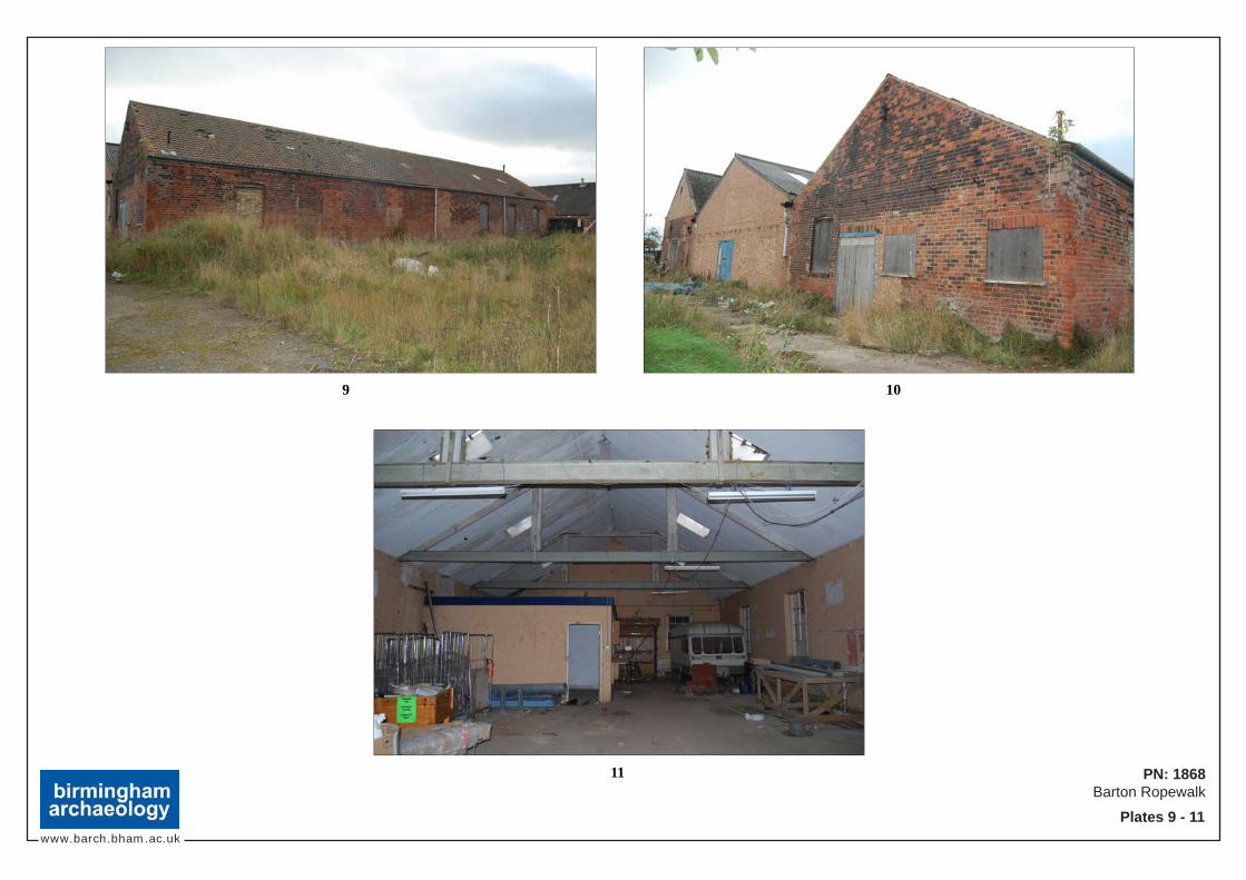
List of Plates Plate 1: Barton Ropewalk from south, development site to the right of photo. Plate 2: Development site from southwest. Plate 3: Section A from east. Plate 4: Section A from south. Plate 5: Moulded eaves course Section A. Plate 6: Section A interior from west. Plate 7: West facing elevations. Plate 8: Section B interior from west. Plate 9: Section C from north. Plate 10: East facing elevations. Plate 11: Section C interior from west.
Appendix A: Glossary of terms
PN: 1868 Barton Ropewalk, Barton-upon-Humber: DBA and Historic Buildings Assessment
birmingham archaeology
i
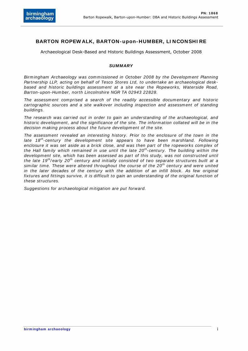
BARTON ROPEWALK, BARTON-upon-HUMBER, LINCONSHIRE
Archaeological Desk-Based and Historic Buildings Assessment, October 2008
SUMMARY
Birmingham Archaeology was commissioned in October 2008 by the Development Planning Partnership LLP, acting on behalf of Tesco Stores Ltd, to undertake an archaeological desk-based and historic buildings assessment at a site near the Ropeworks, Waterside Road, Barton-upon-Humber, north Lincolnshire NGR TA 02943 22828.
The assessment comprised a search of the readily accessible documentary and historic cartographic sources and a site walkover including inspection and assessment of standing buildings.
The research was carried out in order to gain an understanding of the archaeological, and historic development, and the significance of the site. The information collated will be in the decision making process about the future development of the site.
The assessment revealed an interesting history. Prior to the enclosure of the town in the late 18th-century the development site appears to have been marshland. Following enclosure it was set aside as a brick close, and was then part of the ropeworks complex of the Hall family which remained in use until the late 20th-century. The building within the development site, which has been assessed as part of this study, was not constructed until the late 19th/early 20th century and initially consisted of two separate structures built at a similar time. These were altered throughout the course of the 20th century and were united in the later decades of the century with the addition of an infill block. As few original fixtures and fittings survive, it is difficult to gain an understanding of the original function of these structures.
Suggestions for archaeological mitigation are put forward.
PN: 1868 Barton Ropewalk, Barton-upon-Humber: DBA and Historic Buildings Assessment
birmingham archaeology
1
BARTON ROPEWALK, BARTON-upon-HUMBER, LINCOLNSHIRE
Archaeological Desk-Based and Historic Buildings Assessment, October 2008
1. INTRODUCTION
1.1. Background to the Project
1.1.1. In October 2008, Birmingham Archaeology carried out an archaeological desk-based assessment (DBA) and historic building assessment of a building adjacent to Barton Ropewalk, Barton-upon-Humber, Lincolnshire, in order to gain an understanding of the history and significance of the site prior to decisions being made on its future use/redevelopment. The assessment was commissioned by Matthew Birkinshaw of Development Planning Partnership LLP, acting on behalf of Tesco Stores Ltd.
1.1.2. This report outlines the results of the assessment, which has been prepared in accordance with the Institute of Field Archaeologists Standard and Guidance for Archaeological Desk-Based Assessment (IFA, 2001) and Standard and Guidance for the Archaeological Investigation and Recording of Standing Buildings or Structures (IFA 2001).
1.1.3. The assessment conformed to a Written Scheme of Investigation (Birmingham Archaeology, 2008).
1.1.4. This report has been prepared based upon information current and available as of October 2008. Details of archaeological terms used in this report are given in the glossary appended as Appendix A.
2. LOCATION AND GEOLOGY
2.1. Site Location
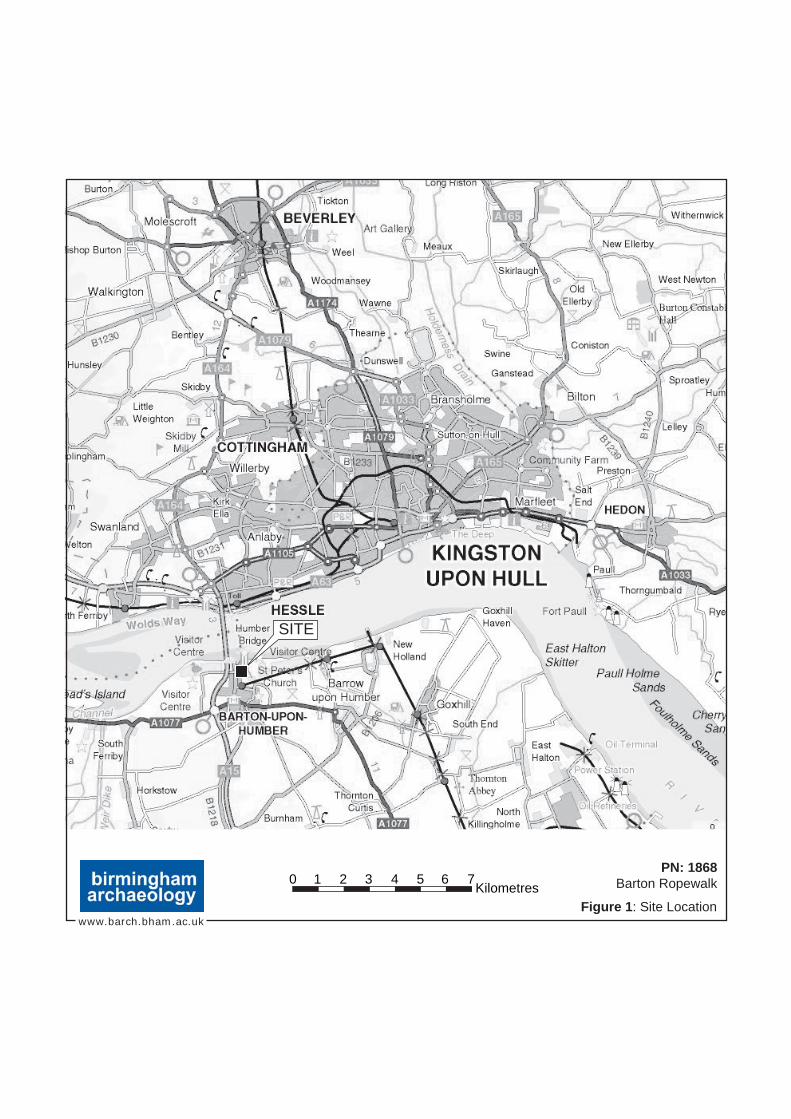
2.1.1. The proposed development site is located at Barton Ropewalk, Waterside Road, Barton-upon-Humber, Lincolnshire, approximately 600m north of Barton-upon-Humber town centre (Figure 1).
2.1.2. The development site covers a total area of 0.1 hectares and is centred on NGR TA 02943 22828. It is bounded to the west by Barton Ropewalk (Plate 1), a Grade II listed historic industrial building, and Waterside Road, a road which links the town centre to the south bank of the River Humber which is located c. 600m to the north. The structure is immediately surrounded to the east and north by a walled derelict yard. Beyond this yard to the east is the semi-detached residential area of 52-78 Maltkiln Road, while the yard is bounded to the north by further residential development. To the south is the northern section of the Tesco carpark, with the supermarket located c. 50m to the southeast. The historic Despatch House, which played an important part in the ropeworks complex, is located 90m to the southwest (Figures 2 and 3).
2.1.3. For the purposes of the current assessment, a buffer zone of 500m around the development site boundary has been included to place the site within its immediate archaeological and historical context. The development site and buffer zone together are referred to hereafter as the ‘study area’. Where
PN: 1868 Barton Ropewalk, Barton-upon-Humber: DBA and Historic Buildings Assessment
birmingham archaeology
2
relevant, sites located beyond the study area have been included, where they have be shown to be of direct significance to the understanding the study area within its local context.
2.2. Geology
2.2.1. The underlying geology of the study area comprises bedrock of the Ferriby Chalk Formation, which is overlain by layers of clay and silt tidal flat deposits.
2.3. Statutory Designations
2.3.1. The development site does not lie within a Scheduled Ancient Monument (SAM) nor does it lie within the Barton-upon-Humber Conservation Area which encompasses much of the historic town centre.
2.3.2. The development site does not contain any statutory or locally listed buildings, however it is located immediately adjacent to Barton Ropewalk a Grade II listed building (NLSMR 5278, Figure 2).
2.3.3. In addition, the wider study area includes 22 listed buildings all of which are post-medieval in date, the majority domestic in nature, however, they also include historic inns, hotels, mills, and industrial buildings (See Table 1 below).
3. AIMS AND OBJECTIVES
3.1. General Aims and Objectives
3.1.1. The general aim of the archaeological desk-based assessment, as stated within the WSI, was to collate existing archaeological and historic information relating to the proposed development site and its immediate environs (the study area), to enable informed decisions to be made regarding any further archaeological input which may be required by means of mitigation as the proposed development proceeds through the planning process.
3.1.2. The general aim of the historic buildings assessment was to gain an understanding of the standing buildings within the development site in order to assess their development.
3.1.3. The objective of the project was to gain an understanding of the archaeological and historical development of the development site and wider study area, and thereby assess the potential for the survival of below-ground archaeological remains and gain an understanding of the historic buildings.
3.2. Project Specific Aims and Objectives
3.2.1. Project specific aims, as outlined in the WSI, were as follows:
• An assessment of the historical development of the site and buildings;
• An assessment of the potential for below-ground archaeology.
PN: 1868 Barton Ropewalk, Barton-upon-Humber: DBA and Historic Buildings Assessment
birmingham archaeology
3
4. METHODOLOGY
4.1. Documentary Research
4.1.1. A search was made of the readily available primary and secondary historical sources held at the Lincolnshire Archives, and the libraries of the University of Birmingham. The North Lincolnshire Sites and Monuments Record (SMR), the primary source for archaeological information for the region, was also consulted.
4.2. Walkover Survey
4.2.1. Subsequent to the completion of initial documentary research as outlined above, a walkover survey of the proposed development area was undertaken in order to assess the topography and any above-ground archaeology, including standing buildings.
4.3. Historic Buildings Assessment
4.3.1. An inspection of the buildings in order to compile analytical descriptions detailing their structural development and to assist in assessing their significance.
5. ARCHAEOLOGICAL AND HISTORICAL CONTEXT
5.1.1. This section of the assessment summarises the known archaeological and historical development of the study area within the context of the development of Barton-upon-Humber as a whole; the development of the development site itself is described in more detail in Section 8 below.
5.2. Early Development
5.2.1. Barton-upon-Humber is primarily Anglo-Saxon in origin. However there is some evidence for earlier activity in the vicinity of the town. Jeffrey May in his ‘Prehistoric Lincolnshire’ mentions a possible prehistoric trackway ‘Barton Street’ which ran from Barton to Alford 70km to the southeast (1976, 9). Historic trade directories also allude to prehistoric finds in the town such as creamy white flint axes and bronze bosses (White’s Directory). Whilst there is very little evidence for any Roman activity or settlement at Barton-upon-Humber (NLSMR 4668), the Romans did settle on a site to the east of the modern town to the east of the Beck stream (The Conservation Studio 2002, 7).
5.3. The Anglo-Saxon Period
5.3.1. As mentioned above, Barton-upon-Humber is Anglo-Saxon in origin. The first thing to allude to this Anglo-Saxon provenance is the town’s name. The place name element Barton can be traced back to the Old English beretun or baertun which derive from bere which means barley or corn and tun which means threshing floor (Ekwall 1960). Another clear indication of the town’s Anglo-Saxon origins is the town’s St. Peter’s Church which has a tower dating to the late 10th or early 11th-century. By the time of the Domesday Book (1086) the town was “already the most important town in north Lincolnshire” (Pevsner and Harris 1964, 121). Barton at this time had a population of c.

PN: 1868 Barton Ropewalk, Barton-upon-Humber: DBA and Historic Buildings Assessment
birmingham archaeology
4
900, which enjoyed the use of a market, mills, and a ferry. The nature of this relatively large town in this period is reflected in the archaeological record. Whilst St. Peter’s church contains 11th and 12th century fabric, excavations beneath the nave have uncovered the remains of 5th and 6th century buildings (The Conservation Studio 2002, 8). Further Anglo-Saxon buildings have been uncovered near Beck Hill, and an Anglo-Saxon cemetery, containing the graves of c. 200 of Barton’s inhabitants in the 6th and 7th centuries, has been excavated in the town centre in the area around Castledyke South and Whitecross Street. This is the only Anglo-Saxon cemetery in Lincolnshire “with a substantial number of relatively well-preserved skeletons” (Sawyer 1998, 42). In addition traces of extensive ditches and palisades built before the 10th-century have been found immediately east of St. Peter’s Church. Sawyer presumes that these protected important residences (1998, 84). These may be related to the Castledyke (NLSMR 410, an early medieval defensive feature mentioned in documentary sources, and a possible castle, both of which have yet to be revealed in the archaeological record.
5.4. The Medieval Period
5.4.1. Following the Domesday survey the town spread westwards and consisted of two linked settlements; the original settlement around St. Peter’s Church and the 12th-century St. Mary’s Church, and around Fleetgate and Newport near the small port of Barton Haven (NLSMR 17907). The town continued to prosper, becoming the most important port on the Humber, being a centre of trade particularly in tanning, wool, fish, and chalk quarrying, and an early centre of British brick and tile-making (Denby Local Board 1858). Barton’s regional importance dwindled however when Edward I decided to use the settlement of Wyke on the north bank of the Humber as a base for his Scottish campaigns in the early 14th-century. Wyke was renamed Kingston-upon-Hull and soon usurped Barton from its importance as the regions principal port. Remnants of the medieval period are still evident in Barton-upon-Humber in the form of its street pattern and streetnames such as Fleetgate, Hungate, Holydyke, and Finkle Lane; and in the fabric of some of its buildings. The best examples of surviving medieval buildings in the town centre are the two churches, and the 15th century timber framed buildings at 51 Fleetgate and Tyrwhitt Hall.
5.5. The Post-medieval Period
5.5.1. Despite the continuing growth of Kingston-upon-Hull, Barton managed to expand, if slowly, in the post-medieval period, with a number of substantial properties being built by Barton or Hull-based businessmen in the 17th and 18th centuries (The Conservation Studio 2002, 7). The most important event of this period was the enclosure of Barton’s open fields in the late 18th-century, which has been described as the “most important epoch in the history of Barton” (Ball 1856, 69). This saw the conversion of 5920 acres of open land into compact land and distinct closes, and is characterised by the large fields, hedges, and footpaths now seen in the surrounding countryside. This acted as a spur for further development and during the 19th century Barton reaffirmed its status as an important market town and port, albeit in the constant shadow of its now much larger neighbour on the opposite bank of the Humber. Pevsner notes that the impression of the town today is of 18th and early 19th-century development on a modest scale and contains a “surprising homogeneity of late Georgian housing (Pevsner and Harris 1964, 121 and 127). Barton’s residents continued to rely on its industries for employment finding work in the town’s brick and tiles works, ropeworks,
PN: 1868 Barton Ropewalk, Barton-upon-Humber: DBA and Historic Buildings Assessment
birmingham archaeology
5
boatyards, malting, and a host of other manufactories which included chemical factories, whiting processing plants, and a bicycle factory. This expansion is reflected in the number of listed buildings which were constructed during this period, most of which are domestic or industrial in nature (see Table 1 below for those listed buildings from this period within the study area). The principal building material used in Barton at this time was red brick, most likely produced in the brickworks to the north of the town, whilst local clay pantiles were the main roofing material until the 19th-century when Welsh slate became fashionable, no doubt influenced by the coming of the railways to the area in the mid 19th-century.
5.6. The Modern Period
5.6.1. Barton’s steady growth throughout the 19th century stalled in the early 20th-century and many local industries declined and eventually died out. The once important boatyards relocated to Ferriby in the 1970s, whilst Hopper’s Cycle factory and the ropeworks ceased operations in the 1980s. The opening of the Humber Bridge just to the northeast of the town has seen the town become part of the commuter region for Hull, and an industrial estate on the edge of the town has provided much needed employment.
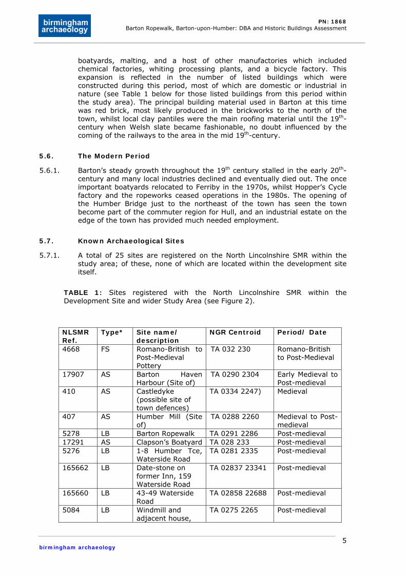
5.7. Known Archaeological Sites
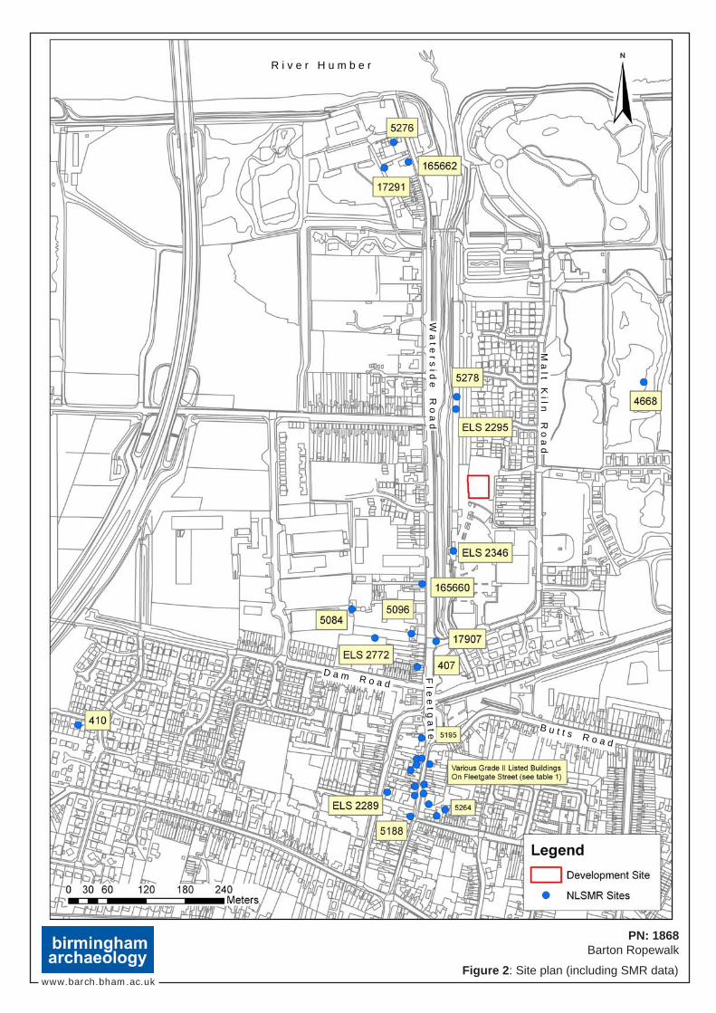
5.7.1. A total of 25 sites are registered on the North Lincolnshire SMR within the study area; of these, none of which are located within the development site itself.
TABLE 1: Sites registered with the North Lincolnshire SMR within the Development Site and wider Study Area (see Figure 2).
NLSMR Ref.
Type* Site name/ description
NGR Centroid Period/ Date
4668 FS Romano-British to Post-Medieval Pottery
TA 032 230 Romano-British to Post-Medieval
17907 AS Barton Haven Harbour (Site of)
TA 0290 2304 Early Medieval to Post-medieval
410 AS Castledyke (possible site of town defences)
TA 0334 2247) Medieval
407 AS Humber Mill (Site of)
TA 0288 2260 Medieval to Post-medieval
5278 LB Barton Ropewalk TA 0291 2286 Post-medieval 17291 AS Clapson’s Boatyard TA 028 233 Post-medieval 5276 LB 1-8 Humber Tce,
Waterside Road TA 0281 2335 Post-medieval
165662 LB Date-stone on former Inn, 159 Waterside Road
TA 02837 23341 Post-medieval
165660 LB 43-49 Waterside Road
TA 02858 22688 Post-medieval
5084 LB Windmill and adjacent house,
TA 0275 2265 Post-medieval
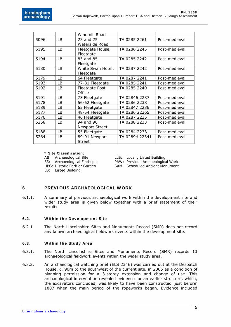
PN: 1868 Barton Ropewalk, Barton-upon-Humber: DBA and Historic Buildings Assessment
birmingham archaeology
6
Windmill Road 5096 LB 23 and 25
Waterside Road TA 0285 2261 Post-medieval
5195 LB Fleetgate House, Fleetgate
TA 0286 2245 Post-medieval
5194 LB 83 and 85 Fleetgate
TA 0285 2242 Post-medieval
5180 LB White Swan Hotel, Fleetgate
TA 0287 2242 Post-medieval
5179 LB 64 Fleetgate TA 0287 2241 Post-medieval 5193 LB 77-81 Fleetgate TA 0285 2241 Post-medieval 5192 LB Fleetgate Post
Office TA 0285 2240 Post-medieval
5191 LB 73 Fleetgate TA 02846 2237 Post-medieval 5178 LB 56-62 Fleetgate TA 0286 2238 Post-medieval 5189 LB 65 Fleetgate TA 02847 2236 Post-medieval 5177 LB 48-54 Fleetgate TA 0286 22365 Post-medieval 5176 LB 46 Fleetgate TA 0287 2235 Post-medieval 5258 LB 94 and 96
Newport Street TA 0288 2233 Post-medieval
5188 LB 55 Fleetgate TA 0284 2233 Post-medieval 5264 LB 89-91 Newport
Street TA 02894 22341 Post-medieval
* Site Classification: AS: Archaeological Site FS: Archaeological Find-spot HPG: Historic Park or Garden LB: Listed Building
LLB: Locally Listed Building PAW: Previous Archaeological Work SAM: Scheduled Ancient Monument
6. PREVIOUS ARCHAEOLOGICAL WORK
6.1.1. A summary of previous archaeological work within the development site and wider study area is given below together with a brief statement of their results.
6.2. Within the Development Site
6.2.1. The North Lincolnshire Sites and Monuments Record (SMR) does not record any known archaeological fieldwork events within the development site.
6.3. Within the Study Area
6.3.1. The North Lincolnshire Sites and Monuments Record (SMR) records 13 archaeological fieldwork events within the wider study area.
6.3.2. An archaeological watching brief (ELS 2346) was carried out at the Despatch House, c. 90m to the southwest of the current site, in 2005 as a condition of planning permission for a 3-storey extension and change of use. This archaeological intervention revealed evidence for an earlier structure, which, the excavators concluded, was likely to have been constructed ‘just before’ 1807 when the main period of the ropeworks began. Evidence included
PN: 1868 Barton Ropewalk, Barton-upon-Humber: DBA and Historic Buildings Assessment
birmingham archaeology
7
horizontal timbers, vertical posts, and a stub of brick wall which lay c.10m to the north of the Despatch House.
6.3.3. A standing building survey of the Barton Ropeworks (ELS2295), c. 10 m to the west of the development site in 2004 was carried out in advance of refitting the building. This survey revealed that the current buildings were in place by 1803 when it was damaged by fire. Manufacturing continued at the buildings until 1989 and although much of the ropewalk complex was demolished at some point after this the listed ropewalk and the unlisted despatch building survived. The historic building recording provided a plan and photographic record of all fixtures and fittings. Surviving evidence for rope production was identified in the form of mounted supports known as ‘skirders’, posts and pulleys, and trackways along the floor.
6.3.4. A number of LIDAR survey flights (ELS2581) took place over the study area in the period between 1998 and 2005.
6.3.5. A series of 5 archaeological trial trenches carried out in land off Dam Road in 2008 following an archaeological desk-based assessment (ELS 2772) revealed few features of archaeological significance. Another previous archaeological evaluation in the Dam Road area (ELS20635) revealed a medieval sherd and post-medieval pits.
6.3.6. An archaeological watching brief at Castledyke West (ELS2289) prior to the construction of a detached bungalow revealed no archaeological features or deposits.
7. WALKOVER STUDY
7.1.1. The development site extends to a total area of 0.1 hectares; it is bounded to the west by Barton Ropewalk, a Grade II listed historic industrial building, and Waterside Road, a road which links the town centre to the south bank of the River Humber which is located c. 600m to the north. Scarring on the concrete surface between this structure and Barton Ropewalk suggests that there were once structures located between the two buildings. This is further substantiated by scarring and staining on the west wall of the structure in the development site. This structure is immediately surrounded to the east and north by a brick walled derelict yard. Beyond this yard to the east is the semi-detached residential area of 52-78 Maltkiln Road, while the yard is bounded to the north by further residential development to the north. To the south is the northern section of the Tesco carpark, with the supermarket located c. 50m to the southeast. The historic Despatch House, which played an important part in the rope works complex, is located 90m to the southwest.
8. THE HISTORICAL DEVELOPMENT OF THE DEVELOPMENT SITE
8.1.1. This section of the assessment describes the known archaeological and historical development of the proposed development site. It is based upon information current and readily available as of October 2008. Other areas of archaeological or historical importance, not presently recorded, may be identified during subsequent phases of field investigation.
8.1.2. Little is known about the nature of the land on which the development site lies prior to the post-medieval period. Cartographic evidence (as can be seen from section 9 below) that the land was designated as marshland until the
PN: 1868 Barton Ropewalk, Barton-upon-Humber: DBA and Historic Buildings Assessment
birmingham archaeology
8
enclosure of the town in the late 18th-century. Following the enclosure the area was set aside as brick closes, and was later purchased by the Hall family for use as a ropery in the early 19th-century. The Hall family, who had had a ropeworks in the town since 1767, constructed the present ropewalk building prior to 1803 when it was damaged by fire (Preconstruct Archaeology 2004). The Hall family were originally from Hull, and were successful merchants and ship owners “securing great wealth from trading to Baltic and European ports” (Fenton 2007, 1). It is believed that they chose to locate their business in Barton due to the extensive local hemp supplies and to exploit an existing workforce (Fenton 2007, 11 and 18), which suggests that Barton already had skilled ropemakers operating there at that time.
8.1.3. It was John Hall who began the development of ropemaking in earnest when in 1808 he filed a patent for an improvement in the process (Fenton 2007, 2), heralding a period of major development in the ropeworks complex, including the constructing of the Despatch House, and various industrial buildings.
8.1.4. Fenton (2007, 17) draws together various sources to provide an understanding of the site in the mid 19th-century:
“The whole site consisted of a modest collection of brick buildings bounded by the Haven on the west side. Many of the works buildings were carefully protected to prevent the spread of fire; the tar sheds and hemp stores being free standing for this purpose. There was a large room for hatchelling, or the hand-preparation of fibres. Adjoined to this would be a room for the spinning of hemp into yarn, although this could have been continued outdoors at this time. Nearby would have stood a brick boiler house and steam engine and, attached to this, a form of mill housing basic steam powered machinery for the making of ropes”.
8.1.5. The map regression below provides an understanding of the development of the ropeworks complex from the late 18th-century.
9. MAP REGRESSION
9.1. Early Maps
9.1.1. The available early maps provide an excellent insight into the development of the development site and the wider study area from the late 18th-century onwards.
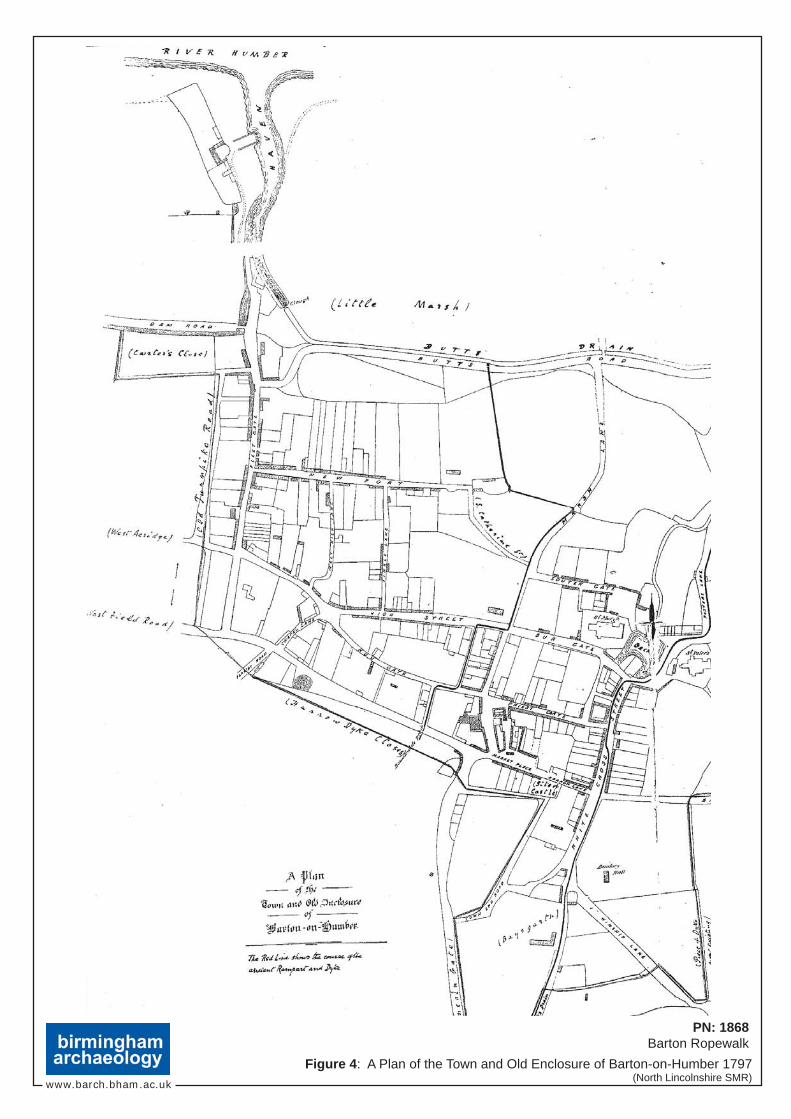
9.1.2. The earliest of these maps is A Plan of the Town and Old Enclosure of Barton-on-Humber which was produced in 1796 (Figure 4) as part of plans for the Enclosure of the town in 1797. It is clear from this map that the development site is located outside of the town and old enclosure in an area to the north of Butts Road which forms the northern extent of the urban area, and to the haven, a channel which linked the town to the River Humber. The area is marked in which the development site stands is marked ‘Little Marsh’ which presumably is descriptive of the topographic conditions prevailing in the area at that time.
PN: 1868 Barton Ropewalk, Barton-upon-Humber: DBA and Historic Buildings Assessment
birmingham archaeology
9
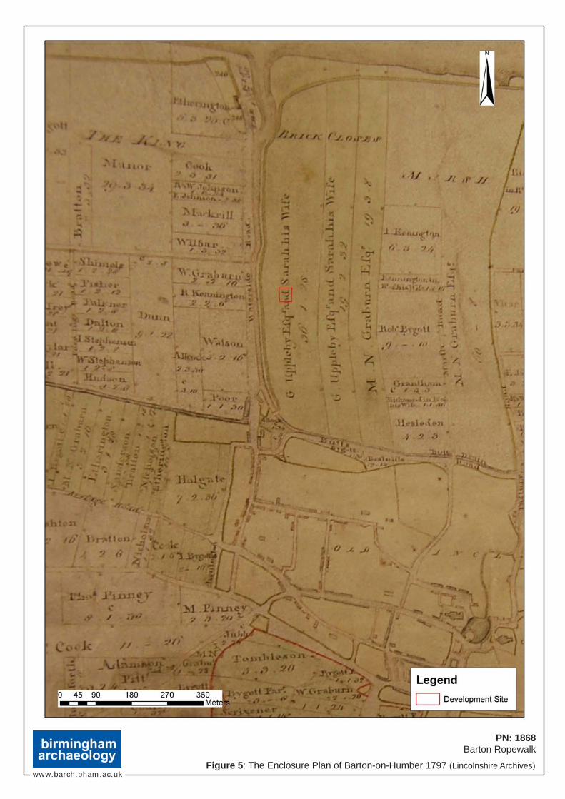
9.1.3. The Enclosure Plan of Barton-on-Humber produced in the following year (1797, Figure 5) illustrates the major effects that enclosure had on the topography and morphology of the town and its environs. The area immediately surrounding the development site has been divided up into three distinct long and thin tracts of land which ran from Butts Road to the southern bank of the Humber. The two most westerly tracts were owned by a Mr G. Uppleby Esq. and his wife Sarah, the other tract was owned by a Mr. M.N. Graburn Esq. These parcels of land were collectively described as ‘brick closes’ which was either indicative of their previous use prior to enclosure or their new use following enclosure. Also notable in this plan is that Waterside Road had been laid out to the west of the development site.
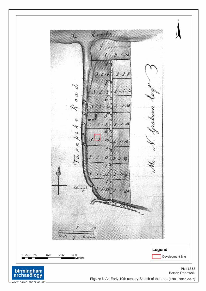
9.1.4. An Early 19thcentury sketch (Figure 6) shows how quickly the brick close area was divided up. There does not appear to have been any development in the current site, but there are two buildings to the north which may be related to the early ropeworks.
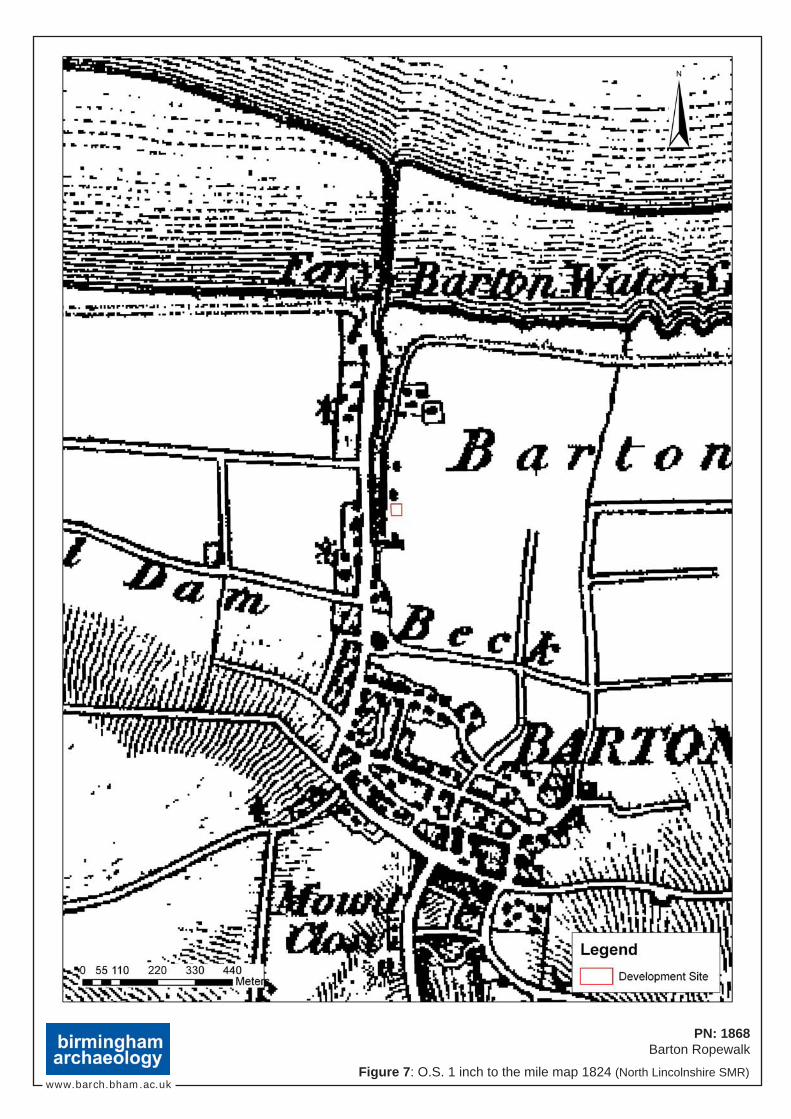
9.1.5. The scale of the Ordnance Survey 1 inch to the mile Map 1824 (Figure 7) means that it is difficult to determine if there had been any development at the site. The surrounding area does not appear to have been in use as brick closes any longer and this area to the north of the town is labelled Barton Marshes. The ropewalk building to the west of the site had been constructed and at least two buildings had been built to the east of it, however, neither would appear to be close or on the current development site.
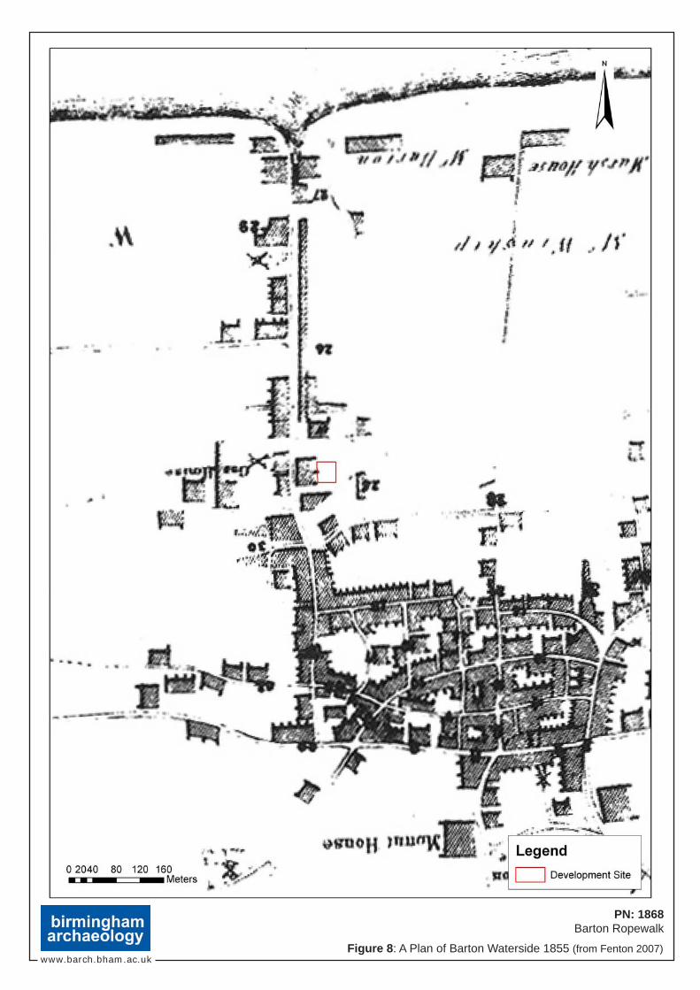
9.1.6. A Plan of Barton ‘Waterside’ 1855 (Figure 8) gives a much clearer indication of how the ropeworks complex had developed in the early 19th-century. The long ropewalk building is clearly shown, and is obviously different in scale and shape to any of the other buildings shown on this plan. An ‘L’ shaped building had been constructed along the southeast side of the ropewalk; however this seems too far south to be within the development site which appears as open ground.
9.2. Later Ordnance Survey Maps
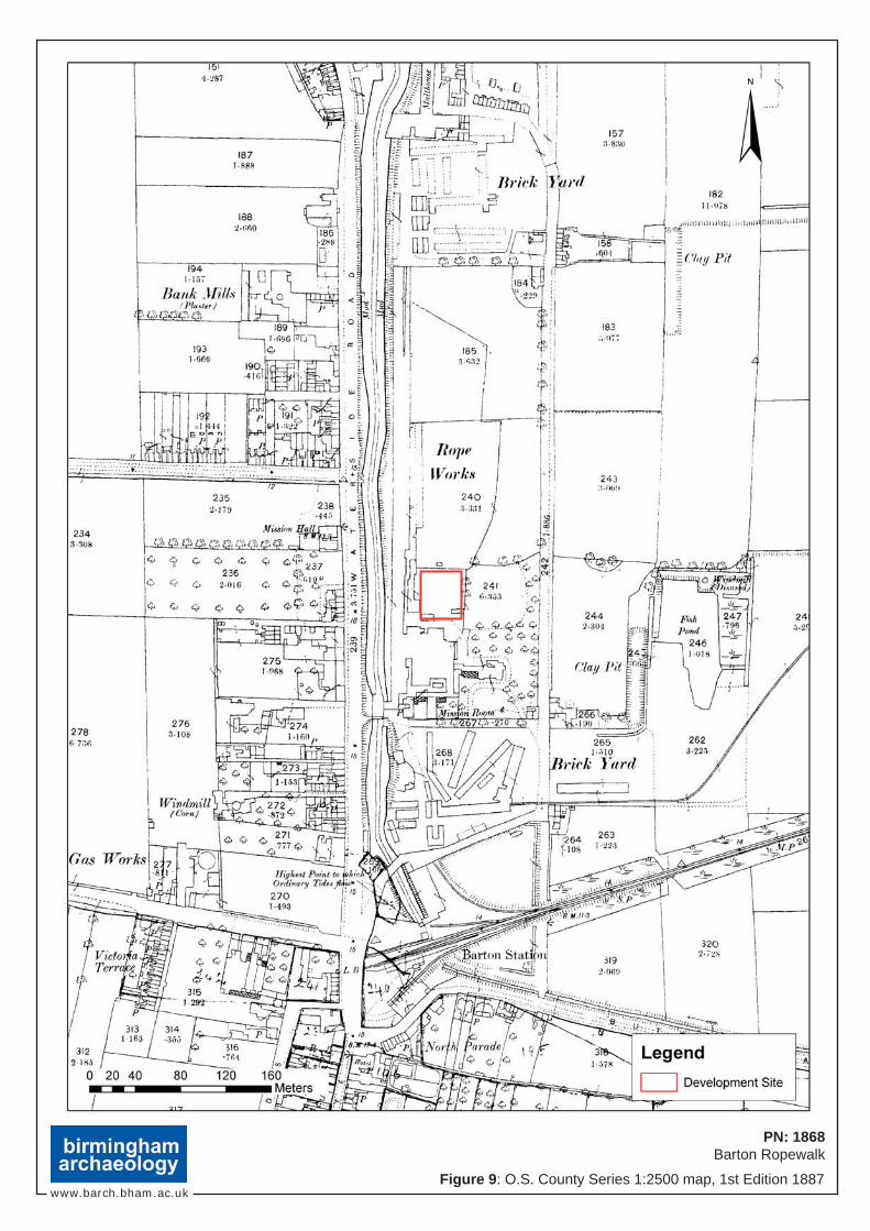
9.2.1. The 1st Edition Ordnance Survey map of 1887 (Figure 9) gives a clear indication of the components of the ropeworks complex at this time. The main element was the long ropeworks building whose south terminal was formed by an amorphous shaped structure which perhaps contained the offices or warehouses of the ropeworks. There also appears to have been a smaller ropewalk structure to the east of the main ropewalk building. The development site itself appears to be in some form of enclosure, perhaps a yard, with walls to the north and east, and small outbuildings occupying the southwest corner and part of the eastern boundary. The area to the immediate east of the development site was occupied by what appears to have been a lawn and tree plantation. Further to the east was a clay pit and fish pond. Barton Station, which would have been important for the exportation of the ropeworks wares throughout the country, was located 300m to the south.
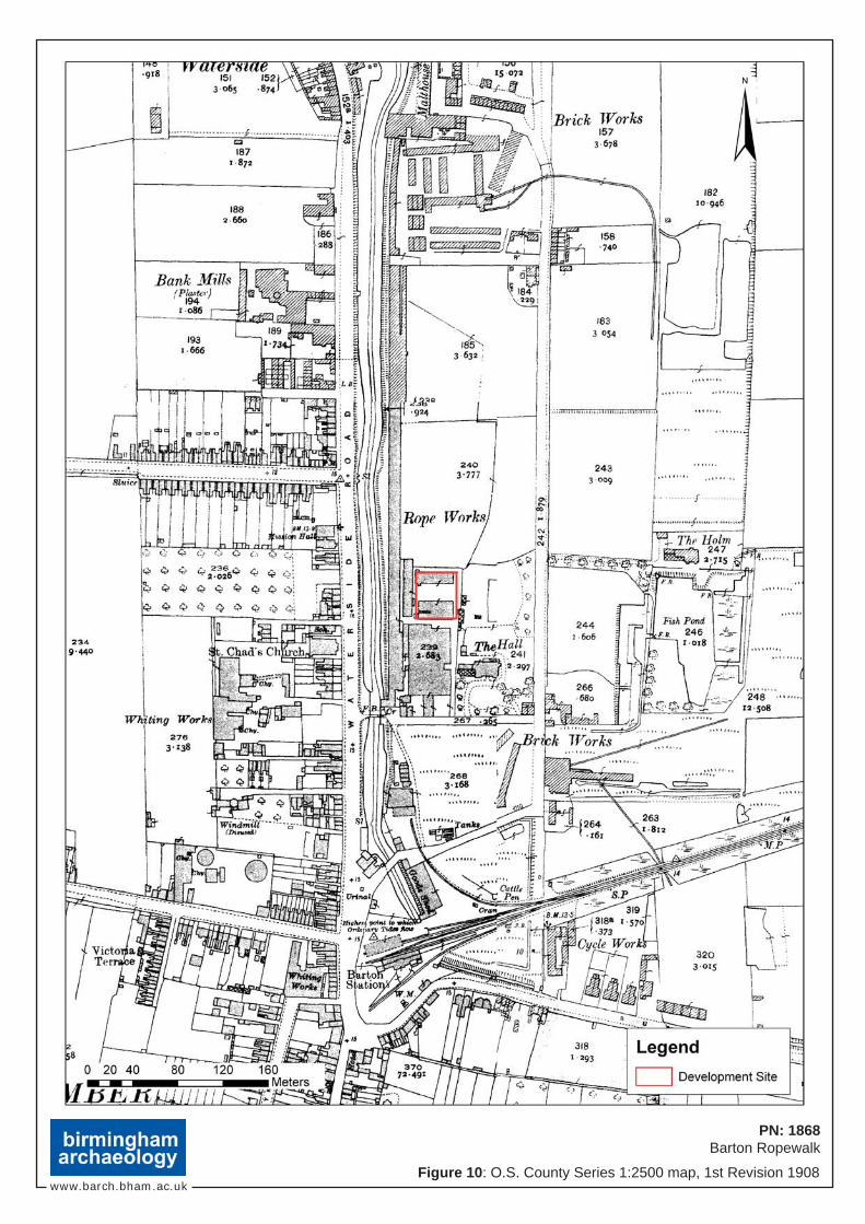
9.2.2. By the time of the Revised 1st Edition Ordnance Survey map 1908 (Figure 10) some changes had taken place within the development site and the wider ropeworks complex. One of the buildings seen on the previous map had been labelled ‘The Hall’, it perhaps being the residence of the owner or site manager. The smaller ropewalk building to the east of the main building had been demolished by this time. Perhaps the most significant change that had taken place in the period since the previous map had been produced was in
PN: 1868 Barton Ropewalk, Barton-upon-Humber: DBA and Historic Buildings Assessment
birmingham archaeology
10
the development site itself. Two rectangular-shaped buildings are located within the development zone. Both run from east to west and are separated by a central yard. There is no indication of what the function of these buildings was, however their proximity to the ropewalk suggests that they were part of the ropeworks complex.
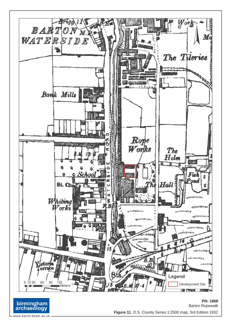
9.2.3. By the time of the 3rd Edition Ordnance Survey map 1932 (Figure 11) the building previously marked as ‘The Hall’ had been demolished to be replaced by a row of detached residential buildings fronting Chemical Street to the east, and by a large square-plan structure lining Ropery Lane to the south, and attached to the ropeworks complex. Not noticeable on the map is the reconstruction of the north part of the ropewalk building following a freak tide in 1921.
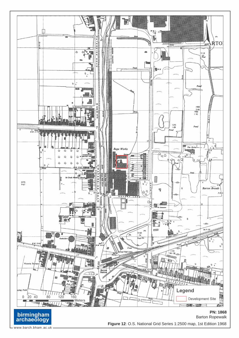
9.2.4. The 1968 Ordnance Survey map (Figure 12) demonstrates the beginning of the end of centuries old industry in the wider area with the tileries located to the north of the ropeworks being demolished and cleared. There had been some extensions to the main ropeworks buildings, and some extensions, marked tank, to the north side of the southern building in the development site.
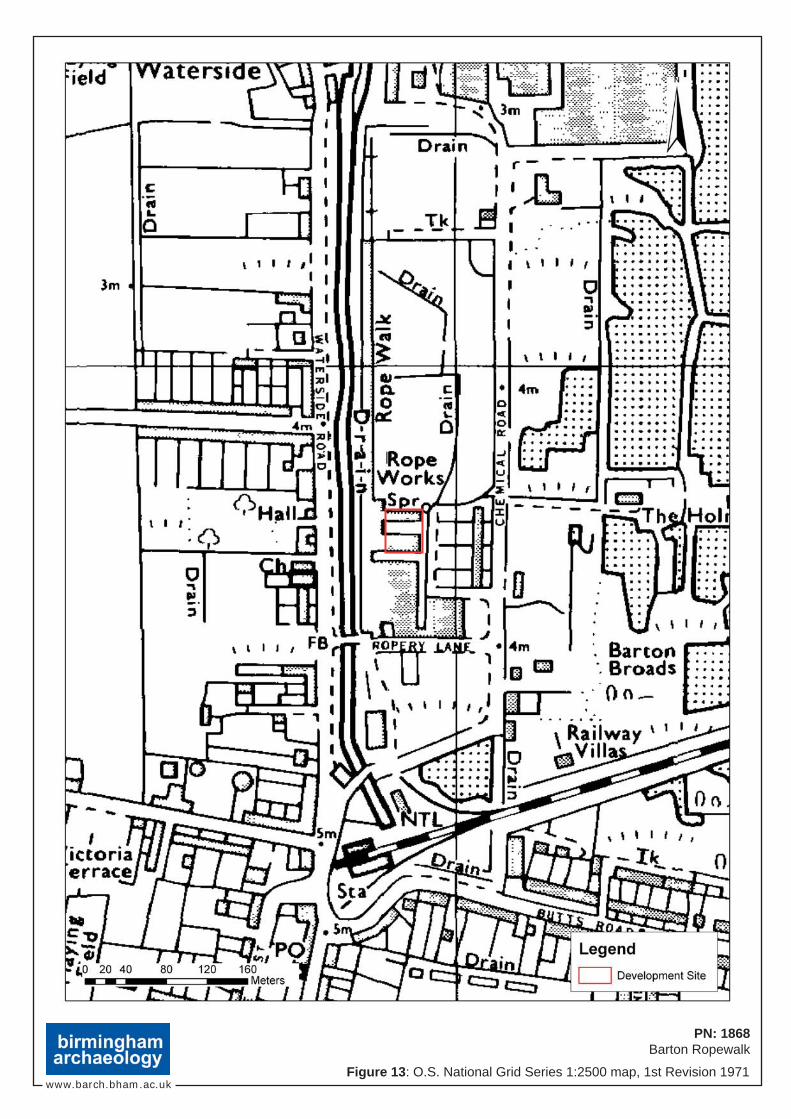
9.2.5. The 1971 and 1995 Ordnance Survey maps (Figures 13 and 14) show very few changes to the development site or the wider ropeworks complex despite the fact that the ropeworks ceased operations in 1989.
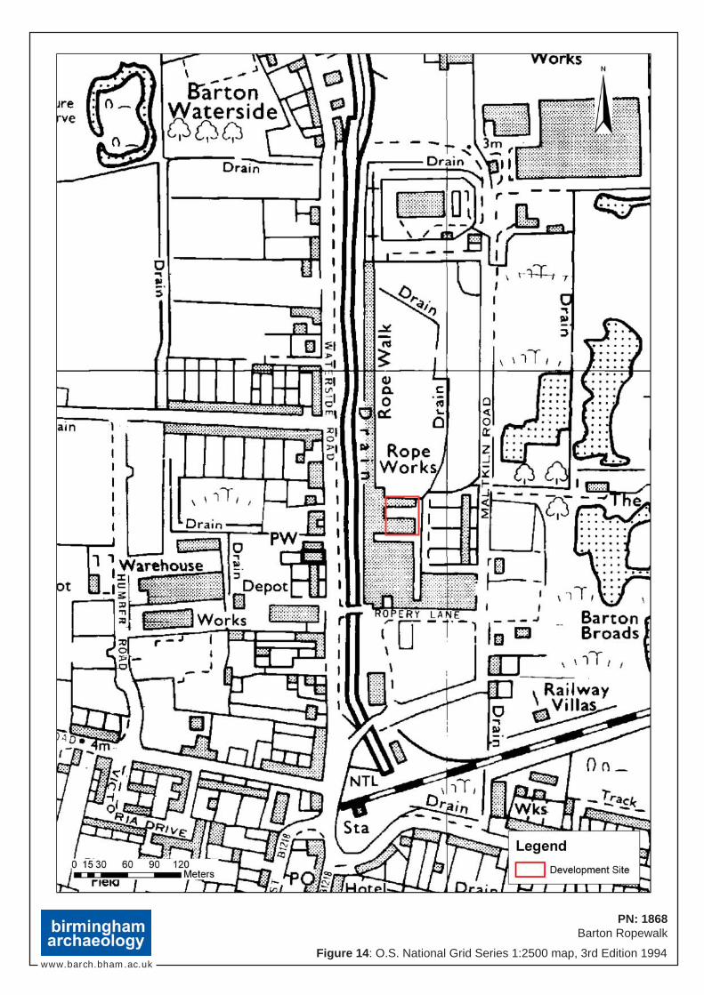
9.2.6. The recent 1:2500 Ordnance Survey map (Not illustrated) shows that most of the ropeworks buildings have been demolished and cleared since the previous map. All that remains is the ropewalk building, the Despatch House, and the buildings on the current development site, which now appear as a single building with the central yard being in-filled. The building is currently being used as a storage area for the nearby Tesco supermarket.
10. HISTORIC BUILDINGS ASSESSMENT
10.1. Introduction
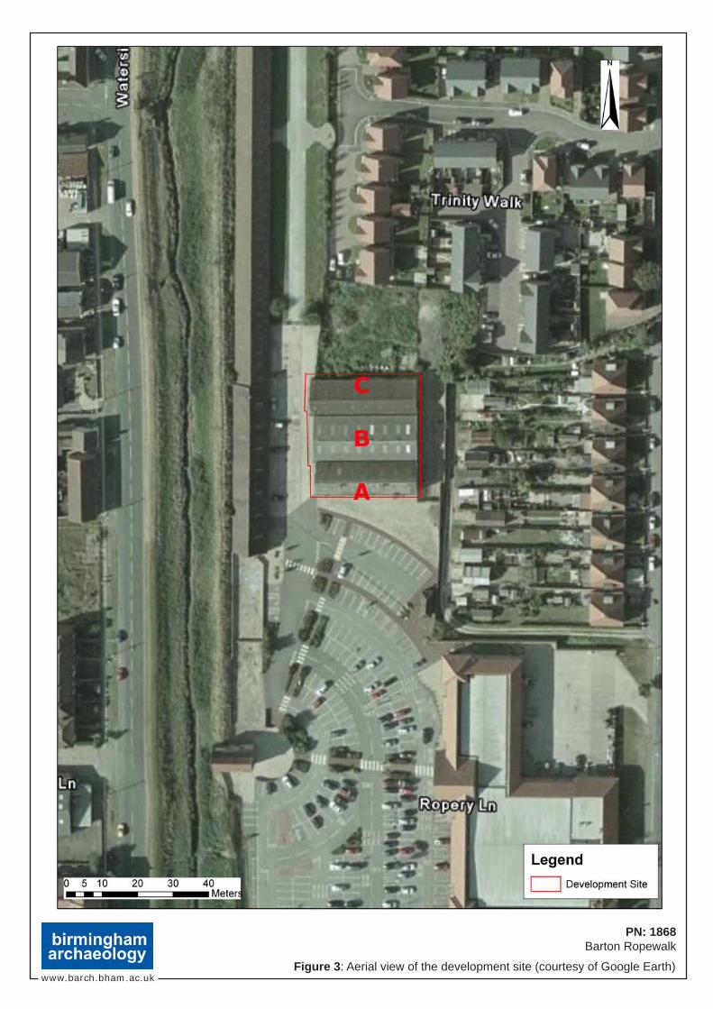
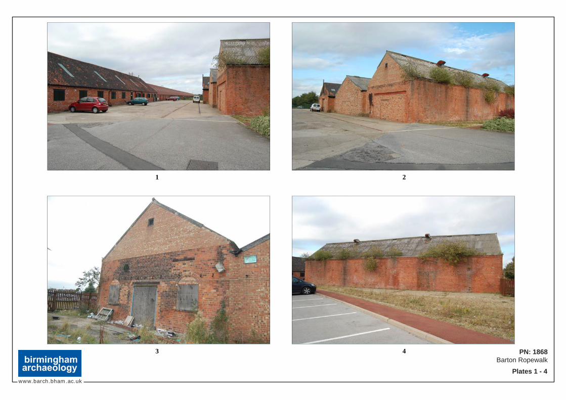
10.1.1. As seen from the map regression the buildings within the proposed development site clearly form part of the ropeworks complex. Originally two separate structures, these, according to the Ordnance Survey maps, were constructed in the late 19th/early 20th century. These buildings were subsequently linked by an infill development later in the 20th century (See Figure 3 for Section Outline).
10.2. The Buildings
10.2.1. The buildings are clearly divided into three distinct sections which also reflect the main phases of construction on the site. Section A, which is the most southerly section, dates from the late 19th-century. Section C, the most northerly section, appears to post-date Section A and is probably of a late 19th/early 20th-century date. Section B represents an infill phase of construction built in the mid/late 20th-century. Sections A and C are by no means in a complete state, however, despite much alteration during the course of the 20th-century, it is possible to identify, read and interpret their original form and fabric.
PN: 1868 Barton Ropewalk, Barton-upon-Humber: DBA and Historic Buildings Assessment
birmingham archaeology
11
10.2.2. The original phase of Section A (Plates 2 to 6) was constructed with an orangey red brick measuring 8 ⅞ ins x 3 ins x 4 ins, which was laid in English garden wall bond. This is rectangular in plan and is abutted to the north by Section B which is clearly of a later construction. The pitched gabled asbestos tiled roof is clearly not an original feature. The only surviving remains of the original fenestration scheme on the exterior is on the east elevation which has 2 (now blocked) round arched brick windows, the most northerly of which has a moulded brick sill whilst the other has a cut stone sill. These flank an inserted brick soldier arch headed doorway which may mark the position of an earlier doorway. The long south wall is devoid of any evidence of fenestration but does have an attractive moulded brick eaves course which becomes an oversail brick eaves course towards the south of the building. The west elevation has been greatly altered with an inserted (now blocked) machinery entrance, and both east and west gables have been reconstructed in the mid/late 20th-century.
Internally Section A provides further evidence of its original appearance. This is a single cell room, and few fixtures and fittings remain to provide an insight into its original function. What do remain are glimpses of its original form. The poured concrete floor is unlikely to be original but it does contain some cut vertical I-beam stumps. Unusually the south wall does not provide any evidence of any previous fenestration or other openings, which may be related to its original function. The north wall, now truncated in the middle bays to provide access from Section B, was clearly once an exterior wall. This retains two of its original round headed arch windows (now blocked) similar to those on the east wall. Much of the roof structure appears original. Six queen post trusses spring from piers on the north wall. The western three are wooden and are held together by cast-iron braces, and appear to be an original feature. The eastern three are also of queen-post truss construction, however the horizontal beam is in the form of an iron ‘I’-beam. This appears consistent with the variation in eaves course on the south wall and may represent another phase, or more likely repair.
10.2.3. Section B has clearly been added in the latter half of the 20th-century (Plates 7, 8, and 10). The Ordnance Survey maps suggest that this was sometime after 1995, however the fabric suggests an earlier date than this. The exterior has been constructed in a mottled red brick and this clearly abuts Sections A and B of the building. What clearly suggests an earlier date than 1995 is the asbestos tile covered roof which is similar in nature to the roof on Section A.
Internally the roof is carried on a steel superstructure. The east and west walls are clearly the former exterior walls of Sections A and C.
10.2.4. The original phase of Section C (Plates 9 to 11) was constructed in a reddish orange brick measuring 9 ⅛ ins x 3 ins x 4 ½ ins, and is laid in English garden wall bond. The north elevation has seven bays of segmental arch windows (now blocked) with brick sills. The east elevation also contains one of these original windows in addition to two inserted windows and a doorway. The west elevation has undergone a lot of repair and has an inserted machine door with steel lintel. The pitched gabled roof is covered in clay Roman tiles, which do not appear to be an original feature. Scarring and staining on the east wall suggests a previously adjacent building running towards the historic ropewalk building.
Internally Section C has an inserted concrete floor, and an early/mid 20th-century office/toilet cubicle in the northeast corner. The central section of the
PN: 1868 Barton Ropewalk, Barton-upon-Humber: DBA and Historic Buildings Assessment
birmingham archaeology
12
south wall has been demolished to provide access to Section B; however two original windows with 12-pane frames survive on either side of this opening. The seven roof trusses appear similar to those iron queen-post trusses on the east side of Section A.
10.3. Conclusions and Significance
10.3.1. The earliest phases of this accretive structure date from the late 19th/early
20th-century. The original function of this building is not apparent from the surviving fabric or in the readily available documentary sources. The size and form of the earlier phases would perhaps suggest a warehouse/storage function. Section A would appear to have been the first phase constructed. This was built in the late 19th-century and was soon followed by Section C. Both of these were greatly altered in the mid/late 20th-century with alterations including new roof surfaces, doorways, windows, and flooring. The main alteration was the infilling of the space between these two structures with Section C which for access and usage purposes necessitated the demolition of large sections of earlier fabric.
10.3.2. The earliest phases of this structure are most likely to have been part of the ropeworks complex. However, these elements were rather late additions to the ropeworks, and have suffered much alteration in the latter half of the 20th-century. Whilst the original form of the separate structures is readable, there is nothing in the historic fabric to suggest that these buildings are of any great significance. What is significant about them is the fact that they remain as one of the last remaining structural vestiges of the ropeworks complex along with the Grade II listed ropewalk and the recently extended Despatch House. It is this association with an industry that characterised this area for almost 200 years and the close proximity to the Grade II listed ropewalk, and not the historic fabric, design, or structural detail which provide this structure with any significance. However this significance has been greatly eroded by later alterations and additions, and loss of context during the 20th century.
11. DISCUSSION AND IMPLICATIONS
11.1. Archaeological Potential of the Study Area
11.1.1. The present study has shown that there is limited archaeological potential at the proposed development site. The site would appear to have been undeveloped until the present buildings were constructed in the late 19th/early 20th-century. Prior to this the cartographic and documentary evidence suggests that the site originally formed part of the open fields of the Barton-upon-Humber hinterlands prior to enclosure in the late 18th-century. At this time the land was officially set aside as brick closes, a function which it may have had prior to this. In the early 19th-century the land was purchased and converted for use as a ropeworks, despite this, which involved the construction of a number of ropeworks buildings, the site was not built upon until the end of the 19th century. The earlier history of the site is unclear, although archaeological finds and sites in the wider study area tentatively suggests some form of activity in this part Barton-upon-Humber from the Roman-British period.
PN: 1868 Barton Ropewalk, Barton-upon-Humber: DBA and Historic Buildings Assessment
birmingham archaeology
13
11.1.2. As seen above, the historic buildings in the development site are of little significance apart from their location adjacent to the Grade II listed Barton Ropewalk, and the fact that they are one of the few remaining vestiges of the ropeworks complex.
11.2. Possible Impacts of Development
11.2.1. It is unknown what the nature of the future development of the site will be; therefore it is difficult to discuss the possible archaeological impacts at this stage. The future development is likely to involve either reusing the existent structures, or clearing them for new development.
11.2.2. Both of these possible options are likely to impact on the Grade II listed Ropewalk building to the west of the development site. Therefore any proposals would need to examined and approved by the local planning authority as part of the planning permission process.
11.2.3. Any proposal which would necessitate the disturbance of possible sub-surface archaeological features would require some form of archaeological mitigation. The nature of this mitigation would have to be agreed by the local planning archaeologist.
11.3. Relevant Planning Policy and Guidance
11.3.1. Planning Policy Guidance Note 16: Archaeology and Planning (PPG16; DoE, 1990) Section B, para.30 states that:
‘No development shall take place within the area indicated (this would be the area of archaeological interest) until the applicant has secured the implementation of a programme of archaeological work in accordance with a written scheme of investigation which has been submitted by the applicant and approved by the Planning Authority.’
11.3.2. Planning Policy Guidance Note 15: Planning and the Historic Environment (PPG15:; DoE 1994) requires local authorities to have special regard to the setting of listed buildings when considering applications for planning permission. Within this context, the scale, height, massing, alignment and materials of any proposed new development should seek so far as is possible to reflect the proportions of the listed buildings within and around the study area, while the setting of the buildings within the streetscape should also be a material consideration.
11.4. Suggested Archaeological Mitigation
NB The comments made in this report are subject to review and revision by the planning archaeologist.
11.4.1. Given the limited potential for archaeological deposits within the development site, it is recommended that an archaeological watching brief may be required ahead of development by way of mitigation during any subsurface works. This would be consistent with the policy adopted during the recent extension works to the nearby Despatch House. Specific details regarding the nature of this watching brief would need to be defined in the light of detailed design proposals and in consultation with the Regional Archaeological Officer.
PN: 1868 Barton Ropewalk, Barton-upon-Humber: DBA and Historic Buildings Assessment
birmingham archaeology
14
11.4.2. With regard to the historic buildings on the site it is possible that the local Conservation Officer will request that some form of historic building recording is carried out prior to demolition or wholesale alterations of the structures. It is likely that this would be at a level commensurate with a Level 2 survey as defined by English Heritage (2006) which would require written descriptions, plans, and a photographic record to be carried out. It may also be recommended that further detailed documentary research be carried out, particularly of the ropeworks records, in order to gain a more exact understanding of the original function of these buildings and their role within the wider ropeworks complex.
12. ACKNOWLEDGEMENTS
12.1.1. The project was commissioned by Development Planning Partnership LLP working on behalf of Tesco Stores Ltd; thanks are extended to Matthew Birkinshaw of Development Planning Partnership LLP for his help and cooperation throughout the course of the project. Thanks are also due to the Mike Hemblade of the North Lincolnshire SMR, the staff of Lincolnshire Archives and the Libraries of the University of Birmingham, and to Claire Whittaker of Development Planning Partnership LLP for her assistance during fieldwork.
12.1.2. The historical research and site assessment were undertaken by Shane Kelleher of Birmingham Archaeology who also produced the current report. Illustrations were the work of Shane Kelleher and Nigel Dodds, and the report was edited by Dr Malcolm Hislop who also managed the project for Birmingham Archaeology.
13. LIST OF SOURCES
13.1. Cartographic Sources
• 1796 A Plan of the Town and Old Enclosure of Barton-on-Humber (North Lincolnshire SMR).
• 1797 The Enclosure Plan of Barton-on-Humber (Lincolnshire Archives).
• An Early 19th-century Sketch of the area (From Fenton 2007).
• 1824 Ordnance Survey 1 inch to the mile map (North Lincolnshire SMR).
• 1855 A Plan of Barton Waterside (From Fenton 2007).
• 1887 Ordnance Survey County Series 1:2500 map, 1st Edition.
• 1908 Ordnance Survey County Series 1:2500 map, 1st Revision.
• 1932 Ordnance Survey County Series 1:2500 map, 3rd Edition.
• 1968 Ordnance Survey National Grid Series 1:2500 map, 1st Edition.
• 1971 Ordnance Survey National Grid Series 1:2500 map, 1st Revision.
• 1994 Ordnance Survey National Grid Series 1:2500 map, 3rd Edition.
13.2. Sources
PN: 1868 Barton Ropewalk, Barton-upon-Humber: DBA and Historic Buildings Assessment
birmingham archaeology
15
Department of the Environment (DoE), 1990 Planning Policy Guidance Note 16: Archaeology and Planning.
Department of the Environment (DoE), 1994 Planning Policy Guidance Note 15: Planning and the Historic Environment.
Ball, H.W. 1856. The Social History and Antiquities of Barton-upon-Humber. Ball, Barton-upon-Humber.
Birmingham Archaeology 2008. Written Scheme of Investigation for Archaeological Desk-based and Historic Building Assessment at Barton Ropewalk, Barton-upon-Humber.
Denby Local Board 1858. The Development of Barton-upon-Humber.
Ekwall, E. 1960. The Concise Oxford Dictionary of English Place-names. Clarendon Press, Oxford.
Fenton, W. 2007. Ropeworks: A brief history of Hall’s Barton Ropery. The Ropewalk, Barton-upon-Humber.
Institute of Field Archaeologists (IFA) 1999, Standard and Guidance for Archaeological Desk-Based Assessment, rev. edn.
Institute of Field Archaeologists (IFA) 1999, Standard and Guidance for the Archaeological Investigation and Recording of Standing Buildings or Structures, rev. edn.
May, J. 1976. Prehistoric Lincolnshire. History of Lincolnshire Committee for the Society for Lincolnshire History and Archaeology
Pevsner, N. and Harris, J. 1964. Lincolnshire. Penguin, Harmondsworth.
Preconstruct Archaeology 2004. Historic Building Survey at Barton Ropewalk, Barton-upon-Humber.
Sawyer, P. 1998. Anglo Saxon Lincolnshire. History of Lincolnshire Committee for the Society for Lincolnshire History and Archaeology, Lincoln.
The Conservation Studio 2002. Barton-upon-Humber Conservation Area Appraisal. For North Lincolnshire Council.

PN: 1868 Barton Ropewalk, Barton-upon-Humber: DBA and Historic Buildings Assessment
birmingham archaeology
16
PN: 1868 Barton Ropewalk, Barton-upon-Humber: DBA and Historic Buildings Assessment
birmingham archaeology
17
APPENDIX A: Glossary of Terms
Archaeological Periods and Date Ranges
Period Date Range
Prehistoric
Paleolithic 500,000 BC – 10,000 BC
Mesolithic 10,000 BC – 4,000 BC
Neolithic 4,000 BC – 2,400 BC
Bronze Age 2,400 BC – 700 BC
Iron Age 700 BC – AD 43
Historic
Roman AD 43 – AD 410
Anglo-Saxon/ Early Medieval AD 410 – AD 1066
Medieval AD 1066 – AD 1539
Post Medieval AD 1540 – AD 1900
Industrial Revolution c.AD 1750 – AD 1825
Modern AD 1901 - present
Statutory Designations
Scheduled Ancient Monument (SAM)
'Scheduling' is the process through which nationally important sites and monuments are given legal protection. A schedule has been kept since 1882 of monuments whose preservation is given priority over other land uses. The current legislation, the Ancient Monuments and Archaeological Areas Act 1979, supports a formal system of Scheduled Monument Consent (SMC, see below) for any work to a designated monument.
Conservation Area (CA)
Conservation Areas are any areas of ‘special architectural or historic interest, the character or appearance of which it is desirable to preserve or enhance' and are designated by Local Authorities. There are now more than 8,000 conservation areas in England. Designation introduces a general control over the demolition of unlisted buildings and provides the basis for policies designed to preserve or enhance all the aspects of character or appearance that define an area's special interest.
Listed Building (LB)
A ‘Listed Building’ is a structure that has been placed on the statutory lists of buildings of 'special architectural or historic interest' compiled by the Secretary of State for Culture, Media and Sport on advice from English Heritage. When a building is listed, it is listed in its entirety, which means that both the exterior and the interior are protected. In addition, any object or structure fixed to the building, and any object or structure within the curtilage of the building, which although not fixed to the building, forms part of the land and has done so since before 1 July 1948, are treated as part of the listed building.
Locally Listed Building (LLB)
A Locally Listed Building is a building, structure or feature which, whilst not Statutorily listed by the Secretary of State, a local authority feels makes a significant contribution to the local environment and an important part of an area’s heritage due to its architectural, archaeological significance or historical associations. Inclusion on a Local List does not give a building any statutory protection.
PN: 1868 Barton Ropewalk, Barton-upon-Humber: DBA and Historic Buildings Assessment
birmingham archaeology
18
Registered Parks and Gardens
The Register of Parks and Gardens of special historic interest in England, compiled and maintained by English Heritage, currently includes nearly 1450 sites, divided into three grade bands. The majority of the sites identified through the Register as being of a sufficiently high level of interest to merit a national designation, are designated Grade II. Around 30% of the 1450 are considered to be of exceptional historic interest and are awarded a star giving them Grade II* status while a further 10% are of international importance, and are classified as Grade I.
Historic Battlefields
The English Heritage Register of Historic Battlefields identifies forty-three important English battlefields. Its purpose is to offer them protection and to promote a better understanding of their significance.
The Planning Process
Scheduled Monument Consent (SMC)
The Secretary of State must be informed about any work which might affect a monument above or below ground, and English Heritage gives advice to the Government on each application. In assessing each application the Secretary of State will try to ensure that damage done to protected sites is kept to a minimum. Written consent must always be obtained before any work can begin. Some development may also need planning permission.
Listed Building Consent (LBC)
Listed Building Consent (LBC) is required in order to carry out any works to a Listed Building which will affect its special value for listing purposes. This will almost certainly be necessary for any major works, but may also be necessary for minor alterations and possibly even repairs and maintenance. LBC may also be necessary for a change of use of the property. It is a criminal offence to carry out work which needs listed building consent without obtaining it beforehand.
The Archaeological Process
The principal stages for handling archaeology within the planning process, in line with the Government's Planning Policy Guidance notes PPG 15 and PPG16 are:
• Pre-determination: desk-based assessment, archaeological evaluation;
• Post-determination: preservation in situ, preservation by record (excavation).
Stages of Archaeological Work
Written Scheme of Investigation (WSI)
Any programme of archaeological work will normally be undertaken in accordance with a Written Scheme of Investigation (WSI), clearly stating the scope and extent of work, the aims and objectives, and the methodology to be employed during the course of work. The WSI will be prepared by the contracted archaeological organisation and approved in advance of work by the archaeological officer of the relevant LPA.
Archaeological Desk-Based Assessment (DBA)
An archaeological desk-based assessment (DBA) constitutes a first stage, non-invasive assessment of the archaeological potential of a site, undertaken in advance of any development. Research will normally comprise a search of all readily available documentary and archival sources pertaining to a site combined with an on-site ‘walkover’ survey to assess surviving archaeological remains/ built heritage of the area.
Archaeological Evaluation
An archaeological evaluation is a limited programme of intrusive or non-intrusive fieldwork undertaken to establish the extent of survival of archaeological deposits within a site and to determine the character, date, state of preservation and potential significance of any buried remains. An evaluation is often required prior to the determination of a planning application for development and will normally be undertaken subsequent to a desk-based assessment. A variety
PN: 1868 Barton Ropewalk, Barton-upon-Humber: DBA and Historic Buildings Assessment
birmingham archaeology
19
of techniques may be employed including geophysical survey, fieldwalking, trial trenching and test pitting. The results of evaluation will be used to establish the necessity for and determine the requirements of any further stage of archaeological work.
Archaeological Excavation
An archaeological excavation is a programme of controlled, intrusive fieldwork, normally undertaken by means of open area excavation, with the purpose of examining and recording archaeological deposits, features and structures identified by documentary research and/ or archaeological evaluation. Archaeological excavation will normally lead on to a programme of post-excavation analysis and publication.
Archaeological Watching Brief
An archaeological watching brief is a formal programme of observation and investigation conducted during any operation carried out for non-archaeological reasons within an area or site where there is a possibility of archaeological deposits being disturbed or destroyed. Groundworks will normally be undertaken by a principal contractor under the supervision of an attending archaeologist.
Preservation in-situ
Foundation design to avoid or minimise impact on archaeology may be sought. This might include locating buildings to avoid archaeology; display of remains; sympathetic location of piled foundations and piling techniques; raising floor or ground beam levels; the routing of services; management of ground water. Landscaping and planting may also be constrained. Monitoring over a number of years after completion may be needed to assess if the preservation techniques have been successful.
Historic Building Recording (HBR)
A Historic Building Record (HBR) is a programme of work intended to establish the character, history, dating, form and archaeological development of a specified building, structure or complex and its setting. A programme of historic building recording will often be required as a condition of planning consent/ listed building consent, to be taken in advance of (pre-determination) and/ or during building refurbishment/ alterations/ demolitions (post determination).
HBR can be undertaken to a range of different levels (Levels 1 – 4 as defined by English Heritage) dependent upon the significance of the building under consideration and the extent of the proposed works.
SITE
Figure 1: Site Locationwww.barch.bham.ac.uk
0 1 2 3 4 5 6 7Kilometres
PN: 1868Barton Ropewalk
www.barch.bham.ac.uk
PN: 1868Barton Ropewalk
Figure 2: Site plan (including SMR data)
R i v e r H u m b e r
W a t e r s i d e R
o a d
M a l t K
i l n R o a d
D a m R o a d
B u t t s R o a d
F l e e t g a t e
www.barch.bham.ac.uk
PN: 1868Barton Ropewalk
Figure 3: Aerial view of the development site (courtesy of Google Earth)
www.barch.bham.ac.uk
PN: 1868Barton Ropewalk
Figure 4: A Plan of the Town and Old Enclosure of Barton-on-Humber 1797(North Lincolnshire SMR)
www.barch.bham.ac.uk
PN: 1868Barton Ropewalk
Figure 5: The Enclosure Plan of Barton-on-Humber 1797 (Lincolnshire Archives)
www.barch.bham.ac.uk
PN: 1868Barton Ropewalk
Figure 6: An Early 19th century Sketch of the area (from Fenton 2007)
www.barch.bham.ac.uk
PN: 1868Barton Ropewalk
Figure 7: O.S. 1 inch to the mile map 1824 (North Lincolnshire SMR)
www.barch.bham.ac.uk
PN: 1868Barton Ropewalk
Figure 8: A Plan of Barton Waterside 1855 (from Fenton 2007)
www.barch.bham.ac.uk
PN: 1868Barton Ropewalk
Figure 9: O.S. County Series 1:2500 map, 1st Edition 1887
www.barch.bham.ac.uk
PN: 1868Barton Ropewalk
Figure 10: O.S. County Series 1:2500 map, 1st Revision 1908
www.barch.bham.ac.uk
PN: 1868Barton Ropewalk
Figure 11: O.S. County Series 1:2500 map, 3rd Edition 1932
www.barch.bham.ac.uk
PN: 1868Barton Ropewalk
Figure 12: O.S. National Grid Series 1:2500 map, 1st Edition 1968
www.barch.bham.ac.uk
PN: 1868Barton Ropewalk
Figure 13: O.S. National Grid Series 1:2500 map, 1st Revision 1971
www.barch.bham.ac.uk
PN: 1868Barton Ropewalk
Figure 14: O.S. National Grid Series 1:2500 map, 3rd Edition 1994
www.barch.bham.ac.uk
PN: 1868Barton Ropewalk
Plates 1 - 4
1 2
3 4
www.barch.bham.ac.uk
PN: 1868Barton Ropewalk
Plates 5 - 8
5 6
7 8
www.barch.bham.ac.uk
PN: 1868Barton Ropewalk
Plates 9 - 11
9 10
11