petroleum geology of the nogal basin and surrounding area
TRANSCRIPT
91Journal of Petroleum Geology, Vol. 42(1), January 2019, pp 91-120
1 Khalifa University of Science and Technology, Abu Dhabi, UAE.* corresponding author, [email protected] POSCO DAEWOO Corporation, Incheon, Korea.
Key words: Nogal Basin, Somalia, Somaliland, stratigraphy, tectonic evolution, rift basins.
PETROLEUM GEOLOGY OF THE NOGAL BASIN AND SURROUNDING AREA, NORTHERN SOMALIA: PART 1, STRATIGRAPHY AND TECTONIC EVOLUTION
M. Y. Ali1* and J. Lee1,2
In this study, 92 closely-spaced reflection seismic profiles (~4000 line-km) were tied to biostratigraphic and lithological data from six deep exploration wells in the poorly-known Nogal rift basin, northern Somalia, and were integrated with outcrop and aeromagnetic data to investigate the basin stratigraphy and tectonic evolution. Aeromagnetic data show NW-SE trending magnetic anomalies which are interpreted as plutonic bodies intruded during the Early Cretaceous, probably contemporaneously with a pre-Cenomanian uplift phase. The aeromagnetic data also suggest a change of basement type from Inda Ad Series metasediments in the SE of the study area to igneous and high-grade metamorphic basement in the NW. Biostratigraphic data and seismic reflection profiles define the Nogal Basin as a WNW–ESE striking half-graben, approximately 250 km long and 40 km wide, which formed as a result of mainly Cenomanian–Maastrichtian and Oligocene–Miocene intracontinental rifting. The depocentre contains at least 7000 m of Mesozoic and Cenozoic sediments and is located in the centre of the basin (east of well Nogal-1), to the south of the Shileh Madu Range. To the north, the basin is bounded by a major border fault along which significant variations in the thickness of sedimentary units are observed, suggesting that the fault controlled basin architecture and patterns of sedimentation. Oligocene–Miocene normal faults which resulted in north-tilted fault blocks are widespread within the main basin; smaller-scale sub-basins oriented NW-SE to WNW-ESE are observed to the NW of the basin and probably developed contemporaneously.
The Late Jurassic rift phase which has been documented elsewhere in northern Somalia is either missing in the Nogal Basin or is preserved only in localised grabens in the western and central parts of the basin. This is probably due to the pre-Cenomanian uplift and erosion which removed almost the entire Jurassic and Lower Cretaceous successions over a wide area referred to as the Nogal-Erigavo Arch. A more pronounced rifting episode followed this erosional event in the Cenomanian–Maastrichtian and resulted in the deposition of well -sorted fluvio-deltaic sandstones (Gumburo and Jesomma Formations), more than 2000 m thick. In wells in the Nogal Basin, these formations are between two and three times thicker than in wells drilled in footwall locations, and include excellent reservoir rocks sealed by transgressive mudstones and carbonates. A final rifting event in the Oligocene–Miocene was related to the opening of the Gulf of Aden. A rift sag phase which accommodated the Early Oligocene continental sediments of the Nogal Group initially developed at the centre of the basin. This was followed by a period of strong rotational faulting and tilting, which reactivated the Cenomanian–Maastrichtian structures.
© 2018 The Authors. Journal of Petroleum Geology © 2019 Scientific Press Ltd
Ali part 1.indd 91 03/12/2018 12:48:11
www.jpg.co.uk
92 Petroleum geology of the Nogal Basin, Northern Somalia, Part 1
INTRODUCTION
The geology of northern Somalia is dominated by uplifted and exhumed basement blocks which are exposed along the Gulf of Aden, and rift basins containing thick Mesozoic and Cenozoic sedimentary successions (Ali and Watts, 2016; Mackay et al., 1954). Although there have been a number of stratigraphic and structural studies of the Mesozoic and Cenozoic sequences in northern Somalia (e.g. Abbate et al., 1974; Abbate et al., 1993a; Boeckelmann and Schreiber, 1990; Hunt et al., 1956; Luger et al., 1990), few studies have delineated the subsurface basin architecture as they were heavily reliant on outcrop geology. However, investigating the subsurface structure of the basins is of relevance for hydrocarbon exploration as recent wells have indicated a regional hydrocarbon potential.
Ali and Watts (2016) used two regional-scale seismic reflection profiles tied to lithological and biostratigraphic data to investigate the stratigraphy of northern Somalia. They showed that basin fills in general can be divided into five stratigraphic sequences that range in age from Late Jurassic to Neogene. In addition, Ali (2015) investigated the petroleum geology and hydrocarbon potential of the Mesozoic–Neogene Guban rift basin, which is located along the southern coast of the Gulf of Aden and NW of the Nogal Basin.
The basin contains both Upper Jurassic source rocks and a variety of reservoir rocks. Furthermore, by backstripping biostratigraphic data from exploration wells Ali and Watts (2013) and Ali and Watts (2016) showed that basins in northern Somalia have undergone three main rift phases with intervening periods of uplift and erosion. Initial phases of rifting occurred in the Late Jurassic and Late Cretaceous as a result of the late-stage break-up of Gondwana and a rapid increase in the spreading rate on the ridges separating the African and Indian plates respectively (Ali and Watts, 2016). The final rift phase in the Oligocene–Miocene was related to the opening of the Gulf of Aden (Ali and Watts, 2016).
The Nogal Basin, the subject of this paper, is a WNW-ESE striking half-graben which extends from north of Garowe to north of Las Anod below the Nogal Valley (Figs 1 and 2), and which formed as a result of Late Cretaceous and Oligocene–Miocene rifting (Ali and Watts, 2016). The basin has been explored by Amerada Oil and Conoco Somalia Ltd with rather discouraging results. However, petroleum systems modelling which is presented in Part 2 of this paper (Ali and Lee, in press) suggests that the western and central parts of the basin may be prospective, with hydrocarbons possibly trapped in the Adigrat and Gumburo Formation sandstones.
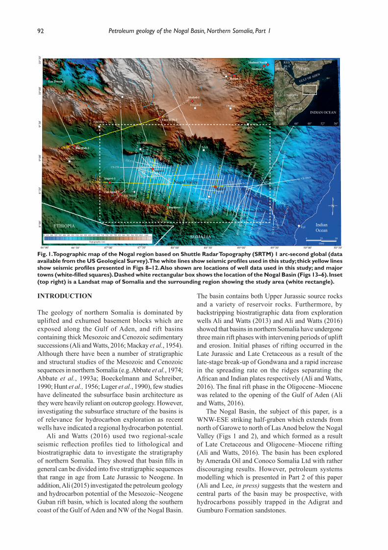
Fig. 1. Topographic map of the Nogal region based on Shuttle Radar Topography (SRTM) 1 arc-second global (data available from the US Geological Survey). The white lines show seismic profiles used in this study; thick yellow lines show seismic profiles presented in Figs 8–12. Also shown are locations of well data used in this study; and major towns (white-filled squares). Dashed white rectangular box shows the location of the Nogal Basin (Figs 13–6). Inset (top right) is a Landsat map of Somalia and the surrounding region showing the study area (white rectangle).
'
L5D
L5C
L5B
L5A
L5
CS-300
CS-290
CS-280
CS-275
CS-270
CS-264 CS-260A
CS-257
CS-250
CS-2
40A
CS-240
CS-231
CS-230
CS-230
CS-229
CS-228CS-227
CS-226
CS-225
CS-222
CS-220CS-195
CS-188-
CS-185
CS-176'
CS-172
CS-170
CS-165
CS-163
CS-162
CS-161
CS-160_5
CS-160
CS-153
S
CS-155
C
CS-150
CS-147
CS-145
CS-142
CS-140CS-130
CS-123
CS-127
CS-125
CS-120A
CS-120
CS-233
CS-232
CS-234
CS-235
CS-236CS-237
CS-238
CS-256
CS-251
CS-247
CS-245A
CS-243CS-241
CS-242
CS-255
CS-250A
CS-245
CS-250B
CS-262
CS-190
CS-156
25 50
(km)
00 154 260 329 382 426 465 501 534 565 595 624 653 682 710 739 769 799 831 865 903 944 992 1052 1168
Topography (m)
Las Durah-1
Bur Dab-1
Yaguri-1
Las Anod-1
Burhisso-1
Nogal-1
Faro Hills-1
Hedad-1
Buran-1
Kalis-1
Shabeel-1
Shabeel North
Las Anod
IndianOcean
48°30' 49°00'48°00'47°30'47°00'46°30'46°00' 50°00' 50°30'49°30'
8°00
'8°
30'
9°00
'9°
30'
10°0
0'10
°30'
Huddun
Eil Afwein
Dhahar
Garowe
Hingalol
Buran
Eyl
Ainabo
Garadag
Iskushuban
ETHIOPIA
SOMALIA
Iskushuban
0°
44°
ETHIOPIA
SOMALIAKENYA
YEMENERITRIA
GULF OF ADEN
RED SEA
INDIAN OCEAN
40° 48° 52° 56°
4°8°
12°
16°
CS-260
Qardho
Taleh
Nogal Valley
Ali part 1.indd 92 03/12/2018 10:25:20
93M. Y. Ali and J. Lee
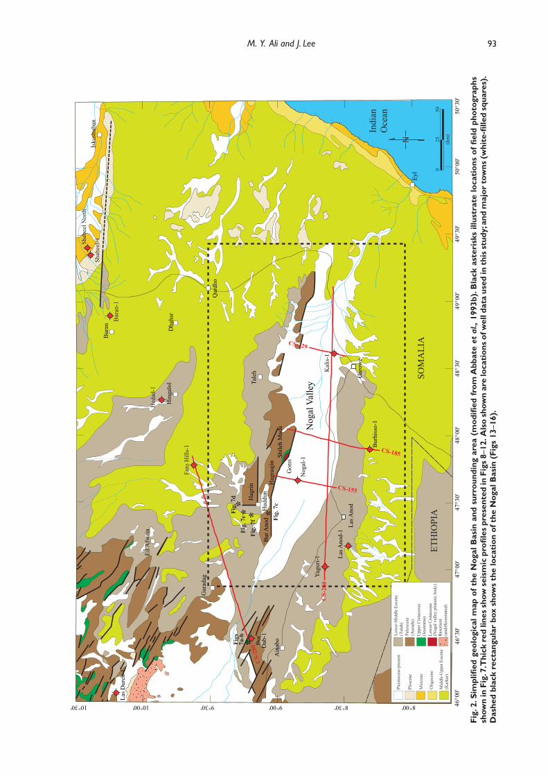
Fig.
2. S
impl
ifi ed
geo
logi
cal m
ap o
f the
Nog
al B
asin
and
sur
roun
ding
are
a (m
odifi
ed fr
om A
bbat
e et
al.,
199
3b).
Bla
ck a
ster
isks
illu
stra
te lo
cati
ons
of fi
eld
phot
ogra
phs
show
n in
Fig
. 7. T
hick
red
line
s sh
ow s
eism
ic p
rofi l
es p
rese
nted
in F
igs
8–12
. Als
o sh
own
are
loca
tion
s of
wel
l dat
a us
ed in
thi
s st
udy;
and
maj
or t
owns
(whi
te-fi
lled
squ
ares
). D
ashe
d bl
ack
rect
angu
lar
box
show
s th
e lo
cati
on o
f the
Nog
al B
asin
(Fi
gs 1
3–16
).
Bur
hiss
o-1
Kal
is-1
Las A
nod-
1
Nog
al-1
Yagu
ri-1
Nog
al V
alle
y
Las A
nod
Hud
dun
Eil A
fwei
n
Dha
har
Tale
h
Qar
dho
Gar
owe
48°3
0'49
°00'
2550
(km
)
0ET
HIO
PIA
SOM
ALI
A
Indi
anO
cean
48°0
0'47
°30'
47°0
0'46
°30'
46°0
0'50
°00'
50°3
0'49
°30'
8°00'8°30'9°00'9°30'10°00'10°30'
Hin
galo
l
Bur
an
Eyl
Ain
aboBur
Dab
-1
Las D
ureh
-1
Faro
Hill
s-1
Hed
ad-1
Shab
eel-1Sh
abee
l Nor
th
Bur
an-1
Isku
shub
an
Hag
rin
Bur
Ano
dH
agra
ajin
CS-
280
CS-229
CS-185
CS-155
CS-
260
Gar
adag
*Figs
7a-b
*Fi
g. 7
c*Fi
g. 7
d
*Fi
g. 7
e *Fi
g. 7
f
Shile
h M
adu
Gor
ei
Mio
cene
Upp
er C
reta
ceou
s(J
esom
ma)
Plei
stoc
ene-
pres
ent
Low
er C
reta
ceou
s(N
ogal
val
ley
plut
onic
bod
y)B
asem
ent
(und
iffer
entia
ted)
Pale
ocen
e(A
urad
u)
Low
er-M
iddl
e Eo
cene
(Tal
eh)
Olig
ocen
e
Plio
cene
Mid
dle-
Upp
er E
ocen
e(K
arka
r)
Ali part 1.indd 93 03/12/2018 10:25:21
94 Petroleum geology of the Nogal Basin, Northern Somalia, Part 1
In this paper, we report the results of a detailed study of stratigraphy, structure and regional tectonic history of the Nogal Basin and the surrounding area based upon outcrop observations integrated with closely-spaced 2D seismic profiles, exploration wells and aeromagnetic data. The study shows that the basin is infilled by a thick Upper Cretaceous and Cenozoic succession, which record periods of extension and subsidence alternating with uplift and erosion. These results have led to a revised stratigraphy of northern Somalia, and provide a framework within which the regional-scale basin development and hydrocarbon potential can be reassessed.
DATASET AND METHODOLOGY
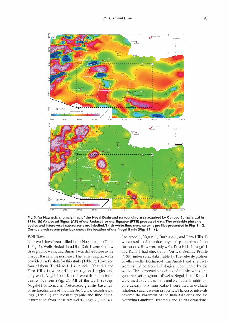
Aeromagnetic DataIn 1986, Conoco Somalia Ltd acquired Total Magnetic Intensity (TMI) data in the Nogal region. The TMI field measurements were made along NW-SE flight lines with a line spacing of 2 km and perpendicular control lines at 10 km intervals. Processing of the TMI data included removal of the International Geomagnetic Reference Field and line intersection adjustments to remove diurnal changes in the field strength. As part of this study, we transformed the TMI map to Reduction-to-the-Pole (RTP) and Reduction-to-the-Equator (RTE) maps to minimize the inclination effect of the TMI field. These transformations reduced the
magnetic anomalies to the magnetic pole/equator and corrected for variations in inclination and declination over the study area, assuming that all magnetization is induced (Baranov and Naudy, 1964; Leu, 1981). However, The RTP and RTE transformations were not successful since positive anomalies still had negative anomalies after the RTE operation (Fig. 3a). This was probably due to the magnetic remanence of the crustal rocks and the low latitude of the study area which is close to the geomagnetic equator (average inclination and declination of 1.927° and 0.195° respectively). The dipole nature of magnetic anomalies makes it difficult to infer the position of magnetic sources from an RTE map, as anomaly peaks may not coincide with their corresponding magnetic sources. Thus, to analyse the distribution of centres of magnetic sources, we constructed the Analytic Signal (AS) of the RTE map (Fig. 3b). The AS repositioned magnetic anomalies over related sources to facilitate geological interpretation (Roest et al., 1992).
FieldworkFieldwork by the authors was conducted in two seasons (August 2014 and July–August 2018) and covered most of the western Nogal Basin and surrounding area. The objectives were to conduct geological traverses along the Nogal Valley and surrounding area, to record structural measurements and stratigraphy, and to collect rock samples from the oldest parts of the stratigraphy.
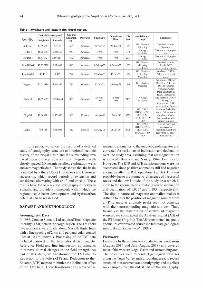
Table 1. Available well data in the Nogal region.
Wells Coordinates (degrees) Ground
Elevation(m)
Operator Spud Date Completion Date
TD (m)
Available well logs Comments
Longitude Latitude
Burhisso-1 47.896667 8.3175 664 Amerada 29-Apr-58 26-Jun-58 1551 GR, Electric, Microlog
Dead oil stain in Tertiary
Hedad-1 48.266667 9.866667 939 Amerada 1958 1958 312 No logsavailable
Shallow stratigraphic test
Bur Dab-1 46.476721 9.197264 672 Amerada 1958 1958 256 No logsavailable
Shallow stratigraphic test
Faro Hills-1 47.777778 9.626389 880 Amerada 07-Aug-57 07-Nov-57 1637GR, Electric,
Microlog,checkshot
Dead oil stain in Taleh, DST
recovered no fluids
Las Anod-1 47.175 8.475 792 Amerada 09-May-57 19-Jul-57 1664GR, Electric,
Laterolog, Microlog
No shows, DST in Adigrat recovered
water
Yaguri-1 47.018889 8.648333 724 Amerada 12-Jul-58 26-Aug-58 1440 GR, Electric, Microlog
No shows, TOC of 0.5-3.5 in Adigrat,
DST in Adigratrecovered water
Buran-1 48.896667 10.249444 853 Amerada 27-Nov-1957
16-Mar-1958 2437 No logs
available
Dead oil stains in Taleh, Cretaceous
and Jurassic, TOC = 0.43 avg. in
Cretaceous, DST recovered no fluids
Nogal-1 47.665111 8.853639 500 Conoco 16-Nov-89 12-Apr-90 3272
GR, CALI, RHOB, NPHI,
ILD, ILM, SFLU, DT, SP,
VSP
Jesomma flashed by water. Oil shows in
Gumburo. Over-pressured section within Gumburo
Kalis-1 48.6125 8.583056 417 Conoco 02-May-90 26-Jul-90 2978
GR, CALI, RHOB, NPHI,
ILD, ILM, SFLU, DT, SP,
VSP
16 brl of heavy oilrecovered in
Jesomma. Gumburorecovered 60 brl of
mud filtrate.
Ali part 1.indd 94 03/12/2018 10:25:22
95M. Y. Ali and J. Lee
Well DataNine wells have been drilled in the Nogal region (Table 1, Fig. 2). Wells Hedad-1 and Bur Dab-1 were shallow stratigraphic wells, and Buran-1 was drilled close to the Daroor Basin in the northeast. The remaining six wells provided useful data for this study (Table 2). However, four of them (Burhisso-1, Las Anod-1, Yaguri-1 and Faro Hills-1) were drilled on regional highs, and only wells Nogal-1 and Kalis-1 were drilled in basin centre locations (Fig. 2). All of the wells (except Nogal-1) bottomed in Proterozoic granitic basement or metasediments of the Inda Ad Series. Geophysical logs (Table 1) and biostratigraphic and lithological information from these six wells (Nogal-1, Kalis-1,
Las Anod-1, Yaguri-1, Burhisso-1, and Faro Hills-1) were used to determine physical properties of the formations. However, only wells Faro Hills-1, Nogal-1 and Kalis-1 had check-shot, Vertical Seismic Profile (VSP) and/or sonic data (Table 1). The velocity profiles of other wells (Burhisso-1, Las Anod-1 and Yaguri-1) were estimated from lithologies encountered by the wells. The corrected velocities of all six wells and synthetic seismograms of wells Nogal-1 and Kalis-1 were used to tie the seismic and well data. In addition, core descriptions from Kalis-1 were used to evaluate lithologies and reservoir properties. The cored intervals covered the basement of the Inda Ad Series and the overlying Gumburo, Jesomma and Taleh Formations.
Fig. 3. (a) Magnetic anomaly map of the Nogal Basin and surrounding area acquired by Conoco Somalia Ltd in 1986. (b) Analytical Signal (AS) of the Reduced-to-the-Equator (RTE) processed data. The probable plutonic bodies and interpreted suture zone are labelled. Thick white lines show seismic profiles presented in Figs 8–12. Dashed black rectangular box shows the location of the Nogal Basin (Figs 13–16).
-1500 -600 -300 -100 100 200 300 400 500 600 700 800 900 1000 1200 1400 1700Analytical Signal (nT /m)
2000
2000
00
02
Las Durah-1
Yaguri-1
Las Anod-1
Burhisso-1
Nogal-1
Faro Hills-1
Hedad-1
Buran-1
Kalis-1
Shabeel-1
Shabeel North
Las Anod
IndianOcean
48°30' 49°00'48°00'47°30'47°00'46°30'46°00' 50°00' 50°30'49°30'
8°00
'8°
30'
9°00
'9°
30'
10°0
0'10
°30'
Huddun
Eil Afwein
Dhahar
Garowe
Hingalol
Buran
Eyl
Garadag
Iskushuban
ETHIOPIA
(km)
25 500
-80 -50 -40 -30 -20 -10 0 10 20 30 40 50 70
Magnetic Anomaly (nT)
00
1-
0
0
0 0
0
0
0
0
0
0
0
0
0
0
0
0
0
Las Durah-1
Yaguri-1
Las Anod-1
Burhisso-1
Nogal-1
Faro Hills-1
Hedad-1
Buran-1
Kalis-1
Shabeel-1
Shabeel North
IndianOcean
Huddun
Eil Afwein
Dhahar
Garowe
Hingalol
Buran
Eyl
Garadag
Iskushuban
ETHIOPIA
(km)
25 500
48°30' 49°00'48°00'47°30'47°00'46°30'46°00' 50°00' 50°30'49°30'
8°00
'8°
30'
9°00
'9°
30'
10°0
0'10
°30'
(a)
(b)
?Plutons
?Suture zone
?Suture zone
Las Anod
?Plutons
CS-280
CS-229
CS-185
CS-155
CS-280
CS-229
CS-185
CS-155
Qardho
Taleh
Qardho
Taleh
Ainabo
Bur Dab-1
Bur Dab-1
Ainabo
CS-260
CS-260
Ali part 1.indd 95 03/12/2018 10:25:30
96 Petroleum geology of the Nogal Basin, Northern Somalia, Part 1
Seismic DataFrom 1987 to 1990, Conoco Somalia Ltd acquired 4596 line-km of closely-spaced 2D seismic reflection data in the Nogal Basin and surrounding area, and 92 profiles (~4000 line-km) were interpreted in this study (Fig. 1). The spacing between 2D seismic lines varies from 2 to 10 km, and the maximum depth of profiles is 4.8 sec TWT (Two-Way-Travel Time). Five vibrator sources with 12 sweeps of 6-56 Hz and split spread geometry were used to acquire the data. Shot point and recording group intervals were 120 m and 60 m respectively. The near and far offsets were 150 m and 3690 m respectively. In addition, up-hole surveys were acquired at approximately 2 km intervals along the seismic lines. The maximum CMP (Common Mid-Point) coverage was 30-fold.
Conoco Somalia Ltd applied a standard processing sequence to the seismic data. The noise content of the data was primarily reduced by the application of three processes: deconvolution, CMP stacking and migration. In addition, secondary processes were applied which included corrections for weathering-related statics that were derived from the up-hole surveys, an F-K filter, and a bandpass filter that varied from 6-56 Hz in the shallower section to 8-40 Hz in the deeper sections.
For the purposes of this study, the 2D seismic profiles were converted from high-quality image files in TIF format to SEGY format. This procedure included scanning and rasterising of the TIF files. Seismic data quality is generally fair to good in the upper 2 sec TWT. In the central area of the basin, interference of multiple reflections distorts the data quality in the deeper part of
the sections. Regardless of this, seismic data allowed us to perform an acceptable analysis of the basin infill and geometry.
A mis-tie correction was applied to all the seismic lines. All the lines were calibrated with line CS-260, which passed through the basin in east-west direction (Fig. 1). The maximum vertical shift between seismic lines was less than 10 msec.
In addition, zero-offset VSP surveys were acquired from wells Nogal-1 and Kalis-1 to generate time-depth relationships for the seismic horizons, distinguish primary from multiple reflections and identifying the top-basement reflector. For well Nogal-1, 87 levels were recorded in an open hole from 2914 m to 2599 m, and in a cased hole from 2599 m to 305 m (Poppendeck and Cowen, 1990). Recordings were taken at 15 m, 23 m and 76 m intervals from 2914 m to 2438 m, 2438 m to 1524 m and 1524 m to 305 m respectively. A vibrator energy source with sweep parameters of 12 sweeps per level and 8 seconds per sweep with a 6-56 Hz filter was employed. For well Kalis-1, the VSP was recorded in two stages. The initial VSP recorded 113 levels in an uncased hole from 2104 m to 378 m at 15 m intervals (Overmyer and Cowen, 1990). Check-shots at every 76 m were recorded from 305 m to 152 m inside casing. The final VSP recorded 60 levels in an uncased hole from 2941 m to 1920 m at 15 m intervals. A vibrator energy source located at 37 m and 15° north of the borehole was used. Sweep parameters included 12 sweeps per level and 8 seconds per sweep with a 6-56 Hz bandpass filter. Table 3 lists key formation tops encountered in the Kalis-1 well and their corresponding seismic times.
Table 2. Ages and thicknesses of the formations penetrated by wells in the Nogal region. The depths are Measured Depth (MD) below rig floor, which are roughly equal to True Vertical Depth (TVD) since the wells are vertical.
Period Epoch Formation Tops
Faro Hills-1 Nogal-1 Kalis-1 Yaguri-1 Las Anod-1 Burhisso-1Depth
(m)Thickness
(m)Depth
(m)Thickness
(m)Depth
(m)Thickness
(m)Depth
(m)Thickness
(m)Depth
(m)Thickness
(m)Depth
(m)Thickness
(m)
NEO
GEN
E Recent-Pliocene
Nogal Group
Surface 200
Mio
.
200 677
PALE
OG
ENE O
lig.
Eoce
ne
L. Karkar Surface 104 - 0 Surface 306
M. Taleh 104 338 877 104 306 205 Surface 177 Surface 258
E.
Auradu 442 430 981 544 511 571 Surface 471 177 421 258 422Paleocene
CR
ET.
EarlyJesomma 872 263 1525 1001 1082 585 471 326 598 277 680 172Gumburo 1135 399 2526 746+ 1667 1061 797 368 875 375 852 558
JUR
ASS
IC
Late
Gawan(Gabredarre) - 0 ? ? - 0 - 0 - 0 - 0
Daghani, Wanderer, Gahodleh
(Uarandab)- 0 - 0 - 0 - 0 - 0
BihenU. Hamanlei
Middle- 0 - 0 1165 230 1250 270 1410 76
Adigrat 1534 103 2728 103 1395 32 1520 64 1486 54Early
PROTEROZOIC Basement 1637 1+ 2831 116+ 1427 14+ 1584 81+ 1540 11+
Ali part 1.indd 96 03/12/2018 10:25:31
97M. Y. Ali and J. Lee
Horizon and Fault Interpretation The interpretation of stratigraphic horizons was based on well-to-seismic ties, the lateral continuity of seismic horizons and seismic facies. The interpretation started from the seismic lines that pass through wells Nogal-1, Kalis-1, Las Anod-1, Yaguri-1, Burhisso-1 and Faro Hills-1. Biostratigraphic data from these wells were used to constrain relative horizon ages. Seven key stratigraphic tops were identified and mapped across the Nogal Basin: top-Basement, top-Adigrat, top-Bihendula, top-Gumburo, top-Jesomma, top-Auradu and top-Taleh. Faults were interpreted by the termination of reflectors and from observable offsets in interpreted horizons. All seismic horizons and faults were manually interpreted.
The VSP and sonic data from wells Nogal-1 and Kalis-1 and check-shot velocity of well Faro Hills-1 together with velocity profiles estimated for other three wells (Burhisso-1, Las Anod-1 and Yaguri-1) and interval velocities from seismic processing were used to obtain time-depth pairs. These allowed the derivation of time-depth functions that were used to convert the interpreted time horizons into the depth domain. The depth converted maps were constrained by actual formation top depths in all wells within map area.
Structure contour maps of each horizon top were generated by combining horizon and fault interpretations of all the seismic lines. A convergent interpolation method was used to make the surface maps, and individual faults were connected to create fault polygons which were then incorporated.
STRATIGRAPHY AND DEPOSITIONAL SETTING
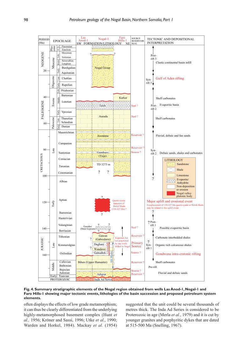
A tectonostratigraphic chart for northern Somalia was published by Ali and Watts (2016). However, in this study a new stratigraphic chart for the Nogal Basin and surrounding area is adopted as a result of integrating new information obtained by the authors from the Nogal-1 and Kalis-1 wells located in the west and east of the basin, respectively (Figs 1 and 2). In addition,
radiometric dates acquired by Conoco Somalia Ltd as well as seismic and aeromagnetic data have allowed a better understanding of the regional tectonic evolution.
A tectonostratigraphic summary of the Nogal Basin and surrounding area is illustrated in Fig. 4 and is supported by the regional well correlation section in Fig. 5. The figures show that a basal transgressive sequence (Adigrat Formation) of ?Early–Middle Jurassic age rests on basement, and is overlain by Upper Jurassic carbonates and shales, Upper Cretaceous sandstones and carbonates, and carbonates and evaporites of Paleogene age. Major unconformities below the Cenomanian and at the top of the Eocene mark periods of regional uplift and erosion which are tied to documented deformation phases in northern Somalia and Yemen. The following section summarises the stratigraphy of the Nogal Basin area.
Crystalline Basement and Inda Ad SeriesAll the wells drilled in the Nogal region (Fig. 5) which reached the basement bottomed in metasediments or granites. Wells Kalis-1, Yaguri-1, Burhisso-1 and Las Anod-1 bottomed in metasediments (schists, quartzites, sandstones and phyllites) assigned to the Inda Ad Series which outcrops in the Mait area, north of the Nogal Valley (Amerada, 1958; Mackay et al., 1954; Overmyer and Cowen, 1990). A core of basement from well Yaguri-1 is described as consisting of dark grey to black phyllite and quartz-muscovite paragneiss (Amerada, 1958). However, Faro Hills-1 bottomed in a granite containing coarse, pink feldspars, clear quartz and white and lavender mica (Amerada, 1957). The granite could be part of a Lower Palaeozoic intrusion into the Inda Ad Series as reported in the northern Somalia Plateau (Greenwood, 1960; Greenwood, 1961; Mackay et al., 1954; Mason and Warden, 1956); alternatively, the granite may be related to the Lower Cretaceous quartz-syenite intrusion at Gorei, south of the Shileh Madu Range (Fig. 2).
The Inda Ad Series is usually considered to form part of the basement of northern Somalia. However, the unit consists of slates, greyish and greenish quartzites, slaty sandstones and beds of limestones, and therefore
Table 3. Time-depth pairs obtained from the VSP data of the Kalis-1 well (Overmyer and Cowen, 1990). TVD = True Vertical Depth; TWT = Two-Way-Travel Time.
Tops Depth, TVD (m) TWT (sec)
Karkar 152 0.238 Faulted Taleh 235 0.296 Top Auradu 512 0.410 Top Jesomma 1173 0.762 Lower Jesomma 1456 0.960 Top Gumburo 1667 1.041 Top Cenomanian 2588 1.500 Adigrat 2728 1.550 Basement 2831 1.598 TD 2947 1.640
Ali part 1.indd 97 03/12/2018 10:25:32
98 Petroleum geology of the Nogal Basin, Northern Somalia, Part 1
often displays the effects of low grade metamorphism; it can thus be clearly differentiated from the underlying highly-metamorphosed basement complex (Hunt et al., 1956; Kröner and Sassi, 1996; Utke et al., 1990; Warden and Horkel, 1984). Mackay et al. (1954)
suggested that the unit could be several thousands of metres thick. The Inda Ad Series is considered to be Proterozoic in age (Merla et al., 1979) and it is cut by younger granites and porphyritic dykes that are dated at 515-500 Ma (Snelling, 1967).
Fig. 4. Summary stratigraphic elements of the Nogal region obtained from wells Las Anod-1, Nogal-1 andFaro Hills-1 showing major tectonic events, lithologies of the basin succession and proposed petroleum system elements.
PERIOD(Ma) EPOCH/AGE
SW NEFORMATION/LITHOLOGY
SOURCERESERVOIRSEAL
TECTONIC AND DEPOSITIONALINTERPRETATION
Plio
- PiacenzianZancleance
neM
ioce
neMessinian
TortonianSerravallianLanghian
Early
Late
Mid
dle
Burdigalian
PALE
OG
ENE
Aquitanian
Chattian
Olig
ocen
e
Rupelian
Late
Early
Late
Mid
dle
Early
Eoce
ne
Priabonian
Bartonian
Lutetian
Ypresian
ThanetianSelandian
Pale
ocen
e
Late
Early Danian
Maastrichtian
Campanian
SantonianLate
Coniacian
Turonian
CenomanianCR
ETA
CEO
US
Albian
Aptian
Early
Barremian
Hauterivian
Valanginian
Berriasian
Late
Tithonian
Kimmeridgian
Oxfordian
JUR
ASS
IC
Callovian
Mid
dle
BathonianBajocianAalenian
PROTEROZOIC
20
40
60
80
100
120
140
160
Post-rift 3
Syn-rift 3
Gulf of Aden rifting
Post-rift 2
Syn-rift 2
Karkar
Auradu
Jesomma
Gondwana intra-cratonic rifting
Post-rift 1? ?
??Gawan
(Gabredarre)
Bihen (Upper Hamanlei)
Syn-rift 1
Pre-rift
LITHOLOGYSandstone
Shale
LimestoneEvaporite/AnhydriteNon-depositionor erosion
??
LasAnod-1 Nogal-1 Faro
Hills-1N
EOG
ENE ??
Nogal Group
Wanderer
Gorrahei (Main Gypsum)
?
?
?
?
Expected, butnot penetrated by any wells drilled in Nogal
Primary Source
Reservoir ?
Seal ?
Reservoir ?
Reservoir ?
Reservoir ?
Reservoir ?
Seal ?
Seal ?
Source ?
Source ?
Major uplift and erosional event
Clastic continental basin infill
Shelf carbonates
Evaporitic basin
Shelf carbonates
Fluvial, deltaic and fan sands
Deltaic sands, shales and carbonates
Possible evaporitic basin
Carbonate interbedded shales
Organic rich calcareous shales
Shelf carbonates
Fluvial and deltaic sands
?
?
Quartz-synite intrusion of Shileh Madu
(118-127 Ma) ?
Emaplacement of 118-127 Ma quartz-synite at Shileh Madumay be related to this uplift event
Nogal valley plutonic body
Source ?
Early Toarcian
TD 3273 m
Taleh
Gumburo(Tisje)
Inda Ad Series
Gahodleh
Daghani
E.L.
Uar
anda
bA
hl M
edo
Adigrat
?
?
Ali part 1.indd 98 03/12/2018 10:25:32
99M. Y. Ali and J. Lee
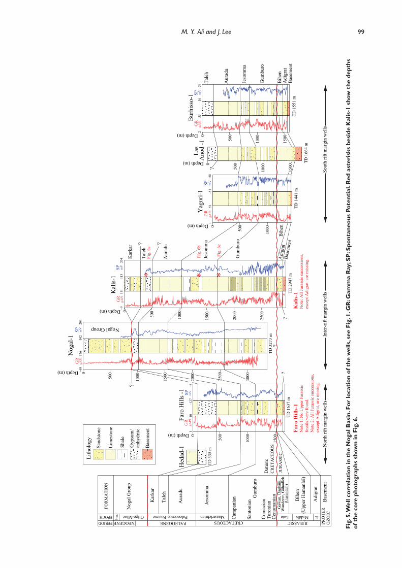
Fig.
5. W
ell c
orre
lati
on in
the
Nog
al B
asin
. For
loca
tion
of t
he w
ells
, see
Fig
. 1. G
R: G
amm
a R
ay; S
P: S
pont
aneo
us P
oten
tial
. Red
ast
eris
ks b
esid
e K
alis
-1 s
how
the
dep
ths
of t
he c
ore
phot
ogra
phs
show
n in
Fig
. 6.
0
500
1000
1500
2000
2500
–911
1G
RgA
PI11
320
4SP m
V
Tale
h
Aur
adu
Jeso
mm
a
Gum
buro
Adi
grat
Base
men
t
Kal
is-1
TD 2
947
mK
alis
-1N
ote:
All
Jura
ssic
succ
essi
ons,
exce
pt A
digr
at, a
re m
issi
ng. K
arka
r
*Fi
g. 6
c
*Fi
g. 6
b
*Fi
g. 6
c50
00
1000
1500
5000
1000
1500
2000
2500
3000
0
500
1000
5000
1000
1500
0
500
1000
1500
110
GR
gAPI
–127
–5SP m
V
–68
176
GR
gAPI
102
204
SP mV
151
GR
gAPI
–51
68SP m
V
255
GR
gAPI
–30
59SP m
V
FOR
MA
TIO
N
EPOCHPERIOD NEOGENE
Nog
al G
roup
Oligo-Mioc.
Kar
kar
PALEOGENE
Tale
h
Aur
adu
Paleocence-Eocene
Jeso
mm
a
MaastrichtianCRETACEOUS C
ampa
nian
Sant
onia
nG
umbu
ro
Con
iaci
anTu
roni
anC
enom
ania
nG
awan
, Dag
hani
, W
ande
rer,
Gah
odle
h (U
aran
dab)
Bih
en(U
pper
Ham
anle
i)
JURASSICLate Middle
Adi
grat
Bas
emen
tPR
OTE
RO
ZOIC
?
Faro
Hill
s -1
Nog
al-1
Yag
uri-1
Las
Ano
d -1
Bur
hiss
o-1
Sand
ston
e
Gyp
sum
/an
hydr
ite
Bas
emen
t
Lith
olog
y
TD 1
637
m
TD 3
273
m
TD 1
441
m
TD 1
664
m
TD 1
551
m
Nogal Group
Dat
um:
CR
ETA
CEO
US
JUR
ASS
IC
Faro
Hill
s-1
Not
e 1:
No
Upp
er Ju
rass
ic
foss
ils w
ere
foun
d.N
ote
2: A
ll Ju
rass
ic su
cces
sion
s, ex
cept
Adi
grat
, are
mis
sing
.
Plio
.
Hed
ad-1
TD 3
35 m
Lim
esto
ne
Shal
e
?
?
?
Depth (m)
Depth (m)
Depth (m)
Depth (m)
Depth (m)
Depth (m)
Tale
h
Aur
adu
Jeso
mm
a
Gum
buro
Bih
enA
digr
atB
asem
ent
?
??
Bih
en
Sout
h rif
t mar
gin
wel
lsN
orth
rift
mar
gin
wel
lsIn
ter-
rift m
argi
n w
ells
E.
Ali part 1.indd 99 03/12/2018 10:25:33
100 Petroleum geology of the Nogal Basin, Northern Somalia, Part 1
The Jurassic successionIn the Nogal region, the oldest sediments overlying the Inda Ad Series are ?Lower–Middle Jurassic continental sandstones and conglomerates of the Adigrat Formation. The formation is conformably overlain by transgressive marine carbonates with minor interbedded marlstones of the Bihendula Group.
? Pliensbachian–Toarcian: Adigrat FormationIn the Nogal region, the Adigrat Formation was penetrated by wells Faro Hills-1, Yaguri-1, Burhisso-1, Las Anod-1 and Kalis-1 (Fig. 5). The formation is composed of pre-rift sandstones which were deposited in fluvial and marginal-marine environments (Abbate et al., 1974; Bosellini, 1989; Bruni and Fazzuoli, 1977; Luger et al., 1990; Merla et al., 1979). At its base, the Adigrat sandstones rest abruptly against the underlying Inda Ad Series; above, they pass gradationally into the overlying Jurassic carbonates (Harms et al., 1989). The thickness of the formation ranges from 32 m in Yaguri-1 to 103 m in Faro Hills-1 and Kalis-1 (Table 2). This variation in thickness may be related to post-Jurassic erosion or a pre-Adigrat high onto which the formation onlapped (Harms et al., 1989).
In the Nogal region, the Adigrat Formation consists of conglomeratic sandstones at the base grading upwards into interbedded, dark grey to variegated shales and sandy carbonates. Black carbonaceous matter and lignitic streaks are common (Harms et al., 1989). Lithological descriptions of cuttings from the Kalis-1 well describe the sandstones as unconsolidated and containing quartz and mica grains that are fine to coarse grained and poorly sorted with angular to sub-angular clasts, and of generally low porosity (Overmyer and Cowen, 1990).
The Adigrat sandstones are poorly dated and their age may be variable regionally. In northern Somalia, it is regarded as being entirely Middle–Late Jurassic, possibly Bathonian–Kimmeridgian (Abbate et al., 1974; Merla et al., 1979). However in eastern and central Somalia, shales and carbonates above the sandstones apparently range from Pliensbachian to Callovian (Harms et al., 1989). In addition, Luger et al. (1990) suggested the occurrence of early Toarcian ammonites at the base of overlying Alh Medo sequence, NE of Erigavo, which may indicate a late Pliensbachian to early Toarcian age for the Adigrat sandstone succession.
Callovian–Tithonian: Bihendula GroupThe Bihendula Group consists of a limestone succession with marl and shale intervals and establishes a transition to a marine environment (Bosellini, 1992; Hunt et al., 1956; MacFadyen, 1933). In the Bihendula area SE of Berbera, MacFadyen (1933) divided the Group into five lithologic units, from bottom to top:
the Bihen limestone, Gahodleh shale, Wanderer limestone, Daghani shale and Gawan limestone (Fig. 4). In central Somalia and eastern Ethiopia, the Bihen, Gahodleh-Wanderer-Daghani and Gawan Formations are equivalent to the upper Hamanlei, Uarandab and Gabredarre Formations respectively (Fig. 4) (Barnes, 1976). However, in northern Somalia including the Nogal Basin, the formation names of the Bihendula Group should be retained as proposed by MacFadyen (1933). In central Somalia, the Gabredarre Formation is conformably overlain by the Main Gypsum/Gorrahei Formation (Barnes, 1976; Merla et al., 1979). In SW Somalia, the Gorrahei is represented by the more distal equivalent of the Garba Harre Formation, which consists of alternating dolomitic limestones, sandstones and siltstones with gypsum lenses (Barnes, 1976).
Fossils in the Bihendula area suggest that the Bihen limestone is Callovian–Oxfordian to possibly Kimmeridgian in age (Mackay et al., 1954). However, wells drilled in central Somalia that penetrated the Hamanlei Formation recorded Pliensbachian foraminifera (e.g. Vidalina mertana, Lingulina teneras and Orbitopsella precursor) (Harms et al., 1989) and it is therefore possible that the Bihen limestone in the Nogal region is significantly older than at the type section in the Bihendula area. Alternatively, the wells in central Somalia sampled the lower Hamanlei Formation of Pliensbachian–Aalenian age, and the Bihen Formation in the Nogal and Bihendula areas is equivalent to the bioclastic limestones of the Callovian upper Hamanlei Formation mapped in the Ogaden Basin, SE Ethiopia (Hunegnaw et al., 1998). In this case, the lower Hamanlei (Toarcian–Aalenian) and middle Hamanlei (Aalenian – early Bathonian) that are observed in the Ogaden Basin are absent in the Nogal area.
All the drilled wells in the Nogal region (except Nogal-1, which bottomed in the Coniacian) show that the Bihendula Group is either absent or very thin (Fig. 5); only wells Yaguri-1, Las Anod-1 and Burhisso-1 penetrated a thin section of Bihen limestone. In these wells, the Bihen limestone consists of shoal-water packstones and grainstones with interbedded dolomites, anhydrites and marls. The thickness of the Bihen limestone ranges from 76 m in well Burhisso-1 to 270 m in Las Anod-1 (Table 2). The Gahodle shale, Wanderer limestone, Dhagani shale and Gawan limestone are absent at these well locations.
Neocomian–Albian upliftA major pre-Cenomanian deformation event is documented over northern Somalia and the Neocomian–Albian interval is absent (Fig. 4). Ali and Watts (2016) suggested that pre-Cenomanian uplift gave rise to the Nogal-Erigavo Arch, and resulted in the erosion of up to 1500 m of the Upper Jurassic Bihendula Group
Ali part 1.indd 100 03/12/2018 10:25:33

101M. Y. Ali and J. Lee
succession over a wide area. This uplift probably resulted from regional thermal doming related to the intrusion of plutonic bodies. Consequently, the entire Upper Jurassic and Lower Cretaceous succession was removed from the platforms but may be preserved in localised grabens if the Nogal rift-bounding faults had already become active in the Late Jurassic.
The pre-Cenomanian unconformity is well documented both in the Nogal wells (Fig. 5) and in outcrop sections in the Erigavo region, north of the Nogal Basin. In the Nogal region, the Cenomanian to Campanian Gumburo Formation rests directly the Adigrat sandstone or Bihen limestone, as recorded in wells Faro Hills-1, Las Anod-1, Yaguri-1, Burhiso-1 and Kalis-1 (Figs 4 and 5). In the Erigavo area, the entire Jurassic and Lower Cretaceous are absent (Bott et al., 1992) and the Upper Cretaceous Tisje Formation rests unconformably on the Inda Ad Series basement (Beydoun, 1970; Luger et al., 1990). To the west of Erigavo in the Bihendula region, up to 1200 m of Jurassic sediments have been preserved (Beydoun, 1970; Bruni and Fazzuoli, 1977; MacFadyen, 1933); to the NE, the Adigrat and Middle–Upper Jurassic Ahl Medo Formations are exposed in the Ahl Medo sub-basin.
In southern and central parts of Somalia, the Neocomian–Barremian interval is represented by a variety of sediments including a thick evaporite succession known as the Main Gypsum or Gorahei
Formation (Barnes, 1976). In the Ogaden Basin, the Lower Cretaceous includes gypsum with calcareous and marly shale intercalations (Hunegnaw et al., 1998). However, there is no evidence of pre-Cenomanian deposits contemporaneous with the evaporites of the Main Gypsum/Gorrahei Formation and associated basinal deposits in the Nogal region. Harms et al. (1989) suggested that a low-lying land area, which was exposed during a lowstand of the Neocomian ocean, could have served as part of the barrier which resulted in the restricted conditions in which the Main Gypsum evaporites were deposited. It is also possible that a Lower Cretaceous sequence equivalent to the Main Gypsum may have been deposited over part or all of the Nogal area but was removed by the pre-Cenomanian erosion (Harms et al., 1989).
Quartz-syenites in the Shileh Madu RangeThe small quartz-syenite outcrop near Gorei (about 50 km SE of Huddun) on the northern flank of the Nogal Valley and the southern footwall of the Shileh Madu Range (Fig. 2) has commonly been interpreted as a small erosional window of Proterozoic crystalline basement (Barnes, 1976; Mackay et al., 1954; Mason, 1957). However, Rb-Sr and K-Ar radiometric dating by Conoco Somalia Ltd puts the age of the quartz-syenite complex in the range 118 to 127 Ma which suggests that it is intrusive (Granath, 2001; Harms et al., 1989). The complex is composed of several separate intrusions
Fig. 6. Core photographs from the Kalis-1 well. (a) Core photograph of the Gumburo Formation from depth interval 1678–1681 m; the core shows brown, finely crystalline argillaceous limestone with vertical fracture porosity partly filled with calcite. (b) Core photograph of the Jesomma Formation from depth interval 1346–1348 m; the core shows fine-grained, sub-angular, well-sorted sandstones with good to fair porosity. Abundant carbonaceous material, mostly woody plant fragments, are contained in laminated black shales. (c) Core photograph of the Taleh Formation from depth interval 447–450 m; the core shows brown argillaceous dolomite with patchy oil staining at the top. Dark brown, microcrystalline massive anhydrite is seen at 448–450 m. For the depths of the core intervals, see Fig. 5.
(b) (c)(a)
Ali part 1.indd 101 03/12/2018 10:25:50
102 Petroleum geology of the Nogal Basin, Northern Somalia, Part 1
composed of coarse, feldspar-dominated lithologies and fi ne-grained porphyritic dikes.
The quartz-syenite body was deeply weathered and eroded prior to deposition of the overlying Jesomma Formation during a hiatus that lasted around 40 Ma, based on radiometric age dates and chronostratigraphic analysis of the Nogal-1 well (Granath, 2001; Poppendeck and Cowen, 1990). The Jesomma Formation consists of fi ne-grained fl uvial sandstones showing no evidence of thermal overprint, and unconformably overlies both the breccia and the quartz-syenite complex. Furthermore, none of the dikes intrude either the breccia or the Jesomma sandstones, nor is there any evidence of recrystallization of the breccia matrix (Granath, 2001). In addition, the lowest sandstone strata of Jesomma Formation contain boulders, cobbles, and pebbles derived from the quartz-
syenite complex (Granath, 2001; Mason, 1957). Hence, the age of the quartz-syenite complex coincides with the phase of uplift and erosion which removed the Upper Jurassic Bihendula Group.
The Cenomanian–Campanian Gumburo Formation which is well developed in the Nogal Basin is absent from the Gorei area. Therefore, it appears that the area was part of an exposed footwall block that underwent erosional denudation throughout most of the Late Cretaceous. The area was transgressed by the end of the Maastrichtian with deposition of the upper Jesomma Formation (Granath, 2001).
The Upper Cretaceous successionThe wells drilled in the Nogal region record a major unconformity which separates the Upper Cretaceous succession either from the Adigrat sandstone (as at
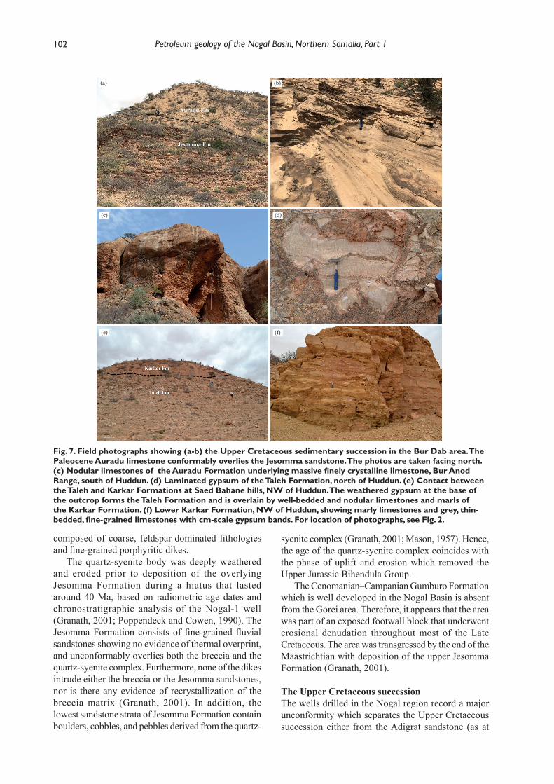
Fig. 7. Field photographs showing (a-b) the Upper Cretaceous sedimentary succession in the Bur Dab area. The Paleocene Auradu limestone conformably overlies the Jesomma sandstone. The photos are taken facing north. (c) Nodular limestones of the Auradu Formation underlying massive fi nely crystalline limestone, Bur Anod Range, south of Huddun. (d) Laminated gypsum of the Taleh Formation, north of Huddun. (e) Contact between the Taleh and Karkar Formations at Saed Bahane hills, NW of Huddun. The weathered gypsum at the base of the outcrop forms the Taleh Formation and is overlain by well-bedded and nodular limestones and marls of the Karkar Formation. (f) Lower Karkar Formation, NW of Huddun, showing marly limestones and grey, thin-bedded, fi ne-grained limestones with cm-scale gypsum bands. For location of photographs, see Fig. 2.
(d)(c)
(f)(e)
(b)(a)
Auradu Fm
Jesomma Fm
Ali part 1.indd 102 03/12/2018 10:26:33
103M. Y. Ali and J. Lee
wells Faro Hills-1 and Kalis-1) or the Bihen (upper Hamanlei) Formation as at wells Yaguri-1, Las Anod-1 and Burhisso-1 (Fig. 5). The well and seismic data suggest a major rift phase during the Cenomanian to Maastrichtian with coeval deposition of the thick, predominantly shallow-water clastics of the Gumburo and Jesomma Formations. These formations are at least 2000 m thick e.g. at well Nogal-1, and are between two and three times thicker in basin-centre locations than in the uplifted footwall (e.g. at wells Yaguri-1, Burhisso-1, Las Anod-1 and Faro Hills-1). However, there is little variation in the lithological composition of Upper Cretaceous strata between wells drilled in the centre of the basin or in platform locations.
The Late Cretaceous rift phase correlates with a rapid increase in spreading rate on the ridges separating the African and Indian and African and Antarctica plates, and a contemporaneous slowing-down of the African plate’s motion (Ali and Watts, 2016).
Cenomanian-Campanian: Gumburo FormationIn the Nogal Basin, the Gumburo Formation directly overlies the Adigrat sandstone or the Bihen (upper Hamanlei) limestone, as recorded in wells Faro Hills-1, Las Anod-1, Yaguri-1, Burhiso-1 and Kalis-1 (Fig. 5). The Gumburo Formation is dated as Cenomanian–Campanian in wells Burhisso-1, Faro Hills-1 and Kalis-1 (Amerada, 1957; Overmyer and Cowen, 1990). Harms et al. (1989) suggested the lower Gumburo is of early Cenomanian age (92-96 Ma) in well Burhisso-1. The Nogal-1 and Kalis-1 wells show that the formation consists of fine- to coarse-grained, poorly-sorted fluvio-deltaic sandstones with marginal-marine limestones and shales deposited in the rift axis. Core data from the Kalis-1 well over the interval 1678 m to 1681 m show that it consists of shallow-water, finely crystalline, argillaceous limestones with a vertical fracture porosity partly filled with calcite (Fig. 6a). The Nogal-1 well encountered a major overpressured shale section from 2134 m to 2520 m within the Gumburo Formation with a pressure gradient of 2.03 psi/m (Poppendeck and Cowen, 1990). The contact with the overlying Jesomma Formation is transitional and reflects a shallowing of water depths accompanied by an influx of siliciclastic material. The Gumburo Formation ranges in thickness from 1061 m (Kalis-1) in grabenal locations to 368 m (Yaguri-1) on the platform (Table 2).
Maastrichtian: Jesomma FormationIn the Nogal Basin area, the Jesomma Formation crops out at Gorie (SE of Huddun) in the southern footwall of the Shileh Madu Range and the NE corner of the Bur Dab Range, north of Ainabo (Fig. 2). The Jesomma Formation consists of sandstones, siltstones and carbonaceous shales whose age is poorly documented
but which are believed to be entirely Maastrichtian. The uppermost part of the Jesomma is exposed at Bur Dab area along a NW–SE trending fault (Fig. 2). Here it consists of a 180 m sequence of fine to coarse grained quartz sandstones with siltstones, shales, calcareous sandstones and limestones (Figs 7a and 7b), overlain conformably by the Auradu Formation (Fig. 7b). At Gorei, the Jesomma Formation consists of a ~40 m sequence of medium- to coarse-grained, fossiliferous (plant remains) sandstones with conglomeratic intercalations at the base which rest unconformably on the quartz-syenite complex (Luger et al., 1990). However, the formation is much thicker elsewhere in the Nogal region and ranges in thickness from 1001 m (Nogal-1) in graben locations to 172 m (Burhisso-1) on the platform (Table 2).
At the Nogal-1 and Kalis-1 wells, the Jesomma Formation consists of interbedded limestones and claystones at the top grading to interbedded sandstone and shale towards the base. Core data from the Kalis-1 well over the interval 1346-1348 m show that the formation consists of marginal marine, fine-grained, subangular, well-sorted sandstones with good to fair porosity (Overmyer and Cowen, 1990). Abundant carbonaceous material, mostly woody plant fragments, are present in laminated black shales, and small wave ripples are observed in the core (Fig. 6b). This marginal-marine section marks the transition to the overlying Auradu Formation (Granath, 2001).
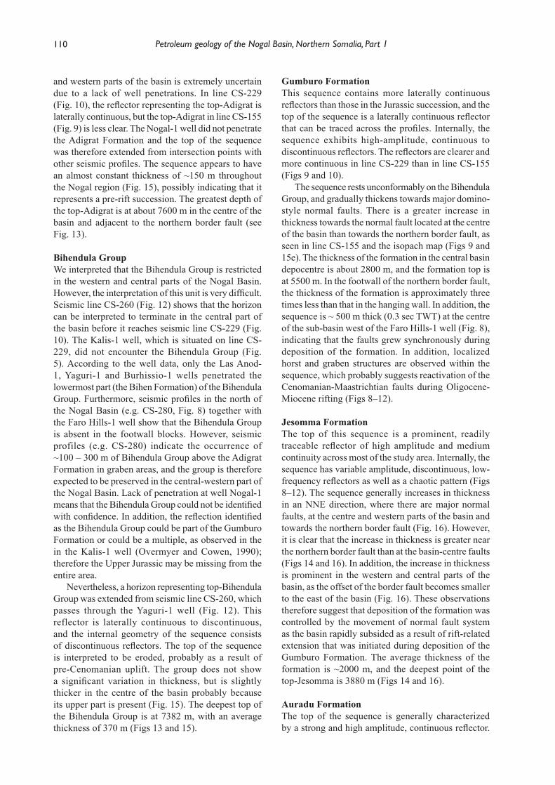
The Cenozoic successionPaleogene shelf carbonates of the Auradu, Taleh (or Gypsum-Anhydrite Series) and Karkar Formations are exposed over large areas in the Nogal region (Fig. 2). A marine transgression flooded across northern Somalia and Yemen during the Early Paleocene. This is recorded by the transition from the Jessoma clastics to the marine carbonates of the Auradu and Umm-er-Radhuma Formations. These gave way to more evaporitic conditions and deposition of the Taleh Anhydrite in the Middle Eocene. A further transgression in the Late Eocene was accompanied by the deposition of a marine limestone with chert bands (Karkar Formation, Fig. 7f). These Paleogene sediments rest conformably upon the Jesomma Formation. The Paleogene succession consists of comparable facies both in the Nogal Basin and in the surrounding platform areas.
Paleocene – Early Eocene: Auradu FormationThe Auradu Formation is exposed over much of the Nogal region. In the Huddun area north of the Nogal Basin, the formation is present in two discontinuous and fault-dissected ranges (the Hagrin-Bur Anod-Hagraajin and Shileh Madu ridges: Fig. 2) which form striking morphological features. The formation is present in wells drilled in the Nogal region and
Ali part 1.indd 103 03/12/2018 10:26:33
104 Petroleum geology of the Nogal Basin, Northern Somalia, Part 1
subsurface data show that it ranges from 421–571 m thick (Table 2). The Auradu Formation maintains a fair lithological uniformity and thickness throughout the study area, indicating deposition during a tectonically quiescent time interval. However, the formation is slightly thicker in the Nogal-1 well than it is in wells drilled on the platform (Fig. 5). It is ~300 m and 330 m thick respectively at Bur Dab and Gorei.
In the Huddun area (Fig. 2), the Auradu Formation consists of at least 250 m of thick-bedded and massive, nodular, grey to white and pink, finely-crystalline fossiliferous limestones with iron-stained concretions (Fig. 7c). At the base, the formation is composed of 50-60 m of well-bedded limestones and marls, overlain by ~120 m of brown to grey, nodular marly limestone. At the top, the formation consists of 70-80 m of well-bedded limestones with thin marly horizons. In the Nogal-1 well, the Auradu Formation consists of moderately argillaceous limestones with minor interbeds of claystone deposited in a shallow-marine environment with limited open-marine influence (Poppendeck and Cowen, 1990).
The lower boundary of the Audaru Formation was not observed in the Huddun area. However, at Bur Dab and Gorei, the formation rests conformably on the Jesomma sandstone. At Huddun and elsewhere in the Nogal region, the unit is overlain, apparently conformably, by the Taleh Formation.
Limestones of the Auradu Formation are assigned to the Paleocene to Early Eocene (MacFadyen, 1933; Mackay et al., 1954). Luger et al. (1990) suggested that Auradu limestones contain ostracods and larger foraminifera (Lockhartia and Orbitolites) indicating a Late Paleocene to Early Eocene age.
Early–Middle Eocene: Taleh FormationThe Taleh Formation evaporites are exposed over wide parts of the north and south Nogal Valley and the surrounding area (Fig. 2), and typically weather to undulating, flat-topped hills which are bare of vegetation. The formation is 104–338 m thick in the Nogal region (Table 2); it is 140 m, 160 m and 285 m thick in the Gorei, Bur Dab and Las Anod areas respectively (Mackay et al., 1954). However, the Faro Hills-1 well intersected 338 m of the Taleh Formation.
The formation consists of massive to banded gypsum, irregularly bedded with chalky gypsiferous limestones, white marls and anhydrite (Fig. 7d). The unit is barren of fossils. In the Nogal-1 and Kalis-1 wells, the formation consists of interbedded anhydrite and dolomite with minor interbeds of claystone (Overmyer and Cowen, 1990; Poppendeck and Cowen, 1990). Cores from the Kalis-1 well over the interval 447-450 m (Fig. 6b) show that the formation consists of brown argillaceous dolomites and microcrystalline, massive anhydrite (Overmyer and Cowen, 1990).
The Taleh Formation conformably overlies the Auradu limestone with a boundary which is often transitional; its upper boundary with the Karkar Formation is conformable and transitional (Fig. 7e). The formation was deposited in a predominantly intertidal-supratidal environment (Boeckelmann and Schreiber, 1990). The age of the formation is not constrained. However, from the ages of the underlying (Auradu) and overlying (Karkar) formations, the Taleh has been dated as Early to Middle Eocene (Boeckelmann and Schreiber, 1990).
Middle Eocene: Karkar FormationOutcrops of the Karkar Formation are usually covered by thin red soil with a vegetation cover that disappears where gypsiferous soils prevail. In the Huddun and most of the Nogal region, the formation is the youngest unit exposed at the surface, and the eastern side of the Hagrin Range north of Huddun (Fig. 2) is composed entirely of Karkar Formation sediments. The formation consists of chalky nodular limestones and marls with interbedded gypsiferous shales (Fig. 7f). In some locations the upper section contains sequences of marly limestone and thin-bedded fine-grained limestones with gypsum lenses. The lower section consists of chalky nodular limestones with shales.
The Karkar Formation has an average thickness of ~100 m. In the Ainabo and Las Anod areas, the formation is 80 m and 139 m thick respectively (Mackay et al., 1954). The formation is erosionally absent in wells drilled in the Nogal Basin and surrounding area (including Nogal-1), except the Faro Hills-1 and Kalis-1 wells which intersected 104 m and 306 m of Karkar Formation respectively (Table 2). In the Kalis-1 well, the formation consists of gypsum interbedded with dolomite, limestone and chert (Overmyer and Cowen, 1990); at Faro Hills-1, it consists of limestones with shale and anhydrite layers (Amerada, 1957). A major unconformity which is considered to be associated with the initial rifting of the Gulf of Aden is responsible for the absence of the Karkar Formation and Upper Eocene sediments from large parts of the Nogal region.
The lower boundary of the Karkar Formation is well exposed in the Nogal region (Fig. 7e), and the formation rests conformably and gradationally on the Taleh Formation. The upper boundary of the formation was not observed in the Nogal region, but the boundary is a discontinuity over most of northern Somalia.
The Karkar Formation was deposited in a supratidal to open, shallow-marine environments. Over most of northern Somalia, the formation is entirely of Middle Eocene age on the basis of a good foraminiferal assemblage. In the extreme NE of northern Somalia, the formation may range up to Late Eocene (Azzaroli, 1952; Azzaroli, 1958).
Ali part 1.indd 104 03/12/2018 10:26:33
105M. Y. Ali and J. Lee
Oligocene – Miocene: Nogal GroupDuring the Oligocene–Miocene, the west-central part of the Nogal Basin underwent rapid subsidence with the development of a half-graben system and the reactivation of Cenomanian–Maastrichtian faults which resulted in the formation of fault blocks and possibly flower structures along wrench faults. At the same time, at least 877 m of predominantly continental sediments of the Nogal Group were deposited in a narrow down-faulted basin (Fig. 5, Table 2). These sediments are probably time-equivalent to those of the Daban Group which outcrop along the coastline of the Gulf of Aden (Ali and Watts, 2016). The section intersected by the Nogal-1 well consists of interbedded sandstones and claystones, with 107 m of gypsum and anhydrite just below surface which probably represent the deposits of a salt lake (Poppendeck and Cowen, 1990). However, the eastern part of the Nogal Basin did not undergo the same subsidence as indicated by the Kalis-1 well which did not penetrate an Oligocene–Miocene succession.
AEROMAGNETIC DATA
Figs 3a and 3b show the magnetic anomaly and AS maps. The AS map shows the presence of NW-SE oriented anomalies that run from north of the Burhisso-1 well to the NW corner of the study area (Fig. 3b). The middle high-magnetic zone west of the Faro Hills-1 well is located exactly where the seismic data (Fig. 8) indicate the presence of a sub-basin. However, the magnetic anomaly and AS maps do not show this sub-basin, nor do they illustrate the main Nogal Basin. Another high magnetic zone coincides with the quartz-syenite outcrop near Gorei (Figs 2 and 3). Therefore, the NW-SE trending magnetic anomalies are interpreted as plutonic bodies that were intruded during the Early Cretaceous (118-127 Ma), probably contemporaneously with the pre-Cenomanian uplift event. Other, weaker NW-SE anomalies are observed to the SE of the Nogal Basin (Fig. 3b) and may have a similar origin.
The NW-SE trend of the magnetic anomalies coincides with the regional trend of the Late Jurassic rift basins in northern Somalia and Yemen. This trend lies along the Nogal-Erigavo Arch where pre-Cenomanian deformation is interpreted to have removed the Upper Jurassic and Lower Cretaceous succession. Therefore, it is possible that the plutonic bodies are related to the pre-Cenomanian deformation phase.
The magnetic anomaly and AS maps also show a NE-SW trending line through the Bur Dab-1 well which separates higher frequency magnetic anomalies to the NW from lower frequency anomalies to the SE (Fig. 3). This trend has been interpreted as being due to a reactivated SE-verging basement thrust or to the
presence of volcanics within the sedimentary column (Harms et al., 1989). Alternatively, it may reflect an old suture zone with a different basement composition.
In northern Somalia, two different basement outcrop areas can be distinguished (i) the Borama-Hargeisa-Burao area to the west, where high-grade metamorphic rocks, migmatites, orthogneisses and metagabbros are exposed; and (ii) the Erigavo-Bosaso area to the east, where the low-grade Inda Ad Series rests unconformably on crystalline basement (Farquharson, 1924; Greenwood, 1960; Greenwood, 1961; Mason, 1962; Mason and Warden, 1956; Mason et al., 1959). The basement of northern Somalia consists of Proterozoic terranes which were amalgamated during Neoproterozoic island-arc and microcontinent accretion events, which led to the formation of the Afro-Arabian margin of Gondwana (Al-Husseini, 2000; Husseini, 1989; Loosveld et al., 1996; Sassi et al., 1993; Warden and Daniels, 1982; Warden and Daniels, 1984). Thus, the suture zone observed in the magnetic anomaly and AS maps may indicate a change of basement type from the Inda Ad Series in the SE, as documented by wells drilled in the Nogal region and outcrop data to the north in the Mait area, to igneous and high-grade metamorphic basement in the NW.
SEISMIC MAPPING AND STRATIGRAPHY
Seven sedimentary sequences have been defined in the Nogal region (Figs 8–12) and are: Nogal Group (Oligocene-Miocene to Recent); Taleh and Karkar Formations (Lower to Middle Eocene); Auradu Formation (Paleocene to Lower Eocene); Jesomma Formation (Maastrichtian); Gumburo Formation (Cenomanian to Campanian); Bihendula Group (Upper Jurassic); and Adigrat Formation (Lower–Middle Jurassic). Surface and isopach maps for each formation in time and depth domains were generated (Figs 13–16). These sequences are described in the following section.
The Kalis-1 well constrained all the sedimentary sequences present in the eastern part of the basin. The Nogal-1 well TD’d at 3273 m and identified the majority of the reflector surfaces (up to top-Gumburo) within the western part of the Nogal Basin. Therefore, all the formation tops below the Gumburo (including top-Bihendula, top-Adigrat and top-Basement) are not constrained by well data, and seismic data did not clearly image the formations. In addition, the seismic lines do not have sufficient quality to define possible Upper Jurassic graben structures, and interpretation of formations in the western and central parts of the basin is challenging. Furthermore, all the wells drilled in the Nogal region, except the more recent Nogal-1 and Kalis-1 wells were drilled on platform areas, and it is
Ali part 1.indd 105 03/12/2018 10:26:33
106 Petroleum geology of the Nogal Basin, Northern Somalia, Part 1
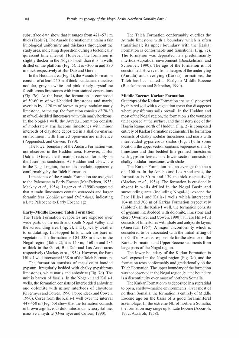
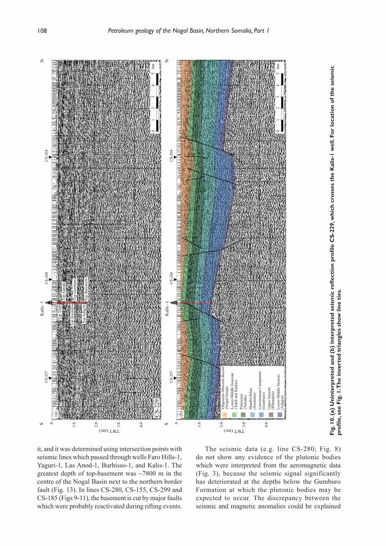
Fig.
8. (
a) U
nint
erpr
eted
and
(b)
inte
rpre
ted
seis
mic
refl
ect
ion
profi
le C
S-28
0, w
hich
cro
sses
wel
l Far
o H
ills-
1 an
d a
sub-
basi
n. F
or lo
cati
on o
f th
e se
ism
ic p
rofi l
e, s
ee F
ig. 1
. The
inve
rted
tri
angl
es s
how
line
tie
s.
therefore diffi cult to correlate the platform stratigraphy to the graben areas.
The seismic profi les show that a branch of the Nogal rift extends to the NW of the main Nogal Basin. For example, seismic line CS-280 (Fig. 8) shows half grabens (with less sedimentary cover than the main Nogal Basin, as imaged by CS-155 in Fig. 9) which seem to have developed contemporaneously with, and
are oriented parallel to, the main Nogal Basin. These seismic lines indicate the possible existence of further graben areas which could be en échelon extension features of the main Nogal Basin.
Basement The Kalis-1 well penetrated the basement corresponding to the Inda Ad Series at a depth of 2831 m (Fig. 5, Table
TWT:
-160
.81
TWT:
115
.60
E
Low
er-M
iddl
e Ee
ocen
e(T
aleh
and
Kar
kar)
Pale
ocen
e(A
urad
u)M
aast
richt
ian
(Jes
omm
a)C
enom
ania
n-C
ampa
nian
(Gum
buro
)U
pper
Jura
ssic
(Bih
endu
la)
Low
er-M
iddl
e Ju
rass
ic(A
digr
at)
W 1.0
2.0
3.0
4.0
TWT (sec)
0C
S-30
0C
S-12
0C
S-13
0
CS-
170
Faro
Hill
s -1
05
1015
2025
km
TWT:
-160
.81
TWT:
115
.60
EW 1.0
2.0
3.0
4.0
TWT (sec)
0C
S-30
0C
S-12
0C
S-13
0
CS-
170
Faro
Hill
s -1
05
1015
2025
km
Top
Aur
adu
Top
Jeso
mm
aTo
p G
umbu
ro
Top
Adi
grat
Bas
emen
t
CS-
280
??
??? ?
??
??
??
? Ig
neou
s in
trusi
on
? Ig
neou
s in
trusi
on
??
Ali part 1.indd 106 03/12/2018 10:26:39
107M. Y. Ali and J. Lee
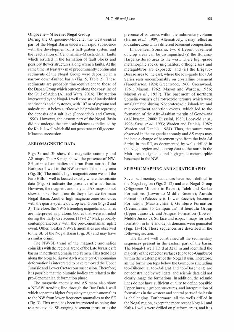
Fig.
9. (
a) U
nint
erpr
eted
and
(b)
inte
rpre
ted
seis
mic
refl
ect
ion
profi
le C
S-15
5, w
hich
cro
sses
the
Nog
al-1
wel
l and
the
mai
n N
ogal
Bas
in.
For
loca
tion
of t
he s
eism
ic p
rofi l
e, s
ee F
ig. 1
. The
inve
rted
tri
angl
es s
how
line
tie
s. W
ell-t
o-se
ism
ic t
ie a
nd t
he la
tera
l con
tinu
ity
of s
eism
ic
hori
zons
allo
wed
iden
tifi c
atio
n of
sev
en m
appa
ble
stra
tigr
aphi
c se
quen
ces.
The
sei
smic
line
sho
ws
a m
ajor
tilt
ed b
lock
.
2). At this location the VSP data indicated that the Inda Ad Series is non-refl ective (Overmyer and Cowen, 1990) due to the weak acoustic impedance contrast between the Adigrat sandstones and the quartzitic basement; no strong seismic refl ection is observed at top-basement (Figs 8–12). The strong refl ectors beneath top-basement in seismic line CS-229 (Fig. 10) are interpreted as multiples and not as intra-basement
primary refl ectors. The basement is characterized by noisy and ambiguous refl ectors that are contaminated with numerous multiples. As there is a lack of well data for basement in the western and central parts of the basin, it was diffi cult to map the top-basement refl ector or any of its internal structures in the seismic lines.
In line CS-155 (Fig. 9), the depth of top-basement is not well defi ned since well Nogal-1 did not penetrate
N
Olig
ocen
e-M
ioce
ne-R
ecen
t(N
ogal
Gro
up)
Low
er-M
iddl
e Ee
ocen
e(T
aleh
and
Kar
kar)
Pale
ocen
e(A
urad
u)M
aast
richt
ian
(Jes
omm
a)C
enom
ania
n-C
ampa
nian
(Gum
buro
)U
pper
Jura
ssic
(Bih
endu
la)
Low
er-M
iddl
e Ju
rass
ic(A
digr
at)
Nog
al -1
S 1.0
2.0
3.0
4.0
TWT (sec)
0C
S-26
0C
S-26
5C
S-28
7C
S-26
7C
S-27
0C
S-27
5C
S-27
6
01
23
45
km
NN
ogal
-1S 1.0
2.0
3.0
4.0
TWT (sec)
0C
S-26
0C
S-26
5C
S-28
7C
S-26
7C
S-27
0C
S-27
5C
S-27
6
01
23
45
km
(b)
(a)
Top
Aur
adu
Top
Jeso
mm
a
Top
Gum
buro
Top
Tale
h
CS-
155
??
??
??
??
?
Ali part 1.indd 107 03/12/2018 10:26:44
108 Petroleum geology of the Nogal Basin, Northern Somalia, Part 1
it, and it was determined using intersection points with seismic lines which passed through wells Faro Hills-1, Yaguri-1, Las Anod-1, Burhisso-1, and Kalis-1. The greatest depth of top-basement was ~7800 m in the centre of the Nogal Basin next to the northern border fault (Fig. 13). In lines CS-280, CS-155, CS-299 and CS-185 (Figs 9-11), the basement is cut by major faults which were probably reactivated during rifting events.
The seismic data (e.g. line CS-280; Fig. 8) do not show any evidence of the plutonic bodies which were interpreted from the aeromagnetic data (Fig. 3), because the seismic signal significantly has deteriorated at the depths below the Gumburo Formation at which the plutonic bodies may be expected to occur. The discrepancy between the seismic and magnetic anomalies could be explained
Fig.
10.
(a)
Uni
nter
pret
ed a
nd (
b) in
terp
rete
d se
ism
ic r
efl e
ctio
n pr
ofi le
CS-
229,
whi
ch c
ross
es t
he K
alis
-1 w
ell.
For
loca
tion
of t
he s
eism
ic
profi
le, s
ee F
ig. 1
. The
inve
rted
tri
angl
es s
how
line
tie
s.
01
23
45
km
01
23
45
km
Olig
ocen
e-M
ioce
ne-R
ecen
t(N
ogal
Gro
up)
Low
er-M
iddl
e Ee
ocen
e(T
aleh
and
Kar
kar)
Pale
ocen
e(A
urad
u)Maastrichtian
(Jes
omm
a)C
enom
ania
n-C
ampa
nian
(Gum
buro
)U
pper
Jura
ssic
(Bih
endu
la)
Low
er-M
iddl
e Ju
rass
ic(A
digr
at)
NS 1.0
2.0
3.0
4.0
TWT (sec)
0C
S-25
7C
S-26
0C
S-26
4K
alis
-1
NS 1.0
2.0
3.0
4.0
TWT (sec)
0C
S-25
7C
S-26
0C
S-26
4K
alis
-1
(b)
(a)
Top
Aur
adu
Top
Jeso
mm
a
Top
Adi
grat
Top
Tale
h
Top
Gum
buro
Top
Bas
emen
t
CS-
229
??
??
Ali part 1.indd 108 03/12/2018 10:26:47

109M. Y. Ali and J. Lee
Fig.
11.
(a)
Uni
nter
pret
ed a
nd (
b) in
terp
rete
d se
ism
ic r
efl e
ctio
n pr
ofi le
CS-
185.
For
loca
tion
of t
he s
eism
ic p
rofi l
e, s
ee F
ig. 1
. The
inve
rted
tr
iang
les
show
sei
smic
pro
fi les
tha
t cr
oss
this
pro
fi le.
if the plutonic bodies have a similar composition to the quartz-syenite body which is exposed near Gorei, with densities and velocities which are similar to those of the sedimentary rocks and particularly of the carbonates of the Bihendula Group and Gumburo Formation. Consequently, there will be little acoustic impedance contrast between the carbonates and the intrusive bodies.
Adigrat FormationThe deepest sedimentary sequence in the Nogal region is interpreted as the Adigrat Formation. Although seismic data do not clearly image the formation or the Inda Ad Series, there appears to be ~0.1 sec TWT of sedimentary section between top-basement and top-Adigrat as shown in Figs 8–12. However, the presence and thickness of the Adigrat Formation in the centre
N
Olig
ocen
e-M
ioce
ne-R
ecen
t(N
ogal
Gro
up)
Low
er-M
iddl
e Ee
ocen
e(T
aleh
and
Kar
kar)
Pale
ocen
e(A
urad
u)M
aast
richt
ian
(Jes
omm
a)C
enom
ania
n-C
ampa
nian
(Gum
buro
)U
pper
Jura
ssic
(Bih
endu
la)
Low
er-M
iddl
e Ju
rass
ic(A
digr
at)
(b)
CS-
120
CS-
120
S 1.0
2.0
3.0
4.0
TWT (sec)
0
02
46
810
km
Bur
hiss
o -1
N
(a)
CS-
120
CS-
120
S 1.0
2.0
3.0
4.0
TWT (sec)
0
02
46
810
km
Bur
hiss
o -1
Top
Adi
grat
Top
Jeso
mm
a
Top
Bas
emen
t
Top
Bih
endu
la
CS-
185
??
?
??
??
Ali part 1.indd 109 03/12/2018 10:26:52
110 Petroleum geology of the Nogal Basin, Northern Somalia, Part 1
and western parts of the basin is extremely uncertain due to a lack of well penetrations. In line CS-229 (Fig. 10), the reflector representing the top-Adigrat is laterally continuous, but the top-Adigrat in line CS-155 (Fig. 9) is less clear. The Nogal-1 well did not penetrate the Adigrat Formation and the top of the sequence was therefore extended from intersection points with other seismic profiles. The sequence appears to have an almost constant thickness of ~150 m throughout the Nogal region (Fig. 15), possibly indicating that it represents a pre-rift succession. The greatest depth of the top-Adigrat is at about 7600 m in the centre of the basin and adjacent to the northern border fault (see Fig. 13).
Bihendula GroupWe interpreted that the Bihendula Group is restricted in the western and central parts of the Nogal Basin. However, the interpretation of this unit is very difficult. Seismic line CS-260 (Fig. 12) shows that the horizon can be interpreted to terminate in the central part of the basin before it reaches seismic line CS-229 (Fig. 10). The Kalis-1 well, which is situated on line CS-229, did not encounter the Bihendula Group (Fig. 5). According to the well data, only the Las Anod-1, Yaguri-1 and Burhissio-1 wells penetrated the lowermost part (the Bihen Formation) of the Bihendula Group. Furthermore, seismic profiles in the north of the Nogal Basin (e.g. CS-280, Fig. 8) together with the Faro Hills-1 well show that the Bihendula Group is absent in the footwall blocks. However, seismic profiles (e.g. CS-280) indicate the occurrence of ~100 – 300 m of Bihendula Group above the Adigrat Formation in graben areas, and the group is therefore expected to be preserved in the central-western part of the Nogal Basin. Lack of penetration at well Nogal-1 means that the Bihendula Group could not be identified with confidence. In addition, the reflection identified as the Bihendula Group could be part of the Gumburo Formation or could be a multiple, as observed in the in the Kalis-1 well (Overmyer and Cowen, 1990); therefore the Upper Jurassic may be missing from the entire area.
Nevertheless, a horizon representing top-Bihendula Group was extended from seismic line CS-260, which passes through the Yaguri-1 well (Fig. 12). This reflector is laterally continuous to discontinuous, and the internal geometry of the sequence consists of discontinuous reflectors. The top of the sequence is interpreted to be eroded, probably as a result of pre-Cenomanian uplift. The group does not show a significant variation in thickness, but is slightly thicker in the centre of the basin probably because its upper part is present (Fig. 15). The deepest top of the Bihendula Group is at 7382 m, with an average thickness of 370 m (Figs 13 and 15).
Gumburo FormationThis sequence contains more laterally continuous reflectors than those in the Jurassic succession, and the top of the sequence is a laterally continuous reflector that can be traced across the profiles. Internally, the sequence exhibits high-amplitude, continuous to discontinuous reflectors. The reflectors are clearer and more continuous in line CS-229 than in line CS-155 (Figs 9 and 10).
The sequence rests unconformably on the Bihendula Group, and gradually thickens towards major domino-style normal faults. There is a greater increase in thickness towards the normal fault located at the centre of the basin than towards the northern border fault, as seen in line CS-155 and the isopach map (Figs 9 and 15e). The thickness of the formation in the central basin depocentre is about 2800 m, and the formation top is at 5500 m. In the footwall of the northern border fault, the thickness of the formation is approximately three times less than that in the hanging wall. In addition, the sequence is ~ 500 m thick (0.3 sec TWT) at the centre of the sub-basin west of the Faro Hills-1 well (Fig. 8), indicating that the faults grew synchronously during deposition of the formation. In addition, localized horst and graben structures are observed within the sequence, which probably suggests reactivation of the Cenomanian-Maastrichtian faults during Oligocene-Miocene rifting (Figs 8–12).
Jesomma FormationThe top of this sequence is a prominent, readily traceable reflector of high amplitude and medium continuity across most of the study area. Internally, the sequence has variable amplitude, discontinuous, low-frequency reflectors as well as a chaotic pattern (Figs 8–12). The sequence generally increases in thickness in an NNE direction, where there are major normal faults, at the centre and western parts of the basin and towards the northern border fault (Fig. 16). However, it is clear that the increase in thickness is greater near the northern border fault than at the basin-centre faults (Figs 14 and 16). In addition, the increase in thickness is prominent in the western and central parts of the basin, as the offset of the border fault becomes smaller to the east of the basin (Fig. 16). These observations therefore suggest that deposition of the formation was controlled by the movement of normal fault system as the basin rapidly subsided as a result of rift-related extension that was initiated during deposition of the Gumburo Formation. The average thickness of the formation is ~2000 m, and the deepest point of the top-Jesomma is 3880 m (Figs 14 and 16).
Auradu FormationThe top of the sequence is generally characterized by a strong and high amplitude, continuous reflector.
Ali part 1.indd 110 03/12/2018 10:26:52
111M. Y. Ali and J. Lee
Internally, the sequence displays high amplitude, continuous, parallel refl ectors that can be mapped throughout the seismic sections. The boundary between the Jessoma and Auradu Formations seems to be conformable as the refl ectors above and below the boundary are parallel. The sequence has a constant thickness of ~650 m both in the basinal and platform areas of the Nogal region. However, the formation is
slightly thinner to the south of the southern border fault (Fig. 15), probably due to erosion of its top-most part.
Taleh and Karkar FormationsIt was not possible to distinguish the Karkar from the Taleh Formation on seismic, and both formations were therefore grouped together as Taleh Formation in the interpretation for this study. Their characteristics are
Fig.
12.
(a)
Uni
nter
pret
ed a
nd (
b) in
terp
rete
d se
ism
ic r
efl e
ctio
n pr
ofi le
CS-
260,
whi
ch c
ross
es t
he Y
agur
i-1 w
ell.
For
loca
tion
of t
he s
eism
ic
profi
le, s
ee F
ig. 1
. The
inve
rted
tri
angl
es s
how
line
tie
s.
TWT:
110
.00
WE
Olig
ocen
e-M
ioce
ne-R
ecen
t(N
ogal
Gro
up)
Low
er-M
iddl
e Ee
ocen
e(T
aleh
and
Kar
kar)
Pale
ocen
e(A
urad
u)M
aast
richt
ian
(Jes
omm
a)C
enom
ania
n-C
ampa
nian
(Gum
buro
)U
pper
Jura
ssic
(Bih
endu
la)
Low
er-M
iddl
e Ju
rass
ic(A
digr
at)
1.0
2.0
3.0
4.0
TWT (sec)
0
1.0
2.0
3.0
4.0
TWT (sec)
0
(b)
(a)
05
1015
2025
km
05
1015
2025
km
CS-1
20CS
-125
CS-1
27CS
-120
CS-1
40CS
-145
CS-1
55CS
-161
CS-1
72CS
-185
CS-1
95CS
-220
CS-2
22CS
-225
CS-2
27
CS-2
29
CS-2
31CS
-232
CS-2
34CS
-235
CS-2
40CS
-236
WE
CS-1
20CS
-125
CS-1
27CS
-120
CS-1
40CS
-145
CS-1
55CS
-161
CS-1
72CS
-185
CS-1
95CS
-220
CS-2
22CS
-225
CS-2
27CS
-231
CS-2
32CS
-234
CS-2
35CS
-240
CS-2
36
Yagu
ri -1
Yagu
ri -1
Top
Adi
grat
Top
Jeso
mm
a
Kal
is -1
(pro
ject
ed 2
.1 k
m)
Kal
is -1
(pro
ject
ed 2
.1 k
m)
Top
Bas
emen
t
Top
Bih
endu
la
CS-
260
??
??
??
??
?
??
??
??
?
Ali part 1.indd 111 03/12/2018 10:26:57
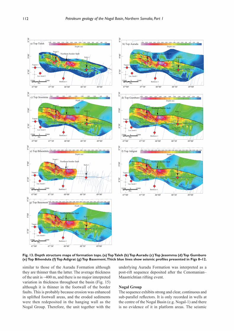
112 Petroleum geology of the Nogal Basin, Northern Somalia, Part 1
similar to those of the Auradu Formation although they are thinner than the latter. The average thickness of the unit is ~400 m, and there is no major interpreted variation in thickness throughout the basin (Fig. 15) although it is thinner in the footwall of the border faults. This is probably because erosion was enhanced in uplifted footwall areas, and the eroded sediments were then redeposited in the hanging wall as the Nogal Group. Therefore, the unit together with the
underlying Auradu Formation was interpreted as a post-rift sequence deposited after the Cenomanian–Maastrichtian rifting event.
Nogal GroupThe sequence exhibits strong and clear, continuous and sub-parallel reflectors. It is only recorded in wells at the centre of the Nogal Basin (e.g. Nogal-1) and there is no evidence of it in platform areas. The seismic
Fig. 13. Depth structure maps of formation tops. (a) Top Taleh (b) Top Auradu (c) Top Jesomma (d) Top Gumburo (e) Top Bihendula (f) Top Adigrat (g) Top Basement. Thick blue lines show seismic profiles presented in Figs 8–12.
25000 0 25000(m)
-2800 -2600 -2400 -2200 -2000 -1800 -1600 -1400 -1200 -1000 -800 -600 -400 -200
Depth (m)
9°30
'
CS -12 0
CS-130
CS -170
CS-190
CS-220
0 34 36A
CS-238
CS-240
CS-241
-242
CS-243
CS-245A
CS-247
CS-250
CS-250
CS -2 50A
CS -250AC
S-250B
CS-250B
CS-251
CS-251
CS-255
CS-256
CS-256
CS-260A
CS-280
CS-290
CS-290
L5
L5A
L5D
-800
0
0
0
25000 0 25000(m)
-3000 -2800 -2600 -2400 -2200 -2000 -1800 -1600 -1400 -1200 -1000 -800 -600 -400 -200
Depth (m)
-800
-400
0 0 4 -
004-
0
0
0
00
0
0
0
25000 0 25000(m)
-3800 -3400 -3000 -2600 -2200 -1800 -1400 -1000 -600 -200
Depth (m)
-800
-800
00
8 -
-8
00
008-
25000 0 25000(m)
-5400 -5000 -4600 -4200 -3800 -3400 -3000 -2600 -2200 -1800 -1400 -1000 -600
Depth (m)
-1
60
0
0 0 6 1 -
00
61
-
25000 0 25000(m)
-7200 -6800 -6400 -6000 -5600 -5200 -4800 -4400 -4000 -3600 -3200 -2800 -2400 -2000 -1600 -1200
Depth (m)-5600-4000
-3200
25000 0 25000(m)
-8000 -7600 -7200 -6800 -6400 -6000 -5600 -5200 -4800 -4400 -4000 -3600 -3200 -2800 -2400 -2000 -1600 -1200
Depth (m)
-4000
-3200-24
00
0 0 4 2 -
00
42
-
25000 0 25000(m)
-8200 -7800 -7400 -7000 -6600 -6200 -5800 -5400 -5000 -4600 -4200 -3800 -3400 -3000 -2600 -2200 -1800 -1400
Depth (m)
-4
800
-4000
-3200-3200
-3
20
0
-2400
0 0 4 2 -
00
42
-
9°00
'8°
30'
47°00' 47°30' 48°00' 48°30' 49°00'
9°30
'9°
00'
8°30
'
47°00' 47°30' 48°00' 48°30' 49°00'
9°30
'9°
00'
8°30
'
47°00' 47°30' 48°00' 48°30' 49°00'
9°30
'9°
00'
8°30
'
47°00' 47°30' 48°00' 48°30' 49°00'
9°30
'9°
00'
8°30
'
47°00' 47°30' 48°00' 48°30' 49°00'
9°30
'9°
00'
8°30
'
47°00' 47°30' 48°00' 48°30' 49°00'
9°30
'9°
00'
8°30
'
47°00' 47°30' 48°00' 48°30' 49°00'
b) Top Auradua) Top Taleh
c) Top Jesomma
e) Top Bihendula
g) Top Basement
f) Top Adigrat
d) Top Gumburo
Yaguri-1
Las Anod-1
Burhisso-1
Kalis-1
Nogal-1Northern border fault
Yaguri-1
Las Anod-1
Burhisso-1
Kalis-1
Nogal-1Northern border fault
Yaguri-1
Las Anod-1
Burhisso-1
Kalis-1
Nogal-1Northern border fault
Yaguri-1
Las Anod-1
Burhisso-1
Kalis-1
Nogal-1Northern border fault
Yaguri-1
Las Anod-1
Burhisso-1
Kalis-1
Nogal-1Northern border fault
Yaguri-1
Las Anod-1
Burhisso-1
Kalis-1
Nogal-1Northern border fault
Yaguri-1
Las Anod-1
Burhisso-1
Kalis-1
Nogal-1Northern border fault
Ali part 1.indd 112 03/12/2018 10:27:01
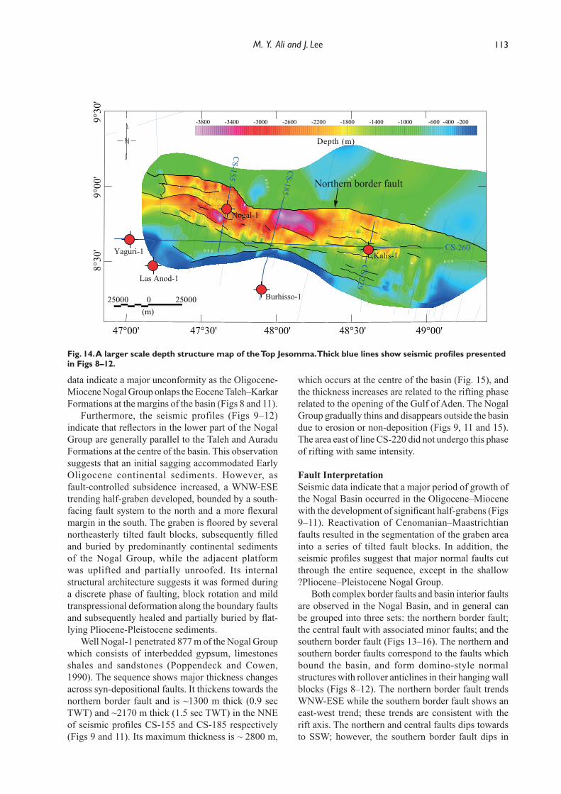
113M. Y. Ali and J. Lee
data indicate a major unconformity as the Oligocene-Miocene Nogal Group onlaps the Eocene Taleh–Karkar Formations at the margins of the basin (Figs 8 and 11).
Furthermore, the seismic profiles (Figs 9–12) indicate that reflectors in the lower part of the Nogal Group are generally parallel to the Taleh and Auradu Formations at the centre of the basin. This observation suggests that an initial sagging accommodated Early Oligocene continental sediments. However, as fault-controlled subsidence increased, a WNW-ESE trending half-graben developed, bounded by a south-facing fault system to the north and a more flexural margin in the south. The graben is floored by several northeasterly tilted fault blocks, subsequently filled and buried by predominantly continental sediments of the Nogal Group, while the adjacent platform was uplifted and partially unroofed. Its internal structural architecture suggests it was formed during a discrete phase of faulting, block rotation and mild transpressional deformation along the boundary faults and subsequently healed and partially buried by flat-lying Pliocene-Pleistocene sediments.
Well Nogal-1 penetrated 877 m of the Nogal Group which consists of interbedded gypsum, limestones shales and sandstones (Poppendeck and Cowen, 1990). The sequence shows major thickness changes across syn-depositional faults. It thickens towards the northern border fault and is ~1300 m thick (0.9 sec TWT) and ~2170 m thick (1.5 sec TWT) in the NNE of seismic profiles CS-155 and CS-185 respectively (Figs 9 and 11). Its maximum thickness is ~ 2800 m,
which occurs at the centre of the basin (Fig. 15), and the thickness increases are related to the rifting phase related to the opening of the Gulf of Aden. The Nogal Group gradually thins and disappears outside the basin due to erosion or non-deposition (Figs 9, 11 and 15). The area east of line CS-220 did not undergo this phase of rifting with same intensity.
Fault Interpretation Seismic data indicate that a major period of growth of the Nogal Basin occurred in the Oligocene–Miocene with the development of significant half-grabens (Figs 9–11). Reactivation of Cenomanian–Maastrichtian faults resulted in the segmentation of the graben area into a series of tilted fault blocks. In addition, the seismic profiles suggest that major normal faults cut through the entire sequence, except in the shallow ?Pliocene–Pleistocene Nogal Group.
Both complex border faults and basin interior faults are observed in the Nogal Basin, and in general can be grouped into three sets: the northern border fault; the central fault with associated minor faults; and the southern border fault (Figs 13–16). The northern and southern border faults correspond to the faults which bound the basin, and form domino-style normal structures with rollover anticlines in their hanging wall blocks (Figs 8–12). The northern border fault trends WNW-ESE while the southern border fault shows an east-west trend; these trends are consistent with the rift axis. The northern and central faults dips towards to SSW; however, the southern border fault dips in
Fig. 14. A larger scale depth structure map of the Top Jesomma. Thick blue lines show seismic profiles presented in Figs 8–12.
25000 0 25000(m)
-3800 -3400 -3000 -2600 -2200 -1800 -1400 -1000 -600 -400 -200
Depth (m)
-800
-800
00
8 -
-8
00
008-
9°30
'9°
00'
8°30
'
47°00' 47°30' 48°00' 48°30' 49°00'
Yaguri-1
Las Anod-1
Burhisso-1
Kalis-1
Northern border fault
CS-185
CS-260
CS-229
CS-155
Nogal-1
Ali part 1.indd 113 03/12/2018 10:27:02
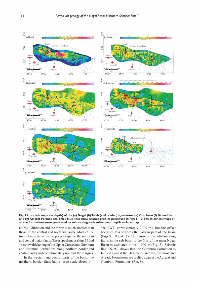
114 Petroleum geology of the Nogal Basin, Northern Somalia, Part 1
an NNE direction and the throw is much smaller than those of the central and northern faults. Most of the minor faults show reverse polarity against the northern and central major faults. The isopach maps (Figs 15 and 16) show thickening of the Upper Cretaceous Gumburo and Jesomma Formations along northern border and central faults and complimentary uplift of the margins.
In the western and central parts of the basin, the northern border fault has a large-scale throw (~1
sec TWT, approximately 3000 m), but the offset becomes less towards the eastern part of the basin (Figs 9, 10 and 11). The throw on the rift-bounding faults in the sub-basin to the NW of the main Nogal Basin is estimated to be ~1000 m (Fig. 8). Seismic line CS-280 shows that the Gumburo Formation is faulted against the Basement, and the Jesomma and Auradu Formations are faulted against the Adigrat and Gumburo Formations (Fig. 8).
Fig. 15. Isopach maps (in depth) of the (a) Nogal (b) Taleh (c) Auradu (d) Jesomma (e) Gumburo (f) Bihendula and (g) Adigrat Formations. Thick blue lines show seismic profiles presented in Figs 8–12. The thickness maps of all the formations were generated by subtracting each subsequent depth surface map.
200 400 600
Thicknes s (m)
200 400400 600 800
Thicknes s (m)
200 400 600 800 1000 1200 1400 1600 1800 2000 2200 2400 2600 2800 3000 3200 3400 3600
Thicknes s (m)
200 400 600 800 1000 1200 1400 1600 1800 2000 2200
Thicknes s (m)
200 400 600 800 1000 1200 1400 1600
Thicknes s (m)
200 400 600 800 1000
Thicknes s (m)
200 400 600 800 1000 1200 1400 1600 1800 2000 2200 2400 2600 2800
Thicknes s (m)
9°30
'9°
00'
8°30
'
47°00' 47°30' 48°00' 48°30' 49°00'
9°30
'9°
00'
8°30
'
47°00' 47°30' 48°00' 48°30' 49°00'
g) Adigrat
f) Bihendula
Yaguri-1
Las Anod-1
Burhisso-1
Kalis-1
Nogal-1Northern border fault
Yaguri-1
Las Anod-1
Burhisso-1
Kalis-1
Nogal-1Northern border fault
9°00
'8°
30'
47°00' 47°30' 48°00' 48°30' 49°00'
a) Nogal
Yaguri-1
Las Anod-1
Burhisso-1
Kalis-1
Nogal-1Northern border fault
25000 0 25000(m)
9°30
'
25000 0 25000(m)
25000 0 25000(m)
9°30
'9°
00'
8°30
'
47°00' 47°30' 48°00' 48°30' 49°00'
b) Taleh
Yaguri-1
Las Anod-1
Burhisso-1
Kalis-1
Nogal-1Northern border fault
25000 0 25000(m)
9°30
'9°
00'
8°30
'
47°00' 47°30' 48°00' 48°30' 49°00'
c) Auradu
Yaguri-1
Las Anod-1
Burhisso-1
Kalis-1
Nogal-1Northern border fault
25000 0 25000(m)
9°30
'9°
00'
8°30
'
47°00' 47°30' 48°00' 48°30' 49°00'
d) Jesomma
Yaguri-1
Las Anod-1
Burhisso-1
Kalis-1
Nogal-1Northern border fault
25000 0 25000(m)
9°30
'9°
00'
8°30
'
47°00' 47°30' 48°00' 48°30' 49°00'
e) Gumburo
Yaguri-1
Las Anod-1
Burhisso-1
Kalis-1
Nogal-1Northern border fault
25000 0 25000(m)
Ali part 1.indd 114 03/12/2018 10:27:05
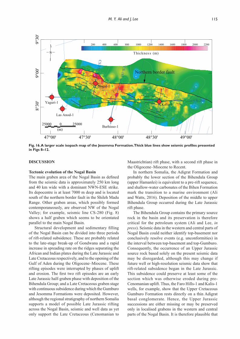
115M. Y. Ali and J. Lee
DISCUSSION
Tectonic evolution of the Nogal BasinThe main graben area of the Nogal Basin as defined from the seismic data is approximately 250 km long and 40 km wide with a dominant NWN-ESE strike. Its depocentre is at least 7000 m deep and is located south of the northern border fault in the Shileh Madu Range. Other graben areas, which possibly formed contemporaneously, are observed NW of the Nogal Valley; for example, seismic line CS-280 (Fig. 8) shows a half graben which seems to be orientated parallel to the main Nogal Basin.
Structural development and sedimentary filling of the Nogal Basin can be divided into three periods of rift-related subsidence. These are probably related to the late-stage break-up of Gondwana and a rapid increase in spreading rate on the ridges separating the African and Indian plates during the Late Jurassic and Late Cretaceous respectively, and to the opening of the Gulf of Aden during the Oligocene–Miocene. These rifting episodes were interrupted by phases of uplift and erosion. The first two rift episodes are an early Late Jurassic half-graben phase with deposition of the Bihendula Group; and a Late Cretaceous graben stage with continuous subsidence during which the Gumburo and Jesomma Formations were deposited. However, although the regional stratigraphy of northern Somalia supports a model of possible Late Jurassic rifting across the Nogal Basin, seismic and well data as yet only support the Late Cretaceous (Cenomanian to
Maastrichtian) rift phase, with a second rift phase in the Oligocene–Miocene to Recent.
In northern Somalia, the Adigrat Formation and probably the lower section of the Bihendula Group (upper Hamanlei) is equivalent to a pre-rift sequence, and shallow-water carbonates of the Bihen Formation mark the transition to a marine environment (Ali and Watts, 2016). Deposition of the middle to upper Bihendula Group occurred during the Late Jurassic rift phase.
The Bihendula Group contains the primary source rock in the basin and its preservation is therefore critical for the petroleum system (Ali and Lee, in press). Seismic data in the western and central parts of Nogal Basin could neither identify top-basement nor conclusively resolve events (e.g. unconformities) in the interval between top-basement and top-Gumburo. Consequently, the occurrence of an Upper Jurassic source rock based solely on the present seismic data may be disregarded, although this may change if future well or high-resolution seismic data show that rift-related subsidence began in the Late Jurassic. This subsidence could preserve at least some of the section which was otherwise eroded during pre-Cenomanian uplift. Thus, the Faro Hills-1 and Kalis-1 wells, for example, show that the Upper Cretaceous Gumburo Formation rests directly on a thin Adigrat basal conglomerate. Hence, the Upper Jurassic successions are either missing or may be preserved only in localised grabens in the western and central parts of the Nogal Basin. It is therefore plausible that
Fig. 16. A larger scale isopach map of the Jesomma Formation. Thick blue lines show seismic profiles presented in Figs 8–12.
200 400 600 800 1000 1200 1400 1600 1800 2000 2200
Thicknes s (m)
9°30
'9°
00'
8°30
'
47°00' 47°30' 48°00' 48°30' 49°00'
Las Anod-1
Burhisso-125000 0 25000
(m)
Yaguri-1 Kalis-1
Northern border fault
CS-185
CS-260
CS-155
Nogal-1CS-229
Ali part 1.indd 115 03/12/2018 10:27:06
116 Petroleum geology of the Nogal Basin, Northern Somalia, Part 1
the Upper Jurassic rift sediments were removed by the pre-Cenomanian uplift event or by the Erigavo-Nogal Arch which developed during the Late Jurassic; hence Upper Jurassic rift-fill facies were not deposited in the Nogal Basin. The Upper Jurassic sediments that may have been eroded in the Nogal region were possibly deposited further east, as the Cotton-1, Sagaleh-1 and Garad Mare-1 wells penetrated thick sequences (up to 780 m of the Cotton Formation) of Early Cretaceous age. The origin of the pre-Cenomanian uplift event and the Erigavo-Nogal Arch is not known but it might be associated with regional-scale tectonic uplift flanking the Gondwana rifted margin. Alternatively, the uplift event may have resulted from a regional thermal doming related to plutonic bodies that intruded during the Early Cretaceous.
The aeromagnetic data identified high magnetic zones with a NW-SE orientation which are interpreted to represent plutonic bodies of similar age to the quartz-syenite intrusion (i.e. 118–127 Ma) at Gorei. Moreover, the seismic data show no indication of intrusive bodies within the sedimentary cover. However, all of the sequences imaged by seismic profile CS-280 (Fig. 8), west of Faro Hills-1, could be interpreted Late Cretaceous and younger, assuming the intrusions are same age as that at Gorie. This interpretation is based on the lack of acoustic impedance contrast between the sedimentary sequences and the quartz-syenite intrusions which are not therefore detected in the seismic data. The intrusive bodies may be contemporaneous with the pre-Cenomanian uplift that resulted the Erigavo-Nogal Arch.
The stratigraphy of the Gumburo and Jesomma Formations is consistent with a rifting episode that post-dates the pre-Cenomanian uplift. The seismic profiles and surface and isopach maps suggest that sedimentation was fault controlled, and the Gumburo and Jesomma Formations show characteristics of syn-rift sequences (Figs 8–16) with significant thickness variations across the rift (Figs 8–16). Compared to sections in footwall locations, the Jesomma Formation is more than three times thicker, and the Gumburo Formation more than two times thicker, than equivalent sections in the Faro Hills-1 well (Fig. 5). Thickness variations are also evident within the rift across faults (Figs 8–16). These two syn-rift sequences in general consist of sandy carbonates and sandstones, and are the most important potential reservoir units in the basin (Ali and Lee, in press).
The Paleocene to Eocene Auradu and Taleh Formation are consistent with post-rift deposition, with constant thicknesses throughout the Nogal region (Fig. 15). These units may serve as a regional seal because they are composed of tight limestones and evaporites, respectively (Ali and Lee, in press). The Karkar Formation and upper part of the Taleh Formation
are eroded in many parts of the Nogal region due to Oligocene uplift and unroofing (Figs 8 and 9).
The Nogal Group which overlies the Taleh Formation is thicker (up to 2800 m) in the centre of the Nogal Basin (Fig. 15a). The group is absent in well Kalis-1 (Fig. 5) and adjacent platforms. However, its thickness is generally less than 800 m in the western part of the basin (Fig. 15a). The group correlates well with other Gulf of Aden depocentres in northern Somalia, such as those in the Daban Basin (Ali, 2015). Deposition of the Nogal Group was controlled by growth faults related to the development of the Gulf of Aden rifting event (Figs 9–11). The middle to upper part of the group represents a post-rift sequence since it shows little variation in thickness (Fig. 9).
Structural Trends in the Nogal RegionThe geometry of the major faults in the Nogal Basin in general form a half-graben structure (Wernicke, 1985). The Upper Cretaceous synrift sequences and overlying Cenozoic have similar WNW-ESE trends (Figs 13–16), and the most prominent structural features in the basin are WNW-ESE trending domino-style normal faults together with fault-block ranges in the northern flanks of the Nogal Valley. The northern border fault probably began to develop in the Mesozoic and coincide with the escarpments of the Shileh Madu and Bur Dab Ranges (Fig. 2). The Shileh Madu Range is tilted to the NNE with dips of 5–10°, with stratigraphic throws on south-dipping normal faults of up to 900 m. The Bur Dab Range is tilted SW with dips of 3–10°, and stratigraphic throws on north-dipping normal faults of 600-700 m (Harms et al., 1989; Mackay et al., 1954). During the Cenomanian–Maastrichtian, epeirogenic movements and rifting generated numerous faults, but it is hard to distinguish them from faults reactivated during Oligocene–Miocene rifting. Nevertheless, since the faults displace the Taleh Formation, significant movement must have occurred in late Eocene or Oligocene–Miocene times.
Granath (2001) suggested that the Nogal Basin and associated sub-basins are bordered by NW-SE trending normal faults. In this interpretation, the sub-basins in the Nogal region continue to the Las Dureh and Berbera sub-basins (Figs 2 and 17). However, seismic and outcrop mapping indicate that the faults bounding the northern side of the Nogal graben do not continue to link up with the Las Dureh and Berbera sub-basins. For example, the structural data acquired in the Huddun area and western Nogal region show a series of east-west to WNW–ESE trending normal faults with southerly-tilted fault blocks resulting in half graben systems. These faults separate the uplifted blocks of the Hagrin and Bur Anod-Hagraajin-Shileh Madu Ranges from the down-faulted blocks of the Huddun and Ban Tur Anod Basins (Fig. 2). In the Bur
Ali part 1.indd 116 03/12/2018 10:27:06
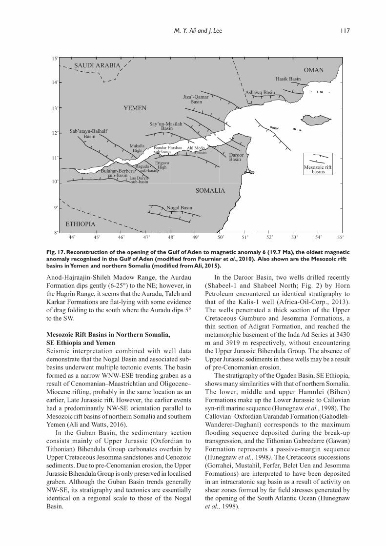
117M. Y. Ali and J. Lee
Anod-Hajraajin-Shileh Madow Range, the Aurdau Formation dips gently (6-25°) to the NE; however, in the Hagrin Range, it seems that the Auradu, Taleh and Karkar Formations are flat-lying with some evidence of drag folding to the south where the Auradu dips 5° to the SW.
Mesozoic Rift Basins in Northern Somalia, SE Ethiopia and YemenSeismic interpretation combined with well data demonstrate that the Nogal Basin and associated sub-basins underwent multiple tectonic events. The basin formed as a narrow WNW-ESE trending graben as a result of Cenomanian–Maastrichtian and Oligocene–Miocene rifting, probably in the same location as an earlier, Late Jurassic rift. However, the earlier events had a predominantly NW-SE orientation parallel to Mesozoic rift basins of northern Somalia and southern Yemen (Ali and Watts, 2016).
In the Guban Basin, the sedimentary section consists mainly of Upper Jurassic (Oxfordian to Tithonian) Bihendula Group carbonates overlain by Upper Cretaceous Jesomma sandstones and Cenozoic sediments. Due to pre-Cenomanian erosion, the Upper Jurassic Bihendula Group is only preserved in localised graben. Although the Guban Basin trends generally NW-SE, its stratigraphy and tectonics are essentially identical on a regional scale to those of the Nogal Basin.
In the Daroor Basin, two wells drilled recently (Shabeel-1 and Shabeel North; Fig. 2) by Horn Petroleum encountered an identical stratigraphy to that of the Kalis-1 well (Africa-Oil-Corp., 2013). The wells penetrated a thick section of the Upper Cretaceous Gumburo and Jesomma Formations, a thin section of Adigrat Formation, and reached the metamorphic basement of the Inda Ad Series at 3430 m and 3919 m respectively, without encountering the Upper Jurassic Bihendula Group. The absence of Upper Jurassic sediments in these wells may be a result of pre-Cenomanian erosion.
The stratigraphy of the Ogaden Basin, SE Ethiopia, shows many similarities with that of northern Somalia. The lower, middle and upper Hamnlei (Bihen) Formations make up the Lower Jurassic to Callovian syn-rift marine sequence (Hunegnaw et al., 1998). The Callovian–Oxfordian Uarandab Formation (Gahodleh-Wanderer-Daghani) corresponds to the maximum flooding sequence deposited during the break-up transgression, and the Tithonian Gabredarre (Gawan) Formation represents a passive-margin sequence (Hunegnaw et al., 1998). The Cretaceous successions (Gorrahei, Mustahil, Ferfer, Belet Uen and Jesomma Formations) are interpreted to have been deposited in an intracratonic sag basin as a result of activity on shear zones formed by far field stresses generated by the opening of the South Atlantic Ocean (Hunegnaw et al., 1998).
Fig. 17. Reconstruction of the opening of the Gulf of Aden to magnetic anomaly 6 (19.7 Ma), the oldest magnetic anomaly recognised in the Gulf of Aden (modified from Fournier et al., 2010). Also shown are the Mesozoic rift basins in Yemen and northern Somalia (modified from Ali, 2015).
10˚
12˚
14˚
15˚
11˚
13˚
44˚ 46˚ 48˚ 50˚ 52˚ 54˚45˚ 47˚ 49˚ 51˚ 53˚
DaroorBasin
Bulahar-Berberasub-basin
Sab’atayn-Balhalf Basin
Ragudasub-basin
Mesozoic rift basins
Say’un-Masilah Basin
Jiza’-QamarBasin
Ashawq Basin
Hasik Basin
55˚
Bandar Harshausub-basin
ErigavoHigh
MukallaHigh
9˚
8˚
Nogal Basin
SOMALIA
YEMEN
ETHIOPIA
OMAN
Ahl Medosub-basin
Las Durehsub-basin
SAUDI ARABIA
Ali part 1.indd 117 03/12/2018 10:27:07

118 Petroleum geology of the Nogal Basin, Northern Somalia, Part 1
Although now separated by the Gulf of Aden, Yemen and northern Somalia shared a common tectono-stratigraphic history during the Jurassic, Cretaceous and Paleogene (Beydoun, 1970). Reconstructing the Arabian and African plates to their pre-rift position before the opening of the Gulf of Aden shows that rift basins in southern Yemen extended to northern Somalia (Fig. 17). For example, the Balhaf and Sab’atayn Basins appear to be a continuation of the Berbera-Bulahar and Raguda sub-basins; the Erigavo-Nogal Arch is the continuation of the Mukalla High; and the Bandar Harshau and Ahl Medo sub-basins are conjugates of the Say’un-Masilah Basins (Ali, 2015; Beydoun, 1970; Bosworth et al., 2005) (Fig. 17). In addition, Birse et al. (1997) suggested that the Late Jurassic extensional NW-SE (140°) lineament that occurs in the Marib-Al Jawf-Balhaf grabens of Yemen extends to the Guban and Nogal grabens in northern Somalia. This trend is also parallel to that of the Masilah and Daroor Basins (Ali and Watts, 2016), and subsurface data demonstrate that these basins are part of a NW–SE striking rift system (Ali and Watts, 2016; Ellis et al., 1996). On the Yemeni side, the entire Jurassic is known to be absent on the Mukalla High where Cretaceous sediments rests unconformably on a peneplained basement.
In Yemen, the orientation and age of the Mesozoic rift basins vary from the west to the east of the country. In western and central Yemen, the Sab’atayn and Balhaf rift basins are oriented NW–SE (Bosence, 1997; Bott et al., 1992; Brannan et al., 1997) (Fig. 17). The earliest syn-rift strata within the Sab’atayn (Marib-Shabwa) Basin are early to mid Kimmeridgian in age (Holden and Kerr, 1997), with maximum subsidence occurring in the Kimmeridgian and Tithonian (Redfern and Jones, 1995). To the east, the Say’un-Masilah and Jiza’-Qamar Basins are oriented progressively more east-west (Beydoun, 1996; Beydoun, 1997; Bosence, 1997; Brannan et al., 1997; Redfern and Jones, 1995) (Fig.17). These basins are relatively younger than the NW-SE oriented basins, with syn-rift deposits starting in the Hauterivian and subsidence continuing intermittently through to the late Cenozoic (Bosence et al., 1996). The change in stress orientation over time has been suggested to relate firstly to the inherited NW-SE Najd trend, which was later translated to an external stress induced by the northward movement of India in the Late Cretaceous together with involvement with the rifting and spreading of the Gulf of Aden (Bosence et al., 1996; Bosworth et al., 2005; Redfern and Jones, 1995; Birse et al., 1997).
Based on the above observations and by analogy with Yemen, it is possible that the WNW-ESE trending Nogal Basin is predominantly a Late Cretaceous rift basin, with little subsidence during the Late Jurassic, as in the Say’un-Masilah and Jiza’-Qamar Basins in
Yemen which have a similar orientation as a result of the Erigavo-Nogal Arch which was centred on the region. However, it is also possible that Upper Jurassic rift sequences were deposited but were removed by the pre-Cenomanian uplift event.
CONCLUSIONS
The following main conclusions can be drawn from this study of the Nogal Basin, northern Somalia:
Aeromagnetic data identified high magnetic zones with a NW-SE orientation, which are interpreted to represent plutonic bodies of similar age to that of the Gorei intrusion (i.e. 118–127 Ma) in the Shileh Madu Range. The data also show a suture zone which separates the basement of the Inda Ad Series in the SE from the igneous and high-grade metamorphic basement in the NW.
Interpretation of closely-spaced seismic profiles shows that sedimentation and structural development of the main Nogal Basin and associated sub-basins were strongly affected by rifting events. The sub-basins have a WNW-ESE trend similar to that of Cretaceous rift basins in Yemen.
Seven sequences have been defined in the Nogal Basin: Nogal Group (Oligocene–Miocene to Recent), Taleh and Karkar Formations (Lower to Middle Eocene), Auradu Formation (Paleocene to Lower Eocene), Jesomma Formation (Maastrichtian), Gumburo Formation (Cenomanian to Campanian), Bihendula Group (Upper Jurassic), and Adigrat Formation (Lower–Middle Jurassic).
The Upper Jurassic Bihendula Group, which is the main source rock interval in northern Somalia, is either absent in the basin or preserved only in localised grabens in the western and central parts of the basin.
A major unconformity (pre-Cenomanian) below the Gumburo Formation records a basin-wide uplift and erosional event which removed most of the Jurassic sequences. This uplift formed the Nogal-Erigavo Arch, a NW-SE area where the Upper Cretaceous rests directly on Lower-Middle Jurassic sediments or basement. The origin of the event is not understood but may be associated with regional uplift on the rifted margin of Gondwana.
Seismic data document a well-developed half graben with thickening of the Upper Cretaceous and Oligocene–Miocene sequences towards the northern border fault.
The border fault bounds the basin in the north. The thickness of Cretaceous formations in the footwall block is less than that in the hanging wall, implying that the border fault was active syn-depositionally.
Seismic data suggest an early rift sag phase which accommodated Early Oligocene continental sediments of the Nogal Group. This was followed by a period
Ali part 1.indd 118 03/12/2018 10:27:07
119M. Y. Ali and J. Lee
of strong rotational faulting and tilting, and these structures were subsequently healed and partially buried by flat-lying Pliocene–Pleistocene sediments.
ACKNOWLEDGEMENTS
The authors wish to thank the Somaliland Ministry of Minerals and Energy and Ibrahim Hassan for assisting with access to the well and seismic data used in this study. Special thanks go to Ahmed Aden, Suleiman Mohammed Ali, Bashir AbdiDahir Ali and Hidig Jama Mohammed for assisting the fieldwork conducted in the Nogal Basin. Computer software used included Petrel, GMT and Geosoft Montage. The authors thank David Boote (DRB Consulting, London), Paul Martinez (Africa Oil Corp.) and Lindsay Davidson (RPS Energy) for their helpful comments on an earlier version of the paper.
REFERENCES
ABBATE, E., FICARELLI, G., RADDRIZZANI, C.P., SALVIETTI, A., D. TORRE and A. TURI, 1974. Jurassic sequences from the Somali coast of the Gulf of Aden. Rivista Italiana di Paleontologia e Stratigrafia, 80, 405-445.
ABBATE, E., HUSSEIN, A.S., BRUNI, P. and SAGRI, M., 1993a. Pre- and syn-rift sedimentation in a Tertiary basin along the Gulf of Aden (Daban Basin, Northern Somalia). In: Abbate, E., Sagri, M. and Sassi, F. P. (Eds), Geology and mineral resources of Somalia and surrounding regions. Relazioni e Monografie 113A/1993, Insituto Agronomico Oltremare, Firenze, 211-240.
ABBATE, E., M., S. and SASSI, F.P., 1993b. A geological map of Somalia 1:1,500,000. In: Abbate, E., Sagri, M. and Sassi, F. P. (Eds), 1st International Meeting on the Geology of Somalia and Surrounding Regions (GEOSOM 87).
Africa-Oil-Corp., 2013. Corporate Presentation: A Major Emerging Oil Company in East Africa, http://www.africaoilcorp.com/i/pdf/2013-07_aoip.pdf [last accessed June 2019].
AL-HUSSEINI, M.I., 2000. Origin of the Arabian Plate structures; Amar collision and Najd Rift. GeoArabia, 5, 527-542.
ALI, M. Y., 2015. Petroleum geology and hydrocarbon potential of the Guban basin, Northern Somaliland. Journal of Petroleum Geology, 38, 433-457.
ALI, M. Y. and LEE, J., in press, 2019. Petroleum geology of the Nogal basin, northern Somalia, Part 2: Hydrocarbon potential. Journal of Petroleum Geology, 42.
ALI, M.Y. and WATTS, A.B., 2013. Subsidence history, crustal structure, and evolution of the Somaliland-Yemen conjugate margin. Journal of Geophysical Research, 118, 1-12.
ALI, M.Y. and WATTS, 2016. Tectonic evolution of sedimentary basins of northern Somalia. Basin Research, 28, 340-364.
AMERADA, 1957. Progress report: Amerada Faro Hills No.1. Amerada Petroleum Corporation, 1-58.
AMERADA, 1958. Progress report: Amerada Yaguri No.1, Amerada Petroleum Corporation, 1-48.
AZZAROLI, A., 1952. I Macroforaminiferi Della Serie Del Carcar (Eocene Medio e Superiore) in Somalia e La Loro Distribuzione Stratigrafica. Palaeontographia Italica, 47, 99-131.
AZZAROLI, A., 1958. L’Oligocene e Il Miocene Della Somalia: Stratigrafia, Tetonica, Paleontologia (Macroforaminiferi, Coralli, Molluschi.) Palaeont. Italica, 52, 1-142.
BARANOV, V. and NAUDY, H., 1964. Numerical calculation of
the formula of reduction to the magnetic pole. Geophysics, 29, 67-79.
BARNES, S.V., 1976. Geology and oil prospects of Somalia, East Africa. AAPG Bulletin, 60, 389-413.
BEYDOUN, Z.R., 1970. Southern Arabia and Northern Somalia – Comparative Geology. Phil. Trans. R. Soc. Lond.Ser. A, 267, 267-292.
BEYDOUN, 1996. Rift sedimentation and tectonics in the Red Sea and Gulf of Aden region. Journal of Petroleum Geology, 19, 235-235.
BEYDOUN, 1997. Introduction to the revised Mesozoic stratigraphy and nomenclature for Yemen. Mar. Petrol. Geol., 14, 617-629.
BIRSE, A.C.R., BOTT, W.F., MORRISON, J. and SAMUEL, M.A., 1997. The Mesozoic and Early Tertiary tectonic evolution of the Socotra area, eastern Gulf of Aden, Yemen. Mar. Petrol. Geol., 14, 675-684.
BOECKELMANN, K. and SCHREIBER, W., 1990. Sedimentology and stratigraphy of Taleh and Karkar Formations (Eocene) in Northern Somalia. In: Klitzsch, E. and Schrank, E. (Eds), Research in Sudan, Somalia, Egypt and Kenya. Berliner Geowissenschaftliche Abhandlungen, Reihe A, 595-620.
BOSELLINI, A., 1989. The continental margins of Somalia: Their structural evolution and sequence stratigraphy. Mernorie di Scienze Geologiche gia Memorir degli Instituti di Geologia and Mineralogia dell’universita di Padova, 41, 373-458.
BOSELLINI, A., 1992. The Continental Margins of Somalia - Structural Evolution and Sequence Stratigraphy. Geology and Geophysics of Continental Margins, 53, 185-205.
BOSENCE, D., NICHOLS, G., AL SUBBARY, A.K., AL THOUR, K.A. and REEDER, M., 1996. Synrift continental to marine depositional sequences, Tertiary, Gulf of Aden, Yemen. J. Sediment. Res, 66, 766-777.
BOSENCE, D.W.J., 1997. Mesozoic rift basins of Yemen. Mar. Petrol. Geol., 14, 611-616.
BOSWORTH, W., HUCHON, P. and McCLAY, K., 2005. The Red Sea and Gulf of Aden basins. J. Afr. Earth Sci, 43, 334-378, doi:10.1016/J.Jafrearsci.2005.07.020.
BOTT, W.F., SMITH, B.A., OAKES, G., SIKANDER, A.H. and IBRAHAM, A.I., 1992. The Tectonic Framework and Regional Hydrocarbon Prospectivity of the Gulf of Aden. Journal of Petroleum Geology, 15, 211-243.
BRANNAN, J., GERDES, K.D. and NEWTH, I.R., 1997. Tectono-stratigraphic development of the Qamar basin, Eastern Yemen. Mar. Petrol. Geol., 14, 701-730.
BRUNI, P. and FAZZUOLI, M., 1977. Sedimentological observations on Jurassic and Cretaceous sequences from northern Somalia: Preliminary report. Bollettino Societa¢ Geologica Italiana, 95, 1571–1588.
ELLIS, A.C., KERR, H.M., CORNWELL, C.P. and WILLIAMS, D.O., 1996. A tectono-stratigraphic framework for Yemen and its implications for hydrocarbon potential. Petrol. Geosci., 2, 29-42.
FARQUHARSON, R.A., 1924. First Report on the Geology and Mineral Resources of British Somaliland (with map). Waterlow and Sons, Ltd., 53 pp.
FOURNIER, M., CHAMOT-ROOKE, N., PETIT, C., HUCHON, P., AL-KATHIRI, A., AUDIN, L., BESLIER, M.O., D’ACREMONT, E., FABBRI, O., FLEURY, J.M., KHANBARI, K., LEPVRIER, C., LEROY, S., MAILLOT, B. and MERKOURIEV, S., 2010. Arabia-Somalia plate kinematics, evolution of the Aden-Owen-Carlsberg triple junction, and opening of the Gulf of Aden. J. Geophys. Res., 115, B04102, doi: 10.1029/2008jb006257.
GRANATH, J.W., 2001. The Nogal Rift of northern Somalia: Gulf of Aden. Reactivation of a Mesozoic rift. Peri-Tethys Memoir 6: Peri-Tethyan Rift/Wrench Basins and Passive Margins, 186, 511-527.
GREENWOOD, J.E.G.W., 1960. Geology of the Las Khoreh-Elayu area, Erigavo district. Somaliland Protectorate Geological Survey, Report no. 3, 1-36, Hargeisa, Somaliland.
Ali part 1.indd 119 03/12/2018 10:27:07
120 Petroleum geology of the Nogal Basin, Northern Somalia, Part 1
GREENWOOD, J.E.G.W., 1961. The Inda Ad Series of the former Somaliland Protectorate. Overseas Geology and Mineral Resources, 8, 288–296.
HARMS, J.C., BRADY, M.J. and MacKENZIE, D. B., 1989. Oil and gas potential of the Somali Democratic Republic, Volume III Nogal Valley. Ministry of Mineral and Water Resources, Mogadishu, Somali Democratic Republic, 1-58.
HOLDEN, A. and KERR, H.M., 1997. A subsurface lithostratigraphic division of the Hauterivian to Aptian, Furt (informal) and Qishn formations, Yemen. Marine and Petroleum Geology, 14, 631-642.
HUNEGNAW, A., SAGE, L. and GONNARD, R., 1998. Hydrocarbon potential of the intracratonic Ogaden basin, SE Ethiopia. Journal of Petroleum Geology, 21, 401-425.
HUNT, J. A., DREYFUSS, M., DAINELLI, G.,TAVANI, G. and FURON, R., 1956. British Somaliland. Lexique stratigraphique international, IV, 1-78 Congrès géologique international, Commission de stratigraphie, Paris.
HUSSEINI, M.I., 1989. Tectonic and Deposition Model of Late Precambrian-Cambrian Arabian and Adjoining Plates. AAPG Bulletin, 73, 1117-1131.
KRÖNER, A. and SASSI, F. P., 1996. Evolution of the northern Somali basement: new constraints from zircon ages. Journal of African Earth Sciences, 22, 1-15.
LEU, L. K., 1981. Use of reduction-to-the-equator process for magnetic data interpretation. 51st Annual International Meeting, Geophysics, 47, 445. Los Angeles.
LOOSVELD, R.J.H., BELL, A. and TERKEN, J.J.M., 1996. The tectonic evolution of interior Oman. GeoArabia (Manama), 1, 28-51.
LUGER, P., HENDRIKS, F., M. ARRUSH, M., BUSSMANN, M., KALLENBACH, H., METTE, W. and STROUHAL, A., 1990. The Jurassic and the Cretaceous of Northern Somalia: Preliminary results of the sedimentologic and stratigraphic investigations. Bed. Geowiss. Abh., A120, 571-593.
MacFADYEN, W.A., 1933. Geology of British Somaliland: Part I of the Geology and Paleontology of British Somaliland. The Government of the Somaliland Protectorate, 1-87.
MacKAY, C., WILLIAMS, D., GILBERT, D.L.F. and WIDMER, H., 1954. A Geological Reconnaissance of the Sedimentary Deposits of the Protectorate of British Somaliland. Somaliland Oil Exploration Company Limited, 1-41.
MASON, J. E., 1957. An isolated occurrence of igneous rocks at Gorei in the Las Anod district of the Somaliland Protectorate. Geological Magazine, 94, 498-502.
MASON, J. E., 1962. Geology of the area north of Hargeisa and Laferug, Hargeisa and Berbera District. Somaliland Protectorate Geological Survey, Report 7, 1-34. Hargeisa, Somaliland.
MASON, J. E. and WARDEN, A. J., 1956. The Geology of the
Heis-Mait-Waqderia Area, Erigavo District. Somaliland Protectorate Geological Survey, Report 1,1-23. Hargeisa, Somaliland.
MASON, J.E., WARDEN, A.J. and STEWART, J.A.B., 1959. Geological Survey Sheet 14, Heis Area, 1:125,000. Ordnance Survey, 1,000/10/59/6080/OS, Hargeisa, Somaliland Protectorate.
MERLA, G., ABBATE, E., CANUTI, P., SAGRI, M. and TACCONI, P., 1979. Geological map of Ethiopia and Somalia (1973), scale 1:200,000: explanatory notes, 1-99.
OVERMYER, L. and COWEN, B., 1990. Kalis-1 final geological well report. Conoco Somalia Limited, 1-74.
POPPENDECK, M. and COWEN, B., 1990. Nogal-1 Final Geological Well Report, Block 28, Onshore Somalia. Conoco Somalia Ltd. Worldwide Exploration Services, Houston, Texas, 1-43.
REDFERN, P. and JONES, J. A., 1995. The interior rifts of the Yemen - analysis of basin structure and stratigraphy in a regional plate tectonic context. Basin Research, 7, 337-356.
ROEST, W.R., VERHOEF, J. and PILKINGTON, M., 1992. Magnetic interpretation using the 3-D analytic signal. Geophysics, 57, 116-125.
SASSI, F. P., VISONA, D., FERRARA, G., GATTO, G.O., IBRAHIM, H.A., SAIDA, A. A. and TONARINI, S., 1993. The crystalline basement of Northern Somalia: lithostratigraphy and sequence of events. In: Abbate, E., Sagri, M. and Sassi, F.P. (Eds), Geology and Mineral Resources of Somalia and Surrounding Regions. Relazioni e Monografie 113A/1993 Insituto Agronomico Oltremare, Firenze, 3-40.
SNELLING, N. J., 1967. Age determination results. In: Greenwood, J.E. and Bleackley, D. (Eds), Geology of the Arabian Peninsula: Aden Protectorate. U.S. Government Printing Office,C93-C96.
UTKE, A., HUTH, A., MATHEIS, G. and HAWA, H., 1990. Geological and structural setting of the Maydh and Inda Ad basement units in northeast Somalia. Berl. Geowiss. Abh., Berlin, 120, 537-550.
WARDEN, A. and HORKEL, A., 1984. The geological evolution of the NE-branch of the Mozambique Belt (Kenya, Somalia, Ethiopia). Mitteilungen der Osterreichischen Geologischen Gesellschaft, 77, 161-184.
WARDEN, A.J. and DANIELS, J. L., 1982. Evolution of the Precambrian of Northern Somalia. Precambrian Res.,16, A42-A43.
WARDEN, A. J. and DANIELS, J. L.,1984. Evolution of the Precambrian of Northern Somalia. Bulletin Faculty Earth Sciences King Abdulaziz University Jeddah, 6, 145-164.
WERNICKE, B., 1985. Uniform-sense normal simple shear of the continental lithosphere. Canadian Journal of Earth Sciences, 22, 108-125.
Ali part 1.indd 120 03/12/2018 10:27:07