2.15871 - geology ontario
TRANSCRIPT
S2H06SW002S 2.15871 WABIKON LAKE 010
2.15871
GEOPHYSICAL
REPORT
WHISTLE LAKE EAST PROJECT
NTS 52-H-6
BY: PHANTOM EXPLORATION SERVICES LTD. 103-79 NORTH COURT STREET THUNDER BAY, ONTARIO P7A 4T7 OCTOBER, 1994

l52H06SWO025 2.15871 WABIKON LAKE Q*| QQ
TABLE OF CONTENTS
INTRODUCTION...................................1
GRIDING.LOCATION AND ACCESS....................1
LIST OF CLAIMS.................................2
PROPERTY GEOLOGY...............................2
THEORY OF OPERATION............................3
SURVEY PROCEDURE...............................3
DISCUSSION OF RESULTS..........................4
CONCLUSIONS AND RECOMMENDATIONS................5
MAPS INCLUDED IN THIS REPORT
MAXMIN PROFILES 444 HZ "north" grid.......1:2500
MAXMIN PROFILES 1777 HZ "north" grid......1:2500
MAXMIN PROFILES 444 HZ "east" grid........1:2500
MAXMIN PROFILES 1777 HZ "east " grid......1:2500
INTRODUCTION
During the fall of 1994, Phantom Exploration
Services of Thunder Bay, Ontario was contracted by
Cumberland Resources Ltd. of Thunder Bay, to complete a
MaxMin II+ geophysical survey on two grids on their Whistle
Lake East Project. The property consists of 77 unpatented
mining claims containing 104 units numbered TB 1082884-899
inclusive, TB 1083000-003 inclusive, TB 1083035-036
inclusive, TB 1083041-070 inclusive, TB 1083073-082
inclusive, TB 1083084-092 inclusive, TB 1088209-210
inclusive, TB 1195981, TB 1209446, TB 1204894 and TB 1205107
which are located in the Thunder Bay Mining Division.
GRIDING. LOCATION AND ACCESS
Approximately 29.6 Kilometres of line were cut,
chained and picketed at 25 metre intervals on two grids:
11.5 kilometres on the "north" grid and the remainder on the
"east" grid. The baseline was orientated east-west and the
grid lines were cut perpendicular to it at 100 metre
intervals. The line cutting was completed by Vytyl
Exploration Services of Thunder Bay, Ontario while the
geophysical survey was carried out by Phantom Exploration
Services Ltd.
The property is located about 100 kilometres due
north of Thunder Bay, Ontario and about 4km east of Highway
1

north of Thunder Bay, Ontario and about 4km east of Highway
#527. Access is provided to the general area by highways
1117*17 and #527. At a point about 100 kilometres north of
the junction of these two highways, access is gained by
travelling (5km) north and east on old logging roads to the
survey area.
CLAIMS COVERED BY THIS REPORT
TB 1082884 TB 1082893 TB 1082894
TB 1083035 TB 1083050 TB 1083051
TB 1083052 TB 1083053 TB 1083054
TB 1083059 TB 1083060 TB 1083061
TB 1083062 TB 1083065 TB 1083066
TB 1083067 TB 1083068 TB 1083074
TB 1083075 TB 1204894
PROPERTY GEOLOGY
The property is underlain by an east-west trending
sequence of volcanic rocks which are capped by a diabase
sill. This sill, which in general thickens to the east, is
relatively thin in the survey area and in some areas is
completely removed. The volcanics exposed in these windows
are for the most part felsic in composition and exhibit
zones of alteration associated with varying amounts of
sulphides consisting of mainly pyrite and pyrrhotite.
A relatively thin, flat lying, fine grained, white
recrystallized dolomitic limestone is closely associated
spatially with the diabase sill.
THEORY OF OPERATION
The Max Min IH-
Since the horizontal loop E.M. system is maximum
coupled, measurement at the receiver is most conveniently
made in terms of the ratios of the in phase and out of phase
voltages induced in a reference coil. The reference coil is
mounted directly on the transmitting coil in the orientation
of the maximum coupling. The reference and the receiver
voltage are compared in a bridge ratiometer circuit, the
output of which is displayed on the in and out of phase
meters. These meters will read zero when the signal is
entirely due to the primary field and its phase shift is
ninety degrees (i.e. no E.M. anomaly present). When readings
are taken in the vicinity of a conductor, the in phase and
the out of phase components of the secondary field are
measured as a percentage of the primary field intensity and
phase at the receiver.
SURVEY PROCEDURE
The Max Min II+
The equipment used for this survey was a Max Min
II+ manufactured by Apex Parametries Limited of Uxbridge,
Ontario. The survey was conducted using the in-line array,
with coplanar coils moving in tandem along survey lines
orientated perpendicular to the geologic strike. The
horizontal separation between the coils is kept constant by
means of accurate secant chaining of the lines. A continuous
inclinometer survey is carried out by the receiver operator
as he travels from station to station. By simple arithmetic
averaging, the percentage slope (tilt) between coils can be
calculated and thus any errors due to elevation differences
between the transmitter and the receiver can be eliminated
by using the tiltmeter to keep the coils coplanar. Both in
and out of pase readings were taken at 25 meter intervals
along the survey lines for two frequencies ( 1777 Hz and 444
Hz). These readings are plotted at mid point between the
transmitter and the receiver.
DISCUSSION OF RESULTS
The Max Min II+ Survey
The survey area is presented in plan form at a
scale of 1:2500 with the vertical scale set at 1 cm - 25X
for the EM profiles with one map for each frequency
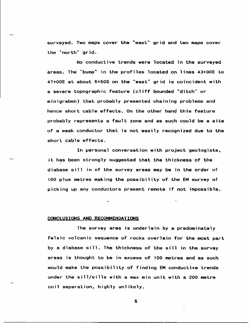
surveyed. Two maps cover the "east" grid and two maps cover
the "north" grid.
No conductive trends were located in the surveyed
areas. The "bump" in the profiles located on lines 43+OOE bo
47+OOE at about 6+50S on the "east" grid is coincident with
a severe topographic feature (cliff bounded "ditch" or
mini graben) that probably presented chaining problems arid
hence short cable effects. On the other hand this feature
probably represents a fault zone and as such could be a site
of a weak conductor that is not easily recognized due to the
short cable effects.
In personal conversation with project geologists,
it has been strongly suggested that the thickness of the
diabase sill in of the survey areas may be in the order of
100 plus metres making the possibility of the EM survey of
picking up any conductors present remote if not impossible.
CONCLUSIONS AND RECOMMENDATIONS
The survey area is underlain by a predominately
felsic volcanic sequence of rocks overlain for the most part
by a diabase sill. The thickness of the sill in the survey
areas is thought to be in excess of 100 metres and as such
would make the possibility of finding EM conductive trends
under the sill/sills with a max min unit with a 200 metre
coil separation, highly unlikely.
A EM survey that has sufficient penetrating
ability such as a pulse EM survey should be considered to
evaluated the volcanic sequence located under the diabase
sill areas of the property.
Detailed mapping and prospecting should be carried
out to better understand and evaluate the geophysical
results. A lithogeochemical survey of the volcanic sequence
of rocks, to outline any alteration halos present, should be
done to aid in evaluating the base metal potential of the
area.
Subsequent to the above recommendations, a drill
program should be considered to test any resulting target
areas.
Submitted by
6

S2H06SW0025 2.15871 WABIKON LAKE Q20
1587
WHOLE ROCK GEOCHEMISTRY
DATA RESULTS AND LOCATION MAP
WHISTLE LAKE EAST PROPERTY
WABIKON CLAIM MAP (G-773)
CUMBERLAND RESOURCES LTD.
JANUARY 4, 1995
FEB V ' r.r-
LI.MG Lz,NDS BRANCH

Jan 4, 1995
To: W. Mccrindle Fm: M.W.Leahey
REj Whole Rock Geochemistry
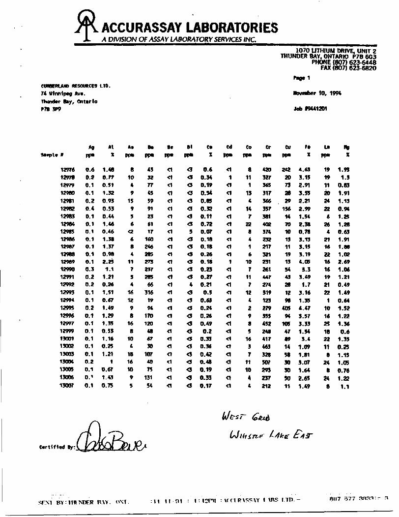
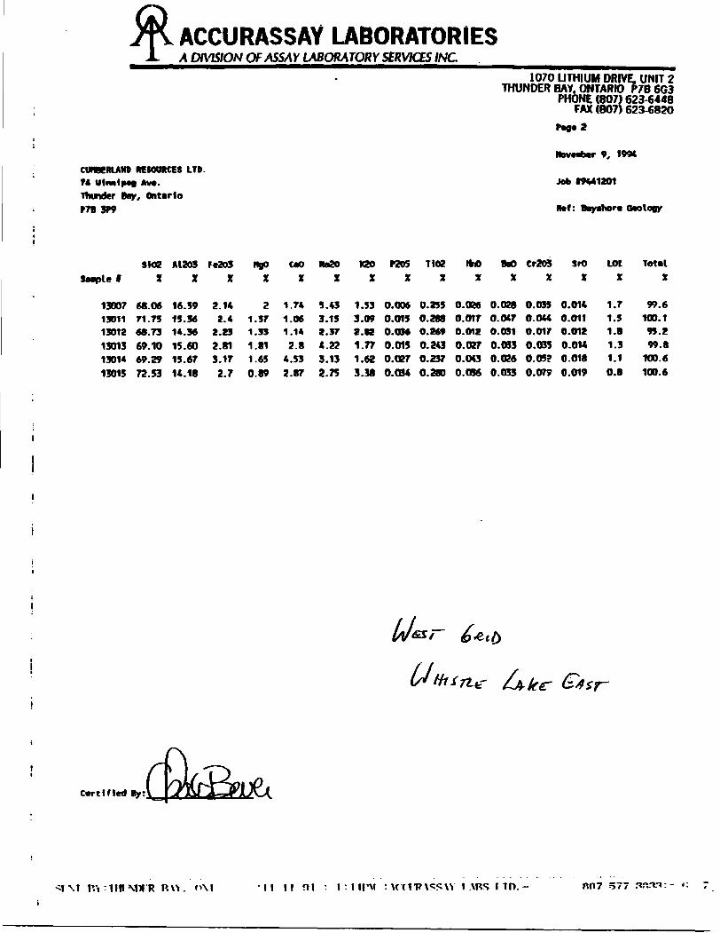
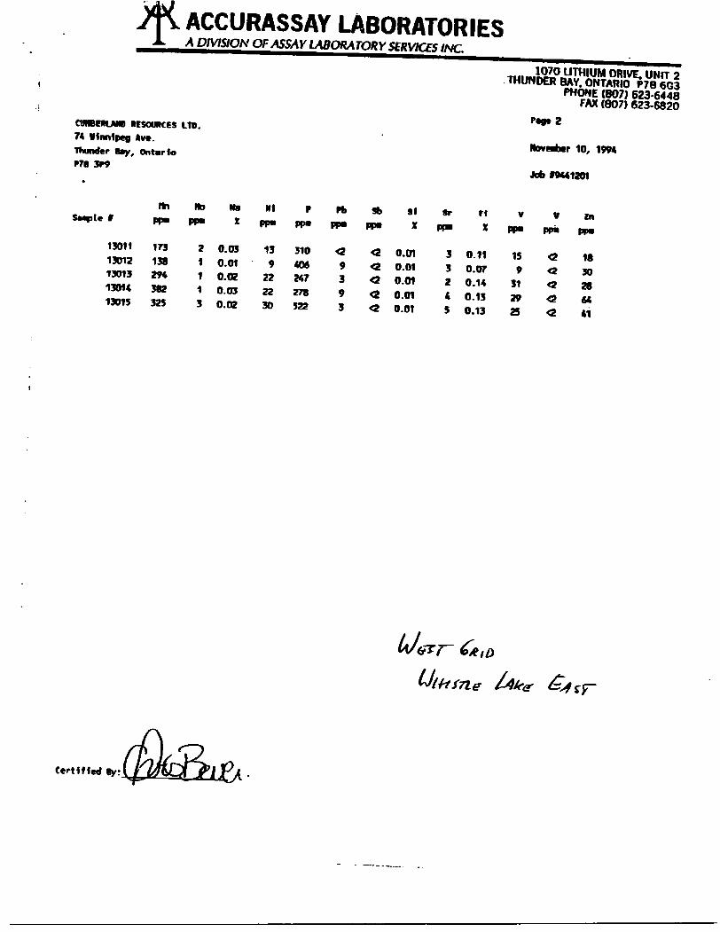
On the enclosed map, Figure 3, 74 whole rock sample locations were plotted on Cumberland's Whistle East property. The samples are -From both outcrop and float locations. This map is a compilation of the data from the 1994 reconnaissance geological mapping, the 1994 geological mapping of the West, the North and the East grids of the Whistle Lake East property. All analyses were undertaken by Accurassay Laboratories. The whole rock results +X- trace element values and a listing of the grid co-ordinates are presented in the attached appendix.
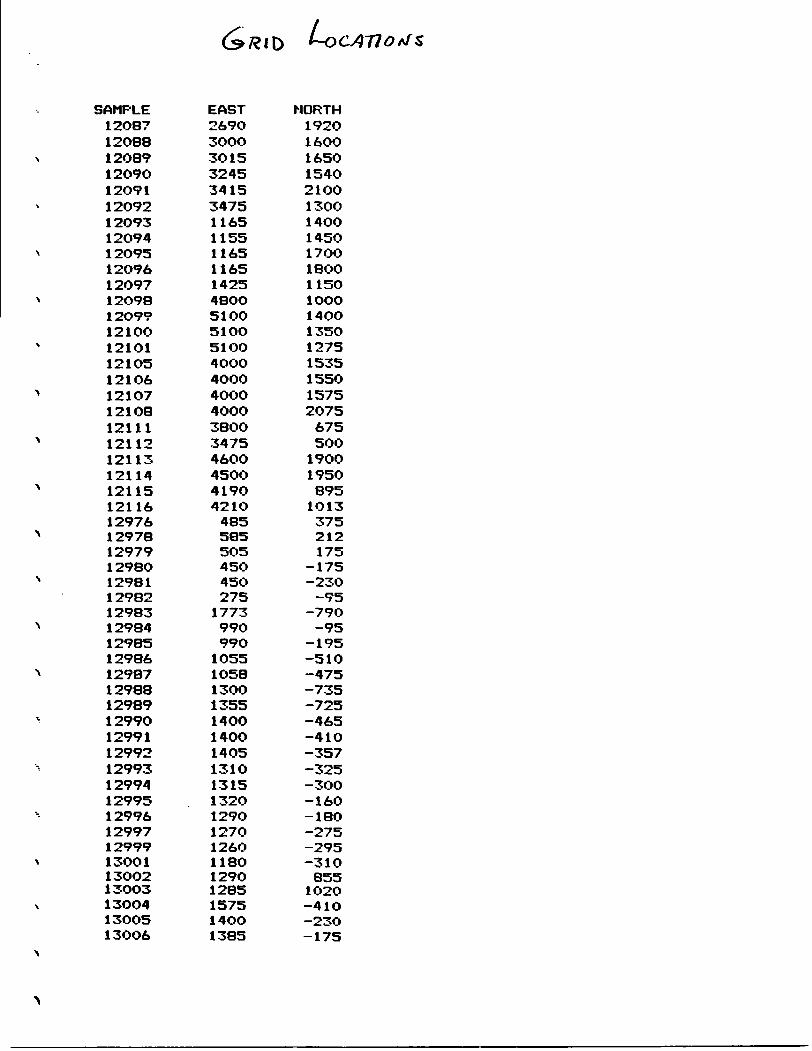
SAMPLE12O871208812O891209O120911209212O93120941209512096120971209812O99121OO121O1121O5121O612107121O81211112112121131211412115121161297612978129791298O1298112982129831298412985129861298712988129891299012991129921299312994129951299612997129991300113OO213O0313OO413OO513OO6
EAST269O300030153245341534751165115511651165142548OO51 OO510O51004OOO4000400O40003BOO3475460045OO4190421048558550545O45O275177399099O1055105813OO135514OO14OO1405131013151320129O1270126O118012901285157514OO1385
NORTH192016001650154021OO130014OO145017OO1800115O1OOO14OO135012751535155015752075675500190019508951013375212175
-175-23O-95
-79O-95
-195-510-475-735-725-465-410-357-325-300-16O-180-275-295-3108551O2O-41O-23O-175
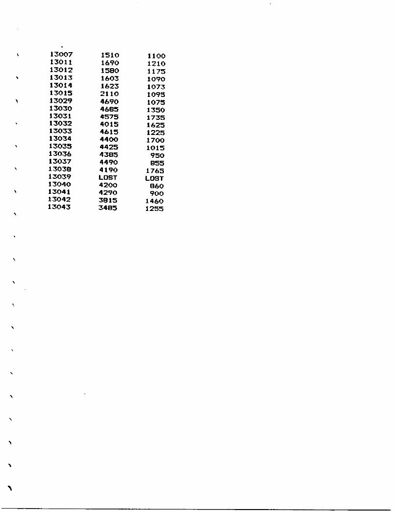
13007 1510 110013011 169O 121013012 1580 117513013 16O3 1O9O13014 1623 107313015 2110 109513029 469O 1O7513030 4685 135O13031 4575 173513032 4O15 162513033 4615 122513034 44OO 17OO13035 4425 1O1513036 4385 95O13037 449O 85513038 419O 176513039 LOST LOST13040 42OO 86O13041 4290 90013042 3815 146013043 3485 1255
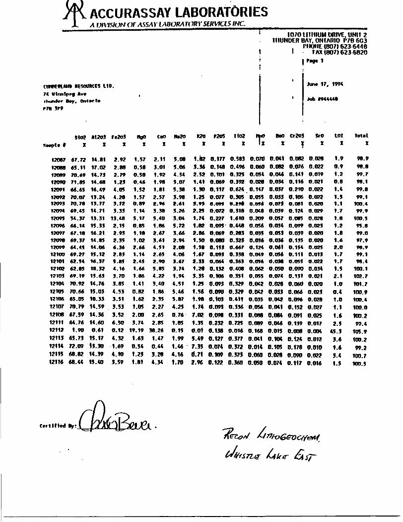
ACCURASSAY UBORATORIESA UI\1SION Of ASSAY IAOORA1ORY SERVICES INC.
CMffmAIIB RESOURCES LID.
74 ttlrmlprf Aw*thunder toy, Ontario
r 70 3r9
S 102
SMple 1 X
12087 67.72
12088 65.11
12089 TO. 6912090 71.83
12091 66.65
12092 70.0712093 70.7812094 69.45
12095 54.37
12096 66.14
12097 67.18
12O98 69.3713099 64.4512100 69.27121O1 62.54
12102 62.85
12103 #9.19
12104 70.92
121O5 70.66
121O6 65.05
12107 70.79
12108 67.59
12111 64.76
12112 1.90
12113 65.73
12114 72.09
12115 68.82
12116 68.44
A1203
X
14.81
17.02
14.7314.68
16.49
13.2413.7714.71
13.31
15.33
16.2114.8514.0615.1216.37
18.32
15.63
14.76
15.03
18.33
14.59
14.36
14.60
0.61
15.17
13.30
14.3915.40
Fe2o3X
2.92
2.88
2.79
1.23
4.05
4.283.72
3.33
13.48
2.15
2.93
2.356.362.835.894.16
3.70
3.85
4.533.513.533.526.500.124.32
1.694.103.59
t
HgO
x
1.57
0.58
0.58
0. 46
1.52
1.570.891.14
5.17
0.85
1.181.022.661.142.45
1.66
1.86
1.41
0.82
1.62
1.05
2.00
3.74
19.19
1.63
0.54
1.23
1.81
taoX
2.113.011.921.981.812.57C.9A3.385.40
1.86
2.673.614.512.652.90
5.85
4.22
3.40
1.86
2.35
2.272.652.85
38.261.470.44
3.284.34
Na20X
5.08
5.06
4.54
5.07
5.38
3.982.61
3.26
3.04
3.72
3.662.942.084.063.673.74
1.94
4.51
5.465.874.250.761.850.151.991.464.16
1.70
1 10/0 1 lil HUM DRIVE. UNIT 2THUNDER BAY. ONTARIO P/B 6G3
, PHONE (807) 623 64481 1 FAX (807) 623-6820i Fag* 11
June 17, 1994
1 Job *944448
K20 f 205 T 102 tM BaO Cr2Oj SrO LOI total
xxxlxxfxx x
1.82 0.177 0.583 0.070 0.041 0.082 0.028 1.9 98.9
3.36 0.148 0.496 0.060 0.082 0.076 0.022 0.9 98.8
2.52 0.101 0.325 0.054 O.O46 0.141 0.019 1.2 99.7
1.41 O.O69 0.392 0.028 O.O34 0.116 0.021 0.8 98.1
1.30 0.117 0.624 0.147 0.037 0.21O 0.022 1.4 99.8
1.25 0.077 0.305 0.055 0.033 0.106 0.022 1.5 99.19.99 O.OM 0.**8 O.M4 O.OfJ 0.081 O.O20 1.1 100.*2.25 0.072 0.318 0.0(8 0.039 0.124 0.029 .7 99.9
1.74 0.227 1.610 0.209 O.057 0.085 0.028 .8 100.5
1.82 O.O95 0.448 0.056 0.034 0.099 0.023 .2 95.8
2.86 0.069 0.283 0.035 O.053 O.039 0.020 .8 99.0
1.50 0.080 0.323 0.036 0.036 0.135 0.020 .6 97.91.58 0.153 0.667 0.124 0.061 0.154 O.O2S .O 98.91.67 0.093 0.338 O.O49 0.056 0.111 0.013 .7 99.12.33 0.064 0.363 O.O56 0.038 O.O55 O.O22 .7 98.4
1.28 0.132 0. 408 0.0*2 0.050 O.090 0.034 .5 100.1
3.35 O.106 0.351 O.O55 O.074 0.131 0.021 2.1 102.7
1.25 0.093 0.329 0.042 0.028 O.O60 0.020 1.0 101.7
1.56 0.090 0.329 0.042 0.033 0.066 0.023 0.4 100.91.98 0.103 0.411 0.035 0.042 0.096 0.028 1.0 1OD.4
1.74 0.093 0.336 0.056 0.041 0.152 0.027 1.1 100.0
7.02 0.098 0.331 0.088 0.084 0.091 0.025 1. 100.21.35 0.232 0.725 0.089 6.046 0.139 0.017 2. 99.40.01 0.138 0.016 0.168 0.015 0.008 0.004 45. 1O5.95.49 0.127 0.377 0.041 0.104 0.124 0.012 3. 100.2
7.35 0.074 0.372 0.014 0.105 0.178 0.010 1. 99.2d.7l 0.109 0.32) 0.060 0.028 0.090 0.022 3. 100.72.9ft 0.122 0.360 0.050 0.074 0.117 0.016 1. 100.5
Certified By:
M

L l O. Ui 17 o.
ACCURASSAY UBORATORIESX DMSION Of ASSAY LABORATORY SERVICES INC.
1070 UTHIUM DRIVE. UNIT 2THUNDER BAY. ONTARIO P7B 603
PHONE (807) 623-6448FAX (807) 623-6820
CUHBCHUMO RESOURCES LTD. 74 Winnipeg Avc. Thunder Bay, Ontario P7B 3P9
9, 1994
Job 19441201
Met: Bayshor* Saology
Saaple f
12976
12978
12979
12980
12981
12902
12983
12984
12985
1298*
12987
129M
12989
12990
1Z991
12992
12993
1299*
12993
12996
12997
12999
13001
13002
13003
1300*
13005
13006
sioex
65.07
68.40
TO. 90
68.82
62.36
68.72
69.70
68.06
72.9964.69
65.38
66.17
65.08
67.66
67.34
69.63
67.33
50. 0*
65.27
66.92
68.11
70.68
65.64
72.33
68.22
68.8072.7370.79
A1203X
12.9813.8212.6912.2113.7113.6612.2713.6712.4213.7813.8513.7013.0813.93U.3313.7213.6213.2*12.2714.0914.0213.8414.2114.3414.00
13.25
13.95
13.92
FC203X
7.214.494.4
5.474.824.322.383.89
1.2
4.89
4.&C
4.56
6.24
4.394.84
2.54.8412.15.884.74
4.76
2.24
4.83
1.62
2.78
4.232.384.16
ngoX
3.8
2.4
1.54
3.96
3.6
1.71
2.58
2.69
1.3
4.01
3.76
1.75
3.73
1.87
2.21
0.92
3.02
8.04
2.76
2.16
2.53
1.09
2.56
0.41
2.36
1.88
1.42
2.49
CaO
X
2.94
2.85
2.2
2.08
6.21
3.1T
0.8
3.37
1.26
2.61
3.4
3.6
1.69
3.73
3.37
2.67
2.76
10.26
1.96
3.13
3.85
2.66
2.98
2.7
2.77
2.98
i. K
3.79
NB20X
1.39
3.02
3.29
0.87
1.222.720.441.121.582.892.833.29
0.82
2.552.833.441.061.312.512.872.282.742.854.621.292.772.391.73
K20X
1.561.361.241.802.301.784. 452.883.021.211.841.713.651.771.841.443.220.991.461.651.962.081.A41.002.831.701.912.70
P205X
0.0190.0380.0270.0160.0330.0300.0140.0180.0010.034O.0280.0130.0230.06S0.0360.0220.0310.0210.0190.0260.0300.0010.0300.0120.0140.0290.0100.045
Hoex
0.4720.4680.4390.4070.4480,4800.2320.4380.0340.5240.4880.4670.4280.4900.5390.2490.5480.7310.4720.5310.5200.2090.5110.2860.2590.4370.2470.519
IhrtX
0.0890.0410.0430.0580.0870.0530.0260.0520.0250.0460.0420.0500.0500.0480.0480.0270.0730.1740.0410.0340.0540.0340.0400.0290.0380.0440.0220.046
BaOX
0.0220.0220.0220.0280.0250.0300.0440.0310.0260.0190.028O.OZ70.0290.0250.0280.0270.0420.0130.0180.0260.0310.0260.0190.0220.0270.0300.0270.030
Cr203X
0.122
0.0610.0700.0610.0700.0700.0700.0870.0520.0440.0440.0610.0520.0520.0790.0440.0610.0520.0520.0700.0870.0440.0790.079O.O910.0960.0320.052
SroX
0.0120.0130.0150.0090.0130.0150.0030.0100.0070.0130.0150.0190.0030.0090.0130.0160.0070.0110.0080.0120.0110.0190.0140.0260.0080.0150.0100.010
LDI
x
3.12.12.13.12.11.72.92.01.61.71.40.81.91.21.51.11.71.32.41.81.81.32.60.81.91.91.20.9
TotalX
98.8
99.1
99.0
98.9
97.2
98.5
95.9
98.3
95.5
96.5
97.7
96.2
98.8
98.0
99.0
95.8
98.3
98.3
95.1
98.1
100.0
97.0
97.6
98.3
96.6
98.2
99.2
101.2
Certified By fa.tee
ACCURASSAY LABORATORIESA DIVISION OF ASSAY LABORATORY SERVICES INC.
CUMBERLAND RESOURCES LTD. 74 Winnipeg Ava.
Thunder Bay, Ontario MB 3P9
1070 LITHIUM DRIVE, UNIT 2THUNDER BAY, ONTARIO P7B 603
PHONE (807) 623-6448FAX (807) 623-6820
rao.1
NbveMber 10, 1994
Job 19441201
f
12976129781297912980
129811298212983129841298512986129871298812989129901299112992129931299412995129961299712999130011300213003130041300513006
13007
A0
PP"
0.60.20.10.1
0.20.40.10.10.10.10.10.10.10.30.20.2
0.0.0.0.O.0.0.0.10.10.20.1O. 1
0.1
AtX
1.480.770.511.320.930.530.441.460.461.381.370.982.25
1.1
1.210.261.510.671.491.291.350.531.160.251.21
10.671.43
0.75
A*
PP"
81049
15
42
411754
161298
168
104
1816109
5
Bm
PP*
45327745
5991236117
16024628527323728566
3161994
170120486730
1074075
13154
Be
PP*
CI
rtrtCI
rtCI
rtrtrtrtrtrtrtrtrtrtrtrtrtrtrtrtrtrtrtrtrtrtrt
Bf
PP*
o4343
43
43
43
43
43
543
43
43
43
43
43
44343
43
43
43
43
43
43
434343
43
43
eax
0.60.340.190.540.850.320.110.720.070.180.180.260.180.230.270.210.5
0.630.240.260.490.2
0.330.36
0.420.480.19
0.330.17
CdPP*
rt1
rtCI
rtrtCI
rtrtrtrtrti
rtrtrtrtrtrtrtrtrtrtrtrtrtrtCI
rt
Co
PP*
a11i
134
147
22
8416
107
117
124
2
1
1110
44
crPP*
420
327365317366357381402374232217321231261447274319123279355452248417463328507293237212
CuPP"
242
2073
2829
156147010131119135443281298
40594in4789145830305011
r*x
4.633.152.913.552.21
2.991.542.380.783.133.153.194.053.3
3.491.7
3.161.334.47
3.573.331.543.4
1.091.813.071.642.651.49
LaPP"
191911202422
626
42116221616192122
11016251822118
248
248
"9X
1.931.3
0.831.911.130.941.251.280.631.911.881.022.691.061.210.491.490.641.521.221.360.6
1.350.251.131.050.761.221.1
Certified B/:
SPM BVrlinADER RAY. o\l. l : 12PM : \( C l R\SS\Y l \RS l TO. - 8117 57 :- n

JL A DIVISION OF ASSAY LABORATORY SERVICES INC.
RESOURCES LTD.
74 Winnipeg Ave. Thunder toy, Ontario P7B 3P9
1070 UTHIUM DRIVE. U' ' 2THUNDER BAY, ONTARIO P7B ,5
PHONE (607) 623-6448FAX (807) 623-6820
P*3t1
Novober 10, 1994
Job 19441201
i
1297612978129791298012981129821298312984129851298612987129881298912990129911299212993129941299512996129971299913001130021300313004130051300613007
NnPP*
Ml36934350939048226144122S392394487499462444277563194458369530352380190344439220330278
ItoPP*
322212112121213221213212116492
NBX
0.040.040.040.060.080.040.020.120.020.030.030.040.08O.OS0.080.020.1
0.080.030.040.070.020.040.03O.070.060.040.070.03
N1PP*
292315212124142682326282518271124362332321328232031122218
PPP*
587562476489602607313504155580606596499604632600609222538708675336608311351562356579247
PbPP*
2626253422231813410121819171681911610189871511171115
SbPP*
42424242^^9
^2K2424242424242424424242
424242424242424242
42
SIX
0.010.010.010.010.010.010.010.010.010.010.010.010.010.010.010.010.01O.OIO.OI0.01O.OI0.010.010.010.010.010.01O.OI0.01
SfPP*
97791571
172
1624735689473
Tl
X
0.30.220.2
0.190.180.210.020.150.020.2
0.250.280.290.260.280.110.250.080.250.236.220.120.210.080.110.210.110.230.14
VPP*
5334434394615399
6565585561742270365770611658272555224728
UPP*
4?
4242927542424242^5424242
144242422
4242
4242
242
4242
InPT*
70433035414322284
3439444662404846154132514525224329373528
certified By:
SfM RVillRNDER BAY. : M - 11 -94 V "l : -I5PM : ACCfRASSAY LABS LTD. - 807 57
in A r*r* nw i Anr*rm-rr\r*ir-r*
ACCURASSAY LABORATORIESA DIVISION OF ASSAY LABORATORY SERVICES INC
1070 LITHIUM DRIVE, UNIT 2THUNDER BAY. ONTARIO P7B6G3
PHONE (807) 623-6448FAX (807) 623-6820
Peg* 2
CUMBERLAND RESOURCES LT6. T* Wlnn1|Mt Av*. Thunder Bay, Ontario fTB 3P9
9, 1994
Job 19*41201
Ret: Bnyahor* Geology
Saaple l
13007 13011 15012 13013 1301*
SW2 A1203 Fe203 XXX
68.06 71.75 68.73 67.10 69.2?
16.5915.361*.36 15.60 15.67
2.142.4
2.232.813.17
ngoX
21.371.33
1.811.65
cao Ba2O X X
1.7* 1.06 1.1* 2.8
*.53
3.43 3.13 2.37 (.22 3.13
K20 X
1.53 3.09 2. K1.77 1.62
P205X
O.006 0.013 0.036 0.015 O.GZ7
T102X
0.255 0.288 0.269 0.2*3 0.237
feoX
0.026
0.017
0.012
0.027
0.0*3
BaO
X
0.028
0.0*7
0.031
0.033
0.026
Cr203 X
0.035 0.0(4 0.017 0.033 0.05?
SrOX
0.014 0.011 0.012 0.014 0.018
totx
1.7
1.5 1.8
1.3
1.1
Total
X
99.6
100.195.2
99.8
100.6
13015 72.53 14.18 2.7 0.89 2.87 2.75 3.38 0.034 0.280 0.036 0.033 0.079 0.019 0.8 100.6
tr bk
Certified By
q M p.i :iiir\nrR li 11 ni : rwci-pxssu i .\RS i in. - r.O7 577 HrtHr*:- i:
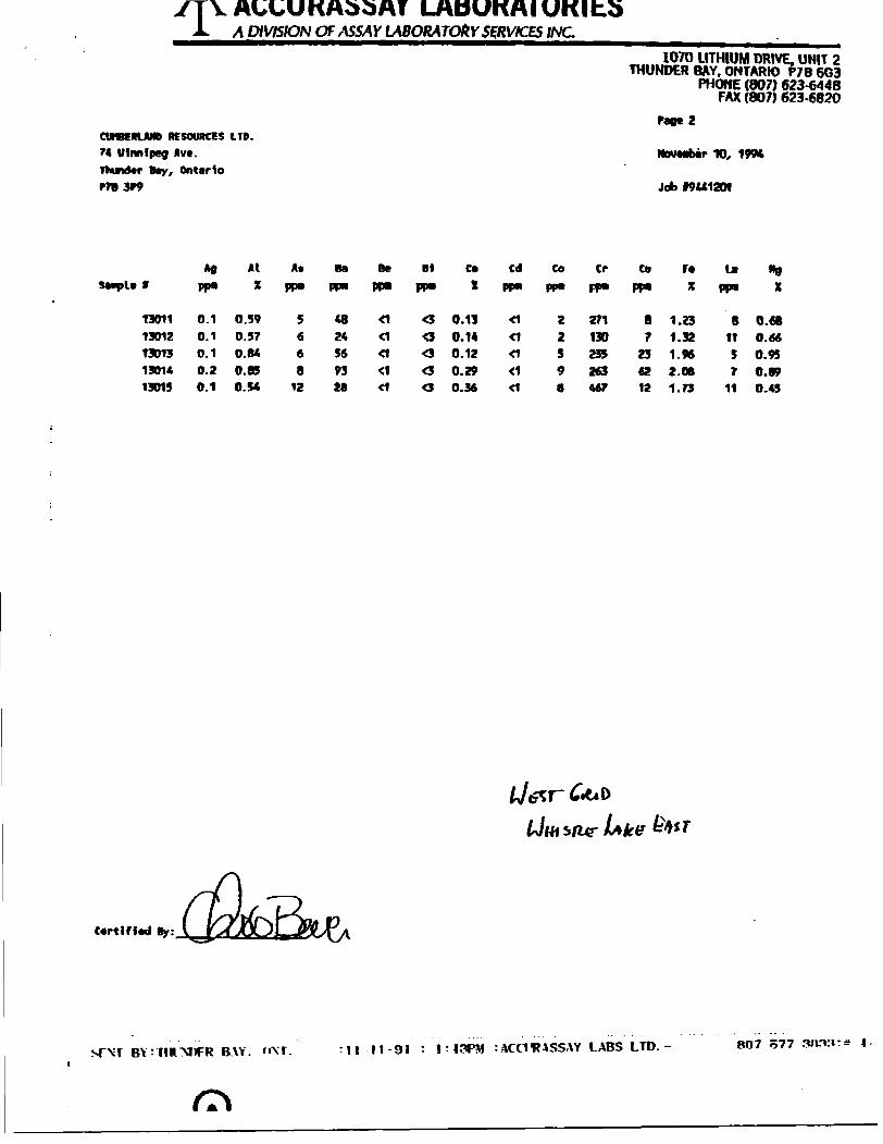
YTYAl,l,OKA55Ar LABORATORIESJL A DIVISION OF ASSAY LABORATORY SERVICES INC.
Tu,mlX70 LITHIUM "W*. UN" 2 THUNDER BAY. ONTARIO P7B 6G3
PHONE (807) 623-6448 FAX (807) 623-6820
Page 2CUHBCRIAMD RESOURCES LTD.
74 "*"*WI *"- Thunder Bay, OntarioP7B 3W
TO, 1W4
Job I9U1201
PP*
At
XA* Bf
13011130121301315014
0.10.10.10.2
0.390.570.840.85
5668
48245693
CaX
0.130.140.12
0.29
CdPP*
CI
CI
CI
tf
CO
pp*
2
259
CrPP*
271130235263
CoPP"
87
2362
r*x
1.231.321.962.08
UPP"
81157
"B
X
0.680.660.950.89
13015 0.1 O.S4 12 28 O 0.36 467 12 1./3 11 0.45
Certified
srxr B\Y. t*\r. n-oi :ACCIHASSAY LABS LTD.- BO? 577
ACCURASSAY LABORATORIESA DIVISION OF ASSAY LABORATORY SERVICES INC.
CUMBERLAND RESOURCES LTD. 74 IMmlpeg Av*. Thunder Ray, Ontcrlo PTB 3f9
1070 LITHIUM DRIVE. UNIT 2 THUNDER BAY. ONTARIO P7B 603
PHONE (807) 623-6448 FAX (807) 623-6820
rage Z
NovMter 10, 199*
Job 19441201
Nt Si
XT1
X
13011 13012 13013 13014 13015
173 138 294 382 325
2 11 13
0.03 0.01 0.02 0.03 0.02
13 9
22 22 30
310 406 247 278 522
42 9 3 93
42 O.O1G 0.01 42 0.01 *2 0.01 42 0.01
3 32 4 5
0.11 0.07 0.14 0.13 0.13
15 9
31 29 25
in
183028
64
41

ACCURASSAY LABORATORIESA DIVISION OF ASSAY LABORATORY SERVICES INC.
1070 LITHIUM DRIVE. UNIT 2THUNDER BAY. ONTARIO P7B 663
PHONE (807) 623-6448FAX (807) 623-6820
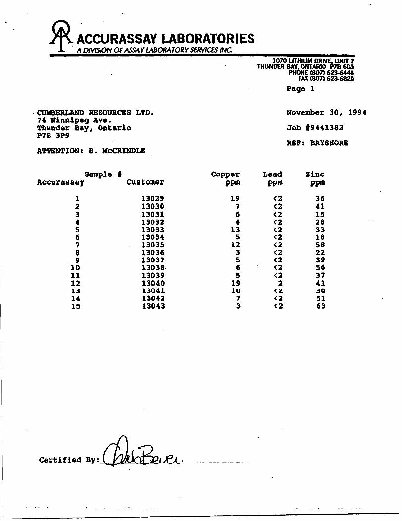
Page l
CUMBERLAND RESOURCES LTD. 74 Winnipeg Ave. Thunder Bay, Ontario P7B 3P9
ATTENTION: B. MCCRINDLE
November 30, 1994
Job 19441382
REP: BATSHORE
Sample i Accurassay Customer
123456789
101112131415
130291303013031130321303313034130351303613037130381303913040130411304213043
Copper ppm
19764
135
123565
191073
Lead ppra
<2
tttt2
tt tt
Zinc ppra
364115283318582239563741305163
Certified By s

ACCURASSAY LABORATORIESA DIVISION OF ASSAY LABORATORY SERVICES INC
CWBERlAm HESOUICES LTD. 74 Ufmlpcg Av*. Thunder B*y, enterlo P7B 3F9
1070 LITHIUM DRIVE. UNIT 2THUNDER BAY, ONTARIO P78 6G3
PHONE (007) 623-6448FAX (807) 623-6820
Pigtl
November 30, 1594
Job K441382
KEF: BAYSHOtt
SanpU ff
13029.' 13030
1303113032
1303313034
: 13033
i 13036
i 13037
j 13038130391304013O411304213043
3102
X
69.3570.35
68.3268.9469.89
67.60
69.3871.14
72.3167.76
67.7164.9573.2669.2271.81
A1203
X
16.5914.43
13.6814.56
14.30
14.46
14.3514.10
15.0914.96
14.8517.1514.3914.6315.57
F0203
X
3.262.63
2.312.58
2.94
2.54
3.352.52
2.64.15
2.513.572.163.663.22
flgO
X
1.061.84
4.151.531.97
3.15
1.391.14
0.861.97
0.881.720.861.361.6
CaO
X
1.68
2.35
1.582.97
4.84
0.85
2.691.58
2.93.28
2.353.231.453.451.89
Ha20
X
3.593.87
3.113.92
2.67
3.08
2.434.64
2.212.65
3.724.064.323.314.17
K20
X
2.121.78
3.182.23
1.19
4.84
2.351.72
1.632.26
2.171.261.862.001.81
P205
X
0.0320.078
0.0730.019
0.0660.100
0.020
0.029
0.0470.043
0.0470.0790.0100.0380.055
T102
X
0.2150.255
0.2940.313
0.2960.304
0.2690.267
0.3120.312
0.3070.3670.2060.3090.283
HnO
X
0.013
0.057
0.0150.027
0.0450.012
0.0340.021
0.0370.035
0.0370.0(90.0150.0620.031
BsO
X
0.0210.026
0.0420.032
0.022
0.081
0.0340.025
0.0260.025
0.037O.OJ20.0220.0300.024
Cr203
X
0.0480.238
0.1200.106
0.0450.128
0.0420.150
0.0820.119
0.0530.1010.0360.1250.043
SrO
X
0.0490.014
0.0200.0380.043
0.027
0.081
0.056
0.068
0.0560.0680.0770.0690.0690.058
toiX
1.2
1.4
2.21.21.4
1.9
2.11.2
1.1
1.21.41.30.91.41.3
Total
X
99.299.5
99.1
98.599.7
99.1
98.7
98.6
99.398.8
96.1100.O99.699.799.8
Certified B'
SENT BY:THUNDER BAY. ONT. : i- 3-95 :in:i?AM :ACCII?ASSAY LABS LTD.- 807 577 3833:* 3/ 3
52H06SW002S 2.15871 WABIKON LAKE 030
GEOLOGICAL MAPPING OF THE NORTH AND EAST GRIDS
ON THE 2.15871WHISTLE LAKE EAST PROPERTY
OF
CUMBERLAND RESOURCES LTD.
AND
INTERNATIONAL VESTOR RESOURCES LTD.
THUNDER BAY MINING DIVISION
WABIKON LAKE AREA
DECEMBER 30, 1994 BAYSHORE GEOLOGY INC.
NTS: 52 H 6 MICHAEL W. LEAHEY
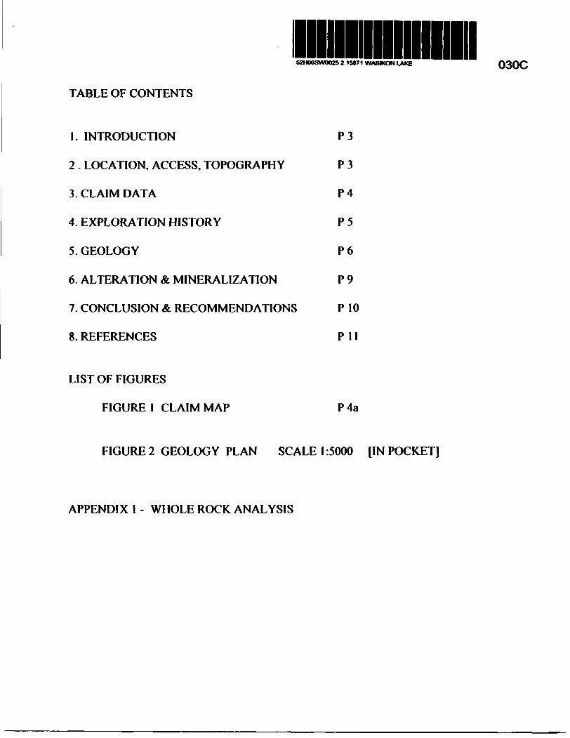
l52H06SW0025 2.15871 WABIKON LAKE 030C
TABLE OF CONTENTS
I. INTRODUCTION P 3
2 . LOCATION, ACCESS, TOPOGRAPHY P 3
3. CLAIM DATA P 4
4. EXPLORATION HISTORY P 5
5. GEOLOGY P 6
6. ALTERATION St MINERALIZATION P 9
7. CONCLUSION A RECOMMENDATIONS P IO
8. REFERENCES P 11
LIST OF FIGURES
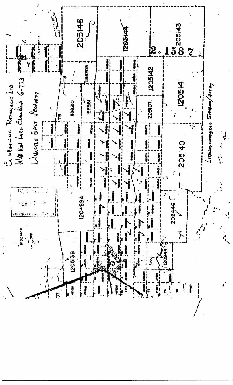
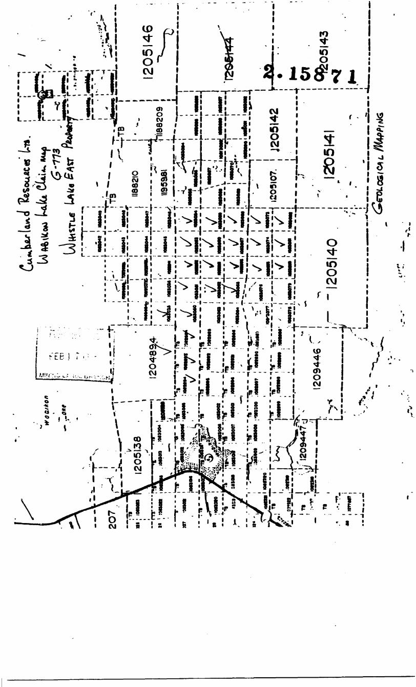
FIGURE l CLAIM MAP P 4a
FIGURE 2 GEOLOGY PLAN SCALE 1:5000 [IN POCKET]
APPENDIX I - WHOLE ROCK ANALYSIS

l INTRODUCTION
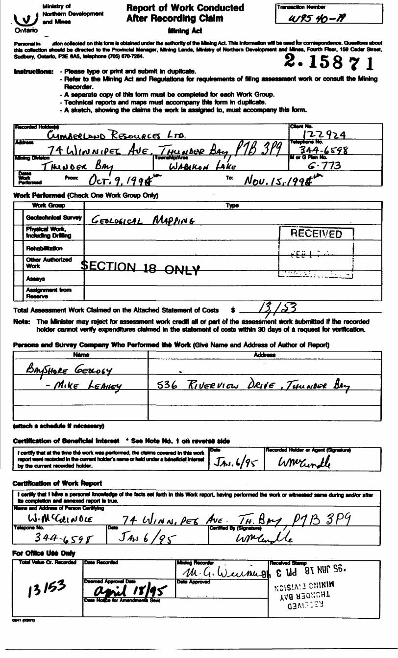
This report describes the results from the fall 1994 mapping on the Whistle Lake North and East grids on claims owned by Cumberland and International Vestor Resources Ltd. to determine the base metal potential of the property. The report is prepared to meet assessment requirements. The North grid is defined as Lines 2000E to 2900E from 1900N to 2800N; the East grid runs from 3500E to 3800E between l DOON to l SOON and 3900E to 4700E from 100S to l SOON. Bayshore Geology Inc. was contracted by Cumberland Resources Ltd., the operator, to conduct the geological mapping program.
The fieldwork was begun in October and completed November 15, 1994 and is the follow-up program of grid line cutting, ground EM and detailed geological mapping as recommended in the September 30, 1994 report by the author. Prospecting and mapping was undertaken on the grid with the data plotted at a scale of l :5000. 15 rock samples were collected and forwarded to Accurassay Laboratories for whole rock and trace element analyses. Sample results are included in Appendix l. The results of the HLEM ground surveys on these grids are the basis of a separate report by Phantom Exploration Services Ltd.
2 LOCATION, ACCESS, TOPOGRAPHY
The Cumberland Resources Ltd.'s property is located some 125 kilometers north of Thunder Bay. Road entry is gained to the south end of the claims by old logging roads off the forestry access road between Dubroy and Ollett Lakes, four kilometers east of Highway 527. Access to the East grid is gained by foot from the replanted area at the south end of L2200E at 200S. Road access to the North grid of the claim block can be gained from the logging road that skirts the south end of Wabikon Lake 1.6 kilometers east of Highway 527. This road enters the grid on L2000E at 2200N. The topographically low areas of the grids are wet, cedar and alder covered; the higher ground is a mixed forest of spruce, balsam fir and poplar with moose maple and tag alder undergrowth. Maximum relief on the grids is 98 meters, from a low of 415 to the height of land between Ollett and Lever Lakes on the grid at 513 meters.
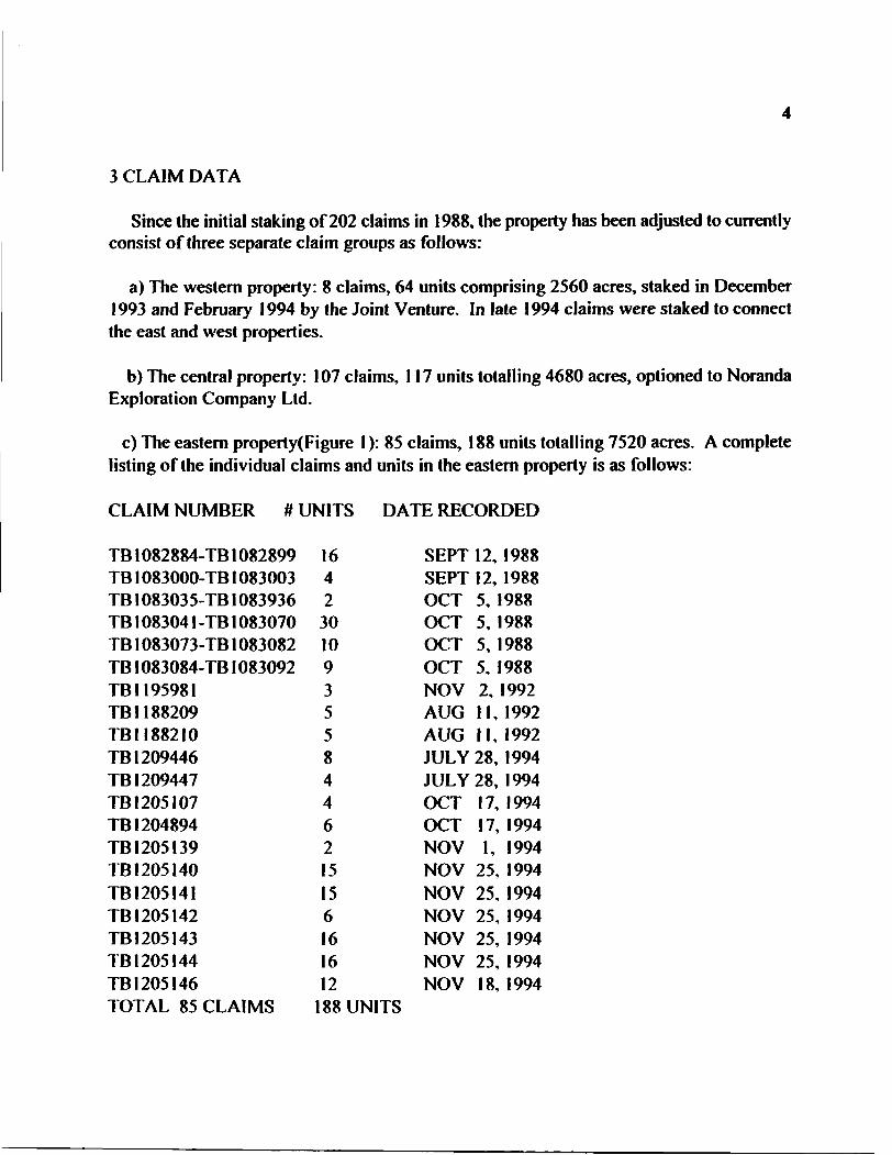
3 CLAIM DATA
Since the initial staking of 202 claims in 1988, the property has been adjusted to currently consist of three separate claim groups as follows:
a) The western property: 8 claims, 64 units comprising 2560 acres, staked in December 1993 and February 1994 by the Joint Venture. In late 1994 claims were staked to connect the east and west properties.
b) The central property: 107 claims, 117 units totalling 4680 acres, optioned to Noranda Exploration Company Ltd.
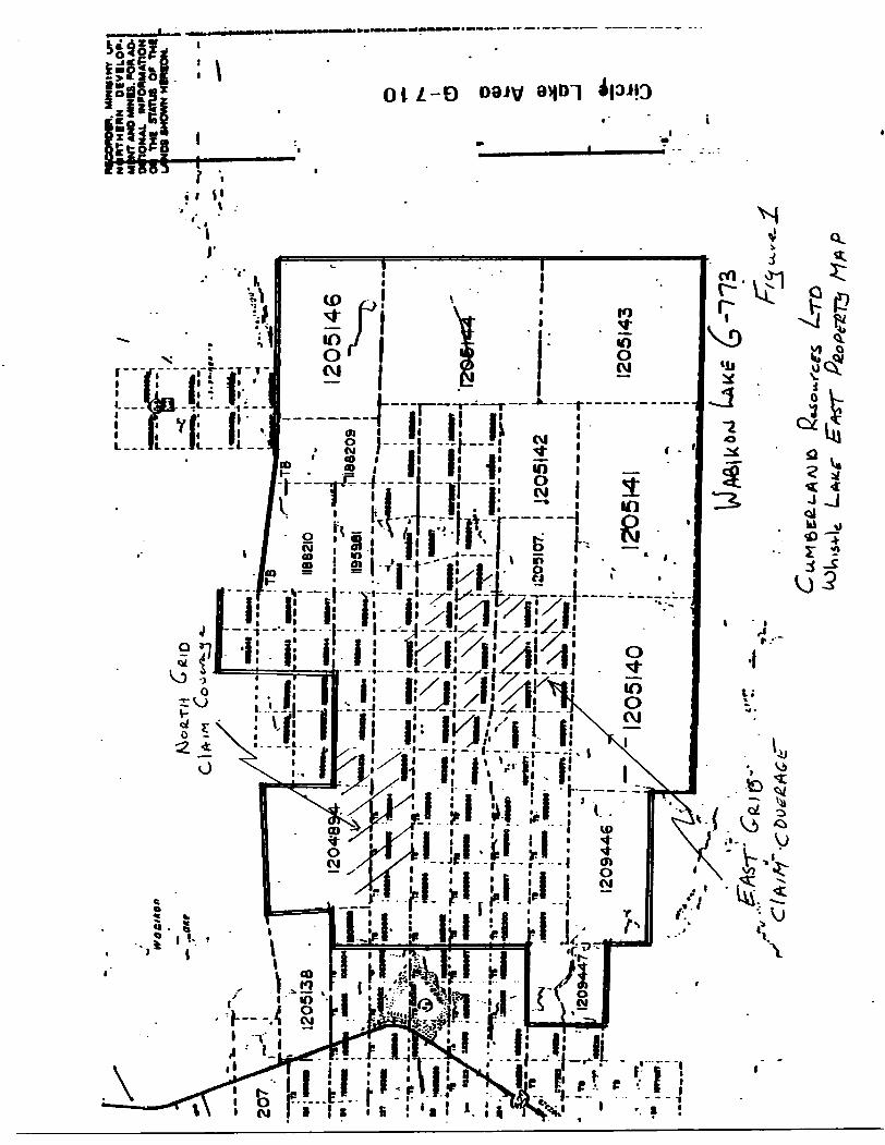
c) The eastern property(Figure 1): 85 claims, 188 units totalling 7520 acres. A complete listing of the individual claims and units in the eastern property is as follows:
CLAIM NUMBER # UNITS DATE RECORDED
TB1082884-TB1082899 16TB1083000-TB1083003 4TB1083035-TB1083936 2TB1083041-TB1083070 30TB1083073-TB1083082 10TB1083084-TB1083092 9TB1195981 3TB 1188209 5TB1188210 5TB 1209446 8TB 1209447 4TB1205107 4TB 1204894 6TB1205I39 2TB1205140 15TB1205I41 15TB 1205142 6TB1205143 16TB1205144 16TB 1205146 12TOTAL 85 CLAIMS 188 UNITS
SEPT 12, 1988 SEPT 12, 1988 OCT 5, 1988 OCT 5, 1988 OCT 5, 1988 OCT 5, 1988 NOV 2, 1992 AUG M, 1992 AUG 11,1992 JULY 28, 1994 JULY 28, 1994 OCT 17, 1994 OCT 17, 1994 NOV l, 1994 NOV 25, 1994 NOV 25, 1994 NOV 25, 1994 NOV 25, 1994 NOV 25, 1994 NOV 18, 1994
\ x—
v—. ;
M.;.
M'^
JM
B
*
M^
Wi M
M M
4*L
* ** r*"^
"
:i.
i -
2031
07.
J205
I42
Ofl
ON
AL
IN
FO
RM
AT
ION
T
HE
ST
ATU
S O
P
TH
Iut
xos
SHOW
NMIN
W1M
V
UP
08V
ILO
P-
NT
AN
D M
INIS
. P
OM
AO
-
l O o O) o o 13 w O
L*tL
f E
~*S
T
The claims are owned 50*^6 by Cumberland Resources Ltd. and 50*54 by International Vestor Resources Ltd. (the Joint Venture). The registered owner and operator of the property is Cumberland Resources Ltd. The claims are shown on the Wabikon Lake (G-773) mapsheet (Figure l) in the Thunder Bay, Mining Division.
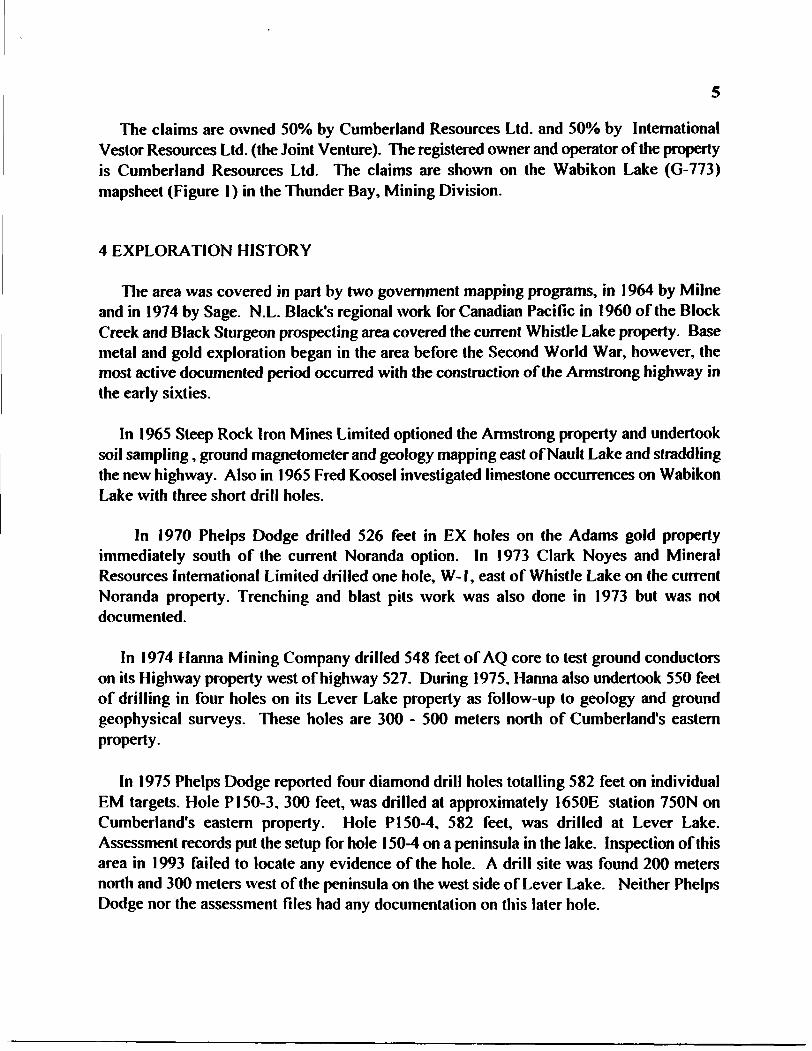
4 EXPLORATION HISTORY
The area was covered in part by two government mapping programs, in 1964 by Milne and in 1974 by Sage. N.L. Black's regional work for Canadian Pacific in 1960 of the Block Creek and Black Sturgeon prospecting area covered the current Whistle Lake property. Base metal and gold exploration began in the area before the Second World War, however, the most active documented period occurred with the construction of the Armstrong highway in the early sixties.
In 1965 Steep Rock Iron Mines Limited optioned the Armstrong property and undertook soil sampling, ground magnetometer and geology mapping east of Nault Lake and straddling the new highway. Also in 1965 Fred Koosel investigated limestone occurrences on Wabikon Lake with three short drill holes.
In 1970 Phelps Dodge drilled 526 feet in EX holes on the Adams gold property immediately south of the current Noranda option. In 1973 Clark Noyes and Mineral Resources International Limited drilled one hole, W-1, east of Whistle Lake on the current Noranda property. Trenching and blast pits work was also done in 1973 but was not documented.
In 1974 Hanna Mining Company drilled 548 feet of AQ core to test ground conductors on its Highway property west of highway 527. During 1975, Hanna also undertook 550 feet of drilling in four holes on its Lever Lake property as follow-up to geology and ground geophysical surveys. These holes are 300 - 500 meters north of Cumberland's eastern property.
In 1975 Phelps Dodge reported four diamond drill holes totalling 582 feet on individual EM targets. Hole P150-3, 300 feet, was drilled at approximately I650E station 750N on Cumberland's eastern property. Hole P150-4, 582 feet, was drilled at Lever Lake. Assessment records put the setup for hole 150-4 on a peninsula in the lake. Inspection of this area in 1993 failed to locate any evidence of the hole. A drill site was found 200 meters north and 300 meters west of the peninsula on the west side of Lever Lake. Neither Phelps Dodge nor the assessment files had any documentation on this later hole.
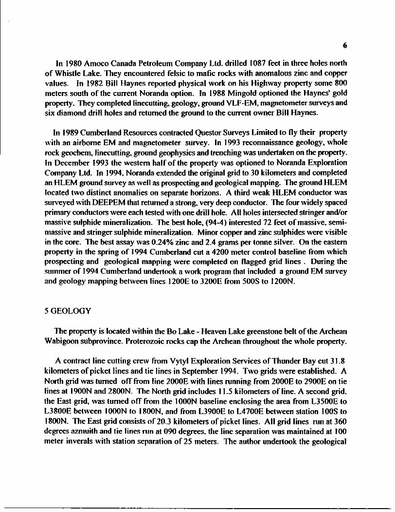
In 1980 Amoco Canada Petroleum Company Ltd. drilled 1087 feet in three holes north of Whistle Lake. They encountered felsic to mafic rocks with anomalous zinc and copper values. In 1982 Bill Haynes reported physical work on his Highway property some 800 meters south of the current Noranda option. In 1988 Mingold optioned the Haynes1 gold property. They completed linecutting, geology, ground VLF-EM, magnetometer surveys and six diamond drill holes and returned the ground to the current owner Bill Haynes.
In 1989 Cumberland Resources contracted Questor Surveys Limited to fly their property with an airborne EM and magnetometer survey. In 1993 reconnaissance geology, whole rock geochem, linecutting, ground geophysics and trenching was undertaken on the property. In December 1993 the western half of the property was optioned to Noranda Exploration Company Ltd. In 1994, Noranda extended the original grid to 30 kilometers and completed an HLEM ground survey as well as prospecting and geological mapping. The ground HLEM located two distinct anomalies on separate horizons. A third weak HLEM conductor was surveyed with DEEPEM that returned a strong, very deep conductor. The four widely spaced primary conductors were each tested with one drill hole. All holes intersected stringer and/or massive sulphide mineralization. The best hole, (94-4) interested 72 feet of massive, semi- massive and stringer sulphide mineralization. Minor copper and zinc sulphides were visible in the core. The best assay was G.24% zinc and 2.4 grams per tonne silver. On the eastern property in the spring of 1994 Cumberland cut a 4200 meter control baseline from which prospecting and geological mapping were completed on flagged grid lines . During the summer of 1994 Cumberland undertook a work program that included a ground EM survey and geology mapping between lines 1200E to 3200E from 500S to 1200N.
5 GEOLOGY
The property is located within the Bo Lake - Heaven Lake greenstone belt of the Archean Wabigoon subprovince. Proterozoic rocks cap the Archean throughout the whole property.
A contract line cutting crew from Vylyl Exploration Services of Thunder Bay cut 31.8 kilometers of picket lines and tie lines in September 1994. Two grids were established. A North grid was turned off from line 2000E with lines running from 2000E to 2900E on tie lines at 1900N and 2800N. The North grid includes 11.5 kilometers of line. A second grid, the East grid, was turned off from the 1000N baseline enclosing the area from L3500E to L3800E between 1000N to l SOON, and from L3900E to L4700E between station 100S to l SOON. The East grid consists of 20.3 kilometers of picket lines. All grid lines run at 360 degrees azmuith and tie lines run at 090 degrees, the line separation was maintained at 100 meter inverals with station separation of 25 meters. The author undertook the geological
mapping and lithogeochemical sampling of the property.
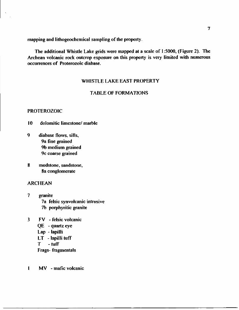
The additional Whistle Lake grids were mapped at a scale of l :5000, (Figure 2). The Archean volcanic rock outcrop exposure on this property is very limited with numerous occurrences of Proterozoic diabase.
WHISTLE LAKE EAST PROPERTY
TABLE OF FORMATIONS
PROTEROZOIC
10 dolomitic limestone/marble
9 diabase flows, sills, 9a fine grained 9b medium grained 9c coarse grained
8 mudstone, sandstone, 8a conglomerate
ARCHEAN
7 granite7a felsic synvolcanic intrusive 7b porphyritic granite
3 FV - felsic volcanic QE - quartz eye Lap - lapilli LT -lapilli tuff T -tuff Frags- fragmentals
l MV - mafic volcanic

8
Unit 1 . mafic volcanics, consists of fine grained dark green to black mafic volcanic flows. In outcrop vague pillow selvages and rims can be seen. The outcrops are often sheared and foliated with local gneissic character development, foliation trends 250 degrees with a 48 degrees north dip. Near to the granite contact a number of pegmatite dykes and dykelets stope into the mafic volcanics. The contact with the granitoid rocks is often baked and bleached. Exposure of the mafic unit is restricted to the North grid near the logging road from 2300N to 2800N. Two exposures of larger granitoid dykes occur 200 meters south of the main granite supracrustal contact. Glacial striations on the mafic volcanics trend 240 degrees.
Unit 3, felsic volcanics, occur as four outcrop or rubble areas between 1400N to 1 700N on lines 4000E to 4700E and as numerous float boulders on the East grid. The outcrop consists of laminated felsic tuff trending 100 to 1 25 degrees with north dips from 20 to 40 degrees . The felsics are usually light gray to greenish gray in colour and occur as tuff, lapilli tuff and coarse fragmentals. Quartz eyes are quite prominent in the unit, most are ^mm in size. Alteration seen in outcrop and float consisted of hematite (orthclase feldspar), weak sericite and locally biotite. The majority of the North and East grids are no doubt underlain by felsic volcanic stratigraphy, but covered by a Proterozoic cap of diabase except in the northeast corner of the East grid where glaciation has removed the cover rocks or the diabase thins out or was not deposited and provided a window through the Proterozoic. An area of numerous felsic float boulders occurs across the East grid from L4000E to 4700E from SOON to 1200N on top of diabase outcrop. The boulder train source is assumed to be felsic supracrustal to the northeast.
Unit 7, granite, is medium to coarse grained . The granite has ^5*^ potash feldspar as the total feldspar and >10% quartz. There are a number of round granite boulders of various sizes on the property.
Unit 7a, felsic synvolcanic intrusive, is similar in appearance to unit 3, but contains large euhedral quartz crystals ^mm and white or blue in colour. It may be a porphyry phase of the felsic volcanics or a synvolcanic intrusive. Unit 7a was found only on the west grid-
Unit 7b, porphyritic granite occurs as a pink granite similar in composition to Unit 7 but with 10- 20*54 large orthclase phenocrysts that vary in size from 2-4cm. The granitoid rock is well exposed near the road on the North grid in large outcrops and in contact with Unit l . As the granite forms dykes it becomes coarse grained pegmatite with a simple feldspar and quartz composition.
Unit 8a. conglomerate consists of a heterlothic mixture of granite and porphyries clasts in a fine matrix of sandstone or mudstone. The float exposure of this unit is deeply weathered and friable. There are only a few occurrences of this unit on the East grid.
Unit 9 is the Proterozoic diabase. Some 95"^o of the outcrop and float on the grid consists of diabase. The unit has a brown chocolate to green concentric weathered surface. The fresh rock is dark to black and composed of calcic plagioclase and pyroxene. The texture varies from fine grained

through medium grained to coarse grained with the majority as coarse grained. Individual sills or flows were not seen in the field nor was the Archean/Proterozic contact exposed. Most of the diabase on the grids is coarse grained and outcrops as steep sided to flat lying outcrop. From the deeply incised valley south of 600S on the East grid it is speculated that the diabase cap thickens to at least 100m in this area.
Unit 10, the dolomitic limestone/marble unit was not encountered on either grid.
6. ALTERATION AND MINERALIZATION
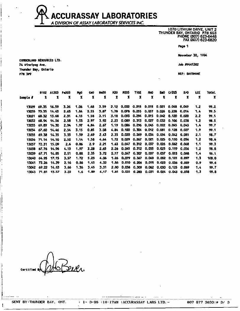
On the East grid visual alteration consisted of a few outcrop exposures of hematitized felsic volcanics. For the fifteen felsic volanic samples collected on the grids an Ishikavvi index was calculated and plotted at the sample site(Figure 2). The index is determined by the following formula (^O+MgOVtFaO+MgO+CaO+NAZOJx 100. Two sample sites 13031 and 13034 returned moderately altered indices of 61 and 67 respectively, the remaining sites give background values in the low 30's. All whole rock data and trace element results are presented in Appendix l. Previous alteration in the few felsic volcanic outcrops on the Whistle Lake grid consists of weak sericite development, local biotite and silicification. Mineralization consists of trace amounts of disseminated chalcopyrite and pyrite.
Assessment drill hole P150-3 was logged as being altered, chloritized at the top. silicified with depth and locally the development of blue corderite? spots with blue quartz fragments and sericite. Garnets are reported from the top of the sulphide horizons.
Mineralization reported in the log for hole P150-3 consists of 20 feet of massive sulphides (po and py), plus banded and stringer type mineralization. Drill hole PI 50-4 reported a thick sulphide zone from 332 feet to the bottom of the hole at 582 feet. Generally, the zone consists of stringers and banded sulphides (po, py) with magnetite. The sulphide zone is capped by cherty metasediments. Generally the sulphide content of the zone increases with depth and the magnetite component decreases.
The log from hole P150-3 suggests an altered felsic volcanic stratigraphy hosting sulphide mineralization. This hole probably correlates with the stratigraphy reported in the log of hole W-1 at the west end of the property optionned to Noranda. The log from hole P150-4 suggests this is the top of the volcanic pile representing a total felsic thickness of 1600 meters.
10
7. CONCLUSION AND RECOMMENDATIONS
In the current geological survey a window of felsic volcanic stratigraphy has been defined on the East grid. Alteration similar to that encountered in the previous grid work has also been noted. Encouraging DEEPEM results were returned through thick diabase cover by Noranda in the western felsic stratigraphy and a number of weak deep airborne EM trends remain to be investigated through DEEPEM and diamond drilling. Two moderately altered Ishikawi indices were returned from sampled felsics which may be indicative of pipe-like alteration below a massive VMS horizon.
Michael W. Leahey
H
8 REFERENCES
Franklin JM et al 1982 A Proterozoic Geology of the Northern Lake Superior Area, Field Trip Guide Book #4 G AC/MAC, 71 p.
Jensen LS 1976 A New Cation Plot for Classifying SubalkalicVolcanic Rocks, Ontario Divison of Mines, MP66, 22p.
Milne VC 1964 Geology of the Garden Lake Area, District of Thunder Bay, ODM, GR 25, 21 p.. Map 2058
Sage R et al 1974 Operation l gnance-Armstrong, Obango Lake, Lac des Iles Sheet, District of Thunder Bay, ODM Preliminary P963.
Various Assessment Reports, Thunder Bay Mining Divison
Various Internal Reports, Cumberland Resources Ltd.
12
APPENDIX 1:
LITHOGEOCHEM ANALYSIS
TRACE ELEMENT ANALYSIS
ACCURASSAY LABORATORIESA DIVISION OF ASSAY LABORATORY SERVICES INC.
CUMBERLAND RESOURCES LTD. 74 Winnipeg Aw*. Thundtr Bay, Ontario P7B 3P9
1070 LITHIUM DRIVE, UNIT 2THUNDER BAY, ONTARIO P7B 6G3
PHONE (807) 623-6448FAX (807) 623-6820
Pag*1
November 30, 1596
Job 49441382
REF: BAYSHORE
3102 A1203Savple 1 X X
i
! 13029 69.35 16.59: 13030 70.35 14.43
13031 68.32 13.68j 13032 68.94 14.56j 13033 69.89 14.30j 13034 67.60 14.46' 13033 69.38 14.35I 13036 71.14 14.10
13037 72.31 15.0913038 67.76 14.96
i 13039 67.71 14.85i 13040 64.95 17.15; 13041 73.26 14.39
: 13042 69.22 14.63' 13043 71.81 13.57
F*203X
3.262.632.312.582.942.543.352.522.6
4.152.513.572.163.663.22
HgOX
1.061.844.151.531.973.151.391.140.861.970.881.720.861.361.6
tooX
1.682.551.582.974.840.852.691.582.9
3.282.355.231.453.451.89
NaZOX
3.593.873.113.922.673.082.434.642.212.653.724.064.323.314.17
K20X
2.121.783.182.231.194.842.351.721.632.262.171.261.862.001.81
P205 T102X X
0.032 0.2150.078 0.2550.093 0.2940.089 0.3130.086 0.2960.100 0.3040.020 0.2690.029 0.2670.047 0.3120.045 0.3120.047 0.3070.079 0.3670.010 0.2060.038 0.3090.03S 0.283
nnoX
0.0150.0570.0150.0270.04S0.0120.0340.0210.0370.0350.0370.0490.0150.0620.031
BaoX
0.0210.0260.0420.032O.OZ20.0810.0340.0250.0260.0250.0370.0320.0220.0300.024
Cr203X
0.0480.2380.1200.1060.0450.1280.0420.1500.0620.1190.0530.1010.0360.1250.043
SrOX
0.0490.0140.0200.0380.0430.0270.0810.0560.0680.0560.0680.0970.0690.0690.058
LOIX
1.21.42.21.2I.*1.92.11.21.11.21.41.30.91.41.3
TotalX
99.299.599.198.599.799.198.798.699.398.896.1
100.099.699.799.8
Certified B:
SENT BY:THUNDER BAY. ONT. : l- 3-95 :10:17AM :ACCURASSAY LABS LTD.- 807 577 3833:* 3/ 3
ACCURASSAY LABORATORIESA DIVISION OF ASSAY LABORATORY SERVICES INC.
1070 UTHIUM DRIVE. UNIT 2THUNDER BAY. ONTARIO P7B 6G3
PHONE (807) 623-6448FAX (807) 623-6820
Page l
CUMBERLAND RESOURCES LTD. 74 Winnipeg Ave. Thunder Bay, OntarioP7B 3P9
ATTENTION: B. MCCRINDLE
November 30, 1994
Job 19441362
REP: BAYSHORE
Accurasaay
123456789
101112131415
Sample lCustomer
130291303013031130321303313034130351303613037130381303913040130411304213043
Copper ppm
19764
135
123565
191073
Lead ppm
tt tt tt tt 2
tt
Zinc ppm
364115283318582239563741305163
Certified By:. JPA
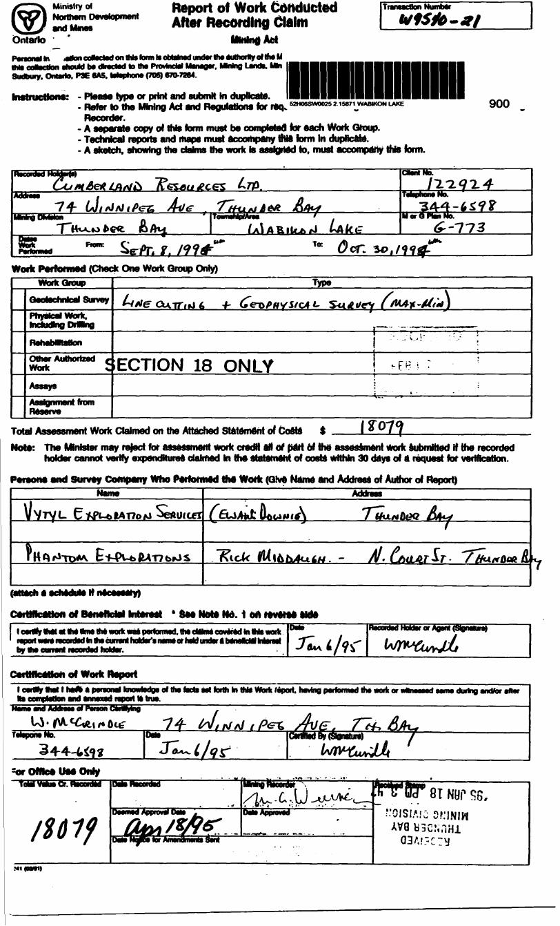
Ministry ofNorthern Development
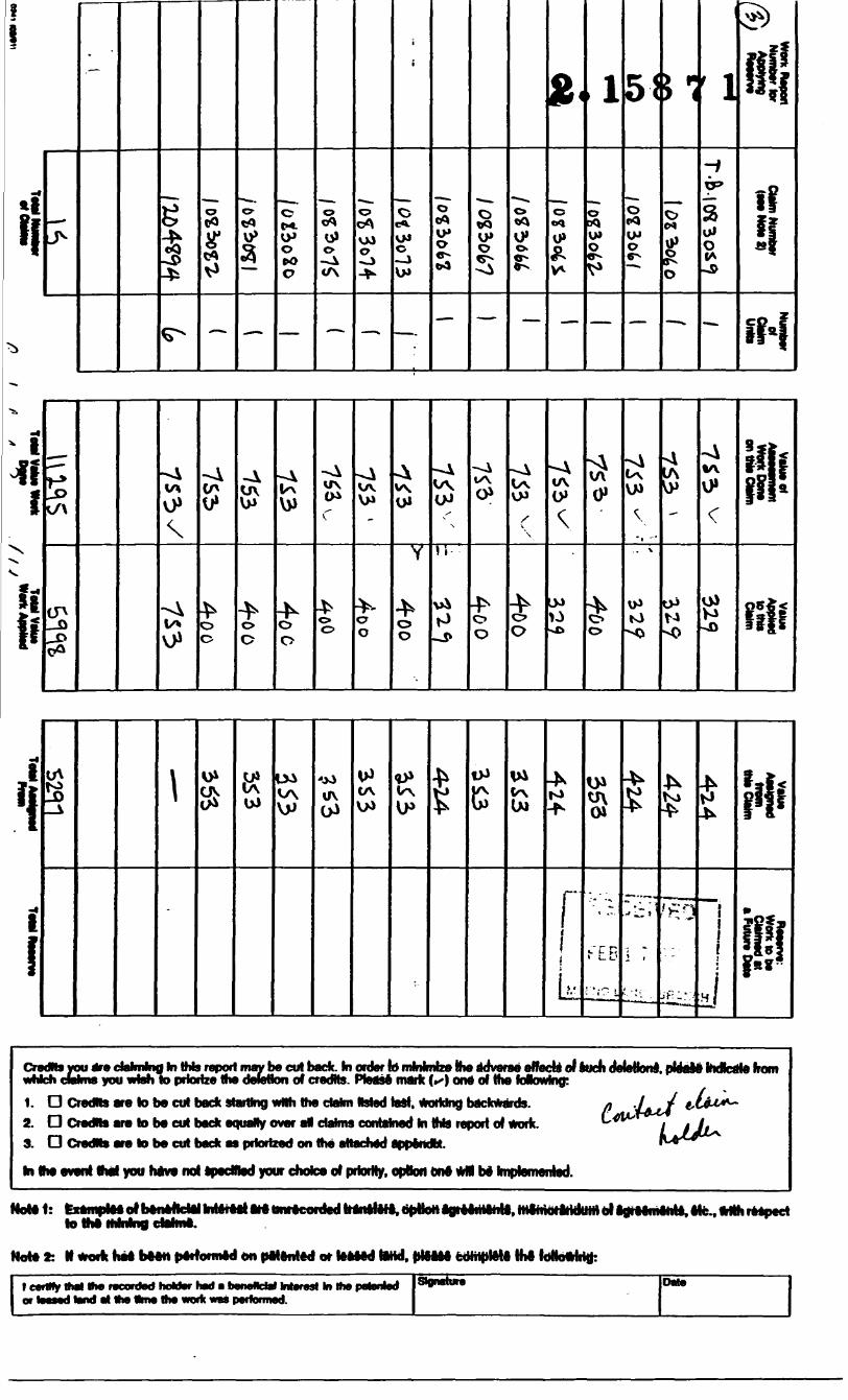
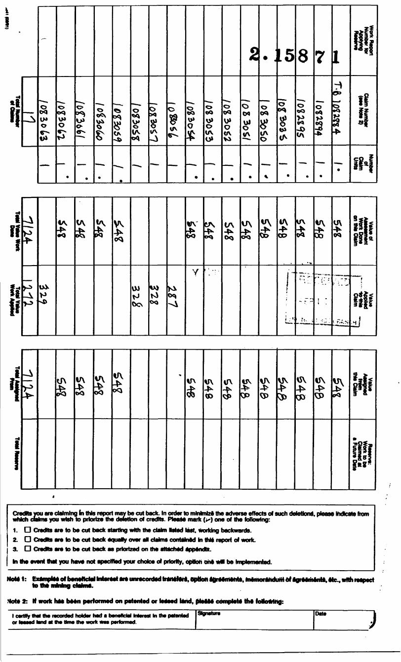
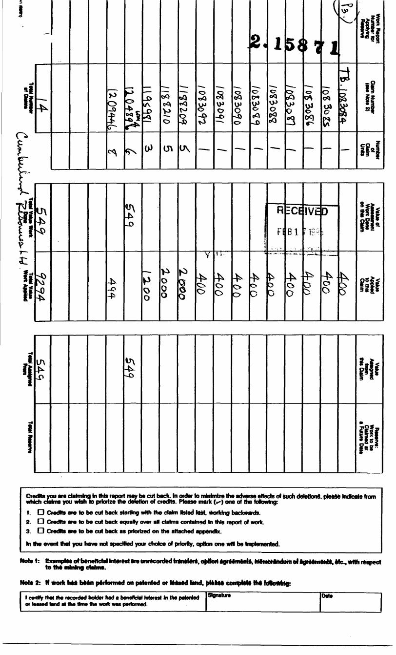
Report of Work Conducted After Recording Claim
Ontario
Pereon* In ,aNoncotectedonlN*termliobtalnedunoVlh*authoityoltfwM i should bs atocMd to Ilw PnwkicW fttansg*. MMng Lsncte. Mki
Sudbury. Ontario. P3E 8A5. totaphoftt (70S) 870-7884.
hutrucuons: - Please type or print and submit In duplicate- Refer to the Mining Act and Regulations for re*.
- A separate copy of this form must be completed for each Work Group.- Technical reports and maps must accompany tfMS form In duplicate.- A sketch, showing the deJms the work is asskjrted to. must accompany this form.
900
Work Performed (Check One Work Group Only)WorkGroup
Qeotechnlcej Survey
tndudbiQ Drifang
Rahat^attonOther Authorized c• M*— -J- ^wont ^
AssaysS) 1 i fTjT-ILUM-
RatSve
Type^ \
w/i/e" CUiTdJ 4 -f- (Teo^ffyi/o* t- Surfi/ry f /M4jr-XfVw)
i -^ " ; ;ECTION 18 ONLY ! ^BI :
;
Total Assessment Work Claimed on the Attached Statement of Coste t ——Note: The Minister may reject for assessment Work credit at) of part of tt* assessment Work submitted if the recorded
holder cannot verity expenditures claimed hi the statemOht of coste Within 30 days of a request for verification.
Person* and Survey Company Who Performed tt* Work (Give Nams and Address of Author of Report)Address
OA^
M- fl 7
A A^^A.^U^A IAB •CTMOUIV li
A^ ***-*--- 4*-l 4 J.A --.------*- *jJjisee rvon no. i on reverse awe
1c^9*XMtn*Mmrtw*p*1omrt.thtdllmtca*Mdin1N*ma* tqnrtw^nconMintocunrthcl&tnirtatb&wtolbinttMtt^ by O* conant nconM hoUsr.
AacanladHolclarorAgart(Sipiafwar
^- --j*- --* - ^ -J li* -^ rtaniuifaeiuiicauon or worn neponl canjfy Sial l hsjfw S pafsonaJ knoMadQa of Ins facts sat HMtti In thht Worii faport* M
maxad report H toua.ngpi idtha*orlior aama during and/tor aftar
2±.
SOT Office Use OnlyToUVaWCr. lUsnseonU' *- lu-i— Mi.'- J.I'•anwBj naBoniar
1 1 61 fST
ii
l! 0 **4 rv
oo*)
SoO
-O0*
S MS
11)8
O04
T* p*
o y*
Sf!
VPos^
^~- -i
s,-^o o oc
S
-*06" D
O
-
4- Oo
-lu\•K
Oiy
-Auv4^
\
4sC5
D4*0c
V *
i
*o o
trt
-*o o
-4^ oo
0 0
y - s
-^ Oo
- r .
4^CSO
ri-.j i.
^ o O
* oO
^
S
V
^ OO
VtlutofAMMMWnt •**--j. *^~— - WQrK UOnejon this CWm
*If
i
• oO eO
Ul
'.•"f
4A
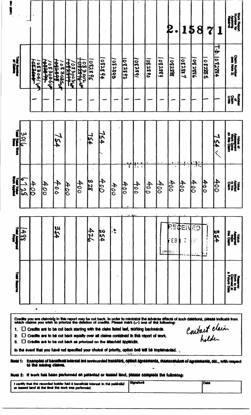
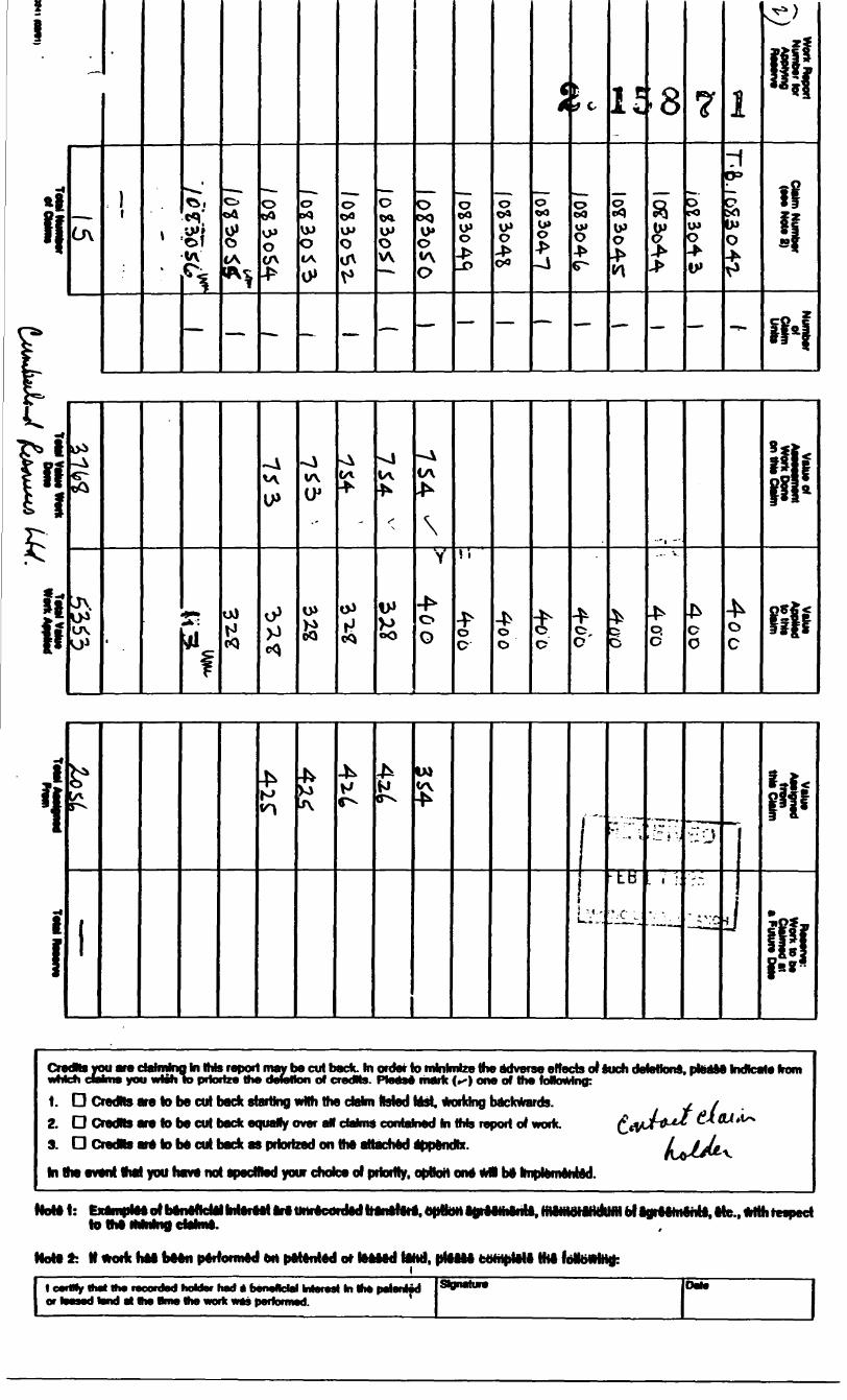
iCredNs you are claiming hi this report may be cut back. In order to tainttMzA thA AdvArAe effect* of such OttAttohs. plAftM Indicate fn— *-*-*- n lil tmrnt m ttntm •MtakA* AM MMtrut^-M. Hi n -*—"—Mr* r* **f nant i HI A f^JmfiMli ••i il ali t \ *t~u* dtf Hi AJ *—**— -- *— —wmcn dan i is you wwn 10 pnonzo me oorouon of cfBom. rwaso niaiR 1*^1 ocw Of ma foao*jiingi .
1. D Credits are to be cut back startingwtth the dahriteted last, WoHdng backward*.2. D Credits are to be cut back equally over al daims contained to thtt report ol Work.A I l f*—M*m^* Am* AM ftWMk 4MAB iMLoiV —-*- •taLml^M il dh^ lil a ***-^—i-a*** A*kflAAVijAA3. LJ urooRs are 10 DO cui DOCW as pnonzoo on mo afjocrioo apporan.
hi IhA AvAnt that you hftve not ApecHied your chote* of priority, option ort* Ml fa
NAtel: ^epHoiiaftieimenu. l AJAAJIAAUAAAA A A aklieV -- -*- - -*r aojfooffioffoj, oic*f wiui mpoci
HotA l- M *otk hAA bAArt pArfornttd AA paiArttAd dr lAAAAd (And. plAAM COInplAtA the foMeM
ttwl MM rtcontwl hofctec hed A twntfcM Mennl In IM tnl*nMd*——-* AA AAkA MBMA ei^A JMII! j^^ •VnO mi HW Qm9 HW wvrK WFJ9
Od*
—
0\
-
11
-
1tA
—
O
0* OCAf^fc. ^*'•^ 3
——
0DO
VP 0 CA
-~
O
VJJ 0 IA0*
~-
o00 VPo
V*
—
oOQ. IPO W
*~
oCKJ0* O •A O
—
0 eaVP O
-D
—
O O*
IP O
00
—
io oa IP o
—
t.
O00u* O4*
—
1 c
IP o
—
•8
f
—
7
orO U*O
IV
—
171P*
LV O
-
ii!iK -f
iH
,rH i
~v
i!
i
i
CmwM
1.
2.
3.
kit
S
1 i iuJ
s
^
v\
S
(A
J
lA
s
V*
iA
\
V
00
\ i
o 0
o0tC
o' 1 o. C
o 0
Oc
i*
m
lA
1
H K J t 5
1 i
,- .,-,
^ t -
-•.:;r-
•Lb
: *.'C L
TT—
:~.J
• ••^
—— a,^^
•J*r
jj
W
t^flBM j.ni* ———— niiitaaifci ra k* tt*l*ions you w cvstfTwng wi mi^^L ^^^^^—^ K^i^a --^^B^^^^ — , -f -Cfl doanlv ymi vWVI lv |HHJ
D Cradfls ara to be cut 1 D Cradfls ara to ba cut 1 D CraoHs ara to ba cut 1
ha aven! Vtai you hava no
i report may be cut brlze tfw oewtion of c
iMck equally over aN Mck as pilmuad on
1 apacNIad your cho)
ack. hi order to mhihi, ,, Ma- *** — t- a i' j iTfjoeis. rmsv HWH i ctalnt listed Msl, tip deJms conteJned hima aiiacnsd sa of pi lw dy.
nteetf* (^)onortdng ttitsra
cpttortonewl
B adverse effect!— ,-J fi, — *-M — -^ ao or mo lunowin backwards, port of wu k.
I kA hi^illnnfll l oa •npieniern
i d such deletions. ptosM hiIP
Id.
idles** from
t^,
MnMt- raan^yai nlkHiJilirliltMliitaat atn^rikitoillifciilaii MMHMH aMMHOnU mantHMtulmii^*-**' -*- ** **- ^^u-*~ --*to tl^m aiifciiiill J t all i it Haw liannl^p IHVnnV*
Mo***: tt *ork hM bean performed M p*t*nted or leMed lirM), ptflU bohiplell Hit
l cwllfy ttwl Vi* raoonlwl haUw had A b l tend HI aw Onw Hw work Ms t
t ia. ** -l m vn9
- 1
-o CO
—
o-
I
—
O
Oto o
—
o
o
—
o oA
o
—
i
O
c-J
— -
o
VH O
—
Oto 0*o
—
o
\yos:—
A afv 4
c
0*^3 ^^x
—
1
oDO VP0
—
51
o
0
—
J "J
0
—
' l-1
soCA
—
If1'f
i? ||
m
i S 0* 0* U*v/v 0* O*
x
-A wv O1
-A v\O1
%/vV)1
li
f*vP
0o
0O
O 0
cr O o
oo O
M -0
SJ-o ir
S uv lA OJ
LWuv tA
O* t C U) Oi
w. r ''
Ji**dalmlnglnt^r*!^i^Jwcu^w you wWi to priorize the doraHon of credits. PkMsi mark (*^) one of the foNowhig:
1. O Credits are to be cut back starting with the dahn ftsfod laftt. working backwards.2. O Credit* ara to be cut back equally over al dahns contained hi ttib report of work.3. D CredNs are to be cut back as priorized on the attached append*.
hi Via event that you have not apedflad your choice of priority, optkxt on* wM b* hnptemeniad.
Hotel: fa*mplM ef b to IM lunkie]
Hereai art mnecotded Hanileli. opttoH JgiMiiialiU. rrtffriorandUtH ot taraemelita. tie.. with letpect
Note 2: It *ocfc hai bMn peitonneil on pMenled or tealed HHd, plUM fcofriJJW* Hit
t ceiWy thai Vw racontod hahtor iMd a tMor toaswl tand Hi ttw am* tfw wmk tras pwformad.
si ni Inft pstontoo Slgnatura Date
Mmtotry of
Ontarioand Mhws
D. ippemant du Nord^A je^aaa BOV OJOVJ
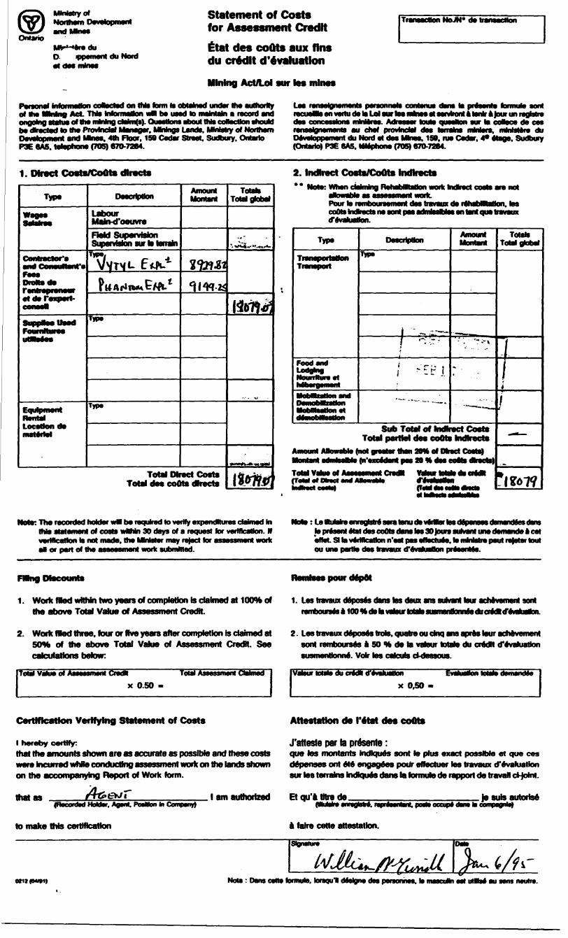
Statement of Costs for Assessment Creditttat des coQts aux fins du credit devaluationMining Act/Lot sur tes mhws
NoJN* de transaction
Personal information coaected on tnto farm to obtainedl under the authority off efio MeMnoj Act. TWo Inioinullun VM bo uooo lo nwntoJn o tMUWl ond.
? of ttio nibiing cWin(s). ftioooons opoul IhJo coHoctfon ohouhf be dkected to ma Provincial Manager. MWngs Lands. MmMry of Northern Development and Mhws. 4th Floor. 159 Cedar Street. Sudbury. Ontario P3E 6AS. telephone (705) 670-7264.
Loo forooipjnofnonls pofsonnols contonuo oons lo pffoonto tonnulo oontrocuaamsenvtjfludotoUlou^ooo coftcosBeOflS fflinlofoo. Aoraooor toulo ojuooHon our lo ooBoco ilo coog^M^B^abM^BMHa^MMSjal ^MS jJa^uf •^MMJaw^Jaal tffta^ AB^M^^^BI ••akat^^iak ^lala^^AAa^ J*B*renoosynovnonoi au COOT pmvnicioi uoo eBnOano nwofB* nwiujiofo ou Devetoppement du Nord at des Mhws. 159. nw Cedar. 4* etage. Sudbury (Ontario) P3E 6A5. wwphorw (70S) 670.7264.
1. Direct Cocta/CoOts directs
Type
Contra
etdefcxpett-
Foumttoree
Labour Mahvd'oeuvreField Supervision Supervision sur to terrain
Type
Type
Amount
Total Direct Coste Total dee coote dlrecte
Totah Total gtobal
2. Indirect CostaVCoOts Indtrects** Not*: VWwn ctoJming RehabHRaMon work Mki
Pour la rarnbouraemant das tnwaux da r4habHtaUon. tos cuotoliiJudsna am A pas eonwsPjlsa en tant ojue traveux d'evaJuatlon.
Type
rOOO OflQLodging Noun It IN o ot
•H*??•-"tir i
Amount
Sub Total of Indirect CostsTotal!
Amount Mtowflbtv (not ojpoolot* ilton 2D*A of Dwoct Cootoj••IAAAA^A .^^—^^m— j—*^——J .a——a ——— dMk BwV ^AA A^AaW ^B^^^A^k••onnni oonivoBNtj pi •xcvcawi paw zu i* ooo coom QWOCWJTotal Vahia of (ToMolDlract
Totals ToW global
this aMamant of costs waMn 30 days of a request for verification. HIs not msdatv tna MMstar may refect for assessment Hoik
el or pert of Hw assessment work submitted.
:LettuWn itenudev*Martos(lo pffaont Atat (tos coOts (tens tos 30 fours sulwnt uns dttflMncto *l col olVot. Si ta vociticoBon n ool pojs oflocluoOt lo nrintolnB pout fojotof tout ou one pertk* des travaux (TevafuaBon prfaenlei.
1. Work med wftNn two years of completion Is claimed at KXWbof the above Total Value of Assessment Credit.
1. Las travaux deposes dans tos dam ens suivant tour acMvement sonl rembouraes
2. Work fled three, four or five years atter completion is dahnedat 50*4 of the above Total Value of Assessment Credit. See
ToW VdMTot Assessment CredR Total Aa ICWnx 0.50
2. Lestravaux deposes trols.quatreoudnq ansaprestour achevement sonl rembourses a SO tt de to. vatour totato du credit devaluation
Vatour totato du credit tfVvehjattonx 0,50 -
EvahMtfa otetode
Ceitlflcaillon Vcilfylnoj SlAleineiit of Costs
l hereby certify:that the amounts shown are as accurate as possible and these costs were Incurred whUe conducting assessment work on the lands shown on the accompanying Report of Work hwrn.
that as(Rocordwl HoUsr, AojMt* PosMon In CotTapMiy)
to make this certification
Attestation de I'etat des coOts
J'atteste par la presente :que tos montants Indiques sent to phis exact possible et quo ces defenses ont ete engagees pour effectuer toe travaux cTevaluation sur tos terrains Indiques dans la formuto de rapport de travail d-ioint.
l am authorized Et qu'a tJtre de^oulobo •nrajotaM, fopffaofatonl, pool*) occupy
a faire cotte attestation.
Jesubautorisedont to conpoQnl*)
Note : Dans cane formuto. torsqul deskjne das personhes. to mascuHn ea) uMtoe au sens neutra.

.... •H-.I i < 'l -'^:l ! t* - -i-.-- .
j-J l -l-^--.-'--
1L-,-

Umatryol
Ontario
Report of Work Conducted After Recording Ctalin
AcLTI*l MUM*. FwrtiROOT. 1WC*dv
type or print end eubn* Indupicate. Rsisf to ttw MMnQ Act snd RoQuUtons for WQUirenionis of •fci t or eoneuR the MMng
A Mparato copy of thb form must to completed tor each Work Group.Techrtoel reports end rmpe muat accompenyltofarm hi dupteate.A ekatch. allowing the ctokne the work bj eeetajned to, muat accompany (hit form.
2.15871tiuU.rt
Cujk i* TO.
74- t Ji rf di Pet - 1/ e. A**tld
. 344-^ryyicrQHHiiMjL
^-773
Work PertotMed (Check One Work Group Only)Wo* (to**
Qeatoehnleal Suney
Typ*
SECTION 18 OMI v
nt Wnrtr CMm^l an *m JUt^A^i jajrti
RSCEiVED
ttBl i 1^'db
MINING Lr :v "i- i" '-
Note: The M holder
ay refect tor.irlfy idRms dunMo In VM
KM el or pert of the i M! at lil a a Ji r 11 mftm ftra B 019 recofosoof coats wMrin 30 days of e reqiiMt tor venHcMkm.
Ponmis sno Swvsy Conpony Who Psffomwd MiA Woih (Qlvo Nsfno Bno Address off Author of RoporQ
-flfilce
of
r*.B*j
80S) MOSB NO* i OH fSWSVOS) VMS;
by e*
Of Wofm nSpOft
Wm iKtt MI tofc bi Mi Wafc Mpo*t ha*fc^ poiaimd t* *oifc at i
74 frA/rfA///^ ^g. 7^y lOkWtaa By (BlB"*lMP*9
l l. A^J jx
r^or Office UM Only
9fi C Ud 81 NHP S6,••.'CISIAI3 C.'.MNIH

lj
i i
1
ti
—
-
P
S
T*
-S)
Oi 0
- —
VP O
U
——
o ox
— -
0
O
O
——
IM
u\
——
03 O s/v
—
O '
—
^
——
|;
——
D) O (A [P
——
OXI
—
i4
O
—
5.
03 O O
—
1 1 9
u^
^
0o
— -
88
JO
——
7\
—
1
T
-r-i
8!!t
iH
i
-
^
-
-
-
-
^
i
^
*
*
-A
*
t*
**^^
* t.
*
Y
. :.! ,- ,-
•t
-,
*
*
*
*
-A
*'. "w
V^ V *
*
^
*
V
W
m
. "!
h
1
R
FM'fJ'.N
rCI
Bl
'i U.N
IVt
)3BR
D
.NCH
. r-
wIR!-
-l
Cradtts you are claiming In thte report may be cut back. In ordtt td fnmiinlzftm^i^^m^ *- ~S^^—^^ *MMa -ftjAB- A— •••(••••^dh M*A dtM^^JIritta* — * 4k*^hdJl^M a^^-^A^ i&mti 1 ' \ — —wracn damn you wian to pnonza ma oowiion 01 cream, naaaa mane t**) on
i. D CradtoaMtoMcutbackaojJaNyoveral i D CrftdNft art to b* cut tack as priortaad onLi ** -- ^'-^"* laVAA tMai ItAtlA akMl ill *i ilia li tartaaft AlwtJHI nw ovom mat you navo noi spocmoo your cnoi
Haiti: EtttNpM MttMfl
*i l* A. || -*---* 1NOW 2: n wonc i
1 carttfy mat tha rt or Maaad land at
LA Ajt B^AAaAdtUhljll *--a**-'• Of ovnvnwi miwii*AB^Ka^ g a^a.-.fc^WnB CvBHlaV*
PMHHIIIM
toordad IMttml
kttara
Ion p
BOBim nnjQI j^A^—A ^luJii dam IB uuiiuiIti .ll.-l.-Oma anacnao
— ji ^J u^^^^ftMea or pnomfj
Md 4pp
w
AfldvarM^fecteoflft of wift fo8o*JinnQt
wiuny UBCKIDiLl* la^-J kl
Billfca vimiA.
OpHononvw
uiMato4dadtrafti*aft.6|
kftAnftaV! Atf IftAaUjt lAHll-
hoktor had * banMdal M*r*M In tha pUMttd
. . ~~
fiuri ui
• btV
VOS.
thoJik.
HpNNIM• .-•^ tnm.
U.—1L iJ*lJ.A**Jg-^ *-*^^.afc^ **^ ^*- jat^ fl^A^Amen oBiBwons, piBBao •MHCHIV iimii
tt* J * t M 4 M il AM^ Lm/tTT ^1 C^^*^*^^
kHim ajUAAJBAAlA MUBJttftliAi^ AA A^lAA^aAAAa *fc* ^^MA. . ^ ^^ ^ a*"wn •grvOTiMinat mamoianoHin vi aajraaniainat aiB*i w nil raapaci
^•fcAfc* ttJUAAlAlA |La lnM*^i||nptaaaa compivn ma niavwingt
S**** Date

g
rij o[XJ
VP oo)o-
/o?
rfi
^XJ
irf
i!
H
ti* -i ji
Y
•in :
•H*
ITT
* ,.
i
^
\
-^v\
^
* f\ --
^-
^J ~r f
1 ' '
3.
. S
i
-A
.-rt f--"'*"
^
, .
^
-. -i.
^
-
i t
^
i
*filil!
Siii
fi
• W-.
.-...4 j
CiwRI VoO m9 dHffilnd lit nw ffipon thfly M cut bAck. M 6roBr 0 nWiNRIU IH8 AdVBfM BracH M Wen MWMBAIi BMH IkKAM IroM^LjkkJa MvUlBHBal laHAi ^bt4Uk b4 M*4j**4^A MlA tlAiiatirirt **J M*BB*AI4I 01*****^ tt^lll ftflt AUfl jj MftA 4M*JLBBBBUBJ|Vwmcn CMnns jvU wwn ID iwiufizw inv oBioDun w cwmiv. rmBv ifHiTti f"/ ww 01 mij fowivfinQ.
i. Oc*dwirttaM6trfbirt*ttitifl0wihlMdilffll^A l~l —-*-*"* Ai* i.. i.* t.J LAilt *----** - a..^t AM -'A*-*-A AAji**iaa^ M •T. UJ VftVOma W ID D* CUI DaCK WJUBWy vW BH CWWflB OOfnoWmi WlA t i ^lAilttA AfM In IvM tfiil 1^^^ MA juffiiUAf! fm MI
iftoiipwJfiKJy8uft*H)(eifllprt8flly' ••-- - * ' -*- "l_______________- r* ~
fJMH..X^M—.-.y -T-i —i
ldntiMnlnoel.tiM:M.z*ott ttMM MM tt M MM M1 n

Ontario
Mv pement du Nord at des mines
Statement of Coste tor Assessment CreditEtat des coOts aux fins du credit devaluationBttMku* A.4tAJI 4*1 mmmm a —— BM tga m mMining ACVLOI sur ws mineo
of the11 •tinn i i nalairiai J *M* **-*— few*-* aW niSfaln m ft u~u*t^ Ot&A an JinaafcifitODon oooocioo on w ionn m oumnoo unoor 010 oumovvyA^A Tib^B k^aju^B^dSMM ^^B) *- — B^B^MA aVk •B*AB*^ABM A M^MM^MJ ———aACV. IIH* afNorinoDon w DO UMQ to invniavn o roconj ono of Bio tieinlnQ ctoavn|8). Quosoono shout Into coOoctton snoirto
IMM^wJ ftAa^MiaBM^BM' UaMkMs*) l AMMSM) a\Ja*i^O*M j^ fclinlli •••i ncaw MtwojOr t iMonpiiojB Lonoo* WewWuy or nonnoniDevelopment and Mmea. 4th ROOT. ISO Cedar Street. Sudbury. Ontario P3E 6A5. telephone (70S) 670-7264.
Las laiutiloiMinuiMi paraonnals oonlanuB dana la pftoanla formula amtivcu0MOT^^o^^awrlaan*waalaBrvlr^atanlra)oiirimdas concessions mMaras. Adrasaar touta quasNon aw la oolaca da ess
Devateppsmant du Nord at das Mhwa. 1S0. nw Cedar. 4* Maga. Sudbury (Ontario) P3E 6A5. MMphone (70S) 670-7264.
1. Direct Coajta/CoOts dbvcte 2. IncHrect Costs/Coots IndlfccM
Typa
Contradar'a
MakHfoauvreFtold Supervision Supervision st* b terrain
TIPS
Typs
TIPS
Amount Totals Total global Pour la rernboursartienl dsslravde rehabBtoHon.
cools Indktocts no wnt posad"evaJuatlon.
Type
Peedsnd
Nourritursst
TIPS
Amount
Total Direct Coats Total dee coots directs
Total Vahisol IstOhsd
Sub Total of tndkect Costs Total partial daa coOta InrArects
(net greater than 20* at Direct Gaels)t fn •XCOQMI pot 20 "A QBO oootel obocta)
Tows Tow global
Note: The recanted holder wff be required lo l of costs wM*t 30 days ol a request tor ve
voflflcttBon to not inodo, Ino MonMor moy re|oct for ol Of port of uio ossossnwnt vork submHIoo.
l hi .If
tonudevMtortox:Le lepresaritataldascoutsdamlasaolouraaulvanturwdaniandBftcat^f^^ d 1^ *^AflMb*^4ldMk ***^^4 m*^^ ^^^Mdd**A^ ^M ^^k^^d*^ ^l^^rf m^l^Am* ^Ma^anal, oi w vanncanon n aai pas enaciuaa. la nvraaira paul rejeiar vjui ou une parfto daa travaux ffi
1. WorfcfltedwUhln two years of completion to ctoJmed at lOIWfcof the above Total Value of Assessment CredM.
1. Los tavoux d4poo4o dsno tos dsux ono sulvonl tour ocMvomonl sont iwnbounno lOO^ooto
2. Work Wed three, four or five years after completion to cteknedat 50* of the above Total Value of Assessment Credit. See
x 0.50
2. Los travaux deports trote,qualroou cinq ansaprtotouracWvomgnl oont romboursos A 50 ^ oo to votour toCvo du CfodM o ovohMflon susmenttoond. Votr loo colculo d-doosouo.
x 0^0 B
CoiUHcflrtlon Voilfylny StBjtwiwnt of Costs
l hereby certify:that the amounts shown are as accurate as possible and thwere Incurred whBe conducting asscmsmont work on the lands shownon the accompanying Report of Work form.
col
AttsstsUon ds I'Atst dss coots
J'attosto par to preeanto :qua tos montants Indlqufe sont to plus exact possfcte at que ess doponsos ont 4t6 engagdos pour effactuer tos travaux d"evahisBon sur tos terrains bKXques dans to formuto de rapport da travaJ cHoM.
hi Company). l am authorized Et qu'a tttre de
to make this certification h faJre cette attestation.
Mote : Dans csns tomwls. torsqul dMgna dss psisonnas. Is msscuan sat utBsl au i
L-,-
Ministry ofNorthern Development
OtMario
Report of Work Conducted After Recording Claim
IflnlndAc*jp^cotscled on triform Is obtained under me eurJiorfr^
IMS ooMcHon should be Directed lo Hw Provincial Manager. MHng Lands. MMstry of Norttwrn Development snd Mnes. Fourth Floor. ISO Cedsf Street. Sudbury. Ontario. P3E 8A5. Kephons (705) 670-7264. O * mv ^ — . -.~* loo 7 linstruction*: - Ptoase type or print and submit In duplicate. * *
- Refer to the Mining Act and Regulations for requirementa of fffing assessment work or consult the Mining Recorder.
- A separate copy of this form must be completed for each Work Group.- Technical reports and maps must accompany tnts lot in hi duplicate.- A sketch, showing the darms the work is assigned to, must accompany this form.
Recontod HoUHM/T/2.
Telephone No."
74 (A\IV\J M /Per: i H±LlJlOWnewllpviFVBel
Asu* m J/ 344-HMng
At*r V "Uke
MerG Pten No.a- 773
To:
Work Performed (Check One Work Group Only)Work Group
GBotechnlcaf Survey
Physical Work. tnchidhiQ DfWnQa*^^B- ^laSJSja/^aiCTja• *0Vl8DHfDD)Ovi
Oil MI Authorized t•••--*- " wane ^
AssaysAssfQjntnent h^iib Reserve
Type
(ZetLoticAL /liffA/VeV
SECTION 18 ONLY ———————— 1
RECEIVED ]
tLB \ : ' —— 1 ——1
j-— —— ~^J
nt Work Claimed on the Attached Statement of CostsTotal^ ^ ^^ ____ __ S 'Note: The Minister may rojoct for assessment work ci edit aff of part of the assessment work Submitted if the recorded
holder cannot verify expenditures claimed in the statement of costs within 30 days of A request for vei ideation.
Persona and Survey Company Who Performed the Work (Gtv* Name and Address of Author of Report)
^^dA^M^fe
**-— *'^*- fcJ-i 4 — ii - - -- -- - ^i-t-ovv nuisj no. i on reverse srae
l certify mat at me time the work was pertormed. me cMms covered m this work report were recorded In the currenl holder's name or hstd under abeneflcMI by the current recorded holder.
necofOBO HdOBr or AQMV (S^nelure)
Cai Undation of Wuik fleportlcertiyihatlliii*apsf*oiialla^^ Ma completion and annexed report Is true.
i during and/or after
CwWtod By (9gnalure)
Fof Office Os* Onfy
t*Domed Approval Pen Approved
ter Sent
NUP SB.-3 eiswrn
ii
ii 3
il
fa?^*If
'{if
—
o oq
o
tP
—
o
O^^^^
—
c*
O*o-
9
0
\^ ^
^*
—
CA
-
O
o l/voA
-
0X)
-i
~-
O
uv
——
i0* 0
^
-~-
o oQ
0 UV0*
— *
o OQV)* 0
Vi
c
2
oMt|J
^^
"^
~-
-OOQ
IAO
—
, 5o"OQ
os(A
—
8
oOQ
S-D
*
7
O
—
1
S
4*-
—
4
lin-l
j)^
H^W
^
~A
^
S
vf*r
•A
•Q
l/V K Wo*
IV)t^JOc\
UJNJOQ
h^o^"^A
Y
o**
' ". -
IA
OQ
U\
CKJ
v\
g v\OQ oQ
'v\ w to S OP 1
KCO
ri
i .'
W\
'T,'^'
- -,
* *V*^B*K.
**
:r;~
, .i
-" WHV
u\
•~TT
-^ iL^
8f^
wf
't*a^3r|l
Oi'
VJV.
I 1 S Wm
H;'*
c.2?!?8J5!iar* ^Z!"9 ^nthte,reP0ft "fyj* cul back ln Ofdel to i****1 thiwhich clalnu you wish to pikNize the detotion of ci edits. Please mark (*x) on i of the foltowlng:
UftdhA* J j li oil* i aa al m • la**r-— -* **- Ja — ^.a— aV^.^^ucn ooteuons, ptooso inciicaw irom
1. D Credits are to be cut back starting wfth the dalm feted last, working backwards.2. D CredNs are to be cut back equafy over ei dakitt contained in thtt report of work.3. D CredNs are to be cut back as priortzed on the attached appendix.
In the event that you have not specified your choice of priority, bpttori one wM be Implemented.
Kl^l*. f,,*m.mt*t~ll.mmmltmtmttmllmm*mt**m~~*~~~t*JI,tUttm-t Umttm* * l..ja-J .i.t* fc-a~—— *^J-.C1 ^ * —— • •-.t..l* *i- ^jrf. —— . ———— 1
fat Hi*ni mv
•t* li aaadMfe l-A a. t, A. .a.— •tAv&MafVHAui tfM^m aihakAAaHA^kjl ^^a* eWa^a^akjA *A---* ^*—*** —-a.———*^A^ AaWA *—**—-**-**-*-iZI If WOfK IMS D9M1 |MIIUIIIIOU Oil |WIOIHOU Or mWO taWlO, pW8*W COmpWw HW fOaiOwinQ;
l carify that Ins recorded holder had a beneficial Merest In the patented or lemd land at the Urn* the work Was performed.

i
i!
iIfi
rriirt
e*•y\ iy
-
oq O
lA.PC
-~
0
ooQ
——
C'
OJ
e)
O
0
0
*
O
O* 0
-G
-
-^. ^
o
-
S s 00
O o
Oo
rQ
O^^^v
^^^l
—
cT
c
—
oCO
O^^^C/l
-
O
^—
DO
0
t
D*Qaj^
O
O
^
2
o^
^^Bi
——
.1
C
——
5
0oq
•^.^^
•)
3o"OQ
WO
—
r j
OJo
—
V*
f
r*
^OJc
—
'BS
f|
iH
O -O
W^^^
OQ SY
S1 1
^ ^
^
A
0 CC
\J\
c^c 03 OP 1 00
Se/V
^
* t ~". . 'm
WJ
~"" i tm
— -^^^^l^J^^CH^
CP OD
Qjy —t*
CD
to
Hirf:
iilri
Mr
M
^S^JSL?0 Jlli?9 "JjfejyPrt maySe-cut backJn order 1 which claims you wish lo priorize Ihe dofottoii of credits. Please1. D Credits are to be cut back starting wNh Ihe dahn fisted 2. D CredNs are to be cut back equally over all dabns cental 3. D CredRs are lo be cut back as priorteed on the attached
In Ihe even! that you have not specified your choice of piluiHy,
Hotel: Ei lo
Mote 2: It
1 certify tt* or teased 1
[ample
o minimize the adverse effects of such dotettens. please Indicate from mark (^) one of the following:
last, working backwards, nod hi this report of work, appendix.
option one wM be Implemented.
• c4rjetM(flcWtntere^ are unrecorded h attifert.c^^
work hat been performed on patented or teased IWtd, pKlM complete the foiowlng:
•no M Ins tfnM the work was performed.
— *- - -^. -'* al. .. HI - — --*•ivenMiiia, ens., wiui reepeci
patented 9Vt n Date
!x
-^—
o-SILn 3
^Ta^[
^.DJA
—
o)
oQ
V0
W
—s^uv
ooO
^
——
iVH O
^5!
—
m
iV*oo
—
2.
o DOo-D
—
i0oQ
OS
—
st0
OoQ
—
i;o
O
S—
(•ioo) cc?—
^
^•M*
g
—
f zf
Mft' K•s
cgo |
i,rJl'Siftr—
a:
P|f
in*
-0 -0
o\^
O
o0o 0o
*
o
! i -
0o 0 0
0r-*.O
R
FI
o 0
ECE
Bl
OO
IVE
^'~
4* D
3
— - -**--i
oo k
5*irf'
wIA ir
s;
CredNs you are claiming In this report may be cut back. In order to minimize the adverse effects of such deletions, please Mfeate from which dafcns you wish to priorlze the deletion of credits. Ptease mark (r) one of the foaowbig:1. D CredNs ara to be cut back starting wNh the claim Nsted last, working backwards.2. O CredNs are to be cut back equally over aR claims contained In this report of work.3. D CredNs are to be cut back as priorlied on the attached appendix.
m the event that you have not specified your choice of priority, option one wM be hi^duiranted.
Hotel: Exempt**efbeneftetalaitereatareumecuniedliamreia.optionagreements.MetneHHdurhof lo the mining Harms.
Note 2: tt work has been performed on patented or teased land, pfttfte complete IM foHowtrig:
etc.. with respect
l certify that Ilw racorded holder had a beiwdcM hitoml In the patented Of W890O IMW ftn Ino HHW Vi0 wotfc wss pvtfovmoo.
Skjnahm Dale
l t- m
l-
r--v-4:r-—— 4
Tf ~ Q" *
i- 'S 15 --, ...-L.—— JIB 'B ! -l

MnMryolNorthern Development
OntarioJCnisteredu
•etoppement du Nord
Statement of Costs for Assessment Creditiztat des coOts aux fins du credit devaluation
Mining Act/Lot sur tes mines
Transaction NoJN* de transaction
ccaoctod on this form Is obtained under the authority- m f^^ Bfl^M^A^ M a B Yl^^ l*t^**MMMti*M* ^Jtt I*A a^M^Mfl bt MtMkrfttka A MMJMMvt — — -*of me •mnfj ACI. iras HNUfineuuii wei oe useo w maaiiawi e lecmu eno ongoing status of the mining daJm(s). QueaBone ebout this cofectton shoutd be dbected to the Provincial Manager. MMngs Lands. MbiMry of Northern Development and Mnes. 4th Floor. 158 Cedar Street. Sudbury. Ontario P3E 6A5. telephone (70S) 670-7264.
mswgr, tents personnels contenus dane la preeente atantrak
formate sorti en vertu de la td eur lea mhwa ei servkont 4 lantr a Jour un regtstre
des concessions mlntares. Adreeeer toute quesHon eur la coHece de ces ronsoignemonts au chef provincial dee terrains mtniors. ministers du Devetoppement du Nord et des Mhws. 150. rue Cedar. 4* wage. Sudbury (Ontario) P3E 6A5. telephone (705) 670-7264.
1. Direct Costs/CoOts directs
Type
Draft* de
etderexpart-
Description
Labour MahxToeuvreHeld Supervision Supervision sur to terrain
Type
Type
Type
Amount
/l,
Total Direct i Total des coots directs
Totals Total global
2. Indirect Costs/Coots mdlrects** Note; When dehnlng RehebaTtatlon work mdfcect costs are mn
Pour w remboursement des travaux de rehabnRation. tes
Type
Lodging
Description
ShCts
ftu
Amount
Sub Total of Indirect Costs Total partJel des coots mdlrects
Amount Allowable (not greater than 20* of Olreet Costs)
Total Vafae of ASMSSB (Total of Urea ai
Totals Total global
Note: The recorded holder wH be required to verify expenditures dafcned hi this statement of costa wKWn 30 days of a request for verification. M verification Is not made, the MMster may reject for assessment work a* or pert of the assessment work submitted.
Note: l^ttaWreeniegMie sera tarw da vaiffisr tostw present etat des coots dans lee 30 Jours autvani une demande a cet effet. SI la verification n'est pas effectuas. w mMstrepeutre)slertout ou une paitw des travaux d'evaJuallon pntoentas.
FMng Dtacounts
1. Work fled wttt^ two years of completion b claimed at 10(m the above Total Value of Assessment Credit.
pour depot
1. Les travail* deposes dans tes deux ans savant tour achevement sent
2. Work Wed three, four or five years after completion Is claimed at SOTb of the above Total Value of Assessment Credit. See calcufatJons belowt
Total VelueoTAsaeMnient CredKx 0.50
2. Les travaux deposes trots, quatreoudnq ana aprte tour achevement aont rambourees a 50 H de la vafeur totaw du credtt d'evahiation
s. Volr las catcuts d-desaous.
Valeur Male du cnMl d'evalx 0.50 -
Certification Verifying Statement of Costs
l hereby certify:that the amounts shown are as accurate as possible and these costs
i incurred whJe conducting assessment work on the lands shown
am authorized
on the accompanying Report of Work form,
that as ___."^(*C***T-——^^—^————(Recorded Holder. Agent. Portion hi Company)
to make tMs certification
Attestation de I'etat des coOts
J'atteste par la presente:Que tes montants indiojuta son! to plus exact possible et que ces dtfponses ont 6td enojarjdes poOr effectuer tes travaux d'Avatuation sur tes terrains indlques dans la formuto de rapport de travail ti-Joint.
Etqu'atttrede. Je sute autorisdre. npreNntmt. poilv occiew J^^ hj COMPSOJM)
a faire cette attestation.
oeiz (04/91) Note : Dans cette formuto. torsqu'l dftshjne des personnes. to mescuan eel utSet au sans neutre

OntarioMinistry ofNorthern Developmentand Mines
Ministere du Developpement du Nord et des Mines
Geoscience Approvals Office 933 Ramsey Lake Road 6th Floor Sudbury, Ontario P3E 6B5
Telephone: (705) 670-5853 Fax: (705) 670-5863
March 07, 1995 Our File: 2.15871 Transaction f: W9540.00019
W9540.00020 W9540.00021
Mining RecorderMinistry of Northern Development i Nines435 James Street SouthSuite B003Thunder Bay, OntarioP7E 6E3
Dear Mr. Weirmeir:
Subject: APPROVAL OF ASSESSMENT WORK CREDITS OM TB 1082884 *t ml. IM WABIKON* LAKE AREA
XMO
Assessment work credits have been approved as outlined on the report of work forms. The credits have been approved under Section 12 (Geology), Section 14 (Geophysical) and Section 17 (Assays) of the Mining Act Regulations.
The approval date is March 06, 1995.
If you have any questions regarding this correspondence, please contact Steven Beneteau at (705) 670-5858.
ORIGINAL SIGNED BY:
Ron C. GashinskiSenior Manager, Mining Lands Section Mining and Land Management Branch Mines and Minerals Division
SBB/jl Enclosure:
cc: Resident Geologist Thunder Bay, Ontario
ssessment Files Library 'Sudbury, Ontario

0033XVH NOXISVM L/BSL Z 9ZOOMS90HZ9
REFERENCES
Cheeseman Lake AreaAREAS WITHDRAWN FROM DISPOSITION
S R MJHt Ai l is'CiHr', MR MININd HKiHTS
SAND AND GRAVEL
NO (c GRAVEL PIT No 1O3&
" " No. 1037
" ' " No. 1063 , FILK 1879*6THE INFORMATION THAT APPEARS ON THIS MAP HAS BEEN COMPILED FROM VARIOUS SOURCES, AND ACCURACY IS NOT GUARANTEED THOSE WISHING TO STAKE MIN
CLAIMS SHOULD CONSULT WITH THE MINING R
NT AND MINES, FORDTIONAL INFORMATION
THE STATUS OF THEL/jDS SHOWN HEREON
LEGEND 1195204
1193206 '~-- 'l- 'j^^^fV l- " TroTT^^i
108^042 l 1083049
195207-***-L- A T TB ~A ~ '"TB" ~ ~:?B—— ,2642 l IOMM3 l JOMSte l J09268I [ 1092692
J?——l—— —* l "l TB , ra — ~0"* J — ™-?02l JOMOJW (0*8039 .1092820 '™ "i™ l TB lTB~~TT7--'
083043 UH304S j1083032 , I08J025 ; IO83023
l 1188210
""TOWJ.I 10*3044 J 10*3047
1205146. ~120894 . l 10*2*44 ! 101
P88209 ra*8030 l 1088037 .1092618 IJ083483 J 1083488 \
— —' —— - - ! I08348Z , 1083489
JJ08348I i 1083490 i'TB083063 l W3062
i . ' i r j ' i i \ \ J- — — — — ^- — -iJ^HfJ1"*!*. j?4* J^l8! 'joMfV 'l0^
--r~— -1081374 i TB |TB
108232610*3078 l 10*3074 ' 1083073
r r — -f--| 120-5107 i j2-"i5l42i , i i i ' '083078 , 1083079 f 10*3080 J '083O8I ' IO83Oe2 " l
DISPOSITION OF CROWN LANDS 1082889 , 10828.11 f 08Mfl9
T YPt L)| DOClMl N'l
L If t
ORDf R IN i '
Rf St RVA ' L \
AN( fill'
SAND LAND USE PERMITS FOR COMMERCIAL TOURISM.OUTPOST CAMPS
RECEIVED
MAR B 01005
WABIKON LAKEM N R ADMINISTRATIVE DISTRICT
THUNDER BAY
(AND HILLS/ REGISTRY DIVISION
THUNDER BAYfcilinjijn l itMiNtf'
Ministry of landNatural Management
6S Branch
Max Lake Area G-741G-773
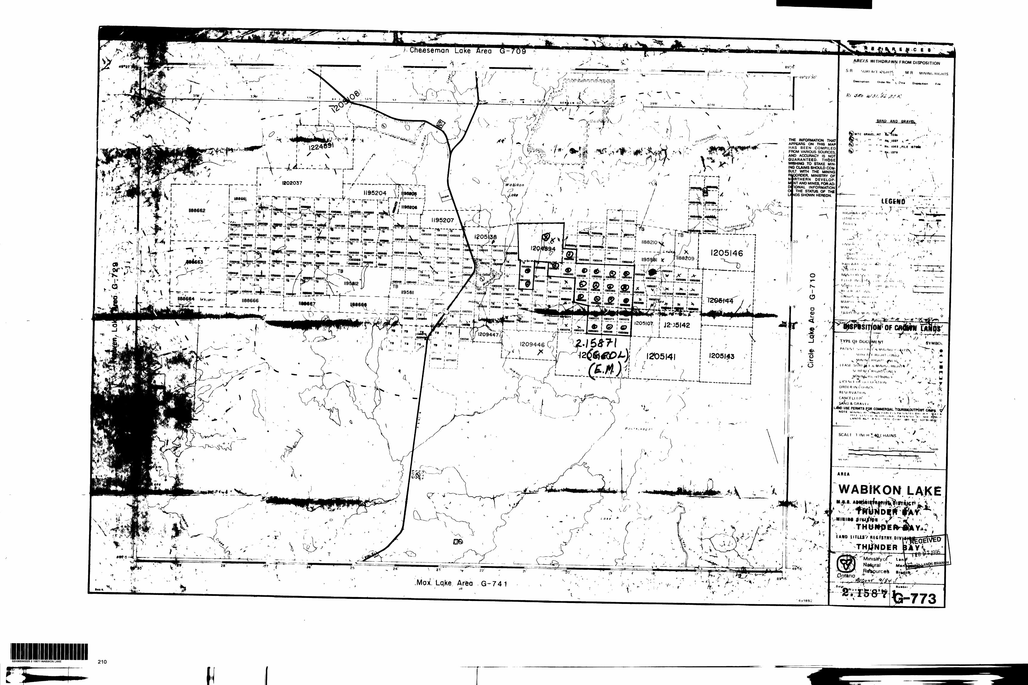
Che/esemonAflEV.S WITHDRAWN FROM DISPOSITION
SAND AND QBAX/BI' X
"^i-ri" ;' THE INFORMATION THAT APPEARS ON THIS MAP HAS BEEN COMPILED FROM VARIOUS SOURCES, AND ACCURACY IS NOT GUARANTEED. THOSE WISHING .TO STAKE MIN ING CLAIMS SHOULD CON SULT WITH THE MINING RfQORDER, MINISTRY OF NiRTHERN DEVELOP
NT AND MINES, FOR AD-IONAL INFORMATIONTHE STATUS. OF THE1195204 .
UfJDS SHOWN HEREON.
II9 207 p - -,- - - . 083048 J j~ ~~
i:r-^{jO*M43 j M040J ^ — -.....
i H882ian... J- -———f l l iM8UI|f,QMWpU l to ~ — —J— — —. —j ^ 1205146^^r -1-'2!"S?U"*fi?t,-~"-1
""
??^u -w-rf'ivL"!??*^0""'k. ! uu.^^.l ^ l ~~T~~ ~~
'OMOa 1082886 | 1082*81 '———!~ ^ ' l ' l
J2-J5I42 h—— -- ---.1082322 J --——iT" - —^—- fc-- A— -L - - -L,.JL-^-; -A1209447-—---4 1209446
\ V IN i Ml! " i4lN
HK.HT , ONio , mf,
^si nrvy r H u,m'.'i,IN L Y
\l. ICf M f Of iji l l li'A I K IN -^
OROF R IN ri )i Rf st RVATION
-— ——-..... j
, . ( L4WD USE PERMITS F,OR COMMERCIAL VoMMSHOUTPbsT C/
NOTE M lNINd Hi "' i- A m ( i -iI'll) VIS'lO N OH.'.iNA, P AIfM'M 'H LANDS *t. t R S (l ") M l CiiAI' IBO S t '
WABIKON LAE
VNHHM
AUD JITUSV REGSTRY DIV
•v ""Ministry
Lqke Area G-741
52H06SW0025 2 15871 WABIKON LAKE 210
\
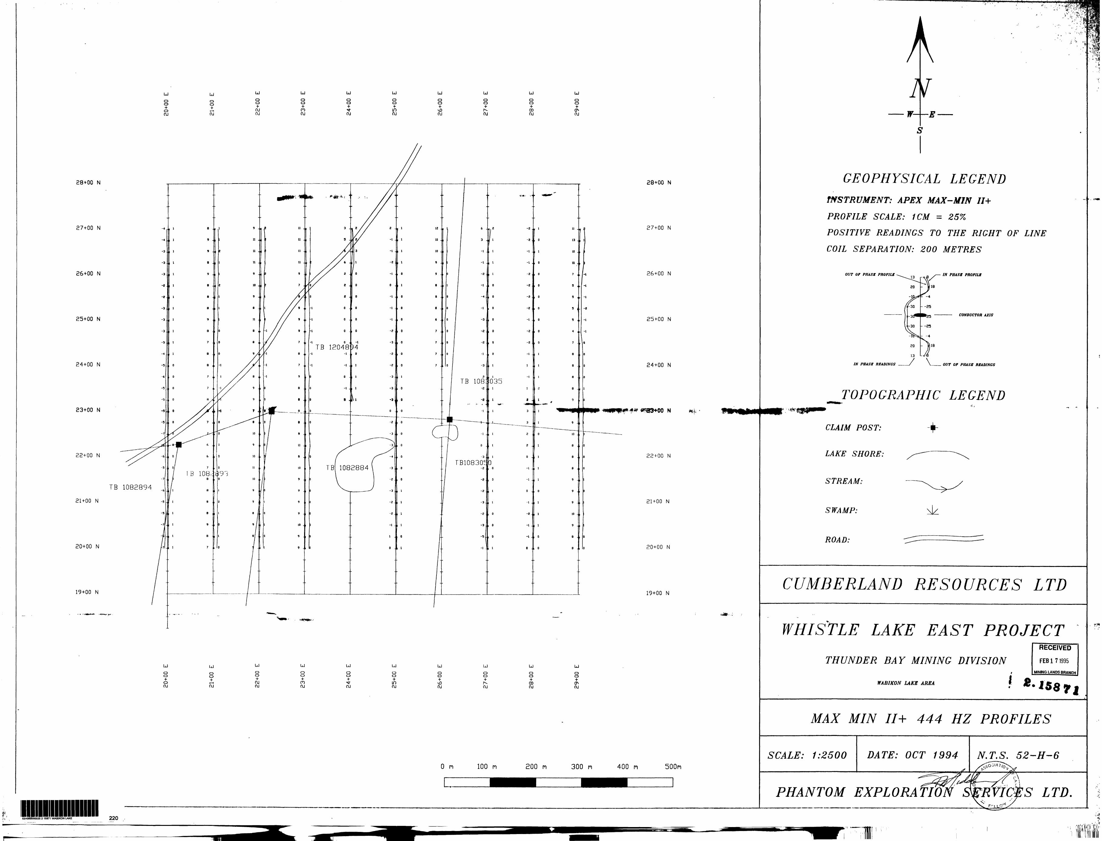
LJ
O O•foOJ
LJ
o o-f*—t OJ
U
Oo*OJ OJ
U
o o*CO CU
U
Oo-h OJ
U
O O* inOJ
uo o
OJ
U
O O
OJ
O O* 00 OJ
uO O
OJ
28+00 N 28+00 N
27+00 N 27+00 N
26+00 N 26+00 N
25+00 N 25+00 N
24+00 N 24+00 N
23+00 N
22+00 N
21+00 N
20+00 N
19+00 N
TB 108J035
FB10830-Z JL O
N
22+00 N
TB 1082894
21+00 N
20+00 N
•i i- \
GEOPHYSICAL LEGENDINSTRUMENT: APEX MAX-MIN II+
PROFILE SCALE: t CM = 25KPOSITIVE READINGS TO THE RIGHT OF LINE
COIL SEPARATION: 200 METRES
OUT OF PHASf PROFILS
IN PHASE READINGS
IN PHASE PROFILS
CONDUCTOR AXIS
OUT OP PHASE READINGS
TOPOGRAPHIC LEGEND
19+00 N
U
Oo-H O OJ
Oo
OJ
U
Oo-H OJ OJ
U
Oo
OJ
u oo
OJ
uo o-h inOJ
uo o*•JD OJ
U
CD O
OJ
uo oH- 00 OJ
uo o•fCTs OJ
O m 100 m 200 m 300 n 400 n 500n
l
CLAIM POST:
LAKE SHORE:
STREAM:
SWAMP:
ROAD:
CUMBERLAND RESOURCES LTD
WHISTLE LAKE EAST PROJECTTHUNDER BAY MINING DIVISION
WABIKON LAKE AREA
r
l
RECEIVED
FEB l 71995
MINING LANDS BRAMCH
MAX MIN II+ 444 HZ PROFILES
SCALE: 1:2500 DATE: OCT 1994 N.T.S. 52-H-6
PHANTOM EXPLORATIO S LTD.52HOB8W0025 2 15871 WABIKON LAKE 220
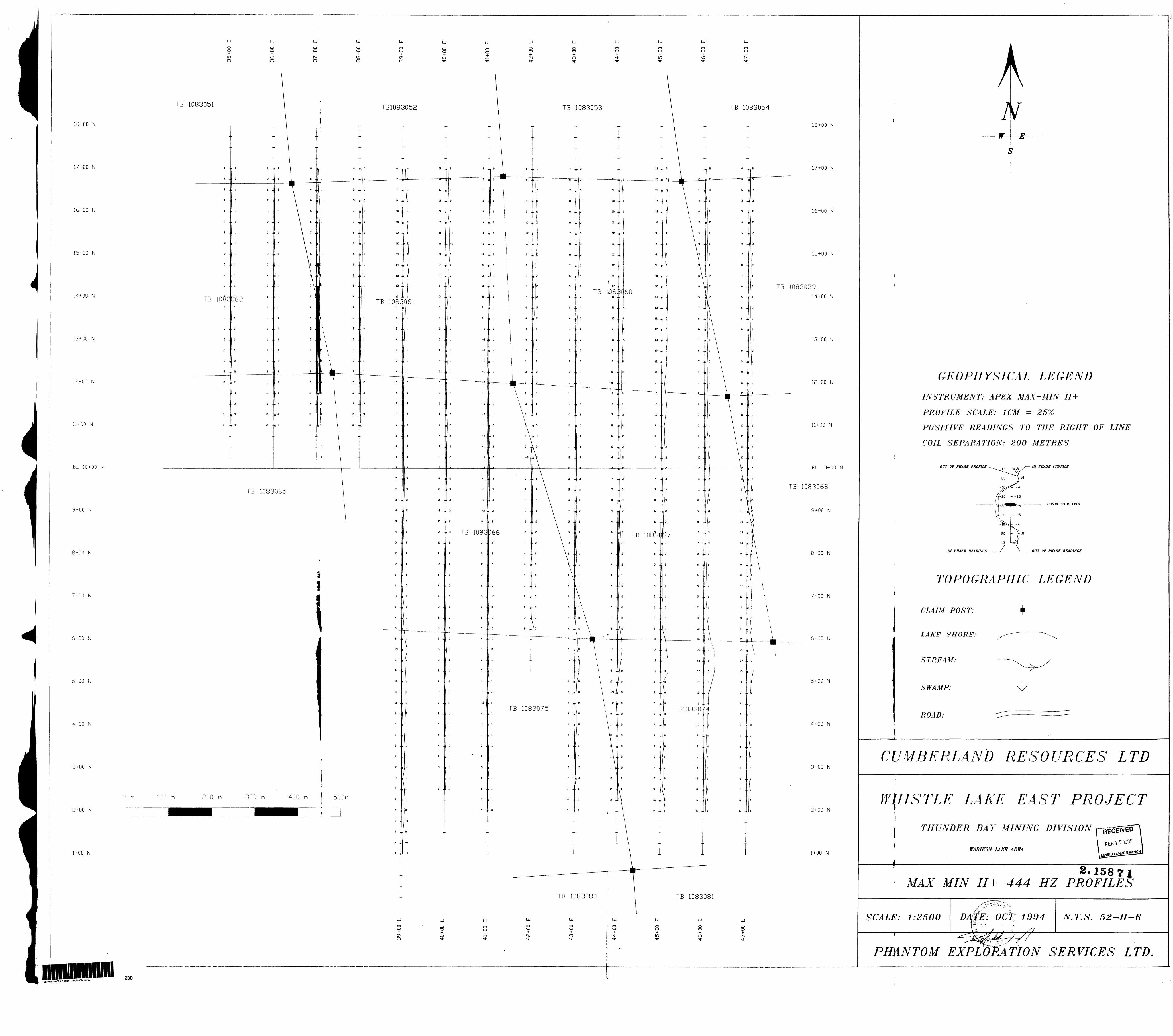
LJ
CD O4- LOen
LJ
CD o
ro
uo o
m
LJ
o o*00ro
uo o-I-CT*
uoo
LJo o
LJo OH- OJ
LJCDo
uCD CD-f-
uoo 4- LD
LJCD O
LJ
CD CD
TB 1083051
18+00 N
17+00 N
16+00 N
15+00 N
14+00 N
N
12+00 N
1 + 00 N
BL 10+00 N
9 + 00 N
8 + 00 N
7 + 00 N
N
5+00 N
4 + 00 N
3 + 00 N
TB 1083054
O m
2 + 00 N
1+00 N
TB1083052 TB 1083053
1,083060
TB 1083065
TB 10S3366 TB 1083
TB 1083075 TB1083010
TB 1083080
18+00 N
17+00 N
16+00 N
15+00 N
TB 108305914+00 N
13+00 N
12+00 N
11+00 N
BL 10+00 N
TB 1083068
9 + 00 N
8+00 N
7+00 N
6-00 N
5 + 00 N
4 + 00 N
3 + 00 N
100 m
2 + 00 N
1 + 00 N
TB 1083081
LJ
CD O
CO
U
CD O±CD
LJ
o o-t-
LJ
CD O±OJ
LJ
CD CDH-ro
LJ
1 O CD
LJ
CD CD•fin
LJ
Oo
LJ
Oo
KH06SW0025 2 1 5B71 WAB.KON LAKE 230
W
GEOPHYSICAL LEGENDINSTRUMENT: APEX M AX-M IN II ±
PROFILE SCALE: 1CM = 257o
POSITIVE READINGS TO THE RIGHT OF LINE
COIL SEPARATION: 200 METRES
OUT OF PHASE PROFILE IN PHASE PROFILE
- -K30
if-30
25
'25
- -25
- -4
CONDUCTOR AXIS
20
13
118
IN PHASE READINGS OUT OF PHASE READINGS
TOPOGRAPHIC LEGEND
CLAIM POST:
LAKE SHORE:
STREAM:
SWAMP:
ROAD:
CUMBERLAND RESOURCES LTD
WHISTLE LAKE EAST PROJECTTHUNDER B A Y MINING DIVISION [-RECEIVED
WABIKON LAKE AREAFEB l
MAX M IN 7J+2.15871
HZ PROFILES
SCALE: 1:2500 DAffE: O C T: 1994 N.T.S. 52-H-6
PHANTOM EXPLORATION SERVICES LTD.
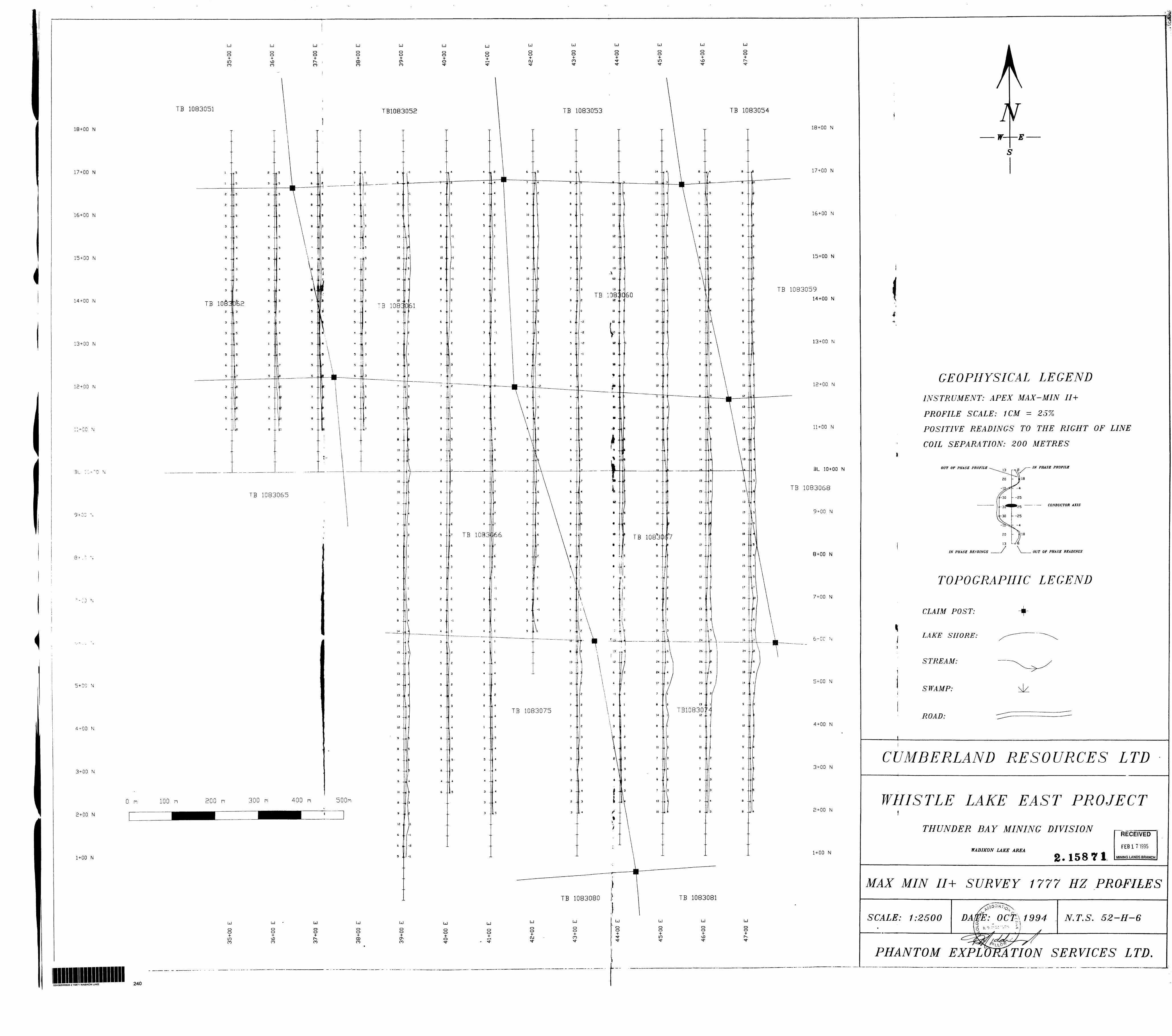
LJ
O o4-m ro
LJ
Oo
co
LJ
o o
CO
LJ
O CD4- 00 CO
LJ
o o-f- (T*co
LJ
o o4- o
LJ
CD O
LJ
CD O4-(XJ
LJ
CD O± CO
LJ
CD CDH-
LJ
Oo-hin
LJ oCD
LJ
CD CD
TB 1083051 TB 1083054
18+00 N
17+00 N
16+00 N
15+00 N
14+00 N
13+00 N
12+00 N
11+00 N
BL ::
8
5 + 00 N
4 + 00 N
3+00 N
O m
2+00 N
1+00 N
TB 1083053TB1083052
TB 108B 1082
TB 1083065
TB 108
TB1083012
TB 1083075
TB 1083080
100 m
TB 1083081
LJ
O CD+ [D CO
LJ
Oo-J- vjQ CO
LJ
Oo-J- r^CO
LJ
O CD+ OD
LJ
CD O-H CT. CO
LJ
CD CD
LJCD CD
LJ
Oo+CXJ
LJ
Oo4- CO
LJ
CD CD
LJ
O CD*in
LJoCD
LJ
OoH-r*-
52H06SW00252 15871 WABIKON LAKE 240
18+00 N
17+00 N
16+00 N
15+00 N
TB 108305914+00 N
13+00 N
12+00 N
11+00 N
BL 10+00 N
TB 1083068
9 + 00 N
8+00 N
7+00 N
N
5 + 00 N
4+00 N
3+00 N
2 + 00 N
1 + 00 N
w- E
GEOPHYSICAL LEGENDINSTRUMENT: APEX M AX-MIN II+
PROFILE SCALE: 1 CM = 25%
POSITIVE READINGS TO THE RIGHT OF LINE
COIL SEPARATION: 200 METRES
OUT OF PHASE PROFILE
IN PHASE READINGS
IN PHASE PROFILE
—— CONDUCTOR AXIS
OUT OF PHASE READINGS
TOPOGRAPHIC LEGEND
CLAIM POST:
LAKE SHORE:
STREAM:
SWAMP:
ROAD:
CUMBERLAND RESOURCES LTD
WHISTLE LAKE EAST PROJECTTHUNDER BAY MINING DIVISION
WABIKON LAKE AREA2.15871
RECEIVED
FEB l 7 1995
MINING LANDS BRANCH
MAX MIN II+ SURVEY 1777 HZ PROFILES
SCALE: 1:2500 DA 1994 N.T.S. 52-H-6
PHANTOM EXPLORATION SERVICES LTD
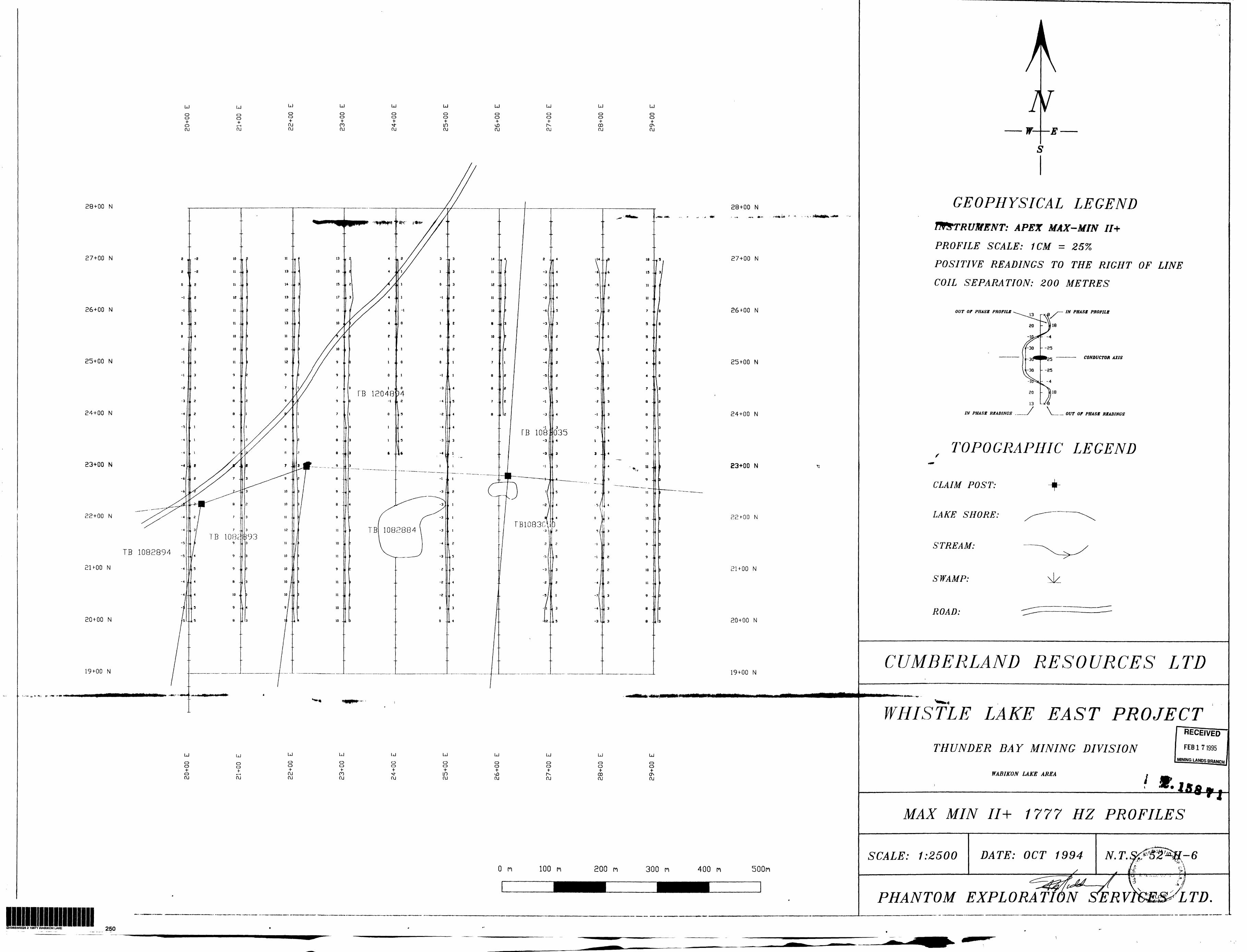
uo o-t- o oj
uo o-I-1—lOJ
uo o-*- OJ OJ
uoo
OJ
uoCD4- s*- OJ
U
Oo-f in ru
uo o-I-•vDru
uo o
OJ
U
Oo+ CO OJ
uo o•fON OJ
28+00 N 28+00 N
27+00 N 27+00 N
26+00 N 26+00 N
25+00 N 25+00 N
24+00 N
23+00 N
22+00 N
2UOO N
20+00 N
19+00 N
TB 1082894
W
GEOPHYSICAL LEGENDINSTRUMENT: APEX MAX-MIN II+
PROFILE SCALE: 1CM = 257*
POSITIVE READINGS TO THE RIGHT OF LINECOIL SEPARATION: 200 METRES
OUT OF PHASE PROFILE
IN PHASE READINGS
IN PHASE PROFILE
CONDUCTOR AXIS
.— OUT OF PHASE READINGS
TOPOGRAPHIC LEGEND
CLAIM POST:
LAKE SHORE:
STREAM:>
SWAMP:
ROAD:
CUMBERLAND RESOURCES LTD
U
Oo -f o ru
o of
1—lru
uo o +OJ OJ
U
o o+m ru
uo o
OJ
uoo ^ in ru
uCD O•f
•JDru
UJ
o o
ru
uoo •f00 OJ
U
CD CD+
CFNru
O H 100 n 200 n 300 n 400 n 500m
H06SW0025 2 15871 WABIKON LAKE
WHISTLE LAKE EAST PROJECTRECEIVER
THUNDER BAY MINING DIVISION FEB l 71995
MINING LANDS BPAflp,, j
WABIKON LAKE AREA
MAX M IN II + 1777 HZ PROFILES
SCALE: 1:2500 DATE: OCT 1994 N.T.
PHANTOM EXPLORATWNSERV. LTD.
250
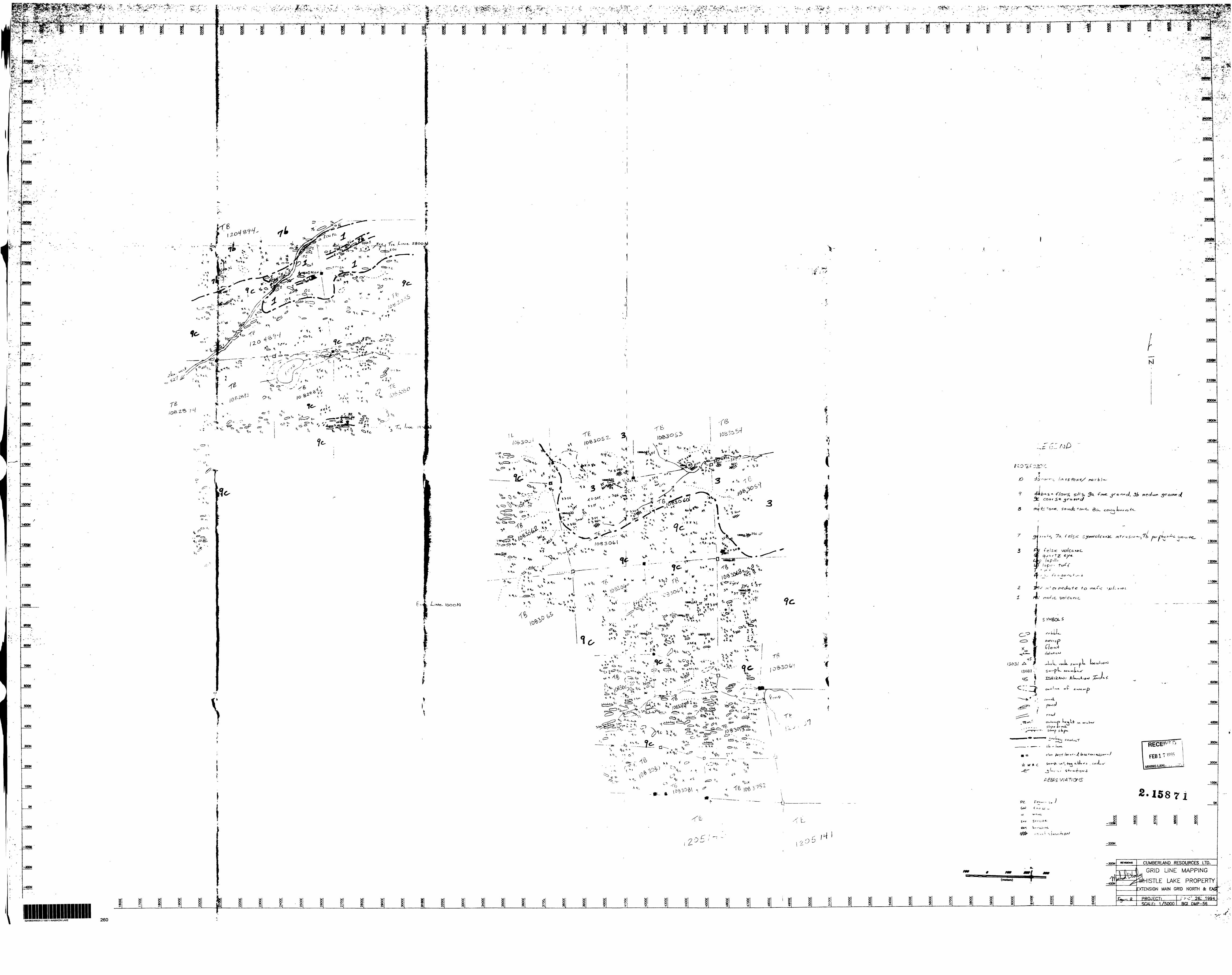
-vT-*-"-^*^*S^^:. ,./;:" -
,v ':^- t: ^f'*t ^ *" z **iLiiiii -3 . -- " -. v.
rj* *^4-tzl- , f
3400N
330QN
3200N
STOON
•* " ~* t *f ',.v.A"
^j- . ^ . .__
/^•-^^'-.
CM CO' ' l " '
f
rr
*t
3300N
aaooH
3100N
3000N
*s^ .•ijfc,-^ -
2908N
MOO*is
2SOON
2400M
2*3!
r
210QN
2BQDN
190QN
180*1
17QON
1600N
1500W
1400N
12QON
J100N
l DOON
fiOQN
800W
TOON
BOOM
500H
400N
300N
200N
100N
-100N
-200V
-WON
. ,
/D^
loooM
f
i
(
l
t
i
; 1
"^ (v--
A^lm- *
-r h ^oe?^0^ "
-Q-
C !
UJ g3 8
UJ UJ8
UJ UJ
,h
*a**- 3-: C-OtCif* *0nf ,
7
rrn-f/c. \jo i Cc, m c
rxsrk*y*~c.
2000N
25QON
2400N
2300N
2200M
ZtOON
2DOOM
1900N
1800N
1700N
1600N
1500N
1400N
1300N
1200N
1100N
13031
1000N
900N
800N
i* clt
' a c ' -i. f 7 r 'fc-f-' C"-' -5
PZL
2.15871
600N
SOON
400N
aooN
200N
100N
ON
ST ~
S*r S" 1":-! -1
-200N
-300N
(iiMtan)
UJ
CUMBERLAND RESOURCES LTD.
GRID LINE MAPPING
ISTLE UKE PROPERTYENSIGN MAIN GRID NORTH Se EAS"
PROJECT:SCALE: 1/5QQO
26: 1994BG1 OMP-56
*.A- If
S2H06SW0025 2 15B71 WABIKON LAKE 260

3300N 2
3200N
3100N
3000N
2900N
2800N
2700N
2600N
2500N
2400N
2300N
2200N
2100N
2000N
1900N
1BOON
1700N
1600N
1500N
1400N
1300N
1200N
1100N
1000N
900N
BOON
700N
600N
SOON
400N
300N
200N
100N
ON
-100N
-200N
-300N
-400N
-SOON
-600N
-TOON
-BOON
-900N
u UJ
lui UJ
i
X 12096
X 12095
X 12094
x 12093
X 1301212097
13007 , 13013 l x 13014
x 1X03
x 13002
x 13039
x 12995 x 12996 x 13006
x 13005
x 12997129|9 1 2994
x 12993
X 12992
X 12991
12990
x 13004
12989
UJ
eg
UJ
M
UJ
X 12091
X 12089
X 12088
X 12090
UJ UJ
, x 342
2092
13043
111
X 12112
UJ u oSin
X 12108
X 12113
X 13031
X 12107 jX 12106 !X 12105 l
x 13030
X 12099
x 12100
X 12101
X 13033
13029
X 12116 13035x 12098
x 13036
. 12115 x ,13041
x ! 1X40 x 13037
if. 158 r rRECEIVED
FEB171995
MINING LA.NDC. BRANCH
UJ
in
-TOON
-BOON
3300N
3200N
31 DON
3000N
2900N
2800N
2700N
2600N
2500N
2400N
2XON
2200N
2100N
2000N
1900N
1800N
1700N
1600N
1500N
1400N
1300N
1200N
11 DON
1000N
900N
BOON
700N
600N
SOON
400N
300N
200N
100N
ON
-100N
-200N
-300N
-400N
-SOON
-SOON
UJl UJ UJ \ -10001UJ
in
REVISIONS CUMBERLAND RESOURCES LTD.
WABIKON LAKE AREA
EAST WHISTLE PROPERTYWHOLE ROCK SAMPLE SITES
PROJECT:SCAI.F; 1/SOQO
JAN 4. 1994BGI DMP-5fi
52H06SW0025 2 1 5671 WABIKON LAKE 270