petroleum geology in egypt
TRANSCRIPT

- The first Egyptian oil field was discovered in 1869 while mining for sulfur, in the SW part of the Gulf of Suez on the Gemsa Peninsula & put on production in 1910, producing 39◦ API crude from Miocene sands.
- The second oil discovery was made in Hurghada in 1913 along the western coast of the Red sea at its junction with the Gulf of Suez.
- In 1938 new oil was struck in Ras Gharib along the west coast of the Gulf of Suez followed by several others in forties and fifties. Many new discoveries both on land and in the Gulf were made in the sixties, including the Belayim Marine , Gharra Marine and Morgan fields. The main producing horizons in most of these discoveries were the Upper & Lower Miocene sands.
Petroleum in Egypt
- Meanwhile, gas deposits were discovered in the Pliocene sands of the Nile Delta, and low sulphur oil in the Upper Cretaceous sands and lower Cretaceous carbonates and sands of the Western Desert. Since then substantial discoveries have been added steadily, the most important being the Ramadan Field situated in The Gulf to the north of the Morgan field, the Abu Qir gas field offshore Alexandria, and the Razzaq field in the Western Desert.

Petroleum in Egypt• The first Egyptian oil field was discovered in 1869 while mining for sulfur, in the SW part of the Gulf of Suez on the Gemsa Peninsula & put on production in 1910, producing 39◦ API crude from Miocene sands.
• The second oil discovery was made in Hurghada in 1913 along the western coast of the Red sea at its junction with the Gulf of Suez.
• In 1938 new oil was struck in Ras Gharib along the west coast of the Gulf of Suez followed by several others in forties and fifties. Many new discoveries both on land and in the Gulf were made in the sixties, including the Belayim Marine , Gharra Marine and Morgan fields. The main producing horizons in most of these discoveries were the Upper & Lower Miocene sands.

• Meanwhile, gas deposits were discovered in the Pliocene sands of the Nile Delta, and low sulphur oil in the Upper Cretaceous sands and lower Cretaceous carbonates and sands of the Western Desert. Since then substantial discoveries have been added steadily, the most important being the Ramadan Field situated in The Gulf to the north of the Morgan field, the Abu Qir gas field offshore Alexandria, and the Razzaq field in the Western Desert.
• Three distinct oil provinces, the Gulf of Suez , the Western Desert and the Nile Delta , contribute to this wealth of hydrocarbons. The largest part of the production and reserves derived from the prolific area of the Gulf of Suez.
• Egypt’s hydrocarbons are accumulated in formations ranging in age from Carboniferous to Pliocene. The reservoirs are formed essentially by sands and sandstones and to a lesser extent by carbonates (Fig. 1)

- Three distinct oil provinces, the Gulf of Suez , the Western Desert and the Nile Delta , contribute to this wealth of hydrocarbons. The largest part of the production and reserves derived from the prolific area of the Gulf of Suez.
- Egypt’s hydrocarbons are accumulated in formations ranging in age from Carboniferous to Pliocene. The reservoirs are formed essentially by sands and sandstones and to a lesser extent by carbonates (Fig. 1)

- Each of these provinces has its own geological history and structural characteristics .
- The following is a brief discussion of the main petroleum provinces in Egypt :

1- The Gulf of Suez-The Gulf of Suez in Egypt has a NNW-SSE orientation and is located at the junction of the African and Arabian plates where it separates the NE African continent from the Sinai Peninsula.
- Geomorphologically it can be described as NW-SE trending taphrogenic taphrogenic depression, known as the clysmic gulf.
- The length of the Gulf of Suez is about 350 km. - The Gulf is a shallow and narrow body of water ,its average depth not exceeding 55 m . The water covered surface amounts to about 25000 sq km .
- It has excellent hydrocarbon potential, with the prospective sedimentary basin area measuring approximately 19,000 km2, and it is considered as the most prolific oil province rift basin in Africa and the Middle East.- This basin contains more than 80 oil fields, with reserves ranging from 1350 to less than 1 million bbl, in reservoirs of Precambrian to Quaternary age.
-The Red Sea and the Gulf of Suez are graben system developed as a result of early rifting between the African and Arabia plate in the late Mesozoic to early Tertiary.
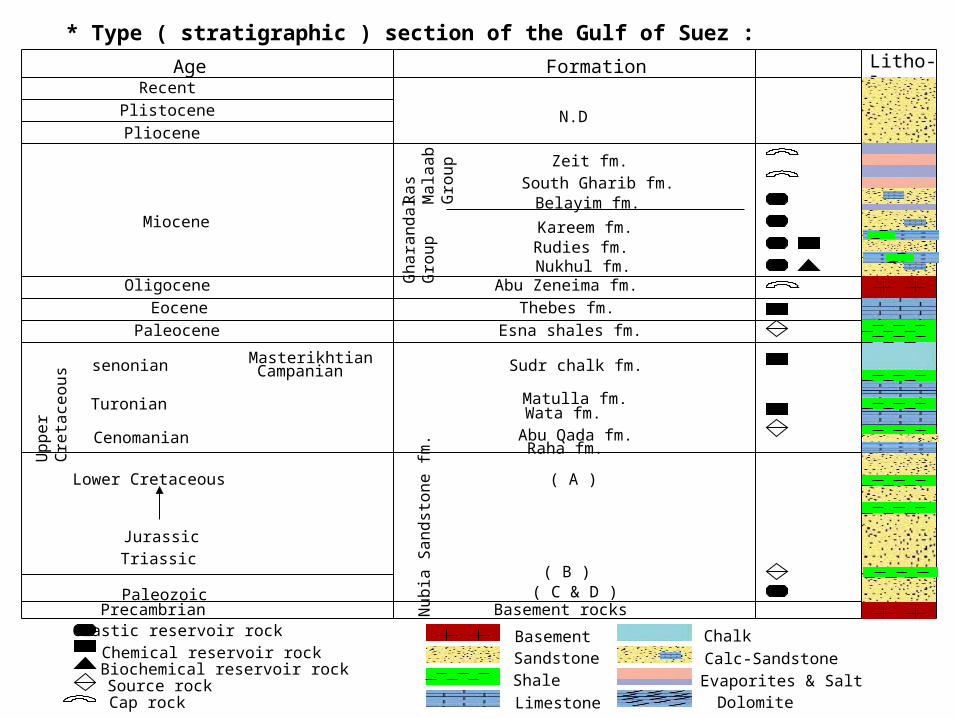
* Type ( stratigraphic ) section of the Gulf of Suez :Age Formation
Recent Plistocene Pliocene
Miocene
Oligocene Eocene
Paleocene
Uppe
rCret
aceo
us
Lower Cretaceous
Jurassic Triassic
Paleozoic Precambrian
Ras
Mala
abGr
oup
Ghar
anda
lGr
oup
Zeit fm.South Gharib fm.Belayim fm.Kareem fm.Rudies fm.Nukhul fm.
Abu Zeneima fm.Thebes fm.
Esna shales fm.
senonian
Turonian
Cenomanian
MasterikhtianCampanian Sudr chalk fm.
Matulla fm.Wata fm.Abu Qada fm.Raha fm.
( A )
( B )( C & D )
Basement rocksNubi
a Sa
ndst
one
fm.
Clastic reservoir rockChemical reservoir rockBiochemical reservoir rockSource rockCap rock
N.D
Litho-logy
BasementSandstoneShaleLimestone
ChalkCalc-Sandstone
DolomiteEvaporites & Salt
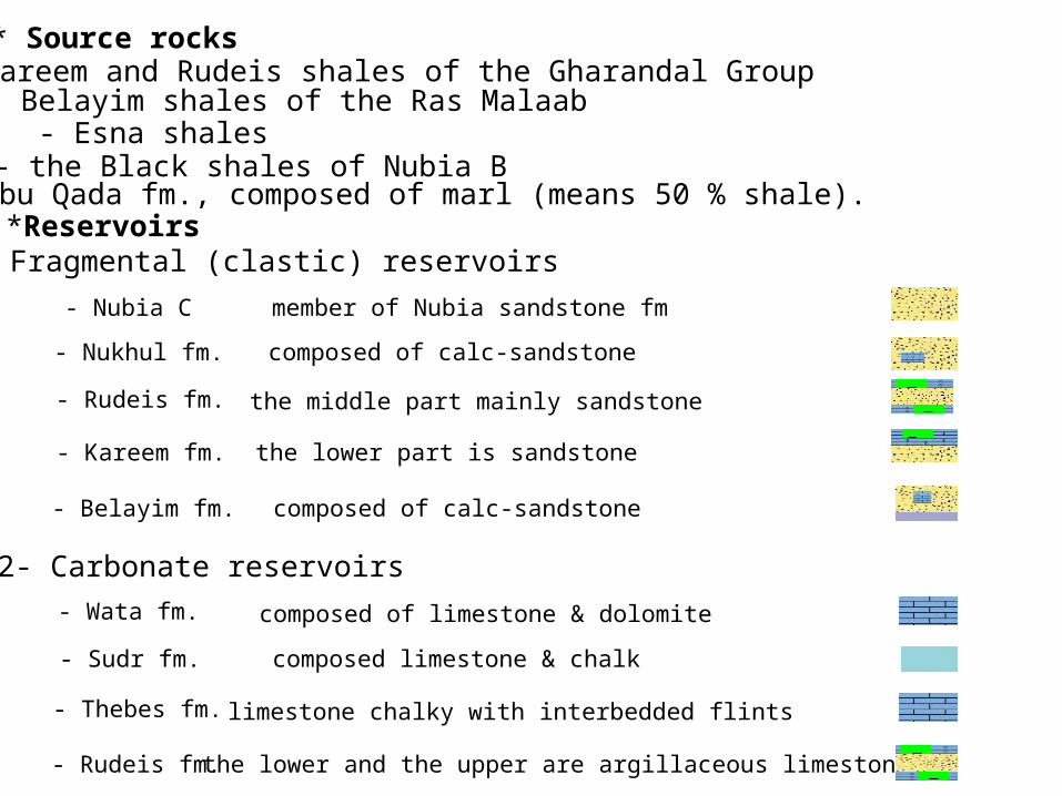
*Reservoirs1- Fragmental (clastic) reservoirs
- Nubia C- Nukhul fm.
member of Nubia sandstone fm composed of calc-sandstone
- Rudeis fm. the middle part mainly sandstone - Kareem fm. the lower part is sandstone
- Belayim fm. composed of calc-sandstone
2- Carbonate reservoirs- Wata fm. composed of limestone & dolomite - Sudr fm. composed limestone & chalk
- Thebes fm. limestone chalky with interbedded flints
- Rudeis fm. the lower and the upper are argillaceous limestone
* Source rocks - kareem and Rudeis shales of the Gharandal Group
- Belayim shales of the Ras Malaab - Esna shales
- the Black shales of Nubia B - Abu Qada fm., composed of marl (means 50 % shale).

*Traps - Gulf of Suez region is highly tectonized, so that it is highly faulted and structure controlled. So, it is suggested that most traps that present in the Gulf of Suez are structural traps, predominantly tilted fault blocks.
*Cap rocks- The Oligocene (Abu Zenima beds which are igneous flows). - The salt beds of the lower member of Belayim fm.
- Evaporite series south Gharib and Zeit formations.
1- Crests of tilted blocksThese are the most common traps in the Gulf of Suez definitely contain thelargest known oil accomulation. Ex. October,Belayim land, and Morgan fields.
Evaporites
...................................................................
● Models of traps

2- Down-faulted wedgesTheses are down-faulted wedges compartments boundary major longitudinal faults.
...................................................................
3- Roll-over foldThese traps are created by dip-slip of the hanging wall of major clysmic faults/aongthe fault scarp.
……………………………….……….…

*Fields-A large number of producing fields and discoveries (more than 50) have been proven in the Gulf of Suez area.
- Some of them can be classified as large fields with proven recoverable reserves exceeding 250 million barrels ( e.g. the Morgan, October, Belayim Land, Belayim Marine, July, Ramadan, and Ras Gharib fields.). - Other fields with proven recoverable reserves of over 125 million barrels of oil (e.g. the Ras Bakr ,Ras Sudr, Shoab Ali, and Budran fields). - Still others have reserves ranging from 0.5 to 50 million barrels of oil.
4- Stratigraphic traps-Common in the Gulf, generally combined with stractural ones. Such as - up-dip pinchout of sand lenses - reefal buidups over block crests - weathered & fractured basment
5- Mixed traps-The oil fields of the Gulf of Suez generally exhibit a great variety of structural features and structural stratigraphic traps.


1- El-Morgan field-El-Morgan field is located in the southern part of the Gulf of Suez.-Traps: fault blocks, tilted to WSW.-Reservoir: Kareem - Belayim - Lower Rudies - Matulla .
2- Ramadan field
- Ramadan field is located in the central province of the Gulf of Suez basin.-Traps: tilted fault blocks, following by crestal erosion-Reservoir: Nubia C - Matulla - Watta .
3- Zaafarana field
-Zaafarana field is located in the north of the Gulf of Suez.-Traps: tilted fault blocks-Reservoir: Kareem - Rudeis (Middle) - Rudies ( Lower) .

2- The Western Desert-The Western Desert comprises the area west of the Nile river and Delta and covers 700,000 sq km, about two-thirds of the area of Egypt.-It extends 1000 km from the Mediterranean Sea to the Sudanese border in the south and 600 to 800 km from the Nile valley to the Libyan border in the west. However, the exploration efforts were mainly concentrated in the northern part of Lat. 28º, with minor efforts in the offshore areas.
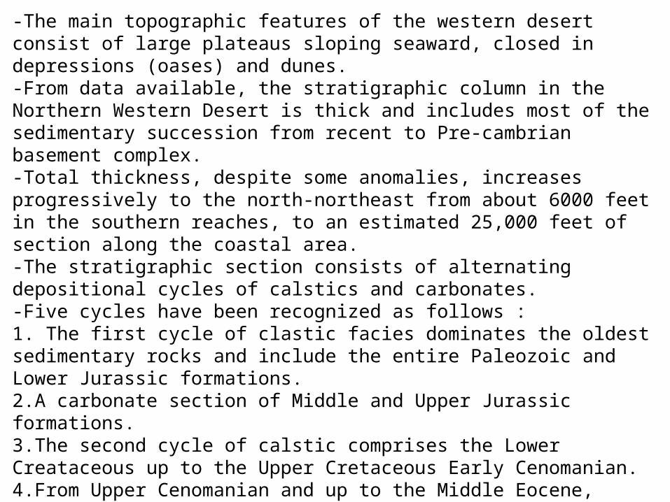
-The main topographic features of the western desert consist of large plateaus sloping seaward, closed in depressions (oases) and dunes.-From data available, the stratigraphic column in the Northern Western Desert is thick and includes most of the sedimentary succession from recent to Pre-cambrian basement complex.-Total thickness, despite some anomalies, increases progressively to the north-northeast from about 6000 feet in the southern reaches, to an estimated 25,000 feet of section along the coastal area.-The stratigraphic section consists of alternating depositional cycles of calstics and carbonates.-Five cycles have been recognized as follows :1. The first cycle of clastic facies dominates the oldest sedimentary rocks and include the entire Paleozoic and Lower Jurassic formations.2.A carbonate section of Middle and Upper Jurassic formations.3.The second cycle of calstic comprises the Lower Creataceous up to the Upper Cretaceous Early Cenomanian.4.From Upper Cenomanian and up to the Middle Eocene, carbonate deposits are again distributed throughout northern Western Desert.5.The upper most clastic depositional cycle includes the Upper Eocene-Oligocene, Miocene and younger section.


* Type ( stratigraphic ) section of the Western Desert :Age Formation
Recent
Plistocene
Pliocene
Miocene Oligocene
Eocene Paleocene
Jurassic
Triassic Paleozo
ic Precambrian
Thebes fm.Esna shales fm.
Basment rocksNubia Sandstone fm.
Ras Qattara GrEghei Gr
Wadi Natrun fmKatatba fm.Masajed fm.
Cretaceous
Lower
Upper
Mamura fm.Matruh fm.Shaltut fm.Alamein fm.Dahab fm.Kharita fm.Baharya fm.Abu Roash fm.Khoman chalk fm.
Mokattam fm.Ghoroud fm.Moghra fm.
Marmarica fm.
N.D
Clastic reservoir rockChemical reservoir rockBiochemical reservoir rockSource rockCap rock
Litho-logy
BasementSandstoneShaleLimestone
ChalkCalc-Sandstone
DolomiteEvaporites & Salt

*Source rocks
- Khatatba fm.
- Kharita fm.
- Massajid fm.- Matruh fm.
*Reservoirs1- Fragmental (clastic) reservoirs
- Nubia sandstone fm.- Kharita fm.
- Bahariya formation
- C,E & G of Abu Roash fm.
2- Carbonate reservoirs- Alamein fm.

*Cap rocks
- Shale sequences intercalated in the carbonate and clastic sections. -Evaporitic sequences including anhydrite ,as in the case of the basal member G of the Abu Roash formation in the Alamein field.
*Traps
- Traps are of combined stratigraphic structural type, consisting mainly of faulted anticlinal features.
*Fields
- The first commercial discovery was made in 1966 with the Alamein field. To date there is a large number of oil and gas fields and discoveries (about 50) has been proven in the Western Desert province with variable size and fields.
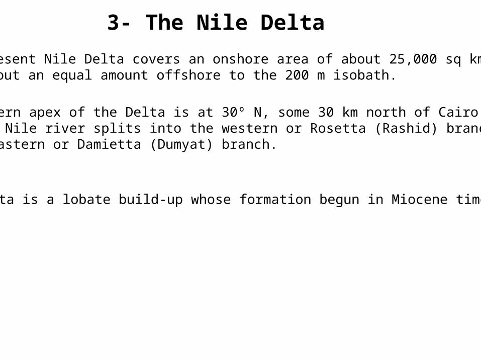
3- The Nile Delta - The present Nile Delta covers an onshore area of about 25,000 sq km and about an equal amount offshore to the 200 m isobath.
-The southern apex of the Delta is at 30º N, some 30 km north of Cairo, where the Nile river splits into the western or Rosetta (Rashid) branch, and the eastern or Damietta (Dumyat) branch.
- The Delta is a lobate build-up whose formation begun in Miocene time.

* Type ( stratigraphic ) section of the Nile Delta :Age Formation
Recent Plistocene
Pliocene
Miocene
Oligocene
Eocene
Paleocene
Jurassic
Triassic
Paleozoic Precambrian
Thebes fm.Esna shales fm.
Basment rocks
Nubian complex
CretaceousLower
Upper
Alamein fm.
Mokattam fm.
Mamura fm.
Wata fm.Sudr fm.
Sidi salem fm.Qawasim fm.
Galala fm.
Qasr El Sagha fm.
Abu Qir fm.Abu Madi fm.
Kafr El Sheikh fm.
Clastic reservoir rockChemical reservoir rockBiochemical reservoir rockSource rockCap rock
Bilqas fm.
LowerUpper Elwastani fm.
Mit Ghamr fm.
Rosetta fm.
Ghazalat fm.Qatrani fm.Abu Zaabal fm.
Litho-logy
BasementSandstoneShaleLimestone
ChalkCalc-Sandstone
DolomiteEvaporites & Salt

*Traps
- Lenticular sands are present on gentle anticlines.
*Source rocks
- The organic rich shales within the Sidi Salem and the Kafr el Sheikh formations
*Reservoirs
- The Abu Madi sandstone fm.- The sands of the Sidi Salem fm.

4- North Sinai-Sinai covers about 61,000 sq km. Basement rocks form the high-relief mountainous tip of the peninsula, culminating at 2675 m (Gebel Musa).-The central part of Sinai is covered by the subhorizontal Mesozoic and Tertiary sediments which form the high plateaus of Egma and El-Tih. These are drained towards the Mediterranean Sea by the multiple affluents of the Wadi el Arish. From latitude 30º to the north, alternating faulted domes, anticlines and synclines known as the Syrian Arc system form a contrasting topography of low alluvial plains and high hill masses.-Due to a series of down-to-basin faults, Neogene in age, the northern fringe of the Syrian Arc sinks seawards. It is hidden under the Quaternary coastal plain and the continental shelf deposits.-To date, the prospective area is confined to the northern coastal plain along the Mediterranean, and its offshore extension, as well as the western coastal plain along the Gulf of Suez with its offshore extension.
*Source rocks-Organic rich shales, interbedded in the Triassic carbonates beyond the Egyptian border, proved to be oil source rocks and could extend into North Sinai.-Carbonaceous shales and coal seams of the Middle Jurassic sequences are potential gas-prone source rocks.-North of the hinge line, other shales and marls with source rock characteristics exist as time equivalents of the thick Jurassic and Cretaceous carbonates.-Cenozoic source rocks may be similar to those of the Nile Delta province.-Upper Oligocene shales are considered a source for gas, and Lower Oligocene series a source for oil.
*Reservoirs-Potential reservoir rocks are widely distributed throughout the geological section:-“Sandstone” in Carboniferous, Lower Triassic, Lower&Middle Jurassic, Lower Cretaceous and Tertiary deltaic or perideltaic deposits.-“Carbontes” of the Middle Triassic, bioclastic or reefal limestones of Upper Jurassic and Middle Cretaceous, as well as their dolomitic time equivalents.
*Cap rocks-Apart from the possible evaporitic beds of the Upper Triassic, cap rocks of Mesozoic age are represented by scattered and thin shaly or marly intervals.-In the Tertiary section, very thick source shale sequences provide an excellent seal to the imbedded, sandy reservoirs.
*Traps-Major traps in pre-Tertiary series consist of faulted anticlines pertaining to the Syrian Arc.-In the hinge zone, step-faulted blocks may form prospective features.-Offshore , in the Tertiary series, traps are of the combined structural-stratigraphic type and frequently fault-associated.
*Fields- The only field which produced in north Sinai is the Sadot gas field, with ultimate recoverable reserves of 35 million CFG, located in Cenomanian dolomite and limestone.
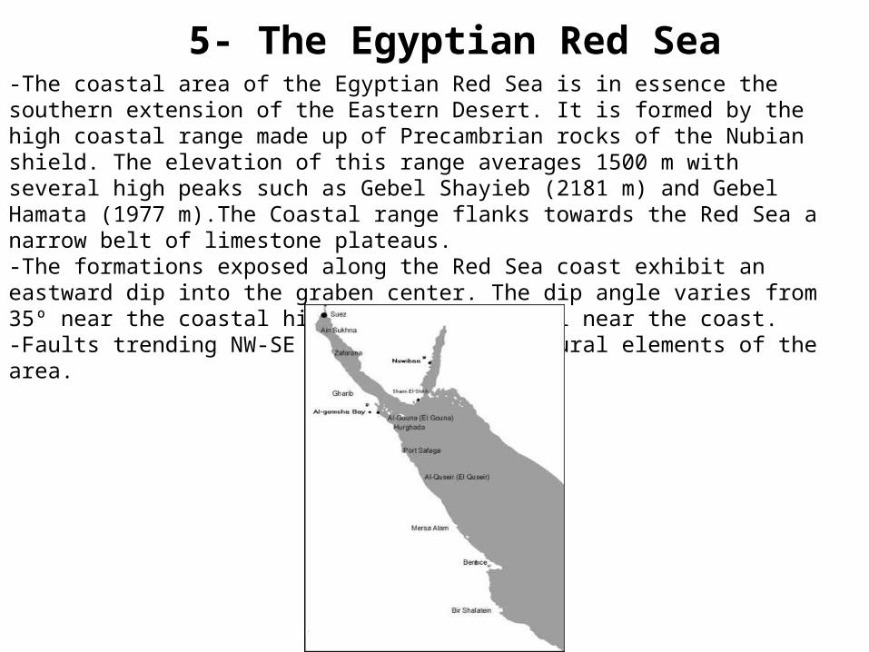
5- The Egyptian Red Sea-The coastal area of the Egyptian Red Sea is in essence the southern extension of the Eastern Desert. It is formed by the high coastal range made up of Precambrian rocks of the Nubian shield. The elevation of this range averages 1500 m with several high peaks such as Gebel Shayieb (2181 m) and Gebel Hamata (1977 m).The Coastal range flanks towards the Red Sea a narrow belt of limestone plateaus.-The formations exposed along the Red Sea coast exhibit an eastward dip into the graben center. The dip angle varies from 35º near the coastal hills to subhorizontal near the coast.-Faults trending NW-SE are the main structural elements of the area.
*Source rocksShales and marls with source rock characteristics may be present imbedded within the sands and in the thick salt sequences. However, very little data is available.
*Reservoirs-Good reservoirs are represented by the Nubian sands which are producing in the Hurghada Field.-Miocene sands likely offer the best reservoirs. They are in part imbedded in thick salt, in part developed as channel or beach sands overlying Lower Miocene carbonates, and preserved on tilted fault block surfaces, or draped over fault blocks.
*Cap rocks- All the reservoirs are sealed by overlying thick salt deposition.
*Traps- traps are represented by a variety if structural features. Horsts flanking the subbasins and tilted fault blocks are developed along the marginal homocline dipping gently seaward.

Type Section of the main petroleum provinces in Egypt: