overview of botanical resources - usda forest
TRANSCRIPT
Page 64
The frequency, timing and locations of natural ignitions are random. These ignitions, coupled with analysis of current and past weather phenomena, have the pote:p.tial to be accepted as a prescribed natural fire (PNF). The result may range from a small, low intensity fire to a large high intensity stand replacing event. Both of these outcomes have occurred at varying frequency in the within the watershed (see Fire Regime descriptions).
The risk and potential impact of a natural ignition may eliminate it from acceptance as a prescribed natural fire (See PNF Plan). This may occur because, due to past fire suppression, there are few natural barriers limiting the size of a burn and the amount of forest fuels are increasing. Therefore, it is possible that PNF' s in the near future will be small and minimize program accomplishment, or large stand replacement events with higher risk and resource impact. The desired result would produce mostly moderately sized burns of varying intensity.
A complete program for returning fire to the ecosystem would also include management ignited fire (MIF). This tool could be used to create fuel breaks to limit future fire size under PNF. It could also control fire intensity in sensitive areas and increase the pace at which fire returns to the ecosystem. Management ignited fire would help reduce the risks and potential impacts of PNF, and maximize the factors affecting fire behavior which can be controlled while minimizing factors that can not be controlled.
OVERVIEW OF BOTANICAL RESOURCES
Non-Forested Habitats Many researchers have sought to answer questions about the non-forested habitats in the Western and Northern Cascades and Olympic Mountain Ranges. Researchers Charles Halpern, B. G. Smith, and Jerry Franklin (Halpern et al 1984), attempted to answer the following questions about the habitat types found in the Three Sisters Wilderness Area:
• What are the origins of the variety of non-forested lands? • What environmental and/ or biotic features maintain them as such? • What changes are occurring within these meadows and across their ecotones? • Why and when did change occur?
The researchers' work focused on establishing a series of permanent transects through various habitat types in the Three Sisters Wilderness Area. This information in conjunction with research done in the Western Cascades was used for this analysis.
Chapter 3
Page 65
Natural disturbances such as volcanic eruptions, fires, and floods created the habitats on the Horse Creek landscape. There are strong correlations between plant community composition, soil moisture, landform type, and elevation. The types of non-forested plant communities and their distribution on the landscape historically probably was more extensive than today. Non-forested plant communities most likely occurred over larger areas and for longer periods of time. Disturbance by fire or other factors in subalpine forests probably resulted in openings that remained a century or more, as forest succession may be much slower in subalpine than in montane forests (Peet 1978, 1981). Reoccurring fires historically created and maintained meadow and shrub dominated communities. Fire is the principal agent through which meadows expand (Miller 1995). Native Americans are reported to have burned meadows (William 1994) for removal of undergrowth vegetation, travel accessibility, maintenance of huckleberry fields, grass growth, and hunting (Coville 1898, Burke 1979, Williams 1994). Many researchers cite environmental and climatic factors over the last century that have influenced montane and subalpine plant communities (Douglas & Bliss 1977, Franklin & Dymess 1988, Hickman 1976, Miller 1995, Miller & Halpern 1997). The effects of sheep grazing in the watershed from the late 1800's until cessation in 1938 have influenced meadow plant communities. Fire suppression since 1910 has also played a critical factor in meadow and shrub habitat types in the watershed.
A high diversity of non-forested habitats and associated species richness is present in the watershed. The diversity in species composition and growth forms reflects the broad range of environmental conditions that can found in the watershed. The following table (Table 3-2) lists the dominant habitat types and approximate acres in the Horse Creek Watershed.
Table 3-2: Dominant special habitat types in the Horse Creek Watershed.
Habitat type Acres % of Watershed Rock, talus, pumice and lava fields 5,580 6%
Shrub I forb I grass communities 1,540 2%
Wetlands 725 1%
The soils and geology of the watershed are of two distinct physiographic provinces. The mountains on the western boundary are O'Leary, Horsepasture, Lamb Butte, and English. This area of the watershed lies within a geologically older (Oligocene to Miocene) part of the Cascade Range. The Western Cascades are more dissected, with deep soils. Habitat types include lush forb meadows, shrub thickets, and ridgetop rock outcrops and gardens. In the Central and Western Cascades the rugged topography and heavier snowfall result in variable snow depths and release dates, leading to steep
Chapter 3
Page 66
environmental gradients, constricted communities, and abrupt changes in community type (Douglas and Bliss 1977).
To the east are the High Cascades, where soils are young and well-drained, and composed of pumice, ash, and cinders. The alpine zone occurs on only recently dormant Pleistocene volcanoes of the Cascade Range (Franklin & Dyrness 1973). High elevation subalpine to alpine habitats are present in the form of grass and forb meadows, dwarf shrub communities, pumice, and talus slopes. Lakes, ponds, and seasonally wet areas and associated vegetation are abundant. Map 3-lla displays the location of known special habitats in this watershed.
Western Cascades Plant Communities Two dominant herbaceous mesic montane meadows that occur in this area are Veratrum I Valeriana I Senecio and Rubus I Pteridium. Two common ridgetop rock gardens are Gilia I Polygoum I Eriogonum and Eriophyllum I Castilleja I Sedum. These rocky habitats have thin soils from the continuous erosion that occurs. Sitka alder (Alnus sinuata) communities are common on the north slopes near water or where ground water is close to the surface. Vine maple (Acer circinatum) and rocky soil associations occur on drier sites. An emergent wetland identified as "The Potholes" is located in the Lamb Butte Special Interest Area. The only other.moist habitat in this area of the watershed is a small spring east of The Potholes. Research in 1968 identified Horsepasture Mountain as one of the most floristically diverse area in the entire Western Cascades (Hickman 1968).
High Cascades Plant Communities Subalpine grass, sedge, and shrub communities; pumice flats, aquatic and seasonally wet areas with associated vegetation are abundant in the eastern portion of the watershed. Shrub communities located on cool, north-facing slopes are dominated by pink heather (Phyllodoce empetrifarmis) and white heather (Cassiope mertensiana). Dry south slopes are dominated by broadleaf lupine (Lupinus latifolius) and mountain bunchgrass (Festuca viridula). Mountain bunchgrass (Festuca viridula) communities were heavily grazed by sheep from the late 1800's until cessation in the 1938. Black sedge (Carex nigricans) community typically occurs in basins and depressions with poor drainage and persistent snow. Mixed grass and forb communities of tufted hairgrass (Deschampsia cespitosa) and long-stalked dover (Trifolium longipes) are found where there is seasonal water. The dry subalpine pumice flats are dominated by Newberry's fleeceflower (Polygonum newberryi) communities. These high elevation subalpine communities have short growing seasons due to late persisting snowbanks and cold, wet soils. By late summer, low moisture stress limits plant growth in many of these communities.
All of the habitat types identified in the Horse Creek watershed have wide distribution throughout the Central, Western, and Northern Cascades to British Columbia, and the Olympia Mountains.
Chapter 3
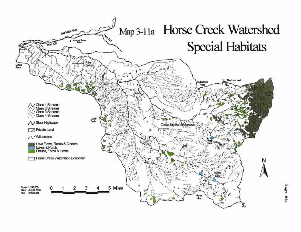
N a ass 1 Streams N aass 2 Streams / 'v aass 3 Streams / , :aass4Streams
I \ 1
N state Highwa~
E:ZJ Private Land
1 \ /Wilderness
- Lava Flows, Rocks & Cinders 1:: · _ • <I Lakes & Ponds
Shrubs, Forbs & Herbs
D _Horse Creek Watershed Boundary
0 1 2 3 4 --
Map3-lla
5 Miles Scale: 1:150,000 03te: July 8, 1997 File: shabs.apr ---
Horse Creek Watershed Special Habitats
N
A >-0 jl)
QQ (I)
0\ 0\ •!13
Page 67
Community Locations
• VeratrumfValeriana/Senecio meadows typically occur on east to northwest-facing slopes, with a constant source of moisture.
• RubusjPteridium community is an extremely widespread type in the Pacific Northwest (Hickman 1976).
• GiliafPolygoumjEriogonum community type is the driest of the meadow associations in the Western Cascades and includes many distinct species (Hickman 1976).
• Eriophyllum/Castilleja/Sedum community type occurs on steep south or west -facing slopes.
• Heather communities dominated by Phyllodoce empetriformis and Cassiope mertensiana. are common in the Central and Northern Cascades and Coastal mountains, extending into British Columbia.
• Festuca virdula and Lupinus latifolius communities were once widespread across the upper montane to subalpine zones of Oregon and Washington, but have probably decreased due to past grazing of livestock. This community has been reported on Mount Rainier, WA. (Meredith 1972), Mt. Jefferson (Swedberg 1961), and Three Sisters Wilderness Area (Van Vechten 1960).
• Carex nigricans communities occur in the Central to Northern Cascades and Olympic Mountains where there is heavy snowpack. This community type occurs from the Siskiyou mountains of California, north to Alaska, and east to the Rocky Mountains of Colorado and Alberta (Munz 1959). This widespread distribution is the result of the southern migration during the Pleistocene glaciation and its persistence on mountain tops since the retreat of the glaciers Oones 1947).
• Large, pumice flats, mostly barren of vegetation are conspicuous features of the subalpine parkland (Van Vechten 1960, Swedberg 1961, Horn 1968).
Threats to Non-Forest Communities Conifer encroachment in montane and subalpine meadow communities is a major threat to the viability of these plant communities. Reduction through the loss of habitat by conifer encroachment has been widely studied in the western United States during the last forty years. The origin and persistence of meadows in areas that can support coniferous forests have been studied by various researchers (Kuramoto & Bliss 1970, Franklin et al. 1971, Vale 1981, Magee & Antos 1992, Rochefort & Peterson, Miller 1995, Miller & Halpern 1997). Most of the scientific literature on montane and subalpine meadow communities have cited climatic changes, fire suppression, and past livestock grazing as influencing conifer encroachment and meadow succession in this century.
For many meadow communities, it is the interactions of two factors that determine meadow successional dynamics: abiotic (snowpack duration, variation in temperature, and precipitation) and biotic (livestock grazing, seed source). Tree invasion patterns in
Chapter 3
Page 68
several Oregon montane meadows over the last 100 years seems to be controlled by the interactions among grazing, fire use and the subsequent suppression, and climatic variability (Vale 1981, Magee & Antos 1992, Miller 1995, Miller & Halpern 1997).
Depending on the location and type of meadow community, weather conditions can increase or decrease conifer invasion and establishment. Franklin et al (1971) suggested that the warmer, drier climate experienced between the late 1800's to the mid 1940's is responsible for conifer invasion into montane and subalpine meadows. Longer snowfree periods associated with a regional drought in 1920 to 1940 were accompanied by massive conifer invasion. Conifer invasion was accelerated from 1945 to 1985 with the absence of frequent fires, cessation of grazing by sheep, and a period of cool, wet weather. (Agee & Smith 1984, Franklin & Dymess 1973). In the Three Sisters Wilderness James Creek, Separation Creek, and Wickiup Plains and on the west side of the watershed Olallie Ridge were intensively used for sheep grazing from 1875-1938 Gohnson 1985). Meadow composition has most likely been strongly influenced by the presence of over 50 years of sheep grazing.
In 1993 Eric Miller re-sampled Halpern, Smith, and Franklin's transects (established in 1984) in the Three Sisters Wilderness Area and identified various factors in the establishment of conifers in some of the meadows (Miller 1995). Miller's research focused on the changes in establishment, survivorship, and growth rates of conifer populations and associated changes in the distribution and abundance of meadow communities. Study sites were James Creek, Separation Creek, and Wickiup Plains. He concluded that trees established in north-sloping, subalpine heath shrub mesic meadows occurred during periods of moderately earlier snowmelt and high summer precipitation (1920-1945). South-facing, subalpine mesoxeric meadows such as James Creek, were invaded during cool, wetter climatic conditions (1945-1985). Miller's work in the Three Sisters Wilderness determined that climate was the best explanation of conifer invasion into higher elevation meadows. Fire suppression and the cessation of sheep grazing were contributing factors for conifer invasion into meadow habitats.
Road construction of Forest Road 1993 cut through many of the mesic montane meadows from O'Leary to Horsepasture Mountain. Road construction adjacent to or through these habitats reduced habitat size and influenced plant species composition. Harvest of conifer stands adjacent to meadow and rock habitats effects the microclimate, hydrology, and plant species composition.
Many dry habitats such as rock gardens and pumice flats have hiking trails through the habitat. The presence of hiking trails can increase erosion in these sensitive areas and favor the introduction of noxious and other nonnative plant species. Human traffic has probably most affected the relatively flat, subalpine meadows near major trailheads such as Wickiup Plains (Shelby and Hall 1992), though the total acreage is very small (<1/ 4 acre). Packstock may be impacting sensitive hydric and mesic meadows. The
Chapter 3
Page 69
highest use areas in the wilderness are Separation-Mesa Complex, Nash Lake, and the Horse Lake Complex. These areas need field verification to assess impacts to the resources.
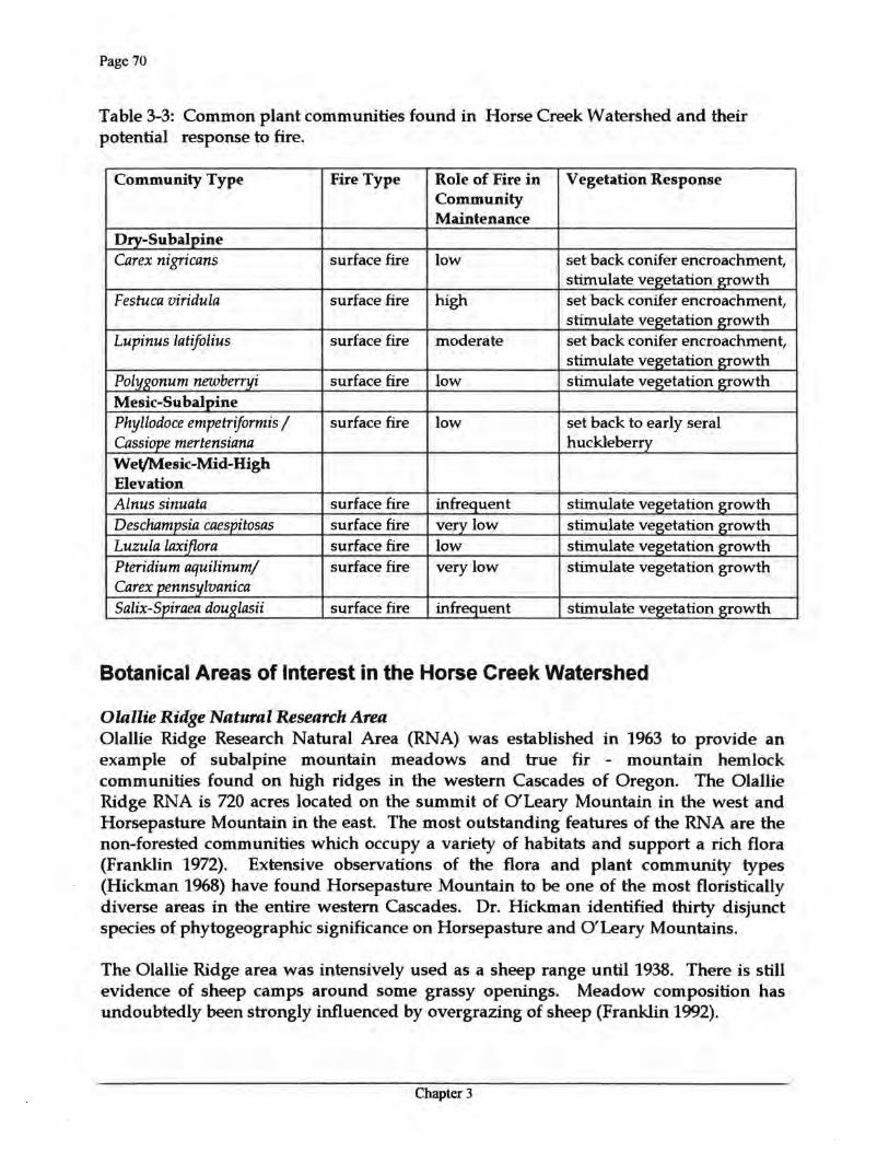
Fire Effects on Non-Forested Habitats Fire effects on non-forested plant communities varies with habitat type and plant community. Environmental conditions such as climate and drought can. affect vegetative conditions and fire intensity. Lakes and wet meadows can impede fire. Sitka alder communities with high soil moisture may also impede the spread of fire. Areas of talus, rock outcrops, and pumice fields can act as barriers that may impede the spread of some fires. Dry meadows on south-facing slopes may bum and enlarge the size of the meadows. Subalpine meadows typically have less fuels and fire will skip over these areas. Fire disturbances may result in forest openings that remain a century or more, as forest succession may be much slower in subalpine than in montane forest (Peet 1978, 1981). Forests that burn at this elevation can be set back to early seral huckleberry meadows for many years before conifers reestablish. Plant species success to compete in a post-fire community are dependent on species regeneration, reproductive abilities, and favorable environmental conditions. Table 3-3lists potential fire response of some of the more common plant communities found in the watershed.
Noxious weeds and other invasive non-native plant species threaten the biological diversity and species composition in special habitat areas. Conifers invasion in meadow communities provide a micro-environment and seed source for further expansion. Re-introduction of fire to reduce conifer encroachment is needed in many of the subalpine meadow communities. Tree establishment has been more dense in subalpine meadow habitats than in montane meadows (Miller & Halpern 1997).
Chapter 3
Page 70
Table 3-3: Common plant communities found in Horse Creek Watershed and their potential response to fire.
Community Type Fire Type Role of Fire in Community Maintenance
Vegetation Response
Dry-Subalpine Carex nigricans surface fire low set back conifer encroachment,
stimulate vegetation growth Festuca viridula surface fire high set back conifer encroachment,
stimulate vegetation growth Lupinus latifolius surface fire moderate set back conifer encroachment,
stimulate vegetation growth Polygonum newberryi surface fire low stimulate vegetation growth Mesic-Subalpine Phyllodoce empetriformis I Cassiope mertensiana
surface fire low set back to early seral huckleberry
Wet/Mesic-Mid-High Elevation Alnus sinuata surface fire infrequent stimulate vegetation growth Deschampsia caespitosas surface fire very low stimulate vegetation growth Luzula laxiflora surface fire low stimulate vegetation growth Pteridium aquilinumj Carex pennsylvanica
surface fire very low stimulate vegetation growth
Salix-Spiraea douglasii surface fire infrequent stimulate vegetation growth
Botanical Areas of Interest in the Horse Creek Watershed
Olallie Ridge Natural Research Area Olallie Ridge Research Natural Area (RNA) was established in 1963 to provide an example of subalpine mountain meadows and true fir - mountain hemlock communities found on high ridges in the western Cascades of Oregon. The Olallie Ridge RNA is 720 acres located on the summit of O'Leary Mountain in the west and Horsepasture Mountain in the east. The most outstanding features of the RNA are the non-forested communities which occupy a variety of habitats and support a rich flora (Franklin 1972). Extensive observations of the flora and plant community types (Hickman 1968) have found Horsepasture Mountain to be one of the most floristically diverse areas in the entire western Cascades. Dr. Hickman identified thirty disjunct species of phytogeographic significance on Horsepasture and O'Leary Mountains.
The Olallie Ridge area was intensively used as a sheep range until 1938. There is still evidence of sheep camps around some grassy openings. Meadow composition has undoubtedly been strongly influenced by overgrazing of sheep (Franklin 1992).
Chapter 3
Page 71
Noxious weeds and other invasive nonnative plant species will continue to be monitored within the Olallie Ridge RNA. Encroachment of conifers into the montane meadows should also continue to be monitored.
Lamb Butte Special Interest Area Lamb Butte is a Special Interest Area (SIA) of approximately 390 acres. It is located on the crest of a north-south ridgeline consisting of three peaks: Taylor Castle, Lamb Butte, and English Mountain. Dry, rocky outcrops are present on or near the top of all three peaks. A wet meadow and small spring known as "The Potholes" is located in the southeast section of the SIA. A population of the uncommon plant species cow-bane (Oxypolis occidentalis) is located in the wet meadow. The SIA was designated because it contains exceptional scenic qualities and biological features. This area was used by Native Americans for medicinal plant gathering (See Human Use section of this Chapter).
The Lamb Butte Special Interest Area has been identified as a "hot spot'' for fungal diversity because of its concentration of rare and endemic species of fungus (Appendix J2, FSEIS USDA and USDI 1994). Habitat conditions for these species of fungi are upper mid elevation (5000 ft.) stands of mature to old growth grand fir, silver fir, Douglas-fir, western hemlock, and mountain hemlock. The FSEIS (USDA and USDI 1994) recommended protection of Lamb Butte Area by the following measures:
• Designate the area as Mycological Special Interest Area
• Merge the Lamb Butte Special Interest Area with the Olallie Ridge Research Natural Area.
Sensitive Species Surveys and Potential Habitat Sensitive plant surveys have occurred in the watershed for proposed timber harvest and for other management activities involving ground disturbance. No formal surveys for rare and uncommon plants have been completed on private lands in the watershed. The diversity of habitat types found within the watershed provide potential habitat for twenty-nine species listed on the Regional Forester's Sensitive Plant List for the Willamette National Forest.
Known Sensitive Populations A population of the sensitive plant species Ophioglossum pusillum (Adder's-tongue) is located in the watershed. Adder' s-tongue is a very low growing fern that inhabits pond margins and wet meadows. The population in the watershed occurs in a seasonal wet meadow near Owl Creek. Two additional uncommon species Sidalcea cusickii (Cusick's mallow) and Botrychium virginianum (Virginia grape-fern) are found in the
Chapter 3
Page 72
meadow. Adder's-tongue is dependent on its mycorrihizal association with fungus, which transfers energy and nutrients from the soil to the plants. Although the plant is perennial, individual plants may not emerge every year; This population is one of only six known populations in the state of Oregon. All six sightings are located on USDA Forest Service lands. A Conservation Strategy and Monitoring Plan for Adder' s-tongue was completed in 1996 between the Willamette, Umpqua, Siuslaw and the Mt. Hood Forests (USDA 1996). The primary objective of the Plan is to maintain long-term population viability of Adder' s-tongue on these four forests.
The occurrence of Adder' s-tongue is related to available soil moisture. It is suspected that changes in available soil moisture can affect the viability of the species. Current moisture levels in the meadow have increased as result of the removal of a mature conifer stand on the adjoining hillslope approximately 15 years ago. Today, a young stand of conifers occupies the site. High levels of surface water will gradually decrease over time, until the hillslope stand reaches 120 years old (McSwain, pers. comm.). Population census on Adder' s-tongue was not taken prior to stand harvest. The Conservation Strategy for this species requires population census to occur biennially. In 1996 the first census of the population was taken. Changes in the Adder's-tongue population, species composition of the meadow, and hydrologic conditions will be tracked. There is also a concern for the loss of habitat due to_ natural succession in the meadow. Currently the meadow is being encroached by competing vegetation.
Oxypolis occidentalis (cow-bane) is also documented in the watershed. This species is currently listed on the Willamette National Forest Sensitive Species List. However, when the sensitive list is revised, cow-bane will be removed from the sensitive list and placed on the Forest Watch List because numerous populations of this species have been found throughout its range.
Other Plant Species of Concern Six uncommon plant species have been documented in the watershed. Uncommon plant species are listed on the Forest Watch and Concern Lists. Unlike the Sensitive list, the Watch and Concern Lists do not have management guildelines. However, many species are associated with non-forested habitats (special habitats) which are protected by standard and guideline FW-211. Listed plant species are monitored to track species occurrence and abundance on the Forest. An example of an uncommon species is Draba aureola (golden alpine draba), which grows at 9,500 feet in the pumice soils on South Sister Mountain. Table 3-4lists the uncommon and rare plant species in this watershed.
Chapter 3
Page 73
Table 3-4: Rare and uncommon plant species in the Horse Creek Watershed.
Species Common Name Site Name *Status Ophioglossum pusillum Adder's-tongue Owl Creek Meadow s Draba aureola Golden alpine South Sister w
draba Oxypolis occidentalis Cow-bane The Potholes w Sidalcea cusickii Cusick's mallow Owl Creek Meadow w Botrychium virginianum Virginia grape-fern Owl Creek Meadow c Botrychium virginianum Virginia grape-fern Horsepasture Mtn. c
Trail Corallorhiza trifida Yellow coral-root Three Sisters c
Pleurocospora .fimbriolata Wilderness
Fringed pinesap Three Sisters c Wilderness
Polystichum andersonii Anderson's Horsepasture Mtn. c swordfern
*Willamette National Forest ~nsitive, Watch, and Concern Lists.
Survey and Manage Species: Fungi, Lichens, Bryophytes and Vascular Plants The Northwest Forest Plan contains a list of species generally associated with latesuccessional forests and riparian habitat. The standard and guidelines for the survey and management of these species contain four components:
1. Manage known species sites, and include provisions for their protection. 2. Survey prior to ground disturbing activities implemented in 1999 and manage known species sites. 3. Develop survey protocols and species management guidelines. Conduct extensive regional surveys to find high priority sites for species management. 4. Conduct general regional surveys.
Species of fungi, lichens, bryophytes and vascular plants are valued as indicators of biodiversity and forest stability. Species diversity for the majority of these species appears highest in late-successional forests due to the diversity of habitat structures, host species, and large amounts of duff and down material. Many of these species have poor dispersal capabilities and are unable to move across fragmented habitats. Fragmented habitat may restrict gene flow between populations in the landscape. No Forest-wide inventories for survey and manage fungi, lichen, bryophyte and vascular plant species have occurred in the watershed. Two vascular plants, Botrychium minganense and Botrychium montanum, are on the survey and manage list of species and
Chapter 3
Page 74
are also on the Willamette National Forest Sensitive Plant List. A list of potential survey and manage species and their associated habitats is located in the Botany Appendix.
Locations of fungi, lichen, bryophyte, and vascular plant species that are documented in the watershed (Table 3-5) are from research collections and incidental sightings. Field surveys done by Dr. J. Trappe in the Lamb Butte Special Interest Area documented thirteen previously unknown species of ectomycorrhizal fungi. These species are locally endemic "type species" and are listed under survey strategy component 1. "Type species" are specimens designated to serve as a reference point for a scientific name. Because of the concentration of rare and endemic fungal species in the Lamb Butte Area, researchers have recommended that the area be protected by the following mitigation measures (from Appendix J 2 FSEIS USDA and USDI 1994):
1. Designate the area as Mycological Special Interest Area. 2. Merge the Lamb Butte Special Interest Area with the Olallie Ridge Research Natural Area.
Table 3-5: Survey and manage species documented in the Horse Creek Watershed.
Survey Species Classification Strategy Geographic Area Chroogomphus loculatus rare gilled mushroom/ 1, 3 The Potholes, Lamb
my~orrhizal fungi Butte Scenic Area, Gastroboletus imbelellus rare bolete mushroom / 1, 3 The Potholes, Lamb
mycorrhizal fungi Butte Scenic Area Gastroboletus ruber rare bolete mushroom / 1, 3 Lamb Butte Scenic Area
mycorrhizal fungi Glomus radiatum rare zygomycete/
mycorrhizal fungi 1, 3 The Potholes, Lambs
Butte Scenic Area, Gymnomyces sp. nov.# rare truffle or false 1, 3 Olallie Trail, Lamb Trappe 1690, truffle/ mycorrhizal Butte Scenic Area
fungi Gymnomyces sp. nov.# rare truffle or false 1, 3 Olallie Trail, Lamb Trappe 1706, truffle/ mycorrhizal Butte Scenic Area
fungi Gymnomyces sp. nov. # rare truffle or false 1, 3 Olallie Trail, Lamb Trappe 1710 truffle/ mycorrhizal Butte Scenic Area
fungi Hypogymnia oceanica rare lichen 1, 3 Fisher Lake area, Three
Sisters Wilderness Area
Chapter 3
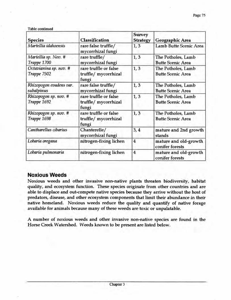
Page 75
Table continued
Survey Species Classification Strategy Geographic Area Martellia idahoensis rare false truffle/
mycorrhizal fungi 1, 3 Lamb Butte Scenic Area
Martellia sp. Nov. # rare truffle/ 1, 3 The Potholes, Lamb Trappe 1700 mycorrhizal fungi Butte Scenic Area Octavianina sp. nov. # rare truffle or false 1, 3 The Potholes, Lamb Trappe 7502 truffle/ mycorrhizal Butte Scenic Area
fungi Rhizopogon evadens var. rare false truffle/ 1, 3 The Potholes, Lamb subalpinus mycorrhizal fungi Butte Scenic Area Rhizopogon sp. nov.# rare truffle or false 1, 3 The Potholes, Lamb Trappe 1692 truffle/ mycorrhizal Butte Scenic Area
fungi Rhizopogon sp. nov.# rare truffle or false 1, 3 The Potholes, Lamb Trappe 1698 truffle/ mycorrhizal Butte Scenic Area
fungi Cantharellus cibarius Chanterelle/
mycorrhizal fungi 3, 4 mature and 2nd growth
stands Lobaria oregana nitrogen-fixing lichen 4 mature and old-growth
conifer forests Lobaria pulmonaria nitrogen-fixing lichen 4 mature and old-growth
conifer forests
Noxious Weeds Noxious weeds and other invasive non-native plants threaten biodiversity, habitat quality, and ecosystem function. These species originate from other countries and are able to displace and out-compete native species because they arrive without the host of predators, disease, and other ecosystem components that limit their abundance in their native homeland. Noxious weeds reduce the quality and quantify of native forage available for animals because many of these weeds are toxic or unpalatable.
A number of noxious weeds and other invasive non-native species are found in the Horse Creek Watershed. Weeds known to be present are listed below.
Chapter 3
Page 76
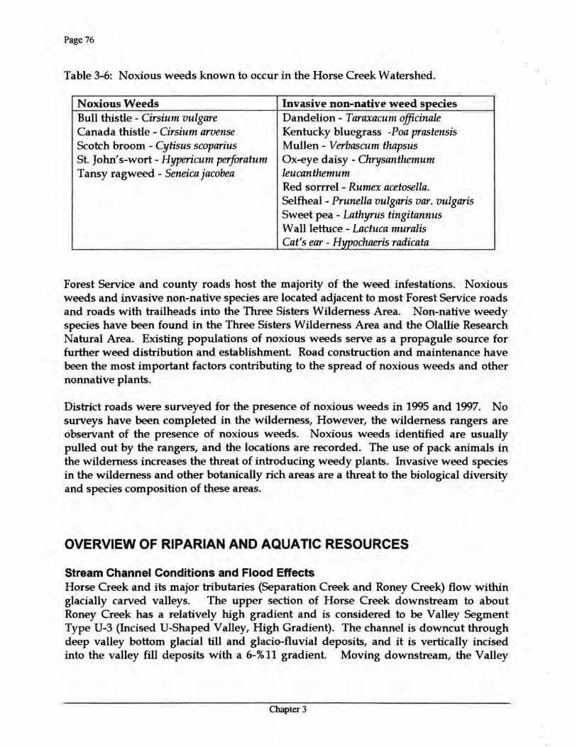
Table 3-6: Noxious weeds known to occur in the Horse Creek Watershed.
Noxious Weeds Invasive non-native weed species Bull thistle - Cirsium vulgare Dandelion - Taraxacum officinale Canada thistle - Cirsium arvense Kentucky bluegrass -Poa prastensis Scotch broom - Cytisus scoparius Mullen- Verbascum thapsus St. John' s-wort - Hypericum perforatum Ox-eye daisy - Chrysanthemum Tansy ragweed - Seneica jacobea leucanthemum
Red sorrrel - Rumex acetosella. Selfheal- Prunella vulgaris var. vulgaris Sweet pea - Lathyrus tingitannus Wall lettuce - Lactuca muralis Cat's ear- Hypochaeris radicata
Forest Service and county roads host the majority of the weed infestations. Noxious weeds and invasive non-native species are located adjacent to most Forest Service roads and roads with trailheads into the Three Sisters Wilderness Area. Non-native weedy species have been found in the Three Sisters Wilderness Area and the Olallie Research Natural Area. Existing populations of noxious weeds serve as a propagule source for further weed distribution and establishment Road construction and maintenance have been the most important factors contributing to the spread of noxious weeds and other nonnative plants.
District roads were surveyed for the presence of noxious weeds in 1995 and 1997. No surveys have been completed in the wilderness, However, the wilderness rangers are observant of the presence of noxious weeds. Noxious weeds identified are usually pulled out by the rangers, and the locations are recorded. The use of pack animals in the wilderness increases the threat of introducing weedy plants. Invasive weed species in the wilderness and other botanically rich areas are a threat to the biological diversity and species composition of these areas.
OVERVIEW OF RIPARIAN AND AQUATIC RESOURCES
Stream Channel Conditions and Flood Effects Horse Creek and its major tributaries (Separation Creek and Roney Creek) flow within glacially carved valleys. The upper section of Horse Creek downstream to about Roney Creek has a relatively high gradient and is considered to be Valley Segment Type U-3 (Incised U-Shaped Valley, High Gradient). The channel is downcut through deep valley bottom glacial till and glacio-fluvial deposits, and it is vertically incised into the valley fill deposits with a 6-%11 gradient. Moving downstream, the Valley
Chapter 3
Page 77
Segment Type changes to U-2 (Incised U-Shaped Valley, Moderate Gradient) around the confluence with Roney Creek, which is similar to U-3 but with a more moderate channel gradient of 2-5%. The valley width and gradients within the U-2 valley segment type are conducive to the formation of mid-channel bars and side channels. The U-2 Valley Segment Type changes to U-Shaped Trough just upstream of the confluence with Avenue Creek. This is where the valley width increases dramatically and stream gradients decline.
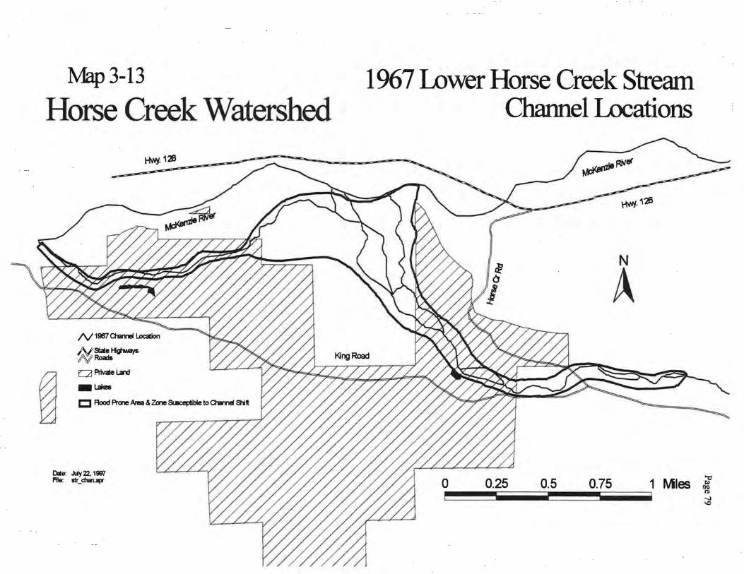
Around the confluence with King Creek, Horse Creek enters the McKenzie River valley, and flows over a broad alluvial fan. The main channel is prone to shifting its location during rare storm events within the broad, glacial valley of the U-Shaped Trough and the Alluvial Fan valley segment types. The channel within the Alluvial Fan valley segment type has changed location many times, often with more than one active channel joining the McKenzie River at various locations. Maps 3-12, 3-13, and 3-14 display the Horse Creek channel for four time periods (1955, 1967, 1990 and 1996) from Horse Creek Campground downstream to its confluence with the McKenzie River.
The 1964 flood, an event with a recurrence interval of 100-120 years, caused Horse Creek to abandon several channels and form new ones, as indicated by comparing the 1955 channels to 1967. During the 1964 event, West Fork Horse Creek aggraded and abandoned its original channel that flowed adjacent to homes. New channels were created both to the north and to the east of the original West Fork Horse Creek channel.
Today, West Fork Horse Creek is virtually dry during summer months, flowing only during the winter and spring. The main channel carrying most of the flow travels directly north into the McKenzie River. In the past, attempts have been made by private citizens to increase flow into West Fork Horse Creek through the use of structures made of gabions, rock, and logs. Installation of these structures have actually accomplished the opposite of the intended effect, causing channel downcutting in East Fork Horse Creek and increasing streamflow in the channel that flows directly north into the McKenzie River.
Prior to the 1964 flood, and today, much of Horse Creek streamside vegetation was dominated by mature conifers and was well vegetated along most of the stream length. Hardwoods in localized areas was the dominant vegetation on point bars within the U2 valley segment type (Incised U-Shaped Valley, Moderate Gradient). The exception is the alluvial fan of lower Horse Creek which had already been heavily harvested by 1955, with much of East Fork Horse Creek and eastward harvested. Most of the major tributaries appeared stable. However, Avenue Creek appeared to have sluiced many years prior to the 1964 flood; Pasture Creek showed evidence of ravelly banks and sideslope failures high in the subwatershed; and Castle Creek had streamside slides and abundant sediments stored within the channel.
Chapter 3
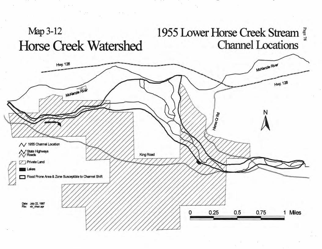
Map3-12
Horse Creek Watershed HYJY.123
N 1955 Chamel Location
M,_StateH~ "f'V Roads
~ 1ZJ Aivate l.a'ld
-I.Bkes C Flood Prone kea & Zone &Jsceplible to Cha"!nel Shift
Dale: .uy 22, 1997 File: str_chsn.apr
1955 Lower Horse Creek Stream ! Channel Locations
00
r~WJ.126
N
A
0 0.25 0.5 0.75 1 Mles
l\1ap 3-13
Horse Creek Watershed
~~Hsjv.ays a QA'ival.and t;3 _,..
Cite: .Uy22, 1997 File: str_chan.apr
~. 126
1967 Lower Horse Creek Stream Channel Locations
'rtHJ.'\26
N
A
., o 0.25 0.5 0.75 1 Mles ~
no -..J \0
Map~-14
Horse Creek Watershed Hv-¥· 126
N 1 sa> & 1996 ctamer Location
~State Hg'ways /\! Roads a [Z] Private Land
rg -~
Dlte: ~22. 1997 File: 111r_ claupr
1990 & 1996 Lower Horse Creek~ 0
Stream Channel Locations
'r\'HI· 126
N
A
0 0.25 0.5 0. 75 1 Mles
Page 81
The effects of the 1964 flood on Horse Creek and its tributaries is quite complex. Several tributaries experienced debris torrents, sending massive quantities of sediment down Horse Creek, including Castle Creek, whose stored sediments careened down the channel and into Horse Creek. At least two other tributaries had debris torrents, including an un-named tributary upstream of Roney Creek and Mosquito Creek. All of the stream failures detected on aerial photos occurred in unmanaged stands and were not the result of harvest or road building. Mass-wasting of tributaries as high in the system as Mosquito Creek resulted in many miles of stream length in main Horse Creek being seriously affected by the flood. Riparian vegetation within the U2 segment was wiped out, and sediment was deposited on point bars. However, the U2 segment is more of a "transport'' section, sending most of the sediment further downstream to the U-Shaped Glacial Trough and Alluvial Fan "response" sections where large quantities of sediment, particularly cobbles and gravel, were deposited on point bars. Within the U-Shaped Glacial Trough, the channel widened and a high proportion of vegetation on bars and islands was wiped out.
Extensive opening of the channel likely resulted in increased stream temperatures within Horse Creek. Revegetation of accumulated sediments with alder are contributing shade to the channel, helping to reduce stream temperatures. However, temperatures probably remain higher during summer months than prior to the 1964 flood due to lack of shade from tall conifers on islands, mid-channel bars, and point bars.
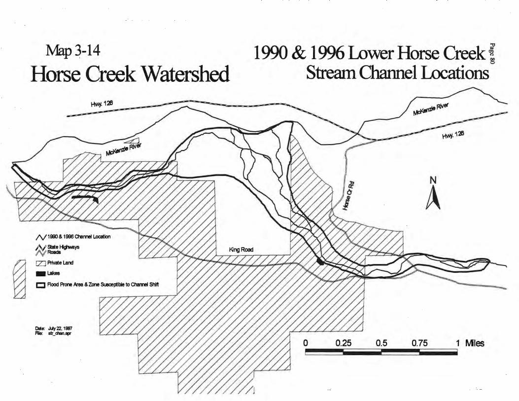
In contrast to the 1964 flood, examination of aerial photos from 1990 and 1996 verify that large-scale channel changes did not occur in the alluvial fan of lower Horse Creek or the U2 segment of Horse Creek during the flood of 1996, a storm with a recurrence interval of approximately 50 years in the upper McKenzie River watershed. Minor changes did occur, however, such as accumulations of large wood into log jams, acceleration and migration of point-bar growth, localized streambank cutting, and shifting of secondary channels to primary channels. Point bars heavily vegetated with alder remained intact for the most part Wilelada Creek experienced a debris torrent, sending some sediment and wood into Horse Creek. There were several other slides and failures that occurred in association with roads or timber harvest, but most of the sediment from these failures never reached Horse Creek.
Map 3-14 illustrates the area potentially subject to flooding or changes in channel location due to large storm events from Horse Creek Campground down to the confluence with the McKenzie River. This includes the lower Horse Creek floodplain and adjacent zones susceptible to channel shift. This depicts areas prone to flooding or channel location shifts resulting from storm events with a return interval >50-75 years. Note that several residences on the east side of Horse Creek are located within the area potentially subject to flooding.
Chapter 3
Page 82
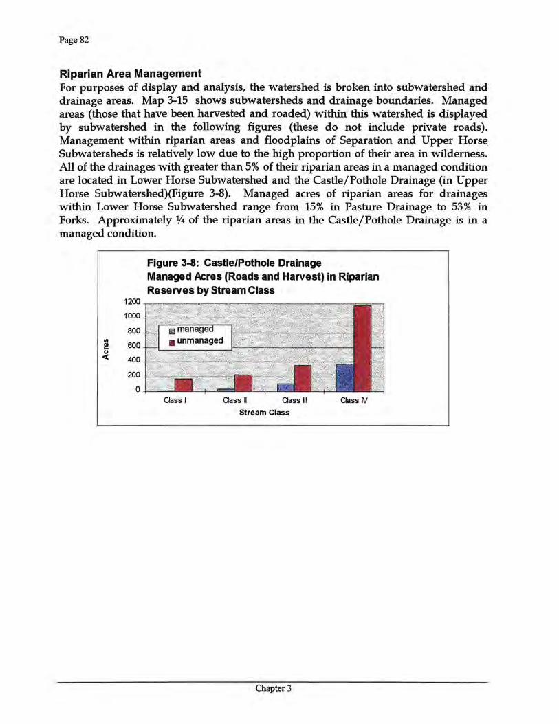
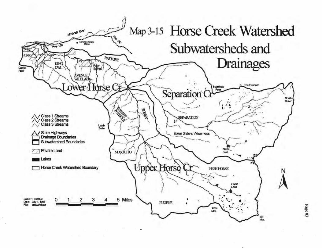
Riparian Area Management For purposes of display and analysis, the watershed is broken into subwatershed and drainage areas. Map 3-15 shows subwatersheds and drainage boundaries. Managed areas (those that have been harvested and roaded) within this watershed is displayed by subwatershed in the following figures (these do not include private roads). Management within riparian areas and floodplains of Separation and Upper Horse Subwatersheds is relatively low due to the high proportion of their area in wilderness. All of the drainages with greater than 5% of their riparian areas in a managed condition are located in Lower Horse Subwatershed and the Castle/Pothole Drainage (in Upper Horse Subwatershed)(Figure 3-8). Managed acres of riparian areas for drainages within Lower Horse Subwatershed range from 15% in Pasture Drainage to 53% in Forks. Approximately 1/4 of the riparian areas in the Castle/Pothole Drainage is in a managed condition.
1200
10p<l
800
! 600 u c( 400
200
0 Class I Class II Class Ill Class N
Stream Class
Figure 3-8: Castle/Pothole Drainage Managed Acres (Roads and Harvest) in Riparian Reserves by Stream Class
Chapter 3
N aass 1 streams N aass 2 streams /\/ aass 3 streams
N state Highways t:J Drainage Boundaries CJ Subwatershed Boundaries
c::zJ Aivate Land
-Lakes
D Horse Creek Watershed Boundary
Scale: 1 :150,000 l:)jte: July 1, 1997 File: subvlshd.apr
0 1 2 3
Map 3-15 Horse Creek Watershed Subwatersheds and
Drainages
N
A 4 .,
~ 00 \i.l
Page 84
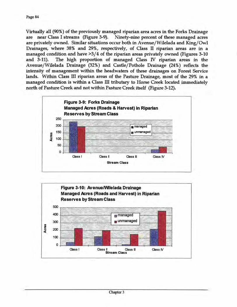
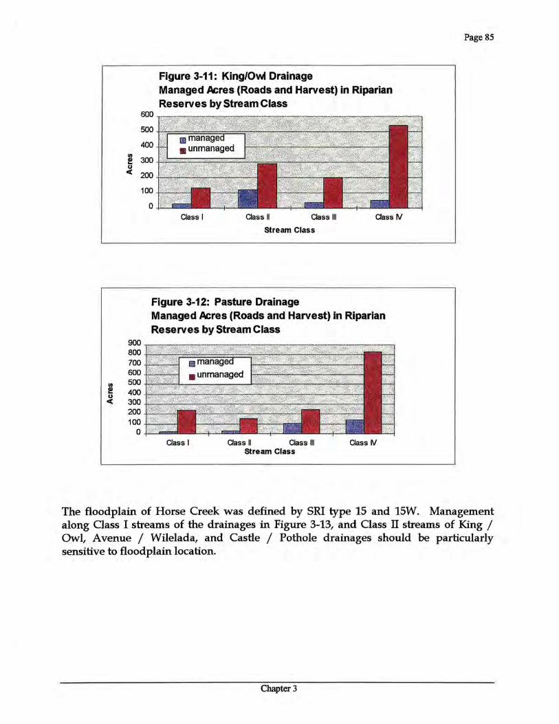
Virtually all (90%) of the previously managed riparian area acres in the Forks Drainage are near Class I streams (Figure 3-9). Ninety-nine percent of these managed acres are privately owned. Similar situations occur both in Avenue/Wilelada and King/Owl Drainages, where 38% and 29%, respectively, of Oass II riparian areas are in a managed condition and have >3 /4 of the riparian areas privately owned (Figures 3-10 and 3-11). The high proportion of managed Class N riparian areas in the Avenue/Wilelada Drainage (32%) and Castle/Pothole Drainage (24%) reflects the intensity of management within the headwaters of these drainages on Forest Service lands. Within Class ill riparian areas of the Pasture Drainage, most of the 29% in a managed condition is within a Class ill tributary to Horse Creek located immediately north of Pasture Creek and not within Pasture Creek itself (Figure 3-12).
2! u c(
Figure 3-9: Forks Drainage Managed Acres (Roads & Harvest) in Riparian Reserves by Stream Class
250 ~;:r::~~ii'WiJ['3;:::§@l~~ 200
Ill 150 I!! .:i. 100
50
0 Class I Class II Class Ill Class W
Stream Class
Figure 3-10: Avenue/Wilelada Drainage Managed Acres (Roads and Harvest) in Riparian Reserves by Stream Class
500
400
300
200
100
0 Class I Class II Class Ill Class W
Stream Class
Chapter 3
!! u <C
600
500
400
!! 300 u
<C 200
100
0
Figure 3-11: King/Owl Drainage Managed Acres (Roads and Harvest) in Riparian Reserves by Stream Class
Class I Class II Class Ill Class IV
Stream Class
Figure 3-12: Pasture Drainage
900 800 700 600 500 400 300 200 100
0
Managed Acres (Roads and Harvest) in Riparian Reserves by Stream Class
Class I Class II Class Ill Class IV Stream Class
Page 85
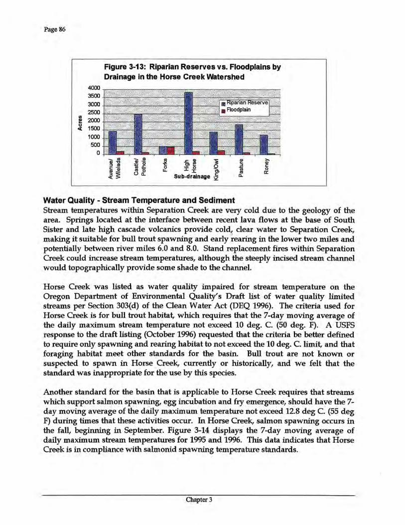
The floodplain of Horse Creek was defined by SRI type 15 and 15W. Management along Class I streams of the drainages in Figure 3-13, and Class IT streams of King I Owl, Avenue I Wilelada, and Castle I Pothole drainages should be particularly sensitive to floodplain location.
Chapter3
Page 86
4000 3500 3000 2500
en 2000 I!!
u 1500 c(
1000 500
0
Figure 3-13: Riparian Reserves vs. Floodplains by Drainage in the Horse Creek Watershed
..... (11 ..... Q) Q)"'C Q)-::J (11 "ijj_g c-Q)~ (11-
~~ (.)~ ~ a ~ o ..... ~ .f £~ Cl
Sub-drainage 2
>. Q) c 0 a::
Water Quality - Stream Temperature and Sediment Stream temperatures within Separation Creek are very cold due to the geology of the area. Springs located at the interface between recent lava flows at the base of South Sister and late high cascade volcanics provide cold, clear water to Separation Creek, making it suitable for bull trout spawning and early ~earing in the lower two miles and potentially between river miles 6.0 and 8.0. Stand replacement fires within Separation Creek could increase stream temperatures, although the steeply incised stream channel would topographically provide some shade to the channel.
Horse Creek was listed as water quality impaired for stream temperature on the Oregon Department of Environmental Quality's Draft list of water quality limited streams per Section 303(d) of the Clean Water Act (DEQ 1996). The criteria used for Horse Creek is for bull trout habitat, which requires that the 7-day moving average of the daily maximum stream temperature not exceed 10 deg. C. (50 deg. F). A USFS response to the draft listing (October 1996) requested that the criteria be better defined to require only spawning and rearing habitat to not exceed the 10 deg. C. limit, and that foraging habitat meet other standards for the basin. Bull trout are not known or suspected to spawn in Horse Creek, currently or historically, and we felt that the standard was inappropriate for the use by this species.
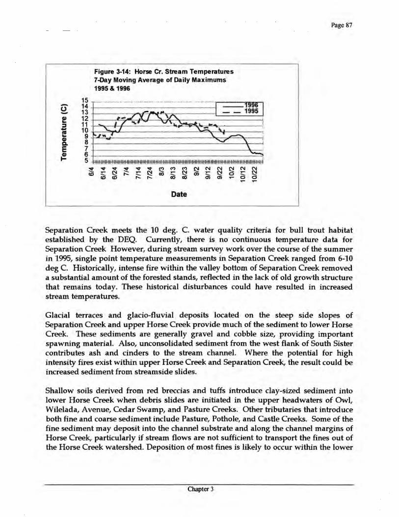
Another standard for the basin that is applicable to Horse Creek requires that streams which support salmon spawning, egg incubation and fry emergence, should have the 7-day moving average of the daily maximum temperature not exceed 12.8 deg C. (55 deg F) during times that these activities occur. In Horse Creek, salmon spawning occurs in the fall, beginning in September. Figure 3-14 displays the 7-day moving average of daily maximum stream temperatures for 1995 and 1996. This data indicates that Horse Creek is in compliance with salmonid spawning temperature standards.
Chapter 3
Page 87
14 0 13 -l!:! 12 :I 11 - 10 l! 9 CD 8 Q. E 7 {!!. 6
5
~ CD
..,. ..,. ~
..,. ..,. ..- ~ ..- ~ ..... 1'- ..... CD CD 1'- 1'-
Date
15 -
Figure 3-14: Horse Cr. Stream Temperatures 7-Day Moving Average of Daily Maximums 1995 & 1996
Separation Creek meets the 10 deg. C. water quality criteria for bull trout habitat established by the DEQ. Currently, there is no continuous temperature data for Separation Creek However, during stream survey work over the course of the summer in 1995, single point temperature measurements in Separation Creek ranged from 6-10 deg C. Historically, intense fire within the valley bottom of Separation Creek removed a substantial amount of the forested stands, reflected in the lack of old growth structure that remains today. These historical disturbances could have resulted in increased stream temperatures.
Glacial terraces and glacio-fluvial deposits located on the steep side slopes of Separation Creek and upper Horse Creek provide much of the sediment to lower Horse Creek. These sediments are generally gravel and cobble size, providing important spawning material. Also, unconsolidated sediment from the west flank of South Sister contributes ash and cinders to the stream channel. Where the potential for high intensity fires exist within upper Horse Creek and Separation Creek, the result could be increased sediment from streamside slides.
Shallow soils derived from red breccias and tuffs introduce day-sized sediment into lower Horse Creek when debris slides are initiated in the upper headwaters of Owl, Wilelada, Avenue, Cedar Swamp, and Pasture Creeks. Other tributaries that introduce both fine and coarse sediment include Pasture, Pothole, and Castle Creeks. Some of the fine sediment may deposit into the channel substrate and along the channel margins of Horse Creek, particularly if stream flows are not sufficient to transport the fines out of the Horse Creek watershed. Deposition of most fines is likely to occur within the lower
Chapter 3
I'll ~ y j£ -ri ~ • oC!
= y I'll -Q
10,000
7,000 5,000 4,000 3,000
2,000
1,000
700 500 400 300
200
100
- Dis.cbm:ge, in CFS
G rapll CraiN: MoD Apr 15 J!i:16:43 ED'J' 19116
lt"
Figure 3-15: Daily average discharge from Horse Creek from 1963-1969.
Hor11e Creek Kear Mckenzie Bridge, Or Statton Number: 14159100
Page 88
alluvial fan of Horse Creek, where the stream enters the McKenzie River Valley, and within side channels and secondary channels. Debris slides that initiate within the tributary headwaters are the result of large storm events, fire, roads, and harvest units.
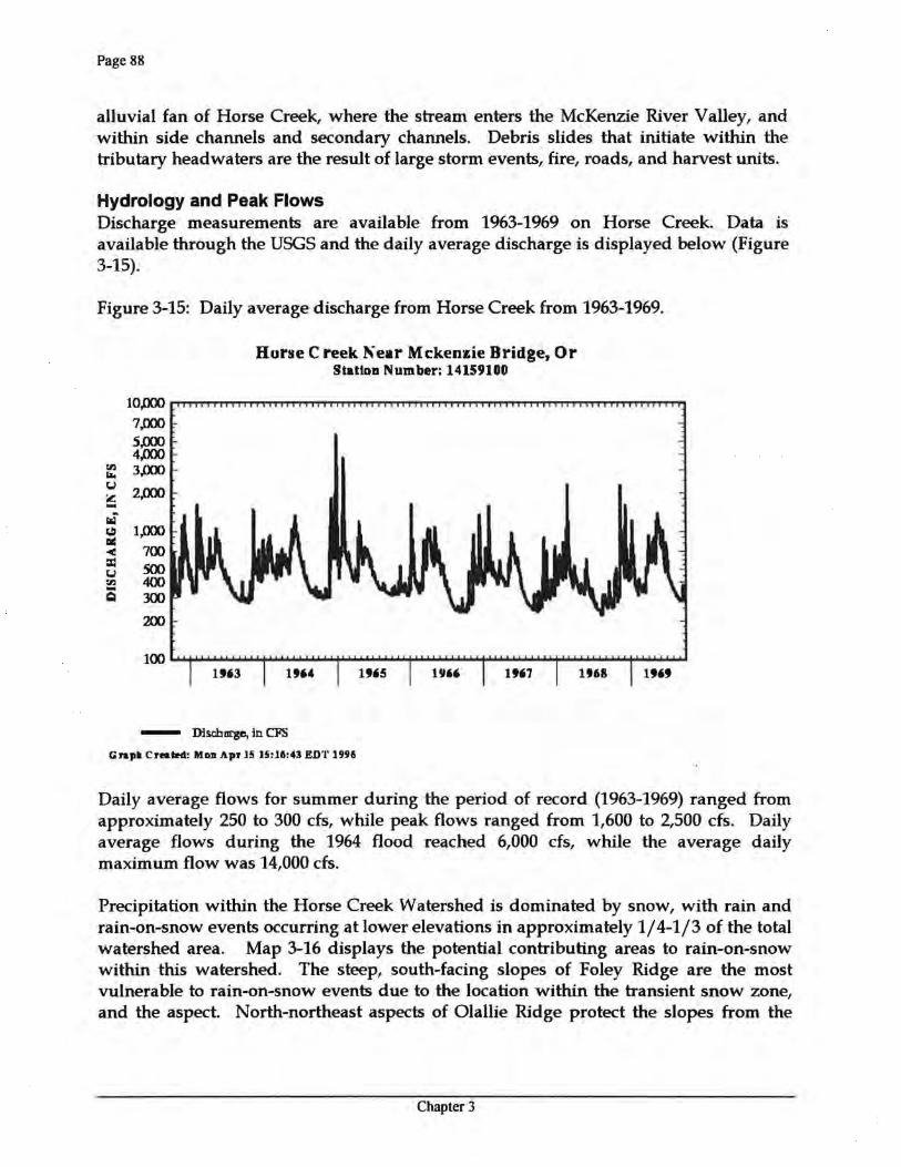
Hydrology and Peak Flows Discharge measurements are available from 1963-1969 on Horse Creek. Data is available through the USGS and the daily average discharge is displayed below (Figure 3-15).
Daily average flows for summer during the period of record (1963-1969) ranged from approximately 250 to 300 cfs, while peak flows ranged from 1,600 to 2,500 cfs. Daily average flows during the 1964 flood reached 6,000 cfs, while the average daily maximum flow was 14,000 cfs.
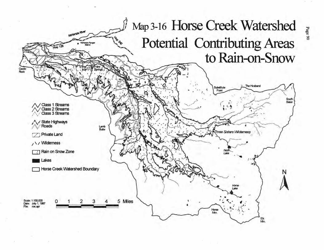
Precipitation within the Horse Creek Watershed is dominated by snow, with rain and rain-on-snow events occurring at lower elevations in approximately 1/4-1/3 of the total watershed area. Map 3-16 displays the potential contributing areas to rain-on-snow within this watershed. The steep, south-facing slopes of Foley Ridge are the most vulnerable to rain-on-snow events due to the location within the transient snow zone, and the aspect. North-northeast aspects of Olallie Ridge protect the slopes from the
Chapter 3
Page 89
south-southwest driven warm rains. However, steep slopes coupled with shallow soils make these slopes prone to debris slides and debris flows. The majority of the wilderness area is located within the permanent snow zone, resulting in a low probability for rain-on-snow events.
Peak streamflows may occur as a result of rain events or rain-on-snow events. They cause transport of large channel substrate, channel widening, bank erosion, and deposition of substrate that provides a medium for early seral riparian vegetation. Forest management may cause increases in peak flows. In a large basin study on peak flow responses to clearcutting on the Willamette National Forest (Wemple et al. 1996) found that watersheds ranging in size from 15,000 to 150,000 acres had increased peak discharges as the cumulative area of harvest and road construction increased. However, the increase in peaks was for storm events that produced discharges with <2 year return intervals. While it is apparent that small peak discharges are increased with management, there is no evidence that large peak discharges are increased. It is unclear what the effects of increased peak flows of <2 year return interval are on stream channel conditions and aquatic habitat. Possible effects are increased bank erosion and transport of larger bedload than is typical during bankfull flows.
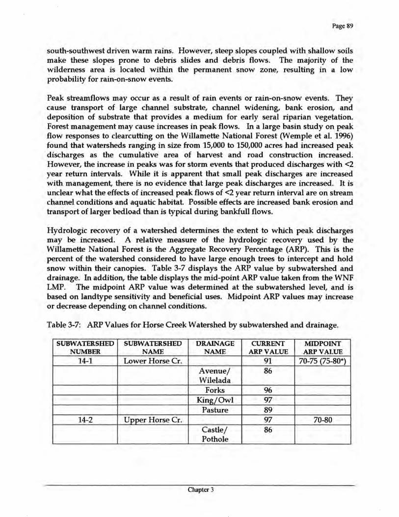
Hydrologic recovery of a watershed determines the extent to which peak discharges may be increased. A relative measure of the hydrologic recovery used by the Willamette National Forest is the Aggregate Recovery Percentage (ARP). This is the percent of the watershed considered to have large enough trees to intercept and hold snow within their canopies. Table 3-7 displays the ARP value by subwatershed and drainage. In addition, the table displays the mid-point ARP value taken from the WNF LMP. The midpoint ARP value was determined at the subwatershed level, and is based on landtype sensitivity and beneficial uses. Midpoint ARP values may increase or decrease depending on channel conditions.
Table 3-7: ARP Values for Horse Creek Watershed by subwatershed and drainage.
SUBWATERSHED SUBWATERSHED DRAINAGE CURRENT MIDPOINT NUMBER NAME NAME ARPVALUE ARPVALUE
14-1 Lower Horse Cr. 91 70-75 (75-80*) Avenue/ 86 Wilelada
Forks 96 King/Owl 97
Pasture 89 14-2 Upper Horse Cr. 97 70-80
Castle/ 86 Pothole
Chapter 3
N aass 1 Streams N aass 2 Streams /\./ aass 3 Streams
~~ State Highways /~! Roads
[ZJ Private Land
1 \ 1 Wilderness
Q Rain on SnON Zone
-Lakes
D Horse Creek Watershed Boundary
Scale: 1 :150,000 ~e: July 1, 1997 File: ros.apr
0 1 2 3 4
Map3-16 Horse Creek Watershed Potential Contributing Areas
to Rain-on-Snow
,....._///~ ... __ ----.~ .---!·~
· .....
N
A 5 Mles
~ ~ \0 0
Page 91
SUBWATERSHED SUBWATERSHED DRAINAGE CURRENT MIDPOINT NUMBER NAME NAME ARPVALUE ARPVALUE
Eugene 100 High Horse 100
Mosquito 97 Roney 100
14-3 Sep_aration Cr. 99 65 (70-75*) Separation 99
*See Text below: recommended new ranges.
The table demonstrates that ARP values for Horse Creek Watershed are well above the Midpoint ARP values. However, two of the Midpoint ARP values should be updated due to additional information gained since the LMP was finalized in 1990. The Midpoint ARP value for Lower Horse subwatershed was based on a landtype sensitivity of moderate value. The landtype sensitivity is based on the amount of area in the rain-on-snow zone and steepness of slope. Map 3-16, which displays rain on snow areas, indicates that Lower Horse subwatershed is a high contributing area to rain-on-snow. In addition, many slopes in the subwatershed are >70%. Therefore, the Midpoint ARP value for Lower Horse subwatershed should be 75-80 due to a high landtype sensitivity and high beneficial use of anadromous fish. The second Midpoint ARP that should be changed is Separation Creek. We have since learned that Separation Creek is bull trout habitat, and therefore should have a high beneficial use. Currently, the beneficial use is moderate. The new rating to high would result in a Midpoint ARP at a value of 70-75.
Increases in small peak streamflows within the watershed may have occurred in the past when hydrologic recovery of the drainages was lower. However, effects of the increases are likely masked by the effects of mass failures in the form of debris torrents, streamside slides, and road failures that occur with large storm events such as the 1964 and 1996 floods. Although a complete reconnaissance of the watershed has not been completed since the flood of 1996, initial data suggests most slides originated at roads or within harvest units.
Roads have been documented to increase small peak flows by increasing their efficiency and extending the drainage network of a watershed Gones and Grant 1996). Table 3-8 displays the road density of the watershed by subwatershed and drainage. Though none exceed 3.0 milesjmile2, two drainages, Avenue/Wilelada and Castle/Pothole, may experience increased peak flows due to road densities, steep slopes, and shallow soils. Three drainages, Eugene, High Horse, and Roney, do not have any roads within their drainages and are not displayed in the table.
Chapter 3
Page 92
Table 3-8: Road densities in Horse Creek Watershed by subwatershed and drainage.
SUBWATERSHED NAME DRAINAGE NAME ROAD DENSITY (miles/mile2)
Lower Horse Cr. 2.3 A venue/W ilelada 2.6
Forks 2.0 King/Owl 1.5
Pasture 2.6 Upper Horse Cr. 0.4
Castlef Pothole 2.3 Mosquito 0.7
Separation Cr. 0.1 Separation 0.1
OVERVIEW OF FISHERIES
Habitat Conditions - Streams In 1937, U.S. Bureau of Fisheries biologists Baltzo, Kolloen, and Parkhurst surveyed the lower 11.1 miles of Horse Creek and the first 2.4 miles of Separation Creek to document the quantity and quality of anadromous fish habitat (Mcintosh et al. 1995). This was part of a larger effort to document anadromous fish habitat in the Columbia River Basin. They described the stream as flowing through a flat bottom valley 2-3 miles wide near its mouth, but varying from only 114 to 1/2 mile in width above the lower 2.5 miles. The valley was bordered by moderately steep hills at its downstream end, but the topography becomes mountainous and the valley walls increasingly steep upstream.
They described the watershed as being heavily wooded with large conifers. The undergrowth was moderate on the hill slopes, but the flat valley floor was described as filled with a damp jungle and huge cedars. They did not observe any erosion of the surrounding hillsides into the stream. The bank of the stream was covered with a dense jungle of vine maple, alder, cedar and brush which hung over the water, providing cover and food for fish. Throughout the lowest 5 miles of Horse Creek, the stream flowed through an intricate network of cross-connecting channels which constantly shifted with each high water. The low, flat banks permitted much of the valley to be flooded at high water stages, and the resultant erosion made the water turbid after heavy rains. They described the country above the confluence with
Chapter 3