national park service cultural landscapes inventory
TRANSCRIPT
NatioNal Park Service
cultural laNdScaPeS iNveNtory ProfeSSioNal ProcedureS Guide
JaNuary 2009

i
Professional Procedures Guide
national Park service
cultural landscaPes inventory
Professional Procedures Guide
Revised By:
Jeffrey Killion, Olmsted Center for Landscape Preservation
Gretchen Hilyard, Olmsted Center for Landscape Preservation
PRePaRed By:
Robert R. Page, Olmsted Center for Landscape Preservation
U.s. dePaRtment of the inteRioR
national PaRk seRvice
cUltURal ResoURce stewaRdshiP and PaRtneRshiPs
PaRk histoRic stRUctURes and cUltURal landscaPes PRogRam
washington d.c.
January 2009

national Park service - cultural landscaPes inventory
ii
The Park Cultural Landscapes Program is a servicewide effort of people in parks, regional offices, centers and the
Washington office dedicated to a mission of the preservation and protection of the cultural landscapes in the parks
of the National Park System. A cultural landscape is a geographic area, including both cultural and natural resources
and the wildlife or domestic animals therein, associated with a historic event, activity or person or exhibiting other
cultural or aesthetic values. Examples include farmsteads, battlefields, national cemeteries and urban streetscapes.
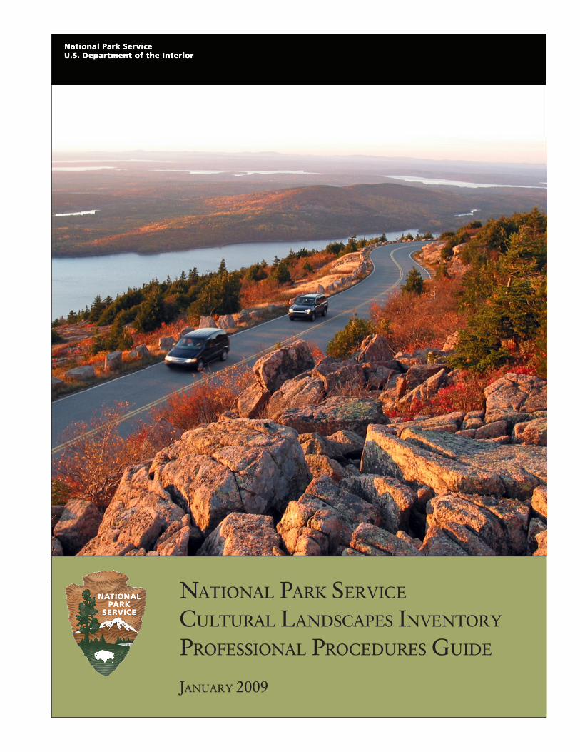
Cover Photograph: Cadillac Mountain Road, Acadia National Park, 2008. (Northeast Region)
iii
Professional Procedures Guide
intRodUction ….………………….......................……………………………………………,……… in-1
the conceptual framework for the cli ..................................................................................... in-3
automating the cli .................................................................................................................... in-3
implementing the cli ................................................................................................................. in-4
Purpose and organization of the guide ................................................................................... in-4
completing the cultural landscapes inventory for landscapes/component landscapes ........ in-5
section 1: inventoRy Unit sUmmaRy and site Plan ...……………………………….……..1-1
inventory Unit ................................................................................................................................1-2
Cultural Landscape Inventory Name
Cultural Landscape Inventory Number
Parent Cultural Landscape Inventory Name
Parent Cultural Landscape Inventory Number
Park Name
Park Alpha Code
Park Org Code
Landscape/Component Landscape Description
Inventory Unit Size (acres)
Property Level
Park Report Cover Image
Park Report Cover Date
site Plan graphic information ......................................................................................................1-4
Site Plan Graphic
Site Plan Graphic Caption
Display Sequence
cli hierarchy description graphic information ..........................................................................1-6
CLI Hierarchy Description
Inventory Description Graphic
CLI Hierarchy Graphic Caption
Display Sequence
taBle of contents
national Park service - cultural landscaPes inventory
iv
section 2: concURRence statUs …………………...……………………………………………..… 2-1
inventory Unit ............................................................................................................................... 2-2
Inventory Unit Completion Status
Completion Status Explanatory Narrative
Park Superintendent Concurrence
Park Superintendent Concurrence Date
National Register Eligibility
National Register Eligibility Concurrence Date (SHPO/Keeper)
National Register Concurrence Explanatory Narrative
concurrence graphic information ............................................................................................... 2-3
Concurrence Graphic
Concurrence Graphic Caption
Display Sequence
Revisions ....................................................................................................................................... 2-3
Revised By
Type of Revision
Revision Concurrence Date
Revision Concurrence
Revision Explanatory Narrative
section 3: geogRaPhic infoRmation and location maP ………………………………….3-1
inventory Unit ............................................................................................................................... 3-2
Inventory Unit Boundary Description
Park Management Unit
Land Tract Numbers
GIS File Name
GIS File Description
GIS URL
states and counties ...................................................................................................................... 3-4
State
County
location map graphic information ............................................................................................. 3-5
Location Map Graphic
Location Map Graphic Caption
v
Professional Procedures Guide
Boundary Utm ............................................................................................................................... 3-5
Boundary UTM Source
Boundary UTM Type
Boundary UTM Datum
Boundary UTM Zone
Boundary UTM Easting
Boundary UTM Northing
Boundary Datum Other
Regional landscape context ....................................................................................................... 3-7
Regional Landscape Context Type
Regional Landscape Context Description
Display Sequence
Regional Landscape Context Graphics
Regional Landscape Context Graphic Caption
section 4: management infoRmation ………………..…………………………………………..4-1
inventory Unit ............................................................................................................................... 4-2
Management Category
Management Category Date
Management Category Explanatory Narrative
adjacent lands graphic information .......................................................................................... 4-2
Do Adjacent Lands Contribute?
Adjacent Lands Description
Adjacent Lands Graphic
Adjacent Lands Graphic Caption
management agreement ............................................................................................................. 4-3
Management Agreement
Management Agreement Expiration Date
Management Agreement Explanatory Narrative
Other Management Agreement
nPs legal interest ......................................................................................................................... 4-4
Type of Legal Interest
Fee Simple Reservation for Life
Fee Simple Reservation Expiration Date
Other Agency or Organization
NPS Legal Interest Explanatory Narrative
national Park service - cultural landscaPes inventory
vi
Public access to site ..................................................................................................................... 4-5
Public Access
Public Access Explanatory Narrative
fmss asset .................................................................................................................................... 4-3
FMSS Asset Location Code
section 5: national RegisteR infoRmation …………………………………………………….5-1
inventory Unit ............................................................................................................................... 5-2
National Register Landscape Documentation
National Register Explanatory Narrative
National Register Eligibility
National Register Eligibility Concurrence Date (SHPO/Keeper)
National Register Concurrence Explanatory Narrative
National Register Significance Level
National Register Significance- Contributing/Individual
National Register Classification
National Historic Landmark Status
National Historic Landmark Date
National Historic Landmark Theme
World Heritage Site Status
World Heritage Site Date
World Heritage Category
Statement of Significance
national Register significance criteria ....................................................................................... 5-10
National Register Significance Criteria
national Register criteria considerations .................................................................................. 5-10
National Register Criteria Consideration
national Register Period of significance .................................................................................... 5-11
Start Year
Start Era
End Year
End Era
historic context theme ................................................................................................................ 5-12
Historic Context Theme
Historic Context Sub-theme
Historic Context Facet
Other Historic Facet

vii
Professional Procedures Guide
national Register areas of significance ..................................................................................... 5-14
Area of Significance Category
Area of Significance Category Explanatory Narrative
Area of Significance Subcategory
state Register documentation .................................................................................................... 5-17
State Register Documentation Name
State Register Document Identification Number
State Register Date Listed
State Register Documentation Explanatory Narrative
nRis information .......................................................................................................................... 5-17
Park Alpha Code/NRIS Name (Number)
Other National Register Name
Primary Certification Date
other certifications ...................................................................................................................... 5-17
Other Certification
Other Certification Date
section 6: chRonology and Physical histoRy ..…………………………………………… 6-1
inventory Unit ............................................................................................................................... 6-2
Primary Historic Function – Major Category
Primary Historic Function – Category
Primary Historic Function
Primary Current Use – Major Category
Primary Current Use – Category
Primary Current Use
other current and historic Uses/functions ................................................................................. 6-2
Other Historic Function or Current Use – Major Category
Other Historic Function or Current Use – Category
Other Historic Function or Current Use – Type
current and historic names ......................................................................................................... 6-3
Current and Historic Name
Type of Current and Historic Name
cultural landscape types ............................................................................................................. 6-4
Cultural Landscape Type
national Park service - cultural landscaPes inventory
viii
ethnographic associated groups ................................................................................................ 6-5
Ethnographic Study Conducted
Ethnographic Significance Description
Ethnographic Associated Group Name
Association Historic, Current, or Both
chronology .................................................................................................................................... 6-6
Start Year of Major Event
Start Era of Major Event
End Year of Major Event
End Era of Major Event
Major Event
Major Event Description
associated names ......................................................................................................................... 6-7
Associated Name
Association
Association Other
Physical history ............................................................................................................................. 6-8
Physical History Time Period
Physical History Narrative
history graphic information ........................................................................................................ 6-8
History Graphic
History Graphic Caption
section 7: analysis and evalUation of integRity ………………….……………………….7-1
inventory Unit ............................................................................................................................... 7-2
Analysis and Evaluation Summary
landscape characteristics ............................................................................................................ 7-4
Landscape Characteristic
Landscape Characteristic Explanatory Narrative
Other Landscape Characteristic
landscape features ...................................................................................................................... 7-4
Feature Name
Feature Contribution
LCS Alpha Code, Name, and Number
Historic Structure Number
ix
Professional Procedures Guide
Feature UTM Source
Feature UTM Point Type
Feature UTM Datum
Feature UTM Zone
GIS URL
Feature UTM Easting
Feature UTM Northing
ANCS ID
ANCS Name
ASMIS ID
ASMIS Name
analysis and evaluation characteristics and features graphic information .......................... 7-6
Analysis and Evaluation Graphic
Analysis and Evaluation Graphic Caption
section 8: condition assessment …………......…………………………………………………..8-1
inventory Unit................................................................................................................................ 8-2
Stabilization Cost
Stabilization Cost Date
Stabilization Cost Level of Estimate
Stabilization Cost Estimator
Stabilization Measures Description
Stabilization Cost Explanatory Narrative
condition assessment .................................................................................................................. 8-2
Condition Assessment
Condition Assessment Date
Condition Assessment Explanatory Narrative
impacts to inventory Unit ............................................................................................................ 8-3
Impact Type
Impact Type – Other
Internal or External
Impact Explanatory Narrative
section 9: tReatment …………..………………………………………………………......……………9-1
inventory Unit ............................................................................................................................... 9-2
Approved Landscape Treatment
Approved Landscape Treatment Completed
Approved Landscape Treatment Explanatory Narrative
national Park service - cultural landscaPes inventory
x
Approved Landscape Treatment Document
Approved Landscape Treatment Document Date
Approved Landscape Treatment Cost
Approved Landscape Treatment Cost Date
Approved Landscape Treatment Level of Estimate
Approved Landscape Treatment Cost – Estimator
Approved Landscape Treatment Cost Explanatory Narrative
section 10: BiBliogRaPhy and sUPPlemental infoRmation ………………………...….10-1
inventory Unit ............................................................................................................................. 10-2
Bibliography
Citation Title
Citation Author
Year of Publication
Publisher
Source Name
Other Source Name
Citation Number
Citation Type
Citation Location
supplemental information ........................................................................................................ 10-2
Supplemental Information Title
Supplemental Information Narrative
supplemental graphic information .......................................................................................... 10-3
Supplemental Information Graphic
Supplemental Graphic Caption
sideBaRs
section 1: inventory Unit summary and site Plan
1 Defining the Inventory Unit Name
2 ‘Parent-Child’ Relationships in the CLI
3 Defining Property Levels and the Hierarchy for Inventorying Cultural Landscapes in the CLI
section 2: concurrence status
4 Park Superintendent Concurrence
section 3: geographic information and location map
5 Selecting Boundaries
6 Preparing Narrative Boundary Descriptions
xi
Professional Procedures Guide
7 GIS Files
8 Entering UTM References
9 Determining UTM References from a Map
section 4: management information
10 Relationship of CLI to FMSS
section 5: national Register information
11 Considerations for Determining National Register Landscape Documentation
12 Writing the National Register Explanatory Narrative
13 Landscapes Not Managed as Cultural Resource
14 Consensus Determinations for Eligibility
15 Writing a Statement of Significance
16 Evaluating and Stating Significance
17 Selecting the Period of Significance
18 Identifying Historic Contexts
19 Developing a Historic Context
20 Selecting Areas of Significance
21 Area of Significance Category and Subcategory Definitions
section 6: chronology and Physical history
22 Entering Functions and Uses
23 Defining Current and Historic Names
24 Entering Associated Groups
25 Identifying Major Event Dates
26 Entering Associated Names
section 7: analysis and evaluation of integrity
27 Evaluating Integrity
28 Assessing Integrity
29 Landscape Characteristics - Definitions, Features, and Documentation
section 8: condition assessment
30 Cost Estimating
aPPendices
a Park organization, alpha codes, and organization codes
B examples of landscape/component landscape descriptions
c states and counties
d examples of national Register explanatory narratives
e guidelines for inventory and consensus determination consultation
national Park service - cultural landscaPes inventory
xii
f determinations of eligibility for inclusion in the national Register of historic Places
g examples of statements of significance
h documenting nationally significant Properties
i historic contexts
J historic and current function and Use list (categories and codes)
k major event list
l examples of analysis and evaluation summary
m list of Required and optional database fields
n examples of cover letters
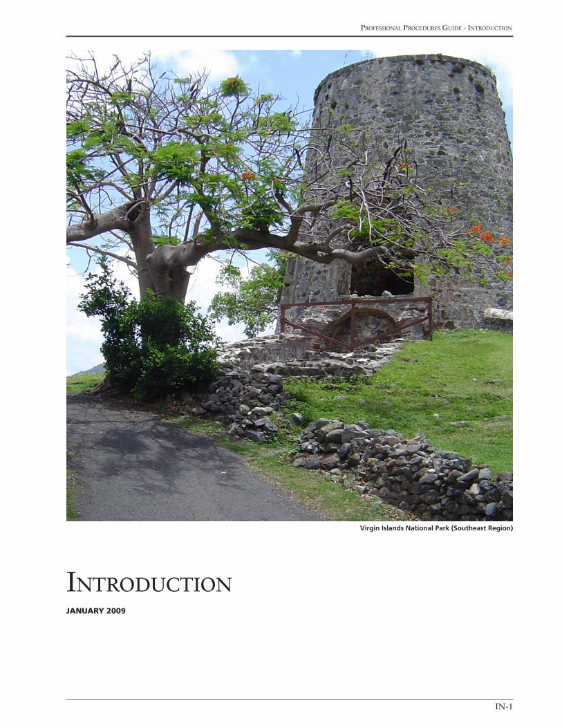
IN-1
Professional Procedures Guide - introduction
introductionJanuary 2009
Virgin Islands National Park (Southeast Region)
national Park service - cultural landscaPes inventory
IN-2
Cultural landscapes are settings that human beings have
created in the natural world. They reveal fundamental
ties between people and the land––ties based on our
need to grow food, give form to our settlements, meet
requirements for recreation, and find suitable places
to bury our dead. Cultural landscapes are intertwined
patterns of things both natural and constructed—plants
and fences, watercourses, and buildings. They range
from formal gardens to cattle ranches, from cemeter-
ies and pilgrimage routes to village squares. They are
special places—expressions of human manipulation of
and adaptation to the land and the environment.
As the recognition of cultural landscapes has expanded
nationally and internationally, landscape inventories
are increasingly being initiated by federal, state, and lo-
cal governments, and private, non-profit organizations.
These inventories involve a variety of professionals,
such as landscape architects, historians, biologists, and
geographers. These efforts, although varied in scope,
all serve the same purpose: to document the quali-
ties and attributes of a cultural landscape that make it
significant and worth preserving.
The Cultural Landscapes Inventory (CLI), a com-
prehensive inventory of all cultural landscapes in the
national park system, is one of the most ambitious
initiatives of the National Park Service (NPS) Park Cul-
tural Landscapes Program. The CLI is an evaluated in-
ventory of all landscapes having historical significance
that are listed on or eligible for listing on the National
Register of Historic Places, or are otherwise managed
as cultural resources through a public planning process
and in which the NPS has or plans to acquire any legal
interest. The CLI provides a management inventory of
evaluated cultural landscapes, as per Section 110(a)(1)
of the National Historic Preservation Act, NPS Man-
agement Policies, and the Cultural Resource Manage-
ment Guideline. As such, the CLI aids park managers
in planning, programming, and recording treatment
and management decisions.
Since the 1960s, the NPS has undertaken system-wide
inventories of cultural resources, such as historic
structures, archeological resources, and museum
objects. However, in light of the increased recognition
of cultural landscapes since the 1990s, the need for an
inventory of these resources was identified. As a result,
the CLI was initiated and the extent and condition of
the resources in the National Park system are begin-
ning to be known.
In 1990, the Secretary of the Interior’s Annual Control
Report identified a material weakness in the preserva-
tion of cultural landscapes and historic structures. This
weakness was stated as:
Historic and prehistoric structures and cultural land-scapes are damaged by neglect or deferred work due to insufficient funds or staffing.
In fiscal years 1992 and 1994, the NPS budget in-
creased to address the deficiencies that contribute to
the material weakness. One of five corrective actions
targeted for funding was the initiation of the CLI. In
1994, drawing upon inventory work that had been
done throughout the country, a three-year initiation
was commenced to design and field-test an inventory
methodology for cultural landscapes in the park system
and to pilot an automated database to collect and
query the findings.
To date, all NPS regions have participated in the de-
sign, development, and testing of the CLI, providing
broad professional expertise and geographic diversity.
Annual workshops have been held to review the find-
ings of the fieldwork, discuss professional procedures,
and revise the design of the inventory accordingly. As a
result, the CLI at the end of fiscal year 2007 contained
401complete records representing landscapes in 133
parks.
IntroductIon
IN-3
Professional Procedures Guide - introduction
the conceptual Framework For the
clI
The conceptual framework of the CLI is based on two
major challenges faced in developing a standardized in-
ventory of cultural landscapes in the national park sys-
tem: 1) the range and diversity of these resources in the
system, and 2) the need to identify the scope of land-
scapes in a park or region; establish work priorities;
and be responsive to park management. Additionally,
a third challenge relates to the lack of baseline data and
contextual information for cultural landscapes, which
presents difficulties in determining the significance
of these resources. Therefore, the CLI has to provide
the flexibility to address diverse landscapes, serve as a
tool for defining programmatic needs, respond to park
needs, and facilitate the collection of basic information
on cultural landscapes in the system in order to obtain
concurrence on their significance and eligibility.
The CLI framework includes a hierarchy for subdivid-
ing complex landscapes into identifiable components
and features. The application of this framework to
a particular cultural landscape is flexible. As with all
research and inventory efforts, professional judgment
is essential in determining the manner in which the
cultural landscape is subdivided for documentation
and the appropriate level of inventory needed to reach
consensus on the CLI findings.
automatIng the clI
In fiscal year 1996, an Information Requirements and
System Design Study was completed for the CLI to vali-
date and verify the findings of the three years of design
development and determine alternatives for automat-
ing and implementing the CLI system-wide. Listed
below are the primary findings of the study:
• The primary management intents of the CLI are to: identify cultural landscapes in the national park system and provide information on their location; record infor-mation about these resources related to their identifica-tion, description, historical development, evaluation and analysis of contributing landscape characteristics and features, condition, and management; and assist managers and cultural resource specialists in determin-
ing treatment and management decisions, and recording these decisions.
• All CLI management information needs derive directly from legislation, as interpreted by a variety of NPS management policies, guidelines, strategic plans, and the Cultural Landscapes Inventory Professional Procedures Guide.
• Information in the CLI is identified and organized using a consistent methodology, which is conducted by Park Cultural Landscapes Program staff, contractors, and consultants.
• The CLI must be able to share information with the List of Classified Structures (LCS), the National Register Information System (NRIS), the Cultural Resources Management Bibliography (CRBIB), the Facility Man-agement Software System (FMSS) and other databases.
need for an automated Inventory System
Due to the complex nature of cultural landscape
documentation, an automated system was identified as
necessary to help address the following issues:
• CLI information content is voluminous, spanning 27 information categories.
• Types of CLI information are diverse, including numeri-cal data, narrative text, dates, maps, pictures, and other graphical objects.
• Anticipated CLI information uses are diverse, and involve three primary user organizations – park resource management, cultural landscapes program, and the Denver Service Center.
• The hierarchy for defining a cultural landscape is com-plex, and requires a variety of views to properly see its relationships.
When the CLI was implemented system-wide in 1998,
the Cultural Landscapes Automated Inventory Man-
agement System (CLAIMS) was used to automate the
inventory system. CLAIMS was a custom designed
software system that automated data entry and editing
activities, provided ad hoc and preprogrammed que-
ries, along with management and other reports associ-
ated with the CLI. CLAIMS was a PC-based system
that was managed by each region and annual uploads
were provided to the Washington office. Since 1998,
improvements have been made to both the process and
software as needed. In fiscal year 2005, the CLI was
moved to a web-based platform. This improvement
national Park service - cultural landscaPes inventory
IN-4
allows completed records to be added throughout the
year, a user to query or report on current data, but
most importantly it provides NPS intranet access to
approved users.
ImplementIng the clI
In fiscal year 1997, funding was allocated to initiate the
CLI in all regions. At that time, two key CLI adminis-
trative practices were established: the identification of
CLI Coordinators for each region who provide profes-
sional oversight and management of the inventory; and
the requirement of a five-year plan with annual updates
from each region, which identifies strategies and priori-
ties for conducting the CLI.
clI data collection and reporting
The collection and refinement of CLI data for the pur-
poses of completing CLI inventory unit records is an
ongoing process throughout the year. To be considered
“complete, accurate and reliable” or “certified” a CLI
inventory unit record requires concurrence on the CLI
findings from the park superintendent. In addition,
for inventory unit records that are not currently listed
on the National Register and/or do not have adequate
documentation, concurrence is required from the State
Historic Preservation Officer (SHPO) or Keeper of the
National Register. When these conditions are met, a
record is added to the CLI through an established ap-
proval process.
Reporting from the CLI is possible throughout the year
because the CLI is a web-based system. The system
is also used to create a comprehensive status report
on the progress of the CLI program at the end of each
fiscal year. This report is required for NPS reporting
associated with the Government Results and Perfor-
mance Act (GRPA), which monitors the progress made
toward completing increasing numbers of CLI records,
and the goal of increasing the number of NPS land-
scapes which have been worked into good condition.
purpoSe and organIzatIon oF the
guIde
This guide is intended to provide professional proce-
dural guidance for completing a CLI inventory unit re-
cord to ensure consistency and high quality data. The
guidance is related to the completion of a management
inventory for the purposes of satisfying requirements
with Section 110(a)(1) of the National Historic Preser-
vation Act, NPS Management Policies, Director’s Order
28, and Cultural Resource Management Guideline.
Much of the guidance contained in this section was
drawn from a variety of existing reference materials,
primarily the National Register Bulletin series. The fol-
lowing National Register Bulletins were referenced:
• Guidelines for Evaluating and Documenting Rural His-toric Landscapes
• Guidelines for Evaluating and Documenting Traditional Cultural Properties
• Guidelines for Identifying, Evaluating, and Registering America’s Historic Battlefields
• Guidelines for Evaluating and Registering Cemeteries and Burial Places
• Guidelines for Identifying , Evaluating, and Registering Historic Mining Properties
• Historic Residential Suburbs: Guidelines for Evalua-tion and Documentation for the National Register of Historic Places
• How to Apply the National Register Criteria for Evalu-ation
• How to Complete a National Register Nomination Form
• How to Evaluate and Nominate Designed Historic Landscapes
• How to Establish Boundaries for National Register Properties
terminology
The need for clear and consistent terminology can
not be overstated. The terminology used in the CLI
directly relates to NPS policy, guidelines, and standards
(e.g., Management Policies, Cultural Resource Manage-
ment Guideline, National Register Bulletin). However,
there are distinctions between the National Register
programs and the park programs in the use and appli-
IN-5
Professional Procedures Guide - introduction
cation of terminology. Primarily, this distinction relates
to resource types defined by NPS policy and categories
for listed properties in the National Register defined by
the National Historic Preservation Act, as amended.
Resource types (i.e., archeological resources, cultural
landscapes, structures, ethnographic resources, and
museum objects) used in organizing NPS Management
Policies and the Cultural Resource Management Guide-
line reflect cultural resource disciplines and their spe-
cialized methodologies and techniques. The categories
used for listing properties in the National Register (i.e.,
building, district, site, structure, and object) gener-
ally differ from these resource types, but there is some
overlap. For instance, a cultural landscape which in-
cludes buildings, structures, and objects could be listed
in the National Register as either a site or a district.
Every attempt will be made to be consistent with
National Register terminology and, when distinctions
exist, to define the relationship between the National
Register and park program terminology. For instance,
in defining a cultural landscape in the CLI, the bound-
aries generally relate to a “property” and the landscape
is classified as a “site” or “district,” as it would in the
National Register. In addition to these terms, the CLI
uses its own terms (as mentioned above) to identify
landscape characteristics and associated features
that contribute to the significance of the landscape
and are important based on the management of the
landscape. These characteristics may or may not be
considered “contributing resources” for the National
Register. The National Register associates contribut-
ing resources with property types (i.e., building, site,
structure, object, and district) and it defines contribut-
ing resources as adding “to the historic associations,
historic architectural qualities, or archeological values
for which a property is significant (National Register
Bulletin 16A).”
In order to identify landscape characteristics such as
spatial organization, vegetation, and views as contrib-
uting to the historic character of the property, they may
be defined in the Register nomination in two ways.
The first is to describe them as individually as part of
the historic character of the district. The second is to
define them collectively as a single resource that works
as a “site” that is identified along with buildings, struc-
tures, and objects within a district.
completIng the cultural landScapeS
Inventory For landScapeS and
component landScapeS
This section of the Professional Procedures Guide
outlines all of the information collected and recorded
for landscapes and component landscapes (referred
to collectively as “inventory units”) in the Cultural
Landscapes Inventory database. This information is
structured according to a series of data elements. Each
data element is defined and instructions are given for
how to provide the desired information. Data ele-
ment headings followed by (R) are required and must
be completed for the inventory unit to be considered
certified as “complete, accurate and reliable” when
uploaded into the national CLI database. Data ele-
ment headings followed by (O) are optional. Where
specific options (referred to in the guide as “pick lists”)
are associated with a data element, the guide provides
definitions for each option. Responding to these data
elements involves selecting one or more of the options
in the pick list, as appropriate. Other data elements
require information in a narrative format. For these
data elements, the CLI database establishes specific
character limits (255, 1000, 4000 or 64000 characters
long) depending on the data element. Data elements
with character lengths larger than 255 are indicated in
parentheses after their respective data element head-
ings. Finally, the guide contains professional guidance
and resources under the “Sidebars” headings to help
clarify the intent and content of the data elements.
This section of the guide is organized to correspond
with the organization of the CLI database and includes
the following ten sections (referred to as “pages” in the
database):
1. Inventory Unit Summary and Site Plan
2. Concurrence Status
3. Geographic Information and Location Map
national Park service - cultural landscaPes inventory
IN-6
4. Management Information
5. National Register Information
6. Chronology and Physical History
7. Analysis and Evaluation of Integrity
8. Condition Assessment
9. Treatment
10. Bibliography and Supplemental Information
In the CLI database, several data elements that pro-
vide the unique identification of an inventory unit are
repeated at the top of each section. These data ele-
ments are entered in the database by the Regional CLI
Coordinator when the inventory unit is established in
the CLI database (referred to as the CLI record of an
inventory unit). These data elements include:
• Cultural Landscape Inventory Unit Name
• Cultural Landscape Inventory Number
• Parent Cultural Landscape Inventory Name
• Parent Cultural Landscape Inventory Number
• Park Name
• Park Alpha Code
• Park Org Code fields.
Although the data elements are repeated at each sec-
tion, they are described only once in the Inventory
Unit Summary and Site Plan section of this guide. See
Appendix A: Park Organization, Alpha Codes, and
Organization Codes for information on the codes.
Other appendices are included at the end of the guide
that include lengthy pick lists or additional professional
guidance for completing the CLI for an inventory unit.
The Concurrence Status section of the CLI database
includes data elements drawn from the National
Register Information section. These data elements are
defined in the National Register Information section of
this guide.
1-1
Professional Procedures Guide - section 1
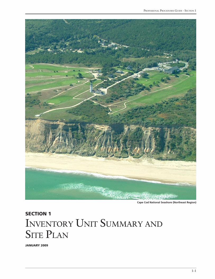
Section 1
inventory unit summary and site PlanJanuary 2009
Cape Cod National Seashore (Northeast Region)
national Park service - cultural landscaPes inventory
1-2
that is both current and historic. The Cultural Land-
scape Inventory Name is entered in the database by the
Regional CLI Coordinator when the CLI record for the
inventory unit is created. Once entered, the Cultural
Landscape Inventory Name will self-populate through-
out the system where needed.
(See Sidebar 1: Defining the Inventory Unit Name)
cultural Landscape inventory number (r, automatically entered)
The unique six-digit number that identifies the inven-
tory unit. The Cultural Landscape Inventory Number
is automatically assigned by the CLI database when
the CLI record for the inventory unit is created by the
Regional CLI Coordinator. The Cultural Landscape
Inventory Number will self-populate throughout the
system where needed.
The following data elements provide information that
uniquely identifies the inventory unit and the park in
which it is located.
inventory unit
cultural Landscape inventory name (r, automatically entered)
The name officially designated for the inventory unit.
For example, an inventory unit name may be a park
name (Gettysburg National Military Park) or it may the
historic name of the property within the park (Richard
Vaughn Farm, Cuyahoga National Park) or an area of
the park that has gained significance over time (Rim
Village, Crater Lake National Park). This name will
appear in CLI reports and queries. The inventory unit
name may be a current name, historic name, or a name
Section 1inventory unit Summary and Site PLan
Sidebar 1: defining the inventory unit name
Naming DistrictsUse traditional terms such as “village,” “ranch,” “courthouse square,” or “town site,” or the generic term “historic dis-
trict,” to indicate the kind of district when naming districts based on their location or historic ownership. Modifiers such
as “prehistoric,” “commercial,” “civic,” “rural,” “industrial,” or “residential” may also be used to define the predominant
historic quality of a district. Names of historic districts should reflect the area as whole rather than specific resources. For
example:
Mystic Town Site Historic District
Snake Valley Archeological District
Burke’s Garden Rural Historic District
Properties with Common NamesDifferentiate properties with common names by numbering them or adding the location to the name. For example:
United States Post Office - Walnut Street Branch
World War II Japanese Fortification - Site 2
Properties in Different Parks or Regions with the Same NameIf properties with the same name are found in different parks or regions during the annual upload processing, the Na-
tional Center staff may rename an inventory unit to clarify its location. Each region will be contacted prior to renaming
the inventory unit. The renaming will start with the region-defined inventory unit name followed by a hyphen and then
the park alpha code. For example:
Miller Farm - DEWA
Superintendent’s Residence - MUWO
Miller Farm - SLBE
Superintendent’s Residence – CRLA
1-3
Professional Procedures Guide - section 1
Sidebar 2: Parent-child relationships in the cLi
In order to associate related inventory units (i.e., landscapes with component landscapes), a ‘parent-child’ relationship must
be established in the CLI database. The landscape is the parent in this relationship and a component landscape(s) is the
child. In addition, within the inventory unit, associated features are defined for both landscapes and component land-
scapes.
A landscape is a single property or a district that is listed on, or eligible for listing on, the National Register of Historic
Places. A landscape feature is a physical unit that is part of the existing character of a landscape. Each feature is identified
in association with one of thirteen landscape characteristics and as contributing or noncontributing to the historic character
of the landscape, or as managed as a cultural resource.
A component landscape is a definable physical area within the boundaries of a landscape that is listed on, or eligible for
listing on, the National Register of Historic Places. It contributes to the significance of the landscape, and may also be indi-
vidually eligible for the National Register. A component landscape warrants individual documentation to adequately record
the physical character or assemblage of related features. A component landscape feature is a physical unit that is part of
the existing character of a component landscape. Each feature is identified in association with one of thirteen landscape
characteristics, and evaluated as contributing or noncontributing to the historic character of the component landscape, or
as managed as a cultural resource.
Parent cultural Landscape inventory name (r, automatically entered if applicable)
The name that identifies the “parent landscape” of the
inventory unit. If the inventory unit is a landscape, the
Parent Cultural Landscape Inventory Name is the same
as the Cultural Landscape Inventory Name (i.e., a land-
scape is its own parent). The Parent Cultural Land-
scape Inventory Name is entered in the database by the
Regional CLI Coordinator when the CLI record for
the inventory unit is created. Once entered, the Parent
Cultural Landscape Inventory Name will self-populate
throughout the system where needed.
(See Sidebar 2: ‘Parent-Child’ Relationships in the
CLI)
Parent cultural Landscape inventory number (r, automatically entered if applicable)
The unique six-digit number that identifies the parent
landscape of the inventory unit. If the inventory unit is
a landscape, the Parent Cultural Landscape Inventory
Number is the same as the Cultural Landscape Inven-
tory Number (i.e., a landscape is its own parent). This
unique six-digit number is automatically assigned by
the CLI database when the CLI record for the inven-
tory unit is created by the Regional CLI Coordinator.
Once entered, the Parent Cultural Landscape Inven-
tory Number will self-populate throughout the system
where needed.
Park name (r, automatically entered)
The name that uniquely identifies the park in which
the inventory unit is located (e.g., Gettysburg National
Military Park). The Park Name is entered in CLI da-
tabase by the Regional CLI Coordinator when the CLI
record for the inventory unit is created. Once entered,
the Park Name will self-populate throughout the sys-
tem where needed.
Park alpha code (r, automatically entered)
The four letter alpha code that uniquely identifies
the park in which the inventory unit is located (e.g.,
GETT). The Park Alpha Code is automatically entered
in CLI database when the Regional CLI Coordina-
tor selects the park from the pick list. The Park Alpha
Code will self-populate throughout the system where
needed.
Park org code (r, automatically entered)
The four digit org code that uniquely identifies the park
in which the inventory unit is located (e.g., 1850). The
Park Org Code is automatically entered in CLI database
national Park service - cultural landscaPes inventory
1-4
as a site or district; the combination of component landscapes and/or landscape charateristics and features that define the historic character of a cultural landscape.
Component Landscape: A definable physical area within the boundaries of a landscape that is listed on, or eligible for listing on, the National Register of Historic Places. A component landscape contrib-utes to the significance of the landscape and may be individually eligible for the National Register. A component landscape warrants individual documen-tation to adequately record the physical character or assemblage of related features. An example may be garden, overlook, cemetery, campground, farmstead,
or road system.
(See Sidebar 3: Defining Property Levels and the
Hierarchy for Inventorying Cultural Landscapes in
the CLI)
Park report cover image (r)
Provide the graphic image that will appear on the cover
of the CLI park report.
Park report cover date (o)
This date, in YYYY format, represents the completion
of the CLI record. It is recommended that the date
identify the year in which the park superintendent
concurred with the findings of the CLI record or the
SHPO concurred with the findings of the CLI record,
whichever is later.
Site PLan GraPhic information
The following data elements in this table provide in-
formation on graphics associated with a site plan of the
inventory unit.
Site Plan Graphic (r)
Provide one or more site plans that graphically illustrate
the inventory unit. At a minimum, the plan should:
• clearly delineate the boundaries of the inventory unit
• document existing conditions
• include both contributing and noncontributing land-scape characteristics and features
• be at an approximate graphic scale with a scale noted on the plan
when the Regional CLI Coordinator selects the park
from the pick list. The Park Org Code will self-popu-
late throughout the system where needed.
Landscape/component Landscape description (r – 64,000 characters)
Provide a narrative overview of the inventory unit that
includes:
• a physical description of the landscape, including size, location, setting, landscape type or style, distinct quali-ties, and significant features
• a brief explanation of the period of significance
• a brief summary of the landscape’s principle character-istics and features
• a summary of the landscape’s integrity
• the condition of the landscape at the time of the record’s completion
The description should be concise, factual, and well
organized. Use common professional terms, especially
those employed by the National Register of Historic
Places, to describe significance and integrity. Define
any regional or local terms that are not commonly
understood or generally used.
(See examples for recommended narrative structure
and content in Appendix B: Examples of Land-
scape/Component Landscape Description)
inventory unit Size (acres) (r)
Indicate the acreage for the inventory unit. Acreage
should be accurate to the nearest whole acre; fractions
of acres should be recorded, if known, to the nearest
one-tenth acre. For large properties, such as districts
over 100 acres, use a USGS acreage estimator or digi-
tizer to calculate acreage.
Property Level (r, automatically entered)
The level of subdivision of the inventory unit that has
been determined to clearly articulate its character and
physical qualities. The Property Level is entered in CLI
database by the Regional CLI Coordinator when the
CLI record for the inventory unit is created. The Prop-
erty Level can be one of the following options:
Landscape: A landscape that is listed on or eligible for listing on the National Register of Historic Places
1-5
Professional Procedures Guide - section 1
Sidebar 3: defining Property Levels and the hierarchy for inventorying cultural Land-
scapes in the cLi
The diversity of cultural landscapes in the national park system, both in terms of scale and physical complexity, presents a
significant challenge for a standardized inventory. Based on this diversity and the need to clearly articulate the physical
character of the landscape for the purposes of the CLI, and ultimately for management, a hierarchy has been defined for
subdividing a landscape into identifiable components and features. This hierarchy includes landscapes, landscape features,
component landscapes, and component landscapes features.
Landscape: A landscape that is listed on, or eligible for listing on, the National Register of Historic Places as a site or
district; the combination of component landscapes and/or landscape characteristics and features that define the historic
character of a cultural landscape. Examples include Gettysburg National Military Park, Grant-Kohrs Ranch National Historic
Site, Cades Cove Historic District (Great Smoky Mountains National Park), Dungeness Historic District (Cumberland Island
National Seashore), Frederick Law Olmsted National Historic Site, The Mall (National Mall and Memorial Parks), and Ebey’s
Landing National Historical Reserve.
Landscape Feature: A physical unit that is part of the existing character of a landscape, can be managed as an individual el-
ement, and is identified as contributing or noncontributing to the historic significance of the landscape. Examples include a
woodlot, earthwork, hedge, lawn, specimen tree, allee, barn, agricultural field, and vista. In the CLI, each landscape feature
is identified in association with one of thirteen landscape characteristics.
Component Landscape: A definable physical area within the boundaries of a landscape that is listed on, or eligible for
listing on, the National Register of Historic Places. A component landscape contributes to the significance of the landscape
and may be individually eligible for the National Register. A component landscape warrants individual documentation
to adequately record the physical character of the overall landscape and can be further subdivided into smaller features.
Examples include a garden, overlook, cemetery, campground, farmstead, and road system.
Component Landscape Feature: A physical unit that is part of the existing character of a component landscape, can be
managed as an individual element, and is identified as contributing or noncontributing to the historic significance of the
landscape. Examples include a garden feature, such as a bench or fence; an overlook feature, such as stone wall or path;
and a cemetery feature such as a specimen tree or tombstone. In the CLI, each component landscape feature is identified in
association with one of thirteen landscape characteristics.
The application of these categories to a particular landscape is contingent upon its character and complexity. Any subdivi-
sion beyond a single landscape should be based on the need to clearly articulate the character and physical aspects of a
cultural landscape for management. The following two examples serve to illustrate this point. At Harry S Truman National
Historic Site, the CLI could identify the 1.4 acre property as the landscape and specific attributes, such as the rose garden,
outbuildings, fencing, and foundation plantings, could be identified as landscape features. In a more complex park, such as
Gettysburg National Military Park, the CLI could identify the 3,965 acre park as the landscape, along with several compo-
nent landscapes, including several farmsteads, a national cemetery, and a memorial road system. Additionally, the features
associated with the landscape and the component landscape could be identified. The determination of how to apply this
hierarchy to a particular park and cultural landscape is up to the professional judgment of the CLI team.
There will be a few rare cases where the park owns only a component of an entire landscape or the integrity of the land-
scape is compromised and only a component is eligible for the National Register. In either of these cases, a parent land-
scape record must be created first with an appropriate minimum number of data elements completed in order to associate
the component landscape record(s). For this group of parent landscapes, there is no intention that they will be certified as
complete, reliable and accurate so there is no consultation requirement.
national Park service - cultural landscaPes inventory
1-6
The plan should always include a north arrow and the
date it was created (mm/yyyy). The degree of detail
and accuracy of the site plan will vary depending on the
level of inventory being conducted, the type of land-
scape being inventoried, and available information.
Site Plan Graphic caption (r)
Provide a title and/or brief description of each Site Plan
Graphic.
display Sequence (o)
Indicate the sequence (1,2,3…) for how each Site Plan
Graphic should appear in all reports.
cLi hierarchy deScriPtion GraPhic
information
cLi hierarchy description (o – 4000 characters)
Provide a narrative description of how the park is
subdivided into landscapes, component landscapes,
and features. Articulate the professional decisions used
to determine boundaries of either the landscape or
component landscape(s).
The following data elements provide information on
graphics associated with a hierarchy description of the
inventory unit. In the CLI database, they are in the CLI
Hierarchy Description Graphic Information table.
inventory description Graphic (o)
Provide one or more graphics that illustrate the rela-
tionship of the inventory unit to the division of the
landscape, as per the CLI Hierarchy Description.
cLi hierarchy Graphic caption (o)
Provide a title and/or brief description of the CLI Hier-
archy Description Graphic.
display Sequence (o)
Indicate the sequence (1,2,3…) for how the CLI Hier-
archy Description Graphic should appear in all reports.
2-1
Professional Procedures Guide - section 2
Section 2
concurrence statusJanuary 2009
Mount Rushmore National Memorial (Midwest Region)
national Park service - cultural landscaPes inventory
2-2
Section 2concurrence StatuS
The following data elements document the completion
status of the CLI record. These data elements verify
that the Park Superintendent concurs with the CLI
findings, and that National Register documentation is
adequate for the inventory unit or that the State His-
toric Preservation Officer(s) or Keeper of the National
Register of Historic Places has concurred with a deter-
mination of eligibility based on the CLI findings.
inventory unit
inventory unit completion Status (r)
Indicate the current completion status of the inventory
unit. Select one from the following pick list:
Complete: All required inventory data elements, at a minimum, are complete; the Park Superintendent concurs with all CLI findings; the National Register documentation is adequate for the inventory unit, or the State Historic Preservation Officer(s) or Keeper of the National Register of Historic Places has con-curred with a determination of eligibility based on the CLI findings.
Incomplete: All required inventory data elements are not complete, additional optional data elements defined by the Regional CLI Coordinator are not complete, and/or the required concurrence with the CLI findings has not been documented.
Hide: The inventory unit is incomplete and the Regional CLI Coordinator has decided to remove the inventory unit name from the Home Tab and Standard Queries (including those for GPRA) in the CLI database. Hide can also be used for inventory units that have been completed but for a variety of reasons is no longer eligible for the NR and should not be displayed on the home tab or calculated for GPRA purposes. A decision to “hide” the inventory unit name from view is based on the need to eliminate confusion for secondary users regarding incomplete records in the CLI.
(Note: Only “Complete” records are included in annual
reporting of accomplishment)
completion Status explanatory narrative (o – 4000 characters)
Provide a brief explanation of the inventory unit’s com-
pletion status. This statement may need to be updated
or deleted when the inventory unit record is certified as
“complete, accurate, and reliable.” Information regard-
ing when site visits were conducted, methodology, past
research efforts, or park cultural resource contacts can
also be documented here.
Park Superintendent concurrence (r)
Indicate if the Park Superintendent has formally (with
signed memorandum or form) concurred with the
content and findings of the CLI for the inventory unit.
Select one from the following pick list:
Yes
No
(See Sidebar 4: Park Superintendent Concurrence)
Park Superintendent concurrence Date (r)
Provide the date (mm/dd/yyyy) the Park Superinten-
dent concurred with the content and findings of the
CLI for the inventory unit. This should be the date on
the memorandum or form signed by the Park Superin-
tendent.
national register eligibility (r, automatically entered)
This field is automatically inserted from the data ele-
ments entered in the National Register Information
section. Refer to the National Register section of this
guide for definition and guidance about this data ele-
ment.
national register eligibility concurrence Date (SHPo/Keeper) (r, automatically entered)
This field is automatically inserted from the data ele-
ments entered in the National Register Information
section. Refer to the National Register section of this
2-3
Professional Procedures Guide - section 2
Sidebar 4: Park Superintendent concurrence
Finalizing a CLI for an inventory unit requires a Park Superintendent to formally concur with the content and findings of
the CLI. In particular, two key pieces of data are highlighted: “Condition Assessment” and “Management Category.” Each
region should have a standard memorandum or form to document and date the park’s concurrence with the CLI findings.
This date also is used for the “Condition Assessment Date” and the “Management Category Date” when the inventory
unit is first added to the CLI database as a certified record (i.e., complete, accurate, and reliable).
The condition for the inventory unit must be reevaluated every six (6) years to keep the inventory unit certified as com-
plete, accurate, and reliable. The Park Superintendent must formally concur with each reevaluation of condition, along
with any other substantive changes to the content of the CLI record. This is accomplished through a standard memoran-
dum or form.
Following receipt of concurrence for the condition reassessment three items need to be added/changed in the CLI data-
base. Dates and explanatory narratives regarding condition reassessments are recorded in the Condition section of the
CLI database as a new entry in the Condition Assessment table. The revision is recorded in the Concurrence section of the
CLI database in two places. A copy of the Park Superintendent signed standard memorandum or form should be added
to the Concurrence Graphic Information table. A new entry should be added to the Revision table and “Change in Condi-
tion” should be selected from the pick list.
guide for definition and guidance about this data ele-
ment.
national register concurrence explanatory narrative (r, automatically entered, if applicable)
This field is automatically inserted from the data ele-
ments entered in the National Register Information
section. Refer to the National Register section of this
guide for definition and guidance about this data ele-
ment.
concurrence GraPHic information
The following data elements in this table provide infor-
mation on graphics associated with concurrence on the
content and findings of the CLI for the inventory unit.
concurrence Graphic (r)
Provide an electronic scanned copy of the signed con-
currence documentation from the Park Superintendent
and, if applicable, the signed concurrence documen-
tation from State Historic Preservation Officer(s) or
Keeper of the National Register. A copy of the Park
Superintendent signed standard memorandum or form
should also be added to this table, if applicable. Condi-
tion reassessment forms can also be added to this table,
if applicable.
concurrence Graphic caption (r)
Provide a title and/or brief description of the Concur-
rence Graphic.
Display Sequence (o)
Indicate the sequence (1,2,3…) for how the Concur-
rence Graphic should appear in all reports.
reviSionS
The following data elements in this table document
any substantive revisions to the content of a certified
CLI record. These data elements should be completed
to record revisions that require concurrence from
the Park Superintendent, State Historic Preservation
Officer(s), or Keeper of the National Register (e.g.,
changes in condition, revision to period of significance,
or adding/subtracting contributing features). These
data elements should not be used to record revisions
that result from minor editing (e.g., misspelled words;
adding name(s) to the historical narrative, or adding a
more detailed description of a landscape characteristic
or feature).
national Park service - cultural landscaPes inventory
2-4
revised By (r, if applicable)
Provide the name of the individual(s) who prepared the
revision to the certified CLI record. Enter the individ-
ual’s full name or first initial and last name. If there are
multiple individuals, list all names and separate them
with commas.
type of revision (r, if applicable)
Indicate the type of revision to the certified CLI record
that requires concurrence from the Park Superinten-
dent, State Historic Preservation Officer(s), or Keeper
of the National Register. Such a revision can not be
accepted until concurrence is documented. For a con-
dition reassessment, “Change in Condition” should be
selected from the pick list. Select one from the follow-
ing pick list:
Addition/Deletion of Landscape Characteristic or Contributing Feature
Change in Acreage
Change in Condition (requires Park Superinten- dent’s concurrence only)
Change in National Register Status
Other
(Note: Any of the above revisions may require addi-
tional editing throughout the inventory unit record. For
example, a change in boundaries (acreage) may result in
a number of changes such as the Period of Significance
needing to be lengthened or additional Landscape Char-
acteristics and/or Features being added. All of the appro-
priate changes are considered part of a single revision.)
revision concurrence Date (r, if applicable)
Provide the date (mm/dd/yyyy) the Park Superinten-
dent, State Historic Preservation Officer(s), or Keeper
of the National Register concurred with the revision
to the certified CLI record based on an official letter,
memorandum, or form.
revision concurrence (r, if applicable)
Indicate which party concurred with the revision to
the certified CLI record. Select one or more from the
following pick list:
Park Superintendent
State Historic Preservation Officer
Keeper of the National Register
revision explanatory narrative (0 - 4000 characters)
Provide a brief summary of the revision to the certified
CLI record and the data element(s) edited. Include in-
formation about who performed the tasks and indicate
whether or not a site visit was conducted.
Display Sequence (o)
Indicate the sequence (1,2,3…) for how the Revision
should appear in all reports.
3-1
Professional Procedures Guide - section 3
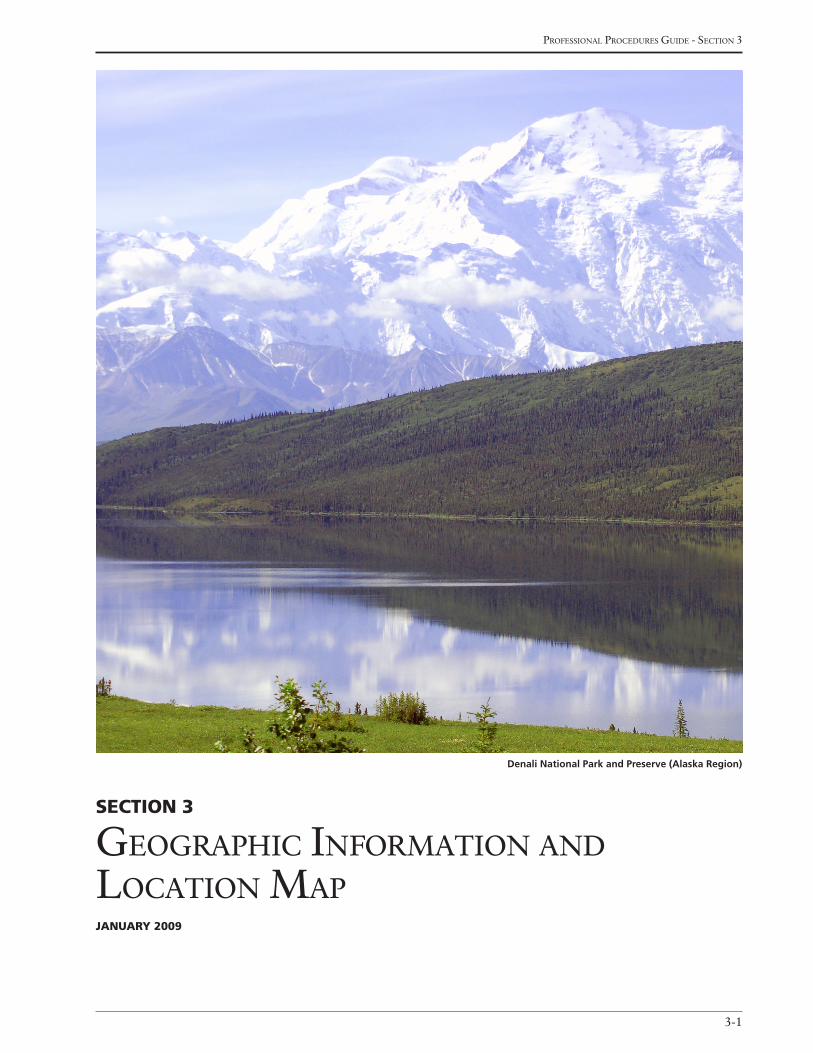
Section 3
GeoGraPhic information and location maPJanuary 2009
Denali National Park and Preserve (Alaska Region)
national Park service - cultural landscaPes inventory
3-2
Sidebar 5: Selecting Boundaries
All Cultural LandscapesCarefully select boundaries to encompass, but not to exceed, the full extent of the significant resources and land area
making up the property.
The area to be registered should be large enough to include all historic features of the property, but should not include
“buffer zones” or acreage not directly contributing to the significance of the property. Leave out peripheral areas of the
property that no longer retain integrity, due to subdivision, development, or other changes.
“Donut holes” are not allowed. However, for the purposes of the CLI, they are allowed if we do not have legal interest in
that particular area. No area or resources within a set of boundaries may be excluded from listing in the National Regis-
ter. Identify non-historic resources within the boundaries as noncontributing.
Section 3GeoGraphic information and Location map
define management units and the format may include
alphabetic, numeric, or alphanumeric codes.
Land tract numbers (o – 4000 characters)
Indicate the land tract numbers associated with the
inventory unit, if applicable. The tract numbers can be
found in the NPS regional land resources programs.
GiS file name (o)
Provide one or more GIS file names and their location
for each file that relates directly to the inventory unit.
(See Sidebar 7: GIS Files)
GiS file description (o – 4000 characters)
Provide a brief description of the contents of each GIS
file included. Indicate if processing needs to occur and
whether the information is already in the regional or
park GIS system. For example:
• Roads.shp—Centerline of all major roads from 1890-1980; arcview shape file; in regional and park GIS as of 1998
• Vegetation.cor—Differentially/corrected GPS points for all memorial trees in cemetery
• Trail.e00—Centerline of trail; exported Arcinfo file
The following data elements provide geographic infor-
mation regarding the inventory unit.
inventory unit
Boundary description (r – 64,000 characters)
Provide a brief description of the physical extent of the
inventory unit. Describe the boundaries using one of
the following:
• legal parcel number
• block and lot numbers
• metes and bounds
• dimension of a parcel of land, reckoning from a land-mark, such as a natural or cultural feature
The description should be based on the inventory
unit’s historic significance and integrity and include a
brief and concise explanation of the reasons for select-
ing the boundaries. Account for irregular boundaries
and areas excluded because of loss of integrity.
(See Sidebar 5: Selecting Boundaries and Sidebar 6:
Preparing Narrative Boundary Descriptions)
park management unit (o)
Provide the park management unit where the inventory
unit is located, if applicable. Large parks occasionally
3-3
Professional Procedures Guide - section 3
For historic sites, select boundaries that encompass the area where historic events took place. Include only portions of
the site retaining historic integrity and documented to have been directly associated with the event.
Use the following features to mark the boundaries:
• Legallyrecordedboundarylines.
• Historiclegalboundariesofasingleproperty,agroupofproperties,oranentirepoliticaljurisdictionwhenthe
historic property possesses continuity of historic landscape characteristics throughout, even though the ownership
or division of land may have changed.
• Currentlegalboundaries,whentheycoincidewiththearearetaininghistoriclandscapecharacteristicstoday.Acre-
age may be the same or smaller than that within the historic boundaries.
• Manmadefeatures,suchasstonewalls;hedgerows;drainageditches;thecurblinesofhighways,streets,and
roads;areasofnewconstruction.
• Boundarydemarcationsthatarerelativelypermanent,suchasstonewalls,irrigationordrainageditchesandma-
ture hedge rows, when such barriers are based on historic land use or ownership and encompass the concentration
of related historic landscape characteristics.
• Long-standingvegetationthatisvisibleatallseasons,suchasarowofhardwoods,whenitmarkstheedgeofthe
area containing historic landscape characteristics.
• Rights-of-way,suchasroads,establishedpaths,andhighways,whentheyseparateareasoflandthatarehistori-
cally significant from those that are unrelated, insignificant, or not historic.
• Naturaltopographicfeatures,suchasridgesvalleys,rivers,andforests.
• Naturalfeatures,suchasrivers,lakeshores,ridges,plateaus,andcontourelevationswhensuchfeatureslimitedthe
historic development of the land and continue to contain historic landscape characteristics.
• Forlargeproperties,topographicfeatures,contourlines,andsectionlinesmarkedonUSGSmaps.
• Linesdrawnalongorbetweenfixedpoints,suchasshorelines,ortheintersectionoftworoads,whentheycontain
the area retaining historic landscape features.
• Changesinnatureofdevelopmentorspatialorganization,suchasthedepartureofacommunityhavingvasttracts
ofcommunallyownedfarmlandfromthetypicalMidwesterngridof160-acrefarms,whendifferencesarerelated
to significance.
• Edgesofnewdevelopment,suchasmodernhousing,limitedaccesshighways,orindustrialparks.
Historic DistrictsSelectboundariestoencompassthesingleareaoflandcontainingthesignificantconcentrationofbuildings,sites,
structures,orobjectsmakingupthedistrict.Thedistrict’ssignificanceandhistoricintegrityshouldhelpdeterminethe
boundaries.
Consider the following factors:
• Visualbarriersthatmarkachangeinthehistoriccharacteroftheareaorthatbreakthecontinuityofthedistrict,
such as new construction, highways, or development of a different character.
• Visualchangesinthecharacteroftheareaduetodifferentarchitecturalstyles,typesorperiods,ortoadeclinein
the concentration of contributing resources.
• Boundariesataspecifictimeinhistory,suchastheoriginalcitylimitsorthelegallyrecordedboundariesofahous-
ing subdivision, estate, or ranch.
• Clearlydifferentiatedpatternsofhistoricaldevelopment,suchascommercialversusresidentialorindustrial.
A historic district may contain discontinuous elements only under the following circumstances:
• Whenvisualcontinuityisnotafactorofhistoricsignificance,whenresourcesaregeographicallyseparate,and
when the intervening space lacks significance: for example, a cemetery located outside a rural village.
• WhenmanmaderesourcesareinterconnectedbynaturalfeaturesthatareexcludedfromtheNationalRegisterlist-
ing: for example, a canal system that incorporates natural waterways.
• Whenaportionofadistricthasbeenseparatedbyinterveningdevelopmentorhighwayconstructionandwhen
the separated portion has sufficient significance and integrity to meet the National Register criteria.
national Park service - cultural landscaPes inventory
3-4
Sidebar 7: GiS files
GISFilesmayconsistofcorrectedoruncorrectedGPSfiles,Arcviewshapefiles,exportedArcinfofiles,orothertypesof
associatedGISfiles(e.g.,.ssf,.cor,.dwg,.dxf,.dgn,.shp,.dbf,.txt,.tiff,.jpg,.bil,.sid,.bmp,.img).TheCLIdoesnotstore
orimportthisinformation;itispurelyforreference.Forexample:
Roads.shp—d:/GIS/clifiles/slbe/roads.shp
Vegetation.cor—regional GIS office; contact GIS Coordinator Peter Budde at . .
Trails.e00—park GIS office; contact . . .
ulsg.sid—d:/GISclifiles/ulsg/images/ulsg.sid
Landsat.img—ERDAS Imagine format satellite imagery
StateS and countieS
The following data elements in this table provide in-
formation on the state(s) and county(s) associated with
the inventory unit.
State (r)
Indicate the state(s) in which the inventory unit is lo-
cated. Select one or more from the pick list included in
Appendix C: States and Counties.
county (r)
Indicate the County(s), parish(es), district(s), or
equivalent areas in which the inventory unit is located.
Select one or more from the pick list included in Ap-
pendix C: States and Counties.
display Sequence (o)
Indicate the sequence (1,2,3…) for how the State and
County data should appear in all reports.
Sidebar 6: preparing narrative Boundary descriptions
Describe the boundaries in a narrative using street names, property lines, geographical features, and other lines of
convenience.Beginbydefiningafixedreferencepointandproceedbydescribingtheperimeterinanorderlysequence,
incorporating both dimensions and direction. Draw boundaries that correspond to rights-of-way to one side or the other
but not along the centerline. For example:
Beginning at a point on the east bank of the Lazy River and 60’ south of the center of Maple Avenue, proceed east 150’
along the rear property lines of 212- 216 Maple Avenue to the west curb line of Main Street. Then proceed north 150’
along the west curb line of Main Street, turning west for 50’ along the rear property line of 217 Maple Avenue. Then
proceed north 50’ to the rear property line of 215 Maple Avenue, turning west for 100’ to the east bank of the Lazy River.
Then proceed south along the riverbank to the point of origin.
To describe only a portion of a city lot, use fractions, dimensions, or other means. For example:
The south 1/2 of Lot 36,
The eastern 20 feet of Lot 57
For rural properties where it is difficult to establish fixed reference points such as highways, roads, legal parcels of land,
ortaxparcels,refertothesectiongridappearingontheUSGSmapifitcorrespondstotheactualboundaries.Forex-
ample:
NW 114, SE 114, NE 114, SW 114, Section 28, Township 35, Range 17
For rural properties less than one acre, the description may be based on the dimensions of the property fixed upon a
single point of reference. For example:
The property is a rectangular parcel measuring 50 x 100 feet, whose northwest corner is 15 feet directly northwest of the
northwest corner of the foundation of the barn and whose southeast corner is 15 feet directly southeast of the southeast
corner of the foundation of the farmhouse.
3-5
Professional Procedures Guide - section 3
Location map Graphic information
The following data elements in this table provide infor-
mation on graphics associated with the location of the
inventory unit.
Location map Graphic (r)
Provide one (recommended) or more graphics that
illustrate the location of the inventory unit in the park
and, if appropriate, the region.
Location map Graphic caption (r)
Provide a title and/or brief description of the Location
Map Graphic.
display Sequence (o)
Indicate the sequence (1,2,3…) for how the Location
Map Graphic should appear in all reports.
Boundary utm
In this table, provide one or more Universal Transverse
Mercator (UTM) Grid System references to identify
the exact location of the inventory unit. The UTM
Grid System is a method of recording the geographic
location of a historic property. UTM divides the world
into 60 zones, running north and south, each cover-
ing six degrees longitude and numbered beginning at
the 180-degree meridian. The UTM grid references
may be determined from USGS maps with UTM ticks
or translated from a Global Positioning System (GPS).
The zone number, easting, and northing make up the
complete UTM grid reference for any point and distin-
guish it from any other point on earth. A United States
Geological Survey (USGS) quadrangle map and a UTM
counter are necessary tools for manually determining
UTM reference points. Enter only complete, unabbre-
viated references. The order of the UTMs should fol-
low protocol, begin with the northeastern most point
and proceed clockwise.
(See Sidebar 8: Entering UTM References and
Sidebar 9: Determining UTM References from a
Map)
Boundary utm Source (r)
Indicate the source of the UTM point. Select one from
the following pick list:
Sidebar 8: entering utm references
Forpropertieslessthan10acres,entertheUTMreferenceforthepointcorrespondingtothecenteroftheproperty.
Forpropertiesof10ormoreacres,enterthreeormoreUTMreferences.Thereferencesshouldcorrespondtothevertices
ofapolygondrawnontheUSGSmapaccordingthefollowingsteps:
1. DrawapolygonofatleastthreesidesontheUSGSmapthatapproximatelyencompassestheareatoberegistered.
2. Label the vertices of the polygon alphabetically, beginning at the northeast corner and moving clockwise.
3. DeterminetheUTMreferenceforthepointcorrespondingtoeachvertex(SeeDeterminingUTMReferencesfroma
Map)
4. Enterthereferencesalphabeticallyontheform.Useacontinuationsheetforadditionalreferences.
Forlinearpropertiesof10ormoreacres,suchasarailroad,canal,highway,ortrail,enterthreeormoreUTMreferences.
ThereferencesshouldcorrespondtopointsalongalinedrawnontheUSGSmapaccordingtothefollowingsteps:
1. DrawalineontheUSGSmapindicatingthecourseoftheproperty.
2. Markandlabelalphabeticallypointsalongthelinethatcorrespondtothebeginning,end,andeachmajorshiftin
direction.Orderlettersinsequencefrombeginningtoend.
3. DeterminetheUTMreferenceforeachpoint.
4. Enterthereferencesalphabetically.
IfUTMreferencesdefinetheboundariesoftheproperty,aswellasindicatelocation,thepolygonorlinedelineatedby
thereferencesmustcorrespondexactlywiththeproperty’sboundaries.
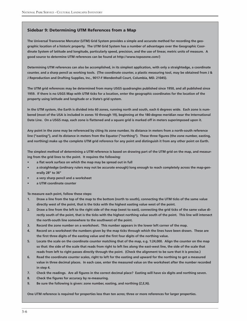
national Park service - cultural landscaPes inventory
3-6
Sidebar 9: determining utm references from a map
TheUniversalTransverseMercator(UTM)GridSystemprovidesasimpleandaccuratemethodforrecordingthegeo-
graphiclocationofahistoricproperty.TheUTMGridSystemhasanumberofadvantagesovertheGeographicCoor-
dinateSystemoflatitudeandlongitude,particularlyspeed,precision,andtheuseoflinear,metricunitsofmeasure.A
goodsourcetodetermineUTMreferencescanbefoundathttp://www.topozone.com/)
DeterminingUTMreferencescanalsobeaccomplished,initssimplestapplication,withonlyastraightedge,acoordinate
counter, and a sharp pencil as working tools. (The coordinate counter, a plastic measuring tool, may be obtained from J &
JReproductionandDraftingSupplies,Inc.,9017-FMendenhallCourt,Columbia,MD.21045).
TheUTMgridreferencesmaybedeterminedfrommanyUSGSquadranglespublishedsince1950,andallpublishedsince
1959.IfthereisnoUSGSMapwithUTMticksforalocation,enterthegeographiccoordinatesforthelocationofthe
propertyusinglatitudeandlongitudeoraState’sgridsystem.
IntheUTMsystem,theEarthisdividedinto60zones,runningnorthandsouth,each6degreeswide.Eachzoneisnum-
bered(mostoftheUSAisincludedinzones10through19),beginningatthe180-degreemeridianneartheInternational
DateLine.OnaUSGSmap,eachzoneisflattenedandasquaregridismarkedoffinmeterssuperimposeduponit.
Any point in the zone may be referenced by citing its zone number, its distance in meters from a north-south reference
line(“easting”),anditsdistanceinmetersfromtheEquator(“northing”).Thesethreefigures(thezonenumber,easting,
andnorthing)makeupthecompleteUTMgridreferenceforanypointanddistinguishitfromanyotherpointonEarth.
ThesimplestmethodofdeterminingaUTMreferenceisbasedondrawingpartoftheUTMgridonthemap,andmeasur-
ingfromthegridlinestothepoint.Itrequiresthefollowing:
• aflatworksurfaceonwhichthemapmaybespreadoutinfull
• astraightedge(ordinaryrulersmaynotbeaccurateenough)longenoughtoreachcompletelyacrossthemap-gen-
erally28”to36”
• averysharppencilandaworksheet
• aUTMcoordinatecounter
To measure each point, follow these steps:
1. Drawalinefromthetopofthemaptothebottom(northtosouth),connectingtheUTMticksofthesamevalue
directly west of the point, that is the ticks with the highest easting value west of the point.
2. Draw a line from the left to the right side of the map (west to east), connecting the grid ticks of the same value di-
rectly south of the point, that is the ticks with the highest northing value south of the point. This line will intersect
the north-south line somewhere to the southwest of the point.
3. Record the zone number on a worksheet. This number appears in the lower left corner of the map.
4. Record on a worksheet the numbers given by the map ticks through which the lines have been drawn. These are
the first three digits of the easting value and the first four digits of the northing value.
5. Locatethescaleonthecoordinatecountermatchingthatofthemap,e.g.1:24,000.Alignthecounteronthemap
so that: the side of the scale that reads from right to left lies along the east-west line, the side of the scale that
reads from left to right passes directly through the point. (Check the alignment to be sure that it is precise.)
6. Readthecoordinatecounterscales,righttoleftfortheeastingandupwardforthenorthingtogetameasured
value in three decimal places. In each case, enter the measured value on the worksheet after the number recorded
in step 4.
7. Checkthereadings.Areallfiguresinthecorrectdecimalplace?Eastingwillhavesixdigitsandnorthingseven.
8. Checkthefiguresforaccuracybyre-measuring.
9. Besurethefollowingisgiven:zonenumber,easting,andnorthing(Z,E,N).
OneUTMreferenceisrequiredforpropertieslessthantenacres;threeormorereferencesforlargerproperties.
3-7
Professional Procedures Guide - section 3
Boundary datum other (r, if applicable)
If “Other Digital Source” is selected for Boundary
UTM Source, describe the type of source that was
used.
display Sequence (o)
Indicate the sequence (1,2,3…) for how the Boundary
UTM data should appear in all reports.
reGionaL LandScape context
The following data elements in this table provide infor-
mation associated with the regional landscape context
of the inventory unit.
regional Landscape context type (o)
Indicate the type of regional landscape context that will
be described in the following text. Select one or more
from the following pick list:
Physiographic: The large scale physical forms and patterns of the landscape such as hill, plateau, ravine, drumlin, etc.
Cultural: The general human overlay on the physical form on the landscape.
Political: The overlay imposed on the landscape through general land use, zoning, legal restrictions, transportation, utilities, population, and political ju-risdiction (e.g., state, county, city, borough, or village).
regional Landscape context description (o – 4000 characters)
Provide a written description for the Regional Land-
scape Context Type selected.
display Sequence (o)
Indicate the sequence (1,2,3…) for how the Regional
Landscape Context Type should appear in all reports.
regional Landscape context Graphics (o)
Provide one or more graphics that illustrates the Re-
gional Landscape Context Type selected.
regional Landscape context Graphic caption (o – 4000 characters)
Provide a title and/or brief description for each Region-
al Landscape Context Graphic.
USGS Map 1:24000
USGS Map 1:62500
USGS Map 1:100000
GPS – Differentially Corrected
GPS – Uncorrected
Other Digital Source
Boundary utm type (r)
Indicate the type of point the UTM represents. Select
one from the following pick list:
Point: For properties less than 10 acres, enter the UTM reference for the point corresponding to the center of the property.
Area: For properties of 10 or more acres, enter three or more UTM references. Multiple entries can be added if this category is selected.
Line: For linear features such as a road or trail, select this category. Multiple entries can be added if this category is selected.
Boundary utm datum (r)
Indicate the datum of the USGS map. Select one from
the following pick list:
NAD 27 (North American Datum of 1927)
NAD 83 (North American Datum of 1983)
Other
Boundary utm Zone (r)
Indicate which of the 60 worldwide UTM zones applies
for the inventory unit.
Boundary utm easting (r)
Indicate the distance, in meters, from the central
meridian to the inventory unit. The easting coordi-
nates within the UTM zone are lines that measure the
number of meters east of a prime meridian.
Boundary utm northing (r)
Indicate the distance, in meters, from the equator to the
inventory unit. The northing coordinates within the
UTM zone are lines that measure the number of meters
north of the equator.

national Park service - cultural landscaPes inventory
3-8
display Sequence (o)
Indicate the sequence (1,2,3…) for how the Regional
Landscape Context Graphic should appear in all
reports.

4-1
Professional Procedures Guide - section 4
Section 4
ManaGeMent inforMationJanuary 2009
San Juan National Historic Site (Southeast Region)
national Park service - cultural landscaPes inventory
4-2
The following data elements provide information on
the management of the inventory unit.
inventory unit
Management category (r)
Indicate the category of management for the inven-
tory unit based on its significance, use, condition, and
location. Each category identified is representative of
a compilation of legislative mandates, policy consider-
ations, and planning. A management category is deter-
mined based on the findings of the CLI and the criteria
for each category defined below. Select one from the
following pick list:
Must be Preserved and Maintained (Category A): An inventory unit meeting any one of the follow-ing criteria: the preservation of the inventory unit is specifically legislated; the inventory unit is related to the park’s legislated significance; the inventory unit is nationally significant as defined by National Historic Landmark criteria or serves as the setting for a nation-ally significant structure or object; the inventory unit is less than nationally significant, but contributes to the park’s national significance; the inventory unit is prehistoric.
Should be Preserved and Maintained (Category B): An inventory unit meeting all of the following criteria (failure to meet any of the conditions moves it to Category C): the inventory unit meets National Register criteria; the inventory unit is compatible with the park’s legislated significance.
May be Preserved or Maintained (Category C): An inventory unit meeting one of the following cri-teria: the inventory unit meets the National Register criteria but because of condition or other factors does not qualify for Category B classification; there is cur-rently insufficient information available to determine eligibility for the National Register but preliminary study indicates eligibility, or a landscape that has been determined ineligible but is managed as a cultural resource base through an NPS planning process.
May Be Released, Altered, or Destroyed (Catego-ry D): An inventory unit meeting one of the following criteria: the inventory unit is an irreparable hazard to
public health and safety of has lost its historical integ-rity; the inventory unit is a physical or visual intru-sion on the park’s legislated significance, as defined through the planning process; the inventory unit has been disposed of by planned action or destroyed by natural forces.
Management category Date (r)
Provide the date (mm/dd/yyyy) the Management Cat-
egory was determined.
Management category explanatory narrative (r – 4000 characters)
Provide a brief narrative describing why the Manage-
ment Category was selected for the inventory unit
based on the criteria outlined.
aDJacent LanDS Graphic inforMation
Do adjacent Lands contribute? (o)
Indicate whether adjacent lands (lands outside the
boundaries of the park) contribute to the significance
of the inventory unit. Select one from the following
pick list:
Yes – Adjacent lands do contribute
No – Adjacent lands do not contribute
Undetermined
adjacent Lands Description (o - 4000 characters)
Provide a narrative describing how the adjacent lands
contribute to the significance of the inventory unit.
The following data elements provide information on
adjacent lands associated with the inventory unit. In the
CLI database, they are in the Adjacent Lands Graphic
Information table.
adjacent Lands Graphic (o)
Provide one or more graphics to illustrate the physical
relationship of the adjacent lands to the inventory unit.
Section 4ManaGeMent inforMation
4-3
Professional Procedures Guide - section 4
adjacent Lands Graphic caption (o – 4000 characters)
Provide a title and/or brief description of the Adjacent
Lands Graphic.
Display Sequence (o)
Indicate the sequence (1,2,3…) for how the Adjacent
Lands Graphic should appear in all reports.
ManaGeMent aGreeMent
The following data elements in this table provide infor-
mation regarding the management agreements associ-
ated with the inventory unit.
Management agreement (r)
Indicate the agreements to which the NPS is a party
that are associated with the inventory unit. Select one
or more from the following pick list:
Concession Contract/Permit: A document issued to authorize private persons and corporations to provide accommodations, facilities, and services for public use in the national park system.
Cooperative Agreement: A document describing the relationship between the Federal Government and State, local government, or other entity when the principal purpose is to transfer money, property (real or personal), services, or anything of value to the State or local government or other entity. Purpose is to ac-complish a public purpose of support or stimulation authorized by Federal statute in lieu of acquisition of purchase or lease. Substantial involvement of the NPS is anticipated.
Special Use Permit: A document issued by a super-intendent to an individual or organization to allow the use of NPS administered resources. It is used for all special park uses that do not have an approved permitting instrument. Special Use permits are used for short-term, not to exceed one year, or long-term, not to exceed five years. The special use permit is not an authority. When it is issued, that authority for the use must be cited. One of the major uses of this form is to cover commercial agriculture activities including planting, tilling, harvesting, forge cropping, and some grazing.
Lease: A document describing a contractual relation-ship by which one party (landlord or lessor) provides to another (tenant or lessee) the use and possession of
lands, resources, buildings, or property for a specified period of time in return for fixed payments. All con-ditions for use and possessions are specified within the lease.
Interagency Agreement: A document describing an agreement between the NPS and another Federal Agency or office for supplies or services provided by the other agency. These agreements are also used to establish cooperative or mutual assistance between two Federal parties, and to transfer funds from one agency to another.
Memorandum of Agreement: A document describ-ing a mutual agreement relationship which differs from a Memorandum of Understanding in that it provides a receipt of funds by the NPS from a non-federal party.
Memorandum of Understanding: A document de-scribing mutual understanding or agreement between the NPS and a State, local government, or other party that is set forth in a written document in which both are participants. A Memorandum of Understanding does not obligate funds.
None: No management agreement is entered into by the NPS.
Other: A document describing an agreement other than those listed under Management Agreements to which the NPS is a party.
Management agreement expiration Date (r)
Provide the date (mm/dd/yyyy) that the Management
Agreement expires. Enter NA if the date is not appli-
cable or UK if unknown.
Management agreement explanatory narrative (o – 4000 characters)
Provide a brief narrative describing the Management
Agreement(s) and its relationship to the management
of the inventory unit.
other Management agreement (o)
Indicate the type of agreement when “Other” is se-
lected.
Display Sequence (o)
Indicate the sequence (1,2,3…) for how the Manage-
ment Agreement data should appear in all reports.
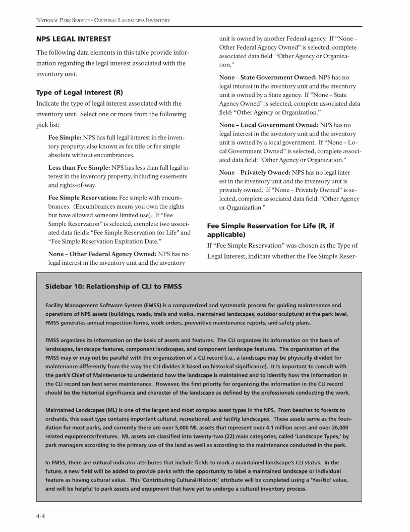
national Park service - cultural landscaPes inventory
4-4
npS LeGaL intereSt
The following data elements in this table provide infor-
mation regarding the legal interest associated with the
inventory unit.
type of Legal interest (r)
Indicate the type of legal interest associated with the
inventory unit. Select one or more from the following
pick list:
Fee Simple: NPS has full legal interest in the inven-tory property; also known as fee title or fee simple absolute without encumbrances.
Less than Fee Simple: NPS has less than full legal in-terest in the inventory property, including easements and rights-of-way.
Fee Simple Reservation: Fee simple with encum-brances. (Encumbrances means you own the rights but have allowed someone limited use). If “Fee Simple Reservation” is selected, complete two associ-ated data fields: “Fee Simple Reservation for Life” and “Fee Simple Reservation Expiration Date.”
None – Other Federal Agency Owned: NPS has no legal interest in the inventory unit and the inventory
unit is owned by another Federal agency. If “None – Other Federal Agency Owned” is selected, complete associated data field: “Other Agency or Organiza-tion.”
None – State Government Owned: NPS has no legal interest in the inventory unit and the inventory unit is owned by a State agency. If “None – State Agency Owned” is selected, complete associated data field: “Other Agency or Organization.”
None – Local Government Owned: NPS has no legal interest in the inventory unit and the inventory unit is owned by a local government. If “None – Lo-cal Government Owned” is selected, complete associ-ated data field: “Other Agency or Organization.”
None – Privately Owned: NPS has no legal inter-est in the inventory unit and the inventory unit is privately owned. If “None – Privately Owned” is se-lected, complete associated data field: “Other Agency or Organization.”
fee Simple reservation for Life (r, if applicable)
If “Fee Simple Reservation” was chosen as the Type of
Legal Interest, indicate whether the Fee Simple Reser-
Sidebar 10: relationship of cLi to fMSS
Facility Management Software System (FMSS) is a computerized and systematic process for guiding maintenance and
operations of NPS assets (buildings, roads, trails and walks, maintained landscapes, outdoor sculpture) at the park level.
FMSS generates annual inspection forms, work orders, preventive maintenance reports, and safety plans.
FMSS organizes its information on the basis of assets and features. The CLI organizes its information on the basis of
landscapes, landscape features, component landscapes, and component landscape features. The organization of the
FMSS may or may not be parallel with the organization of a CLI record (i.e., a landscape may be physically divided for
maintenance differently from the way the CLI divides it based on historical significance). It is important to consult with
the park’s Chief of Maintenance to understand how the landscape is maintained and to identify how the information in
the CLI record can best serve maintenance. However, the first priority for organizing the information in the CLI record
should be the historical significance and character of the landscape as defined by the professionals conducting the work.
Maintained Landscapes (ML) is one of the largest and most complex asset types in the NPS. From beaches to forests to
orchards, this asset type contains important cultural, recreational, and facility landscapes. These assets serve as the foun-
dation for most parks, and currently there are over 5,000 ML assets that represent over 4.1 million acres and over 26,000
related equipments/features. ML assets are classified into twenty-two (22) main categories, called ‘Landscape Types,’ by
park managers according to the primary use of the land as well as according to the maintenance conducted in the park.
In FMSS, there are cultural indicator attributes that include fields to mark a maintained landscape’s CLI status. In the
future, a new field will be added to provide parks with the opportunity to label a maintained landscape or individual
feature as having cultural value. This ‘Contributing Cultural/Historic’ attribute will be completed using a ‘Yes/No’ value,
and will be helpful to park assets and equipment that have yet to undergo a cultural inventory process.
4-5
Professional Procedures Guide - section 4
vation is for the life of the tenant. Select one from the
following pick list:
Yes
No
fee Simple reservation expiration Date (r, if applicable)
If “No” was chosen for Fee Simple Reservation for Life,
indicate the expiration date (mm/dd/yyyy) of the fee
simple reservation.
other agency or organization (r, if applicable)
If one of the “None” options were chosen as the Type
of Legal Interest, indicate the name of the agency,
organization, or individual that has legal interest in the
inventory unit.
npS Legal interest explanatory narrative (o – 4000 characters)
Provide amplifying details regarding the legal interest in
the inventory unit (e.g., scenic easements, conveyance).
Display Sequence (o)
Indicate the sequence (1,2,3…) for how the NPS Legal
Interest data should appear in all reports.
pubLic acceSS to Site
The following data elements in this table provide infor-
mation regarding the public access associated with the
inventory unit.
public access (r)
Indicate the type of public access to the inventory unit.
Select one or more from the following pick list:
Unrestricted: No restrictions apply to public access to the inventory unit.
With Permission: The public must have permission from the NPS, property owner, or tenant in order to access the inventory unit.
Other Restrictions: Specific restrictions apply for access to the inventory unit.
No Access Currently: There is no public access to the inventory unit.
public access explanatory narrative (o – 4000 characters)
Provide a brief narrative describing the Public Access to
the inventory unit.
Display Sequence (o)
Indicate the sequence (1,2,3…) for how the Public Ac-
cess data should appear in all reports.
fMSS aSSet
The following data elements in this table provide in-
formation regarding the Facility Management Software
System (FMSS) asset code associated with the inven-
tory unit.
fMSS asset Location code (o)
This code provides the link between the CLI and
FMSS. FMSS asset codes are associated with specific
asset categories, i.e., Roads 1100, Trails 2100, Main-
tained Landscapes 3100, Buildings 4100, etc. A specific
asset location code is system-generated and assigned
once a particular asset is added to FMSS. The asset
code includes the asset category and a specific asset
number, such as 3100-xxxx.
Display Sequence (o)
Indicate the sequence (1,2,3…) for how the FMSS As-
set Location Code should appear in all reports.
(See Sidebar 10: Relationship of CLI to FMSS)

national Park service - cultural landscaPes inventory
4-6
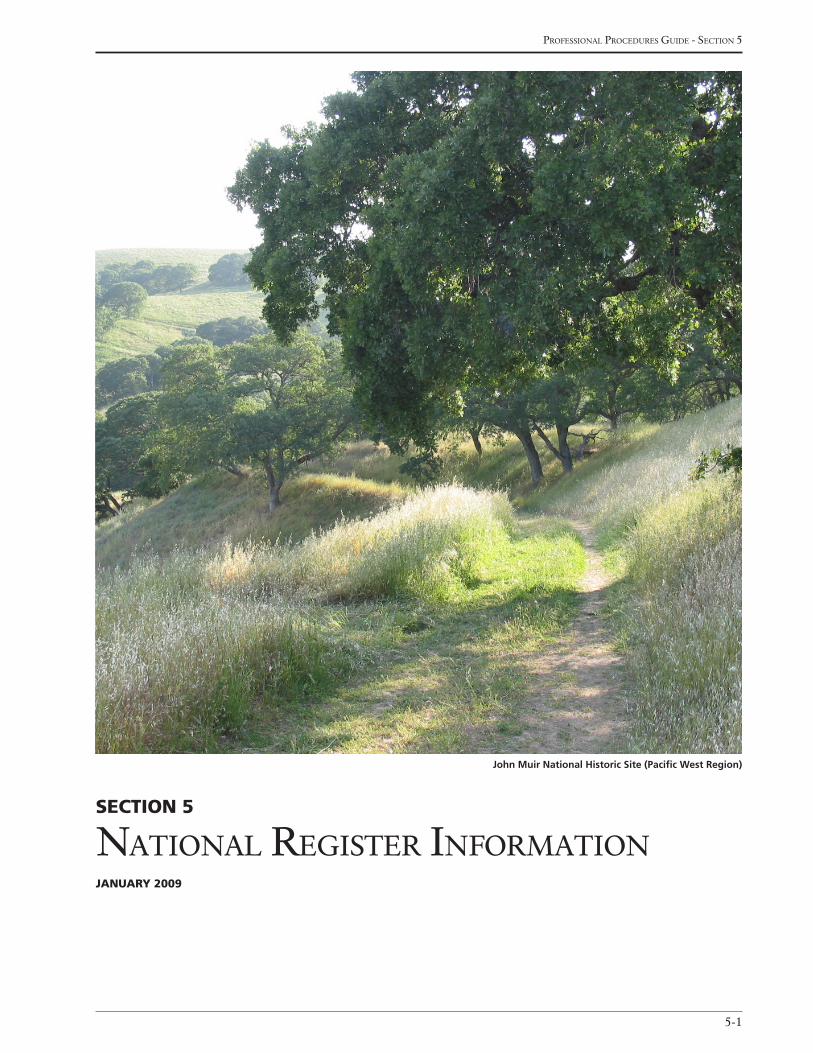
5-1
Professional Procedures Guide - section 5
Section 5
national reGister informationJanuary 2009
John Muir National Historic Site (Pacific West Region)
national Park service - cultural landscaPes inventory
5-2
The following data elements provide information
regarding the National Register of Historic Places
documentation, significance, and eligibility associated
with the inventory unit.
inventory unit
national register Landscape Documentation (r)
Indicate the status of the inventory unit’s National
Register listing and documentation at the time the CLI
is initiated and prior to its certification as complete,
accurate, and reliable. Note: If this status changes at a
later date, it should be noted in the National Register
Explanatory Narrative data element. Select one from
the following pick list:
Entered – Documented: The inventory unit is within the boundaries of a property listed on the National Register of Historic Places and is adequately docu-mented in accordance with the findings of the CLI.
Entered – Inadequately documented: The inven-tory unit is within the boundaries of a property listed on the National Register of Historic Places but is not adequately documented in accordance with the find-ings of the CLI.
SHPO – Documented: The inventory unit is within the boundaries of a property determined to be eligible for the National Register by a State Historic Pres-ervation Officer and is adequately documented in accordance with the findings of the CLI (e.g., Deter-mination of Eligibility).
SHPO – Inadequately documented: The inventory unit is within the boundaries of a property deter-mined to be eligible for the National Register by a State Historic Preservation Officer, but not adequately documented in accordance with the findings of the CLI.
Keeper – Documented: The inventory unit is within the boundaries of a property determined to be eli-gible for the National Register by the Keeper of the National Register, and is adequately documented in accordance with the findings of the CLI.
Keeper – Inadequately documented: The inventory unit is within the boundaries of a property deter-mined to be eligible for the National Register by the Keeper of the National Register, but not adequately documented in accordance with the findings of the CLI.
Undocumented: The inventory unit is not within the boundaries of a property determined to be eligible for the National Register.
(See Sidebar 11: Considerations for Determining
National Register Landscape Documentation)
national register explanatory narrative (r – 4000 characters)
Provide a brief narrative describing the existing
National Register documentation associated with the
inventory unit. The text should describe the documen-
tation history including all eligibility determinations
that have been made to date (i.e., National Register
nominations, determinations of eligibility, Section 110
consensus determinations), and any other documenta-
tion pertaining to resources within the boundaries of
the inventory unit. Date(s) of documentation must be
included in this narrative. If documentation on the
landscape is inadequate, the narrative should include a
description of how the information is insufficient. Any
changes to the status of the inventory unit’s National
Register listing and documentation that occurs after the
CLI is certificated as complete, accurate, and reliable
should be noted in this section.
(See Sidebar 12: Writing the National Register
Explanatory Narrative and Appendix D: Examples
of National Register Explanatory Narratives for
examples)
national register eligibility (r, if applicable)
This data element is applicable if the landscape is not
adequately documented, and “Entered-Inadequately
Documented,” “SHPO-Inadequately Documented,” or
“Keeper-Inadequately Documented” was selected from
the National Register Landscape Documentation data
Section 5nationaL regiSter information
5-3
Professional Procedures Guide - section 5
Sidebar 11: considerations for Determining national register Landscape Documenta-
tion
The intent of this data element is to indicate the status of the inventory unit’s National Register listing and documenta-
tion at the time the CLI is initiated and prior to its certification as complete, accurate, and reliable. In order to do so,
it is recommended that the National Register Explanatory Narrative data element be completed when the CLI work is
initiated. Include a summary of the existing National Register documentation that describes all eligibility determinations
that have been made to date including National Register nominations, determinations of eligibility, Section 110 consen-
sus determinations, and any other documentation pertaining to resources within the boundaries of the inventory unit.
Both the National Register Landscape Documentation and National Register Explanatory Narrative data elements may be
updated to reflect additional documentation and listing that occurs subsequent to the initial certification of the inventory
unit as complete, accurate, and reliable.
Historical units of the national park system are automatically listed on the National Register by law as required by the
National Historic Preservation Act of 1966. Within the national park system, “historical units” include the terms: National
Historic Site, National Military Park, National Battlefield Park, National Battlefield Site, National Historical Park, National
Monument, National Memorial and International Historic Site. Therefore, all physical components of the park are consid-
ered “listed” (or “entered” as per this status list) in the National Register whether or not they are identified in a National
Register nomination. Therefore, the status of the National Register landscape documentation for a CLI in a historical unit
of the national park system would be either “Entered-Documented” or “Entered-Inadequately Documented.”
If “Entered-Documented,” “SHPO-Documented,” or “Keeper-Documented” is selected, National Register Eligibility data
elements are not applicable to the inventory unit. The selection of one of these options indicates that the inventory unit
is eligible and adequate documentation of the landscape’s significance, characteristics and features exists.
Sidebar 12: Writing the national register explanatory narrative
The National Register Explanatory Narrative is a key piece of information in the concurrence package. The narrative is
essentially a history of consultation with the SHPO. It informs other menu items such as current National Register status,
the statement of significance, determining existing and proposed areas of significance, etc. It is also a key component in
the concurrence package cover letter, for both the LCS and the CLI. The following is a checklist of the possible types of
National Register documentation available:
• NationalHistoricLandmarkdesignation
• NationalRegisterDocumentation
• DeterminationsofEligibility(DOEs)
• LCSconcurrenceletters
• OtherCLIrecords
• DeterminationsasaresultofaSection106action
• Legislativelyderivedsignificance
• NRISdatabasereport
• Administrativelisting(10/15/66)ordateofestablishmentofahistoricalparkandsubsequentboundaryadjust-
ments
• Nonparkspecificevaluations,MultiplePropertyDocumentationForms,Thematicnominations,historicdistrictsthat
include NPS properties
• Overlappingdesignations(i.e.NationalRegister,historicalparkboundary,NationalHistoricLandmarkdesignation)
Possiblesourcesinclude:NRISelectronicdatabase,CLIconcurrenceletters,LCSconcurrenceletters,Section106parkproj-
ect files undertaking, National Historic Landmark files at WASO, National Register files at WASO, and SHPO files.
national Park service - cultural landscaPes inventory
5-4
element. This data element also applies to landscapes
ineligible but managed as cultural resources as deter-
mined through the National Park Service planning
process. This data element is not applicable if the land-
scape is adequately documented and its eligibility is
not in question, and “Entered-Documented,” “SHPO-
Documented,” or “Keeper-Documented” was selected
from the National Register Landscape Documentation
data element. Select one from the following pick list:
Eligible – SHPO Consensus Determination: The State Historic Preservation Officer(s) or appropri-ate staff concur with the findings of the CLI that the inventory unit is eligible for the National Register or contributes to the significance of an existing National Register property.
Eligible – Keeper: The Keeper of the National Register concurs with the findings of the CLI that the inventory unit is eligible for the National Register or contributes to the significance of an existing National
Sidebar 13: Landscapes not managed as a cultural resource
One of the options for documenting the National Register eligibility of a landscape or component landscape includes
“Not Managed as Cultural Resource.” This option has been included to identify landscapes that are not managed as
cultural resources (if at all) by the NPS but have important associations with inventory units in the CLI. These landscapes
are either:
• ineligiblefortheNationalRegisterbasedonthefindingsofaCLI,or
• includepropertyforwhichtheNPSdoesnothave,norplanstoobtain,anylegalinterest.
As an example, the developed areas of Yosemite National Park, as related to NPS park development in the early twen-
tieth century, may be defined as a landscape that does not retain historic integrity and is, therefore, ineligible for the
National Register. However, several fragments or portions of the developed area may retain integrity and be identified
as component landscapes in the CLI. An example of a landscape which includes property for which the NPS does not
have,norplanstoobtain,anylegalinterestmaybetheSantaFeTrail.Anindividualparkwillonlycontainoneormore
portions of the trail, and the trail in its entirety is not managed as a cultural resource by the NPS. By identifying the
entiredevelopedareaofYosemiteNationalParkortheentireSantaFeTrailasalandscape,therelationshipsbetween
the discontinuous components can be illustrated. Otherwise, each component landscape would have to be defined as a
landscape.
Landscapes “Not Managed as Cultural Resource” are included in the CLI because they directly relate (thematically) to
component landscapes which are eligible for the National Register, and it is desirable to illustrate the relationship of the
component landscape to this broader context. However, defining a landscape in this manner requires the CLI recorder
to distinguish between a property which has been reduced in size but by definition is still a “landscape,” and a property
which has been reduced to fragments (either owned by NPS or not) which by definition are “components” related to a
“landscape” which is either ineligible or extends beyond park boundaries.
Allowing for these instances will provide a mechanism for illustrating the contextual relationship of the component land-
scapesinventoried,aswellastheexistenceofsignificantadjacentlands.Theselandscapeswillnotbeincludedinthe
general CLI reports and queries.
Register property.
Ineligible – SHPO Consensus Determination: The State Historic Preservation Officer(s) or appropriate staff do not concur with the findings of the CLI and responds that the inventory unit is ineligible for the National Register or does not contribute to the signifi-cance of an existing National Register property.
Ineligible – Keeper: The Keeper of the National Register does not concur with the findings of the CLI and formally responds that the inventory unit is ineli-gible for the National Register or does not contribute to the significance of an existing National Register property.
Ineligible – Managed as a Cultural Resource: The inventory unit has been determined ineligible for the National Register through a concurrence process with the State Historic Preservation Officer(s) or Keeper of the National Register, but through the National Park Service planning process (General Management Plan) a decision has been made to manage the inventory unit as a cultural resource.
5-5
Professional Procedures Guide - section 5
Sidebar 14: consensus Determinations for eligibility
The CLI is finalized with a consensus determination opinion by the appropriate State Historic Preservation Officer(s)
(SHPO) regarding the findings of the inventory for the following:
• aninventoryunitwithinapropertylistedintheNationalRegisterandinadequatelydocumented
• aninventoryunitwithinapropertydeterminedeligibleforlistingintheNationalRegisterandinadequatelydocu-
mented
• aninventoryunitnotcurrentlywithintheboundariesofaNationalRegistereligiblepropertybutconsideredeli-
gible based on the findings of the CLI
Forlandscapesandcomponentlandscapes,NPSwillworkwithSHPOstoconfirmwhichlandscapecharacteristicscontrib-
ute to the significance of the property, along with an associated list of contributing and non-contributing features. Those
inventoried and found to be “ineligible” also will be submitted to the SHPO and recorded in the CLI, as per Section 110
guidance. The recommended format for presenting the CLI information to the SHPO regarding a consensus determina-
tion is the Park Report with a custom cover letter or the SHPO-defined format, if available.
When a consensus determination opinion cannot be achieved (the SHPO disagrees with the findings of the CLI, or choos-
es not to review the CLI), a Determination of Eligibility (DOE) must be completed. Ideally, the DOE should address all
contributing resources within an eligible property (e.g., cultural landscapes, structures, archeology) not previously listed
in the National Register or which are not included in an existing National Register nomination. However, the ability to
coordinate and sequence the CLI with other inventory efforts may not be possible in light of the different developmental
stages of these inventory programs. Therefore, at a minimum, the DOE form completed as part of the CLI will indicate
whether or not other resources have been evaluated concurrently. The key differences between a consensus determina-
tion and a DOE are:
• thelevelofinformationrequiredisgreaterforaDOE
• aDOErequirestheparticipationoftheKeeperoftheNationalRegister
(SeeAppendixE:GuidelinesforInventoryandConsensusDeterminationConsultation,AppendixF:Determinationsof
Eligibility for Inclusion in the National Register of Historic Places and Appendix P: Examples of Cover Letters)
Not Managed as Cultural Resource: The inventory unit (in this case a landscape only) has been deter-mined ineligible for the National Register or includes property for which the National Park Service does not have, nor plans to obtain, any legal interest, but is included in the CLI because it is directly related to a component landscape(s) which is eligible for the National Register.
Undetermined: No determination of the eligibility of the inventory unit has been made and a determination will be pursued based on the findings of the CLI. This is not a valid choice for a completed record.
(See Sidebar 13: Landscapes Not Managed as Cul-
tural Resource)
national register eligibility concurrence Date (SHPo/Keeper) (r, if applicable)
Indicate the date (mm/dd/yyyy) that the inventory unit
was determined eligible or ineligible by a State Historic
Preservation Officer(s) or the Keeper of the National
Register based on the findings of the CLI. This data
element does not apply if “Entered-Documented,”
“SHPO-Documented,” or “Keeper-Documented” was
selected from the National Register Landscape Docu-
mentation data element.
national register concurrence explanatory narrative (o – 4000 characters)
Provide a brief narrative regarding any issues or con-
siderations encountered in obtaining State Historic
Preservation Officer(s) or the Keeper of the National
Register concurrence. The text should note any stipu-
lations or revisions that resulted from consultation with
either group.
(See Sidebar 14: Consensus Determinations for
Eligibility)
national Park service - cultural landscaPes inventory
5-6
national register Significance Level (r)
Indicate the National Register significance level for the
inventory unit. If more than one significance level is
applicable, choose the highest level. Select one from
the following pick list:
International: An inventory unit that represents an aspect of the history of the world as a whole. It illus-trates the worldwide impact of events or persons as-sociated with the property, its landscape type or style, or information potential. The inventory unit must be of universal significance to humankind representing or illustrating an important theme in world history.
National: An inventory unit that represents an aspect of the history of the United States and its territories as a whole. It illustrates the nationwide impact of events or persons associated with the property, its landscape type or style or information potential. The inventory unit must be of exceptional value in representing or illustrating an important theme in the nation’s history.
State: An inventory unit that represents an aspect of the history of a State as a whole. It can be located in only a portion of the State’s present political boundary and does not have to belong to property types found throughout the State. The context of the inventory unit must be important statewide with historic associations or information potential that extends beyond a single local area. American Samoa, the District of Columbia, the Commonwealth of the Northern Marian Island, Guam, Puerto Rico, and the Virgin Islands are considered separate states.
Local: An inventory unit that represents an aspect of the history of a town, city, county, cultural area, region, or ay portions thereof. It is defined by the im-portance of the property, not necessarily the physical location of the property.
Not Significant: An inventory unit that is less than 50 years old, appears to have no significance, or has lost integrity based on the findings of the CLI.
national register Significance - contributing/individual (r)
Indicate whether the inventory unit contributes to the
significance of a property listed on, or eligible for listing
on, the National Register; or if it is listed on, or eligible
for listing on, the National Register as a separate prop-
erty based on its individual significance. Select one
from the following pick list:
Contributing
Individual
national register classification (r)
Indicate the National Register property category as-
sociated with the inventory unit. Select one from the
following pick list:
Site: The location of a significant event, a prehis-toric or historic occupation or activity, or building or structure, whether standing, in ruins, or destroyed, where the location itself possesses historic, cultural, or archeological value regardless of the value of any existing structure.
District: A significant concentration, linkage, or continuity of sites, buildings, structures, or objects united historically or aesthetically by plan or physical development.
Multiple Property: A group of historic properties related by a common theme (patterns of history), general geographical area, and period of time.
national Historic Landmark Status (r)
Indicate whether or not the inventory unit is, or is part
of, a National Historic Landmark. Such properties are
designated by the Secretary of the Interior based on
their national significance in illustrating or represent-
ing United States prehistory and history of the United
States. Select one from the following pick list:
Yes
No
national Historic Landmark Date (r, if applicable)
Provide the date (mm/dd/yyyy) the inventory unit was
determined to be a National Historic Landmark.
national Historic Landmark theme (r, if applicable)
Provide the theme, sub-theme, and/or facet under
which the landscape was designated a National Historic
Landmark, as indicated on the nomination form.
World Heritage Site Status (r)
Indicate if the inventory unit is a World Heritage Site.
Such properties are found to possess “universal sig-
nificance to mankind” as designated under the World
Heritage Convention. Select one from the following:
Yes
No
5-7
Professional Procedures Guide - section 5
World Heritage Site Date (r, if applicable)
Provide the date (mm/dd/yyyy) the inventory unit was
determined to be a World Heritage Site.
World Heritage category (r, if applicable)
Indicate the category under which the landscape was
designated a World Heritage Site. Select one from the
following pick list:
Cultural
Natural
Both Cultural and Natural
Statement of Significance (r – 64,000 characters)
Provide a narrative stating the inventory unit’s historic
significance. In general, use an opening, summary
paragraph to explain how the property meets the Na-
tional Register criteria, how it contributed to the areas
of significance listed, and the way it was important to
the history of its locality, state, or the nation during the
period of significance. Mention the important themes
or historic contexts to which the property relates.
Discuss the facts and circumstances of the property’s
history that led to its importance focusing on the
primary area(s) of significance. Clearly articulate the
connection between each area of significance, its cor-
responding criterion, and period of significance. This
section should not be redundant of the history section.
Use the key facts that directly support and/or highlight
the significance of the property.
(See Sidebar 15: Writing a Statement of Signifi-
cance, Sidebar 16: Evaluating and Stating Signifi-
cance, and Appendix G: Examples of Statements of
Significance
Sidebar 15: Writing a Statement of Significance
The statement of significance consists of:
• Aparagraphsummarizingtheinventoryunit’ssignificance
• Severalsupportingparagraphsthatbrieflydiscuss:
•Thehistoryoftheproperty,particularlyasitrepresentsimportanthistoriccontextsandreflectsthesignificant
events, associations, characteristics, or other reasons the property meets the National Register criteria, and
•Thehistoriccontexts,themes,trends,andpatternsofdevelopmentrelatingtotheproperty.
Summary ParagraphSimply and clearly state the reasons why the property meets the National Register criteria.
• Providebrieffactsillustratinghowthepropertymeetsthecriteria,howitcontributedtotheareasofsignificance
listed, and the ways in which the property was important to the pre-history and history of its locality, State or the
nation during the period of significance.
• Mentiontheimportanthistoricthemes,contexts,trendsorpatternsofdevelopmenttowhichthepropertyrelates,
and whether the property retains sufficient integrity to convey its historic significance through existing physical
features; that is, does it retain sufficient integrity to convey its significance.
• Substantiatethesefactsbymentioningthespecificassociationsorcharacteristicsofthepropertythatgiveit
significance under each criterion. These can include historic events, activities, persons, physical features, artistic
qualities,landscape/gardenstyles,andarcheologicalevidence.
• Alsobesuretoidentifytheroleofanyimportantpersonsorculturalaffiliations,andthewaysinwhichtheprop-
erty meets the special standards for any criteria considerations.
Supporting ParagraphsUse the summary paragraph as an outline for building the case for significance in the supporting paragraphs.
• Beginbyprovidingabriefchronologicalhistoryoftheproperty,thenmoveintoadiscussionofthehistoriccontext
of the property. Only present and discuss facts that directly support the significance of the property, avoid narrat-
ingtheentirehistory.Forexample,identifysignificantlandscapearchitecturaldetailsifalandscapeissignificant
for its design, or explain the role that an agricultural landscape has played in local commerce or industry.
national Park service - cultural landscaPes inventory
5-8
• Bespecific–givedatesandpropernamesofpertinentpeopleandplaces,andprovidedescriptiveandhistorical
information about the area where the property is located - do not assume the reader will be familiar with the prop-
erty or its history.
• Explaintheroleofthepropertyinrelationshiptobroadhistorictrends,illustratewithspecificfactsabouttheprop-
erty and its community.
• Furtherexplorethewaysinwhichthepropertyrelatestoimportantthemesintheprehistoryorhistoryofitscom-
munity, State, or the nation. Consider, for example, the historic context of the role of cherry production in a State’s
agricultural economy since the early twentieth-century, or that reforestation has occurred in eighty percent of a
county extensively farmed in the 1840s. This can lead to the identification of significant cherry-producing areas or
reforested farms that have evidence of early land uses and division.
• Foreachareaofsignificance,discussthefactsandcircumstancesintheproperty’shistorythatledtoitsimportance.
Make a clear connection between each area of significance, the corresponding National Register criterion, and the
period of significance. Be sure to discuss in more detail the specific associations and characteristics of the prop-
ertythatwerementionedinthesummaryparagraph–showhowthepropertyisunique,outstandingorstrongly
representative of an important historic context when compared with other properties of the same or similar period,
characteristics, or associations. Consult with the SHPO staff for help in determining how much and what kinds of
information are needed.
• Incorporatethefollowinginformationtotheextentthatitrelatestothesignificanceoftheproperty:
•specificevents
•activitiesanduses
•influenceoftechnology
•aspectsofdevelopment
•culturalaffiliations
•politicalorganization
•socialorculturaltraditions
•commonlandscapearchitecturalstylesortypes
•constructionmaterialsandmethods
•roleofimportantpersonsororganizations
•trendsinlocalorregionaldevelopmentpatternsofphysicaldevelopment
•economicforces
•presenceandconditionofsimilarproperties
Sidebar 16: evaluating and Stating Significance
The following guidelines and questions should be considered when evaluating the significance of a property and de-
veloping the statement of significance. Incorporate the answers to the questions directly pertaining to the property’s
historic significance and integrity in the narrative.
The following areas of significance commonly apply to landscapes:
• Agriculture:Wherethelandhasbeenusedforcultivatingcrops,raisinglivestock,andotheractivitiesthathave
contributed to the growth, development, and economy of a community during particular periods of its history.
• Architecture:Whereacollectionofhigh-styleorvernacularbuildingsandoutbuildings,byhistoricalassociation,
function, design, spatial arrangement, or setting, are integrally related to large areas of landscape and are indica-
tive of the physical development, materials, or land uses of a State, region, or community, or the building practices
or traditions of the people who occupied it.
• Archeology:Wherepatternsvisibleuponthelandorevidentinsubsurfaceremainscanprovideimportantinforma-
tion about land use and occupation of prehistoric or historic peoples.
• Communityplanninganddevelopment:Wherethespatialorganizationandcharacterofthelandscapearethe
result of either a consciously designed plan or vernacular patterns of land use or land division.
5-9
Professional Procedures Guide - section 5
• Conservation:Wherethelandscapehasbeenthesubjectofanimportantstage,event,ordevelopmentinthecon-
servation of natural or cultural resources.
• Engineering:Wherethelandscapeanditsusesreflectthepracticalapplicationofscientificprinciplestoservehu-
man needs, such as reclamation, irrigation, and water power.
• Exploration/settlement:Wherethelandscapecontinuestoreflecttheexploration,establishment,orearlydevelop-
ment of a community or region.
• Industry:Wherethelandscapehasbeenshapedormanipulatedtoprovidegoodsorservices,throughactivities
such as lumbering, mining, milling and quarrying, that have contributed to the development of a community or
society in general.
• Landscapearchitecture:Wherethelandscapecontainssites,suchasgardens,residentialsubdivisions,andparks,
which have been based on established design principles or conscious designs, or are the work of a master, having
importance within the context of landscape design.
• Science:Wherethelandscape,hasbeenthesubjectofresearchrelatedtotheadvancementorunderstandingof
agriculture, horticulture, silviculture, animal husbandry, or other scientific principles.
The following questions may apply:
• Whateventstookplaceonthesignificantdatesindicated,andinwhatwaysaretheyimportanttotheproperty?
• Inwhatwaysdoesthepropertyphysicallyreflectitsperiodofsignificance,andinwhatwaysdoesitreflect
changesaftertheperiodofsignificance?
• Whatistheperiodofsignificancebasedon?Bespecificandrefertoexistingresourcesorfeatureswithintheprop-
erty or important events in the property’s history.
• Howdoesthepropertyrelatetothesignificantevent,occupation,oractivitythattookplacethere?
• Howhavealterationssuchasthedestructionoforiginalbuildings,changesinlanduse,andchangesinfoliageor
topographyaffectedtheintegrityofthesiteanditsabilitytoconveyitssignificantassociations?Forexample,if
the forested site of a treaty signing is now a park in a suburban development, the site may have lost much of its
historic integrity and may not be eligible for the National Register.
• InwhatwaysdoestheeventthatoccurredonthepropertyreflectthebroadpatternsofAmericanhistoryandwhy
isitsignificant?
• Whatarethephysicalfeaturesandcharacteristicsthatdistinguishtheproperty,including,topography,landuse,
spatialorganization,streetpatterns,structures,andbuildingmaterials?
• Whataretheoriginsandkeyeventsinthehistoricaldevelopmentoftheproperty?
• Areanylandscapearchitects,designers,buildersorplannersimportanttotheproperty’sdevelopment?
• Howhavesignificantindividualsoreventscontributedtothedevelopmentoftheproperty?
• Doesthepropertyconveyasenseofcohesivenessthroughdesign,setting,materials,workmanship,orassociation?
• Howdotheelementswithinthepropertycontributetothefeelingoftimeandplace?
• Howhasthepropertyaffectedthehistoricaldevelopmentofthecommunity,region,orState?Howdoestheprop-
ertyreflectthehistoryofthecommunity,region,orState?
• Howdoesthepropertycomparetoothersimilarareasinthelocality,region,orStateandwhatarethequalities
thatdistinguishthepropertyfromitssurroundings?
• Ifthereareanypreservationorrestorationactivitiesontheproperty,dotheyaffecttheproperty’ssignificance?
• Doesthepropertycontainanyresourcesoutsidetheperiodofsignificancethatarecontributing?Ifso,identify
them and explain their importance.
• Ifthepropertyhasindustrialsignificance,howdotheindustrialfunctionsorprocessesrepresentedrelatetothe
broaderindustrialortechnologicaldevelopmentofthelocality,region,Stateornation?Howimportantwerethe
entrepreneurs,engineers,designers,andplannerswhocontributedtothedevelopmentofthedistrict?Howdothe
remaining landscape characteristics, processes and physical forms, within the property reflect industrial production
orprocess?
• Ifthepropertyisrural,howarethenaturalandmanmadeelementsofthepropertylinkedhistoricallyorarchi-
tecturally,functionally,orbycommonethnicorsocialbackground?Howdoestheopenspaceconstituteorunite
significantfeaturesoftheproperty?
• Doesthepropertyhaveanyresourcesofpossiblearcheologicalsignificance?Ifso,howaretheylikelytoyield
importantinformation?Howdotheyrelatetotheprehistoryorhistoryoftheproperty?
national Park service - cultural landscaPes inventory
5-10
nationaL regiSter Significance
criteria
national register Significance criteria (r)
In this table, indicate the significance criteria for which
the inventory unit qualifies for listing on the National
Register. Criteria is defined as the quality of signifi-
cance in American history, architecture, engineering,
and culture; that is present in districts, sites, buildings,
structures, and objects; and that possess integrity of lo-
cation, design, setting, materials, workmanship, feeling,
and association. Inventory units are often significant
for more than one criterion. Select only those that are
supported by the narrative statement of significance.
Select one or more from the following pick list:
Criterion A: The property is associated with events that have made a significant contribution to the broad pattern of our history
Criterion B: The property is associated with the lives of persons significant in our past
Criterion C: The property embodies the distinc-tive characteristics of a type, period, or method of construction or represents the work of a master, or possesses high artistic values, or represents a signifi-cant and distinguishable entity whose components may lack individual distinction
Criterion D: The property has yielded, or may be likely to yield, information important in prehistory or history
Display Sequence (o)
Indicate the sequence (1,2,3…) for how the National
Register Significance Criteria should appear in all
reports.
nationaL regiSter criteria
conSiDerationS
national register criteria consideration (r, if applicable)
In this table, indicate the National Register criteria
considerations for the inventory unit, if applicable.
The criteria considerations set forth special standards
for listing certain kinds of properties usually excluded
from the National Register. Ordinarily the following
properties are not considered eligible for the National
Register: cemeteries, birthplaces, graves of historical
figures, properties owned by religious institutions or
used for religious purposes, structures that have been
moved from their original locations, reconstructed his-
toric buildings, properties primarily commemorative in
nature, and properties that have achieved significance
within the past 50 years. However, such properties
will qualify if they are integral parts of properties that
do meet the criteria or if they fall within the following
criteria considerations. Select one or more from the
following pick list:
Criteria Consideration A: A religious property deriving primary significance from architectural or artistic distinction or historical importance
Criteria Consideration B: A building or structure removed from its original location but which is sig-nificant primarily for architectural value, or which is surviving structure most importantly associated with a historic person or event
Criteria Consideration C: A birthplace or grave of a historical figure of outstanding importance if there is no other appropriate site or building directly associ-ated with his or her productive life
Criteria Consideration D: A cemetery which de-rives its primary significance from graves of persons of transcendent importance, from age, from distinc-tive design features, or from association with historic events
Criteria Consideration E: A reconstructed building when accurately executed in a suitable environment and presented in a dignified manner as part of a res-toration master plan, and when no other building or structure with the same association has survived
Criteria Consideration F: A property primarily commemorative in intent if design, age, tradition, or symbolic value has invested it with its own historical significance
Criteria Consideration G: A property achieving significance within the past fifty years if it is of excep-tional importance
Display Sequence (o)
Indicate the sequence (1,2,3…) for how the National
Register Criteria Consideration should appear in all
reports.
5-11
Professional Procedures Guide - section 5
nationaL regiSter PerioD of
Significance
The following data elements in this table include infor-
mation about the landscape’s period(s) of significance.
The period of significance is the length of time when
a property was associated with the important events,
activities, or persons, or attained the characteristics that
qualify it for National Register listing.
Start year: (r) (enter one to many)
Indicate the beginning year (yyyy) for the period(s) of
significance according to National Register criteria.
Start era (r)
Indicate the start era. Select one from the following
pick list:
AD
BC
end year (r)
Indicate the end year (yyyy) for each period(s) of
significance marking the span of time in which the in-
ventory unit attained significance according to National
Register criteria.
end era (r)
Indicate the End Era. Select one from the following
pick list:
AD
BC
Display Sequence (o)
Indicate the sequence (1,2,3…) for how the Period of
Significance should appear in all reports.
(See Sidebar 17: Selecting the Period of Signifi-
cance)
Sidebar 17: Selecting the Period of Significance
Period of significance usually begins with the date when significant activities or events began giving the property its
historicsignificance;thisisoftenadateofconstruction.Forprehistoricproperties,theperiodofsignificanceisthebroad
span of time about which the site or district is likely to provide information; it is often the period associated with a par-
ticular cultural group.
• CriterionA:Forthesiteofanimportantevent,suchasapivotalfive-monthlaborstrike,theperiodofsignificance
isthetimewhentheeventoccurred.Forpropertiesassociatedwithhistorictrends,suchascommercialdevelop-
ment, the period of significance is the span of time when the property actively contributed to the trend.
• CriterionB:TheperiodofsignificanceforapropertysignificantforCriterionBisusuallythelengthoftimethe
property was associated with the important person.
• CriterionC:Forarchitecturallysignificantproperties,theperiodofsignificanceisthedateofconstructionand/or
the dates of any significant alterations and additions.
• CriterionD:Theperiodofsignificanceforanarcheologicalsiteistheestimatedtimewhenitwasoccupiedorused
forreasonsrelatedtoitsimportance,forexample,3000-2500BC.
Additional Guidelines• Thepropertymustpossesshistoricintegrityforallperiodsofsignificanceentered.
• Theperiodofsignificanceisbaseduponthetimewhenthepropertymadethecontributionsorachievedthechar-
acteronwhichsignificanceisbased.Continueduseoractivitydoesnotnecessarilyjustifycontinuingtheperiodof
significance.
• Fiftyyearsagoisusedastheclosingdateforperiodsofsignificancewhereactivitiesbegunhistoricallycontinued
to have importance and no more specific date can be defined to end the historic period. (Events and activities
occurringwithinthelastfiftyyearsmustbeexceptionallyimportanttoberecognizedas“historic”andtojustify
extendingaperiodofsignificancebeyondthelimitof50yearsago.)
• Basetheperiodofsignificanceonspecificeventsdirectlyrelatedtothesignificanceoftheproperty:forexample,
the date of construction for a garden significant for its design or the length of time a farm operated and contrib-
uted to local lifestyle and economy.
national Park service - cultural landscaPes inventory
5-12
Sidebar 18: identifying Historic contexts
Historic context is an organizing structure for interpreting history that groups historic properties sharing a common
theme, geographic location, and time period. The historic context provides the basis for comparative analysis of the
significance of one property to another within the same context. As such, it can be a foundation for decisions about the
planning, identification, evaluation, registration, and treatment of historic properties. Every cultural landscape has at
least one historic context that is the basis of its significance.
Thematic classification has been used by the NPS in response to a Congressional mandate to ensure that the full diversity
of American history and prehistory is expressed in the NPS’ identification and interpretation of historic properties. The
first theme outline developed by the NPS was prepared in 1936 and has been revised on several occasions based on new
scholarship and the way we look at the past. The thematic framework was last revised in 1994 and eight seemingly dis-
crete categories, not meant to be mutually exclusive, were identified.
The themes identified in 1994 are also used in the CLI. These eight categories embrace prehistory to the modern period
and a multiplicity of human experiences. However, in order to provide greater specificity in the themes related to cultural
landscapes in the national park system, each category has two subcategories (sub-themes and facets). These subcat-
egories have been primarily drawn from “History and Prehistory in the National Park System and the National Historic
Landmarks Program,” (1987), a variety of sources related to cultural landscapes in the United States, and suggestions
from field staff undertaking CLI work.
An example of the three levels is as follows: Expressing Cultural Values (Historic Context Theme), Landscape Architecture
(Historic Context Sub-theme), The City Beautiful Movement (Historic Context Facet)
HiStoric context tHeme
The following data elements in this table include infor-
mation about the theme(s), sub-theme(s), and facet(s)
of history associated with the inventory unit. In the
CLI database, they are nested under “National Regis-
ter Period of Significance” and are accessible after the
National Register Period of Significance data fields are
entered.
(See Sidebar 18: Identifying Historic Contexts and
Sidebar 19: Developing a Historic Context)
Historic context theme (r)
Indicate the historic context theme(s) associated with
the inventory unit for each Period of Significance iden-
tified. Select one or more from the pick list provided in
Appendix I: Historic Context.
Historic context Sub-theme (r)
Indicate the sub-theme(s) associated with the inventory
unit for each historic context theme selected. Select
one or more sub-themes from Appendix I: Historic
Context.
Sidebar 19: Developing a Historic context
A historic context is an important theme, pattern, or trend in the historical development of a locality, State, or the nation
at a particular time in history or prehistory. To develop a historic context, identify and provide facts about one or more
themes of history to which the property relates through its historic uses, activities, associations, and physical character-
istics.Theme,geographicalplace,andperiodoftimeshouldorganizethesefacts.Factsmayrelatetootherproperties
having similar associations or characteristics and existing in the same place and time.
Properties Significant for Criterion A Explain how the event or pattern of events made an important contribution to the history of the community, State, or na-
tion,andhowrelatedtypesofpropertiesreflecttheseevents.Forexample,statehowtheadventoftherailroadaffected
the growth and character of a town in the late nineteenth century and how it is represented today by the 1870 depot.
5-13
Professional Procedures Guide - section 5
Properties Significant for Criterion B Explain why the person or persons with whom the property is associated is important to the history of the community,
State, or nation. Also identify other properties associated with the person and explain their role in the career of the per-
son.Forexample,discusshowanauthorwhodepictedthepeople,events,andplacesofherregionachievedstatewide
recognition and how a rustic mountain retreat and boarding house where she wrote and found inspiration are the surviv-
ing properties best associated with her life and career.
Properties Significant for Criterion C• TypeorMethodofConstruction:Explainwhythetype,period,ormethodofconstructionrepresentslandscapefea-
turesorpatternsthataresignificantinthedevelopmentofthecommunity,State,ornation.Forexample,describe
how a style, a new innovation in design or implementation, or a use of particular building or construction material,
is articulated in a landscape or landscape feature.
• WorkofaMaster:Providefactsaboutthecareerandworkoftheartist,landscapearchitect,landscapedesigneror
engineer, to explain how the person was accomplished in his or her field and made contributions to the art, land-
scapearchitectureordesignofthecommunity,State,ornation.Forexample,discusshowalandscapearchitect,
suchasBeatrixFarrand,gainedrecognitionofcampusandestatedesigns,aswellashercontributionstotheArts
and Crafts Movement in landscape architecture.
• HighArtisticValues:Describethequalityofartistryorcraftsmanshippresentincomparableworksinthecommuni-
ty,State,ornation.Forexample,discusshowthedesignofNewYork’sCentralParkisanotableexampleofpublic
park design which led the movement of developing public parks across the nation.
Properties Significant for Criterion D Explain why the information the site is likely to yield is important to the knowledge of the prehistory or history of the
community,State,ornation.Forexample,discusshowthedataonhuntingandgatheringpracticesandtechnologyofa
Late Archaic culture will broaden the knowledge and understanding of the culture’s occupation regionally.
Properties of Local Significance Identify the local events and activities relating to the property and discuss their importance to local history.
Properties of State Significance Discuss how the property reflects the history of the State and the ways in which the property is one of the best of simi-
larly associated properties in the State to represent the theme.
Properties of National Significance Discuss how the property reflects an important aspect of the history of the Nation as a whole or has contributed in an
exceptional way to the diverse geographical and cultural character of the Nation. Also, explain how the property relates
to other properties nationwide having similar associations.
(See Appendix H: Documenting Nationally Significant Properties)
Foracompletediscussionofhistoriccontext,seethefollowingNationalRegisterBulletins:
• HowtoApplytheNationalRegisterCriteriaforEvaluation(#15)
• HowtoCompletetheNationalRegisterMultiplePropertyDocumentationForm(#16B)
AlsorefertothefollowingNationalRegisterBulletinsforspecificguidelinesindevelopingand/ordefininghistoriccon-
texts:
• HowtoEvaluateandNominateDesignedHistoricLandscapes(#18)
• GuidelinesforEvaluatingandDocumentingRuralHistoricLandscapes(#30)
• GuidelinesforEvaluatingandDocumentingTraditionalCulturalProperties(#38)
• GuidelinesforIdentifying,Evaluating,andRegisteringAmerica’sHistoricBattlefields(#40)
• GuidelinesforEvaluatingandRegisteringCemeteriesandBurialPlaces(#41)
• GuidelinesforIdentifying,EvaluatingandRegisteringHistoricMiningProperties(#42)
national Park service - cultural landscaPes inventory
5-14
Historic context facet (r, if applicable)
Indicate the facet associated with the inventory unit
for each sub-theme selected. Select one or more facets
from Appendix I: Historic Context.
other Historic facet (r, if applicable)
Provide the facet of history if “Other” is selected for a
facet.
Display Sequence (o)
Indicate the sequence (1,2,3…) for how the Historic
Context Theme should appear in all reports.
nationaL regiSter areaS of
Significance
The following data elements in this table include infor-
mation relating to the aspects(s) of historic develop-
ment for which the inventory unit meets the National
Register criteria. Facts about the history and existing
landscape characteristics related to the themes and
property types determined by the property’s historic
context are used to determine areas of significance for
a property.
(See Sidebar 20: Selecting Areas of Significance
and Sidebar 21: Area of Significance Category and
Subcategory Definitions)
area of Significance category (r)
Indicate the aspects(s) of historic development for
which the inventory unit meets the National Register
criteria. Select one or more from the following pick list:
Agriculture
Architecture
Archeology
Art
Commerce
Communications
Community Planning and Development
Conservation
Economics
Education
Engineering
Entertainment/Recreation
Ethnic Heritage
Exploration/Settlement
Health/Medicine
Industry
Invention
Landscape Architecture
Law
Literature
Maritime History
Military
Other
Performing Arts
Philosophy
Politics/Government
Religion
Science
Social History
Transportation
area of Significance category explanatory narrative (r, if applicable)
If “Other” was selected in the Area of Significance Cat-
egory data element, it should be described here.
area of Significance Subcategory (r, if applicable)
Indicate the appropriate subcategory if the Area of
Significance Category selected is either “Archeology”
or “Ethnic Heritage.” For “Archeology” select one or
more from the following pick list:
Historic-Aboriginal
Historic-Non-Aboriginal
Prehistoric
For “Ethnic Heritage” select one or more from the fol-
lowing pick list:
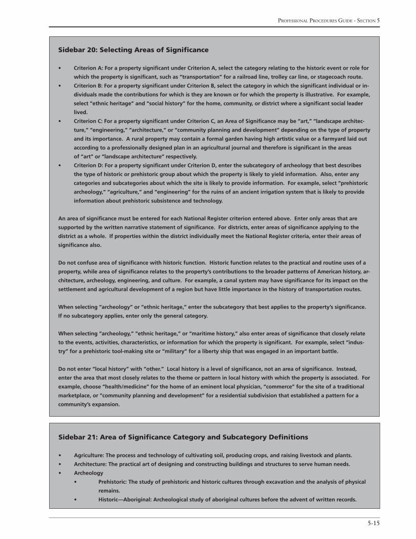
5-15
Professional Procedures Guide - section 5
Sidebar 20: Selecting areas of Significance
• CriterionA:ForapropertysignificantunderCriterionA,selectthecategoryrelatingtothehistoriceventorrolefor
which the property is significant, such as “transportation” for a railroad line, trolley car line, or stagecoach route.
• CriterionB:ForapropertysignificantunderCriterionB,selectthecategoryinwhichthesignificantindividualorin-
dividualsmadethecontributionsforwhichistheyareknownorforwhichthepropertyisillustrative.Forexample,
select “ethnic heritage” and “social history” for the home, community, or district where a significant social leader
lived.
• CriterionC:ForapropertysignificantunderCriterionC,anAreaofSignificancemaybe“art,”“landscapearchitec-
ture,” “engineering,” “architecture,” or “community planning and development” depending on the type of property
and its importance. A rural property may contain a formal garden having high artistic value or a farmyard laid out
accordingtoaprofessionallydesignedplaninanagriculturaljournalandthereforeissignificantintheareas
of “art” or “landscape architecture” respectively.
• CriterionD:ForapropertysignificantunderCriterionD,enterthesubcategoryofarcheologythatbestdescribes
the type of historic or prehistoric group about which the property is likely to yield information. Also, enter any
categoriesandsubcategoriesaboutwhichthesiteislikelytoprovideinformation.Forexample,select“prehistoric
archeology,” “agriculture,” and “engineering” for the ruins of an ancient irrigation system that is likely to provide
information about prehistoric subsistence and technology.
An area of significance must be entered for each National Register criterion entered above. Enter only areas that are
supportedbythewrittennarrativestatementofsignificance.Fordistricts,enterareasofsignificanceapplyingtothe
district as a whole. If properties within the district individually meet the National Register criteria, enter their areas of
significance also.
Do not confuse area of significance with historic function. Historic function relates to the practical and routine uses of a
property, while area of significance relates to the property’s contributions to the broader patterns of American history, ar-
chitecture,archeology,engineering,andculture.Forexample,acanalsystemmayhavesignificanceforitsimpactonthe
settlement and agricultural development of a region but have little importance in the history of transportation routes.
When selecting “archeology” or “ethnic heritage,” enter the subcategory that best applies to the property’s significance.
If no subcategory applies, enter only the general category.
When selecting “archeology,” “ethnic heritage,” or “maritime history,” also enter areas of significance that closely relate
totheevents,activities,characteristics,orinformationforwhichthepropertyissignificant.Forexample,select“indus-
try” for a prehistoric tool-making site or “military” for a liberty ship that was engaged in an important battle.
Do not enter “local history” with “other.” Local history is a level of significance, not an area of significance. Instead,
entertheareathatmostcloselyrelatestothethemeorpatterninlocalhistorywithwhichthepropertyisassociated.For
example,choose“health/medicine”forthehomeofaneminentlocalphysician,“commerce”forthesiteofatraditional
marketplace, or “community planning and development” for a residential subdivision that established a pattern for a
community’s expansion.
Sidebar 21: area of Significance category and Subcategory Definitions
• Agriculture:Theprocessandtechnologyofcultivatingsoil,producingcrops,andraisinglivestockandplants.
• Architecture:Thepracticalartofdesigningandconstructingbuildingsandstructurestoservehumanneeds.
• Archeology
• Prehistoric:Thestudyofprehistoricandhistoricculturesthroughexcavationandtheanalysisofphysical
remains.
• Historic—Aboriginal:Archeologicalstudyofaboriginalculturesbeforetheadventofwrittenrecords.
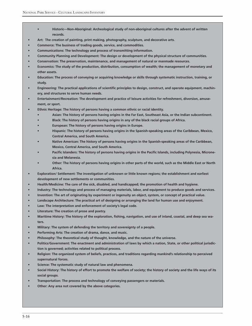
national Park service - cultural landscaPes inventory
5-16
• Historic—Non-Aboriginal:Archeologicalstudyofnon-aboriginalculturesaftertheadventofwritten
records.
• Art:Thecreationofpainting,printmaking,photography,sculpture,anddecorativearts.
• Commerce:Thebusinessoftradinggoods,service,andcommodities.
• Communications:Thetechnologyandprocessoftransmittinginformation.
• CommunityPlanningandDevelopment:Thedesignordevelopmentofthephysicalstructureofcommunities.
• Conservation:Thepreservation,maintenance,andmanagementofnaturalormanmaderesources.
• Economics:Thestudyoftheproduction,distribution,consumptionofwealth;themanagementofmonetaryand
other assets.
• Education:Theprocessofconveyingoracquiringknowledgeorskillsthroughsystematicinstruction,training,or
study.
• Engineering:Thepracticalapplicationsofscientificprinciplestodesign,construct,andoperateequipment,machin-
ery, and structures to serve human needs.
• Entertainment/Recreation:Thedevelopmentandpracticeofleisureactivitiesforrefreshment,diversion,amuse-
ment, or sport.
• EthnicHeritage:Thehistoryofpersonshavingacommonethnicorracialidentity.
• Asian:ThehistoryofpersonshavingoriginsintheFarEast,SoutheastAsia,ortheIndiansubcontinent.
• Black:ThehistoryofpersonshavingoriginsinanyoftheblackracialgroupsofAfrica.
• European:ThehistoryofpersonshavingoriginsinEurope.
• Hispanic:ThehistoryofpersonshavingoriginsintheSpanish-speakingareasoftheCaribbean,Mexico,
Central America, and South America.
• NativeAmerican:ThehistoryofpersonshavingoriginsintheSpanish-speakingareasoftheCaribbean,
Mexico, Central America, and South America.
• PacificIslanders:ThehistoryofpersonshavingoriginsinthePacificIslands,includingPolynesia,Microne-
sia and Melanesia.
• Other:Thehistoryofpersonshavingoriginsinotherpartsoftheworld,suchastheMiddleEastorNorth
Africa.
• Exploration/Settlement:Theinvestigationofunknownorlittleknownregions;theestablishmentandearliest
development of new settlements or communities.
• Health/Medicine:Thecareofthesick,disabled,andhandicapped;thepromotionofhealthandhygiene.
• Industry:Thetechnologyandprocessofmanagingmaterials,labor,andequipmenttoproducegoodsandservices.
• Invention:Theartoforiginatingbyexperimentoringenuityanobject,system,orconceptofpracticalvalue.
• LandscapeArchitecture:Thepracticalartofdesigningorarrangingthelandforhumanuseandenjoyment.
• Law:Theinterpretationandenforcementofsociety’slegalcode.
• Literature:Thecreationofproseandpoetry.
• MaritimeHistory:Thehistoryoftheexploration,fishing,navigation,anduseofinland,coastal,anddeepseawa-
ters.
• Military:Thesystemofdefendingtheterritoryandsovereigntyofapeople.
• PerformingArts:Thecreationofdrama,dance,andmusic.
• Philosophy:Thetheoreticalstudyofthought,knowledge,andthenatureoftheuniverse.
• Politics/Government:Theenactmentandadministrationoflawsbywhichanation,State,orotherpoliticaljurisdic-
tion is governed; activities related to political process.
• Religion:Theorganizedsystemofbeliefs,practices,andtraditionsregardingmankind’srelationshiptoperceived
supernatural forces.
• Science:Thesystematicstudyofnaturallawandphenomena.
• SocialHistory:Thehistoryofefforttopromotethewelfareofsociety;thehistoryofsocietyandthelifewaysofits
social groups.
• Transportation:Theprocessandtechnologyofconveyingpassengersormaterials.
• Other:Anyareanotcoveredbytheabovecategories.
5-17
Professional Procedures Guide - section 5
Asian
Black
European
Hispanic
Native American
Other
Pacific Islander
Display Sequence (o)
Indicate the sequence (1,2,3…) for how the Areas of
Significance should appear in all reports.
State regiSter Documentation
The following data elements in this table include infor-
mation on a state’s inventory of significant properties
that is associated with the inventory unit.
State register Documentation name (o)
Provide the State Register name for the inventory unit.
State register Documentation identification number (o)
Provide the alphanumeric State Register Document
Identification Number for the inventory unit.
State register Date Listed (o)
Provide the date (mm/dd/yyyy) the inventory unit was
listed on the State Register.
State register Documentation explanatory narrative (o – 4000 characters)
Provide a narrative explanation about the State Register
documentation. The text may describe the purpose
and use of the State Register, the history of document-
ing the inventory unit for the State Register, or include
information regarding any inadequacies in the existing
nomination.
Display Sequence (o)
Indicate the sequence (1,2,3…) for how the State Reg-
ister of Documentation should appear in all reports.
nriS information
The following data elements in this table provide
information from the National Register Information
System (NRIS), a database containing information on
approved National Register nominations. An inventory
unit may be associated with one or more nominations
listed in the National Register of Historic Places.
Park alpha code/nriS name (number) (r, if applicable)
Provide the park alpha code, primary name, and unique
number listed in the NRIS database for the documenta-
tion associated with the inventory unit.
other national register name (r, if applicable)
Provide secondary names listed in the NRIS database.
Primary certification Date (r, if applicable)
Provide the date (mm/dd/yyyy) the primary certifica-
tion was determined according to the NRIS database.
Display Sequence (o)
Indicate the sequence (1,2,3…) for how the NRIS
Information should appear in all reports.
otHer certificationS
The following data elements in this table provide
information about other certifications that have been
determined for the inventory unit. These data elements
are nested under “NRIS Information” in the CLI data-
base and are accessible after the NRIS Information data
fields are entered.
other certification (r, if applicable)
Indicate the other certifications that have been de-
termined for the nomination (e.g., National Historic
Landmark, amendment) according to the NRIS data-
base.
other certification Date (r, if applicable)
Indicate the date(s) (mm/dd/yyyy) of the Other
Certification(s) according to the NRIS database.

national Park service - cultural landscaPes inventory
5-18
Display Sequence (o)
Indicate the sequence (1,2,3…) for how the Other Cer-
tifications data should appear in all reports.
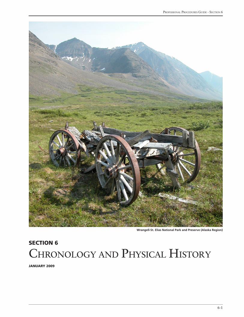
6-1
Professional Procedures Guide - section 6
Section 6
chronoloGy and Physical historyJanuary 2009
Wrangell-St. Elias National Park and Preserve (Alaska Region)

national Park service - cultural landscaPes inventory
6-2
Section 6chronology and PhySical hiStory
The following data elements provide information on
the historic and current function, use, and name of the
inventory unit; the ethnographic significance of the
inventory unit; and a physical history and annotated
chronology of the inventory unit.
(See Sidebar 22: Entering Functions and Uses)
inventory unit
Primary historic Function – Major category (r)
Indicate the major category of the historic function(s)
for the inventory unit. Select one from the pick list
included in Appendix J: Historic and Current Func-
tion and Use List.
Primary historic Function – category (r)
Indicate the detailed category for the Primary Historic
Function – Major Category selected for the inventory
unit. Select one from the appropriate pick list included
in Appendix J: Historic and Current Function and
Use List.
Primary historic Function (r)
Indicate the historic function for the Primary His-
toric Function – Category selected for the inventory
unit. Select from the appropriate pick list included in
Appendix J: Historic and Current Function and
Use List.
Primary current use – Major category (r)
Indicate the major category of the current use associ-
ated with the inventory unit. Select from the pick list
included in Appendix J: Historic and Current Func-
tion and Use List.
Primary current use – category (r)
Indicate the detailed category for the Primary Cur-
rent Use – Major Category selected for the inventory
unit. Select from the appropriate pick list included in
Appendix J: Historic and Current Function and
Use List.
Primary current use (r)
Indicate the current use for the Primary Current Use
– Category selected for the inventory unit. Select one
from the appropriate pick list included in Appendix J:
Historic and Current Function and Use List.
(Note: Other Historic Functions and Current Uses can be
entered in a table described later in this section.)
other current and hiStoric uSeS/
FunctionS
The following data elements in this table provide addi-
tional information pertaining to the other current and
historic uses and functions of the inventory unit.
other historic Function or current use – Major category (o)
Indicate the major category of the other historic func-
tion or current use for the inventory unit.
Select one from the pick list included in Appendix J:
Historic and Current Function and Use List.
other historic Function or current use – category (o)
Indicate the detailed category for the Other Historic
Function or Current Use – Major Category selected
for the inventory unit. Select one from the appropriate
pick list included in Appendix J: Historic and Cur-
rent Function and Use List.
other historic Function or current use (o)
Indicate the historic function or the current use for the
Other Historic Function or Current Use – Category
selected for the inventory unit. Select one from the
appropriate pick list included in Appendix J: Historic
and Current Function and Use List.
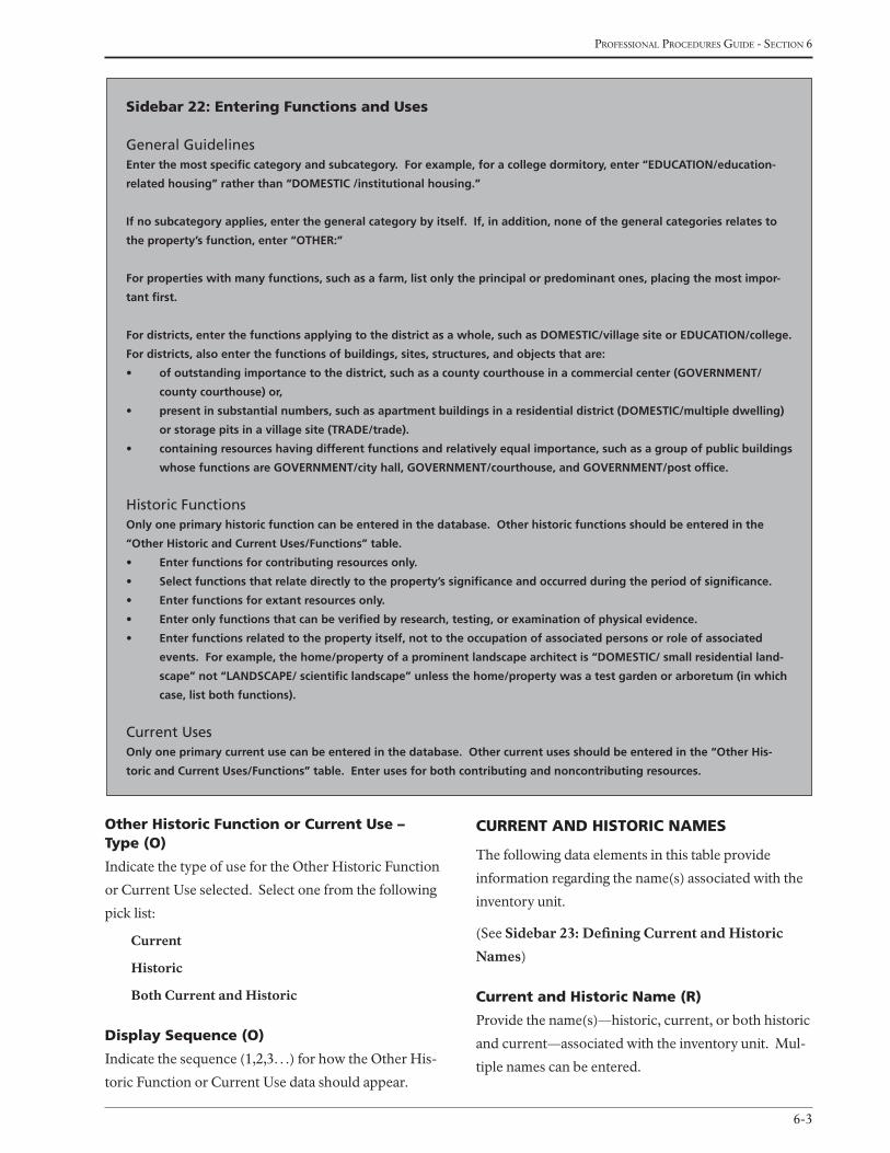
6-3
Professional Procedures Guide - section 6
other historic Function or current use – type (o)
Indicate the type of use for the Other Historic Function
or Current Use selected. Select one from the following
pick list:
Current
Historic
Both Current and Historic
display Sequence (o)
Indicate the sequence (1,2,3…) for how the Other His-
toric Function or Current Use data should appear.
current and hiStoric naMeS
The following data elements in this table provide
information regarding the name(s) associated with the
inventory unit.
(See Sidebar 23: Defining Current and Historic
Names)
current and historic name (r)
Provide the name(s)—historic, current, or both historic
and current—associated with the inventory unit. Mul-
tiple names can be entered.
Sidebar 22: entering Functions and uses
General GuidelinesEnter the most specific category and subcategory. For example, for a college dormitory, enter “EDUCATION/education-
related housing” rather than “DOMESTIC /institutional housing.”
If no subcategory applies, enter the general category by itself. If, in addition, none of the general categories relates to
the property’s function, enter “OTHER:”
For properties with many functions, such as a farm, list only the principal or predominant ones, placing the most impor-
tant first.
For districts, enter the functions applying to the district as a whole, such as DOMESTIC/village site or EDUCATION/college.
For districts, also enter the functions of buildings, sites, structures, and objects that are:
• ofoutstandingimportancetothedistrict,suchasacountycourthouseinacommercialcenter(GOVERNMENT/
county courthouse) or,
• presentinsubstantialnumbers,suchasapartmentbuildingsinaresidentialdistrict(DOMESTIC/multipledwelling)
or storage pits in a village site (TRADE/trade).
• containingresourceshavingdifferentfunctionsandrelativelyequalimportance,suchasagroupofpublicbuildings
whosefunctionsareGOVERNMENT/cityhall,GOVERNMENT/courthouse,andGOVERNMENT/postoffice.
Historic FunctionsOnly one primary historic function can be entered in the database. Other historic functions should be entered in the
“Other Historic and Current Uses/Functions” table.
• Enterfunctionsforcontributingresourcesonly.
• Selectfunctionsthatrelatedirectlytotheproperty’ssignificanceandoccurredduringtheperiodofsignificance.
• Enterfunctionsforextantresourcesonly.
• Enteronlyfunctionsthatcanbeverifiedbyresearch,testing,orexaminationofphysicalevidence.
• Enterfunctionsrelatedtothepropertyitself,nottotheoccupationofassociatedpersonsorroleofassociated
events. For example, the home/property of a prominent landscape architect is “DOMESTIC/ small residential land-
scape” not “LANDSCAPE/ scientific landscape” unless the home/property was a test garden or arboretum (in which
case, list both functions).
Current UsesOnly one primary current use can be entered in the database. Other current uses should be entered in the “Other His-
toric and Current Uses/Functions” table. Enter uses for both contributing and noncontributing resources.
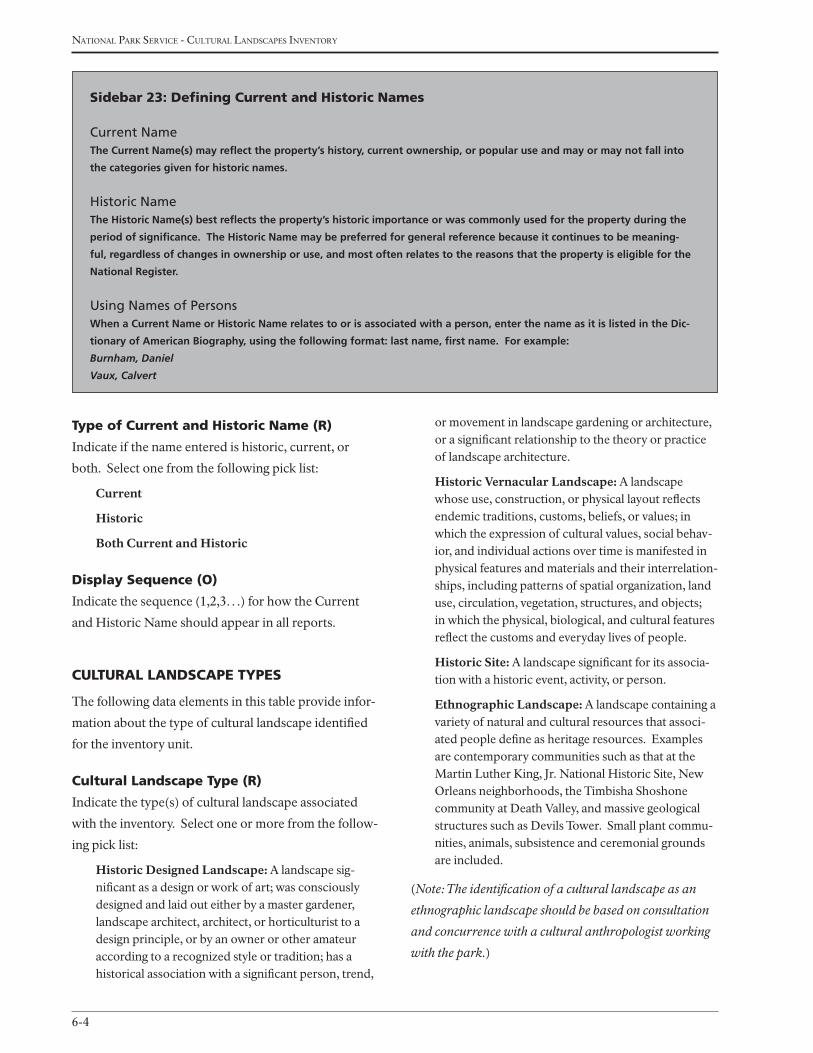
national Park service - cultural landscaPes inventory
6-4
or movement in landscape gardening or architecture, or a significant relationship to the theory or practice of landscape architecture.
Historic Vernacular Landscape: A landscape whose use, construction, or physical layout reflects endemic traditions, customs, beliefs, or values; in which the expression of cultural values, social behav-ior, and individual actions over time is manifested in physical features and materials and their interrelation-ships, including patterns of spatial organization, land use, circulation, vegetation, structures, and objects; in which the physical, biological, and cultural features reflect the customs and everyday lives of people.
Historic Site: A landscape significant for its associa-tion with a historic event, activity, or person.
Ethnographic Landscape: A landscape containing a variety of natural and cultural resources that associ-ated people define as heritage resources. Examples are contemporary communities such as that at the Martin Luther King, Jr. National Historic Site, New Orleans neighborhoods, the Timbisha Shoshone community at Death Valley, and massive geological structures such as Devils Tower. Small plant commu-nities, animals, subsistence and ceremonial grounds are included.
(Note: The identification of a cultural landscape as an
ethnographic landscape should be based on consultation
and concurrence with a cultural anthropologist working
with the park.)
type of current and historic name (r)
Indicate if the name entered is historic, current, or
both. Select one from the following pick list:
Current
Historic
Both Current and Historic
display Sequence (o)
Indicate the sequence (1,2,3…) for how the Current
and Historic Name should appear in all reports.
cultural landScaPe tyPeS
The following data elements in this table provide infor-
mation about the type of cultural landscape identified
for the inventory unit.
cultural landscape type (r)
Indicate the type(s) of cultural landscape associated
with the inventory. Select one or more from the follow-
ing pick list:
Historic Designed Landscape: A landscape sig-nificant as a design or work of art; was consciously designed and laid out either by a master gardener, landscape architect, architect, or horticulturist to a design principle, or by an owner or other amateur according to a recognized style or tradition; has a historical association with a significant person, trend,
Sidebar 23: defining current and historic names
Current NameThe Current Name(s) may reflect the property’s history, current ownership, or popular use and may or may not fall into
the categories given for historic names.
Historic NameThe Historic Name(s) best reflects the property’s historic importance or was commonly used for the property during the
period of significance. The Historic Name may be preferred for general reference because it continues to be meaning-
ful, regardless of changes in ownership or use, and most often relates to the reasons that the property is eligible for the
National Register.
Using Names of PersonsWhen a Current Name or Historic Name relates to or is associated with a person, enter the name as it is listed in the Dic-
tionary of American Biography, using the following format: last name, first name. For example:
Burnham, Daniel
Vaux, Calvert
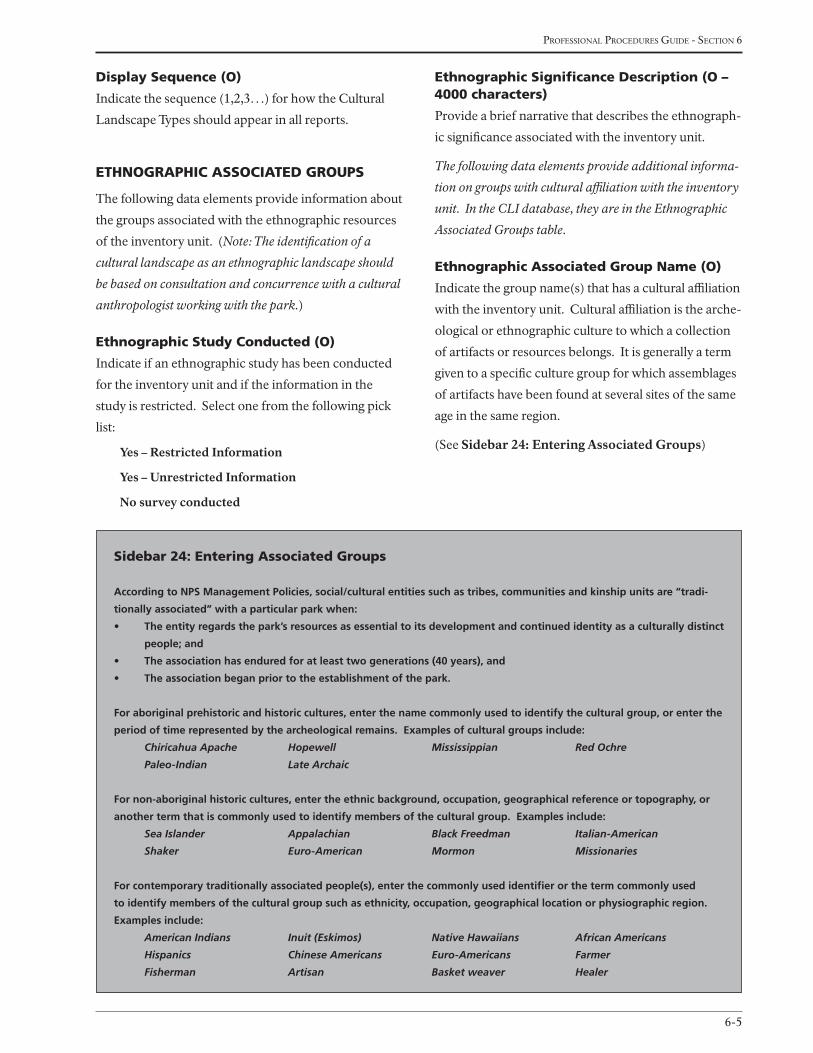
6-5
Professional Procedures Guide - section 6
Sidebar 24: entering associated groups
According to NPS Management Policies, social/cultural entities such as tribes, communities and kinship units are “tradi-
tionally associated” with a particular park when:
• Theentityregardsthepark’sresourcesasessentialtoitsdevelopmentandcontinuedidentityasaculturallydistinct
people; and
• Theassociationhasenduredforatleasttwogenerations(40years),and
• Theassociationbeganpriortotheestablishmentofthepark.
For aboriginal prehistoric and historic cultures, enter the name commonly used to identify the cultural group, or enter the
period of time represented by the archeological remains. Examples of cultural groups include:
Chiricahua Apache Hopewell Mississippian Red Ochre
Paleo-Indian Late Archaic
For non-aboriginal historic cultures, enter the ethnic background, occupation, geographical reference or topography, or
another term that is commonly used to identify members of the cultural group. Examples include:
Sea Islander Appalachian Black Freedman Italian-American
Shaker Euro-American Mormon Missionaries
For contemporary traditionally associated people(s), enter the commonly used identifier or the term commonly used
to identify members of the cultural group such as ethnicity, occupation, geographical location or physiographic region.
Examples include:
American Indians Inuit (Eskimos) Native Hawaiians African Americans
Hispanics Chinese Americans Euro-Americans Farmer
Fisherman Artisan Basket weaver Healer
display Sequence (o)
Indicate the sequence (1,2,3…) for how the Cultural
Landscape Types should appear in all reports.
ethnograPhic aSSociated grouPS
The following data elements provide information about
the groups associated with the ethnographic resources
of the inventory unit. (Note: The identification of a
cultural landscape as an ethnographic landscape should
be based on consultation and concurrence with a cultural
anthropologist working with the park.)
ethnographic Study conducted (o)
Indicate if an ethnographic study has been conducted
for the inventory unit and if the information in the
study is restricted. Select one from the following pick
list:
Yes – Restricted Information
Yes – Unrestricted Information
No survey conducted
ethnographic Significance description (o – 4000 characters)
Provide a brief narrative that describes the ethnograph-
ic significance associated with the inventory unit.
The following data elements provide additional informa-
tion on groups with cultural affiliation with the inventory
unit. In the CLI database, they are in the Ethnographic
Associated Groups table.
ethnographic associated group name (o)
Indicate the group name(s) that has a cultural affiliation
with the inventory unit. Cultural affiliation is the arche-
ological or ethnographic culture to which a collection
of artifacts or resources belongs. It is generally a term
given to a specific culture group for which assemblages
of artifacts have been found at several sites of the same
age in the same region.
(See Sidebar 24: Entering Associated Groups)

national Park service - cultural landscaPes inventory
6-6
association historic, current, or Both (o)
Indicate whether the group’s association with the
inventory unit is current, historic, or both. Select one
from the following pick list:
Current
Historic
Both Current and Historic
display Sequence (o)
Indicate the sequence (1,2,3…) for how the Ethno-
graphic Associated Group data should appear in all
reports.
chronology
The following data elements in this table provide
chronological information regarding the physical his-
tory of the inventory unit.
Start year of Major event (r)
Provide the start year (yyyy) of the major event.
Start era of Major event (r)
Provide the start era (AD/BC) that the event took place.
AD
BC
end year of Major event (r)
Provide the end year (yyyy) of the major event.
end era of Major event (r)
Provide the end era (AD/BC) that the event took place.
Sidebar 25: identifying Major event dates
The start and end dates of a major event should mark the occurrence of specific events directly related to the significance
of the property. For example, it should be the date of construction that also marked the beginning of an important
individual’s residency, or the closing of a mine that ended a community’s growth. For a property significant for National
Register Criterion C, enter the date of the construction or alterations through which the property achieved its importance.
For the purpose of the CLI, major events must correspond to physical change in the landscape. Important historical or
social events that did not affect the development of the land are not appropriate for this chronology. For example, if the
inventory unit is discussed in detail in a published document, summarize the physical development information by era in
the chronology, then in the Physical History section or in the Bibliography note the reference and add a statement that
the reader should consult the original document for more information.
AD
BC
(See Sidebar 25: Identifying Major Event Dates)
Major event (r)
Indicate the key event(s) that was integral to the physi-
cal development of the inventory unit historically.
Select one or more events from the following pick list:
Abandoned
Altered
Built
Colonized
Conserved
Cultivated
Damaged
Demolished
Designed
Destroyed
Developed
Domesticated
Engineered
Eroded
Established
Excavated
Expanded
Exploited
Explored
Farmed/Harvested
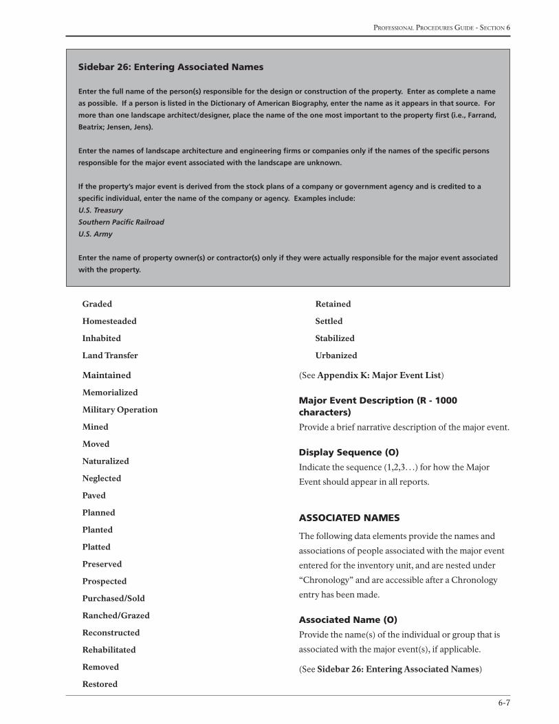
6-7
Professional Procedures Guide - section 6
Graded
Homesteaded
Inhabited
Land Transfer
Maintained
Memorialized
Military Operation
Mined
Moved
Naturalized
Neglected
Paved
Planned
Planted
Platted
Preserved
Prospected
Purchased/Sold
Ranched/Grazed
Reconstructed
Rehabilitated
Removed
Restored
Retained
Settled
Stabilized
Urbanized
(See Appendix K: Major Event List)
Major event description (r - 1000 characters)
Provide a brief narrative description of the major event.
display Sequence (o)
Indicate the sequence (1,2,3…) for how the Major
Event should appear in all reports.
aSSociated naMeS
The following data elements provide the names and
associations of people associated with the major event
entered for the inventory unit, and are nested under
“Chronology” and are accessible after a Chronology
entry has been made.
associated name (o)
Provide the name(s) of the individual or group that is
associated with the major event(s), if applicable.
(See Sidebar 26: Entering Associated Names)
Sidebar 26: entering associated names
Enter the full name of the person(s) responsible for the design or construction of the property. Enter as complete a name
as possible. If a person is listed in the Dictionary of American Biography, enter the name as it appears in that source. For
more than one landscape architect/designer, place the name of the one most important to the property first (i.e., Farrand,
Beatrix; Jensen, Jens).
Enter the names of landscape architecture and engineering firms or companies only if the names of the specific persons
responsible for the major event associated with the landscape are unknown.
If the property’s major event is derived from the stock plans of a company or government agency and is credited to a
specific individual, enter the name of the company or agency. Examples include:
U.S. Treasury
Southern Pacific Railroad
U.S. Army
Enter the name of property owner(s) or contractor(s) only if they were actually responsible for the major event associated
with the property.
national Park service - cultural landscaPes inventory
6-8
association (o)
Indicate the type of association that each individual or
group had to the major event. Select one from the fol-
lowing pick list:
Architect
Engineer
Gardener
Horticulturist
Landscape Architect
Owner
Sculptor
Other
association other (o)
If “Other” is selected for Association, provide the type
of association that the individual or group had to the
major event.
display Sequence (o)
Indicate the sequence (1,2,3…) for how the Associated
Name should appear in all reports.
PhySical hiStory
The following data elements in this table provide in-
formation on the physical history and evolution of the
inventory unit.
Physical history time Period (o)
Provide the dates of the physical history time period
that will be described in the following narrative. This
date can be in any format (yyyy, mm/dd/yyyy, July
1898, July 4, 1776, etc.). The time period may reflect
the period of significance, the chronology of physical
development or evolutionary change to the landscape,
or other key dates (e.g., 1918–Park Roads Constructed;
1918–Park Village Constructed). The time period also
may include significant events or activities with the
same time period. In these cases, provide a descriptor
following the date to uniquely identify each section of
the narrative (e.g., 1863 – First Battle, 1863 – Second
Battle). Multiple Physical History Time Periods can be
entered.
Physical history narrative (o – 64,000 characters)
Provide a concise narrative description of the events,
associations, development, etc., associated with the
time period identified for the inventory unit.
display Sequence (o)
Indicate the sequence (1,2,3…) for how the Physical
History data should appear in all reports.
hiStory graPhic inForMation
The following data elements provide information on
graphics associated with the physical history time
period identified. In the CLI database, these elements
are nested under “Physical History” and are accessible
after a Physical History entry has been made.
history graphic (o)
Provide one or more graphics illustrating the narrative
for the time period identified.
history graphic caption (o)
Provide a title and/or brief description for each History
Graphic.
display Sequence (o)
Indicate the sequence (1,2,3…) that the History
Graphic should appear in all reports.
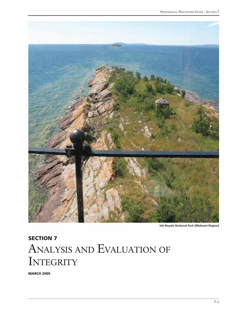
7-1
Professional Procedures Guide - section 7
Section 7
analysis and evaluation of inteGrityMarch 2009
Isle Royale National Park (Midwest Region)
national Park service - cultural landscaPes inventory
7-2
Sidebar 27: evaluating integrity
Integrity is the ability of a property to convey its significance. The National Register recognizes seven aspects or qualities
that, in various combinations, define integrity. The seven aspects of integrity are location, design, setting, materials,
workmanship, feeling, and association. To retain historic integrity, a property will always possess several, and usually
most, of the aspects of integrity.
Decisions about historic integrity require professional judgments about whether a property today reflects the spatial
organization, physical components, and historic associations that it attained during the period(s) of significance. A prop-
erty’s period(s) of significance becomes the benchmark for measuring whether changes outside the period of significance
contribute to or alter its integrity.
Landscapes have unique attributes that often complicate the evaluation of integrity, but the degree to which the overall
landscape and its significant features are present today must be evaluated. In general, the researcher should ask the fol-
lowing questions when evaluating integrity:
1) To what degree does the landscape convey its historic character?
2) To what degree has the original fabric been retained?
3) Are changes to the landscape irrevocable or can they be corrected so that the property retains integrity?
The relationships between landscape characteristics and the seven aspects of integrity are complex. Patterns of spatial
organization, circulation networks, and clusters directly relate to integrity of design and strongly influence the cohesive-
ness of a landscape. Boundary demarcations, small-scale elements, vegetation, and the evidence of responses to natural
systems and features all add to location and setting. Continuing or compatible land uses and activities enhance integrity
of feeling and association. Buildings and structures, vegetation, small-scale features, and land uses all reflect materials,
Section 7analySiS and evaluation of integrity
The following data elements provide information on
the landscape characteristics and features associated
with the inventory unit, including whether or not they
contribute to the historic character of the property, and
the integrity of the inventory unit.
inventory unit
analysis and evaluation Summary (r – 64,000 characters)
Provide a narrative summary that identifies the land-
scape characteristics that apply to the inventory unit
and indicates how the characteristics are related to the
significance of the inventory unit. The text should de-
scribe how the characteristics and associated features
have changed, or remained the same, since the period
of significance. Based on the analysis and evaluation of
the landscape characteristics and associated features,
describe the integrity of the inventory unit based on
the seven aspects of integrity defined by the National
Register (location, design, setting, materials, workman-
ship, feeling, and association).
(See Sidebar 27: Evaluating Integrity, Sidebar 28:
Assessing Integrity, and Appendix L: Examples
of Analysis and Evaluation Summary. Additional
guidance is offered in the following National Register
Bulletins:
• How to Evaluate and Nominate Designed Historic Landscapes (#18)
• Guidelines for Evaluating and Nominating Properties that have Achieved Significance within the Past Fifty Years (#22)
• Guidelines for Evaluating and Documenting Rural His-toric Landscapes (#30)
• Guidelines for Evaluating and Documenting Traditional Cultural Properties (#38)

7-3
Professional Procedures Guide - section 7
workmanship, and design. Archeological sites may strengthen integrity by providing physical evidence of activities no
longer practiced.
Single major changes as well as cumulative effects threaten historic integrity. Loss or relocation of a few features usually
does not affect a property’s overall historic integrity. But the repeated loss of buildings, structures, roadways, and small-
scale features, as well as gradual changes to boundaries and land uses, may cumulatively destroy integrity. However, it is
important to remember that the National Register will accept significant and distinguishable entities whose components
may lack individual distinction. For example, for industrial sites, the passage of time, exposure to a harsh environment,
abandonment, vandalism, and neglect often combine to cause the deterioration of individual property components. Al-
though these individual components may appear to lack distinction, the combined impact of these separate components
may enable the property to convey the collective image of a historically significant industrial operation.
The clearest evaluation of integrity is based on the presence of identifiable landscape characteristics and features of the
original site. To evaluate the historic integrity of a landscape, it is useful to compare the landscape’s present appearance
and function to its historical appearance and function. The relationship between present function and that intended or
actually in use during the period of significance may also affect landscape integrity. Features to be evaluated should also
be considered in terms of survival, condition, and appropriateness to the original design intent and period of significance.
Vegetation, an important feature of most landscapes, is not stable; it is always changing—by seasonal cycles, maturation,
pruning, removal, neglect, and other forces. Changes in vegetation impact historic integrity, which is determined by the
extent to which the general character of the historic period is evident, and the degree to which incompatible elements
obscuring that character can be reversed. As vegetation matures, a change in tree canopy, scale, and overall massing may
affect the overall character of the landscape. It is important to consider not only changes to the individual feature but
also how such changes affect the landscape as a whole.
Adjacent off site conditions will not be considered in the evaluation of integrity, unless they were included as part of
the landscape in a period of significance. In such cases, a landscape’s immediate surroundings may have an impact on an
evaluation of integrity. Major adjacent encroachment, such as highways, parking lots, and new buildings, may violate
the original intent and intrude upon the property. Views from the property, for example, that were intended to be
pastoral but that are now industrial, or views that were established along sight lines to buildings, monuments, or other
features that have been destroyed, may be a serious detriment to the integrity of a historic landscape.
Sidebar 28: assessing integrity
Integrity is based on significance: why, where, and when a property is important. Integrity can be assessed only after
significance is fully understood. Ultimately, the question of integrity is answered by whether or not the property retains
the identity for which it is significant. The steps in assessing integrity are as follows:
• Definetheessential physical features that must be present for a property to represent its significance.
• Determinewhethertheessential physical features are visible enough to convey their significance
• Determinewhetherthepropertyshouldbecompared with similar properties.
• Determine,basedonsignificanceandessentialphysicalfeatures,which aspects of integrity are particularly vital to
the property and if they are present.
All properties change over time, and as such, it is not necessary for a property to retain all of its historic physical features
or characteristics. The property must retain, however, the essential physical features that enable it to convey its historic
identity. The essential physical features are those that define both why a property is significant and when it was signifi-
cant. They are the features without which a property can no longer be identified.
See page 46 of the National Register Bulletin: How to Apply the National Register Criteria for Evaluation (#15), for guid-
ance regarding the relationship between essential physical features and specific National Register Criteria.
national Park service - cultural landscaPes inventory
7-4
landscape characteristic explanatory narrative (o – 64,000 characters)
Provide a brief narrative to describe the landscape
characteristic selected. The narrative should draw
upon both documentary evidence and field observa-
tions. It should document the evolution of the char-
acteristic and its associated features to the present.
Describe the major changes between the period of sig-
nificance and the current condition. Indicate whether
the landscape characteristic and its associated features
have historic integrity. Include specific facts and, wher-
ever possible, dates. Organize the information in a logi-
cal manner, by first describing the characteristic and its
associated features as they existed during the historic
period and then their existing condition. The amount
of detail needed in the description depends on the size
and complexity of the landscape characteristic and its
associated features and the extent to which alterations,
additions, and deterioration have affected integrity; the
greater the change, the more thorough the description
of additions, replacement materials, and other altera-
tions should be.
other landscape characteristic (o)
If “Other” was chosen as a Landscape Characteristic,
this should be used if one or more landscape character-
istics need to be combined for analysis purposes, such
as Land Use and Topography.
display Sequence (o)
Indicate the sequence (1,2,3…) that the Landscape
Characteristics data should appear in all reports.
(See Sidebar 29: Landscape Characteristics Defini-
tions, Features, and Documentation)
landScape featureS
The following data elements in this subtable provide
information for all features (contributing and noncon-
tributing) identified for each landscape characteristic
selected. In the CLI database, these data elements are
nested under “Landscape Characteristics” and are ac-
cessible after a landscape characteristic entry is made.
• Guidelines for Identifying, Evaluating, and Registering Americas’s Historic Battlefields (#40)
• Guidelines for Evaluating and Registering Cemeteries and Burial Places (#41)
• Guidelines for Identifying, Evaluating and Registering Historic Mining Properties (#42) (for specific guidelines in developing and/or defining integrity evaluation)
landScape characteriSticS
The following data elements in this table provide infor-
mation on the landscape characteristics associated with
the inventory unit.
landscape characteristic (r)
Identify the landscape characteristic associated with
the inventory unit. Landscape characteristics are the
tangible and intangible aspects of an inventory unit
which have either influenced the history of the devel-
opment of the landscape, or are products of its devel-
opment, respectively. Landscape characteristics must
be uniquely identified for each inventory unit according
to the type of landscape, and the nature of its historical
development. Select one or more from the following
pick list:
Archeological Sites
Buildings and Structures
Circulation
Cluster Arrangement
Constructed Water Features
Cultural Traditions
Land Use
Natural Systems and Features
Other
Small-Scale Features
Spatial Organization
Topography
Vegetation
Views and Vistas
(Note: A minimum of one characteristic must be de-
scribed to have a complete inventory unit record).
7-5
Professional Procedures Guide - section 7
feature name (r)
Provide the name of the feature associated with the
Landscape Characteristic selected (e.g., Adam’s or-
chard, entry drive).
feature contribution (r)
Indicate whether the feature is considered contributing
or non-contributing to the National Register eligibil-
ity of the inventory unit, or if its is undetermined or
managed as a cultural resource. Select one from the
following pick list:
Contributing
Noncontributing
Undetermined
Managed as a Cultural Resource
lcS alpha code, name, and number (r, if applicable)
Provide the following information for each feature
listed in the List of Classified Structures (LCS): IDLCS
Number, LCS Structure Name, and LCS Structure
Number. The CLI database includes a pick list of all
LCS structures associated with a park that will include
this information.
historic Structure number (r, if applicable)
Provide the historic structure number for each feature
listed, if applicable.
feature utM Source (o)
Indicate the source of the UTM point for the feature.
Select one from the following pick list:
USGS Map 1:24,000
USGS Map 1:62,500
USGS Map 1:100,000
GPS - Differentially Corrected
GPS - Uncorrected
feature utM point type (o)
Indicate the type of point the UTM for the feature rep-
resents. Select one from the following pick list:
Area
Line
Point
feature utM datum (o)
Indicate the datum of the USGS map. Select one from
the following pick list:
NAD 27 (North American Datum of 1927)
NAD 83 (North American Datum of 1983)
Other
feature utM Zone (o)
Describe the UTM zone location of the feature. UTM
divides the world into 60 zones, running north and
south, each covering six degrees longitude and num-
bered beginning at the 180-degree meridian.
giS url (o)
Provide the URL information from GIS.
feature utM easting (o)
Describe the distance, in meters, from the central
meridian to the feature. The easting coordinates within
the UTM zone are lines that measure the number of
meters east of a prime meridian.
feature utM northing (o)
Describe the distance, in meters, from the equator to
the feature. The northing coordinates within the UTM
zone are lines that measure the number of meters north
of the equator.
ancS id (o)
For a feature listed in the Automated National Cata-
logue System (ANCS), provide the three (3) part,
12-character ANCS+ identification number for the
feature:
• part one – first four (4) spaces are the park alpha code;
• part two – is a collection designation that is left blank if the park has only one collection;
• part three – is a unique sequential number assigned to an object.
Examples from the ANCS+: SHEN 190 or COLO Y
3456 (Y is a designation for the Yorktown collection)
national Park service - cultural landscaPes inventory
7-6
Sidebar 29: landscape characteristics - definitions, features, and documentation
NATURAL SYSTEMS AND FEATURESDefinition:
The natural aspects that have influenced the development and physical form of a landscape. The following may be
included:
•Geomorphology:thelargescalepatternsoflandforms
•Geology:thesurficial;characteristicsoftheearth
•Hydrology:thesystemofsurfaceandsubsurfacewater.
•Ecology:theinterrelationshipsamonglivingorganismsandtheirenvironment.
•Climate:thetemperature,windvelocity,andprecipitation
•Nativevegetation:indigenousplantcommunitiesandaggregateandindividualplanfeatures.
Features:
ravines, valleys, watersheds, wetlands, rock outcrops
Documentation/Narrative:
•Describethephysicalenvironmentandecologicalsystemsoftheregion.
•Describethekindsoffeaturesthathaveresultedfromculturaladaptationandresponsetothenaturalenvironment.
•Identifynaturalfeaturesthathavemajorimportanceorpredominancebyname,type,andlocation.
SPATIAL ORGANIZATIONDefinition:
The three-dimensional organization of physical forms and visual associations in the landscape, including the articulation
of ground, vertical, and overhead planes that define and create spaces.
ancS name (o)
Provide the name in the ANCS database for the feature
identified.
aSMiS id (o)
For a feature listed in the Archeological Sites Man-
agement Information System (ASMIS), provide the
nine-digit ASMIS identification number for the feature
where the first four (4) spaces are the park alpha code,
followed by five (5) numbers.
aSMiS name (o)
Provide the name in the ASMIS database for the feature
identified.
display Sequence (o)
Indicate the sequence (1,2,3…) that the Landscape
Characteristic Feature data should appear in all reports.
analySiS and evaluation
characteriSticS and featureS
graphic inforMation
The following data elements in this table provide infor-
mation on graphics associated with the landscape char-
acteristics and features identified. In the CLI database,
these data elements are nested under the “Landscape
Characteristics” table and are accessible after a Land-
scape Characteristic entry has been made.
analysis and evaluation graphic (o)
Provide one or more graphics for each characteristic
selected.
analysis and evaluation graphic caption (o)
Provide a title and/or brief description of each Analysis
and Evaluation Graphic.
display Sequence (o)
Indicate the sequence (1,2,3…) for how the Analysis
and Evaluation Graphic should appear in all reports.
7-7
Professional Procedures Guide - section 7
Features:
circulation systems, views and vistas, areas of land use, natural features, cluster of structures, division of property
Documentation/Narrative:
•Describeanypatternscharacterizingthelandscapeasawhole.
•Relatepatternstolandusesandactivities,responsestonaturalandculturaltraditions.
•Relatespatialorganizationtocomponentsincludingvegetationboundarydemarcations,andcirculationnetworks.
•Describeandlocateanyareaswherehistoricspatialorganizationisparticularlyvisibleorsubstantiallylost.
LAND USEDefinition:
The principal activities in the landscape that have formed, shaped, or organized the landscape as a result of human inter-
action.
Features:
fields, pastures, orchard, open range, terraces, commons, cemeteries, playing fields, parks, mining areas, quarries, logging
areas
Documentation/Narrative:
•Describeprincipalandsignificantlanduses.
•Identifythetangiblefeaturesrelatedtolandusesbytype,generallocation,datesofuse,condition,andrelatedveg-
etation.
•Describehistoricprocessesrelatedtolanduse,suchasmining,irrigation,lumbering,contourfarming,orquarrying.
•Pointoutobsoletehistoricoperations,ongoingtraditionalpractices,ormodernadaptationsrelatedtosignificance.
•Identifythreatstointegrity,andindicatetheirlocation,extent,andimpactonhistoricintegrity.
•Identifyareashavingmajorimportanceorpredominancebylocationandtypeandclassifyashistoricornon-historic.
•Overallpatternsofthecirculationnetwork,areasoflanduse,naturalfeatures,clusterofstructures,anddivisionof
property.
•Describeanypatternscharacterizingthelandscapeasawhole.
•Relatepatternstolandusesandactivities,responsestonaturalandculturaltraditions.
•Relatespatialorganizationtocomponentsincludingvegetation,boundarydemarcations,andcirculationnetworks.
•Describeandlocateanyareaswherehistoricspatialorganizationisparticularlyvisibleorsubstantiallylost.
CULTURAL TRADITIONSDefinition:
The practices that have influenced the development of the landscape in terms of land use, patterns of land division,
building forms, stylistic preferences, and the use of materials.
Features:
land use practices, buildings and structures, ethnic or religious institutions, community organization construction meth-
ods, technology, trades and skills, use of plants, craftsmanship, methods of transportation, patterns of land division
Documentation/Narrative:
•Describelandusepractices,patternsoflanddivision,institutions,buildingforms,workmanship,stylisticpreferences,
vernacular characteristics, use of materials, and methods of construction that have been influenced by cultural tradi-
tion.
•Identifythesourcesofculturalinfluencesandnamespecificindividuals,suchasartisans,builders,communityleaders,
or farmers responsible for perpetuating or establishing such traditions.
•Describethekindsoffeaturesresultingfromorexhibitingculturaltraditions,andname,date,andlocatetheprimary
features reflecting such traditions.

national Park service - cultural landscaPes inventory
7-8
TOPOGRAPHYDefinition:
The three dimensional configuration of the landscape surface characterized by features (such as slope and articulation)
and orientation (such as elevation and solar aspect).
Features:
earthworks, drainage ditches, knolls, terraces
Documentation/Narrative:
•Describethephysicalpatternsofthelandscapethatcharacterizeitasawhole.
•Relatetheculturalortraditionaladaptationsoflanduseand/orsettlementpatternstothenaturaltopography.
•Describeorlocateanyareasofsignificantchangetohistoricadaptationstothetopography.
VEGETATIONDefinition:
Deciduous and evergreen trees, shrubs, vines, ground covers and herbaceous plants, and plant communities, whether
indigenous or introduced in the landscape.
Features:
functional and ornamental trees and shrubs, orchards, groves, woodlots, pastures, gardens, allees, shelter belts, forests,
grasslands
Documentation/Narrative:
•Describeprincipal,predominant,andsignificantvegetationbytype,condition,age,use,andgeneral/specificlocation.
•Discusschangesthathaveoccurredinvegetationsincetheperiodofsignificance.
•Relatethefunction,massing,anddetailsofvegetationtolanduseandactivities,culturaltraditions,andresponseto
the natural environment.
•Forrotatedcrops,identifythegeneraltypesofcropsthatmightbegrownoveraperiodofseveralyears.
CIRCULATIONDefinition:
The spaces, features, and applied material finishes which constitute systems of movement in a landscape.
Features:
paths, roads, streams, canals, highways, railways, waterways
Documentation/Narrative:
•Describetheprincipalformsoftransportationandcirculationroutesthatfacilitatetravelwithinthelandscapeandcon-
nect the landscape with the larger region.
•Name,date,anddescribeprincipalorsignificantexamples.
•Identifyprincipleroadwaysandothertransportationroutes,byname,type,andlocationandclassifyascontributing
or noncontributing.
BUILDINGS AND STRUCTURESDefinition:
The elements primarily built for sheltering any form of human activities are buildings; and the functional elements con-
structed for other purposes than sheltering human activity are structures. Engineering systems are also structures, and
mechanical engineering systems may be distinguished from structural engineering systems:
•Mechanicalengineeringsystems:conductutilitieswithinthelandscape(suchaspowerlines,hydrants,culverts).
•Structuralengineeringsystems:providephysicalstabilizationinthelandscape(suchasretainingwalls,dikes,
foundations).

7-9
Professional Procedures Guide - section 7
Features:
houses, barns, stables, schools, churches, factories, bridges, windmills, gazebos, silos, dams, power lines, hydrants, cul-
verts, retaining walls, dikes, foundations
Documentation/Narrative:
•Describethekindsofbuildingsandstructurespresent.
•Relatethefunction,form,materials,andconstructionofbuildingsandstructurestolandusesandactivities,cultural
adaptations, and response to the natural environment.
•Identifypatternsanddistinctiveexamplesofworkmanship,methodsofconstruction,materials,stylisticinfluences,
and vernacular forms.
•Discusstheimpactofnon-historicconstructionandalterationsonhistoricintegrity.
•Identifyallbuildingsandstructuresbylocation,nameornumber,andtypeandclassifyascontributingornoncontrib-
uting.
CLUSTER ARRANGEMENTDefinition:
The location and patterns of buildings, structures, and associated spaces in the landscape.
Features:
village centers, farmsteads, crossroads, harbors, ranching complexes, mining complexes
Documentation/Narrative:
•Describetheclusters,historicandnon-historic,foundinthelandscapebygenerallocation,function,scale,spatialar-
rangement, density, condition, and composition.
•Discussanypatternsvisibleinthearrangement,location,orpresenceofclustersandrelatethesetospatialorganiza-
tion, cultural traditions, response to the natural environment, and land uses and activities.
•Identifyprincipal,representative,orimportantexamplesbynametype,function,andlocation.
•Discusstheimpactofnon-historicdevelopmentonhistoricintegrity.
•Identifyallbuildings,structures,andprincipalobjectscomprisingclustersbytypeandlocationandclassifyascontrib-
uting or noncontributing.
VIEWS AND VISTASDefinition:
The prospect afforded by a range of vision in the landscape, conferred by the composition of other landscapes character-
istics and associated features. Views and vistas are distinguished as follows:
•Views:theexpansiveand/orpanoramicprospectofabroadrangeofvisionwhichmaybenaturallyoccurringordelib-
erately contrived.
•Vistas:thecontrolledprospectofadiscrete,linearrangeofvision,whichisdeliberatelycontrived.
Features:
n/a
Documentation/Narrative:
•Describethecharacteroftheviewpointwithintheboundariesofthelandscape;whetherit’saclearing,designedlook-
out structure, controlled with vegetation, etc.
•Describetheviews/vistasintothelandscapefromadjacentproperties,orapproachesintothelandscapetospecific
features, etc.
•Describetheview/vistasintermsoftheresponsetotopographyorothernaturalfeatures.
•Describesignificantperceptualqualitiessuchassmells,sounds,etc.fromtheviewpoint.
•Identifyviewsandvistasontoandoffoftheproperty.
national Park service - cultural landscaPes inventory
7-10
CONSTRUCTED WATER FEATURESDefinition:
The built features and elements which utilize water for aesthetic or utilitarian functions in the landscape.
Features:
fountains, pools, ponds, lakes, cascades, canals, reservoirs
Documentation/Narrative:
•Describetheprincipalconstructedwaterfeaturesbyname,type,location,date,andfunction.
•Describetheappearance,style,materials,andcurrentcondition,identifyingdistinctiveexamplesofworkmanship,
methods of construction, stylistic influences, and vernacular forms.
•Relatethefunction,form,materials,andconstructiontolandusesandactivities,culturaladaptations,andresponseto
the natural environment.
•Discusstheimpactofnon-historicconstructionandalterationonhistoricintegrity.
•Identifyallconstructedwaterfeaturesandclassifyascontributingornoncontributing.
SMALL-SCALE FEATURESDefinition:
The elements which provide detail and diversity for both functional needs and aesthetic concerns in the landscape.
Features:
fences, benches, monuments, road markers, flagpoles, signs, foot bridges, cow paths, isolated vegetation, curbstones,
trail ruts, culverts, foundations, minor ruins
Documentation/Narrative:
•Describethekindsofelementsthatcollectivelyaddtothelandscape’ssetting,bytype,function,generallocation,and
approximate date.
•Relatetheseelementstohistoricpatternsoflanduse,spatialorganization,culturaltraditions,boundarydemarcation,
circulation networks, or vegetation.
•Discusstheextentofwhichthelossofthesehascumulativelyaffectedhistoricintegrity.
ARCHEOLOGICAL SITESGraphic or written documentation of sensitive archeological and/or ethnographic data needs to be carefully considered in
completing the CLI. Documenting archeological and ethnographic site locations should be dealt with based on the stan-
dard policy of a region, cluster, or park. Consideration should be given to the resolution of the map/diagram, the type
of site involved, and the frequency of on-site monitoring (i.e., visible NPS presence). Each region, cluster, or park should
determine the appropriate approach to this issue based on the recommendations of an ethnographer and archeologist.
Definition:
The location of ruins, traces, or deposited artifacts in the landscape, and are evidenced by the presence of either surface
or subsurface features.
Features:
road traces, reforested fields, ruins of farmsteads, mills, mines, irrigation systems, piers and wharves, quarries
Documentation/Narrative:
•Describethetypeofarcheologicalsites,theirculturalaffiliationandtheperiodofhistoryorprehistoryrepresented.
•Indicatetheextentofarcheologicalsiteswithinthelandscape,theirdistribution,environmentalsetting,andgeneral
location.
•Identifyarcheologicalsitesbynumberornameanddescribesurfaceandsubsurfacefeatures,condition,disturbances,
and any excavation or testing. However, specific locational information for archeological sites should not be given.
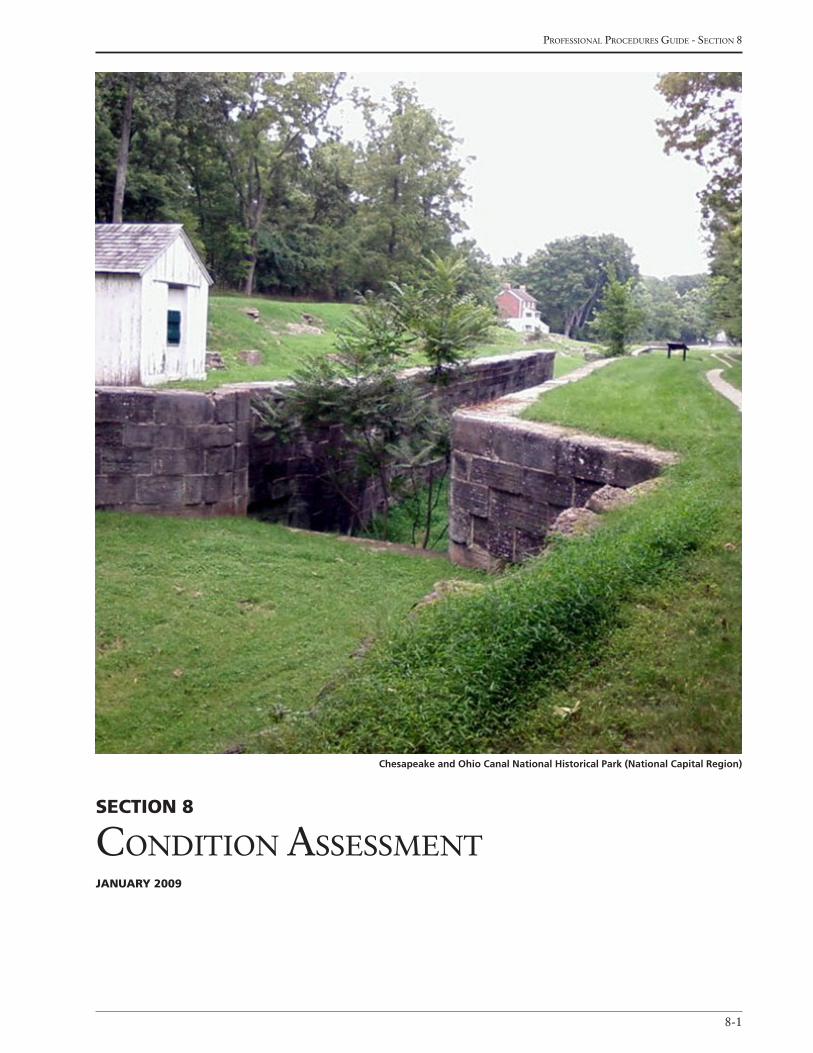
8-1
Professional Procedures Guide - section 8
Section 8
condition assessmentJanuary 2009
Chesapeake and Ohio Canal National Historical Park (National Capital Region)
national Park service - cultural landscaPes inventory
8-2
The following data elements provide information on
the stabilization cost and current condition of the
inventory unit
inventory unit
Stabilization cost (o)
Provide an estimated cost of the physical work neces-
sary to stabilize the inventory unit, if applicable. In-
clude all associated features (except those listed in the
LCS) excluding professional services.
(See Sidebar 30: Cost Estimating)
Stabilization cost Date (o)
Provide the date (mm/dd/yyyy) that the estimate for the
Stabilization Cost was determined.
Stabilization cost Level of estimate (o)
Indicate the accuracy of the Stabilization Cost accord-
ing to one of three categories. Select one from the
following pick list:
A- Working Drawings
B- Preliminary Plans/HSR or CLR
C- Similar Facilities
Stabilization cost estimator (o)
Indicate where the landscape stabilization cost esti-
mates were developed. Select one from the following
pick list:
Regional Office
Denver Service Center
Other Center
Park/FMSS
Contractor
Stabilization Measures Description (o - 4000 characters)
Provide a list of immediate actions needed to address
stabilization of the inventory unit, including those that
address any identified impacts. The stabilization cost
data should be derived from this list of actions.
Stabilization cost explanatory narrative (o)
Provide a brief narrative that explains cost estimating
details for the inventory unit, including any special
conditions, limitations, or assumptions made in deter-
mining the cost. The stabilization of LCS buildings,
structures, and features should also be discussed to the
extent that it effects the stabilization of the landscape.
conDition aSSeSSMent
The following data elements in this table provide infor-
mation on the current condition of the inventory unit
as well as condition reassessments.
The condition for the inventory unit must be reevalu-
ated every six (6) years to keep the inventory unit
certified as complete, accurate, and reliable. The
Park Superintendent must formally concur with each
reevaluation of condition, along with any other sub-
stantive changes to the content of the CLI record. This
is accomplished in this field as a new entry. It is also
accomplished in the Concurrence section through a
signed standard memorandum or form that is included
as a graphic in the Concurrence Graphic Information
table, and as a new entry in the Revision table.
condition assessment (r)
Indicate the current condition of the inventory unit.
Select one from the following pick list:
Good: Indicates the inventory unit shows no clear evidence of major negative disturbance and deteriora-tion by natural and/or human forces. The inventory unit’s cultural and natural values are as well preserved as can be expected under the given environmental conditions. No immediate corrective action is re-quired to maintain its current condition.
Fair: Indicates the inventory unit shows clear evi-dence of minor disturbances and deterioration by natural and/or human forces, and some degree of corrective action is needed within 3-5 years to prevent
Section 8conDition aSSeSSMent
8-3
Professional Procedures Guide - section 8
Sidebar 30: cost estimating
Cost estimating for the CLI should not include professional services or technical reports/surveys; hazardous materials
reports and surveys.
Class “C” level estimates are based on “similar facilities,” or: anticipated square footage and landscape type; anticipated
site development, including existing and proposed utilities; anticipated structural systems; known or anticipated unusual
site conditions.
Class “B” level estimates are based on “preliminary plans”, or: site design, including existing and proposed utilities, grad-
ing, plantings, etc.; site design, including plans, elevations, and typical details; outline specifications, including cut sheets
of proposed equipment, fixtures or specialty items which might significantly influence the estimate; initial quantity take-
offs for utilities, site work, and systems (civil, landscape architectural and architectural).
Class “A” level estimates are based on “working drawings,” or final construction drawings and specifications and include
contractor costs for overhead, profit, and general conditions.
Cost estimating for stabilization is done in a similar manner.
(See R.S. Means Building Construction Cost Data [other specific cost references are available through R.S. Means] and the
Denver Service Center’s Class C Estimating Guide, New Construction)
further harm to its cultural and/or natural values. If left to continue without the appropriate corrective action, the cumulative effect of the deterioration of many of the landscape characteristics will cause the inventory unit to degrade to a poor condition.
Poor: Indicates the inventory unit shows clear evi-dence of major disturbance and rapid deterioration by natural and/or human forces. Immediate correc-tive action is required to protect and preserve the remaining historical and natural values.
Undetermined: This pick can be used during consul-tation with the park regarding the landscape’s condi-tion. Condition must be determined before a record can be approved as complete.
condition assessment Date (r)
Provide the date (mm/dd/yyyy) that the current condi-
tion assessment was completed for the inventory unit.
condition assessment explanatory narrative (r – 4000 characters)
Provide a brief narrative describing the current condi-
tion assessment of the inventory unit. Explain changes
in condition or aspects of condition that are important
to note for this inventory unit. The narrative may also
note what may be needed to improve the condition
from fair to good or from poor to fair.
Display Sequence (o)
Indicate the sequence (1,2,3…) for how the Condition
Assessment data should appear in all reports.
iMpactS to inventory unit
The following data elements in this table provide in-
formation on the impacts affecting the condition of the
inventory unit.
impact type (r)
Indicate the impact(s) associated with the inventory
unit. An impact is defined as a detectable result of an
agent or series of agents having a negative effect on the
significance, characteristics of resource’s integrity, and
for which some form of mitigation or preventative ac-
tion is possible. Select one or more from the following
pick list:
Adjacent Lands
Agriculture
Consumptive Use
national Park service - cultural landscaPes inventory
8-4
Deferred Maintenance
Earthquakes
Erosion
Exposure to Elements
Fertilization Practices
Fire
Flooding
Impending Development
Improper Drainage
Inappropriate Maintenance
Microclimate
Neglect
Operations on site
Other
Pests/Diseases
Planting Practices
Pollution
Poor Security/Lighting
Pruning Practices
Release to Succession
Removal/Replacement
Structural Deterioration
Soil Compaction
Unknown
Vandalism/Theft/Arson
Vegetation/Invasive Plants
Visitation
impact type – other (o)
Provide the impact if “Other” is the selected for Impact
Type.
internal or external (r)
Indicate whether the impact is from inside or outside
of the park’s boundaries. Select one from the following
pick list:
Internal
External
Both Internal and External
impact explanatory narrative (r - 1000 characters)
Provide a brief description of the type of impact
including how it is negatively affecting the condition of
the inventory unit. Cross reference this section with
Stabilization Measures.
Display Sequence (o)
Indicate the sequence (1,2,3…) for how the Impacts to
Inventory Unit data should appear in all reports.
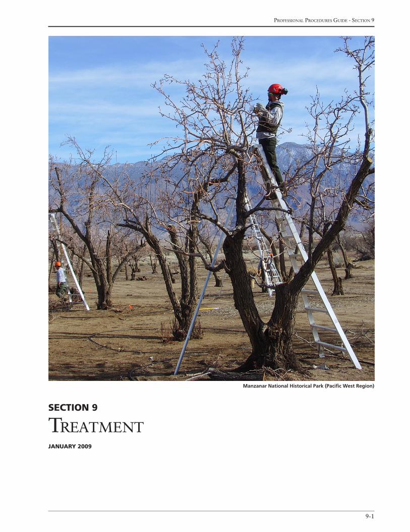
9-1
Professional Procedures Guide - section 9
Section 9
treatmentJanuary 2009
Manzanar National Historical Park (Pacific West Region)
national Park service - cultural landscaPes inventory
9-2
The following data elements provide information about
any landscape treatment that has been selected and ap-
proved for the inventory unit. Approved treatments are
determined through an NPS planning process or for-
mal public review and comment. Descriptions of the
approved landscape treatments can typically be found
in a General Management Plan, Development Concept
Plan, Historic Structure Report, Cultural Landscape
Report, Vegetation Management Plan, Regional Ne-
glect/Removal Memo, or other similar documents.
inventory unit
approved Landscape treatment (r)
Indicate the treatment of the inventory unit that has
been selected and approved through the NPS planning
process. Select one from the following pick list:
Preservation: The act or process of applying measures to sustain the existing form, integrity and material of an inventory unit. Preliminary measures to protect and stabilize the property may be taken, but preservation work focuses upon the ongoing main-tenance and repair of historic material and features rather than extensive replacement and new work.
Rehabilitation: The act or process of making pos-sible an efficient compatible use for an inventory unit through repair, alterations, and additions while preserving those portions of features that convey its historical, cultural or aesthetic values.
Restoration: The act or process of accurately depict-ing the form, features, and character of an inventory unit as it appeared at a particular period of time (period of significance), by the removal of features present from other periods in its history and/or the reconstruction or replacement of missing features from the period of significance.
Reconstruction: The act or process of depicting, by means of new work, the form, feature, and detailing of a non-surviving inventory unit or any part thereof, for the purpose of replicating its appearance at a spe-cific time and in its historic location.
Neglect: No treatment or preservation measures will be taken for the inventory unit (this is not an accept-
able response for a completed inventory unit that is either listed in the National Register or is determined eligible for listing).
Undetermined: No treatment has been approved.
approved Landscape treatment completed (r)
Indicate if the Approved Landscape Treatment has
been completed. Select one from the following pick
list:
Yes
No
approved Landscape treatment explanatory narrative (o – 4000 characters)
Provide a brief narrative regarding the Approved Land-
scape Treatment for the inventory unit.
approved Landscape treatment Document (r, if applicable)
Indicate the document that includes a description of
the Approved Landscape Treatment. To be considered
“approved,” the document must have gone through
the NPS planning process or formal public review and
comment. Select one from the following pick list:
General Management Plan
Development Concept Plan
Historic Structure Report
Cultural Landscape Report
Vegetation Management Plan
Regional Neglect/Removal Memo
Other Document
approved Landscape treatment Document Date (r, if applicable)
Indicate the date (mm-dd-yyyy) the Approved Land-
scape Treatment Document was approved.
Section 9treatment

9-3
Professional Procedures Guide - section 9
approved Landscape treatment cost (o)
Indicate the projected cost of physical work necessary
to accomplish the Approved Landscape Treatment
selected (excluding LCS treatment costs or professional
services).
approved Landscape treatment cost Date (o)
Indicate the date (mm/dd/yyyy) that the Approved
Landscape Treatment Cost was determined.
approved Landscape treatment Level of estimate (o)
Indicate the accuracy of information on which the
Approved Landscape Treatment Cost was determined.
Select one from the following pick list:
A- Working Drawings
B- Preliminary Plans/HSR or CLR
C- Similar Facilities
approved Landscape treatment cost – estimator (o)
Indicate where the Approved Landscape Treatment
Cost was developed. Select one from the following
pick list:
Regional Office
Denver Service Center
Other Center
Park/FMSS
Contractor
approved Landscape treatment cost explanatory narrative (o)
Provide a brief narrative explaining the treatment cost
estimate including any details on special conditions,
limitations, and assumptions made in creating the
estimate.

national Park service - cultural landscaPes inventory
9-4
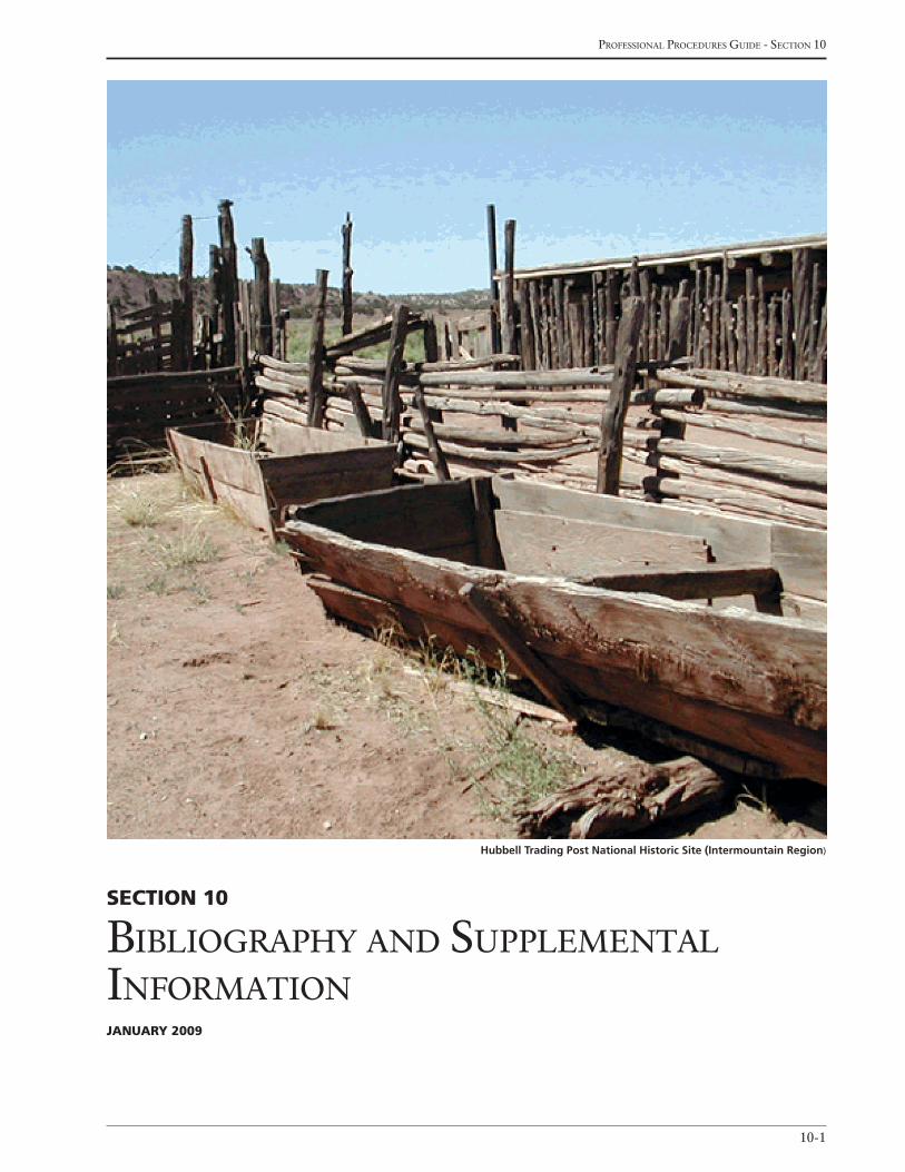
10-1
Professional Procedures Guide - section 10
Section 10
BiBlioGraPhy and suPPlemental informationJanuary 2009
Hubbell Trading Post National Historic Site (Intermountain Region)

national Park service - cultural landscaPes inventory
10-2
The following data elements provide bibliographic in-
formation for the sources used to create the inventory
unit record, along with any supplemental information
that supports the findings of the CLI record.
inventory unit
Bibliography (r)
Indicate the primary and published secondary sources
used in documenting and evaluating the inventory
unit. These include books, journal or magazine articles,
planning documents, historic resource studies or
survey reports, census data, newspaper articles, deeds,
wills, correspondence, business records, diaries, and
other sources. Do not include general reference works
unless they provide specific information about the
inventory unit or have assisted in evaluating the proper-
ty’s significance. A minimum of one source is required.
citation title (r)
Provide the title of the work being cited.
citation author (r)
Provide the author(s) and or editor(s) of the work be-
ing cited.
year of Publication (o)
Provide the year (yyyy) that the citation was published
or prepared.
Publisher (o)
Provide the name of the publisher of the resource.
Source name (o)
Indicate the source for the citation. Select one from the
following pick list:
CRBIB – the Cultural Resources Management Bibliography
DSC TIC – the Denver Service Center Technical Service Center
HABS – Historic American Buildings Survey
HAER – Historic American Engineering Record
HALS – Historic American Landscape Survey
Library of Congress or Dewey Decimal System
Other
other Source name (o)
If “Other” was selected, provide the name of the other
source.
citation number (o)
Provide the citation number of the publication, if ap-
propriate.
citation type (o)
Indicate the type of citation. Select one from the fol-
lowing pick list:
Graphic
Narrative
Both Graphic and Narrative
citation Location (o)
Provide the location where the citation can be found.
Display Sequence (o)
Indicate the sequence (1,2,3…) for how the Bibliogra-
phy data should appear in all reports.
SuPPLementaL information
The following data elements provide information
on supplemental sources of data associated with the
inventory unit, such as unpublished references, maps,
plant lists, unidentified photographs, oral interviews,
oral history tapes, correspondence, etc.
Supplemental information title (o)
Provide the title of the supplemental information.
Section 10BiBLiograPhy anD SuPPLementaL information

10-3
Professional Procedures Guide - section 10
Supplemental information narrative (o – 64,000 characters)
Provide a brief description of the supplemental infor-
mation’s relevance to the inventory unit.
Display Sequence (o)
Indicate the sequence (1,2,3…) for how the Supple-
mental Information data should appear in all reports.
SuPPLementaL graPhic information
The following data elements provide information on
graphics association with a supplemental data.
Supplemental information graphic (o)
Provide a graphic associated with the supplemental
information.
Supplemental graphic caption (o)
Provide a title and/or brief description for each Supple-
mental Information Graphic.
Display Sequence (o)
Indicate the sequence (1,2,3…) for how the Supple-
mental Graphic should appear in all reports.

national Park service - cultural landscaPes inventory
10-4
A-1
Professional Procedures Guide - aPPendix a
Appendix A
Park orGanization, alPha codes, and orGanization codesJAnuAry 2009
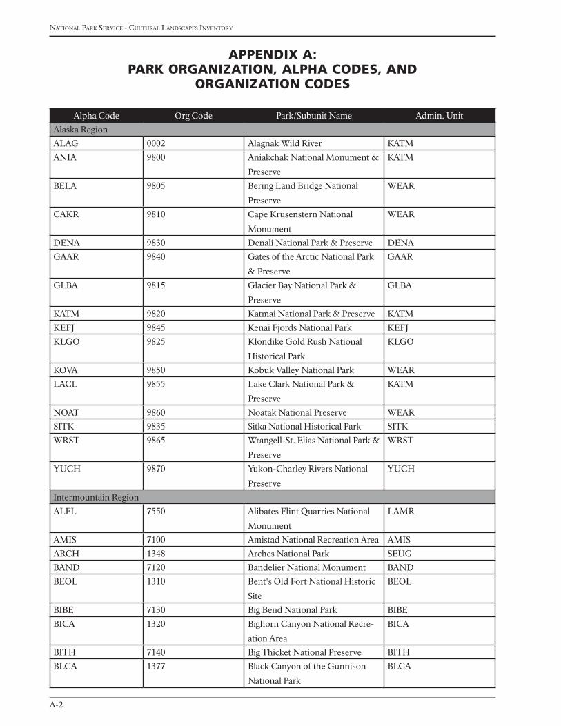
national Park service - cultural landscaPes inventory
A-2
Alpha Code Org Code Park/Subunit Name Admin. Unit
Alaska Region
ALAG 0002 Alagnak Wild River KATM
ANIA 9800 Aniakchak National Monument &
Preserve
KATM
BELA 9805 Bering Land Bridge National
Preserve
WEAR
CAKR 9810 Cape Krusenstern National
Monument
WEAR
DENA 9830 Denali National Park & Preserve DENA
GAAR 9840 Gates of the Arctic National Park
& Preserve
GAAR
GLBA 9815 Glacier Bay National Park &
Preserve
GLBA
KATM 9820 Katmai National Park & Preserve KATM
KEFJ 9845 Kenai Fjords National Park KEFJ
KLGO 9825 Klondike Gold Rush National
Historical Park
KLGO
KOVA 9850 Kobuk Valley National Park WEAR
LACL 9855 Lake Clark National Park &
Preserve
KATM
NOAT 9860 Noatak National Preserve WEAR
SITK 9835 Sitka National Historical Park SITK
WRST 9865 Wrangell-St. Elias National Park &
Preserve
WRST
YUCH 9870 Yukon-Charley Rivers National
Preserve
YUCH
Intermountain Region
ALFL 7550 Alibates Flint Quarries National
Monument
LAMR
AMIS 7100 Amistad National Recreation Area AMIS
ARCH 1348 Arches National Park SEUG
BAND 7120 Bandelier National Monument BAND
BEOL 1310 Bent's Old Fort National Historic
Site
BEOL
BIBE 7130 Big Bend National Park BIBE
BICA 1320 Bighorn Canyon National Recre-
ation Area
BICA
BITH 7140 Big Thicket National Preserve BITH
BLCA 1377 Black Canyon of the Gunnison
National Park
BLCA
Appendix A: pArk OrgAnizAtiOn, AlphA COdes, And
OrgAnizAtiOn COdes
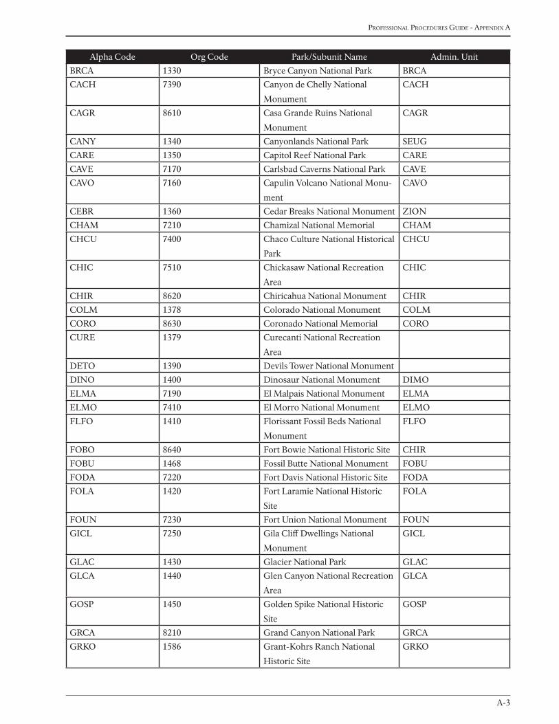
A-3
Professional Procedures Guide - aPPendix a
Alpha Code Org Code Park/Subunit Name Admin. Unit
BRCA 1330 Bryce Canyon National Park BRCA
CACH 7390 Canyon de Chelly National
Monument
CACH
CAGR 8610 Casa Grande Ruins National
Monument
CAGR
CANY 1340 Canyonlands National Park SEUG
CARE 1350 Capitol Reef National Park CARE
CAVE 7170 Carlsbad Caverns National Park CAVE
CAVO 7160 Capulin Volcano National Monu-
ment
CAVO
CEBR 1360 Cedar Breaks National Monument ZION
CHAM 7210 Chamizal National Memorial CHAM
CHCU 7400 Chaco Culture National Historical
Park
CHCU
CHIC 7510 Chickasaw National Recreation
Area
CHIC
CHIR 8620 Chiricahua National Monument CHIR
COLM 1378 Colorado National Monument COLM
CORO 8630 Coronado National Memorial CORO
CURE 1379 Curecanti National Recreation
Area
DETO 1390 Devils Tower National Monument
DINO 1400 Dinosaur National Monument DIMO
ELMA 7190 El Malpais National Monument ELMA
ELMO 7410 El Morro National Monument ELMO
FLFO 1410 Florissant Fossil Beds National
Monument
FLFO
FOBO 8640 Fort Bowie National Historic Site CHIR
FOBU 1468 Fossil Butte National Monument FOBU
FODA 7220 Fort Davis National Historic Site FODA
FOLA 1420 Fort Laramie National Historic
Site
FOLA
FOUN 7230 Fort Union National Monument FOUN
GICL 7250 Gila Cliff Dwellings National
Monument
GICL
GLAC 1430 Glacier National Park GLAC
GLCA 1440 Glen Canyon National Recreation
Area
GLCA
GOSP 1450 Golden Spike National Historic
Site
GOSP
GRCA 8210 Grand Canyon National Park GRCA
GRKO 1586 Grant-Kohrs Ranch National
Historic Site
GRKO
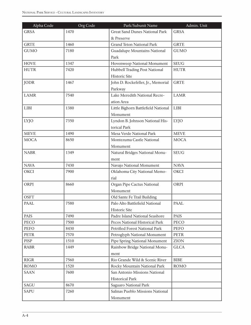
national Park service - cultural landscaPes inventory
A-4
Alpha Code Org Code Park/Subunit Name Admin. Unit
GRSA 1470 Great Sand Dunes National Park
& Preserve
GRSA
GRTE 1460 Grand Teton National Park GRTE
GUMO 7180 Guadalupe Mountains National
Park
GUMO
HOVE 1347 Hovenweep National Monument SEUG
HUTR 7420 Hubbell Trading Post National
Historic Site
HUTR
JODR 1467 John D. Rockefeller, Jr., Memorial
Parkway
GRTE
LAMR 7540 Lake Meredith National Recre-
ation Area
LAMR
LIBI 1380 Little Bighorn Battlefield National
Monument
LIBI
LYJO 7350 Lyndon B. Johnson National His-
torical Park
LYJO
MEVE 1490 Mesa Verde National Park MEVE
MOCA 8650 Montezuma Castle National
Monument
MOCA
NABR 1349 Natural Bridges National Monu-
ment
SEUG
NAVA 7430 Navajo National Monument NAVA
OKCI 7900 Oklahoma City National Memo-
rial
OKCI
ORPI 8660 Organ Pipe Cactus National
Monument
ORPI
OSFT Old Sante Fe Trail Building
PAAL 7580 Palo Alto Battlefield National
Historic Site
PAAL
PAIS 7490 Padre Island National Seashore PAIS
PECO 7500 Pecos National Historical Park PECO
PEFO 8430 Petrified Forest National Park PEFO
PETR 7570 Petroglyph National Monument PETR
PISP 1510 Pipe Spring National Monument ZION
RABR 1449 Rainbow Bridge National Monu-
ment
GLCA
RIGR 7560 Rio Grande Wild & Scenic River BIBE
ROMO 1520 Rocky Mountain National Park ROMO
SAAN 7600 San Antonio Missions National
Historical Park
SAGU 8670 Saguaro National Park
SAPU 7260 Salinas Pueblo Missions National
Monument
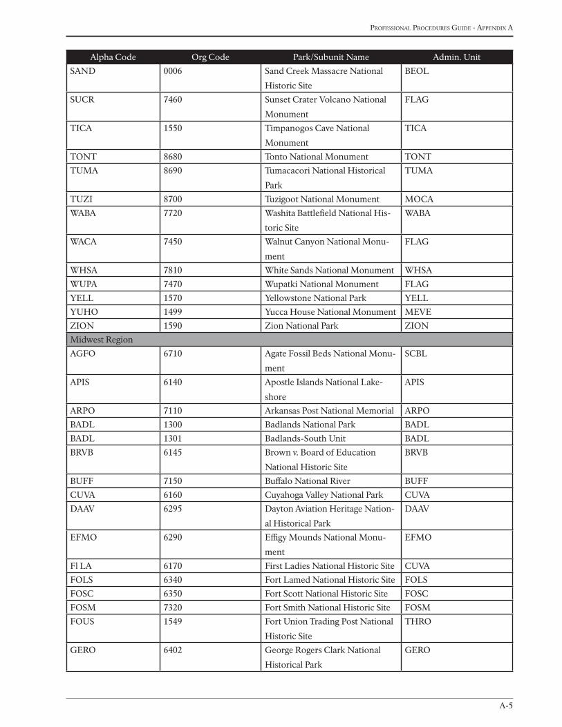
A-5
Professional Procedures Guide - aPPendix a
Alpha Code Org Code Park/Subunit Name Admin. Unit
SAND 0006 Sand Creek Massacre National
Historic Site
BEOL
SUCR 7460 Sunset Crater Volcano National
Monument
FLAG
TICA 1550 Timpanogos Cave National
Monument
TICA
TONT 8680 Tonto National Monument TONT
TUMA 8690 Tumacacori National Historical
Park
TUMA
TUZI 8700 Tuzigoot National Monument MOCA
WABA 7720 Washita Battlefield National His-
toric Site
WABA
WACA 7450 Walnut Canyon National Monu-
ment
FLAG
WHSA 7810 White Sands National Monument WHSA
WUPA 7470 Wupatki National Monument FLAG
YELL 1570 Yellowstone National Park YELL
YUHO 1499 Yucca House National Monument MEVE
ZION 1590 Zion National Park ZION
Midwest Region
AGFO 6710 Agate Fossil Beds National Monu-
ment
SCBL
APIS 6140 Apostle Islands National Lake-
shore
APIS
ARPO 7110 Arkansas Post National Memorial ARPO
BADL 1300 Badlands National Park BADL
BADL 1301 Badlands-South Unit BADL
BRVB 6145 Brown v. Board of Education
National Historic Site
BRVB
BUFF 7150 Buffalo National River BUFF
CUVA 6160 Cuyahoga Valley National Park CUVA
DAAV 6295 Dayton Aviation Heritage Nation-
al Historical Park
DAAV
EFMO 6290 Effigy Mounds National Monu-
ment
EFMO
Fl LA 6170 First Ladies National Historic Site CUVA
FOLS 6340 Fort Lamed National Historic Site FOLS
FOSC 6350 Fort Scott National Historic Site FOSC
FOSM 7320 Fort Smith National Historic Site FOSM
FOUS 1549 Fort Union Trading Post National
Historic Site
THRO
GERO 6402 George Rogers Clark National
Historical Park
GERO

national Park service - cultural landscaPes inventory
A-6
Alpha Code Org Code Park/Subunit Name Admin. Unit
GRPO 6150 Grand Portage National Monu-
ment
GRPO
GWCA 6360 George Washington Carver Na-
tional Monument
GWCA
HEHO 6470 Herbert Hoover National Historic
Site
HEHO
HOCU 6514 Hopewell Culture National His-
torical Park
HOCU
HOME 6480 Homestead National Monument
of America
HOME
HOSP 7300 Hot Springs National Park HOSP
HSTR 6460 Harry S Truman National Historic
Site
HSTR
INDU 6300 Indiana Dunes National Lake-
shore
INDU
ISRO 6310 Isle Royale National Park ISRO
JAGA 6380 James A. Garfield National His-
toric Site
CUVA
JECA 1569 Jewel Cave National Monument WICA
JEFF 6520 Jefferson National Expansion
Memorial
JEFF
KEWE 6410 Keweenaw National Historical
Park
ISRO
KNRI 1548 Knife River Indian Village Nation-
al Historic Site
THRO
LIBO 6400 Lincoln Boyhood National Me-
morial
LIBO
LIHO 6530 Lincoln Home National Historic
Site
LINO
LIRO 7310 Little Rock Central High School
National Historic Site
LIRO
MIMI 1305 Minuteman Missile National
Historic Site
BADL
MISS 6286 Mississippi National River & Rec-
reation Area
MISS
MNRR 6288 Missouri National Recreational
River
NIOB
MORU 1500 Mount Rushmore National Me-
morial
MORU
NICO 6345 Nicodemus National Historic Site FOLS
NIOB 6630 Niobrara National Scenic River NIOB
OZAR 6640 Ozark National Scenic Riverways OZAR
PERI 7330 Pea Ridge National Military Park PERI
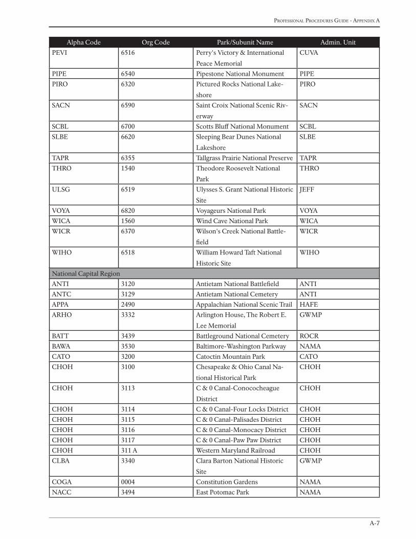
A-7
Professional Procedures Guide - aPPendix a
Alpha Code Org Code Park/Subunit Name Admin. Unit
PEVI 6516 Perry's Victory & International
Peace Memorial
CUVA
PIPE 6540 Pipestone National Monument PIPE
PIRO 6320 Pictured Rocks National Lake-
shore
PIRO
SACN 6590 Saint Croix National Scenic Riv-
erway
SACN
SCBL 6700 Scotts Bluff National Monument SCBL
SLBE 6620 Sleeping Bear Dunes National
Lakeshore
SLBE
TAPR 6355 Tallgrass Prairie National Preserve TAPR
THRO 1540 Theodore Roosevelt National
Park
THRO
ULSG 6519 Ulysses S. Grant National Historic
Site
JEFF
VOYA 6820 Voyageurs National Park VOYA
WICA 1560 Wind Cave National Park WICA
WICR 6370 Wilson's Creek National Battle-
field
WICR
WIHO 6518 William Howard Taft National
Historic Site
WIHO
National Capital Region
ANTI 3120 Antietam National Battlefield ANTI
ANTC 3129 Antietam National Cemetery ANTI
APPA 2490 Appalachian National Scenic Trail HAFE
ARHO 3332 Arlington House, The Robert E.
Lee Memorial
GWMP
BATT 3439 Battleground National Cemetery ROCR
BAWA 3530 Baltimore-Washington Parkway NAMA
CATO 3200 Catoctin Mountain Park CATO
CHOH 3100 Chesapeake & Ohio Canal Na-
tional Historical Park
CHOH
CHOH 3113 C & 0 Canal-Conococheague
District
CHOH
CHOH 3114 C & 0 Canal-Four Locks District CHOH
CHOH 3115 C & 0 Canal-Palisades District CHOH
CHOH 3116 C & 0 Canal-Monocacy District CHOH
CHOH 3117 C & 0 Canal-Paw Paw District CHOH
CHOH 311 A Western Maryland Railroad CHOH
CLBA 3340 Clara Barton National Historic
Site
GWMP
COGA 0004 Constitution Gardens NAMA
NACC 3494 East Potomac Park NAMA
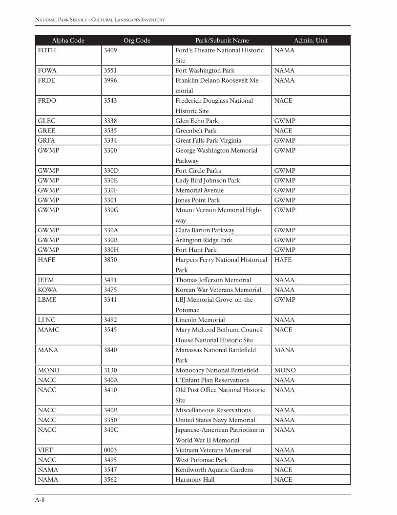
national Park service - cultural landscaPes inventory
A-8
Alpha Code Org Code Park/Subunit Name Admin. Unit
FOTH 3409 Ford's Theatre National Historic
Site
NAMA
FOWA 3551 Fort Washington Park NAMA
FRDE 3996 Franklin Delano Roosevelt Me-
morial
NAMA
FRDO 3543 Frederick Douglass National
Historic Site
NACE
GLEC 3338 Glen Echo Park GWMP
GREE 3535 Greenbelt Park NACE
GRFA 3334 Great Falls Park Virginia GWMP
GWMP 3300 George Washington Memorial
Parkway
GWMP
GWMP 330D Fort Circle Parks GWMP
GWMP 330E Lady Bird Johnson Park GWMP
GWMP 330F Memorial Avenue GWMP
GWMP 3301 Jones Point Park GWMP
GWMP 330G Mount Vernon Memorial High-
way
GWMP
GWMP 330A Clara Barton Parkway GWMP
GWMP 330B Arlington Ridge Park GWMP
GWMP 330H Fort Hunt Park GWMP
HAFE 3850 Harpers Ferry National Historical
Park
HAFE
JEFM 3491 Thomas Jefferson Memorial NAMA
KOWA 3475 Korean War Veterans Memorial NAMA
LBME 3341 LBJ Memorial Grove-on-the-
Potomac
GWMP
LI NC 3492 Lincoln Memorial NAMA
MAMC 3545 Mary McLeod Bethune Council
House National Historic Site
NACE
MANA 3840 Manassas National Battlefield
Park
MANA
MONO 3130 Monocacy National Battlefield MONO
NACC 340A L'Enfant Plan Reservations NAMA
NACC 3410 Old Post Office National Historic
Site
NAMA
NACC 340B Miscellaneous Reservations NAMA
NACC 3350 United States Navy Memorial NAMA
NACC 340C Japanese-American Patriotism in
World War II Memorial
NAMA
VIET 0003 Vietnam Veterans Memorial NAMA
NACC 3495 West Potomac Park NAMA
NAMA 3547 Kenilworth Aquatic Gardens NACE
NAMA 3562 Harmony Hall NACE
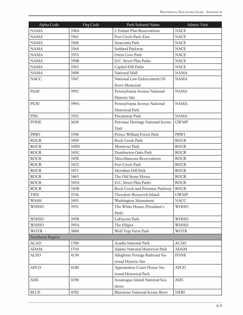
A-9
Professional Procedures Guide - aPPendix a
Alpha Code Org Code Park/Subunit Name Admin. Unit
NAMA 350A L'Enfant Plan Reservations NACE
NAMA 3561 Fort Circle Park-East NACE
NAMA 3560 Anacostia Park NACE
NAMA 3564 Suitland Parkway NACE
NAMA 3553 Oxon Cove Park NACE
NAMA 350B D.C. Street Plan Parks NACE
NAMA 3563 Capitol Hill Parks NACE
NAMA 3408 National Mall NAMA
NACC 3567 National Law Enforcement Of-
ficers Memorial
NAMA
PAAV 3992 Pennsylvania Avenue National
Historic Site
NAMA
PEAV 399A Pennsylvania Avenue National
Historical Park
NAMA
PISC 3552 Piscataway Park NAMA
POHE 3620 Potomac Heritage National Scenic
Trail
GWMP
PRWI 3700 Prince William Forest Park PRWI
ROCR 3450 Rock Creek Park ROCR
ROCR 345D Montrose Park ROCR
ROCR 345C Dumbarton Oaks Park ROCR
ROCR 345E Miscellaneous Reservations ROCR
ROCR 3472 Fort Circle Park ROCR
ROCR 3471 Meridian Hill Park ROCR
ROCR 3463 The Old Stone House ROCR
ROCR 345A D.C. Street Plan Parks ROCR
ROCR 345B Rock Creek and Potomac Parkway ROCR
TRIS 3336 Theodore Roosevelt Island GWMP
WASH 3493 Washington Monument NACC
WHHO 3951 The White House (President's
Park)
WHHO
WHHO 395B LaFayette Park WHHO
WHHO 395A The Ellipse WHHO
WOTR 3800 Wolf Trap Farm Park WOTR
Northeast Region
ACAD 1700 Acadia National Park ACAD
ADAM 1710 Adams National Historical Park ADAM
ALPO 4130 Allegheny Portage Railroad Na-
tional Historic Site
FONE
APCO 4180 Appomattox Court House Na-
tional Historical Park
APCO
ASIS 4190 Assateague Island National Sea-
shore
ASIS
BLUE 4782 Bluestone National Scenic River NERI
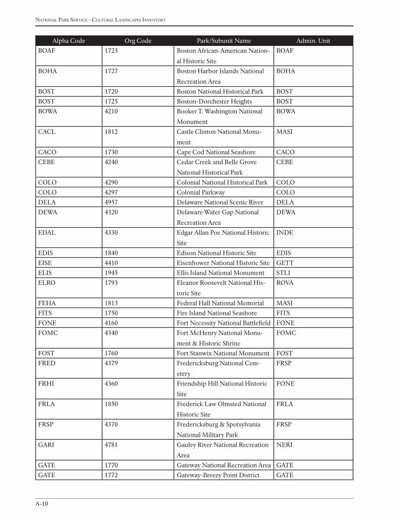
national Park service - cultural landscaPes inventory
A-10
Alpha Code Org Code Park/Subunit Name Admin. Unit
BOAF 1723 Boston African-American Nation-
al Historic Site
BOAF
BOHA 1727 Boston Harbor Islands National
Recreation Area
BOHA
BOST 1720 Boston National Historical Park BOST
BOST 1725 Boston-Dorchester Heights BOST
BOWA 4210 Booker T. Washington National
Monument
BOWA
CACL 1812 Castle Clinton National Monu-
ment
MASI
CACO 1730 Cape Cod National Seashore CACO
CEBE 4240 Cedar Creek and Belle Grove
National Historical Park
CEBE
COLO 4290 Colonial National Historical Park COLO
COLO 4297 Colonial Parkway COLO
DELA 4957 Delaware National Scenic River DELA
DEWA 4320 Delaware Water Gap National
Recreation Area
DEWA
EDAL 4330 Edgar Allan Poe National Historic
Site
INDE
EDIS 1840 Edison National Historic Site EDIS
EISE 4410 Eisenhower National Historic Site GETT
ELIS 1945 Ellis Island National Monument STLI
ELRO 1793 Eleanor Roosevelt National His-
toric Site
ROVA
FEHA 1813 Federal Hall National Memorial MASI
FITS 1750 Fire Island National Seashore FITS
FONE 4160 Fort Necessity National Battlefield FONE
FOMC 4340 Fort McHenry National Monu-
ment & Historic Shrine
FOMC
FOST 1760 Fort Stanwix National Monument FOST
FRED 4379 Fredericksburg National Cem-
etery
FRSP
FRHI 4360 Friendship Hill National Historic
Site
FONE
FRLA 1850 Frederick Law Olmsted National
Historic Site
FRLA
FRSP 4370 Fredericksburg & Spotsylvania
National Military Park
FRSP
GARI 4781 Gauley River National Recreation
Area
NERI
GATE 1770 Gateway National Recreation Area GATE
GATE 1772 Gateway-Breezy Point District GATE
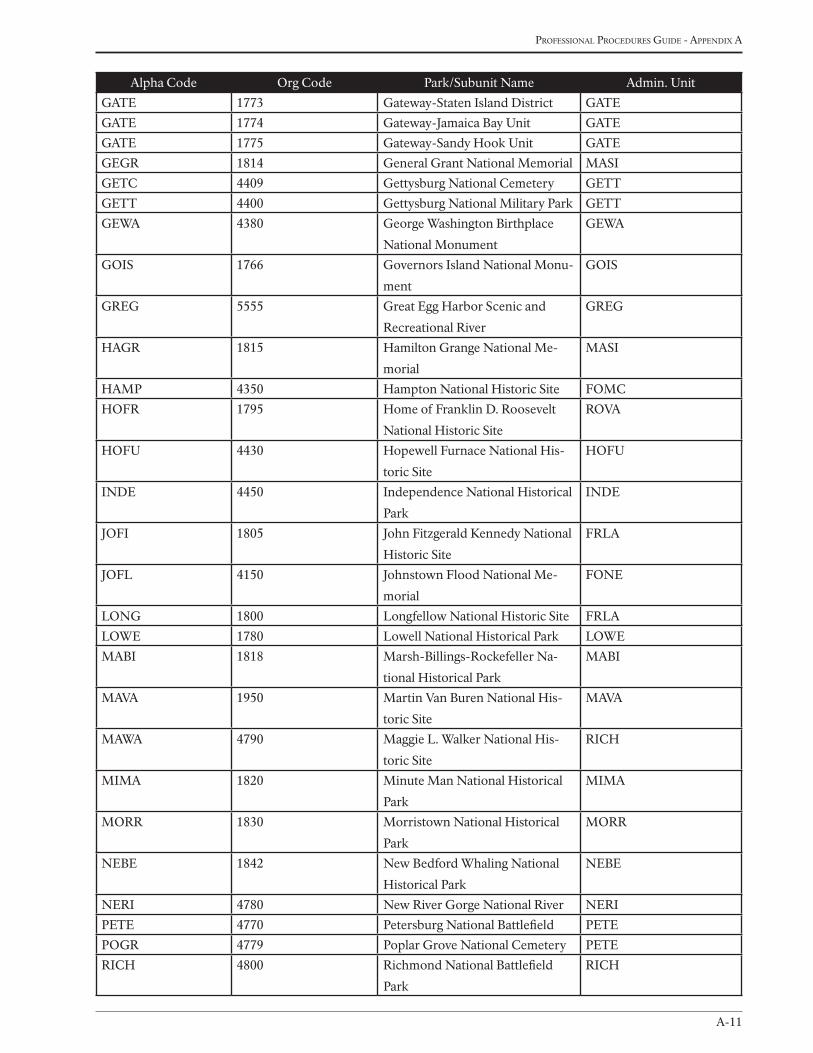
A-11
Professional Procedures Guide - aPPendix a
Alpha Code Org Code Park/Subunit Name Admin. Unit
GATE 1773 Gateway-Staten Island District GATE
GATE 1774 Gateway-Jamaica Bay Unit GATE
GATE 1775 Gateway-Sandy Hook Unit GATE
GEGR 1814 General Grant National Memorial MASI
GETC 4409 Gettysburg National Cemetery GETT
GETT 4400 Gettysburg National Military Park GETT
GEWA 4380 George Washington Birthplace
National Monument
GEWA
GOIS 1766 Governors Island National Monu-
ment
GOIS
GREG 5555 Great Egg Harbor Scenic and
Recreational River
GREG
HAGR 1815 Hamilton Grange National Me-
morial
MASI
HAMP 4350 Hampton National Historic Site FOMC
HOFR 1795 Home of Franklin D. Roosevelt
National Historic Site
ROVA
HOFU 4430 Hopewell Furnace National His-
toric Site
HOFU
INDE 4450 Independence National Historical
Park
INDE
JOFI 1805 John Fitzgerald Kennedy National
Historic Site
FRLA
JOFL 4150 Johnstown Flood National Me-
morial
FONE
LONG 1800 Longfellow National Historic Site FRLA
LOWE 1780 Lowell National Historical Park LOWE
MABI 1818 Marsh-Billings-Rockefeller Na-
tional Historical Park
MABI
MAVA 1950 Martin Van Buren National His-
toric Site
MAVA
MAWA 4790 Maggie L. Walker National His-
toric Site
RICH
MIMA 1820 Minute Man National Historical
Park
MIMA
MORR 1830 Morristown National Historical
Park
MORR
NEBE 1842 New Bedford Whaling National
Historical Park
NEBE
NERI 4780 New River Gorge National River NERI
PETE 4770 Petersburg National Battlefield PETE
POGR 4779 Poplar Grove National Cemetery PETE
RICH 4800 Richmond National Battlefield
Park
RICH
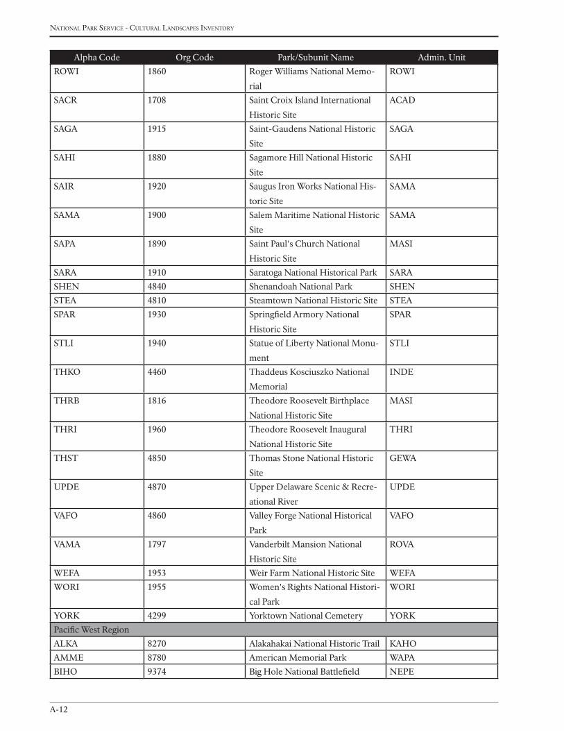
national Park service - cultural landscaPes inventory
A-12
Alpha Code Org Code Park/Subunit Name Admin. Unit
ROWI 1860 Roger Williams National Memo-
rial
ROWI
SACR 1708 Saint Croix Island International
Historic Site
ACAD
SAGA 1915 Saint-Gaudens National Historic
Site
SAGA
SAHI 1880 Sagamore Hill National Historic
Site
SAHI
SAIR 1920 Saugus Iron Works National His-
toric Site
SAMA
SAMA 1900 Salem Maritime National Historic
Site
SAMA
SAPA 1890 Saint Paul's Church National
Historic Site
MASI
SARA 1910 Saratoga National Historical Park SARA
SHEN 4840 Shenandoah National Park SHEN
STEA 4810 Steamtown National Historic Site STEA
SPAR 1930 Springfield Armory National
Historic Site
SPAR
STLI 1940 Statue of Liberty National Monu-
ment
STLI
THKO 4460 Thaddeus Kosciuszko National
Memorial
INDE
THRB 1816 Theodore Roosevelt Birthplace
National Historic Site
MASI
THRI 1960 Theodore Roosevelt Inaugural
National Historic Site
THRI
THST 4850 Thomas Stone National Historic
Site
GEWA
UPDE 4870 Upper Delaware Scenic & Recre-
ational River
UPDE
VAFO 4860 Valley Forge National Historical
Park
VAFO
VAMA 1797 Vanderbilt Mansion National
Historic Site
ROVA
WEFA 1953 Weir Farm National Historic Site WEFA
WORI 1955 Women's Rights National Histori-
cal Park
WORI
YORK 4299 Yorktown National Cemetery YORK
Pacific West Region
ALKA 8270 Alakahakai National Historic Trail KAHO
AMME 8780 American Memorial Park WAPA
BIHO 9374 Big Hole National Battlefield NEPE
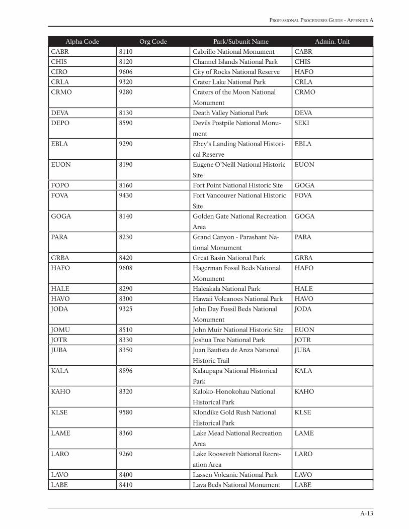
A-13
Professional Procedures Guide - aPPendix a
Alpha Code Org Code Park/Subunit Name Admin. Unit
CABR 8110 Cabrillo National Monument CABR
CHIS 8120 Channel Islands National Park CHIS
CIRO 9606 City of Rocks National Reserve HAFO
CRLA 9320 Crater Lake National Park CRLA
CRMO 9280 Craters of the Moon National
Monument
CRMO
DEVA 8130 Death Valley National Park DEVA
DEPO 8590 Devils Postpile National Monu-
ment
SEKI
EBLA 9290 Ebey's Landing National Histori-
cal Reserve
EBLA
EUON 8190 Eugene O'Neill National Historic
Site
EUON
FOPO 8160 Fort Point National Historic Site GOGA
FOVA 9430 Fort Vancouver National Historic
Site
FOVA
GOGA 8140 Golden Gate National Recreation
Area
GOGA
PARA 8230 Grand Canyon - Parashant Na-
tional Monument
PARA
GRBA 8420 Great Basin National Park GRBA
HAFO 9608 Hagerman Fossil Beds National
Monument
HAFO
HALE 8290 Haleakala National Park HALE
HAVO 8300 Hawaii Volcanoes National Park HAVO
JODA 9325 John Day Fossil Beds National
Monument
JODA
JOMU 8510 John Muir National Historic Site EUON
JOTR 8330 Joshua Tree National Park JOTR
JUBA 8350 Juan Bautista de Anza National
Historic Trail
JUBA
KALA 8896 Kalaupapa National Historical
Park
KALA
KAHO 8320 Kaloko-Honokohau National
Historical Park
KAHO
KLSE 9580 Klondike Gold Rush National
Historical Park
KLSE
LAME 8360 Lake Mead National Recreation
Area
LAME
LARO 9260 Lake Roosevelt National Recre-
ation Area
LARO
LAVO 8400 Lassen Volcanic National Park LAVO
LABE 8410 Lava Beds National Monument LABE
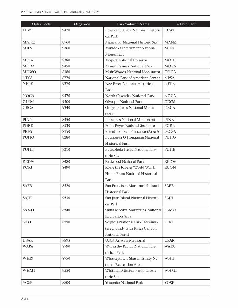
national Park service - cultural landscaPes inventory
A-14
Alpha Code Org Code Park/Subunit Name Admin. Unit
LEWI 9420 Lewis and Clark National Histori-
cal Park
LEWI
MANZ 8760 Manzanar National Historic Site MANZ
MIIN 9360 Minidoka Internment National
Monument
MIIN
MOJA 8380 Mojave National Preserve MOJA
MORA 9450 Mount Rainier National Park MORA
MUWO 8180 Muir Woods National Monument GOGA
NPSA 8770 National Park of American Samoa NPSA
NEPE 9370 Nez Perce National Historical
Park
NEPE
NOCA 9470 North Cascades National Park NOCA
OLYM 9500 Olympic National Park OLYM
ORCA 9340 Oregon Caves National Monu-
ment
ORCA
PINN 8450 Pinnacles National Monument PINN
PORE 8530 Point Reyes National Seashore PORE
PRES 8150 Presidio of San Francisco (Area A) GOGA
PUHO 8280 Puuhonua O Honaunau National
Historical Park
PUHO
PUHE 8310 Puukohola Heiau National His-
toric Site
PUHE
REDW 8480 Redwood National Park REDW
RORI 8490 Rosie the Riveter/World War II
Home Front National Historical
Park
EUON
SAFR 8520 San Francisco Maritime National
Historical Park
SAFR
SAJH 9530 San Juan Island National Histori-
cal Park
SAJH
SAMO 8540 Santa Monica Mountains National
Recreation Area
SAMO
SEKI 8550 Sequoia National Park (adminis-
tered jointly with Kings Canyon
National Park)
SEKI
USAR 8895 U.S.S. Arizona Memorial USAR
WAPA 8790 War in the Pacific National His-
torical Park
WAPA
WHIS 8750 Whiskeytown-Shasta-Trinity Na-
tional Recreation Area
WHIS
WHMI 9550 Whitman Mission National His-
toric Site
WHMI
YOSE 8800 Yosemite National Park YOSE
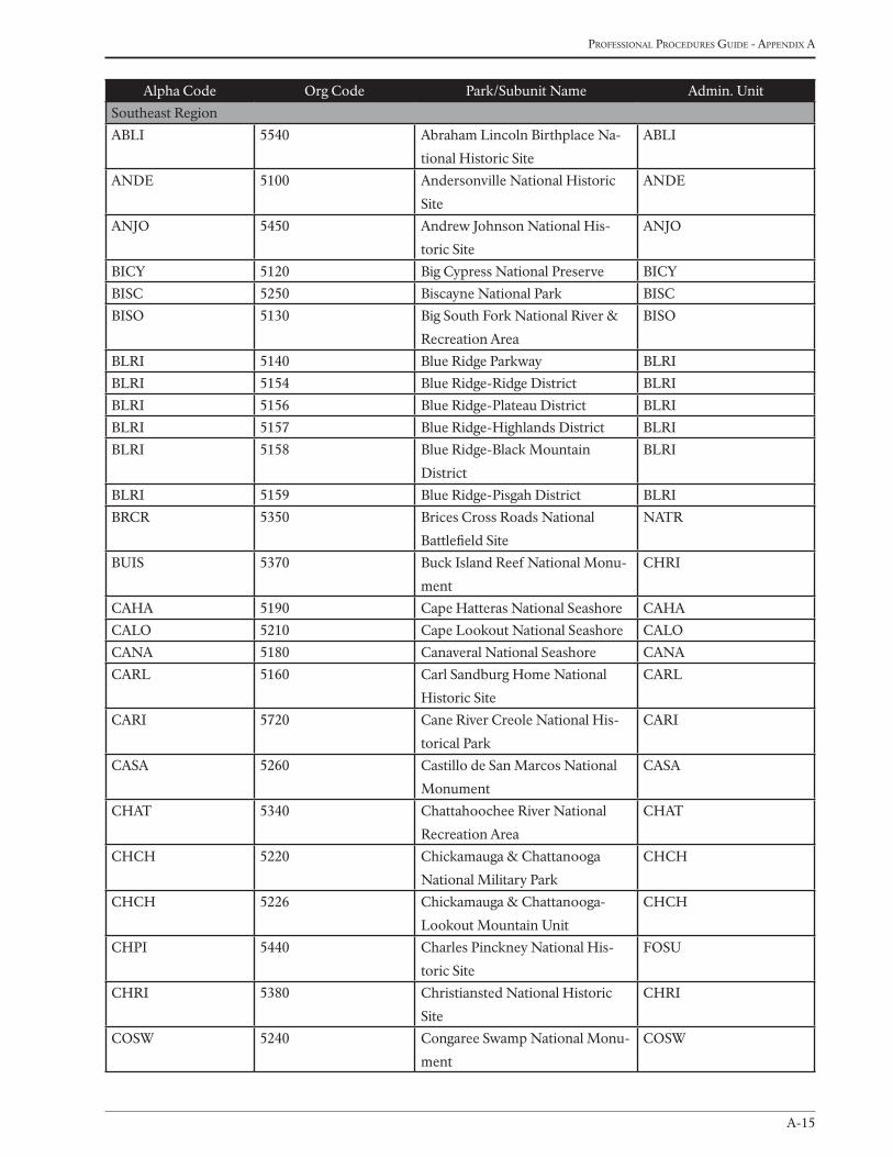
A-15
Professional Procedures Guide - aPPendix a
Alpha Code Org Code Park/Subunit Name Admin. Unit
Southeast Region
ABLI 5540 Abraham Lincoln Birthplace Na-
tional Historic Site
ABLI
ANDE 5100 Andersonville National Historic
Site
ANDE
ANJO 5450 Andrew Johnson National His-
toric Site
ANJO
BICY 5120 Big Cypress National Preserve BICY
BISC 5250 Biscayne National Park BISC
BISO 5130 Big South Fork National River &
Recreation Area
BISO
BLRI 5140 Blue Ridge Parkway BLRI
BLRI 5154 Blue Ridge-Ridge District BLRI
BLRI 5156 Blue Ridge-Plateau District BLRI
BLRI 5157 Blue Ridge-Highlands District BLRI
BLRI 5158 Blue Ridge-Black Mountain
District
BLRI
BLRI 5159 Blue Ridge-Pisgah District BLRI
BRCR 5350 Brices Cross Roads National
Battlefield Site
NATR
BUIS 5370 Buck Island Reef National Monu-
ment
CHRI
CAHA 5190 Cape Hatteras National Seashore CAHA
CALO 5210 Cape Lookout National Seashore CALO
CANA 5180 Canaveral National Seashore CANA
CARL 5160 Carl Sandburg Home National
Historic Site
CARL
CARI 5720 Cane River Creole National His-
torical Park
CARI
CASA 5260 Castillo de San Marcos National
Monument
CASA
CHAT 5340 Chattahoochee River National
Recreation Area
CHAT
CHCH 5220 Chickamauga & Chattanooga
National Military Park
CHCH
CHCH 5226 Chickamauga & Chattanooga-
Lookout Mountain Unit
CHCH
CHPI 5440 Charles Pinckney National His-
toric Site
FOSU
CHRI 5380 Christiansted National Historic
Site
CHRI
COSW 5240 Congaree Swamp National Monu-
ment
COSW
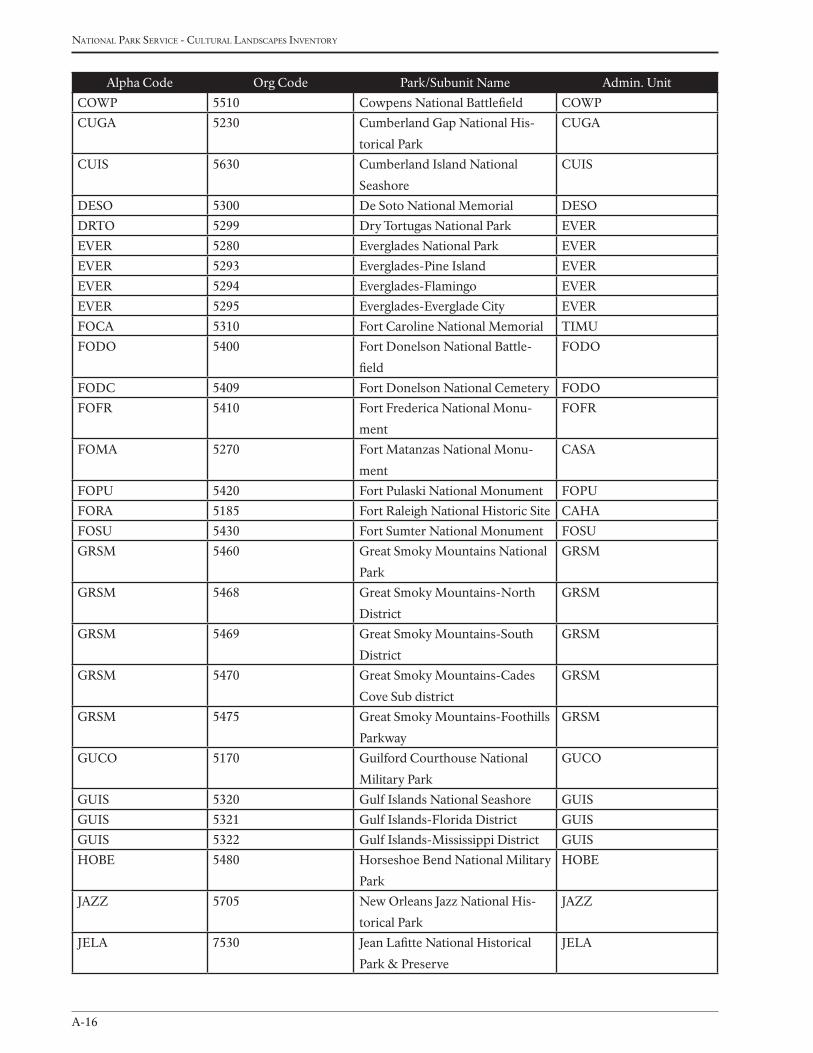
national Park service - cultural landscaPes inventory
A-16
Alpha Code Org Code Park/Subunit Name Admin. Unit
COWP 5510 Cowpens National Battlefield COWP
CUGA 5230 Cumberland Gap National His-
torical Park
CUGA
CUIS 5630 Cumberland Island National
Seashore
CUIS
DESO 5300 De Soto National Memorial DESO
DRTO 5299 Dry Tortugas National Park EVER
EVER 5280 Everglades National Park EVER
EVER 5293 Everglades-Pine Island EVER
EVER 5294 Everglades-Flamingo EVER
EVER 5295 Everglades-Everglade City EVER
FOCA 5310 Fort Caroline National Memorial TIMU
FODO 5400 Fort Donelson National Battle-
field
FODO
FODC 5409 Fort Donelson National Cemetery FODO
FOFR 5410 Fort Frederica National Monu-
ment
FOFR
FOMA 5270 Fort Matanzas National Monu-
ment
CASA
FOPU 5420 Fort Pulaski National Monument FOPU
FORA 5185 Fort Raleigh National Historic Site CAHA
FOSU 5430 Fort Sumter National Monument FOSU
GRSM 5460 Great Smoky Mountains National
Park
GRSM
GRSM 5468 Great Smoky Mountains-North
District
GRSM
GRSM 5469 Great Smoky Mountains-South
District
GRSM
GRSM 5470 Great Smoky Mountains-Cades
Cove Sub district
GRSM
GRSM 5475 Great Smoky Mountains-Foothills
Parkway
GRSM
GUCO 5170 Guilford Courthouse National
Military Park
GUCO
GUIS 5320 Gulf Islands National Seashore GUIS
GUIS 5321 Gulf Islands-Florida District GUIS
GUIS 5322 Gulf Islands-Mississippi District GUIS
HOBE 5480 Horseshoe Bend National Military
Park
HOBE
JAZZ 5705 New Orleans Jazz National His-
torical Park
JAZZ
JELA 7530 Jean Lafitte National Historical
Park & Preserve
JELA
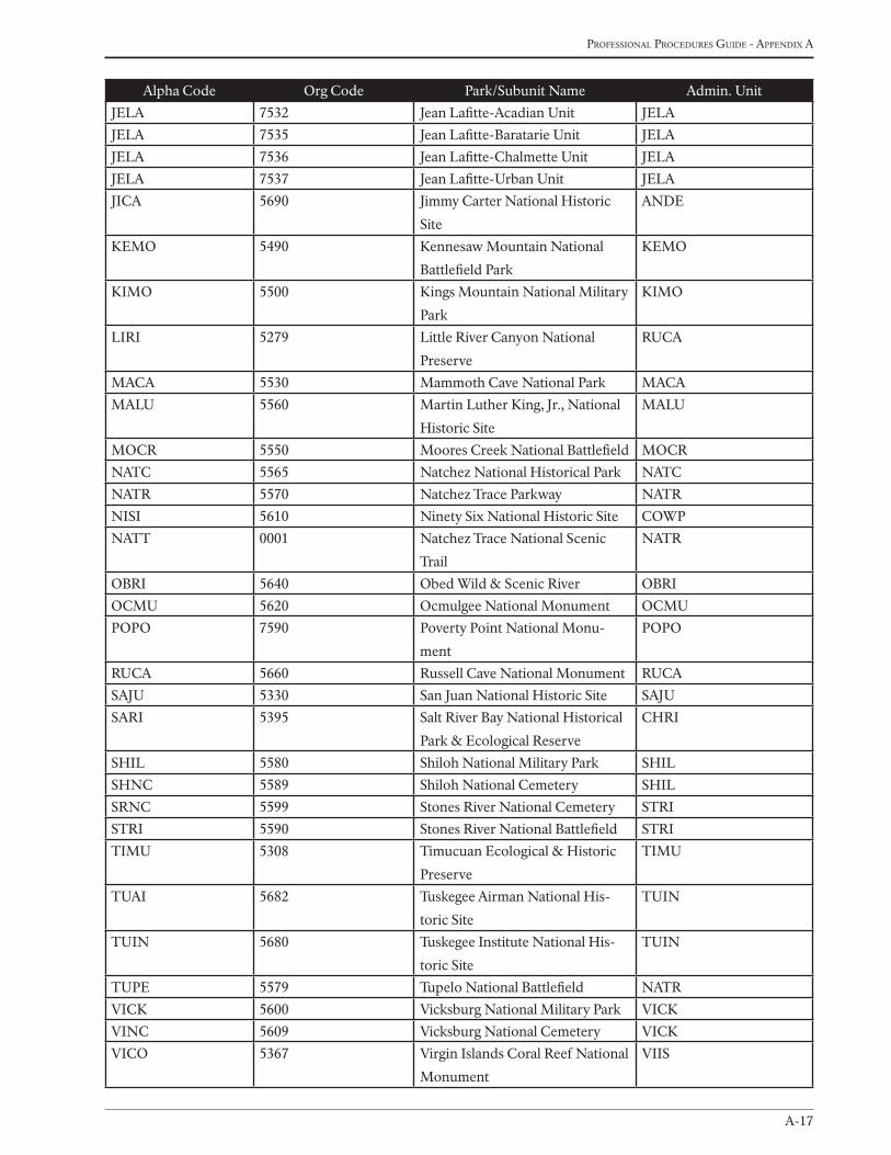
A-17
Professional Procedures Guide - aPPendix a
Alpha Code Org Code Park/Subunit Name Admin. Unit
JELA 7532 Jean Lafitte-Acadian Unit JELA
JELA 7535 Jean Lafitte-Baratarie Unit JELA
JELA 7536 Jean Lafitte-Chalmette Unit JELA
JELA 7537 Jean Lafitte-Urban Unit JELA
JICA 5690 Jimmy Carter National Historic
Site
ANDE
KEMO 5490 Kennesaw Mountain National
Battlefield Park
KEMO
KIMO 5500 Kings Mountain National Military
Park
KIMO
LIRI 5279 Little River Canyon National
Preserve
RUCA
MACA 5530 Mammoth Cave National Park MACA
MALU 5560 Martin Luther King, Jr., National
Historic Site
MALU
MOCR 5550 Moores Creek National Battlefield MOCR
NATC 5565 Natchez National Historical Park NATC
NATR 5570 Natchez Trace Parkway NATR
NISI 5610 Ninety Six National Historic Site COWP
NATT 0001 Natchez Trace National Scenic
Trail
NATR
OBRI 5640 Obed Wild & Scenic River OBRI
OCMU 5620 Ocmulgee National Monument OCMU
POPO 7590 Poverty Point National Monu-
ment
POPO
RUCA 5660 Russell Cave National Monument RUCA
SAJU 5330 San Juan National Historic Site SAJU
SARI 5395 Salt River Bay National Historical
Park & Ecological Reserve
CHRI
SHIL 5580 Shiloh National Military Park SHIL
SHNC 5589 Shiloh National Cemetery SHIL
SRNC 5599 Stones River National Cemetery STRI
STRI 5590 Stones River National Battlefield STRI
TIMU 5308 Timucuan Ecological & Historic
Preserve
TIMU
TUAI 5682 Tuskegee Airman National His-
toric Site
TUIN
TUIN 5680 Tuskegee Institute National His-
toric Site
TUIN
TUPE 5579 Tupelo National Battlefield NATR
VICK 5600 Vicksburg National Military Park VICK
VINC 5609 Vicksburg National Cemetery VICK
VICO 5367 Virgin Islands Coral Reef National
Monument
VIIS

national Park service - cultural landscaPes inventory
A-18
Alpha Code Org Code Park/Subunit Name Admin. Unit
VICR 5360 Virgin Islands National Park VIIS
WRBR 5187 Wright Brothers National Memo-
rial
CAHA
B-1
Professional Procedures Guide - aPPendix B
Appendix B
examPles of landscaPe/comPonentlandscaPe descriPtionsJAnuAry 2009
B-2
national Park service - cultural landscaPes inventory
The TelAquAnA Corridor hisToriC disTriCT
lake Clark national park and preserve (Alaska region)
The Telaquana Corridor Historic District (TCHD) is a historic vernacular and ethnographic landscape within
Lake Clark National Park and Preserve, significant under Criteria A and D. It is a well known route from the
Dena’ina winter village of Kijik on the shores of Lake Clark to Telaquana Lake and another village on Trail Creek
(Ch’qulch’ishtnu). A fish camp also existed on the north bank of the Telaquana River near the outlet of Telaquana
Lake. The Telaquana Corridor was an important route which connected the greater Lake Clark and Iliamna regions
with villages on the Mulchatna, Stony River and Kuskokwim drainages, its period of significance is 1860 to 1940.
After 1900 the route became important to Euro-American trappers and miners and was the main route of migration
when the Dena’ina finally abandoned the inland villages for the more accessible villages of Kijik and Nondalton. As
an ethnographic landscape the district maintains remarkable integrity and today it is popular with hikers, big game
hunters, and fishermen.
The Telaquana Corridor Historic District is defined by a corridor approximately a mile wide and 50 miles long, that
runs from Kijik to Telaquana Lake, encompassing known historic routes, natural features and other tangible objects
and sites in the landscape which contribute to the significance of the District. Many of these features are within the
main Corridor boundary, however some are not. The inclusion of these discontinuous sites are justified given their
association with and significance to the District. The size of this District is approximately 56,638 acres. A narrative
boundary description and justification for these boundaries can be found in the boundary description section of this
document. Throughout this document the terms District, Corridor, TCHD, Telaquana Corridor, Telaquana Trail or
simply ‘the Trail’ are utilized, and are, for the purposes of this document, synonymous.
ChisAnA-Gold hill MininG lAndsCApe
Wrangell-st. elias national park and preserve (Alaska region)
Chisana - Gold Hill is a historic vernacular landscape that exemplifies the development of placer mining in Alaska,
advancing through a number of discrete stages and employing a broad range of technologies and equipment. Start-
ing with little more than a shovel and a gold pan, miners subsequently ground-sluiced promising creek bottoms and
hydraulic mined the adjoining benches. The period of significance for this landscape is 1913 to 1942.
The Chisana - Gold Hill Historic Mining Landscape is situated in south-eastern Alaska, just south of the Nutzotin
Mountains near the eastern headwaters of the Chisana River and on the north eastern edge of Wrangell-St. Elias
National Park and Preserve. Vegetation in the area is mainly associated with various tundra communities, inter-
spersed with low shrubs on the slopes and riparian areas along the creeks. The area is characterized topographically
by rolling hills and narrow, deeply incised valleys, with elevations ranging from 5,815 feet at the summit of Gold Hill
to 3,200 feet near the townsite of Chisana City. Its higher areas provide sweeping vistas of both the Wrangell and
Nutzotin Mountains.
While miners usually built seasonal residences near their claims, they eventually established several larger and more
distant communities as well. They also developed and maintained an extensive local transportation system, joining
Appendix B: exAMples of lAndsCApe/CoMponenT lAndsCApe
desCripTions
B-3
Professional Procedures Guide - aPPendix B
their mines, homes, and communities to the regional network which connected with Dawson City in the Yukon
Territory, and with McCarthy, Chitina, and Gulkana, in Alaska.
Many elements of the Chisana Historic Landscape could undoubtedly qualify for individual nomination to
the National Register of Historic Places. Others, more adversely impacted by the passage of time and the
region’s harsh subarctic environment, clearly lack such distinction. Together these buildings, structures, sites,
and objects contribute significantly to the integrity of the landscape as a whole. Their setting still conveys the
environmental characteristics of the district’s most significant era, the boom lasting from 1913 to 1915. Their
spatial organization reflects the area’s topographical advantages and constraints. Their diverse designs demon-
strate technological innovation as well as the miners’ continuously evolving needs. Their various construction
materials reveal the full range of locally available options. Their workmanship provides invaluable insight into
the skills, engineering practices, and aesthetic preferences of their day. Their feeling of isolation and abandon-
ment reflects the boom and bust cycle characteristic of all mining regions. When combined with their well-doc-
umented association with prominent people and events, these features convey a clear sense of the landscape’s
historic identity.
CAMp Grosvenor hisToriC disTriCT
Katmai national park and preserve (Alaska region)
Approximately 250 air miles south west of Anchorage, Alaska, Grosvenor Lake Lodge is one of the five origi-
nal fishing camps established by Ray Petersen in southwest Alaska during the 1950s. The camp sits on a small
peninsula separating lakes Grosvenor and Coville, where the physical constriction of the waterway makes the
fishing for rainbow trout ideal. Native house remains exist nearby (XMK-004), indicating that this has been an
excellent subsistence location for hundreds if not thousands of years. The Camp Grosvenor Historic District
(XMK-132) is a 2.34 acre historic district associated with the context of early tourism development in Alaska. It
is significant under Criterion A and Criterion Consideration G. Camp Grosvenor contains representative build-
ings from all of its major era’s of development and can be characterized as a historic vernacular landscape. A
determination of eligibility exists from 2002, and describes primarily the structures of the district. The district’s
period of significance is 1950 to 1959. This CLI updates the National Register of Historic Places eligibility
status of the district, adds a site specific chronology and site plan, describes the landscape characteristics, and
illustrates how these characteristics contribute to the integrity of the district.
folGer pArK
national Capital parks east - Capitol hill parks (national Capital region)
Folger Park is a two-acre park located in a residential neighborhood on Capitol Hill in Southeast Washington,
D.C., a couple of blocks south of the U.S. Capitol. It is a formal urban park bounded on the north and south by
D Street, on the west by 2nd Street, and on the east by 3rd Street. It lies within the corridor of North Carolina
Avenue, which touches the park at the northeast and southwest corners. The site is important as a component
of Andrew Ellicott’s 1792 revision of the 1791 L’Enfant Plan for Washington. As it exists today, the park is
mostly the result of National Park Service work conducted in 1936. There do not appear to be any remnants of
the original 1880s design.
Folger Park has two Periods of Significance: 1791-1792, when this area first appeared on Ellicott’s modification
of the L’Enfant Plan, and 1936, when it was redesigned. Except for vegetation, the park has not greatly changed
B-4
national Park service - cultural landscaPes inventory
since 1936. The vegetation conforms only in the most general way to the 1936 design – grass panels, street trees,
densely grouped trees and shrubs behind the benches at the east and west ends, bordering privet hedges, and trees
on the grass panels. Most of the trees planted in 1936 have died.
First developed in the 1880s under the jurisdiction of the Office of Public Buildings and Grounds (OPBG), U.S. Army
Corps of Engineers, the original design was symmetrical but picturesque, with curving gravel walks and dense plant-
ings. The two main curved walks formed several oval grass panels. A circular fountain, with a granite coping and a
single spray, occupied a central plaza. Surrounded by rows of street trees, the park contained dense plantings of trees
and shrubs, many of them flowering.
From its creation in the mid-1880s through the end of the nineteenth century, Folger Park appears to have been well
maintained. In 1905 it still retained an abundance of native and non-native plantings. By the 1920s, however, many
of its trees and shrubs had been lost; probably, like most of the downtown and Capitol Hill parks, it had begun to suf-
fer from poor or irregular maintenance. The condition of these parks led to their major overhaul in the 1930s, when
not only Folger Park but also Franklin Park and Lincoln Park were entirely redesigned with funding from President
Franklin D. Roosevelt’s New Deal programs, primarily the Public Works Administration (and perhaps the Works
Progress Administration as well). New circulation systems were developed for these three parks that established
axial alignments of walks oriented to the cardinal directions (as is the Washington street grid); these axes were over-
laid on curving oval walks that followed the parks’ perimeters. Simpler vegetative palettes, comprising lines of trees
circling the park and informally arranged trees on grass panels, replaced the earlier profusion of trees and shrubs in a
multitude of species and varieties.
The new design of Folger Park featured a cross-shaped arrangement of double parallel asphalt walks set within an
oval walk that ran near the park’s boundary. Entrances at the four corners connected with the oval walk; entrances at
the mid-points of each of the four sides led to a central square plaza, paved with flagstones and featuring an octago-
nal “wading” pool. The new circulation established strong east-west and north-south axes. Four rectangular flower
beds were to be contained in the arms of the cross. This circulation layout remains largely intact today, along with its
original bituminous concrete paving material and the flagstone paving of the plaza.
Placed at the east and west ends of the long axis were identical structures composed of a drinking fountain flanked
by twin benches. These were constructed of exposed-aggregate concrete. Centered in the wall behind each fountain
was a red cast-concrete plaque depicting the park’s new plan. With their classical references – the exedral form (twin
benches forming a niche), and drinking fountains shaped like sections of a Doric column – and stylized appearance,
the structures are late Art Deco.
Unlike the circulation and structures, it is not known how much of the 1936 planting plan was carried out. A single
photograph of 1964 showing one quadrant of the park suggests the planting was mostly implemented, but most of
the trees have since died. The 1936 plan called for trees and shrubs to be added in each quadrant of the park, with
the resulting composition almost entirely symmetrical across the park as a whole. Open lawns were to be planted
with deciduous trees, the majority of them oriental plane trees. Looser arrangements of shrubs interspersed with
trees were to form identical backdrops behind each of the fountain bench structures. Privet hedges surrounded the
grass panels.
Sometime before 1964, the wading pool was converted into a planter for annuals and roses. A planting plan of 1984
called for the addition of several new trees to augment existing vegetation, which was then sparse.
Today, the lines of street trees remain, though most of them have numerous gaps. The arrangement of trees within
the park is quite different from that called for in 1936. Instead of numerous trees placed informally, but symmetri-
B-5
Professional Procedures Guide - aPPendix B
cally, across the grass panels, only a single tree now grows on most panels. The 1984 plan reveals that the four panels
with curved sides within the oval walk had pairs of trees (a Southern magnolia and a copper beech) situated along
the north-south walks; today two of these pairs exist, and of the other two, only a single tree remains. Privet hedges
remain around the park’s perimeter. Plantings of somewhat different, simpler composition than shown in the 1936
plan create backdrops behind the fountain and bench structures. Many of the street trees have died; only D Street, to
the south, retains a nearly unbroken line of trees.
Most of the park’s small-scale features date from the 1936 redesign. The remaining significant features are the iron
frame and wood-slat benches, a design developed for National Capital Parks in the mid-1930s, and the quarter-
round concrete curbs, a type of boundary element first used in the city parks in 1904/1905. Lights and trash recep-
tacles are more recent additions.
The most important vistas from the park are along its east-west and north-south axes. The view to the south opens
out to a large green space, former site of Providence Hospital.
lAdy Bird Johnson MeMoriAl pArK
George Washington Memorial parkway - lady Bird Johnson park (national Capital region)
Lady Bird Johnson Park is a constructed 157-acre island that extends along the Virginia shore of the Potomac River,
directly across from West Potomac Park in Washington, D.C. The island lies within the boundary of the District of
Columbia and is administered by the George Washington Memorial Parkway. When viewed from Washington, the
spreading lawns of Lady Bird Johnson Park serve as a verdant, open foreground to Arlington National Cemetery and
Arlington House, the Robert E. Lee Memorial, on the Virginia hills to the west.
Originally known as Columbia Island, the island was created between about 1915 and 1930 to serve as the western
terminus of Arlington Memorial Bridge and a symbolic entrance into Nation’s Capital. A traffic circle, known as
Memorial Circle, marks the intersection of the bridge axis with two roadways, Mount Vernon Memorial Highway,
completed mostly by 1932 and running between Arlington Memorial Bridge and Mount Vernon, and George Wash-
ington Memorial Parkway, completed in 1965, and extending from Arlington Memorial Bridge to the Capital Beltway,
I-495 (since the 1930s, Mount Vernon Memorial Highway has formed the southern section of George Washington
Memorial Parkway). Two pairs of classical pylons flank Memorial Circle on the east and west, framing the entrances
to Arlington Memorial Bridge and Memorial Avenue, respectively. The Mount Vernon Trail, a multi-use trail for
walkers and bikers, runs through a broad, grassy verge between the parkway and the river.
The island is traversed by a complex system of roadways that include ten bridges, many of them faced with granite.
Though certain circulation features, particularly the composition centered around the western end of Arlington
Memorial Bridge and Memorial Circle, retain vestiges of a City Beautiful formality, most of the island’s landscape is
a simple, modern design based on picturesque landscape aesthetics. Much of the terrain is undulating and covered
with lawns. Groupings of deciduous and evergreen trees frame and define views for motorists and pedestrians. Nu-
merous native tree species have been retained.
The western boundary of the island is defined by two constructed water features. The narrow Boundary Channel
flows from the river at the north end of the island, passing between the island and the Virginia shore and emptying
at the south into the artificial lagoon called Columbia Lagoon (also known as Columbia Basin or Pentagon Lagoon).
The flow of the channel reverses during the incoming tide. The small Columbia Marina is situated on the eastern
shore of the basin, opposite the Pentagon.
B-6
national Park service - cultural landscaPes inventory
Two monuments are located at the island’s southern end. The Navy-Marine Memorial, an aluminum sculpture
depicting sea gulls flying over a curling wave, was designed to honor sailors lost at sea. Constructed in the 1920s,
the memorial was not placed in its current location until 1934. A component landscape, the Lyndon Baines John-
son Memorial Grove on the Potomac, was built in the 1970s in memory of the late president. The Memorial Grove
juxtaposes a secluded meadow, sheltered by trees and berms, with a white pine grove surrounding an open plaza
containing a large stone monolith. From this plaza visitors gain dramatic views of East and West Potomac Parks and
the Washington Monument.
No extensive landscaping was carried out on the island until the 1950s. In the intervening decades a native riparian
growth became established, particularly along the shorelines. A succession of landscaping and development plans
was prepared for the island over the years. About 75 flowering trees were planted along Mount Vernon Memorial
Highway on the south end of the island in the early 1930s, and grass was seeded for lawns. However, it was not until
the 1960s that landscaping of the entire island was undertaken under the Johnson administration’s Beautification
Program and a planting plan developed by landscape architect Edward D. Stone, Jr. Large drifts of daffodils and
massed flowering dogwoods and other trees were planted, with initial planting efforts focused on developing the area
around Memorial Circle.
Over the last 30 years the Stone plan has been implemented in phases. Thousands of the original dogwoods have
been lost, and daffodil beds have been altered and thinned. Locally native species of trees of similar character have
been substituted for some that have failed to thrive.
The island’s Period of Significance has been defined as extending from 1915, the year when deposition of dredged
material for the island is believed to have begun, to 1979, the date of the last known revision of the planting plan de-
veloped by landscape architect Edward D. Stone, Jr., and implemented in phases by the National Park Service. This
period includes construction of the island; construction of all its major features, including roads, bridges, and the
two memorials; and the Beautification Program (1964-1968) and conception and initial implementation of the Stone
planting plan, developed under the Beautification Program.
The MAll
national Mall (national Capital region)
The central area of the Mall, within this inventory’s study boundaries, is a rigorously simple but monumental land-
scape that encompasses 135 acres between 3rd and 14th Streets, and Madison and Jefferson Drives, N.W., in the
center of Washington, D.C. The National Park Service oversaw the implementation of the plan, mostly in the 1930s,
with strong design support and legislative assistance from the National Capital Planning Commission; the 1930s
plan followed the 1902 McMillan Plan, which sought to revive the conception of the 1791 L’Enfant Plan for a broad
promenade lined by fine buildings and gardens that would form the center of the capital city’s cultural and social
life. The Periods of Significance extend from 1791-1792, the date of the L’Enfant Plan and its revision by Andrew El-
licott, and 1902-1975, extending from the date of the McMillan Plan to the year when the last tree panel on the Mall
was planted, following the removal of the last temporary military buildings in 1971. The Mall retains a high level
of historic integrity, and is in fair condition overall. The major problems affecting the Mall are soil compaction and
chronic wear and tear on the turf caused by recurrent visitor use (both passive, individual use and far more intrusive
organized activities); and the unevenness of the elm canopy, caused by later in-fill plantings, construction activities,
over fifty years of Dutch elm disease losses, and the incompatible form of some replacement elms.
B-7
Professional Procedures Guide - aPPendix B
The creation of this linear landscape opened the view between the United States Capitol and the Washington Monu-
ment. The landscape, view, and spatial organization of the Mall are all interdependent and reinforce each other.
Central grass panels are flanked north and south by panels planted with four rows each of American elm trees,
almost six hundred in all. A few dozen elms remain from an early planting in the 1920s, and some portion of the rest
date from the major planting in 1935. Others are replacements planted since the 1930s, many of them cultivars of a
disease-resistant elm from the 1930s planting; there are a few other cultivars or varieties as well, and several trees of
other species.
Behind the lines of elms, imposing museum buildings designed in Victorian, Beaux-Arts classical, and modern styles
line the Mall on the north and south. Two sculpture gardens are located at the north and south along the 8th Street
cross axis, designated as an important element on the L’Enfant Plan.
The landscape is overlaid with a grid of walks and cross walks. The two former inner Mall drives, parallel to Madi-
son and Jefferson Drives, have been converted into gravel walks. Single or paired gravel and concrete walks follow
the routes of most cross-axial streets, except 11th Street. Fourth and 7th Streets are surface roads that cross the Mall,
and 9th and 12th Streets are tunneled beneath it. All street curbs are granite.
Benches designed in a historic, standard National Capital Region style are placed along the outer edges of the east-
west walks and the inner edges of the walks along Madison and Jefferson Drives. All benches face the center of the
Mall. Light standards in a style designed specifically for the Mall in the 1930s and trash receptacles designed in the
1960s are located between the benches along the inner Mall Walks. Other features include four small food service
buildings and short sections of post-and-chain barriers.
A few constructed areas interrupt the continuity of the lines of elms, but do not detract from the monumental land-
scape. The Smithsonian Castle extends to within 300 feet of the Mall’s center line. The sunken sculpture garden
of the Hirshhorn Museum also extends into a Mall tree panel, and has its own varied planting palette. An entrance
to an underground Metro station is located in a tree panel between the Freer Gallery of Art and the Department of
Agriculture building, and a small permitted carousel is situated in the tree panel in front of the Arts and Industries
building.
union squAre
national Mall (national Capital region)
Union Square is the section of the Mall located between 1st and 3rd Streets, N.W. and S.W., Pennsylvania Avenue,
N.W. and Maryland Avenue, S.W. The wedge-shaped site lies at the foot of Capitol Hill and functions as an interme-
diate landscape between the Capitol Grounds and the Mall. The enormous memorial to Ulysses S. Grant (installed
1922) extends for 250+ feet across the site’s east end, parallel to and a short distance from 1st Street. The memorial
comprises a raised marble platform with balustraded ends at north and south and long flights of stairs to east and
west. The bronze figure of Grant sitting quietly on his horse occupies the center. The figure, on a high marble ped-
estal, is flanked at the north and south ends by bronze groups of men and horses, representing Cavalry and Artillery
respectively, which, in contrast to the still figure of Grant, depict violent action.
Planting beds at the ends of the platform help tie it visually to the ground. Tall hedges of yew and a few boxwood
also anchor the sculpture group and screen views of the traffic along 1st Street. Groups of trees beyond the hedges
in the park’s northeast and southeast corners help frame the composition; several of these trees are remnants of the
nineteenth-century Botanic Garden plantings.
B-8
national Park service - cultural landscaPes inventory
A six-acre wedge-shaped pool, with a broad, simple limestone coping, occupies the central third of the site and is set
slightly below ground level. The pool and its circulation system were designed by Skidmore, Owings & Merrill and
installed in 1969-1971. Stairs lead down to the pool and its surrounding pavement on three sides. West of the pool is
a large limestone and concrete plaza, demarcated by tall concrete bollards and Bacon Twin Twenty lights at the west
end. Union Square’s western end is occupied by a grass panel, crossed by two asphalt walks parallel to the diagonal
lines of Pennsylvania and Maryland Avenues, which divide the panel into three sections. Large old trees, including
more remnants of the Botanic Garden planting, and a number of younger trees occupy the other grass panels; the
groupings themselves are remnants of the trees landscape architect Frederick Law Olmsted Jr. used in his design for
Union Square. Sidewalks surround the square on all four sides.
CAdillAC MounTAin suMMiT
Acadia national park (northeast region)
Cadillac Mountain summit is a National Park Service (NPS) developed area in Acadia National Park, located in
Hancock County, Maine. Acadia was the first national park established east of the Mississippi River and today en-
compasses over 47,000 acres across Mount Desert Island, the Schoodic Peninsula, and other smaller islands. Cadil-
lac Mountain is the highest point on the Atlantic coast between Labrador and Brazil, and the highest mountain on
Mount Desert Island. The rocky summit features three high points, or “peaks,” dominated by broad granite ledges
and outcrops interspersed with shrubs and grasses and lesser amounts of mixed conifer woodland and forest. Access
to the summit is primarily from Cadillac Mountain Road, a segment of the park’s historic motor road system that
climbs the mountain’s north and west slopes and terminates as a broad, tear drop-shaped loop nestled between the
eastern and middle peaks. Three of the park’s historic trails also ascend the mountain and connect to the site’s walk-
ways, trails, and parking areas organized around the loop. Visitor facilities at the summit are limited to a small conces-
sion and restroom building on a wooded slope below the middle peak, well away from views of the island-studded
horizon and the Atlantic Ocean. Additional parking is provided below the west peak, at the Blue Hill overlook, which
offers views to Eagle Lake and the ranges of mountains that march to the west. The Cadillac Mountain summit is the
most popular visitor attraction in the park, and on a typical summer’s day around 6,000 visitors make the journey
there.
HISTORICAL OVERVIEW
Since the 1850s, the story of Mount Desert Island’s tallest mountain has been about getting to the top and experi-
encing the spectacular views. Early walkers and hikers ascended the mountain’s north slope along a rough path that
was improved by the government to access a survey station. As the island’s summer population and tourist economy
grew, additional trails were blazed to the summit from the east and south, and another road was built along the north
ridge for the locally popular “buckboard” horse-drawn wagons. A small hotel/boarding house served travelers on
the mountain’s wind-swept middle peak until 1883 when a much larger Victorian-style hotel was constructed on the
same peak and just steps from the terminus of a cog railroad. The hotel and railroad were the vision of a local entre-
preneur named Frank Clergue, and were initially quite successful despite a devastating fire that meant rebuilding the
hotel on the summit’s eastern peak. The cog railroad climbed the mountain’s wooded west slope from Eagle Lake to
the summit, but by 1890 was closed, partly because of a new carriage road that offered a quicker trip to the summit
from Bar Harbor. By the late 1890s the Summit Hotel was razed. All that remains of these ventures today are some
stone foundations and a few iron bolts that once secured the railroad line to the mountain’s granite ledges.
B-9
Professional Procedures Guide - aPPendix B
Cadillac Mountain summit and around 6,000 acres of land on Mount Desert Island became part of Sieur de Monts
National Monument in 1916 (renamed Lafayette National Park in 1919 and then Acadia National Park in 1929).
However, it was not until the late 1920s when access to the summit was improved. In the early 1920s, the carriage
road had badly deteriorated, prompting the park’s first superintendent, George B. Dorr, to include a summit motor
road in the park’s motor road proposal. Construction on the first motor began in 1922 but was soon halted by a small
but vocal opposition that eventually lead to hearings in Washington, D.C. Construction on the motor road (later
named Jordan Pond/Eagle Lake Road) resumed in 1924, and at that time surveying and preliminary grading for Ca-
dillac Mountain Road began. Jordan Pond/Eagle Lake Road was completed in 1927, but on Cadillac Mountain Road,
the mountain’s granite proved to be a formidable obstacle and by 1928 the Department of Agriculture’s Bureau of
Public Roads (now the Federal Highways Administration), in partnership with the NPS, took the lead on the project.
When Cadillac Mountain Road was opened to traffic in October 1931, it was widely praised as an excellent example
of outstanding road construction in mountainous terrain and in the use of the NPS Rustic Design style.
Parking at the summit initially consisted of a small lot prior to the motor road’s terminal loop. Realizing more parking
was needed, and that visitors would likely wish to stop and walk around to enjoy the views, NPS designers imple-
mented plans for a much larger parking area within the terminal loop as well as new walkways and trails. A Ranger
Station, restrooms, and a small refreshment stand called the Cadillac Tavern were constructed between 1932 and
1934, and were inconspicuously sited on a wooded slope between the middle peak and parking area so as not to
impact the viewsheds. Like the motor road, the new facilities and circulation features also demonstrated the Rustic
Design style and visually blended in with the surrounding landscape.
Much of the trail work on the summit and throughout Acadia National Park was completed by the Civilian Conser-
vation Corps (CCC), one of the Roosevelt administration’s New Deal programs. In 1933, under the supervision of
NPS landscape architects, the CCC constructed the paved loop trail around the eastern peak. The CCC built several
other connector trails from the summit parking area to the visitor facilities, and installed new plantings in several
locations at the summit and along the motor road to hide construction scars. Projects involving trail maintenance,
seeding, and sodding continued until 1941 when the CCC participated in building the first of two military radar sta-
tions on the summit. Soon after converting the tavern into barracks in 1942, the CCC disbanded and the summit was
closed for the duration of World War II.
The two radar station complexes and the tavern were removed after the war and the summit was reopened. A radio
transmitter complex was built near the old tavern site beginning in the 1950s, and in 1966 a new parking and over-
look area was developed below the western peak, now called the Blue Hill overlook. By 1983, the Ranger Station
was removed and replaced by a new concession building constructed in the same location and design as the historic
building. Today, the Cadillac Mountain summit remains one of the most popular developed areas in the park, its
panoramic views drawing countless visitors from sunrise to sunset.
SIGNIFICANCE SUMMARY
On June 29, 2007, the “Historic Resources of Acadia National Park” Multiple Property Documentation Form
(MPDF) was accepted by the National Register for Historic Places. The MPDF identified the Cadillac Mountain
summit as a developed area within the “Visitor Facilities and Developed Areas” property type and identified contexts
and registration requirements with which to evaluate this type of park resource. One segment of the park’s motor
road system and three segments of the park’s hiking trail system provide access to the summit. The Maine State His-
toric Preservation Office concurred with NPS determinations that the motor road system on Mount Desert Island
and the park’s hiking trails were eligible for listing on the National Register (March 26, 1993 and December 17, 2001,
B-10
national Park service - cultural landscaPes inventory
respectively). These motor road and trail segments are contributing features for the site, but because only portions of
them are within the site’s boundaries, the individual significance of each segment is not evaluated in this report. Both
the motor road system and hiking trail system are considered separate property types with unique periods of signifi-
cance. They will be evaluated in future Cultural Landscape Inventories.
The Cadillac Mountain summit is significant under Criterion A for its association with the context identified in the
MPDF, “Community Development and the Origins of Acadia National Park (1890-1937),” in the area of entertain-
ment/recreation. It is locally significant for its development as a major visitor destination and developed area in the
park. The construction of Cadillac Mountain Road beginning in 1928 and the subsequent construction of visitor fa-
cilities, walkways, and overlook trails made possible unprecedented public access to the mountain and its panoramic
views and vistas. The summit is also significant under Criterion C for its association with the context identified in the
MPDF, “Rustic Design of the National Park Service (1916-1958),” in the area of landscape architecture. It is locally
significant for its retention of rustic design characteristics and features as implemented by the National Park Service
(NPS), Bureau of Public Roads (BPR), and Civilian Conservation Corps (CCC). The design and construction of these
features effectively illustrates the harmonization of built features with the park’s natural scenery.
The period of significance for the Cadillac Mountain summit begins in 1928, when the BPR finalized the alignment of
Cadillac Mountain Road. It continues through the early 1930s when the motor road was opened for traffic, pedestri-
an circulation features were constructed, and visitor facilities were built. The CCC installed and maintained addition-
al trails, service roads, and plantings through 1941 when they helped build a military radar station complex at the site.
The period of significance ends in 1942 when the CCC converted one of the summit buildings into barracks for the
station. It was one of their last projects at the summit before the CCC program was disbanded due to World War II.
ANALYSIS AND EVALUATION SUMMARY AND CONDITION
Significant landscape characteristics and features from the period of significance remain important to the unique
identity of the Cadillac Mountain summit today. They include: natural systems and topography, spatial organization,
land use, vegetation (CCC plantings, turf areas in parking areas and trailheads), circulation (a portion of Cadillac
Mountain Road, summit parking area and attendant site details, overflow parking lot, portions of three park trails,
Cadillac Summit Loop Trail, connecting trails and stone steps around Cadillac Summit Center area, and two service
roads), views (from the summit area, from the Blue Hill overlook), and several archeological sites. Of these, features
associated with natural systems and topography, circulation, and views are the most important in defining the site’s
character.
After 1942, minor changes were made to the layout of the summit parking area; new types of curbing, steps, and a
guardwall were introduced; and historically separate visitor facilities were consolidated in a new single concession/
restroom building. Nevertheless, the analysis in this report concludes that the site retains integrity in location, design,
setting, materials, workmanship, feeling, and association to convey its historic significance. The developed area still
occupies the summit and provides access to the scenic views. The site continues to display the harmonization of NPS
Rustic Style design elements with the summit’s natural features, with only a few modern intrusions. Materials have
generally been maintained, and workmanship is still evident in some of the site details. Together, these qualities have
sustained the site’s historic character and feeling, and supported its continued use as a scenic recreational destination
at Acadia National Park. Lastly, there remains a strong association with work of the BPR and NPS, the CCC, and the
NPS Rustic Design style.
The condition of the landscape at the time of this report’s completion is evaluated as “fair” due to the loss of soil
and vegetation and sections of uneven surfaces along trails and walkways that have been caused by a combination of
years of heavy visitor use and by severe weather.
B-11
Professional Procedures Guide - aPPendix B
floyd BenneTT field
Gateway national recreation Area (northeast region)
Floyd Bennett Field, part of the Jamaica Bay Unit of Gateway National Recreation Area, located southeast of Brook-
lyn, New York, is a 1,450-acre former municipal airport and Naval Air Station on an island in Jamaica Bay. Floyd
Bennett Field is surrounded by water on three sides and is connected to Brooklyn and the Rockaway peninsula by
bridges. The site is now used largely for recreational purposes, such as for community gardening, model airplane
flying, and sporting activities, and by several on-site partners such as the New York City Police Department, the New
York City Department of Sanitation, and as an Armed Forces Reserve Center. The site is characterized by features
dating to the municipal and Naval Air Station eras including runways, airplane hangars, and World War II-era service
buildings, as well as by newer recreation-related features dating to the NPS period such as a modern sports facility,
picnic and campground areas, and community gardens.
HISTORICAL OVERVIEW
Floyd Bennett Field is significant for the period between 1928 and 1945, representing the development of New
York’s first municipal airport and the development of a major Naval Air Station during World War II. New York City
purchased the site of the future airport, Barren Island, in the 1920s in the hopes of developing a large regional port
in Jamaica Bay. When this plan failed to materialize, the property was chosen as the site of the first municipal airport
in New York, closely following the opening of Newark Airport in New Jersey. Construction began in 1928 and Floyd
Bennett Field was opened to commercial air traffic in 1931. The initial airport consisted of two perpendicular run-
ways and a line of buildings along Flatbush Avenue. The airport was enlarged by the Works Progress Administration
(WPA) who provided the design expertise and labor to expand the airport’s capacity throughout the 1930s. By 1942,
the Navy, who had been an on-site partner since the airport’s inception, purchased Floyd Bennett Field from the
City of New York, renaming it Naval Air Station, New York, NY (NAS New York) and closed the facility to commer-
cial traffic. The Navy altered the airport extensively to accommodate the increased war-time activity. Runways were
lengthened, scores of new buildings were built, and access to the facility was altered to create a more secure location.
After 1945, Navy activity at the airfield decreased markedly, except for a brief escalation during the Korean War in
the 1950s, and the Navy leased out portions of the field to other military and other public agencies. The Navy trans-
ferred the property to the National Park Service (NPS) in 1972 and Floyd Bennett Field became part of the newly
established Gateway National Recreation Area.
SIGNIFICANCE SUMMARY
Floyd Bennett Field is associated with significant themes and contexts that fall within National Register criteria A,
B, and C. The property derives significance under Criterion A on a state level in the area of transportation for the
development of early municipal airports, and on a national level in the area of military for the development Naval Air
Stations on the home front in World War II. The site is significant on a state level under Criterion C for the design of
early municipal airports and on a local level for the design of Naval Air Stations during World War II. Floyd Bennett
Field is also significant under Criterion B for its association with important individuals in early aviation, including
Wiley Post, Howard Hughes, and Douglas Corrigan, however, further examination of Criterion B falls outside the
scope of this report. The period of significance for Floyd Bennett Field is 1928-1945, beginning with the construction
of the municipal airport and continuing through the end of World War II.
ANALYSIS AND EVALUATION SUMMARY
Floyd Bennett Field reflects the conditions of the municipal airport and Navy airport eras. Several dominant land-
scape characteristics convey the property’s historic character including spatial organization, circulation, vegetation,
B-12
national Park service - cultural landscaPes inventory
buildings and structures, and views and vistas. Historically, the flat terrain, open landscape, and proximity to water
created ideal conditions for an airport, where sight lines were readily available and access for seaplanes was plentiful.
Though initial airport development took place on a fraction of the land that was eventually included in the airport
boundary, outlying areas were characterized by low-growing native vegetation, much of which was inundated regu-
larly by the tides. Vegetation inside the airport was sparse, with the exception of a planting scheme at the airport en-
trance and Administration Building that included street trees and shrubs. As the City, WPA, and the Navy expanded
the airport in the 1930s and 1940s new circulation features and buildings altered the spatial organization of the site.
Runways, taxiways, aprons, roads, and parking lots were built to accommodate larger aircraft and increased numbers
of personnel. To increase the buildable acreage, the Navy built seawalls and filled land on the island’s perimeter. The
Navy added many new buildings, often in new clusters of development outside of the original airport boundary. By
1945, most of the island’s land mass was developed to some degree, contrasting with the sparse appearance of the
municipal airport era. New clusters of development on the north, south, and east sides of the island blocked some
direct water views but the historically flat and open character of the landscape remained due to the low growing
vegetation, flat terrain, and long, open view corridors of the runways and taxiways.
The Navy made some changes to the airbase after 1945, including the demolition of several hangars and barracks.
More significant alterations occurred during the NPS period beginning in 1972 when management objectives favored
natural resource goals and the creation of recreational opportunities. Successional vegetation was allowed to grow
in several formerly open expanses between the runways and along the northern extents of the site, impacting the
historically open view corridors.
Despite the changes made, many character defining aspects of the landscape remain today. The runways and taxiways
still create dramatic swaths of open, linear space. Clusters of development established during the municipal airport
and World War II eras remain, including Hangar Row and the Seaplane Patrol Base on Jamaica Bay. As such, the
study area retains integrity of location, design, setting, materials, workmanship, feeling, and association to the period
of significance, 1928-1945. The condition of the landscape is fair. The growth of unmanaged vegetation in areas that
were formerly maintained has impacted the condition. Likewise, numerous buildings on site are in disrepair.
forT poinT uniTed sTATes CoAsT GuArd sTATion hisToriC disTriCT
Golden Gare national recreation Area (pacific West region)
The United States Coast Guard (U.S.C.G.) Fort Point Station is a five-acre historic district located in the Golden Gate
National Recreation Area in California. It is sited within the boundaries of the Presidio of San Francisco National
Historic Landmark (NHL) along the protected waters of the San Francisco Bay. Several of the U.S.C.G. Fort Point
Station structures were listed as contributing to the Presidio of San Francisco in the 1993 NHL documentation. This
CLI establishes the significance of the U.S.C.G. Fort Point Station as an individual historic district with boundaries
and periods of significance that are different than those established for the Presidio of San Francisco NHL. The 1993
NHL documentation for the Presidio identifies the period of significance from 1776 to 1945. For the purposes of the
CLI, the U.S.C.G. Fort Point Station period of significance extends from 1915 to 1964. This time frame includes the
period of initial development at its existing site, until the time new lifesaving equipment was introduced that drasti-
cally altered the way in which the site was used.
The U.S.C.G. Fort Point Station contains structures associated with maritime transportation and early social and hu-
manitarian efforts. The original Forth Point Lifeboat Station was built just east of the existing station in 1890 to come
to the aid of ships stranded or wrecked at sea. The Station was moved in 1915 to make room for the Panama-Pacific
B-13
Professional Procedures Guide - aPPendix B
International Exposition. It has stood in its present location since 1915 with substantial additions and alterations
being made throughout the period of significance. The major contributing features of the district include the 1890
boathouse, the Officer in Charge quarters, the 1915 boathouse, tide-gauge house, buoy shack, storage building, pier,
breakwater, and concrete seawall. Additional features include a row of Canary Island date palms, lawns, footpaths,
and driveways. Some features such as the juniper hedges and the Monterey cypress windbreak do not contribute but
are compatible with the U.S.C.G. Fort Point Station historic district. Other features such as the planters, accessible
ramps, the entrance gate, and some of the foundation plantings do not contribute and are not compatible with the
historic district.
Currently, the station is maintained in good working order by the National Oceanic and Atmospheric Administration
(NOAA) and the National Park Service. Most of the structures are used as office and educational space by NOAA
and the buildings are maintained in fair condition. Overall, the district is in good condition and exhibits all seven
aspects of integrity as defined by the National Register of Historic Places.
Those landscape characteristics that contribute to the significance of the proposed district include natural systems
and features, spatial organization, vegetation, circulation, buildings and structures, and small scale features. The
natural systems and features of the U.S.C.G. Fort Point Station provided an ideal location for lifeboat station. The
gentle slope leading to the San Francisco Bay, the clear views of the entire north bay and the Golden gate, and the
calm waters allowed for easier rescues. The remaining contributing buildings and structures display the evolution of
the lifeboat station, including the original boathouse, the original Officer in Charge quarters, the newer boathouse, as
well as the pier, breakwater, seawall, and outlying buildings. The footpaths and driveways from the original plan are
still present although the vehicular access to the site was changed during the Crissy Field Redevelopment Project in
the 1990s. Vegetation patterns such as rectilinear lawns, hedges, and Canary Island date palms are still present.
The KilAueA AdMinisTrATion And eMployee housinG hisToriC disTriCT
hawaii volcanoes national park (pacific West region)
The Kilauea Administration and Employee Housing Historic District is located along Crater Rim Drive, approxi-
mately one quarter-mile west of the Hilo entrance station of Hawaii Volcanoes National Park. Developed along the
relatively dormant northeast edge of Kilauea Caldera, this 43-acre historic district is located within a dense, native
ohia forest.
The period of significance for the Kilauea Administration and Employee Housing Historic District (Kilauea head-
quarters for short) extends from 1927 to 1942. This time frame encompasses the period of initial development of the
National Park and ends with the closing of the Civilian Conservation Corps (CCC) program with the United States
entry into World War II. This historic district is significant at the state level under Criterion A for its association with
Early Park Planning, and for its association with the CCC. It is also significant at the state level under Criterion C
because it embodies distinctive characteristics of the Park Service Rustic Style as expressed during the early develop-
ment of Hawaii National Park.
The Kilauea headquarters includes a picturesque collection of small-scale, rustic-styled houses and buildings massed
along the northeast edge of Kilauea Caldera. Most of the existing structures were sited according to a series of master
plans developed from 1931 to 1941 by the Landscape and Engineering Division of the National Park Service, San
Francisco Office. Most of the buildings and landscape features were built by CCC crews during this same era.
The National Park Service Western Region Branch of Plans and Design (the successor to the Landscape Engineering
Division) completed a comprehensive plan for the headquarters area in the mid-1930s during the period of inten-

B-14
national Park service - cultural landscaPes inventory
sive development at Hawaii National Park (HNP). The rustic-style buildings and structures were designed using an
adapted Hawaiian style of building that incorporated tropical design elements such as wider eaves and larger win-
dows that were responsive to the wetter but warmer conditions of the Hawaiian Islands. Both the structures and the
landscape were developed following naturalistic principles that advocated the use of native materials and plants.
Wood siding was stained or painted grey to blend with the ohia forest; and lava rock design elements such as: walk-
ways, planters, and foundation veneers, helped harmonize the built environment with the natural.
The built environment is made up of three distinct functional areas: the administration area, the employee housing
area, and the maintenance area. The major historic elements within these areas include the current administration
building/visitor center, the original administration building, residences, carports, roads, and maintenance related
shops, offices, and grounds.
Today, the headquarters area remains the main administrative and residential area for Hawaii Volcanoes National
Park, and landscape characteristics such as spatial organization, cluster arrangement, topography, buildings and
structures, circulation, small-scale features, and native vegetation contribute to the historic district’s integrity includ-
ing its setting.
The Kilauea Administration and Employee Housing Historic District continues to convey a rustic and naturalistic
association through its architecture and landscape architectural design. As a whole, the historic landscape within the
historic district retains integrity, is in good condition, and should be maintained and preserved.
C-1
Professional Procedures Guide - aPPendix c
Appendix C
states and countiesJAnuAry 2009
national Park service - cultural landscaPes inventory
C-2
MO MISSOURI
MT MONTANA
NE NEBRASKA
NV NEVADA
NH NEW HAMPSHIRE
NJ NEW JERSEY
NM NEW MEXICO
NY NEW YORK
NC NORTH CAROLINA
ND NORTH DAKOTA
MP NORTHERN MARIANA ISLANDS
OH OHIOOK OKLAHOMA
OR OREGON
PW PALAU
PA PENNSYLVANIA
PR PUERTO RICO
RI RHODE ISLAND
SC SOUTH CAROLINA
SD SOUTH DAKOTA
TN TENNESSEE
TX TEXAS
UM U.S. MINOR ISLANDS
UT UTAH
VT VERMONT
VI VIRGIN ISLANDS
VA VIRGINIA
WA WASHINGTON
WV WEST VIRGINIA
WI WISCONSIN
WY WYOMING
StAte CodeS
AK ALASKA
AL ALABAMA
AS AMERICAN SAMOA
AZ ARIZONA
AR ARKANSAS
CA CALIFORNIA
CO COLORADO
CT CONNECTICUT
DE DELAWARE
DC DISTRICT OF COLUMBIA
FL FLORIDA
GA GEORGIA
GU GUAM
HI HAWAII
ID IDAHO
IL ILLINOIS
IN INDIANA
IA IOWA
KS KANSAS
KY KENTUCKY
LA LOUISIANA
ME MAINE
MH MARSHALL ISLANDS
MD MARYLAND
MA MASSACHUSETTS
MI MICHIGAN
FM FEDERATED STATES OF MICRONESIA
MN MINNESOTA
MS MISSISSIPPI
Appendix C: StAteS And CountieS
C-3
Professional Procedures Guide - aPPendix c
County CodeS
Alabama
Autauga County
Baldwin County
Barbour County
Bibb County
Blount County
Bullock County
Butler County
Calhoun County
Chambers County
Cherokee County
Chilton County
Choctaw County
Clarke County
Clay County
Cleburne County
Coffee County
Colbert County
Conecuh County
Coosa County
Covington County
Crenshaw County
Cullman County
Dale County
Dallas County
DeKalb County
Elmore County
Escambia County
Etowah County
Fayette County
Franklin County
Geneva County
Greene County
Hale County
Henry County
Houston County
Jackson County
Jefferson County
Lamar County
Lauderdale County
Lawrence County
Lee County
Limestone County
Lowndes County
Macon County
Madison County
Marengo County
Marion County
Marshall County
Mobile County
Monroe County
Montgomery County
Morgan County
Perry County
Pickens County
Pike County
Randolph County
Russell County
Shelby County
St. Clair County
Sumter County
Talladega County
Tallapoosa County
Tuscaloosa County
Walker County
Washington County
Wilcox County
Winston County
Alaska
Aleutians East Borough
Anchorage Borough
Bristol Bay Borough
City and Borough of Juneau
City and Borough of Sitka
City and Borough of Wrangell
City and Borough of Yakutat
Denali Borough
Fairbanks North Star Borough
Haines Borough
Kenai Peninsula Borough
Ketchikan Gateway Borough
Kodiak Island Borough
Lake And Peninsula Borough
Matanuska-Susitna Borough
Municipality of Skagway
North Slope Borough
Northwest Arctic Borough
American Samoa
Eastern District
Manu’a District
Rose Island
Swain Island
Western District
national Park service - cultural landscaPes inventory
C-4
Arizona
Apache County
Cochise County
Coconino County
Gila County
Graham County
Greenlee County
La Paz County
Maricopa County
Mohave County
Navajo County
Pima County
Pinal County
Santa Cruz County
Yavapai County
Yuma County
Arkansas
Arkansas County
Ashley County
Baxter County
Benton County
Boone County
Bradley County
Calhoun County
Carroll County
Chicot County
Clark County
Clay County
Cleburne County
Cleveland County
Columbia County
Conway County
Craighead County
Crawford County
Crittenden County
Cross County
Dallas County
Desha County
Drew County
Faulkner County
Franklin County
Fulton County
Garland County
Grant County
Greene County
Hempstead County
Hot Spring County
Howard County
Independence County
Izard County
Jackson County
Jefferson County
Johnson County
Lafayette County
Lawrence County
Lee County
Lincoln County
Little River County
Logan County
Lonoke County
Madison County
Marion County
Miller County
Mississippi County
Monroe County
Montgomery County
Nevada County
Newton County
Ouachita County
Perry County
Phillips County
Pike County
Poinsett County
Polk County
Pope County
Prairie County
Pulaski County
Randolph County
Saline County
Scott County
Searcy County
Sebastian County
Sevier County
Sharp County
St. Francis County
Stone County
Union County
Van Buren County
Washington County
White County
Woodruff County
Yell County
California
Alameda County
Alpine County
Amador County
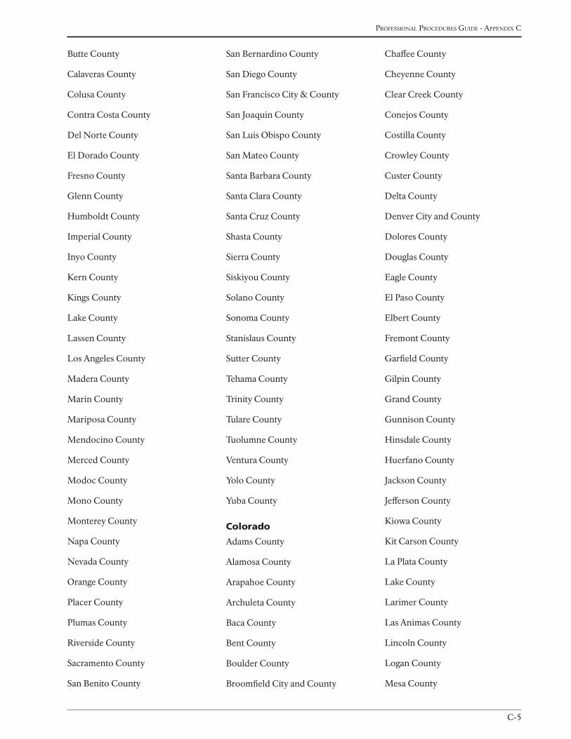
C-5
Professional Procedures Guide - aPPendix c
Butte County
Calaveras County
Colusa County
Contra Costa County
Del Norte County
El Dorado County
Fresno County
Glenn County
Humboldt County
Imperial County
Inyo County
Kern County
Kings County
Lake County
Lassen County
Los Angeles County
Madera County
Marin County
Mariposa County
Mendocino County
Merced County
Modoc County
Mono County
Monterey County
Napa County
Nevada County
Orange County
Placer County
Plumas County
Riverside County
Sacramento County
San Benito County
San Bernardino County
San Diego County
San Francisco City & County
San Joaquin County
San Luis Obispo County
San Mateo County
Santa Barbara County
Santa Clara County
Santa Cruz County
Shasta County
Sierra County
Siskiyou County
Solano County
Sonoma County
Stanislaus County
Sutter County
Tehama County
Trinity County
Tulare County
Tuolumne County
Ventura County
Yolo County
Yuba County
Colorado
Adams County
Alamosa County
Arapahoe County
Archuleta County
Baca County
Bent County
Boulder County
Broomfield City and County
Chaffee County
Cheyenne County
Clear Creek County
Conejos County
Costilla County
Crowley County
Custer County
Delta County
Denver City and County
Dolores County
Douglas County
Eagle County
El Paso County
Elbert County
Fremont County
Garfield County
Gilpin County
Grand County
Gunnison County
Hinsdale County
Huerfano County
Jackson County
Jefferson County
Kiowa County
Kit Carson County
La Plata County
Lake County
Larimer County
Las Animas County
Lincoln County
Logan County
Mesa County
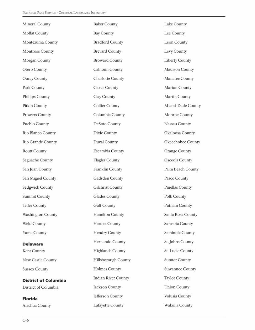
national Park service - cultural landscaPes inventory
C-6
Mineral County
Moffat County
Montezuma County
Montrose County
Morgan County
Otero County
Ouray County
Park County
Phillips County
Pitkin County
Prowers County
Pueblo County
Rio Blanco County
Rio Grande County
Routt County
Saguache County
San Juan County
San Miguel County
Sedgwick County
Summit County
Teller County
Washington County
Weld County
Yuma County
delaware
Kent County
New Castle County
Sussex County
district of Columbia
District of Columbia
Florida
Alachua County
Baker County
Bay County
Bradford County
Brevard County
Broward County
Calhoun County
Charlotte County
Citrus County
Clay County
Collier County
Columbia County
DeSoto County
Dixie County
Duval County
Escambia County
Flagler County
Franklin County
Gadsden County
Gilchrist County
Glades County
Gulf County
Hamilton County
Hardee County
Hendry County
Hernando County
Highlands County
Hillsborough County
Holmes County
Indian River County
Jackson County
Jefferson County
Lafayette County
Lake County
Lee County
Leon County
Levy County
Liberty County
Madison County
Manatee County
Marion County
Martin County
Miami-Dade County
Monroe County
Nassau County
Okaloosa County
Okeechobee County
Orange County
Osceola County
Palm Beach County
Pasco County
Pinellas County
Polk County
Putnam County
Santa Rosa County
Sarasota County
Seminole County
St. Johns County
St. Lucie County
Sumter County
Suwannee County
Taylor County
Union County
Volusia County
Wakulla County
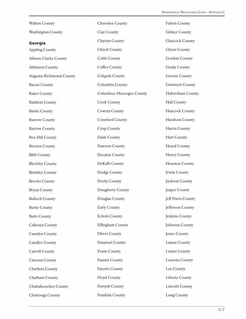
C-7
Professional Procedures Guide - aPPendix c
Walton County
Washington County
Georgia
Appling County
Athens-Clarke County
Atkinson County
Augusta-Richmond County
Bacon County
Baker County
Baldwin County
Banks County
Barrow County
Bartow County
Ben Hill County
Berrien County
Bibb County
Bleckley County
Brantley County
Brooks County
Bryan County
Bulloch County
Burke County
Butts County
Calhoun County
Camden County
Candler County
Carroll County
Catoosa County
Charlton County
Chatham County
Chattahoochee County
Chattooga County
Cherokee County
Clay County
Clayton County
Clinch County
Cobb County
Coffee County
Colquitt County
Columbia County
Columbus-Muscogee County
Cook County
Coweta County
Crawford County
Crisp County
Dade County
Dawson County
Decatur County
DeKalb County
Dodge County
Dooly County
Dougherty County
Douglas County
Early County
Echols County
Effingham County
Elbert County
Emanuel County
Evans County
Fannin County
Fayette County
Floyd County
Forsyth County
Franklin County
Fulton County
Gilmer County
Glascock County
Glynn County
Gordon County
Grady County
Greene County
Gwinnett County
Habersham County
Hall County
Hancock County
Haralson County
Harris County
Hart County
Heard County
Henry County
Houston County
Irwin County
Jackson County
Jasper County
Jeff Davis County
Jefferson County
Jenkins County
Johnson County
Jones County
Lamar County
Lanier County
Laurens County
Lee County
Liberty County
Lincoln County
Long County
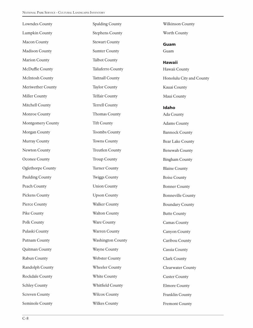
national Park service - cultural landscaPes inventory
C-8
Lowndes County
Lumpkin County
Macon County
Madison County
Marion County
McDuffie County
McIntosh County
Meriwether County
Miller County
Mitchell County
Monroe County
Montgomery County
Morgan County
Murray County
Newton County
Oconee County
Oglethorpe County
Paulding County
Peach County
Pickens County
Pierce County
Pike County
Polk County
Pulaski County
Putnam County
Quitman County
Rabun County
Randolph County
Rockdale County
Schley County
Screven County
Seminole County
Spalding County
Stephens County
Stewart County
Sumter County
Talbot County
Taliaferro County
Tattnall County
Taylor County
Telfair County
Terrell County
Thomas County
Tift County
Toombs County
Towns County
Treutlen County
Troup County
Turner County
Twiggs County
Union County
Upson County
Walker County
Walton County
Ware County
Warren County
Washington County
Wayne County
Webster County
Wheeler County
White County
Whitfield County
Wilcox County
Wilkes County
Wilkinson County
Worth County
Guam
Guam
Hawaii
Hawaii County
Honolulu City and County
Kauai County
Maui County
idaho
Ada County
Adams County
Bannock County
Bear Lake County
Benewah County
Bingham County
Blaine County
Boise County
Bonner County
Bonneville County
Boundary County
Butte County
Camas County
Canyon County
Caribou County
Cassia County
Clark County
Clearwater County
Custer County
Elmore County
Franklin County
Fremont County
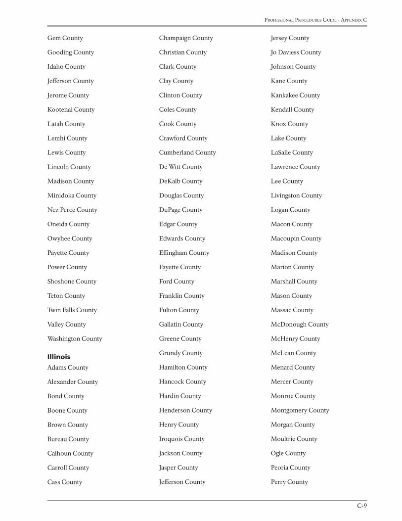
C-9
Professional Procedures Guide - aPPendix c
Gem County
Gooding County
Idaho County
Jefferson County
Jerome County
Kootenai County
Latah County
Lemhi County
Lewis County
Lincoln County
Madison County
Minidoka County
Nez Perce County
Oneida County
Owyhee County
Payette County
Power County
Shoshone County
Teton County
Twin Falls County
Valley County
Washington County
illinois
Adams County
Alexander County
Bond County
Boone County
Brown County
Bureau County
Calhoun County
Carroll County
Cass County
Champaign County
Christian County
Clark County
Clay County
Clinton County
Coles County
Cook County
Crawford County
Cumberland County
De Witt County
DeKalb County
Douglas County
DuPage County
Edgar County
Edwards County
Effingham County
Fayette County
Ford County
Franklin County
Fulton County
Gallatin County
Greene County
Grundy County
Hamilton County
Hancock County
Hardin County
Henderson County
Henry County
Iroquois County
Jackson County
Jasper County
Jefferson County
Jersey County
Jo Daviess County
Johnson County
Kane County
Kankakee County
Kendall County
Knox County
Lake County
LaSalle County
Lawrence County
Lee County
Livingston County
Logan County
Macon County
Macoupin County
Madison County
Marion County
Marshall County
Mason County
Massac County
McDonough County
McHenry County
McLean County
Menard County
Mercer County
Monroe County
Montgomery County
Morgan County
Moultrie County
Ogle County
Peoria County
Perry County
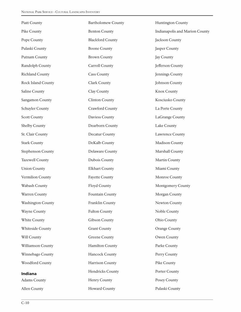
national Park service - cultural landscaPes inventory
C-10
Piatt County
Pike County
Pope County
Pulaski County
Putnam County
Randolph County
Richland County
Rock Island County
Saline County
Sangamon County
Schuyler County
Scott County
Shelby County
St. Clair County
Stark County
Stephenson County
Tazewell County
Union County
Vermilion County
Wabash County
Warren County
Washington County
Wayne County
White County
Whiteside County
Will County
Williamson County
Winnebago County
Woodford County
indiana
Adams County
Allen County
Bartholomew County
Benton County
Blackford County
Boone County
Brown County
Carroll County
Cass County
Clark County
Clay County
Clinton County
Crawford County
Daviess County
Dearborn County
Decatur County
DeKalb County
Delaware County
Dubois County
Elkhart County
Fayette County
Floyd County
Fountain County
Franklin County
Fulton County
Gibson County
Grant County
Greene County
Hamilton County
Hancock County
Harrison County
Hendricks County
Henry County
Howard County
Huntington County
Indianapolis and Marion County
Jackson County
Jasper County
Jay County
Jefferson County
Jennings County
Johnson County
Knox County
Kosciusko County
La Porte County
LaGrange County
Lake County
Lawrence County
Madison County
Marshall County
Martin County
Miami County
Monroe County
Montgomery County
Morgan County
Newton County
Noble County
Ohio County
Orange County
Owen County
Parke County
Perry County
Pike County
Porter County
Posey County
Pulaski County
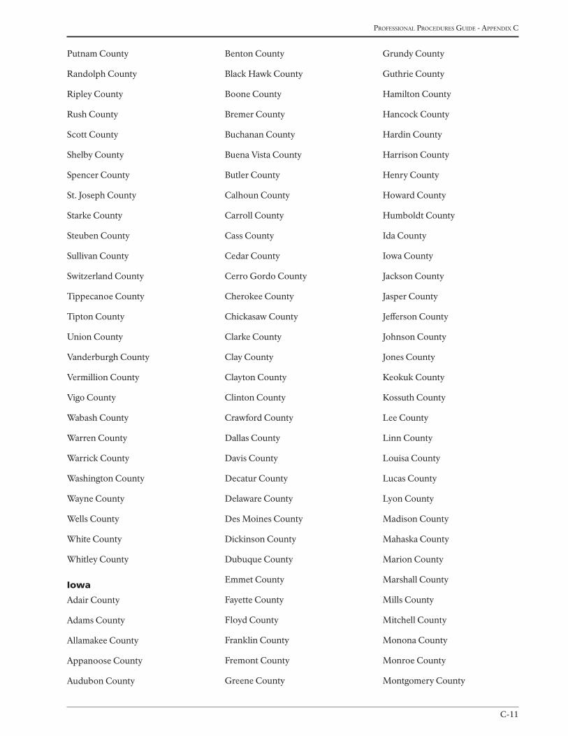
C-11
Professional Procedures Guide - aPPendix c
Putnam County
Randolph County
Ripley County
Rush County
Scott County
Shelby County
Spencer County
St. Joseph County
Starke County
Steuben County
Sullivan County
Switzerland County
Tippecanoe County
Tipton County
Union County
Vanderburgh County
Vermillion County
Vigo County
Wabash County
Warren County
Warrick County
Washington County
Wayne County
Wells County
White County
Whitley County
iowa
Adair County
Adams County
Allamakee County
Appanoose County
Audubon County
Benton County
Black Hawk County
Boone County
Bremer County
Buchanan County
Buena Vista County
Butler County
Calhoun County
Carroll County
Cass County
Cedar County
Cerro Gordo County
Cherokee County
Chickasaw County
Clarke County
Clay County
Clayton County
Clinton County
Crawford County
Dallas County
Davis County
Decatur County
Delaware County
Des Moines County
Dickinson County
Dubuque County
Emmet County
Fayette County
Floyd County
Franklin County
Fremont County
Greene County
Grundy County
Guthrie County
Hamilton County
Hancock County
Hardin County
Harrison County
Henry County
Howard County
Humboldt County
Ida County
Iowa County
Jackson County
Jasper County
Jefferson County
Johnson County
Jones County
Keokuk County
Kossuth County
Lee County
Linn County
Louisa County
Lucas County
Lyon County
Madison County
Mahaska County
Marion County
Marshall County
Mills County
Mitchell County
Monona County
Monroe County
Montgomery County
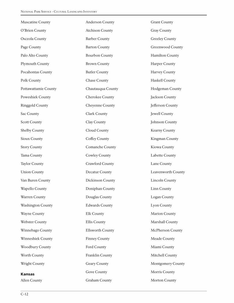
national Park service - cultural landscaPes inventory
C-12
Muscatine County
O’Brien County
Osceola County
Page County
Palo Alto County
Plymouth County
Pocahontas County
Polk County
Pottawattamie County
Poweshiek County
Ringgold County
Sac County
Scott County
Shelby County
Sioux County
Story County
Tama County
Taylor County
Union County
Van Buren County
Wapello County
Warren County
Washington County
Wayne County
Webster County
Winnebago County
Winneshiek County
Woodbury County
Worth County
Wright County
Kansas
Allen County
Anderson County
Atchison County
Barber County
Barton County
Bourbon County
Brown County
Butler County
Chase County
Chautauqua County
Cherokee County
Cheyenne County
Clark County
Clay County
Cloud County
Coffey County
Comanche County
Cowley County
Crawford County
Decatur County
Dickinson County
Doniphan County
Douglas County
Edwards County
Elk County
Ellis County
Ellsworth County
Finney County
Ford County
Franklin County
Geary County
Gove County
Graham County
Grant County
Gray County
Greeley County
Greenwood County
Hamilton County
Harper County
Harvey County
Haskell County
Hodgeman County
Jackson County
Jefferson County
Jewell County
Johnson County
Kearny County
Kingman County
Kiowa County
Labette County
Lane County
Leavenworth County
Lincoln County
Linn County
Logan County
Lyon County
Marion County
Marshall County
McPherson County
Meade County
Miami County
Mitchell County
Montgomery County
Morris County
Morton County
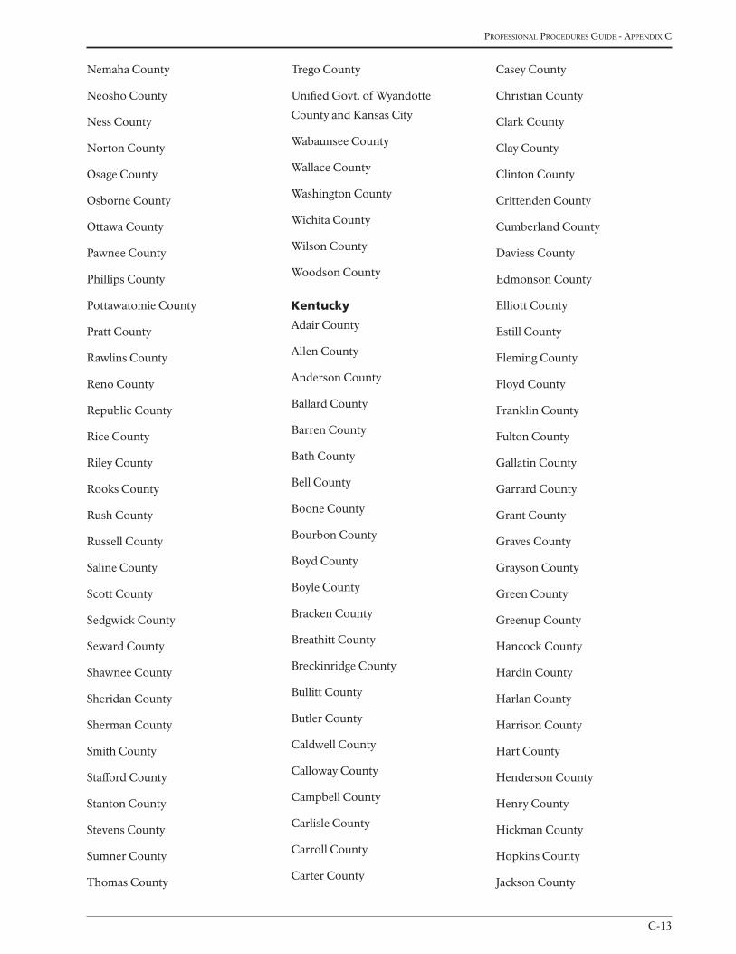
C-13
Professional Procedures Guide - aPPendix c
Nemaha County
Neosho County
Ness County
Norton County
Osage County
Osborne County
Ottawa County
Pawnee County
Phillips County
Pottawatomie County
Pratt County
Rawlins County
Reno County
Republic County
Rice County
Riley County
Rooks County
Rush County
Russell County
Saline County
Scott County
Sedgwick County
Seward County
Shawnee County
Sheridan County
Sherman County
Smith County
Stafford County
Stanton County
Stevens County
Sumner County
Thomas County
Trego County
Unified Govt. of Wyandotte
County and Kansas City
Wabaunsee County
Wallace County
Washington County
Wichita County
Wilson County
Woodson County
Kentucky
Adair County
Allen County
Anderson County
Ballard County
Barren County
Bath County
Bell County
Boone County
Bourbon County
Boyd County
Boyle County
Bracken County
Breathitt County
Breckinridge County
Bullitt County
Butler County
Caldwell County
Calloway County
Campbell County
Carlisle County
Carroll County
Carter County
Casey County
Christian County
Clark County
Clay County
Clinton County
Crittenden County
Cumberland County
Daviess County
Edmonson County
Elliott County
Estill County
Fleming County
Floyd County
Franklin County
Fulton County
Gallatin County
Garrard County
Grant County
Graves County
Grayson County
Green County
Greenup County
Hancock County
Hardin County
Harlan County
Harrison County
Hart County
Henderson County
Henry County
Hickman County
Hopkins County
Jackson County
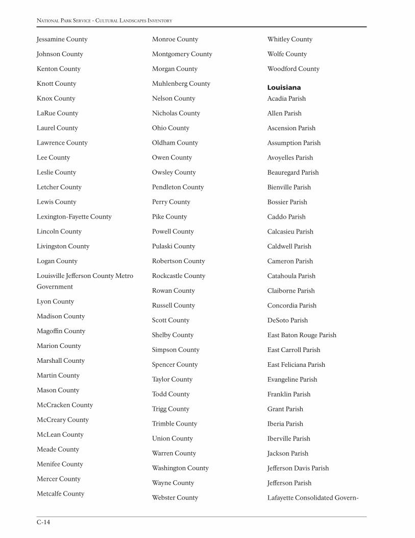
national Park service - cultural landscaPes inventory
C-14
Jessamine County
Johnson County
Kenton County
Knott County
Knox County
LaRue County
Laurel County
Lawrence County
Lee County
Leslie County
Letcher County
Lewis County
Lexington-Fayette County
Lincoln County
Livingston County
Logan County
Louisville Jefferson County Metro
Government
Lyon County
Madison County
Magoffin County
Marion County
Marshall County
Martin County
Mason County
McCracken County
McCreary County
McLean County
Meade County
Menifee County
Mercer County
Metcalfe County
Monroe County
Montgomery County
Morgan County
Muhlenberg County
Nelson County
Nicholas County
Ohio County
Oldham County
Owen County
Owsley County
Pendleton County
Perry County
Pike County
Powell County
Pulaski County
Robertson County
Rockcastle County
Rowan County
Russell County
Scott County
Shelby County
Simpson County
Spencer County
Taylor County
Todd County
Trigg County
Trimble County
Union County
Warren County
Washington County
Wayne County
Webster County
Whitley County
Wolfe County
Woodford County
Louisiana
Acadia Parish
Allen Parish
Ascension Parish
Assumption Parish
Avoyelles Parish
Beauregard Parish
Bienville Parish
Bossier Parish
Caddo Parish
Calcasieu Parish
Caldwell Parish
Cameron Parish
Catahoula Parish
Claiborne Parish
Concordia Parish
DeSoto Parish
East Baton Rouge Parish
East Carroll Parish
East Feliciana Parish
Evangeline Parish
Franklin Parish
Grant Parish
Iberia Parish
Iberville Parish
Jackson Parish
Jefferson Davis Parish
Jefferson Parish
Lafayette Consolidated Govern-
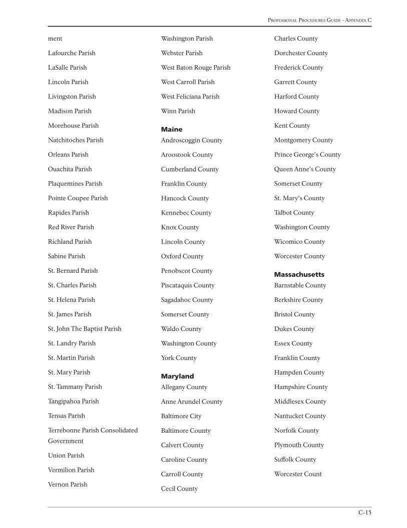
C-15
Professional Procedures Guide - aPPendix c
ment
Lafourche Parish
LaSalle Parish
Lincoln Parish
Livingston Parish
Madison Parish
Morehouse Parish
Natchitoches Parish
Orleans Parish
Ouachita Parish
Plaquemines Parish
Pointe Coupee Parish
Rapides Parish
Red River Parish
Richland Parish
Sabine Parish
St. Bernard Parish
St. Charles Parish
St. Helena Parish
St. James Parish
St. John The Baptist Parish
St. Landry Parish
St. Martin Parish
St. Mary Parish
St. Tammany Parish
Tangipahoa Parish
Tensas Parish
Terrebonne Parish Consolidated
Government
Union Parish
Vermilion Parish
Vernon Parish
Washington Parish
Webster Parish
West Baton Rouge Parish
West Carroll Parish
West Feliciana Parish
Winn Parish
Maine
Androscoggin County
Aroostook County
Cumberland County
Franklin County
Hancock County
Kennebec County
Knox County
Lincoln County
Oxford County
Penobscot County
Piscataquis County
Sagadahoc County
Somerset County
Waldo County
Washington County
York County
Maryland
Allegany County
Anne Arundel County
Baltimore City
Baltimore County
Calvert County
Caroline County
Carroll County
Cecil County
Charles County
Dorchester County
Frederick County
Garrett County
Harford County
Howard County
Kent County
Montgomery County
Prince George’s County
Queen Anne’s County
Somerset County
St. Mary’s County
Talbot County
Washington County
Wicomico County
Worcester County
Massachusetts
Barnstable County
Berkshire County
Bristol County
Dukes County
Essex County
Franklin County
Hampden County
Hampshire County
Middlesex County
Nantucket County
Norfolk County
Plymouth County
Suffolk County
Worcester Count
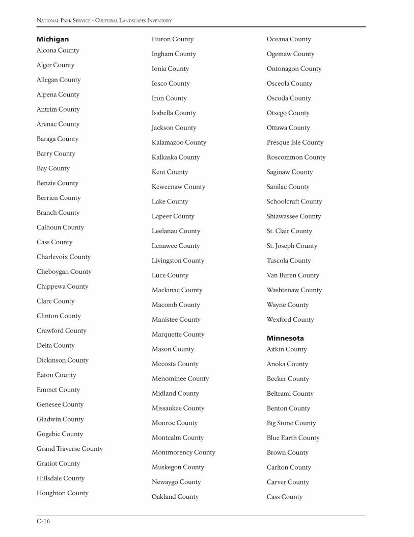
national Park service - cultural landscaPes inventory
C-16
Michigan
Alcona County
Alger County
Allegan County
Alpena County
Antrim County
Arenac County
Baraga County
Barry County
Bay County
Benzie County
Berrien County
Branch County
Calhoun County
Cass County
Charlevoix County
Cheboygan County
Chippewa County
Clare County
Clinton County
Crawford County
Delta County
Dickinson County
Eaton County
Emmet County
Genesee County
Gladwin County
Gogebic County
Grand Traverse County
Gratiot County
Hillsdale County
Houghton County
Huron County
Ingham County
Ionia County
Iosco County
Iron County
Isabella County
Jackson County
Kalamazoo County
Kalkaska County
Kent County
Keweenaw County
Lake County
Lapeer County
Leelanau County
Lenawee County
Livingston County
Luce County
Mackinac County
Macomb County
Manistee County
Marquette County
Mason County
Mecosta County
Menominee County
Midland County
Missaukee County
Monroe County
Montcalm County
Montmorency County
Muskegon County
Newaygo County
Oakland County
Oceana County
Ogemaw County
Ontonagon County
Osceola County
Oscoda County
Otsego County
Ottawa County
Presque Isle County
Roscommon County
Saginaw County
Sanilac County
Schoolcraft County
Shiawassee County
St. Clair County
St. Joseph County
Tuscola County
Van Buren County
Washtenaw County
Wayne County
Wexford County
Minnesota
Aitkin County
Anoka County
Becker County
Beltrami County
Benton County
Big Stone County
Blue Earth County
Brown County
Carlton County
Carver County
Cass County
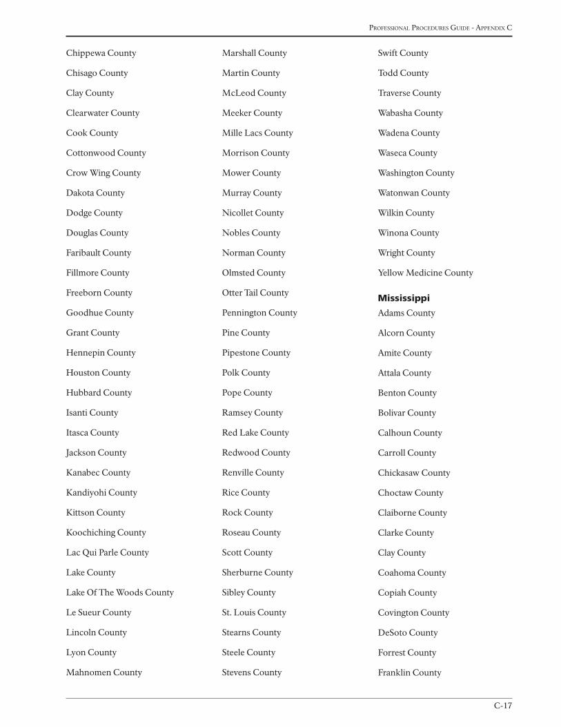
C-17
Professional Procedures Guide - aPPendix c
Chippewa County
Chisago County
Clay County
Clearwater County
Cook County
Cottonwood County
Crow Wing County
Dakota County
Dodge County
Douglas County
Faribault County
Fillmore County
Freeborn County
Goodhue County
Grant County
Hennepin County
Houston County
Hubbard County
Isanti County
Itasca County
Jackson County
Kanabec County
Kandiyohi County
Kittson County
Koochiching County
Lac Qui Parle County
Lake County
Lake Of The Woods County
Le Sueur County
Lincoln County
Lyon County
Mahnomen County
Marshall County
Martin County
McLeod County
Meeker County
Mille Lacs County
Morrison County
Mower County
Murray County
Nicollet County
Nobles County
Norman County
Olmsted County
Otter Tail County
Pennington County
Pine County
Pipestone County
Polk County
Pope County
Ramsey County
Red Lake County
Redwood County
Renville County
Rice County
Rock County
Roseau County
Scott County
Sherburne County
Sibley County
St. Louis County
Stearns County
Steele County
Stevens County
Swift County
Todd County
Traverse County
Wabasha County
Wadena County
Waseca County
Washington County
Watonwan County
Wilkin County
Winona County
Wright County
Yellow Medicine County
Mississippi
Adams County
Alcorn County
Amite County
Attala County
Benton County
Bolivar County
Calhoun County
Carroll County
Chickasaw County
Choctaw County
Claiborne County
Clarke County
Clay County
Coahoma County
Copiah County
Covington County
DeSoto County
Forrest County
Franklin County
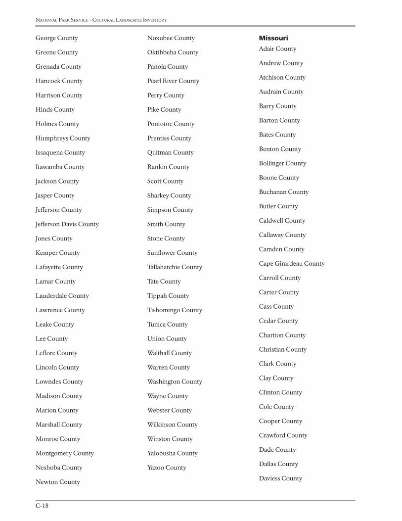
national Park service - cultural landscaPes inventory
C-18
George County
Greene County
Grenada County
Hancock County
Harrison County
Hinds County
Holmes County
Humphreys County
Issaquena County
Itawamba County
Jackson County
Jasper County
Jefferson County
Jefferson Davis County
Jones County
Kemper County
Lafayette County
Lamar County
Lauderdale County
Lawrence County
Leake County
Lee County
Leflore County
Lincoln County
Lowndes County
Madison County
Marion County
Marshall County
Monroe County
Montgomery County
Neshoba County
Newton County
Noxubee County
Oktibbeha County
Panola County
Pearl River County
Perry County
Pike County
Pontotoc County
Prentiss County
Quitman County
Rankin County
Scott County
Sharkey County
Simpson County
Smith County
Stone County
Sunflower County
Tallahatchie County
Tate County
Tippah County
Tishomingo County
Tunica County
Union County
Walthall County
Warren County
Washington County
Wayne County
Webster County
Wilkinson County
Winston County
Yalobusha County
Yazoo County
Missouri
Adair County
Andrew County
Atchison County
Audrain County
Barry County
Barton County
Bates County
Benton County
Bollinger County
Boone County
Buchanan County
Butler County
Caldwell County
Callaway County
Camden County
Cape Girardeau County
Carroll County
Carter County
Cass County
Cedar County
Chariton County
Christian County
Clark County
Clay County
Clinton County
Cole County
Cooper County
Crawford County
Dade County
Dallas County
Daviess County
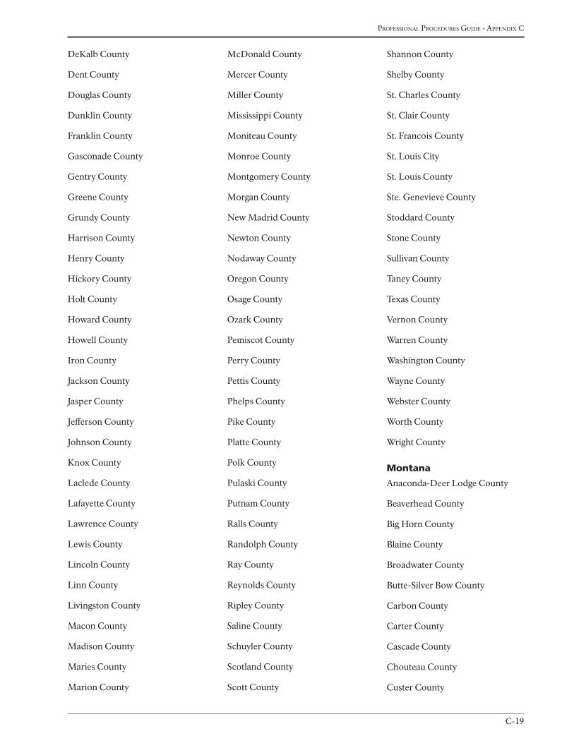
C-19
Professional Procedures Guide - aPPendix c
DeKalb County
Dent County
Douglas County
Dunklin County
Franklin County
Gasconade County
Gentry County
Greene County
Grundy County
Harrison County
Henry County
Hickory County
Holt County
Howard County
Howell County
Iron County
Jackson County
Jasper County
Jefferson County
Johnson County
Knox County
Laclede County
Lafayette County
Lawrence County
Lewis County
Lincoln County
Linn County
Livingston County
Macon County
Madison County
Maries County
Marion County
McDonald County
Mercer County
Miller County
Mississippi County
Moniteau County
Monroe County
Montgomery County
Morgan County
New Madrid County
Newton County
Nodaway County
Oregon County
Osage County
Ozark County
Pemiscot County
Perry County
Pettis County
Phelps County
Pike County
Platte County
Polk County
Pulaski County
Putnam County
Ralls County
Randolph County
Ray County
Reynolds County
Ripley County
Saline County
Schuyler County
Scotland County
Scott County
Shannon County
Shelby County
St. Charles County
St. Clair County
St. Francois County
St. Louis City
St. Louis County
Ste. Genevieve County
Stoddard County
Stone County
Sullivan County
Taney County
Texas County
Vernon County
Warren County
Washington County
Wayne County
Webster County
Worth County
Wright County
Montana
Anaconda-Deer Lodge County
Beaverhead County
Big Horn County
Blaine County
Broadwater County
Butte-Silver Bow County
Carbon County
Carter County
Cascade County
Chouteau County
Custer County
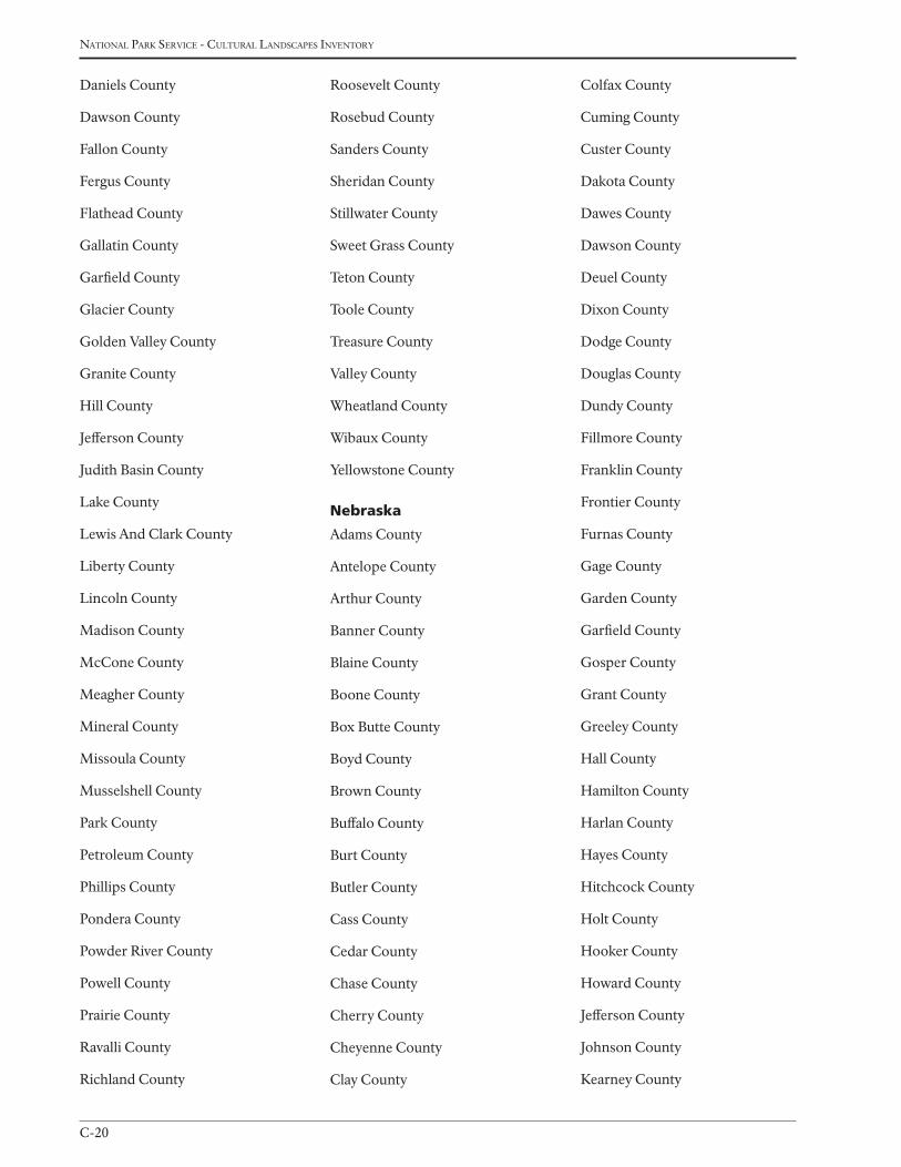
national Park service - cultural landscaPes inventory
C-20
Daniels County
Dawson County
Fallon County
Fergus County
Flathead County
Gallatin County
Garfield County
Glacier County
Golden Valley County
Granite County
Hill County
Jefferson County
Judith Basin County
Lake County
Lewis And Clark County
Liberty County
Lincoln County
Madison County
McCone County
Meagher County
Mineral County
Missoula County
Musselshell County
Park County
Petroleum County
Phillips County
Pondera County
Powder River County
Powell County
Prairie County
Ravalli County
Richland County
Roosevelt County
Rosebud County
Sanders County
Sheridan County
Stillwater County
Sweet Grass County
Teton County
Toole County
Treasure County
Valley County
Wheatland County
Wibaux County
Yellowstone County
nebraska
Adams County
Antelope County
Arthur County
Banner County
Blaine County
Boone County
Box Butte County
Boyd County
Brown County
Buffalo County
Burt County
Butler County
Cass County
Cedar County
Chase County
Cherry County
Cheyenne County
Clay County
Colfax County
Cuming County
Custer County
Dakota County
Dawes County
Dawson County
Deuel County
Dixon County
Dodge County
Douglas County
Dundy County
Fillmore County
Franklin County
Frontier County
Furnas County
Gage County
Garden County
Garfield County
Gosper County
Grant County
Greeley County
Hall County
Hamilton County
Harlan County
Hayes County
Hitchcock County
Holt County
Hooker County
Howard County
Jefferson County
Johnson County
Kearney County
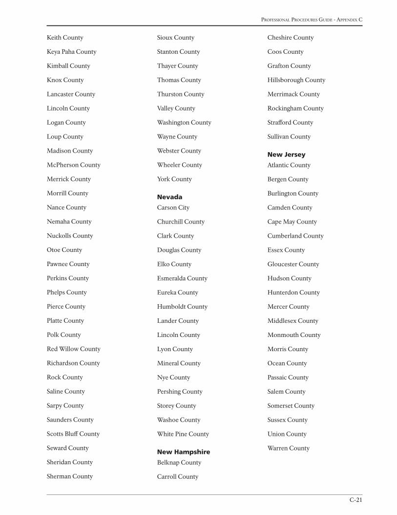
C-21
Professional Procedures Guide - aPPendix c
Keith County
Keya Paha County
Kimball County
Knox County
Lancaster County
Lincoln County
Logan County
Loup County
Madison County
McPherson County
Merrick County
Morrill County
Nance County
Nemaha County
Nuckolls County
Otoe County
Pawnee County
Perkins County
Phelps County
Pierce County
Platte County
Polk County
Red Willow County
Richardson County
Rock County
Saline County
Sarpy County
Saunders County
Scotts Bluff County
Seward County
Sheridan County
Sherman County
Sioux County
Stanton County
Thayer County
Thomas County
Thurston County
Valley County
Washington County
Wayne County
Webster County
Wheeler County
York County
nevada
Carson City
Churchill County
Clark County
Douglas County
Elko County
Esmeralda County
Eureka County
Humboldt County
Lander County
Lincoln County
Lyon County
Mineral County
Nye County
Pershing County
Storey County
Washoe County
White Pine County
new Hampshire
Belknap County
Carroll County
Cheshire County
Coos County
Grafton County
Hillsborough County
Merrimack County
Rockingham County
Strafford County
Sullivan County
new Jersey
Atlantic County
Bergen County
Burlington County
Camden County
Cape May County
Cumberland County
Essex County
Gloucester County
Hudson County
Hunterdon County
Mercer County
Middlesex County
Monmouth County
Morris County
Ocean County
Passaic County
Salem County
Somerset County
Sussex County
Union County
Warren County
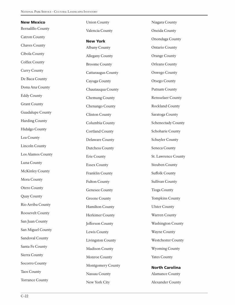
national Park service - cultural landscaPes inventory
C-22
new Mexico
Bernalillo County
Catron County
Chaves County
Cibola County
Colfax County
Curry County
De Baca County
Dona Ana County
Eddy County
Grant County
Guadalupe County
Harding County
Hidalgo County
Lea County
Lincoln County
Los Alamos County
Luna County
McKinley County
Mora County
Otero County
Quay County
Rio Arriba County
Roosevelt County
San Juan County
San Miguel County
Sandoval County
Santa Fe County
Sierra County
Socorro County
Taos County
Torrance County
Union County
Valencia County
new york
Albany County
Allegany County
Broome County
Cattaraugus County
Cayuga County
Chautauqua County
Chemung County
Chenango County
Clinton County
Columbia County
Cortland County
Delaware County
Dutchess County
Erie County
Essex County
Franklin County
Fulton County
Genesee County
Greene County
Hamilton County
Herkimer County
Jefferson County
Lewis County
Livingston County
Madison County
Monroe County
Montgomery County
Nassau County
New York City
Niagara County
Oneida County
Onondaga County
Ontario County
Orange County
Orleans County
Oswego County
Otsego County
Putnam County
Rensselaer County
Rockland County
Saratoga County
Schenectady County
Schoharie County
Schuyler County
Seneca County
St. Lawrence County
Steuben County
Suffolk County
Sullivan County
Tioga County
Tompkins County
Ulster County
Warren County
Washington County
Wayne County
Westchester County
Wyoming County
Yates County
north Carolina
Alamance County
Alexander County
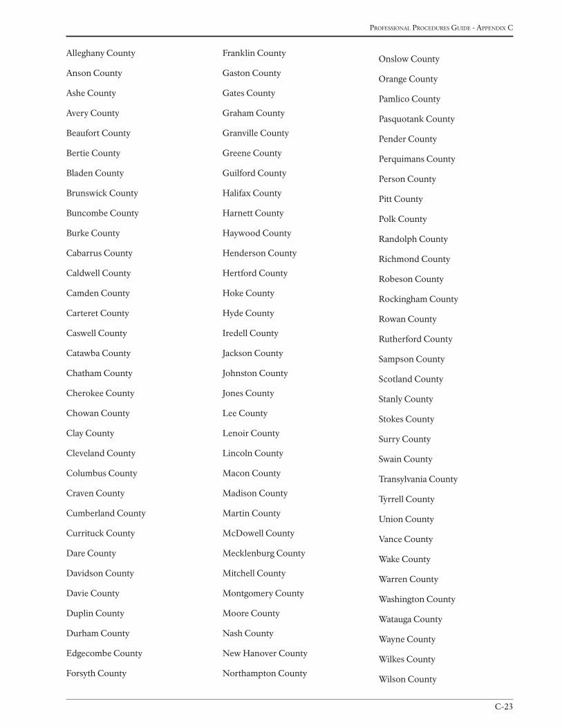
C-23
Professional Procedures Guide - aPPendix c
Alleghany County
Anson County
Ashe County
Avery County
Beaufort County
Bertie County
Bladen County
Brunswick County
Buncombe County
Burke County
Cabarrus County
Caldwell County
Camden County
Carteret County
Caswell County
Catawba County
Chatham County
Cherokee County
Chowan County
Clay County
Cleveland County
Columbus County
Craven County
Cumberland County
Currituck County
Dare County
Davidson County
Davie County
Duplin County
Durham County
Edgecombe County
Forsyth County
Franklin County
Gaston County
Gates County
Graham County
Granville County
Greene County
Guilford County
Halifax County
Harnett County
Haywood County
Henderson County
Hertford County
Hoke County
Hyde County
Iredell County
Jackson County
Johnston County
Jones County
Lee County
Lenoir County
Lincoln County
Macon County
Madison County
Martin County
McDowell County
Mecklenburg County
Mitchell County
Montgomery County
Moore County
Nash County
New Hanover County
Northampton County
Onslow County
Orange County
Pamlico County
Pasquotank County
Pender County
Perquimans County
Person County
Pitt County
Polk County
Randolph County
Richmond County
Robeson County
Rockingham County
Rowan County
Rutherford County
Sampson County
Scotland County
Stanly County
Stokes County
Surry County
Swain County
Transylvania County
Tyrrell County
Union County
Vance County
Wake County
Warren County
Washington County
Watauga County
Wayne County
Wilkes County
Wilson County
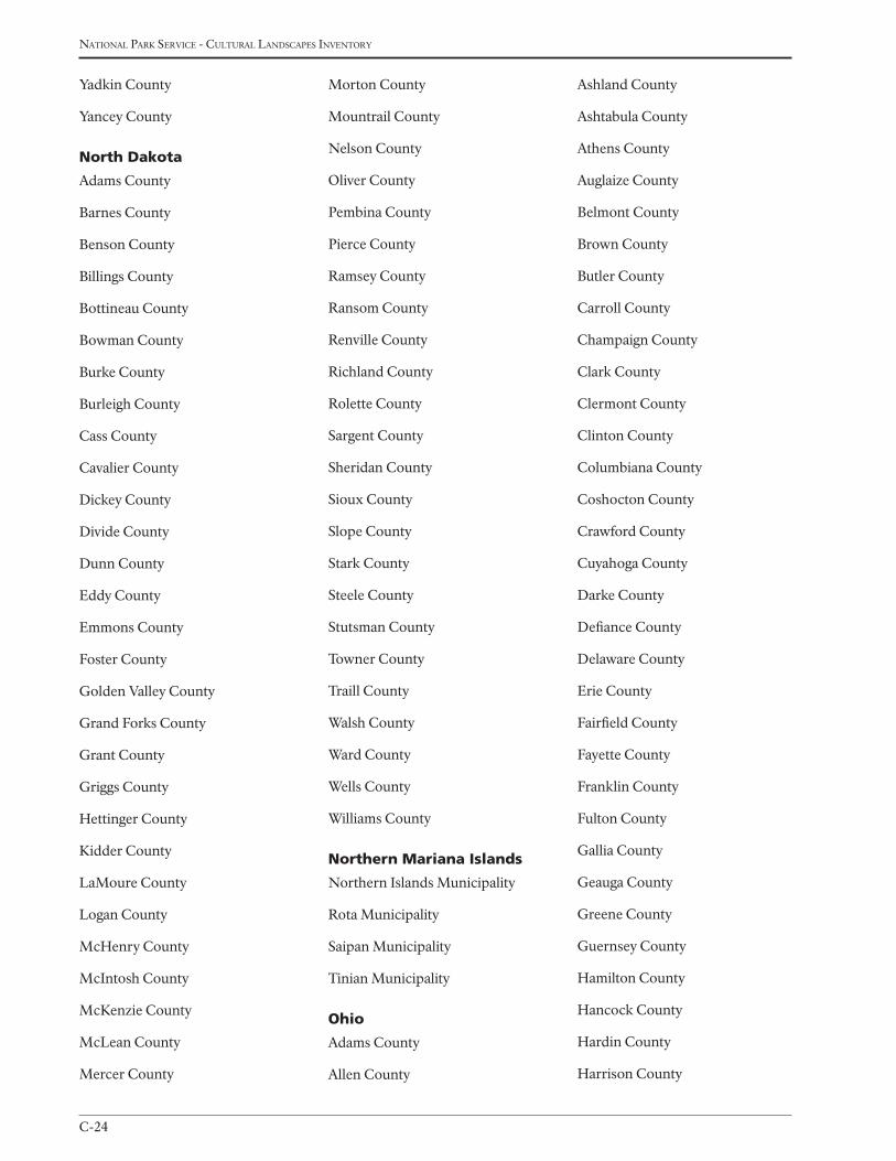
national Park service - cultural landscaPes inventory
C-24
Yadkin County
Yancey County
north dakota
Adams County
Barnes County
Benson County
Billings County
Bottineau County
Bowman County
Burke County
Burleigh County
Cass County
Cavalier County
Dickey County
Divide County
Dunn County
Eddy County
Emmons County
Foster County
Golden Valley County
Grand Forks County
Grant County
Griggs County
Hettinger County
Kidder County
LaMoure County
Logan County
McHenry County
McIntosh County
McKenzie County
McLean County
Mercer County
Morton County
Mountrail County
Nelson County
Oliver County
Pembina County
Pierce County
Ramsey County
Ransom County
Renville County
Richland County
Rolette County
Sargent County
Sheridan County
Sioux County
Slope County
Stark County
Steele County
Stutsman County
Towner County
Traill County
Walsh County
Ward County
Wells County
Williams County
northern Mariana islands
Northern Islands Municipality
Rota Municipality
Saipan Municipality
Tinian Municipality
ohio
Adams County
Allen County
Ashland County
Ashtabula County
Athens County
Auglaize County
Belmont County
Brown County
Butler County
Carroll County
Champaign County
Clark County
Clermont County
Clinton County
Columbiana County
Coshocton County
Crawford County
Cuyahoga County
Darke County
Defiance County
Delaware County
Erie County
Fairfield County
Fayette County
Franklin County
Fulton County
Gallia County
Geauga County
Greene County
Guernsey County
Hamilton County
Hancock County
Hardin County
Harrison County
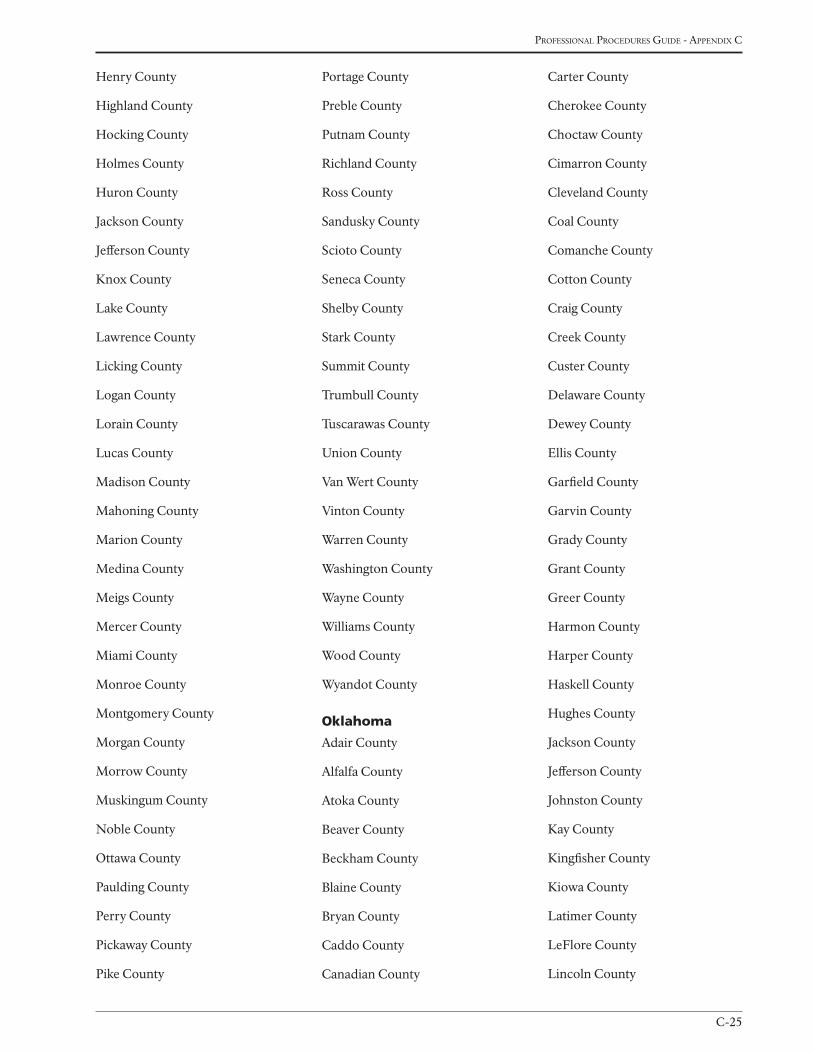
C-25
Professional Procedures Guide - aPPendix c
Henry County
Highland County
Hocking County
Holmes County
Huron County
Jackson County
Jefferson County
Knox County
Lake County
Lawrence County
Licking County
Logan County
Lorain County
Lucas County
Madison County
Mahoning County
Marion County
Medina County
Meigs County
Mercer County
Miami County
Monroe County
Montgomery County
Morgan County
Morrow County
Muskingum County
Noble County
Ottawa County
Paulding County
Perry County
Pickaway County
Pike County
Portage County
Preble County
Putnam County
Richland County
Ross County
Sandusky County
Scioto County
Seneca County
Shelby County
Stark County
Summit County
Trumbull County
Tuscarawas County
Union County
Van Wert County
Vinton County
Warren County
Washington County
Wayne County
Williams County
Wood County
Wyandot County
oklahoma
Adair County
Alfalfa County
Atoka County
Beaver County
Beckham County
Blaine County
Bryan County
Caddo County
Canadian County
Carter County
Cherokee County
Choctaw County
Cimarron County
Cleveland County
Coal County
Comanche County
Cotton County
Craig County
Creek County
Custer County
Delaware County
Dewey County
Ellis County
Garfield County
Garvin County
Grady County
Grant County
Greer County
Harmon County
Harper County
Haskell County
Hughes County
Jackson County
Jefferson County
Johnston County
Kay County
Kingfisher County
Kiowa County
Latimer County
LeFlore County
Lincoln County
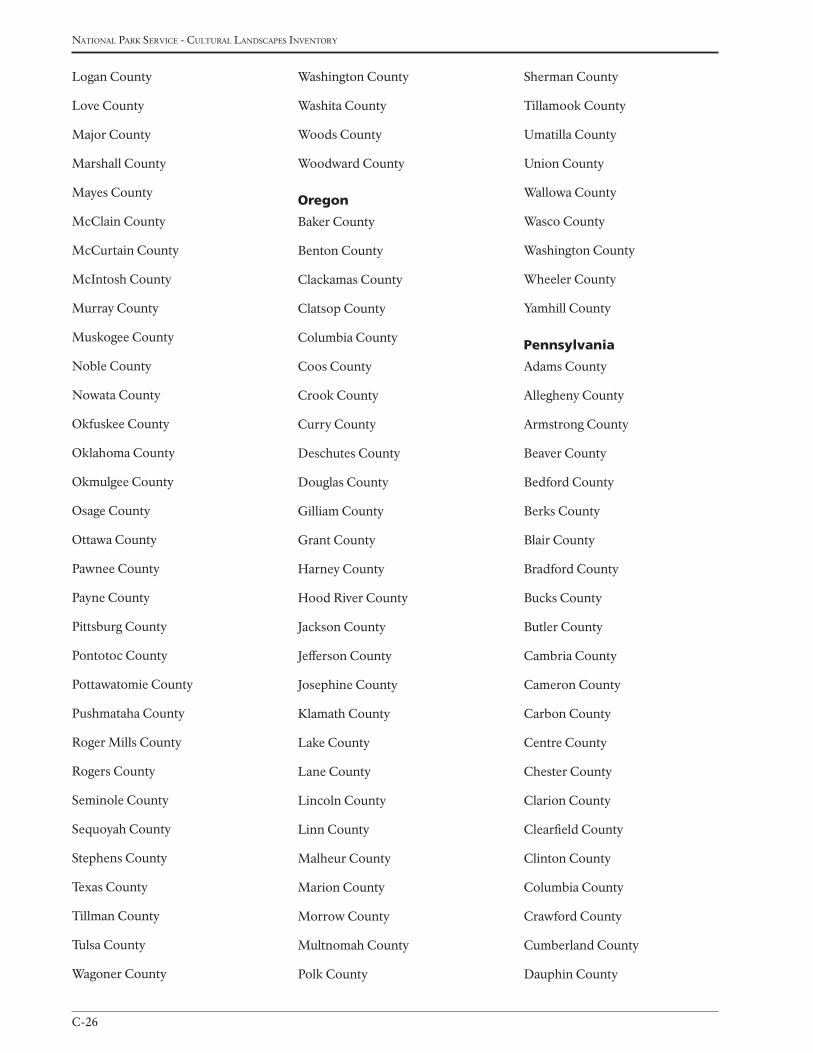
national Park service - cultural landscaPes inventory
C-26
Logan County
Love County
Major County
Marshall County
Mayes County
McClain County
McCurtain County
McIntosh County
Murray County
Muskogee County
Noble County
Nowata County
Okfuskee County
Oklahoma County
Okmulgee County
Osage County
Ottawa County
Pawnee County
Payne County
Pittsburg County
Pontotoc County
Pottawatomie County
Pushmataha County
Roger Mills County
Rogers County
Seminole County
Sequoyah County
Stephens County
Texas County
Tillman County
Tulsa County
Wagoner County
Washington County
Washita County
Woods County
Woodward County
oregon
Baker County
Benton County
Clackamas County
Clatsop County
Columbia County
Coos County
Crook County
Curry County
Deschutes County
Douglas County
Gilliam County
Grant County
Harney County
Hood River County
Jackson County
Jefferson County
Josephine County
Klamath County
Lake County
Lane County
Lincoln County
Linn County
Malheur County
Marion County
Morrow County
Multnomah County
Polk County
Sherman County
Tillamook County
Umatilla County
Union County
Wallowa County
Wasco County
Washington County
Wheeler County
Yamhill County
pennsylvania
Adams County
Allegheny County
Armstrong County
Beaver County
Bedford County
Berks County
Blair County
Bradford County
Bucks County
Butler County
Cambria County
Cameron County
Carbon County
Centre County
Chester County
Clarion County
Clearfield County
Clinton County
Columbia County
Crawford County
Cumberland County
Dauphin County
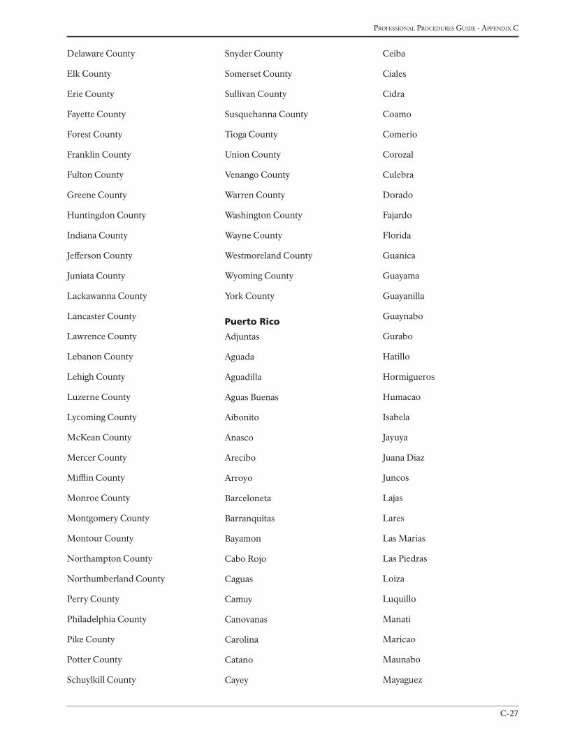
C-27
Professional Procedures Guide - aPPendix c
Delaware County
Elk County
Erie County
Fayette County
Forest County
Franklin County
Fulton County
Greene County
Huntingdon County
Indiana County
Jefferson County
Juniata County
Lackawanna County
Lancaster County
Lawrence County
Lebanon County
Lehigh County
Luzerne County
Lycoming County
McKean County
Mercer County
Mifflin County
Monroe County
Montgomery County
Montour County
Northampton County
Northumberland County
Perry County
Philadelphia County
Pike County
Potter County
Schuylkill County
Snyder County
Somerset County
Sullivan County
Susquehanna County
Tioga County
Union County
Venango County
Warren County
Washington County
Wayne County
Westmoreland County
Wyoming County
York County
puerto rico
Adjuntas
Aguada
Aguadilla
Aguas Buenas
Aibonito
Anasco
Arecibo
Arroyo
Barceloneta
Barranquitas
Bayamon
Cabo Rojo
Caguas
Camuy
Canovanas
Carolina
Catano
Cayey
Ceiba
Ciales
Cidra
Coamo
Comerio
Corozal
Culebra
Dorado
Fajardo
Florida
Guanica
Guayama
Guayanilla
Guaynabo
Gurabo
Hatillo
Hormigueros
Humacao
Isabela
Jayuya
Juana Diaz
Juncos
Lajas
Lares
Las Marias
Las Piedras
Loiza
Luquillo
Manati
Maricao
Maunabo
Mayaguez
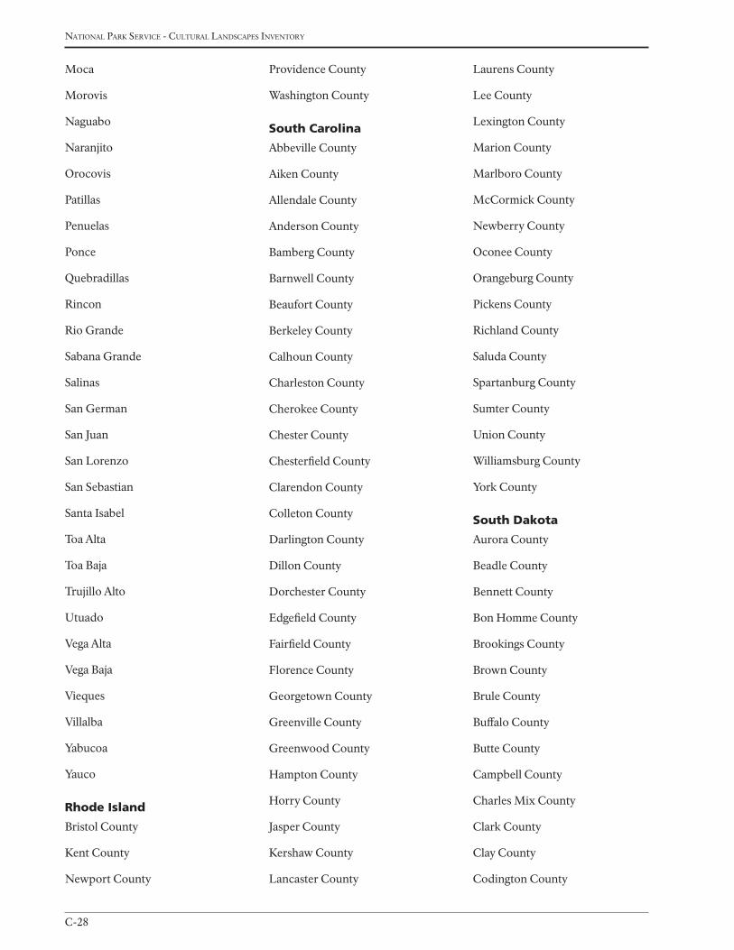
national Park service - cultural landscaPes inventory
C-28
Moca
Morovis
Naguabo
Naranjito
Orocovis
Patillas
Penuelas
Ponce
Quebradillas
Rincon
Rio Grande
Sabana Grande
Salinas
San German
San Juan
San Lorenzo
San Sebastian
Santa Isabel
Toa Alta
Toa Baja
Trujillo Alto
Utuado
Vega Alta
Vega Baja
Vieques
Villalba
Yabucoa
Yauco
rhode island
Bristol County
Kent County
Newport County
Providence County
Washington County
South Carolina
Abbeville County
Aiken County
Allendale County
Anderson County
Bamberg County
Barnwell County
Beaufort County
Berkeley County
Calhoun County
Charleston County
Cherokee County
Chester County
Chesterfield County
Clarendon County
Colleton County
Darlington County
Dillon County
Dorchester County
Edgefield County
Fairfield County
Florence County
Georgetown County
Greenville County
Greenwood County
Hampton County
Horry County
Jasper County
Kershaw County
Lancaster County
Laurens County
Lee County
Lexington County
Marion County
Marlboro County
McCormick County
Newberry County
Oconee County
Orangeburg County
Pickens County
Richland County
Saluda County
Spartanburg County
Sumter County
Union County
Williamsburg County
York County
South dakota
Aurora County
Beadle County
Bennett County
Bon Homme County
Brookings County
Brown County
Brule County
Buffalo County
Butte County
Campbell County
Charles Mix County
Clark County
Clay County
Codington County
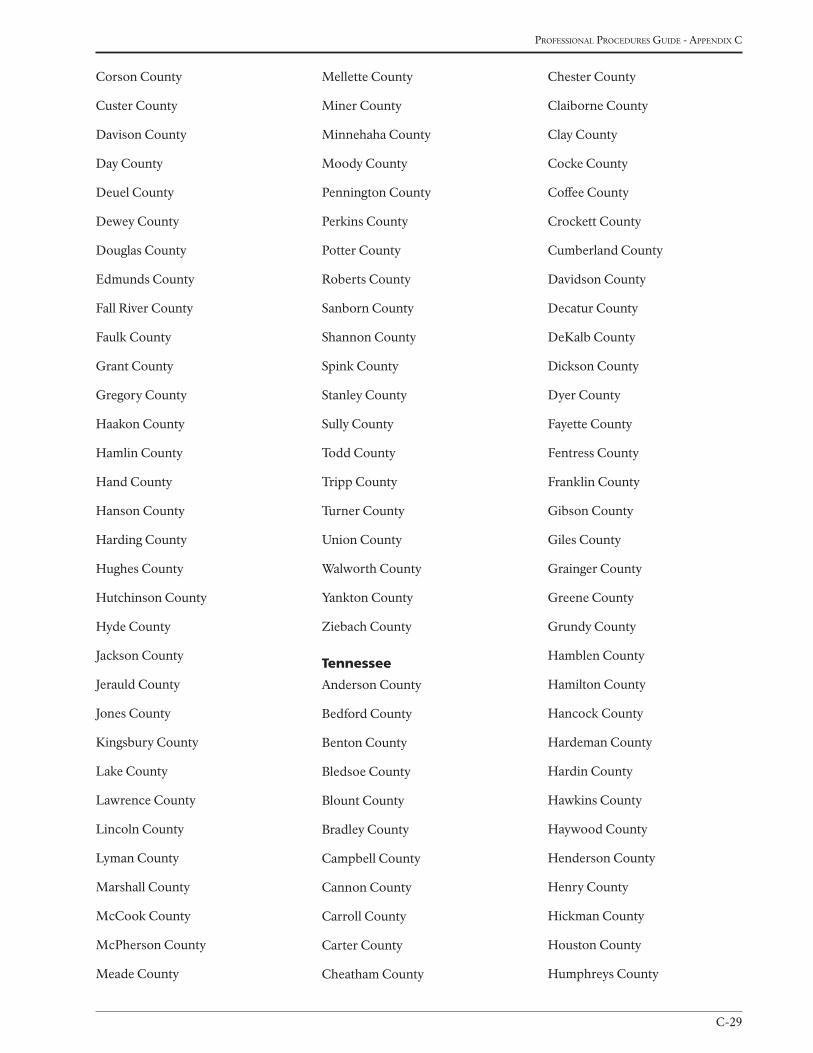
C-29
Professional Procedures Guide - aPPendix c
Corson County
Custer County
Davison County
Day County
Deuel County
Dewey County
Douglas County
Edmunds County
Fall River County
Faulk County
Grant County
Gregory County
Haakon County
Hamlin County
Hand County
Hanson County
Harding County
Hughes County
Hutchinson County
Hyde County
Jackson County
Jerauld County
Jones County
Kingsbury County
Lake County
Lawrence County
Lincoln County
Lyman County
Marshall County
McCook County
McPherson County
Meade County
Mellette County
Miner County
Minnehaha County
Moody County
Pennington County
Perkins County
Potter County
Roberts County
Sanborn County
Shannon County
Spink County
Stanley County
Sully County
Todd County
Tripp County
Turner County
Union County
Walworth County
Yankton County
Ziebach County
tennessee
Anderson County
Bedford County
Benton County
Bledsoe County
Blount County
Bradley County
Campbell County
Cannon County
Carroll County
Carter County
Cheatham County
Chester County
Claiborne County
Clay County
Cocke County
Coffee County
Crockett County
Cumberland County
Davidson County
Decatur County
DeKalb County
Dickson County
Dyer County
Fayette County
Fentress County
Franklin County
Gibson County
Giles County
Grainger County
Greene County
Grundy County
Hamblen County
Hamilton County
Hancock County
Hardeman County
Hardin County
Hawkins County
Haywood County
Henderson County
Henry County
Hickman County
Houston County
Humphreys County
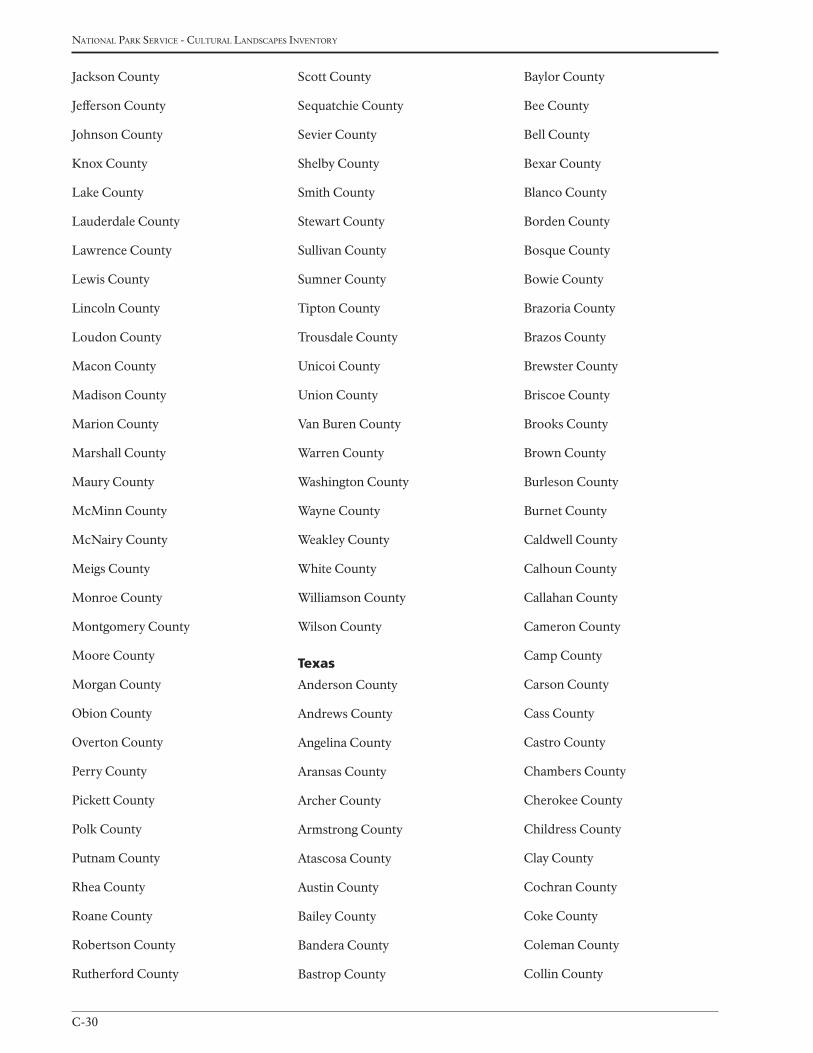
national Park service - cultural landscaPes inventory
C-30
Jackson County
Jefferson County
Johnson County
Knox County
Lake County
Lauderdale County
Lawrence County
Lewis County
Lincoln County
Loudon County
Macon County
Madison County
Marion County
Marshall County
Maury County
McMinn County
McNairy County
Meigs County
Monroe County
Montgomery County
Moore County
Morgan County
Obion County
Overton County
Perry County
Pickett County
Polk County
Putnam County
Rhea County
Roane County
Robertson County
Rutherford County
Scott County
Sequatchie County
Sevier County
Shelby County
Smith County
Stewart County
Sullivan County
Sumner County
Tipton County
Trousdale County
Unicoi County
Union County
Van Buren County
Warren County
Washington County
Wayne County
Weakley County
White County
Williamson County
Wilson County
texas
Anderson County
Andrews County
Angelina County
Aransas County
Archer County
Armstrong County
Atascosa County
Austin County
Bailey County
Bandera County
Bastrop County
Baylor County
Bee County
Bell County
Bexar County
Blanco County
Borden County
Bosque County
Bowie County
Brazoria County
Brazos County
Brewster County
Briscoe County
Brooks County
Brown County
Burleson County
Burnet County
Caldwell County
Calhoun County
Callahan County
Cameron County
Camp County
Carson County
Cass County
Castro County
Chambers County
Cherokee County
Childress County
Clay County
Cochran County
Coke County
Coleman County
Collin County
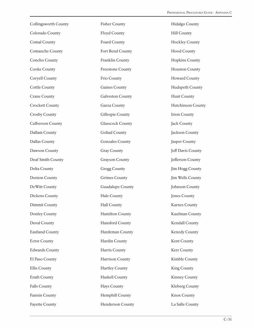
C-31
Professional Procedures Guide - aPPendix c
Collingsworth County
Colorado County
Comal County
Comanche County
Concho County
Cooke County
Coryell County
Cottle County
Crane County
Crockett County
Crosby County
Culberson County
Dallam County
Dallas County
Dawson County
Deaf Smith County
Delta County
Denton County
DeWitt County
Dickens County
Dimmit County
Donley County
Duval County
Eastland County
Ector County
Edwards County
El Paso County
Ellis County
Erath County
Falls County
Fannin County
Fayette County
Fisher County
Floyd County
Foard County
Fort Bend County
Franklin County
Freestone County
Frio County
Gaines County
Galveston County
Garza County
Gillespie County
Glasscock County
Goliad County
Gonzales County
Gray County
Grayson County
Gregg County
Grimes County
Guadalupe County
Hale County
Hall County
Hamilton County
Hansford County
Hardeman County
Hardin County
Harris County
Harrison County
Hartley County
Haskell County
Hays County
Hemphill County
Henderson County
Hidalgo County
Hill County
Hockley County
Hood County
Hopkins County
Houston County
Howard County
Hudspeth County
Hunt County
Hutchinson County
Irion County
Jack County
Jackson County
Jasper County
Jeff Davis County
Jefferson County
Jim Hogg County
Jim Wells County
Johnson County
Jones County
Karnes County
Kaufman County
Kendall County
Kenedy County
Kent County
Kerr County
Kimble County
King County
Kinney County
Kleberg County
Knox County
La Salle County
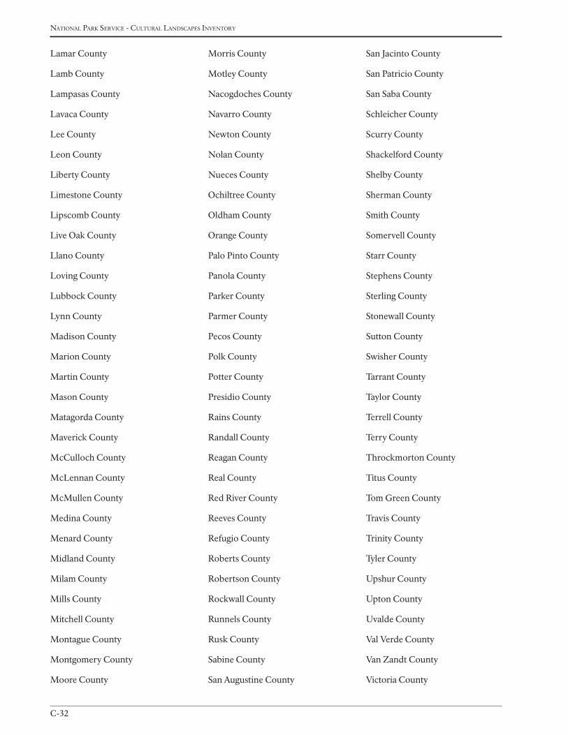
national Park service - cultural landscaPes inventory
C-32
Lamar County
Lamb County
Lampasas County
Lavaca County
Lee County
Leon County
Liberty County
Limestone County
Lipscomb County
Live Oak County
Llano County
Loving County
Lubbock County
Lynn County
Madison County
Marion County
Martin County
Mason County
Matagorda County
Maverick County
McCulloch County
McLennan County
McMullen County
Medina County
Menard County
Midland County
Milam County
Mills County
Mitchell County
Montague County
Montgomery County
Moore County
Morris County
Motley County
Nacogdoches County
Navarro County
Newton County
Nolan County
Nueces County
Ochiltree County
Oldham County
Orange County
Palo Pinto County
Panola County
Parker County
Parmer County
Pecos County
Polk County
Potter County
Presidio County
Rains County
Randall County
Reagan County
Real County
Red River County
Reeves County
Refugio County
Roberts County
Robertson County
Rockwall County
Runnels County
Rusk County
Sabine County
San Augustine County
San Jacinto County
San Patricio County
San Saba County
Schleicher County
Scurry County
Shackelford County
Shelby County
Sherman County
Smith County
Somervell County
Starr County
Stephens County
Sterling County
Stonewall County
Sutton County
Swisher County
Tarrant County
Taylor County
Terrell County
Terry County
Throckmorton County
Titus County
Tom Green County
Travis County
Trinity County
Tyler County
Upshur County
Upton County
Uvalde County
Val Verde County
Van Zandt County
Victoria County
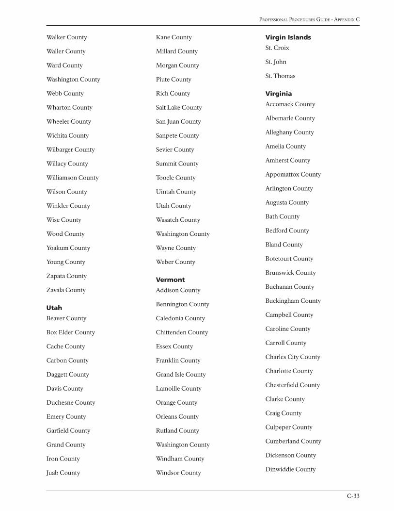
C-33
Professional Procedures Guide - aPPendix c
Walker County
Waller County
Ward County
Washington County
Webb County
Wharton County
Wheeler County
Wichita County
Wilbarger County
Willacy County
Williamson County
Wilson County
Winkler County
Wise County
Wood County
Yoakum County
Young County
Zapata County
Zavala County
utah
Beaver County
Box Elder County
Cache County
Carbon County
Daggett County
Davis County
Duchesne County
Emery County
Garfield County
Grand County
Iron County
Juab County
Kane County
Millard County
Morgan County
Piute County
Rich County
Salt Lake County
San Juan County
Sanpete County
Sevier County
Summit County
Tooele County
Uintah County
Utah County
Wasatch County
Washington County
Wayne County
Weber County
Vermont
Addison County
Bennington County
Caledonia County
Chittenden County
Essex County
Franklin County
Grand Isle County
Lamoille County
Orange County
Orleans County
Rutland County
Washington County
Windham County
Windsor County
Virgin islands
St. Croix
St. John
St. Thomas
Virginia
Accomack County
Albemarle County
Alleghany County
Amelia County
Amherst County
Appomattox County
Arlington County
Augusta County
Bath County
Bedford County
Bland County
Botetourt County
Brunswick County
Buchanan County
Buckingham County
Campbell County
Caroline County
Carroll County
Charles City County
Charlotte County
Chesterfield County
Clarke County
Craig County
Culpeper County
Cumberland County
Dickenson County
Dinwiddie County
national Park service - cultural landscaPes inventory
C-34
Essex County
Fairfax County
Fauquier County
Floyd County
Fluvanna County
Franklin County
Frederick County
Giles County
Gloucester County
Goochland County
Grayson County
Greene County
Greensville County
Halifax County
Hanover County
Henrico County
Henry County
Highland County
Isle Of Wight County
James City County
King And Queen County
King George County
King William County
Lancaster County
Lee County
Loudoun County
Louisa County
Lunenburg County
Madison County
Mathews County
Mecklenburg County
Middlesex County
Montgomery County
Nelson County
New Kent County
Northampton County
Northumberland County
Nottoway County
Orange County
Page County
Patrick County
Pittsylvania County
Powhatan County
Prince Edward County
Prince George County
Prince William County
Pulaski County
Rappahannock County
Richmond County
Roanoke County
Rockbridge County
Rockingham County
Russell County
Scott County
Shenandoah County
Smyth County
Southampton County
Spotsylvania County
Stafford County
Surry County
Sussex County
Tazewell County
Warren County
Washington County
Westmoreland County
Wise County
Wythe County
York County
City Of Alexandria
City Of Bedford
City Of Bristol
City Of Buena Vista
City Of Charlottesville
City Of Chesapeake
City Of Colonial Heights
City Of Covington
City Of Danville
City Of Emporia
City Of Fairfax
City Of Falls Church
City Of Franklin
City Of Fredericksburg
City Of Galax
City Of Hampton
City Of Harrisonburg
City Of Hopewell
City Of Lexington
City Of Lynchburg
City Of Manassas
City Of Manassas Park
City Of Martinsville
City Of Newport News
City Of Norfolk
City Of Norton
City Of Petersburg
City Of Poquoson
C-35
Professional Procedures Guide - aPPendix c
City Of Portsmouth
City Of Radford
City Of Richmond
City Of Roanoke
City Of Salem
City Of Staunton
City Of Suffolk
City Of Virginia Beach
City Of Waynesboro
City Of Williamsburg
City Of Winchester
Washington
Adams County
Asotin County
Benton County
Chelan County
Clallam County
Clark County
Columbia County
Cowlitz County
Douglas County
Ferry County
Franklin County
Garfield County
Grant County
Grays Harbor County
Island County
Jefferson County
King County
Kitsap County
Kittitas County
Klickitat County
Lewis County
Lincoln County
Mason County
Okanogan County
Pacific County
Pend Oreille County
Pierce County
San Juan County
Skagit County
Skamania County
Snohomish County
Spokane County
Stevens County
Thurston County
Wahkiakum County
Walla Walla County
Whatcom County
Whitman County
Yakima County
West Virginia
Barbour County
Berkeley County
Boone County
Braxton County
Brooke County
Cabell County
Calhoun County
Clay County
Doddridge County
Fayette County
Gilmer County
Grant County
Greenbrier County
Hampshire County
Hancock County
Hardy County
Harrison County
Jackson County
Jefferson County
Kanawha County
Lewis County
Lincoln County
Logan County
Marion County
Marshall County
Mason County
McDowell County
Mercer County
Mineral County
Mingo County
Monongalia County
Monroe County
Morgan County
Nicholas County
Ohio County
Pendleton County
Pleasants County
Pocahontas County
Preston County
Putnam County
Raleigh County
Randolph County
Ritchie County
Roane County
national Park service - cultural landscaPes inventory
C-36
Summers County
Taylor County
Tucker County
Tyler County
Upshur County
Wayne County
Webster County
Wetzel County
Wirt County
Wood County
Wyoming County
Wisconsin
Adams County
Ashland County
Barron County
Bayfield County
Brown County
Buffalo County
Burnett County
Calumet County
Chippewa County
Clark County
Columbia County
Crawford County
Dane County
Dodge County
Door County
Douglas County
Dunn County
Eau Claire County
Florence County
Fond du Lac County
Forest County
Grant County
Green County
Green Lake County
Iowa County
Iron County
Jackson County
Jefferson County
Juneau County
Kenosha County
Kewaunee County
La Crosse County
Lafayette County
Langlade County
Lincoln County
Manitowoc County
Marathon County
Marinette County
Marquette County
Menominee County
Milwaukee County
Monroe County
Oconto County
Oneida County
Outagamie County
Ozaukee County
Pepin County
Pierce County
Polk County
Portage County
Price County
Racine County
Richland County
Rock County
Rusk County
Sauk County
Sawyer County
Shawano County
Sheboygan County
St. Croix County
Taylor County
Trempealeau County
Vernon County
Vilas County
Walworth County
Washburn County
Washington County
Waukesha County
Waupaca County
Waushara County
Winnebago County
Wood County
Wyoming
Albany County
Big Horn County
Campbell County
Carbon County
Converse County
Crook County
Fremont County
Goshen County
Hot Springs County
Johnson County
Laramie County

C-37
Professional Procedures Guide - aPPendix c
Lincoln County
Natrona County
Niobrara County
Park County
Platte County
Sheridan County
Sublette County
Sweetwater County
Teton County
Uinta County
Washakie County
Weston County

national Park service - cultural landscaPes inventory
C-38

D-1
Professional Procedures Guide - aPPendix d
Appendix d
examPles of national reGister exPlanatory narrativesJAnuAry 2009
D-2
national Park service - cultural landscaPes inventory
CAmp Grosvenor HistoriC distriCt
Katmai national park and preserve (Alaska region)
Historical Landscape Architect (HLA) Samson L. Ferreira was made aware of the Fishing Camps of Katmai NPP by
park personnel in 2005, a site visit occurred in 2006. A determination of eligibility (DOE) exists for Grosvenor Camp
Historic District (Clemens, 2002). The historic context for this determination was written like a multiple property
nomination, with brief explanations for all five camps associated with the Fishing Camps of Katmai NPP (see supple-
mental info.), yet contributing resources were itemized for only Camp Grosvenor. The HLA adapted this determina-
tion to the CLI format, updated contributing and non-contributing resources, added a detailed site chronology and
site map and illustrated how identified landscape characteristics contribute to the integrity of the district.
CHisnA-Gold Hill mininG lAndsCApe
Wrangell-st. elias national park and preserve (Alaska region)
The original Chisana district nomination to the National Register of Historic Places was in 1985, and included only
Chisana City, an area of approximately 30 acres. In 1998 the nomination was expanded to include the Gold Hill
landscape and was called the Chisana Historic Mining Landscape. This CLI refers to this expanded landscape as the
Chisana - Gold Hill Historic Mining Landscape, to reflect the inclusion of the Gold Hill mining area described in
the 1998 nomination. No resources have been added as a result of this Inventory. The boundary for the district was
redrawn in ARCGIS 9 and more accurately reflects the original boundary description in the 1998 nomination. Subse-
quently, the acreage was decreased from 27,700 acres to 27,216 acres.
eisenHoWer FArms
eisenhower national Historic site (northeast region)
(site with overlapping districts and legislatively derived significance)
The 690-acre Eisenhower National Historic Site consists of the home and farm (Farm #1) of General Dwight D.
Eisenhower, 34th president of the United States, two neighboring farms, (Farms #2 and #3) related to the agricultural
operations at the Eisenhower farm, and the Clement Redding farm.
The 238-acre Eisenhower farm was designated a national historic landmark on May 23, 1966. The home and farm
was designated a national historic site on November 27, 1967, by Secretary of the Interior Stewart L. Udall under the
National Historic Sites Act of 1935. The Order of Designation identifies the site as significant for its association with
the life and work of General Eisenhower, and because of its relation to the historic battle of Gettysburg during the
Civil War.
Farms #2 and #3, which total 260-acres, were transferred to the Gettysburg National Military Park on September
12, 1962 and administratively listed in the National Register of Historic Places on October 15, 1966. On December
2, 1969 a Joint Resolution (Public Law 91-133) was passed by Congress which transferred Farms #2 and #3 from the
Gettysburg National Military Park to the Eisenhower National Historic Site. Public Law 95-625 added the adjacent
Clement Redding Farm to the site in November 10, 1978.
Appendix d: exAmples oF nAtionAl reGister explAnAtory nArrAtives
D-3
Professional Procedures Guide - aPPendix d
Additionally, all four farms are included within the National Register boundary of the Gettysburg Battlefield Historic
District, listed on March 19, 1975. The approximately 11,000-acre Gettysburg Battlefield Historic District embraces
the land area associated with the battle of Gettysburg.
m’ClintoCK House
Women’s rights national Historical park (northeast region)
(pre- NPS documentation, remnant features)
While the M’Clintock House has been listed on the National Register of Historic Places, the landscape characteris-
tics and features have not been adequately documented. Therefore, the following narrative includes, first, a summary
of the current listings, and second, recommendations regarding the landscape characteristics and features of the
M’Clintock House property.
The M’Clintock House; located at 14 East Williams Street, Waterloo, NY; was listed on the NR in 1980 as part of the
Women’s Rights Historic Sites Thematic Resources Nomination. Five sites are documented in the thematic nomina-
tion and are significant under Criterion A for their association with the Women’s Rights Convention of 1848, held
in Seneca Falls. The focus of the period of significance for the thematic resources nomination is 1847-1849, which
includes the events directly leading to the first Women’s Rights Convention, as well as the events immediately follow-
ing.
Based on the Analysis and Evaluation section, this CLI finds that the cultural landscape of the M’Clintock House
provides a setting and contributes to the property’s character. While the remaining cultural landscape characteristics
retain limited integrity, due to the great amount of change since the end of the period of significance in 1849, those
landscape characteristics and features that do remain, should be preserved. The thematic nomination should be up-
dated to include a discussion of the landscape characteristics and features of the M’Clintock House that remain.
sKylAnd
shenandoah national park (northeast region)
Initial National Register documentation for the Skyland resort was prepared in a draft nomination for a Skyland His-
toric District by Reed Engle, Cultural Resource Specialist, Shenandoah National Park (NP), on April 19, 1994. This
draft was not finalized.
On April 28, 1997, the park’s Skyline Drive was documented in a nomination for a Skyline Drive Historic District,
with significance under Criteria A and C. Shortly thereafter, a boundary increase to the historic district was com-
pleted to include a portion of the Big Meadows area as well as Dickey Ridge, Simmons Gap, Piney River, and the
Headquarters area, also deriving significance under Criteria A and C. Neither the original nomination for the Skyline
Drive Historic District nor its boundary increase included the Skyland resort until documentation for a second
boundary increase was completed on December 5, 2003. Skyland, along with two other distinct areas along Skyline
Drive – Big Meadows and Lewis Mountain – were added to the historic district, deriving significance under Criteria
A, B, and C. The nomination was completed by Judith Robinson, Stephanie Foell, and Tim Kerr, Architectural His-
torians at Robinson & Associates, Inc., and Reed Engle. Expanding on Engle’s earlier Skyland research, the nomi-
nation identified additional contributing and non-contributing features and shortened the period of significance to
1890-1952. The nomination also identified Skyland’s significance under Criteria A and C. Criterion B is applicable at
Herbert Hoover’s summer retreat, Big Meadows/Rapidan Camp, only.
D-4
national Park service - cultural landscaPes inventory
AppAlACHiAn trAil-CentrAl distriCt
shenandoah national park (northeast region)
Portions of the Appalachian Trail (AT) within the North, Central, and South Districts of Shenandoah National Park
(NP) are listed in the National Register of Historic Places as part of the Skyline Drive Historic District. Included
in the original National Register listing are seventeen of the twenty-nine crossings where the AT and Skyline Drive
intersect, counted as one contributing site, which span the 125-foot-wide district right-of-way to either side of the
drive (250-feet-wide overall). Additional segments of the AT were included in subsequent boundary increases of the
Skyline Drive Historic District made in 1997 and 2003 that incorporated park facilities adjoining the Skyline Drive
corridor. In these areas, the AT passes through approximately 300-feet of the Simmons Gap ranger station and park
maintenance facilities cluster, through approximately one mile at the Skyland resort, and provides the eastern bound-
ary of the Loft Mountain campground and picnic area. Within these boundary expansions, the AT is not listed as a
contributing resource. At Skyland, however, the AT follows approximately 2,500 feet of the Stony Man Nature Trail,
which is listed as a contributing resource.
The Statement of Significance for the original Skyline Drive Historic District listing describes the significance of the
AT in the area of regional planning. However, the AT is minimally addressed and treated primarily as a precursor to
the development of Skyline Drive. As noted above, only a portion of the AT crossings with Skyline Drive are iden-
tified in National Register documentation. Since these crossings represent only a very small fraction of the many
contributing resources that have now been identified, this cultural landscape inventory has recorded the current
National Register documentation as “undocumented.”
HistoriC motor roAd system
Acadia national park (northeast region)
On November 14, 1979, two bridges currently associated with the Acadia National Park’s historic motor road system
on Mount Desert Island were listed in the National Register of Historic Places under “Carriage Paths, Bridges and
Gatehouses, Acadia National Park.” They are the Dane Farm Bridge (LCS #041106) and the Stanley Brook Bridge
(LCS #006572). The segments of the historic motor road system on Mount Desert Island are not currently listed
on the National Register, but in consultation with the Maine Historic Preservation Commission, were determined
eligible for listing on March 26, 1993, through a report, “Evaluation of Eligibility of the Historic Motor Road System,
Acadia National Park, for the National Register of Historic Places.” The evaluation report identifies the national
significance of the motor road system for association with John D. Rockefeller, Jr. The design of the motor road
system is significant at the national level as the work of the Olmsted landscape architectural firm under the direction
of Frederick Law Olmsted, Jr. and at the state level for the development of tourism in the State of Maine. The evalu-
ation report also notes the National Register listings of other roads and related structures by the Bureau of Public
Roads (BPR) in the national park system. At the time the report was written in 1993, Criteria Consideration G was
identified for the road segments and structures built on the island after World War II: the Paradise Hill Road bridges,
Day Mountain Road Extension, and Bureau of Public Roads Project 4A2. The report identified the period of signifi-
cance as the period of planning and construction for the motor roads, 1921-1958. The Maine Historic Preservation
Commission concurred with the additions of these motor road segments, as well as nineteen bridges, to the List of
Classified Structures on July 1, 1996.
The two segments of the historic motor road system on Schoodic Peninsula, Schoodic Loop Road and Schoodic
Point Road, were entered into the National Register as part of the Schoodic Point Historic District on June 29, 2007.
D-5
Professional Procedures Guide - aPPendix d
According to the National Register listing, the two motor road segments on the Schoodic Peninsula are signifi-
cant under criteria A, B, and C under two historic contexts: John D. Rockefeller, Jr. and the National Park Service
(1913-1958), and Rustic Design (1890-1958). Specifically, the two motor roads relate to one of the Rustic Design
subthemes – Rustic Design in the National Park Service (1916-1958). The period of significance for Schoodic Pen-
insula Historic District is 1930-1941, which begins when development of the Schoodic Peninsula lands began and
ends when the last park-related structures were built in the Rustic Design style. The National Register listing does not
provide a specific period of significance for the two historic motor road segments. In addition to the two motor road
segments, the Fraser Creek causeway and the John Godfrey Moore Memorial Plaque (LCS #041362) were deter-
mined as contributing resources.
The “Historic Resources of Acadia National Park” Multiple Property Documentation Form (MPDF) was accepted
by the National Register for Historic Places on June 29, 2007. The MPDF identifies property types and historic
contexts with which to evaluate park resources. The motor road system is identified as part of the “Circulation Sys-
tems” property type under two contexts: “John D. Rockefeller, Jr. and the Development of the National Park System
(1913-1958),” and “Rustic Design (1890-1958)” and its subthemes, the Picturesque Style (1890-1950) and “Rustic
Design of the National Park Service (1916-1958).” It defines the historic motor road system as being comprised of
automobile tour roads on both Mount Desert Island and the Schoodic Peninsula. Registration requirements outlined
in the MPDF for the motor roads require that they retain sufficient integrity in design, setting, and location. (Specific
registration requirements are discussed in the Analysis and Evaluation section of this CLI.) The MPDF describes
the collaborative efforts of John D. Rockefeller, Jr., Frederick Law Olmsted, Jr., the BPR, and the NPS. It notes the
minimal impact of the motor roads on the landscape and their respect to the natural topography, the standards of
the rustic design style, and the unifying design characteristics of the road segments themselves and their associated
bridges and other engineering structures. At the time the MPDF was approved in 2007, it noted that Criteria Con-
sideration G does not need to be applied because the final motor road segment completed in 1958, Bureau of Public
Roads Project 4A2, was an integral component of the motor road network and therefore contributed to the overall
significance of the historic motor road system.
Pursuant to Section 110 of the National Historic Preservation Act, there has been a recent consultation with the
Maine Historic Preservation Commission regarding the historic motor road system. The Allesandro Fabbri Memorial
Plaque, erected in 1937 along the park loop road to honor the founder and commander of the Naval Radio Station at
Otter Cliffs, was determined eligible for listing in the National Register on October 31, 2007.
Westside roAd
mount rainier national park (pacific West region)
The Westside Road and its associated features and surrounding landscape were described in the 1997 National
Register nomination and designated a National Landmark District in 1997. However, the National Register nomina-
tion did not adequately document the landscape characteristics and features along the road. This CLI expands the
description of the road’s setting, provides greater detail, and reevaluates the boundary, including the last three miles
that are now managed as a trail.

D-6
national Park service - cultural landscaPes inventory
E-1
Professional Procedures Guide - aPPendix e
Appendix e
Guidelines for inventory and consensus determination consultationJAnuAry 2009
E-2
national Park service - cultural landscaPes inventory
Appendix e: Guidelines for inventory And Consensus
determinAtion ConsultAtion
The following is excerpted from The Secretary’s Standards and Guidelines for Federal Agency Historic Preservation Pro-
grams and can be referenced as a guideline for Consensus Determination Consultation.
stAndArd 6.
An agency must provide for consultation with knowledgeable and concerned parties outside the agency.
(1) Consultation means the process of seeking, discussing, and considering the views of others, and, wherever
feasible, seeking agreement with them on how historic properties should be identified, considered, and managed.
Consultation is built upon the exchange of ideas, not simply the provision of information. Whether consulting on a
specific project or on broader agency programs, the agency should:
(a) make its interests and constraints clear at the beginning;
(b) make clear any rules, processes, or schedules applicable to the consultation;
(c) acknowledge others’ interests as legitimate, and seek to understand them;
(d) develop and consider a full range of options; and,
(e) try to identify solutions that will leave all parties satisfied.
(2) Consultation should be undertaken early in the planning stage of any Federal action that might affect historic
properties. Although time limits may be necessary on specific transactions carried out in the course of consultation
(e.g., the time allowed to respond to an inquiry), there should be no hard-and-fast time limit on consultation over-
all. Consultation on a specific undertaking should proceed until agreement is reached or until it becomes clear that
agreement cannot be reached.
(3) Consultation should not be limited to the consideration of specific projects, but should instead include broader
efforts to maintain ongoing communication with all those public and private entities that are interested in or affected
by the agency’s activities.
(4) While specific consultation requirements and procedures will vary among agencies depending on their missions
and programs, the nature of historic properties that might be affected, and other factors, consultation should always
include all affected parties. Section 11 0(a)(2)(D) specifies consultation with other Federal, State, and local agencies,
Indian tribes, Native Hawaiian organizations and the private sector. The appropriate SHPO is an important point of
contact. In addition to having a formal role under the Act, the SHPO can assist in identifying other parties with inter-
ests, as well as sources of information.
(5) The agency needs to inform other agencies, organizations, and the public in a timely manner about its projects
and programs, and about the possibility of impacts on historic resources of interest to them. However, the agency
cannot force a group to express its views, or participate in the consultation. These groups also bear a responsibil-
ity, once they have been made aware that a Federal agency is interested in their views, to provide them in a suitable
format, and in a timely fashion.
(6) Agency efforts to inform the public about its projects and programs and about the possibility of impacts on
historic resources must be carried out in a manner consistent with the provisions of Section 304 of the Act, which
E-3
Professional Procedures Guide - aPPendix e
calls for withholding from disclosure to the public information on the location, character, or ownership of a historic
resource where such disclosure may:
(a) cause a significant invasion of privacy;
(b) risk harm to the historic resource; or
(c) impede the use of a traditional religious site by practitioners.
(7) Inclusion of Indian tribes and Native Hawaiian organizations in the consultation process is imperative and is
specifically mandated by the Act:
(a) properties with traditional religious and cultural importance to Native American and Native Hawaiian groups may be eligible for the National Register; such properties must be considered and the appropriate Native American and/or Native Hawaiian groups must be consulted in project and program planning through the Section 106 review process (see NHPA Sec. 101(d)(6)(A&B);
(b) the Native American Graves Protection and Repatriation Act of 1990 (NAGPRA) establishes consultation require-ments that may affect or be affected by consultation pursuant to Section 106 of the NHPA concerning activities on Federal and Tribal lands that could affect human remains and cultural items;
(c) Section 110 requires that an agency’s efforts to comply with Section 106 must also be consistent with the require-ments of Section 3(c) of NAGPRA concerning the disposition of human remains and Native American cultural items from Federal and Tribal lands.
(8) Where those consulted do not routinely or customarily participate in traditional governmental means of consulta-
tion (e.g., through public meetings, exchanges of correspondence), reasonable efforts should be made to accommo-
date their cultural values and modes of communication.

E-4
national Park service - cultural landscaPes inventory
F-1
Professional Procedures Guide - aPPendix f
Appendix F
determination for eliGibility for inclusion in the national reGister of historic PlacesJAnuAry 2009
F-2
national Park service - cultural landscaPes inventory
The following is excerpted from Part 63 of 36 CFR Ch. I (7-1-89 Edition), Determinations of Eligibility for Inclusion in
The National Register of Historic Places and can be referenced as a guideline for Determinations of Eligibility.
pArt 63—determinAtions oF eligibility For inclusion in the nAtionAl register oF
historic plAces
Section:
63.1 Purpose and authorities.
63.2 Determination of eligibility process.
63.3 Procedures to be applied when the agency and the State Historic Preservation Officer agree a property is eligible.
63.4 Other properties on which determinations of eligibility may be made by the Secretary of the Interior.
63.5 Federal Register publication of properties determined eligible.
63.6 Review and nomination of properties determined eligible.
Authority:
Sec.2(k), Historic Sites Act of 1935, 16 U.S.C. 462 (K) (1970 ed); sec. 101 (a)(1), National Historic Preservation Act of
1966, as amended, 16 U.S.C. 470 (a)(1) (1970 ed) I; secs. 3(b) and 4(f), E.O. 11593; sec. 2 of Reorganization Plan No. 3
of 1950 (34 Stat.1262).
Source:
42 FR 47661, Sept.21, 1977, unless otherwise noted. Redesignated at 45 FR 28716, April 30, 1980, and 46 FR
34329, July 1, 1981.
sec. 63.1 purpose and Authorities
These regulations have been developed to assist Federal agencies in identifying and evaluating the eligibility of
properties for inclusion in the National Register. The regulations explain how to request determinations of eligibility
under Section 2 (b) of Executive Order 11593 and the regulations of the Advisory Council on Historic Preservation
(36 CFR Part 800) for implementation of sections 1(3) and 2(b) of Executive Order 11593 and the National Historic
Preservation Act of 1966, as amended Federal agencies request determinations of eligibility in considering historic
properties on lands under their jurisdiction or control or on lands to be affected by proposed actions.
sec. 63.2 determination of eligibility process
The Department of the Interior will respond within 45 days of receipt of a documented request for a determination
of eligibility from a Federal agency when it is submitted in accordance with the following regulations and is accompa-
nied by documentation that clearly portrays the nature and significance of the property.
(a) The agency shall consult the State Historic Preservation Officer as the first step in identifying historic properties
for information concerning:
(1) Properties listed in the National Register
(2) Properties in the process of nomination to the National Register.
Appendix F: determinAtions oF eligibility For inclusion in the
nAtionAl register oF historic plAces

F-3
Professional Procedures Guide - aPPendix f
(3) Properties determined eligible by the Secretary of the Interior for listing in the National Register.
(4) Any other available information that would assist in identifying properties in the area affected by the proposed ac-tion.
(b) If the State Historic Preservation Officer has inadequate information to document the presence or absence of
historic properties in the project area, the Federal agency should refer to the Department of the Interior’s criteria
for the identification of historic properties and the guidelines for level of documentation to accompany requests for
determinations of eligibility for inclusion in the National Register published as a notice in the Federal Register.
(c) The agency shall, in consultation with the State Historic Preservation Officer, apply the National Register Criteria
for Evaluation contained in 36 CFR 60.6 to all potentially eligible properties that may be affected by the proposed ac-
tion. If a property appears to meet the Criteria and the State Historic Preservation Officer agrees, the agency should
follow the procedures in s.63.3. If there is a question whether the Criteria are met, the agency shall complete the
procedures in s63.3(d). A question on whether a property meets the Criteria exists when the agency and the State
Historic Preservation Officer disagree or when the agency determines that a question exists. The Department of the
Interior will provide general and specific advice concerning the identification of historic properties and will bring to
the attention of a Federal Agency any information received from the public regarding potential historic properties in
the area affected by its plans or projects.
(d) The agency shall submit a letter of request for a determination of eligibility with a description, statement of
significance, photographs, and a map, or a statement in accord with s63.3 below, if applicable, directly to the Keeper
of the National Register, National Park Service, Department of the Interior, Washington, DC 20240. If available, the
opinion of the State Historic Preservation Officer on the eligibility of the property should also be forwarded with the
request.
(e) The Keeper, National Register, will respond in writing to the agency’s request within 45 days of receipt of a docu-
mented request submitted in accord with s63.2(d) of these procedures. If the opinion of the State Historic Preserva-
tion Officer is not included with the request, the Keeper of the National Register will provide to the State Historic
Preservation Officer a copy of the request and will ask for his opinion on the property. If the Keeper does not receive
the State Historic Preservation Officer’s response within three weeks of the State Historic Preservation Officer’s
receipt of a letter from the Keeper requesting an opinion, the Keeper will proceed with the determination and will
inform the agency that the State Historic Preservation Officer did not give an opinion. If the Keeper of the National
Register determines that documentation submitted with the request is not sufficient to make a professional evalua-
tion of the significance of the property, he will advise the agency in writing of the additional information needed. The
Keeper of the National Register will respond to the agency’s request within 45 days of receipt of documentation on
the property requested by the Keeper.
sec. 63.3 procedures to be Applied When the Agency and the state historic preservation of-ficer Agree a property is eligible.
If during the consultation described in s63.2(c), both the agency and the State Historic Preservation Officer agree
that a property meets the Criteria, the Federal agency or the State Historic Preservation Officer shall forward to the
Keeper of the National Register.
(a) a letter signed by the agency stating that the agency and the State Historic Preservation Officer agree that the
property is eligible for inclusion in the National Register, and
(b) a statement signed by the State Historic Preservation Officer that in his opinion the property is eligible for the
National Register. Either the letter or the statement must contain substantive information on the property, includ-
F-4
national Park service - cultural landscaPes inventory
ing a description, specific boundaries, its significance under National Register Criteria, and an explanation of why
the property is eligible for listing in the National Register. The Keeper of the National Register shall give written
notice of his determination to both the agency and the State Historic Preservation Officer within 10 working days of
receipt. If the property has not been accurately identified and evaluated, the Keeper will inform the agency and the
State Historic Preservation Officer within 10 working days and will recommend that the agency follow the process
set forth at s63.2. Notwithstanding such recommendation, the Federal agency or the Keeper of the National Regis-
ter may consider the property eligible for the purpose of obtaining the Advisory Council on Historic Preservation’s
comments. Documentation concerning properties determined eligible for the National Register shall be kept on file
by the agency and the State Historic Preservation Officer.
sec. 63.4 other properties on Which determinations of eligibility may be made by the secre-tary of the interior
(a) The Keeper of the National Register will make determinations of eligibility on properties nominated by Federal
agencies under section 2(a) of Executive Order 11593 prior to returning the nominations for such properties to the
agency for technical or professional revision or because of procedural requirements. Such determinations of eligibil-
ity will be made only if sufficient information exists to establish the significance of the property and its eligibility for
the National Register.
(b) Any property or district removed from the National Register for procedural deficiencies in the nomination and/or
listing process shall automatically be considered eligible for inclusion in the National Register without further action
and will be published as such in the Federal Register.
(c) If necessary to assist in the protection of historic resources, the Keeper, upon consultation with the appropriate
State Historic Preservation Officer and concerned Federal agency, if any, may determine properties to be eligible for
listing in the National Register under the Criteria established by 36 CFR Part 60 and shall publish such determina-
tions in the Federal Register. Such determinations may be made without a specific request from the Federal agency
or, in effect, may reverse findings on eligibility made by a Federal agency and State Historic Preservation Officer. Such
determinations will be made after an investigation and an onsite inspection of the property in question.
sec. 63.5 Federal register publication of properties determined eligible.
In addition to written notice to the Federal agency and the State Historic Preservation Officer, public notice of prop-
erties determined eligible for the National Register will be published in the Federal Register at regular intervals and
in a cumulative annual edition usually issued in February. Determinations in accord with S 63.3 will be identified with
an asterisk.
sec. 63.6 review and nomination of properties determined eligible.
The Keeper of the National Register will conduct an annual review of the condition of properties determined eligible
for the National Register. The Keeper of the National Register will obtain from the Advisory Council on Historic
Preservation information on decisions made concerning eligible properties in accord with memorandum of agree-
ment under the Council’s “Procedures for the Protection of Historic and Cultural Properties” (36 CFR Part 800).
If there is no memorandum of agreement or if no provision has been made in a memorandum of agreement for
nomination of an eligible property and if the property retains the characteristics that made it eligible for the National
Register, the Keeper of the National Register will take the following steps:

F-5
Professional Procedures Guide - aPPendix f
(a) For a property owned by a Federal agency, or under the jurisdiction or control of the agency to the extent
that the agency substantially exercises the attributes of ownership, the Keeper of the National Register will
request the Federal agency to nominate the property to the National Register within six months.
(b) If the property is not under Federal jurisdiction or control, the Keeper of the National Register will request
that the State Historic Preservation Office nominate the property to the National Register within six months.
(c) If the Keeper of the National Register determines that a property has lost the characteristics that made it
eligible for the National Register, he will inform the State Historic Preservation Officer and the Federal agency
and remove the property from the list of eligible properties.

F-6
national Park service - cultural landscaPes inventory

G-1
Professional Procedures Guide - aPPendix G
Appendix G
examPles of statements of siGnificanceJAnuAry 2009
G-2
national Park service - cultural landscaPes inventory
CAmp Grosvenor HistoriC distriCt
Katmai national park and preserve (Alaska region)
Camp Grosvenor Historic District (XMK-00132) reflects the development of early tourism within Katmai National
Park and Preserve. It can be characterized as a historic vernacular landscape and its period of significance is from
1950-1959. During the 1950s, five camps were established by Raymond I. Petersen, president of Northern Consoli-
dated Airlines (NCA), that appealed primarily to fishermen. Grosvenor is one of the five original sport-fishing camps
that has been in operation for over fifty years. The remaining four original camps include: Brooks Camp (XMK-
00142); Kulik Camp (XMK-00l43); Battle Lake Camp (ILI-00122); and Nonvianuk Camp (ILI-00125). Grosvenor
continues to be the only camp in operation that reflects the rustic and intimate fish camp experience as it has re-
mained a small operation, while the camps at Brooks River and Kulik grew into larger enterprises and the camps at
Battle Lake and Nonvianuk were less developed, experienced decreased usage, and currently receive only sporadic
use.
Grosvenor has operated as a sport fishing camp from 1950 to the present. The camp retains a strong sense of its
historic setting. Changes to the site are all related to the operation of the camp business. The natural setting contin-
ues to dominate the site with a minimal amount of cleared vegetation around the pathways and the buildings. As the
camp evolved, the concessionaire sited buildings consistently away from the beach. The camp maintains its orienta-
tion to the lakes, with visitors continuing to arrive and depart by float-plane. The camp maintains spatial continuity
as a linear pattern along one primary gravel pathway, conforming to the general topography and orientation of the
peninsula. Another key relationship that has been maintained is the function of buildings and structures from the
1950s (the 1950 and 1959 cabins) and zones of use. The size and scale of the buildings are appropriate in relation to
each other and continue to reflect basic and functional guest accommodations. While significant improvements have
been made, the camp continues to display its historic character through its buildings and structures and their spatial
relationship with the surrounding landscape.
Grosvenor Camp Historic District is eligible for listing on the National Register of Historic Places under Criterion
A and Criterion Consideration G, for its association with early tourism in the Katmai region from 1950-1959. While
the Camp has experienced some changes, it continues to convey its significance through its location, design, setting,
materials, workmanship, feeling and association.
Criterion Consideration G: Properties That Have Achieved Significance within the Past Fifty Years.
According to the criterion, properties that have achieved significance within the last 50 years may be eligible for list-
ing if they are integral parts of districts that are eligible for listing in the National Register. The contributing proper-
ties within Grosvenor Camp Historic District are: Grosvenor Cabin; outhouse; and the Pilot’s Cabin that were all
built in 1950; one structure (Generator Shed) built in 1954; and four buildings (Guest Cabins #1 & #2, the old Bath
House that were built in 1959 and the Lodge that was built in 1957). The latter constructed buildings and structures
are integral to the period of significance (1950-1959) and to the camp history. There is sufficient perspective to con-
sider these properties historic resources, as the additional cabins, the bath house, and the lodge are essential parts of
the historic camp. These Pan-Abode constructed buildings clearly maintain the character of the district as they reflect
the continuity of simple, practical design and materials, and through their construction helped solidify the spatial
organization of the historic camp which remains to this day.
Appendix G: exAmples of stAtements of siGnifiCAnCe
G-3
Professional Procedures Guide - aPPendix G
CHisAnA-Gold Hill mininG lAndsCApe
Wrangell-st. elias national park and preserve (Alaska region)
The scene of Alaska’s last important gold rush, the Chisana district played a key role in the history of interior Alaska.
While few struck it rich, the resulting demand for materials and supplies helped establish regional transportation
networks, encouraged supporting industries, and hastened the exploration and settlement of both the Copper and
Tanana Basins.
The Chisana district was particularly significant from 1913 to 1915, the period encompassing its discovery, stampede,
and boom. It remained locally important through 1942, when war-time exigencies virtually ended local mining. For-
mer Klondike stampeders and prototypical prospectors William E. “Billy” James and Nels P. Nelson made the first
gold discoveries in the Chisana district, thereby precipitating the Chisana rush. Each subsequently devoted the rest
of his life to developing mining properties in the district. Both miners are associated with buildings in Chisana City
and each constructed sections of the two main Bonanza flumes (NAB-059 and NAB-064). Nelson is also associated
with NAB-046, a large camp situated on upper Bonanza Creek, and NAB-060, the area’s largest hydraulic mining cut.
Shushanna Joe, an Upper Tanana Indian whose traditional territory included the entire Chisana region, guided James
and Nelson to the site of their Bonanza Creek discovery. He subsequently spent the remainder of his life in the area,
working as a trapper, market hunter, prospector, and miner, before finally dying in Chisana City about 1960. Joe, who
exemplifies the major but often neglected role played by Alaska Natives in advancing the territory’s mining frontier, is
associated with NAB-053, a small mining camp located on lower Bonanza Creek. He is buried in Chisana City (NAB-
210).
Carl F. Whitham was also present at the time of the Chisana discovery and mined in the vicinity for more than a
decade. He eventually moved about thirty-five miles west to a site near the Nabesna River where he established and
operated the Nabesna Mine, now listed on the National Register of Historic Places. Whitham is associated with
NAB-051, an elaborate camp situated at the mouth of Skookum Creek.
Embodying its period of early twentieth century, small-scale, placer mining, Chisana’s cultural landscape superbly il-
lustrates both its mining processes and its evolutionary sequence. Unusually complex, it retains examples of virtually
all of its historic components, including a city, two town sites, numerous tent camps, two sawmill sites, various water
diversion and delivery systems, a full range of hand, hydraulic, and mechanical mining operations, and an associated
transportation network. It also contains a wide assortment of small-scale features, such as sluice and rocker boxes,
metal mining boilers, steampoints, hydraulic nozzles, and metal penstock pipe, as well as more ephemeral elements
like sled and wagon remnants and tool, trash, and domestic artifact scatters (Bleakley, 1998:22).
The Chisana district contains data which may be vital to any wider, comparative study of twentieth century placer
mining. Its excellent examples of hand-mining methods are relatively rare: evidence of such activity elsewhere was
often obliterated by subsequent hydraulic or dredging epochs. Further investigations in the Chisana district could
also address key questions regarding mining variability and change. The timing, speed, and conditions under which
innovations occurred are likely to be especially important. Excavations could also provide additional social data, in-
cluding a better estimate of the district’s population; the role played by women and Alaska Natives; the nature of the
miner’s material culture; and the production, distribution, and consumption of commodities.
G-4
national Park service - cultural landscaPes inventory
GiddinGs property
Kobuk valley national park (Alaska region)
The Giddings Property is a 1.3-acre historic site within the Onion Portage Archeological District NHL. This CLI il-
lustrates the significance of the Giddings property under Criteria B through its association with J. Louis Giddings and
his significant contributions to archeology and anthropology in northwest Alaska. In addition Criteria Consideration
G is applicable as well, as it is less than 50 years old, but of exceptional importance. The period of significance is 1963
to 1964. The areas of significance are prehistoric archeology, and science. The level of significance is local and state.
The Giddings site was used every summer as a base camp for excavation work between 1963 and 1968. It is the place
where Giddings and his graduate students worked, ate, slept, analyzed data, wrote field notes and stored artifacts. It
was both laboratory and base camp, and is an obvious extension of the Onion Portage archeological site. The NHL
nomination for Onion Portage site focused on the significance of the information that was discovered at Onion Por-
tage, and how significant this contribution was to northwest arctic Alaskan archeology and anthropology (the theme
is ‘Understanding the Earliest People of North America’). In short the Onion Portage site verified and expanded
existing knowledge concerning the prehistoric cultural chronology of northwest Alaska. Specifically, Giddings’
discovery at Onion Portage and other related sites (Cape Krusenstern, Iyatayet, and other Denbigh sites) established
a definitive cultural chronology for northwest Alaska. This discovery was of national and state significance, and the
information obtained from the Onion Portage site was the key to understanding the chronological sequence of these
ancient cultures. The Giddings Property is exceptionally important in light of the fact that the discoveries at the On-
ion Portage site contributed significantly to the advancement of NW Alaskan archeology and anthropology, and that
the Giddings Property was the physical location where these ideas were analyzed and articulated, as well as where
most artifacts were stored prior to their exportation to facilities in the lower 48. Moreover, the cabin is the building
where Giddings wrote a substantial portion of his final work, “Ancient Men of the Arctic”, in which he outlines the
importance of the Onion Portage site, and its importance to the field of northwestern Alaskan archeology.
Criterion B.
Born James Louis Giddings Jr. in 1909 in Caldwell, Texas, Giddings was a naturalist and explorer turned archeologist.
Graduating from the University of Alaska, Fairbanks in 1932, Giddings spent several years exploring northern Alaska
and collecting samples for his work in tree-ring chronology or dendrochronology. In 1939, Giddings was introduced
to archeology while working with UAF anthropologists Froelich Rainey and Helge Larsen at Point Hope, Alaska.
Giddings went on to receive an M.A. from the University of Arizona in the field of dendrochronology in 1941 and
a Ph.D. in anthropology from the University of Pennsylvania in 1951. Of his numerous scientific papers and mono-
graphs on a wide variety of topics such as dendochronology, archeology, ethnology, Eskimo kinship, and mythology,
Giddings is most famous for his contributions in the field of Alaskan archeology. These contributions are the founda-
tions of our knowledge of the origin and development of Eskimo culture in northwest Alaska.
Giddings contributions to our knowledge of Eskimo culture resulted from a series of significant archeological dis-
coveries in Alaska and Canada. In addition to his participation in the discovery of the Ipiutak Eskimo culture site dat-
ing from the 2nd to the 6th century AD at Pt. Hope, Giddings also discovered significant sites at Cape Denbigh, Cape
Krusenstern, and Onion Portage. In 1948, Giddings discovered and eventually described the Denbigh Flint complex,
generally recognized as the primary local source for current Eskimo culture, at Iyatayet (Cape Denbigh) in Norton
Sound on the Bering Coast. Giddings named the unique style of small, fine, pressure flaked flint tools associated with
this culture the “Arctic Small-Tool tradition.” As the result of his work, the Ipituak site at Point Hope and Iyatayet site
on Cape Denbigh were designated National Historic Landmarks (NHL) in 1961.
G-5
Professional Procedures Guide - aPPendix G
In 1958, Giddings identified and began surveying the beach ridges along the ever-changing Alaska shoreline of the
Chukchi Sea. The horizontal stratigraphy of this series of 114 marine beach ridges contained 5,000 or more years of
northwestern Alaska cultural history. In 1973, Cape Krusenstern was designated an archeological district and a Na-
tional Historic Landmark (NHL) and in 1980, a portion of the Landmark was proclaimed a National Monument.
Although Giddings first found the Onion Portage site in 1941 while conducting dendrochronology tests along the
Kobuk River, it was not until 1961 that he discovered the extensive occupational layers at the site, and actually began
to inhabit the Giddings property. Archeological excavations at the Onion Portage site have identified the presence
of almost continuous human occupation since at least, 8500 BP, including eight stratigraphic bands within which lie
numerous cultural components. In the opinion of Henry B. Collins, Bureau of American Ethnology, Smithsonian
Institution, “The deep, stratified Onion Portage site on the middle Kobuk, discovered by Giddings in 1961, is without
doubt the most important archaeological site within the Arctic. Covering 2 acres and reaching a depth of 18 feet, it
has over 30 distinct occupation levels containing in vertical sequence the hearths and artifacts of most of the cultures
represented on the Krusenstern beaches, as well as others known heretofore only from undated, unstratified surface
sites in the interior” (Collins, 1965; 66-67). Until this time it was thought that Inupiaq culture was primarily a marine
based culture limited to the coastal areas of Alaska, however his discoveries at this site, as well as his previous work
at Cape Krusenstern, Iyatayet, and other Denbigh sites, led Giddings to connect the interior Onion Portage site with
the sites on the coast. Giddings also hoped that the Onion Portage site would provide a vertical succession of Arctic
cultures, in the way that the Cape Krusenstern beaches had provided a horizontal one, and indeed this turned out to
be the case. In fact it represented in vertical sequence not only the Cape Krusenstern layers, but many others that had
yet to be placed within a northwest Alaskan cultural chronology.
In December of 1964, Louis Giddings died unexpectedly while recuperating in the hospital after an automobile ac-
cident. His mentorship of so many, however, allowed the fieldwork at Onion Portage to continue. Douglas Anderson,
Giddings’ assistant, and his crews were eventually able to identify eight different cultures at the site, ranging from the
Akmak complex (over 8,500 years old) through the Arctic Woodland Eskimo culture (A.D. 1000-1700), thus fulfilling
Giddings’ vision of the unique scientific potential of Onion Portage. Thus Giddings’ discovery at Onion Portage ex-
panded existing theories concerning Inupiaq anthropology and more importantly, contributed to the establishment
of a reliable cultural chronology for NW Alaska, one which is still the basis for archeological work in the region today.
Giddings’ contributions to the field of northwest Alaskan archeology are exceptionally important. By association the
Giddings property is also significant as the place where much of this information was analyzed, recorded and stored.
An important work of Alaskan archeological history was also written at the Giddings site. Namely Giddings’ “Ancient
Men of the Arctic”, posthumously published by his wife in 1967. It was nationally known, and probably of interest
internationally to Beringia scholars, however its significance lies at the state level, as his discoveries over his career
in arctic Alaska pioneered new field methodologies in the region, and answered regionally significant archeological
questions. While not field notes or a trip report, the book does interpret and summarize his findings during the many
years he spent in NW Alaska, as well as how they contribute to the regional anthropological and archeological ques-
tions of his day. In addition it provides amusing anecdotes of camp life that occurred at both the Giddings site and
the excavation site.
The Giddings site was laid out in 1963 and executed in 1964. The cabin and cache were built by local, Native car-
penters. These same people were also friends and neighbors of the Giddings family, and had known Giddings since
1940, when he hired some of them to guide him through the country and show him suspected archeological sites. In
many ways the local Natives were instrumental in leading Giddings to the Onion Portage site. Giddings had the cabin
built with the intent of retiring at the site, but died tragically later that same year. By most accounts he was thought of
G-6
national Park service - cultural landscaPes inventory
highly by locals in the area, even so much as to have the potential to become a local leader by some accounts. He was
also relied upon as a man who could produce work for wages. As such he had a significant impact within the local
community of the day, many might say it was exceptional, and he was missed by all when he died. Giddings’ impact
within the local community attributes local significance, and by association, the Giddings Property site has local
significance as well.
Giddings’ tireless efforts within northwest Alaska between 1932 and 1964 are impressive. He pioneered new method-
ologies (dendrochronology) and made some of the states most significant archeological discoveries. The scope and
importance of his work is comparable to Frederica de Laguna’s work in southeast and south-central Alaska. Fred-
erica de Laguna is an American ethnologist and archaeologist known for her pioneering work in Northwest North
America, in particular for her work in Alaska between 1932-1975. Giddings was a contemporary of de Laguna, and
his work can be compared in that he was also one of the pioneers of Alaskan archeology, and is venerated by many
within the northwest Alaskan archeological community to this day for his contributions to the field. The Giddings
Property maintains a quality of significance that is associated with the lives of persons significant in our past, on both
the local and state levels.
Criterion Consideration G.
In addition to the Alaskan sites association with J.L. Giddings and his exceptional contributions to archeology in
northwest Alaska, the exceptional importance of the Giddings Property is emphasized by the fact that this is the only
site in Alaska with extant features that can be connected with the man. The other sites associated with Giddings, such
as Point Hope, Cape Krusenstern, Iyatayet, and Onion Portage, are all archeological sites with few, if any, extant fea-
tures, not to mention integrity. Thus as the only remaining site with physical attributes associated with J.L. Giddings
in Alaska, the Giddings Property displays exceptional importance at the state level.
The cabin and cache, as well as the trail system, vegetation, and views, are all considered contributing historic fea-
tures of the Giddings Property. The buildings and structures on the site are in fair condition and are in the process
of being listed in the List of Classified Structures (LCS). The Giddings Property has integrity of location, design,
workmanship, materials, feeling, association, and setting.
folGer pArK
national Capital parks east - Capitol Hill parks (national Capital region)
Folger Park has two Periods of Significance, 1791-1792 and 1936. The first period includes the year 1791, when
Pierre Charles L’Enfant created the plan for the City of Washington, and the year 1792, when the future Folger Park
site was first included as open space on a city plan, surveyor Andrew Ellicott’s modification of the L’Enfant plan.
The second period, the single year 1936, is when the park was redesigned with a more formal layout and entirely re-
planted. No features remain from the park’s first picturesque design of the 1880s. Much of the 1936 layout remains
– the circulation system of walks and the central flagstone plaza; and the structures, the two fountain benches and
the central wading pool (since converted into a planter). These features all retain their original materials. Most of
the existing planting plan is of unknown provenance. It is not entirely clear how much of the 1936 planting plan was
implemented and the only remaining features that seem to date to that plan are some of the street trees, a portion of
the privet hedges, and the two hackberries at the northeast and southeast walk intersections.
Folger Park is significant as part of the Ellicott Plan. It is listed as a contributing feature in the “L’Enfant Plan of the
City of Washington” National Register Multiple Property Nomination (listed 1997). It is eligible for the National
G-7
Professional Procedures Guide - aPPendix G
Register of Historic Places under National Register Criteria A, B, and C. As stated in the “L’Enfant Plan” nomina-
tion:
“The historic plan of Washington, District of Columbia – the nation’s capital – designed by Pierre L’Enfant in 1791
as the site of the Federal City, represents the sole American example of a comprehensive Baroque city plan with a co-
ordinated system of radiating avenues, parks and vistas laid over an orthogonal system. . . . The plan meets National
Register Criterion A for its relationship with the creation of the new United States of America and the creation of a
capital city; it meets Criterion B because of its design by Pierre L’Enfant, and subsequent development and enhance-
ment by numerous significant persons and groups responsible for the city’s landscape architecture and regional plan-
ning; and it meets Criterion C as a well-preserved, comprehensive, Baroque plan with Beaux-Arts modifications.”
(“L’Enfant Plan” nomination 1997:Section 8, pp. 1, 2)
These factors applying to the plan as a whole are also relevant to its constituent parts, including Folger Park, since
this site was included the following year on Ellicott’s version of the L’Enfant Plan. Folger Park is also eligible under
Criterion C for its largely intact Beaux Arts-inspired design of 1936 (plan 1935, implemented 1936), prepared by
National Park Service landscape architects under a New Deal-funded plan to modernize Washington’s smaller parks.
The design of Washington’s downtown and Capitol Hill parks is based on their circulation systems. The first de-
signed path system of Folger Park was implemented in 1884-1885, seventeen years after the Office of Public Buildings
and Grounds was established under the U.S. Army Corps of Engineers and given responsibility for the city’s parks.
The first Engineer Officer, Nathaniel Michler, and particularly his successor, Orville Babcock, were instrumental in
devising and implementing the initial grading, layout, and planting of the downtown parks and reservations. While
not identical, design changes to these parks were made consistently. Similar ideas regarding walk systems and plant-
ing layouts were implemented, and governed their initial Victorian designs, their subsequent alterations, and their
redesign in the 1930s, after their transfer to the National Park Service in 1933.
Folger Park was one of several city parks to be redesigned in the mid-1930s by National Park Service landscape
architects using funds provided by the Public Works Administration (and perhaps also the Works Progress Admin-
istration). The existing layout, or design framework, of these Victorian parks was established by their circulation
systems. Though many included some major feature as a focal point, such as a fountain or statue, all had curving
walks arranged with varying degrees of asymmetry and informal plant massings, providing a picturesque experience
for the visitor.
In the 1930s, these curvilinear walks were replaced by formal, symmetrical layouts, based on axes and cross-axes
oriented to the city’s street grid and leading to some central feature. Secondary diagonal walks led in from corners.
Alteration of the circulation systems caused changes to the vegetation patterns, which, together with the walks,
defined the parks’ spatial organizations. Trees were moved or removed to accommodate new routes. While some of
the informal massings of trees were retained, other trees were planted to accent walk intersections. The heavy shrub
growth of the Victorian park designs was thinned or eliminated to create open spaces and clear sightlines. Some of
these changes were inspired by practical considerations, such as providing more direct routes for commuters walking
through the parks on their way to work, and making parks appear safer. However, ultimately the designs derive from
the City Beautiful precepts established for the city’s core by the Senate Park Commission (McMillan Commission)
Report of 1902. All these changes are evident in the evolution of the Folger Park design.
G-8
national Park service - cultural landscaPes inventory
lAdy Bird JoHnson memoriAl pArK
George Washington memorial parkway - lady Bird Johnson park (national Capital region)
The landscape of Lady Bird Johnson Park is significant under Criteria A, broad patterns of history and C, work of
a recognized master. Two Criteria Considerations also apply: Criteria Consideration F, since it is a commemorative
landscape, and Criteria Consideration G, since it is less than 50 years old. The Period of Significance extends from
1915, the probable year dredged materials began to be deposited near the Virginia shoreline of the Potomac River,
resulting in the formation of the island in the 1920s; to 1979, the last date of the last known revision of the planting
plan developed by landscape architect Edward D. Stone, Jr., and implemented in phases by the National Park Service.
The Lady Bird Johnson Park landscape is significant under Criterion A because it forms a distinct landscape within
the nationally significant areas of Mount Vernon Memorial Highway and George Washington Memorial Parkway,
Arlington Memorial Bridge, and Memorial Avenue, all of which are listed on the National Register. While sharing
important qualities with the landscapes of the two parkways, the island possesses its own unique character. Addi-
tionally, it plays a central role in the axial composition linking the Lincoln Memorial with the entrance to Arlington
National Cemetery by providing a site for Memorial Circle and for the bridgeheads of Arlington Memorial Bridge
and Arlington Memorial Bridge: Boundary Channel Extension, both of which carry Memorial Avenue. Apart from
the Johnson Memorial Grove, none of the island’s characteristics are specifically discussed or listed in any of these
nominations.
The landscape is significant under Criterion C in connection with the work of architect William Kendall and the
landscape architects James Greenleaf and Gilmore Clarke. William Kendall, of the firm McKim, Mead & White,
designed Arlington Memorial Bridge, Arlington Memorial Bridge: Boundary Channel Extension, and the Memorial
Avenue corridor. The four monumental granite pylons flanking Memorial Circle are the only elements of his design
for a plaza on Columbia Island to have been implemented. James Greenleaf, an early member of the Commission
of Fine Arts (CFA), articulated a planning concept that, in its broad outlines, has guided the subsequent develop-
ment of the island. Though none of the particular plantings called for in his plan were installed, elements of his ideas
have been incorporated into the naturalistic treatment of the island. Gilmore Clarke, a pioneering parkway designer,
influenced the layout and surroundings of the roadways crossing the island, initially as a consultant for the Mount
Vernon Memorial Highway and later for the George Washington Memorial Parkway. Clarke also exerted a sustained
influence on the island’s development through his service as member and chair of the Commission of Fine Arts.
Clarke was instrumental in the creation of Memorial Circle, one of the key elements of the Columbia Island circula-
tion pattern.
Beginning in the 1960s, the island’s landscape received two important overlays: the Beautification Program for the
National Capital, 1964-1968, spearheaded by First Lady Lady Bird Johnson; and the tree planting plan developed by
landscape architect Edward Durrell Stone, Jr. These additional layers effected a major change to the landscape.
The Beautification Program focused the efforts of the First Lady, environmental philanthropists, and District of
Columbia activists on the improvement of the city’s monumental areas and economically depressed neighborhoods
through the addition of flowers, shrubs, trees, recreational equipment, and other amenities. Columbia Island was
one of the program’s centerpieces; one million daffodils – probably the largest planting of daffodils ever undertaken
in a public display – were planted along the roads in naturalistic beds, along with thousands of white and pink flower-
ing dogwoods. Such was the influence of the Beautification Program on the island’s appearance that it was renamed
Lady Bird Johnson Park to honor the First Lady for her achievements in this initiative. The Beautification Program in
Washington attracted widespread notice and was soon adopted by other communities across the nation.
G-9
Professional Procedures Guide - aPPendix G
A great deal of primary information exists regarding the Beautification Program. Additionally, several recent publica-
tions on Lady Bird Johnson discuss the program as it was implemented in Washington in considerable depth. These
demonstrate that the Beautification Program was one of the more significant, and perhaps the most public, environ-
mental efforts of Lyndon B. Johnson’s administration, and that Lady Bird Johnson Park was one of its most impor-
tant sites. The national significance of the Lady Bird Johnson Park landscape as a Beautification Program project is
clear.
It is not possible at this time to fully assess the significance of the Stone planting plan, developed to coordinate with
the Beautification planting. Stone laid out an extensive design, calling for thousands of deciduous and evergreen
trees to be planted across the island. The selected species were mostly native, with a preponderance of sugar maples
and scarlet oaks. Many Scotch pines were also used. The Stone plan has been implemented in phases by park man-
agement over the last thirty years.
Little scholarly research has been done on the work of Edward D. Stone, Jr. and his firm (known as EDSA), and
therefore few secondary sources exist. Preliminary research by the CLI team has failed to uncover any assessments
of Stone’s career. While research could be carried out to explore Stone’s work within the context of modern land-
scape architecture, and the relative importance of this landscape within his body of work, such efforts are not within
the scope of a Cultural Landscape Inventory. It is not possible to do more than present the information concerning
the Stone landscape that has been found within park and regional files and to assess the landscape’s condition.
The Lyndon B. Johnson Memorial Grove has already been listed on the National Register as significant under Crite-
rion A, as a memorial contributing to the commemoration of presidents through the construction of congressionally
authorized monuments in Washington, D.C. The pattern was established by the Washington Monument (1848-85)
and continued in the 20th century through the completion of memorials to Lincoln (1922), Jefferson (1943).
The first presidential landscape memorial was Theodore Roosevelt Island, immediately north of Lady Bird Johnson
Park. In the 1930s, landscape architect Frederick Law Olmsted, Jr., attempted to establish on this overgrown 90-acre
island a native woodland ecosystem that would pay tribute to the primeval landscape of the Potomac River valley,
as well as commemorating Roosevelt’s conservation legacy. The fact that the island was a designed landscape was
soon forgotten. (Theodore Roosevelt Island landscape, 1930s-1940s; monument on island, 1967). Later presidential
landscape memorials in the Washington area include the John F. Kennedy gravesite in Arlington National Cemetery
(1967) and the Franklin D. Roosevelt Memorial (1997).
An important aspect of Lady Bird Johnson Park’s significance that was not explored in the nomination is its sta-
tus as a “living memorial.” The term “living” refers to the use of plants to form a memorial, while also relating it
to a broader conceptual context. Earlier architectural monuments enshrined national leaders in structures which
adapted the forms of classical Greek or Roman temples to convey democratic aspirations, to recall specific aspects
of a president’s legacy, and to serve the needs of a particular site. Following World War I, a national movement arose
urging the development of living memorials, inspired by a fear that classical architecture relied on sterile forms that
were bereft of meaning for the modern world. Modern designers began searching for new memorial forms which
could embody the feeling of devastation caused by modern warfare and also provide for the social needs of a world
struggling to rebuild itself, both physically and in moral purpose. Such issues underlay the heated controversy
which erupted in the 1930s over the design of the Jefferson Memorial, completed in 1943, which proved to be the
last classical, temple-form monument constructed in the United States. While the earliest plans for living memorials
were monuments to the fallen of the first World War, eventually monuments to individuals began to be built as living
memorials.
G-10
national Park service - cultural landscaPes inventory
Living memorials typically require the interaction of the visitor, often through the provision of a passage along a
defined space or route which leads to a final destination. Such memorials thus combine temporal and spatial dimen-
sions. These new types of memorial were also “living” in the sense that they might be spaces or buildings fulfilling
particular community needs, often for recreation; they were therefore active as well as contemplative spaces. The
Kennedy Center for the Performing Arts (Edward Durrell Stone, Sr., 1971) is a living memorial in this sense, as are
the landscape designs of Theodore Roosevelt Island and the Franklin D. Roosevelt Memorial on the Tidal Basin. In
accord with the living memorial tradition, the Lyndon B. Johnson Memorial Grove combines a formal commemora-
tive space and a place for “passive” outdoor recreation.
The Grove is also significant because of its association with the environmental achievements of President Johnson’s
administration. The protection of natural and scenic resources formed a cornerstone of Johnson’s Great Society
program, and among the many accomplishments spearheaded by his administration are the 1964 Wilderness Act; the
1966 National Historic Preservation Act; fundamental legislation concerning air and water pollution; and the addi-
tion of 3.6 million acres to the National Park system. His memorial provides an experience of the countryside for
all Washington residents, regardless of income. The location had personal significance for Johnson, as he and Lady
Bird had enjoyed driving and strolling on Columbia Island during their years in Washington. Additionally, of course,
Columbia Island had been a major beneficiary of Lady Bird’s Beautification Campaign.
The Grove was listed as significant under Criterion C because of its importance for 20th-Century Landscape Archi-
tecture. The design, dictated by the site, is an example of abstract landscape art. The dominant geometric form of
the spiral is reinforced by its constituent elements: walks, bridge, meadow, and flower beds. The designer, landscape
architect Meade Palmer (d. 2001), received the ASLA medal in 1991, and the Grove has won design awards from the
American Association of Nurserymen and the American Landscape Contractors Association.
Finally, two Criteria Considerations apply to the LBJ Memorial Grove. It was listed on the National Register under
Criteria Consideration F, since it is a commemorative site, and under Criteria Consideration G, since it is less than 50
years old. (Cohen, “LBJ Memorial Grove on Columbia Island is Dedicated,” Wash. Post 28 Sept. 1974; “The Lyndon
Baines Johnson Memorial Grove on the Potomac,” booklet produced by the Special Publication Division, National
Geographic Society, for Eastern National Park and Monument Association, 1977; Denise Bradley and John C. How-
land, “Lyndon B. Johnson Memorial Grove on the Potomac,” National Register Nomination, 1998; Kathryn Fan-
ning, “American Temples: Presidential Memorials of the American Renaissance,” dissertation, University of Virginia,
1996).
tHe mAll
national mall (national Capital region)
The national significance of the Mall cannot be overstated. The central landscape itself, as defined for this inven-
tory, constitutes the fundamental feature of the Mall, clarifying the vista and thus the symbolic relation between the
Capitol and the Washington Monument, representing the legislative and executive branches of government (since the
Washington Monument stands on axis with the White House) – the primary design intent of both the L’Enfant and
the McMillan Plans. The Mall is therefore a symbol of American democracy. Conceived in 1791, modified in 1902,
and constructed, for the most part, in 1932-36, the Mall lies at the very center of the plan of the federal city. The Pe-
riod of Significance for the Mall includes two separate periods: 1791-1792, encompassing the year the L’Enfant Plan
was created, and the subsequent year, when changes were made to the plan by L’Enfant’s successor, Andrew Ellicott;
and 1902-1975, extending from the publication of the McMillan Plan, encompassing the years 1932-1936 when the
G-11
Professional Procedures Guide - aPPendix G
plan was revised and largely implemented, to the year when the final tree panel was planted with elm trees following
the removal of the last temporary war building a few years earlier.
The Mall gains its significance not only from being part of the L’Enfant Plan, but also from its inclusion in the central
area of the McMillan Plan, and the adaptation of this plan by Frederick Law Olmsted, Jr., and other planners in the
1930s. Olmsted, one of the leading twentieth-century American landscape architects, for many decades played a ma-
jor role in the design of Washington and helped oversee the Mall’s construction in 1932-36. This construction was
authorized by an Act of Congress passed in March 1929, and funded by the Public Works Administration in the early
years of President Franklin D. Roosevelt’s administration. Today the Mall provides the setting for hundreds of public
events each year, from political demonstrations to cultural celebrations, all of them expressions of American citizens’
First Amendment rights of free speech and assembly.
The Mall was listed individually by name only on the National Register on October 15, 1966. The supporting nomi-
nation was prepared fourteen years later and listed on May 19, 1981, with the boundaries of the Mall – at that time
called the “National Mall” – defined as “Constitution and Pennsylvania Avenues on the north, 1st Street, N.W., on
the east, Independence and Maryland Avenues on the south, and 14th Street, N.W., on the west” (Sec. 7, p. 1, Donald
C. Pfanz, “National Mall,” National Register Nomination, May 19, 1981). These boundaries encompass a larger area
than this Cultural Landscapes Inventory, and include Union Square, which has been treated as a separate landscape
in the National Park Service’s Cultural Landscapes database. Also, this nomination was prepared before Criteria,
Criteria Considerations, and Periods of Significance were part of the nomination process. Instead, there was a
category called “Specific Dates,” which for the Mall were given as 1791-1976, with no explanation provided. The
nomination includes very little landscape description.
The Mall is also listed on the National Register under the nomination, “The L’Enfant Plan of the City of Washing-
ton” (listed April 24, 1997). As defined in this nomination, the L’Enfant Plan as a whole and its constituent parts,
including the Mall, are significant under Criteria A, B, and C:
The plan meets National Register Criterion A for its relationship with the creation of the new United States of Amer-
ica and the creation of a capital city; it meets Criterion B because of its design by Pierre L’Enfant, and subsequent
development and enhancement by numerous significant persons and groups responsible for the city’s landscape
architecture and regional planning; and it meets Criterion C as a well-preserved, comprehensive, Baroque plan with
Beaux Arts modifications. (Leach and Barthold, “The L’Enfant Plan in the City of Washington, D.C.,” NR nomina-
tion, Section 8, page 2)
However, the description of the Mall in this nomination is limited to the following: “a flat open greensward lined
with evenly spaced elms to frame the reciprocal vistas between the Capitol and the Washington Monument.”
(L’Enfant Plan NR nomination, Sec. 8, p. 34)
The L’Enfant Plan National Register nomination was used as the basis for a draft National Historic Landmark nomi-
nation, “The Plan of the City of Washington,” completed in 2000. Since the NHL is still a draft, assessment of the
Mall’s significance must follow the listed National Register nomination, but nonetheless the NHL draft nomination
offers additional analysis clarifying Criterion C:
The historic plan of the City of Washington is the foremost example in the United States of two combined nationally
significant planning styles – the Baroque and the City Beautiful. . . . the design and evolution of the two combined
plans is even more outstanding as a unified entity that has no parallel in American city planning. (“The Plan of the
City of Washington,” National Historic Landmark Nomination, draft, July 14, 2000)
G-12
national Park service - cultural landscaPes inventory
There have been no major changes to the concept of the Mall outlined in the McMillan Plan and constructed in
1932-36. The Mall retains much of its historic circulation system and many of its historic trees and small-scale fea-
tures. The Mall possesses a high level of historic integrity and historic significance.
union squAre
national mall (national Capital region)
Located at the foot of Capitol Hill, Union Square is the easternmost section of the Mall. It was formerly the site of
the historic Botanic Garden, in existence from 1849 until 1934, when the garden was moved and the site was wholly
given over to commemoration of the Civil War. Frederick Law Olmsted Jr. designed the Union Square landscape in
1934-35, based generally on the McMillan Plan’s interpretation of the L’Enfant Plan for this site. This construction
was authorized by an Act of Congress passed in March 1929, and funded by the Public Works Administration in the
early years of President Franklin D. Roosevelt’s administration. Much of the Olmsted design was lost in the 1960s,
when the plan by Skidmore, Owings and Merrill for the Capitol Reflecting Pool was constructed. However, the main
commemorative feature of the site, the Grant Memorial (1908-1922), remained, along with the site’s association with
honoring the preservation of the Union through memorials to Union generals. The Grant Memorial and Union
Square form a complement to the Lincoln Memorial at the National Mall’s west end, the key feature of the McMillan
Plan. The Period of Significance for Union Square includes two separate periods: 1791-1792, encompassing the year
the L’Enfant Plan was created, and the subsequent year, when changes were made to the plan by L’Enfant’s succes-
sor, Andrew Ellicott; and 1901-1935, extending from the formation of the McMillan Commission to the completion
of Olmsted’s landscape design for the square.
As part of the Mall, Union Square is listed on the National Register under the nomination, “The L’Enfant Plan of the
City of Washington, District of Columbia” (listed April 24, 1997) and “The National Mall” (listed May 19, 1981). It
was probably also included within the Mall boundaries when the Mall was listed individually by name only on the
National Register on October 15, 1966. Union Square has national significance.
The L’Enfant Plan as a whole and its constituent parts, including Union Square, are significant under Criteria A, B,
and C:
“The plan meets National Register Criterion A for its relationship with the creation of the new United States of
America and the creation of a capital city; it meets Criterion B because of its design by Pierre L’Enfant, and subse-
quent development and enhancement by numerous significant persons and groups responsible for the city’s land-
scape architecture and regional planning; and it meets Criterion C as a well-preserved, comprehensive, Baroque plan
with Beaux Arts modifications.” (L’Enfant Plan nomination, Section 8, page 2)
However, the L’Enfant Plan nomination only identifies Union Square by its boundaries. It does not discuss its
historical development or describe its historic or current landscape. The earlier nomination of “The National Mall”
only briefly describes the origin and development of the site.
The L’Enfant Plan National Register nomination was used as the basis for a draft National Historic Landmark nomi-
nation, “The Plan of the City of Washington,” completed in 2000. Since the NHL is still a draft, assessment of the
Mall’s significance must follow the listed National Register nomination, but nonetheless the NHL draft nomination
offers additional analysis clarifying Criterion C:
The historic plan of the City of Washington is the foremost example in the United States of two combined nationally
significant planning styles – the Baroque and the City Beautiful. . . . the design and evolution of the two combined
G-13
Professional Procedures Guide - aPPendix G
plans is even more outstanding as a unified entity that has no parallel in American city planning. (“The Plan of the
City of Washington,” National Historic Landmark Nomination, draft, July 14, 2000)
This Cultural Landscapes Inventory maintains that Union Square gained its significance not only from being part
of the L’Enfant Plan, but also from its inclusion in the central area of the McMillan Plan, and from Frederick Law
Olmsted Jr.’s adaptation of the McMillan Plan design for this square.
Olmsted Jr. designed the landscape to act as a transitional element between the rectilinear grass panels defined by
straight lines of elms on the Mall’s central landscape (3rd to 14th Streets) and the less formal massings of trees on the
west lawn of the Capitol. These massings were designed by Frederick Law Olmsted Sr. to gradually narrow the focus
of the vista to the Capitol building, following the converging lines of Pennsylvania and Maryland Avenues. Olmsted
Jr.’s arrangement of trees, therefore, acted as a bridge from the formal landscape of the Mall to the more informal
plan of the Capitol Grounds. Olmsted Jr. also used the landscape to strengthen the square’s thematic significance as
a site memorializing key Union generals.
Following the intention, if not the precise form, outlined in the McMillan Plan, the Grant Memorial had been
erected here in 1922 (on a marble platform built in 1908) as a strong linear element extending north to south across
the central Mall axis, with the large equestrian figure of Grant placed directly on the axis. Olmsted Jr. laid out the site
so that the Maj. Gen. George G. Meade Monument, which had been installed in 1927, occupied a clearly subordinate
location in regard to the Grant Memorial; another site for a future military sculpture was established in a correspond-
ing position south of Meade. As built, the Olmsted Jr. plan adapted the McMillan Plan’s design for Union Square to
current conditions.
The large reflecting pool of the Skidmore, Owings and Merrill design, installed 1969-1971, destroyed a large part of
the Olmsted landscape plan. The Meade Memorial was removed and the pool was built because of construction of
the highway tunnel that runs beneath the square. The loss of this memorial weakened the Union victory theme that
was to have been carried through the site. Olmsted’s lines of trees to north and south were disrupted when dozens of
trees were removed from the center of the site, leaving isolated groups in the four corners. The function of the trees
as linear elements guiding the vista virtually without interruption from the Capitol to the Washington Monument was
disrupted. Also, historic trees remaining from the Botanic Garden were removed, undermining the sense of historic
continuity that Olmsted apparently hoped to retain.
Therefore Union Square, in its current condition, retains significance from the L’Enfant, Ellicott, and McMillan
Plans, and from the Grant Memorial. Though the Olmsted Jr. Plan remains only in part, it retains significance, but
has low integrity.
floyd Bennett field
Gateway national recreation Area (northeast region)
Floyd Bennett Field, a site within the Jamaica Bay Unit of Gateway National Recreation Area, is associated with sig-
nificant themes and contexts that fall within National Register criteria A, B, and C. Based on findings from the draft
Cultural Landscape Report for Floyd Bennett Field, the following statement of significance represents a proposed
revision to the existing National Register documentation. The property derives significance on a state level under
Criterion A in the area of transportation for the development of early municipal airports, and on a national level in
the area of military for the development Naval Air Stations on the home front in World War II. The site is signifi-
cant on a state level under Criterion C for the design of early municipal airports and on a local level for the design
of Naval Air Stations during World War II. Floyd Bennett Field is significant under Criterion B for its association
G-14
national Park service - cultural landscaPes inventory
with important individuals in early aviation, including Wiley Post, Howard Hughes, and Douglas Corrigan, however,
further examination of Criterion B falls outside the scope of this report. In addition, national significance in the area
of transportation for the municipal airport and the location of record-setting flights by nationally known aviators was
considered for this report, but the research to date was considered inadequate to make that determination.
The recommended period of significance for Floyd Bennett Field begins in 1928, the year construction began on
the airport, and extends through the end of World War II in 1945. This period includes the formative years of the
airport’s design and development, the municipal airport period when the Navy, Coast Guard, and other agencies
shared resources at the airport, and finally, the World War II period when the Navy purchased and greatly expanded
the airfield into Naval Air Station, New York, NY (NAS New York). The period of significance does not extend to
1972, the date the Navy decommissioned NAS New York, because of the limited character defining-changes made to
the airbase after 1945 and because use and physical development of the site after World War II does not reflect the
areas of significance.
Floyd Bennett Field was developed as New York City’s first municipal airport, following the mobilization of the po-
litical will to compete for regional passenger and airmail service. Initial development of the airport was undertaken
by the City of New York between 1928 and 1931 and was greatly enlarged and improved with the help of federal
work-relief programs, notably the Works Progress Administration (WPA), between 1934 and 1938. The airport
featured the most up-to-date facilities and landing technology, including eight large hangars, a terminal building, and
a seaplane base on Jamaica Bay. Although never a commercial success due to its distance from Manhattan, Floyd
Bennett Field was actively used for both commercial and private craft, including numerous record-setting flights and
sightseeing tours, as well as by the military.
The Navy had a presence at the field beginning in 1931, and over the years expanded operations into several hangars.
In 1940 in the lead-up to World War II, the Navy developed its own Seaplane Patrol Base along Jamaica Bay, adjoin-
ing a Coast Guard Air Station completed in 1938. By 1940, following the city’s shift to North Beach Airport (later
named LaGuardia) as its primary commercial airport, the Navy began to press for acquisition of Floyd Bennett Field
for redevelopment into a Naval Air Station. NAS New York was commissioned on June 2, 1941 and the Navy leased
the property from the City until February 9, 1942 when it acquired it through condemnation. Upon acquisition, the
Navy substantially enlarged the airport with new runways and taxiways, a communications-munitions area, mainte-
nance buildings, and a support area containing barracks, offices, dining halls, and related facilities.
After the war, the Navy did not need the extensive infrastructure and began to lease portions of the field to other
agencies. Some physical improvements occurred during this time, notably alteration of existing facilities during the
Korean War to accommodate improved airplane technology and the demolition of World War II-era barracks, but
few changes were equivalent to the extensive World War II development. In 1972, the Navy finally closed Floyd Ben-
nett Field and the majority of the site was transferred to the NPS and incorporated into Gateway National Recreation
Area. The U.S. Coast Guard Air Station was decommissioned in 1996 and transferred to the NPS for incorporation
into Floyd Bennett Field.
NATIONAL REGISTER CRITERION A
Transportation – Development of the Municipal Airport:
Floyd Bennett Field is presently listed on the National Register under Criterion A in the area of transportation for the
development of early municipal airports. As one of the earliest intact municipal airports in New York state, Floyd
Bennett Field derives significance on a state level. Floyd Bennett Field municipal airport represents the formative
period of commercial aviation in the United States and its design closely follows the U.S. Department of Commerce-
G-15
Professional Procedures Guide - aPPendix G
defined design guidelines and standards. Although never a commercial success, Floyd Bennett Field was New York
City’s first municipal airport and served as a prominent location for the origin and destination of numerous record-
breaking airplane flights.
The construction of Floyd Bennett Field closely followed the opening of the first municipal airport in the New York
City metropolitan area in Newark, New Jersey. New York City officials sought to catch up with New Jersey in the
competition for airmail contracts and for the profits generated from regional commercial air traffic. City officials
and consultant Clarence D. Chamberlain, a well known aviator, supported the development of an airport on Barren
Island, recently connected to Brooklyn by a land bridge as part of an unrealized vision to transform Jamaica Bay into
a world class harbor. The island’s flat terrain, clear views, mild weather patterns, and proximity to water for seaplane
access were deciding factors in choosing the location for New York’s first municipal airport.
The airport was designed by engineers and architects employed by the New York City Department of Docks. Build-
ing from an initial conceptual plan, the Department of Docks produced a detailed design by the fall of 1928. The
design followed the Federal Air Commerce Act of 1926, which promoted standards and guidelines for commercial
airlines and airport design, as part of the federal government’s regulation of interstate commerce. The City devel-
oped specifications for the airport based on the ‘A1A’ rating, the highest standards set by the Department of Com-
merce. Following the standards, the designers arranged Floyd Bennett Field’s support buildings in a line off to one
side of the runways and located the airport close to a major highway, Flatbush Avenue.
Construction of Floyd Bennett Field began in May 1928 and the initial development was substantially complete
within two years. By 1933, Floyd Bennett Field became the second busiest airport in the country. Experimental fly-
ers of the early aviation age used the facility for numerous record breaking flights. Aviator Wiley Post broke his previ-
ous around-the-world flight time after taking off and landing from Floyd Bennett Field in 1933. Similarly, Howard
Hughes and his four man crew departed from and landed at Floyd Bennett Field on their record-breaking around-
the-world flight five years later.
The airport underwent additional refinement, expansion, and development in four distinct phases of construction.
The first phase, from 1928 to 1931, included filling and grading of the site, and construction of the primary facilities
including runways, aprons, hangars, and an administration building-passenger terminal. The second phase, from
1932 to 1933, included construction of the seaplane base along Jamaica Bay, and addition of landing guidance sys-
tems, maintenance buildings, and a sewage disposal facility. A substantial expansion of the airport occurred during
the third phase between 1934 and 1938, made possible through assistance from the WPA program. Work included
the addition of two runways, enlargement of the hangars, improvement of the airport entrance landscape, new park-
ing lots, two new runways, and construction of the Coast Guard Air Station along Jamaica Bay. During the fourth
construction phase between 1939 and 1941, the Navy expanded its presence at the airport in the run-up to World
War II, notably through development of a seaplane patrol base along Jamaica Bay.
The Navy expanded the airport between 1941 and 1945 when it was redeveloped as NAS New York. The Navy used
some of the resources and spatial patterns established in the commercial aviation period in their development plan,
but also created new facilities on the periphery of the original airport. Despite changes to the scale of the airport,
many landscape features and patterns established between 1931 and 1941are still evident today.
Correspondence from the National Historic Landmarks program in August 2005 recommended that Floyd Bennett
Field is signficant on a national level as an example of early municipal airports and due to its location as the setting
for several record-breaking flights by nationally known aviators during the 1930s. Further examination for changing
the signficance level level falls outside the scope of this inventory but subsequent study may provide the documenta-
tion needed to substantiate the National Historic Landmarks recommendation.
G-16
national Park service - cultural landscaPes inventory
Military – United States Military at Floyd Bennett Field:
Floyd Bennett Field is significant under National Register Criterion A for its association with the military, specifically
the development of naval airfields on the home front in World War II. In correspondence from August 2005, the
National Historic Landmarks Program recommended that the property be considered significant on a national level
for its World War II-era development.
It was common in the early twentieth century for U.S. Naval Air Stations to be located at municipal airports. After
the huge expenditure of resources during World War I, little federal funding was available for new military bases,
forcing the War Department to make use of existing aviation facilities. The Navy was present at Floyd Bennett Field
from the beginning, occupying Hangar 5 just one week after the airport opened in 1931. Although the Navy and
the airport functioned independently at Floyd Bennett Field, their operations supported each other. The municipal
airport enjoyed the funding brought by the Navy and the Navy saved money and gained public exposure by utiliz-
ing existing public facilities. The Navy continued to use space at the airfield throughout the 1930s and invested in
development of a Seaplane Patrol Base along Jamaica Bay in 1940. The U.S. Coast Guard also used civilian airports
as a base for their air operations and established an air station along Jamaica Bay in 1936, just north of the municipal
airport’s seaplane base.
Between 1941 and 1945, Floyd Bennett Field was redeveloped as a war-time military facility, when the Navy gained
ownership of the entire site and extensively expanded the existing airport facilities. Floyd Bennett Field, commis-
sioned NAS New York by the Navy on June 2, 1941, played a significant role in the American home front during
World War II. Several aviation units of the Atlantic Fleet, three submarine patrols squadrons, a scout observation
service unit, and two Naval Air Transport Service squadrons were based at the station. NAS New York served as the
main air station for the New York City area and functioned as part of a system of military installations in the area that
included the Coast Guard Air Station, an air corps base on Mitchell Field, Long Island, and an Army anti-aircraft
harbor defense at Fort Tilden across Rockaway Inlet. Between 1941, when NAS New York was commissioned, and
1944, the military personnel at the base increased from thirty to over 4,000.
NAS New York became the busiest Naval Air Station in the country during World War II. The most important opera-
tions at NAS New York included maintaining, repairing, and shipping aircraft for use overseas, training personnel,
testing helicopter technology, and conducting anti-submarine patrols. As a result of the rapidly increasing number
of aircraft being produced, the Navy commissioned several Naval Air Ferry Commands to transport aircraft from the
production plants to the test facilities and then overseas. The Navy chose to headquarter the Naval Air Ferry Com-
mand at NAS New York due to its advantageous location near several military production plants and for its proximity
to the Atlantic Ocean for ease of shipping equipment to Europe. Within a year of the commission, the VRF-1 unit of
the Naval Air Ferry command at NAS New York had become the largest air squadron in the country. NAS New York
was also unique in that it became the only military center for developing and testing the recently invented helicopter
and based their helicopter pilot training facility at the Coast Guard Air Station, which was under Navy control during
the war.
The Navy and Coast Guard made extensive changes to the landscape during the war years to meet their needs.
Marshlands and the remnants of the former Barren Island residential community on the periphery of the original
airfield were filled and new facilities were built on the reclaimed land. The Navy built communications equipment,
barracks, storage facilities, runways, hangars, utilities, and seaplane facilities. Several distinct clusters of development
emerged, separated by wide open expanses with clear site lines across the airfield. Fewer changes were made after
1945. With some noticeable subtractions due to demolition and neglect, much of the infrastructure and spatial pat-
terns established by the military during World War II within the CLI study area are evident today. The North Forty
G-17
Professional Procedures Guide - aPPendix G
Natural Area to the north of the study area and former main barracks area to the south have lost historic integrity due
to building demolition and alternation, and natural succession from open field to woods.
NATIONAL REGISTER CRITERION C
Municipal Airport Design:
Floyd Bennett Field is significant on a state level under National Register Criterion C for the design of early munici-
pal airports, as presently documented in the National Register. Floyd Bennett Field is a rare surviving example of
early municipal airport design and construction. The original airport design embodied the architectural, landscape
architectural, engineering, and planning principles that emerged in response to the growing demand for commercial
aviation. The Federal Air Commerce Act of 1926 promoted standards and guidelines for commercial airlines and
airport design as part of the federal government’s regulation of interstate commerce, and the design of Floyd Ben-
nett Field followed these standards. The design and layout of the original airport illustrates the intent to construct
airports that were not only functional, but also safe and comfortable for the civilian population who were still largely
unfamiliar with air travel.
Designers with the New York City Department of Docks adhered to the guildelines in the 1926 Federal Air Com-
merce Act by arranging the support buildings in a line off to one side of the runways and by locating the airport close
to a major highway, Flatbush Avenue. This road served as a defining spatial feature and many circulation, landscape,
and structural features were oriented parallel or perpendicular to it. Hangar Row, the line of initial airport build-
ings, was situated parallel to Flatbush Avenue and was characterized by eight nearly identical hangar buildings with
uniform setbacks. The Administration Building was designed as the focal point of the airport, being at the center of
Hangar Row and on axis with the entry driveways. This geometric spatial patterning continued to the first runways,
aprons, and taxiways. Runway 15-33 and the first airport apron mirrored the parallel orientation to Flatbush Avenue
and Runway 6-24 abutted them at a right angle. Later WPA improvements followed these design precedents and two
new runways were constructed on a diagonal to Runway 6-24, crossing near its midpoint.
Along with the overall layout, a significant landscape feature of the municipal airport design is the original airport
entrance and the area surrounding the Administration Building. Through the WPA, the City of New York construct-
ed the new entrance landscape in 1935-1936. The design included the addition of two diagonal entry drives and
numerous walks, with the areas between the entry drives and sidewalks surfaced in turf grass. Hedges, edging the
walks, bordered the smaller lawn areas, to either side of the entry drives. The central walk was flanked by sycamore
trees, and encircled a flagpole and an entrance sign. This redesign of the entrance formalized the entry experience
and focused views down the diagonal circulation routes to the Administration Building. The design of the entry
drives, pedestrian walkways, and inclusion of ornamental plant materials illustrate the emphasis placed on creat-
ing airport spaces that would allow the public to feel welcome and comfortable. Ornamental plantings were also
installed around the Administration Building, which had two large planting beds to either side of the main entrance.
This landscape also tied the airport into the surrounding park development underway during the second half of the
1930s, which included Brooklyn Marine Park, Jacob Riis Park, Shore Parkway, and redesign of Flatbush Avenue into
Marine Parkway with its extension over Rockaway Inlet on the Marine Parkway Bridge.
The Administration Building (1931), built in the Neoclassical Revival style with Art Deco ornamentation, was typical
for public buildings of the period such as train stations, libraries, and court houses. The design also responded to the
desire to present a familiar and comforting appearance to passengers wary about the new technology of flight. The
pleasantly styled, well-landscaped building served as the focal point of the airport and welcomed passengers to Floyd
Bennett Field in a manner they were accustomed to. In contrast, the remainder of the airport buildings in Hangar
G-18
national Park service - cultural landscaPes inventory
Row (1930-38) reflect a more modern design that use elements of Art Deco style that reflected the technologically
advanced aviation-related use of the buildings. The current National Register listing identifies Art Deco architecture,
not Neoclassical architecture, as the significant design style associated with Floyd Bennett Field. Further study by a
qualified architectural historian is necessary to determine if the site’s Neoclassical architectural features are eligible
for inclusion in the National Register listing.
Despite some notable changes, the original design of the municipal airport landscape is still evident through the
largely open character of the airfield, the organization of the runways and taxiways, the Coast Guard Air Station,
and the spatial organization of Hangar Row. Significant changes to the municipal airport since it was closed in 1941
include growth of successional woods and an area of pine trees on the periphery of the airfield; the construction of
parking lots and entrance drives over Runway 15-33 and the former passenger loading and gate area on the Hangar
Row apron; covering of portions of Runways 12-30 and 1-19 with vegetation; the addition of a large connecting
building over Hangars 5 and 6, together with a new utility building within the entrance area; and removal of Hangar
A in the former Naval Seaplane Patrol Base. The airport entrance area has also been changed through the removal of
the Field House, historic light standards, and ornamental plantings; replacement of historic parking areas with lawn;
and addition of security fences and light standards that are not compatible with historic conditions. The existing
wood sign is an accurate reproduction of the historic feature installed in 1936. The changes made to the municipal
airport by the Navy during World War II are significant in their own right and do not in general obscure the earlier
municipal airport landscape.
Naval Air Station Design:
Floyd Bennett Field is locally significant under National Register Criterion C for the design of domestic Naval Air
Stations during World War II. The Navy’s plans for the expansion of Floyd Bennett Field into NAS New York were
typical of its war-time development elsewhere across the nation that employed standardized plans based on availabil-
ity of resources and limitations of the local climate. The principal ground facilities of waterside Naval Air Stations
remained largely the same as they were prior to the war. These included seaplane ramps, seaplane parking areas,
seaplane hangars, wharfs, landplane hangars, landplane runways, shops, schools, and personnel buildings including
barracks, recreational halls, and dispensaries. The sites for Naval Air Stations required a limited amount of landplane
facilities alongside a protected body of water where seaplanes could take off and land under a variety of weather con-
ditions. One change in facilities during the war resulted from advances in aircraft, which became faster and larger.
These craft required longer, more stable runways.
Although Naval Air Stations featured standardized plans and types of facilities, no two were alike. Runway con-
figurations varied widely, as did the location of hangars, barracks, and other support facilities. NAS Quonset Point,
the largest NAS built during World War II on the East Coast, was similar in size to NAS New York and contained a
similar runway pattern built on fill in Narragansett Bay. A notable difference in the two air stations was New York’s
origins as a municipal airport with its non-military hangars and administration building. This mixture of military
and civilian infrastructure was not, however, unusual among Naval Air Stations since many were located at former
municipal airports. Forty-three of the eighty-six Naval Air establishments in the eastern United States during World
War II were located at former municipal airports and thus it was characteristic for them to incorporate both civilian
and military aspects.
The Navy’s war-time plans for buildings, structures, circulation, and landscape improvements were designed for
quick and efficient construction. War-time building construction fell into two general types: permanent, intended
for continued use after the war and usually employing masonry and steel; and temporary, not intended for use
after the war and usually built of wood frame and modular construction. Aside from facilities at the Naval Aviation
G-19
Professional Procedures Guide - aPPendix G
Patrol Base, the permanent war-time infrastructure at NAS New York was largely built prior to the war as part of the
municipal airport, while new construction was generally temporary in design. At the time that redevelopment of
Floyd Bennett Field was just beginning, the Bureau of Yards and Docks outlined a set of rules for new construction
designed to conserve resources and labor. These rules were formalized into a “Joint Directive on Wartime Con-
struction” issued on May 20, 1941 by the War Production Board, the Secretary of the War, and the Secretary of the
Navy. This directive required that buildings be no more elaborate or extensive than was absolutely essential, and that
substitutes should be found for scarce materials, such as steel.
World War II naval development at the airfield, aside from the Aviation Patrol Base along Jamaica Bay, was not com-
parable to the style of the original airport or the Coast Guard Air Station. Many new facilities were constructed out
of unadorned concrete, wood, and metal due to the war-time shortage of labor and building materials that became
acute in the spring of 1942.
At NAS New York, the Navy expanded the existing facilities of the original airport in response to the difference
between the size of military aircraft and the commercial airplanes formerly used at the airport and to accommodate
the increased number of personnel. Most of this development was built in 1941 and 1942. To improve the landing
facilities, the Navy widened and lengthened three of the four existing concrete runways with asphalt extensions and
added a fifth runway along the northern boundary of the field. Changes were also made to features along Hangar
Row. The Navy redesigned portions of the interior of the Administration Building to accommodate the needs of
military personnel and the original control tower was replaced with a more modern glass and steel construction to
enhance visibility onto the airfield. At the same time, the Navy constructed a one-story wood-frame addition on the
north side of the Administration Building and two barrel-vaulted hangars, Hangars 9 and 10 north of Hangars 7 and
8. The utilitarian wood-frame style of the Administration Building addition and Hangars 9 and 10 sharply contrasted
with the brick and cast-stone buildings on Hangar Row. At the Aviation Patrol Base, the Navy constructed a mainte-
nance-storage complex of concrete and metal buildings to support the operations of the air station, and also added a
second hangar.
The Navy also extensively developed the areas north and south of the original airport boundaries during World War
II, outside of the CLI study area. They filled the sandy marshlands to the north and developed a communications-
munitions area with radio towers and several high-explosives magazines. This area, now known as the North 40
Natural Area, was flat and open, matching the broad character of the airfield. The Navy constructed a system of
asphalt roads to connect the new facilities with Hangar Row and the Aviation Patrol Base. South of the original
boundaries, the Navy built a new seaplane base and a main barracks area with officer’s quarters, recreation facilities,
and infrastructure support buildings, such as a power plant and pump stations.
Much of the Navy development dating to World War II is visible today within the CLI study area, although several
notable features have been lost. The expanded runways and perimeter taxiways are the most dominant naval fea-
tures, along with the Aviation Patrol Base hangar (Hangar B) and surrounding maintenance-storage buildings. The
Coast Guard Air Station remains largely as it did during the historic period, defining the eastern boundary of the site,
although it has lost its barracks. The airport entrance, although not actively used during the war, was retained largely
intact by the Navy. Significant changes from conditions at the end of World War II include the growth of succes-
sional woods and a planting of pine trees on formerly open airfield; the construction of an access road over Runway
15-33 and covering of several other runways with vegetation and berms; the loss of Hangar A in the Seaplane Patrol
Base; and the addition of a Doppler radar tower south of the Coast Guard air station in the former Navy recreation
area. In Hangar Row, changes since 1945 include the removal of Hangars 9 & 10 and the frame wing on the Admin-
istration Building; the construction of a large connecting building over Hangars 5 and 6; and the construction of rec-
G-20
national Park service - cultural landscaPes inventory
reational fields and parking lots on the Hangar Row apron and former passenger loading area that obscure historic
circulation patterns. Within the airport entrance, changes since 1945 include the loss of ornamental plantings and
light standards, replacement of parking lots with lawn, and the addition of fences and light standards that are not
compatible with historic conditions
Two areas of Floyd Bennett Field developed by the Navy during World War II, the North 40 Natural Area and the
former Navy main barracks area, have been altered from their historic condition due to extensive demolition, some
new construction, and natural succession in formerly open fields. According to National Register guidelines, these
two areas have been excluded from the CLI study area boundary due to the diminished integrity of the landscape.
However, if further archeological or architectural study concludes that these areas are significant, the boundary may
be amended.
CAdillAC mountAin summit
Acadia national park (northeast region)
Acadia National Park’s developed area at the Cadillac Mountain summit is significant under National Register of
Historic Places Criteria A and C in the areas of entertainment/recreation and landscape architecture. The site is lo-
cally significant under Criterion A for its development as a major visitor destination and developed area in the park.
The completion of Cadillac Mountain Road in 1931 and the subsequent construction of visitor facilities, walkways,
and overlook trails made possible unprecedented public access to the mountain and its panoramic views and vistas.
The site is also locally significant under Criterion C for its retention of rustic design characteristics and features as
implemented by the National Park Service (NPS), Bureau of Public Roads (BPR), and Civilian Conservation Corps
(CCC). The design and construction of these features effectively illustrates the harmonization of built features with
the park’s natural scenery. Though beyond the scope of this CLI, the level of significance may warrant further evalu-
ation in the future.
The period of significance for the Cadillac Mountain summit is 1928-1942. The period begins in 1928, when the
alignment of Cadillac Mountain Road was finalized by the BPR, and extends through 1931 when the motor road
was opened for traffic. The period continues when soon after completion of the motor road, a large parking area,
walkways, and a Ranger Station, Comfort Station, and the Cadillac Tavern were built around the road’s terminal loop
at the summit. In 1933, a loop trail with overlooks designed by the NPS and constructed by the CCC was completed.
Additional trails, service roads, and plantings were installed and maintained periodically through 1941 when the
CCC participated in the construction of a military radar station complex at the site. The period of significance ends
in 1942 when the CCC converted the tavern into barracks. The CCC camps at the park were closed that same year
because of World War II, and the summit was temporarily closed to the public.
The following statement of significance is organized by National Register criteria with a focus on the Cadillac
Mountain summit developed area. While the motor roads and hiking trails are identified in the “Historic Resources
of Acadia National Park” Multiple Property Documentation Form (MPDF) as potentially eligible historic resources
at Acadia National Park, their significance is not included in this statement because segments of the motor road and
the hiking trails that are within the site’s boundaries represent only small portions of the much larger motor road and
hiking trail systems. They will be evaluated in separate Cultural Landscape Inventories.
NATIONAL REGISTER CRITERION A
The Cadillac Mountain summit is significant under Criterion A for its association with the context identified in the
MPDF, “Community Development and the Origins of Acadia National Park (1890-1937),” in the area of entertain-
G-21
Professional Procedures Guide - aPPendix G
ment/recreation. The popularity of pedestrian excursions and mountain climbs on Mount Desert Island blossomed
beginning in the mid-1800s when dramatic paintings by Hudson River School artists attracted masses of summer
travelers to see and write about the island. Cadillac Mountain, as the tallest natural landmark on the island, was one
of the most popular destinations from which to take in the panoramic views and memorable sunrises and sunsets. By
the late 1880s, the summit could be reached by three hiking trails, a carriage road, and a cog railroad, and offered din-
ing and lodging facilities. However, the previous boom years of development on Mount Desert Island to serve both
the tourists and the increasing number of wealthy summer residents ended with a land bust, and ventures such as the
cog railroad and the hotel on the summit failed and were eventually removed. Though lacking amenities, Cadillac
Mountain’s rugged natural features and scenic views continued to attract recreational users.
Around this time, there was a growing movement throughout the northeast United States to improve the physical
and cultural qualities of villages and towns. To this end, several Village Improvement Association (VIA) groups were
established in the 1890s on Mount Desert Island, and in addition to focusing on their town centers, worked coopera-
tively across the island to map, improve, and maintain the existing trails and construct new trails. In 1901, summer
resident Charles W. Eliot founded the Hancock County Trustees for Public Reservations (HCTPR) primarily to ac-
quire and control land for public use. As many members of the HCTPR were also members of the various VIAs, the
protection of walking paths and scenic vistas was compatible with the organization’s vision. (Brown 2007: 183-184)
The HCTPR was incorporated in 1903, and in 1908 they received their first parcels of land, one of which was an 85-
acre parcel atop Cadillac Mountain owned by the heirs of Daniel Brewer. This purchase was facilitated by George
Buckman Dorr, also a summer resident and a founding member of the Bar Harbor VIA, and financially backed by
John S. Kennedy, a banker and railroad magnate from New York. Many other land transfers followed, and by 1913
the HCTPR controlled over 5,000 acres of land on Mount Desert Island. However, many year-round residents, and
especially local merchants, were opposed to the increasing limits on places for development. The possibility that
such discord could lead to the revocation of the HCTPR’s tax exempt status prompted Dorr to recommend that
long-term protection of the island’s land should come from the federal government. Promotional campaigns by Dorr
and Eliot, and financial support by another summer resident, John D. Rockefeller, Jr., eventually lead to the creation
in 1916 of Sieur de Monts National Monument, with Dorr serving as its first superintendent. Over 6,000 acres of
HCTPR lands, including much of Cadillac Mountain, thus became part of the monument, which later became Lafay-
ette National Park (1919) and then Acadia National Park (1929). (MPDF 2007: E19-E23)
The summit was still functioning as a recreational destination when it became part of the national monument, pri-
marily because it was still accessed from well-maintained trails. By the early 1920s, however, access to the summit
was nevertheless arduous and there were no visitor amenities. Around this time, superintendents throughout the
NPS were grappling with access issues, and how to balance providing park visitors safe and efficient access while not
destroying the resources for which the parks had been established to preserve. Part of the solution was the careful
planning and construction of park roads and facilities, and in 1922, with popularity of the automobile travel increas-
ing, NPS Director Mather requested that superintendents develop a general roads program for their parks. For
Acadia National Park, Superintendent Dorr drew a plan for a “Mountain Road” (later named Jordan Pond/Eagle
Lake Road) connecting the northern and southern parts of the island as well as a motor road to the summit (Cadillac
Mountain Road), both of which were approved. Another part of the solution was the development of a design style
that came to be known as Rustic Design of the National Park Service, which aimed to protect the scenic qualities of
landscapes and to provide new design and development compatible with the qualities of the natural environment.
(MPDF 2006: E60,E76).
G-22
national Park service - cultural landscaPes inventory
By the end of the 1920s, the Rustic Design of the National Park Service took the form of standardized approaches
to building and landscape work. These standards were reflected in Acadia’s first master plan in 1927, which sup-
ported the previously-approved Cadillac Mountain Road and Jordan Pond/Eagle Lake Road as specific destinations
in the park. The master plan also envisioned the summit of Cadillac Mountain as a developed area, though limited in
scope. The plan provided guidelines for a new teahouse and advised against overnight (hotel) accommodations since
sufficient private lodging already existed in towns around the park. Construction of Cadillac Mountain Road began
in earnest in 1928 and was opened to traffic in the fall of 1931. (MPDF 2006: E62,E64)
With the issue of access to the summit resolved, NPS landscape architects Charles E. Peterson and Benjamin Breeze
moved quickly to provide visitor amenities. From 1932 to 1934, a large parking area was constructed within the ter-
minal loop of Cadillac Mountain Road, as were new walkways that connected to the existing hiking trails, a loop trail
with overlook areas east of the parking area, and three new structures designed in the Rustic Design style: a Ranger
Station, Comfort Station, and the Cadillac Tavern (the teahouse proposed in the 1927 master plan).
In 1933, the arrival of Roosevelt’s New Deal programs began a period of construction projects that had a great
impact on the physical development at Acadia National Park. These programs were created in response to severe
unemployment resulting from a nationwide economic depression, and provided both money and labor to the NPS,
primarily through the Public Works Administration, which was funded through emergency appropriations, and the
Emergency Conservation Work, which was carried out by the Civilian Conservation Corps (CCC). At the summit,
the CCC constructed the loop trail and overlooks, which offered visitors dramatic birds-eye views of the Mount
Desert scenery and the Atlantic Ocean beyond. In the ensuing years, the CCC constructed additional trails and
walkways, a service road and picnic space at the tavern, several stone fireplaces, and engaged in periodic planting and
maintenance projects. The CCC’s contributions continued through 1942 when the tavern was converted into bar-
racks for the government’s radar station complex, situated around the summit’s middle peak.
The developed area at the summit of Cadillac Mountain retains sufficient integrity of location, design, setting, materi-
als, workmanship, feeling, and association to convey its significance with the context, “Community Development and
the Origins of Acadia National Park.” The principal circulation system – consisting of Cadillac Mountain Road and
its terminal loop, around which parking areas, walkways, and trails are organized – continues to convey the summit’s
historic recreational use. A new concession structure has replaced the original Ranger Station, Comfort Station, and
Cadillac Tavern buildings, but offers many of the visitor services the previous three buildings provided. Access to the
panoramic views to the north, east, and west from the terminal loop and parking area at the middle and eastern Peaks
is virtually unlimited, while the Blue Hill parking area below the western peak provides access to equally impressive
views to the north, west, and south.
The site does not possess integrity to planning efforts that predated Acadia National Park. Although the summit was
one of the first parcels acquired by the Hancock County Trustees for Reservations, whose land acquisitions eventu-
ally lead to the establishment of Sieur de Monts National Monument (Acadia National Park), there are no essential
physical features, other than three trailheads, that remain today from that period.
NATIONAL REGISTER CRITERION C
The Cadillac Mountain summit is significant under Criterion C for its association with the context identified in the
MPDF, “Rustic Design of the National Park Service (1916-1958),” in the area of landscape architecture. The origin
of the Rustic Design style can be traced back to the nineteenth and early twentieth century social movements to
protect and preserve natural scenery for the public’s benefit. In 1916, Frederick Law Olmsted, Jr. articulated this
philosophy in the enabling legislation of the NPS, which sought to conserve natural scenery in parks while provid-
G-23
Professional Procedures Guide - aPPendix G
ing public access to them. In the early years of the NPS, landscape architects, architects, and engineers recognized
the need to develop unified design principles and standards that would guide the development of park facilities and
simultaneously protect a park’s natural, cultural, and scenic resources. The new style came to be known as Rustic
Design of the National Park Service. It drew heavily from the Picturesque Style, which incorporated natural fea-
tures and materials with rustic constructed features to create an effect that was naturalistic and romantic rather than
artificial and contrived. It was also influenced by the Prairie Style that emphasized the use of native plants. In the
Rustic Design style, constructed features utilized labor-intensive methods that created a rugged, frontier-like qual-
ity appropriate to a wilderness setting. Though general design standards remained the same, features were typically
customized with local materials, such as stone or wood, to fit the environment in which they were constructed. By
the end of the 1920s, Rustic Design of the National Park Service guided plans and specifications for site features and
structures, techniques for the location of roads and trails in relation to natural scenery, methods to repair construc-
tion damage to natural conditions, and construction of park facilities. (MPDF 2007: E35,E61-E62)
The park’s first master plan in 1927 embraced the characteristics of the Rustic Design style in proposals for new
facilities but also recognized the physical character of the park’s existing facilities. Fortunately, the new style was ap-
propriate for the picturesque setting of Mount Desert Island that had attracted tourists and summer residents since
the mid- to late-nineteenth centuries and encouraged the land preservation and conservation efforts that ultimately
established Acadia National Park. The Rustic Design style also complemented the picturesque character of the hik-
ing trails, carriage roads, and structures that had already been built in the park. One of the most prominent existing
features was the Jordan Pond/Eagle Lake Road, the park’s first motor road, which was widely praised for its superior
design and use of native materials that blended the road with the surrounding landscape. As Cadillac Mountain
Road had already been approved, the 1927 plan simply reiterated the value of the motor road and the summit as a
specific park destination.
Preliminary grading for Cadillac Mountain Road began in 1924, but by 1928 had only advanced around 6,000 linear
feet to the White Cap prominence on the mountain’s north slope. The slow progress prompted Director Mather
to initiate a 1926 agreement with the Department of Agriculture’s Bureau of Public Roads (BPR), in which the BPR
would survey, develop specifications, and supervise construction of the road, and NPS engineers and landscape
architects would oversee planning and review. On a recommendation from Rockefeller’s carriage road engineer to
refine the grade and route to the summit, in 1928 the BPR retained portions of the route up to the White Cap and
then surveyed a new alignment from there along the north and west slopes and ending as a terminal loop at the sum-
mit. The motor road was completed in 1931 and noted as an excellent example of road construction in mountainous
terrain through its use of spiral transitions and superelevations in the curves, and in grades that accommodated the
limitations of early twentieth-century automobiles. The motor road was also hailed for its successful application of
the Rustic Design style; the route and overall design of the road laid lightly on the land, and the use of the mountain’s
distinctive pink granite in guardwalls, embankments, headwalls, and final wearing course mix, visually harmonized
the motor road with the surrounding rock outcrops and ledges. Another example of this successful NPS and BPR
partnership was the siting of the terminal loop on the summit. Its location within a relatively broad and flat area near
the summit’s middle and eastern peaks, rather than atop the peaks themselves, represented both practical and sensi-
tive planning and design.
Nearing completion of the motor road, NPS Assistant Landscape Architect Charles E. Peterson expressed concerns
about the contractor’s poor cleanup and the large amount of blasting debris remaining along the roadside. One of
the worst areas was identified within the motor road’s terminal loop. To solve this problem and to address what he
felt was an inadequate provision of parking and a general lack of pedestrian amenities, Peterson designed a large
G-24
national Park service - cultural landscaPes inventory
parking area in this scarred area. The parking layout resembled a teardrop, essentially filling the bowl area that
defined the terminal loop. Peterson also recommended the parking area connect to a system of trails, noting that
because it lay in a saddle below a short rise, visitors would want to leave their cars and walk around to take in the
views. The use of rough cut granite curbs and steps in these features complemented the built features on Cadillac
Mountain Road and, more importantly, the barren mountaintop. The three structures constructed on the summit
between 1932 and 1934 – a Ranger Station, a Comfort Station, and the Cadillac Tavern – also adhered to the Rustic
Design style through the use vertical board and batten siding, hipped roofs, and generally low-profile designs that
rendered them inconspicuous and unobtrusive within the summit landscape. These buildings were similar in style to
other structures in the park and along the carriage roads.
Beginning in 1933, many of the recommendations set out in the park’s 1927 master plan were accomplished by the
Civilian Conservation Corps (CCC), and under the supervision of NPS landscape architects and engineers, conse-
quently exhibited Rustic Design style principles. Some of the most important work involved the repair of construc-
tion scars along Cadillac Mountain Road and the transformation of part of the carriage road trace at the summit
into a spur to the Cadillac North Ridge Trail. Both projects were primarily accomplished through an installation
of native plantings. The CCC also built the Cadillac Summit Loop Trail and associated overlooks, and constructed
a trail to the tavern site that passed a small grove of spruce and fir trees carefully pruned to accommodate a picnic
area. A service road that followed a circuitous and screened route from the motor road to the tavern was also built by
the CCC. Other CCC projects on Cadillac Mountain included routine maintenance, selective cutting for vistas, and
possibly the construction of several stone fireplaces and wood directional signs. At the start of World War II from
1941 to 1942, the CCC worked alongside the Army Corps of Engineers and Public Roads Administration to develop a
radar station at the summit. Even in such grave times, this facility gestured to the Rustic Design style in making use of
existing open areas and paths in order to minimize damage to the landscape.
The Cadillac Mountain summit retains sufficient integrity of location, design, setting, materials, workmanship, feel-
ing, and association to convey its significance with the context under “Rustic Design in the National Park Service.”
The principal circulation system – consisting of Cadillac Mountain Road and its terminal loop, around which parking
areas, walkways, and trails are organized – continues to convey the summit’s historic landscape design. The sum-
mit retains the primary built features associated with the design and construction of Cadillac Mountain Road by the
NPS and BPR and a majority of the visitor facilities developed by the NPS and CCC. Original site details continue to
communicate the historic design vocabulary, such as stone curbing and stone steps. Since the historic period, some
new curb sections and stone steps have been installed that differ in character than the original materials, and several
accessible ramps have been added on the historic loop trail, but taken as whole these changes do not detract from the
historic scene. The original restroom structure and the Cadillac Tavern building are no longer present, and the origi-
nal Ranger Station has been replaced. However, the new concession structure is similar in scale and design as the
former Ranger Station, and it is sited on that building’s location to remain unobtrusive like the original building. The
many trails, overlooks, and natural outcrops in the historic developed area continue to highlight panoramic views to
the north, east, and, west. The Blue Hill parking area was built in 1966 and is not part of the historic developed area,
but its design and layout is compatible with the surroundings and it too provides impressive views to the north, west,
and south.
G-25
Professional Procedures Guide - aPPendix G
fort point united stAtes CoAst GuArd stAtion
Golden Gate national recreation Area (pacific West region)
General Statement
In 1962 the Presidio of San Francisco became a National Historic Landmark (NHL). In 1993, the NHL documenta-
tion was updated to include a list of contributing buildings, structures, and objects. This update formally recognized
the Fort Point Coast Guard Station as a component of the Presidio of San Francisco and identified its principal
surviving structures as contributing features. This Cultural Landscape Inventory is intended to supplement the 1993
NHL nomination by inventorying the landscape features and characteristics that contribute directly to this com-
ponent district of the Presidio of San Francisco or constitute to its setting. This CLI is also intended to elaborate
upon the unique history of the Fort Point Coast Guard Station and clarify how it is distinct from the larger historical
context of the Presidio in which the station is geographically situated. The period of significance for the Presidio of
San Francisco was identified by the NHL nomination as 1776 to 1945. This is extended to 1964 for the Coast Guard
Station. This inventory also introduces several new contextual themes which were not included in the NHL nomi-
nation. These additional themes are justified by the unique history and mission of the Coast Guard at its Fort Point
Station, which was significantly different from that of the Army at the Presidio of San Francisco.
Parent Landscape: The Presidio of San Francisco National Historic Landmark
The National Historic Landmark documentation from 1993 noted that the “Presidio of San Francisco is the oldest
Army installation operating in the American West and one of the longest-garrisoned posts in the country.” [8-1]. The
size and duration of this installation has resulted in a complex landscape in which many layers of history overlap
in a relatively small geographical area. The NHL documentation goes on to explain, “The Presidio district is like a
great landscape palimpsest, characterized by a rich and often dense overlay of resources from individual periods.”
[Sec. 8, pg. 3]. The complexity and diversity of the landscape is itself an important characteristic contributing to its
unique historic value. Few places offer the opportunity to witness, in such close proximity, the military histories of
the Spanish colonial, Mexican, and American national periods. As one of the U.S. Army’s largest and most important
garrisons, the Presidio of San Francisco has played a key role in nearly all of the country’s military campaigns since
the Mexican-American war of 1846-1848, when the garrison was acquired by the United States through conquest.
These campaigns include the Civil War, most of the Indian wars in the West, the Spanish-American War, the Philip-
pine Insurrection, the Mexican-Punitive Expedition, World War I, World War II, the Korean and Vietnam Wars, and
the first Gulf War in Kuwait.
Another factor contributing to the Presidio’s unique historic value is its close relationship to San Francisco, and, in
turn, San Francisco’s regional importance in the American Far West.
The Presidio has been a primary and focal element of San Francisco’s long ascendancy in the Far West; as the impor-
tance of the City has increased, so has the importance of the Presidio that has protected it and the Bay area beyond...
The Presidio and the City of San Francisco are intertwined, most fundamentally through their sharing of a peninsula
and through the Post’s long-running function of guarding the entrance to the Bay. The reservation, now engulfed
within the City, holds the most strategic position on the San Francisco Peninsula, commanding access and egress
through the Golden Gate strait into San Francisco Bay. [Sec. 8, pg. 5]
San Francisco’s position as a vibrant economic and cultural center has contributed to and augmented the importance
of the Presidio by reason of association. But at the same time, the Presidio has contributed to San Francisco’s own
importance by protecting its vital resources and making it possible for the city to grow and flourish. This protection
has not been limited to military defense but includes a range of other services rendered by the Army and its various
G-26
national Park service - cultural landscaPes inventory
lessees at the Presidio. These include Army assistance during natural disasters, like the earthquake and fire of 1906;
forest-fire air patrols conducted by Army pilots flying out of Crissy Field; medical care provided by the United States
Public Health Service based at the Marine Hospital; and protection of commercial shipping provided by the aids to
navigation and life- saving services of the U.S. Coast Guard.
The 1993 NHL update recognized the national significance of the Presidio of San Francisco under combined Na-
tional Historic Landmark Criteria 1, 4, 5, and 6, explaining that,
The property is composed of a wealth of historic, architectural and archeological resources that collectively com-
prise a distinctive entity of exceptional historical significance (Criteria 4, 5, and 6), and whose archeological study
can amplify our understanding of those periods and peoples underrepresented in the existing historical record. As a
vast district entity, the Presidio possesses exceptional value in illustrating the history of the United States through its
association with important historical events and its outstanding representation of patterns of national development
through multiple periods (Criterion 1). [Sec. 8, pg. 7]
It also recognized the Presidio’s national significance under combined National Register Criteria A, C, and D, which
closely parallel the National Historic Landmark Criteria. Criterion A recognizes the district’s association with events
that have made a significant contribution to the broad pattern of American history. Criterion C recognizes the
district’s embodiment of distinctive characteristics of several historic periods and methods of construction. And Cri-
terion D recognizes the district’s potential to yield valuable information through its historic archeological resources.
The period of significance was listed as 1776 to 1945 (and 1951).
The NHL update identified several contextual themes and sub-themes in which the Presidio of San Francisco
expresses its significance. The language and organization of these themes were drawn from NHL guidelines that
preceded the 1993 revision of the National Park Service’s thematic framework. The nomination’s list was comprised
of the following items:
II. European Colonial Exploration and Settlement
A. Spanish Exploration and Settlement
V. Political and Military Affairs, 1783-1860
I. Mexican War, 1846-1848
K. The Army and the Navy
VI. Civil War
C. War in the West
VII. Political and Military Affairs, 1865-1939
D. The United States Becomes a World Power, 1865-1914
E. World War I
F. Military Affairs not related to World War I or World War II, 1914-1941
H. The Great Depression and the New Deal, 1929-1941
VIII. World War II
B. War in the Pacific, 1941-1945
X. Westward Expansion of the British Colonies and the United States, 1763-1898
G-27
Professional Procedures Guide - aPPendix G
C. Military-Aboriginal American Contact and Conflict
XVIII. Technology (Engineering and Invention)
E. Military (Fortifications, Weapons, and War Vehicles)
These themes all relate principally to Army military operations associated with the Presidio. The NHL acknowledged
that several other themes might also be cited to describe activities and facilities associated with the Presidio that were
not directly related to military operations. However, it declined to elaborate on these themes, writing that, “with
regard to several other National Historic Landmark themes/sub-themes, there is not sufficient contextual informa-
tion at this time to establish significance at the national level.” [Sec 8, pg. 9]. Among these excluded themes are those
which describe the life-saving activities of the U.S.C.G. Fort Point Station. In the language of the pre-1993 revision,
these themes are comprised of the following:
XIV. Transportation
B. Ships, Boats, Lighthouses, and Other Structures
In the language of the post-1993 revision, they are:
II. Creating Social Institutions and Movements
B. Social and Humanitarian Movements: Emergency Aid and Health Care
V. Developing the American Economy
T. Shipping and Transportation by Water: Ships, Boats, Lighthouses, and Other Structures
This Cultural Landscape Inventory proposes that the U.S.C.G. Fort Point Station Historic District is eligible for list-
ing on the National Register of Historic Places under these different themes and sub-themes than those previously
offered by the NHL. Additional contextual information is provided to sufficiently determine the significance of the
U.S.C.G. Fort Point Station in light of these themes and sub-themes.
Period of Significance (1915-1964)
This CLI also proposes using a separate period of significance for the Fort Point U.S.C.G.S. Historic District in order
to more accurately reflect the historic reality of the Station as distinct from the Presidio. This proposed period of
significance is 1915 to 1964. This period reflects a relatively continuous state of operations during which the physi-
cal character of the Fort Point Coast Guard Station and its landscape changed very little. Moreover, the existing
structures and landscape retain sufficient integrity to convey the significance of this period. The argument might be
made for pushing back the period of significance all the way to 1890, when the Fort Point station first opened under
the Coast Guard’s predecessor organization, the U.S. Life-Saving Service. Two of the buildings at the existing site
date back to that time and have experienced only minor structural alterations since. But in 1915 the entire facility
was moved approximately 700 feet, and in the process its constituent structures lost their original relationship to
one another and to their immediate setting. This action seriously compromised the integrity of the early station, and
existing conditions no longer convey the significance of that period. Also in 1915, the U.S. U.S. Life Saving Service
experienced a profound change of identity when it was absorbed in the newly-created U.S. Coast Guard. The conse-
quences of this reorganization were not immediately apparent but would eventually result in revision of the U.S.C.G.
Fort Point Station’s mission and the duties associated with it. The Coast Guard’s close association with the Navy
would require its small craft stations, like Fort Point, to devote increasingly more time and resources to harbor patrol
and coastal defense work. Taken together, these factors argue persuasively for 1915 as the beginning of a distinct
historical period for the U.S.C.G. Fort Point Station.
G-28
national Park service - cultural landscaPes inventory
The proposed terminal date for the Fort Point Coast Guard Station’s period of significance is 1964. At that time the
Coast Guard’s new 44-foot motor lifeboat was introduced at Fort Point, causing operational changes which would
result in significant modifications to the facility and eventually require its abandonment altogether. The new lifeboat
was too large to fit on the marine railway and had to remain moored in the water. As a result the railway ceased to
be used from this date and was allowed to deteriorate. With the abandonment of the marine railway, the boathouse
also ceased to be used according to its original design. These changes constitute a significant turning point for the
U.S.C.G. Fort Point Station and represent a break in its historic continuity which had extended since 1915. The ter-
minal date for the Presidio’s period of significance, as proposed by the 1993 NHL update, is 1945. This makes sense
for Army operations and facilities at the Presidio, which experienced significant changes associated with the end of
World War II. But the Fort Point Coast Guard Station experienced only minor changes in operation and virtually no
change in physical structure at that time. Its period of significance should therefore extend beyond that of the Army
Presidio and terminate only when events justify a break in its history—1964.
Criterion A
The Fort Point Coast Guard Station is historically significant at the state level under Criterion A for its association
with events that have contributed to the broad patterns of American history. In this respect it may be understood
within contextual theme II. Creating Social Institutions and Movements, sub-theme B. Social and Humanitarian
Movements: Emergency Aid and Health Care. It may also be understood within contextual theme V. Develop-
ing the American Economy, sub-theme T. Shipping and Transportation by Water: Ships, Boats, Lighthouses, and
Other Structures. These contextual themes are closely related in this instance, because the Coast Guard’s life-saving
mission helped (and continues to help) develop and maintain the American economy by ensuring relative safety
and security in maritime transportation. The Fort Point Station’s importance in this regard is directly related to the
economic and commercial importance of San Francisco. This commerce was significantly threatened by the dangers
of the difficult maritime approach to this port city, a situation which the Fort Point Station, in conjunction with other
Coast Guard facilities, was designed to mitigate. Like the Presidio, then, much of the Fort Point Coast Guard Station’s
unique historic value derives from its close relationship to San Francisco.
Life saving stations were a response to maritime conditions unique to nineteenth century America. An increase in
shipping during the first half of this century brought rising numbers of shipwrecks, especially in Massachusetts and
along the coasts of New Jersey and Long Island, where two of the nation’s most important maritime centers were lo-
cated, Boston and New York. The relative lack of navigational aids—like accurate charts, signal buoys and lighthous-
es—compelled early mariners to sail close to shore so that they could use physical landmarks to orient themselves.
Along much of the Atlantic seaboard, the land sloped at a very gradual angle into the water, so that sandy shoals were
often present a long ways from the shore itself. Ships sailing close to the coast frequently grounded on these shoals,
and their crews had to be rescued. For much of the nineteenth century this responsibility was left up to local volun-
teers, but as the problem only worsened with time, many legislators came to recognize the need for a more compre-
hensive and better-organized solution. In 1871 they finally succeeded in getting the federal government involved,
and the Treasury Department created a life-saving branch within its Revenue Cutter Service. By 1878 the enormous
value of this new institution was recognized, and it became its own bureau within the Treasury Department, the U.S.
Life-Saving Service. The Life-Saving Service established permanently-manned stations at regular intervals along
the coasts where shipping was present. Eventually, nearly 300 of these stations were built throughout the country.
There were different types of stations, but nearly all were equipped with boats for reaching victims in the water and a
“beach apparatus” for reaching victims from the shore. Crews were trained in a variety of life-saving techniques and
first aid procedures and were required to stay in a high state of readiness at all times.
G-29
Professional Procedures Guide - aPPendix G
The topography of the Pacific Coast differed from the Atlantic in that much of it was composed of hard rocky shelves
and fell steeply away into deep water. Ships were more likely to run aground only on points which extended far out
into the ocean shipping lanes—like Point Arena or Point Reyes—or when they neared the shore as they approached
or departed from a port. The Life-Saving Service responded to these differences by concentrating its stations on
points and near harbor entrances. It also built more lifeboat, rather than life-saving, stations. A lifeboat station was
designed specifically to accommodate the larger, heavier lifeboat, which the service used for providing assistance in
deep water and in heavier seas. These stations had to be located in relatively protected, deep-water bays, and were
frequently situated within a harbor itself.
In 1890 the Fort Point Lifeboat Station was built just inside the mouth of San Francisco Bay in order to provide as-
sistance to vessels traveling through the treacherous waters of this narrow inlet. It cooperated closely with the Point
Bonita Lifeboat Station, which was built in 1899 on the north side of the bay entrance, and also with the Golden Gate
Park Life-Saving Station, which had been built in 1877 to patrol the southerly approach to San Francisco from out-
side the bay’s entrance. The crew of the Fort Point Lifeboat Station distinguished itself almost immediately by their
heroism and earned the gratitude and respect of the citizens of San Francisco. Only a year after the Station opened,
the San Francisco Examiner wrote the following praise for its tragic attempt to save the crew and passengers of the
sailing ship Elizabeth:
It is gratifying to note that the Life-Saving Station on this side of the channel showed no lack of promptness or cour-
age on this occasion. The life-saving crew at Bakers Beach [Fort Point] put off for the scene of the wreck, but it was
too distant to be reached by a lifeboat in the heavy sea that was running. The death of the captain of the station is
much to be regretted, but it has done much to raise the Service in the esteem of the people.
The Fort Point Lifeboat Station would continue to distinguish itself over the years in numerous actions, both large
and small, around the San Francisco Bay. It continued to perform the same duties for which it had originally been
intended following its transfer to the Coast Guard in 1915 (after which the facility became officially known as the
U.S.C.G. Fort Point Station). During times of war, the station assumed the additional responsibility of providing
harbor patrol for coastal defense. With the consolidation of Coast Guard life-saving resources in the area—the Point
Bonita station closed in 1946 and Golden Gate Park closed in 1951—the Fort Point Coast Guard Station assumed
even greater importance as the sole lifeboat facility guarding the entrance to San Francisco Bay. Changing technology
eventually rendered the station obsolete, and the Fort Point Coast Guard Station was deactivated in 1990. However,
the services it always rendered were still needed. They are now provided by larger, faster lifeboats operating out of a
new Coast Guard facility at East Fort Baker and by helicopters operating from Coast Guard airfields.
Criterion C:
The Fort Point Coast Guard Station is also significant at the state level under Criterion C for embodying the distinc-
tive characteristics of a landscape and architectural type associated with a particular period in American maritime
history. A characteristic architectural and landscape style grew up around the stations of the U.S. Life-Saving Service
and was carried on by the U.S. Coast Guard after 1915. That style was derived from a conscious emulation of exist-
ing domestic architectural styles, usually those popular on the East Coast, but was made distinctive by its adaptation
to the specific utilitarian purposes of these life-saving institutions. Because the unique value of this architectural and
landscape adaptation lies in its connection to the Coast Guard as an expression of that institution and its life-sav-
ing mission, this subject should be understood within contextual theme V. Developing the American Economy,
sub-theme T. Shipping and Transportation by Water: Ships, Boats, Lighthouses, and Other Structures. An argument
might also be made for treating this subject as architectural and landscape sub-themes of contextual theme III.
G-30
national Park service - cultural landscaPes inventory
Expressing Cultural Values, but this further classification is not necessary and misses the more essential point of the
purpose for which these landscapes were intended.
The earliest life-saving stations—for example, those built by the Massachusetts Humane Society—were utilitarian,
wood-frame structures with no architectural styling or adornment. With the creation of the U.S. Life-Saving Service
in 1871, the buildings became more substantial and elaborate. This was partially in response to the need to accom-
modate a larger, more permanent staff, but professional pride also played a role in determining the character of these
structures. Nearly all of the facilities built after the 1870s borrowed their architectural motifs from contemporary
domestic models. Many of the early stations were built according to the Stick or Eastlake style, which was popular
during the first two decades of the Life-Saving Service. Colonial Revival, including the Dutch Colonial or Gambrel,
became popular slightly later. The basic residential model was modified according to the specific needs of a life-sav-
ing or lifeboat station. Boat houses, for example, all needed a large bay on the ground floor to store and service the
station’s small craft. These bays had to be accessed through barn-like doors, which pierced most of the ground-floor
wall on one or more sides. Usually there was a ramp of some sort attached on which the boats were conveyed to
the water. With the later lifeboat houses, this launchway ramp was one of the most visually arresting features of the
whole structure. Most boathouses had a living room or lounge adjacent to the boatroom on the ground floor and
sleeping quarters on the upper floor. Another peculiarity of boathouses was the need for an observation deck or a
watchtower. Many had either an open widow’s walk or a cupola built into the roof peak. The Keeper’s Quarters were
closer to the typical residential house in design, but they too often had some distinctive features which betrayed their
unique use. Many, for example, had cupolas like the boathouses.
These architectural elements were laid out in a simple but carefully designed and meaningful landscape. The boat-
house was always, by necessity, oriented toward the water with which it communicated by means of a launchway.
Launchways could range in complexity from a simple wooden ramp placed over the sand to the elaborate marine
railways of the later lifeboat houses. All stations included a large open area for use as a practice area and drill ground.
In many places this was the section of beach lying directly in front of the station, but some stations utilized an
adjacent field for this purpose. A wreck pole always stood at one end of the drill ground. There was always a sharp
contrast between the utilitarian purpose of a life-saving or lifeboat station and its domestic appearance. This was
suggested in the architecture, as already described, but was emphasized even more strongly in a station’s landscaping.
Nearly every station took exceptional pride in laying out a residential-style garden and maintaining it meticulously.
The quality of the garden and the care taken to maintain it were usually noted by the Office of Inspector, implying
that this was an official, if largely unregulated, standard throughout the service. Proximity to saltwater and heavy
winds usually restricted how elaborate a station’s garden might be and limited its choice of plants to the more hardy
variety of shrub, like cypress and juniper. A crew might also adorn its garden with non-vegetative features. The Fort
Point Station, for example, included a variety of elaborate sculptures and fountains.
When the Coast Guard inherited the facilities of the U.S. Life-Saving Service, it generally preserved the architectural
and landscape traditions of its predecessor. The new boathouse (bldg. PE 1903) designed by Andre Fourchy at the
Fort Point Coast Guard Station in 1914, for instance, differed from the other buildings in specific style rather than
general intent. Like the earlier structures, this building was designed to emulate currently-popular architectural
styles, particularly those from the East Coast. The Fourchy addition did not retain the specifically Dutch Colonial
elements of the original buildings, but it nonetheless remained decidedly Colonial Revival. The reconfiguration of the
Fort Point Station following its move in 1915 introduced an emphatically designed character to the landscaping sur-
rounding it. With the Officer-in-Charge Quarters (bldg. figure 1902) now reoriented to face the boathouse, an open
plaza was created between the buildings. The centrality of this plaza was emphasized by the flagpole which tempo-
G-31
Professional Procedures Guide - aPPendix G
rarily stood in the middle of it. Secondary plazas mirrored each other on either side of the grounds, at least in the
original Fourchy plan. This symmetry was largely effaced when the old boathouse (PE 1902) was placed in the middle
of the westerly driveway, blocking the projected plaza on that side, but a hint of the neoclassical pattern of Fourchy’s
original plan always remained and is still evident. The rectilinear layout of paths and driveways, for instance, is rigidly
neoclassical in concept. Plantings would always be sparse at the Fort Point Station, largely because of environmental
constraints, but the addition of palm trees (Phoenix canariensis) in the early 1920s was a creative response to this
limitation and gave the station one of its most distinctive landscape characteristics.
Integrity
The present-day Fort Point Coast Guard Station possesses integrity of location, setting, design, materials, workman-
ship, feeling, and association and conveys its significance from the period 1915 to 1964. The essential design and
configuration of the station was established when the facility was moved to its present location in 1915. All of the
major buildings associated with this date remain intact and relatively unchanged. The main boathouse (PE 1903)
suffered a major renovation in 1979, when its boat doors and beach apparatus door were removed in order to convert
the ground floor boat bay to residential quarters and offices. These renovations, however, were done thoughtfully,
and the original feeling of the building was retained. The new ground floor walls were clad in shingles that matched
the rest of the building’s wall cladding, and the new fenestration was in keeping with that from the original structure.
Moreover, these changes may be reversible, as the Coast Guard was instructed by the National Park Service in 1978
to preserve and store the original boat doors. Whether it did so or not, however, is presently unknown. The basic
configuration of the vegetation as it was proposed in 1914 is similar to the original plan, though many individual
plants have been replaced. The plan, however, is still preserved in existing drives and pathways.
Two changes have occurred since the end of the period of significance which compromised the integrity of the Fort
Point Coast Guard Station. The first of these was the removal of the marine railway in 1979. The second was the
breaching of the seawall in 2000 and the reconfiguration of vehicular circulation patterns associated with this action.
Despite these changes, the U.S.C.G. Fort Point Station retains overall integrity.
point reyes lifeBoAt stAtion
point reyes national seashore (pacific West region)
General Statement
The significance of the Point Reyes Lifeboat Station—recognized as the only surviving lifeboat station on the Pacific
coast to possess an intact marine railway—has already been well-established. It was listed in the National Register of
Historic Places in 1985. In 1989 the property was nominated as a National Historic Landmark (NHL) and in Janu-
ary of 1990 it received landmark designation. The history of the station was carefully and thoroughly documented in
1991 with the preparation of a Historic Structure Report, entitled The History and Architecture of the Point Reyes
Lifeboat Station, by historian Dewey Livingston and historical architect Steven Burke. The purpose of this Cultural
Landscape Inventory (CLI) is to complement the already extensive literature on the Point Reyes Lifeboat Station by
filling in one of the few remaining gaps, namely, to document the cultural landscape which comprises that facility in
addition to its individual buildings and structures. The cultural landscape is simply the geographic area associated
with the historic site or event or exhibiting values identified with it. However, the argument put forward in the NHL
nomination is extracted or paraphrased in the following paragraphs in order to establish an appropriate context for
subsequent discussion of the cultural landscape.
G-32
national Park service - cultural landscaPes inventory
The Point Reyes Lifeboat Station was determined to have national significance under criteria A and C of the National
Register, corresponding to categories 1 and 4 of the National Historic Landmark criteria. The areas of significance,
or “contextual themes,” under which it was proposed that the property be interpreted are NHL Theme XII: Busi-
ness; Sub-theme L: Shipping and Transportation. And NHL Theme XIV: Transportation; Sub-theme B: Ships, Boats,
Lighthouses, and Other Structures. In the language of the post-1993 revision of the National Park Service’s thematic
framework, the following are the closest and most appropriate corresponding areas: Theme II: Creating Social Insti-
tutions and Movements; Sub-theme B: Social and Humanitarian Movements: Emergency Aid and Health Care. And
Theme V: Developing the American Economy; Sub-theme T: Shipping and Transportation by Water: Ships, Boats,
Lighthouses, and Other Structures.
Period of Significance (1927-1957)
The NHL nomination established the period of significance as 1927 to 1939. The beginning date corresponds to
the opening of the station. The end-date was established following a rigid adherence to the 50-year rule (1939 being
exactly fifty years prior to 1989, the year the nomination was written). This end date has little justification on a purely
historic basis, since no significant change in the physical structure of the station or break in its continuity of service
occurred that year. Important physical modifications continued to be made after that date, and the station continued
to operate at full capacity until 1957, remaining in service at diminished capacity until 1968. In light of these facts,
this CLI proposes extending the period of significance to 1957 in order to include the entire operational history of
the Point Reyes Lifeboat Station. 1957 represents a natural conclusion of the station’s history since regular patrol
activities were discontinued that year, and the crew complement was reduced in response to the declining utility of
the Point Reyes facility. The amended period of significance, as proposed, would now extend from 1927 to 1957.
Criterion A
The Point Reyes Lifeboat Station was built to rescue seamen whose misfortune it was to wreck on the treacherous
shores of the Point Reyes peninsula, which abruptly intersects the ocean shipping lanes off the Pacific coast. Vessels
making landfall from transpacific passages usually aimed for Point Reyes and turned south from here to San Fran-
cisco. Strong currents, thick fogs, and shifting winds always threatened to drive ashore vessels seeking shelter in the
point’s lee. Between 1595 and 1939, more than 30 vessels engaged in coastal and transpacific trade were lost at Point
Reyes, and more than 20 other large vessels were stranded or suffered some sort of accident in its waters. Because
of the large number of shipwrecks on the peninsula, a life-saving station was built in 1889 on Ten Mile Beach, just
windward of the point. The station remained in service at this location until 1927, when it was moved to Drake’s Bay
on the lee side of the Point Reyes peninsula.
The United States Life-Saving Service, later merged with the Revenue Cutter Service to create the U.S. Coast Guard,
was established in 1878 to render aid to the hundreds of shipwrecked vessels and mariners lost annually on the
nation’s coasts and lakeshores. A variety of station types were developed for various launching conditions. Most
employed manually-launched surfboats hauled across beach sands to the ocean. Other stations on rocky coastlines
employed simple railways to launch their boats. The introduction of motor lifeboats around 1908 revolutionized
life-saving operations, and a number of early stations built on sand beaches were decommissioned in favor of more
centrally-located rail-launching stations on more protected shores in order to accommodate the new vessels. The
new motor lifeboats were immediately preferred, because they had a quicker response time and could operate in a
wider range of conditions more efficiently. Point Reyes responded somewhat belatedly to this innovation but eventu-
ally relocated its operations to Drake’s Bay and constructed a boathouse and launchway there designed specifically
for the new motor lifeboats. During its forty-one years in service on Drake’s Bay, the Point Reyes Lifeboat Station
assisted in several major shipwrecks and countless minor incidents. The station became an indispensable aid to
G-33
Professional Procedures Guide - aPPendix G
the local fishing fleets. But the vigilance of its crew improved safety for all sea-borne commerce on the treacherous
northern approach to San Francisco Bay. In addition to the lives it saved, the Point Reyes Lifeboat Station made an
important contribution to the regional economy by protecting millions of dollars worth of maritime trade.
Criterion C
The Point Reyes Lifeboat Station is also significant under Criterion C as a characteristic example of the type of archi-
tecture and landscaping commonly used by the Coast Guard for its lifeboat facilities on the West Coast. The build-
ings constructed for these facilities were usually simple and utilitarian interpretations of contemporary residential
styles. The Point Reyes facility displays a neo-colonial classicism, reflecting a style popular at the time it was built. The
Officer-in-Charge quarters is similar in this respect. Its broad shed dormer seems even vaguely reminiscent of Dutch
neo-colonial influence. The landscaping throughout the facility is spare but clean, reflecting the orderliness and
discipline of a working Coast Guard station. The most extensive landscaping was introduced within the boundar-
ies of the residential area at the top of the bluff. These boundaries are defined by a perimeter of cypress trees, which
were planted immediately after the station was completed and are now quite large. The landscaping around the
residential area was brought to its fullest maturity with extensive work done in 1939-1940 by a WPA crew. This crew
enhanced circulation through the area by introducing footpaths and a driveway which sweeps in a graceful arc from
the main drive to the rear of the house. This arc is visually—and structurally—reinforced by a curving stone retaining
wall which separates the main drive from the more intimate space around the front porch by dividing the two areas
into distinct levels, with the latter significantly elevated above the former. The WPA crew also planted lawn around
most of the residence. The overall effect of the WPA landscaping sets the residential area dramatically apart from
its surrounding environment and from the more utilitarian purposes of the boathouse below, creating an image of
quiet and well-groomed domesticity in the midst of a contrastingly harsh natural landscape of windswept bluffs and
pounding sea.
The Point Reyes Lifeboat Station also represents a rare surviving example of the unique technologies developed by
the Coast Guard for its early small craft stations. This includes the marine railway and a fully-restored example of
the 36-foot motor lifeboat which the station was designed to accommodate. Lifeboat stations were originally devel-
oped under the U.S. Life-Saving Service to accommodate the massive lifeboat, which was much more stable than the
light surfboat and could operate reliably in deep water to perform rescues farther from shore. But the lifeboat was
too heavy to launch by hand into the surf, so the Life-Saving Service designed special boathouses equipped with
launchways that delivered the boat directly into deep water. These boathouses had to be constructed within bays or
sheltered coves, where the water was relatively calm. They were often built within harbors, like the Fort Point station
inside San Francisco Bay. The Point Reyes Lifeboat Station was established in 1927 to replace the antiquated life-sav-
ing station on Ten Mile Beach, which had originally been designed only for surfboats. By this time, lifeboats were
being equipped with gasoline engines and had become even larger and heavier than their original predecessors. The
new lifeboat station was designed specifically to accommodate these 36-foot motor lifeboats. It employed a heavy
marine railway powered by a gasoline winch to launch or take up the boats. The lifeboat house itself was designed to
accommodate enough enlisted men to operate two of these boats, or sixteen men. The Point Reyes Lifeboat Station
remained in active service until the middle of the 1960s, when the introduction of the 44-foot motor lifeboat made
the station obsolete. It was replaced in 1966 by the Bodega Bay Small Craft Station, which had opened in 1963 and
was designed to accommodate the newer model lifeboats.
Integrity
For 80 years the life-saving and lifeboat stations of Point Reyes provided a humanitarian service to Pacific coast ship-
ping, one of the nation’s vital maritime trade routes. The first half of this period was served by the original life-saving
G-34
national Park service - cultural landscaPes inventory
station at Ten Mile Beach, built in 1889. Shortly after its decommissioning in 1927, all of the structures comprising
this station were either demolished or relocated, and now nothing remains of it except the cypress trees planted by
the life-saving crew. No attempt has been made to attribute any status to it.
The second half of this life-saving period was served by the newer lifeboat station on Drake’s Bay. This facility has
been preserved relatively intact since its decommissioning in 1968 and is currently managed for preservation by
the National Park Service, which now owns it. A typical example of an early twentieth century lifeboat station with
marine railroad and cradle-launched 36-foot motor lifeboat, the Point Reyes Lifeboat Station is the only unaltered
station of this nationally-employed type remaining on the Pacific Coast. It retains its principal structures, the major-
ity of its secondary structures, and most importantly its launchway, marine railroad, launching cradles, and one of
the station’s original 36-foot motor lifeboats, now restored to operational condition. All of the structures comprising
the station and the landscape in which they are situated remain much as they were during the period of significance,
retaining essential aspects of location, design, setting, materials, workmanship, feeling and associations.
peter strAuss rAnCH
santa monica mountains national recreation Area (pacific West region)
Peter Strauss Ranch is a historic site eligible for listing on the National Register of Historic Places under criteria A (as-
sociation with historic events or trends) and B (association with persons significant in our past). The site is significant
at the state level under criterion B for its association with Harry Miller, a pioneering automotive engineer whose
many innovations contributed profoundly to the early development of automobile technology. The site is also signifi-
cant at the local level under criterion A for its association with the emergence and popularity of regional amusement
and recreation parks in the years following World War II. Lake Enchanto represents an important transition period
between exclusive private country clubs and large corporate amusement parks. Two periods of significance corre-
spond to the two Register criteria: the first period, from 1923 to 1933, covers the years the site was associated with
Harry Miller, and the second period, from 1939-1955, covers the development and popularity of the Lake Enchanto
resort and its association with the significant period of regional park popularity. Contributing features include Harry
Miller’s house, radio house, gate tower, and aviary; the terrazzo dance floor and large concrete pool from the Lake
Enchanto period; and numerous stone retaining walls and stairs from both periods. Patterns of circulation and spa-
tial organization reveal the site’s design and historic associations, and native and introduced vegetation, topography,
natural systems, and views contribute to the setting of the historic site.
Harry Miller
From 1923 to 1933, Peter Strauss Ranch was the site of a retreat home and workshop for Harry Miller, one of the
preeminent racecar builders of the early twentieth century. His cars dominated American oval-track racing for nearly
half a century, winning the Indianapolis 500, the definitive American auto race, nine times. Miller engines running
on other chasses won the Indianapolis 500 another three times. From 1923 to 1928, Miller cars accounted for 83% of
the Indianapolis 500 fields. After Miller went bankrupt in the 1930s, his company was purchased by one of his chief
engineers, Fred Offenhauser, who continued to manufacture engines based largely on Miller’s designs. These cars
won another 28 runnings of the Indianapolis 500 and more than 200 races elsewhere, and it was not until 1981 that
an Indianapolis 500 start did not feature a single Miller-derived engine.
Miller’s dominance of American auto racing was a product of his many innovations in the design of racecars and
racing engines. In 1907, Miller designed the Master carburetor, which provided more efficient fuel delivery at high
speeds. The Master carburetor was used not only in racecars, but in police cars and fire engines, dominating the
G-35
Professional Procedures Guide - aPPendix G
market of high-performance engines until 1921. Miller’s penchant for coaxing enormous power from small, light,
efficient engines allowed him to dominate in an era when racing formulas in many of the major races limited the
allowable size of engines. Miller’s innovations and improvements on existing technology, such as front-wheel- and
four-wheel-drive, superchargers, and body aerodynamics, had ramifications beyond racing, influencing the design
of production road cars for decades. Miller’s accomplishments continue to be recognized among racing enthusiasts
today, and examples of his work are on permanent display at the Smithsonian and the Indianapolis Motor Speedway
Hall of Fame.
In 1923, just as his career was reaching its peak, Miller purchased a parcel in the Santa Monica Mountains for a week-
end retreat from his Los Angeles Home. In the oak forest near Triunfo creek, he built a small ranch consisting of a
main house, a guest house and caretaker’s house, and a “radio house” for playing cards and listening to the radio. He
also built a two-car garage and shop, an orchard, aviaries, and various pens and cages for the exotic animals he kept
on the property. Miller often entertained friends and colleagues at the ranch. While these guests included Hollywood
stars like Douglas Fairbanks and Mary Pickford, they were more typically race car drivers, car designers, and the
businessmen who helped fund his projects. Harry Miller’s Santa Monica ranch became a place where design ideas
could be shared informally by both drivers and engineers. Much of the conceptual work that went into creating his
cars would have occurred there. As a retreat from his Los Angeles home and workshop and as a forum for working
out new design ideas, the ranch was an integral part of Miller’s design process.
Harry Miller kept his ranch until 1933, when poor business decisions and bad luck on the race track forced him into
bankruptcy. Since then, most of the key structures Miller had built have been retained, including the main house,
the radio house, a stone cellar, an aviary, and a stone gate tower. While the interiors of these structures, particularly
the main house and the radio house, were altered to meet the needs of the subsequent owners, the exteriors have
changed little over the past 70 years. These structures, together with the oak woodland setting, the proximity to the
creek, and the views of the surrounding mountains, contribute to the historic character of the ranch.
Although many of Miller’s cars and engines have been preserved, few physical locations remain that are directly as-
sociated with him. In Los Angeles, a building still stands that once housed one of Miller’s shops. Today, this building
is in private ownership and is being used as a warehouse. Aside from Peter Strauss Ranch, this is the only known
structure in California that is associated with Miller. While the shop represents the applied, production aspects
of Miller’s work, the ranch reveals different facets of Miller’s design process, business interactions, social life, and
personality. The property represents a rare and significant connection to Miller’s life. The period of significance for
the Harry Miller period extends from 1923, when Miller purchased the property, until 1933, when he lost it in bank-
ruptcy.
Lake Enchanto
After Harry Miller lost his Santa Monica Mountains property in bankruptcy it was purchased by two entrepre-
neurs determined to create a popular resort park for families to escape the city. Warren Shobert and Arthur Edeson
began construction of the park in 1938, building a dam across Triunfo Creek to create a 2.5-acre lake. Briefly named
Lake Shoson, a contraction of the founders’ names, the park was renamed Lake Enchanto in 1940. The park would
eventually comprise the lake, a large swimming pool, a terrazzo dance floor, picnic areas, a petting zoo, amusement
rides, putting golf, ping pong tables, horseback riding, and a variety of other visitor amenities. During its heyday
from 1945 to about 1955, Lake Enchanto drew hundreds of people each day from Los Angeles, San Fernando Valley,
and other cities in the region. Much of its business went to large Los Angeles-based companies who would rent the
facilities for employee picnics. Some of these picnics reportedly numbered nearly 5,000 people on a single day. Live
bands performed near the dance floor or on the round island in the swimming pool, and a juke-box provided music
G-36
national Park service - cultural landscaPes inventory
for dancing during catered events on weekends. Theatrical productions were staged at the stone amphitheater, while
children enjoyed the fantastical forms and plaster figurines in an area dubbed Fairytale Land.
Lake Enchanto developed during a period when recreational habits were undergoing profound transformations
throughout the region in response to rapidly evolving transportation technologies. As private automobiles became
more widely available, more and more people began to spend their leisure time in rural areas outside the cities where
they lived and worked. These rural retreats were originally accessible only to the wealthy, who could afford both the
cost of transportation and the time required to get there. The exclusive country club was typical of the sort of facility
built at this time. By the 1920s, however, affordable, mass-produced cars and improved roads made it possible for
even middle-class families to begin traveling to the country for a holiday weekend. Popular resorts began to be estab-
lished to cater to this new class of vacationer. These establishments were non-exclusive, in contrast to the old coun-
try club, and were more likely to be oriented toward family recreation, featuring many attractions for children. In the
1930s, the Great Depression temporarily dampened these activities, but Southern California recovered more quickly
than many other parts of the country, due in part to the local economy’s dependence on leisure and entertainment
rather than heavy industry. In the latter half of the 1930s, many middleclass Angelinos were once again prosperous
enough to begin traveling to rural resorts. It was during this brief interim between the Great Depression and World
War II, when wartime rationing once again restricted people’s leisure-time travel, that Lake Enchanto opened.
The Santa Monica Mountains, located less than 40 miles from much of the Los Angeles metropolitan area, provided
an ideal setting for these popular resorts. Exclusive country clubs like the Crags Club and Malibou Lake Mountain
Club, drawn to the proximity to urban areas, picturesque scenery, undeveloped land, and reasonable real estate pric-
es, had already established the Santa Monica Mountains as a resort destination. With increased accessibility of the
area due to better roads and the proliferation of automobiles, non-exclusive resorts began establishing themselves.
Lakeside, an ungated subdivision on the shores of Malibou Lake just outside the gates of Malibou Lake Mountain
Club, offered visitors amenities that included a modest clubhouse, a pool, and tennis courts. Seminole Hot Springs, a
health spa and resort just 2.5 miles from Malibou Lake, also had a pool and tennis courts, in addition to naturally-fed
hot pools. Lake Enchanto, taking advantage of the popularity of the area as a resort destination, opened in 1939
along the creek between Malibou Lake and Seminole Hot Springs.
The end of World War II in 1945 brought unprecedented prosperity to middleclass Americans, who now spent
increasing amounts of time and money on leisure activities. Popular rural resorts like Lake Enchanto benefited from
this shift, enjoying a spike in attendance during the post-war years from 1945 to 1955. Amenities such as pools, hot
springs, miniature golf, petting zoos, stocked fishing ponds, and exhibits of exotic animals drew families from urban
areas and provided novel facilities for large company picnics. On weekends, hundreds of people converged on re-
sorts like Lake Enchanto.
The same forces that gave rise to small-scale popular resorts like Lake Enchanto eventually led to their decline. Mas-
sive federal expenditures on road improvements, including the interstate highway act of 1956, combined with more
powerful cars and cheaper gas, encouraged Americans to travel greater distances for their vacations. Individual, more
spectacular destinations, which were specifically designed for the auto tourist, began to compete with smaller resorts.
In 1955 Walt Disney, backed by strong corporate support, opened the 160-acre Disneyland in Orange County, even-
tually drawing thousands of people per day from across the country. Pacific Ocean Park, with its large amusement
rides and carnival-like atmosphere, opened in Santa Monica in 1958 with 20,000 visitors its first day. Like Disneyland,
Pacific Ocean Park took advantage of corporate sponsorship to create large, extravagant exhibits that overshadowed
the modest swimming pools and badminton courts at the smaller resorts. Even national parks were expanding their
visitor services, with Mission 66 projects making the parks more accessible to automobile visitors. Attendance at
G-37
Professional Procedures Guide - aPPendix G
parks like Lake Enchanto declined sharply after about 1955 as vacationers sought the thrills of the larger parks. Lake
Enchanto continued to operate for another decade, finally closing around 1965.
Many of the features and landscape characteristics that composed the Lake Enchanto resort during its operation re-
main today, including the large round pool, the terrazzo dance floor, a stone amphitheater, numerous stone retaining
walls and steps, and remnants of the dam that created Lake Enchanto. Structures built by Harry Miller, including the
main house, the radio house, aviary, and stone gate tower, were integrated into the Lake Enchanto resort. The natural
vegetation, topography, and scenic views are much the same today as they were during the period of significance,
contributing to the setting of the property.
Of the non-exclusive resorts in the region that were associated with the significant period, Lake Enchanto is the most
intact. In 1967, the spa facilities at Seminole Hot Springs were razed to make room for a mobile home park, which oc-
cupies the site today. Lakeside no longer retains its original clubhouse and other recreational facilities. Other attrac-
tions in the area have long since disappeared.
Lake Enchanto offers a rare glimpse of a popular resort during the important transition period between the promi-
nence of exclusive members-only resorts and large corporate amusement parks. The period of significance for the
Lake Enchanto period corresponds to this transition period, beginning in 1939 when the park opened, and ending
in 1955 when Disneyland opened and attendance at Lake Enchanto sharply declined. This period of significance
encompasses all of the major physical development of the park, and all of the key features of the park were in place
by the end of this period.

G-38
national Park service - cultural landscaPes inventory

H-1
Professional Procedures Guide - aPPendix H
Appendix H
documentinG nationally siGnificant ProPertiesJAnuAry 2009
H-2
national Park service - cultural landscaPes inventory
This appendix explains how national significance is documented for the National Register of Historic Places. A
Cultural Landscapes Inventory (CLI) recorder may recommend that a cultural landscape be designated as a National
Historic Landmark (NHL). Designation of a cultural landscape as a NHL will occur subsequent to the completion of
the CLI following the process outlined below. This information was excerpted from National Register Bulletin 16A:
How to Complete the National Register Registration Form.
WHAt Are nAtionAl Historic lAndmArks (nHls)?
NHLs are districts, sites, buildings, structures, and objects found to possess national significance in illustrating or
representing the prehistory and history of the United States. NHLs are designated by the Secretary of the Interior.
Other than inclusion in the National Park System, Landmark designation is the Federal government’s only official
designation of the national significance of a historic property. NHLs number less than four percent of the properties
listed in the National Register.
nHl criteriA
The quality of national significance is ascribed to districts, sites, buildings, structures, and objects that possess
exceptional value or quality in illustrating or interpreting the heritage of the United States in history, architecture,
archeology, engineering, and culture and that possess a high degree of integrity of location, design, setting, materials,
workmanship, feeling, and association, and:
• That are associated with events that have made significant contribution to, and are identified with, or that outstandingly represent, the broad national patterns of United States history and from which an understanding and appreciation of those patterns may be gained; or
• That are associated importantly with the lives of persons nationally significant in the history of the United States; or
• That represent some great idea or ideal of the American people; or
• That embody that distinguishing characteristics of an architectural type specimen exceptionally valuable for a study of a period, style, or method of construction, or that represent a significant, distinctive and exceptional entity whose compo-nents may lack individual distinction; or
• That are composed of integral parts of the environment not sufficiently significant by reason of historical association or artistic merit to warrant individual recognition but collectively compose an entity of exceptional historical or artistic significance, or outstandingly commemorate or illustrate a way of life or culture; or
• That have yielded or may be likely to yield information of major scientific importance by revealing new cultures, or by shedding light upon periods of occupation over large areas of the United States. Such sites are those which have yielded, or which may reasonably be expected to yield, data affecting theories, concepts and ideas to a major degree.
nHl exclusions
Ordinarily, cemeteries, birthplaces, graves of historical figures, properties owned by religious institutions or used
for religious purposes, structures that have been moved from their original locations, reconstructed historic build-
ings and properties that have achieved significance within the past fifty years are not eligible for designation. If such
properties fall within the following categories they may, nevertheless, be found to qualify:
Appendix H: documenting nAtionAlly significAnt properties
H-3
Professional Procedures Guide - aPPendix H
• A religious property deriving its primary national significance from architectural or artistic distinction or historical impor-tance; or
• A building or structure removed from its original location but which is nationally significant primarily for its architectural merit, or for association with persons or events or transcendent importance in the nation’s history and the association consequential; or
• A site of a building or structure no longer standing but the person or event associated with it is of transcendent impor-tance in the nation’s history and the association consequential; or
• A birthplace, grave or burial if it is of a historical figure of transcendent national significance and no other appropriate site, building, or structure directly associated with the productive life of the person exists; or
• A cemetery that derives its primary national significance from graves of persons of transcendent importance, or from an exceptionally distinctive design or an exceptionally significant event; or
• A reconstructed building or ensemble of buildings of extraordinary national significance when accurately executed in a suitable environment and presented in a dignified manner as part of a restoration master plan, and when no other build-ings or structures with the same association have survived; or
• A property primarily commemorative in intent if design, age, tradition, or symbolic value has invested it with its own national historical significance; or
• A property achieving national significance within the past 50 years if it is of extraordinary national importance.
While the NHL criteria are similar, they are not identical to those of the National Register, and set a very stringent
test for national significance, including high historic integrity. If, after reviewing the criteria, applicants are satisfied
that the property is a reasonable candidate for NHL designation they should then contact the State Historic Pres-
ervation Officer (SHPO) and the National Historic Landmarks Survey staff in the Washington National Register,
History and Education Program, of the National Park Service. If the property is an archeological site or district, they
should also consult the archeological staff in the appropriate National Park Service support office. SHPO and NPS
staff will help the applicant determine whether NHL designation should be pursued and what information is needed
to make the case for national significance.
nHl designAtion
NHLs are designated by the Secretary of the Interior after the National Park System Advisory Board reviews Na-
tional Register forms explaining the national significance of the properties. The National Historic Landmarks Survey
staff prepares, reviews, or revises these forms before the Board considers them. The Landmarks Survey staff is eager
to work directly with interested individuals, organizations, and SHPO staff who wish to document properties for
NHL designation.
NHL designation requires different and more comprehensive documentation than National Register listing and a
substantial amount of time, at least 18 months in most cases. Through the National Register nomination process, a
property documented as having national importance can be listed for its State and local importance. After the prop-
erty has been listed, the National Register staff may recommend it to the Landmarks staff for consideration as a NHL.
nHl tHeme studies
NHLs are most often identified through theme studies by the Landmarks Survey staff. Theme studies consist of a
context or theme statement and a series of National Register forms relating to a particular topic in U.S. history or
archeology, such as westward expansion, architecture, science, or education. An outline of the thematic framework
is available from the Washington National Register, History and Education Program, in the National Park Service.
H-4
national Park service - cultural landscaPes inventory
Theme studies will consider properties already listed in the National Register, but may include others not yet listed. If
a property has not been listed, designation as a NHL confers listing in the National Register.
It is easier to make the case for national significance if a theme study provides the context to judge relative signifi-
cance. If no theme study of comparable properties exists, or if it is incomplete, the applicant will need to document
the context on the form. This can be done, for example, by citing judgments of national significance from profes-
sional literature.
documenting nAtionAl significAnce
Applicants are encouraged to provide information in the National Register form that makes the case for NHL desig-
nation. This information is entered on continuation sheets and supplements the documentation for National Register
listing (i.e., State or local significance). The continuation sheets should:
• cite the qualifying NHL criteria
• state the related NHL theme and explain the property’s relationship to it, and
• explain how the property has significance at the national level.
If a property is already listed in the National Register, the documentation may be amended from State or local sig-
nificance to national significance (particularly if new information is available). Applicants can do this by revising the
entire form or by submitting additional documentation on continuation sheets.
guidelines for documenting nAtionAl significAnce
• Support claims for national significance by historical facts and comparisons of the property to themes of national impor-tance and to similar properties nationwide. Often the easiest way to do this is to compare the property to existing NHLs and units of the National Park System.
• NHL themes are not necessarily represented uniformly nationwide. Regional patterns and property types found only in one part of the country may be significant nationally if the pattern they represent reflects an important trend in the his-tory of the United States.
• Areas of national significance may differ from those of local and State significance. For example, a garden may be im-portant for its American Romantic style design nationally, statewide, and locally, but have importance in materials and vegetation only locally.
• National significance requires that a property be exceptionally important compared to similar properties. For example, only the finest or the most influential works by a master American landscape architect are likely to be designated NHLs. Also, not all residences, properties or gardens of nationally prominent persons are strong candidates; only those with the strongest and longest associations are likely to be designated.
• Establishing national significance requires the examination of the theme in which the property is significant to the extent necessary to ascertain that the property represents an important aspect of the theme on a national scale and is outstand-ing in its representation.
• An altered or seriously deteriorated property will not be a strong candidate for NHL designation as long as other proper-ties with similar importance and a higher historic integrity exist.
I-1
Professional Procedures Guide - aPPendix i
Appendix i
Historic contextsJAnuAry 2009
I-2
national Park service - cultural landscaPes inventory
Appendix i: Historic contexts
Pre-History and History in the National Park and
Landmark System
i. peopling plAces
A. the earliest inhabitants:
The Early Peopling of North America
The Early Peopling of the Pacific
The Early Peopling of the Caribbean
Archaic Adaptation of the Arctic
Archaic Adaptation of the SubArctic
Archaic Adaptation of the Northwest Coast
Western Archaic Adaptations (California Area)
Plateau (Columbia/Colorado) Archaic Adaptations
Archaic Adaptations of the Great Basin
Archaic Adaptations of the Southwest
Archaic Adaptations of the Plains
Archaic Adaptations of the Mississippi Valley Region
Archaic Adaptations of the Southeast (including the
Cumberland Region)
Archaic Adaptations of the Caribbean
Archaic Adaptations of the Northeast (Including the
Ohio Valley Region)
Archaic Adaptations in Montane Regions
Archaic Adaptations in Arid Lands
Archaic Adaptations in Riverine Zones
B. post-Archaic and prehistoric develop-ments
Adapters
Eastern Farmers
Farmers
Hunters and Gatherers
Plains Farmers
Southwestern Farmers
c. prehistoric Archeology: topical Facets
Domestication/Horticulture
Major Contributions to the Development of Archeolog
Major Contributions to the Development of Culture
Histories
Prehistoric Agricultural Innovations
Prehistoric Agriculture/Plant
Prehistoric Animal Domestication/Husbandry
Prehistoric Architecture/Shelter/Housing
Prehistoric Arts/Handicrafts Prehistoric Communica-
tion
Prehistoric Cultural Change
Prehistoric Demographics
Prehistoric Diet/Health
Prehistoric Economics/Trade
Prehistoric Extraction/Mining
Prehistoric Human Physical Remains
Prehistoric Religion, Ideology, and Ceremonialism
Prehistoric Science/Intellectual Developments
Prehistoric Settlements and Settlement Patterns
Prehistoric Social and Political Organizations
Prehistoric Social Differentiation Prehistoric Technol-
ogy
Prehistoric Transportation and Travel
Prehistoric Urban Development Prehistoric Warfare
Submerged Prehistoric Period Archeological Resources
Other
I-3
Professional Procedures Guide - aPPendix i
d. ethno-history of indigenous American populations
Becoming Native American
Establishing Intercultural Relations
Native Contributions to the Development of the Na-
tion’s Cultures
Native Cultural Adaptations at Contact
Readaptation of Native Populations
Varieties of Conflict, Conquest or Accommodation
e. colonial exploration and settlement
American Exploration and Settlement
Dutch Exploration and Settlement
English Exploration and Settlement
French Exploration and Settlement
Other European Exploration and Settlement
Russian Exploration and Settlement
Scandinavian Exploration and Settlement
Spanish Exploration and Settlement
F. development of the colonies
Physical Development
Social and Economic Affairs
g. Westward expansion of colonies and the united states, 1763-1898
Explorations of the West
Military-Indigenous Peoples Contact
The Cattle Frontier
The Farmers’ Frontier
The Fur Trade
The Mining Frontier
The Timber Frontier
Western Trails and Travelers
H. other
ii. creAting sociAl institutions And
MoveMents
A. Ways of life
Consumer Society of the 20th Century
Consumer Society of the 21st Century
Domesticity and Family Life
Ethnic Communities (Including the Immigration Phe-
nomenon)
Farming Communities
Industrial Life of the First Half of the 20th Century
Industrial Life of the Last Half of the 20th Century
Industrial Life of the Last Half of the 19th Century
Industrial Towns
Life on the Reservation
Mining Towns
Occupational and Economic Classes
Ranching Communities
Slavery and Plantation Life
Suburban Life
Urban Life
B. social and Humanitarian Movements
Abolitionism
Civil Rights Movements
Communitarianism and Utopianism
Emergency Aid and Health Care
Environmental Movement
Farmers’ Organizations
General and Radical Reform
General Philanthropy
Historic Preservation Movement
Labor Organizations
Peace Movements
Poverty Relief and Urban Social Reform
I-4
national Park service - cultural landscaPes inventory
Prison Reform
Temperance and Prohibition
Women’s Movement
c. recreation
General Recreation
Spectator Pastimes (Passive)
Sports (Active)
Tourism
iii. expressing culturAl vAlues
A. education
Pre-School
Elementary, Intermediate and Secondary Education
Higher Education
Specialized Education
Adult Education
Vocational Training
Adjunct Educational Institutions
Special Populations
B. intellectual currents
Philosophical Schools of Thought
c. literature
Poetry
Fiction
Novel
Short Story
Non-Fiction
Journalism
Newswriting and Reporting
Supporting Institutions
Festivals and Events
d. theater
Playwriting
Performance
Directing Theater
Staging
Producing Theater
Theater Buildings
Studios
Supporting Institutions - Theater
Theater for Radio and Television
Vaudeville and Burlesque
Festivals and Events
e. Motion pictures
Cinematography
Editing
Acting
Design
Directing
Animation
Producing
Film Product
Supporting Institutions
Movie Houses/Drive-In Theaters
Festivals and Events
F. Music
Classical Folk
Jazz
Popular
Musical Theater
Opera
Literature of Music
Music Publishing
I-5
Professional Procedures Guide - aPPendix i
Instruments
Forums
Performers
Supporting Institutions
Musical Education and Training
Music for Radio and Television Recording
Composing
Festivals and Events
g. dance
Ballet
Modern Dance
Folk Dance
Popular Dance
Dancers
Choreography
Theatrics
Forums
Supporting Institutions
Festivals and Events
H. painting and sculpture
Early American Provincial Painting 1676-1726
Baroque in America 1720-1776
Neoclassicism, 1780-1820
Romanticism
European Influences, 1876-1920
American Impressionism 1876-1920
Realism 1850-1926
Historical Painting and Sculpture: Memory and
Dreams, 1876-1908
The 20th Century, 1900-1930
The New Realism 1900-1926
Art Colonies 1915-1930
Regionalism 1915-1935
The Second Generation 1920-
World War II to the Present, 1939-
Supporting Institutions
Festivals and Events
Period Revival
Sculpture Gardens/Outdoor Museums
i. prints and photography
Festivals and Events
J. decorative Folk Arts
Festivals and Events
K. communication
Prehistoric Forms (ie., Hieroglyphs, Petroglyphs, etc.)
Written Word (Newspapers and Periodicals)
Mail Service
Telegraph and Telephone
Radio
Television
Post WWII Electronics
Spoken Word (Oratory and Public Speaking)
Internet
l. Architecture
Colonial (1600-1730)
Georgian (1730-1780)
Federal (1780-1820)
Greek Revival (1820-1840)
Gothic Revival (1830-1915)
Romanesque Revival (1840-1900)
Renaissance Revival (1830-1920)
Exotic Revivals (1830-1860)
Second Empire (1850-1890)
Stick Style (1860-1890)
I-6
national Park service - cultural landscaPes inventory
Queen Anne-Eastlake (1880-1900)
Shingle Style (1880-1900)
Period Revivals (1870-1940)
Commercial (1890-1915)
Sullivanesque (1890-1915)
Prairie (1890-1915)
Bungalow (1890-1940)
Craftsman (1890-1915)
Wrightian (1887-1959)
Moderne Art Deco (1920-1945)
International (1915-1945)
Vernacular Architecture
Rustic Architecture
NPS Mission 66
M. landscape Architecture
The Prehistoric Landscape
Colonial Traditions in the New World
The Early National Period
Development of Transportation and Land Tenure
Systems
The Romantic Period
Utopian Planning in the Romantic Period
Rural Cemeteries
Parks Produce a New Profession
Urban Planning in the Nineteenth Century
Impacts of Railroads on the American Landscape
The Late Victorian Eclectic Landscape
The City Beautiful Movement
The City Scientific
The Revival of Classicism
Protection of Natural and Cultural Resources
The 1930’s: Era of Public Works
The Automobile Age and Suburban Development
The Modern City
Modern Landscape Design and Site Planning
Regional Planning
Colonial Revival Landscape Design
NPS Mission 66
Urban Cemeteries
Post Modern Landscape Design
Urban Planning in the Twentieth Century
n. other
iv. sHAping tHe politicAl lAndscApe
A. early Military landscapes (pre-1776)
B. the American revolution
Politics and Diplomacy
The Declaration of Independence
War in the North
War in the South
War on the Frontier
c. political and Military Affairs 1 783-1 860
Confederation Period, 1783-1789
The Constitution
Early Federal Period, 1 789-1800
Jeffersonian Period, 1800-1811
War of 1812, 1812-1815
Post-War Nationalism, 1816-1828
Jacksonian Democracy, 1828-1844
Manifest Destiny, 1844-1859
Mexican-American War, 1846-1848
The Rise of Sectionalism, 1840-1859
The Army and Navy
Indian Wars
I-7
Professional Procedures Guide - aPPendix i
d. the civil War
Abolishment of Slavery
Battles in the North and South
Conquest and Emancipation
Secession: The Nation Divides, 1860-1861
The Antebellum South
The Industrial North
e. political and Military Affairs 1865-1939
The Reconstruction Era, 1865-1877
Indian Wars (1860-1890)
The Republican Era, 1877-1900
The Progressive Era, 1901-1914
America Becomes a World Power, 1865-1914
World War I, 1914-1919
The Great Depression and the New Deal, 1929-1941
F. World War ii
Politics and Diplomacy During the War
The Home Front
War in Europe, Africa, and the Atlantic, 1939-1945
War in the Pacific, 1941-1945
g. political and Military Affairs after 1945
The Aftermath of WWII
The United Nations
Restructuring of World Systems
The Korean War
The “Cold War” with the Soviet Union
United States as leader of the Free World
The Vietnam Era
The Gulf War
H. the law
The Development of Principles in the Legal Specialties
The Court System
Law Schools, Offices, Journals, etc.
Scholars, Judges, and Lawyers
Landmark Court Cases
Indian Law
i. other
v. developing tHe AMericAn econoMy
A. native American economy (pre-1776)
Trade/Barter
B. expansion of the colonies and the unit-ed states,1763-1898
Early Pathfinders
Lewis and Clark Expedition
Scientific and Topographic Surveys
c. the Fur trade
Alaska Fur Trade
Old Northwest and Mississippi Valley Fur Frontier,
1763-1815
Fur Trappers and Mountain Men as Pathfinders
John Jacob Astor and the American Fur Company,
1808-1840
Rocky Mountain Rendevous Era, 1824-1839
Southwest Fur Trade
Hudson’s Bay Company and the Northwest Coast Fur
Trade
Other
d. Military-indigenous peoples contact
Alaska
East of the Mississippi, 1763-1850’s
Pacific Islands
Prairie and Great Lakes
The Northern Plains
The Pacific Coast
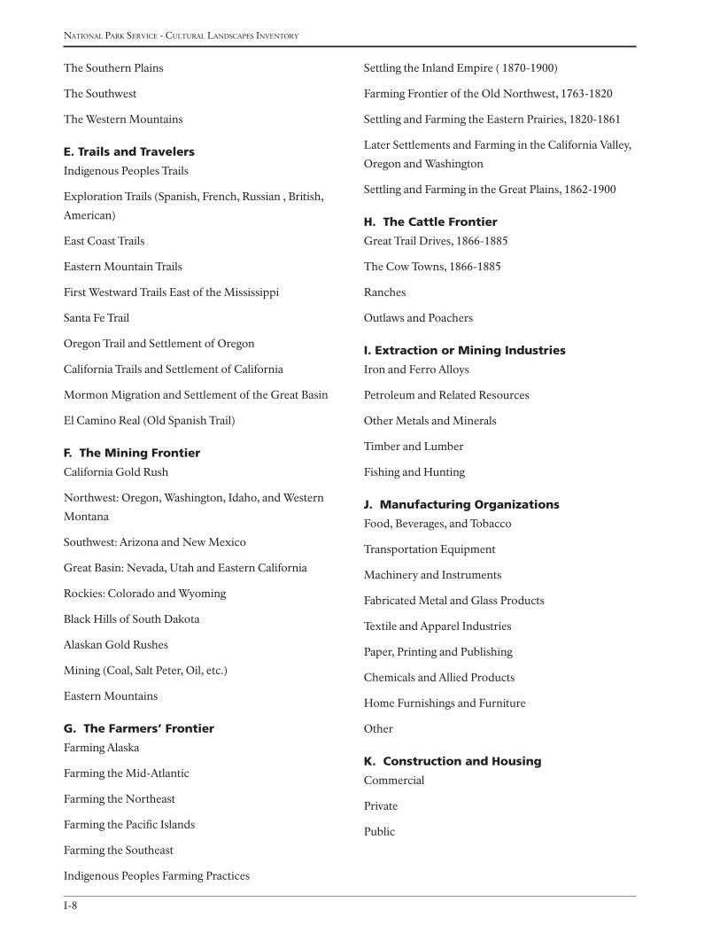
I-8
national Park service - cultural landscaPes inventory
The Southern Plains
The Southwest
The Western Mountains
e. trails and travelers
Indigenous Peoples Trails
Exploration Trails (Spanish, French, Russian , British,
American)
East Coast Trails
Eastern Mountain Trails
First Westward Trails East of the Mississippi
Santa Fe Trail
Oregon Trail and Settlement of Oregon
California Trails and Settlement of California
Mormon Migration and Settlement of the Great Basin
El Camino Real (Old Spanish Trail)
F. the Mining Frontier
California Gold Rush
Northwest: Oregon, Washington, Idaho, and Western
Montana
Southwest: Arizona and New Mexico
Great Basin: Nevada, Utah and Eastern California
Rockies: Colorado and Wyoming
Black Hills of South Dakota
Alaskan Gold Rushes
Mining (Coal, Salt Peter, Oil, etc.)
Eastern Mountains
g. the Farmers’ Frontier
Farming Alaska
Farming the Mid-Atlantic
Farming the Northeast
Farming the Pacific Islands
Farming the Southeast
Indigenous Peoples Farming Practices
Settling the Inland Empire ( 1870-1900)
Farming Frontier of the Old Northwest, 1763-1820
Settling and Farming the Eastern Prairies, 1820-1861
Later Settlements and Farming in the California Valley,
Oregon and Washington
Settling and Farming in the Great Plains, 1862-1900
H. the cattle Frontier
Great Trail Drives, 1866-1885
The Cow Towns, 1866-1885
Ranches
Outlaws and Poachers
i. extraction or Mining industries
Iron and Ferro Alloys
Petroleum and Related Resources
Other Metals and Minerals
Timber and Lumber
Fishing and Hunting
J. Manufacturing organizations
Food, Beverages, and Tobacco
Transportation Equipment
Machinery and Instruments
Fabricated Metal and Glass Products
Textile and Apparel Industries
Paper, Printing and Publishing
Chemicals and Allied Products
Home Furnishings and Furniture
Other
K. construction and Housing
Commercial
Private
Public

I-9
Professional Procedures Guide - aPPendix i
l. trade (Modern)
Export-Import
Wholesale
Retail
Advertising
Commodity Markets
M. Finance and Banking
Commercial Banks
Savings and Loan Associations
Mutual Savings Banks
Credit Unions
Finance and Personal Loan Companies
Credit Companies (Credit Card Industry)
Public Regulatory Institutions
Stock and Other Market Exchanges
General Finance
n. insurance
Fire and Marine
Casualty and Surety
Life
Health
o. service industry
Food
Lodging
Tourism
p. power and lighting
Electric
Gas
Nuclear
Water
Q. Accounting
r. defense
s. Business organization
t. shipping and transportation by Water
Ships, Boats, Lighthouses, and Other Structures
Canals
u. supporting institutions
v. Agriculture
Animal Husbandry (Cattle, Horses, Sheep, Hogs,
Poultry)
Farm Orchards (1600-1820)
Farming for Local Markets (Dairying, Fruits, and Veg-
etables)
Fish Farming
Large-Scale Commercial Agriculture (Crops, Orchards)
Mechanized Agriculture/Agricultural Innovations
Plantation Agriculture
Sharecropping, and Tenant Farming
Small-Scale commercial Agriculture (Crops, Orchards)
Subsistence Agriculture
W. transportation by land and Air
Early Turnpikes, Roads, and Taverns East of the Missis-
sippi
Land Travel West of the Mississippi (i.e., Stagecoaches),
after 1840
Wagons and Wagon Roads
Carriage Roads, Touring Roads and Parkways
Planned Roads, Highways and Freeways
Railroads and Rail yards
Urban Transport (Trolleys, Streetcars and Subways)
Automobiles, Buses, and other vehicles
Air Travel (Airplanes/Airports)
x. communication
Written Word (Newspapers and Periodicals)
Mail Service (Land, Water and Air Routes)

I-10
national Park service - cultural landscaPes inventory
Telegraph and Telephone
Radio
Television
Post World War II Electronic
Spoken Word (Oratory and Public Speaking)
Internet
y. other
vi. expAnding science And tecHnol-
ogy
A. physical sciences
Astronomy
Physics
Chemistry
B. earth science
Physical Geography
Geology
Hydrology
Meteorology
Climatology
Soil Science
c. Biological sciences
Botany
Zoology
Paleontology
Psychology
d. social sciences
Anthropology
Economics
Political Science
Sociology
e. Mathematics
F. Medicine
Clinical Specialties
Non-Clinical Specialties
Affiliated Disciplines
Non-Western Alternative Medicine
g. scientific institutions
H. technology (engineering and invention)
Measurement, Observation, and Control (Surveying,
Cartography, etc.)
Transportation
Energy Conversion, Utilization and Distribution
Tools and Machines
Military (Fortifications, Weapons, and War Vehicles)
Extraction and Conversion of Industrial Raw Materials
Industrial Production Processes (Including Agricul-
ture)
Construction
Information Processing, Transmission, and Recording
Earth and Space Exploration
Water and Sewerage
Fire, Safety, Sanitation, and Pollution Controls
Atomic/Nuclear Technology
i. other
vii. trAnsForMing tHe environMent
A. indigenous peoples use of and response to the environment
B. the industrial revolution
Degradation of Human Environment
Degradation of Natural Environment
Industrial Innovations
Industrialization of Work Force
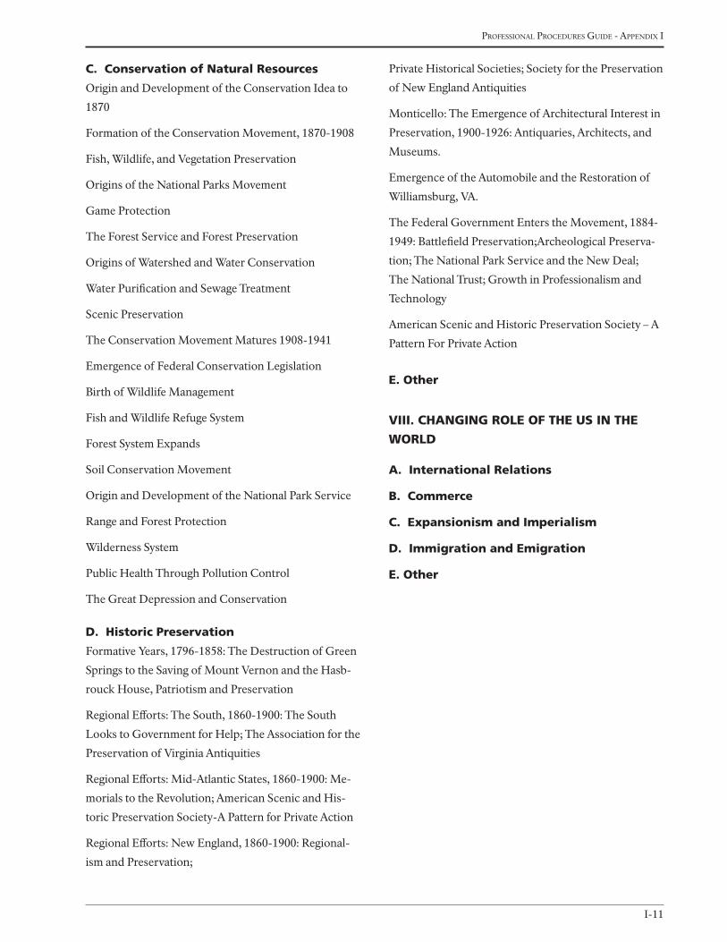
I-11
Professional Procedures Guide - aPPendix i
c. conservation of natural resources
Origin and Development of the Conservation Idea to
1870
Formation of the Conservation Movement, 1870-1908
Fish, Wildlife, and Vegetation Preservation
Origins of the National Parks Movement
Game Protection
The Forest Service and Forest Preservation
Origins of Watershed and Water Conservation
Water Purification and Sewage Treatment
Scenic Preservation
The Conservation Movement Matures 1908-1941
Emergence of Federal Conservation Legislation
Birth of Wildlife Management
Fish and Wildlife Refuge System
Forest System Expands
Soil Conservation Movement
Origin and Development of the National Park Service
Range and Forest Protection
Wilderness System
Public Health Through Pollution Control
The Great Depression and Conservation
d. Historic preservation
Formative Years, 1796-1858: The Destruction of Green
Springs to the Saving of Mount Vernon and the Hasb-
rouck House, Patriotism and Preservation
Regional Efforts: The South, 1860-1900: The South
Looks to Government for Help; The Association for the
Preservation of Virginia Antiquities
Regional Efforts: Mid-Atlantic States, 1860-1900: Me-
morials to the Revolution; American Scenic and His-
toric Preservation Society-A Pattern for Private Action
Regional Efforts: New England, 1860-1900: Regional-
ism and Preservation;
Private Historical Societies; Society for the Preservation
of New England Antiquities
Monticello: The Emergence of Architectural Interest in
Preservation, 1900-1926: Antiquaries, Architects, and
Museums.
Emergence of the Automobile and the Restoration of
Williamsburg, VA.
The Federal Government Enters the Movement, 1884-
1949: Battlefield Preservation;Archeological Preserva-
tion; The National Park Service and the New Deal;
The National Trust; Growth in Professionalism and
Technology
American Scenic and Historic Preservation Society – A
Pattern For Private Action
e. other
viii. cHAnging role oF tHe us in tHe
World
A. international relations
B. commerce
c. expansionism and imperialism
d. immigration and emigration
e. other

I-12
national Park service - cultural landscaPes inventory

J-1
Professional Procedures Guide - aPPendix J
Appendix J
Historic and current function and use list (cateGories and codes)JAnuAry 2009
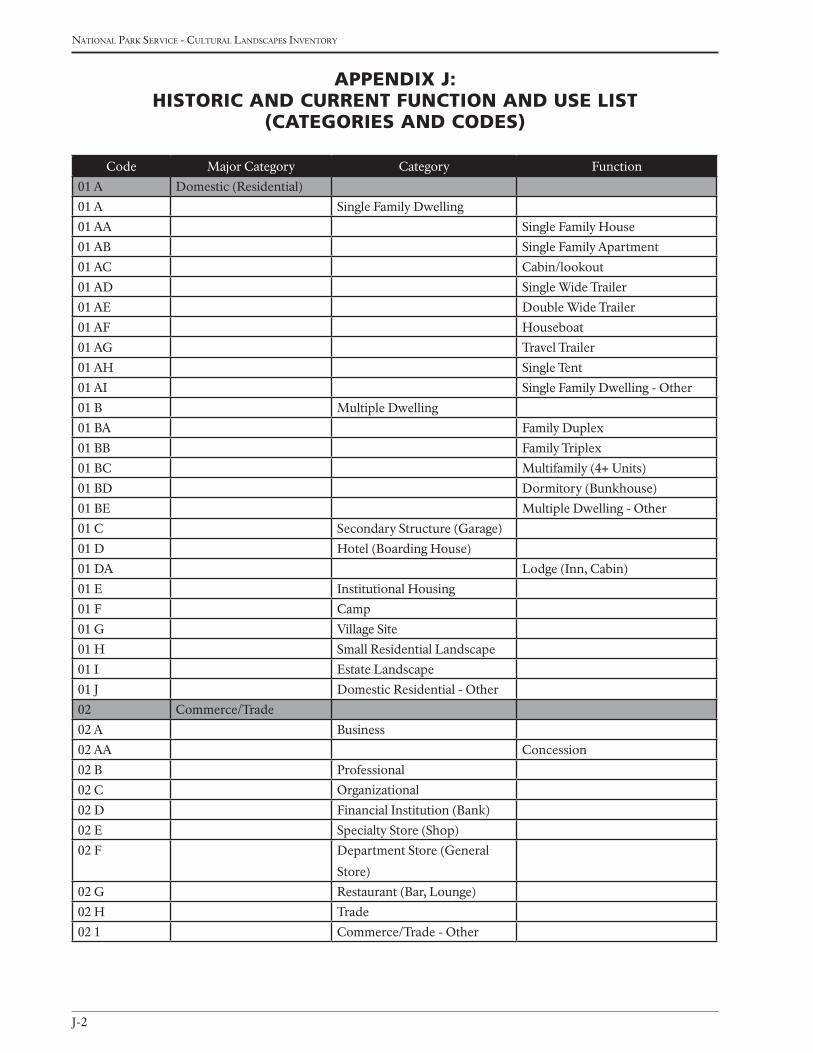
J-2
national Park service - cultural landscaPes inventory
Appendix J: Historic And current Function And use List
(cAtegories And codes)
Code Major Category Category Function
01 A Domestic (Residential)
01 A Single Family Dwelling
01 AA Single Family House
01 AB Single Family Apartment
01 AC Cabin/lookout
01 AD Single Wide Trailer
01 AE Double Wide Trailer
01 AF Houseboat
01 AG Travel Trailer
01 AH Single Tent
01 AI Single Family Dwelling - Other
01 B Multiple Dwelling
01 BA Family Duplex
01 BB Family Triplex
01 BC Multifamily (4+ Units)
01 BD Dormitory (Bunkhouse)
01 BE Multiple Dwelling - Other
01 C Secondary Structure (Garage)
01 D Hotel (Boarding House)
01 DA Lodge (Inn, Cabin)
01 E Institutional Housing
01 F Camp
01 G Village Site
01 H Small Residential Landscape
01 I Estate Landscape
01 J Domestic Residential - Other
02 Commerce/Trade
02 A Business
02 AA Concession
02 B Professional
02 C Organizational
02 D Financial Institution (Bank)
02 E Specialty Store (Shop)
02 F Department Store (General
Store)
02 G Restaurant (Bar, Lounge)
02 H Trade
02 1 Commerce/Trade - Other
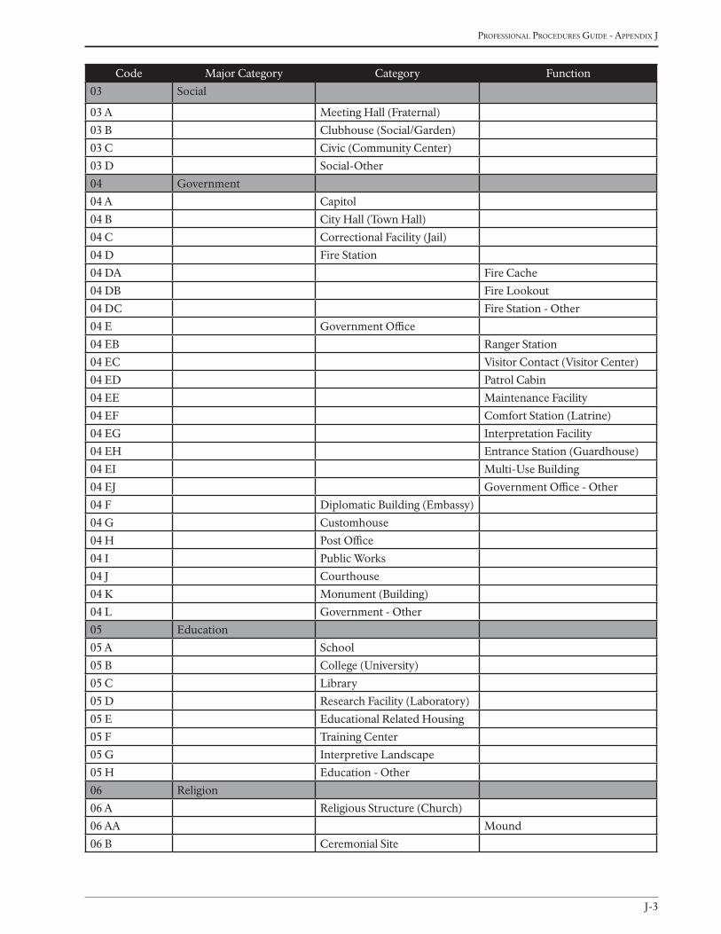
J-3
Professional Procedures Guide - aPPendix J
Code Major Category Category Function
03 Social
03 A Meeting Hall (Fraternal)
03 B Clubhouse (Social/Garden)
03 C Civic (Community Center)
03 D Social-Other
04 Government
04 A Capitol
04 B City Hall (Town Hall)
04 C Correctional Facility (Jail)
04 D Fire Station
04 DA Fire Cache
04 DB Fire Lookout
04 DC Fire Station - Other
04 E Government Office
04 EB Ranger Station
04 EC Visitor Contact (Visitor Center)
04 ED Patrol Cabin
04 EE Maintenance Facility
04 EF Comfort Station (Latrine)
04 EG Interpretation Facility
04 EH Entrance Station (Guardhouse)
04 EI Multi-Use Building
04 EJ Government Office - Other
04 F Diplomatic Building (Embassy)
04 G Customhouse
04 H Post Office
04 I Public Works
04 J Courthouse
04 K Monument (Building)
04 L Government - Other
05 Education
05 A School
05 B College (University)
05 C Library
05 D Research Facility (Laboratory)
05 E Educational Related Housing
05 F Training Center
05 G Interpretive Landscape
05 H Education - Other
06 Religion
06 A Religious Structure (Church)
06 AA Mound
06 B Ceremonial Site
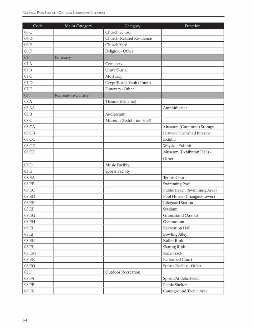
J-4
national Park service - cultural landscaPes inventory
Code Major Category Category Function
06 C Church School
06 D Church-Related Residence
06 E Church Yard
06 F Religion - Other
07 Funerary
07 A Cemetery
07 B Grave/Burial
07 C Mortuary
07 D Crypt/Burial Vault (Tomb)
07 E Funerary- Other
08 Recreation/Culture
08 A Theater (Cinema)
08 AA Amphitheater
08 B Auditorium
08 C Museum (Exhibition Hall)
08 CA Museum (Curatorial) Storage
08 CB Historic Furnished Interior
08 CC Exhibit
08 CD Wayside Exhibit
08 CE Museum (Exhibition Hall) -
Other
08 D Music Facility
08 E Sports Facility
08 EA Tennis Court
08 EB Swimming Pool
08 EC Public Beach (Swimming Area)
08 ED Pool House (Change/Shower)
08 EE Lifeguard Station
08 EF Stadium
08 EG Grandstand (Arena)
08 EH Gymnasium
08 EI Recreation Hall
08 EJ Bowling Alley
08 EK Roller Rink
08 EL Skating Rink
08 EM Race Track
08 EN Basketball Court
08 EO Sports Facility - Other
08 F Outdoor Recreation
08 FA Sports/Athletic Field
08 FB Picnic Shelter
08 FC Campground/Picnic Area
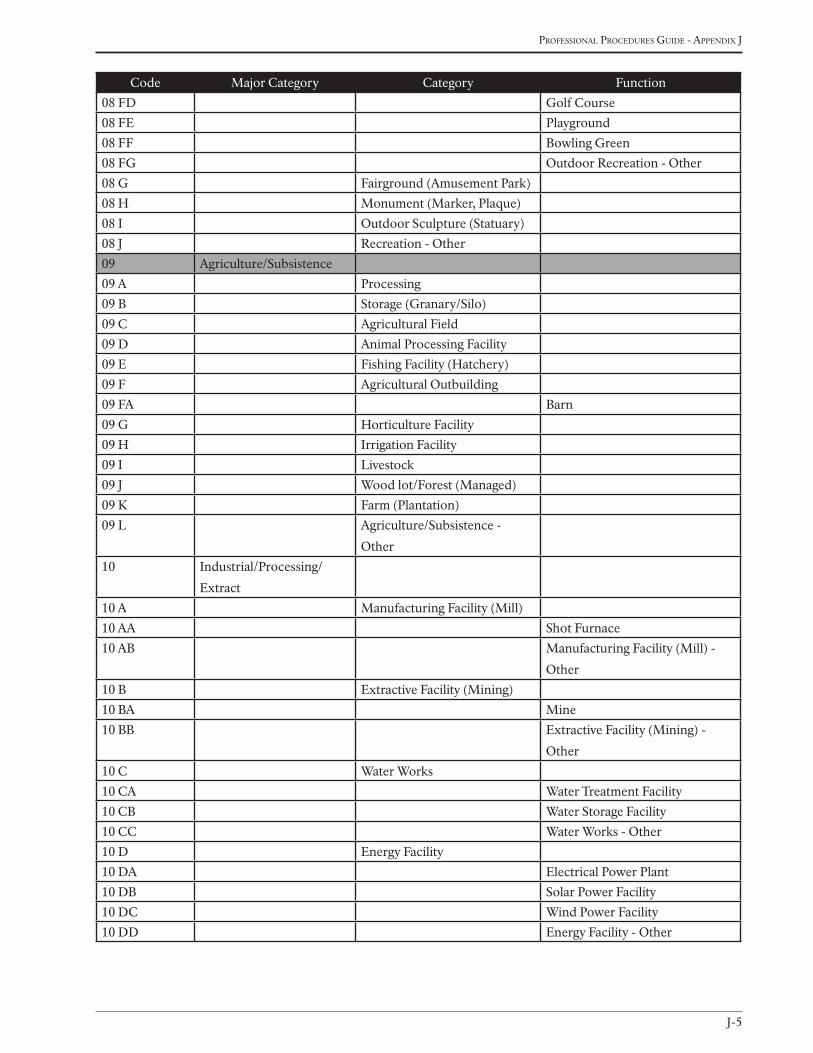
J-5
Professional Procedures Guide - aPPendix J
Code Major Category Category Function
08 FD Golf Course
08 FE Playground
08 FF Bowling Green
08 FG Outdoor Recreation - Other
08 G Fairground (Amusement Park)
08 H Monument (Marker, Plaque)
08 I Outdoor Sculpture (Statuary)
08 J Recreation - Other
09 Agriculture/Subsistence
09 A Processing
09 B Storage (Granary/Silo)
09 C Agricultural Field
09 D Animal Processing Facility
09 E Fishing Facility (Hatchery)
09 F Agricultural Outbuilding
09 FA Barn
09 G Horticulture Facility
09 H Irrigation Facility
09 I Livestock
09 J Wood lot/Forest (Managed)
09 K Farm (Plantation)
09 L Agriculture/Subsistence -
Other
10 Industrial/Processing/
Extract
10 A Manufacturing Facility (Mill)
10 AA Shot Furnace
10 AB Manufacturing Facility (Mill) -
Other
10 B Extractive Facility (Mining)
10 BA Mine
10 BB Extractive Facility (Mining) -
Other
10 C Water Works
10 CA Water Treatment Facility
10 CB Water Storage Facility
10 CC Water Works - Other
10 D Energy Facility
10 DA Electrical Power Plant
10 DB Solar Power Facility
10 DC Wind Power Facility
10 DD Energy Facility - Other
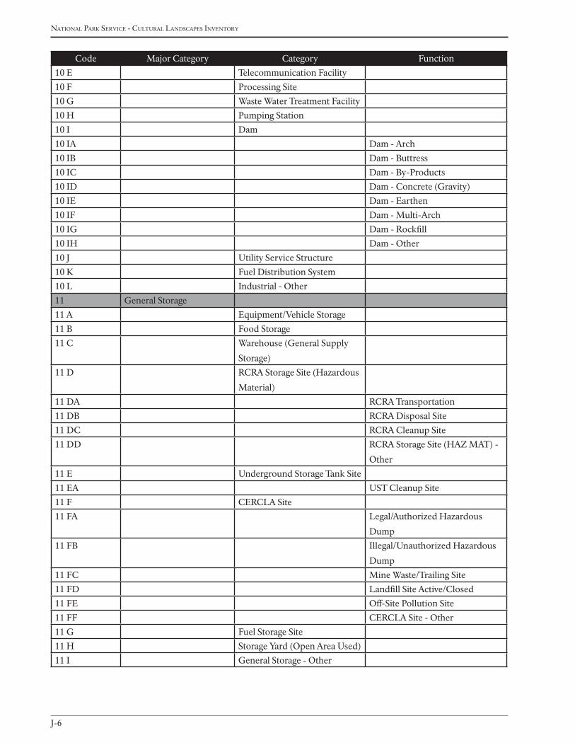
J-6
national Park service - cultural landscaPes inventory
Code Major Category Category Function
10 E Telecommunication Facility
10 F Processing Site
10 G Waste Water Treatment Facility
10 H Pumping Station
10 I Dam
10 IA Dam - Arch
10 IB Dam - Buttress
10 IC Dam - By-Products
10 ID Dam - Concrete (Gravity)
10 IE Dam - Earthen
10 IF Dam - Multi-Arch
10 IG Dam - Rockfill
10 IH Dam - Other
10 J Utility Service Structure
10 K Fuel Distribution System
10 L Industrial - Other
11 General Storage
11 A Equipment/Vehicle Storage
11 B Food Storage
11 C Warehouse (General Supply
Storage)
11 D RCRA Storage Site (Hazardous
Material)
11 DA RCRA Transportation
11 DB RCRA Disposal Site
11 DC RCRA Cleanup Site
11 DD RCRA Storage Site (HAZ MAT) -
Other
11 E Underground Storage Tank Site
11 EA UST Cleanup Site
11 F CERCLA Site
11 FA Legal/Authorized Hazardous
Dump
11 FB Illegal/Unauthorized Hazardous
Dump
11 FC Mine Waste/Trailing Site
11 FD Landfill Site Active/Closed
11 FE Off-Site Pollution Site
11 FF CERCLA Site - Other
11 G Fuel Storage Site
11 H Storage Yard (Open Area Used)
11 I General Storage - Other
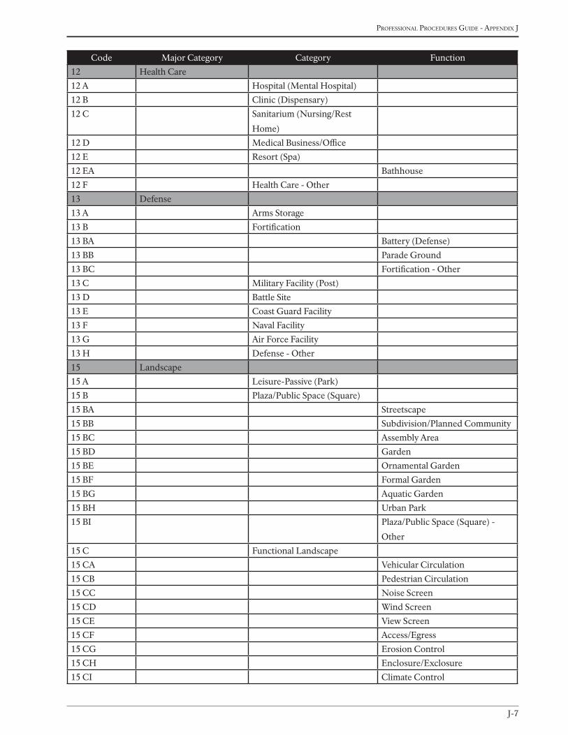
J-7
Professional Procedures Guide - aPPendix J
Code Major Category Category Function
12 Health Care
12 A Hospital (Mental Hospital)
12 B Clinic (Dispensary)
12 C Sanitarium (Nursing/Rest
Home)
12 D Medical Business/Office
12 E Resort (Spa)
12 EA Bathhouse
12 F Health Care - Other
13 Defense
13 A Arms Storage
13 B Fortification
13 BA Battery (Defense)
13 BB Parade Ground
13 BC Fortification - Other
13 C Military Facility (Post)
13 D Battle Site
13 E Coast Guard Facility
13 F Naval Facility
13 G Air Force Facility
13 H Defense - Other
15 Landscape
15 A Leisure-Passive (Park)
15 B Plaza/Public Space (Square)
15 BA Streetscape
15 BB Subdivision/Planned Community
15 BC Assembly Area
15 BD Garden
15 BE Ornamental Garden
15 BF Formal Garden
15 BG Aquatic Garden
15 BH Urban Park
15 BI Plaza/Public Space (Square) -
Other
15 C Functional Landscape
15 CA Vehicular Circulation
15 CB Pedestrian Circulation
15 CC Noise Screen
15 CD Wind Screen
15 CE View Screen
15 CF Access/Egress
15 CG Erosion Control
15 CH Enclosure/Exclosure
15 CI Climate Control
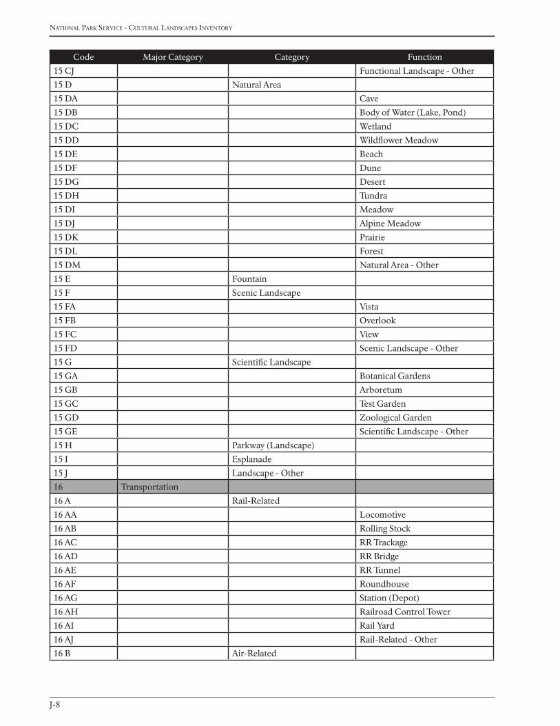
J-8
national Park service - cultural landscaPes inventory
Code Major Category Category Function
15 CJ Functional Landscape - Other
15 D Natural Area
15 DA Cave
15 DB Body of Water (Lake, Pond)
15 DC Wetland
15 DD Wildflower Meadow
15 DE Beach
15 DF Dune
15 DG Desert
15 DH Tundra
15 DI Meadow
15 DJ Alpine Meadow
15 DK Prairie
15 DL Forest
15 DM Natural Area - Other
15 E Fountain
15 F Scenic Landscape
15 FA Vista
15 FB Overlook
15 FC View
15 FD Scenic Landscape - Other
15 G Scientific Landscape
15 GA Botanical Gardens
15 GB Arboretum
15 GC Test Garden
15 GD Zoological Garden
15 GE Scientific Landscape - Other
15 H Parkway (Landscape)
15 I Esplanade
15 J Landscape - Other
16 Transportation
16 A Rail-Related
16 AA Locomotive
16 AB Rolling Stock
16 AC RR Trackage
16 AD RR Bridge
16 AE RR Tunnel
16 AF Roundhouse
16 AG Station (Depot)
16 AH Railroad Control Tower
16 AI Rail Yard
16 AJ Rail-Related - Other
16 B Air-Related
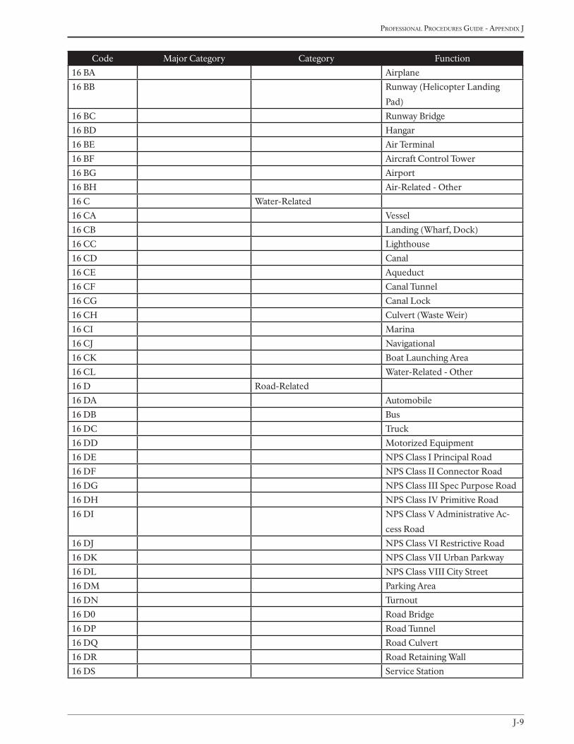
J-9
Professional Procedures Guide - aPPendix J
Code Major Category Category Function
16 BA Airplane
16 BB Runway (Helicopter Landing
Pad)
16 BC Runway Bridge
16 BD Hangar
16 BE Air Terminal
16 BF Aircraft Control Tower
16 BG Airport
16 BH Air-Related - Other
16 C Water-Related
16 CA Vessel
16 CB Landing (Wharf, Dock)
16 CC Lighthouse
16 CD Canal
16 CE Aqueduct
16 CF Canal Tunnel
16 CG Canal Lock
16 CH Culvert (Waste Weir)
16 CI Marina
16 CJ Navigational
16 CK Boat Launching Area
16 CL Water-Related - Other
16 D Road-Related
16 DA Automobile
16 DB Bus
16 DC Truck
16 DD Motorized Equipment
16 DE NPS Class I Principal Road
16 DF NPS Class II Connector Road
16 DG NPS Class III Spec Purpose Road
16 DH NPS Class IV Primitive Road
16 DI NPS Class V Administrative Ac-
cess Road
16 DJ NPS Class VI Restrictive Road
16 DK NPS Class VII Urban Parkway
16 DL NPS Class VIII City Street
16 DM Parking Area
16 DN Turnout
16 D0 Road Bridge
16 DP Road Tunnel
16 DQ Road Culvert
16 DR Road Retaining Wall
16 DS Service Station
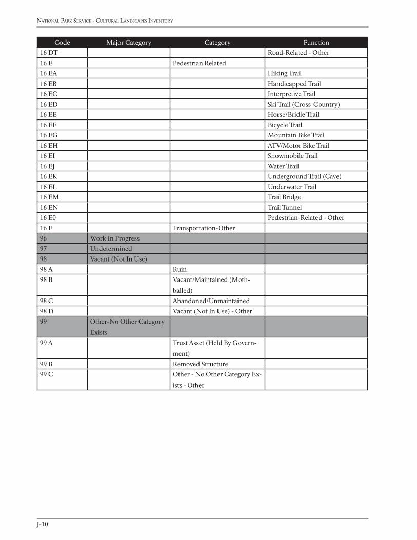
J-10
national Park service - cultural landscaPes inventory
Code Major Category Category Function
16 DT Road-Related - Other
16 E Pedestrian Related
16 EA Hiking Trail
16 EB Handicapped Trail
16 EC Interpretive Trail
16 ED Ski Trail (Cross-Country)
16 EE Horse/Bridle Trail
16 EF Bicycle Trail
16 EG Mountain Bike Trail
16 EH ATV/Motor Bike Trail
16 EI Snowmobile Trail
16 EJ Water Trail
16 EK Underground Trail (Cave)
16 EL Underwater Trail
16 EM Trail Bridge
16 EN Trail Tunnel
16 E0 Pedestrian-Related - Other
16 F Transportation-Other
96 Work In Progress
97 Undetermined
98 Vacant (Not In Use)
98 A Ruin
98 B Vacant/Maintained (Moth-
balled)
98 C Abandoned/Unmaintained
98 D Vacant (Not In Use) - Other
99 Other-No Other Category
Exists
99 A Trust Asset (Held By Govern-
ment)
99 B Removed Structure
99 C Other - No Other Category Ex-
ists - Other

K-1
Professional Procedures Guide - aPPendix K
Appendix K
Major event listJAnuAry 2009

K-2
national ParK service - cultural landscaPes inventory
Major Event Similar Term
Abandoned Closed
Altered Adapted, Burned, Cleared, Improved, Inundated, Name Change, Resur-
faced, Widened, Dismantled, Reassembled
Built Constructed, Created, Improved, Begun
Colonized Granted
Conserved Reserved (Natural Resource focus)
Cultivated
Damaged Vandalized
Demolished (planned demolition)
Designed
Destroyed (unplanned destruction)
Developed Opened, Completed
Domesticated
Engineered
Eroded
Established Designated, Authorized, Redesignated, Granted, Dedicated, Incorporated,
Discovered, Recorded, Documented, Patented, Created, Listed, Opened,
Reserved
Excavated
Expanded Completed
Exploited
Explored
Farmed/Harvested Hunted, Fished, Timbered
Graded
Homesteaded
Inhabited Occupied, Seasonal Habitation, Teneted
Land Transfer Acquired, Ceded, Disposed, Subdivided, Transferred, Granted
Maintained
Memorialized Placed, Erected, Decorated
Military Operation Decommissioned
Mined
Moved Dismantled, Reassembled, Relocated
Naturalized
Neglected
Paved
Planned Laid Out
Planted Reforested, Vegetated
Platted Surveyed, Mapped, Drawn, etc.
This appendix lists the Major Events pick list. Similar terms are offered as reference.
Appendix K: MAJor event List
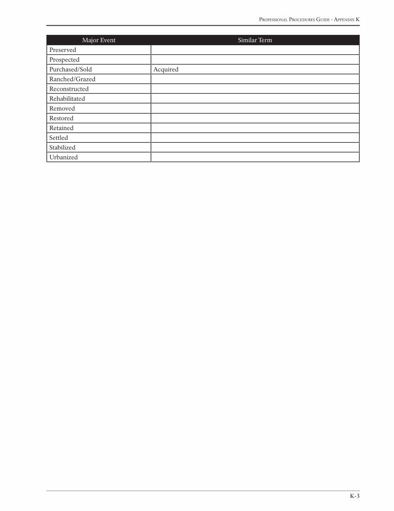
K-3
Professional Procedures Guide - aPPendix K
Major Event Similar Term
Preserved
Prospected
Purchased/Sold Acquired
Ranched/Grazed
Reconstructed
Rehabilitated
Removed
Restored
Retained
Settled
Stabilized
Urbanized

K-4
national ParK service - cultural landscaPes inventory

L-1
Professional Procedures Guide - aPPendix l
Appendix L
examPles of analysis andevaluation summaryJAnuAry 2009
L-2
national Park service - cultural landscaPes inventory
KiJiK ArcheoLogicAL district nhL
Lake clark national park and preserve (Alaska region)
The primary landscape characteristics associated with the Kijik Archeological District include Natural Systems and
Features, Vegetation, Buildings and Structures, Circulation, Cluster Arrangements and Archeological Sites. All of
these characteristics are discussed below, and when relevant, features within these categories that contribute to the
significance of the District are noted. Contributing Natural Systems and Features include salmon and hydrology.
Contributing Buildings and Structures include house-depressions and cache pits. Contributing circulation elements
include the Telaquana Trail and the Kijik River. Contributing Cluster Arrangements include historic Kijik Village
(XLC-001), and contributing Vegetation includes the flora used for subsistence by the Dena’ina. All documented
archeological sites are considered contributing to the District.
Archeological integrity at the District scale is excellent. Most sites within the District are intact and complete, and
have not been impacted by natural or cultural influences. One exception to this is that changing river patterns and
the activity of beavers has affected the integrity of some sites. Nevertheless the majority of known sites have not been
affected by these natural influences.
It is well documented that the Inland Dena’ina were the primary occupiers of the known pre-historic and historic
sites. The distinction between historic and pre-historic sites is not well documented through excavation however. In
general, there has been an assumption that if a house-pit exists, then it is probably a pre-historic site, if not, then it is
probably historic. In general this assumption holds true in the District, but is not relied upon as an absolute determi-
nation of prehistoric or historic occupation (see for example the hybrid house-depression design at Kijik from the
historic period, part 2a page 3). Often sites have been both, with multiple occupations spanning hundreds of years.
Nevertheless at Kijik this assumption has generally been validated by a paucity of historic artifacts at the excavated
house-depression sites, and a relative abundance at the historic sites. Further subsurface testing is needed however
to validate these assumptions at non-excavated, pre-historic sites. Further sub-surface investigations at pre-historic
sites would further delineate the historic/pre-historic classification of sites and serve to further expand occupational
sequences at Kijik.
In the case of Kijik, contact with Europeans, the abandonment of traditional ways, and subsequent illness and
disease, as well as depletion of local resources (timber, game) may have forced the abandonment of the pre-historic
sites, with a high probability that they would never return to live in these places. Thus there are no known cultural
disturbances from the re-habitation of formerly abandoned sites, and therefore archeological integrity at the District
scale is present.
The landscape-scale spatial organization of mountains, streams and valleys has not changed significantly since the
period of significance, neither has the major vegetation associations, and therefore the District retains integrity of
location, setting, and feeling. On the ground many of the pre-historic house-depression foundations and cache pits
are readily identifiable in the landscape, the rooms of the house-depression can be identified and functional uses
can sometimes be surmised through casual observation (bath houses for instance by a pile of stones in center or a
corner). In addition to the thousands of cache-pits that dot the landscape in settled areas, the house-depressions are
considered physical characteristics of the landscape which collectively contribute to the integrity of association in the
District, but also to integrity of design in terms of Athabaskan house-depression typology.
Appendix L: exAmpLes of AnALysis And evALuAtion summAry

L-3
Professional Procedures Guide - aPPendix l
At the District scale, enough sites have been identified so that large scale settlement patterns have begun to emerge,
these collective contributions of individual sites to the discernment of settlement patterns and site planning confers
integrity of design at the District level.
The Kijik Archeological District NHL is unique in its concentrated spatial organization of sites. Other known Atha-
baskan sites in Alaska compare to Kijik in terms of number of sites, but they are typically spread out along rivers or
lake shores (Kenai sites) for great distances. No other known sites in Alaska are as concentrated as at Kijik. In addi-
tion, cultural homogeneity and temporal span of individual sites is also unusual (1170-1910), and presents a unique
opportunity to study the life-ways and cultural change among the Inland Dena’ ina over a significant period of time.
Further archeological work will most likely contribute to the articulation and expansion of these archeological and
ethnographic areas of inquiry.
indiAn river pArK
sitka national historical park (Alaska region)
The history of the Indian River Park cultural landscape identifies a series of near catastrophic events, which, remark-
ably, have not changed the visitor’s overall experience. A comparison of historic and contemporary accounts describ-
ing the Indian River area testify to the enchantment of the forest and river, as well as the magnificent views looking
out to the sound. Thus, the Indian River Park cultural landscape retains integrity in terms of location, feeling, as-
sociation, and setting. The Russian drawings of the forest and trails, along with a range of historic and contemporary
photographs confirm this integrity.
Remnants of the Russian walk cross portions of the existing trails in the park today (CLR, 116), and part of the
existing trail system follows the Old Post Road (CLR, 262). Part of the current trail system has been in place since,
at least, 1910, and the current trail system reflects the trail configuration mapped in U.S. Survey No. 1258 from 1919.
Although no known plans of the original design for the arrangement of the totem poles along the Totem Walk (then
known as “Lover’s Lane”) exist; documentation (photographs, written accounts) over the years verifies the reloca-
tion of some of the totems along the trail for better viewing and for management purposes. Despite these changes,
the overall linear alignment of totems and groupings of the poles along the trail have continued for almost one hun-
dred years. Overall, Totem Walk retains integrity in terms of design, workmanship, materials, feeling, association, and
setting. As a result of the WWII dredging operations, the historic trail along the east bank of the river was removed,
and portions of Indian River Park land has been lost to erosion.
Although the quality of the reproduction and repair work of the totems during the CCC tenure in the park (1938-
1942) has been challenged, the CLI finds the work of the CCC an important contribution to the continuation of the
totem pole collection in the park, not only as part of the overall historical significance of the CCC era, but as a project
that served to perpetuate the totem carving tradition among Tlingit artisans. (Patrick, 137-138) Native artisans utiliz-
ing traditional knowledge, tools, and materials, reproduced the historic totem poles transferring the artistic skill on
to younger Native workers. Reproductions yes, but in a climate such as the southeastern Alaskan rain forest, dete-
rioration of the wooden totem poles has always occurred. Along the coastlands of the Tlingit villages, totem poles
deteriorated, and were then replaced in kind or by newly designed totem poles. Today, with advancements in preser-
vation knowledge and product, historic totem poles can be better preserved for longer periods of times. Frequently,
historic totem poles have been placed in museums and/or storage—the outside display of totem poles along the one
hundred-year old Totem Walk in Sitka National Historical Park is unique. The workmanship used to reproduce the
totem poles represents an unbroken and continuing tradition of Tlingit artistic knowledge, just as large cedars native
to the area have always provided the material for carving. The location of the Southeastern Alaska Indian Cultural
L-4
national Park service - cultural landscaPes inventory
Center within the visitor center of the park has provided space for artisans and the continuation of the totem carving
tradition. The additions of a new totem pole in 1996 and another in 1999 represent the connection of the Tlingit to
their traditional homelands and the perpetuation of their identifying markers on the land. In terms of workmanship,
materials, feeling, association, and design the totem poles within the Indian River Park landscape retain integrity.
While the overall affect of the Totem Walk holds much the same appeal as the historic photographs portray, sur-
rounding vegetation has obscured the totem poles. Several historic documents verify the trimming back of trees, and
in some cases removal of trees, and in other cases moving the poles to more advantageously display the structures.
Merrill noted the setting of the totem poles and installation of park benches specifically to offer park visitors the
opportunity to enjoy the views and surrounding scenery. Today, the totem poles are more tightly surrounded by veg-
etation than ever before. Views and vistas from the benches looking out to the bay have also become overgrown. The
dense vegetation around the fort site does not allow for any view of the bay contradicting the very reason the Tlingit
selected the site and cut back the forest to provide views of the bay. The battleground has become overgrown with
young alder growth.
Well aware of the potential for erosion along the banks of the Indian River, park managers monitor and control
existing riprap installations. Trees continue to lean and slide down the river bank, as evidenced by current condi-
tion photographs. While the park’s lush vegetation has softened the devastating effects of the dredging operations,
the overall character of the mouth of the Indian River has been degraded. The establishment of a mobile home park
along the end of the east bank mars the view from the west bank of the park looking east. Upstream, views from the
present day footbridge favorably reflect the character seen in photographs taken from the earlier historic footbridges
located further upstream.
Numerous studies conducted in the park recommend further archeological survey to determine the extent and
location of valuable resources within the park. Of most importance, is the need to conduct the archeological work
necessary to verify the location of the historic Tlingit fort. Dredging operations of the military during World War II
removed the historic trail on the east bank of Indian River. Portions of the eastern most trail on the east bank follow
the alignment of the Old Post Road, which is listed on LCS. Of concern is the fact that some archeological evidence
from the 1958-1959 Hadleigh-West excavation at the Russian Memorial suggests that portions of the historic wood-
en road may still exist along the east bank of the river in the area of the Russian Memorial. It does not appear that
the park has pursued this information with further archeological investigations, which would serve to identify an
important historic cultural resource.
An overlay of the current parkland on an 1850 Russian map (CLR, p. 116) suggests the original location of the Rus-
sian Memorial may actually lie underwater in the river, part of the east bank lost to the dredging operations. Yet, the
location of the memorial on both the 1908 and 1910 maps, as well as subsequent maps of the park, appears to be
consistent with the location of the present memorial. The memorial has yielded no grave material during archeologi-
cal excavation and testing, was removed by the park at one point and then reinstalled, destroyed by vandalism and
reinstalled again in 1995. Although the site has no historical integrity, the Russian Memorial has existed in the park in
some fashion or another since first installed by the Russians sometime prior to 1827. The park manages the Russian
Memorial as a cultural resource, thus its listing on the LCS.
While the Indian River Park retains much of the character since its inception, the overgrowth of the forest obscures
the totem poles, as well as important views and vistas incorporated into the original design of the Totem Walk. The
need for archeological survey to determine the location of significant historical resources cannot be stressed enough.
Treatment plans cannot be determined or instituted until the verification of the historic Tlingit Fort Site and 1804
Battleground locations are established.
L-5
Professional Procedures Guide - aPPendix l
Bremner historic mining district
Wrangell - st. elias national park and preserve (Alaska region)
The following analyzes the Bremner Historic Mining District in terms of its Landscape Characteristics and historic
integrity. These characteristics include Spatial Organization, Land Use, Natural Systems and Features, Circulation,
Topography, Vegetation, Cluster Arrangements, Buildings and Structures, Constructed Water Features, Small Scale
Features, and Archeological Sites.
Integrity of location is in part illustrated by the District’s remoteness, which has been a persistent quality of the area
well into the modern age. It is also illustrated by the nature of gold and where it is located geographically and geo-
logically. Mining districts are biased in this sense because gold, and in particular gold bearing quartz veins, tend to
concentrate in specific locals on both regional and site scales. Bremner was a known gold producing district histori-
cally, and the area is still known to contain modest concentrations of gold. At the site scale, the location of the milling
site and individual mines is often a compromise between access, natural water supply, and location of gold bearing
quartz veins. These conditions tend not to change much over time and have not changed significantly in the District.
As such all the identified mining sites display integrity of location. For these reasons overall integrity of location at the
district scale is present.
Integrity of design is more elusive at the district scale, but can be illustrated through the spatial organization of the
overall district, as well as the cluster arrangements of the individual sites. “Design results from conscious and un-
conscious decisions over time about where areas of land use, roadways, buildings and structures, and vegetation are
located in relationship to natural features and each other” (National Register Bulletin, Guidelines for Evaluating and
Documenting Rural Historic Landscapes, 22). At the district scale topography, hydrology and geology largely deter-
mined the location of mining activities. The subsequent sites that developed and the artifacts that mark their location
have not changed geographically since the period of significance. Through integrity of location and the spatial orga-
nization of the District as a whole, that is, where sites developed, why, and the large-scale, historic-spatial patterns
that can be discerned in the contemporary landscape, integrity of design at the district scale is present.
At the site level integrity of design is illustrated by the layout of cluster arrangements. As described above these
arrangements were the result of physical access to the site, the location of gold bearing quartz veins, and access to
natural water sources. These factors determined where in the landscape mining and camp structures (adits, shafts,
tailings piles, tents, cabins, tramway systems) occurred. Often the location of the milling equipment was a compro-
mise between access to water, and access to the mine. At most of the mining sites this spatial logic is still discernible
through identification and analysis of cluster arrangements. Thus integrity of design can be illustrated at the site level
as well, in so far as the cluster arrangements of the District can be identified in the contemporary landscape. Cluster
arrangements can be identified at the Grand Prize Mine site, the Yellow Band Mine site, the Sheriff Mine site, the
Yellow Band Mining Camp (main), the lower Yellow Band Mining Camp, the Bremner Mining Camp, and the Lucky
Girl Mill site.
Integrity of setting is illustrated primarily by the natural systems and features of the District. Topography, geo-
morphology and geology are all landscape characteristics that contribute to the integrity of setting in the District.
Dramatic views and vistas also contribute to integrity of setting. These landscape characteristics have not changed
significantly since the period of significance and continue today to attract visitors to the District. At the site level the
abundance of small-scale features, and buildings and structures from the period of significance also contributes to
integrity of setting.
L-6
national Park service - cultural landscaPes inventory
Integrity of materials at the district level is illustrated primarily by the regions geologic features, in particular, quartz
vein outcrops on the hillsides and along drainages. These were geologic features sought out by prospectors from the
period of significance because they were known to contain gold, and are still apparent in the contemporary land-
scape. If the National Park Service did not regulate land use in the District, many of these gold bearing quartz veins
would be sought by the public today. In addition, the local materials used in mining activities can still be ascertained
at many sites, in particular the White spruce timbers used to support tunnels and build mining related structures,
and the extensive use of stone for building and tent frame foundations as well as road construction. For these reasons
integrity of materials is present at the district level.
Integrity of workmanship is present at the district level, and is best illustrated by the collective contributions of the
individual sites, structures and small scale features. According to the National Register Bulletin, Guidelines for Evalu-
ating and Documenting Rural Historic Landscapes, “workmanship is exhibited in the ways people have fashioned
their environment for functional and decorative purposes” (23). The District contains remnant engineering struc-
tures such as dams, tramway systems, tunneling structures, rock retaining walls and foundations, culverts, and road-
ways. The quality of their workmanship can still in most cases be readily discerned. It also contains curious examples
of adaptive re-use of materials, such as the creative re-use of 55 gallon drums for various purposes. A few examples
include a wheel barrel fashioned from a ‘half-drum’, or the wood-fired water heater fashioned from an entire drum.
55-gallon drums were also re-used as ore chutes and siding for structures in the District. Other exceptional examples
of workmanship in the District include the ore bin at the lower Yellow Band Mine tram terminal, the spruce sid-
ing on the Powerhouse structure, and the dry stack tent foundations found at the Yellow Band Mine and below the
Sheriff Mine. There are many other examples of workmanship in the District. For example, although the historic
road from Golconda Creek to the lower Sheriff Mine site is overgrown with willow in many places, the workmanship
of many sections of this road is still apparent in the landscape. Culverts and ditches are still functioning and retaining
walls are still apparent. In addition, the orientation of the road, that is, the route its designers chose can still be easily
ascertained. This is a quality of design, but from a road engineering perspective it is also a quality of workmanship. As
such this historic road, in so far as its’ route and design features can be ascertained in the contemporary landscape,
still maintains integrity of workmanship. Similar arguments for integrity of workmanship can be made for most of the
roads in the District. For all the reasons outlined above the District has integrity of workmanship.
Integrity of feeling is present at the district level. The cumulative effect of the natural systems and features, views and
vistas, cluster arrangements, small-scale features, as well as the feeling of time and place that the individual mining
sites evoke contributes to integrity of feeling at the district level. In particular, structural artifacts such as building
clusters, and an abundance of mining related small scale features contribute to a strong sense of time and place at the
individual sites, and thus contribute to integrity of feeling in the District.
Integrity of association is illustrated by the fact that all the identified mining sites were associated with the historic
context of lode and placer gold mining in Alaska during the early to mid-twentieth century. While at several sites
mining activity continued beyond the period of significance, this does not necessarily negate integrity of association,
but merely illustrates a continued use of the site. For these reasons the District displays integrity of association.
LAdy Bird Johnson memoriAL pArK
george Washington memorial parkway (national capital region)
For the purposes of a Cultural Landscape Inventory, landscapes are analyzed according to a number of criteria,
known as landscape characteristics. Ten such characteristics were found to be relevant to the landscape of Lady
L-7
Professional Procedures Guide - aPPendix l
Bird Johnson Park: Topography, Natural Systems and Features, Spatial Organization, Land Use, Vegetation, Circula-
tion, Views and Vistas, Buildings and Structures, Small-Scale Features, and Constructed Water Features. Each was
analyzed for its historic and current conditions, which were then compared to arrive an assessment of integrity, fol-
lowing the qualities defined by the National Register of Historic Places: location, design, setting, materials, workman-
ship, feeling, and association. This summary presents the highlights of the Analysis and Evaluation sections. The
overall integrity of the landscape is good.
From a central north-south plateau, the undulating terrain of the long, linear island known as Lady Bird Johnson
Park slopes to the shores of the Potomac River on the east and to Boundary Channel on the west. Few changes have
been made to the original grading, except where roadbeds have been depressed to run beneath a bridge or abutment.
The island supports only a limited amount of wildlife.
The park’s spatial organization has been defined by the way the land has been used, primarily by circulation and
recreation, and also by views and vegetation. Circulation is the most important trait defining spatial character. It is
the principal organizing element of the central feature on the island, Memorial Circle. This rotary channels traffic
east and west between Washington, D.C. and Arlington National Cemetery, and north and south into Virginia. The
circle is the central point in the vista running between the Lincoln Memorial and the entrance to Arlington National
Cemetery and Arlington House. The island’s major uses include commuting along the George Washington Memo-
rial Parkway corridor, and such recreational pursuits as walking, running, biking, and boating. Most recreational use
is concentrated at the south end of the island, around the Columbia Marina and the Lyndon B. Johnson Memorial
Grove. Recreational use also follows the corridor of the Mount Vernon Trail along the island’s eastern shore.
Views (discussed in greater detail below) also help to define the park’s spatial character. The most important is the
nearly continuous view zone along the eastern shore, looking to Washington and the shoreline of West Potomac
Park. Most of the monuments of this park and the National Mall are visible from the island’s roads and trails, includ-
ing the Lincoln and Jefferson Memorials, the Washington Monument, and the U.S. Capitol.
Mature historic and volunteer trees grow in Lady Bird Johnson Park as individual specimens and in groups on the
higher ground and along shorelines. Oaks and white pines are the major planted canopy trees, and cottonwoods and
willows are the principal volunteer species. Thousands of daffodils are planted throughout the island, as a result of
Lady Bird Johnson’s Beautification Program in the late 1960s. The planting plan developed by landscape architect
Edward Durrell Stone, Jr., called for the addition of more than 2000 dogwoods, nearly 1000 pines, and about 800
deciduous canopy trees. Many of these trees have been planted over the succeeding decades.
Traversed by a complex system of roadways, the island forms a major entrance to Washington, D.C., and its succes-
sive landscape plans have generally been developed with this role of ceremonial gateway to the city, and to Arlington
Memorial Cemetery, in mind. The most important road is the historic George Washington Memorial Parkway, which
includes an older roadway south of Memorial Circle formerly known as Mount Vernon Memorial Highway. The
George Washington Memorial Parkway creates a scenic transportation and recreational corridor along the Virginia
shore of the Potomac River, between Mount Vernon and I-495, the Capital Beltway. This circulation system owes
much to the work of landscape architect Gilmore Clarke in the 1930s-1940s. The Mount Vernon Trail, a multi-use
trail for walkers and bikers, runs the length of the island through a broad grassy verge along the river, partially follow-
ing the alignment of a historic bridle path.
Significant views of the National Mall and the river can be seen from both the historic parkways and the trail. The
development of panoramic views and directed vistas played an important role in the design of the classic American
parkway of the 1930s, of which Mount Vernon Memorial Highway, in particular, and George Washington Memo-
L-8
national Park service - cultural landscaPes inventory
rial Parkway are prime examples. The placement of the Mount Vernon Trail between the parkway corridor and the
river’s shore allows pedestrians to enjoy the same views as motorists. Vistas are directed to adjacent sites and their
prominent features, including vistas of Arlington House and the Lincoln Memorial seen from Memorial Circle, and
vistas to the Washington Monument and other structures in Washington seen from the plaza of the Lyndon B. John-
son Memorial Grove.
The island has one major component landscape, the Lyndon B. Johnson Memorial Grove on the Potomac, designed
by landscape architect Meade Palmer. This is a living memorial to the late president occupying a prominent loca-
tion at the southern end of the island, with its entrance across Boundary Channel on the adjacent Virginia shore.
Reached by a wooden footbridge, the Grove is composed of two landscape areas, a small meadow surrounded by
massed trees and a dense planting of white pines through which runs a spiral walkway. The walkway leads to a
flagstone plaza, in the center of which stands a massive, roughly carved granite megalith by sculptor Harold Vogel.
Dramatic views of East and West Potomac Parks and the monuments and memorials of the National Mall open from
the plaza.
The island’s other commemorative feature is the Navy-Marine Memorial, a large aluminum sculpture depicting sea
gulls flying over a breaking wave. Designed in the 1920s by sculptor Ernesto Begni del Piatta, the stylized, linear
articulation of the statue has a strong Art Deco character. After completion in 1922, the sculpture was moved to its
current site at the southeast end of Columbia Island in 1934. Landscaping was installed in the early 1940s. The low
spreading shrubs, primarily yews, were meant to complement the curving granite base and suggest the waves of the
sea.
Ten bridges cross over or lead to Lady Bird Johnson Park. The most important of these is Arlington Memorial
Bridge, leading from the Lincoln Memorial to Memorial Avenue and Arlington National Cemetery, and serving as a
link to George Washington Memorial Parkway. Arlington Memorial Bridge is a major commuting route for the Wash-
ington area, but, more significantly, serves as a ceremonial entrance to the National Capital and thus carries consider-
able symbolic import. This classical granite bridge, designed by architect William Mitchell Kendall of McKim, Mead
& White, is composed of a series of gentle arches topped by a balustrade and ornamented with allegorical sculpture.
At its west end is the grassed traffic rotary known as Memorial Circle. Also designed by Kendall is the complemen-
tary structure known as Arlington Memorial Bridge: Boundary Channel Extension, a three-arched bridge continuing
the axis of Arlington Memorial Bridge and carrying Memorial Avenue over southbound George Washington Memo-
rial Parkway and Boundary Channel.
Of the other eight bridges, seven are steel and concrete structures, some faced in granite. Meade Palmer designed
the pedestrian bridge made of heavy timbers that leads from the entrance deck of the LBJ Memorial Grove over
Boundary Channel to the grove on the island. The most recent bridge is the Mount Vernon Trail Bridge, a utilitarian
steel and concrete structure at the island’s north end carrying the multi-use trail over the Boundary Channel inlet to
Virginia.
While a variety of historic and modern small-scale features can be found throughout the island, such as light posts,
benches, and trash receptacles, few contribute to the site’s historic significance, and most of these are located in the
LBJ Memorial Grove. The grove has granite-and-wood benches and granite drinking fountains designed by Palmer,
along with wooden entrance signs and a modern type of light post. Some of the light posts along the George Wash-
ington Memorial Parkway are recent reproductions of a historic design selected for the Mount Vernon Memorial
Highway.

L-9
Professional Procedures Guide - aPPendix l
Two constructed water features, Boundary Channel and Columbia Lagoon (also called Columbia Basin and Penta-
gon Lagoon), define the western boundary of the park. The narrow Boundary Channel separates the island from the
Virginia shoreline.
The National Register uses seven characteristics or qualities to assess a property’s historic integrity. Six are relevant
to the landscape of Lady Bird Johnson Park: location, design, setting, materials, workmanship, and feeling.
The location of Lady Bird Johnson Park and its significant features has not changed. The design of most of the fea-
tures has also not changed. Rehabilitation of features in the LBJ Memorial Grove has followed Section 106 guide-
lines. The major buildings and structures – the bridges, the two memorials, and the four pylons – have not changed.
The most important feature of the circulation, the George Washington Memorial Parkway (including Mount Vernon
Memorial Highway), has not been significantly altered. Vegetation is probably the most important single design
feature for the island. As stated below, there have been two major design overlays in vegetation. The original 1930s
vegetation design consisted of lawns and trees; riparian growth became established along shorelines.
Under the 1960s Beautification Program, the landscape plan by Edward D. Stone, Jr., was developed. Dogwoods
and large beds of daffodils were planted first, along with deciduous and evergreen trees around Memorial Circle;
the rest of the plantings have been implemented in phases since then. Changes have been made to these plantings as
necessary to address management needs, but park administration has endeavored to maintain their character. The
integrity of the vegetation design, and of the island’s design as a whole, can be considered fair.
The island’s setting has greatly changed on the Virginia side. To the east, views of Washington, and of East and West
Potomac Parks, has altered little. Directly to the north, the George Washington Memorial Parkway continues along
the Virginia shore, which is also a historic landscape and has changed little over the last 50 years. However, to the
northwest and south, construction of high-rise buildings in Rosslyn and Crystal City has dramatically affected the
view. Views to the west are buffered by the riparian growth along Boundary Channel, and views of Arlington Na-
tional Cemetery have not greatly changed; but roads, increasing traffic, and changes to the environs of the Pentagon
have altered these views.
The category of materials applies mostly to the features of the LBJ Memorial Grove. These have not altered greatly
since its installation, except for relaying of the flagstone walk and paving, following Section 106 review, and relatively
minor changes to the grove’s small-scale features. Likewise, workmanship is primarily relevant to the Grove, where
the original high level of workmanship remains in good condition.
Feeling refers to the perception evoked by the presence of physical characteristics that reflect the historic scene. The
island’s design was meant to enable it to function as a somewhat bucolic retreat for city dwellers, and as a picturesque
parkway allowing for passive or individual recreation – only secondarily as a high-volume traffic corridor. While
somewhat difficult to assess, the park’s historic feeling, on the whole, remains intact.
the mALL
national mall (national capital region)
The central Mall landscape is bounded by four roads: 3rd Street, Madison Drive, 14th Street, and Jefferson Drive.
Madison and Jefferson Drives are both one way east-west streets, and provide access to the many museums lining the
Mall. Third, 4th, and 7th Streets cross the Mall on grade; 9th and 12th Streets, leading between the city’s downtown
and I-395, have been tunneled. All streets have granite curbs and curb cuts.
L-10
national Park service - cultural landscaPes inventory
The Mall is defined by its primary view, the grand vista between the Capitol and the Washington Monument. With-
out this vista, the Mall would not exist in anything like the form it has today. The potential vista is what inspired
L’Enfant to plan a Grand Avenue connecting the Capitol building with the equestrian monument to George Wash-
ington he anticipated would be located near the Potomac River. L’Enfant placed buildings, walks, and gardens
along this avenue to reinforce the visual corridor. The McMillan Commission adapted this idea as the basis for their
Mall plan. The essential features of the 1930s version of the McMillan Commission’s plan – the grass panels, the
eight rows of elms, and the orthogonal arrangement of walks and buildings – all lead the eye from the Capitol to the
Washington Monument, and from the Washington Monument to the Capitol. Since the monument had been built
southeast of the actual crossing of the two axes, the axis of the Mall was slanted to the southwest to place the monu-
ment directly on line with the Capitol.
The 135-acre central landscape of the Mall offers a continuous series of other views along its length. People moving
along the Mall or under the trees add movement and color, an effect sought by the McMillan Commission. Views of
the monumental building facades and vistas up the walks and cross streets also enliven the scene.
One of the most intensively used public spaces in the country, the Mall has become the setting for rallies, marches,
and demonstrations, for concerts, exhibits, and displays, and for the Folklife Festival, cosponsored by the Smithso-
nian Institution and the National Park Service, each June and/or July. Visitors walk between museums and surround-
ing memorials and buildings. People run, bike, fly kites, play pick-up games (soccer, football) and watch the scene
from benches. Mounted U.S. Park Police officers patrol the Mall, and vehicles, from carts to trucks, used by the NPS,
the Smithsonian Institution, and their concessionaires and vendors, drive on the Mall walks.
The Mall has been thoroughly altered from its original condition of marshy, often flooded fields spreading along
the banks of the Tiber Creek, and is an entirely constructed landscape. All the vegetation has been planted. The
topography is nearly entirely level but rises slightly east to west. At the west end is a slight slope descending north to
Madison Drive and to 14th Street. A small terrace extends east-west in the narrow tree panel in front of the Smithso-
nian Castle.
The interdependence of the space with the view and the landscape helps give this design its drama. The lines of elms
to the north and south, reinforced by the facades of the imposing monumental museum buildings behind them, cre-
ate the spatial corridor, which expands out at the ends, into Union Square at the east and into the sloping grounds of
the Washington Monument at the west. Along the Mall beneath the elms is a more filtered space, with subordinate
spatial openings along the lines of the cross streets.
Overlaid on the Mall landscape is an intricate grid of pedestrian walks. Along the streets run wide sidewalks. The
former inner Mall drives, Adams and Washington Drives, were replaced in the 1970s with wide graveled walks.
Single or paired walks also follow the alignments of most cross axes created by the city’s grid of numbered streets.
Walks are composed of a natural beige-toned compacted gravel/sand/clay mix. Many are half gravel, half exposed
aggregate concrete installed to meet unusual access requirements. On the slope in front of the Castle are two curved
gravel walks and a number of social trails; other occasional social trails run parallel to Mall walks.
The Mall has a simple vegetative palette, composed of central grass panels flanked north and south by panels planted
with American elm trees, nearly 600 in all. Most of the tree panels have four rows each of elms, planted fifty feet on
center. The American elm tree was specified in the McMillan Plan and in the 1930s revised plans for its vase shape.
The rows of columnar trunks and arching branches form natural arcades. Some portion of the existing elms on the
Mall date from the original planting of 333 elms in 1935; the rest are from later plantings over the next forty years or
are replacements. The large elms on the south side of the block between 3rd and 4th Streets, and perhaps some oth-
ers at the Mall’s east end, were planted in the 1920s.
L-11
Professional Procedures Guide - aPPendix l
There are a few limited variations in the vegetation. No elms are planted in the historically important 8th Street axis,
where there are sculpture gardens at the north and south, each with its own landscaping. The Smithsonian Castle
extends into the tree panel in front of it, so that it narrows to a single row of elms. The Joseph Henry statue in front
of the Castle stands in its own small planting bed. Five bald cypress trees grow in front of the National Museum of
Natural History. One cypress is located in the north-south walk leading between Natural History and the Castle,
intruding into that view corridor. Two oak trees grow along 14th Street, one of them directly in the view corridor
between the Capitol and Washington Monument.
The Smithsonian Institution museums and the National Gallery of Art are under separate jurisdiction from the Mall,
which is administered by the National Park Service. Each museum building facing the Mall has its own landscap-
ing scheme on its immediately surrounding property. Many of the landscapes were designed in relation to the Mall
landscape. The NPS retains jurisdiction over the sidewalks in front of the museums and the adjacent land up to the
face of the curbs on Madison and Jefferson Drives.
Large buildings help define the Mall’s edges, but within the CLI study boundaries, the only buildings are small utili-
tarian structures, including four food service buildings set within the tree panels in front of the National Museum of
American History, the National Museum of Natural History, the Arts and Industries Building, and the National Air
and Space Museum. A hexagonal Tourmobile ticket kiosk is located along Madison Drive, and another stands on
Jefferson Drive. An entrance to an underground Metro station, surrounded by a wall, hedge, and chain-link fence,
is located on the Mall northwest of the Freer Gallery of Art. The Joseph Henry statue, a bronze figure of the first
Smithsonian Secretary stands on a granite pedestal in front of the Smithsonian Castle, in the sloping tree panel just
off Jefferson Drive. A carousel owned by the Smithsonian Institution occupies the tree panel in front of the Arts and
Industries Building. All of these buildings and structures are non-contributing.
The Mall has only a few types of small-scale features. Contributing features include the “Mall” benches and the
“Olmsted” street lights.
All benches used on the National Mall are the standard design developed for the National Capital Parks in 1934/35.
The benches are located along the walks along the Mall’s east-west axes. Facing towards the center of the Mall, they
are bolted to concrete pads set into the walks next to the lawns, or within the walks, in some cases.
The type of street light used on the Mall was designed by General Electric especially for this site as part of the 1930s
construction. A twenty-one-foot high steel fluted post is topped by a cylindrical lamp suspended from two supports.
With its simplified geometric ornament abstracted from classical motifs, the street lights are late Art Deco in style.
The lights are placed along Madison and Jefferson Drives, and along the inner walks of the Mall, next to the inner
rows of elm trees, spaced about 100 feet apart, alternating between the benches with trash receptacles. Trash recep-
tacles on the Mall are the “tulip” type, with vertical wood slats and plastic liners, supported on a central steel post.
Post-and-chain barriers have been erected in certain areas to protect the grass.
Seven characteristics are used to assess historic integrity for landscapes that are listed on, or are eligible for, the Na-
tional Register of Historic Places: location, setting, design, materials, workmanship, feeling, and association. Analysis
of the Mall landscape according to these characteristics shows that the Mall retains its historic integrity.
Location – The location of the Mall has not changed.
Setting – The setting of the Mall has changed substantially since 1935 with the addition of six new museum build-
ings (not including the underground museums behind the Castle), but this conforms generally to the development
planned for in the McMillan Plan and its 1930s revisions, in that these are large buildings housing prominent cultural
institutions. While many are Modern structures, they face the Mall and share a common cornice line.
L-12
national Park service - cultural landscaPes inventory
Design – The design of the Mall has not greatly changed since 1935, when a little over half the elms had been planted.
The remaining elms were planted over the following forty years. Some original elms have been replaced with differ-
ent cultivars. A few new structures have been added, such as the food service buildings and the Metro entrance, but
these are relatively minor alterations, and the spatial relationships remain the same. The Inner Mall Drives have been
converted into gravel walks.
Materials – The simple palette of materials that make up the Mall landscape have not greatly changed. The original
concrete paving of the walks has been replaced with a combination of gravel and exposed aggregate concrete, and
certain modifications have been made to the mix of elm varieties.
Workmanship – This characteristic is not applicable to the Mall.
Feeling – The feeling of the Mall can be defined as a landscape that manifests the grandeur and monumentality of the
Capitol and Washington Monument, allowing visitors to draw a visual connection between the two structures and to
understand the relationship between what they represent regarding American history and democracy. This feeling
remains.
Association – The Mall embodies an association with the 1791 L’Enfant Plan for Washington. The 1902 McMillan
Commission Plan interpreted rather than recreated this plan, retaining what they defined as its essential principles – a
linear landscape of gardens and monumental structures forming a view corridor between the Capitol and a monu-
ment honoring the commander of the Revolutionary Army and the nation’s first president. The 1930s plans which
led to the construction of the McMillan Mall plan adapted it for modern needs without changing its essential ele-
ments. The Mall, therefore, retains its association with these uniquely important city plans.
cAdiLLAc mountAin summit
Acadia national park (northeast region)
The Cadillac Mountain summit is identified in the park’s Multiple Property Documentation Form (MPDF) as a
developed area within the Visitor Facilities and Developed Areas property type. The MPDF outlines registration
requirements that developed areas need to have to be eligible for listing in the National Register. Developed areas
should retain integrity of setting and design to convey their historic use. They should also retain the following: princi-
pal circulation systems, site organization, built features designed and constructed during the height of the New Deal
programs; historic buildings in their original locations and identifiable as NPS or CCC rustic structures, mall-scale
features that communicate the historic design vocabulary, and principal vistas. Developed areas should maintain a
continuity of historic use as a recreation area, summit, or scenic destination. The MPDF acknowledges that although
some loss of historic features, materials, or spaces can be expected, and there may be new additions, their must be
sufficient remaining historic resources present to illustrate the historic design.
Significant landscape characteristics identified for the Cadillac Mountain summit include natural systems and topog-
raphy, spatial organization, land use, vegetation, circulation, buildings and structures, views and vistas, small-scale
features, and archeology. Many of these characteristics have associated with them features that contribute to the site’s
overall historic significance and identity as well features that do not. The summit’s most important characteristics are
natural systems and topography, circulation, and views, which together define the character of the site.
The physical integrity of the Cadillac Mountain summit landscape is evaluated by comparing landscape charac-
teristics and features present during the period of significance (1928-1942) with current conditions. Many of the
characteristics and features are unchanged. The natural systems and topography that define Cadillac Mountain are
L-13
Professional Procedures Guide - aPPendix l
essentially unchanged since the historic period. Granite ledges and outcrops continue to dominate the summit land-
scape, interrupted only by scattered patches of shrubs and grasses and occasional masses of woodland and forest.
The historic arrangement of pedestrian circulation features around the motor road’s terminal loop and parking area
is also still intact. Many of the site details associated with these features, such as granite curbs, steps, and rock bor-
ders, continue to illustrate the site’s Rustic Design style. Recreational land use has continued, although it was briefly
suspended during World War II when the summit was closed to serve as the location of a radar facility. To those who
know where to look, vestiges of the summit’s former commercial endeavors can still be found, as can some of the
now mature plantings installed by the Civilian Conservation Corps that now blend in with the native vegetation. But
perhaps the most important characteristic to remain unchanged are the panoramic views in all directions. The 1991
public review draft of the General Management Plan/Environmental Assessment and the 1992 General Management
Plan identify the importance of the views and vistas along the motor roads. (GMP/EA 1991: 116 and 1961 Vista Plan
in Appendix D, and GMP 1992:33)
Since 1942, slight modifications have been made to the configuration of the summit parking area. Sections of
non-compatible curbing, steps, and guardwall have been introduced, and the small historic visitor services buildings
have been replaced by a single structure, the Cadillac Summit Center. These changes are not ideal as they detract
somewhat from the historic character, but collectively they do not diminish the site’s overall integrity. Social paths
have also developed in and around the parking area and the Cadillac Summit Loop Trail, and in some cases are
threatening sensitive vegetation, but the park is making efforts to control them. The Blue Hill parking area, radio
transmitter complex, water tank, and well post-date the historic period but are physically and visually removed
from the summit area and therefore do not detract from the historic scene. Likewise, the current collection of signs,
fences, gates, and trash cans, and also a flagpole and picnic table, make use of materials that make them generally
inconspicuous in the landscape.
Methodology:
The developed area at the Cadillac Mountain summit encompasses land above the 1400-foot elevation line. Although
Cadillac Mountain Road and three hiking trails terminate within the site’s boundary, only portions of these segments
are within the boundary. Therefore, characteristic and features associated with Cadillac Mountain Road and the
three historic trails are not comprehensively evaluated in this report. Their unique areas and periods of significance
will be addressed in separate Cultural Landscape Inventory reports.
ASPECTS OF INTEGRITY
Location:
The site’s original location on the summit of Cadillac Mountain is unchanged, preserving the goal of making the
park’s scenic views accessible to the public. This mountaintop location shaped the physical characteristics of Cadillac
Mountain Road and its terminating loop, and the subsequent development of parking areas, walkways and trails, and
visitor facilities. Since the historic period, it has also guided the placement of the Blue Hill parking area and the radio
transmitter complex.
Design:
The combination of elements that characterize the summit’s built landscape is recognized today as the NPS Rustic
Design style. The historic design as applied by Bureau of Public Roads engineers and NPS landscape architects is still
evident in the winding alignment of the motor road, walkways, and trails; the use of naturalistic materials in site de-
tails and replanted areas; and in the generally inconspicuous placement and appearance of visitor and service facili-
ties. Since the historic period, some of the original features have been replaced around the summit parking area, and
L-14
national Park service - cultural landscaPes inventory
the Blue Hill overlook area has been developed below the western peak, but these changes as a whole do not detract
from the Rustic Design style that aimed to integrate the built features with the natural landscape.
Setting:
The relationship between the site’s built features – the motor road, parking areas, walkways, trails, and structures
– and the mountaintop scene of rocky ledges, limited vegetation, and uninterrupted viewsheds is unchanged since
the historic period. The setting of the Cadillac Mountain summit as a major recreational destination for panoramic
scenic views in the park continues to thrive.
Materials:
The historic pink granite that was historically added to the motor road’s final wearing course has long since been
replaced by periodic applications of plant-mixed, hot-asphalt bituminous concretes. However, such surface materials
are also used on the perimeter walkway at the summit parking area and roadways and walkways throughout the park.
The use of native granite as boulders along the loop trail and in the curbs, steps, and the guardwall is still evident.
These materials were intentionally used so that built features would blend with the surrounding landscape. Some
post-historic additions to the site have successfully made use of the native granite, such as in the retaining walls and
pavement surfaces of the new accessible ramps on the loop trail and in the bases of the interpretive signs. Like the
historic Ranger Station it replaced, the non-historic concession building is clad in vertical board and batten siding
and wood shingles to harmonize with the surrounding landscape and other buildings in the park. Historic CCC-pe-
riod vegetation can also be found in certain locations and has matured to blend in with the surrounding vegetation.
Historically, several wood signs were present on the summit, and although none remain today, wood is used in the
current log trailhead and informational/directional signs.
Workmanship:
The local granite used in the site’s curbs, steps, and the guardwall were rough in texture and without smooth surfaces
or straight edges to complement the summit’s granitic ledges and outcrops. Such workmanship is still present, and
upon closer examination the tool marks are still visible. More refined sawn-top curbs and steps have been added in
several locations, but as a whole they do not detract from the historic scene.
Feeling:
The physical features that comprise this site – the motor road, parking areas, walkways, trails, and the concession
building – are not uncommon to developed areas in national parks. The design, materials, workmanship, and setting
of these features convey a rustic character. The fact that the summit has long served as a scenic recreational destina-
tion with unparalleled panoramic viewsheds also contributes to the rustic feeling.
Association:
Most of summit’s circulation features and small-scale features, and all of the major views and vistas, are still pres-
ent and intact to directly link the site to the work of the Bureau of Public Roads and the NPS, the New Deal and the
CCC, and the NPS Rustic Design style. Association with the summit’s military radar station has been lost, however,
as those features were removed after World War II.
L-15
Professional Procedures Guide - aPPendix l
fLoyd Bennett fieLd
gateway national recreation Area (northeast region)
For the purposes of a Cultural Landscape Inventory (CLI), a landscape is analyzed and evaluated according to a
number of characteristics. Eight such landscape characteristics were found to be relevant to the landscape of Floyd
Bennett Field: Natural Systems, Spatial Organization, Land Use, Vegetation, Circulation, Buildings and Structures,
Views and Vistas, and Small-Scale Features. Of these, spatial organization, circulation, vegetation, buildings and
structures, and views and vistas are the most significant landscape characteristics at Floyd Bennett Field. Through the
analysis and evaluation process, features associated with each characteristic are also identified as appropriate. Over-
all, the landscape of Floyd Bennett Field retains integrity to the period of significance, 1928-1945.
The spatial organization of Floyd Bennett Field reflects the significant patterns established during the municipal
airport era and the World War II Navy period. Key spatial qualities established during the municipal airport period
included the geometric circulation patterns, architectural uniformity of scale, spacing, and massing along Hangar
Row, and large amounts of flat, open space for clear views across the airport. Much of this can be evidenced today.
Character defining Navy-era contributions to the site’s spatial organization included the increased scale of the run-
way system, the filling and regularizing of the shoreline, and the scores of war-time support structures built through-
out the island. Many of the Navy’s World War II changes to the site’s spatial organization remain with the exception
of a decrease in maintained open space due to successional woodlands and the loss of several deteriorated war-time
structures.
Circulation established in the initial phase of municipal airport design and construction established some of the most
significant landscape features on site. The geometric layout of the early runways, both perpendicular and parallel
to Flatbush Avenue, defined the organization of the buildings of Hangar Row. Later municipal airport improve-
ments included expanding the runways, building on the geometric patterns established previously, and a redesigned
entry connecting Flatbush Avenue and the Administration Building. The new entry featured axial driving lanes and
pedestrian paths that focused traffic and views toward the Administration Building. The early runways remain today,
although they are obscured by later layering of additional runways. The entry experience is also intact, despite not
being the actively used entrance any longer. Navy-era changes to the circulation system expanded upon the compact
and geometric layout of the municipal airport-era. A drastically increased program of infrastructure improvements
created many new roads throughout the site to connect new hangars, barracks, and storage facilities. The Navy
extended the original runways and added several new ones. Even though several World-War II buildings have been
removed, most of the contemporary roads remain. The runways established by 1945 exist, although several have been
altered by being covered in mulch and grassy vegetation and by the addition of earthen berms.
Historically, vegetation at Floyd Bennett Field was kept to a minimum. Cut grass surrounded the runway system to
allow clear views in all directions. Improvements to the airport entry in the 1930s added street trees, hedges, and
foundation plantings along the redesigned Flatbush Avenue entrance and at the Administration building to enhance
the visitor experience. The Navy continued this approach to vegetation management during World War II, keeping
copious amounts of cut grass to retain open views. Ornamental plantings were not incorporated into the expansion
campaign. The vegetation at Floyd Bennett Field has changed since the period of significance due to management
changes of the NPS. Several areas of the site are now allowed to grow naturally. Woody vegetation covers some areas
that were previously cleared. The park added mulch and berms to portions of the runway system where grasses and
forbes flourish today.
Buildings and structures were key elements of the municipal and Navy airport eras, each of which displayed distinct
characteristics unique to the context in which they were built. Airport designers clustered all of the structures of the
L-16
national Park service - cultural landscaPes inventory
early airport along Flatbush Avenue along Hangar Row. The Neoclassical revival Administration Building stood at the
center of the line of buildings and several uniform glass and metal hangars flanked it to the north and south. These
were built in popular styles of the time that reflected trends in early airport construction. The tight geometry of the
district was altered slightly with the addition of several small support buildings on the south side of Hangar Row in
the 1930s. Two more clusters of buildings were constructed prior to World War II, a Coast Guard Air Station and
a Navy Seaplane patrol base, both east of the municipal airport along Jamaica Bay. Several of these buildings were
modified during World War II, notably the Administration Building, to accommodate military needs. The Navy add-
ed many more buildings and structures outside of the municipal airport boundaries during World War II, building
extensively on the south part of the island and also to the north and expanding the existing facilities on Jamaica Bay.
These buildings contrasted with the carefully designed structures of Hangar Row. Most were unadorned reinforced
concrete or metal buildings, erected with expedience, not style in mind. Some of these war-time buildings have been
removed in recent years and others stand in disrepair. The NPS and its partner groups have rehabilitated some to
serve new uses. Evidence of the design intent of both the municipal airport and the Navy Air Station are sufficiently
visible to illustrate the historic condition of the period of significance.
INTEGRITY
The Floyd Bennett Field CLI study area retains integrity to the period of significance (1928-1945). While individual
features have been altered, overall the historic character and integrity of the Floyd Bennett Field expanded historic
district remains.
Location:
All land and associated features within the proposed boundaries were historically part of Naval Air Station, New
York (NAS New York) in 1945. The location of the major features that remain on-site – the Administration Building,
hangars, runways – have not changed since the end of the period of significance in 1945.
Design:
Since the end of the period of significance in 1945, several features within the Floyd Bennett Field landscape have
been changed; however, the overall landscape has not been altered beyond recognition. Overall, spatial relationships,
circulation patterns, and buildings remain intact. Changes that have been made to individual features since 1945
include the 1935 airport entrance by the WPA, which has been altered through the removal of plant materials and the
addition of the current fence separating the field from Flatbush Avenue, the alteration of Hangar Row through the
addition of the access road, the presence of the new sports complex, and the addition of three lighted parking lots
with concrete curbing constructed on top of the original apron. While much of the open land between the runways is
being managed as naturalized grasslands that retain the general open character of the historic turf, the northern areas
between Runways 1-19 and 6-24 contain dense successional woods, which detract from the historic design, when
these areas were all mown grass or low grasses and shrubs.
Setting:
Floyd Bennett Field was originally selected as the location of New York City’s first municipal airport specifically
because of it setting; its location on Jamaica Bay created ideal conditions for the development of not just the airport,
but also as a Naval Air Station. Since the landmass Floyd Bennett Field was constructed on is somewhat isolated,
connected to the rest of Brooklyn via Flatbush Avenue, modern development within the city has had little impact on
Floyd Bennett Field.
Much of the development that took place surrounding Floyd Bennett Field may not have occurred without the pres-
ence of the airport. The Gil Hodges Memorial Bridge was constructed in 1936 as part of a parkway system developed
L-17
Professional Procedures Guide - aPPendix l
to increase open space and recreational opportunities for the New York metropolitan area. When the bridge was
constructed, Flatbush Avenue also became a major arterial that connected not just Floyd Bennett Field with the rest
of Brooklyn but with Rockaway Peninsula and ultimately with the rest of Long Island.
The context provided by Flatbush Avenue is an important part of the overall character of Floyd Bennett Field. The
current condition of Flatbush Avenue reflects the setting of Floyd Bennett Field during the period of significance. In
particular, the WPA designed the main entrance in 1935 and planted two rows of sycamore trees along the central
walkway and Flatbush Avenue, providing a visible connection between the design of Flatbush Avenue and Floyd
Bennett Field. Further development throughout Brooklyn and Long Island have had virtually no visual impact on
Floyd Bennett Field, and the surrounding context of Flatbush Avenue and the Gil Hodges Memorial Bridge reflect
the historic context in which Floyd Bennett Field was located.
Materials:
All types of construction materials, including paving, plants, and other landscape material are included under this
aspect of integrity. Many individual features, such as the Administration Building and some of the hangars, retain
their original materials. A major change can be seen in the new materials of the sports complex, which intentionally
contrasts with the design and materials of the original hangars. Another significant change in materials has been the
loss of the plant materials once found at the WPA entrance. While the open lawn remains, the loss of the ornamental
plantings has altered the character of the airport entrance. Although changes have been made to the materials of a
number of individual features, many of the changes are either reversible or have impacted only portions of historic
features, leaving much of the historic materials intact.
Workmanship:
Although changes have been made to individual features, evidence of the original workmanship of Floyd Bennett
Field and NAS New York remains evident in the landscape. Many of the buildings and structures retain workman-
ship, and in spite of the addition of asphalt over sections of the runways, access roads, and parking lots, the original
concrete remains exposed in other areas, clearly displaying the method of construction used during the period of
significance.
Feeling:
The fundamental element contributing greatly to the character of the historic landscape was the feeling of broad
open spaces, which remains largely intact despite the growth of successional woods. Despite this change, the overall
development patterns also remains intact, particularly the layout of the runways and the buildings and structures
both along Hangar Row and Jamaica Bay. These features were important with regard to the site’s functioning as a
municipal airport and as a Naval Air Station.
Association:
Although no longer an active airport or military property, the overall layout of the remaining features, particularly
the runways, buildings on Hangar Row, and the hangars, aprons, and support buildings along Jamaica Bay, accurately
portray the function of the landscape as it was during the period of significance.
crAter rim historic district
hawaii volcanoes national park (pacific West region)
The Crater Rim Historic District is significant for its association with national park master planning in the 1920s and
1930s (criterion A), for its characteristic design style, which reflects the Park Service Rustic architecture and natural-
L-18
national Park service - cultural landscaPes inventory
istic landscape architecture design principles (criterion C), and for its association with the CCC (criterion A). The pe-
riod of significance is 1916 to 1942, covering the period of primary park development and CCC involvement. Today,
the physical features of the district’s buildings and structures, as well as the patterns of spatial organization, circula-
tion, vegetation, land use, and topography present during the period of significance remain, contributing to the prop-
erty’s ability to convey its significant associations. This ability is enhanced by the site’s natural setting and by its views,
which help express the site’s historic character. Together, the landscape characteristics of the district contribute to all
seven aspects of the its integrity: location, design, setting, materials, workmanship, feeling, and association.
Evaluation of the integrity of the Crater Rim Historic District relies on the identification of the essential physical
components, patterns, and relationships that must be intact in order for the property to convey its significance. To
determine if these essential elements are still evident in the property, the associated landscape characteristics must
be examined and compared to conditions during the period of significance. The district retains integrity if the es-
sential qualities that convey the sites significance are still reflected in the spatial organization, physical features, and
the natural setting of the property. Identification of the essential elements is reliant upon an evaluation of the site’s
significance and the period during which the site attained that significance.
For its association with park master planning, as well as its association with rustic and naturalistic design styles,
Crater Rim Historic District retains the qualities that reflect the principles that guided these movements. During the
1920s and 1930s, the NPS formalized design philosophies that would guide development in national parks. Accord-
ing to these philosophies, human-built elements in parks should blend with the natural landscape, simultaneously
facilitating easy access to the park’s attractions while protecting the natural features that give the park its value. This
was achieved through careful planning on different scales, from master plans that sensitively located development
and circulation patterns to the specification of design standards and materials for buildings, roads, and other struc-
tures.
The decisions that guided the development of Kilauea are still evident in the contributing landscape characteristics.
The overall spatial organization of the district, the location and arrangement of the developed areas, and the align-
ment of the circulation systems all reflect the desire to move people around the crater while protecting the natural
sites. The location of services throughout the district demonstrated a sensitive response to the unique natural systems
and features of the volcano. Original alignments for the roads, chosen to reduce sharp curves and steep grades while
providing access to the crater’s features and views from the crater rim, are largely retained in the current circulation
system. These characteristics contribute strongly to the cohesiveness of the district and relate to the integrity aspects
of design and association, as well as location, feeling, and setting.
The individual contributing features, including the buildings and the numerous stone structures throughout the
district, reflect the design principles of rustic architecture. Native lava stone was used almost exclusively in construct-
ing elements such as guard walls, retaining walls, and stone-faced embankments and drainage ditches, and was used
in many of the buildings, including the Thurston Lava Tube comfort station, the Jaggar Museum, and the Volcano
House. The design of these buildings reflect a melding of NPS rustic architecture and Hawaiian regional design
styles. Furthermore, the topography and alignment of the road, the siting of the buildings, and the use and arrange-
ment of native vegetation demonstrate the principles of naturalistic landscape architecture. Rounded road shoulders,
naturalistic rock cuts, and the heavy reliance on natural plant communities all reflect a desire that the elements of the
park blend with the natural landscape. These aspects of the district still reveal the desired aesthetic and contribute to
the integrity aspects of design, materials, workmanship, and location.
Finally, for the district’s association with the CCC program and the projects conducted by the crews, the district
retains a significant number of features directly associated with the CCC, as well as the general character that defined
L-19
Professional Procedures Guide - aPPendix l
the district during the period the crews were active. CCC crews worked in the park from January 1934 through
1942, contributing to a number of projects including fire prevention, erosion control, trash cleanup, insect control,
reforestation, eradication of exotic species, trail construction and maintenance, and landscaping projects. By the
end of their time in the park, the CCC were also involved in more substantial projects, including the construction
several park buildings. Many features built by the CCC remain today in the Crater Rim Historic District, including
stone-faced embankments and stone-lined drainage ditches along Crater Rim Drive and dry-stacked stone retaining
walls on the Kilauea Iki Trail. Furthermore, the district retains in its patterns of vegetation, circulation, and natural
setting qualities associated with less tangible CCC contributions, including fire prevention, exotic weed control, ero-
sion control, and landscaping. Together, these features and qualities contribute to the integrity aspects of association,
materials, workmanship, and design.
Crater Rim Historic District has undergone changes since the end of the period of significance as the park has
responded to the shifting volcanic landscape and updated to accommodate evolving visitor needs. These changes in-
clude the relocation or realignment of sections of Crater Rim Drive and changes to the width and character of some
portions of the road. The changes, however, do not diminish the qualities for which the district is significant, and do
not destroy its integrity. The overall landscape of the district retains enough of its physical features and its appearance
and character to reveal the property’s historic associations and design styles. As a result the landscape characteristics,
including natural systems and features, spatial organization, buildings and structures, circulation, topography, vegeta-
tion, views and vistas, land use, and archeological sites, contribute to the district’s integrity.
KiLAueA AdministrAtion And empLoyee housing historic district
hawaii volcanoes national park (pacific West region)
The landscape characteristics contributing to the district as they relate to the 1927-1942 period of significance
include: topography, spatial organization, vegetation, circulation, buildings and structures, small-scale features, and
cluster arrangement.
Spatial Organization: The proximity to Kilauea Caldera, the presence of existing development, and the presence of
established vegetation all informed the siting and layout of the Kilauea headquarters.
Cluster Arrangement: The master plans developed for the Kilauea headquarters in the 1930s called for the separa-
tion of different functions throughout the district. The administrative cluster is the furthest north and encounters the
most contact with visitors. The employee housing cluster is adjacent to the administrative cluster, somewhat con-
cealed from public access. The maintenance cluster is located southeast of the housing cluster and is least accessible.
Topography: During the height of development in the 1930s, CCC crews graded road banks to minimize their slope
and blend them into their surrounding to create a more natural look. Topography was also manipulated to create
building pads of changing elevation that created distinct spaces between residences and enhanced a sense of privacy.
Buildings and Structures: The historic district contains 36 contributing buildings and structures ranging from an
administration building/ visitor center, residences, carports, maintenance sheds, and small-scale structures such as
planters, retaining walls, and fire hydrants.
Small-Scale Features: Features such as planters, fire hydrants, retaining walls, barbecues, stone stairways, and a foot-
bridge are scattered throughout the historic district. Built by the CCC, the majority of these features retain integrity.
Circulation: The majority of roads, footpaths, driveways, and parking lots still retain their historic alignments and
associated features such as curbing, lava rock stairways, and guardrails.

L-20
national Park service - cultural landscaPes inventory
Vegetation: Vegetation patterns such as the integration of buildings into the native ohia forest, the use of native plants
to create varying levels of vegetative screening, and the development of lawns at each residence are characteristics of
the historic planting intent. This vegetation pattern and palette remains intact.
Integrity
Kilauea Administration and Employee Housing Historic District retains all seven aspects of integrity: location,
design, materials, workmanship, setting, feeling, and association. The site reflects the spatial organization, physical
components, and historic associations that it attained during the period of significance, 1927-1942. The landscape
characteristics and associated features convey the significance of the historic site with the majority of historic fabric
remaining from the period of significance.
According to the multiple property submission document, resources significant primarily for their role within HNP’s
early planning and development history (Criterion A) should retain a particularly high level of integrity in:
Location: The district’s location near the edge of Kilauea Caldera and the main visitor accommodation facilities has
not been altered since the period of significance.
Setting: The setting, as defined by the vegetation patterns and palette, spatial organization, and cluster arrangement
remains much the same as it was during the period of significance. The location of the headquarters adjacent to the
caldera in an area that is safe from eruptions or flows and sheltered by vegetation is relatively unique to this general
vicinity and remains unchanged. The cluster arrangement and function of the site also remain intact. The natural and
designed vegetation patterns within each of the three clusters exhibits the same composition and configuration that
it had during the period of significance. Residences located along the internal loop road have been constructed since
the end of the district’s period of significance and have altered the setting to a minor degree by increasing the amount
of development eastward beyond the edges of what existed before the beginning of World War II; however, these
newer residences were constructed as a result of 1930s master planning efforts and do not distract from the overall
district experience.
Feeling: The feeling of the “historic scene” of Kilauea headquarters is still conveyed through the retention of most of
the site’s original forms and functions that are a result of early park planning efforts and principles is reflected. Con-
tributing landscape characteristics such as circulation, buildings and structures, cluster arrangement, and vegetation
express the feeling of a 1930s era NPS rustic village/headquarters.
Association: The district’s association with the park as staff housing and park administration/land management
facilities is intact. It also still conveys association with the events that make it significant: the presence of the CCC, the
early development of HNP, and early park planning.
Similarly, the multiple property submission registration requires that resources that are significant primarily for their
exemplary Park Service Rustic architecture (Criterion C) should retain a particularly high level of integrity in:
Design: The buildings, structures, circulation, and cluster arrangement still convey historic design patterns and inten-
tions of the NPS landscape architects from the period of significance.
Materials: Materials such as horizontal redwood siding, lava rock facades, lava rock landscape features, asphalt foot-
paths and roads, as well as a dominantly native plant palette all date to the period of significance and remain intact.
Workmanship: In addition to the early rustic architecture developed at the park the CCC continued a high level of
workmanship during their eight-year tenure in the park which is evident in the existing dry-laid and mortared lava
rock masonry, the construction of the buildings, and the thriving vegetative planting borders and screens.

L-21
Professional Procedures Guide - aPPendix l
Despite alterations to individual contributing features, such as small additions, new roofs, and the replacement of a
small number of windows, the district’s overall design, materials, and workmanship have not been compromised.
The layout, architectural design, and materials throughout the historic district remain as originally conceived during
the master planning era. Furthermore, the setting along the forested edge of the Kilauea Caldera and overall feeling
of the Kilauea Administration and Employee Housing Historic District are virtually unchanged since the period of
significance.

L-22
national Park service - cultural landscaPes inventory

M-1
Professional Procedures Guide - aPPendix M
Appendix M
list of required and oPtional database fieldsJAnuAry 2009
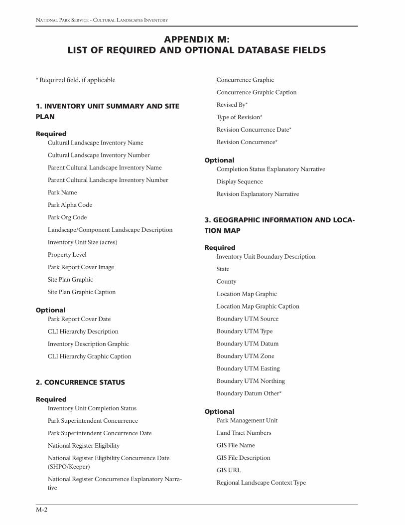
M-2
national Park service - cultural landscaPes inventory
Concurrence Graphic
Concurrence Graphic Caption
Revised By*
Type of Revision*
Revision Concurrence Date*
Revision Concurrence*
OptionalCompletion Status Explanatory Narrative
Display Sequence
Revision Explanatory Narrative
3. GeOGrAphic infOrMAtiOn And LOcA-
tiOn MAp
requiredInventory Unit Boundary Description
State
County
Location Map Graphic
Location Map Graphic Caption
Boundary UTM Source
Boundary UTM Type
Boundary UTM Datum
Boundary UTM Zone
Boundary UTM Easting
Boundary UTM Northing
Boundary Datum Other*
OptionalPark Management Unit
Land Tract Numbers
GIS File Name
GIS File Description
GIS URL
Regional Landscape Context Type
* Required field, if applicable
1. inventOry unit SuMMAry And Site
pLAn
requiredCultural Landscape Inventory Name
Cultural Landscape Inventory Number
Parent Cultural Landscape Inventory Name
Parent Cultural Landscape Inventory Number
Park Name
Park Alpha Code
Park Org Code
Landscape/Component Landscape Description
Inventory Unit Size (acres)
Property Level
Park Report Cover Image
Site Plan Graphic
Site Plan Graphic Caption
OptionalPark Report Cover Date
CLI Hierarchy Description
Inventory Description Graphic
CLI Hierarchy Graphic Caption
2. cOncurrence StAtuS
requiredInventory Unit Completion Status
Park Superintendent Concurrence
Park Superintendent Concurrence Date
National Register Eligibility
National Register Eligibility Concurrence Date (SHPO/Keeper)
National Register Concurrence Explanatory Narra-tive
Appendix M: LiSt Of required And OptiOnAL dAtAbASe fieLdS

M-3
Professional Procedures Guide - aPPendix M
National Register Classification
National Historic Landmark Status
National Historic Landmark Date*
National Historic Landmark Theme*
World Heritage Site Status
World Heritage Site Date*
World Heritage Category*
Statement of Significance
National Register Significance Criteria
National Register Criteria Consideration*
Start Year
Start Era
End Year
End Era
Historic Context Theme*
Historic Context Sub-theme*
Historic Context Facet*
Other Historic Facet*
Area of Significance Category
Area of Significance Category Explanatory Narrative*
Area of Significance Subcategory*
Park Alpha Code/NRIS Name (Number)*
Other National Register Name*
Primary Certification Date*
Other Certification*
Other Certification Date*
Optional National Register Concurrence Explanatory Narra-tive
State Register Documentation Name
State Register Document Identification Number
State Register Date Listed
State Register Documentation Explanatory Narrative
Regional Landscape Context Description
Regional Landscape Context Graphics
Regional Landscape Context Graphic Caption
4. MAnAGeMent infOrMAtiOn
requiredManagement Category
Management Category Date
Management Category Explanatory Narrative
Management Agreement
Management Agreement Expiration Date
Type of Legal Interest
Fee Simple Reservation for Life*
Fee Simple Reservation Expiration Date*
Public Access
Optional Do Adjacent Lands Contribute?
Adjacent Lands Description
Adjacent Lands Graphic
Adjacent Lands Graphic Caption
Management Agreement Explanatory Narrative
Other Management Agreement
Other Agency or Organization
NPS Legal Interest Explanatory Narrative
Public Access Explanatory Narrative
FMSS Asset Location Code
5. nAtiOnAL reGiSter infOrMAtiOn
requiredNational Register Landscape Documentation
National Register Explanatory Narrative
National Register Eligibility*
National Register Eligibility Concurrence Date (SHPO/Keeper)*
National Register Significance Level
National Register Significance- Contributing/Indi-vidual

M-4
national Park service - cultural landscaPes inventory
6. chrOnOLOGy And phySicAL hiStOry
requiredPrimary Historic Function – Major Category
Primary Historic Function – Category
Primary Historic Function
Primary Current Use – Major Category
Primary Current Use – Category
Primary Current Use
Current and Historic Name
Type of Current and Historic Name
Cultural Landscape Type
Start Year of Major Event
Start Era of Major Event
End Year of Major Event
End Era of Major Event
Major Event
Major Event Description
Optional Other Historic Function or Current Use – Major Category
Other Historic Function or Current Use – Category
Other Historic Function or Current Use
Other Historic Function or Current Use – Type
Ethnographic Study Conducted
Ethnographic Significance Description
Ethnographic Associated Group Name
Association Historic, Current, or Both
Associated Name
Association
Association Other
Physical History Time Period
Physical History Narrative
History Graphic
History Graphic Caption
7. AnALySiS And evALuAtiOn Of inteG-
rity
requiredAnalysis and Evaluation Summary
Landscape Characteristic
Feature Name
Feature Contribution
LCS Alpha Code, Name, and Number*
Historic Structure Number*
Optional Landscape Characteristic Explanatory Narrative
Other Landscape Characteristic
Feature UTM Source
Feature UTM Point Type
Feature UTM Datum
Feature UTM Zone
GIS URL
Feature UTM Easting
Feature UTM Northing
ANCS ID
ANCS Name
ASMIS ID
ASMIS Name
Analysis and Evaluation Graphic
Analysis and Evaluation Graphic Caption
8. cOnditiOn ASSeSSMent
requiredCondition Assessment
Condition Assessment Date
Condition Assessment Explanatory Narrative
Impact Type
Internal or External
Impact Explanatory Narrative
OptionalStabilization Cost
Stabilization Cost Date
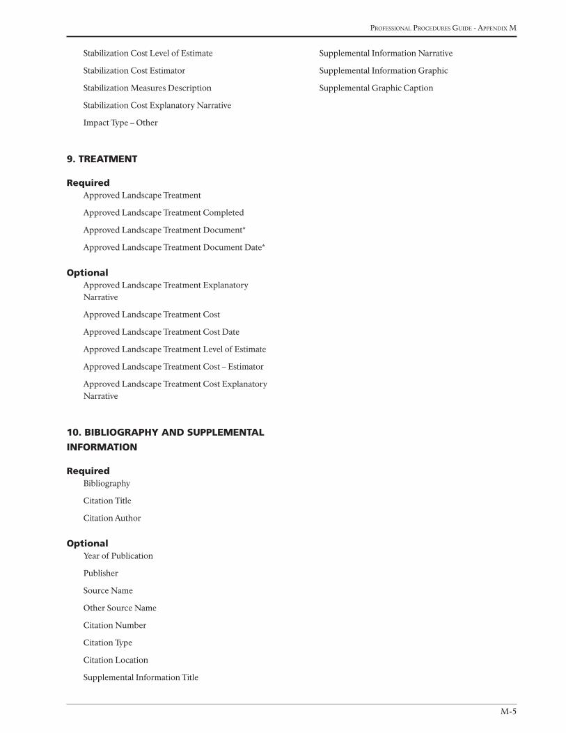
M-5
Professional Procedures Guide - aPPendix M
Stabilization Cost Level of Estimate
Stabilization Cost Estimator
Stabilization Measures Description
Stabilization Cost Explanatory Narrative
Impact Type – Other
9. treAtMent
requiredApproved Landscape Treatment
Approved Landscape Treatment Completed
Approved Landscape Treatment Document*
Approved Landscape Treatment Document Date*
OptionalApproved Landscape Treatment Explanatory Narrative
Approved Landscape Treatment Cost
Approved Landscape Treatment Cost Date
Approved Landscape Treatment Level of Estimate
Approved Landscape Treatment Cost – Estimator
Approved Landscape Treatment Cost Explanatory Narrative
10. bibLiOGrAphy And SuppLeMentAL
infOrMAtiOn
requiredBibliography
Citation Title
Citation Author
OptionalYear of Publication
Publisher
Source Name
Other Source Name
Citation Number
Citation Type
Citation Location
Supplemental Information Title
Supplemental Information Narrative
Supplemental Information Graphic
Supplemental Graphic Caption

M-6
national Park service - cultural landscaPes inventory

N-1
Professional Procedures Guide - aPPendix n
Appendix n
examPles of cover lettersJAnuAry 2009
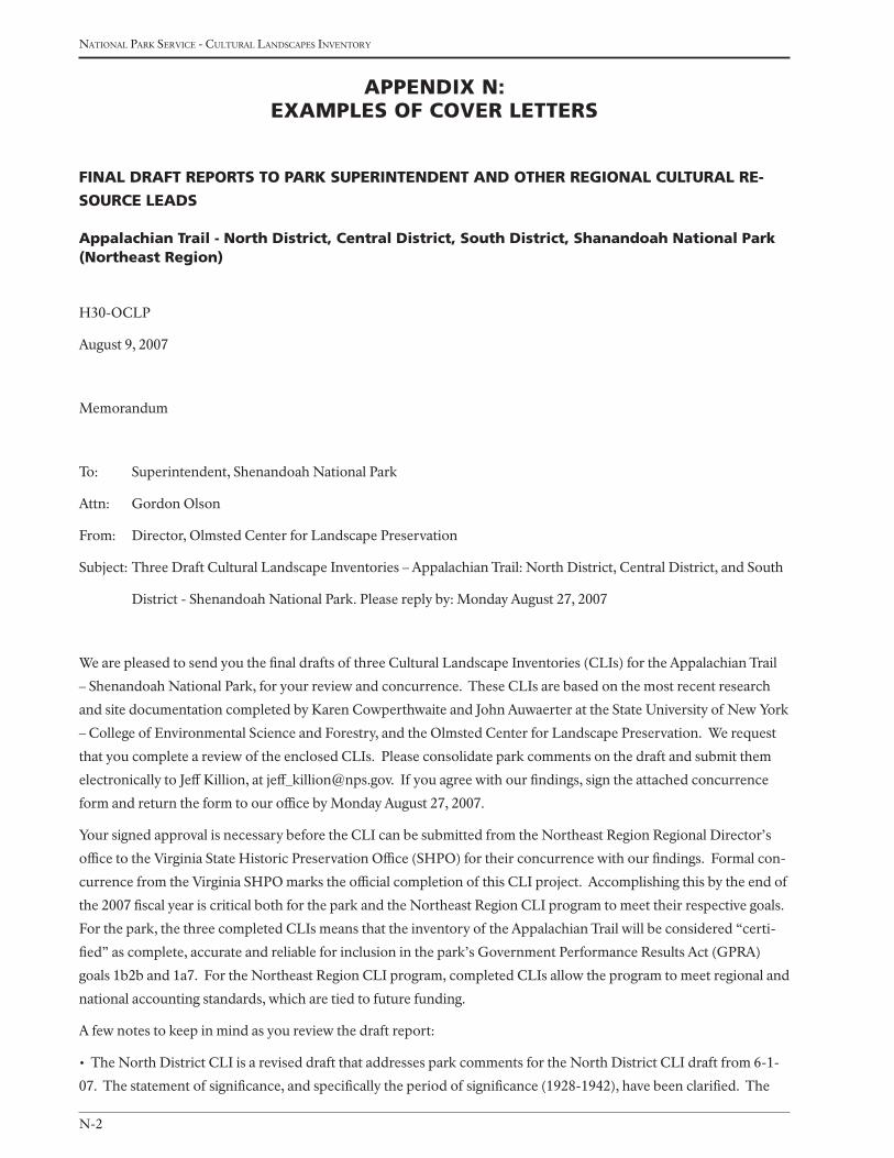
N-2
national Park service - cultural landscaPes inventory
FinAl drAFt reports to pArk superintendent And other regionAl CulturAl re-
sourCe leAds
Appalachian trail - north district, Central district, south district, shanandoah national park (northeast region)
H30-OCLP
August 9, 2007
Memorandum
To: Superintendent, Shenandoah National Park
Attn: Gordon Olson
From: Director, Olmsted Center for Landscape Preservation
Subject: Three Draft Cultural Landscape Inventories – Appalachian Trail: North District, Central District, and South
District - Shenandoah National Park. Please reply by: Monday August 27, 2007
We are pleased to send you the final drafts of three Cultural Landscape Inventories (CLIs) for the Appalachian Trail
– Shenandoah National Park, for your review and concurrence. These CLIs are based on the most recent research
and site documentation completed by Karen Cowperthwaite and John Auwaerter at the State University of New York
– College of Environmental Science and Forestry, and the Olmsted Center for Landscape Preservation. We request
that you complete a review of the enclosed CLIs. Please consolidate park comments on the draft and submit them
electronically to Jeff Killion, at [email protected]. If you agree with our findings, sign the attached concurrence
form and return the form to our office by Monday August 27, 2007.
Your signed approval is necessary before the CLI can be submitted from the Northeast Region Regional Director’s
office to the Virginia State Historic Preservation Office (SHPO) for their concurrence with our findings. Formal con-
currence from the Virginia SHPO marks the official completion of this CLI project. Accomplishing this by the end of
the 2007 fiscal year is critical both for the park and the Northeast Region CLI program to meet their respective goals.
For the park, the three completed CLIs means that the inventory of the Appalachian Trail will be considered “certi-
fied” as complete, accurate and reliable for inclusion in the park’s Government Performance Results Act (GPRA)
goals 1b2b and 1a7. For the Northeast Region CLI program, completed CLIs allow the program to meet regional and
national accounting standards, which are tied to future funding.
A few notes to keep in mind as you review the draft report:
• The North District CLI is a revised draft that addresses park comments for the North District CLI draft from 6-1-
07. The statement of significance, and specifically the period of significance (1928-1942), have been clarified. The
Appendix n: exAmples oF Cover letters
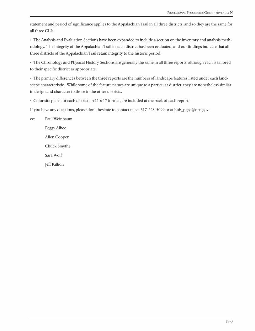
N-3
Professional Procedures Guide - aPPendix n
statement and period of significance applies to the Appalachian Trail in all three districts, and so they are the same for
all three CLIs.
• The Analysis and Evaluation Sections have been expanded to include a section on the inventory and analysis meth-
odology. The integrity of the Appalachian Trail in each district has been evaluated, and our findings indicate that all
three districts of the Appalachian Trail retain integrity to the historic period.
• The Chronology and Physical History Sections are generally the same in all three reports, although each is tailored
to their specific district as appropriate.
• The primary differences between the three reports are the numbers of landscape features listed under each land-
scape characteristic. While some of the feature names are unique to a particular district, they are nonetheless similar
in design and character to those in the other districts.
• Color site plans for each district, in 11 x 17 format, are included at the back of each report.
If you have any questions, please don’t hesitate to contact me at 617-223-5099 or at [email protected].
cc: Paul Weinbaum
Peggy Albee
Allen Cooper
Chuck Smythe
Sara Wolf
Jeff Killion
N-4
national Park service - cultural landscaPes inventory
BrieFing stAtement to regionAl direCtor
Appalachian trail - north district, Central district, south district, shanandoah national park
(northeast region)
Bureau: National Park Service
Issue: State Historic Preservation Office Concurrence with CLIs
Park Site: Shenandoah National Park-Appalachian Trail (three districts)
Date: August 2007
Action Required:
Attached for your signature is a cover letter to the Virginia State Historic Preservation Officer, asking for concurrence
on three Cultural Landscape Inventories (CLIs), the eligibility of the Appalachian Trail (AT) in the National Register
of Historic Places, and the categorization of features as contributing, non-contributing, and undetermined to the
significance and historic character of the AT – North District, Central District, and South District – in Shenandoah
National Park (NP).
Background:
Portions of the AT within the North, Central, and South Districts of Shenandoah NP are listed in the National Reg-
ister as part of the Skyline Drive Historic District. Included in the original National Register listing are seventeen of
the twenty-nine crossings where the AT and Skyline Drive intersect, counted as one contributing site, which span the
125-foot-wide district right-of-way to either side of the drive (250-feet-wide overall). Additional segments of the AT
were included in subsequent boundary increases of the Skyline Drive Historic District made in 1997 and 2003 that
incorporated park facilities adjoining the Skyline Drive corridor. In these areas, the AT passes through approximately
300-feet of the Simmons Gap ranger station and park maintenance facilities cluster, through approximately one mile
at the Skyland resort, and provides the eastern boundary of the Loft Mountain campground and picnic area. Within
these boundary expansions, the AT is not listed as a contributing resource. At Skyland, however, the AT follows ap-
proximately 2,500 feet of the Stony Man Nature Trail, which is listed as a contributing resource.
The Statement of Significance for the original Skyline Drive Historic District listing describes the significance of the
AT in the area of regional planning. However, the AT is minimally addressed and treated primarily as a precursor to
the development of Skyline Drive. The AT crossings with Skyline Drive represent only a very small fraction of the
many contributing resources that have been identified in this CLI.
Additional research described in the CLI and in the attached Landscape Features Lists indicate hundreds of addi-
tional landscape features that contribute to the significance of AT in Shenandoah NP but are not included in existing
National Register documentation. This request for concurrence asks that future National Register documentation for
the AT in Shenandoah NP fully describe all contributing building and landscape resources; and all areas of signifi-
cance in community planning and development, conservation, entertainment/recreation, landscape architecture,
politics/government, and social history. In addition, we are asking for acknowledgment that the AT in Shenandoah
NP is a cultural landscape that retains integrity to the period of significance.
The report was prepared by a team of historical landscape architects with the National Park Service (NPS), Olmsted
Center for Landscape Preservation and the State University of New York, College of Environmental Science and For-

N-5
Professional Procedures Guide - aPPendix n
estry. The CLI program and the enclosed reports continue NPS efforts to update our cultural resource inventories.
Procedure:
As required by Section 110 of the National Historic Preservation Act and consistent with the Cultural Resource Man-
agement Guideline, the CLIs are being submitted for review and comments by the Virginia State Historic Preserva-
tion Officer. Upon receiving concurrence, they will be included in the CLI database.
Contact:
Robert Page, Director, Olmsted Center for Landscape Preservation, 617-223-5099.
N-6
national Park service - cultural landscaPes inventory
FinAl drAFt reports to stAte historiC preservAtion oFFiCe
Appalachian trail - north district, Central district, south district, shanandoah national park (northeast region)
H30 (NER-RS&S OCLP) Dr. Ethel Eaton
Office of Review and Compliance
Department of Historic Resources
Commonwealth of Virginia
2801 Kensington Ave.
Richmond, VA 23221
Dear Dr. Eaton,
Enclosed you will find three Cultural Landscapes Inventories (CLIs) documenting the entire length of the Ap-
palachian Trail (AT) landscape – North District, Central District, and South District –located within Shenandoah
National Park (NP). Portions of the AT, namely the trail crossings at Skyline Drive, are listed as part of the Skyline
Drive Historic District. We seek your concurrence that the entire AT is eligible for listing in the National Register of
Historic Places. The CLIs have been prepared by a team of historical landscape architects with the State University of
New York – College of Environmental Science and Forestry, and the National Park Service (NPS) Olmsted Center for
Landscape Preservation. The CLI program and the enclosed report continue the NPS efforts to update our cultural
resource inventories.
Through the CLI program, the NPS is currently in the midst of a nationwide effort to inventory its cultural land-
scapes. The CLI is conducted in accordance with Section 110 of the National Historic Preservation Act of 1966
(as amended). It is an inventory of baseline information for all historically significant cultural landscapes within
the national park system, and it examines multiple landscape features that contribute to the significance of historic
properties. The CLI process includes gathering information from existing secondary sources and conducting on-site
reconnaissance of the existing landscape. The information collected provides a comprehensive look at the historical
development and significance of the landscape, placing it in context of the property’s overall significance. For land-
scapes found potentially eligible for the National Register of Historic Places, the evaluation describes their character-
defining features and assesses the landscape’s overall historical integrity. It also raises questions about the landscape
that need further study.
It is important to note that the CLI reports are not intended as comprehensive inventory reports for any one proper-
ty, although for some properties they provide fuller documentation than for others. For example, the reports do not
include a full architectural description of structures, but document structures as elements of the overall landscape,
and similarly documents other characteristics such as vegetation, spatial organization, and views and vistas. The CLI
is one component of the NPS inventory effort that also includes cultural resource inventories for historic structures,
archeological sites, ethnographic resources, and museum objects. For example, the NPS List of Classified Structures
inventory includes structural features of cultural landscapes, but the CLI takes a more encompassing approach to the
properties, inventorying all above-ground features in each park in which the NPS has a legal or mandated interest.
N-7
Professional Procedures Guide - aPPendix n
Portions of the AT within the North, Central, and South Districts of Shenandoah NP are listed in the National Regis-
ter of Historic Places as part of the Skyline Drive Historic District. Included in the original National Register listing
are seventeen of the twenty-nine existing crossings where the AT and Skyline Drive intersect, counted as one con-
tributing site, which span the 125-foot-wide district right-of-way to either side of the drive (250-feet-wide overall).
Additional segments of the AT were included in subsequent boundary increases of the Skyline Drive Historic District
made in 1997 and 2003 that incorporated park facilities adjoining the Skyline Drive corridor. In these areas, the AT
passes through approximately 300-feet of the Simmons Gap ranger station and park maintenance facilities cluster,
through approximately one mile at the Skyland resort, and provides the eastern boundary of the Loft Mountain
campground and picnic area. Within these boundary expansions, the AT is not listed as a contributing resource. At
Skyland, however, the AT follows approximately 2,500 feet of the Stony Man Nature Trail, which is listed as a contrib-
uting resource.
The Statement of Significance for the original Skyline Drive Historic District listing describes the significance of the
AT in the area of regional planning. However, the AT is minimally addressed and treated primarily as a precursor to
the development of Skyline Drive. As noted above, not all AT crossings with Skyline Drive are identified in National
Register documentation. These crossings represent only a very small fraction of the many contributing resources
that have now been identified in this CLI.
The AT in Shenandoah NP is significant under Criteria A and C in the areas of landscape architecture, architecture,
community planning and development, politics/government, and entertainment/recreation. Under Criterion A, it is
significant for its association with the early regional planning effort to establish a linked pedestrian greenway corridor
on the East Coast. It also derives significance for its role in the history of park development by creating a pedestrian
spine which parallels, both conceptually and geographically, the vehicular spine of the Skyline Drive. Under Crite-
rion C, the AT is significant as an example of trail design and methods of construction established by the NPS and
implemented by the Civilian Conservation Corps (CCC). Now known as the NPS Rustic style, its principles and
practices endeavored to harmonize development with the natural environment and enable the visitor to experience
scenic features and views.
The period of significance for the AT in Shenandoah NP is from 1928 to 1942. In 1928, the volunteer PATC began
construction of the trail in Shenandoah NP, which had been authorized as a national park in 1926, but would not
yet be fully established until 1935. The period extends until 1942, which encompasses the completion of the AT by
the PATC in 1930, the relocation and reconstruction of portions of the trail by the CCC using NPS trail design and
construction methods necessitated by the building of the Skyline Drive from 1933 to 1938, and the ending of the trail
refinements by the CCC as the program came to a close, they disbanded, and the United States entered World War II.
The CLI fully evaluates the cultural landscape, particularly the associated landscape characteristics and features, and
finds that the three Appalachian Trail landscapes – North District, Central District, and South District – retain overall
integrity in the areas community planning and development, conservation, entertainment/recreation, landscape
architecture, politics/government, and social history. The landscape characteristics and features that date to the peri-
ods of significance should be preserved since they contribute to the historic character of the property.
On the attached lists there is one type of feature – the AT crossings at Skyline Drive – that has been previously evalu-
ated in the National Register. In the documentation, fifteen crossings are discussed in the narrative, but seventeen
crossings are identified in a list by UTM coordinates. The CLI has documented a total of twenty-nine crossings. It
is unclear as to which National Register-listed crossings correspond to crossings identified in the CLI. Because the
National Register collectively counts the crossings as one contributing site, all twenty-nine crossings are therefore
listed in this report as “previously evaluated” as they are clearly the same type of feature.
N-8
national Park service - cultural landscaPes inventory
We call your particular attention to the Landscape Description, National Register Information, Statement of Signifi-
cance, and Analysis and Evaluation Summary in the enclosed CLI. Based on the CLI, we seek your concurrence on
the following:
• The Appalachian Trail landscapes are significant under Criteria A and C.
• The areas of significance are community planning and development, conservation, entertainment/recreation, land-
scape architecture, politics/government, and social history.
• The period of significance for the three Appalachian Trail landscapes is 1928-1942.
• The cultural landscape retains integrity to the period of significance.
• The property retains landscape characteristics and associated features that contribute to the sites’ historic charac-
ter (see attached lists).
If you concur with the items above and our categorization of the Appalachian Trail landscape features associated
with the trail at Shenandoah NP, as contributing, non-contributing, and undetermined, and as enumerated on the
attached lists for each trail district, we ask that you please sign on the space provided and return this letter to Jeff Kil-
lion, CLI Coordinator (Address: Olmsted Center for Landscape Preservation, 15 State Street, 6th Floor, Boston, MA
02109) within thirty days.
Thank you for your attention to these reports. Should you have any questions, please feel free to contact Mr. Killion
at 617-223-5053.
Sincerely,
John A. Latschar
Acting Regional Director
Northeast Region
cc: Superintendent, Shenandoah National Park
I concur that the Appalachian Trail is eligible for listing in the National Register of Historic Places and with the cat-
egorization of the Appalachian Trail landscape features at Shenandoah National Park, as contributing, non-contrib-
uting, and undetermined.
__________________________________________ ______________
Virginia State Historic Preservation Officer Date

Olmsted Center fOr landsCape preservatiOn
Boston National Historical Park
Charlestown Navy Yard, Quarters C
Boston, MA 02129
Phone: 617.241.6954
Fax: 617.241.3952
www.nps.gov/oclp/
U.s. department Of the interiOr
natiOnal park serviCe
CUltUral resOUrCe stewardship and partnerships
park histOriC strUCtUres and CUltUral landsCapes prOgram
washingtOn d.C.