horsley park, cecil park and mt vernon urban investigation
TRANSCRIPT
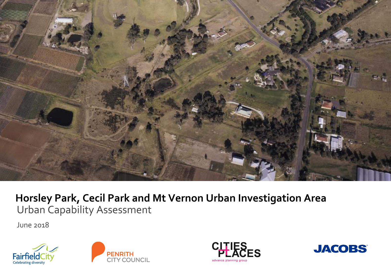
Horsley Park, Cecil Park and Mt Vernon Urban Investigation Area Urban Capability Assessment
June 2018
Mt Vernon, Horsley Park and Cecil Park Urban Investigation Area Urban Capability Assessment Existing Urban Environment Analysis – July 2018
DRAFT Mt Vernon, Horsley Park and Cecil Park Urban Investigation Area
Client Name: Fairfield City Council
Document Title: Mt Vernon, Horsley Park and Cecil Park Urban Investigation
Area
Document No.: IA180500
Revision: 2
Revision Date: June 2018
Project/Proposal No: IA180500
Project Manager: Myall Stevens
Prepared By: Myall Stevens
Approved By: Aaron Bowden
File Name: J:\IE\Projects\04_Eastern\IA180500\21 Deliverables\Horsley
Park, Cecil Park and Mt Vernon Urban Investigation Area
Urban Capability Assessment - Final.docx
Jacobs Australia Pty Limited
Level 7, 177 Pacific Highway
North Sydney NSW 2060 Australia
PO Box 632 North Sydney
NSW 2059 Australia
T +61 2 9928 2100
F +61 2 9928 2500
www.jacobs.com
© Copyright 2018 Jacobs Australia Pty Limited. The concepts and information contained in this document are the property of Jacobs. Use or copying of this document in whole or in part without the written permission of Jacobs constitutes an infringement of copyright
Mt Vernon, Horsley Park and Cecil Park Urban Investigation Area Urban Capability Assessment Existing Urban Environment Analysis – July 2018
DRAFT Table of contents
Introduction ................................................................................................................................................ 3
1.1 Purpose of this report .................................................................................................................................. 4
Strategic Planning Overview ................................................................................................................... 5
2.1 Overview ...................................................................................................................................................... 6
2.2 Greater Sydney Region Plan 2018.............................................................................................................. 6
2.3 Future Transport 2056 ................................................................................................................................. 9
2.4 State Infrastructure Strategy 2018-2038 ..................................................................................................... 9
2.5 District Plans .............................................................................................................................................. 10
2.6 Fairfield City Plan 2012-2022 .................................................................................................................... 11
2.7 Penrith Community Plan 2017 ................................................................................................................... 11
2.8 State Environmental Planning Policies...................................................................................................... 11
2.9 Other Environmental Planning Instruments .............................................................................................. 11
Existing Urban Environment Analysis ..................................................................................................13
3.1 Introduction ................................................................................................................................................ 14
3.2 Study area – Horsley Park and Cecil Park ................................................................................................ 15
3.3 Study area – Mt Vernon ............................................................................................................................ 16
3.4 Slope and Topography – Horsley Park and Cecil Park ............................................................................. 17
3.5 Slope and Topography – Mt Vernon ......................................................................................................... 18
3.6 Flooding – Horsley Park and Cecil Park.................................................................................................... 19
3.7 Flooding – Mt Vernon ................................................................................................................................ 20
3.8 Bush Fire – Horsley Park and Cecil Park .................................................................................................. 21
3.9 Bush Fire – Mt Vernon .............................................................................................................................. 22
3.10 Biodiversity – Horsley Park and Cecil Park ............................................................................................... 23
3.11 Biodiversity – Mt Vernon ........................................................................................................................... 24
3.12 Heritage – Horsley Park and Cecil Park .................................................................................................... 25
3.13 Heritage – Mt Vernon ................................................................................................................................ 26
3.14 Existing Land Uses – Horsley Park and Cecil Park .................................................................................. 27
3.15 Existing land uses – Mt Vernon ................................................................................................................. 28
3.16 Lot Size – Horsley Park and Cecil Park .................................................................................................... 29
3.17 Lot Size – Mt Vernon ................................................................................................................................. 30
3.18 Infrastructure – Horsley Park and Cecil Park ............................................................................................ 31
3.19 Infrastructure – Mt Vernon ......................................................................................................................... 32
3.20 Land Soil Capability and Acid Sulfate Soils – Horsley Park and Cecil Park ............................................. 33
3.21 Land Soil Capability and Acid Sulfate Soils – Mt Vernon .......................................................................... 34
3.22 Soil Geology – Horsley Park and Cecil Park ............................................................................................. 35
3.23 Soil Geology – Mt Vernon ......................................................................................................................... 36
3.24 Salinity – Horsley Park and Cecil Park ......................................................................................................37
3.25 Salinity – Mt Vernon ...................................................................................................................................38
3.26 Cumulative Natural and Physical Constraints – Horsley Park and Cecil Park ..........................................39
3.27 Cumulative Natural and Physical Constraints – Mt Vernon .......................................................................40
3.28 Land recommended not urban development capable – Horsley Park and Cecil Park ..............................41
3.29 Land recommended not urban development capable – Mt Vernon ..........................................................42
3.30 Land not urban capable land potentially urban development capable – Horsley Park and Cecil Park .....43
3.31 Land not urban capable land potentially urban development capable ......................................................44
Conclusions and Recommendations ................................................................................................... 45
4.1 Conclusions ...............................................................................................................................................46
4.2 Recommendations .....................................................................................................................................46
Mt Vernon, Horsley Park and Cecil Park Urban Investigation Area Urban Capability Assessment Existing Urban Environment Analysis – July 2018
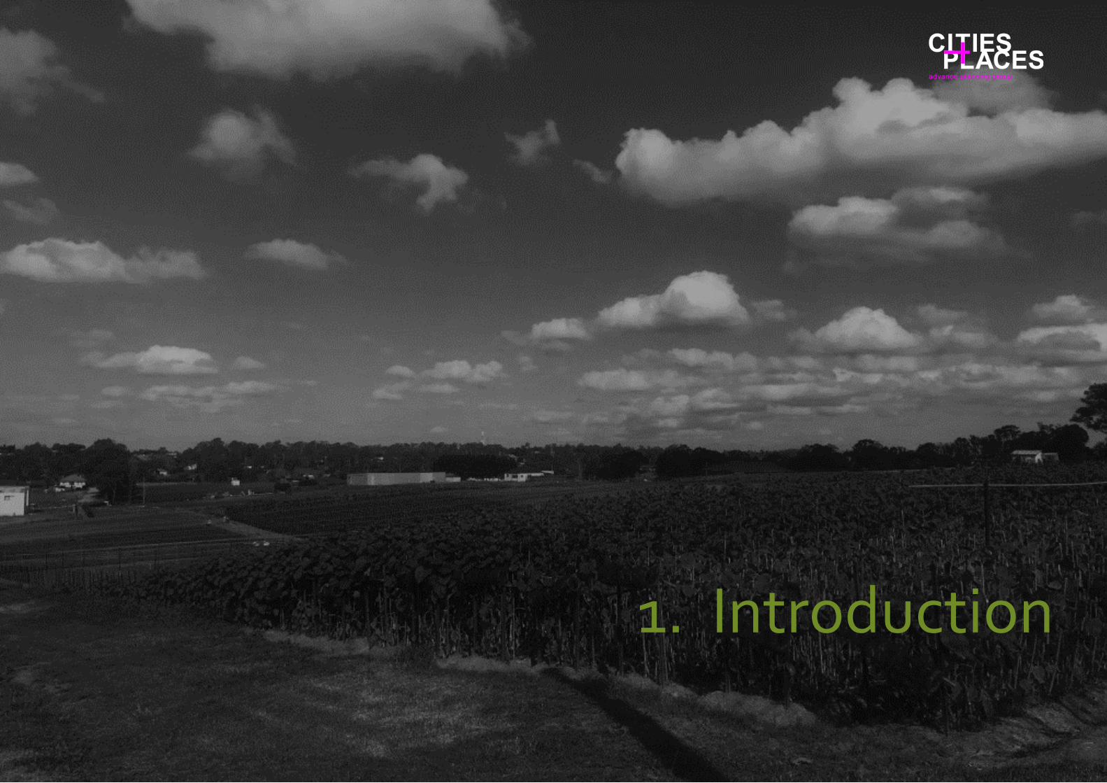
DRAFT Introduction
Riverwood Land Use and Infrastructure Implementation Plan Background Research, Vision and Principles
1. Introduction
Mt Vernon, Horsley Park and Cecil Park Urban Investigation Area Urban Capability Assessment Existing Urban Environment Analysis – July 2018
DRAFT 1.1 Purpose of this report
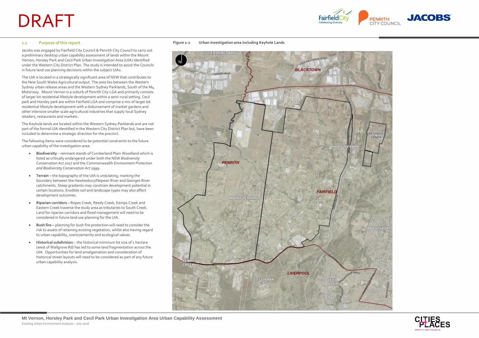
Jacobs was engaged by Fairfield City Council & Penrith City Council to carry out a preliminary desktop urban capability assessment of lands within the Mount Vernon, Horsley Park and Cecil Park Urban Investigation Area (UIA) identified under the Western City District Plan. The study is intended to assist the Councils in future land use planning decisions within the subject UIAs.
The UIA is located in a strategically significant area of NSW that contributes to the New South Wales Agricultural output. The area lies between the Western Sydney urban release areas and the Western Sydney Parklands, South of the M4 Motorway. Mount Vernon is a suburb of Penrith City LGA and primarily consists of larger lot residential lifestyle development within a semi-rural setting. Cecil park and Horsley park are within Fairfield LGA and comprise a mix of larger lot residential lifestyle development with a disbursement of market gardens and other intensive smaller scale agricultural industries that supply local Sydney retailers, restaurants and markets.
The Keyhole lands are located within the Western Sydney Parklands and are not part of the formal UIA identified in the Western City District Plan but, have been included to determine a strategic direction for the precinct.
The following items were considered to be potential constraints to the future urban capability of the investigation area:
Biodiversity – remnant stands of Cumberland Plain Woodland which is listed as critically endangered under both the NSW Biodiversity Conservation Act 2017 and the Commonwealth Environment Protection and Biodiversity Conservation Act 1999.
Terrain – the topography of the UIA is undulating, marking the boundary between the Hawkesbury/Nepean River and Georges River catchments. Steep gradients may constrain development potential in certain locations. Erodible soil and landscape types may also affect development outcomes.
Riparian corridors – Ropes Creek, Reedy Creek, Kemps Creek and Eastern Creek traverse the study area as tributaries to South Creek. Land for riparian corridors and flood management will need to be considered in future land use planning for the UIA.
Bush fire – planning for bush fire protection will need to consider the risk to assets of retaining existing vegetation, whilst also having regard to urban capability, scenic/amenity and ecological values.
Historical subdivision – the historical minimum lot size of 1 hectare (west of Wallgrove Rd) has led to some land fragmentation across the UIA. Opportunities for land amalgamation and consideration of historical street layouts will need to be considered as part of any future urban capability analysis.
Figure 1-1 Urban investigation area including Keyhole Lands
Mt Vernon, Horsley Park and Cecil Park Urban Investigation Area Urban Capability Assessment Existing Urban Environment Analysis – July 2018
DRAFT Strategic Planning Overview
2. Strategic Planning Overview

Mt Vernon, Horsley Park and Cecil Park Urban Investigation Area Urban Capability Assessment Existing Urban Environment Analysis – July 2018
DRAFT 2.1 Overview
The strategic planning framework in NSW has undergone significant change over the last 5 years with a multitude of variations of Sydney wide and districts planning strategies. The Greater Sydney Commission commenced in January 2016 with an agreed Statement of priorities with the Minister for Planning. This Statement of Priorities are based on Commission's statutory responsibilities under the Greater Sydney Commission Act 2015.
The following section outlines the strategic planning documents that currently apply to the UIA at state, regional and local levels.
2.2 Greater Sydney Region Plan 2018
Purpose
The Greater Sydney Region Plan 2018 (GSRP) has been prepared by the Greater Sydney Commission concurrently with the NSW Government’s Future Transport 2056 and Infrastructure NSW’s State Infrastructure Strategy 2018-2038 to facilitate the coordination of land use, transport and infrastructure across the Greater Sydney region. The GSRP has been prepared in accordance with Section 3.3 of the NSW Environmental Planning & Assessment Act 1979. The Plan describes the long term planning vision and principles for the growth of the Greater Sydney region to 2056.
The GSRP has been ‘approved’ by the NSW Government and is the primary strategic document to guide future development of Sydney. Accordingly, the plan provides guidance for the preparation of the urban capability assessment of lands within the Mount Vernon, Horsley Park and Cecil Park UIA.
The GSRP aims to:
Set a 40-year vision (to 2056) and establish a 20-year plan to manage growth and change for Greater Sydney
Inform district and local plans as well as assessment of planning proposals
Assist with the planning and delivery of infrastructure and align with place-based outcomes
Inform the private sector and the wider community regarding growth management and infrastructure investment intentions of the government.
GSRP structure
The GSRP organises the Ten Directions for Greater Sydney into four groups. The GSRP contains 38 urban growth objectives, organised under each of the Ten Directions. An additional two directions guide the implementation of the directions, objectives, metrics and plan preparation.
The Ten Directions, along with respectively objectives are illustrated in Figure 2-1
Figure 2-1 GSRP Ten Directions
Source: Adapted from GSRP, Greater Sydney Commission 2018
Infrastructure and
collaboration
Direction One:
A city supported by infrastructure
Direction Two:
A collaborative city
Liveability
Direction Three:
A city for people
Direction Four:
Housing the city
Direction Five:
A city of great places
Productivity
Direction Six:
A well-connected city
Direction Seven:
Jobs and skills for the city
Sustainability
Direction Eight:
A city in its landscape
Direction Nine:
An efficient city
Direction Ten:
A resilient city
Mt Vernon, Horsley Park and Cecil Park Urban Investigation Area Urban Capability Assessment Existing Urban Environment Analysis – July 2018
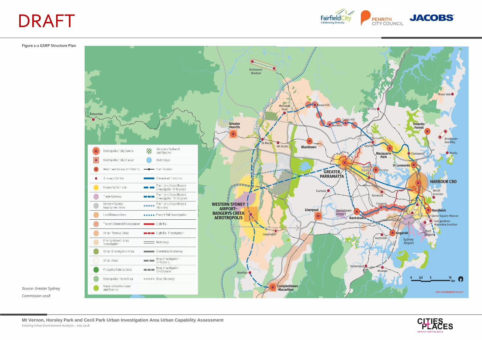
DRAFT Figure 2-2 GSRP Structure Plan
Source: Greater Sydney
Commission 2018
Mt Vernon, Horsley Park and Cecil Park Urban Investigation Area Urban Capability Assessment Existing Urban Environment Analysis – July 2018
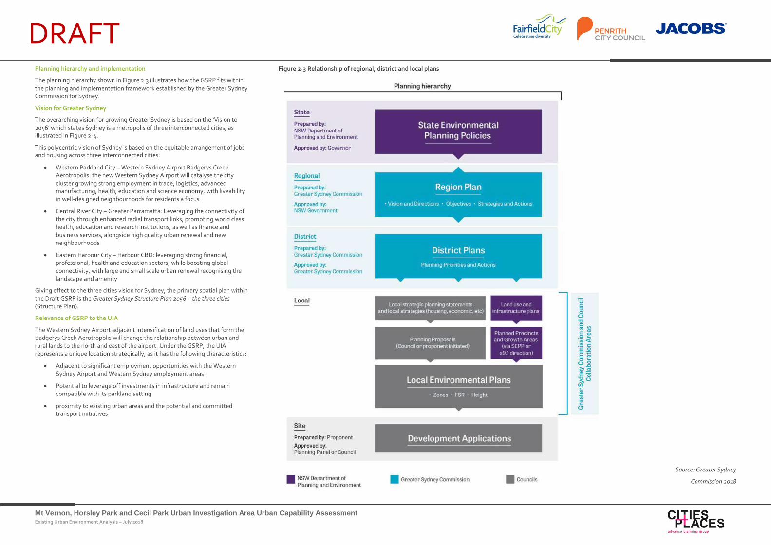
DRAFT Planning hierarchy and implementation
The planning hierarchy shown in Figure 2.3 illustrates how the GSRP fits within the planning and implementation framework established by the Greater Sydney Commission for Sydney.
Vision for Greater Sydney
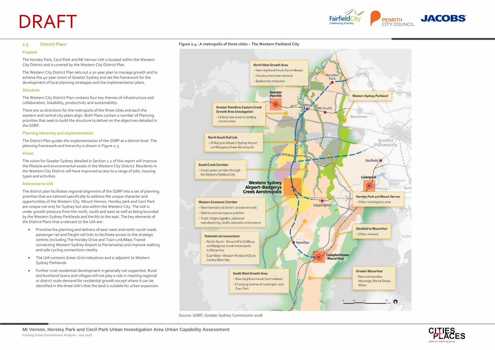
The overarching vision for growing Greater Sydney is based on the ‘Vision to 2056’ which states Sydney is a metropolis of three interconnected cities, as illustrated in Figure 2-4.
This polycentric vision of Sydney is based on the equitable arrangement of jobs and housing across three interconnected cities:
Western Parkland City – Western Sydney Airport Badgerys Creek Aerotropolis: the new Western Sydney Airport will catalyse the city cluster growing strong employment in trade, logistics, advanced manufacturing, health, education and science economy, with liveability in well-designed neighbourhoods for residents a focus
Central River City – Greater Parramatta: Leveraging the connectivity of the city through enhanced radial transport links, promoting world class health, education and research institutions, as well as finance and business services, alongside high quality urban renewal and new neighbourhoods
Eastern Harbour City – Harbour CBD: leveraging strong financial, professional, health and education sectors, while boosting global connectivity, with large and small scale urban renewal recognising the landscape and amenity
Giving effect to the three cities vision for Sydney, the primary spatial plan within the Draft GSRP is the Greater Sydney Structure Plan 2056 – the three cities (Structure Plan).
Relevance of GSRP to the UIA
The Western Sydney Airport adjacent intensification of land uses that form the Badgerys Creek Aerotropolis will change the relationship between urban and rural lands to the north and east of the airport. Under the GSRP, the UIA represents a unique location strategically, as it has the following characteristics:
Adjacent to significant employment opportunities with the Western Sydney Airport and Western Sydney employment areas
Potential to leverage off investments in infrastructure and remain compatible with its parkland setting
proximity to existing urban areas and the potential and committed transport initiatives
Figure 2-3 Relationship of regional, district and local plans
Source: Greater Sydney
Commission 2018
Mt Vernon, Horsley Park and Cecil Park Urban Investigation Area Urban Capability Assessment Existing Urban Environment Analysis – July 2018
DRAFT 2.3 Future Transport 2056
Purpose
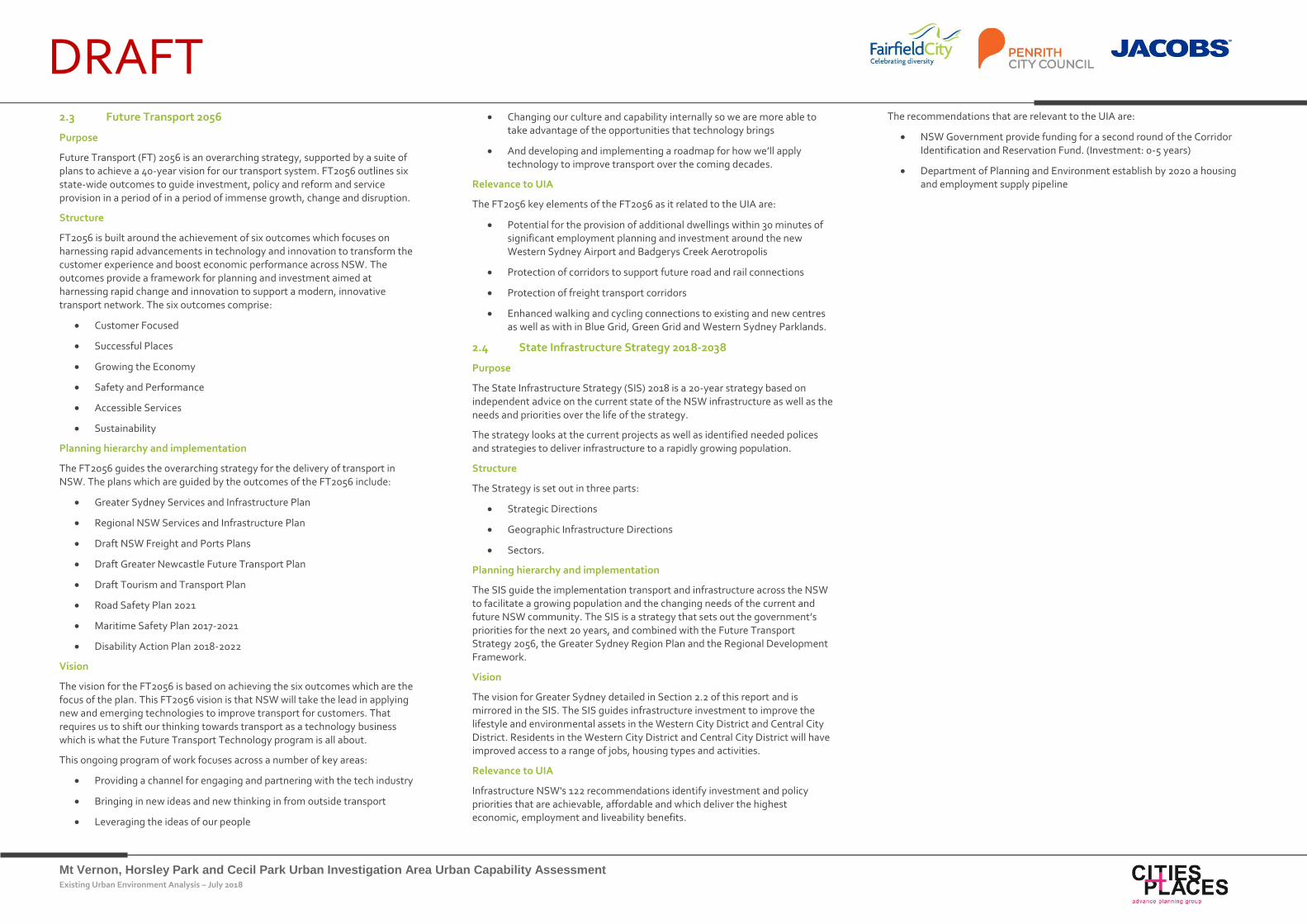
Future Transport (FT) 2056 is an overarching strategy, supported by a suite of plans to achieve a 40-year vision for our transport system. FT2056 outlines six state-wide outcomes to guide investment, policy and reform and service provision in a period of in a period of immense growth, change and disruption.
Structure
FT2056 is built around the achievement of six outcomes which focuses on harnessing rapid advancements in technology and innovation to transform the customer experience and boost economic performance across NSW. The outcomes provide a framework for planning and investment aimed at harnessing rapid change and innovation to support a modern, innovative transport network. The six outcomes comprise:
Customer Focused
Successful Places
Growing the Economy
Safety and Performance
Accessible Services
Sustainability
Planning hierarchy and implementation
The FT2056 guides the overarching strategy for the delivery of transport in NSW. The plans which are guided by the outcomes of the FT2056 include:
Greater Sydney Services and Infrastructure Plan
Regional NSW Services and Infrastructure Plan
Draft NSW Freight and Ports Plans
Draft Greater Newcastle Future Transport Plan
Draft Tourism and Transport Plan
Road Safety Plan 2021
Maritime Safety Plan 2017-2021
Disability Action Plan 2018-2022
Vision
The vision for the FT2056 is based on achieving the six outcomes which are the focus of the plan. This FT2056 vision is that NSW will take the lead in applying new and emerging technologies to improve transport for customers. That requires us to shift our thinking towards transport as a technology business which is what the Future Transport Technology program is all about.
This ongoing program of work focuses across a number of key areas:
Providing a channel for engaging and partnering with the tech industry
Bringing in new ideas and new thinking in from outside transport
Leveraging the ideas of our people
Changing our culture and capability internally so we are more able to take advantage of the opportunities that technology brings
And developing and implementing a roadmap for how we’ll apply technology to improve transport over the coming decades.
Relevance to UIA
The FT2056 key elements of the FT2056 as it related to the UIA are:
Potential for the provision of additional dwellings within 30 minutes of significant employment planning and investment around the new Western Sydney Airport and Badgerys Creek Aerotropolis
Protection of corridors to support future road and rail connections
Protection of freight transport corridors
Enhanced walking and cycling connections to existing and new centres as well as with in Blue Grid, Green Grid and Western Sydney Parklands.
2.4 State Infrastructure Strategy 2018-2038
Purpose
The State Infrastructure Strategy (SIS) 2018 is a 20-year strategy based on independent advice on the current state of the NSW infrastructure as well as the needs and priorities over the life of the strategy.
The strategy looks at the current projects as well as identified needed polices and strategies to deliver infrastructure to a rapidly growing population.
Structure
The Strategy is set out in three parts:
Strategic Directions
Geographic Infrastructure Directions
Sectors.
Planning hierarchy and implementation
The SIS guide the implementation transport and infrastructure across the NSW to facilitate a growing population and the changing needs of the current and future NSW community. The SIS is a strategy that sets out the government’s priorities for the next 20 years, and combined with the Future Transport Strategy 2056, the Greater Sydney Region Plan and the Regional Development Framework.
Vision
The vision for Greater Sydney detailed in Section 2.2 of this report and is mirrored in the SIS. The SIS guides infrastructure investment to improve the lifestyle and environmental assets in the Western City District and Central City District. Residents in the Western City District and Central City District will have improved access to a range of jobs, housing types and activities.
Relevance to UIA
Infrastructure NSW's 122 recommendations identify investment and policy priorities that are achievable, affordable and which deliver the highest economic, employment and liveability benefits.
The recommendations that are relevant to the UIA are:
NSW Government provide funding for a second round of the Corridor Identification and Reservation Fund. (Investment: 0-5 years)
Department of Planning and Environment establish by 2020 a housing and employment supply pipeline
Mt Vernon, Horsley Park and Cecil Park Urban Investigation Area Urban Capability Assessment Existing Urban Environment Analysis – July 2018
DRAFT 2.5 District Plans
Purpose
The Horsley Park, Cecil Park and Mt Vernon UIA is located within the Western City District and is covered by the Western City District Plan.
The Western City District Plan sets out a 20-year plan to manage growth and to achieve the 40-year vision of Greater Sydney and set the framework for the development of local planning strategies and the implementation plans.
Structure
The Western City District Plan contains four key themes of infrastructure and collaboration, liveability, productivity and sustainability.
There are 10 directions for the metropolis of the three cities and each the western and central city plans align. Both Plans contain a number of Planning priorities that seek to build the structure to deliver on the objectives detailed in the GSRP.
Planning hierarchy and implementation
The District Plan guides the implementation of the GSRP at a district level. The planning framework and hierarchy is shown in Figure 2-3
Vision
The vision for Greater Sydney detailed in Section 2.2 of this report will improve the lifestyle and environmental assets in the Western City District. Residents in the Western City District will have improved access to a range of jobs, housing types and activities.
Relevance to UIA
The district plan facilitates regional alignment of the GSRP into a set of planning priorities that are tailored specifically to address the unique character and opportunities of the Western City. Mount Vernon, Horsley park and Cecil Park are unique not only for Sydney but also within the Western City. The UIA is under growth pressure from the north, south and west as well as being bounded by the Western Sydney Parklands and the M7 to the east. The key elements of the District Plans that a relevant to the UIA are:
Prioritise the planning and delivery of east-west and north-south roads passenger rail and freight rail links to facilitate access to the strategic centres (including The Horsley Drive and Train Link/Mass Transit connecting Western Sydney Airport to Parramatta) and improve walking and safe cycling connections nearby
The UIA contains Green Grid indicatives and is adjacent to Western Sydney Parklands
Further rural-residential development is generally not supported. Rural and bushland towns and villages will not play a role in meeting regional or district scale demand for residential growth except where it can be identified in the three UIA’s that the land is suitable for urban expansion
Figure 2.4 : A metropolis of three cities – The Western Parkland City
Source: GSRP, Greater Sydney Commission 2018
Mt Vernon, Horsley Park and Cecil Park Urban Investigation Area Urban Capability Assessment Existing Urban Environment Analysis – July 2018
DRAFT 2.6 Fairfield City Plan 2012-2022
Purpose
The Fairfield City Plan 2012-2022 (FCP) was prepared by Fairfield City Council and adopted by Council on 11 December 2012. The FCPP and is intended to provide strategic indicators for the development of Fairfield LGA up to 2022 and beyond. The FCP is also intended to guide the allocation of resources, inform Council’s contribution plans, Local Environmental Plan and Development Control Plan. It is therefore the key strategic planning document for informing and managing urban growth and change in the Fairfield LGA.
FCP Structure
The FCP aims to deliver on its vision through a set of principles and goals. The goals of the FCP are based around five key themes which comprise:
Community wellbeing
Places and infrastructure
Environmental sustainability
Local economy and employment
Good governance and leadership
Vision for Fairfield
The community vision for Fairfield is:
‘We are Fairfield City - a welcoming, safe and diverse community where we are proud to belong, invest and prosper”
To achieve this there are 10 priorities that have been identified to achieve the key themes and the vision statement. The top ten priorities are:
Improve community safety
A clean and attractive place
Better health services
Less rubbish dumping
Cleaner environment
Improved roads
Better public transport
Access to schools, universities and TAFE
More parking
More activities for children and youth.
Relevance of FCP to the UIA
At the time of preparing the FCP the potential for the expansion of the urban area into the UIA was not identified in strategic planning strategies. With the update or development of a Fairfield strategic plan that responded to the GSRP and the District it is likely that the outcomes of this report will be considered.
2.7 Penrith Community Plan 2017
Purpose
The Penrith Community Plan 2017 (PCP) is a LGA wide plan based around seven outcomes that were devised through a process of community consultation. The seven outcomes are based around three themes that are aimed at improving Penrith as a place to live, work and visit. The plan is required by the NSW office of local Government and is
PCP Structure
The PCP aims to deliver on its vision through a set of seven outcomes. The outcomes comprise:
We can work close to home –
Helping our community find a local job that suits them.
We plan for our future growth –
Making sure that services and infrastructure keep up as Penrith grows.
We can get around our city –
Making sure we can get from place to place safely and easily, whether we drive, walk, cycle or ride the train or bus.
We have safe, vibrant places –
Making sure our public spaces are safe, pleasant places to be.
We care for our environment –
Protecting our air and water quality, and our natural areas.
We are healthy, and share strong community spirit –
Supporting the physical and mental health of our community.
We have confidence in our council –
Putting our values into action: We are accountable. We show respect. We encourage innovation.
The PCP is the guiding plan that provides direction to the Penrith City Council Delivery program, Operational Plan and Resourcing Strategy.
Vision
Penrith City Council’s vision is:
“Council’s vision is one of a sustainable and prosperous region with harmony of urban and rural qualities with a strong commitment to environmental protection and enhancement.
It would offer both the cosmopolitan and cultural lifestyles of a mature city and the casual character of a rural community.”
Relevance of PCP to the UIA
The PCP is a string driver for the implementation of new or evolving of existing communities within Penrith LGA. The PCP provides clear objectives to guide the location and form of urban development within the LGA which is a consideration for Mt Vernon and what is considered for Mt Vernon should it be identified for increased density future urban development.
2.8 State Environmental Planning Policies
The following section provides an outline to the relationship of the relevant State Environmental Planning Policies (SEPPs) to the BEL:
Sydney Regional Environmental Planning Policy No.20 – Hawkesbury Nepean River (deemed SEPP)
Sydney Regional Environmental Planning Policy No.20 – Hawkesbury Nepean River (deemed SEPP) to protect the environment of the Hawkesbury-Nepean River system by ensuring that the impacts of future land uses are considered in a regional context.
The UIA is located in the upper reaches of the South Creek Catchment which feeds into the Hawkesbury-Nepean River System. The SEPP establishes a framework for future development in the Hawkesbury Nepean with the aim of promoting the principles of total catchment management, improving water quality and enhancing sustainable development in the Catchment.
State Environmental Planning Policy No 55-Remediation of Land
State Environmental Planning Policy No 55-Remediation of Land comprises provisions for the identification and remediation of contaminated land. Development proposed within NSW is required to be assessed and justified that the land subject of the land use can be made capable of safely facilitating that land use without impacting on the health of the environment or the employees.
Existing and previous agricultural land uses within the UIA gives rise to the potential for contaminated land. In this regard, development in the UIA will need to consider the remediation of the contamination as part of individual development proposals.
2.9 Other Environmental Planning Instruments
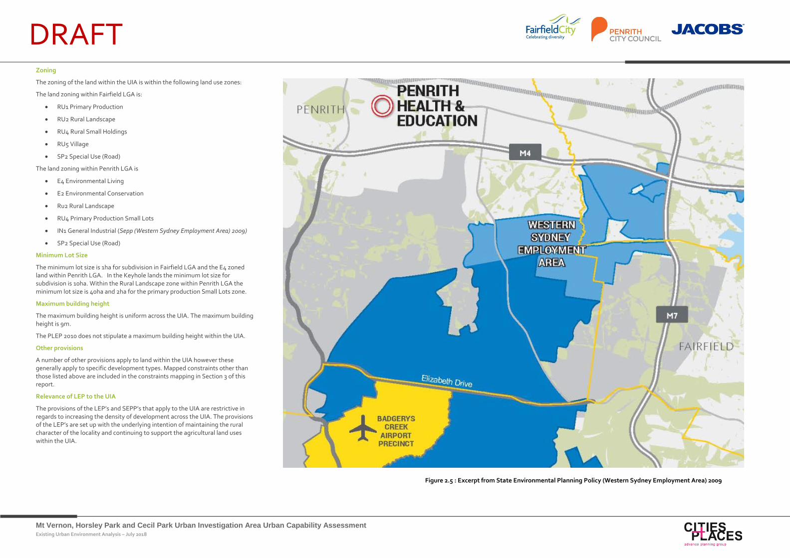
Fairfield Local Environmental Plan 2010, Penrith Local Environmental Plan 2013 and State Environmental Planning Policy (Western Sydney Employment Area) 2009
Local Environmental Plans (LEPs) give legislative statutory effect to the broader strategies that are developed to guide development in NSW. The Fairfield Local Environmental Plan 2010 (FLEP), Penrith Local Environmental Plan 2013 (PLEP) and SEPP (Western Sydney Employment Area) 2009 all contain provisions that apply to the UIA and are summarised below.
Mt Vernon, Horsley Park and Cecil Park Urban Investigation Area Urban Capability Assessment Existing Urban Environment Analysis – July 2018
DRAFT Zoning
The zoning of the land within the UIA is within the following land use zones:
The land zoning within Fairfield LGA is:
RU1 Primary Production
RU2 Rural Landscape
RU4 Rural Small Holdings
RU5 Village
SP2 Special Use (Road)
The land zoning within Penrith LGA is
E4 Environmental Living
E2 Environmental Conservation
Ru2 Rural Landscape
RU4 Primary Production Small Lots
IN1 General Industrial (Sepp (Western Sydney Employment Area) 2009)
SP2 Special Use (Road)
Minimum Lot Size
The minimum lot size is 1ha for subdivision in Fairfield LGA and the E4 zoned land within Penrith LGA. In the Keyhole lands the minimum lot size for subdivision is 10ha. Within the Rural Landscape zone within Penrith LGA the minimum lot size is 40ha and 2ha for the primary production Small Lots zone.
Maximum building height
The maximum building height is uniform across the UIA. The maximum building height is 9m.
The PLEP 2010 does not stipulate a maximum building height within the UIA.
Other provisions
A number of other provisions apply to land within the UIA however these generally apply to specific development types. Mapped constraints other than those listed above are included in the constraints mapping in Section 3 of this report.
Relevance of LEP to the UIA
The provisions of the LEP’s and SEPP’s that apply to the UIA are restrictive in regards to increasing the density of development across the UIA. The provisions of the LEP’s are set up with the underlying intention of maintaining the rural character of the locality and continuing to support the agricultural land uses within the UIA.
Figure 2.5 : Excerpt from State Environmental Planning Policy (Western Sydney Employment Area) 2009
Mt Vernon, Horsley Park and Cecil Park Urban Investigation Area Urban Capability Assessment Existing Urban Environment Analysis – July 2018
DRAFT Existing Urban Environment Analysis
3. Existing Urban
Environment Analysis
Mt Vernon, Horsley Park and Cecil Park Urban Investigation Area Urban Capability Assessment Existing Urban Environment Analysis – July 2018
DRAFT 3.1 Introduction
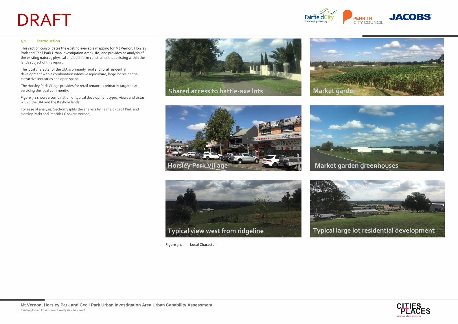
This section consolidates the existing available mapping for Mt Vernon, Horsley Park and Cecil Park Urban Investigation Area (UIA) and provides an analysis of the existing natural, physical and built form constraints that existing within the lands subject of this report.
The local character of the UIA is primarily rural and rural residential development with a combination intensive agriculture, large lot residential, extractive industries and open space.
The Horsley Park Village provides for retail tenancies primarily targeted at servicing the local community.
Figure 3-1 shows a combination of typical development types, views and vistas within the UIA and the Keyhole lands.
For ease of analysis, Section 3 splits the analysis by Fairfield (Cecil Park and Horsley Park) and Penrith LGAs (Mt Vernon).
Figure 3-1 Local Character
Horsley Park Village
Typical view west from ridgeline Typical large lot residential development
Market garden
Market garden greenhouses
Shared access to battle-axe lots
Mt Vernon, Horsley Park and Cecil Park Urban Investigation Area Urban Capability Assessment Existing Urban Environment Analysis – July 2018
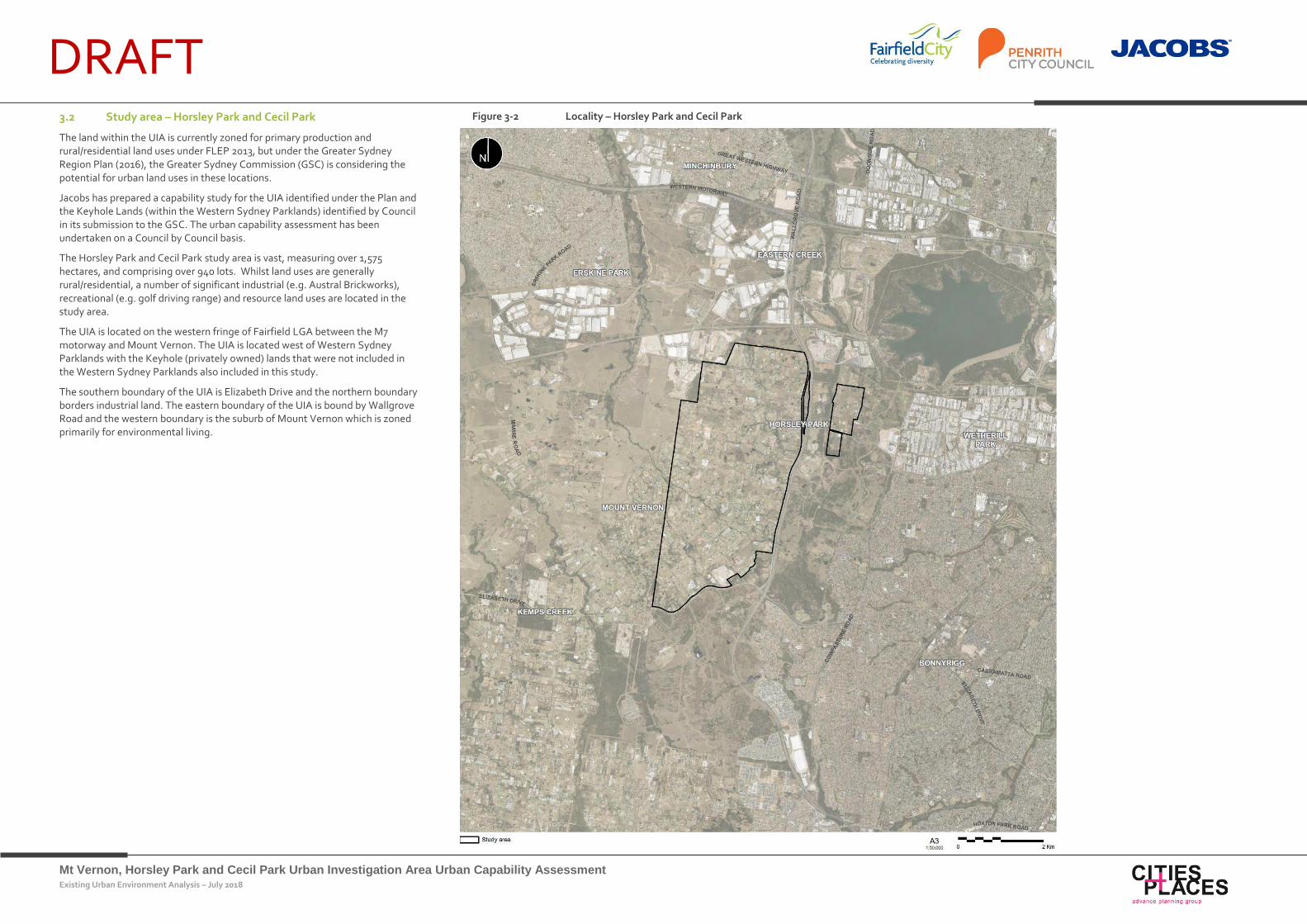
DRAFT 3.2 Study area – Horsley Park and Cecil Park
The land within the UIA is currently zoned for primary production and rural/residential land uses under FLEP 2013, but under the Greater Sydney Region Plan (2016), the Greater Sydney Commission (GSC) is considering the potential for urban land uses in these locations.
Jacobs has prepared a capability study for the UIA identified under the Plan and the Keyhole Lands (within the Western Sydney Parklands) identified by Council in its submission to the GSC. The urban capability assessment has been undertaken on a Council by Council basis.
The Horsley Park and Cecil Park study area is vast, measuring over 1,575 hectares, and comprising over 940 lots. Whilst land uses are generally rural/residential, a number of significant industrial (e.g. Austral Brickworks), recreational (e.g. golf driving range) and resource land uses are located in the study area.
The UIA is located on the western fringe of Fairfield LGA between the M7 motorway and Mount Vernon. The UIA is located west of Western Sydney Parklands with the Keyhole (privately owned) lands that were not included in the Western Sydney Parklands also included in this study.
The southern boundary of the UIA is Elizabeth Drive and the northern boundary borders industrial land. The eastern boundary of the UIA is bound by Wallgrove Road and the western boundary is the suburb of Mount Vernon which is zoned primarily for environmental living.
Figure 3-2 Locality – Horsley Park and Cecil Park
Mt Vernon, Horsley Park and Cecil Park Urban Investigation Area Urban Capability Assessment Existing Urban Environment Analysis – July 2018
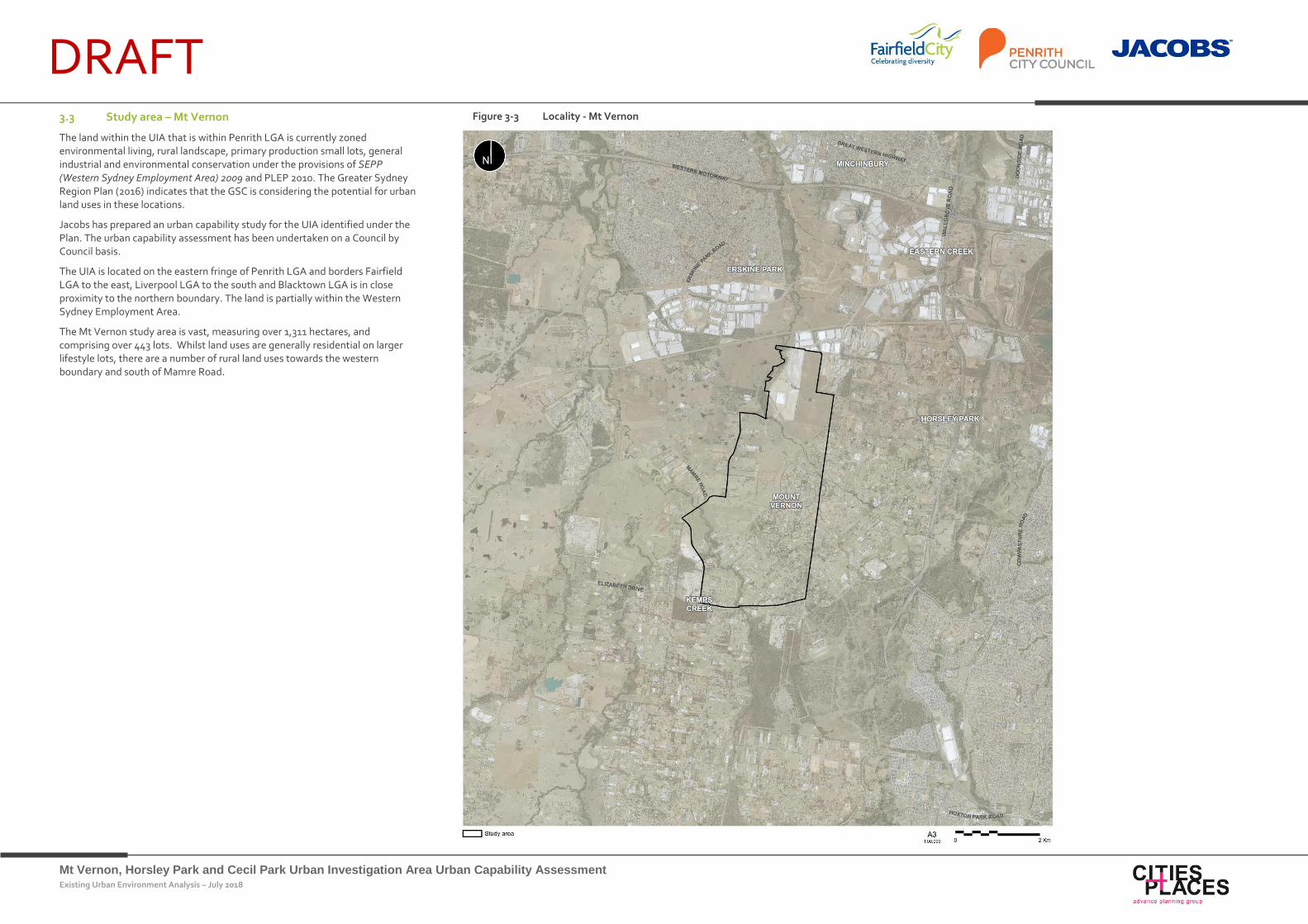
DRAFT 3.3 Study area – Mt Vernon
The land within the UIA that is within Penrith LGA is currently zoned environmental living, rural landscape, primary production small lots, general industrial and environmental conservation under the provisions of SEPP (Western Sydney Employment Area) 2009 and PLEP 2010. The Greater Sydney Region Plan (2016) indicates that the GSC is considering the potential for urban land uses in these locations.
Jacobs has prepared an urban capability study for the UIA identified under the Plan. The urban capability assessment has been undertaken on a Council by Council basis.
The UIA is located on the eastern fringe of Penrith LGA and borders Fairfield LGA to the east, Liverpool LGA to the south and Blacktown LGA is in close proximity to the northern boundary. The land is partially within the Western Sydney Employment Area.
The Mt Vernon study area is vast, measuring over 1,311 hectares, and comprising over 443 lots. Whilst land uses are generally residential on larger lifestyle lots, there are a number of rural land uses towards the western boundary and south of Mamre Road.
Figure 3-3 Locality - Mt Vernon
Mt Vernon, Horsley Park and Cecil Park Urban Investigation Area Urban Capability Assessment Existing Urban Environment Analysis – July 2018
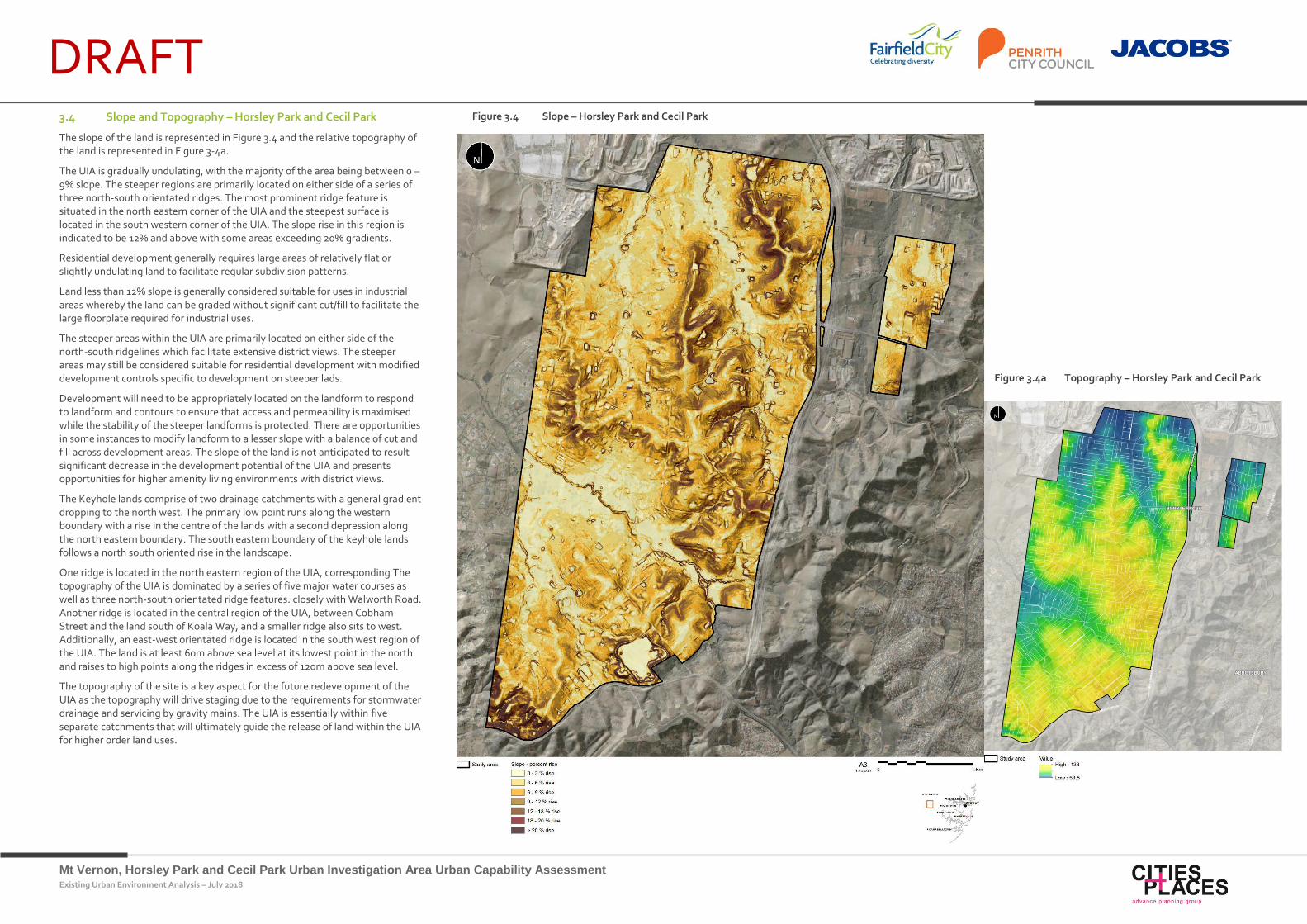
DRAFT 3.4 Slope and Topography – Horsley Park and Cecil Park
The slope of the land is represented in Figure 3.4 and the relative topography of the land is represented in Figure 3-4a.
The UIA is gradually undulating, with the majority of the area being between 0 – 9% slope. The steeper regions are primarily located on either side of a series of three north-south orientated ridges. The most prominent ridge feature is situated in the north eastern corner of the UIA and the steepest surface is located in the south western corner of the UIA. The slope rise in this region is indicated to be 12% and above with some areas exceeding 20% gradients.
Residential development generally requires large areas of relatively flat or slightly undulating land to facilitate regular subdivision patterns.
Land less than 12% slope is generally considered suitable for uses in industrial areas whereby the land can be graded without significant cut/fill to facilitate the large floorplate required for industrial uses.
The steeper areas within the UIA are primarily located on either side of the north-south ridgelines which facilitate extensive district views. The steeper areas may still be considered suitable for residential development with modified development controls specific to development on steeper lads.
Development will need to be appropriately located on the landform to respond to landform and contours to ensure that access and permeability is maximised while the stability of the steeper landforms is protected. There are opportunities in some instances to modify landform to a lesser slope with a balance of cut and fill across development areas. The slope of the land is not anticipated to result significant decrease in the development potential of the UIA and presents opportunities for higher amenity living environments with district views.
The Keyhole lands comprise of two drainage catchments with a general gradient dropping to the north west. The primary low point runs along the western boundary with a rise in the centre of the lands with a second depression along the north eastern boundary. The south eastern boundary of the keyhole lands follows a north south oriented rise in the landscape.
One ridge is located in the north eastern region of the UIA, corresponding The topography of the UIA is dominated by a series of five major water courses as well as three north-south orientated ridge features. closely with Walworth Road. Another ridge is located in the central region of the UIA, between Cobham Street and the land south of Koala Way, and a smaller ridge also sits to west. Additionally, an east-west orientated ridge is located in the south west region of the UIA. The land is at least 60m above sea level at its lowest point in the north and raises to high points along the ridges in excess of 120m above sea level.
The topography of the site is a key aspect for the future redevelopment of the UIA as the topography will drive staging due to the requirements for stormwater drainage and servicing by gravity mains. The UIA is essentially within five separate catchments that will ultimately guide the release of land within the UIA for higher order land uses.
Figure 3.4 Slope – Horsley Park and Cecil Park
Figure 3.4a Topography – Horsley Park and Cecil Park
Mt Vernon, Horsley Park and Cecil Park Urban Investigation Area Urban Capability Assessment Existing Urban Environment Analysis – July 2018
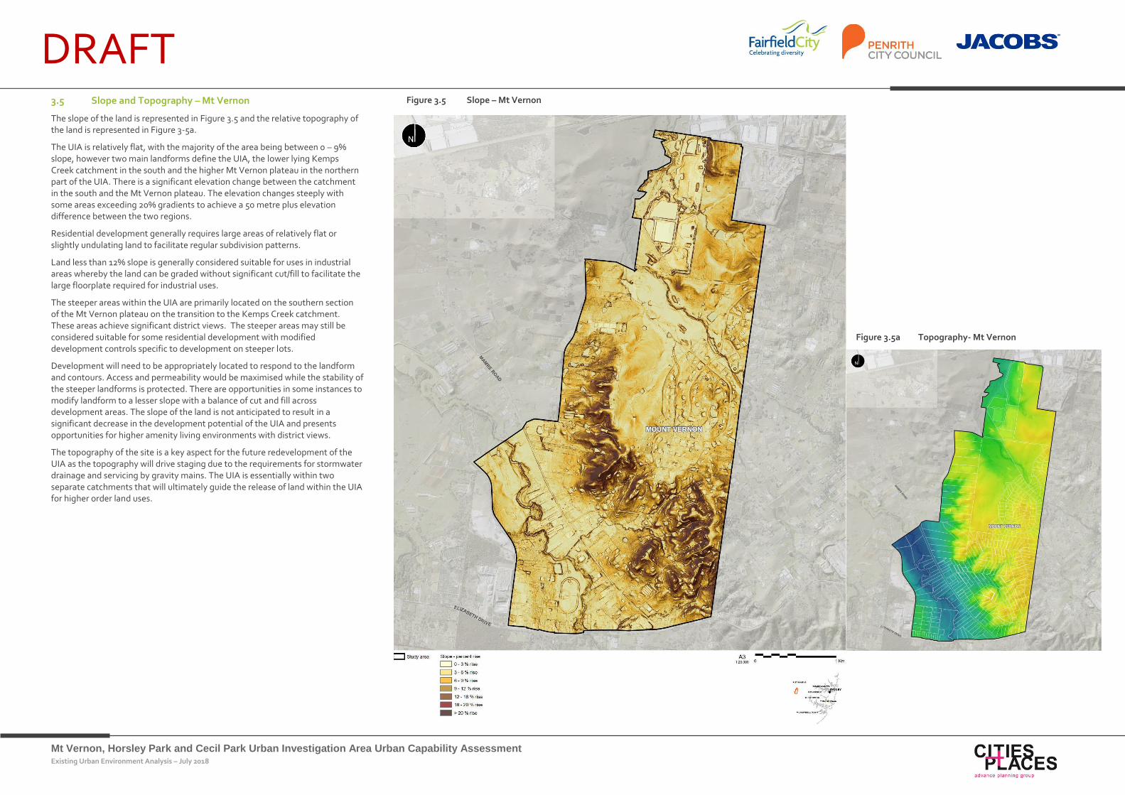
DRAFT 3.5 Slope and Topography – Mt Vernon
The slope of the land is represented in Figure 3.5 and the relative topography of the land is represented in Figure 3-5a.
The UIA is relatively flat, with the majority of the area being between 0 – 9% slope, however two main landforms define the UIA, the lower lying Kemps Creek catchment in the south and the higher Mt Vernon plateau in the northern part of the UIA. There is a significant elevation change between the catchment in the south and the Mt Vernon plateau. The elevation changes steeply with some areas exceeding 20% gradients to achieve a 50 metre plus elevation difference between the two regions.
Residential development generally requires large areas of relatively flat or slightly undulating land to facilitate regular subdivision patterns.
Land less than 12% slope is generally considered suitable for uses in industrial areas whereby the land can be graded without significant cut/fill to facilitate the large floorplate required for industrial uses.
The steeper areas within the UIA are primarily located on the southern section of the Mt Vernon plateau on the transition to the Kemps Creek catchment. These areas achieve significant district views. The steeper areas may still be considered suitable for some residential development with modified development controls specific to development on steeper lots.
Development will need to be appropriately located to respond to the landform and contours. Access and permeability would be maximised while the stability of the steeper landforms is protected. There are opportunities in some instances to modify landform to a lesser slope with a balance of cut and fill across development areas. The slope of the land is not anticipated to result in a significant decrease in the development potential of the UIA and presents opportunities for higher amenity living environments with district views.
The topography of the site is a key aspect for the future redevelopment of the UIA as the topography will drive staging due to the requirements for stormwater drainage and servicing by gravity mains. The UIA is essentially within two separate catchments that will ultimately guide the release of land within the UIA for higher order land uses.
Figure 3.5 Slope – Mt Vernon
Figure 3.5a Topography- Mt Vernon
Mt Vernon, Horsley Park and Cecil Park Urban Investigation Area Urban Capability Assessment Existing Urban Environment Analysis – July 2018
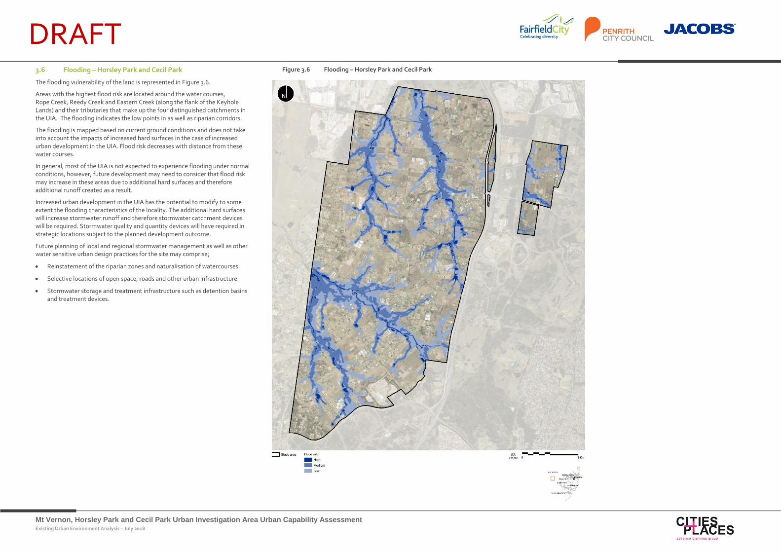
DRAFT 3.6 Flooding – Horsley Park and Cecil Park
The flooding vulnerability of the land is represented in Figure 3.6.
Areas with the highest flood risk are located around the water courses, Rope Creek, Reedy Creek and Eastern Creek (along the flank of the Keyhole Lands) and their tributaries that make up the four distinguished catchments in the UIA. The flooding indicates the low points in as well as riparian corridors.
The flooding is mapped based on current ground conditions and does not take into account the impacts of increased hard surfaces in the case of increased urban development in the UIA. Flood risk decreases with distance from these water courses.
In general, most of the UIA is not expected to experience flooding under normal conditions, however, future development may need to consider that flood risk may increase in these areas due to additional hard surfaces and therefore additional runoff created as a result.
Increased urban development in the UIA has the potential to modify to some extent the flooding characteristics of the locality. The additional hard surfaces will increase stormwater runoff and therefore stormwater catchment devices will be required. Stormwater quality and quantity devices will have required in strategic locations subject to the planned development outcome.
Future planning of local and regional stormwater management as well as other water sensitive urban design practices for the site may comprise;
Reinstatement of the riparian zones and naturalisation of watercourses
Selective locations of open space, roads and other urban infrastructure
Stormwater storage and treatment infrastructure such as detention basins and treatment devices.
Figure 3.6 Flooding – Horsley Park and Cecil Park
Mt Vernon, Horsley Park and Cecil Park Urban Investigation Area Urban Capability Assessment Existing Urban Environment Analysis – July 2018
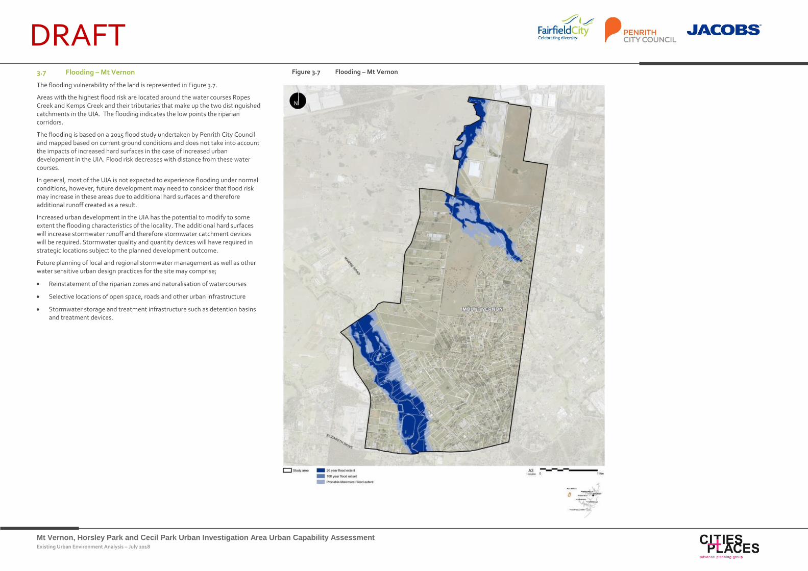
DRAFT 3.7 Flooding – Mt Vernon
The flooding vulnerability of the land is represented in Figure 3.7.
Areas with the highest flood risk are located around the water courses Ropes Creek and Kemps Creek and their tributaries that make up the two distinguished catchments in the UIA. The flooding indicates the low points the riparian corridors.
The flooding is based on a 2015 flood study undertaken by Penrith City Council and mapped based on current ground conditions and does not take into account the impacts of increased hard surfaces in the case of increased urban development in the UIA. Flood risk decreases with distance from these water courses.
In general, most of the UIA is not expected to experience flooding under normal conditions, however, future development may need to consider that flood risk may increase in these areas due to additional hard surfaces and therefore additional runoff created as a result.
Increased urban development in the UIA has the potential to modify to some extent the flooding characteristics of the locality. The additional hard surfaces will increase stormwater runoff and therefore stormwater catchment devices will be required. Stormwater quality and quantity devices will have required in strategic locations subject to the planned development outcome.
Future planning of local and regional stormwater management as well as other water sensitive urban design practices for the site may comprise;
Reinstatement of the riparian zones and naturalisation of watercourses
Selective locations of open space, roads and other urban infrastructure
Stormwater storage and treatment infrastructure such as detention basins and treatment devices.
Figure 3.7 Flooding – Mt Vernon
Mt Vernon, Horsley Park and Cecil Park Urban Investigation Area Urban Capability Assessment Existing Urban Environment Analysis – July 2018
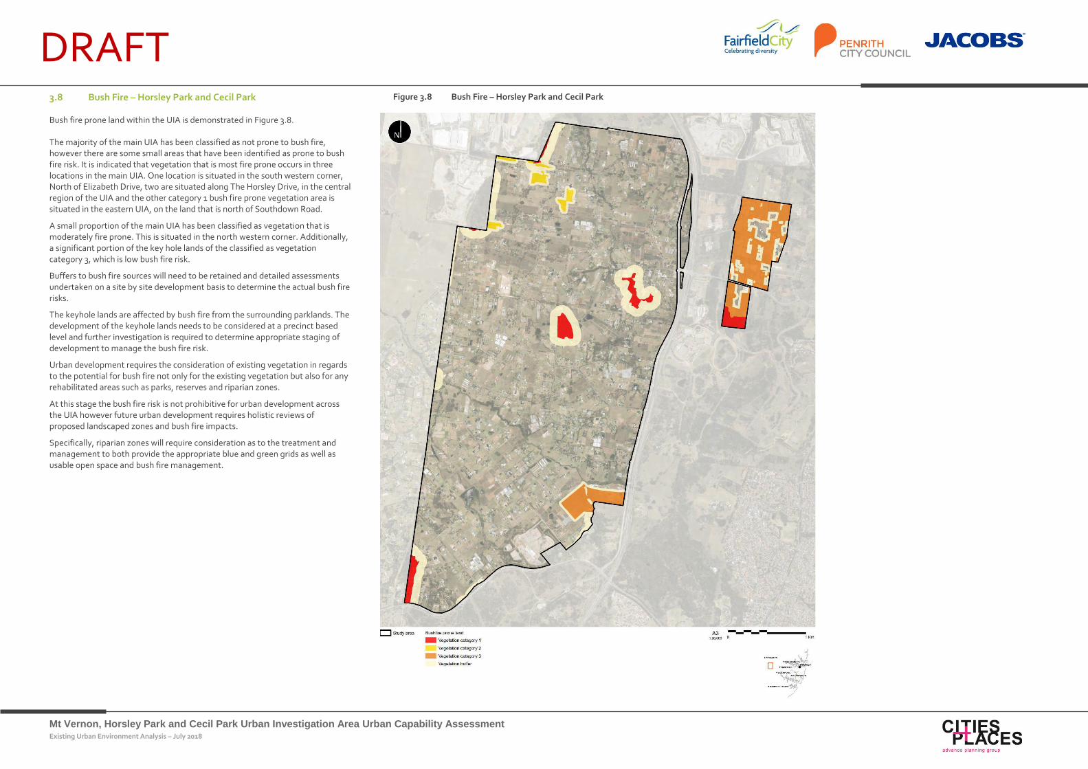
DRAFT 3.8 Bush Fire – Horsley Park and Cecil Park
Bush fire prone land within the UIA is demonstrated in Figure 3.8.
The majority of the main UIA has been classified as not prone to bush fire, however there are some small areas that have been identified as prone to bush fire risk. It is indicated that vegetation that is most fire prone occurs in three locations in the main UIA. One location is situated in the south western corner, North of Elizabeth Drive, two are situated along The Horsley Drive, in the central region of the UIA and the other category 1 bush fire prone vegetation area is situated in the eastern UIA, on the land that is north of Southdown Road.
A small proportion of the main UIA has been classified as vegetation that is moderately fire prone. This is situated in the north western corner. Additionally, a significant portion of the key hole lands of the classified as vegetation category 3, which is low bush fire risk.
Buffers to bush fire sources will need to be retained and detailed assessments undertaken on a site by site development basis to determine the actual bush fire risks.
The keyhole lands are affected by bush fire from the surrounding parklands. The development of the keyhole lands needs to be considered at a precinct based level and further investigation is required to determine appropriate staging of development to manage the bush fire risk.
Urban development requires the consideration of existing vegetation in regards to the potential for bush fire not only for the existing vegetation but also for any rehabilitated areas such as parks, reserves and riparian zones.
At this stage the bush fire risk is not prohibitive for urban development across the UIA however future urban development requires holistic reviews of proposed landscaped zones and bush fire impacts.
Specifically, riparian zones will require consideration as to the treatment and management to both provide the appropriate blue and green grids as well as usable open space and bush fire management.
Figure 3.8 Bush Fire – Horsley Park and Cecil Park
Mt Vernon, Horsley Park and Cecil Park Urban Investigation Area Urban Capability Assessment Existing Urban Environment Analysis – July 2018
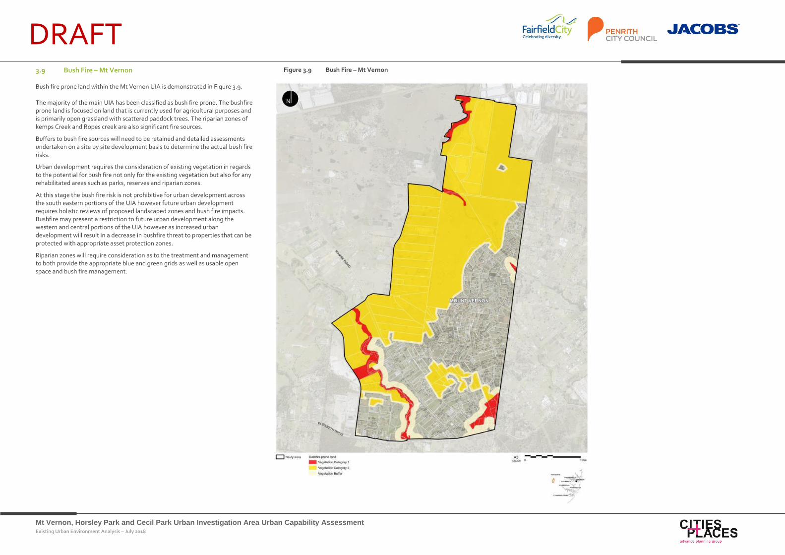
DRAFT 3.9 Bush Fire – Mt Vernon
Bush fire prone land within the Mt Vernon UIA is demonstrated in Figure 3.9.
The majority of the main UIA has been classified as bush fire prone. The bushfire prone land is focused on land that is currently used for agricultural purposes and is primarily open grassland with scattered paddock trees. The riparian zones of kemps Creek and Ropes creek are also significant fire sources.
Buffers to bush fire sources will need to be retained and detailed assessments undertaken on a site by site development basis to determine the actual bush fire risks.
Urban development requires the consideration of existing vegetation in regards to the potential for bush fire not only for the existing vegetation but also for any rehabilitated areas such as parks, reserves and riparian zones.
At this stage the bush fire risk is not prohibitive for urban development across the south eastern portions of the UIA however future urban development requires holistic reviews of proposed landscaped zones and bush fire impacts. Bushfire may present a restriction to future urban development along the western and central portions of the UIA however as increased urban development will result in a decrease in bushfire threat to properties that can be protected with appropriate asset protection zones.
Riparian zones will require consideration as to the treatment and management to both provide the appropriate blue and green grids as well as usable open space and bush fire management.
Figure 3.9 Bush Fire – Mt Vernon
Mt Vernon, Horsley Park and Cecil Park Urban Investigation Area Urban Capability Assessment Existing Urban Environment Analysis – July 2018
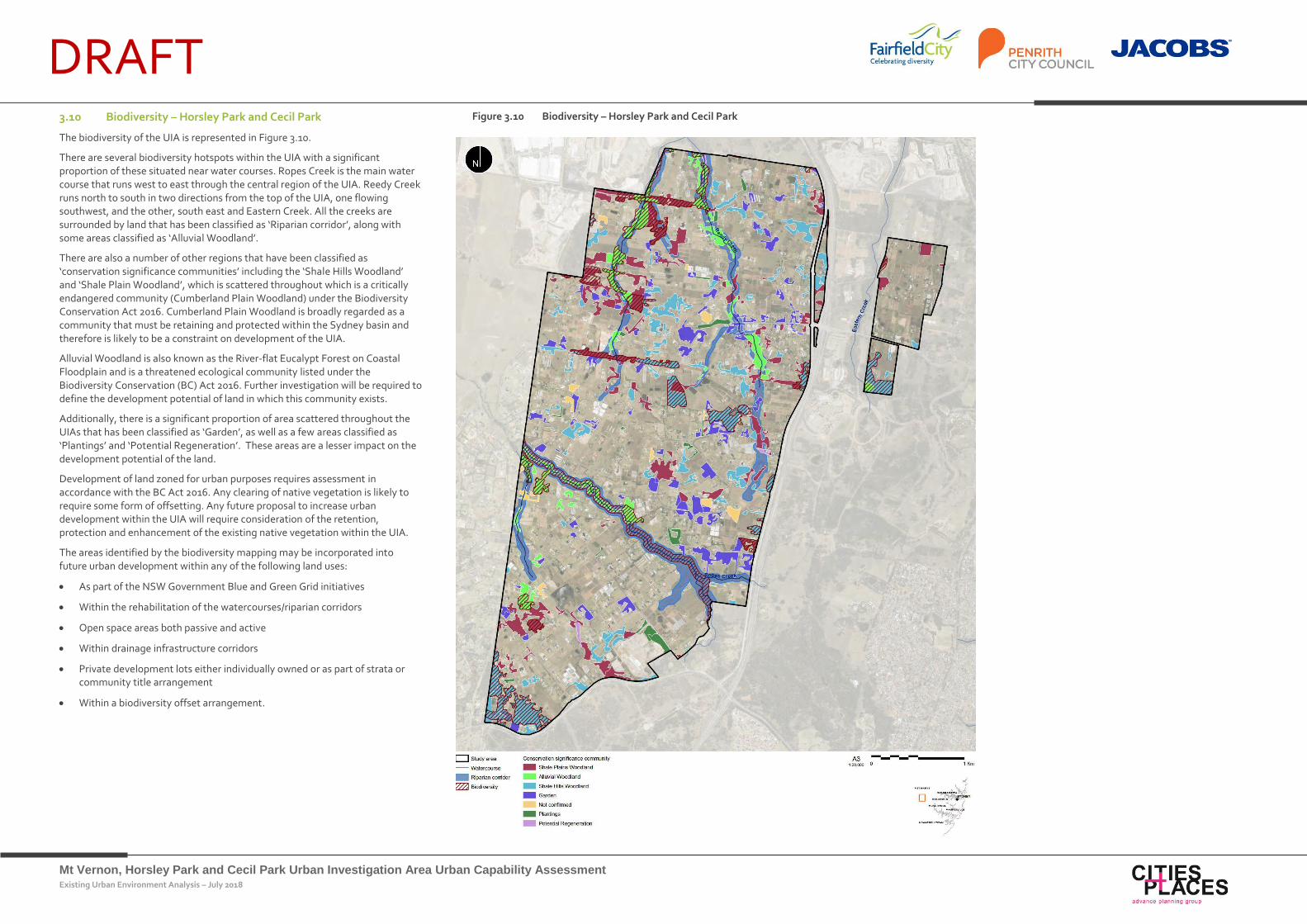
DRAFT 3.10 Biodiversity – Horsley Park and Cecil Park
The biodiversity of the UIA is represented in Figure 3.10.
There are several biodiversity hotspots within the UIA with a significant proportion of these situated near water courses. Ropes Creek is the main water course that runs west to east through the central region of the UIA. Reedy Creek runs north to south in two directions from the top of the UIA, one flowing southwest, and the other, south east and Eastern Creek. All the creeks are surrounded by land that has been classified as ‘Riparian corridor’, along with some areas classified as ‘Alluvial Woodland’.
There are also a number of other regions that have been classified as ‘conservation significance communities’ including the ‘Shale Hills Woodland’ and ‘Shale Plain Woodland’, which is scattered throughout which is a critically endangered community (Cumberland Plain Woodland) under the Biodiversity Conservation Act 2016. Cumberland Plain Woodland is broadly regarded as a community that must be retaining and protected within the Sydney basin and therefore is likely to be a constraint on development of the UIA.
Alluvial Woodland is also known as the River-flat Eucalypt Forest on Coastal Floodplain and is a threatened ecological community listed under the Biodiversity Conservation (BC) Act 2016. Further investigation will be required to define the development potential of land in which this community exists.
Additionally, there is a significant proportion of area scattered throughout the UIAs that has been classified as ‘Garden’, as well as a few areas classified as ‘Plantings’ and ‘Potential Regeneration’. These areas are a lesser impact on the development potential of the land.
Development of land zoned for urban purposes requires assessment in accordance with the BC Act 2016. Any clearing of native vegetation is likely to require some form of offsetting. Any future proposal to increase urban development within the UIA will require consideration of the retention, protection and enhancement of the existing native vegetation within the UIA.
The areas identified by the biodiversity mapping may be incorporated into future urban development within any of the following land uses:
As part of the NSW Government Blue and Green Grid initiatives
Within the rehabilitation of the watercourses/riparian corridors
Open space areas both passive and active
Within drainage infrastructure corridors
Private development lots either individually owned or as part of strata or community title arrangement
Within a biodiversity offset arrangement.
Figure 3.10 Biodiversity – Horsley Park and Cecil Park
Mt Vernon, Horsley Park and Cecil Park Urban Investigation Area Urban Capability Assessment Existing Urban Environment Analysis – July 2018
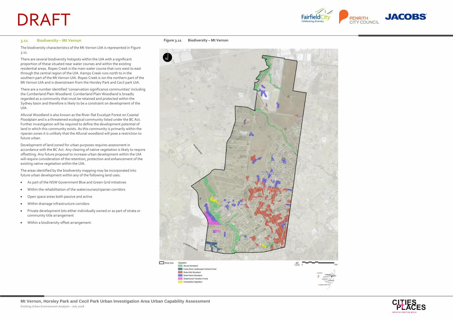
DRAFT 3.11 Biodiversity – Mt Vernon
The biodiversity characteristics of the Mt Vernon UIA is represented in Figure 3.11.
There are several biodiversity hotspots within the UIA with a significant proportion of these situated near water courses and within the existing residential areas. Ropes Creek is the main water course that runs west to east through the central region of the UIA. Kemps Creek runs north to in the southern part of the Mt Vernon UIA. Ropes Creek is ion the northern part of the Mt Vernon UIA and is downstream from the Horsley Park and Cecil park UIA.
There are a number identified ‘conservation significance communities’ including the Cumberland Plain Woodland. Cumberland Plain Woodland is broadly regarded as a community that must be retained and protected within the Sydney basin and therefore is likely to be a constraint on development of the UIA.
Alluvial Woodland is also known as the River-flat Eucalypt Forest on Coastal Floodplain and is a threatened ecological community listed under the BC Act. Further investigation will be required to define the development potential of land in which this community exists. As this community is primarily within the riparian zones it is unlikely that the Alluvial woodland will pose a restriction to future urban.
Development of land zoned for urban purposes requires assessment in accordance with the BC Act. Any clearing of native vegetation is likely to require offsetting. Any future proposal to increase urban development within the UIA will require consideration of the retention, protection and enhancement of the existing native vegetation within the UIA.
The areas identified by the biodiversity mapping may be incorporated into future urban development within any of the following land uses:
As part of the NSW Government Blue and Green Grid initiatives
Within the rehabilitation of the watercourses/riparian corridors
Open space areas both passive and active
Within drainage infrastructure corridors
Private development lots either individually owned or as part of strata or community title arrangement
Within a biodiversity offset arrangement.
Figure 3.11 Biodiversity – Mt Vernon
Mt Vernon, Horsley Park and Cecil Park Urban Investigation Area Urban Capability Assessment Existing Urban Environment Analysis – July 2018
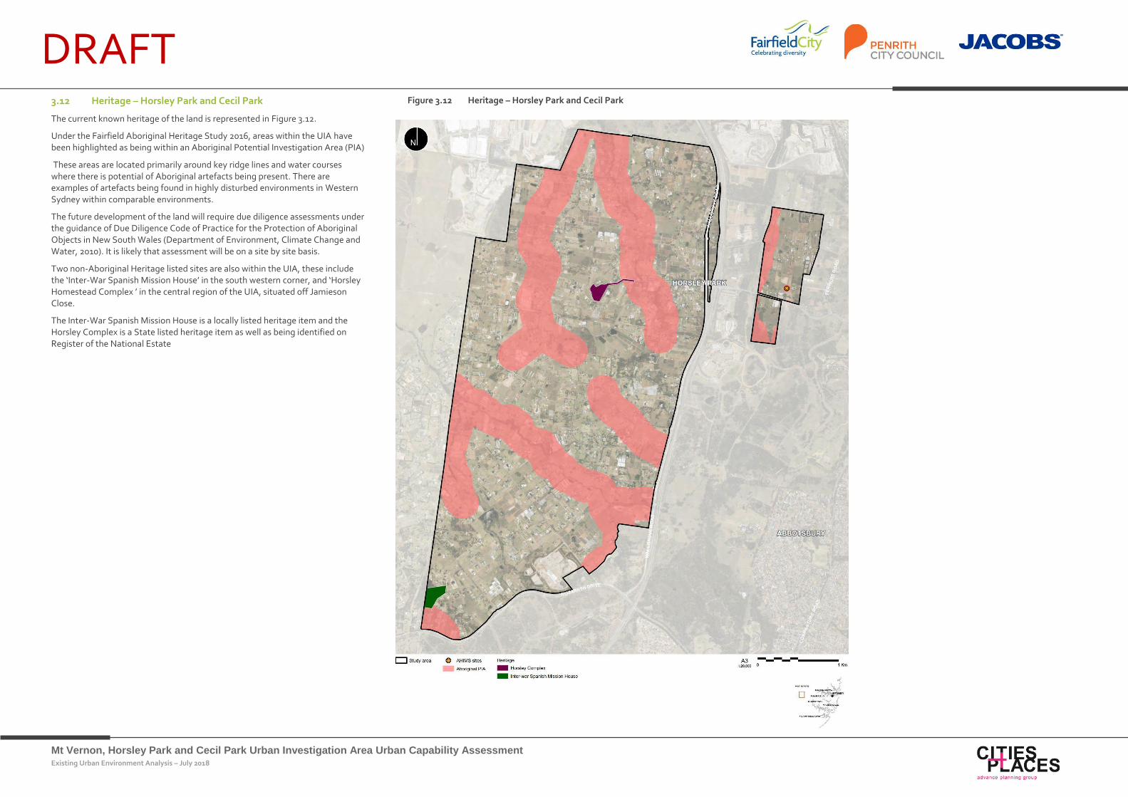
DRAFT 3.12 Heritage – Horsley Park and Cecil Park
The current known heritage of the land is represented in Figure 3.12.
Under the Fairfield Aboriginal Heritage Study 2016, areas within the UIA have been highlighted as being within an Aboriginal Potential Investigation Area (PIA)
These areas are located primarily around key ridge lines and water courses where there is potential of Aboriginal artefacts being present. There are examples of artefacts being found in highly disturbed environments in Western Sydney within comparable environments.
The future development of the land will require due diligence assessments under the guidance of Due Diligence Code of Practice for the Protection of Aboriginal Objects in New South Wales (Department of Environment, Climate Change and Water, 2010). It is likely that assessment will be on a site by site basis.
Two non-Aboriginal Heritage listed sites are also within the UIA, these include the ‘Inter-War Spanish Mission House’ in the south western corner, and ‘Horsley Homestead Complex ’ in the central region of the UIA, situated off Jamieson Close.
The Inter-War Spanish Mission House is a locally listed heritage item and the Horsley Complex is a State listed heritage item as well as being identified on Register of the National Estate
Figure 3.12 Heritage – Horsley Park and Cecil Park
Mt Vernon, Horsley Park and Cecil Park Urban Investigation Area Urban Capability Assessment Existing Urban Environment Analysis – July 2018
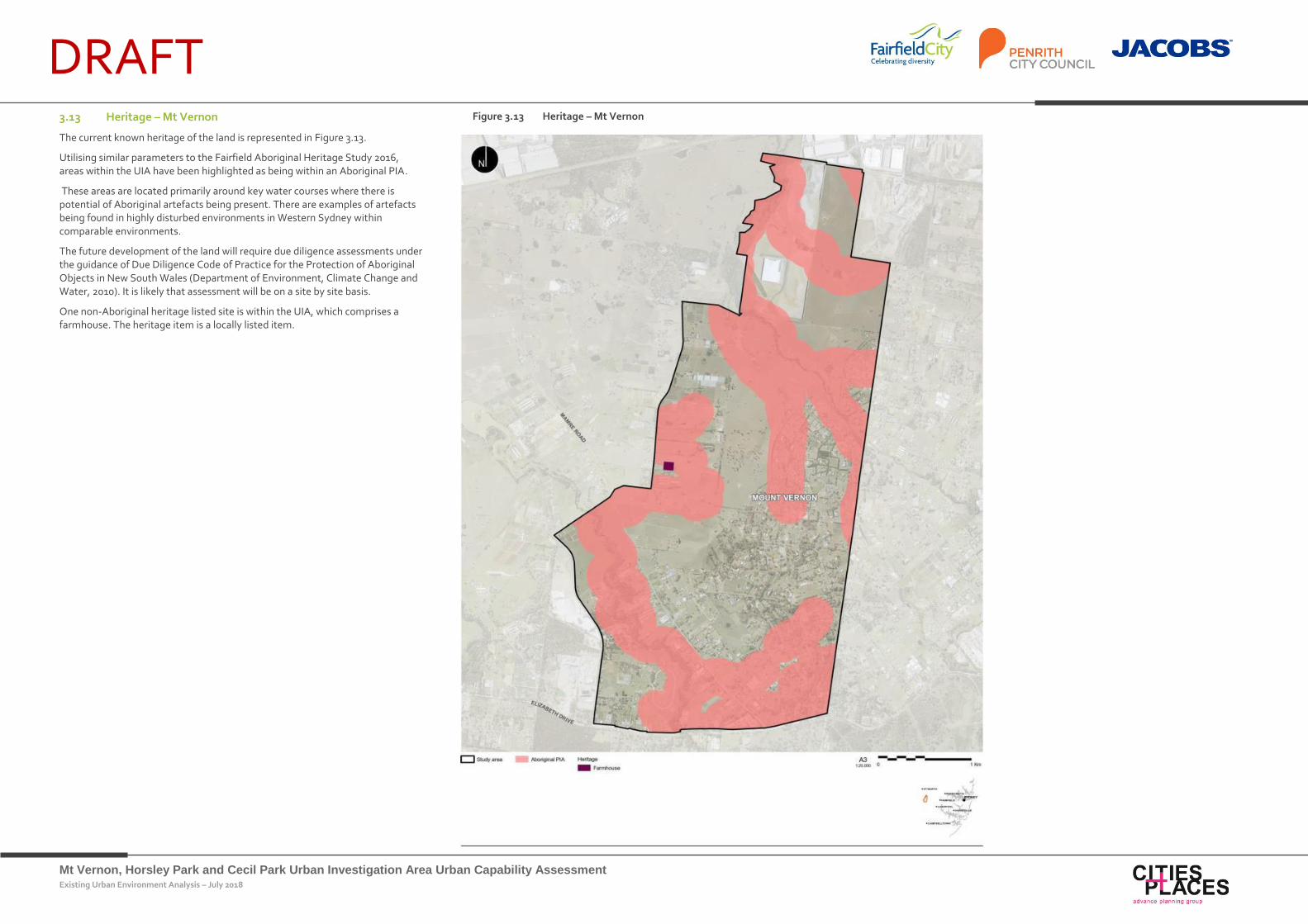
DRAFT 3.13 Heritage – Mt Vernon
The current known heritage of the land is represented in Figure 3.13.
Utilising similar parameters to the Fairfield Aboriginal Heritage Study 2016, areas within the UIA have been highlighted as being within an Aboriginal PIA.
These areas are located primarily around key water courses where there is potential of Aboriginal artefacts being present. There are examples of artefacts being found in highly disturbed environments in Western Sydney within comparable environments.
The future development of the land will require due diligence assessments under the guidance of Due Diligence Code of Practice for the Protection of Aboriginal Objects in New South Wales (Department of Environment, Climate Change and Water, 2010). It is likely that assessment will be on a site by site basis.
One non-Aboriginal heritage listed site is within the UIA, which comprises a farmhouse. The heritage item is a locally listed item.
Figure 3.13 Heritage – Mt Vernon
Mt Vernon, Horsley Park and Cecil Park Urban Investigation Area Urban Capability Assessment Existing Urban Environment Analysis – July 2018
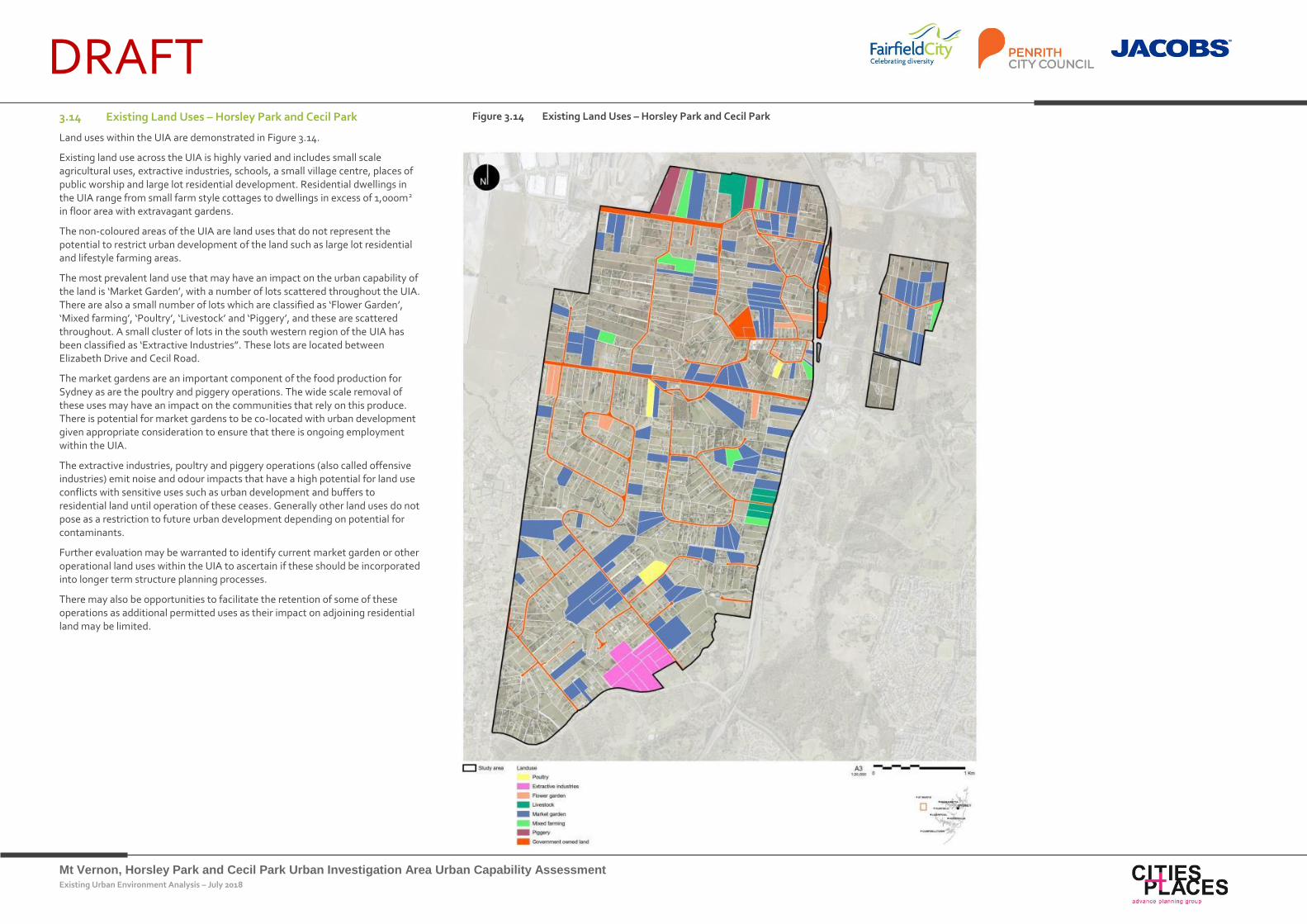
DRAFT 3.14 Existing Land Uses – Horsley Park and Cecil Park
Land uses within the UIA are demonstrated in Figure 3.14.
Existing land use across the UIA is highly varied and includes small scale agricultural uses, extractive industries, schools, a small village centre, places of public worship and large lot residential development. Residential dwellings in the UIA range from small farm style cottages to dwellings in excess of 1,000m2 in floor area with extravagant gardens.
The non-coloured areas of the UIA are land uses that do not represent the potential to restrict urban development of the land such as large lot residential and lifestyle farming areas.
The most prevalent land use that may have an impact on the urban capability of the land is ‘Market Garden’, with a number of lots scattered throughout the UIA. There are also a small number of lots which are classified as ‘Flower Garden’, ‘Mixed farming’, ‘Poultry’, ‘Livestock’ and ‘Piggery’, and these are scattered throughout. A small cluster of lots in the south western region of the UIA has been classified as ‘Extractive Industries”. These lots are located between Elizabeth Drive and Cecil Road.
The market gardens are an important component of the food production for Sydney as are the poultry and piggery operations. The wide scale removal of these uses may have an impact on the communities that rely on this produce. There is potential for market gardens to be co-located with urban development given appropriate consideration to ensure that there is ongoing employment within the UIA.
The extractive industries, poultry and piggery operations (also called offensive industries) emit noise and odour impacts that have a high potential for land use conflicts with sensitive uses such as urban development and buffers to residential land until operation of these ceases. Generally other land uses do not pose as a restriction to future urban development depending on potential for contaminants.
Further evaluation may be warranted to identify current market garden or other operational land uses within the UIA to ascertain if these should be incorporated into longer term structure planning processes.
There may also be opportunities to facilitate the retention of some of these operations as additional permitted uses as their impact on adjoining residential land may be limited.
Figure 3.14 Existing Land Uses – Horsley Park and Cecil Park
Mt Vernon, Horsley Park and Cecil Park Urban Investigation Area Urban Capability Assessment Existing Urban Environment Analysis – July 2018
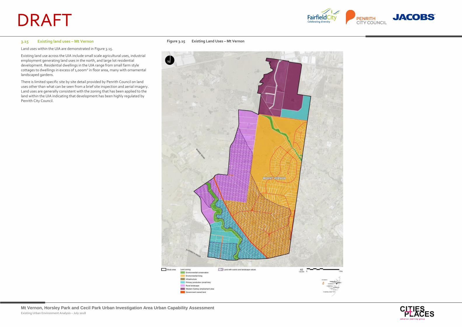
DRAFT 3.15 Existing land uses – Mt Vernon
Land uses within the UIA are demonstrated in Figure 3.15.
Existing land use across the UIA include small scale agricultural uses, industrial employment generating land uses in the north, and large lot residential development. Residential dwellings in the UIA range from small farm style cottages to dwellings in excess of 1,000m2 in floor area, many with ornamental landscaped gardens.
There is limited specific site by site detail provided by Penrith Council on land uses other than what can be seen from a brief site inspection and aerial imagery. Land uses are generally consistent with the zoning that has been applied to the land within the UIA indicating that development has been highly regulated by Penrith City Council.
Figure 3.15 Existing Land Uses – Mt Vernon
Mt Vernon, Horsley Park and Cecil Park Urban Investigation Area Urban Capability Assessment Existing Urban Environment Analysis – July 2018
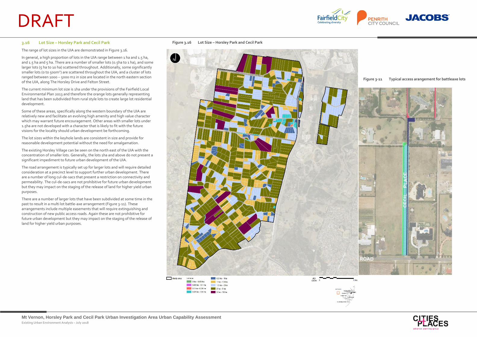
DRAFT 3.16 Lot Size – Horsley Park and Cecil Park
The range of lot sizes in the UIA are demonstrated in Figure 3.16.
In general, a high proportion of lots in the UIA range between 1 ha and 1.5 ha, and 1.5 ha and 5 ha. There are a number of smaller lots (0.5ha to 1 ha), and some larger lots (5 ha to 10 ha) scattered throughout. Additionally, some significantly smaller lots (0 to 500m2) are scattered throughout the UIA, and a cluster of lots ranged between 1000 – 5000 m2 in size are located in the north eastern section of the UIA, along The Horsley Drive and Felton Street.
The current minimum lot size is 1ha under the provisions of the Fairfield Local Environmental Plan 2013 and therefore the orange lots generally representing land that has been subdivided from rural style lots to create large lot residential development.
Some of these areas, specifically along the western boundary of the UIA are relatively new and facilitate an evolving high amenity and high value character which may warrant future encouragement. Other areas with smaller lots under 1.5ha are not developed with a character that is likely to fit with the future visions for the locality should urban development be forthcoming.
The lot sizes within the keyhole lands are consistent in size and provide for reasonable development potential without the need for amalgamation.
The existing Horsley Village can be seen on the north east of the UIA with the concentration of smaller lots. Generally, the lots 1ha and above do not present a significant impediment to future urban development of the UIA.
The road arrangement is typically set up for larger lots and will require detailed consideration at a precinct level to support further urban development. There are a number of long cul-de-sacs that present a restriction on connectivity and permeability. The cul-de-sacs are not prohibitive for future urban development but they may impact on the staging of the release of land for higher yield urban purposes.
There are a number of larger lots that have been subdivided at some time in the past to result in a multi lot battle-axe arrangement (Figure 3-11). These arrangements include multiple easements that will require extinguishing and construction of new public access roads. Again these are not prohibitive for future urban development but they may impact on the staging of the release of land for higher yield urban purposes.
Figure 3.16 Lot Size – Horsley Park and Cecil Park
Figure 3-11 Typical access arangement for battleaxe lots
Mt Vernon, Horsley Park and Cecil Park Urban Investigation Area Urban Capability Assessment Existing Urban Environment Analysis – July 2018
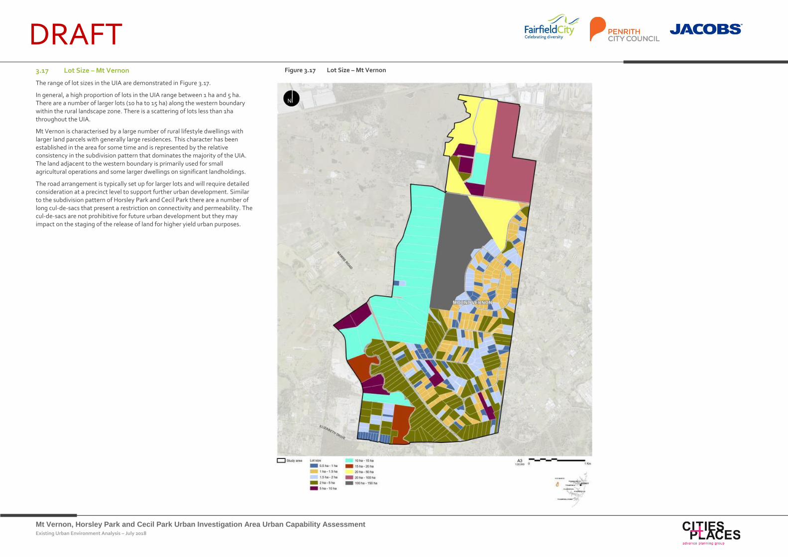
DRAFT 3.17 Lot Size – Mt Vernon
The range of lot sizes in the UIA are demonstrated in Figure 3.17.
In general, a high proportion of lots in the UIA range between 1 ha and 5 ha. There are a number of larger lots (10 ha to 15 ha) along the western boundary within the rural landscape zone. There is a scattering of lots less than 1ha throughout the UIA.
Mt Vernon is characterised by a large number of rural lifestyle dwellings with larger land parcels with generally large residences. This character has been established in the area for some time and is represented by the relative consistency in the subdivision pattern that dominates the majority of the UIA. The land adjacent to the western boundary is primarily used for small agricultural operations and some larger dwellings on significant landholdings.
The road arrangement is typically set up for larger lots and will require detailed consideration at a precinct level to support further urban development. Similar to the subdivision pattern of Horsley Park and Cecil Park there are a number of long cul-de-sacs that present a restriction on connectivity and permeability. The cul-de-sacs are not prohibitive for future urban development but they may impact on the staging of the release of land for higher yield urban purposes.
Figure 3.17 Lot Size – Mt Vernon
Mt Vernon, Horsley Park and Cecil Park Urban Investigation Area Urban Capability Assessment Existing Urban Environment Analysis – July 2018
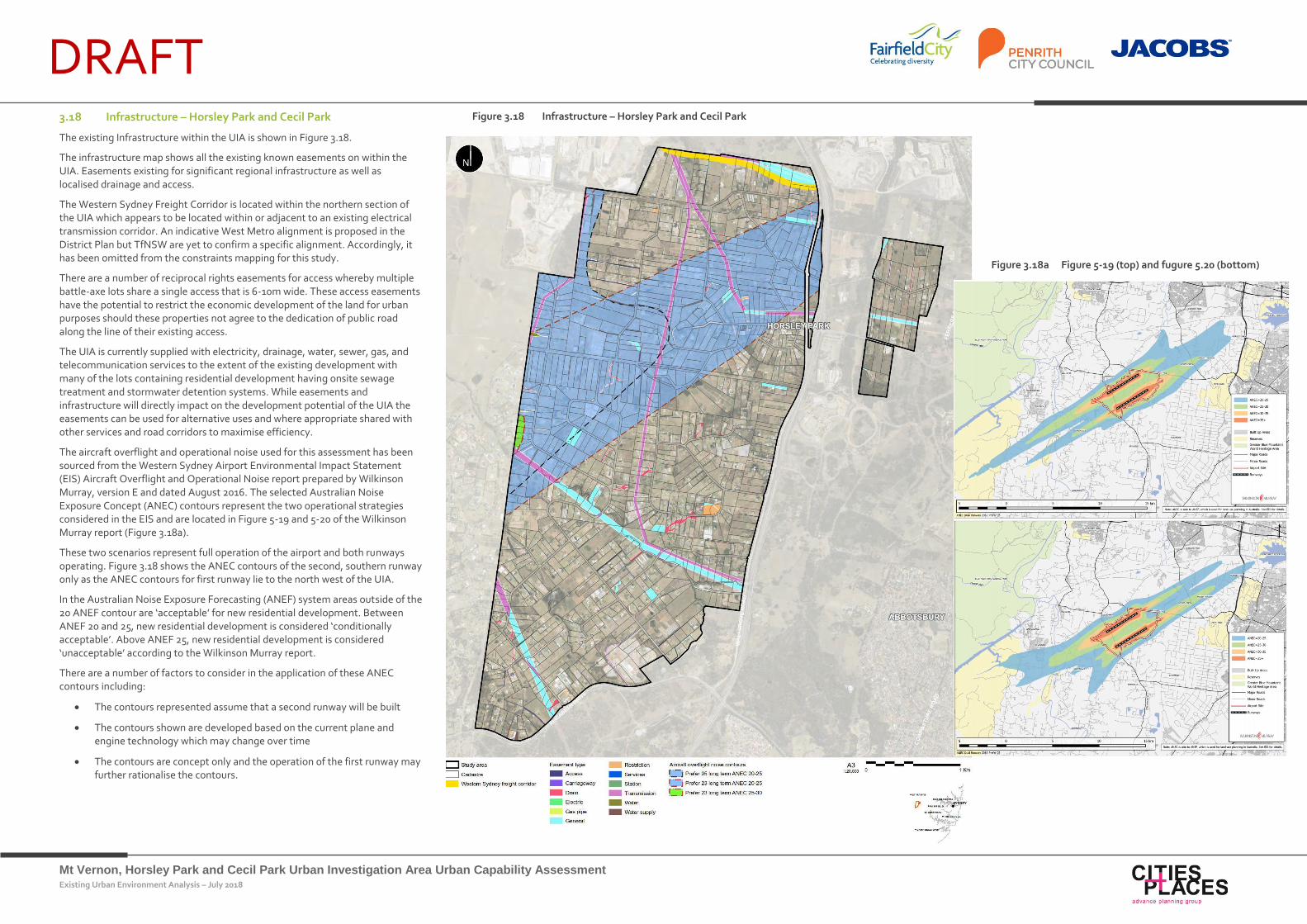
DRAFT 3.18 Infrastructure – Horsley Park and Cecil Park
The existing Infrastructure within the UIA is shown in Figure 3.18.
The infrastructure map shows all the existing known easements on within the UIA. Easements existing for significant regional infrastructure as well as localised drainage and access.
The Western Sydney Freight Corridor is located within the northern section of the UIA which appears to be located within or adjacent to an existing electrical transmission corridor. An indicative West Metro alignment is proposed in the District Plan but TfNSW are yet to confirm a specific alignment. Accordingly, it has been omitted from the constraints mapping for this study.
There are a number of reciprocal rights easements for access whereby multiple battle-axe lots share a single access that is 6-10m wide. These access easements have the potential to restrict the economic development of the land for urban purposes should these properties not agree to the dedication of public road along the line of their existing access.
The UIA is currently supplied with electricity, drainage, water, sewer, gas, and telecommunication services to the extent of the existing development with many of the lots containing residential development having onsite sewage treatment and stormwater detention systems. While easements and infrastructure will directly impact on the development potential of the UIA the easements can be used for alternative uses and where appropriate shared with other services and road corridors to maximise efficiency.
The aircraft overflight and operational noise used for this assessment has been sourced from the Western Sydney Airport Environmental Impact Statement (EIS) Aircraft Overflight and Operational Noise report prepared by Wilkinson Murray, version E and dated August 2016. The selected Australian Noise Exposure Concept (ANEC) contours represent the two operational strategies considered in the EIS and are located in Figure 5-19 and 5-20 of the Wilkinson Murray report (Figure 3.18a).
These two scenarios represent full operation of the airport and both runways operating. Figure 3.18 shows the ANEC contours of the second, southern runway only as the ANEC contours for first runway lie to the north west of the UIA.
In the Australian Noise Exposure Forecasting (ANEF) system areas outside of the 20 ANEF contour are ‘acceptable’ for new residential development. Between ANEF 20 and 25, new residential development is considered ‘conditionally acceptable’. Above ANEF 25, new residential development is considered ‘unacceptable’ according to the Wilkinson Murray report.
There are a number of factors to consider in the application of these ANEC contours including:
The contours represented assume that a second runway will be built
The contours shown are developed based on the current plane and engine technology which may change over time
The contours are concept only and the operation of the first runway may further rationalise the contours.
Figure 3.18 Infrastructure – Horsley Park and Cecil Park
Figure 3.18a Figure 5-19 (top) and fugure 5.20 (bottom)
Mt Vernon, Horsley Park and Cecil Park Urban Investigation Area Urban Capability Assessment Existing Urban Environment Analysis – July 2018
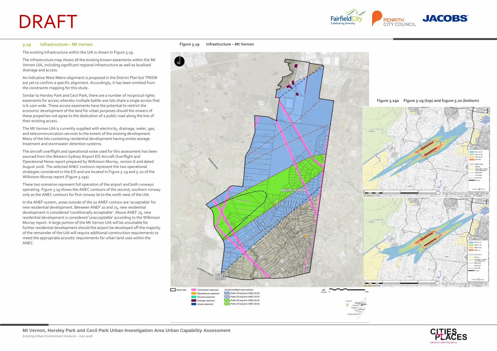
DRAFT 3.19 Infrastructure – Mt Vernon
The existing Infrastructure within the UIA is shown in Figure 3.19.
The infrastructure map shows all the existing known easements within the Mt Vernon UIA, including significant regional infrastructure as well as localised drainage and access.
An indicative West Metro alignment is proposed in the District Plan but TfNSW are yet to confirm a specific alignment. Accordingly, it has been omitted from the constraints mapping for this study.
Similar to Horsley Park and Cecil Park, there are a number of reciprocal rights easements for access whereby multiple battle-axe lots share a single access that is 6-10m wide. These access easements have the potential to restrict the economic development of the land for urban purposes should the onwers of these properties not agree to the dedication of a public road along the line of their existing access.
The Mt Vernon UIA is currently supplied with electricity, drainage, water, gas, and telecommunication services to the extent of the existing development. Many of the lots containing residential development having onsite sewage treatment and stormwater detention systems.
The aircraft overflight and operational noise used for this assessment has been sourced from the Western Sydney Airport EIS Aircraft Overflight and Operational Noise report prepared by Wilkinson Murray, version E and dated August 2016. The selected ANEC contours represent the two operational strategies considered in the EIS and are located in Figure 5-19 and 5-20 of the Wilkinson Murray report (Figure 3.19a).
These two scenarios represent full operation of the airport and both runways operating. Figure 3.19 shows the ANEC contours of the second, southern runway only as the ANEC contours for first runway lie to the north west of the UIA.
In the ANEF system, areas outside of the 20 ANEF contour are ‘acceptable’ for new residential development. Between ANEF 20 and 25, new residential development is considered ‘conditionally acceptable’. Above ANEF 25, new residential development is considered ‘unacceptable’ according to the Wilkinson Murray report. A large portion of the Mt Vernon UIA will be unsuitable for further residential development should the airport be developed off the majority of the remainder of the UIA will require additional construction requirements to meed the appropriate acoustic requirements for urban land uses within the ANEC.
Figure 3.19 Infrastructure – Mt Vernon
Figure 3.19a Figure 5-19 (top) and fugure 5.20 (bottom)
Mt Vernon, Horsley Park and Cecil Park Urban Investigation Area Urban Capability Assessment Existing Urban Environment Analysis – July 2018
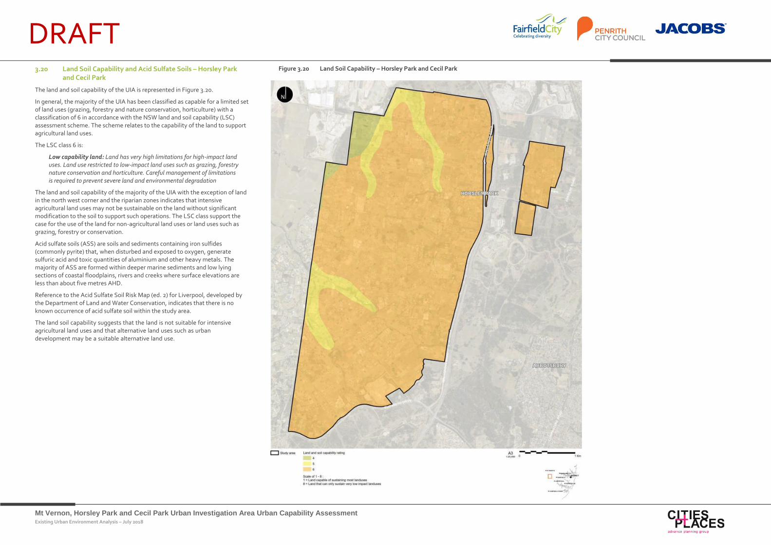
DRAFT 3.20 Land Soil Capability and Acid Sulfate Soils – Horsley Park
and Cecil Park
The land and soil capability of the UIA is represented in Figure 3.20.
In general, the majority of the UIA has been classified as capable for a limited set of land uses (grazing, forestry and nature conservation, horticulture) with a classification of 6 in accordance with the NSW land and soil capability (LSC) assessment scheme. The scheme relates to the capability of the land to support agricultural land uses.
The LSC class 6 is:
Low capability land: Land has very high limitations for high-impact land uses. Land use restricted to low-impact land uses such as grazing, forestry nature conservation and horticulture. Careful management of limitations is required to prevent severe land and environmental degradation
The land and soil capability of the majority of the UIA with the exception of land in the north west corner and the riparian zones indicates that intensive agricultural land uses may not be sustainable on the land without significant modification to the soil to support such operations. The LSC class support the case for the use of the land for non-agricultural land uses or land uses such as grazing, forestry or conservation.
Acid sulfate soils (ASS) are soils and sediments containing iron sulfides (commonly pyrite) that, when disturbed and exposed to oxygen, generate sulfuric acid and toxic quantities of aluminium and other heavy metals. The majority of ASS are formed within deeper marine sediments and low lying sections of coastal floodplains, rivers and creeks where surface elevations are less than about five metres AHD.
Reference to the Acid Sulfate Soil Risk Map (ed. 2) for Liverpool, developed by the Department of Land and Water Conservation, indicates that there is no known occurrence of acid sulfate soil within the study area.
The land soil capability suggests that the land is not suitable for intensive agricultural land uses and that alternative land uses such as urban development may be a suitable alternative land use.
Figure 3.20 Land Soil Capability – Horsley Park and Cecil Park
Mt Vernon, Horsley Park and Cecil Park Urban Investigation Area Urban Capability Assessment Existing Urban Environment Analysis – July 2018
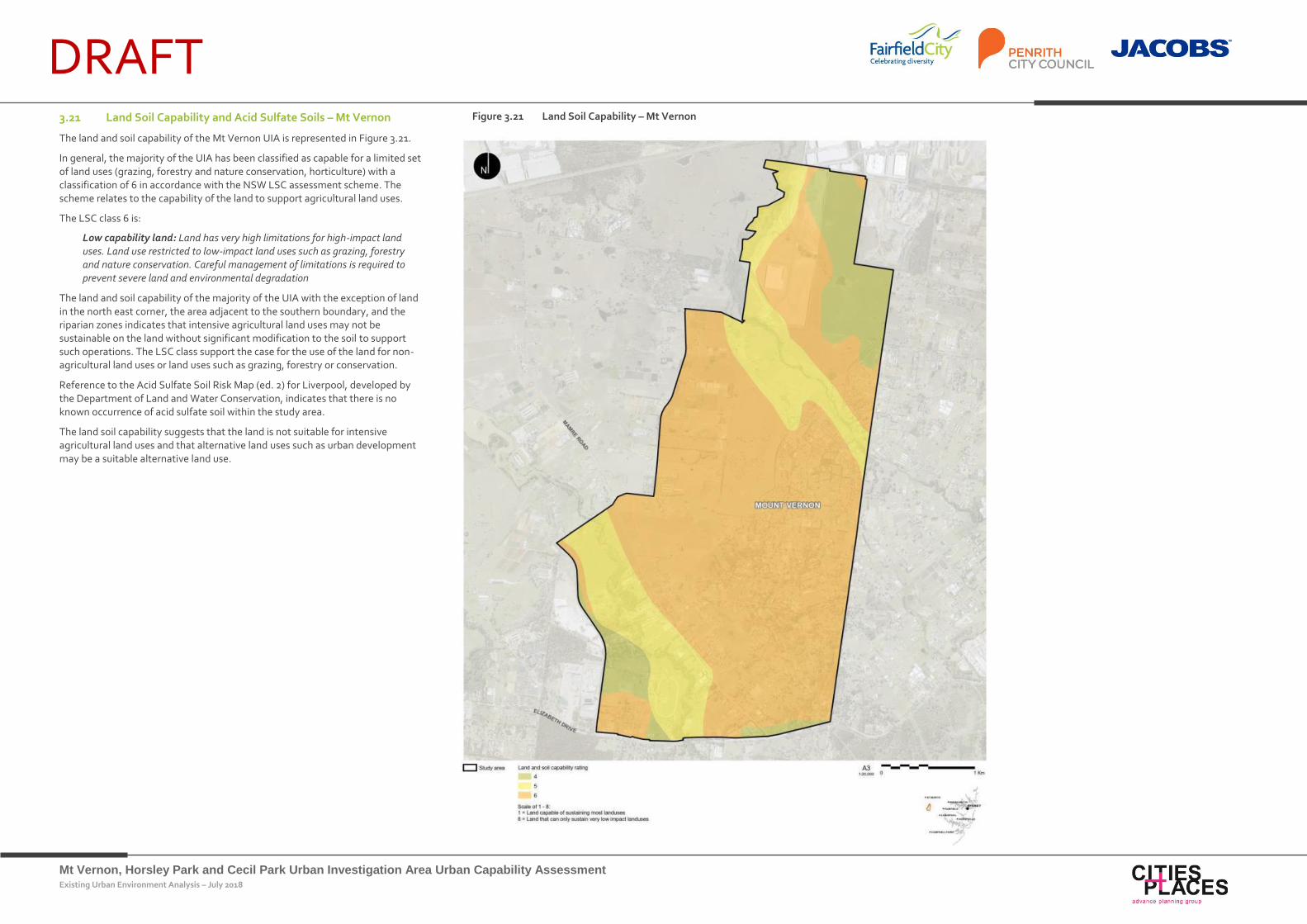
DRAFT 3.21 Land Soil Capability and Acid Sulfate Soils – Mt Vernon
The land and soil capability of the Mt Vernon UIA is represented in Figure 3.21.
In general, the majority of the UIA has been classified as capable for a limited set of land uses (grazing, forestry and nature conservation, horticulture) with a classification of 6 in accordance with the NSW LSC assessment scheme. The scheme relates to the capability of the land to support agricultural land uses.
The LSC class 6 is:
Low capability land: Land has very high limitations for high-impact land uses. Land use restricted to low-impact land uses such as grazing, forestry and nature conservation. Careful management of limitations is required to prevent severe land and environmental degradation
The land and soil capability of the majority of the UIA with the exception of land in the north east corner, the area adjacent to the southern boundary, and the riparian zones indicates that intensive agricultural land uses may not be sustainable on the land without significant modification to the soil to support such operations. The LSC class support the case for the use of the land for non-agricultural land uses or land uses such as grazing, forestry or conservation.
Reference to the Acid Sulfate Soil Risk Map (ed. 2) for Liverpool, developed by the Department of Land and Water Conservation, indicates that there is no known occurrence of acid sulfate soil within the study area.
The land soil capability suggests that the land is not suitable for intensive agricultural land uses and that alternative land uses such as urban development may be a suitable alternative land use.
Figure 3.21 Land Soil Capability – Mt Vernon
Mt Vernon, Horsley Park and Cecil Park Urban Investigation Area Urban Capability Assessment Existing Urban Environment Analysis – July 2018
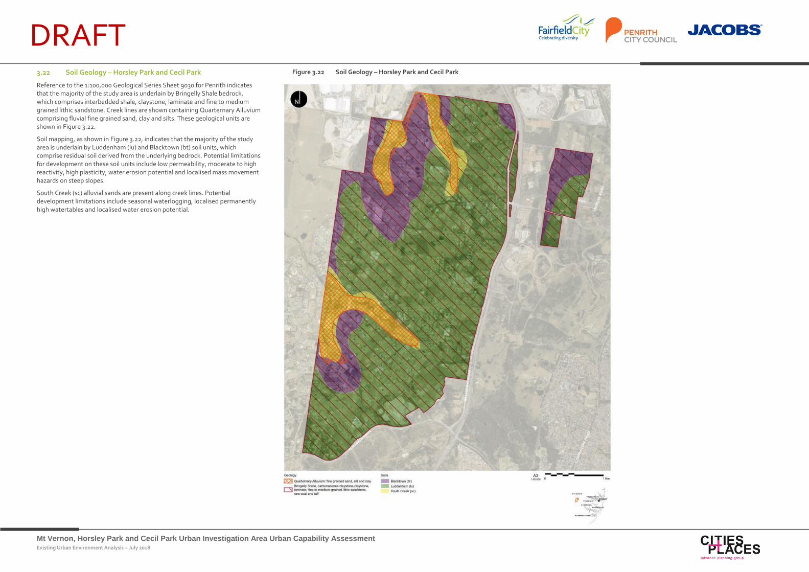
DRAFT 3.22 Soil Geology – Horsley Park and Cecil Park
Reference to the 1:100,000 Geological Series Sheet 9030 for Penrith indicates that the majority of the study area is underlain by Bringelly Shale bedrock, which comprises interbedded shale, claystone, laminate and fine to medium grained lithic sandstone. Creek lines are shown containing Quarternary Alluvium comprising fluvial fine grained sand, clay and silts. These geological units are shown in Figure 3.22.
Soil mapping, as shown in Figure 3.22, indicates that the majority of the study area is underlain by Luddenham (lu) and Blacktown (bt) soil units, which comprise residual soil derived from the underlying bedrock. Potential limitations for development on these soil units include low permeability, moderate to high reactivity, high plasticity, water erosion potential and localised mass movement hazards on steep slopes.
South Creek (sc) alluvial sands are present along creek lines. Potential development limitations include seasonal waterlogging, localised permanently high watertables and localised water erosion potential.
Figure 3.22 Soil Geology – Horsley Park and Cecil Park
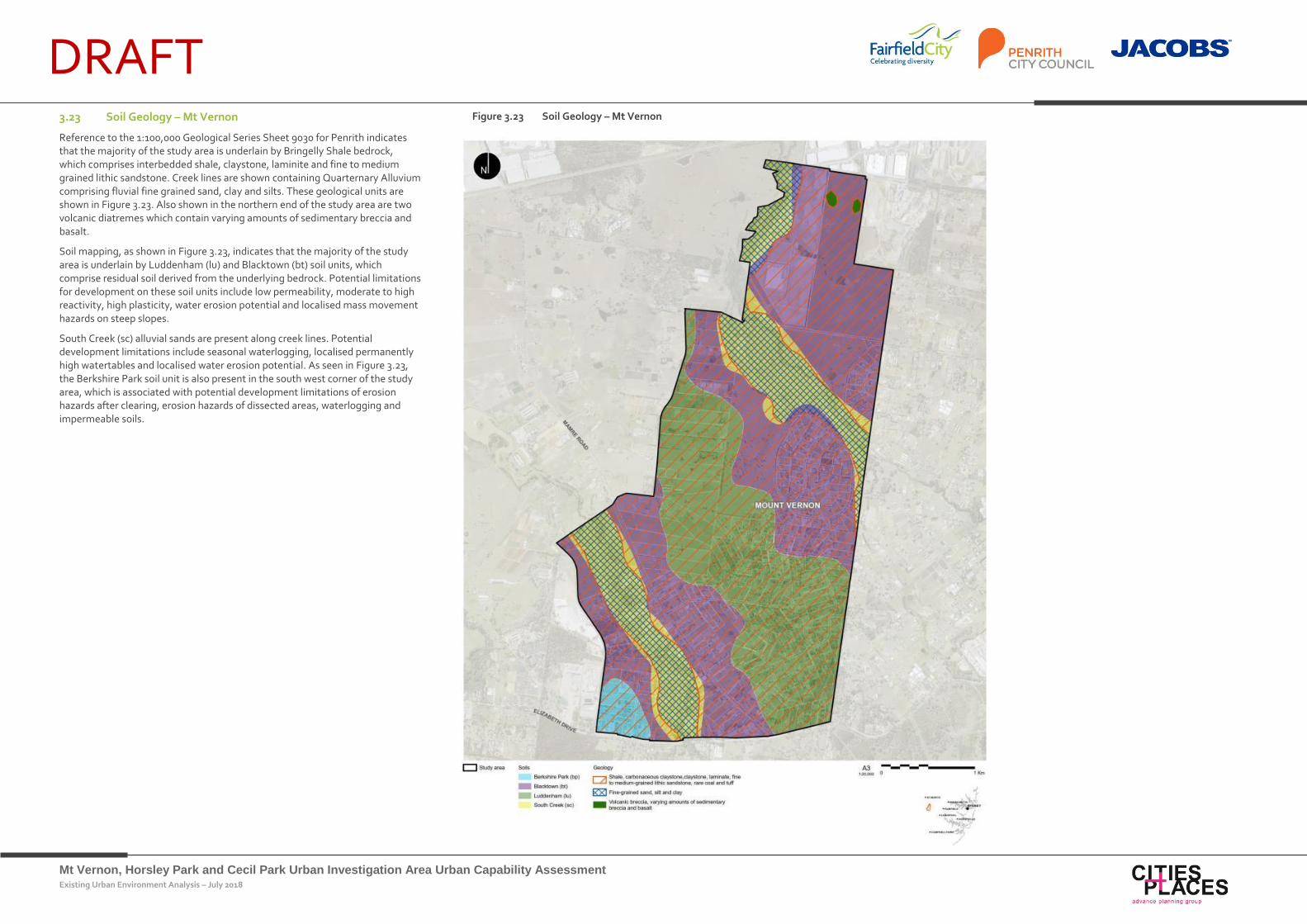
Mt Vernon, Horsley Park and Cecil Park Urban Investigation Area Urban Capability Assessment Existing Urban Environment Analysis – July 2018
DRAFT 3.23 Soil Geology – Mt Vernon
Reference to the 1:100,000 Geological Series Sheet 9030 for Penrith indicates that the majority of the study area is underlain by Bringelly Shale bedrock, which comprises interbedded shale, claystone, laminite and fine to medium grained lithic sandstone. Creek lines are shown containing Quarternary Alluvium comprising fluvial fine grained sand, clay and silts. These geological units are shown in Figure 3.23. Also shown in the northern end of the study area are two volcanic diatremes which contain varying amounts of sedimentary breccia and basalt.
Soil mapping, as shown in Figure 3.23, indicates that the majority of the study area is underlain by Luddenham (lu) and Blacktown (bt) soil units, which comprise residual soil derived from the underlying bedrock. Potential limitations for development on these soil units include low permeability, moderate to high reactivity, high plasticity, water erosion potential and localised mass movement hazards on steep slopes.
South Creek (sc) alluvial sands are present along creek lines. Potential development limitations include seasonal waterlogging, localised permanently high watertables and localised water erosion potential. As seen in Figure 3.23, the Berkshire Park soil unit is also present in the south west corner of the study area, which is associated with potential development limitations of erosion hazards after clearing, erosion hazards of dissected areas, waterlogging and impermeable soils.
Figure 3.23 Soil Geology – Mt Vernon
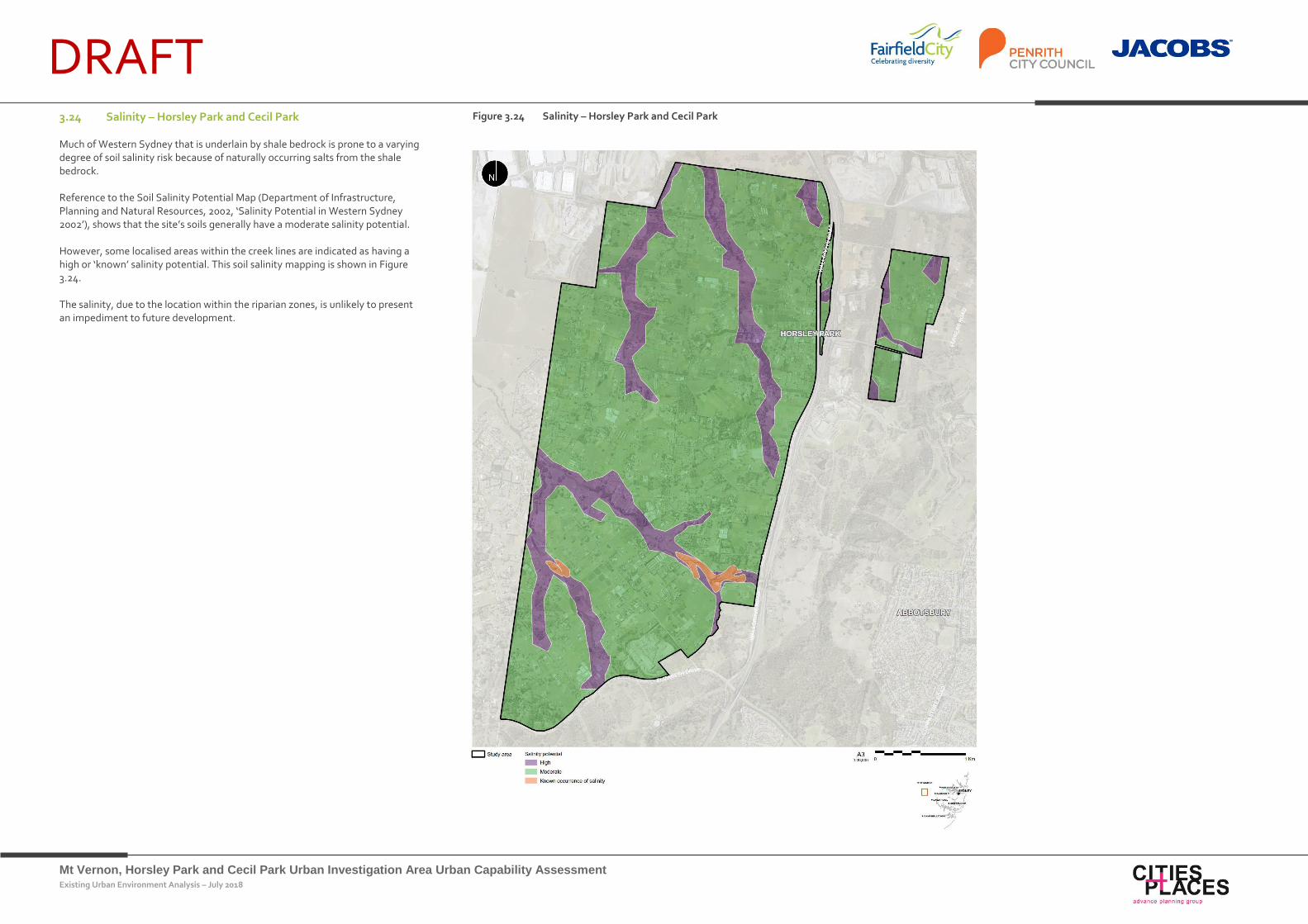
Mt Vernon, Horsley Park and Cecil Park Urban Investigation Area Urban Capability Assessment Existing Urban Environment Analysis – July 2018
DRAFT 3.24 Salinity – Horsley Park and Cecil Park
Much of Western Sydney that is underlain by shale bedrock is prone to a varying degree of soil salinity risk because of naturally occurring salts from the shale bedrock.
Reference to the Soil Salinity Potential Map (Department of Infrastructure, Planning and Natural Resources, 2002, ‘Salinity Potential in Western Sydney 2002’), shows that the site’s soils generally have a moderate salinity potential.
However, some localised areas within the creek lines are indicated as having a high or ‘known’ salinity potential. This soil salinity mapping is shown in Figure 3.24.
The salinity, due to the location within the riparian zones, is unlikely to present an impediment to future development.
Figure 3.24 Salinity – Horsley Park and Cecil Park

Mt Vernon, Horsley Park and Cecil Park Urban Investigation Area Urban Capability Assessment Existing Urban Environment Analysis – July 2018
DRAFT 3.25 Salinity – Mt Vernon
Much of Western Sydney that is underlain by shale bedrock is prone to a varying degree of soil salinity risk because of naturally occurring salts from the shale bedrock.
Reference to the Soil Salinity Potential Map (Department of Infrastructure, Planning and Natural Resources, 2002, ‘Salinity Potential in Western Sydney 2002’), shows that site soils generally have a moderate salinity potential.
However, some localised areas within the creek lines are indicated as having a high or ‘known’ salinity potential. This soil salinity mapping is shown in Figure 3.25.
The salinity, due to the location within the riparian zones, is unlikely to present an impediment to future development except for the area adjacent to the southern boundary. Development in this area may require additional treatments to reduce the impact of salinity on the built form.
Figure 3.25 Salinity – My Vernon
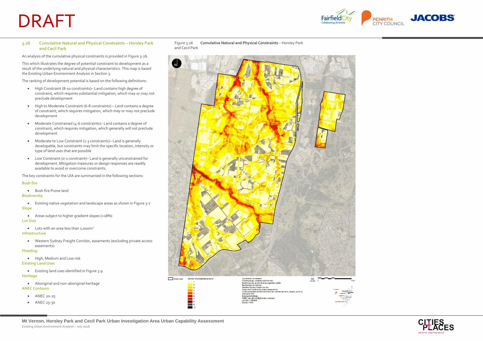
Mt Vernon, Horsley Park and Cecil Park Urban Investigation Area Urban Capability Assessment Existing Urban Environment Analysis – July 2018
DRAFT 3.26 Cumulative Natural and Physical Constraints – Horsley Park
and Cecil Park
An analysis of the cumulative physical constraints is provided in Figure 3-26.
This which illustrates the degree of potential constraint to development as a result of the underlying natural and physical characteristics. This map is based the Existing Urban Environment Analysis in Section 3.
The ranking of development potential is based on the following definitions:
High Constraint (8-10 constraints)– Land contains high degree of constraint, which requires substantial mitigation, which may or may not preclude development
High to Moderate Constraint (6-8 constraints) – Land contains a degree of constraint, which requires mitigation, which may or may not preclude development
Moderate Constrained (4-6 constraints)– Land contains a degree of constraint, which requires mitigation, which generally will not preclude development
Moderate to Low Constraint (1-3 constraints)– Land is generally developable, but constraints may limit the specific location, intensity or type of land uses that are possible
Low Constraint (0-1 constraint)– Land is generally unconstrained for development. Mitigation measures or design responses are readily available to avoid or overcome constraints.
The key constraints for the UIA are summarised in the following sections:
Bush fire
Bush fire Prone land Biodiversity
Existing native vegetation and landscape areas as shown in Figure 3-7 Slope
Areas subject to higher gradient slopes (>18%) Lot Size
Lots with an area less than 1,000m2 Infrastructure
Western Sydney Freight Corridor, easements (excluding private access easements)
Flooding
High, Medium and Low risk Existing Land Uses
Existing land uses identified in Figure 3.9 Heritage
Aboriginal and non-aboriginal heritage ANEC Contours
ANEC 20-25
ANEC 25-30
Figure 3.26 Cumulative Natural and Physical Constraints – Horsley Park and Cecil Park
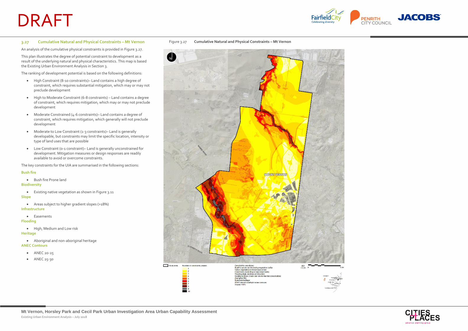
Mt Vernon, Horsley Park and Cecil Park Urban Investigation Area Urban Capability Assessment Existing Urban Environment Analysis – July 2018
DRAFT 3.27 Cumulative Natural and Physical Constraints – Mt Vernon
An analysis of the cumulative physical constraints is provided in Figure 3.27.
This plan illustrates the degree of potential constraint to development as a result of the underlying natural and physical characteristics. This map is based the Existing Urban Environment Analysis in Section 3.
The ranking of development potential is based on the following definitions:
High Constraint (8-10 constraints)– Land contains a high degree of constraint, which requires substantial mitigation, which may or may not preclude development
High to Moderate Constraint (6-8 constraints) – Land contains a degree of constraint, which requires mitigation, which may or may not preclude development
Moderate Constrained (4-6 constraints)– Land contains a degree of constraint, which requires mitigation, which generally will not preclude development
Moderate to Low Constraint (1-3 constraints)– Land is generally developable, but constraints may limit the specific location, intensity or type of land uses that are possible
Low Constraint (0-1 constraint)– Land is generally unconstrained for development. Mitigation measures or design responses are readily available to avoid or overcome constraints.
The key constraints for the UIA are summarised in the following sections:
Bush fire
Bush fire Prone land Biodiversity
Existing native vegetation as shown in Figure 3.11 Slope
Areas subject to higher gradient slopes (>18%) Infrastructure
Easements Flooding
High, Medium and Low risk Heritage
Aboriginal and non-aboriginal heritage ANEC Contours
ANEC 20-25
ANEC 25-30
Figure 3.27 Cumulative Natural and Physical Constraints – Mt Vernon
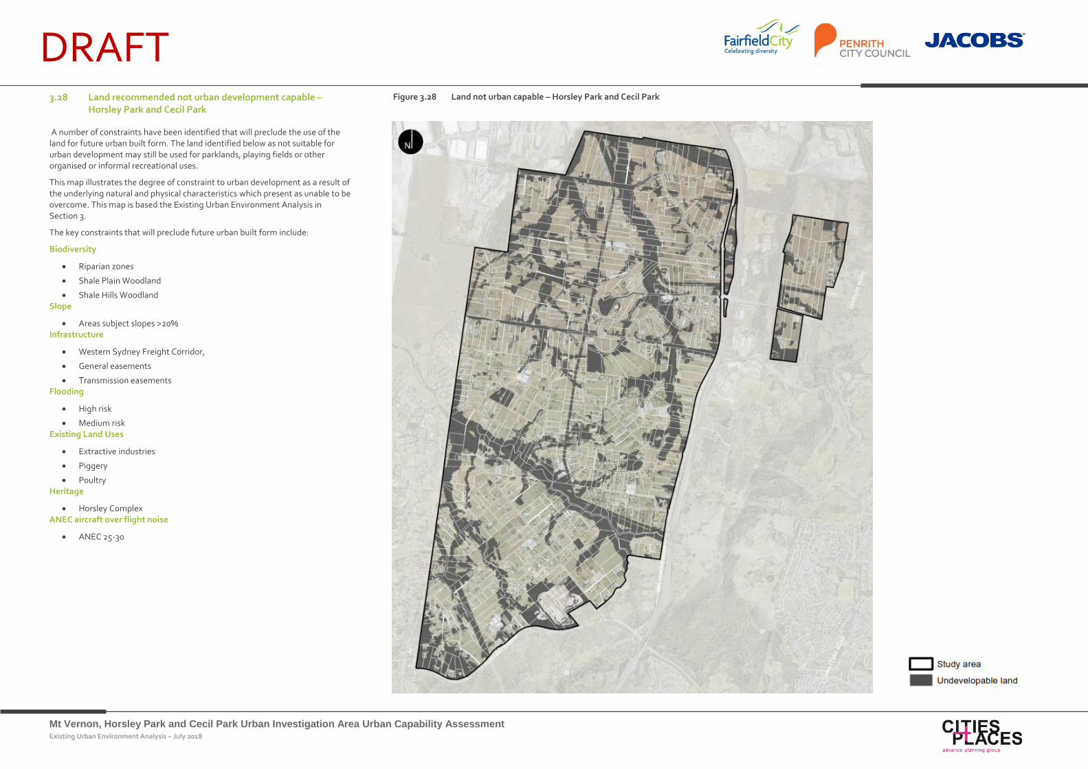
Mt Vernon, Horsley Park and Cecil Park Urban Investigation Area Urban Capability Assessment Existing Urban Environment Analysis – July 2018
DRAFT 3.28 Land recommended not urban development capable –
Horsley Park and Cecil Park
A number of constraints have been identified that will preclude the use of the land for future urban built form. The land identified below as not suitable for urban development may still be used for parklands, playing fields or other organised or informal recreational uses.
This map illustrates the degree of constraint to urban development as a result of the underlying natural and physical characteristics which present as unable to be overcome. This map is based the Existing Urban Environment Analysis in Section 3.
The key constraints that will preclude future urban built form include:
Biodiversity
Riparian zones
Shale Plain Woodland
Shale Hills Woodland Slope
Areas subject slopes >20% Infrastructure
Western Sydney Freight Corridor,
General easements
Transmission easements Flooding
High risk
Medium risk Existing Land Uses
Extractive industries
Piggery
Poultry Heritage
Horsley Complex ANEC aircraft over flight noise
ANEC 25-30
Figure 3.28 Land not urban capable – Horsley Park and Cecil Park
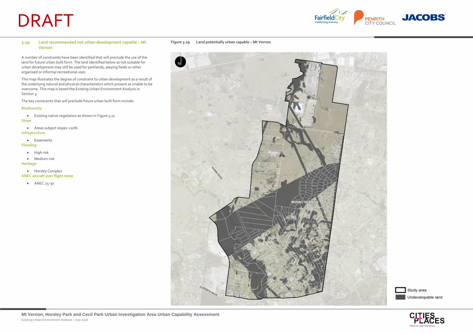
Mt Vernon, Horsley Park and Cecil Park Urban Investigation Area Urban Capability Assessment Existing Urban Environment Analysis – July 2018
DRAFT 3.29 Land recommended not urban development capable – Mt
Vernon
A number of constraints have been identified that will preclude the use of the land for future urban built form. The land identified below as not suitable for urban development may still be used for parklands, playing fields or other organised or informal recreational uses.
This map illustrates the degree of constraint to urban development as a result of the underlying natural and physical characteristics which present as unable to be overcome. This map is based the Existing Urban Environment Analysis in Section 3.
The key constraints that will preclude future urban built form include:
Biodiversity
Existing native vegetation as shown in Figure 3.11 Slope
Areas subject slopes >20% Infrastructure
Easements Flooding
High risk
Medium risk Heritage
Horsley Complex ANEC aircraft over flight noise
ANEC 25-30
Figure 3.29 Land potentially urban capable – Mt Vernon
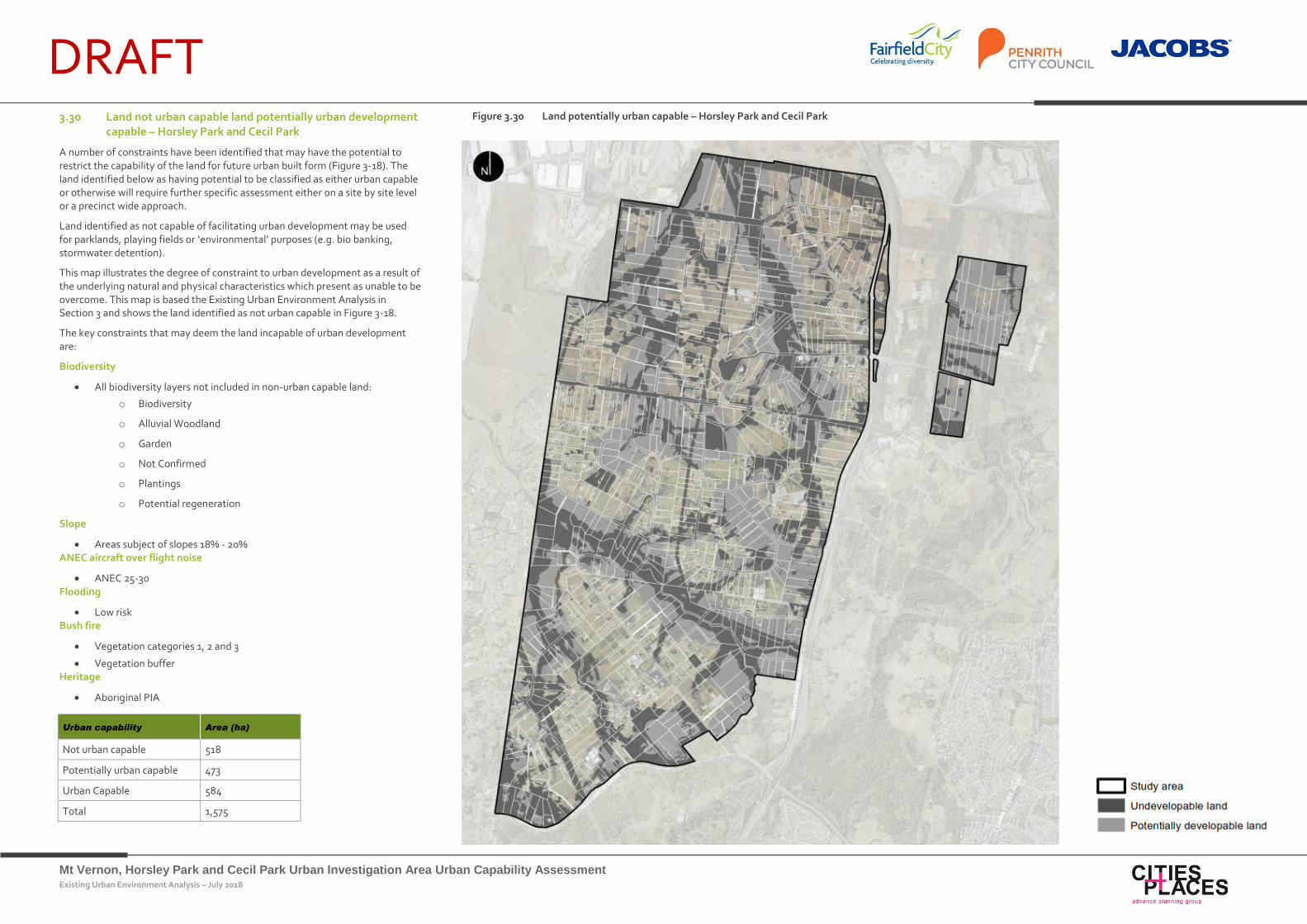
Mt Vernon, Horsley Park and Cecil Park Urban Investigation Area Urban Capability Assessment Existing Urban Environment Analysis – July 2018
DRAFT
Urban capability Area (ha)
Not urban capable 518
Potentially urban capable 473
Urban Capable 584
Total 1,575
3.30 Land not urban capable land potentially urban development capable – Horsley Park and Cecil Park
A number of constraints have been identified that may have the potential to restrict the capability of the land for future urban built form (Figure 3-18). The land identified below as having potential to be classified as either urban capable or otherwise will require further specific assessment either on a site by site level or a precinct wide approach.
Land identified as not capable of facilitating urban development may be used for parklands, playing fields or ‘environmental’ purposes (e.g. bio banking, stormwater detention).
This map illustrates the degree of constraint to urban development as a result of the underlying natural and physical characteristics which present as unable to be overcome. This map is based the Existing Urban Environment Analysis in Section 3 and shows the land identified as not urban capable in Figure 3-18.
The key constraints that may deem the land incapable of urban development are:
Biodiversity
All biodiversity layers not included in non-urban capable land:
o Biodiversity
o Alluvial Woodland
o Garden
o Not Confirmed
o Plantings
o Potential regeneration
Slope
Areas subject of slopes 18% - 20% ANEC aircraft over flight noise
ANEC 25-30 Flooding
Low risk Bush fire
Vegetation categories 1, 2 and 3
Vegetation buffer Heritage
Aboriginal PIA
Figure 3.30 Land potentially urban capable – Horsley Park and Cecil Park
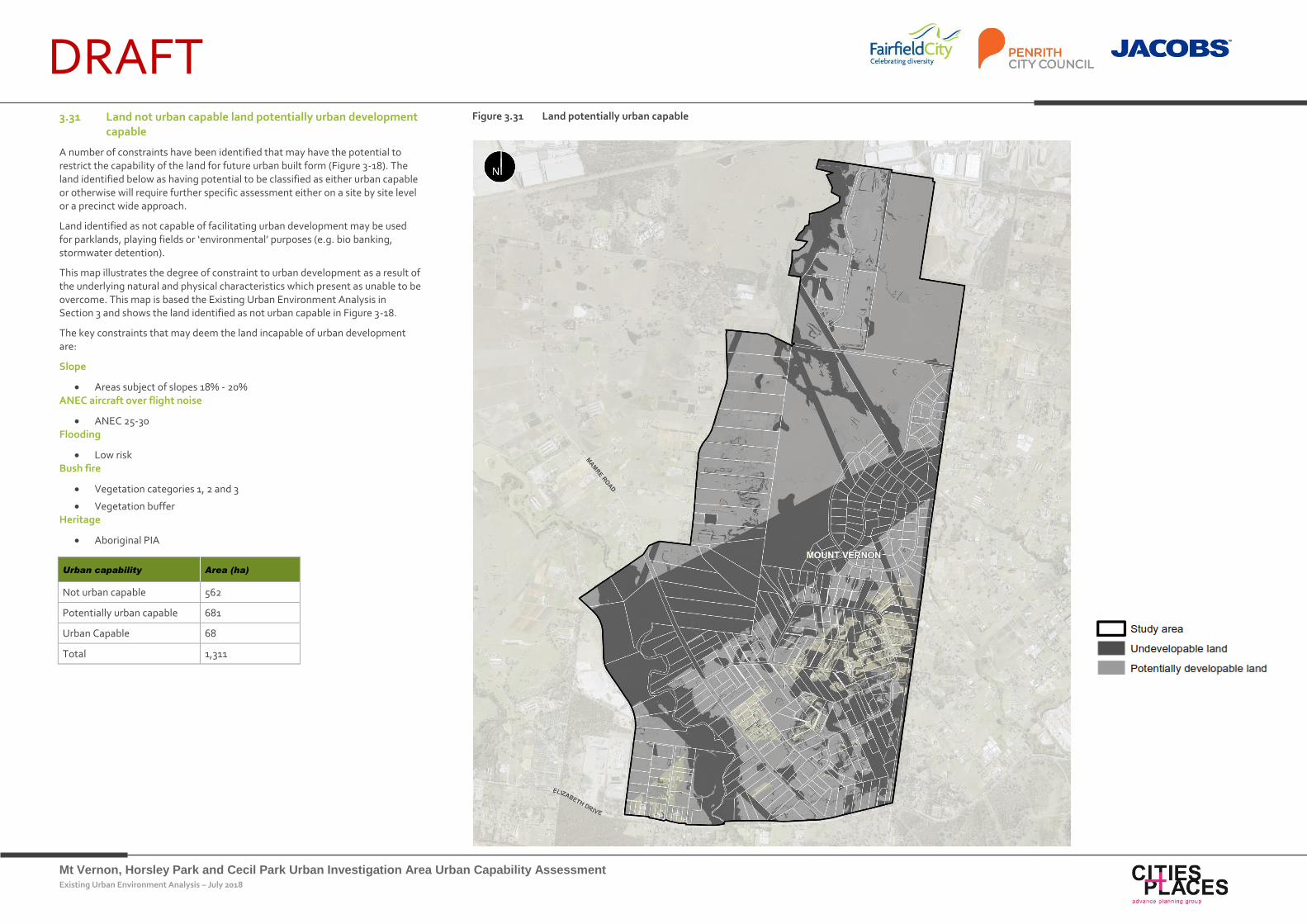
Mt Vernon, Horsley Park and Cecil Park Urban Investigation Area Urban Capability Assessment Existing Urban Environment Analysis – July 2018
DRAFT
Urban capability Area (ha)
Not urban capable 562
Potentially urban capable 681
Urban Capable 68
Total 1,311
3.31 Land not urban capable land potentially urban development capable
A number of constraints have been identified that may have the potential to restrict the capability of the land for future urban built form (Figure 3-18). The land identified below as having potential to be classified as either urban capable or otherwise will require further specific assessment either on a site by site level or a precinct wide approach.
Land identified as not capable of facilitating urban development may be used for parklands, playing fields or ‘environmental’ purposes (e.g. bio banking, stormwater detention).
This map illustrates the degree of constraint to urban development as a result of the underlying natural and physical characteristics which present as unable to be overcome. This map is based the Existing Urban Environment Analysis in Section 3 and shows the land identified as not urban capable in Figure 3-18.
The key constraints that may deem the land incapable of urban development are:
Slope
Areas subject of slopes 18% - 20% ANEC aircraft over flight noise
ANEC 25-30 Flooding
Low risk Bush fire
Vegetation categories 1, 2 and 3
Vegetation buffer Heritage
Aboriginal PIA
Figure 3.31 Land potentially urban capable
Mt Vernon, Horsley Park and Cecil Park Urban Investigation Area Urban Capability Assessment Existing Urban Environment Analysis – July 2018
DRAFT Conclusions and Recommendations
4. Conclusions and
Recommendations
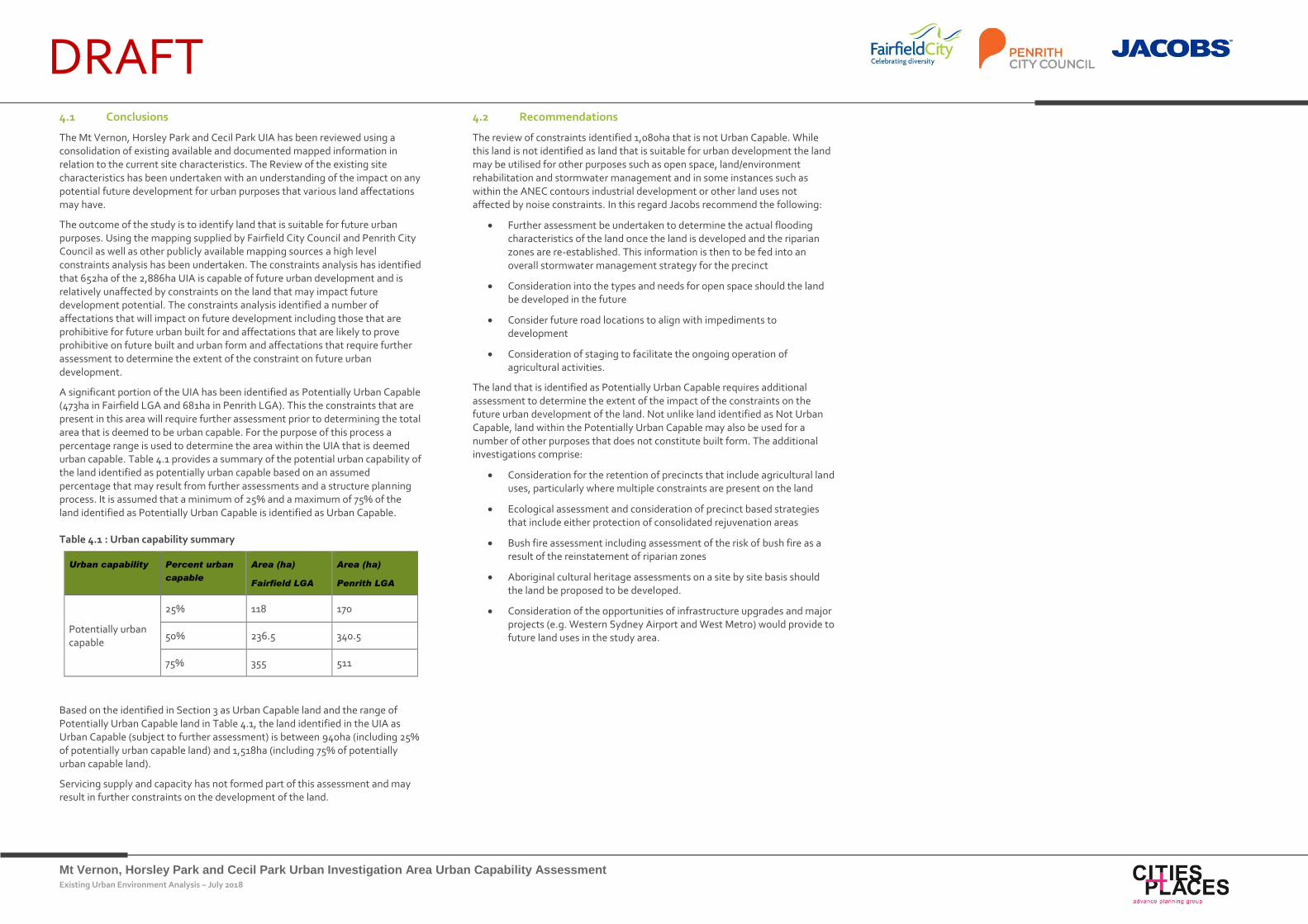
Mt Vernon, Horsley Park and Cecil Park Urban Investigation Area Urban Capability Assessment Existing Urban Environment Analysis – July 2018
DRAFT 4.1 Conclusions
The Mt Vernon, Horsley Park and Cecil Park UIA has been reviewed using a consolidation of existing available and documented mapped information in relation to the current site characteristics. The Review of the existing site characteristics has been undertaken with an understanding of the impact on any potential future development for urban purposes that various land affectations may have.
The outcome of the study is to identify land that is suitable for future urban purposes. Using the mapping supplied by Fairfield City Council and Penrith City Council as well as other publicly available mapping sources a high level constraints analysis has been undertaken. The constraints analysis has identified that 652ha of the 2,886ha UIA is capable of future urban development and is relatively unaffected by constraints on the land that may impact future development potential. The constraints analysis identified a number of affectations that will impact on future development including those that are prohibitive for future urban built for and affectations that are likely to prove prohibitive on future built and urban form and affectations that require further assessment to determine the extent of the constraint on future urban development.
A significant portion of the UIA has been identified as Potentially Urban Capable (473ha in Fairfield LGA and 681ha in Penrith LGA). This the constraints that are present in this area will require further assessment prior to determining the total area that is deemed to be urban capable. For the purpose of this process a percentage range is used to determine the area within the UIA that is deemed urban capable. Table 4.1 provides a summary of the potential urban capability of the land identified as potentially urban capable based on an assumed percentage that may result from further assessments and a structure planning process. It is assumed that a minimum of 25% and a maximum of 75% of the land identified as Potentially Urban Capable is identified as Urban Capable.
Table 4.1 : Urban capability summary
Urban capability Percent urban
capable
Area (ha)
Fairfield LGA
Area (ha)
Penrith LGA
Potentially urban capable
25% 118 170
50% 236.5 340.5
75% 355 511
Based on the identified in Section 3 as Urban Capable land and the range of Potentially Urban Capable land in Table 4.1, the land identified in the UIA as Urban Capable (subject to further assessment) is between 940ha (including 25% of potentially urban capable land) and 1,518ha (including 75% of potentially urban capable land).
Servicing supply and capacity has not formed part of this assessment and may result in further constraints on the development of the land.
4.2 Recommendations
The review of constraints identified 1,080ha that is not Urban Capable. While this land is not identified as land that is suitable for urban development the land may be utilised for other purposes such as open space, land/environment rehabilitation and stormwater management and in some instances such as within the ANEC contours industrial development or other land uses not affected by noise constraints. In this regard Jacobs recommend the following:
Further assessment be undertaken to determine the actual flooding characteristics of the land once the land is developed and the riparian zones are re-established. This information is then to be fed into an overall stormwater management strategy for the precinct
Consideration into the types and needs for open space should the land be developed in the future
Consider future road locations to align with impediments to development
Consideration of staging to facilitate the ongoing operation of agricultural activities.
The land that is identified as Potentially Urban Capable requires additional assessment to determine the extent of the impact of the constraints on the future urban development of the land. Not unlike land identified as Not Urban Capable, land within the Potentially Urban Capable may also be used for a number of other purposes that does not constitute built form. The additional investigations comprise:
Consideration for the retention of precincts that include agricultural land uses, particularly where multiple constraints are present on the land
Ecological assessment and consideration of precinct based strategies that include either protection of consolidated rejuvenation areas
Bush fire assessment including assessment of the risk of bush fire as a result of the reinstatement of riparian zones
Aboriginal cultural heritage assessments on a site by site basis should the land be proposed to be developed.
Consideration of the opportunities of infrastructure upgrades and major projects (e.g. Western Sydney Airport and West Metro) would provide to future land uses in the study area.