landscapes of cultivation: inland rice fields as landscapes and archaeological sites
TRANSCRIPT
1
September 2009 Newsletter Landscapes of Cultivation:
Inland Rice Fields as Landscapes and Archaeological Sites
By Andrew Agha and Charles F. Philips, Jr.*
Introduction
When the first colonists had successfully transformed rice into a viable commodity, the
future of Carolina was set. The Carolina Lowcountry became the colonial epicenter for rice
production, and the Lowcountry planters generated wealth and capital that would help to build
the foundation for the state we live in and study today. One would think that such a major
agricultural development would have been documented in full detail. Unfortunately, very little
information about the development, successes, and failures of early rice production exists.
In recent decades, historians have attempted to unravel the process by which Europeans
and Africans created a hydrological wonder in the American southeastern coastal swamps. The
growth of rice production, especially in the eighteenth century, is a study of cultural transference,
both from Europe and perhaps more interestingly West Africa. Unfortunately, historians have a
propensity to breeze through the early development of the inland rice industry and jump into tidal
rice agriculture -- a well documented chapter of South Carolina’s history. Sam Hilliard (1972:
98) stated this dilemma, succinctly writing:
The most puzzling aspect of the entire Carolina rice complex is the apparent confusion between tidewater and inland swamp rice. Early sources rarely go into detail, and most secondary sources gloss over the early period and jump quickly into long descriptions of tidewater rice, which has received the received the greatest attention. Archival work on rice fields is not new. Duncan Clinch Heyward, in Seed from
Madagascar (1937), and David Doar, in Rice and Rice Planting in the South Carolina Low
Country (1936), wrote in detail of some methods of rice field construction in the 1930s, work
2
they participated in as planters of the post-bellum period. In the 1960s, Jack Greene (1989),
Richard Dunn (1973), and Sidney Mintz (1974) began to explore the strong connections between
the Indies and Carolina along with the introduction of African slavery into the region. In the
1970s, 80s, and 90s, authors such as Peter Wood (1974), Daniel Littlefield (1981), Ira Berlin
(1998) and many more explored the immense contribution of African slaves in building the rice
industry along the southeastern American mainland. Sam Hilliard (1972) and Judith Carney
(2001) challenged conventional thinking about the role of Africans, women in particular, in the
design of the early inland rice fields. Most recently, Edda Fields-Black (2008) and Max Edleson
(2006) are taking the work of these scholars and refining the definitions of rice growing, African
technology transfer, and Lowcountry processes. All of these works have enriched our
understanding of rice culture, but they all lack one thing: the fieldwork needed within the inland
swamps that would let us know of their origins and how they were used through time.
Today, we see evidence of tidal rice along the banks of almost all rivers in the Lower
Coastal Plain of North Carolina, South Carolina, and Georgia, but archaeologists are also
observing remnants of the inland systems along the freshwater creeks and lowland areas,
especially within a 30 mile radius of Charleston. Since little documentation exists for the
formative years, roughly 1690 to 1760, we are left with the need to find other ways to uncover
the development of inland swamp rice-growing technology -- a technology so important that it
would shape the evolution of slavery in South Carolina and in the United States. This article,
then, argues that to understand inland rice, we must use historical archaeology to investigate
these early fields and study them just as we would a slave village. Our field allows us to use
interdisciplinary approaches to tackle research problems, and if there ever was a research
problem, there is one involving the origins and evolution of inland swamp rice cultivation.
The study of landscape in historical archaeology allows for the incorporation of
geography, ecology, history, anthropology, and archaeology (Agha 2004). Because of this
freedom to incorporate multiple theories, methods, and approaches, historical archaeologists are
positioned to take landscape studies into new directions. After investigating various planter elite
landscapes (Kelso et al. 1990), attention was turned to deal with the constructors of these
landscapes. Those builders were, of course, the enslaved labor force comprised almost entirely
3
of African captives. Focus of studies began on enslaved involvement and presence within the
yards and gardens of these elite houses and plantations (Miller and Gleason et al. 1994; Yamin
and Metheny et al. 1996). These studies lead to our research into how enslaved Africans created
landscape within the confines of the southern plantations, ranging from their sense of place at the
village site to the linkages between plantations (Heath and Bennett 2000; Agha 2004).
Since landscapes, and the study of them, lie within the realm of space and place, the study
of landscape became a study of power relations, resistance, and domination within a given
plantation. The investigation of power relations between planter and slave, although crucially
important to the advancement of slave studies, has not fully addressed how landscapes were
created and lived in by the enslaved. More importantly, lines of inquiry have not addressed what
landscapes meant to those people. Recent studies by scholars on the meanings of landscape,
rather than power relations within them, have been addressing how enslaved landscapes may
have enriched the compromised lives of the enslaved and helped them make sense of the rural,
and urban, world around them (Joseph 2002; Agha 2004; Isenbarger 2009). As we incorporate
new “places” and the links between them to define new perceptions of landscapes that the
enslaved lived within, we move these studies in positive directions, incorporating a much larger
spatial realm than previously studied. However, one such realm of landscape studies has been
completely ignored: that of the rice fields on plantations.
Our Framework
This article argues that if historical archaeologists are going to address and study the
landscapes of the enslaved, and incorporate the plantation into such a landscape, then we need to
be including the rice fields, both inland and tidal, into our scope of inquiry. These fields were
major components of the enslaved landscapes in the Carolina Lowcountry, as these Africans
spent most of their days working in them. These fields were also the purpose of their existence
on the plantations, as their labor was used to grow crops that made the planter money. All too
often, archaeologists focus on the planter house, overseer’s house, and slave village for
understanding plantation culture and lifeways. Add landscape to this, and the spatial relationship
between these structures and the people residing in them becomes a topic of study. However, the
4
plantation’s rice fields, particularly the inland swamp rice fields, are usually ignored and have
been investigated and mapped only in a few instances over the last 25 years of fieldwork in the
Carolina Lowcountry (Elliott 1987; Trinkley 2004; Agha 1999, 2001).
In order to understand how inland rice fields were elements of enslaved landscapes, an
assessment of their development and history is needed. Therefore, we are placing the
development of inland rice, slave imports, and rice exports and profit margins into a framework
that deals with the conflicts and wars that impacted Carolina during the Colonial period. All of
the above mentioned were indeed influenced by the conflicts of the Colonial period, which
culminated with the Revolutionary War. Most, if not all, historians deal with the development of
rice through the transference of technology and culture, making minor references to the influence
conflict had on rice. Here, we choose to use wars and conflicts as our analytical filter to
understand the development of rice, because we see that the importation of enslaved Africans
was directly influenced by conflict. Understanding inland rice in this way will show how
influential inland rice fields were to the enslaved, and what the impact was like when planters
shifted to tidal agriculture after the Revolution.
A Crop Amidst Violence
Like most American commodities, the history of commercially-grown rice is punctuated
with highs and lows and impacted by such Atlantic World events as wars, treaties, bounties,
duties, market prices, and governmental actions. In the southeast, rice production started out as
an experimental crop brought over by settlers to Carolina in the 1670s. Early planting attempts
were inconclusive: the crop could be grown on high ground but weeding time made it unsuitable
for commercial purposes. Rice took its place along side other unsuccessful experimental crops
such as silk, almonds, raisins, citrus, and wine (Clowse 1971: 59; Wood 1974: 27). Although
planters did not completely give up on rice, their efforts in the first 30 years of the colony
focused on making profits off the Indian trade, cattle ranching, and timbering (Wood 1974: 27-
32; Edgar 1998: 132-138). By the late 1690s, they were beginning to experiment with wet-
culture rice, noting that the crop grew well in cleared cypress swamps (Littlefield 1991: 102;
Lawson 1967: 81). By the first decade of the eighteenth century, they were perfecting the use of
5
water to flood the rice fields and eradicate the weeds (Lawson 1967: 8; Greene 1989: 40).
Colonial Indian trade profits temporarily dried up when the Yamasee initiated a war in the
spring of 1715 and wiped out not only the trade but the Carolina settlement outside a 30-mile
radius of Charles Town (Edgar 1998: 138). Although by this time the region was becoming
known as a rice producer, naval stores became the next product of choice. Sweden’s stricter
practices for naval store production, the advent of the Queen Anne’s War in 1702, and perhaps
most importantly, the Great Northern War (1700-1721) between Sweden and Russia severed
primary British Admiralty sources for timbers, pitch, tar, and turpentine. Most importantly,
Parliament place a bounty on those products which the southeastern colonies had, stored in
hundreds of millions of acres of pine forests (Clowse 1971: 133, 171-178, 210-211). All the
colonists had to do was cut the softwoods and convert the wood into the products, a fairly simple
technology that was adaptable on the frontier. Production started slow, but by the 1718, the
colonists were making steady progress and by 1725, South Carolinians exported more than
60,000 barrels of tar and pitch (Clowse 1971: 176, 210-211, 232-233). That year also marked the
end of the bounty and exports declined to 3,100 barrels by 1728 (Clowse 1971: 211-217, 232; US
Dept. Commerce 1976: 1194). Nonetheless, several years in the early 1720s, planters found an
excellent reason to clear forests and lowlands and convert the pine trees into naval stores and the
pine and hardwoods into building materials. Meanwhile, as they cleared their lowlands, they
planted rice.
Rice production lagged during Queen Anne’s War (1702-1712), rebounded, and then
sagged again in 1715 due to the Yamasee war. In 1716, production rebounded again and grew to
20,000 barrels in 1720, then sagged again in the early 1720s due to market saturation in Britain
and struggles with the Board of Trade over southern European markets (Clowse 1971: 218).
Despite the difficulties, production in the colony reached 7 million pounds by 1725 and more
importantly, the colony was refining the hydrological process. Rice was ready to claim its place
along with tobacco and sugar with the great products of colonial British America.
In 1725, Parliament changed the ground rules for the bounty on naval stores essentially
eliminating those products manufactured in Carolina and forcing Lowcountry planters to look for
another commodity. By this time, Carolina planters had mastered the art of growing Lowcountry
6
rice (Clowse 1971: 210-211). Production by the end of the decade doubled again to 14.3 million
pounds, despite falling prices (US Dept. Commerce 1976: 1192). By 1729, the Carolinians
managed to convince the Board of Trade to revise mercantilist policies and collect duties in
South Carolina so that ships could export rice directly to southern Europe. This opened vast
Catholic markets to the white grain. Two more issues remained to be solved: security and
money. Both were not long in coming.
Naval stores and the renewed deer skin trade provided partial financing for expansion of
the rice-planting business. Carolinians had also established their own financial system to
simplify local business and began printing their first money during Queen Anne’s War.
Additionally, the colony developed a home-grown mortgage market fed by excess cash generated
by the naval stores and deer skin trade and by cash-heavy Europeans coming to the colony and
looking for secure places to invest (Menard 1994: 669-670).
Planters also needed security and political stability to expand. Between 1700 and 1719,
Carolinians eliminated the southern threat by crushing the Spanish mission system in Georgia
and North Florida, and eliminated the Native-American threat by defeating two groups in
separate wars (Bushnell 1996; Edgar 1998: 100-101; Taylor 2001: 234-236). All this they
concluded with minimal Proprietary help and in 1719, they threw off the inconsistent Proprietary
rule and became a Royal Colony. After 10 years of haggling, the crown settled with the
Proprietors over its purchase of the colony and sent out a Royal Governor in 1730. In 1731,
Governor Robert Johnson reopened the land office and the colony was set for a decade of
spectacular growth (Clowse 1971: 243-245).
Rice production expanded quickly, growing from 7 million pounds in 1725 to 14.2
million only four years later (US Dept. Commerce 1976: 1192). Johnson’s reopening of the land
in Charleston allowed Carolinians to legally settle tracts that had been technically closed for 10
years. Financing, new markets, security, consistent administration, a source of cheap labor, and
technological understanding of the process for production set off a decade-long expansion of rice
production: productivity climbing from 14.2 million pounds in 1729 to 32.2 million pounds in
1739 (Edgar 1998; US Dept. Commerce 1976: 1192). Meanwhile slave imports that were 436 in
1723 reached more than 3,000 per year in 1736 (US Dept. Commerce 1976: 1174).
7
Throughout the 1730s, Lowcountry planters and merchants funneled profits into more
slaves, more lands, and larger and more opulent country houses and gardens to display their new-
found wealth. Planters and their factors transformed Charles Town into a capital city filled with
all the resemblances of Europe, complete with a newspaper, theatre, lavish homes, active trading
houses, a growing artisan community, and an elite new world gentry who were surrounded by
thousands of relocated Africans (Waterhouse 1989: 74-75; Fraser 1989: 45-66). Additionally,
during the decade safety was increased by the founding of Georgia in 1733, as well as a ring of
fortified settlements in the backcountry that protected the rich rice-region in the Lowcountry
(Edgar 1998: 52-54).
Two events changed the unbridled optimism and headiness at decades’ end. In 1739,
Angolan slaves revolted and killed several white families in an attempt to reach St. Augustine
and freedom. Although the Stono Rebellion was swiftly crushed it was not before ramifications
of slave revolt rippled throughout the Lowcountry culminating in a new harsher slave code and
near total restriction on slave importation (Wood 1974: 308-326). Additionally, Spanish
disruption of sea trade provoked the War of Jenkins Ear (1739-1742) that expanded into the War
of Austrian Succession (1741-1748) in Europe (King George’s War). Rice prices began to
decline, peaking in 1738 at 20.67 shillings per CWT and dropping to 6.99 shillings per CWT in
1746 (US Dept. Commerce 1976: 1197). Planters tried further expansion with productivity
rising to 43.3 million pounds in 1740 but falling to less than 22 million by 1749 (Edgar 1998:
144; US Dept. Commerce 1976: 1192). Although prices rose at the conclusion of the war in
1748 and slave imports resumed they did not reach pre-1739 levels until the 1750s (US Dept.
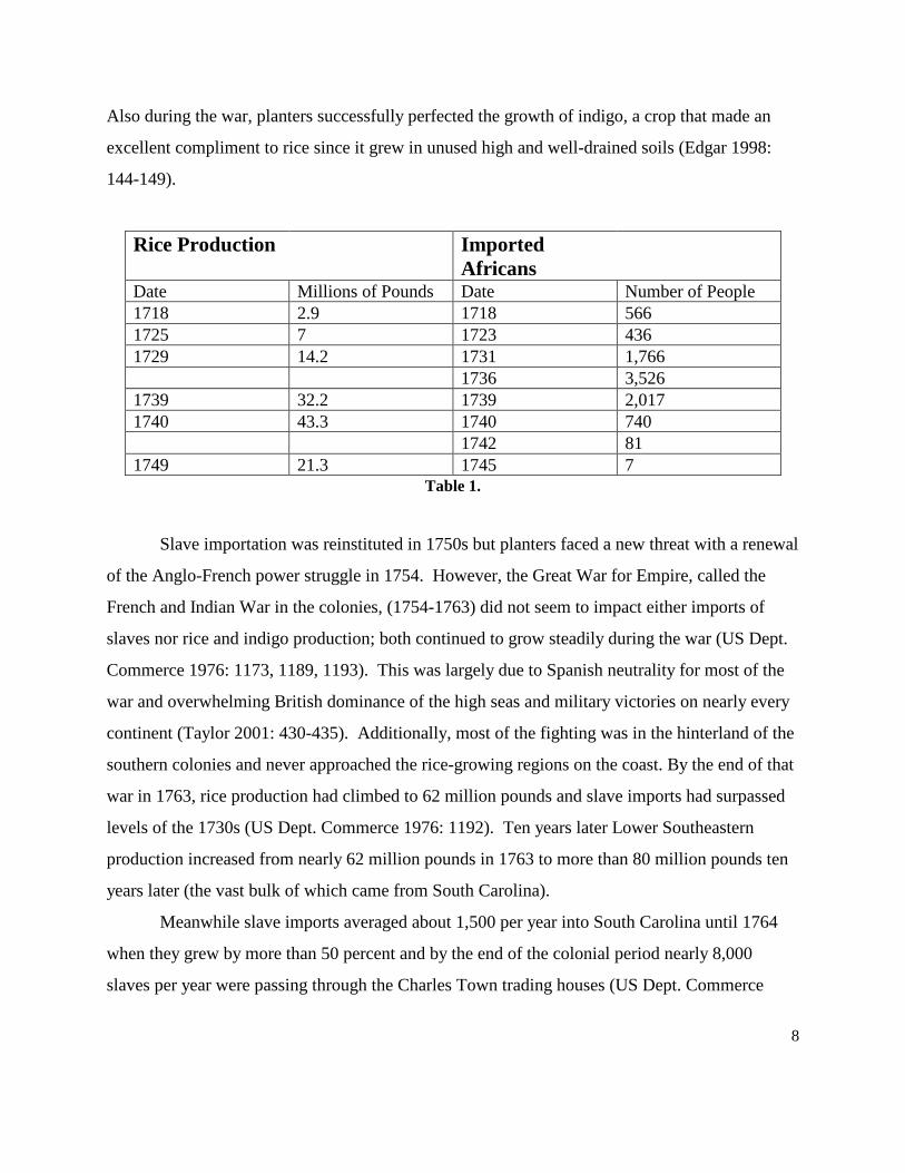
Commerce 1976: 1173-1174, 1197). Table 1 displays a comparison of rice exports and slave
imports during the first half of the eighteenth century.
Probably in the 1740s, planters and slaves negotiated and solidified the task system for
labor within rice culture (Coclanis 1989: 96-98). Enslaved laborers established a tradition of
required sections per day with free time the reward for efficiency. Planters seeking indigenous
slave growth in the absence of allowable imports encouraged family growth and a level of slave
satisfaction (Chaplin 1993: 85-86). The success of this system was such that it survived intact,
despite some planter attempts to change it, until the end of the Civil War (Chaplin 1993: 123).
8
Also during the war, planters successfully perfected the growth of indigo, a crop that made an
excellent compliment to rice since it grew in unused high and well-drained soils (Edgar 1998:
144-149).
Rice Production Imported Africans
Date Millions of Pounds Date Number of People 1718 2.9 1718 566 1725 7 1723 436 1729 14.2 1731 1,766 1736 3,526 1739 32.2 1739 2,017 1740 43.3 1740 740 1742 81 1749 21.3 1745 7
Table 1.
Slave importation was reinstituted in 1750s but planters faced a new threat with a renewal
of the Anglo-French power struggle in 1754. However, the Great War for Empire, called the
French and Indian War in the colonies, (1754-1763) did not seem to impact either imports of
slaves nor rice and indigo production; both continued to grow steadily during the war (US Dept.
Commerce 1976: 1173, 1189, 1193). This was largely due to Spanish neutrality for most of the
war and overwhelming British dominance of the high seas and military victories on nearly every
continent (Taylor 2001: 430-435). Additionally, most of the fighting was in the hinterland of the
southern colonies and never approached the rice-growing regions on the coast. By the end of that
war in 1763, rice production had climbed to 62 million pounds and slave imports had surpassed
levels of the 1730s (US Dept. Commerce 1976: 1192). Ten years later Lower Southeastern
production increased from nearly 62 million pounds in 1763 to more than 80 million pounds ten
years later (the vast bulk of which came from South Carolina).
Meanwhile slave imports averaged about 1,500 per year into South Carolina until 1764
when they grew by more than 50 percent and by the end of the colonial period nearly 8,000
slaves per year were passing through the Charles Town trading houses (US Dept. Commerce
9
1976: 1173). The colonies of Georgia and Florida also grew but peaking in the mid 1760s their
importation declined to less than 500 per year by 1775 (US Dept. Commerce 1976: 1172).
Charles Town remained the primary trading city with Sullivan’s Island serving as the point of
debarkation for slavers.
However, more trouble was brewing for South Carolina rice planters as the colony
entered the last quarter of the century. Struggles over taxation and representation boiled over in
1775, with the 13 American colonies vying for independence from Great Britain. After a brief
but violent attempt to take Charleston, British Naval and Army forces concentrated on subduing
the Northern colonies and temporarily abandoned the South. However, after seizing Savannah in
December 1778, British forces, after several failures, took Charleston in May of 1780 and by
August had secured most of the back country. This action provoked an increasingly violent
guerilla war throughout the state, completed with skirmishes, battles, murders, hangings, property
seizures, displaced owners and escaped slaves. By 1781, the American-French defeat of
Cornwallis at Yorktown and effective maneuvering and fighting by colonial forces commanded
by General Nathaniel Greene forced British units back to a small enclave around Charleston.
Peace was declared at Paris that ended the American Revolution in 1783.
For rice planters of the Lowcountry, the fighting and insecurity reduced productivity,
which fell from 118,000, 550 pound barrels, to 24,000 barrels at war’s end (US Dept. Commerce
1976: 1192). Massive abandonment by both Patriot and Loyalist owners, confiscation of estates
by South Carolina officials, the loss of more than 10,000 slaves who left when the British
evacuated, the breakdown of law and order, as well as the disruption to a well-established trading
and exportation system contributed to a social and economic upheaval that loosened the very
“fabric of life” and “unraveled planter’s prosperity and sense of security” (Edelson 2006: 255).
Yet the rice planters saw in their devastated landscape an opportunity, an opportunity that
they, their children and grandchildren brought to fruition in the decades that followed the
Revolution. From the 1780s until the end of the Civil War, they converted the massive tidal
marshes and swamps in their Lowcountry into a huge rice-producing machine. One author noted
that with stability, certainty, and a continued demand from both the former mother country and
10
former allies, the planters put in place one of the “most advanced technologies on the most
productive lands” (Edelson 2006: 265). Largely abandoning inland fields by the 1820s, the rice
complexes they developed on the Waccamaw and Pee Dee, Cooper and Wando, Combahee and
Edisto, Ogeechee and Altamaha rivers as well as hundreds of smaller rivers and streams from the
Cape Fear to the St. Johns, dwarfed the colonial complexes developed in the inland swamps.
The link between conflict and development of the Lowcountry could not be seen more
clearly than through the evolution of rice in early Carolina. Some wars impacted rice production
more than others, while others did not inhibit the crop’s advancement at all. The American
Revolution was probably the war that had the most direct effect on rice growing and
technological advances. The seizing of plantations and purposeful attempts by officers to disrupt
the slave populations throughout the Lowcountry were some of the biggest threats to rice
agriculture throughout all of the eighteenth century. However, all attempts to disturb rice
plantations did not succeed, and planters were able to reclaim the riverside marshes and expand
their rice endeavors in expansive ways. After the Revolution, planters, now forefathers of a new
America, began recording much of their livelihood to secure the record of their successes, and
failures, for their future generations. Thus, we are left with many more documents detailing tidal
rice agriculture -- much more than the limited documentation on inland rice. Thus, we are left
with a major gap in the literature.
Although the planter elite held promise in their new tidal fields at the turn of the
nineteenth century, their enslaved laborers would be facing a massive physical and mental
upheaval. Nearly 100 years of continuous work in the inland fields, and all of the daily routines
involved in and between the swamps and nearby settlements, came to a grinding halt for
countless thousands of slaves once tidal fields became realized by their owners. One can imagine
an enslaved family being ingrained to work the same fields for generations, only to suddenly one
day be forced to convert the riverside marshes into the fields they would then toil in for a number
of decades. Tidal labor, however, was much more difficult, as the conditions were wetter, the
ditching more brutal, and since the crop could grow more dense due to the improved flooding
techniques, hoeing intensified.
11
Besides these factors, the settlement may have had to move closer to the river to be near
the tidal fields. This means the enslaved had to leave the homes they had to work so hard to
develop a sense of place for, and move to a new place to grow accustomed to. Today, we have
the freedom to move to a new place and develop a sense of place at our leisure. To the enslaved
of the past, crafting a new sense of place was likely not as easy. This shift in location meant that
the proximity of the village to the overseer, and the planter, may have changed, creating more
difficult situations socially. Here, the structures of domination and resistance were renegotiated
and the power relations redefined as space was transformed into new places for the planter and
his/her slaves.
With the shift from inland to tidal, the enslaved faced new intensities in labor, in some
cases a new settlement to live in, a redefined power structure, and a new definition of landscape.
Since we know so little about inland rice fields and how they were developed, how can we
understand what the change in perceptions of the inland fields as parts of landscapes were like?
Without knowing the technological development of inland rice, we are lost when trying to
understand what kinds of relationships the enslaved had with the ecology created in the rice
fields -- ecology created through the time spent working and improving the inland fields. As
technology and labor changed in the fields, so too did the perceptions of landscape. When one
walks in the swamps, and crosses bank after bank, the true majesty of the labor, skill, knowledge,
and technological prowess of these Africans is brought to light. With an archaeological study of
inland rice fields, we have the chance to begin understanding how field locations were selected,
layouts designed, banks and ditches constructed, water controlled, rice crops adapted, and labor
allocated. Historical archaeology will prove to be the discipline that may finally uncover the
information historians have sought for decades, and will establish the framework needed so that
we can understand how fields became landscapes, and were integrated into the larger plantation
landscape of the enslaved.
Historical Archaeology in Rice Fields
Since the late 1960s, historical archeologists have been increasing their studies and
expanding their research designs to investigate the houses, yards, outbuildings, and landscapes
12
that were once occupied by the enslaved laborers on plantations throughout the Southeast. We
have numerous resources at our disposal to help us interpret and make sense of the daily lives of
these slaves. Some of these resources are comparative architectural forms and construction
techniques, planters’ journals and other public announcements that reference specific elements of
their plantations, slave narratives, early photographs, and paintings. The most common
“resources” in our field are comparative analyses of slave village, house, and yard excavations
and the artifact assemblages produced from such endeavors.
Early on, historical archaeologists thought that focusing on the slave village and cabin
would reveal the most information about slaves and how they survived the cruel institution of
slavery. The earliest excavations on slave housing focused primarily on the houses themselves,
and although some excavations occurred in the yards, the structure was focused on, as we tend to
treat the home as the focal point of daily life. Work continued at slave villages throughout the
decade, but it was Doug Armstrong’s (1999) work at Drax Hall in the 1980s that put forth the
call for us to begin treating the yards of the houses with equal attention. We quickly learned that
excavating the yards yielded data just as important as that from the cabins. Historical
archaeology also began to adopt the study of landscape more towards the late ‘80s-early ‘90s, as
studies of elite housing moved into the yards and formal gardens of those elites (Yamin and
Metheny 1996). That emphasis allowed archaeologists to then study the landscapes that the
enslaved themselves created and lived within. We could consider the entire plantation part of the
enslaved Africans’ landscape, with the places inside and sometimes outside this realm carrying
different levels of meaning. Such places were the rice fields; since the fields were the reason
many Africans became slaves. Although important parts of plantations, inland rice fields have
seldom been mentioned in archaeological studies, and have not been designated as archaeological
sites until very recently (Agha et al. 2007a, 2007b).
Methods to Approaching Rice Fields as Resources
We believe that until serious efforts are made on the ground, in the colonial period inland
rice fields, their construction and change through time will remain a mystery. Along with that,
our understanding of these fields as important places within the slaves’ landscapes will be a
13
mystery. As archaeologists and historians working in cultural resource management, we have
been encountering these agricultural resources in recent years through our work on federal, state,
and private lands. Most of the embankments and ditches are in wetlands, and technically free
from harm’s way, thus free from potential study. But, if we can develop time and cost effective
methods, we can begin to map these field systems, whether threatened or not, and name them as
stand alone archaeological resources, or as incorporated components of larger plantation complex
sites. Fieldwork will lead to our further understanding of how fields were laid out and
engineered, and who really was involved in all parts of the process. This information, then,
becomes pivotal when including rice fields as integral places within the landscapes of the
enslaved.
An Example from Capers Swamp Plantation
Designating an inland rice field as an archaeological site sounds like it should be easy, but
it in fact is not. For 30 plus years of finding and excavating plantation-related sites, few to no
inland rice fields have been named as sites, or included as parts of sites. However, our work with
Brockington and Associates has been able to name inland rice fields as stand alone resources and
as contributing elements to historic districts eligible for the NRHP. As we continue to document,
preserve, and study these fields, we will be creating a database of layouts, designs, watersheds,
and geography. Since the Colonial records lack crucial historical data, groundwork on the fields
themselves may provide some of the only information existing for the formative years of
Carolina rice technology. Therefore, the more fields we investigate, the more landscapes we
understand.
During a 2004 survey in the Francis Marion National Forest, Agha had the opportunity to
survey part of the eighteenth through nineteenth century Caper’s Swamp Plantation (Agha et al.
2008). Figure 1 displays the location of Caper’s in relation to Charleston. Besides uplands, the
survey required an inspection of the wetlands, and in these wetlands were evidence of rice fields.
Brockington historians quickly noted that the modern aerial photograph showed organized lines
of trees, and when compared to the historic plat, we found that the fields were almost 100%
intact to the layout seen on the 1808 plat. Figure 2 displays the 1808 plat. We quickly saw the

14
Figure 1. The location of Caper’s Swamp in relation to Charleston, SC (all images by the authors).
Figure 2. The 1808 Caper’s Swamp Plantation plat.
15
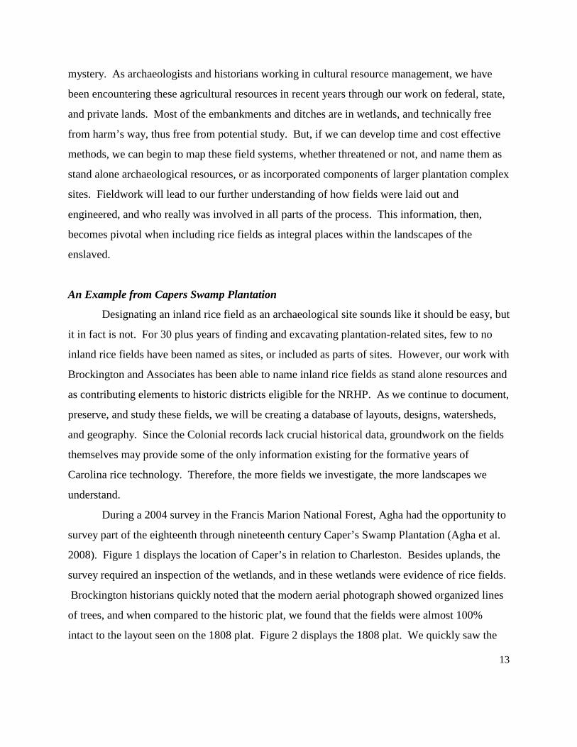
exact layout of the plantation on the aerial, with the plotted canals and embankments showing
themselves on the photo. Figures 3 and 4 display the results of this comparison. Based on this
alone, we feel confident that the fields are intact amidst years of maintenance -- both pre and post
Forest Service acquisition. This method of simple image overlaying would create a guide map
for the archaeologist, which would allow them to go right to the potential earthworks, inspect
their integrity, and look for elements not seen on the overlay. This work shows that if a plat
exists for an inland field system, and you have the general location of it today, then comparative
plat/aerial/soil map GIS work would be worthwhile, cost effective, and very important when
trying to see how information from one map informs another.
Figure 3. A visual comparison of the 1808 plat with features seen on the aerial photograph.
16
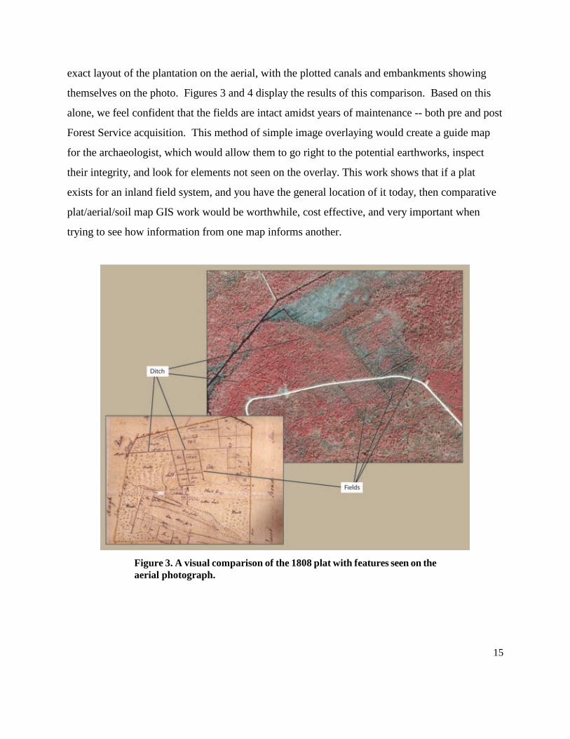
Figure 4. Digital overlay of ditches/banks from the 1808 plat on the aerial photograph.
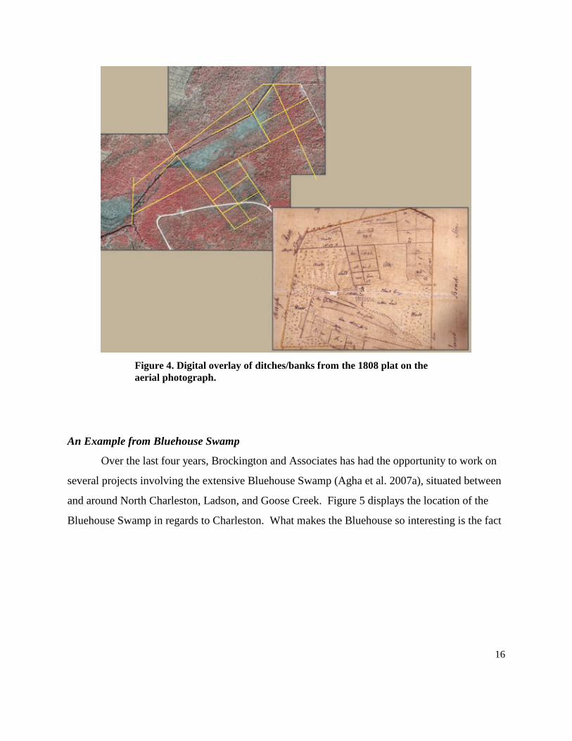
An Example from Bluehouse Swamp
Over the last four years, Brockington and Associates has had the opportunity to work on
several projects involving the extensive Bluehouse Swamp (Agha et al. 2007a), situated between
and around North Charleston, Ladson, and Goose Creek. Figure 5 displays the location of the
Bluehouse Swamp in regards to Charleston. What makes the Bluehouse so interesting is the fact
17
Figure 5. The location of the Bluehouse Swamp in relation to Charleston, SC.
that it was cut up and divided between eight plantations around 1800; all of which shared one
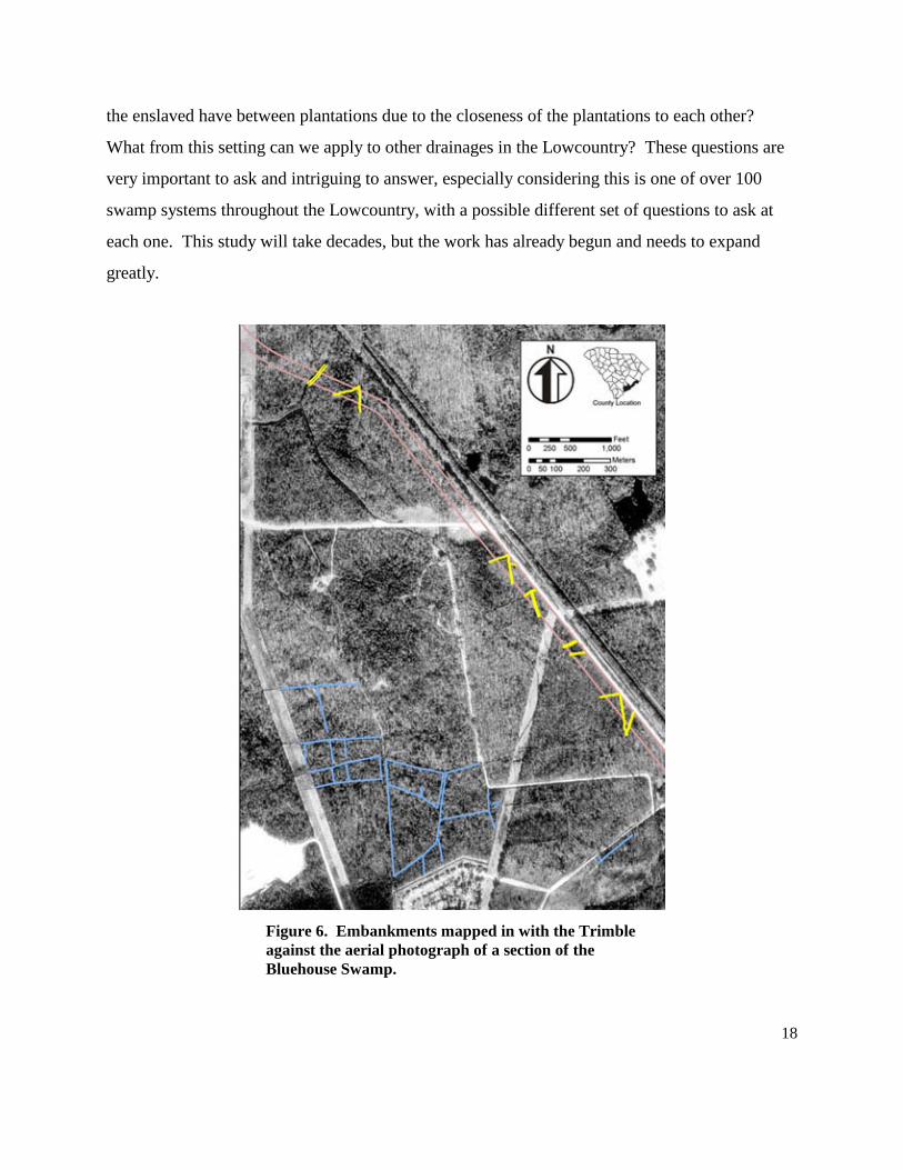
canal that helped feed and drain this extensive inland rice system. Instigated by road projects for
the South Carolina Department of Transportation, we had the chance to walk, assess, and map
miles of inland embankments, ditches, canals, and old causeway roads. Using a Trimble GPS
unit, we obtained submeter accuracy in these fields. Although we mapped less than 5 percent of
the swamp, it was clear that the fields are very intact and will yield information about how
planters shared property boundaries and a water source. Figure 6 displays the features mapped
on an aerial photograph. In the future, we plan to do more extensive mapping of the swamp,
relocate the old property lines, and even collect soil samples to hopefully find intact rice grains
so that we can find out what kind(s) of rice was grown there. Because of the unique nature of the
Bluehouse Swamp, we are able to ask unique questions: What does this level of water source
sharing mean for eighteenth century competition and camaraderie? What level of interaction did
18
the enslaved have between plantations due to the closeness of the plantations to each other?
What from this setting can we apply to other drainages in the Lowcountry? These questions are
very important to ask and intriguing to answer, especially considering this is one of over 100
swamp systems throughout the Lowcountry, with a possible different set of questions to ask at
each one. This study will take decades, but the work has already begun and needs to expand
greatly.
Figure 6. Embankments mapped in with the Trimble against the aerial photograph of a section of the Bluehouse Swamp.
19
An Example from Willtown
Along with mapping and compiling GIS overlays of every map available, it is possible to
excavate embankments to learn things no one has ever thought of before. Agha undertook such
an excavation 11 years ago, after participating in Martha Zierden’s field school at an inland rice
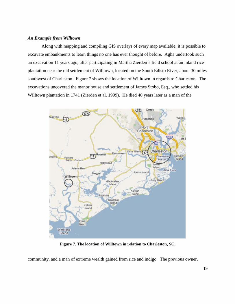
plantation near the old settlement of Willtown, located on the South Edisto River, about 30 miles
southwest of Charleston. Figure 7 shows the location of Willtown in regards to Charleston. The
excavations uncovered the manor house and settlement of James Stobo, Esq., who settled his
Willtown plantation in 1741 (Zierden et al. 1999). He died 40 years later as a man of the
Figure 7. The location of Willtown in relation to Charleston, SC.
community, and a man of extreme wealth gained from rice and indigo. The previous owner,
20
John Smelie, owned the land from 1719 to 1727, and from what was listed in his inventory, he
likely grew rice as well. The amount, quality, and unique nature of the artifact assemblage from
this site was so impressive, Zierden was able to interpret gentry life in a Carolina Frontier town
in new and exciting ways.
Shortly after the manor house excavations, Agha focused on the earthen banks and
ditches south of the house in an attempt to try to date the embankments to know if the inland
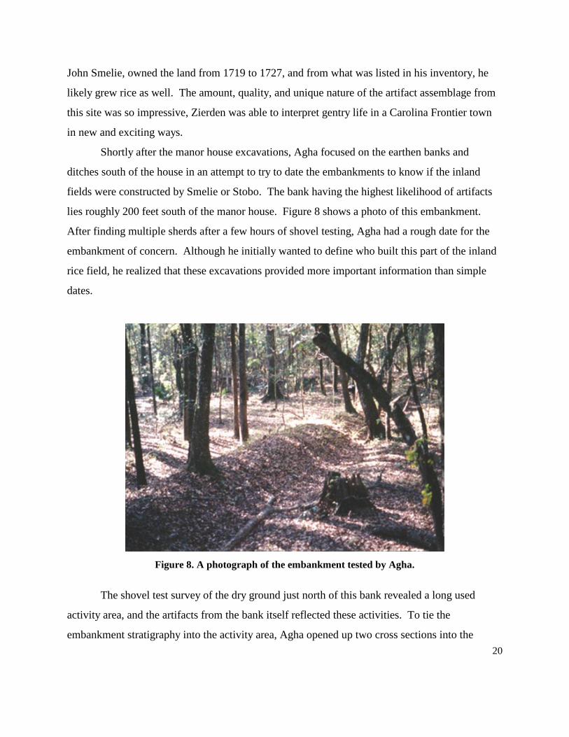
fields were constructed by Smelie or Stobo. The bank having the highest likelihood of artifacts
lies roughly 200 feet south of the manor house. Figure 8 shows a photo of this embankment.
After finding multiple sherds after a few hours of shovel testing, Agha had a rough date for the
embankment of concern. Although he initially wanted to define who built this part of the inland
rice field, he realized that these excavations provided more important information than simple
dates.
Figure 8. A photograph of the embankment tested by Agha.
The shovel test survey of the dry ground just north of this bank revealed a long used
activity area, and the artifacts from the bank itself reflected these activities. To tie the
embankment stratigraphy into the activity area, Agha opened up two cross sections into the
21
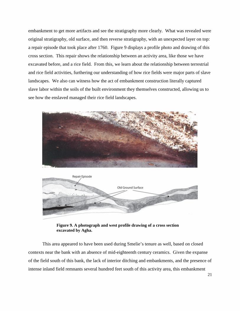
embankment to get more artifacts and see the stratigraphy more clearly. What was revealed were
original stratigraphy, old surface, and then reverse stratigraphy, with an unexpected layer on top:
a repair episode that took place after 1760. Figure 9 displays a profile photo and drawing of this
cross section. This repair shows the relationship between an activity area, like those we have
excavated before, and a rice field. From this, we learn about the relationship between terrestrial
and rice field activities, furthering our understanding of how rice fields were major parts of slave
landscapes. We also can witness how the act of embankment construction literally captured
slave labor within the soils of the built environment they themselves constructed, allowing us to
see how the enslaved managed their rice field landscapes.
Figure 9. A photograph and west profile drawing of a cross section excavated by Agha.
This area appeared to have been used during Smelie’s tenure as well, based on closed
contexts near the bank with an absence of mid-eighteenth century ceramics. Given the expanse
of the field south of this bank, the lack of interior ditching and embankments, and the presence of
intense inland field remnants several hundred feet south of this activity area, this embankment
22
may have been constructed to manage water at the south edge of the knoll that houses the
settlement. Then, the bank and ditch served only as a buffer to keep water from the lowland to
the south from encroaching on an apparently important activity area and possible structure. Agha
uncovered a modified rib bone from the embankment, which has been looked at by sweetgrass
basket weavers from Mt. Pleasant, South Carolina and determined to be a “bone” that is the main
tool used in basket production. This bone was found in the post-1760 repair episode in the
embankment, making it the earliest known example of a basket maker’s bone. So, one can see
quickly that paying attention to these areas that might be deemed “on the fringe” of historic sites
can yield data and artifacts totally unique to the settlement under study. These kinds of artifacts
and components of sites diversify our study of the enslaved landscape as well.
Conclusions and Future Directions
As rice developed in the Lowcountry of South Carolina, so too did the landscapes of the
elite and enslaved. As this article has shown, the occurrences of wars and conflicts, both internal
and abroad, effected rice and its technological advances in both positive and negative ways. The
evolution of rice historically also effected the way slavery evolved in the Lowcountry. Therefore,
perceptions of landscape on rice plantations were a result of the ways rice first was adapted to the
inland swamps, where the enslaved were introduced to environments somewhat familiar to them
as they almost mirrored West Africa. As the enslaved became used to the Task System, and the
fields themselves, their sense of place became stronger and more grounded as each year passed.
Life in their settlement may have become more static as changes may have occurred less, as
schedule and profit dictated the needs and wants of the planter who controlled them. In some
cases, community life may have been fractured with families being ripped apart and sold, along
with new, unfamiliar Africans coming into the village. Although the taking away and adding of
people was a disruptive factor, we feel that these actions would not have disturbed the collective
sense of place for the entire group of enslaved. Life in and around the inland swamp rice fields
would have been something of a fixture, with the inland landscape being something that was
understood and felt by all.
23
The Revolutionary War, and its resultant disruption of the inland way of life for many
plantation inhabitants, began the radical shift in agriculture from the inland swamps to the tidal
marshes. In some cases, the settlement moved to a new area, and with this move, so too did the
sense of place for the enslaved. The setting of the tidal fields were very different from those in
an inland setting, and decades of uniformity in the task, in the inland rice fields, would have
completely went away. Instead, an updated method to ditching, embanking, canalizing, and
trunk minding came about. The tidal method allowed for more rice to be grown each season,
with bigger yields each harvest. This, along with the new setting, was the major shift in
landscape for the enslaved trying to carry on traditions from the eighteenth century into the
nineteenth. Was the move beneficial to the enslaved? Did they ever regain the same sense of
place within their new landscapes, or did it reside in the landscapes they left behind in the
swamps? More importantly, was the tidal field a more familiar setting because they farmed rice
in tidal settings in Africa? We may never know the answers to these questions, but asking them
informs our archaeology of ways to think about these shifts in landscape and what that meant to
the enslaved, whose villages we excavate almost every year in the Lowcountry of South Carolina.
Treating inland rice fields as enslaved landscapes is the important first step toward
putting a human “face” on the earthen features we encounter in the swamps of former
plantations. With inland fields as parts of landscapes, our study of them gains importance. With
enough mapping and investigations, will our studies finally crack the mystery of who provided
what knowledge, and to what degree? Will we find something years from now that clearly shows
African or European trademarks? We are unsure. One thing is for sure, and that is this: these
remnant, intact, eighteenth century built environments were once the reason Carolina continued
to thrive. They were the primary reason slave populations jumped so rapidly throughout the
eighteenth century, and probably the reason the Task System came to be. These fields were not
easy to come by, as the geography, although similar, varies across the Lowcountry, and slight to
major alterations of the natural environment were needed in every instance when planters were
trying to master the watershed within their plantation. The mix of Africans also varied, which
raises an important question: If there were only 2 out of 20 slaves that knew how to grow rice
before the Middle Passage, how alien were the rice fields to those inexperienced? What sense of
24
place did these Africans craft when forced to labor in a field unfamiliar to them? How did this
affect their activities at the village, and in their homes? As one can see, when incorporating
inland rice fields into the landscapes of the enslaved laborers who built and worked in them, we
open up an entirely new and crucial realm of research. Our fieldwork in the swamps is new, as
no one has attempted to construct a concise research design to deal with the fields as
archaeological sites, or as integral parts of the plantation complex and landscape. Although we
might not learn the extent of the African Connection to Colonial rice, we will be relocating the
meaningful places that once existed as large parts of the slaves’ landscapes. Interpreting and
studying the landscapes of the enslaved brings us closer to understanding how slaves made sense
of the world around them, and how they negotiated an existence in a world totally foreign to
them.
Acknowledgements We would first like to thank Mr. Hayden Smith for his generous sharing of inland rice knowledge over the last 12 years. We also extend thanks and appreciation to our clients who allowed us access to investigate the fields in this article: The Weber Group, Bob Morgan at the Francis Marion National Forest, Chad Long at the South Carolina Department of Transportation, and the LPA Group. We also need to thank the South Carolina Department of Archives and History and the State Historic Preservation Office for working with us on these resources. Special thanks go to Scott Kitchens and Brian Falls for their help in the field, and to Allison Wind for preparing our graphics. Lastly, we would like to thank the Lane Family for their continuing support and love of history. Note
* Andrew Agha is a Senior Archaeologist, and Charles F. Philips, Jr. is a Senior Historian, with Brockington and Associates.
25
References Agha, Andrew 1999 African American Slaves and Rice Dike Construction. In Willtown: An Archaeological and Historical Perspective, Zierden, M., R. Anthony, S. Linder, eds. South Carolina Department of Archives and History, Columbia. 2001 An Analysis of the Cultural Material and Deposits in an Eighteenth Century Inland Swamp Rice Embankment, Willtown Bluff, Charleston County, South Carolina. On file, The Charleston Museum. 2004 Searching for Cabins, Searching for Places: Locating the Living Areas at the James Stobo Plantation, Willtown Bluff, Charleston County, South Carolina. Master’s Thesis, Department of Anthropology, The University of South Carolina. Agha, Andrew, Charles F. Philips, Jr., Edward Salo, Jason Ellerbee, and Joshua N. Fletcher 2007a Cultural Resources Survey of the Palmetto Commerce Parkway Extension Project, Charleston County, South Carolina. Prepared for LPA Group, LLC. Agha, Andrew, Charles F. Philips, Jr., Edward Salo, and Joshua N. Fletcher 2007b Intensive Cultural Resources Survey of the Old Fort Drive Extension (S-18-662), Dorchester County, South Carolina. Prepared for South Carolina Department of Transportation. Armstrong, Douglas 1999 Archaeology and Ethnohistory of the Caribbean Plantation. In I, Too, Am America, ed. Theresa Singleton. University of Virginia Press. Berlin, Ira 1998 Many Thousands Gone: The First Two Centuries of Slavery in North America. Harvard University Press, Cambridge, Massachusetts. Bushnell, Amy Turner 1996 Situado and Sabana: Spain’s Support System for the Presidio and Mission Provinces of Florida. Anthropological Papers of the American Museum of Natural History. Washington, DC. Carney, Judith A. 2001 Black Rice: The African Origins of Rice Cultivation in the Americas. Harvard University Press, Cambridge, Massachusetts. Chaplin, Joyce E. 1993 An Anxious Pursuit. Agricultural Innovation & Modernity in the Lower South, 1730-1815. University of North Carolina Press, Chapel Hill.
26
Clowse, Converse D. 1971 Economic Beginnings in Colonial South Carolina, 1670-1730. University of South Carolina Press, Columbia. Coclanis, Peter A. 1989 Shadow of a Dream: Economic Life and Death in the South Carolina Low Country,1670-1920. Oxford University Press, Oxford, United Kingdom. Doar, David 1936 Rice and Rice Planting in the South Carolina Low Country. Contribution 8, The Charleston Museum. Dunn, Richard S 1973 Sugar and Slaves: The Rise of the Planter Class in the English West Indies, 1624-1713. W. W. Norton & Company, New York. Edelson, S. Max 2006 Plantation Enterprise in Colonial South Carolina. Harvard University Press, Cambridge. Edgar, Walter 1998 South Carolina A History. University of South Carolina Press, Columbia. Elliott, Daniel T. 1987 Crowfield Archaeological Survey. Prepared for Westvaco Development Corporation, Summerville, South Carolina. Fields-Black, Edda 2008 Deep Roots: Rice Farmers in West Africa and the African Diaspora. Indiana University Press, Indianapolis. Fraser, Walter J., Jr. 1988 Charleston! Charleston! History of a Southern City. University of South Carolina Press, Columbia. Greene, Jack P. 1989 Colonial South Carolina and the Caribbean Connection, South Carolina Historical Magazine Vol. 88 (1987), pp. 192-210. Heath, Barbara J. and Amber Bennett 2000 “The little Spots allow’d them”: The Archaeological Study of African-American Yards. Historical Archaeology 34(2): 38-55.
27
Heyward, Duncan Clinch 1937 Seed from Madagascar. University of North Carolina, Chapel Hill. Reprinted in 1993, University of South Carolina, Columbia. Hillard, Sam B. 1972 Antebellum tidewater rice culture in South Carolina and Georgia. In European Settlement and Development in North America: Essay on Geographical Change in Honour and Memory of Andrew Hill Clark. University of Toronto, Toronto. Isenbarger, Nicole M. 2006 Potters, Hucksters, and Consumers: Placing Colonoware within the Internal Slave Economy Framework. Masters Thesis, University of South Carolina. Kelso, William M. and Rachel Most, editors 1990 Earth Patterns: Essays in Landscape Archaeology. University of Virginia Press, Charlottesville. Lawson, John 1967 A New Voyage to Carolina. Edited by Hugh Talmage Lefler. University of North Carolina Press, Chapel Hill. Littlefield, Daniel C. 1981 Rice and Slaves, Ethnicity and the Slave Trade in Colonial South Carolina. University of Illinois Press, Urbana. Menard, Russell, M. 1994 Financing the Low County Export Boom: Capital and Growth in Early South Carolina. William and Mary Quarterly. 3rd Ser. Vol. 51 no. 4 (October 1994), pp. 659-676. Miller, Naomi F. and Kathryn L. Gleason, editors 1994 The Archaeology of Garden and Field. University of Pennsylvania Press, Philadelphia. Mintz, Sidney 1974 Caribbean Transformations. Johns Hopkins University Press, Baltimore. Morgan, Philip D. 1982 Work and Culture: The Task System and the World of Lowcountry Blacks, 1700-1880. William and Mary Quarterly, 3d ser., 39: 563-599. Taylor, Alan 2001 American Colonies, The Settling of North America. Penguin Books, New York.
28
Trinkley, Michael 2004 Rice Cultivation, Processing, and Marketing in the Eighteenth Century. An historic context prepared for the South Carolina Department of Archives and History, South Carolina Historic Preservation Office. Waterhouse, Richard 1989 A New World Gentry: The Making of a Merchant and Planter Class in South Carolina, 1670-1770. Garland Publishing, Inc., New York. U.S. Department of Commerce 1976 Historical Statistics of the United States, Colonial Times to 1970, Part 2. US Bureau of the Census, Washington, DC. Wood, Peter H. 1974 Black Majority, Negroes in Colonial South Carolina from 1670 through the Stono Rebellion. W. W. Norton & Company, New York. Yamin, Rebecca and Karen Bescherer Metheny, editors 1996 Landscape Archaeology: Reading and Interpreting the American Historical Landscape. University of Tennessee Press, Knoxville.
Return to September 2009 Newsletter: http://www.diaspora.uiuc.edu/news0909/news0909.html