mountain landscapes nw portugal
TRANSCRIPT
Fontes, L. (2010) - Mountain landscapes and landscape archaeology in northwest
Portugal. In Living Landscape. The European Landscape Convention in research
perspective, Volume I, Papers, Firenze: Bandecchi e Vivaldi, p.204-226.
[p.204]
MOUNTAIN LANDSCAPES AND LANDSCAPE ARCHAEOLOGY IN NORTHWEST PORTUGAL Luís Fontes, Archaeologist, Member of the Scientific Committee of RPO PNPG Archaeological Unit of Minho’s University / Avenida Central, 39 P 4710-228 BRAGA [email protected]
Introduction European mountains are areas of vital importance to the continent’s population, as highlighted in the “Mountain Areas in Europe: Analysis of mountain areas in EU member states, acceding and other European countries” final report (European Commission contract No 2002.CE.16.0.AT.136, January 2004). Such importance led to an increased knowledge promotion related with the mountainous systems, which originated a new research area centered on the study of the mountainous cultural landscapes. The latter also reflects the scientific progress over the landscape conservation and development approaches, established in the European Landscape Convention, Florence 2000 (European Treaty Series - N. º 176) and also present in the concept of “Cultural Landscape”, as an heritage category established in the World Heritage Convention (1972), partly included in the Portuguese legislation - Law n. º 107/01, of 8th September, Articles 2.th and 14.th (DR n. º 209/01 SERIE I-A, p.5808-5829). The general interest about mountain systems in Portugal is well represented in the national congress promoted by the National Park of the Peneda-Gerês (Hot springs of the Gerês – 19 to 21 of September of 2002), entitled “Sustainable development in mountain areas”. The main conclusions and recommendations of the meeting only currently are being taken into consideration by politic-makers for the support of a coherent and integrated development of those territories. From a sustainable development point of view, requiring a specific and holistic approach, archaeology has been contributing towards the construction of a necessary multidisciplinary knowledge about mountain systems (Dax and Hovorka 2002), especially within Landscape Archaeology. One of the main achievements of the archaeological studies concerns a new understanding of mountain areas as cultural spaces, being the result of human action over the last 8.000 years, contradicting the previous idea of mountains as natural unchangeable spaces with no significant human impact. Our contribution to this Conference, related with landscape identification and typology, is resumed to a case study developed during the last fifteen years in mountainous landscapes in Northern Portugal. The study, centered on archaeological and historical long term occupation, tried to assess: a) the evolution of human settlement; b) the development models of present communities. Moreover it also constitutes an example of the application of Landscape Archaeology in a proposal entitled "Revision of the Plan of Land Arrangement of the National Park of the Peneda-Geres " (2008), in phase of approval, which includes, according with the European Landscape Convention and in the line of other similar programs developed in countries that ratified it (Busquets and Screen 2009), the next strategic objectives: - To preserve the cultural material and immaterial inheritance with sight to preserve the identity and the collective memory;
- To ensure the protection of the landscape values for cultural, spiritual, scientific, educative and recreational aims; - To plan and to promote a scheme of sustainable visitation with sight to the awareness and mobilization of the society for the conservation of the natural and cultural inheritance. [p.205]
Perspectives and concepts
Landscape archaeology developed in Portugal from 1980s, after similar development in other European countries, following the emergent concerns of the ecology in relation with geography (Godja 2004). This work was developed on the basis of an eclectic theoretical approach (García Sanjuán 2005, Ibáñez Montoya 2007), especially considering the contextual perspective postulated by Butzer (1989), Hodder (1994) and Johnson (2000). As etymologically “context” means to connect, to establish connection, in archaeology the concept implies a four dimension spatial and chronological network, able to express the real world where people act, ordering the relations between the physical and the socio historical structures (Crumley and Marquardt 1990, Maderuelo 2009). Thus, landscape is a representation space of human and environmental relationships, being also a cultural category. In this way, culture may be seen as the instrument or system developed for societies to interact with the environment in order to guarantee its survival. This conception implies the recognition that the landscape is not only one physical entity, but above all an environment modelled by communities all along the times, in which distinct territories have been designed (Criado Boado 1999, García Sanjuán 2004, Vázquez Varela 2004). It is now recognized that the insights of precedent societies about past landscapes did not consist of a set of fixed ideas, being the daily experiences the way through which the populations acquired the knowledge about the landscape, simultaneously perpetuated and changed. Moreover, it is believed that landscape cannot be understood and explained without taking into account the human presence, its acts and consequences. Thus, the long duration of the human intervention gives a chronological dimension to the analysis adding “thickness” to the landscape. Due to the interaction between humans and nature, within an historical framework, an accumulation of countless layers was produced both in memory and in landscape, being the latter a complex repository of signals, only understandable as cultural expressions. Under these circumstances, landscape is always a cultural realm, or it is not landscape (Hernández León 2007). In conclusion and according with Navia Osorio (2000) “to understand and to interpret a territory historically configured is the equivalent of deciphering the language through which that territory express itself and it becomes rationally understandable; therefore, it implies the discovery of the system of specific signals for each territorial organization”. Aims and methodology
The main general objectives of this study are as follow: a) To develop methodologies for gathering and analysing data, from a validation perspective to support the study of cultural landscapes; b) To analyse the evolution of the territorial structure, in a diachronic perspective, identifying the periods and the most important phenomena in the formation of the PNPG landscapes, as well as the changes and continuities, equilibriums and breaks; c) To rehearse the interpretation of the interrelations between the communities and the environment while trying to assess the relative weight of the cultural and natural factors in order to reach the landscape polysemous expressions.
To achieve these goals, considering the theoretical assumptions mentioned above, required the definition of specific procedures and methodological tools. In fact, landscape archaeology requires the gathering of all the available data (archaeology and history, geology and geography, biology and ecology, economy and society) in order to identify, relate and understand all the traces of long gone sites and its environments (Criado Boado 1999; David and Thomas 2008). Practice demands a wide variety of techniques and procedures, which range from field survey to air photography analysis and thematic mapping, from palynology to the toponymy, or even [p.206]
from excavations to archive research (Orengo and Ejarque 2008). One must approach and analyse different data sources articulating the distinctive contributions in an integrated, although, always precarious synthesis. We initiated the study with the identification of the main physical characteristics of the territory, using chorographic and geological official mapping (scales 1:10.000, 1:25.000 and 1:50.000), as well as official air photography (black and white orthophotomaps to the scale 1:10.000 and a colours covering of PNPG to the approximate scale of 1:8.000). The synthesis about the palaeoenvironemental evolution took as a reference several studies carried out in the mountain ranges of the Peneda, Gerês and Cabreira, based on pollen diagrams of Lagoa de Couce and Lamas do Vez (Coudé-Gaussen 1979), of Lagoa of Branda of Gorbelas and Encosta of Trovão (Ruiz Zapata et al 1993) and Lagoa do Marinho (Ramil Rego et al 1996; Ruiz Zapata et al 1993). The next step was the production of an inventory of archaeological sites and findings, using field survey, after previous and complementary collection of the existing archaeological, historical and geographical information, gathered from air photography and cartographic analysis and from bibliography and historical sources. The inventory was conceived in a contextual perspective and in a multi-scale analysis. A related database was designed, able to be used in GIS (Arc Info), with three main files: SITIARQ – archaeological sites file; DESCRARQ – archaeological description file; CONTXAMB – geographical and environmental characterization file. The former includes locative and administrative data; the second one is descriptive and interpretative of the archaeological elements which characterize the sites or spaces with archaeological interest; the third one collects the information about the physical characterization (geographical and environmental) of the sites and its surroundings. Throughout information analysis we prioritise the study of the territorial structure, understood as analysis of the settlement distribution, considering the physiographical conditions, the site distribution, the ground uses and the accessibilities. We favoured the macro level of analysis, considering especially the site functionality and the inter-sites relationships, linked with the potential areas of resources exploration and with the settlement hierarchy (Ruiz Zapatero e Burillo Mozota 1988). As an analytical instrument, we used the Site Catchment Analysis developed by Vita-Finzi and Higgs which is recurrently applied in the studies of “Spatial Archaeology” (Davidson e Bailey 1984). We also used cartographical overlapping of information, being possible to obtain different data combinations and "synthesis maps" (Claver Farias et al 1991). Finally, the interpretation phase included a diachronic reading of landscape, expressed in maps of settlement related with the main chronological periods of occupation. The produced maps, part of which are here published, includes the proposal of the “Review of the Land Plan of the National Park of the Peneda-Gerês”, of 2008, promoted and submitted to the public debate by the Ministry of the Environment, Arrangement of
the Territory and Regional Development / Institute of the Conservation of the Nature and Biodiversity / Natural Park of Peneda-Gerês. The National Park of the Peneda-Gerês: a mountain landscape
The National Park of the Peneda-Gerês, ahead assigned PNPG, was the first protected area created in Portugal and is the only to possess the statute of National Park, deserving since its creation the same qualification on behalf of the International Union for the Nature Conservation (UICN). The PNPG was created by the Decree Nº 187/71, of 8th May, having its Plan of Arrangement and Regulation been approved by the Cabinet Resolution nº 134/95, of the 11th November. The park area integrates the Site Mountain ranges of the Peneda and Gerês, PTCON 0001, created by
[p.207]
the Cabinet Resolution nº 142/97, of 28th August, under the Directive nº 92/43/CEE, of the European Council, of 21th May (Directive Habitats) and also the Special Protection Zone (ZPE) of the Mountain range of the Gerês, created by the Decree nº 384-B/99, of 23th of September, under the Directive nº 79/409/CEE of the European Council, of 2nd April (Directive Birds). It also integrates the Biogenetic Reserve Bushes of Palheiros-Albergaria, PT 930003, part of the Biogenetic Reserves Net of the European Council (April of 1989). By the “Portaria” nº 377/88, of the 11th June, all the territory of the PNPG was identified as a “Disfavoured Region”.
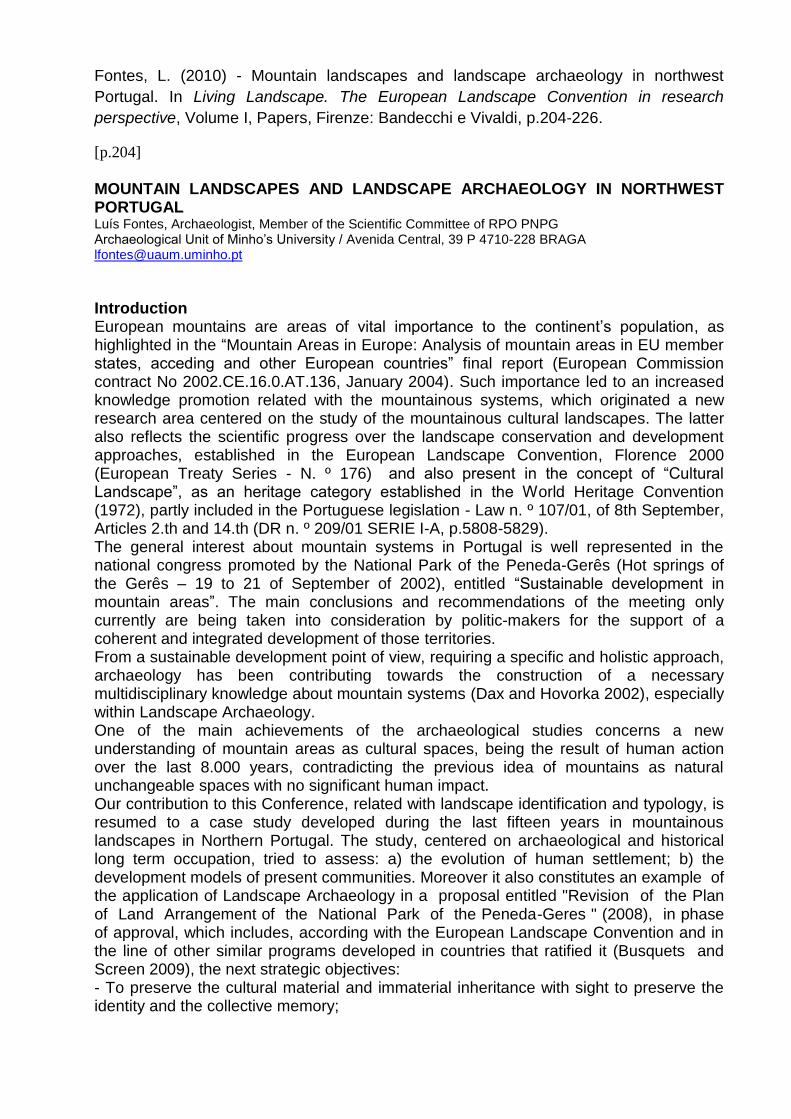
Figure I - Geographic and administrative location of the PNPG: (RPO PNPG).
The PNPG is located in Northern Portugal within a transition area between the Minho and Trás-os-Montes regions. It is included in NUT II – North, being confined by 8º 25' and 7º 53' W meridians and by 41º 41' and 42º 05' N parallels. In 2001 it possessed an area of 69.596 Ha, with a resident population of 11.046 inhabitants distributed around 22 parishes of 5 municipalities: Castro Laboreiro and Lamas de Mouro (municipality of Melgaço), Cabana Maior, Cabreiro, Gavieira, Gondoriz and Soajo (municipality of Arcos de Valdevez), Britelo, Entre-Ambos-os-Rios, Ermida, Germil and Lindoso (municipality of Ponte da Barca), Campo do Gerês, Covide, Rio Caldo and Vilar da Veiga (municipality of Terras de Bouro) and Cabril, Covelães, Outeiro, Pitões das Júnias, Sezelhe and Tourém (municipality of Montalegre).
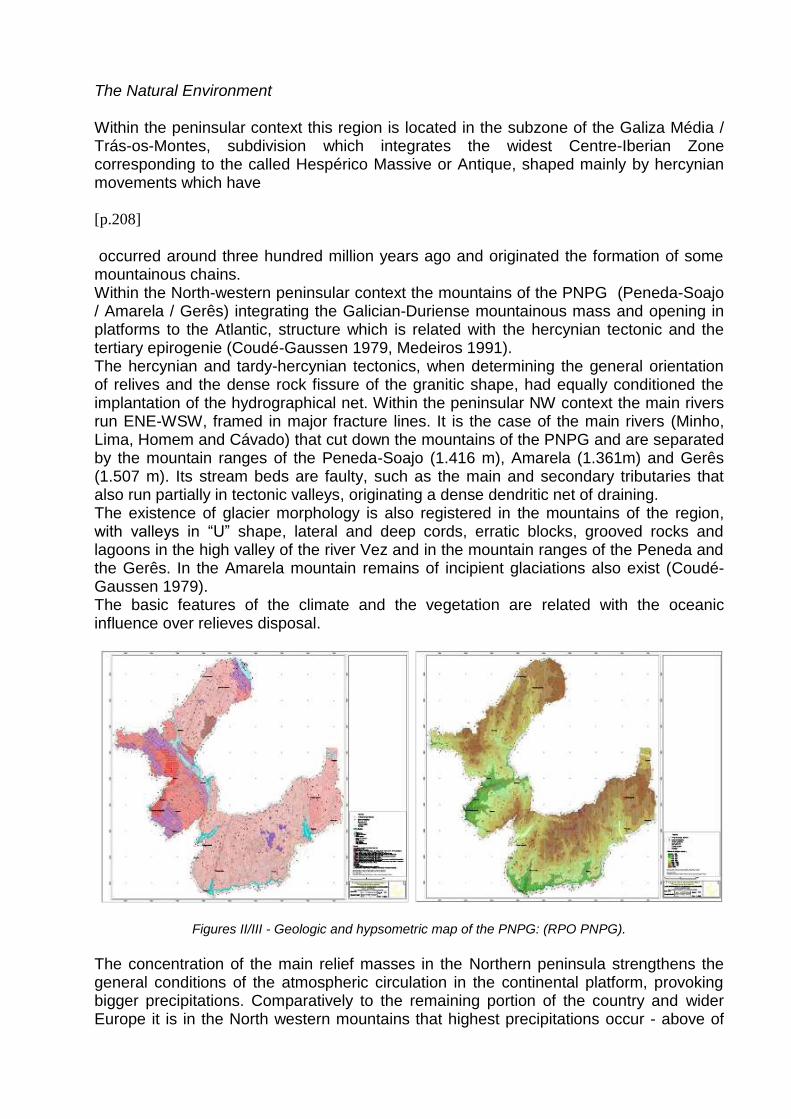
The Natural Environment Within the peninsular context this region is located in the subzone of the Galiza Média / Trás-os-Montes, subdivision which integrates the widest Centre-Iberian Zone corresponding to the called Hespérico Massive or Antique, shaped mainly by hercynian movements which have
[p.208]
occurred around three hundred million years ago and originated the formation of some mountainous chains. Within the North-western peninsular context the mountains of the PNPG (Peneda-Soajo / Amarela / Gerês) integrating the Galician-Duriense mountainous mass and opening in platforms to the Atlantic, structure which is related with the hercynian tectonic and the tertiary epirogenie (Coudé-Gaussen 1979, Medeiros 1991). The hercynian and tardy-hercynian tectonics, when determining the general orientation of relives and the dense rock fissure of the granitic shape, had equally conditioned the implantation of the hydrographical net. Within the peninsular NW context the main rivers run ENE-WSW, framed in major fracture lines. It is the case of the main rivers (Minho, Lima, Homem and Cávado) that cut down the mountains of the PNPG and are separated by the mountain ranges of the Peneda-Soajo (1.416 m), Amarela (1.361m) and Gerês (1.507 m). Its stream beds are faulty, such as the main and secondary tributaries that also run partially in tectonic valleys, originating a dense dendritic net of draining. The existence of glacier morphology is also registered in the mountains of the region, with valleys in “U” shape, lateral and deep cords, erratic blocks, grooved rocks and lagoons in the high valley of the river Vez and in the mountain ranges of the Peneda and the Gerês. In the Amarela mountain remains of incipient glaciations also exist (Coudé-Gaussen 1979). The basic features of the climate and the vegetation are related with the oceanic influence over relieves disposal.
Figures II/III - Geologic and hypsometric map of the PNPG: (RPO PNPG).
The concentration of the main relief masses in the Northern peninsula strengthens the general conditions of the atmospheric circulation in the continental platform, provoking bigger precipitations. Comparatively to the remaining portion of the country and wider Europe it is in the North western mountains that highest precipitations occur - above of
3,000 mm in Gerês, raining in the North is always more than 100 days per year (Medeiros 1991, Brito 1994, Ribeiro, Laustensach and Daveau 1994). Within the context of climatic type’s variability in the Iberian Peninsula resulting from those three main factors the Portuguese Northwest is generally integrated in the Atlantic influence group with a differentiated climate in its mountains. In fact, between the main climatic types (Maritime and Continental), the mountainous bulks “are marked by strong climatic dissymmetry” (Ribeiro, Laustensach and Daveau 1994), with variations in the levelled tops, deep valleys, slopes and foots, with a climate aggravation above 700 or 800 meters. With long winters, which are cold
[p.209]
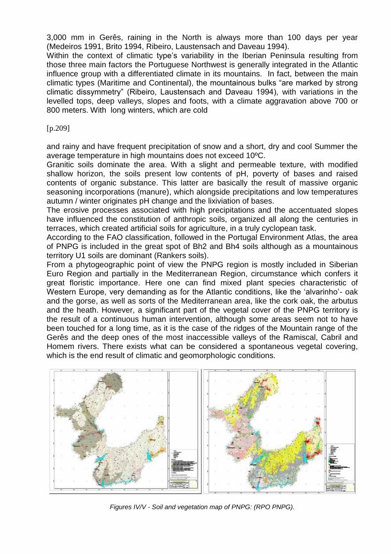
and rainy and have frequent precipitation of snow and a short, dry and cool Summer the average temperature in high mountains does not exceed 10ºC. Granitic soils dominate the area. With a slight and permeable texture, with modified shallow horizon, the soils present low contents of pH, poverty of bases and raised contents of organic substance. This latter are basically the result of massive organic seasoning incorporations (manure), which alongside precipitations and low temperatures autumn / winter originates pH change and the lixiviation of bases. The erosive processes associated with high precipitations and the accentuated slopes have influenced the constitution of anthropic soils, organized all along the centuries in terraces, which created artificial soils for agriculture, in a truly cyclopean task. According to the FAO classification, followed in the Portugal Environment Atlas, the area of PNPG is included in the great spot of Bh2 and Bh4 soils although as a mountainous territory U1 soils are dominant (Rankers soils). From a phytogeographic point of view the PNPG region is mostly included in Siberian Euro Region and partially in the Mediterranean Region, circumstance which confers it great floristic importance. Here one can find mixed plant species characteristic of Western Europe, very demanding as for the Atlantic conditions, like the ‘alvarinho’- oak and the gorse, as well as sorts of the Mediterranean area, like the cork oak, the arbutus and the heath. However, a significant part of the vegetal cover of the PNPG territory is the result of a continuous human intervention, although some areas seem not to have been touched for a long time, as it is the case of the ridges of the Mountain range of the Gerês and the deep ones of the most inaccessible valleys of the Ramiscal, Cabril and Homem rivers. There exists what can be considered a spontaneous vegetal covering, which is the end result of climatic and geomorphologic conditions.
Figures IV/V - Soil and vegetation map of PNPG: (RPO PNPG).
With great floristic affinity with the associations Myrtilleto-Quercetum broteroanae (characteristic group of the climax vegetation of Gerês mountain) and with the association Myrtilleto-Quercetum Roboris (climax oak-grove of intermediate zones), these bushes are oak-grove dominated by the ‘alvarinho’-oak (Quercus robur L.), being well represented many species that characterize the related associations, as the cranberry or grape-of-the-mount (Vaccinium myrtillus L.), the arbutus (Arbutus unedo L.), the holly (Ilex aquifolium L.) and the Eryngium duriaei former Gay Bss, being the latter an endangerous Iberian endemism (RPO PNPG 2008). The Rusceto-Quercetum roboris association featuring in lower altitudes and slopes of bigger sunstroke is also present with representations of cork oak (Quercus suber L.) and butcher’s broom
[p.210]
(Ruscus aculeatus L.). Not so frequent are the ‘padreiro’ (Acer pseudoplatanus L.), the birch (Birch pubescens), the hazel (Avellana Corylus L.), the chestnut (Sativa Castanea) and the ‘azereiro’ or Portuguese laurel (Lusitanica Prunus L. ssp. lusitanica), being the latter a relic of the Tertiary period. In the highest areas, with more extensive rocky outcrops and more windy, the dry brushwood is dominant, namely the shrub (Chamaespartium tridentatum L.) and the genista-of-the-brooms (Cytisus scoparius L.). There still occurs the grass-divine (Armeria humilis L. ssp. humilis), a rare peninsular endemism (RPO PNPG 2008). The convergence of geologic, climatic and geomorphologic factors, in which stands the granitic soils origin, the abundance of water and the multiplicity of slopes and platforms, resulted in a natural vegetal covering where Atlantic associations are dominant, with some inclusions of Mediterranean or transition species. However, most authors recognize that the current landscape of the PNPG in its extraordinary diversity, where the valley/mountain opposition stands out, is basically a product of a continuous human action with a strong reduction of the “bio geographic inheritance” (Coudé-Gaussen 1979).
The Palaeoenvironment Within a long term approach, as the one we intend to have for the PNPG area, it is important to know both current physical and environmental characteristics but also the past ones related with the human communities who inhabited the territory since Recent Pre-History. However, this study did not deal with primary data collection. Besides the limitations of working with secondary information we understand to be more reasonably to present a generalist approach based on data carried through previous studies in the PNPG and neighbouring areas, which have provided already some conclusions on the issue (Ruiz Zapata et al 1993, Ramil Rêgo et al 1996, Oliveira 2000, Carrión Marco 2005, Juliá et al 2007). After the definitive retreat of the polar front to the coasts of the Greenland, between 10.000-9.000 BP, was established the beginning of the geologic period known as Holocene, climatically correspondent to the end of the Tardy Glacial period and the beginning of the current Inter Glacial, being possible to distinguish three great periods according with climatic criteria: a) Anathermic Phase, between 10.000-6.000 BP, with gradual increase of the temperature and the moistness; b) Optimum Climatic, between 6.000-3.000 BP, with tepid and wet climate; c) since 3.000 BP the Catathermic Phase with manifestation of cold and tempered periods as a signal of general cooling. Significant changes in vegetation are registered and it is possible to identify in this region a precocious arboreal settling with dominance of Quercus and lesser expression of Pinus, Betula, Quercus ilex and some Corylus, having the former reached the optimum
around 7.500 BP. Within the soils point of view we can understand that the gradual oak grove overspread until it reached its optimum, originating the existence of biostatic conditions and therefore an intense pedological activity. The last stage of the Anathermic Phase, between 8.000-6.000 BP, was characterized by the hegemony of the forest extending towards valleys and hillsides in dense formations. In the hilltops, already free of perpetual snows for a long time, shrub and herbaceous formations have developed. In the PNPG area the previously latent heterogeneity stands out distinguishing itself in three basic forest units: at the biggest altitude boreal formations dominates, with Pinus sylvestris e Betula alba, marking the altitude limit of the forest; below the main woody masses have developed with predominance of trees of lapsed leaf - Quercus, Alnus, Castanea, etc.; in periphery zones, or in small spots inside the previous woods, are present the thermophile trees of permanent leafs - Quercus tp. ilex, Olea e Arbutus. In the Optimum Climatic phase, between 6.000-3.000 BP, the climatic conditions remained favourable for the conservation of the forest being predominant the lapsed leaf trees like Quercus. Precisely in this period discontinuous erosive processes and deforestation episodes have started, being enhanced with the appearance and spread of cereal agriculture and with the expansion
[p.211]
of herbaceous and shrub. Most scholars recognize in those processes an anthropic nature and associate them with the increment of human environmental exploitation and with the diffusion of the cultural “megalithic phenomena”. The impact of the agro-pastoral activity, clear from 3.500 BP, might have been different in time and space according with the greater or minor population pressure. The consequences of this process produced the reduction of the arboreal mass (with changes on composition and distribution of vegetal communities), the development of the shrub and herbaceous spots and the increase of synanthropic taxa and the appearance of crops.
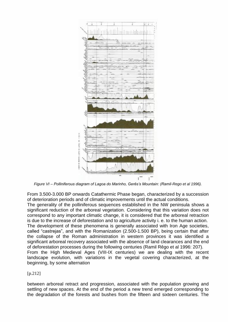
Figure VI – Polliniferous diagram of Lagoa do Marinho, Gerês’s Mountain: (Ramil-Rego et al 1996).
From 3.500-3.000 BP onwards Catathermic Phase began, characterized by a succession of deterioration periods and of climatic improvements until the actual conditions. The generality of the polliniferous sequences established in the NW peninsula shows a significant reduction of the arboreal vegetation. Considering that this variation does not correspond to any important climatic change, it is considered that the arboreal retraction is due to the increase of deforestation and to agriculture activity i. e. to the human action. The development of these phenomena is generally associated with Iron Age societies, called “castrejas”, and with the Romanization (2.500-1.500 BP), being certain that after the collapse of the Roman administration in western provinces it was identified a significant arboreal recovery associated with the absence of land clearances and the end of deforestation processes during the following centuries (Ramil Rêgo et al 1996: 207). From the High Medieval Ages (VIII-IX centuries) we are dealing with the recent landscape evolution, with variations in the vegetal covering characterized, at the beginning, by some alternation
[p.212]
between arboreal retract and progression, associated with the population growing and settling of new spaces. At the end of the period a new trend emerged corresponding to the degradation of the forests and bushes from the fifteen and sixteen centuries. The
established polliniferous diagrams for the mountain ranges next to the Peneda, Gerês and Cabreira seem to confirm this evolution of vegetal covering (Ruiz Zapata et al 1993). The period between the eleven and the thirteen centuries correspond to an effective penetration and communities setting in the mountain ranges of the region, associated with the diffusion of new woody tillage, as the olive, the chestnut and the grapevine (Ramil Rêgo et al 1996). The eighteen and nineteen centuries correspond, simultaneously, to the expansion of cultivated areas with the diffusion of the maize culture, with massive destruction of forests, to feed florescent iron and steel industries (vegetal coal for the castings and domestic consumption in the cities) and also to the necessity to implement an arboreal recovery. This politics of forestation has been delineated then, shyly in the nineteen century and more decidedly in the last quarter of the twenty century, dominated by pine plantations (Pinus pinaster) (Medeiros 1991). The resource to the forest fires and the intensive pasturing favoured the degradation of the ground, not making possible the development of complete pedologic processes and creating an environment of bigger dryness that favoured the development of shrub. In the middle of the last century the traditional land exploration system entered in crisis, due to emigration of young people and to the aging of the rural population. At the same time attempts to apply reforestation plans were implemented. The human occupation in PNPG
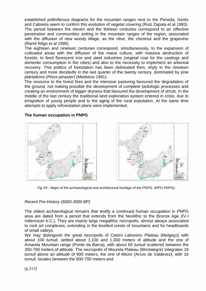
Fig VII - Maps of the archaeological and architectural heritage of the PNPG: (RPO PNPG).
Recent Pre-History (6000-3000 BP)
The oldest archaeological remains that testify a continued human occupation in PNPG area are dated from a period that extends from the Neolithic to the Bronze Age (IV-I millennium b.C.). They are mainly large megalithic necropolis, almost always associated to rock art complexes, extending in the levelled crests of mountains and for headboards of small valleys. We may distinguish the great necropolis of Castro Laboreiro Plateau (Melgaço) with about 100 tumuli, settled about 1,100 and 1,300 meters of altitude and the one of Amarela Mountain range (Ponte da Barca), with about 60 tumuli scattered between the 350-700 meters of altitude. The necropolis of Mourela Plateau (Montalegre) integrates 19 tumuli above an altitude of 900 meters, the one of Mezio (Arcos de Valdevez), with 16 tumuli, locates between the 600-700 meters and
[p.213]
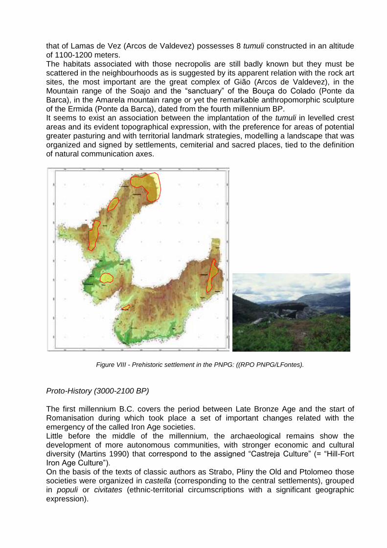
that of Lamas de Vez (Arcos de Valdevez) possesses 8 tumuli constructed in an altitude of 1100-1200 meters. The habitats associated with those necropolis are still badly known but they must be scattered in the neighbourhoods as is suggested by its apparent relation with the rock art sites, the most important are the great complex of Gião (Arcos de Valdevez), in the Mountain range of the Soajo and the “sanctuary” of the Bouça do Colado (Ponte da Barca), in the Amarela mountain range or yet the remarkable anthropomorphic sculpture of the Ermida (Ponte da Barca), dated from the fourth millennium BP. It seems to exist an association between the implantation of the tumuli in levelled crest areas and its evident topographical expression, with the preference for areas of potential greater pasturing and with territorial landmark strategies, modelling a landscape that was organized and signed by settlements, cemiterial and sacred places, tied to the definition of natural communication axes.
Figure VIII - Prehistoric settlement in the PNPG: ((RPO PNPG/LFontes). Proto-History (3000-2100 BP) The first millennium B.C. covers the period between Late Bronze Age and the start of Romanisation during which took place a set of important changes related with the emergency of the called Iron Age societies. Little before the middle of the millennium, the archaeological remains show the development of more autonomous communities, with stronger economic and cultural diversity (Martins 1990) that correspond to the assigned “Castreja Culture” (= “Hill-Fort Iron Age Culture”). On the basis of the texts of classic authors as Strabo, Pliny the Old and Ptolomeo those societies were organized in castella (corresponding to the central settlements), grouped in populi or civitates (ethnic-territorial circumscriptions with a significant geographic expression).
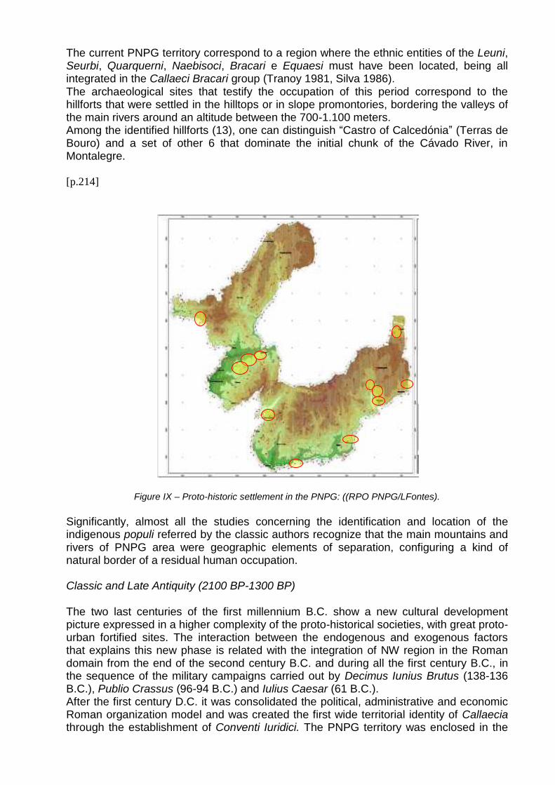
The current PNPG territory correspond to a region where the ethnic entities of the Leuni, Seurbi, Quarquerni, Naebisoci, Bracari e Equaesi must have been located, being all integrated in the Callaeci Bracari group (Tranoy 1981, Silva 1986). The archaeological sites that testify the occupation of this period correspond to the hillforts that were settled in the hilltops or in slope promontories, bordering the valleys of the main rivers around an altitude between the 700-1.100 meters. Among the identified hillforts (13), one can distinguish “Castro of Calcedónia” (Terras de Bouro) and a set of other 6 that dominate the initial chunk of the Cávado River, in Montalegre. [p.214]
Figure IX – Proto-historic settlement in the PNPG: ((RPO PNPG/LFontes).
Significantly, almost all the studies concerning the identification and location of the indigenous populi referred by the classic authors recognize that the main mountains and rivers of PNPG area were geographic elements of separation, configuring a kind of natural border of a residual human occupation. Classic and Late Antiquity (2100 BP-1300 BP)
The two last centuries of the first millennium B.C. show a new cultural development picture expressed in a higher complexity of the proto-historical societies, with great proto-urban fortified sites. The interaction between the endogenous and exogenous factors that explains this new phase is related with the integration of NW region in the Roman domain from the end of the second century B.C. and during all the first century B.C., in the sequence of the military campaigns carried out by Decimus Iunius Brutus (138-136 B.C.), Publio Crassus (96-94 B.C.) and Iulius Caesar (61 B.C.). After the first century D.C. it was consolidated the political, administrative and economic Roman organization model and was created the first wide territorial identity of Callaecia through the establishment of Conventi Iuridici. The PNPG territory was enclosed in the
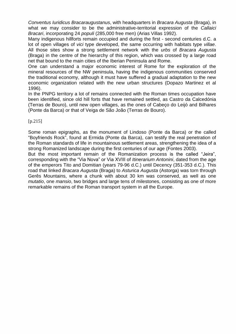
Conventus Iuridicus Bracaraugustanus, with headquarters in Bracara Augusta (Braga), in what we may consider to be the administrative-territorial expression of the Callaici Bracari, incorporating 24 populi (285,000 free men) (Arias Villas 1992). Many indigenous hillforts remain occupied and during the first - second centuries d.C. a lot of open villages of vici type developed, the same occurring with habitats type villae. All those sites show a strong settlement network with the urbs of Bracara Augusta (Braga) in the centre of the hierarchy of this region, which was crossed by a large road net that bound to the main cities of the Iberian Peninsula and Rome. One can understand a major economic interest of Rome for the exploration of the mineral resources of the NW peninsula, having the indigenous communities conserved the traditional economy, although it must have suffered a gradual adaptation to the new economic organization related with the new urban structures (Dopazo Martinez et al 1996). In the PNPG territory a lot of remains connected with the Roman times occupation have been identified, since old hill forts that have remained settled, as Castro da Calcedónia (Terras de Bouro), until new open villages, as the ones of Cabeço do Leijó and Bilhares (Ponte da Barca) or that of Veiga de São João (Terras de Bouro).
[p.215]
Some roman epigraphs, as the monument of Lindoso (Ponte da Barca) or the called “Boyfriends Rock”, found at Ermida (Ponte da Barca), can testify the real penetration of the Roman standards of life in mountainous settlement areas, strengthening the idea of a strong Romanized landscape during the first centuries of our age (Fontes 2003). But the most important remain of the Romanization process is the called “Jeira”, corresponding with the “Via Nova” or Via XVIII of Itinerarium Antonini, dated from the age of the emperors Tito and Domitian (years 79-96 d.C.) until Decency (351-353 d.C.). This road that linked Bracara Augusta (Braga) to Asturica Augusta (Astorga) was torn through Gerês Mountains, where a chunk with about 30 km was conserved, as well as one mutatio, one mansio, two bridges and large tens of milestones, consisting as one of more remarkable remains of the Roman transport system in all the Europe.
Figure X - Roman settlement in the PNPG: ((RPO PNPG/LFontes). Above the 750 meters of altitude no archaeological evidences connected with Roman occupation has been identified. All the archaeological sites of the period are settled below the 725 meters, distributing themselves for the flowing decreases of the mountain ranges, predominantly between the 450 and 650 meters of altitude. The spaces thus bordered would satisfy all the necessities of the agriculture / forestry / pastoral economic model, which would have supported the survival of the communities. The absence of archaeological remains in the high slopes of the mountains seems to be both understandable and justified. However, hunting, extensive pasturing and forest exploration were widely practised by the Galician-Roman communities, representing important complementary activities of the economic system. It is also admitted that extensive pasturing and forest exploration could have been more or less consolidated as main economic activities depending on the specific economic contexts (Arias Villas 1992). References to the hunting and the pasturing in the highlands of the Bierzo (Astorga) are well known, registered about 670-680 D.C. (Diaz y Diaz 1974). Although we cannot simply use those references for the previous centuries research is coming to show extensive pasturing in the Iberian Peninsula since the Roman times (Gómez Pantoja 1993). In the PNPG area this economic specialization would explain the existence of settlements like Torre Grande and Bilhares (Ponte da Barca) and the one of Castelo (Melgaço). Therefore, the mountain space would have been affected by hunting activities, extensive pasturing and forest exploration. One could consider that the large settlement distribution must have supported all these activities with major economic and social importance than the one of simple complementary activity. We admit also that it was the forest exploration to justify the opening of Via XVIII and not the traditional considered importance of mineral resources that are scarce in the region.
[p.216]
Medieval Age (1300-500 BP)
The transition of the millennium was in the Europe a time of deep transformations, basically characterized by the introduction of new techniques, nationalisms affirmation, a significant demographic growth and a generalized prosperity. In the peninsular Northwest the main trends were similar, although the “Christian Reconquest” and the affirmation of Portugal as a sovereign Kingdom have created different development rhythms and intensities. Between the disaggregation of the Visighotic power and the Leon-Asturian reorganization the Southern Galicia and Northern Portugal have represented a kind of “no men land”, emerging in the twelve-thirteen centuries as a border zone, justifying a particular attention of the Portuguese monarchs D. Alfonso III (1248-1279) and D. Dinis (1279-1325) that have consolidated the territorial division between the Portuguese and Castilian kingdoms, strengthening the bordering line (Fontes and Regalo 1997). Symptomatically, the rough mountainous of the PNPG territory was affirmed as a natural limit in the definition of the border with the Galiza. At the end of eleven century it is yet identified a perfectly structured settlement around the parishes (Costa 1997). With the intensification of the settlement in the central centuries of the Middle Age the territorial structures were fixed, hierarchical organized around churches, monasteries and castles, consolidating ancient roads or giving origin to new nets of ways (Fontes 2005). The same happened in the PNPG territory where almost all the current villages were already referred in the thirteen century documentation. Some of them, already disappeared, are archaeologically registered, as the village of the Pombas (Arcos de Valdevez), the Old Village of the Juríz (Montalegre), or the village of the Chelo (Terras de Bouro). Among the monasteries we can distinguish Fiães (Melgaço), Ermelo (Arcos de Valdevez) and Pitões das Júnias (Montalegre), all of them testifying the early process of appropriation of the mountain border spaces. Nevertheless, it was with the castles of Melgaço, Castro Laboreiro (Melgaço), Lindoso (Ponte da Barca) and Bouro (Terras de Bouro) that the border line was consolidated. In this period a dense road net was developed joining villages, monasteries and castles, which is archaeologically materialized in extensive paved chunks and in several bridges that allowed crossing the multiple water lines that cut the relief of the region. Between the most important examples we must refer the Bridge of Dorna (Melgaço), the Bridge of Ladeira (Arcos de Valdevez), the Old Bridge of Parada (Ponte da Barca) or the Bridge of Misarela (Montalegre), remarkable for its landscape insertion.
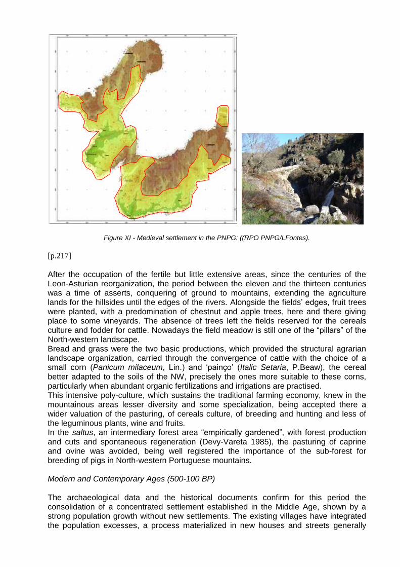
Figure XI - Medieval settlement in the PNPG: ((RPO PNPG/LFontes). [p.217]
After the occupation of the fertile but little extensive areas, since the centuries of the Leon-Asturian reorganization, the period between the eleven and the thirteen centuries was a time of asserts, conquering of ground to mountains, extending the agriculture lands for the hillsides until the edges of the rivers. Alongside the fields’ edges, fruit trees were planted, with a predomination of chestnut and apple trees, here and there giving place to some vineyards. The absence of trees left the fields reserved for the cereals culture and fodder for cattle. Nowadays the field meadow is still one of the “pillars” of the North-western landscape. Bread and grass were the two basic productions, which provided the structural agrarian landscape organization, carried through the convergence of cattle with the choice of a small corn (Panicum milaceum, Lin.) and ‘painço’ (Italic Setaria, P.Beaw), the cereal better adapted to the soils of the NW, precisely the ones more suitable to these corns, particularly when abundant organic fertilizations and irrigations are practised. This intensive poly-culture, which sustains the traditional farming economy, knew in the mountainous areas lesser diversity and some specialization, being accepted there a wider valuation of the pasturing, of cereals culture, of breeding and hunting and less of the leguminous plants, wine and fruits. In the saltus, an intermediary forest area “empirically gardened”, with forest production and cuts and spontaneous regeneration (Devy-Vareta 1985), the pasturing of caprine and ovine was avoided, being well registered the importance of the sub-forest for breeding of pigs in North-western Portuguese mountains. Modern and Contemporary Ages (500-100 BP) The archaeological data and the historical documents confirm for this period the consolidation of a concentrated settlement established in the Middle Age, shown by a strong population growth without new settlements. The existing villages have integrated the population excesses, a process materialized in new houses and streets generally
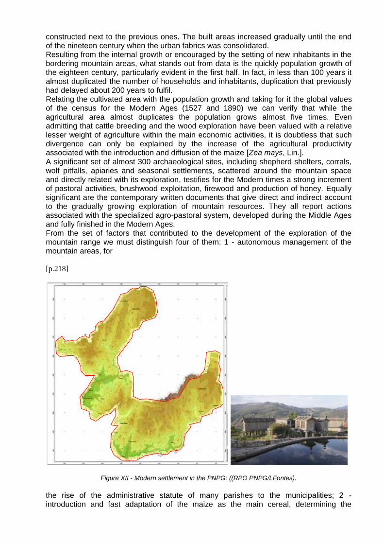
constructed next to the previous ones. The built areas increased gradually until the end of the nineteen century when the urban fabrics was consolidated. Resulting from the internal growth or encouraged by the setting of new inhabitants in the bordering mountain areas, what stands out from data is the quickly population growth of the eighteen century, particularly evident in the first half. In fact, in less than 100 years it almost duplicated the number of households and inhabitants, duplication that previously had delayed about 200 years to fulfil. Relating the cultivated area with the population growth and taking for it the global values of the census for the Modern Ages (1527 and 1890) we can verify that while the agricultural area almost duplicates the population grows almost five times. Even admitting that cattle breeding and the wood exploration have been valued with a relative lesser weight of agriculture within the main economic activities, it is doubtless that such divergence can only be explained by the increase of the agricultural productivity associated with the introduction and diffusion of the maize [Zea mays, Lin.]. A significant set of almost 300 archaeological sites, including shepherd shelters, corrals, wolf pitfalls, apiaries and seasonal settlements, scattered around the mountain space and directly related with its exploration, testifies for the Modern times a strong increment of pastoral activities, brushwood exploitation, firewood and production of honey. Equally significant are the contemporary written documents that give direct and indirect account to the gradually growing exploration of mountain resources. They all report actions associated with the specialized agro-pastoral system, developed during the Middle Ages and fully finished in the Modern Ages. From the set of factors that contributed to the development of the exploration of the mountain range we must distinguish four of them: 1 - autonomous management of the mountain areas, for [p.218]
Figure XII - Modern settlement in the PNPG: ((RPO PNPG/LFontes).
the rise of the administrative statute of many parishes to the municipalities; 2 - introduction and fast adaptation of the maize as the main cereal, determining the
intensification of the exploration of the area of saltus for manure production; 3 - charcoal (over all of heath) and wooden cuts for the naval industry and stakes for the vines, the last ones more intensely in the eighteen century; 4 - intensification of the bovine cattle trade, developed along the eighteen century with the proliferation of biweekly and monthly markets for all the region. Much of the cattle that fed this commerce was created in the highest part of the mountain ranges, transformed then into vast steppes deforested, covered by thousand of cattle heads. The cattle greeting reached a great dimension that can be easily understandable in the PNPG Mountains in this period by the extraordinary number of 35 seasonal pastoral settlements and 109 sheppard huts identified. In the mountain ranges of Peneda and Soajo a transhumance system was established, originating a model of peculiar settlement, formed with “brandas” and “inverneiras”, respectively, altitude summer villages and valley winter ones. To prevent the ascent of the cattle in the mountain pitfalls for wolves capture were constructed being registered in the PNPG area 16 of these hunting traps. Following this growth new houses were erected and older ones have been increased, temples were rebuilt and rock granaries have been constructed using the generous resource of the nature formed by the granitic rock. Everything is constructed with this material: the shrines that margin the flagstone paved ways; the pontoons that cross the streams; the roofs; the mills; the pillars that support the balconies. But the preferential use of the granitic rock and the major control over the art of working it know it’s bigger expression, from an architectural and artistic point of view, in the stone granaries, being remarkable those of Soajo (Arcos de Valdevez), Parada and Lindoso (Ponte da Barca). Present (2008)
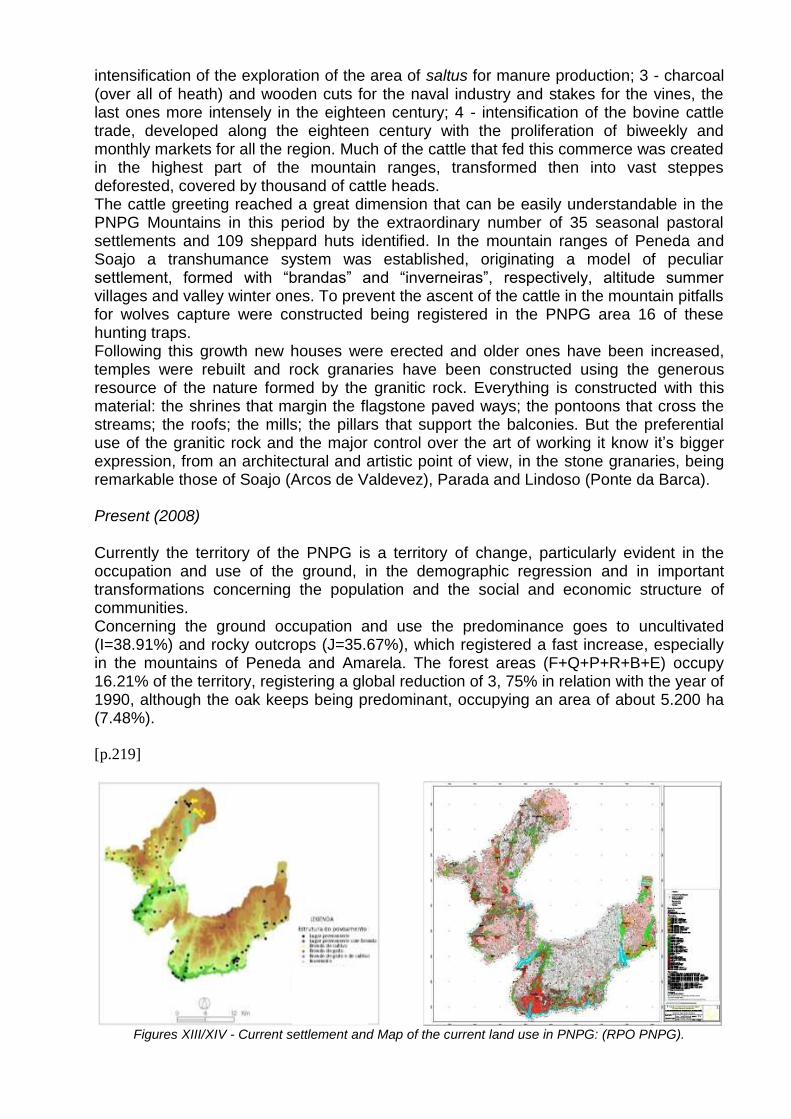
Currently the territory of the PNPG is a territory of change, particularly evident in the occupation and use of the ground, in the demographic regression and in important transformations concerning the population and the social and economic structure of communities. Concerning the ground occupation and use the predominance goes to uncultivated (I=38.91%) and rocky outcrops (J=35.67%), which registered a fast increase, especially in the mountains of Peneda and Amarela. The forest areas (F+Q+P+R+B+E) occupy 16.21% of the territory, registering a global reduction of 3, 75% in relation with the year of 1990, although the oak keeps being predominant, occupying an area of about 5.200 ha (7.48%).
[p.219]
Figures XIII/XIV - Current settlement and Map of the current land use in PNPG: (RPO PNPG).
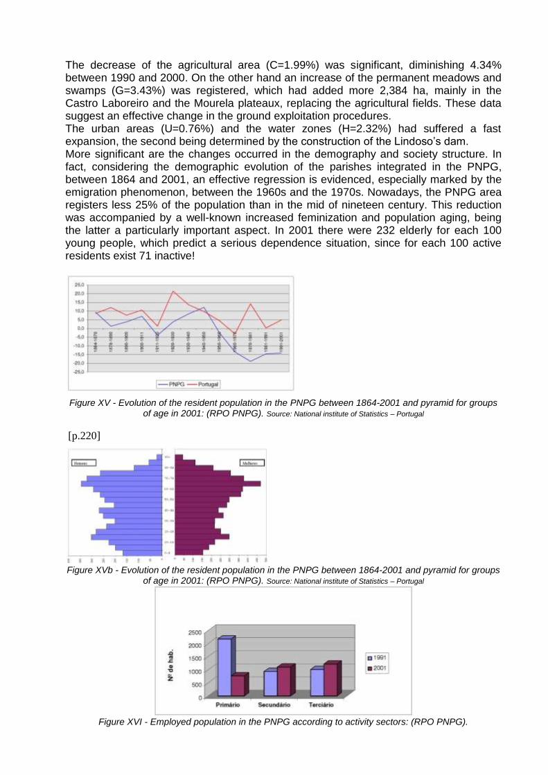
The decrease of the agricultural area (C=1.99%) was significant, diminishing 4.34% between 1990 and 2000. On the other hand an increase of the permanent meadows and swamps (G=3.43%) was registered, which had added more 2,384 ha, mainly in the Castro Laboreiro and the Mourela plateaux, replacing the agricultural fields. These data suggest an effective change in the ground exploitation procedures. The urban areas (U=0.76%) and the water zones (H=2.32%) had suffered a fast expansion, the second being determined by the construction of the Lindoso’s dam. More significant are the changes occurred in the demography and society structure. In fact, considering the demographic evolution of the parishes integrated in the PNPG, between 1864 and 2001, an effective regression is evidenced, especially marked by the emigration phenomenon, between the 1960s and the 1970s. Nowadays, the PNPG area registers less 25% of the population than in the mid of nineteen century. This reduction was accompanied by a well-known increased feminization and population aging, being the latter a particularly important aspect. In 2001 there were 232 elderly for each 100 young people, which predict a serious dependence situation, since for each 100 active residents exist 71 inactive!
Figure XV - Evolution of the resident population in the PNPG between 1864-2001 and pyramid for groups of age in 2001: (RPO PNPG). Source: National institute of Statistics – Portugal
[p.220]
Figure XVb - Evolution of the resident population in the PNPG between 1864-2001 and pyramid for groups of age in 2001: (RPO PNPG). Source: National institute of Statistics – Portugal
Figure XVI - Employed population in the PNPG according to activity sectors: (RPO PNPG).
Source: National institute of Statistics – Portugal
Equally significant and perhaps more important are the changes registered in the social and economic structure of the communities of the PNPG. The primary sector, previously dominant in all the area, is currently residual, characterizing itself still by agricultural or familiar production that subsisted in association with other incoming sources, basically financed by subsidies from governmental programs. Regarding the secondary sector, from which the resident active population starts to be dependent, the industry associated with the animal production, mainly the preparation and conservation of meat, as the traditional “fumier”, is the activity currently offering greater economic yield, being the majority of the workmanship associated with this sector absorbed by the building construction. But the biggest employer today is the tertiary sector, dominating the activities related with the tourism: accommodation, restoration, little commerce and other services. In fact, the development of the lodging capacity and the offer of leisure and recreation activities, as well as the infrastructures of visitation, particularly related with conservation, valuation and spreading of the PNPG cultural and natural heritage (interpretation and education centres, museums, belvederes and picnic areas), are due to the tourism in its several types, natural, thermal, religious and cultural. Between the main existing structures of visitation, are distinguished the Barroso’s Eco Museum, the Pitfall Wolf in Fafião, the Monastery of Saint Mary of Júnias, the Ethnographic Museum of Vilarinho of the Furnas, the Lindoso’s Castle, the Megalithic Nucleus of Plateau of Castro Laboreiro and the centres of interpretation and education of Lamas de Mouro, Covide and Vidoeiro, that [p.221]
represent true “doors” of access to the PNPG, where the visitors can collect information and orientation for their visits to its territory.
Figure XVII - Movement of visitors in the ranks of tourism of the PNPG municipalities: (RPO PNPG).
Conclusions
The archaeological sites contextualized inventory constitutes a first contribution towards the knowledge of the long term occupation of the PNPG territory, thus performing the main objective of our work. The registration procedures and the variability of scale of analysis turned out to be appropriate to the qualitative and quantitative diversity of the data, expressing well the
different human activities performed in the environment, as well as the social and administrative organization of the space. The chronological-cultural distribution of the archaeological sites is different, determining an equally different knowledge of the different historical periods. Comparatively, the recent past could have been better known than the distant past. In a similar way, some social and economic aspects, even in periods with reduced data, could be better analyzed than others. In the Recent Pre-History (6.000 / 3.000 BP) the territory of the PNPG got to know the beginning of the human occupation, with preferential installation areas to be the high lands, according with a model of economic exploration sets in the pasturing and itinerant agriculture. Between 3.000 / 2.100 BP (Proto-History) the settlement structure clearly shifts with the abandonment of the upper crests and a gradual approach of the open valleys happened. The human communities become sedentary installing themselves in permanent settlement, developing an agro-forest-pastoral economic base. Under these circumstances, the PNPG mountainous area is left out by the anthropic pressure strong impact over the environment, which is believed to have occurred in this NW peninsular period. This phenomenon is globally characterized by a significant trees retraction prompted by deforestation and agricultural land crops (Ramil Rêgo 1993). We can state that in the PNPG territory, right before the Romanization era, a recovery of the Quercus forest took place leading to a predominantly forest landscape. A second settlement structure change occurs in the Classic and Later Antiquity (2.100 / 1300 BP), corroborated by the foundation of new settlements in the Roman times. We believe that [p.222]
the settlement expansion of the period reached deeply the mountain spaces. Consequently, one must recognize that this new and widened settlement in the PNPG, which accompanied the Romanization process, gave origin to changes in the landscape, as those identified in other areas. The most significant change within this new settlement dynamic is the one related with the vegetal covering alteration. Therefore, we believe that in this period, here in the PNPG area as in all the peninsular Northwest, the impact of the human action over the environment prompted a significant arboreal regression (Ramil Rêgo 1993, Ramil Rêgo et al 1996). In the medieval times (1.300 / 500 BP) the mountainous of the PNPG area knows a third configuration with a new settlement structure, with an increase in settlements and the fixation of a border between Portugal and Galiza. The mountain territory exploitation set upon a specialized agriculture / forestry / pastoral system, adapted to the different ecological mountain conditions, with abundance of mounts´ spaces and diversified vegetal covering with pasture and woods (Guitián Rivera 1993). Within the relation people / environment, “the natural” environment seems to be predominant until the tenth and eleventh centuries, period from which a widening of the agricultural area begins, conquered to the saltus, and associated with an increase in woods exploitation and a significant forest regression (Ramil Rego 1993). The demographic growth and the settlement organization have stabilized throughout the twelve century, and were sustained by an agro-forest-pastoral system, which reaches the maximum complexity and keeps a good ecological balance. From the thirteen century onwards there is a rupture in this balance, particularly within the forest domain. However, in the PNPG Mountains wide forest areas were preserved, even though some polliniferous registers the contrary in the eastern slopes of the Gerês mountain range or in the high valley of the river Vez (Ramil Rêgo 1993, Ruiz Zapata et al 1993). As stated by Nicole Devy-Vareta “(...) the border forest position, the difficulties in
access and the royal parks protected the area from the economic pressure of the low regions, being more integrated within the systems of local forest-pastoral exploration. (...) “(1985: 51). The structure of the medieval settlement was consolidated in the course of the Modern and Contemporary Ages (500-100 BP), when both a significant population increase and an agro-pastoral important growth were registered, with fragmentation and dispersal of the properties. However, those tendencies were perfectly compatible with the reach of good agricultural productivity, in contrast with what was believed for a long time. Today, finally, we start to understand, accept and recognize this to be the best ecological option for intensive agricultural in mountain zones (Bentley 1997).
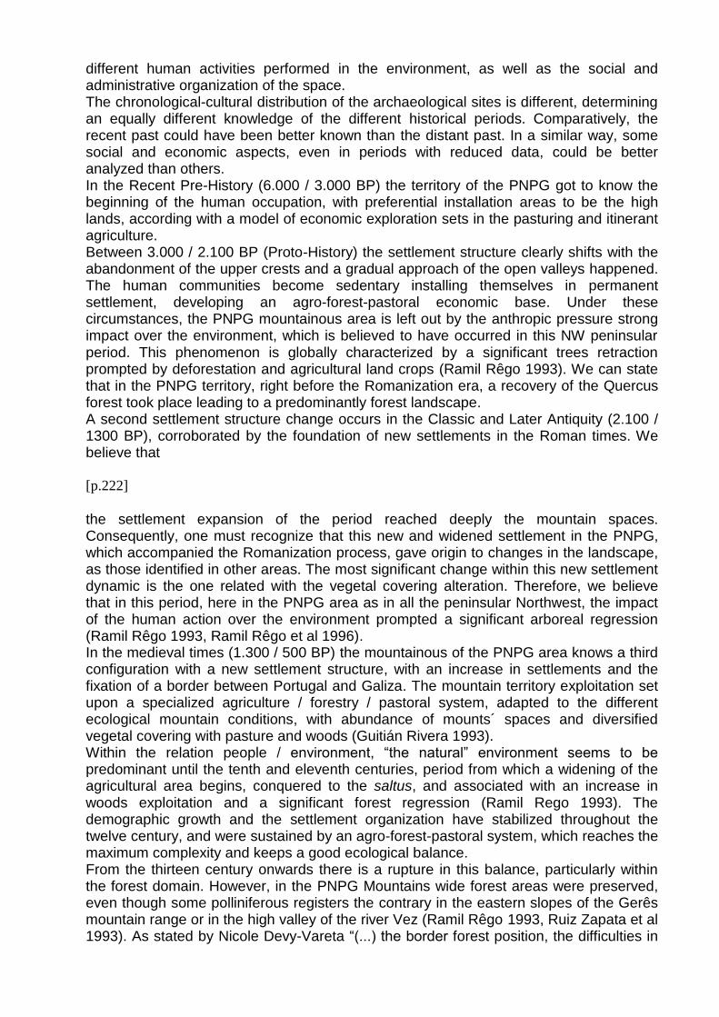
Figure XVIII - Panoramic sight of the valleys of Gavieira and Laboreiro: (Jorge Barros/PNPG).
[p.223]
However, moved away from the urban centres, the territory of the PNPG was gradually converted into a periphery area, being to the edge of the changes of the exterior society. Therefore, its populations had developed standards of space occupation, modalities of resources exploration and particular strategies of social organization, configuring a landscape with unique physical, geographic and human characteristics, which had practically kept unchangeable until the end of last century. But, as was well observed by P.J.R. Modderman (1988), “(...) the interaction, which is changing every second like movie, is missing. Every living organism has its relationships with the environment; everyone is in search of the best guarantees for existence, which leads to a great variety of activities, and the result is an ever changing picture. (...)".
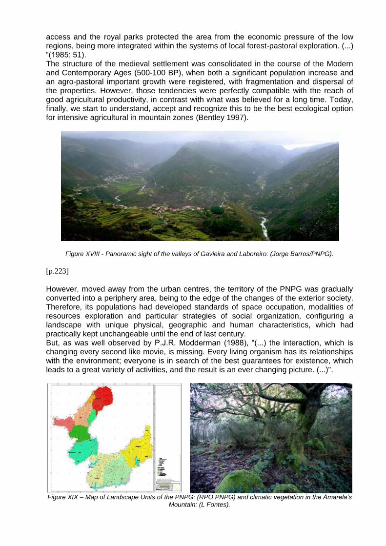
Figure XIX – Map of Landscape Units of the PNPG: (RPO PNPG) and climatic vegetation in the Amarela’s
Mountain: (L Fontes).
Today, the territory of the PNPG is configured as a cultural landscape, where 8 main Units of Landscape can be distinguished, almost all as a result of the human action, guided by five elementary exploitation forms: conservation of the nature, tourism, forestry, pasturing and agriculture. One can affirm that the PNPG territory, considered as a mountain area, possesses today an increased importance, as it functions as a supplier of ecosystems services. It is supposed it can to evolve, in accordance with the proposals of the new Plan of Arrangement of the Park, for a more complex cultural landscape, in a scene of an “adaptable mosaic”, able to answer easily to the quick changes of the lowlands and coastal populations (Pereira et al 2009:327).
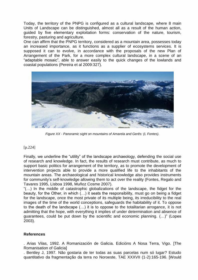
Figure XX - Panoramic sight on mountains of Amarela and Gerês: (L Fontes).
[p.224]
Finally, we underline the “utility” of the landscape archaeology, defending the social use of research and knowledge. In fact, the results of research must contribute, as much to support basic politics for arrangement of the territory, as to promote the development of intervention projects able to provide a more qualified life to the inhabitants of the mountain areas. The archaeological and historical knowledge also provides instruments for community’s self-knowledge allowing them to act over the reality (Fontes, Regalo and Tavares 1995, Lisboa 1998, Muñoz Cosme 2007). “(…) In the middle of catastrophic globalizations of the landscape, the fidget for the beauty, for the Other, in which (…) it seats the responsibility, must go on being a fidget for the landscape, once the most private of its multiple being, its irreducibility to the real images of the time of the world conceptions, safeguards the habitability of it. To oppose to the death of the landscape (…) it is to oppose to the totalitarian arrogance, it is not admitting that the hope, with everything it implies of under determination and absence of guarantees, could be put down by the scientific and economic planning. (…)” (Lopes 2003).
References . Arias Vilas, 1992. A Romanización de Galicia. Edicións A Nosa Terra, Vigo. [The Romanisation of Galicia] . Bentley J, 1997. Não gostaria de ter todas as suas parcelas num só lugar? Estudo quantitativo da fragmentação da terra no Noroeste, TAE XXXVII (1-2):165-196. [Would
not like having your parcels at an alone place? Quantitative study of the fragmentation of the land in the Northwest] . Brito R, (dir) 1994. Portugal. Perfil Geográfico, Editorial Estampa, Lisboa. [Portugal. Geographic profile] . Busquets J e Cortina A, (eds) 2009. Gestión del paisage. Manual de protección, gestión y ordenación del paisage. Editorial Ariel, Barcelona. [Landscape management. Hand-book of protection, management and arrangement of the landscape] . Butzer K, 1989. Arqueología: una ecología del hombre. Ediciones Bellaterra, Barcelona. [Archaeology, as ecology of de man] . Capela J, 2005. As freguesias do distrito de Viana do Castelo nas Memórias Paroquiais de 1758. Casa Museu de Monção / Universidade do Minho, Viana do Castelo. [The parish of Viana Castelo district in the “Parish Memory’s” of 1758] . Carrión Marco Y, 2005. La Vegetación Mediterránea y Atlántica de la Península Ibérica. Nuevas secuencias antracológicas. Diputación Provincial de Valencia, Valencia. [Mediterranean and Atlantic vegetation. News anthracological sequences] . Costa A, 1997. O Bispo D. Pedro e a Organização da Diocese de Braga, (2.ª edição), I. Irmandade de S. Bento da Porta Aberta, Braga. [D. Pedro Bishop and the organisation of Braga’s diocese] . Coudé-Gaussen G, 1979. Les Serras da Peneda et de Gerês (Minho - Portugal). Formes et formations d'origine froide en milieu granitique. Université de Paris I, Paris. [The Peneda’s and Gerês’s Mountains (Minho-Portugal). Forms and trainings of cold origin in granite middle] . Criado Boado F, 1999. Del Terreno al Espacio: Planteamientos y Perspectivas para la Arqueología del Paisage. CAPA, 6, GIAP/Universidade de Santiago de Compostela, Santiago de Compostela. [From the Land to the Space: Approaches and Prospects for the Archaeology of Landscape] . Crumley C and Marquardt W, 1990 - Landscape: a unifying concept in regional analysis. In: Allen K, Green S, Zubrow E (eds) Interpreting Space: GIS and archaeology, Taylor & Francis, London. pp 73-79 . David B and Thomas J, (eds) 2008. Handbook of Landscape Archaeology. Berg Publishers, Oxford, UK. . Dax T and Hovorka G. 2002. A holistic approach to mountain development research: Experiences from the Federal Institute for Less-Favoured and Mountainous Areas, Austria. In: The Innovative Structures for the Sustainable Development of Mountainous Areas (ISDEMA) Conference. School of Agriculture, Aristotle University of Thessaloniki, Tessalónica. . Devy-Vareta N, 1985. Para uma geografia histórica da floresta portuguesa. As matas medievais e a "Coutada Velha" do rei. Revista da Faculdade de Letras - Geografia, I Série, I:47-67 [For a historical geography of the Portuguese forest. The medieval forests and the "Old Covert" of the king] . Diaz y Diaz M, 1974. La Vida de San Fructuoso de Braga. Arcebispado de Braga, Braga. [The Saint Fructose biography]
[p.225]
. Dopazo Martínez, A et al 1996. Arqueometria aplicada a yacimientos galaico-romanos del NW peninsular: valoracion de la actividad agricola y ganadera. In: Ramil Rêgo P, Fernández Rodríguez C and Rodríguez Guitián M (coords) Biogeografía Pleistocena - Holocena de la Península Ibérica, Xunta de Galicia, Santiago de Compostela. pp 317-332. [Pleistocene and Holocene Biogeography of Iberian Peninsula] . Fontes L, 2000. Os Fojos de Lobo da Cabreira. MINIA, 3ª série, 6: pp.73-94. [The wolf pitfalls of Cabreira Mountain]
. Fontes L, 2003. A estela com togado de Lindoso, Ponte da Barca. MINIA, 3ª série, 10:147-158. [The roman stele of Lindoso] . Fontes L, 2005. São Martinho de Tibães: um sítio onde se fez um mosteiro. Ensaio em arqueologia da oaisagem e da arquitectura. IPPAR, Lisboa. [São Martinho of Tibães: a place who was founded a monastery. Essay on archaeology of landscape and architecture] . Fontes L, Regalo H, 1997. Lindoso. O castelo e a região. ICN/PNPG, Braga. [Lindoso. The castle and the region] . Fontes L, Regalo H, Tavares A, 1995. Lindoso Castle: A Museology and Cultural Improvement Project. In: Abstracts on European Association of Archaeologists. First Annual Meeting:112. . García Sanjuán L, 2005. Introducción al Reconocimiento y Análisis Arqueológico del Territorio. Ariel, Barcelona. [Introduction to the Recognition and Archaeological Analysis of the Territory] . Gojda M, 2004. Landscape Archaeology. In: KNOWLEDGE FOR SUSTAINABLE DEVELOPMENT An Insight into the ENCYCLOPEDIA OF LIFE SUPPORT SYSTEMS, Volume I, (4), pp 723-741, UNESCO Publishing-Eolss Publishers, Oxford, UK. . Gómez Pantoja J, 1993. Buscando a los Pastores, TAE.XXXIII.3-4:446-459. [Looking for the Shepherds] . Guitián Rivera L, 1993. Sistemas de Utilización del Espacio y Evolución del Paisaje Vegetal en las Sierras Orientales de Lugo. In: Pérez Alberti A, Guitián Rivera L, Ramil Rêgo P (eds.) La Evolución del Paisage en las Montañas del Entorno de los Caminos Jacobeos. Xunta de Galicia, Santiago de Compostela. pp 211-224. [The Evolution of Landscape in the Mountains of Environment of the Jacobean Road] . Hernández León J, 2007. Sobre el Paisage Cultural. In: Paisage Cultural. EURAU 08. Ministerio de Fomento e Universidad Politecnica de Madrid, Madrid. pp 11-13. . Hodder I, 1994. Interpretación en Arqueología. Corrientes actuales. Editorial Crítica, Barcelona. [Current Interpretations in Archaeology] . Ibáñez Montoya J, 2007. Diversas maneras de construir con el tiempo. In: Paisage Cultural. EURAU 08. Ministerio de Fomento e Universidad Politecnica de Madrid, Madrid. pp 21-33. [Cultural Landscape] . Johnson M, 2000. Teoría arqueológica. Una introducción. Editorial Ariel, Barcelona, 2000. [Archaeological Theory. An introduction] . Lisboa J, 1998. Podíamos não considerar o tempo? In: Vértice, 87, II Série:49-55. [Can we don’t consider the time?] . Lopes S, 2003. Uma paisagem é uma paisagem? In: Ler. Livros & Leitores, 60:43-49. [Is landscape a landscape?] . Juliá R et al, 2007. Climatic and land use changes on the NW of Iberian Peninsula recorded in a 1,500-year from Lake Sanabria. Contributions to Sciences, 3 (3):355-369. . Maderuelo J, (ed) 2009. Paisage e Historia. Abada Editores, Madrid. [Landscape and History] . Martins M, 1990. O Povoamento Proto-Histórico e a Romanização da Bacia do Curso Médio do Cávado. Universidade do Minho, Braga. [The Proto-historic settlement and the Romanisation of the medium valley of Cávado river] . Medeiros C, 1991. Geografia de Portugal. Ambiente Natural e Ocupação Humana: uma introdução, 2ª ed. Editorial Estampa, Lisboa. [Geography of Portugal. Natural Environment and Human Occupation: an introduction] . Modderman P, 1988. Thoughts on archaeology, geography and scales. In: Bintliff J, Davidson D, Grant E, (eds) Conceptual Issues in Environmental Archaeology, University Press, Edinburgh. pp 59-63. . Muñoz Cosme G, 2007. El paisaje y la historia. In: Paisage Cultural. EURAU 08. Ministerio de Fomento e Universidad Politecnica de Madrid, Madrid. pp 56-58. [Cultural Landscape]
. Navia Osorio J, 2000. La Construcción del Territorio. Mapa Histórico del Noroeste de la Península Ibérica, Lunwerg Editores, Barcelona-Madrid. [The Construction of Territory. Historical Map of North-Western Iberian Peninsula] . Oliveira M, 2000. O registo paleocarpológico do NO peninsular entre o IIIº e o Iº milénios a.C. Contributo para o estudo da alimentação pré e proto-histórica. Universidade do Minho, Braga. [The palaeocarpological register of the Peninsular NW from the 3th to the 2nd millennia BC. Contribution to the study of pre and protohistoric food] . Orengo H and Ejarque A, 2008. Metodología aplicada en el análisis del paisaje del Massís del Garraf. In Riera S, (ed.) La historia del paisaje cultural del massís del Garraf a partir de la resolución de casos. Barcelona. pp.
[p.226]
81-86. [The history of the cultural landscape of the Garraf massif from the resolution of cases]. . Pereira H et al, (eds) 2009. Ecossistemas e Bem-Estar Humano. Avaliação para Portugal do Millenium Ecosystem Assessment, Escolar Editora, Lisboa. [Ecosystems and Human Welfare. Portugal evaluation of Millenium Ecosystem Assessment] . Ramil Rêgo 1993 P. Ramil Rêgo - Evolución Climática e Historia de la Vegetación durante el Pleistoceno Superior y el Holoceno en las Regiones Montañosas del Noroeste Ibérico. In: Pérez Alberti A, Guitián Rivera L, Ramil Rêgo P (eds) La Evolución del Paisage en las Montañas del Entorno de los Caminos Jacobeos. Xunta de Galicia, Santiago de Compostela. pp 25-60. [The Evolution of Landscape in the Mountains of Environment of the Jacobean Road] . Ramil Rêgo et al 1996. Modificacion de la cubierta vegetal y accion antropica en la region del Minho (Norte de Portugal) durante el Holoceno. In: Ramil Rêgo P, Fernández Rodríguez C and Rodríguez Guitián M (coords) Biogeografía Pleistocena - Holocena de la Península Ibérica, Xunta de Galicia, Santiago de Compostela. pp 199-214. [Pleistocene and Holocene Biogeography of Iberian Peninsula] . Ribeiro O, Lautensach H, Daveau S, 1994. Geografia de Portugal. II. O Ritmo Climático e a Paisagem. 2ª ed., Edições João Sá da Costa, Lisboa. [Geography of Portugal. II. The climatic rhythm and landscape] . RPO PNPG, 2008. Revisão do Plano de Ordenamento do Parque Nacional da Peneda-Gerês. MAOTDR/ICNB/PNPG (Ministry of the Environment, Arrangement of the Territory and Regional Development / Institute of the Conservation of the Nature and Biodiversity / Natural Park of Peneda-Gerês), Braga. [Revision of the Plan of Arrangement of the National Park of the Peneda-Gerês] . Ruiz Zapata B et al 1993. Datos preliminares sobre la evolucion de la vegetacion en las Sierras del Noroeste de Portugal durante el Holoceno. Actas da 3ª Reunião do Quaternário Ibérico. Universidade de Coimbra, Coimbra. pp 97-104. [Preliminary data on the evolution of the vegetation in the Mountains of Northwest of Portugal in the Holocene] . Silva A, 1986. A Cultura Castreja no Noroeste de Portugal. Câmara Municipal de Paços de Ferreira, Paços de Ferreira. [The ‘Castreja’ Culture in the Northwest of Portugal] . Tranoy A, 1981. La Galice Romaine. Recherches sur le nor-ouest de la péninsule ibérique dans l`Antiquité, Diffusion du Boccard, Paris. [The Roman Galicia. Researches on the nor-west of the Iberian Peninsula in Antiquity] . Vázquez Varela J, 2004. Culturas distintas, tiempos diferentes y soluciones parecidas. Ensayos de Etnoarqueología. Diputación Provincial de Pontevedra, Pontevedra. [Diverse cultures, different times and similar solutions. Essays of Ethno Archaeology]