materials resource planning for appropriate road construction
TRANSCRIPT
National Workshop on Road Planning, Pavement Design & Overloading Prevention 11 – 12 November 2004, ITC – Phnom Penh – Cambodia
Workshop Paper No 7 - Materials Resource Planning for Appropriate Road Construction 1/13
Workshop Paper No 7
Materials Resource Planning for Appropriate Road Construction
Dr J R Cook
Intech-TRL
1 Introduction
It is becoming increasingly recognised that a key objective in sustainable road construction is to best match the available material to its road task and its local environment. Construction costs of the upper pavement layers are typically about 30 to 40 per cent of the total road construction cost and it is clear that, the identification and characterisation of available road construction materials is an important stage in the selection of a road design.
The more effective use of natural resources enables a better and larger rural infrastructure to be rehabilitated within limited budgets. More cost-effective road designs that incorporate appropriate materials allow more kilometres per unit cost of access to be built, rehabilitated and maintained. The benefits of utilising locally available materials arise from a reduction in costs (eg haulage) and less damage to existing pavements from extended haul. Benefits also stem from the better management of local resources that can steer new road construction towards the more cost-effective and more environmentally aware use of non-renewable natural resources
The focus over the last decade in Cambodia has been on re-establishing a core road network through the rehabilitation of the most important national and rural roads. There have been a number of donor and agency supported initiatives that have contributed substantially to rehabilitating the road network and developing the local capacity to manage and carry out road works. Key to these initiatives is the availability of suitable road building materials
There is an increasing awareness of the cost-effectiveness of assembling materials databases as materials planning tools that can supply early information on construction materials at little cost to a project. A fully established road materials information system (RMIS) incorporating an up-to date materials database can play a key role in the dissemination of information on local materials and indicate their most appropriate use.
2 The Need for Materials Resource Planning
2.1 Road Design
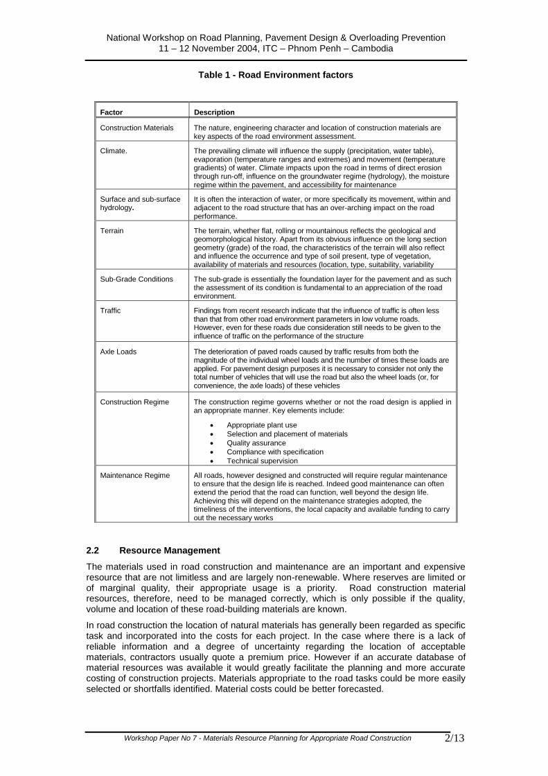
The performance of a road depends on a whole range of factors that cumulatively can be described as the “road environment”. These factors, as defined in Table 1, together describe the matrix of road environment impacts that needs to be addressed by design response factors that are in effect the tools for an overall appropriate design strategy. The road performance can be seen as a direct function of the road environment and its interaction with an appropriate design. A pragmatic and realistic assessment of these road environment factors is essential for an appropriate and sustainable road design
Construction material is a factor over which road practitioners has some limited control within the context of natural availability. This control is maximised when the road designer has access to all available materials resource information, thus allowing him match the most appropriate materials with the road task and its environment, including axle loading.
Road construction materials information in the form of a materials resource plan or information system becomes therefore an important tool in the effective design of sustainable roads.
National Workshop on Road Planning, Pavement Design & Overloading Prevention 11 – 12 November 2004, ITC – Phnom Penh – Cambodia
Workshop Paper No 7 - Materials Resource Planning for Appropriate Road Construction 2/13
Table 1 - Road Environment factors
2.2 Resource Management
The materials used in road construction and maintenance are an important and expensive resource that are not limitless and are largely non-renewable. Where reserves are limited or of marginal quality, their appropriate usage is a priority. Road construction material resources, therefore, need to be managed correctly, which is only possible if the quality, volume and location of these road-building materials are known.
In road construction the location of natural materials has generally been regarded as specific task and incorporated into the costs for each project. In the case where there is a lack of reliable information and a degree of uncertainty regarding the location of acceptable materials, contractors usually quote a premium price. However if an accurate database of material resources was available it would greatly facilitate the planning and more accurate costing of construction projects. Materials appropriate to the road tasks could be more easily selected or shortfalls identified. Material costs could be better forecasted.
Factor Description
Construction Materials The nature, engineering character and location of construction materials are key aspects of the road environment assessment.
Climate. The prevailing climate will influence the supply (precipitation, water table), evaporation (temperature ranges and extremes) and movement (temperature gradients) of water. Climate impacts upon the road in terms of direct erosion through run-off, influence on the groundwater regime (hydrology), the moisture regime within the pavement, and accessibility for maintenance
Surface and sub-surface hydrology.
It is often the interaction of water, or more specifically its movement, within and adjacent to the road structure that has an over-arching impact on the road performance.
Terrain The terrain, whether flat, rolling or mountainous reflects the geological and geomorphological history. Apart from its obvious influence on the long section geometry (grade) of the road, the characteristics of the terrain will also reflect and influence the occurrence and type of soil present, type of vegetation, availability of materials and resources (location, type, suitability, variability
Sub-Grade Conditions The sub-grade is essentially the foundation layer for the pavement and as such the assessment of its condition is fundamental to an appreciation of the road environment.
Traffic Findings from recent research indicate that the influence of traffic is often less than that from other road environment parameters in low volume roads. However, even for these roads due consideration still needs to be given to the influence of traffic on the performance of the structure
Axle Loads The deterioration of paved roads caused by traffic results from both the magnitude of the individual wheel loads and the number of times these loads are applied. For pavement design purposes it is necessary to consider not only the total number of vehicles that will use the road but also the wheel loads (or, for convenience, the axle loads) of these vehicles
Construction Regime The construction regime governs whether or not the road design is applied in an appropriate manner. Key elements include:
Appropriate plant use
Selection and placement of materials
Quality assurance
Compliance with specification
Technical supervision
Maintenance Regime All roads, however designed and constructed will require regular maintenance to ensure that the design life is reached. Indeed good maintenance can often extend the period that the road can function, well beyond the design life. Achieving this will depend on the maintenance strategies adopted, the timeliness of the interventions, the local capacity and available funding to carry out the necessary works
National Workshop on Road Planning, Pavement Design & Overloading Prevention 11 – 12 November 2004, ITC – Phnom Penh – Cambodia
Workshop Paper No 7 - Materials Resource Planning for Appropriate Road Construction 3/13
The planning, design, construction and maintenance of projects in an effective and economic manner depend on reliable information being available to the engineer in an easily recognisable and accessible format, at an appropriate level of accuracy. Highway engineering projects present particular information problems because they can cover long distances across different terrain, geology and soils. Compiling and maintaining an inventory or database of material sources and properties is one way of making already-gathered information available for cost-effective re-use.
A systematic approach to the development and use of road construction sources enables a greater control to kept on any potentially detrimental environment impacts, both in terms of quarry or borrow pit excavation and their eventual reinstatement
3 Developing a Road Materials Information System
3.1 Objectives
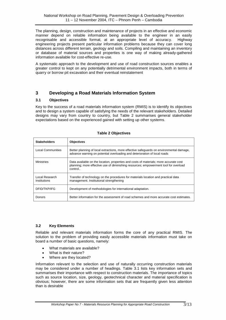
Key to the success of a road materials information system (RMIS) is to identify its objectives and to design a system capable of satisfying the needs of the relevant stakeholders. Detailed designs may vary from country to country, but Table 2 summarises general stakeholder expectations based on the experienced gained with setting up other systems.
Table 2 Objectives
3.2 Key Elements
Reliable and relevant materials information forms the core of any practical RMIS. The solution to the problem of providing easily accessible materials information must take on board a number of basic questions, namely:
What materials are available?
What is their nature?
Where are they located?
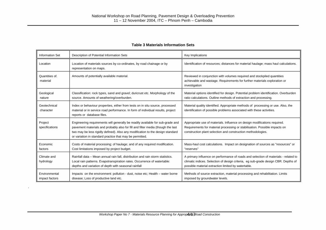
Information relevant to the selection and use of naturally occurring construction materials may be considered under a number of headings. Table 3.1 lists key information sets and summarises their importance with respect to construction materials. The importance of topics such as source location, size, geology, geotechnical character and material specification is obvious; however, there are some information sets that are frequently given less attention than is desirable
Stakeholders Objectives
Local Communities Better planning of local extractions, more effective safeguards on environmental damage, advance warning on potential overloading and deterioration of local roads
Ministries Data available on the location, properties and costs of materials; more accurate cost planning; more effective use of diminishing resources; empowerment tool for overload control..
Local Research Institutions
Transfer of technology on the procedures for materials location and practical data management. Institutional strengthening
DFID/TKP/IFG Development of methodologies for international adaptation.
Donors Better information for the assessment of road schemes and more accurate cost estimates.
National Workshop on Road Planning, Pavement Design & Overloading Prevention 11 – 12 November 2004, ITC – Phnom Penh – Cambodia
Workshop Paper No 7 - Materials Resource Planning for Appropriate Road Construction 4/13
Table 3 Materials Information Sets
.
Information Set Description of Potential Information Sets Key Implications
Location Location of materials sources by co-ordinates, by road chainage or by
representation on maps.
Identification of resources; distances for material haulage; mass haul calculations.
Quantities of.
material
Amounts of potentially available material. Reviewed in conjunction with volumes required and stockpiled quantities
achievable and wastage. Requirements for further materials exploration or
investigation
Geological
nature
Classification: rock types, sand and gravel; duricrust etc. Morphology of the
source. Amounts of weathering/overburden.
Material options identified for design. Potential problem identification. Overburden
ratio calculations. Outline methods of extraction and processing.
Geotechnical
character
Index or behaviour properties, either from tests on in situ source, processed
material or in service road performance. In form of individual results, project
reports or database files.
Material quality identified. Appropriate methods of processing or use. Also, the
identification of possible problems associated with these activities.
Project
specifications
Engineering requirements will generally be readily available for sub-grade and
pavement materials and probably also for fill and filter media (though the last
two may be less rigidly defined). Also any modification to the design standard
or variation in standard practice that may be permitted.
Appropriate use of materials. Influence on design modifications required.
Requirements for material processing or stabilisation. Possible impacts on
construction plant selection and construction methodologies.
Economic
factors
Costs of material processing; of haulage; and of any required modification.
Cost limitations imposed by project budget.
Mass-haul cost calculations. Impact on designation of sources as "resources" or
"reserves"
Climate and
hydrology
Rainfall data – Mean annual rain fall, distribution and rain storm statistics.
Local rain patterns. Evapotranspiration rates. Occurrence of watertable:
depths and variation of depth with seasonal rainfall
A primary influence on performance of roads and selection of materials - related to
climatic indices. Selection of design criteria, eg sub-grade design CBR. Depths of
possible material extraction limited by watertable.
Environmental
impact factors
Impacts on the environment: pollution - dust, noise etc; Health – water borne
disease; Loss of productive land etc.
Methods of source extraction, material processing and rehabilitation. Limits
imposed by groundwater levels.
National Workshop on Road Planning, Pavement Design & Overloading Prevention 11 – 12 November 2004, ITC – Phnom Penh – Cambodia
Workshop Paper No 7 - Materials Resource Planning for Appropriate Road Construction 5/13
Economic factors should include information on costs of winning materials including extraction, processing and transport to site. To be fully effective, data on any long term, or whole-life, cost implications of using particular materials should also be accessed; this may include relative maintenance and repair costs, and also long term cost implications of using inappropriately high grade resources. Information on the relative costs of stabilisation options for utilisation of lower quality materials would, for example, be required to balance judgement with the technical assessment.
The input of the prevailing climate on the in service performance of road materials and sub-grade can be significant with respect to their potential weathering and moisture susceptibility. It also impacts on their traffickability and placeability during construction.
The increasing importance given to environmental impact means that information on factors such as loss of habitat and pollution, are very relevant to materials investigations. This may be particularly applicable for some materials, for example the development and processing of technically hard quartz-rich rocks may incur risks due to production of silica dust. There is also the need to consider the environmental and economic implications of quarry or borrow pit restoration.
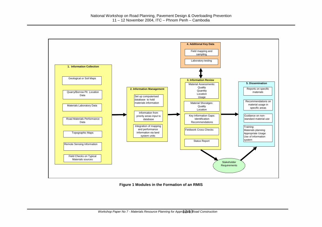
In order to be an effective planning tool any RMIS must incorporate the following key activities:
Identify existing information sources
Collate and review existing information
Assess stakeholder and user needs and expectations
Identify information gaps and recommend solutions
Store and manipulate relevant information in a user-friendly system for the recording, organising, storage and retrieval of data
Training
Disseminate required information
These activities may be considered within a number of activity modules as illustrated in Figure 1
3.3 Accessing Available Information
The identification and capture of existing materials information is a fundamental step in setting up an RMIS. Important and immediately useful data sources are normally as follows:
Maps
Topographic Maps. Commonly vary in scale from 1:250,000 to 1: 5,000. Apart from providing base level location information they can include topographic features such as rivers, cliffs, rock outcrops and beaches that can relevant to engineering materials.
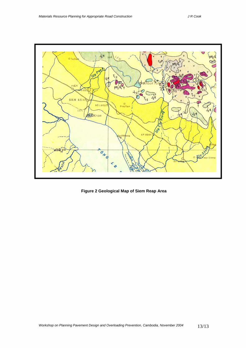
Geological Maps. Generally vary in scale between 1:5,000,000 and 1:500,000. The map is usually accompanied by a report describing the geological sequences shown on the map. Geological maps are an indispensable source of information for materials surveys, Figure 2.
Agricultural Soil Maps. Commonly called soils maps these vary in scale between 1:5,000,000 and 1:50,000, and are usually accompanied by a report describing the soil sequences shown on the map. Soil maps can provide very useful information about the occurrence of pedogenic engineering construction materials (laterite, calcrete, silcrete) and are very useful indicators of sub-grade type, and earthfill sources.
Terrain classification or land system maps have been used extensively in materials investigations. Land system mapping is based on the premise that landscapes do not evolve randomly, but develop as integrated associations of soils, slopes and hydrological regimes. Within an association, ground characteristics have a limited
National Workshop on Road Planning, Pavement Design & Overloading Prevention 11 – 12 November 2004, ITC – Phnom Penh – Cambodia
Workshop Paper No 7 - Materials Resource Planning for Appropriate Road Construction 6/13
range of variation and are predictable. Some countries in parts of Africa, S E Asia and Australasia have the widest coverage of land system mapping. Land systems maps and reports give an immediate “feel” of a landscape by virtue of the drawings showing the slope relationships, and the easily-understood style of presentation of the terrain information.
Road Construction and Research Projects
Large amounts of data on materials sources and their geotechnical properties are normally collected during the construction, maintenance, rehabilitation or reconstruction of roads. This is frequently extremely useful and relevant information comprising not only as-produced material properties but also related costs.
These data are normally either held centrally by the relevant ministry or road department or retained by the consultants and contractors. In many rapidly developing countries this information may be dispersed or difficult to track down
In recent large projects much of this data may already be in spreadsheet format and hence readily transferred to a central information system. Older project data is likely to be in hard copy that would have to be transferred to electronic format. This most effectively done using standard data capture forms and procedures.
Road materials research information may be available from local or international universities, from individual research institutes or be contained within published reports.
Local Knowledge
There is frequently a fund of local knowledge on the location of materials sources. Sometimes additional useful data such as material usage, performance on the road and costs can be obtained from commune or district personnel.
3.4 New Data Acquisition
It is frequently the case, however, that fresh data will have to be obtained to supplement that obtained form existing information sources. This acquisition can take many forms but in general may be broadly divide as follows:
1. Surface reconnaissance and visual assessment of materials sources usually the first stage in any detailed project-specific materials investigation programme. This approach using trained field teams and standardised data collection pro-formas can be a highly successful approach to acquiring information for a materials information system.
2. Sub-surface investigations: Frequently a necessary part of large road projects. On the ground of cost however this approach is rarely used specifically in the assembly of large material information system, although acquisition existing information is important.
3. As- built road materials performance data. Information on the performance of materials on the road is of course vitally important data that should be accessed where possible. However, as with sub-surface investigations it is generally associated with specific projects rather than a general RMIS. Acquisition of existing data or data from ongoing projects is again important
4. Laboratory investigations. Knowledge of the geotechnical nature of road materials is vital in determining their appropriate use. Some variety of laboratory testing programme is generally essential in the formation of an RMIS. It may take the form of a limited range of standard materials tests or may include specific tests for particular materials, eg lime or cement stabilisation testing of soils or mineralogical testing of basic igneous rock aggregates.
National Workshop on Road Planning, Pavement Design & Overloading Prevention 11 – 12 November 2004, ITC – Phnom Penh – Cambodia
Workshop Paper No 7 - Materials Resource Planning for Appropriate Road Construction 7/13
3.5 Data Management
No matter how the data is acquired, its effective storage, collation and overall management lies at the heart of an effective RMIS
Storing this information on a computer database provides a rapid, reliable and effective method of sorting, retrieving and presenting relevant information. Over the last 10-15 years computer technology has become n accepted tool in large volume data handling offering as it does several advantages. Data can be:
Accessed easily
Interrogated and edited so that data are added, modified or deleted, according to the needs of the user
Manipulated by sorting, querying, filtering, and indexing
Related to different databases with the same key fields (eg pit number or road number and chainage)
Used to produce reports which are designed and produced according to the users’ or customers’ specifications
There are additional advantages to be gained by computer-based storage and retrieval systems within the rapidly developing area of Information Technology (IT), for example the rapid electronic access and transfer of a data, the use of scanning techniques, and the application of Geographical Information Systems.
3.6 Dissemination
An RMIS exists for the purpose of providing information. Its dissemination capabilities are therefore fundamental to its design.
When properly designed and established with accurate data an RMIS has many dissemination related benefits. Data is available in a single location, in a compact, standard format that may be manipulated to provide answers to specific enquiries. The data can also be updated when necessary without difficulty and can easily be integrated with terrain classifications or GIS programmes to facilitate dissemination.
A computer-based RMIS has the ability to produce a variety of either standard reports or reports aimed at specific queries.
4 The Indonesian Construction Materials Information System
4.1 General description
A series of DFID supported World Bank projects from 1988 to 1997 resulted in the formation of the Indonesian Construction Materials Information System (ICMIS). This system based around the collation of materials data in terms of location, quality and quantity utilises standard database software to store and manipulate data acquired from all of the 26 widespread provinces of Indonesia,.
Issues which facilitated the setting up of ICMIS and governed its design as follows;
An active road development programme supported by the World Bank and other major donors
The requirement within the Indonesian MoW for a centralised materials information system
The widespread and diverse nature of the Indonesian island
An existing road research institute that could act as host to the database
The known existence of recently completed terrain evaluation maps
Total topographic map coverage of Indonesia at 1:50 000
The known existence of materials data within provincial administrations
No existing databases or any formalised construction materials information systems
National Workshop on Road Planning, Pavement Design & Overloading Prevention 11 – 12 November 2004, ITC – Phnom Penh – Cambodia
Workshop Paper No 7 - Materials Resource Planning for Appropriate Road Construction 8/13
The availability of technical staff for technology transfer and training
4.2 Development of ICMIS
ICMIS was developed over a number of years, commencing with a research and trial phase, through major data collection phases and culminating in a comprehensive province-wide training and mainstreaming programme. Table 4 summarises the principal stages of development:
Table 4 Stages in ICMIS Development
Phase Description Time
I Background Research
Review of existing systems in the light of Indonesian requirements. Identification of key data sets
3 months
II System Setup and Trials
Design of database file systems, data collection forms and output procedures. Comprehensive trials undertaken in one province
9 months
III Nation-wide System Set-up
National input of available provincial data and refinement of database design. Design of differing levels information system
20 months
IV Mainstreaming of ICMIS
Mainstreaming of provincial level data collection and reporting procedures through training programmes and workshops. Data updates commenced by provinces.
10 months
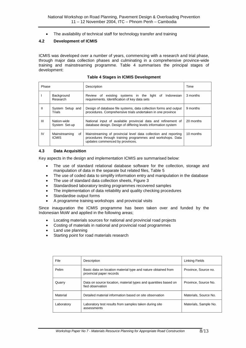
4.3 Data Acquisition
Key aspects in the design and implementation ICMIS are summarised below:
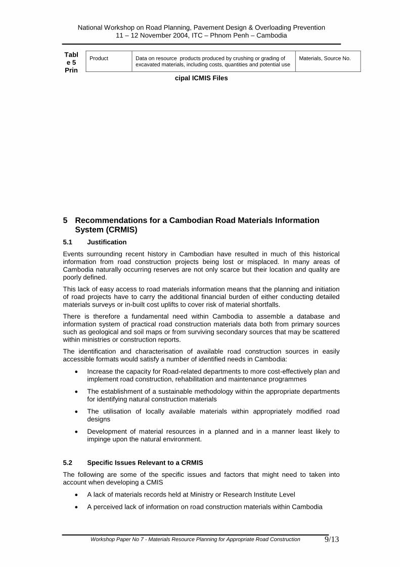
The use of standard relational database software for the collection, storage and manipulation of data in the separate but related files, Table 5
The use of coded data to simplify information entry and manipulation in the database
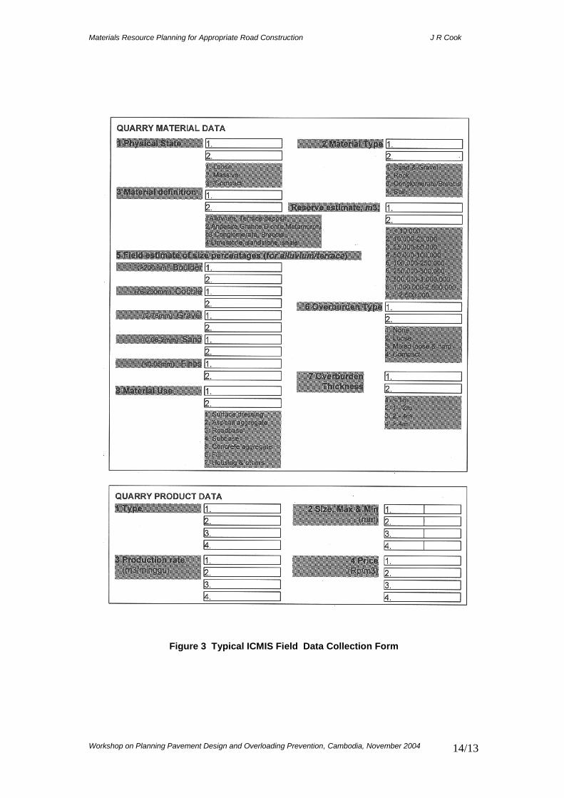
The use of standard data collection sheets, Figure 3
Standardised laboratory testing programmes recovered samples
The implementation of data reliability and quality checking procedures
Standardise output forms
A programme training workshops and provincial visits
Since inauguration the ICMIS programme has been taken over and funded by the Indonesian MoW and applied in the following areas;
Locating materials sources for national and provincial road projects
Costing of materials in national and provincial road programmes
Land use planning
Starting point for road materials research
File Description Linking Fields
Pelim Basic data on location material type and nature obtained from provincial paper records
Province, Source no.
Quarry Data on source location, material types and quantities based on fied observation
Province, Source No.
Material Detailed material information based on site observation Materials, Source No.
Laboratory Laboratory test results from samples taken during site assessments
Materials, Sample No.
National Workshop on Road Planning, Pavement Design & Overloading Prevention 11 – 12 November 2004, ITC – Phnom Penh – Cambodia
Workshop Paper No 7 - Materials Resource Planning for Appropriate Road Construction 9/13
Table 5 Prin
cipal ICMIS Files
5 Recommendations for a Cambodian Road Materials Information System (CRMIS)
5.1 Justification
Events surrounding recent history in Cambodian have resulted in much of this historical information from road construction projects being lost or misplaced. In many areas of Cambodia naturally occurring reserves are not only scarce but their location and quality are poorly defined.
This lack of easy access to road materials information means that the planning and initiation of road projects have to carry the additional financial burden of either conducting detailed materials surveys or in-built cost uplifts to cover risk of material shortfalls.
There is therefore a fundamental need within Cambodia to assemble a database and information system of practical road construction materials data both from primary sources such as geological and soil maps or from surviving secondary sources that may be scattered within ministries or construction reports.
The identification and characterisation of available road construction sources in easily accessible formats would satisfy a number of identified needs in Cambodia:
Increase the capacity for Road-related departments to more cost-effectively plan and implement road construction, rehabilitation and maintenance programmes
The establishment of a sustainable methodology within the appropriate departments for identifying natural construction materials
The utilisation of locally available materials within appropriately modified road designs
Development of material resources in a planned and in a manner least likely to impinge upon the natural environment.
5.2 Specific Issues Relevant to a CRMIS
The following are some of the specific issues and factors that might need to taken into account when developing a CMIS
A lack of materials records held at Ministry or Research Institute Level
A perceived lack of information on road construction materials within Cambodia
Product Data on resource products produced by crushing or grading of excavated materials, including costs, quantities and potential use
Materials, Source No.
National Workshop on Road Planning, Pavement Design & Overloading Prevention 11 – 12 November 2004, ITC – Phnom Penh – Cambodia
Workshop Paper No 7 - Materials Resource Planning for Appropriate Road Construction 10/13
The existence of geological mapping at 1: 100 000 scale (non-digitised)
Existing topographic mapping – some digitised
No terrain evaluation mapping
The existence of the IRAP GIS model into which materials data could be fed
Some recent research on materials properties associated with ongoing programmes
Some pre-1960s research reports on geological materials
5.3 Suggested Programme
In the light of previous experience in establishing materials information systems and taking into account the items above it has been suggested that the setting up a CMIS should follow a modified and updated version of the Indonesian methodology, that is:
1. Background research on data availability and type
2. Implementation in a trial area (or province)
3. Review of effectiveness of trial MIS
4. Modifications to trial
5. Full scale CRMIS establishment.
In developing CRMIS to meet the needs identified by stakeholders and end-users, the detailed solution might range from a complex integrated system to a simple database or spreadsheet approach. In any case the data acquisition is likely to be based on the surface reconnaissance of existing quarry or pit locations using standard data pro-formas, backed by limited amounts of standard materials testing.
The primary purpose of the CRMIS project would be the dissemination of relevant materials information. Hence an effective dissemination strategy will be a fundamental aspect of the project. Activities within the dissemination procedures could be as follows:
Reports on specific materials eg “Lateritic Soils and Gravels of Cambodia”
Reports on specific areas ; “Road Materials of the Sim Reap Area”
Guidance on the use of Non-Standard materials
Training ( eg Database usage, Materials Planning, CRMIS sustainability
Dissemination would be aided by close co-operation with the IRAP GIS programme and other ongoing roads-related road construction and research programmes.
REFERENCES
Woodbridge M E, Cook, J R & Moestofa B. 1999 Development and Implementation of a Construction Material Information System. 7
th Int Conf. on Low-Volume Roads, Louisiana,
USA
Beavan P J, Cook J R & Moestofa B.1990. The Design and use of Road Materials Inventory. Proc. 6
th Conf. of REAAA, Kuala Lumpur, Malaysai

National Workshop on Road Planning, Pavement Design & Overloading Prevention 11 – 12 November 2004, ITC – Phnom Penh – Cambodia
Workshop Paper No 7 - Materials Resource Planning for Appropriate Road Construction 11/13
National Workshop on Road Planning, Pavement Design & Overloading Prevention 11 – 12 November 2004, ITC – Phnom Penh – Cambodia
Workshop Paper No 7 - Materials Resource Planning for Appropriate Road Construction 12/13
2. Information Management
1. Information Collection
Geological or Soil Maps
Quarry/Borrow Pit Location
Data
Materials Laboratory Data
Road Materials Performance
Data
3. Information Review
4. Additional Key Data
5. Dissemination
Information from
priority areas input to
database
Integration of mapping
and performance
information via land
system units
Material Assessments:
Quality
Quantity
Location
Usage
Material Shoratges:
Quality
Location
Key Information Gaps:
Identification
Recommendations
Status Report
Stakeholder
Requirements
Reports on specific
materials
Recommendations on
material usage in
specific areas
Guidance on non-
standard material use
Training:
Materials planning
Appropriate Usage
Use of information
system
Topographic Maps
Remote Sensing Information
Field mapping and
sampling
Laboratory testing
Field Checks on Typical
Materials sources
Fieldwork Cross Checks
Set up computerised
database to hold
materials information
Figure 1 Modules in the Formation of an RMIS
Materials Resource Planning for Appropriate Road Construction J R Cook
Workshop on Planning Pavement Design and Overloading Prevention, Cambodia, November 2004
13/13
Figure 2 Geological Map of Siem Reap Area
Materials Resource Planning for Appropriate Road Construction J R Cook
Workshop on Planning Pavement Design and Overloading Prevention, Cambodia, November 2004
14/13
Figure 3 Typical ICMIS Field Data Collection Form