hydrogeology iii - martinus jansen van rensburg
TRANSCRIPT

Tshwane University of TechnologyFaculty of Engineering and Built Environment
Lecturer: Professor GM Ochieng0
HYDROGEOLOGY III
TABLE OF CONTENTS:
1. Introduction 3
1.1 Groundwater resources in South Africa 3
1.2 Land and marine hydrogeology status…………………………………………………………………………………..…5
2. Literature review 6
2.1 The Impact of urbanization on groundwater resources 6
2.2 Impacts of deep foundations e.g. piles 8
2.2.1 Review of piles 8
2.2.2 Impacts to groundwater and pollution due to deep foundation (piles) 8
2.3 Climate change and groundwater resources 12
2.4 Monitoring programmes in South Africa 14
2.5 Urban processes and groundwater resources 15
2..5.1 Recharge and abstraction of groundwater due to construction and urbanization 16
2..5.2 Urban processes and groundwater quality 18
2..5.3 Investigation of urban impact on groundwater 18
3. Discussion and conclusions 19
3.1 Management of groundwater 19
3.1.1 Groundwater management authorities 20
3.2 Adaptation 21
3.2.1 Adaptation review 21
3.2.2 Durban’s adaptation plans 23
3.2.3 Impacts on the coast of Cape Town and some adaptation strategies 24
4. Recommendations 25
4.1 Groundwater research and data collection 25
4.2 Sharing groundwater information 25
4.2.1 Groundwater knowledge base 25
5. Reference list 26
Appendix A 27
Appendix B 28
Appendix C 29
Appendix D 30

HYDROGEOLOGY III
Tables:
Table 1: Benefits and costs using the urban subsurface (modified from Foster et al, 1998)...............7
Table 2: Different types of piles and methods of installation all effecting groundwater.....................8
Table 3: Impact on groundwater quality due to external sources of recharge (Morris et al, 2003)....17
Table 4: Example of short–run and long-run adaptations...................................................................22
Figures:
Figure 1: Distribution of significant secondary and primary aquifer systems in South Africa................4
Figure 2: Coastal population and shoreline degradation in South Africa...............................................5
Figure 3: Urban water supply, waste water disposal and shallow groundwater....................................6
Figure 4: Evolution of urban water infrastructure (Morris et al, 2003).................................................7
Figure 5: Penetration through an aquitard............................................................................................9
Figure 6: Vapour migration to surface....................................................................................................9
Figure 7: Contaminated spoil exposed at the surface..........................................................................10
Figure 8: Corrosion of pile leading to creation of flow paths...............................................................10
Figure 9: Driving contaminated material into aquifer..........................................................................11
Figure 10: Grout or paste injected into groundwater..........................................................................11
Figure 11: Diagram showing the relationship between climate change and variability.......................13
Figure 12: Groundwater monitoring and data management responsibilities......................................14
Figure 13: An illustration of groundwater contamination to an aquifer beneath an industrial..........16
Figure 14: Showing the Recharge and abstraction activities from an urban area...............................16
Figure 15: Downward movement of pollutants induced by pumping (from Morris et al, 1994) ........18
Figure 16: Water resource management system.................................................................................19
Figure 17: Relationship between the groundwater co-ordinator and water management authorities..........................................................................................................................20

HYDROGEOLOGY III
1. Introduction:
This document is a term paper for Hydrogeology III with the topic “Impact of Deep Foundation in Extensively Urbanized areas on Coastal Groundwater Regimes of South Africa”. Climate change, adaptation and a few more topics will also form part of contents of the paper.
1.1 Groundwater resources in South Africa:
Groundwater resources in South Africa make up about 65% of the water supplied to rural areas and there is no cost effective way to supply water from dams and any surface reservoirs to 8 million people and 15 000 settlements situated around our country. Groundwater is the primary source of water for domestic usage for up to 65 % of the population and more than 300 towns in South Africa. Although this is true, groundwater is still a very small component of the total water being used accounting for about 15% of the total consumption. Economic and population growth will cause the use of freshwater resources to rise dramatically in the near future. As the lifestyle in South Africa continues to change together with the expanded water supply systems it also has a great impact on the resources as well as the quality of the groundwater.
Southern Africa’s groundwater is becoming a growing concern especially in the areas of urbanisation which contaminate the aquifers through construction rubble, deep foundations etc. As urbanization increases the water table lowers and pollution to the groundwater occurs due to waste water and other urban activities. In the early stages of a new developing city the community exploits the shallow ground water which is usually good quality water.
Groundwater is essential to the water supply of towns such as Beaufort West, Prince Albert, Graaf Reinet, Atlantis and Mussina. Even large cities like Pretoria and Johannesburg are partly dependent on groundwater supplies. There is therefore a need to raise the status of groundwater to equal that of surface water in meeting the country’s growing water demand.
Rainfall in S.A is generally low with a mean annual precipitation in the order of 500mm where the world average is 860mm, the country has limited water resources and settlements was established around these availability of groundwater and high rainfall. In water – scarce areas the water supply does constrain the social and economic development and almost two thirds of the population in S.A depends on groundwater. When the surface water becomes polluted one must sink a borehole, there is no use in sinking a borehole if the water is polluted or if the rate of yield will be more than the recharge of the water source through precipitation or from an alternative source.
In 1998 a map was produced using the information of a national hydro geological project that was conducted in 1995, this map is called the HP (Harvest Potential) map. The estimated available groundwater that could be abstracted on an annual basis in South Africa is 10 000mm3. Over 80% of South Africa is underlain by relatively low-yielding, shallow and/or fractured rock aquifer systems. In the Northern and Southern parts of the country where the aquifer systems consisting from dolomite and quartzitic material, a high rate of water can be obtained. This is also true for a number of aquifers along the coastline of the country. Coastal areas in Southern Africa are in some places dependant on these groundwater resources and aquifer systems which can provide enough water. Urbanization along these regions of the coast will contaminate these systems through the deep foundations etc, as mentioned earlier.
Integrated Water Resource Management and Planning (IWRMP) is the term used by a wide group of specialised people around the world including managers, planners, scientists and engineers. DWAF forms part of this group and works in Southern Africa, the group consist of about 250 specialists. The study of groundwater resources and the development of a good information system in rural South Africa ca forms part of their work.

HYDROGEOLOGY III
Figure 1: Distribution of significant secondary and primary aquifer systems in South Africa:
South Africa is classified as a water-stressed country with the average rainfall less than 60% of the rest of the world average. The groundwater that is available can’t supply the growing water demand of some areas in the country. In the Northern Cape for example the water resources was used up and because of the drought, some municipalities had to supply the community with a water tanker. Water loss, poor management and planning have also contributed to the water shortages in the Northern Cape. Some towns use 100% more than the recommended yield, and they need to use less to provide a buffer for the drought seasons. There is little co-operation from the residents in the regard of saving water. The Northern Cape has a minimal rainfall and the rain does evaporate at a very fast rate due to the intense heat that occurs during the summer months. On the west coast the mean annual precipitation is around 20mm and on the eastern side 300mm.
Sub surface aquifers are an important factor in the storage of water for it can store much larger quantities than their annual recharge (Appendix D, Figure F). The advantage of this property is that the aquifer can store a reliable supply of groundwater even during low rainfall periods. This effect is referred to as the buffering capacity of groundwater and contrasts with the way in which surface water behave. Ground water is also better quality water than surface water because all surface water is easily contaminated by humans or any by means of animals etc.
The inter-relationship between geology, geomorphology and rainfall both current and historic create patterns of water availability, quality, reliability, ease of access and sustainability. Three rainfall recharge zones occur in Africa, if the annual precipitation is less than 200mm little or no recharge will occur (Eilers et al., 2007). Areas where the precipitation is in the range of 200-500mm per year up to 25mm or 5% may contribute to groundwater recharge although much will depend on the timing and intensity of the precipitation events (Edmonds et al., 2008). Significant groundwater

HYDROGEOLOGY III
recharge of 5 – 10% or 25 – 50 mm per annum will occur in areas where the rainfall exceeds 500mm per annum. These results is from previous studies done but more extensive research is needed to gain a better understanding and knowledge of groundwater is South Africa.
Groundwater is a hidden resource and the pollution to the aquifers containing the groundwater is only realised once the water discharges above the surface. This makes it a difficult task to protect this vital resource of freshwater.
1.2 Land and Marine hydrogeology status:
Biodiversity at the coastal cities of South Africa are diminishing due to the population growth and thus the pressure on surrounding environments due to human activities, further loss of coastal and marine resources must be prevented at all cost. Natural disasters, poverty and pressures of economic development all play a part in the degradation of these resources. The overexploitation of offshore fisheries also has an impact on the amount of food that remains available for the communities at the coastal regions. Rivers which natural route is to run into the ocean is cut off by building dams for irrigation use and these activities cause a concern for pollution to the environment.
Non-living resources along the coast of Africa such as natural gas and commercial oil reserves supply domestic needs. In South Africa diamond and heavy mineral bearing has for a long time been extracted from the coastal sediments. Protection of our land and marine ecosystems should be the long term goal of every community. These objectives must be achieved even with all the pressure of climate change and urbanisation. Inadequate education and the lack of capacity for detection in South Africa make it difficult to manage human activities which have negative impacts on the environment. Figure 2 shows the coast of South Africa which are heavily urbanized and have extensive industrial development.
Figure 2: Coastal population and shoreline degradation in South Africa.

HYDROGEOLOGY III
2. Literature review:
2.1 The impact of urbanization on groundwater resources:
Urbanization is the transformation of agricultural land to industries and cities etc. and also refers to a process in which an increasing proportion of population lives in and around cities. The quality and quantity of groundwater systems is affected by the impact of urbanization. This urbanisation trend has implications on waste water management and protection of groundwater in urban environments. Overall agriculture still demands more water than any urban areas but this demand is on the increase. Infrastructure of cities will change to accommodate the changes and upgrades needed such as water supply, sanitation and drainage, all these mentioned has a negative effect on groundwater aquifers.
Figure 3: Urban water supply, waste water disposal and shallow groundwater
(Modified from Foster et al, 1998).
As shown (Figure 3) Urban Engineering has numerous impacts on the groundwater and on the environment underneath and around cities. The subsurface are used for a variety of activities as follows:
Deep foundations (piles etc.) Shallow foundations and basements; Pipelines; Sewers; Tunnels etc.
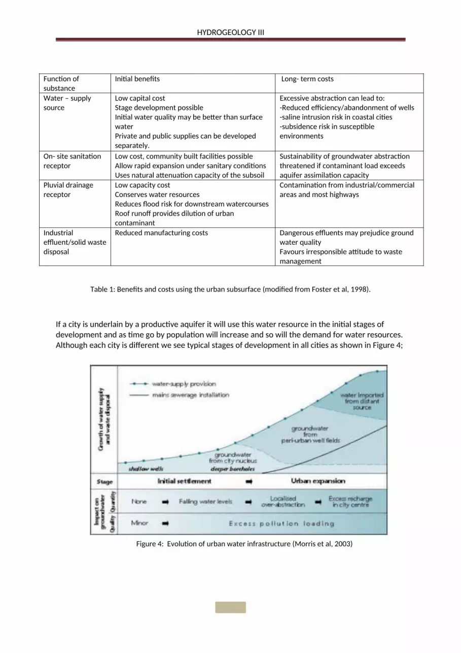
Although the benefits of the subsurface will be apparent immediately, the cost associated with environmental impact will only be realised at a later stage (Table 1). Saline intrusion and ground water quality being two of the many long term cost problems.
HYDROGEOLOGY III
Function of substance
Initial benefits Long- term costs
Water – supply source
Low capital costStage development possibleInitial water quality may be better than surface waterPrivate and public supplies can be developed separately.
Excessive abstraction can lead to:-Reduced efficiency/abandonment of wells-saline intrusion risk in coastal cities-subsidence risk in susceptible environments
On- site sanitation receptor
Low cost, community built facilities possibleAllow rapid expansion under sanitary conditionsUses natural attenuation capacity of the subsoil
Sustainability of groundwater abstraction threatened if contaminant load exceeds aquifer assimilation capacity
Pluvial drainage receptor
Low capacity costConserves water resourcesReduces flood risk for downstream watercoursesRoof runoff provides dilution of urban contaminant
Contamination from industrial/commercial areas and most highways
Industrial effluent/solid waste disposal
Reduced manufacturing costs Dangerous effluents may prejudice ground water qualityFavours irresponsible attitude to waste management
Table 1: Benefits and costs using the urban subsurface (modified from Foster et al, 1998).
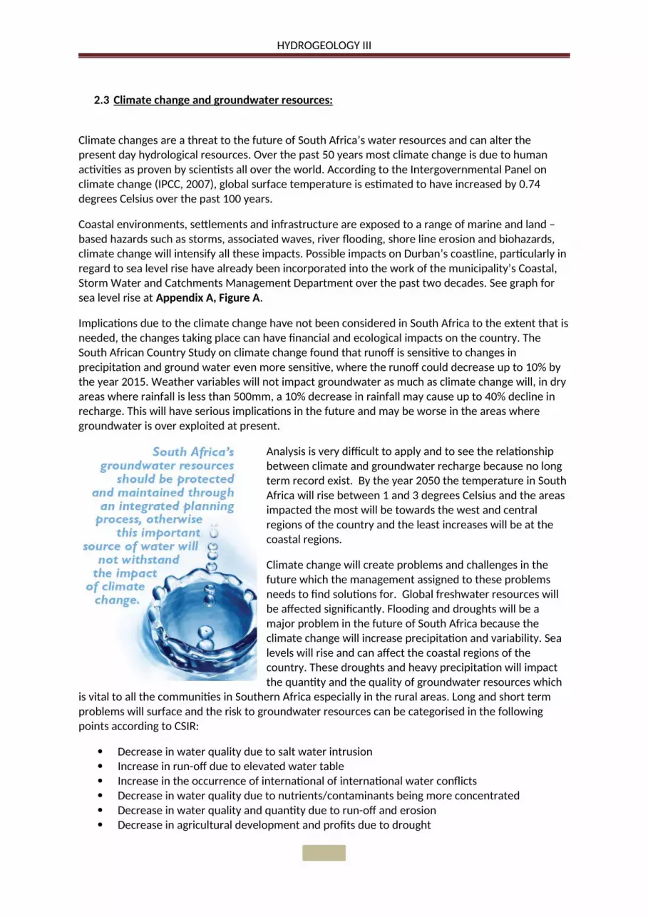
If a city is underlain by a productive aquifer it will use this water resource in the initial stages of development and as time go by population will increase and so will the demand for water resources. Although each city is different we see typical stages of development in all cities as shown in Figure 4;
Figure 4: Evolution of urban water infrastructure (Morris et al, 2003)

HYDROGEOLOGY III
2.2 Impacts of Deep Foundations e.g. piles:
2.2.1 Review of piles.
Piles are column like structures which is used in foundations to transfer the load through a soft low bearing capacity soil to competent material such as rock. Ground improvement is the enhancement of the properties of a weak soil to be able to carry the load required, this is done by their penetration, compaction and addition of material in order to have a significant increase in the density of the soil. Although this method also has an impact on the environment we will only look at piles.
Construction of raft foundations may be an alternative to piling and less of a risk to the environment. If a site in underlain by aquifers piling should be avoided especially if a clay layer will be penetrated, because clay acts as a protective layer for an aquifer. A number of factors determine the choice of pile used including bearing capacity and settlement. Many different types of piles and installation methods are used and are summarised in the Table 2 below:
Classification SubdivisionsMaterials Timber, concrete, steel, composite, stone etc.Load transfer End – bearing, friction, combinationInstallation Bored, driven, cast – in - placeEffect of installation on soil mass
Displacement, non – displacement/replacement and subdivisions according to installation method.
Table 2: Different types of piles and methods of installation all effecting groundwater.
In many instances the risks to groundwater quality will be the principal concern of environmental agency officers. Concerns regarding the protection of the groundwater will be of highest priority when:
When the site is contaminated and ground works could allow them to migrate. If pile driving connect two previously discrete aquifers. The site overlies a major or minor aquifer. Location of the site is within a source protection zone. Groundwater is currently of good quality. Shallow water table and likely be intersected by piles. Geological strata are fractured. Works are close to a surface water body that may be polluted by run- off water from site.
At a high risk site a risk assessment will be undertaken and groundwater monitoring incorporated.
2.2.2 Impacts to groundwater and pollution due to deep foundations (piling):
Different soil profiles and piling methods have different hazards which will be described; most of these scenarios affect the groundwater. Six scenarios of possible contamination to groundwater and pollution are considered and follow:

HYDROGEOLOGY III
1. Creation of pathways through an aquitard (low permeability layer), to allow potential contamination of an underlying aquifer.
Figure 5: Penetration through an aquitard.
2. Creation of pathways through an aquitard to allow upward migration of landfill gas, soil gas or contaminant vapours to the surface.
Figure 6: Vapour migration to surface.
A low permeability cap is often present as part of the remediation solution. The gas and vapours that escape in this situation is caused where an old landfill is penetrated through the cap with a pile and the material used in the landfill was gas generating fill material. The introduction of air will cause the rate of which these gasses are generated to increase.
A typical situation where the layer of soil above a clay deposit is contaminated, the clay sits on solid strata. The disturbance of this aquitard layer could create a pathway between the aquifer and groundwater on top. This pathway will be the pile or stone column used, if a timber untreated pile is used the transmission could occur within the pile material itself.

HYDROGEOLOGY III
3. The contaminated soil which have been brought to the surface being in direct contact with site workers.
Figure 7: Contaminated spoil exposed at the surface.
4. Degradation of piles due to the direct contact to contaminated soil which will cause secondary pollution to groundwater and migrating of contaminants.
Figure 8: Corrosion of pile leading to creation of flow paths.
Construction workers and surface water may come into contact with spoil from the excavation of the pile. This excavated contaminated soil may mix with uncontaminated soil and thus lead to the increase of contaminated material for disposal.
The contaminants found in contaminated soils may be aggressive to materials in piles. This has the potential to cause degradation to the piles and thus reducing their load carrying potential. This also creates pathways for migration.

HYDROGEOLOGY III
5. Aquifer penetrated by solid contaminants during pile driving .
Figure 9: Driving contaminated material into aquifer.
6. Groundwater contamination and surface water contamination by concrete, cement paste or grout.
Figure 10: Grout or paste injected into groundwater
Movement of soil during piling is in the lateral direction, some of the soil in contact with the sides or the tip of the pile can slightly move in the vertical direction with the pile before being displaced laterally.
This will cause the underlying aquifers to become contaminated. If an open-ended pile is used in soils with high densities the pile might get blocked and causes the captured material from near the surface to be transported downward.
Piling with a permanent casing or pre-formed piles would generally be chosen when piling through strata with fractured or jointed rocks.
Loss of wet concrete, cement paste or grout may occur in fast flowing groundwater in fractured rocks such as limestone etc.
This migration will continue until the setting of the concrete etc. Therefore the impact is likely to be localised.
HYDROGEOLOGY III
2.3 Climate change and groundwater resources:
Climate changes are a threat to the future of South Africa’s water resources and can alter the present day hydrological resources. Over the past 50 years most climate change is due to human activities as proven by scientists all over the world. According to the Intergovernmental Panel on climate change (IPCC, 2007), global surface temperature is estimated to have increased by 0.74 degrees Celsius over the past 100 years.
Coastal environments, settlements and infrastructure are exposed to a range of marine and land – based hazards such as storms, associated waves, river flooding, shore line erosion and biohazards, climate change will intensify all these impacts. Possible impacts on Durban’s coastline, particularly in regard to sea level rise have already been incorporated into the work of the municipality’s Coastal, Storm Water and Catchments Management Department over the past two decades. See graph for sea level rise at Appendix A, Figure A.
Implications due to the climate change have not been considered in South Africa to the extent that is needed, the changes taking place can have financial and ecological impacts on the country. The South African Country Study on climate change found that runoff is sensitive to changes in precipitation and ground water even more sensitive, where the runoff could decrease up to 10% by the year 2015. Weather variables will not impact groundwater as much as climate change will, in dry areas where rainfall is less than 500mm, a 10% decrease in rainfall may cause up to 40% decline in recharge. This will have serious implications in the future and may be worse in the areas where groundwater is over exploited at present.
Analysis is very difficult to apply and to see the relationship between climate and groundwater recharge because no long term record exist. By the year 2050 the temperature in South Africa will rise between 1 and 3 degrees Celsius and the areas impacted the most will be towards the west and central regions of the country and the least increases will be at the coastal regions.
Climate change will create problems and challenges in the future which the management assigned to these problems needs to find solutions for. Global freshwater resources will be affected significantly. Flooding and droughts will be a major problem in the future of South Africa because the climate change will increase precipitation and variability. Sea levels will rise and can affect the coastal regions of the country. These droughts and heavy precipitation will impact the quantity and the quality of groundwater resources which
is vital to all the communities in Southern Africa especially in the rural areas. Long and short term problems will surface and the risk to groundwater resources can be categorised in the following points according to CSIR:
Decrease in water quality due to salt water intrusion Increase in run-off due to elevated water table Increase in the occurrence of international of international water conflicts Decrease in water quality due to nutrients/contaminants being more concentrated Decrease in water quality and quantity due to run-off and erosion Decrease in agricultural development and profits due to drought

HYDROGEOLOGY III
As mentioned above the increase in sea levels will cause the salt water at the coastal region to intrude and contaminate the freshwater aquifers at all the coastal cities and towns. Along South Africa’s coast a lot of rural towns rely on the vital resource of groundwater and this problem will be a major concern in all of these regions. The elevated water table will be a direct result of the heavy precipitation due to the climate change in the future. As oil was one of the resources the whole world need to function a lot of war and international conflicts was the only solution between oil rich countries and the rest of the world. This same problem may in the near future be true for the water resources which will become scarcer as time goes on and climate change starts to have a major affect. As the aquifers become less saturated the contamination entering these resources will be more concentrated and will be a danger to the people using this water for domestic use. The economy will be affected through the decrease in agriculture development and profits due to the drought.
Predictions regarding precipitation changes due to climate change are more difficult to make than those for temperature, particularly for the west coast of Africa. Variability as mentioned before is the precipitation becoming unpredictable in terms of both intensity and duration and the frequency of extreme events (floods and droughts) is a result, but still the development needed to cope with problems regarding variability remains the same as for climate change, see Figure 11 below.
Figure 11: Diagram showing the relationship between climate change and variability.
In some areas where precipitation is less than 200mm per annum people use groundwater for domestic use which is stored in large sandstone aquifers. These aquifer systems are not being actively recharged from precipitation but still contain enough groundwater to support these communities and in some cases even irrigation. In these situations it is unlikely that climate change will affect the groundwater conditions.

HYDROGEOLOGY III
In recent years the devastation to urban populations of low and middle income areas has been on the rise and resulted in some deaths worldwide caused by extreme weather events. Whether this is due to climate change or not all these statistics shows the vulnerability of these populations and with climate change these events will increase. Climate change will cause more stresses than flooding and droughts such as reduction in freshwater availability and heat waves etc. See table at Appendix B which summarise some of the change and the impacts of climate change.
Climate change will increase the risk of tropical storms and floods this will affect the low-income communities living on flood plains. Long lead times are needed for encouraging urban development to move away from the coast to more environmentally friendly locations. Human settlement has been drawn to coastal areas for and all the trading opportunities that the coast provides but with the rising sea levels these settlements face hazardous conditions due to climate change.
Climate change models are not predictions of the future, but rather projections of how the future global and local climates may evolve and how these scenarios could affect local resources. It is therefore important hat planners, investors and decision makers take into account the potential effects of climate change on the water resources and in so doing, adopt strategies that ensure the long term sustainability of the water supplies and local resources.
2.4 Monitoring programmes in South Africa.
Adequate monitoring of ground water is needed to be able to make efficient use of these resources, especially for groundwater where the impacts are not obvious. All participant involved must understand the reason and the monitoring needs, these data collected must be used when decisions are made regarding the planning for the groundwater and the protection of these resources.
Figure 12: Groundwater monitoring and data management responsibilities.
HYDROGEOLOGY III
Under the National Water Act is the responsibility of the Department of Water Affairs and Forestry to implement national monitoring systems.
Good management, more knowledge and information regarding these aquifer systems is needed and must be available to everyone and not only the authorities. The lack of data regarding groundwater led to the Directorate of Geohydrology in the Department of Water Affairs and Forestry (DWAF), this programme was launched in the mid 1990’s and the purpose was to collect the data and compile 21 hydro geological maps and the programme finished in 2005.The Department of Water Affairs And Forestry requires that groundwater monitoring take place at those facilities which pose a potential threat to groundwater quality. The classification of the potentially affected aquifer system will determine the level of monitoring required and intensity of monitoring which is needed can be determined by addressing these aspects:
Number of boreholes Frequency of monitoring Variables of concern Reporting format
The purpose of monitoring facilities is to check that the impact management measures implemented are achieving the agreed groundwater objectives. Movements of any contaminants are tracked over time and monitoring will also detect contamination. Quality objectives are set and all the results will be compared to these objectives and thus checking the performance of impact management measures. Training and education for operational staff must be implemented and the Department has to ensure all officers have the skills and ability required to evaluate groundwater monitoring networks.
Implementation of these monitoring programmes needs to happen as early as possible after construction of facility, auditing and monitoring of results by Department must be done on a regular basis.
The National Microbial Monitoring Programme for Groundwater (NMMP) forms part of the national water resource monitoring programme required by the National Water Act (No. 36 of 1998) and aims to monitor microbial water quality of South Arica’s groundwater resources, with the specific objective of tracking faecal pollution and minimising the risks to human health.
2.5 Urban processes and groundwater resources:
One of the most important issues of a growing city is the interaction between urban development and groundwater, especially on cities located above shallow unconfined aquifers. Urbanisation affects the quantity and quality of the underlying groundwater of cities. The urbanisation is the cause of these following three points according to Foster et al, 1998.
Radically changing patterns and rates of recharge. Initiating new abstraction regimes. Adversely affecting groundwater quality.
Due to the points mentioned above three main problems can be related with the groundwater underneath these growing cities.
Fluctuations in groundwater levels. Severe groundwater contamination. Impact on engineering structures
HYDROGEOLOGY III
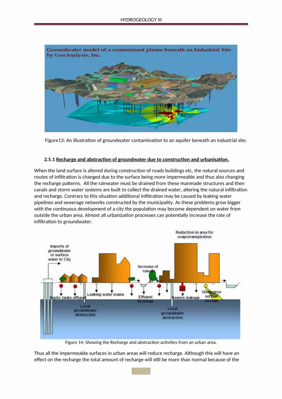
Figure13: An illustration of groundwater contamination to an aquifer beneath an industrial site.
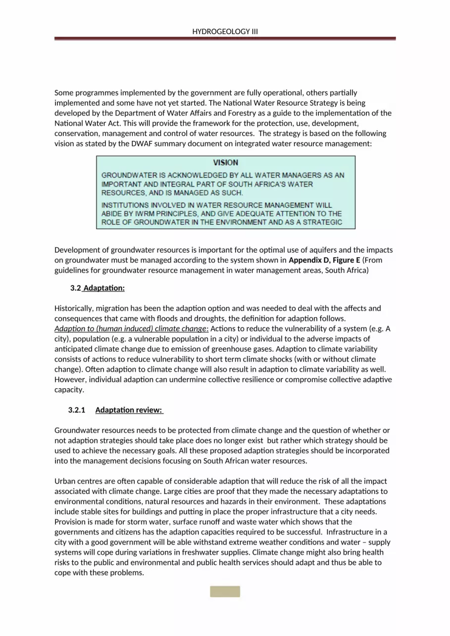
2.5.1 Recharge and abstraction of groundwater due to construction and urbanisation.
When the land surface is altered during construction of roads buildings etc, the natural sources and routes of infiltration is changed due to the surface being more impermeable and thus also changing the recharge patterns. All the rainwater must be drained from these manmade structures and then canals and storm water systems are built to collect the drained water, altering the natural infiltration and recharge. Contrary to this situation additional infiltration may be caused by leaking water pipelines and sewerage networks constructed by the municipality. As these problems grow bigger with the continuous development of a city the population may become dependent on water from outside the urban area. Almost all urbanization processes can potentially increase the rate of infiltration to groundwater.
Figure 14: Showing the Recharge and abstraction activities from an urban area.
Thus all the impermeable surfaces in urban areas will reduce recharge. Although this will have an effect on the recharge the total amount of recharge will still be more than normal because of the

HYDROGEOLOGY III
large volumes of water lost from water and waste water infrastructure. The urban recharge in these big cities will always be more than the recharge from precipitation, where at humid areas the urban recharge may balance out the recharge of precipitation.
The recharge will not be affected by urbanisation in cities where the population and industries relies on water which is imported. Cities with on–site sanitation system have potentially major effect on increasing groundwater recharge than cities with a sewerage system. It was shown that urban groundwater recharge can drastically affect local aquifer systems in terms of quality and quantity.
Abstraction of groundwater beneath large cities can be heavy and concentrated this will cause the water table lower and in return cause problems such as rupturing water mains, sewers, oil pipelines and subsurface storage tanks according to Morris et al (2003 - ). As Table 3 shows this could bring down the quality of water due to pollution. It is possible for a city to experience a steep recovery rate of the groundwater if the abstraction rate is reduced.
Recharge source Importance Water quality Pollutants/Pollution indicatorsLeaking water mains Major Excellent Generally no obvious indicatorsOn – site sanitation Major Poor N, CI, FC, DOCOn – site disposal or leakage of industrial wastewater
Minor – to - major Poor HC, industrial chemicals, N CI, FC, DOC
Leaking sewers Minor Poor Industrial chemicals, N, B, CI, FC, SO4
Pluvial drainage from surfaces by soakaways
Minor – to - major Good – to - Poor N, CI, FC, DOC, Industrial chemicals, HC
Seepage from canals and rivers Minor – to - major Moderate – to - Poor N, CI, FC, DOC, Industrial chemicals, SO4
Amenity watering of parks, playing fields, private gardens
Minor – to - major Good – to - moderate No obvious indicators if from potable supplies, N, CI, FC, DOC if with untreated or partially treated wastewater.
B: Boron, CL: Chloride, DOC: dissolved organic carbon, FC: Faecal coliforms, HC: Hydrocarbons, N: Nitrogen compounds,SO4 sulphate.
Table 3: Impact on groundwater quality due to external sources of recharge (Morris et al, 2003)
Artificial recharge is the process whereby water found on the surface is transferred to the subsurface to be stored is aquifer systems. The Department of Water Affairs has produced a strategy to encourage this artificial recharge in order to optimise the usage of aquifers in South Africa. Various methods of conducting this transferring of the water to the subsurface are being used and the most common ones is injecting water into boreholes and using basins where water can infiltrate the subsurface.
If the water has reached the subsurface it is less likely to be contaminated or evaporate like surface water. According to Mr Fanus Fourie, Hydrogeological Resource Analyst at the Department Water Affairs “Artificial recharge can be implemented virtually everywhere where groundwater is being used or being planned for use. It can augment water supplies on a large scale such as in Atlantis near Cape Town, or Windhoek in Namibia, or it can be used to boost single borehole schemes like at Kharkhams in Namaqualand, or for irrigation supplies for individual households such as in Hermanus in the Southern Cape. Areas potentially suitable for artificial recharge in South Africa have been identified using a GIS (Geographic Information System) process and are presented on WMA (Watershed Management Area) scale maps”.

Figure 15: Downward movement of pollutants induced by pumping (from Morris et al, 1994)
HYDROGEOLOGY III
Groundwater levels must immediately be monitored which will give a good indication of the aquifer’s potential to accept water. Artificial recharge is working and can be used to ensure water availability for later use. It is much cheaper than most new resource developments.
Urbanization often has efficient drainage systems which remove storm water from recharge area, together with all the paved surfaces decreases the infiltration to aquifer systems. Urban design needs to reduce those losses by introducing more soakaways and some vegetated areas to maintain groundwater recharge.
2.5.2 Urban processes and groundwater quality.
The changing patterns and rates of recharge and abstraction of groundwater as explained above also effects the quality of the groundwater. The impact of the modified recharge from various resources as mentioned above is usually unfavourable because the quality of water coming from these additional resources is poor. Sanitation such as septic tanks, soak ways, cesspits and pit latrines are used by dense urban populations living on shallow and vulnerable aquifers. Cross contamination between unsewered and sewered sanitation and poorly maintained or illegally tapped into water distribution systems can also be expected.
As a result of urbanisation on top of these shallow groundwater aquifers many towns can no longer use this supply because of pollution. When this is the situation the municipality and private water users looks for a different source of unpolluted quality water usually found deep underneath the surface. This water will be a new source and safe but only until the contaminated water moves downwards because of the pumping to compromising the quality of the deeper abstraction boreholes. Other sources of contamination is illustrated in Appendix A, Figure B.
2.5.3 Investigation of urban Impact on groundwater.
For a proper assessment of the risk that an urban area has on the groundwater, the interaction between the recharge and discharge pressures and the pollutant loading on the one hand and the nature of the subsurface environment on the other. The potential for urbanisation processes to have an impact on the underlying aquifers depends on the vulnerability to pollution and whether excessive abstraction will have negative consequences on the groundwater.
Developing a model of a groundwater system will help with the investigation and understanding of the impacts of urbanisation on the system. The model needs only to be a cross section sketch showing the aquifer systems and the recharge and discharge of the urban area under investigation.

HYDROGEOLOGY III
The model is used to decide which areas and processes needs further investigation. As work progresses this model can be changed and refined, the more detailed model will increase the knowledge of the groundwater and its ability to cope with the pollutants due to the urban processes. Good knowledge of population densities and whether they are served with sewered or unsewerd sanitation is required to estimate the potential of urban pollution. Both planned and managed disposal of waste in landfills and unplanned, informal disposal in brick pits, dry canals and river beds, old wells and drains, into the street and onto disused can contribute to pollution and contamination of groundwater systems thus reducing the quality of the water. It should be remembered that many urban pollution sources such as sewers, storm drainage, solid waste disposal, fuel storage tanks are likely to discharge below the ground surface of the soil thus bypassing the only protective layer for underlying groundwater systems.
3. Discussions and conclusions:
3.1 Management of groundwater:
Poor management of groundwater is common because it is not visible like surface water. Once an aquifer is contaminated it is very expensive and difficult to purify the water to its original state. Lack of knowledge and information will cause our groundwater quality to deteriorate, in many parts of the country groundwater is the only water available for communities to provide for the basic needs. The more groundwater becomes in demand as the population grows the more the country will need to protect these resources for the future. The increasing developments, mining, urbanization, industrialisation and agriculture contaminate this supply of good quality groundwater. Now the problem being realised and becoming a reality the groundwater will need to be managed and protected. South Africa has good control over the surface water in the country but the knowledge of groundwater where it occurs and what actions to take in order for all the external factors not to contaminate the groundwater to unacceptable levels are limited.
Because of the wide spread and uneven ground water resources of South Africa it is not possible to protect all the water, important aquifers and resources needs to be identified and protected. Thus our water policy must not put their aim on preventing all of the negative effects on the aquifers systems but minimise it and select the location according to local demand, thus being more economical. Aquifers with a higher yield and higher demand must receive more protection.
Protecting groundwater is central to successfully managing the country’s limited water resources, the National Water Act provides the framework needed to protect, manage and develop our resources.

HYDROGEOLOGY III
3.1.1 Groundwater management authorities:
All groundwater management agencies need to employ a groundwater co-ordinator who will interact with all water management authorities and stakeholders. The co-ordinator should have good management skills and have a good understanding of groundwater. The responsibilities of the co-ordinator will include:
Contribution to regular review of National Water Resource Strategy to ensure groundwater is integrated into the national strategy.
Catchment management strategies implementation. Groundwater quality management strategies, conservation and protection. Determine aquifer vulnerability and the safe yield of an aquifer. Allocation of groundwater to users Monitoring borehole use, groundwater quality and water table draw down. Management of an effective groundwater information system.
Figure 17: Relationship between the groundwater co-ordinator and water management authorities.
According to DWAF Cape town will be the first major urban city in South Africa to exceed the total potential yield for the area, if the population growth scenarios are realized or the impact of projected climate change manifests itself. The Berg Water Project will bring some relief to the high water demand of Cape Town and is illustrated in Appendix C, Figure D. The Integrated Water Resource Planning Study identified an integrated planning approach to ensure water demand matches supply.
It is important that all the impacts and effects due to climate change be monitored as a precautionary measure and management and planners need to make decisions by using climate data available and the data from the monitoring sites.
Figure16: Water resource management system
HYDROGEOLOGY III
Some programmes implemented by the government are fully operational, others partially implemented and some have not yet started. The National Water Resource Strategy is being developed by the Department of Water Affairs and Forestry as a guide to the implementation of the National Water Act. This will provide the framework for the protection, use, development, conservation, management and control of water resources. The strategy is based on the following vision as stated by the DWAF summary document on integrated water resource management:
Development of groundwater resources is important for the optimal use of aquifers and the impacts on groundwater must be managed according to the system shown in Appendix D, Figure E (From guidelines for groundwater resource management in water management areas, South Africa)
3.2 Adaptation:
Historically, migration has been the adaption option and was needed to deal with the affects and consequences that came with floods and droughts, the definition for adaption follows.Adaption to (human induced) climate change : Actions to reduce the vulnerability of a system (e.g. A city), population (e.g. a vulnerable population in a city) or individual to the adverse impacts of anticipated climate change due to emission of greenhouse gases. Adaption to climate variability consists of actions to reduce vulnerability to short term climate shocks (with or without climate change). Often adaption to climate change will also result in adaption to climate variability as well. However, individual adaption can undermine collective resilience or compromise collective adaptive capacity.
3.2.1 Adaptation review:
Groundwater resources needs to be protected from climate change and the question of whether or not adaption strategies should take place does no longer exist but rather which strategy should be used to achieve the necessary goals. All these proposed adaption strategies should be incorporated into the management decisions focusing on South African water resources.
Urban centres are often capable of considerable adaption that will reduce the risk of all the impact associated with climate change. Large cities are proof that they made the necessary adaptations to environmental conditions, natural resources and hazards in their environment. These adaptations include stable sites for buildings and putting in place the proper infrastructure that a city needs. Provision is made for storm water, surface runoff and waste water which shows that the governments and citizens has the adaption capacities required to be successful. Infrastructure in a city with a good government will be able withstand extreme weather conditions and water – supply systems will cope during variations in freshwater supplies. Climate change might also bring health risks to the public and environmental and public health services should adapt and thus be able to cope with these problems.

HYDROGEOLOGY III
With investments and developments in and around urban centres will reduce the risks to infrastructure, population and enterprises to climate change related impacts. The methods requires for adaption is in use today by changing the building codes, land use planning in high risk areas and special provision for extreme events. It could be difficult for large well established cities to adapt to climate change risks. Climate change risks also heighten the already existing risks involved.
Without the effective adaption millions of people living in urban areas are at risk of the direct or indirect impact of climate change. Adaption can only prevent some damage and greenhouse gas emissions must be cut by a considerable amount and thus global agreements is urgently needed to minimise the problems associated with the continuous gas emissions. Reduction in poverty, development in housing and infrastructure is also a key part in adaption to a better future.
Cape Town is at risk of weather changes due to climate change and developed a municipal adaption plan for these risks. The paper revolves around four main principles as mentioned below:
1) Adaption to short-term climate variability and extreme events should be included as the basis for reducing vulnerability to longer-term climate change;
2) Adaption policies and measure should be assessed in a developmental context;3) Adaption should occur at different levels of society;4) Both the strategy and process by which adaption is implemented are equally important
Eight steps are also described in the paper for developing an existing adaption strategy for a municipality and are as follows:
1) Asses current climate trends and projections for the municipal area;2) Undertake a vulnerability assessment for each sector, and identify future vulnerabilities;3) Formulate strategy;4) Assess adaption options;5) Evaluate priority adaption strategies;6) Carry out programme- and project-scoping and design;7) Implementation;8) Monitoring.
Resource mobilization for the implementation phase of the adaption strategy is also covered in the same paper.
Adaption can also be divided into a long term and short term solutions or categories and is often revered to as “adaption” and “coping” respectively.
Type of response to climate change.
By households, communities and firms. Policy driven
Short - run Making short- run adjustments, e.g. reducing water use, spreading the risk of loss through insurance
Developing greater understanding of climate risks and vulnerabilities.Improving emergency response.
Long - run Investing in climate resilience- much encouraged if future effects are relatively well understood and benefits are easy to capture for household, community organization or firm.
Investing to create or modify major infrastructure, e.g. larger reservoir storage, increased drainage capacity, higher sea-walls.Avoiding negative impacts e.g. land use planning to restrict developments in floodplains and at-risk coastal sites.
HYDROGEOLOGY III
Table 4: Example of short–run and long-run adaptations.
Coastal regions in South Africa are at risk of sea level rise and must consider the options and strategies to successfully adapt to this problem in the future. Relocation landwards and abandoning the coastal areas that are too difficult and expensive to protect may be one of the options in the future. The Intergovernmental Panel on Climate Change (IPCC) did conduct studies to what will be the cost to protect these coastal cities by means of reducing the energy of the water by offshore barriers etc. No conclusion was made regarding the global cost only a few estimates.
Cities needs local knowledge and capacity for adaption to happen but the government of each city must rely on the higher government for the much needed funding and expertise to be available when the city needs this resources. A good information base in needed to make all the information available to the population and thus in this manner support from the local communities will form. The World Meteorological Organization recommended a minimum amount of weather – watch stations, Africa’s number of these stations is eight times less than recommended. Thus many nations are unable to monitor or forecast the climate. This is n constraint in the sense of adaption capabilities all over the world, if no data in urban cities is collected on hazardous events and the impact from everyday life there can be no policy put in place to support adaption.
3.2.2 Durban’s adaptation plans:
Durban’s adaption plans to climate change are still at an early stage and are led by the environmental Management Department of eThekwini Municipality. Because of major post apartheid development challenges and restructuring of local government it took several years before climate change emerged as an issue of concern. Governments of different cities in South Africa participated in the Cities for Climate Protection Campaign focusing on mitigation.
“Climate Future for Durban Programme” was initiated with CSIR (Council for Scientific and Industrial Research) in 2004 and consists of 3 phases as follows.
1 Reviewing and developing an understanding of global and regional climate change science and translating this into an understanding of the implications of climate change for Durban.
2 Developing a “Headline Climate Change Adaption Strategy” for the city.3 Incorporating climate change into long term city planning, for greater understanding of the
effect s of climate change in Durban CSIR are developing a model
The report on Headline Change Adaptation Strategy as mentioned above was competed in 2006 with the focus as follows.
Discuss in more detail sectoral climate – change impacts, Durban’s vulnerability to these impacts and plausible adaption options; Gain insights into how the various departments within the municipality engage with the
issue of climate – change adaption; Identify departmental initiatives (both current and future) that will facilitate adaption; Highlight research opportunities.

HYDROGEOLOGY III
Since the strategy was produced major storm events caused damage to the coastline such as the R 60 million repair cost in March 2007.
Below is a list of the adaptation options for Durban:
Human health: Heat waves, weather disasters, infectious disease etc. Water and sanitation: Absorbing capability of landscape, urban drainage, sewer design etc. Coastal zone: Sea storm and sea level rise prediction Biodiversity: Develop knowledge on biodiversity impacts Key infrastructure at risk: Planning, maintenance, upgrades to endure weather events. Electricity supplies: Review of how to cope with climate change Transport: Reduce emissions and revise road construction standards. Food security and agriculture: Impacts on commercial agriculture Disaster risk reduction: Pro –active to minimise hazard, early warnings etc. Cross – sector municipal activities: Public education, local research, build awareness,
encourage policy changes etc.
3.2.3 Impacts on the coast of Cape Town and some adaptation strategies:
The City of Cape Town has many sandy areas along the coast line that have high potential for erosion as a result of high energy wave regime. Specific locations are evaluated in terms of their vulnerability to five potential impacts as listed below.
Increased exposure to extreme events Increased saltwater intrusion and raised groundwater tables. Greater tidal influence. Increased flooding. Increased coastal erosion.
Proposed planning measures to manage the potential coastal impacts will include the following:
Development of a coastal vulnerability map using geographic information. Shoreline management plan to include protection of ecological water reserves. Maintenance and monitoring programme for coastal infrastructure. Break water to provide shelter for harbours, roads and housing.
The few adaptation strategies mentioned above is only for the coastal regions and many other adaptations will be necessary for Cape Town as for many other cities due to the impact from climate change. Assessment of the vulnerability to climate change impact needs to be done in order to develop a Municipal Adaptation Plan or a “MAP”, see Appendix C, Figure C which shows the process for developing a plan like this.

HYDROGEOLOGY III
4. Recommendations:
Governments, municipalities and departments which forms part of the framework of protecting groundwater and minimising the risks to groundwater from climate change etc need to deal with these impacts in a proactive manner. If there is a problem with drought some regions use water tankers to provide water for domestic needs, this is not a solution. So if the authorities act in a proactive manner water will in the near future be available if groundwater is protected and not overexploited. Wastage and losses in delivery systems contaminate groundwater, management and strategies should be implemented to reduce the risk of permanently reducing the quality of aquifer systems. As mentioned before it is expensive and difficult to purify the water to its original state, thus another reason to implement proactive strategies as soon as possible. Good groundwater management is obviously very important but it is necessary for early warning systems for reporting depleted groundwater reserves and monitoring to be up to standard at all times.
4.1 Groundwater Research and data collection:
In order to respond to any problems regarding groundwater proper research is needed. Little research has been done on groundwater availability in hard rock regions where storage is low and typically has poor aquifer systems. Some areas use hard-rock aquifers for irrigation and therefore better understanding them is important. In many regions the estimates for extraction, recharge, evapotranspiration etc are unavailable showing the lack of research at the moment.
In general governments do not give much attention to long term data collection on resource conditions. As much elements of the hydrological cycle including groundwater fluctuations should form part of the data collection and is essential for managing groundwater. Data collected over a period of time can be used for resolving conflict and settle debates over management of groundwater and thus is necessary for social and government related problems.
4.2 Sharing groundwater Information :
The lack of knowledge and information in communities regarding groundwater has been mentioned a few times in the topics discussed above, it’s become obvious to me that information and the availability thereof does play an important role in communities and needs to be shared amongst governments, people and associations. Sharing knowledge and information has always been part of human’s way of life and is necessary for development. Sharing information improves efficiency, stimulates development and reduces the probability of making wrong decisions.
4.2.1 Groundwater Knowledge base:
Without having access to sufficient and relevant information it is not possible to respond to the major issues including floods, droughts protecting ecosystems etc. As stated by the South African Minister of Water Resources Ronny Kasrils (2003): ‘No sustainable development of scarce natural resource is possible without understanding the resource and managing it wisely according to this growing understanding.’ Therefore the knowledge base on our groundwater resources has to be continuously updated. Groundwater can be a difficult subject to understand regarding its movement, quality, does it link with surface water and the way it will respond to over exploitation. Protecting and managing the aquifers systems properly a sufficient information and knowledge base is needed. The Department of Water Affairs and Forestry will establish and maintain a national information system for groundwater in South Africa.

HYDROGEOLOGY III
5. Reference list:
Hydrological science in South Africa: http://researchspace.csir.co.za/dspace/bitstream/10204/539/1/Ashton_1999.pdf Colvin_2008 http://researchspace.csir.co.za/dspace/bitstream/10204/2555/1/Colvin_2008.pdf Piling and Penetrative Ground Improvement Methods on Land Affected by
Contamination: FJ Westcott, C M B Lean & M L Cunningham Adapting to climate change in Urban Areas, Human Settlements Discussion Paper Series http://www.iaea.org/technicalcooperation/documents/Brochures/sust-groundwater.pdf Coastal and marine environments: Russell Arthurton, Kwame Korateng Policy and strategy for groundwater quality management in South Africa (DWAF) Impact of Urbanization on Groundwater Recharge (D.P.E Putra, K Baier) http://www.wrc.org.za/News/Pages/GroundwaterusepotentialforSouthAfrica.aspx GUIDELINES%20FOR%20GROUNDW%20RESOURCES%20MANAGEMENT%20LEVEL%202
Integrated water resource management, DANIDA SRK_Woodfood_How_much_Groundwater_does_SA_have (DWAF, Alan Woodford &
Peter Rosewarne) Framework for Adaption to Climate Change in the City of Cape Town (07Mukheibir
%20Water%20Northern%20Cape) The Rising tide: Assessing the risks of climate change and human settlements in low
elevation coastal zones. (Gordon Mc Graham, Deborah Balk and Bridget Anderson)
Appendix A:

HYDROGEOLOGY III
Figure A: Sea level rise due to climate change.
Figure B: Sources of groundwater contamination.
Appendix B:

HYDROGEOLOGY III
Current and projected impacts of climate change on industry, settlement, society and groundwater
Appendix C:
Figure C: Process for developing a Municipal adaptation plan (MAP)
Figure D: Water supply and demand projections for Cape Town.

HYDROGEOLOGY III
Appendix D:
Figure E: Integrated development resources.

HYDROGEOLOGY III
Figure F: Estimated total volume (m3/km2 ) of groundwater stored in South African aquifers