hydrogeology 1st lecture
TRANSCRIPT
HYDROGEOLOGY
.
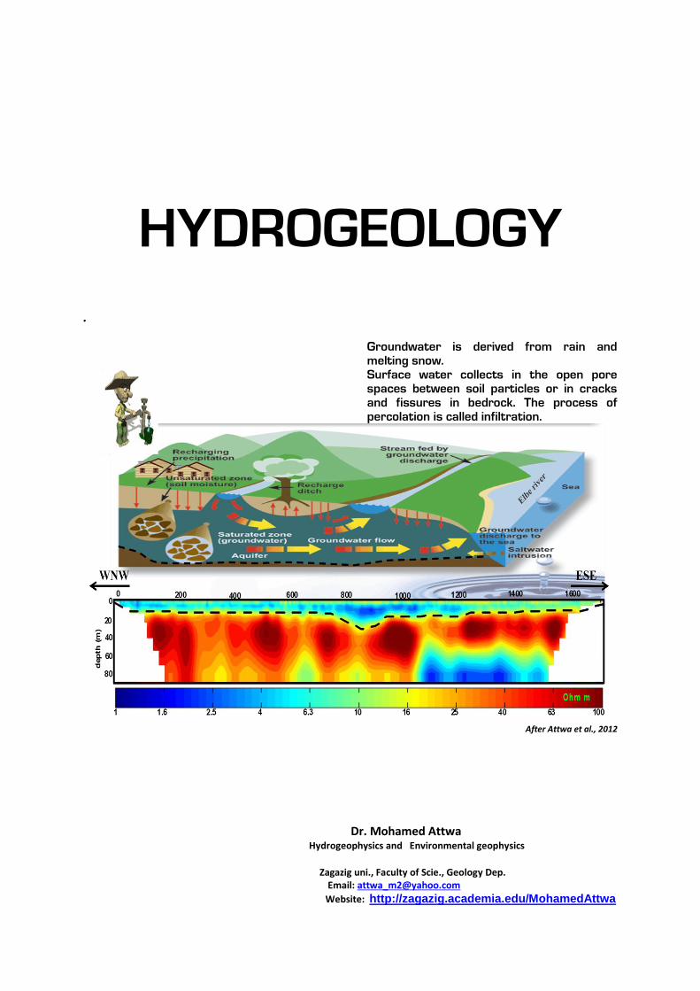
Groundwater is derived from rain and melting snow. Surface water collects in the open pore spaces between soil particles or in cracks and fissures in bedrock. The process of percolation is called infiltration.
After Attwa et al., 2012
Dr. Mohamed Attwa Hydrogeophysics and Environmental geophysics
Zagazig uni., Faculty of Scie., Geology Dep. Email: [email protected]
Website: http://zagazig.academia.edu/MohamedAttwa
1. Introduction
What is groundwater?
Groundwater is a concealed fluid “subsurface water” that can be observed
only at intermittent points at springs and in boreholes. Aquifers and flow paths
are traditionally deduced by information retrieved from drilling operations, for
example, rock cuttings and occasionally cores, but these are poor small-scale
representatives of the large systems involved. This feature is familiar to
geologists who try to predict the lithological and stratigraphic column to be
passed by a new borehole. The outcome reveals time and again a higher spatial
complexity and variability than predicted by interpolation of data available from
existing boreholes. Prediction of hydraulic barriers, as well as prediction of
preferred flow paths, based on knowledge of the regional geology is short-
handed as well. Water properties have also been measured traditionally, but they
were mostly limited to the depth of the water table, or the hydraulic head,
temperature, and salinity. Modern chemical and isotope hydrology encompasses
many more parameters and deals with the integrative interpretation of all
available data. The concealed nature of groundwater gets gradually exposed.
Groundwater geology (Hydrogeology) is a branch of the earth sciences
dealing with the flow of water through aquifers and other shallow porous media.
Hydrology is a branch of Earth Science. The importance of hydrology in the
assessment, development, utilization and management of the water resources, of
any region is being increasingly realized at all levels. It was in view of this that
the United Nations proclaimed the period of 1965-1974 as the International
Hydrological Decade during which, intensive efforts in hydrologic education
research, development of analytical techniques and collection of hydrological
information on a global basis, were promoted in Universities, Research
Institutions, and Government Organizations.
What is the importance of groundwater?
One of the most important sources of fresh water in the earth.
The only fresh water source in many desert areas.
Many town and city persons also drink groundwater.
Fifty-five counties draw half or more of their public water supplies from
groundwater.
Farmers use groundwater for irrigating crops and for their animals.
Many commercial businesses and industries companies also depend on
groundwater for their processes and operations.
Other industries rely on clean groundwater for the production of electric
power, food and material production.
How does groundwater originate?
Groundwater originates from the following types:
1- Juvenile Water/ Magmatic Groundwater, e.g comes out from volcanoes
and traps in rocks.
2- Connate Groundwater e.g fossilized water.
3- Meteoric groundwater (Rainwater Recharge)..
4- Metamorphic groundwater, e.g trapped during rock – forming
processes.
5- Marine water.
What is an aquifer?
An aquifer is a body of saturated rock that both stores and transmits
important quantities of groundwater. Therefore, subsurface water is the sum of
soil moisture (above the water table) and groundwater (below it).
The study of hydrology helps us to know:
(i) the maximum probable flood that may occur at a given site and its frequency;
this is required for the safe design of drains and culverts, dams and reservoirs,
channels and other flood control structures.
(ii) the water yield from a basin—its occurrence, quantity and frequency, etc;
this is necessary for the design of dams, municipal water supply, water power,
river navigation, etc.
(iii) the ground water development for which a knowledge of the hydrogeology
of the area, i.e., of the formation soil, recharge facilities like streams and
reservoirs, rainfall pattern, climate, cropping pattern, etc. are required.
(iv) the maximum intensity of storm and its frequency for the design of a
drainage project in the area.
What is the spring?
Spring is a place where groundwater flows or seeps out of the ground.
When percolating water reaches the water table or an impermeable layer, it
flows laterally, and if the flow intersects the ground surface, it discharges as a
spring.
What is the water well and streams?
Water well is an opening made by digging or drilling (dug wells) into the
zone of saturation. Water percolates into the well and rises to the level of the
water table. Streams are any flow of water within a natural channel regardless o
f size. A stream's headwaters are where the stream originates, usually in the
higher elevations of mountainous terrain. The stream flows downhill and across
lower elevations to its terminus, where it enters another stream, lake, or ocean.
This terminus is called the mouth of the stream.
1.1. World’s water resources
The World’s total water resources are estimated at 1.36 × 10⁸ Μ ha-m. Of
these global water resources, about 97.2% is salt water mainly in oceans, and
only 2.8% is available as fresh water at any time on the planet earth. Out of this
2.8% of fresh water, about 2.2% is available as surface water and 0.6% as
ground water. Even out of this 2.2% of surface water, 2.15% is fresh water in
glaciers and icecaps and only of the order of 0.01% is available in lakes and
streams, the remaining 0.04% being in other forms. Out of 0.6% of stored
ground water, only about 0.25% can be economically extracted with the present
drilling technology (the remaining being at greater depths).
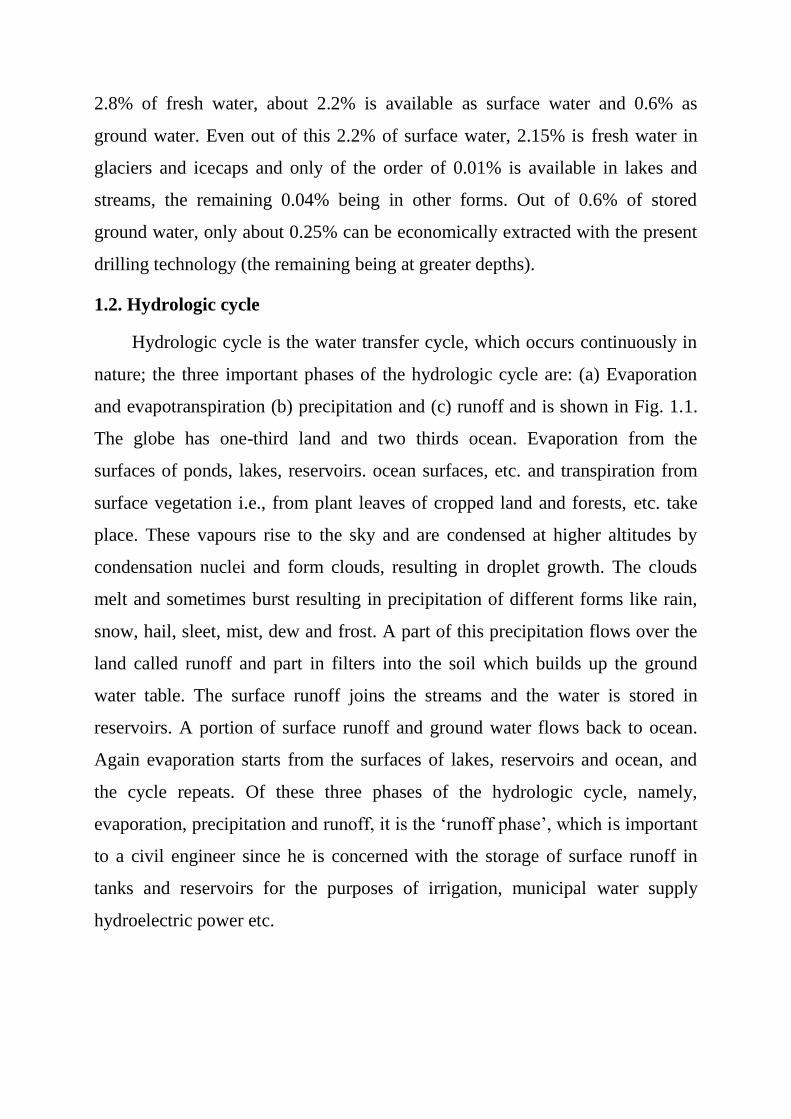
1.2. Hydrologic cycle
Hydrologic cycle is the water transfer cycle, which occurs continuously in
nature; the three important phases of the hydrologic cycle are: (a) Evaporation
and evapotranspiration (b) precipitation and (c) runoff and is shown in Fig. 1.1.
The globe has one-third land and two thirds ocean. Evaporation from the
surfaces of ponds, lakes, reservoirs. ocean surfaces, etc. and transpiration from
surface vegetation i.e., from plant leaves of cropped land and forests, etc. take
place. These vapours rise to the sky and are condensed at higher altitudes by
condensation nuclei and form clouds, resulting in droplet growth. The clouds
melt and sometimes burst resulting in precipitation of different forms like rain,
snow, hail, sleet, mist, dew and frost. A part of this precipitation flows over the
land called runoff and part in filters into the soil which builds up the ground
water table. The surface runoff joins the streams and the water is stored in
reservoirs. A portion of surface runoff and ground water flows back to ocean.
Again evaporation starts from the surfaces of lakes, reservoirs and ocean, and
the cycle repeats. Of these three phases of the hydrologic cycle, namely,
evaporation, precipitation and runoff, it is the ‘runoff phase’, which is important
to a civil engineer since he is concerned with the storage of surface runoff in
tanks and reservoirs for the purposes of irrigation, municipal water supply
hydroelectric power etc.
Fig. 1.1. A simplified representation of hydrological cycle.
1.3. Forms of precipitation
Drizzle — a light steady rain in fine drops (0.5 mm) and intensity <1 mm/hr
Rain — the condensed water vapour of the atmosphere falling in drops (>0.5
mm, maximum size—6 mm) from the clouds.
Glaze — freezing of drizzle or rain when they come in contact with cold
objects.
Sleet — frozen rain drops while falling through air at subfreezing temperature.
Snow — ice crystals resulting from sublimation (i.e., water vapour condenses to
ice)
Snow flakes — ice crystals fused together.
Hail — small lumps of ice (>5 mm in diameter) formed by alternate freezing
and melting, when they are carried up and down in highly turbulent air currents.
Dew — moisture condensed from the atmosphere in small drops upon cool
surfaces.
Frost — a feathery deposit of ice formed on the ground or on the surface of
exposed objects by dew or water vapour that has frozen
Fog — a thin cloud of varying size formed at the surface of the earth by
condensation of atmospheric vapour (interfering with visibility)
Mist — a very thin fog
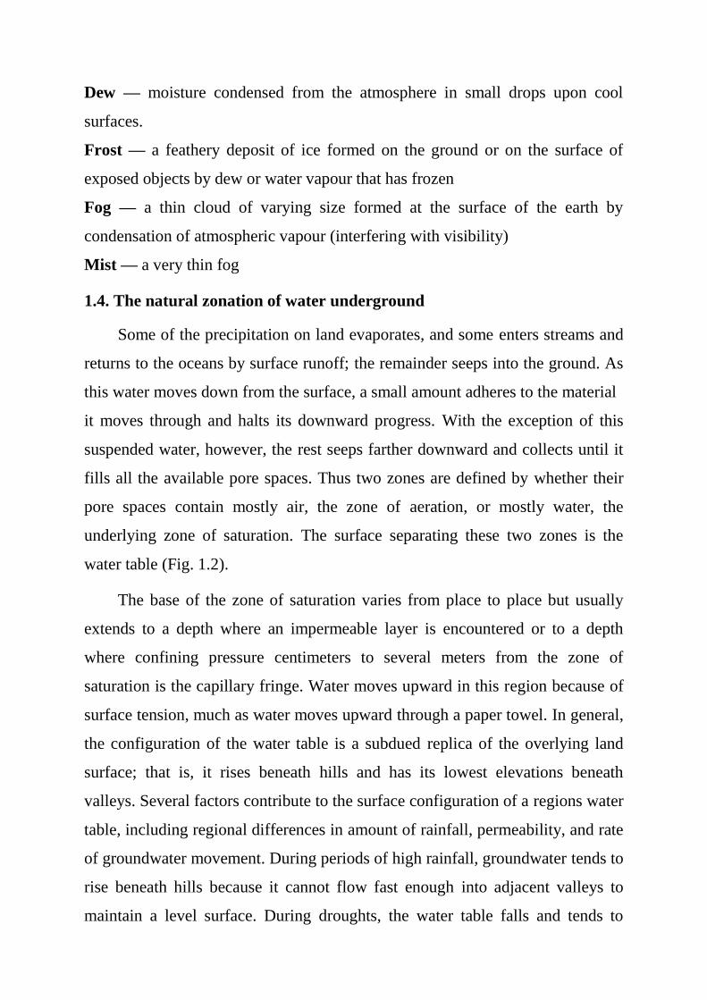
1.4. The natural zonation of water underground
Some of the precipitation on land evaporates, and some enters streams and
returns to the oceans by surface runoff; the remainder seeps into the ground. As
this water moves down from the surface, a small amount adheres to the material
it moves through and halts its downward progress. With the exception of this
suspended water, however, the rest seeps farther downward and collects until it
fills all the available pore spaces. Thus two zones are defined by whether their
pore spaces contain mostly air, the zone of aeration, or mostly water, the
underlying zone of saturation. The surface separating these two zones is the
water table (Fig. 1.2).
The base of the zone of saturation varies from place to place but usually
extends to a depth where an impermeable layer is encountered or to a depth
where confining pressure centimeters to several meters from the zone of
saturation is the capillary fringe. Water moves upward in this region because of
surface tension, much as water moves upward through a paper towel. In general,
the configuration of the water table is a subdued replica of the overlying land
surface; that is, it rises beneath hills and has its lowest elevations beneath
valleys. Several factors contribute to the surface configuration of a regions water
table, including regional differences in amount of rainfall, permeability, and rate
of groundwater movement. During periods of high rainfall, groundwater tends to
rise beneath hills because it cannot flow fast enough into adjacent valleys to
maintain a level surface. During droughts, the water table falls and tends to
flatten out because it is not being replenished. In arid and semiarid regions, the
water table is usually quite flat regardless of the overlying land surface.
Fig. 1.2. A simplified representation of hydrological cycle.
1.5. Basic concepts and definitions
Evaporation:
The transformation of water from a liquid into a gas, a process which humidifies
the atmosphere.
Transpiration:
Transfer of water to the atmosphere by plants and vegetation.
Condensation:
The transformation of water from a gas into a liquid, and the processes that lead
to condensation.
Transport:
The movement of water through the atmosphere.
Precipitation:
The transfer of water from the atmosphere to land.
Infiltration:
Water infiltrated below ground surface to form groundwater and how it returns
to the surface.
Runoff:
Rivers, lakes, and streams transport water from land to the oceans. Too much
rainfall can cause excess runoff, or flooding.
An aquitard:
A water bearing layer in which the horizontal flow component with respect to
the vertical flow component is so small that it can be neglected. An aquitard is a
saturated body of rock that impedes the movement of groundwater. In an
aquitard the ground flow is assumed to be predominantly vertical.
An aquiclude:
A water bearing layer in which both the horizontal and vertical flow components
are so small that they can be neglected. In an aquiclude the groundwater flow is
assumed to be zero.
Common aquifers are geological formations of unconsolidated sand and gravel,
sandstone, limestone and heavily fractures volcanic and crystalline rocks.
Common aquitard are for example, clays, shale and silt.
1.6 Hydrologic equation
The hydrologic equation is simply the statement of the law of conservation of
matter and is given by,
I = O + S
where I = inflow
O = outflow
S = change in storage
This equation states that during a given period, the total inflow into a given area
must equal the total outflow from the area plus the change is storage. While
solving this equation, the ground water is considered as an integral part of the
surface water and it is the subsurface inflow and outflow that pose problems in
the water balance studies of a basin.
1- Water budget (balance) equation for surface water:
P+Qin-Qout+Qg-Es-Ts-I=Ss
where P is precipitation, Qin surface water flow into the system (stream), Qout
surface water flow out the system, Qg underground flow towards the system, Es
evaporation from the surface, Ts transportation, I infiltration and Ss the change
in storage in the surface water system.
2- Water budget (balance) equation for groundwater:
I+Gin-Gout+Qg-Eg-Tg=Sg
where Gin groundwater flow into the system, Gout groundwater flow from the
system (stream), Qg underground flow towards the surface water system, Eg
evaporation, Tg transportation which will be effective if the water table is near
to the ground surface and Sg the change in storage in the groundwater system.
3- Water budget (balance) equation for hydrologic system:
P- (Qout-Qin) - (Es+Eg) - (Ts+ Tg) - (Gout–Gin)= (Ss-Sg)
Net water amount:
P-Q-G-E-T=S
Summary Exercises:
1- Is an Aquifer an Underground River?
2- What does an aquifer look like?
3- How Does an Aquifer Work?
4- Why is Groundwater So Clean?
5- How is an Aquifer Contaminated?
Further Readings:
Please read the lecture of “Running water2nd Lect.” and “Gunning water2nd Lect.” at
http://zagazig.academia.edu/MohamedAttwa