grand canyon geology training manual section 4
TRANSCRIPT
Chapter 2: READING THE PAGES OF GRAND CANYON GEOLOGY
The rock layers in Grand Canyon are the pages of an ancient history book, written in the language of geology, with chapters of information about places and environments that existed long ago. This vast book of geologic information can be overwhelming, as it would be to read an entire encyclopedia. Many of the pages of the book are missing because they were removed as rocks were eroded and washed away during various periods in geologic time.
Now that you’ve been introduced to the fundamentals of the “Language of Geol-ogy,” we can begin to read the pages of Grand Canyon, and think about how to convey the geology to park visitors in a meaningful way. Just as the rocks in the canyon were deposited, this manual will discuss important events in the geologic history of Grand Canyon chronologically from the bottom of the canyon to the top.
THE PRECAMBRIAN TIME (4540 TO 544 MILLION YEARS AGO)
Even though the Precambrian time comprises about 87% of the Earth’s his-tory, we know little about it compared to more recent geologic periods. Since the Earth formed 4540 million years ago, it has been cooling and releasing heat and gases. The planet’s atmosphere and water were formed by the gases released, and the continents gradually formed (in locations different than today) after millions of years of volcanic and tectonic events. Undoubtedly, the Earth looked very different during the Precambrian,
One might imagine that this was intended for the library of the gods; and it was. The shelves are not for books, but form the stony leaves of one great book. He who would read the language of the universe may dig out letters here and there, and with them spell the words, and read, in a slow and imperfect way, but still so as to understand a little, the story of creation. (J.W. Powell, The Exploration of the Colorado River and its Canyons, ©1961, Dover Publications, Inc.)
Interpreting the rocks. It is not as important to memorize the names or the ages of all the rock layers, as it is to recognize the rock types and the environments of deposition they represent. Although you may initially impress visitors by naming off each layer, they will probably not find a pro-gram enjoyable or meaningful if you go into excruciating detail about each of the layers. An overload of details would bore visitors, as it would bore you to hear a detailed description of the internal workings of a frog intes-tine! Have a few carefully selected and intriguing topics to discuss about some of the layers. The layers you choose should be easy to recognize from the rim, have geologic stories relevant to your program theme, and represent a depositional environment that visitors can relate to. Consider carrying a stratigraphic column (Fig 1.25) as a cheat sheet to help you answer more specific questions about the rocks.
47
especially because the oceans held the only life on the planet. The first life forms were simple, unicellular microorganisms that developed about 3500 million years ago. Their fossilized remains have been found in western Australia.
Precambrian Metamorphic Rocks
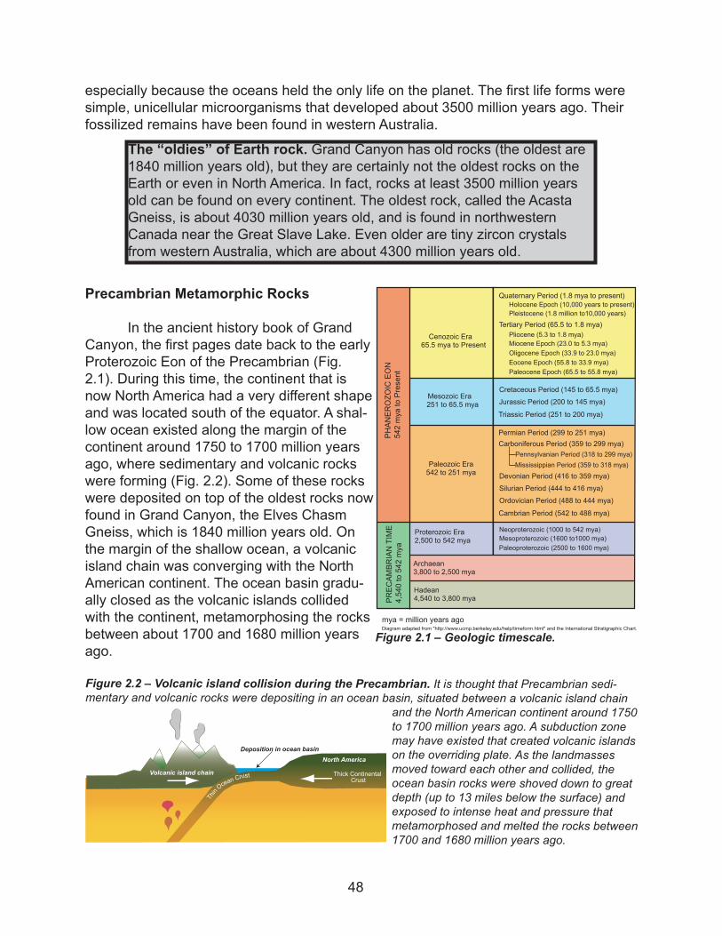
In the ancient history book of Grand Canyon, the first pages date back to the early Proterozoic Eon of the Precambrian (Fig. 2.1). During this time, the continent that is now North America had a very different shape and was located south of the equator. A shal-low ocean existed along the margin of the continent around 1750 to 1700 million years ago, where sedimentary and volcanic rocks were forming (Fig. 2.2). Some of these rocks were deposited on top of the oldest rocks now found in Grand Canyon, the Elves Chasm Gneiss, which is 1840 million years old. On the margin of the shallow ocean, a volcanic island chain was converging with the North American continent. The ocean basin gradu-ally closed as the volcanic islands collided with the continent, metamorphosing the rocks between about 1700 and 1680 million years ago.
The “oldies” of Earth rock. Grand Canyon has old rocks (the oldest are 1840 million years old), but they are certainly not the oldest rocks on the Earth or even in North America. In fact, rocks at least 3500 million years old can be found on every continent. The oldest rock, called the Acasta Gneiss, is about 4030 million years old, and is found in northwestern Canada near the Great Slave Lake. Even older are tiny zircon crystals from western Australia, which are about 4300 million years old.
Figure 2.1 – Geologic timescale.
PREC
AMBR
IANTIME
4,540to54
2mya
mya = million years ago
PHAN
EROZO
ICEO
N54
2mya
toPresent
Hadean4,540 to 3,800 mya
Archaean3,800 to 2,500 mya
Proterozoic Era2,500 to 542 mya
Paleozoic Era542 to 251 mya
Paleoproterozoic (2500 to 1600 mya)Mesoproterozoic (1600 to1000 mya)
Diagram adapted from "http://www.ucmp.berkeley.edu/help/timeform.html" and the International Stratigraphic Chart.
Neoproterozoic (1000 to 542 mya)
Cambrian Period (542 to 488 mya)
Ordovician Period (488 to 444 mya)Silurian Period (444 to 416 mya)Devonian Period (416 to 359 mya)
Carboniferous Period (359 to 299 mya)Pennsylvanian Period (318 to 299 mya)Mississippian Period (359 to 318 mya)
Permian Period (299 to 251 mya)
Mesozoic Era251 to 65.5 mya
Triassic Period (251 to 200 mya)
Jurassic Period (200 to 145 mya)Cretaceous Period (145 to 65.5 mya)
Cenozoic Era65.5 mya to Present
Tertiary Period (65.5 to 1.8 mya)
Quaternary Period (1.8 mya to present)
Pliocene (5.3 to 1.8 mya)Miocene Epoch (23.0 to 5.3 mya)Oligocene Epoch (33.9 to 23.0 mya)
Paleocene Epoch (65.5 to 55.8 mya)Eocene Epoch (55.8 to 33.9 mya)
Holocene Epoch (10,000 years to present)Pleistocene (1.8 million to10,000 years)
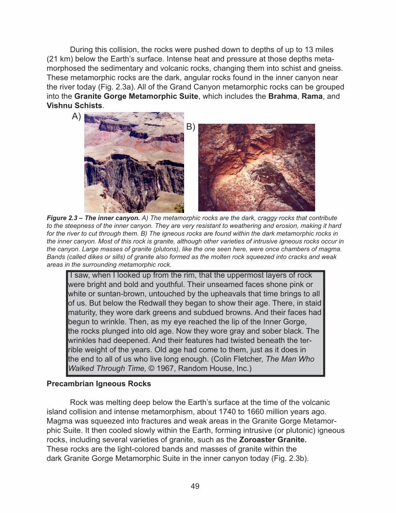
Figure 2.2 – Volcanic island collision during the Precambrian. It is thought that Precambrian sedi-mentary and volcanic rocks were depositing in an ocean basin, situated between a volcanic island chain
and the North American continent around 1750 to 1700 million years ago. A subduction zone may have existed that created volcanic islands on the overriding plate. As the landmasses moved toward each other and collided, the ocean basin rocks were shoved down to great depth (up to 13 miles below the surface) and exposed to intense heat and pressure that metamorphosed and melted the rocks between 1700 and 1680 million years ago.
North America
Volcanic island chain
Deposition in ocean basin
Thin
Ocean
Crust Thick ContinentalCrust
48
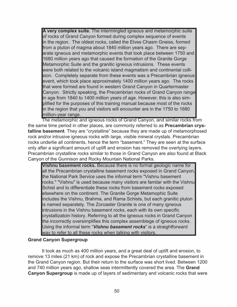
During this collision, the rocks were pushed down to depths of up to 13 miles (21 km) below the Earth’s surface. Intense heat and pressure at those depths meta-morphosed the sedimentary and volcanic rocks, changing them into schist and gneiss. These metamorphic rocks are the dark, angular rocks found in the inner canyon near the river today (Fig. 2.3a). All of the Grand Canyon metamorphic rocks can be grouped into the Granite Gorge Metamorphic Suite, which includes the Brahma, Rama, and Vishnu Schists.
Precambrian Igneous Rocks
Rock was melting deep below the Earth’s surface at the time of the volcanic island collision and intense metamorphism, about 1740 to 1660 million years ago. Magma was squeezed into fractures and weak areas in the Granite Gorge Metamor-phic Suite. It then cooled slowly within the Earth, forming intrusive (or plutonic) igneous rocks, including several varieties of granite, such as the Zoroaster Granite.These rocks are the light-colored bands and masses of granite within the dark Granite Gorge Metamorphic Suite in the inner canyon today (Fig. 2.3b).
Figure 2.3 – The inner canyon. A) The metamorphic rocks are the dark, craggy rocks that contribute to the steepness of the inner canyon. They are very resistant to weathering and erosion, making it hard for the river to cut through them. B) The igneous rocks are found within the dark metamorphic rocks in the inner canyon. Most of this rock is granite, although other varieties of intrusive igneous rocks occur in the canyon. Large masses of granite (plutons), like the one seen here, were once chambers of magma. Bands (called dikes or sills) of granite also formed as the molten rock squeezed into cracks and weak areas in the surrounding metamorphic rock.
A)B)
I saw, when I looked up from the rim, that the uppermost layers of rock were bright and bold and youthful. Their unseamed faces shone pink or white or suntan-brown, untouched by the upheavals that time brings to all of us. But below the Redwall they began to show their age. There, in staid maturity, they wore dark greens and subdued browns. And their faces had begun to wrinkle. Then, as my eye reached the lip of the Inner Gorge, the rocks plunged into old age. Now they wore gray and sober black. The wrinkles had deepened. And their features had twisted beneath the ter-rible weight of the years. Old age had come to them, just as it does in the end to all of us who live long enough. (Colin Fletcher, The Man Who Walked Through Time, © 1967, Random House, Inc.)
49
The metamorphic and igneous rocks of Grand Canyon, and similar rocks from the same time period in other places, are commonly referred to as Precambrian crys-talline basement. They are “crystalline” because they are made up of metamorphosed rock and/or intrusive igneous rocks with large, visible mineral crystals. Precambrian rocks underlie all continents, hence the term “basement.” They are seen at the surface only after a significant amount of uplift and erosion has removed the overlying layers. Precambrian crystalline rocks similar to those in Grand Canyon are also found at Black Canyon of the Gunnison and Rocky Mountain National Parks.
Grand Canyon Supergroup
It took as much as 400 million years, and a great deal of uplift and erosion, to remove 13 miles (21 km) of rock and expose the Precambrian crystalline basement in the Grand Canyon region. But their return to the surface was short lived. Between 1200 and 740 million years ago, shallow seas intermittently covered the area. The Grand Canyon Supergroup is made up of layers of sedimentary and volcanic rocks that were
A very complex suite. The intermingled igneous and metamorphic suite of rocks of Grand Canyon formed during complex sequence of events in the region. The oldest rocks, called the Elves Chasm Gneiss, formed from a pluton of magma about 1840 million years ago. There are sep-arate igneous and metamorphic events that took place between 1750 and 1680 million years ago that caused the formation of the Granite Gorge Metamorphic Suite and the granitic igneous intrusions. These events were both related to the volcanic island magmatism and continental colli-sion. Completely separate from these events was a Precambrian igneous event, which took place approximately 1400 million years ago. The rocks that were formed are found in western Grand Canyon in Quartermaster Canyon. Strictly speaking, the Precambrian rocks of Grand Canyon range in age from 1840 to 1400 million years of age. However, this is also sim-plified for the purposes of this training manual because most of the rocks in the region that you and visitors will encounter are in the 1750 to 1680 million-year range.
Vishnu basement rocks. Because there is no formal geologic name forall the Precambrian crystalline basement rocks exposed in Grand Canyon,the National Park Service uses the informal term "Vishnu basement rocks." "Vishnu" is used because many visitors are familar with the VishnuSchist and to differentiate these rocks from basement rocks exposedelsewhere on the continent. The Granite Gorge Metamophic Suiteincludes the Vishnu, Brahma, and Rama Schists, but each granitic pluton is named separately. The Zoroaster Granite is one of many igneous intrusions in the Vishnu basement rocks, each with its own specificcrystallizatoin history. Referring to all the igneous rocks in Grand Canyon the incorrectly oversimplifies this complex assemblege of igneous rocks. Using the informal term “Vishnu basement rocks” is a straightforward
way to refer to all these rocks when talking with visitors.
50
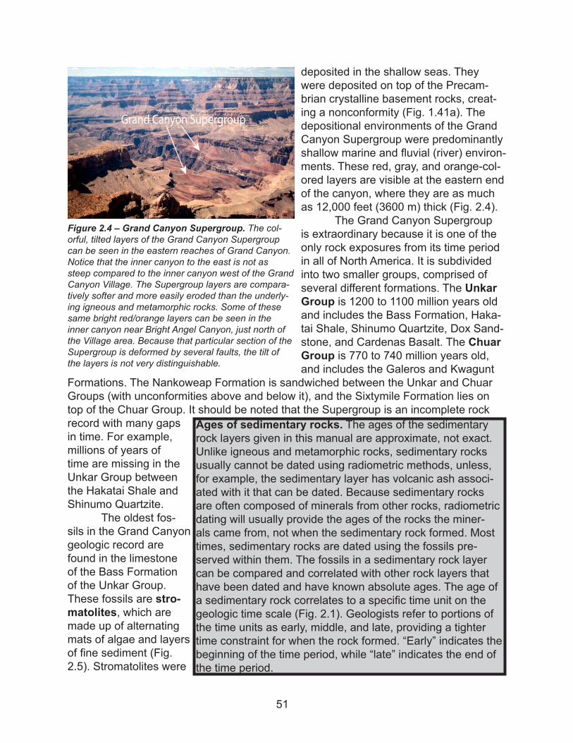
deposited in the shallow seas. They were deposited on top of the Precam-brian crystalline basement rocks, creat-ing a nonconformity (Fig. 1.41a). The depositional environments of the Grand Canyon Supergroup were predominantly shallow marine and fluvial (river) environ-ments. These red, gray, and orange-col-ored layers are visible at the eastern end of the canyon, where they are as much as 12,000 feet (3600 m) thick (Fig. 2.4).
The Grand Canyon Supergroup is extraordinary because it is one of the only rock exposures from its time period in all of North America. It is subdivided into two smaller groups, comprised of several different formations. The Unkar Group is 1200 to 1100 million years old and includes the Bass Formation, Haka-tai Shale, Shinumo Quartzite, Dox Sand-stone, and Cardenas Basalt. The Chuar Group is 770 to 740 million years old, and includes the Galeros and Kwagunt
Formations. The Nankoweap Formation is sandwiched between the Unkar and Chuar Groups (with unconformities above and below it), and the Sixtymile Formation lies on top of the Chuar Group. It should be noted that the Supergroup is an incomplete rock record with many gaps in time. For example, millions of years of time are missing in the Unkar Group between the Hakatai Shale and Shinumo Quartzite.
The oldest fos-sils in the Grand Canyon geologic record are found in the limestone of the Bass Formation of the Unkar Group. These fossils are stro-matolites, which are made up of alternating mats of algae and layers of fine sediment (Fig. 2.5). Stromatolites were
Figure 2.4 – Grand Canyon Supergroup. The col-orful, tilted layers of the Grand Canyon Supergroup can be seen in the eastern reaches of Grand Canyon. Notice that the inner canyon to the east is not as steep compared to the inner canyon west of the Grand Canyon Village. The Supergroup layers are compara-tively softer and more easily eroded than the underly-ing igneous and metamorphic rocks. Some of these same bright red/orange layers can be seen in the inner canyon near Bright Angel Canyon, just north of the Village area. Because that particular section of the Supergroup is deformed by several faults, the tilt of the layers is not very distinguishable.
Grand Canyon Supergroup
Ages of sedimentary rocks. The ages of the sedimentary rock layers given in this manual are approximate, not exact. Unlike igneous and metamorphic rocks, sedimentary rocks usually cannot be dated using radiometric methods, unless, for example, the sedimentary layer has volcanic ash associ-ated with it that can be dated. Because sedimentary rocks are often composed of minerals from other rocks, radiometric dating will usually provide the ages of the rocks the miner-als came from, not when the sedimentary rock formed. Most times, sedimentary rocks are dated using the fossils pre-served within them. The fossils in a sedimentary rock layer can be compared and correlated with other rock layers that have been dated and have known absolute ages. The age of a sedimentary rock correlates to a specific time unit on the geologic time scale (Fig. 2.1). Geologists refer to portions of the time units as early, middle, and late, providing a tighter time constraint for when the rock formed. “Early” indicates the beginning of the time period, while “late” indicates the end of the time period.
51
very abundant during the Proterozoic Eon. The photosynthetic processes performed by the algae used the carbon dioxide in the atmosphere and changed it to oxygen. These algae actually caused an increase in the oxygen content of the atmosphere. Without the abundance of stromatolites, oxygen-breathing life as we know it may not have devel-oped!
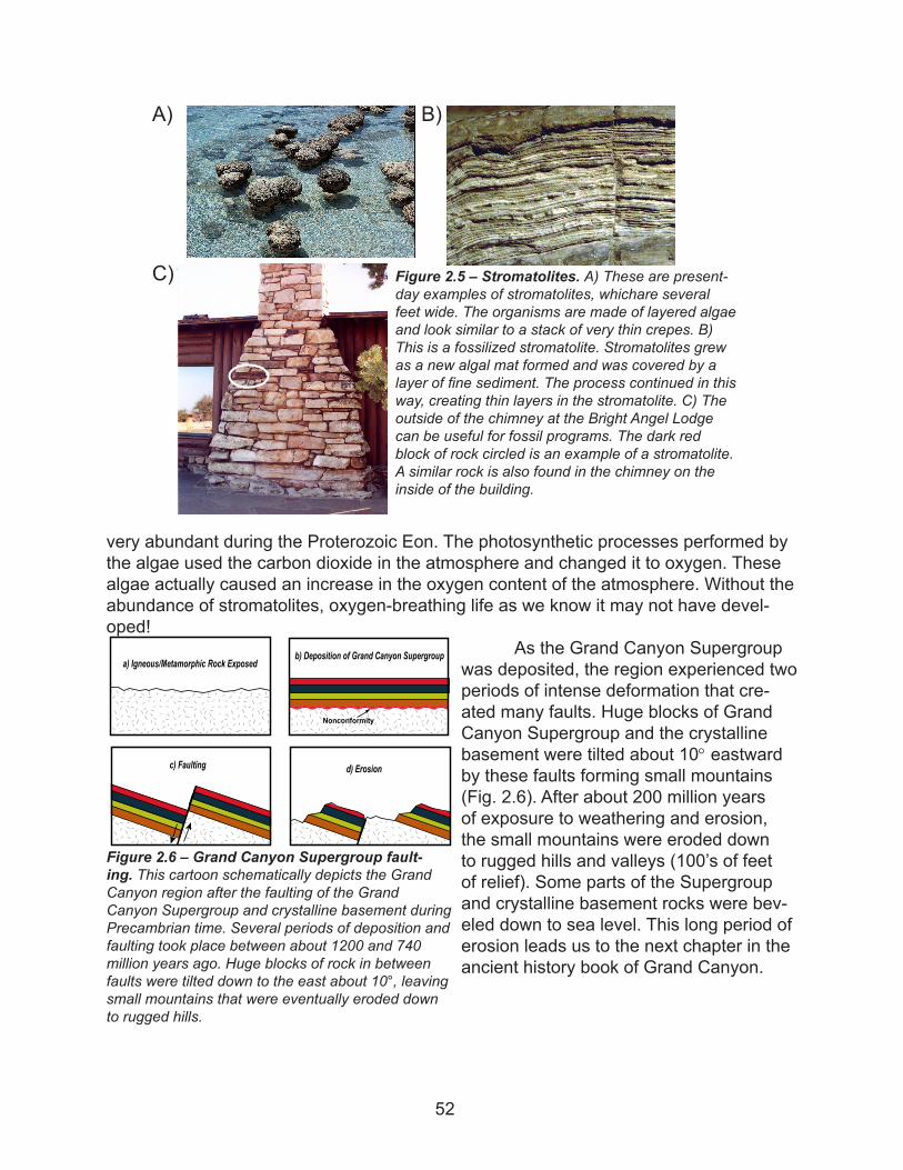
As the Grand Canyon Supergroup was deposited, the region experienced two periods of intense deformation that cre-ated many faults. Huge blocks of Grand Canyon Supergroup and the crystalline basement were tilted about 10° eastward by these faults forming small mountains (Fig. 2.6). After about 200 million years of exposure to weathering and erosion, the small mountains were eroded down to rugged hills and valleys (100’s of feet of relief). Some parts of the Supergroup and crystalline basement rocks were bev-eled down to sea level. This long period of erosion leads us to the next chapter in the ancient history book of Grand Canyon.
A)
Figure 2.5 – Stromatolites. A) These are present-day examples of stromatolites, whichare several feet wide. The organisms are made of layered algae and look similar to a stack of very thin crepes. B) This is a fossilized stromatolite. Stromatolites grew as a new algal mat formed and was covered by a layer of fine sediment. The process continued in this way, creating thin layers in the stromatolite. C) The outside of the chimney at the Bright Angel Lodge can be useful for fossil programs. The dark red block of rock circled is an example of a stromatolite. A similar rock is also found in the chimney on the inside of the building.
B)
C)
Figure 2.6 – Grand Canyon Supergroup fault-ing. This cartoon schematically depicts the Grand Canyon region after the faulting of the Grand Canyon Supergroup and crystalline basement during Precambrian time. Several periods of deposition and faulting took place between about 1200 and 740 million years ago. Huge blocks of rock in between faults were tilted down to the east about 10°, leaving small mountains that were eventually eroded down to rugged hills.
a) Igneous/Metamorphic Rock Exposedb) Deposition of Grand Canyon Supergroup
Nonconformity
c) Faulting d) Erosion
52
THE PALEOZOIC ERA (542 TO 251 MILLION YEARS AGO)
Life became extremely abundant and diverse during the Paleozoic Era, the era of “early life.” Fossils preserved in Paleozoic rocks reveal a dramatic change from Precam-brian time, when there were no complex life forms, to an era when thousands of new species evolved. Some organisms that developed are very different from anything we know today.
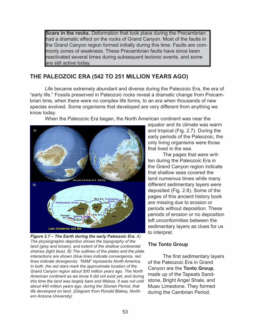
When the Paleozoic Era began, the North American continent was near the equator and its climate was warm and tropical (Fig. 2.7). During the early periods of the Paleozoic, the only living organisms were those that lived in the sea.
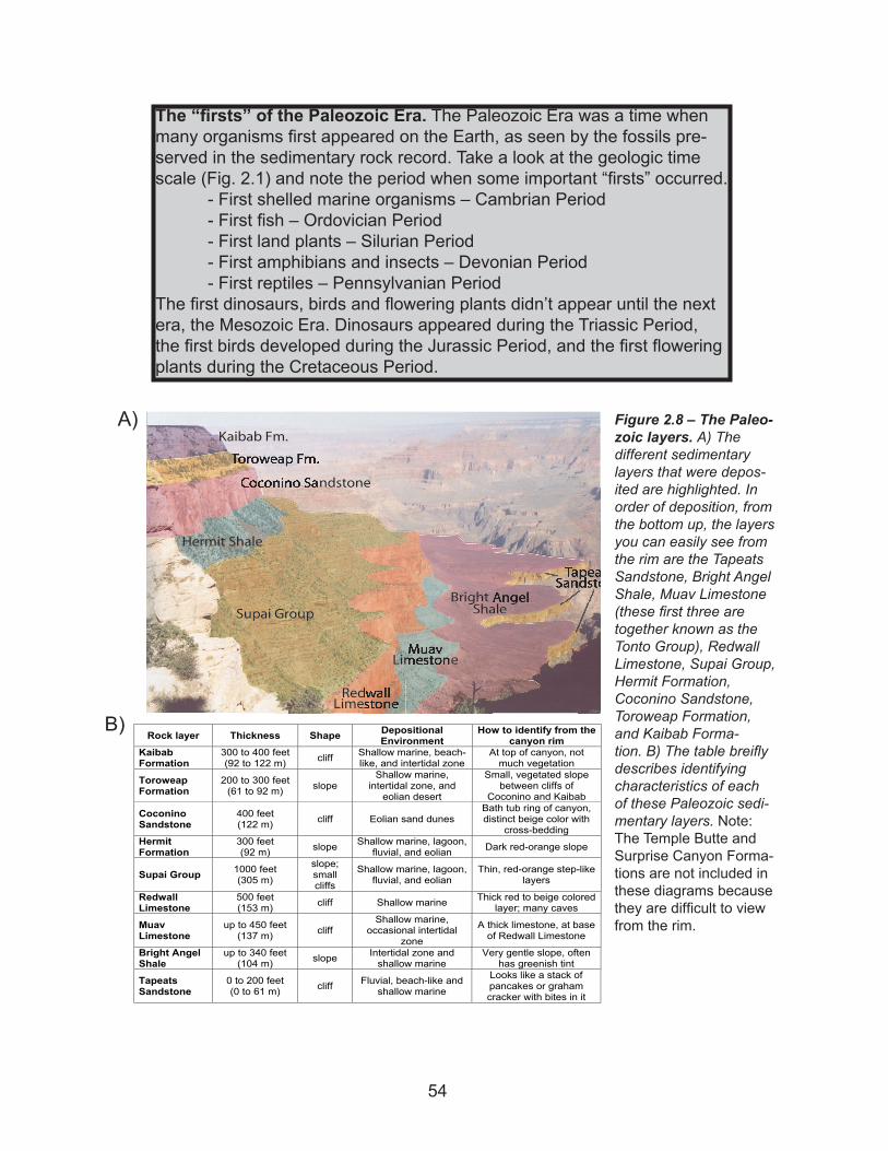
The pages that were writ-ten during the Paleozoic Era in the Grand Canyon region indicate that shallow seas covered the land numerous times while many different sedimentary layers were deposited (Fig. 2.8). Some of the pages of this ancient history book are missing due to erosion or periods without deposition. These periods of erosion or no deposition left unconformities between the sedimentary layers as clues for us to interpret.
The Tonto Group
The first sedimentary layers of the Paleozoic Era in Grand Canyon are the Tonto Group, made up of the Tapeats Sand-stone, Bright Angel Shale, and Muav Limestone. They formed during the Cambrian Period,
Scars in the rocks. Deformation that took place during the Precambrian had a dramatic effect on the rocks of Grand Canyon. Most of the faults in the Grand Canyon region formed initially during this time. Faults are com-monly zones of weakness. These Precambrian faults have since been reactivated several times during subsequent tectonic events, and some are still active today.
Figure 2.7 – The Earth during the early Paleozoic Era. A) The physiographic depiction shows the topography of the land (grey and brown), and extent of the shallow continental shelves (light blue). B) The outlines of the plates and the plate interactions are shown (blue lines indicate convergence, red lines indicate divergence). “NAM” represents North America. In both, the red stars mark the approximate location of the Grand Canyon region about 500 million years ago. The North American continent as we know it did not exist yet, and during this time the land was largely bare and lifeless. It was not until about 440 million years ago, during the Silurian Period, that life developed on land. (Diagram from Ronald Blakey, North-ern Arizona University)
A)
B)
53
The “firsts” of the Paleozoic Era. The Paleozoic Era was a time when many organisms first appeared on the Earth, as seen by the fossils pre-served in the sedimentary rock record. Take a look at the geologic time scale (Fig. 2.1) and note the period when some important “firsts” occurred. - First shelled marine organisms – Cambrian Period - First fish – Ordovician Period - First land plants – Silurian Period - First amphibians and insects – Devonian Period - First reptiles – Pennsylvanian PeriodThe first dinosaurs, birds and flowering plants didn’t appear until the next era, the Mesozoic Era. Dinosaurs appeared during the Triassic Period, the first birds developed during the Jurassic Period, and the first flowering plants during the Cretaceous Period.
Figure 2.8 – The Paleo-zoic layers. A) The different sedimentary layers that were depos-ited are highlighted. In order of deposition, from the bottom up, the layers you can easily see from the rim are the Tapeats Sandstone, Bright Angel Shale, Muav Limestone (these first three are together known as the Tonto Group), Redwall Limestone, Supai Group, Hermit Formation, Coconino Sandstone, Toroweap Formation, and Kaibab Forma-tion. B) The table breifly describes identifying characteristics of each of these Paleozoic sedi-mentary layers. Note: The Temple Butte and Surprise Canyon Forma-tions are not included in these diagrams because they are difficult to view from the rim.
A)
Rock layer Thickness Shape DepositionalEnvironment
How to identify from the canyon rim
KaibabFormation
300 to 400 feet (92 to 122 m) cliff Shallow marine, beach-
like, and intertidal zone At top of canyon, not
much vegetation
Toroweap Formation
200 to 300 feet (61 to 92 m) slope
Shallow marine, intertidal zone, and
eolian desert
Small, vegetated slope between cliffs of
Coconino and Kaibab
CoconinoSandstone
400 feet (122 m) cliff Eolian sand dunes
Bath tub ring of canyon, distinct beige color with
cross-beddingHermitFormation
300 feet (92 m) slope Shallow marine, lagoon,
fluvial, and eolian Dark red-orange slope
Supai Group 1000 feet (305 m)
slope;smallcliffs
Shallow marine, lagoon, fluvial, and eolian
Thin, red-orange step-like layers
Redwall Limestone
500 feet (153 m) cliff Shallow marine Thick red to beige colored
layer; many caves
MuavLimestone
up to 450 feet (137 m) cliff
Shallow marine, occasional intertidal
zone
A thick limestone, at base of Redwall Limestone
Bright Angel Shale
up to 340 feet (104 m) slope Intertidal zone and
shallow marine Very gentle slope, often
has greenish tint
TapeatsSandstone
0 to 200 feet (0 to 61 m) cliff Fluvial, beach-like and
shallow marine
Looks like a stack of pancakes or graham cracker with bites in it
B)
54
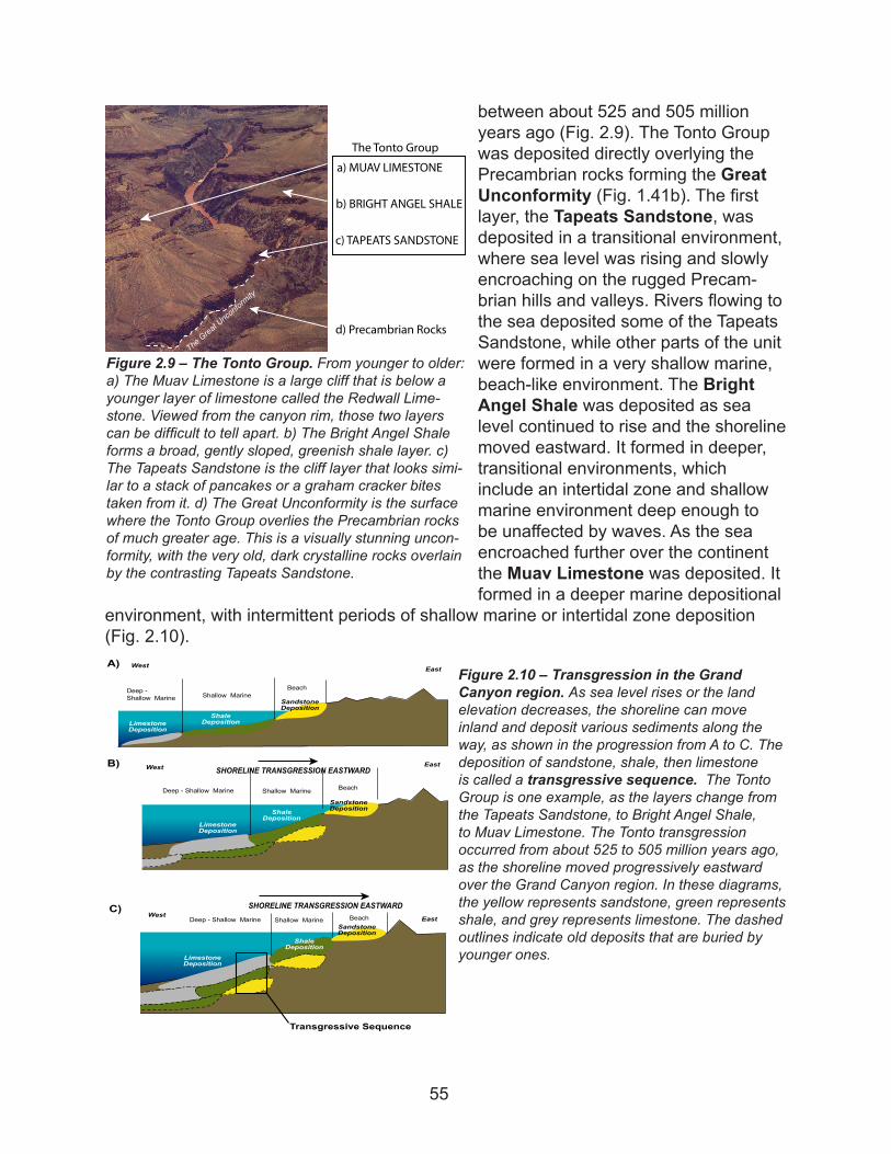
between about 525 and 505 million years ago (Fig. 2.9). The Tonto Group was deposited directly overlying the Precambrian rocks forming the Great Unconformity (Fig. 1.41b). The first layer, the Tapeats Sandstone, was deposited in a transitional environment, where sea level was rising and slowly encroaching on the rugged Precam-brian hills and valleys. Rivers flowing to the sea deposited some of the Tapeats Sandstone, while other parts of the unit were formed in a very shallow marine, beach-like environment. The Bright Angel Shale was deposited as sea level continued to rise and the shoreline moved eastward. It formed in deeper, transitional environments, which include an intertidal zone and shallow marine environment deep enough to be unaffected by waves. As the sea encroached further over the continent the Muav Limestone was deposited. It formed in a deeper marine depositional
environment, with intermittent periods of shallow marine or intertidal zone deposition (Fig. 2.10).
Figure 2.9 – The Tonto Group. From younger to older: a) The Muav Limestone is a large cliff that is below a younger layer of limestone called the Redwall Lime-stone. Viewed from the canyon rim, those two layers can be difficult to tell apart. b) The Bright Angel Shale forms a broad, gently sloped, greenish shale layer. c) The Tapeats Sandstone is the cliff layer that looks simi-lar to a stack of pancakes or a graham cracker bites taken from it. d) The Great Unconformity is the surface where the Tonto Group overlies the Precambrian rocks of much greater age. This is a visually stunning uncon-formity, with the very old, dark crystalline rocks overlain by the contrasting Tapeats Sandstone.
�� ������� ���������
�� ������ ����� �����
�� ���� ���������
�� ����������� �����
��� ����� �����
The Great Unconformity
SHORELINE TRANSGRESSION EASTWARDEast
LimestoneDeposition
ShaleDeposition
SandstoneDeposition
West
LimestoneDeposition
ShaleDeposition
East
SandstoneDeposition
WestA)
B)
Shallow Marine Beach
SHORELINE TRANSGRESSION EASTWARDEast
LimestoneDeposition
WestC)
SandstoneDeposition
ShaleDeposition
Transgressive Sequence
Deep - Shallow Marine
Shallow Marine BeachDeep - Shallow Marine
Shallow MarineBeachDeep -
Shallow Marine
Figure 2.10 – Transgression in the Grand Canyon region. As sea level rises or the land elevation decreases, the shoreline can move inland and deposit various sediments along the way, as shown in the progression from A to C. The deposition of sandstone, shale, then limestone is called a transgressive sequence. The Tonto Group is one example, as the layers change from the Tapeats Sandstone, to Bright Angel Shale, to Muav Limestone. The Tonto transgression occurred from about 525 to 505 million years ago, as the shoreline moved progressively eastward over the Grand Canyon region. In these diagrams, the yellow represents sandstone, green represents shale, and grey represents limestone. The dashed outlines indicate old deposits that are buried by younger ones.
55
The Cambrian Sea deposited the Tonto Group over the rugged Precambrian hills. Ini-tially, as sea level rose, the taller hills in the eastern Grand Canyon region remained above the sea as islands, while valleys were submerged. Because of this, some of the tall Precambrian hills were not covered by all the formations of the Tonto Group. Most of the valleys have the entire group from Tapeats
Sandstone, to Bright Angel Shale, to Muav Limestone. But some higher islands were not completely covered with sediment until the Muav Limestone was deposited, when sea level had risen high enough to cover them (Fig. 2.12).
The Temple Butte Formation
Following deposition of the Muav Limestone and about 100 million years of ero-sion, river channels and valleys were cut into the Muav Limestone. A new sedimentary
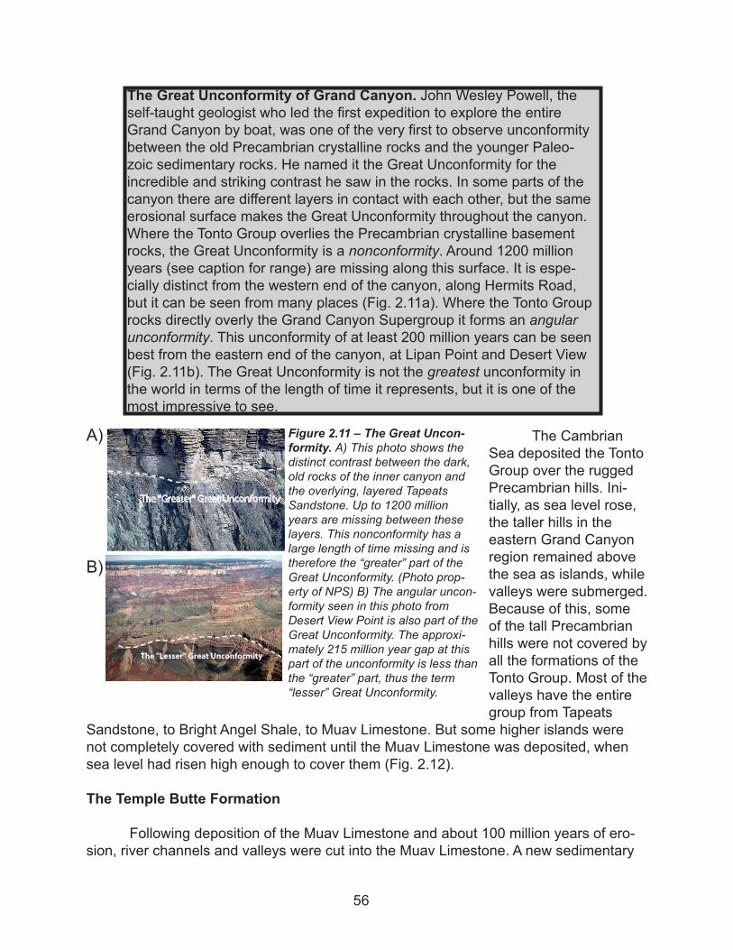
The Great Unconformity of Grand Canyon. John Wesley Powell, the self-taught geologist who led the first expedition to explore the entire Grand Canyon by boat, was one of the very first to observe unconformity between the old Precambrian crystalline rocks and the younger Paleo-zoic sedimentary rocks. He named it the Great Unconformity for the incredible and striking contrast he saw in the rocks. In some parts of the canyon there are different layers in contact with each other, but the same erosional surface makes the Great Unconformity throughout the canyon. Where the Tonto Group overlies the Precambrian crystalline basement rocks, the Great Unconformity is a nonconformity. Around 1200 million years (see caption for range) are missing along this surface. It is espe-cially distinct from the western end of the canyon, along Hermits Road, but it can be seen from many places (Fig. 2.11a). Where the Tonto Group rocks directly overly the Grand Canyon Supergroup it forms an angular unconformity. This unconformity of at least 200 million years can be seen best from the eastern end of the canyon, at Lipan Point and Desert View (Fig. 2.11b). The Great Unconformity is not the greatest unconformity in the world in terms of the length of time it represents, but it is one of the most impressive to see.
Figure 2.11 – The Great Uncon-formity. A) This photo shows the distinct contrast between the dark, old rocks of the inner canyon and the overlying, layered Tapeats Sandstone. Up to 1200 million years are missing between these layers. This nonconformity has a large length of time missing and is therefore the “greater” part of the Great Unconformity. (Photo prop-erty of NPS) B) The angular uncon-formity seen in this photo from Desert View Point is also part of the Great Unconformity. The approxi-mately 215 million year gap at this part of the unconformity is less than the “greater” part, thus the term “lesser” Great Unconformity.
��� �������� ����� ������������
A)
B)
56
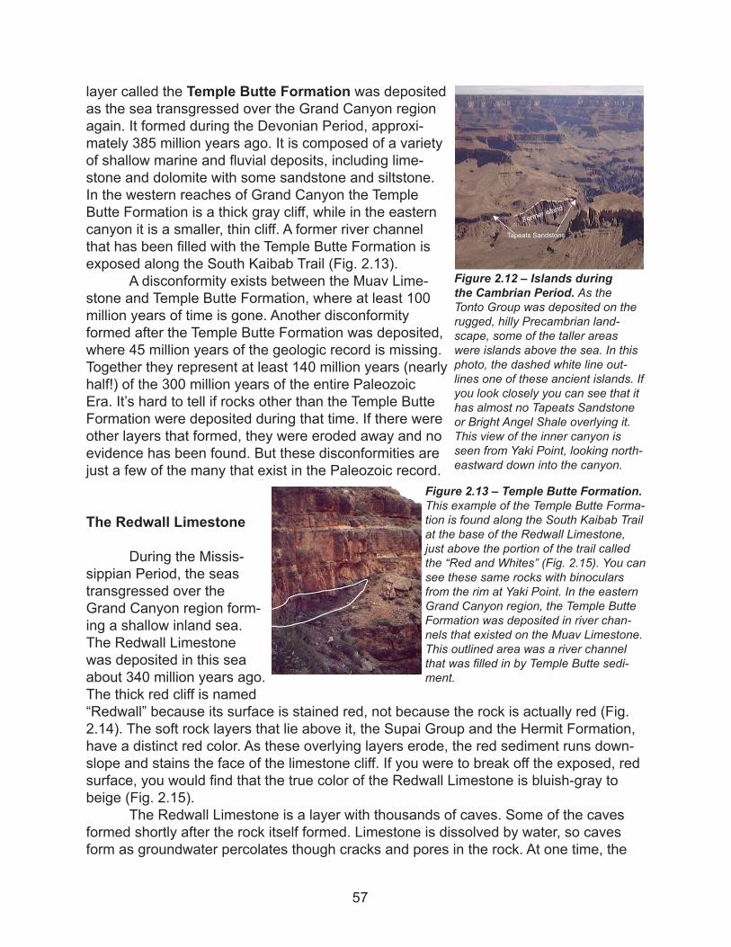
layer called the Temple Butte Formation was deposited as the sea transgressed over the Grand Canyon region again. It formed during the Devonian Period, approxi-mately 385 million years ago. It is composed of a variety of shallow marine and fluvial deposits, including lime-stone and dolomite with some sandstone and siltstone. In the western reaches of Grand Canyon the Temple Butte Formation is a thick gray cliff, while in the eastern canyon it is a smaller, thin cliff. A former river channel that has been filled with the Temple Butte Formation is exposed along the South Kaibab Trail (Fig. 2.13).
A disconformity exists between the Muav Lime-stone and Temple Butte Formation, where at least 100 million years of time is gone. Another disconformity formed after the Temple Butte Formation was deposited, where 45 million years of the geologic record is missing. Together they represent at least 140 million years (nearly half!) of the 300 million years of the entire Paleozoic Era. It’s hard to tell if rocks other than the Temple Butte Formation were deposited during that time. If there were other layers that formed, they were eroded away and no evidence has been found. But these disconformities are just a few of the many that exist in the Paleozoic record.
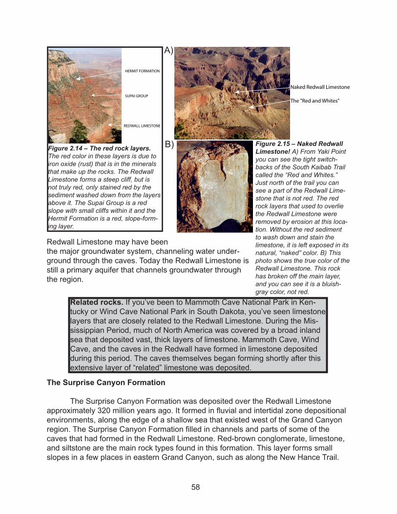
The Redwall Limestone
During the Missis-sippian Period, the seas transgressed over the Grand Canyon region form-ing a shallow inland sea. The Redwall Limestone was deposited in this sea about 340 million years ago. The thick red cliff is named “Redwall” because its surface is stained red, not because the rock is actually red (Fig. 2.14). The soft rock layers that lie above it, the Supai Group and the Hermit Formation, have a distinct red color. As these overlying layers erode, the red sediment runs down-slope and stains the face of the limestone cliff. If you were to break off the exposed, red surface, you would find that the true color of the Redwall Limestone is bluish-gray to beige (Fig. 2.15).
The Redwall Limestone is a layer with thousands of caves. Some of the caves formed shortly after the rock itself formed. Limestone is dissolved by water, so caves form as groundwater percolates though cracks and pores in the rock. At one time, the
Figure 2.12 – Islands during the Cambrian Period. As the Tonto Group was deposited on the rugged, hilly Precambrian land-scape, some of the taller areas were islands above the sea. In this photo, the dashed white line out-lines one of these ancient islands. If you look closely you can see that it has almost no Tapeats Sandstone or Bright Angel Shale overlying it. This view of the inner canyon is seen from Yaki Point, looking north-eastward down into the canyon.
Tapeats Sandstone
Former isla
nd
Figure 2.13 – Temple Butte Formation. This example of the Temple Butte Forma-tion is found along the South Kaibab Trail at the base of the Redwall Limestone, just above the portion of the trail called the “Red and Whites” (Fig. 2.15). You can see these same rocks with binoculars from the rim at Yaki Point. In the eastern Grand Canyon region, the Temple Butte Formation was deposited in river chan-nels that existed on the Muav Limestone. This outlined area was a river channel that was filled in by Temple Butte sedi-ment.
57
Redwall Limestone may have been the major groundwater system, channeling water under-ground through the caves. Today the Redwall Limestone is still a primary aquifer that channels groundwater through the region.
The Surprise Canyon Formation
The Surprise Canyon Formation was deposited over the Redwall Limestone approximately 320 million years ago. It formed in fluvial and intertidal zone depositional environments, along the edge of a shallow sea that existed west of the Grand Canyon region. The Surprise Canyon Formation filled in channels and parts of some of the caves that had formed in the Redwall Limestone. Red-brown conglomerate, limestone, and siltstone are the main rock types found in this formation. This layer forms small slopes in a few places in eastern Grand Canyon, such as along the New Hance Trail.
Figure 2.15 – Naked Redwall Limestone! A) From Yaki Point you can see the tight switch-backs of the South Kaibab Trail called the “Red and Whites.” Just north of the trail you can see a part of the Redwall Lime-stone that is not red. The red rock layers that used to overlie the Redwall Limestone were removed by erosion at this loca-tion. Without the red sediment to wash down and stain the limestone, it is left exposed in its natural, “naked” color. B) This photo shows the true color of the Redwall Limestone. This rock has broken off the main layer, and you can see it is a bluish-gray color, not red.
����� ������� ���������
��� ���� ��� �������
A)
B)
������� ���������
����� �����
������ ���������
Figure 2.14 – The red rock layers. The red color in these layers is due to iron oxide (rust) that is in the minerals that make up the rocks. The Redwall Limestone forms a steep cliff, but is not truly red, only stained red by the sediment washed down from the layers above it. The Supai Group is a red slope with small cliffs within it and the Hermit Formation is a red, slope-form-ing layer.
Related rocks. If you’ve been to Mammoth Cave National Park in Ken-tucky or Wind Cave National Park in South Dakota, you’ve seen limestone layers that are closely related to the Redwall Limestone. During the Mis-sissippian Period, much of North America was covered by a broad inland sea that deposited vast, thick layers of limestone. Mammoth Cave, Wind Cave, and the caves in the Redwall have formed in limestone deposited during this period. The caves themselves began forming shortly after this extensive layer of “related” limestone was deposited.
58
The Surprise Canyon Formation has the most abundant and diverse fossils of all the Paleozoic layers, including plant fossils, corals, brachiopods, as well as many others (see pages 63-64 for more about fossils).
The Supai Group and Hermit Formation
The layered slopes and thin cliffs above the Redwall Limestone are mostly red siltstone and sandstone known as the Supai Group, which are overlain by red layers of shale and sandstone called the Hermit Formation (Fig. 2.14). These layers were deposited during the early Pennsylvanian Period through the early Permian Period, approximately 315 to 280 million years ago. Sea level fluctuated greatly during this time, as indicated by the diverse depositional environments, which include shallow marine, lagoon, and fluvial environments. They also include the first layers deposited in an eolian (wind) environment in the Grand Canyon region. These layers mark the onset of the coastal sand dune environment that was dominant in the region through the late Jurassic Period.
The Coconino Sandstone and Toroweap Formation
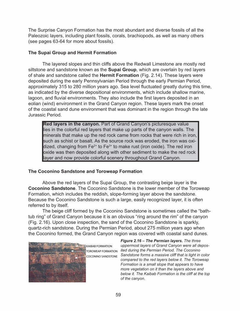
Above the red layers of the Supai Group, the contrasting beige layer is the Coconino Sandstone. The Coconino Sandstone is the lower member of the Toroweap Formation, which includes the reddish, slope-forming layer above the sandstone. Because the Coconino Sandstone is such a large, easily recognized layer, it is often referred to by itself.
The beige cliff formed by the Coconino Sandstone is sometimes called the “bath-tub ring” of Grand Canyon because it is an obvious “ring around the rim” of the canyon (Fig. 2.16). Upon close inspection, the sand of the Coconino Sandstone is sparkly, quartz-rich sandstone. During the Permian Period, about 275 million years ago when the Coconino formed, the Grand Canyon region was covered with coastal sand dunes.
Red layers in the canyon. Part of Grand Canyon’s picturesque value lies in the colorful red layers that make up parts of the canyon walls. The minerals that make up the red rock came from rocks that were rich in iron, such as schist or basalt. As the source rock was eroded, the iron was oxi-dized, changing from Fe2+ to Fe3+ to make rust (iron oxide). The red iron oxide was then deposited along with other sediment to make the red rock layer and now provide colorful scenery throughout Grand Canyon.
Figure 2.16 – The Permian layers. The three uppermost layers of Grand Canyon were all depos-ited during the Permian Period. The Coconino Sandstone forms a massive cliff that is light in color compared to the red layers below it. The Toroweap Formation is a small slope that appears to have more vegetation on it than the layers above and below it. The Kaibab Formation is the cliff at the top of the canyon.
�������� ���������
������ ���������
�������� ���������
59
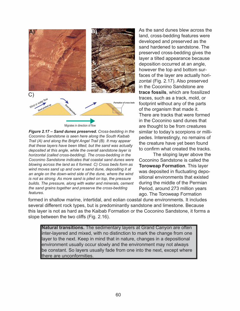
As the sand dunes blew across the land, cross-bedding features were developed and preserved as the sand hardened to sandstone. The preserved cross-bedding gives the layer a tilted appearance because deposition occurred at an angle, however the top and bottom sur-faces of the layer are actually hori-zontal (Fig. 2.17). Also preserved in the Coconino Sandstone are trace fossils, which are fossilized traces, such as a track, mold, or footprint without any of the parts of the organism that made it. There are tracks that were formed in the Coconino sand dunes that are thought to be from creatures similar to today’s scorpions or milli-pedes. Interestingly, no remains of the creature have yet been found to confirm what created the tracks.
The sloping layer above the Coconino Sandstone is called the Toroweap Formation. This layer was deposited in fluctuating depo-sitional environments that existed during the middle of the Permian Period, around 273 million years ago. The Toroweap Formation
formed in shallow marine, intertidal, and eolian coastal dune environments. It includes several different rock types, but is predominantly sandstone and limestone. Because this layer is not as hard as the Kaibab Formation or the Coconino Sandstone, it forms a slope between the two cliffs (Fig. 2.16).
Figure 2.17 – Sand dunes preserved. Cross-bedding in the Coconino Sandstone is seen here along the South Kaibab Trail (A) and along the Bright Angel Trail (B). It may appear that these layers have been tilted, but the sand was actually deposited at this angle, while the overall sandstone layer is horizontal (called cross-bedding). The cross-bedding in the Coconino Sandstone indicates that coastal sand dunes were blowing across the land as it formed. C) Cross beds form as wind moves sand up and over a sand dune, depositing it at an angle on the down-wind side of the dune, where the wind is not as strong. As more sand is piled on top, the pressure builds. The pressure, along with water and minerals, cement the sand grains together and preserve the cross-bedding features.
Migrates in direction of flow
Wind or water flow
Sand pic
kedup Sand deposited
Formation of cross beds
A) B)
C)
Natural transitions. The sedimentary layers at Grand Canyon are often inter-layered and mixed, with no distinction to mark the change from one layer to the next. Keep in mind that in nature, changes in a depositional environment usually occur slowly and the environment may not always be constant. So layers usually fade from one into the next, except where there are unconformities.
60
The Kaibab Formation
The Paleozoic layer most available for you and visitors to observe is the Kaibab Formation. The Kaibab Formation forms the cap rock of Grand Canyon because it is a hard, resistant rock layer (Fig. 2.16). It was deposited near the end of the Paleozoic Era, in the middle of the Permian Period, about 270 million years ago. Although it is the youngest layer of the canyon, it is too old to have any remains of dinosaurs. The dino-saurs actually roamed the Earth after the Kaibab Formation was formed.
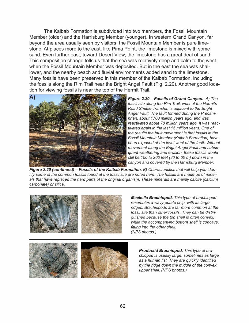
The Kaibab Formation has an abundance of chert, which forms in irregular blobs and nodules in the limestone (Fig. 2.19). Chert is com-posed of microscopic quartz crys-tals, made of pure silica (SiO2). Dark gray chert, called flint, gets its color from impurities and other minerals.
Red chert is another variety called jasper. In the Kaibab Formation, the chert nodules are commonly light in color, which indicate it is relatively pure silica with few other miner-als. Chert is more resistant to weathering and often sticks out where the limestone has weathered away around it.
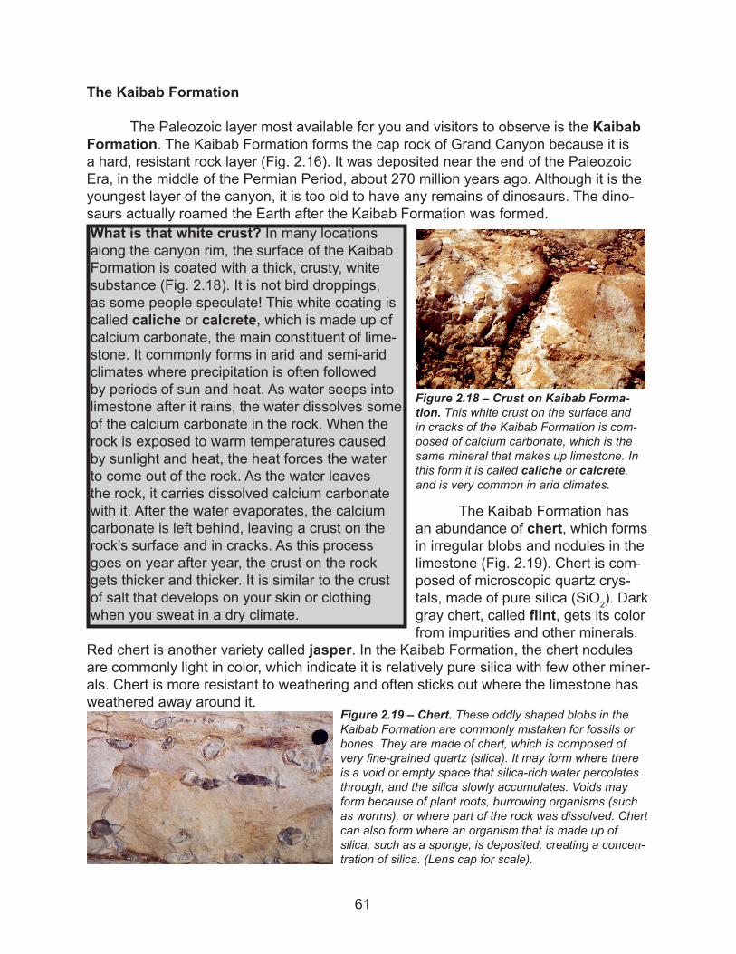
What is that white crust? In many locations along the canyon rim, the surface of the Kaibab Formation is coated with a thick, crusty, white substance (Fig. 2.18). It is not bird droppings, as some people speculate! This white coating is called caliche or calcrete, which is made up of calcium carbonate, the main constituent of lime-stone. It commonly forms in arid and semi-arid climates where precipitation is often followed by periods of sun and heat. As water seeps into limestone after it rains, the water dissolves some of the calcium carbonate in the rock. When the rock is exposed to warm temperatures caused by sunlight and heat, the heat forces the water to come out of the rock. As the water leaves the rock, it carries dissolved calcium carbonate with it. After the water evaporates, the calcium carbonate is left behind, leaving a crust on the rock’s surface and in cracks. As this process goes on year after year, the crust on the rock gets thicker and thicker. It is similar to the crust of salt that develops on your skin or clothing when you sweat in a dry climate.
Figure 2.18 – Crust on Kaibab Forma-tion. This white crust on the surface and in cracks of the Kaibab Formation is com-posed of calcium carbonate, which is the same mineral that makes up limestone. In this form it is called caliche or calcrete, and is very common in arid climates.
Figure 2.19 – Chert. These oddly shaped blobs in the Kaibab Formation are commonly mistaken for fossils or bones. They are made of chert, which is composed of very fine-grained quartz (silica). It may form where there is a void or empty space that silica-rich water percolates through, and the silica slowly accumulates. Voids may form because of plant roots, burrowing organisms (such as worms), or where part of the rock was dissolved. Chert can also form where an organism that is made up of silica, such as a sponge, is deposited, creating a concen-tration of silica. (Lens cap for scale).
61
The Kaibab Formation is subdivided into two members, the Fossil Mountain Member (older) and the Harrisburg Member (younger). In western Grand Canyon, far beyond the area usually seen by visitors, the Fossil Mountain Member is pure lime-stone. At places more to the east, like Pima Point, the limestone is mixed with some sand. Even farther east, toward Desert View, the limestone has a great deal of sand. This composition change tells us that the sea was relatively deep and calm to the west when the Fossil Mountain Member was deposited. But in the east the sea was shal-lower, and the nearby beach and fluvial environments added sand to the limestone. Many fossils have been preserved in this member of the Kaibab Formation, including the fossils along the Rim Trail near the Bright Angel Fault (Fig. 2.20). Another good loca-tion for viewing fossils is near the top of the Hermit Trail.
Figure 2.20 – Fossils of Grand Canyon. A) The fossil site along the Rim Trail, west of the Hermits Road Shuttle Transfer, is adjacent to the Bright Angel Fault. The fault formed during the Precam-brian, about 1700 million years ago, and was reactivated about 70 million years ago. It was reac-tivated again in the last 15 million years. One of the results the fault movement is that fossils in the Fossil Mountain Member (Kaibab Formation) have been exposed at rim level west of the fault. Without movement along the Bright Angel Fault and subse-quent weathering and erosion, these fossils would still be 100 to 200 feet (30 to 60 m) down in the canyon and covered by the Harrisburg Member.
A)
Meekella Brachiopod. This type of brachiopod resembles a wavy potato chip, with its large ridges. Brachiopods are far more common at the fossil site than other fossils. They can be distin-guished because the top shell is often convex, while the accompanying bottom shell is concave, fitting into the other shell. (NPS photos.)
Figure 2.20 (continued) – Fossils of the Kaibab Formation. B) Characteristics that will help you iden-tify some of the common fossils found at the fossil site are noted here. The fossils are made up of miner-als that have replaced the hard parts of the original organism. These minerals are mainly calcite (calcium carbonate) or silica.
Productid Brachiopod. This type of bra-chiopod is usually large, sometimes as large as a human fist. They are quickly identified by the ridge down the middle of the convex, upper shell. (NPS photos.)
62
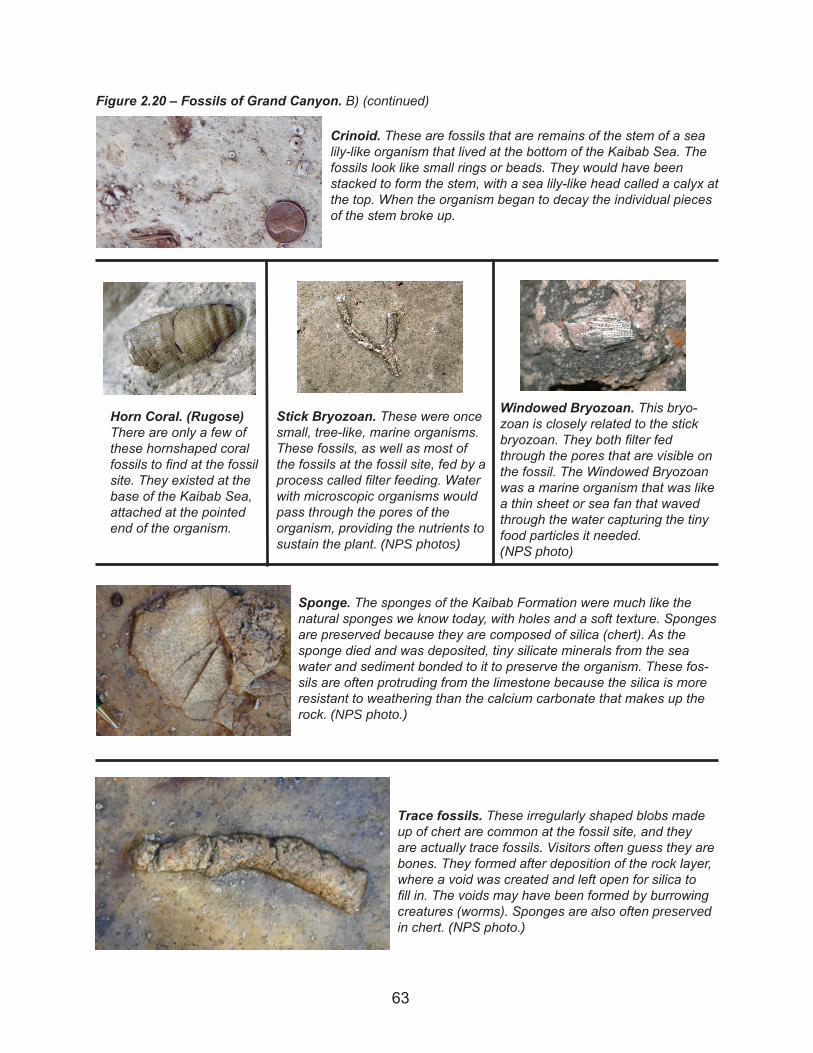
Figure 2.20 – Fossils of Grand Canyon. B) (continued)
Sponge. The sponges of the Kaibab Formation were much like the natural sponges we know today, with holes and a soft texture. Sponges are preserved because they are composed of silica (chert). As the sponge died and was deposited, tiny silicate minerals from the sea water and sediment bonded to it to preserve the organism. These fos-sils are often protruding from the limestone because the silica is more resistant to weathering than the calcium carbonate that makes up the rock. (NPS photo.)
Trace fossils. These irregularly shaped blobs made up of chert are common at the fossil site, and they are actually trace fossils. Visitors often guess they are bones. They formed after deposition of the rock layer, where a void was created and left open for silica to fill in. The voids may have been formed by burrowing creatures (worms). Sponges are also often preservedin chert. (NPS photo.)
Crinoid. These are fossils that are remains of the stem of a sea lily-like organism that lived at the bottom of the Kaibab Sea. The fossils look like small rings or beads. They would have been stacked to form the stem, with a sea lily-like head called a calyx at the top. When the organism began to decay the individual pieces of the stem broke up.
Horn Coral. (Rugose) There are only a few of these hornshaped coral fossils to find at the fossil site. They existed at the base of the Kaibab Sea, attached at the pointed end of the organism.
Stick Bryozoan. These were once small, tree-like, marine organisms. These fossils, as well as most of the fossils at the fossil site, fed by a process called filter feeding. Water with microscopic organisms would pass through the pores of the organism, providing the nutrients to sustain the plant. (NPS photos)
Windowed Bryozoan. This bryo-zoan is closely related to the stick bryozoan. They both filter fed through the pores that are visible on the fossil. The Windowed Bryozoan was a marine organism that was like a thin sheet or sea fan that waved through the water capturing the tiny food particles it needed. (NPS photo)
63

The change from the Fossil Mountain Member to the Harrisburg Member is gradual, and the rock types are similar, making it hard to see. The base of the Harrisburg Member has a layer of white, butterscotch, or red colored chert that marks the change from one member to the next. The Harrisburg Member was deposited as the sea gradually retreated to the west, leaving restricted areas of shallow water. Oxidized, iron-rich, rust colored sediment was deposited in this shallow water. The reddish color of the soil in the village area, and along Village Loop Road near the turnoff for Desert View Drive comes from the Harrisburg Member (Fig. 2.21). Evaporites are also found in the Harrisburg Member. They
are minerals that were once dissolved in water, but when the water evaporated, the evaporite minerals were leached out. Gypsum is the most common evaporite mineral in the Harrisburg Member.
The Close of the Paleozoic Era
Although life grew and flourished with diversity, it all came to a screeching halt as a mass extinction event occurred at the end of the Paleozoic Era. Fewer than 5 percent of sea life and 33 percent of land animals survived, as a total of about 90 percent of all of the planet’s species died off. This event was bigger than the extinction of the dino-saurs that occurred at the end of the following era. The exact reason for the Paleozoic extinction is still unknown, but it was likely a combination of catastrophic events. The possibilities include massive volcanic eruptions, cooling of the seas, and dramatic cli-mate changes due to development of large ice caps.
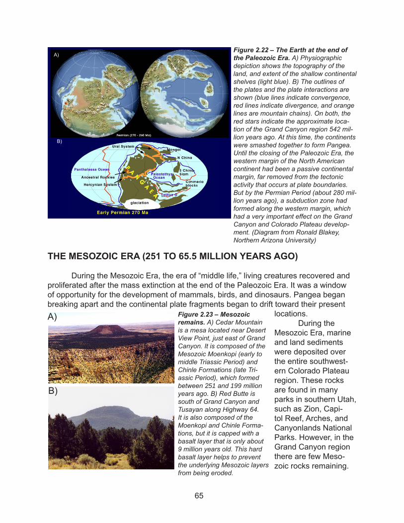
At the closing of the Paleozoic Era, all of the continents had smashed together to form the super-continent known as Pangea (Fig. 2.22). Prior to the Permian Period (286 to 248 million years ago), the western edge of North America had been a passive conti-nental plate margin, much like the eastern coast of North America today. After millions of years of the sea repeatedly coming and going over southwestern North America, depos-iting layer upon layer of sedimentary rock, the tectonic environment changed dramati-cally. Since the Permian Period, the western continental margin of North America has been a site of active plate boundary processes.
Figure 2.21 – The Harrisburg Member of the Kaibab Formation. These deep red rocks are part of the Harrisburg Member, seen here along Village Loop Road, just north of the turn off for Desert View Drive. The red color, caused by iron oxide (rust) in the rock, is common in the soil throughout the Village and in the residential area.
64
THE MESOZOIC ERA (251 TO 65.5 MILLION YEARS AGO)
During the Mesozoic Era, the era of “middle life,” living creatures recovered and proliferated after the mass extinction at the end of the Paleozoic Era. It was a window of opportunity for the development of mammals, birds, and dinosaurs. Pangea began breaking apart and the continental plate fragments began to drift toward their present
locations. During the
Mesozoic Era, marine and land sediments were deposited over the entire southwest-ern Colorado Plateau region. These rocks are found in many parks in southern Utah, such as Zion, Capi-tol Reef, Arches, and Canyonlands National Parks. However, in the Grand Canyon region there are few Meso-zoic rocks remaining.
Figure 2.22 – The Earth at the end of the Paleozoic Era. A) Physiographic depiction shows the topography of the land, and extent of the shallow continental shelves (light blue). B) The outlines of the plates and the plate interactions are shown (blue lines indicate convergence, red lines indicate divergence, and orange lines are mountain chains). On both, the red stars indicate the approximate loca-tion of the Grand Canyon region 542 mil-lion years ago. At this time, the continents were smashed together to form Pangea. Until the closing of the Paleozoic Era, the western margin of the North American continent had been a passive continental margin, far removed from the tectonic activity that occurs at plate boundaries. But by the Permian Period (about 280 mil-lion years ago), a subduction zone had formed along the western margin, which had a very important effect on the Grand Canyon and Colorado Plateau develop-ment. (Diagram from Ronald Blakey, Northern Arizona University)
B)
A)
Figure 2.23 – Mesozoic remains. A) Cedar Mountain is a mesa located near Desert View Point, just east of Grand Canyon. It is composed of the Mesozoic Moenkopi (early to middle Triassic Period) and Chinle Formations (late Tri-assic Period), which formed between 251 and 199 million years ago. B) Red Butte is south of Grand Canyon and Tusayan along Highway 64. It is also composed of the Moenkopi and Chinle Forma-tions, but it is capped with a basalt layer that is only about 9 million years old. This hard basalt layer helps to prevent the underlying Mesozoic layers from being eroded.
A)
B)
65
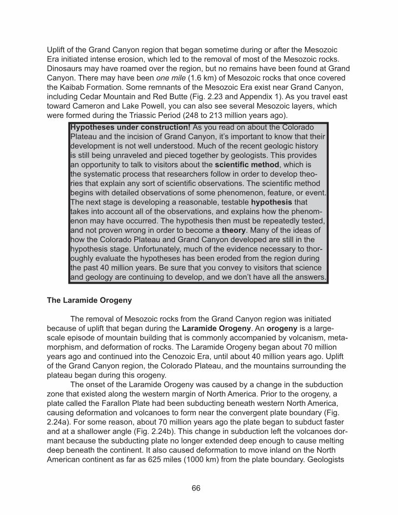
Uplift of the Grand Canyon region that began sometime during or after the Mesozoic Era initiated intense erosion, which led to the removal of most of the Mesozoic rocks. Dinosaurs may have roamed over the region, but no remains have been found at Grand Canyon. There may have been one mile (1.6 km) of Mesozoic rocks that once covered the Kaibab Formation. Some remnants of the Mesozoic Era exist near Grand Canyon, including Cedar Mountain and Red Butte (Fig. 2.23 and Appendix 1). As you travel east toward Cameron and Lake Powell, you can also see several Mesozoic layers, which were formed during the Triassic Period (248 to 213 million years ago).
The Laramide Orogeny
The removal of Mesozoic rocks from the Grand Canyon region was initiated because of uplift that began during the Laramide Orogeny. An orogeny is a large-scale episode of mountain building that is commonly accompanied by volcanism, meta-morphism, and deformation of rocks. The Laramide Orogeny began about 70 million years ago and continued into the Cenozoic Era, until about 40 million years ago. Uplift of the Grand Canyon region, the Colorado Plateau, and the mountains surrounding the plateau began during this orogeny.
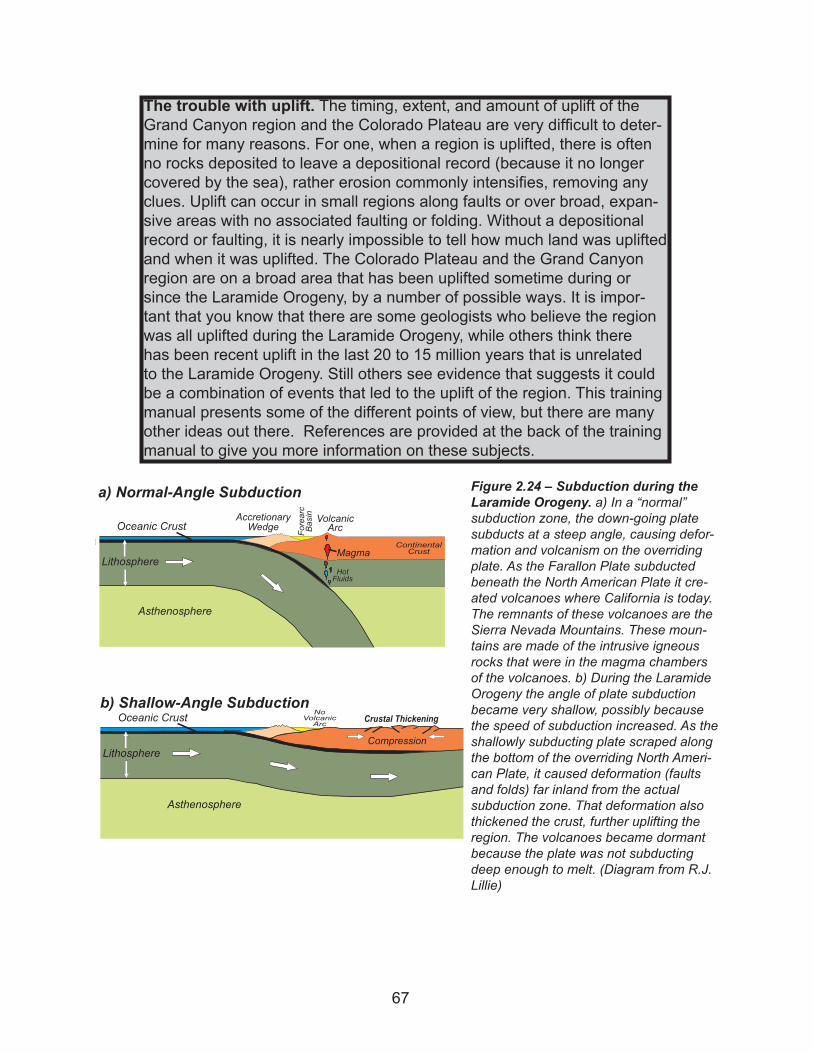
The onset of the Laramide Orogeny was caused by a change in the subduction zone that existed along the western margin of North America. Prior to the orogeny, a plate called the Farallon Plate had been subducting beneath western North America, causing deformation and volcanoes to form near the convergent plate boundary (Fig. 2.24a). For some reason, about 70 million years ago the plate began to subduct faster and at a shallower angle (Fig. 2.24b). This change in subduction left the volcanoes dor-mant because the subducting plate no longer extended deep enough to cause melting deep beneath the continent. It also caused deformation to move inland on the North American continent as far as 625 miles (1000 km) from the plate boundary. Geologists
Hypotheses under construction! As you read on about the Colorado Plateau and the incision of Grand Canyon, it’s important to know that their development is not well understood. Much of the recent geologic history is still being unraveled and pieced together by geologists. This provides an opportunity to talk to visitors about the scientific method, which is the systematic process that researchers follow in order to develop theo-ries that explain any sort of scientific observations. The scientific method begins with detailed observations of some phenomenon, feature, or event. The next stage is developing a reasonable, testable hypothesis that takes into account all of the observations, and explains how the phenom-enon may have occurred. The hypothesis then must be repeatedly tested, and not proven wrong in order to become a theory. Many of the ideas of how the Colorado Plateau and Grand Canyon developed are still in the hypothesis stage. Unfortunately, much of the evidence necessary to thor-oughly evaluate the hypotheses has been eroded from the region during the past 40 million years. Be sure that you convey to visitors that science and geology are continuing to develop, and we don’t have all the answers.
66
The trouble with uplift. The timing, extent, and amount of uplift of the Grand Canyon region and the Colorado Plateau are very difficult to deter-mine for many reasons. For one, when a region is uplifted, there is often no rocks deposited to leave a depositional record (because it no longer covered by the sea), rather erosion commonly intensifies, removing any clues. Uplift can occur in small regions along faults or over broad, expan-sive areas with no associated faulting or folding. Without a depositional record or faulting, it is nearly impossible to tell how much land was uplifted and when it was uplifted. The Colorado Plateau and the Grand Canyon region are on a broad area that has been uplifted sometime during or since the Laramide Orogeny, by a number of possible ways. It is impor-tant that you know that there are some geologists who believe the region was all uplifted during the Laramide Orogeny, while others think there has been recent uplift in the last 20 to 15 million years that is unrelated to the Laramide Orogeny. Still others see evidence that suggests it could be a combination of events that led to the uplift of the region. This training manual presents some of the different points of view, but there are many other ideas out there. References are provided at the back of the training manual to give you more information on these subjects.
Figure 2.24 – Subduction during the Laramide Orogeny. a) In a “normal” subduction zone, the down-going plate subducts at a steep angle, causing defor-mation and volcanism on the overriding plate. As the Farallon Plate subducted beneath the North American Plate it cre-ated volcanoes where California is today. The remnants of these volcanoes are the Sierra Nevada Mountains. These moun-tains are made of the intrusive igneous rocks that were in the magma chambers of the volcanoes. b) During the Laramide Orogeny the angle of plate subduction became very shallow, possibly because the speed of subduction increased. As the shallowly subducting plate scraped along the bottom of the overriding North Ameri-can Plate, it caused deformation (faults and folds) far inland from the actual subduction zone. That deformation also thickened the crust, further uplifting the region. The volcanoes became dormant because the plate was not subducting deep enough to melt. (Diagram from R.J. Lillie)
AccretionaryWedge
VolcanicArcFo
rearc
Basin
ContinentalCrust
Oceanic Crust
Lithosphere
Asthenosphere
a) Normal-Angle Subduction
Magma
HotFluids
NoVolcanicArc
Oceanic Crust
Lithosphere
Asthenosphere
Compression
b) Shallow-Angle SubductionCrustal Thickening
67
suspect the Farallon Plate began to scrape along the bottom of the North American Plate, causing intense east-west compression over much of western North America. The com-pression led to the Laramide Orogeny as huge blocks of crust were shoved upward to form mountain ranges surrounding the Colorado Plateau.
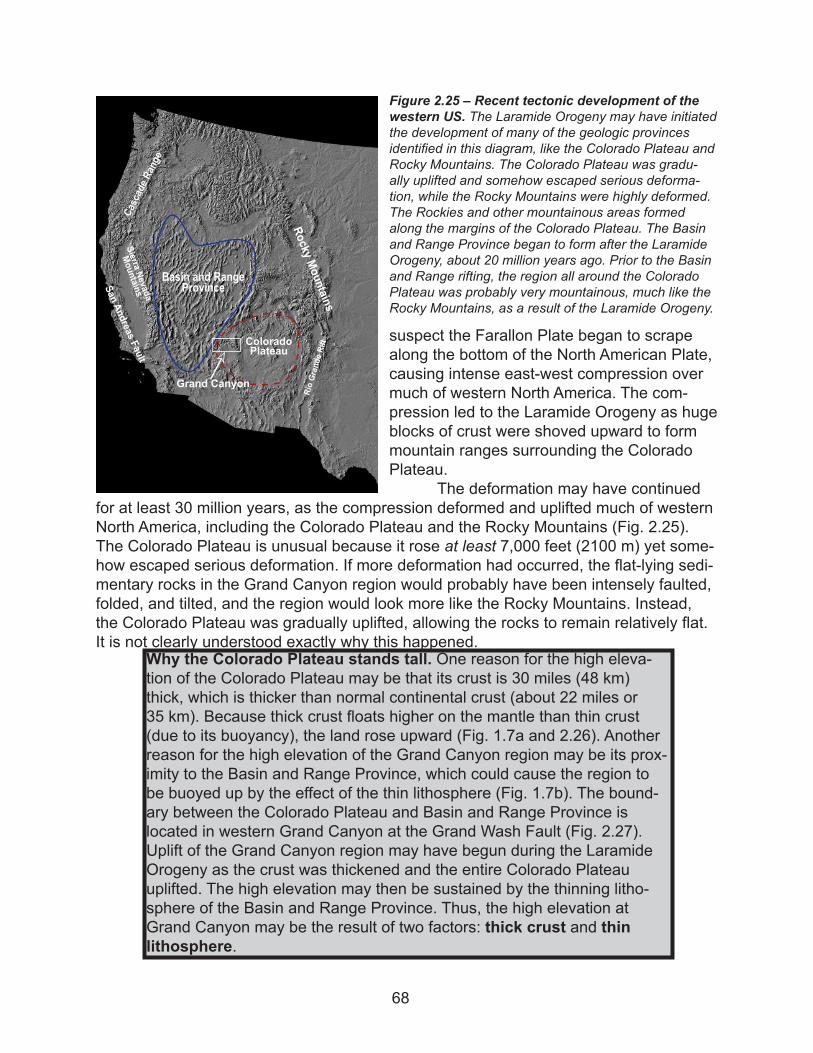
The deformation may have continued for at least 30 million years, as the compression deformed and uplifted much of western North America, including the Colorado Plateau and the Rocky Mountains (Fig. 2.25). The Colorado Plateau is unusual because it rose at least 7,000 feet (2100 m) yet some-how escaped serious deformation. If more deformation had occurred, the flat-lying sedi-mentary rocks in the Grand Canyon region would probably have been intensely faulted, folded, and tilted, and the region would look more like the Rocky Mountains. Instead, the Colorado Plateau was gradually uplifted, allowing the rocks to remain relatively flat. It is not clearly understood exactly why this happened.
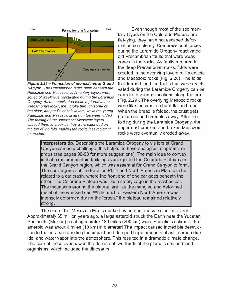
Why the Colorado Plateau stands tall. One reason for the high eleva-tion of the Colorado Plateau may be that its crust is 30 miles (48 km) thick, which is thicker than normal continental crust (about 22 miles or 35 km). Because thick crust floats higher on the mantle than thin crust (due to its buoyancy), the land rose upward (Fig. 1.7a and 2.26). Another reason for the high elevation of the Grand Canyon region may be its prox-imity to the Basin and Range Province, which could cause the region to be buoyed up by the effect of the thin lithosphere (Fig. 1.7b). The bound-ary between the Colorado Plateau and Basin and Range Province is located in western Grand Canyon at the Grand Wash Fault (Fig. 2.27). Uplift of the Grand Canyon region may have begun during the Laramide Orogeny as the crust was thickened and the entire Colorado Plateau uplifted. The high elevation may then be sustained by the thinning litho-sphere of the Basin and Range Province. Thus, the high elevation at Grand Canyon may be the result of two factors: thick crust and thin lithosphere.
Figure 2.25 – Recent tectonic development of the western US. The Laramide Orogeny may have initiated the development of many of the geologic provinces identified in this diagram, like the Colorado Plateau and Rocky Mountains. The Colorado Plateau was gradu-ally uplifted and somehow escaped serious deforma-tion, while the Rocky Mountains were highly deformed. The Rockies and other mountainous areas formed along the margins of the Colorado Plateau. The Basin and Range Province began to form after the Laramide Orogeny, about 20 million years ago. Prior to the Basin and Range rifting, the region all around the Colorado Plateau was probably very mountainous, much like the Rocky Mountains, as a result of the Laramide Orogeny.
Basin and RangeProvince
RockyMountains
SierraNevada
Mountains
ColoradoPlateau
Cascade Range
RioGrandeRift
SanAndreas
Fault
Grand Canyon
68
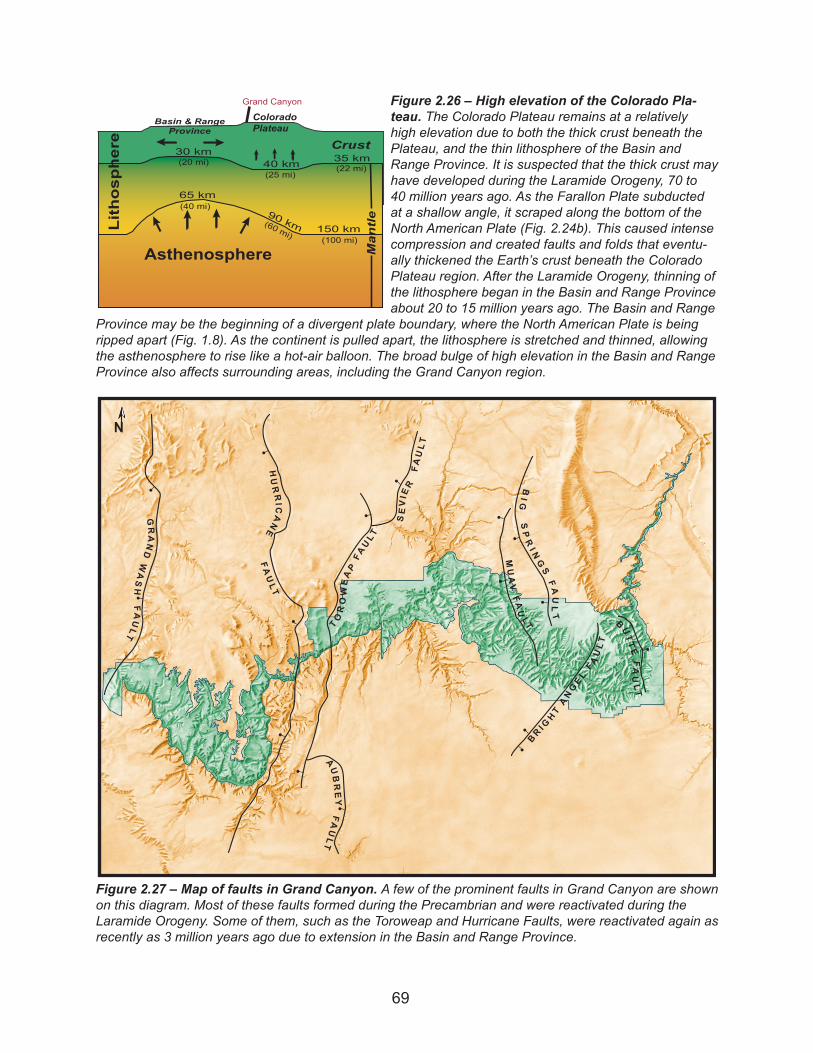
Figure 2.26 – High elevation of the Colorado Pla-teau. The Colorado Plateau remains at a relatively high elevation due to both the thick crust beneath the Plateau, and the thin lithosphere of the Basin and Range Province. It is suspected that the thick crust may have developed during the Laramide Orogeny, 70 to 40 million years ago. As the Farallon Plate subducted at a shallow angle, it scraped along the bottom of the North American Plate (Fig. 2.24b). This caused intense compression and created faults and folds that eventu-ally thickened the Earth’s crust beneath the Colorado Plateau region. After the Laramide Orogeny, thinning of the lithosphere began in the Basin and Range Province about 20 to 15 million years ago. The Basin and Range
Province may be the beginning of a divergent plate boundary, where the North American Plate is being ripped apart (Fig. 1.8). As the continent is pulled apart, the lithosphere is stretched and thinned, allowing the asthenosphere to rise like a hot-air balloon. The broad bulge of high elevation in the Basin and Range Province also affects surrounding areas, including the Grand Canyon region.
Crust
Lithosphere
Asthenosphere
35 km
150 km
65 km
30 km
90 km
Grand Canyon
40 km(20 mi)(25 mi)
(40 mi)
(60 mi)
(22 mi)
(100 mi)
ColoradoPlateau
Basin & RangeProvince
Mantle
B UTTEFAULT
BR IGHTANGE L
FAULT
MUAVF A
ULT
BIG
SPRI NGSFAULT
SEVIER
FAULT
TOROWEAPFAULT
AUBREY
FAULT
HURRICANE
FAULT
GRANDWASH
FAULT
N
Figure 2.27 – Map of faults in Grand Canyon. A few of the prominent faults in Grand Canyon are shown on this diagram. Most of these faults formed during the Precambrian and were reactivated during the Laramide Orogeny. Some of them, such as the Toroweap and Hurricane Faults, were reactivated again as recently as 3 million years ago due to extension in the Basin and Range Province.
69
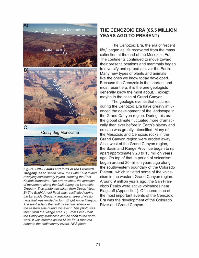
Even though most of the sedimen-tary layers on the Colorado Plateau are flat-lying, they have not escaped defor-mation completely. Compressional forces during the Laramide Orogeny reactivated old Precambrian faults that were weak zones in the rocks. As faults ruptured in the deep Precambrian rocks, folds were created in the overlying layers of Paleozoic and Mesozoic rocks (Fig. 2.28). The folds that formed, and the faults that were reacti-vated during the Laramide Orogeny can be seen from various locations along the rim (Fig. 2.29). The overlying Mesozoic rocks were like the crust on hard Italian bread. When the bread is folded, the crust gets broken up and crumbles away. After the folding during the Laramide Orogeny, the uppermost cracked and broken Mesozoic rocks were eventually eroded away.
The end of the Mesozoic Era is marked by another mass extinction event. Approximately 65 million years ago, a large asteroid struck the Earth near the Yucatan Peninsula (Mexico) creating a crater 180 miles (290 km) wide. Scientists estimate the asteroid was about 6 miles (10 km) in diameter! The impact caused incredible destruc-tion to the area surrounding the impact and dumped huge amounts of ash, carbon diox-ide, and water vapor into the atmosphere. This resulted in a dramatic climate change. The sum of these events was the demise of two-thirds of the planet’s sea and land organisms, which included the dinosaurs.
Figure 2.28 – Formation of monoclines at Grand Canyon. The Precambrian faults deep beneath the Paleozoic and Mesozoic sedimentary layers were zones of weakness reactivated during the Laramide Orogeny. As the reactivated faults ruptured in the Precambrian rocks, they broke through some of the older, deeper Paleozoic layers, while the young Paleozoic and Mesozoic layers on top were folded. The folding of the uppermost Mesozoic layers caused them to crack as they were extended on the top of the fold, making the rocks less resistant to erosion.
Precambrian rocks
Paleozoic rocks
Mesozoic rocks
Formation of a MonoclineWest East
Interpreters tip. Describing the Laramide Orogeny to visitors at Grand Canyon can be a challenge. It is helpful to have analogies, diagrams, or props (see pages 90-93 for more suggestions). The main idea to convey is that a major mountain building event uplifted the Colorado Plateau and the Grand Canyon region, which was essential for Grand Canyon to form. The convergence of the Farallon Plate and North American Plate can be related to a car crash, where the front end of one car goes beneath the other. The Colorado Plateau was like a safety cage in the crashed car. The mountains around the plateau are like the mangled and deformed metal of the wrecked car. While much of western North America was intensely deformed during the “crash,” the plateau remained relatively strong.
70
THE CENOZOIC ERA (65.5 MILLION YEARS AGO TO PRESENT)
The Cenozoic Era, the era of “recent life,” began as life recovered from the mass extinction at the end of the Mesozoic Era. The continents continued to move toward their present locations and mammals began to diversify and spread all over the Earth. Many new types of plants and animals like the ones we know today developed. Because the Cenozoic is the shortest and most recent era, it is the one geologists generally know the most about… except maybe in the case of Grand Canyon!
The geologic events that occurred during the Cenozoic Era have greatly influ-enced the development of the landscape in the Grand Canyon region. During this era, the global climate fluctuated more dramati-cally than ever before in Earth’s history and erosion was greatly intensified. Many of the Mesozoic and Cenozoic rocks in the Grand Canyon region were eroded away. Also, west of the Grand Canyon region, the Basin and Range Province began to rip apart approximately 20 to 15 million years ago. On top of that, a period of volcanism began around 20 million years ago along the southwestern boundary of the Colorado Plateau, which initiated some of the volca-nism in the western Grand Canyon region. Around 9 million years ago, the San Fran-cisco Peaks were active volcanoes near Flagstaff (Appendix 1). Of course, one of the most important events of the Cenozoic Era was the development of the Colorado River and Grand Canyon.
Figure 2.29 – Faults and folds of the Laramide Orogeny. A) At Desert View, the Butte Fault folded overlying sedimentary layers, creating the East Kaibab Monocline. The arrows show the direction of movement along the fault during the Laramide Orogeny. This photo was taken from Desert View. B) The Bright Angel Fault was reactivated during the Laramide Orogeny, leaving an area of weak-ness that was eroded to form Bright Angel Canyon. The west side of the fault moved up relative to the eastern side during this event. This photo was taken from the Village area. C) From Pima Point, the Crazy Jug Monocline can be seen to the north-west. It was created as the Muav Fault ruptured beneath the sedimentary layers. NPS photo.
East Kaibab Monocline
Butte Fault
Bright Angel Fault
Up Down
B)
A)
71
Once the Colorado Plateau and Grand Canyon region were uplifted, the stage was set for Grand Canyon to form. The big question is – WHY DID GRAND CANYON FORM HERE? The answer to that question is complex, because it relates many differ-ent but interconnected factors.
§ One of the factors is the Laramide Orogeny that uplifted the rocks. To form a canyon as deep as Grand Canyon, the rocks had to be well above the base level of the river, which is sea level in this case. With the rocks in the Grand Canyon region more than 7000 feet (2100 m) above sea level, the Colorado River had its work cut out!
§ The Colorado River had to be a very powerful river to carve Grand Canyon. With its steep gradient, the Colorado River has a high water velocity and can carry a large sediment load. The sediment enabled the river to slice down through the rocks and carve the canyon.
§ Also, because most of the overlying canyon layers are comparatively soft
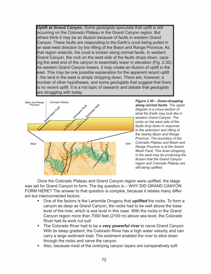
Uplift at Grand Canyon. Some geologists speculate that uplift is still occurring on the Colorado Plateau in the Grand Canyon region. But others think it may be an illusion because of faults in western Grand Canyon. These faults are responding to the Earth’s crust being pulled in an east-west direction by the rifting of the Basin and Range Province. As that region extends, the crust is broken along normal faults. In western Grand Canyon, the rock on the west side of the faults drops down, caus-ing the west end of the canyon to essentially lower in elevation (Fig. 2.30). As western Grand Canyon lowers, it may create an illusion of uplift in the east. This may be one possible explanation for the apparent recent uplift – the land in the west is simply dropping down. There are, however, a number of other hypotheses, and some geologists that suggest that there is no recent uplift. It is a hot topic of research and debate that geologists are struggling with today.
Figure 2.30 – Down-dropping along normal faults. The upper diagram is a cross-section of what the Earth may look like in western Grand Canyon. The rocks on the west side of the faults drop down in response to the extension and rifting of the nearby Basin and Range Province. The boundary of the Colorado Plateau and Basin and Range Province is at the Grand Wash Fault. This down-dropping in the west may be producing the illusion that the Grand Canyon region and Colorado Plateau are still being uplifted.
B UTTEFAULT
BRIGHTANGELFAU
LT
MUAVFAUL T
SEVIER
FAUL
TOROWEAPFAULT
HURRIC
ANEFAULT
GRANDWASH
FAULT
Grand Wash Fault
Toroweap Fault
Hurricane Fault
West East
Colorado PlateauBasin and RangeProvince
72
sedimentary rocks, rather than very hard metamorphic or igneous rocks, it may have been easier for the river to cut through them.
§ The Laramide Orogeny did not seriously deform the sedimentary rock layers, so they remained mostly flat-lying. It would have been more difficult for the river to flow over tilted and deformed rocks and it would probably have taken a different course over and around the rocks. Also if the rocks were not flat-lying, the canyon would not have the continuous, visible layers of alternating cliffs and slopes that it does today.
§ Grand Canyon exists in this location in part because of the semi-arid desert climate. Weathering and erosion in this dry climate, such as ice wedging and mass movement, have widened and sculpted the canyon. These processes have helped create the landscape features like buttes, mesas, and temples. Also, if Grand Canyon were in a more humid climate, the canyon would be covered by vegetation, disguising the colorful, picturesque layers.
The Giant Puzzle: The Colorado River and Grand Canyon
It is clear that the Colorado River carved Grand Canyon, but exactly how the river came to be is a big puzzle that geologists are still piecing together. Unfortunately, so many critical pieces of the puzzle are missing and gone forever. There are just too many gaps in the geologic record between the formation of the rocks, uplift, and erosion, and the carving of the canyon. Somewhere in these gaps lie the pieces geologists need to complete the puzzle.
Geologists are stuck working with very little data to help them resolve the his-tory of a complicated river system. One of the biggest problems they face when trying to understand the history of a river is that the river itself tends to wash away much of
Glaciers, faults, earthquakes, meteorite impacts, and wind… are some of the common incorrect ideas of how Grand Canyon formed. We know glaciers did not directly carve Grand Canyon. During the most recent ice ages (1.8 million to 15,000 years ago) the massive, continental glaciers did not reach as far south as northern Arizona (but there were small, alpine glaciers on the San Francisco Peaks). However, melting of glaciers in regions far upstream contributed to the carving of the canyon by increasing the discharge of the Colorado River with their melt water. Major faulting did not form Grand Canyon either. If a large fault had broken open the canyon, there should be evidence of the fault in the inner canyon, but there is none. Faults do cross the canyon, but do not run parallel to it along its length. An earthquake could not have created the canyon because, again, there would have to be a fault for the earthquake to occur along throughout the length of Grand Canyon, and there is not one. A meteor-ite also did not form Grand Canyon. A meteorite would have probably formed a crater, rather than a linear canyon, because impact sites are usually circular (like Meteor Crater, near Winslow, AZ). Additionally, no remains of meteorites have been found at the canyon. Finally, wind has had a very small role in the development of Grand Canyon. It may have helped a little to widen the canyon by transporting small sediment particles, but it certainly has not cut down through one mile (1.6 km) of rock.
73
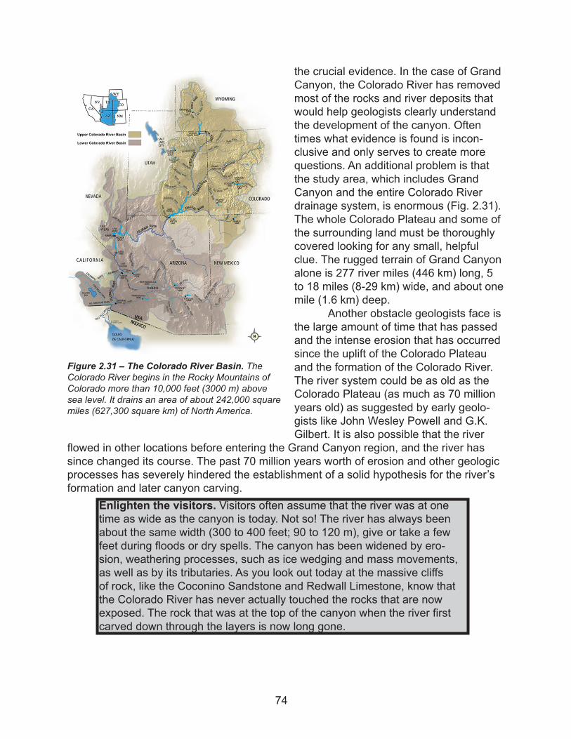
the crucial evidence. In the case of Grand Canyon, the Colorado River has removed most of the rocks and river deposits that would help geologists clearly understand the development of the canyon. Often times what evidence is found is incon-clusive and only serves to create more questions. An additional problem is that the study area, which includes Grand Canyon and the entire Colorado River drainage system, is enormous (Fig. 2.31). The whole Colorado Plateau and some of the surrounding land must be thoroughly covered looking for any small, helpful clue. The rugged terrain of Grand Canyon alone is 277 river miles (446 km) long, 5 to 18 miles (8-29 km) wide, and about one mile (1.6 km) deep.
Another obstacle geologists face is the large amount of time that has passed and the intense erosion that has occurred since the uplift of the Colorado Plateau and the formation of the Colorado River. The river system could be as old as the Colorado Plateau (as much as 70 million years old) as suggested by early geolo-gists like John Wesley Powell and G.K. Gilbert. It is also possible that the river
flowed in other locations before entering the Grand Canyon region, and the river has since changed its course. The past 70 million years worth of erosion and other geologic processes has severely hindered the establishment of a solid hypothesis for the river’s formation and later canyon carving.
Figure 2.31 – The Colorado River Basin. The Colorado River begins in the Rocky Mountains of Colorado more than 10,000 feet (3000 m) above sea level. It drains an area of about 242,000 square miles (627,300 square km) of North America.
Enlighten the visitors. Visitors often assume that the river was at one time as wide as the canyon is today. Not so! The river has always been about the same width (300 to 400 feet; 90 to 120 m), give or take a few feet during floods or dry spells. The canyon has been widened by ero-sion, weathering processes, such as ice wedging and mass movements, as well as by its tributaries. As you look out today at the massive cliffs of rock, like the Coconino Sandstone and Redwall Limestone, know that the Colorado River has never actually touched the rocks that are now exposed. The rock that was at the top of the canyon when the river first carved down through the layers is now long gone.
74
Pieces of the Puzzle
Piecing together the Grand Canyon puzzle begins with understanding the devel-opment of the Colorado River. Using the scientific method, geologists have developed several different hypotheses for how Grand Canyon and the Colorado River came to be. They continue to research and collect evidence that can help prove or disprove some of the hypotheses. It cannot be emphasized enough that this topic is still under great debate and may never be resolved due to the lack of necessary, physical evidence and data available in this dynamic river system.
The evidence that has been collected so far suggests that the northeastern part of the Colorado River (upper part; in Colorado and Utah) is slightly older, while the southwestern portion (lower part; in Arizona, Nevada and California) is younger. The upper part of the river is sometimes referred to as the “old Colorado River” or “ancestral Colorado River.” The younger, southwestern part of the river that flowed to the Gulf of California is the “young Colorado River”.
Some of the oldest evidence that may be from the ancestral Colorado River is river gravel found near Grand Junction, CO at Grand Mesa. It is associated with dated volcanic rocks that are approximately 10 million years old. There is another possible Colorado River gravel deposit further upstream near Glenwood Springs, CO, that may indicate the river in that region is at least 7 million years old. It is not exactly clear if the gravels are from an ancestral Colorado River, or some other river, but it is some of the only data available so far. Evidence in the reach of the young Colorado River (discussed in next paragraphs) indicates that between 5 and 6 million years ago, the older and the younger parts combined to form the Colorado River that flows though Grand Canyon, as we know it today.
The shape of the land at the time when the Colorado River formed was likely an important factor in its development. Undoubtedly, the land looked very different than it does today, in part because there was a thick sequence of Mesozoic rocks overlying the Grand Canyon region, little of which now remains. The shape of the landscape then (which is unknown because it has been eroded away) probably determined the present course of the Colorado River.
In eastern Grand Canyon, one landscape obstacle apparent today that seems impossible for a river to cross is the Kaibab Plateau, which is a broad, elevated area that was uplifted along the East Kaibab Monocline (Fig. 2.32). The Kaibab Plateau begins where the Colorado River makes a sharp turn to the west, near Desert View. How the river has managed to cut right through this large area of upwarped land is unknown. As you know, water follows gravity and travels down slope, away from or along hills, rather than through them. It is possible that 10 to 30 million years ago the Kaibab Plateau may not have been as large as it is today. The land could have been rel-atively flat and easy for the river to cross, and then the plateau may have been uplifted after the river had established its course (Fig. 2.33a). Alternatively, relatively flat-lying Mesozoic rock layers may have covered the Kaibab Plateau. As these Mesozoic rocks were eroded away by the river, the Kaibab Plateau was exposed, and the Colorado River could have established its channel right through the plateau (Fig. 2.33b).
Looking at clues in western Grand Canyon, geologists suspect that mountains
75
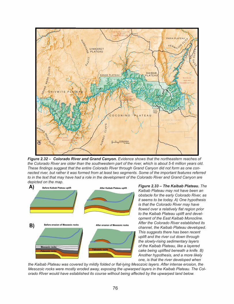
Figure 2.32 – Colorado River and Grand Canyon. Evidence shows that the northeastern reaches of the Colorado River are older than the southwestern part of the river, which is about 5-6 million years old. These findings suggest that the entire Colorado River through Grand Canyon did not form as one con-nected river, but rather it was formed from at least two segments. Some of the important features referred to in the text that may have had a role in the development of the Colorado River and Grand Canyon are depicted on the map.
ColoradoRiver
ColoradoRiver
River
Little Colorado River
15
389
64
66
89
180
64
64
67
ALT89
89
ALT89
Fredonia
U INKARETPLATEAU
C O C O N I N O P L A T E A U
HURRICANE
CLIFFS
KANAB PLATEAU
S H I V W I T S P L A T E A U
GRAND
WASH
CLI FFS
SANUPPLATE
AU
GRAND
WASHCL I F F A
UBREY
CLI FFS
KANAB
CANYON
DesertView
MARBLECANYO
KA IBABPLATEAU
VERM I L I ONCLI FFPARIA PLATEAU
Bright AngelPoint
GrandCanyonVillage
ECHOCLI FFS
K A I B A B N A T I O N A L
F O R E S T
K A I B A B N A T I O N A L
F O R E S T
H U A L A P A I I N D I A N
R E S E R V A T I O N
K A I B A B P A I U T EI N D I A N
R E S E R V A T I O N
N A V A J O
I N D I A N
R E S E R V A T I O N
H A V A S U P A II N D I A N
R E S E R V A T I O N
G R A N D C A N Y O N
N A T I O N A LP A R K
00 10 Miles5
10 Kilometers5North
Tuweep
Before Kaibab Plateau uplift After Kaibab Plateau upliftA)
B)
Mesozoic rocks
Paleozoic rocksPaleozoic rocks
Before erosion of Mesozoic rocks After erosion of Mesozoic rocks
Figure 2.33 – The Kaibab Plateau. The Kaibab Plateau may not have been an obstacle for the early Colorado River, as it seems to be today. A) One hypothesis is that the Colorado River may have flowed over a relatively flat region prior to the Kaibab Plateau uplift and devel-opment of the East Kaibab Monocline. After the Colorado River established its channel, the Kaibab Plateau developed. This suggests there has been recent uplift and the river cut down through the slowly-rising sedimentary layers of the Kaibab Plateau, like a layered cake being uplifted beneath a knife. B) Another hypothesis, and a more likely one, is that the river developed when
the Kaibab Plateau was covered by mildly folded or flat-lying Mesozoic layers. After intense erosion, the Mesozoic rocks were mostly eroded away, exposing the upwarped layers in the Kaibab Plateau. The Col-orado RIver would have established its course without being affected by the upwarped land below.
76
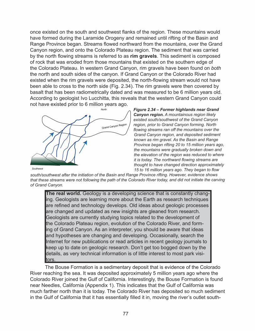
once existed on the south and southwest flanks of the region. These mountains would have formed during the Laramide Orogeny and remained until rifting of the Basin and Range Province began. Streams flowed northward from the mountains, over the Grand Canyon region, and onto the Colorado Plateau region. The sediment that was carried by the north flowing streams is referred to as rim gravels. This sediment is composed of rock that was eroded from those mountains that existed on the southern edge of the Colorado Plateau. In western Grand Canyon, rim gravels have been found on both the north and south sides of the canyon. If Grand Canyon or the Colorado River had existed when the rim gravels were deposited, the north-flowing stream would not have been able to cross to the north side (Fig. 2.34). The rim gravels were then covered by basalt that has been radiometrically dated and was measured to be 6 million years old. According to geologist Ivo Lucchitta, this reveals that the western Grand Canyon could not have existed prior to 6 million years ago.
The Bouse Formation is a sedimentary deposit that is evidence of the Colorado River reaching the sea. It was deposited approximately 5 million years ago where the Colorado River joined the Gulf of California. Interestingly, the Bouse Formation is found near Needles, California (Appendix 1). This indicates that the Gulf of California was much farther north than it is today. The Colorado River has deposited so much sediment in the Gulf of California that it has essentially filled it in, moving the river’s outlet south-
Figure 2.34 – Former highlands near Grand Canyon region. A mountainous region likely existed south/southwest of the Grand Canyon region, prior to Grand Canyon forming. North flowing streams ran off the mountains over the Grand Canyon region, and deposited sediment known as rim gravel. As the Basin and Range Province began rifting 20 to 15 million years ago, the mountains were gradually broken down and the elevation of the region was reduced to where it is today. The northward flowing streams are thought to have changed direction approximately 15 to 16 million years ago. They began to flow
south/southwest after the initiation of the Basin and Range Province rifting. However, evidence shows that these streams were not following the path of the Colorado River today, and did not initiate the carving of Grand Canyon.
North
Grand Canyon Region
Southwest
The real world. Geology is a developing science that is constantly chang-ing. Geologists are learning more about the Earth as research techniques are refined and technology develops. Old ideas about geologic processes are changed and updated as new insights are gleaned from research. Geologists are currently studying topics related to the development of the Colorado Plateau region, evolution of the Colorado River, and form-ing of Grand Canyon. As an interpreter, you should be aware that ideas and hypotheses are changing and developing. Occasionally, search the Internet for new publications or read articles in recent geology journals to keep up to date on geologic research. Don’t get too bogged down by the details, as very technical information is of little interest to most park visi-tors.
77
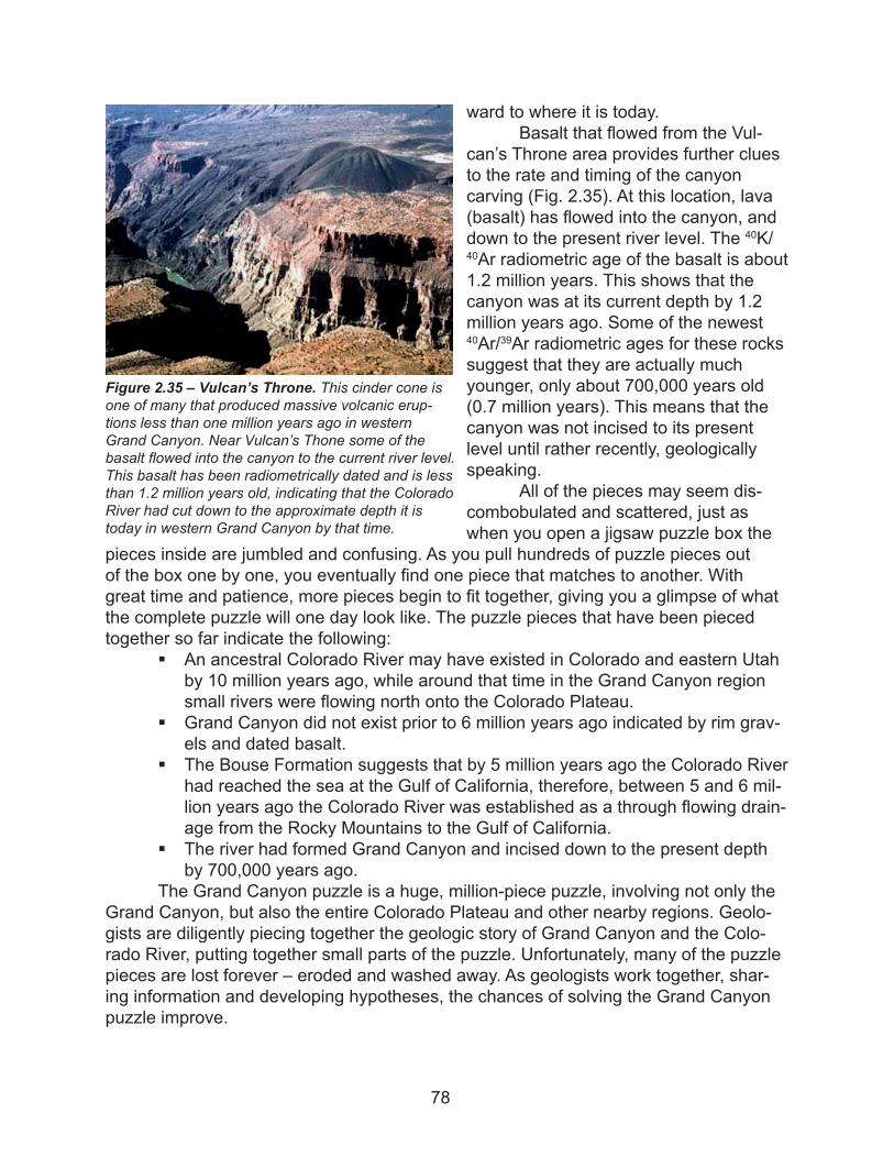
ward to where it is today. Basalt that flowed from the Vul-
can’s Throne area provides further clues to the rate and timing of the canyon carving (Fig. 2.35). At this location, lava (basalt) has flowed into the canyon, and down to the present river level. The 40K/40Ar radiometric age of the basalt is about 1.2 million years. This shows that the canyon was at its current depth by 1.2 million years ago. Some of the newest 40Ar/39Ar radiometric ages for these rocks suggest that they are actually much younger, only about 700,000 years old (0.7 million years). This means that the canyon was not incised to its present level until rather recently, geologically speaking.
All of the pieces may seem dis-combobulated and scattered, just as when you open a jigsaw puzzle box the
pieces inside are jumbled and confusing. As you pull hundreds of puzzle pieces out of the box one by one, you eventually find one piece that matches to another. With great time and patience, more pieces begin to fit together, giving you a glimpse of what the complete puzzle will one day look like. The puzzle pieces that have been pieced together so far indicate the following:
§ An ancestral Colorado River may have existed in Colorado and eastern Utah by 10 million years ago, while around that time in the Grand Canyon region small rivers were flowing north onto the Colorado Plateau.
§ Grand Canyon did not exist prior to 6 million years ago indicated by rim grav-els and dated basalt.
§ The Bouse Formation suggests that by 5 million years ago the Colorado River had reached the sea at the Gulf of California, therefore, between 5 and 6 mil-lion years ago the Colorado River was established as a through flowing drain-age from the Rocky Mountains to the Gulf of California.
§ The river had formed Grand Canyon and incised down to the present depth by 700,000 years ago.
The Grand Canyon puzzle is a huge, million-piece puzzle, involving not only the Grand Canyon, but also the entire Colorado Plateau and other nearby regions. Geolo-gists are diligently piecing together the geologic story of Grand Canyon and the Colo-rado River, putting together small parts of the puzzle. Unfortunately, many of the puzzle pieces are lost forever – eroded and washed away. As geologists work together, shar-ing information and developing hypotheses, the chances of solving the Grand Canyon puzzle improve.
Figure 2.35 – Vulcan’s Throne. This cinder cone is one of many that produced massive volcanic erup-tions less than one million years ago in western Grand Canyon. Near Vulcan’s Thone some of the basalt flowed into the canyon to the current river level. This basalt has been radiometrically dated and is less than 1.2 million years old, indicating that the Colorado River had cut down to the approximate depth it is today in western Grand Canyon by that time.
78
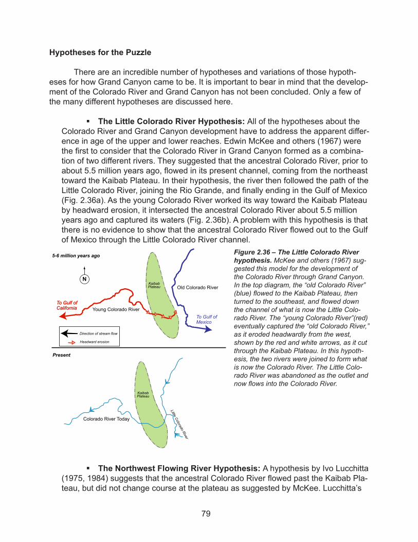
Hypotheses for the Puzzle
There are an incredible number of hypotheses and variations of those hypoth-eses for how Grand Canyon came to be. It is important to bear in mind that the develop-ment of the Colorado River and Grand Canyon has not been concluded. Only a few of the many different hypotheses are discussed here.
§ The Little Colorado River Hypothesis: All of the hypotheses about the Colorado River and Grand Canyon development have to address the apparent differ-ence in age of the upper and lower reaches. Edwin McKee and others (1967) were the first to consider that the Colorado River in Grand Canyon formed as a combina-tion of two different rivers. They suggested that the ancestral Colorado River, prior to about 5.5 million years ago, flowed in its present channel, coming from the northeast toward the Kaibab Plateau. In their hypothesis, the river then followed the path of the Little Colorado River, joining the Rio Grande, and finally ending in the Gulf of Mexico (Fig. 2.36a). As the young Colorado River worked its way toward the Kaibab Plateau by headward erosion, it intersected the ancestral Colorado River about 5.5 million years ago and captured its waters (Fig. 2.36b). A problem with this hypothesis is that there is no evidence to show that the ancestral Colorado River flowed out to the Gulf of Mexico through the Little Colorado River channel.
§ The Northwest Flowing River Hypothesis: A hypothesis by Ivo Lucchitta (1975, 1984) suggests that the ancestral Colorado River flowed past the Kaibab Pla-teau, but did not change course at the plateau as suggested by McKee. Lucchitta’s
Figure 2.36 – The Little Colorado River hypothesis. McKee and others (1967) sug-gested this model for the development of the Colorado River through Grand Canyon. In the top diagram, the “old Colorado River” (blue) flowed to the Kaibab Plateau, then turned to the southeast, and flowed down the channel of what is now the Little Colo-rado River. The “young Colorado River”(red) eventually captured the “old Colorado River,” as it eroded headwardly from the west, shown by the red and white arrows, as it cut through the Kaibab Plateau. In this hypoth-esis, the two rivers were joined to form what is now the Colorado River. The Little Colo-rado River was abandoned as the outlet and now flows into the Colorado River.
KaibabPlateau
KaibabPlateau Old Colorado River
Young Colorado River
Colorado River Today
N
5-6 million years ago
Present
To Gulf ofCaliforniaTo Gulf ofCalifornia
Direction of stream flow
Headward erosion
To Gulf ofMexico
LittleColorado
River
79
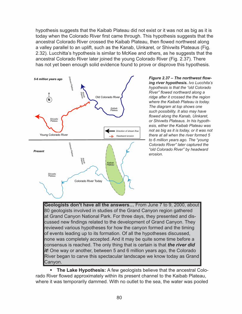
hypothesis suggests that the Kaibab Plateau did not exist or it was not as big as it is today when the Colorado River first came through. This hypothesis suggests that the ancestral Colorado River crossed the Kaibab Plateau, then flowed northwest along a valley parallel to an uplift, such as the Kanab, Uinkaret, or Shivwits Plateaus (Fig. 2.32). Lucchitta’s hypothesis is similar to McKee and others, as he suggests that the ancestral Colorado River later joined the young Colorado River (Fig. 2.37). There has not yet been enough solid evidence found to prove or disprove this hypothesis.
§ The Lake Hypothesis: A few geologists believe that the ancestral Colo-rado River flowed approximately within its present channel to the Kaibab Plateau, where it was temporarily dammed. With no outlet to the sea, the water was pooled
Figure 2.37 – The northwest flow-ing river hypothesis. Ivo Lucchita’s hypothesis is that the “old Colorado River” flowed northward along a ridge after it crossed the the region where the Kaibab Plateau is today. The diagram at top shows one such possibility. It also may have flowed along the Kanab, Uinkaret, or Shivwits Plateaus. In his hypoth-esis, either the Kaibab Plateau was not as big as it is today, or it was not there at all when the river formed 5 to 6 million years ago. The “young Colorado River” later captured the “old Colorado River” by headward erosion.
N
KanabPlateau
Uinkaret Plateau
ShivwitsPlateau
KaibabPlateau
Colorado River Today
KanabPlateau
Uinkaret Plateau
ShivwitsPlateau
Old Colorado River
Young Colorado River
KaibabPlateau
5-6 million years ago
Present
Direction of stream flow
Headward erosion
Geologists don’t have all the answers… From June 7 to 9, 2000, about 80 geologists involved in studies of the Grand Canyon region gathered at Grand Canyon National Park. For three days, they presented and dis-cussed new findings related to the development of Grand Canyon. They reviewed various hypotheses for how the canyon formed and the timing of events leading up to its formation. Of all the hypotheses discussed, none was completely accepted. And it may be quite some time before a consensus is reached. The only thing that is certain is that the river did it! One way or another, between 5 and 6 million years ago, the Colorado River began to carve this spectacular landscape we know today as Grand Canyon.
80
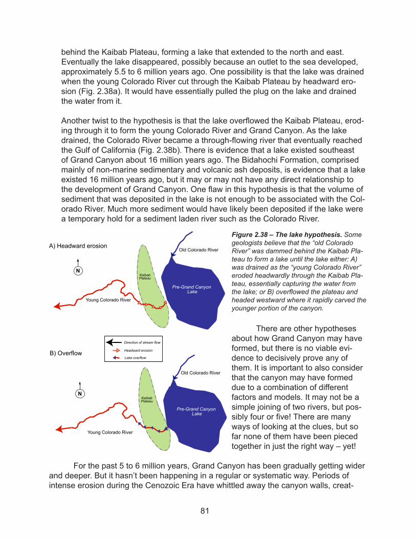
behind the Kaibab Plateau, forming a lake that extended to the north and east. Eventually the lake disappeared, possibly because an outlet to the sea developed, approximately 5.5 to 6 million years ago. One possibility is that the lake was drained when the young Colorado River cut through the Kaibab Plateau by headward ero-sion (Fig. 2.38a). It would have essentially pulled the plug on the lake and drained the water from it.
Another twist to the hypothesis is that the lake overflowed the Kaibab Plateau, erod-ing through it to form the young Colorado River and Grand Canyon. As the lake drained, the Colorado River became a through-flowing river that eventually reached the Gulf of California (Fig. 2.38b). There is evidence that a lake existed southeast of Grand Canyon about 16 million years ago. The Bidahochi Formation, comprised mainly of non-marine sedimentary and volcanic ash deposits, is evidence that a lake existed 16 million years ago, but it may or may not have any direct relationship to the development of Grand Canyon. One flaw in this hypothesis is that the volume of sediment that was deposited in the lake is not enough to be associated with the Col-orado River. Much more sediment would have likely been deposited if the lake were a temporary hold for a sediment laden river such as the Colorado River.
There are other hypotheses about how Grand Canyon may have formed, but there is no viable evi-dence to decisively prove any of them. It is important to also consider that the canyon may have formed due to a combination of different factors and models. It may not be a simple joining of two rivers, but pos-sibly four or five! There are many ways of looking at the clues, but so far none of them have been pieced together in just the right way – yet!
For the past 5 to 6 million years, Grand Canyon has been gradually getting wider and deeper. But it hasn’t been happening in a regular or systematic way. Periods of intense erosion during the Cenozoic Era have whittled away the canyon walls, creat-
Figure 2.38 – The lake hypothesis. Some geologists believe that the “old Colorado River” was dammed behind the Kaibab Pla-teau to form a lake until the lake either: A) was drained as the “young Colorado River” eroded headwardly through the Kaibab Pla-teau, essentially capturing the water from the lake; or B) overflowed the plateau and headed westward where it rapidly carved the younger portion of the canyon.
KaibabPlateau
Old Colorado River
Young Colorado River
N
KaibabPlateau
Old Colorado River
Young Colorado River
N
Lake Bidahochi
A) Headward erosion
B) Overflow
Pre-Grand CanyonLake
Direction of stream flow
Headward erosion
Lake overflow
Pre-Grand CanyonLake
81
ing side canyons and tributaries along the river. Referencing averages for how fast the canyon is getting wider or deeper can be misleading to park visitors who do not know that the erosion of the canyon appears to happen episodically. For example, as large, continental glaciers melted about 15,000 years ago at the end of the last ice age, an enormous amount of water may have been added to the Colorado River, which could have intensified erosion and deepening of the canyon.
The Cenozoic Era brings us to today, when both geologic and human forces are at work on Grand Canyon. Glen Canyon Dam maintains the flow of the Colorado River through the canyon. In geologic time the dam will be a short moment in the Colorado River’s life (Fig. 2.39). The Colorado River has overcome many natural dams during its life. Over the past 3 million years, volcanoes in the western Grand Canyon have erupted basalt into the canyon and may have at times completely dammed the river. Some of the dams may have been over 2000 feet (610 m) high and up to 84 miles (135 km) long! Huge lakes may have formed behind these dams, as the Colorado River backed up. It would have filled side canyons and deposited sediment. Amazingly, the river was
Interpreters tip. Park rangers and volunteers occasionally encounter visitors with religious views that differ from interpretations based on scientific observations. Rest assured that most visitors come to geology programs to hear what you have to say, not to argue about scientific facts. As an interpreter representing the National Park Service, your job is to present the scientific view of how the canyon may have formed based on evidence found in the rocks. According to the NPS 2001 Management Poli-cies the “Constitution prohibits the National Park Service from endorsing or promoting any religious position in explaining natural processes. However, alternative theories of processes and events may be acknowledged.” Also talk to your seasoned colleagues for suggestions on how to handle argumentative, opinionated visitors. There is no one right way to handle visitors who don’t acknowledge scientific evidence. Not everyone accepts scientific views and that’s okay! Keep in mind that religion is a belief system and beliefs don’t necessarily change. Scientific explanations are based on testing and observation and may change as new information becomes available.
The 2001 NPS Management Policies for Grand Canyon National Park states: The content of interpretive and educational programs must be accurate, represent multiple points of view and be free of cultural, ethnic, and personal biases. However, in accordance with section 7.5.5 of Man-agement Policies (2001), “acknowledging multiple points of view does not require interpretive and educational programs to provide equal time, or to disregard the weight of scientific or historical evidence.” Section 8.4.3 on scientific research states, “Questions often arise around the presentation of geologic, biological and evolutionary processes. The interpretive treat-ment used to explain the natural processes and history of the Earth must be based upon the best scientific evidence available, as found in scholarly sources that have stood the test of scientific peer review and criticism. The facts, theories, and interpretations to be used will be those that reflect the thinking of the scientific community in such fields as biology, geology, physics, astronomy, chemistry, and paleontology.”
82
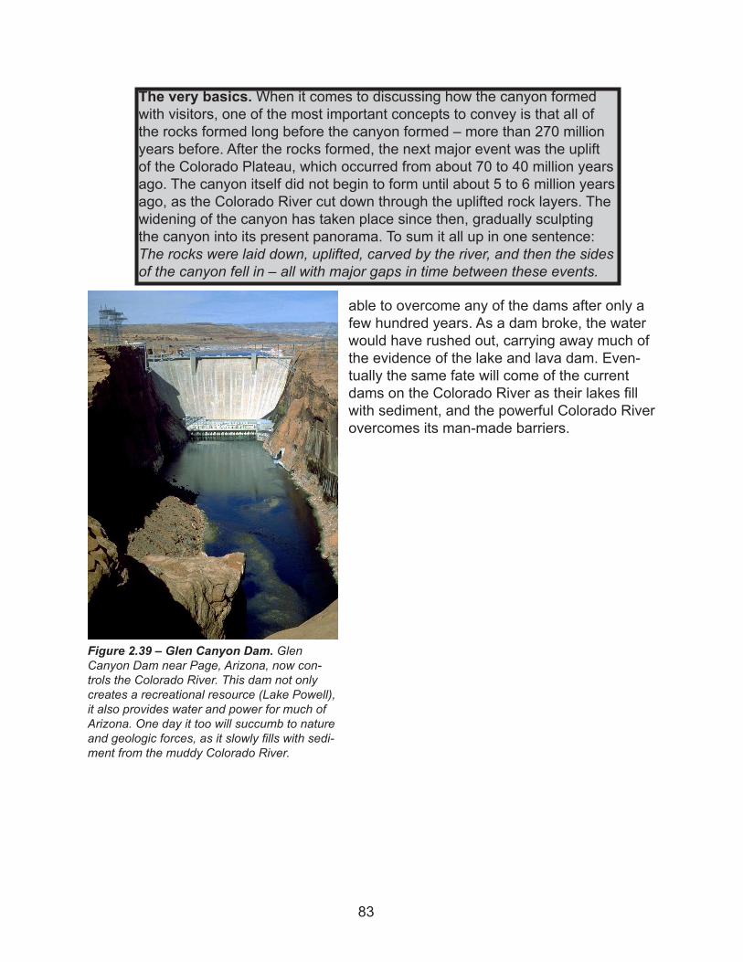
able to overcome any of the dams after only a few hundred years. As a dam broke, the water would have rushed out, carrying away much of the evidence of the lake and lava dam. Even-tually the same fate will come of the current dams on the Colorado River as their lakes fill with sediment, and the powerful Colorado River overcomes its man-made barriers.
Figure 2.39 – Glen Canyon Dam. Glen Canyon Dam near Page, Arizona, now con-trols the Colorado River. This dam not only creates a recreational resource (Lake Powell), it also provides water and power for much of Arizona. One day it too will succumb to nature and geologic forces, as it slowly fills with sedi-ment from the muddy Colorado River.
The very basics. When it comes to discussing how the canyon formed with visitors, one of the most important concepts to convey is that all of the rocks formed long before the canyon formed – more than 270 million years before. After the rocks formed, the next major event was the uplift of the Colorado Plateau, which occurred from about 70 to 40 million years ago. The canyon itself did not begin to form until about 5 to 6 million years ago, as the Colorado River cut down through the uplifted rock layers. The widening of the canyon has taken place since then, gradually sculpting the canyon into its present panorama. To sum it all up in one sentence: The rocks were laid down, uplifted, carved by the river, and then the sides of the canyon fell in – all with major gaps in time between these events.
83
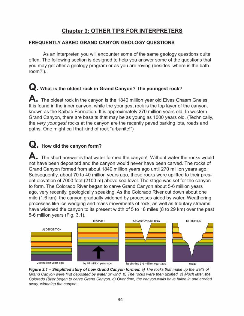
Chapter 3: OTHER TIPS FOR INTERPRETERS
FREQUENTLY ASKED GRAND CANYON GEOLOGY QUESTIONS
As an interpreter, you will encounter some of the same geology questions quite often. The following section is designed to help you answer some of the questions that you may get after a geology program or as you are roving (besides ‘where is the bath-room?’).
Q. What is the oldest rock in Grand Canyon? The youngest rock?
A. The oldest rock in the canyon is the 1840 million year old Elves Chasm Gneiss. It is found in the inner canyon, while the youngest rock is the top layer of the canyon, known as the Kaibab Formation. It is approximately 270 million years old. In western Grand Canyon, there are basalts that may be as young as 1000 years old. (Technically, the very youngest rocks at the canyon are the recently paved parking lots, roads and paths. One might call that kind of rock “urbanite!”)
Q. How did the canyon form?
A. The short answer is that water formed the canyon! Without water the rocks would not have been deposited and the canyon would never have been carved. The rocks of Grand Canyon formed from about 1840 million years ago until 270 million years ago. Subsequently, about 70 to 40 million years ago, these rocks were uplifted to their pres-ent elevation of 7000 feet (2100 m) above sea level. The stage was set for the canyon to form. The Colorado River began to carve Grand Canyon about 5-6 million years ago, very recently, geologically speaking. As the Colorado River cut down about one mile (1.6 km), the canyon gradually widened by processes aided by water. Weathering processes like ice wedging and mass movements of rock, as well as tributary streams, have widened the canyon to its present width of 5 to 18 miles (8 to 29 km) over the past 5-6 million years (Fig. 3.1).
Figure 3.1 – Simplified story of how Grand Canyon formed. a) The rocks that make up the walls of Grand Canyon were first deposited by water or wind. b) The rocks were then uplifted. c) Much later, the Colorado River began to carve Grand Canyon. d) Over time, the canyon walls have fallen in and eroded away, widening the canyon.
��� ������� ����� ��� �� �� ������� ����� ���
�� ����������
�� ������
��������� ��� ������� ����� ���
�� ������ �������
�����
�� �������
84
Q. Why is Grand Canyon here?
A.Part of the reason the canyon is here is because of the type of rocks in the region. The picturesque, layered rocks are sedimentary rocks, and they are easier to erode than igneous or metamorphic rocks. Grand Canyon formed here also due to the fact that these rocks are at a high elevation. The rocks were uplifted more than 7000 feet (2100 m) above sea level during a mountain building event that took place 70 to 40 mil-lion years ago called the Laramide Orogeny. The high elevation is important because the rock had to be up high enough for the Colorado River to cut down through it. During the Laramide Orogeny, the sedimentary rocks were not seriously deformed so they remained mostly flat-lying. If the rocks were not flat lying, horizontal layers, the canyon would not look the way it does with its alternating cliff and slope layers. It’s not just any river that can form a Grand Canyon. The Colorado River is a very powerful river. It was capable of carrying a large volume of sediment, which was like a sand-blaster cut-ting down through the rock. Grand Canyon exists in this location also because of the semi-arid desert climate. Erosion in a dry climate can be rather sporadic and dramatic, such as when monsoon season arrives. Most other times though, the erosion is a grad-ual process. The rocks are also preserved better in a dry climate than they would be in a humid climate, which tends to dissolve limestone. In a desert climate, there is usually no dense vegetation. So plants do not disguise Grand Canyon, as would be the case if it had formed in a location with a humid climate. It would not be such a GRAND Canyon if the rocks were not uplifted, flat-lying sedimentary rocks, carved by a very pow-erful river in a dry desert climate!
Q. Is the canyon getting bigger?
A.As long as Grand Canyon is exposed to the atmosphere and erosional processes it will continue to get bigger. This rate has changed over time and is affected by factors such as climatic changes, sea level changes, ice ages, and even human involvement. The canyon continues to get slightly wider due to physical weathering processes like ice wedging and mass movement, as well as erosion by tributary streams. In the past, great floods with high discharges and sediment loads carved out the depth of the canyon. Now that Glen Canyon Dam controls the Colorado River, these floods are infrequent so the depth of the canyon is probably not changing much. The river has also reached the hardest rocks of the canyon, the Precambrian igneous and metamorphic rocks. They are much more resistant to weathering than the overlying sedimentary layers, making it difficult for the river to cut down through them.
Q. Where did all the rocks that once filled the canyon go?
A.Over the last 5-6 million years, since the Colorado River first began to carve the canyon, sediment has been carried down river toward the Gulf of California. However,
85
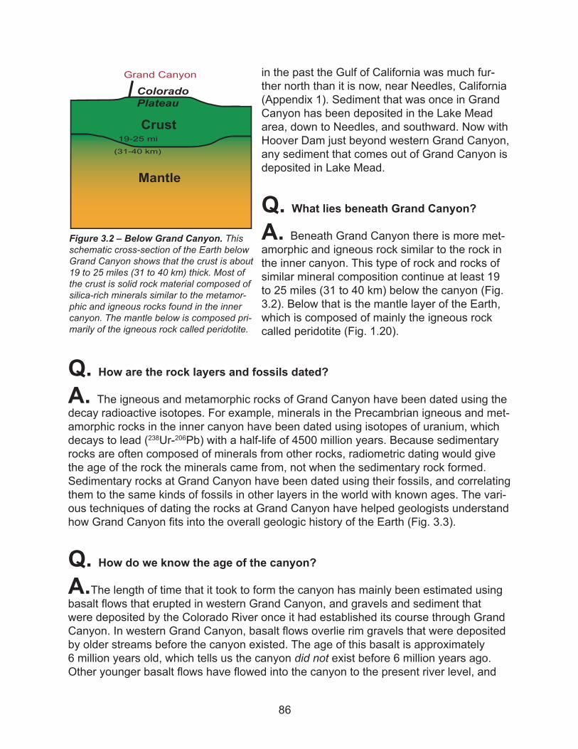
in the past the Gulf of California was much fur-ther north than it is now, near Needles, California (Appendix 1). Sediment that was once in Grand Canyon has been deposited in the Lake Mead area, down to Needles, and southward. Now with Hoover Dam just beyond western Grand Canyon, any sediment that comes out of Grand Canyon is deposited in Lake Mead.
Q. What lies beneath Grand Canyon?
A. Beneath Grand Canyon there is more met-amorphic and igneous rock similar to the rock in the inner canyon. This type of rock and rocks of similar mineral composition continue at least 19 to 25 miles (31 to 40 km) below the canyon (Fig. 3.2). Below that is the mantle layer of the Earth, which is composed of mainly the igneous rock called peridotite (Fig. 1.20).
Q. How are the rock layers and fossils dated?
A. The igneous and metamorphic rocks of Grand Canyon have been dated using the decay radioactive isotopes. For example, minerals in the Precambrian igneous and met-amorphic rocks in the inner canyon have been dated using isotopes of uranium, which decays to lead (238Ur-206Pb) with a half-life of 4500 million years. Because sedimentary rocks are often composed of minerals from other rocks, radiometric dating would give the age of the rock the minerals came from, not when the sedimentary rock formed. Sedimentary rocks at Grand Canyon have been dated using their fossils, and correlating them to the same kinds of fossils in other layers in the world with known ages. The vari-ous techniques of dating the rocks at Grand Canyon have helped geologists understand how Grand Canyon fits into the overall geologic history of the Earth (Fig. 3.3).
Q. How do we know the age of the canyon?
A.The length of time that it took to form the canyon has mainly been estimated using basalt flows that erupted in western Grand Canyon, and gravels and sediment that were deposited by the Colorado River once it had established its course through Grand Canyon. In western Grand Canyon, basalt flows overlie rim gravels that were deposited by older streams before the canyon existed. The age of this basalt is approximately 6 million years old, which tells us the canyon did not exist before 6 million years ago. Other younger basalt flows have flowed into the canyon to the present river level, and
Figure 3.2 – Below Grand Canyon. This schematic cross-section of the Earth below Grand Canyon shows that the crust is about 19 to 25 miles (31 to 40 km) thick. Most of the crust is solid rock material composed of silica-rich minerals similar to the metamor-phic and igneous rocks found in the inner canyon. The mantle below is composed pri-marily of the igneous rock called peridotite.
Crust
Grand Canyon
19-25 mi
(31-40 km)
ColoradoPlateau
Mantle
86
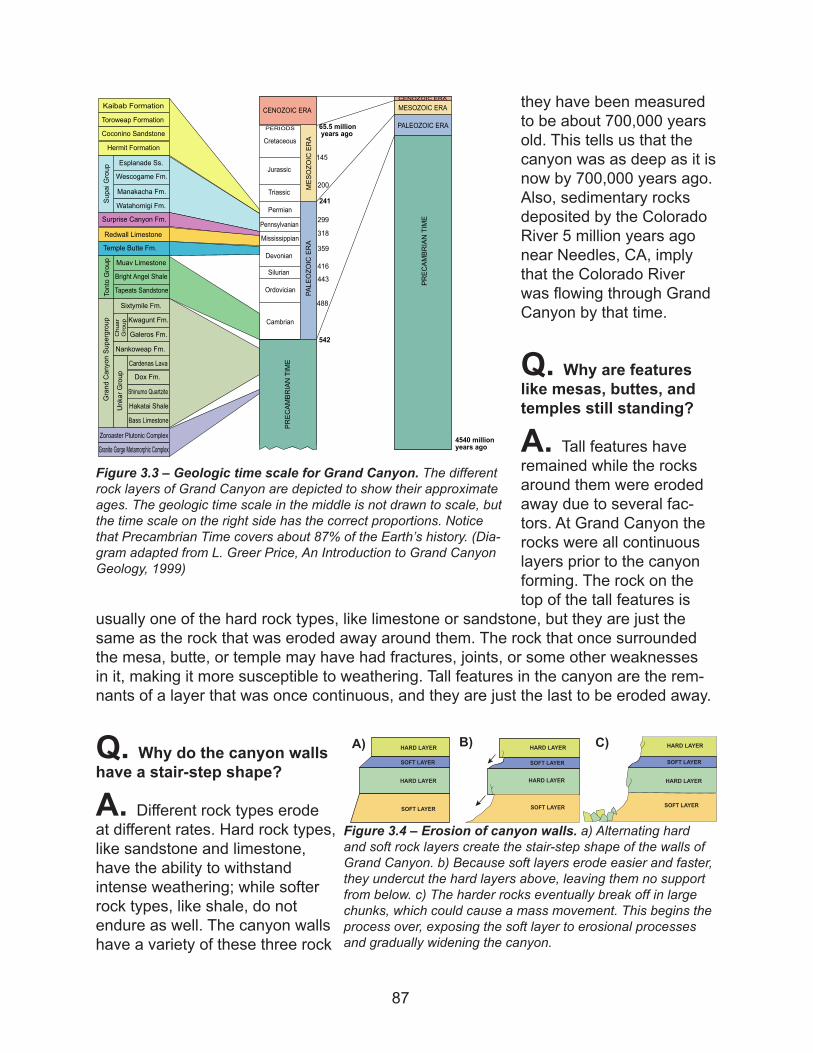
they have been measured to be about 700,000 years old. This tells us that the canyon was as deep as it is now by 700,000 years ago. Also, sedimentary rocks deposited by the Colorado River 5 million years ago near Needles, CA, imply that the Colorado River was flowing through Grand Canyon by that time.
Q. Why are features like mesas, buttes, and temples still standing?
A. Tall features have remained while the rocks around them were eroded away due to several fac-tors. At Grand Canyon the rocks were all continuous layers prior to the canyon forming. The rock on the top of the tall features is
usually one of the hard rock types, like limestone or sandstone, but they are just the same as the rock that was eroded away around them. The rock that once surrounded the mesa, butte, or temple may have had fractures, joints, or some other weaknesses in it, making it more susceptible to weathering. Tall features in the canyon are the rem-nants of a layer that was once continuous, and they are just the last to be eroded away.
Q. Why do the canyon walls have a stair-step shape?
A. Different rock types erode at different rates. Hard rock types, like sandstone and limestone, have the ability to withstand intense weathering; while softer rock types, like shale, do not endure as well. The canyon walls have a variety of these three rock
Figure 3.3 – Geologic time scale for Grand Canyon. The different rock layers of Grand Canyon are depicted to show their approximate ages. The geologic time scale in the middle is not drawn to scale, but the time scale on the right side has the correct proportions. Notice that Precambrian Time covers about 87% of the Earth’s history. (Dia-gram adapted from L. Greer Price, An Introduction to Grand Canyon Geology, 1999)
Kaibab Formation
Toroweap Formation
Coconino Sandstone
Hermit Formation
Wescogame Fm.
Manakacha Fm.
Watahomigi Fm.
Surprise Canyon Fm.
Redwall Limestone
Temple Butte Fm.
Muav Limestone
Bright Angel Shale
Tapeats Sandstone
Sixtymile Fm.
Kwagunt Fm.
Galeros Fm.
Nankoweap Fm.
Cardenas Lava
Dox Fm.
Shinumo Quartzite
Hakatai Shale
Bass Limestone
Zoroaster Plutonic Complex
Granite Gorge Metamorphic Complex
Esplanade Ss.
TontoGroup
GrandCanyonSupergroup
UnkarGroup
SupaiGroup
MESOZOICERA
PALEOZOICERA
PRECAM
BRIANTIME
Cambrian
Ordovician
Silurian
Devonian
Mississippian
Pennsylvanian
Permian
Triassic
Jurassic
Cretaceous
CENOZOIC ERA
PRECAMBRIANTIME
PALEOZOIC ERA
MESOZOIC ERACENOZOIC ERA
PERIODS
Chuar
Group
542
4540 millionyears ago
488
443
416
359
318
299
241
200
145
65.5 millionyears ago
Figure 3.4 – Erosion of canyon walls. a) Alternating hard and soft rock layers create the stair-step shape of the walls of Grand Canyon. b) Because soft layers erode easier and faster, they undercut the hard layers above, leaving them no support from below. c) The harder rocks eventually break off in large chunks, which could cause a mass movement. This begins the process over, exposing the soft layer to erosional processes and gradually widening the canyon.
SOFT LAYER
HARD LAYER
SOFT LAYER
HARD LAYERA)
HARD LAYER
HARD LAYERB) C)SOFT LAYER
HARD LAYER
SOFT LAYER
HARD LAYER
SOFT LAYER
SOFT LAYER
87
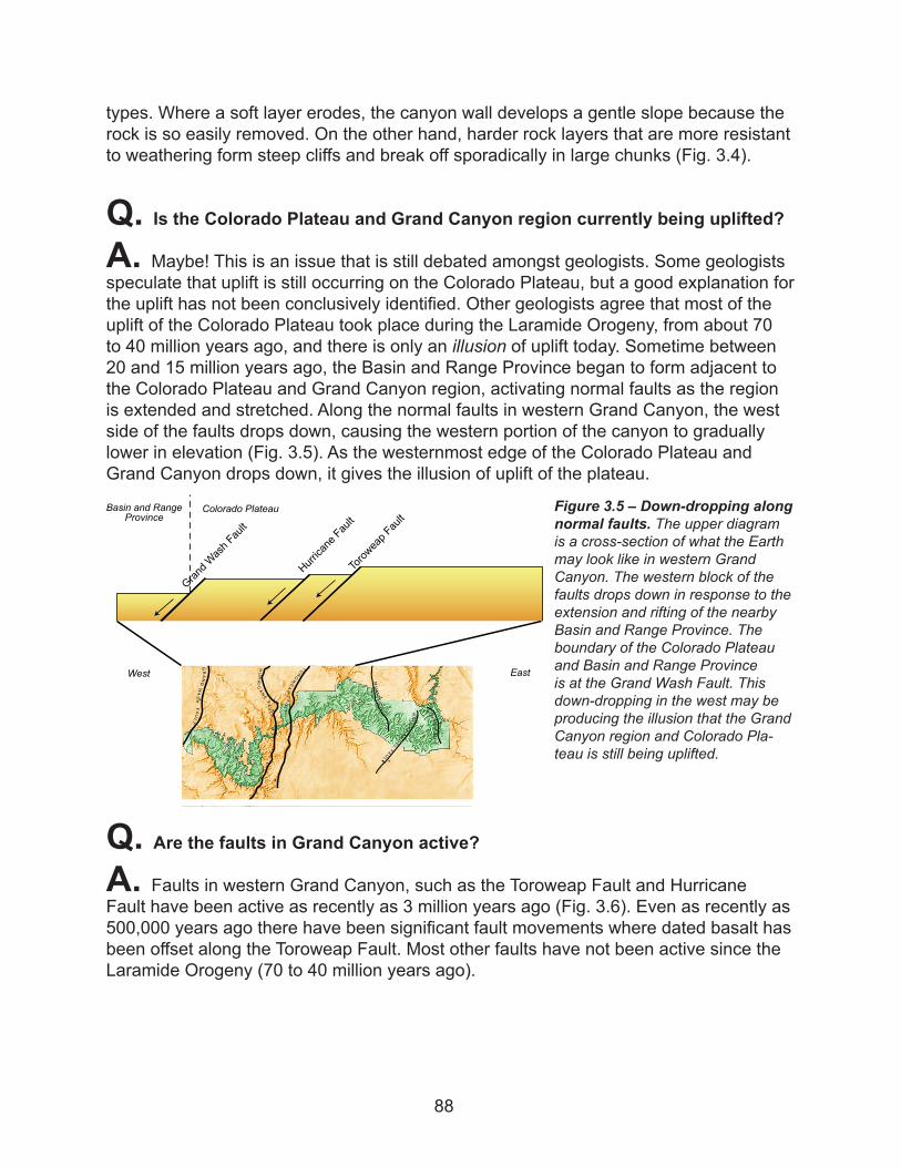
types. Where a soft layer erodes, the canyon wall develops a gentle slope because the rock is so easily removed. On the other hand, harder rock layers that are more resistant to weathering form steep cliffs and break off sporadically in large chunks (Fig. 3.4).
Q. Is the Colorado Plateau and Grand Canyon region currently being uplifted?
A. Maybe! This is an issue that is still debated amongst geologists. Some geologists speculate that uplift is still occurring on the Colorado Plateau, but a good explanation for the uplift has not been conclusively identified. Other geologists agree that most of the uplift of the Colorado Plateau took place during the Laramide Orogeny, from about 70 to 40 million years ago, and there is only an illusion of uplift today. Sometime between 20 and 15 million years ago, the Basin and Range Province began to form adjacent to the Colorado Plateau and Grand Canyon region, activating normal faults as the region is extended and stretched. Along the normal faults in western Grand Canyon, the west side of the faults drops down, causing the western portion of the canyon to gradually lower in elevation (Fig. 3.5). As the westernmost edge of the Colorado Plateau and Grand Canyon drops down, it gives the illusion of uplift of the plateau.
Q. Are the faults in Grand Canyon active?
A. Faults in western Grand Canyon, such as the Toroweap Fault and Hurricane Fault have been active as recently as 3 million years ago (Fig. 3.6). Even as recently as 500,000 years ago there have been significant fault movements where dated basalt has been offset along the Toroweap Fault. Most other faults have not been active since the Laramide Orogeny (70 to 40 million years ago).
Figure 3.5 – Down-dropping along normal faults. The upper diagram is a cross-section of what the Earth may look like in western Grand Canyon. The western block of the faults drops down in response to the extension and rifting of the nearby Basin and Range Province. The boundary of the Colorado Plateau and Basin and Range Province is at the Grand Wash Fault. This down-dropping in the west may be producing the illusion that the Grand Canyon region and Colorado Pla-teau is still being uplifted.
B UTTEFAULT
BRIGHTANGELFAULT
MUAVFAUL T
SEVIER
FAUL
TOROWEAPFAULT
HURRIC
ANEFAULT
GRANDWASH
FAULT
Grand Wash Fault
Toroweap Fault
Hurricane Fault
West East
Colorado PlateauBasin and RangeProvince
88
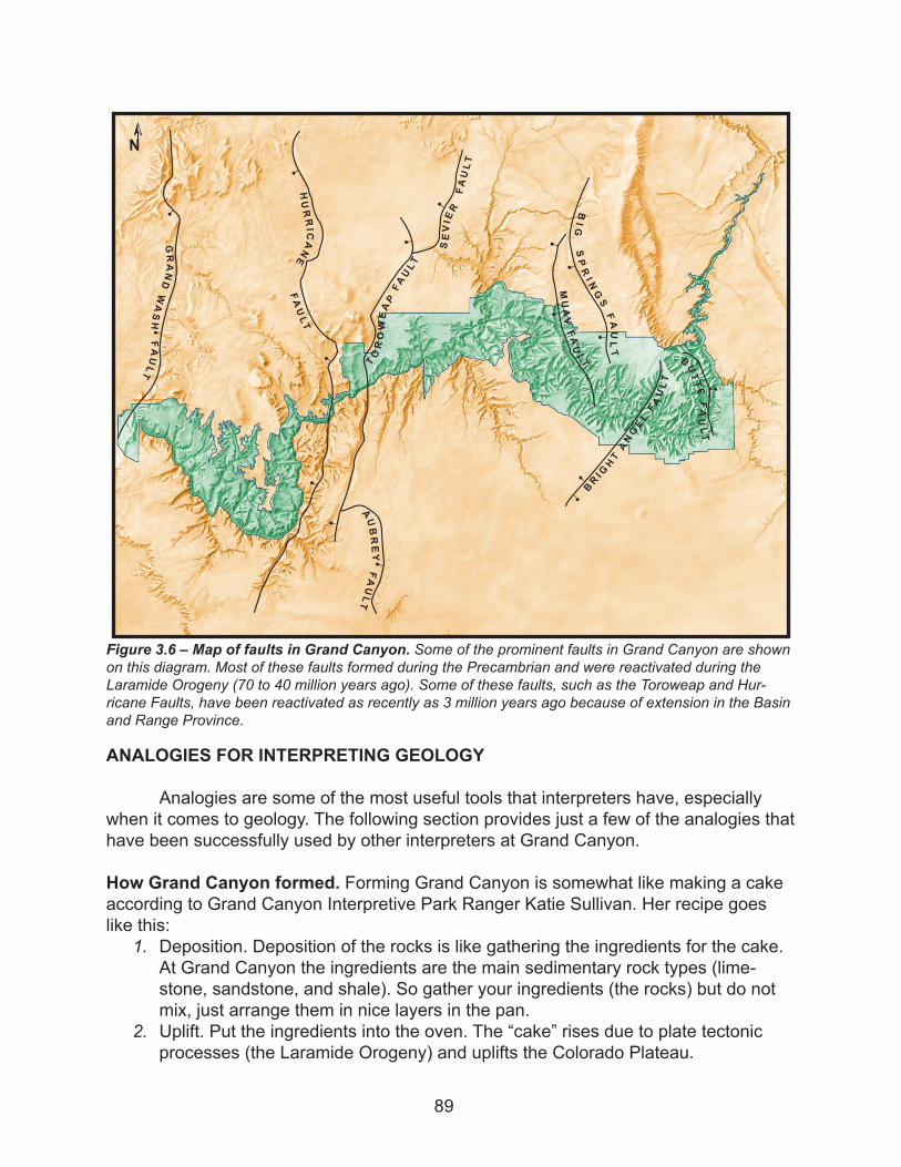
ANALOGIES FOR INTERPRETING GEOLOGY
Analogies are some of the most useful tools that interpreters have, especially when it comes to geology. The following section provides just a few of the analogies that have been successfully used by other interpreters at Grand Canyon.
How Grand Canyon formed. Forming Grand Canyon is somewhat like making a cake according to Grand Canyon Interpretive Park Ranger Katie Sullivan. Her recipe goes like this:
1. Deposition. Deposition of the rocks is like gathering the ingredients for the cake. At Grand Canyon the ingredients are the main sedimentary rock types (lime-stone, sandstone, and shale). So gather your ingredients (the rocks) but do not mix, just arrange them in nice layers in the pan.
2. Uplift. Put the ingredients into the oven. The “cake” rises due to plate tectonic processes (the Laramide Orogeny) and uplifts the Colorado Plateau.
B UTTEFAULT
BR IGHTANGE L
FAULT
MUAVF A
ULT
BIG
SPRI NGSFAULT
SEVIER
FAULT
TOROWEAPFAULT
AUBREY
FAULT
HURRICANE
FAULT
GRANDWASH
FAULT
N
Figure 3.6 – Map of faults in Grand Canyon. Some of the prominent faults in Grand Canyon are shown on this diagram. Most of these faults formed during the Precambrian and were reactivated during the Laramide Orogeny (70 to 40 million years ago). Some of these faults, such as the Toroweap and Hur-ricane Faults, have been reactivated as recently as 3 million years ago because of extension in the Basin and Range Province.
89
3. Erosion. The cake is cut by a knife (the Colorado River) and the “crumbs” fall to the center of the cut (canyon widening). Weathering and erosional processes are like someone eating/nibbling away the sides of the “cake” and widening the canyon.
Laramide Orogeny. The event that caused the uplift of the Colorado Plateau and for-mation of many western mountains was like two cars crashing into each other. As the Farallon Plate collided with and subducted beneath the North American Plate, it created a mess of uplifted, folded, crinkled, broken, faulted rocks. Just like when two cars crash, the metal of the cars gets bent and mangled.
Colorado Plateau and the Laramide Orogeny. Grand Canyon Interpretive Park Ranger Allyson Mathis continued with the above analogy of the car crash and the Laramide Orogeny. The Colorado Plateau was like a “safety cage” during the collision. The Earth around the Colorado Plateau was much more crumpled and mangled, while the plateau withstood serious deformation.
Earth’s layers. Grand Canyon Interpretive Park Ranger Keith Green used peanut M&M’s to represent the Earth and its compositional layers. The thin candy coating is like the crust of the Earth. The chocolate is the mantle, and the peanut is the core of the Earth.
Significance of geology at Grand Canyon. Volunteer Naturalist Anna Licameli used a watermelon to help visitors understand the geologic significance of Grand Canyon. If you never saw the inside of a watermelon but only saw the green and white rind, you would never guess that a watermelon was pink with black seeds inside unless it was cut open. Similarly, the Earth is like a watermelon. Grand Canyon is like a slice into the watermelon, which allows us to see some of the rock that lies beneath our feet. The Col-orado River has acted as a knife, cutting it open so we can get a peek at what’s inside.
Depositional environments. Grand Canyon Interpretive Park Ranger Jim Heywood likes to help visitors understand the depositional environments by relating them to other vacation spots. Many of the sedimentary layers at Grand Canyon were deposited in environments that are similar to locations on Earth today. For example the Tonto Group (Tapeats Sandstone, Bright Angel Shale, and Muav Limestone) was deposited in a warm, tropical environment near the equator. It may have been similar to the climate of the Caribbean, but with one major difference – NO PLANTS! The Supai Group formed in a semi-arid coastal environment that may have been like southern, coastal Texas, such as Galveston or Padre Island. The rocks of the Kaibab Formation, Toroweap For-mation and Coconino Sandstone may have been deposited in an environment similar to a mini-Arabian Desert, with the nearby Red Sea and Persian Gulf.
Geologic time. If the age of the Earth could be viewed as one year, the Earth formed on January 1. “During January and part of early February, the Earth became organized into core, mantle, and crust. On about February 21 life evolved. During all of spring,
90
summer and early fall the Earth evolved to continents, and ocean basins something like those of today and plate tectonics became active. On October 25, at the begin-ning of the Cambrian Period, complex organisms, including those with shells arrived. On December 7 reptiles evolved, and on Christmas Day the dinosaurs became extinct. Modern humans, homo sapiens, appeared on the scene at 11 pm on New Year’s Eve, and the last glacial age ended at 11:58:45 pm. Three-hundredths of a second before midnight, Columbus landed on a West Indian island. And about a few thousandths of a second ago, you were born.” (Press, Frank and Raymond Siever, Understanding Earth, ©1994, W.H. Freeman and Company)
Layers of rocks at Grand Canyon. The layers of rock in the canyon can be related to pancakes. When you make pancakes, you stack the pancakes on a plate, with the oldest one on the bottom of the stack and the freshest pancake on top. The rocks in the canyon are laid down in the same way with the oldest at the bottom of the canyon and the youngest at the top. If an inexperienced chef (like myself) were making the pan-cakes, the first ones may burn and be overcooked, similar too the “well-done” metamor-phic and igneous rocks at the bottom of Grand Canyon. And the freshest, evenly cooked pancakes are at the top.
Geologic time. Grand Canyon Interpretive Park Ranger Kathy Daskal found this one. If you view formation of Grand Canyon and its rocks on a 24-hour timeline, its 2 billion year history would begin at midnight. At midnight the Precambrian metamorphic and igneous rocks of the inner canyon are formed. At noon (12 hours later), the first ocean moves in from the west and retreats back to the west a few minutes later, leaving the first sedimentary layers behind. From noon till 9pm, six more oceans come and go leav-ing behind the layers seen today at Grand Canyon. At 11:00pm on this very long day, uplift of the Colorado Plateau begins. At 11:45pm the Colorado River begins carving through the rock layers (about 5 million years ago). And then at 11:59:59pm humans arrive at Grand Canyon.
VISUAL AIDS FOR INTERPRETING GEOLOGY
Visual aids are especially useful tools to help convey difficult concepts such as geologic time, and help get visitors (especially children) involved and interested. You have the best visual aid for geology right in your back yard - the canyon itself! Use it as much as possible. Here are a few alternative suggestions you can also try.
Geologic time. Use your arm span as a timeline. Hold your arms out to your side. Des-ignate the tip of your right hand as the beginning of the Earth about 4600 million years ago, and the tip of your left hand as today.a) The Precambrian schist and granite formed at your left shoulderb) The first Paleozoic sedimentary rock (Tapeats Sandstone) formed at the middle of
your left forearmc) The deposition of the last Paleozoic layer (Kaibab Formation) and the beginning of
91
the time of the dinosaurs occurred at your left wrist, getting closer to todayd) The extinction of the dinosaurs and the uplift of the Colorado Plateau (Laramide
Orogeny) began at the last joint of your longest finger on your left hande) The beginning of the cutting of Grand Canyon is at the end of your fingernail bed
(pink stuff) of your longest finger closest to your fingertip!f) Humans did not come along until the very end of your fingernail! You could erase all
of human civilization with just a nail clipper!
Shape of Grand Canyon. Grand Canyon Interpretive Park Ranger Phyllis Northup had visitors trace a profile of a canyon wall with their fingertip and one eye closed. It can help them develop a keen awareness of the landscape of cliffs and slopes formed by the different rock types.
Grand Canyon’s rocks. Phyllis Northup also liked to have signs or posters with names of rock layers and their ages. Kids can hold the signs and make a visual timeline.
Geologic time. Interpreters at Dinosaur Ridge National Monument (near Morrison, CO) like to use a geologic yardstick. Here’s how some of Earth history events would measure up on a yardstick (total 36 inches):
- At 36 inches, the Earth was born. - The oldest known rocks on Earth were formed at 31 inches. - The first fossils of single celled organisms formed at 28 inches. - At about 43⁄4 inches multi-cellular life began to evolve. - At 41⁄2 inches life diversified tremendously in the Cambrian Period. - The massive extinction at the end of the Paleozoic Era occurred at about 2 inches. - From 13⁄4 to about 1⁄2 inch the dinosaurs lived. - And finally at less than 1/20th inch the first members of the human family of pri-mates appeared.
Grand Canyon geology. Any of the figures used in this training manual are available to you. A CD of the figures is available from the park, and the figures can be printed out for making a poster or presentation.
92