calendrical stations in chaco canyon
TRANSCRIPT
Archaeoastronomy, the Journal of Astronomy in Culture, XXIII (2011)
Calendrical Stations in Chaco Canyon
Andrew M. Munro and J. McKim Malville
Abstract Archaeologists differ about the relative importance of political power, ritual activities,
trade, and pilgrimage in the Chacoan regional system. Nonetheless, there seems to be
agreement that visual astronomy played a role, at least to provide a calendar for periodic
events. We describe locations in Chaco Canyon that may have served as primary
calendrical stations for establishing dates to anticipate and confirm the solstices as well as
identify the full moon closest to solstice. Most of these sites are associated with
December solstice and are contained in or close to Late Bonito structures such as Wijiji,
Kin Kletso, and Headquarters Site A. The calendrical station at Piedra del Sol could have
provided the dates of June solstice necessary for positioning the spiral petroglyph of the
Fajada Butte three-slab site. The highest point of West Mesa as viewed from the great
house of Casa del Rio may have been a very early winter solstice marker. An intriguing
site for observing December solstice sunrise is close to two ruins that range in occupation
dates from before A.D. 900 to 1200; these are located southeast of Wijiji and were
excavated by Roberts in the 1920s. This site contains Puebloan and Navajo cultural
material and may have been associated with Basketmaker III or early Pueblo I occupation
of Shabik’eschee Village. A visual communication system supporting organization of
calendar-driven community ritual may have extended from the shrines of West Mesa to
the eastern edge of Chaco Canyon near Wijiji.
Introduction
Modern Puebloan solar and lunar horizon calendars support both agricultural and
ceremonial activity. Documented practices vary but are surprisingly consistent. Sun
priests take daily observations utilizing horizon foresights that make up a calendar.
Individual sunrise (and less commonly sunset) horizon features are associated with days
of secular and spiritual significance. Depending upon local topography, a single
calendrical station may be used throughout the year, or multiple stations may be used to
create an integrated calendar. Observing locations were not commonly marked during the
historic period; only a minority of them was associated with rock art. The sun priest must
sit or stand at the same spot to ensure repeatability. Anticipatory observations can provide
preparation time for a ritual event, provide time for traveling to a festival site,
compensate for the slow movement of the sun along the horizon at the solstices, and
overcome the problem of cloudy weather (Zeilik 1987). Lunar phases are integrated into
Puebloan calendars; lunar rise observations are associated with many festival days, and
there is evidence for a unique system of intercalary synchronization by at least one
Pueblo (McCluskey 1977; Williamson 1984; Zeilik 1985).
We expand slightly upon Zeilik’s (1987) classification of calendrical sites to
distinguish between primary and secondary sites and those that are anticipatory and/or
confirmatory. Primary Class 1 sites include both anticipatory and confirmatory markers
for significant dates; primary Class 2 sites provide only confirmatory markers; and
secondary Class 3 sites were constructed while using a Class 1 or Class 2 site as a
primary reference.
Calendrical Station Classes
Class Characteristics
1 Primary: both anticipatory and confirmatory
foresight(s)
2 Primary: confirmatory foresight(s)
3 Secondary: construct that lacks an irregular
horizon that can be used to identify recurring
events from the position of sunrise or sunset.
Created with reference to calendrical
information from a primary site.
This article focuses on primary stations; we do not treat the secondary Class 3 sites such
as Pueblo Bonito, Casa Rinconada, or the three-slab Fajada Butte “Sun Dagger” site in
detail. General locations of sites discussed are shown in Figure 1.
Figure 1.Important Sites at Chaco Canyon, New Mexico. Adapted from Lekson (2007).
Calendrical Stations and Shrines
Beyond an irregular working horizon, the identifying characteristics of primary
calendrical stations have been the subject of some debate. Early work tended to focus on
the presence of rock art (Benson 1980; Williamson 1984:84-90). Based upon
ethnographic research, Zeilik (1985) recommended differentiation between sun shrines
that were usually marked with rock art versus calendrical stations that were not.
Shrines are not observing locations; rather, they function as places to make
offerings to the sun. They often occur at mesa tops or edges and are frequently associated
with the horizon foresights observed from calendrical stations. Zeilik did note
complicating factors in association of calendrical stations and rock art. Puebloan sun
symbols have evolved noticeably during the historic period, and the usage and forms of
related rock art apparently changed during the period in the 1300s when the Kachina
religion arose (Plog 2008; Schaafsma 1980; Young 1983).
In the historic period, while most sun-watching stations were not conspicuously
marked, some were. At the Matsakya site a rock wall about 1 m high enclosed a flat rock
containing a sun symbol. At a Tanoan pueblo, perhaps Jemez, a sun-watching station was
identified by a solar monolith some 76 cm thick. In all cases, proximity of a calendrical
site to the pueblo seemed to have a high priority because of the need for frequent
observations at dawn (Zeilik 1987, 1989).
Pilgrimage and Calendars during the Chacoan Fluorescence
The Pueblo II and early Pueblo III period from A.D. 900-1140 is often referred to
as the Chacoan Fluorescence. Clear architectural differentiation between monumental
great houses and common habitations emerged. In addition, the period saw expansion of
trade, including importation of esoteric goods. At Pueblo Bonito, a small number of high-
status burials from this period contained individuals in better apparent health and of
greater stature than those living in small houses, and these burials included esoteric grave
goods. A regional road network was developed, and over time increasing numbers of
outlier great houses were constructed at villages across the region. Associated with this
phenomenon, there is evidence that pilgrimage from outlying communities to attend large
periodic gatherings was a major feature of Chacoan ceremonialism (Judge 1991; Malville
and Malville 2001a, 2001b; Sebastian 1992; Toll 1985; Windes and Ford 1996).
Opportunities for precise horizon calendars are relatively rare within Chaco
Canyon. As seen from many of the great houses, the horizon is too smooth to allow direct
calendrical determinations (Zeilik 1989).
Calendrical precision is improved by making observations from two weeks prior
to a particular date until two weeks following, especially at the solstices, when day-over-
day solar motion on the horizon is small. Class 1 (anticipatory) calendrical sites also
provide the benefit of improved accuracy in the case of poor weather (Zeilik 1985). For a
calendar supporting pilgrimage activity, anticipatory markers also provide ritual and
physical preparation time for pilgrims. For public gatherings, a festival calendar with an
accuracy of one or two days would enable visitors to reach the canyon on time.
Accuracy of horizon calendars is worst when day-over-day solar motion along the
horizon is smallest, at the solstices. As a result, the solstices present the best possible time
for a sun priest to impress the public with a display of skill; errors of a few days are
undetectable. This situation is perfect for maintenance of ordered ritual activity (Malville
and Malville 2001a).
Signaling
In a small community, announcement that an important festival was forthcoming
would be by word of mouth. For extended communities, the announcement could be
carried by runners or signaled with fire, smoke, or mirrors (potentially selenite mirrors
among the Chacoans).
Andrea Ellis (1991) provides a useful insight into signaling networks in the
Pajarito Plateau, Galisteo Basin, Mesa Verde, Chaco Canyon, and Gallina. One of Ellis’s
guides identified a piece of selenite crystal as “Blue Sky Stone” because it reflected the
blue of the sky so clearly. She was informed that sheets of selenite were shaved
underwater along the fracture line to obtain the most reflective surface. Gordon Page
(1986) demonstrated that reflections from a wet, unshaved selenite mirror 30.5 cm on a
side can be seen from a distance of 7.6 km; using a wet shaved mirror, the distance may
be extended to 10 km. At the longer distances it was important to establish beforehand
the direction from which a signal would come. It was thus necessary to use “established
signal locations” from which to transmit and receive signals such as towers or high
points, some of which were marked by circles of stones.
Most of the in-canyon great houses were intervisible. Mesa-top shrines at
locations such as 29SJ 423 and 29SJ 1088, in combination with mesa-top buildings such
as Pueblo Alto and Tsin Kletzin and “tower kivas” at outlier great houses, provided the
capacity for regional signaling using line-of-sight communications (Mathien 2005:165-
169; Van Dyke 2008:229). A sightline from any calendrical station to a location

participating in a line-of-sight signaling network could enable rapid regional signaling of
significant calendrical observations.
Documented Primary Calendrical Stations
Piedra Del Sol (Class 1)
In July 1992, Fort Lewis College and the University of Colorado held a three
week archaeoastronomy field school led by Jim Judge and Kim Malville. During the time
in Chaco Canyon, participant Rick Watson, a professor of archaeology at San Juan
College, pointed out the large spiral on the northeast face of a large boulder near the
Visitors’ Center. After consultation with park personnel, the site, initially known as
“Rick’s Rock,” was renamed “Piedra del Sol” due to its extensive solar symbolism.
Malville made theodolite measurements of the spiral and the pyramid-shaped rock on the
horizon and concluded that the spiral marked a date near June solstice sunrise. At
Malville’s request G. B. Cornucopia photographically documented the movement of
sunrise positions around the June solstice of 1993 (Malville et al. 1996).
The south face of Piedra del Sol contains many petroglyphs, including one that
may represent a coronal mass ejection that occurred during the July 1097 total eclipse,
which crossed the canyon (Malville et al. 1996; Malville 2008). The western side of the
rock includes a pecked basin, similar to those found in Mesa Verde and that are often
found in conjunction with bedrock-grinding areas (Malville and Munson 1998). These
features may indicate post-Chacoan ceremonial activity at the rock. The basin, with a
diameter of 8 cm and a depth of 5 cm, has a rounded shape that distinguishes it from the
more common straight-sided basins associated with Chacoan stone circles (Windes

1978). A bedrock-grinding area is adjacent to the basin. The site is proximate to two great
houses, Una Vida and Headquarters Site A.
Approximately two weeks prior to the June solstice, the pyramid-shaped rock
above Piedra del Sol provides a sunrise foresight, casting a shadow onto a spiral
petroglyph on the northeast side of the boulder. The shadow’s penumbra prevents use as
an accurate marker; however, visual observations while an observer places the back of his
or her head in front of the center of the spiral petroglyph allow precise determinations of
the daily movement of the sun prior to solstice. From this location, anticipatory
observation for the June solstice is possible; the sun rises directly over the pyramid-
shaped rock between June 4 and 6. Not only does this observation provide an opportunity
for planning and organizing a June solstice ceremony, but it also establishes the full
moon that is closest to solstice. The solstice full moon may have been the preferred date
for ceremonies. The days surrounding the solstice itself are confirmed by a notch on the
foresight.
Subsequent observations by Cornucopia established that a horizon feature
approximately marks sunset on December solstice as viewed from the pecked basin. The
site has a direct line of sight to the three-slab Sun Dagger site on Fajada Butte, suggesting
the possibility that it provided the primary reference for that Class 3 site (Malville 2005,
2008:67-70; Malville et al. 1996). Piedra del Sol is unique among currently proposed
Chacoan calendrical sites not only due to its superb rock art but also because it includes
both solstices and a direct line of sight to the Fajada Butte site.

29SJ 931 (Class 1)
Two Class 1 calendrical stations have been identified in proximity to Wijiji. The
first of these was initially identified by O’Flynn at 29SJ 931 when he assessed the area
near a well-documented pictograph located on a ledge northeast of Wijiji (Williamson et
al 1977; Williamson 1983, 1984:88-89). He found that from a position north of the
pictograph, a stone pillar to the southeast was a workable foresight for December solstice
sunrise calendrical observations. The ledge contains pecked basins and channels that are
similar to those found in Mesa Verde (Malville and Munson 1998), suggesting possible
post-Chacoan use. Subsequently, Williamson noted that the same pillar worked as an
anticipatory calendrical marker some 16 days before the solstice by changing the
observing location, but his suggested location is not well identified on the ledge.
Additional work by Zeilik and Elston (1983) associated a group of nearby Puebloan
petroglyphs with the site and identified an additional solstitial alignment option. After
significant debate, a consensus emerged that this site likely represents multiculture use by
Puebloan and Navajo people (Williamson 1984:88-92).
Wijiji Great House (Class 1)
The second calendrical station at Wijiji was suggested by Malville in the summer
of 1993 and confirmed by G B Cornucopia through a series of photographs in December
of that year. Wijiji, apparently built in a single construction effort around A.D. 1110
(Lekson 1984), provides a Class 1 calendrical station for December solstice. When
standing in the northeast corner of the structure, a distinct notch is visible on the horizon
to the southeast. Between December 4 and 6 the sun rises from the north (left) side of this
notch. At December solstice the sun rises on the south (right) side of the same notch. This
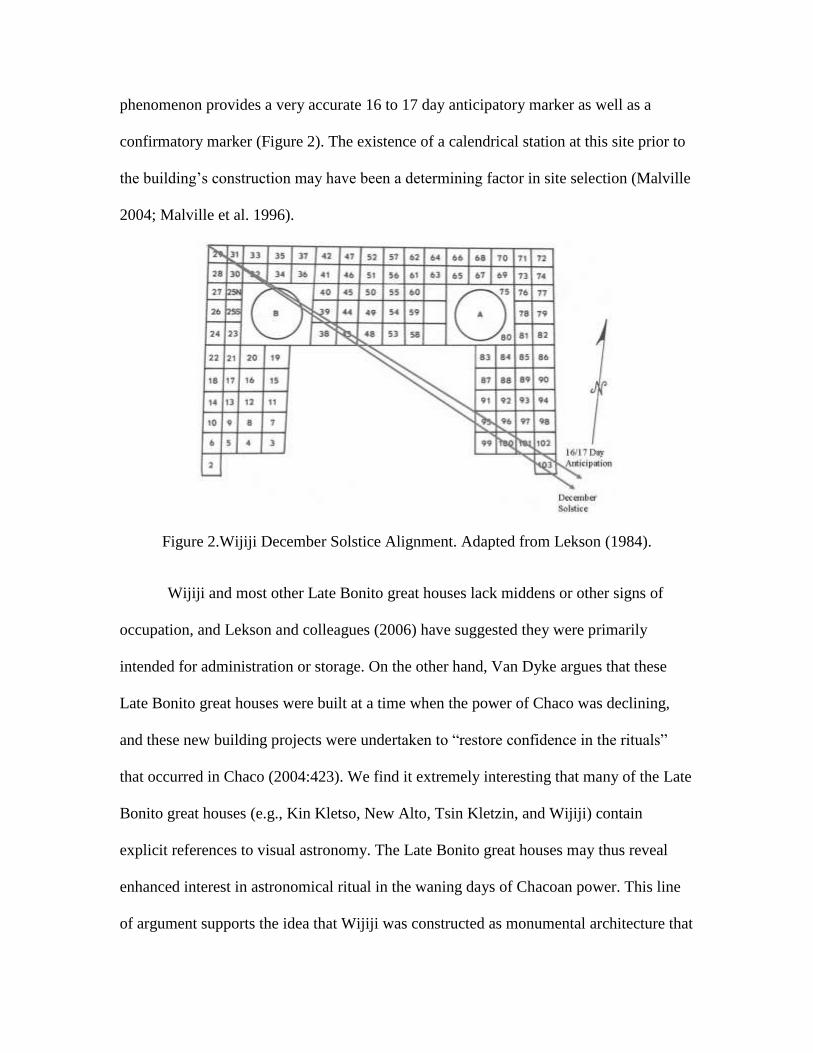
phenomenon provides a very accurate 16 to 17 day anticipatory marker as well as a
confirmatory marker (Figure 2). The existence of a calendrical station at this site prior to
the building’s construction may have been a determining factor in site selection (Malville
2004; Malville et al. 1996).
Figure 2.Wijiji December Solstice Alignment. Adapted from Lekson (1984).
Wijiji and most other Late Bonito great houses lack middens or other signs of
occupation, and Lekson and colleagues (2006) have suggested they were primarily
intended for administration or storage. On the other hand, Van Dyke argues that these
Late Bonito great houses were built at a time when the power of Chaco was declining,
and these new building projects were undertaken to “restore confidence in the rituals”
that occurred in Chaco (2004:423). We find it extremely interesting that many of the Late
Bonito great houses (e.g., Kin Kletso, New Alto, Tsin Kletzin, and Wijiji) contain
explicit references to visual astronomy. The Late Bonito great houses may thus reveal
enhanced interest in astronomical ritual in the waning days of Chacoan power. This line
of argument supports the idea that Wijiji was constructed as monumental architecture that
expressed Chacoan worldviews (Van Dyke 2004, 2008) and as a site for public ritual.
The solstitial relationship may have been an intentional result of site selection, building
design, and function (Malville 2008:70).
Kin Kletso (Class 1)
Kin Kletso was initially constructed between A.D. 1118 and 1130. It is one of the
five remaining Late Bonito great houses built in McElmo-style masonry (Lekson
1984:238-246; Van Dyke 2008:213-217) and is the only McElmo-style great house that
has been excavated (Vivian and Matthews 1964). In another example of collaboration
with park personnel, Malville suggested the cliff to the southeast of Kin Kletso might
mark December solstice, and his proposal was confirmed that December by Mike King, a
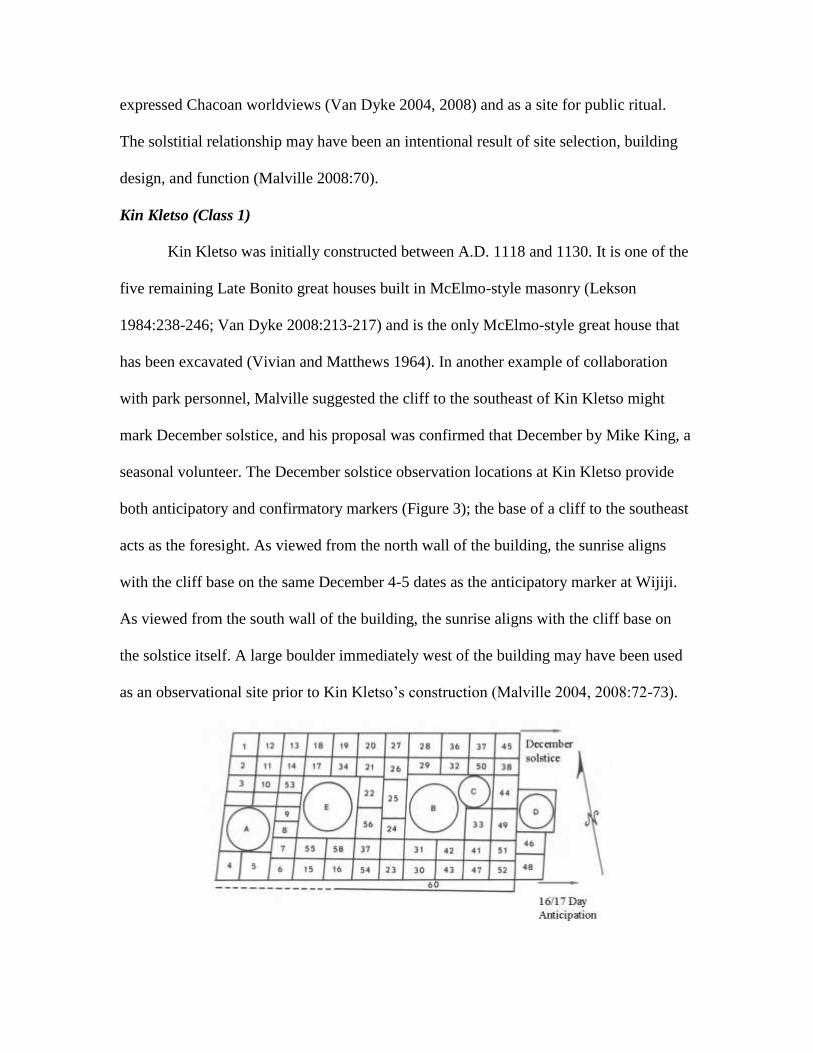
seasonal volunteer. The December solstice observation locations at Kin Kletso provide
both anticipatory and confirmatory markers (Figure 3); the base of a cliff to the southeast
acts as the foresight. As viewed from the north wall of the building, the sunrise aligns
with the cliff base on the same December 4-5 dates as the anticipatory marker at Wijiji.
As viewed from the south wall of the building, the sunrise aligns with the cliff base on
the solstice itself. A large boulder immediately west of the building may have been used
as an observational site prior to Kin Kletso’s construction (Malville 2004, 2008:72-73).
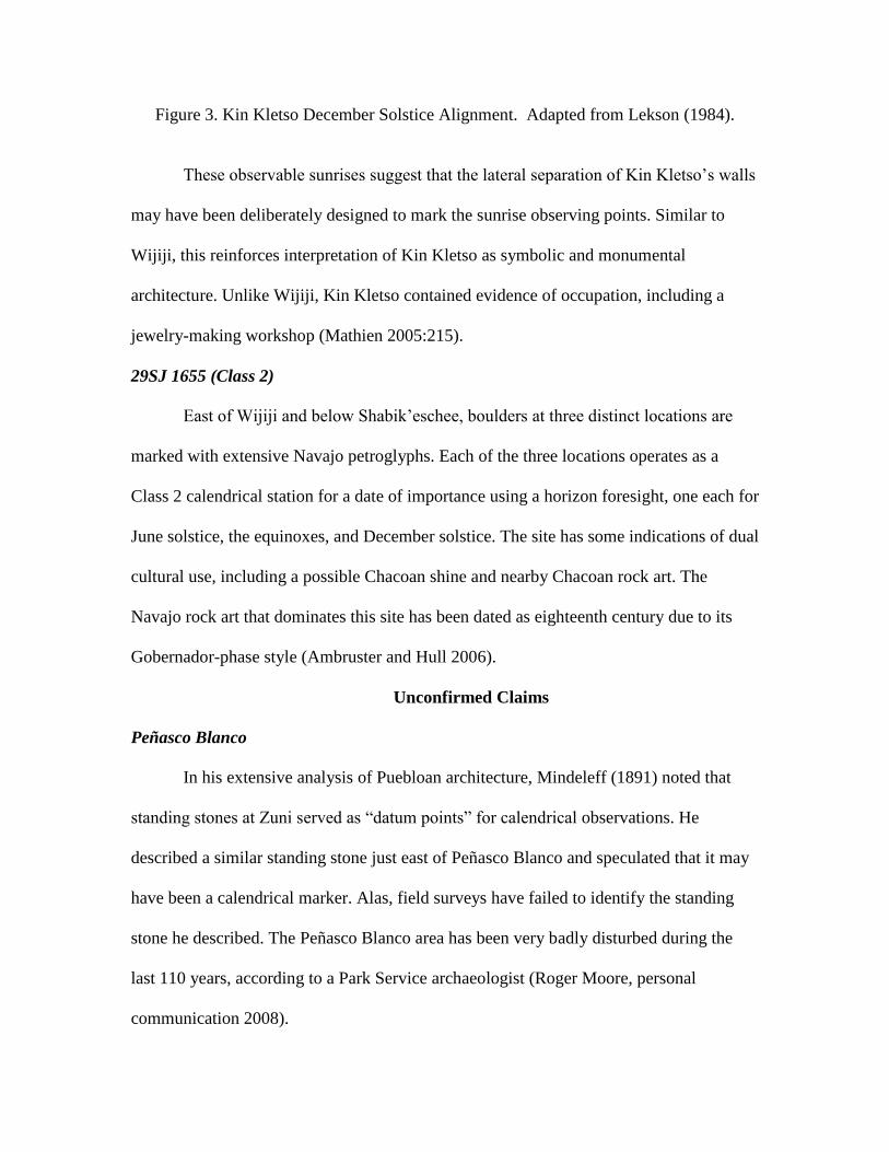
Figure 3. Kin Kletso December Solstice Alignment. Adapted from Lekson (1984).
These observable sunrises suggest that the lateral separation of Kin Kletso’s walls
may have been deliberately designed to mark the sunrise observing points. Similar to
Wijiji, this reinforces interpretation of Kin Kletso as symbolic and monumental
architecture. Unlike Wijiji, Kin Kletso contained evidence of occupation, including a
jewelry-making workshop (Mathien 2005:215).
29SJ 1655 (Class 2)
East of Wijiji and below Shabik’eschee, boulders at three distinct locations are
marked with extensive Navajo petroglyphs. Each of the three locations operates as a
Class 2 calendrical station for a date of importance using a horizon foresight, one each for
June solstice, the equinoxes, and December solstice. The site has some indications of dual
cultural use, including a possible Chacoan shine and nearby Chacoan rock art. The
Navajo rock art that dominates this site has been dated as eighteenth century due to its
Gobernador-phase style (Ambruster and Hull 2006).
Unconfirmed Claims
Peñasco Blanco
In his extensive analysis of Puebloan architecture, Mindeleff (1891) noted that
standing stones at Zuni served as “datum points” for calendrical observations. He
described a similar standing stone just east of Peñasco Blanco and speculated that it may
have been a calendrical marker. Alas, field surveys have failed to identify the standing
stone he described. The Peñasco Blanco area has been very badly disturbed during the
last 110 years, according to a Park Service archaeologist (Roger Moore, personal
communication 2008).
“Supernova Pictograph”
Approximately 500 m below Peñasco Blanco are pictographs consisting of a star,
crescent moon, and handprint on an overhang. One research team famously suggested
that the starburst represented the supernova of A.D. 1054 (Brandt et al. 1975). The view
in the vicinity of the pictographs does not present a useful horizon calendar. O’Flynn
suggested that a sheltered site approximately 20 m above the pictographs on the mesa rim
provided a useful horizon calendar for the equinoxes and June solstice (Williamson
1984:86-88; Williamson et al. 1975). Notwithstanding the additional convincing
ethnographic and artistic arguments presented by Florence Hawley Ellis (2008),
subsequent reassessment of the site by multiple researchers has (to date) failed to identify
a working horizon calendar in proximity to this pictograph panel.
Newly Identified Potential Calendrical Stations
Casa del Rio (Class 2)
Casa del Rio has a large midden with a volume of 1,702 m3 and an estimated
.609-1.520 million sherds. By comparison, the midden at Peñasco Blanco has a volume
of 1,430-1,840 m3 and an estimate of .585-1.460 million sherds. Of the early great
houses within Chaco Canyon, only Peñasco Blanco can match the huge quantities of
refuse generated at Casa del Rio, yet in terms of size Casa del Rio is a very small
community by comparison. Peñasco Blanco had some 124 rooms and was occupied for
more than two centuries. The great house of Casa del Rio had some 21-27 rooms with
perhaps 4-5 households. None of the other early great houses, including Kin Bineola,
Pueblo Bonito, Una Vida, and the East Community, produced similar quantities of refuse

in the late A.D. 800s and 900s. Only the nearby house at Lake Valley has similar
agricultural potential and a similarly enormous midden.
Unlike the great mounds of the mid- and late A.D. 1000s, these early mounds
seem to be primarily domestic trash associated with food. The deposition of trash
diminished or ceased in the 1000s, when the great houses were being expanded in
“downtown Chaco.” Regarding Casa del Rio, Windes states: “It is difficult to believe that
the few inhabitants of the great house could have been responsible for the quantity of
cultural materials contained in the mound” (2007:69). Consequently, “either the small
number of inhabitants produced a prodigious amount of refuse or they had outside help to
create such a volume” (Windes 2007:71).
A troughlike depression that partly encircles the large midden suggests a
formalized movement of people, perhaps participants in periodic festivals, who reached
the site on the Great West Road, which runs south of the Chaco River from Peñasco
Blanco westward. All these elements suggest that Casa del Rio may have been one of the
early sites of periodic festivals in the Chaco area. The enormous scale of the Lake Valley
midden suggests similar possibilities for periodic festival activity.
Casa del Rio is within view of the shrine of 29SJ 1088 on West Point, the high,
westernmost extension of West Mesa. The shrine may have been used as a link in a visual
communication network extending to the west as far as the Chuska Mountains. The
amount of Chuskan ceramics indicates connections with settlements to the west, perhaps
also associated with periodic gatherings (Windes 2007).
Was there a horizon calendar that could have been used to establish the date for a
feasting and trade fair at Casa del Rio? Topographic analysis demonstrates that, as
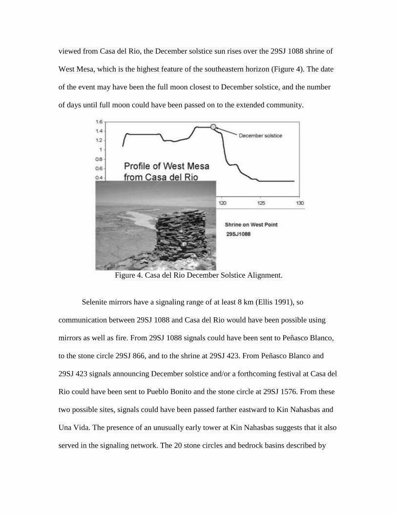
viewed from Casa del Rio, the December solstice sun rises over the 29SJ 1088 shrine of
West Mesa, which is the highest feature of the southeastern horizon (Figure 4). The date
of the event may have been the full moon closest to December solstice, and the number
of days until full moon could have been passed on to the extended community.
Figure 4. Casa del Rio December Solstice Alignment.
Selenite mirrors have a signaling range of at least 8 km (Ellis 1991), so
communication between 29SJ 1088 and Casa del Rio would have been possible using
mirrors as well as fire. From 29SJ 1088 signals could have been sent to Peñasco Blanco,
to the stone circle 29SJ 866, and to the shrine at 29SJ 423. From Peñasco Blanco and
29SJ 423 signals announcing December solstice and/or a forthcoming festival at Casa del
Rio could have been sent to Pueblo Bonito and the stone circle at 29SJ 1576. From these
two possible sites, signals could have been passed farther eastward to Kin Nahasbas and
Una Vida. The presence of an unusually early tower at Kin Nahasbas suggests that it also
served in the signaling network. The 20 stone circles and bedrock basins described by

Windes may be part of the signaling network connecting West Point with sites in the
canyon. The uncertain dates of the stone circles make them problematic members of an
early signaling network, but the early great houses could have been connected through
29SJ 1088 from Peñasco Blanco to Una Vida.
Casa del Rio may have been a transitional locus for community integration in the
tenth century, leading to the more formalized social cohesion implicit in the eleventh-
century Chacoan regional system. The necessary elements for such periodic gatherings
are present at the site: agricultural surplus for the feast, evidence of manufacture of
jewelry for trade, a horizon calendar, and accessibility to a signaling station.
29SJ 2538 & 29SJ 2539 (Class 2)
On the bank of Chaco Wash southeast of Wijiji is a 9- or 10-room structure first
excavated by Roberts in 1926. Known as Roberts Small House or Turkey House, 29SJ
2385 was a habitation. First construction of the house has been dated to about A.D. 900.
The name “Turkey House” is a reference to the large number of turkey bones found
within the structure by Roberts. Potsherds at the site have been dated from Pueblo I
through the Mesa Verde periods, indicative of long use (Mathien 2005:235).
During much of this building’s period of occupation, turkeys would likely have
been kept primarily for their feathers’ usage in ceremonials and garments; only during the
Late Bonito Phase did they become a primary food source (Akins 1986; Mathien
2005:236). Dual use for both ceremonial and food purposes cannot be ruled out; turkey
feathers continue to be used by modern Puebloans for ceremonial purposes, for example,
as components in Hopi ceremonial Mongko staffs (Waters 1970:140).

Human burials were found within rooms and in the adjacent trash midden.
Roberts Small House is one of the sites within Chaco Canyon where evidence for
anthropophagy has been identified (Turner 1993; Turner and Turner 1999). However,
Turner’s claimed early Pueblo II (A.D. 900) date has been undermined by identification
and analysis of original site notes written by Amsden and Roberts at the time of
excavation. The stratigraphic evidence within these notes clearly points to an earlier
Pueblo I time period for the human remains (Bustard 2008).
During a preliminary site visit in May 2008, we noted that the eastern horizon at
this location had calendrical potential. A search across the adjacent talus slope on the
compass back-azimuth for December solstice identified a location with a large flat
boulder and “backstop” that were well positioned to observe December solstice sunrise
using a cliff face as the foresight(Figure 5).
Figure 5. Probable Sunwatcher’s Station at 29SJ 2539.
Review of National Park Service site files identified the site as 29SJ 2539; it is
directly adjacent to 29SJ 2538, which includes a ledge overlooking the boulder. Much of
29SJ 2538/2539 is covered with cultural material, including lithics, bone fragments, and
potsherds. Chacoan and Navajo rock art is present. The NPS site assessments note that
potsherds include both Chacoan and Navajo types and that while the ledge is suited for
storage, there is no evidence of such use. The assessments concluded that the two sites
are linked, should possibly be considered as one, and may have been used as “a special
activity area of some sort” (National Park Service 1983).
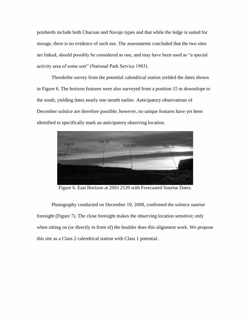
Theodolite survey from the potential calendrical station yielded the dates shown
in Figure 6. The horizon features were also surveyed from a position 15 m downslope to
the south, yielding dates nearly one month earlier. Anticipatory observations of
December solstice are therefore possible; however, no unique features have yet been
identified to specifically mark an anticipatory observing location.
Figure 6. East Horizon at 29SJ 2539 with Forecasted Sunrise Dates.
Photography conducted on December 19, 2008, confirmed the solstice sunrise
foresight (Figure 7). The close foresight makes the observing location sensitive; only
when sitting on (or directly in front of) the boulder does this alignment work. We propose
this site as a Class 2 calendrical station with Class 1 potential.
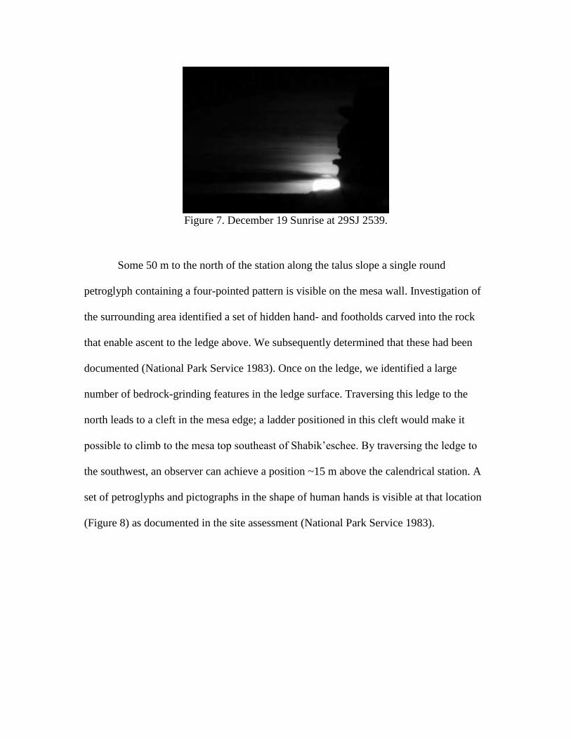
Figure 7. December 19 Sunrise at 29SJ 2539.
Some 50 m to the north of the station along the talus slope a single round
petroglyph containing a four-pointed pattern is visible on the mesa wall. Investigation of
the surrounding area identified a set of hidden hand- and footholds carved into the rock
that enable ascent to the ledge above. We subsequently determined that these had been
documented (National Park Service 1983). Once on the ledge, we identified a large
number of bedrock-grinding features in the ledge surface. Traversing this ledge to the
north leads to a cleft in the mesa edge; a ladder positioned in this cleft would make it
possible to climb to the mesa top southeast of Shabik’eschee. By traversing the ledge to
the southwest, an observer can achieve a position ~15 m above the calendrical station. A
set of petroglyphs and pictographs in the shape of human hands is visible at that location
(Figure 8) as documented in the site assessment (National Park Service 1983).

Figure 8. Above the Sunwatcher’s Station; Chacoan Rock Art at 29SJ 2538.
Rock art is also present 15 m to the south of the observing location. One panel
includes a lightly inscribed petroglyph of a horse and a circular form that are likely
Navajo in origin. A second panel contains a modern inscription, “Chabai 74,” with a light
but clearly inscribed sunburst symbol to the left of the letter “C” (Figure 9). The land
containing this site was transferred to the National Park Service in the late 1970s. The
content of this panel suggests sun-related reuse as late as the 1970s.
Figure 9. Modern Rock Inscription at 29SJ 2539 (Note faint sunburst at left above the
letter “C”).
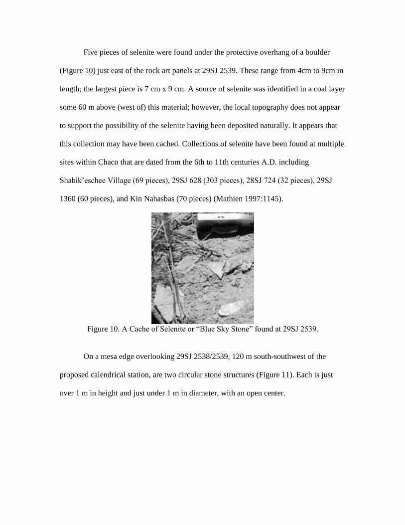
Five pieces of selenite were found under the protective overhang of a boulder
(Figure 10) just east of the rock art panels at 29SJ 2539. These range from 4cm to 9cm in
length; the largest piece is 7 cm x 9 cm. A source of selenite was identified in a coal layer
some 60 m above (west of) this material; however, the local topography does not appear
to support the possibility of the selenite having been deposited naturally. It appears that
this collection may have been cached. Collections of selenite have been found at multiple
sites within Chaco that are dated from the 6th to 11th centuries A.D. including
Shabik’eschee Village (69 pieces), 29SJ 628 (303 pieces), 28SJ 724 (32 pieces), 29SJ
1360 (60 pieces), and Kin Nahasbas (70 pieces) (Mathien 1997:1145).
Figure 10. A Cache of Selenite or “Blue Sky Stone” found at 29SJ 2539.
On a mesa edge overlooking 29SJ 2538/2539, 120 m south-southwest of the
proposed calendrical station, are two circular stone structures (Figure 11). Each is just
over 1 m in height and just under 1 m in diameter, with an open center.
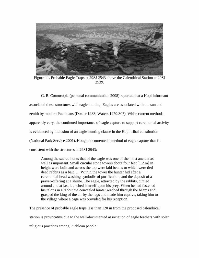
Figure 11. Probable Eagle Traps at 29SJ 2543 above the Calendrical Station at 29SJ
2539.
G. B. Cornucopia (personal communication 2008) reported that a Hopi informant
associated these structures with eagle hunting. Eagles are associated with the sun and
zenith by modern Puebloans (Dozier 1983; Waters 1970:307). While current methods
apparently vary, the continued importance of eagle capture to support ceremonial activity
is evidenced by inclusion of an eagle-hunting clause in the Hopi tribal constitution
(National Park Service 2001). Hough documented a method of eagle capture that is
consistent with the structures at 29SJ 2943:
Among the sacred hunts that of the eagle was one of the most ancient as
well as important. Small circular stone towers about four feet [1.2 m] in
height were built and across the top were laid beams to which were tied
dead rabbits as a bait. … Within the tower the hunter hid after a
ceremonial head washing symbolic of purification, and the deposit of a
prayer-offering at a shrine. The eagle, attracted by the rabbits, circled
around and at last launched himself upon his prey. When he had fastened
his talons in a rabbit the concealed hunter reached through the beams and
grasped the king of the air by the legs and made him captive, taking him to
the village where a cage was provided for his reception.
The presence of probable eagle traps less than 120 m from the proposed calendrical
station is provocative due to the well-documented association of eagle feathers with solar
religious practices among Puebloan people.
We propose that the cultural evidence in the area of the proposed calendrical
station, including rock art, selenite, probable eagle traps, and potsherds, as well as the
concentration of turkey bones found within Roberts Small House indicates that this area
may have been a center of esoteric activity, potentially over an extended period. Based on
this evidence, the area around Roberts Small House appears unique among Chacoan
small houses in this regard. The location may have acquired importance due to the
proximity of an eagle trap location, naturally occurring selenite, and a December solstice
calendrical station.
No available evidence provides any basis for linkage of the proposed esoteric and
astronomical activity at this site with anthropophagy. The preponderance of ethnographic
data, the singular nature of the recovered remains, and the lack of similar evidence at any
other identified calendrical station argue against such association.
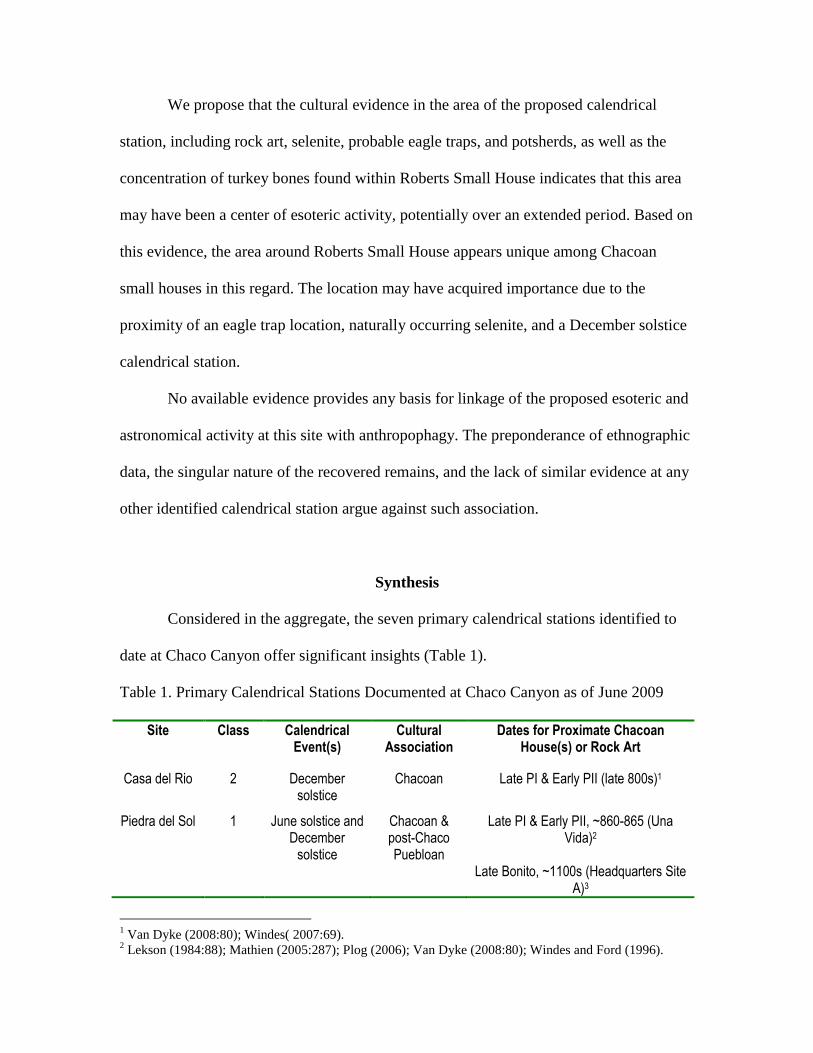
Synthesis
Considered in the aggregate, the seven primary calendrical stations identified to
date at Chaco Canyon offer significant insights (Table 1).
Table 1. Primary Calendrical Stations Documented at Chaco Canyon as of June 2009
Site Class Calendrical Event(s)
Cultural Association
Dates for Proximate Chacoan House(s) or Rock Art
Casa del Rio 2 December solstice
Chacoan Late PI & Early PII (late 800s)1
Piedra del Sol 1 June solstice and December
solstice
Chacoan & post-Chaco Puebloan
Late PI & Early PII, ~860-865 (Una Vida)2
Late Bonito, ~1100s (Headquarters Site
A)3
1 Van Dyke (2008:80); Windes( 2007:69).
2 Lekson (1984:88); Mathien (2005:287); Plog (2006); Van Dyke (2008:80); Windes and Ford (1996).
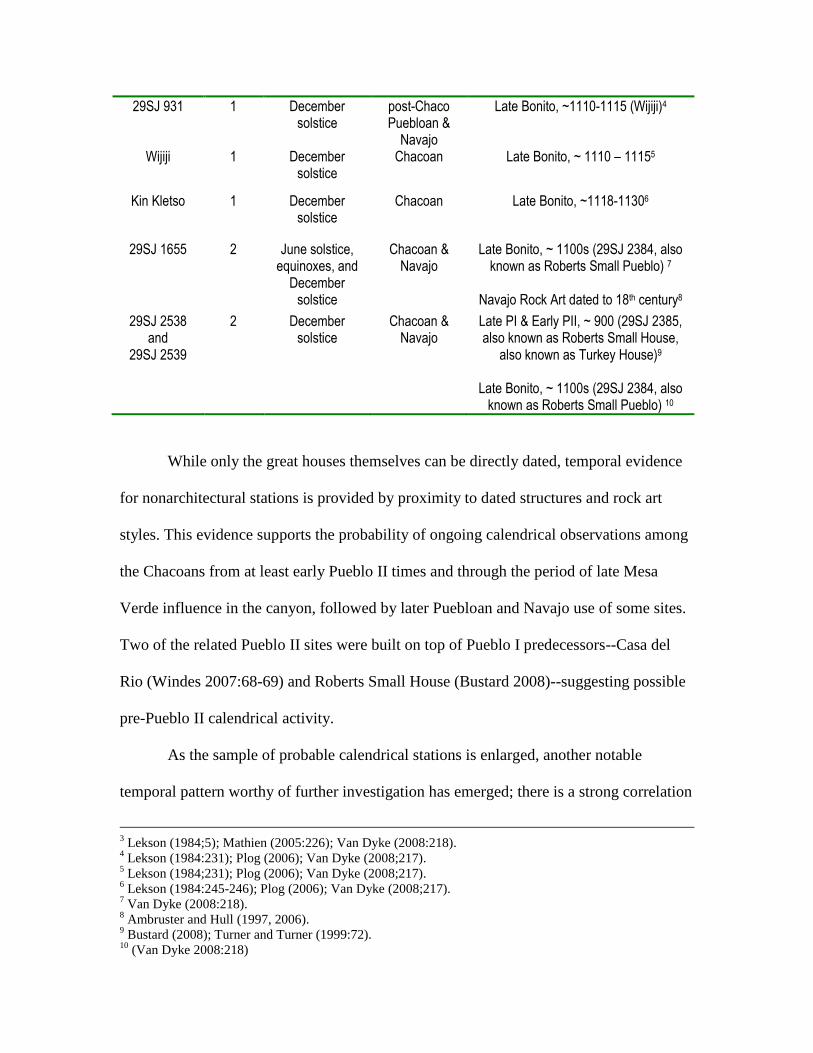
29SJ 931 1 December solstice
post-Chaco Puebloan &
Navajo
Late Bonito, ~1110-1115 (Wijiji)4
Wijiji 1 December solstice
Chacoan Late Bonito, ~ 1110 – 11155
Kin Kletso 1 December solstice
Chacoan Late Bonito, ~1118-11306
29SJ 1655 2 June solstice, equinoxes, and
December solstice
Chacoan & Navajo
Late Bonito, ~ 1100s (29SJ 2384, also known as Roberts Small Pueblo) 7
Navajo Rock Art dated to 18th century8
29SJ 2538 and
29SJ 2539
2 December solstice
Chacoan & Navajo
Late PI & Early PII, ~ 900 (29SJ 2385, also known as Roberts Small House,
also known as Turkey House)9
Late Bonito, ~ 1100s (29SJ 2384, also known as Roberts Small Pueblo) 10
While only the great houses themselves can be directly dated, temporal evidence
for nonarchitectural stations is provided by proximity to dated structures and rock art
styles. This evidence supports the probability of ongoing calendrical observations among
the Chacoans from at least early Pueblo II times and through the period of late Mesa
Verde influence in the canyon, followed by later Puebloan and Navajo use of some sites.
Two of the related Pueblo II sites were built on top of Pueblo I predecessors--Casa del
Rio (Windes 2007:68-69) and Roberts Small House (Bustard 2008)--suggesting possible
pre-Pueblo II calendrical activity.
As the sample of probable calendrical stations is enlarged, another notable
temporal pattern worthy of further investigation has emerged; there is a strong correlation
3 Lekson (1984;5); Mathien (2005:226); Van Dyke (2008:218).
4 Lekson (1984:231); Plog (2006); Van Dyke (2008;217).
5 Lekson (1984;231); Plog (2006); Van Dyke (2008;217).
6 Lekson (1984:245-246); Plog (2006); Van Dyke (2008;217).
7 Van Dyke (2008:218).
8 Ambruster and Hull (1997, 2006).
9 Bustard (2008); Turner and Turner (1999:72).
10 (Van Dyke 2008:218)
between calendrical stations and Late Bonito Phase architecture. Two of the sites (Kin
Kletso and Wijiji) show direct intent by Late Bonito builders to associate monumental
architecture with calendrical events. In total, five of the seven identified stations include
indication of Chacoan period use and are either proximate to or defined by Late Bonito
great houses. (Author’s Note: In the two years since the 2009 conference where the paper
resulting in this article was presented, we have photographically confirmed three
additional cases where Late Bonito Phase great houses mark observation sites with
workable solstice horizons. These include June solstice sunset at Casa Chiquita,
December solstice sunrise at Headquarters Site A, and June solstice sunrise at the “halo”
great house of Bis sa ani (Munro and Malville 2010, 2011).)
December solstice is a dominant calendrical event among the identified sites. This
is supportive of that date’s overarching ritual importance. December, when the land was
fallow, would have been the best time to visit Chaco for engaging in festivals and trade.
Three sites in the eastern canyon provide evidence of Navajo sun watching. Sites
29SJ 1655, 29SJ 931, and 29SJ 2538/2539 all include rock art indicative of possible dual
culture use; in the latter case use appears to have continued until the land was transferred
to National Park Service control in the late 1970s.
Use of these calendrical stations likely spanned centuries of activity. While it is of
course not certain which modern Puebloan clans are direct descendants of specific groups
of Chacoans, nonetheless modern ethnography directly links to the circumstantial
physical evidence of prehistoric practices. These practices have undoubtedly been
influenced by cultural development in the centuries since Chaco was an active building
site. In addition, they may have evolved in response to the cultural pressures that have
caused the understandable reticence of modern Pueblo people to discuss their
cosmological and spiritual practices with members of a dominant “foreign” culture.
Conclusions
The location of the Casa del Rio great house may have been fixed not only due to
agricultural potential but also to take advantage of a December Solstice calendrical
foresight at the shrine at 29SJ 1088. The site at 29SJ 2538/2539 was likely a Class 2
calendrical station and has Class 1 potential. The site includes a wealth of evidence for
related esoteric activity. Seven potential primary calendrical stations are now identified at
Chaco Canyon, including two Late Bonito great houses.
Acknowledgements
We gratefully acknowledge the support of the following people without whom
this work would not have been possible: Mike King documented sunrises around
December solstice at Kin Kletso. Robert and Beverly Beehler, Nancy Malville, Anne
Marie Munro, Donald D. Munro IV, John Sperry Nickerson, Gene McCracken, and
Greggory Rothmeier assisted our 2008 and 2009 fieldwork. National Park Service staff
who assisted in facilitation of the permit process, fieldwork and research include Russ
Bodnar, Tracy G. Bodnar, Wendy Bustard, Dabney Ford, Roger Moore, and
Superintendent Barbara West. We offer special thanks to National Park Service
interpretive ranger G.B. Cornucopia for his voluntary program of observational support
and confirmatory photography over a period of years.
References Cited
Akins, Nancy J.
1986 A Biocultural Approach to Human Burials from Chaco Canyon, New Mexico. Reports of
the Chaco Center 9. Branch of Cultural Research, National Park Service, Santa Fe.
Ambruster, Carol W., and Tony Hull
2006 Evidence for Early Navajo Horizon Astronomy in Chaco Canyon. In Current Studies in
Archaeoastronomy: Conversations Across Time and Space. Selected Papers from the
Oxford V International Conference at Santa Fe 1996, edited by John W. Fountain and
Rolf M. Sinclair, pp. 205-220. Carolina Academic Press, Durham.
Aveni, Anthony F.
2001 Skywatchers. Revised ed. University of Texas Press, Austin.
Benson, Craig
1980 Anasazi Sun-Watching Stations. El Palacio 86(2):4-9.
Brandt, John C., Stephen P. Maran, Ray A. Williamson, Robert S. Harrington, Clarion Cochran,
Muriel Kennedy, William J. Kennedy, and Von Del Chamberlain
1975 Possible Rock Art Records of the Crab Nebula Supernova in the Western United States.
In Archaeoastronomy in Pre-Columbian America, edited by Anthony F. Aveni, pp. 45-
57. University of Texas Press, Austin.
Bustard, Wendy
2008 Chaco Horrificus? In Social Violence in the Prehispanic American Southwest, edited by
Debra L. Nichols and Patricia L. Crown, pp. 82-83. University of Arizona Press, Tucson.
Dozier, Edward P.
1983 The Pueblo Indians of North America. Reissued ed.. Waveland Press, Long Grove,
Illinois.
Ellis, Andrea
1991 Towers of the Gallina Area and Greater Southwest. In Puebloan Past and Present. Papers
in Honor of Stewart Peckham, edited by Meliha S. Duran and David T. Kirkpatrick, pp.
57-70. Archaeological Society of New Mexico.
Ellis, Florence Hawley
2008 A Thousand Years of the Pueblo Sun-Moon-Star Calendar. In Foundations of New World
Cultural Astronomy, edited by Anthony Aveni, pp. 647-667. University Press of
Colorado, Boulder. First published in 1975 as Archaeoastronomy in Pre-Columbian
America, edited by Anthony Aveni, pp. 59-87. University of Texas Press, Austin.
Hough, Walter
1915 The Hopi Indians. Torch Press, Cedar Rapids, Iowa.
Judge, W. James
1991 Chaco: Current Views of Prehistory and the Regional System. In Chaco and Hohokam,
Prehistoric Regional Systems in the American Southwest, edited by Patricia L. Crown
and W. James Judge, pp. 11-30. School of American Research, Santa Fe.
Lekson, Stephen H.
1984 Great Pueblo Architecture of Chaco Canyon, New Mexico. University of New Mexico
Press, Albuquerque.
2007 Chaco Matters. In The Architecture of Chaco Canyon, edited by Stephen H. Lekson, p. 5.
University of Utah Press, Salt Lake City.
Lekson, Stephen H., Thomas C. Windes, and Peter J. McKenna
2006 Architecture. In The Archaeology of Chaco Canyon: An Eleventh-Century Pueblo
Regional Center, edited by Stephen H. Lekson, pp. 67-116. School of American Research
Press, Santa Fe.
Malville, J. McKim
2004 Calendrical Knowledge and Ritual Power. In Chimney Rock: The Ultimate Outlier,
edited by J. McKim Malville, pp. 151-163. Lexington Books, Lanham, Maryland.
2005 Ancient Space and Time in the Canyons. In Canyon Spirits: Beauty and Power in the
Ancestral Puebloan World, by Stephen H. Lekson, J. McKim Malville, and John L.
Ninnemann, pp. 65-86. University of New Mexico Press, Albuquerque.
2008 A Guide to Prehistoric Astronomy in the Southwest. Revised ed. Johnson Books,
Boulder.
Malville, J. McKim, G. B. Cornucopia, and Rick Watson
1996 The Three Faces of Piedra del Sol (29SJ514), Chaco Canyon. Paper presented at the
Oxford V International Conference in Santa Fe.
Malville, J. McKim, and Nancy J. Malville
2001a Pilgrimage and Astronomy in Chaco Canyon. In Pilgrimage Studies: The Power of
Sacred Places, edited by D. P. Dubey, pp. 206-241. Society of Pilgrimage Studies,
Allahabad.
2001b Pilgrimage and Periodic Festivals as Processes of Social Integration in Chaco Canyon.
Kiva 66(3):327-344.
Malville, J. McKim, and Gregory Munson
1998 Pecked Basins of the Mesa Verde. Southwestern Lore 64:1-35.
Mathien, F. Joan
1997 Ceramics, Lithics, and Ornaments of Chaco Canyon, Analyses of Artifacts from the
Chaco Project 1971-1978, Volume III. Lithics and Ornaments. National Park Service,
Santa Fe.
2005 Culture and Ecology of Chaco Canyon and the San Juan Basin. National Park Service,
Santa Fe.
McCluskey, Stephen C.
1977 The Astronomy of the Hopi Indians. Journal for the History of Astronomy 8:174-195.
McGuire, Randall H., and Ruth M. Van Dyke
2008 Dismembering the Trope: Imagining Cannibalism in the Ancient Pueblo World. In Social
Violence in the Prehispanic American Southwest, edited by Debra L. Nichols and Patricia
L. Crown, pp. 7-40. University of Arizona Press, Tucson.
Mindeleff, Victor
1891 A Study of Pueblo Architecture in Tusayan and Cibola. U.S. Government Printing Office,
Washington, D.C.
Munro, Andrew M., & J. McKim Malville
2010 Astronomy and the Design of Late Bonito Great Houses at Chaco Canyon. Paper
presented at the 2010 Society for American Archeology Annual Meeting in Saint Louis,
Missouri, symposium on Archaeoastronomy in the Americas. Proceedings of the
symposium are currently being edited by Dr. Robert Benfer of the University of Missouri
for inclusion in a volume to be published by the University of Florida Press.
2011 Ancestors and the sun: astronomy, architecture and culture at Chaco Canyon. In
Archaeoastronomy and Ethnoastronomy: Building Bridges Between Cultures,
Proceedings of the 278th Symposium of the International Astronomical Union and
‘Oxford IX’ International Symposium on Archaeoastronomy (in press), edited by Clive
L. N. Ruggles, pp. 255-265. Cambridge University Press, Cambridge.
National Park Service
1983 Site Assessment of 29SJ 2538 and Site Assessment of 29SJ 2539, conducted by Peter J.
McKenna and J. Miles. Chaco Culture National Historical Park, Headquarters Collection.
2001 Proposed Rule: Religious Ceremonial Collection of Golden Eaglets in Wupatki National
Monument. Electronic document,
http://home.nps.gov/applications/parks/wupa/ppdocuments/ACF342.htm, accessed May
7, 2009.
Page, Gordon
1986 Field Report on Signaling Possibilities, Using Selenite. Unpublished field report on file at
the Florence Hawley Ellis Museum of Anthropology at Ghost Ranch. Abiquiu, New
Mexico.
Plog, Stephen
2006 The Chaco Digital Initiative: Tree Ring Database. Electronic document,
http://www.chacoarchive.org/chaco_tring.html, accessed March 12, 2009.
2008 Ancient Peoples of the American Southwest. 2nd ed. Thames and Hudson, London.
Schaafsma, Polly
1980 Indian Rock Art of the Southwest. School of American Research Press, Santa Fe.
Sebastian, Lynne S.
1992 The Chaco Anasazi. Cambridge University Press, Cambridge.
Swanson, Steve
2003 Documenting Prehistoric Communication Networks: A Case Study in the Paquime
Polity. American Antiquity 68:753-767.
Toll, H. Wolcott
1985 Pottery, Production, Public Architecture, and the Chaco Anasazi System. Unpublished
Ph.D. dissertation, University of Colorado at Boulder.
Turner, Christy G.
1993 Cannibalism in Chaco Canyon: The Charnel Pit Excavated in 1926 at Small House Ruin
by Frank H. H. Roberts, Jr. American Journal of Physical Anthropology 91:421-439.
Turner, Christy G., and Jacqueline A. Turner
1999 Man Corn: Cannibalism and Violence in the Prehistoric American Southwest. University
of Utah Press, Salt Lake City.
Van Dyke, Ruth M.
2004 Memory, Meaning, and Masonry: The Late Bonito Chacoan Landscape. American
Antiquity 69:413-431.
2008 The Chaco Experience: Landscape and Ideology at the Center Place. School for
Advanced Research Press, Santa Fe.
Vivian, Gwinn, and T. W. Matthews
1964 Kin Kletso, a Pueblo III Community in Chaco Canyon, New Mexico. Southwestern
Monuments Association Technical Series, Vol. 6, Part 1, Globe, Arizona.
Waters, Frank
1970 Masked Gods. Ballantine, New York.
Williamson, Ray A.
1983 Sky Symbolism in a Navajo Rock Art Site, Chaco Canyon National Historical Park, New
Mexico. Archaeoastronony: The Journal of the Center for Archaeoastronomy VI: 59-66.
1984 Living in the Sky: The Cosmos of the American Indian. University of Oklahoma Press,
Norman.
Williamson, Ray A., H. J. Fisher, and D. O’Flynn
1975 The Astronomical Record in Chaco Canyon New Mexico. In Archaeoastronomy in Pre-
Columbian America, edited by Anthony F. Aveni, pp. 33-43. University of Texas Press,
Austin.
1977 Anasazi Solar Observations. In Native American Astronomy, edited by Anthony F. Aveni
pp. 203-217. University of Texas Press, Austin.
Windes, Thomas C.
1978 Stone Circles of Chaco Canyon, Northwestern New Mexico. National Park Service,
Albuquerque.
2007 Gearing Up and Piling On: Early Great Houses in the San Juan Basin. In The
Architecture of Chaco Canyon, New Mexico, edited by Stephen H. Lekson, pp. 45-87.
University of Utah Press, Salt Lake City.
Windes, Thomas C., and Dabney Ford
1996 Chaco Wood Project: The Chronometric Reappraisal of Pueblo Bonito. American
Antiquity 61:295-310.
Young, M. Jane
1983 Issues in the Archaeoastronomical Endeavor in the American Southwest. In Astronomy
and Ceremony in the Prehistoric Southwest, edited by John B. Carlson and W. James
Judge, pp. 219-232. Maxwell Museum, Albuquerque.
Zeilik, Michael
1985 Sun Shrines and Sun Symbols in the US Southwest. Archaeoastronomy; Supplement to
the Journal for the History of Astronomy 9:S86-S96.
1987 Anticipation in Ceremony: The Readiness Is All. In Astronomy and Ceremony in the
Prehistoric Southwest, edited by John B. Carlson and W. James Judge, pp. 25-41.
Maxwell Museum, Albuquerque.
1989 Keeping the Sacred and Planting Calendar: Archaeoastronomy in the Pueblo Southwest.
In World Archaeoastronomy, edited by Anthony F. Aveni, pp. 143-166. Cambridge
University Press, Cambridge.
Zeilik, Michael and Richard Elston
1983 Wijiji at Chaco Canyon: A Winter Solstice Sunrise and
Sunset Station. Archaeoastronomy: The Journal of the Center for Archaeoastronomy VI:
66-73.
