shabik'eschee village in chaco canyon: beyond the archetype
TRANSCRIPT

This study revisits an earlier study published
in this journal (Wills and Windes 1989)
that proposed a settlement reconstruction
for Shabik’eschee Village in Chaco Canyon, New
Mexico (Figure 1), a Basketmaker III (ca. A.D.
400 to 750) archaeological site that frequently ap-
pears in textbooks and scholarly treatises as an ex-
emplar of this time period. In fact, Shabik’eschee
has a historical place in southwestern archaeology
much like the Folsom site or Snaketown, in that
excavations in the early twentieth century pre-
sented unexpected insights about the past and
deeply influenced how subsequent research would
proceed (e.g., Meltzer et al. 2002). Each site be-
came an archetype to which other sites were com-
pared to for adherence to— or divergence from—
an established pattern. The Shabik’eschee
archetype is the “village,” a permanent settle-
ment of kin and non-kin households characterized
by year-round occupation based on surplus agri-
cultural production. The 1989 study was an in-
tentional counterpoint to this archetype, empha-
sizing material and chronological evidence for
small group size, limited household autonomy,
seasonal mobility, and periodic settlement aban-
donment.
We return to this issue for three related reasons.
First, the model outlined by Wills and Windes
(1989) has been challenged as inaccurate or mis-
leading by several researchers who argue that
Shabik’eschee and other large BM III sites were
sedentary villages with incipient or established
social hierarchies (Altschul and Huber 2000; Lek-
son 2009:67, 275; Reed 2000). Second, the reso-
lution of these competing perspectives is imme-
diately relevant to a recent argument for a
“Neolithic Demographic Transition” in the Amer-
ican Southwest, as the presumed cause of this his-
SHABIK’ESCHEE VILLAGE IN CHACO CANYON: BEYOND THE ARCHETYPE
W. H. Wills, F. Scott Worman, Wetherbee Dorshow, and Heather Richards-Rissetto
This study revisits an earlier publication in this journal (Wills and Windes 1989) in which a settlement model involving sea-
sonal mobility and limited household autonomy was outlined for Shabik’eschee Village, a Basketmaker III period (ca. A.D.
400–750) site in Chaco Canyon, New Mexico. We return to that work for three reasons. First, the original interpretation
has been challenged and an alternative view offered in the form of a large sedentary village. Second, the issue of Basket-
maker III sedentism is central to recent efforts to identify and understand a Neolithic Demographic Transition in the north-
ern Southwest. And third, we have obtained new field data from Shabik’eschee and Chaco that contributes to this debate.
We conclude that our understanding of Shabik’eschee’s history is improved by both new data and the ongoing considera-
tion of alternative models, but the site does not contain evidence for a sedentary village.
Esta investigación vuelve a tocar el tema de una publicación anterior en esta revista académica (Wills y Windes, 1989) en
donde se explicó un modelo de asentamiento involucrando una movilidad temporal y la autonomía doméstica limitada sinte-
tizada por el Pueblo Shabik’eschee, un sitio del Periodo Basketmaker III (AD 400 a 750) en Chaco Canyon, New Mexico.
Hemos vuelto a tocar ese tema por tres razones. Primero, la interpretación original ha sido cuestionada, mientras que una
perspectiva alterna fue ofrecida en forma de una gran aldea sedentaria. Segundo, el tema del sedentarismo durante el Periodo
Basketmaker III es fundamental para los esfuerzos recientes de identificar y entender una Transición Demográfica del Neolí-
tico en la parte Norte del Suroeste. Y tercera, hemos obtenido nuevos datos de Shabik’eschee y Chaco que contribuyen a este
debate. Concluimos que nuestro entendimiento de la historia de Shabik’eschee se ha mejorado debido a nuevos datos y a la
consideración continua de modelos alternativos; sin embargo, el sitio no cuenta con evidencia de una aldea sedentaria.
W. H. Wills, F. Scott Worman, Wetherbee Dorshow and Heather Richards-Rissetto � Department of Anthropology,
University of New Mexico, Albuquerque, NM 87131
American Antiquity 77(2), 2012, pp. 326–350
Copyright ©2012 by the Society for American Archaeology
326

REPORTS 327
torical change in human fertility is an increase in
sedentism (Kohler et al. 2008:646). And third, we
have new data from Shabik’eschee that improve
our understanding of its occupational history.
The Neolithic Demographic Transition (NDT)
is a concept introduced by Bocquet-Appel and
colleagues (Bocquet-Appel 2002, 2008; Bocquet-
Appel et al. 2008) to explain increases in the pro-
portion of juveniles (5–19 years of age) observed
in mortuary remains from archaeological sites in
the Old and New Worlds. They hypothesize that
this pattern reflects a “demographic transition”
stemming from a shift from foraging to agriculture
as reproductive women experienced an improve-
ment in “maternal energetics,” or more specifically
an increase in high-calorie foods (cultivated plants)
for reproductive females and a decline in child
transportation costs with greater sedentism (Boc-
quet-Appel 2009:657). Kohler et al. (2008) see ev-
idence for the beginning of a Southwest NDT
sometime after A.D. 500, although this follows the
introduction of maize to the region by at least
2,500 years (Hall 2010; Huber and Van West
2005), and bone chemistry evidence for high di-
etary inputs from cultigens by a millennium
(Coltrain et al. 2007), which suggests a far more
complex demographic incubation than simply the
transition from foraging to farming. Kohler and
colleagues address this complexity by utilizing
the argument by Crown and Wills (1995) that the
adoption of ceramics and other food processing
technologies indicates intensification of food pro-
duction within a context of increasing sedentism.
This argument underwrites the working premise
that the initial use of ceramics can be taken as “a
surrogate for the first local intensive use of maize
among relatively sedentary populations” (Kohler
et al. 2008:656). Or, in other words, that the ap-
pearance of ceramics is indicative of the kind of
“sedentism” required to set in motion the im-
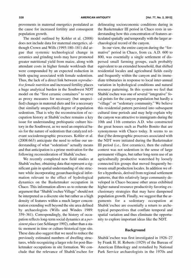
Figure 1. Boundaries of Chaco Culture National Historical Park and locations of Shabik’eschee Village, 295J423 andPueblo Bonito.
provements in maternal energetics postulated as
the cause for increased fertility and consequent
population growth.
The model outlined by Kohler et al. (2008)
does not include data for maternal energetics, al-
though Crown and Wills (1995:180–181) did ar-
gue that systemic technological change in
ceramics and grinding tools may have promoted
greater nutritional yield from maize, along with
attendant costs in higher female workloads that
were compounded by an expected reduction in
birth spacing associated with female sedentism.
Thus, the lack of a direct link between reproduc-
tive female nutrition and increased fertility places
a huge analytical burden in the Southwest NDT
model on the “first ceramic containers” to serve
as proxy measures for necessary (but unspeci-
fied) changes in maternal diets and for a necessary
(but similarly unspecified) degree of population
sedentism. That is why the reconstruction of oc-
cupation history at Shabik’eschee remains a key
issue for understanding prehispanic culture his-
tory in the Southwest, as we need an empirical ba-
sis for the nature of sedentism that catalyzed rel-
evant sociodemographic processes. Kohler et al.
(2008:663) anticipate the need to refine our un-
derstanding of what “sedentism” actually means
and that anticipation is a prime motivation for the
following reconsideration of Shabik’eschee.
We recently completed new field studies at
Shabik’eschee, obtaining data that represent a sig-
nificant gain in spatial understanding of site struc-
ture while incorporating geoarchaeological infor-
mation relevant to the effect of hydrological
dynamics on the Basketmaker occupation in
Chaco. This information allows us to reiterate the
argument that “Shabik’eschee Village” should not
be interpreted as a discrete site but rather as a high
density of features within a much larger concen-
tration extending well beyond the site area defined
by archaeologists (Wills and Windes 1989:
359–361). Correspondingly, the history of occu-
pation reflects long-term social dynamics at a per-
sistent place (see Schlanger 1992), rather than a sta-
tic moment in time or culture-historical type site.
These data also suggest that we need to reduce the
previously estimated numbers of dwelling struc-
tures, while recognizing a larger role for post-Bas-
ketmaker occupations in site formation. We con-
clude that the relevance of Shabik’eschee for
delineating socioeconomic conditions during in
the Basketmaker III period in Chaco rests in un-
derstanding how this concentration of features ar-
ticulated spatially and temporally with the larger ar-
chaeological record of the canyon.
In our view, the entire canyon during the “for-
mative” period in Chaco, from ca. A.D. 600 to
800, was essentially a single settlement of dis-
persed small farming groups, each probably
equivalent to an extended household, that shifted
residential locales and agricultural fields easily
and frequently within the canyon and its imme-
diate tributaries in response to local inter-annual
variation in hydrological conditions and natural
resource patterning. In this system we feel that
Shabik’eschee was one of several “integrative” fo-
cal points for the canyon population but hardly a
“village” or “sedentary community.” We believe
this residential pattern persisted into subsequent
cultural time periods and may help explain why
the canyon was attractive to immigrants during the
10th and 11th centuries A.D. who constructed
the great houses such as Pueblo Bonito that are
synonymous with Chaco today. It seems to us
that if the demographic processes associated with
the NDT were initiated during the Basketmaker
III period (i.e., first ceramics), then the cultural
context was not sedentism in the sense of large
permanent villages, but rather long-term use of an
agriculturally productive watershed by loosely
connected kin groups that moved frequently be-
tween small production locales. In addition we of-
fer a hypothesis, derived from regional settlement
patterns, that this relatively large community de-
veloped in Chaco because other areas exhibited
higher natural resource productivity favoring ex-
clusionary strategies that may have dampened
population growth. Finally, we suggest that the ar-
guments for a sedentary occupation at
Shabik’eschee are essentially a return to arche-
typical perspectives that conflate temporal and
spatial variation and thus eliminate the opportu-
nity to explore important ideas like the NDT.
Background
Shabik’eschee was first investigated in 1926–27
by Frank H. H. Roberts (1929) of the Bureau of
American Ethnology and restudied by National
Park Service archaeologists in the 1970s and
328 amERican anTiquiTy [Vol. 77, no. 2, 2012]

1980s (Wills and Windes 1989). It is one of the
largest Basketmaker III settlements on the Col-
orado Plateau and is widely used to illustrate ma-
terial characteristics of this time period, which in
turn is perceived as a pivotal transition in the re-
gion’s culture history, encompassing the intro-
duction of ceramic technology to the northern
Southwest, the adoption of new varieties of maize,
greater investment in domestic architecture, dis-
tinctive regional styles in material culture, and ev-
idence for violent conflict. Robins and Hays-
Gilpin (2000:231) link these developments to
agricultural intensification, a view widely shared
among archaeologists (Nichols 2002; Reed 2000).
Yet large BM III sites are rare, few have been ex-
cavated, and their inherent significance with re-
spect to processes of cultural change is therefore
poorly understood. Although more than 80 years
have passed since Shabik’eschee was first exca-
vated, it continues to have a key role in archaeo-
logical discussions of the early ceramic period be-
cause it stands out as “unusual” against a
background of smaller settlements, leading to the
assumption (or occasional hypothesis) that
Shabik’eschee reflects a significant evolutionary
change or alteration in the social organization of
regional farming populations (see Amsden 1949;
Lekson 2009; Lightfoot and Feinman 1982; Reed
2000; Schelberg 1982; Schiffer 1972; Steward
1937; Vivian 1990, 2000).
Basketmaker III was already defined (but not
dated) when Roberts started work at
Shabik’eschee,1 and consequently he had no dif-
ficulty assigning the site to this period. What
Shabik’eschee provided for the first time was a
well-documented excavation of an open-air site
big enough to be considered the remnants of a so-
cial group larger than a family or household
(Steward 1937). Roberts (1929:149) viewed Bas-
ketmaker III as a bridge between the preceramic
Basketmaker II and ceramic Pueblo I periods, a
transitional stage during which previously mobile
farmers began “settling down,” a process that in-
cluded social tension as competition for arable
land became more important. Roberts and his
professional contemporaries described settlement
systems during this process as “seasonal shifting”
(Steward 1937) or “fixed encampments” (Amsden
1949), rather than permanent settlements, some-
thing more analogous to historical Navajo mobil-
ity patterns than the greater sedentism found
among Pueblo groups.
This was consistent with the idea that seden-
tary lifestyles developed gradually as food pro-
duction took on greater economic importance.
Preceramic strata in rockshelters in the Four Cor-
ners region excavated in the nineteenth century
produced copious amounts of maize and other
cultigens, so that archaeologists assumed that
agriculture played a critical subsistence role
(Blackurn and Williamson 1997; Kidder and
Guernsey 1919; Morris 1980; Moseley 1966),
but one that did not displace hunting and gather-
ing. In other words, researchers envisioned a
drawn-out history of gradually increasing invest-
ment in agricultural production, likely given a
technological jump-start by the adoption of pot-
tery. Shabik’eschee was the missing-link in this
progressive model, the anticipated intermediate
adaptation between high mobility and sedentism.
This transitional perspective on Shabik’eschee
was rejected in the 1970s and 1980s by some ar-
chaeologists in favor of year-round occupation.
For example, Schiffer (1972) considered
Shabik’eschee to be “wholly sedentary” based on
potential volume of maize storage, which he esti-
mated to comprise at least 50 percent of the in-
habitants’ diet. This new interpretation facilitated
structural analyses of settlement architecture, par-
ticularly attempts to read indications of intra-group
hierarchy or status differentiation directly from
the size and arrangement of structures (Kovacik
1996; Lekson 2009; Lightfoot and Feinman 1982;
Schelberg 1982), because it introduced surplus
food as the source of sedentism and the control of
surplus as the pathway to intra-group power.
These studies assumed that all site features
were contemporaneous, an approach that pro-
duced the maximum possible site size and intra-
site variation but one at odds with the published
empirical record of pervasive structure remodel-
ing and abandonment during the BMIII occupa-
tion, which Roberts interpreted as a period of set-
tlement disuse. Wills and Windes (1989) revisited
Roberts’ original interpretation and argued that the
extensive evidence for remodeling and structure
abandonment stemmed from complex temporal
dynamics associated with household life-cycles
and episodic settlement abandonment (Figure 7),2
but Roberts’ hypothesized hiatus could not be
REPORTS 329
substantiated independently. In either case,
Shabik’eschee represents the cumulative effects of
a complicated occupational history, not a fos-
silized record of multiple contemporaneous struc-
tures and features.
One of those features built early in the occu-
pation but then burned, probably in the mid–sixth
century A.D., was an exceptionally large and well-
constructed pit structure that Roberts (1929:73) de-
scribed as a “kiva,” or a circular room constructed
for ritual purposes. Later researchers would add
“great” to this appellation,3 making an ancestral
connection to “great kivas” found in Chaco’s mas-
sive ruins of the eleventh and twelfth centuries.
There are similarities and Roberts (1929:90) rec-
ognized them, but the idea that kivas were present
during BM III was novel enough that he took
great pains to simply interpret this structure as a
nondomestic or public building (see also Gillespie
1976; Martin 1929). Wills and Windes
(1989:364–365) argued that this structure was a
communal building associated with group deci-
sion-making stresses that result from periodic ag-
gregations exceeding five or six households (fol-
lowing Johnson 1982). However, they also pointed
out that evidence for burning and abandonment
meant that the kiva role was confined to only part
of Shabik’eschee’s history and that the likely user
group extended beyond its immediate vicinity.
Roberts actually thought that there were two
BM III sites on the mesa top, separated by a low-ly-
ing area that he tested and found lacking in any ar-
chaeological materials. The first two pithouses ex-
cavated in 1926 were located north of this swale, the
remainder to the south (Figure 3). In his site report
he consistently described Shabik’eschee Village as
the southern group and referred to the northern
group mostly in passing. Subsequent researchers
have included all features as part of a single site.
Wills and Windes (1989) interpreted the archaeo-
logical patterns at Shabik’eschee as the result of pe-
riodic demographic pulses resulting from seasonal
population aggregation keyed to water, arable land
and natural resource abundance. Leaving the details
aside, the model was derived from physical evi-
dence for temporal patterns among site features, as-
sumptions about the risk-pooling role of storage fa-
cilities, and the conceptualization of subsistence
economies as systemic enterprises in which tactics
(whether cultivation or foraging) interact with each
other synergistically, rather than occurring as dis-
crete disconnected parts. More broadly, the model
posited population dispersal as the most common
settlement strategy for optimizing access to agri-
cultural and natural resources among the sort of
mixed agricultural and foraging economies inferred
for BM III sites throughout the Colorado Plateau,
but proposed that larger settlement aggregates— like
Shabik’eschee— occurred primarily in response to
local social and demographic factors (Wills and
Windes 1989:359).
This reconstruction was a counterweight to
the tendency to treat Shabik’eschee as an organi-
zational archetype for the entire BM III period or
“culture,” rather than a local variant that could be
compared to other site reconstructions and sub-
sequent research at other BM III sites has been
mostly consistent with this interpretation. Large
sites (in excess of 10 pithouses) are still rare while
the number of documented small, geographically
dispersed sites has increased enormously (Huck-
leberry and Billman 1998; Nichols 2002). Exca-
vations typically reveal complex intrasite occu-
pation patterns even in small sites (including
temporal replacement of dwellings); settlement
locations tied to water and arable land and sub-
sistence remains reflecting resource mixes con-
gruent with local habitat biodiversity (Gilpin and
Benallie 2000; Kearns et al. 2000; McKenna and
Truell 1986; Reed et al. 1996). In general, the pre-
dominant view of similar early ceramic period ar-
chaeology in much of the Southwest includes
shifting residential moves among sites in response
to resource patterns and sociodemographic vari-
ables (e.g., Gilman 1987; McGuire 1992; Raut-
man 1993; Rice 1980; Rocek 1996; Roth and
Stokes 2007; Whalen 1994; Wills 1992, 1996,
2001), as it does for the two to three centuries af-
ter the Basketmaker III period in the Colorado
Plateau l (Varien 2002).
Still, several large BM III sites investigated in
the past decade have been interpreted as sedentary
or permanent settlements. For example, Altschul
and Huber (2000) suggest that AZ E:12:5, in
northeastern Arizona, consisting of nine pit struc-
tures and numerous smaller features, was occu-
pied year-round because of the large potential
storage volume found in excavated features (sensu
Schiffer 1972). Similarly, Reed (2000:15) argues
that interpretations of episodic or punctuated oc-
330 amERican anTiquiTy [Vol. 77, no. 2, 2012]
cupation patterns in BM III contexts have been
unduly (and incorrectly) influenced by a propen-
sity among archaeologists to underestimate the
role of agriculture in promoting sedentary life-
ways. These researchers may have discovered
sedentary BM III settlements outside Chaco
Canyon, but this would seem to support the view
that organizational variability produces differ-
ences in archaeological patterning and that cul-
tural-temporal designations like BMIII encom-
pass a wide range of socioeconomic formations
(see also Nichols 2003; Vivian 2000; Wills 1989,
1992, 2001). Indeed, the study by Altschul and
Huber (2000:153) cited above proposes that at AZ
E:12:5 “some individuals may have stayed at the
settlement year-round” while others went some-
where else, which is precisely what Wills and
Windes (1989:358) inferred for Shabik’eschee, as
perhaps did Roberts (1929:77).
However, the recent concern with “agricultural
dependence” during the BM III period as a proxy
measure of group sedentism at large sites such as
Shabik’eschee probably owes as much to impor-
tant breakthroughs in the isotopic reconstruction of
human diet in the precedingBasketmaker II period
as to new interpretations of settlement patterns. Di-
etary studies derived from chemical analyses of
human remains have documented levels of C4
plant input in preceramic BM II burials equivalent
or similar to levels found in later BM III and
Pueblo period skeletons in the Four Corners region
(Coltrain et al. 2007). Although the exact propor-
tion of maize in these diets cannot be ascertained
(see Hard et al. 1996), it is probably reasonable to
assume that maize consumption was about the
same in all these time periods. If these data accu-
rately indicate equivalent degrees of dietary intake
from maize, then the economies found in these
chronological periods were not the same. That is,
if diets did not change then the trends toward
larger settlement size, higher capital investments
in architecture, technological innovations, and
population sedentism must have been derived from
factors governing the organization and means of
production and the social structure of local groups,
not greater reliance or dependence on agriculture
(Wills 2001). In short, the new biochemistry data
return us to the original emphasis on organiza-
tional change that concerned anthropologists be-
fore sedentism was invoked as the foundation for
structural analyses of Shabik’eschee’s political
economy. In the following sections we address
some the factors most likely related to socioeco-
nomic organization.
Site Description and Mapping
Shabik’eschee is located at the northern tip of a
narrow projection of Chacra Mesa, at an elevation
of 1927 masl, or 30 m above the modern flood-
plain of Chaco Wash (Figure 2). Site features
were built into a relatively thin aeolian deposit of
sandy loam stabilized with a primary covering of
grasses and sagebrush. Sandstone bedrock (Cliff-
house Formation) defines the entire perimeter of
the site, forming a cliff from northwest to south-
east, with scattered outcrops within the site
boundaries. Mapping was conducted in October
of 2008 and June of 2009 as part of the University
of New Mexico Chaco Stratigraphy Project
(www.unm.edu/~chaco) with a total station and a
GPS receiver with sub-meter accuracy. In addi-
tion, airborne lidar data were collected in June of
2010. These efforts produced high-resolution
topographic data (Figure 3), located previously
excavated pithouses and smaller slab-lined fea-
tures, plotted isolated artifacts of particular inter-
est, and identified possible buried structures/fea-
tures that have not been excavated.
The bounded area in Figure 3 is defined by the
edge of the mesa and the extent of archaeological
features. Previously excavated features were lo-
cated with the aid of the original 1929 published
map and a 1983 compass and tape survey map, and
are indicated in Figure 3 by a point taken in the ap-
proximate center of the structure or feature.4 Iden-
tifying potential unexcavated structures is far more
problematic because the surface of the site is a
nearly continuous distribution of artifacts, ash-
stained sediments, burnt and un-burnt sandstone
slabs, occasional upright slabs, eroded backdirt
piles, and wind-deflated depressions. The 1983
survey map (Wills and Windes 1989:351) plotted
possible dwelling structures relatively evenly
across the site (each structure was given an esti-
mated diameter of ca. 8 m), but we were unable to
replicate this distribution with confidence. The lo-
cation of possible structures is based on observed
high surface densities of artifacts associated with
distinct surface depressions (except in areas where
REPORTS 331

the underlying bedrock was obviously very close
to the modern surface), for a total of 25 excavated
structures and 36 possible unexcavated structures,
seven fewer than the 68 total estimated by Wills
and Windes (1989). However, we emphasize the
guesswork in this map. In our view the number of
potential structures cannot be accurately gauged
from surface indications alone.5
We also documented a number of Basketmaker
features recently exposed by erosion in the flood-
plain below Shabik’eschee where deeply buried
structures have been observed since the 1920s.
Roberts excavated a Basketmaker III pithouse (“Ar-
royo House”) just to the east of Shabik’eschee,
more than 4 m below the surface, and in 1947 the
University of New Mexico exposed another deeply
buried pit structure associated with a small Pueblo
I period (ca. A.D. 750–900) masonry roomblock in
the same area (Half House or 29SJ1657) (Adams
1951; see also Judd 1924). Half House has been
recorded on several subsequent occasions by sur-
vey crews as erosion continues to expose and de-
stroy the site. Other, more deeply buried slab-lined
features and extensive horizontal midden deposits
have been exposed along the main arroyo bank
over the past twenty years in the same vicinity, ex-
tending laterally at least 100 meters east and west
(Figure 2).
Chronological Control
The BM III period is poorly reflected in chrono-
metric data from Chaco but those dates are con-
sistent with the established time frame for this
period (see Hall 1977, 1983; McKenna and Truell
1986). Four tree-ring dates from the kiva at
Shabik’eschee suggest construction during the
mid–sixth century A.D. and an archaeomagnetic
date from Pithouse Y is late seventh century (Wills
and Windes 1989:356). Other excavated BM III
sites in Chaco with sixth and seventh century tree-
ring cutting dates include 29SJ423 and 29SJ299.
332 amERican anTiquiTy [Vol. 77, no. 2, 2012]
Figure 2. Location of Shabik’eschee on Chacra Mesa. 29SJ1657 and buried pit structures are exposed in the floodplainbelow the mesa.

Post-Basketmaker occupation at Shabik’eschee is
represented by the “protokiva” and House X (ca.
A.D. 750–850 based on ceramics), and by multi-
ple Navajo features dating to the eighteenth cen-
tury. Ceramics from excavations and the surface
are consistent with BM III and Pueblo I, although
there are scattered sherds from the eleventh and
thirteenth centuries. These late ceramics are not
surprising given that there is a nearby Bonito
Phase (ca. A.D. 950 to 1150) unfinished great
house with outlying room blocks and a great kiva.
Shabik’eschee was undoubtedly impacted by the
prolonged use of the immediate area by subse-
quent canyon residents (as are all excavated BM III
sites in Chaco).
Archaeologists working with BM III sites out-
side Chaco have recently suggested that pithouses
built during the early portion of this period may
have differed from later dwellings in size
(smaller) and formality (fewer features), termed
respectively “Transitional” and “Classic” (Reed
2000). Both forms occur in the excavated portions
of Shabik’eschee with the Transitional structures
located south of the great kiva (Figure 3). Roberts
encountered abundant indicators of widespread
abandonment of structures and features in his ex-
cavations, which included burning of the kiva,
along with stratigraphic evidence for an interrup-
tion in refuse deposition, which he saw collec-
tively as the result of a settlement hiatus (see
Wills and Windes 1989). This hypothesized hia-
tus might correspond to Transitional and Classic
house forms, and if so the kiva may have been at
the northern edge of the early occupation before
it burned and was converted to a trash dump.
However, there has been too little excavation in
the northern sector to draw any temporal conclu-
sions about overall spatial patterning.
A complementary view of spatial variation
among site features is that different house forms
REPORTS 333
Figure 3. Site boundaries, surface topography, and correspondence between excavated and potential structures and fea-tures at Shabik’eschee Village (29SJ1659). Hillshade generated from airborne Lidar survey in June, 2010. “CSP” refersto Chaco Stratigraphy Project.

may represent functional specificity— different
kinds of structures reflect activities, resident sta-
tus or social unit— as well as demographic house-
hold cycling over time. Wills and Windes
(1989:354) suggested three house-clusters on this
basis. Unfortunately, new data do not offer much
insight about this issue, and at this point we favor
the idea that there were at least two temporally
discrete episodes of residential use, each charac-
terized by domestic household cycling. Investi-
gations of BM III sites on the Colorado Plateau
consistently reveal intra-site occupation patterns
attributable to episodic use by one or a few house-
holds (Kidder and Guernsey 1919; Morris 1980;
Nichols 2002; Reed 2000), so our interpretation
of Shabik’eschee as the product of similar punc-
tuated use is unexceptionable. However, our point
is not that all BM III pithouse settlements repre-
sent seasonally or periodically utilized residential
locations, it is that we need to make these assess-
ments on a case-by-case basis. Sheer site size is
simply not a reliable guide to historical demo-
graphic or sociopolitical character of southwest-
ern pithouse settlements (Wills 2001, 2005).
Geological Context of Buried Basketmaker
Features near Shabik’eschee
Much of the Basketmaker record in Chaco ap-
pears to be obscured by alluviation and aeolian
deposition, a situation that confounds our ability
to accurately establish the number of features
from this period but conversely offers an excellent
opportunity to evaluate hydrological conditions
during this interval. Geomorphological data ob-
tained from the alluvial record immediately below
Shabik’eschee indicate that the Basketmaker oc-
cupation of the floodplain occurred as the canyon
depositional regime shifted from a period of rel-
ative stasis to an active floodplain characterized
by aggradation associated with rising water tables.
Chaco is a relatively broad (generally .5-x-
1.0-km wide) and shallow (180 m) canyon en-
trenched in sandstone formations for approxi-
mately 32 km at the western end of a watershed
that drains more than 11,500 km2 from higher el-
evations to the east. Shabik’eschee is located at a
constriction in the canyon walls (.37 km) at the
west end of a 3.5-km stream reach that averages
between .54 and .70 km and includes a major
northern tributary. The narrowing of the canyon
probably forces groundwater closer to the surface
and may create particularly favorable conditions
for agriculture (Bryan 1929; Dean 1992:38). Al-
luviation within this reach is complex, with water
and sediments entering the canyon through the
main valley, the northern tributary, and at least
four relatively large entrants on the southern side.
The depositional history in this part of Chaco
reflects changing hydrological patterns over the
past 10,000 thousand years but most of the allu-
vial fill has accumulated in the last 5,000 years,
principally the Chaco Unit, a thick formation of
pale-brown clayey silt that formed between ca.
300 B.C. and A.D. 1100 as runoff from the head-
waters spread over a flat alluvial valley (Hall
1977, 1983, 1990; 1983; Worman and Mattson
2010; also Force et al. 2002); the buried features
below Shabik’eschee occur in the Chaco Unit. In
order to understand the landscape context of these
features, a detailed field description was con-
ducted of the adjacent soils and sediments at
29SJ1657 (Figure 4; Table 1) using standard
methods (Birkeland 1999: Appendix 1, 347–359;
Buol et al. 1997; Holliday 2004; Schoenberger et
al. 2002; Soil Survey Division Staff 1993, 1999).
Stratum I, from the surface to a depth of 27 cm,
is a very weakly developed soil B horizon; the A
horizon has been removed by recent localized
erosion. The sediments in which the soil is form-
ing appear to have been deposited primarily by ae-
olian processes although clay-rich laminae pro-
vide evidence for minor reworking by water,
probably during large storm events or rare over-
bank flooding. Stratigraphic relationships show
that it was deposited after the occupation of the PI
roomblock, and the very weak soil development
is consistent with deposition during the past cen-
tury to few centuries. This stratum represents de-
position and reworking of sediments on the aban-
doned floodplain since the formation of the
current channel, which Love (1983) suggests
dates to the nineteenth century.
The subjacent nine strata, from a depth of 27
cm to 4.35 m below the modern ground surface,
are a series of weakly developed B horizons and
C horizons that lack evidence of pedogenic alter-
ation (Table 1). The sandy loam texture of the up-
permost, Stratum II, suggests some aeolian inputs,
while the remainder are silty loam or silty clay
334 amERican anTiquiTy [Vol. 77, no. 2, 2012]
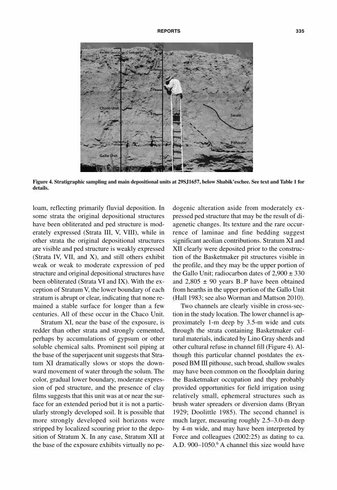
loam, reflecting primarily fluvial deposition. In
some strata the original depositional structures
have been obliterated and ped structure is mod-
erately expressed (Strata III, V, VIII), while in
other strata the original depositional structures
are visible and ped structure is weakly expressed
(Strata IV, VII, and X), and still others exhibit
weak or weak to moderate expression of ped
structure and original depositional structures have
been obliterated (Strata VI and IX). With the ex-
ception of Stratum V, the lower boundary of each
stratum is abrupt or clear, indicating that none re-
mained a stable surface for longer than a few
centuries. All of these occur in the Chaco Unit.
Stratum XI, near the base of the exposure, is
redder than other strata and strongly cemented,
perhaps by accumulations of gypsum or other
soluble chemical salts. Prominent soil piping at
the base of the superjacent unit suggests that Stra-
tum XI dramatically slows or stops the down-
ward movement of water through the solum. The
color, gradual lower boundary, moderate expres-
sion of ped structure, and the presence of clay
films suggests that this unit was at or near the sur-
face for an extended period but it is not a partic-
ularly strongly developed soil. It is possible that
more strongly developed soil horizons were
stripped by localized scouring prior to the depo-
sition of Stratum X. In any case, Stratum XII at
the base of the exposure exhibits virtually no pe-
dogenic alteration aside from moderately ex-
pressed ped structure that may be the result of di-
agenetic changes. Its texture and the rare occur-
rence of laminae and fine bedding suggest
significant aeolian contributions. Stratum XI and
XII clearly were deposited prior to the construc-
tion of the Basketmaker pit structures visible in
the profile, and they may be the upper portion of
the Gallo Unit; radiocarbon dates of 2,900 ± 330
and 2,805 ± 90 years B..P have been obtained
from hearths in the upper portion of the Gallo Unit
(Hall 1983; see also Worman and Mattson 2010).
Two channels are clearly visible in cross-sec-
tion in the study location. The lower channel is ap-
proximately 1-m deep by 3.5-m wide and cuts
through the strata containing Basketmaker cul-
tural materials, indicated by Lino Gray sherds and
other cultural refuse in channel fill (Figure 4). Al-
though this particular channel postdates the ex-
posed BM III pithouse, such broad, shallow swales
may have been common on the floodplain during
the Basketmaker occupation and they probably
provided opportunities for field irrigation using
relatively small, ephemeral structures such as
brush water spreaders or diversion dams (Bryan
1929; Doolittle 1985). The second channel is
much larger, measuring roughly 2.5–3.0-m deep
by 4-m wide, and may have been interpreted by
Force and colleagues (2002:25) as dating to ca.
A.D. 900–1050.6A channel this size would have
REPORTS 335
Figure 4. Stratigraphic sampling and main depositional units at 29SJ1657, below Shabik’eschee. See text and Table 1 fordetails.

33
6a
mE
Ric
an
an
Tiq
uiT
y[V
ol. 7
7, n
o. 2
, 2012]
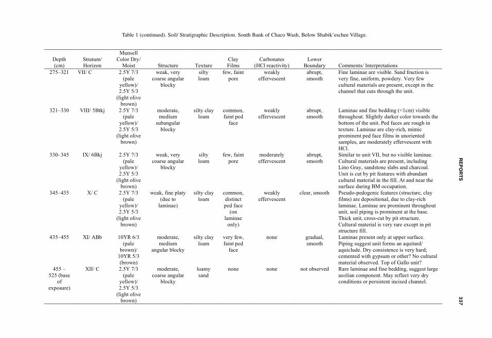
Table 1. Soil/ Stratigraphic Description. South Bank of Chaco Wash, Below Shabik’eschee Village.
Depth
(cm)
Stratum/
Horizon
Munsell
Color Dry/
Moist
Structure
Texture
Clay
Films
Carbonates
(HCl reactivity)
Lower
Boundary
Comments/ Interpretations
0–27 I/ Bj 2.5Y 7/3
(pale
yellow)/
2.5Y 5/3
(light olive
brown)
weak, medium
subangular
blocky
sandy
loam to
loamy
sand
none none abrupt,
smooth
Soil development is very weak. Small clay-
rich laminae, appear to be due to water
reworking aeolian material. Creates some
platy “structure” (non-pedogenic) and non-
pedogenic clay films. Laminae are fine silty
loam, weakly effervescent with HCl.
27–119 II/ Bw 2.5Y 7/3
(pale
yellow)/
2.5Y 5/3
(light olive
brown)
weak to
moderate,
medium to
coarse
subangular
blocky
sandy
loam
none none abrupt, wavy Laminae and clay-rich fine beds to 2cm
thick, appears to be an aggrading floodplain.
Laminae are weakly effervescent with HCl.
Beds form stronger, larger peds. Slightly
higher clay content overall than stratum I.
119–155 III/ Btkj 2.5Y 6/2
(light
brownish
gray)/ 2.5Y
5/2 (grayish
brown)
moderate,
medium
subangular
blocky
silty
loam
few, faint
ped face
weakly
effervescent
clear, smooth Gravels are <1%, angular, 2-3mm. Ped faces
are rough in texture. Original depositional
structures are not visible. Possible overbank
with incised channel, or main swale/ small
channel far away.
155–192 IV/ 2Btkj 2.5Y 7/3
(pale
yellow)/
2.5Y 5/3
(light olive
brown)
weak to
moderate, fine
subangular
blocky
silty
loam
few to
very few,
faint ped
face
weakly
effervescent
clear, smooth Coarser sediments overall, few laminae
present. Laminae are moderately
effervescent. Less clay than overlying unit.
Rapid aggradation, near small channel or no
channel present.
192–227 V/ 3Btkj 2.5Y 6/2
(light
brownish
gray)/ 2.5Y
5/2 (grayish
brown)
moderate,
medium
subangular
blocky
silty
loam
few, faint
ped face
weakly
effervescent
gradual,
smooth
Ped faces are rough in texture. Original
depositional structures are not visible.
Possible overbank with incised channel, or
main swale/ small channel far away. Lower
part of unit contains whitewares and
sandstone slabs, probably manuports or
building materials.
227–275 VI/ 4Btkj 2.5Y 7/3
(pale
yellow)/
2.5Y 5/3
(light olive
brown)
weak to
moderate, fine
subangular
blocky
silty clay
loam
few to
very few,
faint ped
face
weakly
effervescent
abrupt,
smooth
Gravels are <5% angular sandstone to 2cm.
Unit fines upward slightly. Some white
“nodules” are visible on the face, gypsum or
other chemical salt. No original depositional
structures are visible. Cultural materials
(whitewares, sandstone, diffuse charcoal) are
visible throughout.
RE
PO
RT
S3
37
Depth
(cm)
Stratum/
Horizon
Munsell
Color Dry/
Moist
Structure
Texture
Clay
Films
Carbonates
(HCl reactivity)
Lower
Boundary
Comments/ Interpretations
275–321 VII/ C 2.5Y 7/3
(pale
yellow)/
2.5Y 5/3
(light olive
brown)
weak, very
coarse angular
blocky
silty
loam
few, faint
pore
weakly
effervescent
abrupt,
smooth
Fine laminae are visible. Sand fraction is
very fine, uniform, powdery. Very few
cultural materials are present, except in the
channel that cuts through the unit.
321–330 VIII/ 5Btkj 2.5Y 7/3
(pale
yellow)/
2.5Y 5/3
(light olive
brown)
moderate,
medium
subangular
blocky
silty clay
loam
common,
faint ped
face
weakly
effervescent
abrupt,
smooth
Laminae and fine bedding (<1cm) visible
throughout. Slightly darker color towards the
bottom of the unit. Ped faces are rough in
texture. Laminae are clay-rich, mimic
prominent ped face films in unoriented
samples, are moderately effervescent with
HCl.
330–345 IX/ 6Bkj 2.5Y 7/3
(pale
yellow)/
2.5Y 5/3
(light olive
brown)
weak, very
coarse angular
blocky
silty
loam
few, faint
pore
moderately
effervescent
abrupt,
smooth
Similar to unit VII, but no visible laminae.
Cultural materials are present, including
Lino Gray, sandstone slabs and charcoal.
Unit is cut by pit features with abundant
cultural material in the fill. At and near the
surface during BM occupation.
345–435 X/ C 2.5Y 7/3
(pale
yellow)/
2.5Y 5/3
(light olive
brown)
weak, fine platy
(due to
laminae)
silty clay
loam
common,
distinct
ped face
(on
laminae
only)
weakly
effervescent
clear, smooth Pseudo-pedogenic features (structure, clay
films) are depositional, due to clay-rich
laminae. Laminae are prominent throughout
unit, soil piping is prominent at the base.
Thick unit, cross-cut by pit structure.
Cultural material is very rare except in pit
structure fill.
435–455 XI/ ABb 10YR 6/3
(pale
brown)/
10YR 5/3
(brown)
moderate,
medium
angular blocky
silty clay
loam
very few,
faint ped
face
none gradual,
smooth
Laminae present only at upper surface.
Piping suggest unit forms an aquitard/
aquiclude. Dry consistence is very hard;
cemented with gypsum or other? No cultural
material observed. Top of Gallo unit?
455 –
525 (base
of
exposure)
XII/ C 2.5Y 7/3
(pale
yellow)/
2.5Y 5/3
(light olive
brown)
moderate,
coarse angular
blocky
loamy
sand
none none not observed Rare laminae and fine bedding, suggest large
aeolian component. May reflect very dry
conditions or persistent incised channel.
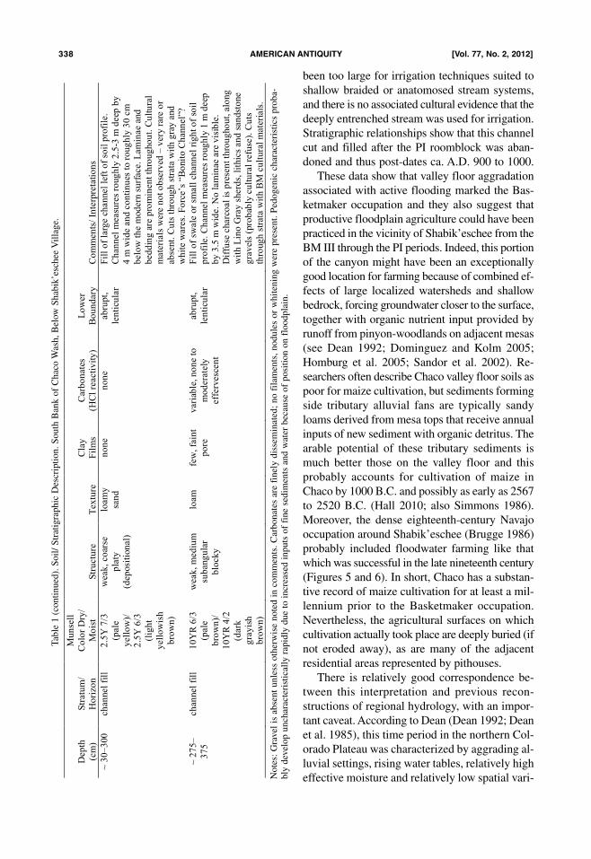
Table 1 (continued). Soil/ Stratigraphic Description. South Bank of Chaco Wash, Below Shabik’eschee Village.
been too large for irrigation techniques suited to
shallow braided or anatomosed stream systems,
and there is no associated cultural evidence that the
deeply entrenched stream was used for irrigation.
Stratigraphic relationships show that this channel
cut and filled after the PI roomblock was aban-
doned and thus post-dates ca. A.D. 900 to 1000.
These data show that valley floor aggradation
associated with active flooding marked the Bas-
ketmaker occupation and they also suggest that
productive floodplain agriculture could have been
practiced in the vicinity of Shabik’eschee from the
BM III through the PI periods. Indeed, this portion
of the canyon might have been an exceptionally
good location for farming because of combined ef-
fects of large localized watersheds and shallow
bedrock, forcing groundwater closer to the surface,
together with organic nutrient input provided by
runoff from pinyon-woodlands on adjacent mesas
(see Dean 1992; Dominguez and Kolm 2005;
Homburg et al. 2005; Sandor et al. 2002). Re-
searchers often describe Chaco valley floor soils as
poor for maize cultivation, but sediments forming
side tributary alluvial fans are typically sandy
loams derived from mesa tops that receive annual
inputs of new sediment with organic detritus. The
arable potential of these tributary sediments is
much better those on the valley floor and this
probably accounts for cultivation of maize in
Chaco by 1000 B.C. and possibly as early as 2567
to 2520 B.C. (Hall 2010; also Simmons 1986).
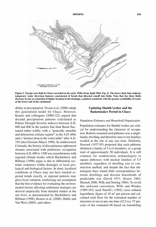
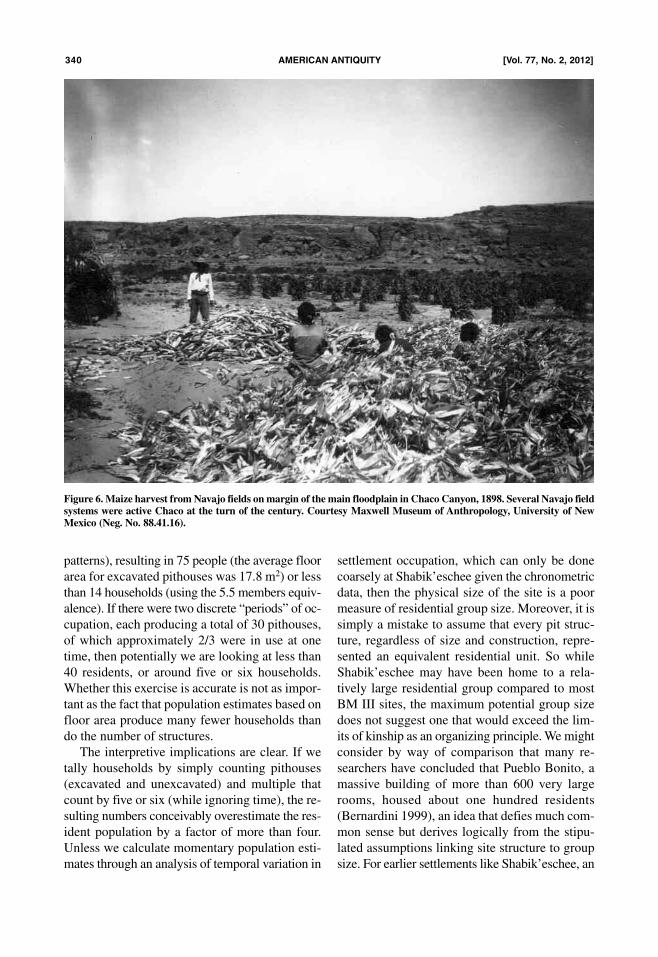
Moreover, the dense eighteenth-century Navajo
occupation around Shabik’eschee (Brugge 1986)
probably included floodwater farming like that
which was successful in the late nineteenth century
(Figures 5 and 6). In short, Chaco has a substan-
tive record of maize cultivation for at least a mil-
lennium prior to the Basketmaker occupation.
Nevertheless, the agricultural surfaces on which
cultivation actually took place are deeply buried (if
not eroded away), as are many of the adjacent
residential areas represented by pithouses.
There is relatively good correspondence be-
tween this interpretation and previous recon-
structions of regional hydrology, with an impor-
tant caveat. According to Dean (Dean 1992; Dean
et al. 1985), this time period in the northern Col-
orado Plateau was characterized by aggrading al-
luvial settings, rising water tables, relatively high
effective moisture and relatively low spatial vari-
338 amERican anTiquiTy [Vol. 77, no. 2, 2012]
Dep
th
(cm
)
Str
atu
m/
Ho
rizo
n
Mu
nse
ll
Co
lor
Dry
/
Mo
ist
Str
uctu
re
Tex
ture
Cla
y
Fil
ms
Carb
on
ate
s
(HC
l re
acti
vit
y)
Lo
wer
Bo
un
dary
Co
mm
en
ts/
Inte
rpre
tati
on
s
~ 3
0–
300
ch
an
nel
fill
2
.5Y
7/3
(pale
yell
ow
)/
2.5
Y 6
/3
(lig
ht
yell
ow
ish
bro
wn
)
weak
, co
arse
pla
ty
(dep
osi
tion
al)
loam
y
san
d
no
ne
no
ne
ab
rupt,
len
ticu
lar
Fil
l o
f la
rge c
han
nel
left
of
soil
pro
file
.
Ch
an
nel
measu
res
roug
hly
2.5
-3 m
deep
by
4 m
wid
e a
nd
co
nti
nu
es t
o r
oug
hly
30
cm
belo
w t
he m
od
ern
su
rface. L
am
inae a
nd
bed
din
g a
re p
rom
inen
t th
rou
gho
ut.
Cu
ltu
ral
mate
rials
were
no
t o
bse
rved
– v
ery
rare
or
ab
sent.
Cu
ts t
hro
ug
h s
trata
wit
h g
ray
and
wh
ite w
are
s. F
orc
e’s
“B
onit
o C
hann
el”
?
~ 2
75
–
37
5
ch
an
nel
fill
1
0Y
R 6
/3
(pale
bro
wn
)/
10
YR
4/2
(dark
gra
yis
h
bro
wn
)
weak
, m
ed
ium
sub
ang
ula
r
blo
cky
loam
fe
w,
fain
t
po
re
vari
able
, n
on
e to
mo
dera
tely
eff
erv
esc
en
t
ab
rupt,
len
ticu
lar
Fil
l o
f sw
ale
or
small
ch
ann
el
rig
ht
of
soil
pro
file
. C
han
nel
measu
res
roug
hly
1 m
deep
by
3.5
m w
ide.
No
lam
inae
are
vis
ible
.
Dif
fuse
charc
oal
is p
rese
nt
thro
ug
ho
ut,
alo
ng
wit
h L
ino
Gra
y s
herd
s, l
ithic
s an
d s
an
dst
one
gra
vel
s (p
rob
ably
cu
ltu
ral
refu
se).
Cu
ts
thro
ug
h s
trata
wit
h B
M c
ult
ura
l m
ate
rials
.
Table 1 (continued). Soil/ Stratigraphic Description. South Bank of Chaco Wash, Below Shabik’eschee Village.
Notes: Gravel is absent unless otherwise noted in comments. Carbonates are finely disseminated; no filaments, nodules or whitening were present. Pedogenic characteristics proba-
bly develop uncharacteristically rapidly due to increased inputs of fine sediments and water because of position on floodplain.
ability in precipitation. Vivian et al. (2006) adopt
this generalized model for Chaco. However,
Kearns and colleagues (2000:122) argued that
decadal precipitation patterns (calculated as
Palmer Drought Severity indices) between A.D.
600 and 800 in the eastern San Juan Basin fluc-
tuated rather wildly, with a “generally unstable
and deleterious climate regime” in the A.D. 600s
and a “distinct drop in the water table” after A.D.
745 (also Grissino-Mayer 1996). In southwestern
Colorado, the history of discontinuous ephemeral
streams associated with prehistoric occupation
between A.D. 600 to 1300 was asynchronous with
regional climate trends, which Huckleberry and
Billman (1998) argue is due to differential sys-
temic responses within drainages to local geo-
logical and biological factors. In short, localized
conditions in Chaco may not have tracked re-
gional trends exactly, or regional patterns may
gloss local variation, reinforcing our assumption
that the best evidence for evaluating the environ-
mental factors affecting settlement strategies are
derived empirically from detailed studies at the
site level, as demonstrated by Huckleberry and
Billman (1998), Kearns et al. (2000), Huber and
Van West (2005), and others.
Updating Shabik’eschee and the
Basketmaker Period in Chaco
Population Estimates and Household Organization
Population estimates for Shabik’eschee are criti-
cal for understanding the character of occupa-
tion. Roberts assumed each pithouse was a single-
family dwelling and therefore nine to ten families
resided at the site at any one time. Similarly,
Steward (1937:95) proposed that each pithouse
sheltered a family of 5 to 6 members, or a group
total of approximately 50 individuals. It is still
common for southwestern archaeologists to
equate pithouses with nuclear families of 5.5
members, regardless of dwelling size or con-
struction method, and despite the fact that eth-
nologists have found little correspondence be-
tween dwellings and discrete households of
predictable size (David 1971; Dozier 1965;
Shelach 2006; Wilk and Netting 1984). To avoid
this awkward convention, Wills and Windes
(1989:363) used Naroll’s (1962) cross-cultural
logarithmic figure of 10 m2 per person and cal-
culated total floor for the estimated number of
structures in use at any one time (42.5 (ca. 57 per-
cent) of the estimated 68 based on remodeling
REPORTS 339
Figure 5. Navajo corn field in Chaco recorded in the early 1920s (from Judd 1964: Fig. 4). The heavy dark lines indicatetemporary water diversion features constructed of brush that directed runoff into fields. Note that the three fieldsdecrease in size as a function of higher location in the drainage, a pattern consistent with the greater availability of waterat the lower end of the catchment.
patterns), resulting in 75 people (the average floor
area for excavated pithouses was 17.8 m2) or less
than 14 households (using the 5.5 members equiv-
alence). If there were two discrete “periods” of oc-
cupation, each producing a total of 30 pithouses,
of which approximately 2/3 were in use at one
time, then potentially we are looking at less than
40 residents, or around five or six households.
Whether this exercise is accurate is not as impor-
tant as the fact that population estimates based on
floor area produce many fewer households than
do the number of structures.
The interpretive implications are clear. If we
tally households by simply counting pithouses
(excavated and unexcavated) and multiple that
count by five or six (while ignoring time), the re-
sulting numbers conceivably overestimate the res-
ident population by a factor of more than four.
Unless we calculate momentary population esti-
mates through an analysis of temporal variation in
settlement occupation, which can only be done
coarsely at Shabik’eschee given the chronometric
data, then the physical size of the site is a poor
measure of residential group size. Moreover, it is
simply a mistake to assume that every pit struc-
ture, regardless of size and construction, repre-
sented an equivalent residential unit. So while
Shabik’eschee may have been home to a rela-
tively large residential group compared to most
BM III sites, the maximum potential group size
does not suggest one that would exceed the lim-
its of kinship as an organizing principle. We might
consider by way of comparison that many re-
searchers have concluded that Pueblo Bonito, a
massive building of more than 600 very large
rooms, housed about one hundred residents
(Bernardini 1999), an idea that defies much com-
mon sense but derives logically from the stipu-
lated assumptions linking site structure to group
size. For earlier settlements like Shabik’eschee, an
340 amERican anTiquiTy [Vol. 77, no. 2, 2012]
Figure 6. Maize harvest from Navajo fields on margin of the main floodplain in Chaco Canyon, 1898. Several Navajo fieldsystems were active Chaco at the turn of the century. Courtesy Maxwell Museum of Anthropology, University of NewMexico (Neg. No. 88.41.16).
assumption that any pithouse will reflect the same
average-sized social unit begs the question we
need to answer, which is how to understand de-
mographic patterns from architectural variation.7
The Role of the “Great Kiva”
There is little reason to question the assumption
that the kiva at Shabik’eschee represents some
form of nondomestic or public architecture, one
with integrative functions at least partly involved
with ritual activity and related to the size of the
user group (Adler 1989; Lightfoot 1988; Roberts
1929:90; Wills and Windes 1989). In our recon-
struction it is neither likely that so large and sub-
stantial a building was constructed by the dozen
or so residential households, nor would it have
been necessary for “integrating” such a small
group occupying a space in which daily interac-
tion between individuals was certainly the norm.
Instead, we favor a model originally constructed
by Bluhm (1960) to account for the distribution of
especially large pithouses during the Reserve
Phase in the Mogollon Highlands, in which she
argued that these structures formed a stable social
center for populations of dispersed, possibly sea-
sonally mobile households. It is essentially the
same argument often made for Pueblo I period
great kivas in the northern San Juan region (Ware
and Blinman 2000).
This also seems to be what Gilpin and Benal-
lie (2000:172) mean when they write that BMIII
great kivas and adjacent features in northeastern
Arizona were “only portions of larger communi-
ties,” perhaps with specialized group-level storage
functions. In other words, these structures were
part of a greater social realm, both geographically
and demographically, or the center of a dispersed
social network. So it may be that the exact loca-
tion of these public buildings was determined by
a combination of factors, especially where food
production or household density created a tether-
ing effect and where the structure itself may have
offered a visible connection between group mem-
bers. In Chaco there are two known extra-large
BM III pitstructures, one at Shabik’eschee and
one at 29SJ423, at the eastern end of the canyon
(Figure 1; Wills and Windes 1989). They share ex-
ceptionally good views over large sections of the
canyon bottom in multiple directions and we think
that their location vis-à-vis the larger BM III com-
munity in Chaco was probably equally or more
important than a relationship to pithouses in the
immediate vicinity. However, in the next section
we also suggest that large pitstructures may exist
on the canyon floor but are buried by alluvium
and consequently we need to be careful in pre-
suming that the positioning of these two mesa top
examples is characteristic of all BM III public ar-
chitecture.
Basketmaker III Settlement Patterns in Chaco
It is common for researchers to equate
Shabik’eschee and 29SJ423 with the entire Bas-
ketmaker occupation in the canyon to the neglect
of the scores of other documented and excavated
structures and features (Figures 1 and 8). Most ex-
cavated Basketmaker III residential components
are found in the canyon bottom and adjacent to the
floors of tributary drainages (Hayes 1981;
McKenna and Truell 1986; Windes 1993), which
implies a more extensive distribution of buried
Basketmaker sites throughout the canyon. We as-
sume archaeological surveys have accurately cap-
tured most or all significant Basketmaker mater-
ial on the exposed mesas (consisting mainly of
small features and ceramic scatters), but that deep
alluviation in the canyon obscures much of the
REPORTS 341
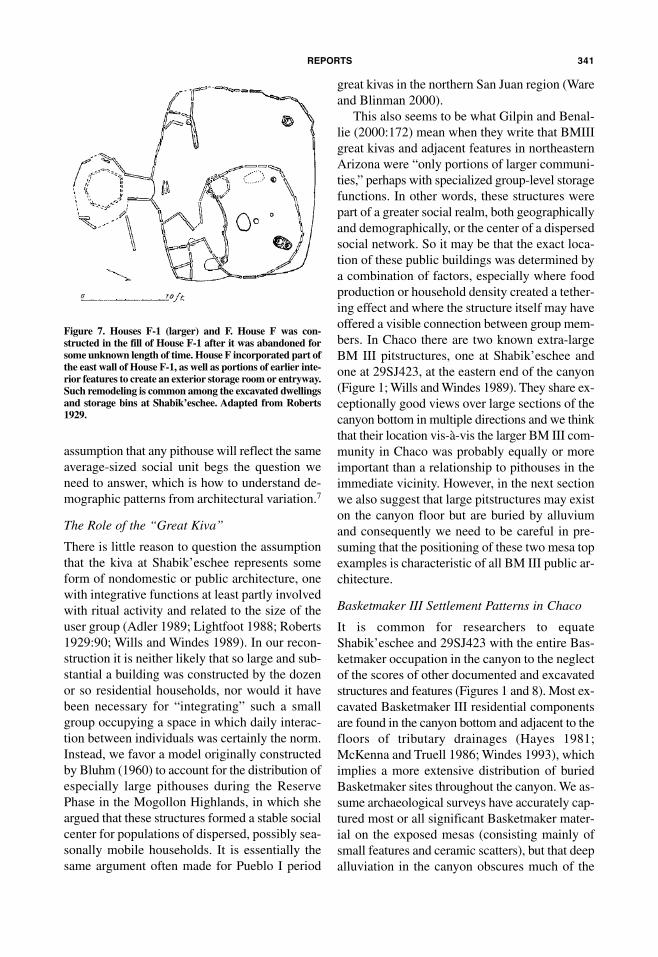
Figure 7. Houses F-1 (larger) and F. House F was con-structed in the fill of House F-1 after it was abandoned forsome unknown length of time. House F incorporated part ofthe east wall of House F-1, as well as portions of earlier inte-rior features to create an exterior storage room or entryway.Such remodeling is common among the excavated dwellingsand storage bins at Shabik’eschee. Adapted from Roberts1929.

floodplain occupation. We are therefore inclined
to view canyon floor as the prime focus of Bas-
ketmaker occupation in Chaco, with the mesa-top
features representing a subset of the overall set-
tlement record. Even then, Shabik’eschee occu-
pies a location that is immediately adjacent to
the floodplain, simply elevated. It is possible that
there were (and still are) hundreds of individual
Basketmaker houses in Chaco spread out along
the canyon bottom and among these there may
have been some overly large structures.
Consequently we suspect that Shabik’eschee
and 29SJ423 were not two separate Basketmaker
sites or “villages,” but rather the east and west ex-
tremes of a single settlement or community that
was stretched out along the entire canyon floor be-
tween these two concentrations of features (Fig-
ure 8), a “community” simply meaning a group
whose members regularly interact and share some
decision-making responsibilities. Given the
episodic occupation patterns at excavated sites,
we also suggest that individual households, the
probable units of production, were able to shift lo-
cations in response to locally altered conditions
for small-scale agricultural plots determined by
the dynamically changing configuration of the
floodplain associated with aggradation and chan-
nel movement. We hypothesize that the canyon it-
self is the appropriate spatial scale for under-
standing the socioeconomic characteristics of
Basketmaker occupation.
Small-scale farmers in arid environments typ-
ically manage risk through limited networks of
food-sharing and extensive systems of dispersed
production locales that average yields among cul-
tivated plots (Stone 1991). Chaco Canyon is at the
end of a massive watershed consisting of many
smaller watersheds and the least-cost manage-
ment approach would be to have fields in differ-
ent locations and to circulate seasonally and inter-
annually among these in a fallow rotation.
Historical patterns of Pueblo agricultural field
dispersal were similarly designed to spread pro-
duction risk over large areas (Bryan 1929, 1954;
Dominquez and Holm 2005; Ford 1972; Homburg
et al. 2005). But the most direct analog for our hy-
342 amERican anTiquiTy [Vol. 77, no. 2, 2012]
Figure 8. Basketmaker III site components in Chaco Culture National Historic Park and surrounding area. Light grayareas have been systematically surveyed. Source: New Mexico Archaeological Records Management System (ARMS).

pothetical settlement system is historic Navajo
residential strategies in the same region.
There is a long history of Navajo agricultural
occupation in Chaco in which household settle-
ments were situated at the heads of tributary
canyons next to alluvial fan fields (Figures 5 and
6), while some residential sites were also located
on the mesas and outside the canyon (Brugge
1986). More than any other archaeological period
in Chaco, the Navajo occupation parallels BM III
in site location and organization. Ethnoarchaeo-
logical studies of residential movement by Navajo
households have documented the complexity of
shifting residences and membership associated
with land use strategies that emphasize the abil-
ity to respond quickly to changing environmental
and social conditions. For example, Alexandra
Roberts (1992) determined that just two Navajo
families utilizing an area of ca. 40,000 acres in
northeastern Arizona produced an archaeological
record in 50 years that consisted of 28 camps or
homesteads still recognizable from a total of more
than 40 former residential sites recognized by
family members. She refers to this process as
“archaeological landscape development,” in
which “multiple layers of land use by various
combinations of residence groups over several
generations are represented in the archaeological
record of the study area” (Roberts 1992:119).
The complex interplay of property rights and
shifting residence among the historic Navajo pro-
duced static settlement patterns that capture only
a portion of the dynamism underlying inter-annual
economic production (Sapir 1966), and we imag-
ine that the Basketmaker III occupation in Chaco
reflects a similar long-term interaction between
group mobility between residential locations, in-
cluding the periodic reoccupation of structures.
The archaeological result would be many small
sites within a relatively large geographic area. If
correct, then we need to rethink the way that we
have been estimating population size (and by ex-
tension, social organization) in Chaco during BM
III by moving away from calculations based sim-
ply on the number of structures, and by concep-
tualizing the effective spatial scale of land use in
terms of residential flexibility and economic or-
ganization rather than categorical descriptors such
as “sedentary” or “village.” Varien (2002) has ar-
gued cogently that in large PI communities of
southwestern Colorado, individual households
and members shifted frequently within a larger
context of settlement or community persistence.
We feel that during the BM III period in Chaco
there was an analogous large and persistent com-
munity, dispersed widely, within which house-
holds moved opportunistically and frequently (see
also Windes et al. 2000).
Thinking about Chaco
Basketmakers Regionally
It is reasonable to ask how revisiting these issues
moves our understanding of the Basketmaker pe-
riod forward, or least beyond the original formu-
lation offered by Wills and Windes (1989). Our an-
swer is in part that this earlier work seems to have
been displaced by an alternative interpretation that
is not based in direct analysis of Shabik’eschee and
relies on an archetypical mode of inference that ig-
nores intra-site temporal and spatial variation (see
especially Lekson 2009). We feel this new “his-
tory” for Shabik’eschee is premature. Equally im-
portant, we think that reducing Shabik’eschee’s
complicated occupational history to a classifica-
tory type such as “sedentary” or “village” misses
an excellent opportunity to study the organiza-
tional variation that is encompassed by the classi-
fication BM III, especially as it is relevant to cur-
rent theoretical concerns such as the NDT.
It is absolutely true that Shabik’eschee is enor-
mous compared to most other BMIII sites in
Chaco but at any given point during the Basket-
maker occupation the residential component was
smaller than the “site” that we see today, a result
of household cycling, punctuated residential use,
and likely fluctuations in group size. In this re-
spect Shabik’eschee looks fairly similar to large
dispersed Basketmaker sites described along the
Chuska slope on the west side of the San Juan
Basin (Figure 9 and chapters in Reed 2000) as
well as in areas to the south of the basin (Bullard
1962; Wills 1988, 1996). In other words, the
Chaco BM III pattern appears to be a local ex-
ample of a socioeconomic process that was play-
ing out over a considerable portion of the South-
west, one that involved aggregation of small,
relatively mobile household farmers in local areas
without the dense residential packing found in
later pueblo settlements.
REPORTS 343

Which brings us back to the fundamental ques-
tion posed by Roberts and Steward about the BM
III period: what factors promoted prolonged
household aggregates in Chaco? Steward
(1937:167) assumed that sites like Shabik’eschee
represented lineages, or small corporate groups
linked by close kinship ties. He did not think that
such groups formed in response to “ecological”
factors because he felt that land was not a limiting
factor in conditions of low population density in-
ferred for the time period. Instead, Steward favored
defense as the most likely cause for aggregates like
Shabik’eschee, although he did not speculate on
the source of conflict. Steward was correct that the
kind of small-scale food production found in the
BM III period can be conducted almost anywhere
on the Colorado Plateau below 2000 m MSL
where flood water cultivation conditions existed
and thus it is terribly unlikely (given known site
distributions, see Figure 9) that finding good agri-
cultural land was much of a problem for any indi-
vidual household. We also think Steward was right
to look to conflict as a key factor in the concen-
tration of Basketmaker features in Chaco, although
in a manner he did not envision.
There is considerable space for small house-
holds to move around in Chaco and still remain
within a prime agricultural zone. However, the
same cannot be said for wild resources, especially
the higher-ranked game and plants, which would
have been differentially concentrated in higher el-
evations around the margins of the San Juan Basin
(Driver and Badenhorst 2009). These non-agri-
cultural resources are the types most susceptible to
depletion through foraging and least amenable to
human control, and therefore the most contested
(Kelly 1995). The archaeological record for BM II
and III in the northern San Juan River system, on
the southern edge of the Rocky Mountains, reveals
fierce conflict among groups in higher elevations
and latitudes, including massacres, possible can-
nibalism and defensive architecture (Chenault and
Motsinger 2000; LeBlanc 1999;). No similar evi-
dence has been found in Chaco.
Why not? Basketmaker farmers in Chaco
clearly had access to wild resources, especially in
pinyon-juniper woodlands to the east and grass-
lands to the south but these may not have been
dense or reliable enough to fight over. Conversely,
the potential for agricultural production may have
been much higher in the canyon due to floodplain
characteristics than in locales nearer higher eleva-
tions that offered greater biodiversity and better ac-
cess to (and perhaps control of) wild resources
(see Huckleberry and Billman 1998). That is, the
economic potential for small-scale farming in
Chaco was perhaps attractive to segments of the re-
gional Basketmaker population, which were ex-
cluded from access to prime natural resource zones,
or elected to rely more on food production. Returns
from cultivation may have offset the loss of higher
return wild foods, effectively moving cultivation up
in any ranking of available resources (Barlow
2002). We feel that the known distribution of BMIII
sites in the San Juan Basin supports this model,
with Chaco representing a departure from the ma-
jority of settlement locations that are adjacent to
forested uplands (Figure 9).
We should expect such intra-regional variabil-
ity among low-level food producers, the kind of
flexibility that Netting (1990) described as “eco-
logical fine-tuning” (also Smith 2004; Wills 1991,
2005). In arid environments where unpredictable
water availability is the most important factor af-
fecting cultigen production, dispersal strategies
for both fields and people make fundamental eco-
nomic sense. Thus we conclude that the large
size of Shabik’eschee— the quality that many re-
searchers feel makes it exceptional— may reflect
less selective pressure from property control
(competition) than experienced by Basketmaker
groups on the outer edges of the San Juan Basin
because the critical contested property at the re-
gional level was not arable land but high-return
wild resource zones.
This leads us to a suggestion about the suc-
ceeding Pueblo I period. Given the rate and
amount of alluvial deposition associated with the
BM III and P I occupations, we believe that the P
I presence in the canyon was probably larger than
we see today in surface archaeology and was di-
rectly linked to the same floodplain qualities that
attracted BM III groups. As in the northern San
Juan region, Pueblo I sites in Chaco may have
comprised long linear distributions of small
roomblocks that have been largely buried, partly
obscured by later great houses, and possibly “dis-
aggregated” by survey crews assigning individual
site numbers to every roomblock (see Chupika
and Potter 2007; compare Wills 2000; Wilshusen
344 amERican anTiquiTy [Vol. 77, no. 2, 2012]

REPORTS 345
Figure 9. Regional distribution of Basketmaker III site components. Areas in gray have been systematically surveyed.Counties are indicated by name. Source: New Mexico Archaeological Records Management System.
and Van Dyke 2006; Windes et al. 2000). In this
light, the Pueblo I settlement density period in
Chaco might have been greater than survey data
suggest and continuity with the Basketmaker oc-
cupation more robust than suggested by assign-
ment of sites to culture historical classifications.
Windes and colleagues suggest (2000) that the
earliest great houses constructed in the late ninth
and early tenth centuries were focal points for
large dispersed communities, a settlement orga-
nization that we suspect builds on earlier Basket-
maker III pattern. As the recent AMS dating of
two likely high-status human burials in Pueblo
Bonito to the late 800s A.D. (Coltrain et al. 2007)
suggests, a more complex and catalytic social en-
vironment may have preceded the emergence of
great house architecture than the “modest” occu-
pation inferred from a focus on individual
roomblocks rather than local concentrations of
roomblocks (see Wilshusen and Van Dyke
2007:224–225). A step to revealing more of these
relationships would be to stop defining sites and
site “components” by arbitrary classifications like
Basketmaker III, a procedure that imposes arbi-
trary temporal boundaries, and instead analyze
materials by chronometric associations.
In summary, we are explicitly arguing that the
conventional archaeological “site” consisting of a
discrete feature or group of features does not ad-
equately capture the likely dynamics of residen-
tial movement during the BM III period in Chaco.
We are not arguing that the conventional site is un-
related to past social organizations or structures
but rather that it makes sense to conceptualize
these features within regions or defined geo-
graphic areas (e.g., watersheds) in terms of what
cross-cultural research indicates about the nature
of small-scale horticultural production strategies
and residential occupation spans in arid environ-
ments. We especially emphasize that our model
recognizes non-agricultural production as equally
important as plant cultivation in understanding the
overall, inter-annual patterns of residential sys-
tems. This approach allows for the future devel-
opment of deductive expectations that can be
evaluated through field research.
We believe Chaco was a critical place in the
evolution of prehistoric Colorado Plateau agri-
cultural societies long before great houses made
their appearance in part because the canyon was
marginal to prime foraging areas but was very
well-suited to floodplain agriculture.
Shabik’eschee is important to understanding why
this happened and potentially to the initiation of
the NDT proposed by Kohler et al. (2008), but its
significance is not about sedentism or site size per
se based on synchronic perspectives that ignore
basic contextual evidence for occupational fluid-
ity (e.g., Lekson 2009:67). For all the research
that has taken place in Chaco over the past 80
years, we are still vastly ignorant of the formative
BM III period due to limited excavations and
deeply buried occupation horizons. We need more
data from excavations, especially geoarchaeolog-
ical investigations in the floodplain, and we need
to shift our emphasis from individual sites defined
by archaeologists, especially archetypes like
Shabik’eschee, to a broader focus on the overall
pattern of canyon occupation.
References Cited
Adams, Richard N.1951 Half House: A Pithouse in Chaco Canyon, NewMexico. Michigan Academy of Science, Arts, and Letters35:273–296.
Altschul, Jeffrey H., and Edgar K. Huber2000 Economics, Site Structure, and Social Organization dur-ing the Basketmaker III Period: A View from the LukachukaiValley. In Foundations of Anasazi Culture: The Basketmaker-Pueblo Transition, edited by Paul F. Reed, pp. 145–160. TheUniversity of Utah Press, Salt Lake City.
Amsden, Charles A.1949 Prehistoric Southwesterners from Basketmaker toPueblo. Los Angeles Southwest Museum, Los Angeles, Cal-ifornia.
Barlow, Renee K.2002 Predicting Maize Agriculture among the Fremont: AnEconomic Comparison of Farming and Foraging in theAmerican Southwest. American Antiquity 67:65–88.
Bernardini, Wesley1999 Reassessing the Scale of Social Action at Pueblo Boni-to, Chaco Canyon, New Mexico. Kiva 64:447–470.
Birkeland, Peter1999 Soils and Geomorphology. Oxford University Press,New York.
Blackburn, Fred M., and Ray A. Williamson1997 Cowboys and Cave Dwellers: Basketmaker Archae-ology in Utah’s Grand Gulch. School of American ResearchPress, Santa Fe, New Mexico.
Bluhm, Elaine A.1960 Mogollon Settlement Patterns in Pine Lawn Valley, NewMexico. American Antiquity 25:538–546.
Bocquet-Appel, Jean-Pierre2002 Paleoanthropological Traces of a Neolithic Demo-graphic Transition. Current Anthropology 43:637–650.
2008 The Neolithic Demographic Transitions. In The Ne-olithic Demographic Transition and Its Consequences, edit-ed by J-P Bocquet-Appel and O. Bar-Yosef, pp. 35–56.Springer, Berlin.
346 amERican anTiquiTy [Vol. 77, no. 2, 2012]

2009 The Demographic Impact of the Agricultural Systemin Human History. Current Anthropology 50:657–660.
Bocquet-Appel, J.-P., S. Naji, and M. Bandy2008 Demographic and Health changes During the Transi-tion to Agriculture in North America. In Recent Advancesin Paleodemography: Data, Techniques and Patterns,edited by J.-P. Bocquet-Appel, pp. 277–292. Springer, Berlin.
Buol, Stanley, F. Hole, R. McCracken, Randal Southard1997 Soil Genesis and Classification (4th Ed.). Iowa StateUniversity Press, Ames.
Brugge, David M.1986 Tsegai: An Archeological Ethnohistory of the ChacoRegion. U. S. Department of the Interior, National Park Ser-vice, Washington, D.C.
Bryan, Kirk1929 Flood-Water Farming. The Geographical Review19:444–456.
1954 The Geology of Chaco Canyon, New Mexico in Relationto the Life and Remains of the Prehistoric People of Pueblo
Bonito. Smithsonian Miscellaneous Collections, Vol. 122,No. 7, Smithsonian Institution, Washington, D.C.
Bullard, William Rotch1962 The Cerro Colorado Site and Pithouse Architecture inthe Southwestern United States Prior to A.D. 900. PeabodyMuseum of Archaeology and Ethnology, Harvard University,Vol. 64, No. 2, Cambridge, Massachusetts.
Chenault, Mark L., Thomas N. Motsinger2000 Colonization, Warfare, and Regional Competition: Re-cent Research into the Basketmaker III Period in the MesaVerde Region. In Foundations of Anasazi Culture: The Bas-ketmaker-Pueblo Transition, edited by Paul F. Reed, pp.45–68. The University of Utah Press, Salt Lake City.
Chupika, Jason. P, and James M. Potter 2007 Animas-La Plata Project. SWCA Anthropological Re-search Paper Number 10, SWCA Environmental Consul-tants, Phoenix, Arizona.
Coltrain, Joan Benner, Joel C. Janetski, and Shawn W. Carlyle2007 The Stable- and Radio-Isotope Chemistry of WesternBasketmaker Burials: Implications for Early Puebloan Di-ets and Origins. American Antiquity 72:01–321.
Crown, Patricia L., and W. H. Wills1995 The Origins of Southwestern Ceramic Containers:Women’s Time Allocation and Economic Intensification.Journal of Anthropological Research 51:173–187.
David, Nicholas1971 The Fulani Compound and the Archaeologist. WorldArchaeology 3:111–131.
Dean, Jeffery S.1992 Environmental Factors in the Evolution of the ChacoanPolitical System. In Anasazi Regional Organization and theChaco System, edited by David E. Doyel, pp. 35–44.Maxwell Museum of Anthropology, Anthropological Pa-pers No. 5. University of New Mexico, Albuquerque.
Dean, Jeffery S., Robert C. Euler, George J. Gummerman, FredPlog, Richard H. Hevly, and Thor N. V., Karlstrom
1985 Human Behavior, Demography, and Paleoenvironmenton the Colorado Plateaus. American Antiquity 50:537–554.
Dominguez, Steven, and Kenneth E. Kolm2005 Beyond Water Harvesting: A Soil Hydrology Per-spective on Traditional Southwestern Agricultural Tech-nology. American Antiquity 70:732–765.
Doolittle, William E.1985 The Use of Check Dams for Protecting DownstreamAgricultural Lands in the Prehistoric Southwest: A Con-textual Analysis. Journal of Anthropological Research41:279–305.
Dozier, Edward P.1965 Southwestern Social Units and Archaeology. Ameri-can Antiquity 31:38–47.
Driver, Jonathan, and Shaw Badenhurst2009 Faunal Changes in Farming Communities from Bas-ketmaker II to Pueblo III (A.D. 1–1300) in the San JuanBasin of the American Southwest. Journal of ArchaeologicalScience 36:1832–1841.
Force, Eric, R. Gwinn Vivian, Thomas C. Windes, and JeffreyS. Dean
2002 Relation of “Bonito” Paleo-channels and Base-levelVariations to Anasazi Occupation, Chaco Canyon, New
Mexico. Arizona State Museum Archaeological Series 194.Arizona State Museum, Tucson.
Ford, Richard I.1972 An Ecological Perspective on the Eastern Pueblos. InNew Perspectives on the Pueblos, edited by Alfonso Ortiz,pp. 1–18. School of American Research Press, Santa Fe,New Mexico.
Gillespie, William B.1976 Culture Change at the Ute Canyon Site: A Study of thePithouse-Kiva Transition in the Mesa Verde Region. M.A.Thesis, Department of Anthropology, University of Col-orado, Boulder, Colorado.
Gilman, Patricia A.1987 Architecture as Artifact: Pit Structures and Pueblos inthe American Southwest. American Antiquity 52:538–564.
Gilpin, Dennis, and Larry Benallie Jr.2000 Juniper Cove and Early Anasazi Community StructureWest of the Chuska Mountains. In Foundation of AnasaziCulture: The Basketmaker-Pueblo Transition, edited by PaulF. Reed, pp. 161–174. The University of Utah Press, SaltLake City.
Grissino-Mayer, Henri D.1996 A 2129 Year Annual Reconstruction of Precipitation forNorthwestern New Mexico. In Tree Rings, Environment, andHumanity, edited by J. S. Dean, D. M. Meko, and T. W. Swet-nam, pp. 191–204. University of Arizona Press, Tucson.
Hall, Stephen A.1977 Late Quaternary Sedimentation and Paleoecology ofChaco Canyon, New Mexico. Geological Society of Amer-ica Bulletin 88:1593–1618.
1983 Holocene Stratigraphy and Paleoecology of ChacoCanyon. In Chaco Canyon Country, edited by S. Wells, D.Love, and T. Love, D. Gardner, pp. 219–226. American Ge-omorphical Field Group, Adobe Press, Albuquerque, NewMexico.
1990 Holocene Landscapes of the San Juan Basin, New Mex-ico: Geomorphic, Climatic, and Cultural Dynamics. In Ar-chaeological Geology of North America, edited by N. P. Las-ca, and J. Donahue, pp. 323–334. Geological Society ofAmerica Centennial Special Volume No. 4, Boulder, Col-orado.
2010 Early Maize Pollen from Chaco Canyon, NM, USA.Palynology 34:125–137.
Hard, Robert J., Raymond P. Mauldin, and Gary R. Raymond1996 Mano Size, Stable Carbon Isotope Ratios, and Mac-robotanical Remains as Multiple Lines of Evidence of MaizeDependence in the American Southwest. Journal of Ar-chaeological Method and Theory 3:253–318.
Hayes, Alden1981 A Survey of Chaco Canyon Archaeology. In Archae-ological Surveys of Chaco Canyon, edited by Alden C.Hayes, David M. Brugge, and W. James Judge, pp. 1–68.Publications in Archeology, No. 18A. National Park Ser-vice, Washington, D. C.
REPORTS 347
Holliday, Vance T.2004 Soils in Archaeological Research. Oxford UniversityPress, Oxford.
Homburg, Jeffrey, Jonathan A. Sandor, and Jay B. Norton2005 Anthropogenic Influences on Zuni Agricultural Soils.Geoarchaeology 20:661–693.
Huber, Edgar and Carla Van West (editors)2005 Fence Lake Project: Archaeological Data Recovery inthe New Mexico Transportation Corridor and First Five-
Year Permit Area, Fence Lake Coal Mine Project, Catron
County, New Mexico. Statistical Research, Inc. Tempe, Ari-zona.
Huckleberry, Gary A., and Brian R. Billman1998 Floodwater Farming, Discontinuous EphemeralStreams, and Puebloan Abandonment in Southwestern Col-orado. American Antiquity 63:595–616.
Johnson, Gregory1982 Organization Structure and Scalar Stress. In Theory andExplanation in Archaeology: The Southhampton Confer-
ence, edited by Colin Renfrew, Michael Rowlands, and Bar-bara A. Segraves, pp. 389–421. Academic Press, New York.
Judd, Neil M.1924 Two Chaco Canyon Pithouses. In Annual report of theBoard of Regents of The Smithsonian Institution Showing
the Operations, Expenditures and Condition of the Insti-
tution for the Year Ending June 30, 1922. Smithsonian In-stitution, Washington, D.C.
Kelly, Robert L.1995 The Foraging Spectrum: Diversity in Hunter-GathererLifeways. Smithsonian Institution Press, Washington, D.C.
Kearns, Timothy M., Janet L. McVicker, and Lori Stephens Reed2000 The Early to Late Basketmaker III Transition in To-hatrchi Flats, New Mexico. InFoundations of Anasazi Cul-ture: The Basketmaker- Pueblo Transition, edited by PaulF. Reed, pp. 115–144. The University of Utah Press, SaltLake City.
Kidder, Alfred V., and Samuel J. Guernsey1919 Archaeological Explorations in Northeastern Arizona.Bulletin 65. Bureau of American Ethnology, Washington,D.C.
Kohler, Timothy A., Matt Pier Glaude, Jean-Pierre Bocquet-Ap-pel, and Brian M. Kemp
2008 the Neolithic Demographic Transition in the U.S. South-west. American Antiquity 73:645–669.
Kovacik, Joseph J.1996 A Social/Contextual Archaeology of Chaco Canyon,New Mexico: Collective Memory and Material Cultureamongst the Chaco Anasazi. Ph.D. dissertation, Faculty ofArchaeology and Anthropology, Cambridge University,Cambridge.
LeBlanc, Stephen H.1999 Prehistoric Warfare in the American Southwest. TheUniversity of Utah Press, Salt Lake City.
2009 A History of the Ancient Southwest. School for Ad-vanced Research Press, Santa Fe, New Mexico.
Lekson, Stephen H.2009 A History of the Ancient Southwest. School for Ad-vanced Research Press, Santa Fe.
Lightfoot, Kent G., and Gary M. Feinman1982 Social Differentiation and Leadership Development inEarly Pithouse Villages in the Mogollon Region of the Amer-ican Southwest. American Antiquity 47:64–86.
Lightfoot, Ricky R.1988 Roofing an Early Anasazi Great Kiva: Analysis of anArchitectural Model. Kiva 53:253–272.
Love, David1983 Quaternary Facies in Chaco Canyon and Their Im-
plications for Geomorphic-Sedimentological Models. InChaco Canyon Country, edited by S. Wells, D. Love, andT. Love, D. Gardner, pp. 195–206. American GeomorphicalField Group, Adobe Press, Albuquerque, New Mexico.
Martin, Paul S.1929 The Kiva: A Survival of an Ancient House Type. Un-published Ph.D. dissertation, Department of Anthropolo-gy, University of Chicago, Chicago, Illinois.
McKenna, Peter J., and Marcia L. Truell1986 Small Site Architecture of Chaco Canyon, New Mex-ico. Publications in Archeology 18D. National Park Ser-vice, Santa Fe, New Mexico.
McGuire, Randall1992 Death, Society, and Ideology in a Hohokam Commu-nity. Westview Press, Boulder, Colorado.
Meltzer, David, Lawrence Todd, and Vance T. Holliday2002 The Folsom (Paleoindian) Type Site: Past Investiga-tions, Current Studies. American Antiquity 67:5–36.
Morris, Elizabeth A.1980 Basketmaker Caves in the Prayer Rock District,Northeastern Arizona. Anthropological Papers of the Uni-versity of Arizona, No. 35. University of Arizona Press, Tuc-son.
Mosley, Michael1966 The Discovery and Definition of Basket Maker. TheMasterkey 11:140–154.
Naroll, R.1962 Floor Area and Settlement Population. American An-tiquity 27:587–589.
Netting, Robert Mc.1990 Population, Permanent Agriculture, and Polities: Un-packing the Evolutionary Portmanteau. In The Evolutionof Political Systems: Sociopolitics in Small-Scale Societies,edited by Steadman Upham, pp. 21–61. Cambridge Uni-versity Press, Cambridge.
Nichols, Deborah L.2002 Basketmaker III: Early Ceramic-Period Villages in theKayenta Region. In Prehistoric Culture Change on the Col-orado Plateau: Ten Thousand Years on Black Mesa, edit-ed by Shirley Powell and Francis E. Smiley, pp. 66–76. TheUniversity of Arizona Press, Tucson.
Rautman, Alison E.1993 Resource Variability, Risk, and the Structure of SocialNetworks: An Example from the Prehistoric Southwest.American Antiquity 58:403–424.
Reed, Paul F.2000 Fundamental Issues in Basketmaker Archaeology. InFoundations of Anasazi Culture: The Basketmaker-Pueblo
Transition, edited by Paul F. Reed, pp. 3–18. The Univer-sity of Utah Press, Salt Lake City.
Reed, Lori S., Janet L. McVickar, and Scott A. Wails1996 Modeling the Basketmaker Transition in the SouthernSan Juan Basin, New Mexico. Paper presented at the 55th
Annual Meeting of the Society for American Archaeolo-gy, New Orleans.
Rice, Glen E.1980 An Analytical Overview of the Mogollon Tradition.In Studies in the Prehistory of the Forestdale Region, Ari-zona, edited by C. Stafford and G. Rice, pp. 9–40. An-thropological Field Studies No. 1. Arizona State Univer-sity, Tempe.
Roberts, Alexandra1992 An Archaeological and Ethnohistorical Investigationof Restricted Mobility Among Navajo Families in the Wup-taki Basin, Arizona. Ph.D. dissertation, Department of An-thropology, University of New Mexico, Albuquerque,New Mexico.
348 amERican anTiquiTy [Vol. 77, no. 2, 2012]
Roberts, Frank H. H., Jr.1929 Shabik’eschee Village: A Late Basket Maker Site in theChaco Canyon, New Mexico. Bureau of American Eth-nology Bulletin 92. Washington, D.C.
Robins, Michael R., and Kelley A. Hays-Gilpin2000 The Bird in the Basket: Gender and Social Change inBasketmaker Iconography. In Foundations of Anasazi Cul-ture: The Basketmaker-Pueblo Transition, edited by PaulF. Reed, pp. 231–240. University of Utah Press, Salt LakeCity.
Rocek, Thomas1996 Sedentarization and Agricultural Dependence: Per-spectives from the Pithouse to Pueblo Transition in the Amer-ican Southwest. American Antiquity 60:218–239.
Roth, Barbara J., and Robert J. Stokes (editors)2007 Exploring Variability in Mogollon Pithouses. An-thropological Papers No. 58. Arizona State University,Tempe.
Sapir, Edward 1966 Son of Old Man Hat: A Navajo Autobiography. Uni-versity of Nebraska Press, Lincoln.
Shelach, Gideon2006 Economic Adaptation, Community Structure, and Shar-ing Strategies of Households at Early Sedentary Commu-nities in Northeast China. Journal of Anthropological Ar-chaeology 25:318–345.
Schelberg, John1982 The Development of Social Complexity in ChacoCanyon. Newsletter of the New Mexico ArchaeologicalCouncil 4:15–20.
Schiffer, Michael B.1972 Cultural Laws and the Reconstruction of Past Lifeways.The Kiva 37:148–157.
Schlanger, Sarah H.1992 Recognizing Persistent Places in Anasazi SettlementSystems. In Space, Time, and Archaeological Landscapes,edited by Jacqueline Rossignol and LuAnn Wandsnider, pp.91–112. Plenum Press, New York.
Schoenberger, P. J., D. A. Wysocki, E. C. Benham, and W. D.Broderson (editors)
2002 Field Book for Describing and Sampling Soils, Version2.0.Natural Resources Conservation Service, National SoilSurvey Center, Lincoln, Nebraska.
Simmons, Alan H.1986 New Evidence for the Early Use of Cultigens in theAmerican Southwest. American Antiquity 51:73–89.
Smith, Bruce D.2004 Low-Level Food Production. Journal of Archaeolog-ical Research 9:1–41.
Soil Survey Division Staff1993 Soil Survey Manual. U.S. Department of AgricultureHandbook No. 18. US Government Printing Office, Wash-ington, D.C.
1999 Soil Taxonomy: A Basic System of Soil Classificationfor Making and Interpreting Soil Surveys. Second Edition.U.S. Department of Agriculture Handbook 436. U.S.Government Printing Office, Washington, D.C.
Steward, Julian H.1937 Ecological Aspects of Southwestern Society. An-thropos 32:87–104.
Stone, Glenn Davis1991 Agricultural Territories in a Dispersed Settlement Sys-tem. Current Anthropology 32:343–53.
Varien, Mark D.2002 Persistent Communities and Mobile Households:Population Movement in the Central Mesa Verde Region,A.D. 950 to 11290. In Seeking the Center Place: Archae-
ology and Ancient Communities in the Mesa Verde Region,edited by Mark D. Varien and Richard H. Wilshusen, pp.163–184. University of Utah Press, Salt Lake City.
Vivian, R. Gwinn1990 Anasazi Prehistory of the San Juan Basin. AcademicPress, New York.
2000 Basketmaker Archaeology at the Millennium: New An-swers to Old Questions. In Foundations of Anasazi Culture:The Basketmaker-Pueblo Transition, edited by Paul F. Reed,pp. 251–258. The University of Utah Press, Salt Lake City.
Vivian, R. Gwinn, Carla R. Van West, Jeffrey S. Dean, NancyJ. Akins, Mollie S. Toll, and Thomas C. Windes
2006 Ecology and Economy. In The Archaeology of Cha-co Canyon: An Eleventh-Century Pueblo Regional Center,edited by Stephen H. Lekson, pp. 45–66. School of Amer-ican Research Press, Santa Fe, New Mexico.
Ware, John A., and Eric Blinman2000 Cultural Collapse and Reorganization: Origin andSpread of Pueblo Ritual Sodalities. In The Archaeology ofRegional Interaction: Religion, Warfare, and Exchange
across the American Southwest and Beyond, edited byMichele Hegmon, pp. 381–409. University Press of Col-orado, Boulder.
Whalen, Michael E.1994 Turquoise Ridge and late Prehistoric Mobility in the DesertMogollon Region. University of Utah Press, Salt Lake City.
Wilk, Richard R., and Robert Mc. Netting 1984 Households: Changing Form and Function. In House-holds: Comparative and Historical Studies of the Domes-
tic Group, edited by Robert Netting, Richard Wilk and Ed-ward Arnould, pp. 217–244. University of CaliforniaPress, Berkeley.
Wills, W. H.1988 Agriculture and Sedentism in the American Southwest:Evidence and Interpretations. Journal of World Prehisto-ry 2:445–488.
1991 Organizational Strategies and the Emergence of Pre-historic Villages in the American Southwest. In BetweenBands and States, edited by Susan A. Gregg, pp. 161–180.Occasional Paper No. 9. Center for Archaeological Inves-tigations, Southern Illinois University, Carbondale.
1992 Foraging Systems and Plant Cultivation during theEmergence of Agricultural Economies in the PrehistoricAmerican Southwest. In Transitions to Agriculture in Pre-history, edited by Ann B. Gebauer and T. Douglas Price,pp. 153–176. Monographs in World Archaeology No. 4, Pre-history Press, Madison, Wisconsin.
1996 The Transition from the Preceramic to Ceramic Peri-od in the Mogollon Highlands of Western New Mexico.Journal of Field Archaeology 23:3335–359.
2000 Political Leadership and the Construction of ChacoanGreat Houses, A.D. 1020–1140. In Alternative LeadershipStrategies in the Prehispanic Southwest, edited by BarbaraJ. Mills, pp. 19–44. University of Arizona Press, Tucson.
2001 Pithouse Architecture and the Economics of House-hold Formation in the Prehistoric American Southwest. Hu-man Ecology 29:477–500.
2005 Economic Competition and Agricultural Involution inthe Precontact North American Southwest. In A Catalystfor Ideas: Anthropological Archaeology and the Legacy of
Douglas W. Schwartz, edited by Vernon L. Scarborough,pp. 41–68. School of American Research Press, Santa Fe,New Mexico.
Wills, W. H., and Thomas C. Windes1989 Evidence for Population Aggregation and Dispersal dur-ing the Basketmaker III Period in Chaco Canyon, New Mex-ico. American Antiquity 54:347–369.
REPORTS 349
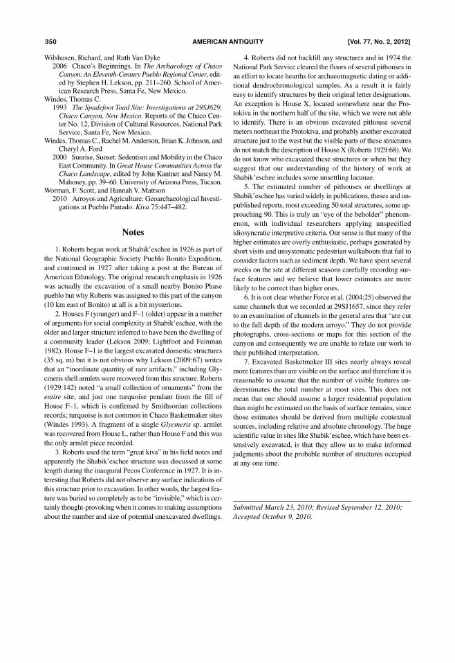
Wilshusen, Richard, and Ruth Van Dyke2006 Chaco’s Beginnings. In The Archaeology of ChacoCanyon: An Eleventh-Century Pueblo Regional Center, edit-ed by Stephen H. Lekson, pp. 211–260. School of Amer-ican Research Press, Santa Fe, New Mexico.
Windes, Thomas C.1993 The Spadefoot Toad Site: Investigations at 29SJ629,Chaco Canyon, New Mexico. Reports of the Chaco Cen-ter No. 12, Division of Cultural Resources, National ParkService, Santa Fe, New Mexico.
Windes, Thomas C., Rachel M. Anderson, Brian K. Johnson, andCheryl A. Ford
2000 Sunrise, Sunset: Sedentism and Mobility in the ChacoEast Community. In Great House Communities Across theChaco Landscape, edited by John Kantner and Nancy M.Mahoney, pp. 39–60. University of Arizona Press, Tucson.
Worman, F. Scott, and Hannah V. Mattson2010 Arroyos and Agriculture: Geoarchaeological Investi-gations at Pueblo Pintado. Kiva 75:447–482.
Notes
1. Roberts began work at Shabik’eschee in 1926 as part of
the National Geographic Society Pueblo Bonito Expedition,
and continued in 1927 after taking a post at the Bureau of
American Ethnology. The original research emphasis in 1926
was actually the excavation of a small nearby Bonito Phase
pueblo but why Roberts was assigned to this part of the canyon
(10 km east of Bonito) at all is a bit mysterious.
2. Houses F (younger) and F–1 (older) appear in a number
of arguments for social complexity at Shabik’eschee, with the
older and larger structure inferred to have been the dwelling of
a community leader (Lekson 2009; Lightfoot and Feinman
1982). House F–1 is the largest excavated domestic structures
(35 sq. m) but it is not obvious why Lekson (2009:67) writes
that an “inordinate quantity of rare artifacts,” including Gly-
cmeris shell armlets were recovered from this structure. Roberts
(1929:142) noted “a small collection of ornaments” from the
entire site, and just one turquoise pendant from the fill of
House F–1, which is confirmed by Smithsonian collections
records; turquoise is not common in Chaco Basketmaker sites
(Windes 1993). A fragment of a single Glycmeris sp. armlet
was recovered from House L, rather than House F and this was
the only armlet piece recorded.
3. Roberts used the term “great kiva” in his field notes and
apparently the Shabik’eschee structure was discussed at some
length during the inaugural Pecos Conference in 1927. It is in-
teresting that Roberts did not observe any surface indications of
this structure prior to excavation. In other words, the largest fea-
ture was buried so completely as to be “invisible,” which is cer-
tainly thought-provoking when it comes to making assumptions
about the number and size of potential unexcavated dwellings.
4. Roberts did not backfill any structures and in 1974 the
National Park Service cleared the floors of several pithouses in
an effort to locate hearths for archaeomagnetic dating or addi-
tional dendrochronological samples. As a result it is fairly
easy to identify structures by their original letter designations.
An exception is House X, located somewhere near the Pro-
tokiva in the northern half of the site, which we were not able
to identify. There is an obvious excavated pithouse several
meters northeast the Protokiva, and probably another excavated
structure just to the west but the visible parts of these structures
do not match the description of House X (Roberts 1929:68). We
do not know who excavated these structures or when but they
suggest that our understanding of the history of work at
Shabik’eschee includes some unsettling lacunae.
5. The estimated number of pithouses or dwellings at
Shabik’eschee has varied widely in publications, theses and un-
published reports, most exceeding 50 total structures, some ap-
proaching 90. This is truly an “eye of the beholder” phenom-
enon, with individual researchers applying unspecified
idiosyncratic interpretive criteria. Our sense is that many of the
higher estimates are overly enthusiastic, perhaps generated by
short visits and unsystematic pedestrian walkabouts that fail to
consider factors such as sediment depth. We have spent several
weeks on the site at different seasons carefully recording sur-
face features and we believe that lower estimates are more
likely to be correct than higher ones.
6. It is not clear whether Force et al. (2004:25) observed the
same channels that we recorded at 29SJ1657, since they refer
to an examination of channels in the general area that “are cut
to the full depth of the modern arroyo.” They do not provide
photographs, cross-sections or maps for this section of the
canyon and consequently we are unable to relate our work to
their published interpretation.
7. Excavated Basketmaker III sites nearly always reveal
more features than are visible on the surface and therefore it is
reasonable to assume that the number of visible features un-
derestimates the total number at most sites. This does not
mean that one should assume a larger residential population
than might be estimated on the basis of surface remains, since
those estimates should be derived from multiple contextual
sources, including relative and absolute chronology. The huge
scientific value in sites like Shabik’eschee, which have been ex-
tensively excavated, is that they allow us to make informed
judgments about the probable number of structures occupied
at any one time.
Submitted March 23, 2010; Revised September 12, 2010;
Accepted October 9, 2010.
350 amERican anTiquiTy [Vol. 77, no. 2, 2012]