gis: tool or science? demystifying the persistent ambiguity of gis as "tool" versus...
TRANSCRIPT
ForumGIS: Tool or Science?
Demystifying the Persistent Ambiguity of GIS as “Tool”versus “Science”
Dawn J. Wright,* Michael F. Goodchild,** and James D. Proctor***
*Department of Geosciences, Oregon State University
**Department of Geography and National Center for Geographic Information and Analysis,University of California, Santa Barbara
***Department of Geography, University of California, Santa Barbara
Is GIS a tool or a science? The question is clearly important in the day-to-day operations ofgeography departments. Departments need to know if GIS is a tool that should be taught at theundergraduate level, or a science and thus a legitimate research specialty of faculty and graduatestudents. We summarize the debate on this question that was conducted on GIS-L electroniclistserver in late 1993. In evaluating this discussion it became clear that GIS could be understoodnot by the two distinct positions taken by the GIS-L discussants but as three positions along acontinuum ranging from tool to science. These positions attach several meanings to “doing GIS.”These are (1) GIS as tool, i.e., the use of a particular class of software, associated hardware tools,and digital geographic data in order to advance some specific purpose; (2) GIS as toolmaking, i.e.,the advancement of the tool’s capabilities and facilities (ease of use); and (3) the science of GIS,i.e., the analysis of the fundamental issues raised by the use of GIS. Recognizing the importance ofunderstanding what is meant by “doing science” as well as what is meant by “doing GIS,” weconclude that only one of these positions—“the science of GIS”—is a sufficient condition forscience. The “toolmaker” position is rarely able to meet the test of science; and the “GIS is a tool”position involves “doing science” only if it yields progress on some substantive problem. The debateis certainly problematic in light of the variety of perspectives on science and on GIS. The persistenceof the issue suggests, however, that the GIS community should continue to work toward a resolution.Key Words: GIS-L, systems, geographic information science, geographic thought, nature and philosophy ofscience, nature of geographic information systems.
When Roger Tomlinson coined the term“geographic information system” forthe Government of Canada in the
early 1960s (Coppock and Rhind 1991), he canscarcely have imagined the impact that “GIS”would have on the discipline of geography, or theintensity of the debates that were provoked bythis seemingly innocent three-letter acronym. Ofcourse geography is no stranger to methodologi-cal debates, and some of the arguments over GISecho the arguments over quantification in the
1950s. We cannot be certain whether the GISdebate is more or less intense than its precursors,but we can be certain that it is important giventhe interdisciplinary nature of GIS, albeit a naturein which geography is widely accepted as havinga unique role (Morrison 1991; Kennedy 1994).Geography’s debates over GIS are thus unusuallyexposed to general view.
The purpose here is not to review the variousappraisals of GIS, which range from GIS as saviorputting the “geographic Humpty Dumpty” back
Annals of the Association of American Geographers, 87(2), 1997, pp. 346–362©1997 by Association of American GeographersPublished by Blackwell Publishers, 350 Main Street, Malden, MA 02148, and 108 Cowley Road, Oxford, OX4 1JF, UK.
together again (Openshaw 1991) to dismissal as“non-intellectual expertise” (Jordan 1988); fromexcitement over GIS as positivism’s second com-ing (Heywood 1990) to GIS as a last-ditch rallyby positivism’s battered survivors (Taylor 1990).More interesting are the social implications ofGIS—the message it sends, whom it empowers,and the responsibility its developers should bearfor its eventual use (Smith 1992; Pickles 1994;Harvey and Chrisman forthcoming). In the U.K.,these debates within the discipline have caughtthe attention of even so authoritative a source asthe Times Higher Education Supplement (Davies1995).
At heart, these debates arise from the ambigu-ity of GIS as a tool or as a science. While Tomlin-son was clear enough in his definition of a GIS asa computer application designed to perform cer-tain specific functions (Coppock and Rhind1991), it is not at all clear what is meant by “doingGIS,” “the GIS community,” or “GIS research,”since in all these cases the etymological pathbetween acronym and phrase has become hope-lessly muddied. At face value, “doing GIS” seemsto imply nothing more than interacting with aparticular class of software: “the GIS community”is no more than a group of individuals with anintense interest in that software; and “GIS re-search” seems an oxymoron. By examining thetension between GIS as a tool and GIS as a
science—a tension that ultimately defines whatit means to be “doing GIS” in geography—wehope to shed some light on these issues, which areclearly important in the day-to-day operations ofgeography departments. Departments need toknow if GIS is either a tool that should be taughtexclusively at the undergraduate level or a sci-ence and thus a legitimate research specialty offaculty and graduate students. Are students who“do GIS” doing substantive science? Is an associa-tion with GIS sufficient to ensure that research issubstantive, or if not, what other conditions arenecessary?
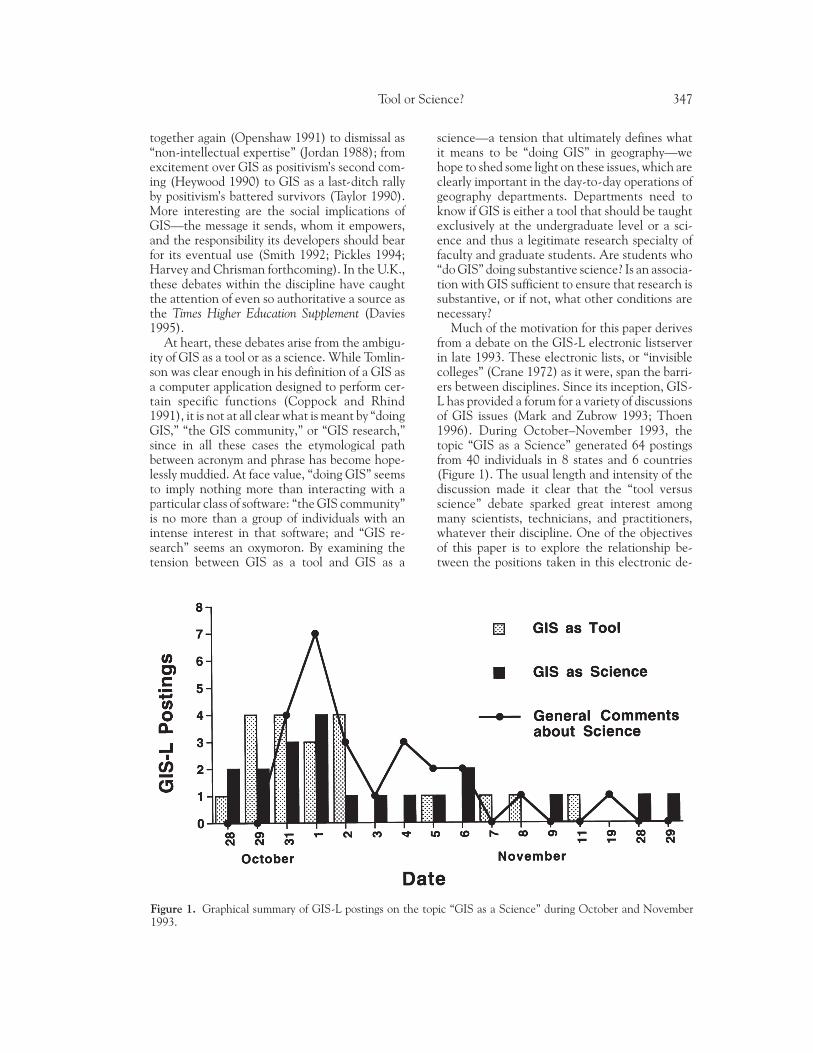
Much of the motivation for this paper derivesfrom a debate on the GIS-L electronic listserverin late 1993. These electronic lists, or “invisiblecolleges” (Crane 1972) as it were, span the barri-ers between disciplines. Since its inception, GIS-L has provided a forum for a variety of discussionsof GIS issues (Mark and Zubrow 1993; Thoen1996). During October–November 1993, thetopic “GIS as a Science” generated 64 postingsfrom 40 individuals in 8 states and 6 countries(Figure 1). The usual length and intensity of thediscussion made it clear that the “tool versusscience” debate sparked great interest amongmany scientists, technicians, and practitioners,whatever their discipline. One of the objectivesof this paper is to explore the relationship be-tween the positions taken in this electronic de-
Figure 1. Graphical summary of GIS-L postings on the topic “GIS as a Science” during October and November1993.
Tool or Science? 347
bate and current debates within the discipline ofgeography.
The “tool versus science” debate has receivedlittle mention in the published literature of geog-raphy, which is surprising in view of the attentiongiven to GIS the past decade. The closest theliterature comes to the debate is Goodchild’s(1992) paper on “geographic information sci-ence,” Sui’s (1994) discussion on reconciling thedifferences between GIS enthusiasts and critics,and the articles on “Automated Geography” thatappeared in The Professional Geographer in1993—the latter, a series of reflections on devel-opments in the ten years since Dobson (1983)announced that advances in analytical methodsand computer technology had made it possible toautomate several aspects of geographical researchand problem solving.
In the discussion that follows, the electronicdebate on GIS-L serves as the point of departurefor an exploration of “doing GIS” from the per-spectives of both geography and the society inwhich the discipline is embedded. The paperframes the tension between the positions of “GISas a tool” and “GIS as a science,” summarizes theGIS-L debate, considers the implications of thedebate, explores the position adopted, and pro-poses a solution and discusses its implications forthe profession. One note on terminology is nec-essary. The term “geographic information sci-ence” has appeared with an increasing frequencyin the geographic literature (Goodchild 1992;Rhind et al. 1991; Rhind 1992; Abler 1993;Cromley 1993; Dobson 1993; Fedra 1993). Good-child (1992) has argued that GIS has done muchto remove the traditional isolation between thefields of photogrammetry, remote sensing, geod-esy, cartography, surveying, geography, computerscience, spatial statistics, and other disciplineswith interests in the generic issues of spatial data,and it is these disciplines that constitute geo-graphic information science; hence it makessense for the research community to decode theGIS acronym in this way. Be that as it may, in thispaper every reference to the acronym GIS is to“system” not to “science.”
The GIS-L Debate
Documenting Electronic Discussions
Scholarly interaction is being revolutionized bythe Internet applications of electronic mail, dis-
cussion lists, the World Wide Web, electronicjournals, and digital libraries (on the Internet’simpact in oceanography, see Hess et al. 1993; andlikewise on traditional journals, see Odlyzko1995). Subscribers to an electronic list such asGIS-L are able to reach hundreds of colleaguesaround the world to discuss an issue or ask aquestion, thereby crossing all of the traditionalstructures of the research community (save per-haps structures based on language) within min-utes. While it is impossible to determine exactlyhow many individuals read GIS-L and with whatlevel of interest, Mark and Zubrow (1993) re-ported that at the time of their analysis, the listcontained approximately 1100 individual In-ternet addresses and was redistributed to morethan 30 additional lists worldwide.
Once registered as a subscriber to an unmod-erated electronic discussion list, any individualwith an Internet address automatically receivesall messages posted by any other subscriber. Theessential informality of this system of communi-cation is both a blessing and a source of difficultyfor anyone attempting to synthesize these discus-sions. Many of the discussants do not have thetime, the inclination, or perhaps the energy toresearch the positions that they adopt on suchtopics as, in our case, philosophies of science,geographic methodology, or the interplay be-tween science and technology. Electronic com-ments posted to a discussion list are not ascarefully thought out as writing in the scientificliterature. A written synthesis is thus perhapsmore akin to the proceedings of a workshop, inwhich useful ideas are expressed but not yet con-solidated or put into perspective.
Another challenge is how best to present thediscussion; in other words, how to properly citecommunication from an electronic conference.As on-line newspapers, journals, libraries, anddata archives become more prevalent on the “in-formation superhighway,” and it becomes neces-sary to refer to information that may exist only inelectronic form, formal methods of citation willhave to emerge that are as robust and persistentas conventional methods. The use of UniversalResource Locators (URLs, the electronic WorldWide Web addresses that commonly begin with“http://”) for citations to information availablethrough the World Wide Web is already causingproblems with “broken URLs,” which occurwhenever information is deleted or moved fromits existing site, or the name of a server or its filestructure is changed. Until better methods are
348 Wright et al.
devised, material posted on electronic discussionlists and bulletin board falls into the realm of“personal communication,” but unlike oral com-munication, electronic mail provides a more orless permanent and verbatim record of commu-nication and is precisely quotable. In this paperwe follow the electronic citation style proposedby Li and Crane (1993).
A final issue is confidentiality. For this study ofthe GIS-L discussion, all participants were noti-fied of our intent to present and synthesize theircomments in a published manuscript, and giventhe option of having quotations and references totheir comments removed. Before the manuscriptwas submitted for publication, participants weresent a draft version for review and comment. Itshould be noted that the views expressed by GIS-L discussants do not necessarily reflect the viewsof their institutions or organizations.
Summary of the GIS-L Discussion
The GIS-L exchange (summarized in Table 1)began as an offshoot of a discussion about oneimportant aspect of the scientific enterprise: thevalue of peer-reviewed literature within the sci-entific community, particularly with respect to itssuitability as reading material for students. Withthe mention of “GIS as a science” in the contextof peer-reviewed literature, some correspondentsresponded that “GIS is a tool, perhaps even aproblem-solving environment, but it is most cer-tainly not a science” (Skelly 1993a). The elec-tronic debate launched a discussion that unfoldedbetween October 28 and November 28, 1993(Figure 1). Table 1 is organized chronologicallybecause the debate was dynamic and evolved viaa series of responses to particular statements,claims, etc. The evolutionary course of the debatewas also very important in shaping its contents.Space does not permit a presentation of the entirediscussion, which when downloaded from GIS-Land printed out comprises fifty pages of single-spaced text. The table is organized according tothe two major positions taken during the debate(“GIS as tool” vs. “GIS as science”) as well as bythe participants’ general comments about thescientific enterprise.
Many of those who argued on the “tool side”of the issue could not see how a computer appli-cation could be described as a science (e.g.,McCauley 1993; Moll 1993; Skelly 1993a,1993b). They saw GIS as a tool or technique in
the same sense that Curran (1987) defines re-mote sensing as a technique. From this perspec-tive, GIS on its own is meaningless; its gainsmeaning only by its goals, which generally involvethe application of knowledge by scientists, but notscience itself (McCauley 1993; Moll 1993; Skelly1993b). In the GIS-L discussion, those who de-fined GIS as a tool did so in the sense of a physicalentity and also as a technique (Crepeau 1993a;Feldman 1993b; Halls 1993; Moll 1993). Viewedin this way, GIS may belong more to the field ofengineering than to science (Feldman 1993d;Skelly 1993c, 1993d). Discussants identified en-gineering as a problem-solving activity, while sci-ence was linked to discovery and problemunderstanding (Al-Taha 1993). That said, theboundaries between the two are often muddied,particularly at the level of basic research whereengineers may use scientific methods to identifyand understand the problems they will eventuallyattempt to solve (Al-Taha 1993).
Some of the “tool side” of the issue seemed tofeel that if GIS had any scientific aspect, it derivedfrom GIS’s place within the discipline of geogra-phy (Crepeau 1993a; Feldman 1993c; Halls1993). GIS is thus a tool applied when goingabout the business of geographic science (Halls1993). If “doing geography” is a science, then“doing GIS” amounts to a science (on the “geog-raphy as science” issue, see Couclelis andGolledge 1983; Hart 1982; Johnston 1979, 1986;Smith 1992; and Unwin 1992).
Those on the “science side” of the GIS-L dis-cussion spoke mainly about the use of GIS as amethod or body of knowledge for developing andtesting spatial theories (Brenner 1993; Laffey1993; Sandhu 1993b; Wright 1993a), not aboutthe physical entity GIS itself. While they agreedthat the “toolbox” view of GIS was accurate, itwas at the same time very limiting (Bartlett1993b; Sandhu 1993a; Wright 1993b). As impor-tant as are the hardware/software components ofGIS, it is the conceptual elements of GIS (e.g.,the rules governing the creation of spatial modelsfor GIS, the measurement and modeling of errorpropagation through a GIS, or proofs of theoremson data structures) that enable GIS to claim aplace as a science (Bartlett 1993a; Carlson 1993a;Wright 1993b).
Some discussants raised more fundamentalquestions: “what exactly is science?” and “whatspecifically allows us to call GIS a science?” (Feld-man 1993c; Piou 1993). Although no simpleconsensus on science emerged, discussants ac-
Tool or Science? 349
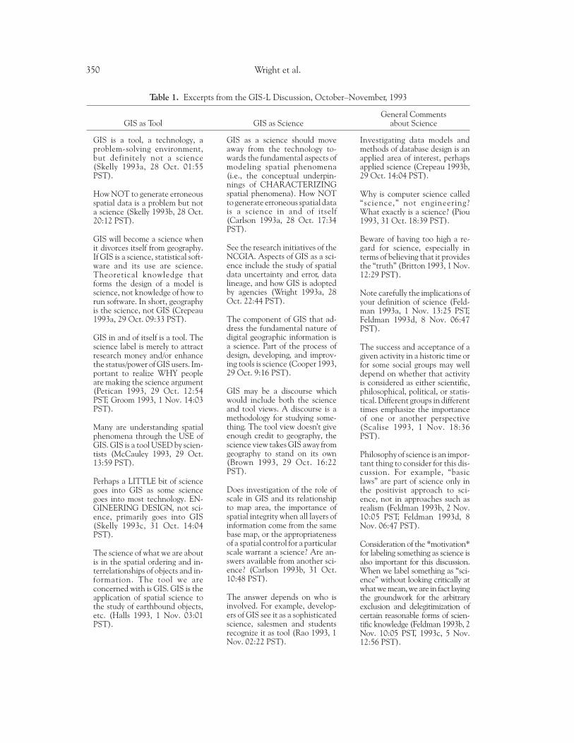
Table 1. Excerpts from the GIS-L Discussion, October–November, 1993
General CommentsGIS as Tool GIS as Science about Science
GIS is a tool, a technology, aproblem-solving environment,but definitely not a science(Skelly 1993a, 28 Oct. 01:55PST).
How NOT to generate erroneousspatial data is a problem but nota science (Skelly 1993b, 28 Oct.20:12 PST).
GIS will become a science whenit divorces itself from geography.If GIS is a science, statistical soft-ware and its use are science.Theoretical knowledge thatforms the design of a model isscience, not knowledge of how torun software. In short, geographyis the science, not GIS (Crepeau1993a, 29 Oct. 09:33 PST).
GIS in and of itself is a tool. Thescience label is merely to attractresearch money and/or enhancethe status/power of GIS users. Im-portant to realize WHY peopleare making the science argument(Petican 1993, 29 Oct. 12:54PST; Groom 1993, 1 Nov. 14:03PST).
Many are understanding spatialphenomena through the USE ofGIS. GIS is a tool USED by scien-tists (McCauley 1993, 29 Oct.13:59 PST).
Perhaps a LITTLE bit of sciencegoes into GIS as some sciencegoes into most technology. EN-GINEERING DESIGN, not sci-ence, primarily goes into GIS(Skelly 1993c, 31 Oct. 14:04PST).
The science of what we are aboutis in the spatial ordering and in-terrelationships of objects and in-formation. The tool we areconcerned with is GIS. GIS is theapplication of spatial science tothe study of earthbound objects,etc. (Halls 1993, 1 Nov. 03:01PST).
GIS as a science should moveaway from the technology to-wards the fundamental aspects ofmodeling spatial phenomena(i.e., the conceptual underpin-nings of CHARACTERIZINGspatial phenomena). How NOTto generate erroneous spatial datais a science in and of itself(Carlson 1993a, 28 Oct. 17:34PST).
See the research initiatives of theNCGIA. Aspects of GIS as a sci-ence include the study of spatialdata uncertainty and error, datalineage, and how GIS is adoptedby agencies (Wright 1993a, 28Oct. 22:44 PST).
The component of GIS that ad-dress the fundamental nature ofdigital geographic information isa science. Part of the process ofdesign, developing, and improv-ing tools is science (Cooper 1993,29 Oct. 9:16 PST).
GIS may be a discourse whichwould include both the scienceand tool views. A discourse is amethodology for studying some-thing. The tool view doesn’t giveenough credit to geography, thescience view takes GIS away fromgeography to stand on its own(Brown 1993, 29 Oct. 16:22PST).
Does investigation of the role ofscale in GIS and its relationshipto map area, the importance ofspatial integrity when all layers ofinformation come from the samebase map, or the appropriatenessof a spatial control for a particularscale warrant a science? Are an-swers available from another sci-ence? (Carlson 1993b, 31 Oct.10:48 PST).
The answer depends on who isinvolved. For example, develop-ers of GIS see it as a sophisticatedscience, salesmen and studentsrecognize it as tool (Rao 1993, 1Nov. 02:22 PST).
Investigating data models andmethods of database design is anapplied area of interest, perhapsapplied science (Crepeau 1993b,29 Oct. 14:04 PST).
Why is computer science called“science,” not engineering?What exactly is a science? (Piou1993, 31 Oct. 18:39 PST).
Beware of having too high a re-gard for science, especially interms of believing that it providesthe “truth” (Britton 1993, 1 Nov.12:29 PST).
Note carefully the implications ofyour definition of science (Feld-man 1993a, 1 Nov. 13:25 PST;Feldman 1993d, 8 Nov. 06:47PST).
The success and acceptance of agiven activity in a historic time orfor some social groups may welldepend on whether that activityis considered as either scientific,philosophical, political, or statis-tical. Different groups in differenttimes emphasize the importanceof one or another perspective(Scalise 1993, 1 Nov. 18:36PST).
Philosophy of science is an impor-tant thing to consider for this dis-cussion. For example, “basiclaws” are part of science only inthe positivist approach to sci-ence, not in approaches such asrealism (Feldman 1993b, 2 Nov.10:05 PST; Feldman 1993d, 8Nov. 06:47 PST).
Consideration of the *motivation*for labeling something as science isalso important for this discussion.When we label something as “sci-ence” without looking critically atwhat we mean, we are in fact layingthe groundwork for the arbitraryexclusion and delegitimization ofcertain reasonable forms of scien-tific knowledge (Feldman 1993b, 2Nov. 10:05 PST, 1993c, 5 Nov.12:56 PST).
350 Wright et al.
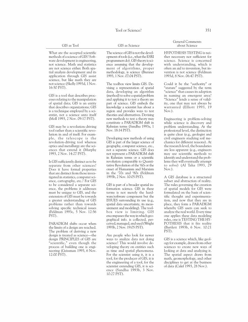
General CommentsGIS as Tool GIS as Science about Science
What are the accepted scientificmethods of a science of GIS? Soft-ware development is engineering,not science. Math and statisticsare not science either. Both spa-tial analysis development and itsapplication through GIS assistscience, but like math they arenot science (Skelly 1993d, 1 Nov.16:50 PST).
GIS is a tool that describes proc-esses relating to the manipulationof spatial data; GIS is an entitythat describes organizations; GISis a technique employed by a sci-entist, not a science unto itself(Moll 1993, 2 Nov. 09:17 PST).
GIS may be a revolution-drivingtool rather than a scientific revo-lution in and of itself. For exam-ple , the te lescope is therevolution-driving tool whereasoptics and metallurgy are the sci-ences that extend it (Murphy1993, 2 Nov. 14:27 PST).
Is GIS sufficiently distinct as to beseparate from other sciences?Does it have formal propertiesthat are distinct from those inves-tigated in statistics, computer sci-ence, cartography, etc.? For GISto be considered a separate sci-ence, the problems it addressesmust be unique to GIS, and theextension of GIS must be towardsa greater understanding of GISproblems rather than towardssolving specific technical issues(Feldman 1993c, 5 Nov. 12:56PST).
PARADIGM shifts occur whenthe limits of a design are reached.The problem of deriving a newdesign is treated as science—thedesign PRINCIPLES of GIS are“scientific,” even though theprocess of building one is engi-neering (Geissman 1993, 6 Nov.12:00 PST).
Thescienceof GIS is not thedevel-opmentof tools (i.e.,what theESRIprogrammers do). GIS theory is sci-ence assuming that the develop-ment of algorithms, propermethodology, is science (Brenner1993, 1 Nov. 07:04 PST).
The toolbox view limits GIS. De-vising a representation of spatialdata, developing an algorithm(method) to solve a spatial problemand applying it to test a theory arepart of science. GIS embeds theknowledge a scientist has about aregion and provides ways to testtheories and alternatives. Devisingnew methods to test a theory mayconstitute a PARADIGM shift inKuhnian terms (Sandhu 1993a, 1Nov. 18:14 PST).
Developing new methods of usingGIS is part of the larger science ofgeography, computer science, etc.,not a separate science. GIS doesnot represent a PARADIGM shiftin Kuhnian terms or a scientificrevolution comparable to Quanti-tative Revolution of the ‘60s or theonset of Humanism and Marxismin the ‘70s and ‘80s (Feldman1993b, 2 Nov. 10:05 PST).
GIS is part of a broader spatial in-formation science. GIS in theseterms is not merely the hard-ware/software component but theISSUES surrounding its use (e.g.,spatial data uncertainty, its meas-urement and modeling). The tool-box view is l imiting. GISencompasses the way in which geo-graphical info. is collected, per-ceived,managed,andused(Wright1993b, 2 Nov. 19:05 PST).
Are people who look for newerways to analyze data not doingscience? This would involve de-veloping theory on entities suchas time and spatial phenomena.For the scientist using it, it is atool, for the producer of GIS, it isthe engineering of a tool, for thescientist extending GIS, it is sci-ence (Sandhu 1993b, 3 Nov.10:27 PST).
HYPOTHESIS TESTING is nei-ther necessary nor sufficient forscience. Science is concernedwith understanding, which isoften an aid to invention, but in-vention is not science (Feldman1993d, 8 Nov. 06:47 PST).
Could it be the “authority” or“stature” suggested by the term“science” that causes its adoptionin naming an emergent area?“Science” lends a sense of valid-ity, one that may not always bewarranted (Elliott 1993, 19Nov.).
Engineering is problem-solvingwhile science is discovery andproblem understanding. At theprofessional level, the distinctionis quite clear (e.g., geologist andcivil engineers studying soil me-chanics for different reasons). Atthe research level, the boundariesare less apparent (e.g., engineersmay use scientific methods toidentify and understand the prob-lems they will eventually attemptto solve) (Al Taha 1993, 29Nov.).
A GIS database is a structuredsubset and abstraction of reality.The rules governing the creationof spatial models for GIS wereformulated on the basis of scien-tific thought and experimenta-tion, and now that they are inplace, they form a PARADIGMwhereby GIS users can seek toanalyze the real world. Every timeone applies these data modelingrules, one is TESTING THE HY-POTHESIS that it fits reality(Bartlett 1993b, 6 Nov. 10:21PST).
GIS is a science which, like geol-ogy for example, draws from othersciences to create new ways oflooking at data and analyzing it.The spatial aspect draws frommath, geomorphology, and otherdisciplines to get at the businessof data (Calef 1993, 28 Nov.).
Tool or Science? 351
cented the conceptual elements mentionedabove, along with activities such as “obtainingtheoretical knowledge to form the design of amodel,” “development theory on entities such astime and spatial phenomena,” and “developmentalgorithms to test a theory.” These were thoughtto be parts of the scientific enterprise (Crepeau1993a; Sandhu 1993a; Wright 1993b), and hencea possible basis for testing the scientific status ofa given activity. There was also a distinction madebetween “formal science” (purely abstractthought, as in mathematics) and “substantivescience” (phenomena that exist outside ofthought) (see Feldman 1993c). Accordingly, onemust consider the implications of his or her defi-nition of science so as not to arbitrarily excludeor delegitimize certain reasonable forms of knowl-edge (Feldman 1993a, 1993c, 1993d).
These attempts at defining science naturallyled to the question of whether GIS is significantlydistinct from sciences such as computer scienceor geography. In other words, if GIS is a sciencein some respects, is it a science unto itself, withits own unique, logically coherent object ofknowledge (Carlson 1993b; Feldman 1993d;Skelly 1993d)? Hence Dobson’s (1993) query: “IsGIS prompting a scientific revolution? The mostsevere test would be whether there are hypothe-ses and theories that can only be conceived andtested through GIS.” GIS is special in that it isuniquely visual and able to make explicit theimplicit features of data. Those on the “science”side or in the middle of the GIS-L discussion,however, did not seem to require a separate bodyof knowledge for GIS. Instead, they viewed thescience of GIS as a subdiscipline of geography or
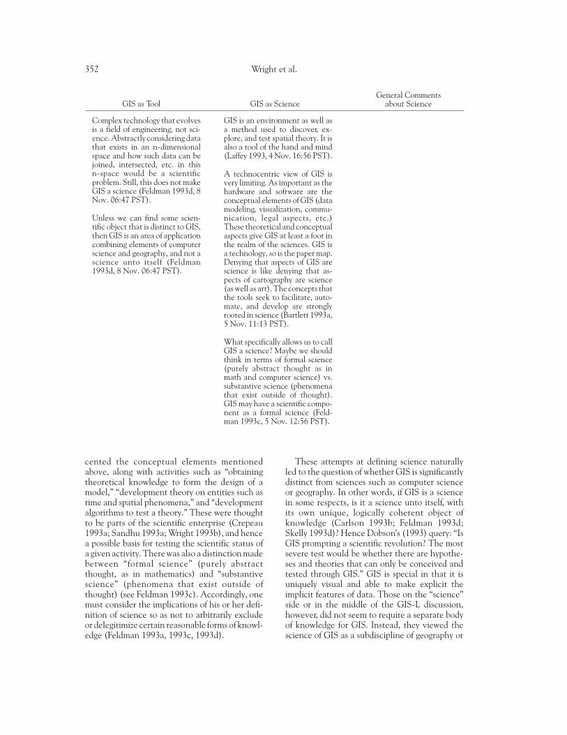
General CommentsGIS as Tool GIS as Science about Science
Complex technology that evolvesis a field of engineering, not sci-ence. Abstractly considering datathat exists in an n-dimensionalspace and how such data can bejoined, intersected, etc. in thisn-space would be a scientificproblem. Still, this does not makeGIS a science (Feldman 1993d, 8Nov. 06:47 PST).
Unless we can find some scien-tific object that is distinct to GIS,then GIS is an area of applicationcombining elements of computerscience and geography, and not ascience unto itself (Feldman1993d, 8 Nov. 06:47 PST).
GIS is an environment as well asa method used to discover, ex-plore, and test spatial theory. It isalso a tool of the hand and mind(Laffey 1993, 4 Nov. 16:56 PST).
A technocentric view of GIS isvery limiting. As important as thehardware and software are theconceptual elements of GIS (datamodeling, visualization, commu-nication, legal aspects, etc.)These theoretical and conceptualaspects give GIS at least a foot inthe realm of the sciences. GIS isa technology, so is the paper map.Denying that aspects of GIS arescience is like denying that as-pects of cartography are science(as well as art). The concepts thatthe tools seek to facilitate, auto-mate, and develop are stronglyrooted in science (Bartlett 1993a,5 Nov. 11:13 PST).
What specifically allows us to callGIS a science? Maybe we shouldthink in terms of formal science(purely abstract thought as inmath and computer science) vs.substantive science (phenomenathat exist outside of thought).GIS may have a scientific compo-nent as a formal science (Feld-man 1993c, 5 Nov. 12:56 PST).
352 Wright et al.
computer science (the way biogeography or geo-morphology are sciences within the larger field ofgeography, or paleontology is a science within thebroader field of geology) (Bartlett 1993a; Calef1993; Wright 1993b). Discussants voiced strongagreement that the connections between GIS andthe science of geography are the strongest, and thatGIS is not merely a subset of computer science(Bartlett 1993a; Wright 1993b). It was pointed outthat many of GIS’s early pioneers were geographers,e.g., Coppock, Rhind, Bickmore, and Unwin inBritain; Tomlinson, Garrison, Berry, Tobler, andMarble in North America (Bartlett 1993b); andthat geographers more than anyone else actuallyidentified, conceptualized, and formalized theinitial connections between spatial concepts andcomputer technology (Bartlett 1993b).
Putting the Debate intoPerspective: Definitions of Science
A lengthy foray into the philosophy and soci-ology of science is beyond the scope of this paper,but some considerations of these matters is un-avoidable in order to know what scientists do, thesignificance of what they do, and the relationshipof science to other knowledge-generating mecha-nisms. There is one caveat at the outset: there areprobably as many definitions and viewpoints ofscience as there are scientists (Feibleman 1972),and not all of these are necessarily correct! Aconcise definition of science cannot hope to cap-ture the full meaning of the term. Science encom-passes a wide range of fields that differ widely fromeach other in philosophy, knowledge content, andmethodology. The term “science” may be viewed asshorthand for a logical and systematic approach toproblems that seeks generalizable answers. This isthe position by Robinson et al. (1984) in describinghow cartography employs “the scientific method” inconstructing its products. Given Robinson et al.’semphasis on logic, most computer applicationswould pass the test of being “scientific,” though itleaves unanswered the question of whether “doingcartography” is “doing science.” Nonetheless, manyparticipants in the GIS-L debate were probablyunaware of the finer shades of meaning conveyedby the term “science,” or that many users of GISmight think of themselves as “scientists” in theunqualified sense of that term.
Depending on one’s inclination, there are sev-eral different approaches to science, each with itsown ontology, epistemology, and methodology.
These so-called -isms are defined variously bygeographers. Johnston (1986) uses the terms“positivism,” “humanism,” and “structuralism” todescribe human geography’s three main scientificapproaches; Haines-Young and Petch (1986) ac-cent “empiricism,” “positivism,” “relativism,” and“critical rationalism,” and Cloke et al. (1991)focus on “Marxism,” “humanism,” “structurationtheory,” “realism,” and “postmodernism.” Thusto ask the simple question, “Is GIS a science?,” isusually to presume the superiority of one or an-other approach to generating knowledge. For ex-ample, the GIS-L discussion pointed out that theconcept of “basic laws” is part of science only inthe positivist approach, not necessarily in ap-proaches such as realism or humanism (Feldman1993b, 1993d). Many argue that the positivistapproach is privileged with regard to GIS (Hey-wood 1990; Taylor 1990; Smith 1992; Lake 1993;Shepherd 1993), but Goodchild (1994) sees inthe growing literature on the epistemology of GIS(e.g., Pickles 1991; Wellar et al. 1994) the entirespectrum of approaches, from the positivist to thepostmodernist. If in the past certain approachesto science have been preferred in GIS, GIS neednot preclude other approaches in the future.
If aspects of GIS are to be considered as “sci-ence,” according to what philosophical approachare they scientific? This issue was raised briefly inthe GIS-L discussion (see Table 1; Feldman1993b, 1993c) but was not examined in detail. Inthe longstanding debates that have occurred ingeography over the appropriateness of differentapproaches, “positivism” and the “critical ration-alism” of Karl Popper (1959) are conventionallyassociated with “science” (Haines-Young andPetch 1986; Johnston 1986), but the rigorouscollection and evaluation of data in the produc-tion of knowledge are not exclusive to positivismor critical rationalism (e.g., Keat and Urry 1975;Johnston 1986; Sayer 1992). It is not our wish todownplay the explanatory power of these alterna-tive, nonpositivistic approaches; indeed variousphilosophies of science have succeeded in under-mining positivism’s claims to being a superiormethod for understanding the world (e.g., Willerand Willer 1973; Hindess 1977; Couclelis andGolledge 1983; Sheppard 1993).
Why Does Science Matter?
Why should one care whether GIS is a sci-ence or not? The technological (toolbox) face
Tool or Science? 353
of GIS is widely successful in government, busi-ness, and education, and it appears to have af-fected and improved the lives of far more peoplethan have many theoretical advances (e.g., thetheories of spatial data and of data structures,datamodels,andalgorithms).Technologyingen-eral has the potential to contribute greatly tosocietyandculture.
Science, though, is often held in high regard,and labeling a field as a science may sometimeshelp to ensure it a place in the academy or tosecure it greater funding and prestige. “Science”is often used as a generic synonym for “research,”particularly research of a basic, systematic, andgeneralizable kind. Thus “science” often func-tions as a rather crude but convenient shorthandfor academic legitimacy; if “doing GIS” is “doingscience” then its claim to a place in the academy,as a topic of research and graduate-level instruc-tion, is clearly strengthened.
In the GIS-L discussion, some participants im-plied (Groom 1993; Petican 1993) that thosearguing for “GIS as science” might be driven byulterior motives. Some participants warned ofhaving too high a regard for science, especially inbelieving that it provides the “truth” (Table 1). Inthe opinion of these correspondents, science doesindeed greatly influence our everyday lives andour ideas about the world, but does it deservespecial reverence? Is there something specialabout science and the contributions it has made?One must strike a balance between debunkingscience and dragging it off its pedestal, on the onehand, and falling into scientism (the claim thatthe scientific method is the only true method ofobtaining knowledge), on the other. The pointhas already been made eloquently by Bauer(1992:144):
That science does not have all the answers does notmean that it has no answers. That science now hasinadequate answers in some areas does not meanthat the answers will not become adequate in thefuture; in fact, history teaches that science’s answersbecome better and better as time goes by. Thatscience is fallible does not mean that science isentirely fallible or that it is as fallible as such othermodes of human knowledge and belief as folklore,religion, political ideology, or social science. Thatscience has no answers in some matters—such asthe value of human life or the purpose of liv-ing—does not mean that it has no answers in otherareas—those areas that are within its purviews, mat-ters of forces and substances and natural phenom-ena. And that science has no direct answers onmatters of human purpose does not mean that its
answers on other matters have no bearing on how,and how well, we are able to think about humanpurpose, free will, and other such things.
Clearly it does matter whether or not “doingGIS” is “doing science,” if for no other reasonthan that “doing science” is often regarded as acode-phrase for academic legitimacy. We will nowargue that “doing GIS” may express at least threemeanings that are represented by three positions.Our strategy, therefore, is to examine the role andlegitimacy of each of these three positions withinthe academy in general and within the disciplineof geography in particular.
Three Positions on GIS
In synthesizing the general themes of the GIS-L discussion, it became clear to us that GIS couldbe understood not by the two distinct positionstaken by the GIS-L discussants but as three posi-tions along a continuum from tool to science.These positions focus on the several meaningsattached to “doing GIS” rather than to GIS alone.These are (1) GIS as tool; (2) GIS as toolmaking;and (3) the science of GIS. It seems clear fromthe GIS-L discussion that the label “GIS” is sim-plistic, since it fails to indicate by itself whetherthe research involves fundamental scientificquestions and hypotheses, or whether GIS merelyadds gloss to the research through the use of acomplex and sophisticated tool—whether it de-codes as “science” or “system.” We have derivedthree positions on GIS from the GIS-L discussion;these represent a “fuzzy” continuum of opinionwhich recognize that positional labels are notperfect. Although these three positions do notcapture all of the nuances of argument during theGIS-L debate, they do represent the principalpoints of view along a “tool-science” continuum.
The “GIS is a tool” position sees GIS as the useof a particular class of software, the associatedhardware tools such as digitizers and plotters, anddigital geographic data in order to advance somespecific purpose. The tool itself is inherently neu-tral, its development and availability being largelyindependent of its use, which is driven by appli-cation.
The “toolmaking” position sees GIS as con-cerned with advancing the tool’s capabilities andease of use. Besides using the tool, toolmakersregularly promote the adoption of GIS, play a rolein educating users, and work to ensure responsi-ble use.
354 Wright et al.
Finally, the “science of GIS” position insists ona more intimate and reciprocal connection be-tween tool and science—one that involves re-search on a set of basic problems, each of whichprobably existed prior to the development of GIS,but whose solution is more pressing now becauseof the technology. This practice of collecting setsof basic problems under new names has a longhistory in science. It occurred, for example, withthe emergence of computer science, when thedevelopment of computing technology providedthe impetus for solving certain fundamental re-search problems that had previously been associ-ated with mathematics.
Discussion of the Three Positionson GIS
GIS Is a Tool
For those who take this position, “doing GIS”amounts to making use of a tool to advance theinvestigation of a problem. If the investigationmerits the label “research,” then “doing GIS” isprobably “doing science” as well, but the exist-ence and use of the tool are separable from thesubstantive problem. The documentation andwrite-up of the research tend to focus on thesubstantive problem, and indeed the tool may notbe mentioned at all. In some cases, GIS may beonly one of a number of tools used, each of whichhas been selected strictly for its efficacy in theresearch project. In these cases, the tools do notdrive the research.
If the research objectives are to some degree“methodological,” then the rules of engagementwith tools such as GIS may be somewhat different,as may the content of the paper documenting theresearch. In these cases, the tool may assume agreater role in directing the research, and hencebe given greater prominence in documentation,and case studies may be used to illustrate thetechnique rather than to provide generalizableempirical results. In papers of this sort, phrasessuch as “The Use of GIS in . . .” may appear inpaper’s title, although the processes responsiblefor the tool’s development are independent of thesubstantive research problem. Because their pri-mary motivation is to advocate the use of the tool,methodological demonstrations of GIS are moreappropriately included under the second positiondiscussed in the next section.
Scientists use many types of tools in their re-search. Some, such as typewriter or telephone, aregeneric in nature, with no particular associationwith any discipline. Others are developed strictlyfor one discipline, or even for one project or forone group of scientists. GIS falls somewhere inthe middle, being of interest, in principle, to anydiscipline dealing with the distribution of phe-nomena on the surface of the Earth. It seemsneither a generic tool whose use is so ubiquitousthat one can reasonably assume universal famili-arity (word processor, calculator), nor the exclu-sive tool of a single discipline. Perhaps a usefulanalogy is the tool of statistics, which in somedisciplines (e.g., agronomy) is close to universal,while in others (e.g., anthropology) usage is mixedand its value is the subject of continuous debate.
For these less-than-universal tools, the acad-emy traditionally provides the necessary infra-structure in the form of technical courses andtechnical support. But in addition, the academysatisfies the need for education in the associatedconcepts. In the case of statistics, for example, itwould not be adequate to provide a laboratory ofstatistical tools without at the same time provid-ing courses to ensure that students have thenecessary understanding of concepts. The samedistinction between technical training in the useof tools and education in the underlying conceptsapplies to GIS. While the concepts of GIS may befamiliar to professional geographers, they must betaught anew to each generation of students.Without conceptual courses, the use of GIS islikely to degenerate to data management and mapmaking, however complex the tool’s capabilitiesfor scientific analysis and modeling.
If GIS is a tool of particular value to geography,and if geography has traditionally taught many ofthe concepts that the tool implements, then itwould seem that formal courses in GIS are mostappropriately taught in geography. In the absenceof departments of geography, universities havefound a variety of solutions to the need for GISinstruction. In some cases, courses are taught byfaculty or staff in computing facilities; in others,they are taught in departments such as surveying,civil engineering, or forestry (Morgan and Fleury1993). But wherever they are taught, thesecourses serve two purposes—they prepare stu-dents to do their own research, and they providestudents with useful job skills.
While this technical line of argument providesa solution that is satisfactory for students, it cre-ates problems for the faculty assigned to teach
Tool or Science? 355
them, particularly untenured faculty. Technicalcourses require very heavy commitments of fac-ulty time, and teaching them is unlikely to boostthe instructor’s scholarly research career. Thetime required to maintain the GIS teaching labo-ratory and to deal with students’ technical prob-lems cuts down on the time available forresearch—and for securing tenure. Some depart-ments deal with this issue by relying on sessionalteaching staff or on technical staff, much as theydid in the past when offering courses in technicalfields such as cartography or remote sensing.
GIS Is Toolmaking
Advancing along the continuum between“GIS as tool” and “GIS as science,” we reach themiddle position on GIS, that of toolmaking. Fortoolmakers, the tool is inseparable from the sub-stantive problem, i.e., “doing GIS” implies in-volvement in the development of the tool itself.Geographers who are makers of the GIS toolparticipate directly in its specification, develop-ment, and evaluation, as well as in its use.
In reality, the developers of GIS tools havebackgrounds in many disciplines, including com-puter science, engineering, design, and mathe-matics, as well as geography. Few geographershave the necessary technical skills to build majorsoftware systems or to write “industrial-strengthcode”; but for that matter, academics in generalare not regarded as suited to the development ofreliable software. Indeed, most current GISs origi-nated in the private sector in companies employ-ing a mix of disciplines (GRASS and Idrisi arenotable exceptions).
Geographers possess two unique and powerfulabilities as GIS toolmakers. The first of these is anexcellent understanding of the geographic con-cepts that form the primitive elements of GISdatabases and processing and the ways that theseconcepts are embedded in theories, methods ofanalysis, and models. Second is that geographersare trained in a discipline that integrates under-standing of a wide range of processes influencingphenomena on the earth’s surface. Both of theseabilities are essential to “doing GIS” if one adoptsthe position that “doing GIS” is toolmaking. AGIS toolmaker thus requires a basic education ingeography together with technical courses thatemphasize critical analysis of the technology’scapabilities.
At the research level, the view of the tool-maker presumes critical analysis and reflection.The result is an extensive research literature thatfocuses on GIS as a generic tool (Goodchild et al.1991); at the same time there is remarkably littlepublished research on specific systems, perhapsbecause of the propriety nature of most GISs andbecause of scholarly fears that principles of aca-demic freedom and the First Amendment wouldnot protect them against a suit brought by aprivate-sector GIS vendor against publication ofa critical academic evaluation of a product.
Critical analysis and reflection extends beyondthe techniques of toolmaking to encompass ques-tions about the social responsibilities of toolmak-ers and the social implications of the widespreadadoption of the tool (Smith 1992; Pickles 1991,1994; Harvey and Chrisman forthcoming). Thisinvolves evaluating a tool that has applicationsspanning the full range of human activi-ties—from economy to politics to society. In thiscase, the issues become complex indeed. Thescope of research is determined not by the tool’svalue to geographers, but rather by the multifari-ous applications of GIS, to include all of thesocietal effects of the computerization of geo-graphic information. Whether “GIS” can with-stand the stress of such varied usages remains tobe seen.
The Science of GIS
It was evident from the GIS-L debate that GISis widely viewed outside the discipline of geogra-phy as a subset of geographical science. Althoughgeography is a small, unevenly represented disci-pline, and doubts about its legitimacy in the acad-emy are widely held (Smith 1987), the recentgrowth of GIS and its affiliation with the disci-pline has meant increased visibility in the acad-emy. Moreover GIS is associated with clearphysical imagery, hence it is much easier to imag-ine “doing GIS” than “doing geography” if one hasno familiarity with the latter. Geography’s affili-ation with GIS thus pairs it with the computer(however inappropriately). Computerizationautomatically confers precision, rigor, and repli-cability in the popular imagination, all of whichcontribute to the flawed notion of GIS as a subsetof geographical science.
The very rapid growth of technology and theemergence of a technology-based society in re-
356 Wright et al.
cent years have prompted new groupings andpriorities within science. Few would have pre-dicted, for example, that the development of thedigital computer would eventually lead to thediscipline of computer science, or that informa-tion would itself become the basis of a scientificdiscipline. Four conditions seem necessary for theemergence of a science out of a technology: first,the driving technology must be of sufficient sig-nificance; second, the issues raised by its devel-opment and use must be sufficiently challenging;third, interest in and support for research onthose issues must be inadequate in the existingdisciplines; and fourth, there must be sufficientcommonality among the issues to create a sub-stantial synergy.
Two terms have evolved to describe the emer-gence of a science based on GIS. The first isgeomatics, a term favored in many countries be-cause of its simplicity and its ease of translationinto French; the second, geographic informationscience, a term that is well-known in the English-speaking world. The latter is used here.
Geographic information science, the science ofGIS, is concerned with geographic concepts, theprimitive elements used to describe, analyze,model, reason about, and make decisions on phe-nomena distributed on the surface of the earth.These range from the geometric primitives ofpoints, lines, and areas to the topological relation-ships of adjacency and connectivity through thedynamic relations of flow and interaction to do-main-specific concepts such as neighborhood,geosyncline, or place. In their current state ofdevelopments, GISs are comparatively crudedigital systems for representing and manipulatinggeographic concepts, capable of handling onlythe most primitive of these concepts. But whilecurrent technology may constrain the science ofGIS, it does not limit its development, just ascomputer science is not limited by the currentstate of computer technology. Indeed the re-search problems raised by GIS and their solutionswill help to define the future form of GIS tech-nology. Perhaps the most crucial of these prob-lems for geographic information science is thelimitation of digital representation, i.e., are theregeographic concepts which can never be repre-sented in or manipulated by GIS?
The digital representation and manipulation ofgeographic concepts raise a number of fundamen-tal research issues, many of which, though long-standing in traditional disciplines, have been
reenergized by the development of GIS. Althoughthe capabilities of GIS are improving, geographerswho use it still look forward to the stage at whichall geographic concepts and procedures are im-plemented digitally (Dobson 1983, 1993; Cou-clelis 1991). In the interim, GIS research willmost likely implement those concepts and proce-dures that are the simplest, most logical, and mostrigorously defined, i.e., the most primitive and/orthe most scientific. These include issues of recog-nition and measurement in the field, the choicebetween alternative representations, the roles ofgeneralization and multiple representations, therepresentation of uncertain information, meth-ods of analysis and modeling, problems of describ-ing the content of geographic data and evaluatingits fitness for use, and methods of visualization.These sorts of issues underscore the multidiscipli-nary nature of geographic information science.Besides geography, it includes such traditionalgeographic information disciplines as geodesy,surveying, cartography, photogrammetry, and re-mote sensing along with spatially oriented ele-ments of such other disciplines as informationstatistics, cognitive science, information science,library science, and computer science.
Evaluation
In light of these three perspectives on GIS,what can be said about the significance of “doingGIS?” If “GIS is a tool,” then its use has little todo with the legitimacy of the research; in this case,significance derives strictly from the progressesmade on the substantive research problem. In thissense “doing GIS” is not necessarily the same as“doing science”; the latter depends on the meth-ods deployed on the substantive problem, i.e., arethey scientific? Courses in GIS are more likely tobe offered at the undergraduate level and reflecttheir essentially technical, service orientation. Ageography department using GIS on this basisprobably would not claim GIS as a researchspecialty, nor would it encourage its studentsto regard GIS as a substantive subfield of thediscipline.
The toolmaking position confers a more sig-nificant status on GIS. In this case, GIS includescase studies that demonstrate the methodology,advocacy of GIS usage, and, perhaps also, thedevelopment of software. In the absence of indis-putable instances of scientific insights uniquely
Tool or Science? 357
attributable to the use of GIS, toolmaking willremain more akin to engineering than to science.Consequently, tests of toolmaking’s progresswould be based on indicators of improvements inthe tool’s utility. Critical reflection on and theevaluation of GIS are also included in the tool-making position. While these are clearly legiti-mate activities of the academy, they are not aseasily characterized as “doing science” (or “doingengineering”).
A department adopting the toolmaking posi-tion would probably offer a range of undergradu-ate and graduate courses in GIS, includingcourses in the toolmaker’s tools—programminglanguages—and the faculty would regard GIS asa research specialty and encourage students tomake significant contributions as toolmakers. Butsuch a department might also expect continuingtension between research and teaching in GISand in more substantive fields (i.e., where re-search is measured by the accumulation of knowl-edge rather than by the improvement of tools).
The third position, “science of GIS,” is con-cerned with the analysis of the fundamental issuesraised by the use of GIS in geography or in otherdisciplines. As noted earlier, these issues may notbe unique to GIS, but rather are remotivated byit; many of these issues continue to be regardedas problems in cartography or surveying or spatialcognition. A department taking this position withregard to specialization in GIS would recognize itas a substantive research field on a par with othersuch fields and would measure progress based onthe accumulation of research results and contri-butions to human understanding, rather thanfrom improvements in the tools themselves. Thisposition is therefore the only one that providessufficient grounds on which “doing GIS” is “doingscience,” and for the legitimacy of GIS as a re-search field in the academy.
Proponents of this position, however, must becareful not to confuse the use of GIS itself (e.g.,entering a sequence of spatial analysis com-mands) with an analysis of the issues surroundingthe use. Some may try to derive legitimacy fromthe proposition that GIS is so uniquely funda-mental to geography that to do GIS is necessarilyto do science—or, more extremely, that to do GISis to do geography scientifically. This argument issomewhat flawed because it implies that GIS isvastly more effective than it currently is, andbecause it ignores the limitations of current GISin dealing with time, scale, interactions, and ahost of other sophisticated geographic concepts.
Whether GIS is a geographical science in and ofitself depends on both the rigor with which thetool is employed and the scope of the tool’s func-tionality given the nature of the substantive prob-lem. These issues clearly must be resolved on acase-by-case basis. Therefore the use of GIS is nota sufficient condition for science.
Conclusion
Goodchild (1993:445) notes that “an encour-aging recent trend has been the willingness of abroad spectrum of geographers to see GIS not asa tool that they can use in their own research, butas a phenomenon on which they can reflect andcomment.” We have chosen to reflect and com-ment on “the phenomenon” of GIS because, asnoted earlier, some of the interest in the GIS-Ldebate may have stemmed from the uncertaintyfaced by young scholars in particular overwhether departments will accept “GIS” as a topicfor scientific research. In these situations, becausethe label “GIS” is not altogether perfect, what isprobably needed to fully describe the entity “GIS”is a shift from “black-and-white” boxes of descrip-tion to “fuzzier” continua. We find that GIS rep-resents just such a continuum between tool andscience. The technologies of GIS (i.e., the toolsand the toolmaking) clearly have the potential tomotivate a host of interesting and fundamentalscientific research questions. The science basedon GIS (i.e., geographic information science) mayadvance the tools and toolmaking of GIS, as wellas scientific research done with aid of using a GIS.Surely the desired end from all perspectives is thebuilding of an intellectual foundation for GIS bygeographers and members of allied disciplinesalike, which will ensure its survival long after thenovelty of the technology has worn off.
Debates arising out of the ambiguity of GIS astool or science must be understood within thecontext of broader trends in science and in societygenerally. Older notions of science as the equiva-lent of “hard science” are being replaced by amore open view. Warning against conflating sci-ence and its positivistic expression, Johnston(1986:6) proposes a more generous view of sci-ence as “the pursuit of systematic and formulatedknowledge, and as such [it] is not confined to anyparticular epistemology.” In this context, GISmay represent a new kind of science, one thatemphasizes visual expression, collaboration, ex-ploration, and intuition, and the uniqueness of
358 Wright et al.
place over more traditional concerns for mathe-matical rigor, hypothesis testing, and generality(Goodchild 1992; Kemp et al. 1992; Rhind 1993;Fedra 1993; Muller 1993; Burrough and Frank1995).
As a discipline, geography has long struggledwith the tension between the general and theparticular (Bunge 1962). Maps and geographicdata capture the essence of the geographicallyparticular, the boundary conditions that in-fluence the outcome of physical and socialprocesses; in that sense, GIS illuminates the par-ticular. But unlike maps, the purpose of GIS is tomaintain geographic data in a state(s) that maybe transformed, processed, and analyzed in waysthat are geographically uniform. Thus GIS is atechnology of both the general and the particular,implementing the former in its formalized algo-rithms, concepts, and models, and the latter inthe contents of its data sets. GIS as a technologyseems uniquely appropriate for geographic re-search and, more specifically, for transforminggeographic knowledge of processes into predic-tions, policies, and decisions. In this sense GIScaptures geography’s tensions between basic re-search and application, and between the geo-graphically general and the geographicallyparticular.
The demands for basic and applied knowledgeare several in the new worlds created and encoun-tered by GIS. Whether GIS serves as a techno-logical means to acquire and develop knowledgeor as an end for scientific inquiry in its own right,these systems will undoubtedly play a central rolein knowledge making in the future. But it isimportant to understand what is meant by “doingscience,” as well as what is meant by “doing GIS.”This paper has identified three well-defined posi-tions on this matter, only one of which confers thekind of academic legitimacy associated with “do-ing science.” In other cases, “doing GIS” is moreakin to using a tool (to be evaluated by theappropriateness of the tool to the substantiveproblem) or to engineering better tools (to beevaluated on the degree of improvement in thetool). In such cases, GIS appears not to constrainits users to any particular epistemological stance.
Acknowledgments
The authors wish to thank Pete Peterson, KristinLovelace, Steve Behnke, and Ray Smith at UCSB forfruitful discussions. The critical reviews of Helen Cou-
clelis and Alan Brenner significantly improved themanuscript. The National Center for GeographicalInformation and Analysis is supported by the NationalScience Foundation under Cooperative AgreementSBR 88-10917.
References
Printed References
Abler, R. F. 1993. Everything in Its Place: GPS, GIS,and Geography in the 1990s. The Professional Ge-ographer 45:131–39.
Bauer, H. H. 1992. Scientific Literacy and the Myth of theScientific Method. Urbana: University of IllinoisPress.
Bunge, W. 1962. Theoretical Geography. Lund, Sweden:C. W. K. Gleerup.
Burrough, P. A., and Frank, A. U. 1995. Concepts andParadigms in Spatial Information: Are CurrentGeographical Information Systems Truly Generic?International Journal of Geographical InformationSystems 9:101–16.
Cloke, P.; Philo, C.; and Sadler, D. 1991. ApproachingHuman Geography: An Introduction to Contempo-rary Theoretical Debates. New York: Guilford Press.
Coppock, J. T., and Rhind, D. W. 1991. The History ofGIS. In Geographical Information Systems: Princi-ples and Applications, vol. 1, ed. D. J. Maguire, M.F. Goodchild, and D. W. Rhind, pp. 21–43. NewYork: John Wiley and Sons.
Couclelis, H. 1991. Requirements for Planning-Rele-vant GIS: A Spatial Perspective. Papers in RegionalScience 70:9–19.
———, and Golledge, R. 1983. Analytic Research,Positivism, and Behavioral Geography. Annals ofthe Associat ion of American Geographers73:331–39.
Crane, D. 1972. Invisible Colleges. Chicago: Universityof Chicago Press.
Cromley, R. G. 1993. Automated Geography: Ten YearsLater. The Professional Geographer 45:442–43.
Curran, P. J. 1987. Remote Sensing Methodologies andGeography. International Journal of Remote Sensing8:1255–75.
Davies, J. 1995. Perspective: Chart Hits? Times HigherEducation Supplement, October 27, p. 19.
Dobson, J. E. 1983. Automated Geography. The Profes-sional Geographer 35:135–43.
———. 1993. The Geographic Revolution: A Retro-spective on the Age of Automated Geography.The Professional Geographer 45:431–39.
Fedra, K. 1993. GIS and Environmental Modelling. InEnvironmental Modeling with GIS, ed. M. F. Good-child, B. O. Parks, and L. T. Steyaert, pp. 35–50.New York: Oxford University Press.
Feibleman, J. K. 1972. Scientific Method. The Hague:Martinus Nijhoff.
Tool or Science? 359
Goodchild, M. F. 1992. Geographical Information Sci-ence. International Journal of Geographical Infor-mation Systems 6:31–45.
———. 1993. Ten Years Ahead: Dobson’s AutomatedGeography in 1993. The Professional Geographer45:444–45.
———. 1994. GIS and Geographic Research. InGround Truth: The Social Implications of GeographicInformation Systems, ed. J. Pickles, pp. 31–50. NewYork: Guilford.
———; Rhind, D. W.; and Maguire, D. J. 1991.Introduction (Section II: Principles). In Geo-graphical Information Systems: Principles and Ap-plications, vol. 1, ed. D. J. Maguire, M. F.Goodchild, and D. W. Rhind, pp. 111–17. NewYork: John Wiley and Sons.
Haines-Young, R. H., and Petch, J. R. 1986. PhysicalGeography: Its Nature and Methods. London: PaulChapman Publishing Ltd.
Hart, J. F. 1982. The Highest Form of the Geographer’sArt. Annals of the Association of American Geogra-phers 72:1–29.
Harvey, F., and Chrisman, N. J. Forthcoming. SpatialTechnology in the Making: GIS as Social Practice.Progress in Human Geography.
Hess, B.; Sproull, L.; Kiesler, S.; and Walsh, J. 1993.Returns to Science: Computer Networks inOceanography. Communications of the Associationfor Computing Machinery 36:90–101.
Heywood, I. 1990. Geographic Information Systems inthe Social Sciences. Environment and Planning A22:849–54.
Hindess, B. 1977. Philosophy and Methodology in theSocial Sciences. Hassocks, NJ: Harvester Press.
Johnston, R. J. 1979. Geography and Geographers: An-glo-American Human Geography since 1945. NewYork: Wiley.
———. 1986. Philosophy and Human Geography: AnIntroduction to Contemporary Approaches. London:Edward Arnold.
Jordan, T. 1988. The Intellectual Core: President’sColumn. AAG Newsletter 23:1.
Keat, R., and Urry, J. 1975. Social Theory as Science.London: Routledge & Paul.
Kemp, K. K.; Goodchild, M. F.; and Dodson, R. F. 1992.Teaching GIS in Geography. The Professional Ge-ographer 44:181–90.
Kennedy, M. 1994. Review of Geographical InformationSystems: Principles and Applications, ed. David J.Maguire, Michael F. Goodchild, and David W.Rhind. Annals of the Association of American Ge-ographers 84:172–73.
Lake, R. W. 1993. Planning and Applied Geography:Positivism, Ethics, and Geographic InformationSystems. Progress in Human Geography 17:404–13.
Li, X., and Crane, N. B. 1993. Electronic Style: A Guide toCiting Electronic Information. Westport, CT: Meckler.
Mark, D. M., and Zubrow, E. 1993. Join the GIS-LElectronic Community! GIS World 6:56–57.
Morgan, J. M., III, and Fleury, B. B. 1993. AcademicGIS Education: Assessing the State of the Art.Geo Info Systems 3:33–40.
Morrison, J. L. 1991. The Organizational Home for GISin the Scientific Professional Community. In Geo-graphical Information Systems: Principles and Appli-cations, vol. 1, ed. D. J. Maguire, M. F. Goodchild,and D. W. Rhind, pp. 91–100. New York: JohnWiley and Sons.
Muller, J.-C. 1993. Latest Developments in GIS/LIS.International Journal of Geographical InformationSystems 7:293–303.
Odlyzko, A. 1995. Tragic Loss or Good Riddance? TheImpending Demise of Traditional Scholarly Jour-nals. International Journal of Human-ComputerStudies 42:71–122.
Openshaw, S. 1991. A View on the GIS Crisis inGeography, or Using GIS to put Humpty-DumptyBack Together Again. Environment and Planning A23:621–28.
Pickles, J. 1991. Geography, GIS, and the SurveillantSociety. Papers and Proceedings of the Applied Ge-ography Conference 14:80–91.
———, ed. 1994. Ground Truth. New York: GuilfordPress.
Popper, K. 1959. The Logic of Scientific Discovery. NewYork: Basic Books.
Rhind, D. 1992. The Next Generation of GeographicalInformation Systems and the Context in WhichThey Will Operate. Computers, Environment andUrban Systems 16:261–68.
———. 1993. Maps, Information and Geography: ANew Relationship. Geography 78:150–59.
Rhind, D. W.; Goodchild, M. F.; and Maguire, D.J. 1991. Epilogue. In Geographical InformationSystems: Principles and Applications, vol. 2, ed.D. J. Maguire, M. F. Goodchild, and D. W.Rhind, pp. 313–27. New York: John Wileyand Sons.
Robinson, A. H.; Sale, R. D.; Morrison, J. L.; andMuehrcke, P. C. 1984. Elements of Cartography,5th ed. New York: John Wiley & Sons.
Sayer, A. 1992. Method in Social Science. London: Rout-ledge.
Sheppard, E. 1993. Automated Geography: What Kindof Geography for What Kind of Society? TheProfessional Geographer 45:457–60.
Smith, N. 1987. Academic War over the Field of Ge-ography. The Elimination of Geography at Har-vard, 1947–51. Annals of the Association ofAmerican Geographers 77:155–72.
———. 1992. History and Philosophy of Geography:Real Wars, Theory Wars. Progress in Human Geog-raphy 16:257–71.
Sui, D. Z. 1994. GIS and Urban Studies: Positivism,Post-positivism, and Beyond. Urban Geography15:258–78.
Taylor, P. J. 1990. GIS. Political Geography Quarterly9:211–12.
360 Wright et al.
Thoen, B. 1996. On-line Demographics: GIS Commu-nities Flourish. GIS World 9:48–51.
Unwin, T. 1992. The Place of Geography. Essex, Eng-land: Longman Scientific & Technical.
Wellar, B.; Cameron, N.; and Sawada, M. 1994. Pro-gress in Building Linkages Between GIS andMethods and Techniques of Scientific Inquiry.Computers, Environment, and Urban Systems18:67–80.
Willer, D., and Willer, J. 1973. Systematic Empiricism:Critique of a Pseudoscience. Englewood Cliffs, NJ:Prentice-Hall.
Electronic References (All referencesavailable e-mail: GIS-L @UBVM.CC.BUFFALO.EDU.)
Al-Taha, K. November 29, 1993. Department of Geog-raphy and Anthropology, Louisiana State Univer-sity. Re: GIS as a Science [Discussion]. GeographicInformation Systems Discussion List [Online].
Bartlett, D. November 5, 1993. Geography Depart-ment, Cork University, Ireland. Re: GIS as aScience [Discussion]. Geographic Information Sys-tem Discussion List [Online].
———. November 6, 1993b. Re: GIS as a Science[Discussion]. Geographic Information Systems Dis-cussion List [Online].
Brenner, A. November 1, 1993. Environmental Protec-tion Agency. Re: GIS as a Science [Discussion].Geographic Information Systems Discussion List[Online].
Britton, J. November 1, 1993. GIS and CartographyDepartment, Sir Sandford Fleming College, Can-ada. Re: GIS as a Science [Discussion]. Geo-graphic Information Systems Discussion List[Online].
Brown, M. October 29, 1993. Department of Geogra-phy, San Diego State. Tool or Science? [Discus-sion]. Geographic Information Systems DiscussionList [Online].
Calef, F. J. November 28, 1993. Re: GIS as a Science[Discussion]. Geographic Information Systems Dis-cussion List [Online].
Carlson, C. L. October 28, 1993a. Northern IllinoisUniversity. Re: Value of Peer Review [Discus-sion]. Geographic Information Systems DiscussionList [Online].
———. October 31, 1993b. Re: GIS as a Science[Discussion]. Geographic Information Systems Dis-cussion List [Online].
Cooper, A. October 29, 1993. CSIR Information Serv-ices, Pretoria, South Africa. Re: Value of PeerReview [Discussion]. Geographic Information Sys-tems Discussion List [Online].
Crepeau, R. October 28, 1993a. School of Social Ecol-ogy, University of California-Irvine. Re: GIS as a
Science [Discussion]. Geographic Information Sys-tems Discussion List [Online].
———. October 29, 1993b. Re: GIS as a Science[Discussion]. Geographic Information Systems Dis-cussion List [Online].
Elliott, M. A. November 19, 1993. Department ofGeography, Northern Illinois University. Re:Why “Science”? [Discussion]. Geographic Infor-mation Systems Discussion List [Online].
Feldman, M. November 1, 1993a. Community Plan-ning, University of Rhode Island. Re: GIS as aScience and Value of Peer Review [Discussion].Geographic Information Systems Discussion List[Online].
———. November 2, 1993b. Re: GIS as a Science[Discussion]. Geographic Information Systems Dis-cussion List [Online].
———. November 5, 1993c. Re: GIS as a Science[Discussion]. Geographic Information Systems Dis-cussion List [Online].
———. November 8, 1993d. Re: GIS as a Science[Discussion]. Geographic Information Systems Dis-cussion List [Online].
Geissman, J. November 6, 1993. Re: GIS as a Science[Discussion]. Geographic Information Systems Dis-cussion List [Online].
Groom, A. November 1, 1993. Christchurch CityCouncil, New Zealand. Re: Tool or Science? [Dis-cussion]. Geographic Information Systems Discus-sion List [Online].
Halls, P. J. November 1, 1993. Simon Fraser University,Canada. Re: GIS as a Science and Value of PeerReview [Discussion]. Geographic Information Sys-tems Discussion List [Online].
Laffey, S. C. November 4, 1993. Department of Geog-raphy, Northern Illinois University. Re: GIS as aScience [Discussion]. Geographic Information Sys-tems Discussion List [Online].
McCauley, D. October 29, 1993. Agricultural Engi-neering Department, Purdue University. Re: GISas a Science [Discussion]. Geographic InformationSystems Discussion List [Online].
Moll, B. W. November 2, 1993. Martin Marietta EnergySystems. Re: GIS as a Science [Discussion]. Geo-graphic Information Systems Discussion List [On-line].
Murphy, L. November 2, 1993. Indiana University. Re:GIS as a Science [Discussion]. Geographic Infor-mation Systems Discussion List [Online].
Petican, D. J. October 29, 1993. University of Waterloo,Canada. Re: GIS as a Science [Discussion]. Geo-graphic Information Systems Discussion List [Online].
Piou, J. October 31, 1993. University of Maryland. Re:Value of Peer Review [Discussion]. GeographicInformation Systems Discussion List [Online].
Rao, L. November 1, 1993. Re: GIS as a Science[Discussion]. Geographic Information Systems Dis-cussion List [Online].
Tool or Science? 361
Sandhu, J. November 1, 1993a. Environmental Sys-tems Research Institute, Redlands, CA. Re: GISas a Science [Discussion]. Geographic InformationSystems Discussion List [Online].
———. November 3, 1993b. Re: GIS as a Science[Discussion]. Geographic Information Systems Dis-cussion List [Online].
Scalise, A. H. November 1, 1993. United Nations De-velopment Program, Argentina. GIS as a Science[Discussion]. Geographic Information Systems Dis-cussion List [Online].
Skelly, C. W. October 28, 1993a. James Cook Univer-sity, Australia. GIS and Remote Sensing Research[Discussion]. Geographic Information Systems Dis-cussion List [Online].
———. October 28, 1993b. Re: Value of Peer Review[Discussion]. Geographic Information Systems Dis-cussion List [Online].
———. October 31, 1993c. Re: Value of Peer Review[Discussion]. Geographic Information Systems Dis-cussion List [Online].
———. November 1, 1993d. Re: GIS as a Science andValue of Peer Review [Discussion]. GeographicInformation Systems Discussion List [Online].
Wright, D. J. October 28, 1993a. Department of Geog-raphy, University of California-Santa Barbara. Re:Value of Peer Review [Discussion]. GeographicInformation Systems Discussion List [Online].
———. November 2, 1993b. Re: GIS as a Science[Discussion]. Geographic Information Systems Dis-cussion List [Online].
Correspondence: Department of Geosciences, Oregon State University, Corvallis, OR 97331-5506, [email protected] (Wright); Department of Geography, University of California, Santa Barbara, CA93106-4060 (Goodchild and Proctor).
362 Wright et al.