georges river local environmental plan 2021
TRANSCRIPT
New South Wales
Georges River Local Environmental Plan 2021under the
Environmental Planning and Assessment Act 1979
Published LW 8 October 2021 (2021 No 587)
I, the Minister for Planning and Public Spaces, pursuant to section 3.20 of the EnvironmentalPlanning and Assessment Act 1979, adopt the mandatory provisions of the Standard Instrument(Local Environmental Plans) Order 2006 and prescribe matters required or permitted by thatOrder so as to make a local environmental plan as follows.
MALCOLM McDONALDAs delegate for the Minister for Planning and Public Spaces
ContentsPage
Georges River Local Environmental Plan 2021 [NSW]Contents
Part 1 Preliminary1.1 Name of Plan 5
1.1AA Commencement 51.2 Aims of Plan 51.3 Land to which Plan applies 61.4 Definitions 61.5 Notes 61.6 Consent authority 61.7 Maps 61.8 Repeal of planning instruments applying to land 6
1.8A Savings provisions relating to development applications 71.9 Application of SEPPs 7
1.9A Suspension of covenants, agreements and instruments 7
Part 2 Permitted or prohibited development2.1 Land use zones 82.2 Zoning of land to which Plan applies 82.3 Zone objectives and Land Use Table 82.4 Unzoned land 92.5 Additional permitted uses for particular land 92.6 Subdivision—consent requirements 92.7 Demolition requires development consent 102.8 Temporary use of land 10
Land Use Table
Part 3 Exempt and complying development3.1 Exempt development 213.2 Complying development 213.3 Environmentally sensitive areas excluded 22
Part 4 Principal development standards4.1 Minimum subdivision lot size 23
4.1AA Minimum subdivision lot size for community title schemes 234.1A Minimum subdivision lot size for dual occupancies 234.1B Minimum lot sizes and special provisions for certain dwellings 24
4.2 Rural subdivision 254.3 Height of buildings 25
4.3A Exceptions to height of buildings 254.4 Floor space ratio 25
4.4A Exceptions to floor space ratio—certain residential accommodation 264.4B Exceptions to floor space ratio—non-residential uses 27
4.5 Calculation of floor space ratio and site area 274.6 Exceptions to development standards 29
Page 2 Published LW 8 October 2021 (2021 No 587)
Georges River Local Environmental Plan 2021 [NSW]Contents
Page
Part 5 Miscellaneous provisions5.1 Relevant acquisition authority 315.2 Classification and reclassification of public land 315.3 Development near zone boundaries 325.4 Controls relating to miscellaneous permissible uses 325.5 Controls relating to secondary dwellings on land in a rural zone 335.6 Architectural roof features 335.7 Development below mean high water mark 335.8 Conversion of fire alarms 335.9 Dwelling house or secondary dwelling affected by natural disaster 34
5.9AA (Repealed) 345.10 Heritage conservation 345.11 Bush fire hazard reduction 375.12 Infrastructure development and use of existing buildings of the Crown 375.13 Eco-tourist facilities 375.14 Siding Spring Observatory—maintaining dark sky 375.15 Defence communications facility 375.16 Subdivision of, or dwellings on, land in certain rural, residential or
environment protection zones 375.17 Artificial waterbodies in environmentally sensitive areas in areas of
operation of irrigation corporations 375.18 Intensive livestock agriculture 375.19 Pond-based, tank-based and oyster aquaculture 375.20 Standards that cannot be used to refuse consent—playing and
performing music 395.21 Flood planning 395.22 Special flood considerations 40
Part 6 Additional local provisions6.1 Acid sulfate soils 416.2 Earthworks 426.3 Stormwater management 426.4 Foreshore area and coastal hazards and risk 436.5 Riparian land and waterways 446.6 Foreshore scenic protection area 446.7 Airspace operations 456.8 Development in areas subject to aircraft noise 466.9 Essential services 47
6.10 Design excellence 476.11 Environmental sustainability 486.12 Landscaped areas in certain residential and environment protection
zones 496.13 Development in certain business zones 506.14 Restaurants or cafes and take away food and drink premises in Zone
IN2 516.15 Location of sex services premises 516.16 Development in areas of activity hazard risk 52
Schedule 1 Additional permitted uses 53Schedule 2 Exempt development 58Schedule 3 Complying development 59
Page 3 Published LW 8 October 2021 (2021 No 587)

Georges River Local Environmental Plan 2021 [NSW]Contents
Page
Schedule 4 Classification and reclassification of public land 60Schedule 5 Environmental heritage 61Schedule 6 Pond-based and tank-based aquaculture 83
Dictionary 85
Page 4 Published LW 8 October 2021 (2021 No 587)
Georges River Local Environmental Plan 2021under the
Environmental Planning and Assessment Act 1979
Georges River Local Environmental Plan 2021 [NSW]Part 1 Preliminary
Part 1 Preliminary1.1 Name of Plan
This Plan is Georges River Local Environmental Plan 2021.
1.1AA CommencementThis Plan commences on the day on which it is published on the NSW legislationwebsite.
1.2 Aims of Plan(1) This Plan aims to make local environmental planning provisions for land in Georges
River in accordance with the relevant standard environmental planning instrumentunder section 3.20 of the Act.
(2) The particular aims of this Plan are as follows—(aa) to protect and promote the use and development of land for arts and cultural
activity, including music and other performance arts,(a) to provide for housing choices to cater for changing demographics and
population needs,(b) to provide for a range of business uses which promote employment and
economic growth and contribute to the viability and vibrancy of centres,(c) to promote and facilitate an ecologically and economically sustainable and
vegetated urban environment in which the needs and aspirations of thecommunity are realised,
(d) to provide for a range of recreational, social, cultural and community serviceopportunities to meet the needs of the Georges River community,
(e) to protect and preserve the natural, built, cultural and Aboriginal heritage ofGeorges River and to build upon and enhance the character of local areas,
(f) to promote a high standard of urban design and built form,(g) to protect, preserve and enhance the natural landform, vegetation and open
space, especially foreshores or bushland, in order to maintain landscapeamenity and public access and use,
(h) to protect, maintain and improve waterway health to achieve theenvironmental values of the community and uses for waterways,
(i) to facilitate infrastructure to support new development,(j) to promote and facilitate transit-oriented development that encourages the use
of public transport, cycling and walking.
Page 5 Published LW 8 October 2021 (2021 No 587)
Georges River Local Environmental Plan 2021 [NSW]Part 1 Preliminary
1.3 Land to which Plan applies(1) This Plan applies to the land identified on the Land Application Map.
(1A) Despite subclause (1), this Plan does not apply to the land identified as “Deferredmatter” on the Land Application Map.
1.4 DefinitionsThe Dictionary at the end of this Plan defines words and expressions for the purposesof this Plan.
1.5 NotesNotes in this Plan are provided for guidance and do not form part of this Plan.
1.6 Consent authorityThe consent authority for the purposes of this Plan is (subject to the Act) the Council.
1.7 Maps(1) A reference in this Plan to a named map adopted by this Plan is a reference to a map
by that name—(a) approved by the local plan-making authority when the map is adopted, and(b) as amended or replaced from time to time by maps declared by environmental
planning instruments to amend or replace that map, and approved by the localplan-making authority when the instruments are made.
(1AA) (Repealed)(2) Any 2 or more named maps may be combined into a single map. In that case, a
reference in this Plan to any such named map is a reference to the relevant part oraspect of the single map.
(3) Any such maps are to be kept and made available for public access in accordancewith arrangements approved by the Minister.
(4) For the purposes of this Plan, a map may be in, and may be kept and made availablein, electronic or paper form, or both.Note. The maps adopted by this Plan are to be made available on the official NSW legislationwebsite in connection with this Plan. Requirements relating to the maps are set out in thedocuments entitled Standard technical requirements for LEP maps and Standardrequirements for LEP GIS data which are available on the website of the Department ofPlanning and Environment.
1.8 Repeal of planning instruments applying to land(1) All local environmental plans and deemed environmental planning instruments
applying only to the land to which this Plan applies are repealed.Note. The following local environmental plans are repealed under this provision—Hurstville Local Environmental Plan 2012Kogarah Local Environmental Plan 2012
(2) All local environmental plans and deemed environmental planning instrumentsapplying to the land to which this Plan applies and to other land cease to apply to theland to which this Plan applies.Note. While Hurstville Local Environmental Plan 2012 no longer applies to the land to whichthis Plan applies, Hurstville Local Environmental Plan 1994 will continue to apply to the landidentified as “Deferred matter” under clause 1.3(1A).
Page 6 Published LW 8 October 2021 (2021 No 587)
Georges River Local Environmental Plan 2021 [NSW]Part 1 Preliminary
1.8A Savings provisions relating to development applicationsIf a development application has been made before the commencement of this Planin relation to land to which this Plan applies and the application has not been finallydetermined before that commencement, the application must be determined as if thisPlan had not commenced.Note. However, under Division 3.5 of the Act, a development application may be made forconsent to carry out development that may only be carried out if the environmental planninginstrument applying to the relevant development is appropriately amended or if a newinstrument, including an appropriate principal environmental planning instrument, is made,and the consent authority may consider the application. The Division requires public notice ofthe development application and the draft environmental planning instrument allowing thedevelopment at the same time, or as closely together as is practicable.
1.9 Application of SEPPs(1) This Plan is subject to the provisions of any State environmental planning policy that
prevails over this Plan as provided by section 3.28 of the Act.(2) The following State environmental planning policies (or provisions) do not apply to
the land to which this Plan applies—State Environmental Planning Policy No 1—Development Standards
1.9A Suspension of covenants, agreements and instruments(1) For the purpose of enabling development on land in any zone to be carried out in
accordance with this Plan or with a consent granted under the Act, any agreement,covenant or other similar instrument that restricts the carrying out of thatdevelopment does not apply to the extent necessary to serve that purpose.
(2) This clause does not apply—(a) to a covenant imposed by the Council or that the Council requires to be
imposed, or(b) to any biodiversity certification conferred under Part 8 of the Biodiversity
Conservation Act 2016, or(c) to any private land conservation agreement within the meaning of the
Biodiversity Conservation Act 2016, or(d) to any relevant instrument within the meaning of section 13.4 of the Crown
Land Management Act 2016, or(e) to the relevant provisions of a land management (native vegetation) code (and
the necessary mandatory code compliant certificate) with respect to a set asidearea under Part 5A of the Local Land Services Act 2013, or
(f) to any conservation agreement within the meaning of the National Parks andWildlife Act 1974, or
(g) to any property vegetation plan within the meaning of the Native VegetationAct 2003 that is continued in force by the Biodiversity Conservation (Savingsand Transitional) Regulation 2017, or
(h) to any Trust agreement within the meaning of the Nature Conservation TrustAct 2001 that is continued in force by the Biodiversity Conservation (Savingsand Transitional) Regulation 2017, or
(i) to any planning agreement within the meaning of Division 7.1 of the Act.(3) This clause does not affect the rights or interests of any public authority under any
registered instrument.(4) Under section 3.16 of the Act, the Governor, before the making of this clause,
approved of subclauses (1)–(3).
Page 7 Published LW 8 October 2021 (2021 No 587)
Georges River Local Environmental Plan 2021 [NSW]Part 2 Permitted or prohibited development
Part 2 Permitted or prohibited development2.1 Land use zones
The land use zones under this Plan are as follows—Residential ZonesR2 Low Density ResidentialR3 Medium Density ResidentialR4 High Density ResidentialBusiness ZonesB1 Neighbourhood CentreB2 Local CentreB3 Commercial CoreB4 Mixed UseB6 Enterprise CorridorIndustrial ZonesIN2 Light IndustrialSpecial Purpose ZonesSP2 InfrastructureRecreation ZonesRE1 Public RecreationRE2 Private RecreationEnvironment Protection ZonesE1 National Parks and Nature ReservesE2 Environmental ConservationWaterway ZonesW2 Recreational Waterways
2.2 Zoning of land to which Plan appliesFor the purposes of this Plan, land is within the zones shown on the Land ZoningMap.
2.3 Zone objectives and Land Use Table(1) The Land Use Table at the end of this Part specifies for each zone—
(a) the objectives for development, and(b) development that may be carried out without development consent, and(c) development that may be carried out only with development consent, and(d) development that is prohibited.
(2) The consent authority must have regard to the objectives for development in a zonewhen determining a development application in respect of land within the zone.
(3) In the Land Use Table at the end of this Part—(a) a reference to a type of building or other thing is a reference to development
for the purposes of that type of building or other thing, and
Page 8 Published LW 8 October 2021 (2021 No 587)
Georges River Local Environmental Plan 2021 [NSW]Part 2 Permitted or prohibited development
(b) a reference to a type of building or other thing does not include (despite anydefinition in this Plan) a reference to a type of building or other thing referredto separately in the Land Use Table in relation to the same zone.
(4) This clause is subject to the other provisions of this Plan.Notes.
1 Schedule 1 sets out additional permitted uses for particular land.2 Schedule 2 sets out exempt development (which is generally exempt from both Parts
4 and 5 of the Act). Development in the land use table that may be carried out withoutconsent is nevertheless subject to the environmental assessment and approvalrequirements of Part 5 of the Act.
3 Schedule 3 sets out complying development (for which a complying developmentcertificate may be issued as an alternative to obtaining development consent).
4 Clause 2.6 requires consent for subdivision of land.5 Part 5 contains other provisions which require consent for particular development.
2.4 Unzoned land(1) Development may be carried out on unzoned land only with development consent.(2) In deciding whether to grant development consent, the consent authority—
(a) must consider whether the development will impact on adjoining zoned landand, if so, consider the objectives for development in the zones of theadjoining land, and
(b) must be satisfied that the development is appropriate and is compatible withpermissible land uses in any such adjoining land.
2.5 Additional permitted uses for particular land(1) Development on particular land that is described or referred to in Schedule 1 may be
carried out—(a) with development consent, or(b) if the Schedule so provides—without development consent,in accordance with the conditions (if any) specified in that Schedule in relation to thatdevelopment.
(2) This clause has effect despite anything to the contrary in the Land Use Table or otherprovision of this Plan.
2.6 Subdivision—consent requirements(1) Land to which this Plan applies may be subdivided, but only with development
consent.Notes.
1 If a subdivision is specified as exempt development in an applicable environmentalplanning instrument, such as this Plan or State Environmental Planning Policy (Exemptand Complying Development Codes) 2008, the Act enables it to be carried out withoutdevelopment consent.
2 Part 6 of State Environmental Planning Policy (Exempt and Complying DevelopmentCodes) 2008 provides that the strata subdivision of a building in certain circumstancesis complying development.
(2) Development consent must not be granted for the subdivision of land on which asecondary dwelling is situated if the subdivision would result in the principaldwelling and the secondary dwelling being situated on separate lots, unless theresulting lots are not less than the minimum size shown on the Lot Size Map inrelation to that land.Note. The definition of secondary dwelling in the Dictionary requires the dwelling to be onthe same lot of land as the principal dwelling.
Page 9 Published LW 8 October 2021 (2021 No 587)
Georges River Local Environmental Plan 2021 [NSW]Part 2 Land Use Table
2.7 Demolition requires development consentThe demolition of a building or work may be carried out only with developmentconsent.Note. If the demolition of a building or work is identified in an applicable environmentalplanning instrument, such as this Plan or State Environmental Planning Policy (Exempt andComplying Development Codes) 2008, as exempt development, the Act enables it to becarried out without development consent.
2.8 Temporary use of land(1) The objective of this clause is to provide for the temporary use of land if the use does
not compromise future development of the land, or have detrimental economic,social, amenity or environmental effects on the land.
(2) Despite any other provision of this Plan, development consent may be granted fordevelopment on land in any zone for a temporary use for a maximum period of 52days (whether or not consecutive days) in any period of 12 months.
(3) Development consent must not be granted unless the consent authority is satisfiedthat—(a) the temporary use will not prejudice the subsequent carrying out of
development on the land in accordance with this Plan and any other applicableenvironmental planning instrument, and
(b) the temporary use will not adversely impact on any adjoining land or theamenity of the neighbourhood, and
(c) the temporary use and location of any structures related to the use will notadversely impact on environmental attributes or features of the land, orincrease the risk of natural hazards that may affect the land, and
(d) at the end of the temporary use period the land will, as far as is practicable, berestored to the condition in which it was before the commencement of the use.
(4) Despite subclause (2), the temporary use of a dwelling as a sales office for a newrelease area or a new housing estate may exceed the maximum number of daysspecified in that subclause.
(5) Subclause (3)(d) does not apply to the temporary use of a dwelling as a sales officementioned in subclause (4).
Land Use TableNote. A type of development referred to in the Land Use Table is a reference to that type of developmentonly to the extent it is not regulated by an applicable State environmental planning policy. The following Stateenvironmental planning policies in particular may be relevant to development on land to which this Planapplies—State Environmental Planning Policy (Affordable Rental Housing) 2009 (including provision for secondarydwellings)State Environmental Planning Policy (Housing for Seniors or People with a Disability) 2004State Environmental Planning Policy (Infrastructure) 2007—relating to infrastructure facilities such as thosethat comprise, or are for, air transport, correction, education, electricity generating works and solar energysystems, health services, ports, railways, roads, waste management and water supply systemsState Environmental Planning Policy (Mining, Petroleum Production and Extractive Industries) 2007State Environmental Planning Policy No 33—Hazardous and Offensive DevelopmentState Environmental Planning Policy No 50—Canal Estate DevelopmentState Environmental Planning Policy No 64—Advertising and SignageState Environmental Planning Policy (Primary Production and Rural Development) 2019
Page 10 Published LW 8 October 2021 (2021 No 587)
Georges River Local Environmental Plan 2021 [NSW]Part 2 Land Use Table
Zone R2 Low Density Residential
1 Objectives of zone• To provide for the housing needs of the community within a low density
residential environment.• To enable other land uses that provide facilities or services to meet the day to
day needs of residents.• To promote a high standard of urban design and built form that enhances the
local character of the suburb and achieves a high level of residential amenity.• To provide for housing within a landscaped setting that enhances the existing
environmental character of the Georges River local government area.
2 Permitted without consentHome occupations
3 Permitted with consentBed and breakfast accommodation; Boarding houses; Boat sheds; Businessidentification signs; Car parks; Centre-based child care facilities; Communityfacilities; Dual occupancies; Dwelling houses; Early education and care facilities;Educational establishments; Emergency services facilities; Environmental facilities;Environmental protection works; Group homes; Health services facilities; Homebusinesses; Home industries; Jetties; Oyster aquaculture; Pond-based aquaculture;Public administration buildings; Recreation areas; Respite day care centres; Roads;Secondary dwellings; Semi-detached dwellings; Seniors housing; Tank-basedaquaculture
4 ProhibitedAny development not specified in item 2 or 3
Zone R3 Medium Density Residential
1 Objectives of zone• To provide for the housing needs of the community within a medium density
residential environment.• To provide a variety of housing types within a medium density residential
environment.• To enable other land uses that provide facilities or services to meet the day to
day needs of residents.• To enable other land uses that contribute to the vibrancy of the neighbourhood.• To promote a high standard of urban design and built form that enhances the
local character of the suburb and achieves a high level of residential amenity.• To provide for housing within a landscaped setting that enhances the existing
environmental character of the Georges River local government area.
2 Permitted without consentHome occupations
3 Permitted with consentAttached dwellings; Bed and breakfast accommodation; Boarding houses; Businessidentification signs; Car parks; Centre-based child care facilities; Communityfacilities; Dual occupancies; Dwelling houses; Early education and care facilities;
Page 11 Published LW 8 October 2021 (2021 No 587)
Georges River Local Environmental Plan 2021 [NSW]Part 2 Land Use Table
Educational establishments; Emergency services facilities; Environmental facilities;Environmental protection works; Group homes; Health services facilities; Homebusinesses; Home industries; Jetties; Multi dwelling housing; Neighbourhood shops;Oyster aquaculture; Places of public worship; Public administration buildings;Recreation areas; Respite day care centres; Roads; Secondary dwellings;Semi-detached dwellings; Seniors housing; Tank-based aquaculture
4 ProhibitedPond-based aquaculture; Any other development not specified in item 2 or 3
Zone R4 High Density Residential
1 Objectives of zone• To provide for the housing needs of the community within a high density
residential environment.• To provide a variety of housing types within a high density residential
environment.• To enable other land uses that provide facilities or services to meet the day to
day needs of residents.• To enable other land uses that contribute to the vibrancy of the neighbourhood
while ensuring that business centres remain the focus for business and retailactivity.
• To encourage development that maximises public transport patronage andpromotes walking and cycling.
2 Permitted without consentHome occupations
3 Permitted with consentAttached dwellings; Bed and breakfast accommodation; Boarding houses; Businessidentification signs; Car parks; Centre-based child care facilities; Communityfacilities; Dual occupancies; Dwelling houses; Early education and care facilities;Educational establishments; Emergency services facilities; Environmental facilities;Environmental protection works; Group homes; Health services facilities; Homebusinesses; Hostels; Hotel or motel accommodation; Jetties; Multi dwelling housing;Neighbourhood shops; Oyster aquaculture; Places of public worship; Publicadministration buildings; Recreation areas; Residential flat buildings; Respite daycare centres; Restaurants or cafes; Roads; Secondary dwellings; Semi-detacheddwellings; Seniors housing; Serviced apartments; Shops; Shop top housing; Smallbars
4 ProhibitedPond-based aquaculture; Tank-based aquaculture; Any other development notspecified in item 2 or 3
Zone B1 Neighbourhood Centre
1 Objectives of zone• To provide a range of small-scale retail, business and community uses that
serve the needs of people who live or work in the surrounding neighbourhood.• To ensure development contributes to the vibrancy of the neighbourhood.
Page 12 Published LW 8 October 2021 (2021 No 587)
Georges River Local Environmental Plan 2021 [NSW]Part 2 Land Use Table
• To ensure residential development provides housing that meets the needs ofthe community.
2 Permitted without consentHome occupations
3 Permitted with consentBoarding houses; Business premises; Centre-based child care facilities; Communityfacilities; Medical centres; Neighbourhood shops; Neighbourhood supermarkets;Oyster aquaculture; Respite day care centres; Roads; Shop top housing; Tank-basedaquaculture; Any other development not specified in item 2 or 4
4 ProhibitedAdvertising structures; Agriculture; Air transport facilities; Airstrips; Amusementcentres; Attached dwellings; Backpackers’ accommodation; Boat building and repairfacilities; Boat launching ramps; Boat sheds; Camping grounds; Caravan parks;Cellar door premises; Cemeteries; Charter and tourism boating facilities;Correctional centres; Crematoria; Depots; Dual occupancies; Dwelling houses;Eco-tourist facilities; Entertainment facilities; Exhibition homes; Exhibitionvillages; Extractive industries; Farm buildings; Farm stay accommodation; Forestry;Freight transport facilities; Function centres; General industries; Heavy industrialstorage establishments; Heavy industries; Helipads; High technology industries;Highway service centres; Home occupations (sex services); Hotel or motelaccommodation; Industrial retail outlets; Industrial training facilities; Jetties;Landscaping material supplies; Marinas; Mooring pens; Moorings; Multi dwellinghousing; Open cut mining; Passenger transport facilities; Pond-based aquaculture;Port facilities; Pubs; Recreation facilities (major); Recreation facilities (outdoor);Registered clubs; Research stations; Residential flat buildings; Restricted premises;Roadside stalls; Rural industries; Rural supplies; Rural workers’ dwellings;Secondary dwellings; Semi-detached dwellings; Sewerage systems; Sex servicespremises; Specialised retail premises; Storage premises; Timber yards; Transportdepots; Truck depots; Vehicle body repair workshops; Vehicle repair stations;Vehicle sales or hire premises; Warehouse or distribution centres; Waste or resourcemanagement facilities; Water recreation structures; Water supply systems; Wharf orboating facilities; Wholesale supplies
Zone B2 Local Centre
1 Objectives of zone• To provide a range of retail, business, entertainment and community uses that
serve the needs of people who live in, work in and visit the local area.• To encourage employment opportunities in accessible locations.• To maximise public transport patronage and encourage walking and cycling.• To ensure development contributes to the vibrancy and economic viability of
the centre.• To allow residential development to provide housing that meets the needs of
the community.
2 Permitted without consentHome occupations
Page 13 Published LW 8 October 2021 (2021 No 587)
Georges River Local Environmental Plan 2021 [NSW]Part 2 Land Use Table
3 Permitted with consentBoarding houses; Centre-based child care facilities; Commercial premises;Community facilities; Educational establishments; Entertainment facilities; Functioncentres; Information and education facilities; Medical centres; Oyster aquaculture;Passenger transport facilities; Recreation facilities (indoor); Registered clubs;Respite day care centres; Restricted premises; Roads; Service stations; Shop tophousing; Tank-based aquaculture; Tourist and visitor accommodation; Any otherdevelopment not specified in item 2 or 4
4 ProhibitedAgriculture; Air transport facilities; Airstrips; Attached dwellings; Boat building andrepair facilities; Boat launching ramps; Boat sheds; Camping grounds; Caravanparks; Cemeteries; Charter and tourism boating facilities; Correctional centres;Crematoria; Depots; Dual occupancies; Dwelling houses; Eco-tourist facilities;Exhibition homes; Exhibition villages; Extractive industries; Farm buildings;Forestry; Freight transport facilities; General industries; Heavy industrial storageestablishments; Heavy industries; Helipads; High technology industries; Highwayservice centres; Home occupations (sex services); Industrial retail outlets; Industrialtraining facilities; Jetties; Marinas; Mooring pens; Moorings; Multi dwellinghousing; Open cut mining; Pond-based aquaculture; Port facilities; Recreationfacilities (major); Recreation facilities (outdoor); Research stations; Residential flatbuildings; Rural industries; Rural workers’ dwellings; Secondary dwellings;Semi-detached dwellings; Sewerage systems; Sex services premises; Storagepremises; Transport depots; Truck depots; Vehicle body repair workshops; Vehiclerepair stations; Warehouse or distribution centres; Waste or resource managementfacilities; Water recreation structures; Water supply systems; Wharf or boatingfacilities; Wholesale supplies
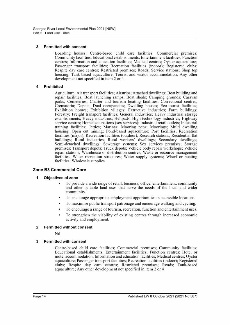
Zone B3 Commercial Core
1 Objectives of zone• To provide a wide range of retail, business, office, entertainment, community
and other suitable land uses that serve the needs of the local and widercommunity.
• To encourage appropriate employment opportunities in accessible locations.• To maximise public transport patronage and encourage walking and cycling.• To encourage a range of tourism, recreation, function and entertainment uses.• To strengthen the viability of existing centres through increased economic
activity and employment.
2 Permitted without consentNil
3 Permitted with consentCentre-based child care facilities; Commercial premises; Community facilities;Educational establishments; Entertainment facilities; Function centres; Hotel ormotel accommodation; Information and education facilities; Medical centres; Oysteraquaculture; Passenger transport facilities; Recreation facilities (indoor); Registeredclubs; Respite day care centres; Restricted premises; Roads; Tank-basedaquaculture; Any other development not specified in item 2 or 4
Page 14 Published LW 8 October 2021 (2021 No 587)
Georges River Local Environmental Plan 2021 [NSW]Part 2 Land Use Table
4 ProhibitedAgriculture; Air transport facilities; Airstrips; Animal boarding or trainingestablishments; Backpackers’ accommodation; Bed and breakfast accommodation;Boat building and repair facilities; Boat launching ramps; Boat sheds; Campinggrounds; Caravan parks; Cemeteries; Charter and tourism boating facilities;Correctional centres; Crematoria; Depots; Eco-tourist facilities; Exhibition homes;Exhibition villages; Extractive industries; Farm buildings; Farm stayaccommodation; Forestry; Freight transport facilities; General industries; Heavyindustrial storage establishments; Heavy industries; Helipads; Highway servicecentres; Home-based child care; Home businesses; Home industries; Homeoccupations; Home occupations (sex services); Industrial retail outlets; Industrialtraining facilities; Jetties; Marinas; Mooring pens; Moorings; Open cut mining;Pond-based aquaculture; Port facilities; Recreation facilities (major); Recreationfacilities (outdoor); Research stations; Residential accommodation; Rural industries;Serviced apartments; Sewerage systems; Sex services premises; Storage premises;Transport depots; Truck depots; Vehicle body repair workshops; Vehicle repairstations; Veterinary hospitals; Warehouse or distribution centres; Waste or resourcemanagement facilities; Water recreation structures; Water supply systems; Wharf orboating facilities; Wholesale supplies
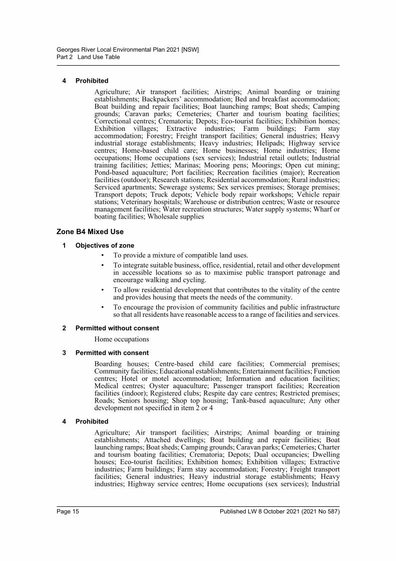
Zone B4 Mixed Use
1 Objectives of zone• To provide a mixture of compatible land uses.• To integrate suitable business, office, residential, retail and other development
in accessible locations so as to maximise public transport patronage andencourage walking and cycling.
• To allow residential development that contributes to the vitality of the centreand provides housing that meets the needs of the community.
• To encourage the provision of community facilities and public infrastructureso that all residents have reasonable access to a range of facilities and services.
2 Permitted without consentHome occupations
3 Permitted with consentBoarding houses; Centre-based child care facilities; Commercial premises;Community facilities; Educational establishments; Entertainment facilities; Functioncentres; Hotel or motel accommodation; Information and education facilities;Medical centres; Oyster aquaculture; Passenger transport facilities; Recreationfacilities (indoor); Registered clubs; Respite day care centres; Restricted premises;Roads; Seniors housing; Shop top housing; Tank-based aquaculture; Any otherdevelopment not specified in item 2 or 4
4 ProhibitedAgriculture; Air transport facilities; Airstrips; Animal boarding or trainingestablishments; Attached dwellings; Boat building and repair facilities; Boatlaunching ramps; Boat sheds; Camping grounds; Caravan parks; Cemeteries; Charterand tourism boating facilities; Crematoria; Depots; Dual occupancies; Dwellinghouses; Eco-tourist facilities; Exhibition homes; Exhibition villages; Extractiveindustries; Farm buildings; Farm stay accommodation; Forestry; Freight transportfacilities; General industries; Heavy industrial storage establishments; Heavyindustries; Highway service centres; Home occupations (sex services); Industrial
Page 15 Published LW 8 October 2021 (2021 No 587)
Georges River Local Environmental Plan 2021 [NSW]Part 2 Land Use Table
retail outlets; Industrial training facilities; Jetties; Marinas; Mooring pens; Moorings;Multi dwelling housing; Open cut mining; Pond-based aquaculture; Port facilities;Recreation facilities (major); Recreation facilities (outdoor); Research stations;Residential flat buildings; Rural industries; Rural workers’ dwellings; Secondarydwellings; Semi-detached dwellings; Sewerage systems; Sex services premises;Transport depots; Truck depots; Vehicle body repair workshops; Warehouse ordistribution centres; Waste or resource management facilities; Water recreationstructures; Water supply systems; Wharf or boating facilities; Wholesale supplies
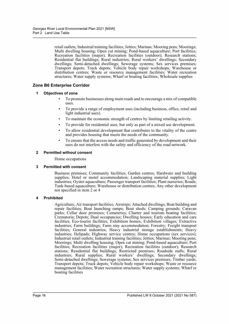
Zone B6 Enterprise Corridor
1 Objectives of zone• To promote businesses along main roads and to encourage a mix of compatible
uses.• To provide a range of employment uses (including business, office, retail and
light industrial uses).• To maintain the economic strength of centres by limiting retailing activity.• To provide for residential uses, but only as part of a mixed use development.• To allow residential development that contributes to the vitality of the centre
and provides housing that meets the needs of the community.• To ensure that the access needs and traffic generated by development and their
uses do not interfere with the safety and efficiency of the road network.
2 Permitted without consentHome occupations
3 Permitted with consentBusiness premises; Community facilities; Garden centres; Hardware and buildingsupplies; Hotel or motel accommodation; Landscaping material supplies; Lightindustries; Oyster aquaculture; Passenger transport facilities; Plant nurseries; Roads;Tank-based aquaculture; Warehouse or distribution centres; Any other developmentnot specified in item 2 or 4
4 ProhibitedAgriculture; Air transport facilities; Airstrips; Attached dwellings; Boat building andrepair facilities; Boat launching ramps; Boat sheds; Camping grounds; Caravanparks; Cellar door premises; Cemeteries; Charter and tourism boating facilities;Crematoria; Depots; Dual occupancies; Dwelling houses; Early education and carefacilities; Eco-tourist facilities; Exhibition homes; Exhibition villages; Extractiveindustries; Farm buildings; Farm stay accommodation; Forestry; Freight transportfacilities; General industries; Heavy industrial storage establishments; Heavyindustries; Helipads; Highway service centres; Home occupations (sex services);Industrial retail outlets; Industrial training facilities; Jetties; Marinas; Mooring pens;Moorings; Multi dwelling housing; Open cut mining; Pond-based aquaculture; Portfacilities; Recreation facilities (major); Recreation facilities (outdoor); Researchstations; Residential flat buildings; Restricted premises; Roadside stalls; Ruralindustries; Rural supplies; Rural workers’ dwellings; Secondary dwellings;Semi-detached dwellings; Sewerage systems; Sex services premises; Timber yards;Transport depots; Truck depots; Vehicle body repair workshops; Waste or resourcemanagement facilities; Water recreation structures; Water supply systems; Wharf orboating facilities
Page 16 Published LW 8 October 2021 (2021 No 587)
Georges River Local Environmental Plan 2021 [NSW]Part 2 Land Use Table
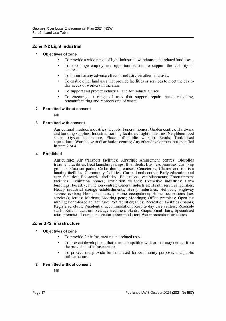
Zone IN2 Light Industrial
1 Objectives of zone• To provide a wide range of light industrial, warehouse and related land uses.• To encourage employment opportunities and to support the viability of
centres.• To minimise any adverse effect of industry on other land uses.• To enable other land uses that provide facilities or services to meet the day to
day needs of workers in the area.• To support and protect industrial land for industrial uses.• To encourage a range of uses that support repair, reuse, recycling,
remanufacturing and reprocessing of waste.
2 Permitted without consentNil
3 Permitted with consentAgricultural produce industries; Depots; Funeral homes; Garden centres; Hardwareand building supplies; Industrial training facilities; Light industries; Neighbourhoodshops; Oyster aquaculture; Places of public worship; Roads; Tank-basedaquaculture; Warehouse or distribution centres; Any other development not specifiedin item 2 or 4
4 ProhibitedAgriculture; Air transport facilities; Airstrips; Amusement centres; Biosolidstreatment facilities; Boat launching ramps; Boat sheds; Business premises; Campinggrounds; Caravan parks; Cellar door premises; Cemeteries; Charter and tourismboating facilities; Community facilities; Correctional centres; Early education andcare facilities; Eco-tourist facilities; Educational establishments; Entertainmentfacilities; Exhibition homes; Exhibition villages; Extractive industries; Farmbuildings; Forestry; Function centres; General industries; Health services facilities;Heavy industrial storage establishments; Heavy industries; Helipads; Highwayservice centres; Home businesses; Home occupations; Home occupations (sexservices); Jetties; Marinas; Mooring pens; Moorings; Office premises; Open cutmining; Pond-based aquaculture; Port facilities; Pubs; Recreation facilities (major);Registered clubs; Residential accommodation; Respite day care centres; Roadsidestalls; Rural industries; Sewage treatment plants; Shops; Small bars; Specialisedretail premises; Tourist and visitor accommodation; Water recreation structures
Zone SP2 Infrastructure
1 Objectives of zone• To provide for infrastructure and related uses.• To prevent development that is not compatible with or that may detract from
the provision of infrastructure.• To protect and provide for land used for community purposes and public
infrastructure.
2 Permitted without consentNil
Page 17 Published LW 8 October 2021 (2021 No 587)
Georges River Local Environmental Plan 2021 [NSW]Part 2 Land Use Table
3 Permitted with consentAquaculture; Car parks; Community facilities; Markets; Public administrationbuildings; Recreation areas; Respite day care centres; Roads; Signage; The purposeshown on the Land Zoning Map, including any development that is ordinarilyincidental or ancillary to development for that purpose
4 ProhibitedAny development not specified in item 2 or 3
Zone RE1 Public Recreation
1 Objectives of zone• To enable land to be used for public open space or recreational purposes.• To provide a range of recreational settings and activities and compatible land
uses.• To protect and enhance the natural environment for recreational purposes.
2 Permitted without consentEnvironmental facilities; Environmental protection works
3 Permitted with consentAquaculture; Boat launching ramps; Centre-based child care facilities; Emergencyservices facilities; Information and education facilities; Jetties; Kiosks; Markets;Recreation areas; Recreation facilities (indoor); Recreation facilities (major);Recreation facilities (outdoor); Respite day care centres; Restaurants or cafes; Roads;Signage; Take away food and drink premises; Water recreation structures; Waterstorage facilities
4 ProhibitedAny development not specified in item 2 or 3
Zone RE2 Private Recreation
1 Objectives of zone• To enable land to be used for private open space or recreational purposes.• To provide a range of recreational settings and activities and compatible land
uses.• To protect and enhance the natural environment for recreational purposes.• To ensure the scale, density and form of development reflects the nature of the
recreational use of the land and is compatible with the surrounding urban formand natural setting.
2 Permitted without consentNil
3 Permitted with consentAquaculture; Bee keeping; Building identification signs; Business identificationsigns; Community facilities; Entertainment facilities; Environmental facilities;Environmental protection works; Information and education facilities; Kiosks;Recreation areas; Recreation facilities (indoor); Recreation facilities (outdoor);Registered clubs; Restaurants or cafes; Roads; Water recreation structures
Page 18 Published LW 8 October 2021 (2021 No 587)
Georges River Local Environmental Plan 2021 [NSW]Part 2 Land Use Table
4 ProhibitedAny development not specified in item 2 or 3
Zone E1 National Parks and Nature Reserves
1 Objectives of zone• To enable the management and appropriate use of land that is reserved under
the National Parks and Wildlife Act 1974 or that is acquired under Part 11 ofthat Act.
• To enable uses authorised under the National Parks and Wildlife Act 1974.• To identify land that is to be reserved under the National Parks and Wildlife
Act 1974 and to protect the environmental significance of that land.
2 Permitted without consentUses authorised under the National Parks and Wildlife Act 1974
3 Permitted with consentNil
4 ProhibitedAny development not specified in item 2 or 3
Zone E2 Environmental Conservation
1 Objectives of zone• To protect, manage and restore areas of high ecological, scientific, cultural or
aesthetic values.• To prevent development that could destroy, damage or otherwise have an
adverse effect on those values.
2 Permitted without consentEnvironmental protection works
3 Permitted with consentEnvironmental facilities; Information and education facilities; Jetties; Oysteraquaculture; Roads
4 ProhibitedBusiness premises; Hotel or motel accommodation; Industries; Multi dwellinghousing; Pond-based aquaculture; Recreation facilities (major); Residential flatbuildings; Restricted premises; Retail premises; Seniors housing; Service stations;Tank-based aquaculture; Warehouse or distribution centres; Any other developmentnot specified in item 2 or 3
Zone W2 Recreational Waterways
1 Objectives of zone• To protect the ecological, scenic and recreation values of recreational
waterways.• To allow for water-based recreation and related uses.• To provide for sustainable fishing industries and recreational fishing.
Page 19 Published LW 8 October 2021 (2021 No 587)
Georges River Local Environmental Plan 2021 [NSW]Part 2 Land Use Table
2 Permitted without consentNil
3 Permitted with consentAquaculture; Boat launching ramps; Boat sheds; Building identification signs;Business identification signs; Environmental facilities; Environmental protectionworks; Jetties; Kiosks; Marinas; Mooring pens; Moorings; Roads; Water recreationstructures
4 ProhibitedIndustries; Multi dwelling housing; Residential flat buildings; Seniors housing;Warehouse or distribution centres; Any other development not specified in item 2 or3
Page 20 Published LW 8 October 2021 (2021 No 587)
Georges River Local Environmental Plan 2021 [NSW]Part 3 Exempt and complying development
Part 3 Exempt and complying development3.1 Exempt development
(1) The objective of this clause is to identify development of minimal environmentalimpact as exempt development.
(2) Development specified in Schedule 2 that meets the standards for the developmentcontained in that Schedule and that complies with the requirements of this Part isexempt development.
(3) To be exempt development, the development—(a) must meet the relevant deemed-to-satisfy provisions of the Building Code of
Australia or, if there are no such relevant provisions, must be structurallyadequate, and
(b) must not, if it relates to an existing building, cause the building to contravenethe Building Code of Australia, and
(c) must not be designated development, and(d) must not be carried out on land that comprises, or on which there is, an item
that is listed on the State Heritage Register under the Heritage Act 1977 or thatis subject to an interim heritage order under the Heritage Act 1977.
(e) (Repealed)(4) Development that relates to an existing building that is classified under the Building
Code of Australia as class 1b or class 2–9 is exempt development only if—(a) the building has a current fire safety certificate or fire safety statement, or(b) no fire safety measures are currently implemented, required or proposed for
the building.(5) To be exempt development, the development must—
(a) be installed in accordance with the manufacturer’s specifications, ifapplicable, and
(b) not involve the removal, pruning or other clearing of vegetation that requiresa permit, development consent or other approval unless it is undertaken inaccordance with a permit, development consent or other approval.
Note. See State Environmental Planning Policy (Vegetation in Non-Rural Areas) 2017 andPart 5A of the Local Land Services Act 2013.
(6) A heading to an item in Schedule 2 is part of that Schedule.
3.2 Complying development(1) The objective of this clause is to identify development as complying development.(2) Development specified in Part 1 of Schedule 3 that is carried out in compliance
with—(a) the development standards specified in relation to that development, and(b) the requirements of this Part,is complying development.Note. See also clause 5.8(3) which provides that the conversion of fire alarms is complyingdevelopment in certain circumstances.
(3) To be complying development, the development must—(a) be permissible, with development consent, in the zone in which it is carried
out, and
Page 21 Published LW 8 October 2021 (2021 No 587)
Georges River Local Environmental Plan 2021 [NSW]Part 3 Exempt and complying development
(b) meet the relevant deemed-to-satisfy provisions of the Building Code ofAustralia, and
(c) have an approval, if required by the Local Government Act 1993, from theCouncil for an on-site effluent disposal system if the development isundertaken on unsewered land.
(4) A complying development certificate for development specified in Part 1 ofSchedule 3 is subject to the conditions (if any) set out or referred to in Part 2 of thatSchedule.
(5) A heading to an item in Schedule 3 is part of that Schedule.
3.3 Environmentally sensitive areas excluded(1) Exempt or complying development must not be carried out on any environmentally
sensitive area for exempt or complying development.(2) For the purposes of this clause—
environmentally sensitive area for exempt or complying development means any ofthe following—(a) the coastal waters of the State,(b) a coastal lake,(c) land within the coastal wetlands and littoral rainforests area (within the
meaning of the Coastal Management Act 2016),(d) land reserved as an aquatic reserve under the Fisheries .......Management Act
1994 or as a marine park under the Marine Parks Act 1997,(e) land within a wetland of international significance declared under the Ramsar
Convention on Wetlands or within a World heritage area declared under theWorld Heritage Convention,
(f) land within 100 metres of land to which paragraph (c), (d) or (e) applies,(g) land identified in this or any other environmental planning instrument as being
of high Aboriginal cultural significance or high biodiversity significance,(h) land reserved under the National Parks and Wildlife Act 1974 or land acquired
under Part 11 of that Act,(i) land reserved or dedicated under the Crown Land Management Act 2016 for
the preservation of flora, fauna, geological formations or for otherenvironmental protection purposes,
(j) land that is a declared area of outstanding biodiversity value under theBiodiversity Conservation Act 2016 or declared critical habitat under Part 7Aof the Fisheries Management Act 1994.
Page 22 Published LW 8 October 2021 (2021 No 587)
Georges River Local Environmental Plan 2021 [NSW]Part 4 Principal development standards
Part 4 Principal development standards4.1 Minimum subdivision lot size
(1) The objectives of this clause are as follows—(a) to ensure that lots created by a subdivision have sufficient area to
accommodate development on the lots that complies with relevantdevelopment standards and controls for the development,
(b) to ensure that subdivisions reflect and reinforce the predominant subdivisionpattern of the area,
(c) to ensure that the lot sizes are appropriate for the environmental capability ofthe land, having regard to the land’s topography and other natural features.
(2) This clause applies to a subdivision of any land shown on the Lot Size Map thatrequires development consent and that is carried out after the commencement of thisPlan.
(3) The size of any lot resulting from a subdivision of land to which this clause appliesis not to be less than the minimum size shown on the Lot Size Map in relation to thatland.
(3A) If a lot is a battle-axe lot or other lot with an access handle, the area of the accesshandle and any right of carriageway is not to be included in calculating the lot sizefor the purposes of subclause (3).
(4) This clause does not apply in relation to the subdivision of any land—(a) by the registration of a strata plan or strata plan of subdivision under the Strata
Schemes Development Act 2015, or(b) by any kind of subdivision under the Community Land Development Act 1989.
4.1AA Minimum subdivision lot size for community title schemes[Not adopted]
4.1A Minimum subdivision lot size for dual occupancies(1) The objective of this clause is to ensure that the lot sizes for dual occupancies are
appropriate for the environmental capability of the land, having regard to the land’stopography and other natural features.
(2) Despite clauses 4.1 and 4.1B, development consent may be granted for thesubdivision of land—(a) in Zone R2 Low Density Residential, Zone R3 Medium Density Residential or
Zone R4 High Density Residential if—(i) there is a dual occupancy on the land that was lawfully erected or a dual
occupancy is proposed on the land, and(ii) the lot size for each resulting lot will be at least 300 square metres, or
(b) in the Foreshore Scenic Protection Area as identified on the Foreshore ScenicProtection Area Map if—(i) there is a dual occupancy on the land that was lawfully erected or a dual
occupancy is proposed on the land, and(ii) the lot size for each resulting lot will be at least 430 square metres.
(3) If a lot is a battle-axe lot or other lot with an access handle, the area of the accesshandle and any right of carriageway is not to be included in calculating the lot size.
Page 23 Published LW 8 October 2021 (2021 No 587)
Georges River Local Environmental Plan 2021 [NSW]Part 4 Principal development standards
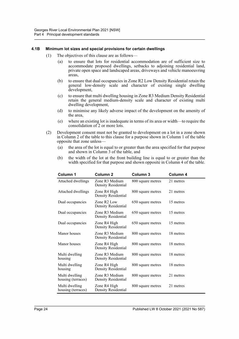
4.1B Minimum lot sizes and special provisions for certain dwellings(1) The objectives of this clause are as follows—
(a) to ensure that lots for residential accommodation are of sufficient size toaccommodate proposed dwellings, setbacks to adjoining residential land,private open space and landscaped areas, driveways and vehicle manoeuvringareas,
(b) to ensure that dual occupancies in Zone R2 Low Density Residential retain thegeneral low-density scale and character of existing single dwellingdevelopment,
(c) to ensure that multi dwelling housing in Zone R3 Medium Density Residentialretain the general medium-density scale and character of existing multidwelling development,
(d) to minimise any likely adverse impact of the development on the amenity ofthe area,
(e) where an existing lot is inadequate in terms of its area or width—to require theconsolidation of 2 or more lots.
(2) Development consent must not be granted to development on a lot in a zone shownin Column 2 of the table to this clause for a purpose shown in Column 1 of the tableopposite that zone unless—(a) the area of the lot is equal to or greater than the area specified for that purpose
and shown in Column 3 of the table, and(b) the width of the lot at the front building line is equal to or greater than the
width specified for that purpose and shown opposite in Column 4 of the table.
Column 1 Column 2 Column 3 Column 4Attached dwellings Zone R3 Medium
Density Residential800 square metres 21 metres
Attached dwellings Zone R4 High Density Residential
800 square metres 21 metres
Dual occupancies Zone R2 Low Density Residential
650 square metres 15 metres
Dual occupancies Zone R3 Medium Density Residential
650 square metres 15 metres
Dual occupancies Zone R4 High Density Residential
650 square metres 15 metres
Manor houses Zone R3 Medium Density Residential
800 square metres 18 metres
Manor houses Zone R4 High Density Residential
800 square metres 18 metres
Multi dwelling housing
Zone R3 Medium Density Residential
800 square metres 18 metres
Multi dwelling housing
Zone R4 High Density Residential
800 square metres 18 metres
Multi dwelling housing (terraces)
Zone R3 Medium Density Residential
800 square metres 21 metres
Multi dwelling housing (terraces)
Zone R4 High Density Residential
800 square metres 21 metres
Page 24 Published LW 8 October 2021 (2021 No 587)
Georges River Local Environmental Plan 2021 [NSW]Part 4 Principal development standards
(3) Development consent must not be granted for the erection of a dual occupancy in theForeshore Scenic Protection Area as identified on the Foreshore Scenic ProtectionArea Map unless the lot has an area of at least 1,000 square metres as shown on theLot Size for Dual Occupancy Map.
(4) Development consent must not be granted for the erection of a dual occupancy(attached) that provides for both dwellings facing a primary road unless the width ofthe lot at the front building line is at least 15 metres.
(5) Development consent must not be granted for the erection of a dual occupancy(detached) unless the width of the lot at the front building line is at least—(a) if only 1 dwelling faces the primary road—18 metres, or(b) otherwise—22 metres.
(6) If a lot is a battle-axe lot or other lot with an access handle, the area of the accesshandle and any right of carriageway is not to be included in calculating the lot size.
4.2 Rural subdivision[Not applicable]
4.3 Height of buildings(1) The objectives of this clause are as follows—
(a) to ensure that buildings are compatible with the height, bulk and scale of theexisting and desired future character of the locality,
(b) to minimise the impact of overshadowing, visual impact, disruption of viewsand loss of privacy on adjoining properties and open space areas,
(c) to ensure an appropriate height transition between new buildings and—(i) adjoining land uses, or
(ii) heritage items, heritage conservation areas or Aboriginal places ofheritage significance.
(2) The height of a building on any land is not to exceed the maximum height shown forthe land on the Height of Buildings Map.
4.3A Exceptions to height of buildings(1) The objectives of this clause are as follows—
(a) to provide for building heights that establish the appropriate height for streetfrontages, buildings or groups of buildings,
(b) to achieve well-proportioned buildings with articulated design and massing.(2) Despite clause 4.3—
(a) the maximum height of a dual occupancy on land in Zone R3 Medium DensityResidential or Zone R4 High Density Residential is 9 metres above groundlevel (existing), and
(b) the maximum height of a building that forms part of multi dwelling housing is5 metres above ground level (existing) if the building is adjacent to the rearboundary of the lot.
4.4 Floor space ratio(1) The objectives of this clause are as follows—
(a) to ensure that buildings are compatible with the bulk and scale of the existingand desired future character of the locality,
Page 25 Published LW 8 October 2021 (2021 No 587)
Georges River Local Environmental Plan 2021 [NSW]Part 4 Principal development standards
(b) to ensure that development provides appropriate built form transition betweennew buildings and—(i) adjoining land uses, or
(ii) heritage items, heritage conservation areas or Aboriginal places ofheritage significance,
(c) to control development density and intensity of land use, taking into account—(i) the environmental constraints and values of the site, including retaining
the scenic, visual, and landscape qualities of the area, and(ii) the amenity of adjoining land and the public domain, and
(iii) the availability of infrastructure to service the site, and(iv) the capacity of the road network to accommodate the vehicular and
pedestrian traffic that a development will generate.(2) The maximum floor space ratio for a building on any land is not to exceed the floor
space ratio shown for the land on the Floor Space Ratio Map.
4.4A Exceptions to floor space ratio—certain residential accommodation(1) The objectives of this clause are as follows—
(a) to ensure that the bulk and scale of development are compatible with the sizeof the lot,
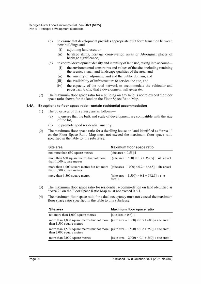
(b) to promote good residential amenity.(2) The maximum floor space ratio for a dwelling house on land identified as “Area 1”
on the Floor Space Ratio Map must not exceed the maximum floor space ratiospecified in the table to this subclause.
(3) The maximum floor space ratio for residential accommodation on land identified as“Area 2” on the Floor Space Ratio Map must not exceed 0.6:1.
(4) The maximum floor space ratio for a dual occupancy must not exceed the maximumfloor space ratio specified in the table to this subclause.
Site area Maximum floor space rationot more than 650 square metres [site area × 0.55]:1more than 650 square metres but not more than 1,000 square metres
[(site area 650) × 0.3 + 357.5] site area:1
more than 1,000 square metres but not more than 1,500 square metres
[(site area 1000) × 0.2 + 462.5] site area:1
more than 1,500 square metres [(site area 1,500) × 0.1 + 562.5] site area:1
Site area Maximum floor space rationot more than 1,000 square metres [site area × 0.6]:1more than 1,000 square metres but not more than 1,500 square metres
[(site area 1000) × 0.3 + 600] site area:1
more than 1,500 square metres but not more than 2,000 square metres
[(site area 1500) × 0.2 + 750] site area:1
more than 2,000 square metres [(site area 2000) × 0.1 + 850] site area:1
Page 26 Published LW 8 October 2021 (2021 No 587)
Georges River Local Environmental Plan 2021 [NSW]Part 4 Principal development standards
4.4B Exceptions to floor space ratio—non-residential uses(1) The objective of this clause is to encourage an appropriate mix of residential and
non-residential uses in order to ensure a suitable level of non-residential floor spaceis provided to promote employment and reflect the hierarchy of the business zones.
(2) This clause applies to development that is the erection of a new building oralterations or additions to an existing building.
(3) Development consent must not be granted for development on land in Zone B1Neighbourhood Centre, Zone B2 Local Centre or Zone B4 Mixed Use unless thenon-residential floor space ratio is at least 0.3:1.
(4) Development consent must not be granted for development on the following landidentified on the Floor Space Ratio Map unless the non-residential floor space ratiois—(a) for land identified as “Area 3”—at least 0.5:1,(b) for land identified as “Area 4”—at least 1:1.
(5) Development consent must not be granted for development on land identified as“Area 5” on the Floor Space Ratio Map unless the non-residential floor space ratio isat least 0.7:1.
(6) Despite clause 4.4, development consent may be granted for a building situated onland identified as “Area 6” on the Floor Space Ratio Map if the consent authority issatisfied that—(a) the gross floor area of the building will exceed the maximum gross floor area
that would otherwise be permitted under clause 4.4 by an amount of no morethan 7,023 square metres (the bonus floor allowance), and
(b) part of the building, with a floor area of not less than the bonus floorallowance, will be used for the purpose of hotel or motel accommodation.
(7) In this clause—non-residential floor space ratio means the ratio of the gross floor area of that partof a building used or proposed to be used for a purpose other than residentialaccommodation in a building on the site to the site area.
4.5 Calculation of floor space ratio and site area(1) Objectives
The objectives of this clause are as follows—(a) to define floor space ratio,(b) to set out rules for the calculation of the site area of development for the
purpose of applying permitted floor space ratios, including rules to—(i) prevent the inclusion in the site area of an area that has no significant
development being carried out on it, and(ii) prevent the inclusion in the site area of an area that has already been
included as part of a site area to maximise floor space area in anotherbuilding, and
(iii) require community land and public places to be dealt with separately.(2) Definition of “floor space ratio”
The floor space ratio of buildings on a site is the ratio of the gross floor area of allbuildings within the site to the site area.
Page 27 Published LW 8 October 2021 (2021 No 587)
Georges River Local Environmental Plan 2021 [NSW]Part 4 Principal development standards
(3) Site areaIn determining the site area of proposed development for the purpose of applying afloor space ratio, the site area is taken to be—(a) if the proposed development is to be carried out on only one lot, the area of
that lot, or(b) if the proposed development is to be carried out on 2 or more lots, the area of
any lot on which the development is proposed to be carried out that has at leastone common boundary with another lot on which the development is beingcarried out.
In addition, subclauses (4)–(7) apply to the calculation of site area for the purposesof applying a floor space ratio to proposed development.
(4) Exclusions from site areaThe following land must be excluded from the site area—(a) land on which the proposed development is prohibited, whether under this
Plan or any other law,(b) community land or a public place (except as provided by subclause (7)).
(5) Strata subdivisionsThe area of a lot that is wholly or partly on top of another or others in a stratasubdivision is to be included in the calculation of the site area only to the extent thatit does not overlap with another lot already included in the site area calculation.
(6) Only significant development to be includedThe site area for proposed development must not include a lot additional to a lot orlots on which the development is being carried out unless the proposed developmentincludes significant development on that additional lot.
(7) Certain public land to be separately consideredFor the purpose of applying a floor space ratio to any proposed development on,above or below community land or a public place, the site area must only include anarea that is on, above or below that community land or public place, and is occupiedor physically affected by the proposed development, and may not include any otherarea on which the proposed development is to be carried out.
(8) Existing buildingsThe gross floor area of any existing or proposed buildings within the verticalprojection (above or below ground) of the boundaries of a site is to be included in thecalculation of the total floor space for the purposes of applying a floor space ratio,whether or not the proposed development relates to all of the buildings.
(9) Covenants to prevent “double dipping”When development consent is granted to development on a site comprised of 2 ormore lots, a condition of the consent may require a covenant to be registered thatprevents the creation of floor area on a lot (the restricted lot) if the consent authorityis satisfied that an equivalent quantity of floor area will be created on another lot onlybecause the site included the restricted lot.
(10) Covenants affect consolidated sitesIf—(a) a covenant of the kind referred to in subclause (9) applies to any land (affected
land), and
Page 28 Published LW 8 October 2021 (2021 No 587)
Georges River Local Environmental Plan 2021 [NSW]Part 4 Principal development standards
(b) proposed development relates to the affected land and other land that togethercomprise the site of the proposed development,
the maximum amount of floor area allowed on the other land by the floor space ratiofixed for the site by this Plan is reduced by the quantity of floor space area thecovenant prevents being created on the affected land.
(11) DefinitionIn this clause, public place has the same meaning as it has in the Local GovernmentAct 1993.
4.6 Exceptions to development standards(1) The objectives of this clause are as follows—
(a) to provide an appropriate degree of flexibility in applying certain developmentstandards to particular development,
(b) to achieve better outcomes for and from development by allowing flexibilityin particular circumstances.
(2) Development consent may, subject to this clause, be granted for development eventhough the development would contravene a development standard imposed by thisor any other environmental planning instrument. However, this clause does not applyto a development standard that is expressly excluded from the operation of thisclause.
(3) Development consent must not be granted for development that contravenes adevelopment standard unless the consent authority has considered a written requestfrom the applicant that seeks to justify the contravention of the development standardby demonstrating—(a) that compliance with the development standard is unreasonable or
unnecessary in the circumstances of the case, and(b) that there are sufficient environmental planning grounds to justify
contravening the development standard.(4) Development consent must not be granted for development that contravenes a
development standard unless—(a) the consent authority is satisfied that—
(i) the applicant’s written request has adequately addressed the mattersrequired to be demonstrated by subclause (3), and
(ii) the proposed development will be in the public interest because it isconsistent with the objectives of the particular standard and theobjectives for development within the zone in which the development isproposed to be carried out, and
(b) the concurrence of the Planning Secretary has been obtained.(5) In deciding whether to grant concurrence, the Planning Secretary must consider—
(a) whether contravention of the development standard raises any matter ofsignificance for State or regional environmental planning, and
(b) the public benefit of maintaining the development standard, and(c) any other matters required to be taken into consideration by the Planning
Secretary before granting concurrence.(6) Development consent must not be granted under this clause for a subdivision of land
in Zone RU1 Primary Production, Zone RU2 Rural Landscape, Zone RU3 Forestry,Zone RU4 Primary Production Small Lots, Zone RU6 Transition, Zone R5 Large Lot
Page 29 Published LW 8 October 2021 (2021 No 587)
Georges River Local Environmental Plan 2021 [NSW]Part 4 Principal development standards
Residential, Zone E2 Environmental Conservation, Zone E3 EnvironmentalManagement or Zone E4 Environmental Living if—(a) the subdivision will result in 2 or more lots of less than the minimum area
specified for such lots by a development standard, or(b) the subdivision will result in at least one lot that is less than 90% of the
minimum area specified for such a lot by a development standard.(7) After determining a development application made pursuant to this clause, the
consent authority must keep a record of its assessment of the factors required to beaddressed in the applicant’s written request referred to in subclause (3).
(8) This clause does not allow development consent to be granted for development thatwould contravene any of the following—(a) a development standard for complying development,(b) a development standard that arises, under the regulations under the Act, in
connection with a commitment set out in a BASIX certificate for a building towhich State Environmental Planning Policy (Building Sustainability Index:BASIX) 2004 applies or for the land on which such a building is situated,
(c) clause 5.4,(d) clause 6.14.
Page 30 Published LW 8 October 2021 (2021 No 587)
Georges River Local Environmental Plan 2021 [NSW]Part 5 Miscellaneous provisions
Part 5 Miscellaneous provisions5.1 Relevant acquisition authority
(1) The objective of this clause is to identify, for the purposes of section 3.15 of the Act,the authority of the State that will be the relevant authority to acquire land reservedfor certain public purposes if the land is required to be acquired under Division 3 ofPart 2 of the Land Acquisition (Just Terms Compensation) Act 1991 (theowner-initiated acquisition provisions).Note. If the landholder will suffer hardship if there is any delay in the land being acquired bythe relevant authority, section 23 of the Land Acquisition (Just Terms Compensation) Act 1991requires the authority to acquire the land.
(2) The authority of the State that will be the relevant authority to acquire land, if the landis required to be acquired under the owner-initiated acquisition provisions, is theauthority of the State specified below in relation to the land shown on the LandReservation Acquisition Map (or, if an authority of the State is not specified inrelation to land required to be so acquired, the authority designated or determinedunder those provisions).
(3) Development on land acquired by an authority of the State under the owner-initiatedacquisition provisions may, before it is used for the purpose for which it is reserved,be carried out, with development consent, for any purpose.
5.2 Classification and reclassification of public land(1) The objective of this clause is to enable the Council to classify or reclassify public
land as “operational land” or “community land” in accordance with Part 2 of Chapter6 of the Local Government Act 1993.Note. Under the Local Government Act 1993, “public land” is generally land vested in or underthe control of a council (other than roads and certain Crown land). The classification orreclassification of public land may also be made by a resolution of the Council under section31, 32 or 33 of the Local Government Act 1993. Section 30 of that Act enables this Plan todischarge trusts on which public reserves are held if the land is reclassified under this Plan asoperational land.
(2) The public land described in Part 1 or Part 2 of Schedule 4 is classified, orreclassified, as operational land for the purposes of the Local Government Act 1993.
(3) The public land described in Part 3 of Schedule 4 is classified, or reclassified, ascommunity land for the purposes of the Local Government Act 1993.
(4) The public land described in Part 1 of Schedule 4—(a) does not cease to be a public reserve to the extent (if any) that it is a public
reserve, and
Type of land shown on Map Authority of the StateZone RE1 Public Recreation and marked “Local open space”
Council
Zone RE1 Public Recreation and marked “Regional open space”
The corporation constituted under section 2.5 of the Act
Zone B4 Mixed Use and marked “Local road widening”
Council
Zone SP2 Infrastructure and marked “Classified road”
Roads and Maritime Services
Zone E1 National Parks and Nature Reserves and marked “National Park”
Minister administering the National Parks and Wildlife Act 1974
Page 31 Published LW 8 October 2021 (2021 No 587)
Georges River Local Environmental Plan 2021 [NSW]Part 5 Miscellaneous provisions
(b) continues to be affected by any trusts, estates, interests, dedications,conditions, restrictions or covenants that affected the land before itsclassification, or reclassification, as operational land.
(5) The public land described in Part 2 of Schedule 4, to the extent (if any) that it is apublic reserve, ceases to be a public reserve when the description of the land isinserted into that Part and is discharged from all trusts, estates, interests, dedications,conditions, restrictions and covenants affecting the land or any part of the land,except—(a) those (if any) specified for the land in Column 3 of Part 2 of Schedule 4, and(b) any reservations that except land out of the Crown grant relating to the land,
and(c) reservations of minerals (within the meaning of the Crown Land Management
Act 2016).Note. In accordance with section 30(2) of the Local Government Act 1993, the approval of theGovernor to subclause (5) applying to the public land concerned is required before thedescription of the land is inserted in Part 2 of Schedule 4.
5.3 Development near zone boundaries[Not adopted]
5.4 Controls relating to miscellaneous permissible uses(1) Bed and breakfast accommodation
If development for the purposes of bed and breakfast accommodation is permittedunder this Plan, the accommodation that is provided to guests must consist of nomore than 3 bedrooms.Note. Any such development that provides for a certain number of guests or rooms mayinvolve a change in the class of building under the Building Code of Australia.
(2) Home businessesIf development for the purposes of a home business is permitted under this Plan, thecarrying on of the business must not involve the use of more than 30 square metresof floor area.
(3) Home industriesIf development for the purposes of a home industry is permitted under this Plan, thecarrying on of the home industry must not involve the use of more than 30 squaremetres of floor area.
(4) Industrial retail outletsIf development for the purposes of an industrial retail outlet is permitted under thisPlan, the retail floor area must not exceed—(a) 20% of the gross floor area of the industry or rural industry located on the same
land as the retail outlet, or(b) 400 square metres,whichever is the lesser.
(5) Farm stay accommodationIf development for the purposes of farm stay accommodation is permitted under thisPlan, the accommodation that is provided to guests must consist of no more than 3bedrooms.
Page 32 Published LW 8 October 2021 (2021 No 587)
Georges River Local Environmental Plan 2021 [NSW]Part 5 Miscellaneous provisions
(6) KiosksIf development for the purposes of a kiosk is permitted under this Plan, the grossfloor area must not exceed 15 square metres.
(7) Neighbourhood shopsIf development for the purposes of a neighbourhood shop is permitted under thisPlan, the retail floor area must not exceed 100 square metres.
(7AA) Neighbourhood supermarketsIf development for the purposes of a neighbourhood supermarket is permitted underthis Plan, the gross floor area must not exceed 1,000 square metres.
(8) Roadside stallsIf development for the purposes of a roadside stall is permitted under this Plan, thegross floor area must not exceed 8 square metres.
(9) Secondary dwellings on land other than land in a rural zoneIf development for the purposes of a secondary dwelling is permitted under this Planon land other than land in a rural zone, the total floor area of the dwelling, excludingany area used for parking, must not exceed whichever of the following is thegreater—(a) 60 square metres,(b) 10% of the total floor area of the principal dwelling.
(10) Artisan food and drink industry exclusionIf development for the purposes of an artisan food and drink industry is permittedunder this Plan in an industrial or rural zone, the floor area used for retail sales (notincluding any cafe or restaurant area) must not exceed—(a) 20% of the gross floor area of the industry, or(b) 400 square metres,whichever is the lesser.
5.5 Controls relating to secondary dwellings on land in a rural zone[Not adopted]
5.6 Architectural roof features[Not adopted]
5.7 Development below mean high water mark(1) The objective of this clause is to ensure appropriate environmental assessment for
development carried out on land covered by tidal waters.(2) Development consent is required to carry out development on any land below the
mean high water mark of any body of water subject to tidal influence (including thebed of any such water).
5.8 Conversion of fire alarms(1) This clause applies to a fire alarm system that can be monitored by Fire and Rescue
NSW or by a private service provider.(2) The following development may be carried out, but only with development
consent—
Page 33 Published LW 8 October 2021 (2021 No 587)
Georges River Local Environmental Plan 2021 [NSW]Part 5 Miscellaneous provisions
(a) converting a fire alarm system from connection with the alarm monitoringsystem of Fire and Rescue NSW to connection with the alarm monitoringsystem of a private service provider,
(b) converting a fire alarm system from connection with the alarm monitoringsystem of a private service provider to connection with the alarm monitoringsystem of another private service provider,
(c) converting a fire alarm system from connection with the alarm monitoringsystem of a private service provider to connection with a different alarmmonitoring system of the same private service provider.
(3) Development to which subclause (2) applies is complying development if it consistsonly of—(a) internal alterations to a building, or(b) internal alterations to a building together with the mounting of an antenna, and
any support structure, on an external wall or roof of a building so as to occupya space of not more than 450mm × 100mm × 100mm.
(4) A complying development certificate for any such complying development is subjectto a condition that any building work may only be carried out between 7.00 am and6.00 pm on Monday to Friday and between 7.00 am and 5.00 pm on Saturday, andmust not be carried out on a Sunday or a public holiday.
(5) In this clause—private service provider means a person or body that has entered into an agreementthat is in force with Fire and Rescue NSW to monitor fire alarm systems.
5.9 Dwelling house or secondary dwelling affected by natural disaster[Not adopted]
5.9AA (Repealed)
5.10 Heritage conservationNote. Heritage items (if any) are listed and described in Schedule 5. Heritage conservationareas (if any) are shown on the Heritage Map as well as being described in Schedule 5.
(1) ObjectivesThe objectives of this clause are as follows—(a) to conserve the environmental heritage of the Georges River local government
area,(b) to conserve the heritage significance of heritage items and heritage
conservation areas, including associated fabric, settings and views,(c) to conserve archaeological sites,(d) to conserve Aboriginal objects and Aboriginal places of heritage significance.
(2) Requirement for consentDevelopment consent is required for any of the following—(a) demolishing or moving any of the following or altering the exterior of any of
the following (including, in the case of a building, making changes to its detail,fabric, finish or appearance)—(i) a heritage item,
(ii) an Aboriginal object,(iii) a building, work, relic or tree within a heritage conservation area,
Page 34 Published LW 8 October 2021 (2021 No 587)
Georges River Local Environmental Plan 2021 [NSW]Part 5 Miscellaneous provisions
(b) altering a heritage item that is a building by making structural changes to itsinterior or by making changes to anything inside the item that is specified inSchedule 5 in relation to the item,
(c) disturbing or excavating an archaeological site while knowing, or havingreasonable cause to suspect, that the disturbance or excavation will or is likelyto result in a relic being discovered, exposed, moved, damaged or destroyed,
(d) disturbing or excavating an Aboriginal place of heritage significance,(e) erecting a building on land—
(i) on which a heritage item is located or that is within a heritageconservation area, or
(ii) on which an Aboriginal object is located or that is within an Aboriginalplace of heritage significance,
(f) subdividing land—(i) on which a heritage item is located or that is within a heritage
conservation area, or(ii) on which an Aboriginal object is located or that is within an Aboriginal
place of heritage significance.(3) When consent not required
However, development consent under this clause is not required if—(a) the applicant has notified the consent authority of the proposed development
and the consent authority has advised the applicant in writing before any workis carried out that it is satisfied that the proposed development—(i) is of a minor nature or is for the maintenance of the heritage item,
Aboriginal object, Aboriginal place of heritage significance orarchaeological site or a building, work, relic, tree or place within theheritage conservation area, and
(ii) would not adversely affect the heritage significance of the heritage item,Aboriginal object, Aboriginal place, archaeological site or heritageconservation area, or
(b) the development is in a cemetery or burial ground and the proposeddevelopment—(i) is the creation of a new grave or monument, or excavation or
disturbance of land for the purpose of conserving or repairingmonuments or grave markers, and
(ii) would not cause disturbance to human remains, relics, Aboriginalobjects in the form of grave goods, or to an Aboriginal place of heritagesignificance, or
(c) the development is limited to the removal of a tree or other vegetation that theCouncil is satisfied is a risk to human life or property, or
(d) the development is exempt development.(4) Effect of proposed development on heritage significance
The consent authority must, before granting consent under this clause in respect of aheritage item or heritage conservation area, consider the effect of the proposeddevelopment on the heritage significance of the item or area concerned. Thissubclause applies regardless of whether a heritage management document isprepared under subclause (5) or a heritage conservation management plan issubmitted under subclause (6).
Page 35 Published LW 8 October 2021 (2021 No 587)

Georges River Local Environmental Plan 2021 [NSW]Part 5 Miscellaneous provisions
(5) Heritage assessmentThe consent authority may, before granting consent to any development—(a) on land on which a heritage item is located, or(b) on land that is within a heritage conservation area, or(c) on land that is within the vicinity of land referred to in paragraph (a) or (b),require a heritage management document to be prepared that assesses the extent towhich the carrying out of the proposed development would affect the heritagesignificance of the heritage item or heritage conservation area concerned.
(6) Heritage conservation management plansThe consent authority may require, after considering the heritage significance of aheritage item and the extent of change proposed to it, the submission of a heritageconservation management plan before granting consent under this clause.
(7) Archaeological sitesThe consent authority must, before granting consent under this clause to the carryingout of development on an archaeological site (other than land listed on the StateHeritage Register or to which an interim heritage order under the Heritage Act 1977applies)—(a) notify the Heritage Council of its intention to grant consent, and(b) take into consideration any response received from the Heritage Council
within 28 days after the notice is sent.(8) Aboriginal places of heritage significance
The consent authority must, before granting consent under this clause to the carryingout of development in an Aboriginal place of heritage significance—(a) consider the effect of the proposed development on the heritage significance
of the place and any Aboriginal object known or reasonably likely to belocated at the place by means of an adequate investigation and assessment(which may involve consideration of a heritage impact statement), and
(b) notify the local Aboriginal communities, in writing or in such other manner asmay be appropriate, about the application and take into consideration anyresponse received within 28 days after the notice is sent.
(9) Demolition of nominated State heritage itemsThe consent authority must, before granting consent under this clause for thedemolition of a nominated State heritage item—(a) notify the Heritage Council about the application, and(b) take into consideration any response received from the Heritage Council
within 28 days after the notice is sent.(10) Conservation incentives
The consent authority may grant consent to development for any purpose of abuilding that is a heritage item or of the land on which such a building is erected, orfor any purpose on an Aboriginal place of heritage significance, even thoughdevelopment for that purpose would otherwise not be allowed by this Plan, if theconsent authority is satisfied that—(a) the conservation of the heritage item or Aboriginal place of heritage
significance is facilitated by the granting of consent, and(b) the proposed development is in accordance with a heritage management
document that has been approved by the consent authority, and
Page 36 Published LW 8 October 2021 (2021 No 587)

Georges River Local Environmental Plan 2021 [NSW]Part 5 Miscellaneous provisions
(c) the consent to the proposed development would require that all necessaryconservation work identified in the heritage management document is carriedout, and
(d) the proposed development would not adversely affect the heritage significanceof the heritage item, including its setting, or the heritage significance of theAboriginal place of heritage significance, and
(e) the proposed development would not have any significant adverse effect onthe amenity of the surrounding area.
5.11 Bush fire hazard reductionBush fire hazard reduction work authorised by the Rural Fires Act 1997 may becarried out on any land without development consent.Note. The Rural Fires Act 1997 also makes provision relating to the carrying out ofdevelopment on bush fire prone land.
5.12 Infrastructure development and use of existing buildings of the Crown(1) This Plan does not restrict or prohibit, or enable the restriction or prohibition of, the
carrying out of any development, by or on behalf of a public authority, that ispermitted to be carried out with or without development consent, or that is exemptdevelopment, under State Environmental Planning Policy (Infrastructure) 2007.
(2) This Plan does not restrict or prohibit, or enable the restriction or prohibition of, theuse of existing buildings of the Crown by the Crown.
5.13 Eco-tourist facilities[Not applicable]
5.14 Siding Spring Observatory—maintaining dark sky[Not adopted]
5.15 Defence communications facility[Not adopted]
5.16 Subdivision of, or dwellings on, land in certain rural, residential or environment protection zones
[Not adopted]
5.17 Artificial waterbodies in environmentally sensitive areas in areas of operation of irrigation corporations
[Not applicable]
5.18 Intensive livestock agriculture[Not applicable]
5.19 Pond-based, tank-based and oyster aquaculture(1) Objectives
The objectives of this clause are as follows—(a) to encourage sustainable oyster, pond-based and tank-based aquaculture in the
State, namely, aquaculture development that uses, conserves and enhances thecommunity’s resources so that the total quality of life now and in the futurecan be preserved and enhanced,
Page 37 Published LW 8 October 2021 (2021 No 587)
Georges River Local Environmental Plan 2021 [NSW]Part 5 Miscellaneous provisions
(b) to set out the minimum site location and operational requirements forpermissible pond-based and tank-based aquaculture development.
(2) Pond-based or tank-based aquaculture—matters of which consent authority must be satisfied before granting consentThe consent authority must not grant development consent to carry out developmentfor the purpose of pond-based aquaculture or tank-based aquaculture unless theconsent authority is satisfied of the following—(a) that the development complies with the site location and operational
requirements set out in Part 1 of Schedule 6 for the development,(b) in the case of—
(i) pond-based aquaculture or tank-based aquaculture in Zone R1 GeneralResidential, Zone R2 Low Density Residential or Zone R5 Large LotResidential—that the development is for the purpose of small scaleaquarium fish production, and
(ii) pond-based aquaculture in Zone E3 Environmental Management orZone E4 Environmental Living—that the development is for thepurpose of extensive aquaculture, and
(iii) tank-based aquaculture in Zone R3 Medium Density Residential, ZoneE3 Environmental Management or Zone E4 Environmental Living—that the development is for the purpose of small scale aquarium fishproduction, and
(iv) pond-based aquaculture or tank-based aquaculture in Zone W1 NaturalWaterways, Zone W2 Recreational Waterways or Zone W3 WorkingWaterways—that the development will use waterways to source water.
(3) The requirements set out in Part 1 of Schedule 6 are minimum requirements and donot limit the matters a consent authority is required to take into consideration underthe Act or the conditions that it may impose on any development consent.
(4) Extensive pond-based aquaculture permitted without consent in certain zonesDevelopment for the purpose of pond-based aquaculture, that is also extensiveaquaculture, may be carried out without development consent if—(a) the development is carried out in Zone RU1 Primary Production, Zone RU2
Rural Landscape, Zone RU3 Forestry, Zone RU4 Primary Production SmallLots or Zone RU6 Transition, and
(b) the development complies with the site location requirements and operationalrequirements set out in Part 2 of Schedule 6.
(5) Oyster aquaculture—additional matters that consent authority must consider in determining a development applicationIn determining a development application for development for the purpose of oysteraquaculture, the consent authority must consider—(a) any provisions of any aquaculture industry development plan that are relevant
to the subject of the development application, and(b) the NSW Oyster Industry Sustainable Aquaculture Strategy.
(6) Oyster aquaculture permitted without consent in priority oyster aquaculture areasDevelopment for the purpose of oyster aquaculture may be carried out withoutdevelopment consent—(a) on land that is wholly within a priority oyster aquaculture area, or(b) on land that is partly within and partly outside a priority oyster aquaculture
area, but only if the land outside the area is no more than 0.1 hectare in area.
Page 38 Published LW 8 October 2021 (2021 No 587)
Georges River Local Environmental Plan 2021 [NSW]Part 5 Miscellaneous provisions
(7) DefinitionsIn this clause—aquaculture industry development plan means an aquaculture industry developmentplan published under Part 6 of the Fisheries Management Act 1994.extensive aquaculture has the same meaning as in the Fisheries Management(Aquaculture) Regulation 2017.NSW Oyster Industry Sustainable Aquaculture Strategy means the third edition ofthe publication of that title, as published in 2016 by the Department of PrimaryIndustries (within the Department of Industry).priority oyster aquaculture area means an area identified as a priority oysteraquaculture area on a map referred to in Chapter 5.3 of the NSW Oyster IndustrySustainable Aquaculture Strategy, being a map a copy of which is held in the headoffice of the Department of Primary Industries (within the Department of Industry)and published on that Department’s website.
5.20 Standards that cannot be used to refuse consent—playing and performing music(1) The consent authority must not refuse consent to development in relation to licensed
premises on the following grounds—(a) the playing or performance of music, including the following—
(i) the genre of music played or performed, or(ii) whether the music played or performed is live or amplified, or
(iii) whether the music played or performed is original music, or(iv) the number of musicians or live entertainment acts playing or
performing, or(v) the type of instruments played,
(b) whether dancing occurs,(c) the presence or use of a dance floor or another area ordinarily used for dancing,(d) the direction in which a stage for players or performers faces,(e) the decorations to be used, including, for example, mirror balls, or lighting
used by players or performers.(2) The consent authority must not refuse consent to development in relation to licensed
premises on the grounds of noise caused by the playing or performance of music, ifthe consent authority is satisfied the noise may be managed and minimised to anacceptable level.
(3) In this clause—licensed premises has the same meaning as in the Liquor Act 2007.
5.21 Flood planning(1) The objectives of this clause are as follows—
(a) to minimise the flood risk to life and property associated with the use of land,(b) to allow development on land that is compatible with the flood function and
behaviour on the land, taking into account projected changes as a result ofclimate change,
(c) to avoid adverse or cumulative impacts on flood behaviour and theenvironment,
(d) to enable the safe occupation and efficient evacuation of people in the event ofa flood.
Page 39 Published LW 8 October 2021 (2021 No 587)
Georges River Local Environmental Plan 2021 [NSW]Part 5 Miscellaneous provisions
(2) Development consent must not be granted to development on land the consentauthority considers to be within the flood planning area unless the consent authorityis satisfied the development—(a) is compatible with the flood function and behaviour on the land, and(b) will not adversely affect flood behaviour in a way that results in detrimental
increases in the potential flood affectation of other development or properties,and
(c) will not adversely affect the safe occupation and efficient evacuation of peopleor exceed the capacity of existing evacuation routes for the surrounding areain the event of a flood, and
(d) incorporates appropriate measures to manage risk to life in the event of a flood,and
(e) will not adversely affect the environment or cause avoidable erosion, siltation,destruction of riparian vegetation or a reduction in the stability of river banksor watercourses.
(3) In deciding whether to grant development consent on land to which this clauseapplies, the consent authority must consider the following matters—(a) the impact of the development on projected changes to flood behaviour as a
result of climate change,(b) the intended design and scale of buildings resulting from the development,(c) whether the development incorporates measures to minimise the risk to life
and ensure the safe evacuation of people in the event of a flood,(d) the potential to modify, relocate or remove buildings resulting from
development if the surrounding area is impacted by flooding or coastalerosion.
(4) A word or expression used in this clause has the same meaning as it has in theConsidering Flooding in Land Use Planning Guideline unless it is otherwise definedin this clause.
(5) In this clause—Considering Flooding in Land Use Planning Guideline means the ConsideringFlooding in Land Use Planning Guideline published on the Department’s website on14 July 2021.flood planning area has the same meaning as it has in the Floodplain DevelopmentManual.Floodplain Development Manual means the Floodplain Development Manual(ISBN 0 7347 5476 0) published by the NSW Government in April 2005.
5.22 Special flood considerations[Not adopted]
Page 40 Published LW 8 October 2021 (2021 No 587)
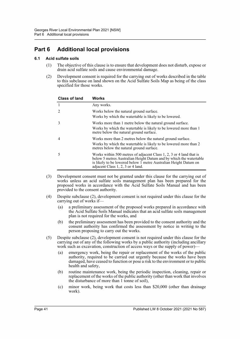
Georges River Local Environmental Plan 2021 [NSW]Part 6 Additional local provisions
Part 6 Additional local provisions6.1 Acid sulfate soils
(1) The objective of this clause is to ensure that development does not disturb, expose ordrain acid sulfate soils and cause environmental damage.
(2) Development consent is required for the carrying out of works described in the tableto this subclause on land shown on the Acid Sulfate Soils Map as being of the classspecified for those works.
(3) Development consent must not be granted under this clause for the carrying out ofworks unless an acid sulfate soils management plan has been prepared for theproposed works in accordance with the Acid Sulfate Soils Manual and has beenprovided to the consent authority.
(4) Despite subclause (2), development consent is not required under this clause for thecarrying out of works if—(a) a preliminary assessment of the proposed works prepared in accordance with
the Acid Sulfate Soils Manual indicates that an acid sulfate soils managementplan is not required for the works, and
(b) the preliminary assessment has been provided to the consent authority and theconsent authority has confirmed the assessment by notice in writing to theperson proposing to carry out the works.
(5) Despite subclause (2), development consent is not required under this clause for thecarrying out of any of the following works by a public authority (including ancillarywork such as excavation, construction of access ways or the supply of power)—(a) emergency work, being the repair or replacement of the works of the public
authority, required to be carried out urgently because the works have beendamaged, have ceased to function or pose a risk to the environment or to publichealth and safety,
(b) routine maintenance work, being the periodic inspection, cleaning, repair orreplacement of the works of the public authority (other than work that involvesthe disturbance of more than 1 tonne of soil),
(c) minor work, being work that costs less than $20,000 (other than drainagework).
Class of land Works1 Any works.2 Works below the natural ground surface.
Works by which the watertable is likely to be lowered.3 Works more than 1 metre below the natural ground surface.
Works by which the watertable is likely to be lowered more than 1 metre below the natural ground surface.
4 Works more than 2 metres below the natural ground surface.Works by which the watertable is likely to be lowered more than 2 metres below the natural ground surface.
5 Works within 500 metres of adjacent Class 1, 2, 3 or 4 land that is below 5 metres Australian Height Datum and by which the watertable is likely to be lowered below 1 metre Australian Height Datum on adjacent Class 1, 2, 3 or 4 land.
Page 41 Published LW 8 October 2021 (2021 No 587)
Georges River Local Environmental Plan 2021 [NSW]Part 6 Additional local provisions
(6) Despite subclause (2), development consent is not required under this clause to carryout any works if—(a) the works involve the disturbance of less than 1 tonne of soil, and(b) the works are not likely to lower the watertable.
6.2 Earthworks(1) The objective of this clause is to ensure that earthworks for which development
consent is required will not have a detrimental impact on environmental functionsand processes, neighbouring uses, cultural or heritage items or features of thesurrounding land.
(2) Development consent is required for earthworks unless—(a) the earthworks are exempt development under this Plan or another applicable
environmental planning instrument, or(b) the earthworks are ancillary to development that is permitted without consent
under this Plan or to development for which development consent has beengiven.
(3) In deciding whether to grant development consent, the consent authority mustconsider the following matters—(a) the likely disruption of, or any detrimental effect on, drainage patterns and soil
stability in the locality of the development,(b) the effect of the development on the likely future use or redevelopment of the
land,(c) the quality of the fill or the soil to be excavated, or both,(d) the effect of the development on the existing and likely amenity of adjoining
properties,(e) measures to minimise the need for cut and fill, particularly on sites with a slope
of 15% or greater, by stepping the development to accommodate the fall in theland,
(f) the source of any fill material and the destination of any excavated material,(g) the likelihood of disturbing relics,(h) the proximity to, and potential for adverse impacts on, any waterway, drinking
water catchment or environmentally sensitive area,(i) appropriate measures proposed to avoid, minimise or mitigate the impacts of
the development.Note. The National Parks and Wildlife Act 1974, particularly section 86, deals with harmingAboriginal objects.
6.3 Stormwater management(1) The objective of this clause is to minimise the impacts of urban stormwater on land
to which this Plan applies and on adjoining properties, native bushland and receivingwaters.
(2) In deciding whether to grant development consent for development, the consentauthority must be satisfied that the development—(a) is designed to maximise the use of water permeable surfaces on the land
having regard to the soil characteristics affecting on-site infiltration of water,and
Page 42 Published LW 8 October 2021 (2021 No 587)
Georges River Local Environmental Plan 2021 [NSW]Part 6 Additional local provisions
(b) includes, if practicable, on-site stormwater detention or retention to minimisestormwater runoff volumes and reduce the development’s reliance on mainswater, groundwater or river water, and
(c) avoids significant adverse impacts of stormwater runoff on adjoiningproperties, native bushland, receiving waters and the downstream stormwatersystem or, if the impact cannot be reasonably avoided, minimises andmitigates the impact, and
(d) is designed to minimise the impact on public drainage systems.
6.4 Foreshore area and coastal hazards and risk(1) The objectives of this clause are as follows—
(a) to protect people and property from unacceptable risk from coastal hazardsassociated with climate change,
(b) to ensure that development in the foreshore area will not impact on naturalforeshore processes or affect the amenity of the area,
(c) to facilitate opportunities for public access to and along the foreshore.(2) This clause applies to the following land—
(a) land identified on the Coastal Hazard and Risk Map,(b) land identified on the Foreshore Building Line Map.
(3) Development consent must not be granted for development on land to which thisclause applies except for the following purposes—(a) the alteration, or demolition and rebuilding, of an existing building if the
footprint of the building will not extend further forward than the footprint ofthe existing building into—(i) the foreshore building line, or
(ii) the land identified on the Coastal Hazard and Risk Map,(b) the erection of a building if the levels, depth or other exceptional features of
the site make it appropriate to do so,(c) boat sheds, cycling paths, fences, sea walls, swimming pools, water recreation
structures or walking tracks.(4) In deciding whether to grant development consent, the consent authority must
consider the following matters—(a) whether the development addresses the impacts of sea level rise and tidal
inundation as a result of climate change,(b) whether the development could be located on parts of the site not exposed to
coastal hazards,(c) whether the development will cause congestion or generate conflict between
people using open space areas or the waterway,(d) whether the development will cause environmental harm by pollution or
siltation of the waterway,(e) opportunities to provide reasonable, continuous public access along the
foreshore, considering the needs of property owners,(f) appropriate measures proposed to avoid, minimise or mitigate the impacts of
the development.(5) In this clause—
foreshore area means the land between the foreshore building line and the mean highwater mark of the nearest bay or river.
Page 43 Published LW 8 October 2021 (2021 No 587)

Georges River Local Environmental Plan 2021 [NSW]Part 6 Additional local provisions
foreshore building line means the line shown as the foreshore building line on theForeshore Building Line Map.
6.5 Riparian land and waterways(1) The objective of this clause is to protect and maintain the following—
(a) water quality within waterways,(b) the stability of the bed and banks of waterways,(c) aquatic and riparian species, communities, populations and their habitats,(d) ecological processes within waterways and riparian areas,(e) Aboriginal cultural heritage values of riparian land and waterways.
(2) This clause applies to land identified as “Sensitive land” on the Riparian Lands andWaterways Map.
(3) In deciding whether to grant development consent for development on land to whichthis clause applies, the consent authority must consider the following—(a) whether the development is likely to have an adverse impact on the
following—(i) the water quality and flows within the waterway,
(ii) the stability of the bed, shore and banks of the waterway,(iii) the future rehabilitation of the waterway and riparian areas,(iv) the biophysical, hydrological or ecological integrity of adjacent coastal
wetlands, including the aquatic and riparian species, habitats andecosystems of the waterway,
(v) indigenous trees and other vegetation,(vi) opportunities for additional planting of local native riparian vegetation,
(b) whether the development is likely to increase water extraction from thewaterway,
(c) whether the development will cause environmental harm by pollution orsiltation of the waterway,
(d) appropriate measures proposed to avoid, minimise or mitigate the impacts ofthe development.
(4) Development consent must not be granted to development on land to which thisclause applies unless the consent authority is satisfied that—(a) the development is designed, sited and will be managed to avoid significant
adverse environmental impact, or(b) if that impact cannot be reasonably avoided—the development is designed,
sited and will be managed to minimise that impact, or(c) if that impact cannot be minimised—the development will be managed to
mitigate that impact.
6.6 Foreshore scenic protection area(1) The objectives of this clause are—
(a) to protect, maintain and improve the scenic amenity of the Georges Riverforeshore,
(b) to protect, maintain and improve significant views of and from the GeorgesRiver,
(c) to protect, maintain and improve the diversity and condition of nativevegetation and habitats,
Page 44 Published LW 8 October 2021 (2021 No 587)
Georges River Local Environmental Plan 2021 [NSW]Part 6 Additional local provisions
(d) to reinforce and improve the dominance of landscape over built form, hardsurfaces and cut and fill,
(e) to encourage the recovery of threatened species and their communities,populations and habitats,
(f) to enhance existing environmental, cultural and built character values of theforeshore.
(2) This clause applies to land identified as “Foreshore scenic protection area” on theForeshore Scenic Protection Area Map.
(3) In deciding whether to grant development consent for development on land to whichthis clause applies, the consent authority must be satisfied that the developmentwould facilitate the following—(a) the protection of the natural environment, including topography, rock
formations, canopy vegetation or other significant vegetation,(b) the avoidance or minimisation of the disturbance and adverse impacts on
remnant vegetation communities, habitat and threatened species andpopulations,
(c) the maintenance and enhancement of native vegetation and habitat in parcelsof a size, condition and configuration that will facilitate biodiversity protectionand native flora and fauna movement through biodiversity corridors,
(d) the achievement of no net loss of significant vegetation or habitat,(e) the avoidance of clearing steep slopes and facilitation of the stability of the
land,(f) the minimisation of the impact on the views and visual environment, including
views to and from the Georges River, foreshore reserves, residential areas andpublic places,
(g) the minimisation of the height and bulk of the development by stepping thedevelopment to accommodate the fall in the land.
6.7 Airspace operations(1) The objectives of this clause are—
(a) to provide for the effective and ongoing operation of the Sydney (KingsfordSmith) Airport by ensuring that its operation is not compromised bydevelopment that penetrates the Limitations or Operations Surface for thatairport, and
(b) to protect the community from undue risk from that operation.(2) Development consent must not be granted to development to which this clause
applies unless—(a) the consent authority has consulted the relevant Commonwealth body, and(b) the relevant Commonwealth body advises the consent authority that—
(i) the development will penetrate the Limitations or Operations Surfacebut it does not object to the development, or
(ii) the development will not penetrate the Limitations or OperationsSurface.
(3) Development consent must not be granted to development to which this clauseapplies if the relevant Commonwealth body advises that the development willpenetrate the Limitation or Operations Surface and should not be carried out.
(4) In this clause—
Page 45 Published LW 8 October 2021 (2021 No 587)
Georges River Local Environmental Plan 2021 [NSW]Part 6 Additional local provisions
Limitation or Operations Surface means the Obstacle Limitation Surface or theProcedures for Air Navigation Services Operations Surface as shown on the ObstacleLimitation Surface Map or the Procedures for Air Navigation Services OperationsSurface Map for the Sydney (Kingsford Smith) Airport.relevant Commonwealth body means the body, under Commonwealth legislation,that is responsible for development approvals for development that penetrates theLimitation or Operations Surface for the Sydney (Kingsford Smith) Airport.
6.8 Development in areas subject to aircraft noise(1) The objectives of this clause are as follows—
(a) to prevent certain noise sensitive developments from being located near theSydney (Kingsford Smith) Airport and its flight paths,
(b) to assist in minimising the impact of aircraft noise from that airport and itsflight paths by requiring appropriate noise attenuation measures in noisesensitive buildings,
(c) to ensure that land use and development in the vicinity of that airport do nothinder or have any other adverse impacts on the ongoing, safe and efficientoperation of that airport.
(2) This clause applies to development that—(a) is on land that is near the Kingsford Smith Airport and in an ANEF contour of
20 or greater, and(b) the consent authority considers is likely to be adversely affected by aircraft
noise, and(c) involves any one or more of the following—
(i) the erection of a new building,(ii) a substantial alteration or addition to an existing building,
(iii) an alteration or addition to a building that is required by a developmentconsent to be compliant with AS 2021—2015,
(iv) the change of use of any part of a building to a centre-based child carefacility, educational establishment, entertainment facility, healthservices facility, place of public worship, public administration buildingor residential accommodation,
(v) the change of use of any part of a building on land that is in an ANEFcontour of 25 or greater to business premises, a hostel, office premises,retail premises or tourist and visitor accommodation,
(vi) the change of use of any part of a building on land that is in an ANEFcontour of 30 or greater to light industry.
(3) In deciding whether to grant development consent to development to which thisclause applies, the consent authority—(a) must consider whether the development will result in the creation of a new
dwelling or an increase in the number of dwellings or people affected byaircraft noise, and
(b) must consider the location of the development in relation to the criteria set outin Table 2.1 (Building Site Acceptability Based on ANEF Zones) in AS2021—2015, and
(c) must be satisfied the development will meet the indoor design sound levelsshown in Table 3.3 (Indoor Design Sound Levels for Determination ofAircraft Noise Reduction) in AS 2021—2015.
(4) In this clause—
Page 46 Published LW 8 October 2021 (2021 No 587)

Georges River Local Environmental Plan 2021 [NSW]Part 6 Additional local provisions
ANEF contour means a noise exposure contour shown as an ANEF contour on theNoise Exposure Forecast Contour Map for the Kingsford Smith Airport prepared bythe Department of the Commonwealth responsible for airports.AS 2021—2015 means AS 2021—2015, Acoustics—Aircraft noise intrusion—Building siting and construction.
6.9 Essential servicesDevelopment consent must not be granted to development unless the consentauthority is satisfied that any of the following services that are essential for thedevelopment are available or that adequate arrangements have been made to makethem available when required—(a) the supply of water,(b) the supply of electricity,(c) the supply of telecommunications facilities,(d) the disposal and management of sewage,(e) stormwater drainage or on-site conservation,(f) suitable vehicular access.
6.10 Design excellence(1) The objective of this clause is to deliver the highest standard of sustainable
architecture and urban design.(2) This clause applies to development on land referred to in subclause (3) involving—
(a) the erection of a new building, or(b) additions or external alterations to an existing building that, in the opinion of
the consent authority, are significant.(3) This clause applies to development on the following land—
(a) land identified on the Foreshore Scenic Protection Area Map if thedevelopment is for one or more of the following purposes—(i) bed and breakfast accommodation,
(ii) health services facilities,(iii) marinas,(iv) residential accommodation, except for secondary dwellings,
(b) land in the following zones if the building concerned is 3 or more storeys orhas a height of 12 metres or greater above ground level (existing), or both, notincluding levels below ground level (existing) or levels that are less than 1.2metres above ground level (existing) that provide for car parking—(i) Zone R4 High Density Residential,
(ii) Zone B1 Neighbourhood Centre,(iii) Zone B2 Local Centre,(iv) Zone B3 Commercial Core,(v) Zone B4 Mixed Use,
(vi) Zone B6 Enterprise Corridor,(vii) Zone IN2 Light Industrial.
(4) Development consent must not be granted for development to which this clauseapplies unless the consent authority considers that the development exhibits designexcellence.
Page 47 Published LW 8 October 2021 (2021 No 587)
Georges River Local Environmental Plan 2021 [NSW]Part 6 Additional local provisions
(5) In considering whether the development exhibits design excellence, the consentauthority must have regard to the following matters—(a) whether a high standard of architectural design, materials and detailing
appropriate to the building type and location will be achieved,(b) whether the form and external appearance of the development will improve the
quality and amenity of the public domain,(c) whether the development detrimentally impacts on view corridors,(d) how the development addresses the following matters—
(i) the suitability of the land for development,(ii) existing and proposed uses and use mix,
(iii) heritage issues and streetscape constraints,(iv) the relationship of the development with other development (existing or
proposed) on the same site or on neighbouring sites in terms ofseparation, setbacks, amenity and urban form,
(v) bulk, massing and modulation of buildings,(vi) street frontage heights,
(vii) environmental impacts such as sustainable design, overshadowing andsolar access, visual and acoustic privacy, noise, wind and reflectivity,
(viii) pedestrian, cycle, vehicular and service access and circulationrequirements, including the permeability of pedestrian networks,
(ix) the impact on, and proposed improvements to, the public domain,(x) achieving appropriate interfaces at ground level between the building
and the public domain,(xi) excellence and integration of landscape design,
(xii) the provision of communal spaces and meeting places,(xiii) the provision of public art in the public domain,(xiv) the provision of on-site integrated waste and recycling infrastructure,(xv) the promotion of safety through the application of the principles of
crime prevention through environmental design.
6.11 Environmental sustainability(1) The objective of this clause is to ensure that development to which this clause applies
is consistent with principles of best practice environmentally sensitive design.(2) This clause applies to development—
(a) on land in the following zones—(i) Zone R4 High Density Residential,
(ii) Zone B1 Neighbourhood Centre,(iii) Zone B2 Local Centre,(iv) Zone B3 Commercial Core,(v) Zone B4 Mixed Use,
(vi) Zone B6 Enterprise Corridor,(vii) Zone IN2 Light Industrial, and
(b) that involves—(i) the erection of a new building, or
(ii) the change of use of an existing building, or
Page 48 Published LW 8 October 2021 (2021 No 587)
Georges River Local Environmental Plan 2021 [NSW]Part 6 Additional local provisions
(iii) alterations or additions to an existing building that, in the opinion of theconsent authority, are significant.
(3) Development consent must not be granted to development on land to which thisclause applies if the building is 1,500 square metres in gross floor area or greaterunless adequate consideration has been given to the following in the design of thebuilding—(a) water demand reduction, including water efficiency, water recycling and
minimisation of potable water usage,(b) energy demand reduction, including energy generation, use of renewable
energy and reduced reliance on mains power,(c) indoor environmental quality, including daylight provision, glare control,
cross ventilation and thermal comfort,(d) the minimisation of surfaces that absorb and retain heat and the use of surfaces
that reflect heat where possible,(e) a reduction in new materials consumption and use of sustainable materials,
including recycled content in concrete, sustainable timber and PVCminimisation,
(f) transport initiatives to reduce car dependence such as providing cyclefacilities, car share and small vehicle parking spaces.
6.12 Landscaped areas in certain residential and environment protection zones(1) The objectives of this clause are as follows—
(a) to ensure adequate opportunities exist for the retention or provision ofvegetation that contributes to biodiversity and enhances the tree canopy of theGeorges River local government area,
(b) to minimise urban run-off by maximising permeable areas on the sites ofdevelopment,
(c) to ensure that the visual impact of development is minimised by sufficient andappropriately located landscaping that complements the scale of buildings,
(d) to ensure that the use of surfaces that absorb and retain heat are minimised.(2) This clause applies to land in the following zones—
(a) Zone R2 Low Density Residential,(b) Zone R3 Medium Density Residential,(c) Zone R4 High Density Residential,(d) Zone E2 Environmental Conservation.
(3) Despite subclause (2), this clause does not apply to development referred to in StateEnvironmental Planning Policy No 65—Design Quality of Residential ApartmentDevelopment, clause 4.
(4) Development consent must not be granted to development on land to which theclause applies unless the consent authority is satisfied that the development—(a) allows for the establishment of appropriate plantings—
(i) that are of a scale and density commensurate with the height, bulk andscale of the buildings to which the development relates, and
(ii) that will maintain and enhance the streetscape and the desired futurecharacter of the locality, and
(b) maintains privacy between dwellings, and
Page 49 Published LW 8 October 2021 (2021 No 587)
Georges River Local Environmental Plan 2021 [NSW]Part 6 Additional local provisions
(c) does not adversely impact the health, condition and structure of existing trees,tree canopies and tree root systems on the land or adjacent land, and
(d) enables the establishment of indigenous vegetation and habitat for nativefauna, and
(e) integrates with the existing vegetation to protect existing trees and naturallandscape features such as rock outcrops, remnant bushland, habitats andnatural watercourses.
(5) Development consent must not be granted to development on land to which thisclause applies unless a percentage of the site area consists of landscaped areas that isat least—(a) for a dwelling house located on land outside the Foreshore Scenic Protection
Area—20% of the site area, or(b) for a dwelling house located on land within the Foreshore Scenic Protection
Area—25% of the site area, or(c) for a dual occupancy located on land outside the Foreshore Scenic Protection
Area—25% of the site area, or(d) for a dual occupancy located on land within the Foreshore Scenic Protection
Area—30% of the site area, or(e) for development in Zone R3 Medium Density Residential—20% of the site
area, or(f) for development in Zone R4 High Density Residential—10% of the site area,
or(g) for development in Zone E2 Environmental Conservation—70% of the site
area.(6) If a lot is a battle-axe lot or other lot with an access handle, the area of the access
handle and any right of carriageway is not to be included in calculating the site areafor the purposes of subclause (5).
(7) In this clause—Foreshore Scenic Protection Area means land shown on the Foreshore ScenicProtection Area Map.
6.13 Development in certain business zones(1) The objectives of this clause are as follows—
(a) to promote uses that attract pedestrian traffic along ground floor streetfrontages,
(b) to maintain existing, and encourage additional, non-residential uses alongground floor street frontages,
(c) to strengthen the viability of existing established centres,(d) to maintain opportunities for business and retail development that is suited to
high exposure locations.(2) This clause applies to land in the following zones—
(a) Zone B1 Neighbourhood Centre,(b) Zone B2 Local Centre,(c) Zone B4 Mixed Use,(d) Zone B6 Enterprise Corridor.
(3) Development consent must not be granted for development on land to which thisclause applies unless the consent authority is satisfied the development will not cause
Page 50 Published LW 8 October 2021 (2021 No 587)
Georges River Local Environmental Plan 2021 [NSW]Part 6 Additional local provisions
a part of the ground floor of a building that is facing a street to be used for thepurposes of residential accommodation or tourist and visitor accommodation.
(4) Subclause (3) does not apply to a part of a building that is used for the followingpurposes—(a) entrances and lobbies, including as part of a mixed use development,(b) access for fire services,(c) essential services.
(5) For development in Zone B6 Enterprise Corridor that is the erection of a newbuilding, or alterations or additions to an existing building, that has a gross floor areaon the ground floor greater than 500 square metres—development consent must notbe granted for the development unless the consent authority is satisfied that at least500 square metres of the gross floor area on the ground floor of the building will beused for both— (a) purposes other than residential accommodation or tourist and visitor
accommodation, and(b) uses specified in subclause (4).
(6) In this clause—essential services means the following—(a) the supply of water,(b) the supply of electricity,(c) the supply of telecommunications facilities,(d) the disposal and management of sewage,(e) stormwater drainage or on-site conservation,(f) suitable vehicular access.
6.14 Restaurants or cafes and take away food and drink premises in Zone IN2Development consent must not be granted to development for the purposes of arestaurant or cafe or take away food and drink premises on land in Zone IN2 LightIndustrial if the gross floor area of the restaurant or cafe or take away food and drinkpremises is more than—(a) 20% of the gross floor area of the industrial activity located on the same land
as the restaurant or café or take away food and drink premises, or(b) 200 square metres.
6.15 Location of sex services premises(1) The objective of this clause is to restrict the location of sex services premises.(2) Despite any other provision of this Plan, development consent must not be granted to
development for the purposes of sex services premises if the premises will be locatedon land that adjoins, or that is separated only by a local road from, land—(a) in Zone R2 Low Density Residential, Zone R3 Medium Density Residential,
Zone R4 High Density Residential, Zone RE1 Public Recreation or Zone E2Environmental Conservation, or
(b) used for the purposes of a centre-based child care facility, a communityfacility, a school, a place of public worship or a hospital, or
(c) used for residential purposes.(3) In deciding whether to grant development consent, the consent authority must
consider the following—
Page 51 Published LW 8 October 2021 (2021 No 587)
Georges River Local Environmental Plan 2021 [NSW]Part 6 Additional local provisions
(a) the impact of the proposed development, and the hours of operation of thepremises, on any place likely to be regularly frequented by children—(i) that adjoins the development, or
(ii) that can be viewed from the development, or(iii) from which a person can view the development,
(b) whether the proposed development will have an adverse impact on the amenityof the neighbourhood, taking into account—(i) the size of the development or the number of employees working at the
premises, and(ii) other sex services premises located in the neighbourhood having similar
hours of operation.
6.16 Development in areas of activity hazard risk(1) The objective of this clause is to minimise risk to life and property in the event of an
emergency arising near a high pressure gas pipeline.(2) This clause applies to development for one or more of the following purposes on land
identified as “High Pressure Gas Pipeline Risk Area” on the Activity Hazard RiskMap—(a) centre-based child care facilities,(b) early education and care facilities,(c) educational establishments,(d) health services facilities,(e) seniors housing.
(3) The consent authority must not determine a development application fordevelopment to which this clause applies, unless, in accordance with subclause (4),the consent authority has— (a) consulted the Planning Secretary on the application, and(b) taken into consideration the Planning Secretary’s submissions, if any.
(4) The consent authority must—(a) forward a copy of the application and the accompanying documents to the
Planning Secretary within 7 days of receiving the application, and(b) consider the Planning Secretary’s submissions within 28 days of forwarding
the documents.
Page 52 Published LW 8 October 2021 (2021 No 587)
Georges River Local Environmental Plan 2021 [NSW]Schedule 1 Additional permitted uses
Schedule 1 Additional permitted uses(Clause 2.5)
1 Use of certain land at 87A Jubilee Avenue, Beverley Park(1) This clause applies to land at 87A Jubilee Avenue, Beverley Park, being Lot 161, DP
19098.(2) Development for the purpose of a registered club is permitted with development
consent.
2 Use of certain land at 7 Holley Road, Beverly Hills(1) This clause applies to land at 7 Holley Road, Beverly Hills, being Lot 78, DP 16723.(2) Development for the purpose of a registered club is permitted with development
consent.
3 Use of certain land at 916–918 King Georges Road, Blakehurst(1) This clause applies to land at 916–918 King Georges Road, Blakehurst, being Lot 22,
DP 575236 and Lot 252, DP 1999.(2) Development for the purpose of a shop is permitted with development consent if the
floor space ratio of the buildings on the lot does not exceed 0.27:1.
4 Use of certain land at Princes Highway, Carlton(1) This clause applies to land at Jubilee Oval and Kogarah Park, Princes Highway,
Carlton, being Lot 7084, DP 93146, Lots A and B, DP 316338, Lots A and B, DP162265 and Lot 2, DP 170281.
(2) Development for the purpose of an entertainment facility is permitted withdevelopment consent.
5 Use of certain land at 84D Roberts Avenue, Mortdale(1) This clause applies to land at 84D Roberts Avenue, Mortdale, being Lot 21, DP
542051.(2) Development for the following purposes is permitted with development consent—
(a) retail premises,(b) centre-based child care facilities.
6 Use of certain land at 95 Mulga Road, Oatley(1) This clause applies to land at 95 Mulga Road, Oatley, being Lot 14, Section 11, DP
6368.(2) Development for the purpose of a vehicle repair station is permitted with
development consent.
7 Use of certain land at 764 Forest Road, Peakhurst(1) This clause applies to land at 764 Forest Road, Peakhurst, being Lot 8, DP 659072.(2) Development for the purpose of a function centre is permitted with development
consent.
8 Use of certain land at 12 and 14 Pindari Road, Peakhurst Heights(1) This clause applies to land at 12 and 14 Pindari Road, Peakhurst Heights, being Lots
58 and 59, DP 206906.
Page 53 Published LW 8 October 2021 (2021 No 587)

Georges River Local Environmental Plan 2021 [NSW]Schedule 1 Additional permitted uses
(2) Development for the following purposes is permitted with development consent—(a) office premises,(b) a restaurant or cafe.
9 Use of certain land for limited commercial and residential purposes(1) This clause applies to the following land—
(a) 30 Jubilee Avenue, Carlton, being Lot 1, DP 577628,(b) 32 Jubilee Avenue, Carlton, being Lot 2, DP 577628,(c) 55 Jubilee Avenue, Carlton, being Lot 5, DP 170245,(d) 115 Connells Point Road, Connells Point, being Lot E, DP 302306,(e) 40 Bellevue Parade, Hurstville, being Lot 43, Section 7, DP 2793,(f) 129 Laycock Road, Hurstville Grove, being Lot 1, DP 178839,(g) 13–15 Gray Street, Kogarah, being Lots 1 and 2, DP 770957,(h) 29–31 Rocky Point Road, Kogarah, being Lot 61, DP 6615,(i) 4A Wyee Street, Kogarah Bay, being Lot A, DP 383186,(j) 59 Rosa Street, Oatley, being Lot 1, DP 1080827,(k) 281 Rocky Point Road, Sans Souci, being Lots 1 and 2, SP 65139,(l) 283 Rocky Point Road, Sans Souci, being Lots 1 and 2, SP 67532,
(m) 393 Rocky Point Road, Sans Souci, being Lot E, DP 25589,(n) 395–399 Rocky Point Road, Sans Souci, being Lot D, DP 25589,(o) 401 and 403 Rocky Point Road, Sans Souci, being Lots B and C, DP 25589,(p) 64 Blakesley Road, South Hurstville, being Lot 8, Section 3, DP 5453,(q) 64 Blakesley Road, South Hurstville, being Lot 1, DP 947432,(r) 100 Connells Point Road, South Hurstville, being Lot 1, DP 103456,(s) 911 King Georges Road, South Hurstville, being Lot B, DP 324694.
(2) Development for the purposes of any of the following is permitted with developmentconsent—(a) business premises,(b) multi dwelling housing,(c) office premises,(d) residential flat buildings,(e) restaurants or cafes,(f) shops,(g) shop top housing.
(3) Development consent must not be granted under subclause (2) unless—(a) no more than 2 floors are used for the development permitted by subclause (2),
and(b) the maximum floor space used for the purpose of business premises, office
premises or shops is no more than 80m2 or the existing commercial and retailfloor space, whichever is greater.
10 Use of certain land for multi dwelling housing or dual occupancies (detached)(1) This clause applies to the following land—
Page 54 Published LW 8 October 2021 (2021 No 587)

Georges River Local Environmental Plan 2021 [NSW]Schedule 1 Additional permitted uses
(a) 124 Princes Highway, Beverley Park, being Lot 1, DP 814106,(b) 408 Princes Highway, Blakehurst, being Lot D, DP 362178,(c) 17 Planthurst Road, Carlton, being Lot 143, DP 2022,(d) 5 Denman Street, Hurstville, being Lot 12, DP 236321,(e) 15 Greenbank Street, Hurstville, being Lot 16, DP 662877,(f) 27 Hurstville Road, Hurstville, being Lot 31, DP 666112,(g) 11 Hamer Street, Kogarah Bay, being Lot B, DP 340038,(h) 40 Oatley Parade, Oatley, being Lot B, DP 363683,(i) 44 Oatley Parade, Oatley, being Lot B, DP 381842,(j) 54 Oatley Parade, Oatley, being Lot B, DP 382279,(k) 9 Belmont Avenue, Penshurst, being Lot 7, DP 11194,(l) 42 Dudley Street, Penshurst, being Lot 90, DP 5885,
(m) 721A and 721B King Georges Road, Penshurst, being Lot 32, DP 1010274and Lot 12, DP 881035,
(n) 24 Penshurst Avenue, Penshurst, being Lot 2, DP 320644.(2) Development for the purpose of dual occupancies (detached) is permitted with
development consent if the total site coverage of the proposed buildings does notexceed 30%.
(3) Development for the purpose of multi dwelling housing is permitted withdevelopment consent if—(a) the total site coverage of the proposed buildings does not exceed 30%, and(b) if a site has frontage to a classified road, the site frontage is at least 27m.
11 Use of certain land for a place of public worship(1) This clause applies to the following land—
(a) 117 and 121 Morgan Street, Beverly Hills, being Lots 25–27, DP 12807,(b) 438 King Georges Road, Beverly Hills, being Lot 22, DP 771989,(c) 82 Ponyara Road, Beverly Hills, being Lot 301, DP 13496 and Lot 1300, DP
669323,(d) 192 and 194 Stoney Creek Road, Beverly Hills, being Lots 22 and 23, DP
9505,(e) 7, 9 and 11 Warrawee Place, Beverly Hills, being Lots 29–35, DP 13496,(f) 1 and 3 Lorna Avenue, Blakehurst, being Lots 12 and 13, DP 15709,(g) 48 Lynwood Street, Blakehurst, being Lots 10 and 11, DP 15709,(h) 100 Stuart Street, Blakehurst, being Lot B, DP 344531,(i) 34 Park Road, Carlton, being Lot 1, DP 326285, Lots 20–23, Section A, DP
2560 and Lot 19, Section A, DP 5409,(j) 17 Planthurst Road, Carlton, being Lot 143, DP 2022,(k) 247 Princes Highway, Carlton, being Lot 1, DP 301901,(l) 112A Hillcrest Avenue, Hurstville Grove, being Lots 5 and 6, Section 7, DP
1650,(m) 289A Kingsgrove Road, Kingsgrove, being Lots 12 and 13, DP 18444,(n) 4 Morgan Street, Kingsgrove, being Lots 1 and 2, DP 216288,(o) 3 Paterson Street, Kingsgrove, being Lot 62, DP 19078,
Page 55 Published LW 8 October 2021 (2021 No 587)

Georges River Local Environmental Plan 2021 [NSW]Schedule 1 Additional permitted uses
(p) 26 Souter Street, Kogarah Bay, being Lots 15 and 16, Section 2, DP 1963,(q) 909 Forest Road, Lugarno, being Lots 8 and 9, DP 241206,(r) 977 Forest Road, Lugarno, being Lot 2, DP 405732,(s) 1142 Forest Road, Lugarno, being Lot 9, DP 13473,(t) 3A Old Forest Road, Lugarno, being Lots 18 and 19, DP 13473,(u) 112 Morts Road, Mortdale, being Lots 26–28, DP 4374,(v) 74 Walter Street, Mortdale, being Lot 100, DP 1136828,(w) 3 Boundary Road, Oatley, being Lot A, DP 360268,(x) 20 River Road, Oatley, being Lot 2, Section 5, DP 2297,(y) 1 Woronora Parade, Oatley, being Lot 1, DP 900753, Lot A and B, DP 362134
and Lot 1, DP 315491,(z) 60 Woronora Parade, Oatley, being Lots 1–3, Section 13, DP 979509 and Lot
40, DP 1033406,(za) 33 Baumans Road, Peakhurst, being Lots 1–8, DP 20830,(zb) 815 Forest Road, Peakhurst, being Lot 11, DP 136467,(zc) 4A Whitegates Avenue, Peakhurst Heights, being Lot 5, DP 26545,(zd) 22, 24 and 26 Dudley Street, Penshurst, being Lots A–C, DP 322282,(ze) 671 King Georges Road, Penshurst, being Lot 100, DP 854121 and Lot 1, DP
312949,(zf) 18 Penshurst Avenue, Penshurst, being Lot 3, DP 312214,(zg) 55 Penshurst Street, Penshurst, being Lots 4 and 6, DP 14114 and Lot 5, DP
319474,(zh) 96 Penshurst Street, Penshurst, being Lots 24 and 25, DP 8173,(zi) 116A and 118 Penshurst Street, Penshurst, being Lot 2, DP 225248 and Lot 2,
DP 625328,(zj) 15 Percival Street, Penshurst, being Lot 21, DP 8173,(zk) 181 Rocky Point Road, Ramsgate, being Lot 1, DP 1084543,(zl) 43 Coleridge Street, Riverwood, being Lots 23 and 24, DP 15347,
(zm) 1 Newcombe Street, Sans Souci, being Lot 5, Section 1, DP 3896,(zn) 323–329 Rocky Point Road, Sans Souci, being Lots 47–50, DP 4277 and Lots
1 and 2, Section 1, DP 3896,(zo) 35 and 37 Culwulla Street, South Hurstville, being Lots 20–22, DP 4607,(zp) 84 George Street, South Hurstville, being Lot 3, DP 534462.
(2) Development for the purpose of a place of public worship is permitted withdevelopment consent.
12 Use of certain land for a service station(1) This clause applies to the following land—
(a) 1044 Forest Road, Lugarno, being Lot A, DP 401276,(b) 21 Boundary Road, Oatley, being Lots 1 and 2, DP 388264,(c) 633–637 Forest Road, Peakhurst, being Lots 1 and 2, SP 48902,(d) 742 Forest Road, Peakhurst, being Part Lots 5–10, DP 12823,(e) 836 Forest Road, Peakhurst, being Lot 1, DP 209909,
Page 56 Published LW 8 October 2021 (2021 No 587)
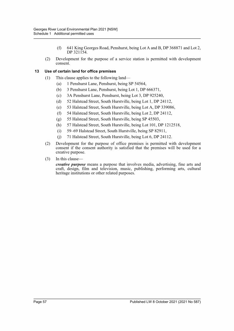
Georges River Local Environmental Plan 2021 [NSW]Schedule 1 Additional permitted uses
(f) 641 King Georges Road, Penshurst, being Lot A and B, DP 368871 and Lot 2,DP 321154.
(2) Development for the purpose of a service station is permitted with developmentconsent.
13 Use of certain land for office premises(1) This clause applies to the following land—
(a) 1 Penshurst Lane, Penshurst, being SP 54564,(b) 3 Penshurst Lane, Penshurst, being Lot 1, DP 666371, (c) 3A Penshurst Lane, Penshurst, being Lot 3, DP 925240,(d) 52 Halstead Street, South Hurstville, being Lot 1, DP 24112,(e) 53 Halstead Street, South Hurstville, being Lot A, DP 339086,(f) 54 Halstead Street, South Hurstville, being Lot 2, DP 24112,(g) 55 Halstead Street, South Hurstville, being SP 45503,(h) 57 Halstead Street, South Hurstville, being Lot 101, DP 1212518,(i) 59–69 Halstead Street, South Hurstville, being SP 82911,(j) 71 Halstead Street, South Hurstville, being Lot 6, DP 24112.
(2) Development for the purpose of office premises is permitted with developmentconsent if the consent authority is satisfied that the premises will be used for acreative purpose.
(3) In this clause—creative purpose means a purpose that involves media, advertising, fine arts andcraft, design, film and television, music, publishing, performing arts, culturalheritage institutions or other related purposes.
Page 57 Published LW 8 October 2021 (2021 No 587)

Georges River Local Environmental Plan 2021 [NSW]Schedule 2 Exempt development
Schedule 2 Exempt development(Clause 3.1)
Note 1. State Environmental Planning Policy (Exempt and Complying Development Codes) 2008 specifiesexempt development under that Policy. The Policy has State-wide application. This Schedule containsadditional exempt development not specified in that Policy.Note 2. Exempt development may be carried out without the need for development consent under the Act.Such development is not exempt from any approval, licence, permit or authority that is required under anyother Act and adjoining owners’ property rights and the common law still apply.
(When this Plan was made this Schedule was blank)
Page 58 Published LW 8 October 2021 (2021 No 587)

Georges River Local Environmental Plan 2021 [NSW]Schedule 3 Complying development
Schedule 3 Complying development(Clause 3.2)
Note. State Environmental Planning Policy (Exempt and Complying Development Codes) 2008 specifiescomplying development and the complying development conditions for that development under that Policy.The Policy has State-wide application. This Schedule contains additional complying development notspecified in that Policy.
Part 1 Types of development(When this Plan was made this Schedule was blank)
Part 2 Complying development certificate conditionsNote. Complying development must comply with the requirements of the Act, the regulations under the Actand this Plan.
General conditionsAny development specified in Part 1 is subject to the same conditions set out inSchedule 6 to State Environmental Planning Policy (Exempt and ComplyingDevelopment Codes) 2008.
Page 59 Published LW 8 October 2021 (2021 No 587)
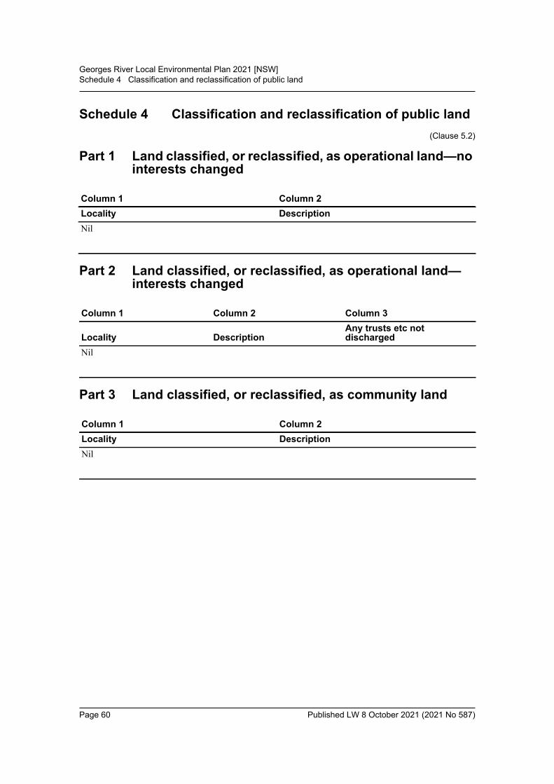
Georges River Local Environmental Plan 2021 [NSW]Schedule 4 Classification and reclassification of public land
Schedule 4 Classification and reclassification of public land(Clause 5.2)
Part 1 Land classified, or reclassified, as operational land—no interests changed
Part 2 Land classified, or reclassified, as operational land—interests changed
Part 3 Land classified, or reclassified, as community land
Column 1 Column 2Locality DescriptionNil
Column 1 Column 2 Column 3
Locality DescriptionAny trusts etc not discharged
Nil
Column 1 Column 2Locality DescriptionNil
Page 60 Published LW 8 October 2021 (2021 No 587)

Georges River Local Environmental Plan 2021 [NSW]Schedule 5 Environmental heritage
Schedule 5 Environmental heritage(clause 5.10)
Part 1 Heritage items
Suburb Item name AddressProperty description Significance Item no
Allawah Allawah Hotel 470 Railway Parade
Lots 263 and 264, DP 7182
Local I1
Allawah Former Woids Avenue Congregational Church—St George Christian School
51–69 Woids Avenue
Lot 1, DP 1172012
Local I2
Beverley Park House and garden, “McWilliam House”
188 Princes Highway
Lots 5 and 6, DP 17522
Local I3
Beverley Park House and garden 177 Rocky Point Road
Lot 11, DP 1087596
Local I4
Beverley Park Former Ramsgate Methodist Church—Ramsgate Community Church
181 Rocky Point Road
Lot 1, DP 1084543
Local I5
Beverly Hills Beverly Hills Railway Station Group
East Hills rail line Lot 10, DP 1211599
State I6
Beverly Hills Federation style weatherboard house, early outbuildings and spatial qualities of the setting
71 Edgbaston Road
Lot 36, DP 13578 Local I7
Beverly Hills Late Federation house “Woodville” and setting
79 Edgbaston Road
Lot B, DP 377604 Local I8
Beverly Hills Interwar house “Hilcrest” and setting, including front fence
130 Stoney Creek Road
Lot 7, DP 18860 Local I9
Beverly Hills Timber Federation period house “Devonia Farm” and setting
136 Stoney Creek Road
Lot 1, DP 20704 Local I10
Blakehurst House and garden, “Braeside Castle”
4 Marie Dodd Crescent
Lot A, DP 29102 Local I11
Blakehurst Georges River (Tom Ugly’s) Bridge
Princes Highway Local I12
Page 61 Published LW 8 October 2021 (2021 No 587)
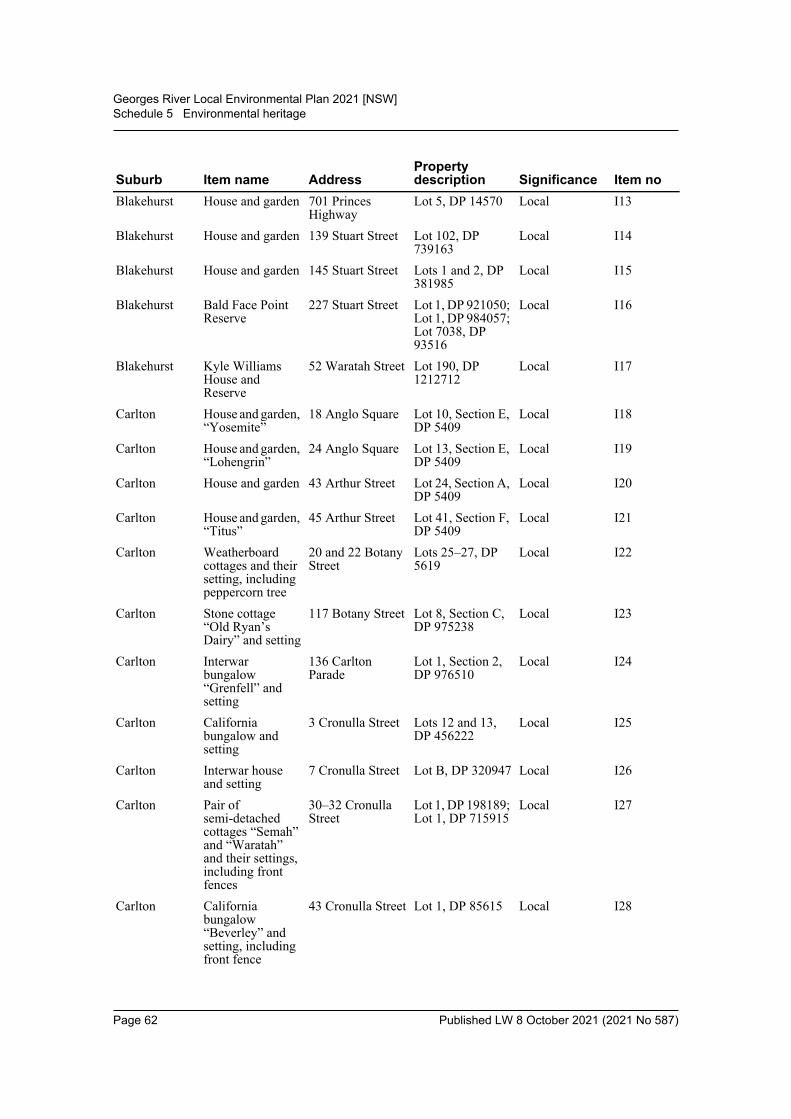
Georges River Local Environmental Plan 2021 [NSW]Schedule 5 Environmental heritage
Blakehurst House and garden 701 Princes Highway
Lot 5, DP 14570 Local I13
Blakehurst House and garden 139 Stuart Street Lot 102, DP 739163
Local I14
Blakehurst House and garden 145 Stuart Street Lots 1 and 2, DP 381985
Local I15
Blakehurst Bald Face Point Reserve
227 Stuart Street Lot 1, DP 921050; Lot 1, DP 984057; Lot 7038, DP 93516
Local I16
Blakehurst Kyle Williams House and Reserve
52 Waratah Street Lot 190, DP 1212712
Local I17
Carlton House and garden, “Yosemite”
18 Anglo Square Lot 10, Section E, DP 5409
Local I18
Carlton House and garden, “Lohengrin”
24 Anglo Square Lot 13, Section E, DP 5409
Local I19
Carlton House and garden 43 Arthur Street Lot 24, Section A, DP 5409
Local I20
Carlton House and garden, “Titus”
45 Arthur Street Lot 41, Section F, DP 5409
Local I21
Carlton Weatherboard cottages and their setting, including peppercorn tree
20 and 22 Botany Street
Lots 25–27, DP 5619
Local I22
Carlton Stone cottage “Old Ryan’s Dairy” and setting
117 Botany Street Lot 8, Section C, DP 975238
Local I23
Carlton Interwar bungalow “Grenfell” and setting
136 Carlton Parade
Lot 1, Section 2, DP 976510
Local I24
Carlton California bungalow and setting
3 Cronulla Street Lots 12 and 13, DP 456222
Local I25
Carlton Interwar house and setting
7 Cronulla Street Lot B, DP 320947 Local I26
Carlton Pair of semi-detached cottages “Semah” and “Waratah” and their settings, including front fences
30–32 Cronulla Street
Lot 1, DP 198189; Lot 1, DP 715915
Local I27
Carlton California bungalow “Beverley” and setting, including front fence
43 Cronulla Street Lot 1, DP 85615 Local I28
Suburb Item name AddressProperty description Significance Item no
Page 62 Published LW 8 October 2021 (2021 No 587)
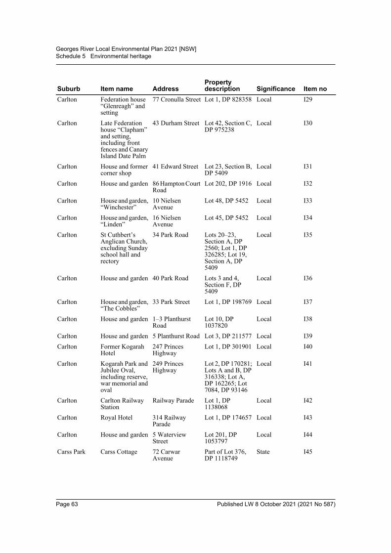
Georges River Local Environmental Plan 2021 [NSW]Schedule 5 Environmental heritage
Carlton Federation house “Glenreagh” and setting
77 Cronulla Street Lot 1, DP 828358 Local I29
Carlton Late Federation house “Clapham” and setting, including front fences and Canary Island Date Palm
43 Durham Street Lot 42, Section C, DP 975238
Local I30
Carlton House and former corner shop
41 Edward Street Lot 23, Section B, DP 5409
Local I31
Carlton House and garden 86 Hampton Court Road
Lot 202, DP 1916 Local I32
Carlton House and garden, “Winchester”
10 Nielsen Avenue
Lot 48, DP 5452 Local I33
Carlton House and garden, “Linden”
16 Nielsen Avenue
Lot 45, DP 5452 Local I34
Carlton St Cuthbert’s Anglican Church, excluding Sunday school hall and rectory
34 Park Road Lots 20–23, Section A, DP 2560; Lot 1, DP 326285; Lot 19, Section A, DP 5409
Local I35
Carlton House and garden 40 Park Road Lots 3 and 4, Section F, DP 5409
Local I36
Carlton House and garden, “The Cobbles”
33 Park Street Lot 1, DP 198769 Local I37
Carlton House and garden 1–3 Planthurst Road
Lot 10, DP 1037820
Local I38
Carlton House and garden 5 Planthurst Road Lot 3, DP 211577 Local I39Carlton Former Kogarah
Hotel247 Princes Highway
Lot 1, DP 301901 Local I40
Carlton Kogarah Park and Jubilee Oval, including reserve, war memorial and oval
249 Princes Highway
Lot 2, DP 170281; Lots A and B, DP 316338; Lot A, DP 162265; Lot 7084, DP 93146
Local I41
Carlton Carlton Railway Station
Railway Parade Lot 1, DP 1138068
Local I42
Carlton Royal Hotel 314 Railway Parade
Lot 1, DP 174657 Local I43
Carlton House and garden 5 Waterview Street
Lot 201, DP 1053797
Local I44
Carss Park Carss Cottage 72 Carwar Avenue
Part of Lot 376, DP 1118749
State I45
Suburb Item name AddressProperty description Significance Item no
Page 63 Published LW 8 October 2021 (2021 No 587)
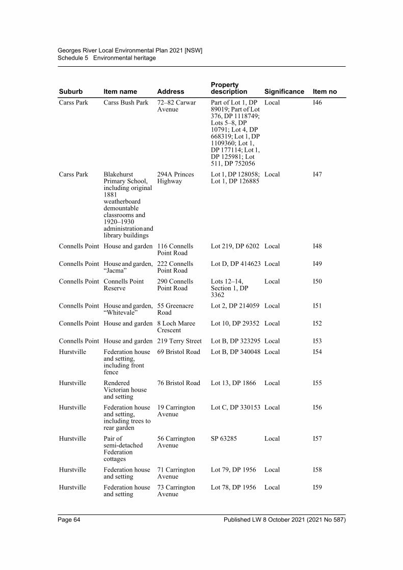
Georges River Local Environmental Plan 2021 [NSW]Schedule 5 Environmental heritage
Carss Park Carss Bush Park 72–82 Carwar Avenue
Part of Lot 1, DP 89019; Part of Lot 376, DP 1118749; Lots 5–8, DP 10791; Lot 4, DP 668319; Lot 1, DP 1109360; Lot 1, DP 177114; Lot 1, DP 125981; Lot 511, DP 752056
Local I46
Carss Park Blakehurst Primary School, including original 1881 weatherboard demountable classrooms and 1920–1930 administration and library buildings
294A Princes Highway
Lot 1, DP 128058; Lot 1, DP 126885
Local I47
Connells Point House and garden 116 Connells Point Road
Lot 219, DP 6202 Local I48
Connells Point House and garden, “Jacma”
222 Connells Point Road
Lot D, DP 414623 Local I49
Connells Point Connells Point Reserve
290 Connells Point Road
Lots 12–14, Section 1, DP 3362
Local I50
Connells Point House and garden, “Whitevale”
55 Greenacre Road
Lot 2, DP 214059 Local I51
Connells Point House and garden 8 Loch Maree Crescent
Lot 10, DP 29352 Local I52
Connells Point House and garden 219 Terry Street Lot B, DP 323295 Local I53Hurstville Federation house
and setting, including front fence
69 Bristol Road Lot B, DP 340048 Local I54
Hurstville Rendered Victorian house and setting
76 Bristol Road Lot 13, DP 1866 Local I55
Hurstville Federation house and setting, including trees to rear garden
19 Carrington Avenue
Lot C, DP 330153 Local I56
Hurstville Pair of semi-detached Federation cottages
56 Carrington Avenue
SP 63285 Local I57
Hurstville Federation house and setting
71 Carrington Avenue
Lot 79, DP 1956 Local I58
Hurstville Federation house and setting
73 Carrington Avenue
Lot 78, DP 1956 Local I59
Suburb Item name AddressProperty description Significance Item no
Page 64 Published LW 8 October 2021 (2021 No 587)

Georges River Local Environmental Plan 2021 [NSW]Schedule 5 Environmental heritage
Hurstville Federation house “Canberra” and setting
75 Carrington Avenue
Lot 2, DP 204431 Local I60
Hurstville House and garden, “Maroo”
6 Carysfort Street Lot A, DP 415190 Local I61
Hurstville Federation house and setting
2 Clevedon Road Lot 34, DP 1866 Local I62
Hurstville Federation house “Dungog” and setting
4 Clevedon Road Lot 33, DP 1866 Local I63
Hurstville Victory House 8 Crofts Avenue SP 46769 Local I64Hurstville House and garden,
“Oxley”11 Denman Street SP 49471 Local I65
Hurstville Hurstville Oval and Velodrome
30 Dora Street Lot 1, DP 919317; Lot 53, DP 9355
Local I66
Hurstville Four pairs of semi-detached Victorian cottages and settings
33–47 Dora Street Lots 5–8, DP 237059; Lot 34, DP 836363; Lot 1, DP 794227
Local I67
Hurstville Federation house “Busigny” and setting, including traditional garden
50 Dora Street Lot 8, DP 9355 Local I68
Hurstville Hurstville Scout Hall
116 Durham Street
Lot 5, DP 171179 Local I69
Hurstville War Memorial Monument
Forest Road Local I70
Hurstville Allawah Reservoir (WS 0001)
2 Forest Road Lots 1 and 7–9, DP 6584; Lot 1, DP 73077; Lots A–C, DP 308650; Lots A and B, DP 322974; Lots 1 and 2, DP 331657; Lot 1, DP 1019736; Lot 13, DP 666411; Lot 1, DP 1019740; Lot B, DP 303573
Local I71
Hurstville Hurstville Public School
80 Forest Road Lot 32, DP 842051
Local I72
Hurstville Shop and residence
140 Forest Road Lot 1, DP 82544 Local I73
Hurstville Commercial building
143 Forest Road Lot 2, Section 1, DP 3232
Local I74
Hurstville St George Anglican Church
144 Forest Road Lot 2, DP 207467 Local I75
Hurstville Retail building 160 Forest Road Lot 69, DP 1595 Local I76
Suburb Item name AddressProperty description Significance Item no
Page 65 Published LW 8 October 2021 (2021 No 587)
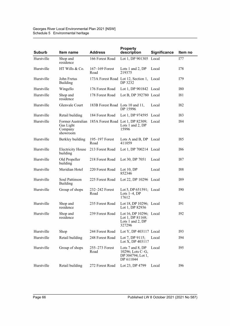
Georges River Local Environmental Plan 2021 [NSW]Schedule 5 Environmental heritage
Hurstville Shop and residence
166 Forest Road Lot 1, DP 901305 Local I77
Hurstville HT Wills & Co. 167–169 Forest Road
Lots 1 and 2, DP 219375
Local I78
Hurstville John Fretus Building
173A Forest Road Lot 12, Section 1, DP 3232
Local I79
Hurstville Wingello 176 Forest Road Lot 1, DP 901842 Local I80Hurstville Shop and
residence178 Forest Road Lot B, DP 392780 Local I81
Hurstville Glenvale Court 183B Forest Road Lots 10 and 11, DP 15996
Local I82
Hurstville Retail building 184 Forest Road Lot 1, DP 974595 Local I83Hurstville Former Australian
Gas Light Company showroom
185A Forest Road Lot 1, DP 82309; Lots 1 and 2, DP 15996
Local I84
Hurstville Berkley building 195–197 Forest Road
Lots A and B, DP 411059
Local I85
Hurstville Electricity House building
213 Forest Road Lot 1, DP 700214 Local I86
Hurstville Old Propeller building
218 Forest Road Lot 30, DP 7051 Local I87
Hurstville Meridian Hotel 220 Forest Road Lot 10, DP 852346
Local I88
Hurstville Soul Pattinson Building
225 Forest Road Lot 22, DP 10296 Local I89
Hurstville Group of shops 232–242 Forest Road
Lot 5, DP 651591; Lots 1–4, DP 17612
Local I90
Hurstville Shop and residence
235 Forest Road Lot 18, DP 10296; Lot 1, DP 82936
Local I91
Hurstville Shop and residence
239 Forest Road Lot 16, DP 10296; Lot 1, DP 81168; Lots 1 and 2, DP 327296
Local I92
Hurstville Shop 244 Forest Road Lot Y, DP 403117 Local I93Hurstville Retail building 248 Forest Road Lot 7, DP 9115;
Lot X, DP 403117Local I94
Hurstville Group of shops 255–273 Forest Road
Lots 7 and 8, DP 10296; Lots C–G, DP 304794; Lot 1, DP 611044
Local I95
Hurstville Retail building 272 Forest Road Lot 23, DP 4799 Local I96
Suburb Item name AddressProperty description Significance Item no
Page 66 Published LW 8 October 2021 (2021 No 587)
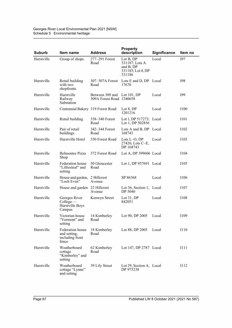
Georges River Local Environmental Plan 2021 [NSW]Schedule 5 Environmental heritage
Hurstville Group of shops 277–291 Forest Road
Lot B, DP 331187; Lots A and B, DP 331185; Lot 4, DP 331186
Local I97
Hurstville Retail building with two shopfronts
307–307A Forest Road
Lots E and D, DP 17670
Local I98
Hurstville Hurstville Railway Substation
Between 309 and 309A Forest Road
Lot 101, DP 1240658
Local I99
Hurstville Centennial Bakery 319 Forest Road Lot 8, DP 1201216
Local I100
Hurstville Retail building 338–340 Forest Road
Lot 1, DP 517273; Lot 1, DP 502856
Local I101
Hurstville Pair of retail buildings
342–344 Forest Road
Lots A and B, DP 168743
Local I102
Hurstville Hurstville Hotel 350 Forest Road Lots L–O, DP 27426; Lots C–E, DP 168743
Local I103
Hurstville Belmontes Pizza Shop
372 Forest Road Lot A, DP 399606 Local I104
Hurstville Federation house “Lilliesleaf” and setting
50 Gloucester Road
Lot 1, DP 957691 Local I105
Hurstville House and garden, “Loch Even”
2 Hillcrest Avenue
SP 86368 Local I106
Hurstville House and garden 22 Hillcrest Avenue
Lot 36, Section 1, DP 5040
Local I107
Hurstville Georges River College — Hurstville Boys Campus
Kenwyn Street Lot 31, DP 842051
Local I108
Hurstville Victorian house “Vermont” and setting
14 Kimberley Road
Lot 90, DP 2005 Local I109
Hurstville Federation house and setting, including front fence
18 Kimberley Road
Lot 88, DP 2005 Local I110
Hurstville Weatherboard cottage “Kimberley” and setting
62 Kimberley Road
Lot 147, DP 2787 Local I111
Hurstville Weatherboard cottage “Lynne” and setting
39 Lily Street Lot 29, Section A, DP 975238
Local I112
Suburb Item name AddressProperty description Significance Item no
Page 67 Published LW 8 October 2021 (2021 No 587)
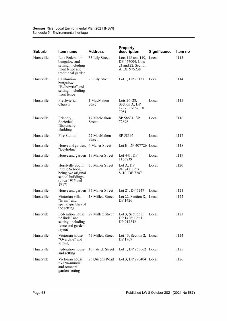
Georges River Local Environmental Plan 2021 [NSW]Schedule 5 Environmental heritage
Hurstville Late Federation bungalow and setting, including front fence and traditional garden
53 Lily Street Lots 118 and 119, DP 457004; Lots 21 and 22, Section A, DP 975238
Local I113
Hurstville Californian bungalow “Belbowrie” and setting, including front fence
76 Lily Street Lot 1, DP 78137 Local I114
Hurstville Presbyterian Church
1 MacMahon Street
Lots 26–28, Section A, DP 1297; Lot 67, DP 7051
Local I115
Hurstville Friendly Societies’ Dispensary Building
17 MacMahon Street
SP 58631; SP 72896
Local I116
Hurstville Fire Station 27 MacMahon Street
SP 58395 Local I117
Hurstville House and garden, “Leyholme”
4 Maher Street Lot B, DP 407726 Local I118
Hurstville House and garden 17 Maher Street Lot 441, DP 1163839
Local I119
Hurstville Hurstville South Public School, being two original school buildings (circa 1915 and 1917)
30 Maher Street Lot A, DP 948241; Lots 8–10, DP 7247
Local I120
Hurstville House and garden 35 Maher Street Lot 21, DP 7247 Local I121Hurstville Victorian villa
“Erina” and spatial qualities of the setting
18 Millett Street Lot 22, Section D, DP 1426
Local I122
Hurstville Federation house “Alinda” and setting, including fence and garden layout
29 Millett Street Lot 3, Section E, DP 1426; Lot 1, DP 917242
Local I123
Hurstville Victorian house “Overdale” and setting
67 Millett Street Lot 13, Section 2, DP 1769
Local I124
Hurstville Federation house and setting
16 Patrick Street Lot 1, DP 965662 Local I125
Hurstville Victorian house “Yarra-mundi” and remnant garden setting
75 Queens Road Lot 3, DP 270404 Local I126
Suburb Item name AddressProperty description Significance Item no
Page 68 Published LW 8 October 2021 (2021 No 587)
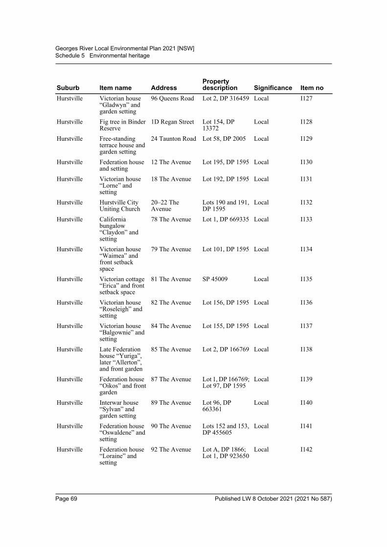
Georges River Local Environmental Plan 2021 [NSW]Schedule 5 Environmental heritage
Hurstville Victorian house “Gladwyn” and garden setting
96 Queens Road Lot 2, DP 316459 Local I127
Hurstville Fig tree in Binder Reserve
1D Regan Street Lot 154, DP 13372
Local I128
Hurstville Free-standing terrace house and garden setting
24 Taunton Road Lot 58, DP 2005 Local I129
Hurstville Federation house and setting
12 The Avenue Lot 195, DP 1595 Local I130
Hurstville Victorian house “Lorne” and setting
18 The Avenue Lot 192, DP 1595 Local I131
Hurstville Hurstville City Uniting Church
20–22 The Avenue
Lots 190 and 191, DP 1595
Local I132
Hurstville California bungalow “Claydon” and setting
78 The Avenue Lot 1, DP 669335 Local I133
Hurstville Victorian house “Waimea” and front setback space
79 The Avenue Lot 101, DP 1595 Local I134
Hurstville Victorian cottage “Erica” and front setback space
81 The Avenue SP 45009 Local I135
Hurstville Victorian house “Roseleigh” and setting
82 The Avenue Lot 156, DP 1595 Local I136
Hurstville Victorian house “Balgownie” and setting
84 The Avenue Lot 155, DP 1595 Local I137
Hurstville Late Federation house “Yuriga”, later “Allerton”, and front garden
85 The Avenue Lot 2, DP 166769 Local I138
Hurstville Federation house “Oikos” and front garden
87 The Avenue Lot 1, DP 166769; Lot 97, DP 1595
Local I139
Hurstville Interwar house “Sylvan” and garden setting
89 The Avenue Lot 96, DP 663361
Local I140
Hurstville Federation house “Oswaldene” and setting
90 The Avenue Lots 152 and 153, DP 455605
Local I141
Hurstville Federation house “Loraine” and setting
92 The Avenue Lot A, DP 1866; Lot 1, DP 923650
Local I142
Suburb Item name AddressProperty description Significance Item no
Page 69 Published LW 8 October 2021 (2021 No 587)
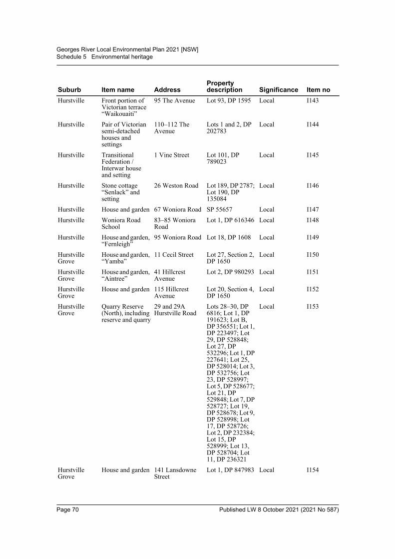
Georges River Local Environmental Plan 2021 [NSW]Schedule 5 Environmental heritage
Hurstville Front portion of Victorian terrace “Waikouaiti”
95 The Avenue Lot 93, DP 1595 Local I143
Hurstville Pair of Victorian semi-detached houses and settings
110–112 The Avenue
Lots 1 and 2, DP 202783
Local I144
Hurstville Transitional Federation / Interwar house and setting
1 Vine Street Lot 101, DP 789023
Local I145
Hurstville Stone cottage “Senlack” and setting
26 Weston Road Lot 189, DP 2787; Lot 190, DP 135084
Local I146
Hurstville House and garden 67 Woniora Road SP 55657 Local I147Hurstville Woniora Road
School83–85 Woniora Road
Lot 1, DP 616346 Local I148
Hurstville House and garden, “Fernleigh”
95 Woniora Road Lot 18, DP 1608 Local I149
Hurstville Grove
House and garden, “Yamba”
11 Cecil Street Lot 27, Section 2, DP 1650
Local I150
Hurstville Grove
House and garden, “Aintree”
41 Hillcrest Avenue
Lot 2, DP 980293 Local I151
Hurstville Grove
House and garden 115 Hillcrest Avenue
Lot 20, Section 4, DP 1650
Local I152
Hurstville Grove
Quarry Reserve (North), including reserve and quarry
29 and 29A Hurstville Road
Lots 28–30, DP 6816; Lot 1, DP 191623; Lot B, DP 356551; Lot 1, DP 223497; Lot 29, DP 528848; Lot 27, DP 532296; Lot 1, DP 227641; Lot 25, DP 528014; Lot 3, DP 532756; Lot 23, DP 528997; Lot 5, DP 528677; Lot 21, DP 529848; Lot 7, DP 528727; Lot 19, DP 528678; Lot 9, DP 528998; Lot 17, DP 528726; Lot 2, DP 232384; Lot 15, DP 528999; Lot 13, DP 528704; Lot 11, DP 236321
Local I153
Hurstville Grove
House and garden 141 Lansdowne Street
Lot 1, DP 847983 Local I154
Suburb Item name AddressProperty description Significance Item no
Page 70 Published LW 8 October 2021 (2021 No 587)
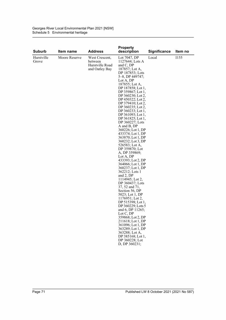
Georges River Local Environmental Plan 2021 [NSW]Schedule 5 Environmental heritage
Hurstville Grove
Moore Reserve West Crescent, between Hurstville Road and Oatley Bay
Lot 7047, DP 1127644; Lots A and C, DP 187857; Lot A, DP 187853; Lots 5–8, DP 449747; Lot A, DP 187855; Lot A, DP 187858; Lot 1, DP 359867; Lot 1, DP 360230; Lot 2, DP 450322; Lot 2, DP 379410; Lot 2, DP 360235; Lot 2, DP 360233; Lot 1, DP 361093; Lot 1, DP 361825; Lot 1, DP 360227; Lots A and B, DP 360226; Lot 1, DP 433374; Lot 1, DP 363870; Lot 1, DP 360232; Lot 3, DP 526583; Lot A, DP 359870; Lot A, DP 359869; Lot A, DP 433393; Lot 2, DP 364066; Lot 1, DP 360237; Lot 1, DP 362212; Lots 1 and 2, DP 1114945; Lot 2, DP 360437; Lots 37, 52 and 71, Section 56, DP 5023; Lot 1, DP 1176951; Lot 2, DP 515398; Lot 1, DP 360229; Lots 5 and 6, DP 11265; Lot C, DP 359868; Lot 2, DP 211618; Lot 1, DP 361096; Lot 1, DP 363289; Lot 1, DP 363288; Lot A, DP 385168; Lot 1, DP 360228; Lot D, DP 360231;
Local I155Suburb Item name Address
Property description Significance Item no
Page 71 Published LW 8 October 2021 (2021 No 587)
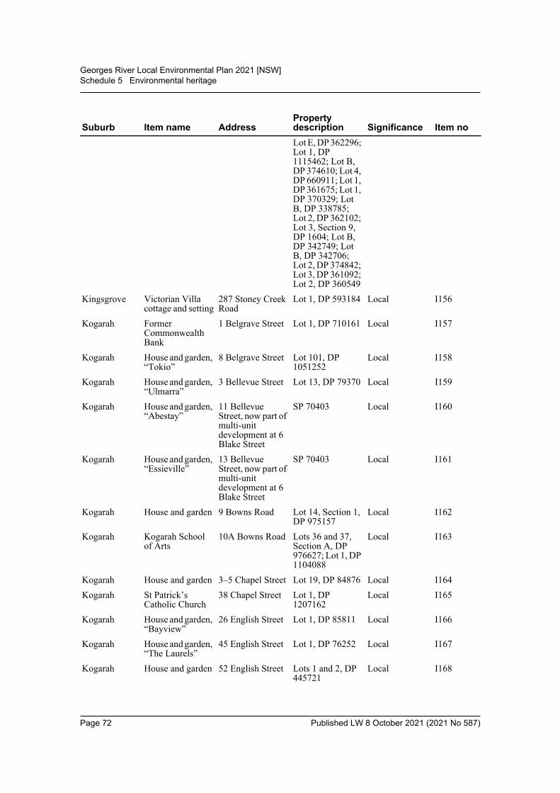
Georges River Local Environmental Plan 2021 [NSW]Schedule 5 Environmental heritage
Lot E, DP 362296; Lot 1, DP 1115462; Lot B, DP 374610; Lot 4, DP 660911; Lot 1, DP 361675; Lot 1, DP 370329; Lot B, DP 338785; Lot 2, DP 362102; Lot 3, Section 9, DP 1604; Lot B, DP 342749; Lot B, DP 342706; Lot 2, DP 374842; Lot 3, DP 361092; Lot 2, DP 360549
Kingsgrove Victorian Villa cottage and setting
287 Stoney Creek Road
Lot 1, DP 593184 Local I156
Kogarah Former Commonwealth Bank
1 Belgrave Street Lot 1, DP 710161 Local I157
Kogarah House and garden, “Tokio”
8 Belgrave Street Lot 101, DP 1051252
Local I158
Kogarah House and garden, “Ulmarra”
3 Bellevue Street Lot 13, DP 79370 Local I159
Kogarah House and garden, “Abestay”
11 Bellevue Street, now part of multi-unit development at 6 Blake Street
SP 70403 Local I160
Kogarah House and garden, “Essieville”
13 Bellevue Street, now part of multi-unit development at 6 Blake Street
SP 70403 Local I161
Kogarah House and garden 9 Bowns Road Lot 14, Section 1, DP 975157
Local I162
Kogarah Kogarah School of Arts
10A Bowns Road Lots 36 and 37, Section A, DP 976627; Lot 1, DP 1104088
Local I163
Kogarah House and garden 3–5 Chapel Street Lot 19, DP 84876 Local I164Kogarah St Patrick’s
Catholic Church38 Chapel Street Lot 1, DP
1207162Local I165
Kogarah House and garden, “Bayview”
26 English Street Lot 1, DP 85811 Local I166
Kogarah House and garden, “The Laurels”
45 English Street Lot 1, DP 76252 Local I167
Kogarah House and garden 52 English Street Lots 1 and 2, DP 445721
Local I168
Suburb Item name AddressProperty description Significance Item no
Page 72 Published LW 8 October 2021 (2021 No 587)
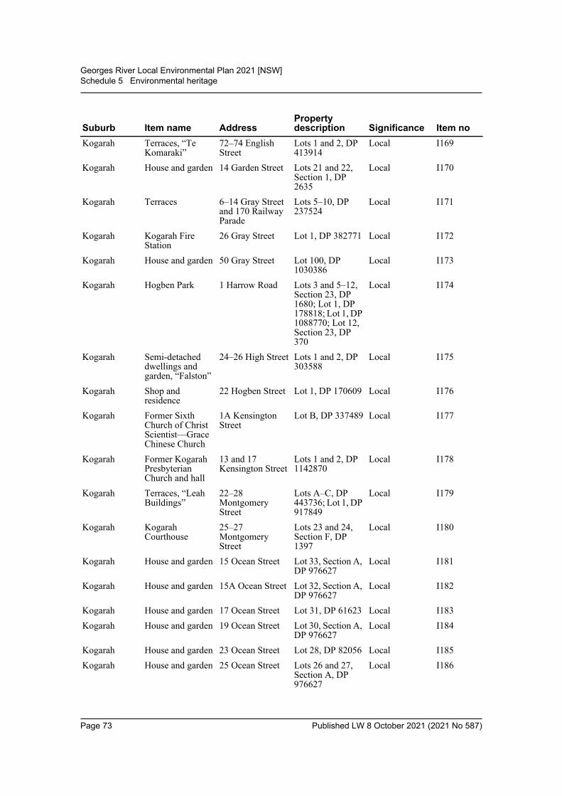
Georges River Local Environmental Plan 2021 [NSW]Schedule 5 Environmental heritage
Kogarah Terraces, “Te Komaraki”
72–74 English Street
Lots 1 and 2, DP 413914
Local I169
Kogarah House and garden 14 Garden Street Lots 21 and 22, Section 1, DP 2635
Local I170
Kogarah Terraces 6–14 Gray Street and 170 Railway Parade
Lots 5–10, DP 237524
Local I171
Kogarah Kogarah Fire Station
26 Gray Street Lot 1, DP 382771 Local I172
Kogarah House and garden 50 Gray Street Lot 100, DP 1030386
Local I173
Kogarah Hogben Park 1 Harrow Road Lots 3 and 5–12, Section 23, DP 1680; Lot 1, DP 178818; Lot 1, DP 1088770; Lot 12, Section 23, DP 370
Local I174
Kogarah Semi-detached dwellings and garden, “Falston”
24–26 High Street Lots 1 and 2, DP 303588
Local I175
Kogarah Shop and residence
22 Hogben Street Lot 1, DP 170609 Local I176
Kogarah Former Sixth Church of Christ Scientist—Grace Chinese Church
1A Kensington Street
Lot B, DP 337489 Local I177
Kogarah Former Kogarah Presbyterian Church and hall
13 and 17 Kensington Street
Lots 1 and 2, DP 1142870
Local I178
Kogarah Terraces, “Leah Buildings”
22–28 Montgomery Street
Lots A–C, DP 443736; Lot 1, DP 917849
Local I179
Kogarah Kogarah Courthouse
25–27 Montgomery Street
Lots 23 and 24, Section F, DP 1397
Local I180
Kogarah House and garden 15 Ocean Street Lot 33, Section A, DP 976627
Local I181
Kogarah House and garden 15A Ocean Street Lot 32, Section A, DP 976627
Local I182
Kogarah House and garden 17 Ocean Street Lot 31, DP 61623 Local I183Kogarah House and garden 19 Ocean Street Lot 30, Section A,
DP 976627Local I184
Kogarah House and garden 23 Ocean Street Lot 28, DP 82056 Local I185Kogarah House and garden 25 Ocean Street Lots 26 and 27,
Section A, DP 976627
Local I186
Suburb Item name AddressProperty description Significance Item no
Page 73 Published LW 8 October 2021 (2021 No 587)
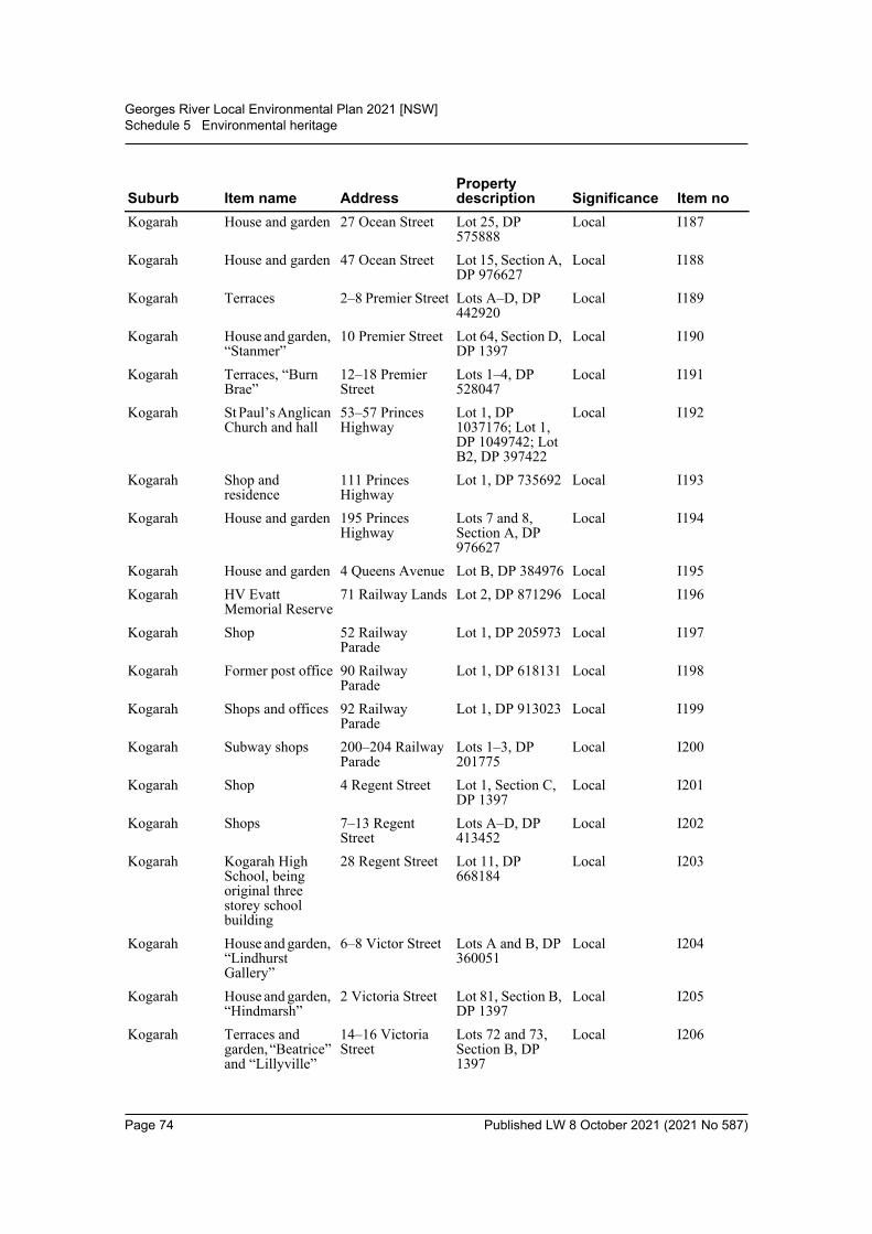
Georges River Local Environmental Plan 2021 [NSW]Schedule 5 Environmental heritage
Kogarah House and garden 27 Ocean Street Lot 25, DP 575888
Local I187
Kogarah House and garden 47 Ocean Street Lot 15, Section A, DP 976627
Local I188
Kogarah Terraces 2–8 Premier Street Lots A–D, DP 442920
Local I189
Kogarah House and garden, “Stanmer”
10 Premier Street Lot 64, Section D, DP 1397
Local I190
Kogarah Terraces, “Burn Brae”
12–18 Premier Street
Lots 1–4, DP 528047
Local I191
Kogarah St Paul’s Anglican Church and hall
53–57 Princes Highway
Lot 1, DP 1037176; Lot 1, DP 1049742; Lot B2, DP 397422
Local I192
Kogarah Shop and residence
111 Princes Highway
Lot 1, DP 735692 Local I193
Kogarah House and garden 195 Princes Highway
Lots 7 and 8, Section A, DP 976627
Local I194
Kogarah House and garden 4 Queens Avenue Lot B, DP 384976 Local I195Kogarah HV Evatt
Memorial Reserve71 Railway Lands Lot 2, DP 871296 Local I196
Kogarah Shop 52 Railway Parade
Lot 1, DP 205973 Local I197
Kogarah Former post office 90 Railway Parade
Lot 1, DP 618131 Local I198
Kogarah Shops and offices 92 Railway Parade
Lot 1, DP 913023 Local I199
Kogarah Subway shops 200–204 Railway Parade
Lots 1–3, DP 201775
Local I200
Kogarah Shop 4 Regent Street Lot 1, Section C, DP 1397
Local I201
Kogarah Shops 7–13 Regent Street
Lots A–D, DP 413452
Local I202
Kogarah Kogarah High School, being original three storey school building
28 Regent Street Lot 11, DP 668184
Local I203
Kogarah House and garden, “Lindhurst Gallery”
6–8 Victor Street Lots A and B, DP 360051
Local I204
Kogarah House and garden, “Hindmarsh”
2 Victoria Street Lot 81, Section B, DP 1397
Local I205
Kogarah Terraces and garden, “Beatrice” and “Lillyville”
14–16 Victoria Street
Lots 72 and 73, Section B, DP 1397
Local I206
Suburb Item name AddressProperty description Significance Item no
Page 74 Published LW 8 October 2021 (2021 No 587)
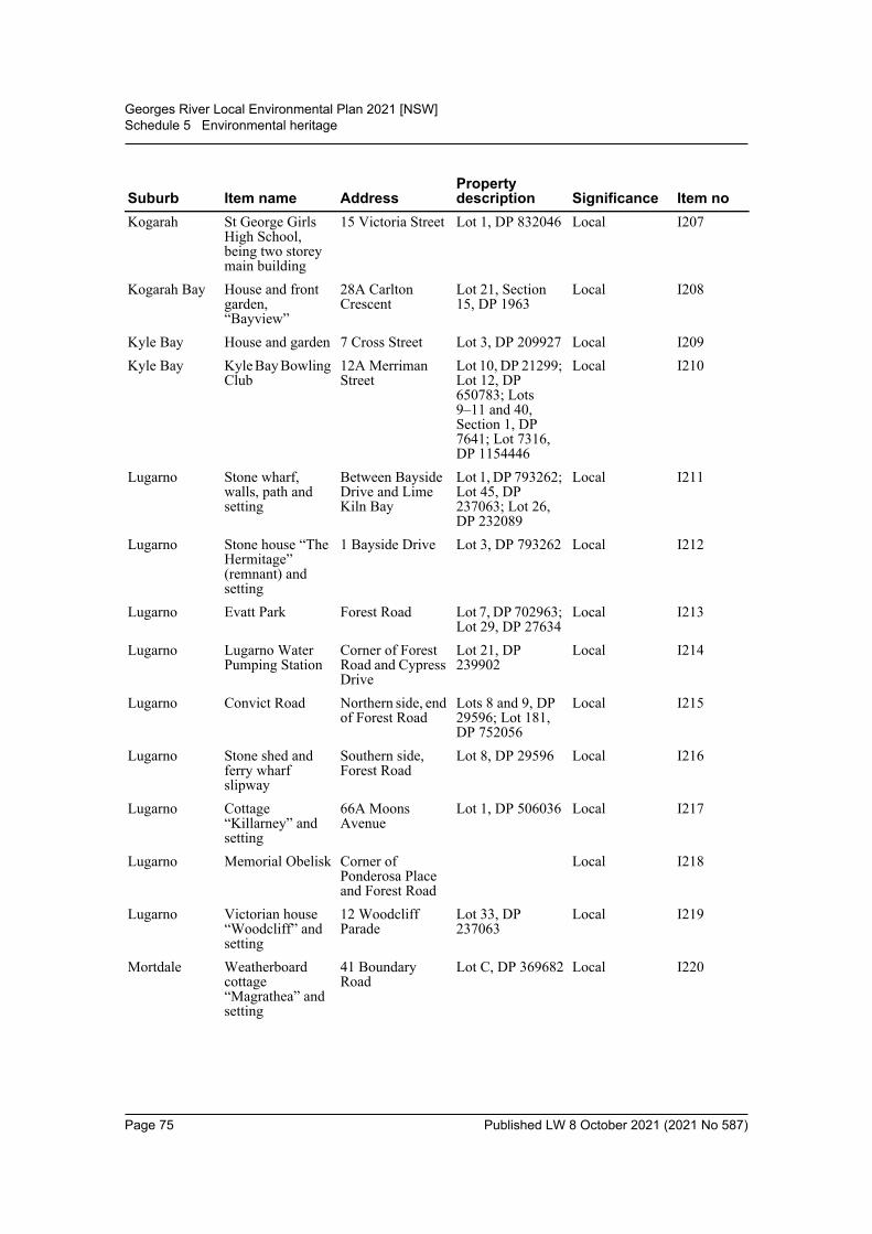
Georges River Local Environmental Plan 2021 [NSW]Schedule 5 Environmental heritage
Kogarah St George Girls High School, being two storey main building
15 Victoria Street Lot 1, DP 832046 Local I207
Kogarah Bay House and front garden, “Bayview”
28A Carlton Crescent
Lot 21, Section 15, DP 1963
Local I208
Kyle Bay House and garden 7 Cross Street Lot 3, DP 209927 Local I209Kyle Bay Kyle Bay Bowling
Club12A Merriman Street
Lot 10, DP 21299; Lot 12, DP 650783; Lots 9–11 and 40, Section 1, DP 7641; Lot 7316, DP 1154446
Local I210
Lugarno Stone wharf, walls, path and setting
Between Bayside Drive and Lime Kiln Bay
Lot 1, DP 793262; Lot 45, DP 237063; Lot 26, DP 232089
Local I211
Lugarno Stone house “The Hermitage” (remnant) and setting
1 Bayside Drive Lot 3, DP 793262 Local I212
Lugarno Evatt Park Forest Road Lot 7, DP 702963; Lot 29, DP 27634
Local I213
Lugarno Lugarno Water Pumping Station
Corner of Forest Road and Cypress Drive
Lot 21, DP 239902
Local I214
Lugarno Convict Road Northern side, end of Forest Road
Lots 8 and 9, DP 29596; Lot 181, DP 752056
Local I215
Lugarno Stone shed and ferry wharf slipway
Southern side, Forest Road
Lot 8, DP 29596 Local I216
Lugarno Cottage “Killarney” and setting
66A Moons Avenue
Lot 1, DP 506036 Local I217
Lugarno Memorial Obelisk Corner of Ponderosa Place and Forest Road
Local I218
Lugarno Victorian house “Woodcliff” and setting
12 Woodcliff Parade
Lot 33, DP 237063
Local I219
Mortdale Weatherboard cottage “Magrathea” and setting
41 Boundary Road
Lot C, DP 369682 Local I220
Suburb Item name AddressProperty description Significance Item no
Page 75 Published LW 8 October 2021 (2021 No 587)
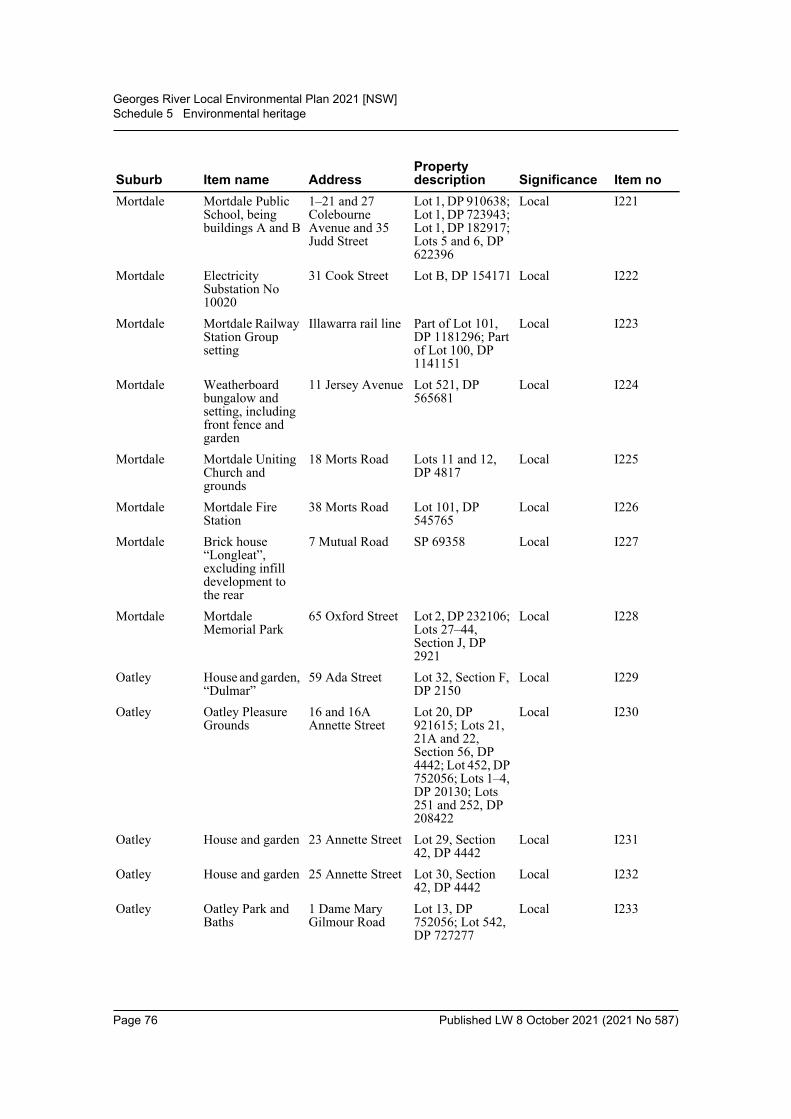
Georges River Local Environmental Plan 2021 [NSW]Schedule 5 Environmental heritage
Mortdale Mortdale Public School, being buildings A and B
1–21 and 27 Colebourne Avenue and 35 Judd Street
Lot 1, DP 910638; Lot 1, DP 723943; Lot 1, DP 182917; Lots 5 and 6, DP 622396
Local I221
Mortdale Electricity Substation No 10020
31 Cook Street Lot B, DP 154171 Local I222
Mortdale Mortdale Railway Station Group setting
Illawarra rail line Part of Lot 101, DP 1181296; Part of Lot 100, DP 1141151
Local I223
Mortdale Weatherboard bungalow and setting, including front fence and garden
11 Jersey Avenue Lot 521, DP 565681
Local I224
Mortdale Mortdale Uniting Church and grounds
18 Morts Road Lots 11 and 12, DP 4817
Local I225
Mortdale Mortdale Fire Station
38 Morts Road Lot 101, DP 545765
Local I226
Mortdale Brick house “Longleat”, excluding infill development to the rear
7 Mutual Road SP 69358 Local I227
Mortdale Mortdale Memorial Park
65 Oxford Street Lot 2, DP 232106; Lots 27–44, Section J, DP 2921
Local I228
Oatley House and garden, “Dulmar”
59 Ada Street Lot 32, Section F, DP 2150
Local I229
Oatley Oatley Pleasure Grounds
16 and 16A Annette Street
Lot 20, DP 921615; Lots 21, 21A and 22, Section 56, DP 4442; Lot 452, DP 752056; Lots 1–4, DP 20130; Lots 251 and 252, DP 208422
Local I230
Oatley House and garden 23 Annette Street Lot 29, Section 42, DP 4442
Local I231
Oatley House and garden 25 Annette Street Lot 30, Section 42, DP 4442
Local I232
Oatley Oatley Park and Baths
1 Dame Mary Gilmour Road
Lot 13, DP 752056; Lot 542, DP 727277
Local I233
Suburb Item name AddressProperty description Significance Item no
Page 76 Published LW 8 October 2021 (2021 No 587)

Georges River Local Environmental Plan 2021 [NSW]Schedule 5 Environmental heritage
Oatley Oatley Memorial Clock
On traffic island in Frederick Street, west of intersection with Oatley Avenue
Local I234
Oatley Como Railway Bridge
Georges River State I235
Oatley Oatley Railway Station Group
Illawarra rail line Lots 5 and 11 DP 803349; Lot 14, DP 839742
State I236
Oatley Oatley Masonic Lodge
11A Letitia Street Lot A, DP 325569; Lot 20, DP 1043366
Local I237
Oatley House and garden 56 Letitia Street Lot C, DP 389898 Local I238Oatley Semi-detached
dwellings and garden, “Glenbrook”
90–92 Letitia Street
Lots 1 and 2, DP 526437
Local I239
Oatley Interwar bungalow and setting, including fence base
36 Lloyd Street Lot 58, DP 9927 Local I240
Oatley George Fincham Pipe Organ
1 Myall Street Lot 123, DP 801645
Local I241
Oatley Interwar bungalow “Bangala” and setting, including brick fence and frangipanni
7 Myall Street Lot 24, Section 15, DP 4513
Local I242
Oatley Oatley Memorial Gardens
2B and 2C Oatley Avenue
Lots 1–26, DP 16690; Lot 1, DP 1170690
Local I243
Oatley Oatley Point Reserve
1 and 1A Phipps Street
Lots 22, 25 and 25A, Section 37, DP 4868; Lots 22A, 23, 23A, 24 and 24A, DP 4868; Lot 7050, DP 1027173
Local I244
Oatley House 92 Rosa Street Lot 5, Section 42, DP 4442
Local I245
Oatley House and garden 9 Russell Street Lot B, DP 367555 Local I246Oatley House and garden 10 Russell Street Lot 2, DP 231023 Local I247Oatley Federation house
“Lindaville” and setting
11 Waratah Street Lot 4, DP 319565 Local I248
Oatley Federation house “Colwyn” and setting
30 Waratah Street Lot 7, Section 8, DP 2297
Local I249
Suburb Item name AddressProperty description Significance Item no
Page 77 Published LW 8 October 2021 (2021 No 587)
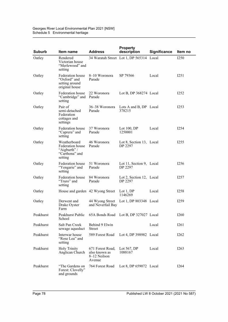
Georges River Local Environmental Plan 2021 [NSW]Schedule 5 Environmental heritage
Oatley Rendered Victorian house “Merlewood” and setting
34 Waratah Street Lot 1, DP 565314 Local I250
Oatley Federation house “Oxford” and setting around original house
8–10 Woronora Parade
SP 79366 Local I251
Oatley Federation house “Cambridge” and setting
22 Woronora Parade
Lot B, DP 368274 Local I252
Oatley Pair of semi-detached Federation cottages and settings
36–38 Woronora Parade
Lots A and B, DP 378215
Local I253
Oatley Federation house “Caprera” and setting
37 Woronora Parade
Lot 100, DP 1250001
Local I254
Oatley Weatherboard Federation house “Aigburth” / “Carthona” and setting
46 Woronora Parade
Lot 8, Section 13, DP 2297
Local I255
Oatley Federation house “Yengarie” and setting
51 Woronora Parade
Lot 11, Section 9, DP 2297
Local I256
Oatley Federation house “Truro” and setting
84 Woronora Parade
Lot 2, Section 12, DP 2297
Local I257
Oatley House and garden 42 Wyong Street Lot 1, DP 1146269
Local I258
Oatley Derwent and Drake Oyster Farm
44 Wyong Street and Neverfail Bay
Lot 1, DP 803348 Local I259
Peakhurst Peakhurst Public School
65A Bonds Road Lot B, DP 327027 Local I260
Peakhurst Salt Pan Creek sewage aqueduct
Behind 9 Elwin Street
Local I261
Peakhurst Interwar house “Rose Lea” and setting
589 Forest Road Lot 4, DP 398982 Local I262
Peakhurst Holy Trinity Anglican Church
671 Forest Road, also known as 8–12 Neilson Avenue
Lot 567, DP 1088167
Local I263
Peakhurst “The Gardens on Forest: Clovelly” and grounds
764 Forest Road Lot 8, DP 659072 Local I264
Suburb Item name AddressProperty description Significance Item no
Page 78 Published LW 8 October 2021 (2021 No 587)
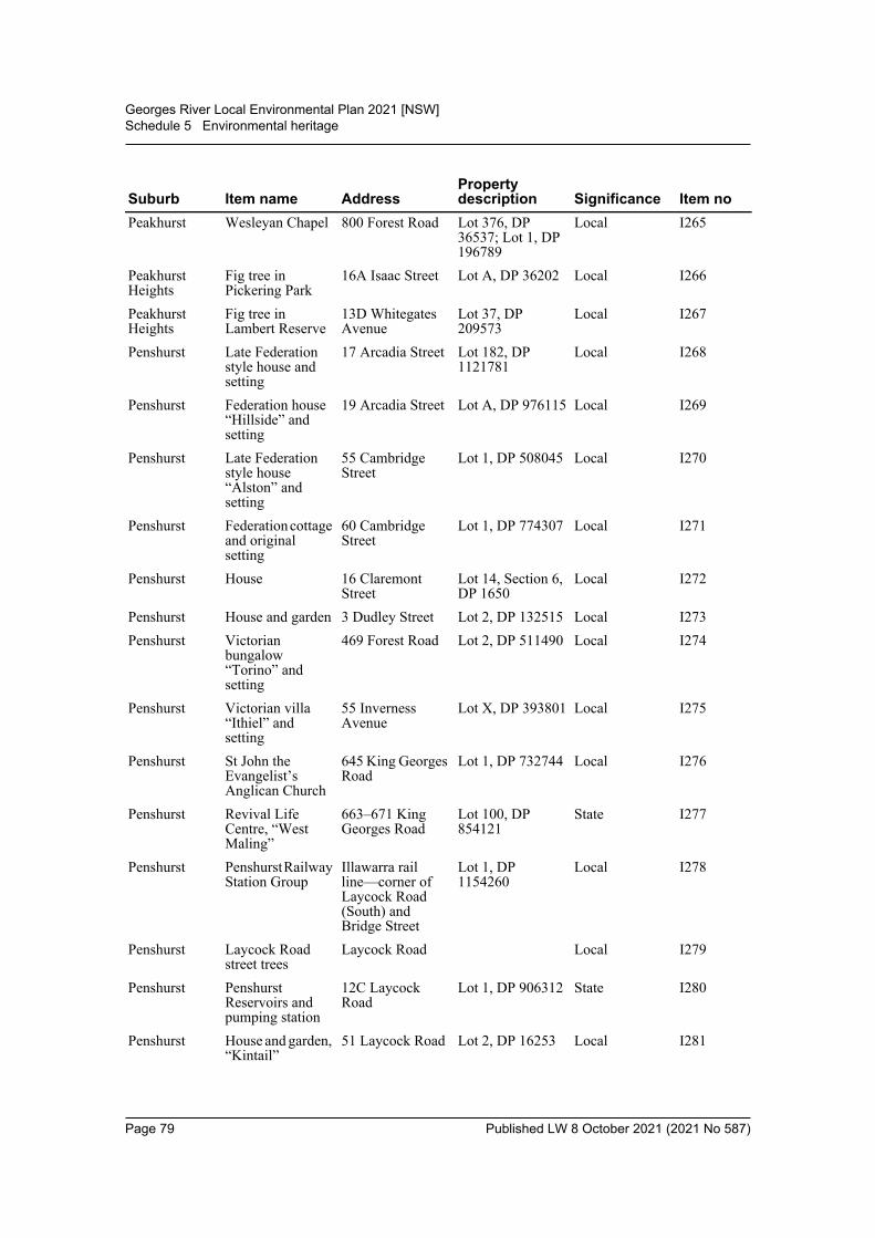
Georges River Local Environmental Plan 2021 [NSW]Schedule 5 Environmental heritage
Peakhurst Wesleyan Chapel 800 Forest Road Lot 376, DP 36537; Lot 1, DP 196789
Local I265
Peakhurst Heights
Fig tree in Pickering Park
16A Isaac Street Lot A, DP 36202 Local I266
Peakhurst Heights
Fig tree in Lambert Reserve
13D Whitegates Avenue
Lot 37, DP 209573
Local I267
Penshurst Late Federation style house and setting
17 Arcadia Street Lot 182, DP 1121781
Local I268
Penshurst Federation house “Hillside” and setting
19 Arcadia Street Lot A, DP 976115 Local I269
Penshurst Late Federation style house “Alston” and setting
55 Cambridge Street
Lot 1, DP 508045 Local I270
Penshurst Federation cottage and original setting
60 Cambridge Street
Lot 1, DP 774307 Local I271
Penshurst House 16 Claremont Street
Lot 14, Section 6, DP 1650
Local I272
Penshurst House and garden 3 Dudley Street Lot 2, DP 132515 Local I273Penshurst Victorian
bungalow “Torino” and setting
469 Forest Road Lot 2, DP 511490 Local I274
Penshurst Victorian villa “Ithiel” and setting
55 Inverness Avenue
Lot X, DP 393801 Local I275
Penshurst St John the Evangelist’s Anglican Church
645 King Georges Road
Lot 1, DP 732744 Local I276
Penshurst Revival Life Centre, “West Maling”
663–671 King Georges Road
Lot 100, DP 854121
State I277
Penshurst Penshurst Railway Station Group
Illawarra rail line—corner of Laycock Road (South) and Bridge Street
Lot 1, DP 1154260
Local I278
Penshurst Laycock Road street trees
Laycock Road Local I279
Penshurst Penshurst Reservoirs and pumping station
12C Laycock Road
Lot 1, DP 906312 State I280
Penshurst House and garden, “Kintail”
51 Laycock Road Lot 2, DP 16253 Local I281
Suburb Item name AddressProperty description Significance Item no
Page 79 Published LW 8 October 2021 (2021 No 587)
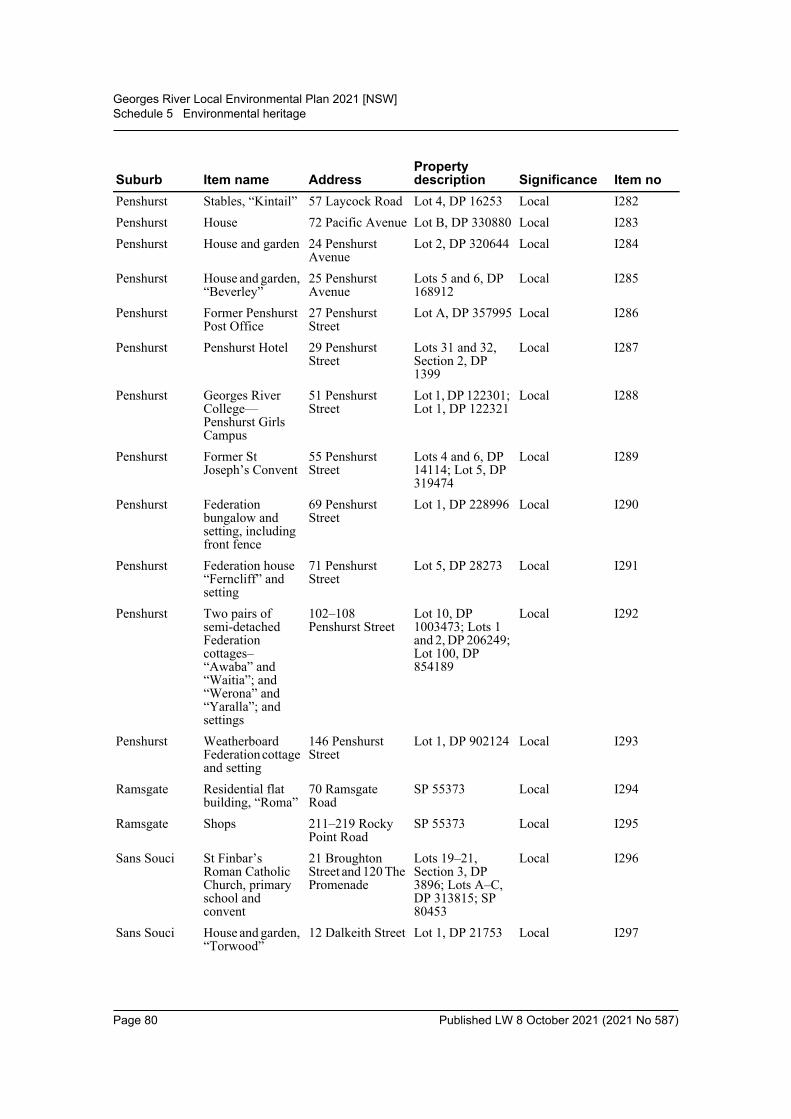
Georges River Local Environmental Plan 2021 [NSW]Schedule 5 Environmental heritage
Penshurst Stables, “Kintail” 57 Laycock Road Lot 4, DP 16253 Local I282Penshurst House 72 Pacific Avenue Lot B, DP 330880 Local I283Penshurst House and garden 24 Penshurst
AvenueLot 2, DP 320644 Local I284
Penshurst House and garden, “Beverley”
25 Penshurst Avenue
Lots 5 and 6, DP 168912
Local I285
Penshurst Former Penshurst Post Office
27 Penshurst Street
Lot A, DP 357995 Local I286
Penshurst Penshurst Hotel 29 Penshurst Street
Lots 31 and 32, Section 2, DP 1399
Local I287
Penshurst Georges River College—Penshurst Girls Campus
51 Penshurst Street
Lot 1, DP 122301; Lot 1, DP 122321
Local I288
Penshurst Former St Joseph’s Convent
55 Penshurst Street
Lots 4 and 6, DP 14114; Lot 5, DP 319474
Local I289
Penshurst Federation bungalow and setting, including front fence
69 Penshurst Street
Lot 1, DP 228996 Local I290
Penshurst Federation house “Ferncliff” and setting
71 Penshurst Street
Lot 5, DP 28273 Local I291
Penshurst Two pairs of semi-detached Federation cottages– “Awaba” and “Waitia”; and “Werona” and “Yaralla”; and settings
102–108 Penshurst Street
Lot 10, DP 1003473; Lots 1 and 2, DP 206249; Lot 100, DP 854189
Local I292
Penshurst Weatherboard Federation cottage and setting
146 Penshurst Street
Lot 1, DP 902124 Local I293
Ramsgate Residential flat building, “Roma”
70 Ramsgate Road
SP 55373 Local I294
Ramsgate Shops 211–219 Rocky Point Road
SP 55373 Local I295
Sans Souci St Finbar’s Roman Catholic Church, primary school and convent
21 Broughton Street and 120 The Promenade
Lots 19–21, Section 3, DP 3896; Lots A–C, DP 313815; SP 80453
Local I296
Sans Souci House and garden, “Torwood”
12 Dalkeith Street Lot 1, DP 21753 Local I297
Suburb Item name AddressProperty description Significance Item no
Page 80 Published LW 8 October 2021 (2021 No 587)
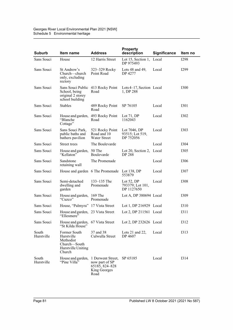
Georges River Local Environmental Plan 2021 [NSW]Schedule 5 Environmental heritage
Sans Souci House 12 Harris Street Lot 15, Section 1, DP 975493
Local I298
Sans Souci St Andrew’s Church—church only, excluding rectory
323–329 Rocky Point Road
Lots 48 and 49, DP 4277
Local I299
Sans Souci Sans Souci Public School, being original 2 storey school building
413 Rocky Point Road
Lots 4–17, Section 1, DP 288
Local I300
Sans Souci Stables 489 Rocky Point Road
SP 76105 Local I301
Sans Souci House and garden, “Blanche Cottage”
493 Rocky Point Road
Lot 71, DP 1162043
Local I302
Sans Souci Sans Souci Park, public baths and bathers pavilion
521 Rocky Point Road and 10 Water Street
Lot 7046, DP 93515; Lot 519, DP 752056
Local I303
Sans Souci Street trees The Boulevarde Local I304
Sans Souci House and garden, “Kellaton”
50 The Boulevarde
Lot 20, Section 2, DP 288
Local I305
Sans Souci Sandstone retaining wall
The Promenade Local I306
Sans Souci House and garden 6 The Promenade Lot 138, DP 553879
Local I307
Sans Souci Semi-detached dwelling and garden
133–135 The Promenade
Lot 52, DP 793379; Lot 101, DP 1127650
Local I308
Sans Souci House and garden, “Cuzco”
169 The Promenade
Lot A, DP 380694 Local I309
Sans Souci House, “Palmyra” 17 Vista Street Lot 1, DP 216929 Local I310Sans Souci House and garden,
“Ellesmere”23 Vista Street Lot 2, DP 211561 Local I311
Sans Souci House and garden, “St Kilda House”
67 Vista Street Lot 2, DP 232626 Local I312
South Hurstville
Former South Hurstville Methodist Church—South Hurstville Uniting Church
37 and 38 Culwulla Street
Lots 21 and 22, DP 4607
Local I313
South Hurstville
House and garden, “Pine Villa”
1 Derwent Street, now part of SP 65185, 824–828 King Georges Road
SP 65185 Local I314
Suburb Item name AddressProperty description Significance Item no
Page 81 Published LW 8 October 2021 (2021 No 587)

Georges River Local Environmental Plan 2021 [NSW]Schedule 5 Environmental heritage
Part 2 Heritage conservation areas
Part 3 Archaeological sites
South Hurstville
St Raphael’s Church and School
88 George Street Lots 13–16, Section 7, DP 5453
Local I315
South Hurstville
Former South Hurstville Bowling Club—Club Hurstville Sports
29 Greenacre Road
Lot 40, DP 1241815
Local I316
DescriptionIdentification on Heritage Map Significance
Penshurst Heritage Conservation Area
Shown by red hatching and labelled “C1”
Local
O’Brien’s Estate Heritage Conservation Area
Shown by red hatching and labelled “C2”
Local
Kogarah South Heritage Conservation Area
Shown by red hatching and labelled “C3”
Local
Suburb Item name AddressProperty description Significance Item no
Blakehurst Ruin—sandstone block dwelling
56 Townson Street
Lot B, DP 343565 Local A1
Suburb Item name AddressProperty description Significance Item no
Page 82 Published LW 8 October 2021 (2021 No 587)

Georges River Local Environmental Plan 2021 [NSW]Schedule 6 Pond-based and tank-based aquaculture
Schedule 6 Pond-based and tank-based aquaculture(Clause 5.19)
Part 1 Pond-based and tank-based aquacultureDivision 1 Site location requirements
1 Conservation exclusion zones(1) Must not be carried out on the following land, except to the extent necessary to gain
access to water—(a) land declared an area of outstanding biodiversity value under the Biodiversity
Conservation Act 2016,(b) vacant Crown land,(c) land within a wetland of international significance declared under the Ramsar
Convention on Wetlands.(2) Must not be carried out on the following land, except for the purposes of minimal
infrastructure to support the extraction of water from, and discharge of water to, theland concerned—(a) land declared as an aquatic reserve under the Marine Estate Management Act
2014,(b) land declared as a marine park under the Marine Estate Management Act 2014.Note. Nothing in this clause affects any requirement under an Act relating to land specified inthis clause to obtain a licence or other authority under that Act for development of the land.
Division 2 Operational requirements2 Species selection
Species of fish or marine vegetation cultivated or kept must be consistent with therelevant aquaculture industry development plan (within the meaning of clause 5.19).
3 Pond-based aquaculture that is also intensive aquaculture—pond designFor pond-based aquaculture that is also intensive aquaculture—ponds must becapable of being drained or pumped and then completely dried.
4 Pond-based aquaculture and tank-based aquaculture that is also intensive aquaculture—freshwater discharges
For pond-based aquaculture and tank-based aquaculture that is also intensiveaquaculture—no discharge of freshwater used to intensively cultivate or keep fish tonatural waterbodies or wetlands is permitted, except freshwater discharge from openflow through systems.
5 Outlets from culture ponds etcAll outlets from culture ponds, tanks and other culture facilities must be screened toavoid the escape of fish.
6 DefinitionIn this Division—intensive aquaculture has the same meaning as it has in the Fisheries Management(Aquaculture) Regulation 2017.
Page 83 Published LW 8 October 2021 (2021 No 587)
Georges River Local Environmental Plan 2021 [NSW]Schedule 6 Pond-based and tank-based aquaculture
Part 2 Extensive pond-based aquacultureDivision 1 Site location requirements
7 Conservation exclusion zones(1) Must not be carried out on the following land, except to the extent necessary to gain
access to water—(a) land declared an area of outstanding biodiversity value under the Biodiversity
Conservation Act 2016,(b) vacant Crown land,(c) land within a wetland of international significance declared under the Ramsar
Convention on Wetlands.Note. Nothing in this clause affects any requirement under an Act relating to land specified inthis clause to obtain a licence or other authority under that Act for development of the land.
8 Flood liabilityMust be designed or constructed on land so that it will not be inundated by thedischarge of a 1:100 ARI (average recurrent interval) flood event.
Division 2 Operational requirements9 Species selection
Species of fish or marine vegetation cultivated or kept must be consistent with therelevant aquaculture industry development plan (within the meaning of clause 5.19).
10 Pond design(1) Must not require the construction of new ponds, water storages, dams or buildings.(2) Must not be located on permanent watercourses, creeks, billabongs or isolated
outreaches of creeks or rivers.(3) Must be capable of preventing the escape of stock into natural waterbodies or
wetlands.
11 Culture waterMust use freshwater.
Page 84 Published LW 8 October 2021 (2021 No 587)

Georges River Local Environmental Plan 2021 [NSW] Dictionary
Dictionary(clause 1.4)
Aboriginal object means any deposit, object or other material evidence (not being a handicraftmade for sale) relating to the Aboriginal habitation of an area of New South Wales, beinghabitation before or concurrent with (or both) the occupation of that area by persons ofnon-Aboriginal extraction, and includes Aboriginal remains.Aboriginal place of heritage significance means an area of land, the general location of which isidentified in an Aboriginal heritage study adopted by the Council after public exhibition and thatmay be shown on the Heritage Map, that is—(a) the site of one or more Aboriginal objects or a place that has the physical remains of
pre-European occupation by, or is of contemporary significance to, the Aboriginal people.It may (but need not) include items and remnants of the occupation of the land byAboriginal people, such as burial places, engraving sites, rock art, midden deposits, scarredand sacred trees and sharpening grooves, or
(b) a natural Aboriginal sacred site or other sacred feature. It includes natural features such ascreeks or mountains of long-standing cultural significance, as well as initiation, ceremonialor story places or areas of more contemporary cultural significance.
Note. The term may include (but is not limited to) places that are declared under section 84 of the NationalParks and Wildlife Act 1974 to be Aboriginal places for the purposes of that Act.acid sulfate soils means naturally occurring sediments and soils containing iron sulfides(principally pyrite) or their precursors or oxidation products, whose exposure to oxygen leads tothe generation of sulfuric acid (for example, by drainage or excavation).Acid Sulfate Soils Manual means the manual by that name published by the Acid Sulfate SoilsManagement Advisory Committee and made publicly available.Acid Sulfate Soils Map means the Georges River Local Environmental Plan 2021 Acid SulfateSoils Map.Activity Hazard Risk Map means the Georges River Local Environmental Plan 2021 ActivityHazard Risk Map.advertisement has the same meaning as in the Act.Note. The term is defined as a sign, notice, device or representation in the nature of an advertisement visiblefrom any public place or public reserve or from any navigable water.advertising structure has the same meaning as in the Act.Note. The term is defined as a structure used or to be used principally for the display of an advertisement.Advertising structures are a type of signage—see the definition of that term in this Dictionary.affordable housing has the same meaning as in the Act.Note. The term is defined as housing for very low income households, low income households or moderateincome households, being such households as are prescribed by the regulations or as are provided for in anenvironmental planning instrument.agricultural produce industry means a building or place used for the handling, treating,processing or packing, for commercial purposes, of produce from agriculture (including dairyproducts, seeds, fruit, vegetables or other plant material), and includes wineries, flour mills, cottonseed oil plants, cotton gins, feed mills, cheese and butter factories, and juicing or canning plants,but does not include a livestock processing industry.Note. Agricultural produce industries are a type of rural industry—see the definition of that term in thisDictionary.agriculture means any of the following—(a) aquaculture,(b) extensive agriculture,(c) intensive livestock agriculture,(d) intensive plant agriculture.
Page 85 Published LW 8 October 2021 (2021 No 587)
Georges River Local Environmental Plan 2021 [NSW] Dictionary
Note. Part 6 of the Plantations and Reafforestation Act 1999 provides that exempt farm forestry within themeaning of that Act is not subject to the Environmental Planning and Assessment Act 1979.air transport facility means an airport or a heliport that is not part of an airport, and includesassociated communication and air traffic control facilities or structures.airport means a place that is used for the landing, taking off, parking, maintenance or repair ofaeroplanes, and includes associated buildings, installations, facilities and movement areas and anyheliport that is part of the airport.Note. Airports are a type of air transport facility—see the definition of that term in this Dictionary.airstrip means a single runway for the landing, taking off or parking of aeroplanes for privateaviation only, but does not include an airport, heliport or helipad.amusement centre means a building or place (not being part of a pub or registered club) usedprincipally for playing—(a) billiards, pool or other like games, or(b) electronic or mechanical amusement devices, such as pinball machines, computer or video
games and the like.animal boarding or training establishment means a building or place used for the breeding,boarding, training, keeping or caring of animals for commercial purposes (other than for theagistment of horses), and includes any associated riding school or ancillary veterinary hospital.aquaculture has the same meaning as in the Fisheries Management Act 1994. It includes oysteraquaculture, pond-based aquaculture and tank-based aquaculture.Note. Aquaculture is a type of agriculture—see the definition of that term in this Dictionary.archaeological site means a place that contains one or more relics.artisan food and drink industry means a building or place the principal purpose of which is themaking or manufacture of boutique, artisan or craft food or drink products only. It must alsoinclude at least one of the following—(a) a retail area for the sale of the products,(b) a restaurant or cafe,(c) facilities for holding tastings, tours or workshops.Note. See clause 5.4 for controls in industrial or rural zones relating to the retail floor area of an artisan foodand drink industry.Artisan food and drink industries are a type of light industry—see the definition of that term in this Dictionary.attached dwelling means a building containing 3 or more dwellings, where—(a) each dwelling is attached to another dwelling by a common wall, and(b) each of the dwellings is on its own lot of land, and(c) none of the dwellings is located above any part of another dwelling.Note. Attached dwellings are a type of residential accommodation—see the definition of that term in thisDictionary.attic means any habitable space, but not a separate dwelling, contained wholly within a roof abovethe ceiling line of the storey immediately below, except for minor elements such as dormerwindows and the like.backpackers’ accommodation means a building or place that—(a) provides temporary or short-term accommodation on a commercial basis, and(b) has shared facilities, such as a communal bathroom, kitchen or laundry, and(c) provides accommodation on a bed or dormitory-style basis (rather than by room).Note. Backpackers’ accommodation is a type of tourist and visitor accommodation—see the definition ofthat term in this Dictionary.basement means the space of a building where the floor level of that space is predominantly belowground level (existing) and where the floor level of the storey immediately above is less than 1metre above ground level (existing).
Page 86 Published LW 8 October 2021 (2021 No 587)
Georges River Local Environmental Plan 2021 [NSW] Dictionary
bed and breakfast accommodation means an existing dwelling in which temporary or short-termaccommodation is provided on a commercial basis by the permanent residents of the dwelling andwhere—(a) meals are provided for guests only, and(b) cooking facilities for the preparation of meals are not provided within guests’ rooms, and(c) dormitory-style accommodation is not provided.Note. See clause 5.4 for controls relating to the number of bedrooms for bed and breakfast accommodation.Bed and breakfast accommodation is a type of tourist and visitor accommodation—see the definition ofthat term in this Dictionary.bee keeping means a building or place used for the keeping and breeding of bees for commercialpurposes.Note. Bee keeping is a type of extensive agriculture—see the definition of that term in this Dictionary.biodiversity or biological diversity means the variety of living animal and plant life from allsources, and includes diversity within and between species and diversity of ecosystems.biosolids treatment facility means a building or place used as a facility for the treatment ofbiosolids from a sewage treatment plant or from a water recycling facility.Note. Biosolids treatment facilities are a type of sewerage system—see the definition of that term in thisDictionary.boarding house means a building that—(a) is wholly or partly let in lodgings, and(b) provides lodgers with a principal place of residence for 3 months or more, and(c) may have shared facilities, such as a communal living room, bathroom, kitchen or laundry,
and(d) has rooms, some or all of which may have private kitchen and bathroom facilities, that
accommodate one or more lodgers,but does not include backpackers’ accommodation, a group home, hotel or motel accommodation,seniors housing or a serviced apartment.Note. Boarding houses are a type of residential accommodation—see the definition of that term in thisDictionary.boat building and repair facility means any facility (including a building or other structure) usedprimarily for the construction, maintenance or repair of boats, whether or not including thestorage, sale or hire of boats, but does not include a marina or boat shed.boat launching ramp means a structure designed primarily for the launching of trailer bornerecreational vessels, and includes associated car parking facilities.boat shed means a building or other structure used for the storage and routine maintenance of aboat or boats and that is associated with a private dwelling or non-profit organisation, and includesany skid used in connection with the building or other structure.brothel has the same meaning as in the Act.Note. This definition is relevant to the definitions of home occupation (sex services) and sex servicespremises in this Dictionary.building has the same meaning as in the Act.Note. The term is defined to include part of a building and any structure or part of a structure, but not includinga manufactured home, a moveable dwelling or associated structure (or part of a manufactured home,moveable dwelling or associated structure).building height (or height of building) means—(a) in relation to the height of a building in metres—the vertical distance from ground level
(existing) to the highest point of the building, or(b) in relation to the RL of a building—the vertical distance from the Australian Height Datum
to the highest point of the building,
Page 87 Published LW 8 October 2021 (2021 No 587)
Georges River Local Environmental Plan 2021 [NSW] Dictionary
including plant and lift overruns, but excluding communication devices, antennae, satellite dishes,masts, flagpoles, chimneys, flues and the like.building identification sign means a sign that identifies or names a building and that may includethe name of a building, the street name and number of a building, and a logo or other symbol butdoes not include general advertising of products, goods or services.Note. Building identification signs are a type of signage—see the definition of that term in this Dictionary.building line or setback means the horizontal distance between the property boundary or otherstated boundary (measured at 90 degrees from the boundary) and—(a) a building wall, or(b) the outside face of any balcony, deck or the like, or(c) the supporting posts of a carport or verandah roof,whichever distance is the shortest.bush fire hazard reduction work has the same meaning as in the Rural Fires Act 1997.Note. The term is defined as follows—bush fire hazard reduction work means—(a) the establishment or maintenance of fire breaks on land, and(b) the controlled application of appropriate fire regimes or other means for the reduction or modification
of available fuels within a predetermined area to mitigate against the spread of a bush fire,but does not include construction of a track, trail or road.bush fire prone land has the same meaning as in the Act.Note. The term is defined, in relation to an area, as land recorded for the time being as bush fire prone landon a map for the area certified as referred to in section 10.3(2) of the Act.bush fire risk management plan means a plan prepared under Division 4 of Part 3 of the RuralFires Act 1997 for the purpose referred to in section 54 of that Act.business identification sign means a sign—(a) that indicates—
(i) the name of the person or business, and(ii) the nature of the business carried on by the person at the premises or place at which
the sign is displayed, and(b) that may include the address of the premises or place and a logo or other symbol that
identifies the business,but that does not contain any advertising relating to a person who does not carry on business at thepremises or place.Note. Business identification signs are a type of signage—see the definition of that term in this Dictionary.business premises means a building or place at or on which—(a) an occupation, profession or trade (other than an industry) is carried on for the provision of
services directly to members of the public on a regular basis, or(b) a service is provided directly to members of the public on a regular basis,and includes a funeral home and, without limitation, premises such as banks, post offices,hairdressers, dry cleaners, travel agencies, internet access facilities, betting agencies and the like,but does not include an entertainment facility, home business, home occupation, home occupation(sex services), medical centre, restricted premises, sex services premises or veterinary hospital.Note. Business premises are a type of commercial premises—see the definition of that term in thisDictionary.camping ground means an area of land that has access to communal amenities and on whichcampervans or tents, annexes or other similar portable and lightweight temporary shelters are, orare to be, installed, erected or placed for short term use, but does not include a caravan park.canal estate development means development that incorporates wholly or in part a constructedcanal, or other waterway or waterbody, that is inundated by or drains to a natural waterway or
Page 88 Published LW 8 October 2021 (2021 No 587)

Georges River Local Environmental Plan 2021 [NSW] Dictionary
natural waterbody by surface water or groundwater movement (not being works of drainage, orfor the supply or treatment of water, that are constructed by or with the authority of a person orbody responsible for those functions and that are limited to the minimal reasonable size andcapacity to meet a demonstrated need for the works), and that either—(a) includes the construction of dwellings (which may include tourist and visitor
accommodation) of a kind other than, or in addition to—(i) dwellings that are permitted on rural land, and
(ii) dwellings that are used for caretaker or staff purposes, or(b) requires the use of a sufficient depth of fill material to raise the level of all or part of that
land on which the dwellings are (or are proposed to be) located in order to comply withrequirements relating to residential development on flood prone land.
car park means a building or place primarily used for the purpose of parking motor vehicles,including any manoeuvring space and access thereto, whether operated for gain or not.caravan park means land (including a camping ground) on which caravans (or caravans and othermoveable dwellings) are, or are to be, installed or placed.catchment action plan has the same meaning as in the Catchment Management Authorities Act2003.Note. The term is defined as a catchment action plan of an authority that has been approved by the Ministerunder Part 4 of the Catchment Management Authorities Act 2003.cellar door premises means a building or place that is used to sell wine by retail and that is situatedon land on which there is a commercial vineyard, and where most of the wine offered for sale isproduced in a winery situated on that land or is produced predominantly from grapes grown in thesurrounding area.Note. Cellar door premises are a type of retail premises—see the definition of that term in this Dictionary.cemetery means a building or place used primarily for the interment of deceased persons or petsor their ashes, whether or not it contains an associated building for conducting memorial services.centre-based child care facility means—(a) a building or place used for the education and care of children that provides any one or more
of the following—(i) long day care,
(ii) occasional child care,(iii) out-of-school-hours care (including vacation care),(iv) preschool care, or
(b) an approved family day care venue (within the meaning of the Children (Education andCare Services) National Law (NSW)),Note. An approved family day care venue is a place, other than a residence, where an approvedfamily day care service (within the meaning of the Children (Education and Care Services) NationalLaw (NSW)) is provided.
but does not include—(c) a building or place used for home-based child care or school-based child care, or(d) an office of a family day care service (within the meanings of the Children (Education and
Care Services) National Law (NSW)), or(e) a babysitting, playgroup or child-minding service that is organised informally by the
parents of the children concerned, or(f) a child-minding service that is provided in connection with a recreational or commercial
facility (such as a gymnasium) to care for children while the children’s parents are using thefacility, or
(g) a service that is concerned primarily with providing lessons or coaching in, or providing forparticipation in, a cultural, recreational, religious or sporting activity, or providing privatetutoring, or
Page 89 Published LW 8 October 2021 (2021 No 587)
Georges River Local Environmental Plan 2021 [NSW] Dictionary
(h) a child-minding service that is provided by or in a health services facility, but only if theservice is established, registered or licensed as part of the institution operating in thefacility.
charter and tourism boating facility means any facility (including a building or other structure)used for charter boating or tourism boating purposes, being a facility that is used only by theoperators of the facility and that has a direct structural connection between the foreshore and thewaterway, but does not include a marina.classified road has the same meaning as in the Roads Act 1993.Note. The term is defined as follows—classified road means any of the following—(a) a main road,(b) a highway,(c) a freeway,(d) a controlled access road,(e) a secondary road,(f) a tourist road,
(g) a tollway,(h) a transitway,(i) a State work.
(See Roads Act 1993 for meanings of these terms.)clearing native vegetation has the same meaning as in Part 5A of the Local Land Services Act2013.clearing vegetation has the same meaning as in State Environmental Planning Policy (Vegetationin Non-Rural Areas) 2017.coastal hazard has the same meaning as in the Coastal Management Act 2016.Coastal Hazard and Risk Map means the Georges River Local Environmental Plan 2021 CoastalHazard and Risk Map.coastal lake means a body of water identified in Schedule 1 to State Environmental PlanningPolicy (Coastal Management) 2018.coastal protection works has the same meaning as in the Coastal Management Act 2016.coastal waters of the State—see section 58 of the Interpretation Act 1987.coastal zone has the same meaning as in the Coastal Management Act 2016.commercial premises means any of the following—(a) business premises,(b) office premises,(c) retail premises.community facility means a building or place—(a) owned or controlled by a public authority or non-profit community organisation, and(b) used for the physical, social, cultural or intellectual development or welfare of the
community,but does not include an educational establishment, hospital, retail premises, place of publicworship or residential accommodation.community land has the same meaning as in the Local Government Act 1993.correctional centre means—(a) any premises declared to be a correctional centre by a proclamation in force under section
225 of the Crimes (Administration of Sentences) Act 1999, including any juvenilecorrectional centre or periodic detention centre, and
Page 90 Published LW 8 October 2021 (2021 No 587)
Georges River Local Environmental Plan 2021 [NSW] Dictionary
(b) any premises declared to be a detention centre by an order in force under section 5(1) of theChildren (Detention Centres) Act 1987,
but does not include any police station or court cell complex in which a person is held in custodyin accordance with any Act.Council means the Georges River Council.crematorium means a building in which deceased persons or pets are cremated, whether or not itcontains an associated building for conducting memorial services.curtilage, in relation to a heritage item or conservation area, means the area of land (including landcovered by water) surrounding a heritage item, a heritage conservation area, or building, work orplace within a heritage conservation area, that contributes to its heritage significance.dairy (pasture-based) means a dairy that is conducted on a commercial basis where the onlyrestriction facilities present are milking sheds and holding yards and where cattle generally feedby grazing on living grasses and other plants on the land and are constrained for no more than 10hours in any 24 hour period (excluding during any period of drought or similar emergency relief).Note. Dairies (pasture-based) are a type of extensive agriculture—see the definition of that term in thisDictionary.dairy (restricted) means a dairy that is conducted on a commercial basis where restriction facilities(in addition to milking sheds and holding yards) are present and where cattle have access tograzing for less than 10 hours in any 24 hour period (excluding during any period of drought orsimilar emergency relief). It may comprise the whole or part of a restriction facility.Note. Dairies (restricted) are a type of intensive livestock agriculture—see the definition of that term in thisDictionary.demolish, in relation to a heritage item or an Aboriginal object, or a building, work, relic or treewithin a heritage conservation area, means wholly or partly destroy, dismantle or deface theheritage item, Aboriginal object or building, work, relic or tree.depot means a building or place used for the storage (but not sale or hire) of plant, machinery orother goods (that support the operations of an existing undertaking) when not required for use, butdoes not include a farm building.drainage means any activity that intentionally alters the hydrological regime of any locality byfacilitating the removal of surface or ground water. It may include the construction, deepening,extending, opening, installation or laying of any canal, drain or pipe, either on the land or in sucha manner as to encourage drainage of adjoining land.dual occupancy means a dual occupancy (attached) or a dual occupancy (detached).Note. Dual occupancies are a type of residential accommodation—see the definition of that term in thisDictionary.dual occupancy (attached) means 2 dwellings on one lot of land that are attached to each other,but does not include a secondary dwelling.Note. Dual occupancies (attached) are a type of dual occupancy—see the definition of that term in thisDictionary.dual occupancy (detached) means 2 detached dwellings on one lot of land, but does not includea secondary dwelling.Note. Dual occupancies (detached) are a type of dual occupancy—see the definition of that term in thisDictionary.dwelling means a room or suite of rooms occupied or used or so constructed or adapted as to becapable of being occupied or used as a separate domicile.dwelling house means a building containing only one dwelling.Note. Dwelling houses are a type of residential accommodation—see the definition of that term in thisDictionary.early education and care facility means a building or place used for the education and care ofchildren, and includes any of the following—(a) a centre-based child care facility,(b) home-based child care,
Page 91 Published LW 8 October 2021 (2021 No 587)

Georges River Local Environmental Plan 2021 [NSW] Dictionary
(c) school-based child care.earthworks means excavation or filling.ecologically sustainable development has the same meaning as in the Act.eco-tourist facility means a building or place that—(a) provides temporary or short-term accommodation to visitors on a commercial basis, and(b) is located in or adjacent to an area with special ecological or cultural features, and(c) is sensitively designed and located so as to minimise bulk, scale and overall physical
footprint and any ecological or visual impact.It may include facilities that are used to provide information or education to visitors and to exhibitor display items.Note. See clause 5.13 for requirements in relation to the granting of development consent for eco-touristfacilities.Eco-tourist facilities are not a type of tourist and visitor accommodation—see the definition of that term inthis Dictionary.educational establishment means a building or place used for education (including teaching),being—(a) a school, or(b) a tertiary institution, including a university or a TAFE establishment, that provides formal
education and is constituted by or under an Act.electricity generating works means a building or place used for the purpose of—(a) making or generating electricity, or(b) electricity storage.emergency services facility means a building or place (including a helipad) used in connectionwith the provision of emergency services by an emergency services organisation.emergency services organisation means any of the following—(a) Ambulance Service of New South Wales,(b) Fire and Rescue NSW,(c) NSW Rural Fire Service,(d) NSW Police Force,(e) State Emergency Service,(f) New South Wales Volunteer Rescue Association Incorporated,(g) New South Wales Mines Rescue Brigade established under the Coal Industry Act 2001,(h) an accredited rescue unit within the meaning of the State Emergency and Rescue
Management Act 1989.entertainment facility means a theatre, cinema, music hall, concert hall, dance hall and the like,but does not include a pub or registered club.environmental facility means a building or place that provides for the recreational use or scientificstudy of natural systems, and includes walking tracks, seating, shelters, board walks, observationdecks, bird hides or the like, and associated display structures.environmental protection works means works associated with the rehabilitation of land towardsits natural state or any work to protect land from environmental degradation, and includes bushregeneration works, wetland protection works, erosion protection works, dune restoration worksand the like, but does not include coastal protection works.estuary has the same meaning as in the Water Management Act 2000.Note. The term is defined as follows—estuary means—(a) any part of a river whose level is periodically or intermittently affected by coastal tides, or
Page 92 Published LW 8 October 2021 (2021 No 587)
Georges River Local Environmental Plan 2021 [NSW] Dictionary
(b) any lake or other partially enclosed body of water that is periodically or intermittently open to the sea,or
(c) anything declared by the regulations (under the Water Management Act 2000) to be an estuary,but does not include anything declared by the regulations (under the Water Management Act 2000) not to bean estuary.excavation means the removal of soil or rock, whether moved to another part of the same site orto another site, but does not include garden landscaping that does not significantly alter the shape,natural form or drainage of the land.exhibition home means a dwelling built for the purposes of the public exhibition and marketingof new dwellings, whether or not it is intended to be sold as a private dwelling after its use forthose purposes is completed, and includes any associated sales or home finance office or placeused for displays.exhibition village means 2 or more exhibition homes and associated buildings and places used forhouse and land sales, site offices, advisory services, car parking, food and drink sales and otherassociated purposes.extensive agriculture means any of the following—(a) the production of crops or fodder (including irrigated pasture and fodder crops) for
commercial purposes,(b) the grazing of livestock (other than pigs and poultry) for commercial purposes on living
grasses and other plants on the land as their primary source of dietary requirements, and anysupplementary or emergency feeding, or temporary agistment or housing for weaning,dipping, tagging or similar husbandry purposes, of the livestock,
(c) bee keeping,(d) a dairy (pasture-based) where the animals generally feed by grazing on living grasses and
other plants on the land as their primary source of dietary requirements, and anysupplementary or emergency feeding, or temporary agistment or housing for weaning,dipping, tagging or similar husbandry purposes, of the animals.
Note. Extensive agriculture is a type of agriculture—see the definition of that term in this Dictionary.extractive industry means the winning or removal of extractive materials (otherwise than from amine) by methods such as excavating, dredging, tunnelling or quarrying, including the storing,stockpiling or processing of extractive materials by methods such as recycling, washing, crushing,sawing or separating, but does not include turf farming.Note. Extractive industries are not a type of industry—see the definition of that term in this Dictionary.extractive material means sand, soil, gravel, rock or similar substances that are not mineralswithin the meaning of the Mining Act 1992.farm building means a structure the use of which is ancillary to an agricultural use of thelandholding on which it is situated and includes a hay shed, stock holding yard, machinery shed,shearing shed, silo, storage tank, outbuilding or the like, but does not include a dwelling.farm stay accommodation means a building or place that provides temporary or short-termaccommodation to paying guests on a working farm as a secondary business to primaryproduction.Note. See clause 5.4 for controls relating to the number of bedrooms.Farm stay accommodation is a type of tourist and visitor accommodation—see the definition of that termin this Dictionary.feedlot means a confined or restricted area that is operated on a commercial basis to rear and fattencattle, sheep or other animals, but does not include a poultry farm, dairy or pig farm.Note. Feedlots are a type of intensive livestock agriculture. Intensive livestock agriculture does notinclude extensive agriculture. See the definitions of those terms in this Dictionary.fill means the depositing of soil, rock or other similar extractive material obtained from the sameor another site, but does not include—
Page 93 Published LW 8 October 2021 (2021 No 587)
Georges River Local Environmental Plan 2021 [NSW] Dictionary
(a) the depositing of topsoil or feature rock imported to the site that is intended for use ingarden landscaping, turf or garden bed establishment or top dressing of lawns and that doesnot significantly alter the shape, natural form or drainage of the land, or
(b) the use of land as a waste disposal facility.filming means recording images (whether on film or video tape or electronically or by othermeans) for exhibition or broadcast (such as by cinema, television or the internet or by othermeans), but does not include—(a) still photography, or(b) recording images of a wedding ceremony or other private celebration or event principally
for the purpose of making a record for the participants in the ceremony, celebration orevent, or
(c) recording images as a visitor or tourist for non-commercial purposes, or(d) recording for the immediate purposes of a television program that provides information by
way of current affairs or daily news.fish has the same meaning as in the Fisheries Management Act 1994.Note. The term is defined as follows—Definition of “fish”(1) Fish means marine, estuarine or freshwater fish or other aquatic animal life at any stage of their life
history (whether alive or dead).(2) Fish includes—
(a) oysters and other aquatic molluscs, and(b) crustaceans, and(c) echinoderms, and(d) beachworms and other aquatic polychaetes.
(3) Fish also includes any part of a fish.(4) However, fish does not include whales, mammals, reptiles, birds, amphibians or other things
excluded from the definition by the regulations under the Fisheries Management Act 1994.flood mitigation work means work designed and constructed for the express purpose of mitigatingflood impacts. It involves changing the characteristics of flood behaviour to alter the level,location, volume, speed or timing of flood waters to mitigate flood impacts. Types of works mayinclude excavation, construction or enlargement of any fill, wall, or levee that will alter riverineflood behaviour, local overland flooding, or tidal action so as to mitigate flood impacts.floor space ratio—see clause 4.5.Floor Space Ratio Map means the Georges River Local Environmental Plan 2021 Floor SpaceRatio Map.food and drink premises means premises that are used for the preparation and retail sale of foodor drink (or both) for immediate consumption on or off the premises, and includes any of thefollowing—(a) a restaurant or cafe,(b) take away food and drink premises,(c) a pub,(d) a small bar.Note. Food and drink premises are a type of retail premises—see the definition of that term in thisDictionary.Foreshore Building Line Map means the Georges River Local Environmental Plan 2021Foreshore Building Line Map.Foreshore Scenic Protection Area Map means the Georges River Local Environmental Plan2021 Foreshore Scenic Protection Area Map.forestry means forestry operations within the meaning of the Forestry Act 2012 or Part 5B of theLocal Land Services Act 2013.
Page 94 Published LW 8 October 2021 (2021 No 587)
Georges River Local Environmental Plan 2021 [NSW] Dictionary
freight transport facility means a facility used principally for the bulk handling of goods fortransport by road, rail, air or sea, including any facility for the loading and unloading of vehicles,aircraft, vessels or containers used to transport those goods and for the parking, holding, servicingor repair of those vehicles, aircraft or vessels or for the engines or carriages involved.function centre means a building or place used for the holding of events, functions, conferencesand the like, and includes convention centres, exhibition centres and reception centres, but doesnot include an entertainment facility.funeral home means premises that are used to arrange, conduct and cater for funerals andmemorial services, whether or not the premises include facilities for the short-term storage,dressing and viewing of bodies of deceased persons.Note. Funeral homes are a type of business premises—see the definition of that term in this Dictionary.garden centre means a building or place the principal purpose of which is the retail sale of plantsand landscaping and gardening supplies and equipment. It may include a restaurant or cafe and thesale of any of the following—(a) outdoor furniture and furnishings, barbecues, shading and awnings, pools, spas and
associated supplies, and items associated with the construction and maintenance of outdoorareas,
(b) pets and pet supplies,(c) fresh produce.Note. Garden centres are a type of retail premises—see the definition of that term in this Dictionary.general industry means a building or place (other than a heavy industry or light industry) that isused to carry out an industrial activity.Note. General industries are a type of industry—see the definition of that term in this Dictionary.gross floor area means the sum of the floor area of each floor of a building measured from theinternal face of external walls, or from the internal face of walls separating the building from anyother building, measured at a height of 1.4 metres above the floor, and includes—(a) the area of a mezzanine, and(b) habitable rooms in a basement or an attic, and(c) any shop, auditorium, cinema, and the like, in a basement or attic,but excludes—(d) any area for common vertical circulation, such as lifts and stairs, and(e) any basement—
(i) storage, and(ii) vehicular access, loading areas, garbage and services, and
(f) plant rooms, lift towers and other areas used exclusively for mechanical services or ducting,and
(g) car parking to meet any requirements of the consent authority (including access to that carparking), and
(h) any space used for the loading or unloading of goods (including access to it), and(i) terraces and balconies with outer walls less than 1.4 metres high, and(j) voids above a floor at the level of a storey or storey above.
ground level (existing) means the existing level of a site at any point.ground level (finished) means, for any point on a site, the ground surface after completion of anyearthworks (excluding any excavation for a basement, footings or the like) for which consent hasbeen granted or that is exempt development.ground level (mean) means, for any site on which a building is situated or proposed, one half ofthe sum of the highest and lowest levels at ground level (finished) of the outer surface of theexternal walls of the building.
Page 95 Published LW 8 October 2021 (2021 No 587)
Georges River Local Environmental Plan 2021 [NSW] Dictionary
group home means a permanent group home or a transitional group home.Note. Group homes are a type of residential accommodation—see the definition of that term in thisDictionary.group home (permanent) or permanent group home means a dwelling—(a) that is occupied by persons as a single household with or without paid supervision or care
and whether or not those persons are related or payment for board and lodging is required,and
(b) that is used to provide permanent household accommodation for people with a disability orpeople who are socially disadvantaged,
but does not include development to which State Environmental Planning Policy (Housing forSeniors or People with a Disability) 2004 applies.Note. Permanent group homes are a type of group home—see the definition of that term in this Dictionary.group home (transitional) or transitional group home means a dwelling—(a) that is occupied by persons as a single household with or without paid supervision or care
and whether or not those persons are related or payment for board and lodging is required,and
(b) that is used to provide temporary accommodation for the relief or rehabilitation of peoplewith a disability or for drug or alcohol rehabilitation purposes, or that is used to providehalf-way accommodation for persons formerly living in institutions or temporaryaccommodation comprising refuges for men, women or young people,
but does not include development to which State Environmental Planning Policy (Housing forSeniors or People with a Disability) 2004 applies.Note. Transitional group homes are a type of group home—see the definition of that term in this Dictionary.hardware and building supplies means a building or place the principal purpose of which is thesale or hire of goods or materials, such as household fixtures, timber, tools, paint, wallpaper,plumbing supplies and the like, that are used in the construction and maintenance of buildings andadjacent outdoor areas.Note. Hardware and building supplies are a type of retail premises—see the definition of that term in thisDictionary.hazardous industry means a building or place used to carry out an industrial activity that would,when carried out and when all measures proposed to reduce or minimise its impact on the localityhave been employed (including, for example, measures to isolate the activity from existing orlikely future development on other land in the locality), pose a significant risk in the locality—(a) to human health, life or property, or(b) to the biophysical environment.Note. Hazardous industries are a type of heavy industry—see the definition of that term in this Dictionary.hazardous storage establishment means a building or place that is used for the storage of goods,materials or products and that would, when in operation and when all measures proposed to reduceor minimise its impact on the locality have been employed (including, for example, measures toisolate the building or place from existing or likely future development on other land in thelocality), pose a significant risk in the locality—(a) to human health, life or property, or(b) to the biophysical environment.Note. Hazardous storage establishments are a type of heavy industrial storage establishment—see thedefinition of that term in this Dictionary.headland includes a promontory extending from the general line of the coastline into a large bodyof water, such as a sea, coastal lake or bay.health care professional means any person registered under an Act for the purpose of providinghealth care.health consulting rooms means premises comprising one or more rooms within (or within thecurtilage of) a dwelling house used by not more than 3 health care professionals at any one time.
Page 96 Published LW 8 October 2021 (2021 No 587)
Georges River Local Environmental Plan 2021 [NSW] Dictionary
Note. Health consulting rooms are a type of health services facility—see the definition of that term in thisDictionary.health services facility means a building or place used to provide medical or other servicesrelating to the maintenance or improvement of the health, or the restoration to health, of personsor the prevention of disease in or treatment of injury to persons, and includes any of thefollowing—(a) a medical centre,(b) community health service facilities,(c) health consulting rooms,(d) patient transport facilities, including helipads and ambulance facilities,(e) hospital.heavy industrial storage establishment means a building or place used for the storage of goods,materials, plant or machinery for commercial purposes and that requires separation from otherdevelopment because of the nature of the processes involved, or the goods, materials, plant ormachinery stored, and includes any of the following—(a) a hazardous storage establishment,(b) a liquid fuel depot,(c) an offensive storage establishment.heavy industry means a building or place used to carry out an industrial activity that requiresseparation from other development because of the nature of the processes involved, or thematerials used, stored or produced, and includes—(a) hazardous industry, or(b) offensive industry.It may also involve the use of a hazardous storage establishment or offensive storageestablishment.Note. Heavy industries are a type of industry—see the definition of that term in this Dictionary.Height of Buildings Map means the Georges River Local Environmental Plan 2021 Height ofBuildings Map.helipad means a place not open to the public used for the taking off and landing of helicopters.heliport means a place open to the public that is used for the taking off and landing of helicopters,whether or not it includes—(a) a terminal building, or(b) facilities for the parking, storage or repair of helicopters.Note. Heliports are a type of air transport facility—see the definition of that term in this Dictionary.heritage conservation area means an area of land of heritage significance—(a) shown on the Heritage Map as a heritage conservation area, and(b) the location and nature of which is described in Schedule 5,and includes any heritage items situated on or within that area.heritage conservation management plan means a document prepared in accordance withguidelines prepared by the Public Service agency responsible to the Minister administering theHeritage Act 1977 that documents the heritage significance of an item, place or heritageconservation area and identifies conservation policies and management mechanisms that areappropriate to enable that significance to be retained.heritage impact statement means a document consisting of—(a) a statement demonstrating the heritage significance of a heritage item or heritage
conservation area, and(b) an assessment of the impact that proposed development will have on that significance, and
Page 97 Published LW 8 October 2021 (2021 No 587)

Georges River Local Environmental Plan 2021 [NSW] Dictionary
(c) proposals for measures to minimise that impact.heritage item means a building, work, place, relic, tree, object or archaeological site the locationand nature of which is described in Schedule 5.Note. An inventory of heritage items is also available at the office of the Council.heritage management document means—(a) a heritage conservation management plan, or(b) a heritage impact statement, or(c) any other document that provides guidelines for the ongoing management and conservation
of a heritage item, Aboriginal object, Aboriginal place of heritage significance or heritageconservation area.
Heritage Map means the Georges River Local Environmental Plan 2021 Heritage Map.heritage significance means historical, scientific, cultural, social, archaeological, architectural,natural or aesthetic value.high technology industry means a building or place predominantly used to carry out an industrialactivity that involves any of the following—(a) electronic or micro-electronic systems, goods or components,(b) information technology (such as computer software or hardware),(c) instrumentation or instruments of a scientific, industrial, technological, medical or similar
nature,(d) biological, pharmaceutical, medical or paramedical systems, goods or components,(e) film, television or multi-media technologies, including any post production systems, goods
or components,(f) telecommunications systems, goods or components,(g) sustainable energy technologies,(h) any other goods, systems or components intended for use in a science or technology related
field,but does not include a building or place used to carry out an industrial activity that presents ahazard or potential hazard to the neighbourhood or that, because of the scale and nature of theprocesses involved, interferes with the amenity of the neighbourhood.Note. High technology industries are a type of light industry—see the definition of that term in thisDictionary.highway service centre means a building or place used to provide refreshments and vehicleservices to highway users. It may include any one or more of the following—(a) a restaurant or cafe,(b) take away food and drink premises,(c) service stations and facilities for emergency vehicle towing and repairs,(d) parking for vehicles,(e) rest areas and public amenities.home-based child care means a family day care residence (within the meaning of the Children(Education and Care Services) National Law (NSW)) at which the education and care service isprovided at any one time to no more than 7 children (including any child of the person providingthe service) all of whom are under the age of 13 years and no more than 4 of whom are childrenwho do not ordinarily attend school.Note. A family day care residence is a residence at which a family day care educator educates and cares forchildren as part of a family day care service—see the Children (Education and Care Services) National Law(NSW).
Page 98 Published LW 8 October 2021 (2021 No 587)
Georges River Local Environmental Plan 2021 [NSW] Dictionary
home business means a business, whether or not involving the sale of items online, carried on ina dwelling, or in a building ancillary to a dwelling, by 1 or more permanent residents of thedwelling and not involving the following—(a) the employment of more than 2 persons other than the residents,(b) interference with the amenity of the neighbourhood because of the emission of noise,
vibration, smell, fumes, smoke, vapour, steam, soot, ash, dust, waste water, waste products,grit or oil, traffic generation or otherwise,
(c) the exposure to view, from adjacent premises or from a public place, of unsightly matter,(d) the exhibition of signage, other than a business identification sign,(e) the retail sale of, or the exposure or offer for retail sale of, items, whether goods or
materials, not produced at the dwelling or building, other than by online retailing,but does not include bed and breakfast accommodation, home occupation (sex services) or sexservices premises.Note— See clause 5.4 for controls relating to the floor area used for a home business.home industry means an industrial activity, whether or not involving the sale of items online,carried on in a dwelling, or in a building ancillary to a dwelling, by 1 or more permanent residentsof the dwelling and not involving the following—(a) the employment of more than 2 persons other than the residents,(b) interference with the amenity of the neighbourhood because of the emission of noise,
vibration, smell, fumes, smoke, vapour, steam, soot, ash, dust, waste water, waste products,grit or oil, traffic generation or otherwise,
(c) the exposure to view, from adjacent premises or from a public place, of unsightly matter,(d) the exhibition of signage, other than a business identification sign,(e) the retail sale of, or the exposure or offer for retail sale of, items, whether goods or
materials, not produced at the dwelling or building, other than by online retailing,but does not include bed and breakfast accommodation or sex services premises.Note— See clause 5.4 for controls relating to the floor area used for a home industry.Home industries are a type of light industry—see the definition of that term in this Dictionary.home occupation means an occupation that is carried on in a dwelling, or in a building ancillaryto a dwelling, by one or more permanent residents of the dwelling and that does not involve—(a) the employment of persons other than those residents, or(b) interference with the amenity of the neighbourhood by reason of the emission of noise,
vibration, smell, fumes, smoke, vapour, steam, soot, ash, dust, waste water, waste products,grit or oil, traffic generation or otherwise, or
(c) the display of goods, whether in a window or otherwise, or(d) the exhibition of any signage (other than a business identification sign), or(e) the sale of items (whether goods or materials), or the exposure or offer for sale of items, by
retail,but does not include bed and breakfast accommodation, home occupation (sex services) or sexservices premises.home occupation (sex services) means the provision of sex services in a dwelling that is a brothel,or in a building that is a brothel and is ancillary to such a dwelling, by no more than 2 permanentresidents of the dwelling and that does not involve—(a) the employment of persons other than those residents, or(b) interference with the amenity of the neighbourhood by reason of the emission of noise,
traffic generation or otherwise, or(c) the exhibition of any signage, or
Page 99 Published LW 8 October 2021 (2021 No 587)

Georges River Local Environmental Plan 2021 [NSW] Dictionary
(d) the sale of items (whether goods or materials), or the exposure or offer for sale of items, byretail,
but does not include a home business or sex services premises.horticulture means the cultivation of fruits, vegetables, mushrooms, nuts, cut flowers and foliageand nursery products for commercial purposes, but does not include a plant nursery, turf farmingor viticulture.Note. Horticulture is a type of intensive plant agriculture—see the definition of that term in this Dictionary.hospital means a building or place used for the purpose of providing professional health careservices (such as preventative or convalescent care, diagnosis, medical or surgical treatment,psychiatric care or care for people with disabilities, or counselling services provided by health careprofessionals) to people admitted as in-patients (whether or not out-patients are also cared for ortreated there), and includes ancillary facilities for (or that consist of) any of the following—(a) day surgery, day procedures or health consulting rooms,(b) accommodation for nurses or other health care workers,(c) accommodation for persons receiving health care or for their visitors,(d) shops, kiosks, restaurants or cafes or take away food and drink premises,(e) patient transport facilities, including helipads, ambulance facilities and car parking,(f) educational purposes or any other health-related use,(g) research purposes (whether or not carried out by hospital staff or health care workers or for
commercial purposes),(h) chapels,(i) hospices,(j) mortuaries.
Note. Hospitals are a type of health services facility—see the definition of that term in this Dictionary.hostel means premises that are generally staffed by social workers or support providers and atwhich—(a) residential accommodation is provided in dormitories, or on a single or shared basis, or by
a combination of them, and(b) cooking, dining, laundering, cleaning and other facilities are provided on a shared basis.Note. Hostels are a type of residential accommodation—see the definition of that term in this Dictionary.hotel or motel accommodation means a building or place (whether or not licensed premises underthe Liquor Act 2007) that provides temporary or short-term accommodation on a commercial basisand that—(a) comprises rooms or self-contained suites, and(b) may provide meals to guests or the general public and facilities for the parking of guests’
vehicles,but does not include backpackers’ accommodation, a boarding house, bed and breakfastaccommodation or farm stay accommodation.Note. Hotel or motel accommodation is a type of tourist and visitor accommodation—see the definition ofthat term in this Dictionary.industrial activity means the manufacturing, production, assembling, altering, formulating,repairing, renovating, ornamenting, finishing, cleaning, washing, dismantling, transforming,processing, recycling, adapting or servicing of, or the research and development of, any goods,substances, food, products or articles for commercial purposes, and includes any storage ortransportation associated with any such activity.industrial retail outlet means a building or place that—(a) is used in conjunction with an industry (other than an artisan food and drink industry) or
rural industry, and
Page 100 Published LW 8 October 2021 (2021 No 587)
Georges River Local Environmental Plan 2021 [NSW] Dictionary
(b) is situated on the land on which the industry or rural industry is located, and(c) is used for the display or sale (whether by retail or wholesale) of only those goods that have
been manufactured on the land on which the industry or rural industry is located,but does not include a warehouse or distribution centre.Note. See clause 5.4 for controls relating to the retail floor area of an industrial retail outlet.industrial training facility means a building or place used in connection with vocational trainingin an activity (such as forklift or truck driving, welding or carpentry) that is associated with anindustry, rural industry, extractive industry or mining, but does not include an educationalestablishment, business premises or retail premises.industry means any of the following—(a) general industry,(b) heavy industry,(c) light industry,but does not include—(d) rural industry, or(e) extractive industry, or(f) mining.
information and education facility means a building or place used for providing information oreducation to visitors, and the exhibition or display of items, and includes an art gallery, museum,library, visitor information centre and the like.intensive livestock agriculture means the keeping or breeding, for commercial purposes, of cattle,poultry, pigs, goats, horses, sheep or other livestock, and includes any of the following—(a) dairies (restricted),(b) feedlots,(c) pig farms,(d) poultry farms,but does not include extensive agriculture, aquaculture or the operation of facilities for drought orsimilar emergency relief.Note. Intensive livestock agriculture is a type of agriculture—see the definition of that term in this Dictionary.intensive plant agriculture means any of the following—(a) the cultivation of irrigated crops for commercial purposes (other than irrigated pasture or
fodder crops),(b) horticulture,(c) turf farming,(d) viticulture.Note. Intensive plant agriculture is a type of agriculture—see the definition of that term in this Dictionary.jetty means a horizontal decked walkway providing access from the shore to the waterway and isgenerally constructed on a piered or piled foundation.kiosk means premises that are used for the purposes of selling food, light refreshments and othersmall convenience items such as newspapers, films and the like.Note. See clause 5.4 for controls relating to the gross floor area of a kiosk.Kiosks are a type of retail premises—see the definition of that term in this Dictionary.Land Application Map means the Georges River Local Environmental Plan 2021 LandApplication Map.Land Reservation Acquisition Map means the Georges River Local Environmental Plan 2021Land Reservation Acquisition Map.Land Zoning Map means the Georges River Local Environmental Plan 2021 Land Zoning Map.
Page 101 Published LW 8 October 2021 (2021 No 587)
Georges River Local Environmental Plan 2021 [NSW] Dictionary
landscaped area means a part of a site used for growing plants, grasses and trees, but does notinclude any building, structure or hard paved area.landscaping material supplies means a building or place used for the storage and sale oflandscaping supplies such as soil, gravel, potting mix, mulch, sand, railway sleepers, screenings,rock and the like.Note. Landscaping material supplies are a type of retail premises—see the definition of that term in thisDictionary.light industry means a building or place used to carry out an industrial activity that does notinterfere with the amenity of the neighbourhood by reason of noise, vibration, smell, fumes,smoke, vapour, steam, soot, ash, dust, waste water, waste products, grit or oil, or otherwise, andincludes any of the following—(a) high technology industry,(b) home industry,(c) artisan food and drink industry.Note. Light industries are a type of industry—see the definition of that term in this Dictionary.liquid fuel depot means premises used for the bulk storage of petrol, oil, petroleum or otherinflammable liquid for wholesale distribution and at which no retail trade is conducted.Note. Liquid fuel depots are a type of heavy industrial storage establishment—see the definition of thatterm in this Dictionary.livestock processing industry means a building or place used for the commercial production ofproducts derived from the slaughter of animals (including poultry) or the processing of skins orwool of animals and includes abattoirs, knackeries, tanneries, woolscours and rendering plants.Note. Livestock processing industries are a type of rural industry—see the definition of that term in thisDictionary.local distribution premises means a building or place used for the storage or handling of items(whether goods or materials) pending their delivery to people and businesses in the local area, butfrom which no retail sales are made.Note. Local distribution premises are a type of warehouse or distribution centre—see the definition of thatterm in this Dictionary.Lot Size for Dual Occupancy Map means the Georges River Local Environmental Plan 2021Minimum Lot Size for Dual Occupancy Map.Lot Size Map means the Georges River Local Environmental Plan 2021 Lot Size Map.maintenance, in relation to a heritage item, Aboriginal object or Aboriginal place of heritagesignificance, or a building, work, archaeological site, tree or place within a heritage conservationarea, means ongoing protective care, but does not include the removal or disturbance of existingfabric, alterations (such as carrying out extensions or additions) or the introduction of newmaterials or technology.manor house has the same meaning as in the State Environmental Planning Policy (Exempt andComplying Development Codes) 2008.marina means a permanent boat storage facility (whether located wholly on land, wholly on awaterway or partly on land and partly on a waterway), and includes any of the followingassociated facilities—(a) any facility for the construction, repair, maintenance, storage, sale or hire of boats,(b) any facility for providing fuelling, sewage pump-out or other services for boats,(c) any facility for launching or landing boats, such as slipways or hoists,(d) any car parking or commercial, tourist or recreational or club facility that is ancillary to the
boat storage facility,(e) any berthing or mooring facilities.market means an open-air area, or an existing building, that is used for the purpose of selling,exposing or offering goods, merchandise or materials for sale by independent stall holders, and
Page 102 Published LW 8 October 2021 (2021 No 587)
Georges River Local Environmental Plan 2021 [NSW] Dictionary
includes temporary structures and existing permanent structures used for that purpose on anintermittent or occasional basis.Note. Markets are a type of retail premises—see the definition of that term in this Dictionary.mean high water mark means the position where the plane of the mean high water level of allordinary local high tides intersects the foreshore, being 1.44m above the zero of Fort Denison TideGauge and 0.515m Australian Height Datum.medical centre means premises that are used for the purpose of providing health services(including preventative care, diagnosis, medical or surgical treatment, counselling or alternativetherapies) to out-patients only, where such services are principally provided by health careprofessionals. It may include the ancillary provision of other health services.Note. Medical centres are a type of health services facility—see the definition of that term in this Dictionary.mezzanine means an intermediate floor within a room.mine means any place (including any excavation) where an operation is carried on for mining ofany mineral by any method and any place on which any mining related work is carried out, butdoes not include a place used only for extractive industry.mine subsidence district means a mine subsidence district proclaimed under section 15 of theMine Subsidence Compensation Act 1961.mining means mining carried out under the Mining Act 1992 or the recovery of minerals underthe Offshore Minerals Act 1999, and includes—(a) the construction, operation and decommissioning of associated works, and(b) the rehabilitation of land affected by mining.Note. Mining is not a type of industry—see the definition of that term in this Dictionary.mixed use development means a building or place comprising 2 or more different land uses.mooring means a detached or freestanding apparatus located on or in a waterway and that iscapable of securing a vessel, but does not include a mooring pen.mooring pen means an arrangement of freestanding piles or other restraining devices designed orused for the purpose of berthing a vessel.mortuary means premises that are used, or intended to be used, for the receiving, preparation,embalming and storage of bodies of deceased persons pending their interment or cremation.moveable dwelling has the same meaning as in the Local Government Act 1993.Note. The term is defined as follows—moveable dwelling means—(a) any tent, or any caravan or other van or other portable device (whether on wheels or not), used for
human habitation, or(b) a manufactured home, or(c) any conveyance, structure or thing of a class or description prescribed by the regulations (under the
Local Government Act 1993) for the purposes of this definition.multi dwelling housing means 3 or more dwellings (whether attached or detached) on one lot ofland, each with access at ground level, but does not include a residential flat building.Note. Multi dwelling housing is a type of residential accommodation—see the definition of that term in thisDictionary.multi dwelling housing (terraces) has the same meaning as in the State Environmental PlanningPolicy (Exempt and Complying Development Codes) 2008.native fauna means any animal-life that is indigenous to New South Wales or is known toperiodically or occasionally migrate to New South Wales, whether vertebrate (including fish) orinvertebrate and in any stage of biological development, but does not include humans.native flora means any plant-life that is indigenous to New South Wales, whether vascular ornon-vascular and in any stage of biological development, and includes fungi and lichens, andmarine vegetation within the meaning of Part 7A of the Fisheries Management Act 1994.native vegetation has the same meaning as in Part 5A of the Local Land Services Act 2013.
Page 103 Published LW 8 October 2021 (2021 No 587)
Georges River Local Environmental Plan 2021 [NSW] Dictionary
navigable waterway means any waterway that is from time to time capable of navigation and isopen to or used by the public for navigation, but does not include flood waters that havetemporarily flowed over the established bank of a watercourse.neighbourhood shop means premises used for the purposes of selling general merchandise suchas foodstuffs, personal care products, newspapers and the like to provide for the day-to-day needsof people who live or work in the local area, and may include ancillary services such as a postoffice, bank or dry cleaning, but does not include neighbourhood supermarkets or restrictedpremises.Note. See clause 5.4 for controls relating to the retail floor area of neighbourhood shops.Neighbourhood shops are a type of shop—see the definition of that term in this Dictionary.neighbourhood supermarket means premises the principal purpose of which is the sale ofgroceries and foodstuffs to provide for the needs of people who live or work in the local area.Note. See clause 5.4 for controls relating to the gross floor area of neighbourhood supermarkets.Neighbourhood supermarkets are a type of shop—see the definition of that term in this Dictionary.nominated State heritage item means a heritage item that—(a) has been identified as an item of State significance in a publicly exhibited heritage study
adopted by the Council, and(b) the Council has, by notice in writing to the Heritage Council, nominated as an item of
potential State significance.non-potable water means water that does not meet the standards or values for drinking waterrecommended from time to time by the National Health and Medical Research Council.offensive industry means a building or place used to carry out an industrial activity that would,when carried out and when all measures proposed to reduce or minimise its impact on the localityhave been employed (including, for example, measures to isolate the activity from existing orlikely future development on other land in the locality), emit a polluting discharge (including, forexample, noise) in a manner that would have a significant adverse impact in the locality or onexisting or likely future development on other land in the locality.Note. Offensive industries are a type of heavy industry—see the definition of that term in this Dictionary.offensive storage establishment means a building or place that is used for the storage of goods,materials or products and that would, when all measures proposed to reduce or minimise its impacton the locality have been employed (including, for example, measures to isolate the building orplace from existing or likely future development on other land in the locality), emit a pollutingdischarge (including, for example, noise) in a manner that would have a significant adverse impactin the locality or on existing or likely future development on other land in the locality.Note. Offensive storage establishments are a type of heavy industrial storage establishment—see thedefinition of that term in this Dictionary.office premises means a building or place used for the purpose of administrative, clerical,technical, professional or similar activities that do not include dealing with members of the publicat the building or place on a direct and regular basis, except where such dealing is a minor activity(by appointment) that is ancillary to the main purpose for which the building or place is used.Note. Office premises are a type of commercial premises—see the definition of that term in this Dictionary.open cut mining means mining carried out on, and by excavating, the earth’s surface, but does notinclude underground mining.operational land has the same meaning as in the Local Government Act 1993.oyster aquaculture means the cultivation of any species of edible oyster for a commercialpurpose.Note. Oyster aquaculture is a type of aquaculture—see the definition of that term in this Dictionary.parking space means a space dedicated for the parking of a motor vehicle, including anymanoeuvring space and access to it, but does not include a car park.passenger transport facility means a building or place used for the assembly or dispersal ofpassengers by any form of transport, including facilities required for parking, manoeuvring,storage or routine servicing of any vehicle that uses the building or place.
Page 104 Published LW 8 October 2021 (2021 No 587)
Georges River Local Environmental Plan 2021 [NSW] Dictionary
people who are socially disadvantaged means—(a) people who are disadvantaged because of their alcohol or drug dependence, extreme
poverty, psychological disorder or other similar disadvantage, or(b) people who require protection because of domestic violence or upheaval.people with a disability means people of any age who, as a result of having an intellectual,psychiatric, sensory, physical or similar impairment, or a combination of such impairments, eitherpermanently or for an extended period, have substantially limited opportunities to enjoy full andactive lives.pig farm means land that is used to keep or breed pigs for animal production, whether an indoor,outdoor, free-range or other type of operation.Note. Pig farms are a type of intensive livestock agriculture—see the definition of that term in thisDictionary.place of public worship means a building or place used for the purpose of religious worship by acongregation or religious group, whether or not the building or place is also used for counselling,social events, instruction or religious training.plant nursery means a building or place the principal purpose of which is the retail sale of plantsthat are grown or propagated on site or on an adjacent site. It may include the on-site sale of anysuch plants by wholesale and, if ancillary to the principal purpose for which the building or placeis used, the sale of landscape and gardening supplies and equipment and the storage of these items.Note. Plant nurseries are a type of retail premises—see the definition of that term in this Dictionary.pond-based aquaculture means aquaculture undertaken predominantly in ponds, raceways ordams (including any part of the aquaculture undertaken in tanks such as during the hatchery ordepuration phases), but not including natural water-based aquaculture.Note. Pond-based aquaculture is a type of aquaculture—see the definition of that term in this Dictionary.Typical pond-based aquaculture is the pond culture of prawns, yabbies or silver perch.port facilities means any of the following facilities at or in the vicinity of a designated port withinthe meaning of section 47 of the Ports and Maritime Administration Act 1995—(a) facilities for the embarkation or disembarkation of passengers onto or from any vessels,
including public ferry wharves,(b) facilities for the loading or unloading of freight onto or from vessels and associated
receival, land transport and storage facilities,(c) wharves for commercial fishing operations,(d) refuelling, launching, berthing, mooring, storage or maintenance facilities for any vessel,(e) sea walls or training walls,(f) administration buildings, communication, security and power supply facilities, roads, rail
lines, pipelines, fencing, lighting or car parks.potable water means water that meets the standards or values for drinking water recommendedfrom time to time by the National Health and Medical Research Council.poultry farm means land that is used to keep or breed poultry for animal production, whether formeat or egg production (or both) and whether an indoor, outdoor, free-range or other type ofoperation.Note. Poultry farms are a type of intensive livestock agriculture—see the definition of that term in thisDictionary.private open space means an area external to a building (including an area of land, terrace,balcony or deck) that is used for private outdoor purposes ancillary to the use of the building.property vegetation plan mean a property vegetation plan approved under Part 4 of the NativeVegetation Act 2003 before the repeal of that Act (as continued in force by the regulations underthe Biodiversity Conservation Act 2016).
Page 105 Published LW 8 October 2021 (2021 No 587)
Georges River Local Environmental Plan 2021 [NSW] Dictionary
pub means licensed premises under the Liquor Act 2007 the principal purpose of which is the retailsale of liquor for consumption on the premises, whether or not the premises include hotel or motelaccommodation and whether or not food is sold or entertainment is provided on the premises.Note. Pubs are a type of food and drink premises—see the definition of that term in this Dictionary.public administration building means a building used as offices or for administrative or other likepurposes by the Crown, a statutory body, a council or an organisation established for publicpurposes, and includes a courthouse or a police station.public authority has the same meaning as in the Act.public land has the same meaning as in the Local Government Act 1993.public reserve has the same meaning as in the Local Government Act 1993.public utility undertaking means any of the following undertakings carried on or permitted to becarried on by or by authority of any Public Service agency or under the authority of or in pursuanceof any Commonwealth or State Act—(a) railway, road transport, water transport, air transport, wharf or river undertakings,(b) undertakings for the supply of water, hydraulic power, electricity or gas or the provision of
sewerage or drainage services,and a reference to a person carrying on a public utility undertaking includes a reference to acouncil, electricity supply authority, Public Service agency, corporation, firm or authoritycarrying on the undertaking.rainwater tank means a tank designed for the storage of rainwater gathered on the land on whichthe tank is situated.recreation area means a place used for outdoor recreation that is normally open to the public, andincludes—(a) a children’s playground, or(b) an area used for community sporting activities, or(c) a public park, reserve or garden or the like,and any ancillary buildings, but does not include a recreation facility (indoor), recreation facility(major) or recreation facility (outdoor).recreation facility (indoor) means a building or place used predominantly for indoor recreation,whether or not operated for the purposes of gain, including a squash court, indoor swimming pool,gymnasium, table tennis centre, health studio, bowling alley, ice rink or any other building orplace of a like character used for indoor recreation, but does not include an entertainment facility,a recreation facility (major) or a registered club.recreation facility (major) means a building or place used for large-scale sporting or recreationactivities that are attended by large numbers of people whether regularly or periodically, andincludes theme parks, sports stadiums, showgrounds, racecourses and motor racing tracks.recreation facility (outdoor) means a building or place (other than a recreation area) usedpredominantly for outdoor recreation, whether or not operated for the purposes of gain, includinga golf course, golf driving range, mini-golf centre, tennis court, paint-ball centre, lawn bowlinggreen, outdoor swimming pool, equestrian centre, skate board ramp, go-kart track, rifle range,water-ski centre or any other building or place of a like character used for outdoor recreation(including any ancillary buildings), but does not include an entertainment facility or a recreationfacility (major).Reduced Level (RL) means height above the Australian Height Datum, being the datum surfaceapproximating mean sea level that was adopted by the National Mapping Council of Australia inMay 1971.registered club means a club that holds a club licence under the Liquor Act 2007.relic has the same meaning as in the Heritage Act 1977.Note. The term is defined as follows—relic means any deposit, artefact, object or material evidence that—
Page 106 Published LW 8 October 2021 (2021 No 587)
Georges River Local Environmental Plan 2021 [NSW] Dictionary
(a) relates to the settlement of the area that comprises New South Wales, not being Aboriginalsettlement, and
(b) is of State or local heritage significance.research station means a building or place operated by a public authority for the principal purposeof agricultural, environmental, fisheries, forestry, minerals or soil conservation research, andincludes any associated facility for education, training, administration or accommodation.residential accommodation means a building or place used predominantly as a place of residence,and includes any of the following—(a) attached dwellings,(b) boarding houses,(c) dual occupancies,(d) dwelling houses,(e) group homes,(f) hostels,(g) multi dwelling housing,(h) residential flat buildings,(i) rural workers’ dwellings,(j) secondary dwellings,(k) semi-detached dwellings,(l) seniors housing,
(m) shop top housing,but does not include tourist and visitor accommodation or caravan parks.residential care facility means accommodation for seniors or people with a disability thatincludes—(a) meals and cleaning services, and(b) personal care or nursing care, or both, and(c) appropriate staffing, furniture, furnishings and equipment for the provision of that
accommodation and care,but does not include a dwelling, hostel, hospital or psychiatric facility.Note. Residential care facilities are a type of seniors housing—see the definition of that term in thisDictionary.residential flat building means a building containing 3 or more dwellings, but does not include anattached dwelling or multi dwelling housing.Note. Residential flat buildings are a type of residential accommodation—see the definition of that term inthis Dictionary.resource recovery facility means a building or place used for the recovery of resources fromwaste, including works or activities such as separating and sorting, processing or treating thewaste, composting, temporary storage, transfer or sale of recovered resources, energy generationfrom gases and water treatment, but not including re-manufacture or disposal of the material bylandfill or incineration.Note. Resource recovery facilities are a type of waste or resource management facility—see the definitionof that term in this Dictionary.respite day care centre means a building or place that is used for the care of seniors or people whohave a disability and that does not provide overnight accommodation for people other than thoserelated to the owner or operator of the centre.restaurant or cafe means a building or place the principal purpose of which is the preparation andserving, on a retail basis, of food and drink to people for consumption on the premises, whetheror not liquor, take away meals and drinks or entertainment are also provided.
Page 107 Published LW 8 October 2021 (2021 No 587)
Georges River Local Environmental Plan 2021 [NSW] Dictionary
Note. Restaurants or cafes are a type of food and drink premises—see the definition of that term in thisDictionary.restricted premises means premises that, due to their nature, restrict access to patrons or customersover 18 years of age, and includes sex shops and similar premises, but does not include a pub, hotelor motel accommodation, home occupation (sex services) or sex services premises.restriction facilities means facilities where animals are constrained for management purposes,including milking sheds, pads, feed stalls, holding yards and paddocks where the number oflivestock exceeds the ability of vegetation to recover from the effects of grazing in a normalgrowing season, but does not include facilities for drought or similar emergency relief.retail premises means a building or place used for the purpose of selling items by retail, or hiringor displaying items for the purpose of selling them or hiring them out, whether the items are goodsor materials (or whether also sold by wholesale), and includes any of the following—(a) (Repealed)(b) cellar door premises,(c) food and drink premises,(d) garden centres,(e) hardware and building supplies,(f) kiosks,(g) landscaping material supplies,(h) markets,(i) plant nurseries,(j) roadside stalls,(k) rural supplies,(l) shops,
(la) specialised retail premises,(m) timber yards,(n) vehicle sales or hire premises,but does not include highway service centres, service stations, industrial retail outlets or restrictedpremises.Note. Retail premises are a type of commercial premises—see the definition of that term in this Dictionary.Riparian Lands and Waterways Map means the Georges River Local Environmental Plan 2021Riparian Lands and Waterways Map.road means a public road or a private road within the meaning of the Roads Act 1993, and includesa classified road.roadside stall means a place or temporary structure used for the retail sale of agricultural produceor hand crafted goods (or both) produced from the property on which the stall is situated or froman adjacent property.Note. See clause 5.4 for controls relating to the gross floor area of roadside stalls.Roadside stalls are a type of retail premises—see the definition of that term in this Dictionary.rural industry means the handling, treating, production, processing, storage or packing of animalor plant agricultural products for commercial purposes, and includes any of the following—(a) agricultural produce industries,(b) livestock processing industries,(c) composting facilities and works (including the production of mushroom substrate),(d) sawmill or log processing works,(e) stock and sale yards,
Page 108 Published LW 8 October 2021 (2021 No 587)
Georges River Local Environmental Plan 2021 [NSW] Dictionary
(f) the regular servicing or repairing of plant or equipment used for the purposes of a ruralenterprise.
Note. Rural industries are not a type of industry—see the definition of that term in this Dictionary.rural supplies means a building or place used for the display, sale or hire of stockfeeds, grains,seed, fertilizers, veterinary supplies and other goods or materials used in farming and primaryindustry production.Note. Rural supplies are a type of retail premises—see the definition of that term in this Dictionary.rural worker’s dwelling means a building or place that is additional to a dwelling house on thesame lot and that is used predominantly as a place of residence by persons employed, whether ona long-term or short-term basis, for the purpose of agriculture or a rural industry on that land.Note. Rural workers’ dwellings are a type of residential accommodation—see the definition of that term inthis Dictionary.sawmill or log processing works means a building or place used for handling, cutting, chipping,pulping or otherwise processing logs, baulks, branches or stumps, principally derived fromsurrounding districts, into timber or other products derived from wood.Note. Sawmill or log processing works are a type of rural industry—see the definition of that term in thisDictionary.school means a government school or non-government school within the meaning of theEducation Act 1990.Note. Schools are a type of educational establishment—see the definition of that term in this Dictionary.school-based child care means a building or place within a school that is used to provideout-of-school-hours care (including vacation care) for school children only.Note. Accordingly, a building or place within a school that is used to provide out-of-school-hours care for bothschool children and pre-school children is not school-based child care.secondary dwelling means a self-contained dwelling that—(a) is established in conjunction with another dwelling (the principal dwelling), and(b) is on the same lot of land as the principal dwelling, and(c) is located within, or is attached to, or is separate from, the principal dwelling.Note. See clause 5.4 for controls relating to the total floor area of secondary dwellings.Secondary dwellings are a type of residential accommodation—see the definition of that term in thisDictionary.self-storage units means premises that consist of individual enclosed compartments for storinggoods or materials (other than hazardous or offensive goods or materials).Note. Self-storage units are a type of storage premises—see the definition of that term in this Dictionary.semi-detached dwelling means a dwelling that is on its own lot of land and is attached to only oneother dwelling.Note. Semi-detached dwellings are a type of residential accommodation—see the definition of that termin this Dictionary.seniors housing means a building or place that is—(a) a residential care facility, or(b) a hostel within the meaning of clause 12 of State Environmental Planning Policy (Housing
for Seniors or People with a Disability) 2004, or(c) a group of self-contained dwellings, or(d) a combination of any of the buildings or places referred to in paragraphs (a)–(c),and that is, or is intended to be, used permanently for—(e) seniors or people who have a disability, or(f) people who live in the same household with seniors or people who have a disability, or(g) staff employed to assist in the administration of the building or place or in the provision of
services to persons living in the building or place,but does not include a hospital.
Page 109 Published LW 8 October 2021 (2021 No 587)
Georges River Local Environmental Plan 2021 [NSW] Dictionary
Note. Seniors housing is a type of residential accommodation—see the definition of that term in thisDictionary.service station means a building or place used for the sale by retail of fuels and lubricants formotor vehicles, whether or not the building or place is also used for any one or more of thefollowing—(a) the ancillary sale by retail of spare parts and accessories for motor vehicles,(b) the cleaning of motor vehicles,(c) installation of accessories,(d) inspecting, repairing and servicing of motor vehicles (other than body building, panel
beating, spray painting, or chassis restoration),(e) the ancillary retail selling or hiring of general merchandise or services or both.serviced apartment means a building (or part of a building) providing self-containedaccommodation to tourists or visitors on a commercial basis and that is regularly serviced orcleaned by the owner or manager of the building or part of the building or the owner’s ormanager’s agents.Note. Serviced apartments are a type of tourist and visitor accommodation—see the definition of thatterm in this Dictionary.sewage reticulation system means a building or place used for the collection and transfer ofsewage to a sewage treatment plant or water recycling facility for treatment, or transfer of thetreated waste for use or disposal, including associated—(a) pipelines and tunnels, and(b) pumping stations, and(c) dosing facilities, and(d) odour control works, and(e) sewage overflow structures, and(f) vent stacks.
Note. Sewage reticulation systems are a type of sewerage system—see the definition of that term in thisDictionary.sewage treatment plant means a building or place used for the treatment and disposal of sewage,whether or not the facility supplies recycled water for use as an alternative water supply.Note. Sewage treatment plants are a type of sewerage system—see the definition of that term in thisDictionary.sewerage system means any of the following—(a) biosolids treatment facility,(b) sewage reticulation system,(c) sewage treatment plant,(d) water recycling facility,(e) a building or place that is a combination of any of the things referred to in paragraphs
(a)–(d).sex services means sexual acts or sexual services in exchange for payment.sex services premises means a brothel, but does not include home occupation (sex services).shop means premises that sell merchandise such as groceries, personal care products, clothing,music, homewares, stationery, electrical goods or the like or that hire any such merchandise, andincludes a neighbourhood shop and neighbourhood supermarket, but does not include food anddrink premises or restricted premises.Note. Shops are a type of retail premises—see the definition of that term in this Dictionary.shop top housing means one or more dwellings located above ground floor retail premises orbusiness premises.
Page 110 Published LW 8 October 2021 (2021 No 587)
Georges River Local Environmental Plan 2021 [NSW] Dictionary
Note. Shop top housing is a type of residential accommodation—see the definition of that term in thisDictionary.signage means any sign, notice, device, representation or advertisement that advertises orpromotes any goods, services or events and any structure or vessel that is principally designed for,or that is used for, the display of signage, and includes any of the following—(a) an advertising structure,(b) a building identification sign,(c) a business identification sign,but does not include a traffic sign or traffic control facilities.site area means the area of any land on which development is or is to be carried out. The land mayinclude the whole or part of one lot, or more than one lot if they are contiguous to each other, butdoes not include the area of any land on which development is not permitted to be carried outunder this Plan.Note. The effect of this definition is varied by clause 4.5 for the purpose of the determination of permittedfloor space area for proposed development.site coverage means the proportion of a site area covered by buildings. However, the followingare not included for the purpose of calculating site coverage—(a) any basement,(b) any part of an awning that is outside the outer walls of a building and that adjoins the street
frontage or other site boundary,(c) any eaves,(d) unenclosed balconies, decks, pergolas and the like.small bar means a small bar within the meaning of the Liquor Act 2007.Note. Small bars are a type of food and drink premises—see the definition of that term in this Dictionary.spa pool has the same meaning as in the Swimming Pools Act 1992.Note. The term is defined to include any excavation, structure or vessel in the nature of a spa pool, flotationtank, tub or the like.specialised retail premises means a building or place the principal purpose of which is the sale,hire or display of goods that are of a size, weight or quantity, that requires—(a) a large area for handling, display or storage, or(b) direct vehicular access to the site of the building or place by members of the public for the
purpose of loading or unloading such goods into or from their vehicles after purchase orhire,
but does not include a building or place used for the sale of foodstuffs or clothing unless their saleis ancillary to the sale, hire or display of other goods referred to in this definition.Note. Examples of goods that may be sold at specialised retail premises include automotive parts andaccessories, household appliances and fittings, furniture, homewares, office equipment, outdoor andrecreation equipment, pet supplies and party supplies.Specialised retail premises are a type of retail premises—see the definition of that term in this Dictionary.stock and sale yard means a building or place that is used on a commercial basis for the purposeof offering livestock or poultry for sale and that may be used for the short-term storage andwatering of stock.Note. Stock and sale yards are a type of rural industry—see the definition of that term in this Dictionary.storage premises means a building or place used for the storage of goods, materials, plant ormachinery for commercial purposes and where the storage is not ancillary to any industry,business premises or retail premises on the same parcel of land, and includes self-storage units,but does not include a heavy industrial storage establishment or a warehouse or distribution centre.storey means a space within a building that is situated between one floor level and the floor levelnext above, or if there is no floor above, the ceiling or roof above, but does not include—(a) a space that contains only a lift shaft, stairway or meter room, or
Page 111 Published LW 8 October 2021 (2021 No 587)
Georges River Local Environmental Plan 2021 [NSW] Dictionary
(b) a mezzanine, or(c) an attic.swimming pool has the same meaning as in the Swimming Pools Act 1992.Note. The term is defined as follows—swimming pool means an excavation, structure or vessel—(a) that is capable of being filled with water to a depth of 300 millimetres or more, and(b) that is solely or principally used, or that is designed, manufactured or adapted to be solely or
principally used, for the purpose of swimming, wading, paddling or any other human aquatic activity,and includes a spa pool, but does not include a spa bath, anything that is situated within a bathroom oranything declared by the regulations made under the Swimming Pools Act 1992 not to be a swimming poolfor the purposes of that Act.take away food and drink premises means premises that are predominantly used for thepreparation and retail sale of food or drink (or both) for immediate consumption away from thepremises.Note. Take away food and drink premises are a type of food and drink premises—see the definition of thatterm in this Dictionary.tank-based aquaculture means aquaculture undertaken exclusively in tanks, but not includingnatural water-based aquaculture.Note. Tank-based aquaculture is a type of aquaculture—see the definition of that term in this Dictionary.Typical tank-based aquaculture is the tank culture of barramundi or abalone.telecommunications facility means—(a) any part of the infrastructure of a telecommunications network, or(b) any line, cable, optical fibre, fibre access node, interconnect point equipment, apparatus,
tower, mast, antenna, dish, tunnel, duct, hole, pit, pole or other structure in connection witha telecommunications network, or
(c) any other thing used in or in connection with a telecommunications network.telecommunications network means a system, or series of systems, that carries, or is capable ofcarrying, communications by means of guided or unguided electromagnetic energy, or both.temporary structure has the same meaning as in the Act.Note. The term is defined as follows—temporary structure includes a booth, tent or other temporary enclosure (whether or not part of the booth,tent or enclosure is permanent), and also includes a mobile structure.the Act means the Environmental Planning and Assessment Act 1979.timber yard means a building or place the principal purpose of which is the sale of sawn, dressedor treated timber, wood fibre boards or similar timber products. It may include the cutting of suchtimber, boards or products to order and the sale of hardware, paint, tools and materials used inconjunction with the use and treatment of timber.Note. Timber yards are a type of retail premises—see the definition of that term in this Dictionary.tourist and visitor accommodation means a building or place that provides temporary orshort-term accommodation on a commercial basis, and includes any of the following—(a) backpackers’ accommodation,(b) bed and breakfast accommodation,(c) farm stay accommodation,(d) hotel or motel accommodation,(e) serviced apartments,but does not include—(f) camping grounds, or(g) caravan parks, or(h) eco-tourist facilities.
Page 112 Published LW 8 October 2021 (2021 No 587)
Georges River Local Environmental Plan 2021 [NSW] Dictionary
transport depot means a building or place used for the parking or servicing of motor powered ormotor drawn vehicles used in connection with a business, industry, shop or passenger or freighttransport undertaking.truck depot means a building or place used for the servicing and parking of trucks, earthmovingmachinery and the like.turf farming means the commercial cultivation of turf for sale and the removal of turf for thatpurpose.Note. Turf farming is a type of intensive plant agriculture—see the definition of that term in this Dictionary.underground mining means—(a) mining carried out beneath the earth’s surface, including bord and pillar mining, longwall
mining, top-level caving, sub-level caving and auger mining, and(b) shafts, drill holes, gas and water drainage works, surface rehabilitation works and access
pits associated with that mining (whether carried out on or beneath the earth’s surface),but does not include open cut mining.vehicle body repair workshop means a building or place used for the repair of vehicles oragricultural machinery, involving body building, panel building, panel beating, spray painting orchassis restoration.vehicle repair station means a building or place used for the purpose of carrying out repairs to, orthe selling and fitting of accessories to, vehicles or agricultural machinery, but does not include avehicle body repair workshop or vehicle sales or hire premises.vehicle sales or hire premises means a building or place used for the display, sale or hire of motorvehicles, caravans, boats, trailers, agricultural machinery and the like, whether or not accessoriesare sold or displayed there.Note. Vehicle sales or hire premises are a type of retail premises—see the definition of that term in thisDictionary.veterinary hospital means a building or place used for diagnosing or surgically or medicallytreating animals, whether or not animals are kept on the premises for the purpose of treatment.viticulture means the cultivation of grapes for use in the commercial production of fresh or driedfruit or wine.Note. Viticulture is a type of intensive plant agriculture—see the definition of that term in this Dictionary.warehouse or distribution centre means a building or place used mainly or exclusively for storingor handling items (whether goods or materials) pending their sale, but from which no retail salesare made, and includes local distribution premises.waste disposal facility means a building or place used for the disposal of waste by landfill,incineration or other means, including such works or activities as recycling, resource recovery andother resource management activities, energy generation from gases, leachate management, odourcontrol and the winning of extractive material to generate a void for disposal of waste or to coverwaste after its disposal.Note. Waste disposal facilities are a type of waste or resource management facility—see the definition ofthat term in this Dictionary.waste or resource management facility means any of the following—(a) a resource recovery facility,(b) a waste disposal facility,(c) a waste or resource transfer station,(d) a building or place that is a combination of any of the things referred to in paragraphs
(a)–(c).waste or resource transfer station means a building or place used for the collection and transferof waste material or resources, including the receipt, sorting, compacting, temporary storage anddistribution of waste or resources and the loading or unloading of waste or resources onto or fromroad or rail transport.
Page 113 Published LW 8 October 2021 (2021 No 587)
Georges River Local Environmental Plan 2021 [NSW] Dictionary
Note. Waste or resource transfer stations are a type of waste or resource management facility—see thedefinition of that term in this Dictionary.water recreation structure means a structure used primarily for recreational purposes that has adirect structural connection between the shore and the waterway, and may include a pier, wharf,jetty or boat launching ramp.water recycling facility means a building or place used for the treatment of sewage effluent,stormwater or waste water for use as an alternative supply to mains water, groundwater or riverwater (including, in particular, sewer mining works), whether the facility stands alone or isassociated with other development, and includes associated—(a) retention structures, and(b) treatment works, and(c) irrigation schemes.Note. Water recycling facilities are a type of sewerage system—see the definition of that term in thisDictionary.water reticulation system means a building or place used for the transport of water, includingpipes, tunnels, canals, pumping stations, related electricity infrastructure and dosing facilities.Note. Water reticulation systems are a type of water supply system—see the definition of that term in thisDictionary.water storage facility means a dam, weir or reservoir for the collection and storage of water, andincludes associated monitoring or gauging equipment.Note. Water storage facilities are a type of water supply system—see the definition of that term in thisDictionary.water supply system means any of the following—(a) a water reticulation system,(b) a water storage facility,(c) a water treatment facility,(d) a building or place that is a combination of any of the things referred to in paragraphs
(a)–(c).water treatment facility means a building or place used for the treatment of water (such as adesalination plant or a recycled or reclaimed water plant) whether the water produced is potableor not, and includes residuals treatment, storage and disposal facilities, but does not include awater recycling facility.Note. Water treatment facilities are a type of water supply system—see the definition of that term in thisDictionary.waterbody means a waterbody (artificial) or waterbody (natural).waterbody (artificial) or artificial waterbody means an artificial body of water, including anyconstructed waterway, canal, inlet, bay, channel, dam, pond, lake or artificial wetland, but doesnot include a dry detention basin or other stormwater management construction that is onlyintended to hold water intermittently.waterbody (natural) or natural waterbody means a natural body of water, whether perennial orintermittent, fresh, brackish or saline, the course of which may have been artificially modified ordiverted onto a new course, and includes a river, creek, stream, lake, lagoon, natural wetland,estuary, bay, inlet or tidal waters (including the sea).watercourse means any river, creek, stream or chain of ponds, whether artificially modified or not,in which water usually flows, either continuously or intermittently, in a defined bed or channel,but does not include a waterbody (artificial).waterway means the whole or any part of a watercourse, wetland, waterbody (artificial) orwaterbody (natural).wetland means—(a) natural wetland, including marshes, mangroves, backwaters, billabongs, swamps,
sedgelands, wet meadows or wet heathlands that form a shallow waterbody (up to 2 metres
Page 114 Published LW 8 October 2021 (2021 No 587)
Georges River Local Environmental Plan 2021 [NSW] Dictionary
in depth) when inundated cyclically, intermittently or permanently with fresh, brackish orsalt water, and where the inundation determines the type and productivity of the soils andthe plant and animal communities, or
(b) artificial wetland, including marshes, swamps, wet meadows, sedgelands or wet heathlandsthat form a shallow waterbody (up to 2 metres in depth) when inundated cyclically,intermittently or permanently with water, and are constructed and vegetated with wetlandplant communities.
wharf or boating facilities means a wharf or any of the following facilities associated with a wharfor boating that are not port facilities—(a) facilities for the embarkation or disembarkation of passengers onto or from any vessels,
including public ferry wharves,(b) facilities for the loading or unloading of freight onto or from vessels and associated
receival, land transport and storage facilities,(c) wharves for commercial fishing operations,(d) refuelling, launching, berthing, mooring, storage or maintenance facilities for any vessel,(e) sea walls or training walls,(f) administration buildings, communication, security and power supply facilities, roads, rail
lines, pipelines, fencing, lighting or car parks.wholesale supplies means a building or place used for the display, sale or hire of goods ormaterials by wholesale only to businesses that have an Australian Business Number registeredunder the A New Tax System (Australian Business Number) Act 1999 of the Commonwealth.
Page 115 Published LW 8 October 2021 (2021 No 587)