geoacoustic character, sedimentology and chronology of a cross-shelf holocene sediment deposit off...
TRANSCRIPT

1 23
Geo-Marine LettersAn International Journal of MarineGeology ISSN 0276-0460Volume 34Number 4 Geo-Mar Lett (2014) 34:297-314DOI 10.1007/s00367-014-0370-6
Geoacoustic character, sedimentologyand chronology of a cross-shelf Holocenesediment deposit off Cabo Frio, Brazil(southwest Atlantic Ocean)
Ursula Mendoza, Arthur Ayres Neto,Rodrigo C. Abuchacra, Cátia FernandesBarbosa, Alberto G. Figueiredo, ManoelaC. Gomes, et al.

1 23
Your article is protected by copyright and
all rights are held exclusively by Springer-
Verlag Berlin Heidelberg. This e-offprint is
for personal use only and shall not be self-
archived in electronic repositories. If you wish
to self-archive your article, please use the
accepted manuscript version for posting on
your own website. You may further deposit
the accepted manuscript version in any
repository, provided it is only made publicly
available 12 months after official publication
or later and provided acknowledgement is
given to the original source of publication
and a link is inserted to the published article
on Springer's website. The link must be
accompanied by the following text: "The final
publication is available at link.springer.com”.

ORIGINAL
Geoacoustic character, sedimentology and chronologyof a cross-shelf Holocene sediment deposit off Cabo Frio, Brazil(southwest Atlantic Ocean)
Ursula Mendoza & Arthur Ayres Neto & Rodrigo C. Abuchacra &
Cátia Fernandes Barbosa & Alberto G. Figueiredo Jr. & Manoela C. Gomes &
Andre L. Belem & Ramsés Capilla & Ana Luiza S. Albuquerque
Received: 2 October 2013 /Accepted: 25 March 2014 /Published online: 22 April 2014# Springer-Verlag Berlin Heidelberg 2014
Abstract The Cabo Frio region in the state of Rio de Janeiro,southeast coast of Brazil, is characterized by a local coastalupwelling system and converging littoral sediment transportsystems that are deflected offshore at Cabo Frio, as a conse-quence of which a thick cross-shelf sediment deposit hasdeveloped over time. To investigate the evolution of thismuddy deposit, geophysical, sedimentological and geochem-ical data from four sediment cores (3.8–4.1 m in length)recovered in water depths between 88 and 141 m were ana-lyzed. The high-resolution seismic data show variable sedi-ment thicknesses ranging from 1 to 20 m, comprising twosedimentary units separated by a high-impedance layer at adepth of about 10 m below the seafloor at the coring sites.According to the available age datings, the upper sedimentaryunit is late Pleistocene to Holocene in age, whereas the lowerunit (not dated) must, by implication, be entirely Pleistocenein age. The boomer-seismic reflection signal can be dividedinto three echo-types, namely transparent (inner shelf),stratified (middle shelf) and reflective (outer shelf), each typeseemingly related to the local sediment composition. Theupper 4 m of the upper sedimentary unit is dominated by siltysediment on the middle shelf, and by upward-fining sediments
(silty sand to sandy silt) on the inner and outer shelf. Thedowncore trends of P-wave velocity, gamma-ray density andacoustic impedance are largely similar, but generally reversedto those of water and organic carbon contents. Total organiccarbon contents increase with decreasing mean grain size,periodic fluctuations suggesting temporal changes in the re-gional hydrodynamics and primary productivity fuelled by thelocal upwelling system. The reconstruction of sedimentationrates in the course of the Holocene is based on 35 AMS agedatings of organic material recovered from variable downcoredepths. These range from a maximum of 13.3 cm/decade nearthe base of the inner shelf core (7.73–7.70 ka BP) to generallyvery low values (<0.11 cm/century) over the last thousandyears in all cores. Over the last 6 ka there appear to have beenthree distinct sedimentation peaks, one between 6 and 5 ka BP,another between 4 and 3 ka PB, and one around 1 ka BP. Dueto different time intervals between dates, not every peak isequally well resolved in all four cores. Based on the similarsedimentology of the inner and outer shelf cores, an essential-ly identical sedimentation model is proposed to have beenactive in both cases, albeit at different times. Thus, alreadyduring the last glacial maximum, alongshore sediment trans-port was deflected offshore by a change in shoreline orienta-tion caused by the Cabo Frio structural high. The source ofterrigenous material was probably a barrier-island complexthat was subsequently displaced landward in the course of sea-level rise until it stabilized some 6.5 ka BP along the moderncoast.
Introduction
The acoustic characteristics and physical properties of sedi-ments are important variables sensitive to geological events
U. Mendoza :C. Fernandes Barbosa :A. L. Belem :A. L. S. Albuquerque (*)Departamento de Geoquímica, Instituto de Química, UniversidadeFederal Fluminense, 24020-150 Niterói, RJ, Brazile-mail: [email protected]
A. Ayres Neto :R. C. Abuchacra :A. G. Figueiredo Jr. :M. C. GomesDepartamento de Geologia, Instituto de Geociências, UniversidadeFederal Fluminense, 24210-346 Niterói, RJ, Brazil
R. CapillaPetrobras/Cenpes/Geoquímica, Cidade Universitária, Ilha doFundão, 21941-915 Rio de Janeiro, Brazil
Geo-Mar Lett (2014) 34:297–314DOI 10.1007/s00367-014-0370-6
Author's personal copy

that may be preserved in the sedimentary record of continentalshelf deposits. The intrinsic capacity of sediments to differen-tially absorb and scatter sound waves enables the acousticclassification and discrimination of sedimentary facies, andtheir distinction from underlying rocks and buried objects(e.g., Briggs et al. 2002). Already during the late 1960s,seabed echo characteristics were explored as a means tointerpret late Quaternary sedimentation processes in varioussettings worldwide, including the southeastern continentalshelf of Brazil (for an overview, see Damuth and Hayes1977). Indeed, high-resolution seismic data have long servedto identify geomorphological features characterized by keysedimentary processes (e.g., Damuth 1975; Damuth andHayes 1977; Manley and Flood 1989; Hong and Chen2000). For example, Davis et al. (2002) derived surficialseabed sediment properties based on seismic reflection char-acteristics in the Clyde Sea and the southern Baltic Sea, whichwere then used to interpret complex interrelationships be-tween the geological setting, sediment supply, prevailingwinds, oceanographic and paleoclimatic conditions, and sea-level fluctuations. Another well-known proxy is sedimentorganic matter (e.g., Flemming and Delafontaine 2000;Omura and Hoyanagi 2004; Sanders et al. 2014).
In this context, the Cabo Frio upwelling system, which islocated on the southeastern Brazilian continental shelf, can beregarded as a natural laboratory to explore relationships be-tween sedimentary processes and geophysical sediment char-acteristics. This site has been influenced by the oligotrophicBrazil Current, wind-induced coastal Ekman transport, sea-level changes and associated climatic oscillations during thelate Pleistocene–Holocene (e.g., Angulo and Lessa 1997).Thus, a mid-Holocene sea-level highstand was followed bya series of sea-level oscillations of several meters that occurredover a few thousand years before stabilizing at approximatelythe present-day level. These variations resulted in a predom-inance of terrigenous sediment on the inner shelf, andbioclastic carbonate sediment on the outer shelf (FigueiredoJr and Madureira 2004).
The Cabo Frio region (cf. Fig. 1), where northward- andsouthward-flowing wind-driven littoral currents converge,displays an extensive accumulation of muddy sediment thatis oriented normal to the modern shoreline and reaches almostto the outer continental shelf. This elongated, cross-shelfmuddy deposit was initially described by Kowsmann andCosta (1979) and Dias et al. (1982). More recent studies inthe wider region focused on physical, geochemical, sedimen-tological and paleoceanographic aspects of the area (e.g.,Mahiques et al. 2002, 2004, 2005, 2009, 2011; Nagai et al.2009; Gyllencreutz et al. 2010; Souto et al. 2011; Cruz et al.2013), whereas high-resolution shallow seismic surveys andcoring operations aimed at a better understanding of thestratigraphy and acoustic properties of the seafloor in theregion surrounding Cabo Frio Island were conducted by the
Brazilian Navy (Artusi and Figueiredo 2007; Macedo et al.2009). The area occupies a strategic position at the boundarybetween the Campos and Santos sedimentary basins, whichare currently prime hydrocarbon exploration targets.
In the regional context outlined above, the aim of thepresent study was to unravel the Holocene sedimentologicalevolution of the Cabo Frio shelf by integrating variations inthe echo character- and age-constrained downcore physico-chemical and geochemical parameters within the cross-shelfsediment deposit.
Physical setting
The Cabo Frio promontory marks a pronounced change in theorientation of the coastline from NE–SW north of the cape toE–W south of it (Fig. 1). The E–W portion of the coastline isexposed to SW–SE winds that are associated with cold fronts,whereas the NE–SW portion is typically exposed to NE–Ewinds.
Barrier island and lagoon systems are considered to beimportant indicators of the sedimentological history and coast-line orientation in Brazil (e.g., Barbosa and Suguio 1999;Sallun et al. 2012). It can thus be assumed that this also appliesto the Cabo Frio coastal area, where a large barrier islandsystem has probably been present since the early Holocenebecause of the influence of the Cabo Frio High, which deter-mines the present-day coastline orientation. The study areastraddles the Cabo Frio structural high, which separates theCampos Basin to the north from the Santos Basin to the south.After the last glacial maximum (LGM), the Brazilian shelfexperienced three phases of accelerated sea-level rise atapprox. 11, 9, and 8 ka BP (Kowsmann and Costa 1979;Corrêa 1996; Sawakuchi et al. 2009). Barbosa (1997) identi-fied two highstand/stillstand (H/S) phases in the sedimentarysuccession of the nearby Lagoa Vermelha at 5.1 ka BP and atapprox. 0.75 ka BP.
The oceanography of the Cabo Frio continental shelf iscomplex. The Brazil Current (BC), which is a southward-flowing western boundary current, mainly follows the 100–200 m isobaths (Castro and Miranda 1998; Viana et al. 1998),but meanders of the current frequently approach the shelf andfacilitate intrusions of South Atlantic Central Water onto theshelf. This water upwells along the coast in response to theprevailing northeasterly winds (Castelao and Barth 2006). Thedynamics of these wind-driven nearshore currents are con-trolled by seasonal meteorological forcing. Due to the changein shoreline orientation and the presence of the protrudingcape, the interaction between the dominant wind field and theseafloor topography is the main cause of the coastal upwell-ing, which is intensified during the austral summer in responseto the South Atlantic high pressure cell (Rodrigues andLorenzzetti 2001; Franchito et al. 2008).
298 Geo-Mar Lett (2014) 34:297–314
Author's personal copy

Sediment transport patterns on the inner shelf are controlledby wind-driven circulation (NE trade winds), whereas sedimentdispersal on the outer shelf follows the meanderingmotion of theBrazil Current (Mahiques et al. 2002). However, the flow on themid-shelf is primarily controlled by cross-shelf currents that aredriven by the intensity of upwelling along the coast and tidalcurrents (Belem et al. 2013). Sediment is supplied by local rivers,including the Paraiba River, which is located about 180 km northof Cabo Frio, and Guanabara Bay, which is located 150 kmwestof the cape (Knoppers and Moreira 1990).
Materials and methods
Bathymetric and seismic data
Bathymetric and seismic data, as well as four piston cores (cf.below), were collected from aboard the RVOcean Survey at theend of 2009 and the beginning of 2010 (Fig. 1). Navigation wascontrolled by a differential global positioning system with anaccuracy of ~1 m (WGS84 datum). The high-resolution seismic/bathymetric survey covered an area of 680 km2 along a cross-shelf section of approx. 40 nautical miles, comprising 42 SE–NW- and NE–SW-aligned profiles ranging in length from 3 to21 km and spaced at 1.5 km intervals (Fig. 1). In addition, two30- and 35-km-long SE–NW tie lines were run through thecentral part of the study area.
The bathymetric data were recorded bymeans of a 300 kHzSimrad EM3000 dual-head multibeam echosounder. The rawdata were corrected for varying tidal elevations using the tidalharmonic constants for Arraial do Cabo (Cabo Frio) obtainedfrom the tide tables of the Diretoria de Hidrografia eNavegação (DHN, Rio de Janeiro). The geophysical surveyincluded seismic profiling employing a 3.5 kHz GeoPulse™boomer (GeoAcoustics Ltd., Great Yarmouth, UK). A con-stant sonic velocity of 1,550 m s–1 was selected to depth-convert the seismic travel times; this corresponds to the aver-age P-wave velocity measured in the cores.
Piston cores
To track potential interrelationships between seismic echocharacters and various physical sediment properties in innerand outer shelf sediments, four cores (3.8–4.0 m in length)were collected at water depths of 88, 110, 112 and 141 musing a 6-m-long and 10-cm-diameter piston corer fitted witha 750 kg weight unit. The precise locations of the coring sitesare provided in Fig. 1 and Table 1. The cores were storedhorizontally onboard the ship at 4 °C. In the laboratory, P-wave velocity (Vp) and gamma-ray density were measured at1 cm intervals using a GEOTEK multi-sensor core logger.Downcore acoustic impedance was calculated as the productof these two parameters.
After scanning, the sediment cores were sampled at 5 cmintervals. Absolute water contents were determined by oven
Fig. 1 Map of the study area offCabo Frio showing thebathymetry, the locations of theseismic survey lines and coringsites, and the onshore topographyand coastal lagoons. Notations:WGS84 datum
Geo-Mar Lett (2014) 34:297–314 299
Author's personal copy

drying aliquots of bulk sediments at 60 °C, without correctionfor salt contents. After removal of carbonate by acidificationwith 1 mol HCl, total organic carbon (TOC) content was
measured on other aliquots by means of a PDZ EuropaANCA-GSL elemental analyzer at the Davis Stable IsotopeFacility, University of California, CA.
Table 1 AMS radiocarbon agesof organic matter. Asterisks Ra-diocarbon dating inversions (NB:these ages were omitted fromFigs. 5 and 8)
Code Core depth 14C age Calibrated age in calendar years (2σ)
(cm) (ka BP) Minimum Cal. year BP Maximum
Core CF10-01B: 23°24′ 14′ ′ S, 41°35′ 27′ ′ W, water depth 141 m
AA93441 1 1.03–36 628 675 775
AA93442 21 1.72–38 1,174 1,270 1,347
AA89728 40 2.96–48 2,580 2,730 2,849
AA90736 80 3.45–41 3,205 3,330 3,430
AA93445 131 4.05–39 3,936 4,080 4,218
AA90738 140 4.94–44 5,110 5,280 5,430
AA93447 171 5.73–41 6,001 6,170 6,252
AA90734 200 6.99–48 7,400 7,475 7,570
AA93448 211 6.59–43 6,977* 7,135* 7,228*
AA93449 231 8.80–48 9,357 9,470 9,548
AA89729 250 10.86–59 10,868* 11,110* 11,190*
AA90735 300 9.25–56 9,885* 10,130* 10,210*
AA90739 340 9.05–67 9,530 9,730 10,010
AA93451 361 9.27–50 9,913 10,140 10,212
AA89730 370 11.1–110 12,363 12,620 12,886
Core CF10-04A: 23°16′ 36′ ′ S, 41°38′ 44′ ′ W, water depth 112 m
AA89734 9 2.25–39 1,722 1,860 1,955
AA90184 51 2.73–39 2,316 2,420 2,606
AA90185 151 4.25–42 4,206 4,370 4,491
AA89735 205 4.94–42 5,109 5,280 5,423
AA90187 351 5.84–46 6,159 6,260 6,376
AA89736 392 6.97–44 7,391 7,460 7,560
Core CF10-09A: 23°12′ 05′ ′ S, 41°44′ 13′ ′ W, water depth 110 m
AA90188 1 1.36–37 784 910 993
AA89740 10 1.92–48 1,335 1,480 1,590
AA90190 71 2.76–45 2,336 2,460 2,653
AA90192 131 3.18–40 2,836 2,960 3,117
AA90193 161 3.55–41 3,329 3,420 3,549
AA90194 251 4.43–42 4,434 4,570 4,733
AA90195 281 4.89–43 5,033 5,250 5,309
AA90197 341 5.38–45 5,624 5,730 5,874
AA89742 399 6.63–42 7,020 7,150 7,260
Core CF10-15A: 23°03′ 31′ ′ S, 41°52′ 37′ ′, water depth 88 m
AA89746 34 1.09–39 550 650 714
AA89743 60 3.11–38 2,759 2,860 2,998
AA90731 100 7.26–60 7,590* 7,710* 7,855*
AA90744 160 5.13–55 5,322 5,470 5,585
AA90732 200 6.59–60 6,940 7,140 7,241
AA90745 260 6.67–54 7,034 7,220 7,318
AA89747 298 6.87–42 7,280 7,400 7,470
AA89742 340 7.27–46 7,612 7,700 7,836
AA90733 380 7.28–58 7,605 7,730 7,870
300 Geo-Mar Lett (2014) 34:297–314
Author's personal copy

For grain-size analyses, fresh sediment samples (2 g) wereoven dried at 105 °C after carbonate had been removed bytreatment with 1 mol HCl. Grain-size distributions at 0.5 phiintervals of the <500 μm fractions were generated using aCilas® 1064 laser grain-size analyzer. Statistical parameterswere determined based on the Gradistat routine of Blott andPye (2001), and the textural data were derived using themethod of moments (cf. Swan et al. 1979; Krumbein andPettijohn 1988; Blott and Pye 2001; Sawakuchi et al. 2009).Downcore sediment descriptions are based on mean grain sizeand sand/silt/clay contents (cf. modified Wentworth scale,Krumbein and Pettijohn 1988).
Downcore chronology was determined by AMS radiocar-bon dating of carbonate-free organic matter in 39 samples atthe NSF Radiocarbon Laboratory, University of Arizona,Tucson, AZ (Table 1). Sediments were decarbonated using1 mol HCl, the δ13C values of –21 to –24‰ indicating that thesamples were carbonate-free. The radiocarbon ages were cal-ibrated based on the Calib 6.0 software of Stuiver et al. (1998)and specifically theMarine09 curve, which considers intervalsbetween 2σ and a southwest Atlantic reservoir effect ofΔR=8±17 years (Angulo et al. 2005). The calibrated age (singlevalue) represents the maximum probability within the 2-sigmarange. These data enabled the calculation of sedimentationrates for successive age intervals. Because the age intervalsvary along the cores and between cores, the calculated sedi-mentation rates (expressed as cm/century) must be consideredas average values for the corresponding age intervals.
Interrelationships between various physical and geochem-ical parameters were evaluated based on the Pearson correla-tion coefficient at 95% confidence intervals, using theMicrosoft Statistica 8.0 statistical software package.Correlations <0.6 are considered as weak, and those >0.6 asstrong (Anderson and Finn 1996).
Results
Only one laterally extensive high-impedance reflector was iden-tified on the seismic profiles. This reflector is considered torepresent the interface between two distinct sedimentary units.Because none of the 4-m-long cores penetrated into the lowerunit or even to the interface, only the top 4m of the upper unit arediscussed here. Seeing that the ages near the base of the coresrange from approx. 12.6 to 7.3 ka BP, however, the lowersedimentary unit must, by implication, be entirely ofPleistocene age, whereas the upper unit comprises both latePleistocene and Holocene sediments (cf. below).
Seismic profiles
The acoustic character of the seismic profiles can besubdivided into three major echo-types: transparent, stratified,
and reflective (Fig. 2). The transparent echo-type character-izes the deposits on the outer shelf where core KCF10-01Bwas collected. Here, the seismic records are completely trans-parent with the exception of a single, sharply defined high-impedance reflector interpreted to separate an upper and lowersedimentary unit (Fig. 2a).
The stratified echo-type characterizes the deposits of thecentral sector represented by cores KCF10-04A and KCF10-09A. Here, the seismic records reveal a sequence of discon-tinuous parallel reflections that are interrupted by a singlecontinuous and more sharply defined reflector of higher im-pedance, interpreted to represent the boundary between theupper and lower sedimentary unit (Fig. 2b).
The reflective echo-type, characterized by a reflective sea-bed without internal seismic reflections, is observed in thenorthwestern sector where it is represented by the seismic linecrossing core site KCF10-15A on the inner shelf. This echo-type is similar to the transparent one, except that the seabedreflector is sharper (higher impedance) and the sub-bottom hasa higher acoustic noise level that fades with depth withoutshowing internal reflections of any kind (Fig. 2c).
The high-resolution seismic survey also revealed aNW–SE-oriented linear, approx. 6-km-long feature thatoutcrops about 2 m above the surrounding seafloor. Thisfeature is located along the 110 m isobath betweencores KCF10-09A and KCF10-04A (Fig. 3), and wasrecently identified as representing a low beach-rock ridge byPetrocelli (2013).
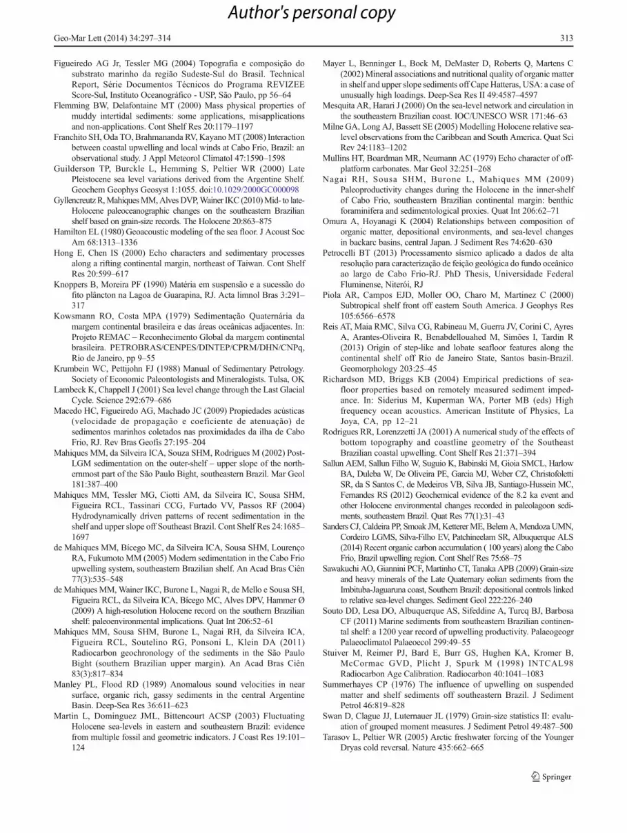
Sediment thickness
The thickest part of the upper sedimentary unit (20 m) islocated in the northwestern part of the study area, where itappears to merge with or form the lower part of the modernshoreface at water depths of 90–100 m (Fig. 4). From here, thethickness of the unit initially decreases strongly southeastwardacross the shelf to 7 m (at ca. 100 m water depth), thenincreases to approx. 10 m before decreasing to <8 m in thecentral sector of the deposit. From this depositional low, theunit gradually thickens offshore to a maximum of 12 mnortheast of the outer mid-shelf coring site (KCF10-04A).From this point southward to approx. 700 m northwest ofthe outer shelf coring site (KFC10-01B), the unit thins to <9mand then thickens to >10 m halfway to the outer shelf coringsite. The upper unit gradually thins from this location acrossthe coring site to the outer shelf.
With the exception of the northernmost part, the upper unitthins to <2 m both to the northeast and the southwest of thecenter line. In contrast to the approximately symmetricallateral thinning of most of the deposit, the sediment thicknesspattern is asymmetrical along its thickest part in the centralsector northeast of coring site KCF10-04A (Fig. 4). Here, thedeposit progressively thickens toward the northeast before
Geo-Mar Lett (2014) 34:297–314 301
Author's personal copy

strongly thinning from >12 m to about 6 m along a NW–SE-trending axis, which the seismic data show to be a ridge
composed of beach rock (Fig. 3). The thinning of the sedimentis probably controlled by structural features related to
Fig. 2 Seismic sections illustrating the three echo-types identified in the study area: a transparent, b stratified, and c reflective. The examples cross threeof the coring sites
302 Geo-Mar Lett (2014) 34:297–314
Author's personal copy
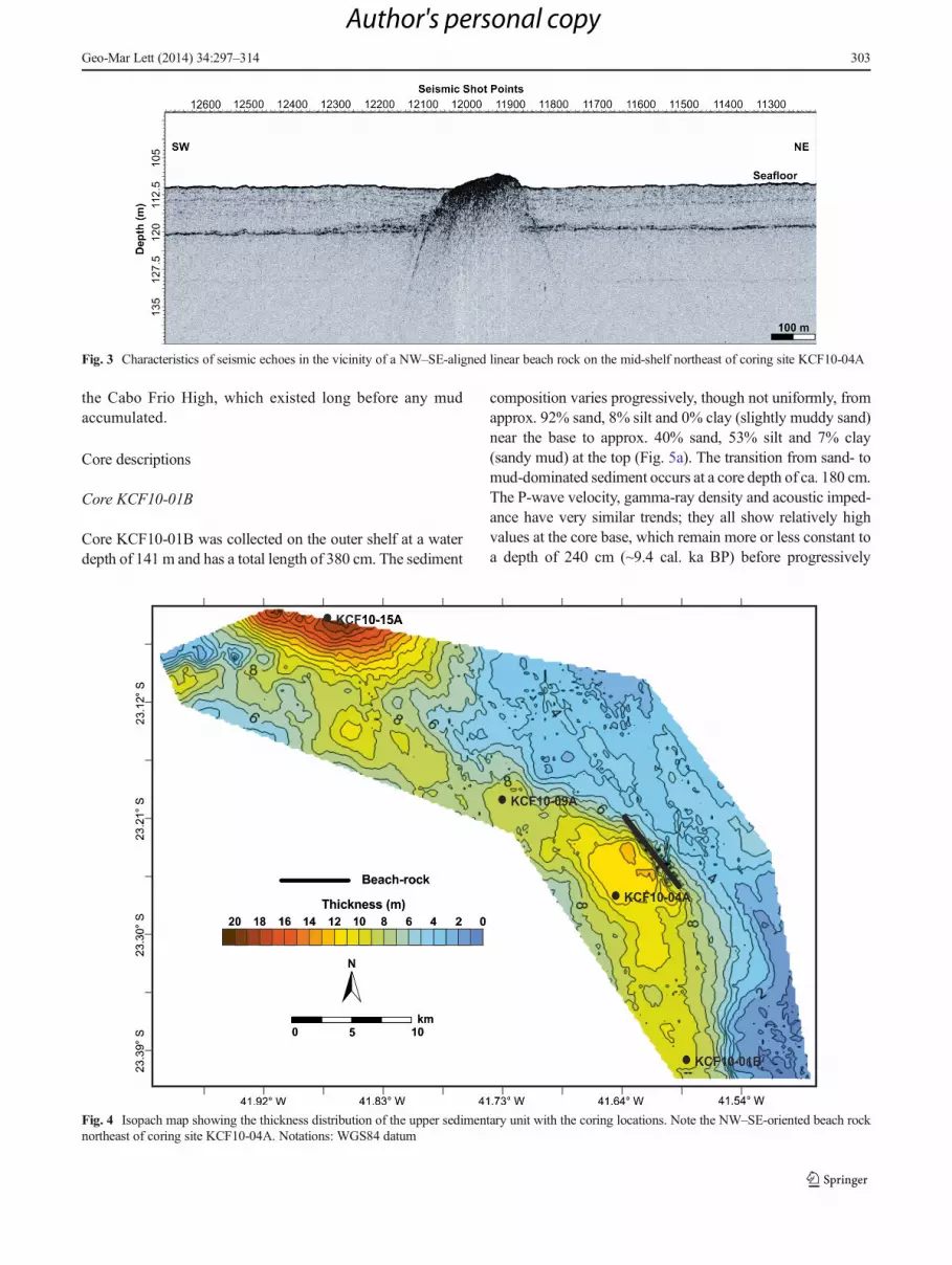
the Cabo Frio High, which existed long before any mudaccumulated.
Core descriptions
Core KCF10-01B
Core KCF10-01B was collected on the outer shelf at a waterdepth of 141 m and has a total length of 380 cm. The sediment
composition varies progressively, though not uniformly, fromapprox. 92% sand, 8% silt and 0% clay (slightly muddy sand)near the base to approx. 40% sand, 53% silt and 7% clay(sandy mud) at the top (Fig. 5a). The transition from sand- tomud-dominated sediment occurs at a core depth of ca. 180 cm.The P-wave velocity, gamma-ray density and acoustic imped-ance have very similar trends; they all show relatively highvalues at the core base, which remain more or less constant toa depth of 240 cm (~9.4 cal. ka BP) before progressively
Fig. 3 Characteristics of seismic echoes in the vicinity of a NW–SE-aligned linear beach rock on the mid-shelf northeast of coring site KCF10-04A
Fig. 4 Isopach map showing the thickness distribution of the upper sedimentary unit with the coring locations. Note the NW–SE-oriented beach rocknortheast of coring site KCF10-04A. Notations: WGS84 datum
Geo-Mar Lett (2014) 34:297–314 303
Author's personal copy

decreasing up to a depth of 160 cm. The values then increaseslightly to a core depth of about 90 cm, and then decrease; thelowest values are reached approx. 16 cm from the core top.Overall, the P-wave velocity varies from 1,520 to 1,763 m s–1,the gamma-ray density from 1.6 to 2.1 g cm–3, and theacoustic impedance from 2,545 to 3,364 N s m–3.
Water content ranges from 20 to 38%, and is low (<25%)near the core base (380–350 cm core depth; Fig. 5a). Thevalues peak at 38% at approx. 340 cm depth, then decreasestepwise to <25% at 220 cm depth, and increase again upcorewith slight fluctuations of 3–5% until they reach 35% at thetop of the core. Overall, TOC values vary from 0.30 to 1.86%,generally increasing from the core base (~0.4%) to the coretop (~1.6%) but fluctuating by more than 1% at almost regulardepth intervals.
Of the four cores, core KCF10-01B covers the largest agerange, beginning at 12,620 cal. years BP near the core baseat 370 cm depth. Twelve ages were available to calculatesedimentation rates (Table 2). As illustrated in Fig. 5b, theoldest age interval has a very low sedimentation rate, whichthen increases and peaks at ~41.92 cm/century at 9,730–9,470 cal. years BP. Thereafter, the sedimentation ratesremain low, although three minor peaks occur at 6,170–5,280, 4,080–2,730, and 1,270–675 cal. years BP. The top1 cm of the core covers the past 675 years, associated with avery low sedimentation rate of 0.15 cm/century.Unfortunately, the high sedimentation rate on the outer shelfat the onset of the Holocene lies beyond the age range of theother three cores, which prevents a comparison with theseother shelf sites.
Fig. 5 a Downcore profiles for core KCF10-01B (141 m waterdepth): sand/silt/clay contents (%), P-wave velocity (m s–1), gam-ma-ray density (g cm–3), acoustic impedance (N s m–3), water
content (%), total organic carbon (TOC, %), and ages (cal. years BP). bSedimentation rates over time. Blue line Mid-points of individual ageintervals, vertical gray lines time slices for which AMS ages are available
304 Geo-Mar Lett (2014) 34:297–314
Author's personal copy

Core KCF10-04A
Core KCF10-04A was collected on the outer mid-shelf at awater depth of 112 m and is 400 cm long. The sedimentessentially consists of sandy to slightly sandy mud (Fig. 6a).The highest sand contents (up to 45%) occur in the lower partof the core (below 300 cm). Above that depth, the values varybetween 0% and 25%, but generally decrease toward the coretop. Clay contents fluctuate by approx. 10% in the lower partof the core (<300 cm depth). The values increase slightly toapprox. 15% at ca. 148 cm core depth, followed by a sharppeak of 60% before decreasing again. From approx. 130 cmcore depth to the core top, clay contents remain almost con-stant at about 5%. With the exception of the single clay-richinterval, the core material is thus dominated by silt-sizesediment.
In contrast to the outer shelf core, only the gamma-raydensity and acoustic impedance show similar trends; overall,the values are higher at the bottom of the core, and decrease toin the upper part (Fig. 6a). From the core base to approx.300 cm depth, the two parameters show relatively stable highvalues, which then progressively decrease with considerablefluctuations toward the core top. The range in gamma-raydensity is 1.66–1.87 g cm–3, and that for impedance is2,524–2,760 N s m–3. The P-wave velocity, by contrast, islow at the base of the core (~1,496 m s–1), and then steadilyincreases to a peak value of ~1,540 m s–1 at ca. 350 cm coredepth, followed by a stepwise decrease to ~1,480 m s–1 at ca.264 cm depth, and an increase to about 1,500 m s–1 at 235 cmdepth. From that depth upcore, values fluctuate at 1,488–1,516 m s–1 up to a core depth of 80 cm, and then decreaseto about 1,480 m s–1 in the uppermost part of the core.
Water content is low (approx. 38%) from the core base upto a core depth of 280 cm, where it reaches a minimum of
34%. It then overall increases to 56% near the top of the core,but fluctuating by up to 10%. The TOC content generallyincreases from approx. 1.8% near the core base to 3.11% atthe core top, with strong spot variations of 0.75–3.11%; thismaximum value is amongst the highest recorded at the twomid-shelf sites.
Core KCF10-04A covers the last 7,460 cal. years BP, withsix ages available for calculation of sedimentation rates(Table 3). The oldest age interval has a relatively low sedi-mentation rate, which increases to peak strongly at 14.9 cm/century at 6,260–5,280 cal. years BP before decreasing againto 5.93 cm/century (Fig. 6b). A minor peak of 7.5 cm/centuryoccurs at 2,420–1,860 cal. years BP. The sedimentation rate isvery low in the youngest, uppermost part of the core.
Core KCF10-09A
Core KCF10-09A was collected on the inner mid-shelf at awater depth of 110 m, only 2 m shallower than the outer mid-shelf core site (cf. above). The core is 405 cm long. As in thecase of the outer mid-shelf core, this core is dominated by silt;sediment composition gradually varies from slightly sandy mud(~18% sand content) at the core base to almost pure mud (<5%sand content) at the core top (Fig. 7a). There is a spot occurrenceof an unusually high sand content of >90% about 25 cm abovethe core base at 380 cm core depth. Clay contents overallincrease from approx. 10% near the core base to 25% at80 cm depth, and then gradually decrease to 15% at the coretop. There are only two spot occurrences of distinctly higherclay contents: 30% at 308 cm, and 50% at 132 cm core depth.
The P-wave velocity, gamma-ray density and acoustic im-pedance of the inner mid-shelf core have very similar trends:the values are overall high at the core base and low at the coretop, albeit with some fluctuations (Fig. 7a). The range in P-wave velocity is 1,450–1,515 m s–1, the corresponding valuesbeing 1.47–1.75 g cm–3 for gamma-ray density, and 2,134–2,650 N s m–3 for acoustic impedance. Water content variesfrom 37 to 57%, and increases toward the core top. Thismaximum value is the highest water content recorded for allcores combined; the next highest was found in the outer mid-shelf core (KCF10-04A, cf. above), in both cases associatedwith high mud contents. TOC contents also generally increasefrom the core base (~2.3%) to the core top (~3.2%), thefluctuations becomingweaker upcore. TOC values range from1.33 to 3.27%.
Core KCF10-09A covers the last 7,150 cal. years BP, withnine ages available for calculation of sedimentation rates(Table 4). At the bottom of the core, the oldest age intervalhas a relatively low sedimentation rate of 4.08 cm/century,which then increases to peak distinctly at 12.5 cm/century at5,730–5,250 cal. years BP (Fig. 7b). The values then decreaseto approx. 4.41 cm/century before increasing to peak againbetween 3,460 and 2,960 cal. years BP. This is followed by
Table 2 Sedimentation rates for age intervals in core KCF10-01B fromthe outer shelf
Age interval Depth interval Sed. rate(cal. years BP) (m) (cm/century)
0–675 0–1 0.15
675–1,270 1–21 3.36
1,270–2,730 21–40 1.50
2,730–3,330 40–80 6.67
3,330–4,080 80–131 6.80
4,080–5,280 131–140 0.75
5,280–6,170 140–171 3.48
6,170–7,475 171–200 2.22
7,475–9,470 200–231 1.55
9,470–9,730 231–340 41.92
9,730–10,140 340–361 5.12
10,140–12,620 361–370 0.36
Geo-Mar Lett (2014) 34:297–314 305
Author's personal copy

sedimentation rates progressively decreasing to a very lowvalue of 0.11 cm/century in the youngest age interval in theuppermost part of the core.
Core KCF10-15A
Core KCF10-15Awas collected on the inner shelf at a waterdepth of 88 m and is 410 cm long. Sediment compositionvaries from slightly muddy sand at the core base (~80% sand,~17% silt, ~3% clay) to sandy mud at the core top (~45%sand, ~50% silt, ~5% clay; Fig. 8a). Sand/mud contents gen-erally fluctuate by approx. 10%, but locally by as much as30% over short core intervals.
As in the other cores, P-wave velocity, gamma-ray densityand acoustic impedance have very similar trends, varyingfrom generally higher values at the core base to low valuesat the core top (Fig. 8a). The main difference with the othercores is that the values decrease more gradually up to a coredepth interval of 50–30 cm, before decreasing sharply to verylow values above this interval. In core KCF10-15A, the valuesof these three parameters increase slightly from the core base
Fig. 6 a Downcore profiles forcore KCF10-04A (112 m waterdepth): sand/silt/clay contents(%), P-wave velocity (m s–1),gamma-ray density (g cm–3),acoustic impedance (N s m–3),water content (%), total organiccarbon (TOC, %), and ages (cal.years BP). b Sedimentation ratesover time. Blue lineMid-points ofindividual age intervals, verticalgray lines time slices for whichAMS ages are available, brokenblue line possible alternative trendif more closely spaced AMS ageswere available from 2,420 to4,370 cal. years BP
Table 3 Sedimentation rates for age intervals in core KCF10-04A fromthe outer mid-shelf
Age interval Depth interval Sed. rate(cal. years BP) (m) (cm/century)
0–1,860 0–9 0.48
1,860–2,420 9–51 7.50
2,420–4,370 51–151 5.13
4,370–5,280 151–205 5.93
5,280–6,260 205–351 14.90
6,260–7,460 351–392 3.42
306 Geo-Mar Lett (2014) 34:297–314
Author's personal copy

up to depths of approx. 260 cm, and then decrease to interme-diate values at core depths of approx. 100 cm. From that depthupcore, P-wave velocity increases up to a core depth of approx.50 cm, and the other two parameters up to approx. 30 cm. Allthree parameters then decrease to reach their lowest values atthe core top. The P-wave velocity ranges from 1,500–1,684 ms–1, this maximum value being the highest recorded for all corescombined. Gamma-ray density is 1.55–2.0 g cm–3, and acousticimpedance 2,194–3,358 N s m–3. Water content increases from~25% at the core base to ~40% at the core top, and fluctuates byas much as 5% over the range of 21–39%. TOC contentincreases progressively from ~0.8% at the core base to ~2.0%at the core top, varying from 0.16–2.13%.
Core KCF10-15A covers the last 7,700 cal. years BP,with eight ages available for sedimentation rate calculations(Table 5). In the lower half of the core, the five oldest agescover a time period of only 590 years, but are associatedwith the highest sedimentation rates recorded at all four
coring sites combined (Fig. 8b). The oldest, lowermost coreinterval (380–340 cm) extends from 7,730 to 7,700 cal.years BP, corresponding to an extrapolated peak sedimen-tation rate of 133.3 cm/century; indeed, more appropriatewould be a rate of 13.3 cm/decade, because of the short timeinterval of only 30 years. The same argument applies toanother sedimentation peak at 260 to 200 cm (40 cm inter-val) that extends from 7,220 to 7,140 cal. years BP (80years), where the rate is more appropriately calculated as 5cm/decade. The upper half of the core covers the remaining7,140 years; the sedimentation rates vary from 1.17 to 5.23cm/century, any shorter-period peaks being masked by thelong time intervals between individual ages.
Age correlations between cores
When comparing sedimentation rates derived from unequaltime intervals, the overall rates may obscure stronger
Fig. 7 a Downcore profiles forcore KCF10-09A (110 m waterdepth): sand/silt/clay contents(%), P-wave velocity (m s–1),gamma-ray density (g cm–3),acoustic impedance (N s m–3),water content (%), total organiccarbon (TOC, %), and ages (cal.years BP). b Sedimentation ratesover time. Blue lineMid-points ofindividual age intervals, verticalgray lines time slices for whichAMS ages are available
Geo-Mar Lett (2014) 34:297–314 307
Author's personal copy

fluctuations over shorter time intervals. Therefore, a synop-tic chronostratigraphic cross-shelf diagram was constructedto link selected age intervals in the four cores relative towater depth. In Fig. 9, the spacing between any two succes-sive isochrons (dashed blue lines) is proportional to thelocal sedimentation rates, whereas the sedimentation ratesin adjacent intervals differ because of the different timeperiods. This diagram provides a good indication of thecross-shelf sedimentation trends in the study area over thepast 7,000 years.
As already described above, only the outer shelf core(KCF10-01B) penetrated the entire Holocene succession.Figure 9 shows that the lowest sedimentation rate occurson the outer shelf, and the next lowest on the inner shelf.Highest sedimentation occurs on the mid-shelf (coresKCF10-09A and KCF10-04A). Only the oldest age inter-val of the inner shelf (core KCF10-15A) shows a sedi-mentation rate similar to that of the mid-shelf. Of partic-ular interest is the sudden decrease in sedimentation onthe inner shelf between 2,860 and 1,000 cal. years BP, andthe generally low rate over the past 1,000 years on themid-shelf compared to the outer shelf and especially theinner shelf.
Statistical interrelationships
The Pearson correlation coefficients indicate a strong correla-tion between P-wave velocity and gamma-ray density(r=0.85); the former is also well correlated with meangrain size (r=–0.81). A very high correlation coefficient(r=0.87) exists between water content and mud content.Water content and TOC, by contrast, are weakly nega-tively correlated with sediment physical properties; forexample, P-wave velocity versus TOC has a negative corre-lation of r=–0.24.
Discussion and conclusions
Sea-level history and physicochemical characteristics
To understand the complex sedimentary evolution of this area,three time slices were considered in the analysis. These de-scribe well-known paleoenvironmental conditions around 12and 6 ka BP, and the last 3 ka. It should be noted, however,that for pre-Holocene times the sea-level history of theBrazilian coast is still poorly understood.
During the last glacial maximum (ca. 18 ka BP) the relativesea level in the study area stood about 110 m below its presentlevel and only the offshore coring site (KCF10-01B), locatedat a water depth of 141 m, was submerged at that time, thewater depth being about 35 m. High-energy conditions inshallow water evidently allowed even coarse sand to betransported offshore up to and beyond the coring site. Twoperiods of rapid and sustained sea-level rise occurred from ca.16 to 12.5 ka BP and again from ca. 11.5 to 8 ka BP (Fig. 10).These two phases of sea-level rise appear to be separated bythe Younger Dryas, a period of global cessation of ice retreat(cf. Lambeck and Chappell 2001), sea level reaching about 60m below the present-day one at 11.5 ka BP (cf. Guildersonet al. 2000; Tarasov and Peltier 2005). Straddling thePleistocene–Holocene boundary (11.5 ka BP), these condi-tions persisted up to about 9.6 ka BP (Figs. 5a, 10) whenrelative sea level stood at about –40m (Fig. 10; cf. Kowsmannand Costa 1979; Corrêa 1990; Guilderson et al. 2000; Artusiand Figueiredo 2007; Reis et al. 2013). In the course of sea-level rise, sand was thus initially deposited at all coring sites.As documented in Fig. 5a and b, maximum sedimentationrates occurred between about 10 and 8 ka BP. In correspon-dence, the Vp, gamma-ray density and acoustic impedancevalues are high (Fig. 5a). Only after 9.6 ka BP, when the waterdepth at the offshore coring site (KCF10-01B) was about 100m, did the supply of sand to the outer shelf gradually decreaseand the deposition of mud, especially of silt, increase.
Coring site KCF10-01B is located in the transparent echodomain, which Damuth (1975) interpreted as being caused bythe presence of coarse sediment (sand or even gravel). Asexpected, average TOC content is low at the base of the coredue to the high sand content, and increases toward the top withincreasing mud content (Fig. 5a). The strong variations inTOC throughout the core could be evidence for correspondingclimate fluctuations associated with changes in productivity.Such an interpretation is supported by the geochronologicalinversions observed in core KCF-10-01B (Table 1), whichsuggest that sea level fluctuated, especially around 7.8 and6.7 ka BP (Corrêa 1996; Angulo and Lessa 1997; Bard et al.1998; Tarasov and Peltier 2005; Milne et al. 2005), and afterrising above the present level at around 6.5 ka BP, reaching amaximum level of 2 to 3 m above the present-day level atabout 5.5 ka BP (Fig. 10). This was followed either by another
Table 4 Sedimentation rates for age intervals in core KCF10-09A fromthe inner mid-shelf
Age interval Depth interval Sed. rate(cal. years BP) (m) (cm/century)
0–910 0–1 0.11
910–1,480 1–10 1.57
1,480–2,460 10–71 6.22
2,460–2,960 71–131 12.00
2,960–3,420 131–161 28.26
3,420–4,570 161–251 7.83
4,570–5,250 251–281 4.41
5,250–5,730 281–341 12.50
5,730–7,150 341–399 4.08
308 Geo-Mar Lett (2014) 34:297–314
Author's personal copy

two high-frequency oscillations (Martin et al. 2003) or by acontinuous drop to the present-day level (Cavallotto et al.2004; Angulo et al. 2006), the evidence in this respect beingcontradictory.
The second time slice, around approximately 6 ka BP, isrepresented in all four cores. In this period, an extensiveportion of the shelf was now submerged, and the offshorecoring site (KCF10-01B) received increasingly less sand andmore finer-grained sediment. Sites KCF10-04A and KCF10-09A, which are located on the mid-shelf at water depths of 112and 110 m respectively, are dominated by fine-grained sedi-ments from the base upward. Correspondingly, the Vp,gamma-ray density and acoustic impedance values are lowerthan those in the other cores (Figs. 6a, 7a). The Vp values areconsistent with the results of Macedo et al. (2009) for thewider study area, and those of, for example, Hamilton (1980)
and Richardson and Briggs (2004) for other world regions. Asexpected, these cores display the highest TOC and watercontents of all four cores examined in this study. High TOCcontents in low-density sediments have been found by, forexample, Mayer et al. (2002) off Cape Hatteras (USA), con-sistent with the preferential association of organic matter withmud-rich sediments (e.g., Flemming and Delafontaine 2000).
The stratified echo character associated with these coressupports the interpretation of a low-energy, mud-dominatedpaleo-shoreface environment. The sedimentation pattern isconsistent with the stratified echo signature found by, forexample, Hong and Chen (2000) under low-energy conditionson the continental margin of Taiwan. Moreover, Mullins et al.(1979; cf. Damuth and Hayes 1977) observed a similar echocharacter on abyssal plains. The considerable accumulation ofmud in this period (Fig. 9) is reflected in the sedimentation-
Fig. 8 a Downcore profiles forcore KCF10-15A (88 m waterdepth): sand/silt/clay contents(%), P-wave velocity (m s–1),gamma-ray density (g cm–3),acoustic impedance (N s m–3),water content (%), total organiccarbon (TOC, %), and ages (cal.years BP). b Sedimentation ratesover time. Blue lineMid-points ofindividual age intervals, verticalgray lines time slices for whichAMS ages are available
Geo-Mar Lett (2014) 34:297–314 309
Author's personal copy

rate peaks recorded in both cores (Figs. 6b, 7b). The presenceof the beach-rock ridge in the central portion of the study areaindicates a period of stable sea level. Although no sampleswere collected to confirm the origin of this feature, previousstudies (Figueiredo and Tessler 2004; Reis et al. 2013) de-scribed the micro-relief along the 110 m isobath at the south-ern limit of the Campos basin as of bioconstructional origin.The ridge may have subsequently acted as a localized sedi-ment trap blocking the bypassing of sediment, but the large
sediment thickness northeast of it is more likely related tostructural control by the Cabo Frio High.
Sedimentation at the inshore coring site (KCF10-15A)commences at about 7.7 ka BP at its base, the lower half ofthe core recording extremely high sedimentation rates(Fig. 8a, b), which may at least partially be explained by itsproximity to the coast. As sea level rose to its maximumpostglacial level, the average sand content gradually de-creased from about 75% at the base of the core (7.7 ka BP)to 70% at a core depth of 1.7 m (5.5 ka BP), the overall highsand content explaining the reflective echo character of theseabed.
Table 5 Sedimentation rates for age intervals in core KCF10-15A fromthe inner shelf
Age interval Depth interval Sed. rate(cal. years BP) (m) (cm/century)
0–650 0–34 5.23
650–2,860 34–60 1.17
2,860–5,470 60–160 2.30
5,470–7,140 160–200 2.39
7,140–7,220 200–260 75.00
7,220–7,400 260–291 21.10
7,400–7,700 291–340 14.00
7,700–7,730 340–380 133.30
Fig. 9 Cross-section across the shelf with chronostratigraphic tie lines linking individual cores. Note the different age intervals and vertical scales aboveand below the seafloor
Fig. 10 Sea-level curves for South America reconstructed by Anguloand Lessa (1997), Guilderson et al. (2000), Tarasov and Peltier (2005),and Milne et al. (2005)
310 Geo-Mar Lett (2014) 34:297–314
Author's personal copy

The third time slice represents the period after 3 ka BP,when sea level had more or less reached its present-dayposition (Corrêa 1996; Fig. 10). Strengthening of the upwell-ing system led to an increase in productivity (Gyllencreutzet al. 2010). Together with the increasing deposition of finer-grained sediment, this led to higher organic matter contents inthe sediment. This applies to all four coring sites, a similartrend having also been reported from the eastern Brazilianshelf by Dominguez et al. (2013).
Millennium-scale sedimentary evolution
The Cabo Frio High probably controlled the planform of theregional coastline ever since its formation. The NW–SE align-ment of the beach-rock ridge (Fig. 3) suggests that, in contrastto the present-day E–W orientation (west of Cabo Frio), thecoast was oriented NW–SE during the LGM sea-levellowstand. Similar situations along the Brazilian coastline havepreviously been described by Angulo (1992) and Barbosa(1995).
In his general analysis of eustatic variations along theeastern Brazilian margin, Vieira (1981) identified cyclonicand anti-cyclonic vortices in the Cabo Frio region, whichevidently influenced local sedimentation patterns. Thus, hy-drostatic pressure differences induce downwelling, in thecourse of which suspended sediment is trapped in the gyrefrom where it is deposited on the seabed. This explains the
fine-grained nature of the sediment in the mid-shelf cores(KCF10-04A and KCF10-09A; Figs. 6a, 6b, 7a, 7b, and 9).
As observed in the study area today, wave-dominatedshallow marine sedimentation influenced by microtidal re-gimes is sensitive to wave-induced fluctuations in water levels(Davis and Hayes 1984), waves breaking at an angle to theshoreline amplifying alongshore sediment transport. The cur-rent pattern at Cabo Frio is complex because of the interactionbetween the shelf front caused by the upwelling of SouthAtlantic Central Water in the wake of intrusions of the BrazilCurrent, and seasonal wind- or storm-induced coastal currentsthat converge on Cabo Frio from the west and northeast. AtCabo Frio the coastal currents are deflected offshore towardthe southeast (Viana et al. 1998; Piola et al. 2000; Belem et al.2013). The intruding Brazil Current slows the offshore-directed currents (Mesquita and Harari 2000), causing theirsuspended load to be deposited across the shelf (Fig. 11). Inaddition, this shear stress model results in the formation ofsand ridges on the shoreface near the coast (Figueiredo 1980).In general, the coastal currents, in which the frictional cou-pling between wind and fluid causes the water to be drivenforward, have a large capacity for sediment transport (Walkerand Plint 1992). The existence of such mechanisms in the pastis also supported by the chronological inversions found insome of the strata (Table 1).
Cores KCB10-01B and KCF10-15A, i.e., the inner and outershelf cores, exhibit very similar sedimentological sequences andacoustic patterns associated with coarse material, suggesting that
Fig. 11 Schematic representationof the interaction between theBrazil Current and the inshorecoastal countercurrent, which isdeflected offshore at Cabo Frio.The reduction in velocityassociated with the shelf frontcaused by the intrusion of SouthAtlantic Central Water at thebottom results in the spatiallyconfined cross-shelfaccumulation of sediment(background image: MODISAqua TrueColor, EOSDIS-NASA, 21 June 2008)
Geo-Mar Lett (2014) 34:297–314 311
Author's personal copy

both are endmembers of the same basic sedimentation model, inwhich wind- and wave-driven alongshore transport of bedloadmaterial is deflected by a change in shoreline orientation to resultin a similar depositional pattern, albeit at different times. Thispattern suggests that the source of terrigenous sand may havebeen a barrier-island complex, which initially developed duringthe LGM and that was subsequently displaced landward in thecourse of sea-level rise until it stabilized some 6.5 ka BP alongthe modern coast (Turcq et al. 1999). That terrigenous sand canbe transported far offshore on the shelf off SE Brazil was alreadynoted by Summerhayes (1976) and more recently confirmed byGyllencreutz et al. (2010). At the same time, muddy suspendedsediment derived from Guanabara Bay and the discharge of theParaiba do Sul and smaller rivers was transported to the area bylongshore drift (Dominguez et al. 1987, 2013) to be depositedfurther offshore in the enigmatic cross-shore depocenter to thesoutheast of Cabo Frio (Viana et al. 1998).
In conclusion, further core-based studies are required to betterdefine the regional Pleistocene–Holocene transition of the shelfsediments off Cabo Frio. In particular, the nature of the lowersedimentation unit deserves further attention—all that is currentlyknown about this unit is that it must be of Pleistocene age. Thiscould be achieved by collecting cores on a lateral transect alongwhich the upper sedimentation unit thins out.
Acknowledgements This work was funded by the Geochemistry Net-work of PETROBRAS/CENPES and the Brazilian National Petroleumand the Biofuels Agency (ANP). We thank Dr. Marcio Gurgel forcollecting the samples. We also wish to acknowledge constructive re-views by R. Gyllencreutz and T. Mulder as well as additional commentsby the editors, all of which helped improve the final paper.
References
Anderson TW, Finn JD (1996) The new statistical analysis of data.Springer, New York
Angulo RJ (1992) Geologia da planície costeira do Estado do Paraná.Dissertation, University of São Paulo
Angulo RJ, Lessa GC (1997) The Brazilian sea-level curves: a criticalreview with emphasis on the curves from the Paranaguá andCananéia regions. Mar Geol 140:141–166
Angulo RJ, SouzaMC, Reimer PJ, Sasaoka SK (2005) Reservoir effect ofthe southeastern Brazilian coast. Radiocarbon 47:67–73
Angulo RJ, Lessa GC, SouzaMC (2006) A critical review of mid- to late-Holocene sea-level fluctuations on the eastern Brazilian coastline.Quat Sci Rev 25:486–506
Artusi L, Figueiredo AG Jr (2007) Sismoestratigrafia rasa da plataformacontinental de Cabo Frio - Arraruama - RJ. Rev Bras Geofís 25:7–16
Barbosa CF (1995) Foraminifera e Arcellacea (“Thecamoebia”) recentesdo estuário de Guaratuba, Paraná Brasil. An Acad Bras Ciênc 67:465–492
Barbosa CF (1997) Reconstituicão paleoambiental de fácies lagunarescom base em foraminiferos: o nível do mar no Quaternário Superiorna área de Cabo Frio. Dissertation, University of São Paulo
Barbosa CF, Suguio K (1999) Bio-sedimentary facies of a subtropicalmicrotidal estuary - an example from southern Brazil. J SedimentRes 69:576–587
Bard E, Arnold M, Hamelin B, Tisnerat-Laborde N, Cabioch G (1998)Radiocarbon calibration bymeans of mass spectrometric 230Th/234Uand 14C ages of corals. An update data base including samples fromBarbados, Mururoa and Tahiti. Radiocarbon 40:1085–1092
Belem AL, Castelao RM, Albuquerque ALS (2013) Controls of subsur-face temperature variability in a western boundary upwelling sys-tem. Geophys Res Lett 40:1362–1366
Blott S, Pye K (2001) Gradistat: a grain-size distribution andstatistics package for the analysis of unconsolidated sedimentsby sieving or laser granulometer. Earth Surf Process Landf 26:1237–1248
Briggs KB, Williams KL, Jackson DR, Jones CD, Ivakin AN, Orsi TH(2002) Fine scale sedimentary structure: implications for acousticremote sensing. Mar Geol 182:141–159
Castelao RM, Barth JA (2006) Upwelling around Cabo Frio, Brazil: theimportance of wind stress curl. Geophys Res Lett 33, L03602. doi:10.1029/2005GL025182
Castro BM, Miranda LB (1998) Physical oceanography of the westernAtlantic continental shelf located between 4°N and 34°S. In:Robinson AR, Brinks KH (eds) The sea. Wiley, New York, pp209–251
Cavallotto JL, Violante RA, Parker G (2004) Sea-level fluctuationsduring the last 8600 years in the de la Plata river (Argentina). QuatInt 114:155–165
Corrêa ICS (1990) Analyse morphostructurale et évolution paléo-géographique de la plate-forme continentale Atlantique sud-brésilienne (Rio Grande do Sul – Brésil). Dissertation, Universityof Bordeaux I
Corrêa ICS (1996) Les variations du niveau de la mer durant les derniers17.500 ans BP: l’exemple de la plate-forme continentale du RioGrande do Sul-Brésil. Mar Geol 130:163–178
Cruz APS, Barbosa CF, Ayres-Neto A, Albuquerque ALS (2013)Physical and geochemical properties of centennial marine sedimentsof the continental shelf of southeast Brazil. Geochim Bras 27(1):1–12
Damuth JE (1975) Quaternary climate change as revealed by calciumcarbonate fluctuations in western Equatorial Atlantic sediments.Deep-Sea Res 22:725–743
Damuth JE, Hayes DE (1977) Echo character of the east Braziliancontinental margin and its relationship to sedimentary processes.Mar Geol 24:73–95
Davis RA, Hayes JD (1984) What is a wave-dominated coast? Mar Geol60:313–329
Davis A, Haynes R, Bennell B, Huws D (2002) Surficial seabed sedimentproperties derived from seismic profiler responses. Mar Geol 182:209–223
Dias GTM, Palma JJC, Ponzi VRA (1982) Matéria orgânica noQuaternário da margem continental entre Rio de Janeiro eGuarapari. LAGEMAR/PETROBRAS/CENPES, Rio de Janeiro,Brazil
Dominguez JML, Martin L, Bittencourt ACSP (1987) Sea-level historyand the Quaternary evolution of river mouth-associated beach-ridgeplains along the east-southeast coast of Brazil: a summary. In:Nummedal D, Pilkey OH, Howard JD (eds) Sea-level fluctuationand coastal evolution. SEPM Spec Publ 41:115–127
Dominguez JML, da Silva RP, Nunes AS, Freire AFM (2013) Thenarrow, shallow, low-accommodation shelf of central Brazil: sedi-mentology, evolution, and human uses. Geomorphology 203:46–59
Figueiredo AG Jr (1980) Response of water column to strong windforcing, southern Brazilian inner-shelf: implications for sand ridgeformation. Mar Geol 35:367–376
Figueiredo AG Jr, Madureira LSP (2004) Topografia, composição,refletividade do substrato marinho e identificação de provínciassedimentares da região Sudeste-Sul do Brasil. Technical Report,Série Documentos Técnicos do Programa REVIZEE Score-Sul,Instituto Oceanográfico - USP, São Paulo, pp 46–55
312 Geo-Mar Lett (2014) 34:297–314
Author's personal copy
Figueiredo AG Jr, Tessler MG (2004) Topografia e composição dosubstrato marinho da região Sudeste-Sul do Brasil. TechnicalReport, Série Documentos Técnicos do Programa REVIZEEScore-Sul, Instituto Oceanográfico - USP, São Paulo, pp 56–64
Flemming BW, Delafontaine MT (2000) Mass physical properties ofmuddy intertidal sediments: some applications, misapplicationsand non-applications. Cont Shelf Res 20:1179–1197
Franchito SH, Oda TO, Brahmananda RV, KayanoMT (2008) Interactionbetween coastal upwelling and local winds at Cabo Frio, Brazil: anobservational study. J Appl Meteorol Climatol 47:1590–1598
Guilderson TP, Burckle L, Hemming S, Peltier WR (2000) LatePleistocene sea level variations derived from the Argentine Shelf.Geochem Geophys Geosyst 1:1055. doi:10.1029/2000GC000098
GyllencreutzR,MahiquesMM,AlvesDVP,Wainer IKC (2010)Mid- to late-Holocene paleoceanographic changes on the southeastern Brazilianshelf based on grain-size records. The Holocene 20:863–875
Hamilton EL (1980) Geoacoustic modeling of the sea floor. J Acoust SocAm 68:1313–1336
Hong E, Chen IS (2000) Echo characters and sedimentary processesalong a rifting continental margin, northeast of Taiwan. Cont ShelfRes 20:599–617
Knoppers B, Moreira PF (1990) Matéria em suspensão e a sucessão dofito plâncton na Lagoa de Guarapina, RJ. Acta limnol Bras 3:291–317
Kowsmann RO, Costa MPA (1979) Sedimentação Quaternária damargem continental brasileira e das áreas oceânicas adjacentes. In:Projeto REMAC – Reconhecimento Global da margem continentalbrasileira. PETROBRAS/CENPES/DINTEP/CPRM/DHN/CNPq,Rio de Janeiro, pp 9–55
Krumbein WC, Pettijohn FJ (1988) Manual of Sedimentary Petrology.Society of Economic Paleontologists and Mineralogists. Tulsa, OK
Lambeck K, Chappell J (2001) Sea level change through the Last GlacialCycle. Science 292:679–686
Macedo HC, Figueiredo AG, Machado JC (2009) Propiedades acústicas(velocidade de propagação e coeficiente de atenuação) desedimentos marinhos coletados nas proximidades da ilha de CaboFrio, RJ. Rev Bras Geofís 27:195–204
Mahiques MM, da Silveira ICA, Souza SHM, Rodrigues M (2002) Post-LGM sedimentation on the outer-shelf – upper slope of the north-ernmost part of the São Paulo Bight, southeastern Brazil. Mar Geol181:387–400
Mahiques MM, Tessler MG, Ciotti AM, da Silveira IC, Sousa SHM,Figueira RCL, Tassinari CCG, Furtado VV, Passos RF (2004)Hydrodynamically driven patterns of recent sedimentation in theshelf and upper slope off Southeast Brazil. Cont Shelf Res 24:1685–1697
de Mahiques MM, Bícego MC, da Silveira ICA, Sousa SHM, LourençoRA, Fukumoto MM (2005) Modern sedimentation in the Cabo Frioupwelling system, southeastern Brazilian shelf. An Acad Bras Ciên77(3):535–548
de Mahiques MM,Wainer IKC, Burone L, Nagai R, de Mello e Sousa SH,Figueira RCL, da Silveira ICA, Bícego MC, Alves DPV, Hammer Ø(2009) A high-resolution Holocene record on the southern Brazilianshelf: paleoenvironmental implications. Quat Int 206:52–61
Mahiques MM, Sousa SHM, Burone L, Nagai RH, da Silveira ICA,Figueira RCL, Soutelino RG, Ponsoni L, Klein DA (2011)Radiocarbon geochronology of the sediments in the São PauloBight (southern Brazilian upper margin). An Acad Bras Ciên83(3):817–834
Manley PL, Flood RD (1989) Anomalous sound velocities in nearsurface, organic rich, gassy sediments in the central ArgentineBasin. Deep-Sea Res 36:611–623
Martin L, Dominguez JML, Bittencourt ACSP (2003) FluctuatingHolocene sea-levels in eastern and southeastern Brazil: evidencefrom multiple fossil and geometric indicators. J Coast Res 19:101–124
Mayer L, Benninger L, Bock M, DeMaster D, Roberts Q, Martens C(2002) Mineral associations and nutritional quality of organic matterin shelf and upper slope sediments off Cape Hatteras, USA: a case ofunusually high loadings. Deep-Sea Res II 49:4587–4597
Mesquita AR, Harari J (2000) On the sea-level network and circulation inthe southeastern Brazilian coast. IOC/UNESCO WSR 171:46–63
Milne GA, Long AJ, Bassett SE (2005) Modelling Holocene relative sea-level observations from the Caribbean and South America. Quat SciRev 24:1183–1202
Mullins HT, Boardman MR, Neumann AC (1979) Echo character of off-platform carbonates. Mar Geol 32:251–268
Nagai RH, Sousa SHM, Burone L, Mahiques MM (2009)Paleoproductivity changes during the Holocene in the inner-shelfof Cabo Frio, southeastern Brazilian continental margin: benthicforaminifera and sedimentological proxies. Quat Int 206:62–71
Omura A, Hoyanagi K (2004) Relationships between composition oforganic matter, depositional environments, and sea-level changesin backarc basins, central Japan. J Sediment Res 74:620–630
Petrocelli BT (2013) Processamento sísmico aplicado a dados de altaresolução para caracterização de feição geológica do fundo oceânicoao largo de Cabo Frio-RJ. PhD Thesis, Universidade FederalFluminense, Niterói, RJ
Piola AR, Campos EJD, Moller OO, Charo M, Martinez C (2000)Subtropical shelf front off eastern South America. J Geophys Res105:6566–6578
Reis AT, Maia RMC, Silva CG, Rabineau M, Guerra JV, Corini C, AyresA, Arantes-Oliveira R, Benabdellouahed M, Simões I, Tardin R(2013) Origin of step-like and lobate seafloor features along thecontinental shelf off Rio de Janeiro State, Santos basin-Brazil.Geomorphology 203:25–45
Richardson MD, Briggs KB (2004) Empirical predictions of sea-floor properties based on remotely measured sediment imped-ance. In: Siderius M, Kuperman WA, Porter MB (eds) Highfrequency ocean acoustics. American Institute of Physics, LaJoya, CA, pp 12–21
Rodrigues RR, Lorenzzetti JA (2001) A numerical study of the effects ofbottom topography and coastline geometry of the SoutheastBrazilian coastal upwelling. Cont Shelf Res 21:371–394
Sallun AEM, Sallun Filho W, Suguio K, Babinski M, Gioia SMCL, HarlowBA, Duleba W, De Oliveira PE, Garcia MJ, Weber CZ, ChristofolettiSR, da S Santos C, de Medeiros VB, Silva JB, Santiago-Hussein MC,Fernandes RS (2012) Geochemical evidence of the 8.2 ka event andother Holocene environmental changes recorded in paleolagoon sedi-ments, southeastern Brazil. Quat Res 77(1):31–43
Sanders CJ, Caldeira PP, Smoak JM,KettererME, BelemA,MendozaUMN,Cordeiro LGMS, Silva-Filho EV, Patchineelam SR, Albuquerque ALS(2014) Recent organic carbon accumulation ( 100 years) along the CaboFrio, Brazil upwelling region. Cont Shelf Res 75:68–75
Sawakuchi AO, Giannini PCF,Martinho CT, Tanaka APB (2009) Grain-sizeand heavy minerals of the Late Quaternary eolian sediments from theImbituba-Jaguaruna coast, Southern Brazil: depositional controls linkedto relative sea-level changes. Sediment Geol 222:226–240
Souto DD, Lesa DO, Albuquerque AS, Sifeddine A, Turcq BJ, BarbosaCF (2011) Marine sediments from southeastern Brazilian continen-tal shelf: a 1200 year record of upwelling productivity. PalaeogeogrPalaeoclimatol Palaeoecol 299:49–55
Stuiver M, Reimer PJ, Bard E, Burr GS, Hughen KA, Kromer B,McCormac GVD, Plicht J, Spurk M (1998) INTCAL98Radiocarbon Age Calibration. Radiocarbon 40:1041–1083
Summerhayes CP (1976) The influence of upwelling on suspendedmatter and shelf sediments off southeastern Brazil. J SedimentPetrol 46:819–828
Swan D, Clague JJ, Luternauer JL (1979) Grain-size statistics II: evalu-ation of grouped moment measures. J Sediment Petrol 49:487–500
Tarasov L, Peltier WR (2005) Arctic freshwater forcing of the YoungerDryas cold reversal. Nature 435:662–665
Geo-Mar Lett (2014) 34:297–314 313
Author's personal copy

Turcq B, Martin L, Flexor JM, Suguio K, Pierre C, Tasayaco-Ortega L(1999) Origin and evolution of the Quaternary coastal plain betweenGuaratiba and Cabo Frio, State of Rio de Janeiro, Brazil. In:Knoppers B, Bidone ED, Abrão JJ (eds) Environmental geochem-istry of coastal lagoon systems. Série Geoquímica Ambiental,Niterói, RJ, pp 25–46
Viana AR, Faugères J-C, Kowsmann RO, Lima JAM, Caddah LEG,Rizzo JG (1998) Hydrology, morphology and sedimentology of
the Campos continental margin, offshore Brazil. Sediment Geol115:133–157
Vieira PC (1981) Variacões do nivel marinho: alterações eustaticas noQuaternário. Rev Inst Geociên 2:39–58
Walker RG, Plint AG (1992)Wave- and storm-dominated shallowmarinesystems. In: Walker RG, James NP (eds) Facies models response tosea-level change. Geological Association of Canada, St. John’s, NL,pp 219–238
314 Geo-Mar Lett (2014) 34:297–314
Author's personal copy