final cover2 - anderson township
TRANSCRIPT
S i g n a g e St u d i o S u m m e r 0 9
Workshop in Urban Design School of Planning College of Design, Architecture, Art, and PlanningUniversity of Cincinnati
Menelaos Trianta�llou, ASLA, AICPAssociate Professor of Planning & Urban Design
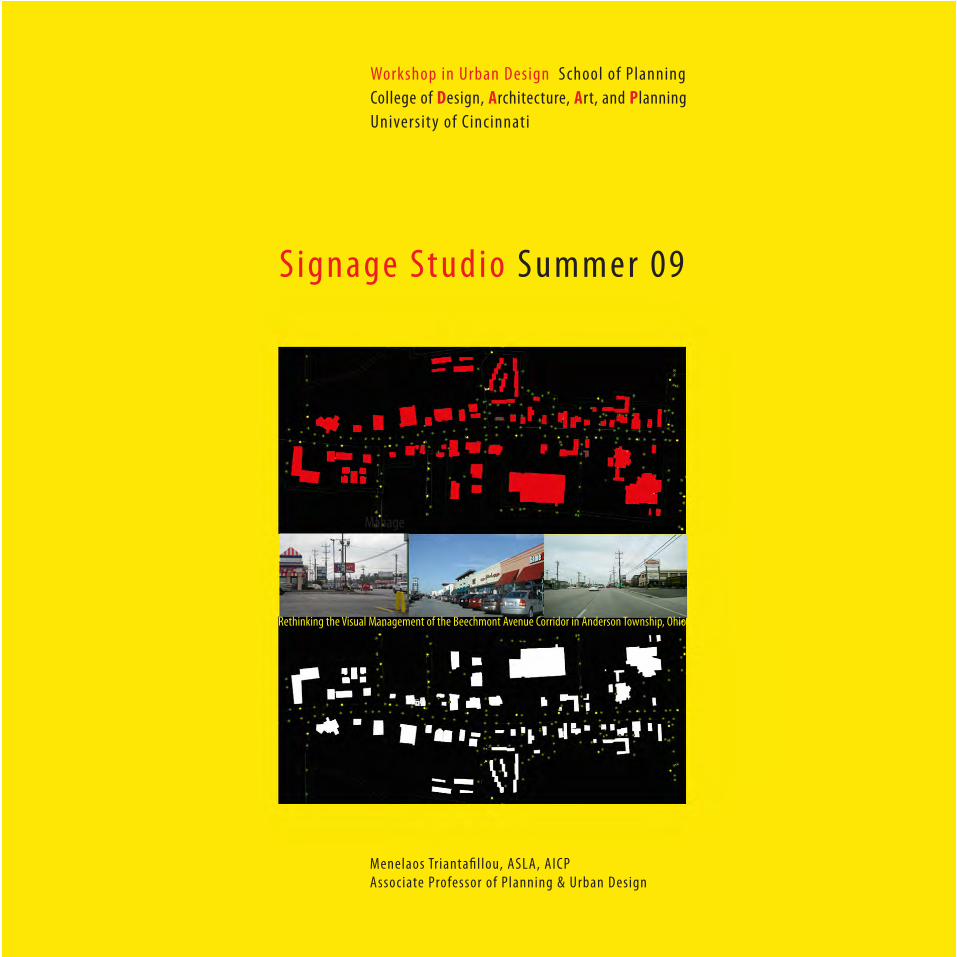
Rethinking the Visual Management of the Beechmont Avenue Corridor in Anderson Township, Ohio
Manage

Workshop in Urban Design 23PLAN604/441 Summer Quarter 2009
School of Planning, College of Design, Architecture, Art, and Planning
Univesrity of Cincinnati
Signage Studio Final Document Beechmont Avenue Corridor Anderson Township, Ohio
October, 2009
Menelaos Trianta�llou, ASLA, AICPAssociate Professor of Planning and Urban DesignSchool of Planning, University of Cincinnati
Prepared for
The Signage Foundation, Inc.
Anderson Township, Ohio
Acknowledgements
The Workshop in Urban Design would like to thank the following for their participation and input to the studio:
Signage Foundation, Inc.
Joe Rickman, President of the SFI BoardDuane Laska, SFI Board MemberPatty Herbin, SFI Consultant
Consultants and Studio Participants
Alan Weinstein, Associate Professor of Law and Urban Studies at Cleve-land State UniversityDavid Hartt, President D.B Hartt Inc, Planning and Development ConsultantsDavid L. Williamson, Attorney and Counselor at Law, Cincinnati, OhioTJ Schmidlin, Designer / Planner, Innerface Architectural Signage, Inc.
Anderson Township
Township Trustees: Peggy D. Reis Russell L. Jackson, Jr.,Albert F. Peter
Township Administrator: Vicky L. Earhart
Steve Sievers, AICP, Director of Community DevelopmentPaul Drury, AICP, Assistant Director of Community Development
Workshop in Urban DesignStudio Members:Selim Aziz Krista Couch
Steve Dobrinich Allison Hodson Cody Meyer Sam SpragueBecca RaufHans Williams
Studio Instructor/Coordinator:Menelaos Triantafillou, ASLA, AICP, Associate Professor of Planning and Urban Design
James (Jim) and Sharon Weinel of Gemini, Inc.
In January 2009, the Terence M. Fruth/Gemini Chair of Signage Design and Community Planning in the College of Design, Architecture, Art, and Planning was also established. This chair and the James S. Womack/Gemini Chair of Signage and Visual Communications in the College of Business (2007) were established through the philanthropy of James (Jim) and Sharon Weinel of Gemini, Inc.
The Workshop in Urban Design in the summer quarter 2009, the Fourth Year Planning Design Studio on Signage and Urban Planning with Pro-fessor Mahyar Arefi in the spring quarter 2009, and the Independent Study on the role of Landscaping and Signage Issues by graduate MCP Student Emily Heintzelman under the direction of Professor Menelaos Triantafillou are initial research activities within the collaborative framework for research and academic exploration on issues centering on urban planning, urban design, and signage.
Introduction
The Workshop in Urban Design was sponsored by the Signage Foun-
dation, Inc. (SFI), and Anderson Township, Ohio. The Workshop took
place in a studio setting in the School of Planning during the ten-week
period of the summer quarter, 2009. Eight 4th and 5th year planning
students participated in the studio (workshop and studio are used
interchangeably). The process also included the participation of the
Director and Assistant Director of Planning and Development Services,
elected officials, and administrative personnel from Anderson Town-
ship, study area business owners, and the general public. The students
had the opportunity to make presentations and receive comments
from the participants during three scheduled meetings at the Anderson
Administration Center.
SFI’s mission is to educate the public about the role of on-premise
signs to society, with regard to their social, economic, and aesthetic
values, and the need for increased effectiveness in communications
through signage. The Foundation focuses on increasing awareness
on these topics, and on bringing education to sign users and to those
who interact with sign users, including advertising agencies, lenders,
appraisers, attorneys, regulators, business form franchisers and small
businesses. One important Foundation activity is to build relation-
ships with academic and governmental organizations to develop and
enunciate public policy for on-premise signs. To do that, the Founda-
tion develops basic research on the social, economic and aesthetic
benefits of on-premise signage. It is in this capacity that the Signage
Foundation, Inc. is making a major contribution that spans across the
sign industry, business and economic development, and the planning
and design professions. In March 2009, the Foundation made available
a document titled, “A Framework for On-Premise Sign Regulations”
that serves as a model sign code for use by local governments, the sign
industry, and business establishments. The Foundation commissioned
Alan C. Weinstein, Inc. and David B. Hartt, Inc. who prepared the model
code.
Since January 2009, the Signage Foundation, Inc, and the School of
Planning at the College of Design, Architecture, Art, and Planning at
the University of Cincinnati have entered into a collaborative relation-
ship, as part of a broader effort to focus on all aspects of signage
through research, seminars, and studio projects. This impetus for these
activities was the endowment of the ‘Gemini-Fruth Chair in Signage
and Community Planning’. The theme of the Workshop in Urban
Design was signage and the exploration of management solutions for a
specific study area through the application of the SFI model sign code.
Specifically, the studio focused on the Beechmont Avenue commercial
corridor in Anderson Township, a mature suburban community to the
east of Cincinnati, beginning approximately at Salem Road and extend-
ing past Nordyke Road to the Township jurisdiction line with Clermont
County, a distance of approximately 2.8 miles. It investigated the
existing visual character of the corridor and identified the key physical
elements that contribute to it. The existing signs are one major con-
tributor, with land use types, building morphology, parcel width sizes
S i g n a g e S t u d i o S u m m e r 0 9 1
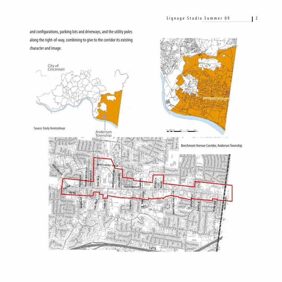
and configurations, parking lots and driveways, and the utility poles
along the right-of-way, combining to give to the corridor its existing
character and image.
Beechmont Avenue Corridor, Anderson Township
S i g n a g e S t u d i o S u m m e r 0 9 2
Source: Emily Heintzelman
The studio evaluated the existing character of Beechmont Avenue
with signage being the primary concern. It examined the visual issues
surrounding the presence of signs in the commercial corridor from a
broad perspective that also recognizes the purpose of signs in direct-
ing, informing, persuading, selling ideas, and giving a sense of place
to the travelling public, the local residents, and those who use the
Beechmont corridor for shopping and entertainment. It is the goal of
the Workshop to advance a set of recommendations for the manage-
ment of signs that will enhance the visual character of the Beechmont
Avenue commercial corridor and will maintain business vitality based
on safety standards, and in so doing to use pertinent sections of the
Model Sign Code of the Sign Foundation (2009) “A Framework for On-
Premise Sign Regulations”. Additionally, recommendations are made
for the visual management and enhancement of the entire corridor,
including the public right-of-way, in an effort to manage signage and
character through a comprehensive wayfinding approach to urban
design. The recommendations advanced by the Workshop do not seek
solutions that assume a preconceived idea towards improved aesthet-
ics found in compact retail urban forms. The recommendations recog-
nize that the Beechmont corridor is a special commercial area where
shopping is accomplished primarily by the automobile, and signage is
viewed from a moving vehicle.
The management of the visual environment is complex. In past and
present planning practice, sign regulations are the most contested
provisions in the zoning code capable of rising strong emotions and
disagreements among many stakeholders such as planners, planning
commission members, sign makers, business owners, and the general
public -at-large. In spite of that, with the exception of few cases, signs
have not been addressed comprehensively by planners and urban de-
signers and the sign industry, within a visual management framework
that goes beyond endless debates on-sign height, sign size, internal
illumination and other issues.
The design studio provided the forum for the students to gain knowl-
edge on the subjects of ‘signs’ and ‘signage’, their purposes, the
concept of communication in the visual environment’, the understand-
ing of the physical attributes that contribute to the visual character,
the concept of ‘sign legibility’, and ‘view from the road’ analysis of sign
legibility through viewshed analysis. Various analytical urban design
skills and techniques were applied to the study area. A basic familiar-
ization with the Anderson Township Sign regulations was required so
that specific solutions to the improvement of the existing conditions
were framed within the existing zoning text and the recommended
zoning text from the Model Sign Code.
Beechmont Avenue Commercial Corridor
The analysis and findings of the signage studio were also augmented
by an independent study of two sections of Beechmont Avenue con-
ducted in the spring quarter 2009 by Emily Heintzelman, 2nd year MCP
student, under the direction of Menelaos Triantafillou. The conception
of the studio and the tasks that were undertaken during the ten week
period were based on the following premises:
S i g n a g e S t u d i o S u m m e r 0 9 3
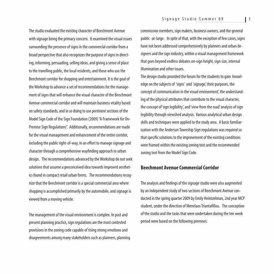
1. The Beechmont Avenue corridor is a commercial auto-related
urban landscape, with a complex land use activity, an inconsistent
presence of buildings and parking voids, a relatively consistent public
right-of way order of physical elements, and many different types of
signs, both on-premise and off-premise. Signs therefore are viewed as
signatures in the corridor’s environment and have evolved over a long
period of time (50 years and more).
2. The visual management of the corridor must address the
needs and concerns of both the local Township government and the
Beechmont Avenue business establishments. Solutions must foster
public safety along the roadway by using standards that are based on
empirical research of the dynamics of the viewing process from a mov-
ing vehicle along the roadway at 40 miles per hour.
3. Most sign regulations, including the regulations of Anderson
Township (Article XXXI-Signage) include standards for size, height,
and placement that do not take in consideration the necessity for ‘Sign
Visibility’, ‘Sign Legibility’, ‘Viewer’s Reaction Time’, and ‘Cone of Vision
and Sign Detectability’ from a moving vehicle (United States Sign
Council; and APA Street Graphics and the Law).
4. Commercial corridors like the study area are very inconsistent
in their form, patterns, and character as a result of varying commercial
land use types (i.e. fast-food drive through establishments as opposed
to big box retail), building and parcel size, the voids between buildings,
placement of ingress/egress access, parking lot sizes and locations, and
sign sizes, height, and graphics. The regulations of signs on the basis of
S i g n a g e S t u d i o S u m m e r 0 9 4
S i g n a g e S t u d i o S u m m e r 0 9 5
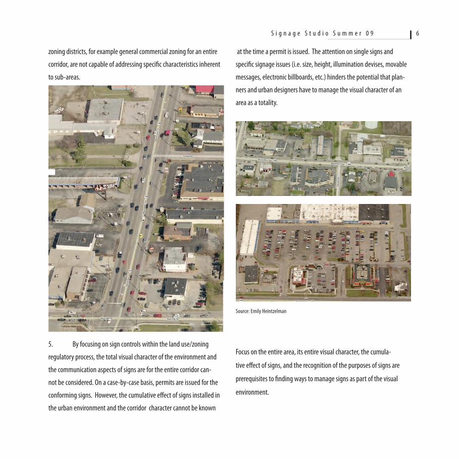
at the time a permit is issued. The attention on single signs and
specific signage issues (i.e. size, height, illumination devises, movable
messages, electronic billboards, etc.) hinders the potential that plan-
ners and urban designers have to manage the visual character of an
area as a totality.
Focus on the entire area, its entire visual character, the cumula-
tive effect of signs, and the recognition of the purposes of signs are
prerequisites to finding ways to manage signs as part of the visual
environment.
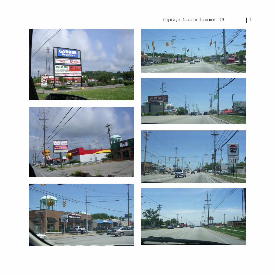
zoning districts, for example general commercial zoning for an entire
corridor, are not capable of addressing specific characteristics inherent
to sub-areas.
5. By focusing on sign controls within the land use/zoning
regulatory process, the total visual character of the environment and
the communication aspects of signs are for the entire corridor can-
not be considered. On a case-by-case basis, permits are issued for the
conforming signs. However, the cumulative effect of signs installed in
the urban environment and the corridor character cannot be known
S i g n a g e S t u d i o S u m m e r 0 9 6
Source: Emily Heintzelman
6. Legal, non-conforming signs are difficult to identify and
describe in detail because the process is length and it is complicated by
the fact that in the Beechmont Avenue corridor, the greatest percent-
age of existing legal signs are non-conforming, having been permitted
prior to 1998 under Hamilton County sign regulations. These sign
make their contribution to visual clatter but their adjustment to meet
current regulations will be beneficial to their owners but will not
necessarily result in an improved visual character.
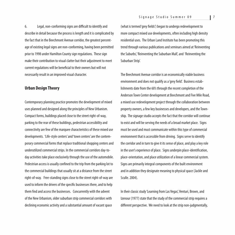
Urban Design Theory
Contemporary planning practice promotes the development of mixed
uses planned and designed along the principles of New Urbanism.
Compact forms, buildings placed close to the street right-of-way,
parking to the rear of these buildings, pedestrian accessibility and
connectivity are few of the marquee characteristics of these mixed use
developments. ‘Life-style centers’ and ‘town centers’ are the contem-
porary commercial forms that replace traditional shopping centers and
underutilized commercial strips. In the commercial corridors day-to-
day activities take place exclusively through the use of the automobile.
Pedestrian access is usually confined to the trip from the parking lot to
the commercial buildings that usually sit at a distance from the street
right-of-way. Free-standing signs close to the street right-of-way are
used to inform the drivers of the specific businesses there, and to help
them find and access the businesses. Concurrently with the advent
of the New Urbanism, older suburban strip commercial corridors with
declining economic activity and a substantial amount of vacant space
(what is termed ‘grey fields’) began to undergo redevelopment to
more compact mixed use developments, often including high density
residential uses. The Urban Land Institute has been promoting this
trend through various publications and seminars aimed at ‘Reinventing
the Suburbs’, ‘Reinventing the Suburban Mall’, and ‘Reinventing the
Suburban Strip’.
The Beechmont Avenue corridor is an economically viable business
environment and does not qualify as a ‘grey field’. Business estab-
lishments date from the 60’s through the recent completion of the
Anderson Town Center development at Beechmont and Five Mile Road,
a mixed use redevelopment project through the collaboration between
property owners, a few key businesses and developers, and the Town-
ship. The signage studio accepts the fact that the corridor will continue
to exist and will be serving the needs of a broad market place. Signs
must be used and must communicate within this type of commercial
environment that is accessible from driving. Signs serve to identify
the corridor and in turn to give it its sense of place, and play a key role
in the user’s experience of place. Signs underpin place-identification,
place-orientation, and place utilization of a linear commercial system.
Signs are primarily integral components of the built environment
and in addition they designate meaning to physical space (Jackle and
Sculle. 2004).
In their classic study ‘Learning from Las Vegas’, Venturi, Brown, and
Izenour (1977) state that the study of the commercial strip requires a
different perspective. We need to look at the strip non-judgmentally,
S i g n a g e S t u d i o S u m m e r 0 9 7
without preconceived aesthetic images on how it should look. While
the general public may be dissatisfied with the existing conditions, and
it would like a more aesthetically ‘acceptable’ environment, the design
professional should aim at ‘enhancing’ what is there rather than chang-
ing it to meet some arbitrary, generic aesthetic value.
Viewing the urban environment from a moving vehicle is dramati-
cally different than the view of the environment as we walk. Speed
decreases our field of view, details blur at the peripheral zones, the
environment is comprehended and we form an image based on several
physical elements that become important when we drive. The image
of the environment we form as we drive is structured based on physical
elements entirely different than when we are walking (Appleyard,
Lynch, and Meyer. 1965)
When driving, our ability to visually access signs, the degree of visibil-
ity, and our ability to detect a sign messages is challenged because we
move considerable distances for every second. The United States Signs
Council has produced a significant amount of research on this that is
very useful in the design and placement of signs USSC (2003).
It is at the intersection of these major inputs from where the Workshop
in Urban Design on signage makes its departure.
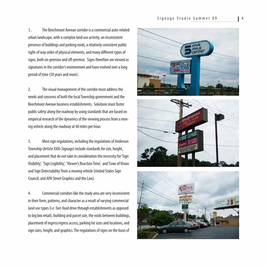
Corridor Morphology and Signs ObservedThe experience of Beechmont Avenue is accumulated as one drives
heading east or west. The driver’s viewshed includes the road, the
streetscape, the signs, and parking areas. The buildings are not always
visible, but only in few cases when they are closer to the road and/or
have a known corporate design that serves as an icon. The predomi-
nant visual elements are the road, the utility poles and the wires, the
free-standing signs that are legible, multi-tenant signs that their sign
boards are not always legible, and signs that are blocked by other
signs.
The distribution of signs reflects the number and arrangement of
the buildings as well as the number of establishments within each
building. Given the limited dimension of each parcel of property, the
smaller the dimension the greater the density of signs will be as a fac-
tor of the number of businesses in each building. Zoning regulations
do not consider this when a zoning permit is issued for the installa-
tion of a sign. This is a key factor that contributes to visual clutter and
many times to the lack of sign visibility from those who drive along the
corridor. Sign competition within the zoning regulations will result in a
certain character and usefulness of each sign.
Images 1-6 shown in the next page demonstrate the typical character
of the strip along Beechmont Avenue. Signs that include a business
logo are easier discernible than signs that use sign text. Free-standing
signs with multi-tenant signs are more difficult to read and the driver
has difficulty discerning their message at distances of less than 150
feet. Many signs are not seen because they are located behind other
signs. The majority of signs on buildings are not seen because they
are beyond the driver’s cone of vision. Utility poles and their wires
dominate the visual field and make a strong contribution to the visual
clutter. As it is shown, utility poles and wires overpower free-standing
signs, and are the direct consequence of previous and current sign
S i g n a g e S t u d i o S u m m e r 0 9 8
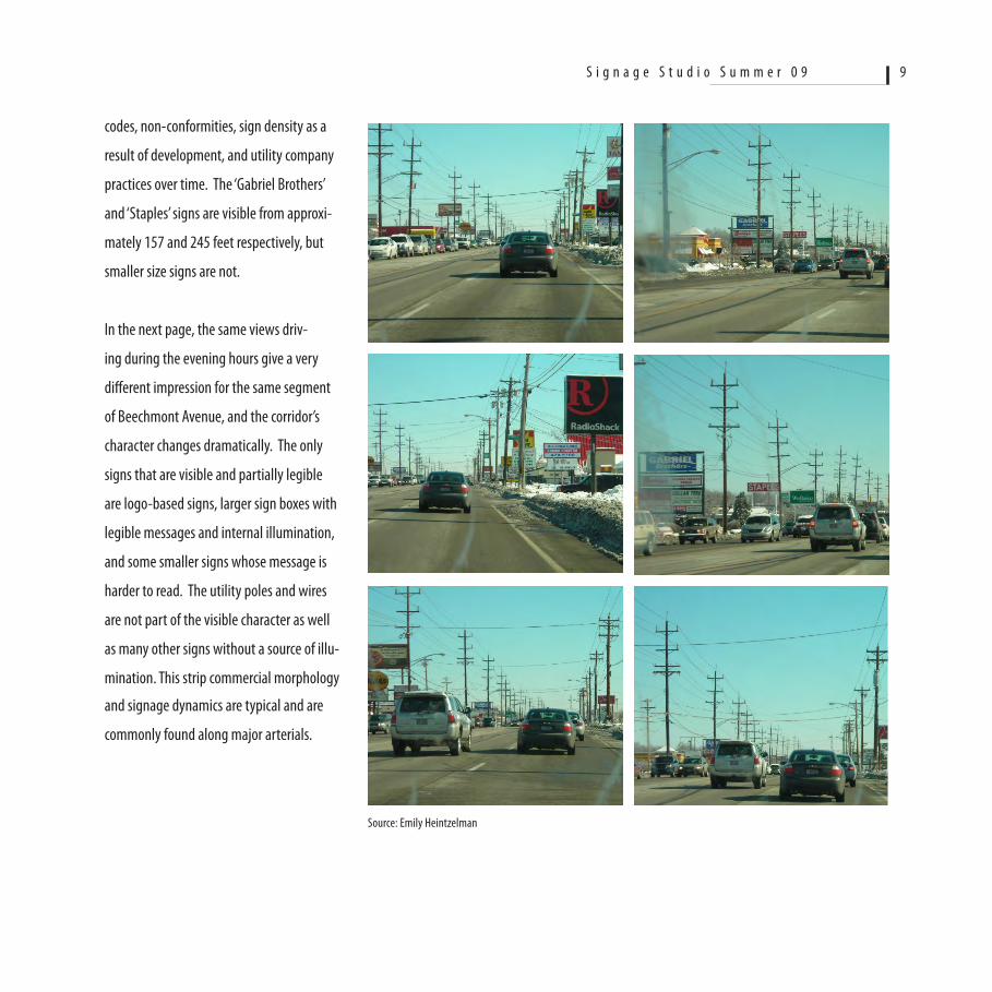
codes, non-conformities, sign density as a
result of development, and utility company
practices over time. The ‘Gabriel Brothers’
and ‘Staples’ signs are visible from approxi-
mately 157 and 245 feet respectively, but
smaller size signs are not.
In the next page, the same views driv-
ing during the evening hours give a very
different impression for the same segment
of Beechmont Avenue, and the corridor’s
character changes dramatically. The only
signs that are visible and partially legible
are logo-based signs, larger sign boxes with
legible messages and internal illumination,
and some smaller signs whose message is
harder to read. The utility poles and wires
are not part of the visible character as well
as many other signs without a source of illu-
mination. This strip commercial morphology
and signage dynamics are typical and are
commonly found along major arterials.
S i g n a g e S t u d i o S u m m e r 0 9 9
Source: Emily Heintzelman
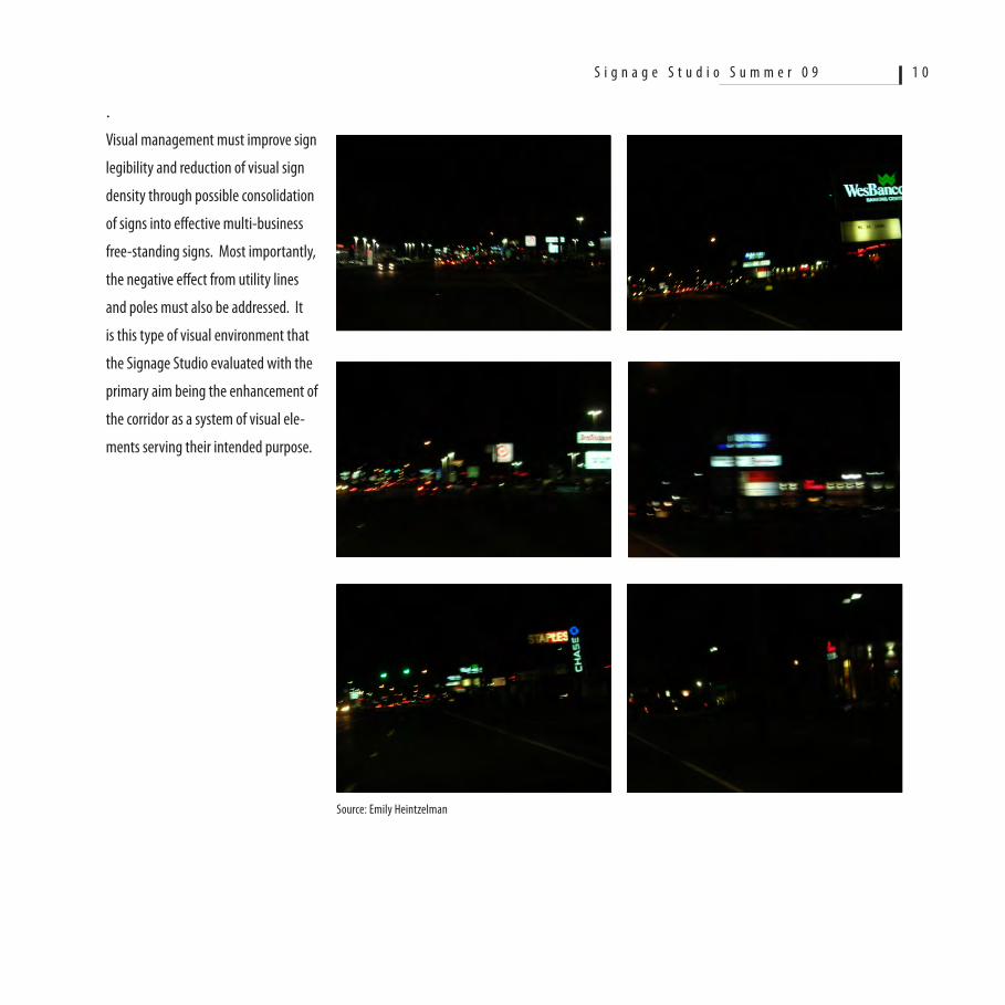
.Visual management must improve sign
legibility and reduction of visual sign
density through possible consolidation
of signs into effective multi-business
free-standing signs. Most importantly,
the negative effect from utility lines
and poles must also be addressed. It
is this type of visual environment that
the Signage Studio evaluated with the
primary aim being the enhancement of
the corridor as a system of visual ele-
ments serving their intended purpose.
S i g n a g e S t u d i o S u m m e r 0 9 1 0
Source: Emily Heintzelman
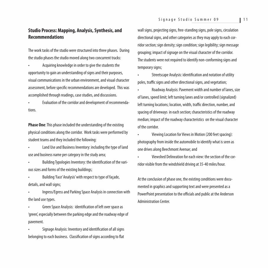
Studio Process: Mapping, Analysis, Synthesis, and Recommendations
The work tasks of the studio were structured into three phases. During
the studio phases the studio moved along two concurrent tracks:
• Acquiringknowledgeinordertogivethestudentsthe
opportunity to gain an understanding of signs and their purposes,
visual communications in the urban environment, and visual character
assessment, before specific recommendations are developed. This was
accomplished through readings, case studies, and discussions.
• Evaluationofthecorridoranddevelopmentofrecommenda-
tions.
Phase One: This phase included the understanding of the existing
physical conditions along the corridor. Work tasks were performed by
student teams and they included the following:
• LandUseandBusinessInventory:includingthetypeofland
use and business name per category in the study area;
• BuildingTypologiesInventory:theidentificationofthevari-
ous sizes and forms of the existing buildings;
• Building‘Face’Analysis’withrespecttotypeoffaçade,
details, and wall signs;
• Ingress/EgressandParkingSpaceAnalysisinconnectionwith
the land use types.
• GreenSpaceAnalysis:identificationofleftoverspaceas
‘green’, especially between the parking edge and the roadway edge of
pavement.
• SignageAnalysis:Inventoryandidentificationofallsigns
belonging to each business. Classification of signs according to flat
wall signs, projecting signs, free-standing signs, pole signs, circulation
directional signs, and other categories as they may apply to each cor-
ridor section; sign density; sign condition; sign legibility; sign message
grouping; impact of signage on the visual character of the corridor.
The students were not required to identify non-conforming signs and
temporary signs;
• StreetscapeAnalysis:identificationandnotationofutility
poles, traffic signs and other directional signs, and vegetation;
• RoadwayAnalysis:Pavementwidthandnumberoflanes,size
of lanes, speed limit; left turning lanes and/or controlled (signalized)
left turning locations; location, width, traffic direction, number, and
spacing of driveways in each section; characteristics of the roadway
median; impact of the roadway characteristics on the visual character
of the corridor.
• ViewingLocationforViewsinMotion(200feetspacing):
photography from inside the automobile to identify what is seen as
one drives along Beechmont Avenue; and
• ViewshedDelineationforeachview:thesectionofthecor-
ridor visible from the windshield driving at 35-40 miles/hour.
At the conclusion of phase one, the existing conditions were docu-
mented in graphics and supporting text and were presented as a
PowerPoint presentation to the officials and public at the Anderson
Administration Center.
S i g n a g e S t u d i o S u m m e r 0 9 1 1
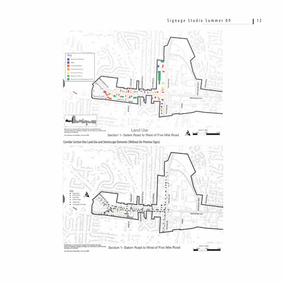
Corridor Section One Land Use and Streetscape Elements (Without On-Premise Signs)
S i g n a g e S t u d i o S u m m e r 0 9 1 2
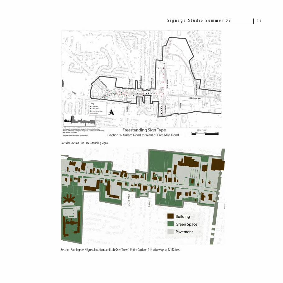
Corridor Section One Free-Standing Signs
Section Four Ingress / Egress Locations and Left Over ‘Green’. Entire Corridor: 114 driveways or 1/112 feet
S i g n a g e S t u d i o S u m m e r 0 9 1 3
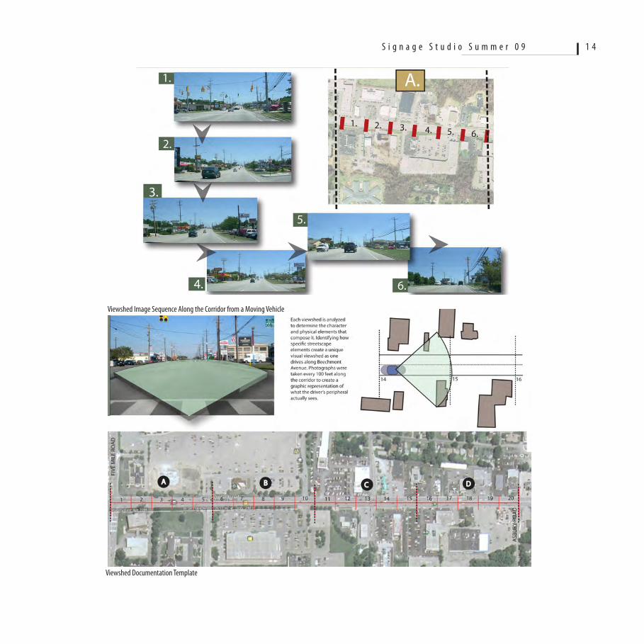
Viewshed Image Sequence Along the Corridor from a Moving Vehicle
Viewshed Documentation Template
S i g n a g e S t u d i o S u m m e r 0 9 1 4
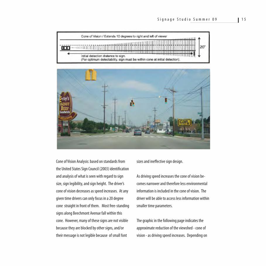
Cone of Vision Analysis: based on standards from
the United States Sign Council (2003) identification
and analysis of what is seen with regard to sign
size, sign legibility, and sign height. The driver’s
cone of vision decreases as speed increases. At any
given time drivers can only focus in a 20 degree
cone straight in front of them. Most free-standing
signs along Beechmont Avenue fall within this
cone. However, many of these signs are not visible
because they are blocked by other signs, and/or
their message is not legible because of small font
sizes and ineffective sign design.
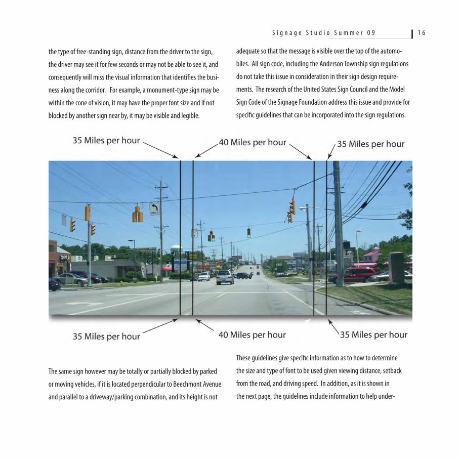
As driving speed increases the cone of vision be-
comes narrower and therefore less environmental
information is included in the cone of vision. The
driver will be able to access less information within
smaller time parameters.
The graphic in the following page indicates the
approximate reduction of the viewshed - cone of
vision - as driving speed increases. Depending on
S i g n a g e S t u d i o S u m m e r 0 9 1 5
the type of free-standing sign, distance from the driver to the sign,
the driver may see it for few seconds or may not be able to see it, and
consequently will miss the visual information that identifies the busi-
ness along the corridor. For example, a monument-type sign may be
within the cone of vision, it may have the proper font size and if not
blocked by another sign near by, it may be visible and legible.
The same sign however may be totally or partially blocked by parked
or moving vehicles, if it is located perpendicular to Beechmont Avenue
and parallel to a driveway/parking combination, and its height is not
adequate so that the message is visible over the top of the automo-
biles. All sign code, including the Anderson Township sign regulations
do not take this issue in consideration in their sign design require-
ments. The research of the United States Sign Council and the Model
Sign Code of the Signage Foundation address this issue and provide for
specific guidelines that can be incorporated into the sign regulations.
These guidelines give specific information as to how to determine
the size and type of font to be used given viewing distance, setback
from the road, and driving speed. In addition, as it is shown in
the next page, the guidelines include information to help under-
S i g n a g e S t u d i o S u m m e r 0 9 1 6
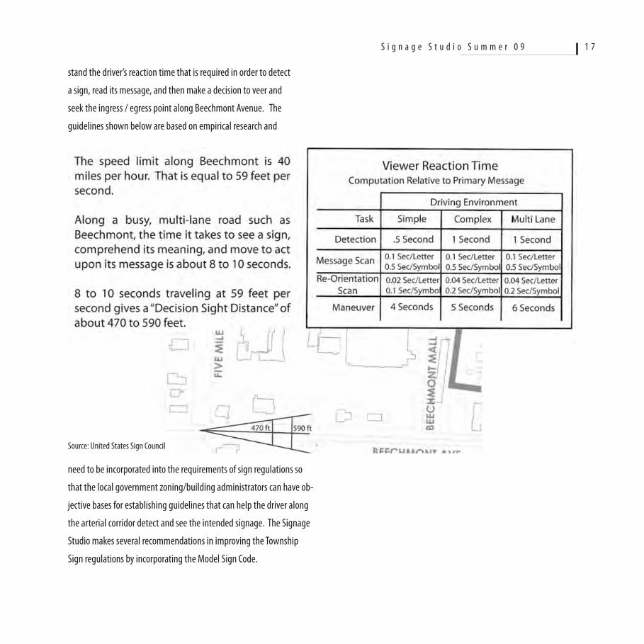
stand the driver’s reaction time that is required in order to detect
a sign, read its message, and then make a decision to veer and
seek the ingress / egress point along Beechmont Avenue. The
guidelines shown below are based on empirical research and
Source: United States Sign Council
need to be incorporated into the requirements of sign regulations so
that the local government zoning/building administrators can have ob-
jective bases for establishing guidelines that can help the driver along
the arterial corridor detect and see the intended signage. The Signage
Studio makes several recommendations in improving the Township
Sign regulations by incorporating the Model Sign Code.
S i g n a g e S t u d i o S u m m e r 0 9 1 7
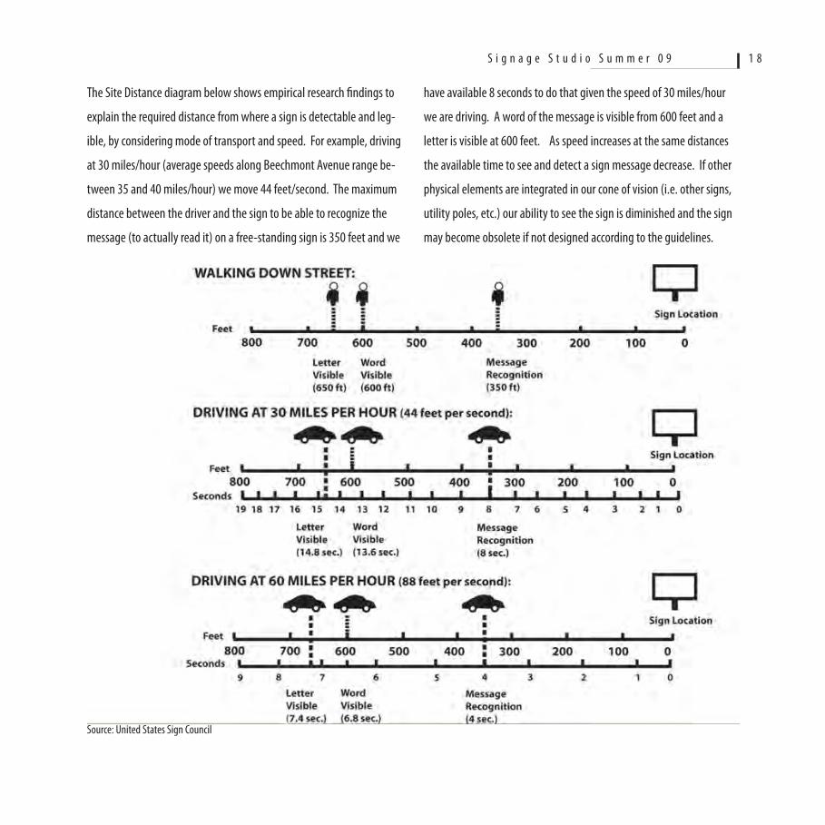
The Site Distance diagram below shows empirical research findings to
explain the required distance from where a sign is detectable and leg-
ible, by considering mode of transport and speed. For example, driving
at 30 miles/hour (average speeds along Beechmont Avenue range be-
tween 35 and 40 miles/hour) we move 44 feet/second. The maximum
distance between the driver and the sign to be able to recognize the
message (to actually read it) on a free-standing sign is 350 feet and we
Source: United States Sign Council
have available 8 seconds to do that given the speed of 30 miles/hour
we are driving. A word of the message is visible from 600 feet and a
letter is visible at 600 feet. As speed increases at the same distances
the available time to see and detect a sign message decrease. If other
physical elements are integrated in our cone of vision (i.e. other signs,
utility poles, etc.) our ability to see the sign is diminished and the sign
may become obsolete if not designed according to the guidelines.
S i g n a g e S t u d i o S u m m e r 0 9 1 8
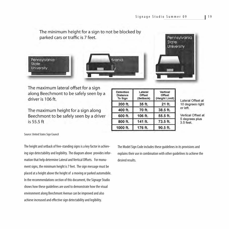
The height and setback of free-standing signs is a key factor in achiev-
ing sign detectability and legibility. The diagram above provides infor-
mation that help determine Lateral and Vertical Offsets. For monu-
ment signs, the minimum height is 7 feet. The sign message must be
placed at a height above the height of a moving or parked automobile.
In the recommendations section of this document, the Signage Studio
shows how these guidelines are used to demonstrate how the visual
environment along Beechmont Avenue can be improved and also
achieve increased and effective sign detectability and legibility.
Source: United States Sign Council
The Model Sign Code includes these guidelines in its provisions and
explains their use in combination with other guidelines to achieve the
desired results.
S i g n a g e S t u d i o S u m m e r 0 9 1 9
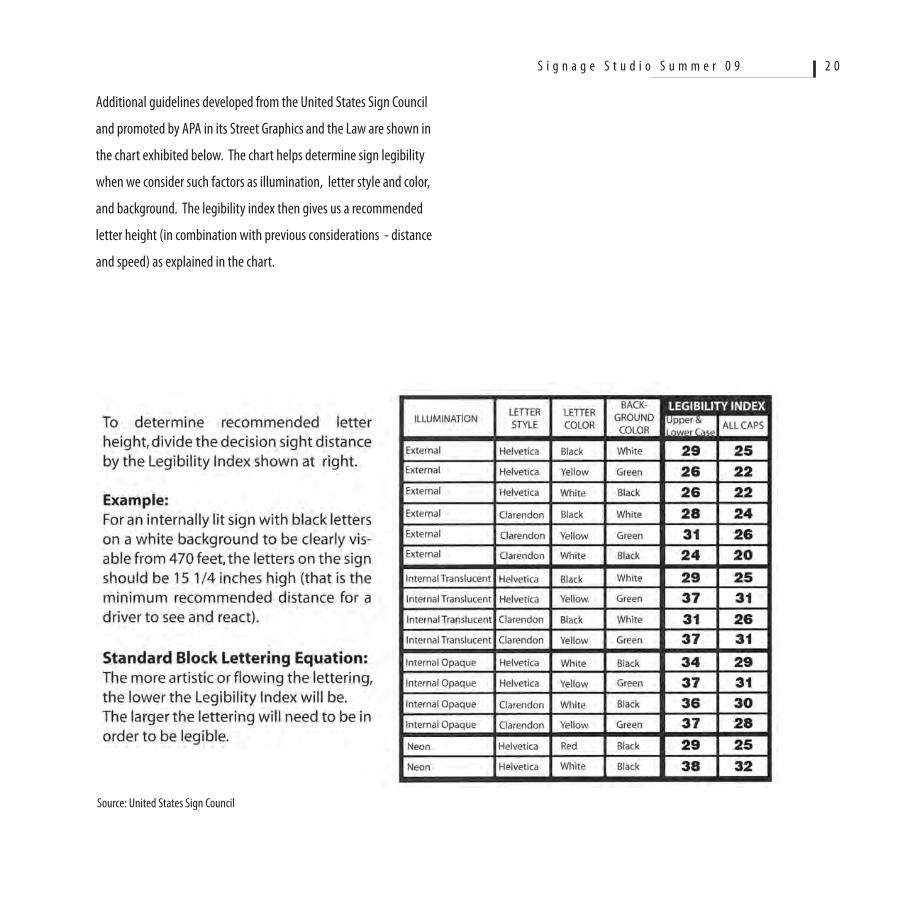
Additional guidelines developed from the United States Sign Council
and promoted by APA in its Street Graphics and the Law are shown in
the chart exhibited below. The chart helps determine sign legibility
when we consider such factors as illumination, letter style and color,
and background. The legibility index then gives us a recommended
letter height (in combination with previous considerations - distance
and speed) as explained in the chart.
Source: United States Sign Council
S i g n a g e S t u d i o S u m m e r 0 9 2 0
Phase Two: During this phase, the students developed preliminary
interventions to manage the visual character of the corridor. The
proposals were presented to the visiting SFI team that included Joe
Rickman, Duane Laska, Patty Herbin, Alan Weinstein, and David Hartt,
as well as David Williamson local attorney specializing in signage.
Pursuant to this meeting, the preliminary recommendations were also
presented during a public meeting at the Anderson Administration
Center. Based on the input that was received during the public meet-
ing, and the feedback from the SFI team, during the third and final
phase the students prepared final recommendations.
Phase Three: During this phase, the preliminary recommendations
were further developed into final plans. Six key recommendations as
described below were advanced to Anderson Township for its consider-
ation and possible adoption.
Findings and Conclusions
The evaluation of the existing character of Beechmont Avenue identi-
fied few key findings and conclusions:
The existing signs compete for visibility and legibility. Bigger free-
standing signs block smaller signs because they are located in close
proximity to each other. However, this is not found consistently
throughout the entire corridor, but in specific concentrated areas. The
application of the sign regulations uniformly across the commercial
districts hinders the Township’s ability to do a more effective manage-
ment of the specific contributors to visual clutter.
The utility poles and lines make a major negative contribution to the
corridor’s character. The wide expanse of the roadway combined with
the building setback away from the road, make the presence of the
utility poles and lines even more prominent. These elements will con-
tinue their negative contribution in spite of any signage improvements
and streetscape enhancements. This is because the corridor is very
long with utility poles and wires along both sides of the roadway.
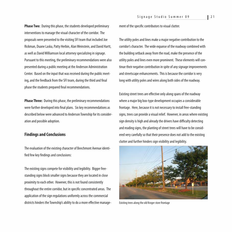
Existing street trees are effective only along spans of the roadway
where a major big box-type development occupies a considerable
frontage. Here, because it is not necessary to install free-standing
signs, trees can provide a visual relief. However, in areas where existing
sign density is high and already the drivers have difficulty detecting
and reading signs, the planting of street trees will have to be consid-
ered very carefully so that their presence does not add to the existing
clutter and further hinders sign visibility and legibility.
Existing trees along the old Kroger store frontage
S i g n a g e S t u d i o S u m m e r 0 9 2 1
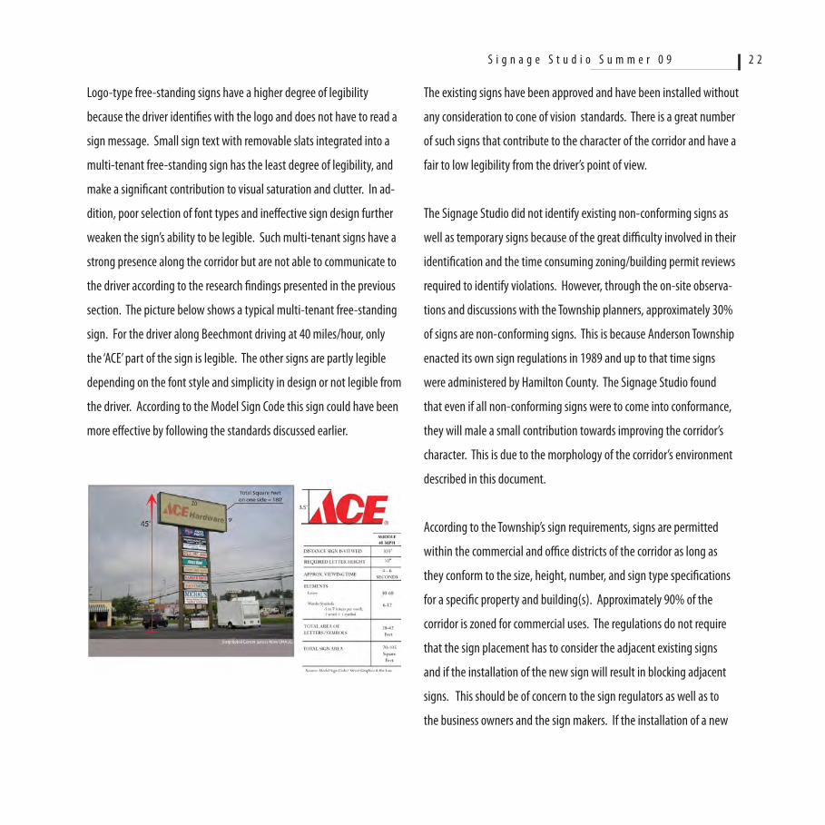
Logo-type free-standing signs have a higher degree of legibility
because the driver identifies with the logo and does not have to read a
sign message. Small sign text with removable slats integrated into a
multi-tenant free-standing sign has the least degree of legibility, and
make a significant contribution to visual saturation and clutter. In ad-
dition, poor selection of font types and ineffective sign design further
weaken the sign’s ability to be legible. Such multi-tenant signs have a
strong presence along the corridor but are not able to communicate to
the driver according to the research findings presented in the previous
section. The picture below shows a typical multi-tenant free-standing
sign. For the driver along Beechmont driving at 40 miles/hour, only
the ‘ACE’ part of the sign is legible. The other signs are partly legible
depending on the font style and simplicity in design or not legible from
the driver. According to the Model Sign Code this sign could have been
more effective by following the standards discussed earlier.
The existing signs have been approved and have been installed without
any consideration to cone of vision standards. There is a great number
of such signs that contribute to the character of the corridor and have a
fair to low legibility from the driver’s point of view.
The Signage Studio did not identify existing non-conforming signs as
well as temporary signs because of the great difficulty involved in their
identification and the time consuming zoning/building permit reviews
required to identify violations. However, through the on-site observa-
tions and discussions with the Township planners, approximately 30%
of signs are non-conforming signs. This is because Anderson Township
enacted its own sign regulations in 1989 and up to that time signs
were administered by Hamilton County. The Signage Studio found
that even if all non-conforming signs were to come into conformance,
they will male a small contribution towards improving the corridor’s
character. This is due to the morphology of the corridor’s environment
described in this document.
According to the Township’s sign requirements, signs are permitted
within the commercial and office districts of the corridor as long as
they conform to the size, height, number, and sign type specifications
for a specific property and building(s). Approximately 90% of the
corridor is zoned for commercial uses. The regulations do not require
that the sign placement has to consider the adjacent existing signs
and if the installation of the new sign will result in blocking adjacent
signs. This should be of concern to the sign regulators as well as to
the business owners and the sign makers. If the installation of a new
S i g n a g e S t u d i o S u m m e r 0 9 2 2
additional sign does not serve adequately its intended purpose why
then should it be installed? Is it possible that the lack of an overall
sign design review and the design and installation of signs without
consideration to the empirical research by the United States Sign
Council is a major reason for the visual clutter and lack of sign legibility
along the corridor? As it was stated in this document, viable commer-
cial corridors are a form of retail and their morphology requires us to
accept them as such and address the needs for signage management
consistent with this reality, not as we may do for a historic or main
street-type retail environments. It is possible to improve sign legibility
and reduce visual clutter through creative ways of rethinking the visual
management of the commercial corridors.
RecommendationsBased on the findings of the analysis of the Beechmont Avenue cor-
ridor, the review of literature and research from the United States Sign
Council, the APA, and the review of the Signage Foundation Model Sign
Code, the Signage Studio prepared several recommendations for the
improvement of the corridor through a comprehensive visual manage-
ment framework. Following, five key recommendations are discussed
for consideration by Anderson Township.
1. Sign Code Text Amendment
The studio recommends the adoption of the Signage Foundation,
Inc. Model Sign Code “Off-Premise Sign Regulations”. The Town-
ship should review the entire code and make adjustments to address
specific local dynamics as for example it pertains to the proposed Sign
Character Areas. The existing Article XXXI Signage can be amended
appropriately with the inclusion of the Signage Foundation’s Model
Sign Code.
The Model Sign Code is based on strong legal grounds and it is
structured in a way to respect the perspectives of the government and
the business interests. It is based on collaborative work between the
American Planning Association ( APA ) and the sign industry that was
culminated in the Planning Advisory Service APA publication “Street
Graphics and the Law” (PAS report No. 57-2004).
The Model Sign Code incorporates the research from the United States
Sign Council on Sign Legibility and Sign Regulations that provides fac-
tual information as to what is involved when a motorist views a sign,
including viewer reaction time, viewer reaction distance, letter height,
copy area, negative space. This information can be used to determine
sign height and sign area and the setback required for the installation
of pole signs back from the right-of-way in order to maintain visibility
from specified distances along the road, in order to ensure that a per-
son in a moving vehicle can detect a sign, read its message, and then
make a decision to turn and enter the business area in adequate and
safe time. Based on these standards the studio found that a pole sign
to be detected and read by a person driving 40 miles on Beechmont
Avenue from a distance of 270 feet (minimum distance to meet the
standards) will require letters 15¼ inch high and a text that occupies
maximum 40% of the sign area. The simple logic here is the fact
that if the existing character of the corridor looks saturated from sign
S i g n a g e S t u d i o S u m m e r 0 9 2 3
induced visual clutter, and existing pole or multiple tenant pole sign
are not detectable and legible based on the existing sign regulations
and standards, then these signs do not fulfill their purpose and may
also contribute to unsafe driving conditions. The use of the Model Sign
Code can help to gradually make the existing signs more effective and
to also require new signs to adhere to these standards.
The free-standing ‘ACE’ sign that was shown earlier demonstrates
what type of changes consistent with the Model Sign Code will be
required to make this sign more effective. A more effective sign design
consistent with the Model Sign Code and viewing requirements would
utilize sign text with 10 inch high letters, 40-60 letters, 6-12 symbols,
28-42 square feet of area occupied by letters with the remaining left
as background, and a total sign area of 70-105 square feet. In order
for this free-standing sign to be achieved, the application for the sign
will be designed according to the Model Sign Code standards, and the
consideration of the adjacent signs and spaces. Consistence in the use
of fonts and color will further enhance visual character and legibility
from the road.
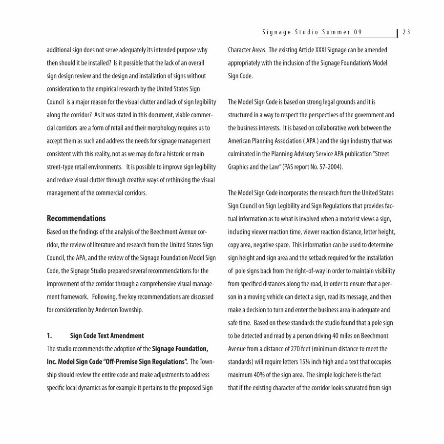
2. Delineate and Establish Character Areas
The Signage Studio recommends the establishment of Character (Sig-
nage) Areas and to regulate signs based on their unique characteristics,
not the specific zoning. Character Areas represent a diverse range of
typical development/zoning types, and offer the potential to establish
‘unique’ destination areas along the business corridor that the user will
become familiar with. These areas should be delineated after careful
analysis of the existing characteristics with respect to building types,
land use, building/parking relationships, the inventory and analysis
of the existing signs, and the streetscape characteristics. The Studio
evaluated the existing visual character of the 2.8 mile corridor and
identified the key physical elements that contribute to it. The existing
signs are one major contributor, with land use types, building morphol-
ogy, parcel width sizes and configurations, parking lots and driveways,
and the utility poles along the right-of-way, combining to give to the
corridor its existing character. Pursuant to this evaluation, five (5) sub-
areas or ‘character areas’ were identified. While the boundaries of these
character areas are not precise, they are important because they serve
to establish the initial focus for further analysis, and to advance recom-
mendations for the management of signage based on interventions to
specific conditions in the designated areas.
The recommended areas are different than the ones described in the
Model Sign Code because they are customized for a commercial cor-
ridor retail environment.
S i g n a g e S t u d i o S u m m e r 0 9 2 4
Existing Zoning Districts - Beechmont Avenue Corridor
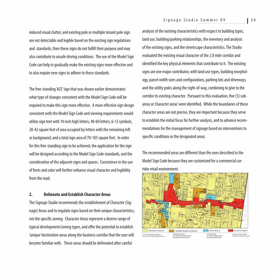
Recommended Character Areas - Beechmont Avenue Corridor
1. Small Commercial Suburban – this is the area from Salem to
Five Mile Road and it includes older structures, smaller size buildings
and parcels, multiple driveways and very little green space between
the edge of the road to the parking at the front; primarily older non-
conforming signs having a fairly high density.
2. Localized Office: Small office structures 2-4 story high, some
landscaping, fewer signs than the commercial sections, more orga-
nized parking areas. Signs have a more effective relationship with the
structures and are mainly wall mounted signs.
3. Mixed Use Retail - New Urbanism: This character area in-
cludes what is identified as the Anderson Town Center; redevelopment
of new retail/entertainment uses, one story commercial structures,
organized building arrangement and parking lots, substantial land-
scaped areas, coordinated signage.
S i g n a g e S t u d i o S u m m e r 0 9 2 5
4. General Commercial – Suburban: This includes the greater
length of the corridor including the many different uses; fast food
drive-through restaurants, national chain commercial; haphazard types
of building sizes and parcels, fragmented landscaping; signs of any
conceivable size and shape, many of them non-conforming.
5. Highway Commercial - Big Box: This are at the eastern edge
of the corridor is characteristic of ‘big box’ type uses of single large size
buildings with large areas of parking, high pole signs with multiple
tenants, some landscaping.
3. Non-Conforming Signs and Improved Sign Legibility
The Model Sign Code recognizes the need for non-conforming signs to
become conforming according to the recommended standards and pro-
cedures. One of the key challenges the studio found is that, given the
existing great number of signs and a low degree of legibility, especially
of multiple tenant signs, even if the signs become conforming there
will still be the concern with legibility. Furthermore, for existing pole
signs of conforming or non-conforming status adjacent to each other,
their presence and relationship hinder effective legibility. The Signage
Studio recommends that the Township should undertake a compre-
hensive program that includes the business/property owners, Business
Association, and local Chamber of Commerce to address non-conformi-
ties and the ineffectiveness of the existing signs. This program should
consider the consolidation of existing ineffective free-standing signs
into new and effective multiple multiple-tenant type signs for several
adjacent properties. Multiple tenant type signs are permitted for
single properties under one ownership and management. The Signage
Studio believes that it will be to the benefit of the business owners and
the government to negotiate arrangement whereby a single pole sign
is installed that serves adjacent multiple business in different owner-
ship. The new sign can be of conventional material and/or it may
include an electronic message board, and should be designed accord-
ing to the requirements of the Model Sign Code and the standards from
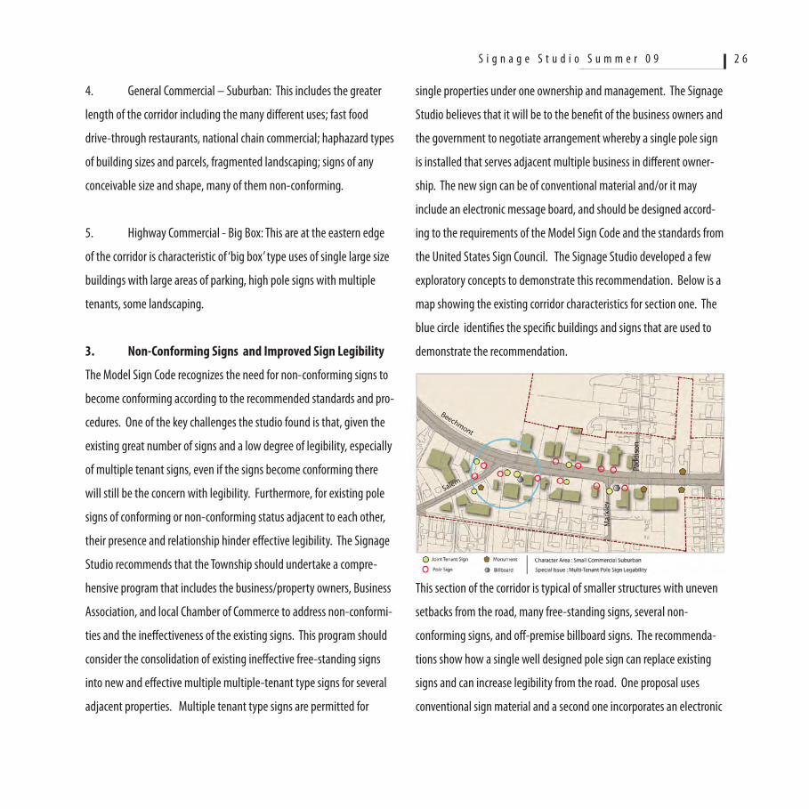
the United States Sign Council. The Signage Studio developed a few
exploratory concepts to demonstrate this recommendation. Below is a
map showing the existing corridor characteristics for section one. The
blue circle identifies the specific buildings and signs that are used to
demonstrate the recommendation.
This section of the corridor is typical of smaller structures with uneven
setbacks from the road, many free-standing signs, several non-
conforming signs, and off-premise billboard signs. The recommenda-
tions show how a single well designed pole sign can replace existing
signs and can increase legibility from the road. One proposal uses
conventional sign material and a second one incorporates an electronic
S i g n a g e S t u d i o S u m m e r 0 9 2 6
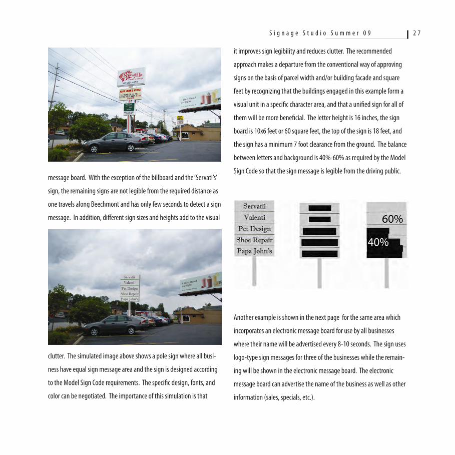
message board. With the exception of the billboard and the ‘Servati’s’
sign, the remaining signs are not legible from the required distance as
one travels along Beechmont and has only few seconds to detect a sign
message. In addition, different sign sizes and heights add to the visual
clutter. The simulated image above shows a pole sign where all busi-
ness have equal sign message area and the sign is designed according
to the Model Sign Code requirements. The specific design, fonts, and
color can be negotiated. The importance of this simulation is that
it improves sign legibility and reduces clutter. The recommended
approach makes a departure from the conventional way of approving
signs on the basis of parcel width and/or building facade and square
feet by recognizing that the buildings engaged in this example form a
visual unit in a specific character area, and that a unified sign for all of
them will be more beneficial. The letter height is 16 inches, the sign
board is 10x6 feet or 60 square feet, the top of the sign is 18 feet, and
the sign has a minimum 7 foot clearance from the ground. The balance
between letters and background is 40%-60% as required by the Model
Sign Code so that the sign message is legible from the driving public.
Another example is shown in the next page for the same area which
incorporates an electronic message board for use by all businesses
where their name will be advertised every 8-10 seconds. The sign uses
logo-type sign messages for three of the businesses while the remain-
ing will be shown in the electronic message board. The electronic
message board can advertise the name of the business as well as other
information (sales, specials, etc.).
S i g n a g e S t u d i o S u m m e r 0 9 2 7
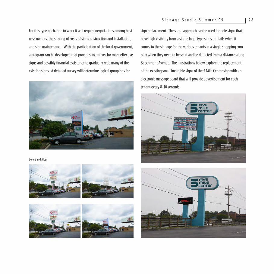
For this type of change to work it will require negotiations among busi-
ness owners, the sharing of costs of sign construction and installation,
and sign maintenance. With the participation of the local government,
a program can be developed that provides incentives for more effective
signs and possibly financial assistance to gradually redo many of the
existing signs. A detailed survey will determine logical groupings for
Before and After
sign replacement. The same approach can be used for pole signs that
have high visibility from a single logo-type signs but fails when it
comes to the signage for the various tenants in a single shopping com-
plex when they need to be seen and be detected from a distance along
Beechmont Avenue. The illustrations below explore the replacement
of the existing small ineligible signs of the 5 Mile Center sign with an
electronic message board that will provide advertisement for each
tenant every 8-10 seconds.
S i g n a g e S t u d i o S u m m e r 0 9 2 8
4. Wayfinding System / Role of Public Right-of-Way
During the analysis and evaluation phases, it became very clear that
the utility poles along both sides of Beechmont Avenue are making a
negative contribution to its character. In combination with existing
signs and the inconsistent urban form, their presence along the right-
of-way will continue to be dominant, and any efforts to improve the
character of the corridor through more effective signage and landscap-
ing will not accrue effective results. The Signage Studio recommends
that the visual management of the corridor must include solutions to
mitigate the presence of these poles and electric lines. The Studio also
recognizes that placing the utility lines underground along the right of
way is economically not feasible, there is a lack of adequate right-of-
way, and should not be advanced as a policy from the Township.
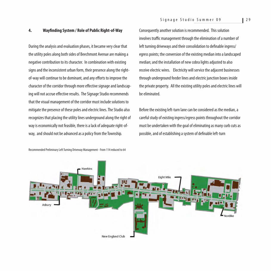
Recommended Preliminary Left Turning Driveway Management - From 114 reduced to 64
Consequently another solution is recommended. This solution
involves traffic management through the elimination of a number of
left turning driveways and their consolidation to definable ingress/
egress points; the conversion of the existing median into a landscaped
median; and the installation of new cobra lights adjusted to also
receive electric wires. Electricity will service the adjacent businesses
through underground feeder lines and electric junction boxes inside
the private property. All the existing utility poles and electric lines will
be eliminated.
Before the existing left-turn lane can be considered as the median, a
careful study of existing ingress/egress points throughout the corridor
must be undertaken with the goal of eliminating as many curb cuts as
possible, and of establishing a system of definable left-turn
S i g n a g e S t u d i o S u m m e r 0 9 2 9

locations. In addition to increasing safety, this solution will convert
the Beechmont Avenue roadway into an organized traffic corridor
where left-turn lanes will afford turning at signalized intersections. In
the private domain, property owners will be required to permit cross
vehicular moment over their parking lot in a newly design system.
The Studio explored this possibility in the character area designated
as Highway Commercial – Big Box. Based on preliminary designs it
is possible to reduce the existing curb cuts by approximately 50%. A
careful study with the collaboration of the property owners and busi-
ness will be necessary. Assuming that the median is a possibility, the
new cobra light poles with the electric lines have the strong potential
to become visual elements unique to Anderson Township and the
Beechmont Avenue corridor.
The placement of the poles at specific spots will establish a visual
rhythm. Low ground cover will add to the aesthetic quality. The space
between the edge of pavement and the right-of-way that will be
available after the removal of the existing utility poles will provide an
opportunity for additional aesthetic improvements with low landscap-
ing at selected segments.
The cobra lights/utility poles will offer an additional opportunity for a
secondary sign guidance system within the right-of-way. Anderson
Township has already began a program of installing low monument
signs inside the right-of-way to announce businesses that are up
ahead. This secondary signage guidance system will be pursued along
the same lines but with a completely different set of physical elements.
Within this system signage can be improved substantially as discussed
earlier and will be visually accessible from the road. Anderson Town-
ship has the opportunity to establish a unique ‘Wayfinding System’
to visually manage the corridor and to enhance sign character and
improve sign legibility. The elimination of the utility poles can be used
to reevaluate the existing signs and to move towards a more managed
approach where legible sign boards replace several ineffective signs.
S i g n a g e S t u d i o S u m m e r 0 9 3 0
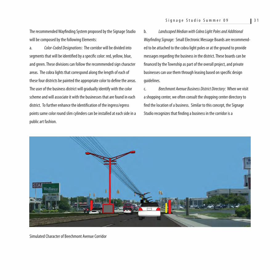
The recommended Wayfinding System proposed by the Signage Studio
will be composed by the following Elements:
a. Color-Coded Designations: The corridor will be divided into
segments that will be identified by a specific color: red, yellow, blue,
and green. These divisions can follow the recommended sign character
areas. The cobra lights that correspond along the length of each of
these four districts be painted the appropriate color to define the areas.
The user of the business district will gradually identify with the color
scheme and will associate it with the businesses that are found in each
district. To further enhance the identification of the ingress/egress
points same color round slim cylinders can be installed at each side in a
public art fashion.
Simulated Character of Beechmont Avenue Corridor
b. Landscaped Median with Cobra Light Poles and Additional
Wayfinding Signage: Small Electronic Message Boards are recommend-
ed to be attached to the cobra light poles or at the ground to provide
messages regarding the business in the district. These boards can be
financed by the Township as part of the overall project, and private
businesses can use them through leasing based on specific design
guidelines.
c. Beechmont Avenue Business District Directory: When we visit
a shopping center, we often consult the shopping center directory to
find the location of a business. Similar to this concept, the Signage
Studio recognizes that finding a business in the corridor is a
S i g n a g e S t u d i o S u m m e r 0 9 3 1
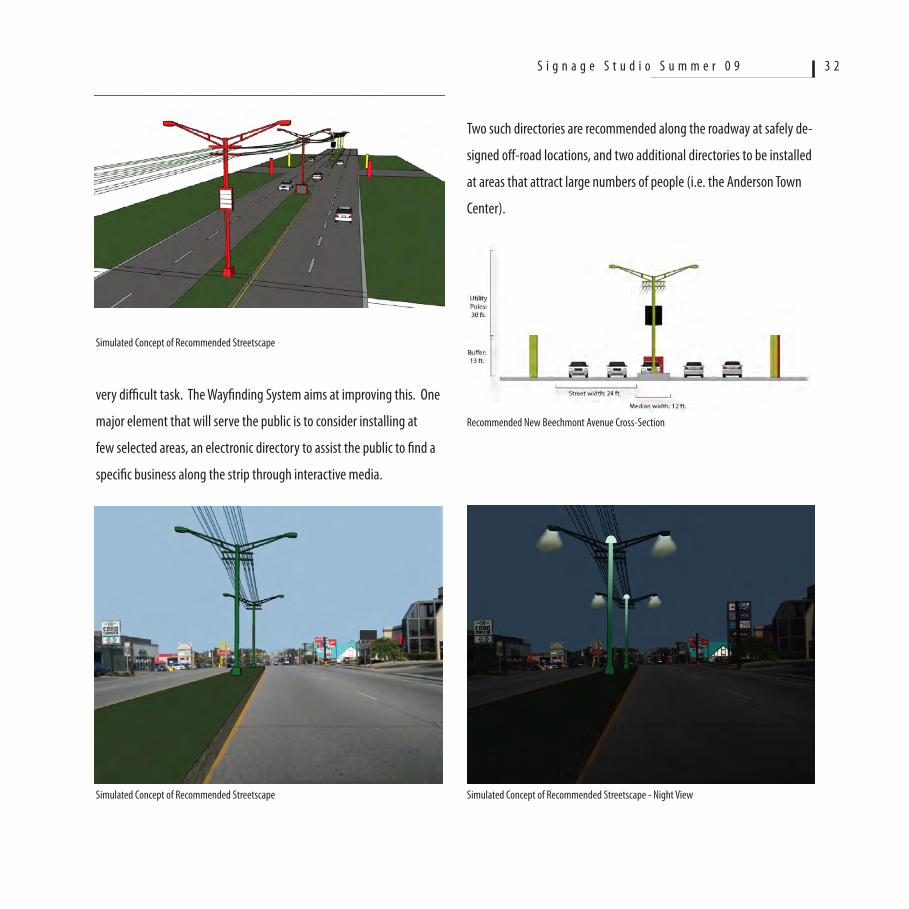
Simulated Concept of Recommended Streetscape
very difficult task. The Wayfinding System aims at improving this. One
major element that will serve the public is to consider installing at
few selected areas, an electronic directory to assist the public to find a
specific business along the strip through interactive media.
Simulated Concept of Recommended Streetscape
Two such directories are recommended along the roadway at safely de-
signed off-road locations, and two additional directories to be installed
at areas that attract large numbers of people (i.e. the Anderson Town
Center).
Recommended New Beechmont Avenue Cross-Section
Simulated Concept of Recommended Streetscape - Night View
S i g n a g e S t u d i o S u m m e r 0 9 3 2
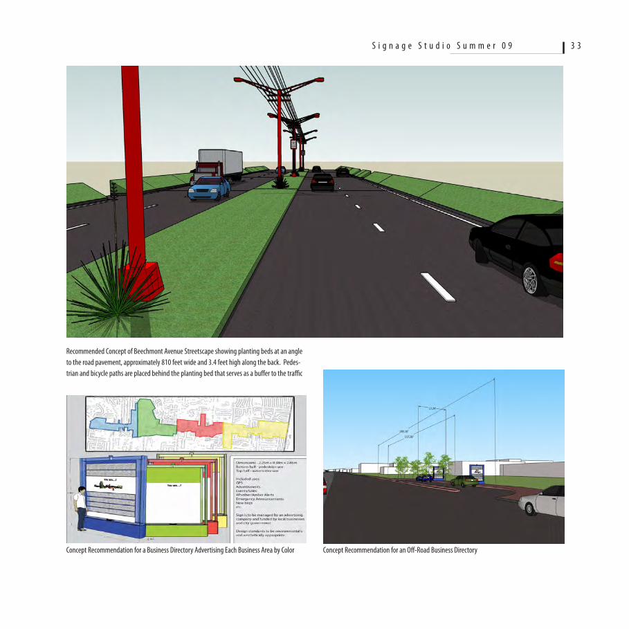
Recommended Concept of Beechmont Avenue Streetscape showing planting beds at an angle to the road pavement, approximately 810 feet wide and 3.4 feet high along the back. Pedes-trian and bicycle paths are placed behind the planting bed that serves as a buffer to the traffic
Concept Recommendation for a Business Directory Advertising Each Business Area by Color Concept Recommendation for an Off-Road Business Directory
S i g n a g e S t u d i o S u m m e r 0 9 3 3
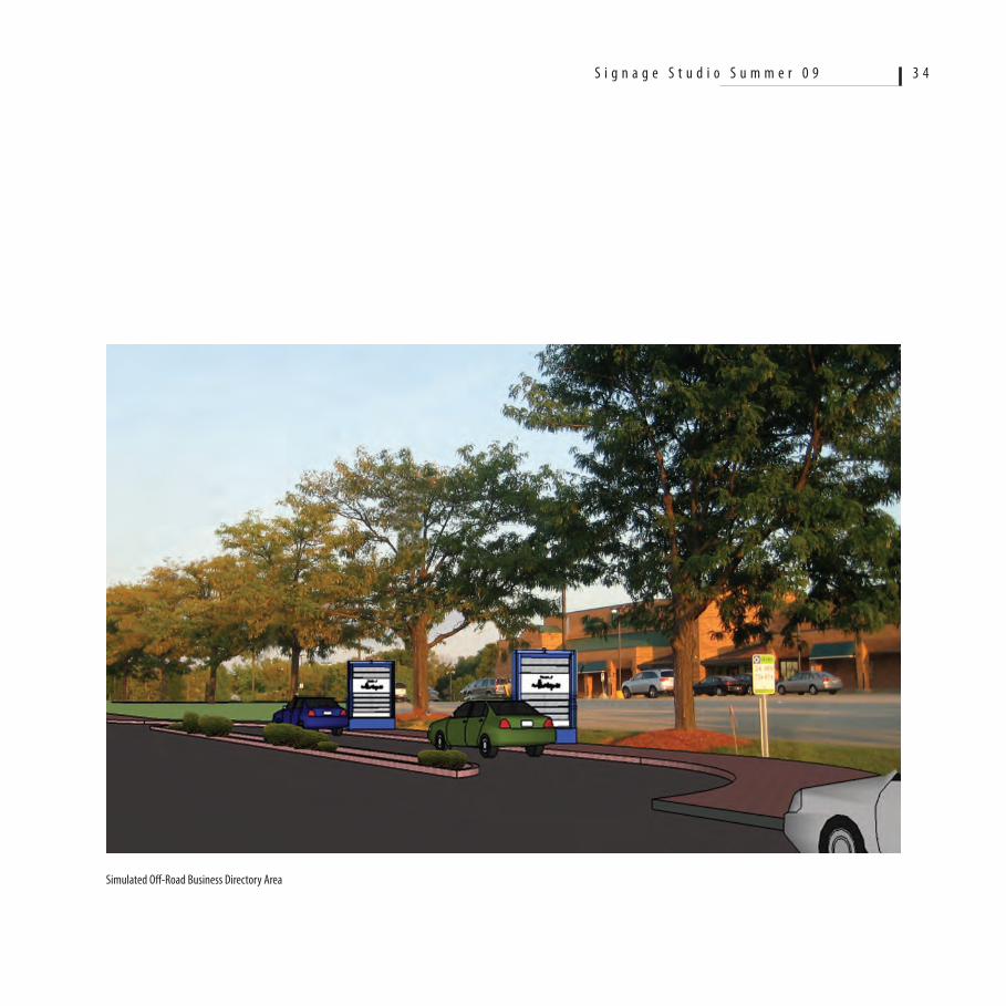
Simulated Off-Road Business Directory Area
S i g n a g e S t u d i o S u m m e r 0 9 3 4
5. Electronic Message Centers (EMCs)
The Model Sign Code recognizes the effectiveness and promise for
signage management that can be afforded by the use of Electronic
Message Centers (or Electronic Message Boards). The Model Sign Code
makes provisions for their use in relation to a specific Sign Character
Area, and permits specific size, height, and duration (time) of message
change. As it was discussed earlier, in the Beechmont Avenue corridor
the Studio explored the use of such EMCs in an effort to make existing
signs conforming and more effective and as a trade off to eliminate
a number of signs. The recommendations by the Signage Studio are
for illustrative purposes and by no means is it recommended that the
Township pursue the elimination of existing signs. The approach that
is recommended is through a collaborative process that will include
education and the identification of roles and responsibilities of all the
stakeholders, including the property and business owners, the Town-
ship officials, the Business Association, and the Chamber of Commerce.
6. Model Sign Code Pilot Project
The Studio recommends that the Township should select an area along
the corridor and work with the property owners, the business estab-
lishments, the Business Association, and the Chamber of Commerce to
demonstrate the benefits of using the Model Sign Code. Specifically
after a phase of education and understanding, a plan and strategy
should be developed that will identify clusters of adjacent free-
standing signs that can be replaced by a unified pole sign, and other
signs that could be replaced. The plan and strategy should also identify
the costs associated with removal and replacement and the financial
responsibility. In addition to the replacement of signs, the pilot study
will use the Model Sign Code to demonstrate the proper estimation
of sign area and height, letter height, and other specific elements as
discussed previously.
Street Tree Planting
The conventional approach to addressing visual clutter along com-
mercial corridors is to plant street trees at a repetitive distance from
each other in order to establish a rhythm. In addition, between the
trees shrubs are also planted in order to add to the natural materials
and screen parked cars at proximity to the road. Furthermore, where
possible, the local government tries to eliminate unwanted, noncon-
forming signs. Sometimes, ‘gateways’ are developed to demarcate the
beginning and the end of the corridor.
The Signage Studio as explained in this document did not approach
the visual enhancement of Beechmont Avenue from this perspective
because it is most likely that if such an improvements program were
to be implemented it will substantially reduce sign legibility and in
many instances along the corridor it may contribute to the clutter.
The assumption that a tree is better than a sign is contrary to the goal
of maintaining a viable business district where signs are improved
to serve their purpose. Landscaping has its place in the corridor but
only if it is considered carefully at selected areas, as for example along
stretches of the corridor where big box type developments with wide
parcel frontage and without the need for free-standing signs.
S i g n a g e S t u d i o S u m m e r 0 9 3 5
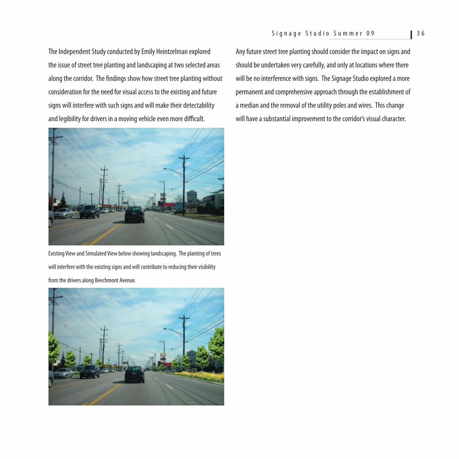
The Independent Study conducted by Emily Heintzelman explored
the issue of street tree planting and landscaping at two selected areas
along the corridor. The findings show how street tree planting without
consideration for the need for visual access to the existing and future
signs will interfere with such signs and will make their detectability
and legibility for drivers in a moving vehicle even more difficult.
Existing View and Simulated View below showing landscaping. The planting of trees
will interfere with the existing signs and will contribute to reducing their visibility
from the drivers along Beechmont Avenue.
Any future street tree planting should consider the impact on signs and
should be undertaken very carefully, and only at locations where there
will be no interference with signs. The Signage Studio explored a more
permanent and comprehensive approach through the establishment of
a median and the removal of the utility poles and wires. This change
will have a substantial improvement to the corridor’s visual character.
S i g n a g e S t u d i o S u m m e r 0 9 3 6