excavations in lakes province, southern sudan
TRANSCRIPT
This article was downloaded by: [Mr Peter Robertshaw]On: 28 August 2015, At: 10:44Publisher: RoutledgeInforma Ltd Registered in England and Wales Registered Number: 1072954 Registered office: 5 HowickPlace, London, SW1P 1WG
Azania: Archaeological Research in AfricaPublication details, including instructions for authors and subscription information:http://www.tandfonline.com/loi/raza20
Excavations in Lakes Province, Southern SudanPeter Robertshaw & Ari SiiriäinenPublished online: 26 Feb 2010.
To cite this article: Peter Robertshaw & Ari Siiriäinen (1985) Excavations in Lakes Province, Southern Sudan, Azania:Archaeological Research in Africa, 20:1, 89-161, DOI: 10.1080/00672708509511360
To link to this article: http://dx.doi.org/10.1080/00672708509511360
PLEASE SCROLL DOWN FOR ARTICLE
Taylor & Francis makes every effort to ensure the accuracy of all the information (the “Content”)contained in the publications on our platform. However, Taylor & Francis, our agents, and our licensorsmake no representations or warranties whatsoever as to the accuracy, completeness, or suitabilityfor any purpose of the Content. Any opinions and views expressed in this publication are the opinionsand views of the authors, and are not the views of or endorsed by Taylor & Francis. The accuracy ofthe Content should not be relied upon and should be independently verified with primary sources ofinformation. Taylor and Francis shall not be liable for any losses, actions, claims, proceedings, demands,costs, expenses, damages, and other liabilities whatsoever or howsoever caused arising directly orindirectly in connection with, in relation to or arising out of the use of the Content.
This article may be used for research, teaching, and private study purposes. Any substantial orsystematic reproduction, redistribution, reselling, loan, sub-licensing, systematic supply, or distribution inany form to anyone is expressly forbidden. Terms & Conditions of access and use can be found at http://www.tandfonline.com/page/terms-and-conditions
Excavations in Lakes Province, Southern Sudan Peter Robertshaw and Ari Siiri'inen'
(with appendices by Jeanne Sept and Lynne Schepartz)
This report presents the results of the archaeological work of the fourth multi- disciplinary expedition to the Southern Sudan by the British Institute in Eastern Africa. In contrast to the wide-ranging survey and excavations of the first two expeditions (Phillipson, 1981; David et al, 198l), the 1981 season followed the example of the previous year in concentrating research within a single province. In 1980 Eastern Equatoria provided the focus (Robertshaw and Mawson, 1981), and in 1981 our attention turned to Lakes (El Buheyrat) Province.2This region was chosen for several reasons: it formed a gap in the Institute's archaeological coverage of the Southern Sudan, and previous work had highlighted the importance of constructing detailed local sequences; it contains mound sites similar to that excavated at Dhang Rial, far to the north-west, which yielded finds of considerable interest (Davidet a/, 1981); it is an area of a parently some importance in historic movements of Dinka
archaeological manifestations of pastoral peoples in a situation where archaeological and ethnoarchaeological research could usefully be combined with the study of oral traditions. This paper gives the details of the archaeological survey and excavations; the interdisciplinary studies will be presented elsewhere.
Our research was concentrated in two areas east of Rumbek, the provincial capital (fi 1). For simplicity the region can be divided into two environmental zones. Alfweather roads run along the Ironstone Plateau, which forms the first zone. This is an extensive laterite sheet derived from prolonged weathering of rocks of the Basement Complex (Whiteman, 1971). The vegetation along the edge of the Plateau is deciduous savanna woodland, though east of Rumbek many of the trees have been felled to allow cultivation and only the larger shady trees, such as the mango, have been left. North-east of the Ironstone are the great clay plains, which are our second environmental zone. These plains support the swamps of the Sudd and the seasonally flooded grasslands toich (roc) which surround it. In the tall grass there are occasional stands of various species of Acacia and palms. Most rain falls in a single long rainy season from April/May to October. Rumbek lies almost astride the 1100 mm mean annual rainfall isohyet; the average rainfall between 1921 and 1950 was 994 mm. Although temperature figures are not available, one may note that it is always hot.
Most of the region is inhabited by Nilotic-speaking Dinka of the Agar tribal group, with Atuot to the east. There is now a dispersed pattern of permanent
and related groups; an B finally it seemed to provide an opportunity to examine the
1 The analysis and description of the excavated material was undertaken by P.R. who also wrote the present report. Both authors are responsible for the excavations.
2 We understand that changes in the regional organization of the Southern Sudan have occurred since our fieldwork was completed.
Dow
nloa
ded
by [
Mr
Pete
r R
ober
tsha
w]
at 1
0:44
28
Aug
ust 2
015
90 Southern Sudan
I
I
Dow
nloa
ded
by [
Mr
Pete
r R
ober
tsha
w]
at 1
0:44
28
Aug
ust 2
015
Robertshaw and Siiriainen 91
homesteads among the fields on the edge of the Ironstone. Sorghum, groundnuts, cowptas and other crops are grown here. The cattle are herded on the toick almost all the year except when they are brought to graze on the stubble and@ manure the fields. At the height of the dry season the cattle are herded from camps (pl. I) located close to the permanent rivers, where fish provide a supplement to the diet. As the floodwaters rise the herds retreat to the wet-season cattle-camps located in higher parts of the toich, usually near the edge of the Ironstone. Many cattle-camps are repeatedly re-occupied over the years, forming ash mounds standing above the level of the surrounding toich and visible from considerable distances (pl. Ia). Close to each mound is a depression, possibly resulting from scooping out of clay to build the base of the mound above the level of the floodwaters. These depressions hold water for most or all of the year and some of this water is used for pot-irrigation of tobacco grown on the edges of the cattle-camp. Where the depression is a little distant from the camp, the Dinka often construct canals to lead the water to the cattle-camp. It is these mounds which were the subject of our archaeological investigations.
Archaeological survey
Since many of the archaeological sites we hoped to find and examine are still intermittently used as cattle-camps, we employed local guides to show us cattle- camps on the toich, particularly those described in Dinka arlance as ‘very high
skeletal and almost entirely confined to the Ironstone Plateau, it is possible to drive with care over considerable areas of the toich. Because of the vagueness and scale (1:250,000) of the topographic maps and the almost complete absence oflandmarks, it is difficult to plot positions on the toich. One cattle-camp is rarely visible from the next and the nature of the terrain enforces numerous detours, so that any attempt at plotting sites with compass bearings and car mileage readings is hazardous. Aerial photographs were obtained only after the expedition. Thus the locations given for all sites must not be treated as precise.
Our search for archaeological sites was concentrated on the toich west of the Na‘am River and immediately noith of the road connecting Rumbek, the Na‘am and Yirol. W e ventured no more than about three hours’ drive off the road on the toich and, of course, we did not visit every mound/cattle-camp within this area. It is particularly interesting that most of the higher mounds possess names identified by our Dinka informants as being from ‘Jur’ (i.e. non-Dinka) languages (as indeed we had been informed beforehand by John Ryle). Smaller mounds and most of the cattle-camps with signs of very recent habitation have Dinka names. Some of the Dinka oral traditions concerning sites, their history and the ‘Jur’, are examined below.
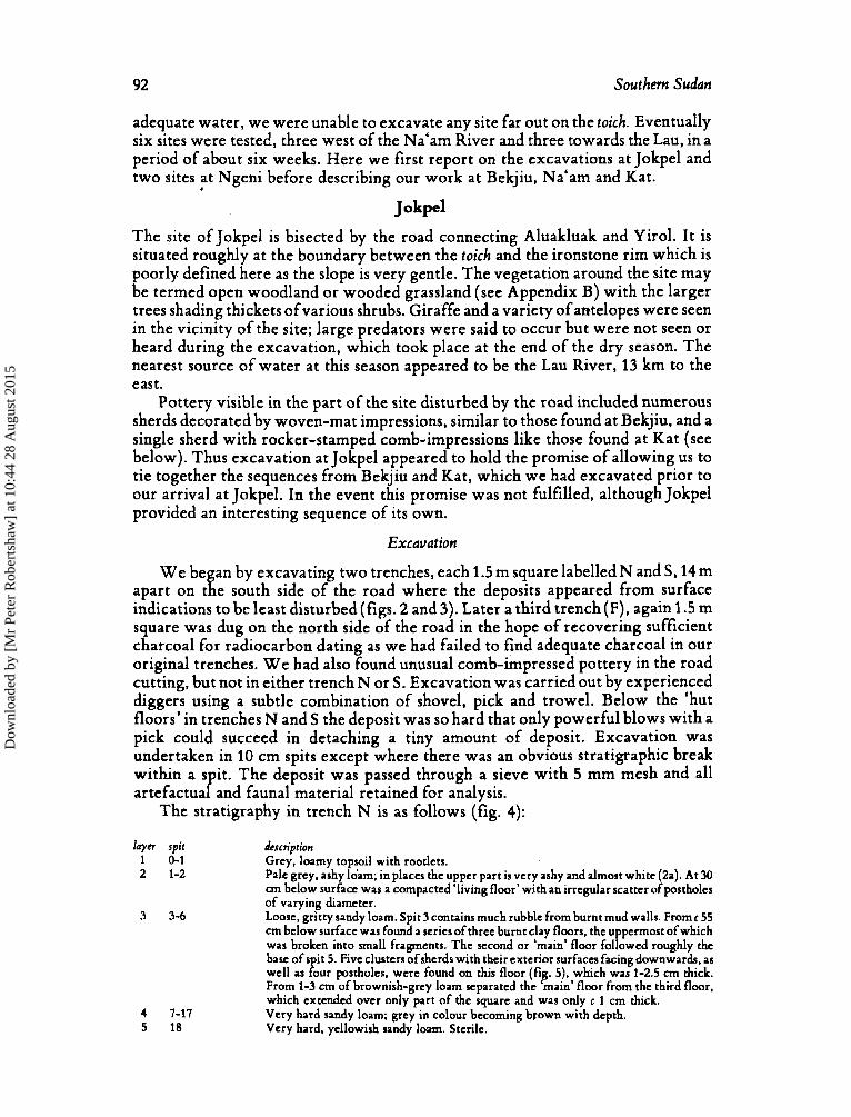
Besides our survey west of the Na‘am River we made, at the beginning of our stay, a brief excursion to Yirol and Shambe to obtain an idea of sites in that region. Few were found, though around Shambe floodwaters from the Nile were too high to allow any real survey work. However, east of Aluakluak and a few km west of the Lau (Dok) River, the road cut through a mound called Jokpel, while several other mounds were visitedjust north of the road at Ngeni about two km west of the Lau.
After spending two weeks in survey work we chose several sites for excavation with a view to sampling sites both on the edge of the Ironstone Plateau and on the toich. For logistical reasons, however, particularly the problem of obtaining
places’, standing 2 m or more. Although the road networ I: in Lakes Province is
Dow
nloa
ded
by [
Mr
Pete
r R
ober
tsha
w]
at 1
0:44
28
Aug
ust 2
015
92 Southern Sudan
adequate water, we were unable to excavate any site far out on the toich. Eventually six sites were tested, three west of the Na'am River and three towards the Lau, in a period of about six weeks. Here we first report on the excavations at Jokpel and two sites at Ngeni before describing our work at Bekjiu, Na'am and Kat.
Jokpel
The site of Jokpel is bisected by the road connecting Aluakluak and Yirol. I t is situated roughly at the boundary between the toich and the ironstone rim which is poorly defined here as the slope is very gentle. The vegetation around the site may be termed open woodland or wooded grassland (see Appendix B) with the larger trees shading thickets ofvarious shrubs. Giraffe and a variety of antelopes were seen in the vicinity of the site; large predators were said to occur but were not seen or heard during the excavation, which took place at the end of the dry season. The nearest source of water at this season appeared to be the Lau River, 13 km to the east.
Pottery visible in the part of the site disturbed by the road included numerous sherds decorated by woven-mat impressions, similar to those found at Bekjiu, and a single sherd with rocker-stamped comb-impressions like those found at Kat (see below). Thus excavation at Jokpel appeared to hold the promise of allowing us to tie together the sequences from Bekjiu and Kat, which we had excavated prior to our arrival at Jokpel. In the event this promise was not fulfilled, although Jokpel provided an interesting sequence of its own.
Excavation
,
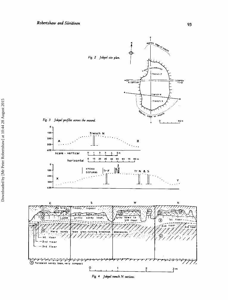
W e be an by excavating two trenches, each 1.5 m square labelled N and S, 14 m
indications to be least disturbed (figs. 2 and 3). Later a third trench (F), again 1.5 m square was dug on the north side of the road in the hope of recovering sufficient charcoal for radiocarbon dating as we had failed to find adequate charcoal in our original trenches. W e had also found unusual comb-impressed pottery in the road cutting, but not in either trench N or S. Excavation was carried out by experienced diggers using a subtle combination of shovel, pick and trowel. Below the 'hut floors' in trenches N and S the deposit was so hard that only powerful blows with a pick could succeed in detaching a tiny amount of deposit. Excavation was undertaken in 10 cm spits except where there was an obvious stratigraphic break within a spit. The deposit was passed through a sieve with 5 mm mesh and all artefactual and faunal material retained for analysis.
apart on t a e south side of the road where the deposits appeared from surface
The stratigraphy in trench N is as follows (fig. 4):
layn spit dcscriprion 1 0-1 Grey, loamy topsoil with rootlets. 2 1-2 Pale grey. ashy loam; in places the upper part is very ashy and almost white (24 . At 30
an below surface was a compacted 'living floor' with an irregular scatter of postholes of varying diameter. Loose, gritty sandy loam. Spit 3 contains much rubble from burnt mud walls. From c 55 cm below surface was found a series of three burnt clay floors, the uppermost of which was broken into mal l fragments. The second or 'main' floor followed roughly the base of s it 5. Five clusters of sherds with their exterior surfaces facing downwards, as well as &ur postholes, were found on this floor (fig. 5), which was 1-2.5 an thick. From 1-3 cm of brownish-grey loam separated the 'main' floor from the third floor, which extended over only part of the square and was only c 1 cm thick. Very hard sandy loam; grey in colour becoming brown with depth. Very hard, yellowish sandy loam. Sterile.
3 3-6
4 7-17 5 18
Dow
nloa
ded
by [
Mr
Pete
r R
ober
tsha
w]
at 1
0:44
28
Aug
ust 2
015
Robertshaw and Siiridinen
0-
100-
200-
300-
L 00
93
T r N 6 s
Y I . . . . .
. . . . X . . . -
. I . .
i
Fig. 2 Jokpcl site pkm.
Fig. 3 Jokpel profiles across the mound.
100 O I Trench N
I 0 SOm Y -
E W N
I _ _ _ - - _ _ _ _ _ _ - - _ _ _ _ _ _ _ _ _ _ - --- ----- _ _ - - - / / / / I , , @ Y r l l o w i s h 5’andy ;o&. c/,mpac’: ’ , 1 1 , 1 , / / / / / / / / / ’ / / , , ,,, ,
0 , , , I
1 2 3 m
Fk. 4 Jokpd trmch N sections.
Dow
nloa
ded
by [
Mr
Pete
r R
ober
tsha
w]
at 1
0:44
28
Aug
ust 2
015
94 Southern Sudan
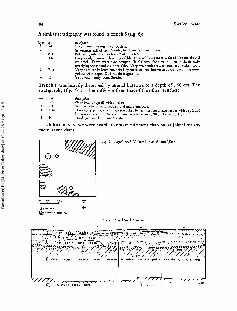
A similar stratigraphy was found in trench S (fig. 6):
l a y n spit description 1 0-1 Grey, loamy topsoil with rootlets. 2 1 3 2-3 4 4-6
In western half of trench only; hard, sandy brown loam. Pale grey, ashy loam as layer 2 of trench N. Grey, sandy loam with building rubble. This rubble is generally sherd-like and about 2 cm thick. There were two compact ‘hut’ floors, the first, c 1 cm thick, directly overlying the second, c 3-6 cm. thick. Very few artefacts were resting on either floor. Very hard sandy loam reworked by termites; red-brown in colour becoming more yellow with depth. Odd rubble fragments.
5 7-16
6 17 Yellowish, sandy loam. Sterile.
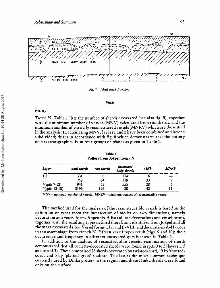
Trench F was heavily disturbed by animal burrows to a depth of c 90 cm. The stratigraphy (fig. 7) is rather different from that of the other trenches:
l a y n spit 1 0-2 2 2-4 3 5-13
4 14
description Grey loamy topsoil with rootlets. Soft, ashy loam with rootlets and many burrows. Dark-grey gritty, sandy loam reworked by termites becoming harder with depth and browner in colour. There are numerous burrows to 90 cm below surface. Hard, yellow clay loam. Sterile.
Unfortunately, we were unable to obtain sufficient charcoal at Jokpel for any radiocarbon dates.
Fk. 5 Jokpel trench N , layer 3: plan of ‘main’floor.
Fig. 6 Jokpcl trench S sections.
20 5 O c m
@ post- hd.,
@ SC01t.r d polSh.rds
E S W N
Dow
nloa
ded
by [
Mr
Pete
r R
ober
tsha
w]
at 1
0:44
28
Aug
ust 2
015
Robertshaw and Siiriainen 95
Fig. 7 Iokpcl frmrh F sections.
Finds
Pottery
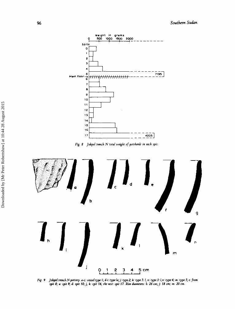
Trench N. Table 1 lists the number of sherds excavated (see also fig. S), together with the minimum number of vessels (MNV) calculated from rim sherds, and the minimum number of partially reconstructed vessels (MNRV) which are those used in the analysis. In calculating MNV, layers 1 and 2 have been combined and layer 4 subdivided; this is in accordance with fig. 8 which demonstrates that the pottery occurs stratigraphically in four groups or phases as given in Table 1.
Table 1 Pottery from Jokpel trench N
Layer MNR V decorated MNv total sherb rim she& sherb
- 192 33 1 6 174 6 3 752 64 319 33 9 qspits 7-12) 946 55 555 28 6 4(spits 13-18) 3196 195 20 42 1 1 h4NV- minimum number of vessels; MNRV-minimum number of reconstructible vessels.
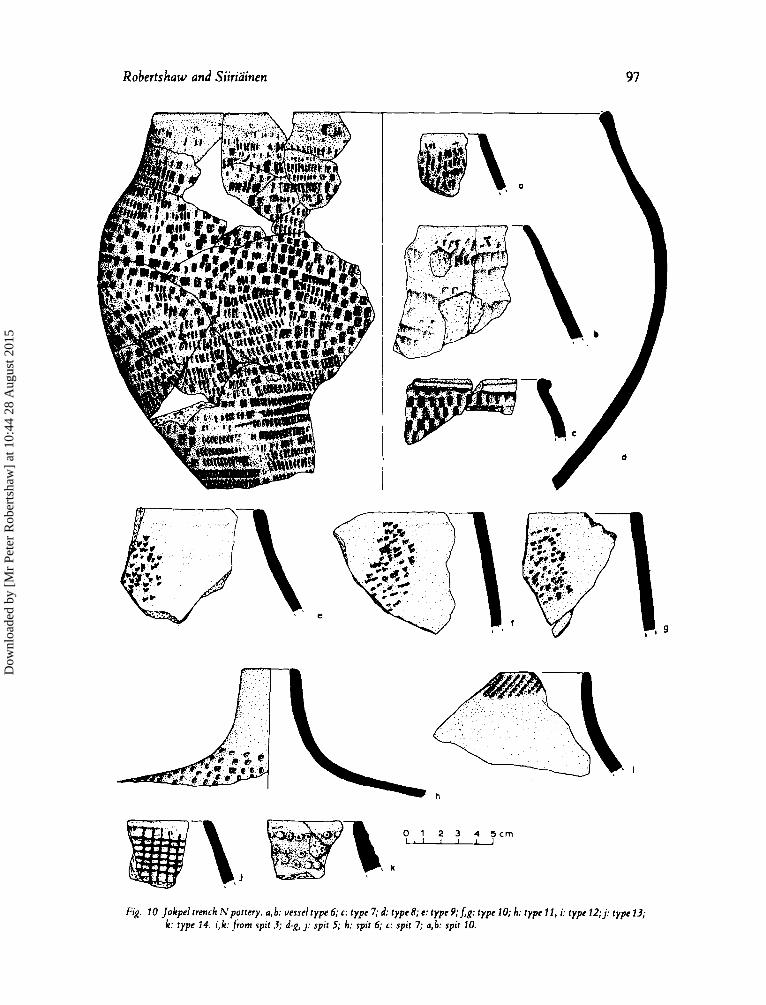
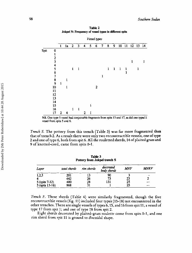
The method used for the analysis of the reconstructible vessels is based on the definition of types from the intersection of modes on two dimensions, namely decoration and vessel form. Appendix A lists all the.decorations and vessel forms, together with the resulting types defined therefrom, identified from Jokpel and all the other excavated sites. Vessel forms I , Ia, and 11-VIII, and decorations A-H occur in the assemblage from trench N. Fifteen vessel, types result (figs. 9 and 10); their occurrence and frequency in different excavated spits is shown in Table 2.
In addition to the analysis of reconstructible vessels, examination of sherds demonstrated that all roulette-decorated sherds were found in spits 0 to 3 (layers 1,2 and top of3). These comprised26 sherds decorated by twisted-cord, 19 by knotted- cord, and 3 by ‘plaited-grass’ roulette. The last is the most common technique currently used by Dinka potters in the region: and these Dinka sherds were found only on the surface.
Dow
nloa
ded
by [
Mr
Pete
r R
ober
tsha
w]
at 1
0:44
28
Aug
ust 2
015
96 Southern Sudan
Weight in grams p so0 1000 lS00 2000 _--------- Spi ts
3
4
1 2 1 I 13 H
16 "b 17 _ _ _ - - - 42053 _- - - - -
Fig. 8 Jokpel trench N total weight of potsherds in each spit.
/1 2- I , 1 ./ -\ m
I Fig. 9 Jokpcpd tnnch N pottery. a-c: vcsscl type 1; d-i: type la; j : rypc2; k: typc3: I, n: t ypc3: 1,n: t ype4; m: t ypc5; cfrom
spit 8; (I: spit 9; d: spit 10; j , k: spit 16; thc rest: spit 17. Rim diameters: b: 26 cm; j : 18 cm; m: 20 cm.
Dow
nloa
ded
by [
Mr
Pete
r R
ober
tsha
w]
at 1
0:44
28
Aug
ust 2
015
97
0 1 2 3 4 5 c r n - Fk. 10 Jokpeltrench Npot tery . a,b: uesselrype6;c: typc7;d: typc8;c: typc9;Jg: typcl0; h: typc11, i: t y p c l 2 ; j : t y p c l 3 ;
k: type 14. i,k:from spit 3; d-g, j : spit 5; h: spit 6; c: spit 7; a,b: spit 10.
Dow
nloa
ded
by [
Mr
Pete
r R
ober
tsha
w]
at 1
0:44
28
Aug
ust 2
015
98 Southern Sudan
Table 2 Jokpel N Frequency of vessel types In different spits
Vessel ppes
1 la 2 3 4 5 6 7 8 9 1 0 1 1 1 2 1 3 1 4 Spit 0
1 2 3 1 1 4 5 1 1 1 1 1 1 1 6 1 7 1 8 1 9 1 10 1 2 1 1 12 13 14 15 1 16 1 1 17 2 4 2 1
NB. One type 5 vessel had conjoinable fragments from spits 15 and 17, as did one typa 1 1 vessel from spits 5 and 6.
Trench S . The pottery from this trench (Table 3) was far more fragmented than that of trench 2. As a result there were only two reconstructible vessels, one of type 2 and one of type 6, both from spit 6. All the rouletted sherds, 14 of plaited grass and 9 of knotted-cord, came from spits 0-1.
Table 3 Pottery from Jokpel trench S
Layer MNV total sherdr rim sherdr decorated sherh MNR V - 20 1 13 90 3
442 26 73 23 2 - 131 25
1 25 - 5 (spits 7-12) 400 28 5 (spits 13-16) 868 31
Trench F. These sherds (Table 4) were similarly fragmented, though the five reconstructible vessels (fig. 11) included four types (15-18) not encountered in the other trenches. There are single vessels of types 6,15, and 16 from spit 11; a vessel of type 17 from spit 1 ; and one of type 18 from spit 2.
Eight sherds decorated by plaited-grass roulette come from spits 0-1, and one rim sherd from spit 11 is ground to discoidal shape.
Dow
nloa
ded
by [
Mr
Pete
r R
ober
tsha
w]
at 1
0:44
28
Aug
ust 2
015
Robertskaw and Siiriainen 99
Table 4 Pottery from Jokpel trench F
~ ~ ~ ~ ~~~~~
MNR V decomted Layer total sherds rim sherds bodv she& MNV 1 128 4 42 3 1 2 138 9 43 9 1 3 98 1 45 418 42 3
Fig. 1 1 Jokpcl trench Fpottcry. a: vcsscl type 6; c: typc 15; d: type 16; e: typc 17;f: type 18. Scc text fordctails ofprovenance.
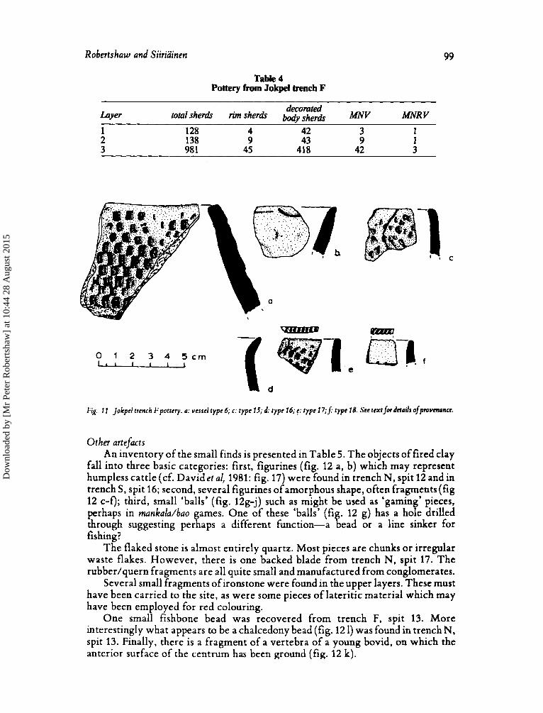
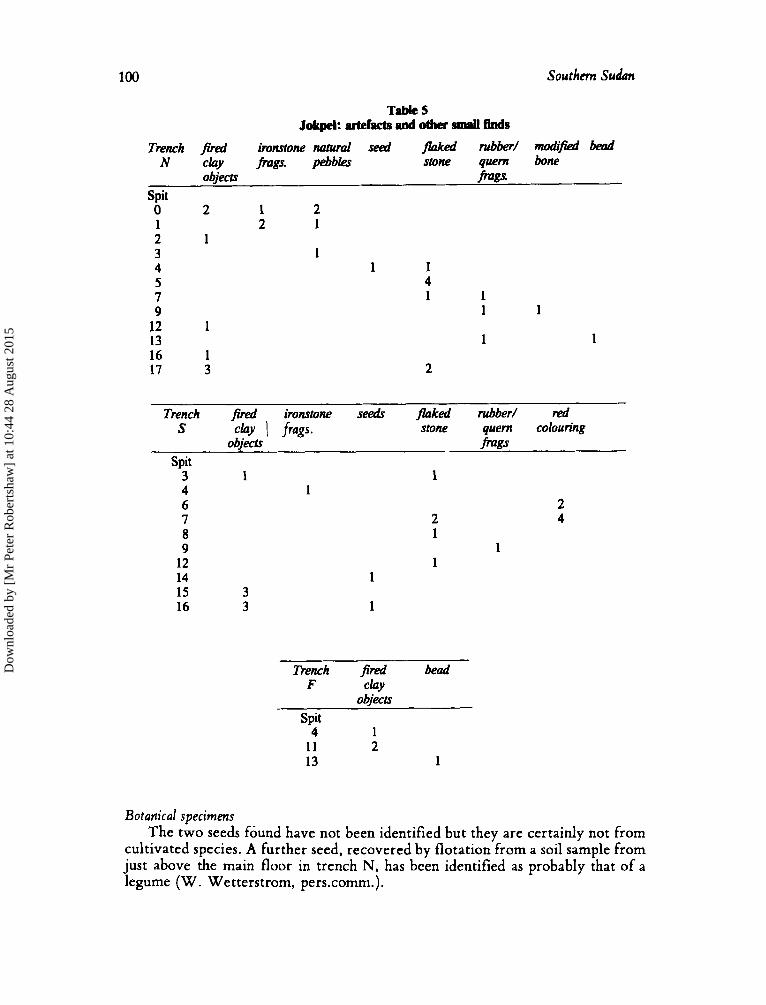
Other artefacts An inventory of the small finds is presented in Table 5. The objects of fired clay
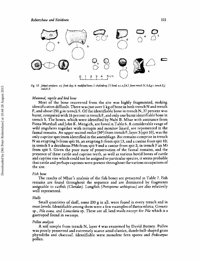
fall into three basic categories: first, figurines (fig. 12 a, b) which may represent humpless cattle (cf. Davidet al, 1981: fig. 17) were found in trench N, spit 12 and in trench S, spit 16; second, several figurines of amorphous shape, often fragments (fig 12 c-f); third, small ‘balls’ (fig. 12g-j) such as might be used as ‘gamin pieces, perhaps in rnankalu/bao games. One of these ‘balls’ (fi . 12 g) has a hoe H’ drilled through suggesting perhaps a different function-a % ead or a line sinker for fishing?
The flaked stone is almost entirely quartz. Most pieces are chunks or irregular waste flakes. However, there is one backed blade from trench N, spit 17. The rubberlquern fragments are all quite small and manufactured from conglomerates.
Several small fragments of ironstone were found in the upper layers. These must have been carried to the site, as were some pieces of lateritic material which may have been employed for red colouring.
One small fishbone bead was recovered from trench F, spit 13. More interestingly what appears to be a chalcedony bead (fig. 12 1) was found in trench N, spit 13. Finally, there is a fragment of a vertebra of a young bovid, on which the anterior surface of the centrum has been ground (fig. 12 k).
Dow
nloa
ded
by [
Mr
Pete
r R
ober
tsha
w]
at 1
0:44
28
Aug
ust 2
015
100 Southern Sudan
Table 5 Jokpe4: artefacts and other d Bnds
Trench $red ironstone natural seed flaked rubbed modlfjed bead N chy jkgs. pebbles stone quem bone
objects fiags Spit 0 2 1 2 1 2 1 2 1 3 1 4 1 1 5 4 7 1 1 9 1 1
12 1 13 1 1 16 1 17 3 2
Trench 3red immtone see& flaked rubber/ red
objece fmgs s cky I frags. stone quem colouring
Spit 3 1 4 1 6 7 8 9
12 14 15 16
1
2 1
1
3 3
Trench fired bead F C h Y
objects Spit
4 1 11 2 13 1
2 4
1
Botanical specimens The two seeds found have not been identified but they are certainly not from
cultivated species. A further seed, recovered by flotation from a soil sample from just above the main floor in trench N, has been identified as probably that of a legume (W. Wetterstrom, pers.comm.).
Dow
nloa
ded
by [
Mr
Pete
r R
ober
tsha
w]
at 1
0:44
28
Aug
ust 2
015
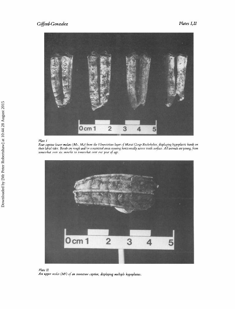
Gifford-Gonzalez Plates I,U
Plate I1 An upper tnolir (M2) ? / - a n irrrrnntrirr capritie, displuyirg multiple hypoplasias.
Dow
nloa
ded
by [
Mr
Pete
r R
ober
tsha
w]
at 1
0:44
28
Aug
ust 2
015
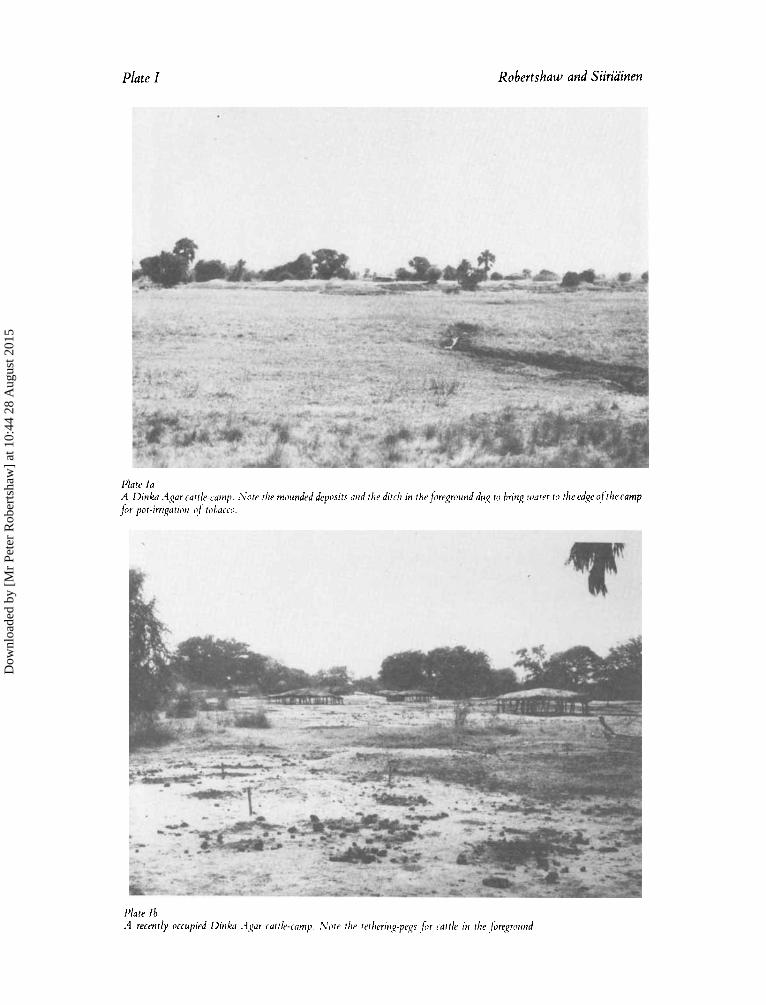
Plate I Robertshaw and Siiriainen
Plate l a A Dinka .-1gar cattle-camp. .\'ate r l i p tnoiind~d dfpopr,sits arid the ditch in rheforegrorrnd dug to bring wa tu f o the ed,qe oftliecamp f i r pot-irri,qarion I!/. robacru.
Dow
nloa
ded
by [
Mr
Pete
r R
ober
tsha
w]
at 1
0:44
28
Aug
ust 2
015
Robmtshaw and Siirihinen Plate IZ
Dow
nloa
ded
by [
Mr
Pete
r R
ober
tsha
w]
at 1
0:44
28
Aug
ust 2
015
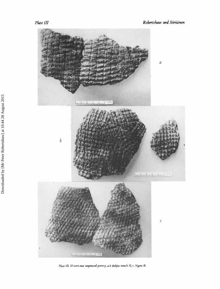
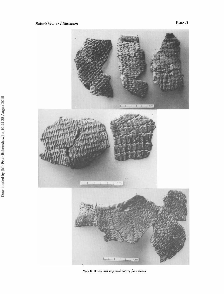
Plate III Robertshaw and Siiriainen
Plate ZZZ Woven-mat impressed pottery, a-b Bekjiu trench IZ; c, Ngeni B.
Dow
nloa
ded
by [
Mr
Pete
r R
ober
tsha
w]
at 1
0:44
28
Aug
ust 2
015
Robertshaw and Siiriainen 101
C
0
nb 0 1 2 3 4 5cm -
0'
Fig. 12 jokpcl artcjacts. a j :J rcd clay; k: modified bone; I: chalcedony (?) bead; a,c,e,f;k,l: from trench N; b,d,g-i: trench S;j: trench F.
Mammal, reptile and bird bone Most of the bone recovered from the site was highly fragmented, making
identification difficult. There was just over 1 kg ofbone in both trench N and trench F, and about 250 g in trench S. Of the identifiable bone in trench N, 37 percent was burnt, compared with 16 percent in trench F, and only one burnt identifiable bone in trench S. The bones, which were identified by Nubi B. Mbae with assistance from Fiona Marshall and John K. Mengich, are listed in Table 6. A considerable range of wild ungulates together with terrapin and monitor lizard, are represented in the faunal remains. An upper second molar (Mz) from trench F, layer 3 (spit lo), was the only caprine specimen identified in the assemblage. Bos remains comprise in trench N an erupting I4 from spit 16, an erupting I1 from spit 13, and a canine from spit 10; in trench S a deciduous PMz from spit 9 and a canine from spit 2; in trench F an M3 from spit 5. Given the poor state of preservation of the faunal remains, and the presence of these cattle and caprine teeth, as well as various bovid bones of cattle and caprine size which could not be assigned to particular species, it seems probable that cattle and perhaps caprines were present throughout the various occupations of the site.
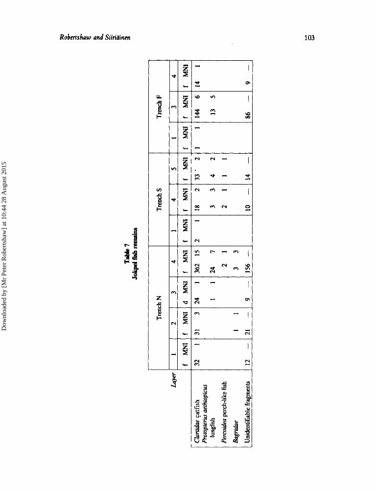
Fish bone The results of Mbae's analysis of the fish bones are presented in Table 7. Fish
remains are found throughout the sequence and are dominated by fragments assignable to catfish (Clariidue). Lungfish (Protopterus aethiopicus) are also relatively well represented.
Shells Small quantities of shell, some 200 g in all, were found in every trench and in
most levels. Identifiable among them were a few examples ofBurtoa nilotica, Gonaxis sp., Piila ouata, and Lirnicolaria sp. These are all land snails except for Pila which is a gastropod found in swamps.
Pollen analysis A soil sample from trench N, layer 4 was examined by David Burney. Pollen
was poorly preserved and extremely scarce amid clastics, dumb-bell-shaped grass phytoliths and charcoal. Identifiable were monolete fern spores and Podocarpus pollen.
Dow
nloa
ded
by [
Mr
Pete
r R
ober
tsha
w]
at 1
0:44
28
Aug
ust 2
015
1 02 Southem Sudan
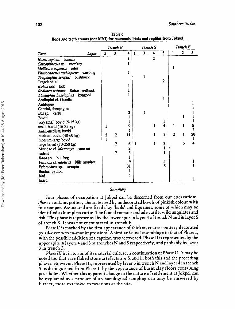
Table 6 Bone and teeth counts (not MNI) for mammals, birds and reptiles from Jokpel
T W Luyer Homo sapiens human Cercopithecus sp. monkey Mellivora capensis rate1 Phacmhoem aethiopicus warthog Tmgelaphus scriptus bushbuck Tragelaphini Kobus kob kob Redunca redunca Bohor reedbuck Akelaphus buselaphus kongoni Antilopini cf. Gazella Antilopini Caprini, sheeplgoat Bossp. cattle Bovini very small bovid (5-15 kg) small bovid (I 6-35 kg) small-medium bovid medium bovid (40-60 kg) medium-large bovid large bovid (70-250 kg) Muridae cf. Mastomys cane rat rodent Rang sp. bullfrog Vamnus cf. niloficus Nile monitor Pelomedusa sp. terrapin Boidae, python bird lizard
Summary
Four phases of occupation at Jokpel can be discerned from our excavations. Phase Z contains pottery characterised by undecorated bowls of pinkish colour with fine temper. Associated are fired clay ‘balls’ and figurines, some of which may be identified as humpless cattle. The faunal remains include cattle, wild ungulates and fish. This phase is represented by the lower spits in layer 4 of trench N and in layer 5 of trench S . I t was not encountered in trench F.
Phase IZ is marked by the first appearance of thicker, coarser pottery decorated by all-over woven-mat impressions. A similar faunal assemblage to that of Phase I, with the possible addition of a caprine, was recovered. Phase 11 is represented by the upper spits in layers 4 and 5 of trenches N and S respectively, and probably by layer 3 in trench F.
PhaseIZZ is, in terms ofits material culture, a continuation ofphase 11. I t may be noted too that rare flaked stone artefacts are found in both this and the preceding phases. However, Phase 111, represented by layer 3 in trench N and layer 4 in trench S, is distinguished from Phase I1 by the appearance of burnt clay floors containing post-holes. Whether this apparent change in the nature of settlement at Jokpel can be explained as a product of archaeological sampling can only be answered by further, more extensive excavations at the site.
Dow
nloa
ded
by [
Mr
Pete
r R
ober
tsha
w]
at 1
0:44
28
Aug
ust 2
015
bye
r 1
f M
NI
1 1
CInr
ihhe
catf
ish
Prot
opte
rus a
ethio
picu
r
Perc
oide
a per
ch-li
ke ff
ih
Bagr
khe
Unid
entif
iabl
e fra
gmen
ts
lung
fish
3 4
f M
NI
f M
NI
144
6 14
1
13
5
86 -
9-
Tren
ch N
Itl
f M
NI
f M
NI 1
12 -
21 -
d M
NI
f M
NI
1 1124
7 2
1
33
9 -1
156
-
Tren
ch S
.*
f M
NI
f M
NI
5
f M
NI
33 .
2
42
11
14 -
Tren
ch F
I
c.
8
Dow
nloa
ded
by [
Mr
Pete
r R
ober
tsha
w]
at 1
0:44
28
Aug
ust 2
015
104 Southem Sudan
Phase ZV, represented by the ashy upper levels in all the trenches, seems to reflect relatively recent use of the site as a cattle-camp. Rouletted sherds occur for the first time, and those sherds decorated by a 'plaited-grass' roulette are indistinguishable from the sherds of broken vessels of types made by living Dinka potters.
Unfortunately no radiocarbon dates are available from our excavations at Jokpel. The relatively close similarity between the all-over woven-mat impressed pottery of Phases I1 and 111 and of Bekjiu (described below), for which dates are available, would suggest that the deposits of Phases I1 and 111 accumulated during the latter part of the first millennium AD. How much earlier we must place Phase I is unknown. Phase IV would seem to be assignable on ceramic grounds to the last two or three centuries.
Discussion ofJokpel in broader context is to be found after the presentation of the other site reports.
Ngeni A
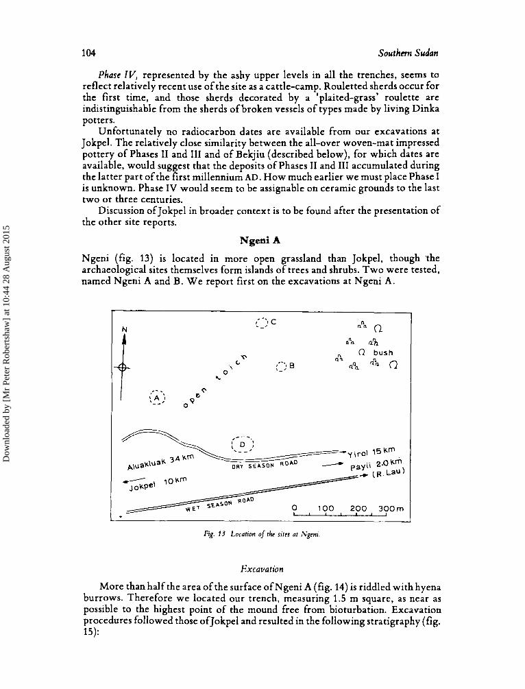
Ngeni (fig. 13) is located in more open grassland than Jokpel, though ?the archaeological sites themselves form islands of trees and shrubs. Two were tested, named Ngeni A and B. W e report first on the excavations a t Ngeni A.
i. .-. A ;I - -
Q
0 9=
c 0'
b
Fig. 13 Location of the sites at Ngeni.
Excavation
More than half the area of the surface of Ngeni A (fig. 14) is riddled with hyena burrows. Therefore we located our trench, measuring 1.5 m square, as near as possible to the highest point of the mound free from bioturbation. Excavation procedures followed those ofJokpel and resulted in the following stratigraphy (fig. 15):
Dow
nloa
ded
by [
Mr
Pete
r R
ober
tsha
w]
at 1
0:44
28
Aug
ust 2
015
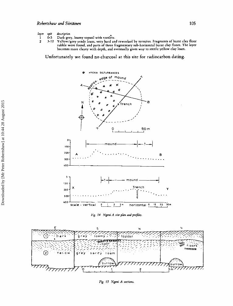
Robertshaw and Siiridinen 105
l a p spit description 1 0-3 Dark grey, loamy topsoil with rootlzts. 2 3-12 Yellow/grey sandy loam; very hard and reworked by termites. Fragments of burnt clay floor
rubble were found, and parts of three fragmentary sub-horizontal burnt clay floors. The layer becomes more clayey with depth, and eventually gives way to sterile yellow clay loam.
Unfortunately we found no charcoal at this site for radiocarbon dating.
# H Y E N A DISTURBANCES
m o u n d
. . . . . . . . . . 0 * . * .
............ 300 . . . . . . .
Y Trench . . . . . ... . . . . . ""', - . ... . . . . . * . . . . . . . . .
4 0 0 sca l e - vert ical 1, ? ;m horizontal p l ? 2,o 3:"
Fig. 14 Ngeni A site plan and profib.
zooL
Fig. 15 Ngeni A secctions.
Dow
nloa
ded
by [
Mr
Pete
r R
ober
tsha
w]
at 1
0:44
28
Aug
ust 2
015
aournem auuun
Finds
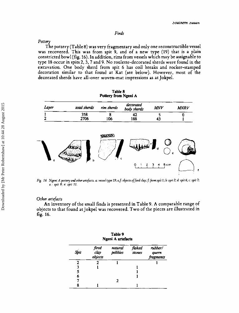
Pottery The pottery (Table 8) was very fragmentary and only one reconstructible vessel
was recovered. This was from spit 9, and of a new type (19) that is a plain constricted bowl (fig. 16). In addition, rims from vessels which may be assignable to type 18 occur in spits 2 , 3 , 7 and 9. No roulette-decorated sherds were found in the excavation. One body sherd from spit 6 has coil breaks and rocker-stamped decoration similar to that found at Kat (see below). However, most of the decorated sherds have all-over woven-mat impressions as at Jokpel.
Table 8 Pottery from Ngeni A
decorated MNR V Luyer total s h e d rim s h e d body sher& MNV
1 358 8 42 5 0 2 2706 106 188 43 1
0 1 2 3 4 5 c m M
Fig. 16 Ngeni A potrc'y andothnartefucrs. a: vessd type 19; e f objects offied clay;f:fromspit 1; b: sp i t l ; d: spit 6; c: spir 7; a : spit 9; c: spit 11.
Other artefacts An inventory of the small finds is presented in Table 9. A comparable range of
objects to that found at Jokpel was recovered. Two of the pieces are illustrated in fig. 16.
Table 9 Ngeni A artefacts
Bred natural flaked rubber/
objects fragments $it clay pebbles stones quern
2 2 1 1 3 1 1 5 1 6 1 7 2 8 1 1
Dow
nloa
ded
by [
Mr
Pete
r R
ober
tsha
w]
at 1
0:44
28
Aug
ust 2
015
Robertshaw and Siirih'inen 107
Faunal remains A small sample of c 400 g of mammal bone was recovered. The identified
speciedgenera, all from layer 2, comprise Bohor reedbuck, one caprine (from spit 7) and monitor lizard. Other bones range in size of animal from small bovid to medium-large bovid (Table lo). Only three of the identifiable bones show traces of burning. Small numbers of catfish, lungfish and Bercoidea bones were also found (Table 11). From c 100 g of shell a single Pila o h t a operculum and one specimen of Burtoa nilotica were identified as coming from deposits of layer 1. Layer 2 produced a single identifiable example of Lanistes purpurea.
Pollen analysis A soil sample from layer 2 contained clastics from sand to clay, dumb-bell-
shaped grass phytoliths and a few crumpled pollen grains too oxidised and abraded for identification (Burney, pers. comm.).
Table 10 Bone and teeth counts (not MNI) for Ngeni A
TaW Redunca redunca Bohor reedbuck Reduncini Caprini, sheep/goat small bovid (16-35 kg) medium bovid (40-60 kg) medium-large bovid Varanus cf. niloticus Nile monitor
Layer 1 2 3 1 1 7 3 1 2
- - - - - - -
Table 11 Ngeni A fish remains
Laver 1 ~ 1 - 2
catfish lungfish Percoidea unidentifiable fragments 6 -
Ngeni B
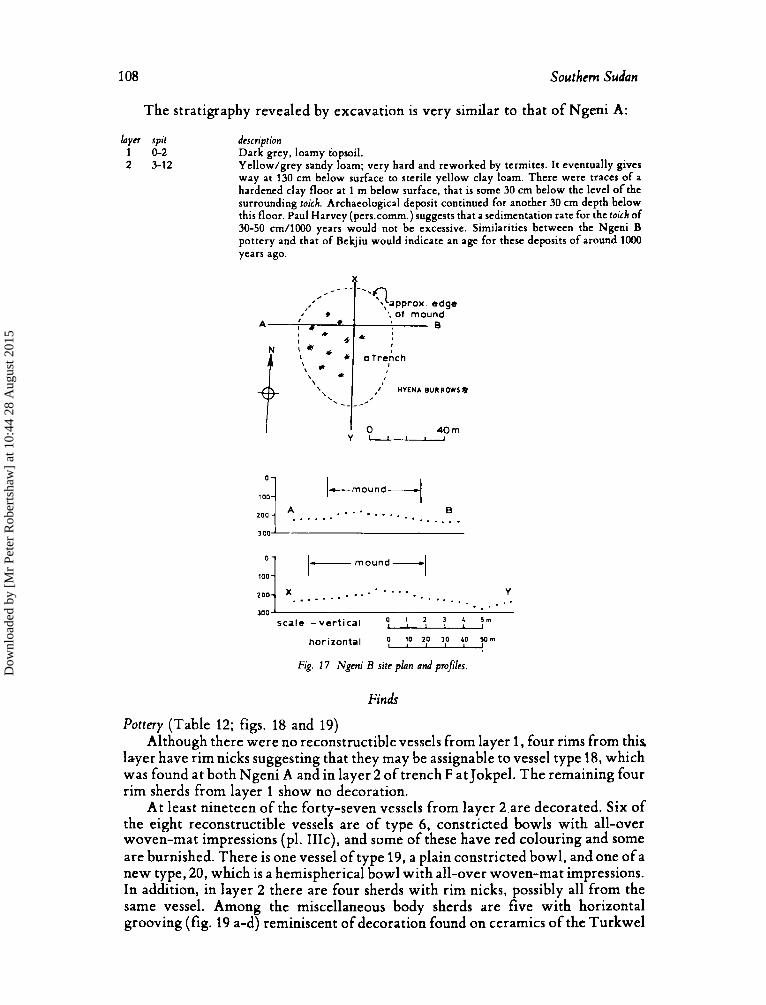
Excavation
As with Ngeni A, much of the mound at Ngeni B was riddled with hyena burrows. W e located our trench, again measuring 1.5 m square, where there appeared to be least disturbance of the deposits (fig. 17).
Dow
nloa
ded
by [
Mr
Pete
r R
ober
tsha
w]
at 1
0:44
28
Aug
ust 2
015
108 Southern Sudan
,,***----
a *
A : * * I I X
-‘‘?approx. edge ‘,of mound
0 6 ’ ,:
100 1- mound -1 O l
0 . . . - - . ._ z o o ] 9 . . . . - . - a . - . . . *
-- - sca le -ver t ica l ‘, 1 t
horizontal 0 I0 20 30 40 5Om l ~ ~ l ~ l
Fig. 7 7 Ngeni B site plan and projles.
Finds
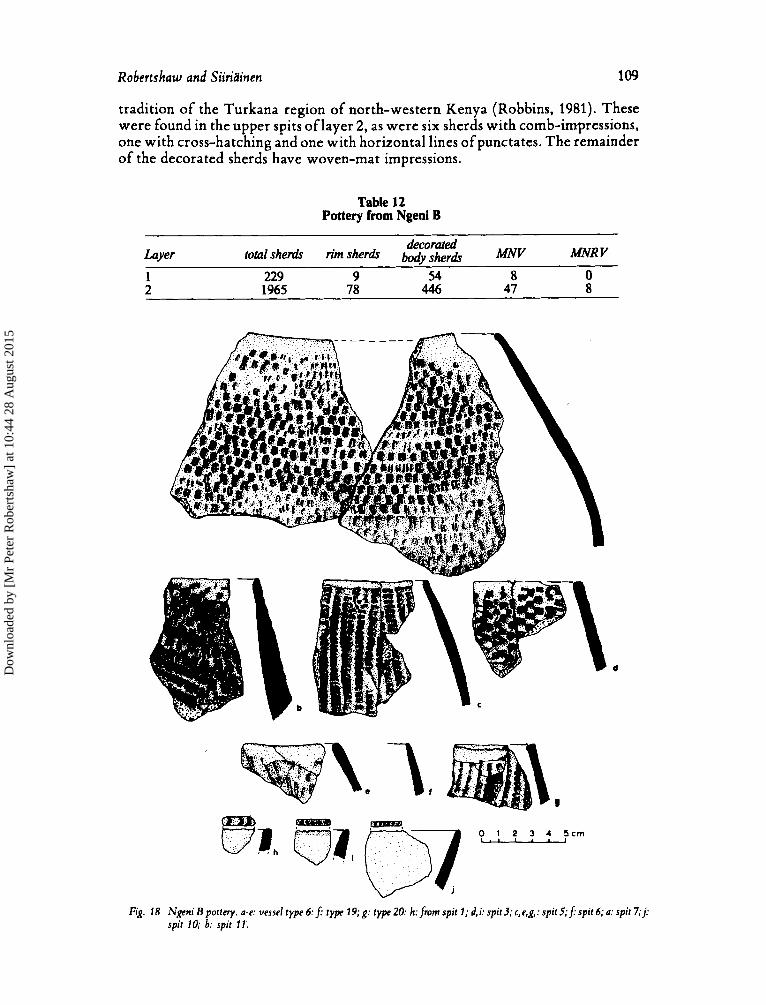
Pottery (Table 12; figs. 18 and 19) Although there were no reconstructible vessels from layer 1, four rims from this
layer have rim nicks suggesting that they may be assignable to vessel type 18, which was found at both Ngeni A and in layer 2 of trench F at Jokpel. The remaining four rim sherds from layer 1 show no decoration.
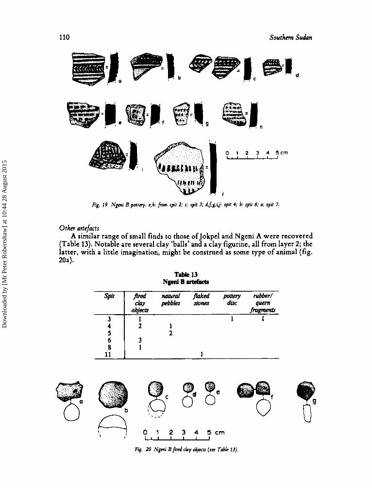
At least nineteen of the forty-seven vessels from layer 2 are decorated. Six of the eight reconstructible vessels are of type 6, constricted bowls with all-over woven-mat impressions (pl. IIIc), and some of these have red colouring and some are burnished. There is one vessel of type 19, a plain constricted bowl, and one of a new type, 20, which is a hemispherical bowl with all-over woven-mat impressions. In addition, in layer 2 there are four sherds with rim nicks, possibly all from the same vessel. Among the miscellaneous body sherds are five with horizontal grooving (fig. 19 a-d) reminiscent of decoration found on ceramics of the Turkwel
Dow
nloa
ded
by [
Mr
Pete
r R
ober
tsha
w]
at 1
0:44
28
Aug
ust 2
015
Robertshaw and Siiridinen 109
tradition of the Turkana region of north-western Kenya (Robbins, 1981). These were found in the upper spits of layer 2, as were six sherds with comb-impressions, one with cross-hatching and one with horizontal lines of punctates. The remainder of the decorated sherds have woven-mat impressions.
Table 12 Pottery from Ngeni B
Layer decorated
total sherh rim s h e d bod,, MNV MNR Y , 1 229 9 54 8 0 2 1965 78 446 47 8
O 1 2 3 4 S c m 1
Fig. 18 Ngeni Bporrery. a-r v e s s e l t y p e 6 . j rype 19;g: rype20: h: from spit?; d,i:spir3;c,e,g,:spirS;f:spir6;a:spit7;j: sprr 10; b: sprr 11
Dow
nloa
ded
by [
Mr
Pete
r R
ober
tsha
w]
at 1
0:44
28
Aug
ust 2
015
110 Southern Sudan
spil
3
I I
0 1 2 3 4 5 c m - =I I
fired natural wed pottety rubber/ cby pebbles stow dirC w m
objecb fnrgrnents 1 1 1
Fig. 19 Ngmi B pottery. e,h: fm spit 2; c: spit 3; d,Jg,i j: spit 4; b: spit 6; a: spit 7.
20a).
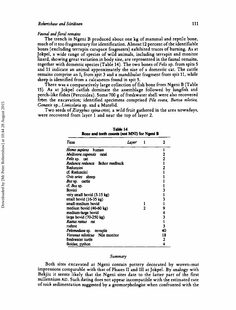
Other artefacts A similar range of small finds to those of Jokpel and Ngeni A were recovered
(Table 13). Notable are several clay ‘balls’ and a clay figurine, a11 from layer 2; the latter, with a little imagination, might be construed as some type of animal (fig.
TPMe 13 N@ B artefacts
: I ; 8
11
M
4. 20 Ngmi B fired clay objects (see Table 13).
Dow
nloa
ded
by [
Mr
Pete
r R
ober
tsha
w]
at 1
0:44
28
Aug
ust 2
015
Robertshaw and Siiridincn 111
Faunal and jloral remuins The trench in Ngeni B produced about one kg of mammal and reptile bone,
much of it too fragmentary for identification. Almost 12 percent of the identifiable bones (excluding terrapin carapace fragments) exhibited traces of burning. As at Jokpel, a wide range of species of wild animals, including terrapin and monitor lizard, showing great variation in body size, are represented in the faunal remains, together with domestic species (Table 14). The two bones ofFelis sp. from spits 5 and 11 indicate an animal approximately the size of a domestic cat. The cattle remains comprise an I-, from spit 3 and a mandibular fragment from spit 11, while sheep is identified from a calcaneum found in spit 5.
There was a comparatively large collection of fish bone from Ngeni B (Table 15). As at Jokpel catfish dominate the assemblage followed by lungfish and perch-like fishes (Percoidea). Some 700 g of freshwater shell were also recovered fram the excavation; identified specimens comprised Pila ovata, Burtoa nilotica, Gonuxis sp., Limicolaria sp. and a Mutelid.
Two seeds of Zizyphus spina-cristi, a wild fruit gathered in the area nowadays, were recovered from layer 1 and near the top of layer 2.
Table 14 Bone and teeth counts (not MNI) for Ngeni B
TaXa h p r 1 2
Homo sapkm human 1 Mellivom capemh ratel 2 Feihsp. cat 2 Redunca redunca Bohor reedbuck 1 Reduncini 2 d. Reduncini 1 Ovharies sheep 1 Bossp. cattle 1 d. Bos sp. 1 Bovini 3 ve;Y small bovid (5-15 kg) 1 small bovid (16-35 kg) 3 small-medium bovid 1 1 medium bovid (4060 kg) 2 9 medium-large bovid 4 large bovid (70-250 kg) 3 Rattusramcs rat 1 rodent 3 Pehmeaha sp. terrapin 40 V a r m niloticus Nile monitor 18 freshwater turtle 2 Boidae, python 4
Summmy
Both sites excavated at Ngeni contain pottery decorated by woven-mat impressions comparable with that of Phases I1 and 111 at Jokpel. By analogy with Bekjiu it seems likely that the Ngeni sites date to the latter part of the first millennium AD. Such dating does not appear incompatible with the estimated rate of toich sedimentation suggested by a geomorphologist when confronted with the
Dow
nloa
ded
by [
Mr
Pete
r R
ober
tsha
w]
at 1
0:44
28
Aug
ust 2
015
112 Southern Sudan
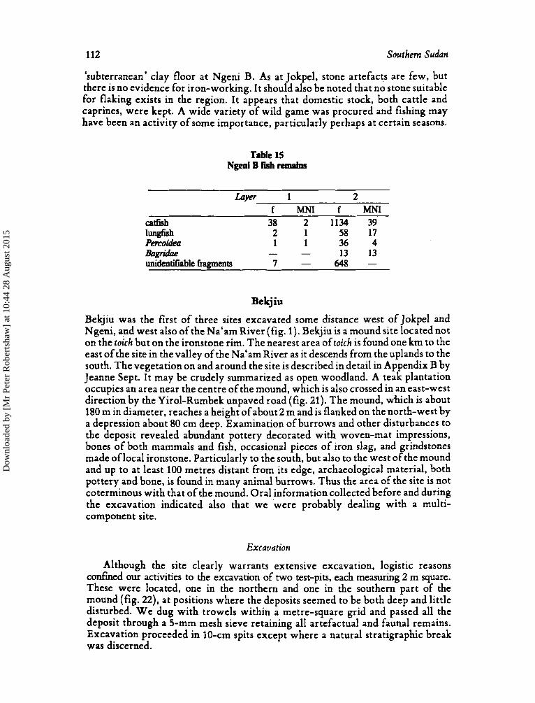
'subterranean' clay floor at Ngeni B. As a t Jokpel, stone artefacts are few, but there is no evidence for iron-working. I t should also be noted that no stone suitable for flaking exists in the region. It appears that domestic stock, both cattle and caprines, were kept. A wide variety of wild game was procured and fishing may have been an activity of some importance, particularly perhaps at certain seasons.
Table 15 NgeniBfishremnins
Laver 1 2 f MNI f MNI
catfish 38 2 1134 39 lungfish 2 1 58 17 Pemidea 1 1 36 4
- - 13 13 648 -
&Igridae unidentifiable fragments 7 -
Bekjiu
Bekjiu was the first of three sites excavated some distance west of Jokpel and Ngeni, and west also of the Na'am River (fig. 1). Bekjiu is a mound site located not on the toich but on the ironstone rim. The nearest area of toich is found one km to the east of the site in the valley of the Na'am River as it descends from the uplands to the south. The vegetation on and around the site is described in detail in Appendix B by Jeanne Sept. I t may be crudely summarized as open woodland. A teak plantation occupies an area near the centre of the mound, which is also crossed in an east-west direction by the Yirol-Rumbek unpaved road (fig. 21). The mound, d i c h is about 180 m in diameter, reaches a height of about 2 m and is flanked on the north-west by a depression about 80 cm deep. Examination of burrows and other disturbances to the deposit revealed abundant pottery decorated with woven-mat impressions, bones of both mammals and fish, occasional pieces of iron slag, and grindstones made of local ironstone. Particularly to the south, but also to the west of the mound and up to at least 100 metres distant from its edge, archaeological material, both pottery and bone, is found in many animal burrows. Thus the area of the site is not coterminous with that of the mound. Oral information collected before and during the excavation indicated also that we were probably dealing with a multi- component site.
Excavation
Although the site clearly warrants extensive excavation, logistic reasons confined our activities to the excavation of two test-pits, each measuring 2 m square. These were located, one in the northern and one in the southern part of the mound (fig. 22), at positions where the deposits seemed to be both deep and little disturbed. W e dug with trowels within a metre-square grid and passed all the deposit through a 5-mm mesh sieve retaining all artefactual and faunal remains. Excavation proceeded in IO-cm spits except where a natural stratigraphic break was discerned.
Dow
nloa
ded
by [
Mr
Pete
r R
ober
tsha
w]
at 1
0:44
28
Aug
ust 2
015

Robertshaw and Siiriainen
Fig. 21 Bekjiu site plan.
113
X
Fig. 22 Bekjiu profiles across the mound.
l a y n 1
2 3
4
5
6 7
8
9
10 11
The stratigraphy revealed in the northern trench, trench I, was as follows (fig. 23): spir 0-1
2 3-5
5-7
7-9
10-11 12-13(
13-14
14-17
17-1 9 19-20
description Light-grey ashy topsoil with some termite disturbance and many grass roots. A few fragments of daga. Light-grey, fine-grained, rather hard loam. Ashy with flecks of charcoal. Grey, gritty soil with many lumps of wall daga, especially in the lower part ot the layer. Some small, scattered fragments of charcoal. In the south-eastern half of the trench, the deposit in spit 4 was very hard and compact; this appeared to be a floor in which were located six small post-holes, about 3-4 cm in diameter. Brownish-grey. gritty soil containing slightly larger lumps (c 15 cm in diameter) of wall daga than layer 3. Softer depasit than layer 3, with flecks of charcoal. Grey, clay loam of greasy texture. Only occasional, usually small, fragments of wall daga. Homogeneous white, clay loam. Grey, clay loam very similar in appearance to that of layer 5. A depression in the south-east corner of the trench contained much bone at its base. White clay loam very similar to that of layer 6, but containing a clear band of charcoal. (N.B. In northern and eastern sections the breaks between layers 6-7 and 7-8 were not clearly discernible.) Grey, clay loam slightly browner than that of layer 7. A burial pit seems to have been dug from the upper part of layer 9 or perhaps the base of layer 8. A brownish grey loam of gritty texture. Orange-brown clay loam. Relatively soft at the top, this deposit became hard and archaeologically sterile with increasing depth.
-1 6)
Dow
nloa
ded
by [
Mr
Pete
r R
ober
tsha
w]
at 1
0:44
28
Aug
ust 2
015
114 S o u t h Sudan
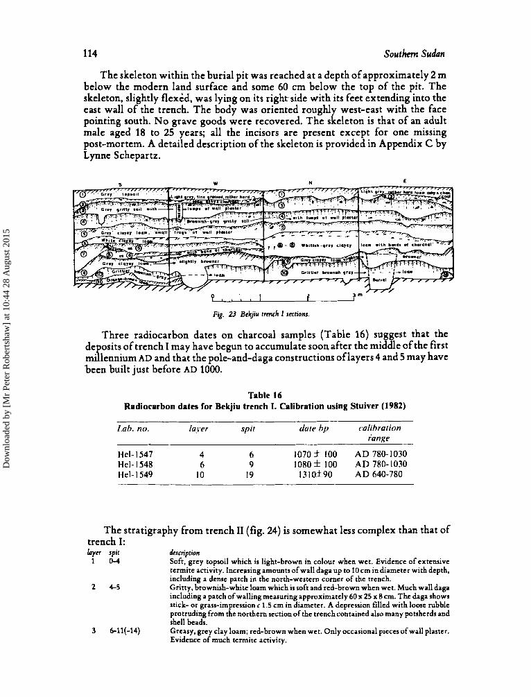
The skeleton within the burial pit was reached at a depth of approximately 2 m below the modern land surface and some 60 cm below the top of the pit. The skeleton, slightly flexed, was lying on its right, side with its feet extending into the east wall of the trench. The body was oriented roughly west-east with the face pointing south. No grave goods were recovered. The skeleton is that of an adult male aged 18 to 25 years; all the incisors are present except for one missing post-mortem. A detailed description of the skeleton is provided in Appendix C by Lynne Schepartz.
Three radiocarbon dates on charcoal samples (Table 16) suggest that the deposits of trench I may have begun to accumulate soon after the middle of the first millennium AD and that the pole-and-daga constructions of layers 4 and 5 may have been built just before AD 1000.
Table 16 Radiocarbon dates for Bekjiu trench 1. Calibration using Stuiver (1982)
Lab. no. laj-er spit date bp calibration range
Hel- I547 4 6 1070 f 100 AD 780- 1030
Hel- I549 10 19 I3 lOf90 AD 640-780 Hel- I548 6 9 I O 8 O f 100 AD 780-1030
The stratigraphy from trench I1 (fig. 24) is somewhat less complex than that of trench I: layer spir dcscscriprion
1 0 - 4 Soft, grey topsoil which is light-brown in colour when wet. Evidence of extensive termite activity. Increasing amounts of wall daga up to 10 cm in diameter with depth, including a dense patch in the north-western corner of the trench. Gritty. brownish-white loam which is soft and red-brown when wet. Much wall daga including a patch of walling measuring approximately 60 x 25 x 8 cm. The daga shows stick- or grass-imprcssionr 1.5 cm in diameter. A depression filled with loose rubble protruding from the northern section of the trench contained also many potsherds and shell beads. Greasy, grey clay loam; red-brown when wet. Only occasional pieces of wall plaster. Evidence of much termite activity.
2 4-5
3 6-11(-14)
Dow
nloa
ded
by [
Mr
Pete
r R
ober
tsha
w]
at 1
0:44
28
Aug
ust 2
015
Dow
nloa
ded
by [
Mr
Pete
r R
ober
tsha
w]
at 1
0:44
28
Aug
ust 2
015
116 ~outhern Sudan
woven-mat impressions; single examples occur in each of spits 4,6,7,8,9,11 and 20. Rim diameters of these vessels range between about 20 and 31 cm. The other reconstructible vessels are as follows: a burnished globular pot with two horizontal bands of carved-roulette or mat-impressed decoration below the rim (type 29) from layer 2 (fig. 25a); a constricted bowl with oblique or almost vertical scoring below the rim (type 24) from layer 3; a constricted bowl with bevelled rim and all-over woven-mat impressions (type 6b) from layer 7 (fig. 25b). An analysis of the decoration on rim sherds (Table 19) indicates that rouletted sherds do not occur below layer 2. Woven-mat impressions are the most common decorative motif and are found throughout the sequence. However, rim sherds with (near) vertical scoring are encountered only from layers 3 to 7; it seems, therefore, that they might provide a phase marker within the tradition of mat-impressed pottery from the region. Interestingly, such vessels with near-vertical scoring were found neither at Jokpel nor at the Ngeni sites. Notable among the body sherds from trench I at Bekjiu is a sherd from layer 3 with woven-mat impressions to which has been added what appears to be a bead-grinding groove.
Table 18 Pottery from Bekjiu trench I
Spit totalshe& rimshe& akImatt?d MNV MNRV
0 266 6 224 6 0 body she&
1 2 3 4 5 6 7 8 9
10 11 12 13 14 15 16 17 18 19 20
27 1 372 344 407 380 435 347 304 395 322 247 33 1 397 185 199 166 52 26 24 6
2 11 3
13 18 6
21 7
19 11 7 8
20 5 7 7 3 1 1 1
180 295 26 1 256 308 394 282 277 366 287 235 314 369 178 176 145 47 23 23
5
2 6 3
13 12 6
19 7
17 9 7 7
16 4 5 6 2 1 1 1
0 1 0 1 0 1 0 0 0 0 1 1 2 0 0 1 0 0 0 1
Trench ZZ. The pottery (Table 20; fig. 26) from trench I1 is generally less fragmented than that of trench I and there are more reconstructible vessels. Several decorations (A1, K-O),which have not been recorded previously, occur. The new types (6a, 8a, 21-28) which are represented by these decorations and by new combinations of various vessel forms with existing decorations are detailed in Appendix A. The frequencies of vessels of different types and of sherds with different motifs through the layers of trench I1 are presented in Tables 21 and 22 respectively. As in trench I, constricted bowls with woven-mat impressions
Dow
nloa
ded
by [
Mr
Pete
r R
ober
tsha
w]
at 1
0:44
28
Aug
ust 2
015
Robntshw and Siiriiiinm 117
0 1 2 3 4 5 6 7 8 9
10 11 12 13 14 15 16 17 18 19 20
covering virtually the entire vessel predominate ( 1. 11, IIIa,b). Similarly, vessels with oblique or nearly vertical scoring are foun! only in the upper half of the deposits beginning in spit 10, with the exception of one small body sherd from spit 13. By contrast sherds exhibiting a zigzag motif, either incised or rocker-stamped, occur in increasing numbers from spit 10 downwards, but always outside the pit. Sherds with this motif are common in the lower levels of the site of Kat (reported below), where vessels with woven-mat impressions are very few; thus their occurrence at the base of the Bekjiu sequence gives important evidence for the relative dating of the two sites.
~~
1 1 2 2 1 1
1 1 2 2 1 1 1
3 2 1 8 1 1 1 10
5 1 7 1 4 3 5 3 1 1 1 1
7 1 1 6 1 7 1
14 2 3 1 5 1 5 6 1 3
1 1
- 16 3
1
~
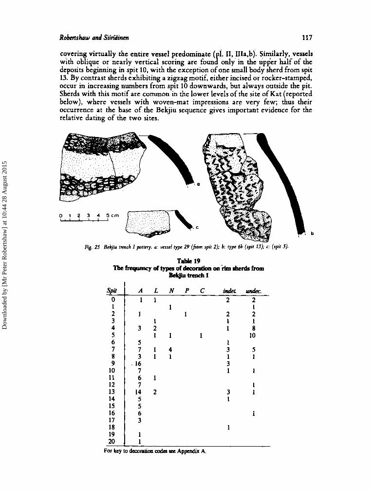
Fig. 25 Bckjiu trmch I pottcry. a: ucsscl typc 29 (from spit 2); b: typc 6b (spit 13); c: (spit 5).
Dow
nloa
ded
by [
Mr
Pete
r R
ober
tsha
w]
at 1
0:44
28
Aug
ust 2
015
118 Southem su&n
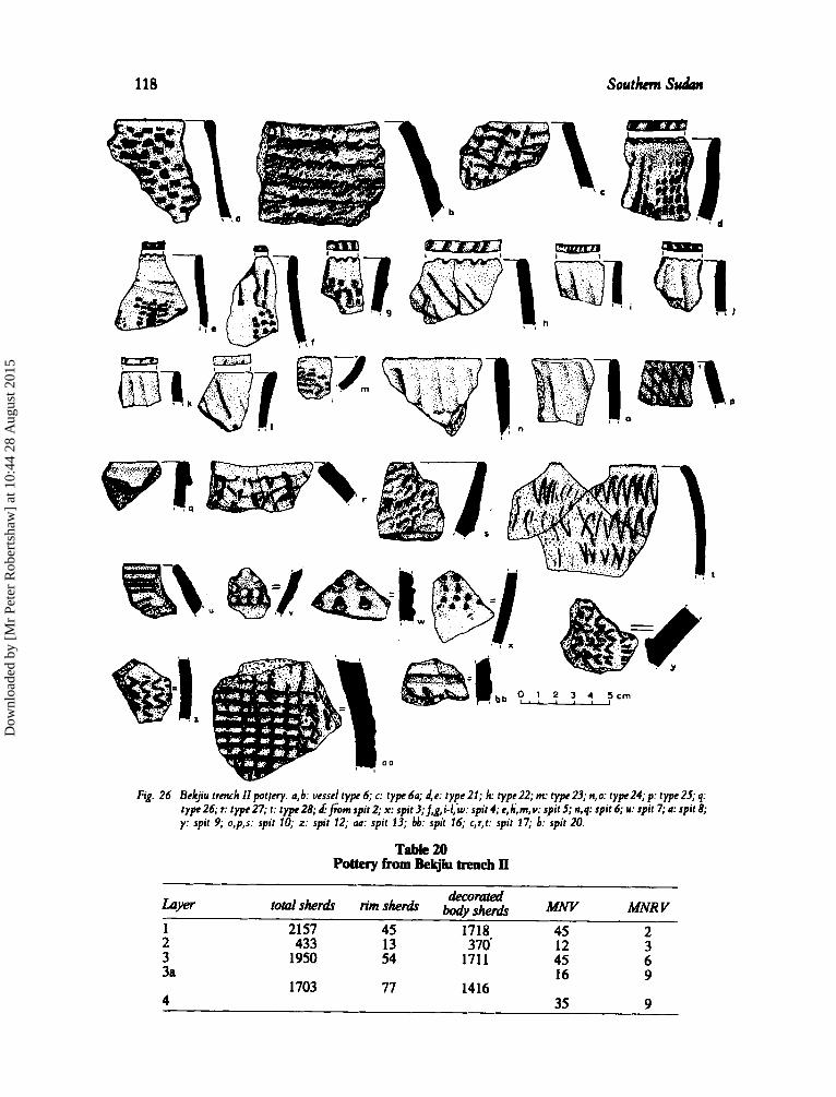
F&. 26 Bckjiu trmch I I p o t l n y . a,b: vesscl type 6; c: type 6a; d,e: type 21; h: typc22; m: type23; n,o: t ypr24;p: type25; q: type 26; c type 27; t: type 28; d fiom spit 2; x: spit 3;f,g,i-/,w: spit 4; c,h,m, Y: spit 5; n,q: spit 6; u: spit 7; a: spit 8; y: spit 9; o,p,s: spit 10; z: spit 12; aa: spit 13; bb: spit 16; c,r,t: spit 17; b: spit 20.
Table 20 Pottery from Bekjiu trench Il
~
deCO& Luyer total~herdr rimshed wys.,, MNV MNR V 1 2157 45 1718 45 2 2 433 13 370' 12 3 3 1950 54 1711 45 6 3a
1703 77 1416 16 9
4 35 9
Dow
nloa
ded
by [
Mr
Pete
r R
ober
tsha
w]
at 1
0:44
28
Aug
ust 2
015
Robntshaw and Siiriliincn 119
Luver
Table 21 Fnquendes of vegels of different typea from Bclrjiu trench II
v-1 TYP 1 4 6 6a 8 8a 20 21 22 23 24 25 26 27 28
1 2 3 3a 4
1 1 1 1 1
1 1 2 1 1 4 2 1 1 1 1
3 2 1 1 1 1
1691 24
1 1 3 6 1 1
1 1 7 9 1 1
1
367
1 2
1
2 2
1
1718 3
2
1 2
9 5
2 1 1 1
395 56 205
303 1105 2
1
2
1 1 3
8 3 1 1 1
4 220
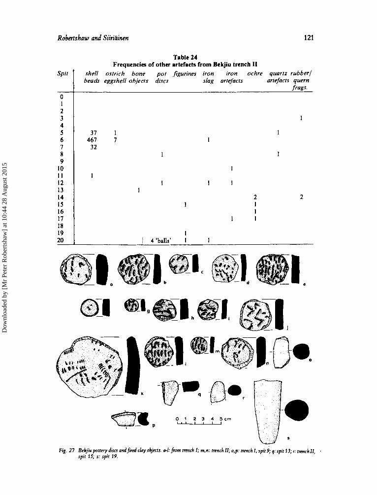
Other artifacts Inventories of the small finds are presented in Tables 23 and 24 and some of the
objects are illustrated in figs. 27 and 28. Pottery discs, some of which have ground edges, occur from spit 8 downwards in both trenches; their function is unknown. Four small clay ‘balls’ from the bottom of trench I1 are similar to those from Jok el
the lower half of the deposits; none of them seems particularly informative, though the largest (fig. 27s) has a rather phallic appearance. Fragments of iron slag,
and Ngeni. Several fired clay objects, here loosely termed ‘figurines’, were foun B in
Dow
nloa
ded
by [
Mr
Pete
r R
ober
tsha
w]
at 1
0:44
28
Aug
ust 2
015
120 S o u t h Sudan
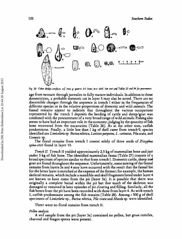
generally quite small, occur in most layers, and there are six iron objects (fig. 28 a-0; one from layer 7 of trench 1 is part of a small blade (fig. 28a), while that from layer 8 of the same trench is a fragment of perhaps a bracelet (fig. 28b). A small point was found in layer 3 of trench I1 (fig. 28c). What the remaining three pieces of iron belong to is not clear, perhaps spear shafts (?). Apart from a considerable number of fragments of rubbers and querns made of local ironstone, only four stone artefacts were discovered in the excavations at Bekjiu. Three of these are quartz flakes; the fourth, from layer 2 of trench 11, is part of a quartz crystal and may well have been used as a l ipplug (fig. 28g). Similarly a fragment of worked bone from layer 3 of trench I may have been part of either a lip- or ear-plug (fig. 28i). The other bone objects include an awl (fig. 28h), and two discs analogous to those made from potsherds. Finally, the overwhelming majority of the shell beads, made presumably from either land snails or freshwater shells, were found within the rubble-filled depression in layer 2 of trench II.
Table 23 Frequencies of other artefacts from Bekjiu trench I
Spit
0 1 2
4 5 6 7 8 9
10 I 1 12 13 14 15 16 17 18 19 20
shell shell bone pot figurines iron iron ochre quartz rubber1 beads tool? objects discs slag artefacts artefacts quern
frags. 1
3 1
I 1
4 2 I 1 1 1
1 2 I 1 2 I
1 3 I I
2 4 I 1 1 I 1 1
1 1
1 1
1
Faunal and floral remains
Trench I . Approximately 5 kg of mammal bone and just over 4 kg of fish bone were recovered from trench I. Much of it is fragmentary and about a tenth of the identifiable mammalian bone shows extensive traces of burning. The identified mammal and reptilian bone is listed in Table 25. For virtually every species in each layer the MNI is one. As at Jokpel and Ngeni a wide range of animals of different sizes is represented. Cattle and sheep/goat are found in every layer for which there is a reasonably large sample of bone. The cattle remains come from animals ranging in
Dow
nloa
ded
by [
Mr
Pete
r R
ober
tsha
w]
at 1
0:44
28
Aug
ust 2
015
Robertrhaw and Siiriiiinen 121
Spit
0 I 2 3 4 5 6 7 8 9
10 I I 12 13 14 I5 16 17 18 19 20
Frequencies of other artefacts from Bekjiu trench 11 shell ostrich bone pot ,figurines iron iron ochre quartz rubber1 beads eggshell objects discs slag artefacts artefacts quern
frogs.
1
37 1 467 7
32
1
1 1 1
2 I 1
1 1 1
I I 4 ‘balls’ 1 1
I
1
I I
2
0 1 2 3 4 5 c m M
Fig. 27 Eckjiu potrcry discs andf’nrd chy objects. a-1: fmm t m c h I; m,n: rnnch 11; o,p: trmch I, spit 9; q: spit 13; F; trmch 11, spit 15; s: spit 19.
Dow
nloa
ded
by [
Mr
Pete
r R
ober
tsha
w]
at 1
0:44
28
Aug
ust 2
015
122 Southern Sudan
Fig. 28 Other Bckjiu artefacts. a$ iron; g: quartz; h-I: bone; m-c shell. Sn text a d Tables 23 and 24 for provenance.
age from neonate through juveniles to full mature individuals. In addition to these domesticates, a probable domestic cat in r ayer 5 may also be noted. There are no discernible changes through the sequence in trench I either in the frequencies of different species or in the relative proportions of domestic and wild animals. The faunal remains appear to indicate that throughout the various occupations represented by the trench I deposits the herding of cattle and sheep/goat was combined with the procurement of a very broad range ofwild animals. Fishing also seems to have had an im ortant role in the economy, judging by the quantity of fish
predominate. Finally, a little less than 1 kg of shell came from trenchY; species identified are Limicolaria sp. Burtoa nilotica, Lanistes purpurea, L. carinatus, Pila ouata, and
The oral remains from trench I consist solely of three seeds of Zizyphus spina-cristi found in layer 10.
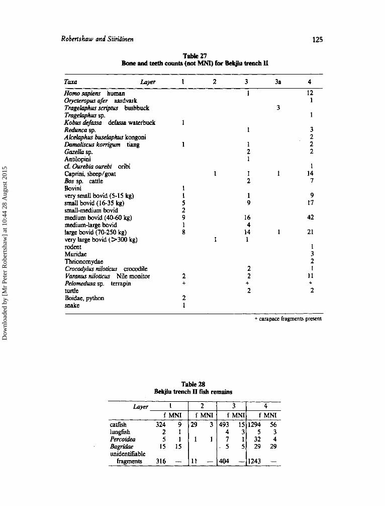
Trench II. Trench 11 yielded approximately 2.5 kg of mammalian bone and just under 3 kg of fish bone. The identified mammalian fauna (Table 27) consists of a broad spectrum of species similar to that from trench I . Domestic cattle, sheep and goat are found throughout the sequence. Unfortunately, some mixing of the faunal remains from layers 3a and 4 may have occurred with the result that the faunal list for the latter layer is enriched at the expense of the former; for example, the human skeletal remains, which include a mandible and skull fragments listed under layer 4 are known to have come from the pit (layer 3a). It is possible that there was originally a complete burial within the pit but that much of the skeleton was damaged or removed in later episodes of pit clearing and filling. Similarly, all the fish bones from the pit have been recorded with those from layer 4. As with trench I, catfish predominate among the fish remains (Table 28). Among c 500 g of shell specimens of Limicolaria sp., Burtoa nilotica, Pila ouata and Mutela sp. were identified.
bone recovered from t 1 e excavation (Table 26). As at the other sites, catfish
conaxis "K'
There were no floral remains from trench 11.
A soil sample from the pit (layer 3a) contained no pollen, but grass cuticles, Pollen analysis
charcoal and fungus spores were present.
Dow
nloa
ded
by [
Mr
Pete
r R
ober
tsha
w]
at 1
0:44
28
Aug
ust 2
015

Robertshaw and Siiriainm 123
Table 25 Bone and teeth counts (not MNI) for Bekjiu trench I
Taxa Lwer Homo sapiens human cf. Homo sapiens human Lepus cupemis cape hare Xenu sp. ground squirrel Hystdcidae, porcupine Cunis sp. dog/jackal Viverridae, genet Felis sp., cf. domestic cat Panrhem leo lion Procaviidae, hyrax Tragelaphini Kobus megaceros Nile lechwe Kobus sp. Redunca redunca Bohor reedbuck Redunca sp. Reduncini cf. Reduncini Alcelaphini 6. Alcelaphini Gazelka sp. Antilopini cf. Antilopini Cephalophus sp. duiker Neotragini cf. Neotragini Capra hircus goat Caprini, sheep/goat 6. Caprini Bossp. cattle cf. Bos sp. Bovini cf. Bovini very small bovid (5- 15 kg) very small-small bovid small bovid (16-35 kg) shall-medium bovid medium bovid (40-60 kg) medium-large bovid large bovid (70-250 kg) large-very large bovid very laqe bovid (>300 kg) T’hprycres sp. mole rat Muridae rodent Rana sp. bullfrog Cmod’lus niloticus crocodile Yumus nilokus Nile monitor Pelornedura sp. terrapin Gabon viper Boidae, python snake
2 3 4 5 6 7 8 9 1 0 1 1
1 3 3 1 1 1
2 1 1
1 1
1 2
1 2 2
1
1 1
4 4 5 1 1 1 1
1 7 4 1 2 1
1 3
1
1
6 8 4
1
1 1 1
1 1 2 2 2 1 1 1
1 2 4 4 2 3 2 1 2 1
3 2 2
1 1 1 1
1 1 7 4 15 8 4
1 3 3 9 2 0 2 2 2 7 6 1 5 8 3
4 4 2 1 2 5 20 16 24 4 13 10
1 1 2
3 2 1 1
1 2 2 2 1 1
2 2 1 2 1 1 1 1 1 6 2 2 3 4 + + + + + + +
2 2 2 3
1 2 + carapace fragments present
Dow
nloa
ded
by [
Mr
Pete
r R
ober
tsha
w]
at 1
0:44
28
Aug
ust 2
015
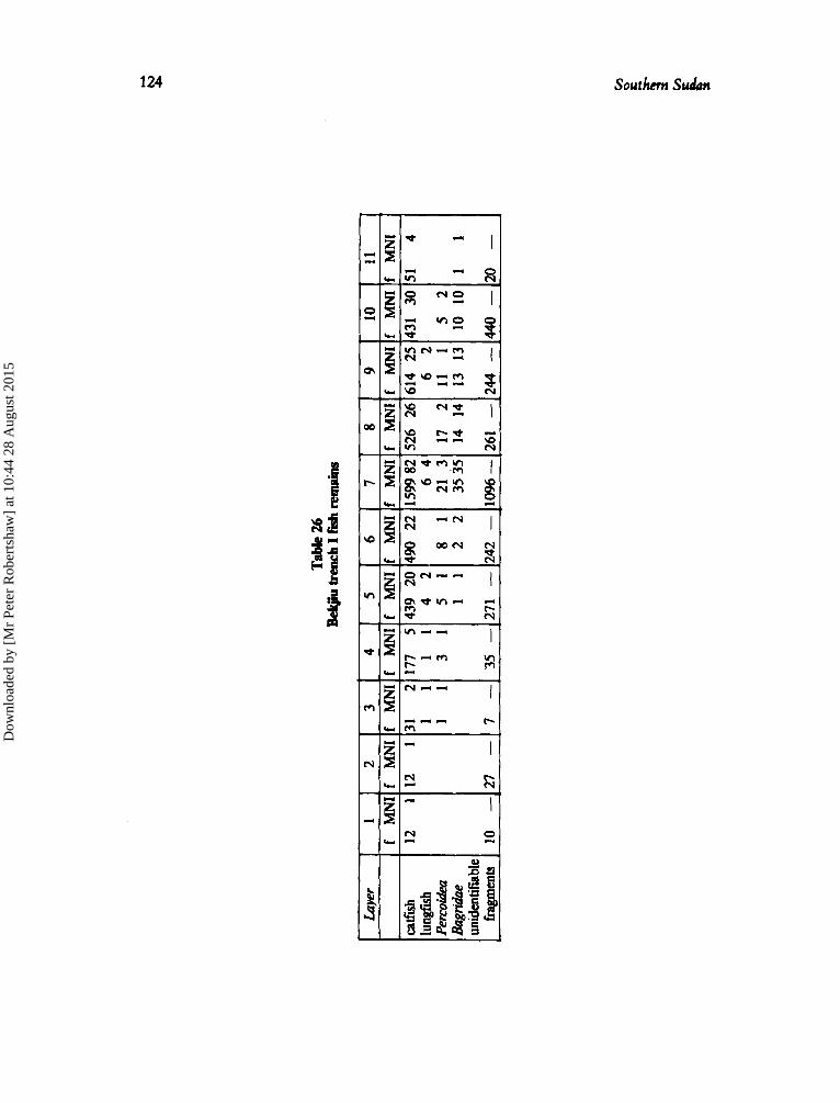
Tabl
e 26
Bel
rjiu
benc
hIfis
hrem
nins
Lwer
1
f M
NI
catfi
sh
12
1 lu
ngfis
h Pe
rcoi
dea
unid
entif
iable
&Ig
ridae
fragm
ents
10 -
2 3
4 5
6 7
f M
NI
f M
NI f
M
NI
f M
NI
f M
NI
f M
NI
12
1 31
2
177
5 43
9 20
490
22
159
982
11
11
42
6
4
11
31
51
81
21
3
1 1
2 2
3535
27 -
7 -
35 - 2
71 - 2
42 - 1
096-
8 f
MNI
261 - 2
44 -
~ ~
-~
~ ~
-
9 10
11
f
MN
I f
MN
I f
MNI
Dow
nloa
ded
by [
Mr
Pete
r R
ober
tsha
w]
at 1
0:44
28
Aug
ust 2
015
Robertskaw and Siiriiiinen 125
Layer 1 f MNI
catfsh 324 9
Percoidea 5 1 1 Bagli&e 15 15 unidentifiable
lungfish 2 1
fragments 316 -
Table 27 Bone and teeth counts (not MNI) for Be&jiu trench EI
2 3 4 f MNI f MNI f MNI
29 3 493 15 1294 56 4 3 5 3
1 7 1 3 2 4 . 5 5 29 29
11 - 404 - 1243 -
TaUr Luyer 1 2 3
Homo sapkns human Orycreropus afer aardvark Tragelaphus scriptus bushbuck Tragehphus sp. Kobus & f i a defassa waterbuck R&nca sp. Akeiaphus buseiaphus kongoni Llamaliscus korn’gum tiang Gazelia sp. Antilopini cf. Ourebia ourebi oribi Caprini, sheeplgoat Bos sp. cattle Bovini very small bovid (5-15 kg) small bovid (16-35 kg) small-medium bovid medium bovid (40-60 kg) medium-large bovid large bovid (70-250 kg) very large bovid (>300 kg) rodent Muridae Thrionomydae Crocodylus niloticus crocodile Varanus niloricus Nile monitor Pelomedusa sp. terrapin turtle Boidae, python snake
2 +
2 1
1
1
1 2 1
1 1 2
1 9
16 4
14 1 1
2 2
2 +
3a 4
12 1
1 3
1 1 14
7
9 17
42
1 21
1 3 2 1
11
2 +
+ carapace fragments present
Dow
nloa
ded
by [
Mr
Pete
r R
ober
tsha
w]
at 1
0:44
28
Aug
ust 2
015
126 Southern Sudan
Summary
Much of the deposit a t Bekjiu seems to have accumulated during the latter part of the first millennium AD. The pottery from the site is characterised by constricted bowls, decorated over most of their surfaces with woven-mat impressions. Several sherds with a zigzag motif from the base of trench 11 are suggestive of an earlier occupation of the site, poorly documented in our excavations. In the upper half of the deposits vessels decorated by oblique/vertical scoring are a new element within the mat-impressed tradition. In the upper part of the deposits there also appear the remains of pole-and-daga structures. The lower loamy deposits are reminiscent of those of modern Dinka cattle-camps in the region; however, the absence of structures in the lower levels may, of course, be explained also by sampling error. Knowledge of iron-working is indicated by the occasional pieces of slag throughout the sequence. The faunal and floral remains, which show no evidence of any significant economic shift during the occupation of the site, indicate that herding of domestic cattle, sheep and goat was combined with the procurement of a wide range of wild animals, including aquatic species such as crocodile and terrapin. Fishing also seems to have been an important activity. The discovery of Zixyphus spina-cristi seeds indicates that wild fruits were gathered when in season. Although no seeds of domestic crops were found in the excavation, the presence of several grindstones suggests that agriculture may have been practised.
Kat
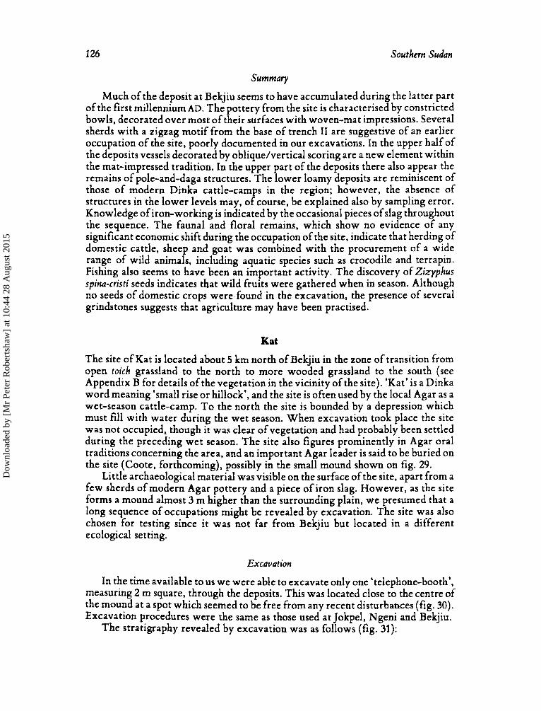
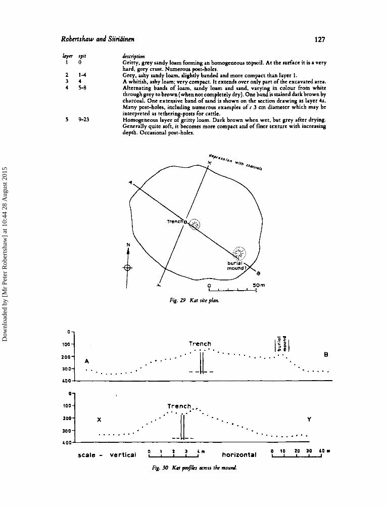
The site of Kat is located about 5 km north of Bekjiu in the zone of transition from open toich grassland to the north to more wooded grassland to the south (see Appendix B for details of the vegetation in the vicinity of the site). ‘Kat’ is a Dinka word meaning ‘small rise or hillock’, and the site is often used by the local Agar as a wet-season cattle-camp. To the north the site is bounded by a depression which must fill with water during the wet season. When excavation took place the site was not occupied, though it was clear of vegetation and had probably been settled during the preceding wet season. The site also figures prominently in Agar oral traditions concerning the area, and an important Agar leader is said to be buried on the site (Coote, forthcoming), possibly in the small mound shown on fig. 29.
Little archaeological material was visible on the surface of the site, apart from a few sherds of modern Agar pottery and a piece of iron slag. However, as the site forms a mound almost 3 m higher than the surrounding plain, we presumed that a long sequence of occupations might be revealed by excavation. The site was also chosen for testing since it was not far from Bekjiu but located in a different ecological setting.
Excavation
In the time available to us we were able to excavate only one ‘telephone-booth’, measuring 2 m square, through the deposits. This was located close to the centre of the mound at a spot which seemed to be free from any recent disturbances (fig. 30). Excavation procedures were the same as those used a t Jokpel, Ngeni and Bekjiu.
The stratigraphy revealed by excavation was as follows (fig. 31):
Dow
nloa
ded
by [
Mr
Pete
r R
ober
tsha
w]
at 1
0:44
28
Aug
ust 2
015
Robcrtshow and Siiridinm
10oJ
200-
300-
127
Trench., . . . . . Y
- * . * . . . . . . . . . . . . . . . . . . . .... -- u -- . . . . . . . . .
X
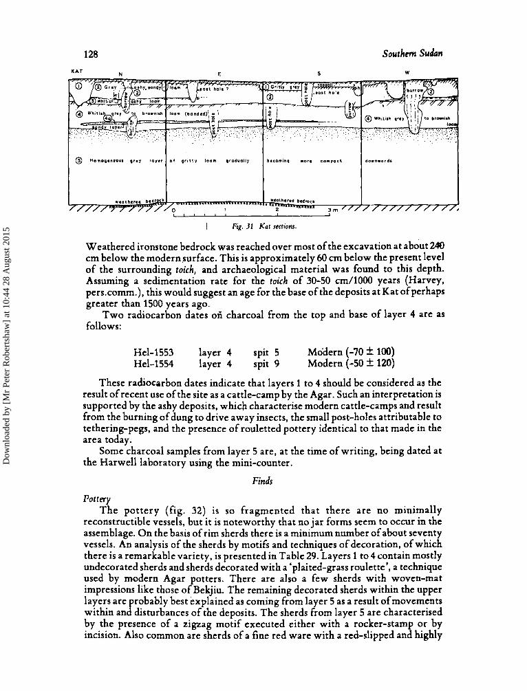
layer spit 1 0
2 1 4 3 4 4 5-8
5 9-23
dcscription Gritty, grey sandy loam forming an homogeneous topsoil. At the surface it is a very hard, grey crust. Numerous post-holes. Grey. ashy sandy loam, slightly banded and more compact than layer 1. A whitish, ashy loam; very compact. It extends over only part of the excavated area. Alternating bands of loam. sandy loam and rand. varying in colour from white through grey to brown (when not com lctely dry). One band is stained dark brown by charcoal. One extensive band of u n l i s shown on the section drawing as layer 4a. Many post-holes, inclading numerous examples of c 3 cm diameter which may be interpreted as tethering-posts for cattle. Homogeneous layer of gritty loam. Dark brown when wet, but grey after drying. Generally quite soft. it becomes more compact and of finer texture with increasing depth. Occasional post-holes.
i 50 m I O--
Fig. 29 Kat site plan.
j j z
B I6 :I Trench
* . . - . . . . . . . . . . . . . . . . . . . . . . . . .
. . A
. . . . . . . .
O t 2 3 4 m 0 10 20 30 40 m scale - vertical ~llll horizontal L-
Fig. 30 Kat pro& a m s s the mound.
Dow
nloa
ded
by [
Mr
Pete
r R
ober
tsha
w]
at 1
0:44
28
Aug
ust 2
015
128 Southern Sudan
N E S W K A T
Weathered ironstone bedrock was reached over most ofthe excavation at about 240 cm below the modernsurface. This is approximately 60 cm below the present level of the surrounding toich, and archaeological material was found to this depth. Assuming a sedimentation rate for the toich of 30-50 cm/1000 years (Harvey, pers.comm.), this would suggest an age for the base of the deposits at Kat ofperhaps greater than 1500 years ago.
Two radiocarbon dates ori charcoal from the top and base of layer 4 are as follows:
Hel-1553 layer 4 spit 5 Modern (-70 * 100) Hel-1554 layer 4 spit 9 Modern (-50 * 120)
These radiocarbon dates indicate that layers 1 to 4 should be considered as the result of recent use of the site as a cattle-camp by the Agar. Such an interpretation is supported by the ashy deposits, which characterise modern cattle-camps and result from the burning of dung to drive away insects, the small post-holes attributable to tethering-pegs, and the presence of rouletted pottery identical to that made in the area today.
Some charcoal samples from layer 5 are, at the time of writing, being dated at the Harwell laboratory using the mini-counter.
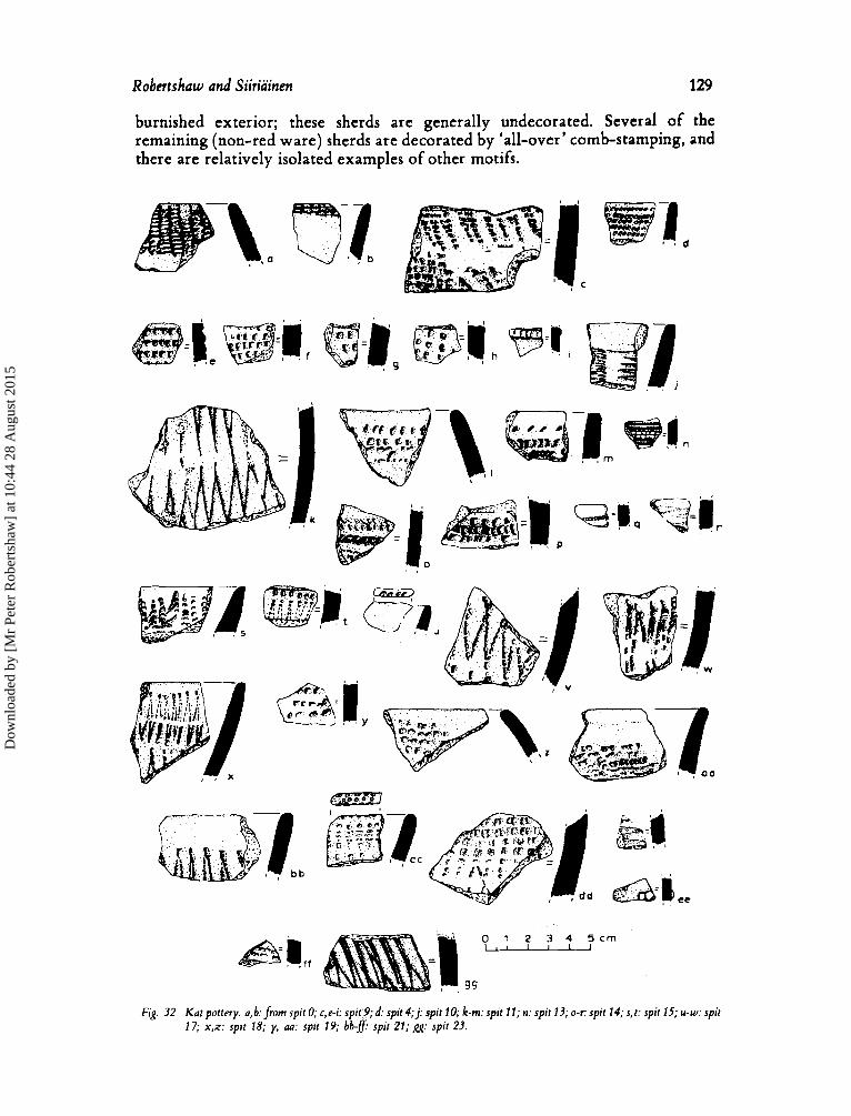
Pottery The pottery (fig. 32) is so fragmented that there are no minimally
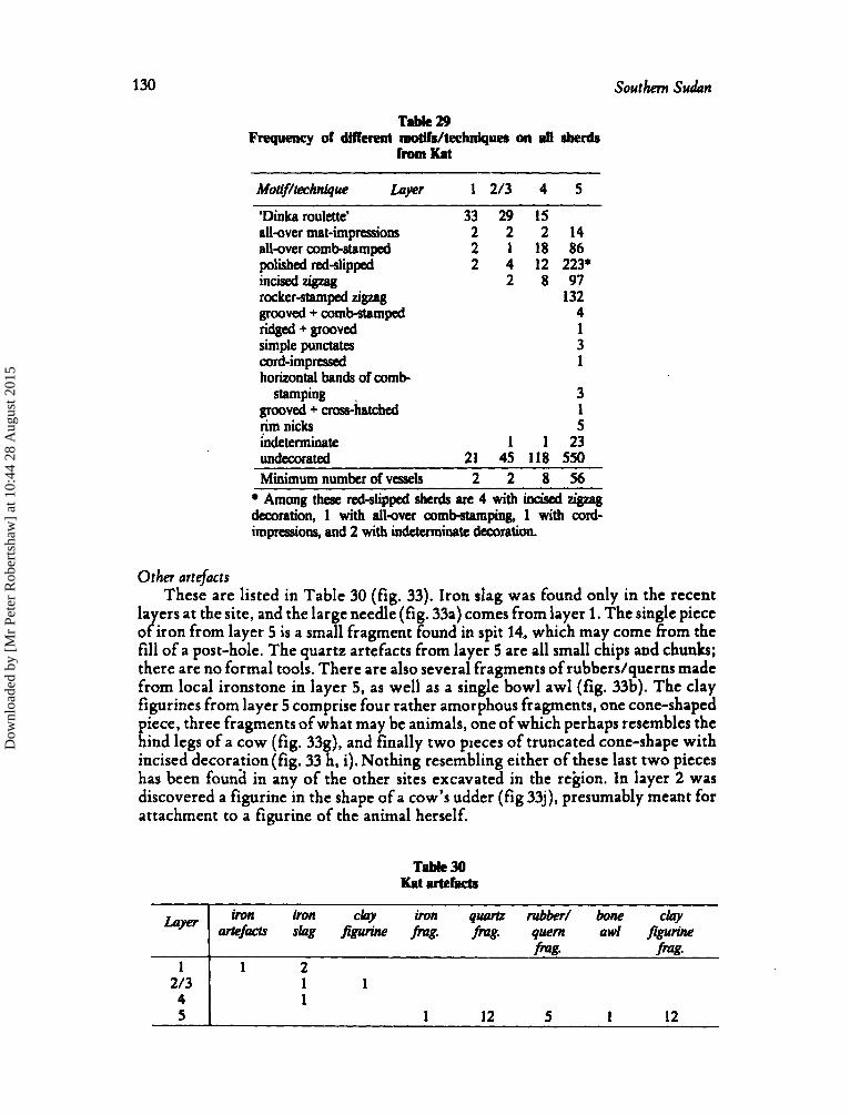
reconstructible vessels, but it is noteworthy that no jar forms seem to occur in the assemblage. On the basis of rim sherds there is a minimum number of about seventy vessels. An analysis of the sherds by motifs and techniques of decoration, of which there is a remarkable variety, is presented in Table 29. Layers 1 to 4 contain mostly undecorated sherds and sherds decorated with a ‘plaited-grass roulette’, a technique used by modern Agar potters. There are also a few sherds with woven-mat impressions like those of Bekjiu. The remaining decorated sherds within the upper layers are probably best explained as coming from layer 5 as a result ofmovements within and disturbances of the deposits. The sherds from layer 5 are characterised by the presence of a zigzag motif executed either with a rocker-stamp or by incision. Also common are sherds of a fine red ware with a red-slipped and highly
Finds
Dow
nloa
ded
by [
Mr
Pete
r R
ober
tsha
w]
at 1
0:44
28
Aug
ust 2
015
Robertshaw and Siiriainen 129
burnished exterior; these sherds are generally undecorated. Several of the remaining (non-red ware) sherds are decorated by ‘all-over’ comb-stamping, and there are relatively isolated examples of other motifs.
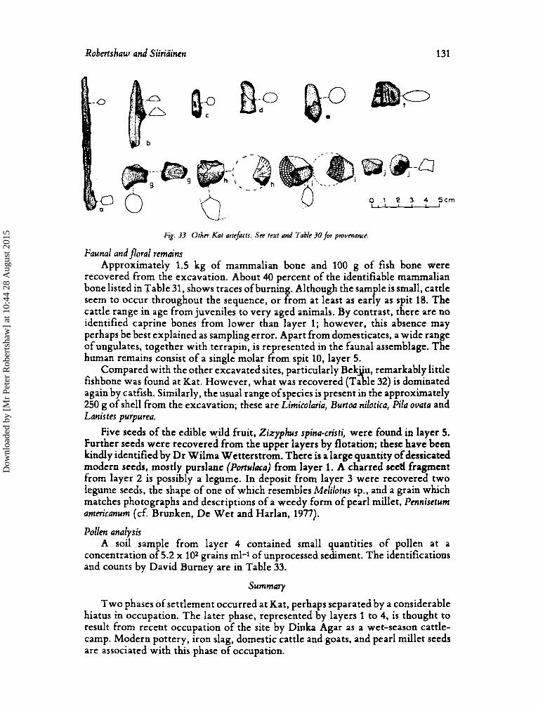
0 1 2 3 4 5 c m I,, Fig. 32 Kat pottery. a, b: from spit 0; c, e-i: spit‘9; d: spit 4; j : spit 10; k-m: spit 1 1 ; n: spit 13; 0-c spit 14; 5, r : spit 15; u-w: spit
17; x,x: spit 18; y, au: spit 19; bb-f spir 21; gg: spir 23.
Dow
nloa
ded
by [
Mr
Pete
r R
ober
tsha
w]
at 1
0:44
28
Aug
ust 2
015
130
1 213 4 5
Southern Sudan
iron iron clay iron quartz rubber/ bone clay cutefacrr slag figurine f i g . fmg. qwm awl jigwine
fmg. fmg. 1 2
1 1 1
1 12 5 1 12
Table 29 Frequency of different mdlls/techniques on pll dnrds
from Kat
hft?h~/&h?tiqW taver 1 2/3 4 5
‘Dinka roulette’ 33 29 15 all-over mat-impressions 2 2 2 1 4 all-over comb-stamped 2 1 18 86 polished red-slipped 2 4 12 223* incised z i p q 2 8 97 rocker-stamped zigzag 132 grooved + comb-stamped 4 ridged + grooved 1 simple punctam 3 cord - i m p r essed
stamping 3 grooved + cros-htched 1 rim nicks 5
1 horizontal bands of comb
indeterminate 1 1 23 Undecorated 21 45 118 550
~~~~~~~
Minimum number of vcsds 2 2 8 5 6 Among these red-slipped she& a n 4 with incised ZigLag
decoration, 1 with a l l a e r comb-stamping, 1 with cord- impressions, and 2 with indeterminate decoration.
Other artefacts These are listed in Table 30 (fig. 33). Iron slag was found only in the recent
layers at the site, and the large needle (fig. 33a) comes from layer 1. The single piece of iron from layer 5 is a small fragment found in spit 14, which may come fiom the fill of a post-hole. The quartz artefacts from layer 5 are all small chips and chunks; there are no formal tools. There are also several fragments of rubbers/querns made from local ironstone in layer 5, as well as a single bowl awl (fig. 33b). The clay figurines from layer 5 comprise four rather amorphous fragments, one cone-shaped piece, three fragments of what may be animals, one of which perhaps resembles the hind legs of a cow (fig. 33g), and finally two pieces of truncated cone-shape with incised decoration(fig. 33 h, i). Nothing resembling either of these last two pieces has been founa in any of the other sites excavated in the region. In layer 2 was discovered a figurine in the shape of a cow’s udder (fig 33j), presumably meant for attachment to a figurine of the animal herself.
Dow
nloa
ded
by [
Mr
Pete
r R
ober
tsha
w]
at 1
0:44
28
Aug
ust 2
015
Robertshaw and Siiriainen 131
Bp @-0 pl'
0 c rn
U.-
Fig. 33 Other Kat arreficts. See text and Table 3o&r pmumance
Faunal andfloral remuins Approximately 1.5 kg of mammalian bone and 100 g of fish bone were
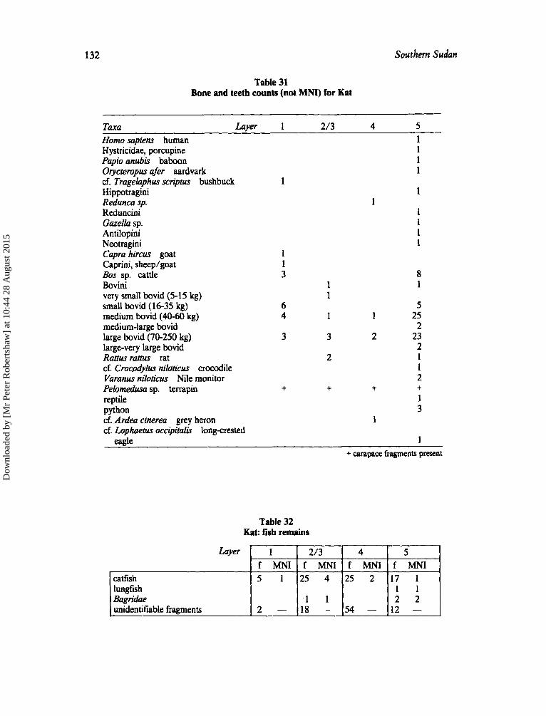
recovered from the excavation. About 40 percent of the identifiable mammalian bone listed in Table 31, shows traces of burning. Although the sample is small, cattle seem to occur throughout the sequence, or from a t least as early as spit 18. The cattle range in age from juveniles to very aged animals. By contrast, there are no identified caprine bones from lower than layer 1; however, this absence may perhaps be best explained as sampling error. Apart from domesticates, a wide range of ungulates, together with terrapin, is represented in the faunal assemblage. The human remains consist of a single molar from spit 10, layer 5.
Compared with the other excavated sites, particularly Bek"u, remarkably little
again by catfish. Similarly, the usual range of species is present in the approximately 250 g of shell from the excavation; these are Limicolaria, Burtoa nilotica, Pila ovata and Lanis tes purpurea.
Five seeds of the edible wild fruit, Zixyphus spina-cristi, were found in layer 5. Further seeds were recovered from the upper layers by flotation; these have been kindly identified by Dr Wilma Wetterstrom. There is a large quantity of dessicated modern seeds, mostly purslane (Portulaca) from layer 1. A charred seed fragment from layer 2 is possibly a legume. In deposit from layer 3 were recovered two legume seeds, the shape of one of which resembles Melilotus sp., and a grain which matches photographs and descriptions of a weedy form of pearl millet, Pennisetum arnericanum (cf, Brunken, De Wet and Harlan, 1977).
Pollen analysis A soil sample from layer 4 contained small quantities of pollen at a
concentration of 5.2 x 10² grains ml-1 of unprocessed sediment. The identifications and counts by David Burney are in Table 33.
Summmy
Two phases of settlement occurred at Kat, perhaps separated by a considerable hiatus in occupation. The later phase, represented by layers 1 to 4, is thought to result from recent occupation of the site by Dinka Agar as a wet-season cattle- camp. Modern pottery, iron slag, domestic cattle and goats, and pearl millet seeds are associated with this phase of occupation.
fishbone was found at Kat. However, what was recovered (Ta fl le 32) is dominated
Dow
nloa
ded
by [
Mr
Pete
r R
ober
tsha
w]
at 1
0:44
28
Aug
ust 2
015
132
Layer
catflsh lungfish Bagridae unidentifiable framnents
Southern Sudan
1 2/3 4 5 f MNI f MNI f MNI f MNI 5 1 2 5 4 2 5 2 1 7 1
I 1 1 1 2 2
2 - 18 - 54 - 12 -
Table 31 Bone and teeth counts (not MNI) for Kat
1 1 3
6 4
3
+
1
Taxa Lqer 1 2/3 4 5 Homo sapiens human 1 Hystricidae, porcupine 1 Papio anubis baboon 1 Oycteropus afer aardvark 1 cf. Tragelaphus scriptus bushbuck 1 Hippotraghi 1 Redunca sp. Redunciai 1 Gazella sp. 1 Antilopini 1 Neotragini 1 Capra hircus goat Caprini, sheeplgoat Bos sp. cattle 8 Bovini 1 1 very small bovid (5- 15 kg) small bovid (16-35 kg) 5 medium bovid (40-60 kg) 1 1 25 medium-large bovid 2 large bovid (70-250 kg) 3 2 23 large-very large bovid 2 Rattw rattus rat 2 1 cf. Crocodylus niloticus crocodile 1 Varanus niloticus Nile monitor 2 Pelomedusa sp. terrapin + + + reptile 1 python 3 cf. Ardea cinerea grey heron 1
eagle 1
1
cf. Lophaetus occipitalis longcrested
+ carapace fragments present
Dow
nloa
ded
by [
Mr
Pete
r R
ober
tsha
w]
at 1
0:44
28
Aug
ust 2
015
Robertshaw and Siiriainen 133
The earlier phase is characterised by pottery decorated with a zigzag motif and by a finely burnished, red-slipped ware. There is no good association between this pottery and any evidence for iron-working or iron artefacts. Cattle and a broad range of wild species were identified from the faunal assemblage. Fish remains, however, are rare by comparison with the other sites excavated. No radiocarbon dates are yet available for this earlier phase of occupation at Kat. However, the presence of sherds decorated with a zigzag motif in the lowest levels of trench11 at Bekjiu indicates that layer 5 at Kat pre-dates the main occupation of Bekjiu and, therefore, is earlier than the late first millennium AD. Further evidence for a probable early date for Kat is the fact ,that archaeological material is found to a depth of 60 cm below the present level of the surrounding toich, and we are satisfied that the stratigraphy has not been disturbed by pits.
Table 33 Pollen count by D.A. Burney of soil
s ~ m ~ l e from Kat laver 4 Moraceae Cyperaceae Gramineae Junipw-type Monolete fern HibkW SD.
1 4
14 2 4 1
wllen sum 26 C X U X I I D ~ ~ ~ indeterminate mains 17
Na'am
The site of Na'am is situated about four km east of Bekjiu and one km west of the Na'am River. .It is located in the open toich grassland that borders the Na'am River and which becomes more .extensive just north of the site as it enters the great clay plain surrounding the Sudd. The site has been used in recent years as a dry-season cattle-camp of the Dinka Agar; a chain of such dry-season camps follows the course of the Na'am River, which is one ofsthe very few water sources with sufficient supplies for livestock late in the dry-season. Several depressions surround the mound (fig. 34); clay from these depressions may have been taken onto the site for building purposes. One of the depressions held a small pool of water at the time of our excavation in the late dry season. Several large catfish were seen in this pool.
The site was chosen for excavation because it seemed that a good sequence of occupation horizons might be recovered from the 2 m depth of deposit. While near to Bekjiu, Na'am is located in a different ecplogical setting; we suspected that we might obtain evidence of a rather different set of adaptations to the local environment from what we had recovered at Bekjiu. No archaeological material was found on the surface of the site before excavation. However, at the salt-lick just east of the mound we discovered twelve sherds decorated with either punctates, mat-impressions or scoring, a single undecorated rim sherd and a fragment of a clay figurine.
Excavation
As usual, we located our trench, measuring2 m square, close to the hi hest point of the mound free from any obvious disturbance to the deposits ( P ig. 35). A relatively complex stratigraphy (fig. 36) was revealed:
Dow
nloa
ded
by [
Mr
Pete
r R
ober
tsha
w]
at 1
0:44
28
Aug
ust 2
015
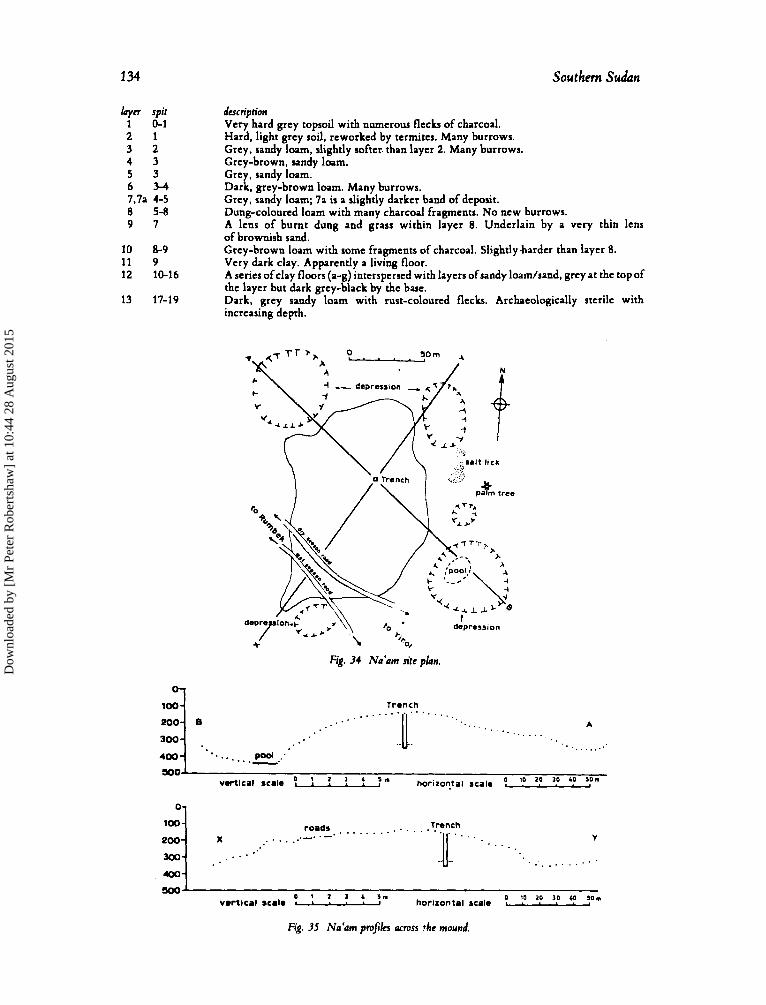
134 Southern Sudan
hyyn spir 1 0-1 2 1 3 2 4 3 5 3 6 3 - 4 7.7a 4-5 8 5-8 9 7
10 8-9 11 9 12 10-16
13 17-19
description Very hard grey topsoil with numerous flecks of charcoal. Hard, light grey soil, reworked by termites. Many burrows. Grey, sandy loam, slightly softer. than layer 2. Many burrows. Grey-brown, sandy loam. Grey, sandy loam. Dark, grey-brown loam. Many burrows. Grey, sandy loam; 7a is a slightly darker band of deposit. Dung-colourcd loam with many charcoal fragments. No new burrows. A lens of burnt dung and grass within layer 8. Underlain by a very thin lens of brownish sand. Grey-brown loam with some fragments of charcoal. Slightlyharder than layer 8. Very dark clay. Apparently a living floor. A series ofclay floors (a-g) interspersed with layers ofsandy loam/sand, grey at the top of the layer but dark grey-black by the base. Dark, grey sandy loam with rust-colourcd flecks. Archaeologically sterile with increasing depth.
depression
Fig. 34 N a b m site plan.
Trench . . . . . . . . . .....(.,. . . .
Pool 400 ....... .. --.
A
.....
v h i c a l scale ! ? ? f :” hotizOr!tsl scale ! ‘0 ’? ’0 ‘? :””
. . . . . . . . . . . . . . . . . . . . . . . . . . . . . . . . .
. . . . . . . . . . . ’
0 10 zo 30 40 so. vmrtical scale 1 * . 1 horizontal scalm L * * * . 4
Fig. 35 Na‘am prafiks across !he mound.
Dow
nloa
ded
by [
Mr
Pete
r R
ober
tsha
w]
at 1
0:44
28
Aug
ust 2
015
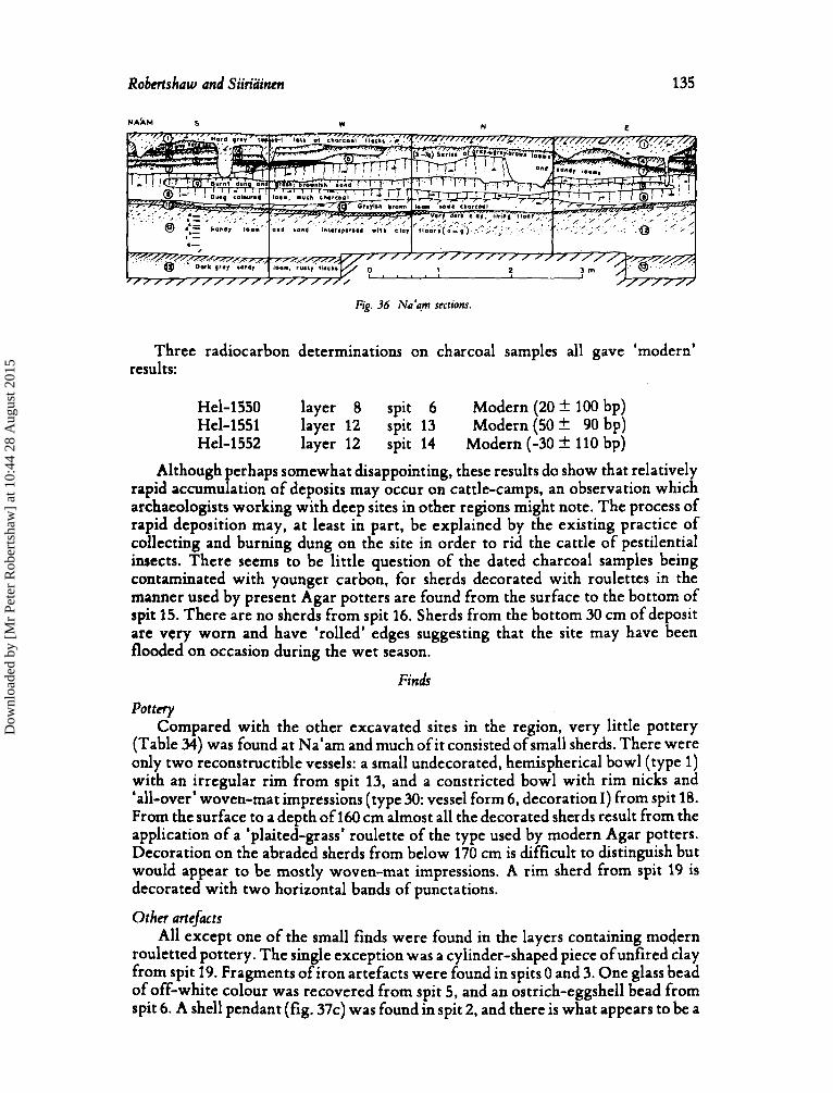
Robertshaw and Siiriainen 135
N A ~ M 5 W N c
Fig. 36 Na‘am sections.
Three radiocarbon determinations on charcoal samples all gave ‘modern’ results:
Hel-1550 layer 8 spit 6 Modern (20f 100 bp) Hel-1551 layer 12 spit 13 Modern (50 f 90 bp) Hel-1552 layer 12 spit 14 Modern (-30 k 110 bp)
Although perhaps somewhat disappointing, these results do show that relatively rapid accumulation of deposits may occur on cattle-camps, an observation which archaeologists working with deep sites in other regions might note. The process of rapid deposition may, at least in part, be explained by the existing practice of collecting and burning dung on the site in order to rid the cattle of pestilential insects. There seems to be little question of the dated charcoal samples being contaminated with younger carbon, for sherds decorated with roulettes in the manner used by present Agar potters are found from the surface to the bottom of spit 15. There are no sherds from spit 16. Sherds from the bottom 30 cm of deposit are very worn and have ‘rolled’ edges suggesting that the site may have been flooded on occasion during the wet season.
Finds
Pottcry Compared with the other excavated sites in the region, very little pottery
(Table 34) was found at Na‘am and much of it consisted of small sherds. There were only two reconstructible vessels: a small undecorated, hemispherical bowl (type 1) with an irregular rim from spit 13, and a constricted bowl with rim nicks and ‘all-over’ woven-mat impressions (type 30: vessel form 6 , decoration I) from spit 18. From the surface to a depth of 160 cm almost all the decorated sherds result from the application of a ‘plaited-grass’ roulette of the type used by modern Agar potters. Decoration on the abraded sherds from below 170 cm is difficult to distinguish but would appear to be mostly woven-mat impressions. A rim sherd from spit 19 is decorated with two horizontal bands of punctations.
Other arrejicts All except one of the small finds were found in the layers containing modern
rouletted pottery. The single exception was a cylinder-shaped piece of unfired clay from spit 19. Fragments of iron artefacts were found in spits 0 and 3. One glass bead of off-white colour was recovered from spit 5, and an ostrich-eggshell bead from spit 6. A shell pendant (fig. 37c) was found in spit 2, and there is what appears to be a
Dow
nloa
ded
by [
Mr
Pete
r R
ober
tsha
w]
at 1
0:44
28
Aug
ust 2
015
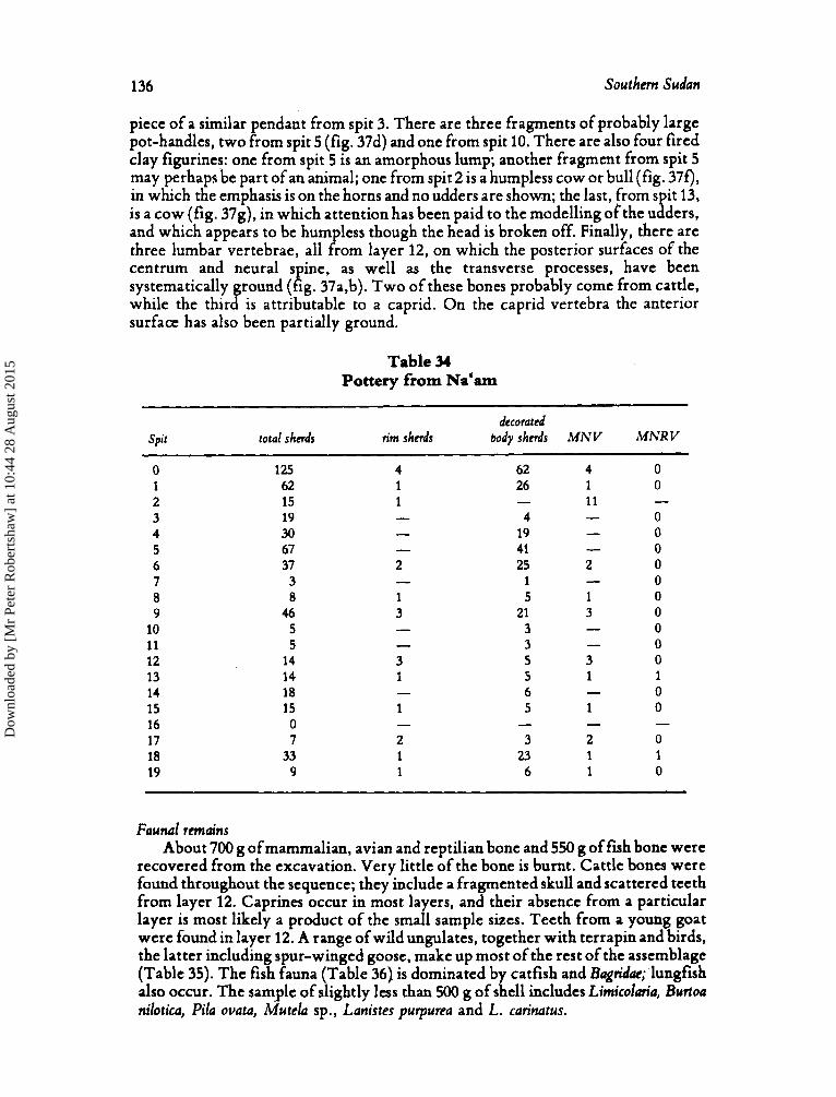
136 Southern Sudan
piece of a similar pendant from spit 3. There are three fragments of probably large pot-handles, two from spit 5 (fig. 37d) and one from spit 10. There are also four fired clay figurines: one from spit 5 is an amorphous lump; another fragment from spit 5 may perhapsbe part of an animal; one from spit 2 is a humpless cow or bull (fig. 370, in which the emphasis is on the horns and no udders are shown; the last, from s it 13,
and which appears to be humpless though the head is broken off. Finally, there are three lumbar vertebrae, all from layer 12, on which the posterior surfaces of the centrum and neural s ine, as well as the transverse processes, have been systematically ground ( P ig. 37a,b). Two of these bones probably come from cattle, while the third is attributable to a caprid. On the caprid vertebra the anterior surface has also been partially ground.
is a cow (fig. 37g), in which attention has been paid to the modelling ofthe u B ders,
Table 34 Pottery from Na'am
decorated Spit total shcrds n'm shnds body shnds MN V MNR V
0 125 4 62 4 0 1 62 1 26 1 0 2 15 1 - 11
0 4 3 0 4 30 - 19
5 67 - 41 - 0 6 37 2 25 2 0
0 7 3 8 8 1 5 1 0 9 46 3 21 3 0
0 10 5 11 5 - 3 - 0 12 14 3 5 3 0 13 14 1 5 1 1
0 14 18 - 15 15 1 5 1 0 16 0 17 7 2 3 2 0 18 33 1 23 1 1 19 9 1 6 1 0
- - 19 - -
- 1 -
- 3 -
- 6
- - - -
Faunal remains About 700 g of mammalian, avian and reptilian bone and 550 g of fish bone were
recovered from the excavation. Very little of the bone is burnt. Cattle bones were found throughout the sequence; they include a fragmented skull and scattered teeth from layer 12. Caprines occur in most layers, and their absence from a particular layer is most likely a product of the small sample sizes. Teeth from a young goat were found in layer 12. A range of wild ungulates, together with terrapin and birds, the latter including spur-winged goose, make up most of the rest of the assemblage (Table 35). The fish fauna (Table 36) is dominated by catfish and Bagridac; lungfish also occur. The sample of slightly less than 500 g of shell includes Limicolmia, Burtoa nilotica, Pila ovata, i t h e l a sp., Lanistes purpurea and L. carinatus.
Dow
nloa
ded
by [
Mr
Pete
r R
ober
tsha
w]
at 1
0:44
28
Aug
ust 2
015
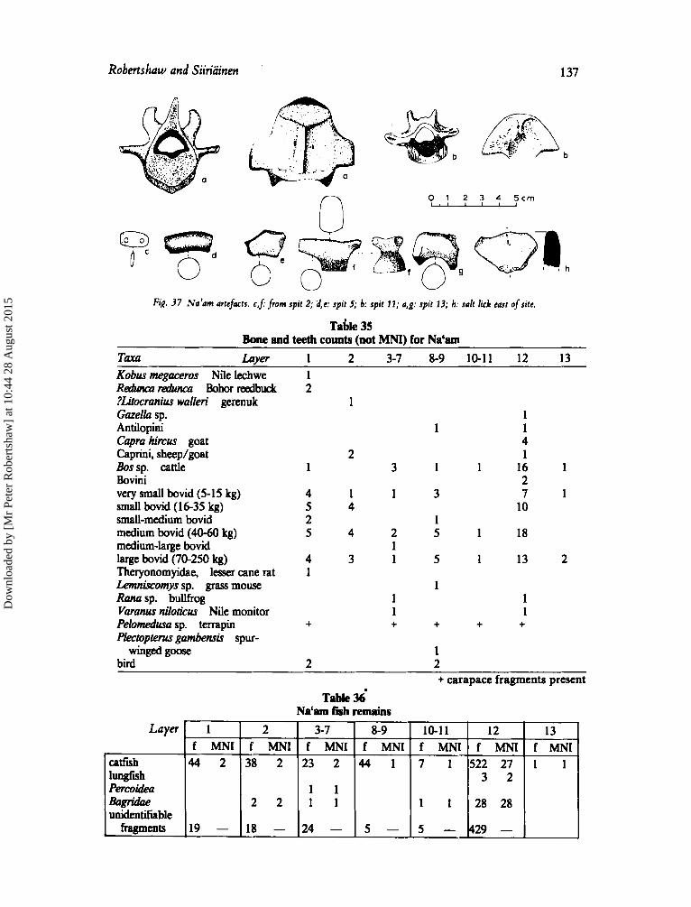
Robertshaw and Siiriainen 137
Layer
catfish lungfish Percoidea &rgridae unidentifiable
fragments
b
0 1 2 3 4 5 c m , 1 1 1 1
1 2 3-7 8-9 10-1 1 12 13 f MNI f MNI f MNI f MNI f MNI f MNI f MNI
44 2 38 2 23 2 44 1 7 1 5 2 2 2 7 1 1 3 2
2 2 1 1 1 1 28 28 1 1
19 - 18 - 2 4 - 5 - 5 - 4 29 -
Fig. 37 N a h m artefacts. c , j from spit 2; d,e: spit 5; b: spit 11; a,g: spit 13; h: salt lick east of site.
Table 35 Bone and teeth counts (not MNI) for Na'am
TaXa Laver 1 2 3-7 8-9 10-11 12 13 Kobus megaceros Nile lechwe Reaiuutz~~dunca Bohorreedbuck ?Litocranius walleri gerenuk Gazella sp. Antilopini Capra himus goat Caprini, sheep/goat Bossp. cattle Bovini very small bovid (5-15 kg) small bovid (16-35 kg) small-medium bovid medium bovid (40-60 kg) medium-large bovid large bovid (70-250 kg) Theryonomyidae, lesser cane rat Lemniscomys sp. grass mouse Rana sp. bullfrog Varanus niloticus Nile monitor Peiomedusa sp. terrapin Plectopterus gambensis spur-
bird winged goose
1 2
1
2 1 3
4 1 1 5 4 2 5 4 2
1 4 3 1 1
+
1 1 +
2
Table 36' Na'am fish remains
1 1 1
4 1
1 1 16 1 2
3 7 1 10
1 5 1 18
5 1 13 2
1 1 1
+ + +
1 2 + carapace fragments present
Dow
nloa
ded
by [
Mr
Pete
r R
ober
tsha
w]
at 1
0:44
28
Aug
ust 2
015
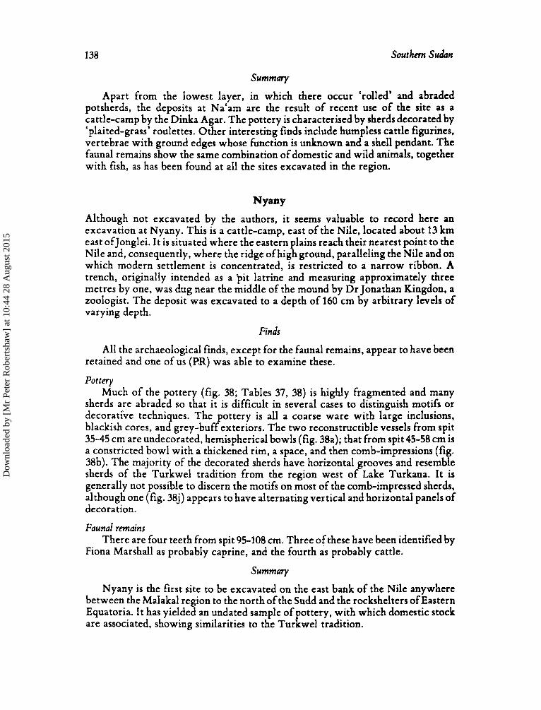
138 Southern Sudan
Summary
Apart from the lowest layer, in which there occur 'rolled' and abraded potsherds, the deposits at Na'am are the result of recent use of the site as a cattle-camp by the Dinka Agar. The pottery is characterised by sherds decorated by 'plaited-grass' roulettes. Other interesting finds include humpless cattle figurines, vertebrae with ground edges whose function is unknown and a shell pendant. The faunal remains show the same combination of domestic and wild animals, together with fish, as has been found at all the sites excavated in the region.
NYmY Although not excavated by the authors, it seems valuable to record here an excavation at Nyany. This is a cattle-camp, east of the Nile, located about 13 km east ofJonglei. I t is situated where the eastern plains reach their nearest point to the Nile and, consequently, where the ridge ofhigh ground, paralleling the Nile and on which modern settlement is concentrated, is restricted to a narrow ribbon. A trench, originally intended as a pit latrine and measuring approximately three metres by one, was dug near the middle of the mound by Dr Jonathan Kingdon, a zoologist. The deposit was excavated to a depth of 160 cm by arbitrary levels of varying depth.
Finds
All the archaeological finds, except for the faunal remains, appear to have been retained and one of us (PR) was able to examine these.
Pottery Much of the pottery (fig. 38; Tables 37, 38) is highly fragmented and many
sherds are abraded so that it is difficult in several cases to distinguish motifs or decorative techniques. The pottery is all a coarse ware with large inclusions, blackish cores, and grey-buff exteriors. The two reconstructible vessels from spit 35-45 cm are undecorated, hemispherical bowls (fig. 38a); that from spit 45-58 cm is a constricted bowl with a thickened rim, a space, and then comb-impressions (fig. 38b). The majority of the decorated sherds have horizontal grooves and resemble sherds of the Turkwel tradition from the region west of Lake Turkana. It is generally not possible to discern the motifs on most of the comb-impressed sherds, although one (fig. 38J) appears to have alternating vertical and horizontal panels of decoration.
Faunal remains
Fiona Marshall as probably caprine, and the fourth as probably cattle. There are four teeth from spit 95-108 cm. Three of these have been identified by
Summary
Nyany is the first site to be excavated on the east bank of the Nile anywhere between the Malakal region to the north of the Sudd and the rockshelters of Eastern Equatoria. I t has yielded an undated sample of pottery, with which domestic stock are associated, showing similarities to the Turkwel tradition.
Dow
nloa
ded
by [
Mr
Pete
r R
ober
tsha
w]
at 1
0:44
28
Aug
ust 2
015
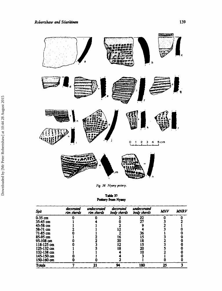
Robcrtshaw and Siiaridinm 139
I
0 1 2 3 4 5 c m M
Fig. 38 Nymy portcry.
0-35 cm 3545 cm 45-58 cm 58-71 cm 71-85 cm 85-95 cm 95108 all 118425 cm 125-132 cm 132-138 145150 cm 150-160 all
0 0 2 22 1 4 0 27 1 1 2 9 2 1 12 4 0 1 2 36 1 2 16 15 0 2 20 18 0 3 12 15 1 5 18 20 1 1 4 10 0 1 4 3 0 0 2 1
0 0 3 2 2 1 3 0 1 0 3 0 2 0 3 0 5 0 2 0 1 0 0 0
Totrls 7 21 91 180 25 3
Dow
nloa
ded
by [
Mr
Pete
r R
ober
tsha
w]
at 1
0:44
28
Aug
ust 2
015
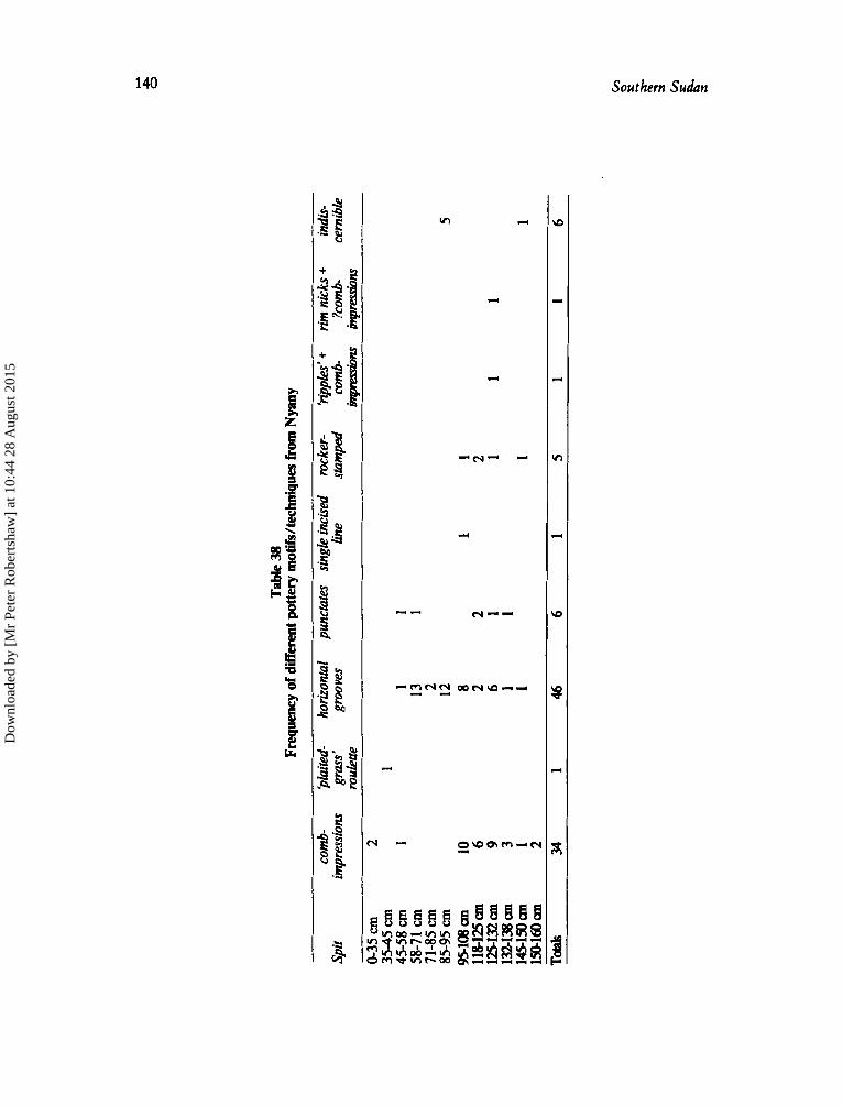
140
v)
d
d
3
Southern Sudan
Dow
nloa
ded
by [
Mr
Pete
r R
ober
tsha
w]
at 1
0:44
28
Aug
ust 2
015
Robertshaw and Siiriainen 141
Discussion
Dating and the pottery sequence
Although pre-‘modern’ radiocarbon dates are available only for Bekjiu, we may, using stratigraphic evidence, establish pottery sequences for Lakes Province. Initially we shall consider the sequences in the west, represented by Bekjiu, Kat, Na’am, and those to the east, from Jokpel and Ngeni A and B, separately. Comparisons with other sites excavated in the South‘ern Sudan and elsewhere, together with the ensuing discussion, is presented in a later section of this report.
In the west the beginning of the sequence is represented by the material found in layer5 at Kat and in part of layer 4 of trench 11 at Bekjiu. The pottery is generally decorated by comb-impressions, often featuring a rocker-stamped zigzag motif. A finely burnished, red-slipped ware is also found. This phase appears to be earlier than the appearance of iron-working in the region. Cattle, together with a range of wild game and fish, are associated. No radiocarbon dates are available. However, dates for the succeeding phase at Bekjiu indicate a terminus ante quem of about AD 500. Since the high lake levels recorded for the mid-Holocene suggest that the site of Kat would have been inundated for much of this period, occupation is unlikely to have commenced more than 4000 years ago. Thus a date in the last two millennia BC is indicated for the first settlement of Kat and Bekjiu. It may be noted that cattle seem to have been present further south at Jebel Tukyi late in the first millennium BC (David et a!, 1981).
The succeeding phase is represented at Bekjiu in trench I , layers 5-11, and trench 11, layer 3. The pottery, which is not related to that of the preceding phase, is characterised by vessels, often constricted bowls, with woven-mat impressions covering most of the exterior surface. The most common pattern of weaving represented on the Bekjiu sherds matches that of a mat, dating to the eleventh or twelfth century, found with the ‘Ma‘den Ij2fen’ derelict caravan in Mauretania (Monod, 1969, see fig. 57D). (We thank Robert Soper for this gem of information.) The first evidence for iron-working occurs in this phase, which dates to the second half of the first millennium AD. Faunal remains comprise cattle, sheep and goats, fish and a broad range of wild animals. A burial with an extended skeleton of an adult male, oriented west-east, lying in its right side with the face looking south, was discovered in trench I.
Pottery with woven-mat impressions is characteristic too of the succeeding phase, which is represented at Bekjiu by the deposits of trench I , layers 3-4, and trench 11, layers 1-2. However, there now appear the first traces of pole-and-daga structures. Although perhaps explicable simply to sampling error, a change in within-site spatial arrangements and/or in the type of structures built at Bekjiu may be indicated. The same shift, which is dated a t Bekjiu to around the late first millennium AD, also seems to be documented at Jokpel. Numerous mollusc-shell beads were discovered in a small pit in trench II. Vessels decorated by oblique or near vertical scoring represent an addition to the potters’ repertoire. The faunal remains show the same combination of wild and domestic animals as the preceding phase.
Dow
nloa
ded
by [
Mr
Pete
r R
ober
tsha
w]
at 1
0:44
28
Aug
ust 2
015
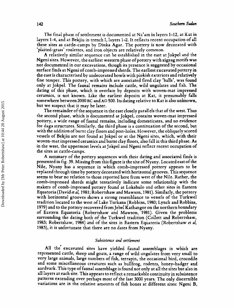
1 42 Southern Sudan
The final phase of settlement is documented a t Na‘am in layers 1-12, a t Kat in layers 1-4, and at Bekjiu in trench I, layers 1-2. It reflects recent occupation of all these sites as cattle-camps by Dinka Agar. The pottery is now decorated with ‘plaited-grass’ roulettes, and iron objects are relatively common.
A relatively similar sequence can be established in the east a t Jokpel and the Ngeni sites. However, the earliest western phase of pottery with zigzag motifs was not documented in our excavations, though its presence is suggested by occasional surface finds at Ngeni of comb-impressed sherds. The earliest excavated pottery in the east is characterised by undecorated bowls with pinkish exteriors and relatively fine temper. This pottery, with which are associated fired clay ‘balls’, was found only at Jokpel. The faunal remains include cattle, wild ungulates and fish. The dating of this phase, which is overlain by deposits with woven-mat impressed ceramics, is not known. Like the earliest deposits at Kat, it presumably falls somewhere between 2000BC and AD 500. Its dating relative to Kat is also unknown, but we suspect that it may be later.
The remainder of the sequence in the east closely parallels that of the west. Thus the second phase, which is documented at Jokpel, contains woven-mat impressed pottery, a wide range of faunal remains, including domesticates, and no evidence for daga structures. Similarly, the third phase is a continuation of the second, but with the addition of burnt clay floors and post-holes. However, the obliquely scored vessels of Bekjiu are not found at Jokpel or at the Ngeni sites, which, with their woven-mat impressed ceramics and burnt clay floors, also fall in this third phase. As in the west, the uppermost levels at Jokpel and Ngeni reflect recent occupation of the sites as cattle-camps.
A summary of the pottery sequences with their dating and associated finds is presented in fig. 39. Missing from this figure is the site of Nyany. Located east of the Nile, Nyany has a sequence in which comb-impressed pottery appears to be replaced through time by pottery decorated with horizontal grooves. This sequence seems to bear no relation to those reported here from west of the Nile. Rather, the comb-impressed sherds might tentatively indicate some relationship with the makers of comb-impressed pottery found at Lokabulo and other sites in Eastern Equatoria (David et al, 1981; Robertshaw and Mawson, 1981). Similarly, the pottery with horizontal grooves shows a strong resemblance to vessels of the Turkwel tradition located to the west of Lake Turkana (Robbins, 1980; Lynch and Robbins, 1979) and to the pottery recovered from Jebel Kathangor on the northern boundary of Eastern Equatoria (Robertshaw and Mawson, 1981). Given the problems surrounding the dating both of the Turkwel tradition (Collett and Robertshaw, 1983; Robertshaw, 1984) and of the sites in Eastern Equatoria (Robertshaw et al, 1983), it is unfortunate that there are no dates from Nyany.
Subsistence and settlement
All the‘ excavated sites have yielded faunal assemblages in which are represented cattle, sheep and goats, a range of wild ungulates from very small to very large animals, large numbers of fish, terrapin, the occasional bird, crocodile and some miscellaneous creatures such as bullfrog, rodents, honey-badger and aardvark. This type of faunal assemblage is found not only at all the sites but also in all layers at each site. This appears to reflect a remarkable continuity in subsistence patterns extending over perhaps most of the last 3000 years. The only discernible variations are in the relative amounts of fish bones a t different sites: Ngeni B,
Dow
nloa
ded
by [
Mr
Pete
r R
ober
tsha
w]
at 1
0:44
28
Aug
ust 2
015
I i
1 I I
I I W
EST
I
EA
ST
I
Dat
e I Be
kjiu
Ka
t N
abrn
I
Jokp
el N
gmi A
+ B
I Po
ttery
0
th
I
I I
1-12
I
Phas
e IV
roul
ette
d, D
inka
ca
t tle-
cam
ps
‘Mod
em’
; tr,
I, 1
-2
I 1-
4
I I A
D15
00
I I H
IAT
US
I I I
AD
lOO
O
I I tr
. I,
3-4,
I
trII
, 1-
2
I I tr.
1, 5
-11,
I
trII
, 3
I I I I I
AD
500
I I
‘0’
I I I 500
BC
I t
rII,4
5
I (?
date
s)
I I I I I I IN
O
CC
UPA
TIO
N?
I i I Ph
ase
111
Nge
ni A
+B
I I (?
date
)
I 13
? I Ph
ase
I1 I 1 I I
Phas
e I
1 1 1 1 I I I
(?da
te)
I 1 1 I I I I I wov
en-m
at i
mpr
essi
ons,
po
le-a
nd-d
aga
stru
ctur
es
I plu
s ve
rtic
al s
cori
ng in
wes
t
I w
oven
-mat
im
pres
sion
s fi
rst i
ron-
wor
king
?
I I I 1 I I I I I 1 unde
cora
ted
bow
ls
I I I I 1 I com
b-im
pres
sion
s, z
igza
g ca
ttle
I m
otif
I
Fk. 3
9 Tm
tativ
e cu
ltum
-hist
oric,
d cm
rwr f
ir h
ka
Prov
ince
.
Dow
nloa
ded
by [
Mr
Pete
r R
ober
tsha
w]
at 1
0:44
28
Aug
ust 2
015
144 Southern Sudan
Bekjiu, and Na'am yielded great quantities, while Kat possessed very few fish, with Jokpel and Ngeni A falling somewhere between the two extremes.
No direct evidence, in the form of seeds, was found of domestic crops, except for pearl millet seeds in the recent layers at Kat. However, the presence on all the sites of fragments of rubbers and querns is at least suggestive of agriculture. Certainly, fruits were gathered in season, as the discovery of Zizyphus spina-cristi seeds in several sites attests.
Given the apparent continuity in subsistence practices in Lakes Province through much of the prehistoric and historic period, it seems worthwhile to record here some information on current Agar subsistence and settlement patterns in the Rumbek district. Much of what follows is drawn from the results of a farm management survey carried out by Alex Duncan in 1978 for the Project Development Unit of the Southern Sudan Regional Ministry of Agriculture. The Agar grow a variety of crops, of which the most important are sorghum, groundnuts and cowpeas. I t is estimated that 87 percent of total calories and 76 percent of protein by weight are provided by crop production, compared with 13 percent of calories and 24 percent of protein derived from livestock produce. (Fish seem to be excluded from these figures.) However, it is noted that livestock are indispensable in bad years when crop failure occurs. Crops are grown on the well-drained soils of the ironstone; soil fertility is maintained by shifting cultivation, the burning of vegetation in the fields, and occasionally by the use of animal wastes. Relatively sturdy and permanent homesteads are located among the fields where most labour is needed. Thus 83 percent of all available labour is estimated to be employed in agricultural activities compared with only 17 percent in livestock husbandry.
Because of the presence of tsetse fly and trypsanomiasis on the ironstone, cattle are kept on the toich away from the homesteads; however, some small stock are usually present at the homesteads. While Duncan reports that the average distance between homesteads and the wet-season grazing areas is 20 km, our observations suggest that around Bekjiu an average distance of perhaps 13 km separates the wet-season cattle-camps from the homesteads. In the dry season when water is scarce both on the ironstone and on the toich, the cattle are moved, often a considerable distance, to camps located along the Na'am River and other bodies of permanent water, including Lake Nyubor to the north-east. However, the cattle are usually in their worst physical condition late in the wet season when the quantity of available grazing is severely restricted by flooding and tsetse fly, and its quality is poor as it is fibrous and low in protein.
Fishing is practised mainly during the dry season in the rivers and lakes near the cattle-camps; Ryle (1982) presents a finely illustrated account of a fishing festival held each dry season at Lake Akeu on the Na'am River. Fishing is done by means of spears and small nets wielded by individuals. Some of the fish is consumed immediately while the rest is dried, part of the latter being sold to traders. Given this information, it is tempting to suggest that the excavated sites in which there are large quantities of fish remains, 'that is Na'am, Ngeni B and Bekjiu, may have been occupied during the dry season, while Kat, with relatively few fish, may have been a wet-season settlement. Some confirmation of this is provided by local information that Na'am is used nowadays as a dry-season cattle-camp, while Kat is a wet-season camp. Neither Duncan nor Ryle consider what species of fish are caught, though Ryle (1982, p. 44) mentions catfish in passing. Catfish is the most common of the
,
Dow
nloa
ded
by [
Mr
Pete
r R
ober
tsha
w]
at 1
0:44
28
Aug
ust 2
015
Robertshaw and Siiriainen 145
species represented in the excavated faunal assemblages. All the fish remains found in the sites belong to species which can survive in shallow water; the large Nile perch (Lates nibticus) is not represented. This fish can survive only in a considerable volume of permanent and well-oxygenated water (Beadle, 1974, p. 125); thus it is unlikely to have occurred in the pools and small channels which were the probable fishing grounds near the excavated sites.
Hunting is not mentioned by Duncan, and Ryle (1982, p. 90) remarks that the Dinka seem to be poor hunters (see also Seligman and Seligman, 1932, p. 32). However, Bloss (1939) describes a Dinka game trap from the Rumbek area. During our fieldwork we occasionally saw Dinka with chunks of game meat, and when out in the toich with us they would often set fire to the bush in expectation of game which they might spear (cf. Jackson, 1923, p. 139).
Burton (1981), on the basis of an analysis of myth, symbolism and vocabulary, has suggested that ‘a mixed riverine-horticultural adaptation preceded cattle- raising’ among the Atuot, Nuer and Dinka, and that these three people were not separate until they had cattle. This scenario is ofvalue in attempting to explain the symbolic importance of the fishing spear and of the war spear. However, the argument is not supported by the historical linguistic work of Ehret (1982; p. 28). Moreover our own work shows that cattle were present in the region throughout the period for which we have archaeological evidence; however we do not know if our archaeological sites were occupied only after the Dinka-Nuer split, nor indeed if they were occupied by Dinka or Nuer; these problems we shall return to later. One indication that these Nilotic-speaking peoples may never have relied too heavily on dairy products is that a high percentage of their populations are lactose malabsorbers (Bayoumi et al, 1982). Thus, in one sense Burton’s (1981) contention that the pastoral fascination of the Nuer and Dinka has been over-emphasised in some ethnographic accounts to the obfuscation ofother important themes is timely. While cattle may have a long history in the toich regions, the importance of livestock products for subsistence may have been relatively minor, except perhaps in years of crop failure.
Although the faunal remains from our sites apparently indicate a stable pattern of subsistence throughout the period for which we have archaeological evidence, other lines of evidence suggest that changes in settlement patterns may have occurred. Firstly, the excavations at both Bekjiu and Jokpei suggest a sequence of settlement in which these sites were originally cattle-camps (an identification made on the basis of the similarities with the deposits from modern cattle-camps). Then, sometime in the late first millennium AD, more permanent structures were erected, while in recent times they again reverted to cattle-camps. Whether these changes are to be explained as sampling errors, or as minor variations in spatial patterning within the settlements, or again as more comprehensive changes in the settlement system, is a problem to be answered by further fieldwork. Secondly, the great majority of the deposits at Bekjiu, and probably at Jokpel and Ngeni too, accumulated during the second half of the first millennium AD; we excavated no deposits which appear to date to the first half of the present millennium, though there is abundant archaeological evidence for the very recent period. Therefore, whilst the possibility of sampling errors can again not be discounted, there is a suggestion of a hiatus or thinning in settlement in the region between perhaps very roughly AD 1000 and AD 1800.
Dow
nloa
ded
by [
Mr
Pete
r R
ober
tsha
w]
at 1
0:44
28
Aug
ust 2
015
146 Southern Sudan
Archaeological comparisons
Since systematic archaeological research is a very recent phenomenon in the Southern Sudan, there are few excavated sites with which to compare our data from Lakes Province. The most important of these sites is Dhang Rial, a mound located in the toich some 150 km NNE of Wau, in an area now inhabited by the Dinka Tuich (see fig. 1). David et a1 (1981) recognised three phases in the occupation of Dhang Rial. The earliest, Phase A, is undated; it contains pots with comb- impressed decoration, mostly applied by rocker-stamping, just below the rim, which often has a band of red slip or wash. There are no associated faunal remains or figurines. Phase B, which dates approximately from the eighth to the thirteenth century AD contains pots decorated in broad bands below and sometimes on the rim by the application of a twisted-cord roulette; there are also a few sherds of a fine, thin red ware with red-slipped and burnished exteriors. Associated artefacts include iron jewellery, humpless cattle figurines, mollusc shell beads and sherds with ground grooves. The faunal remains include cattle, wild ungulates and fish, and there are several burials. Phase C pottery is like that ofphase B, although more vessels appear to be decorated. The cattle figurines are now humped, but mollusc shell beads are no longer found. The faunal assemblage resembles that of Phase B.
There are some striking similarities between parts of the Dhang Rial sequence and that established by our excavations at Bekjiu and neighbouring sites. The comb-impressed pottery from Phase A at Dhang Rial resembles that from layer 5 at Kat, particularly in the emphasis on rocker-stamping. However, the absence of dates from both sites, and of faunal remains from Dhang Rial, together with the fact that the sherds are highly fragmented, precludes any more detailed comparisons.
Phase B at Dhang Rial and the layers with woven-mat impressed pottery at Bekjiu, and resumably also at Jokpel and Ngeni, date, at least in part, to the second
Dhang Rial and Bekjiu differ, the degree of fragmentation of the sherds, particularly at the former site, does not allow any detailed comparisons of vessel forms and decoration layouts. However, it can be noted that constricted bowls are common at both sites, though only Dhang Rial seems to have short-necked jars.
W-hile the'de ree of similarity between the ceramic assemblages of Dhang Rial and Bekjiu may % e unclear, other traits indicate close cultural connections. There are several burials at Dhang Rial: usually the extended skeletons are oriented west- east, with the heads to the west, and lying on their right sides; the skeletons belong to a population of lean build with heights around 180 cm; no dental evulsion was practised. Exactly the same pattern was found in the Bek'iu burial: an extended
right side with head to the west. The pattern is found again, further north, at Debbat Bangdit located near the White Nile south of Er Renk. From this site Kleppe (1983) reports an infant burial, on this occasion covered by a 10-cm thick layer of potsherds, oriented west-east, with the skull towards the west and facing southwards, that ii lying on the right side. This site is dated to around the middle to late first millennium AD (Kleppe, pers.comm.). There are several other burials under potsherd cappings at this site and at another close by, but details are not yet available. Thus, there is evidence, from three widely separated areas of the savanna grasslandsof the Southern Sudan, dating to the second half of the first millennium AD, of a lean and tall population which did not practise dental evulsion and which buried their dead in a particular manner. I t may be worth noting the contrast with
half of the F irst millennium AD. Though the techniques of pottery decoration at
skeleton of lean build, height about 180 cm, with no denta r' evulsion, lying on the
Dow
nloa
ded
by [
Mr
Pete
r R
ober
tsha
w]
at 1
0:44
28
Aug
ust 2
015
Robertshaw and Siiriainen 147
the modern Dinka who, are described as burying their dead in oval holes with the body on its right side, knees flexed, and head facing to the west (Lienhardt 1961, p. 289; Seligman and Seligman, 1932, p. 201; see also Evans-Pritchard, 1956, p. 145 fot details of very similar Nuer burials).
Further similarities between Dhang Rial Phase B andBekjiu are the presence in both of mollusc shell beads and occasional iron artefacts or slag. The same faunal assemblage composition also occurs, in which the bones of domestic animals are combined with those of a wide range.of wild ungulates, as well as fish. Finally, the shift from Phase B to Phase C a t Dhang Rial is marked interalia by the disappearance of mollusc shell beads and by a change in site structure. Prior to thebmain burial complex at the end of Phase B the deposits from the centre of the site are attributable to living floors and the collapse of structures; in Phase C no habitation seems to have occurred in the centre of the site. A similar change is documented at Bekjiu and Jokpel a t the end of the occupation by the makers of the woven-mat impressed pottery, although, as mentioned earlier, there may then have been a considerable hiatus in settlement at these sites.
Leaving Dhang Rial for a moment and turning our attention southwards, we may note that the same pattern of faunal remains encountered in the sites in Lakes Province and a t Dhang Rial appears to occur again at Jebel Tukyi, a rockshelter situated in dense savanna woodland (see fig. 1). Two ottery traditions are represented a t this site (David et al, 1981): the earlier is c K aracterised by comb- impressions covering the whole of the exterior of the vessel. it is associated with cattle remains, and there is a bone collagen date of late in the first millennium BC. There are no obvious parallels between this pottery and that from our own excavations, except ossibly with that of Kat layer 5. The later pottery tradition at Jebel Tukyi, for w 1 ich there is a date around the fourteenth century AD, is characterised by pottery decorated by what David et al describe as plaited-fibre rouletting. However, examination of both the illustrations and the sherds themselves convinces us that the majority of the vessels are constricted bowls decorated by all-over woven-mat impressions. They are, therefbre, of the same type as many of the pots from Bekjiu, Jokpel and N eni (compare for example fig.18c with David et al, 1981, fig. 13a, P1. I11 % ). Pottery decorated by woven-mat impressions and with similar vessel forms is still made by the Central Sudanic-speaking Moru who live in the vicinity of Jebel Tukyi and by the Jur peoples who inhabit the woodland around Mvolo on the southern edge of Lakes Province.
Boldly and broadly interpreting the evidence presented in this section, we may sug est that during the second half of the first millennium AD a single cultural tra ! ition, probably with regional variations in ceramic styles and decorative techniques, existed throughout a large area of the savanna grasslands surrounding the Sudd. These people kept cattle, sheep and goats, fished in rivers and pools, hunted a wide variety of game, and probably cultivated sorghum and other crops. In Lakes Province this cultural tradition disappears from the archaeological record probably early in the present millennium, to be replaced in recent times by that of the Dinka Agar and Atuot. However, the occurrence of woven-mat impressed pottery, dating to the last few centuries, in the woodlands to the south suggests perhaps that the inhabitants of Bekjiu, Jokpel and Ngeni retreated in this direction from the savanna grasslands. In the north-west, at Dhang Rial, the continuity in pottery styles from Phase B to Phase C and on to modern Dinka Tuich suggests not population replacement but a gradual cultural transformation, resulting from the
Dow
nloa
ded
by [
Mr
Pete
r R
ober
tsha
w]
at 1
0:44
28
Aug
ust 2
015
148 Southern Sudan
spread of humped cattle and associated traits, and leading to the development of what David et a1 (1981, p. 49) have called a Nilotic and ultimately Dinka social identity .
Oral information relevant to the sites
Several of the mound sites in the Rumbek area possess names which Dinka Agar informants insist are non-Dinka words; Bekjiu is one of them. These names are attributed to the ‘Jur’, a term which must be handled with care. In this part of the Sudan there are not only Western Nilotic speaking Jur-Luo, but also Central Sudanic-speaking Jur-beli people, the latter located in the woodland south of the Agar. However, the situation is more confused by the fact that Dinka use the term ‘Jur’ to refer to any stranger who does not speak Dinka. Therefore references in Agar oral traditions to ‘Jur’ simply mean that the people in question were notliefig (Dinka). Various Agar informants told us that when they settled in the Rumbek region they encountered ‘Jur’ from whom they learnt iron-working, the making of pottery, and, according to one elder, agriculture. The Agar traditions indicate that they (the Agar) followed the Nile southwards until they reached the vicinity of Shambe, where, preceded by the Tuich, they turned westwards (Coote, in preparation).
Several passers-by observing our excavations a t Bekjiu informed us that, although the site had been occupied in the recent past by Dinka, earlier inhabitants of the site at different times were ‘Jur’ and ‘Gell . ‘Gell’ is a name which does not seem to appear in any of the ethno-historical literature.
A tradition concerning unnamed archaeological sites, located probably in the Rumbek area, is recorded by Lienhardt (1961, p. 187). TheTwij (Dinka) took many Cic (Dinka) cattle after a fight, and left Cic country, which is located around Shambe; ‘they then met a people who built mounds, called the Ber Ajou, and stole their cattle, and went on until they reached the country near Meshra-el-Req’. While remarking that the Ber are the Murle, Lienhardt (1961, p. 187 fn. 1) cannot identify the Ber Ajou, although Southall (1976, fn. 17) suspects them of also being Murle.
A further tradition recorded by Lienhardt (1961, p. 177) mentions a red-skinned people called Luel being chased out of the country ofthe Cic Dinka. Similarly, the Luel (Lwel) were reported to David et a1 (1981, p. 32) as the mound-builders of Dhang Rial and neighbouring sites; they were cattle-herders with knowledge of iron, who were in part expelled and in part assimilated by immigrant Dinka. Lienhardt (1961, p. 177, fn. 2) suspects the Lwel of being Lwo-speakers. Furthermore, Crazzolara (1950) identifies the Rumbek region as the cradleland of the Lwo, whence they began to spread southwards around the thirteenth or fourteenth century AD (Cohen, 1973).
Who, then, are the Gell, the Ber Ajou, and the Luel? And how do they relatc to the Lwo and the Dinka? While nothing appears to be known of the Gell, a corpus of information on the Luel and the Beer (Ber Ajou) has been assembled by Fr Santandrea (1981). According to Santandrea, the Luel formerly occupied almost the entire Bahr el Ghazal region including what is now Lakes Province. They lived on artificial mounds, one of which, located a t Nyamlel on the savanna grasslands far to the north-west, was excavated by Santandrea. No details are given of the excavation, though the stratigraphy of the excavation of a well a t Abyei, from which potsherds were recovered, is outlined (Santandrea, 1981, p. 157). The Luel
Dow
nloa
ded
by [
Mr
Pete
r R
ober
tsha
w]
at 1
0:44
28
Aug
ust 2
015
Robertshaw and Siiriiiinen 149
are said to have kept cattle, been expert iron-workers, and to have made pottery much superior to that of the Dinka and Lwo. Traditions record that they came originally from the north, whither those who were not assimilated by the Dinka later retreated, although a decline in population may have set in well before the arrival of the Dinka (Santandrea, 1981, p. 154). The Beer, Santandrea (1981; pp. 159-162) believes, were a separate people, on friendly terms with Luel; they occupied most of the region prior to the appearance of the Luel and the Lwo.
Ehret (1982, p. 27), on lexicostatistical evidence, believes that the Jii sub-branch of the Western Nilotic group of languages broke up into proto-Dinka-Nuer and pre-Lwo societies by early in the first millennium BC. The separation of the former into Nuer and Dinka is considered by McLaughlin (1967) to have begun around ‘AD 85’. Thus, our archaeological evidence from the first millennium AD would seem to post-date this process of fission.
The approximate contemporaneity ofthe end of the occupation ofBekjiu by the makers of woven-mat impressed pottery and the beginning of the Lwo migrations as estimated from oral traditions (Cohen, 1973) does perhaps suggest that our excavations at Jokpel, Bekjiu and Ngeni may be documenting at least some aspects of pre-Lwo society (to use Ehret’s term). If these Lwo are the ‘Jur’ of Bekjiu then possibly the Gell are to be identified as Dinka speakers; the use of a name other than ‘Jur’ for the early inhabitants of Bekjiu causes us to suspect that Agar informants considered the Gell perhaps to be Jierzg (Dinka).
There remain the complexities inspired by the burials at Dhang Rial and Bekjiu. The nature of the grave and orientation of the body in these burials are similar to those recorded in the ethnographies of the Dinka and Nuer, except that in the ethnographic accounts the body is contracted. By contrast, the Central Sudanic and Western Bari-speaking peoples south of Lakes Province dig graves with recesses to prevent soil falling on the body; the skeleton has the knees drawn up, and men often face west while women face east. Therefore, on this evidence a correlation between the excavated burials and Dinka-speakers seems plausible. However, all of the excavated skeletons had their incisors present, whereas all the ethnographies are unanimous in stating that all the Sudanic and Nilotic peoples west of the Nile practise dental evulsion. Since the practice of dental evulsion appears to be widespread through Eastern Africa probably well prior to the first millenium AD, we are for the moment at a loss to explain its absence a t Dhang Rial and Bekjiu. The possibility that the burials are not those ofNilotes or Central Sudanic speakers does of course exist.
Acknowledgements
W e thank the other members ofthe 1981 British Institute expedition for their efforts, namely Amum Tor (representing the Sudan Antiquities Service), Bernard Mbae (archaeological assistant), Torben Andersen (linguist), Jeremy Coote (historian), Andrew Mawson (ethno-archaeologist) and Thaddayo Owuora (mechanic). Jeanne Sept joined us for the final few weeks to study the vegetation around the sites and to operate an expert sieve. Numerous officials of the Regional Ministry of Culture and Information gave enormous assistance, in particular Messrs. Lawrence Modi and Severiano Matti (Juba), and Andrea Mabor Biar and Jacob Mayak (Rumbek). Cut Dhuol smoothed our passage around Bekjiu. Russ Noble, Wayne Teel, Andy and Chris in Rumbek and Mark and Lanie Todd in Juba gave support and nursed the sick. John Ryle first told us of the mounds near Rumbek.
Bernard Mbae identified the faunal remains with help from Fiona Marshall and John K. Mengich. Martin Pickford identified shells, Robert Soper gave advice on the pottery, David Burney conducted palynological analyses, Lynne Schepartz examined the skeleton from Bekjiu and Wilma
Dow
nloa
ded
by [
Mr
Pete
r R
ober
tsha
w]
at 1
0:44
28
Aug
ust 2
015
150 Southern Sudan
Wetterstrom studied the botanical remains. Jonathan Kingdon allowed us to study and draw the pottery from Nyany. The University Museum of Archaeolo and Anthropology at Cambridge permitted inspection of the pottery from Dhang Rial and Je r el Tukyi.
REFERENCES
Bayoumi. R.A.L.. S.D. Flatz, W. Kiihnau and G. Flatr
Beadle, L.C. Bloss, J.F.E. Brunkcn, J.. J.M.J. De W e t and
J.R. Harlan Burton, J .W.
Cohen. I1.W
Collctt, D.P. and P.T. Robertshaw
Crazzolara, J.P.
David, N.. P. Harvey and
Ehret. C. C.J. Goudie
Evans-Pritchard, E.E. Jackson, H.C.
Kleppe, E.J.
Lienhardt, G. f
Lynch, B.M. and L.H. Robbins
McLaughlin. J.
Monod, T.
Phillipson, D.
Robertshaw, P.
Robertshaw, P.. D. Collett, D. Gifford and N.B. Mbac
1982
1974 1939 1977
1981
1973
19Ho
1983
1950
1981
1982
1956 1923
1983
1961
1979
1967
1969
1981
1984
1983
Robertshaw, P. and A. Mawson1981
Robbins, L. 1980
Ryle, J . Santmdrea, S.
1982 1981
‘Beja and Nilotes: nomadic pastoralist groups in the Sudan with opposite distributions of the adult lactosc phenotypes’, .4merican Journal 1f Physical .4rrthropo/ri,qy 58, 173-8. ?’he inlaud waters of tropical .41rira, London: Longman. ‘A Dinka game trap’, B r h n Sores and Records 22, 163. ‘The morphology and domestication of pearl millet’, Econorriic Botany 31, 163-74. ‘The wave in my mother’s husband: a iscatorial theme in pastoral Nilotic ethnology’, Cahicrs d Etudes .4fricaines 21 (no. 84). 459-77. ‘The River-Lake Njlotes from the fifteenth to the nineteenth century’, in B.A. Ogot (ed.), Eanmni: a survey ?(’East .4fricarr history (re;. ed). Nairobi: EAPH, Longman, pp. 142-57. ‘Early Iron Age and Kansyore pottery: finds from Gogo Falls, South Nyanza’, .Jzania 15, 133-45. ‘Problems in the interpretation of radiocarbon dates: the Pastoral Neolithic of East Africa’, .4frican .4rckaeolo,qical Review 1, 57-74. The tirwu; Part I : Lwoo Al<qrations, Museum Combonianum no. 3, Verona: lnstituto Missioni Africane. ‘Excavations in the Southern Sudan 1979’, clzania16.7-54.
‘Population movement and culture contact in the Southern Sudan, c 30(K) tic to AI) 1ooO: a preliminary linguistic overview’, in J. Mack and P. Robertshaw (edk), CultureHistory in the Sourkern Sudan, Nairobi: BIEA. Memoir 8, pp. 19-48. Muer n/<qion, Oxford: Clarendon Press. ‘The Nuer of the Upper Nile Province’, Sudarr N o t e s nnd Records 6, 59-107. ‘Towards a prehistory of the riverain Nilotic Sudan: archaeol- ogical excavations in the Er Renk District’, .\ithian Letters 1,
Divinity and e.uperience: the religion of the Dinka, Oxford: Clarendon Press. ‘Cushitic and Nilotic prehstory: new archaeologd evidence from northwest Kenya’,Journal ‘!(‘.4friran History 20.319-28. ‘Tentative time depths for Nuer, Dinka, and Anuak’,J‘iunu/ .of Ethiopian Studies 5 , 13-27. ‘Le “Ma’den IjZen”: une ;pave caravaniire ancienne dans la Mapbat Al-Koubr?, in .4cta hi Pnwkr C~ol l~~que Intmarional d’.4 rc!itG/o,qie .4fricainr, Fort-Lamy, pp. 286-320. ‘A preliminary archaeological reconnaissance of the Southern Sudan, 1977-8’. .42arlia 16, 1-6. ‘Archaeology in Eastern Africa: recent developments and more dates’, J~iitrtial I$ .4fican History 25 (4). 369-93. ‘Shell middens on the shores of Lake Victoria’, .4zania 18, 1-43. ‘Excavations in Eastern Equatoria, Southern Sudan 1980’. .4zania 16. 55-95. Loipy: a Late Stone .4,qeJshing andpastoralist settlement in the Lake I’urkana Basiri, Ketrya, Publications of the Museum, Michigan State University, Anthropological Series 3 (11, 1-14. Il’arriors I!(‘ the Iilrite .Vile: the Dinka, Amsterdam: Time-Life. litlmti-,qei~,qrapky the Hahr el (2razal (Sudan), Museum Combonianum no. 37, Bologna: Editrice Missionaria Itahana.
P
14-20.
Dow
nloa
ded
by [
Mr
Pete
r R
ober
tsha
w]
at 1
0:44
28
Aug
ust 2
015
Robntshaw and Siiridincn 151
S c l i p a n C.G. and B.Z. Southall, A.
SNiver, M.
Whiteman, A.J.
1932 1976
1982
1971
P q m tribes qf rite Niloric Sudan, London: Routledge. ‘Nuer and Dinka are people: ecology, ethnicity and logical possibility’. Man (N.S.) 11, 463-91. A high-precision calibration of the AD radiocarbon time
scale’, Radiocarbon 24 (1). 1-26. ( ;eo/qy o/ die Subn Rephlic, Oxford University Press..
S--V
The results of excavations at several sites east of Rumbek situated on or near the ecotone between seasonally flooded grassland and savanna woodland are reported. The earliest pottery is characterised by comb-impressed decoration often with a zi ag motif. Deposits at Jokpel with
date. Evidence for iron-working is first recorded in association with pottery decorated with woven-mat impressions covering almost all the outer surface of the vessel, and dated to the second half of the first millennium AD. A possible change in settlement patterning occurs during the period when this impressed pottery was in use. There appeas to be a hiatus in settlement between roughly the end of the first millennium AD and the recent past, when several sites were re-occupied as Dinka cattle-camps. Throughout the entire sequence faunal remains include bones of domestic livestock and of a wide range of wild species, as well as plentiful fish bones. Comparisons with sites excavated previously allow the identification of a cultural tradition widespread across the toich regions in the later first millennium AD. The excavation results are considered with reference to the available ethno-historical information. Pottery from a site east of the Nile is linked to the Turkwel tradition of north-western Kenya.
undecorated open and hemispherical bowls, but no evidence o P iron-working, are probably of later
Appendix A
Pottery Analysis Peter Robertshaw
Analysis of the reconstructible vessels recovered from the excavations is based on types, which are defined by the intersection of modes on two dimensions, namely decoration and vessel form (see Collett and Robertshaw, 1980, p. 134). This appendi7 serves to list all the vessel forms, the decorations and the types defined thereby that were recovered in the excavations. For detailed information on provenance the reader is referred to the discussions in the main text of the pottery found at each site. Illustrations are also presented with the site reports. Several woven-mat impressed shcrds arc shown in plates 11-111 to illustrate the range of mat-weaves.
Vessel Forms
I Ia I1 I11 IV V VI VII VIIa VIII IX
Hemispherical bowl. Hemispherical bowl with slightly everted rim. Sub-carinated bowl. Shallow open bowl. Slightly constricted bowl with short everted rim. Globular pot. Constricted bowl. Narrow-mouthed, straight-necked jar (gourd-shaped). Narrow-mouthed, straight-necked jar with everted rim. Jar with everted rim. Not discernible (sherd too small).
Dow
nloa
ded
by [
Mr
Pete
r R
ober
tsha
w]
at 1
0:44
28
Aug
ust 2
015
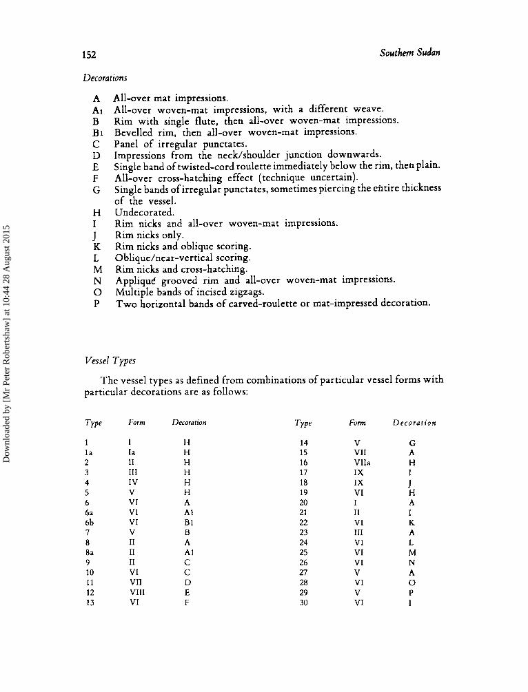
152 Southem Sudan
Decorations
A A1 B Bi C D E F G
H I
K L M N 0 P
J
All-over mat impressions. All-over woven-mat impressions, with a different weave. Rim with single flute, then all-over woven-mat impressions. Bevelled rim, then all-over woven-mat impressions. Panel of irregular punctates. Impressions from the neck/shoulder junction downwards. Single band of twisted-cord roulette immediately below the rim, then plain. All-over cross-hatching effect (technique uncertain). Single bands of irregular punctates, sometimes piercing the ehtire thickness of the vessel. Undecorated. Rim nicks and all-over woven-mat impressions. Rim nicks only. Rim nicks and oblique scoring. Oblique/near-vertical scoring. Rim nicks and cross-hatching. AppliquC grooved rim and all-over woven-mat impressions. Multiple bands of incised zigzags. Two horizontal bands of carved-roulette or mat-impressed decoration.
Vessel Types
The vessel types as defined from combinations of particular vessel forms with particular decorations are as follows:
Type
1 l a 2 3 4 5 6 6a 6b 7 8 8a 9 10 11 12 13
Form
I Ia I1 I11 IV V VI VI VI V I1 I1 I1 VI VII VIII VI
Decoration
H H H H H H A A1 B1 B A A1 C C D E F
Type
14 15 16 17 18 19 20 21 22 23 24 25 26 27 28 29 30
Form
V VII VIIa I X IX VI I I1 VI I11 VI VI VI V VI V VI
D e c o r a t i o n
G A H I
H A I K A L M N A 0 P I
J
Dow
nloa
ded
by [
Mr
Pete
r R
ober
tsha
w]
at 1
0:44
28
Aug
ust 2
015
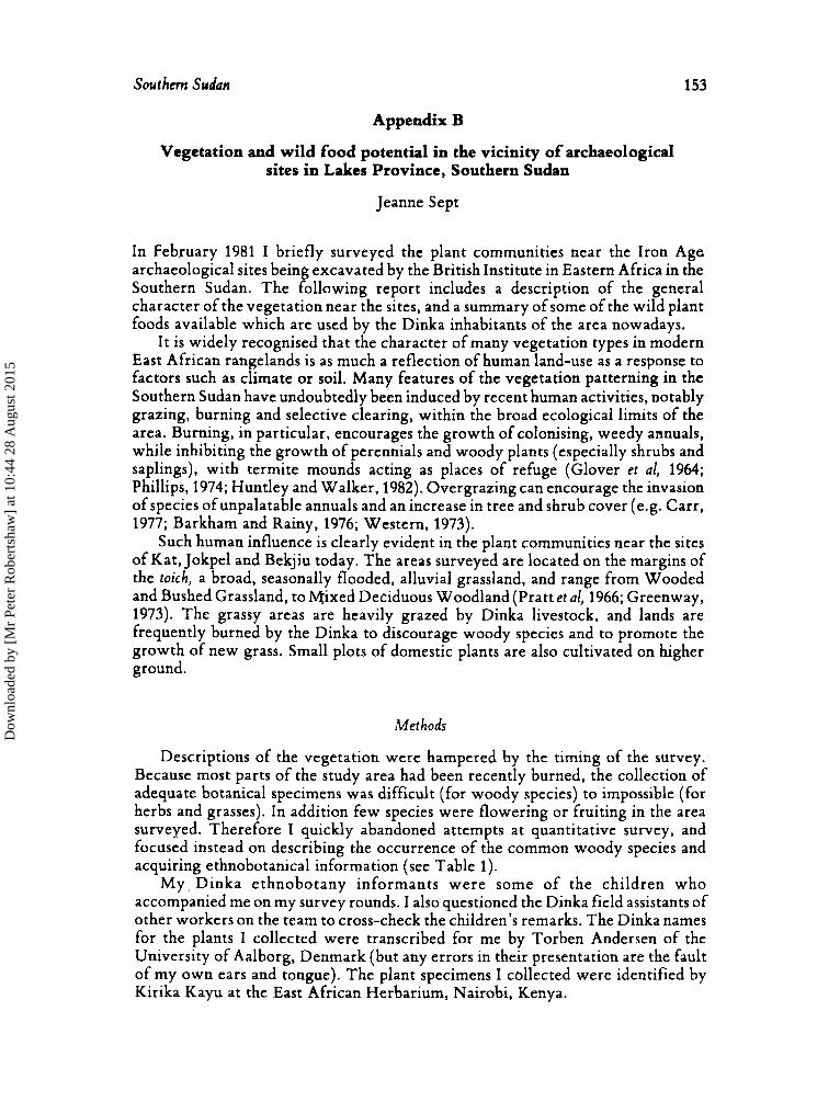
Southm Sudan 153
Appendix B
Vegetation and wild food potential in the vicinity of archaeological sites in Lakes Province, Southern Sudan
Jeanne Sept
In February 1981 I briefly surveyed the plant communities near the Iron Age archaeological sites being excavated by the British Institute in Eastern Africa in the Southern Sudan. The following report includes a description of the general character of the vegetation near the sites, and a summary of some of the wild plant foods available which are used by the Dinka inhabitants of the area nowadays.
I t is widely recognised that the character of many vegetation types in modern East African rangelands is as much a reflection of human land-use as a response to factors such as climate or soil. Many features of the vegetation patterning in the Southern Sudan have undoubtedly been induced by recent human activities, notably grazing, burning and selective clearing, within the broad ecological limits of the area. Burning, in particular, encourages the growth of colonising, weedy annuals, while inhibiting the growth of perennials and woody plants (especially shrubs and saplings), with termite mounds acting as places of refuge (Glover et al, 1964; Phillips, 1974; Huntley and Walker, 1982). Overgrazing can encourage the invasion of species ofunpalatable annuals and an increase in tree and shrub cover (e.g. Carr, 1977; Barkham and Rainy, 1976; Western, 1973).
Such human influence is clearly evident in the plant Communities near the sites of Kat, Jokpel and Bekjiu today. The areas surveyed are located on the margins of the toich, a broad, seasonally flooded, alluvial grassland, and range from Wooded and Bushed Grassland, to Mixed Deciduous Woodland (Pratt et al, 1966; Greenway, 1973). The grassy areas are heavily grazed by Dinka livestock, arzd lands are frequently burned by the Dinka to discourage woody species and to promote the growth of new grass. Small plots of domestic plants are also cultivated on higher ground.
Methods
Descriptions of the vegetation were hampered by the timing of the survey. Because most parts of the study area had been recently burned, the collection of adequate botanical specimens was difficult (for woody species) to impossible (for herbs and grasses). In addition few species were flowering or fruiting in the area surveyed. Therefore I quickly abandoned attempts at quantitative survey, and focused instead on describing the occurrence of the common woody species and acquiring ethnobotanical information (see Table 1).
My Dinka ethnobotany informants were some of the children who accompanied me on my survey rounds. I also questioned the Dinka field assistants of other workers on the team to cross-check the children’s remarks. The Dinka names for the plants I collected were transcribed for me by Torben Andersen of the University of Aalborg, Denmark (but any errors in their presentation are the fault of my own ears and tongue). The plant specimens I collected were identified by Kirika Kayu at the East African Herbarium, Nairobi, Kenya.
Dow
nloa
ded
by [
Mr
Pete
r R
ober
tsha
w]
at 1
0:44
28
Aug
ust 2
015
154 Southern Sudan
Vegetation of study areas
KAT This site is located in a transition zone from the toich open grassland to the north
to more wooded grassland to the south. The soil is a poorly-drained alluvium and the area was heavily burned. Woody vegetation is restricted to topographic high spots, especially termite mounds, and occurs in clumps or patches. To the north of the site such woody stands dot the grassland at intervals of200-300 metres. South of the site termite mounds become more frequent, and clumps of woody vegetation occur much closer together, separated by an average distance of 50 metres.
Associations of trees and shrubs in the Kat area include the following common species: Zixiphus spina-cristi (relative of the ‘Buffalo Thorn’), Balanites aegyptiaca (‘Desert Date’), Kigelia africana (‘Sausage tree’), Cadabafarinosa, Capparis sepiaria, C. tomentosa and Abrus precatorius. Other common woody species are Maytenus senegalensis, Ficus sycomorus, Piliostigma thonningii, Asparagus sp., Calotropis procera, Eupkorbia sp., and, only to the south, Acacia spp., Commiphora sp., Boscia mossambicmsis and M a m a obfongifolia. A non-dominant species of grass occurring in the wooded grassland is Hyparrkmia rufa.
LAU R I V E R / PAYZ The Lau River cuts across some of the extensive toich alluvial grassland plains
a n d , a t P a y i , s p o r t s a d i s c o n t i n u o u s f r i n g e o f G r o u n d w a t e r (Riparian) Woodland. On the steeply cut west bank a kilometre north of the town this riverine strip varies from a maximum width of 90 metres to a minimum of 20 metres or just isolated trees and shrubs. The eastern bank is lower and bordered by grasses for at least 30 metres from the channel margins before showing a thin, woody cover. The woodland on both banks had been recently burned, as had the surrounding grasslands.
Common trees of the wooded zone include the large fig Ficus sycomorus and Acacia sieberiana, with many smaller trees and shrubs such as Ziziphus spina-cristi, Paullinia pinnata, Combreturn collinum, Piliostigma thonningii, aegyptiaca, Capparis tomentosa, C . fascicularis and Cadaba farinosa. The climbers Zpomoea cairica and Lufla echinata are common on the banks, and Solanum incanum (the ‘Sodom Apple’) is also a common coloniser. Woody cover to the east includes Ziziphus, Piliostigma and Acacia SPP.
J O K P E L The vegetation around this site today could be called an open woodland (Pratt et
al, 1966) or a wooded grassland (Greenway, 1973), having between 20 percent and 40 percent woody cover. Large trees such as Ficus sycomorus and Kigelia africanu are very common, often shading a thicket of lower shrubs and trees such as Ziziphus spina-cristi, Crewia mollis, Capparis sp. and Boscia mossambicensis. Ziziphus-dominated stands are particularly common. Solitary trees and shrubs such as Piliostigma thonningii, A brus precatorius, Bafanites aegyptiaca, Combretum collinum, Borassus aethiopium and Acacia spp. also occur. Pockets of woody vegetation and thicket are especially common on termite mounds.
BEKJIU
separated by the east-west running road. The vegetation surveyed near Bekjiu can be summarized in terms of two areas
Dow
nloa
ded
by [
Mr
Pete
r R
ober
tsha
w]
at 1
0:44
28
Aug
ust 2
015
Southern Sudon 155
North of the road the vegetation may be classified as a wooded grassland. Large trees, such as A nogeissus leiocarpus, Khaya grandifolia, Kigeliu aficuna, Acacia seyal, Capparis sp. and Borassus aethiopium tend to occur in stands of four or five, with 300-400 metres or more between stands. Medium-sized trees and shrubs, on the other hand, are much more frequent and evenly distributed, 5-10 metres apart, with many young saplings. Such smaller woody species include: Grewia mollis and Combretum colinum (very common), Cupparis spp., Vitex doniana and Piliostigma tkonningii. The area had been heavil burned just before the survey.
South of the road (and teak p r antation) the vegetation is a patchwork of open/cleared/recently burned areas and closed, impenetrable tracts of Mixed, Deciduous Woodland and understory thicket. The clearings have less tree canopy, variable (shrub) woody cover, and higher grass cover, but a similar floristic composition, compared to the closed woodland areas. The most commonly encountered large trees are Anogeissus leiocarpus and Khayagrandifolia. Other common trees contributing to the canopy included: Lannea barteri, Diospysros mespiliformis, Bridelia sp., Sclerocarya birrea, Acacia sieberiana and Brachystegia sp. Small trees and shrubs common in the understory are: Monanthotaxis buchananii, Boscia mossarnbicensis, Balanites aegyptiaca, Oncoba spinosa, Cassia sieberana and Ximenia americana. Two small trees, Ziziphus spina-cristi and Combretum collinum, are particularly common in the burnt clearings (as are many honey bees!).
Wild plant foods
As listed in Table 1, nine of the woody species in the area were nominated by Dinka informants as having ‘edible’ fruits. All but one of these species are also eaten by other groups in Africa today, and at least eleven of the other species found in the area have edible food products that the Dinka informants did not mention.
Table 2 summarizes the variety of food species that I found in each plant community, but must be interpreted with caution because the samples were unsystematic and are not comparable statistically. While the wooded grasslands seem to be richer in woody plant food species, the absolute importance of woody species in such environments is fairly low (woody cover < 20 percent) when compared to true woodland. The woodlands might thus be expected to carry a greater absolute abundance of woody plant foods.
Further study could investigate the local pastoralists’ use of wild plant foods in different seasons and habitats as one aspect of their system of land-use. The practice of frequent burning may provide them not only with grazing benefits, but also with a true positive ‘feedback’ in terms of popular plant food availability. For instance, two of the most popular ‘snacking food’ fruits, Ziziphus spina-cristi and Grewia mollis, seem both to recover rapidly from burning and to be eager colonisers of burnt/disturbed areas. Ziziphus (rang) seeds have been recovered from two of the archaeological sites, and were thus probably also eaten by earlier inhabitants of the area. Balanites aegyptiuca (dho or ‘desert date’) is also widespread, though less directly associated with patterns of human land-use, Dho has a fruit with edible flesh and seeds which are roasted and chewed by the Dinka today; these fruits are sometimes available in Dinka markets. Cracked and roasted dho skins were found scattered across the floor of a Dinka potter’s compound we visited. The processing of Balanites fruit should be archaeologically detectable.
Dow
nloa
ded
by [
Mr
Pete
r R
ober
tsha
w]
at 1
0:44
28
Aug
ust 2
015
156 Southern Sudan
Conclusion
Plant communities ranging from wooded grassland to deciduous woodland grow near the sites of Kat, Jokpel and Bekjiu. The pattern of vegetation in this region appears to be heavily influenced by the modern pastoralists’ land-use activities which include frequent burning and heavy livestock-grazing. In particular such land-use practices may significantly affect the distribution and abundance of plant foods used nowadays. What the time-depth of such vegetation patterning is, and whether similar land-use patterns were characteristic of the prehistoric occupants of the area, are two questions that remain to be answered.
Table 1
List of plants identified in study areas
The family order follows Hutchinson’s Families of Flowering Plhnrs. Plant specimens were identified in the Eastern African Herbarium, Nairobi, Kenya, by Kirika Kayu. Linguistic transcriptions of Dinka names were suggested by Torben Andersen, University of Aalborg, Denmark. They are followed by comments about the species made by local informants. Literature references to the food species are included in parentheses. Reference numbers refer to the list at the end of the table.
Angiospermae
Dicotyledones
Annonaceae ibfonanthotaxis buchananii (Engler.) Verdc.
‘kulyiu’, ‘not eaten’ Capparaceae
Boscia mossambicensis Kotzsch.
Cadaba farinosa Forsk. ssp. farinosa (fruits of many species of genus eaten, often h i l e d : 58)
‘aciek’, ‘fruit eaten’ (fruit eaten and leaves pounded and eaten raw: 1,s)
Capparis tomentosa Lam. ‘aban’ (reports both of toxic fruit and edible fruit, cooked: 4, 5, B)
C. fascicularis DC. var elaegnoidcs (Gilg) DeWolf ‘not eaten’ C. sepiaria L. uar fischeri (Pax.) De Wolf
‘abai’, ‘not eaten’ (fruit cooked and eaten: 5, 8)
c. sp. Maerua oblongifolia Forsk.
(edible fruits and roots: 9, 14) Flacourtiaceae
Oncoba spinosa Forsk. ‘alonkoi’, ‘fruit eaten’
Cucurbi taceae
Combretaceae Luff. aegyptiaca Mill.
Anogeissus leiocarpus (DC.) Guill. & Perr. ‘amuth’, ‘not eaten’
‘not eaten’ Combretum colinurn Fresen. ssp. binderanum (Klotschy) Okafor
Dow
nloa
ded
by [
Mr
Pete
r R
ober
tsha
w]
at 1
0:44
28
Aug
ust 2
015
Southern Sudan 157
Tiliaceae Creivia mollis Juss.
‘piap’, ‘eat fruit, chew leaves’ (fruit of many species commonly eaten: 1,3,4,5,6,8,10,14)
Malvaceae IVissadula rostrata (Schurnach.) Hook. f.
Euphorbiaceae Bridelia sp.
Caesalpiniaceae ‘rnanapiat’ ‘not eaten’
Brachystegia sp.
Cassia sieberana DC.
Piliostigma thonningii (Schum.) Milne-Redh.
‘tulei’, ‘not eaten’
‘biciit’, ‘not eaten’
‘ pac’ Mimosaceae
Acacia albida Del. A . sieberiana DC. var. sieberiana A . seyal Del.
‘white galled acacia’ Papilionaceae
Abrus .brecatorius L. ‘athialin’., ‘not eaten’ (reports of edible leaves, raw, and edible seeds, cooked: 8,s)
Moraceae Ficus sycomorus L.
‘nap’, ‘eat fruit’ (fruit commonly eaten: 4, 6, 14)
Celastraceae Maytenus senegalensis (Lam. ) Exell
‘akoc’, ‘not eaten’ (dried seed ground and eaten: 8)
Rhamnaceae Ziziphus spina-cristi (L. ) Willd.
‘Lan’, ‘fruit eaten’ relative of ‘buffalo thorn’ (dried fruit and leaves eaten: 8, 11, 14)
Olacaceae Ximenia americana L.
‘malat’, ‘wild plum’, ‘fruit eaten’ (seed and fruit eaten raw: 4, 8, 11, 12, 14)
Balanitaceae Balanites aegyptiaca (L.) Del.
‘dho’, ‘desert date’, ‘fruit roasted and chewed’ (fruit/seeds eaten cooked: 1, 2, 3, 4)
Meliaceae Khaya senegalensis A. Juss.
‘diyiith’, ‘not eaten’ Sapindaceae
Paullinia pinnata L. (aril edible: 8)
Anacardiaceae Lannea barteri (Oliv.) Engler.
‘akonyciit’, ‘fruit eaten’ (fruit and leaves of other species edible: 8, 12)
‘gumel’,’‘Dinka don’t eat fruit, baboons do’ (fruit commonly eaten raw: 4, 8, 11, 12)
Sclerocarya birrea (A. Rich. ) Hochst.
Dow
nloa
ded
by [
Mr
Pete
r R
ober
tsha
w]
at 1
0:44
28
Aug
ust 2
015
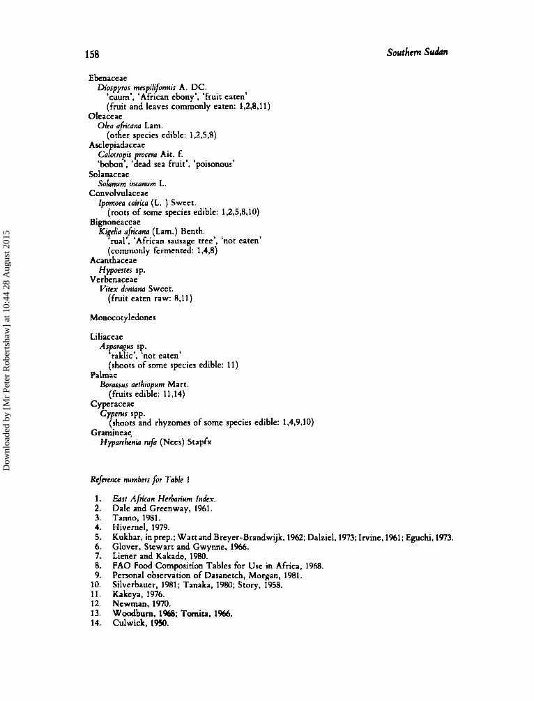
158 Southm S d n
Ebenaceae Diospyros mespilifomis A. DC.
‘cuum’, ‘African ebony’. ‘fruit eaten’ (fruit and leaves commonly eaten: 1,2,8,11)
Oleaceae Olea afrcana Lam.
(other species edible: 1,2.5.8) Ascle iadaceae
C a P otropis procna Ait. f. ‘bobon’, ‘dead sea fruit’, ‘poisonous’
Solanum incanum L.
Zpomoeu cairita (L. ) Sweet.
Solanaceae
Convolvulaceae
(roots of some species edible: 1,2,5.8,10) Bignoneaceae
Kigeha aficana (Lam.) Benth. ‘rual’, ‘African sausage tree’, ‘not eaten’ (commonly fermented: 1,4,8)
Acan thaceae
Verbenaceae Hypoestes sp.
Vitex doniana Sweet. (fruit eaten raw: 8,ll)
Monocotyledones
Liliaceae Asparagus sp.
‘raklic’, ‘not eaten’ (shoots of some species edible: 11)
Palmae Borassus aethiopum Mart.
(fruits edible: 11~4) C yperaceae
Cyperus spp. (shoots and rhyzomes of some species edible: 1,4,9,10)
Gramineae Hypanhenia rufa (Nees) Stapfx
Refwence numbers for Table I
1. 2. 3. 4. 5. 6. 7. 8. 9. 10. 11. 12. 13. 14.
Easr African Herbarium Index. Dale and Greenway, 1961. Tanno, 1981. Hivernel, 1979. Kukhar, in prep.; Watt and Breyer-Brandwijk, 1962; Dalziel, 1973; Irvine, 1961; Eguchi, 1973. Glover, Stewart and Gwynne, 1%6. Liener and Kakada, 1980. F A 0 Food Composition Tables for Use in Africa, 1968. Personal observation of Dasanetch, Morgan, 1981. Silverbauer, 1981; Tanaka, 1980; Story, 1958. Kakeya, 1976. Newman, 1970. Woodbum, 1W; Tomita, 1966. Culwick, 1950.
Dow
nloa
ded
by [
Mr
Pete
r R
ober
tsha
w]
at 1
0:44
28
Aug
ust 2
015
south SUdm 1 59
Table 2
Variety of wild plant foodr by habitat
Habitatlsitc
Wooded Grassland Kat
Bckjiu (north) Woodland
Payi Bekjiu (south)
No. of different
J o b 1
species
Andrcws, F. W.
Barkham. J.P. and M.E. Rainy
Carr. C.J.
Crowfoot, G.M.
Culwick, G.M.
Dale. I.R. and P.J. Grecnway Dalzicl. J.M. Eguchi. N.J.
Glover. P.E., J. Stewart and M.D. Gwynne
Glover. P.E., E.C. Trump and
Grccnway, P;J. Hivcrnel, F.M.M.
L.E.D. Wateridgc
No. of umody I NO. of dible sprcin species acc. to acc. to
idrnt$d informants literature
19 13 14
10 16
3 12 5 10 2 5
3 6
6 8
40 9 20
REFERENCBS (to Appendix B)
1950
1952 1956 1976
1977
1928
1 950
1%1 1937 1973
1966
1964
1973 1979
Huntley, B.J. and B.H. Walkcr(eds)1982
Irvinc. F.R. 1961
Kakcya, M. 1976
Kozlowski, T.T.. and C.E. 1974
Kukhar, P. in prep. Leung. W.W., F. Busson and
Licncr. I.H. and M.L. Kakade
Ahlgren (cds)
C. Jardin 1968
1980
The Floivoing Plants OJ thr Aqb-Egyptian Sudmr, Vol. 1. Bunclc. The Floitrring Pbnts of ~ h r Anebi$yptim Sudbn, Vol. 2. The Flottrring Plants of the Sudan Vol. 3. ‘The vegetation of the Samburu-lsiolo Game Reserve’. b s r African l4*i/d/$ Journal 14, 297-329. Pastoralism in Crisis: Thr Dasanetch and their Ethiopian Lands. University of Chicago, Dept. of Geography Research Paper 180. Floitrring Plants oJthe Northern and Centra/ Sudan, Leominster: the Orphan’s Printing Press. Ltd. A Dietary Survey amone the Zande of the South-Western Sudan, Khartoum: A ricultural Publications Committee. K m p T m a J . ‘jhkrubs, Nairobi: Buchanan’s Kenya Estates Ltd. Thr U p / Pkmts of Mkt Tmpicd Afka, London: Crown -6. ‘A Ful ulde wood list for use in the study of the alimcntation and cuisine of hdarona and surrounding areas’, Kyoto L~nitrcrsity
‘Ma,sai and KipsiRi$ notes on East African plants: 11. Domestic uies of plants’, Eort A f k a r Agn’cu/turc a d Forestry
‘Termifaria and vegetation patterns on the Loita plains of
A n ethnoarchacological study of cnvirontntntal use in the Kmya hkhlands, PhD Thesis, Institute of Archaeology, London. I?dqy of Tropical Sai~annas: EcdqkaI studies analysis,andsynthrsis, 1 ’nl42, New York: Springer-Vcrlag. M’mdy Plants of Ghana with Special R e f m c c to their L h s , Oxford University Press. ‘Subsistence ecology of the Tongwe, Tanzania’, Kyoto University African Studies 10. 143-247. Fitr and Ecosystems, New York: Academic Press.
‘The economic uses of Kenyan Plants’, monograph. Food Compositioii Table for Lrse in A frica, Rome: FAO.
‘Protease inhibitors’, in I.E. Lienu (cd.), 7i~ric Constituents o/ Phnt F d s t u f i , New York: Academic Press, pp. 7-71.
A fri~a Studies 9. 139-75.
] O U ~ 32(2), 192-99.
ournal of E o l q y sz. 367-77. ‘A c h i -tl ration of the vegetation ofEast Africa’, Kilkia9.148.
Dow
nloa
ded
by [
Mr
Pete
r R
ober
tsha
w]
at 1
0:44
28
Aug
ust 2
015
160 Southern Sudun
Morgan, W.T.W.
Newman. J.L.
Phillips, J.
Pratt. D.J., P.J. Greenway
Scudder. T. and M.D. Gwynne
Silverbauer, G.B.
Story, R.
Tanaka. 1.
Tonno, T.
Tornita. K.
Watt, J.M. and
Western, D.
Woodburn, J.
N.G. Breyer-Brandwijk
lvsl
1970
1974
1966
1%2
1981
1958
1980
1981
1966
1%2
1973
I968
‘Ethnobotany of the Turkana: use of plants by a pastoral people and their livestock in Kenya’, Economic Botany 35(1), %-130. The Ecologira/ Basis fnr Subsistence Change .4 m1in.q the sSandait)e of Tanzunia, Washington, D.C.: National Academy of Sciences. ‘Effects of fire in forest and savanna ecosystems of sub- Saharan Africa’, in T.T. Kozlowski aand C.E. Ahlgrhn (eds.) Fire and Eciisysrems, New York: Academic Press, pp. 435-81. ‘A classification of East African Rangeland’,J. Applied I?o/on 3, 369-82. The ecology i?f the Gicmnbe Tiinqa, Kariba Studies, Vol. 11, Manchester University Press. Hunter and Hahitat in the Central Kalallari Desert, Cambridge University Press. ‘Some plants used by the bushmen in obtaining food and water’, BotanicalSurvcy Mcmoir No. 30, Dept. ofAgriculmre/ Division of Botany, Pretoria. Thc Sun, Huntcr-Gathcrcrs of thc Kaiahari, University of Tokyo Press. Plant utilization of the Mbuti pygmies, with special rcferenfe
to-their material culture and use of wild vegetable foods , African Studics Monopaphr 1. 1-55. ‘The sources of food for the Hadzapi tribe: the life of a hunting tribe in East Africa’, Kyoto ITniijersiry -4fn’can Studies
Thc Mcdicinal and Poisonous Plants ofSouthcm and E a s t n Africa, 2nd ed. London: E.& S. Livingstone. The Structure, Dynamics and Changes oft he .4 mboseli Ecosystcm, PhD Thesis, University of Nairobi. ‘An introduction to Hadza ecology’, in R.B. Lee and 1. DeVore (eds.) Man the Hunter, Chicago: Aldine, pp. 49-55.
1, 157-171.
Appendix C
Human Burial from Bekjiu, Lakes Province, Southern S u b
Lynne Schepartz
Basic chructers. Adult male of age 18-25. A moderately tall, slender individual. (Sexing criteria: Skull form and robusticity, mandible form and robusticity, pelvic morphology. Aging criteria: Dental attrition and pubic symphysis morphology.)
Preservation. The remaining portions of the skull consist ofa complete right parietal, the frontal and occiput and portions of the right temporal and the left side of the face. The mandible is virtually complete with damage to the condyles and left gonial region. All of the dentition is complete except for the right MI, missing pre- mortem, and the left I*, missing post-mortem. There are fragments of other portions of the skull, but major’portions are missing and a full reconstruction of the vault is not possible. The edges of the complete vault bones are weathered making even a partial reconstruction difficult.
Postcranially, there are ortions of the scapulae, clavicles, sternum, vertebrae,
iands and feet are also fairly complete. atellae and pelvis. Most o P the limb bones are complete enough to measure. The
Dow
nloa
ded
by [
Mr
Pete
r R
ober
tsha
w]
at 1
0:44
28
Aug
ust 2
015
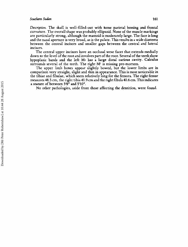
Southern Sudan 161
Description. The skull is well-filled-out with some parietal bossing and frontal curvature. The overall shape was probably ellipsoid. None of the muscle markings are particularly strong, although the mastoid is moderately large. The face is long and the nasal aperture is very broad, as is the palate. This results in a wide diastema between the central incisors and smaller gaps between the central and lateral incisors.
The central upper incisors have an occlusal wear facet that extends medially down to the level of the root and involves part of the root. Several of the teeth show hypoplasic bands and the left MI has a large distal carious cavity. Calculus surrounds several of' the teeth. The right M* is missing pre-mortem.
The upper limb bones appear slightly bowed, but the lower limbs are in comparison very straight, slight and thin in a pearance. This is most noticeable in
measures 48.5 cm, the right tibia 41.9 cm and the right fibula 40.6 cm. This indicates a stature of between 5'8" and 5'10".
the tibiae and fibulae, which seem relatively f ong for the femora. The right femur
No other pathologies, aside from those affecting the dentition, were found.
Dow
nloa
ded
by [
Mr
Pete
r R
ober
tsha
w]
at 1
0:44
28
Aug
ust 2
015