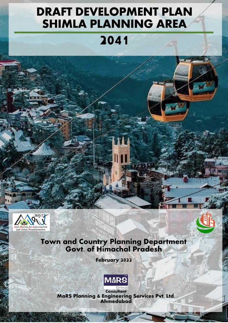
draft development plan shimla planning area
TRANSCRIPT
1
Draft Development Plan, Shimla Planning Area, 2041
s
DRAFT DEVELOPMENT PLAN SHIMLA PLANNING AREA
2041
Town and Country Planning Department Govt. of Himachal Pradesh
February 2022 Fe
Consultant
MaRS Planning & Engineering Services Pvt. Ltd. Ahmedabad
2
Draft Development Plan, Shimla Planning Area, 2041
Disclaimer
This document has been prepared by MaRS Planning & Engineering Services Pvt. Ltd. for internal use of Town and
Country Planning Department, GoHP and for discussion with internal and external audiences.
The inferences and analysis made by MaRS in this report are based on information collated through primary research,
secondary research, discussions with client Department and key stakeholders and our knowledge about the project
Scheme and its objectives. Due care has been taken to validate the authenticity and correctness of the information
from various sources, however, no representations or warranty, expressed or implied, is given by MaRS or any of its
respective partners, officers, employees or agents as to the accuracy or completeness of the information, data or
opinions provided to MaRS by third parties or secondary sources.
This work product is for information purposes only. While due care has been taken during the compilation of this work
product to ensure that the information is accurate to the best of our knowledge and belief. There might be inadvertent
omissions/errors/aberrations owing to situation and conditions outside the control of MaRS as well TCP Department.
Neither this document nor any of its content can be used for any purpose other than stated above, without prior
written consent from the TCP Department, GoHP.
3
Draft Development Plan, Shimla Planning Area, 2041
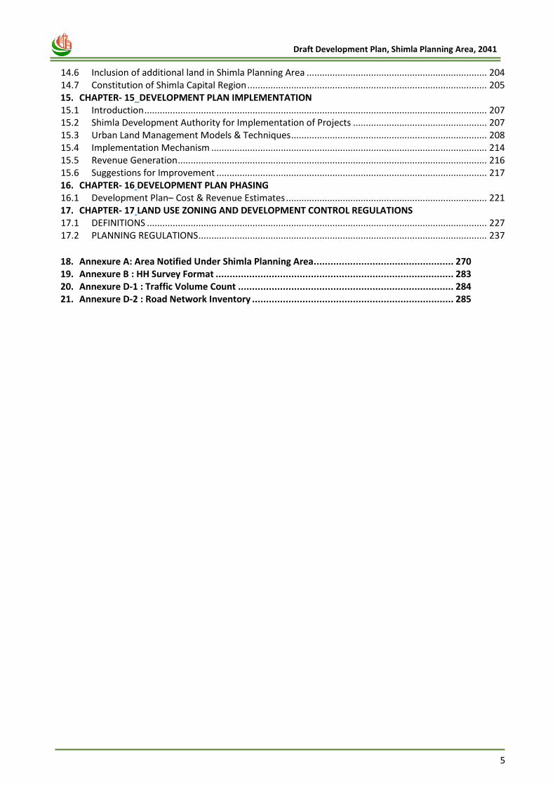
Contents 1. CHAPTER -1 INTRODUCTION 1.1 Context .............................................................................................................................................. 14 1.2 Project background ........................................................................................................................... 15 1.3 Previous Development Plan formulation Interventions .................................................................... 16 1.4 Development Plan 2041 .................................................................................................................... 17 1.5 Methodology for the Preparation of Development Plan, 2041 ........................................................ 18 1.6 Project Monitoring and Review ......................................................................................................... 19 1.7 Stakeholder/Public Consulations ....................................................................................................... 19 1.8 Report Structure ................................................................................................................................ 20 2. CHAPTER -2 SHIMLA PLANNING AREA PROFILE 2.1 Introduction ....................................................................................................................................... 23 2.2 Shimla Planning Area- Area of Interest (AOI) .................................................................................... 23 2.3 Location and Regional Connectivity .................................................................................................. 25 2.4 Historical Significance of Shimla ........................................................................................................ 26 2.5 Shimla Municipal Corporation ........................................................................................................... 28 2.6 Physical Development & Growth ...................................................................................................... 29 3. CHAPTER- 3 VISION AND DEVELOPMENT STRATEGY 3.1 INTRODUCTION ................................................................................................................................. 33 3.2 SWOT Analysis ................................................................................................................................... 33 3.3 Orientations for Development Plan of Shimla .................................................................................. 35 3.4 Vision for Shimla ................................................................................................................................ 36 3.5 Planning Principles............................................................................................................................. 37 3.6 Development of Concept Alternatives .............................................................................................. 37 4. CHAPTER- 4 DEMOGRAPHIC PROFILE 4.1 Introduction ....................................................................................................................................... 40 4.2 Existing Population and Growth Trends ............................................................................................ 40 4.3 Population Density ............................................................................................................................ 41 4.4 Sex Ratio ............................................................................................................................................ 42 4.5 Literacy Rate ...................................................................................................................................... 43 4.6 Workforce Participation .................................................................................................................... 44 4.7 Issues and Problems .......................................................................................................................... 46 4.8 Population Projection ........................................................................................................................ 47 5. CHAPTER- 5 ECONOMIC PROFILE 5.1 Introduction ....................................................................................................................................... 51 5.2 Existing Economic Profile................................................................................................................... 51 5.3 Issues & Potentials............................................................................................................................. 56 5.4 Economic Strategy and Recommendations ....................................................................................... 57 6. CHAPTER- 6 TRAFFIC & TRANSPORTATION 6.1 Introduction ....................................................................................................................................... 60 6.2 Existing Scenario ................................................................................................................................ 60 6.3 Issues and Potentials ......................................................................................................................... 67 6.4 Transport Proposals ........................................................................................................................... 67 7. CHAPTER- 7 PHYSICAL INFRASTRUCTURE 7.1 Introduction ....................................................................................................................................... 82 7.2 Water Supply ..................................................................................................................................... 82 7.3 Sewerage and Sanitation System ...................................................................................................... 89 7.4 Solid Waste Management ................................................................................................................. 95 7.5 Storm Water Drainage ....................................................................................................................... 98 7.6 Electricity ......................................................................................................................................... 100 7.7 Telecommunication ......................................................................................................................... 101
4
Draft Development Plan, Shimla Planning Area, 2041
7.8 Imperative ....................................................................................................................................... 101 8. CHAPTER- 8 SOCIAL INFRASTRUCTURE 8.1 Introduction ..................................................................................................................................... 103 8.2 Education Facilities .......................................................................................................................... 103 8.3 Health Facilities ............................................................................................................................... 106 8.4 Recreational Activities ..................................................................................................................... 109 8.5 Religious institutions ....................................................................................................................... 112 8.6 Other Public Services ....................................................................................................................... 113 8.7 Socio-Cultural Characteristics .......................................................................................................... 114 8.8 Imperative ....................................................................................................................................... 114 9. CHAPTER- 9 HOUSING & SLUMS 9.1 Introduction ..................................................................................................................................... 116 9.2 Existing Housing Scenario ................................................................................................................ 116 9.3 Existing Slum Scenario ..................................................................................................................... 119 9.4 Issues and Potentials ....................................................................................................................... 119 9.5 Future Requirement ........................................................................................................................ 119 10. CHAPTER- 10 TOURISM PROFILE 10.1 Introduction ..................................................................................................................................... 122 10.2 Issues and Concerns ........................................................................................................................ 126 10.3 Tourism Proposals ........................................................................................................................... 127 10.4 Tourism Strategies ........................................................................................................................... 131 11. CHAPTER- 11 HERITAGE PROFILE 11.1 Introduction ..................................................................................................................................... 134 11.2 Type of Heritage .............................................................................................................................. 135 11.3 Heritage Conservation ..................................................................................................................... 141 11.4 Strategies ......................................................................................................................................... 141 11.5 Other Proposals with respect to Shimla Heritage ........................................................................... 142 11.6 Imperative ....................................................................................................................................... 145 12. CHAPTER- 12 ENVIRONMENT 12.1 Introduction ..................................................................................................................................... 147 12.2 Rivers and Water bodies ................................................................................................................. 147 12.3 Forest and Green Cover ................................................................................................................... 148 12.4 Eco-sensitive zones .......................................................................................................................... 153 12.5 Natural Hazards & Vulnerability Problems ...................................................................................... 154 12.6 Pollution Aspects ............................................................................................................................. 157 12.7 Ecology Conservation Strategies ..................................................................................................... 158 12.8 Disaster Management – Vulnerability and Risk Assessment .......................................................... 158 12.9 The Hon’ble NGT Directives ............................................................................................................. 160 12.10 Narrative of NGT’s Carrying Capacity Report .............................................................................. 161 12.11 Building By-laws with respect to NGT’s Carrying Capacity Report .............................................. 168 13. CHAPTER- 13 EXISTING LAND-USE & LAND SUITABILITY ANALYSIS 13.1 Introduction ..................................................................................................................................... 181 13.2 Methodology for the preparation of Base-map .............................................................................. 181 13.3 Existing Land Use of Shimla Planning Area ...................................................................................... 181 13.4 Future Land Requirement ............................................................................................................... 185 13.5 Land Suitability Analysis .................................................................................................................. 186 13.6 Identification of Developable Areas ................................................................................................ 190 14. CHAPTER- 14 PROPOSED LAND-USE 14.1 Proposed Land-use Plan 2041 ......................................................................................................... 193 14.2 Comparison of Land-use plan. ......................................................................................................... 195 14.3 Development of Counter Magnet Town ......................................................................................... 198 14.4 Approach for Planned development in Counter Magnet Town: ..................................................... 200 14.5 Development of Satellite Towns ..................................................................................................... 203
5
Draft Development Plan, Shimla Planning Area, 2041
14.6 Inclusion of additional land in Shimla Planning Area ...................................................................... 204 14.7 Constitution of Shimla Capital Region ............................................................................................. 205 15. CHAPTER- 15 DEVELOPMENT PLAN IMPLEMENTATION 15.1 Introduction ..................................................................................................................................... 207 15.2 Shimla Development Authority for Implementation of Projects .................................................... 207 15.3 Urban Land Management Models & Techniques ............................................................................ 208 15.4 Implementation Mechanism ........................................................................................................... 214 15.5 Revenue Generation ........................................................................................................................ 216 15.6 Suggestions for Improvement ......................................................................................................... 217 16. CHAPTER- 16 DEVELOPMENT PLAN PHASING 16.1 Development Plan– Cost & Revenue Estimates .............................................................................. 221 17. CHAPTER- 17 LAND USE ZONING AND DEVELOPMENT CONTROL REGULATIONS 17.1 DEFINITIONS .................................................................................................................................... 227 17.2 PLANNING REGULATIONS ................................................................................................................ 237
18. Annexure A: Area Notified Under Shimla Planning Area .................................................. 270 19. Annexure B : HH Survey Format ..................................................................................... 283 20. Annexure D-1 : Traffic Volume Count ............................................................................. 284 21. Annexure D-2 : Road Network Inventory ........................................................................ 285
6
Draft Development Plan, Shimla Planning Area, 2041
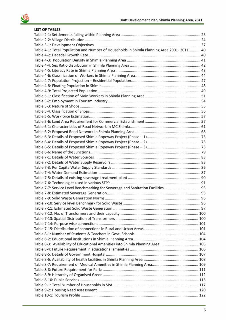
LIST OF TABLES Table 2-1: Settlements falling within Planning Area ............................................................................ 23
Table 2-2: Village Distribution .............................................................................................................. 24
Table 3-1: Development Objectives ..................................................................................................... 37
Table 4-1: Total Population and Number of Households in Shimla Planning Area 2001- 2011. .......... 40
Table 4-2: Decadal Growth Rate........................................................................................................... 40
Table 4-3: Population Density in Shimla Planning Area ...................................................................... 41
Table 4-4: Sex Ratio distribution in Shimla Planning Area ................................................................... 42
Table 4-5: Literacy Rate in Shimla Planning Area ................................................................................. 43
Table 4-6: Classification of Workers in Shimla Planning Area .............................................................. 44
Table 4-7: Population Projection – Residential Population .................................................................. 47
Table 4-8: Floating Population in Shimla .............................................................................................. 48
Table 4-9: Total Projected Population .................................................................................................. 49
Table 5-1: Classification of Main Workers in Shimla Planning Area ..................................................... 51
Table 5-2: Employment in Tourism Industry ........................................................................................ 54
Table 5-3: Nature of Shops ................................................................................................................... 55
Table 5-4: Classification of Shops ......................................................................................................... 56
Table 5-5: Workforce Estimation.......................................................................................................... 57
Table 5-6: Land Area Requirement for Commercial Establishment ..................................................... 57
Table 6-1: Characteristics of Road Network in MC Shimla ................................................................... 61
Table 6-2: Proposed Road Network in Shimla Planning Area .............................................................. 68
Table 6-3: Details of Proposed Shimla Ropeway Project (Phase – 1) ................................................... 73
Table 6-4: Details of Proposed Shimla Ropeway Project (Phase – 2) ................................................... 73
Table 6-5: Details of Proposed Shimla Ropeway Project (Phase – 3) ................................................... 73
Table 6-6: Name of the Junctions ......................................................................................................... 79
Table 7-1: Details of Water Sources ..................................................................................................... 83
Table 7-2: Details of Water Supply Reservoirs ..................................................................................... 83
Table 7-3: Per Capita Water Supply Standards .................................................................................... 86
Table 7-4: Water Demand Estimation .................................................................................................. 87
Table 7-5: Details of existing sewerage treatment plant ..................................................................... 90
Table 7-6: Technologies used in various STP's ..................................................................................... 91
Table 7-7: Service Level Benchmarking for Sewerage and Sanitation Facilities .................................. 93
Table 7-8: Estimated Sewerage Generation ......................................................................................... 93
Table 7-9: Solid Waste Generation Norms ........................................................................................... 96
Table 7-10: Service level Benchmark for Solid Waste .......................................................................... 96
Table 7-11: Estimated Solid Waste Generation ................................................................................... 97
Table 7-12: No. of Transformers and their capacity ........................................................................... 100
Table 7-13: Spatial Distribution of Transformers ............................................................................... 100
Table 7-14: Purpose wise connections ............................................................................................... 101
Table 7-15: Distribution of connections in Rural and Urban Areas .................................................... 101
Table 8-1: Number of Students & Teachers in Govt. Schools ............................................................ 104
Table 8-2: Educational institutions in Shimla Planning Area .............................................................. 104
Table 8-3: Availability of Educational Amenities into Shimla Planning Area ..................................... 105
Table 8-4: Future Requirement in educational amenities ................................................................. 106
Table 8-5: Details of Government Hospital ........................................................................................ 107
Table 8-6: Availability of health facilities in Shimla Planning Area .................................................... 108
Table 8-7: Requirement of Medical Amenities in Shimla Planning Area............................................ 109
Table 8-8: Future Requirement for Parks ........................................................................................... 111
Table 8-9: Hierarchy of Organised Green ........................................................................................... 112
Table 8-10: Public Services ................................................................................................................. 113
Table 9-1: Total Number of Households in SPA ................................................................................. 117
Table 9-2: Housing Need Assessment ................................................................................................ 120
Table 10-1: Tourism Profile ................................................................................................................ 122
7
Draft Development Plan, Shimla Planning Area, 2041
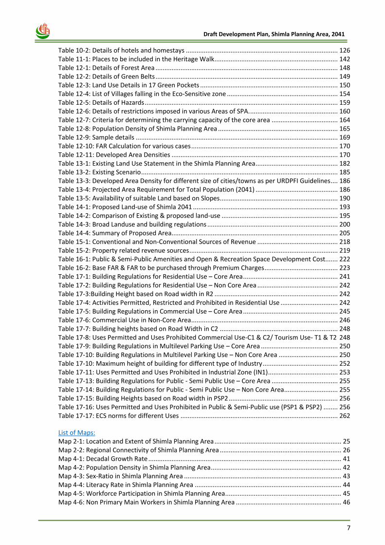
Table 10-2: Details of hotels and homestays ..................................................................................... 126
Table 11-1: Places to be included in the Heritage Walk ..................................................................... 142
Table 12-1: Details of Forest Area ...................................................................................................... 148
Table 12-2: Details of Green Belts ...................................................................................................... 149
Table 12-3: Land Use Details in 17 Green Pockets ............................................................................. 150
Table 12-4: List of Villages falling in the Eco-Sensitive zone .............................................................. 154
Table 12-5: Details of Hazards ............................................................................................................ 159
Table 12-6: Details of restrictions imposed in various Areas of SPA. ................................................. 160
Table 12-7: Criteria for determining the carrying capacity of the core area ..................................... 164
Table 12-8: Population Density of Shimla Planning Area ................................................................... 165
Table 12-9: Sample details ................................................................................................................. 169
Table 12-10: FAR Calculation for various cases .................................................................................. 170
Table 12-11: Developed Area Densities ............................................................................................. 170
Table 13-1: Existing Land Use Statement in the Shimla Planning Area .............................................. 182
Table 13-2: Existing Scenario .............................................................................................................. 185
Table 13-3: Developed Area Density for different size of cities/towns as per URDPFI Guidelines .... 186
Table 13-4: Projected Area Requirement for Total Population (2041) .............................................. 186
Table 13-5: Availability of suitable Land based on Slopes .................................................................. 190
Table 14-1: Proposed Land-use of Shimla 2041 ................................................................................. 193
Table 14-2: Comparison of Existing & proposed land-use ................................................................. 195
Table 14-3: Broad Landuse and building regulations ......................................................................... 200
Table 14-4: Summary of Proposed Area............................................................................................. 205
Table 15-1: Conventional and Non‐Conventional Sources of Revenue ............................................. 218
Table 15-2: Property related revenue sources ................................................................................... 219
Table 16-1: Public & Semi-Public Amenities and Open & Recreation Space Development Cost....... 222
Table 16-2: Base FAR & FAR to be purchased through Premium Charges ......................................... 223
Table 17-1: Building Regulations for Residential Use – Core Area ..................................................... 241
Table 17-2: Building Regulations for Residential Use – Non Core Area ............................................. 242
Table 17-3:Building Height based on Road width in R2 ..................................................................... 242
Table 17-4: Activities Permitted, Restricted and Prohibited in Residential Use ................................ 242
Table 17-5: Building Regulations in Commercial Use – Core Area ..................................................... 245
Table 17-6: Commercial Use in Non-Core Area .................................................................................. 246
Table 17-7: Building heights based on Road Width in C2 .................................................................. 248
Table 17-8: Uses Permitted and Uses Prohibited Commercial Use-C1 & C2/ Tourism Use- T1 & T2 248
Table 17-9: Building Regulations in Multilevel Parking Use – Core Area ........................................... 250
Table 17-10: Building Regulations in Multilevel Parking Use – Non Core Area ................................. 250
Table 17-10: Maximum height of building for different type of Industry .......................................... 252
Table 17-11: Uses Permitted and Uses Prohibited in Industrial Zone (IN1) ....................................... 253
Table 17-13: Building Regulations for Public - Semi Public Use – Core Area ..................................... 255
Table 17-14: Building Regulations for Public - Semi Public Use – Non Core Area .............................. 255
Table 17-15: Building Heights based on Road width in PSP2 ............................................................. 256
Table 17-16: Uses Permitted and Uses Prohibited in Public & Semi-Public use (PSP1 & PSP2) ........ 256
Table 17-17: ECS norms for different Uses ........................................................................................ 262
List of Maps: Map 2-1: Location and Extent of Shimla Planning Area ....................................................................... 25
Map 2-2: Regional Connectivity of Shimla Planning Area .................................................................... 26
Map 4-1: Decadal Growth Rate ............................................................................................................ 41
Map 4-2: Population Density in Shimla Planning Area ......................................................................... 42
Map 4-3: Sex-Ratio in Shimla Planning Area ........................................................................................ 43
Map 4-4: Literacy Rate in Shimla Planning Area .................................................................................. 44
Map 4-5: Workforce Participation in Shimla Planning Area ................................................................. 45
Map 4-6: Non Primary Main Workers in Shimla Planning Area ........................................................... 46
8
Draft Development Plan, Shimla Planning Area, 2041
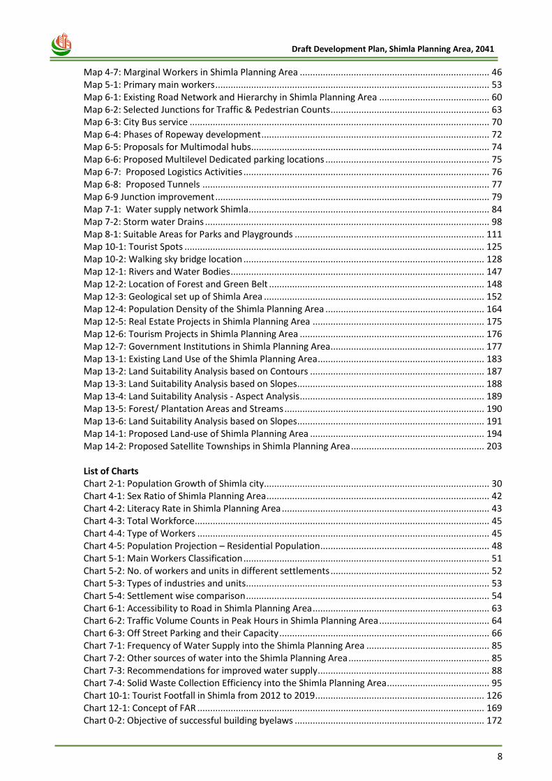
Map 4-7: Marginal Workers in Shimla Planning Area .......................................................................... 46
Map 5-1: Primary main workers ........................................................................................................... 53
Map 6-1: Existing Road Network and Hierarchy in Shimla Planning Area ........................................... 60
Map 6-2: Selected Junctions for Traffic & Pedestrian Counts .............................................................. 63
Map 6-3: City Bus service ..................................................................................................................... 70
Map 6-4: Phases of Ropeway development ......................................................................................... 72
Map 6-5: Proposals for Multimodal hubs............................................................................................. 74
Map 6-6: Proposed Multilevel Dedicated parking locations ................................................................ 75
Map 6-7: Proposed Logistics Activities ................................................................................................ 76
Map 6-8: Proposed Tunnels ................................................................................................................ 77
Map 6-9 Junction improvement ........................................................................................................... 79
Map 7-1: Water supply network Shimla .............................................................................................. 84
Map 7-2: Storm water Drains ............................................................................................................... 98
Map 8-1: Suitable Areas for Parks and Playgrounds .......................................................................... 111
Map 10-1: Tourist Spots ..................................................................................................................... 125
Map 10-2: Walking sky bridge location .............................................................................................. 128
Map 12-1: Rivers and Water Bodies ................................................................................................... 147
Map 12-2: Location of Forest and Green Belt .................................................................................... 148
Map 12-3: Geological set up of Shimla Area ...................................................................................... 152
Map 12-4: Population Density of the Shimla Planning Area .............................................................. 164
Map 12-5: Real Estate Projects in Shimla Planning Area ................................................................... 175
Map 12-6: Tourism Projects in Shimla Planning Area ........................................................................ 176
Map 12-7: Government Institutions in Shimla Planning Area ............................................................ 177
Map 13-1: Existing Land Use of the Shimla Planning Area ................................................................. 183
Map 13-2: Land Suitability Analysis based on Contours .................................................................... 187
Map 13-3: Land Suitability Analysis based on Slopes ......................................................................... 188
Map 13-4: Land Suitability Analysis - Aspect Analysis ........................................................................ 189
Map 13-5: Forest/ Plantation Areas and Streams .............................................................................. 190
Map 13-6: Land Suitability Analysis based on Slopes ......................................................................... 191
Map 14-1: Proposed Land-use of Shimla Planning Area .................................................................... 194
Map 14-2: Proposed Satellite Townships in Shimla Planning Area .................................................... 203
List of Charts Chart 2-1: Population Growth of Shimla city........................................................................................ 30 Chart 4-1: Sex Ratio of Shimla Planning Area ....................................................................................... 42 Chart 4-2: Literacy Rate in Shimla Planning Area ................................................................................. 43 Chart 4-3: Total Workforce ................................................................................................................... 45 Chart 4-4: Type of Workers .................................................................................................................. 45 Chart 4-5: Population Projection – Residential Population .................................................................. 48 Chart 5-1: Main Workers Classification ................................................................................................ 51 Chart 5-2: No. of workers and units in different settlements .............................................................. 52 Chart 5-3: Types of industries and units ............................................................................................... 53 Chart 5-4: Settlement wise comparison ............................................................................................... 54 Chart 6-1: Accessibility to Road in Shimla Planning Area ..................................................................... 63 Chart 6-2: Traffic Volume Counts in Peak Hours in Shimla Planning Area ........................................... 64 Chart 6-3: Off Street Parking and their Capacity .................................................................................. 66 Chart 7-1: Frequency of Water Supply into the Shimla Planning Area ................................................ 85 Chart 7-2: Other sources of water into the Shimla Planning Area ....................................................... 85 Chart 7-3: Recommendations for improved water supply ................................................................... 88 Chart 7-4: Solid Waste Collection Efficiency into the Shimla Planning Area ........................................ 95 Chart 10-1: Tourist Footfall in Shimla from 2012 to 2019 .................................................................. 126 Chart 12-1: Concept of FAR ................................................................................................................ 169 Chart 0-2: Objective of successful building byelaws .......................................................................... 172
9
Draft Development Plan, Shimla Planning Area, 2041
List of Figures Figure 1-1: Shimla City .......................................................................................................................... 14
Figure 1-2: Chronology of amendments in IDP Shimla ........................................................................ 16
Figure 1-3: Methodology for preparation of Development Plan 2041 ................................................ 18
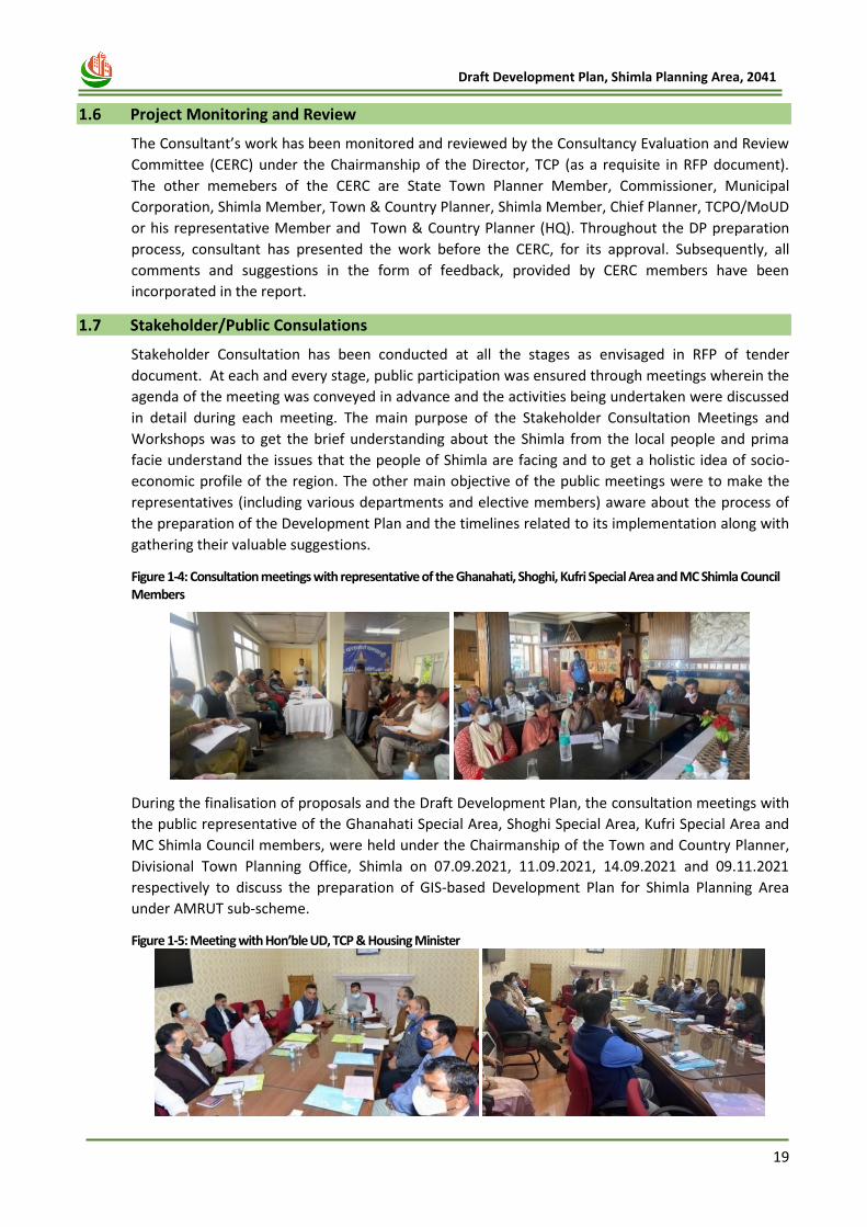
Figure 1-4: Consultation meetings with representative of the Ghanahati, Shoghi, Kufri Special Area and MC Shimla Council Members ........................................................................................................ 19
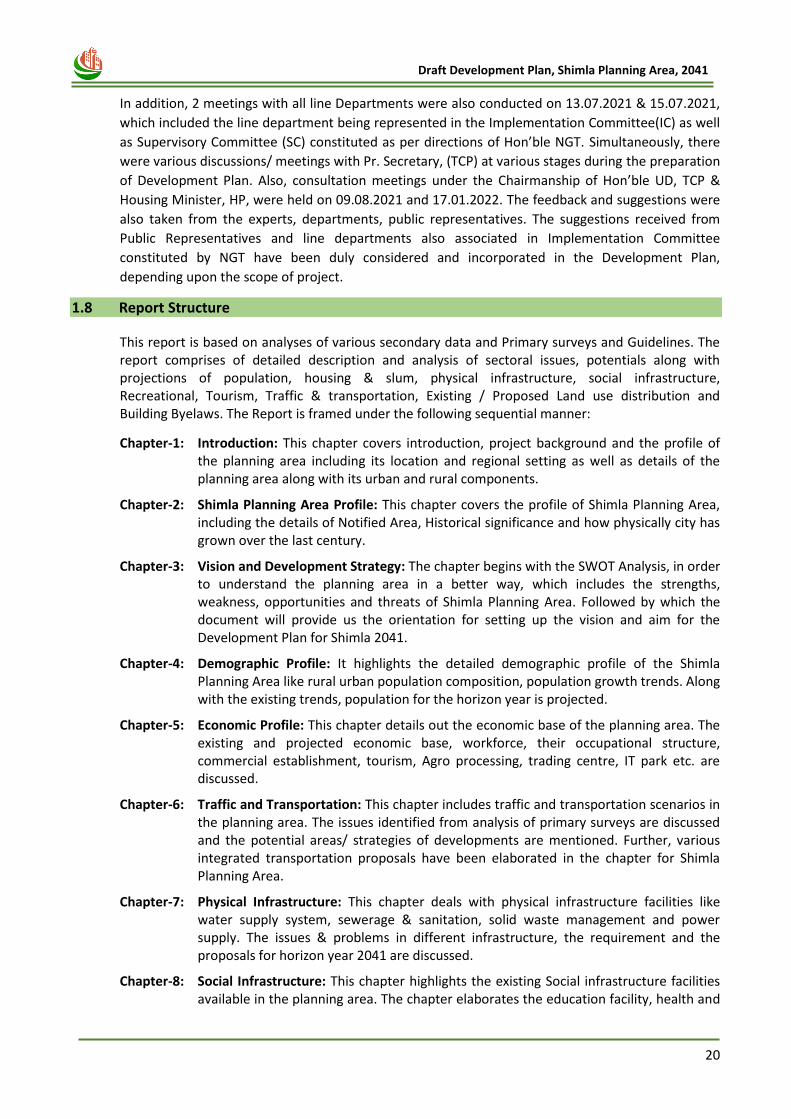
Figure 1-5: Meeting with Hon’ble UD, TCP & Housing Minister .......................................................... 19
Figure 2-1: Urban Sprawl and Growth in Shimla Planning Area - Year 2002-2018. ............................. 29
Figure 2-2: Urban Sprawl ...................................................................................................................... 29
Figure 2-3 Development Trends in SPA ................................................................................................ 30
Figure 3-1 : Vision for the project ......................................................................................................... 36
Figure 5-1: Primary Economic Activity in the Shimla Planning Area .................................................... 52
Figure 5-2: Vegetable Distribution Center on National Highway-22 at Dhalli ..................................... 55
Figure 6-1: Upgradation of roads ......................................................................................................... 62
Figure 6-2: Mode of Transportation ..................................................................................................... 64
Figure 6-3: City bus ............................................................................................................................... 65
Figure 6-4: Pedestrian Volume Counts in Peak Hours in Shimla Planning Area ................................... 65
Figure 6-5: Parking facilities in Shimla .................................................................................................. 66
Figure 6-6: On street Parking................................................................................................................ 66
Figure 6-7: Proposed Bypass Road ....................................................................................................... 68
Figure 6-8: Strengthening of existing road ........................................................................................... 69
Figure 6-9: Retrofitting of Circular of Road .......................................................................................... 69
Figure 6-10: Representative image of Ropeway .................................................................................. 72
Figure 6-11: Pedestrian Movement ...................................................................................................... 78
Figure 6-12: Junction improvement Proposals..................................................................................... 80
Figure 7-1: Location of WTP, STP and Reservoir .................................................................................. 82
Figure 7-2: Water Augmentation Project from Satluj River ................................................................. 88
Figure 7-3: Location of Sewerage Treatment Plant .............................................................................. 90
Figure 7-4: Sewerage Disposal Mechanism .......................................................................................... 91
Figure 7-5: Sewerage Disposal Mechanism .......................................................................................... 94
Figure 7-6: Representative Flow Diagram of SWM .............................................................................. 98
Figure 8-1: Recreational Facilities ...................................................................................................... 110
Figure 8-2: Hierarchy of Organised Green .......................................................................................... 112
Figure 8-3: Shimla Handicrafts and arts ............................................................................................. 114
Figure 9-1: Average Number of floors in and building and Rooms in a Household Unit in SPA ........ 116
Figure 9-2: Construction Issues .......................................................................................................... 117
Figure 9-3: Slum pockets ................................................................................................................... 119
Figure 10-1: Agro Based tourist .......................................................................................................... 127
Figure 10-2: Forest Tourist ................................................................................................................. 127
Figure 10-3: Adventure camping ........................................................................................................ 128
Figure 10-4: Cycling Trails ................................................................................................................... 128
Figure 10-5: Langwaki Sky bridge ....................................................................................................... 129
Figure 10-6: Borag Toy Train .............................................................................................................. 129
Figure 10-7: Heli Taxi Services ............................................................................................................ 130
Figure 10-8: Heli Taxi Network ........................................................................................................... 130
Figure 10-9: Heli Taxi service- Katra ................................................................................................... 131
Figure 11-1: Heritage structure of Shimla .......................................................................................... 134
Figure 11-2: Details of British Heritage .............................................................................................. 134
Figure 11-3: Details of Government Buildings ................................................................................... 136
Figure 11-4: Details of Church ............................................................................................................ 137
Figure 11-5: Details of Bungalows ...................................................................................................... 137
Figure 11-6: Details of Facades .......................................................................................................... 138
Figure 11-7: Porch of Chaipslee .......................................................................................................... 139
10
Draft Development Plan, Shimla Planning Area, 2041
Figure 11-8: Type of Windows ............................................................................................................ 139
Figure 11-9: Roof of Town Hall and Deepak Project Building ............................................................ 140
Figure 11-10: Roof of Bishop Cotton School ...................................................................................... 140
Figure 11-11: Heritage Walk along Mall road .................................................................................... 142
Figure 11-12: Ahmedabad Heritage Walk Network ........................................................................... 143
Figure 11-13: Location of Pedestrian/ Walkable Streets for development ....................................... 144
Figure 11-14: Walkable Streets in Switzerland ................................................................................... 144
Figure 12-1: Green Belts ..................................................................................................................... 149
Figure 12-2: Earthquake Zones - Shimla City ...................................................................................... 155
Figure 12-3: Landslide Hazard Zones in Shimla .................................................................................. 156
Figure 12-4: Vulnerability and Risk Assessment ................................................................................. 159
Figure 12-5: Hazard Profile for working out carrying capacity of Shimla ........................................... 162
Figure 12-6: NGT Report and its parameters .................................................................................... 162
Figure 12-7: Criteria for determining Carrying Capacity .................................................................... 163
Figure 12-8: Concept of Construction Ban ......................................................................................... 167
Figure 12-9: Haphazard Development ............................................................................................... 172
Figure 12-10: Basic Infrastructure Facilities ....................................................................................... 173
Figure 13-1 Shimla city ....................................................................................................................... 188
Figure 14-1: Development concept of counter magnet ..................................................................... 199
Figure 14-2: Integrating transport with counter magnet towns ........................................................ 199
Figure 14-3: Approach for Planned Development through town planning scheme .......................... 200
Figure 14-4: Form Based Code for Development ............................................................................... 201
Figure 14-5: Example of Planned Development ................................................................................. 201
Figure 14-6: 3D View of the city ......................................................................................................... 203
Figure 14-7: Inclusion of additional land in Shimla Planning Area ..................................................... 204
11
Draft Development Plan, Shimla Planning Area, 2041
Abbreviations AGR Annual Growth Rate BPL Below Poverty Line CAGR Compounded Annual Growth Rate CERC Consultancy Evaluation and Review Committee CMP Comprehensive Mobility Plan CPCB Central Pollution Control Board CPHEEO Central Public Health and Environmental Engineering Organization CT Census Town DCR Development Control Regulations DGR Decadal Growth Rate DP Development Plan DPR Detailed Project Report ECS Equivalent Car Space ELU Existing Land Use EoI Expression of Interest EWS Economically Weaker Sections FAR Floor Area Ratio FBC Form Based Codes FDI Foreign Direct Investment FSI Floor Space Index GDDP Gross District Domestic Product GDP Gross Domestic Product GHG Greenhouse Gas GIS Geographic Information Systems GoHP Government of Himachal Pradesh GoI Government of India GSDP Gross State Domestic Product ha Hectare HH House Hold HRVA Hazards Risk and Vulnerability Analysis IDP Interim Development Plan ITPI Institute of Town Planners, India LCV Light Commercial Vehicle LEED Leadership in Energy and Environmental Design LIG Lower Income Group LPCD Litres per Capita Day MC Municipal Corporation MLD Million Litres per Day MoEF Ministry of Environment and Forests MoM Minutes of Meeting MT Metric Tonnes NBC National Building Code NGT National Green Tribunal NDP Net Domestic Product NH National Highway NHAI National Highways Authority of India NRSC National Remote Sensing Centre OC Degree Celsius PA Planning Area PCU Passenger Car Unit PHC Primary Health Centre PLU Proposed Land Use
12
Draft Development Plan, Shimla Planning Area, 2041
pph Persons Per Hectare PPP Public Private Partnership RCC Reinforced Cement Concrete RERA Real Estate Regulatory Authority RFP Request for Proposal RoW Right of Way SA Special Area SADA Special Area Development Authority SH State Highway SMC Shimla Municipal Corporation SME Small and Medium Enterprise SSI Small Scale Industries STP Sewage Treatment Plant SWM Solid Waste Management TDS Total Dissolved Solids ToD Transit Oriented Development ToR Terms of Reference TDS Town Development Scheme TPS Town Planning Scheme TCPO Town and Country Planning Organisation UDD Urban Development Department URDPFI Urban & Regional Development Plans Formulation & Implementation Guidelines ULB Urban Local Body WFPR Work Force Participation Rate WoP Without Parking WP With Parking WTP Water Treatment Plant

13
Draft Development Plan, Shimla Planning Area, 2041
s
Chapter 1 INTRODUCTION
14
Draft Development Plan, Shimla Planning Area, 2041
1 CHAPTER -1 INTRODUCTION
1.1 Context
Perceived and established by the British during colonial period in the first half of 19th century as
their Summer Capital, Shimla acquired global fame by the time British left in 1947. Located at a
commanding site in the interior Himalayas, connected by road, rail and air, it has emerged a
preferred destination for the tourists from all over the world. Known as the 'Queen of Hill Stations',
it has become a multifunctional city along with dominance of tourism, administrative and
institutional activities. Over the years Shimla City has become -congested and crowded and requires
meticulous approach to harness its tourism potential, on one hand and to rehabilitate the spill-over
functions suitably with public participation, on the other.
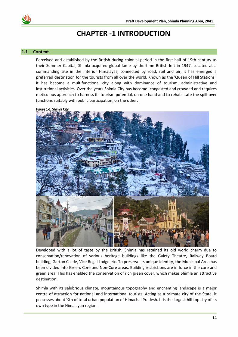
Figure 1-1: Shimla City
Developed with a lot of taste by the British, Shimla has retained its old world charm due to
conservation/renovation of various heritage buildings like the Gaiety Theatre, Railway Board
building, Garton Castle, Vice Regal Lodge etc. To preserve its unique identity, the Municipal Area has
been divided into Green, Core and Non-Core areas. Building restrictions are in force in the core and
green area. This has enabled the conservation of rich green cover, which makes Shimla an attractive
destination.
Shimla with its salubrious climate, mountainous topography and enchanting landscape is a major
centre of attraction for national and international tourists. Acting as a primate city of the State, it
possesses about ¼th of total urban population of Himachal Pradesh. It is the largest hill top city of its
own type in the Himalayan region.
15
Draft Development Plan, Shimla Planning Area, 2041
1.2 Project background
Development of Shimla has been guided and regulated by the statutory Interim Development Plan
(IDP) notified in 1979 for horizon year 2001, under the provisions of the Himachal Pradesh Town and
Country Planning Act, 1977 and the Himachal Pradesh Town and Country Planning Rules 1978(Now
Rules, 2014). However, over the past two decades from 2001 till date, the provisions of Interim
Development Plan (1979-2001) are in force with various amendments carried from time to time.
Over last four decades, Shimla has continued to develop and expand rapidly to accommodate ever-
increasing residents as well as floating population, but mostly in unregulated and un-planned
manner.
Therefore, considering the eternal wait of over 40 years, there is an urgent need of Development
Plan for Shimla in order to revive the growth regulators with the vision for a well-regulated and
planned Shimla and its peri-urban areas, best capturing the urbanisation trend and aspiration of the
city and its fringes. Shimla also has a fragile ecosystem and natural environment that require a lot
more care and proper planning for sustainable development. Thus, this Development Plan is
prepared considering its potentials of tourist destination, vibrant environment, natural ecosystem
and its capacity to accommodate future resident as well as floating population by the year 2041.
This Development Plan has been prepared under AMRUT Sub-Scheme of Govt. of India by the Town
and Country Planning Department, Himachal Pradesh. GIS-based Development Plan Formulation for
Shimla Planning Area comprises of Shimla Municipal Corporation and its surrounding areas including
Kufri, Shoghi and Ghanahatti Special Areas and Additional villages, under the provisions of the
Himachal Pradesh Town and Country Planning Act, 1977. The National Remote Sensing Centre,
Hyderabad, has provided the GIS base map for Development Plan, which is the nodal agency for
providing high-resolution Satellite imagery and GIS data-base under AMRUT Sub-Scheme.
The development plan is prepared considering AMRUT objectives:
i. To Ensure that every household has access to a tap with assured supply of water and a
sewerage connection;
ii. To Increase the amenity value of cities by developing greenery and well maintained open
spaces (e.g. parks);
iii. To reduce pollution by switching to public transport or constructing facilities for non-
motorized transport (e.g. walking and cycling). One purpose of the Mission is to improve
governance through a set of Reforms. During the Mission period, 11 Reforms will be
implemented, of which Preparation of Development Plan using GIS is one of the most
important reforms.
The objective of the GIS-based Development Plan is to formulate a statutory document with a set of
strategic guidelines to validate systematic planned development in the planning area, which is
sustainable, eco-friendly and conducive of economic growth. The DP attempts to meet the emerging
challenges of urban infrastructure and focuses on efficient land-use planning, environmental
conservation, regeneration, improving the quality of life by creating resilient and efficient
infrastructural systems with sufficient provision of amenities and other community services while
upholding the social, community and cultural considerations. It also ensures protection & restoration
of the city's historic architectural heritage & natural assets. The proposed DP will be structurally in
tune with the physiography of the development area in order to contain human vulnerability in the
event of natural disasters. The entire physical proposals of the development plan will be prepared on
a GIS platform for ease of storage, accuracy, retrieval, analysis, manipulation and updation over
time.
16
Draft Development Plan, Shimla Planning Area, 2041
As per the scope of the project, there were six stages/ deliverables in the project given as below:
1. Inception Report
2. Spatial Attribute collection and vetting of Base map
3. Data Analysis Report
4. Projected Requirements, Issues and Potentials
5. Draft Development Plan
6. Development Plan
1.3 Previous Development Plan formulation Interventions
1.3.1 Interim Development Plan, 1979
First formal and statutory Interim Development Plan (IDP) in Himachal Pradesh, in accordance with
provisions of the Himachal Pradesh Town and Country Planning Act, 1977 and Rules, 1978 there
under was notified for Shimla Planning Area in 1979. The proposals of IDP were envisaged for year
2001. Subsequently, in order to implement the Development Plan, Shimla Development Authority
(SDA) was constituted, which during latter half of 1980s and first half of 1990s developed and built
New Shimla Township, implemented a housing complex under IDSMT near Vikasnagar, constructed
an office complex at Kasumpti and Ashwani lift water supply scheme. A National Highway bye pass
was also constructed by the National Highway Authority. Instead of going in for the creation of
serviced land for potential buyers of plots, the SDA concentrated on building construction activities,
which resulted in haphazard development. Though SDA was upgraded in 1995 as Himachal Nagar
Vikas Pradhikaran (HNVP), which too confined to building construction activities only in Shimla and a
few other towns. Ultimately during year 2000, finding no difference in the Development Authority
and Housing Board, the same was amalgamated into Housing Board. In the absence of concrete
action for creation of serviced land on one hand, and vital community provisions including arterial
road network on the other, the implementation of Development Plan could not be carried to the
logical conclusions.
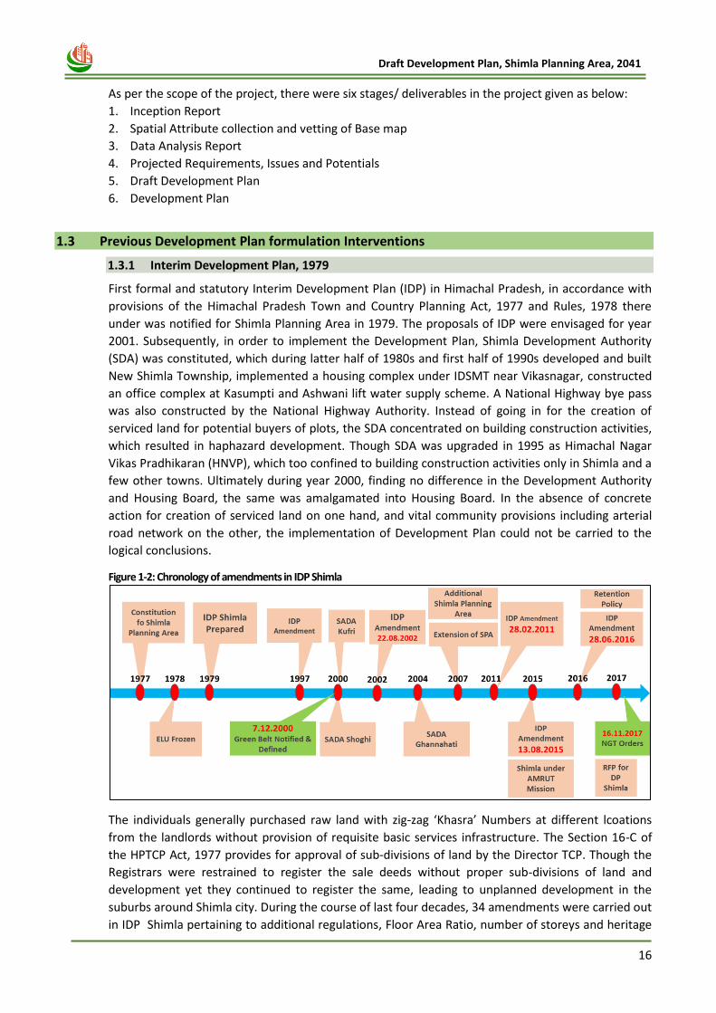
Figure 1-2: Chronology of amendments in IDP Shimla
The individuals generally purchased raw land with zig-zag ‘Khasra’ Numbers at different lcoations
from the landlords without provision of requisite basic services infrastructure. The Section 16-C of
the HPTCP Act, 1977 provides for approval of sub-divisions of land by the Director TCP. Though the
Registrars were restrained to register the sale deeds without proper sub-divisions of land and
development yet they continued to register the same, leading to unplanned development in the
suburbs around Shimla city. During the course of last four decades, 34 amendments were carried out
in IDP Shimla pertaining to additional regulations, Floor Area Ratio, number of storeys and heritage

17
Draft Development Plan, Shimla Planning Area, 2041
imperatives. The ban on construction activities was imposed thrice. Most of the planning and
development activities of Central area of Shimla were brought under the control of State
Government being in heritage and sensitive zone.
1.3.2 Draft Development Plan, 2004-2005 (Not Finalised)
Keeping in view the vast expansion of Shimla due to rapid urbanisation during the last two decades,
the Department continued to make sincere efforts to accomplish the task of finalization the Draft
Development Plan. Also, Public Awareness Campaigns were conducted under a Norwegian Agency
for Development (NORAD) Project by the TCP Department and accordingly, the department had
worked out a model for future development of Shimla. The Draft Developmen Plan was based on
the physical survey and broad existing land use map of years 2002 and on the basis of findings of
socio-economic, traffic and transportation and infrastructural surveys and studies. Thus, in order to
prepare a technically viable document, acceptable to the masses, about 32 deliberations and
seminars including a national seminar with the public, grass-root functionaries, stakeholders, public
representatives and Non-Governmental Organizations (NGOs) were organized. A brain storming
deliberation was also held with the Municipal Corporation, Shimla on the proposed Development
Plan. The Draft Development Plan was published for inviting public objections and suggestions vide
notice dated 26.04.2004, which appeared in Rajpatra on 26.05.2004. In response to said notice, 93
objections / suggestions were received, out of which 57 objections were related to the Green Belt. In
order to elicit broad involvement of social pressure groups, 19 interactive sessions were convened,
which were chaired by professionals, various authorities, environmentalists and heritage experts.
After incorporating necessary changes with respect to decisions on all the objections/ suggestions,
the Draft Development Plan was finalized and submitted to the Government vide letter No.
HIM/TP/PJT/DP-Shimla/ 2005-Vol.IX/1451-52 dated 13.05.2005. However, the Draft Development
could not be finalised and notified by the State Govt.
1.3.3 Draft Development Plan, 2012 (Not Finalised)
Though the provisions of Interim Development Plan envisaged for 2001 are still continuing fully, a
revised Draft Development Plan was again devised for horizon year 2021, in order to orient it in
accordance with changing requirements and aspirations of people of Shimla. The updated Draft
Development Plan was published for inviting public objections/suggestions vide Notice dated
22.12.2011. After hearing the objections/suggestions and incorporating the decisions taken thereon,
the Draft Development Plan was again sent to the Govt. vide letter dated 13.2.2012. The same was
placed before the Cabinet wherein it was decided that the Environment Impact Assessment of
Shimla Planning Area be got done to take a decision regarding allowing construction in Green belts.
The Environment Impact Assessment was got done by the Department through the Department of
Environment, Science and Technology wherein it was concluded not to open the 17 pockets of Green
belts for any type of construction.
1.4 Development Plan 2041
The Town and Country Planning Department, Himachal Pradesh under the AMRUT Sub-Scheme of
Govt. of India have prepared this Draft Development Plan (2041). Thus, the spade work done in
preprataion of Draft Developemnt Plans in past by the Department has enormously helped in
present exercise udner AMRUT Sub-Scheme. Various recommendations, as emanated from various
stakeholnder deliberations forms the basis for working out proposals of the Draft Development Plan
for 2041. The plans and proposals of various departments and local authorities have been duly
incorporated and future land requirements worked out accordingly which form an integral part of
this Draft Development Plan. This Plan envisages for massive implementation through “Land Pooling
and Reconstitution” mechanism along with restricted land acquisition for projects of Govt. priority. It
18
Draft Development Plan, Shimla Planning Area, 2041
emphasizes upon massive public-private participation by involvement of Development Authorities,
Municipal Corporation, Panchayats, Revenue Department and services infrastructural departments.
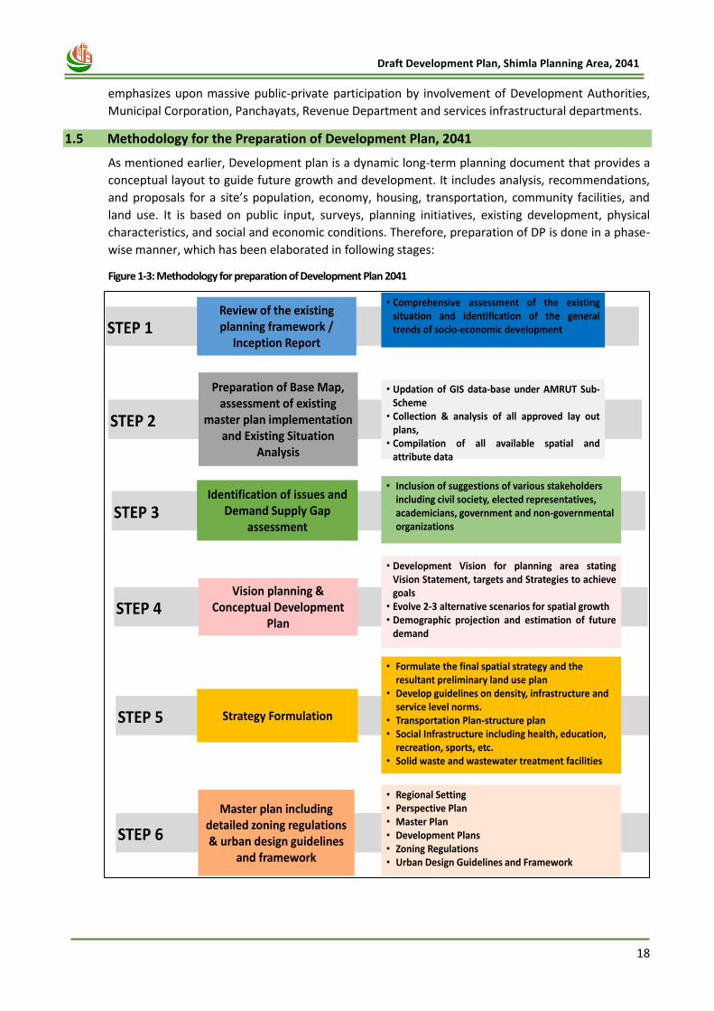
1.5 Methodology for the Preparation of Development Plan, 2041
As mentioned earlier, Development plan is a dynamic long-term planning document that provides a
conceptual layout to guide future growth and development. It includes analysis, recommendations,
and proposals for a site’s population, economy, housing, transportation, community facilities, and
land use. It is based on public input, surveys, planning initiatives, existing development, physical
characteristics, and social and economic conditions. Therefore, preparation of DP is done in a phase-
wise manner, which has been elaborated in following stages:
Figure 1-3: Methodology for preparation of Development Plan 2041
Review of the existing planning framework /
Inception Report
• Comprehensive assessment of the existingsituation and identification of the generaltrends of socio-economic developmentSTEP 1
STEP 2
STEP 3
STEP 4
STEP 5
Preparation of Base Map, assessment of existing
master plan implementation and Existing Situation
Analysis
• Updation of GIS data-base under AMRUT Sub-Scheme
• Collection & analysis of all approved lay outplans,
• Compilation of all available spatial andattribute data
Identification of issues and Demand Supply Gap
assessment
• Inclusion of suggestions of various stakeholders including civil society, elected representatives, academicians, government and non-governmental organizations
Vision planning & Conceptual Development
Plan
• Development Vision for planning area statingVision Statement, targets and Strategies to achievegoals
• Evolve 2-3 alternative scenarios for spatial growth• Demographic projection and estimation of future
demand
Strategy Formulation
• Formulate the final spatial strategy and the resultant preliminary land use plan
• Develop guidelines on density, infrastructure and service level norms.
• Transportation Plan-structure plan• Social Infrastructure including health, education,
recreation, sports, etc.• Solid waste and wastewater treatment facilities
STEP 6
Master plan including detailed zoning regulations & urban design guidelines
and framework
• Regional Setting• Perspective Plan• Master Plan• Development Plans• Zoning Regulations• Urban Design Guidelines and Framework
19
Draft Development Plan, Shimla Planning Area, 2041
1.6 Project Monitoring and Review
The Consultant’s work has been monitored and reviewed by the Consultancy Evaluation and Review
Committee (CERC) under the Chairmanship of the Director, TCP (as a requisite in RFP document).
The other memebers of the CERC are State Town Planner Member, Commissioner, Municipal
Corporation, Shimla Member, Town & Country Planner, Shimla Member, Chief Planner, TCPO/MoUD
or his representative Member and Town & Country Planner (HQ). Throughout the DP preparation
process, consultant has presented the work before the CERC, for its approval. Subsequently, all
comments and suggestions in the form of feedback, provided by CERC members have been
incorporated in the report.
1.7 Stakeholder/Public Consulations
Stakeholder Consultation has been conducted at all the stages as envisaged in RFP of tender
document. At each and every stage, public participation was ensured through meetings wherein the
agenda of the meeting was conveyed in advance and the activities being undertaken were discussed
in detail during each meeting. The main purpose of the Stakeholder Consultation Meetings and
Workshops was to get the brief understanding about the Shimla from the local people and prima
facie understand the issues that the people of Shimla are facing and to get a holistic idea of socio-
economic profile of the region. The other main objective of the public meetings were to make the
representatives (including various departments and elective members) aware about the process of
the preparation of the Development Plan and the timelines related to its implementation along with
gathering their valuable suggestions.
Figure 1-4: Consultation meetings with representative of the Ghanahati, Shoghi, Kufri Special Area and MC Shimla Council Members
During the finalisation of proposals and the Draft Development Plan, the consultation meetings with
the public representative of the Ghanahati Special Area, Shoghi Special Area, Kufri Special Area and
MC Shimla Council members, were held under the Chairmanship of the Town and Country Planner,
Divisional Town Planning Office, Shimla on 07.09.2021, 11.09.2021, 14.09.2021 and 09.11.2021
respectively to discuss the preparation of GIS-based Development Plan for Shimla Planning Area
under AMRUT sub-scheme.
Figure 1-5: Meeting with Hon’ble UD, TCP & Housing Minister
20
Draft Development Plan, Shimla Planning Area, 2041
In addition, 2 meetings with all line Departments were also conducted on 13.07.2021 & 15.07.2021,
which included the line department being represented in the Implementation Committee(IC) as well
as Supervisory Committee (SC) constituted as per directions of Hon’ble NGT. Simultaneously, there
were various discussions/ meetings with Pr. Secretary, (TCP) at various stages during the preparation
of Development Plan. Also, consultation meetings under the Chairmanship of Hon’ble UD, TCP &
Housing Minister, HP, were held on 09.08.2021 and 17.01.2022. The feedback and suggestions were
also taken from the experts, departments, public representatives. The suggestions received from
Public Representatives and line departments also associated in Implementation Committee
constituted by NGT have been duly considered and incorporated in the Development Plan,
depending upon the scope of project.
1.8 Report Structure
This report is based on analyses of various secondary data and Primary surveys and Guidelines. The report comprises of detailed description and analysis of sectoral issues, potentials along with projections of population, housing & slum, physical infrastructure, social infrastructure, Recreational, Tourism, Traffic & transportation, Existing / Proposed Land use distribution and Building Byelaws. The Report is framed under the following sequential manner:
Chapter-1: Introduction: This chapter covers introduction, project background and the profile of the planning area including its location and regional setting as well as details of the planning area along with its urban and rural components.
Chapter-2: Shimla Planning Area Profile: This chapter covers the profile of Shimla Planning Area, including the details of Notified Area, Historical significance and how physically city has grown over the last century.
Chapter-3: Vision and Development Strategy: The chapter begins with the SWOT Analysis, in order to understand the planning area in a better way, which includes the strengths, weakness, opportunities and threats of Shimla Planning Area. Followed by which the document will provide us the orientation for setting up the vision and aim for the Development Plan for Shimla 2041.
Chapter-4: Demographic Profile: It highlights the detailed demographic profile of the Shimla Planning Area like rural urban population composition, population growth trends. Along with the existing trends, population for the horizon year is projected.
Chapter-5: Economic Profile: This chapter details out the economic base of the planning area. The existing and projected economic base, workforce, their occupational structure, commercial establishment, tourism, Agro processing, trading centre, IT park etc. are discussed.
Chapter-6: Traffic and Transportation: This chapter includes traffic and transportation scenarios in the planning area. The issues identified from analysis of primary surveys are discussed and the potential areas/ strategies of developments are mentioned. Further, various integrated transportation proposals have been elaborated in the chapter for Shimla Planning Area.
Chapter-7: Physical Infrastructure: This chapter deals with physical infrastructure facilities like water supply system, sewerage & sanitation, solid waste management and power supply. The issues & problems in different infrastructure, the requirement and the proposals for horizon year 2041 are discussed.
Chapter-8: Social Infrastructure: This chapter highlights the existing Social infrastructure facilities available in the planning area. The chapter elaborates the education facility, health and
21
Draft Development Plan, Shimla Planning Area, 2041
other facilities. As per the planning principles, the requirement for the horizon year is calculated and presented.
Chapter-9: Housing and Slums: This chapter focuses on the housing scenario, housing characteristics, and available facilities & infrastructure along with the slum and urban poor in the city. The chapter also discusses the housing shortages and need in Shimla Planning Area for the horizon year 2041.
Chapter-10: Tourism Profile - This chapter highlights the status of tourism activities, issues and strategies & proposals for the Shimla Planning.
Chapter-11: Heritage Profile - This chapter covers the rich heritage of Shimla Planning Area, including all Heritage Building, areas, tis significance. Followed by which strategies and proposals have been suggested in the later section.
Chapter-12: Environment: The chapter discusses the existing status of the physical environment, ecology, status of natural hazards & vulnerability of the planning area. Followed by which, the chapters covers the NGT Directives, its carrying capacity report and its implications in Shimla Planning Area. Subsequently, in this chapter, the role of Building Bye-laws and Planned Development in the growth and planning of Shimla Town have been specified.
Chapter-13: Existing Land Use & Land Suitability Analysis: This chapter focuses This chapter gives an understanding of the processes of preparation of base map and existing land map of the planning area. Further, it focuses on the issues in the existing land uses within the planning area. Also, existing situations are analysed to find out the direction of future growth and proposed land use is estimated.
Chapter-14: Proposed Land Use: This chapter provides broad proposed landuse for the promotion of planned development with details of different landuses provided based on URDPFI Guidelines requirements.
Chapter-15: Development Plan Implementation: Various tools and financial mechanisms identified for Urban Development and their financing and revenue generation have been detailed out in this chapter.
Chapter-16: Development Plan Phasing: Development to be proposed for 2041 for Shimla Planning Area, has been detailed out in phase-wise manner and costing of the same projects has been listed out in this chapter.
Chapter-17: General Regulations and Building Byelaws: for the successful implementation of proposed zoning, building byelaws and guidelines have been elaborated in this chapter.
22
Draft Development Plan, Shimla Planning Area, 2041
s
Chapter 2
SHIMLA PLANNING AREA
PROFILE
23
Draft Development Plan, Shimla Planning Area, 2041
2 CHAPTER -2 SHIMLA PLANNING AREA PROFILE
2.1 Introduction
Shimla, prior to its development as a hill station was described as an “obscure village”. The village
was named ‘Shimla’ after the temple of Goddess Shyamala located in the village. Another legend is
that ‘Shimla’ or ‘Simla’ is named as is pronounced by the hill people. According to Mr. W.H. Carrey
the original village of Shimla was situated on the ground lying to the east of present secretariat
buildings, above the road leading to the Ripon hospital, and immediately below the Roman Catholic
chapel, S. Michael’s school, and the Court house. Popularly known as ‘Jewel of the orient’ and
‘Queen of Hill Stations’ Shimla has to mainted its past glory in terms of its unique heritage and
environmental quality. Shimla is well known as summer capital of the British era with its highly
varied natural ecosystem. The population of Shimla is around 2.41 lakh as per census 2011. In the
event of growth in population due to capital city and administartive heqd quarter of the State , and
the resulting need to ease traffic chaos, regulate construction activities and provide services
infrastructure to the residents, a perspective strategy has been chalked out to uphold the original
character of Shimla, on one hand and to make it technologically a viable and competitive modern
city. This Development Plan, therefore, paves a way for a healthy, wealthy and vibrant Shimla,
attracting tourists from all over the world, a city that takes care of its citizens and accommodates
those who intend to settle in it as well as in its environs.
2.2 Shimla Planning Area- Area of Interest (AOI)
In order to ensure planned and regulated growth of Shimla Planning Area, Government of Himachal
Pradesh extended the Himachal Pradesh Town and Country Planning Act, 1977 vide Notification No.
9-12/72-PW (B) dated 24.3.1977. Subsequently, the Planning Area was constituted vide Notification
No. 9-12/72/PW (B) dated 30.11.1977. Existing landuse of Planning Area was frozen vide notice
dated 14.3.1978, whereby change of landuse became mandatory requirement. Subsequently, the
Interim Development Plan of Planning Area was devised and notified vide Notification No. TCP-FS(6)-
54/94 dated 2.8.1979. Thereafter, 127 revenue villages and 421 part revenue villages were excluded
from Shimla Planning Area, in view of demand of people thereof vide Notification No. TCP-F (6)-
54/94 dated 2.8.1995.
Table 2-1: Settlements falling within Planning Area
Name of Area/Entity Area (in ha.) Population ( Census 2011)
Municipal Corporation, Shimla (AMRUT City) 2,207 1,69,578
Ghanahatti Special Area 1,647 10,601
Kufri Special Area 3,173 12,505
Shoghi Special Area 2,923 12,755
Additional Shimla Planning Area 12,500 33,928
Jutogh Cantonment Area 1 141 2062
Total 22,450 2,41,429 (Source: Official Rajpatra Notification and Census 2011)
1 Jutogh Cantonment Area is not a part of Shimla Planning area, as per the notification. However, Cantonment Area,
because of being surrounded by Planning boundary from all sides, has been mentioned separately in land-use statement and population estimates as well.
24
Draft Development Plan, Shimla Planning Area, 2041
However, subsequently, vide Notification No. TCP-F(5)-4/2000, dated 11.08.2000 Kufri Special Area
and Shoghi Special Area have been constituted by designating some parts of Shimla Planning Area as
special areas. Thus, 33 revenue villages were included in Kufri Special Area and 49 revenue villages in
Shoghi Special Area. Thereafter, vide Notification No. TCP-F(5)-13/2001 dated 2.3.2002, 14 more
revenue villages were included in Kufri Special Area. Further Additional Shimla Planning Area notified
vide Notification No. TCP-F (5)-1/2006 dated 12.1.2007. Now a total area of 22,450 hectares is taken
into account for formulation of Development Plan, which includes, Municipal Corporation Shimla,
Special Area Development Authorities of Kufri, Shoghi, Ghanahatti and villages of Additional Shimla
Planning Area.
The entire planning area comprises of a total of 375 villages (divided amongst the three SADA’s and
the additional Shimla Planning Area) in addition to Shimla MC and Jutogh Cantonment Area (141
Ha), which adjoins the western boundary of Shimla MC. The distribution of these villages has been
briefly demonstrated in shown below and the detail lists of notified villages has been listed in
Annexure- A.
Table 2-2: Village Distribution
Area Villages (Whole) Villages( Partly) Total Villages
Kufri Special Area 30 17 47
Shoghi Special Area 31 18 49
Ghanahatti Special Area 31 05 36
Additional Planning Area 213 30 243
Total Villages 375
(Source: Census of India, 2011 and TCP, Shimla)
The outer boundaries of foregoing area taken for integrated perspective Development Plan are as
under:-
North: Starting from Marahwag (76), Ghandal (85), Jhundla (82),Gharog (92), Padech (63), chaser
(60), JungaJ chaser Pratham (4/60), JungaJ Ichaser Dwetiya (4/60) , Bharoi (4/61), Shadog
(5/68), Nalayal (5/73), Dhanyal (5/69), Tai and Giri (5/71), Bhoong (3/30), Mania (3/29),
Neri (3/35), Krand (28), Nawag (18), Kavi (20), Tood (21), Shahal (25), Pavabo(24),
Kamiyana (22), Mathav (320),Barmu (333), Jungle Badfar- Ba {340) , Saruila Baruila (341),
Dhani (345), Dhanain (344), Shildu Sapoli (311), Patengali (310), Kolu Jubbar (309),
Chanavat (308), Dhagog (305), Jungle Dhagog (304), Jotlu (303), Bhatia (302), Jungle
Bharog Sheel (298), Shaiser (291), Sheinal (290}, Neri (281), Durgapur (134), Naldehra
(279), Jungle Naldehra (278), Baldeyan (293), Jungal Mashobra (315), Mashobra (246),
Mashobra Bazar {246 A), Seepur (245), Jungle Mool Koti (238), Purani Koti (234), Kunee
(232), Kufri Koti (229), Kufri Junga (228), Jungal Kanger (45), Galu Kalan (320) and Fagu
(241).
East: Then following Fagu (241), Bani (371), Dehna (370), Kadarav {384), Jungal Teer Mahasu
(2), Galu Kalan (320),Galu Khurd (I99 ), Jungal Kanger (45), Kufri Koti (229), Jungle
Charabra (241),Catchment Area (242), Badah (350), Chadadyal (352), Mewag (353),
Chamayana (372), Malyana (376), Ganoti (377), Jungle Ganoti (380), Jalf (383), Gosan (1
17) and Kawalag Majhar (118)
South: Then following Kawalag Majhar (118), Pujarli 116, Kawara 115, Patiud (98), Banadi (123),
Bharor (124), Mahori (96), Shoghi (95), Gawahi (397), Pawad (393), Shadyal (399),
Shungal (398) and Dihari (424)
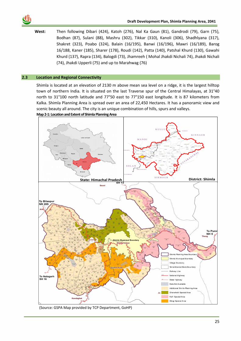
25
Draft Development Plan, Shimla Planning Area, 2041
West: Then following Dibari (424), Katoh (276), Nal Ka Gaun (81), Gandrodi (79), Garn (75},
Bodhan (87), Sulani (88), Mashru (302), Tikkar (310), Kanoli (306), Shadhlyana (317),
Shakret (323), Poabo (324), Balain (16/195), Banwi (16/196), Mawri (16/189), Barog
16/188, Kaner (185), Sharer (178), Roudi (142), Patta (140), Patshal Khurd (130), Gawahi
Khurd (137), Rapra (134), Balogdi (73), Jhamreeh ( Mohal Jhakdi Nichali 74), Jhakdi Nichali
(74), Jhakdi Upperli (75) and up to Marahwag (76)
2.3 Location and Regional Connectivity
Shimla is located at an elevation of 2130 m above mean sea level on a ridge, it is the largest hilltop
town of northern India. It is situated on the last Traverse spur of the Central Himalayas, at 31°40
north to 31°100 north latitude and 77°50 east to 77°150 east longitude. It is 87 kilometers from
Kalka. Shimla Planning Area is spread over an area of 22,450 Hectares. It has a panoramic view and
scenic beauty all around. The city is an unique combination of hills, spurs and valleys. Map 2-1: Location and Extent of Shimla Planning Area
(Source: GSPA Map provided by TCP Department, GoHP)
State: Himachal Pradesh District: Shimla
Shimla Planning Area
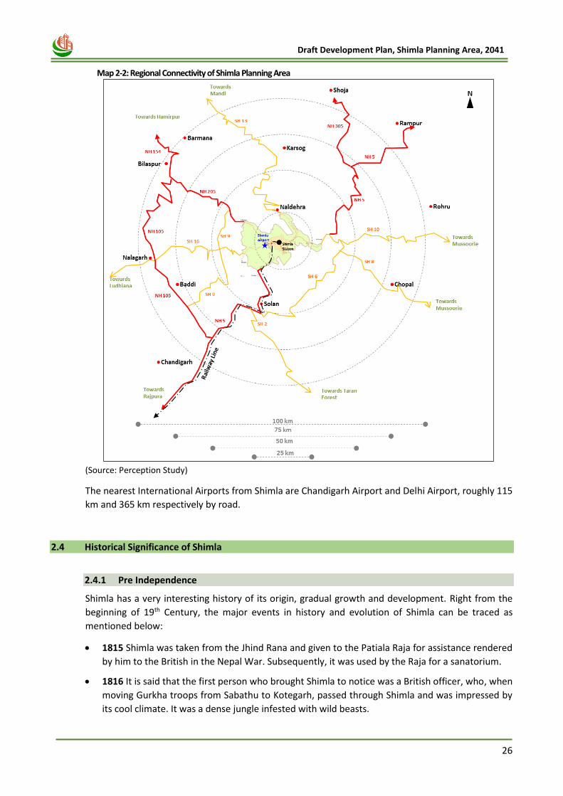
26
Draft Development Plan, Shimla Planning Area, 2041
Map 2-2: Regional Connectivity of Shimla Planning Area
(Source: Perception Study)
The nearest International Airports from Shimla are Chandigarh Airport and Delhi Airport, roughly 115
km and 365 km respectively by road.
2.4 Historical Significance of Shimla
2.4.1 Pre Independence
Shimla has a very interesting history of its origin, gradual growth and development. Right from the
beginning of 19th Century, the major events in history and evolution of Shimla can be traced as
mentioned below:
• 1815 Shimla was taken from the Jhind Rana and given to the Patiala Raja for assistance rendered
by him to the British in the Nepal War. Subsequently, it was used by the Raja for a sanatorium.
• 1816 It is said that the first person who brought Shimla to notice was a British officer, who, when
moving Gurkha troops from Sabathu to Kotegarh, passed through Shimla and was impressed by
its cool climate. It was a dense jungle infested with wild beasts.
27
Draft Development Plan, Shimla Planning Area, 2041
• 1817 It is however, claimed by Mr. A. Wilson in his ‘Abode of Snow’ that the hill on which Shimla
is situated was first made known by Gerard brothers. These two Scotch officers were engaged in
the survey of the Sutlej valley. Their diary, dated August 30, 1817 noted - Shimla, a middling
sized village where a fakir is situated and gives water to travelers. They encamped on the side of
Jakhoo, and had a very extensive and beautiful view.
• 1819 Lt. Ross Assistant Political Agent in the Hill States built a cottage of wood and thatch. This
was probably the first British House in Shimla.
• 1824 Invalids from the plains had been given permission to establish themselves in the locality
on rent free sites provided by the Maharaja of Patiala and Rana of Keionthal.
• 1825 A political agent, Major Kennedy constructed a permanent house on a rent free site. It was
named as Kennedy House.
• 1827 Lord Amherst, the then Governor General of India, after completing progress through
North-West proceeded for the summer months to Shimla. This was the foundation of Shimla’s
Greatness.
• 1828 Lord Combermere with his staff and the whole establishment of Army Head Quarters came
up to Shimla. During his stay, he superintended the construction of a bridge known as
‘Combermere Bridge’ and also a fine broad level road about three miles in length around Mt.
Jakhoo. The movement of British Officers to Shimla in the summers became a regular
phenomenon. This was perhaps the basic contributing factor to the evolution of “Shimla Village”
into a proper town and its fame as a hill station. Another factor that enhanced the popularity of
Shimla was its - ‘climate’, which combined with every imaginable beauty of natural terrain,
natural vegetation, springs and streams presented a very homely atmosphere to the British.
• 1831 Shimla had about sixty permanent houses and a bazaar. Communication between these
was secured by well-formed narrow but quite safe communication routes. Following the
example of British Officers, native chief also started visiting Shimla in the summers. Despite of
the difficulties of traveling to the top, the British used to visit Shimla every summer season like a
flock of the faithful, to escape the scorching heat of the plains and to smoothen their home sick
feelings and were considered “wise to surround themselves as far as they can with an English
atmosphere”.
• 1844 The number of houses in Shimla had risen to 100 as compared to 60 residences reported in
1831. Rapid growth led to necessity of providing amenities and services.
• 1851 Some of the social institutions through a central authority promoted the Municipal
Committee at Shimla. The Committee was responsible for establishment of the Town Hall with a
library, Gaiety Theatre, and Police Station. Municipal Market and Fire Brigade Services were also
provided in subsequent years.
• 1864 Shimla was declared the Summer Capital of Indian Govt. In the following years, the older,
narrower track from Kalka to Shimla was improved. A new road named Grand Hindustan-Tibet
road, 58 miles in length, passing through Dharampur, Solan and Kiaree Ghat was built.
• 1871 The Punjab Govt. also decided to use Shimla as its summer capital.
• 1901 In order to meet the water requirements of the much-increased population of the town,
the Municipal Committee installed powerful water pumps at Churat Nallah near Sanjauli, to lift
up 200,000 gallons of water.
28
Draft Development Plan, Shimla Planning Area, 2041
• 1902 Walker Hospital was opened. Prior to it there was only one medical institution, Ripon
Hospital, built in 1885?
• 1903 The electrical lighting system was introduced in the town and the first place to benefit was
the railway station.
• 1904 The Kalka-Shimla railway line was commissioned to make the town easily and comfortably
accessible. Shimla by now had grown considerably, mainly extending along the entire length of
ridge, the extreme ends of town were separated by a distance of six miles.
• 1913 To meet the increased demands of water supply, two steam pumping engines were
installed at Churat Nallah, supplying 150,000 gallons of water daily. Chaba electricity generating
station was also installed on the Sutlej, to supply electricity to the town (Heritage of Shimla).
Shimla city was planned and developed by the British in accordance with its ecological imperatives
for living, work and play. Institutional, British residential and tourist use on the top, commercial
establishments along the middle contour and Indian residential down below was the general pattern
of development.
The community facilities like schools, hospitals, postal and other amenities were located amidst the
said uses according to requirements. British bungalows were located on top of the ridges at
commanding locations. British planned Shimla strictly in consonance with contours and levels of
topography. All out-efforts were made to orient the plans in such a fashion so that maximum sun is
brought even inside the building.
The British took utmost care of the natural scenery and did not prefer to raise any construction
against the view, vision and vista. Rectangular buildings on various levels, specious environs thereof
and accessibility by roads and pedestrian paths were the essential features of the layouts of those
days.
2.4.2 Post –Independence Period
Nursed and popularized by the Govt., the elite, the traders and the tourists, the town continued to
grow in importance and size and when India became independent in 1947, Shimla was one of the
most important hill stations of the world. After the partition of India in 1947, many of the Punjab
Govt. Offices from Lahore in Pakistan were shifted to Shimla. In 1966, with the re-organisation of
territory into Punjab, Haryana and Himachal Pradesh, Shimla became the capital of Himachal
Pradesh. Since then Shimla has flourished as capital of the State and has continued to be an
important tourist resort of India and the world.
2.5 Shimla Municipal Corporation Shimla Municipal Corporation, one of the oldest institutions in the country passed through many
slings and arrows during the last one hundred and seventy one years of its existence. It was first
constituted as Municipal Committee in December, 1851, under the provision of Act XXVI of 1850.
Initially appointed Municipal Commissioners were Government officials and they failed to receive
the favour of House proprietor. The first election was held on August 26, 1855, following the first
meeting of the committee after its inception in 1854. The elected committee comprised of Deputy
Commissioner, Medical officer, Senior Assistant Commissioner, an Executive Engineer and house
proprietors. On July 31, 1871, the Shimla Municipal Committee was declared as Class I Municipality.
In 1874, it was brought Under the Punjab Municipal Act (IV of 1873) but there were grave objections
to this constitution of the Committee. In 1884, with the introduction of the Punjab Municipal Act (XII
of 1884), the town was divided into two wards- the Station and the Bazaar. The committee passed
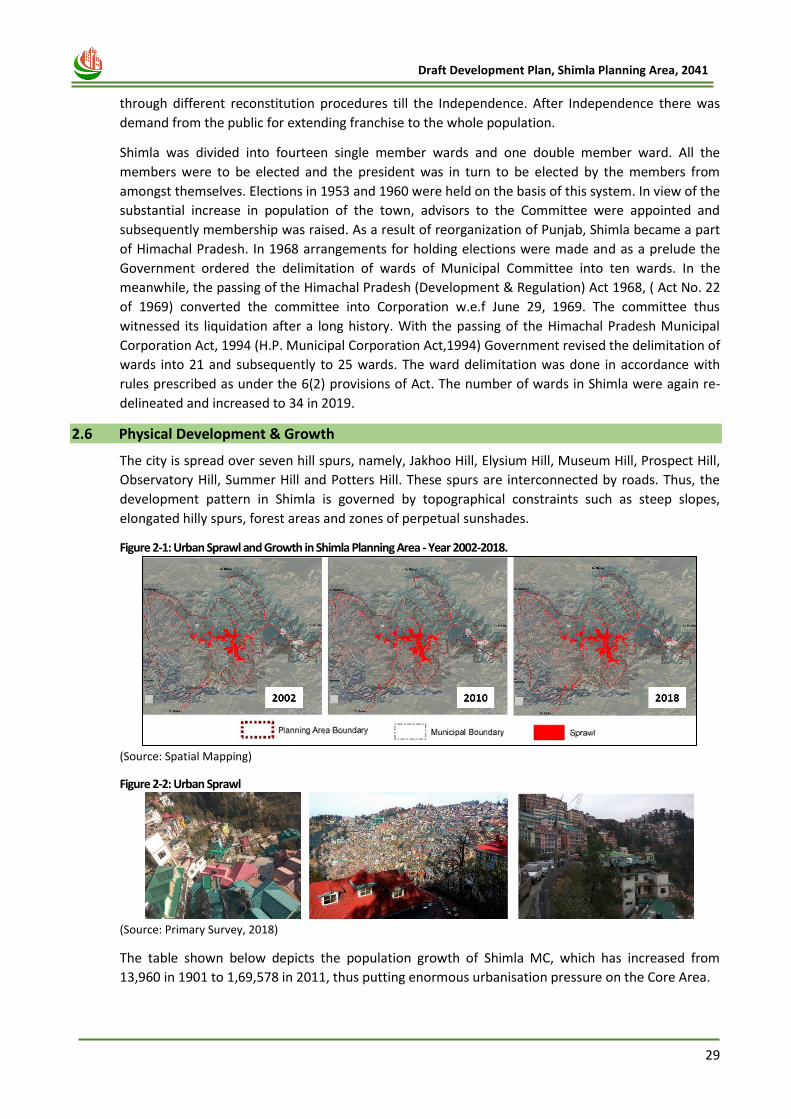
29
Draft Development Plan, Shimla Planning Area, 2041
through different reconstitution procedures till the Independence. After Independence there was
demand from the public for extending franchise to the whole population.
Shimla was divided into fourteen single member wards and one double member ward. All the
members were to be elected and the president was in turn to be elected by the members from
amongst themselves. Elections in 1953 and 1960 were held on the basis of this system. In view of the
substantial increase in population of the town, advisors to the Committee were appointed and
subsequently membership was raised. As a result of reorganization of Punjab, Shimla became a part
of Himachal Pradesh. In 1968 arrangements for holding elections were made and as a prelude the
Government ordered the delimitation of wards of Municipal Committee into ten wards. In the
meanwhile, the passing of the Himachal Pradesh (Development & Regulation) Act 1968, ( Act No. 22
of 1969) converted the committee into Corporation w.e.f June 29, 1969. The committee thus
witnessed its liquidation after a long history. With the passing of the Himachal Pradesh Municipal
Corporation Act, 1994 (H.P. Municipal Corporation Act,1994) Government revised the delimitation of
wards into 21 and subsequently to 25 wards. The ward delimitation was done in accordance with
rules prescribed as under the 6(2) provisions of Act. The number of wards in Shimla were again re-
delineated and increased to 34 in 2019.
2.6 Physical Development & Growth
The city is spread over seven hill spurs, namely, Jakhoo Hill, Elysium Hill, Museum Hill, Prospect Hill,
Observatory Hill, Summer Hill and Potters Hill. These spurs are interconnected by roads. Thus, the
development pattern in Shimla is governed by topographical constraints such as steep slopes,
elongated hilly spurs, forest areas and zones of perpetual sunshades.
Figure 2-1: Urban Sprawl and Growth in Shimla Planning Area - Year 2002-2018.
(Source: Spatial Mapping)
Figure 2-2: Urban Sprawl
(Source: Primary Survey, 2018)
The table shown below depicts the population growth of Shimla MC, which has increased from
13,960 in 1901 to 1,69,578 in 2011, thus putting enormous urbanisation pressure on the Core Area.
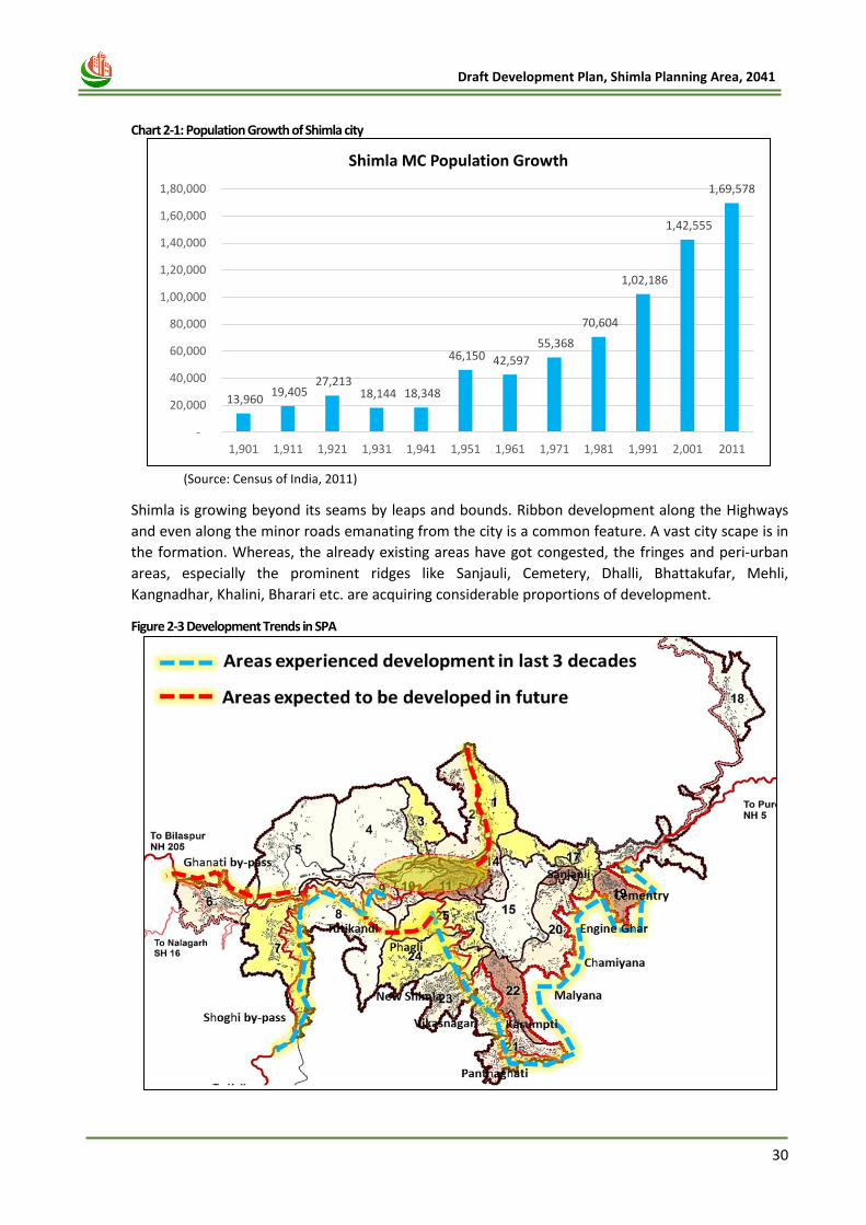
30
Draft Development Plan, Shimla Planning Area, 2041
Chart 2-1: Population Growth of Shimla city
(Source: Census of India, 2011)
Shimla is growing beyond its seams by leaps and bounds. Ribbon development along the Highways
and even along the minor roads emanating from the city is a common feature. A vast city scape is in
the formation. Whereas, the already existing areas have got congested, the fringes and peri-urban
areas, especially the prominent ridges like Sanjauli, Cemetery, Dhalli, Bhattakufar, Mehli,
Kangnadhar, Khalini, Bharari etc. are acquiring considerable proportions of development.
Figure 2-3 Development Trends in SPA
13,960 19,405
27,213 18,144 18,348
46,150 42,597
55,368
70,604
1,02,186
1,42,555
1,69,578
-
20,000
40,000
60,000
80,000
1,00,000
1,20,000
1,40,000
1,60,000
1,80,000
1,901 1,911 1,921 1,931 1,941 1,951 1,961 1,971 1,981 1,991 2,001 2011
Shimla MC Population Growth

31
Draft Development Plan, Shimla Planning Area, 2041
The British strived to build Shimla as a unique town at a commanding location and gave it a distinct
status of Summer Capital. There are many lessons to learn from its historical development in terms
of meticulous planning and development in accordance with environmental and ecological
imperatives, harmony of natural and built heritage. As Shimla is witnessing a spurt in construction
activities, during last few decades, it has to be restored to its past glory by public participation and
by building culture to preserve whatever is in consonance with nature and built heritage, on one
hand and to strive to make it attractive to tourists, on the other.

32
Draft Development Plan, Shimla Planning Area, 2041
Chapter 3
VISION AND DEVELOPMENT
STRATEGY
33
Draft Development Plan, Shimla Planning Area, 2041
3 CHAPTER- 3 VISION AND DEVELOPMENT STRATEGY
3.1 INTRODUCTION
A development plan is a dynamic long-term planning document that provides a conceptual layout to
guide future growth and development. Therefore, a clear vision and goal for a development plan
becomes very important as we embark on a journey to chart out the course of planned development
of Shimla Planning Area. Shimla, popularly known for its cleanliness, natural environs, rich heritage,
scenic beauty and a view of the beautiful Himalayas has to be saved from increasing pollution,
environmental degradation and haphazard and unregualted urbanisation. In order to tackle the
pressure on Shimla core, the developent has to be decentralised to the surrounding areas in form of
a counter Magnet town and satellite towns along major highways at an appreciable distance from
the existing Shimla Town. In addition this decentraised development has to be integrated with
proposed transportation corridors and new form of public transportation system such as Ropeways.
Moreover, a discipline in carrying out construction activities in accordance with physical,
environmental and ecological imperatives is the foremost necessity. Besides, statutory duty, it is the
moral responsibility of Development Authority, Municipal Corporation, Shimla, Environmentalists,
Heritage lovers, Spatial Planners and all those who have respect to their premier hill station to
protect it for tourists, safeguard its beauty and take remedial measures to pave way through
regulatory control along with conservative surgery to restore its basic character and make it
efficient, viable, healthy, wealthy and vibrant city, which may continue to attract tourists from all
over the world and cater for basic requirements of common man.
3.2 SWOT Analysis
For the development plan, it is necessary to prepare a long-term vision of the Shimla Planning Area
that considers the present strengths, opportunities, weakness and threats. Based on detailed
analysis and site observations under each sector, strength weakness, opportunities and threats are
prepared and discussed in the chapter.
3.2.1 Strengths
The major strength of Shimla Planning Area includes the following:
• Shimla is one of the most popular tourist destinations at national and international level.
• Shimla is well connected through road, rail and air with nearby urban centers.
• The city of Shimla is connected to the city of Kalka by one of the longest and World Heritage
listed narrow gauge railway routes “Toy Train”, the Kalka-Shimla Railway
• Higher in migration rate is observed especially due to the better educational and employment
opportunities. Being a capital city, it offers better public amenities & better lifestyle to its
residents. Pleasant atmosphere, favourable climate also attracts more migrants to the city.
• Being an educational hub, availability of higher educational amenities is more than sufficient in
the region.
• Being a State Capital of Himachal Pradesh, availability of health amenities is more than sufficient
in the region.
• 79% of the Shimla City’s population is having piped water supply system.
• Usage of Non – Motorized & Public Transportation is quiet high in the region.
34
Draft Development Plan, Shimla Planning Area, 2041
3.2.2 Weaknesses
The major weakness of Shimla Planning Area includes the following:
• Lack of Proper Junction Design results in traffic congestion & bottleneck situation.
• Insufficient Parking Provision has become a major issue in Shimla as people park their vehicles
on road by encroaching the road space at critical locations.
• Lack of availability of road infrastructure such as Street Lights, Signage and marking brings poor
Standard of living.
• Currently, water supply is more than sufficient in the region. But, old water supply network,
inadequate water sources and leakage results in the water scarcity.
• Dependency upon the tank water is quite high especially in the tourist places.
• Inadequate facilities and out-dated technologies in water treatment plant leads to higher water
losses in the area.
• Absence of Water metering system, water theft results in non-revenue water consumption.
• 50% of the HH’s are not having sewerage network.
• Actual Treatment Capacity of Sewerage Treatment Plan is far below the full design capacity and
most of the sample of effluent from the STPs fail to comply with the environmental standards.
• Private housing supply does not have the sufficient provision for the urban poor of the city.
• Area under recreational activities are considerably less as compared to the URDPFI Standards.
• Non availability of proper boundary delineation of the forest area creates a lot of issues
especially to the private land owners as no development can be done on the forest land.
• Vehicular usage are the main reason of increasing air pollution especially along the roads.
3.2.3 Opportunities
The major opportunities include:
• Due to the terrain restrictions, there is no much scope of development of big industrial
structures. But, there is a huge scope for development of small scale industries.
• Treated Sewerage might be useful for power generation in the near future.
• Projects under Smart City Mission will be helpful to redevelop the old bazaar areas and retrofit
the heritage area.
• Smart Public Transport (such as Ropeway) & Tunnel Project under Smart City Mission will
improve mobility network within the region.
• There is a huge potential to promote Eco – Tourism Activities in the Shimla Planning Area.
• Bulk Water Supply from Sutlej River will be helpful to meet the growing water demand of the
city.
• STP’s those have become critical in terms of capacity and treatment process are being upgraded
under AMRUT project.
3.2.4 Threats
The major threats include:
• Residential and Tourist density of most of the wards in core Shimla area are already high in
comparison to URDPFI Norms
35
Draft Development Plan, Shimla Planning Area, 2041
• Higher in migration rate puts a lot of burden on the existing infrastructure which leads to natural
resource depletion.
• Higher pedestrian movement, absence of footpath may increase higher risk to accident.
• Lines Leakage in the Sewer leads to the ground water contamination.
• Inadequate O&M of the existing sewerage system results in clogged lines leads to water and air
pollution
• In effective Solid Waste Management practice results in air pollution and water & Soil
Contamination.
• The Storm water management system in Shimla reflects large non-compliance to CPHEEO
Manual on Sewerage and Sewage Treatment with respect to several parameters which directly
affects health of the citizens.
• Plenty of mistakes are observed in construction techniques which may results to the Destruction
during natural disasters.
• Lack of availability of secure tenure for the slum dwellers results in unplanned and unsafe
development on higher slopes as well as on the river bed.
• New Economic activities needs to identify for employment generation as maximum working
population is depended upon the tourism related activities.
• Mixed use development, off street parking, narrow streets, and unpleasant visual quality of the
Old Market Areas needs higher attention to control unplanned Development.
• High level of construction activates are damaging the natural settings as well as its scenic beauty
of the region.
• Untreated disposal of waste water degrades the water quality of the region.
• Shimla and its surrounding region lie in seismic zone IV & V. Earthquake in this region will cause
total collapse of poorly built structures and partial collapse of ordinary buildings.
• Due to its terrain, soil conditions and steep slopes, Shimla is also susceptible to landslides.
• The height restriction after the NGT Order results in more horizontal development creating more
carbon footprints in the region.
The opportunities are to be converted into development strategies for Shimla Planning Area Phase-
1, whereas the weaknesses are to be overcome. Threats needs to be handled by mitigation
measures and strengths are to be enhanced.
3.3 Orientations for Development Plan of Shimla
For past few decades, the importance of Shimla’s historical development, in terms of meticulous
planning and development in accordance with environmental and ecological imperatives, harmony
of natural and built heritage has lost it sheen. The city has witnessed unprecedented impact of urban
ills, especially haphazard construction activity and congestion of its prime tourist locations. Thus, as
part of this Development Plan exercise, the focus is on restoring its past glory through urban
planning interventions in due consultation and public participation. The unplanned and
indiscriminate development in the Core, Non-core, Green and rural areas in Shimla Planning Area
has given rise to serious environmental and ecological concerns. Shimla was originally planned for a
population of 25,000 people, while it accommodates more than 2, 40,000 people besides the
floating population of tourists. As per experts, about 90% of the core city area has been built on
slopes more than 60 degree, thus making these constructions against architectural and geological
norms. These factors make Shimla highly susceptible to natural disasters. The area is also located in
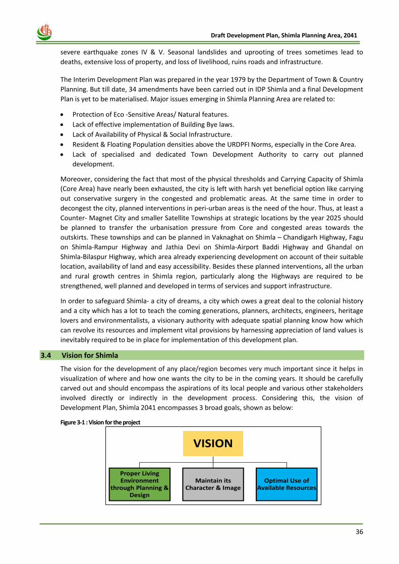
36
Draft Development Plan, Shimla Planning Area, 2041
severe earthquake zones IV & V. Seasonal landslides and uprooting of trees sometimes lead to
deaths, extensive loss of property, and loss of livelihood, ruins roads and infrastructure.
The Interim Development Plan was prepared in the year 1979 by the Department of Town & Country
Planning. But till date, 34 amendments have been carried out in IDP Shimla and a final Development
Plan is yet to be materialised. Major issues emerging in Shimla Planning Area are related to:
• Protection of Eco -Sensitive Areas/ Natural features.
• Lack of effective implementation of Building Bye laws.
• Lack of Availability of Physical & Social Infrastructure.
• Resident & Floating Population densities above the URDPFI Norms, especially in the Core Area.
• Lack of specialised and dedicated Town Development Authority to carry out planned
development.
Moreover, considering the fact that most of the physical thresholds and Carrying Capacity of Shimla
(Core Area) have nearly been exhausted, the city is left with harsh yet beneficial option like carrying
out conservative surgery in the congested and problematic areas. At the same time in order to
decongest the city, planned interventions in peri-urban areas is the need of the hour. Thus, at least a
Counter- Magnet City and smaller Satellite Townships at strategic locations by the year 2025 should
be planned to transfer the urbanisation pressure from Core and congested areas towards the
outskirts. These townships and can be planned in Vaknaghat on Shimla – Chandigarh Highway, Fagu
on Shimla-Rampur Highway and Jathia Devi on Shimla-Airport Baddi Highway and Ghandal on
Shimla-Bilaspur Highway, which area already experiencing development on account of their suitable
location, availability of land and easy accessibility. Besides these planned interventions, all the urban
and rural growth centres in Shimla region, particularly along the Highways are required to be
strengthened, well planned and developed in terms of services and support infrastructure.
In order to safeguard Shimla- a city of dreams, a city which owes a great deal to the colonial history
and a city which has a lot to teach the coming generations, planners, architects, engineers, heritage
lovers and environmentalists, a visionary authority with adequate spatial planning know how which
can revolve its resources and implement vital provisions by harnessing appreciation of land values is
inevitably required to be in place for implementation of this development plan.
3.4 Vision for Shimla
The vision for the development of any place/region becomes very much important since it helps in
visualization of where and how one wants the city to be in the coming years. It should be carefully
carved out and should encompass the aspirations of its local people and various other stakeholders
involved directly or indirectly in the development process. Considering this, the vision of
Development Plan, Shimla 2041 encompasses 3 broad goals, shown as below:
Figure 3-1 : Vision for the project
VISION
Proper Living Environment
through Planning & Design
Maintain its Character & Image
Optimal Use of Available Resources
37
Draft Development Plan, Shimla Planning Area, 2041
3.5 Planning Principles
The Vision perceived is further enumerated in the following specific development objectives as
following:
Table 3-1: Development Objectives
Goals Objectives
Living environment through proper
planning and design
• Reduce Pressure on the Core City Area
• The existing pattern of development of Shimla is insufficient to cater to the growing demand for residential, recreational, commercial and educational use for both residing and floating populations.
• Effective Implementation of Building Bye Laws
• Identification of newer areas for the future development
• Roads & Transportation- Strengthening the existing Road Network, Proposals of New Roads, Improvement in public Transportation system
Maintain its Character &
Image
• Development of more footpaths
• Conservation of heritage buildings
• Introduction of Urban Design Guidelines
• Development of Pedestrian Public spaces
• Development of more open spaces- parks & Garden
Optimal Use of Resources
• Protection of eco – sensitive areas
• Development of Shimla as – tourism network Centre
• Encouragement to eco-tourism
• Diversify the New economy
The Development Plan for the Shimla Planning Area has evolved from a comprehensive
understanding of the existing situation, land utilization pattern, land suitability & potential analysis,
and population projections carried out for the area. The process so far has involved an exploration of
several alternatives, for each of which, certain principles, laid down with a view to achieving the
vision for the Shimla Planning Area, have been primary guiding factors.
While the conceptual studies may differ in their design, the approach and underlying concerns, as
briefly stated above, are the same. Establishing coherence between ecological balance, residential
developments, urban infrastructure, economic activities and provision of amenities within the
Shimla Planning Area would be the key factor in the process of its future development. With
ecological sustainability being a major design criterion, the Development Plan emphasizes the need
for good quality of spaces for housing, education and health among the residents of the Shimla
planning area along with the provision of adequate infrastructure and civic amenities.
3.6 Development of Concept Alternatives
Shimla is situated at a hilly terrain with an advantage of natural scenic view, it was developed a place
to spend leisure time. However, as the development took over and the trend shifted towards the
unplanned and haphazard concrete environment, leading to increased pressure on the area over
time. Today both the existing infrastructure as well as the natural ecosystem is under pressure
because of the increasing urbanization. In this scenario, few sustainable scenario as shown below
could sustain the continuous growth.
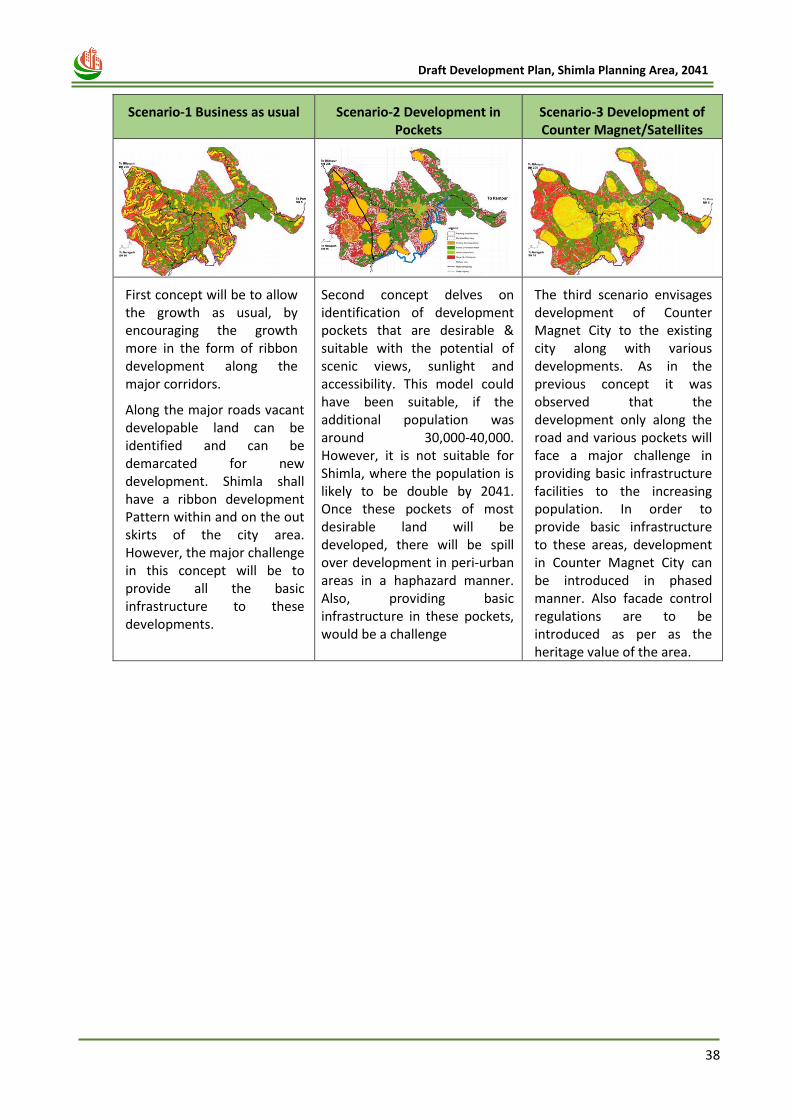
38
Draft Development Plan, Shimla Planning Area, 2041
Scenario-1 Business as usual Scenario-2 Development in Pockets
Scenario-3 Development of Counter Magnet/Satellites
First concept will be to allow the growth as usual, by encouraging the growth more in the form of ribbon development along the major corridors.
Along the major roads vacant developable land can be identified and can be demarcated for new development. Shimla shall have a ribbon development Pattern within and on the out skirts of the city area. However, the major challenge in this concept will be to provide all the basic infrastructure to these developments.
Second concept delves on identification of development pockets that are desirable & suitable with the potential of scenic views, sunlight and accessibility. This model could have been suitable, if the additional population was around 30,000-40,000. However, it is not suitable for Shimla, where the population is likely to be double by 2041. Once these pockets of most desirable land will be developed, there will be spill over development in peri-urban areas in a haphazard manner. Also, providing basic infrastructure in these pockets, would be a challenge
The third scenario envisages development of Counter Magnet City to the existing city along with various developments. As in the previous concept it was observed that the development only along the road and various pockets will face a major challenge in providing basic infrastructure facilities to the increasing population. In order to provide basic infrastructure to these areas, development in Counter Magnet City can be introduced in phased manner. Also facade control regulations are to be introduced as per as the heritage value of the area.
39
Draft Development Plan, Shimla Planning Area, 2041
s
Chapter 4
DEMOGRAPHIC PROFILE
40
Draft Development Plan, Shimla Planning Area, 2041
4 CHAPTER- 4 DEMOGRAPHIC PROFILE
4.1 Introduction
The development of a particular city, town or a region depends upon natural, physical and socio-
economic factors. Among these factors, population assumes significance in determining the future
pattern of progress and development. The Demographic profile of the Shimla Planning area has been
created based on the information derived from secondary sources and the Census of India, 2011.
4.2 Existing Population and Growth Trends
The total population of the Shimla Planning Area in addition to the three Special Areas namely Kufri,
Shoghi and Ghanahatti, the Additional Planning Area and Jutogh Cantonment Area is about 2,41,429
persons (as per Census of India, 2011). This constitutes 29.6% of the total population of the district
Shimla which was 8,14,010 persons as per Census 2011. As per census of India, population of Shimla
Municipal Corporation in 2011 was 1,69,578 of which male and female were 93,152 and 76,426
respectively.
Table 4-1: Total Population and Number of Households in Shimla Planning Area 2001- 2011.
2001 2011
Settlement Households Population Households Population Population Growth (In %)
M.C. Shimla 37,756 1,42,555 46,306 1,69,578 18.96
S.A Ghanahatti 2651 10,185 2,429 10,601 4.08
S.A Kufri 2,284 10,019 2,950 12,505 24.81
SA Shoghi 2,253 11,089 2,814 12,755 15.02
Additional Shimla Planning Area
5,427 29,151 6,850 33,928 -14.79
Jutogh Cantonment - - 394 2,062 16.39
Total 50,371 2,02,999 61,743 2,41,429 17.92 (Source: Census of India, 2011)
The Population Growth rate of Shimla Planning Area including the newly added villages of Additional
Panning Area in 2007, was 17.92% between 2001 to 2011, while the entire planning area
demonstrated a growth rate between 15-25%, Ghanahatti Special Area had a growth rate of just
4.08%, the lowest of all. Further, the trend in Decadal Growth Rate of population for Shimla Planning
Area is given in the table below. The decadal growth trend has been considered as per Census
Population available for Planning Area existing prior the inclusion of Additional Planning Area in year
2007 i.e. Planning Area with area of 99.50 Sqkms only.
Table 4-2: Decadal Growth Rate
Year No. of Persons
(Excluding the additional villages) Decadal Variation % Decadal Growth Rate
1971 72,870 -- --
1981 95,851 22,981 32%
1991 1,29,827 33,976 35%
2001 1,74,789 44,962 35%
2011 2,05,439 30,650 18% (Source: Census of India, 2011)
However, the population growth rate of Shimla Planning Area (including MC Shimla, Kufri, Shoghi and Ghanahatti Special Areas) has been observed to have slowed down since the year 2001 as the growth rate has decreased to about 18% in 2011 from 35% in 2001.
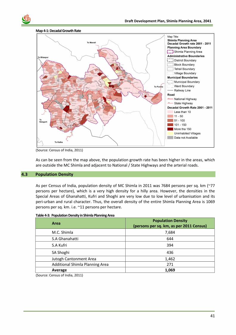
41
Draft Development Plan, Shimla Planning Area, 2041
Map 4-1: Decadal Growth Rate
(Source: Census of India, 2011)
As can be seen from the map above, the population growth rate has been higher in the areas, which are outside the MC Shimla and adjacent to National / State Highways and the arterial roads.
4.3 Population Density As per Census of India, population density of MC Shimla in 2011 was 7684 persons per sq. km (~77 persons per hectare), which is a very high density for a hilly area. However, the densities in the Special Areas of Ghanahatti, Kufri and Shoghi are very low due to low level of urbanisation and its peri-urban and rural character. Thus, the overall density of the entire Shimla Planning Area is 1069 persons per sq. km. i.e. ~11 persons per hectare.
Table 4-3: Population Density in Shimla Planning Area
Area Population Density
(persons per sq. km, as per 2011 Census)
M.C. Shimla 7,684
S.A Ghanahatti 644
S.A Kufri 394
SA Shoghi 436
Jutogh Cantonment Area 1,462
Additional Shimla Planning Area 271
Average 1,069 (Source: Census of India, 2011)
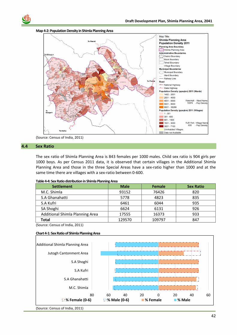
42
Draft Development Plan, Shimla Planning Area, 2041
Map 4-2: Population Density in Shimla Planning Area
(Source: Census of India, 2011)
4.4 Sex Ratio
The sex ratio of Shimla Planning Area is 843 females per 1000 males. Child sex ratio is 904 girls per 1000 boys. As per Census 2011 data, it is observed that certain villages in the Additional Shimla Planning Area and those in the three Special Areas have a sex-ratio higher than 1000 and at the same time there are villages with a sex-ratio between 0-600.
Table 4-4: Sex Ratio distribution in Shimla Planning Area
Settlement Male Female Sex Ratio
M.C. Shimla 93152 76426 820
S.A Ghanahatti 5778 4823 835
S.A Kufri 6461 6044 935
SA Shoghi 6624 6131 926
Additional Shimla Planning Area 17555 16373 933
Total 129570 109797 847 (Source: Census of India, 2011)
Chart 4-1: Sex Ratio of Shimla Planning Area
(Source: Census of India, 2011)
80 60 40 20 0 20 40 60
M.C. Shimla
S.A Ghanahatti
S.A Kufri
S.A Shoghi
Jutogh Cantonment Area
Additional Shimla Planning Area
% Female (0-6) % Male (0-6) % Female % Male
Shimla
Railwa
y
Station
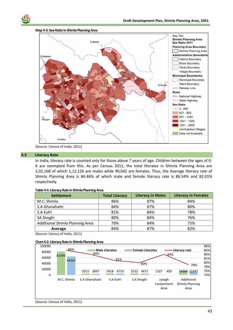
43
Draft Development Plan, Shimla Planning Area, 2041
Map 4-3: Sex-Ratio in Shimla Planning Area
(Source: Census of India, 2011)
4.5 Literacy Rate
In India, literacy rate is counted only for those above 7 years of age. Children between the ages of 0-6 are exempted from this. As per Census 2011, the total literates in Shimla Planning Area are 2,02,168 of which 1,12,126 are males while 90,042 are females. Thus, the Average literacy rate of Shimla Planning Area is 84.46% of which male and female literacy rate is 86.54% and 82.01% respectively.
Table 4-5: Literacy Rate in Shimla Planning Area
Settlement Total Literacy Literacy in Males Literacy in Females
M.C. Shimla 86% 87% 84%
S.A Ghanahatti 84% 87% 80%
S.A Kufri 81% 84% 78%
SA Shoghi 80% 84% 76%
Additional Shimla Planning Area 79% 84% 75%
Average 84% 87% 82% (Source: Census of India, 2011)
Chart 4-2: Literacy Rate in Shimla Planning Area
(Source: Census of India, 2011)
81495
5015 5418 5532 1327 14666
64567
3847 4710 4671 409 12247
86%84%
81%80%
84%
79%
74%76%78%80%82%84%86%88%
0
20000
40000
60000
80000
100000
M.C. Shimla S.A Ghanahatti S.A Kufri S.A Shoghi JutoghCantonment
Area
AdditionalShimla Planning
Area
Male Literates Female Literates Literacy rate
Shimla
Railwa
y
Station
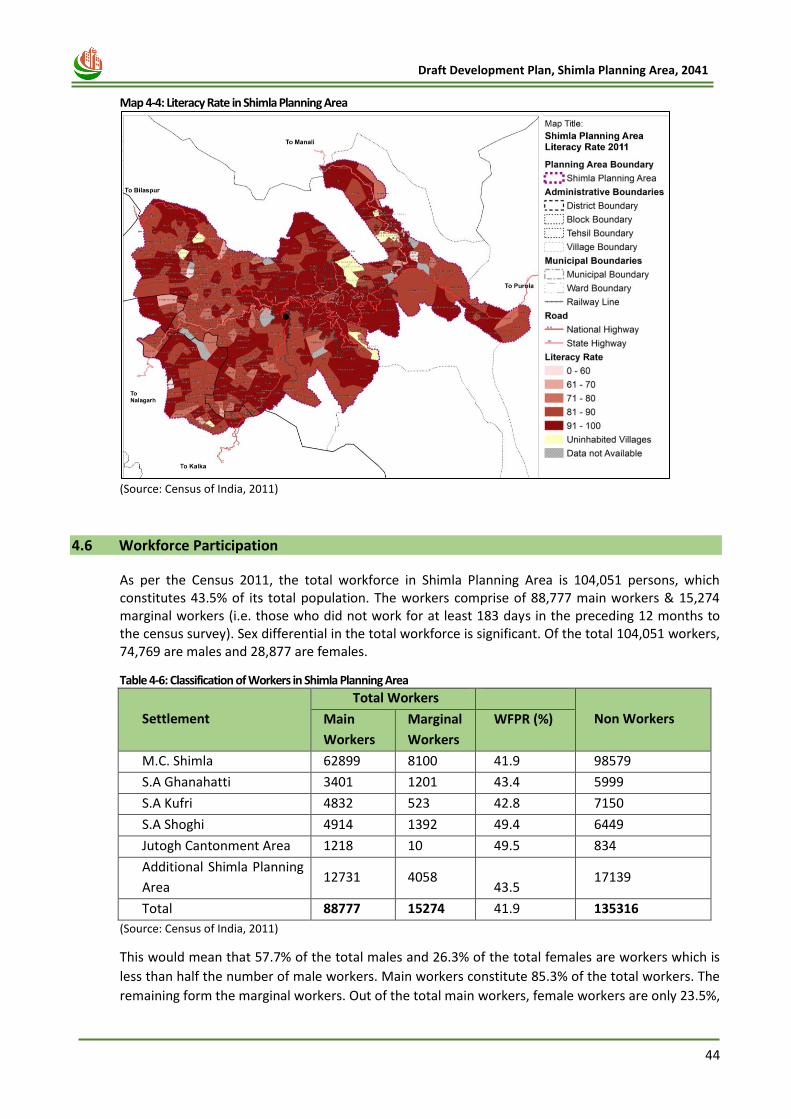
44
Draft Development Plan, Shimla Planning Area, 2041
Map 4-4: Literacy Rate in Shimla Planning Area
(Source: Census of India, 2011)
4.6 Workforce Participation
As per the Census 2011, the total workforce in Shimla Planning Area is 104,051 persons, which constitutes 43.5% of its total population. The workers comprise of 88,777 main workers & 15,274 marginal workers (i.e. those who did not work for at least 183 days in the preceding 12 months to the census survey). Sex differential in the total workforce is significant. Of the total 104,051 workers, 74,769 are males and 28,877 are females.
Table 4-6: Classification of Workers in Shimla Planning Area
Settlement
Total Workers
Non Workers Main
Workers
Marginal
Workers
WFPR (%)
M.C. Shimla 62899 8100 41.9 98579
S.A Ghanahatti 3401 1201 43.4 5999
S.A Kufri 4832 523 42.8 7150
S.A Shoghi 4914 1392 49.4 6449
Jutogh Cantonment Area 1218 10 49.5 834
Additional Shimla Planning
Area 12731 4058
43.5 17139
Total 88777 15274 41.9 135316
(Source: Census of India, 2011)
This would mean that 57.7% of the total males and 26.3% of the total females are workers which is
less than half the number of male workers. Main workers constitute 85.3% of the total workers. The
remaining form the marginal workers. Out of the total main workers, female workers are only 23.5%,
Shimla
Railwa
y
Station
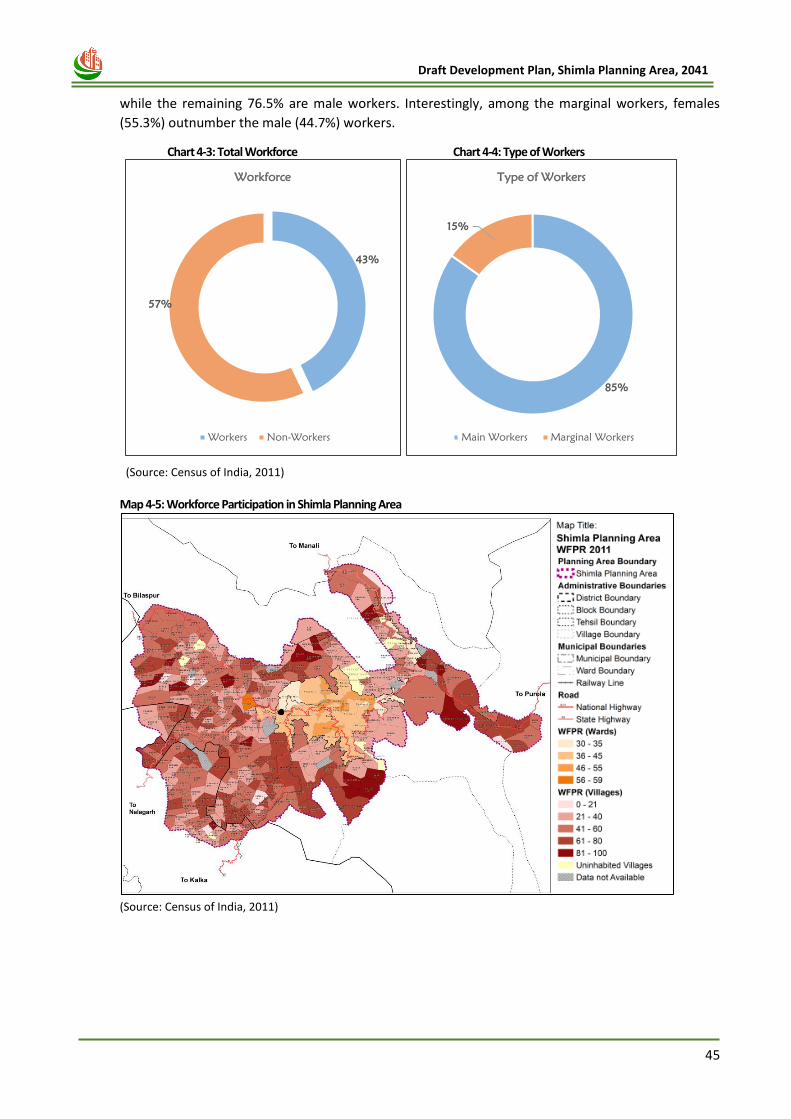
45
Draft Development Plan, Shimla Planning Area, 2041
while the remaining 76.5% are male workers. Interestingly, among the marginal workers, females
(55.3%) outnumber the male (44.7%) workers.
Chart 4-3: Total Workforce
Chart 4-4: Type of Workers
(Source: Census of India, 2011) Map 4-5: Workforce Participation in Shimla Planning Area
(Source: Census of India, 2011)
43%
57%
Workforce
Workers Non-Workers
85%
15%
Type of Workers
Main Workers Marginal Workers
Shimla
Railwa
y
Station
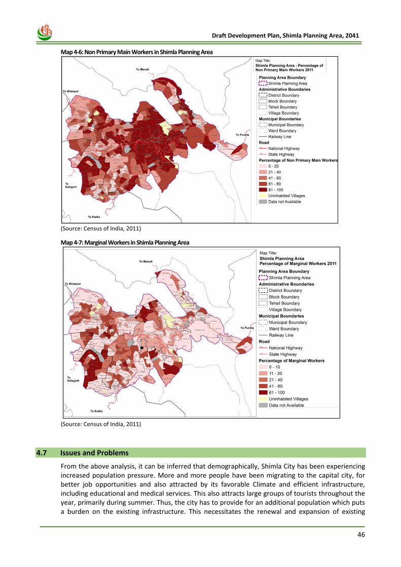
46
Draft Development Plan, Shimla Planning Area, 2041
Map 4-6: Non Primary Main Workers in Shimla Planning Area
(Source: Census of India, 2011)
Map 4-7: Marginal Workers in Shimla Planning Area
(Source: Census of India, 2011)
4.7 Issues and Problems
From the above analysis, it can be inferred that demographically, Shimla City has been experiencing increased population pressure. More and more people have been migrating to the capital city, for better job opportunities and also attracted by its favorable Climate and efficient infrastructure, including educational and medical services. This also attracts large groups of tourists throughout the year, primarily during summer. Thus, the city has to provide for an additional population which puts a burden on the existing infrastructure. This necessitates the renewal and expansion of existing
Shimla
Railwa
y
Station
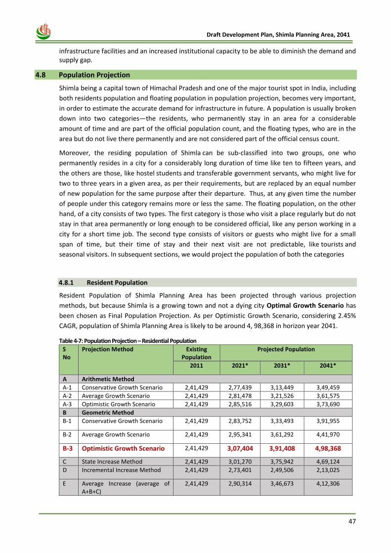
47
Draft Development Plan, Shimla Planning Area, 2041
infrastructure facilities and an increased institutional capacity to be able to diminish the demand and supply gap.
4.8 Population Projection
Shimla being a capital town of Himachal Pradesh and one of the major tourist spot in India, including
both residents population and floating population in population projection, becomes very important,
in order to estimate the accurate demand for infrastructure in future. A population is usually broken
down into two categories—the residents, who permanently stay in an area for a considerable
amount of time and are part of the official population count, and the floating types, who are in the
area but do not live there permanently and are not considered part of the official census count.
Moreover, the residing population of Shimla can be sub-classified into two groups, one who
permanently resides in a city for a considerably long duration of time like ten to fifteen years, and
the others are those, like hostel students and transferable government servants, who might live for
two to three years in a given area, as per their requirements, but are replaced by an equal number
of new population for the same purpose after their departure. Thus, at any given time the number
of people under this category remains more or less the same. The floating population, on the other
hand, of a city consists of two types. The first category is those who visit a place regularly but do not
stay in that area permanently or long enough to be considered official, like any person working in a
city for a short time job. The second type consists of visitors or guests who might live for a small
span of time, but their time of stay and their next visit are not predictable, like tourists and
seasonal visitors. In subsequent sections, we would project the population of both the categories
4.8.1 Resident Population
Resident Population of Shimla Planning Area has been projected through various projection
methods, but because Shimla is a growing town and not a dying city Optimal Growth Scenario has
been chosen as Final Population Projection. As per Optimistic Growth Scenario, considering 2.45%
CAGR, population of Shimla Planning Area is likely to be around 4, 98,368 in horizon year 2041.
Table 4-7: Population Projection – Residential Population
S No
Projection Method Existing Population
Projected Population
2011 2021* 2031* 2041*
A Arithmetic Method
A-1 Conservative Growth Scenario 2,41,429 2,77,439 3,13,449 3,49,459
A-2 Average Growth Scenario 2,41,429 2,81,478 3,21,526 3,61,575
A-3 Optimistic Growth Scenario 2,41,429 2,85,516 3,29,603 3,73,690
B Geometric Method
B-1 Conservative Growth Scenario 2,41,429 2,83,752 3,33,493 3,91,955
B-2 Average Growth Scenario 2,41,429 2,95,341 3,61,292 4,41,970
B-3 Optimistic Growth Scenario 2,41,429 3,07,404 3,91,408 4,98,368
C State Increase Method 2,41,429 3,01,270 3,75,942 4,69,124
D Incremental Increase Method 2,41,429 2,73,401 2,49,506 2,13,025
E Average Increase (average of A+B+C)
2,41,429 2,90,314 3,46,673 4,12,306
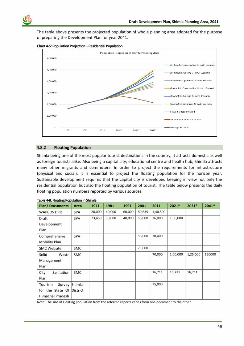
48
Draft Development Plan, Shimla Planning Area, 2041
The table above presents the projected population of whole planning area adopted for the purpose of preparing the Development Plan for year 2041.
Chart 4-5: Population Projection – Residential Population
4.8.2 Floating Population
Shimla being one of the most popular tourist destinations in the country, it attracts domestic as well
as foreign tourists alike. Also being a capital city, educational centre and health hub, Shimla attracts
many other migrants and commuters. In order to project the requirements for infrastructure
(physical and social), it is essential to project the floating population for the horizon year.
Sustainable development requires that the capital city is developed keeping in view not only the
residential population but also the floating population of tourist. The table below presents the daily
floating population numbers reported by various sources.
Table 4-8: Floating Population in Shimla
Plan/ Documents Area 1971 1981 1991 2001 2011 2021* 2031* 2041*
WAPCOS DPR SPA 20,000 40,000 60,000 80,635 1,40,500
Draft
Development
Plan
SPA 23,459 30,000 40,000 56,000 76,000 1,00,000
Comprehensive
Mobility Plan
SPA
56,000 78,400
SMC Website SMC
75,000
Solid Waste
Management
Plan
SMC
70,000 1,00,000 1,25,000 150000
City Sanitation
Plan
SMC
16,711 16,711 16,711
Tourism Survey
for the State Of
Himachal Pradesh
Shimla
District
75,000
Note: The size of Floating population from the referred reports varies from one document to the other.
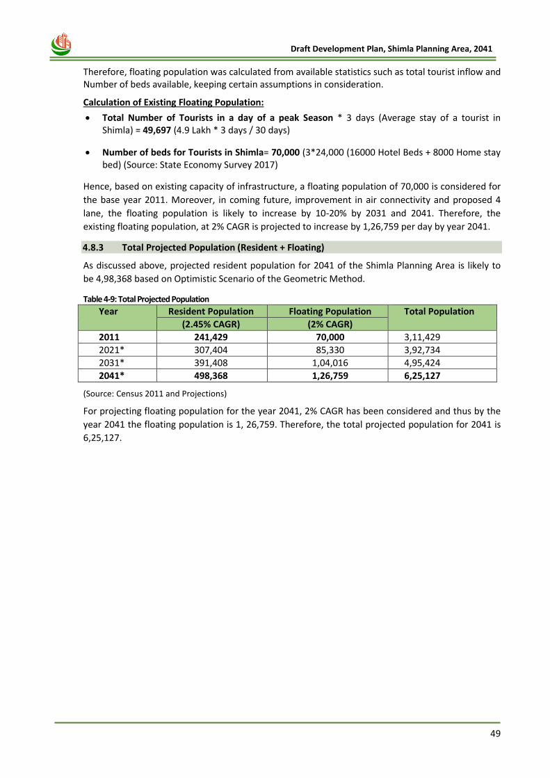
49
Draft Development Plan, Shimla Planning Area, 2041
Therefore, floating population was calculated from available statistics such as total tourist inflow and Number of beds available, keeping certain assumptions in consideration.
Calculation of Existing Floating Population:
• Total Number of Tourists in a day of a peak Season * 3 days (Average stay of a tourist in Shimla) = 49,697 (4.9 Lakh * 3 days / 30 days)
• Number of beds for Tourists in Shimla= 70,000 (3*24,000 (16000 Hotel Beds + 8000 Home stay bed) (Source: State Economy Survey 2017)
Hence, based on existing capacity of infrastructure, a floating population of 70,000 is considered for
the base year 2011. Moreover, in coming future, improvement in air connectivity and proposed 4
lane, the floating population is likely to increase by 10-20% by 2031 and 2041. Therefore, the
existing floating population, at 2% CAGR is projected to increase by 1,26,759 per day by year 2041.
4.8.3 Total Projected Population (Resident + Floating)
As discussed above, projected resident population for 2041 of the Shimla Planning Area is likely to
be 4,98,368 based on Optimistic Scenario of the Geometric Method.
Table 4-9: Total Projected Population
Year Resident Population Floating Population Total Population
(2.45% CAGR) (2% CAGR)
2011 241,429 70,000 3,11,429
2021* 307,404 85,330 3,92,734
2031* 391,408 1,04,016 4,95,424
2041* 498,368 1,26,759 6,25,127
(Source: Census 2011 and Projections)
For projecting floating population for the year 2041, 2% CAGR has been considered and thus by the
year 2041 the floating population is 1, 26,759. Therefore, the total projected population for 2041 is
6,25,127.
50
Draft Development Plan, Shimla Planning Area, 2041
Chapter 5
ECONOMIC PROFILE
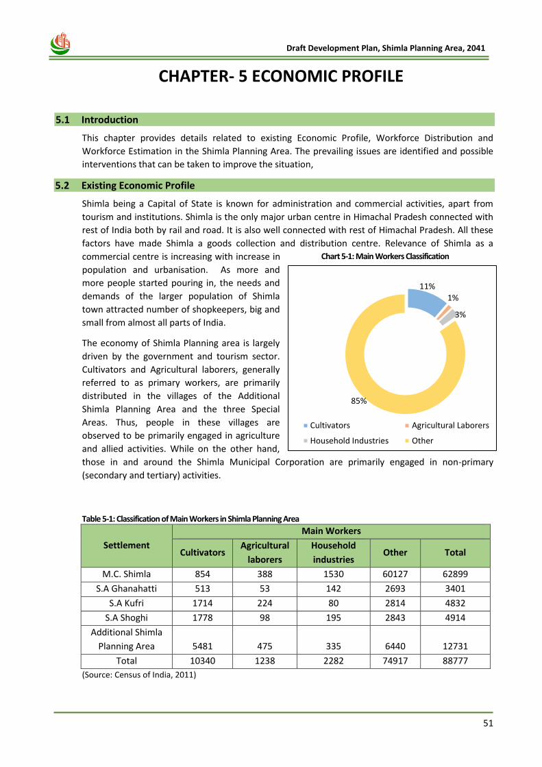
51
Draft Development Plan, Shimla Planning Area, 2041
5 CHAPTER- 5 ECONOMIC PROFILE
5.1 Introduction
This chapter provides details related to existing Economic Profile, Workforce Distribution and
Workforce Estimation in the Shimla Planning Area. The prevailing issues are identified and possible
interventions that can be taken to improve the situation,
5.2 Existing Economic Profile
Shimla being a Capital of State is known for administration and commercial activities, apart from
tourism and institutions. Shimla is the only major urban centre in Himachal Pradesh connected with
rest of India both by rail and road. It is also well connected with rest of Himachal Pradesh. All these
factors have made Shimla a goods collection and distribution centre. Relevance of Shimla as a
commercial centre is increasing with increase in
population and urbanisation. As more and
more people started pouring in, the needs and
demands of the larger population of Shimla
town attracted number of shopkeepers, big and
small from almost all parts of India.
The economy of Shimla Planning area is largely
driven by the government and tourism sector.
Cultivators and Agricultural laborers, generally
referred to as primary workers, are primarily
distributed in the villages of the Additional
Shimla Planning Area and the three Special
Areas. Thus, people in these villages are
observed to be primarily engaged in agriculture
and allied activities. While on the other hand,
those in and around the Shimla Municipal Corporation are primarily engaged in non-primary
(secondary and tertiary) activities.
Table 5-1: Classification of Main Workers in Shimla Planning Area
Settlement
Main Workers
Cultivators Agricultural
laborers
Household
industries Other Total
M.C. Shimla 854 388 1530 60127 62899
S.A Ghanahatti 513 53 142 2693 3401
S.A Kufri 1714 224 80 2814 4832
S.A Shoghi 1778 98 195 2843 4914
Additional Shimla
Planning Area 5481 475 335 6440 12731
Total 10340 1238 2282 74917 88777
(Source: Census of India, 2011)
11%
1%
3%
85%
Cultivators Agricultural Laborers
Household Industries Other
Chart 5-1: Main Workers Classification
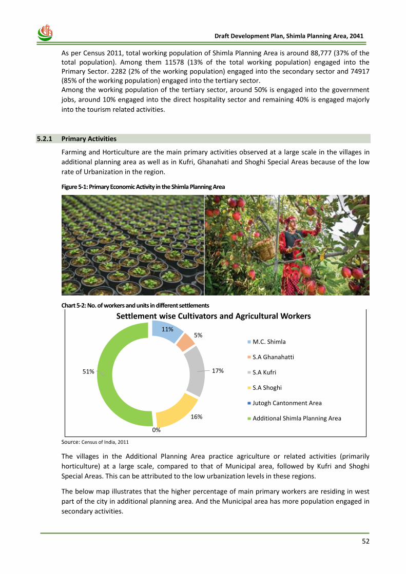
52
Draft Development Plan, Shimla Planning Area, 2041
As per Census 2011, total working population of Shimla Planning Area is around 88,777 (37% of the total population). Among them 11578 (13% of the total working population) engaged into the Primary Sector. 2282 (2% of the working population) engaged into the secondary sector and 74917 (85% of the working population) engaged into the tertiary sector. Among the working population of the tertiary sector, around 50% is engaged into the government
jobs, around 10% engaged into the direct hospitality sector and remaining 40% is engaged majorly
into the tourism related activities.
5.2.1 Primary Activities
Farming and Horticulture are the main primary activities observed at a large scale in the villages in
additional planning area as well as in Kufri, Ghanahati and Shoghi Special Areas because of the low
rate of Urbanization in the region.
Figure 5-1: Primary Economic Activity in the Shimla Planning Area
Chart 5-2: No. of workers and units in different settlements
Source: Census of India, 2011
The villages in the Additional Planning Area practice agriculture or related activities (primarily
horticulture) at a large scale, compared to that of Municipal area, followed by Kufri and Shoghi
Special Areas. This can be attributed to the low urbanization levels in these regions.
The below map illustrates that the higher percentage of main primary workers are residing in west
part of the city in additional planning area. And the Municipal area has more population engaged in
secondary activities.
11%5%
17%
16%
0%
51%
Settlement wise Cultivators and Agricultural Workers
M.C. Shimla
S.A Ghanahatti
S.A Kufri
S.A Shoghi
Jutogh Cantonment Area
Additional Shimla Planning Area

53
Draft Development Plan, Shimla Planning Area, 2041
Map 5-1: Primary main workers
Source: Census of India, 2011
5.2.2 Secondary Activities
Shimla town has majorly small scale and service industries. The major factors that had been limiting
the industrialization are the inhospitable geographical features, inadequate and exorbitant cost of
transport facilities and the absence of market in proximity. The region is also environmentally
sensitive for industrialization. The city practically had no industrial growth till late 1960's.
Chart 5-3: Types of industries and units
Source: Draft Development Plan, 2014
However, the traditional small scale industries like wool spinning, weaving, basket making and metal
work, that use the local resources are still lingering but in vain without attaining progress. Presently
there are about 450 small scale and service industries operating in Shimla Planning area. These units
are classified under the seven broad categories. About 2300 workers are employed in them. The city
has great potential for the establishment of small-scale environment friendly industries. Locally
available Raw material may be utilised and employment opportunities be generated so that
0
100
200
300
400
500
600
700
800
0
20
40
60
80
100
120
140
No
of
Wo
rke
rs
No
of
Un
its
No. of Units No. of Workers
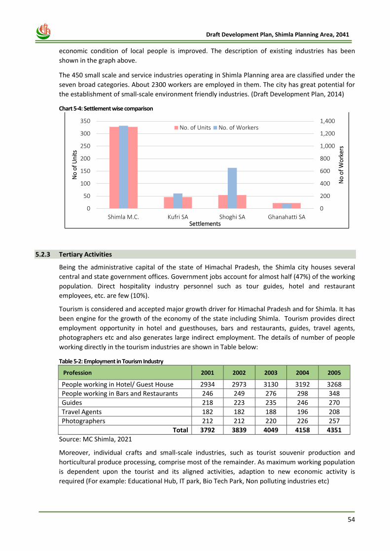
54
Draft Development Plan, Shimla Planning Area, 2041
economic condition of local people is improved. The description of existing industries has been
shown in the graph above.
The 450 small scale and service industries operating in Shimla Planning area are classified under the
seven broad categories. About 2300 workers are employed in them. The city has great potential for
the establishment of small-scale environment friendly industries. (Draft Development Plan, 2014)
Chart 5-4: Settlement wise comparison
5.2.3 Tertiary Activities
Being the administrative capital of the state of Himachal Pradesh, the Shimla city houses several
central and state government offices. Government jobs account for almost half (47%) of the working
population. Direct hospitality industry personnel such as tour guides, hotel and restaurant
employees, etc. are few (10%).
Tourism is considered and accepted major growth driver for Himachal Pradesh and for Shimla. It has
been engine for the growth of the economy of the state including Shimla. Tourism provides direct
employment opportunity in hotel and guesthouses, bars and restaurants, guides, travel agents,
photographers etc and also generates large indirect employment. The details of number of people
working directly in the tourism industries are shown in Table below:
Table 5-2: Employment in Tourism Industry
Profession 2001 2002 2003 2004 2005
People working in Hotel/ Guest House 2934 2973 3130 3192 3268
People working in Bars and Restaurants 246 249 276 298 348
Guides 218 223 235 246 270
Travel Agents 182 182 188 196 208
Photographers 212 212 220 226 257
Total 3792 3839 4049 4158 4351
Source: MC Shimla, 2021
Moreover, individual crafts and small-scale industries, such as tourist souvenir production and
horticultural produce processing, comprise most of the remainder. As maximum working population
is dependent upon the tourist and its aligned activities, adaption to new economic activity is
required (For example: Educational Hub, IT park, Bio Tech Park, Non polluting industries etc)
0
200
400
600
800
1,000
1,200
1,400
0
50
100
150
200
250
300
350
Shimla M.C. Kufri SA Shoghi SA Ghanahatti SA
No
of
Wo
rker
s
No
of
Un
its
Settlements
No. of Units No. of Workers
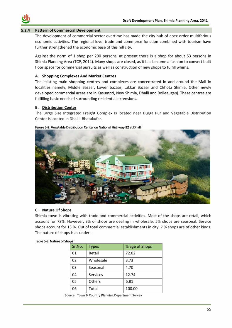
55
Draft Development Plan, Shimla Planning Area, 2041
5.2.4 Pattern of Commercial Development
The development of commercial sector overtime has made the city hub of apex order multifarious
economic activities. The regional level trade and commerce function combined with tourism have
further strengthened the economic base of this hill city.
Against the norm of 1 shop per 200 persons, at present there is a shop for about 53 persons in
Shimla Planning Area (TCP, 2014). Many shops are closed, as it has become a fashion to convert built
floor space for commercial pursuits as well as construction of new shops to fulfill whims.
A. Shopping Complexes And Market Centres
The existing main shopping centres and complexes are concentrated in and around the Mall in
localities namely, Middle Bazaar, Lower bazaar, Lakkar Bazaar and Chhota Shimla. Other newly
developed commercial areas are in Kasumpti, New Shimla, Dhalli and Boileauganj. These centres are
fulfilling basic needs of surrounding residential extensions.
B. Distribution Center
The Large Size Integrated Freight Complex Is located near Durga Pur and Vegetable Distribution
Center is located in Dhalli- Bhatakufar.
Figure 5-2: Vegetable Distribution Center on National Highway-22 at Dhalli
C. Nature Of Shops
Shimla town is vibrating with trade and commercial activities. Most of the shops are retail, which
account for 72%. However, 3% of shops are dealing in wholesale. 5% shops are seasonal. Service
shops account for 13 %. Out of total commercial establishments in city, 7 % shops are of other kinds.
The nature of shops is as under:-
Table 5-3: Nature of Shops
Sr.No. Types % age of Shops
01 Retail 72.02
02 Wholesale 3.73
03 Seasonal 4.70
04 Services 12.74
05 Others 6.81
06 Total 100.00
Source: Town & Country Planning Department Survey
56
Draft Development Plan, Shimla Planning Area, 2041
D. Classification of Shops
There are vegetable, cloth, furniture, fruit jam and Jewellery shops. General merchandise shops are
71% and 29% are others shops as given below:
Table 5-4: Classification of Shops
Items Sold % of Shops
General 71.20
Food 4.82
Vegetable 7.83
Cloths 4.21
Furniture 2.05
Chemist 2.77
Fruits 4.10
Jewellry 3.02
Total 100.00 Source: Town & Country Planning Department Survey
But the pattern of development in these areas are the major concerns that needs special attention
through modification in the building regulations such as:
1. Mixed Use Development: Ground storey, having access from the street, employed as a
commercial space whereas upper floors are used as a resident.
2. Off Street parking: Due to Lack of availability of the proper parking space in commercial areas,
vehicles are parked along the roads.
3. Unplanned and Chaotic Old Market Areas: Inadequate pedestrian moment due to narrower
streets and unplanned venders moment.
4. Most of the buildings are outage and unsafe – is a threat to the people who residing in them.
Hence, no activities for heritage conservation.
5. Lack of landscape adds to the unpleasant visual quality of the street.
6. Hardly any harmony is found in the facade element of the street
7. No proper sign boards
8. Lack of necessary amenities like; public toilets, dustbins, drinking water booths etc.
9. No availability of open spaces or natural beauty
5.3 Issues & Potentials
i. Maximum working population is engaged in the tourism related activities. New Economic activities needs to identify for employment generation.
ii. Shimla is the administrative capital of the state of Himachal Pradesh and hence there are many important departments and offices of the governing body in the city. The people working in these offices are the cogs and screws of the economy of Shimla.
iii. Mixed use development, off street parking, narrow streets, and unpleasant visual quality of the Old Market Areas needs higher attention to control unplanned and Chaotic Development.
iv. The commercial activities have come up here and there in every nook and corner of the city. It has been observed that more than 65% commercial establishments are located in Central Shimla. All out-efforts be made to decongest Shimla by shifting of wholesale, grain market, vegetable market, uncalled for non-conforming activities from the Central Shimla. Efforts may also be made to uphold the original character of central Shimla that was primarily developed by the British. Other few pockets including New Shimla, Kasumpti, Sanjauli, Chakker, Summer Hill, Totu, Longwood and Bharari have become crowded and are getting further congested. Therefore, non-conforming
57
Draft Development Plan, Shimla Planning Area, 2041
activities including workshops, wholesale have to be shifted to the periphery of the city in the west to Activities Zone. The menace of ribbon development of shopping pursuits has to be tackled on priority.
v. Planned and regulated development of commercial pursuits along with their proper location and spatial manifestation including requisite provision of parking and walkways need no emphasis. Planned commercial centres, each covering four to five sectors have to be developed at Ghanahatti, Activities Zone and Jathia Devi, besides local shopping to cater for sectoral requirements. Satellite towns have to be developed to cope up with any more population and commercial activities inevitably required to be accommodated in the adjoining areas of Shimla.
5.4 Economic Strategy and Recommendations
5.4.1 Workforce Estimation
As per Census 2011, WFPR is around 37% in the Shimla Planning Area. Working Population engaged in the primary, secondary and tertiary activities are 13%, 2% and 85% respectively. Based on the observation of last 3 decades, some assumptions are made and those are:
• Proposed WFPR for the horizon year 2041 is around 40%
• Proposed Occupational Structure for the Horizon Year 2041 is around 11%, 8% and 81% respectively.
Table 5-5: Workforce Estimation
Year 2011 2021 2031 2041
Population 234962 307404* 391408* 498368*
WFPR 37% 38%* 39%* 40%*
Total Working Population
88,777 1,16,813* 1,52,649* 1,99,347*
Primary Workers 11578 (13%) 14018* (12%) 16792* (11%) 21928* (11%)
Secondary Workers
2282 (2%) 5840* (5%) 10685* (7%) 15948* (8%)
Tertiary Worker 74917 (85%) 96955* (83%) 125172* (82%) 161471* (81%)
* Proposed Population
5.4.2 Commercial Establishment
A five tiers system of Commercial Areas is envisaged to accommodate required shopping,
commercial office and other service activities like cinema, hotel and restaurant and various
community services and facilities in an integrated manner. In addition, some components of
commercial use are also provided under mixed use, non-hierarchical commercial centers, and
informal sector in the selected areas
Table 5-6: Land Area Requirement for Commercial Establishment
Category Population Served per unit
Requirement based on population in 2041
Future Land requirement under
commercial use (Ha)
City Centre 5,00,000 2 (40X2) = 80
Community Centre 1,00,000 7 (7X5) = 35
Local shopping including service Centre
15,000 42 (42X0.46) = 19.32
Convenience Shopping 5,000 125 (125X0.15) = 18.75
58
Draft Development Plan, Shimla Planning Area, 2041
It has been observed that Shimla city is efficiently serving its local population, tourists as well as surrounding population. It is anticipated that number of commercial establishments is likely to be 153.07 Ha. by the year 2041 respectively. As per existing land-use, the area under commercial use is 100 ha, hence provision for remaining 53 hactare of land will be proposed in the zoning, mainly along the main roads.
5.4.3 TOURISM
Tourism has been driver for overall economy of the State. These would also be a consequent need to
sustain and hence focus on entertainment and city beautification through development of
entertainment/tourism zone, heritage precinct and parks/gardens. The strategies to sustain the
tourism sector have been separately presented in Chapter- 10, Tourism in detail.
5.4.4 AGRI-PROCESSING AND TRADING CENTR
Shimla district in Himachal Pradesh is designated as Agro Economic Zone (AEZ) for Apples. Shimla
being a major collection and distribution center for horticulture products, has potential for food
processing and providing backward linkage in agri produce retailing chain. Looking towards the
potential, major challenge lies in providing infrastructure for its sustainability. Integrated food parks
with cold chains, ware houses, post harvest handling and grading, sorting, waxing, precooling,
packaging center, processing units etc transport nagars, vegetable and fruit market would address
the needs of the sector.
GoHP has entered into MoA with Government of India for development AEZs in 2002. GOHP has
estimated an investment of Rs 57 Cr with about Rs 27.5 Cr to be contributed by GoI and GoHP and
balance to be raised through private sector investments. So far, no investment has come through.
It is recommended that GoHP undertake development of food park in Shimla Planning Area on PPP
leveraging the financial assistance available from GoI under the scheme. GoHP may initiate the
development of Food Park through a Special Purpose Vehicle and later on induct the private sector
partner through competitive bidding process at appropriate time. This would improve the
marketability of project for private sector to walk-in and smooth transfer of project to implementing
agency.
5.4.5 IT PARK
NASSCOM has projected Rs 20, 000 Crore IT potential for state by year 2009-10. GoHP has
formulated the State IT Policy and is envisaging establishment of IT Park at Waknaghat in Shimla
District. With extension of special industrial package to state upto 2010, the sector has potential to
provide fillip to the economy of the region. It is recommended that the project should be taken up
on the fast track for development in order to realize the potential.
59
Draft Development Plan, Shimla Planning Area, 2041
Chapter 6
TRAFFIC
&
TRANSPORTATION
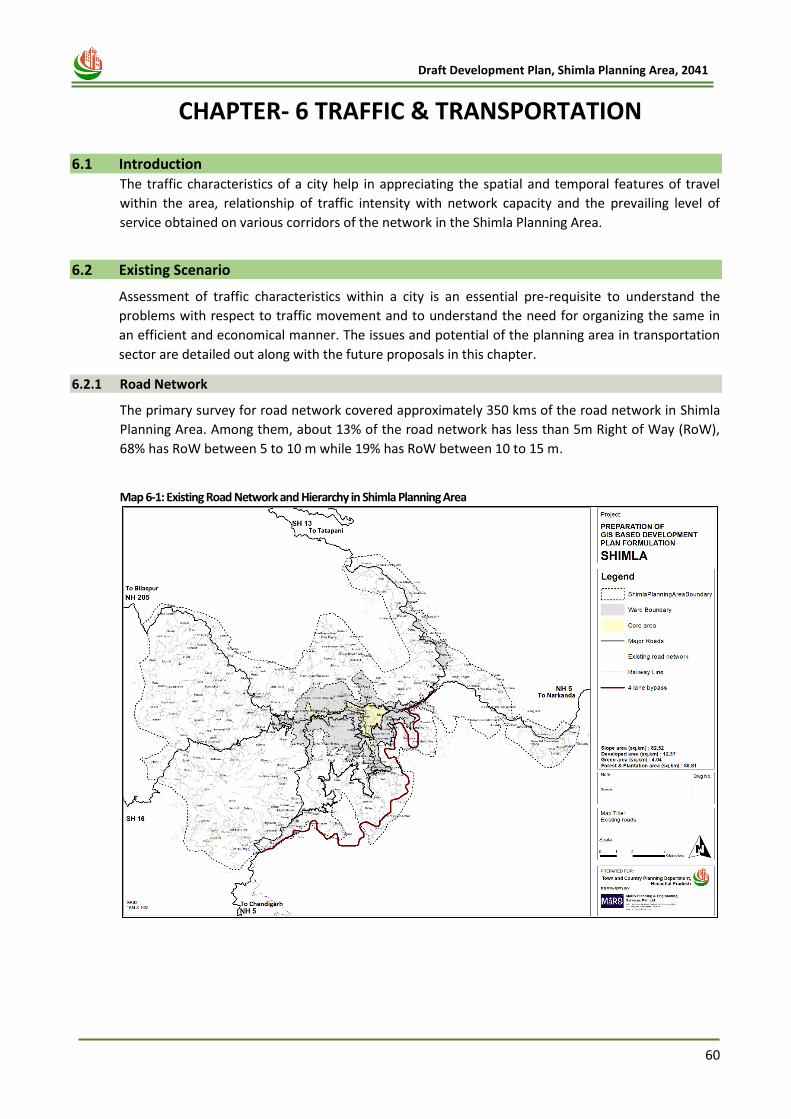
60
Draft Development Plan, Shimla Planning Area, 2041
6 CHAPTER- 6 TRAFFIC & TRANSPORTATION
6.1 Introduction The traffic characteristics of a city help in appreciating the spatial and temporal features of travel
within the area, relationship of traffic intensity with network capacity and the prevailing level of
service obtained on various corridors of the network in the Shimla Planning Area.
6.2 Existing Scenario
Assessment of traffic characteristics within a city is an essential pre-requisite to understand the
problems with respect to traffic movement and to understand the need for organizing the same in
an efficient and economical manner. The issues and potential of the planning area in transportation
sector are detailed out along with the future proposals in this chapter.
6.2.1 Road Network
The primary survey for road network covered approximately 350 kms of the road network in Shimla
Planning Area. Among them, about 13% of the road network has less than 5m Right of Way (RoW),
68% has RoW between 5 to 10 m while 19% has RoW between 10 to 15 m.
Map 6-1: Existing Road Network and Hierarchy in Shimla Planning Area
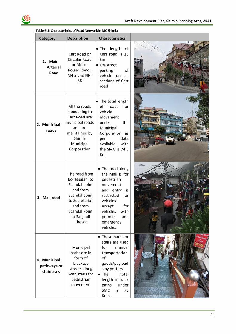
61
Draft Development Plan, Shimla Planning Area, 2041
Table 6-1: Characteristics of Road Network in MC Shimla
Category Description Characteristics
1. Main
Arterial
Road
Cart Road or Circular Road
or Motor Round Road , NH-5 and NH-
88
• The length of Cart road is 18 km
• On-street parking of vehicle on all sections of Cart road
2. Municipal
roads
All the roads connecting to Cart Road are
municipal roads and are
maintained by Shimla
Municipal Corporation
• The total length of roads for vehicle movement under the Municipal Corporation as per data available with the SMC is 74.6 Kms
3. Mall road
The road from Boileauganj to Scandal point
and from Scandal point to Secretariat
and from Scandal Point
to Sanjauli Chowk
• The road along the Mall is for pedestrian movement and entry is restricted for vehicles except for vehicles with permits and emergency vehicles
4. Municipal
pathways or
staircases
Municipal paths are in
form of blacktop
streets along with stairs for
pedestrian movement
• These paths or stairs are used for manual transportation of goods/payloads by porters
• The total length of walk paths under SMC is 73 Kms.
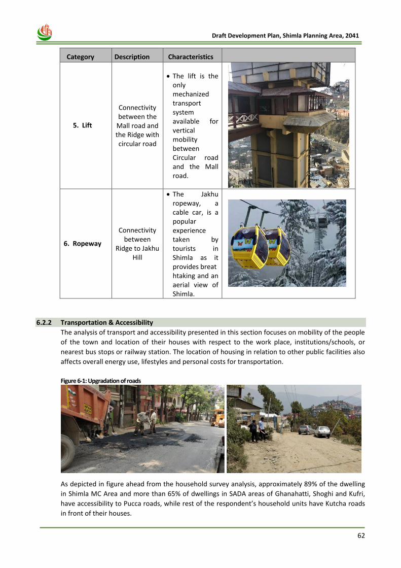
62
Draft Development Plan, Shimla Planning Area, 2041
Category Description Characteristics
5. Lift
Connectivity between the
Mall road and the Ridge with circular road
• The lift is the only mechanized transport system available for vertical mobility between Circular road and the Mall road.
6. Ropeway
Connectivity between
Ridge to Jakhu Hill
• The Jakhu ropeway, a cable car, is a popular experience taken by tourists in Shimla as it provides breathtaking and an aerial view of Shimla.
6.2.2 Transportation & Accessibility
The analysis of transport and accessibility presented in this section focuses on mobility of the people
of the town and location of their houses with respect to the work place, institutions/schools, or
nearest bus stops or railway station. The location of housing in relation to other public facilities also
affects overall energy use, lifestyles and personal costs for transportation.
Figure 6-1: Upgradation of roads
As depicted in figure ahead from the household survey analysis, approximately 89% of the dwelling
in Shimla MC Area and more than 65% of dwellings in SADA areas of Ghanahatti, Shoghi and Kufri,
have accessibility to Pucca roads, while rest of the respondent’s household units have Kutcha roads
in front of their houses.
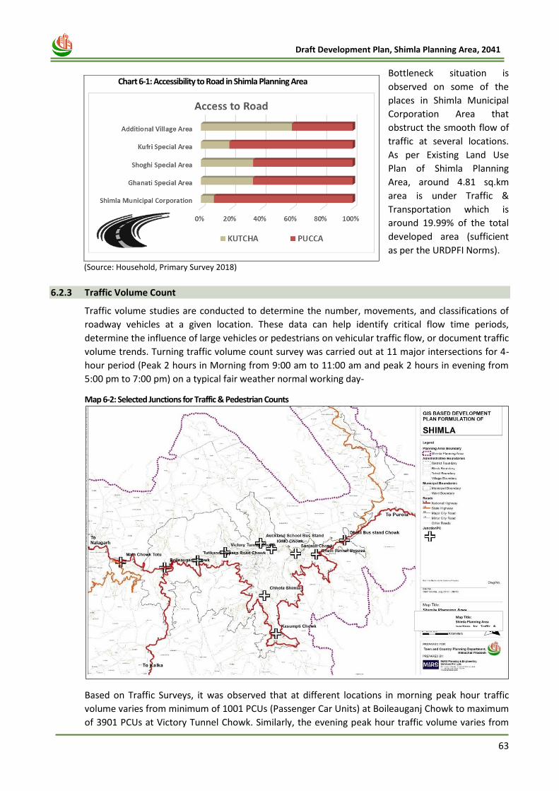
63
Draft Development Plan, Shimla Planning Area, 2041
Bottleneck situation is
observed on some of the
places in Shimla Municipal
Corporation Area that
obstruct the smooth flow of
traffic at several locations.
As per Existing Land Use
Plan of Shimla Planning
Area, around 4.81 sq.km
area is under Traffic &
Transportation which is
around 19.99% of the total
developed area (sufficient
as per the URDPFI Norms).
6.2.3 Traffic Volume Count
Traffic volume studies are conducted to determine the number, movements, and classifications of
roadway vehicles at a given location. These data can help identify critical flow time periods,
determine the influence of large vehicles or pedestrians on vehicular traffic flow, or document traffic
volume trends. Turning traffic volume count survey was carried out at 11 major intersections for 4-
hour period (Peak 2 hours in Morning from 9:00 am to 11:00 am and peak 2 hours in evening from
5:00 pm to 7:00 pm) on a typical fair weather normal working day-
Map 6-2: Selected Junctions for Traffic & Pedestrian Counts
Based on Traffic Surveys, it was observed that at different locations in morning peak hour traffic
volume varies from minimum of 1001 PCUs (Passenger Car Units) at Boileauganj Chowk to maximum
of 3901 PCUs at Victory Tunnel Chowk. Similarly, the evening peak hour traffic volume varies from
Chart 6-1: Accessibility to Road in Shimla Planning Area
(Source: Household, Primary Survey 2018)
Map Title: Shimla Planning Area Junctions for Traffic &
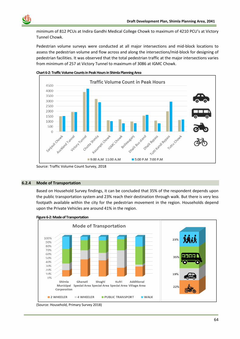
64
Draft Development Plan, Shimla Planning Area, 2041
minimum of 812 PCUs at Indira Gandhi Medical College Chowk to maximum of 4210 PCU’s at Victory
Tunnel Chowk.
Pedestrian volume surveys were conducted at all major intersections and mid-block locations to
assess the pedestrian volume and flow across and along the intersections/mid-block for designing of
pedestrian facilities. It was observed that the total pedestrian traffic at the major intersections varies
from minimum of 257 at Victory Tunnel to maximum of 3086 at IGMC Chowk.
Chart 6-2: Traffic Volume Counts in Peak Hours in Shimla Planning Area
Source: Traffic Volume Count Survey, 2018
6.2.4 Mode of Transportation
Based on Household Survey findings, it can be concluded that 35% of the respondent depends upon
the public transportation system and 23% reach their destination through walk. But there is very less
footpath available within the city for the pedestrian movement in the region. Households depend
upon the Private Vehicles are around 41% in the region.
Figure 6-2: Mode of Transportation
(Source: Household, Primary Survey 2018)
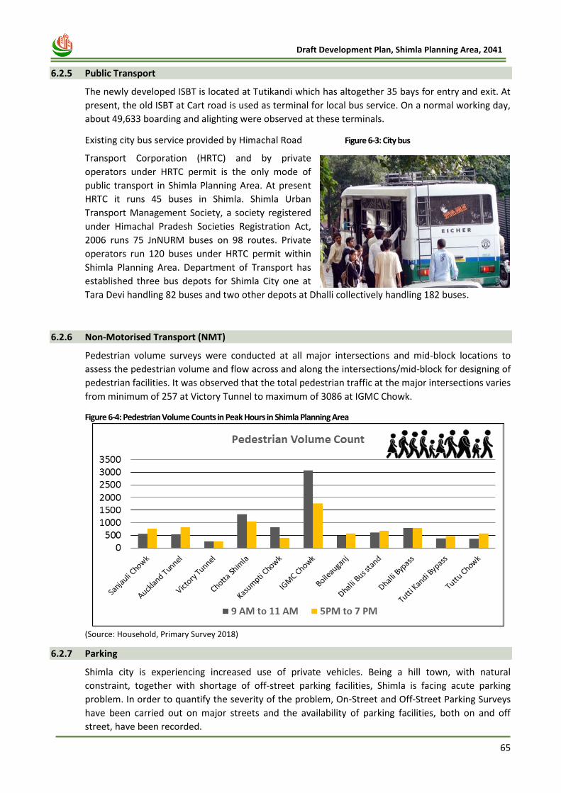
65
Draft Development Plan, Shimla Planning Area, 2041
Figure 6-3: City bus
6.2.5 Public Transport
The newly developed ISBT is located at Tutikandi which has altogether 35 bays for entry and exit. At
present, the old ISBT at Cart road is used as terminal for local bus service. On a normal working day,
about 49,633 boarding and alighting were observed at these terminals.
Existing city bus service provided by Himachal Road
Transport Corporation (HRTC) and by private
operators under HRTC permit is the only mode of
public transport in Shimla Planning Area. At present
HRTC it runs 45 buses in Shimla. Shimla Urban
Transport Management Society, a society registered
under Himachal Pradesh Societies Registration Act,
2006 runs 75 JnNURM buses on 98 routes. Private
operators run 120 buses under HRTC permit within
Shimla Planning Area. Department of Transport has
established three bus depots for Shimla City one at
Tara Devi handling 82 buses and two other depots at Dhalli collectively handling 182 buses.
6.2.6 Non-Motorised Transport (NMT)
Pedestrian volume surveys were conducted at all major intersections and mid-block locations to
assess the pedestrian volume and flow across and along the intersections/mid-block for designing of
pedestrian facilities. It was observed that the total pedestrian traffic at the major intersections varies
from minimum of 257 at Victory Tunnel to maximum of 3086 at IGMC Chowk.
Figure 6-4: Pedestrian Volume Counts in Peak Hours in Shimla Planning Area
(Source: Household, Primary Survey 2018)
6.2.7 Parking
Shimla city is experiencing increased use of private vehicles. Being a hill town, with natural
constraint, together with shortage of off-street parking facilities, Shimla is facing acute parking
problem. In order to quantify the severity of the problem, On-Street and Off-Street Parking Surveys
have been carried out on major streets and the availability of parking facilities, both on and off
street, have been recorded.
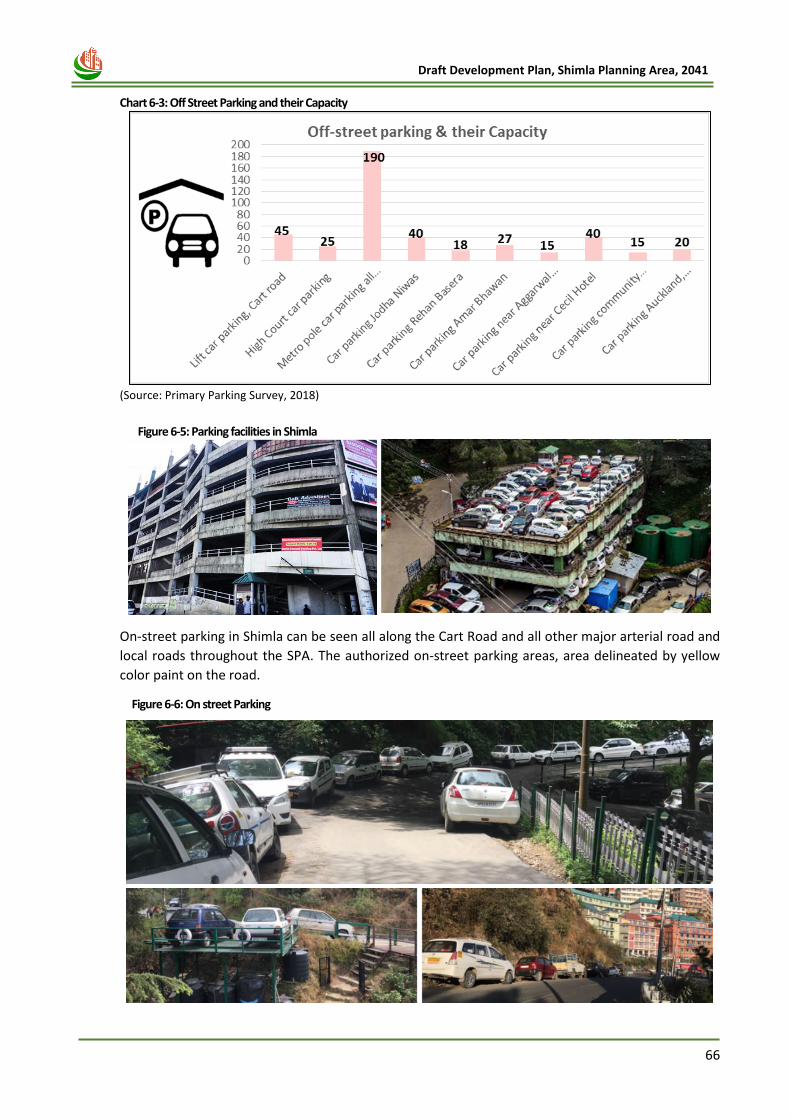
66
Draft Development Plan, Shimla Planning Area, 2041
Chart 6-3: Off Street Parking and their Capacity
(Source: Primary Parking Survey, 2018)
Figure 6-5: Parking facilities in Shimla
On-street parking in Shimla can be seen all along the Cart Road and all other major arterial road and
local roads throughout the SPA. The authorized on-street parking areas, area delineated by yellow
color paint on the road.
Figure 6-6: On street Parking
67
Draft Development Plan, Shimla Planning Area, 2041
6.3 Issues and Potentials
a. Road network Issues
As the roads of Shimla have less carriageway width due to limited scope of widening the road. The
average speed of vehicle in the city during the peak hour is 10 km/hr. This results in congestion of
vehicles on roads. There is very high traffic volume on the Victory tunnel and Kasumpti chowk. Also,
there is high volume capacity ratio measured on Cart Road near Lift, Lakkar Bazar and IGMC. All
these have a need of a bypass to divert the traffic from the high congested area.
b. Non Motorised Transport (NMT) Issues
There is lack of pedestrian infrastructure in the city and that has resulted in the mode share of
pedestrian i.e., 23% which is less as compare to the other major cities of India. There is need to
increase the number of roads with footpath with good quality and sufficient width of footpath.
c. Parking Issues
1. Most of the access roads in Shimla MC are Pucca Roads, with a good road density. However,
most of the roads in Remaining Shimla Planning area, accept NH and SH are kutcha and in poor
condition.
2. Most of people travel by public transport or by walk (i.e., 35% and 23%) transport to reach their
destination of work / study.
3. Junctions like Old Bus Stand, Victory Tunnel, IGMC Chawk, Dhalli by-pass experience traffic
congestions because of high traffic flow or bottleneck situations at turns/junctions/tunnels.
4. Because of insufficient provision of off-street parking, parking has become a major issue in
Shimla and people park their vehicles on road by encroaching the road space at critical locations.
d. Public Transport Issues
Due to absence of dedicated lane for public transportation system, overloaded old buses find
difficulties during the peak hours especially in the core city area. Most of the buses do not report on
time. Also, there is lack of boarding alighting shelters for city bus in the city.
6.4 Transport Proposals
While developing the proposals and strategies for Traffic and transportation in Shimla Planning Area,
the key proposals given in the CMP, 2012, Smart City Proposals and Action Plan for Mobility,
prepared as per directions of the Hon’ble NGT have been taken into consideration. The proposals in
Traffic and Transportation sector will include:
1. Proposed Road Network
2. Proposed Public Transport
3. Proposed Multi-Modal Hubs
4. Parking Proposals
5. Freight Mobility Improvement
6. Proposed Tunnels
7. Strategies for Pedestrian Movement
8. Junction Improvement
68
Draft Development Plan, Shimla Planning Area, 2041
6.4.1 Road network Proposal
A. Bypass Roads:
Because of high congestion in the core city area, there is a need of a bypass which will work as
mobility corridors for development of activity nodes. The proposed bypass road connects NH-5 to
NH-205 passing through a newly proposed satellite town and further connects to education hub. The
graphical representation of the proposed roads, has been shown in various parts of the Shimla
Planning Area.
Figure 6-7: Proposed Bypass Road
Table 6-2: Proposed Road Network in Shimla Planning Area
Proposed Road Name Description
1) Road from Shoghi to Jathita devi (24 m RoW)
2) Road from Jathiyadevi to Ghanahati (24 RoW)
These Road Corridors will serves as peripheral arterial road and will directly connect 4-Lane near Shoghi, to Jathiya devi, Airport, Ghanahati and Ghandal Area. The total length of this road is 21 kms.
3) Road From JubbarHatti Airport to Hiranagar Petrol Pump (18 m RoW)
4) Road From Hiranagar Petrol Pump to road going towards Poabo (18 m RoW)
This road corridor will directly connect Jubbar Hatti, Hiranagar and Ghanahati market and further to Dhudhli-Poabo and will act is alternative entry-exit corridor in the Planning Area. The total length of these roads is 20.90 kms.
69
Draft Development Plan, Shimla Planning Area, 2041
B. Strengthening the existing road network:
To connect the New Shimla and Khalini to the Shoghi Bypass and Taradevi Road there are two new
roads proposed to strengthen the connectivity of New Shimla and Khalini Area to the major roads of
city.
Figure 6-8: Strengthening of existing road
C. Retrofitting of Circular Road:
The main vehicular road of Shimla which has high demand of traffic need to be retrofitted for easing
the movement of traffic. This proposal was under Smart City Mission for Smart Shimla.
Figure 6-9: Retrofitting of Circular of Road
Shoghi By-pass
Taradevi Road
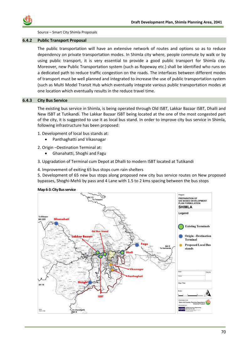
70
Draft Development Plan, Shimla Planning Area, 2041
Source – Smart City Shimla Proposals
6.4.2 Public Transport Proposal
The public transportation will have an extensive network of routes and options so as to reduce
dependency on private transportation modes. In Shimla city where, people commute by walk or by
using public transport, it is very essential to provide a good public transport for Shimla city.
Moreover, new Public Transportation system (such as Ropeway etc.) shall be identified who runs on
a dedicated path to reduce traffic congestion on the roads. The interfaces between different modes
of transport must be well planned and integrated to increase the use of public transportation system
(such as Multi Model Transit Hub which eventually integrate various public transportation modes at
one location which eventually results in the reduce travel time.
6.4.3 City Bus Service
The existing bus service in Shimla, is being operated through Old ISBT, Lakkar Bazaar ISBT, Dhalli and New ISBT at Tutikandi. The Lakkar Bazaar ISBT being located at the one of the most congested part of the city, it is suggested to use it as local bus stand. In order to improve city bus service in Shimla, following infrastructure has been proposed:
1. Development of local bus stands at:
• Panthaghatti and Vikasnagar
2. Origin –Destination Terminal at:
• Ghanahatti, Shoghi and Fagu
3. Upgradation of Terminal cum Depot at Dhalli to modern ISBT located at Tutikandi
4. Improvement of exiting 65 bus stops cum rain shelters 5. Development of 65 new bus stops along proposed new city bus service routes on New proposed bypasses, Shoghi-Mehli by pass and 4 Lane with 1.5 to 2 kms spacing between the bus stops
Map 6-3: City Bus service
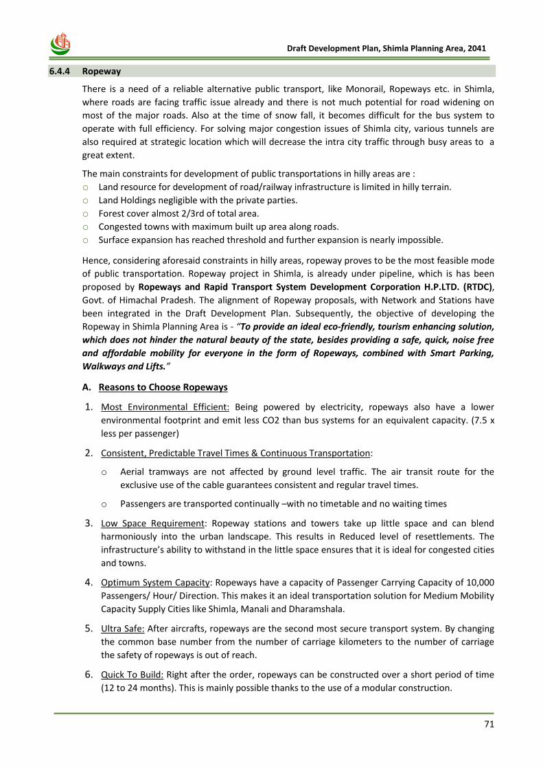
71
Draft Development Plan, Shimla Planning Area, 2041
6.4.4 Ropeway
There is a need of a reliable alternative public transport, like Monorail, Ropeways etc. in Shimla,
where roads are facing traffic issue already and there is not much potential for road widening on
most of the major roads. Also at the time of snow fall, it becomes difficult for the bus system to
operate with full efficiency. For solving major congestion issues of Shimla city, various tunnels are
also required at strategic location which will decrease the intra city traffic through busy areas to a
great extent.
The main constraints for development of public transportations in hilly areas are :
o Land resource for development of road/railway infrastructure is limited in hilly terrain.
o Land Holdings negligible with the private parties.
o Forest cover almost 2/3rd of total area.
o Congested towns with maximum built up area along roads.
o Surface expansion has reached threshold and further expansion is nearly impossible.
Hence, considering aforesaid constraints in hilly areas, ropeway proves to be the most feasible mode
of public transportation. Ropeway project in Shimla, is already under pipeline, which is has been
proposed by Ropeways and Rapid Transport System Development Corporation H.P.LTD. (RTDC),
Govt. of Himachal Pradesh. The alignment of Ropeway proposals, with Network and Stations have
been integrated in the Draft Development Plan. Subsequently, the objective of developing the
Ropeway in Shimla Planning Area is - “To provide an ideal eco-friendly, tourism enhancing solution,
which does not hinder the natural beauty of the state, besides providing a safe, quick, noise free
and affordable mobility for everyone in the form of Ropeways, combined with Smart Parking,
Walkways and Lifts.”
A. Reasons to Choose Ropeways
1. Most Environmental Efficient: Being powered by electricity, ropeways also have a lower
environmental footprint and emit less CO2 than bus systems for an equivalent capacity. (7.5 x
less per passenger)
2. Consistent, Predictable Travel Times & Continuous Transportation:
o Aerial tramways are not affected by ground level traffic. The air transit route for the
exclusive use of the cable guarantees consistent and regular travel times.
o Passengers are transported continually –with no timetable and no waiting times
3. Low Space Requirement: Ropeway stations and towers take up little space and can blend
harmoniously into the urban landscape. This results in Reduced level of resettlements. The
infrastructure’s ability to withstand in the little space ensures that it is ideal for congested cities
and towns.
4. Optimum System Capacity: Ropeways have a capacity of Passenger Carrying Capacity of 10,000
Passengers/ Hour/ Direction. This makes it an ideal transportation solution for Medium Mobility
Capacity Supply Cities like Shimla, Manali and Dharamshala.
5. Ultra Safe: After aircrafts, ropeways are the second most secure transport system. By changing
the common base number from the number of carriage kilometers to the number of carriage
the safety of ropeways is out of reach.
6. Quick To Build: Right after the order, ropeways can be constructed over a short period of time
(12 to 24 months). This is mainly possible thanks to the use of a modular construction.
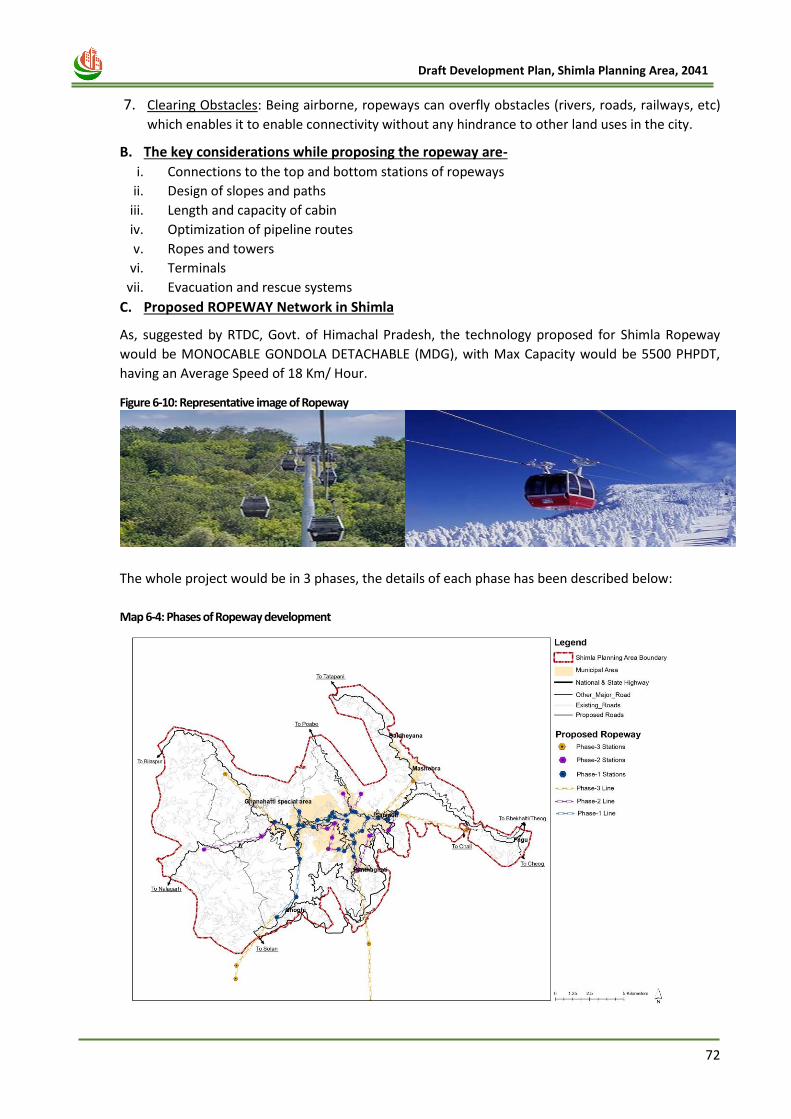
72
Draft Development Plan, Shimla Planning Area, 2041
7. Clearing Obstacles: Being airborne, ropeways can overfly obstacles (rivers, roads, railways, etc)
which enables it to enable connectivity without any hindrance to other land uses in the city.
B. The key considerations while proposing the ropeway are-
i. Connections to the top and bottom stations of ropeways
ii. Design of slopes and paths
iii. Length and capacity of cabin
iv. Optimization of pipeline routes
v. Ropes and towers
vi. Terminals
vii. Evacuation and rescue systems
C. Proposed ROPEWAY Network in Shimla
As, suggested by RTDC, Govt. of Himachal Pradesh, the technology proposed for Shimla Ropeway
would be MONOCABLE GONDOLA DETACHABLE (MDG), with Max Capacity would be 5500 PHPDT,
having an Average Speed of 18 Km/ Hour.
Figure 6-10: Representative image of Ropeway
The whole project would be in 3 phases, the details of each phase has been described below:
Map 6-4: Phases of Ropeway development
73
Draft Development Plan, Shimla Planning Area, 2041
Table 6-3: Details of Proposed Shimla Ropeway Project (Phase – 1)
PROPOSED SHIMLA ROPEWAY PROJECT (Phase-1)
Network Length 30.80 Km
Number of Lines 8
No. of Stations 31
Capital Cost (INR) 1232 Crore
In phase 1, the total length of the ropeway network would be 30.80 km of 8 lines. Number of
stations in phase 1 would be 31 and the capital cost 1232 cr.
Table 6-4: Details of Proposed Shimla Ropeway Project (Phase – 2)
PROPOSED SHIMLA ROPEWAY PROJECT (Phase-2)
Network Length 19.14 Km
Number of Lines 5
No. of Stations 13
Capital Cost (INR) 766 Crore
In phase 2, the total length of the ropeway network would be 19.14 km of 5 lines. Number of
stations in phase 2 would be 13 and the capital cost 766 cr.
Table 6-5: Details of Proposed Shimla Ropeway Project (Phase – 3)
PROPOSED SHIMLA ROPEWAY PROJECT (Phase-3)
Network Length 33.16 Km
Number of Lines 5
No. of Stations 6
Capital Cost (INR) 1326 Crore
In phase 3, the total length of the ropeway network would be 33.16 km of 5 lines. Number of
stations in phase 3 would be 6 and the capital cost 1326 cr.
6.4.5 Integration of Multi Modal Hub with public transport
In Shimla, for the successful implementation of Ropeway, it is very important to integrate it with other transport modes, such as public bus stops, taxi stands or parking lots. In other wo24rds, for development of three tiers of public transport, it is imperative to develop adequate infrastructure. Considering the multimodal integration of following 3 types of public transport, there should be a complete and supportive public transport infrastructure.
(A) Infrastructure for City Bus Service (B) Infrastructure for Ropeway (C) Infrastructure for Multi-modal Integration
A multimodal transport hub (MMTH) is a place where passengers transfer between different services
or modes of public transport as a part of their journey. An MMTH zone is often a gateway to the
public transport network, in that it represents the interface between the public transport services
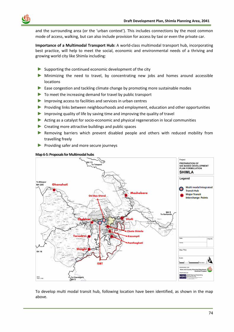
74
Draft Development Plan, Shimla Planning Area, 2041
and the surrounding area (or the ‘urban context’). This includes connections by the most common
mode of access, walking, but can also include provision for access by taxi or even the private car.
Importance of a Multimodal Transport Hub: A world‐class multimodal transport hub, incorporating best practice, will help to meet the social, economic and environmental needs of a thriving and growing world city like Shimla including:
► Supporting the continued economic development of the city
► Minimizing the need to travel, by concentrating new jobs and homes around accessible
locations
► Ease congestion and tackling climate change by promoting more sustainable modes
► To meet the increasing demand for travel by public transport
► Improving access to facilities and services in urban centres
► Providing links between neighbourhoods and employment, education and other opportunities
► Improving quality of life by saving time and improving the quality of travel
► Acting as a catalyst for socio‐economic and physical regeneration in local communities
► Creating more attractive buildings and public spaces
► Removing barriers which prevent disabled people and others with reduced mobility from
travelling freely
► Providing safer and more secure journeys
Map 6-5: Proposals for Multimodal hubs
To develop multi modal transit hub, following location have been identified, as shown in the map above.

75
Draft Development Plan, Shimla Planning Area, 2041
(I) Multi- Modal Transit Hub - Old ISBT and 2)New ISBT
Multi-modal transit hub at New ISBT and Old ISBT will integrate the existing city bus service with proposed Metro cable and Medium Capacity Rapid Transit System (MCRTS).
(II) Major Transit Interchange Points Major transit interchange points such as Shoghi, Taradevi bus stand, University point, Kusumpti, Chota Shimla will integrate more than one transport system. For example, at university point, Shoghi, Taradevi bus stand city bus service and Ropeway should be integrated. At locations such as Kusumpti, Chota Shimla, the public transport system such as proposed Ropeway and MCRTS should be integrated. These Multi Modal Transit Hub and major transit Interchange Points will have park and ride facility i.e development of private vehicle parking lots at these locations to support public transport. Developing parking lots at the transit locations will generate additional ridership.
6.4.6 Parking Proposal
Generally, in a tourist place and in a state capital (where daily commuters are high for availing the
facilities related to education, medical, employment etc.), private vehicles spends more time in
parking as compared to other cities.
Map 6-6: Proposed Multilevel Dedicated parking locations
Ghanahati Market
Taradevi
Panthaghati
Vikasnagar
Dhalli
IGMC
Proposed Multi-level Parking
SDA Complex
Boileauganj
Naldhera
Mashobara
Kufri
Dhalli
Chakkar
HPU
DC Office
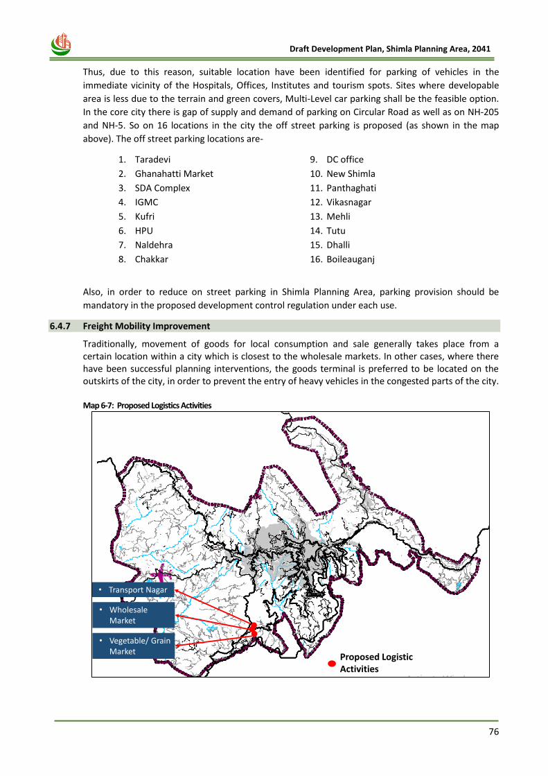
76
Draft Development Plan, Shimla Planning Area, 2041
Thus, due to this reason, suitable location have been identified for parking of vehicles in the
immediate vicinity of the Hospitals, Offices, Institutes and tourism spots. Sites where developable
area is less due to the terrain and green covers, Multi-Level car parking shall be the feasible option.
In the core city there is gap of supply and demand of parking on Circular Road as well as on NH-205
and NH-5. So on 16 locations in the city the off street parking is proposed (as shown in the map
above). The off street parking locations are-
1. Taradevi
2. Ghanahatti Market
3. SDA Complex
4. IGMC
5. Kufri
6. HPU
7. Naldehra
8. Chakkar
9. DC office
10. New Shimla
11. Panthaghati
12. Vikasnagar
13. Mehli
14. Tutu
15. Dhalli
16. Boileauganj
Also, in order to reduce on street parking in Shimla Planning Area, parking provision should be
mandatory in the proposed development control regulation under each use.
6.4.7 Freight Mobility Improvement
Traditionally, movement of goods for local consumption and sale generally takes place from a certain location within a city which is closest to the wholesale markets. In other cases, where there have been successful planning interventions, the goods terminal is preferred to be located on the outskirts of the city, in order to prevent the entry of heavy vehicles in the congested parts of the city. Map 6-7: Proposed Logistics Activities
Proposed Logistic Activities
• Transport Nagar
• Wholesale Market
• Vegetable/ Grain Market
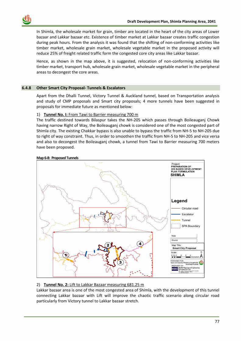
77
Draft Development Plan, Shimla Planning Area, 2041
In Shimla, the wholesale market for grain, timber are located in the heart of the city areas of Lower bazaar and Lakkar bazaar etc. Existence of timber market at Lakkar bazaar creates traffic congestion during peak hours. From the analysis it was found that the shifting of non-conforming activities like timber market, wholesale grain market, wholesale vegetable market in the proposed activity will reduce 25% of freight related traffic form the congested core city areas like Lakkar bazaar.
Hence, as shown in the map above, it is suggested, relocation of non-conforming activities like timber market, transport hub, wholesale grain market, wholesale vegetable market in the peripheral areas to decongest the core areas.
6.4.8 Other Smart City Proposal- Tunnels & Escalators
Apart from the Dhalli Tunnel, Victory Tunnel & Auckland tunnel, based on Transportation analysis and study of CMP proposals and Smart city proposals; 4 more tunnels have been suggested in proposals for immediate future as mentioned below:
1) Tunnel No. I: From Tawi to Barrier measuring 700 m The traffic destined towards Bilaspur takes the NH-205 which passes through Boileauganj Chowk having narrow Right of Way, the Boileauganj chowk is considered one of the most congested part of Shimla city. The existing Chakkar bypass is also unable to bypass the traffic from NH-5 to NH-205 due to right of way constraint. Thus, in order to smoothen the traffic from NH-5 to NH-205 and vice versa and also to decongest the Boileauganj chowk, a tunnel from Tawi to Barrier measuring 700 meters have been proposed. Map 6-8: Proposed Tunnels
2) Tunnel No. 2: Lift to Lakkar Bazaar measuring 681.25 m Lakkar bazaar area is one of the most congested area of Shimla, with the development of this tunnel connecting Lakkar bazaar with Lift will improve the chaotic traffic scenario along circular road particularly from Victory tunnel to Lakkar bazaar stretch.
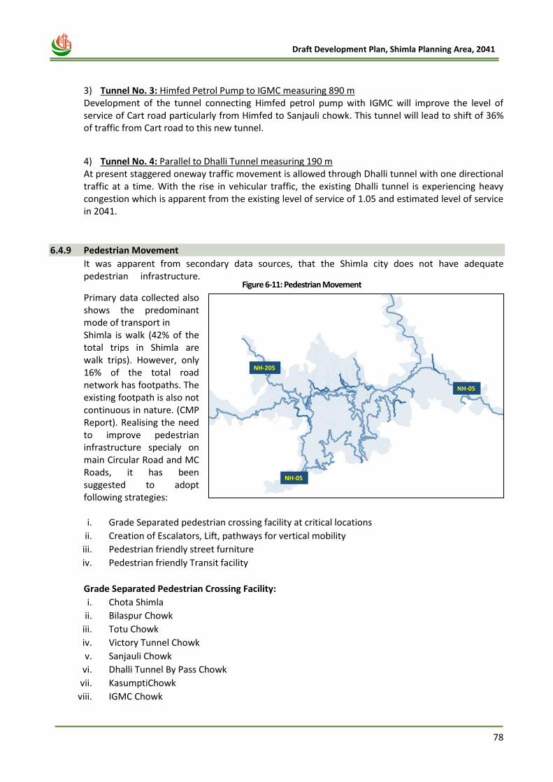
78
Draft Development Plan, Shimla Planning Area, 2041
3) Tunnel No. 3: Himfed Petrol Pump to IGMC measuring 890 m Development of the tunnel connecting Himfed petrol pump with IGMC will improve the level of service of Cart road particularly from Himfed to Sanjauli chowk. This tunnel will lead to shift of 36% of traffic from Cart road to this new tunnel.
4) Tunnel No. 4: Parallel to Dhalli Tunnel measuring 190 m At present staggered oneway traffic movement is allowed through Dhalli tunnel with one directional traffic at a time. With the rise in vehicular traffic, the existing Dhalli tunnel is experiencing heavy congestion which is apparent from the existing level of service of 1.05 and estimated level of service in 2041.
6.4.9 Pedestrian Movement
It was apparent from secondary data sources, that the Shimla city does not have adequate pedestrian infrastructure.
Primary data collected also shows the predominant mode of transport in Shimla is walk (42% of the total trips in Shimla are walk trips). However, only 16% of the total road network has footpaths. The existing footpath is also not continuous in nature. (CMP Report). Realising the need to improve pedestrian infrastructure specialy on main Circular Road and MC Roads, it has been suggested to adopt following strategies: i. Grade Separated pedestrian crossing facility at critical locations
ii. Creation of Escalators, Lift, pathways for vertical mobility
iii. Pedestrian friendly street furniture
iv. Pedestrian friendly Transit facility
Grade Separated Pedestrian Crossing Facility:
i. Chota Shimla
ii. Bilaspur Chowk
iii. Totu Chowk
iv. Victory Tunnel Chowk
v. Sanjauli Chowk
vi. Dhalli Tunnel By Pass Chowk
vii. KasumptiChowk
viii. IGMC Chowk
NH-05
NH-205
NH-05
Figure 6-11: Pedestrian Movement
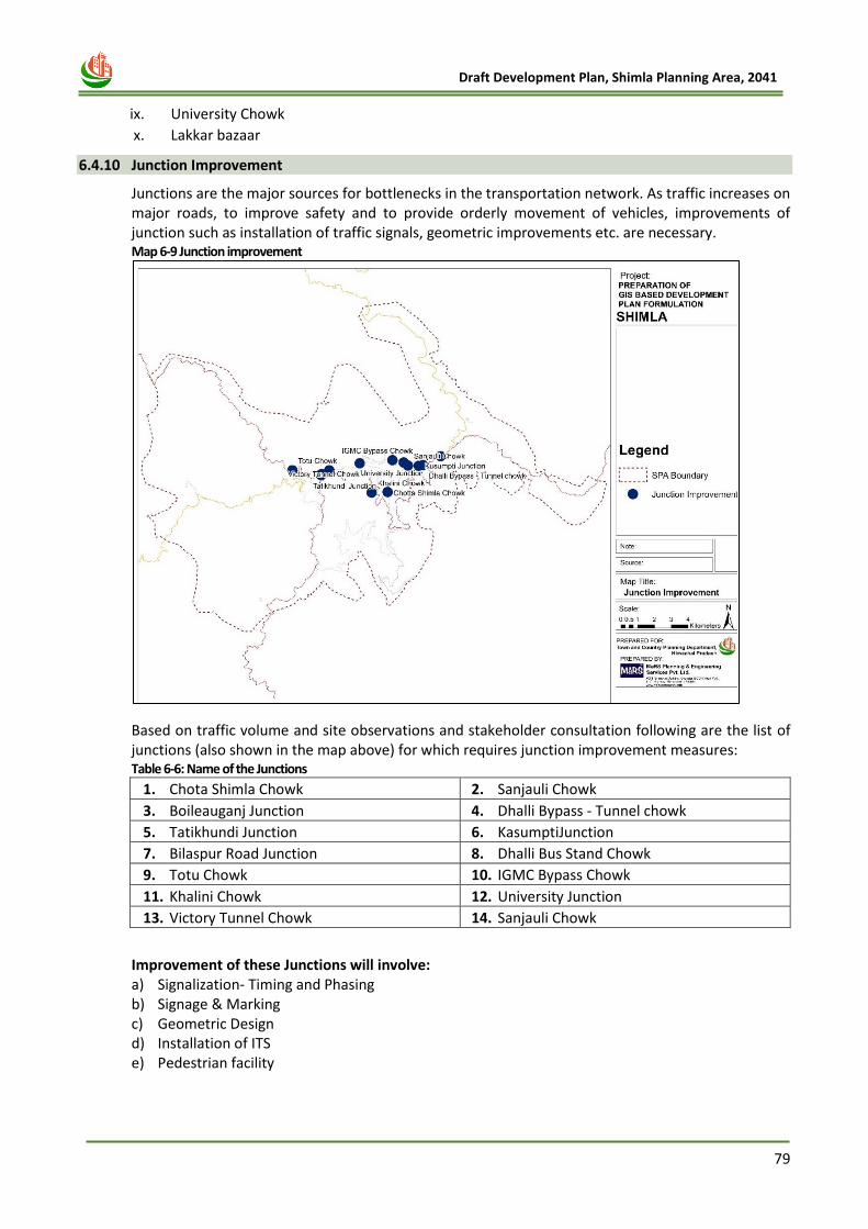
79
Draft Development Plan, Shimla Planning Area, 2041
ix. University Chowk
x. Lakkar bazaar
6.4.10 Junction Improvement
Junctions are the major sources for bottlenecks in the transportation network. As traffic increases on major roads, to improve safety and to provide orderly movement of vehicles, improvements of junction such as installation of traffic signals, geometric improvements etc. are necessary. Map 6-9 Junction improvement
Based on traffic volume and site observations and stakeholder consultation following are the list of junctions (also shown in the map above) for which requires junction improvement measures: Table 6-6: Name of the Junctions
1. Chota Shimla Chowk 2. Sanjauli Chowk
3. Boileauganj Junction 4. Dhalli Bypass - Tunnel chowk
5. Tatikhundi Junction 6. KasumptiJunction
7. Bilaspur Road Junction 8. Dhalli Bus Stand Chowk
9. Totu Chowk 10. IGMC Bypass Chowk
11. Khalini Chowk 12. University Junction
13. Victory Tunnel Chowk 14. Sanjauli Chowk
Improvement of these Junctions will involve: a) Signalization- Timing and Phasing b) Signage & Marking c) Geometric Design d) Installation of ITS e) Pedestrian facility
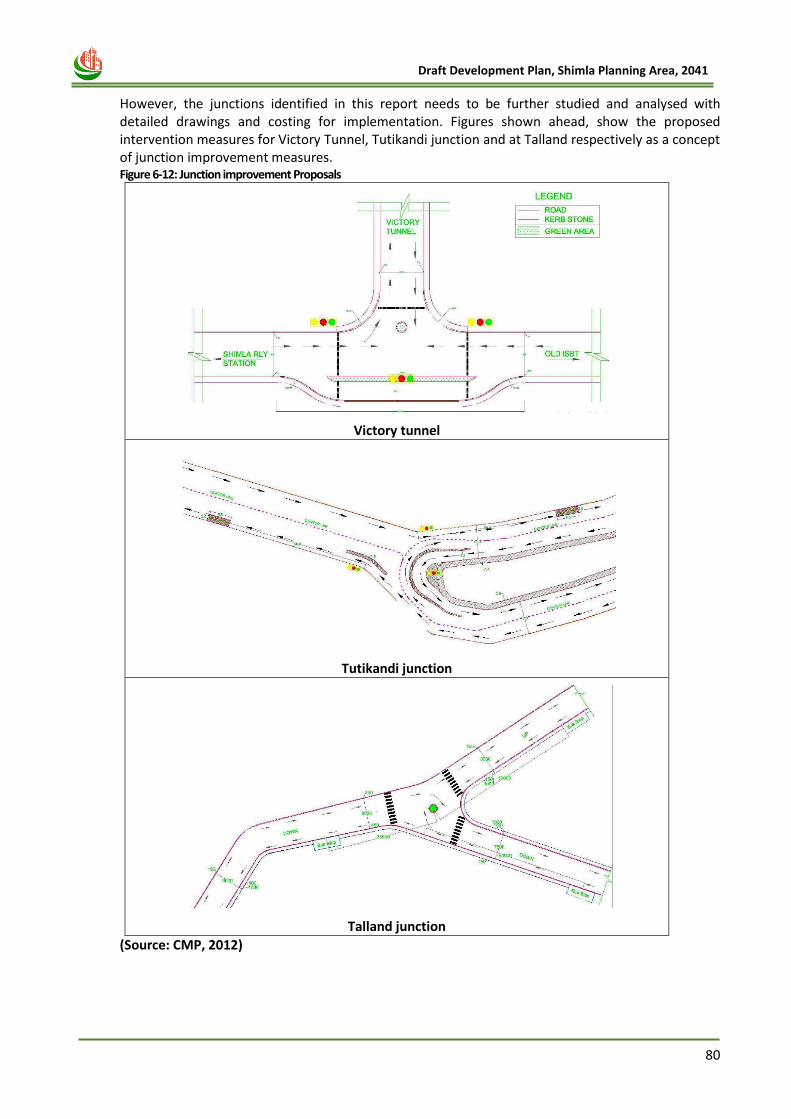
80
Draft Development Plan, Shimla Planning Area, 2041
However, the junctions identified in this report needs to be further studied and analysed with detailed drawings and costing for implementation. Figures shown ahead, show the proposed intervention measures for Victory Tunnel, Tutikandi junction and at Talland respectively as a concept of junction improvement measures. Figure 6-12: Junction improvement Proposals
Victory tunnel
Tutikandi junction
Talland junction
(Source: CMP, 2012)
81
Draft Development Plan, Shimla Planning Area, 2041
Chapter 7
PHYSICAL
INFRASTRUCTURE
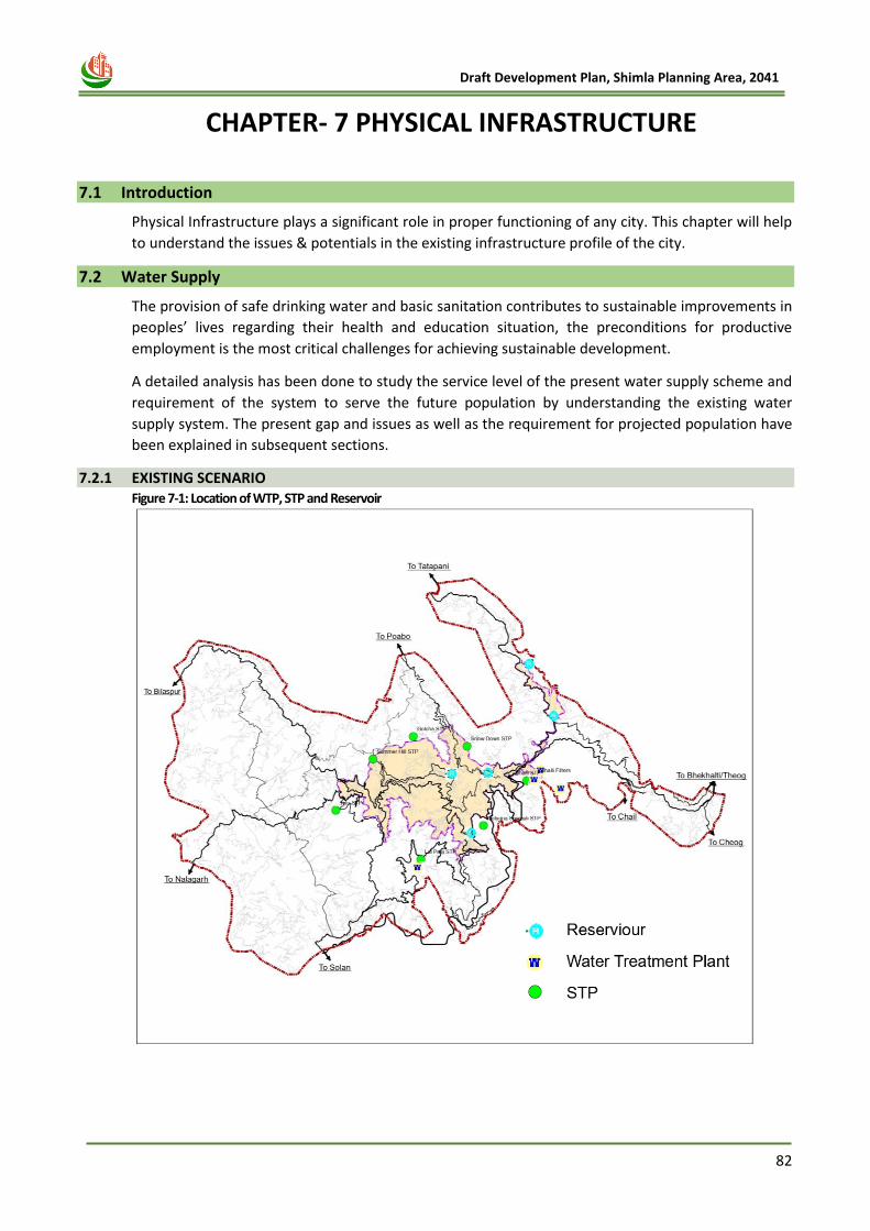
82
Draft Development Plan, Shimla Planning Area, 2041
7 CHAPTER- 7 PHYSICAL INFRASTRUCTURE
7.1 Introduction
Physical Infrastructure plays a significant role in proper functioning of any city. This chapter will help
to understand the issues & potentials in the existing infrastructure profile of the city.
7.2 Water Supply
The provision of safe drinking water and basic sanitation contributes to sustainable improvements in
peoples’ lives regarding their health and education situation, the preconditions for productive
employment is the most critical challenges for achieving sustainable development.
A detailed analysis has been done to study the service level of the present water supply scheme and
requirement of the system to serve the future population by understanding the existing water
supply system. The present gap and issues as well as the requirement for projected population have
been explained in subsequent sections.
7.2.1 EXISTING SCENARIO Figure 7-1: Location of WTP, STP and Reservoir
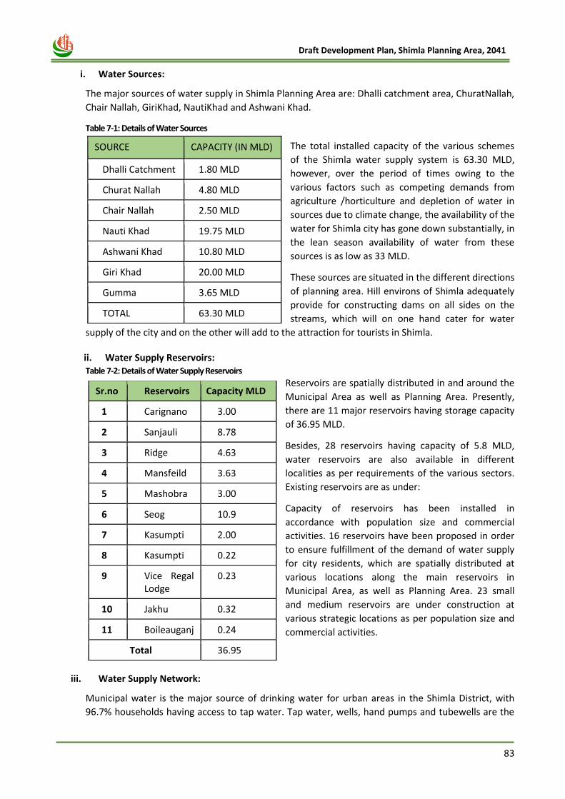
83
Draft Development Plan, Shimla Planning Area, 2041
i. Water Sources:
The major sources of water supply in Shimla Planning Area are: Dhalli catchment area, ChuratNallah,
Chair Nallah, GiriKhad, NautiKhad and Ashwani Khad.
Table 7-1: Details of Water Sources
The total installed capacity of the various schemes
of the Shimla water supply system is 63.30 MLD,
however, over the period of times owing to the
various factors such as competing demands from
agriculture /horticulture and depletion of water in
sources due to climate change, the availability of the
water for Shimla city has gone down substantially, in
the lean season availability of water from these
sources is as low as 33 MLD.
These sources are situated in the different directions
of planning area. Hill environs of Shimla adequately
provide for constructing dams on all sides on the
streams, which will on one hand cater for water
supply of the city and on the other will add to the attraction for tourists in Shimla.
ii. Water Supply Reservoirs: Table 7-2: Details of Water Supply Reservoirs
Reservoirs are spatially distributed in and around the
Municipal Area as well as Planning Area. Presently,
there are 11 major reservoirs having storage capacity
of 36.95 MLD.
Besides, 28 reservoirs having capacity of 5.8 MLD,
water reservoirs are also available in different
localities as per requirements of the various sectors.
Existing reservoirs are as under:
Capacity of reservoirs has been installed in
accordance with population size and commercial
activities. 16 reservoirs have been proposed in order
to ensure fulfillment of the demand of water supply
for city residents, which are spatially distributed at
various locations along the main reservoirs in
Municipal Area, as well as Planning Area. 23 small
and medium reservoirs are under construction at
various strategic locations as per population size and
commercial activities.
iii. Water Supply Network:
Municipal water is the major source of drinking water for urban areas in the Shimla District, with
96.7% households having access to tap water. Tap water, wells, hand pumps and tubewells are the
SOURCE CAPACITY (IN MLD)
Dhalli Catchment 1.80 MLD
Churat Nallah 4.80 MLD
Chair Nallah 2.50 MLD
Nauti Khad 19.75 MLD
Ashwani Khad 10.80 MLD
Giri Khad 20.00 MLD
Gumma 3.65 MLD
TOTAL 63.30 MLD
Sr.no Reservoirs Capacity MLD
1 Carignano 3.00
2 Sanjauli 8.78
3 Ridge 4.63
4 Mansfeild 3.63
5 Mashobra 3.00
6 Seog 10.9
7 Kasumpti 2.00
8 Kasumpti 0.22
9 Vice Regal Lodge
0.23
10 Jakhu 0.32
11 Boileauganj 0.24
Total 36.95
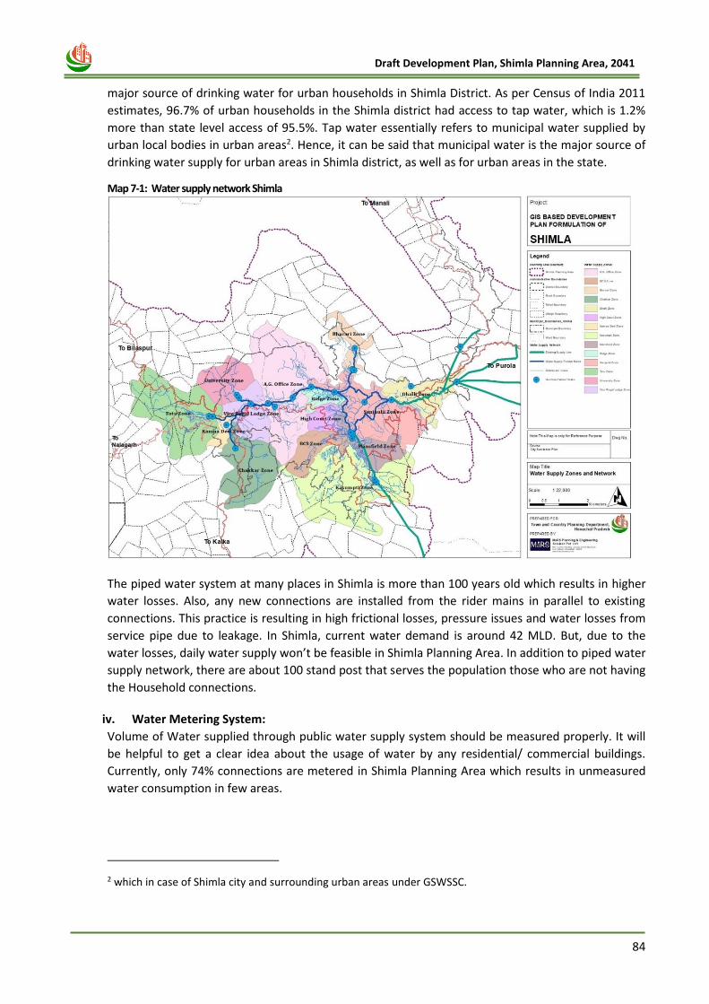
84
Draft Development Plan, Shimla Planning Area, 2041
major source of drinking water for urban households in Shimla District. As per Census of India 2011
estimates, 96.7% of urban households in the Shimla district had access to tap water, which is 1.2%
more than state level access of 95.5%. Tap water essentially refers to municipal water supplied by
urban local bodies in urban areas2. Hence, it can be said that municipal water is the major source of
drinking water supply for urban areas in Shimla district, as well as for urban areas in the state.
Map 7-1: Water supply network Shimla
The piped water system at many places in Shimla is more than 100 years old which results in higher
water losses. Also, any new connections are installed from the rider mains in parallel to existing
connections. This practice is resulting in high frictional losses, pressure issues and water losses from
service pipe due to leakage. In Shimla, current water demand is around 42 MLD. But, due to the
water losses, daily water supply won’t be feasible in Shimla Planning Area. In addition to piped water
supply network, there are about 100 stand post that serves the population those who are not having
the Household connections.
iv. Water Metering System:
Volume of Water supplied through public water supply system should be measured properly. It will
be helpful to get a clear idea about the usage of water by any residential/ commercial buildings.
Currently, only 74% connections are metered in Shimla Planning Area which results in unmeasured
water consumption in few areas.
2 which in case of Shimla city and surrounding urban areas under GSWSSC.
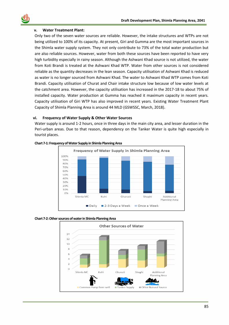
85
Draft Development Plan, Shimla Planning Area, 2041
v. Water Treatment Plant:
Only two of the seven water sources are reliable. However, the intake structures and WTPs are not
being utilized to 100% of its capacity. At present, Giri and Gumma are the most important sources in
the Shimla water supply system. They not only contribute to 73% of the total water production but
are also reliable sources. However, water from both these sources have been reported to have very
high turbidity especially in rainy season. Although the Ashwani Khad source is not utilized, the water
from Koti Brandi is treated at the Ashwani Khad WTP. Water from other sources is not considered
reliable as the quantity decreases in the lean season. Capacity utilisation of Ashwani Khad is reduced
as water is no longer sourced from Ashwani Khad. The water to Ashwani Khad WTP comes from Koti
Brandi. Capacity utilisation of Churat and Chair intake structure low because of low water levels at
the catchment area. However, the capacity utilisation has increased in the 2017-18 to about 75% of
installed capacity. Water production at Gumma has reached it maximum capacity in recent years.
Capacity utilisation of Giri WTP has also improved in recent years. Existing Water Treatment Plant
Capacity of Shimla Planning Area is around 44 MLD (GSWSSC, March, 2018).
vi. Frequency of Water Supply & Other Water Sources
Water supply is around 1-2 hours, once in three days in the main city area, and lesser duration in the
Peri-urban areas. Due to that reason, dependency on the Tanker Water is quite high especially in
tourist places.
Chart 7-1: Frequency of Water Supply in Shimla Planning Area
Chart 7-2: Other sources of water in Shimla Planning Area
86
Draft Development Plan, Shimla Planning Area, 2041
A. ISSUES AND POTENTIALS
• Inadequate coverage: 21% of the municipal corporation is yet to be provided with network for water
supply. In addition, pipeline crossing sewer, drains, roads having heavy traffic etc. should be
appropriately mapped as they are potential hazard sources.
• Water metering: It is envisaged to implement 100% water metering on all consumer connections. At
present only 74% connections are metered.
• System (Transmission and Distribution) Losses and Unaccounted for Water: Currently, the water
supply is more than sufficient to meet the water demand in Shimla Planning Area. However, physical
losses and unequal distribution appear to be the major reason for current supply of about 1.5 hours
only every alternate day in Shimla Municipal Area. The non – revenue water is quiet high in Shimla
Planning Area. Proper audit is required for getting the clear picture about the non – revenue water.
• Inadequate Treatment Facility and Outdated technology might be the reason of water losses in
Shimla Planning Area. Short term measures has to be taken for its proper functioning,
• Adoption of Watershed management: Watershed management practices should be encouraged to
improve water availability in the rivers and springs.
• Need for 24*7 Water Supply: interim and short-term plan should be made to meet growing demand
due to increase in population and tourists.
B. FUTURE REQUIREMENT
i. Per Capita Water Supply Standards:
As per Central Public Health and Environmental Engineering Organization (CPHEEO) Manual on Water Supply & Treatments published in the year of 1999, per capita water supply standards is described in table given below:
Table 7-3: Per Capita Water Supply Standards
Sr. No. Classification of Town/ Cities Recommended Water Supply (lpcd)
1 Towns provided with piped water but without sewerage system
70
2 Cities provided with piped water supply where sewerage systems is existing/contemplated
135
3 Metropolitan & Mega cities provided with piped water supply where sewerage system is existing/contemplated
150
7.2.2 Water Demand Estimation:
The water demand calculated based on water requirements of a one person per day as per CPHEEO
guidelines i.e. 135 lpcd. However, the requirement of a particular unit to be calculated separately as
per the norms prescribed. The net water demand comprises consumption of domestic and non-
domestic purposes. Nondomestic user includes consumption by Institutions (Colleges, School and
Hospital), Commercial Establishment, Industries, Public Parks, Hotels, Tourist places etc. For non-
domestic user also average demand of 135 lpcd is calculated. Gross water demand comprises
network demand and physical and non-physical losses (assumed 15%). Being a tourist city, we also
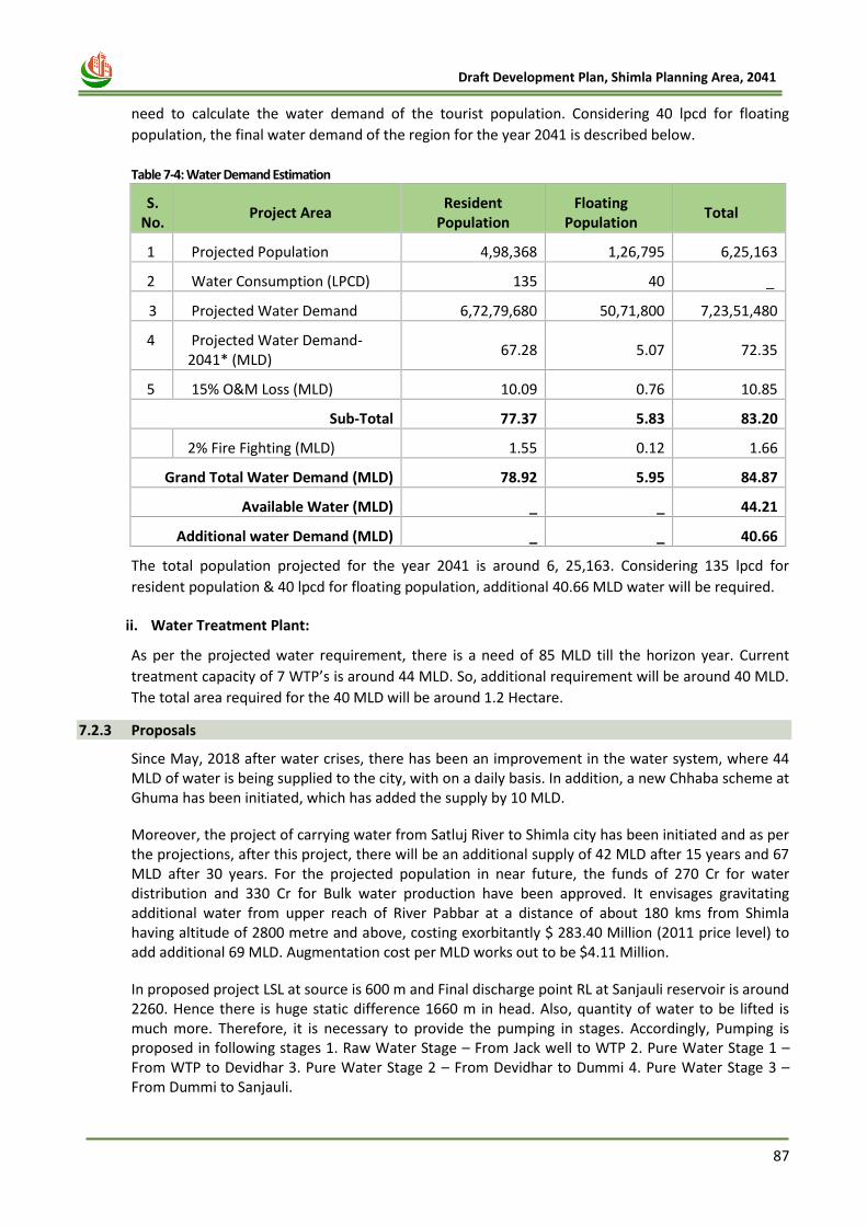
87
Draft Development Plan, Shimla Planning Area, 2041
need to calculate the water demand of the tourist population. Considering 40 lpcd for floating
population, the final water demand of the region for the year 2041 is described below.
Table 7-4: Water Demand Estimation
S. No.
Project Area Resident
Population Floating
Population Total
1 Projected Population 4,98,368 1,26,795 6,25,163
2 Water Consumption (LPCD) 135 40 _
3 Projected Water Demand 6,72,79,680 50,71,800 7,23,51,480
4 Projected Water Demand-2041* (MLD)
67.28 5.07 72.35
5 15% O&M Loss (MLD) 10.09 0.76 10.85
Sub-Total 77.37 5.83 83.20
6 2% Fire Fighting (MLD) 1.55 0.12 1.66
Grand Total Water Demand (MLD) 78.92 5.95 84.87
Available Water (MLD) _ _ 44.21
Additional water Demand (MLD) _ _ 40.66
The total population projected for the year 2041 is around 6, 25,163. Considering 135 lpcd for
resident population & 40 lpcd for floating population, additional 40.66 MLD water will be required.
ii. Water Treatment Plant:
As per the projected water requirement, there is a need of 85 MLD till the horizon year. Current
treatment capacity of 7 WTP’s is around 44 MLD. So, additional requirement will be around 40 MLD.
The total area required for the 40 MLD will be around 1.2 Hectare.
7.2.3 Proposals
Since May, 2018 after water crises, there has been an improvement in the water system, where 44 MLD of water is being supplied to the city, with on a daily basis. In addition, a new Chhaba scheme at Ghuma has been initiated, which has added the supply by 10 MLD.
Moreover, the project of carrying water from Satluj River to Shimla city has been initiated and as per the projections, after this project, there will be an additional supply of 42 MLD after 15 years and 67 MLD after 30 years. For the projected population in near future, the funds of 270 Cr for water distribution and 330 Cr for Bulk water production have been approved. It envisages gravitating additional water from upper reach of River Pabbar at a distance of about 180 kms from Shimla having altitude of 2800 metre and above, costing exorbitantly $ 283.40 Million (2011 price level) to add additional 69 MLD. Augmentation cost per MLD works out to be $4.11 Million.
In proposed project LSL at source is 600 m and Final discharge point RL at Sanjauli reservoir is around 2260. Hence there is huge static difference 1660 m in head. Also, quantity of water to be lifted is much more. Therefore, it is necessary to provide the pumping in stages. Accordingly, Pumping is proposed in following stages 1. Raw Water Stage – From Jack well to WTP 2. Pure Water Stage 1 – From WTP to Devidhar 3. Pure Water Stage 2 – From Devidhar to Dummi 4. Pure Water Stage 3 – From Dummi to Sanjauli.
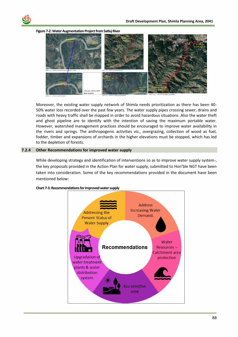
88
Draft Development Plan, Shimla Planning Area, 2041
Figure 7-2: Water Augmentation Project from Satluj River
Moreover, the existing water supply network of Shimla needs prioritization as there has been 40-50% water loss recorded over the past few years. The water supply pipes crossing sewer, drains and roads with heavy traffic shall be mapped in order to avoid hazardous situations .Also the water theft and ghost pipeline are to identify with the intention of saving the maximum portable water. However, watershed management practices should be encouraged to improve water availability in the rivers and springs. The anthropogenic activities viz., overgrazing, collection of wood as fuel, fodder, timber and expansions of orchards in the higher elevations must be stopped, which has led to the depletion of forests.
7.2.4 Other Recommendations for improved water supply
While developing strategy and identification of interventions so as to improve water supply system-,
the key proposals provided in the Action Plan for water supply, submitted to Hon’ble NGT have been
taken into consideration. Some of the key recommendations provided in the document have been
mentioned below:
Chart 7-3: Recommendations for improved water supply
89
Draft Development Plan, Shimla Planning Area, 2041
a) The water supply system for Shimla is unbundled system as
i. Bulk Water Supply: Bulk Water Supply would comprise of abstraction of water from source,
treatment and transmission to the bulk consumers
ii. Local Supply: Local supply would comprise of distribution, supply of water to end consumer,
billing and collection of revenue
iii. A phased approach is to be implemented simultaneously to remove the operational
efficiencies and meet the water demand. The Phase 1 shall provide short-term solution of
augmenting water supply through realization of additional water through reduction in
losses. The Phase 1 would involve improving the performance of existing system through
rehabilitation and upgradation. The Phase II shall address the augmentation of water supply
through exploration of new sources like river Pabbar to meet medium and long-term
requirements.
b) Rehabilitation and Upgradation of main water distribution network of Shimla Planning Area
i. Rehabilitation of entire water production, transmission and distribution system is warranted
with an objective of reducing losses, improving water quality and pressure. It would also
include enhancing coverage to slum areas, public standposts and conversion of un-
authorized connections to authorized connections.
ii. The incremental revenue generation due to efficiency gain can offset the revenue loss from
merger of special areas and may be leveraged to raise the investment required for expansion
and augmentation.
c) Augmentation of water supply distribution system for SADA Areas
i. Augmentation of water supply and distribution system is required for provision of water
supply to newly merged areas of Dhalli, New Shimla and Tutu and special areas of
Ghanahatti, Kufri, and Shoghi. This shall include provision of water storage system and laying
of new distribution pipelines.
d) Rainwater Harvesting
i. In order to tackle the water scarcity problem of Shimla, the strategy should aim at
conservation of water through rooftop rainwater harvesting and creation of water
bodies/storage tanks at suitable locations along the hill slopes through construction of check
dams. Roof top rainwater has been made mandatory in new buildings and hotel through
local bylaws.
7.3 Sewerage and Sanitation System Sewerage, the core element of physical infrastructure, determines the environmental status of any settlement. Development of appropriate sewerage system with efficient treatment acts as a prerequisite for facilitating balanced and harmonized development.
7.3.1 Existing Scenario
i. Sewerage System:
Sewerage systems is an integral part of physical planning. It is a crucial urban utility. Sewerage
system for Shimla was originally designed for a population of 18000 persons in 1880. The same
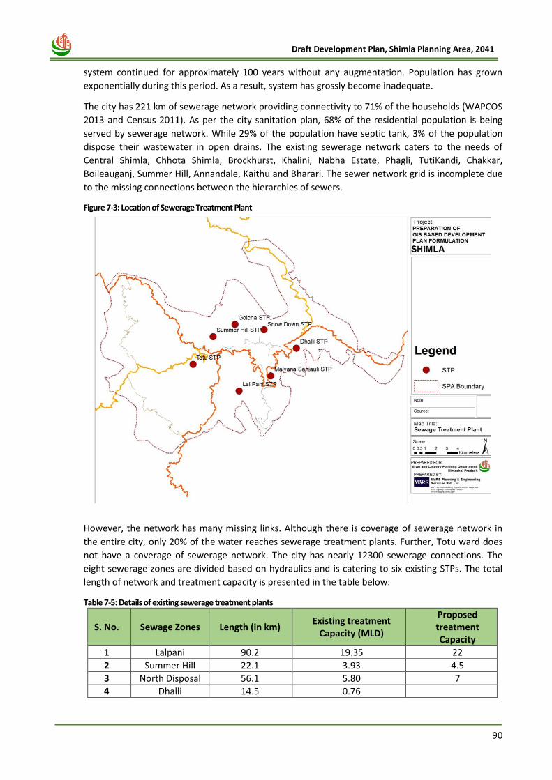
90
Draft Development Plan, Shimla Planning Area, 2041
system continued for approximately 100 years without any augmentation. Population has grown
exponentially during this period. As a result, system has grossly become inadequate.
The city has 221 km of sewerage network providing connectivity to 71% of the households (WAPCOS
2013 and Census 2011). As per the city sanitation plan, 68% of the residential population is being
served by sewerage network. While 29% of the population have septic tank, 3% of the population
dispose their wastewater in open drains. The existing sewerage network caters to the needs of
Central Shimla, Chhota Shimla, Brockhurst, Khalini, Nabha Estate, Phagli, TutiKandi, Chakkar,
Boileauganj, Summer Hill, Annandale, Kaithu and Bharari. The sewer network grid is incomplete due
to the missing connections between the hierarchies of sewers.
Figure 7-3: Location of Sewerage Treatment Plant
However, the network has many missing links. Although there is coverage of sewerage network in
the entire city, only 20% of the water reaches sewerage treatment plants. Further, Totu ward does
not have a coverage of sewerage network. The city has nearly 12300 sewerage connections. The
eight sewerage zones are divided based on hydraulics and is catering to six existing STPs. The total
length of network and treatment capacity is presented in the table below:
Table 7-5: Details of existing sewerage treatment plants
S. No. Sewage Zones Length (in km) Existing treatment
Capacity (MLD)
Proposed treatment Capacity
1 Lalpani 90.2 19.35 22
2 Summer Hill 22.1 3.93 4.5
3 North Disposal 56.1 5.80 7
4 Dhalli 14.5 0.76
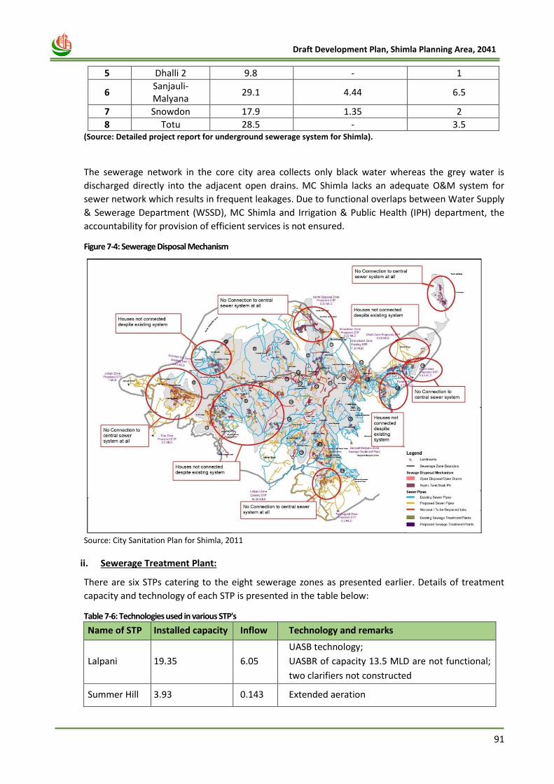
91
Draft Development Plan, Shimla Planning Area, 2041
5 Dhalli 2 9.8 - 1
6 Sanjauli-Malyana
29.1 4.44 6.5
7 Snowdon 17.9 1.35 2
8 Totu 28.5 - 3.5 (Source: Detailed project report for underground sewerage system for Shimla).
The sewerage network in the core city area collects only black water whereas the grey water is
discharged directly into the adjacent open drains. MC Shimla lacks an adequate O&M system for
sewer network which results in frequent leakages. Due to functional overlaps between Water Supply
& Sewerage Department (WSSD), MC Shimla and Irrigation & Public Health (IPH) department, the
accountability for provision of efficient services is not ensured.
Figure 7-4: Sewerage Disposal Mechanism
Source: City Sanitation Plan for Shimla, 2011
ii. Sewerage Treatment Plant:
There are six STPs catering to the eight sewerage zones as presented earlier. Details of treatment
capacity and technology of each STP is presented in the table below:
Table 7-6: Technologies used in various STP's
Name of STP Installed capacity Inflow Technology and remarks
Lalpani 19.35 6.05
UASB technology;
UASBR of capacity 13.5 MLD are not functional;
two clarifiers not constructed
Summer Hill 3.93 0.143 Extended aeration
92
Draft Development Plan, Shimla Planning Area, 2041
No sludge management unit. Filter press
removed and shifted to Sanjauli Malyana
North
Disposal 5.80 1.52 Extended aeration
Dhalli 0.76 0.83 Extended aeration
Sanjauli
Malyana 4.44 2.48
Extended aeration
One aeration tank not constructed and another
aeration tank is converted to sludge holding
tank
Snowdon 1.35 0.3 Extended aeration
Source: Detailed project report on newly proposed STP for Shimla Municipal Corporation
Most of these STPs were constructed between 1999-2006 through an OPEC aid. While the installed
capacity is high, the wastewater received by the STP is low due to missing links in the sewerage
collection network. It is observed that these STPs only treat 10 - 12 MLD of waste water against a
total treatment capacity of 36 MLD and only two out of six STP are operating at the design capacity.
7.3.2 Issues and Potentials
• Inadequate sewer network coverage across Shimla city and outskirts which results in lesser
collection efficiency.
• Actual Treatment Capacity in Sewerage Treatment Plan is far below the full design capacity.
• As per the MoUD rating and categorization of cities based on Sanitation Practices, Shimla coming
under RED category which shows unsatisfactory performance in regards discharged wastewater.
• There are some areas where sewer lines have been laid but still households are not connected to
sewer lines. In some areas toilets may be connected to sewer lines but kitchen or bathroom wastes
are not connected to sewerage system.
• Currently there exists no systematic and organized method to collect and treat waste from septic
tanks. Septic tanks were cleaned when they start overflowing by manual means from some private
agencies or labours. Generally, overflow from septic tanks is directly discharged into open drains,
open fields and sewerage lines etc.
• O&M of the existing sewerage system is not adequate. The O&M of sewerage system is often done
on ad-hoc basis as there is no routine maintenance system/schedule. Maintenance is usually done
after breakdown. Cleaning of sewer lines is done when lines are clogged by manual means and
there is no sewer jetting machines available. However, no mechanism for preventive maintenance
exists at present.
• Leakages in the sewer network (nearly 25% of the existing network is choked and is needs to be
replaced)
• The treated sewage is not reused or recycled at present and generally released in nallah/ rivulets.
Treated water can be used for irrigation or industrial purpose. Unlike in some other cities, the
option of power generation has also not been explored in Shimla. The planning for reusing the
treated water is under consideration.
7.3.3 Future Requirement
As per the ‘Handbook of Service Level Bench marking’ published by Ministry of Urban Development,
Government of India. Benchmarks for proper sewerage and sanitation facility in any city is described
below:
93
Draft Development Plan, Shimla Planning Area, 2041
Table 7-7: Service Level Benchmarking for Sewerage and Sanitation Facilities
Sr. No. Description Coverage (%)
1 Coverage of toilets 100
2 Coverage by sewage network services 100
3 Collection efficiency of sewerage network 100
4 Adequacy of sewage treatment capacity 100
5 Quality of sewage treatment 100
6 Extent of reuse and recycling of sewage 20
7 Cost recovery in sewage management 100
8 Efficiency in collection of sewage charges 90
1. Estimated Sewerage Generation:
Presently, total sewerage generation is around 12 MLD. For projected population, details of
estimated sewerage generation is described in table given below.
Table 7-8: Estimated Sewerage Generation
Project Area Resident
Population Floating
Population Total
Projected Population 4,98,368 1,26,795 6,25,163
Projected Water Demand 67.28 5.07 72.35
Estimated Sewerage Generation (MLD) @80%
53.82 4.06 57.88
2. Sewerage Treatment Plant:
By 2041, sewerage generation will be around 57.88 MLD. Current Installed Capacity of STP’s is around 36 MLD. So, STP will be needed for additional 21.88 MLD. Additional Land requirement will be around 4.38 Hectare.
7.3.4 Proposal & Recommendations
Shimla requires sewage treatment plants for treating around 57.88 MLD of sewage that is expected
to be generated by the year 2041. However, it was found the existing STP’s of Shimla are
underutilized at present. Thus, these STP’s need upgradation and maintenance over a regular
interval of time. For monitoring the same technical guidance to be provided by the professional
institutions. In addition, the location of the proposed STP’s is shown in the map below and have
been incorporated in DP proposals. However, it should be noted that this location only resembles
the landuse for now and will be detailed out later after final discussion with authority.
The city of Shimla is expanded uncontrolled and there are significant number of houses and other
constructions beyond the municipal limits. Some of these areas are deprived of sewage collection
facilities, which may have adverse impacts on water bodies/streams. The proposed plans suggest
provision of sewage collection and treatment in these areas as well, however the same must be
implemented adhering to the scheduled and specifications. The DPR for extension and improvement
of sewerage network is being prepared for which detailed survey of the sewer network has been
completed. 25 kms of new pipelines have laid and the collection of sewage at STP’s has increased by
about 50%.
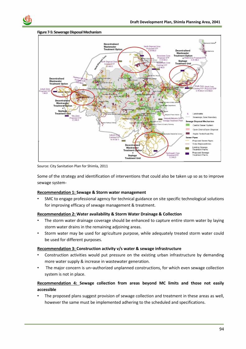
94
Draft Development Plan, Shimla Planning Area, 2041
Figure 7-5: Sewerage Disposal Mechanism
Source: City Sanitation Plan for Shimla, 2011
Some of the strategy and identification of interventions that could also be taken up so as to improve
sewage system-
Recommendation 1: Sewage & Storm water management
• SMC to engage professional agency for technical guidance on site specific technological solutions
for improving efficacy of sewage management & treatment.
Recommendation 2: Water availability & Storm Water Drainage & Collection
• The storm water drainage coverage should be enhanced to capture entire storm water by laying
storm water drains in the remaining adjoining areas.
• Storm water may be used for agriculture purpose, while adequately treated storm water could
be used for different purposes.
Recommendation 3: Construction activity v/s water & sewage infrastructure
• Construction activities would put pressure on the existing urban infrastructure by demanding
more water supply & increase in wastewater generation.
• The major concern is un–authorized unplanned constructions, for which even sewage collection
system is not in place.
Recommendation 4: Sewage collection from areas beyond MC limits and those not easily
accessible
• The proposed plans suggest provision of sewage collection and treatment in these areas as well,
however the same must be implemented adhering to the scheduled and specifications.
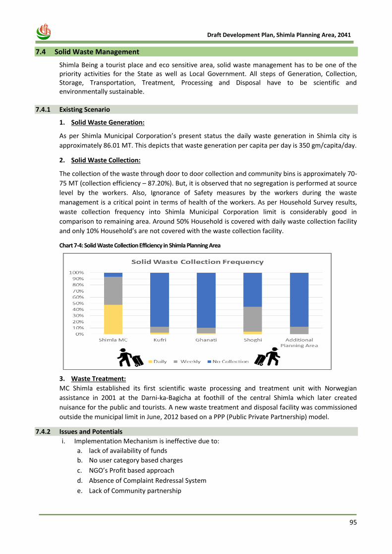
95
Draft Development Plan, Shimla Planning Area, 2041
7.4 Solid Waste Management
Shimla Being a tourist place and eco sensitive area, solid waste management has to be one of the priority activities for the State as well as Local Government. All steps of Generation, Collection, Storage, Transportation, Treatment, Processing and Disposal have to be scientific and environmentally sustainable.
7.4.1 Existing Scenario
1. Solid Waste Generation:
As per Shimla Municipal Corporation’s present status the daily waste generation in Shimla city is
approximately 86.01 MT. This depicts that waste generation per capita per day is 350 gm/capita/day.
2. Solid Waste Collection:
The collection of the waste through door to door collection and community bins is approximately 70-
75 MT (collection efficiency – 87.20%). But, it is observed that no segregation is performed at source
level by the workers. Also, Ignorance of Safety measures by the workers during the waste
management is a critical point in terms of health of the workers. As per Household Survey results,
waste collection frequency into Shimla Municipal Corporation limit is considerably good in
comparison to remaining area. Around 50% Household is covered with daily waste collection facility
and only 10% Household’s are not covered with the waste collection facility.
Chart 7-4: Solid Waste Collection Efficiency in Shimla Planning Area
3. Waste Treatment:
MC Shimla established its first scientific waste processing and treatment unit with Norwegian
assistance in 2001 at the Darni-ka-Bagicha at foothill of the central Shimla which later created
nuisance for the public and tourists. A new waste treatment and disposal facility was commissioned
outside the municipal limit in June, 2012 based on a PPP (Public Private Partnership) model.
7.4.2 Issues and Potentials
i. Implementation Mechanism is ineffective due to:
a. lack of availability of funds
b. No user category based charges
c. NGO’s Profit based approach
d. Absence of Complaint Redressal System
e. Lack of Community partnership

96
Draft Development Plan, Shimla Planning Area, 2041
f. No legal obligation
g. Inefficient recovery of user charges
h. Inadequate pay to staff
i. Inadequate human recourses
ii. No Segregation at Source Level
iii. Littering of Garbage by Tourist and Taxi Drivers on Hill Slopes
iv. Ignorance of Safety Measures by the Workers
v. Burning of Garbage by locally hired workers of commercial establishments/offices
7.4.3 Future Requirement
i. Solid Waste Generation Norms:
The following table indicates the waste generation per capita per day for estimation and forecast of waste generation for future for planning purpose.
Table 7-9: Solid Waste Generation Norms
Sr. No. Category Per Capita Generation Rate
1 Residential Population 400 gm./ capita/ day
2 Floating Population 300 gm./ capita/ day
ii. Service level Benchmark:
The Ministry of Urban Development has introduced Service Level Benchmarking (SLB) as one of the
appropriate systems for information management, performance monitoring and benchmarking. This
system is aimed at improving not only the service provision but also the delivery of services to the
consumers. These are indicators to measure the stepwise performance in MSWM at ULB level. The
table below shows the Current Status of MC Shimla as against the required benchmarks set under
the criteria.
Table 7-10: Service level Benchmark for Solid Waste
Performance Indicator Benchmarks Current Level
Household level coverage of solid waste management services
100% 84.8
Efficiency of collection of municipal solid waste 100% 77.8%
Extent of segregation of municipal solid waste 100% 10%
Extent of municipal solid waste recovered 80% 15%
Extent of scientific disposal of municipal solid waste 100% 0%
Extent of cost recovery in solid waste management services
100% 9.9%
Efficiency in collection of solid waste management charges
90% 44.4%
Efficiency in redressal of customer complaints 80% 74.1%
iii. Estimation of Solid Waste Quantity:
Solid waste generation is estimated considering 400 gm. / capita/ day for residential population and
300 gm. / capita/ day for floating population. The details are described in table given below. For the
population of 6, 25,163, estimated waste generation by 2041 is around 237 Metric Tonnes per day.
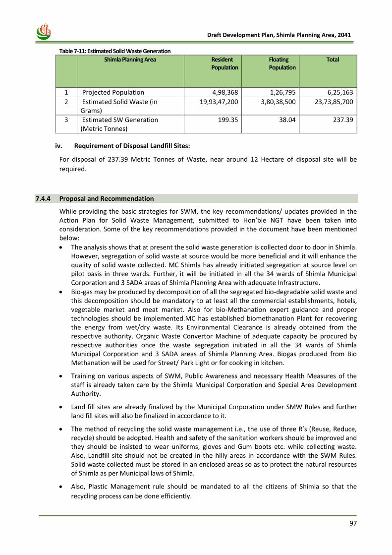
97
Draft Development Plan, Shimla Planning Area, 2041
Table 7-11: Estimated Solid Waste Generation
S.No
Shimla Planning Area Resident Population
Floating Population
Total
1 Projected Population 4,98,368 1,26,795 6,25,163
2 Estimated Solid Waste (in Grams)
19,93,47,200 3,80,38,500 23,73,85,700
3 Estimated SW Generation (Metric Tonnes)
199.35 38.04 237.39
iv. Requirement of Disposal Landfill Sites:
For disposal of 237.39 Metric Tonnes of Waste, near around 12 Hectare of disposal site will be
required.
7.4.4 Proposal and Recommendation
While providing the basic strategies for SWM, the key recommendations/ updates provided in the Action Plan for Solid Waste Management, submitted to Hon’ble NGT have been taken into consideration. Some of the key recommendations provided in the document have been mentioned below:
• The analysis shows that at present the solid waste generation is collected door to door in Shimla. However, segregation of solid waste at source would be more beneficial and it will enhance the quality of solid waste collected. MC Shimla has already initiated segregation at source level on pilot basis in three wards. Further, it will be initiated in all the 34 wards of Shimla Municipal Corporation and 3 SADA areas of Shimla Planning Area with adequate Infrastructure.
• Bio-gas may be produced by decomposition of all the segregated bio-degradable solid waste and this decomposition should be mandatory to at least all the commercial establishments, hotels, vegetable market and meat market. Also for bio-Methanation expert guidance and proper technologies should be implemented.MC has established biomethanation Plant for recovering the energy from wet/dry waste. Its Environmental Clearance is already obtained from the respective authority. Organic Waste Convertor Machine of adequate capacity be procured by respective authorities once the waste segregation initiated in all the 34 wards of Shimla Municipal Corporation and 3 SADA areas of Shimla Planning Area. Biogas produced from Bio Methanation will be used for Street/ Park Light or for cooking in kitchen.
• Training on various aspects of SWM, Public Awareness and necessary Health Measures of the staff is already taken care by the Shimla Municipal Corporation and Special Area Development Authority.
• Land fill sites are already finalized by the Municipal Corporation under SMW Rules and further land fill sites will also be finalized in accordance to it.
• The method of recycling the solid waste management i.e., the use of three R’s (Reuse, Reduce, recycle) should be adopted. Health and safety of the sanitation workers should be improved and they should be insisted to wear uniforms, gloves and Gum boots etc. while collecting waste. Also, Landfill site should not be created in the hilly areas in accordance with the SWM Rules. Solid waste collected must be stored in an enclosed areas so as to protect the natural resources of Shimla as per Municipal laws of Shimla.
• Also, Plastic Management rule should be mandated to all the citizens of Shimla so that the
recycling process can be done efficiently.
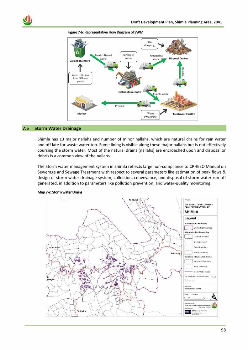
98
Draft Development Plan, Shimla Planning Area, 2041
Figure 7-6: Representative Flow Diagram of SWM
7.5 Storm Water Drainage
Shimla has 13 major nallahs and number of minor nallahs, which are natural drains for rain water and off late for waste water too. Some lining is visible along these major nallahs but is not effectively coursing the storm water. Most of the natural drains (nallahs) are encroached upon and disposal or debris is a common view of the nallahs.
The Storm water management system in Shimla reflects large non-compliance to CPHEEO Manual on Sewerage and Sewage Treatment with respect to several parameters like estimation of peak flows & design of storm water drainage system, collection, conveyance, and disposal of storm water run-off generated, in addition to parameters like pollution prevention, and water-quality monitoring.
Map 7-2: Storm water Drains
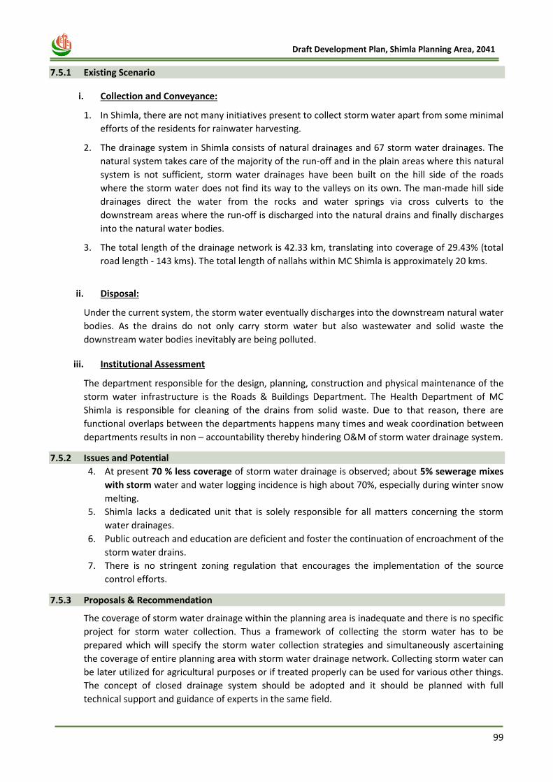
99
Draft Development Plan, Shimla Planning Area, 2041
7.5.1 Existing Scenario
i. Collection and Conveyance:
1. In Shimla, there are not many initiatives present to collect storm water apart from some minimal
efforts of the residents for rainwater harvesting.
2. The drainage system in Shimla consists of natural drainages and 67 storm water drainages. The
natural system takes care of the majority of the run-off and in the plain areas where this natural
system is not sufficient, storm water drainages have been built on the hill side of the roads
where the storm water does not find its way to the valleys on its own. The man-made hill side
drainages direct the water from the rocks and water springs via cross culverts to the
downstream areas where the run-off is discharged into the natural drains and finally discharges
into the natural water bodies.
3. The total length of the drainage network is 42.33 km, translating into coverage of 29.43% (total
road length - 143 kms). The total length of nallahs within MC Shimla is approximately 20 kms.
ii. Disposal:
Under the current system, the storm water eventually discharges into the downstream natural water
bodies. As the drains do not only carry storm water but also wastewater and solid waste the
downstream water bodies inevitably are being polluted.
iii. Institutional Assessment
The department responsible for the design, planning, construction and physical maintenance of the
storm water infrastructure is the Roads & Buildings Department. The Health Department of MC
Shimla is responsible for cleaning of the drains from solid waste. Due to that reason, there are
functional overlaps between the departments happens many times and weak coordination between
departments results in non – accountability thereby hindering O&M of storm water drainage system.
7.5.2 Issues and Potential
4. At present 70 % less coverage of storm water drainage is observed; about 5% sewerage mixes
with storm water and water logging incidence is high about 70%, especially during winter snow
melting.
5. Shimla lacks a dedicated unit that is solely responsible for all matters concerning the storm
water drainages.
6. Public outreach and education are deficient and foster the continuation of encroachment of the
storm water drains.
7. There is no stringent zoning regulation that encourages the implementation of the source
control efforts.
7.5.3 Proposals & Recommendation
The coverage of storm water drainage within the planning area is inadequate and there is no specific
project for storm water collection. Thus a framework of collecting the storm water has to be
prepared which will specify the storm water collection strategies and simultaneously ascertaining
the coverage of entire planning area with storm water drainage network. Collecting storm water can
be later utilized for agricultural purposes or if treated properly can be used for various other things.
The concept of closed drainage system should be adopted and it should be planned with full
technical support and guidance of experts in the same field.
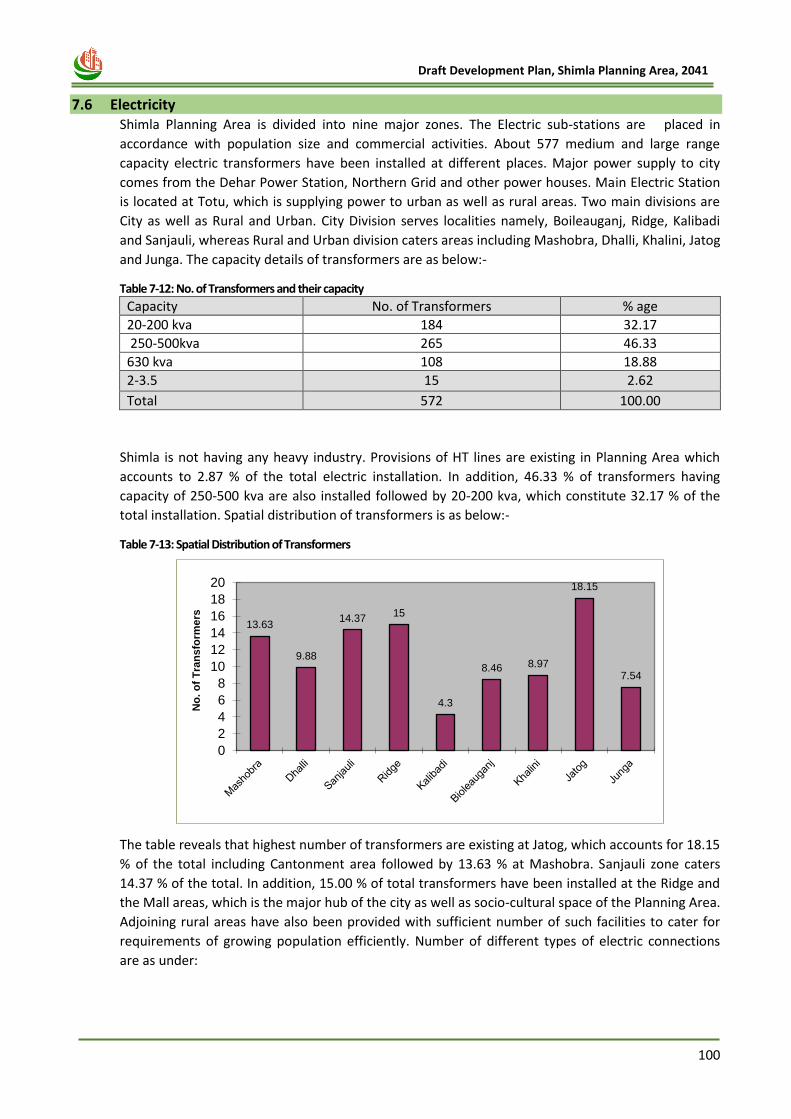
100
Draft Development Plan, Shimla Planning Area, 2041
7.6 Electricity
Shimla Planning Area is divided into nine major zones. The Electric sub-stations are placed in
accordance with population size and commercial activities. About 577 medium and large range
capacity electric transformers have been installed at different places. Major power supply to city
comes from the Dehar Power Station, Northern Grid and other power houses. Main Electric Station
is located at Totu, which is supplying power to urban as well as rural areas. Two main divisions are
City as well as Rural and Urban. City Division serves localities namely, Boileauganj, Ridge, Kalibadi
and Sanjauli, whereas Rural and Urban division caters areas including Mashobra, Dhalli, Khalini, Jatog
and Junga. The capacity details of transformers are as below:-
Table 7-12: No. of Transformers and their capacity
Capacity No. of Transformers % age
20-200 kva 184 32.17
250-500kva 265 46.33
630 kva 108 18.88
2-3.5 15 2.62
Total 572 100.00
Shimla is not having any heavy industry. Provisions of HT lines are existing in Planning Area which
accounts to 2.87 % of the total electric installation. In addition, 46.33 % of transformers having
capacity of 250-500 kva are also installed followed by 20-200 kva, which constitute 32.17 % of the
total installation. Spatial distribution of transformers is as below:-
Table 7-13: Spatial Distribution of Transformers
The table reveals that highest number of transformers are existing at Jatog, which accounts for 18.15
% of the total including Cantonment area followed by 13.63 % at Mashobra. Sanjauli zone caters
14.37 % of the total. In addition, 15.00 % of total transformers have been installed at the Ridge and
the Mall areas, which is the major hub of the city as well as socio-cultural space of the Planning Area.
Adjoining rural areas have also been provided with sufficient number of such facilities to cater for
requirements of growing population efficiently. Number of different types of electric connections
are as under:
13.63
9.88
14.3715
4.3
8.46 8.97
18.15
7.54
0
2
4
6
8
10
12
14
16
18
20
No
. o
f T
ran
sfo
rmers
101
Draft Development Plan, Shimla Planning Area, 2041
Table 7-14: Purpose wise connections
Sector No. Of Connections % age
Domestic 56141 82.80
Commercial 9081 13.39
Industrial 1895 2.80
N.D,NC 416 0.61
Public &
Semi Public
65 0.10
Others 198 0.30
Total 67796 100
Source: H.P SEB Shimla Division I & II
Domestic consumption of electricity in city is high as compared to other sectors on account of Shimla
being an administrative and service city accommodating a huge influx of migrant population as well
as possesses peculiar climatic conditions. Therefore, 82.80 % of the total connections are recorded in
domestic sector followed by 13.39 % connections in commercial sector. 67796 connections have
been recorded, out of which 54.05 % connections are in urban area and 45.95 % connections in rural
areas. Percentage total rural and urban connections are given below:-
Table 7-15: Distribution of connections in Rural and Urban Areas
Sector Connection % age
Urban 36646 54.05
Rural 31150 45.95
Total 67796 100.00
Source: H.P SEB Shimla Division I & II
7.7 Telecommunication Shimla is being served by extensive networks of telecommunications. Private communication providers like Air-Tel, Reliance,Tata Indicom and BSNL are providing efficient services to the masses. Telephone exchanges are spatially placed at strategic locations in Planning Area. Majority of households are enjoying communication. Thus, Shimla being a capital has efficient telecommunication networks as compared to other areas.
7.8 Imperative
Physical Infrastructure: Shimla being a premier city and tourist destination has potential to
strengthen economy of the state. Its basic infrastructure problems are required to be sorted out on
priority. Round the clock water supply is required to be ensured. In Water supply augmentation for
the water sources has been worked out, which will be able to cater the demand of projected
population by 2041. Also, water supply networks and sewage netwroks are required to be improved
and losses be reduced to minimal. Subsequently it would enable STP’s to work on their full capacity.
Structures under major electric networks have to be looked in terms of their safety and action
against unauthorized constructions has to be ensured. Proper sewerage system for entire Shimla
including newly developing peripheral areas need no emphasis. Drainage networks have to be fully
geared up to meet with new challenges posed by haphazard construction activities, on one hand and
coverage of nallahs, on the other.
102
Draft Development Plan, Shimla Planning Area, 2041
Chapter 8
SOCIAL
INFRASTRUCTURE
103
Draft Development Plan, Shimla Planning Area, 2041
8 CHAPTER- 8 SOCIAL INFRASTRUCTURE
8.1 Introduction
Social Infrastructure plays an important role in both the economic development of a nation and
development of the society’s quality of life. Development of Physical Infrastructure cannot lead in
overall development at the desired level, if the social infrastructure is not simultaneously developed.
This chapter will help to understand the issues & potentials in existing social infrastructure profile of
the city. Future requirement for proposed population under each sector is also identified based on
Standard Norms.
8.2 Education Facilities
Shimla, the Queen of the Himalayas is a heart of quality education. Since the British India, Shimla
had been the hub of good schools. In addition, there is a University, medical college, 5 Govt.and
Semi-Govt. Colleges, 31 Senior Secondary Schools (22 Govt. & 9 Pvt.) 25 High Schools (14 Govt. & 11
Pvt.) and 24 middle schools (22 Govt. & 2 Pvt.). There are about 15 C.B.S.E. affiliated schools in
Shimla Planning Area. Therefore, literacy rate in Shimla Planning Area is high as compared to other
towns and Shimla district as a whole. As per 2011 census, there are 2,02,168 literate persons in
Planning Area, who accounts to 84% of whole population of Planning Area. It has been observed that
literacy rate of male and female is 87% and 82% in Shimla Planning Area.
8.2.1 Existing Scenario
Some of the famous colleges in Shimla Planning Area under Himachal Pradesh University are:
1. St. Bedes College, Shimla
2. Government Degree College, Sanjauli, Shimla
3. Rajkiya Kanya MahaVidayaliya (RKMV)
4. H P U Evening College, Shimla
5. Institute of Vocational Studies
6. Indira Gandhi Medical College, Shimla
7. H P Government Dental College & Hospital, Shimla
8. AP Goyal Shimla University
1) University
The Himachal Pradesh University is a premier institution of teaching and research in the country. It
was established on 22nd July, 1970 by an Act of the Himachal Pradesh Legislative Assembly. It is
entirely financed by the Government of Himachal Pradesh and the University Grants Commission,
New Delhi. The University is situated nearly 5 km away from the main city, at Summer Hill, a quiet
suburb of Shimla in the vicinity of the Indian Institute of Advanced Studies. Its beautiful surroundings
present a panoramic view of snow peaked mountains and are ideally suited to pursue higher
learning amidst rhododendron, silver oak, pine and deodar forests. The campus is spread over an
area of about 80.94 hect. The various teaching departments, library, offices, residential complexes
and hostels of girls and boys are housed in aesthetically designed buildings matching with the hilly
terrain and climate. The University is both residential and affiliating in character.
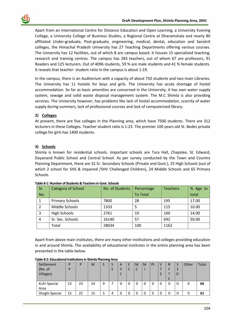
104
Draft Development Plan, Shimla Planning Area, 2041
Apart from an International Centre for Distance Education and Open Learning, a University Evening
College, a University College of Business Studies, a Regional Centre at Dharamshala and nearly 80
affiliated Under-graduate, Post-graduate, engineering, medical, dental, education and Sanskrit
colleges, the Himachal Pradesh University has 27 Teaching Departments offering various courses.
The University has 12 facilities, out of which 8 are campus based. It houses 15 specialized teaching,
research and training centres. The campus has 283 teachers, out of whom 67 are professors, 91
Readers and 125 lecturers. Out of 4096 students, 59 % are male students and 41 % female students.
It reveals that teacher- student ratio in the campus is about 1:19.
In the campus, there is an Auditorium with a capacity of about 750 students and two main Libraries.
The University has 11 hostels for boys and girls. The University has acute shortage of hostel
accommodation. So far as basic amenities are concerned in the University, it has own water supply
system, sewage and solid waste disposal management system. The M.C Shimla is also providing
services. The University however, has problems like lack of hostel accommodation, scarcity of water
supply during summers, lack of professional courses and lack of computerized library.
2) Colleges
At present, there are five colleges in the Planning area, which have 7500 students. There are 312
lecturers in these Colleges. Teacher student ratio is 1:23. The premier 100 years old St. Bedes private
college for girls has 1400 students.
3) Schools
Shimla is known for residential schools. Important schools are Tara Hall, Chapslee, St. Edward,
Dayanand Public School and Central School. As per survey conducted by the Town and Country
Planning Department, there are 31 Sr. Secondary Schools (Private and Govt.), 25 High Schools (out of
which 2 school for SHS & impaired /SHV Challenged Children), 24 Middle Schools and 65 Primary
Schools.
Table 8-1: Number of Students & Teachers in Govt. Schools
Sr.
No.
Category of School No. of Students Percentage
To Total
Teachers % Age to
total
1 Primary Schools 7800 28 195 17.00
2 Middle Schools 1333 5 115 10.00
3 High Schools 2761 10 160 14.00
4 Sr. Sec. Schools 16140 57 692 59.00
Total 28034 100 1162
Apart from above main institutes, there are many other institutions and colleges providing education
in and around Shimla. The availability of educational institutes in the entire planning area has been
presented in the table below.
Table 8-2: Educational institutions in Shimla Planning Area
Settlement (No. of Villages)
P P
P M S S S
A S C
E C
M C
M I
Pt V T S
N F T C
S S D
Other Total
Kufri Special Area
13 23 14 9 7 0 0 0 0 0 0 0 0 0 66
Shoghi Special 15 22 15 5 4 0 0 0 0 0 0 0 0 0 61
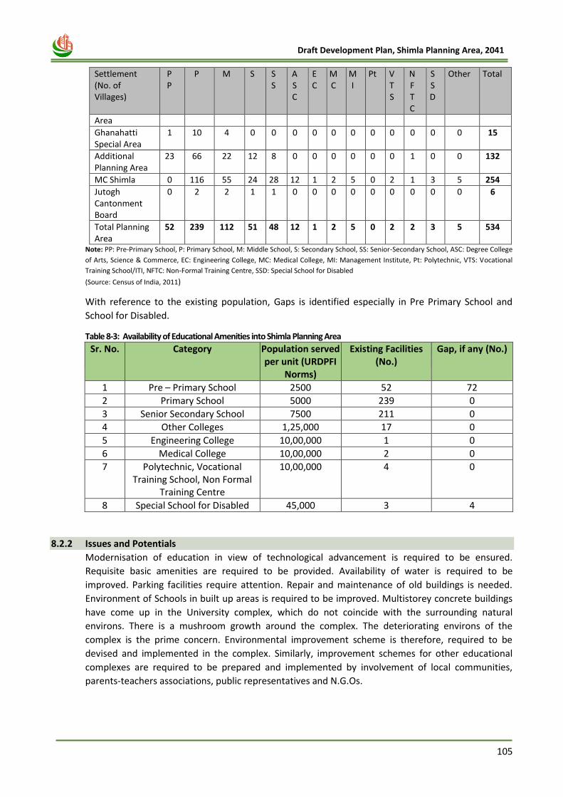
105
Draft Development Plan, Shimla Planning Area, 2041
Settlement (No. of Villages)
P P
P M S S S
A S C
E C
M C
M I
Pt V T S
N F T C
S S D
Other Total
Area
Ghanahatti Special Area
1 10 4 0 0 0 0 0 0 0 0 0 0 0 15
Additional Planning Area
23 66 22 12 8 0 0 0 0 0 0 1 0 0 132
MC Shimla 0 116 55 24 28 12 1 2 5 0 2 1 3 5 254
Jutogh Cantonment Board
0 2 2 1 1 0 0 0 0 0 0 0 0 0 6
Total Planning Area
52 239 112 51 48 12 1 2 5 0 2 2 3 5 534
Note: PP: Pre-Primary School, P: Primary School, M: Middle School, S: Secondary School, SS: Senior-Secondary School, ASC: Degree College
of Arts, Science & Commerce, EC: Engineering College, MC: Medical College, MI: Management Institute, Pt: Polytechnic, VTS: Vocational
Training School/ITI, NFTC: Non-Formal Training Centre, SSD: Special School for Disabled
(Source: Census of India, 2011)
With reference to the existing population, Gaps is identified especially in Pre Primary School and
School for Disabled.
Table 8-3: Availability of Educational Amenities into Shimla Planning Area
Sr. No.
Category Population served per unit (URDPFI
Norms)
Existing Facilities (No.)
Gap, if any (No.)
1 Pre – Primary School 2500 52 72
2 Primary School 5000 239 0
3 Senior Secondary School 7500 211 0
4 Other Colleges 1,25,000 17 0
5 Engineering College 10,00,000 1 0
6 Medical College 10,00,000 2 0
7 Polytechnic, Vocational Training School, Non Formal
Training Centre
10,00,000 4 0
8 Special School for Disabled 45,000 3 4
8.2.2 Issues and Potentials
Modernisation of education in view of technological advancement is required to be ensured.
Requisite basic amenities are required to be provided. Availability of water is required to be
improved. Parking facilities require attention. Repair and maintenance of old buildings is needed.
Environment of Schools in built up areas is required to be improved. Multistorey concrete buildings
have come up in the University complex, which do not coincide with the surrounding natural
environs. There is a mushroom growth around the complex. The deteriorating environs of the
complex is the prime concern. Environmental improvement scheme is therefore, required to be
devised and implemented in the complex. Similarly, improvement schemes for other educational
complexes are required to be prepared and implemented by involvement of local communities,
parents-teachers associations, public representatives and N.G.Os.
106
Draft Development Plan, Shimla Planning Area, 2041
8.2.3 Future Requirement
Being an educational hub, Shimla Planning Area is having educational amenities more than its
population requirement. For the projected population, Additional no. will be required in sector of
Pre Primary School and School for Disabled. Details are described in table given below:
Table 8-4: Future Requirement in educational amenities
Sr. No.
Category Population served per unit
(URDPFI Norms)
Existing Facilities (No.)
Additional Requirement
(No.)
Area Requirement
(Ha.)
1 Pre – Primary School 2500 52 250 =(0.08*250) = 20
2 Primary School 5000 239 0 0
3 Senior Secondary School
7500 211 0 0
4 Other Colleges 1,25,000 17 0 0
5 Engineering College 10,00,000 1 0 0
6 Medical College 10,00,000 2 0 0
7 Polytechnic, Vocational Training School, Non Formal Training Centre
10,00,000 4 0 0
8 Special School for Disabled
45,000 3 11 =(0.20*11) = 2.2
8.2.4 Proposal
a. Pre-Primary School
There are only 52 number of pre-primary schools and 3 Special School for disabled exists in the
Shimla Planning Area and there is requirement of 250 additional pre-primary schools and 11 Special
School for Disabled. So, this requirement will be fulfilled in the proposed education infrastructure
which is located near the Challi Chaula, Mehli, Jalf village located in the southern part of Shimla and
in the Additional planning area of Shimla there are major educational institutions proposed, to fulfill
the requirement of education facilities.
b. Proposed Government High School The Smart City, Shimla has proposed government high school in the Krishna Nagar. This proposed high school is proposed to be made into a model smart school which will include smart classrooms and smart infrastructure. Also, since there is lack of pre-primary school identified in the table above as per the URDPFI guidelines, it is also proposed that the school will be expanded to include primary wing.
8.3 Health Facilities
The city provides very good and effective health services. People from across the State come here for treatment and health care. Presently, area is served by General Hospital, Multi-Specialty Hospital, Family Welfare Centers as well as Veterinary Hospital.
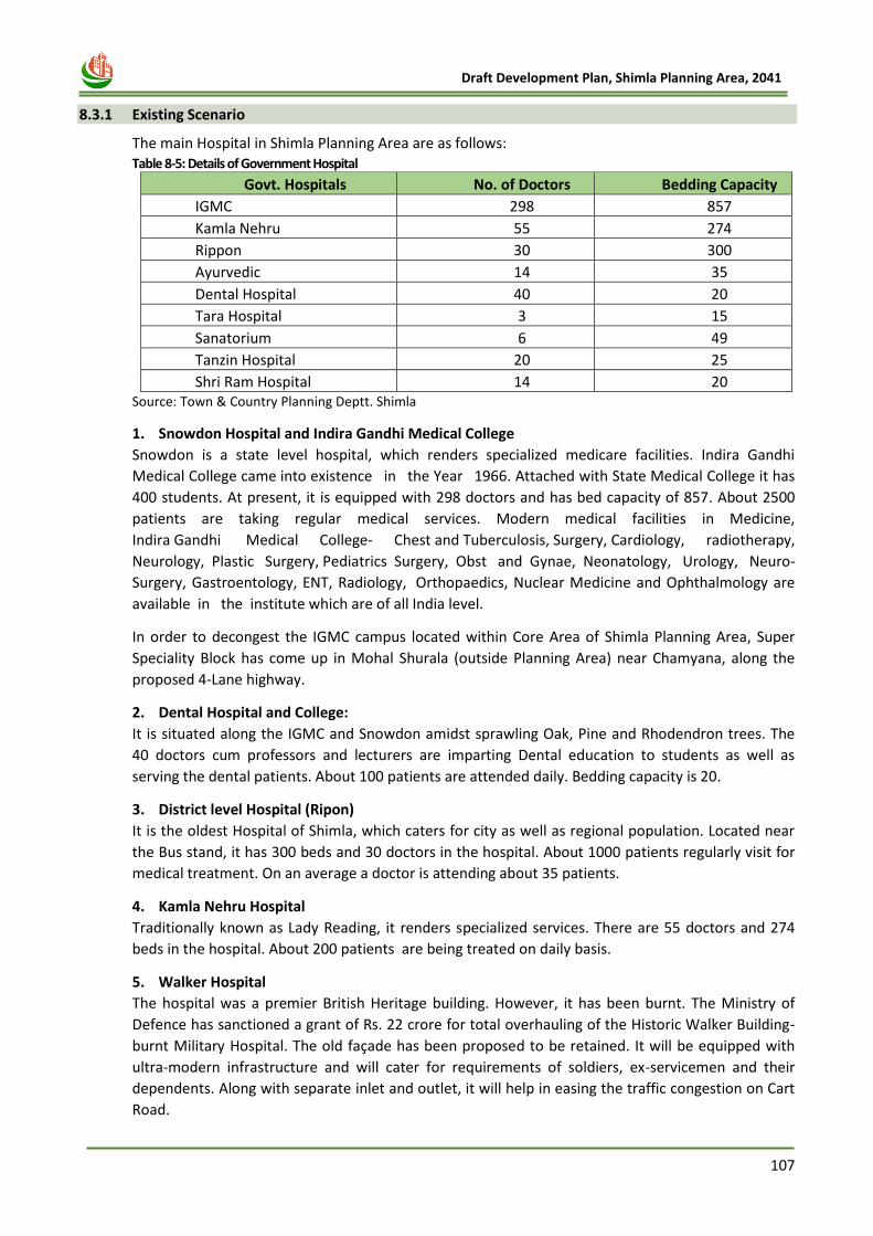
107
Draft Development Plan, Shimla Planning Area, 2041
8.3.1 Existing Scenario
The main Hospital in Shimla Planning Area are as follows: Table 8-5: Details of Government Hospital
Govt. Hospitals No. of Doctors Bedding Capacity
IGMC 298 857
Kamla Nehru 55 274
Rippon 30 300
Ayurvedic 14 35
Dental Hospital 40 20
Tara Hospital 3 15
Sanatorium 6 49
Tanzin Hospital 20 25
Shri Ram Hospital 14 20 Source: Town & Country Planning Deptt. Shimla
1. Snowdon Hospital and Indira Gandhi Medical College
Snowdon is a state level hospital, which renders specialized medicare facilities. Indira Gandhi
Medical College came into existence in the Year 1966. Attached with State Medical College it has
400 students. At present, it is equipped with 298 doctors and has bed capacity of 857. About 2500
patients are taking regular medical services. Modern medical facilities in Medicine,
Indira Gandhi Medical College- Chest and Tuberculosis, Surgery, Cardiology, radiotherapy,
Neurology, Plastic Surgery, Pediatrics Surgery, Obst and Gynae, Neonatology, Urology, Neuro-
Surgery, Gastroentology, ENT, Radiology, Orthopaedics, Nuclear Medicine and Ophthalmology are
available in the institute which are of all India level.
In order to decongest the IGMC campus located within Core Area of Shimla Planning Area, Super
Speciality Block has come up in Mohal Shurala (outside Planning Area) near Chamyana, along the
proposed 4-Lane highway.
2. Dental Hospital and College:
It is situated along the IGMC and Snowdon amidst sprawling Oak, Pine and Rhodendron trees. The
40 doctors cum professors and lecturers are imparting Dental education to students as well as
serving the dental patients. About 100 patients are attended daily. Bedding capacity is 20.
3. District level Hospital (Ripon)
It is the oldest Hospital of Shimla, which caters for city as well as regional population. Located near
the Bus stand, it has 300 beds and 30 doctors in the hospital. About 1000 patients regularly visit for
medical treatment. On an average a doctor is attending about 35 patients.
4. Kamla Nehru Hospital
Traditionally known as Lady Reading, it renders specialized services. There are 55 doctors and 274
beds in the hospital. About 200 patients are being treated on daily basis.
5. Walker Hospital
The hospital was a premier British Heritage building. However, it has been burnt. The Ministry of
Defence has sanctioned a grant of Rs. 22 crore for total overhauling of the Historic Walker Building-
burnt Military Hospital. The old façade has been proposed to be retained. It will be equipped with
ultra-modern infrastructure and will cater for requirements of soldiers, ex-servicemen and their
dependents. Along with separate inlet and outlet, it will help in easing the traffic congestion on Cart
Road.
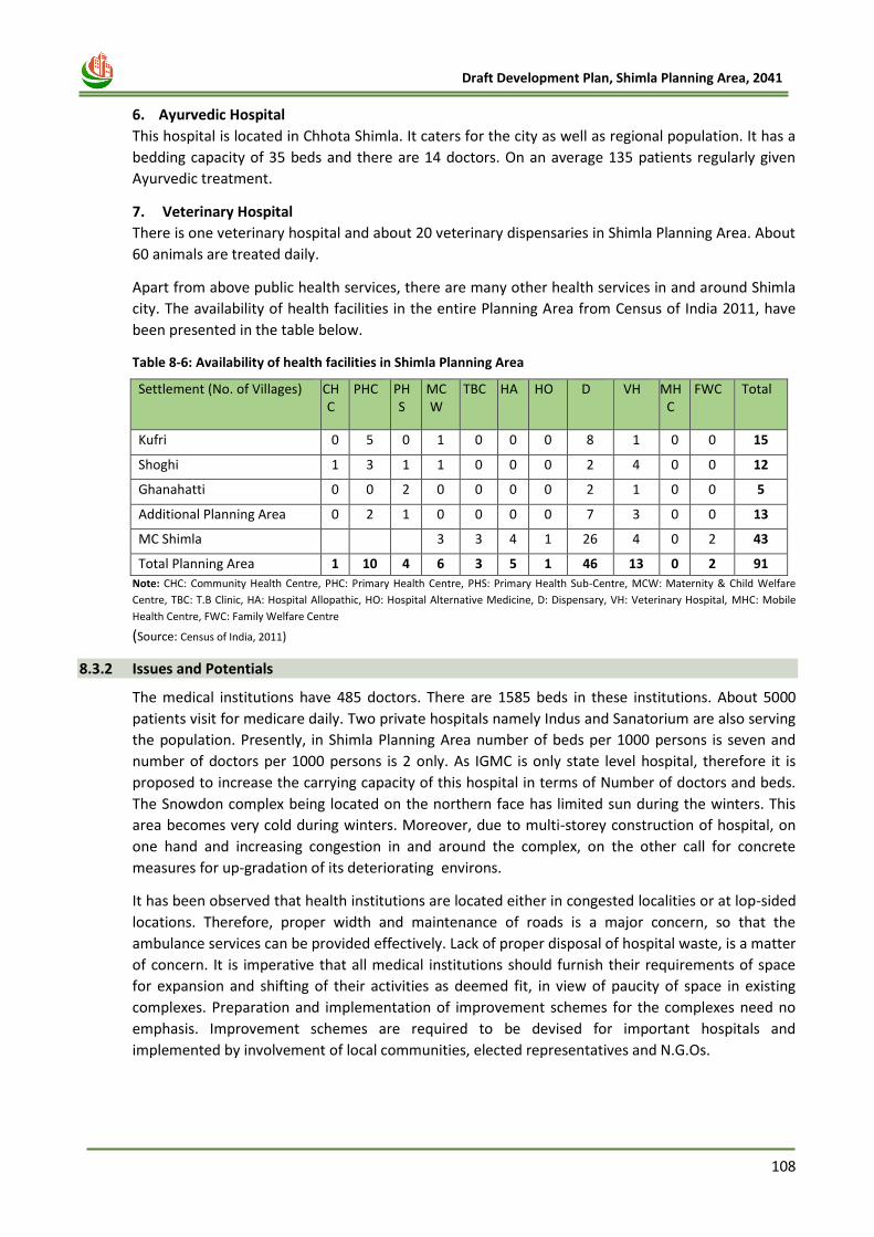
108
Draft Development Plan, Shimla Planning Area, 2041
6. Ayurvedic Hospital
This hospital is located in Chhota Shimla. It caters for the city as well as regional population. It has a
bedding capacity of 35 beds and there are 14 doctors. On an average 135 patients regularly given
Ayurvedic treatment.
7. Veterinary Hospital
There is one veterinary hospital and about 20 veterinary dispensaries in Shimla Planning Area. About
60 animals are treated daily.
Apart from above public health services, there are many other health services in and around Shimla
city. The availability of health facilities in the entire Planning Area from Census of India 2011, have
been presented in the table below.
Table 8-6: Availability of health facilities in Shimla Planning Area
Settlement (No. of Villages) CHC
PHC PHS
MCW
TBC HA HO D VH MHC
FWC Total
Kufri 0 5 0 1 0 0 0 8 1 0 0 15
Shoghi 1 3 1 1 0 0 0 2 4 0 0 12
Ghanahatti 0 0 2 0 0 0 0 2 1 0 0 5
Additional Planning Area 0 2 1 0 0 0 0 7 3 0 0 13
MC Shimla
3 3 4 1 26 4 0 2 43
Total Planning Area 1 10 4 6 3 5 1 46 13 0 2 91
Note: CHC: Community Health Centre, PHC: Primary Health Centre, PHS: Primary Health Sub-Centre, MCW: Maternity & Child Welfare
Centre, TBC: T.B Clinic, HA: Hospital Allopathic, HO: Hospital Alternative Medicine, D: Dispensary, VH: Veterinary Hospital, MHC: Mobile
Health Centre, FWC: Family Welfare Centre
(Source: Census of India, 2011)
8.3.2 Issues and Potentials
The medical institutions have 485 doctors. There are 1585 beds in these institutions. About 5000
patients visit for medicare daily. Two private hospitals namely Indus and Sanatorium are also serving
the population. Presently, in Shimla Planning Area number of beds per 1000 persons is seven and
number of doctors per 1000 persons is 2 only. As IGMC is only state level hospital, therefore it is
proposed to increase the carrying capacity of this hospital in terms of Number of doctors and beds.
The Snowdon complex being located on the northern face has limited sun during the winters. This
area becomes very cold during winters. Moreover, due to multi-storey construction of hospital, on
one hand and increasing congestion in and around the complex, on the other call for concrete
measures for up-gradation of its deteriorating environs.
It has been observed that health institutions are located either in congested localities or at lop-sided
locations. Therefore, proper width and maintenance of roads is a major concern, so that the
ambulance services can be provided effectively. Lack of proper disposal of hospital waste, is a matter
of concern. It is imperative that all medical institutions should furnish their requirements of space
for expansion and shifting of their activities as deemed fit, in view of paucity of space in existing
complexes. Preparation and implementation of improvement schemes for the complexes need no
emphasis. Improvement schemes are required to be devised for important hospitals and
implemented by involvement of local communities, elected representatives and N.G.Os.
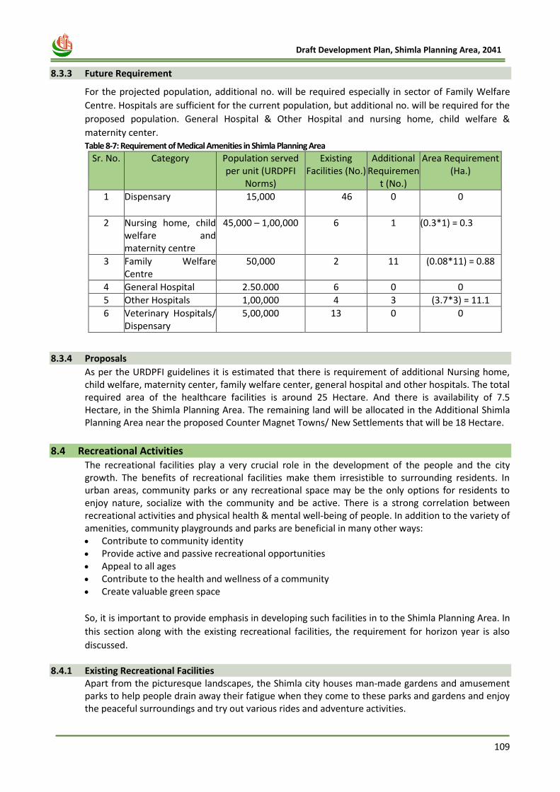
109
Draft Development Plan, Shimla Planning Area, 2041
8.3.3 Future Requirement
For the projected population, additional no. will be required especially in sector of Family Welfare
Centre. Hospitals are sufficient for the current population, but additional no. will be required for the
proposed population. General Hospital & Other Hospital and nursing home, child welfare &
maternity center. Table 8-7: Requirement of Medical Amenities in Shimla Planning Area
Sr. No.
Category Population served per unit (URDPFI
Norms)
Existing Facilities (No.)
Additional Requiremen
t (No.)
Area Requirement (Ha.)
1 Dispensary 15,000 46 0 0
2 Nursing home, child welfare and maternity centre
45,000 – 1,00,000 6 1 (0.3*1) = 0.3
3 Family Welfare Centre
50,000 2 11 (0.08*11) = 0.88
4 General Hospital 2.50.000 6 0 0
5 Other Hospitals 1,00,000 4 3 (3.7*3) = 11.1
6 Veterinary Hospitals/ Dispensary
5,00,000 13 0 0
8.3.4 Proposals
As per the URDPFI guidelines it is estimated that there is requirement of additional Nursing home, child welfare, maternity center, family welfare center, general hospital and other hospitals. The total required area of the healthcare facilities is around 25 Hectare. And there is availability of 7.5 Hectare, in the Shimla Planning Area. The remaining land will be allocated in the Additional Shimla Planning Area near the proposed Counter Magnet Towns/ New Settlements that will be 18 Hectare.
8.4 Recreational Activities The recreational facilities play a very crucial role in the development of the people and the city growth. The benefits of recreational facilities make them irresistible to surrounding residents. In urban areas, community parks or any recreational space may be the only options for residents to enjoy nature, socialize with the community and be active. There is a strong correlation between recreational activities and physical health & mental well-being of people. In addition to the variety of amenities, community playgrounds and parks are beneficial in many other ways: • Contribute to community identity • Provide active and passive recreational opportunities • Appeal to all ages • Contribute to the health and wellness of a community • Create valuable green space
So, it is important to provide emphasis in developing such facilities in to the Shimla Planning Area. In
this section along with the existing recreational facilities, the requirement for horizon year is also
discussed.
8.4.1 Existing Recreational Facilities Apart from the picturesque landscapes, the Shimla city houses man-made gardens and amusement parks to help people drain away their fatigue when they come to these parks and gardens and enjoy the peaceful surroundings and try out various rides and adventure activities.
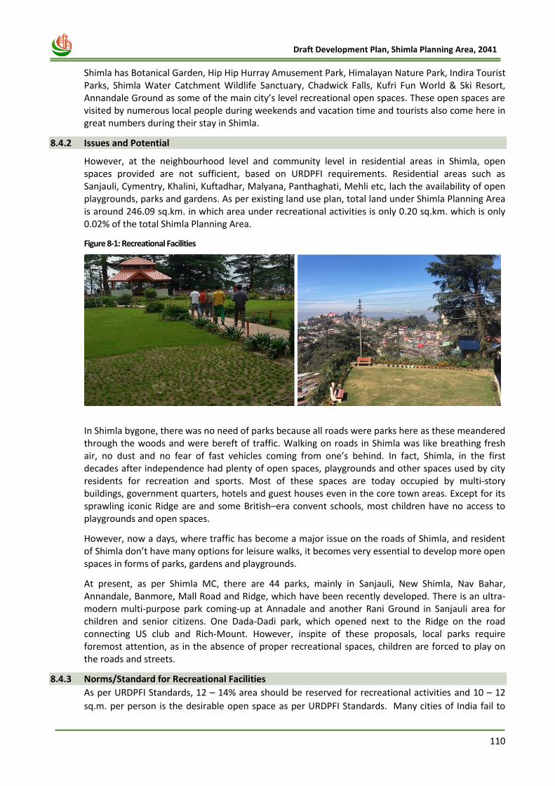
110
Draft Development Plan, Shimla Planning Area, 2041
Shimla has Botanical Garden, Hip Hip Hurray Amusement Park, Himalayan Nature Park, Indira Tourist Parks, Shimla Water Catchment Wildlife Sanctuary, Chadwick Falls, Kufri Fun World & Ski Resort, Annandale Ground as some of the main city’s level recreational open spaces. These open spaces are visited by numerous local people during weekends and vacation time and tourists also come here in great numbers during their stay in Shimla.
8.4.2 Issues and Potential
However, at the neighbourhood level and community level in residential areas in Shimla, open spaces provided are not sufficient, based on URDPFI requirements. Residential areas such as Sanjauli, Cymentry, Khalini, Kuftadhar, Malyana, Panthaghati, Mehli etc, lach the availability of open playgrounds, parks and gardens. As per existing land use plan, total land under Shimla Planning Area is around 246.09 sq.km. in which area under recreational activities is only 0.20 sq.km. which is only 0.02% of the total Shimla Planning Area.
Figure 8-1: Recreational Facilities
In Shimla bygone, there was no need of parks because all roads were parks here as these meandered through the woods and were bereft of traffic. Walking on roads in Shimla was like breathing fresh air, no dust and no fear of fast vehicles coming from one’s behind. In fact, Shimla, in the first decades after independence had plenty of open spaces, playgrounds and other spaces used by city residents for recreation and sports. Most of these spaces are today occupied by multi-story buildings, government quarters, hotels and guest houses even in the core town areas. Except for its sprawling iconic Ridge are and some British–era convent schools, most children have no access to playgrounds and open spaces.
However, now a days, where traffic has become a major issue on the roads of Shimla, and resident of Shimla don’t have many options for leisure walks, it becomes very essential to develop more open spaces in forms of parks, gardens and playgrounds.
At present, as per Shimla MC, there are 44 parks, mainly in Sanjauli, New Shimla, Nav Bahar, Annandale, Banmore, Mall Road and Ridge, which have been recently developed. There is an ultra-modern multi-purpose park coming-up at Annadale and another Rani Ground in Sanjauli area for children and senior citizens. One Dada-Dadi park, which opened next to the Ridge on the road connecting US club and Rich-Mount. However, inspite of these proposals, local parks require foremost attention, as in the absence of proper recreational spaces, children are forced to play on the roads and streets.
8.4.3 Norms/Standard for Recreational Facilities
As per URDPFI Standards, 12 – 14% area should be reserved for recreational activities and 10 – 12
sq.m. per person is the desirable open space as per URDPFI Standards. Many cities of India fail to
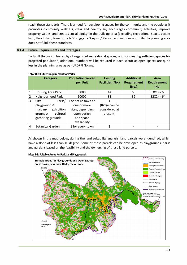
111
Draft Development Plan, Shimla Planning Area, 2041
reach these standards. There is a need for developing spaces for the community and the people as it
promotes community wellness, clear and healthy air, encourages community activities, improve
property values, and creates social equity. In the built-up area (excluding recreational space, vacant
land, flood plain, forest) the NBC suggests 3 sq.m. / Person as minimum norm Shimla planning area
does not fulfill these standards.
8.4.4 Future Requirements and Strategies
To fulfill the gap in hierarchy of organized recreational spaces, and for creating sufficient spaces for
projected population, additional numbers will be required in each sector as open spaces are quite
less in the planning area as per URDPFI Norms.
Table 8-8: Future Requirement for Parks
Category Population Served per Unit
Existing Facilities (No.)
Additional Requirement
(No.)
Area Requirement
(Ha)
1 Housing Area Park 5000 44 63 (63X1) = 63
2 Neighborhood Park 10000 31 32 (32X2) = 64
3 City Parks/ playgrounds/ maidan/ exhibition grounds/ cultural gathering grounds
For entire town at one or more
sites, depending upon design and space availability
1 (Ridge can be considered at
present)
- -
4 Botanical Garden 1 for every town 1 - -
As shown in the map below, during the land suitability analysis, land parcels were identified, which
have a slope of less than 10 degree. Some of these parcels can be developed as playgrounds, parks
and gardens based on the feasibility and the ownership of these land parcels.
Map 8-1: Suitable Areas for Parks and Playgrounds
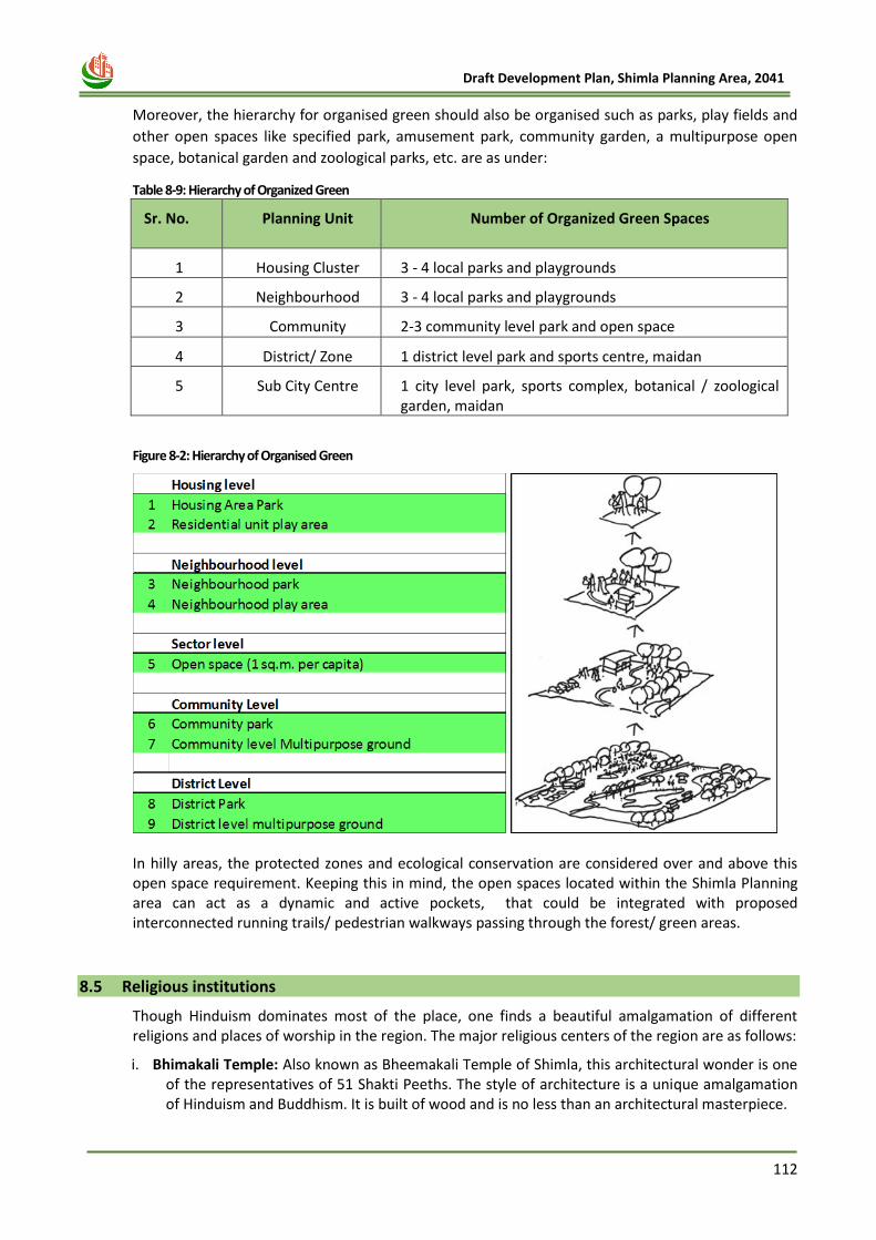
112
Draft Development Plan, Shimla Planning Area, 2041
Moreover, the hierarchy for organised green should also be organised such as parks, play fields and
other open spaces like specified park, amusement park, community garden, a multipurpose open
space, botanical garden and zoological parks, etc. are as under:
Table 8-9: Hierarchy of Organized Green
Sr. No. Planning Unit Number of Organized Green Spaces
1 Housing Cluster 3 ‐ 4 local parks and playgrounds
2 Neighbourhood 3 ‐ 4 local parks and playgrounds
3 Community 2‐3 community level park and open space
4 District/ Zone 1 district level park and sports centre, maidan
5 Sub City Centre 1 city level park, sports complex, botanical / zoological garden, maidan
Figure 8-2: Hierarchy of Organised Green
In hilly areas, the protected zones and ecological conservation are considered over and above this open space requirement. Keeping this in mind, the open spaces located within the Shimla Planning area can act as a dynamic and active pockets, that could be integrated with proposed interconnected running trails/ pedestrian walkways passing through the forest/ green areas.
8.5 Religious institutions
Though Hinduism dominates most of the place, one finds a beautiful amalgamation of different religions and places of worship in the region. The major religious centers of the region are as follows:
i. Bhimakali Temple: Also known as Bheemakali Temple of Shimla, this architectural wonder is one of the representatives of 51 Shakti Peeths. The style of architecture is a unique amalgamation of Hinduism and Buddhism. It is built of wood and is no less than an architectural masterpiece.
113
Draft Development Plan, Shimla Planning Area, 2041
ii. Jakhoo Temple: The Jakhoo temple is located at a height of 2455 meters and is situated on the
highest peak in Shimla. It is hardly 2 kilometers from the Ridge and is an uphill climb through the beautiful deodar trees. It is dedicated to the monkey God, Hanuman.
iii. Kalibari Temple Shimla: The temple was built in the year 1845 and is dedicated to Goddess Kali who is also known as Shyamala. It is from the name of Goddess Shyamala that Shimla derives its name.
iv. Christ Church & St. Michael's Cathedral: The famous Christ church & St. Michael's Cathedral of Shimla is a beautiful architectural masterpiece. The construction of this church took a span of 11 years (1846 - 1857) and is considered to be the second oldest church in North India. This splendid church is located just near the Ridge in Shimla and can be reached very easily from anywhere.
v. Sankat Mochan Temple: One of the most popular tourist attractions of Shimla, the Sankat Mochan Temple is located among lush green and tranquil locales on the Kalka - Shimla highway, on the National Highway - 22. The temple is a place where one can actually meditate and enjoy the calm and peaceful surroundings.
vi. Tara Devi Temple Shimla: Tara Devi is situated at a distance of around 11 kilometers from Shimla and can be accessed while traveling on the Kalka - Shimla National Highway. It is situated at the top of a hill in Shimla and the lush green environs surrounding it give the temple a very peaceful and tranquil atmosphere.
vii. The Main Jonang Takten Phuntsok Choeling Buddhist Monastery: Located in Sanjauli along a hilly cliff on one side, the main aim of this establishment is to gather children from remote places where there are no proper schools, educational facilities, or means of transportation (and children of poor parents and orphan children) - and to nurture them by giving both monastic and moral education.
viii. Gurudwara Sahib Sanjauli: A famous place of worship for the Sikhs of Shimla, this Gurudwara is also visited by a lot of tourists.
ix. Dhingu Mata Temple-Sanjauli: Dhingu Mata temple is in Sanjauli approx. 5 km from Shimla. There are more than 400 steep stairs to reach the temple. It is a 150-200 years old temple.
8.6 Other Public Services
Population pressure is increasing in Shimla because of better services and facilities. There are
six Police Stations, three Fire Stations, Banking and insurance services, 9 petrol pumps and
various services catering for the local and regional population as well as tourists. Presently these
services are not adequate to cater for the existing demand of local and regional population as well as
tourists. A rapid growth of population, floating population and tourists require more facilities to be
provided to cater for the needs by the year 2021. The area requirement for various facilities and
services is given in the 16th chapter. The description of above services is as under:
Table 8-10: Public Services
Description Number
Library 5
Reading Room 2
Post Office 5
Sub-Post Office 15
Telegraph Office 5
Police Station 6
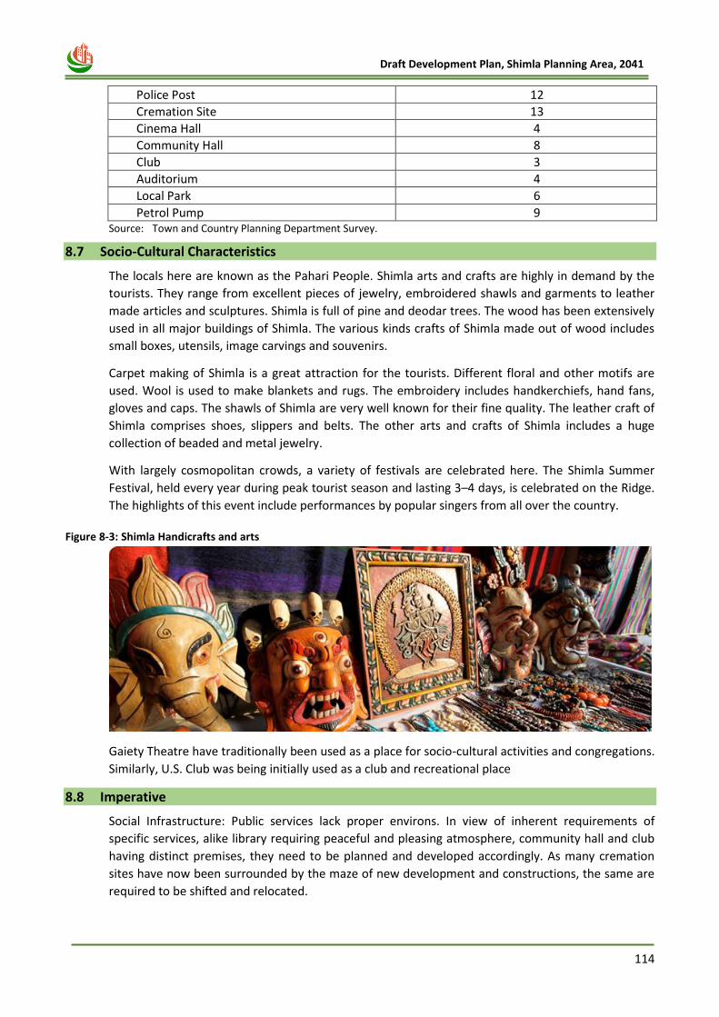
114
Draft Development Plan, Shimla Planning Area, 2041
Police Post 12
Cremation Site 13
Cinema Hall 4
Community Hall 8
Club 3
Auditorium 4
Local Park 6
Petrol Pump 9 Source: Town and Country Planning Department Survey.
8.7 Socio-Cultural Characteristics
The locals here are known as the Pahari People. Shimla arts and crafts are highly in demand by the
tourists. They range from excellent pieces of jewelry, embroidered shawls and garments to leather
made articles and sculptures. Shimla is full of pine and deodar trees. The wood has been extensively
used in all major buildings of Shimla. The various kinds crafts of Shimla made out of wood includes
small boxes, utensils, image carvings and souvenirs.
Carpet making of Shimla is a great attraction for the tourists. Different floral and other motifs are
used. Wool is used to make blankets and rugs. The embroidery includes handkerchiefs, hand fans,
gloves and caps. The shawls of Shimla are very well known for their fine quality. The leather craft of
Shimla comprises shoes, slippers and belts. The other arts and crafts of Shimla includes a huge
collection of beaded and metal jewelry.
With largely cosmopolitan crowds, a variety of festivals are celebrated here. The Shimla Summer
Festival, held every year during peak tourist season and lasting 3–4 days, is celebrated on the Ridge.
The highlights of this event include performances by popular singers from all over the country.
Figure 8-3: Shimla Handicrafts and arts
Gaiety Theatre have traditionally been used as a place for socio-cultural activities and congregations.
Similarly, U.S. Club was being initially used as a club and recreational place
8.8 Imperative
Social Infrastructure: Public services lack proper environs. In view of inherent requirements of
specific services, alike library requiring peaceful and pleasing atmosphere, community hall and club
having distinct premises, they need to be planned and developed accordingly. As many cremation
sites have now been surrounded by the maze of new development and constructions, the same are
required to be shifted and relocated.
115
Draft Development Plan, Shimla Planning Area, 2041
Chapter 9
HOUSING AND
SLUM
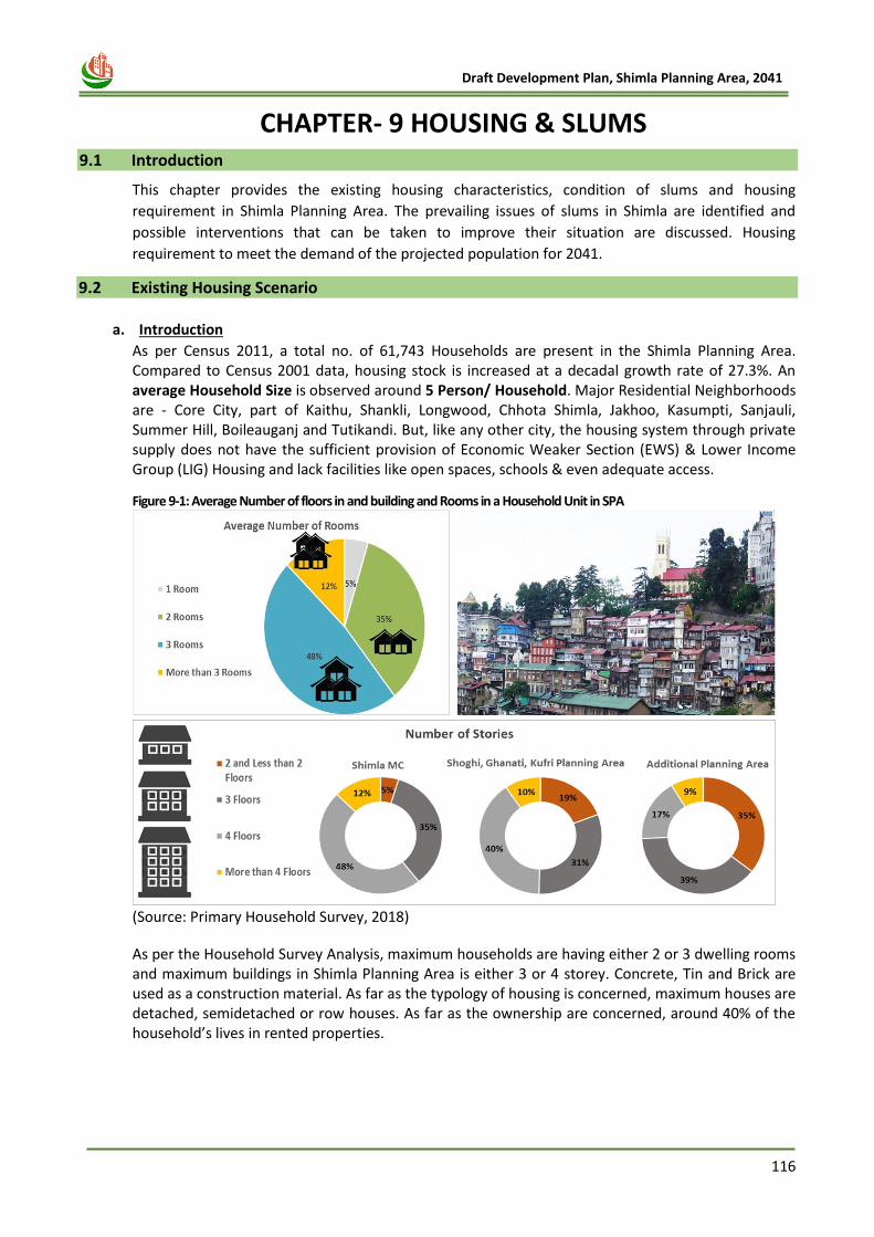
116
Draft Development Plan, Shimla Planning Area, 2041
9 CHAPTER- 9 HOUSING & SLUMS 9.1 Introduction
This chapter provides the existing housing characteristics, condition of slums and housing
requirement in Shimla Planning Area. The prevailing issues of slums in Shimla are identified and
possible interventions that can be taken to improve their situation are discussed. Housing
requirement to meet the demand of the projected population for 2041.
9.2 Existing Housing Scenario
a. Introduction
As per Census 2011, a total no. of 61,743 Households are present in the Shimla Planning Area. Compared to Census 2001 data, housing stock is increased at a decadal growth rate of 27.3%. An average Household Size is observed around 5 Person/ Household. Major Residential Neighborhoods are - Core City, part of Kaithu, Shankli, Longwood, Chhota Shimla, Jakhoo, Kasumpti, Sanjauli, Summer Hill, Boileauganj and Tutikandi. But, like any other city, the housing system through private supply does not have the sufficient provision of Economic Weaker Section (EWS) & Lower Income Group (LIG) Housing and lack facilities like open spaces, schools & even adequate access.
Figure 9-1: Average Number of floors in and building and Rooms in a Household Unit in SPA
(Source: Primary Household Survey, 2018)
As per the Household Survey Analysis, maximum households are having either 2 or 3 dwelling rooms and maximum buildings in Shimla Planning Area is either 3 or 4 storey. Concrete, Tin and Brick are used as a construction material. As far as the typology of housing is concerned, maximum houses are detached, semidetached or row houses. As far as the ownership are concerned, around 40% of the household’s lives in rented properties.
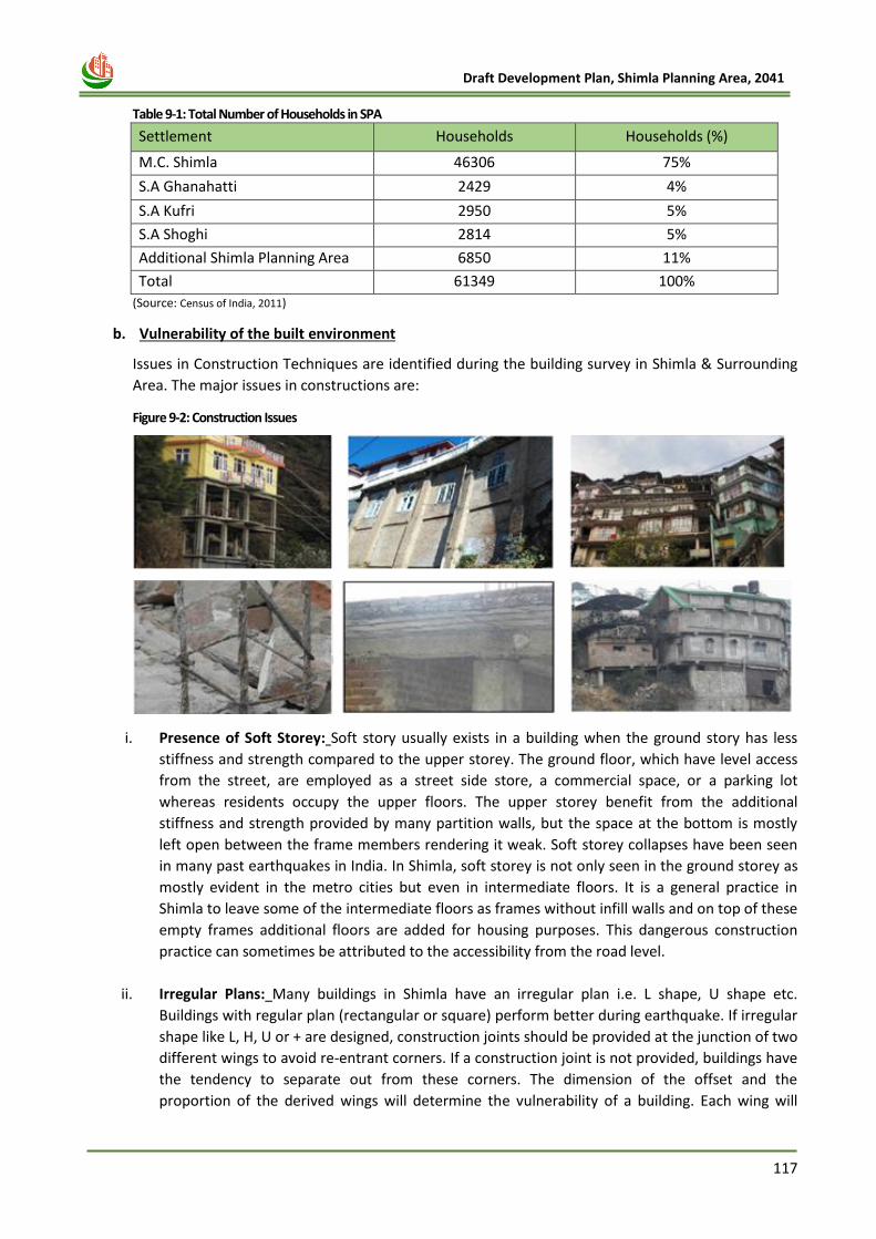
117
Draft Development Plan, Shimla Planning Area, 2041
Table 9-1: Total Number of Households in SPA
Settlement Households Households (%)
M.C. Shimla 46306 75%
S.A Ghanahatti 2429 4%
S.A Kufri 2950 5%
S.A Shoghi 2814 5%
Additional Shimla Planning Area 6850 11%
Total 61349 100%
(Source: Census of India, 2011)
b. Vulnerability of the built environment
Issues in Construction Techniques are identified during the building survey in Shimla & Surrounding
Area. The major issues in constructions are:
Figure 9-2: Construction Issues
i. Presence of Soft Storey: Soft story usually exists in a building when the ground story has less
stiffness and strength compared to the upper storey. The ground floor, which have level access
from the street, are employed as a street side store, a commercial space, or a parking lot
whereas residents occupy the upper floors. The upper storey benefit from the additional
stiffness and strength provided by many partition walls, but the space at the bottom is mostly
left open between the frame members rendering it weak. Soft storey collapses have been seen
in many past earthquakes in India. In Shimla, soft storey is not only seen in the ground storey as
mostly evident in the metro cities but even in intermediate floors. It is a general practice in
Shimla to leave some of the intermediate floors as frames without infill walls and on top of these
empty frames additional floors are added for housing purposes. This dangerous construction
practice can sometimes be attributed to the accessibility from the road level.
ii. Irregular Plans: Many buildings in Shimla have an irregular plan i.e. L shape, U shape etc.
Buildings with regular plan (rectangular or square) perform better during earthquake. If irregular
shape like L, H, U or + are designed, construction joints should be provided at the junction of two
different wings to avoid re-entrant corners. If a construction joint is not provided, buildings have
the tendency to separate out from these corners. The dimension of the offset and the
proportion of the derived wings will determine the vulnerability of a building. Each wing will
118
Draft Development Plan, Shimla Planning Area, 2041
react to the displacements and the torsional effects produced by ground motions in a different
way. Under the action of earthquake forces, each wing will have a different dynamic behaviour
because of its particular stiffness and position relative to the direction of horizontal forces. The
movement of different parts of the building can be very complicated, producing considerable
diaphragm deformation, torsional effects and concentration of stress at the vertices of re-
entrant corners.
iii. Pounding: Pounding is damage caused by two buildings, or different parts of a building, hitting
one another. The number of buildings damaged by pounding is small. Pounding is the result of
irregular response of adjacent buildings of different heights and of different dynamic
characteristics. In situations where two buildings are located too close to each other, they may
collide during strong shaking leading to substantial damage. The pounding effect is more
pronounced in taller buildings. When building heights do not match, the roof of the shorter
building may pound at the mid-height of the columns in the taller building; this can be quite
dangerous, and can lead to storey collapse. In Shimla, most of the buildings located in high
density wards are almost touching each other which mean earthquake shaking of one building
will also affect surrounding buildings.
iv. Incorrect Stirrup Detailing: In most construction sites surveyed during the field visits (and in
some already constructed buildings), it was observed that there was no proper alignment of
columns of different floors. Also, the beams did not properly align with the columns. As a result,
beams and columns were not perfectly orthogonal to each other. This means that the purpose of
providing a frame structure was lost. In a few cases, beams and columns were found detached
without proper joining at the beam column junction. This will lead to collapse of the structure
even in a moderate earthquake.
v. Lack of Frame Action in RC Frame Structure: In Shimla, almost all buildings under construction
observed during the field visit provided only a 900 (as opposed to the stipulated 1350 extended
sufficiently as per the building codes IS 13920:1993 and IS 1893:2002) hook in the stirrups. This
can open very easily in an earthquake shaking leading to failure of the column and an inevitable
collapse of the building.
vi. Short Column Effect on Buildings Built on Slope: Due to scarcity of flat land in Shimla, majority
of the buildings is constructed on the hill slopes with irregular structural configuration having
foundations at different levels. Such buildings pose special structural and constructional
problems. Due to site condition, buildings on hill slopes are built with unequal column heights
within a storey, which results in drastic variation in the stiffness of columns of the same storey.
The short stiff columns on uphill side attracting much higher lateral forces are prone to damage.
In case of downhill building, storey built at road level is most susceptible to damage.
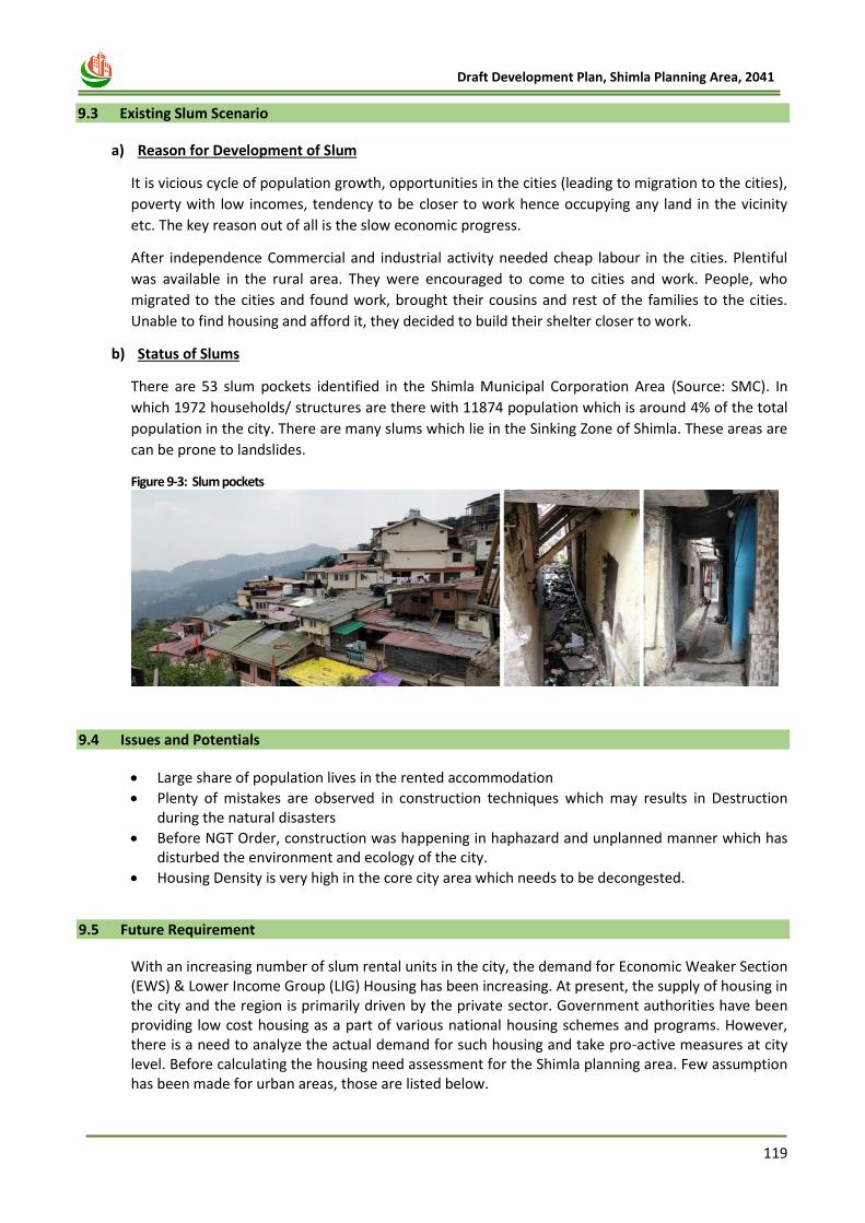
119
Draft Development Plan, Shimla Planning Area, 2041
9.3 Existing Slum Scenario
a) Reason for Development of Slum
It is vicious cycle of population growth, opportunities in the cities (leading to migration to the cities),
poverty with low incomes, tendency to be closer to work hence occupying any land in the vicinity
etc. The key reason out of all is the slow economic progress.
After independence Commercial and industrial activity needed cheap labour in the cities. Plentiful
was available in the rural area. They were encouraged to come to cities and work. People, who
migrated to the cities and found work, brought their cousins and rest of the families to the cities.
Unable to find housing and afford it, they decided to build their shelter closer to work.
b) Status of Slums
There are 53 slum pockets identified in the Shimla Municipal Corporation Area (Source: SMC). In
which 1972 households/ structures are there with 11874 population which is around 4% of the total
population in the city. There are many slums which lie in the Sinking Zone of Shimla. These areas are
can be prone to landslides.
Figure 9-3: Slum pockets
9.4 Issues and Potentials
• Large share of population lives in the rented accommodation
• Plenty of mistakes are observed in construction techniques which may results in Destruction during the natural disasters
• Before NGT Order, construction was happening in haphazard and unplanned manner which has disturbed the environment and ecology of the city.
• Housing Density is very high in the core city area which needs to be decongested.
9.5 Future Requirement
With an increasing number of slum rental units in the city, the demand for Economic Weaker Section (EWS) & Lower Income Group (LIG) Housing has been increasing. At present, the supply of housing in the city and the region is primarily driven by the private sector. Government authorities have been providing low cost housing as a part of various national housing schemes and programs. However, there is a need to analyze the actual demand for such housing and take pro-active measures at city level. Before calculating the housing need assessment for the Shimla planning area. Few assumption has been made for urban areas, those are listed below.
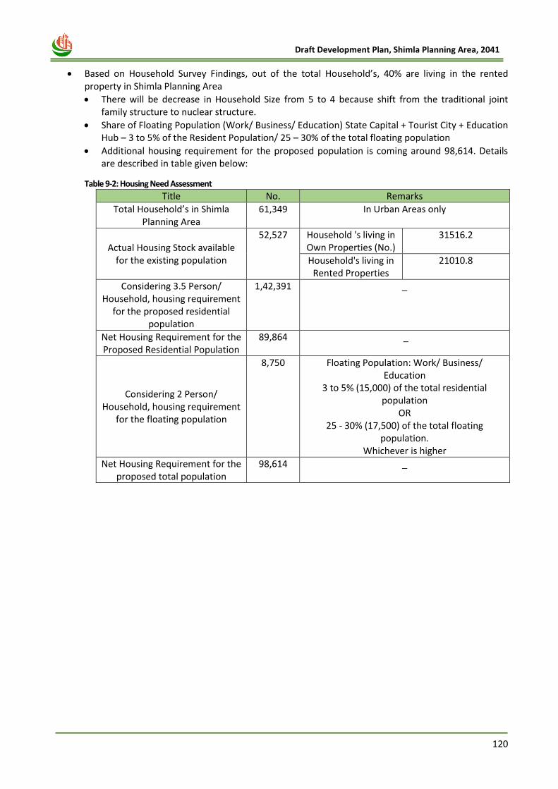
120
Draft Development Plan, Shimla Planning Area, 2041
• Based on Household Survey Findings, out of the total Household’s, 40% are living in the rented
property in Shimla Planning Area
• There will be decrease in Household Size from 5 to 4 because shift from the traditional joint family structure to nuclear structure.
• Share of Floating Population (Work/ Business/ Education) State Capital + Tourist City + Education Hub – 3 to 5% of the Resident Population/ 25 – 30% of the total floating population
• Additional housing requirement for the proposed population is coming around 98,614. Details are described in table given below:
Table 9-2: Housing Need Assessment
Title No. Remarks
Total Household’s in Shimla Planning Area
61,349 In Urban Areas only
Actual Housing Stock available for the existing population
52,527 Household 's living in Own Properties (No.)
31516.2
Household's living in Rented Properties
21010.8
Considering 3.5 Person/ Household, housing requirement
for the proposed residential population
1,42,391 _
Net Housing Requirement for the Proposed Residential Population
89,864 _
Considering 2 Person/ Household, housing requirement
for the floating population
8,750 Floating Population: Work/ Business/ Education
3 to 5% (15,000) of the total residential population
OR 25 - 30% (17,500) of the total floating
population. Whichever is higher
Net Housing Requirement for the proposed total population
98,614 _

121
Draft Development Plan, Shimla Planning Area, 2041
Chapter 10
TOURISIM PROFILE
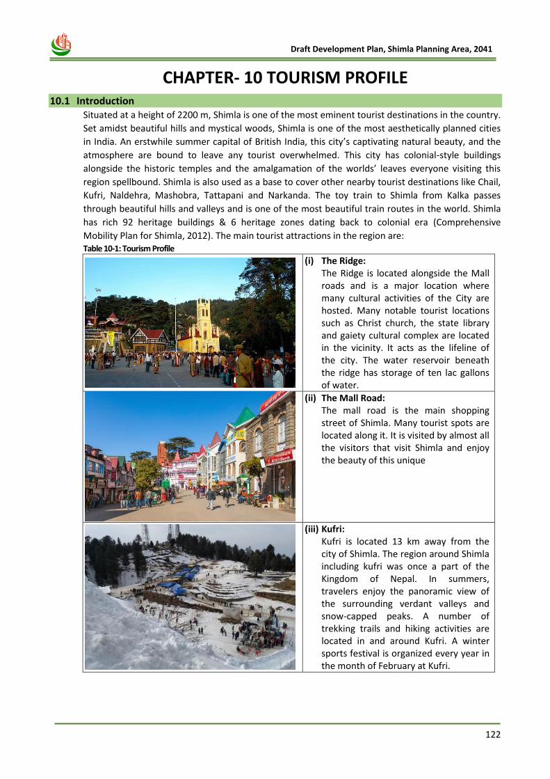
122
Draft Development Plan, Shimla Planning Area, 2041
10 CHAPTER- 10 TOURISM PROFILE 10.1 Introduction
Situated at a height of 2200 m, Shimla is one of the most eminent tourist destinations in the country.
Set amidst beautiful hills and mystical woods, Shimla is one of the most aesthetically planned cities
in India. An erstwhile summer capital of British India, this city’s captivating natural beauty, and the
atmosphere are bound to leave any tourist overwhelmed. This city has colonial-style buildings
alongside the historic temples and the amalgamation of the worlds’ leaves everyone visiting this
region spellbound. Shimla is also used as a base to cover other nearby tourist destinations like Chail,
Kufri, Naldehra, Mashobra, Tattapani and Narkanda. The toy train to Shimla from Kalka passes
through beautiful hills and valleys and is one of the most beautiful train routes in the world. Shimla
has rich 92 heritage buildings & 6 heritage zones dating back to colonial era (Comprehensive
Mobility Plan for Shimla, 2012). The main tourist attractions in the region are: Table 10-1: Tourism Profile
(i) The Ridge: The Ridge is located alongside the Mall roads and is a major location where many cultural activities of the City are hosted. Many notable tourist locations such as Christ church, the state library and gaiety cultural complex are located in the vicinity. It acts as the lifeline of the city. The water reservoir beneath the ridge has storage of ten lac gallons of water.
(ii) The Mall Road: The mall road is the main shopping street of Shimla. Many tourist spots are located along it. It is visited by almost all the visitors that visit Shimla and enjoy the beauty of this unique
(iii) Kufri: Kufri is located 13 km away from the city of Shimla. The region around Shimla including kufri was once a part of the Kingdom of Nepal. In summers, travelers enjoy the panoramic view of the surrounding verdant valleys and snow-capped peaks. A number of trekking trails and hiking activities are located in and around Kufri. A winter sports festival is organized every year in the month of February at Kufri.
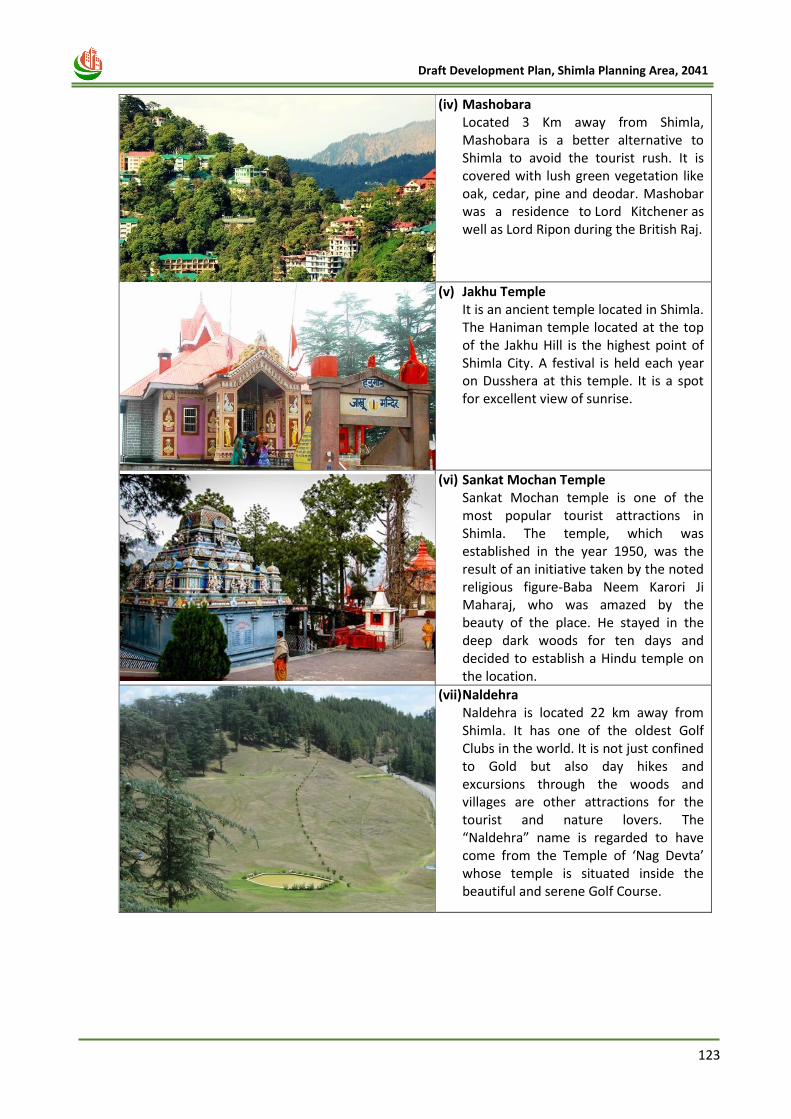
123
Draft Development Plan, Shimla Planning Area, 2041
(iv) Mashobara Located 3 Km away from Shimla, Mashobara is a better alternative to Shimla to avoid the tourist rush. It is covered with lush green vegetation like oak, cedar, pine and deodar. Mashobar was a residence to Lord Kitchener as well as Lord Ripon during the British Raj.
(v) Jakhu Temple It is an ancient temple located in Shimla. The Haniman temple located at the top of the Jakhu Hill is the highest point of Shimla City. A festival is held each year on Dusshera at this temple. It is a spot for excellent view of sunrise.
(vi) Sankat Mochan Temple Sankat Mochan temple is one of the most popular tourist attractions in Shimla. The temple, which was established in the year 1950, was the result of an initiative taken by the noted religious figure-Baba Neem Karori Ji Maharaj, who was amazed by the beauty of the place. He stayed in the deep dark woods for ten days and decided to establish a Hindu temple on the location.
(vii) Naldehra Naldehra is located 22 km away from Shimla. It has one of the oldest Golf Clubs in the world. It is not just confined to Gold but also day hikes and excursions through the woods and villages are other attractions for the tourist and nature lovers. The “Naldehra” name is regarded to have come from the Temple of ‘Nag Devta’ whose temple is situated inside the beautiful and serene Golf Course.
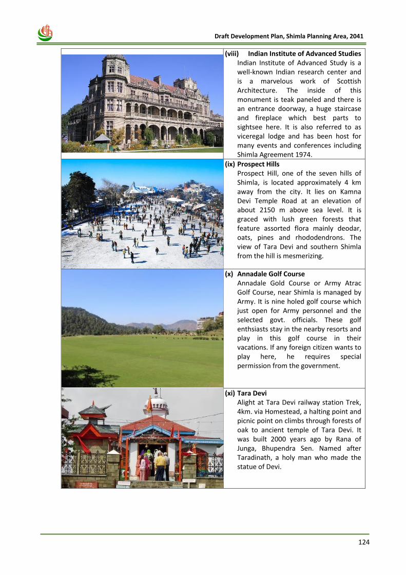
124
Draft Development Plan, Shimla Planning Area, 2041
(viii) Indian Institute of Advanced Studies Indian Institute of Advanced Study is a well-known Indian research center and is a marvelous work of Scottish Architecture. The inside of this monument is teak paneled and there is an entrance doorway, a huge staircase and fireplace which best parts to sightsee here. It is also referred to as viceregal lodge and has been host for many events and conferences including Shimla Agreement 1974.
(ix) Prospect Hills Prospect Hill, one of the seven hills of Shimla, is located approximately 4 km away from the city. It lies on Kamna Devi Temple Road at an elevation of about 2150 m above sea level. It is graced with lush green forests that feature assorted flora mainly deodar, oats, pines and rhododendrons. The view of Tara Devi and southern Shimla from the hill is mesmerizing.
(x) Annadale Golf Course Annadale Gold Course or Army Atrac Golf Course, near Shimla is managed by Army. It is nine holed golf course which just open for Army personnel and the selected govt. officials. These golf enthsiasts stay in the nearby resorts and play in this golf course in their vacations. If any foreign citizen wants to play here, he requires special permission from the government.
(xi) Tara Devi Alight at Tara Devi railway station Trek, 4km. via Homestead, a halting point and picnic point on climbs through forests of oak to ancient temple of Tara Devi. It was built 2000 years ago by Rana of Junga, Bhupendra Sen. Named after Taradinath, a holy man who made the statue of Devi.
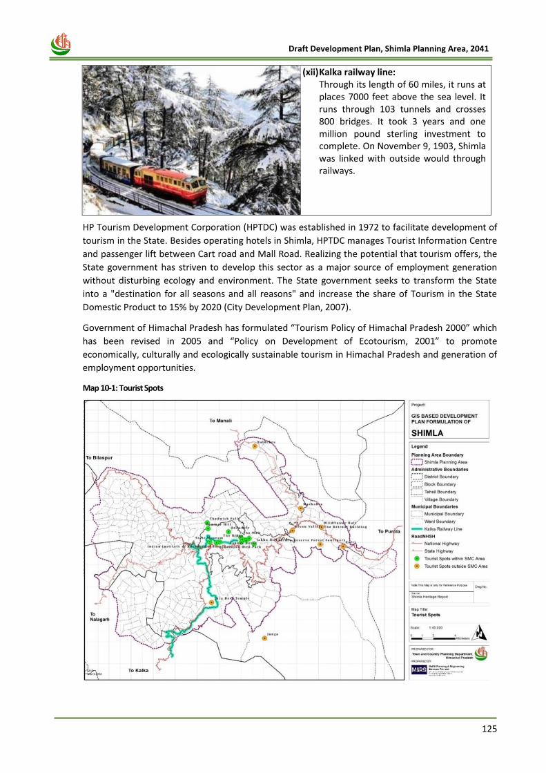
125
Draft Development Plan, Shimla Planning Area, 2041
(xii) Kalka railway line: Through its length of 60 miles, it runs at places 7000 feet above the sea level. It runs through 103 tunnels and crosses 800 bridges. It took 3 years and one million pound sterling investment to complete. On November 9, 1903, Shimla was linked with outside would through railways.
HP Tourism Development Corporation (HPTDC) was established in 1972 to facilitate development of
tourism in the State. Besides operating hotels in Shimla, HPTDC manages Tourist Information Centre
and passenger lift between Cart road and Mall Road. Realizing the potential that tourism offers, the
State government has striven to develop this sector as a major source of employment generation
without disturbing ecology and environment. The State government seeks to transform the State
into a "destination for all seasons and all reasons" and increase the share of Tourism in the State
Domestic Product to 15% by 2020 (City Development Plan, 2007).
Government of Himachal Pradesh has formulated “Tourism Policy of Himachal Pradesh 2000” which
has been revised in 2005 and “Policy on Development of Ecotourism, 2001” to promote
economically, culturally and ecologically sustainable tourism in Himachal Pradesh and generation of
employment opportunities.
Map 10-1: Tourist Spots
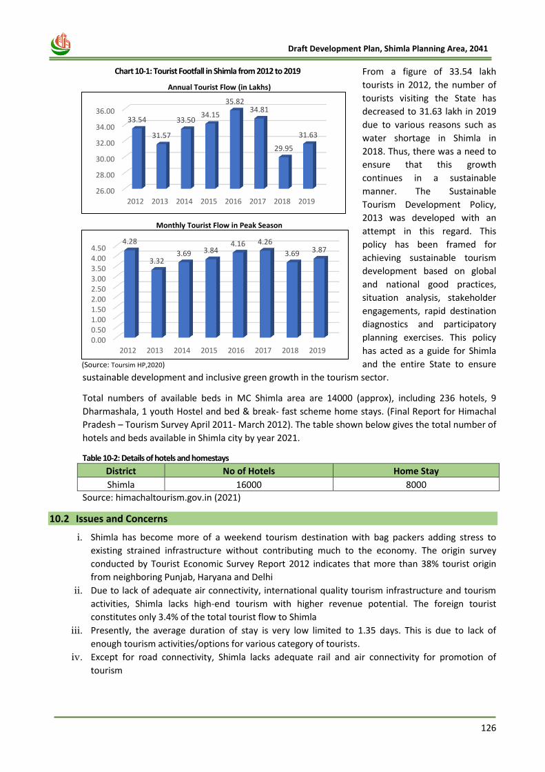
126
Draft Development Plan, Shimla Planning Area, 2041
From a figure of 33.54 lakh
tourists in 2012, the number of
tourists visiting the State has
decreased to 31.63 lakh in 2019
due to various reasons such as
water shortage in Shimla in
2018. Thus, there was a need to
ensure that this growth
continues in a sustainable
manner. The Sustainable
Tourism Development Policy,
2013 was developed with an
attempt in this regard. This
policy has been framed for
achieving sustainable tourism
development based on global
and national good practices,
situation analysis, stakeholder
engagements, rapid destination
diagnostics and participatory
planning exercises. This policy
has acted as a guide for Shimla
and the entire State to ensure
sustainable development and inclusive green growth in the tourism sector.
Total numbers of available beds in MC Shimla area are 14000 (approx), including 236 hotels, 9
Dharmashala, 1 youth Hostel and bed & break- fast scheme home stays. (Final Report for Himachal
Pradesh – Tourism Survey April 2011- March 2012). The table shown below gives the total number of
hotels and beds available in Shimla city by year 2021.
Table 10-2: Details of hotels and homestays
District No of Hotels Home Stay
Shimla 16000 8000
Source: himachaltourism.gov.in (2021)
10.2 Issues and Concerns
i. Shimla has become more of a weekend tourism destination with bag packers adding stress to
existing strained infrastructure without contributing much to the economy. The origin survey
conducted by Tourist Economic Survey Report 2012 indicates that more than 38% tourist origin
from neighboring Punjab, Haryana and Delhi
ii. Due to lack of adequate air connectivity, international quality tourism infrastructure and tourism
activities, Shimla lacks high-end tourism with higher revenue potential. The foreign tourist
constitutes only 3.4% of the total tourist flow to Shimla
iii. Presently, the average duration of stay is very low limited to 1.35 days. This is due to lack of
enough tourism activities/options for various category of tourists.
iv. Except for road connectivity, Shimla lacks adequate rail and air connectivity for promotion of
tourism
Chart 10-1: Tourist Footfall in Shimla from 2012 to 2019
Annual Tourist Flow (in Lakhs)
Monthly Tourist Flow in Peak Season
(Source: Toursim HP,2020)
26.00
28.00
30.00
32.00
34.00
36.00
2012 2013 2014 2015 2016 2017 2018 2019
33.54
31.57
33.5034.15
35.8234.81
29.95
31.63
0.000.501.001.502.002.503.003.504.004.50
2012 2013 2014 2015 2016 2017 2018 2019
4.28
3.323.69 3.84
4.16 4.26
3.69 3.87
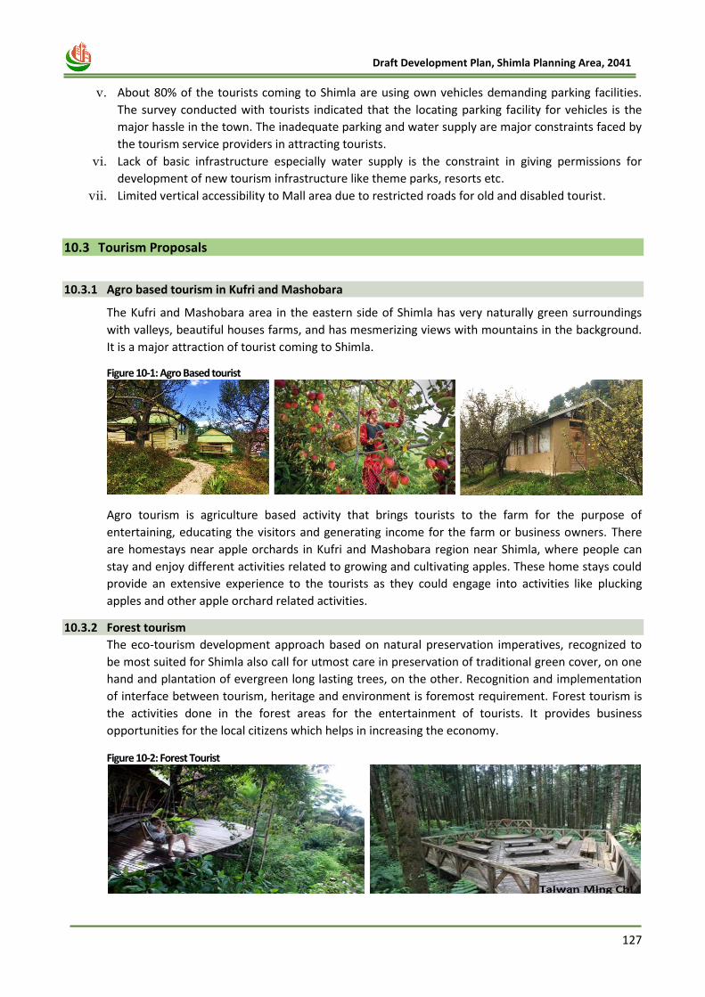
127
Draft Development Plan, Shimla Planning Area, 2041
v. About 80% of the tourists coming to Shimla are using own vehicles demanding parking facilities.
The survey conducted with tourists indicated that the locating parking facility for vehicles is the
major hassle in the town. The inadequate parking and water supply are major constraints faced by
the tourism service providers in attracting tourists.
vi. Lack of basic infrastructure especially water supply is the constraint in giving permissions for
development of new tourism infrastructure like theme parks, resorts etc.
vii. Limited vertical accessibility to Mall area due to restricted roads for old and disabled tourist.
10.3 Tourism Proposals
10.3.1 Agro based tourism in Kufri and Mashobara
The Kufri and Mashobara area in the eastern side of Shimla has very naturally green surroundings
with valleys, beautiful houses farms, and has mesmerizing views with mountains in the background.
It is a major attraction of tourist coming to Shimla.
Figure 10-1: Agro Based tourist
Agro tourism is agriculture based activity that brings tourists to the farm for the purpose of
entertaining, educating the visitors and generating income for the farm or business owners. There
are homestays near apple orchards in Kufri and Mashobara region near Shimla, where people can
stay and enjoy different activities related to growing and cultivating apples. These home stays could
provide an extensive experience to the tourists as they could engage into activities like plucking
apples and other apple orchard related activities.
10.3.2 Forest tourism
The eco-tourism development approach based on natural preservation imperatives, recognized to
be most suited for Shimla also call for utmost care in preservation of traditional green cover, on one
hand and plantation of evergreen long lasting trees, on the other. Recognition and implementation
of interface between tourism, heritage and environment is foremost requirement. Forest tourism is
the activities done in the forest areas for the entertainment of tourists. It provides business
opportunities for the local citizens which helps in increasing the economy.
Figure 10-2: Forest Tourist
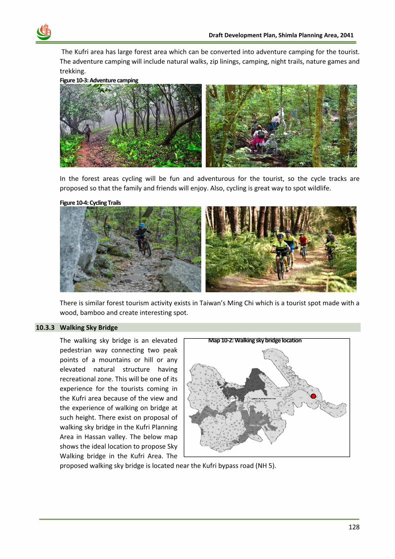
128
Draft Development Plan, Shimla Planning Area, 2041
The Kufri area has large forest area which can be converted into adventure camping for the tourist.
The adventure camping will include natural walks, zip linings, camping, night trails, nature games and
trekking. Figure 10-3: Adventure camping
In the forest areas cycling will be fun and adventurous for the tourist, so the cycle tracks are
proposed so that the family and friends will enjoy. Also, cycling is great way to spot wildlife.
Figure 10-4: Cycling Trails
There is similar forest tourism activity exists in Taiwan’s Ming Chi which is a tourist spot made with a
wood, bamboo and create interesting spot.
10.3.3 Walking Sky Bridge
The walking sky bridge is an elevated
pedestrian way connecting two peak
points of a mountains or hill or any
elevated natural structure having
recreational zone. This will be one of its
experience for the tourists coming in
the Kufri area because of the view and
the experience of walking on bridge at
such height. There exist on proposal of
walking sky bridge in the Kufri Planning
Area in Hassan valley. The below map
shows the ideal location to propose Sky
Walking bridge in the Kufri Area. The
proposed walking sky bridge is located near the Kufri bypass road (NH 5).
Map 10-2: Walking sky bridge location
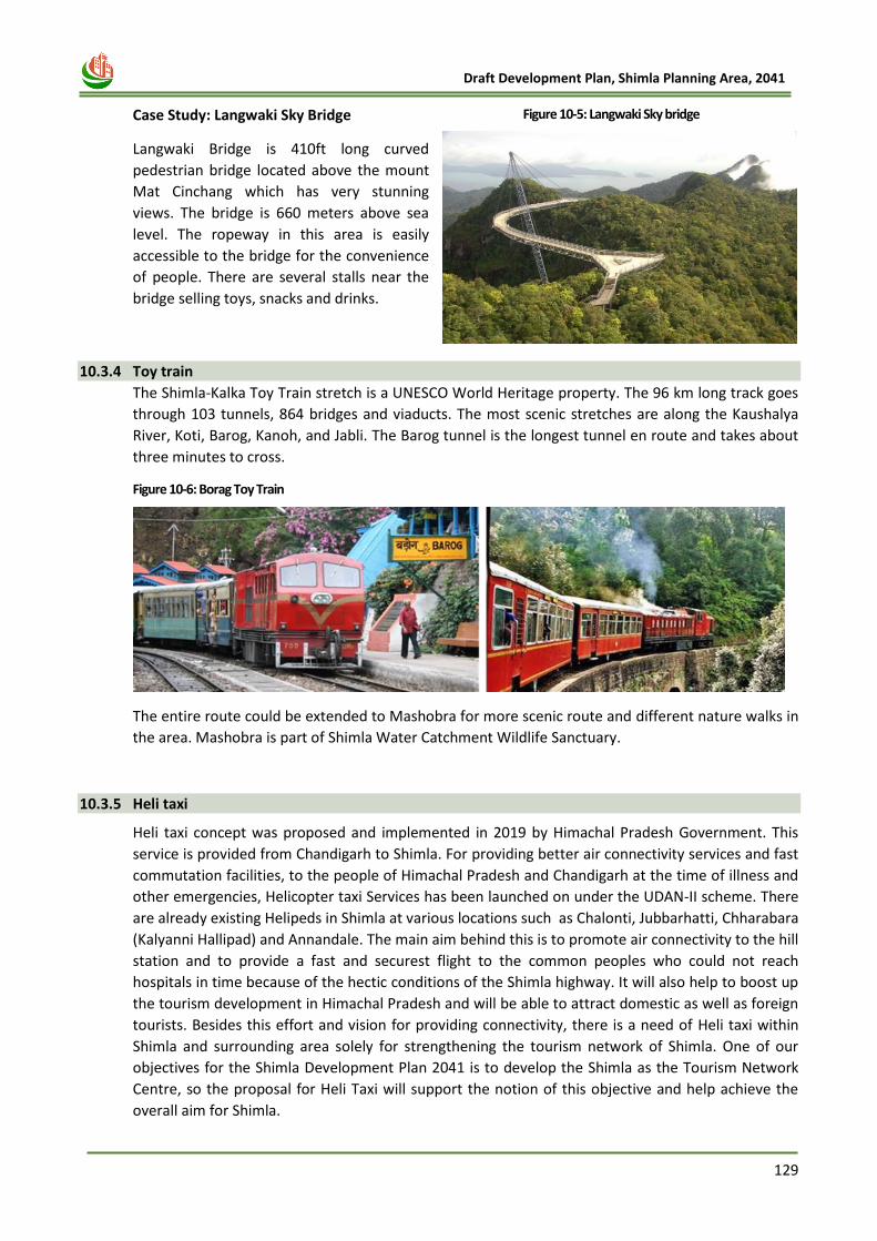
129
Draft Development Plan, Shimla Planning Area, 2041
Case Study: Langwaki Sky Bridge
Langwaki Bridge is 410ft long curved
pedestrian bridge located above the mount
Mat Cinchang which has very stunning
views. The bridge is 660 meters above sea
level. The ropeway in this area is easily
accessible to the bridge for the convenience
of people. There are several stalls near the
bridge selling toys, snacks and drinks.
10.3.4 Toy train
The Shimla-Kalka Toy Train stretch is a UNESCO World Heritage property. The 96 km long track goes
through 103 tunnels, 864 bridges and viaducts. The most scenic stretches are along the Kaushalya
River, Koti, Barog, Kanoh, and Jabli. The Barog tunnel is the longest tunnel en route and takes about
three minutes to cross.
Figure 10-6: Borag Toy Train
The entire route could be extended to Mashobra for more scenic route and different nature walks in
the area. Mashobra is part of Shimla Water Catchment Wildlife Sanctuary.
10.3.5 Heli taxi
Heli taxi concept was proposed and implemented in 2019 by Himachal Pradesh Government. This
service is provided from Chandigarh to Shimla. For providing better air connectivity services and fast
commutation facilities, to the people of Himachal Pradesh and Chandigarh at the time of illness and
other emergencies, Helicopter taxi Services has been launched on under the UDAN-II scheme. There
are already existing Helipeds in Shimla at various locations such as Chalonti, Jubbarhatti, Chharabara
(Kalyanni Hallipad) and Annandale. The main aim behind this is to promote air connectivity to the hill
station and to provide a fast and securest flight to the common peoples who could not reach
hospitals in time because of the hectic conditions of the Shimla highway. It will also help to boost up
the tourism development in Himachal Pradesh and will be able to attract domestic as well as foreign
tourists. Besides this effort and vision for providing connectivity, there is a need of Heli taxi within
Shimla and surrounding area solely for strengthening the tourism network of Shimla. One of our
objectives for the Shimla Development Plan 2041 is to develop the Shimla as the Tourism Network
Centre, so the proposal for Heli Taxi will support the notion of this objective and help achieve the
overall aim for Shimla.
Walking Sky
Bridge
Figure 10-5: Langwaki Sky bridge
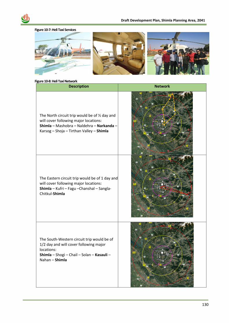
130
Draft Development Plan, Shimla Planning Area, 2041
Figure 10-7: Heli Taxi Services
Figure 10-8: Heli Taxi Network
Description Network
The North circuit trip would be of ½ day and will cover following major locations: Shimla – Mashobra – Naldehra – Narkanda – Karsog – Shoja – Tirthan Valley – Shimla
The Eastern circuit trip would be of 1 day and will cover following major locations: Shimla – Kufri – Fagu –Chanshal – Sangla-Chitkul-Shimla
The South-Western circuit trip would be of 1/2 day and will cover following major locations: Shimla – Shogi – Chail – Solan – Kasauli – Nahan – Shimla
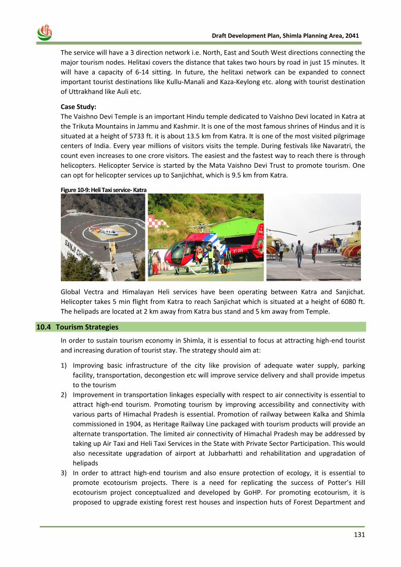
131
Draft Development Plan, Shimla Planning Area, 2041
The service will have a 3 direction network i.e. North, East and South West directions connecting the
major tourism nodes. Helitaxi covers the distance that takes two hours by road in just 15 minutes. It
will have a capacity of 6-14 sitting. In future, the helitaxi network can be expanded to connect
important tourist destinations like Kullu-Manali and Kaza-Keylong etc. along with tourist destination
of Uttrakhand like Auli etc.
Case Study:
The Vaishno Devi Temple is an important Hindu temple dedicated to Vaishno Devi located in Katra at
the Trikuta Mountains in Jammu and Kashmir. It is one of the most famous shrines of Hindus and it is
situated at a height of 5733 ft. it is about 13.5 km from Katra. It is one of the most visited pilgrimage
centers of India. Every year millions of visitors visits the temple. During festivals like Navaratri, the
count even increases to one crore visitors. The easiest and the fastest way to reach there is through
helicopters. Helicopter Service is started by the Mata Vaishno Devi Trust to promote tourism. One
can opt for helicopter services up to Sanjichhat, which is 9.5 km from Katra.
Figure 10-9: Heli Taxi service- Katra
Global Vectra and Himalayan Heli services have been operating between Katra and Sanjichat.
Helicopter takes 5 min flight from Katra to reach Sanjichat which is situated at a height of 6080 ft.
The helipads are located at 2 km away from Katra bus stand and 5 km away from Temple.
10.4 Tourism Strategies
In order to sustain tourism economy in Shimla, it is essential to focus at attracting high-end tourist
and increasing duration of tourist stay. The strategy should aim at:
1) Improving basic infrastructure of the city like provision of adequate water supply, parking
facility, transportation, decongestion etc will improve service delivery and shall provide impetus
to the tourism
2) Improvement in transportation linkages especially with respect to air connectivity is essential to
attract high-end tourism. Promoting tourism by improving accessibility and connectivity with
various parts of Himachal Pradesh is essential. Promotion of railway between Kalka and Shimla
commissioned in 1904, as Heritage Railway Line packaged with tourism products will provide an
alternate transportation. The limited air connectivity of Himachal Pradesh may be addressed by
taking up Air Taxi and Heli Taxi Services in the State with Private Sector Participation. This would
also necessitate upgradation of airport at Jubbarhatti and rehabilitation and upgradation of
helipads
3) In order to attract high-end tourism and also ensure protection of ecology, it is essential to
promote ecotourism projects. There is a need for replicating the success of Potter’s Hill
ecotourism project conceptualized and developed by GoHP. For promoting ecotourism, it is
proposed to upgrade existing forest rest houses and inspection huts of Forest Department and
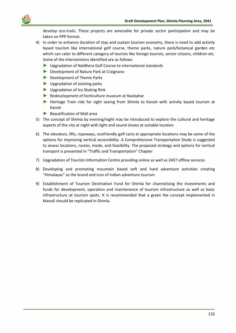
132
Draft Development Plan, Shimla Planning Area, 2041
develop eco-trails. These projects are amenable for private sector participation and may be
taken on PPP format.
4) In order to enhance duration of stay and sustain tourism economy, there is need to add activity
based tourism like international golf course, theme parks, nature park/botanical garden etc
which can cater to different category of tourists like foreign tourists, senior citizens, children etc.
Some of the interventions identified are as follows
► Upgradation of Naldhera Golf Course to international standards
► Development of Nature Park at Craignano
► Development of Theme Parks
► Upgradation of existing parks
► Upgradation of Ice Skating Rink
► Redevelopment of horticulture museum at Navbahar
► Heritage Train ride for sight seeing from Shimla to Kanoh with activity based tourism at
Kanoh
► Beautification of Mall area
5) The concept of Shimla by evening/night may be introduced to explore the cultural and heritage
aspects of the city at night with light and sound shows at suitable location
6) The elevators, lifts, ropeways, ecofriendly golf carts at appropriate locations may be some of the
options for improving vertical accessibility. A Comprehensive Transportation Study is suggested
to assess locations, routes, mode, and feasibility. The proposed strategy and options for vertical
transport is presented in “Traffic and Transportation” Chapter
7) Upgradation of Tourists Information Centre providing online as well as 24X7 offline services
8) Developing and promoting mountain based soft and hard adventure activities creating
“Himalayas” as the brand and icon of Indian adventure tourism
9) Establishment of Tourism Destination Fund for Shimla for channelising the investments and
funds for development, operation and maintenance of tourism infrastructure as well as basic
infrastructure at tourism spots. It is recommended that a green fee concept implemented in
Manali should be replicated in Shimla.
133
Draft Development Plan, Shimla Planning Area, 2041
Chapter 11
HERITAGE PROFILE
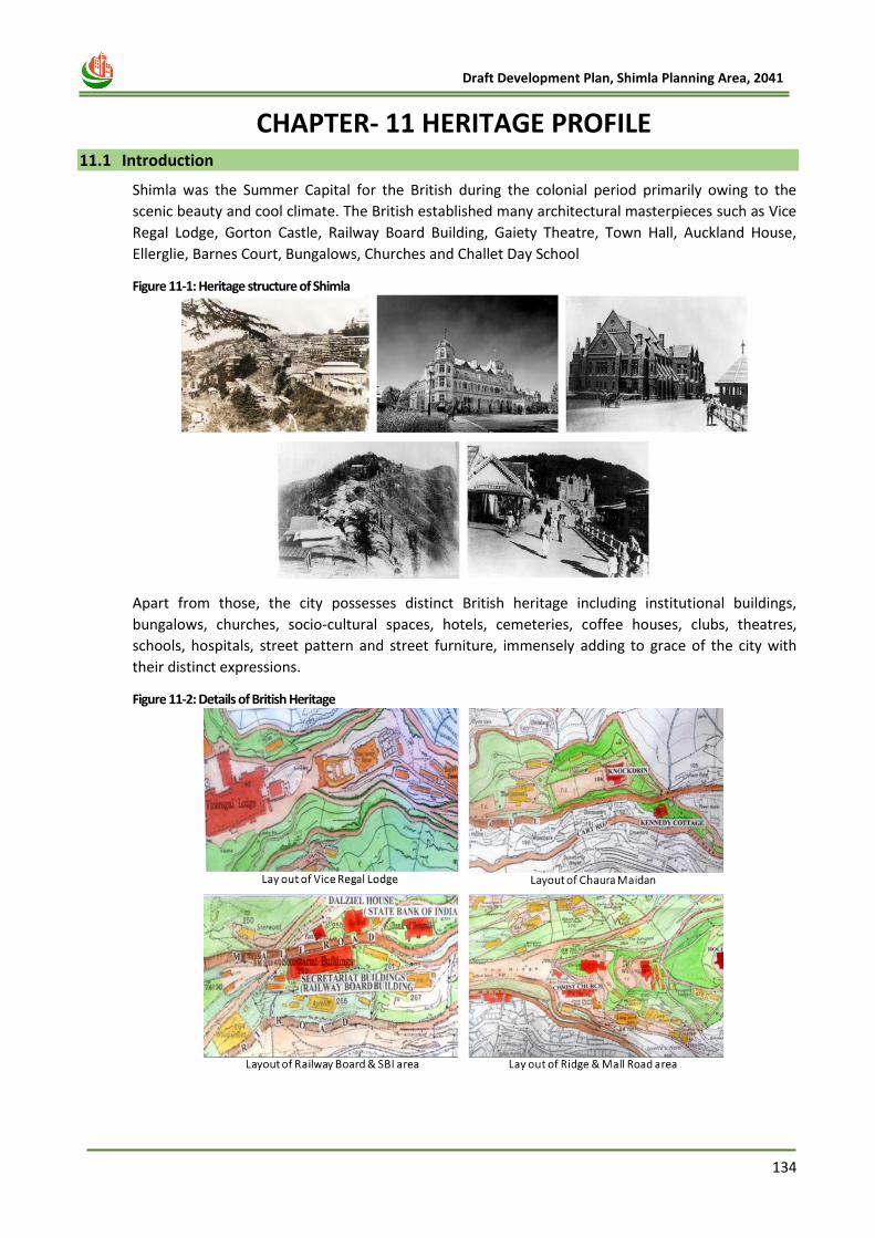
134
Draft Development Plan, Shimla Planning Area, 2041
11 CHAPTER- 11 HERITAGE PROFILE 11.1 Introduction
Shimla was the Summer Capital for the British during the colonial period primarily owing to the
scenic beauty and cool climate. The British established many architectural masterpieces such as Vice
Regal Lodge, Gorton Castle, Railway Board Building, Gaiety Theatre, Town Hall, Auckland House,
Ellerglie, Barnes Court, Bungalows, Churches and Challet Day School
Figure 11-1: Heritage structure of Shimla
Apart from those, the city possesses distinct British heritage including institutional buildings,
bungalows, churches, socio-cultural spaces, hotels, cemeteries, coffee houses, clubs, theatres,
schools, hospitals, street pattern and street furniture, immensely adding to grace of the city with
their distinct expressions.
Figure 11-2: Details of British Heritage
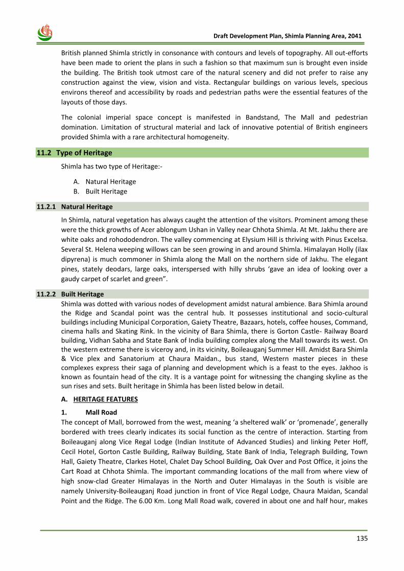
135
Draft Development Plan, Shimla Planning Area, 2041
British planned Shimla strictly in consonance with contours and levels of topography. All out-efforts
have been made to orient the plans in such a fashion so that maximum sun is brought even inside
the building. The British took utmost care of the natural scenery and did not prefer to raise any
construction against the view, vision and vista. Rectangular buildings on various levels, specious
environs thereof and accessibility by roads and pedestrian paths were the essential features of the
layouts of those days.
The colonial imperial space concept is manifested in Bandstand, The Mall and pedestrian
domination. Limitation of structural material and lack of innovative potential of British engineers
provided Shimla with a rare architectural homogeneity.
11.2 Type of Heritage
Shimla has two type of Heritage:-
A. Natural Heritage
B. Built Heritage
11.2.1 Natural Heritage
In Shimla, natural vegetation has always caught the attention of the visitors. Prominent among these
were the thick growths of Acer ablongum Ushan in Valley near Chhota Shimla. At Mt. Jakhu there are
white oaks and rohododendron. The valley commencing at Elysium Hill is thriving with Pinus Excelsa.
Several St. Helena weeping willows can be seen growing in and around Shimla. Himalayan Holly (ilax
dipyrena) is much commoner in Shimla along the Mall on the northern side of Jakhu. The elegant
pines, stately deodars, large oaks, interspersed with hilly shrubs ‘gave an idea of looking over a
gaudy carpet of scarlet and green”.
11.2.2 Built Heritage
Shimla was dotted with various nodes of development amidst natural ambience. Bara Shimla around the Ridge and Scandal point was the central hub. It possesses institutional and socio-cultural buildings including Municipal Corporation, Gaiety Theatre, Bazaars, hotels, coffee houses, Command, cinema halls and Skating Rink. In the vicinity of Bara Shimla, there is Gorton Castle- Railway Board building, Vidhan Sabha and State Bank of India building complex along the Mall towards its west. On the western extreme there is viceroy and, in its vicinity, Boileauganj Summer Hill. Amidst Bara Shimla & Vice plex and Sanatorium at Chaura Maidan., bus stand, Western master pieces in these complexes express their saga of planning and development which is a feast to the eyes. Jakhoo is known as fountain head of the city. It is a vantage point for witnessing the changing skyline as the sun rises and sets. Built heritage in Shimla has been listed below in detail.
A. HERITAGE FEATURES
1. Mall Road
The concept of Mall, borrowed from the west, meaning ‘a sheltered walk’ or ‘promenade’, generally
bordered with trees clearly indicates its social function as the centre of interaction. Starting from
Boileauganj along Vice Regal Lodge (Indian Institute of Advanced Studies) and linking Peter Hoff,
Cecil Hotel, Gorton Castle Building, Railway Building, State Bank of India, Telegraph Building, Town
Hall, Gaiety Theatre, Clarkes Hotel, Chalet Day School Building, Oak Over and Post Office, it joins the
Cart Road at Chhota Shimla. The important commanding locations of the mall from where view of
high snow-clad Greater Himalayas in the North and Outer Himalayas in the South is visible are
namely University-Boileauganj Road junction in front of Vice Regal Lodge, Chaura Maidan, Scandal
Point and the Ridge. The 6.00 Km. Long Mall Road walk, covered in about one and half hour, makes
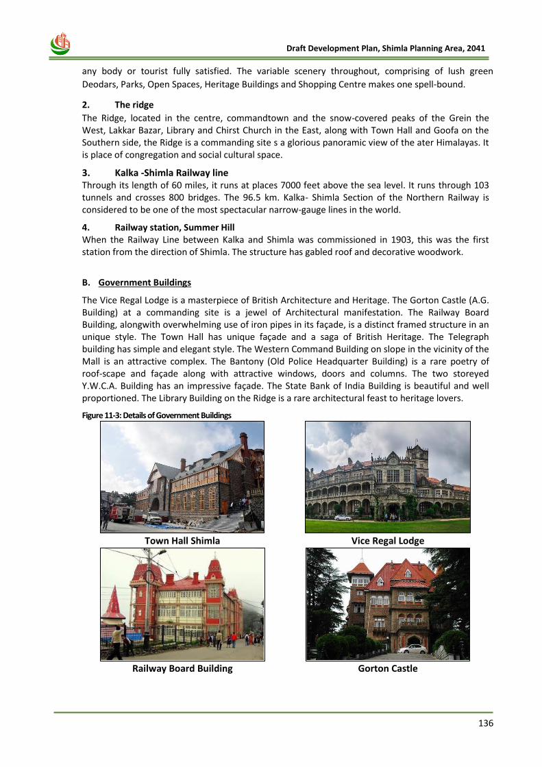
136
Draft Development Plan, Shimla Planning Area, 2041
any body or tourist fully satisfied. The variable scenery throughout, comprising of lush green
Deodars, Parks, Open Spaces, Heritage Buildings and Shopping Centre makes one spell-bound.
2. The ridge
The Ridge, located in the centre, commandtown and the snow-covered peaks of the Grein the West, Lakkar Bazar, Library and Chirst Church in the East, along with Town Hall and Goofa on the Southern side, the Ridge is a commanding site s a glorious panoramic view of the ater Himalayas. It is place of congregation and social cultural space.
3. Kalka -Shimla Railway line Through its length of 60 miles, it runs at places 7000 feet above the sea level. It runs through 103 tunnels and crosses 800 bridges. The 96.5 km. Kalka- Shimla Section of the Northern Railway is considered to be one of the most spectacular narrow-gauge lines in the world.
4. Railway station, Summer Hill When the Railway Line between Kalka and Shimla was commissioned in 1903, this was the first station from the direction of Shimla. The structure has gabled roof and decorative woodwork.
B. Government Buildings
The Vice Regal Lodge is a masterpiece of British Architecture and Heritage. The Gorton Castle (A.G. Building) at a commanding site is a jewel of Architectural manifestation. The Railway Board Building, alongwith overwhelming use of iron pipes in its façade, is a distinct framed structure in an unique style. The Town Hall has unique façade and a saga of British Heritage. The Telegraph building has simple and elegant style. The Western Command Building on slope in the vicinity of the Mall is an attractive complex. The Bantony (Old Police Headquarter Building) is a rare poetry of roof-scape and façade along with attractive windows, doors and columns. The two storeyed Y.W.C.A. Building has an impressive façade. The State Bank of India Building is beautiful and well proportioned. The Library Building on the Ridge is a rare architectural feast to heritage lovers.
Figure 11-3: Details of Government Buildings
Town Hall Shimla
Vice Regal Lodge
Railway Board Building
Gorton Castle
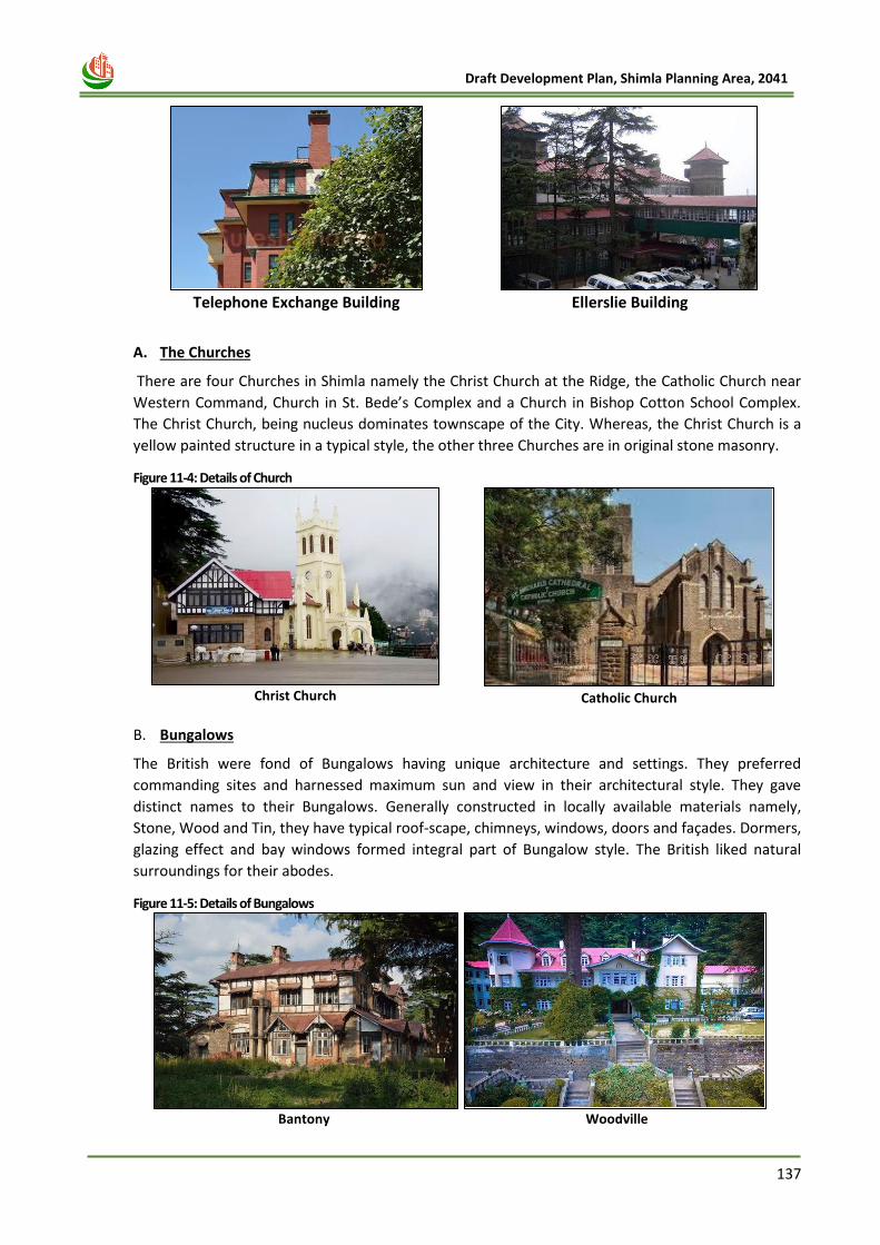
137
Draft Development Plan, Shimla Planning Area, 2041
Telephone Exchange Building
Ellerslie Building
A. The Churches
There are four Churches in Shimla namely the Christ Church at the Ridge, the Catholic Church near
Western Command, Church in St. Bede’s Complex and a Church in Bishop Cotton School Complex.
The Christ Church, being nucleus dominates townscape of the City. Whereas, the Christ Church is a
yellow painted structure in a typical style, the other three Churches are in original stone masonry.
Figure 11-4: Details of Church
Christ Church
Catholic Church
B. Bungalows
The British were fond of Bungalows having unique architecture and settings. They preferred
commanding sites and harnessed maximum sun and view in their architectural style. They gave
distinct names to their Bungalows. Generally constructed in locally available materials namely,
Stone, Wood and Tin, they have typical roof-scape, chimneys, windows, doors and façades. Dormers,
glazing effect and bay windows formed integral part of Bungalow style. The British liked natural
surroundings for their abodes.
Figure 11-5: Details of Bungalows
Bantony
Woodville
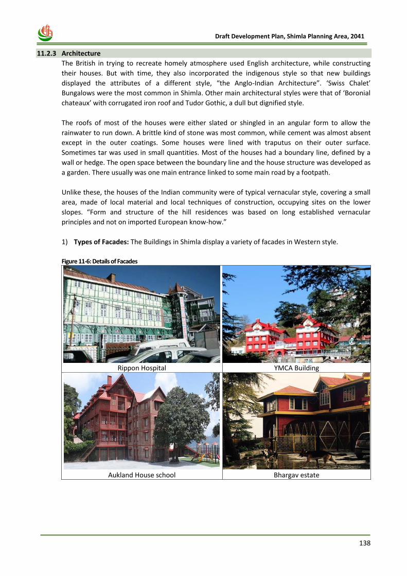
138
Draft Development Plan, Shimla Planning Area, 2041
11.2.3 Architecture
The British in trying to recreate homely atmosphere used English architecture, while constructing
their houses. But with time, they also incorporated the indigenous style so that new buildings
displayed the attributes of a different style, “the Anglo-Indian Architecture”. ‘Swiss Chalet’
Bungalows were the most common in Shimla. Other main architectural styles were that of ‘Boronial
chateaux’ with corrugated iron roof and Tudor Gothic, a dull but dignified style.
The roofs of most of the houses were either slated or shingled in an angular form to allow the
rainwater to run down. A brittle kind of stone was most common, while cement was almost absent
except in the outer coatings. Some houses were lined with traputus on their outer surface.
Sometimes tar was used in small quantities. Most of the houses had a boundary line, defined by a
wall or hedge. The open space between the boundary line and the house structure was developed as
a garden. There usually was one main entrance linked to some main road by a footpath.
Unlike these, the houses of the Indian community were of typical vernacular style, covering a small
area, made of local material and local techniques of construction, occupying sites on the lower
slopes. “Form and structure of the hill residences was based on long established vernacular
principles and not on imported European know-how.”
1) Types of Facades: The Buildings in Shimla display a variety of facades in Western style.
Figure 11-6: Details of Facades
Rippon Hospital
YMCA Building
Aukland House school
Bhargav estate
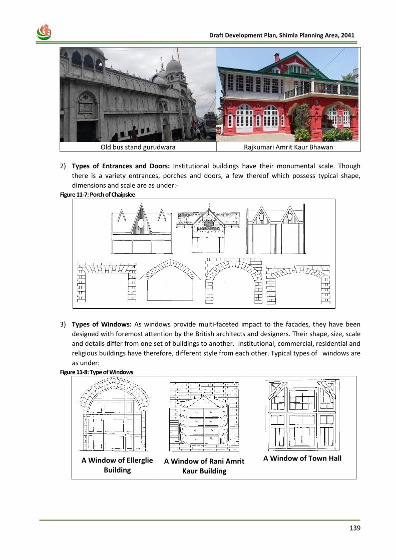
139
Draft Development Plan, Shimla Planning Area, 2041
Old bus stand gurudwara
Rajkumari Amrit Kaur Bhawan
2) Types of Entrances and Doors: Institutional buildings have their monumental scale. Though
there is a variety entrances, porches and doors, a few thereof which possess typical shape,
dimensions and scale are as under:- Figure 11-7: Porch of Chaipslee
3) Types of Windows: As windows provide multi-faceted impact to the facades, they have been
designed with foremost attention by the British architects and designers. Their shape, size, scale
and details differ from one set of buildings to another. Institutional, commercial, residential and
religious buildings have therefore, different style from each other. Typical types of windows are
as under: Figure 11-8: Type of Windows
A Window of Ellerglie
Building
A Window of Rani Amrit
Kaur Building
A Window of Town Hall
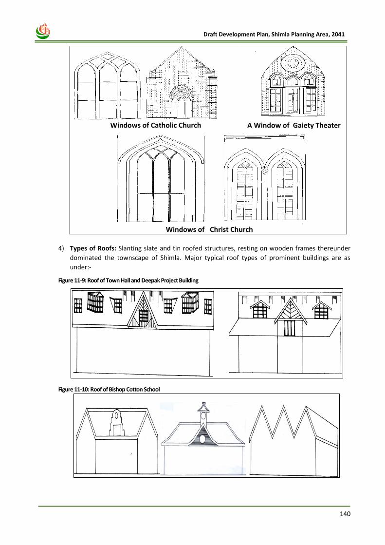
140
Draft Development Plan, Shimla Planning Area, 2041
Windows of Catholic Church
A Window of Gaiety Theater
Windows of Christ Church
4) Types of Roofs: Slanting slate and tin roofed structures, resting on wooden frames thereunder
dominated the townscape of Shimla. Major typical roof types of prominent buildings are as
under:-
Figure 11-9: Roof of Town Hall and Deepak Project Building
Figure 11-10: Roof of Bishop Cotton School
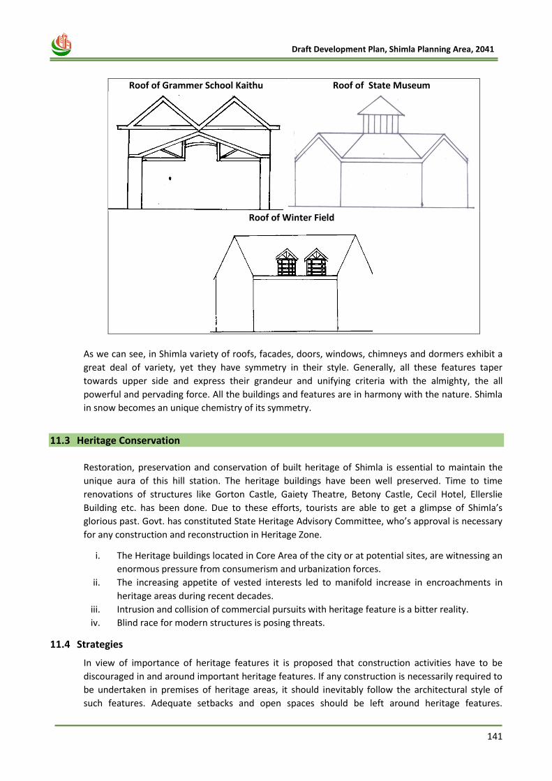
141
Draft Development Plan, Shimla Planning Area, 2041
Roof of Grammer School Kaithu
Roof of State Museum
Roof of Winter Field
As we can see, in Shimla variety of roofs, facades, doors, windows, chimneys and dormers exhibit a
great deal of variety, yet they have symmetry in their style. Generally, all these features taper
towards upper side and express their grandeur and unifying criteria with the almighty, the all
powerful and pervading force. All the buildings and features are in harmony with the nature. Shimla
in snow becomes an unique chemistry of its symmetry.
11.3 Heritage Conservation
Restoration, preservation and conservation of built heritage of Shimla is essential to maintain the
unique aura of this hill station. The heritage buildings have been well preserved. Time to time
renovations of structures like Gorton Castle, Gaiety Theatre, Betony Castle, Cecil Hotel, Ellerslie
Building etc. has been done. Due to these efforts, tourists are able to get a glimpse of Shimla’s
glorious past. Govt. has constituted State Heritage Advisory Committee, who’s approval is necessary
for any construction and reconstruction in Heritage Zone.
i. The Heritage buildings located in Core Area of the city or at potential sites, are witnessing an
enormous pressure from consumerism and urbanization forces.
ii. The increasing appetite of vested interests led to manifold increase in encroachments in
heritage areas during recent decades.
iii. Intrusion and collision of commercial pursuits with heritage feature is a bitter reality.
iv. Blind race for modern structures is posing threats.
11.4 Strategies
In view of importance of heritage features it is proposed that construction activities have to be
discouraged in and around important heritage features. If any construction is necessarily required to
be undertaken in premises of heritage areas, it should inevitably follow the architectural style of
such features. Adequate setbacks and open spaces should be left around heritage features.
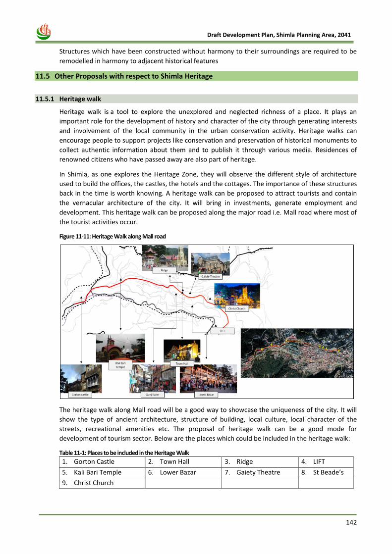
142
Draft Development Plan, Shimla Planning Area, 2041
Structures which have been constructed without harmony to their surroundings are required to be
remodelled in harmony to adjacent historical features
11.5 Other Proposals with respect to Shimla Heritage
11.5.1 Heritage walk
Heritage walk is a tool to explore the unexplored and neglected richness of a place. It plays an
important role for the development of history and character of the city through generating interests
and involvement of the local community in the urban conservation activity. Heritage walks can
encourage people to support projects like conservation and preservation of historical monuments to
collect authentic information about them and to publish it through various media. Residences of
renowned citizens who have passed away are also part of heritage.
In Shimla, as one explores the Heritage Zone, they will observe the different style of architecture
used to build the offices, the castles, the hotels and the cottages. The importance of these structures
back in the time is worth knowing. A heritage walk can be proposed to attract tourists and contain
the vernacular architecture of the city. It will bring in investments, generate employment and
development. This heritage walk can be proposed along the major road i.e. Mall road where most of
the tourist activities occur.
Figure 11-11: Heritage Walk along Mall road
The heritage walk along Mall road will be a good way to showcase the uniqueness of the city. It will
show the type of ancient architecture, structure of building, local culture, local character of the
streets, recreational amenities etc. The proposal of heritage walk can be a good mode for
development of tourism sector. Below are the places which could be included in the heritage walk:
Table 11-1: Places to be included in the Heritage Walk
1. Gorton Castle 2. Town Hall 3. Ridge 4. LIFT
5. Kali Bari Temple 6. Lower Bazar 7. Gaiety Theatre 8. St Beade’s
9. Christ Church
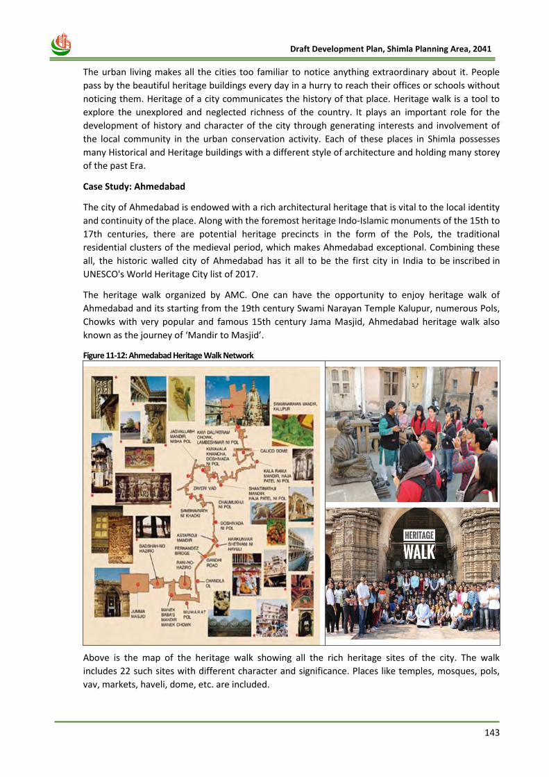
143
Draft Development Plan, Shimla Planning Area, 2041
The urban living makes all the cities too familiar to notice anything extraordinary about it. People
pass by the beautiful heritage buildings every day in a hurry to reach their offices or schools without
noticing them. Heritage of a city communicates the history of that place. Heritage walk is a tool to
explore the unexplored and neglected richness of the country. It plays an important role for the
development of history and character of the city through generating interests and involvement of
the local community in the urban conservation activity. Each of these places in Shimla possesses
many Historical and Heritage buildings with a different style of architecture and holding many storey
of the past Era.
Case Study: Ahmedabad
The city of Ahmedabad is endowed with a rich architectural heritage that is vital to the local identity
and continuity of the place. Along with the foremost heritage Indo-Islamic monuments of the 15th to
17th centuries, there are potential heritage precincts in the form of the Pols, the traditional
residential clusters of the medieval period, which makes Ahmedabad exceptional. Combining these
all, the historic walled city of Ahmedabad has it all to be the first city in India to be inscribed in
UNESCO's World Heritage City list of 2017.
The heritage walk organized by AMC. One can have the opportunity to enjoy heritage walk of
Ahmedabad and its starting from the 19th century Swami Narayan Temple Kalupur, numerous Pols,
Chowks with very popular and famous 15th century Jama Masjid, Ahmedabad heritage walk also
known as the journey of ‘Mandir to Masjid’.
Figure 11-12: Ahmedabad Heritage Walk Network
Above is the map of the heritage walk showing all the rich heritage sites of the city. The walk
includes 22 such sites with different character and significance. Places like temples, mosques, pols,
vav, markets, haveli, dome, etc. are included.
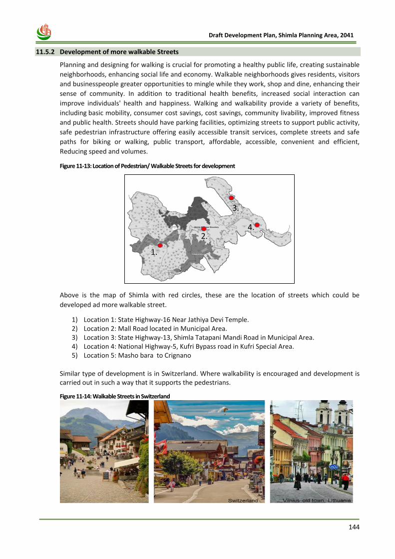
144
Draft Development Plan, Shimla Planning Area, 2041
11.5.2 Development of more walkable Streets
Planning and designing for walking is crucial for promoting a healthy public life, creating sustainable
neighborhoods, enhancing social life and economy. Walkable neighborhoods gives residents, visitors
and businesspeople greater opportunities to mingle while they work, shop and dine, enhancing their
sense of community. In addition to traditional health benefits, increased social interaction can
improve individuals' health and happiness. Walking and walkability provide a variety of benefits,
including basic mobility, consumer cost savings, cost savings, community livability, improved fitness
and public health. Streets should have parking facilities, optimizing streets to support public activity,
safe pedestrian infrastructure offering easily accessible transit services, complete streets and safe
paths for biking or walking, public transport, affordable, accessible, convenient and efficient,
Reducing speed and volumes.
Figure 11-13: Location of Pedestrian/ Walkable Streets for development
Above is the map of Shimla with red circles, these are the location of streets which could be
developed ad more walkable street.
1) Location 1: State Highway-16 Near Jathiya Devi Temple. 2) Location 2: Mall Road located in Municipal Area. 3) Location 3: State Highway-13, Shimla Tatapani Mandi Road in Municipal Area. 4) Location 4: National Highway-5, Kufri Bypass road in Kufri Special Area. 5) Location 5: Masho bara to Crignano
Similar type of development is in Switzerland. Where walkability is encouraged and development is carried out in such a way that it supports the pedestrians.
Figure 11-14: Walkable Streets in Switzerland
145
Draft Development Plan, Shimla Planning Area, 2041
11.6 Imperative
Shimla possesses a unique and distinct heritage. It possesses numerous master pieces along the Mall
road. The British Shimla is dotted with heritage buildings of various styles which are required to be
notified and regulated in accordance with heritage regulations. All buildings facing Mall and the
natural heritage having direct bearing are required to be regulated so that nothing contrary to
natural and built heritage comes up in and around heritage areas. Regulations to govern the
development activities if any to be carried out in heritage zone have been prescribed under separate
chapter of Regulations and the same are required to be adhered strictly.
146
Draft Development Plan, Shimla Planning Area, 2041
Chapter 12
ENVIRONMENT & NATURAL
HAZARD
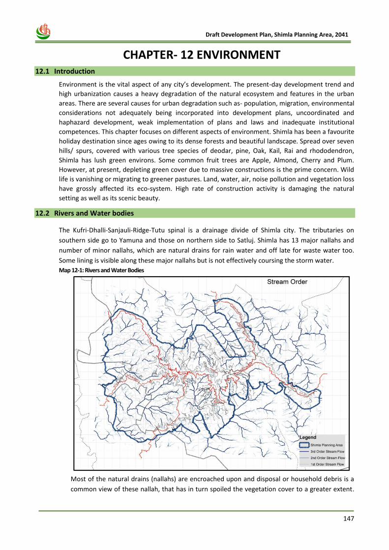
147
Draft Development Plan, Shimla Planning Area, 2041
12 CHAPTER- 12 ENVIRONMENT 12.1 Introduction
Environment is the vital aspect of any city’s development. The present-day development trend and
high urbanization causes a heavy degradation of the natural ecosystem and features in the urban
areas. There are several causes for urban degradation such as- population, migration, environmental
considerations not adequately being incorporated into development plans, uncoordinated and
haphazard development, weak implementation of plans and laws and inadequate institutional
competences. This chapter focuses on different aspects of environment. Shimla has been a favourite
holiday destination since ages owing to its dense forests and beautiful landscape. Spread over seven
hills/ spurs, covered with various tree species of deodar, pine, Oak, Kail, Rai and rhododendron,
Shimla has lush green environs. Some common fruit trees are Apple, Almond, Cherry and Plum.
However, at present, depleting green cover due to massive constructions is the prime concern. Wild
life is vanishing or migrating to greener pastures. Land, water, air, noise pollution and vegetation loss
have grossly affected its eco-system. High rate of construction activity is damaging the natural
setting as well as its scenic beauty.
12.2 Rivers and Water bodies
The Kufri-Dhalli-Sanjauli-Ridge-Tutu spinal is a drainage divide of Shimla city. The tributaries on
southern side go to Yamuna and those on northern side to Satluj. Shimla has 13 major nallahs and
number of minor nallahs, which are natural drains for rain water and off late for waste water too.
Some lining is visible along these major nallahs but is not effectively coursing the storm water.
Map 12-1: Rivers and Water Bodies
Most of the natural drains (nallahs) are encroached upon and disposal or household debris is a
common view of these nallah, that has in turn spoiled the vegetation cover to a greater extent.
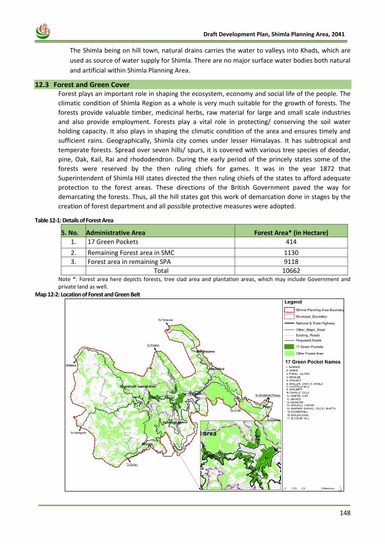
148
Draft Development Plan, Shimla Planning Area, 2041
The Shimla being on hill town, natural drains carries the water to valleys into Khads, which are
used as source of water supply for Shimla. There are no major surface water bodies both natural
and artificial within Shimla Planning Area.
12.3 Forest and Green Cover Forest plays an important role in shaping the ecosystem, economy and social life of the people. The
climatic condition of Shimla Region as a whole is very much suitable for the growth of forests. The
forests provide valuable timber, medicinal herbs, raw material for large and small scale industries
and also provide employment. Forests play a vital role in protecting/ conserving the soil water
holding capacity. It also plays in shaping the climatic condition of the area and ensures timely and
sufficient rains. Geographically, Shimla city comes under lesser Himalayas. It has subtropical and
temperate forests. Spread over seven hills/ spurs, it is covered with various tree species of deodar,
pine, Oak, Kail, Rai and rhododendron. During the early period of the princely states some of the
forests were reserved by the then ruling chiefs for games. It was in the year 1872 that
Superintendent of Shimla Hill states directed the then ruling chiefs of the states to afford adequate
protection to the forest areas. These directions of the British Government paved the way for
demarcating the forests. Thus, all the hill states got this work of demarcation done in stages by the
creation of forest department and all possible protective measures were adopted.
Table 12-1: Details of Forest Area
S. No. Administrative Area Forest Area* (in Hectare)
1. 17 Green Pockets 414
2. Remaining Forest area in SMC 1130
3. Forest area in remaining SPA 9118
Total 10662 Note *: Forest area here depicts forests, tree clad area and plantation areas, which may include Government and private land as well.
Map 12-2: Location of Forest and Green Belt
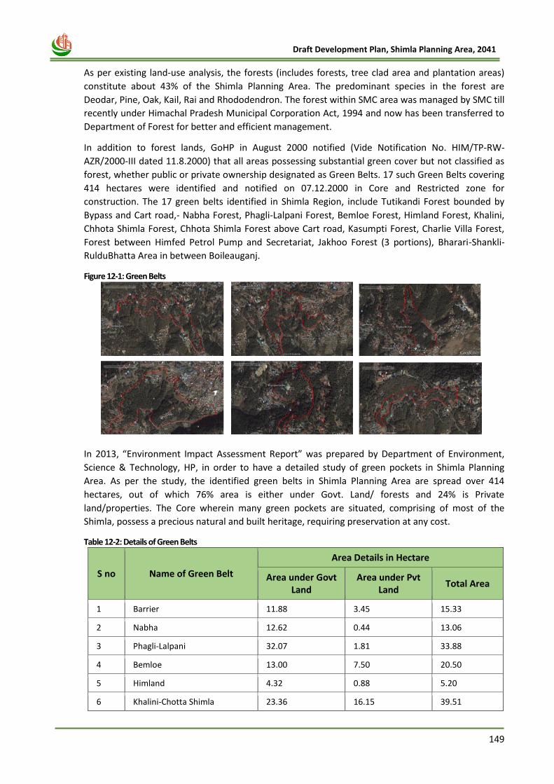
149
Draft Development Plan, Shimla Planning Area, 2041
As per existing land-use analysis, the forests (includes forests, tree clad area and plantation areas)
constitute about 43% of the Shimla Planning Area. The predominant species in the forest are
Deodar, Pine, Oak, Kail, Rai and Rhododendron. The forest within SMC area was managed by SMC till
recently under Himachal Pradesh Municipal Corporation Act, 1994 and now has been transferred to
Department of Forest for better and efficient management.
In addition to forest lands, GoHP in August 2000 notified (Vide Notification No. HIM/TP-RW-
AZR/2000-III dated 11.8.2000) that all areas possessing substantial green cover but not classified as
forest, whether public or private ownership designated as Green Belts. 17 such Green Belts covering
414 hectares were identified and notified on 07.12.2000 in Core and Restricted zone for
construction. The 17 green belts identified in Shimla Region, include Tutikandi Forest bounded by
Bypass and Cart road,- Nabha Forest, Phagli-Lalpani Forest, Bemloe Forest, Himland Forest, Khalini,
Chhota Shimla Forest, Chhota Shimla Forest above Cart road, Kasumpti Forest, Charlie Villa Forest,
Forest between Himfed Petrol Pump and Secretariat, Jakhoo Forest (3 portions), Bharari-Shankli-
RulduBhatta Area in between Boileauganj.
Figure 12-1: Green Belts
In 2013, “Environment Impact Assessment Report” was prepared by Department of Environment,
Science & Technology, HP, in order to have a detailed study of green pockets in Shimla Planning
Area. As per the study, the identified green belts in Shimla Planning Area are spread over 414
hectares, out of which 76% area is either under Govt. Land/ forests and 24% is Private
land/properties. The Core wherein many green pockets are situated, comprising of most of the
Shimla, possess a precious natural and built heritage, requiring preservation at any cost.
Table 12-2: Details of Green Belts
S no Name of Green Belt
Area Details in Hectare
Area under Govt Land
Area under Pvt Land
Total Area
1 Barrier 11.88 3.45 15.33
2 Nabha 12.62 0.44 13.06
3 Phagli-Lalpani 32.07 1.81 33.88
4 Bemloe 13.00 7.50 20.50
5 Himland 4.32 0.88 5.20
6 Khalini-Chotta Shimla 23.36 16.15 39.51
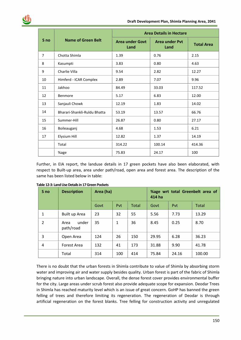
150
Draft Development Plan, Shimla Planning Area, 2041
S no Name of Green Belt
Area Details in Hectare
Area under Govt Land
Area under Pvt Land
Total Area
7 Chotta Shimla 1.39 0.76 2.15
8 Kasumpti 3.83 0.80 4.63
9 Charlie Villa 9.54 2.82 12.27
10 Himferd - ICAR Complex 2.89 7.07 9.96
11 Jakhoo 84.49 33.03 117.52
12 Benmore 5.17 6.83 12.00
13 Sanjauli Chowk 12.19 1.83 14.02
14 Bharari-Shankli-Ruldu Bhatta 53.19 13.57 66.76
15 Summer-Hill 26.87 0.80 27.17
16 Boileauganj 4.68 1.53 6.21
17 Elysium Hill 12.82 1.37 14.19
Total 314.22 100.14 414.36
%age 75.83 24.17 100
Further, in EIA report, the landuse details in 17 green pockets have also been elaborated, with
respect to Built-up area, area under path/road, open area and forest area. The description of the
same has been listed below in table:
Table 12-3: Land Use Details in 17 Green Pockets
S no Description Area (ha) %age wrt total Greenbelt area of 414 ha
Govt Pvt Total Govt Pvt Total
1 Built up Area 23 32 55 5.56 7.73 13.29
2 Area under path/road
35 1 36 8.45 0.25 8.70
3 Open Area 124 26 150 29.95 6.28 36.23
4 Forest Area 132 41 173 31.88 9.90 41.78
Total 314 100 414 75.84 24.16 100.00
There is no doubt that the urban forests in Shimla contribute to value of Shimla by absorbing storm
water and improving air and water supply besides quality. Urban forest is part of the fabric of Shimla
bringing nature into urban landscape. Overall, the dense forest cover provides environmental buffer
for the city. Large areas under scrub forest also provide adequate scope for expansion. Deodar Trees
in Shimla has reached maturity level which is an issue of great concern. GoHP has banned the green
felling of trees and therefore limiting its regeneration. The regeneration of Deodar is through
artificial regeneration on the forest blanks. Tree felling for construction activity and unregulated
151
Draft Development Plan, Shimla Planning Area, 2041
dumping of solid waste and debris along the hill slopes by people causing degradation of forests. Soil
erosion and landslides especially along the natural drains is causing widening of drains especially
during flash floods and exposing trees along the drain to felling, besides the fact that the soil
compaction has lead to deterioration of soil quality and which in turn has led to phenomenon of tree
felling in the entire Shimla region.
In view of soil conditions and pressure of already existing terrestrial development, tree cover has
been affected in Shimla area. The survival rate of plantation is very poor. Uprooting/ tree falling in
normal rain has become very common phenomenon. It needs to be stopped otherwise the entire
ecosystem will get adversely affected living long term impacts.
During the stakeholder meeting of Shimla MC, Elected Councillors, pointed out that prior to
notification of Green belts on 07.12.2000,, buildings were already constructed in the green pockets.
However, some of the residents, who own the land in green area, could not construct their house
because of financial incapacity and their plots lie sandwich between built-up areas. These
landowners pleaded that they should be allowed to build residential homes of 2 floor+ attic, for their
families on their own private land in green areas. In many cases, these sandwiched plots, are being
used to dump the garbage and the plot owners are not able to construct even a boundary wall to
safeguard their property.
As such it was felt that their grievance was genuine and construction on privately owned, open land
which constitutes only about6.28% (26 ha) land may be permitted in the Green area subject to the
condition that no cutting and felling of tree would be allowed and construction permission will be
solely given on sandwiched plots and barren land for residential purposes only.
Realising the need to preserve the rich bio-diversity, in and around Shimla Town, the Green Belts
already notified must remain intact. Moreover, in order the conserve the forest in Shimla Planning
area, there is need to protect remaining forest land in Shimla Planning area, which is approximately
26 times more than 17 green belt area. At present, as per NRSC base-map land-use, 10,662 hectares
land is under forests, tree clad area and plantation areas, which includes government as well as
private land. Therefore, in terms of ecological and environmental perspective, minimum and limited
construction may be allowed on vacant and sandwiched plots within the 26 ha of private open land,
but simultaneously more strategies should be adopted to preserve these forests areas, which is
approximately 10,662 (43.27%) Hectares of land in complete Shimla Planning Area. If low density
construction with limited storeys and FAR is allowed in the green areas, the overall population
pressure on the area is likely to be minimal.
To increase the forest cover it is proposed that the forest Department shall plant pine trees in the
vacant govt. land patches and steep slopes under ambitious tree planting programmes combined
with natural expansion of forests. The massive plantation and landscaping is required to be ensured
in the entire Shimla Planning Area. Species of trees, plants needs to be identified for specific areas so
that the plants survive in these conditions.
12.4 Geological Profile of Shimla
The rock profile of Shimla region mainly comprises of phyllites, mica-schists, garnetiferous mica
schists, quartzites and limestones etc. These terrains are usually, seen exposed along steep hill
slopes, roads and nala cuttings.
These rocks are mainly differentiated into the Jutogh Group and the Shimla Group. The Jutogh Group
occupies the main Shimla area, occurs at higher elevation and extends from Annadale - Chhaura
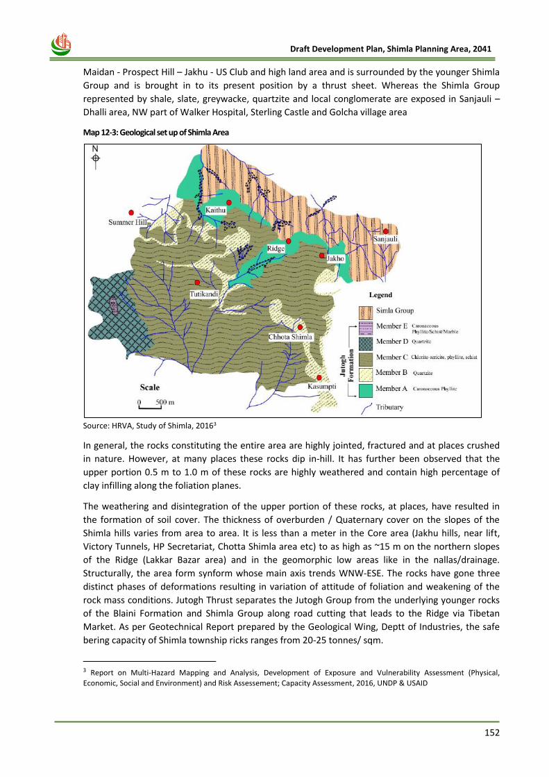
152
Draft Development Plan, Shimla Planning Area, 2041
Maidan - Prospect Hill – Jakhu - US Club and high land area and is surrounded by the younger Shimla
Group and is brought in to its present position by a thrust sheet. Whereas the Shimla Group
represented by shale, slate, greywacke, quartzite and local conglomerate are exposed in Sanjauli –
Dhalli area, NW part of Walker Hospital, Sterling Castle and Golcha village area
Map 12-3: Geological set up of Shimla Area
Source: HRVA, Study of Shimla, 20163
In general, the rocks constituting the entire area are highly jointed, fractured and at places crushed
in nature. However, at many places these rocks dip in-hill. It has further been observed that the
upper portion 0.5 m to 1.0 m of these rocks are highly weathered and contain high percentage of
clay infilling along the foliation planes.
The weathering and disintegration of the upper portion of these rocks, at places, have resulted in
the formation of soil cover. The thickness of overburden / Quaternary cover on the slopes of the
Shimla hills varies from area to area. It is less than a meter in the Core area (Jakhu hills, near lift,
Victory Tunnels, HP Secretariat, Chotta Shimla area etc) to as high as ~15 m on the northern slopes
of the Ridge (Lakkar Bazar area) and in the geomorphic low areas like in the nallas/drainage.
Structurally, the area form synform whose main axis trends WNW-ESE. The rocks have gone three
distinct phases of deformations resulting in variation of attitude of foliation and weakening of the
rock mass conditions. Jutogh Thrust separates the Jutogh Group from the underlying younger rocks
of the Blaini Formation and Shimla Group along road cutting that leads to the Ridge via Tibetan
Market. As per Geotechnical Report prepared by the Geological Wing, Deptt of Industries, the safe
bering capacity of Shimla township ricks ranges from 20-25 tonnes/ sqm.
3 Report on Multi-Hazard Mapping and Analysis, Development of Exposure and Vulnerability Assessment (Physical,
Economic, Social and Environment) and Risk Assessement; Capacity Assessment, 2016, UNDP & USAID
153
Draft Development Plan, Shimla Planning Area, 2041
12.5 Eco-sensitive zones
There is only one Eco-sensitive zone in the entire planning area which is called Shimla Catchment
Wildlife Sanctuary. It is one of the most popular sanctuaries of Shimla. The place is not only famous
for providing some of the best sightings for common and rare wildlife but it is also a major source of
water supply in the region.
The Water Catchment Sanctuary is spread over an area of 10.25 Sq.km (The Eco-Sensitive Zone shall
be of 7.71 sq. Kms with an extent upto 1.5 kilo meter around the boundary of Shimla Water
Catchment Wildlife Sanctuary) and its altitude ranges from 1900-2620 m. It is located on the
northern side of Kufri and is about 8 Km away from the eastern boundary of Shimla. The sanctuary
was declared as an Eco-sensitive zone by the Ministry of Environment, Forest and Climate Change in
the year 2015.
List of activities prohibited or to be regulated within the Eco-sensitive Zone.- All activities in the
Eco sensitive Zone shall be governed by the provisions of the Environment (Protection) Act, 1986 (29
of 1986) and the rules made thereunder. The list of activities as specified in the above mentioned act
are as follows:
1. Prohibited Activities
a. Commercial Mining, stone quarrying and crushing units.
b. Setting up of saw mills
c. Use or production of any hazardous substances
d. Setting up of industries causing water or air or soil or noise pollution
e. Establishment of new major thermal and hydro-electric projects
f. Protection of hill slopes and river banks
g. Commercial use of firewood
h. Use of plastic bags
i. Undertaking activities related to tourism like over-flying the National Park Area by
aircraft, hot-air balloons
j. Fishing
k. Discharge of untreated effluents and solid waste in natural water bodies or land area
2. Regulated Activities
a. Establishment of hotels and resorts
b. Construction Activities
c. Trenching ground
d. Discharge of treated effluents and solid waste in natural water bodies or land area
e. Air and Vehicular Pollution
f. Noise pollution
g. Extraction of ground water
h. Felling of trees
i. Migratory grazers
j. Existing establishments
k. Insulation of electric lines
l. Widening and strengthening of existing roads and construction of new roads
m. Fencing of existing premises of hotels and lodges
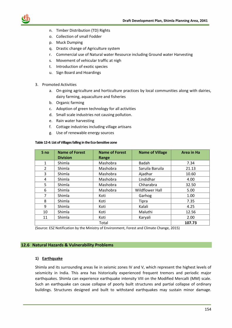
154
Draft Development Plan, Shimla Planning Area, 2041
n. Timber Distribution (TD) Rights
o. Collection of small Fodder
p. Muck Dumping
q. Drastic change of Agriculture system
r. Commercial use of Natural water Resource including Ground water Harvesting
s. Movement of vehicular traffic at nigh
t. Introduction of exotic species
u. Sign Board and Hoardings
3. Promoted Activities
a. On-going agriculture and horticulture practices by local communities along with dairies,
dairy farming, aquaculture and fisheries
b. Organic farming
c. Adoption of green technology for all activities
d. Small scale industries not causing pollution.
e. Rain water harvesting
f. Cottage industries including village artisans
g. Use of renewable energy sources
Table 12-4: List of Villages falling in the Eco-Sensitive zone
S no Name of Forest Division
Name of Forest Range
Name of Village Area in Ha
1 Shimla Mashobra Badah 7.34
2 Shimla Mashobra Saruila Baruila 21.13
3 Shimla Mashobra Ajadhar 10.60
4 Shimla Mashobra Lindidhar 4.00
5 Shimla Mashobra Chharabra 32.50
6 Shimla Mashobra Wildflower Hall 5.00
7 Shimla Koti Garhog 1.00
8 Shimla Koti Tipra 7.35
9 Shimla Koti Kalali 4.25
10 Shimla Koti Maluthi 12.56
11 Shimla Koti Karyali 2.00
Total 107.73 (Source: ESZ Notification by the Ministry of Environment, Forest and Climate Change, 2015)
12.6 Natural Hazards & Vulnerability Problems
1) Earthquake
Shimla and its surrounding areas lie in seismic zones IV and V, which represent the highest levels of
seismicity in India. This area has historically experienced frequent tremors and periodic major
earthquakes. Shimla can experience earthquake intensity VIII on the Modified Mercalli (MM) scale.
Such an earthquake can cause collapse of poorly built structures and partial collapse of ordinary
buildings. Structures designed and built to withstand earthquakes may sustain minor damage.
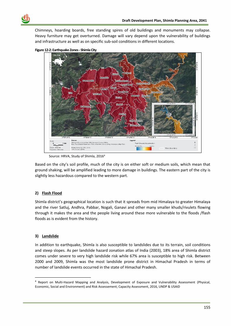
155
Draft Development Plan, Shimla Planning Area, 2041
Chimneys, hoarding boards, free standing spires of old buildings and monuments may collapse.
Heavy furniture may get overturned. Damage will vary depend upon the vulnerability of buildings
and infrastructure as well as on specific sub-soil conditions in different locations.
Figure 12-2: Earthquake Zones - Shimla City
Source: HRVA, Study of Shimla, 20164
Based on the city’s soil profile, much of the city is on either soft or medium soils, which mean that
ground shaking, will be amplified leading to more damage in buildings. The eastern part of the city is
slightly less hazardous compared to the western part.
2) Flash Flood
Shimla district’s geographical location is such that it spreads from mid Himalaya to greater Himalaya
and the river Satluj, Andhra, Pabbar, Nogali, Ganavi and other many smaller khuds/rivulets flowing
through it makes the area and the people living around these more vulnerable to the floods /flash
floods as is evident from the history.
3) Landslide
In addition to earthquake, Shimla is also susceptible to landslides due to its terrain, soil conditions
and steep slopes. As per landslide hazard zonation atlas of India (2003), 18% area of Shimla district
comes under severe to very high landslide risk while 67% area is susceptible to high risk. Between
2000 and 2009, Shimla was the most landslide prone district in Himachal Pradesh in terms of
number of landslide events occurred in the state of Himachal Pradesh.
4 Report on Multi-Hazard Mapping and Analysis, Development of Exposure and Vulnerability Assessment (Physical,
Economic, Social and Environment) and Risk Assessement; Capacity Assessment, 2016, UNDP & USAID
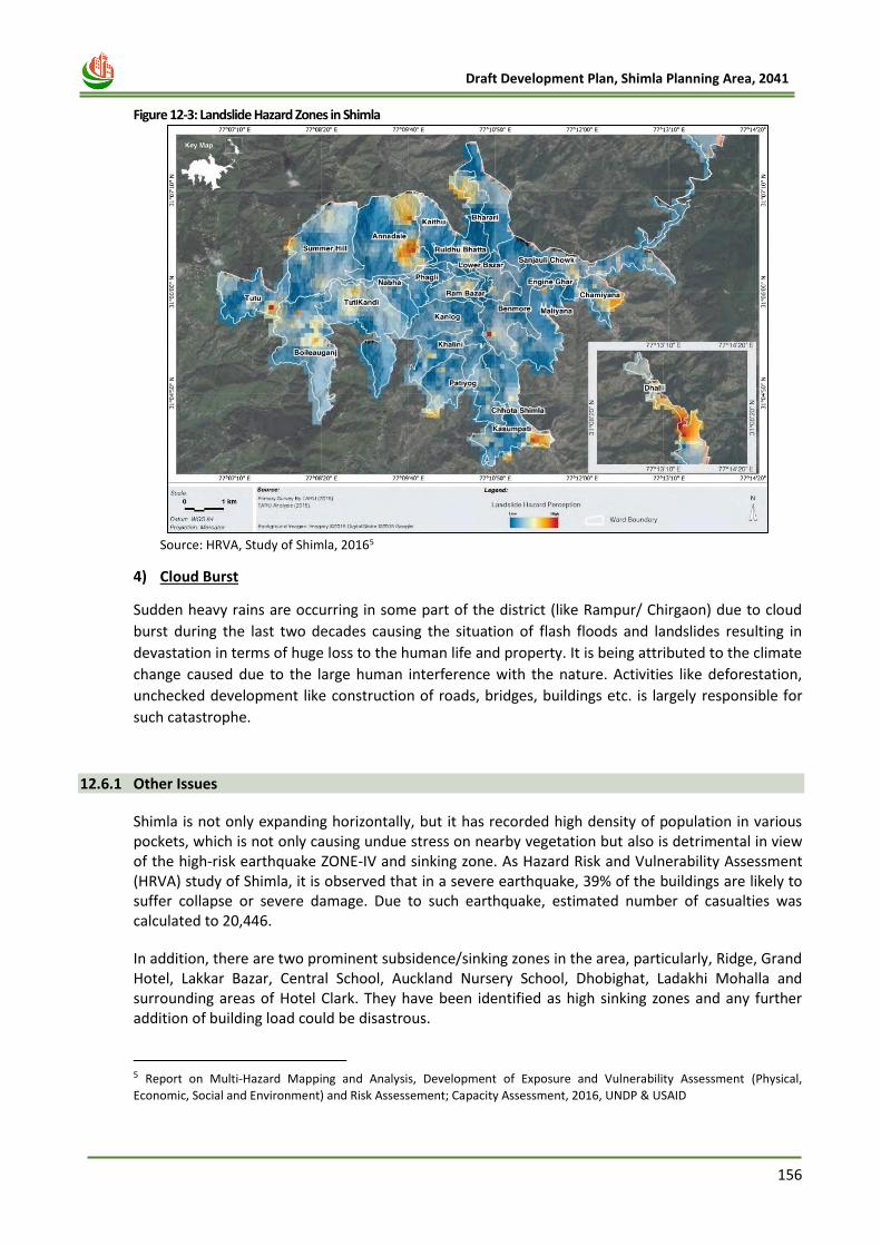
156
Draft Development Plan, Shimla Planning Area, 2041
Figure 12-3: Landslide Hazard Zones in Shimla
Source: HRVA, Study of Shimla, 20165
4) Cloud Burst
Sudden heavy rains are occurring in some part of the district (like Rampur/ Chirgaon) due to cloud
burst during the last two decades causing the situation of flash floods and landslides resulting in
devastation in terms of huge loss to the human life and property. It is being attributed to the climate
change caused due to the large human interference with the nature. Activities like deforestation,
unchecked development like construction of roads, bridges, buildings etc. is largely responsible for
such catastrophe.
12.6.1 Other Issues
Shimla is not only expanding horizontally, but it has recorded high density of population in various pockets, which is not only causing undue stress on nearby vegetation but also is detrimental in view of the high-risk earthquake ZONE-IV and sinking zone. As Hazard Risk and Vulnerability Assessment (HRVA) study of Shimla, it is observed that in a severe earthquake, 39% of the buildings are likely to suffer collapse or severe damage. Due to such earthquake, estimated number of casualties was calculated to 20,446.
In addition, there are two prominent subsidence/sinking zones in the area, particularly, Ridge, Grand Hotel, Lakkar Bazar, Central School, Auckland Nursery School, Dhobighat, Ladakhi Mohalla and surrounding areas of Hotel Clark. They have been identified as high sinking zones and any further addition of building load could be disastrous.
5 Report on Multi-Hazard Mapping and Analysis, Development of Exposure and Vulnerability Assessment (Physical,
Economic, Social and Environment) and Risk Assessement; Capacity Assessment, 2016, UNDP & USAID
157
Draft Development Plan, Shimla Planning Area, 2041
As against the recommended density of 450 persons per hectare in hill settlements, the town’s localities have densities ranging from 2,500 to 3,500 persons per hectare for the same area. Slope violation is a regular occurrence in Shimla Planning Area. Construction on slopes higher than 45 degrees has been observed in many areas. Therefore, risk analysis based on slope is important and a prerequisite for planning process in any hilly and mountainous state.
The main environmental key issues have been highlighted below:
• High level of construction activates are damaging the natural settings as well as its scenic beauty.
• Non availability of proper boundary delineation of the forest area creates a lot of issues especially to the private land owners as no development can be done on these lands.
• Vehicular usage are the main reason of increasing air pollution
• Untreated disposal of waste water degrades the water quality of the region
• Shimla and its surrounding region lie in seismic zone IV & V.
• Due to its terrain, soil conditions and steep slopes, Shimla is also susceptible to landslides.
12.7 Pollution Aspects
Environmental pollution such as air, water, noise and land pollution have not assumed serious proportions in the city of Shimla unlike some other towns in plain areas of north India. Nevertheless, Shimla has shown increasing trends with respect to some important pollution parameters. Details are described in sub sections given below:
1) Air Pollution
Air pollutants have shown increasing trend in Shimla. State Pollution Control Board monitors some
of the important air quality parameters regularly at two places: one at the Ridge and another at Bus
Stand Shimla. There is a certain increase in the level of RSPM at both the locations. Even the Ridge
Maidan falling in sensitive zone category has registered an increase and is close to the permissible
limit. Vehicular pollution is the prime cause of increasing air pollution particularly along road
networks and bus-stands.
The maintenance of air quality of Shimla is big challenge due to traffic jams, soil erosion dust.
The air quality gets affected adversely. The tree cover gives immense protection for air
pollutants and therefore needs to be protected at any cost. The mains concerns during activities
whether building or demolition true the emissions generated by various means excavation,
vehicles and the machineries. Air Pollution is also caused by areas or point sources such as cities,
commercial areas, or by linear sources such as highways. Vegetation buffers minimizes the
build–up of pollution levels in urban areas by acting as pollution sinks, therefore, the vegetation
in Shimla acts as lungs to the entire habitat.
• A dense belt provides greater shelter immediately to leeward but the sheltered area is not as
extensive as when a more permeable zone of vegetation is provided.
• More plantation should be done. Plants are good absorbers of sulphur dioxide. Parks with
trees have an SO2 level lower than city streets, minimize the pollution load.
• Evergreen trees should be planted which are found to be more effective.
• The species chosen for plantation must be resistant to pollutants, particularly in the early
stages of their growth.
158
Draft Development Plan, Shimla Planning Area, 2041
2) Water Pollution
Water pollution is also one of the key concerns of Shimla Planning Area. Since Shimla is facing crises owing to its limited water resources available for drinking water and other consumption of the city, water conservation becomes one of the important aspects to be considered for development and proposals. As drinking water problem of the city is well acknowledged by all sections of the city dwellers, improper use of water and further pollution of this scarce resource are evident from the data analyzed by the board. A large number of hoteliers are discharging waste water openly into various Khads and Nallahs along with domestic discharges. As sewage concentration in waste water is very high in surrounding khads of Shimla and there is not enough water for effective dilution and purification (self-corrective measures of the running water) in the khads.
Another important parameter of surface water quality viz. Total Coliforms (TCs) are observed to be on the rise for quite some time reflecting higher concentration of sewage and untreated disposal of wastewater. The State Board monitors surface water quality of about 4-5 khads and nallahs in and around Shimla. The quality of these khads has deteriorated because of untreated disposal of waste water.
3) Noise Pollution
Noise pollution level above desirable limit is observed especially at the bus stand and commercial
areas such as Lower Bazaar, Lakkar Bazaar, Sanjauli and Khalini localities where higher concentration
of residential area is also observed.
Noise pollution though is not big issue here but increase in number of private vehicles,
transportation vehicle is matter of concern. Green belts and landscaping are effective means to
control noise pollution. Therefore it should be enhanced in and around Shimla town. Strong leafy
trees be planted to act as noise baffles. Shrubs and creepers may also be planted for additional
protection between tree trunks. As little hard paving and as much grass as possible should be used.
12.8 Ecology Conservation Strategies
a. Create vegetative cover on the sites on which developmental activity has already been done and
not to disturb the vegetation in adjacent areas at all. No land clearing activities should be done.
b. Landscape, open areas, create eco sensitive zones.
c. Paved areas to be installed with permeable paving.
d. Check dams built near muck dumping sites to reduce the quantity of eroded soil particles
reaching free-flowing streams of downstream areas.
e. Action for retaining the natural topography of the area or design the landscape with at least 15%
to 25% of the area. Parking areas, walkways and landscaping should be created and considered in
Shimla planning area.
12.9 Disaster Management – Vulnerability and Risk Assessment
For planning for prevention of hazards, the authority must identify and evaluate options for
controlling hazards, using a "hierarchy of controls." Use of hazard control plan to guide the selection
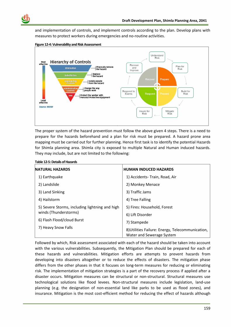
159
Draft Development Plan, Shimla Planning Area, 2041
and implementation of controls, and implement controls according to the plan. Develop plans with
measures to protect workers during emergencies and no-routine activities.
Figure 12-4: Vulnerability and Risk Assessment
The proper system of the hazard prevention must follow the above given 4 steps. There is a need to
prepare for the hazards beforehand and a plan for risk must be prepared. A hazard prone area
mapping must be carried out for further planning. Hence first task is to identify the potential Hazards
for Shimla planning area. Shimla city is exposed to multiple Natural and Human induced hazards.
They may include, but are not limited to the following:
Table 12-5: Details of Hazards
NATURAL HAZARDS
1) Earthquake
2) Landslide
3) Land Sinking
4) Hailstorm
5) Severe Storms, including lightning and high winds (Thunderstorms)
6) Flash Flood/cloud Burst
7) Heavy Snow Falls
HUMAN INDUCED HAZARDS
1) Accidents- Train, Road, Air
2) Monkey Menace
3) Traffic Jams
4) Tree Falling
5) Fires: Household, Forest
6) Lift Disorder
7) Stampede
8)Utilities Failure: Energy, Telecommunication, Water and Sewerage System
Followed by which, Risk assessment associated with each of the hazard should be taken into account
with the various vulnerabilities. Subsequently, the Mitigation Plan should be prepared for each of
these hazards and vulnerabilities. Mitigation efforts are attempts to prevent hazards from
developing into disasters altogether or to reduce the effects of disasters. The mitigation phase
differs from the other phases in that it focuses on long-term measures for reducing or eliminating
risk. The implementation of mitigation strategies is a part of the recovery process if applied after a
disaster occurs. Mitigation measures can be structural or non-structural. Structural measures use
technological solutions like flood levees. Non-structural measures include legislation, land-use
planning (e.g. the designation of non-essential land like parks to be used as flood zones), and
insurance. Mitigation is the most cost-efficient method for reducing the effect of hazards although
160
Draft Development Plan, Shimla Planning Area, 2041
not always the most suitable. Mitigation includes providing regulations regarding evacuation,
sanctions against those who refuse to obey the regulations (such as mandatory evacuations), and
communication of risks to the public.
In addition, while providing the basic strategies for Disaster Management, the key proposals
provided in the Action Plan on Disaster Management, submitted to Hon’ble NGT has been taken into
consideration. The highlights of the actions taken so far are as following:
i. Emergency Operation Centres (1 at State Level and 12 at District Level) is already in place with
24X7 operation facility for effective disaster response and DRR Planning. State Government may
facilitate it with internet, connectivity, satellite phones etc. for better communication.
ii. Disaster Management Cell will launce scheme on conduct of structural and safety audit of life
lines buildings and hospital safety. After that, the District Disaster Management Authority,
Shimla and Municipal Corporation, Shimla may conduct detailed structural audit of the building
with the help of NIT Hamirpur.
iii. For Safe Construction Practice and earthquake risk reduction, report will be prepared by Urban
Development department for modern building byelaws which will be adopt by all the ULB’s
individually. Apart from that, Training will be provided within the staff as well as practicing
engineers and architects for safe planning and construction.
iv. Himachal Pradesh State Disaster Management Plan and District Disaster Management Plans of
12 Districts has been prepared and approved in the year of 2017 as per ‘Disaster Management
Act, 2005. To prepare the Disaster Management Plan for Shimla Planning Area, Hazard Risk &
Vulnerability Analysis (HRVA) will be conducted.
v. The High Powered Expert Committee will also be identified and delineate passages for providing
emergency services, medical assistance and relief work, so enough openings are created for
ingress and egress of fire tenders and emergency medical vehicles/ ambulances.
12.10 The Hon’ble NGT Directives
As per direction of the Hon’bel National Green Tribunal, GoHP constituted an Expert Committee to
carry out study related to Carrying capacity of Shimla city. The Commitee submitted its Carrying
Capacity report in relation to the ecology, environment and protection of the declared forest area,
according to which the carrying capacity of Shimla has been exhausted.
Further, the Principal Bench of the Hon’ble National Green Tribunal, in the matter of Original
Application No. 121/2014 titled as “Yogendra Mohan Sengupta vs Union of India & Others” have
passed a detailed judgement on 16.11.2017. The Hon’ble NGT vide order para 112 has prohibited
new construction of any kind, i.e. residential, institutional and commercial in any part of the Core
and Green/Forest area. The details of restrictions on construction in various zone has been
mentioned in the table below:
Table 12-6: Details of restrictions imposed in various Areas of SPA.
Zone NGT Orders Dated. 16.11.2017
Green Belts &
Complete ban on Construction Reconstruction on old lines- 2 + attic
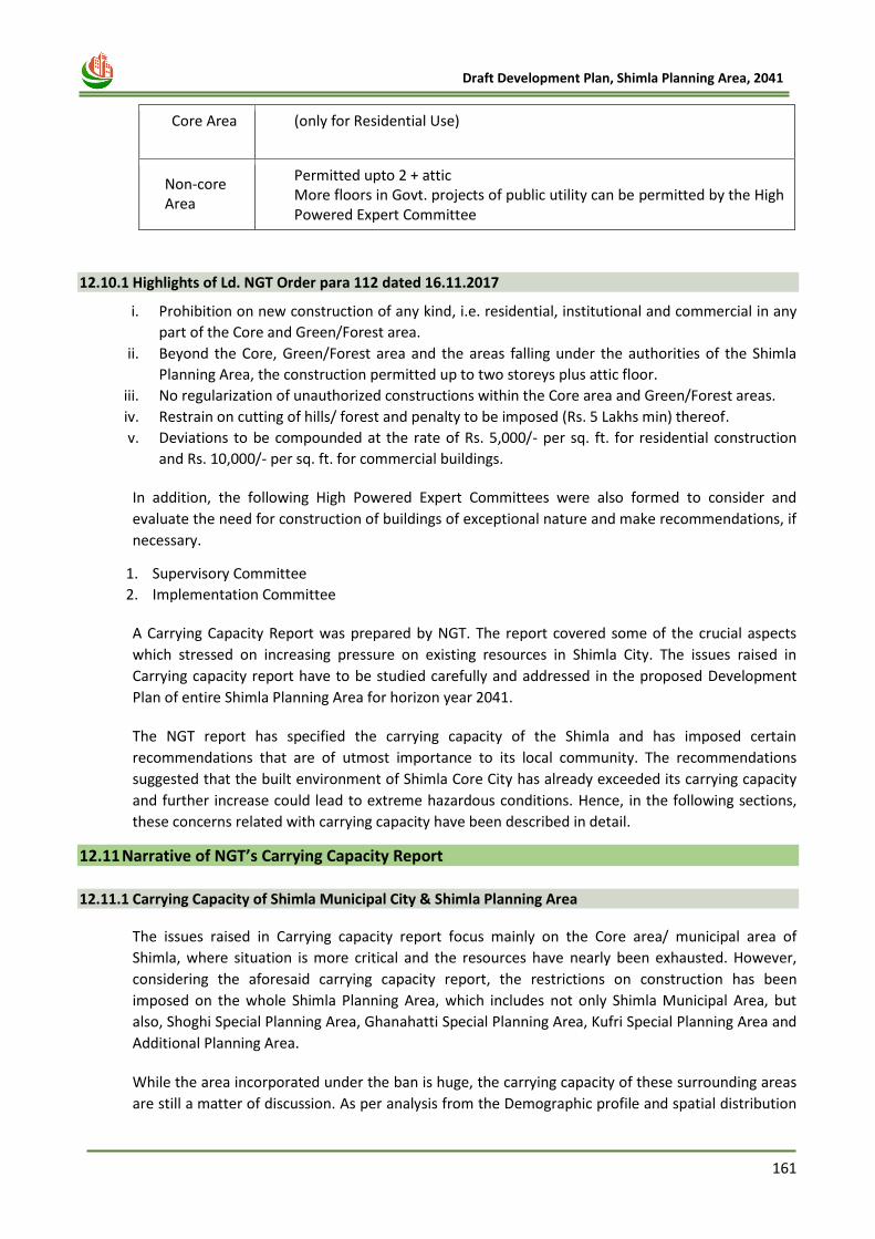
161
Draft Development Plan, Shimla Planning Area, 2041
Core Area (only for Residential Use)
Non-core Area
Permitted upto 2 + attic More floors in Govt. projects of public utility can be permitted by the High Powered Expert Committee
12.10.1 Highlights of Ld. NGT Order para 112 dated 16.11.2017
i. Prohibition on new construction of any kind, i.e. residential, institutional and commercial in any
part of the Core and Green/Forest area.
ii. Beyond the Core, Green/Forest area and the areas falling under the authorities of the Shimla
Planning Area, the construction permitted up to two storeys plus attic floor.
iii. No regularization of unauthorized constructions within the Core area and Green/Forest areas.
iv. Restrain on cutting of hills/ forest and penalty to be imposed (Rs. 5 Lakhs min) thereof.
v. Deviations to be compounded at the rate of Rs. 5,000/- per sq. ft. for residential construction
and Rs. 10,000/- per sq. ft. for commercial buildings.
In addition, the following High Powered Expert Committees were also formed to consider and
evaluate the need for construction of buildings of exceptional nature and make recommendations, if
necessary.
1. Supervisory Committee
2. Implementation Committee
A Carrying Capacity Report was prepared by NGT. The report covered some of the crucial aspects
which stressed on increasing pressure on existing resources in Shimla City. The issues raised in
Carrying capacity report have to be studied carefully and addressed in the proposed Development
Plan of entire Shimla Planning Area for horizon year 2041.
The NGT report has specified the carrying capacity of the Shimla and has imposed certain
recommendations that are of utmost importance to its local community. The recommendations
suggested that the built environment of Shimla Core City has already exceeded its carrying capacity
and further increase could lead to extreme hazardous conditions. Hence, in the following sections,
these concerns related with carrying capacity have been described in detail.
12.11 Narrative of NGT’s Carrying Capacity Report
12.11.1 Carrying Capacity of Shimla Municipal City & Shimla Planning Area
The issues raised in Carrying capacity report focus mainly on the Core area/ municipal area of
Shimla, where situation is more critical and the resources have nearly been exhausted. However,
considering the aforesaid carrying capacity report, the restrictions on construction has been
imposed on the whole Shimla Planning Area, which includes not only Shimla Municipal Area, but
also, Shoghi Special Planning Area, Ghanahatti Special Planning Area, Kufri Special Planning Area and
Additional Planning Area.
While the area incorporated under the ban is huge, the carrying capacity of these surrounding areas
are still a matter of discussion. As per analysis from the Demographic profile and spatial distribution
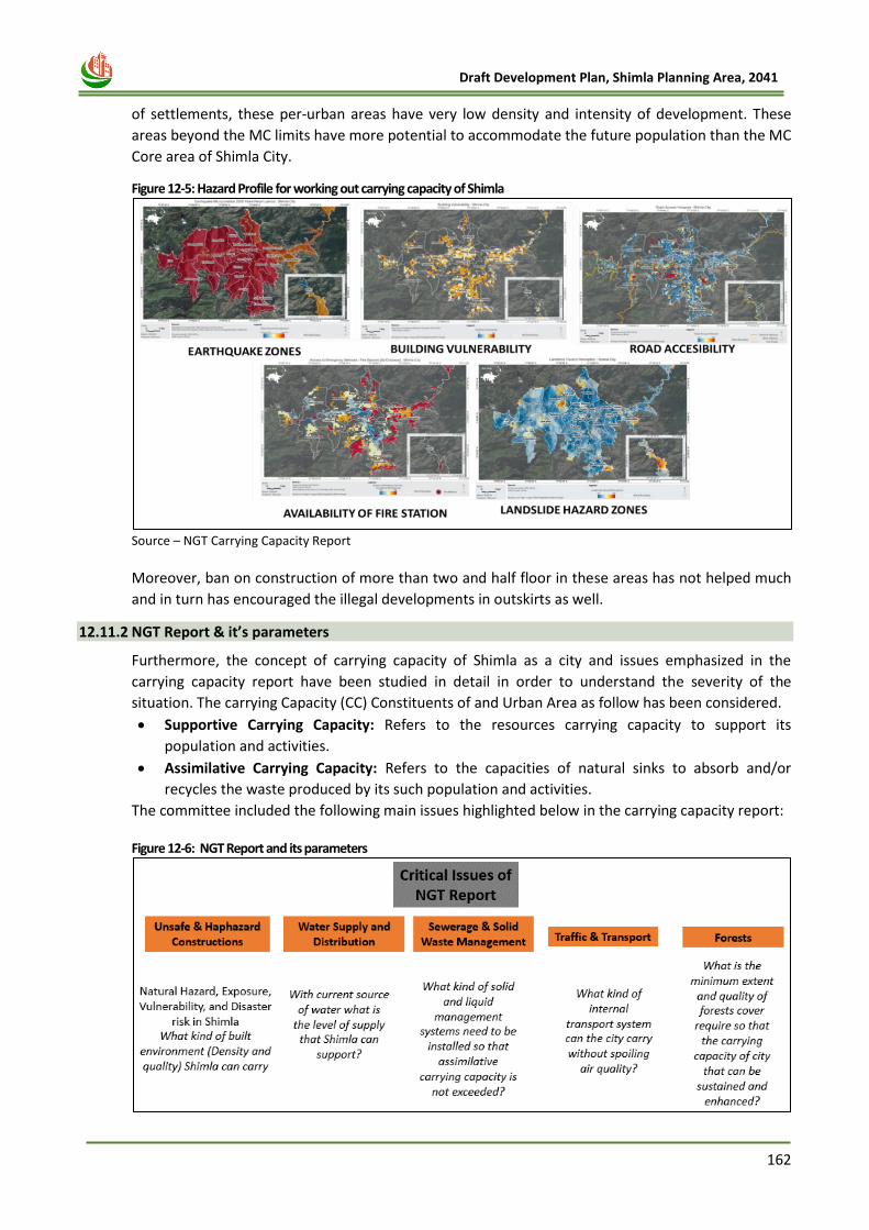
162
Draft Development Plan, Shimla Planning Area, 2041
of settlements, these per-urban areas have very low density and intensity of development. These
areas beyond the MC limits have more potential to accommodate the future population than the MC
Core area of Shimla City.
Figure 12-5: Hazard Profile for working out carrying capacity of Shimla
Source – NGT Carrying Capacity Report
Moreover, ban on construction of more than two and half floor in these areas has not helped much
and in turn has encouraged the illegal developments in outskirts as well.
12.11.2 NGT Report & it’s parameters
Furthermore, the concept of carrying capacity of Shimla as a city and issues emphasized in the
carrying capacity report have been studied in detail in order to understand the severity of the
situation. The carrying Capacity (CC) Constituents of and Urban Area as follow has been considered.
• Supportive Carrying Capacity: Refers to the resources carrying capacity to support its
population and activities.
• Assimilative Carrying Capacity: Refers to the capacities of natural sinks to absorb and/or
recycles the waste produced by its such population and activities.
The committee included the following main issues highlighted below in the carrying capacity report:
Figure 12-6: NGT Report and its parameters
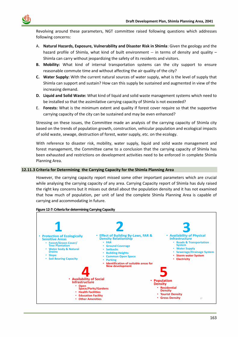
163
Draft Development Plan, Shimla Planning Area, 2041
Revolving around these parameters, NGT committee raised following questions which addresses
following concerns:
A. Natural Hazards, Exposure, Vulnerability and Disaster Risk in Shimla: Given the geology and the
hazard profile of Shimla, what kind of built environment -- in terms of density and quality –
Shimla can carry without jeopardizing the safety of its residents and visitors.
B. Mobility: What kind of internal transportation systems can the city support to ensure
reasonable commute time and without affecting the air quality of the city?
C. Water Supply: With the current natural sources of water supply, what is the level of supply that
Shimla can support and sustain? How can this supply be sustained and augmented in view of the
increasing demand.
D. Liquid and Solid Waste: What kind of liquid and solid waste management systems which need to
be installed so that the assimilative carrying capacity of Shimla is not exceeded?
E. Forests: What is the minimum extent and quality if forest cover require so that the supportive
carrying capacity of the city can be sustained and may be even enhanced?
Stressing on these issues, the Committee made an analysis of the carrying capacity of Shimla city
based on the trends of population growth, construction, vehicular population and ecological impacts
of solid waste, sewage, destruction of forest, water supply, etc. on the ecology.
With reference to disaster risk, mobility, water supply, liquid and solid waste management and
forest management, the Committee came to a conclusion that the carrying capacity of Shimla has
been exhausted and restrictions on development activities need to be enforced in complete Shimla
Planning Area.
12.11.3 Criteria for Determining the Carrying Capacity for the Shimla Planning Area
However, the carrying capacity report missed some other important parameters which are crucial
while analysing the carrying capacity of any area. Carrying Capacity report of Shimla has duly raised
the right key concerns but it misses out detail about the population density and it has not examined
that how much of population, per unit of land the complete Shimla Planning Area is capable of
carrying and accommodating in future.
Figure 12-7: Criteria for determining Carrying Capacity
• Population Density• Residential
Density• Tourist Density• Gross Density 17
• Availability of PhysicalInfrastructure • Roads & Transportation
System• Water Supply• Sewerage/Drainage System• Storm water System• Electricity
• Availability of SocialInfrastructure • Open
Space/Parks/Gardens• Health Facilities• Education Facility• Other Amenities
• Effect of Building By-Laws, FAR & Density Relationship• FAR• Ground Coverage• Setbacks• Building Heights• Common Open Space• Parking• Identification of suitable areas for
New development
1 32
5
• Protection of Ecologically Sensitive Areas • Forest/Green Cover/
Tree Plantation• Water body & Natural
Drains• Slope• Soil Bearing Capacity
4
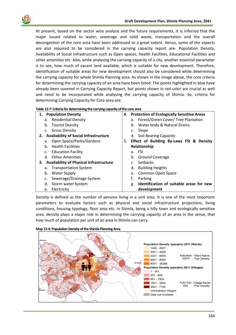
164
Draft Development Plan, Shimla Planning Area, 2041
At present, based on the sector wise analysis and the future requirements, it is inferred that the
major issued related to water, sewerage and solid waste, transportation and the overall
decongestion of the core area have been addressed to a great extent. Hence, some of the aspects
are also required to be considered in the carrying capacity report are- Population Density,
Availability of Social Infrastructure such as Open spaces, Health Facilities, Educational Facilities and
other amenities etc. Also, while analysing the carrying capacity of a city, another essential parameter
is to see, how much of vacant land available, which is suitable for new development. Therefore,
identification of suitable areas for new development should also be considered while determining
the carrying capacity for whole Shimla Planning area. As shown in the image above, the core criteria
for determining the carrying capacity of an area have been listed. The points highlighted in blue have
already been covered in Carrying Capacity Report, but points shown in red color are crucial as well
and need to be incorporated while analysing the carrying capacity of Shimla. So, criteria for
determining Carrying Capacity for Core area are:
Table 12-7: Criteria for determining the carrying capacity of the core area
1. Population Density a. Residential Density b. Tourist Density c. Gross Density
2. Availability of Social Infrastructure a. Open Space/Parks/Gardens b. Health Facilities c. Education Facility d. Other Amenities
3. Availability of Physical Infrastructure a. Transportation System b. Water Supply c. Sewerage/Drainage System d. Storm water System e. Electricity
4. Protection of Ecologically Sensitive Areas a. Forest/Green Cover/ Tree Plantation b. Water body & Natural Drains c. Slope d. Soil Bearing Capacity
5. Effect of Building By-Laws FSI & Density Relationship a. FSI b. Ground Coverage c. Setbacks d. Building Heights e. Common Open Space f. Parking g. Identification of suitable areas for new
development
Density is defined as the number of persons living in a unit area. It is one of the most important
parameters to evaluate factors such as physical and social infrastructure projections, living
conditions, housing typology, floor area etc. in Shimla, being a hilly town and ecologically sensitive
area, density plays a major role in determining the carrying capacity of an area in the sense, that
how much of population per unit of an area in Shimla can carry.
Map 12-4: Population Density of the Shimla Planning Area
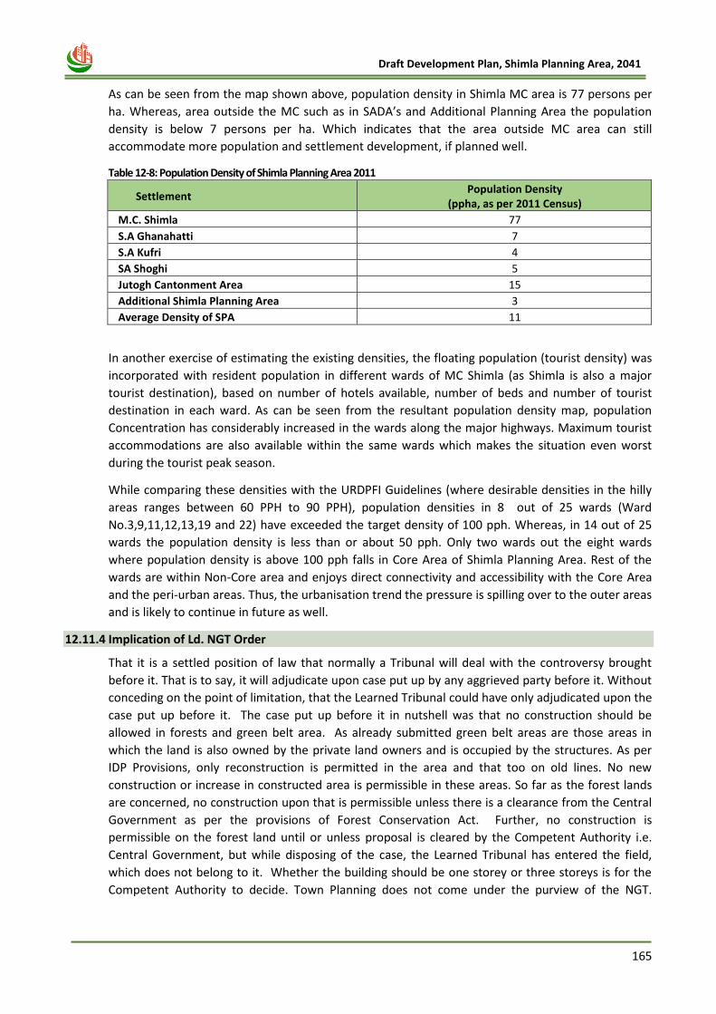
165
Draft Development Plan, Shimla Planning Area, 2041
As can be seen from the map shown above, population density in Shimla MC area is 77 persons per
ha. Whereas, area outside the MC such as in SADA’s and Additional Planning Area the population
density is below 7 persons per ha. Which indicates that the area outside MC area can still
accommodate more population and settlement development, if planned well.
Table 12-8: Population Density of Shimla Planning Area 2011
Settlement Population Density
(ppha, as per 2011 Census)
M.C. Shimla 77
S.A Ghanahatti 7
S.A Kufri 4
SA Shoghi 5
Jutogh Cantonment Area 15
Additional Shimla Planning Area 3
Average Density of SPA 11
In another exercise of estimating the existing densities, the floating population (tourist density) was
incorporated with resident population in different wards of MC Shimla (as Shimla is also a major
tourist destination), based on number of hotels available, number of beds and number of tourist
destination in each ward. As can be seen from the resultant population density map, population
Concentration has considerably increased in the wards along the major highways. Maximum tourist
accommodations are also available within the same wards which makes the situation even worst
during the tourist peak season.
While comparing these densities with the URDPFI Guidelines (where desirable densities in the hilly
areas ranges between 60 PPH to 90 PPH), population densities in 8 out of 25 wards (Ward
No.3,9,11,12,13,19 and 22) have exceeded the target density of 100 pph. Whereas, in 14 out of 25
wards the population density is less than or about 50 pph. Only two wards out the eight wards
where population density is above 100 pph falls in Core Area of Shimla Planning Area. Rest of the
wards are within Non-Core area and enjoys direct connectivity and accessibility with the Core Area
and the peri-urban areas. Thus, the urbanisation trend the pressure is spilling over to the outer areas
and is likely to continue in future as well.
12.11.4 Implication of Ld. NGT Order
That it is a settled position of law that normally a Tribunal will deal with the controversy brought
before it. That is to say, it will adjudicate upon case put up by any aggrieved party before it. Without
conceding on the point of limitation, that the Learned Tribunal could have only adjudicated upon the
case put up before it. The case put up before it in nutshell was that no construction should be
allowed in forests and green belt area. As already submitted green belt areas are those areas in
which the land is also owned by the private land owners and is occupied by the structures. As per
IDP Provisions, only reconstruction is permitted in the area and that too on old lines. No new
construction or increase in constructed area is permissible in these areas. So far as the forest lands
are concerned, no construction upon that is permissible unless there is a clearance from the Central
Government as per the provisions of Forest Conservation Act. Further, no construction is
permissible on the forest land until or unless proposal is cleared by the Competent Authority i.e.
Central Government, but while disposing of the case, the Learned Tribunal has entered the field,
which does not belong to it. Whether the building should be one storey or three storeys is for the
Competent Authority to decide. Town Planning does not come under the purview of the NGT.
166
Draft Development Plan, Shimla Planning Area, 2041
Further the state of Himachal Pradesh is not a non-compliant State. It has been taking care of
environment and has also been taking care of Town Planning.
The Town Planning Act came into force in the year 1977 and different plans for different planning
areas were formulated and these plans have been formulated after taking all possible care with
regard to Town Planning and the factors relevant to Town Planning. For example for Shimla Planning
Area, the appellant has done Zoning of areas. Some areas are in the Heritage Zone where carrying
out construction is very difficult, for the reason that the rules and regulations are very stringent and
different Committees are involved in getting clearances including getting clearance from State
Heritage Advisory Committee. Certain areas fall within core areas where only limited construction is
permitted.
12.11.5 Building Construction vis-à-vis EIA Notification, 2006, MoEF
In the State of Himachal Pradesh, entire construction activities including sanction of maps of a
proposed structure/building falls under the purview of Town & Country Planning Act, 1977 legislated
by the State legislature. The Town & Country Planning Department consists of experts relating to
architecture and town and country planning and when an application for erecting a proposed
structure in a particular area comes for sanction before the department, the department looks into
all the aspects of a proposed building and only once the department is satisfied then only the map of
the proposed building is sanctioned. Moreover, as per the EIA Notification 2006 issued by the
Ministry of Environment, Forest & Climate Change, Govt. of India (herein after referred to as
“MoEF”), which envisages that any construction which is proposed and is having less than 20,000
square metres of built area then all such constructions are exempted from taking any Environmental
Clearance from any authority i.e. SEIAA or EAC of MoEF. Thus in view of the above, the Hon’ble
Tribunal failed to appreciate that by way of impugned judgment, the Hon’ble Tribunal has rendered
the law ineffective in as much as the Hon’ble Tribunal has been pleased to direct the appellant State
that no new construction will be permitted beyond 2 storeys plus attic floor.
Further as per the EIA Notification issued by MoEF, it is mentioned therein that any construction can
be carried out which is less than 20,000 square metres without obtaining EC from respective
authority and it is understood that EIA Notification is the Bible for Environmental issues and this law
also does not prohibit construction less than 20,000 square metres, however by way of impugned
judgment the Ld. Tribunal has sat over and above the law without declaring the law existing as ultra
vires which is violative of Article 14 of the Constitution of India in as much as though the law permits
construction up to 20,000 square metres of built up area without any sanction or EC from any
authority but as far as Shimla is concerned the said law remains ineffective as the impugned
judgment has directed the appellant State to not to permit any construction beyond 2 storeys plus
attic floor.
12.11.6 Urbanisation Aspects
Further, the aspects relating to the urbanization of Shimla City, it is imperative to point out here that
Shimla has been playing multiple roles including administrative, educational, tourist centre and
heritage city. This has led to the formation of a primate city in the State and consequently it is
growing rapidly. With growing population, greenery in Shimla is fast disappearing due to
construction sprawling outside the municipal areas and in the forests. Shimla is experiencing massive
growth in the form of unplanned ribbon development along the highways and roads emanating from
the city. Along with highways, the city slopes are also experiencing urban sprawl reducing forest and
agricultural area
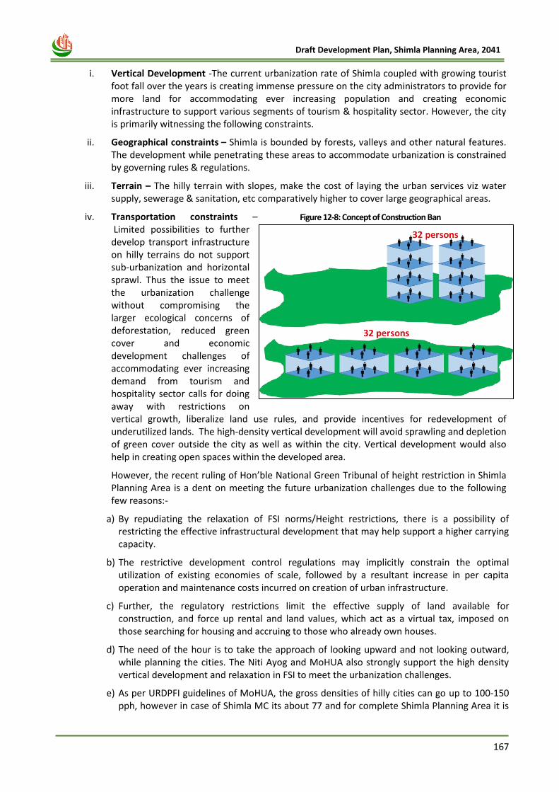
167
Draft Development Plan, Shimla Planning Area, 2041
i. Vertical Development -The current urbanization rate of Shimla coupled with growing tourist
foot fall over the years is creating immense pressure on the city administrators to provide for more land for accommodating ever increasing population and creating economic infrastructure to support various segments of tourism & hospitality sector. However, the city is primarily witnessing the following constraints.
ii. Geographical constraints – Shimla is bounded by forests, valleys and other natural features. The development while penetrating these areas to accommodate urbanization is constrained by governing rules & regulations.
iii. Terrain – The hilly terrain with slopes, make the cost of laying the urban services viz water supply, sewerage & sanitation, etc comparatively higher to cover large geographical areas.
iv. Transportation constraints – Limited possibilities to further develop transport infrastructure on hilly terrains do not support sub-urbanization and horizontal sprawl. Thus the issue to meet the urbanization challenge without compromising the larger ecological concerns of deforestation, reduced green cover and economic development challenges of accommodating ever increasing demand from tourism and hospitality sector calls for doing away with restrictions on vertical growth, liberalize land use rules, and provide incentives for redevelopment of underutilized lands. The high-density vertical development will avoid sprawling and depletion of green cover outside the city as well as within the city. Vertical development would also help in creating open spaces within the developed area.
However, the recent ruling of Hon’ble National Green Tribunal of height restriction in Shimla Planning Area is a dent on meeting the future urbanization challenges due to the following few reasons:-
a) By repudiating the relaxation of FSI norms/Height restrictions, there is a possibility of restricting the effective infrastructural development that may help support a higher carrying capacity.
b) The restrictive development control regulations may implicitly constrain the optimal utilization of existing economies of scale, followed by a resultant increase in per capita operation and maintenance costs incurred on creation of urban infrastructure.
c) Further, the regulatory restrictions limit the effective supply of land available for construction, and force up rental and land values, which act as a virtual tax, imposed on those searching for housing and accruing to those who already own houses.
d) The need of the hour is to take the approach of looking upward and not looking outward, while planning the cities. The Niti Ayog and MoHUA also strongly support the high density vertical development and relaxation in FSI to meet the urbanization challenges.
e) As per URDPFI guidelines of MoHUA, the gross densities of hilly cities can go up to 100-150 pph, however in case of Shimla MC its about 77 and for complete Shimla Planning Area it is
Figure 12-8: Concept of Construction Ban
168
Draft Development Plan, Shimla Planning Area, 2041
10 ppha only, which presents that, if city is developed in planned manner and incorporates the densification strategy it can maintain the balance between development and ecology.
f) Also, most of the old buildings existing on the Mall Road Shimla are 4 to 5 storeyed and the construction of these buildings had been raised from either the Lower Bazar or Middle Bazar Shimla. Thus restricting the rebuilt buildings to a maximum of two and half storeyed would lead to a situation where the Mall Road would cease to exist. It would not be possible to have any shops, showrooms or flat on the Mall Road Shimla as two and half storeys of the reconstructed building would be completed much below the present Mall Road Shimla. There are different owners/occupants of different floors of such buildings and restricting the reconstruction of these buildings to only two and half storeys would not only lead to various disputes but would also deprive the owners/occupants of their property without any authority of law and in gross violation of Article 300-A of the Constitution of India.
g) The impugned judgment /order of the Hon’ble National Green Tribunal is also violative of Principle of natural justice as no opportunity of being heard was afforded to other affected persons of the locality against whom the order is passed. The orders would also adversely affect the rights of co-owners of old properties having more than two stories in a building owned by more than 2 co-owners, if it is to be reconstructed. The Constitution makers bestowed right on every citizen of the Country to acquire, hold and dispose of property and also provided ample safeguards against deprivation of the property by Legislature by confining such deprivation for public purpose only and only on payment of compensation to the expropriated owner either by fixing the amount of compensation or by specifying the principles upon which it could be determined or fixed. As such the impugned judgment/ order is against the provisions of Article 300-A of the Indian Constitution which provides that no person shall be deprived of his right to property save by the authority of law. Further it has been provided under article 19 (1) (g) of Constitution of India the right to practice any profession or to carry out any occupation, trade or business to all is citizens.
h) Building height up to 18 to 21 mts. is accepted as low rise development as per the fire norms, URDPFI guidelines and some of city master plans having same profile. Same can be followed (including top of sloping roof, solar panels, lift rooms etc.). In order to cater to the housing demand and other livelihood demand of growing local population of Shimla, new construction is required in Shimla Planning area and core area. Various proposals in shape of the recommendations that form part and parcel of the Shimla Smart City Project include retrofitting old area, decongesting Shimla, improving mobility, water supply, sanitation and solid waste management, ICT services, eco-friendly development, etc. These proposals are planned to provide adequate infrastructure to the local population. For these reconstructions/ retrofitting should be permissible on old lines and as per the existing Statutes, subject to permissible slope and soil conditions. The construction in core area may be permitted strictly in accordance with the provisions of Town & Country Planning Act, Development Plan and Municipal Bye-law in force.
12.12 Building By-laws with respect to NGT’s Carrying Capacity Report
Building regulations are the root cause of many issues of built environment of cities. . In many cases
the local governments adopt the building bye-laws of other cities/ Specified in the State/ Central
Guidelines. Every city has its unique context in terms of its location, geology, topography, climate
and neglecting these factors would cause a great harm to not just the citizens who resides in these
cities but also affect the natural environment, flora and fauna etc. In Shimla, Frequent changes in the
building byelaws – permissible height, F.A.R., ground coverage, issuance of completion certificates at
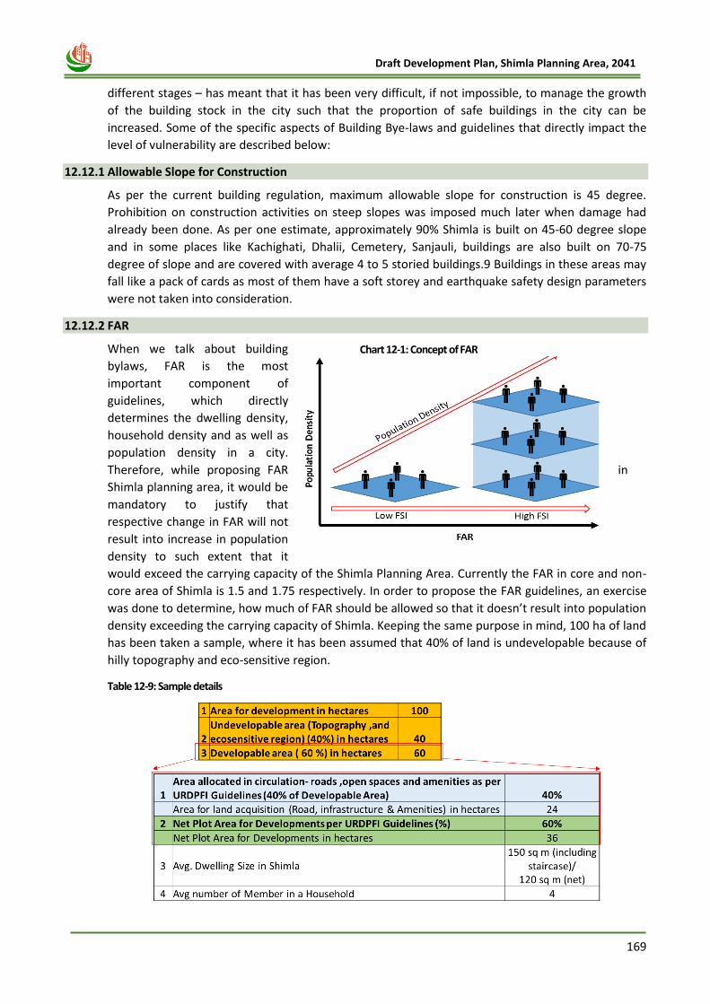
169
Draft Development Plan, Shimla Planning Area, 2041
different stages – has meant that it has been very difficult, if not impossible, to manage the growth
of the building stock in the city such that the proportion of safe buildings in the city can be
increased. Some of the specific aspects of Building Bye-laws and guidelines that directly impact the
level of vulnerability are described below:
12.12.1 Allowable Slope for Construction
As per the current building regulation, maximum allowable slope for construction is 45 degree.
Prohibition on construction activities on steep slopes was imposed much later when damage had
already been done. As per one estimate, approximately 90% Shimla is built on 45-60 degree slope
and in some places like Kachighati, Dhalii, Cemetery, Sanjauli, buildings are also built on 70-75
degree of slope and are covered with average 4 to 5 storied buildings.9 Buildings in these areas may
fall like a pack of cards as most of them have a soft storey and earthquake safety design parameters
were not taken into consideration.
12.12.2 FAR
When we talk about building
bylaws, FAR is the most
important component of
guidelines, which directly
determines the dwelling density,
household density and as well as
population density in a city.
Therefore, while proposing FAR in
Shimla planning area, it would be
mandatory to justify that
respective change in FAR will not
result into increase in population
density to such extent that it
would exceed the carrying capacity of the Shimla Planning Area. Currently the FAR in core and non-
core area of Shimla is 1.5 and 1.75 respectively. In order to propose the FAR guidelines, an exercise
was done to determine, how much of FAR should be allowed so that it doesn’t result into population
density exceeding the carrying capacity of Shimla. Keeping the same purpose in mind, 100 ha of land
has been taken a sample, where it has been assumed that 40% of land is undevelopable because of
hilly topography and eco-sensitive region.
Table 12-9: Sample details
Chart 12-1: Concept of FAR
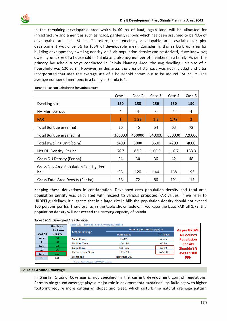
170
Draft Development Plan, Shimla Planning Area, 2041
In the remaining developable area which is 60 ha of land, again land will be allocated for
infrastructure and amenities such as roads, gardens, schools which has been assumed to be 40% of
developable area i.e. 24 ha. Therefore, the remaining developable area available for plot
development would be 36 ha (60% of developable area). Considering this as built up area for
building development, dwelling density vis-à-vis population density can be derived, if we know avg
dwelling unit size of a household in Shimla and also avg number of members in a family. As per the
primary household surveys conducted in Shimla Planning Area, the avg dwelling unit size of a
household was 130 sq m. However, in this area, the area of staircase was not included and after
incorporated that area the average size of a household comes out to be around 150 sq. m. The
average number of members in a family in Shimla is 4.
Table 12-10: FAR Calculation for various cases
Case 1 Case 2 Case 3 Case 4 Case 5
Dwelling size 150 150 150 150 150
HH Member size 4 4 4 4 4
FAR 1 1.25 1.5 1.75 2
Total Built up area (ha) 36 45 54 63 72
Total Built up area (sq m) 360000 450000 540000 630000 720000
Total Dwelling Unit (sq m) 2400 3000 3600 4200 4800
Net DU Density (Per ha) 66.7 83.3 100.0 116.7 133.3
Gross DU Density (Per ha) 24 30 36 42 48
Gross Dev Area Population Density (Per ha) 96 120 144 168 192
Gross Total Area Density (Per ha) 58 72 86 101 115
Keeping these derivations in consideration, Developed area population density and total area
population density was calculated with respect to various proposed FAR values. If we refer to
URDPFI guidelines, it suggests that in a large city in hills the population density should not exceed
100 persons per ha. Therefore, as in the table shown below, if we keep the base FAR till 1.75, the
population density will not exceed the carrying capacity of Shimla.
Table 12-11: Developed Area Densities
12.12.3 Ground Coverage
In Shimla, Ground Coverage is not specified in the current development control regulations.
Permissible ground coverage plays a major role in environmental sustainability. Buildings with higher
footprint require more cutting of slopes and trees, which disturb the natural drainage pattern
171
Draft Development Plan, Shimla Planning Area, 2041
subsequently. Due to less percolation of rainwater into ground, higher runoff in Shimla may lead to
soil erosion and destabilize the slopes. Therefore, in proposed building by-laws it is important to
introduce the provision of Ground Coverage.
12.12.4 Building Height
• Maximum permissible height of residential buildings is 18 m in core area and 21 m in non-core area
of Shimla Planning Area. Height of a floor has been fixed at 2.7 m and permissible height of the
parking floor has been now raised to 4m which is not counted in F.A.R. Hence, in non-core area
height of some of the buildings reach upto 7-8 storey. It leads to more construction activity in outer
areas, which are deficient in basic infrastructure. Therefore, before allowing construction with
relaxed by-laws in outer areas, it is essential to provide the planned development with provision of
basic infrastructure.
• Moreover, same height restrictions are in force throughout the town irrespective of slope gradient,
direction, location and size of plot which lead to same population densities in all localities without
consideration of infrastructure, facilities and characteristics of areas. Hence, in newer areas around
Shimla, where development is inevitable in future, new pockets need to be identified for planned
development based on land suitability ( slope, soil, sun light, accessibility to roads).
• Another drawback of permissible building height is the non-consideration of road width which
results into very limited solar light to lower storeys and lack of open spaces. High-rise buildings along
narrow roads also restrict the effectiveness of fire services.
12.12.5 Set Backs
Front, rear and side set back regulations applicable for residential buildings are 2.0m, 1.5m and 1.5m
respectively. As also mentioned in the carrying capacity report, prescribed setbacks are insufficient
for buildings with permissible height of 18 m & 21 m, to have adequate space for emergency
response in case of a major disaster. Therefore, building heights should be reduced for the plots for
smaller size, where, side margins are as low as 2 m and 1.5 m. In other words, building height and
FAR should be proposed with respect to the size of the plot. Moreover, proposed building height
should be lesser in the core area, as the capacity to accommodate more population in that area is
already not much.
12.12.6 Common Open Space
There is no provision of common open space in the current building byelaws, which leads to
construction of large buildings with insufficient light and ventilation. Thus in proposed guidelines, for
the plots having area more than 1000 sq m, it would be mandatory to leave some space as
“Common Ground” or “Common space”, which can be used for gardening or parking as per
individual requirement.
12.12.7 Parking
Parking provisions in existing building byelaws have not been adequate. Ban by NGT of 2 floors plus
attic on building construction doesn’t encourages citizens to make separate floor for parking either.
In proposed bye-laws, sufficient mandatory provision parking should be introduced with respect to
the size of the plot and to the land-use.
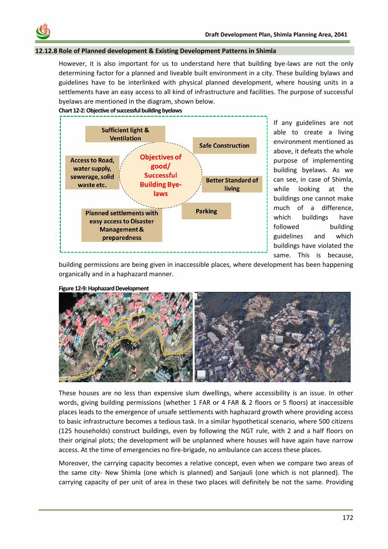
172
Draft Development Plan, Shimla Planning Area, 2041
12.12.8 Role of Planned development & Existing Development Patterns in Shimla
However, it is also important for us to understand here that building bye-laws are not the only
determining factor for a planned and liveable built environment in a city. These building bylaws and
guidelines have to be interlinked with physical planned development, where housing units in a
settlements have an easy access to all kind of infrastructure and facilities. The purpose of successful
byelaws are mentioned in the diagram, shown below. Chart 12-2: Objective of successful building byelaws
If any guidelines are not
able to create a living
environment mentioned as
above, it defeats the whole
purpose of implementing
building byelaws. As we
can see, in case of Shimla,
while looking at the
buildings one cannot make
much of a difference,
which buildings have
followed building
guidelines and which
buildings have violated the
same. This is because,
building permissions are being given in inaccessible places, where development has been happening
organically and in a haphazard manner.
Figure 12-9: Haphazard Development
These houses are no less than expensive slum dwellings, where accessibility is an issue. In other
words, giving building permissions (whether 1 FAR or 4 FAR & 2 floors or 5 floors) at inaccessible
places leads to the emergence of unsafe settlements with haphazard growth where providing access
to basic infrastructure becomes a tedious task. In a similar hypothetical scenario, where 500 citizens
(125 households) construct buildings, even by following the NGT rule, with 2 and a half floors on
their original plots; the development will be unplanned where houses will have again have narrow
access. At the time of emergencies no fire-brigade, no ambulance can access these places.
Moreover, the carrying capacity becomes a relative concept, even when we compare two areas of
the same city- New Shimla (one which is planned) and Sanjauli (one which is not planned). The
carrying capacity of per unit of area in these two places will definitely be not the same. Providing
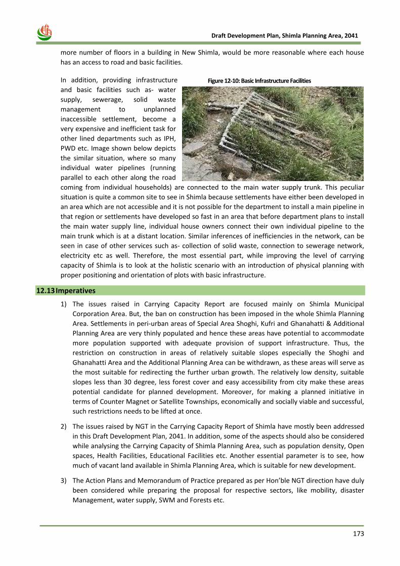
173
Draft Development Plan, Shimla Planning Area, 2041
more number of floors in a building in New Shimla, would be more reasonable where each house
has an access to road and basic facilities.
In addition, providing infrastructure
and basic facilities such as- water
supply, sewerage, solid waste
management to unplanned
inaccessible settlement, become a
very expensive and inefficient task for
other lined departments such as IPH,
PWD etc. Image shown below depicts
the similar situation, where so many
individual water pipelines (running
parallel to each other along the road
coming from individual households) are connected to the main water supply trunk. This peculiar
situation is quite a common site to see in Shimla because settlements have either been developed in
an area which are not accessible and it is not possible for the department to install a main pipeline in
that region or settlements have developed so fast in an area that before department plans to install
the main water supply line, individual house owners connect their own individual pipeline to the
main trunk which is at a distant location. Similar inferences of inefficiencies in the network, can be
seen in case of other services such as- collection of solid waste, connection to sewerage network,
electricity etc as well. Therefore, the most essential part, while improving the level of carrying
capacity of Shimla is to look at the holistic scenario with an introduction of physical planning with
proper positioning and orientation of plots with basic infrastructure.
12.13 Imperatives
1) The issues raised in Carrying Capacity Report are focused mainly on Shimla Municipal
Corporation Area. But, the ban on construction has been imposed in the whole Shimla Planning
Area. Settlements in peri-urban areas of Special Area Shoghi, Kufri and Ghanahatti & Additional
Planning Area are very thinly populated and hence these areas have potential to accommodate
more population supported with adequate provision of support infrastructure. Thus, the
restriction on construction in areas of relatively suitable slopes especially the Shoghi and
Ghanahatti Area and the Additional Planning Area can be withdrawn, as these areas will serve as
the most suitable for redirecting the further urban growth. The relatively low density, suitable
slopes less than 30 degree, less forest cover and easy accessibility from city make these areas
potential candidate for planned development. Moreover, for making a planned initiative in
terms of Counter Magnet or Satellite Townships, economically and socially viable and successful,
such restrictions needs to be lifted at once.
2) The issues raised by NGT in the Carrying Capacity Report of Shimla have mostly been addressed
in this Draft Development Plan, 2041. In addition, some of the aspects should also be considered
while analysing the Carrying Capacity of Shimla Planning Area, such as population density, Open
spaces, Health Facilities, Educational Facilities etc. Another essential parameter is to see, how
much of vacant land available in Shimla Planning Area, which is suitable for new development.
3) The Action Plans and Memorandum of Practice prepared as per Hon’ble NGT direction have duly
been considered while preparing the proposal for respective sectors, like mobility, disaster
Management, water supply, SWM and Forests etc.
Figure 12-10: Basic Infrastructure Facilities
174
Draft Development Plan, Shimla Planning Area, 2041
4) Conservation of forests/green areas in such ecologically sensitive area is very important. 17
Green Belts were identified in SMC Area, which covers an area of 414.46 ha. The forest boundary
of these existing 17 green belts, when delineated at initial levels was not so accurate. Moreover,
in existing Green Belts area, 24.17% (100.14) area is under the Private ownership of which only
6.28% (26 ha) is open and developable land. The owners of these parcels have been facing issues
as no development can be done on these land chunks, and they cannot sell their land to anyone.
Some provisions should be provided such as – TDR or some relaxations should be given for
carrying out very limited development activity in vacant and sandwiched plots for residential
purposes at least. Furthermore, around 10662 Ha. area is under the forest cover with in the
Shimla Planning Area. These areas should also be notified and demarcated in advance to protect,
as the development in these areas is inevitable in future.
5) When Carrying Capacity Report was prepared, there was a water scarcity in Shimla region. But
after May 2018 water crises, there has been a considerable improvement and augmentation in
the Water Supply System. The Current Water Supply fulfils the existing water demand with daily
basis water supply. Augmentation of new schemes such as one at Ghuma has added the daily
water supply in Shimla by 10 MLD. Moreover, the project of lifting water from Satluj River has
already been initiated, which will meet all the water demand of projected population by 2040.
6) As per the NGT orders, only 2+Attic floors are allowed to be constructed in Shimla Planning Area.
These restrictions are unlikely to hamper the prevailing growth and urbanization trend. Any ban
or development through implementation of restricted building height will not stop the
population growth, both residents as well as floating population. One can only redirect the
growth to more suitable areas through relaxation of FAR, number of floors and building height in
some areas and with more restrictions in the other areas. In fact, with the restriction of 2 floor +
attic building height in the whole Shimla Planning Area, more land area will be required in order
to accommodate the future population which will result in more horizontal development
creating more building footprint along with carbon footprint in the region.
7) However, keeping the ecological sensitivity of the whole region and increased population
densities and the limited carrying capacity in some parts of the Shimla Core area, building
regulations needs reconsideration. Moreover, provision of ground coverage and common plot
(with respect to the size of plot) and abutting road width should be introduced in building by-
laws, which will ensure lesser ecological footprint, especially in case of bigger size of plots.
Observing the existing parking and road encroachment issue in entire Shimla, provision of
parking space should be mandatory in bye-laws in residential, commercial and public/semi-
public land-uses.
8) In the Non-Core area, which comprises 98.5% of total area under SPA, there are large stretches
of privately owned land having high potential and scope for planned development. Therefore, in
order to shift the urbanisation pressure from the Core Area, i.e. congested MC Area, planned
development with higher building height and FAR can be considered in outer areas.
9) Further, the focus on decongesting the Core Area as emphasised by the Hon’ble NGT and various
reports, especially the previous Draft Development Plan exercises undertaken by the
Department has been achieved to an extent over last decade and is being continued through the
proposals of this Draft Development Plan.
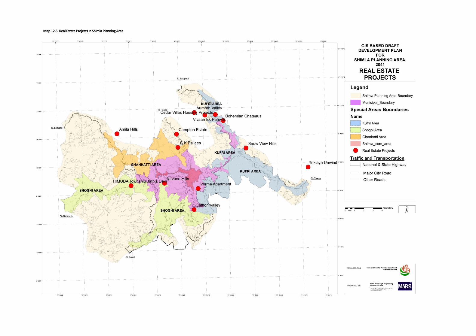
Map 12-5: Real Estate Projects in Shimla Planning Area
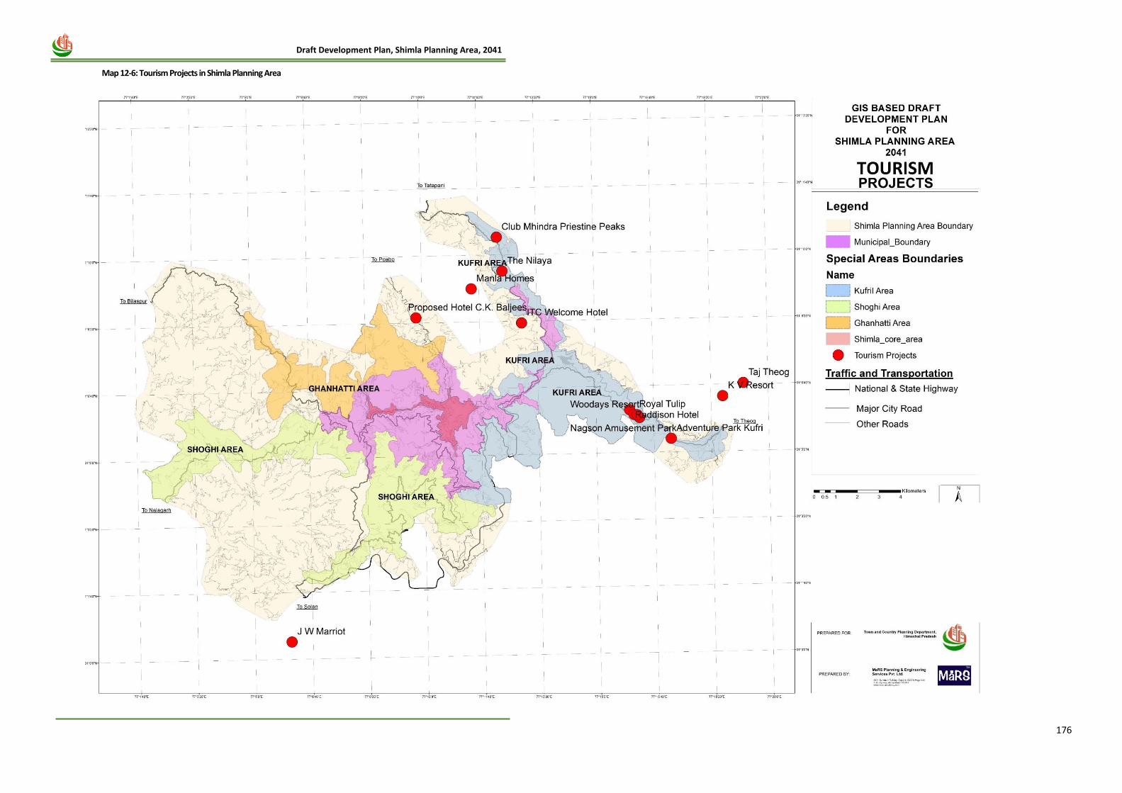
176
Draft Development Plan, Shimla Planning Area, 2041
Map 12-6: Tourism Projects in Shimla Planning Area
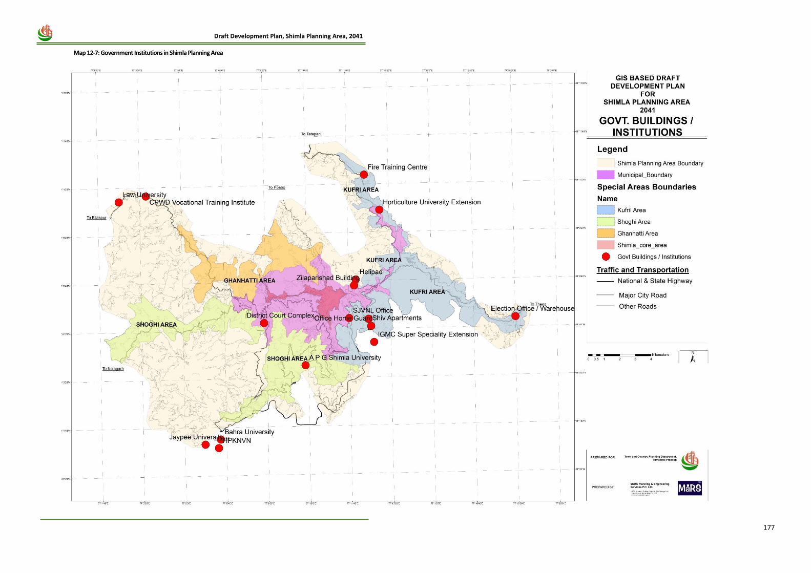
177
Draft Development Plan, Shimla Planning Area, 2041
Map 12-7: Government Institutions in Shimla Planning Area
178
Draft Development Plan, Shimla Planning Area, 2041
10) Based on the spatial analysis of location and scale of various large-scale projects, especially Govt.
projects, Institutional, Tourism and Real Estate projects, which have come up in last 5-7 years
and are under implementation stage, it is evident that the objective of decongestion of the Core
Area is being implemented vigorously and has been achieved to a great extent. The maps
prepared w.r.t location of these large-scale projects clearly shows that the new investment in
Tourism sector is moving to the fringes and peri-urban areas i.e. SADA and Additional Planning
Area and even outside the planning area in some cases. Same trend is also evident in case of
Planned Real Estate projects as well, which are contributing substantially to meet the growing
housing demand in a planned manner. Thus, being planned projects taking due care of all
support services and environmental imperatives, the restriction needs reconsideration especially
in Non-Core Area.
11) Land being a valuable yet scarce resource, its optimum and effective utilisation to accommodate
the future urbanisation pressure needs to be done, especially in outer fringe areas, which are
more suitable for development.
12) Further, the Core Area i.e. the MC Shimla has greatly benefited from the flagship programmes
like AMRUT Scheme and Smart City Mission wherein focus has been on improvement of basic
city infrastructure and services as well as redevelopment of dilapidated market areas, which
gives the city its image and values.
12.14 Recommendations and strategies adopted for conservation of Environment and ecology:
1. Forests Preservation Strategies:
• To increase the forest cover it is proposed that the forest Department shall plant pine trees in
the vacant govt. land patches and steep slopes under ambitious tree planting programs
combined with natural expansion of forests. The Massive plantation and landscaping is
required to be ensured in the entire Shimla Planning Area. Species of trees, plants needs to be
identified for specific areas so that the plants survive in these conditions.
• In 17 green belt areas and remaining forests, no cutting trees is strictly banned.
• Development in green belt areas on private land has been allowed only at 1 FAR, 2 floors of
restriction and 50% of ground coverage.
• Moreover, in a phased manner, more forest land are required to be added in green areas, based
on revenue and ownership details, as Shimla planning area has 43% of land area which falls
under, forests, tree clad area and plantation areas.
2. Promoting eco- tourism and forest based adventure tourism: The eco-tourism development
approach, based on natural preservation imperatives has been promoted in Shimla Development
Plan 2041 proposals. Through the recognition of interface between tourism, heritage and
environment, various forest and adventure based activities such as natural walks, zip linings,
camping, night trails, nature games and trekking should be envisaged for the Shimla.
3. Storm water Drains Conservation: As already mentioned, Shimla has 13 major nallahs and number
of minor nallahs, which are natural drains for rain water and off late for waste water too. In order to
preserve the hydrology around these water streams, no construction would be permitted within the
periphery of 5 m buffer along Nallah and 10 m of buffer along Khads
4. Introduction of Ground Coverage in Building bye-laws: Permissible ground coverage plays a major
role in environmental sustainability. Buildings with higher footprint require more cutting of slopes
and trees, which disturb the natural drainage pattern subsequently. Due to less percolation of
rainwater into ground, higher runoff in Shimla may lead to soil erosion and destabilize slopes. Hence,
179
Draft Development Plan, Shimla Planning Area, 2041
for bigger size of plots, other than side margins, components of ground coverage has also been
provided in building bye-laws
5. Consideration of Slope and land suitability for new areas for development: While introducing new
parcels of land for development, land suitability analysis has been done with the help of GIS base-
map. Hence, identification of new land has been proposed on ground of suitable land, which has not
been proposed over the forests areas and areas having slope more than 45 degree.
6. Measurements for earthquake disaster vulnerability: For construction of stable buildings, the
submission of Structural stability certificate is mandatory.
7. Rain water harvesting: Rain water harvesting system is mandatory per TCP law. However, in coming
future, duel plumbing system can be introduced.
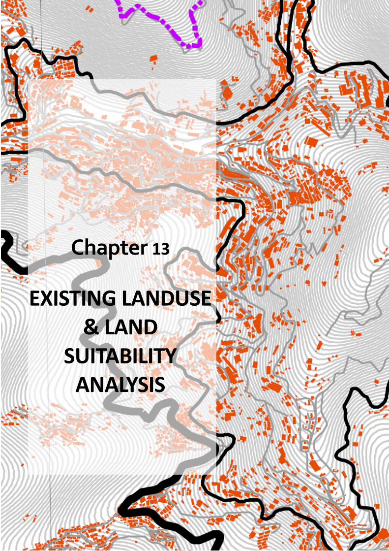
180
Draft Development Plan, Shimla Planning Area, 2041
Chapter 13
EXISTING LANDUSE & LAND
SUITABILITY ANALYSIS
181
Draft Development Plan, Shimla Planning Area, 2041
13 CHAPTER- 13 EXISTING LAND-USE & LAND SUITABILITY ANALYSIS
13.1 Introduction
The rational application of the planning process in the preparation of the future Land Use Plan is
possible only when there is a clear understanding of existing conditions and relationships between
land uses. Knowledge of existing land development furnishes the basic information by which
decisions can be made concerning proposals for future residential, commercial, industrial, and public
land use activities. The Existing Land Use Map and table, which are included in this section of the
report, will serve as a ready reference for the town in its consideration for land use management
and infrastructure improvement proposals.
13.2 Methodology for the preparation of Base-map The preparation of base map has been done in accordance with the guidelines of NRSC & training conducted by TCPO. The different stages involved in the preparation of the Base Map have been described below: STEP 1: Boundary Identification with census maps The updated census maps were collected for the year 2011 for all the town and villages covered under project area and their village boundary was generated from these census maps. The overall project boundary was also identified using census maps. STEP 2: Procurement of landuse data from NRSC Hyderabad The satellite map/ landuse sheets of the project area was collected from NRSC Hyderabad and the same was processed according to the requirement. STEP 3: Existing land-use survey Spatial attribute collection and vetting of Base Map was done in form of field surveys and data entry in Excel Proforma. In Shimla Planning Area, we there were A0 size 1136 sheets/grids with approximately 40,000 building units. STEP 4: Primary Ground Verification / Truthing by the TCP Dept First level ground verification/truthing was done by the TCP Department to verify the land-use map prepared from the existing land use survey above. STEP 5: Preparation of preliminary base-map After ground truthing and vetting the data sheets were sent back to NRSC for preparation of final base map containing all layers as per AMRUT Scheme Design and Guidelines. STEP 6: Creation of updated base-map The preliminary base map was updated by NRSC following the ground truthing process and existing land-use maps and proposed land-use maps were generated from these updated base-map.
13.3 Existing Land Use of Shimla Planning Area
The study of the existing land use pattern reveals that over the years the city has spread more in
south east and east direction along the major highways those are connecting Shimla Municipal
Corporation to Kufri Special Area.
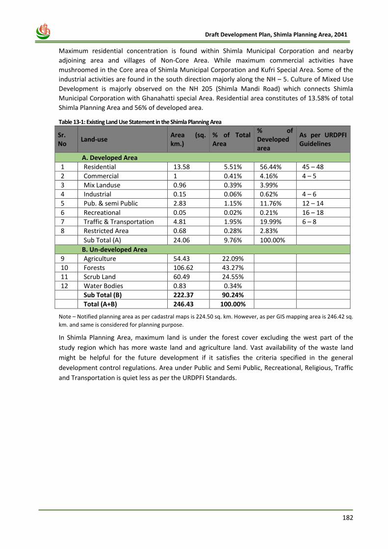
182
Draft Development Plan, Shimla Planning Area, 2041
Maximum residential concentration is found within Shimla Municipal Corporation and nearby
adjoining area and villages of Non-Core Area. While maximum commercial activities have
mushroomed in the Core area of Shimla Municipal Corporation and Kufri Special Area. Some of the
industrial activities are found in the south direction majorly along the NH – 5. Culture of Mixed Use
Development is majorly observed on the NH 205 (Shimla Mandi Road) which connects Shimla
Municipal Corporation with Ghanahatti special Area. Residential area constitutes of 13.58% of total
Shimla Planning Area and 56% of developed area.
Table 13-1: Existing Land Use Statement in the Shimla Planning Area
Sr. No
Land-use Area (sq. km.)
% of Total Area
% of Developed area
As per URDPFI Guidelines
A. Developed Area
1 Residential 13.58 5.51% 56.44% 45 – 48
2 Commercial 1 0.41% 4.16% 4 – 5
3 Mix Landuse 0.96 0.39% 3.99%
4 Industrial 0.15 0.06% 0.62% 4 – 6
5 Pub. & semi Public 2.83 1.15% 11.76% 12 – 14
6 Recreational 0.05 0.02% 0.21% 16 – 18
7 Traffic & Transportation 4.81 1.95% 19.99% 6 – 8
8 Restricted Area 0.68 0.28% 2.83%
Sub Total (A) 24.06 9.76% 100.00%
B. Un-developed Area
9 Agriculture 54.43 22.09%
10 Forests 106.62 43.27%
11 Scrub Land 60.49 24.55%
12 Water Bodies 0.83 0.34%
Sub Total (B) 222.37 90.24%
Total (A+B) 246.43 100.00%
Note – Notified planning area as per cadastral maps is 224.50 sq. km. However, as per GIS mapping area is 246.42 sq.
km. and same is considered for planning purpose.
In Shimla Planning Area, maximum land is under the forest cover excluding the west part of the
study region which has more waste land and agriculture land. Vast availability of the waste land
might be helpful for the future development if it satisfies the criteria specified in the general
development control regulations. Area under Public and Semi Public, Recreational, Religious, Traffic
and Transportation is quiet less as per the URDPFI Standards.
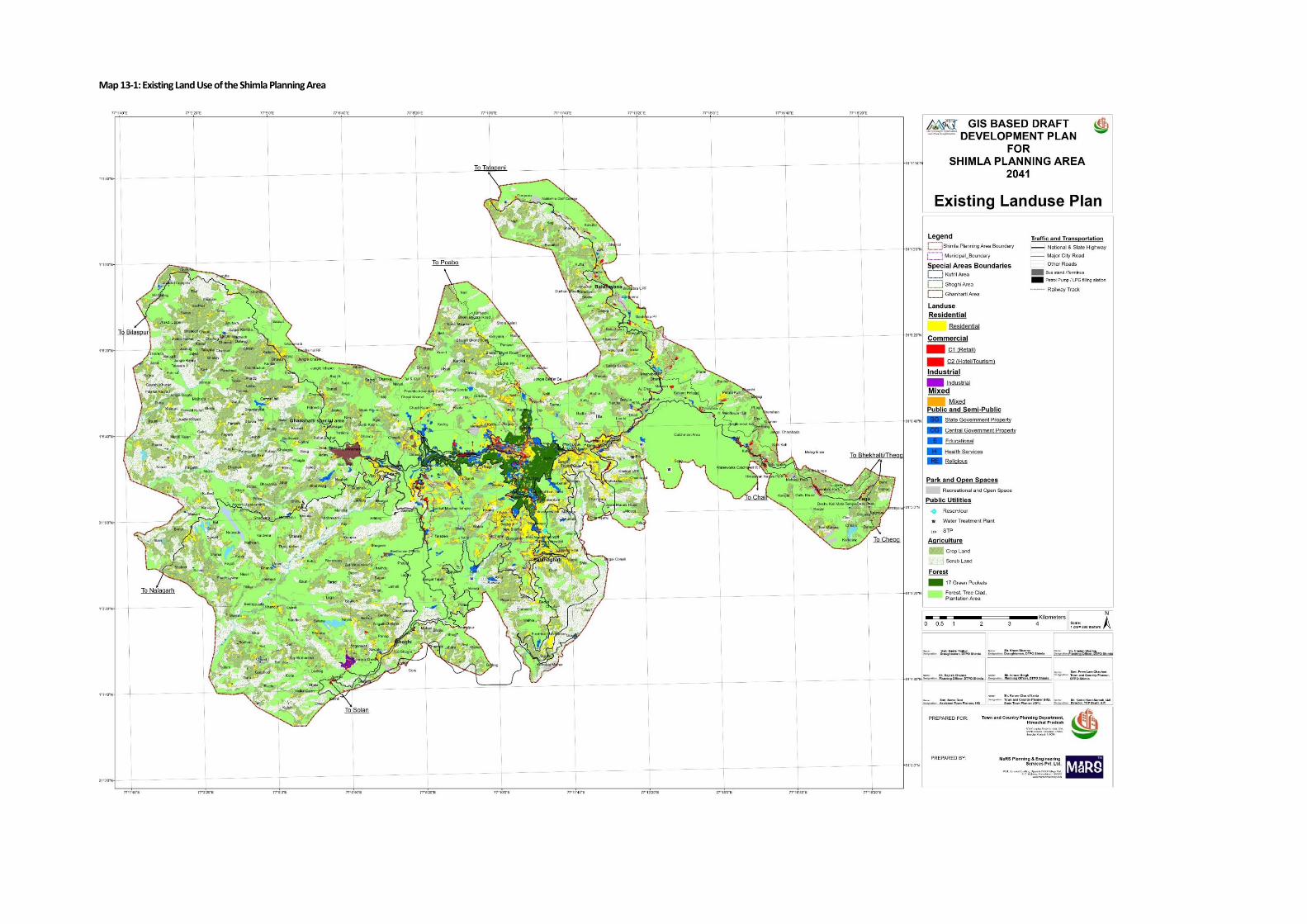
Map 13-1: Existing Land Use of the Shimla Planning Area
The study of existing land use pattern reveals that the city has spread in all directions with major
developments taking place along the main arterial roads passing through the city and along the
south facing ridges in vicinity of the Core Area, where land availability is higher and land values are
relatively lower. Major commercial activities and public-semi-public activities, especially Govt.
institutions and offices have also been concentrated in Core Area of the Shimla town. The land under
primary activity is concentrated along the residential areas in the non-core areas. Many vacant land
parcels are available within the Shimla Planning Area which can be utilized for the development
purpose. The major share of the land is under Forest, Scrub land and Agriculture, i.e. around 43.27%,
24.5% and 22% respectively, of the total Shimla Planning Area. The description of various land use
areas has been given in detail as below:
13.3.1 Residential Use:
The residential activities are concentrated in the existing town area. Majority of the development is
along the major corridors and along the main commercial areas. At present the existing residential
area is 13.58 sq km of area, which includes approximately 43,000 of building units, throughout
whole Shimla Planning Area. These existing prominent residential areas are Sanjauli, Cemetery,
Dhalli, Bhattakufar, Mehli, Kangnadhar, Khalini, Bharari, New Shimla, Vikasnagar, Pathaghati, Tutu,
etc.
13.3.2 Commercial Use:
The commercial activities are concentrated along the main road i.e. NH-5 & NH-205, passing through
the Shimla Planning Area. The commercial activities are concentrated in the core area of the city.
These include Hotels, Restaurants, trade, Commerce, wholesale, vegetable, grain and timber
markets. Existing main shopping centres and complexes are concentrated in and around the Mall in
localities namely, Middle Bazaar, Lower bazaar, Lakkar Bazaar and Chhota Shimla. Other newly
developed commercial areas are in Kasumpti, New Shimla, Dhalli and Boileauganj. At present, the
commercial area in SPA is 1 sq km, which is 0.41% of developed area.
13.3.3 Mix Land-use:
In Shimla Planning Area, the city exhibits mix land-use around the main market areas and along the
main roads, where in a building ground floor is being used for commercial purpose, and floors above
are being used for residential and office purpose. At present, the existing mix- use area comprises of
0.96 sq km of area, which is 0.39% of total developed area.
13.3.4 Industrial use:
Industrial activities are available in Shoghi Special Area and in very small pockets in areas covering
Sanjauli, Lalpani, Shoghi and Totu localities. At present, area under industrial use is around 0.15
sq.km, which is 0.62% of developed area. The area under proposed land use has increased to 0.24 sq
km. which is 0.51% to the total developed area in Proposed land use.
13.3.5 Public Semi Public:
Being a State Capital and Educational Hub of Himachal Pradesh, around 2.83 sq.km. area is available
under the public – semi-public use which is around 11.76% of the developed area. Having status of
capital city, Shimla is equipped with multifarious facilities and services, Govt. & Semi Govt. offices
and specialized institutions. This area of PSP includes the education and health facilities, utilities
such as water supply, sewerage, drainage, electricity, telephone establishments, garbage disposal
sites, services including Police, Banking, Fire Fighting and postal services, other facilities like
cremation ground, graveyard, cinema halls, theatres, sports complex and museum etc.
185
Draft Development Plan, Shimla Planning Area, 2041
13.3.6 Recreational use:
At present, area under recreational activities is around 0.05 sq.km. which is only 0.21% of the
Developed Area. It has been proposed up to 1.13 sq.km. which is around 2.39% of the developed
area.
13.3.7 Traffic & Transportation
The major city traffic and transportation system takes place on seven major roads, which
interconnect with the well-known seven hills of the city. At present, area under traffic and
transportation is around 4.81 sq.km. which is around 19.99% of the developed area. The existing
roads are well inter-connected with the different localities of the core city. However, roads in the
outskirts are not so well developed and sparsely distributed. In core Shimla also, frequent traffic
snarls, congestion, bottlenecks and blind curves are the major problems, which need to be tackled.
13.3.8 Agriculture & Scrub land
At present, agriculture land is around 54.43 sq.km. which is around 22.09% of the total area and
scrub land is 60.49, which is 24.55% of total Shimla Planning Area. As already mentioned, there are
375 villages in Shimla Planning Area. In many of the villages, majority of rural people are engaged in
agricultural activities
13.3.9 Forests
Geographically, Shimla city comes under lesser Himalayas. It has sub-tropical and temperate forests
and it includes the tree species of deodar, pine, Oak, Kail, Rai and rhododendron. Shimla has eco-
sensitive environs. At present, forest area is around 106.62 sq.km. which is around 43.27% of the
total area. Forest area here include forests, tree clad area and plantation areas, which may be
Government and private land as well.
13.3.10 Waterbodies
Shimla has 13 major nallahs and number of minor nallahs, which are natural drains for rain water
and off late for waste water too, this area under water bodies comprises of 0.83 sq.km. which is
0.34% of total Shimla Planning Area.
13.4 Future Land Requirement
Existing Resident Population as per Census of India, 2011 in Shimla Planning Area is around 2,41,429
and existing floating population per day is around 70,000. Presently, total developed area is 24.2 sq.
km. with a developed area density of 100 pph. It is estimated that on an optimistic scenario the
Shimla Planning area will have population of 6,25,127 by the year 2041. As per URDPFI guidelines,
the desired density for a Large size town /medium hilly city should be in between 60 and 90. The
existing developed area in Shimla MC has already crossed that density. However, the densities in
remaining Shimla Planning area are comparatively very lesser. Table 13-2: Existing Scenario
Existing Scenario (2011)
Existing Resident Population (2011) 2,41,429
Existing Floating Population 70,000
Total population 3,11,429
Total Developed area in Shimla Planning Area (sq.km.) 24.2
Developed Area Density 100 Persons per Ha
Total Density (Residential + Floating) 129 Persons per Ha
186
Draft Development Plan, Shimla Planning Area, 2041
As per the URDPFI Standards, Developed area density of the Metropolitan Cities would be around
100 to 150 person per Hecate in the hilly Region.
Table 13-3: Developed Area Density for different size of cities/towns as per URDPFI Guidelines
Settlement Type Persons Per Hectare (PPH)
Plain Areas Hill Areas
Small Towns 75-125 45-75
Medium Towns 100-150 60-90
Large Cities 125-175 60-90
Metropolitan Cities 125-175 100-150 Source: URDPFI, 2014
It has been observed that, around 50% of the total buildings in Shimla Planning area has either 2
floor or 3 floors. Keeping in mind factors like- shortages of land, building construction costs and
increase in the household size etc. it is assumed that in the next 20 years, some of the buildings with
only 2 floor or 3 floors will increase vertically and will become G+3 and around 20% of the existing
population of SMC area will be accommodated in the existing developed area i.e. around 1,25,025
persons. Table 13-4: Projected Area Requirement for Total Population (2041)
Projected Population (2041)
Total
Planning
Area (in
sq.km.)
Developed
Area Density
(PPH)
Total
Developable
Area (in
sq.km)
Already
Developed
Area (in
sq.km)
Required
Additional
Net Area (in
sq.km)
6,25,127 246.09
100 62.51 24.2 38.31
120 52.09 24.2 27.89
Source: Projections for 2041
Thus, for the remaining population i.e. 5,00,101, the land required for catering the future population
is around 38.31 sq km with a population density of 100 pph and 27.89 sqkm with a population
density of 120 pph as shown in the table above. Therefore, the required land has to be identified
based on the suitability analysis of the available vacant land within the planning boundary. Hence, a
detailed analysis of land suitability analysis has been carried out in the next section.
13.5 Land Suitability Analysis
Land suitability is determined by a different set of factors such as slope, drainage, vegetation and
water bodies. Variations can be observed in the characteristics of these factors based on the specific
study areas. These environmental determinants were studied for the entire Shimla Planning Area for
the purpose of identifying highly / moderately environmentally sensitive portions of land and thus
ascertain the suitability / non suitability of these areas for development. Land suitability/potential
analysis for the Shimla Planning Area has been carried out on the basis of the following parameters.
1. No Development Zones (NDZ) – Identifying the areas strictly not to be disturbed and no other
uses to be allowed in these zones except those permitted under the relevant legislation
2. Slope of Land - Areas with very steep slopes are not suitable for development, while areas with
low slopes are highly suitable for development. As per NGT directives, land with a slope greater
than 45 degrees cannot be considered suitable for development.

187
Draft Development Plan, Shimla Planning Area, 2041
3. Forests & vegetation - 44% of the total planning area is covered by forests and 22% is used for
Agriculture. Thus, in order to maintain the ecological balance, the land area under forests shall
be reserved and protected.
4. Sunlight - Southern facing aspects are the most desirable aspect for development in Shimla.
5. Water Bodies & Streams – Identifying the waters bodies & limiting development in the
immediate vicinity in the areas surrounding these water bodies since the conservation of water
bodies is very much important to maintain the environmental stability within the Shimla
Planning Area. The topography of Shimla being a hilly city, is rugged and undulating. There are a
number of nallahs in its vicinity and keeping the natural drain of the area, there natural
hydrology needs to be preserved.
Map 13-2: Land Suitability Analysis based on Contours
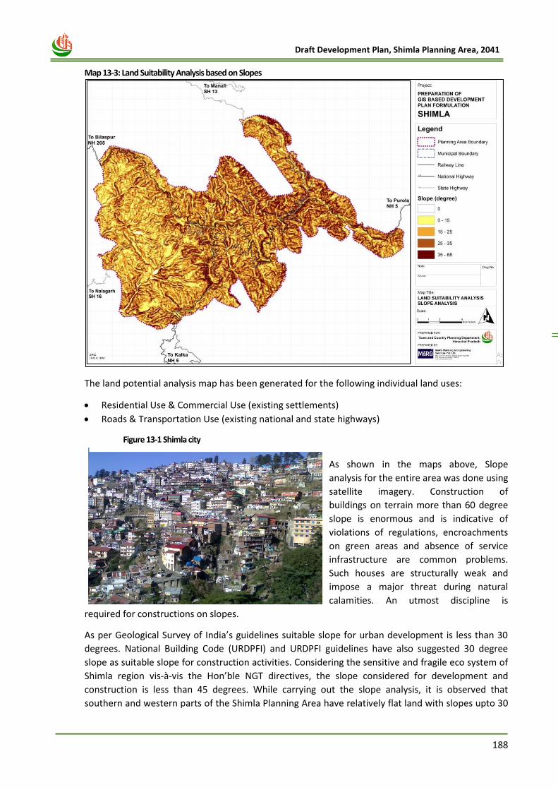
188
Draft Development Plan, Shimla Planning Area, 2041
Figure 13-1 Shimla city
Map 13-3: Land Suitability Analysis based on Slopes
The land potential analysis map has been generated for the following individual land uses:
• Residential Use & Commercial Use (existing settlements)
• Roads & Transportation Use (existing national and state highways)
As shown in the maps above, Slope
analysis for the entire area was done using
satellite imagery. Construction of
buildings on terrain more than 60 degree
slope is enormous and is indicative of
violations of regulations, encroachments
on green areas and absence of service
infrastructure are common problems.
Such houses are structurally weak and
impose a major threat during natural
calamities. An utmost discipline is
required for constructions on slopes.
As per Geological Survey of India’s guidelines suitable slope for urban development is less than 30
degrees. National Building Code (URDPFI) and URDPFI guidelines have also suggested 30 degree
slope as suitable slope for construction activities. Considering the sensitive and fragile eco system of
Shimla region vis-à-vis the Hon’ble NGT directives, the slope considered for development and
construction is less than 45 degrees. While carrying out the slope analysis, it is observed that
southern and western parts of the Shimla Planning Area have relatively flat land with slopes upto 30
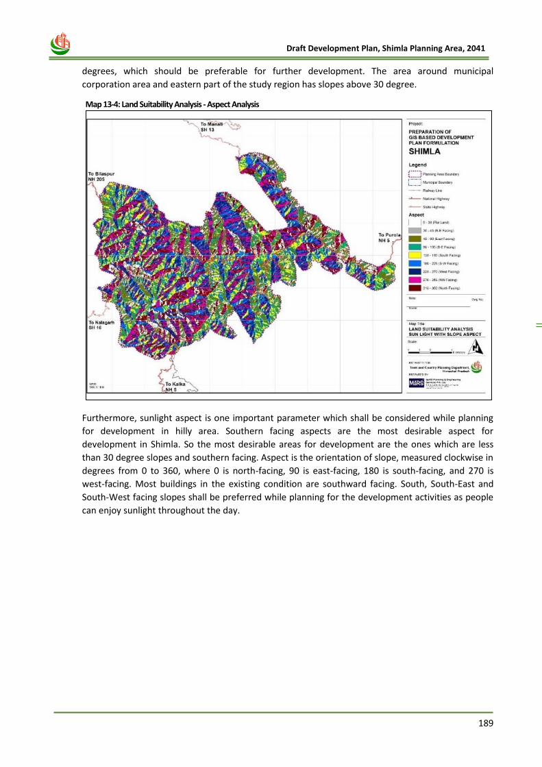
189
Draft Development Plan, Shimla Planning Area, 2041
degrees, which should be preferable for further development. The area around municipal
corporation area and eastern part of the study region has slopes above 30 degree.
Furthermore, sunlight aspect is one important parameter which shall be considered while planning
for development in hilly area. Southern facing aspects are the most desirable aspect for
development in Shimla. So the most desirable areas for development are the ones which are less
than 30 degree slopes and southern facing. Aspect is the orientation of slope, measured clockwise in
degrees from 0 to 360, where 0 is north-facing, 90 is east-facing, 180 is south-facing, and 270 is
west-facing. Most buildings in the existing condition are southward facing. South, South-East and
South-West facing slopes shall be preferred while planning for the development activities as people
can enjoy sunlight throughout the day.
Map 13-4: Land Suitability Analysis - Aspect Analysis
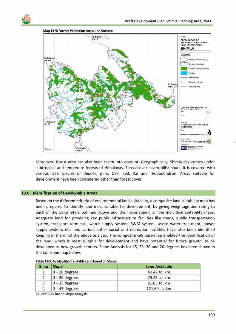
190
Draft Development Plan, Shimla Planning Area, 2041
Moreover, forest area has also been taken into account. Geographically, Shimla city comes under
subtropical and temperate forests of Himalayas. Spread over seven hills/ spurs, it is covered with
various tree species of deodar, pine, Oak, Kail, Rai and rhododendron. Areas suitable for
development have been considered other than forest cover.
13.6 Identification of Developable Areas
Based on the different criteria of environmental land suitability, a composite land suitability map has
been prepared to identify land most suitable for development, by giving weightage and rating to
each of the parameters outlined above and then overlapping all the individual suitability maps.
Adequate land for providing key public infrastructure facilities like roads, public transportation
system, transport terminals, water supply system, SWM system, waste water treatment, power
supply system, etc. and various other social and recreation facilities have also been identified
keeping in the mind the above analysis. The composite GIS base-map enabled the identification of
the land, which is most suitable for development and have potential for future growth, to be
developed as new growth centers. Slope Analysis for 45, 35, 30 and 20 degrees has been shown in
the table and map below.
Table 13-5: Availability of suitable Land based on Slopes
S. no Slope Land Available
1 0 – 20 degrees 40.42 sq. km.
2 0 – 30 degrees 79.46 sq. km.
3 0 – 35 degrees 91.03 sq. km.
4 0 – 45 degrees 121.60 sq. km. Source: GIS based slope analysis.
Map 13-5: Forest/ Plantation Areas and Streams
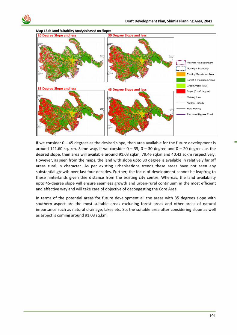
191
Draft Development Plan, Shimla Planning Area, 2041
Map 13-6: Land Suitability Analysis based on Slopes
If we consider 0 – 45 degrees as the desired slope, then area available for the future development is
around 121.60 sq. km. Same way, if we consider 0 – 35, 0 – 30 degree and 0 – 20 degrees as the
desired slope, then area will available around 91.03 sqkm, 79.46 sqkm and 40.42 sqkm respectively.
However, as seen from the maps, the land with slope upto 30 degree is available in relatively far off
areas rural in character. As per existing urbanisations trends these areas have not seen any
substantial growth over last four decades. Further, the focus of development cannot be leapfrog to
these hinterlands given thie distance from the existing city centre. Whereas, the land availability
upto 45-degree slope will ensure seamless growth and urban-rural continuum in the most efficient
and effective way and will take care of objective of decongesting the Core Area.
In terms of the potential areas for future development all the areas with 35 degrees slope with
southern aspect are the most suitable areas excluding forest areas and other areas of natural
importance such as natural drainage, lakes etc. So, the suitable area after considering slope as well
as aspect is coming around 91.03 sq.km.
20 Degree Slope and less 30 Degree Slope and less
35 Degree Slope and less 45 Degree Slope and less
192
Draft Development Plan, Shimla Planning Area, 2041
Chapter 14 PROPOSED
LANDUSE
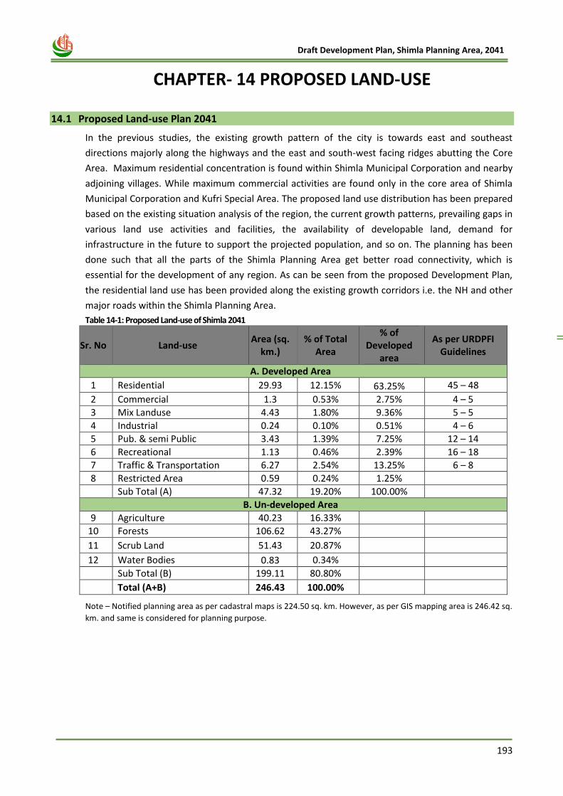
193
Draft Development Plan, Shimla Planning Area, 2041
14 CHAPTER- 14 PROPOSED LAND-USE
14.1 Proposed Land-use Plan 2041
In the previous studies, the existing growth pattern of the city is towards east and southeast
directions majorly along the highways and the east and south-west facing ridges abutting the Core
Area. Maximum residential concentration is found within Shimla Municipal Corporation and nearby
adjoining villages. While maximum commercial activities are found only in the core area of Shimla
Municipal Corporation and Kufri Special Area. The proposed land use distribution has been prepared
based on the existing situation analysis of the region, the current growth patterns, prevailing gaps in
various land use activities and facilities, the availability of developable land, demand for
infrastructure in the future to support the projected population, and so on. The planning has been
done such that all the parts of the Shimla Planning Area get better road connectivity, which is
essential for the development of any region. As can be seen from the proposed Development Plan,
the residential land use has been provided along the existing growth corridors i.e. the NH and other
major roads within the Shimla Planning Area.
Table 14-1: Proposed Land-use of Shimla 2041
Sr. No Land-use Area (sq.
km.) % of Total
Area
% of Developed
area
As per URDPFI Guidelines
A. Developed Area
1 Residential 29.93 12.15% 63.25% 45 – 48
2 Commercial 1.3 0.53% 2.75% 4 – 5
3 Mix Landuse 4.43 1.80% 9.36% 5 – 5
4 Industrial 0.24 0.10% 0.51% 4 – 6
5 Pub. & semi Public 3.43 1.39% 7.25% 12 – 14
6 Recreational 1.13 0.46% 2.39% 16 – 18
7 Traffic & Transportation 6.27 2.54% 13.25% 6 – 8
8 Restricted Area 0.59 0.24% 1.25%
Sub Total (A) 47.32 19.20% 100.00%
B. Un-developed Area
9 Agriculture 40.23 16.33%
10 Forests 106.62 43.27%
11 Scrub Land 51.43 20.87%
12 Water Bodies 0.83 0.34%
Sub Total (B) 199.11 80.80%
Total (A+B) 246.43 100.00%
Note – Notified planning area as per cadastral maps is 224.50 sq. km. However, as per GIS mapping area is 246.42 sq.
km. and same is considered for planning purpose.
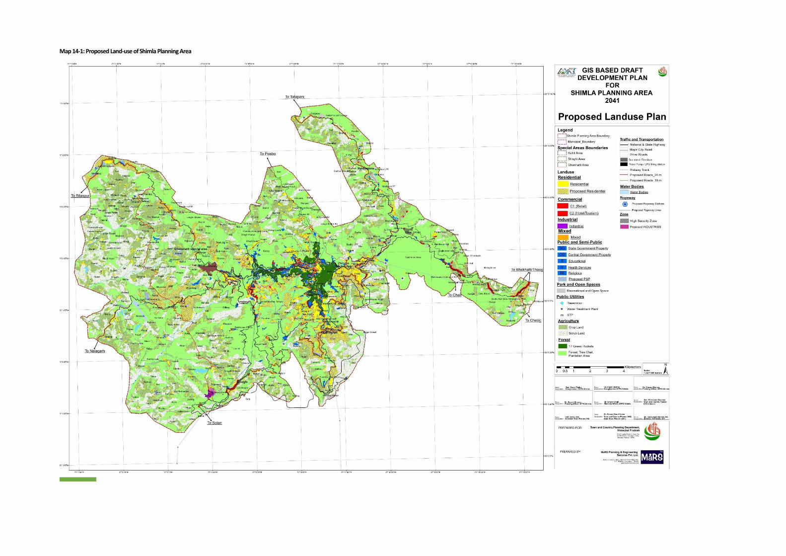
Map 14-1: Proposed Land-use of Shimla Planning Area
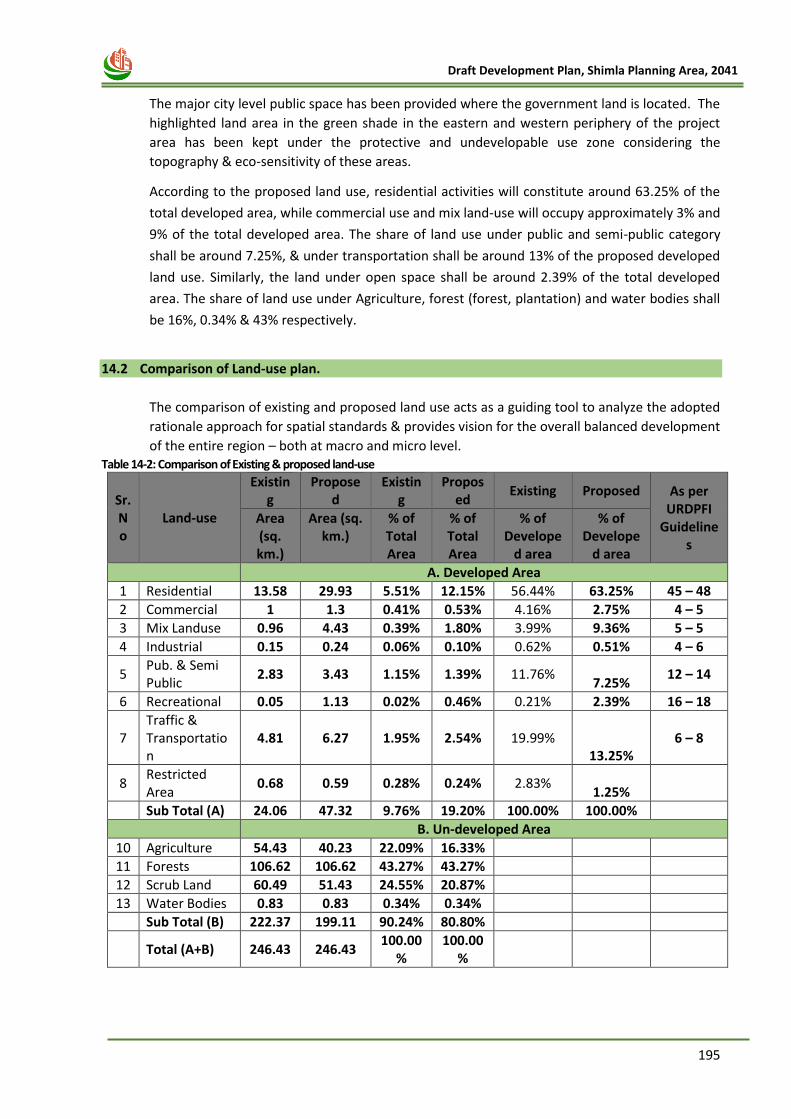
195
Draft Development Plan, Shimla Planning Area, 2041
The major city level public space has been provided where the government land is located. The
highlighted land area in the green shade in the eastern and western periphery of the project
area has been kept under the protective and undevelopable use zone considering the
topography & eco-sensitivity of these areas.
According to the proposed land use, residential activities will constitute around 63.25% of the
total developed area, while commercial use and mix land-use will occupy approximately 3% and
9% of the total developed area. The share of land use under public and semi-public category
shall be around 7.25%, & under transportation shall be around 13% of the proposed developed
land use. Similarly, the land under open space shall be around 2.39% of the total developed
area. The share of land use under Agriculture, forest (forest, plantation) and water bodies shall
be 16%, 0.34% & 43% respectively.
14.2 Comparison of Land-use plan.
The comparison of existing and proposed land use acts as a guiding tool to analyze the adopted
rationale approach for spatial standards & provides vision for the overall balanced development
of the entire region – both at macro and micro level. Table 14-2: Comparison of Existing & proposed land-use
Sr. No
Land-use
Existing
Proposed
Existing
Proposed
Existing Proposed As per URDPFI
Guidelines
Area (sq. km.)
Area (sq. km.)
% of Total Area
% of Total Area
% of Develope
d area
% of Develope
d area
A. Developed Area
1 Residential 13.58 29.93 5.51% 12.15% 56.44% 63.25% 45 – 48
2 Commercial 1 1.3 0.41% 0.53% 4.16% 2.75% 4 – 5
3 Mix Landuse 0.96 4.43 0.39% 1.80% 3.99% 9.36% 5 – 5
4 Industrial 0.15 0.24 0.06% 0.10% 0.62% 0.51% 4 – 6
5 Pub. & Semi Public
2.83 3.43 1.15% 1.39% 11.76% 7.25%
12 – 14
6 Recreational 0.05 1.13 0.02% 0.46% 0.21% 2.39% 16 – 18
7 Traffic & Transportation
4.81 6.27 1.95% 2.54% 19.99% 13.25%
6 – 8
8 Restricted Area
0.68 0.59 0.28% 0.24% 2.83% 1.25%
Sub Total (A) 24.06 47.32 9.76% 19.20% 100.00% 100.00%
B. Un-developed Area
10 Agriculture 54.43 40.23 22.09% 16.33%
11 Forests 106.62 106.62 43.27% 43.27%
12 Scrub Land 60.49 51.43 24.55% 20.87%
13 Water Bodies 0.83 0.83 0.34% 0.34%
Sub Total (B) 222.37 199.11 90.24% 80.80%
Total (A+B) 246.43 246.43 100.00
% 100.00
%
196
Draft Development Plan, Shimla Planning Area, 2041
Important features adopted in Proposed Development Plan in comparison with the existing
developments:
i. Residential land use has been changed from 5.51% out of total planning area to 12.15% in
order to accommodate the future population increase. Out of developed area, the
residential area has been increased from 56.44% to 63.25%
ii. The commercial development is prime factor to cater the robust urban development and
hence the area under commercial use has been increased from 0.41% as can be seen in
ELU to 0.53% in PLU. Out of developed area, the commercial use has been increased from
4.16% to 2.75%. In addition, commercial land-use has been provided in form of mix land
use, along with the main roads, which has been increased from 3.99% to 9.36%.
iii. The area under industrial use has been increased from 0.15 sq. km to 0.24 sq. km of area,
which is 0.51% of total proposed developed area.
iv. The area under public & semi-public use has been increased from 1.15% to 1.39% based
upon the identification of government land available.
v. The area proposed under transportation and communication which is 4.81% as per ELU
has been increased to 6.27% in PLU through creation of extensive interwoven road
network.
In coming section, we would elaborate each specific land-use, proposed in PLU, with the basic
idea of increasing the area, and their respective strategic location in Shimla Planning Area
14.2.1 Residential Use:
As we have already mentioned, the present the existing residential area is 13.58 sq km of area.
Keeping the residential demand in future based on population projection, the residential area
has been increased to 29.93 sq. km of area (Shown in Residential use map ahead). Most of
these proposed residential areas are cropland or scrub land and have close proximity of road
network. In addition, as the DP Shimla 2041, envisages the development of Counter-Magnet
town near Jathita Devi Area, new land under Residential use has been incorporated in proposed
land-use. The detailing of this pocket, with neighbourhood level provision of Open space,
Public/ semi-public infrastructure can be done, at the time of meticulous planning through
various tools such as LAP or TP scheme. Moreover, the number of floors considered for
residential areas areas are 2+parking floor + attic for core area and 3+ parking floor + attic for
non-core area. The further details for residential area has been provided in 17 chapter.
14.2.2 Commercial Use:
The commercial activities are concentrated along the main road i.e. NH-5 & NH-205, is mostly in
Shimla has developed in form of mix land-use, small-scale retail and service use based shops in
nature around the residential area and in the city centre. Majority of the shops are single unit
and the commercial area lacks the complexes and malls. As mentioned before, Existing main
shopping centres and complexes are concentrated in and around the Mall in localities namely,
Middle Bazaar, Lower bazaar, Lakkar Bazaar and Chhota Shimla. Other newly developed
commercial areas are in Kusumpti, New Shimla, Dhalli and Boileauganj. At present the existing
Commercial area comprises of 1 sq km of area, which has been proposed 1.3 sq km of area in
proposed landuse. However, provisions for more commercial area has been provided in the
form of Mix land-use, in order to provide the more flexibility to the residents to build.
197
Draft Development Plan, Shimla Planning Area, 2041
14.2.3 Mix Land-use:
As the city exhibits mix land-use around the main market areas and along the main roads, most
of the commercial areas have been proposed as Mix land use for proposed landuse, 2041. For
promoting Mix Use Development along the road, 50 meter buffer to the NH and 30 meter
buffer to SH and other major roads have been proposed for Mixed Use Development. At
present, the existing mix- use area comprises of 0.96 sq km of area, which has been proposed
4.43 sq km of area in proposed landuse, which is around 9.36% of total developed area.
14.2.4 Industrial use:
At present, area under industrial use is around 0.15 sq.km, which is 0.62% of developed area.
As already mentioned, most of the industrial activities are available in Shoghi Special Area. The
area under proposed land use has increased to 0.24 sq km. which is 0.51% to the total
developed area in Proposed land use. However, percentage of land dedicated for industries, is
less as compared to the URDPFI Norms because of being an Eco – Sensitive Area. However, in
order to create employment opportunities related with non – polluting small scale industries,
various provisions have been given in building guidelines under Residential and Commercial
Uses, where smaller units of household industry will be allowed.
14.2.5 Public Semi Public:
Being a State Capital and Educational Hub of Himachal Pradesh, around 2.83 sq.km. area is
available under the public – semi-public use which is around 11.76% of the developed area . It
has been proposed up to 3.43 sq.km. which is around 7.25% of the developed area. As
compared to URDPFI Norms, area proposed under Public Semi Public uses are comparatively
less. In addition, at later stages, at neighbourhood level, suitable area will be identified for
public – semi public use based on the availability of the government land.
14.2.6 Recreational use:
At present, area under recreational activities is around 0.05 sq.km. which is only 0.21% of the
Developed Area. It has been proposed up to 1.13 sq.km. which is around 2.39% of the
developed area. It is important to mention here, dedicated open spaces are less in the Shimla
Planning Area, as compared to URDPFI Norms. This is partially due to, incorporation of many
recreational spaces as forests areas. In Shimla Planning area, Nature Parks and Wildlife Century
are available for running & joggings Trails and cycle tracks, & is being used for recreational
purposes, but still is a part of forest use/ land. In addition, the availability of Open grounds is
less hilly areas of shimla, due to the steep slopes. However, area under 0 – 10 degree slope has
been identified and shown in map in Social infrastructure chapter, for open spaces and
recreational activities. Later, based on the ownership, these pockets can be identified for the
Recreational purpose.
14.2.7 Traffic & Transportation
At present, area under traffic and transportation is around 4.81 sq.km. which is around 19.99%
of the developed area. Additional roads are proposed, to connect counter magnet town with
Shimla and rest of the planning areas. In proposed land-use, some by-pass roads have been
added for better connectivity and subsequently, under traffic and transportation, areas has
been increased to 6.27 sq.km. which is around 13.25% of the developed area. In comparison to
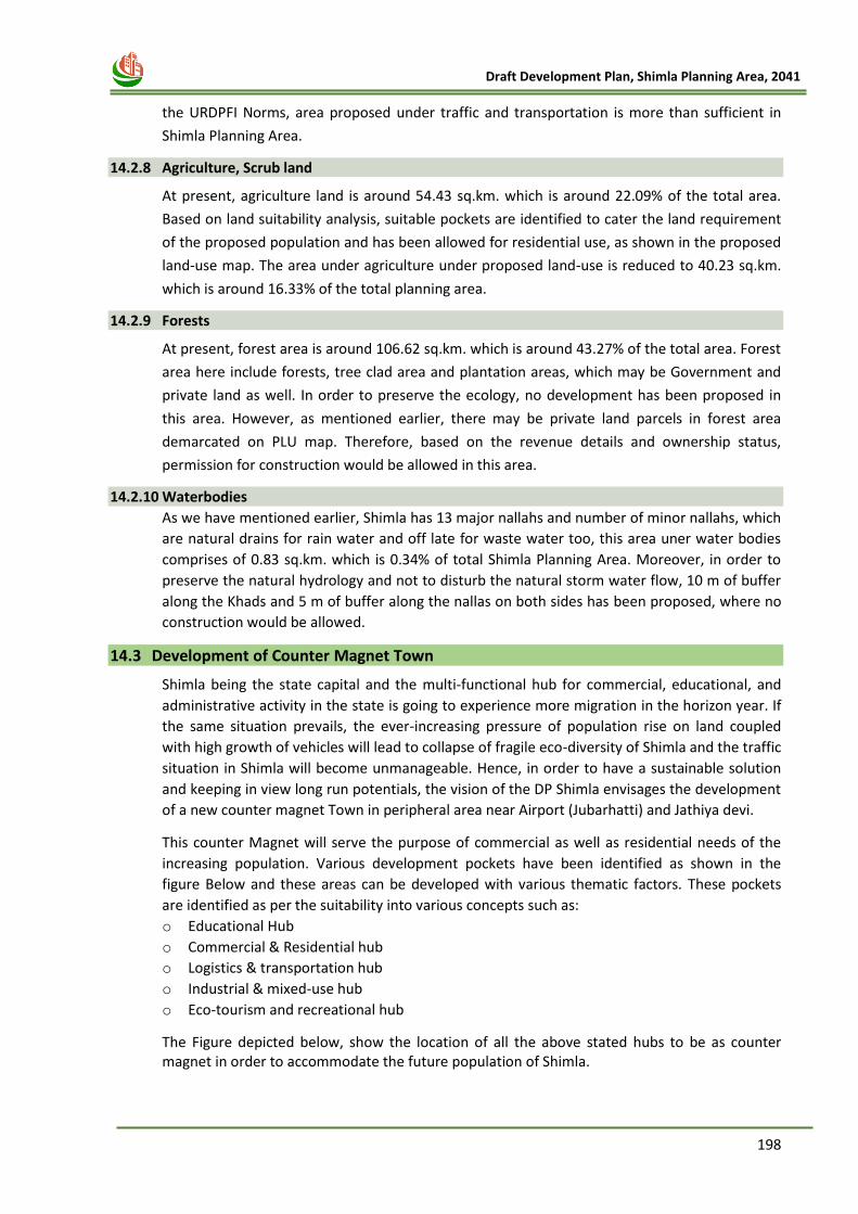
198
Draft Development Plan, Shimla Planning Area, 2041
the URDPFI Norms, area proposed under traffic and transportation is more than sufficient in
Shimla Planning Area.
14.2.8 Agriculture, Scrub land
At present, agriculture land is around 54.43 sq.km. which is around 22.09% of the total area.
Based on land suitability analysis, suitable pockets are identified to cater the land requirement
of the proposed population and has been allowed for residential use, as shown in the proposed
land-use map. The area under agriculture under proposed land-use is reduced to 40.23 sq.km.
which is around 16.33% of the total planning area.
14.2.9 Forests
At present, forest area is around 106.62 sq.km. which is around 43.27% of the total area. Forest
area here include forests, tree clad area and plantation areas, which may be Government and
private land as well. In order to preserve the ecology, no development has been proposed in
this area. However, as mentioned earlier, there may be private land parcels in forest area
demarcated on PLU map. Therefore, based on the revenue details and ownership status,
permission for construction would be allowed in this area.
14.2.10 Waterbodies
As we have mentioned earlier, Shimla has 13 major nallahs and number of minor nallahs, which
are natural drains for rain water and off late for waste water too, this area uner water bodies
comprises of 0.83 sq.km. which is 0.34% of total Shimla Planning Area. Moreover, in order to
preserve the natural hydrology and not to disturb the natural storm water flow, 10 m of buffer
along the Khads and 5 m of buffer along the nallas on both sides has been proposed, where no
construction would be allowed.
14.3 Development of Counter Magnet Town
Shimla being the state capital and the multi-functional hub for commercial, educational, and
administrative activity in the state is going to experience more migration in the horizon year. If
the same situation prevails, the ever-increasing pressure of population rise on land coupled
with high growth of vehicles will lead to collapse of fragile eco-diversity of Shimla and the traffic
situation in Shimla will become unmanageable. Hence, in order to have a sustainable solution
and keeping in view long run potentials, the vision of the DP Shimla envisages the development
of a new counter magnet Town in peripheral area near Airport (Jubarhatti) and Jathiya devi.
This counter Magnet will serve the purpose of commercial as well as residential needs of the
increasing population. Various development pockets have been identified as shown in the
figure Below and these areas can be developed with various thematic factors. These pockets
are identified as per the suitability into various concepts such as:
o Educational Hub
o Commercial & Residential hub
o Logistics & transportation hub
o Industrial & mixed-use hub
o Eco-tourism and recreational hub
The Figure depicted below, show the location of all the above stated hubs to be as counter magnet in order to accommodate the future population of Shimla.
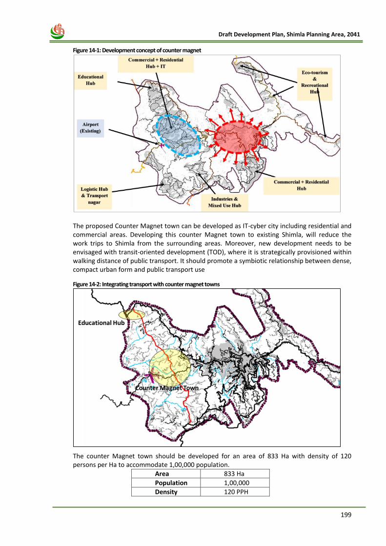
199
Draft Development Plan, Shimla Planning Area, 2041
Figure 14-1: Development concept of counter magnet
The proposed Counter Magnet town can be developed as IT-cyber city including residential and commercial areas. Developing this counter Magnet town to existing Shimla, will reduce the work trips to Shimla from the surrounding areas. Moreover, new development needs to be envisaged with transit-oriented development (TOD), where it is strategically provisioned within walking distance of public transport. It should promote a symbiotic relationship between dense, compact urban form and public transport use
Figure 14-2: Integrating transport with counter magnet towns
The counter Magnet town should be developed for an area of 833 Ha with density of 120 persons per Ha to accommodate 1,00,000 population.
Area 833 Ha
Population 1,00,000
Density 120 PPH
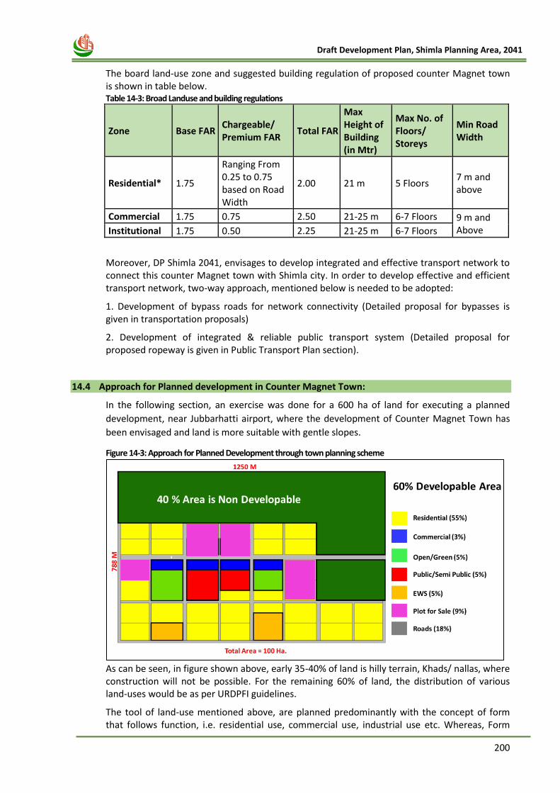
200
Draft Development Plan, Shimla Planning Area, 2041
The board land-use zone and suggested building regulation of proposed counter Magnet town is shown in table below. Table 14-3: Broad Landuse and building regulations
Zone Base FAR Chargeable/ Premium FAR
Total FAR
Max Height of Building (in Mtr)
Max No. of Floors/ Storeys
Min Road Width
Residential* 1.75
Ranging From 0.25 to 0.75 based on Road Width
2.00 21 m 5 Floors 7 m and above
Commercial 1.75 0.75 2.50 21-25 m 6-7 Floors 9 m and Above Institutional 1.75 0.50 2.25 21-25 m 6-7 Floors
Moreover, DP Shimla 2041, envisages to develop integrated and effective transport network to connect this counter Magnet town with Shimla city. In order to develop effective and efficient transport network, two-way approach, mentioned below is needed to be adopted:
1. Development of bypass roads for network connectivity (Detailed proposal for bypasses is given in transportation proposals)
2. Development of integrated & reliable public transport system (Detailed proposal for proposed ropeway is given in Public Transport Plan section).
14.4 Approach for Planned development in Counter Magnet Town:
In the following section, an exercise was done for a 600 ha of land for executing a planned
development, near Jubbarhatti airport, where the development of Counter Magnet Town has
been envisaged and land is more suitable with gentle slopes.
Figure 14-3: Approach for Planned Development through town planning scheme
As can be seen, in figure shown above, early 35-40% of land is hilly terrain, Khads/ nallas, where construction will not be possible. For the remaining 60% of land, the distribution of various land-uses would be as per URDPFI guidelines.
The tool of land-use mentioned above, are planned predominantly with the concept of form that follows function, i.e. residential use, commercial use, industrial use etc. Whereas, Form
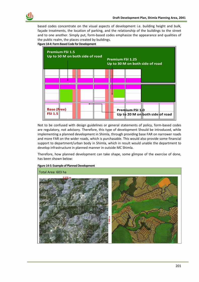
201
Draft Development Plan, Shimla Planning Area, 2041
based codes concentrate on the visual aspects of development i.e. building height and bulk, façade treatments, the location of parking, and the relationship of the buildings to the street and to one another. Simply put, form-based codes emphasize the appearance and qualities of the public realm, the places created by buildings. Figure 14-4: Form Based Code for Development
Not to be confused with design guidelines or general statements of policy, form-based codes are regulatory, not advisory. Therefore, this type of development Should be introduced, while implementing a planned development in Shimla, through providing base FAR on narrower roads and more FAR on the wider roads, which is purchasable. This would also provide some financial support to department/urban body in Shimla, which in result would unable the department to develop infrastructure in planned manner in outside MC Shimla.
Therefore, how planned development can take shape, some glimpse of the exercise of done, has been shown below:
Figure 14-5: Example of Planned Development
Total Area: 603 ha
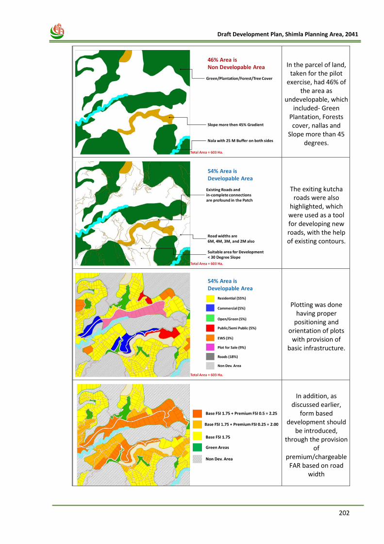
202
Draft Development Plan, Shimla Planning Area, 2041
In the parcel of land, taken for the pilot
exercise, had 46% of the area as
undevelopable, which included- Green
Plantation, Forests cover, nallas and
Slope more than 45 degrees.
The exiting kutcha roads were also
highlighted, which were used as a tool for developing new roads, with the help of existing contours.
Plotting was done having proper
positioning and orientation of plots
with provision of basic infrastructure.
In addition, as discussed earlier,
form based development should
be introduced, through the provision
of premium/chargeable
FAR based on road width
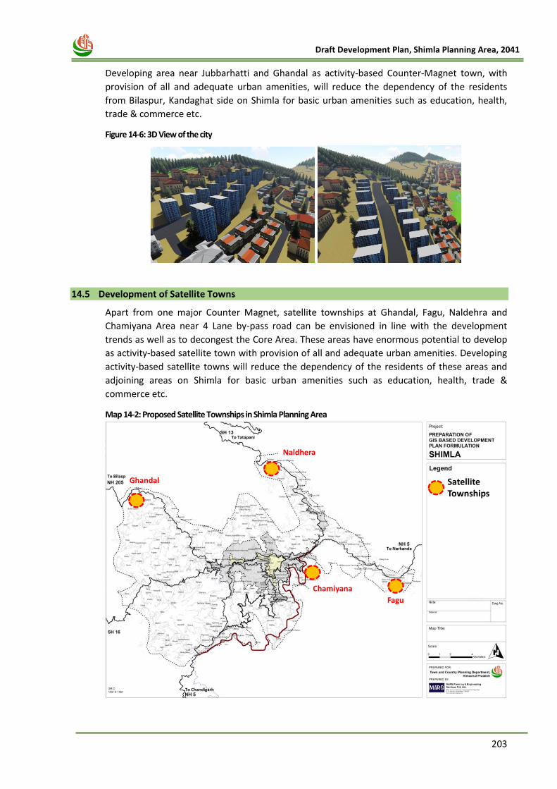
203
Draft Development Plan, Shimla Planning Area, 2041
Developing area near Jubbarhatti and Ghandal as activity-based Counter-Magnet town, with
provision of all and adequate urban amenities, will reduce the dependency of the residents
from Bilaspur, Kandaghat side on Shimla for basic urban amenities such as education, health,
trade & commerce etc.
Figure 14-6: 3D View of the city
14.5 Development of Satellite Towns
Apart from one major Counter Magnet, satellite townships at Ghandal, Fagu, Naldehra and
Chamiyana Area near 4 Lane by-pass road can be envisioned in line with the development
trends as well as to decongest the Core Area. These areas have enormous potential to develop
as activity-based satellite town with provision of all and adequate urban amenities. Developing
activity-based satellite towns will reduce the dependency of the residents of these areas and
adjoining areas on Shimla for basic urban amenities such as education, health, trade &
commerce etc.
Map 14-2: Proposed Satellite Townships in Shimla Planning Area
Satellite Townships
Naldhera
Chamiyana
Fagu
Ghandal
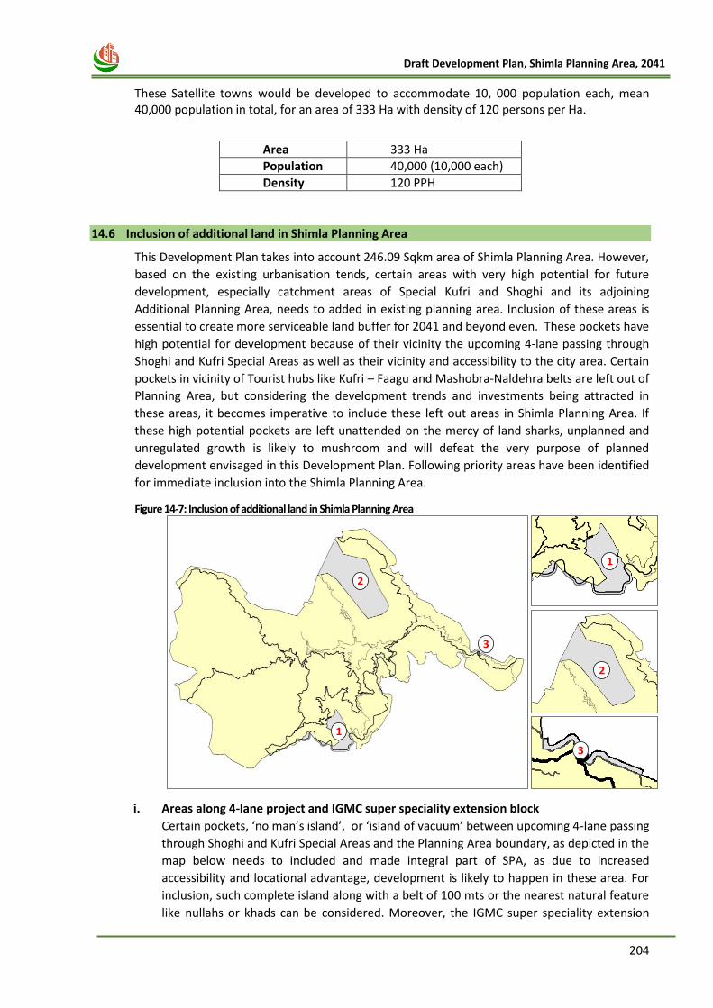
204
Draft Development Plan, Shimla Planning Area, 2041
These Satellite towns would be developed to accommodate 10, 000 population each, mean 40,000 population in total, for an area of 333 Ha with density of 120 persons per Ha.
Area 333 Ha
Population 40,000 (10,000 each)
Density 120 PPH
14.6 Inclusion of additional land in Shimla Planning Area
This Development Plan takes into account 246.09 Sqkm area of Shimla Planning Area. However,
based on the existing urbanisation tends, certain areas with very high potential for future
development, especially catchment areas of Special Kufri and Shoghi and its adjoining
Additional Planning Area, needs to added in existing planning area. Inclusion of these areas is
essential to create more serviceable land buffer for 2041 and beyond even. These pockets have
high potential for development because of their vicinity the upcoming 4-lane passing through
Shoghi and Kufri Special Areas as well as their vicinity and accessibility to the city area. Certain
pockets in vicinity of Tourist hubs like Kufri – Faagu and Mashobra-Naldehra belts are left out of
Planning Area, but considering the development trends and investments being attracted in
these areas, it becomes imperative to include these left out areas in Shimla Planning Area. If
these high potential pockets are left unattended on the mercy of land sharks, unplanned and
unregulated growth is likely to mushroom and will defeat the very purpose of planned
development envisaged in this Development Plan. Following priority areas have been identified
for immediate inclusion into the Shimla Planning Area.
Figure 14-7: Inclusion of additional land in Shimla Planning Area
i. Areas along 4-lane project and IGMC super speciality extension block
Certain pockets, ‘no man’s island’, or ‘island of vacuum’ between upcoming 4-lane passing
through Shoghi and Kufri Special Areas and the Planning Area boundary, as depicted in the
map below needs to included and made integral part of SPA, as due to increased
accessibility and locational advantage, development is likely to happen in these area. For
inclusion, such complete island along with a belt of 100 mts or the nearest natural feature
like nullahs or khads can be considered. Moreover, the IGMC super speciality extension
2
1
3
2
1
3
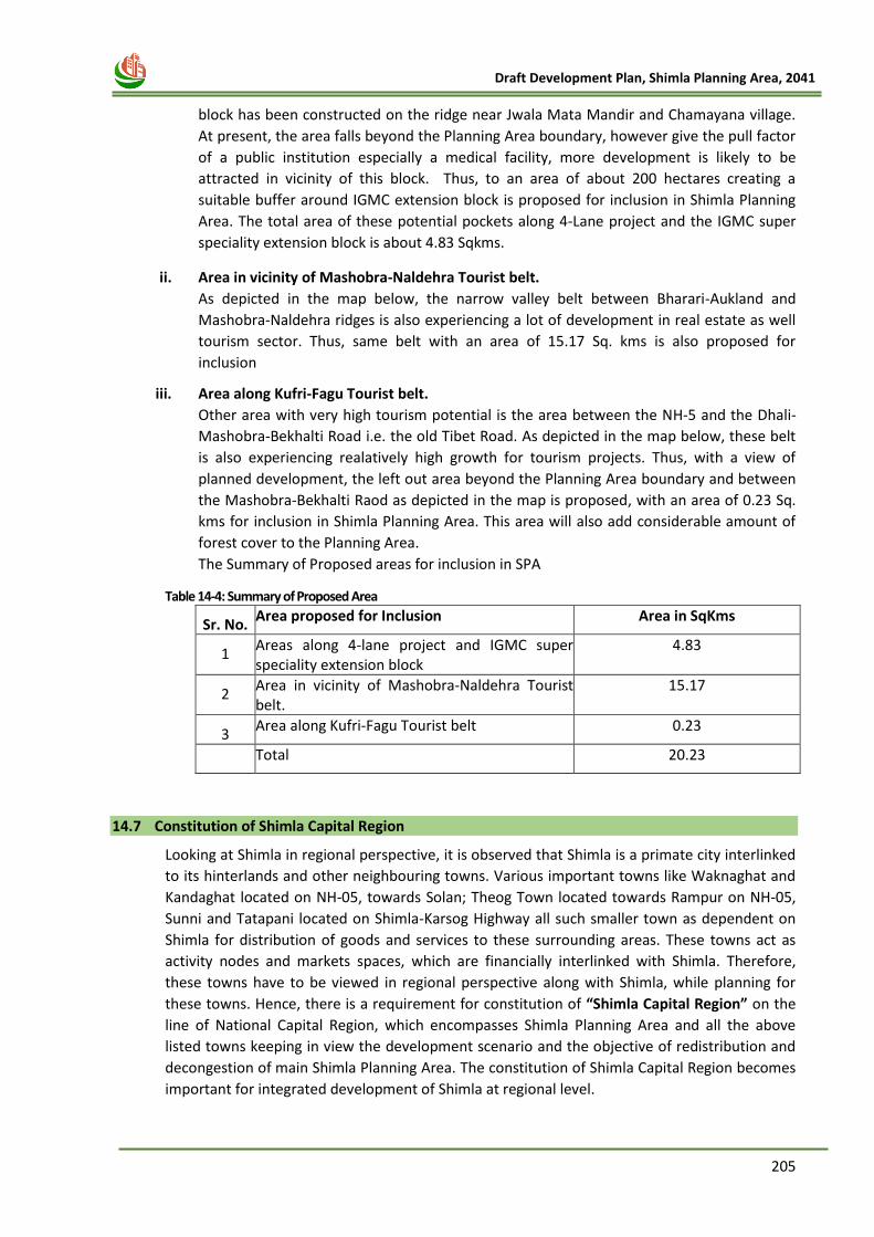
205
Draft Development Plan, Shimla Planning Area, 2041
block has been constructed on the ridge near Jwala Mata Mandir and Chamayana village.
At present, the area falls beyond the Planning Area boundary, however give the pull factor
of a public institution especially a medical facility, more development is likely to be
attracted in vicinity of this block. Thus, to an area of about 200 hectares creating a
suitable buffer around IGMC extension block is proposed for inclusion in Shimla Planning
Area. The total area of these potential pockets along 4-Lane project and the IGMC super
speciality extension block is about 4.83 Sqkms.
ii. Area in vicinity of Mashobra-Naldehra Tourist belt.
As depicted in the map below, the narrow valley belt between Bharari-Aukland and
Mashobra-Naldehra ridges is also experiencing a lot of development in real estate as well
tourism sector. Thus, same belt with an area of 15.17 Sq. kms is also proposed for
inclusion
iii. Area along Kufri-Fagu Tourist belt.
Other area with very high tourism potential is the area between the NH-5 and the Dhali-
Mashobra-Bekhalti Road i.e. the old Tibet Road. As depicted in the map below, these belt
is also experiencing realatively high growth for tourism projects. Thus, with a view of
planned development, the left out area beyond the Planning Area boundary and between
the Mashobra-Bekhalti Raod as depicted in the map is proposed, with an area of 0.23 Sq.
kms for inclusion in Shimla Planning Area. This area will also add considerable amount of
forest cover to the Planning Area.
The Summary of Proposed areas for inclusion in SPA
Table 14-4: Summary of Proposed Area
Sr. No. Area proposed for Inclusion Area in SqKms
1 Areas along 4-lane project and IGMC super speciality extension block
4.83
2 Area in vicinity of Mashobra-Naldehra Tourist belt.
15.17
3 Area along Kufri-Fagu Tourist belt 0.23
Total 20.23
14.7 Constitution of Shimla Capital Region
Looking at Shimla in regional perspective, it is observed that Shimla is a primate city interlinked
to its hinterlands and other neighbouring towns. Various important towns like Waknaghat and
Kandaghat located on NH-05, towards Solan; Theog Town located towards Rampur on NH-05,
Sunni and Tatapani located on Shimla-Karsog Highway all such smaller town as dependent on
Shimla for distribution of goods and services to these surrounding areas. These towns act as
activity nodes and markets spaces, which are financially interlinked with Shimla. Therefore,
these towns have to be viewed in regional perspective along with Shimla, while planning for
these towns. Hence, there is a requirement for constitution of “Shimla Capital Region” on the
line of National Capital Region, which encompasses Shimla Planning Area and all the above
listed towns keeping in view the development scenario and the objective of redistribution and
decongestion of main Shimla Planning Area. The constitution of Shimla Capital Region becomes
important for integrated development of Shimla at regional level.
206
Draft Development Plan, Shimla Planning Area, 2041
Chapter 15 DEVELOPMENT
PLAN
IMPLEMENTATION
207
Draft Development Plan, Shimla Planning Area, 2041
15 CHAPTER- 15 DEVELOPMENT PLAN IMPLEMENTATION
15.1 Introduction
This chapter summarizes implementation mechanism for Shimla Development Plan. It
emphasizes on providing a better quality of life together with high standards of living for the
local population. The development plan proposes to lay out a physical pattern of land use and
transportation linkages for the planning Area as a whole and also serve as a guideline for public
and Government agencies to conform and integrate their sectoral projects into programs.
Hence it is important that suitable strategies needs to be evolved for implementation of the
plan proposals.
15.2 Shimla Development Authority for Implementation of Projects
As the Development Plan is a document of people, community, Government and all democratic
institutions including local bodies, the same are therefore required to come forward for its
implementation. Execution of the Development Plan has to be ensured by Land Pooling and
Reconstitution Mechanism by coordinated efforts of the landowners, Development Authority,
Revenue Department, Municipal Corporation, SADAs, Panchayats and Infrastructural
Departments. Besides landowners, Municipal Corporation, Gram Panchayats and Special Area
Development Authorities shall be responsible for creation of serviced land. Whereas, Private
land involve for the purpose of road facility center /state Govt. acquired the same and provide
the compensation as per market rate.
New Development Authority under the Town and Country Planning Act is inevitably required to
be revived for implementation of this Development Plan. It may be provided with a revolving
fund by the Government, which shall have to be returned by such Authority within a stipulated
period of time. However, overall control and monitoring of implementation of proposals of
development in terms of land use zoning and regulatory control shall be vested with the Town
and Country Planning Department. The Development Authority is required to act at three levels
namely: -
a) To rehabilitate incompatible uses like truck and idle bus parking, timber market, grain
market, vegetable market, workshops and miscellaneous non- conforming uses in
cooperation with local bodies and public participation and the same are to be shifted
from the Core Area to South-Western periphery of the city in a time bound manner
b) To develop counter Magnet town on the periphery in the west and in satellite towns to
cater for the demand of additional population. As long as Development Authority is not
in a position to cater for demand of serviced land, it shall not take up any other activity.
c) In order to implement the major proposals of Tunnels and elevators multinational
companies may be invited on prescribed terms and conditions including BOT
mechanism.
In order to ensure co-coordination, monitoring and effective implementation of Development
Plan the Director may constitute a committee.
Ironically, benefits of infrastructure and new proposals including roads, as shall be
implemented by the various Departments are to be harnessed by the Development Authority.
208
Draft Development Plan, Shimla Planning Area, 2041
The developable Government land is required to be vested with the Development Authority
and the same shall be used as Land Bank. The ownership of Government land as occupied and
used by the private owners has to be specifically looked into and same used for community
purposes, accommodating the legitimate occupants on specified terms and conditions.
15.3 Urban Land Management Models & Techniques
The urban landscape is transforming extensively each day as many new projects are developed
over the agriculturally productive hinterland of the cities. In urban areas land and economic
opportunities are the base for all the development activities which can be broadly classified as
urban and rural areas.
The value of urban land India is largely influenced by the prevalent market forces, which
directly or indirectly determines the supply and demand for land. The value of land increases as
demand exceeds supply. As the urban economy grows, its economic structure changes due to
which improvements in economic conditions can be observed. The increase in household
income creates a desire for better housing and living conditions and a better quality of life. As a
result, demand for urban land increases.
In the majority of cities and towns of the country, suitable land exists but the same is available
in limited quantity for development. The main tool available to Government in order to
regulate the supply of land is the conversion of rural land into urban land through land-use
conversion controls and by providing the basic infrastructure in the area. The challenge in this
process is to supply land, at the right time, in desired locations, and with timely provision of
infrastructure. Historically, land acquisition in the urban centers has been the prerogative of the
Development Authority concerned. It has been felt that government interventions in the urban
land market are mainly to:
o To eliminate market imperfections and failures to increase operating efficiencies
o To remove externalities so that the social costs for land market outcomes correspond
more closely to private costs
o To redistribute city’s scarce resources so that disadvantaged groups get equal share in
society's output
Land assembly and development mechanism are undertaken for achieving optimum social use
of urban land and to ensure adequate availability of land to public authority and individuals.
Public Private Participation is achieved in land development through various techniques.
Mainly, land assembly techniques prevent concentration of land in few hands and promote its
efficient social and economic allocation. Some of the land assembly techniques also promote
flexibility in land utilization in response to changes resulting from growing city.
The various mechanisms to assemble and/or develop land are enlisted below:
i. Land Acquisition: Bulk land acquisition by State and by private initiatives.
ii. Land Pooling: Land pooling approach and redistribution scheme, popularly known as
Town Planning schemes.
iii. Land Reservations: The concept of Accommodation Reservation which allows the land
owner to develop the sites reserved for an amenity.
iv. Transferable Development Rights: A technique of land development which separates the
development potential of a land parcel for use elsewhere.
209
Draft Development Plan, Shimla Planning Area, 2041
v. Guided Land Development: This model uses the provision of infrastructure as an
instrument to guide urban development in partnership with land‐owners without pooling
any land.
15.3.1 Land Acquisition
“Land Acquisition” popularly means the acquisition of land for defined public purpose by a
government agency from individual land‐owners, as authorized by the law, after paying a
government‐fixed compensation to cover losses incurred by land‐owners from surrendering
their land. The land acquisition process can be undertaken by the State or through private
initiatives.
Land acquisition is a key tool for statutory planning, freeing up land from all encumbrances. The
land acquisition is to be processed as per the Right to Fair Compensation and Transparency in
Land Acquisition, Rehabilitation & Resettlement Act (RFCTLARR) 2013. Some models of land
acquisition are as follows:
A. Bulk land acquisition method as a State Initiative: In this method, Master Plan is prepared
for the entire area encompassing different land uses and involving various activities. Land is
developed in accordance to the planning norms for various uses/activities. Bulk land is acquired
from farmers by the development agency and compensation is paid to farmers/owners based
on the provision of prevailing act.
B. Bulk land acquisition method with Private Initiative: To defray the cost of land acquisition
some state governments and ULBs have developed models in which private sector acquire land
by directly paying compensation to the affected families. A variety of models are in existence
per which land is acquired for planned development with private partnership.
C. Haryana Guided Land Development Model: In this model, the private developer can acquire
land directly from farmers at market price and at the same time, it permits a land owner to
assume the role of a colonizer. This model provides fixed time period of 5 years to utilize that
land acquired (initially 2 years, then extension of 3 years, if required) and the developer is
expected to complete the projects within this period. Major highlights of this model are that
the difficulties and delays inland acquisition are avoided and pressure on government to pay
compensation is reduced, overall enhancing investments.
D. Ghaziabad Joint Venture Model: As per approach followed by Ghaziabad Development
Authority (GDA), a joint venture (JV) is formed between the GDA and the
builders/developers/co‐operative societies through open bid (based on technical and financial
capabilities). Twenty per cent of the plots developed are to be reserved for EWS/LIG and the
costing and allotting of social facility by developer has to be done as per the government
regulations. The balance of the land is to be sold by the developer at profit. For the entire
process, the development authority acts only as a facilitator. Project duration is specified in the
JV agreement and penalty is imposed if developer requires time extension, thus making sure
that land is utilized within the stipulated time period.
210
Draft Development Plan, Shimla Planning Area, 2041
E. Hyderabad Differential Compensation Models: In Hyderabad, the land acquisition technique
has been modified into two different models, in which while acquiring land for public and
private projects, different level of compensations are arrived at, these are:
Model-I: When land is acquired for projects mainly for public purpose such as roads, power
generation and distribution, irrigation, schools, welfare housing, environmental projects etc.,
appropriate compensation is paid to land‐owners by consulting them.
Model-II: When land is acquired for projects such as SEZ, Industrial Estates, Satellite townships
and others where value addition enhances the land prices substantially, mainly for third party
use, compensation is normally worked out on profit sharing basis, which is in two parts,
namely‐
Basic Value (Government Rate) of Land
% Equity Sharing in SPV / % of Net Developed Area / Built Space
F. CIDCO Model: CIDCO model of Land Development in Navi Mumbai follows the technique of
land banking for land assembly. The compensation to land owners is done by the way of
monetary and land compensation. But in Vasai Virar sub‐region, CIDCO undertook the land
assembly by obtaining power of attorney from land‐owners or outright purchase of freehold
lands located close to each other by private developers or builder. The promoter is solely
responsible for providing and maintaining infrastructure for consolidated land parcel.
15.3.2 Land Pooling
In Town Planning or Plot Reconstitution Scheme, the land is pooled and its development is
financed with the involvement of land‐owners without compulsorily acquiring land. This land
assembly technique helps to provide plots for basic services in a planned layout from the
original haphazard arrangement. Costs incurred by the developmental authority for
development and for infrastructure are recovered from the sale of few of the final land plots
reserved by the authority and betterment charges levied on land‐owners. The reconstituted
plots are allotted to the landowners in proportion to their original land holdings.
The scheme was first introduced in the Maharashtra Regional and Town Planning Act, 1966 and
later in Gujarat Town Planning & Urban Development Act, 1976 and is now widely appreciated
model of land assembly. Another deviation of the land pooling mechanism has been recently
introduced by the Delhi Development Authority (DDA), wherein DDA facilitated developers and
land‐owners to pool land for development. The town planning scheme is referred as ‘land
acquisition without tears’ and has the following key advantages:
i. Infrastructure is provided in coordinated way.
ii. Partial cost is recovered through betterment charges.
iii. Land for public and community purposes including green & open spaces is acquired
without direct expanses.
iv. Community benefits through unified planning.
v. Land‐owner shares the project cost and benefits by increased property prices.
Town Planning Scheme has emerged as a successful model of land development. The
Maharashtra Regional and Town Planning (MRTP) Act, 1966. The Gujarat Town Planning and
Urban Development Act (GTPUDA), 1976 and now Kerala Town and Country Planning
Ordinance, 2013, have included provisions for Town Planning Scheme.
211
Draft Development Plan, Shimla Planning Area, 2041
The T.P. Scheme is prepared by the authorities generally for an unplanned area of about 100
Ha. Planning this area in detail it may require about 40% of land for road network, public
purpose like school, hospital, market, park, playground etc. and for plots for sale and the
remaining 60% area can be utilized to formulate final Plots for the allotment to land owners as
plots. As a result of this planning exercise, 40% of land is deducted from the ownership of all
the land owners proportionately and allotted to the authority to undertake the respective
development works for public as per the T.P.S. proposals. The remaining 60% land in form of
plots is given back to the land owners on proportionate basis. The land owner will lose 40% of
land and will get back 60% land in form of Final Plot. All the land owners will have this kind of
adjustment.
The entire area through this mechanism becomes well planned. Everybody contributes part of
their land for public purpose proportionately. Every land owner is paid compensation for the
land he is contributing (about 40% land area) and in turn he pays the incremental contribution
authority for the betterment of his land by virtue of this planning. There is no land acquisition
and nobody is deprived of his land. On the sanction of the preliminary scheme under Section 67
of the Act, the land readjustment will come into force as per the scheme documents.
Accordingly all the original boundaries of the Original Plot will be changed automatically to the
new boundaries of the Final Plot. The roads, public purpose plots and the plots for sale will vest
in the authority.
Through TP scheme land for public facilities and services are made available at right location
and at right time. All such public purpose lands are equitably apportioned from the landowners.
Planning efforts can keep pace with the growth and rapid urbanization thereby reducing scope
for haphazard urban sprawl. TP Schemes facilitates decentralization of planned development
activities in core as well as outlying areas of the city. Town planning scheme encourages
optimum use of scarce developed urban land through efficient layouts and using of urban land
as resource to check land speculation. By implementing TP Scheme the build ability of the
reconstituted plot increases with regular shape, improvement in accessibility, increased
potential of development, availability of social and physical infrastructure in the neighborhood,
better linkage with other part of the city and improvement in living environment.
15.3.3 Land Reservation / Accommodation Reservation
The concept of Accommodation Reservation allows the land‐owners to develop the sites
reserved for an amenity in the development plan using full permissible Floor Space Index
(FSI)/Floor Area Ratio (FAR) on the plot, subject to agreeing to entrust and hand over the built‐
up area of such amenity to the local authority free of all encumbrances and accept full FAR/FSI
as compensation in lieu thereof. The area utilized for the amenity would not form part of
FAR/FSI calculation. Reservations such as retail markets, dispensaries, etc. can be implemented
in this way wherein local authority is not required to acquire the land by incurring expenditure
on payment of compensation. In case of reservations like shopping centres etc., the owner can
be allowed to develop these on agreeing to give at least up to 25% of the shops to the local
authority for the purpose of rehabilitation of the displaced persons on payment of cost of
construction.
In case of road widening/ new construction, the local authority can grant additional FSI on 100%
of the area required for the purpose, provided the owner surrenders the land for widening or
212
Draft Development Plan, Shimla Planning Area, 2041
construction of new roads to the local authority free of all encumbrances and accept the
additional FAR/FSI as the compensation in lieu thereof. This mechanism has considerably
relieved local authorities from incurring huge expenses for the purpose of acquisition of such
lands. The model can be explored for other non‐economic activities such as open spaces, public
utilities among others. The concept of accommodation reservation has been incorporated in
the Development Control Rules of the Mumbai Municipal Corporation.
15.3.4 Transfer of Development Rights (TDR)
TDR is a technique of land development, which separates the development potential of a
particular parcel of land from it and allows its use elsewhere within the defined zones of the
city. It allows the owner to sell the development rights of a particular parcel of land to another.
This entitlement is over and above the usual FSI available for receiving plot in accordance with
the prevailing laws and regulations, which entitles a land‐owner to construct additional built‐up
area on his existing building or vacant land.
TDR is taken away from the zone and it is tradable which makes it different from
Accommodation Reservation. This is also generally used for redevelopment of inner city zones
and for reconstruction/ re‐development and has been tried out in numerous cities/ States
including Bengaluru, Chennai, Mumbai and Rajasthan. However it has its prospects and
consequences as experienced from the implementation in various cities. For instance, unbridled
pooling of TDRs could damage the urban form, TOD strategies, quality of public spaces, etc.
Hence it should be used carefully within a predefined spatial framework. States like Karnataka
and Rajasthan have made provisions to mitigate such effects.
Alternative to monetary compensation could be award of Transfer of Development Rights
either to remainder of the land or to a distant location. This could be in three generic cases viz.
Roads and Road widening: Development rights calculated at the FAR permissible in adjoining
area may be allowed to be used in the remainder of the plot up to a limit. Development rights
that cannot be so consumed can be transferred elsewhere in receiving areas. If FAR is related to
width of the road, resistance to widening may get reduced.
Public purposes on open land or exclusive plots: Lands required for parks and playgrounds or
exclusive uses like secondary school, fire station etc. can be obtained by providing TDRs in lieu
of compensation. However, price differentials in originating and receiving zones could be
considered as an incentive in such cases.
Public purposes that require built-up space but not necessarily exclusive plot: Examples of this
could be municipal vegetable market, library etc. In such cases, landowner may be permitted to
use the full potential of development in terms of FAR over the plot provided he offers the built
up space required for the public purpose to the local body.
15.3.5 Guided Land Development
Guided Land Development model uses the provision of infrastructure as instrument to guide
urban development. This is done in partnership with land‐owners who pay for the cost of
providing services to their land and in return donate land for public infrastructure and a
payment as betterment levy. This model, also proposed by the United Nations Economic &
Social Commission for Asia & Pacific (UNESCAP), has been for guiding the conversion of
213
Draft Development Plan, Shimla Planning Area, 2041
privately owned land in the urban periphery. It uses a combination of traditional government
role of providing infrastructure and the enforcement of land subdivision regulations. The key
advantage of the approach is that it is less costly than outright land acquisition and more
equitable than land banking.
The principle behind guided land sub‐division is that the government agency proactively selects
the direction where it feels urban development should take place and provides infrastructure in
those areas. This acts as an incentive to encourage developer to invest in the planned area
selected by the government agency. The cost effectiveness of guided land development
approach results from the fact that land development is planned, designed and implemented
with the land‐owners of the designated area, who donate land for roads and right of way for
infrastructure and public spaces, as well as pay a betterment levy to meet the costs of the
project. To finance the scheme, a loan is initially taken to build the infrastructure, which is paid
from betterment levies provided by land‐owners either on annual installments or in lump sum
upon sale of land. The infrastructure is provided by the government agency up to the site.
Individual land‐owners are supposed to subdivide their land for various developments and lay
the on‐site services. But guided land is often fraught with difficulties on the ground. First, as the
model depends on the consent of the land‐owners it cannot be applied in areas with
fragmented land‐ownership, lack of owners’ will and consensus. Second, collection of
betterment levies may not be feasible by small landholders and lead to default of payment.
15.3.6 Optimum Utilization of Vacant Government Land Scheme
The Optimum Utilization of Vacant Government Land (OUVGL) is a scheme for identifying
vacant government land (including municipal land) and using it as source for providing land for
public purposes. However given the need for using government land for generating financial
resources, entire stock of government land need not be assigned to non-remunerative public
purposes. In fact government land would offer many opportunities for PPP where part of the
land could be used for public purpose. For example a plot of government land could be
allocated for an intercity bus terminal with a budget hotel or commercial shops. Rationalizing
obsolete uses of public lands could be another way of putting public land to more relevant
public purpose.
The land under the ownership of various government departments and the respective
authorities (Municipal Corporations / Nagar Parishads / Nagar Panchayats) falling in local
planning area, can be used mainly for creating public utilities, services, physical and social
infrastructure including parks, open spaces, community facilities etc.
15.3.7 Private Sector Involvement (Haryana Model)
The private colonizers have been involved in land development in Haryana on a large scale and
these colonizers have operated in close collaboration with the State Urban Development
Agency – Haryana Urban Development Authority (HUDA). The private developers have been
granted permission to develop residential layouts in the state under the Haryana Development
and Regulation of Urban Area Act, 1975, promulgated by the State Government to regulate the
use of land in order to prevent ill-planned and haphazard urbanization in and around the towns
in the state.
214
Draft Development Plan, Shimla Planning Area, 2041
License to develop land is given to the colonizers by the Town Planning Department of the State
Government. This is subject to the evaluation of the title of the land, extent and situation of the
land, capacity of the applicant to develop a colony, the layout of the colony, and conformity of
the development schemes of the colony land with those of the neighboring areas.
The private developers have to furnish a bank guarantee equivalent to 25% of the estimated
cost of land development along with an undertaking to carry out and complete the
development works. In addition, the colonizers have to pay proportionate development charges
if the main lines of roads, drainage, sewerage, water supply and electricity are to be laid out
and constructed by the Government or any other Authority.
The responsibility for the maintenance and upkeep of all roads, open spaces, public parks and
public health services are with the developer for a period of five years after the date of issue of
completion certificate. Thereafter, all such roads, open spaces, public parks and public health
services would be transferred free of cost to the State Government or the local Authority as the
case may be.
The Act also stipulates that, in addition to physical infrastructure, the colonizer would provide
social amenities in the layout developed by them. The developer has to construct, at his own
cost, schools, hospitals, community centers and other community buildings on the lands set
apart for the purpose. Alternatively, the developer can transfer these lands free of cost to the
State government which can be allotted to any person or institution for the purpose.
The limitations of the private sector involvement in land development are highlighted in
Haryana. The colonizers are active in the area adjoining NCT Delhi and this is due to captive
demand. Also, they have catered to the higher and middle income groups ignoring the demand
of the lower income groups and the economically weaker sections. The housing supply to the
later categories has been limited to the proportions stipulated by the Town Planning
Department. It can, thus, be concluded that the private sector is guided by profit maximization
motives and cannot be expected to cover the entire population both across geographical areas
and income groups. This brings out the role to be played by the state agencies in land
development – facilitating the private sector involvement and directly catering to the needs of
those sections of the population ignored by the private sector.
15.4 Implementation Mechanism The proposed development Plan Area of the project will cater the estimated population by the
year 2041. For the increasing population as well as the floating population this development
plan focuses on the creation of high level of capital infrastructure that is required for regular
financial investments.
Implementation strategies of the development Plan involves two distinct level approaches i.e.,
Regional and local level. Regional or macro level is concerned with the major trunk
infrastructure including major roads, regional level open spaces, public amenities and other
special reservations. These requirements could be developed in phases through different
mechanisms such as PPP mode, various levels of land acquisition, etc. Local or micro level
involves further neighborhood level planning and allocation of land for local roads, open
spaces, public amenities, etc. nonetheless local economic planning.
215
Draft Development Plan, Shimla Planning Area, 2041
15.4.1 Regional Level
In the development Plan, broadly nine land use categories have been earmarked for the
development. At the regional level, the main considerations are to provide the city level
facilities, which directly falls under the purview of the development authority / local body. To
develop and manage these facilities at the city scale, various innovative measures needs to be
taken up whereby local body / development authority’s role is more of governing and
overlooking the appropriate development rather than getting into the construction /
development of each of these facilities of public use.
Amenities / Public & Semi‐Public Use Zone at macro level ‐ which are earmarked in the
proposed land use, should be acquired by local bodies partly or fully.
Green Space / Open Space / Recreation Use Zone should be marked on ground for all the open
space reservations and acquisition of land wherever required, needs to be completed. Scheme
for private sector participation in the park development should be formulated both on the
Government lands and on private lands wherever needed. Development of parks and open
spaces by local bodies.
Transportation includes roads, logistic and railway terminals. Roads above 30 m width to be
marked on ground so that people do not encroach upon the alignment knowingly or
unknowingly. Widening the existing roads and connecting the missing links needs to be
undertaken.
Specific reservation use zone can be implemented by part acquisition or full acquisition of land.
15.4.2 Local Level
At local level the remaining land uses are dealt. For implementation of plan at local level one of
the mechanisms used in India (Punjab, Haryana, and Gujarat & Maharashtra) is land pooling
Scheme. Under this scheme, certain area of land is pooled out and developed with the
provision of public amenities, open spaces and roads at local level that benefit the local people.
This land Pooling Scheme may be replicated for implementation of the Development Planat the
micro level.
The need for Land Pooling Scheme can be justified for the overall development of the city in the
long run and can prove to be a win‐win situation for development authority / local body as well
as the citizens as mentioned below:
Infrastructure Development: Construction of infrastructure like roads, public utilities, parks,
schools, hospitals, etc. is prerequisite for a systematic and wholesome development of the city.
Through land pooling schemes, infrastructure development becomes possible by incurring
minimal capital costs in the land. It also saves time for the execution of the projects and in
addition it leads to the resultant increase in value of the land / area under development and
also helps in creating planned developments and regulating the growth pattern of the city.
Landowner’s Benefit: Owners surrendering land for development does not suffer major losses.
People giving away the entire underdeveloped plot in exchange of land nearby or only parts of
it, benefit hugely. Due to the development, surrounding land prices increase which
compensates the part land that is used for the development of public amenities or
infrastructure facilities. Without the infrastructure progress, the owner would have to wait
years before any development takes place whereby the value of his land increases. In the case
of Land Pooling Schemes, the owner of the plots would be interested to surrender their part
216
Draft Development Plan, Shimla Planning Area, 2041
land, since they would get the benefits of upgraded infrastructure facilities at their plot in most
cases and at the same time increase in value of their land / plots.
15.5 Revenue Generation There are two main sources of revenue for local bodies viz. Own revenues, and Government
grants. Own revenue resources of development authority comprises tax and non‐tax revenues
realized by them. Government grants comprises funds released by the State Government and
Government of India (GoI) on the recommendation of State Finance Commission (SFC), Central
Finance Commission (CFC); and State Government and Government of India (GoI) share for
implementation of various schemes. The development authority also obtain loans for
implementation of various schemes related to the urban development.
Development authority in most of the states have been empowered to drive their income from
several sources such as taxes, fees, fines and penalties and remunerative enterprises. Apart
from these, development authority also depend upon grants and contributions, loans and some
miscellaneous sources. There is tradition to classify the sources of finance into four categories
viz.
o Tax Revenue
o Non‐Tax Revenue
o Grants and Contributions
o Loans
15.5.1 Tax Revenue of Urban local Government
As per the Government of India act variety of taxes are levied by the development authority in
different states. The most common taxes are property tax/house tax, profession tax, vehicle
tax, tolls, technical tax, and tax on animals, entertainment tax, tax on transfer of property and
tax on advertisements. All the possible taxes could be levied by the development authority to
generate the direct income of taxes.
15.5.2 Non‐Tax Revenues of Urban Local Governments
The other source of income of development authority is through the non‐tax revenues. These
are mainly derived from fees levied in markets, bus stands, cart stands, slaughter houses, and
rents from Municipal property such as land and buildings (especially shopping centers) income
from public utilities and interest on investments. Apart from taxes and rates there are some
sources of revenue such as fines, fees, penalties, rents and income from other minor sources.
This source further possibly includes income from water supply/sewage fees, interest on
investments, fees, fines and charges in relation to performance of statutory and regulatory
functions.
15.5.3 Grant‐in‐aid and Contributions
Grant‐in‐aid form an important constituent of development authority finance. A payment made
from the treasury of the State Government to a local authority for the purpose of assisting that
authority in carrying out a part or all of its activities is known as Grant‐in‐aid. Grant‐in‐aid can
be defined as “Money payments furnished by a higher to a lower level of government to be
used for specific purposes and subject to conditions spelled out in law or administrative
regulations.” Grants are the most important sources of revenue in most of the developing
217
Draft Development Plan, Shimla Planning Area, 2041
countries like India because national governments collects the prime sources of public revenue
and are therefore obliged to assist local units.
15.5.4 Loans from Central Government
With the increase in urbanization and industrialization, urban local governments require more
and more funds to equip the cities with up‐to‐date facilities. A number of capital projects such
as installation of water works, auditoriums, a town hall, etc., development of adequate
sewerage and drainage system, and like are generally undertaken by the development
authority for the benefit of the local people. Normally, the authorities are unable to meet the
huge expenditure required to undertake these projects out of their routine income and hence
loans are required to meet the development needs of the area.
15.6 Suggestions for Improvement The finances of urban local bodies needs to be improved substantially. In order to improve the
revenue of development authority the main suggestions area as below:
15.6.1 Development of Indigenous Resources & Collection of Existing Dues
For effective improvement in the financial sphere, it is imperative that development authority
should first develop their own resources and generate revenue income. A renewed move
should be started to recover the past dues. Urban local bodies must take sincere efforts to
recover legally valid imposed taxes from the persons or enterprises or whosoever concerned as
the case may be. This can be in the form of tax as well as non‐tax revenue. Special units may be
created for this purpose keeping in view the overall economy. Incentives may be offered for
timely and regular payment of taxes.
15.6.2 Emphasis on Non‐Tax Revenue
Apart from taxes, it is also important that development authority should expand sources of
nontax revenues. In this connection local licensing, local enterprises, local trading and housing
may be specially targeted not only because of revenue but also because of their social
advantage.
15.6.3 Capacity Building & Induction of Qualified Staff
The administrative machinery involved in revenue generation can be strengthened by adding
more qualified staff, imparting proper training, providing attractive incentives to the
employees, and so on. The capacity building exercise of the existing staff too needs to be
carried out on regular basis so as to increase their work efficiency while at the same time
utilizing their experience of being in the system that can help in creating cohesive environment
in the system.
15.6.4 Revenue Mobilization at Local level
Revenue mobilization needs not only strengthening the existing revenue sources but also using
other sources of revenue. Therefore, both conventional and non‐conventional sources need to
be tapped to the extent possible. The development authority may benchmark their levy and
utilization with reference to the better performing peers within the State as well as outside the
State. The development authority may use the general principles of ‘users pay, beneficiaries
pay and polluters pay’ to the justification such that the citizens are well aware of the need for
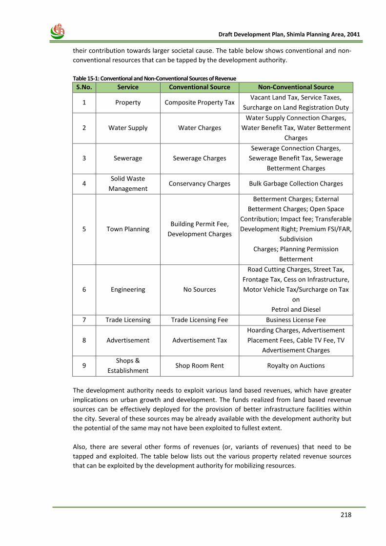
218
Draft Development Plan, Shimla Planning Area, 2041
their contribution towards larger societal cause. The table below shows conventional and non‐
conventional resources that can be tapped by the development authority.
Table 15-1: Conventional and Non‐Conventional Sources of Revenue
S.No. Service Conventional Source Non-Conventional Source
1 Property Composite Property Tax Vacant Land Tax, Service Taxes,
Surcharge on Land Registration Duty
2 Water Supply Water Charges
Water Supply Connection Charges,
Water Benefit Tax, Water Betterment
Charges
3 Sewerage Sewerage Charges
Sewerage Connection Charges,
Sewerage Benefit Tax, Sewerage
Betterment Charges
4 Solid Waste
Management Conservancy Charges Bulk Garbage Collection Charges
5 Town Planning Building Permit Fee,
Development Charges
Betterment Charges; External
Betterment Charges; Open Space
Contribution; Impact fee; Transferable
Development Right; Premium FSI/FAR,
Subdivision
Charges; Planning Permission
Betterment
6 Engineering No Sources
Road Cutting Charges, Street Tax,
Frontage Tax, Cess on Infrastructure,
Motor Vehicle Tax/Surcharge on Tax
on
Petrol and Diesel
7 Trade Licensing Trade Licensing Fee Business License Fee
8 Advertisement Advertisement Tax
Hoarding Charges, Advertisement
Placement Fees, Cable TV Fee, TV
Advertisement Charges
9 Shops &
Establishment Shop Room Rent Royalty on Auctions
The development authority needs to exploit various land based revenues, which have greater
implications on urban growth and development. The funds realized from land based revenue
sources can be effectively deployed for the provision of better infrastructure facilities within
the city. Several of these sources may be already available with the development authority but
the potential of the same may not have been exploited to fullest extent.
Also, there are several other forms of revenues (or, variants of revenues) that need to be
tapped and exploited. The table below lists out the various property related revenue sources
that can be exploited by the development authority for mobilizing resources.
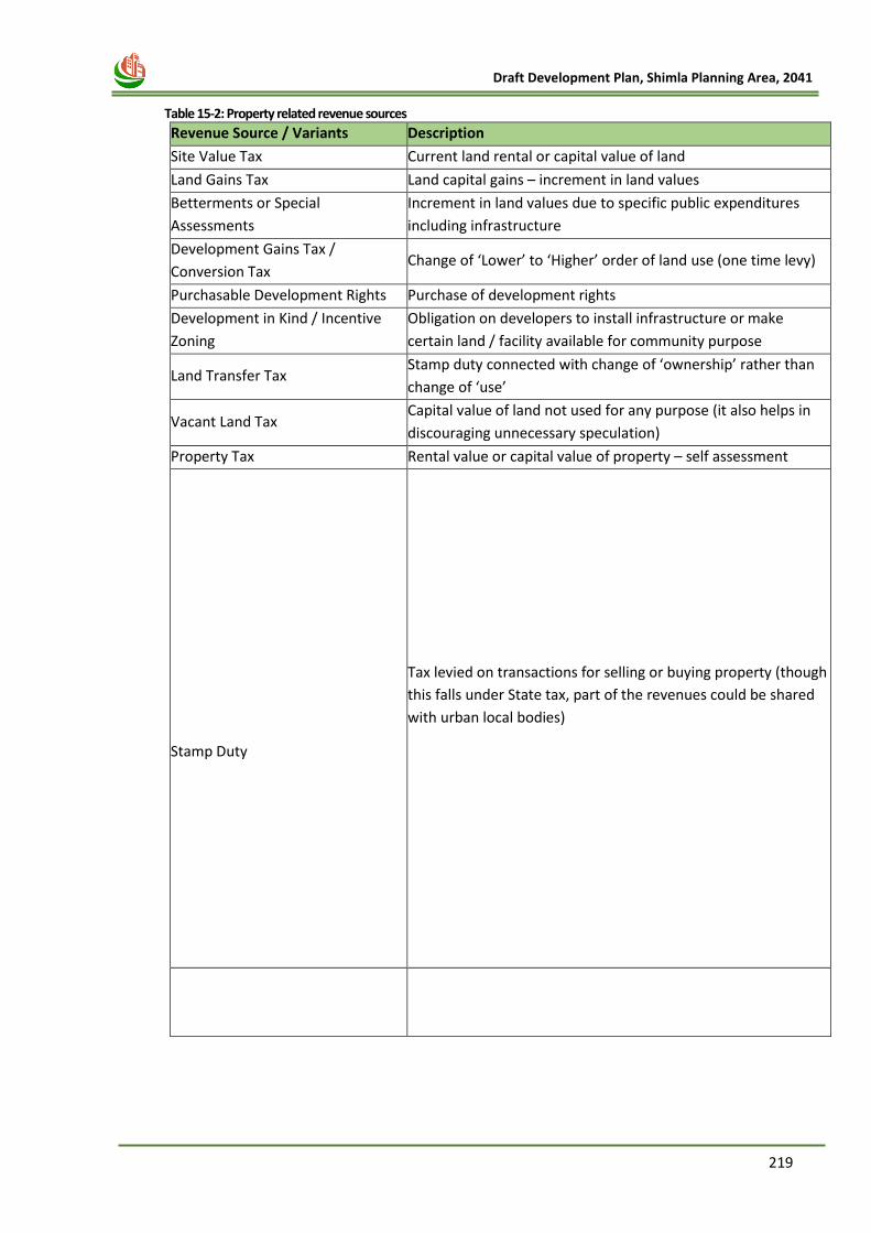
219
Draft Development Plan, Shimla Planning Area, 2041
Table 15-2: Property related revenue sources
Revenue Source / Variants Description
Site Value Tax Current land rental or capital value of land
Land Gains Tax Land capital gains – increment in land values
Betterments or Special
Assessments
Increment in land values due to specific public expenditures
including infrastructure
Development Gains Tax /
Conversion Tax Change of ‘Lower’ to ‘Higher’ order of land use (one time levy)
Purchasable Development Rights Purchase of development rights
Development in Kind / Incentive
Zoning
Obligation on developers to install infrastructure or make
certain land / facility available for community purpose
Land Transfer Tax Stamp duty connected with change of ‘ownership’ rather than
change of ‘use’
Vacant Land Tax Capital value of land not used for any purpose (it also helps in
discouraging unnecessary speculation)
Property Tax Rental value or capital value of property – self assessment
Stamp Duty
Tax levied on transactions for selling or buying property (though
this falls under State tax, part of the revenues could be shared
with urban local bodies)
220
Draft Development Plan, Shimla Planning Area, 2041
Chapter 16
DEVELOPMENT PLAN PHASING
AND FINANCING
221
Draft Development Plan, Shimla Planning Area, 2041
16 CHAPTER- 16 DEVELOPMENT PLAN PHASING 16.1 Development Plan– Cost & Revenue Estimates
16.1.1 Project Costs
There are two types of costs estimated viz. A) Land Acquisition Costs and B) Development Costs.
These have been estimated for major trunk infrastructure, necessary for the development of
plan proposals. Several of these projects will require detailed feasibility estimates and
preparation of detailed project reports prior to implementation.
A. Land Acquisition Costs
The Land Acquisition for public purpose is the sole responsibility of the Competent Authority for
the planning horizon from the sanction of the plan. It is desirable to acquire all land by
authority for proper implementation of the plan. The acquisition costs are estimated based on
the average prevailing Jantri rates (Government Rate Card) in the Shimla Planning Area or
HPWD rates. However, there are possible tools like Accommodation Reservation and TDR. It is
assumed that these tools will be instrumental in acquiring land of roads, public amenities &
open spaces.
B. Development Costs - Amenities & Recreational Open Spaces
It is suggested that the Competent Authority shall plan to develop the amenities and open
spaces through private sector participation to reduce the financial burden on the authority and
to ensure higher degree of plan implementation. Development cost shall be calculated for all
the infrastructure facilities that will be required by the year 2041.
i. Road Cost
The development/ construction of some of the national highways (4 lane) along Mehli and
other areas of Shimla Planning area is taking place. Moreover, the road widening projects at
many places are also taking place under SMART city mission. However, for the remaining Road
& transportation proposals the major assumptions taken while calculating the road
development cost have been mentioned below:
Regional Roads/ National Highway/ State Highway roads – the percentage of new roads shall
be about 20% of the total proposed road length while the remaining 80% shall be existing roads
requiring road widening
Major city roads/ PWD roads – the percentage of new roads shall be about 25% of the total
proposed road length while the remaining 90% shall be existing roads requiring road widening
Rest of the roads - the percentage of new roads shall be about 40% of the total proposed road
length while the remaining 60% shall be existing roads requiring road widening.
ii. Water Supply Cost
Along with the proposed road length, water supply are to be calculated and their cost
estimation will be carried out.
iii. Sewerage & Drainage Network Cost
Similarly cost estimation has to be calculated for Sewerage and drainage network along the
major and minor roads.
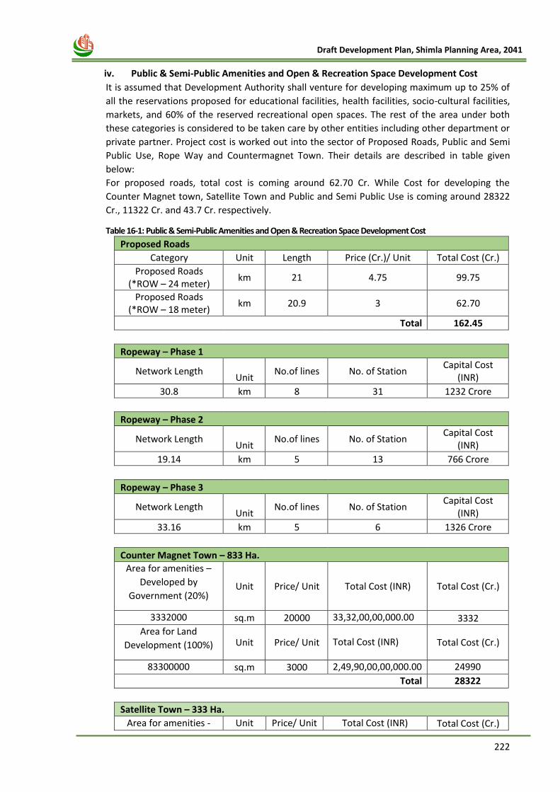
222
Draft Development Plan, Shimla Planning Area, 2041
iv. Public & Semi-Public Amenities and Open & Recreation Space Development Cost
It is assumed that Development Authority shall venture for developing maximum up to 25% of
all the reservations proposed for educational facilities, health facilities, socio-cultural facilities,
markets, and 60% of the reserved recreational open spaces. The rest of the area under both
these categories is considered to be taken care by other entities including other department or
private partner. Project cost is worked out into the sector of Proposed Roads, Public and Semi
Public Use, Rope Way and Countermagnet Town. Their details are described in table given
below:
For proposed roads, total cost is coming around 62.70 Cr. While Cost for developing the
Counter Magnet town, Satellite Town and Public and Semi Public Use is coming around 28322
Cr., 11322 Cr. and 43.7 Cr. respectively.
Table 16-1: Public & Semi-Public Amenities and Open & Recreation Space Development Cost
Proposed Roads
Category Unit Length Price (Cr.)/ Unit Total Cost (Cr.)
Proposed Roads (*ROW – 24 meter)
km 21 4.75 99.75
Proposed Roads (*ROW – 18 meter)
km 20.9 3 62.70
Total 162.45
Ropeway – Phase 1
Network Length Unit
No.of lines No. of Station Capital Cost
(INR)
30.8 km 8 31 1232 Crore
Ropeway – Phase 2
Network Length Unit
No.of lines No. of Station Capital Cost
(INR)
19.14 km 5 13 766 Crore
Ropeway – Phase 3
Network Length Unit
No.of lines No. of Station Capital Cost
(INR)
33.16 km 5 6 1326 Crore
Counter Magnet Town – 833 Ha.
Area for amenities –
Developed by
Government (20%) Unit Price/ Unit Total Cost (INR) Total Cost (Cr.)
3332000 sq.m 20000 33,32,00,00,000.00 3332
Area for Land
Development (100%) Unit Price/ Unit Total Cost (INR) Total Cost (Cr.)
83300000 sq.m 3000 2,49,90,00,00,000.00 24990
Total 28322
Satellite Town – 333 Ha.
Area for amenities - Unit Price/ Unit Total Cost (INR) Total Cost (Cr.)
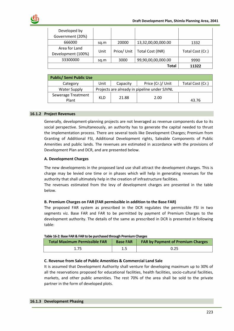
223
Draft Development Plan, Shimla Planning Area, 2041
Developed by
Government (20%)
666000 sq.m 20000 13,32,00,00,000.00 1332
Area for Land
Development (100%) Unit Price/ Unit Total Cost (INR) Total Cost (Cr.)
33300000 sq.m 3000 99,90,00,00,000.00 9990
Total 11322
Public/ Semi Public Use
Category Unit Capacity Price (Cr.)/ Unit Total Cost (Cr.)
Water Supply Projects are already in pipeline under SJVNL
Sewerage Treatment Plant
KLD 21.88 2.00
43.76
16.1.2 Project Revenues
Generally, development-planning projects are not leveraged as revenue components due to its
social perspective. Simultaneously, an authority has to generate the capital needed to thrust
the implementation process. There are several tools like Development Charges; Premium from
Granting of Additional FSI, Additional Development rights, Saleable Components of Public
Amenities and public lands. The revenues are estimated in accordance with the provisions of
Development Plan and DCR, and are presented below.
A. Development Charges
The new developments in the proposed land use shall attract the development charges. This is
charge may be levied one time or in phases which will help in generating revenues for the
authority that shall ultimately help in the creation of infrastructure facilities.
The revenues estimated from the levy of development charges are presented in the table
below.
B. Premium Charges on FAR (FAR permissible in addition to the Base FAR)
The proposed FAR system as prescribed in the DCR regulates the permissible FSI in two
segments viz. Base FAR and FAR to be permitted by payment of Premium Charges to the
development authority. The details of the same as prescribed in DCR is presented in following
table:
Table 16-2: Base FAR & FAR to be purchased through Premium Charges
Total Maximum Permissible FAR Base FAR FAR by Payment of Premium Charges
1.75 1.5 0.25
C. Revenue from Sale of Public Amenities & Commercial Land Sale
It is assumed that Development Authority shall venture for developing maximum up to 30% of
all the reservations proposed for educational facilities, health facilities, socio-cultural facilities,
markets, and other public amenities. The rest 70% of the area shall be sold to the private
partner in the form of developed plots.
16.1.3 Development Phasing
224
Draft Development Plan, Shimla Planning Area, 2041
The infrastructure needed to serve the projected population at build-out is substantially more
than will be needed to serve the development expected in the early phases of the project. As a
result, the provision of infrastructure and facilities will occur as the development they serve
takes place. Since development of Shimla will occur incrementally, this phasing provides a
framework and threshold for providing the infrastructure necessary to serve development as it
occurs. Implementation of Development Plan is divided into two phases coinciding with five
year plans namely:
1. Phase-1 2022-2030
2. Phase-2 2031-2035
3. Phase-3 2036-2041
These phased development will provide an analysis of the estimated annual development and
its impacts on the City included projected city revenues from the development. In view of
implementation of proposal in each phase priorities of subsequent phases shall be worked out
and accordingly implementation has to be ensured.
1. First Phase – 2022-2030
The following proposals are proposed to be implemented in first phase:
1) Identification of new areas for planned development as Counter Magnet town/ Satellite
towns at Ghanahatti, Banuti on Jablog road, Sayri on Kunihar road, Batlana near Shoghi
and Khalag near Jubbarhatti.
2) Land Development Mechanism for these planned development are to be devised and
implemented.
3) Development of Ropeway Phase 1 and Phase 2 lanes.
4) To create land bank and to make headway for acquisition of land for community
purposes including transportation.
5) To create parking lots at proposed strategic locations like Kufri, IGMC, New Shimla, SDA
Complex , Vidhan Sabha, Chakkar and Boileauganj, Dhalli,
6) Shifting and development of Wholesale Grain, vegetable and timber market, Ware
housing at Shoghi
7) Construction of Bye Pass Roads: -
i. Bypass Road connecting Taradevi to Jathiya Devi temple to Ghanahati
ii. Road from New Shimla Sector 4 (Ranjhana) to Shoghi-Mehli by-pass.
iii. Construction of Four Lanning from Shoghi to Dhalli.
8) Widening of major arterial and link roads.
a. Mashobra to Bekhalti Road.
b. Taradevi –Airport Road.
c. Ghanahatti – Airport Road.
d. Mehli- Junga Road.
e. Mehli-Gusan Road
f. Beolia- Sai Temple upto Junga Road.
g. Bhattkufar-Chakriyal Road.
h. Aukland – Bharari –Dudhli Road.
i. Shanan- Chamiyana Road.
2. Second Phase – 2031-2035
The following proposals are proposed to be implemented in second phase:
1) Land Development Schemes / Local Area Plans for Counter Magnet town/ satellite
towns at Ghanahatti, Khalag near Jubbarhatti and Chamyana near proposed 4 lane road
are to be devised and implemented.
225
Draft Development Plan, Shimla Planning Area, 2041
2) Development of open space and recreational spaces as demarcated in PLU
3) To create parking lots at proposed strategic locations like Ghanahatti Market, HPU,
Taradevi, Panthghati, Mehli, Mashobra.
4) Development of roads, water supply network and sewage network in New settlements
in Non-Core area
5) Development of Ropeway Phase 3 lane
6) Development of tourism projects in Kufri and Mashobara Area
3. Third Phase – 2036-2041
The following proposals are proposed to be implemented in third phase:
1) Land Development Schemes / Local Area Plans and Town Development Scheme/Town
Planning Schemes to be implemented in other parts of Shimla Planning Area.
2) All other remaining projects.
Actual phasing of development, including the configuration of development phases, may vary
from the foregoing anticipated phasing, and will depend upon such factors as market
conditions, economic considerations, and completion of infrastructure construction. Moreover,
the progress of the aforesaid projects in different phases will also depend on the detailed
feasibility study and implementation, after the consultation with the lined department.
226
Draft Development Plan, Shimla Planning Area, 2041
Chapter 17
LAND USE ZONING AND
DEVELOPMENT CONTROL
REGULATIONS
227
Draft Development Plan, Shimla Planning Area, 2041
17 CHAPTER- 17 LAND USE ZONING AND DEVELOPMENT CONTROL REGULATIONS
17.1 DEFINITIONS
1) “agriculture” includes horticulture, farming, raising of annual or periodical crops, fruits, vegetables,
flowers, grass, fodder, trees or any kind of cultivation of soil, the reserving of land for fodder, grazing or thatching areas, breeding and keeping of livestock including cattle, horses, donkeys, mules, pigs, breeding of fish and keeping of bees, and the use of land ancillary to the farming of land, but does not include-
(i) keeping of cattle purely for the purpose of milking and selling the milk and milk products,
(ii) a garden which is an appendage of buildings, and the expression “agricultural” shall be construed accordingly;
2) “amenity” includes roads and streets water and electric supply open spaces, parks, recreational
area, natural feature, play grounds, street lighting, drainage sewerage and other utilities, services and conveniences;
3) “allottee” in relation to apartment or plot, means the person to whom such apartment or plot has
been allotted, sold or otherwise transferred by the promoter;
4) “association” means an association consisting of the majority of the apartment owners in a building acting as a group in accordance with the bye-laws made by the association under the Himachal Pradesh Apartment Ownership Act, 1978;
Explanation.- A member of a Co-operative Housing Society of the tenant co-partnership type, or an allottee under a hire-purchase agreement shall be deemed to be an owner, entitled to membership of the association.
5) “Builder”: Will refer to the one who is involved in constructing flats or houses or other
establishments for commercial purposes and by way of sale thereof he will be involved in acquiring profits.
6) “building” includes any structure or erection, or part of a structure or erection, which is intended to
be used for residential, industrial, commercial or other purposes, whether in actual use or not. However, for the purpose of apartment, building shall mean a building constructed on any land, containing more than eight apartments, or two or more buildings with a total of more than eight apartments or any existing building converted into more than eight apartments”;
7) “building operation” includes-
(i) erection or re-erection of a building or any part thereof;
(ii) roofing or re-roofing of any part of building or an open space;
(iii) any material alteration or enlargement of a building;
(iv) any such alteration of a building as is likely to alter its drainage or sanitary arrangements, or materially affect its security;
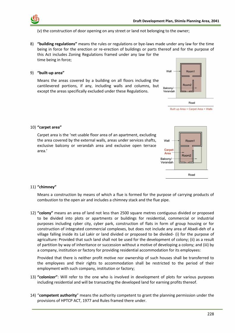
228
Draft Development Plan, Shimla Planning Area, 2041
(v) the construction of door opening on any street or land not belonging to the owner;
8) “building regulations” means the rules or regulations or bye-laws made under any law for the time
being in force for the erection or re-erection of buildings or parts thereof and for the purpose of this Act includes Zoning Regulations framed under any law for the time being in force;
9) “built-up area”
Means the areas covered by a building on all floors including the cantilevered portions, if any, including walls and columns, but except the areas specifically excluded under these Regulations.
10) “carpet area”
Carpet area is the ‘net usable floor area of an apartment, excluding the area covered by the external walls, areas under services shafts, exclusive balcony or verandah area and exclusive open terrace area.’
11) “chimney”
Means a construction by means of which a flue is formed for the purpose of carrying products of combustion to the open air and includes a chimney stack and the flue pipe.
12) “colony” means an area of land not less than 2500 square metres contiguous divided or proposed
to be divided into plots or apartments or buildings for residential, commercial or industrial purposes including cyber city, cyber park, construction of flats in form of group housing or for construction of integrated commercial complexes, but does not include any area of Abadi-deh of a village falling inside its Lal Lakir or land divided or proposed to be divided- (i) for the purpose of agriculture: Provided that such land shall not be used for the development of colony; (ii) as a result of partition by way of inheritance or succession without a motive of developing a colony; and (iii) by a company, institution or factory for providing residential accommodation for its employees:
Provided that there is neither profit motive nor ownership of such houses shall be transferred to the employees and their rights to accommodation shall be restricted to the period of their employment with such company, institution or factory;
13) “colonizer”: Will refer to the one who is involved in development of plots for various purposes including residential and will be transacting the developed land for earning profits thereof.
14) “competent authority” means the authority competent to grant the planning permission under the
provisions of HPTCP ACT, 1977 and Rules framed there under.
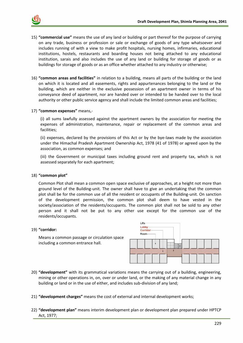
229
Draft Development Plan, Shimla Planning Area, 2041
15) “commercial use” means the use of any land or building or part thereof for the purpose of carrying
on any trade, business or profession or sale or exchange of goods of any type whatsoever and includes running of with a view to make profit hospitals, nursing homes, infirmaries, educational institutions, hostels, restaurants and boarding houses not being attached to any educational institution, sarais and also includes the use of any land or building for storage of goods or as buildings for storage of goods or as an office whether attached to any industry or otherwise;
16) “common areas and facilities” in relation to a building, means all parts of the building or the land
on which it is located and all easements, rights and appurtenances belonging to the land or the building, which are neither in the exclusive possession of an apartment owner in terms of his conveyance deed of apartment, nor are handed over or intended to be handed over to the local authority or other public service agency and shall include the limited common areas and facilities;
17) “common expenses” means,-
(i) all sums lawfully assessed against the apartment owners by the association for meeting the expenses of administration, maintenance, repair or replacement of the common areas and facilities;
(ii) expenses, declared by the provisions of this Act or by the bye-laws made by the association under the Himachal Pradesh Apartment Ownership Act, 1978 (41 of 1978) or agreed upon by the association, as common expenses; and
(iii) the Government or municipal taxes including ground rent and property tax, which is not assessed separately for each apartment;
18) “common plot”
Common Plot shall mean a common open space exclusive of approaches, at a height not more than ground level of the Building-unit. The owner shall have to give an undertaking that the common plot shall be for the common use of all the resident or occupants of the Building-unit. On sanction of the development permission, the common plot shall deem to have vested in the society/association of the residents/occupants. The common plot shall not be sold to any other person and it shall not be put to any other use except for the common use of the residents/occupants.
19) “corridor:
Means a common passage or circulation space including a common entrance hall.
20) “development” with its grammatical variations means the carrying out of a building, engineering,
mining or other operations in, on, over or under land, or the making of any material change in any building or land or in the use of either, and includes sub-division of any land;
21) “development charges” means the cost of external and internal development works;
22) “development plan” means interim development plan or development plan prepared under HPTCP
Act, 1977;
230
Draft Development Plan, Shimla Planning Area, 2041
23) “development works” means external and internal development works;
24) “director” means the Director of Town and Country Planning appointed under HPTCP Act, 1977;
25) “dwelling unit”
Means a shelter consisting of residential accommodation for one family. provided that the
minimum accommodation in a dwelling unit shall be one room of minimum carpet area of 9.50
sq.mts with a minimum width of 2.4 Mts. and a w.c.
26) “existing development/ building/ use”
Means a development, building, structure or its use as sanctioned, approved, regularized,
authorized by the Competent Authority, existing prior to these Regulations.
27) “existing land use map” means a map indicating the use to which lands in any specified area are put at the time of preparing the map, and includes the register prepared, with the map giving details of land-use.
28) “external development works” includes roads and road systems, water supply, sewerage and
drainage systems, electric supply or any other work which may have to be executed in the periphery of, or outside, a colony for its benefit;
29) “floor” :Means the lower surface in a storey on which one normally walks in a building, and does
not include a mezzanine floor. Ground Floor is the floor at ground level with a plinth- hollow or solid, and direct access to a street or open space. The floor above it with minimum permissible height shall be termed as floor 1, with the next higher floor being termed as floor 2, and so on upwards.
30) “floor area”: Means the net enclosed area of a floor in the building including circulation spaces like
lobby or corridors, service areas and semi-open spaces such as verandah or balcony.
31) “floor area ratio”
Means the ratio between the total built up area of all the floors of the building to the area of plot
Total Built up area of all floors FAR =
Plot Area
i. Base/Permissible FAR : Means the base FAR permitted in a Base Zone by the Competent Authority as a matter of right.
ii. Premium FAR: Means the additional FAR available by payment iii. Maximum Permissible FAR: Means the maximum permissible FAR which includes Base FAR
and Chargeable FAR.
32) “foundation”
Means the part of the structure which is in direct contact with and transmitting loads to the ground.
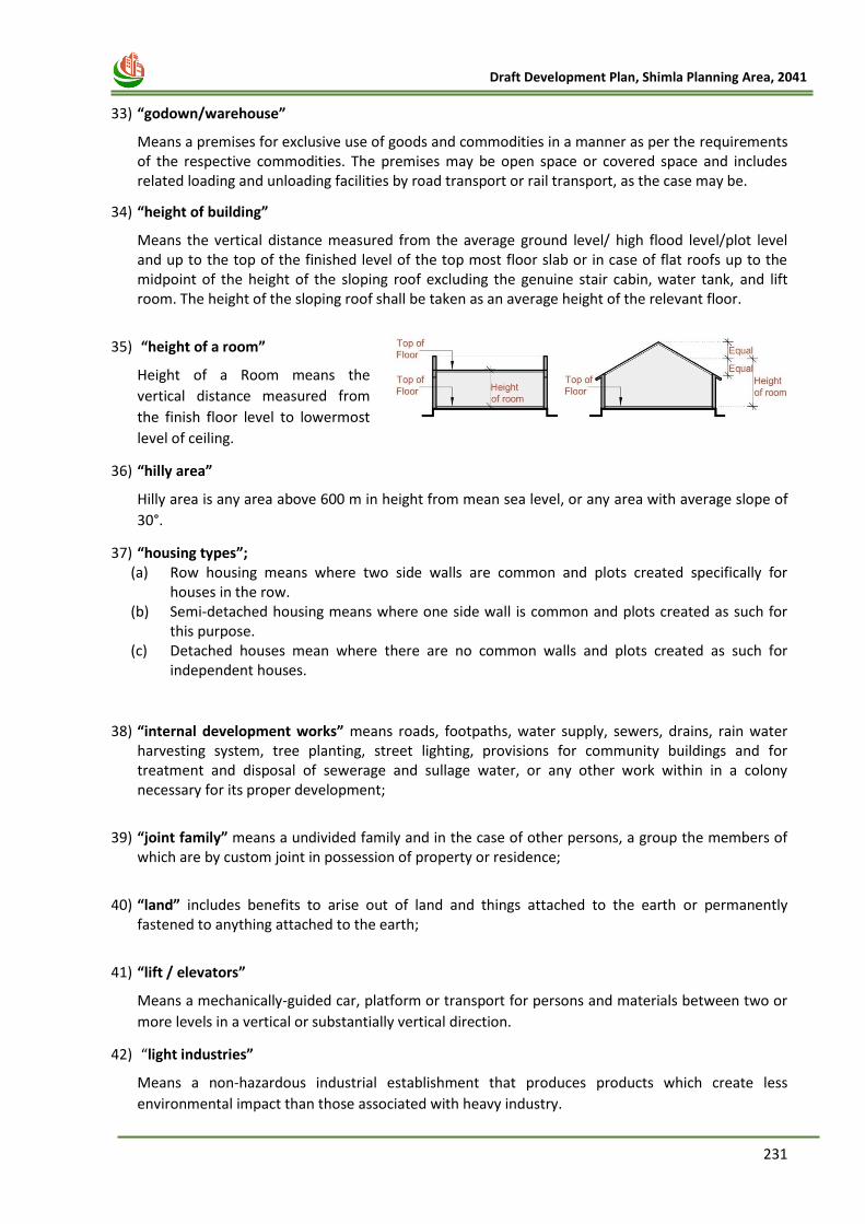
231
Draft Development Plan, Shimla Planning Area, 2041
33) “godown/warehouse”
Means a premises for exclusive use of goods and commodities in a manner as per the requirements of the respective commodities. The premises may be open space or covered space and includes related loading and unloading facilities by road transport or rail transport, as the case may be.
34) “height of building”
Means the vertical distance measured from the average ground level/ high flood level/plot level and up to the top of the finished level of the top most floor slab or in case of flat roofs up to the midpoint of the height of the sloping roof excluding the genuine stair cabin, water tank, and lift room. The height of the sloping roof shall be taken as an average height of the relevant floor.
35) “height of a room”
Height of a Room means the
vertical distance measured from
the finish floor level to lowermost
level of ceiling.
36) “hilly area”
Hilly area is any area above 600 m in height from mean sea level, or any area with average slope of
30°.
37) “housing types”; (a) Row housing means where two side walls are common and plots created specifically for
houses in the row. (b) Semi-detached housing means where one side wall is common and plots created as such for
this purpose. (c) Detached houses mean where there are no common walls and plots created as such for
independent houses.
38) “internal development works” means roads, footpaths, water supply, sewers, drains, rain water harvesting system, tree planting, street lighting, provisions for community buildings and for treatment and disposal of sewerage and sullage water, or any other work within in a colony necessary for its proper development;
39) “joint family” means a undivided family and in the case of other persons, a group the members of
which are by custom joint in possession of property or residence;
40) “land” includes benefits to arise out of land and things attached to the earth or permanently
fastened to anything attached to the earth;
41) “lift / elevators”
Means a mechanically-guided car, platform or transport for persons and materials between two or
more levels in a vertical or substantially vertical direction.
42) “light industries”
Means a non-hazardous industrial establishment that produces products which create less
environmental impact than those associated with heavy industry.
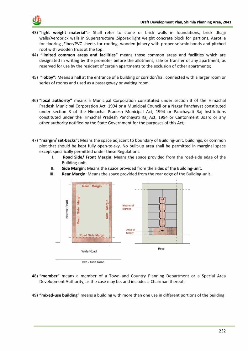
232
Draft Development Plan, Shimla Planning Area, 2041
43) “light weight material”:- Shall refer to stone or brick walls in foundations, brick dhajji
walls/Aerobrick walls in Superstructure ,Siporex light weight concrete block for partions, Aerotile for flooring ,Fiber/PVC sheets for roofing, wooden joinery with proper seismic bonds and pitched roof with wooden truss at the top.
44) “limited common areas and facilities” means those common areas and facilities which are designated in writing by the promoter before the allotment, sale or transfer of any apartment, as reserved for use by the resident of certain apartments to the exclusion of other apartments;
45) “lobby”: Means a hall at the entrance of a building or corridor/hall connected with a larger room or series of rooms and used as a passageway or waiting room.
46) “local authority” means a Municipal Corporation constituted under section 3 of the Himachal Pradesh Municipal Corporation Act, 1994 or a Municipal Council or a Nagar Panchayat constituted under section 3 of the Himachal Pradesh Municipal Act, 1994 or Panchayati Raj Institutions constituted under the Himachal Pradesh Panchayati Raj Act, 1994 or Cantonment Board or any other authority notified by the State Government for the purposes of this Act;
47) “margin/ set-backs”: Means the space adjacent to boundary of Building-unit, buildings, or common plot that should be kept fully open-to-sky. No built-up area shall be permitted in marginal space except specifically permitted under these Regulations.
I. Road Side/ Front Margin: Means the space provided from the road-side edge of the Building-unit.
II. Side Margin: Means the space provided from the sides of the Building-unit. III. Rear Margin: Means the space provided from the rear edge of the Building-unit.
48) “member” means a member of a Town and Country Planning Department or a Special Area Development Authority, as the case may be, and includes a Chairman thereof;
49) “mixed-use building” means a building with more than one use in different portions of the building
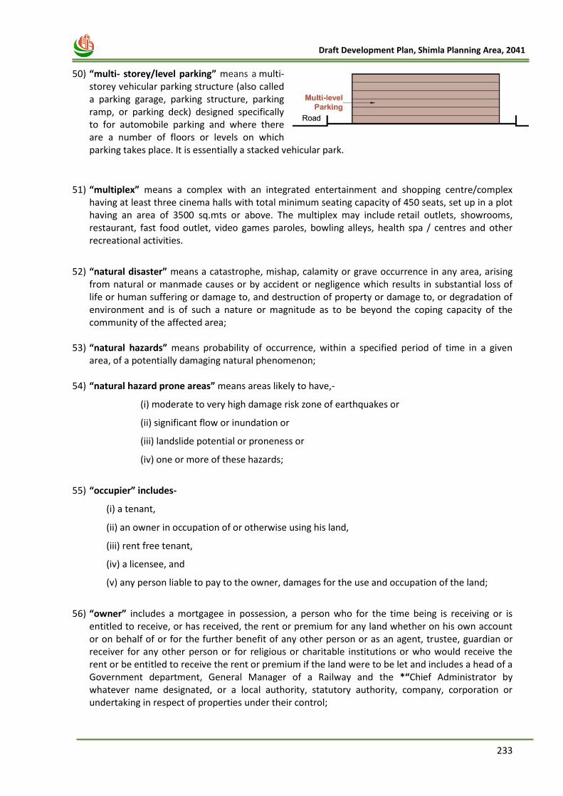
233
Draft Development Plan, Shimla Planning Area, 2041
50) “multi- storey/level parking” means a multi-
storey vehicular parking structure (also called a parking garage, parking structure, parking ramp, or parking deck) designed specifically to for automobile parking and where there are a number of floors or levels on which parking takes place. It is essentially a stacked vehicular park.
51) “multiplex” means a complex with an integrated entertainment and shopping centre/complex having at least three cinema halls with total minimum seating capacity of 450 seats, set up in a plot having an area of 3500 sq.mts or above. The multiplex may include retail outlets, showrooms, restaurant, fast food outlet, video games paroles, bowling alleys, health spa / centres and other recreational activities.
52) “natural disaster” means a catastrophe, mishap, calamity or grave occurrence in any area, arising
from natural or manmade causes or by accident or negligence which results in substantial loss of life or human suffering or damage to, and destruction of property or damage to, or degradation of environment and is of such a nature or magnitude as to be beyond the coping capacity of the community of the affected area;
53) “natural hazards” means probability of occurrence, within a specified period of time in a given
area, of a potentially damaging natural phenomenon;
54) “natural hazard prone areas” means areas likely to have,-
(i) moderate to very high damage risk zone of earthquakes or
(ii) significant flow or inundation or
(iii) landslide potential or proneness or
(iv) one or more of these hazards;
55) “occupier” includes-
(i) a tenant,
(ii) an owner in occupation of or otherwise using his land,
(iii) rent free tenant,
(iv) a licensee, and
(v) any person liable to pay to the owner, damages for the use and occupation of the land;
56) “owner” includes a mortgagee in possession, a person who for the time being is receiving or is
entitled to receive, or has received, the rent or premium for any land whether on his own account or on behalf of or for the further benefit of any other person or as an agent, trustee, guardian or receiver for any other person or for religious or charitable institutions or who would receive the rent or be entitled to receive the rent or premium if the land were to be let and includes a head of a Government department, General Manager of a Railway and the *“Chief Administrator by whatever name designated, or a local authority, statutory authority, company, corporation or undertaking in respect of properties under their control;
234
Draft Development Plan, Shimla Planning Area, 2041
57) “park/ garden”: Means a piece of ground in or near a city or town kept for recreation for the
general public.
58) “parking space”: Means an enclosed, semi-covered or open area including driveway and access aisles required to park vehicles, as per regulations related to parking. Parking spaces shall be served by a driveway connecting them with a street or alley and permitting ingress or egress of vehicles.
59) “person” includes company, firm, co-operative society, joint family and incorporated body of persons;
60) “petrol/diesel pump”: Means a premises for sale of petroleum products like petrol and diesel to consumers.
61) “planning area” means any area declared to be planning area under HPTCP Act, 1977;
62) “prescribed” means prescribed by the rules made under HPTCP Act, 1977;
63) “promoter” means a person who,-
(i) constructs or causes to be constructed a building consisting of apartments or converts an existing building or a part thereof into apartments for the purpose of selling all or some of the apartments to other persons and includes his assigns; or
(ii) develops land into a colony, whether or not, he also constructs structures on any of the plots “for the purpose of” selling to other persons, all or some of the plots whether open or with structures thereon; and
(iii) “constructs more than eight apartments or converts an existing building into more than eight apartments or develops a colony and the person who sells apartments or plots are different persons in any planning area, or any special area or any deemed planning area as specified in sub-section (3a) of section 1, the terms includes both of them;”
Explanation.- A person who acts as described in sub-clause (iii) of this clause shall be deemed to be a promoter, even if-
(i) he styles himself as a builder, colonizer, contractor, developer, estate promoter or by any other name; or
(ii) he claims to be acting as the holder of a power of attorney from the owner of the land on which the building is constructed or colony is developed; and
64) “property” means the land, the building, all improvements and structures thereon and all
easements, rights and appurtenances belonging thereto and includes every type of right and interest in land which a person can have to the exclusion of other persons, such as possession, use and enjoyment free from interference, right of disposition, franchises and hereditament.".
65) “region” means any area established to be a region under HPTCP Act, 1977;
66) “regional plan” means a plan for the region prepared under HPTCP Act, 1977 and approved by the State Government;
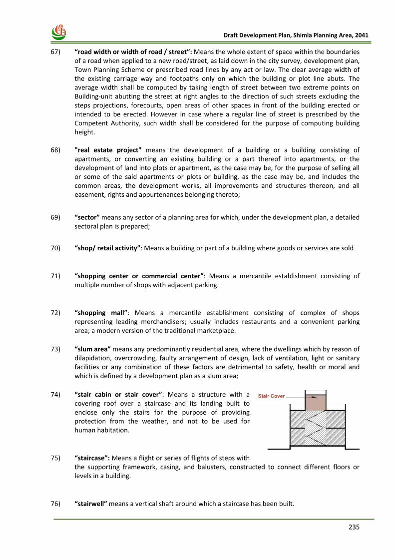
235
Draft Development Plan, Shimla Planning Area, 2041
67) “road width or width of road / street”: Means the whole extent of space within the boundaries
of a road when applied to a new road/street, as laid down in the city survey, development plan, Town Planning Scheme or prescribed road lines by any act or law. The clear average width of the existing carriage way and footpaths only on which the building or plot line abuts. The average width shall be computed by taking length of street between two extreme points on Building-unit abutting the street at right angles to the direction of such streets excluding the steps projections, forecourts, open areas of other spaces in front of the building erected or intended to be erected. However in case where a regular line of street is prescribed by the Competent Authority, such width shall be considered for the purpose of computing building height.
68) "real estate project" means the development of a building or a building consisting of apartments, or converting an existing building or a part thereof into apartments, or the development of land into plots or apartment, as the case may be, for the purpose of selling all or some of the said apartments or plots or building, as the case may be, and includes the common areas, the development works, all improvements and structures thereon, and all easement, rights and appurtenances belonging thereto;
69) “sector” means any sector of a planning area for which, under the development plan, a detailed sectoral plan is prepared;
70) “shop/ retail activity”: Means a building or part of a building where goods or services are sold
71) “shopping center or commercial center”: Means a mercantile establishment consisting of multiple number of shops with adjacent parking.
72) “shopping mall”: Means a mercantile establishment consisting of complex of shops representing leading merchandisers; usually includes restaurants and a convenient parking area; a modern version of the traditional marketplace.
73) “slum area” means any predominantly residential area, where the dwellings which by reason of dilapidation, overcrowding, faulty arrangement of design, lack of ventilation, light or sanitary facilities or any combination of these factors are detrimental to safety, health or moral and which is defined by a development plan as a slum area;
74) “stair cabin or stair cover”: Means a structure with a covering roof over a staircase and its landing built to enclose only the stairs for the purpose of providing protection from the weather, and not to be used for human habitation.
75) “staircase”: Means a flight or series of flights of steps with the supporting framework, casing, and balusters, constructed to connect different floors or levels in a building.
76) “stairwell” means a vertical shaft around which a staircase has been built.
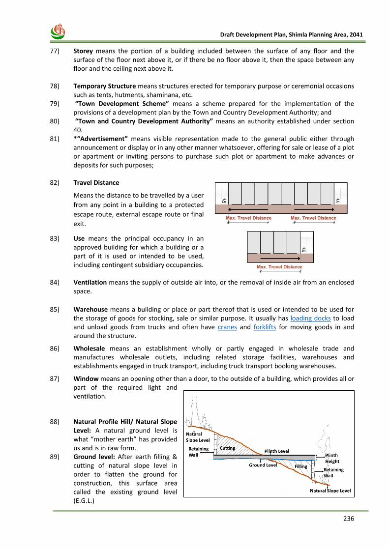
236
Draft Development Plan, Shimla Planning Area, 2041
77) Storey means the portion of a building included between the surface of any floor and the
surface of the floor next above it, or if there be no floor above it, then the space between any floor and the ceiling next above it.
78) Temporary Structure means structures erected for temporary purpose or ceremonial occasions such as tents, hutments, shaminana, etc.
79) “Town Development Scheme” means a scheme prepared for the implementation of the provisions of a development plan by the Town and Country Development Authority; and
80) “Town and Country Development Authority” means an authority established under section 40.
81) *“Advertisement” means visible representation made to the general public either through announcement or display or in any other manner whatsoever, offering for sale or lease of a plot or apartment or inviting persons to purchase such plot or apartment to make advances or deposits for such purposes;
82) Travel Distance
Means the distance to be travelled by a user
from any point in a building to a protected
escape route, external escape route or final
exit.
83) Use means the principal occupancy in an approved building for which a building or a part of it is used or intended to be used, including contingent subsidiary occupancies.
84) Ventilation means the supply of outside air into, or the removal of inside air from an enclosed space.
85) Warehouse means a building or place or part thereof that is used or intended to be used for the storage of goods for stocking, sale or similar purpose. It usually has loading docks to load and unload goods from trucks and often have cranes and forklifts for moving goods in and around the structure.
86) Wholesale means an establishment wholly or partly engaged in wholesale trade and manufactures wholesale outlets, including related storage facilities, warehouses and establishments engaged in truck transport, including truck transport booking warehouses.
87) Window means an opening other than a door, to the outside of a building, which provides all or part of the required light and ventilation.
88) Natural Profile Hill/ Natural Slope Level: A natural ground level is what “mother earth” has provided us and is in raw form.
89) Ground level: After earth filling & cutting of natural slope level in order to flatten the ground for construction, this surface area called the existing ground level (E.G.L.)
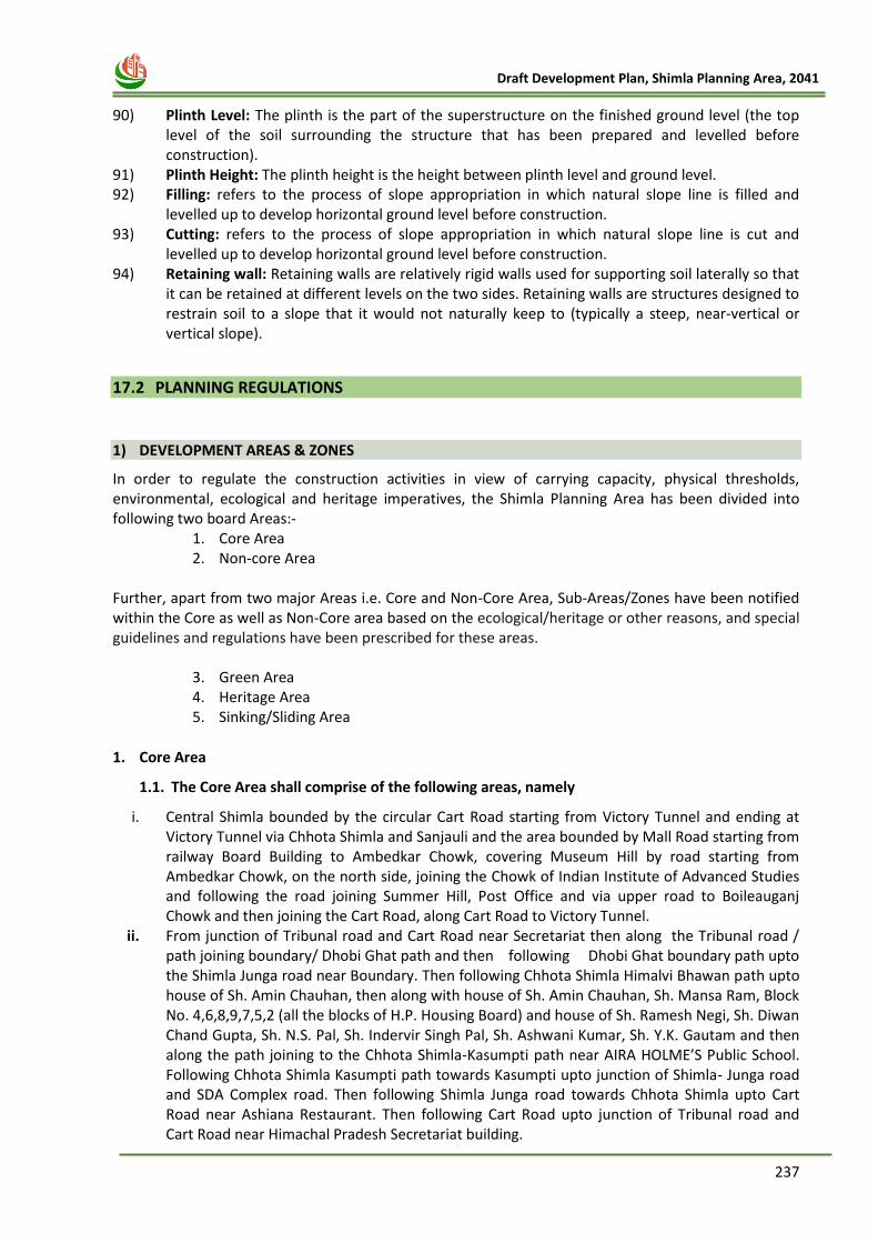
237
Draft Development Plan, Shimla Planning Area, 2041
90) Plinth Level: The plinth is the part of the superstructure on the finished ground level (the top
level of the soil surrounding the structure that has been prepared and levelled before construction).
91) Plinth Height: The plinth height is the height between plinth level and ground level. 92) Filling: refers to the process of slope appropriation in which natural slope line is filled and
levelled up to develop horizontal ground level before construction. 93) Cutting: refers to the process of slope appropriation in which natural slope line is cut and
levelled up to develop horizontal ground level before construction. 94) Retaining wall: Retaining walls are relatively rigid walls used for supporting soil laterally so that
it can be retained at different levels on the two sides. Retaining walls are structures designed to restrain soil to a slope that it would not naturally keep to (typically a steep, near-vertical or vertical slope).
17.2 PLANNING REGULATIONS
1) DEVELOPMENT AREAS & ZONES
In order to regulate the construction activities in view of carrying capacity, physical thresholds, environmental, ecological and heritage imperatives, the Shimla Planning Area has been divided into following two board Areas:-
1. Core Area 2. Non-core Area
Further, apart from two major Areas i.e. Core and Non-Core Area, Sub-Areas/Zones have been notified within the Core as well as Non-Core area based on the ecological/heritage or other reasons, and special guidelines and regulations have been prescribed for these areas.
3. Green Area 4. Heritage Area 5. Sinking/Sliding Area
1. Core Area
1.1. The Core Area shall comprise of the following areas, namely
i. Central Shimla bounded by the circular Cart Road starting from Victory Tunnel and ending at Victory Tunnel via Chhota Shimla and Sanjauli and the area bounded by Mall Road starting from railway Board Building to Ambedkar Chowk, covering Museum Hill by road starting from Ambedkar Chowk, on the north side, joining the Chowk of Indian Institute of Advanced Studies and following the road joining Summer Hill, Post Office and via upper road to Boileauganj Chowk and then joining the Cart Road, along Cart Road to Victory Tunnel.
ii. From junction of Tribunal road and Cart Road near Secretariat then along the Tribunal road / path joining boundary/ Dhobi Ghat path and then following Dhobi Ghat boundary path upto the Shimla Junga road near Boundary. Then following Chhota Shimla Himalvi Bhawan path upto house of Sh. Amin Chauhan, then along with house of Sh. Amin Chauhan, Sh. Mansa Ram, Block No. 4,6,8,9,7,5,2 (all the blocks of H.P. Housing Board) and house of Sh. Ramesh Negi, Sh. Diwan Chand Gupta, Sh. N.S. Pal, Sh. Indervir Singh Pal, Sh. Ashwani Kumar, Sh. Y.K. Gautam and then along the path joining to the Chhota Shimla-Kasumpti path near AIRA HOLME’S Public School. Following Chhota Shimla Kasumpti path towards Kasumpti upto junction of Shimla- Junga road and SDA Complex road. Then following Shimla Junga road towards Chhota Shimla upto Cart Road near Ashiana Restaurant. Then following Cart Road upto junction of Tribunal road and Cart Road near Himachal Pradesh Secretariat building.
238
Draft Development Plan, Shimla Planning Area, 2041
2. Non-Core Area The Non-Core Area shall comprise of the area falling outside the Core Area and upto the boundaries of Shimla Planning Area.
3. Green Areas The Green Area falling in Core Area and Non-Core Area shall comprise of the following areas,
namely:-
i. The Forest Area bounded by bye-pass and Cart Road starting from junction of barrier following
the Cart Road to Parivahan Bhawan Nullah near Government Press, then alongwith houses of
Shri Yog Raj Sharma, J.N. Kaushal, Government Press, Welfare Department to Tutikandi,
following the path meeting at bye-pass road near Government High School, then following the
bye-pass and back to the junction of Barrier;
ii. Nabha Forest bounded by bye-pass and Cart Road from Tutikandi near Government High School
following the path to Cart Road to Nabha Road and following down along with HPPWD Godown
Block No. 28, Hostel I.T.I. Block No. 25-A, Block No. 23, Block-D, Block No. 21, Block L-II'84 and
Block-II'83 along Nullah meeting at bye- pass road and back to Tutikandi near Government High
School;
iii. Phagli and Lal Pani Forest bounded by Cart Road and bye-pass starting from Phagli path from the
bye-pass to Railway parking to Cart Road and then alongwith Railway quarter Block No.62, house
of Sh. Gopal Singh, Sh. Shiv Ranjan, Directorate of Education Department to Municipal
Corporation quarter to Sr. Sec. School Lalpani, then alongwith, Ladakhi Mohalla path upto house
of Smt. Janki Devi, Sh. Sunder Singh and Sh. Naresh, then following the Nullah meeting at
byepass road and back to the Phagli path;
iv. Bemloe Forest bounded by Cart Road and bye-pass starting from lift Nullah moving along Cart
Road then following down the path near Government quarters meeting at junction on Cart Road
to Bemloe road alongwith Post Office building, C.P.R.I. Complex, house of Sh. Sumer Chand, Sh.
I.D. Garg, Smt. Tripta Devi, Smt. Uma Vati, Smt. Sawarn Lata, Block D & C to Bemloe road & bye-
pass and following back to the bye-pass upto the lift Nullah;
v. Himland Forest starting from CPRI Complex on Bemloe Road to house of Sh. Ram Dhan Lal, Sh.
Darshal Lal, Sh. Joginder Pal, Sh. D.P. Sharma to Cart Road, then following the Cart Road to
Himland Nullah meeting at bye-pass to Bemloe Road and back to CPRI Complex;
vi. Khalini and Chhota Shimla Forest area bounded by Cart Road starting from the Nullah near Palika
Bhawan, then following the Nullah to bye-pass road, then to B.C.S. Road via Khalini Chowk to the
house of Sh. Prithvi Sen, Telecom Office, house of Sh. B.S.Chauhan, Hukmi Devi, H.T. Upadhya,
Savitri Niwas & Suman Niwas meeting bye-pass and following bye-pass to B.C.S. Dhobighat,
Servant quarters, Hospital, School Gate, Linlithgo Cottage, Gate Cottage, Pine Cottage, Jr. School
of B.C.S. meeting bye-pass then alongwith bye-pass upto the junction of S.D.A. Road to
Kasumpati-Junga Road alongwith SDA Blocks to Tibetian School to house of Shri. Vinod Sood,
O.C. Bali, Parshotam Dass, M.M. Gulati, Brij Lal Gupta, K.S. Dhaluata, M.R. Sood, Balbir Singh,
Joginder Lal, Varsha Vohra, Sarita Jaidk, Sant Kumar, R.R. Jain, B.L. Pandit, P.S. Negi, Bhupinder
Obraia, T.L. Sharma, I.D. Gupta, Sudershan Mahajan, Penajit Singh, Army Servant quarter then
alongwith Cart Road upto Palika Bhawan Nullah;
239
Draft Development Plan, Shimla Planning Area, 2041
vii. Chhota Shimla Forest area above Cart Road starting from eastern path near Military quarter to
Mall Road to western path meeting at Cart Road;
viii. Kasumpati Forest area starting from the junction of Kasumpati-Mehli path and Police Colony
Road near H. P.PWD Enquiry Office, then following Mehli- Kasumpati path upto Geeta Mandir
along Jammu Castle Road upto junction;
ix. Charlie Villa Forest areas starting from Himachal Pradesh Public Service Commission building
alongwith Himachal Pradesh Housing Board Building, houses of Shri Joginder Singh Kanwar,
Manta Niwas, Sanjeev Sharma, Urvashi Sharma, Dr. Amba Charan, B.R. Malhotra, Mahinder
Singh, O.P. Gupta, Army building, Fakir Chand Tada to Mall Road to Chief Minister residence then
following the Nullah near the house of Shri Satish Kumar Goel meeting at Cart Road;
x. Forest area starting from the Nullah near Himfed Petrol Pump, following the Nullah upto the
junction of path and Nullah, then following the path to the Himachal Pradesh Secretariat
building and following the Cart Road upto Himfed Petrol Pump;
xi. Jakhoo Forest starting from the junction of Raj Bhawan Road and Cart Road to Radha Swami
Bhawan along U.S. Club Road to lift Nullah to Titla Hotel following the road to Oak Wood
through northern road, then following the Nullah down ward to Snowdon Pump House via
Snowdon Road to house of Sh. T.D. Gupta, Sh. Sukhvinder Singh, M.C. Commissioner residence,
Corner House (M.C.quarter), Nehar Singh Thakur and Govt. Sr. Sec. School Sanjuali to Cart Road,
then following Cart Road, upto the junction of Raj Bhawan Road and Cart Road;
xii. Starting from Ram Chandra Chowk to Chief Minister residence via Raj Bhawan Road and Mall
Road to Challet Day School, then along U.S. Club Road to RamChandra Chowk;
xiii. Forest area bounded by Cart Road and Snowdon Road starting from Sanjuali Chowk to Snowdon
Hospital;
xiv. Bharari, Shankli and Ruldhu Bhatta Forest area starting from RKMV College along Keleston Road
to Harvingtion to Lower Bharari road to sewerage line path alongwith house to Sh. M.L. Sharma
(Geeta Bhawan), Prem Bhawan, house of Sh. Desh Raj to Cart Road along Nullah, then following
Cart Road upto RKMV College.
xv. Summer Hill Forest area starting from the Boileauganj Chowk to Summer Hill Post Office
alongwith Summer Hill Road, then following ITI Road upto the gate of Advance Studies via
Chaura Maidan Road upto Police Station Boileauganj encircling the hillock;
xvi. Starting from the junction of Boileauganj and NH-5 near C.M.P. post to Boileauganj ground,
Wakaf Board building shop No. 32 and Wakaf Board building, shop No.34 alongwith Chaura
Maidan road upto Nullah near Press building and down the Nullah meeting at Cart Road; and
xvii. Starting from the gate of Advance Studies along Elysium Hill Road to Ambedkar Chowk encircling
Elysium Hill via Chaura Maidan Road upto gate of Advance Studies.
4. Heritage Area (1) Heritage Area, Heritage Buildings and Cemeteries.—
The following Areas and Buildings whether falling inside or outside the Heritage Area or in Core
Area or in Non-Core Area shall be Heritage Area and heritage Buildings:—
(a) Heritage Areas:—
(i) Vice Regal Lodge Complex complete;
(ii) one building depth on either side of Road surrounding Vice Regal Lodge Complex;
240
Draft Development Plan, Shimla Planning Area, 2041
(iii) one building depth on either side of Mall Road from gate of HAS upto Chhota Shimla
Chowk via SBI, Scandal Point, Shimla Club and Oak Over;
(iv) one building depth on either side of the path/road from Prakash Niwas (housing Shimla
Type Writer) near SBI via Kalibari to Scandal Point;
(v) the area bounded by Scandal Point, Ridge, Regal, Takka Bench, Church, Ritz, U.S. Club
gate, PWD Office, Chalet Day School and The Mall Road;
(vi) one building depth on either side of the Road from Oak Over to Barnes Court
(Governor’s Residence) via Woodvilla;
(vii) Green patches within heritage area;
(b) Heritage Buildings:—
1. Post Office Summer Hill, 2. Indian Institute of Advanced Study, 3. Post Office Chaura Maidan,
4. The Cecil, 5. Carton House, 6. Clemont, 7. Race View, 8. Vidhan Sabha Himachal Pradesh, 9.
Gorton Castle, 10. Railway Board Building, 11. Prakash Niwas, 12. State Bank of India, 13. St.
Mark’s, 14. Kali Bari Temple, 15. Grand Hotel, 16. Bantony, 17. Telegraph Office, 18. St.
Andrew’s Church, 19. General Post Office, 20. Building of the ICICI Bank, 21. The whole range of
buildings starting from Northern Railway booking Agency opposite to Telegraph Office building
and upto Ramji Dass Dina Nath Building on the Mall Road, 22. Town Hall, 23. Gaiety Theatre, 24.
Band Stand, 25. M.C. Library, Ridge, 26. Christ Church, 27. Ladies Park. 28. United Services Club,
29. The Clarks, 30. The Chalet, 31. The Cedars, 32. Oak Over, 33. Cemetery near Oak Over, 34.
Woodvilla, 35. Ernest, 36. Yates Place, 37. Raj Bhawan (Barnes Court) 38. Police Station Sadar at
Boileauganj; 39. Y.M. C.A., 40. St. Michael’s Cathedral, 41. Deen Dayal Upadhayaya Hospital
(Formerly Ripon Hospital), 42 Green Gate, 43. Rothney Castle, 44. Tara Hall, 45. Auckland
House, 46. Chapslee, 47. Convent of Jesus and Mary, 48. Aira Holme, 49. Sterling Castle, 50.
Hainault, 51. Jakhoo Temple, 52. Corner House, 55. Torrentium, 54. Pari-Mahal (Old building),
55. Holly Lodge main building, 56. Walsingham (D.C. Residence), 57. Kamla Nehru Hospital
(Old), 58. Manorville, 59. Bishop Cotton School, 60. Govt. Boys Degree College Sanjauli, 61.
Sodhowal Lodge, 62. The Kalka Shimla Railway Line, 63. Crow- Borough, 64. Inverarm (State
Museum), 65. Strawberry Hill, 66. The Bemole Cottages, 67. Spring Field, 68. South Gate, 69
Foswell, 70. Emm Villa, 71 Craig Gardens, 72. Dimple Lodge, 73. Delphine Lodge, 74. Eddleston,
75. Eaglemount, 76. Railway Station Summer Hill, 77. Winter Field, 78. St. Thomas Church, 79
Shimleshwar (Shiv Mandir), 80. St. Edward School, 81. Wood Bank Offices Rest House, 82.
Thistle Bank, 83. Y.M.C. A., 84. Office of the Deputy Commissioner, 85. Ellerslie Building, 86.
Police Station Chhota Shimla, 87. The Burj, 88. Armsdell, 89. Benmore Estate, 90. Toryne House,
91. Morvyn, (I.T.I. Shimla), 92. Police Station Sadar Sabji Mandi, Shimla.
(C) Cemeteries
Cemetery below the Barrier, Boileauganj, 2. Cemetery at Kanlog 3. Cemetery below St. Bede’s
4. Cemetery at Sanjuali.
(2) The Heritage Area shall be divided into two categories namely:—
(I) Built Heritage:
It shall comprise of all the buildings both private and Government falling within or outside the
Heritage Area as declared by the State Government.
(II) Natural Heritage:
(i) Area on hill side of the Mall starting from Khadi Gramodyog to Kali Studio,
(ii) Daulat Singh Park.
(iii) Café Park,
(iv) Ridge, and
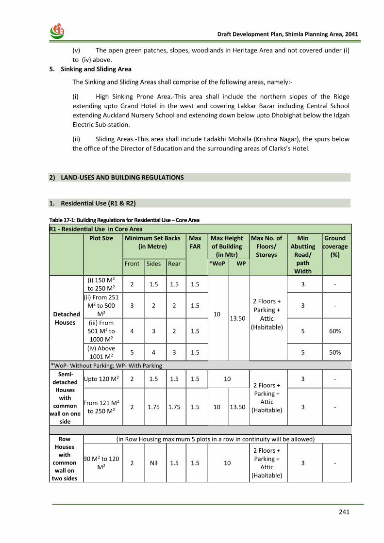
241
Draft Development Plan, Shimla Planning Area, 2041
(v) The open green patches, slopes, woodlands in Heritage Area and not covered under (i)
to (iv) above.
5. Sinking and Sliding Area
The Sinking and Sliding Areas shall comprise of the following areas, namely:-
(i) High Sinking Prone Area.-This area shall include the northern slopes of the Ridge
extending upto Grand Hotel in the west and covering Lakkar Bazar including Central School
extending Auckland Nursery School and extending down below upto Dhobighat below the Idgah
Electric Sub-station.
(ii) Sliding Areas.-This area shall include Ladakhi Mohalla (Krishna Nagar), the spurs below
the office of the Director of Education and the surrounding areas of Clarks’s Hotel.
2) LAND-USES AND BUILDING REGULATIONS
1. Residential Use (R1 & R2) Table 17-1: Building Regulations for Residential Use – Core Area
R1 - Residential Use in Core Area
Plot Size Minimum Set Backs (in Metre)
Max FAR
Max Height of Building
(in Mtr)
Max No. of Floors/ Storeys
Min Abutting
Road/ path
Width
Ground coverage
(%)
Front Sides Rear *WoP WP
Detached Houses
(i) 150 M2 to 250 M2
2 1.5 1.5 1.5
10
13.50
2 Floors + Parking +
Attic (Habitable)
3 -
(ii) From 251 M2 to 500
M2 3 2 2 1.5 3 -
(iii) From 501 M2 to 1000 M2
4 3 2 1.5 5 60%
(iv) Above 1001 M2
5 4 3 1.5 5 50%
*WoP- Without Parking; WP- With Parking
Semi-detached Houses
with common
wall on one side
Upto 120 M2 2 1.5 1.5 1.5 10 2 Floors + Parking +
Attic (Habitable)
3 -
From 121 M2 to 250 M2
2 1.75 1.75 1.5 10 13.50 3 -
Row Houses
with common wall on
two sides
(in Row Housing maximum 5 plots in a row in continuity will be allowed)
90 M2 to 120 M2
2 Nil 1.5 1.5 10
2 Floors + Parking +
Attic (Habitable)
3 -
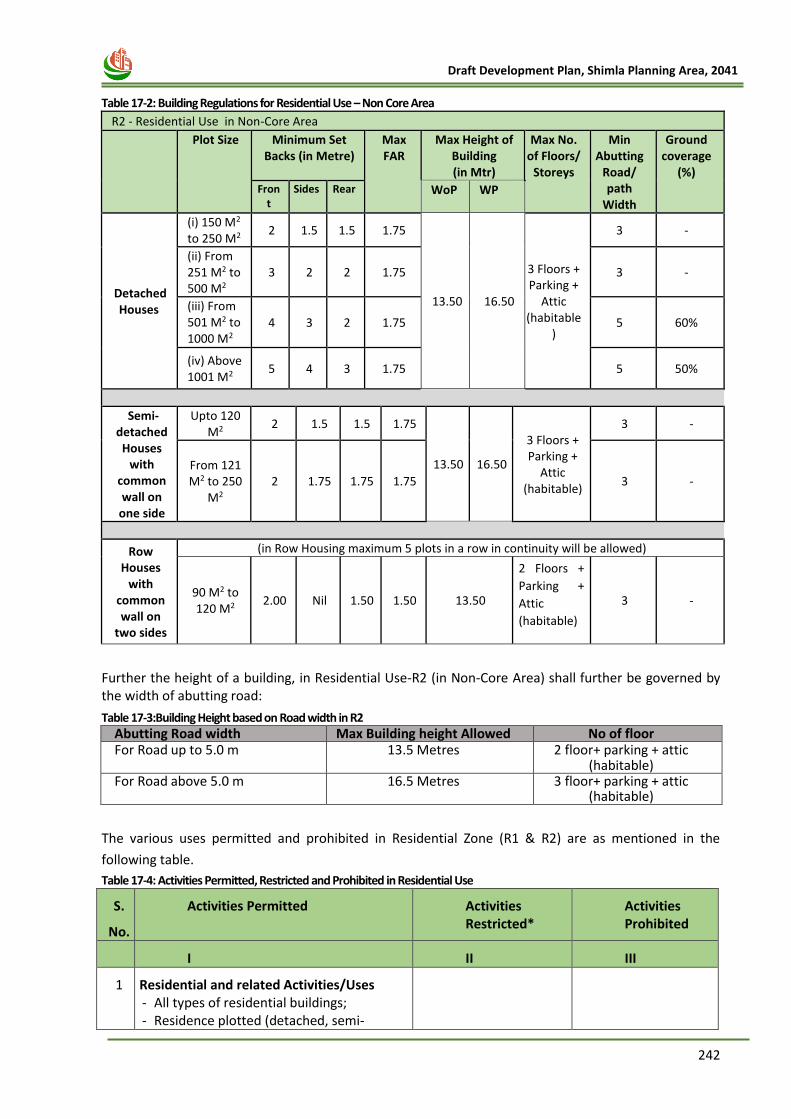
242
Draft Development Plan, Shimla Planning Area, 2041
Table 17-2: Building Regulations for Residential Use – Non Core Area
R2 - Residential Use in Non-Core Area
Plot Size Minimum Set Backs (in Metre)
Max FAR
Max Height of Building (in Mtr)
Max No. of Floors/
Storeys
Min Abutting
Road/ path
Width
Ground coverage
(%) Fron
t Sides Rear WoP WP
Detached Houses
(i) 150 M2 to 250 M2
2 1.5 1.5 1.75
13.50 16.50
3 Floors + Parking +
Attic (habitable
)
3 -
(ii) From 251 M2 to 500 M2
3 2 2 1.75 3 -
(iii) From 501 M2 to 1000 M2
4 3 2 1.75 5 60%
(iv) Above 1001 M2
5 4 3 1.75 5 50%
Semi-detached Houses
with common wall on
one side
Upto 120 M2
2 1.5 1.5 1.75
13.50 16.50
3 Floors + Parking +
Attic (habitable)
3 -
From 121 M2 to 250
M2 2 1.75 1.75 1.75 3 -
Row Houses
with common wall on
two sides
(in Row Housing maximum 5 plots in a row in continuity will be allowed)
90 M2 to 120 M2
2.00 Nil 1.50 1.50 13.50
2 Floors +
Parking +
Attic
(habitable)
3 -
Further the height of a building, in Residential Use-R2 (in Non-Core Area) shall further be governed by the width of abutting road:
Table 17-3:Building Height based on Road width in R2 Abutting Road width Max Building height Allowed No of floor For Road up to 5.0 m 13.5 Metres 2 floor+ parking + attic
(habitable) For Road above 5.0 m 16.5 Metres 3 floor+ parking + attic
(habitable)
The various uses permitted and prohibited in Residential Zone (R1 & R2) are as mentioned in the
following table.
Table 17-4: Activities Permitted, Restricted and Prohibited in Residential Use
S.
No.
Activities Permitted Activities Restricted*
Activities Prohibited
I II III
1 Residential and related Activities/Uses - All types of residential buildings; - Residence plotted (detached, semi-
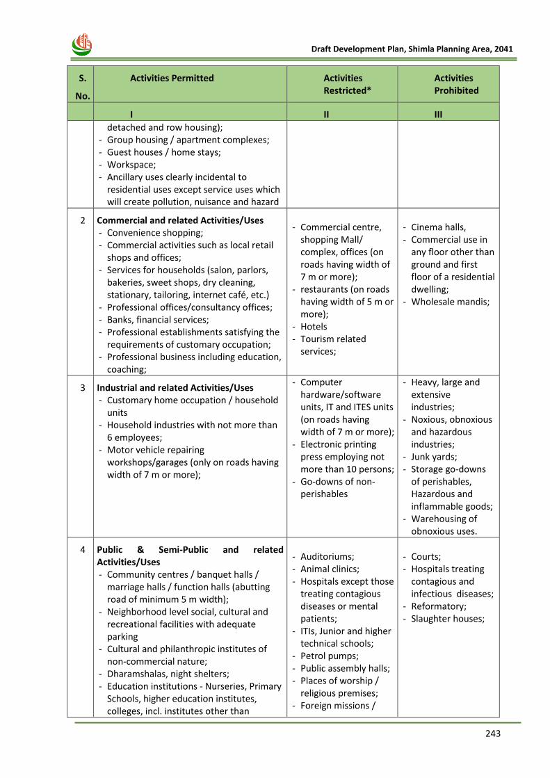
243
Draft Development Plan, Shimla Planning Area, 2041
S.
No.
Activities Permitted Activities Restricted*
Activities Prohibited
I II III
detached and row housing); - Group housing / apartment complexes; - Guest houses / home stays; - Workspace; - Ancillary uses clearly incidental to
residential uses except service uses which will create pollution, nuisance and hazard
2 Commercial and related Activities/Uses - Convenience shopping; - Commercial activities such as local retail
shops and offices; - Services for households (salon, parlors,
bakeries, sweet shops, dry cleaning, stationary, tailoring, internet café, etc.)
- Professional offices/consultancy offices; - Banks, financial services; - Professional establishments satisfying the
requirements of customary occupation; - Professional business including education,
coaching;
- Commercial centre,
shopping Mall/ complex, offices (on roads having width of 7 m or more);
- restaurants (on roads having width of 5 m or more);
- Hotels - Tourism related
services;
- Cinema halls, - Commercial use in
any floor other than ground and first floor of a residential dwelling;
- Wholesale mandis;
3 Industrial and related Activities/Uses - Customary home occupation / household
units - Household industries with not more than
6 employees; - Motor vehicle repairing
workshops/garages (only on roads having width of 7 m or more);
- Computer hardware/software units, IT and ITES units (on roads having width of 7 m or more);
- Electronic printing press employing not more than 10 persons;
- Go-downs of non-perishables
- Heavy, large and extensive industries;
- Noxious, obnoxious and hazardous industries;
- Junk yards; - Storage go-downs
of perishables, Hazardous and inflammable goods;
- Warehousing of obnoxious uses.
4 Public & Semi-Public and related Activities/Uses - Community centres / banquet halls /
marriage halls / function halls (abutting road of minimum 5 m width);
- Neighborhood level social, cultural and recreational facilities with adequate parking
- Cultural and philanthropic institutes of non-commercial nature;
- Dharamshalas, night shelters; - Education institutions - Nurseries, Primary
Schools, higher education institutes, colleges, incl. institutes other than
- Auditoriums; - Animal clinics; - Hospitals except those
treating contagious diseases or mental patients;
- ITIs, Junior and higher technical schools;
- Petrol pumps; - Public assembly halls; - Places of worship /
religious premises; - Foreign missions /
- Courts; - Hospitals treating
contagious and infectious diseases;
- Reformatory; - Slaughter houses;
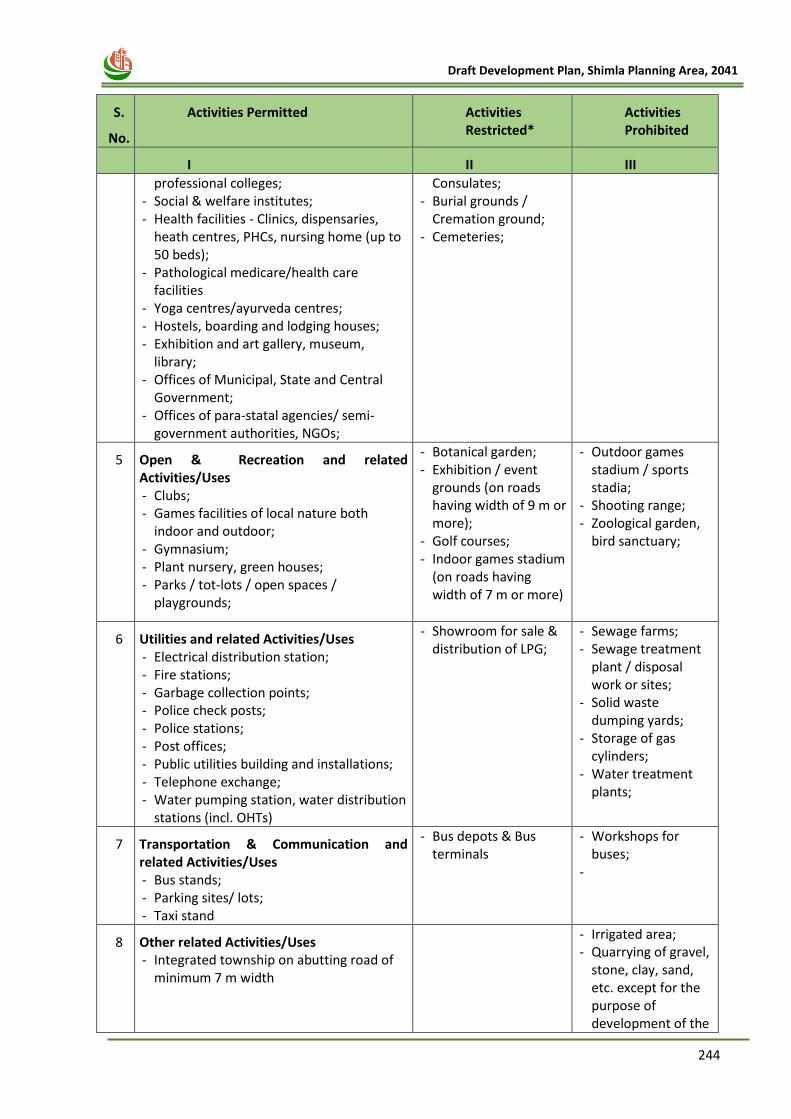
244
Draft Development Plan, Shimla Planning Area, 2041
S.
No.
Activities Permitted Activities Restricted*
Activities Prohibited
I II III
professional colleges; - Social & welfare institutes; - Health facilities - Clinics, dispensaries,
heath centres, PHCs, nursing home (up to 50 beds);
- Pathological medicare/health care facilities
- Yoga centres/ayurveda centres; - Hostels, boarding and lodging houses; - Exhibition and art gallery, museum,
library; - Offices of Municipal, State and Central
Government; - Offices of para-statal agencies/ semi-
government authorities, NGOs;
Consulates; - Burial grounds /
Cremation ground; - Cemeteries;
5 Open & Recreation and related Activities/Uses - Clubs; - Games facilities of local nature both
indoor and outdoor; - Gymnasium; - Plant nursery, green houses; - Parks / tot-lots / open spaces /
playgrounds;
- Botanical garden; - Exhibition / event
grounds (on roads having width of 9 m or more);
- Golf courses; - Indoor games stadium
(on roads having width of 7 m or more)
- Outdoor games stadium / sports stadia;
- Shooting range; - Zoological garden,
bird sanctuary;
6 Utilities and related Activities/Uses - Electrical distribution station; - Fire stations; - Garbage collection points; - Police check posts; - Police stations; - Post offices; - Public utilities building and installations; - Telephone exchange; - Water pumping station, water distribution
stations (incl. OHTs)
- Showroom for sale & distribution of LPG;
- Sewage farms; - Sewage treatment
plant / disposal work or sites;
- Solid waste dumping yards;
- Storage of gas cylinders;
- Water treatment plants;
7 Transportation & Communication and related Activities/Uses - Bus stands; - Parking sites/ lots; - Taxi stand
- Bus depots & Bus terminals
- Workshops for buses;
-
8 Other related Activities/Uses - Integrated township on abutting road of
minimum 7 m width
- Irrigated area; - Quarrying of gravel,
stone, clay, sand, etc. except for the purpose of development of the
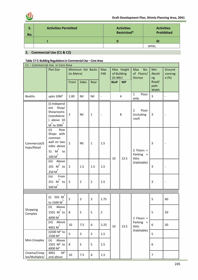
245
Draft Development Plan, Shimla Planning Area, 2041
S.
No.
Activities Permitted Activities Restricted*
Activities Prohibited
I II III
area;
2. Commercial Use (C1 & C2)
Table 17-5: Building Regulations in Commercial Use – Core Area
C1 – Commercial Use in Core Area
Plot Size Minimum Set Backs (in Metre)
Max FAR
Max Height of Building (in Mtr)
Max No. of Floors/ Storeys
Min Abutting Road/ path Width
Ground coverage (%)
Front Sides Rear WoP WP
Booths upto 10M2 1.00 Nil Nil - 4 1 Floor only
3 -
Commercial/Shops/Retail
(i) Independent Shop/ Showrooms (standalone) above 10
M2
to 30M2
2 Nil 1 - 8 2 Floor (including roof)
3 -
(ii) Row Shops with common wall on two sides above
31 M2 to
100 M2
2 Nil 1 1.5
10 13.5
2 Floors + Parking + Attic (habitable)
3 -
(iii) Above
101 M2 to
250 M2
2 1.5 1.5 1.5 3 -
(iv) From
251 M2 to
500 M2
3 2 2 1.5 3 -
Shopping Complex
(i) 501 M2
to 1500 M2
5 3 3 1.75
10 13.5
2 Floors + Parking + Attic (habitable)
5 60
(ii) Above
1501 M2
to
4000 M2
8 5 5 2 5 50
(iii) Above
4001 M2
10 7.5 6 2.25 6 50
Mini-Cineplex
(i)500 M2 to 1500 M2
5 3 3 1.5 5
(ii) Above 1501 M2 to 4000 M2
8 5 5 1.5 6
Cinema/Cineplex/Multiplex/
4001 M2 and above
10 7.5 6 1.5 7
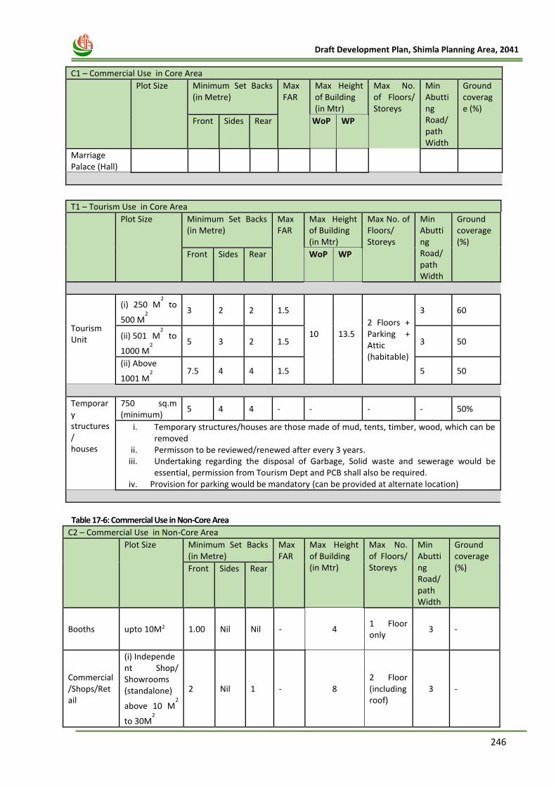
246
Draft Development Plan, Shimla Planning Area, 2041
C1 – Commercial Use in Core Area
Plot Size Minimum Set Backs (in Metre)
Max FAR
Max Height of Building (in Mtr)
Max No. of Floors/ Storeys
Min Abutting Road/ path Width
Ground coverage (%)
Front Sides Rear WoP WP
Marriage Palace (Hall)
T1 – Tourism Use in Core Area
Plot Size Minimum Set Backs (in Metre)
Max FAR
Max Height of Building (in Mtr)
Max No. of Floors/ Storeys
Min Abutting Road/ path Width
Ground coverage (%)
Front Sides Rear WoP WP
Tourism Unit
(i) 250 M2 to
500 M2
3 2 2 1.5
10
13.5
2 Floors + Parking + Attic (habitable)
3 60
(ii) 501 M2 to
1000 M2
5 3 2 1.5 3 50
(ii) Above
1001 M2
7.5 4 4 1.5 5 50
Temporary structures/ houses
750 sq.m (minimum)
5 4 4 - - - - 50%
i. Temporary structures/houses are those made of mud, tents, timber, wood, which can be removed
ii. Permisson to be reviewed/renewed after every 3 years. iii. Undertaking regarding the disposal of Garbage, Solid waste and sewerage would be
essential, permission from Tourism Dept and PCB shall also be required. iv. Provision for parking would be mandatory (can be provided at alternate location)
Table 17-6: Commercial Use in Non-Core Area
C2 – Commercial Use in Non-Core Area
Plot Size Minimum Set Backs (in Metre)
Max FAR
Max Height of Building (in Mtr)
Max No. of Floors/ Storeys
Min Abutting Road/ path Width
Ground coverage (%) Front Sides Rear
Booths upto 10M2 1.00 Nil Nil - 4 1 Floor only
3 -
Commercial/Shops/Retail
(i) Independent Shop/ Showrooms (standalone)
above 10 M2
to 30M2
2 Nil 1 - 8 2 Floor (including roof)
3 -
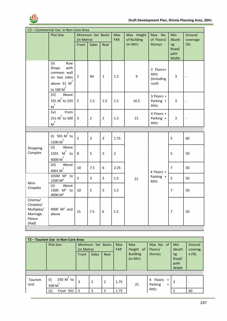
247
Draft Development Plan, Shimla Planning Area, 2041
C2 – Commercial Use in Non-Core Area
Plot Size Minimum Set Backs (in Metre)
Max FAR
Max Height of Building (in Mtr)
Max No. of Floors/ Storeys
Min Abutting Road/ path Width
Ground coverage (%) Front Sides Rear
(ii) Row Shops with common wall on two sides
above 31 M2
to 100 M2
2 Nil 1 1.5 9
2 Floors+ Attic (including roof)
3 -
(iii) Above
101 M2 to 250
M2
2 1.5 1.5 1.5 16.5 3 Floors + Parking + Attic
3 -
(iv) From
251 M2 to 500
M2
3 2 2 1.5 21 4 Floors + Parking + Attic
3 -
Shopping Complex
(i) 501 M2 to
1500 M2
5 3 3 1.75
21
4 Floors + Parking + Attic
5 60
(ii) Above
1501 M2
to
4000 M2
8 5 5 2 5 50
(iii) Above
4001 M2
10 7.5 6 2.25 7 50
Mini-Cineplex
(i)500 M2 to 1500 M2
5 3 3 1.5 5 50
(ii) Above 1500 M2 to 4000 M2
10 5 5 1.5 7 50
Cinema/ Cineplex/ Multiplex/Marriage Palace (Hall)
4000 M2 and above
15 7.5 6 1.5 7 50
T2 – Tourism Use in Non-Core Area
Plot Size Minimum Set Backs (in Metre)
Max FAR
Max Height of Building (in Mtr)
Max No. of Floors/ Storeys
Min Abutting Road/ path Width
Ground coverage (%) Front Sides Rear
Tourism Unit
(i) 250 M2 to
500 M2
3 2 2 1.75 21
4 Floors + Parking + Attic
3 -
(ii) From 501 5 3 3 1.75 5 60
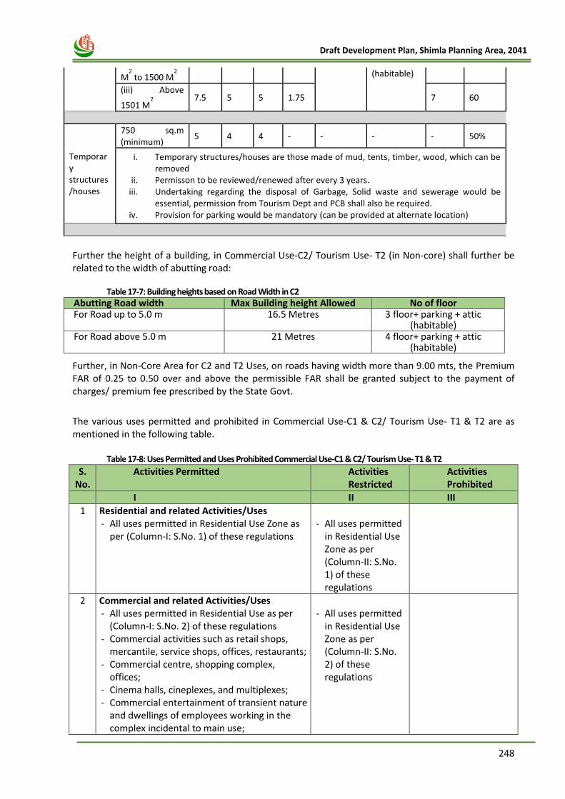
248
Draft Development Plan, Shimla Planning Area, 2041
M2 to 1500 M
2 (habitable)
(iii) Above
1501 M2
7.5 5 5 1.75 7 60
Temporary structures/houses
750 sq.m (minimum)
5 4 4 - - - - 50%
i. Temporary structures/houses are those made of mud, tents, timber, wood, which can be removed
ii. Permisson to be reviewed/renewed after every 3 years. iii. Undertaking regarding the disposal of Garbage, Solid waste and sewerage would be
essential, permission from Tourism Dept and PCB shall also be required. iv. Provision for parking would be mandatory (can be provided at alternate location)
Further the height of a building, in Commercial Use-C2/ Tourism Use- T2 (in Non-core) shall further be related to the width of abutting road:
Table 17-7: Building heights based on Road Width in C2 Abutting Road width Max Building height Allowed No of floor For Road up to 5.0 m 16.5 Metres 3 floor+ parking + attic
(habitable) For Road above 5.0 m 21 Metres 4 floor+ parking + attic
(habitable)
Further, in Non-Core Area for C2 and T2 Uses, on roads having width more than 9.00 mts, the Premium FAR of 0.25 to 0.50 over and above the permissible FAR shall be granted subject to the payment of charges/ premium fee prescribed by the State Govt.
The various uses permitted and prohibited in Commercial Use-C1 & C2/ Tourism Use- T1 & T2 are as mentioned in the following table.
Table 17-8: Uses Permitted and Uses Prohibited Commercial Use-C1 & C2/ Tourism Use- T1 & T2
S. No.
Activities Permitted Activities Restricted
Activities Prohibited
I II III
1 Residential and related Activities/Uses - All uses permitted in Residential Use Zone as
per (Column-I: S.No. 1) of these regulations
- All uses permitted
in Residential Use Zone as per (Column-II: S.No. 1) of these regulations
2 Commercial and related Activities/Uses - All uses permitted in Residential Use as per
(Column-I: S.No. 2) of these regulations - Commercial activities such as retail shops,
mercantile, service shops, offices, restaurants; - Commercial centre, shopping complex,
offices; - Cinema halls, cineplexes, and multiplexes; - Commercial entertainment of transient nature
and dwellings of employees working in the complex incidental to main use;
- All uses permitted
in Residential Use Zone as per (Column-II: S.No. 2) of these regulations
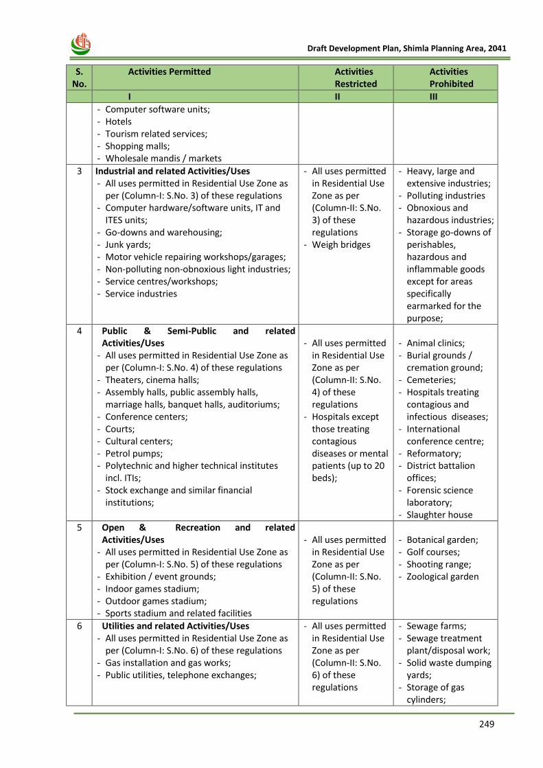
249
Draft Development Plan, Shimla Planning Area, 2041
S.
No. Activities Permitted Activities
Restricted Activities Prohibited
I II III
- Computer software units; - Hotels - Tourism related services; - Shopping malls; - Wholesale mandis / markets
3 Industrial and related Activities/Uses - All uses permitted in Residential Use Zone as
per (Column-I: S.No. 3) of these regulations - Computer hardware/software units, IT and
ITES units; - Go-downs and warehousing; - Junk yards; - Motor vehicle repairing workshops/garages; - Non-polluting non-obnoxious light industries; - Service centres/workshops; - Service industries
- All uses permitted in Residential Use Zone as per (Column-II: S.No. 3) of these regulations
- Weigh bridges
- Heavy, large and extensive industries;
- Polluting industries - Obnoxious and
hazardous industries; - Storage go-downs of
perishables, hazardous and inflammable goods except for areas specifically earmarked for the purpose;
4 Public & Semi-Public and related Activities/Uses
- All uses permitted in Residential Use Zone as per (Column-I: S.No. 4) of these regulations
- Theaters, cinema halls; - Assembly halls, public assembly halls,
marriage halls, banquet halls, auditoriums; - Conference centers; - Courts; - Cultural centers; - Petrol pumps; - Polytechnic and higher technical institutes
incl. ITIs; - Stock exchange and similar financial
institutions;
- All uses permitted
in Residential Use Zone as per (Column-II: S.No. 4) of these regulations
- Hospitals except those treating contagious diseases or mental patients (up to 20 beds);
- Animal clinics; - Burial grounds /
cremation ground; - Cemeteries; - Hospitals treating
contagious and infectious diseases;
- International conference centre;
- Reformatory; - District battalion
offices; - Forensic science
laboratory; - Slaughter house
5 Open & Recreation and related Activities/Uses
- All uses permitted in Residential Use Zone as per (Column-I: S.No. 5) of these regulations
- Exhibition / event grounds; - Indoor games stadium; - Outdoor games stadium; - Sports stadium and related facilities
- All uses permitted
in Residential Use Zone as per (Column-II: S.No. 5) of these regulations
- Botanical garden; - Golf courses; - Shooting range; - Zoological garden
6 Utilities and related Activities/Uses - All uses permitted in Residential Use Zone as
per (Column-I: S.No. 6) of these regulations - Gas installation and gas works; - Public utilities, telephone exchanges;
- All uses permitted in Residential Use Zone as per (Column-II: S.No. 6) of these regulations
- Sewage farms; - Sewage treatment
plant/disposal work; - Solid waste dumping
yards; - Storage of gas
cylinders;
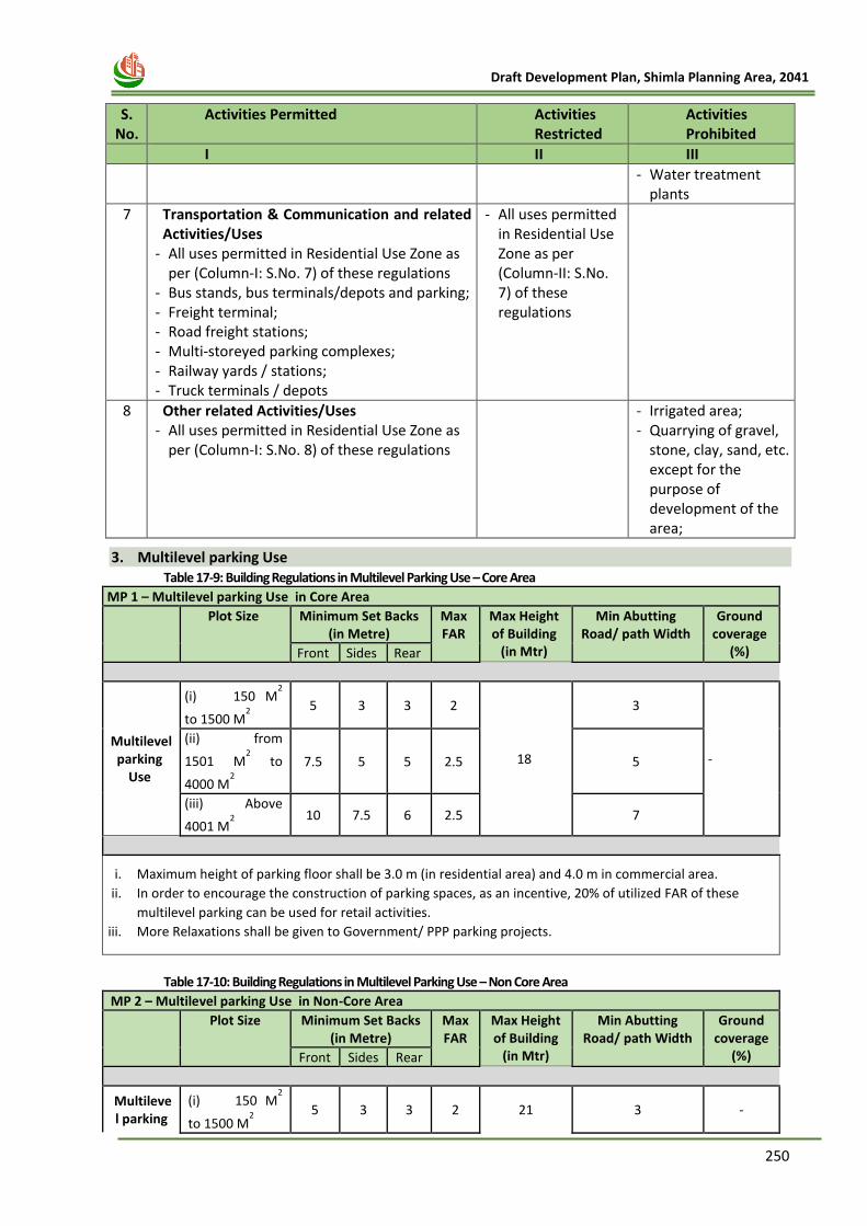
250
Draft Development Plan, Shimla Planning Area, 2041
S.
No. Activities Permitted Activities
Restricted Activities Prohibited
I II III
- Water treatment plants
7 Transportation & Communication and related Activities/Uses
- All uses permitted in Residential Use Zone as per (Column-I: S.No. 7) of these regulations
- Bus stands, bus terminals/depots and parking; - Freight terminal; - Road freight stations; - Multi-storeyed parking complexes; - Railway yards / stations; - Truck terminals / depots
- All uses permitted in Residential Use Zone as per (Column-II: S.No. 7) of these regulations
8 Other related Activities/Uses - All uses permitted in Residential Use Zone as
per (Column-I: S.No. 8) of these regulations
- Irrigated area; - Quarrying of gravel,
stone, clay, sand, etc. except for the purpose of development of the area;
3. Multilevel parking Use Table 17-9: Building Regulations in Multilevel Parking Use – Core Area
MP 1 – Multilevel parking Use in Core Area
Plot Size Minimum Set Backs (in Metre)
Max FAR
Max Height of Building
(in Mtr)
Min Abutting Road/ path Width
Ground coverage
(%) Front Sides Rear
Multilevel parking
Use
(i) 150 M2
to 1500 M2
5 3 3 2
18
3
-
(ii) from
1501 M2 to
4000 M2
7.5 5 5 2.5 5
(iii) Above
4001 M2
10 7.5 6 2.5 7
i. Maximum height of parking floor shall be 3.0 m (in residential area) and 4.0 m in commercial area.
ii. In order to encourage the construction of parking spaces, as an incentive, 20% of utilized FAR of these
multilevel parking can be used for retail activities.
iii. More Relaxations shall be given to Government/ PPP parking projects.
Table 17-10: Building Regulations in Multilevel Parking Use – Non Core Area
MP 2 – Multilevel parking Use in Non-Core Area
Plot Size Minimum Set Backs (in Metre)
Max FAR
Max Height of Building
(in Mtr)
Min Abutting Road/ path Width
Ground coverage
(%) Front Sides Rear
Multilevel parking
(i) 150 M2
to 1500 M2
5 3 3 2 21 3 -
251
Draft Development Plan, Shimla Planning Area, 2041
Use (ii) Above
1501 M2 to
4000 M2
7.5 5 5 2.5 5 60
(iii) Above
4001 M2
10 7.5 6 2.5 7 60
i. Maximum height of parking floor shall be 3.0 m (in residential area) and 4.0 m in commercial area.
ii. In order to encourage the construction of parking spaces, as an incentive, 20% of utilized FAR of these
multilevel parking can be used for retail activities.
iii. More Relaxations shall be given to Government/ PPP parking projects.
4. Green Belts
In 17 Green Belt Area, the following Regulations shall be applicable:—
i. Plots owned prior to the notification of Green Belts vide Notification No HIM-TP-RW-AZR-
2000- III dated 07.12.2000, shall be considered for planning permission for residential use
only
ii. Limited construction with one floor + habitable Attic (inclusive of parking) shall be permitted
for residential use only.
iii. The maximum permissible FAR shall be 1.0.
iv. Setbacks norms prescribed for R1 Use in Core Area shall be applicable.
v. Re-constructions on old lines shall be permissible with same plinth area and no. of storeys.
vi. Cutting and felling of tress shall be prohibited.
vii. Change of Land Use (CLU) and building use shall be prohibited.
5. Mix Land-use
i. The Residential use (R1 & R2), Commercial (C1 & C2), Tourism (T1 & T2) & Common Regulations
as prescribed shall be permissible for any development in Mix Land-use Zone.
ii. For any other use/activities, approval may be given by the competent authority. The officer in
whose favour power under the HPTCP act 1977 and rules framed there under shall be,
empowered to grant the permission in the said use.
iii. The restricted activities shall be permitted by the Director, on special grounds.
6. Industrial Use (IN1) Industrial use shall be permissible in non – core area only.
1. Minimum area of plot:-
a) For small scale industry shall be 150 M2 to 500 M2 .
b) For services/light scale industry shall be above 500 M2 to 1000 M2 .
c) For medium scale industry shall be above 1000 M2 to 5000 M2 .
d) For large and heavy scale industry shall be above 5000 M2 to 10000 M2 and above 10000 M2.
e) The plot area as mentioned in clauses (a) to (d) above would not be applicable in the cases
where the sub-division of land has taken effect before the commencement of the Himachal
Pradesh Town and Country Planning Rules, 2014.
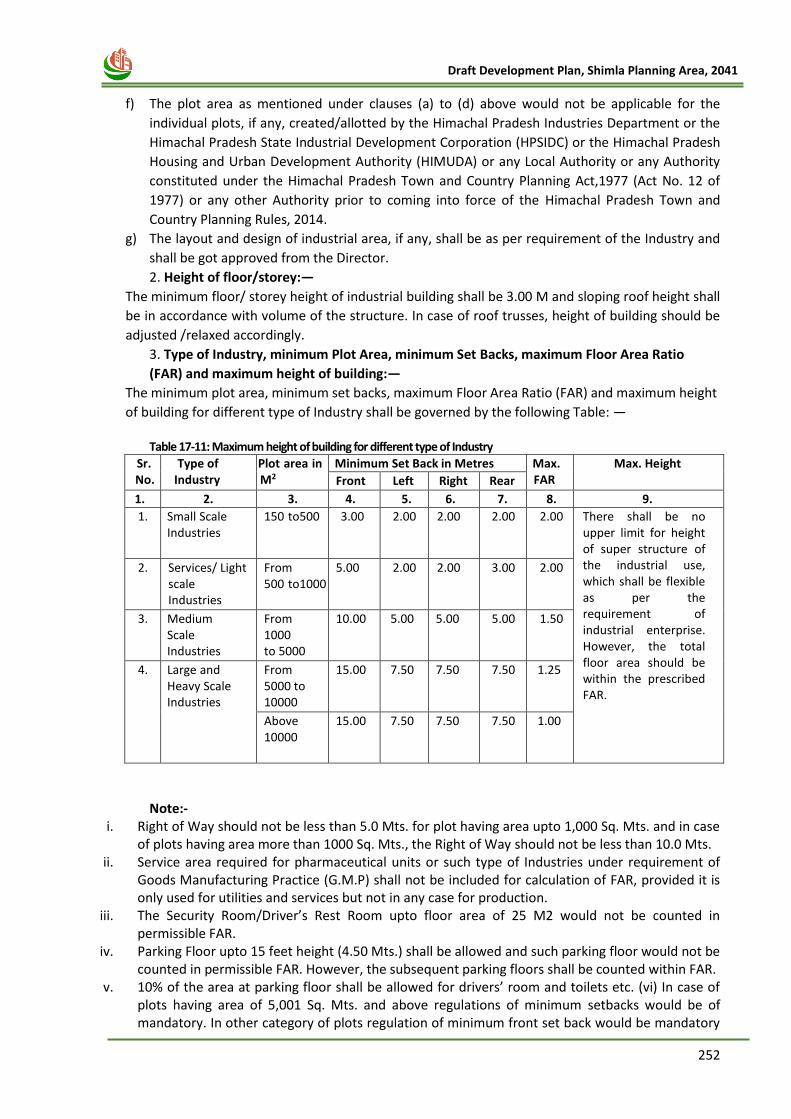
252
Draft Development Plan, Shimla Planning Area, 2041
f) The plot area as mentioned under clauses (a) to (d) above would not be applicable for the
individual plots, if any, created/allotted by the Himachal Pradesh Industries Department or the
Himachal Pradesh State Industrial Development Corporation (HPSIDC) or the Himachal Pradesh
Housing and Urban Development Authority (HIMUDA) or any Local Authority or any Authority
constituted under the Himachal Pradesh Town and Country Planning Act,1977 (Act No. 12 of
1977) or any other Authority prior to coming into force of the Himachal Pradesh Town and
Country Planning Rules, 2014.
g) The layout and design of industrial area, if any, shall be as per requirement of the Industry and
shall be got approved from the Director.
2. Height of floor/storey:—
The minimum floor/ storey height of industrial building shall be 3.00 M and sloping roof height shall
be in accordance with volume of the structure. In case of roof trusses, height of building should be
adjusted /relaxed accordingly.
3. Type of Industry, minimum Plot Area, minimum Set Backs, maximum Floor Area Ratio
(FAR) and maximum height of building:—
The minimum plot area, minimum set backs, maximum Floor Area Ratio (FAR) and maximum height
of building for different type of Industry shall be governed by the following Table: —
Table 17-11: Maximum height of building for different type of Industry
Sr. No.
Type of Industry
Plot area in M2
Minimum Set Back in Metres Max. FAR
Max. Height Front Left Right Rear
1. 2. 3. 4. 5. 6. 7. 8. 9.
1. Small Scale Industries
150 to 500 3.00 2.00 2.00 2.00 2.00 There shall be no upper limit for height of super structure of the industrial use, which shall be flexible as per the requirement of industrial enterprise. However, the total floor area should be within the prescribed FAR.
2. Services/ Light scale Industries
From 500 to 1000
5.00 2.00 2.00 3.00 2.00
3. Medium Scale Industries
From 1000 to 5000
10.00 5.00 5.00 5.00 1.50
4. Large and Heavy Scale Industries
From 5000 to 10000
15.00 7.50 7.50 7.50 1.25
Above 10000
15.00 7.50 7.50 7.50 1.00
Note:-
i. Right of Way should not be less than 5.0 Mts. for plot having area upto 1,000 Sq. Mts. and in case of plots having area more than 1000 Sq. Mts., the Right of Way should not be less than 10.0 Mts.
ii. Service area required for pharmaceutical units or such type of Industries under requirement of Goods Manufacturing Practice (G.M.P) shall not be included for calculation of FAR, provided it is only used for utilities and services but not in any case for production.
iii. The Security Room/Driver’s Rest Room upto floor area of 25 M2 would not be counted in permissible FAR.
iv. Parking Floor upto 15 feet height (4.50 Mts.) shall be allowed and such parking floor would not be counted in permissible FAR. However, the subsequent parking floors shall be counted within FAR.
v. 10% of the area at parking floor shall be allowed for drivers’ room and toilets etc. (vi) In case of plots having area of 5,001 Sq. Mts. and above regulations of minimum setbacks would be of mandatory. In other category of plots regulation of minimum front set back would be mandatory
253
Draft Development Plan, Shimla Planning Area, 2041
and rest of the setbacks shall be relaxable as per functional requirements of the industrial enterprise(s). This relaxability in set back’s is subject to condition that the overall area under setbacks should be minimal area which was to be kept under the setbacks in case relaxability was not provided.
vi. Micro, Small and Medium Enterprises after obtaining the title of land and applying for development permission may start physical implementation of project without waiting for statutory approvals under the Himachal Pradesh Town and Country Planning Act, 1977 in accordance with the provisions of self-certification as stated in para 7 (ii)(xii) of the “Himachal Pradesh Industrial Investment Policy—2019.”.
Permissible Uses
The various uses permitted and prohibited in Industrial Use (IN1) are as mentioned in the
following table.
Table 17-12: Uses Permitted and Uses Prohibited in Industrial Zone (IN1)
S. No.
Activities Permitted Activities Restricted
Activities Prohibited
I II III
1 Residential and related Activities/Uses - Residential buildings for essential staff
and watch and ward staff
-
- Residential dwellings other than those essential for operational and watch and ward staff
2 Commercial and related Activities/Uses - Convenience shopping incidental to
Industries; - Commercial activities such as retail
shops, banks, financial institutes, service shops, offices, restaurants, shopping centres (on plots with area more than 2,500 sq.m area and abutting roads having width of 7 m or more);
- Wholesale business establishments - Tourism (Hotel)
-
3 Industrial and related Activities/Uses - All kinds of non-polluting industries; - Cold storage and ice factory; - Computer hardware/software units, IT
and ITES units; - Dairy and Poultry Farming; - Go-downs and warehousing; - Junk yards; - Motor vehicle repairing
workshops/garages; - Non-polluting non-obnoxious light
industries; - Service centres/workshops; - Service industries - Storage and depot of non-perishable and
non-inflammable commodities and incidental use
- SEZs notified by Government of India
- Heavy, extensive and other obnoxious and hazardous industries except storage of perishable and inflammable goods subject to approval of Himachal Pollution Control Board;
- Major oil depot and LPG refilling plants
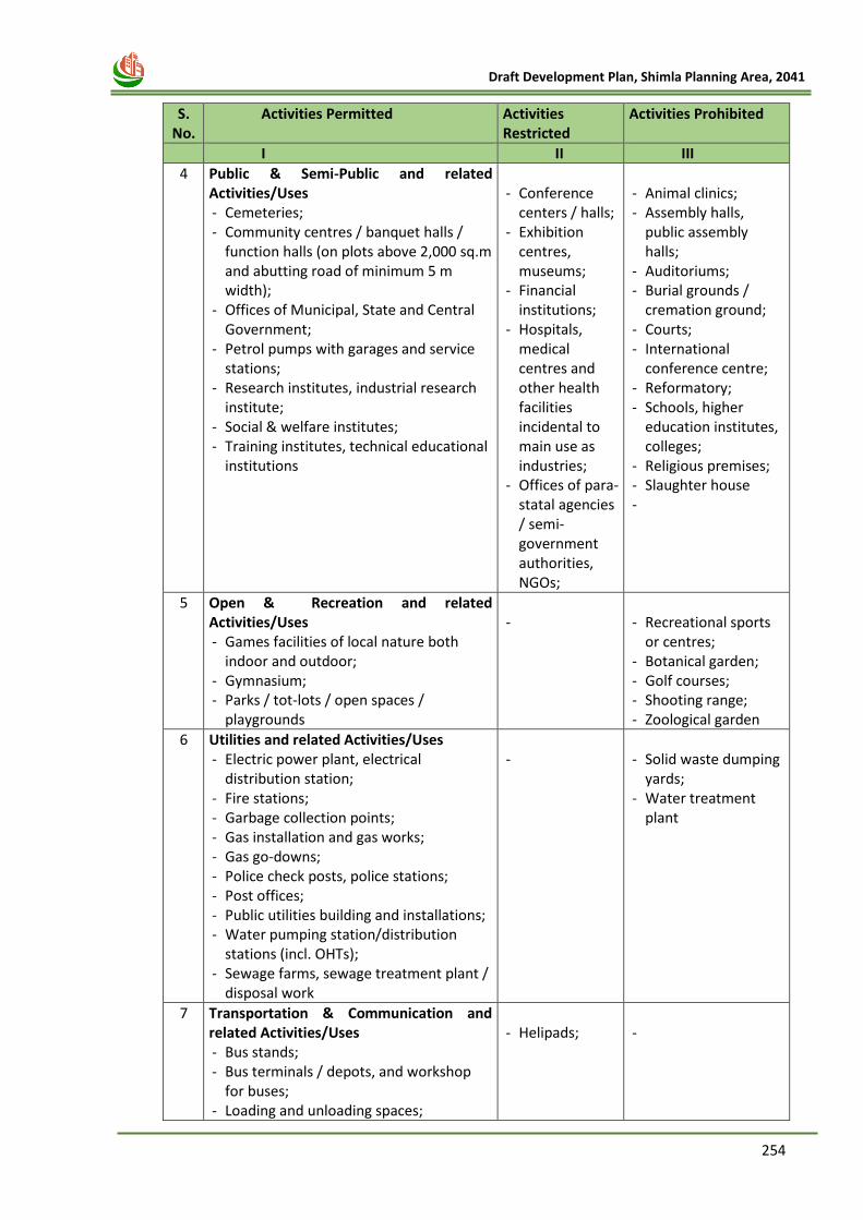
254
Draft Development Plan, Shimla Planning Area, 2041
S.
No. Activities Permitted Activities
Restricted Activities Prohibited
I II III
4 Public & Semi-Public and related Activities/Uses - Cemeteries; - Community centres / banquet halls /
function halls (on plots above 2,000 sq.m and abutting road of minimum 5 m width);
- Offices of Municipal, State and Central Government;
- Petrol pumps with garages and service stations;
- Research institutes, industrial research institute;
- Social & welfare institutes; - Training institutes, technical educational
institutions
- Conference
centers / halls; - Exhibition
centres, museums;
- Financial institutions;
- Hospitals, medical centres and other health facilities incidental to main use as industries;
- Offices of para-statal agencies / semi-government authorities, NGOs;
- Animal clinics; - Assembly halls,
public assembly halls;
- Auditoriums; - Burial grounds /
cremation ground; - Courts; - International
conference centre; - Reformatory; - Schools, higher
education institutes, colleges;
- Religious premises; - Slaughter house -
5 Open & Recreation and related Activities/Uses - Games facilities of local nature both
indoor and outdoor; - Gymnasium; - Parks / tot-lots / open spaces /
playgrounds
-
- Recreational sports
or centres; - Botanical garden; - Golf courses; - Shooting range; - Zoological garden
6 Utilities and related Activities/Uses - Electric power plant, electrical
distribution station; - Fire stations; - Garbage collection points; - Gas installation and gas works; - Gas go-downs; - Police check posts, police stations; - Post offices; - Public utilities building and installations; - Water pumping station/distribution
stations (incl. OHTs); - Sewage farms, sewage treatment plant /
disposal work
-
- Solid waste dumping
yards; - Water treatment
plant
7 Transportation & Communication and related Activities/Uses - Bus stands; - Bus terminals / depots, and workshop
for buses; - Loading and unloading spaces;
- Helipads;
-
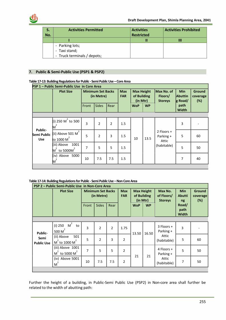
255
Draft Development Plan, Shimla Planning Area, 2041
S.
No. Activities Permitted Activities
Restricted Activities Prohibited
I II III
- Parking lots; - Taxi stand; - Truck terminals / depots;
7. Public & Semi-Public Use (PSP1 & PSP2)
Table 17-13: Building Regulations for Public - Semi Public Use – Core Area
PSP 1 – Public Semi-Public Use in Core Area
Plot Size Minimum Set Backs (in Metre)
Max FAR
Max Height of Building
(in Mtr)
Max No. of Floors/ Storeys
Min Abutting Road/
path Width
Ground coverage
(%)
Front Sides Rear WoP WP
Public-Semi Public
Use
(i) 250 M2 to 500
M2
3 2 2 1.5
10
13.5
2 Floors + Parking +
Attic (habitable)
3 -
(ii) Above 501 M2
to 1000 M2
5 2 3 1.5 5 60
(iii) Above 1001
M2 to 5000M
2
7 5 5 1.5 5 50
(iv) Above 5000
M2
10 7.5 7.5 1.5 7 40
Table 17-14: Building Regulations for Public - Semi Public Use – Non Core Area
PSP 2 – Public Semi-Public Use in Non-Core Area
Plot Size Minimum Set Backs (in Metre)
Max FAR
Max Height of Building
(in Mtr)
Max No. of Floors/
Storeys
Min Abutti
ng Road/ path
Width
Ground coverage
(%)
Front Sides Rear WoP WP
Public-
Semi
Public Use
(i) 250 M2 to
500 M2
3 2 2 1.75
13.50 16.50
3 Floors + Parking +
Attic (habitable)
3 -
(ii) Above 501
M2 to 1000 M
2
5 2 3 2 5 60
(iii) Above 1001
M2 to 5000 M
2
7 5 5 2
21 21
4 Floors + Parking +
Attic (habitable)
5 50
(iv) Above 5001
M2
10 7.5 7.5 2 7 50
Further the height of a building, in Public-Semi Public Use (PSP2) in Non-core area shall further be related to the width of abutting path:
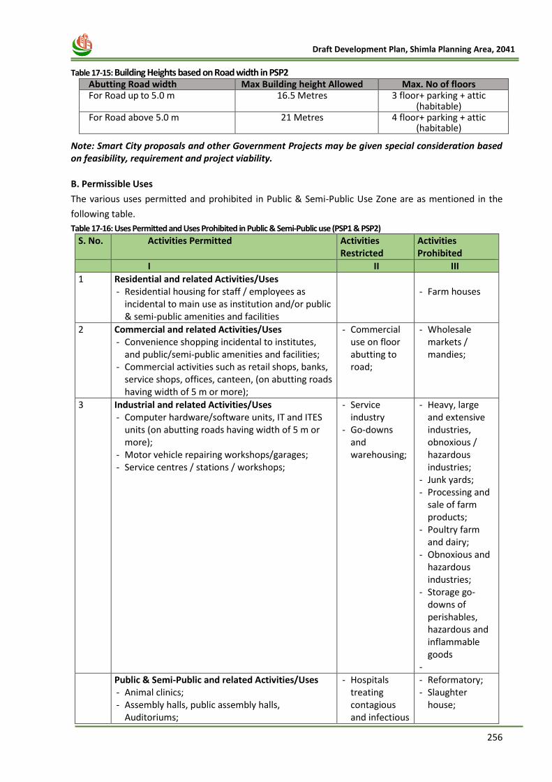
256
Draft Development Plan, Shimla Planning Area, 2041
Table 17-15: Building Heights based on Road width in PSP2
Abutting Road width Max Building height Allowed Max. No of floors For Road up to 5.0 m 16.5 Metres 3 floor+ parking + attic
(habitable) For Road above 5.0 m 21 Metres 4 floor+ parking + attic
(habitable)
Note: Smart City proposals and other Government Projects may be given special consideration based on feasibility, requirement and project viability.
B. Permissible Uses
The various uses permitted and prohibited in Public & Semi-Public Use Zone are as mentioned in the
following table.
Table 17-16: Uses Permitted and Uses Prohibited in Public & Semi-Public use (PSP1 & PSP2)
S. No. Activities Permitted Activities Restricted
Activities Prohibited
I II III
1 Residential and related Activities/Uses - Residential housing for staff / employees as
incidental to main use as institution and/or public & semi-public amenities and facilities
- Farm houses
2 Commercial and related Activities/Uses - Convenience shopping incidental to institutes,
and public/semi-public amenities and facilities; - Commercial activities such as retail shops, banks,
service shops, offices, canteen, (on abutting roads having width of 5 m or more);
- Commercial use on floor abutting to road;
- Wholesale markets / mandies;
3 Industrial and related Activities/Uses - Computer hardware/software units, IT and ITES
units (on abutting roads having width of 5 m or more);
- Motor vehicle repairing workshops/garages; - Service centres / stations / workshops;
- Service industry
- Go-downs and warehousing;
- Heavy, large and extensive industries, obnoxious / hazardous industries;
- Junk yards; - Processing and
sale of farm products;
- Poultry farm and dairy;
- Obnoxious and hazardous industries;
- Storage go-downs of perishables, hazardous and inflammable goods
-
44 Public & Semi-Public and related Activities/Uses - Animal clinics; - Assembly halls, public assembly halls,
Auditoriums;
- Hospitals treating contagious and infectious
- Reformatory; - Slaughter
house;
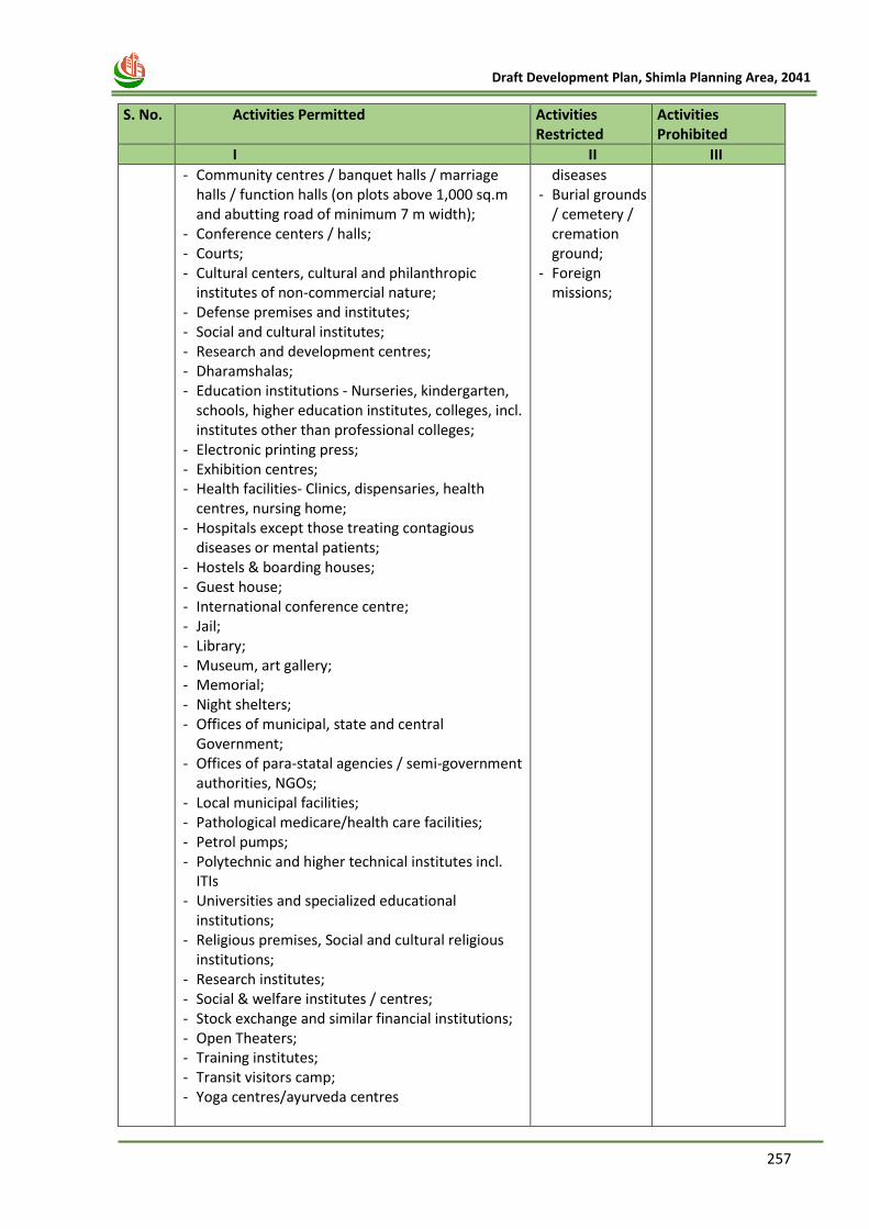
257
Draft Development Plan, Shimla Planning Area, 2041
S. No. Activities Permitted Activities
Restricted Activities Prohibited
I II III
- Community centres / banquet halls / marriage halls / function halls (on plots above 1,000 sq.m and abutting road of minimum 7 m width);
- Conference centers / halls; - Courts; - Cultural centers, cultural and philanthropic
institutes of non-commercial nature; - Defense premises and institutes; - Social and cultural institutes; - Research and development centres; - Dharamshalas; - Education institutions - Nurseries, kindergarten,
schools, higher education institutes, colleges, incl. institutes other than professional colleges;
- Electronic printing press; - Exhibition centres; - Health facilities- Clinics, dispensaries, health
centres, nursing home; - Hospitals except those treating contagious
diseases or mental patients; - Hostels & boarding houses; - Guest house; - International conference centre; - Jail; - Library; - Museum, art gallery; - Memorial; - Night shelters; - Offices of municipal, state and central
Government; - Offices of para-statal agencies / semi-government
authorities, NGOs; - Local municipal facilities; - Pathological medicare/health care facilities; - Petrol pumps; - Polytechnic and higher technical institutes incl.
ITIs - Universities and specialized educational
institutions; - Religious premises, Social and cultural religious
institutions; - Research institutes; - Social & welfare institutes / centres; - Stock exchange and similar financial institutions; - Open Theaters; - Training institutes; - Transit visitors camp; - Yoga centres/ayurveda centres
diseases - Burial grounds
/ cemetery / cremation ground;
- Foreign missions;
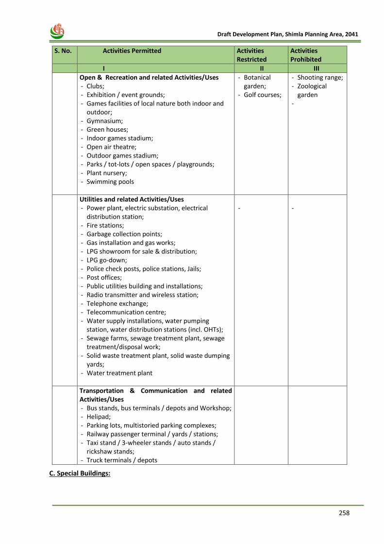
258
Draft Development Plan, Shimla Planning Area, 2041
S. No. Activities Permitted Activities
Restricted Activities Prohibited
I II III
5 Open & Recreation and related Activities/Uses - Clubs; - Exhibition / event grounds; - Games facilities of local nature both indoor and
outdoor; - Gymnasium; - Green houses; - Indoor games stadium; - Open air theatre; - Outdoor games stadium; - Parks / tot-lots / open spaces / playgrounds; - Plant nursery; - Swimming pools
- Botanical garden;
- Golf courses;
- Shooting range; - Zoological
garden -
6 Utilities and related Activities/Uses - Power plant, electric substation, electrical
distribution station; - Fire stations; - Garbage collection points; - Gas installation and gas works; - LPG showroom for sale & distribution; - LPG go-down; - Police check posts, police stations, Jails; - Post offices; - Public utilities building and installations; - Radio transmitter and wireless station; - Telephone exchange; - Telecommunication centre; - Water supply installations, water pumping
station, water distribution stations (incl. OHTs); - Sewage farms, sewage treatment plant, sewage
treatment/disposal work; - Solid waste treatment plant, solid waste dumping
yards; - Water treatment plant
-
-
7 Transportation & Communication and related Activities/Uses - Bus stands, bus terminals / depots and Workshop; - Helipad; - Parking lots, multistoried parking complexes; - Railway passenger terminal / yards / stations; - Taxi stand / 3-wheeler stands / auto stands /
rickshaw stands; - Truck terminals / depots
C. Special Buildings:
259
Draft Development Plan, Shimla Planning Area, 2041
‘Special Building’ – Means those buildings which are visited / used by large number of general public at
a time, such as Indoor Sports Complexes, Cinema Halls, Auditoriums, Public Institutions, Hospitals,
and other public utilities such as lifts, Public escalators, Heliport and Ropeway structures.
Shimla town is located on steep slopes in most parts. Most of the buildings are not accessible by driving
vehicles such as people have to walk up and down on steep staircases/ footpaths in order to reach the
main road from their respective homes. Therefore, Installation of lifts/escalators is essential for the
elderly, physically challenged and people having certain medical conditions. Hence, installation of
lifts/escalators and other special buildings shall be permitted in whole of Shimla Planning Area, both in
private as well as public domain, including all areas/ zones.
8. Heritage Land-use
The following Zoning Regulations shall be applicable in Heritage Area.—
i. Pre-requisite for planning permission.- For construction of new buildings on vacant sites,
detailed architectural drawings 'maps in the scale of 1:50 shall be prepared showing all
architectural features with size and material proposed to be used alongwith two photographs
of 15 cm x 25 cm size of adjoining heritage buildings. In case of re- construction on old lines, the
detailed architectural drawings 'maps in the scale of 1:50 shall be prepared showing all the
architectural features with size and material proposed to be used alongwith old architectural
drawings and two photographs of 15cm x 25cm size of the old building.
ii. The existing number of storeys and floor heights shall not be altered during course of re-
construction of old building. Internal changes shall be permissible without any changes to
external façade.
iii. The original façade shall be maintained. The façade shall have the admixture of wood, stone,
glass, slate and tiles as in the original building. If natural materials are not available, the
alternative ones shall be given the same touch.
iv. The roof design shall be as under:—
1. the roof of the buildings to be constructed on vacant sites shall be sloping with a
maximum height of 2.70 Metres at centre. The continues Dormer on any side of sloping
roof shall not be allowed. Maximum 2 Dormers on either side of sloping roof at a
reasonable distance between eves and ridge shall be allowed; and
2. in sloping roof, slate or corrugated iron sheets, plain galvanized iron sheets, Hi polymer
plastic tiles shall only be used. Primary colours shall be used for roofing in post office red
or forest green colour.
v. The aesthetics of Bay Windows in the existing buildings shall be enhanced by providing window
boxes for flowers. In case of re-construction of buildings, bay windows shall essentially be
provided to enhance aesthetics and functionality. Maximum 60 cm projection of Bay Window
shall be permitted on the Set Backs.
vi. For construction of new buildings on vacant sites, the Regulations as applicable for Core Area
and Non- Core Area shall be applicable in addition to above Regulations.
vii. A Heritage Advisory Committee shall be constituted by the State Government for giving
recommendations for the developments proposed in the Heritage Area.
viii. The Registered Private Professionals Class-A category as specified under rule 17 of the Himachal
Pradesh Town and Country Planning Rules, 2014 shall submit the building map to the
Commissioner, Municipal Corporation, Shimla or concerned Special Area Development
Authorities (SADA’s) or Town and Country Planner, Divisional Town Planning Office, Shimla. The
Commissioner, Municipal Corporation, Shimla or concerned Special Area Development
Authorities (SADA’s) or Town and Country Planner, Divisional Town Planning Office, Shimla
forward the same to the Heritage Advisory Committee. The development permission shall be
granted by the Commissioner, Municipal Corporation, Shimla or concerned SADAs or Town and
260
Draft Development Plan, Shimla Planning Area, 2041
Country Planner, Divisional Town Planning Office Shimla strictly on the recommendations of the
Heritage Advisory Committee.
ix. The applicant seeking planning permission for re-construction or construction of buildings in
Heritage Area shall follow the following architectural elements for maintaining aesthetics of the
existing surrounding buildings, namely:—
(a) Dormer. (b) Windows. (c) Doors. (d) Bay Windows. (e) Facade. (D Chimney. (g) Roofing ' pinnacles. (h) Temporary Kiosks.
x. In the Natural Heritage Area, temporary ‘Kiosks’ for special occasions may be installed by the
Municipal Corporation Shimla with the approval of the Heritage Advisory Committee.
xi. Street furniture in Natural Heritage Area shall be provided in the following manner, namely:—
(a) Cast iron benches.
(b) Decorative lighting.
(c) All the drainage system shall have half round stone ware pipes of various sizes
according to the quantum of run off of water alongwith stone edging.
(d) The design of recreating water drinking spouts made of cast iron shall be got approved
by the Municipal Corporation from the Heritage Advisory Committee.
xii. All service line and pipes including electric and telephone wiring, sanitation, water supply etc.
shall be concealed to improve the overall look of the Heritage Area.
xiii. Brass plates of size of 0.60 M X 0.45M inscribing history of the building, shall be displayed at
strategic points of historical buildings.
(b) The sign boards and hoardings to be provided at strategic locations shall be in accordance
with the National Building Code of India, 2005. Thèse shall not occupy more than 10% of the
façade in any case.
xiv. Minor additions, repair works or alterations in the existing historical building shall be in
conformity with the existing building and shall be permitted by the Commissioner, Municipal
Corporation, Concerned Town and Country Planner, Shimla or concerned member secretary
SADAs.
9. Sinking and Sliding Area
i. The development permission shall be granted by the Competent Authority in whose jurisdiction
the Sinking and Sliding Area falls.
ii. The Regulations as applicable for Core/Green Area and Non-Core Area shall be applicable in
Sinking and Sliding Area.
iii. The Soil Investigation Report shall be submitted by the applicant before
construction/reconstruction of building(s) for the areas falling in sinking and sliding zones as
defined in Shimla Planning Area, or for any reclaimed piece of land. The Soil Investigation
Report shall be given by the Geologist in the prescribed form. In case of negative observations,
the construction shall not be allowed/ shall be allowed as per conditions imposed by the
consultant.
261
Draft Development Plan, Shimla Planning Area, 2041
10. Agriculture Use and Scrub Land
i. The Common Regulations & Residential use (R1 & R2) as prescribed shall be kept in view while
permitting any development in this Zone.
ii. For any other use/activities, approval/ change of Land Use for residential use shall be given by
the concerned Field Office. The officer in whose favour power under the HPTCP Act 1977 &
Rules thereunder shall be empowered to grant the permission in the said use.
11. Real Estate Projects
For development of Real Estate Project i.e. apartments and colonies etc. having plot area more than 2500 sq. Mts the regulations as prescribed in Appendix-7 of the HPTCP Rules, 2014, as amended from time to time, shall be applicable. Further, such projects shall be required to get registered with H.P. Real Estate Regulatory Authority (RERA) constituted as per provisions of Real Estate (Regulation & Development) Act, 2016.
12. Abadi Deh
For village "Abadi Deh" as defined in the revenue record in Abadi Deh area, for local residents,
construction as per provisions of Appendix-8 of the HPTCP Rules, 2014 (as amended from time
to time) shall be allowed. However, for constructing more stories and built-up beyond the
maximum permissible limits as prescribed in Appendix-8, development permission shall be
required from the Competent Authority.
13. Exemption in Rural Area u/s 30-A of the HPTCP Act, 1977-
The benefit of exemptions u/s 30-A of the HPTCP Act, 1977 as provided in the Appendix 8 of the
HPTCP Rules, 2014 (as amended from time to time), shall be applicable beyond the SADA limits
i.e. the rural areas of Additional Shimla Planning Area only.
14. High Security Zone
No construction shall be allowed in High Security Zone, unless No Objection Certificate is
submitted from the Competent Authorities/ Security Agencies.
15. Other Uses
Request for development and special provisions w.r.t following, a) INFORMATION TECHNOLOGY
PARK; b) SOLAR PASSIVE BUILDING DESIGN; c) BARRIER FREE ENVIRONMENT FOR THE PERSONS
WITH DISABILITIES IN PUBLIC AND SEMI-PUBLIC BUILDINGS AND RE-CREATIONAL AREAS, d)
COLLECTION OF RAIN WATER; e) PRESCRIBED LIMITS FOR DEVELOPMENT ACTIVITIES EXEMPTED
UNDER SECTION 30-A OF THE HIMACHAL PRADESH TOWN AND COUNTRY PLANNING ACT, 1977
(ACT NO. 12 OF 1977); and f) INSTALLATION OF COMMUNICATION TOWERS; shall be as per
regulations prescribed under Appendix 2 to 9 of the HPTCP Rule, 2014 (as amended from time
to time).
16. GENERAL REGULATIONS
The following provisions shall be applicable in all areas where no specific mention is made,
namely:-
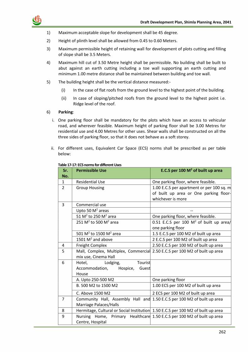
262
Draft Development Plan, Shimla Planning Area, 2041
1) Maximum acceptable slope for development shall be 45 degree.
2) Height of plinth level shall be allowed from 0.45 to 0.60 Meters.
3) Maximum permissible height of retaining wall for development of plots cutting and filling of slope shall be 3.5 Meters.
4) Maximum hill cut of 3.50 Metre height shall be permissible. No building shall be built to abut against an earth cutting including a toe wall supporting an earth cutting and minimum 1.00 metre distance shall be maintained between building and toe wall.
5) The building height shall be the vertical distance measured:-
(i) In the case of flat roofs from the ground level to the highest point of the building.
(ii) In case of sloping/pitched roofs from the ground level to the highest point i.e. Ridge level of the roof.
6) Parking:
i. One parking floor shall be mandatory for the plots which have an access to vehicular road, and wherever feasible. Maximum height of parking floor shall be 3.00 Metres for residential use and 4.00 Metres for other uses. Shear walls shall be constructed on all the three sides of parking floor, so that it does not behave as a soft storey.
ii. For different uses, Equivalent Car Space (ECS) norms shall be prescribed as per table below:
Table 17-17: ECS norms for different Uses
Sr. No.
Permissible Use E.C.S per 100 M2 of built up area
1 Residential Use One parking floor, where feasible.
2 Group Housing 1.00 E.C.S per apartment or per 100 sq. m of built up area or One parking floor- whichever is more
3 Commercial use
Upto 50 M2 areas --
51 M2 to 250 M2 area One parking floor, where feasible.
251 M2 to 500 M2 area 0.51 E.C.S per 100 M2 of built up area/ one parking floor
501 M2 to 1500 M2 area 1.5 E.C.S per 100 M2 of built up area
1501 M2 and above 2 E.C.S per 100 M2 of built up area
4 Freight Complex 2.50 E.C.S per 100 M2 of built up area
5 Mall, Complex, Multiplex, Commercial mix use, Cinema Hall
2.50 E.C.S per 100 M2 of built up area
6 Hotel, Lodging, Tourist Accommodation, Hospice, Guest House
A. Upto 250-500 M2 One parking floor
B. 500 M2 to 1500 M2 1.00 ECS per 100 M2 of built up area
C. Above 1500 M2 2 ECS per 100 M2 of built up area
7 Community Hall, Assembly Hall and Marriage Palaces/Halls
1.50 E.C.S per 100 M2 of built up area
8 Hermitage, Cultural or Social Institution 1.50 E.C.S per 100 M2 of built up area
9 Nursing Home, Primary Healthcare Centre, Hospital
1.50 E.C.S per 100 M2 of built up area
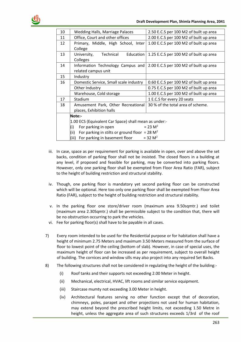
263
Draft Development Plan, Shimla Planning Area, 2041
10 Wedding Halls, Marriage Palaces 2.50 E.C.S per 100 M2 of built up area
11 Office, Court and other offices 2.00 E.C.S per 100 M2 of built up area
12 Primary, Middle, High School, Inter College
1.00 E.C.S per 100 M2 of built up area
13 University, Technical Education Colleges
1.25 E.C.S per 100 M2 of built up area
14 Information Technology Campus and related campus unit
2.00 E.C.S per 100 M2 of built up area
15 Industry
16 Domestic Service, Small scale industry 0.60 E.C.S per 100 M2 of built up area
Other Industry 0.75 E.C.S per 100 M2 of built up area
Warehouse, Cold storage 1.00 E.C.S per 100 M2 of built up area
17 Stadium 1 E.C.S for every 20 seats
18 Amusement Park, Other Recreational places, Exhibition halls
30 % of the total area of scheme.
Note:- 1.00 ECS (Equivalent Car Space) shall mean as under:- (i) For parking in open = 23 M2
(ii) For parking in stilts or ground floor = 28 M2
(iii) For parking in basement floor = 32 M2
iii. In case, space as per requirement for parking is available in open, over and above the set
backs, condition of parking floor shall not be insisted. The closed floors in a building at any level, if proposed and feasible for parking, may be converted into parking floors. However, only one parking floor shall be exempted from Floor Area Ratio (FAR), subject to the height of building restriction and structural stability.
iv. Though, one parking floor is mandatory yet second parking floor can be constructed which will be optional. Here too only one parking floor shall be exempted from Floor Area Ratio (FAR), subject to the height of building restriction and structural stability.
v. In the parking floor one store/driver room (maximum area 9.50sqmtr.) and toilet (maximum area 2.30Sqmtr.) shall be permissible subject to the condition that, there will be no obstruction occurring to park the vehicles.
vi. Fee for parking floor(s) shall have to be payable in all cases.
7) Every room intended to be used for the Residential purpose or for habitation shall have a height of minimum 2.75 Meters and maximum 3.50 Meters measured from the surface of floor to lowest point of the ceiling (bottom of slab). However, in case of special uses, the maximum height of floor can be increased as per requirement, subject to overall height of building. The cornices and window sills may also project into any required Set Backs.
8) The following structures shall not be considered in regulating the height of the building:-
(i) Roof tanks and their supports not exceeding 2.00 Meter in height.
(ii) Mechanical, electrical, HVAC, lift rooms and similar service equipment.
(iii) Staircase mumty not exceeding 3.00 Meter in height.
(iv) Architectural features serving no other function except that of decoration, chimneys, poles, parapet and other projections not used for human habitation, may extend beyond the prescribed height limits, not exceeding 1.50 Metre in height, unless the aggregate area of such structures exceeds 1/3rd of the roof
264
Draft Development Plan, Shimla Planning Area, 2041
area of the building on which these are erected.
(v) Solar panels installed on the roof.
These height regulations shall not apply to the structures housing main seat of Deity
/Sanctum / Sanctorum which are part of religious buildings e.g. Temples, Mosques,
Gurudwaras, Churches, etc. provided it is so designed and approved by the Competent
Authority. The height restrictions shall apply to the ancillary structures like
dharamshala, sarai etc.
9) Sloping roof shall be mandatory in hilly areas. Sloping roof height may be in accordance with volume of the structure and the width of floor plate. However, the total building height should be within the prescribed permissible height of building. The Dormer on either side of the roof shall be permissible, with the suitable distance. Height of sloping roof zero at eaves and maximum 2.75 at centre shall be permissible. However, in case of habitable attic maximum height of roof shall be 3.00 meters. The roof shall be painted with post office red or forest green or natural roofing material such as slates.
10) Set Backs:--
i. Minimum front Set Back from the line of controlled width of National Highways/4-Lanes
Highways shall be 3.00 Metre.
ii. In case of Himachal Pradesh Public Works Department’s Schedules Roads falling within
the Planning Area /Special Area limits (excluding the land, included in the inhabited sites
of an village as entered and demarcated in the Revenue record or on sites in notified
Municipal or town area that are already built up), the minimum front Set Back from the
line of controlled width shall be 1.00 Metre.
iii. Minimum front Set Back from non-scheduled roads and Municipal roads shall be 3.00
Metres.
iv. Every building should have a clear means of access there to from a street or road. The
competent authority may require the provisions of an access lane or access road within
the site of any new building. Where for the purpose of this Regulation, it is necessary to
determine the width of any road or street, the same shall be determined by the
Competent Authority.
v. The following uses in the setbacks will be considered permissible:
(a) Parking in open space/ steel structures (in front setbacks) with 50% of plot frontage
(b) Porch at entrance.
(c) Boundary wall with height upto 1.50 m
11) For the plots abutting National Highways and 4 Lane Roads, No Objection Certificate (NOC)/ Access Permission from the Himachal Pradesh Public Works Department/ NHAI shall be mandatory in the cases where plot is directly abutting to these roads and there is direct access taken by way of connecting bridge and constructing ramps to such roads. However, in the other roads of Himachal Pradesh Public Works Department, the owner concerned will submit and under taking on the stamp paper of Rs. 10 duly attested by the competent authority to the contest that he/she will strictly adhere to the provisions of HP Road Side Control Act 1968 & provisions of HPTCP Act 1977 in letter and spirit.
12) Issuance of No Objection Certificate (NOC) for water supply and electricity connection
(i) Temporary At plinth level (ii) Permanent On completion of dwelling unit/floor/whole building.
13) Any subsequent deviations made in the building constructed after getting the plan approved and after grant of No Objection Certificate (NOC) issued by the Department
265
Draft Development Plan, Shimla Planning Area, 2041
shall entail the floor/unit of the building unauthorized, in which deviations have been carried out and NOC so issued for the said floor/ unit shall be withdrawn and the services if any, released shall be withdrawn.
14) Adequate distance from the electric lines as per the requirement of Himachal Pradesh State Electricity Board Limited (HPSEB Ltd.) Rules shall have to be maintained. A Self Declaration/Certificate to this effect shall be submitted by the applicant in this regard.
15) An applicant shall have to maintain minimum 5.00 Metres distance between two Blocks if he proposes to construct more than one block on a plot, 1.20 m open balcony over the same shall be permissible in 50% of the length of the block.
16) The construction shall be allowed at distance of 3.00 Metre and 5.00 Metre from Nullah and Khad respectively keeping in view of Revenue record or actual at site.
17) No residential building shall be permissible on land having buildable width less than 5.00 Metres after leaving Set Backs. However, if the width of proposed built up area comes to average 5.00 metre, authority competent to grant approval can consider such proposal(s) for grant of approval.
18) No construction shall be allowed within a radius of 2.00 Metre from the existing tree and 3.00 Metres from the Forest land measured from the circumference of an existing tree.
19) Construction on sandwich plots in Bazaar area shall be permissible for shops as per existing building lines, only in existing built up areas.
20) In new sub-division of land :--
i. Minimum width of path/road for sub-division of land having upto 5 plots 3.00meters
ii. Minimum width of path/road for sub-division of land having more than 5 plots and area less than 2500 Sqmts.
5.00meters (with cul-de-sac) at the end.
iii.
Sub-division of land having area more than 2500 Sqmts shall be dealt as per provisions of Appendix-7 of HTCP Rules, 2014(as amended from time to time)
-
iv. Minimum area for open/green space for the scheme having more than 5 plots.
10%
v.
Minimum area for soak pit etc. (irrespective of number of plots). In case of respective area under Sewage Netwrok, the same shall not be applicable.
5% of the scheme area
vi.
Orientation of the plots shall be provided in such a manner so as to be in conformity with the integration of existing plots/infrastructure, wind direction, natural flow of surface drainage to allow unobstructed rain water discharge.
-
vii.
Layout of plots shall be governed by easy access having acceptable grades minimum 1 in 15 and which may not obstruct view or vista.
-
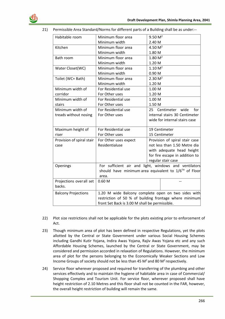
266
Draft Development Plan, Shimla Planning Area, 2041
21) Permissible Area Standard/Norms for different parts of a Building shall be as under:--
Habitable room Minimum floor area Minimum width
9.50 M2 2.40 M
Kitchen Minimum floor area Minimum width
4.50 M2 1.80 M
Bath room Minimum floor area Minimum width
1.80 M2 1.20 M
Water Closet (WC) Minimum floor area Minimum width
1.10 M2 0.90 M
Toilet (WC+ Bath) Minimum floor area Minimum width
2.30 M2 1.20 M
Minimum width of corridor
For Residential use For Other uses
1.00 M 1.20 M
Minimum width of stairs
For Residential use For Other uses
1.00 M 1.50 M
Minimum width of treads without nosing
For Residential use For Other uses
25 Centimeter wide for internal stairs 30 Centimeter wide for internal stairs case
Maximum height of riser
For Residential use For Other uses
19 Centimeter 15 Centimeter
Provision of spiral stair case
For Other uses expect Residential use
Provision of spiral stair case not less than 1.50 Metre dia with adequate head height for fire escape in addition to regular stair case
Openings For sufficient air and light, windows and ventilators should have minimum area equivalent to 1/6TH of Floor area.
Projections over all set backs.
0.60 M --
Balcony Projections 1.20 M wide Balcony complete open on two sides with restriction of 50 % of building frontage where minimum front Set Back is 3.00 M shall be permissible.
22) Plot size restrictions shall not be applicable for the plots existing prior to enforcement of Act.
23) Though minimum area of plot has been defined in respective Regulations, yet the plots allotted by the Central or State Government under various Social Housing Schemes including Gandhi Kutir Yojana, Indira Awas Yojana, Rajiv Awas Yojana etc and any such Affordable Housing Schemes, launched by the Central or State Government, may be considered and permission accorded in relaxation of Regulations. However, the minimum area of plot for the persons belonging to the Economically Weaker Sections and Low Income Groups of society should not be less than 45 M2 and 80 M2 respectively.
24) Service floor wherever proposed and required for transferring of the plumbing and other services effectively and to maintain the hygiene of habitable area in case of Commercial/ Shopping Complex and Tourism Unit. For service floor, wherever proposed shall have height restriction of 2.10 Metres and this floor shall not be counted in the FAR, however, the overall height restriction of building will remain the same.
267
Draft Development Plan, Shimla Planning Area, 2041
25) Before according development permission in areas adjoining to Helipads at Chalonti,
Jubbarhatti, Chharabara (Kalyanni Hallipad) and Annandale, the No Objection Certificate (NOC) from the Competent Authority shall have to be obtained.
26) Wherever proposed, the Swimming Pools and Helipads and other such specialized support infrastructure facilities should preferably be proposed on the ground level. However, in case of roof top design of Swimming Pools and Revolving Restaurants etc. The detailed Soil Investigation Report/Geological Report and Structural Design Report along with Structure Stability Certificate of the proposed building shall be mandatory. In case of rooftop Helipads, the detailed Soil Investigation Report/Geological Report and Structural Design Report along with Structure Stability Certificate and necessary approval from the nearby defence installations, Competent Authority or the Ministry of Civil Aviation, Govt. of India shall be mandatory before the start of operation.
27) In order to promote restricted vehicular use to reduce vehicular pollution in the tourism destinations across the state, tourism units /land parcels where road connectivity to the final destination does not exist, which is especially true in difficult terrain areas of the State, in such cases the owners shall be allowed to park the vehicles at a slightly far off location and hence the tourist would have to walk in order to reach the destination/unit. However, any such walking road/trail/ kacha path/path should be certified so by the concerned field Office of the Department in whose ownership the said road/trail/ kacha path/path stands. For example if the land belongs to the Revenue Department, then the Patwari concerned may certify that it is being used as a raasta/path. Same would be applicable to field Officers of the other Departments as well. The parking for such tourism units has to be mandatorily provided by the owner at an appropriate distance as per norms and same parking areas has to be in ownership/control of the owner of the tourism unit.
28) The onus of obtaining all the necessary approvals/clearances required from all the concerned Departments in respect of Self-Declaration/Certificate given by the applicant before starting actual execution of the work shall be on the applicant. The Department of Town & Country Planning shall not be liable for any violations done by the applicant in respect of other applicable acts, rules and any legal dispute.
29) At the time of submission of proposal for grant of planning permission by TCP/MC, the owner concerned shall be liable to submit an undertaking that he/she will not obstruct laying of water pipe line, sewerage line, telephone line, electric service line/cable which fall under the essential services in his/her setbacks.
30) In case of petrol filling station, the layout plan/norms of the Petrol Pump/ Fuel Station as prescribed and approved by Indian Oil Corporation Limited (IOCL)/ other such Oil Companies shall be adopted.
31) Every development proposal shall have explicit mention of Muck/malva disposal plan. The concerned owner of the plot will ensure to submit an undertaking to the effect that he/she will not throw the Muck/malva during the course of plot development in the Nalla’s/forest land, which cause danger to the adjoining settlements/ properties in the rainy season.
32) The provision of Rain Water Harvesting Tank shall be mandatory and proposed in the plan @20 Litre per sq. m. of the roof top area.
33) Where the area of land proposed to be developed exceeds five hundred square meters or the number of apartments proposed to be developed exceed eight inclusive of all phases and sale/purchase is also involved, such planning permission case shall be further required to get registered with the H.P. Real Estate Regulatory Authority (RERA), as per provisions of Real Estate (Regulation & Development) Act, 2016.
268
Draft Development Plan, Shimla Planning Area, 2041
34) Although Forest Land Use has been prescribed in the Proposed Land Use map of this
Development Plan. However, for private plots falling within the prescribed forest land use development permission shall be granted as per ownership/ revenue document.
35) Premium FAR
In Non-Core Area, plots having area more than 1500 Sqmts and abutting the roads having width more than 9.00 mts, the Premium FAR of 0.25 to 0.50 over and above the permissible FAR shall be granted subject to payment of charges/ fee prescribed by the State Govt.
36) Re-construction of existing buildings:-
Regulations regarding re-construction of houses/ buildings in existence in Core/Green/Non-Core Areas shall be on predominantly existing building lines, with same plinth area and Nos. of Storeys, provided the minimum width of road /path is maintained as available at site, and roof projections, sun shades shall be permitted over streets or paths, as the case may be.
37) Change of Land Use and Building Use:-
Change of existing land use for Residential, Commercial, Public and semi-public and
Industrial, shall be on existing pattern of development and site conditions subject to the
conditions that where basic services like paved roads, drainage, water supply, sewerage
disposal, electrical supply line, street lighting etc. do not exist, change of land use or
development of land shall not be permitted unless the applicant undertakes that these
services shall be provided at his own cost. In public interest and in interest of town design
and other such material considerations, the Change of Land Use shall be allowed by the
Director only. However, the Building Use shall be allowed by the Chairman SADA /
Commissioner, MC.
38) Relaxations:-
Relaxation in set backs, height of floors and building etc. may be allowed in Government projects in the public interest. In case of private construction/projects relaxation in set backs, height of floors and building etc. may be considered by the Competent Authority keeping in view the site conditions. However, in private projects having plot area of more than one hectare, relaxation shall be allowed by the State Government only.
39) Fire fighting provisions and specification shall be as per National Building Code of India, 2016.
40) In case of any clarification with reference to any provision or if there is no any specific provision, the provisions as envisaged in the Urban and Regional Development Plans Formulation and Implementation Guidelines, 2014 of the Government of India or the National Building Code of India, 2016 shall have to be adhered to.
17 Constitution of Single Umbrella Committee
i. There is a need for simplification and uniformity to facilitate the general public and to
adhere the regulations in letter and spirit in Core/Non-Core area within the limit of
Municipal Corporation area, as well as and to avoid the conflict between the M.C Act, and
HPTCPAct,1977 and rules framed their under. Therefore, for the purpose of according
building plan approvals in all types of area in Municipal Corporation area established under
the provisions of Municipal Corporation Act, 1994 there shall be a Single Umbrella
Committee (herein after refereed to the ‘SUC’), which shall comprise of the following :-
269
Draft Development Plan, Shimla Planning Area, 2041
a. Commissioner Municipal Corporation Shimla (Chairman)
b. Town & Country Planner, Shimla (Member)
c. Executive Engineer (Urban Development) (Member)
d. District Revenue Officer, Shimla (Member)
e. Architect Planner, MC Shimla (Member Secretary)
ii. The single umbrella committee (SUC) shall discharge the following functions namely:-
1. Grant approval as per regulations framed under this Development Plan.
2. The SUC meeting will be held twice a month so as to ensure disposal of all cases within the
stipulated time period.
3. In context of Heritage Zone, the Single Umbrella Committee shall consider cases of
Heritage Area only on the recommendation of the State Heritage Advisory Committee.
References:
1. AMRUT Design and Standards Guidelines.
2. Census of India 2001 and 2011.
3. City Development Plan Shimla, 2007.
4. City Disaster Management Plan, 2012.
5. Comprehensive Mobility Plan, Shimla, 2014
6. Carrying Capacity Report for Shimla prepared by the Expert Committee, constituted by
GoHP as per directions of the Hon’ble National Green Tribunal, 2017.
7. City Sanitation Plan for Shimla, MC Shimla, Prepared by GIS Asem (2011)
8. District Census Handbook, Shimla, 2011.
9. Hazard Risk and Vulnerability Analysis Report, Shimla.
10. Heritage of Shimla, Department of Town and Country Planning. (2011)
11. Himachal Pradesh Development and Regulation Act, 1968.
12. Himachal Pradesh Municipal Corporation Act, 1994.
13. Himachal Pradesh Town and Country Planning Act, 1977(Act No. 12 of 1977).
14. Himachal Pradesh Town and Country Planning Rules, 2014.
15. Interim Development Plan Shimla, 1979, Department of Town and Country Planning,
H.P.
16. National Building Code, 2016.
17. Hon’ble National Green Tribunal Orders dated 16.11.2017 w.r.t. Shimla Planning Area.
18. Organization, C. P. (1999). Manual on Water Supply and Treatment.
19. State Economy Survey. HP, (2020-21)
20. Urban and Regional Development Plans Formulation and Implementation Guidelines.
(2014).
21. Urban Sprawl and other Spatial Planning Issues, Shimla, Himachal Pradesh. (2011)
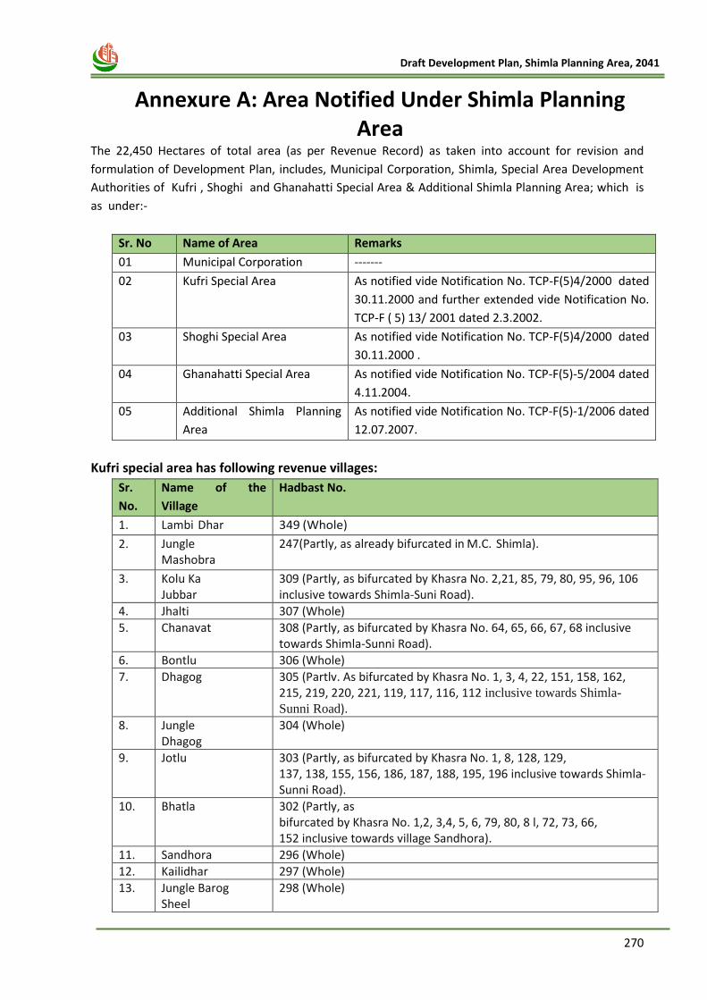
270
Draft Development Plan, Shimla Planning Area, 2041
18 Annexure A: Area Notified Under Shimla Planning Area
The 22,450 Hectares of total area (as per Revenue Record) as taken into account for revision and
formulation of Development Plan, includes, Municipal Corporation, Shimla, Special Area Development
Authorities of Kufri , Shoghi and Ghanahatti Special Area & Additional Shimla Planning Area; which is
as under:-
Sr. No Name of Area Remarks
01 Municipal Corporation -------
02 Kufri Special Area As notified vide Notification No. TCP-F(5)4/2000 dated
30.11.2000 and further extended vide Notification No.
TCP-F ( 5) 13/ 2001 dated 2.3.2002.
03 Shoghi Special Area As notified vide Notification No. TCP-F(5)4/2000 dated
30.11.2000 .
04 Ghanahatti Special Area As notified vide Notification No. TCP-F(5)-5/2004 dated
4.11.2004.
05 Additional Shimla Planning
Area
As notified vide Notification No. TCP-F(5)-1/2006 dated
12.07.2007.
Kufri special area has following revenue villages:
Sr.
No.
Name of the
Village
Hadbast No.
1. Lambi Dhar 349 (Whole)
2. Jungle Mashobra
247(Partly, as already bifurcated in M.C. Shimla).
3. Kolu Ka Jubbar
309 (Partly, as bifurcated by Khasra No. 2,21, 85, 79, 80, 95, 96, 106 inclusive towards Shimla-Suni Road).
4. Jhalti 307 (Whole)
5. Chanavat 308 (Partly, as bifurcated by Khasra No. 64, 65, 66, 67, 68 inclusive towards Shimla-Sunni Road).
6. Bontlu 306 (Whole)
7. Dhagog 305 (Partlv. As bifurcated by Khasra No. 1, 3, 4, 22, 151, 158, 162, 215, 219, 220, 221, 119, 117, 116, 112 inclusive towards Shimla-
Sunni Road).
8. Jungle Dhagog
304 (Whole)
9. Jotlu 303 (Partly, as bifurcated by Khasra No. 1, 8, 128, 129, 137, 138, 155, 156, 186, 187, 188, 195, 196 inclusive towards Shimla-Sunni Road).
10. Bhatla 302 (Partly, as bifurcated by Khasra No. 1,2, 3,4, 5, 6, 79, 80, 8 l, 72, 73, 66, 152 inclusive towards village Sandhora).
11. Sandhora 296 (Whole)
12. Kailidhar 297 (Whole)
13. Jungle Barog Sheel
298 (Whole)
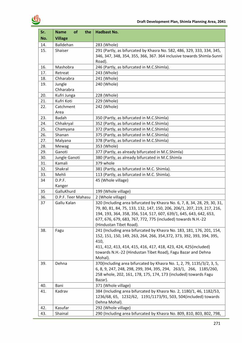
271
Draft Development Plan, Shimla Planning Area, 2041
Sr.
No.
Name of the
Village
Hadbast No.
14. Balldehan 283 (Whole)
15. Shaiser 291 (Partly, as bifurcated by Khasra No. 582, 486, 329, 333, 334, 345, 346, 347, 348, 354, 355, 366, 367. 364 inclusive towards Shimla-Sunni Road).
16. Mashobra 246 (Partly, as bifurcated in M.C.Shimla).
17. Retreat 243 (Whole)
18. Chharabra 241 (Whole)
19. Jungle Chharabra
240 (Whole)
20. Kufri Junga 228 (Whole)
21. Kufri Koti 229 (Whole)
22. Catchment Area
242 (Whole)
23. Badah 350 (Partly, as bifurcated in M.C.Shimla)
24. Chhakryal 352 (Partly, as bifurcated in M.C.Shimla)
25. Chamyana 372 (Partly, as bifurcated in M.C.Shimla)
26. Shanan 375 (Partly, as bifurcated in M.C.Shimla)
27. Malyana 378 (Partly, as bifurcated in M.C.Shimla)
28. Mewag 353 (Whole)
29. Ganoti 377 (Partly, as already bifurcated in M.C.Shimla)
30. Jungle Ganoti 380 (Partly, as already bifurcated in M.C.Shimla
31. Kamali 379 whole
32. Shakral 381 (Partly, as bifurcated in M.C. Shimla).
33. Mehli 113 (Partly, as bifurcated in M.C. Shimla).
34 D.P.F. Kanger
45 (Whole village)
35 GalluKhurd 199 (Whole village)
36. D.P.F. Teer Mahasu 2 (Whole village)
37 Gallu Kalan 320 (Including area bifurcated by Khasra No. 6, 7, 8, 34, 28, 29, 30, 31, 79, 80, 81, 84, 75, 133, 132, 147, 150, 206, 206/1, 207, 219, 217, 216, 194, 193, 364, 358, 356, 514, 517, 607, 639/1, 645, 643, 642, 653, 677, 676, 679, 683, 767, 772, 775 (included) towards N.H.-22 (Hindustan Tibet Road).
38. Fagu 241 (Including area bifurcated by Khasra No. 183, 181, 176, 201, 154, 152, 151, 150, 149, 263, 264, 266, 354,372, 373, 392, 393, 394, 395, 410, 411, 412, 413, 414, 415, 416, 417, 418, 423, 424, 425(included) towards N.H.-22 (Hindustan Tibet Road), Fagu Bazar and Dehna Mohal).
39. Dehna 370(Including area bifurcated by Khasra No. 1, 2, 79, 1135/3/2, 3, 5, 6, 8, 9, 247, 248, 298, 299, 394, 395, 294, 263/1, 266, 1185/260, 258 whole, 202, 161, 178, 175, 174, 173 (included) towards Fagu Bazar).
40. Bani 371 (Whole village)
41. Kadrav 384 (Including area bifurcated by Khasra No. 2, 1180/1, 46, 1182/53, 1236/68, 65, 1232/62, 1191/1173/91, 503, 504(included) towards Dehna Mohal).
42. Kasufar 292 (Whole village)
43. Shainal 290 (Including area bifurcated by Khasra No. 809, 810, 803, 802, 798,
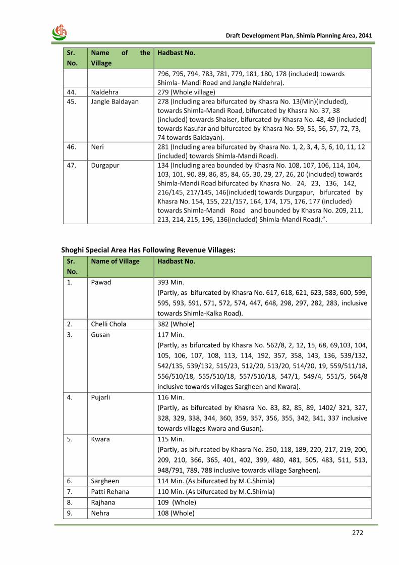
272
Draft Development Plan, Shimla Planning Area, 2041
Sr.
No.
Name of the
Village
Hadbast No.
796, 795, 794, 783, 781, 779, 181, 180, 178 (included) towards Shimla- Mandi Road and Jangle Naldehra).
44. Naldehra 279 (Whole village)
45. Jangle Baldayan 278 (Including area bifurcated by Khasra No. 13(Min)(included), towards Shimla-Mandi Road, bifurcated by Khasra No. 37, 38 (included) towards Shaiser, bifurcated by Khasra No. 48, 49 (included) towards Kasufar and bifurcated by Khasra No. 59, 55, 56, 57, 72, 73, 74 towards Baldayan).
46. Neri 281 (Including area bifurcated by Khasra No. 1, 2, 3, 4, 5, 6, 10, 11, 12 (included) towards Shimla-Mandi Road).
47. Durgapur 134 (Including area bounded by Khasra No. 108, 107, 106, 114, 104, 103, 101, 90, 89, 86, 85, 84, 65, 30, 29, 27, 26, 20 (included) towards Shimla-Mandi Road bifurcated by Khasra No. 24, 23, 136, 142, 216/145, 217/145, 146(included) towards Durgapur, bifurcated by Khasra No. 154, 155, 221/157, 164, 174, 175, 176, 177 (included) towards Shimla-Mandi Road and bounded by Khasra No. 209, 211, 213, 214, 215, 196, 136(included) Shimla-Mandi Road).”.
Shoghi Special Area Has Following Revenue Villages:
Sr.
No.
Name of Village Hadbast No.
1. Pawad 393 Min.
(Partly, as bifurcated by Khasra No. 617, 618, 621, 623, 583, 600, 599,
595, 593, 591, 571, 572, 574, 447, 648, 298, 297, 282, 283, inclusive
towards Shimla-Kalka Road).
2. Chelli Chola 382 (Whole)
3. Gusan 117 Min.
(Partly, as bifurcated by Khasra No. 562/8, 2, 12, 15, 68, 69,103, 104,
105, 106, 107, 108, 113, 114, 192, 357, 358, 143, 136, 539/132,
542/135, 539/132, 515/23, 512/20, 513/20, 514/20, 19, 559/511/18,
556/510/18, 555/510/18, 557/510/18, 547/1, 549/4, 551/5, 564/8
inclusive towards villages Sargheen and Kwara).
4. Pujarli 116 Min.
(Partly, as bifurcated by Khasra No. 83, 82, 85, 89, 1402/ 321, 327,
328, 329, 338, 344, 360, 359, 357, 356, 355, 342, 341, 337 inclusive
towards villages Kwara and Gusan).
5. Kwara 115 Min.
(Partly, as bifurcated by Khasra No. 250, 118, 189, 220, 217, 219, 200,
209, 210, 366, 365, 401, 402, 399, 480, 481, 505, 483, 511, 513,
948/791, 789, 788 inclusive towards village Sargheen).
6. Sargheen 114 Min. (As bifurcated by M.C.Shimla)
7. Patti Rehana 110 Min. (As bifurcated by M.C.Shimla)
8. Rajhana 109 (Whole)
9. Nehra 108 (Whole)
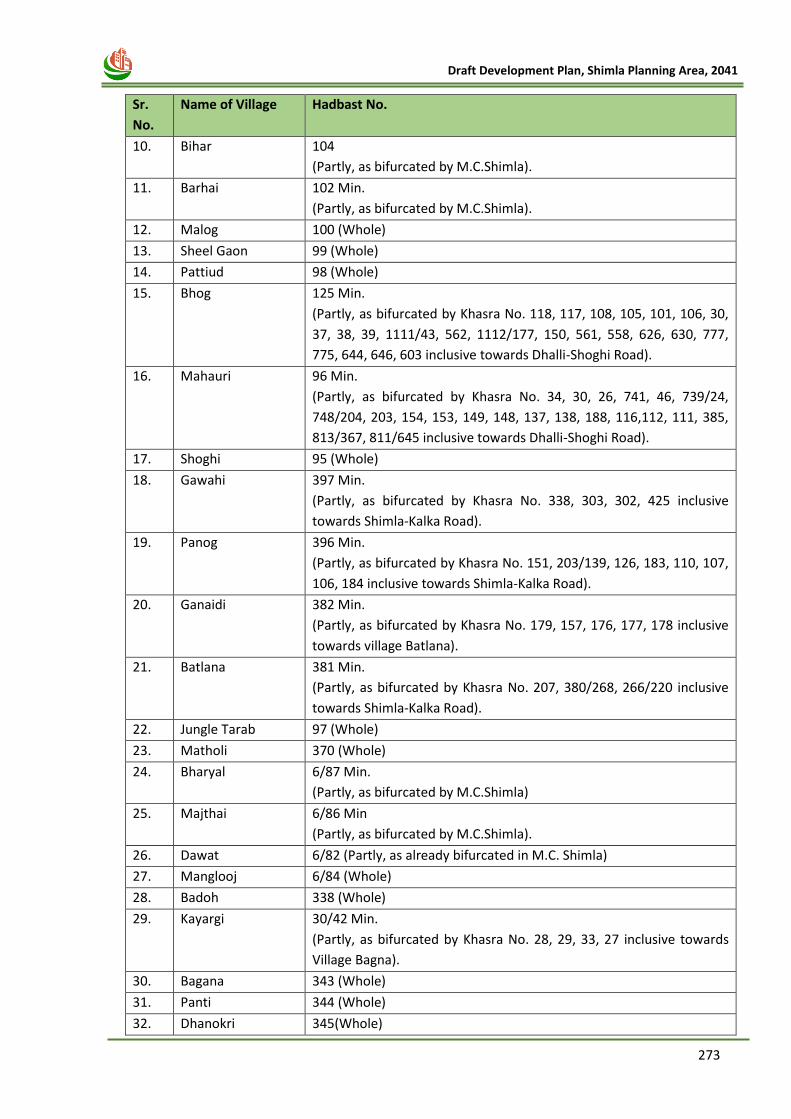
273
Draft Development Plan, Shimla Planning Area, 2041
Sr.
No.
Name of Village Hadbast No.
10. Bihar 104
(Partly, as bifurcated by M.C.Shimla).
11. Barhai 102 Min.
(Partly, as bifurcated by M.C.Shimla).
12. Malog 100 (Whole)
13. Sheel Gaon 99 (Whole)
14. Pattiud 98 (Whole)
15. Bhog 125 Min.
(Partly, as bifurcated by Khasra No. 118, 117, 108, 105, 101, 106, 30,
37, 38, 39, 1111/43, 562, 1112/177, 150, 561, 558, 626, 630, 777,
775, 644, 646, 603 inclusive towards Dhalli-Shoghi Road).
16. Mahauri 96 Min.
(Partly, as bifurcated by Khasra No. 34, 30, 26, 741, 46, 739/24,
748/204, 203, 154, 153, 149, 148, 137, 138, 188, 116,112, 111, 385,
813/367, 811/645 inclusive towards Dhalli-Shoghi Road).
17. Shoghi 95 (Whole)
18. Gawahi 397 Min.
(Partly, as bifurcated by Khasra No. 338, 303, 302, 425 inclusive
towards Shimla-Kalka Road).
19. Panog 396 Min.
(Partly, as bifurcated by Khasra No. 151, 203/139, 126, 183, 110, 107,
106, 184 inclusive towards Shimla-Kalka Road).
20. Ganaidi 382 Min.
(Partly, as bifurcated by Khasra No. 179, 157, 176, 177, 178 inclusive
towards village Batlana).
21. Batlana 381 Min.
(Partly, as bifurcated by Khasra No. 207, 380/268, 266/220 inclusive
towards Shimla-Kalka Road).
22. Jungle Tarab 97 (Whole)
23. Matholi 370 (Whole)
24. Bharyal 6/87 Min.
(Partly, as bifurcated by M.C.Shimla)
25. Majthai 6/86 Min
(Partly, as bifurcated by M.C.Shimla).
26. Dawat 6/82 (Partly, as already bifurcated in M.C. Shimla)
27. Manglooj 6/84 (Whole)
28. Badoh 338 (Whole)
29. Kayargi 30/42 Min.
(Partly, as bifurcated by Khasra No. 28, 29, 33, 27 inclusive towards
Village Bagna).
30. Bagana 343 (Whole)
31. Panti 344 (Whole)
32. Dhanokri 345(Whole)
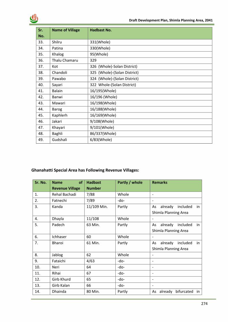
274
Draft Development Plan, Shimla Planning Area, 2041
Sr.
No.
Name of Village Hadbast No.
33. Shilru 331(Whole)
34. Patina 330(Whole)
35. Khalog 95(Whole)
36. Thalu Chamaru 329
37. Kot 326 (Whole)-Solan District)
38. Chandoli 325 (Whole)-(Solan District)
39. Pawabo 324 (Whole)-(Solan District)
40. Sayari 322 Whole-(Solan District)
41. Balain 16/195(Whole)
42. Banwi 16/196 (Whole)
43. Mawari 16/198(Whole)
44. Barog 16/188(Whole)
45. Kaphlerh 16/169(Whole)
46. Jakari 9/108(Whole)
47. Khayari 9/101(Whole)
48. Baghli 86/337(Whole)
49. Gudshali 6/83(Whole)
Ghanahatti Special Area has Following Revenue Villages:
Sr. No. Name of
Revenue Village
Hadbast
Number
Partly / whole Remarks
1. Rehal Bachadi 7/88 Whole -
2. Fatnechi 7/89 -do- -
3. Kanda 11/109 Min. Partly As already included in
Shimla Planning Area
4. Dhayla 11/108 Whole -
5. Padech 63 Min. Partly As already included in
Shimla Planning Area
6. Ichhaser 60 Whole -
7. Bharoi 61 Min. Partly As already included in
Shimla Planning Area
8. Jablog 62 Whole -
9. Fataichi 4/63 -do- -
10. Neri 64 -do- -
11. Rihai 67 -do- -
12. Girb Khurd 65 -do- -
13. Girb Kalan 66 -do- -
14. Dhainda 80 Min. Partly As already bifurcated in
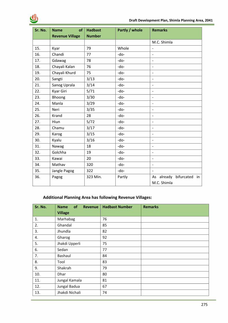
275
Draft Development Plan, Shimla Planning Area, 2041
Sr. No. Name of
Revenue Village
Hadbast
Number
Partly / whole Remarks
M.C. Shimla
15. Kyar 79 Whole -
16. Chandi 77 -do- -
17. Gdawag 78 -do- -
18. Chayali Kalan 76 -do- -
19. Chayali Khurd 75 -do- -
20. Sangti 3/13 -do- -
21. Sanog Uprala 3/14 -do- -
22. Kyar Giri 5/71 -do- -
23. Bhoong 3/30 -do- -
24. Manla 3/29 -do- -
25. Neri 3/35 -do- -
26. Krand 28 -do- -
27. Hiun 5/72 -do- -
28. Chamu 3/17 -do- -
29. Karog 3/15 -do- -
30. Kyalu 3/16 -do- -
31. Nawag 18 -do- -
32. Golchha 19 -do- -
33. Kawai 20 -do- -
34. Mathav 320 -do- -
35. Jangle Pagog 322 -do- -
36. Pagog 323 Min. Partly As already bifurcated in
M.C. Shimla
Additional Planning Area has following Revenue Villages:
Sr. No. Name of Revenue
Village
Hadbast Number Remarks
1. Marhabag 76
2. Ghandal 85
3. Jhundla 82
4. Gharog 92
5. Jhakdi Upperli 75
6. Sedan 77
7. Bashaul 84
8. Tool 83
9. Shakrah 79
10. Dhar 80
11. Jungal Kamala 81
12. Jungal Badua 67
13. Jhakdi Nichali 74
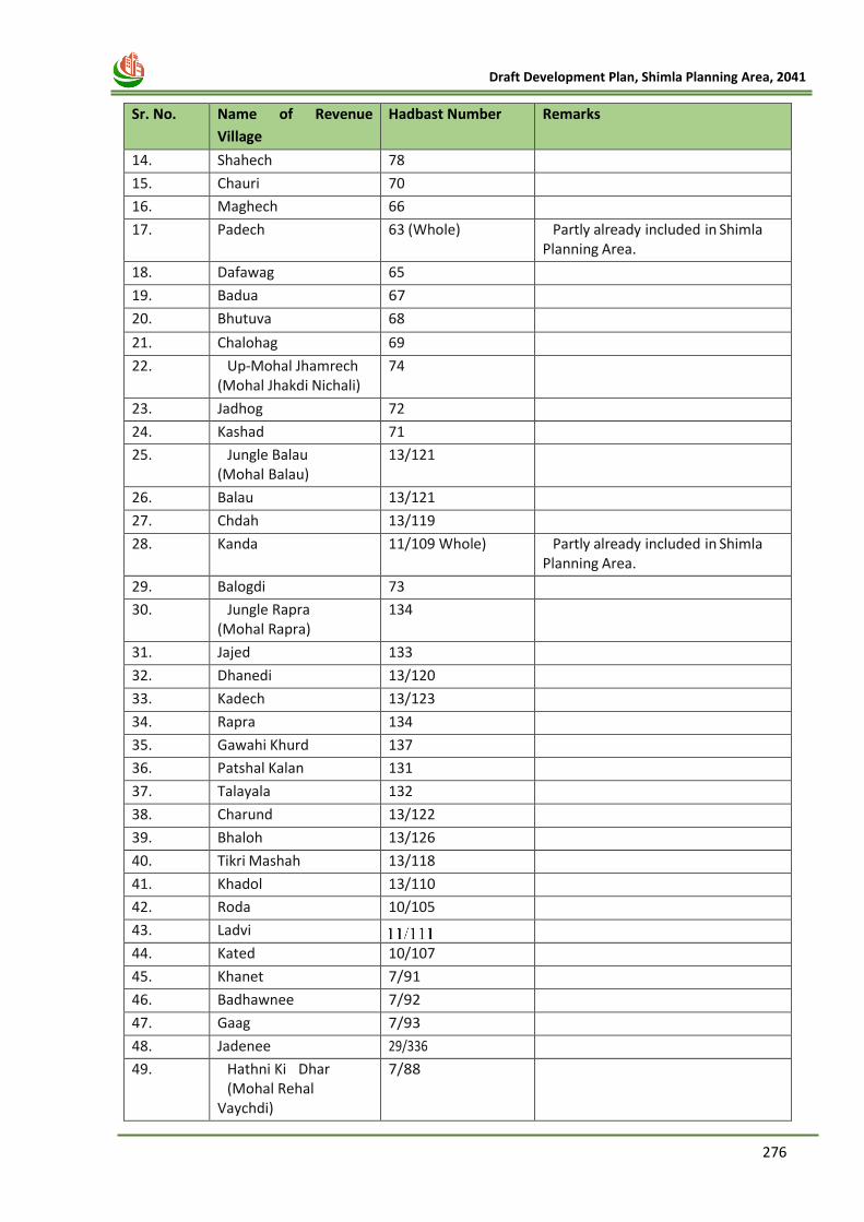
276
Draft Development Plan, Shimla Planning Area, 2041
Sr. No. Name of Revenue
Village
Hadbast Number Remarks
14. Shahech 78
15. Chauri 70
16. Maghech 66
17. Padech 63 (Whole) Partly already included in Shimla Planning Area.
18. Dafawag 65
19. Badua 67
20. Bhutuva 68
21. Chalohag 69
22. Up-Mohal Jhamrech (Mohal Jhakdi Nichali)
74
23. Jadhog 72
24. Kashad 71
25. Jungle Balau (Mohal Balau)
13/121
26. Balau 13/121
27. Chdah 13/119
28. Kanda 11/109 Whole) Partly already included in Shimla Planning Area.
29. Balogdi 73
30. Jungle Rapra (Mohal Rapra)
134
31. Jajed 133
32. Dhanedi 13/120
33. Kadech 13/123
34. Rapra 134
35. Gawahi Khurd 137
36. Patshal Kalan 131
37. Talayala 132
38. Charund 13/122
39. Bhaloh 13/126
40. Tikri Mashah 13/118
41. Khadol 13/110
42. Roda 10/105
43. Ladvi
44. Kated 10/107
45. Khanet 7/91
46. Badhawnee 7/92
47. Gaag 7/93
48. Jadenee 29/336
49. Hathni Ki Dhar (Mohal Rehal
Vaychdi)
7/88
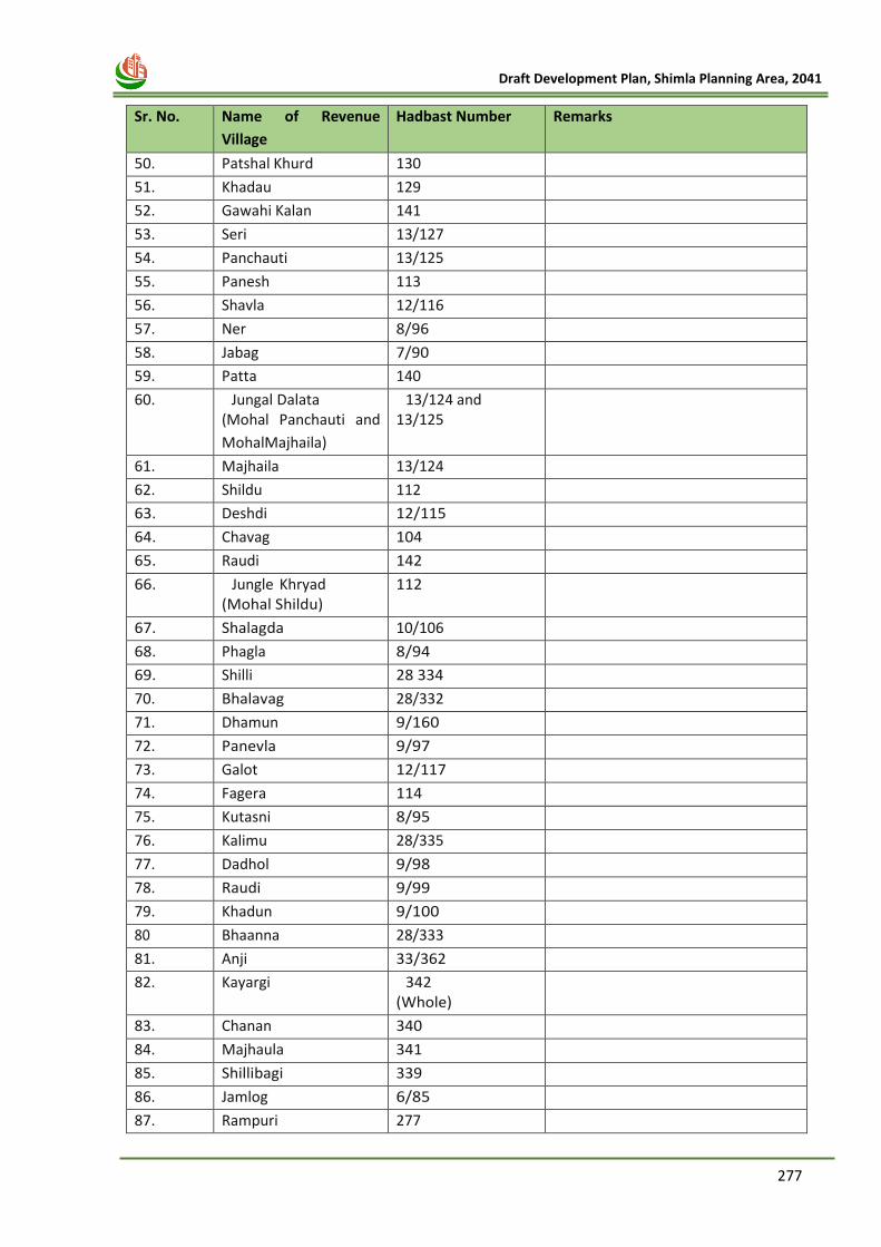
277
Draft Development Plan, Shimla Planning Area, 2041
Sr. No. Name of Revenue
Village
Hadbast Number Remarks
50. Patshal Khurd 130
51. Khadau 129
52. Gawahi Kalan 141
53. Seri 13/127
54. Panchauti 13/125
55. Panesh 113
56. Shavla 12/116
57. Ner 8/96
58. Jabag 7/90
59. Patta 140
60. Jungal Dalata (Mohal Panchauti and
Mohal Majhaila)
13/124 and 13/125
61. Majhaila 13/124
62. Shildu 112
63. Deshdi 12/115
64. Chavag 104
65. Raudi 142
66. Jungle Khryad (Mohal Shildu)
112
67. Shalagda 10/106
68. Phagla 8/94
69. Shilli 28 334
70. Bhalavag 28/332
71. Dhamun 9/160
72. Panevla 9/97
73. Galot 12/117
74. Fagera 114
75. Kutasni 8/95
76. Kalimu 28/335
77. Dadhol 9/98
78. Raudi 9/99
79. Khadun 9/100
80 Bhaanna 28/333
81. Anji 33/362
82. Kayargi 342 (Whole)
83. Chanan 340
84. Majhaula 341
85. Shillibagi 339
86. Jamlog 6/85
87. Rampuri 277
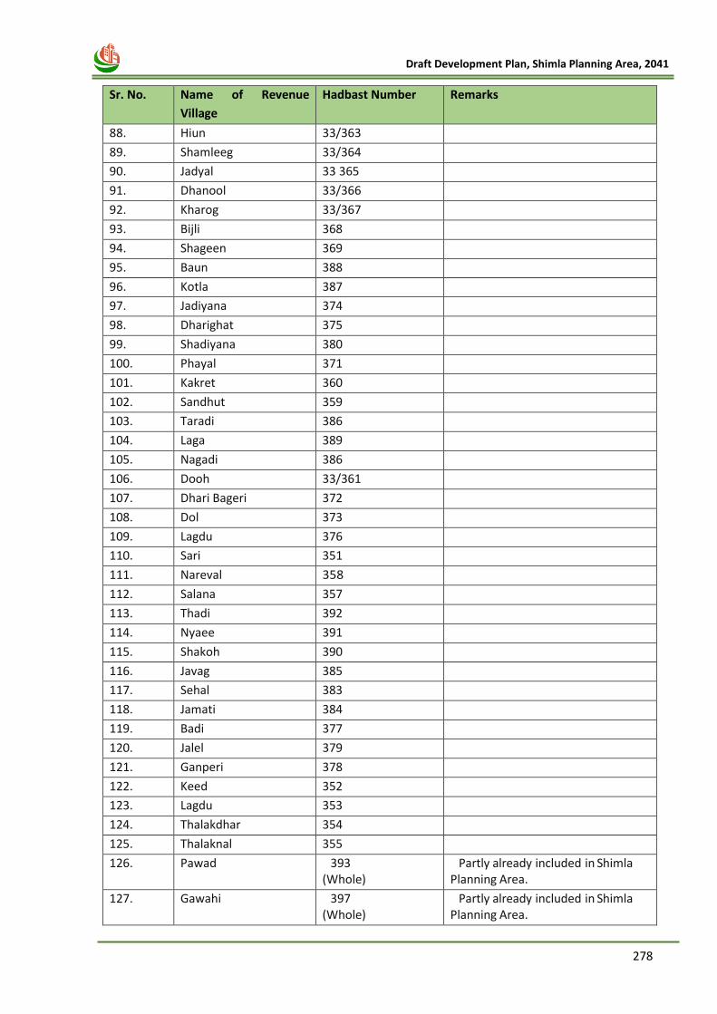
278
Draft Development Plan, Shimla Planning Area, 2041
Sr. No. Name of Revenue
Village
Hadbast Number Remarks
88. Hiun 33/363
89. Shamleeg 33/364
90. Jadyal 33 365
91. Dhanool 33/366
92. Kharog 33/367
93. Bijli 368
94. Shageen 369
95. Baun 388
96. Kotla 387
97. Jadiyana 374
98. Dharighat 375
99. Shadiyana 380
100. Phayal 371
101. Kakret 360
102. Sandhut 359
103. Taradi 386
104. Laga 389
105. Nagadi 386
106. Dooh 33/361
107. Dhari Bageri 372
108. Dol 373
109. Lagdu 376
110. Sari 351
111. Nareval 358
112. Salana 357
113. Thadi 392
114. Nyaee 391
115. Shakoh 390
116. Javag 385
117. Sehal 383
118. Jamati 384
119. Badi 377
120. Jalel 379
121. Ganperi 378
122. Keed 352
123. Lagdu 353
124. Thalakdhar 354
125. Thalaknal 355
126. Pawad 393 (Whole)
Partly already included in Shimla Planning Area.
127. Gawahi 397 (Whole)
Partly already included in Shimla Planning Area.
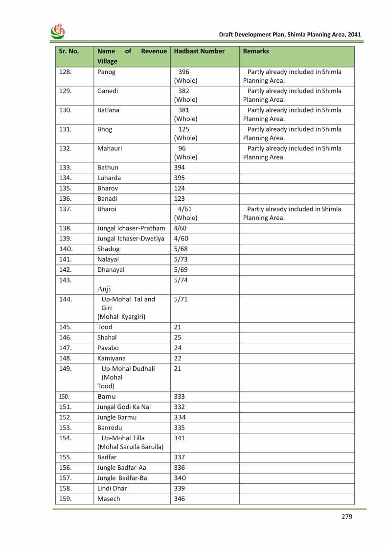
279
Draft Development Plan, Shimla Planning Area, 2041
Sr. No. Name of Revenue
Village
Hadbast Number Remarks
128. Panog 396 (Whole)
Partly already included in Shimla Planning Area.
129. Ganedi 382 (Whole)
Partly already included in Shimla Planning Area.
130. Batlana 381 (Whole)
Partly already included in Shimla Planning Area.
131. Bhog 125 (Whole)
Partly already included in Shimla Planning Area.
132. Mahauri 96 (Whole)
Partly already included in Shimla Planning Area.
133. Bathun 394
134. Luharda 395
135. Bharov 124
136. Banadi 123
137. Bharoi 4/61 (Whole)
Partly already included in Shimla Planning Area.
138. Jungal Ichaser-Pratham 4/60
139. Jungal Ichaser-Dwetiya 4/60
140. Shadog 5/68
141. Nalayal 5/73
142. Dhanayal 5/69
143.
5/74
144. Up-Mohal Tal and Giri
(Mohal Kyargiri)
5/71
145. Tood 21
146. Shahal 25
147. Pavabo 24
148. Kamiyana 22
149. Up-Mohal Dudhali (Mohal
Tood)
21
150. Bamu 333
151. Jungal Godi Ka Nal 332
152. Jungle Barmu 334
153. Banredu 335
154. Up-Mohal Tilla (Mohal Saruila Baruila)
341
155. Badfar 337
156. Jungle Badfar-Aa 336
157. Jungle Badfar-Ba 340
158. Lindi Dhar 339
159. Masech 346
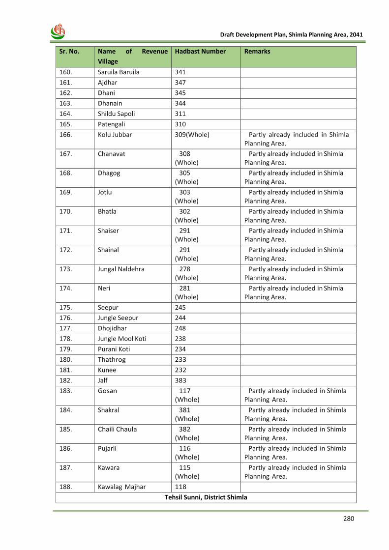
280
Draft Development Plan, Shimla Planning Area, 2041
Sr. No. Name of Revenue
Village
Hadbast Number Remarks
160. Saruila Baruila 341
161. Ajdhar 347
162. Dhani 345
163. Dhanain 344
164. Shildu Sapoli 311
165. Patengali 310
166. Kolu Jubbar 309(Whole) Partly already included in Shimla Planning Area.
167. Chanavat 308 (Whole)
Partly already included in Shimla Planning Area.
168. Dhagog 305 (Whole)
Partly already included in Shimla Planning Area.
169. Jotlu 303 (Whole)
Partly already included in Shimla Planning Area.
170. Bhatla 302 (Whole)
Partly already included in Shimla Planning Area.
171. Shaiser 291 (Whole)
Partly already included in Shimla Planning Area.
172. Shainal 291 (Whole)
Partly already included in Shimla Planning Area.
173. Jungal Naldehra 278 (Whole)
Partly already included in Shimla Planning Area.
174. Neri 281 (Whole)
Partly already included in Shimla Planning Area.
175. Seepur 245
176. Jungle Seepur 244
177. Dhojidhar 248
178. Jungle Mool Koti 238
179. Purani Koti 234
180. Thathrog 233
181. Kunee 232
182. Jalf 383
183. Gosan 117 (Whole)
Partly already included in Shimla Planning Area.
184. Shakral 381 (Whole)
Partly already included in Shimla Planning Area.
185. Chaili Chaula 382 (Whole)
Partly already included in Shimla Planning Area.
186. Pujarli 116 (Whole)
Partly already included in Shimla Planning Area.
187. Kawara 115 (Whole)
Partly already included in Shimla Planning Area.
188. Kawalag Majhar 118
Tehsil Sunni, District Shimla
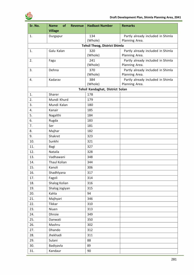
281
Draft Development Plan, Shimla Planning Area, 2041
Sr. No. Name of Revenue
Village
Hadbast Number Remarks
1. Durgapur 134 (Whole)
Partly already included in Shimla Planning Area.
Tehsil Theog, District Shimla
1. Galu Kalan 320 (Whole)
Partly already included in Shimla Planning Area.
2. Fagu 241 (Whole)
Partly already included in Shimla Planning Area.
3. Dehna 370 (Whole)
Partly already included in Shimla Planning Area.
4. Kadarav 384 (Whole)
Partly already included in Shimla Planning Area.
Tehsil Kandaghat, District Solan
1. Sharer 178
2. Mundi Khurd 179
3. Mundi Kalan 180
4. Kanair 185
5. Nagalthi 184
6. Rugda 183
7. Ser 181
8. Majhar 182
9. Shakret 323
10. Sunkhi 321
11. Bagi 327
12. Nataila 328
13. Vadhawani 348
14. Thaul Kolian 344
15. Kanoli 306
16. Shadhlyana 317
17. Fagoli 314
18. Shalog Kolian 316
19. Shalog Jogiyan 315
20. Kahla 94
21. Majhyari 346
22. Tikkar 310
23. Niuen 313
24. Dhroie 349
25. Danwati 350
26. Mashru 302
27. Dhando 312
28. Jhekhadi 311
29. Sulani 88
30. Badiyavla 89
31. Kandaur 90
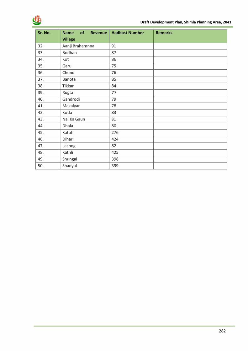
282
Draft Development Plan, Shimla Planning Area, 2041
Sr. No. Name of Revenue
Village
Hadbast Number Remarks
32. Aanji Brahamnna 91
33. Bodhan 87
34. Kot 86
35. Garu 75
36. Chund 76
37. Banota 85
38. Tikkar 84
39. Rugta 77
40. Gandrodi 79
41. Makalyan 78
42. Kotla 83
43. Nal Ka Gaun 81
44. Dhala 80
45. Katoh 276
46. Dihari 424
47. Lachog 82
48. Kathli 425
49. Shungal 398
50. Shadyal 399
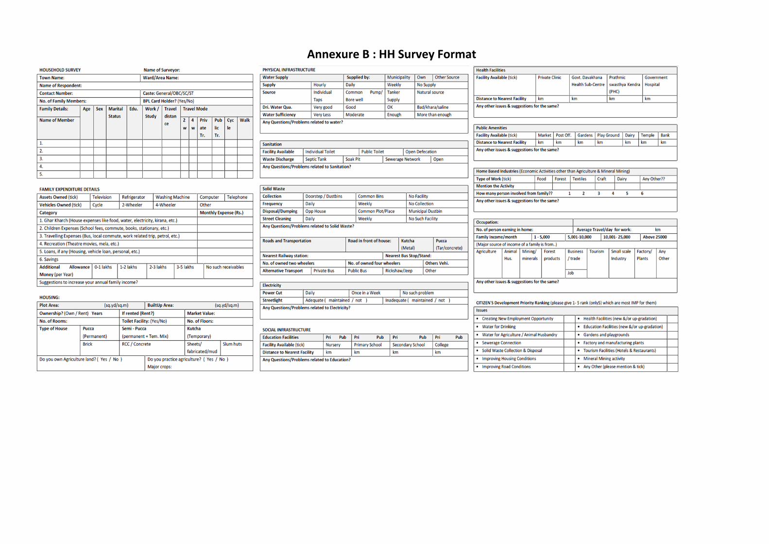
19 Annexure B : HH Survey Format
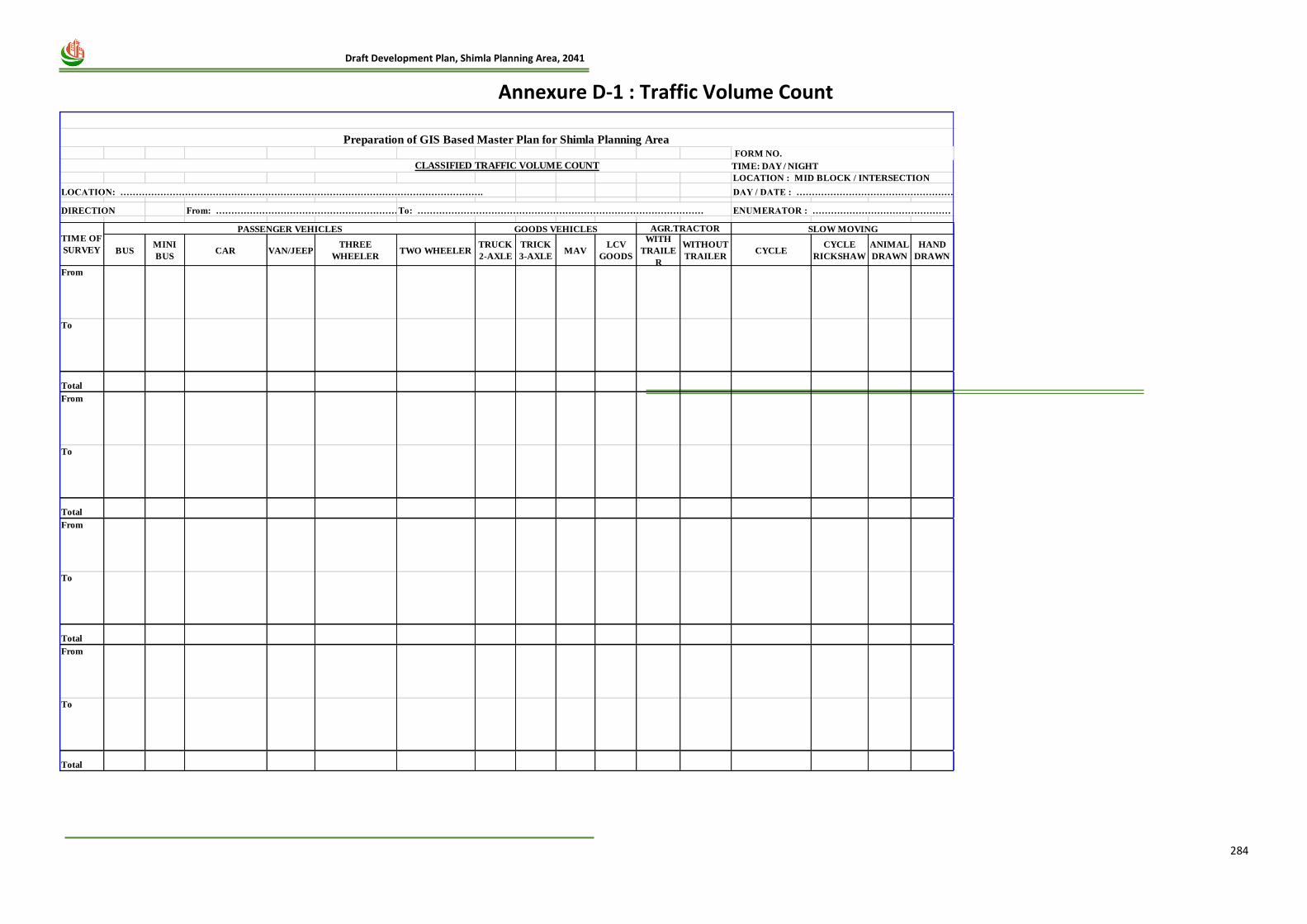
284
Draft Development Plan, Shimla Planning Area, 2041
20 Annexure D-1 : Traffic Volume Count
LOCATION : MID BLOCK / INTERSECTION
LOCATION: ………………………………………………………………………………………………………. DAY / DATE : ……………………………………………
DIRECTION From: …………………………………………………………..To: ………………………………………………………………………………… ENUMERATOR : ………………………………………
BUSMINI
BUSCAR VAN/JEEP
THREE
WHEELERTWO WHEELER
TRUCK
2-AXLE
TRICK
3-AXLEMAV
LCV
GOODS
WITH
TRAILE
R
WITHOUT
TRAILERCYCLE
CYCLE
RICKSHAW
ANIMAL
DRAWN
HAND
DRAWN
From
To
Total
From
To
Total
From
To
Total
From
To
Total
AGR.TRACTOR
Preparation of GIS Based Master Plan for Shimla Planning Area
PASSENGER VEHICLESTIME OF
SURVEY
GOODS VEHICLES SLOW MOVING
CLASSIFIED TRAFFIC VOLUME COUNT
FORM NO.
TIME: DAY / NIGHT
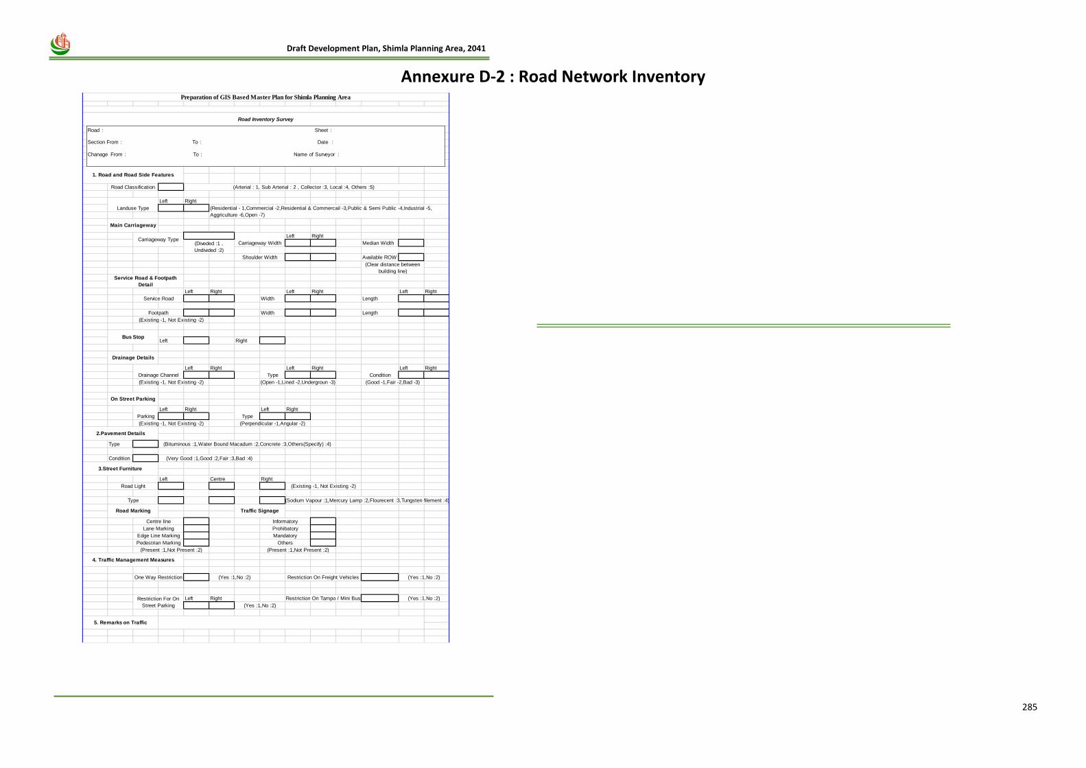
285
Draft Development Plan, Shimla Planning Area, 2041
21 Annexure D-2 : Road Network Inventory
Left Right
Left Right
Median Width
Available ROW
Left Right Left Right Left Right
Width Length
Width Length
Left Right
Left Right Left Right Left Right
Left Right Left Right
Type
Condition
Left Centre Right
Left Right
Preparation of GIS Based Master Plan for Shimla Planning Area
Main Carriageway
Road Classification
Landuse Type
(Arterial : 1, Sub Arterial : 2 , Collector :3, Local :4, Others :5)
(Residential - 1,Commercial -2,Residential & Commercail -3,Public & Semi Public -4,Industrial -5,
Aggriculture -6,Open -7)
Road Inventory Survey
1. Road and Road Side Features
Carriageway TypeCarriageway Width
Shoulder Width
(Clear distance between
building line)
(Diveded :1 ,
Undivided :2)
(Existing -1, Not Existing -2)
Type
(Perpendicular -1,Angular -2)
Condition
(Good -1,Fair -2,Bad -3)
Parking
Drainage Channel
(Existing -1, Not Existing -2)
Type
(Open -1,Lined -2,Undergroun -3)
(Bituminous :1,Water Bound Macadum :2,Concrete :3,Others(Specify) :4)
(Very Good :1,Good :2,Fair :3,Bad :4)
Road Light (Existing -1, Not Existing -2)
3.Street Furniture
2.Pavement Details
Type (Sodium Vapour :1,Mercury Lamp :2,Flourecent :3,Tungsten filement :4)
Centre line Informatory
Road Marking Traffic Signage
4. Traffic Management Measures
Prohibatory
Mandatory
Others
(Present :1,Not Present :2)
Lane Marking
Edge Line Marking
Pedestrian Marking
(Present :1,Not Present :2)
Restriction For On
Street Parking (Yes :1,No :2)
Restriction On Tampo / Mini Bus (Yes :1,No :2)
One Way Restriction (Yes :1,No :2) Restriction On Freight Vehicles
5. Remarks on Traffic
Service Road & Footpath
Detail
Bus Stop
Drainage Details
On Street Parking
Service Road
Footpath
(Existing -1, Not Existing -2)
(Yes :1,No :2)
Road : Sheet :
Section From : To : Date :
Chanage From : To : Name of Surveyor :
286
Draft Development Plan, Shimla Planning Area, 2041
1. Have you been to this city before? (1) Yes (2) No
2. How have you traveled to the city this time?
(1) Train
(2) Bus
(3) Air
(4) Personal Vehicle
(5) Taxi
(6) Other ___________________
3. How often do you travel?
(1) Once a week or more often
(2) Once a fortnight
(3) Once a month
(4) Once in 3 months
(5) Once in 6 months
4. What is your main purpose of visit?
(1) Business
(2) Holidaying, leisure and Recreation
(3) Social
(4) Pilgrimage/Religious activity
(5) Education/Training
(6) Health/Medical
(7) Shopping
(8) Other ____________________________________
5. Are you a part of an organized group / package tour? (1) Yes (2) No
6. If yes, what does the package include?
(1) Travel + Food
(2) Travel + Accommodation
(3) Travel + Transport + Accommodation
(4) Travel + Transport + Accommodation + Food
(5) Any Other
7. How did you make your travel arrangements?
(1) Self
(2) Office/Employer
(3) Travel Agent
(4) Tour Operator
(5) Other ____________________________________
8. Where did you stay during your visit?
(1) Hotel
(2) Service Apartment
(3) Motel
(4) Guest House
(5) Dharamshala
(6) Friends / Relatives
(7) Temporary free stay (Temple, Tent, etc.)
(8) House on Rent / Tourist Bungalow
(9) Youth Hostel
(10) Bed and Breakfast unit
(11) Other __________________________________________
9. On an overall basis, how satisfied or dissatisfied are you on account of each parameter mentioned
below.
[5] Highly Satisfied [4] Satisfied [3] Satisfied but not completely [2] Dissatisfied [1] completely dissatisfied
(Ask satisfaction level only if response is yes)
1. What were the tourist spots you visited during your stay in the city?
(Names of the spots)
2. How did you find your visit to the city as per your expectations?
[5] Much better than expectation [4] Somewhat better than expected [3] As per expected [2] Worse than expected [1] Much worse than expected
