documentary anhrexes to the counter-memorial
TRANSCRIPT
VOLUME II
DOCUMENTARY ANhrEXES TO THE COUNTER-MEMORIAL OF THE
LIBYAN ARA3 JAMAHIRIYA
Annex 1
TUNISIAN PRIME MINISTER'S DECLARATION OF 29 DECEMBER 1980
[Arabic text not reproduced]
Tunis 29 12 80 Tunisia News Agency
Mzali and the Tunisian Libyan Relations
During the speech made this evening at the end of the Tunisian Assembly's discussions, Mr. Mzali declared,
"We are still very keen on rnaintaining Our fnendly, confidential and co-operfilivc relalionshp with Our hrntherly Lihyan Jamahiriya, and id putting aside any misunderstandings which have wçurred in the past. A 1;iirMul and çunsciçntioiis politician is one wlio looks to his future rathçr than dvelling on his past. As advcrcates of friendship, hrotherhocld and CO-apcration hetween us and Libya, we hupc that ot the end ~ 1 1 9 8 0 wi: shall [enninale al1 uur misunderstandings and that sufficient effort will be iiindç frtr dialogue and reproachment hased on mutual respcct of cach othcr and eaçh uthcr's sovcrcignty. Any dialogue based on such respect will cerlainly codlribule lu o better understanding between one another."
The Prime Minister, recalling thc prnposals madc hy him last summcr in whch lie wught tu impruvc Lihyan/'l'unisian relations. said,
"With rhe will of God, we shall work together in order to end the . continental shelf problem for the sake of the two brotherly peoples who have a mrnrnon elhnic origin and a common civilization, and ihat this will be a firu step towards unifying our capabilities.
While we have no objection to allowing the legal issues to take their wurse! we should think of establishing a joint Company which would be
* A5 the spdlings of Arabic place names are phonetic, there are certain variations b e l w m the place names used in the text of the Counter-Mernorial, the Technical Annexes contained in Vol. III and those used in the translations appearingin ths Vol. II. l n $5 rapecr. hnnex 1-28 to the hbyan Mernorial enurnerates some of the principal variauons.
DOCUMENTARY ANNEXES TO COUNTER-MEMORIAL 35 1
charged with exploiting the disputed area equally. If we achieve this goal, we would have succeeded in gaining the confidence of Our youth in Tunisia, in theJamahiriya and in the future. We should not forget that any possibilities we might pursue with our Arab countries will be of great benefit to al1 Arab people, and if we really do believe in the Arab welfare, it would be a pity to waste years merely discussing the different aspects of co-operation in al1 fields contained in the agreements signed between the two countries in 1972 and 1973. There are 14 such agreements which must be injected with new life.
If we could channel the water back on its course and establish positive and bilateral co-operation, and if we could resolve the continental shelf prob- lem, we would then be in the middle of the course which teads us to unity. However, if this is just a dream, it would remain the dream of the Tunisian and Libyan youths, until God helps us to resolve it and until the wisdom and the perceptive political view realizes this dream."
Mr. Mzali also said,
"We are encouraging invitations for informal visits between us. So 1 have addressed to the Libyan Foreign Minister an officia1 invitation to visit Tunisia, and 1 shall have the honour to make an official visit to Libya in response to the Libyan Government's own invitation."
CONTINENTAL SHELF
Annex 2
PAGE 39 OF MEDITERRANEAN PILOT : M TH EDITION. HYDROGRAPHER OF THE NAVY, TAUN-
TON, ENGLAND, 1976, VOL. V
PAGES 174 , 175 AND 360 OF MEDITERRANEAN PILOT : WH EDITION, TAUNTON, ENGLAND, HYDROGRAPHER
OF THE NAVY, 1 9 7 4 , VOL. 1
PAGE 169 OF MEDITERRANEAN PILOT : IOTH EDITION, TAUNTON, ENGLAND, HYDROGRA-
PHER OF THE NAVY, 1978 , VOL. 1
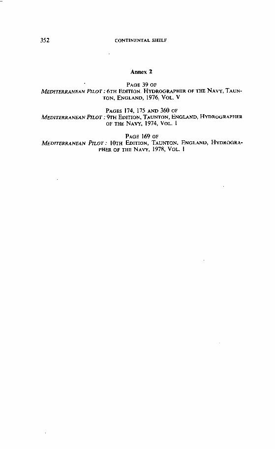
[1751 DOCUMENTARY ANNEXES TO COUNTER-MEMORIAL 355
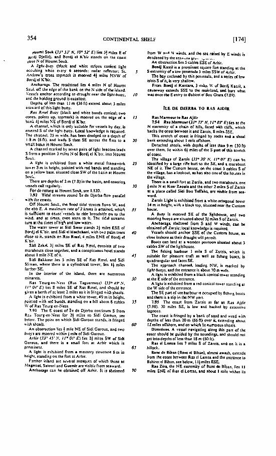
,,,.e,qir? is a vhiic rnasonry towcr (rtd top; clevaiion ol ;.i 0 (18 R); Wo red cones. bases togeihcr. topmark).
.A 1izh1hi -L~~~ (b!ack and vhiic buids conicd; lighi o;.-~iiing *hi.t evcry 6 seconds; rsdar rcnecror; IWO
ir.-.:i. pob4 up. topmark) is moored 2! miles NE or the towrr on RLS Z~ra.
El siban fon stands on M islet ii ~ h c rntrancc 10 Ba-;;n cl Biban. se below.
anchorap c m be obtained on ihc E sidc of Bank & B Z x . vi ih ihc $on ai the entranec w Bahirct cl Biban t:=<nz 185" disiaci aboui S~.rniles. iri a dtpih o f 7-3 rn i?: ::): or wirh rhc fort bcarin~ 23j0, dislani h o u t 3 ai:%. in a dcplh OF 5.5 rn (18 RI. The holding ground i i c,~::icn~
7.W Bahirci el Biban ir enttrrd by a narrow channel k:z :=a the iilti with rh: fon on is i nd rhc isl:r next E of
iL Thcrc is a bar in thc eniruicc wiih r dcpth o l I m (3 fi) over il.
A cisum standr 24 rnila WNW of the ton, a d i hur stands 2 miles ESE of thc ïarL
J Mal iacams in the channel ibrcasi the fort aitain i rait 014 knors ai springs.
Betwan the cnirmcc ollhis lagwn and R u Ajdir. 131 miles SE , ir i chain or maiil hummockr, many of vhich arc surmounicd by mifis. Thc only ont &JI can
!O be idenlilicd wilh nnrinty ir thai on Rai el Ketcl. which stands on a white cl14 lof milm ESE of W Biban tort.
Shoatr. wiih 1 Icat dcpth of 8.5 m (28 Fi) mw rhtm. lic about I I miles NHE o l Ras cl Kcuï.
IS For i descripiiar or Rai Ajdir (33' I O ' N, I Ia 33' 0. and the cotrt ïirthtr Esce ~~ftditerranmn Pilot. VDI. V.
PUBLISHED BY THE HYDROGRAPHER OF THE NAVY
356 CONTINENTAL SHELF 13601
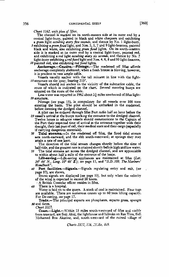
Chmt 1162, ~ - i t h plan 01 S~U. Tbc channel is marked on its north-castern sidc at its outcr end by a
conical iight-buoy, paintcd in black and white chequers and cxhibiting a green light ocdiing siny five sccondr, and thence by Pio. 1 Iight-bu-.
5 exhibithg a grernjurd light, and SOS. 3,5,7 and 9 Light-btacons, painted black and white, nlso cshibiting grernfîxcd lights. On its south-western side it is muked ar its outtr end by a conicll light-buoy, painted red, and exhibiting a rrd light ocnrliitig m q A sesmrdr, and thcnce by No. 1 light-buoy Qhibiring a redfired light and Sm. 4,6,8 and IO light-beacons,
I O painted r d , ai- &biting red f i rd lights. Anchwage.4utioa-Pila-e.-The roadstead off Sfax &or&
anchonge completety shcitcrcd; whcn a frcfh brcczc U blowing, however, it is prudent to veer ample cable.
Vcopcis usualiy anchor with the ta11 minaret in line with the light- ISstnicture on thc qua'., bcaring 310".
ircsscls shouLd not anchor in the vicinity of the submarine cablc, the route of nhich is indicated on the chart. Severai mooring buoyn are situated on the route of the cabte.
Lcss water was reported in 1962 about 3 ) milcs southsard of Sfax light- 20 structure.
Pilotage (fer page 15), is compulsary for al1 v a e l s ovtr 100 tons entering the bWn. The pilot should bc cmbarirtd in the roadstead, bcfort entering the drtdged chuincl.
A pilot c m be ordercd through Sfax Port radio haIf an hour before the 25vcascl's arriva1 at the buoys rnarking the cntrancc to the dredgcd chuinel.
Twclvc houn in adrance v w l s should communicatc to the Captain of tht Port their erpectcd timc of arrivai at the entruice togethcr with thtir dnught, thcir last port of cal], thcir medical state and thcir cargo ( n p & d y if carrying duigerous matcriah).
90 Tidal &carni.-In the roadstead off Sfar, the flood tidal strcam acts north-castward, and the ebb south-~estward; at aprings they may rnrin a rate of one hot.
The direction of the tidal Stream changes shortiy before the time of hW-tidt, and the grtatest rate is îttainedshortly beforc high and low watcr.
35 The tidd s t r e m sct acrov the dredgcd channel, and are apprcciable to within *out haif'a mile of the cntrancc of the basin.
Lif~ving.-Lifc-sat-ing applianccs arc maintaincd nt Sfax (Lut. 34O 44 N., Long. 100 46' E.); set page 13, and "S.D. 100, The :lIaalltrs' Handbwk".
40 Port facilities.-Signsls.-Signa11 rcg-dlating entry and exit, (ut , page IO), arc shou-n.
Storm signal5 arc displayed (rce pagc IO), but ody whcn the vdocity of the wind is cxpccttd to exceed 20 knots.
A British Consular oEcer rcsidcs in Sfax. 45 Thcrc is a hospital.
\Vater is laid or1 to the qua>% A stock of coal is rnaintained. Four nigs are availablc. Thcrc arc numcrous crancs up to 60,tons tifring capaci~. For De-ratting, set page 17.
Trade.-The principal exports are phosphates, csparto gr-, sponges 50 and data.
Climt 3327. Cour+-Light.-IVithin 15 miles sourh-\vestr\-ard of Sfax and visible
from steward, are Sidi .Xbid, the itighthoust and 1iiUoEks on Ras Tina. Sidi 3lohamed Bou .&zinc, and, south-\vtst\rard of the niined village oi
[ 1691 DOCUMENTARY ANNEXES TO COUNTER-MEMORIAL 357
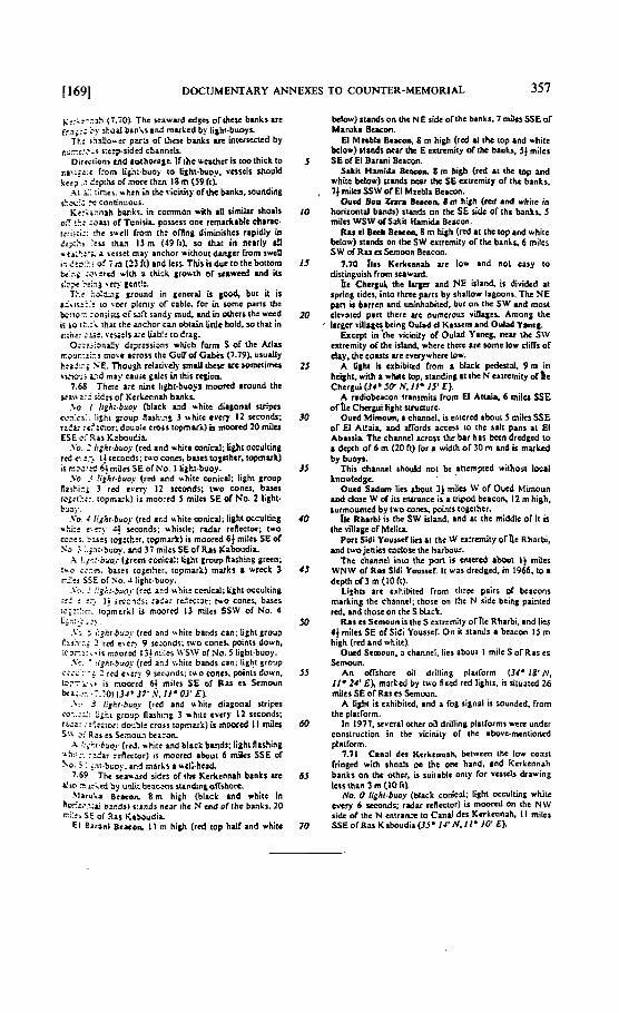
E::;?-ZI!I (7.70). The wawud edge ofrhcsc banks i re f:;i;c; 'y sbsaI binisand mukcd by lilht.buoys.
Tt.: ;i!d!oucr puCs of ihcse banks arc Uiterwctcd by cl;-:::,% s:e:psidcd channelk
Dircctionr tnd atxhoragc. I f ihe weathcr is tmlhick 10 ~c\i;t.: îrom li$h:.buo? to lishi-bue!. vnsclr should le:? ..: 2.-pihr or more thzn 18 m (59.1~).
A i i: ;inci. vhrn in the ricinit). ofthe bnks. uiunding $?,.xi: 'e con6n!?oçs.
Rc:;xnrh bw.ks. in cornmon uith ail simihr ihoils mT !L: ;au1 of Tunisia. poswss one rcmarkiblc char=- 1r:ii;i:: :hc su.ill from th: offinp diminijhcs rapidly in ::pi: lei; ihan I S m (49 11). 50 iha i n nclrly a!I Y a verset ma? anchor vithout duilcr frorn swcll 1; dti.:!j of i n (23 fi) and ksr.This is ductothc batmm k.z ' : ;orcrcd ui th a thick 'rouih of saivecd and iir I:E;Y i i x 3 %CF gcni!:. Tt.: ::3!$~7g yound in &encrai ü but i t is
~ I r i i i ? : : io t t t r plcniy of cabic, for in $orne parts ihc &!IO?. :oniisï cf s.12 randg mu& and in nhcrs rhc wccd ii i o t?..:; that the mchor can obiah bnlc hold. so that in ch:: :s:. \.cw:ls x c $ab!$ todrag.
O;;?:.xa!!y d:;r:ssianr which form S of the Atlas r r o ~ r : ~ ; : ~ more acrosr th: GuUof Gabk (7.79). u s u d l ~ h:idz; VE. Thou& rclaiively smaii rhcw uc romctirn& ticio-i z;d ma? C ~ U Y gaies in this r e o n
7.69 Thcr: are nine Iight-buoy moorcd iround the seau 2:- sides of Kcrlcnnah brnkr
.\O 1 l i 3h idxo (black ind vhitc dii lonal stripcs cosiz;:. lishi poup auhice 3 utht every 12 xconds; rr?i; :e::nor: daude cross topmuk) U m r c d 10 mi14 ESE c: %as KzbouCia.
.\o. : hghr-buoj (rcd and white mnicd; light oecultin~ rcd c. :> 1! wcoedr; t r o conn, b-es toscthcr. topmut) is noo:k 6! miln SE of No. 1 lizhi-buoy.
.Vo .< !j8hr-buo ( r d md whiic wnicd; light Sroup Raihiri 3 red i v r T 12 seconds; iwo wnes. balcs tozri::::. topml;l) is rnoorcd S mi ls SE of No. 2 IishG bl~)..
.\'o. : 1~hr.buoj (rcd ;cd uhiic mnicd; lipht occulting -5:: e,:ri. + xconds; rhistlc: radar rclieclor; 1 ~ 0 C.".. b,.... . :ses iog:tt~, topma:k) i r moord 6f miles SE or
';a ; :.;x;~bsoy. m d 37 miles SE of R is Ilaboudia. .A !.!,::.bvo.i. (Jrcen conicat:lifihi gmup Rashin$ prcen;
:no ;?:S. b u t s togcihcr. topmark) marks a w r ~ k 3 r:... ....-. SSE of ?;o. 4 light.buoy.
.\'.:-. I :::di-bëo.r ( r d a-d ubi i t conicai; tiphi ofculiing ::$ c.:.? li ic~oafs; :a<i: re.:rc:ar: rwo concs. biscl ici?:?::. ioprnark) i; moorcd 13 milcs SSW of NO. 4 C
y. ' '. ,. , ~.fCi-br-. (rcd and u hile bands can; Light grnu? tzi?:?. ? rrd e r t c 9 seconds; two concs. points doun. ;C;iri:%+ir roor td 13!r;.i:ej U'SW of No. 5 1ight.buoy. .y?. ' :i~k!.biroy (rcd anj \ibilc bands f in; tight sraup
c:;~':--i 1 rtd cbc:? 9 srcrindr; ruo conis. points down. lC-- . . . . , t ii noor:d 6! miles SE of R U CS S ~ m n i n kr: .y. .:.?O) ( J d * 37'9. 1IEOJ'E&
.\:* 3 I!gkr.buo~ (rcd and white diapond stripes sO:.:i: i;ht grog? fllrhing 3 white cvcrg 12 scconds; rtaz: ::::cior: dolalt crois toprnuk) is moorcd 1 I d c s
2; Ras es Scmoun bcr:on. .4 ::;L~.buo~ (rtd. m hi:c and black bands: light flashiiig
u$.. .. . a .... . z h i rc f l~ :o r ) i s moored about 6 miles SSE of
ho. 5 : ~.it.bwy. and marks auell.hcrd 7.69 The s+auord sidcr orihe Kcrkcnnah banks arc
di* - s i e d 5y unlk bczu-n% urnbntoff*iort. MiruLa Btason B r n high {blick md vhitc in
ho'!r,l-.;li bxds) r:mdr nrar lhr N tnd of the bmh. 20 ci:', SE or Ras cib bu di^
El Earani B t x o ~ i l m hi* ( r d top h J I and white
bclow) stands on the NE ride of thc barks. 7 miles SSE of Maruki Bucon. El Mzeôl8 k a c o q 8 rn high (rcd at tht top and whiic
bclow) r tads Mar ihc E txmmity olihc banks, 54 milcs 5 SE or El Barmi Bcacon.
Sik i i HsniiJa Beacoa 8 m high ( r d i t thc iop and white bclow) stuids ncar the 56 cxtrcmiiy of the banks.
, 7) milci SSW of El Mzebla &.con. Oucd Boa Znn Elcoson. 8 m hi lh I d and whilc in
IO horizontal bands) stmds on the SE Udc of thc banlis, 5 miln WSW 01 SAir Hmida Bcacon.
Ris cl Bœb Brwm, 8 m high ( r d at thc topind white bllov) stands on ihc SW crmmity or the banls, 6 milcr SW of R u cr Semoun Bcamn.
13 7.70 11es K t r k c n d arc low ind no1 cary lo disihguish rrnm scawud.
ht C h q u i thc l u ~ e r and NE Uand. is dividcd ai spring tidel. intû t h m parts by s h d l ~ w IagOans. The N E part is barrcn and uninhnbitcd. but on the SW i n d mort
20 devatcd p i e lhcre are numcmus villages. Among the Iargcr riUatcr k i n g Outid al K is i tm and Odad Yant:.
Exccpt in ihc vicinitr cf Oulad Yamg. m u thc SW cxtremiiy of tht idand, where ihcrc &re -me low diITs of ehy. rhc couis arc evcrywhcrc Iow.
25 A Gghl is cxhibiird from a black pcdcnd. 9 m in hiilht.iiih r whiie lop, s lu id in~ at the N txtrcrnity o r t e Chersui (34' JQ N, I Io IS' E).
A radiobeacon irinsmits lrorn El Aliui. 6 mi lu SSE ofne Chergui light rtruaurc.
Ouid Mimoun, a dtannel, n intcrcd about 5 milcs SSE or El Aiiai* and fiords accar 10 ihc sali pans ai El Abisiia fhc chuincl icrorr the bar has bctn drcdged IO
a depth of 6 m (20 R) for a &th o f 30 m ind is mukcd by buoys.
Thii chuiwl rhould not be ittcrnptcd wiihoii local knowlalge.
Outd Srdum licr rhout 3j milm w of Oued Mimoun id cl- W d iis enmnct is a iripod beacon. 12 m high, rurmovntcd by two cones, points togcihcr.
11. Rbirbi is the SW Uland. ind at thc middlc of it u the villapc of htclita
Pwt Sidi Youssd l i r~a~ thc W ertremity o rn t Rharbi, uid two jenies enclose rhc harbour.
f hc cbanntl in10 thc port i r cnrcrcd about 1) mats WN\V of Rmi Sidi Yauswf. Ii vas drtdgcd. in 1966, t o i depth of3 m (10 Ir).
Lighu are cxhibited ïrom tlircc pairs of bcacoris mirking the Channel; thosc on the N ride brin; paintsd r d . and ihose on rkcS black.
R is u Samoun is 1hcS txirrmity orl lc Rharbi, and lies 41 miles SE or Sidi Yousrel. On it stands r bcacon 15 rn high (rcd rnd white).
Outd Simoun. a chinncl. l i o about 1 mile S of Ris es Semoun.
An oITshore oil drilling plailorrn (34. 18' h', II* 24' EX markcd by two fircd r i d lighis. is situacd 26 milcs SE oi Ras CS Emoun
A lishi is cxhibitcd. ind a fog signal n soundcd. from thc plairorm.
In 1977. v v t r i i othtr oil driUing pliiïorms w m undcr consiruciion in the viciniiy of ihc ibovc-mentioncd plairorm.
7-71 CinaI dcs Kerkennah berivccn ihc low cov t fringtd with shoals on the one hand, and Kerkennah banks on the othcr. is ruiiable oniy b r v u x l r diawing las lhan 3 rn 110 ftI.
No. O lighf-buoy (black conicrl; light occiiltinp whiie cvcry 6 seconds; radar rrflcctor) is moord on ihc N W si& d i h e N ciitrrnx to CanJ des Kerkennah, II milcr SSE orRas Kabudia (35' II'N,lf* Io' E h
CONTINENTAL SHELF
Annex 3
PARAGRAPH 7 OF THE EXPLANATORY MEMORANDUM OF THE PRESIDENT OF THE UNITED NATIONS
THIRD CONFERENCE ON THE LAW OF THE SEA
7. The Collegium also decided that having regard to the inappropnateness of referring to the revised'text as a final negotiating text, since there were some outstanding issues that needed further negotiations, it seemed more appropriate and advisable to give the revised text the title "Draft Convention (Informal Text)". This text like its predecessor will be informa1 in character. It is a nego- tiating text and not a negotiated text, and does not prejudice the position of any delegation.
Article 14
Combination 01 Merhods jor Determining Baselines
The coastal Sfate may determine baselines in turn by any of the methods provided for in the foregoing articles to suit different conditions.
Article 15
Delimitation of the Territorial Sea between States wilh Opposite or Adjacent Coasrs
Where the coasts of two States are opposite or adjacent to each other, neither of the two States is entitled, failing agreement between them to the contrary, to extend its territorial sea beyond the median line every point of which is equi- distant from the nearest points on the baselines from which the breadth of the territorial seas of each of the two States is measured. The above provision does not apply, however, where it is necessary by reason of historie tiile or other special circumstances to delirnit the territorial seas of the two-States in a way which is at variance therewith.
Article 16
Charts and Lists of Geographical Co-ordinates
1. The baselines for measunng the breadth of the territorial sea determined in accordance with Articles 7, 9 and 10, or the lirnits derived therefrom, and the lines of delirnitation drawn in accordance with Articles 12 and 15, shalI be shown on charts of a scale or scales adequate for determining them. Alternatively, a lis1 of geographical CO-ordinates of points, specifying the geodetic datum, may be substituted.
2. The coastal State shalJ give due publicity to such charts or lists of geogra-
DOCUMENTARY ANNEXES T O COUNTER-MEMOFUAL 359
phical CO-ordinates and shall deposit a copy of each such chart or list with the Secretary-General of the United Nations.
Article 71
Non-Applicability of Articles 69 and 70
The provisions of Articles 69 and 70 shall not apply in the case of a coastal State whose economy is overwhelrningly dependent on the exploitation of the living resources of its exclusive economic zone.
Article 72
Restrictions on Tronsfer of Rights
1. Rights provided under Articles 69 and 70 to exploit living resources shall not be directly or indirectly transferred to third States or their nationals by lease or licence, by establishing joint ventures or in any other rnanner which has the effect of such transfer unless otherwise agreed upon by the States concerned.
2. The foregoing provision does not preclude the States concerned from obtaining technical or financiai assistance frorn third States or international organizations in order to facilitate the exercise of the rights pursuant to Articles 69 and 70, provided that it does not have the effect referred to in paragraph 1.
1. The coastal State may, in the exercise of ils sovereign rights to explore, exploit, conserve and manage the living resources in the exclusive econornic zone, take such measures; including boarding, inspection, arrest and judicial proceed- ings, as may be necessary to ensure cornpliance with the laws and regulations adopted by it in conformity with this Convention.
2. Arrested vessels and their crews shall be promptly released upon the post- ing of reasonable bond or other security.
3. Coastal State penalties for violations of fisheries regulations in the exclu- sive econornic zone may not include imprisonment, in the absence of agreements to the contrary by the States coticemed, or any other form of corporal punish- ment.
4. In cases of arrest or detention of foreign vessels the coastal State shall promptly notify, through appropnate channels, the flag State of the action taken and of any penalties subsequently imposed.
Delimitation of the Exclusive EConomic Zone between States with Opposite or Adjocent Coasts
1. The delimitation of the exclusive econornic zone between States with opposite or adjacent coasts shall be effected by agreement in wnforrnity with
' The question of the location in this Convention of the definition of the rnedian or equidistance line as included in Article 74, paragraph 4, of the ICNT/Rev.l, could be left.for consideration in the Drafting Committee. Article 74, paragraph 4, of the ICNT/ Rev. 1 reads as follows:
"For the purposes of this Convention, 'median or equidistance line' means the lineevery point of which is equidisrant from the nearest points of the baselines from which the breadth of the territorial sea of each State is measured."
360 CONTINENTAL SHELF
international law. Such an agreement shall be in accordance with equitable pnnciples, employing the median or equidistance line, where appropriate, and taking account of al1 circumstances prevailing in the area concemed.
2. If no agreement can be reached within a reasonable period of time, the States concerned shall resort to the procedures provided for in Part XV.
3. Pending agreement as provided for in paragraph 1, the States concerned, in a spirit of understanding and CO-operation, shall make every effort to enter into provisional arrangements of a practical nature and, during this transitional penod, not to jeopardize or hamper the reaching of the final agreement. Such arrangements shall be without prejudice to the final delimitation.
4. Where there is an agreement in force between the States concerned, ques- tions relating to the delimitation of the exclusive ewnomic zone shall be deter- rnined in accordance with the provisions of that agreement.
Arricle 75
Charrs und Lisfs o j Geographical Co-ordinales
1. Subject to this Part, the outer iimit lines of the exclusive ewnornic zone and the lines of delimitation drawn in accordance with Article 74 shall be shown on charts of a scale or scales adequate for determining them. Where appropriate, lists of geographical CO-ordinates of points, specifying the geodetic datum, may be substituted for such outer-iimit lines or lines of delimitation.
2. The coastal State shall give due publicity to such charts or lists of geogra- phical CO-ordinates and shall deposit a copy of each such chart or list with the Secretary-General of the United Nations.
Article 76
Definirion of the Continental Sheif
1. The continental shelf of a cmstal State comprises the sea-bad and su bsoil of the submarine areas that extend beyond its territorial sea throughout the natural prolongation of its land temtory to the outer edge of the continental margin, or to a distance of 200 nautical miles from the baselines from which the breadth of the territonal sea is measured where the outer edge of the continental margin does not extend up to that distance.
2. The continentai shelf of a coastal State shall not extend beyond the iimits provided for in paragraphs 4 to 6.
3. The continental margin comprises the submerged prolongation of the land mass of the coastal State, and consists of the sea-bed and subsoil of the shelf, the slope and the rise. It does not include the deep ocean floor with its oceanic ndges or the subsoil thereof.
4. (a) For the purposes of this Convention, the coastal State shall establish the outer edge of the continental margin wherever the margin extends beyond 200 na~tical.rniles from the baselines from which the breadth of the territorial sea is measured, by either :
(i) A line delineated in accordance with paragraph 7 by reference to the out- ermost fixed points at each of which the thickness of sedimentary rocks is at least 1 per cent of the shortest distance from such point to the foot of the continental slope ; or
(ii) A line delineated in accordance with paragraph 7 by reference to fixed points not more than 60 nautical miles from the foot of the continental slope.
DOCUMENTARY ANNEXES TO COUNTER-MEMORIAL 36 1
(b) In the absence of evidence to the contrary, the foot of the continental slope shall be determinai as the point of maximum change in the gradient at its base.
5. The fixed points comprising the line of the outer limits of the continental shelf on the sea-bed, drawn in accordance with paragraph 4 (a) (i) and (ii), either shall not exceed 350 nautical miles from the baselines from which the breadth of the territorial sea is measured or shall not exceed 100 nautical miles from the 2,500-metre isobath, which is a line connecting the depth of 2,500 metres.
6. Notwithstanding the provisions of paragraph 5, on submarine ridges, the outer limit of the continental shelf shall not exceed 350 nautical miles from the baselines from which the breadth of the territorial sea is measured. This para- graph does not apply to submarine elevations that are natural components of the continental margin, such as its plateaux, rises, caps, banks and spurs.
7. The wastal State shall delineate the seaward boundary of ils continental shelf where that shelf extends beyond 200 nautical miles from the baselines from which the breadth of the territorial sea is measured by straight lines not exceed- ing 60 nautical miles in length, connecting fixed points, such points to be defined by CO-ordinates of latitude and longitude.
8. Information on the limits of the continental shelf beyond the 200 nautical mile exclusive econornic zone shall be submitted by the coastal State to the Commission on the Limits of the Continental Shelf set up under Annex II on the basis of equitable geographical representation. The Commission shall make recommendations to coastal States on matters related to the establishment of the outer Iimits of their continental shelf. The limits of the shelf established by a coastal State on the basis of these recommendations shall be final and bind- ing.
9. The coastal State shall deposit with the Secretary-General of the United Nations charts and relevant information, including gwdetic data, perrnanently describing the outer limits of its continental shelf. The Secretary-General shall give due publicity thereto.
10. The provisions of this article are without prejudice to the question of delimitation of the continental shelf between adjacent or opposite States.
Article 77
Righrs of the Coastal State over the Continental Shelf
1. The wastal State exercises over the continental shelf sovereign rights for the purpose of exploring it and expioiting its natural resources.
2. The rights referred to in paragraph I are exclusive in the sense that if the coastal State does not explore the continental shelf or exploit its natural resources, no one rnay undertake these activities without the express consent of the coastal State.
3. The rights of the coastal State over the continental shelf do not depend on occupation, effetive or national, or an any express prdarnatian.
4. The natural resources referred to in this Part consist of the mineral and other non-living resources of the sea-bed and subsoil together with living or- ganisms belonging to sedentary species, that is to Say, organisms which, at the harvestable stage, either are immobile on or under the sea-bed or are un- able to move except in constant physical contact with the sea-bed or the sub- soil.
CONTINENTAL SHELF
Arricle 78
Legal Status of the Superjacent Waters and Air Space and the Rights and Freedoms of 0 t h States
1. The rights of the coastal State over the continental shelf do not affect the legal status of the superjacent waters or of the air space above those waters.
2. The exerciseof therightsof the coastal Stateover the continental shelf must not infringe, or result in any unjustifiable interference with navigation and other rights and freedoms of other States as provided for in this Convention.
Article 83
Delimitation of the Continental Shelf between States with Opposite or Adjncent Coasts
1 . The delimitation of the continental shelf between States with opposite or adjacent coasts shall be effected by agreement in conforrnity with international law. Such an agreement shall be in accordance with equitable principles, employ- ing the median or equidistance ii ne, where appropriate, and taking account of al1 circumstances prevailing in the area concerned.
2. If no agreement can be reached within a reasonable period of time, the States concerned shall resort to the procedures provided for in Part XV.
3. Pending agreement as provided for in paragraph 1, the States concerned, in a spirit of understanding and w-operation, shall make every effort to enter into provisional arrangements of a practical nature and, dunng this transitional penod, not to jeopardize or hamper the reaching of the final agreement. Such arrangements shall be without prejudice to the final delimitation.
4. Where there is an agreement in force between the States wncemed, ques- tions relating to the delimitation of the continental shelf shall be dctermined in accordance with the provisions of that agreement.
Article 84
Charts und Lists of Geographical Co-ordinates
1. Subject to this Part, the outer limit lines of the continental shelf and the lines of delimitation drawn in accordance with Article 83 shall be shown on charts of a scale or scales adequate for detennining them. Where appropriate, lists of geographical CO-ordinates of points, specifying the geodetic daturn, may be substituted for such outer limit lines or lines of delimitation.
2. The coastal State shall give due publicity to such charts or lists of geogra- phical CO-ordinates and shall deposit a copy of each such chart or List with the Secretary-General of the United Nations.
Article 85
This Part does not prejudice the right of the coastal State to exploit the subsoil by means of tunnelling, irrespective of the depth of water above the subsoil.
DOCUMENTARY ANNEXES TO COUNTER-MEMORlAL
Annex 4
ACCORD ENTRE LE GOUVERNEMENT DE LA MPUBLIQUE TUNISIENNE ET LE GOU- VERNEMENT DE LA R ~ P U B L I Q U E ITALlENNE RELATIF À LA D~LIMITATION DU
PLATEAU CONTINENTAL ENTRE LES DEUX PAYS
Le Gouvernement de la République tunisienne et le Gouvernement de la République italienne désireux de renforcer davantage les relations de bon voi- sinage et de resserrer les liens d'amitié entre les deux pays sont convenus de définir et d'arrêter dans le présent accord les principes et critères du track de la ligne de délimitation du plateau continental entre la Tunisie et l'Italie.
Article 1
La délimitation du plateau continental entre les deux pays est constituée par la ligne médiane dont tous les points sont équidistants des points les plus proches des lignes de base à partir desquelles sont mesurées les largeurs des mers terri- toriales de la Tunisie et de l'Italie en tenant compte des îles, îlots et hauts-fonds découvrants a l'exception de Lampione, Lampedusa, Linosa et Pantelleria.
En ce qui concerne les îles nommées B l'article 1, la délimitation du plateau continental est définie par les dispositions suivantes :
a) Autour de Pantellena, la délimitation vers la Tunisie sera constituée par la ligne enveloppe des cercles de 13 milles marins de rayon et dont les centres se trouvent sur le littoral de cette île et ce, jusqu'd l'intersection de cette enve- loppe avec la Ligne médiane définie dans l'article 1.
b) Autour de Lampione, la délimitation vers la Tunisie sera constituée par la ligne enveloppe des cercles de 12 milles marins de rayon et dont les centres se trouvent sur le Littoral de cette île, et ce, jusqu'à I'intersection de cette enve- loppe avec celle relative à Lampedusa et qui est définie à l'alinéa c) ci- après.
c) Autour de Lampedusa, la délimitation vers la Tunisie sera constituée par les tronçons de la ligne enveloppe des cescles de 13 milles marins de rayon et dont les centres se trouvent sur le littoral de cette ile, tronçons compris entre les intersections de cette enveloppe d'une part avec celle de Lampione précisée a l'alinéa b) ci-dessus et d'autre part avec l'enveloppe relative à Linosa et qui est définie à l'alinéa d) ci-après.
d) Autour de Linosa, la delimitation vers la Tunisie sera constituée par les tronçons dela ligne enveloppe des cercles de 13 milles marins de rayon et dont les centres se trouvent sur le littoral de cette île, tronçons compris entre les intersections de cette enveloppe d'une part avec celle de Lampedusa pré- cisée A l'alinéa c) ci-dessus et d'autre part avec la ligne médiane définie à l'ar- ticle 1.
Il sera créé dans les meilleurs délais une commission technique tuniso- italienne chargée de tracer sur cartes la ligne médiane et les tronçons d'enveloppe
364 CONT~NENTAL SHELF
définis ci-dessus et de déterminer les coordonnées des points constituant ces lignes.
Cette commission devra, dans toute la mesure du possible, avoir achevé ses travaux dans un délai de trois mois à compter de la date du présent accord.
Les cartes ainsi que la définition des coordonnées des points constituant les lignes, qui auront été établies par ladite commission technique, seront authen- tifiées par la signature des plénipotentiaires des deux parties ; elles seront annexées au présent accord.
Si.des gisements de ressources naturelles s'étendent des deux côtés de la ligne de délimitation du plateau continental, avec la conséquence que les ressources dans la partie du plateau appartenant à une des parties contractantes pourraient être exploitées du côté du plateau appartenant a l'autre partie, les autorités compétentes des parties contractantes se concerteront en vue de parvenir à un accord pour la détermination des modalités d'exploitation desdites ressources, après consultation des concessionnaires éventuels.
En attendant l'intervention de l'accord précité, chaque partie veillera A ce que l'exploitation s'effectue dans les conditions optima conformes aux règles de l'art.
Article V
En cas de différend sur la position d'une installation par rapport à la ligne de délimitation, telle que définie par le présent accord, les autorités compétentes des parties contractantes détermineront d'un commun accord dans le plateau continental de quelle partie sont situées lesdites installations.
Article VI
Le présent accord sera ratifié conformément aux régles constitutionnelles des parties contractantes et entrera en vigueur à la date de l'échange des instruments de ratification, qui aura lieu à Rome dans les meilleurs délais.
Toutefois, à compter de la date de signature du présent accord les deux gouvernements pourront octroyer des permis d'exploration et d'exploitation des ressources minérales dans les zones leur revenant et telles que définies par les principes stipules ci-dessus.
Fait Tunis, le 20 août 197 1, en deux exemplaires en langue française, tous deux faisant également loi.
Pour le Gouvernement Pour le Gouvernement de la République tunisienne, de la République italienne,
(Signé) Abdelaziz LAARAM, (Signé) Luciano FAVREITI, directeur ambassadeur d'l talie
de la coopération internationale. a Tunis. Copie certifiée conforme a l'original.
Pour le ministre des affaires etrangéres,
(Signé) Abdelmajid Ben MESSAOUDA.
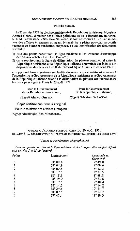
DOCUMENTARY ANNEXES TO COUNTER-MEMORIAL 365
Le 23 janvier 1975 les plénipotentiaires de la République tunisienne, Monsieur Ahmed Ghezal, directeur des affaires politiques, et de la République italienne, S. E. M. l'ambassadeur Salvatore Saraceno, se sont rencontrés à Tunis, au minis- tére des affaires ètrangéres et, ayant échangé leurs pleins pouvoiis respectifs reconnus en bonne et due forme, ont procédé fi l'authentification des documents suivants :
1) liste des points constituant la Ligne médiane et les tronçons d'enveloppe définis aux articles 1 et 11 de raccord ;
2) carte représentant la ligne de délimitation du plateau continental entre la République tunisienne et la République italienne déterminée sur la base des dispositions des articles 1 et II de l'accord signé B Tunis le 20 aoUt 1971 ;
en opposant leurs signatures sur lesdits documents qui constituent annexes B l'accord entre le Gouvernement de 1a.République tunisienne et le Gouvernement de la République italienne relatif à la délimitation du plateau continental entre les deux pays signé Tunis le 20 août 197 1.
Pour le Gouvernement Pour le Gouvernement de la République tunisienne, de la République italienne,
(Signé) Ahmed GHEWL. (Signé) Saivatore SARACENO.
Copie certifiée conforme A l'original.
Pour le ministre des affaires étrangkres,
(Signé) Abdelmajid Ben MESSAOUDA.
ANNEXE À L'ACCORD TUNISO-ITALIEN D U 20 AOOT 1971 RELATIF À LA D~LIMITATION, DU PLATEAU CONTINENTAL ENTRE LES DEUX PAYS
(Cartes et coordonnées géographiques)
Liste des points constiruant /a ligne médiane et des tronçons d'enveloppe définis aux articles I et II de i'uccord
Points Latitude nord Longitude est Greenwich
O 38" 0Of.6 7" 49'.0 1 38' 04.9 8" 09'.6 2 38" OT.8 Bo 22'.3 3 38" 101.5 8' 3T.5 4 38" 13'.1 8' 48j.8 5 38" 1S .O 9" 33'3 6 38" I3'.5 9 O 40f.4 7 38" 14I.5 9" 54.2 8 38" 24.6 IO0 41f.7 9 38" 03l.5 IO0 5T.7
1 O 37O 47.4 I l0 10f.3
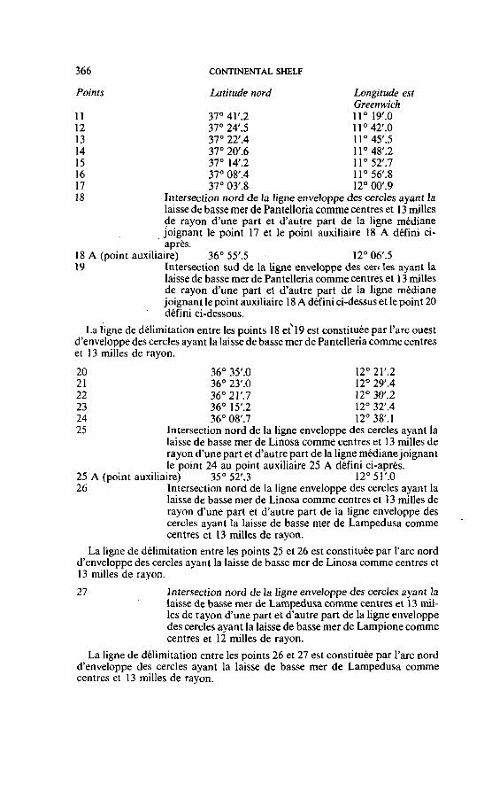
366 CONTINENTAL SHELF
Points Latitude nord Longitude est Greenwich
11 37" 41'.2 11" 19'.0 12 37' 24'.5 1 1 O 42I.O 13 37" 22',4 11" 4S.5 14 37" 2W.6 1 1 O 48'.2 15 37" 14'.2 1 1 " 52I.7 16 37" 08'.4 1 1 O 56l.8 17 37" 03'3 12" OW.9 18 Intersection nord de la ligne enveloppe des cercles ayant la
laisse de basse mer de Pantelloria comme centres et 13 milles de rayon d'une part et d'autre part de Ia ligne médiane joignant le point 17 et le point auxiliaire 18 A défini ci- après.
18 A (point auxiliaire) 36" 55'5 12" Og.5 19 Intersection sud de la ligne enveloppe des cercles ayant la
laisse de basse mer de Pantelleria comme centres et 13 milles de rayon d'une part et d'autre part de la ligne médiane joignant le point auxiliaire 18 A défini ci-dessus et le point 20 défini ci-dessous.
La ligne de délimitation entre les points 18 cc19 est constituée par I'arc ouest d'enveloppe des cercles ayant la laisse de basse mer de Pantelleria comme centres et 13 milles de rayon.
20 36" 3S.O 12O 21'.2 21 36" 23I.O 12O 29'4 22 36" 21'.7 12" 30'.2 23 36" 1S.2 12" 32'.4 24 36" 08',7 12" 38'. 1 25 Intersection nord de la ligne enveloppe des cercles ayant la
laisse de basse mer de Linosa comme centres et 13 milles de rayon d'une part et d'autre part de la ligne médianejoignant le point 24 au point auxiliaire 25 A défini ci-après.
25 A (point auxiliaire) 35" 52I.3 12' 51f.0 26 Intersection nord de la ligne enveloppe des cercles ayant la
laisse de basse mer de Linosa comme centres et 13 milles de rayon d'une part et d'autre part de la ligne enveloppe des cercles ayant la laisse de basse mer de Lampedusa comme centres et 13 milles de rayon.
La ligne de délimitation entre les points 25 et 26 est constituée par l'arc nord d'enveloppe des cercles ayant la laisse de basse mer de Linosa comme centres el 13 milles de rayon.
27 Intersection nord de la ligne enveloppe des cercles ayant la laisse de basse mer de Lampedusa comme centres et 13 mil- les de rayon d'une part et d'autre part de la ligne enveloppe des cercles ayant la laisse de basse mer de Lampione comme centres et 12 milles de rayon.
La ligne de délimitation entre les points 26 et 27 est constituée par l'arc nord d'enveloppe des cercles ayant la laisse de basse mer de Lampedusa comme centres et 13 milles de rayon.
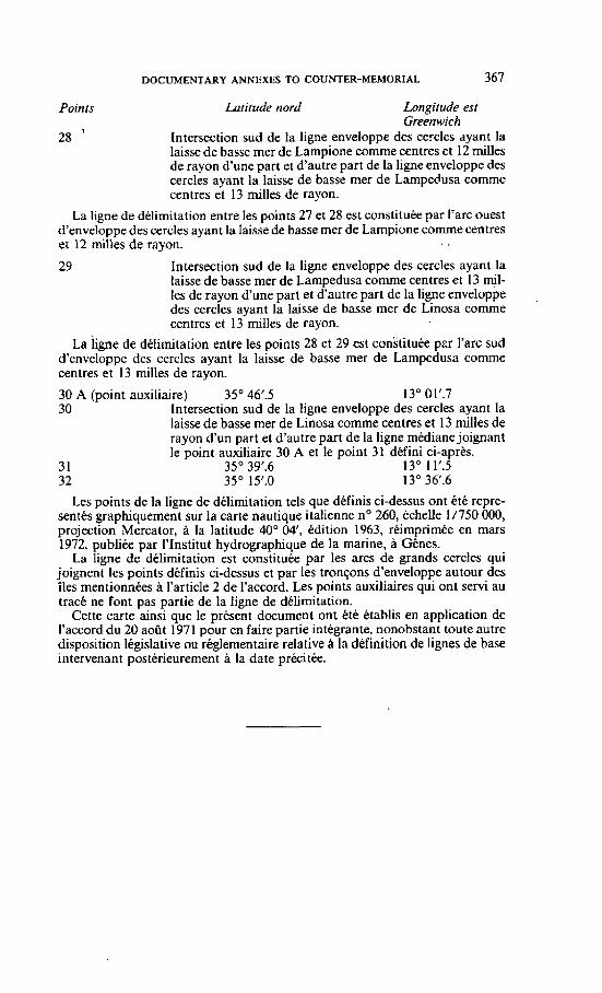
DOCUMENTARY ANNEXES TO COUNTER-MEMORIAL 367
Points Latitude nord Longitude est Greenwich
28 ' Intersection sud de Ia ligne enveloppe des cercles dyant la laisse de basse mer de Lampione comme centres et 12 milles de rayon d'une part et d'autre part de la ligne enveloppe des cercles ayant la laisse de basse mer de Lampedusa comme centres et 13 milles de rayon.
La ligne de délimitation entre les points 27 et 28 est constituée par l'arc ouest d'enveloppe des cercles ayant la laisse de basse mer de Larnpione comme centres et 12 milles de rayon. . . 29 Intersection sud de la ligne enveloppe des cercles ayant la
laisse de basse mer de Lampedusa comme centres et 13 NI- les de rayon d'une part et d'autre part de la ligne enveloppe
,
des cercles ayant la laisse de basse mer de Linosa comme centres et 13 milles de rayon.
La ligne de délimitation entre les points 28 et 29 est constituée pzr l'arc sud d'enveloppe des cercles ayant la laisse de basse mer de Lampedusa comme centres et 13 milles de rayon.
30 A (point auxiliaire) 35' 46'.5 13" 011.7 30 Intersection sud de la Iigne enveloppe des cercles ayant la
laisse de basse mer de Linosa comme centres et 13 milles de rayon d'un part et d'autre part de la ligne médiane joignant le point auxiliaire 30 A et le point 31 défini ci-après.
3 1 35' 39'.6 13" 11'.5 32 35" 1S .O 13' 36l.6
Les points de la ligne de délimitation tels que définis ci-dessus ont été repre- sentés graphiquement sur la carte nautique italienne no 260, échelle 1/750 000, projection Mercator, à la latitude 40" 0 4 , édition 1963, réimprimée en mars 1972, publiée par I'lnstitut hydrographique de la marine, à Gênes.
La ligne de délimitation est constituée par les arcs de grands cercles qui joignent les points définis ci-dessus et par les tronçons d'enveloppe autour des îles mentionnées a l'article 2 de l'accord. Les points auxiliaires qui ont servi au tracé ne font pas partie de la ligne de délimitation.
Cette carte ainsi que le présent document ont été établis en application de l'accord du 20 août 1971 pour en faire partie intégrante. nonobstant toute autre disposition législative ou réglementaire relative à la définition de lignes de base intervenant postérieurement à la date précitée.
368 CONTINENTAL SHELF
Annex 5
(Translation)
Text of the Declaration of Unity and Proclamation of the lslarnjc Arab Republic between Libyan Arab Republic and the Tunisian Republic. 19 Zul Hija 1393, 12 January 1974.
"In the name of Allah the Compassionate the Mercifu1." In a crucial moment, in a time full of challenges, on a glorified day and under
heavy burden of historic responsibility, the Great Mujahid responded to the call of Arab unity the same way he responded to the call for the Jihad to liberate the Islamic Arab land.
Consequently, the leader Habib Bourguiba and Colonel Muamrnar Ghadaffi both signed the Merger Declaration of both Libyan and Tunisian Arab countries according to the constitutional pt-inciples in force in both countries.
Both countries will merge in one republic called the Islarnic Arab Republic under one constitution, flag, president and army, mled by one legislative exec- utive and legal laws as from, by the will of God, 25 ZuI Hija 1393 corresponding to 18 January 1974 A.D.
(Signature) President Habib BOURGUIBA. (Signaiure) Colonel Muammar GHADAFFI.
DOCUMENTARY ANNEXES TO COUNTER-MEMOFUAL 369
PAGES 74 AND 75 OF OIL AND GAS JOURNAL, 20 DECEMBER 1954
PAGE 143 OF OIL AND GAS JOURNAL, 25 JULY 1955
(Nol reproduced]
Annex 7
REPRODUCTION OF THE OFFICIAL MAP OF CONCESSION NO. 137
&PRODUCT~ON OF THE MAP OF CONCESSION NO. 9. MOBIL OIL LIMITED OF CANADA
[Noi reproduced]
CONTINENïAL SHELF
Annex 8
PAGES 7 THROUGH 16 OF 1961 LIBYAN PETROLEUM COMMISSION BOOKLET
LIBYA's O I L POLICY
The booklet presented at the Fiat Arab Petroleum Congress contained an d
abstract and Mme elucidations to the Petroleum Law No. 25 of 1955.
At the t h e said Law came into force it was still unknown whether the territory
nf Libya contained oil. No exploration activities for the search of oil had been
camed out prior to the independence of Libya. Neither in Tunisia nor in the
Western desert of Egypt-had any oil been discovered at that time. Although some
oil had b e n found in the Algerian Western Sahara, the big oil strikes close to the
Libyan fmntiex took place at a later date.
For thir reason the Petmleum Law O€ 1955 was enacted in such a manner as
to encourage oil campanies to search and explore for petmleum in a big way to
determine the country's possible oil potential in the shortest time. The Law largely
fulfilled these aims as i t led ta a fast increasing activity in the search for petroIeum,
as outlined in the second chapter OF this hooklet.
Then came the first promising oil strikes in concessions 6 and 32 in the Sirtica
area mid 1959 and early 1960 tespectivelv.
Because it now became evident that oil was present in commercial quantities
it was realized, as indicated in tEe booklet presented at the Second Arab Petroleum
Congrcss, that for new concessions better terms and aorking obligations could be
negotiatcd by means of speciaI agreements in addition to the normal conditions
specified in the standard concession deed.
Some of the additional temis so obtained ulere: special drilling obligations.
higher minimum amount to be spent within a certain periocl of time, increased
percentages for royalty payrnents, higtier surfam rents, the waiving af the nght of
applging percentag depletion allowance as provided by the Law and the possibility
of participation by the Libyan Government in exploitation.
In conncction with the urperience obtained by the Petraleum Commission
during tlie past five years of exploration, it became clear that the Law had to be
adjusted to the second p h w of petroleum dwelopment in which Libya has landed.
DOCUMENTARY ANNEXES TO COUNTER-MEMORIAL
Also to keep Pace with the changes which occured in other Arab cnuntries
during this period, it was Eclt that the Petmleum Law 1955 should be arnended in
order to insure to the Country an appropriate sharc in the profits more in line \\sith
tday ' s vicws.
The Libyan Gavemment, in drafting these amendments, has benefited From
the expericnce of other counhics in the pehl turn industry and from the experi-
mcnts and cvcnts which those countries have gonc through. The Government in
this amendment has taken into regard the country's intenst and the ecornonic antl
commercial considerations and conditions prorailing in othcr countries which nlirii
petroleum ànd u-hich are going through the same phase as the United Kingdom
of Libya, such as Iraq, the Kingdom of Saudi Arabia, Kuweit, Qatar and Iran
(Peaia). These amendments are derived from the most modern and receiit
provisions applicable in these countries.
The amendments will serve to stimulate keener cornpetition among internn-
tional oil companies to search, explore for,and develop petmleum in Libya in the
areas .rvhich h a n a l d y been relinquished or will be nlinquishcd in the future
by the petroleum companies. In addition, théx amendments will open the door
for the petmleum companies ihat have acquired concessions in the . p s t t n
amend their concessions in accordance with the terms and conditions of these
amendments and to confom with the stage through which the petroleum industty
in the country i s passirig. W e give hemunder a bricf outline of the most important
amendments intrnduced into the Law hy Royal Decree of July 1961.
Articles 7 G 8.
In the past the companis subrnitted tbeir applications with mpect to the
areas for concessions, and the Petroleum Commission c5nsidcred these applications
giving privnty to the p e m who submitted his application befon the other. This
method does not ensure sound and fair cornpetition. Far these rcwns, Artidcs
Seven and Eigbt are amcnded in a manner to permit the Commission to announcc
CONTINENTAL SHELF
h!- nntice in the p m s the arcas in respect of which mnmsions may be applied for
and tn invite those intcrcsted in acquiring mnmsions to submit thcir applications
in sealed envdopes within a spccificd time. Tlie amendment also made it permiss-
ible for the applicants to includc any additional economic, financial and othcr
benefits and advantage ~vhich thcy are willinR and able to offer to the Commis-
sion. This rnethod i r t h e m a t prevalent method used in the p n t of concessions.
It \vil1 be o b s e d that the provisions outlined in the Law and the Second
Schedule thereto have berorne, under this amendment. tn r e p e n t the minimuni
ternis and condit,ions for the grant of n concession. Howcver, the additional terms
and conditions and the economic and financial advantages which are oFfcred or
submitted by the npplicant have become the decisive factor in dctcmining the success-
ful hidder. alter taking into consideration his technical and financial ability and
capacity. There is no doubt that this method will pmride the opportunity for the
Cavcrnment to obtain the best te-, conditions and benefits through the media of
rivalm and mmpetition among international cornpanies and corporations.
Article 9.
Paravaph ( 1 ) of Article 9 authorised the Commission to Rnnt ccinccssions
cnnfnrmiiig witli the fnrm set out in the Secoiid Schedulc to the Law but it did
ntit confer upon tlic Commission the power to pan t concessions to include the
ndditional economic and financial hcnefits and advantages which are offered by
the companies in addition to the provisions set out in the Law. This Article a a s
. tlierefnrc amended in a manner to permit the Commissio~i to gnnt concessions to
include the additional economic, financial and other benefits and advantages which
are offered by the applicant, provided that t h e additions do not mntain conditions
or terms tliat rcduce any of tlie r i~hts , benefits and privi lep to which the Commis-
sion is entitled under ,this Law.
ParaRraph ( 9 1 of Article 9 of the Law is dtleted since .its provisions have
becorne inconsistent with the principle contained in Articles 7 and 8 as amended
i.e., the principle oE g~anting concessions on the basis of scaled bidding.
DOCUMENTARY ANNEXES TO COUNTER-MEMORIAL
( 1 ) The Iast clause of paragraph ( 1 ) of Article 10 is deleted. This relates to the
minimum arca of the concession urhich the concession holder is permittcd to =tain
as it is felt that thcre is no need to spccify a minimum with respect tn the atra
which is retaiued by the concession holder and because thcre is a pressing and
grcat demand for the areas relinquished hy the campanies inrrpective of how small
they may be.
( 2 ) Pangraph ( 3) of this Article gave the concession hoIder the Emdorn to chow
the areas which he is to relinquish in one or more blocks fmm the various parts
of the concession area. provided that the block or blocks aaincd by him are
reasonably compact. Howwer, this provision is not sufficient to pmtect the rights
and intemis of the State and does not prwcnt conmsion holdea fmrn din-
quishing the areas which they are rcquired to xlinquisfi in vcry small blocks which
are not suitabIc for development hy othcr mmpanies, thus denying the Commission
the prima. object in obliging concession hoIders to surrender a $don of their
cnncession areas. T h e ~ f o r e , Article 10 was amcnded to nr to organize the manner
and method of surrender and to enable the Commission to acquice the areas which
are relinquishcd in a suitable and Ltting form and shape which will help in bcnefiting
from thrrn and in their development by other companies or groups-
Article 12.
,4rticlc 12 of the Law provides that every concesion holder who has a surplus
in pipeline transportation capacity is r e q u i d to place such surplus at the dispo~al
of others on the temu and conditions to be a g m d upan. It is weU known that the
Commisiion bears half of the cost and expehses i n q m d wlating to the production
of petroleurn and its transportation to the port fmm wherc it *Il bc exported.
Thexfore, the Commission is entitlcd to have a sîy with rrspect to the cond-
itions and charges which the concession halder obtains fiom others for the transpor-
CONTINENTAL SHELF
tation of petroleum in the pipelines belonging to him. For thcse reasons this
Article 12 nas amendcd as to make it a requisite to obtain the Commission's approval
nf the tems and conditions to be agreed upon. If the Commission does not approve
the tems and canditions or if the concession holder does not agree to the terms
and conditions uyd , the Commission is entitled to propose the tems and conditions
foi thc use of the surplus pipeline capacity. In the event the parties concerned do
not agree to th- proposcd conditions, the Commission shall subrnit the matter to
a cornmittee of experts whose deeision or the decision of the majoritv thereof shall
be final and binding upon the concession holders and the Commission.
Article 13.
f I ) The fees and rents payable by the concession holder under Article 1 3 of
the I-ntv are lori. and incompatible with the phase tlitough which the petroleum
industry in the country i s passing. 'This Article is thcrefom amendeù to provide
for the foilotring payments by the toncesion holders:
( n ) One hundred for evey 100 square kilometers of the area covered by
the concession upon granting him the qncession, instead of the fixed lump
sum of L . E 500 only.
r R! A nominal annual rental dunng the fint fifteen years from the date of the
concession. but it was clcarlp provided that in the event petroleum i s found
in commercial quantities during the said fifteen year period the rental shall
immediately be inctcased to £L. 2,500 for every 100 square kilometers.
i cl EL. 3.500 for evcry 100 square kilometers for each of the followinll fiue years
and EL. 5.000 for each year of the rcmaining pend of the concession.
( 2 ) The Law did not contain any provision giving the Commission the right to
receive the whole or part of the royalty in kind as the case is in the agreements
mncluded behvcen the various petmleum Eompanies and the gwernmcnts in the
Middle East and Venezuela. This Article was alsa arncnded to include a provision

DOCUMENTARY ANNEXES TO COUNTER-MEMORIAL
giving the Commission the right to take in-kind al1 or part of the royalty, provided
that it is dclivered by the concession holder f.0.b. seboard terqinal in Libya.
T h e value of royalty due to the Commission on cmdc petroleum under this
Article is calculated on the basis OC the average of the prevailing price in the frec
market for petroleum crude minus handling and trançportation charges and costs
from field storage. This metliod \vil1 iead to many accounting problems in cakulating
the costs of handling end tr31isportation charges for each field and each quality of
petrnleum produced. Article 13 was therefore amended on the basis of pwvisions
contained in petrolcum agreements concluded in other countries. i.e. calculating the
value of royalty with respect to c ~ d e petroieuni on the basis of the posted price
nf crude .petroleum at Libyan ports without deducting aiiy expenses or costs for
handling and transportaiion.
Article 14.
;\rticlc 14 of the Law relating tn tnration and division of profits is extremely
eornplicated and its implementatinn in its present form would lead to many and
great dificulties. Some OF its provisions are unb i r ~irith respect to Libya when
cornpared \rith the correspondinR provisions of the agrcernents concluded with other
couniries in the Arab world. This Article M'as thercfore subst?ntially amended or1
the hstis of the rules and principles fnllo\r,ed between petrc~leum companies and
hliddte Eastern couritries. Through this amendment the commission is able to
obtain at least half of the actual which the petroleum companies derive From
their operations in Libya. Hereunder is a summary of the most importyt amend-
ments ouilined in the said Article: . ( 1 ) - Under paragraph ( 1 ) of this Article the Govemment's share amounting to
50% of the pro6ts is composed of fees. rents and royalties payable under this Law
and also of the incorne tax and other taxes and dues for which the concession holdcr
is liable in respect of his operations in Libya.
This paragraph is amended to provide that indirect taxes aiid fees, such as
CONTINENTAL SHELF
stamp duty fes and municipal and rcgistntion fm etc., are conJidercd to bc paa
of the cxpenditures if thty are rclated to 'the operations of the concession bol-r. ï b c Govemmcnt's sham of 50% of the profits wil1 consist of f a , en ts and royalties
payable by the concession holder undtr this Law together with the income tax,
the surtax and the other direct taxes. This arrangement is closer to justice and it
contains F a t simplihcation of accountancy procedure. Furthemore. this principle
is adoptcd by other countries in their petroleurn Icgislations.
( 2 ) - Paragraph ( 1 ) (b) of this Article is not clesr tvith regard to the methuil
üf deducting the suïns paid in excess of the 50% of the profits tifhich the concessiuii
holdcr d z e s dunng tbc year. This paragraph \sas thercfore amended on the
basis that mes payments are detluctible onl!. From the income tas and the surtax
duly payable in the subsequent gears.
(3 ) - The s complcte year is clcarly defined in the amendment of this Articlc
so thnt the equal shanng of profits \vil1 be operative fmin the effective date.
( 4 ) - Paragraph ( 2 ) of the said Article defines the e &ecrivc datc as the datc
on which the avtroge exports fram thc cuncession reaches for the first time 15,000
barrcb of pctrolcum prr day ovcr a pcriod of 30 days or the date of e'rpiry of four
ycars fmm the datc on which :he concession holder exprted petroleum regulrirl!.
foc the hrst time.
The q u a i division of profits must becorne effective irrespective of thc date oir
r h c h the production and export of petroleum reaches a certain level. since thc
concession holder is able to realize profits before exports reach a level of 15000
barrels pet day. Morcove~, the concession holdcr is able io tealize profits, without
uporting my petmleum, by ~ û n i n g and selling it iiiside Libya;
Thmforc, the .: & d v e dete, was dcfined in the amendment to mean the
datc on which the c o d o n holder commences to export pctroleum regularl!.
in c o m d quantifies or ta KU pet~oleurn rrgululy in commercial quantilies.
( 5 - The P-leiim L w gave the right to the concession holder io dedua the
fo]hwing items fmm the income which he &rives for the purpose of caicuiating
hk profils:
FIRSTLY: AU and losses.
SECOIVDLY: Amoaization of capital upuiditum at a mie not excding 20Yo
with rrspea to the expenditum incurrcd beforc e%saive date and at a rate not
d n g 10% with respect to the cxpenditum i n c u d on or after the dective
date. . . THIRDLY: A depletion allowanm of 25% of his p annual income.
Th- sums wLch the concession holdcr may deduct in any ycar iiave b e i i
ccviewed and were restncted in the omendmcnts to the IoUowing i t e k only :
FIRSTLY: Operating urpeti~er and overhed, the details of nhish art defined
in Reffilationr.
SECONDLY: Dcpdation of al1 physid w r t s in Libya at the rate of IO9h
per annum and mortizîtion of al1 other capid cxpcnditurcs in Libya at the n t e
of 5% pcr annum.
The amendment to the Law has .Ira clcarly pmvided that the conces-
sion holder shaU not be permitteci to deduct the following items from the incbmc
which he daiws in detemiining his profits.
FlRSTLY: P d t i e s pid under Article 22 OE this Low or ony surns forfeited
under M e 11 of tbis iaw.
SECONDLY: Foreign hc0zne.m.
THIRDLY: Intatrt paià in r e r p s t of the finnncing of tbe opmations O€ the
mnassion h o k .
FORTHLY: Eqnditurc incumd in dation to the organizing and initiating
of petmleum opezatiom in Libya.

CONTINENTAL SHELF
(6) - The Law h d no clcar definition for c The infame resulting from the opera-
tiom of the &-ion holder S. Thercforc, the amendment to the Law dcfines the
incwme of t h tunaaion bolder from cmde petroleum to be equal to the posted
pria of Libysn crude petroleurn less marketing upenses multiplied by number of
tons upoacd.
The ammdment aise contains a prceix definition for r posted prices for crude - p l e u m s and the method for amivin8 at these prices in the absence of free
market for Libyan petroleum.
( 7 ) - The Law dws not p v i d e for a method of payinp the incorne taxes
and the surtaxes due for paymcnt by the concession holder. Parapraph ( I ) of
Clause 9 of the Scmnd Schcdule pmvided that the collectian of the said sums
s u 1 be subject to the procedures defined by Financial Laws and Regulations in
Libya, while paragraph ( 2 ) OF the said Clause stated that the rents and royalties
due shall be paid mry thm months.
Tbmfore, it has bem fit to add a new parapph to the said Article of the
Law to p d that the rxincesshn holdtr shall be requited to submit his accounts
within a period not enceeding 4 months aftcr the end of cach complete !car.
Simuitan~ously with the submission of the accounts the concession holder is
quimi to pay the m s due in respect of income taxes and surtaxes, provideci
that the final settlcment of accounts shall take place after the final determination
of the tax.
The provision wiIl cnabie the Commission to rmive its share of the profit3
pmmptly instcad of waiting until the profits and the taxes are Lnally determined.
in arda ta encourage the exploration and search for petroleum in the country
and in conformity with pmetice f o l i d in other countries, paragiaph ( 1 ) of
Article 16 of the Law was amended on the basis ol permitting the permit and
Boldcs to impoa frre of duty: plant, machinery, tools, equipment,
DOCUMENTARY ANNEXES TO COUNTER-MEMORIAL
matcriais and supplies and also ather gouds which are specifii in Regdations
issu4 under the Custorns Law, pmvidcd that al1 thtse items are uscd in tibya
for petrolcum exploration, pruspecting and mining operations and providd that
M a r goods arc mt available in Libya.
AmElc 17 was amended so as not to permit thc concession holdei to assign
the coiicesion urcept with the Commission's approval in accordance rvith conditions
which it may impose and which it d m appropriate in the public interest.
A ncw Article was addcd, under which concession hoIdea who w a e p n t c d
mnccssions beforc the amendment of the Law may apply to the Cammission, within
6 rnonths frorn tbe 'datc on which &is amendment takes &mt, to have thcir con-
msion deeds amendcd in accordance with the conditions and provisions containml
in these mcndmuits. The pend of any conession thus amended is extended by
a pend q u a 1 to that h m the datc on wbch the original concession was granrd
to tbe date on wbich the amcndmmt takcs cffec~
In addition, this Article har prwidcd that no ncw concessions shall, be granted
to any perion who holds concdsions beforc the corning into f o m of thesc arnend-
ments. unless that person ~ g m s to amend his pmvious concessions in amor-
dance with the conditions and pvisions containcd in t h e amcndments. This
stipulation gives the Commision the opportunity m ncgotiatc with the cxisting
c~mpanics to romply with the nrw set-up and to ampt the provisions and conditions
proposcd in t h e amendmcnts. ï h i s is what har aaually taken plsce in other
countries such as Vatmi& and the A d mnis wherc the agreements werc
omended to the dvantage of tbcre couritries, M a d t of negotiations.
CONTINENTAL SHELF
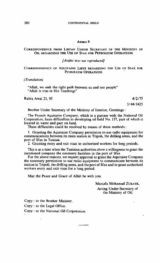
Annex 9
CORRESPONDENCE FROM LIBYAN UNDER SECRETARY OF THE MINISTRY OF OIL REGARDING THE USE OF SFAX FOR PETROLEUM OPERATIONS
[Arubic texr not reproduced]
CORRESPONDENCE OF AQUITAINE LIBYE REGARDlNG THE USE OF SFAX FOR ~ T R O L E U M OPERATIONS
"Allah, we seek the right path between us and our people" "Allah is tme in His Teachings"
Rabia Awal 21, 95
Brother Under Secretary of the Ministry of Interior, Greetings :
The French Aquitaine Company, which is a partner with the National Oil Corporation, faces difficulties in dcveloping oil field No. 137, part of which is Iocated in water and part on land.
These difficulties wuld be resolved by means of these methods :
1. Granting the Aquitaine Company permission to use radio equipment for communications between its main station in Tripoli, the driliing areas, and the port of Sfax in Tunisia.
2. Granting entry and exit visas to authorized workers for long periods.
This is at a time when the Tunisian authorities show a willingness to grant the mentioned wmpany the necessary facilities in the port of Sfax.
For the above reasons, we request approval to grant the Aquitaine Company the necessary permission to use radio equipment to cornmunicate between its station in Tripoli, the driHing areas, and the port of Sfax and to grant authorized workers entry and exit visas for a long period.
May the Peace and Grace of Allah be with you.
Mustafa Mohamad ZURAYK, Acting Under-Secretary of
the Ministry of Oil.
Copy : to the Brother Minister. Copy : to the Legal Office. Copy : to the National Oil Corporation.
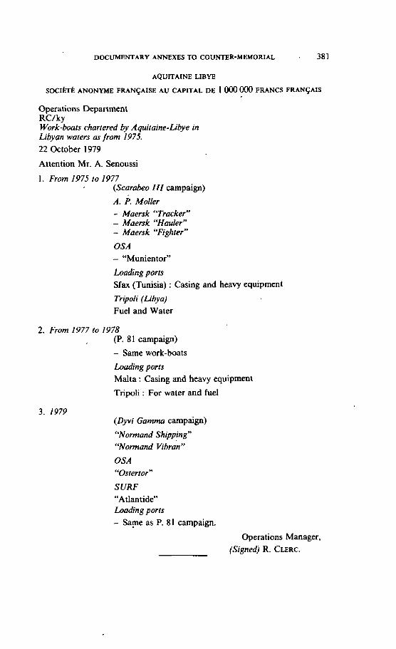
DOCUMENTARY ANNEXES TO COUKTER-MEMORIAL 381
AQUITAINE LIBYE
SOCI~TÉ ANONYME FRANÇAISE AU CAPITAL DE 1 000 000 FRANCS FRANGAIS
Operations Department RC/ky Work-boats chartered by Aquitaine-Libye in Libyan waters as from 1975. 22 October 1979
Attention Mr. A. Senoussi
1 . From 1975 to 1977 (Scarabeo III campaign)
A. P. Moller - Maersk "Tracker" - Maersk "Hauler" - Maersk "'Fighter"
OSA - "Munientor"
Loading ports Sfax (Tunisia) : Casing and heavy equipment
Tripoli (Libya) Fuel and Water
2. From 1977 io 1978 (P. 81 carnpaign)
- Same work-boats
h d i n g ports Malta : Casing and heavy equipment Tripoli : For waler and fuel
3. 1979 (Dyvi Gamma carnpaign) "Normand Shipping" W m a n d vibrai"
OSA "Ostertor"
SURF "Atlantide" Loading ports - Same as P. 81 campaign.
Operations Manager, (Signed) R. CLERC.
CONTINENTAL SHELF
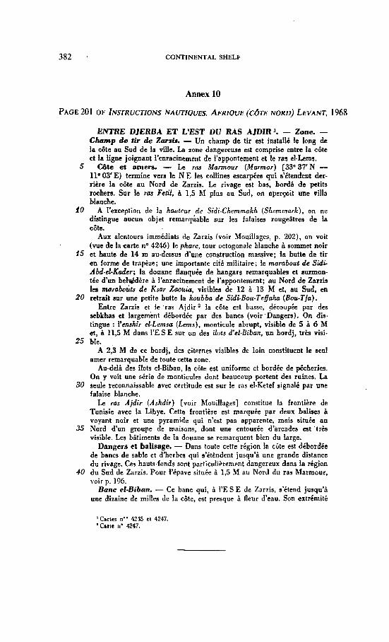
Annex 10
ENTRE DJERBA ET L'EST DU R A S AJDIR '. - Zone. - C k p de tir de Zmris. - Un champ d e tir est instalié le long de la côte au Sud de la ville. La zone dangereuse est comprise entre la côte et la ligne joignant l'enracinement de l'appontement et le ras cl-Lems.
5 Côte eî amers. - k rru Murmour (Marmor) [33'37'N - Ilo O3'E) termine vers le N E les collines escarpéu qui s'étendent der- rière la côte au Nord de Zarzis. Le rivage wt bas, bordé d e petits rochers. Sur le ras Fetil, à 1,s M PIUS au Sud, on aperçoit une villa bbnche.
10 A I'exception de la haiitcur de Sidi-Chammakh (Shemmork), on ne diatinguc aucun objet remarquable sur les falaises rougeâtres d e la côte.
Aux alentours immédiats de Znrzis (voir Mouillages, p. 202), on voit (vue de la carte no 4246) le phare, tour octogonale blanche à sommet noir
15 e t haute de 14 m au-dessui d'une construction massive; la butte de t i r en forme de trapèze; une importante cité militaire; le marabou de Sidi- Abd-cGKader; la douane flanquée de hangars remarquables et surmon- tée d'un belGdère à l'enracinement de I'apponiement; au Nord de Zarzis Ica rnaraboits de Ksar Zaouiu, v i s i b h de 12 ù 13 M et, au Sud. en
20 retrait sur Une petite butte la koubba de Sidi-Bou-Tefaha (Bou-Tfa). Entre Zarzis et le -ras Ajdir la côte est basse, découpée par des
sebkhas et largement débordée par des bancs (voir.Dangers). On dis- tingue : I'enshir el-Lemsir (Lems), monticule abrupt, visible de 5 à 6 M et, à 11,s M dans I'E S E sur un des ilots d'el-Eiban, un bordj, très visi.
25 ble. A 2,3 M de ce bordj, des citernes visibles dc loin constituent le seul
amer remarquable de toute cette zone. Au-delà des ilots el-Bibnn, la cote est uniforme et bordée de pêcheries.
On y voit une série de monticules dont beaucoup portent des ruines. La 30 seule reconnaissable avec certitude est sur le ras elXete£ signale par une
falaise blanche. Le ras Ajdir (Ashdir) [voir Mouillages] constitue la frontière de
Tunisie avec l a Libye. Cette frontière est marquée par deux bnlbea à voyant noir et une pyramide qui n'est pas apparente, mais située a u
35 Nord d'un groupe de maisons, dont une entourée d'arcades est 'très visible. Les bâtiments de la douane se remarquent bien du krge.
Dangera et baliriage. - Dans toute cette région la côte est débordée de bancs de sable et d'herbes qui s'étèndent jusqu'à une grnnde distance du rivage. Ces hauts-fonds sont particiiliètement dangereux dans la région
40 du Sud de Zarzis. Pour l'épave située à 1,5 hl au Nord di1 ras Marmour, voir p. 196.
Banc etBiban. - Ce banc qui, à I'E S E de Zarzis, s'étend jusqu'i une dizaine de milles dc la côte, est presque à fleur d'eau. Son extrémité
DOCUMENTARY ANNEXES TO COUNTER-MEMORIAL 383
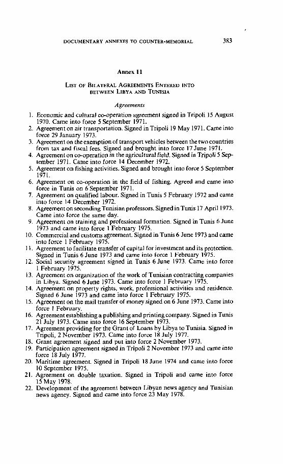
Annex I l
Agreements
1. Economic and cultural CO-operation agreement signed in Tripoli 15 A,ugust 1970. Came into force 5 September 1971.
2. Agreement on air transportation. Signed in Tripoli 19 May 1971. Came into force 29 January 1973.
3. Agreement on theexemption of transport vehicles between the two countries from tax and fiscal fees. Signed and brought into force 17 June 1971.
4. Agreement on w-operation in the agricul tural field. Signed in Tripoli 5 Sep- tember 1971. Came into force 14 December 1972.
5. Agreement on fishing activities. Signed and brought into force 5 September 1971.
6. Agreement on CO-operation in the field of fishing. Agreed and came into force in Tunis on 6 September 1971.
7. Agreement on qualified labour. Signed in Tunis 5 February 1972 and came into force 14 December 1972.
8. Agreement on seconding Tunisian professors. Signed in Tunis 17 April1973. Came into force the same day.
9. Agreement on training and professional formation. Signed in Tunis 6 June 1973 and came into force 1 February 1975.
10. Commercial and customs agreement. Signed in Tunis 6 June 1973 and came into force 1 February 1975.
11. Agreement to facilitate transfer of capital for investment and its protection. Signed in Tunis 6 June 1973 and came into force 1 February 1975.
12. Social security agreement signed in Tunis 6 June 1973. Came into force 1 February 1975.
13. Agreement on organization of the work of Tunisian contracting companies in Libya. Signed 6 June 1973. Came into force 1 February 1975.
14. Agreement on property rights, work, professional activities and residence. Signed 6 June 1973 and came into force 1 February 1975.
15. Agreement on the mail transfer of money signed on 6 June 1973. Came into force 1 February.
16. Agreement establishing a publishing and printing Company. Signed in Tunis 21 July 1973. Came into force 16 September 1973.
17. Agreement providing for the Grant of Loans by Libya to Tunisia. Signed in Tripoli, 2 November 1973. Came into force 18 July 1977.
18. Grant agreement signed and put into force 2 November 1973. 19. Participation agreement signed in Tripoli 2 November 1973 and came into
force 18 July 1977. 20. Maritime agreement. Signed in Tripoli 18 June 1974 and came into force
10 September 1975. 21. Agreement on double taxation. Signed in Tripoli and came into force
15 May 1978. 22. Development of the agreement between Libyan news agency and Tunisian
news agency. Signed and came into force 23 May 1978.
3 84 CONTINENTAL SHELF
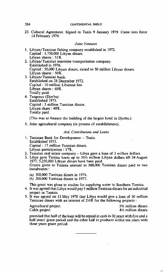
23. Cultural Agreement. Signed in Tunis 9 January 1979. Came into force 14 Febmary 1979.
Joinr Ventures
1. Libyan/Tunisian fishing cornpany established in 1972. Capital : 1,750,000 Libyan dinars. Libyan shares : 51 8.
2. Libyan/Tunisian maritime transportation company. Established in 1976. Capital : 50,000 Libyan dinars, raised to 50 million Libyan dinars. Libyan shares : 50%.
3. Libyan/Tunisian bank. Established on 28 December 1972. Capital : 10 million Libanese lire. Libyan shares : 60%. Totally paid.
4. Turgenus (Djerba) Established 1973. Capital : 3 million Tunisian dinars. Libyan share : 48%. Totally paid.
(This was to f iance the building of the largest hotel in Djerba.)
5. Joint agncultural company (in process of establishment).
A i 4 Contributions and b a n s
1. Tunisian Bank for Development - Tunis. Established 1973. Capital : 17 million Tunisian dinars. Libyan participation : 17%.
2. Tunisian real estate wmpany - Libya gave a loan of 3 million dollars. 3. Libya gave Tunisia loans up to 10lh million Libyan dollars till 24 August
1977, 5,250,000 Libyan dinars have been paid. Grants given to Tunisia amount to 500,000 Tunisian dinars paid in two instalrnents :
(a) 300,000 Tunisian dinars in 1974. (b) 200,000 Tunisian dinars in 1977.
This grant was given to studies for supplying water ta Southern Tunisia. 4. It was agreed that Libya would pay 5 million Tunisian dinars for an industrial
project in Tunisia. 5. It was agreed on 15 May 1978 that Libya would give a loan of 10 million
Tunisian dinars with an interest of 24.r% for the following projects :
Agricultural project 5Ih million dinars Cable project 4115 million dinars
provided that half of the loan will be repaid in cash in 20 years with five and a half years' grace period and the other half in products within ten years with three years grace period.
DOCUMENTARY ANNEXES TO COUNTER-MEMORIAL 385
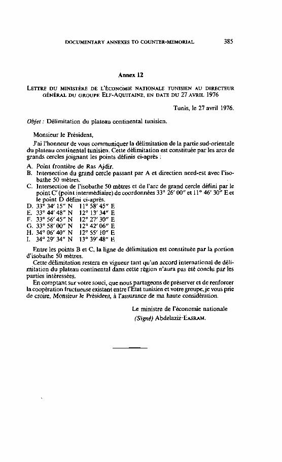
Annex 12
Tunis, le 27 avril 1976.
Objet : Délimitation du plateau continental tunisien.
Monsieur le Président, J'ai l'honneur de vous communiquer la délimitation de la partie sud-orientale
du plateau continental tunisien. Cette délimitation est constituée par les arcs de grands cercles joignant les points definis ci-après :
A. Point frontiére de Ras Ajdir. B. Intersection du grand cercle passant par A et direction nord-est avec l'iso-
bathe 50 rnttres. C. lntersection de l'isobathe 50 métres et de l'arc de grand cercle défini par le
point C' (point intermédiaire) de coordonnées 33' 26' 00" et 1 1 46' 30" E et le point D défini ci-après.
D. 33"34'15" N 11'58'45" E E. 33' 44' 48" N 12" 13' 34" E F. 33" 56' 45" N 12" 27' 30" E G. 33' 58' 00" N 12' 42' 06" E H. 34" 06' 40" N 12" 55' 10" E 1. 34" 29' 34" N 13" 39' 48" E
Entre les points B et C, la ligne de délimitation est constituée par la portion d'isobathe 50 mètres.
Cette délimitation restera en vigueur tant qu'un accord international de déli- mitation du plateau continental dans cette région n'aura pas tté conclu par les parties intéressées.
En comptant sur votre souci, que nous partageons de préserver et de renforcer la coopération fructueuse existant entre SEtat tunisien et votre groupe, je vous prie de croire, Monsieur le Président, i'assurance de ma haute considération.
Le ministre de l'économie nationale
(Signé) A b d e l & - c ~ s ~ u ~ .
CONTINENTAL SHELF
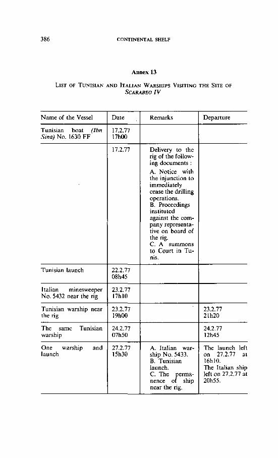
Annex 13
LIST OF TUNISIAN AND ITALIAN WARSHIPS VISITING THE SITE OF SCARABEO IV
Narne of the Vesse1
Tunisian boat (Ibn Sina) No. 1630 FF
Tunisian launch
1 talian minesweeper No.5432neartherig
Tunisian warship near the rig
The same Tunisian warship
One warship and launch
Date ,
17.2.77 17h00
17.2.77
22.2.77 08h45
23.2.77 17h10
23.2.77 19h00
24.2.77 07h50
27.2.77 15h30
Remarks
Delivery to the ng of the follow- ing documents : A. Notice with the injunction to imrnediately cease the drilling operations. B. Proceedings instituted against the com- pany representa- tive on board of the rig. C. A surnmons to Court in Tu- nis.
'
A. Itdian war- ship No. 5433. B. Tunisian launch. C. The perma- nence of ship near the rig.
Departure
23.2.77 2 1 h2O
24.2.77 12h45
The launch left on 27.2.77 al 16h10. The Italian ship left on 27.2.77 at 20h55.
DOCUMENTARY ANNEXES TO COUMER-MEMORIAL 387
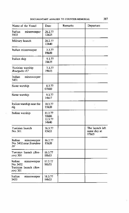
Departure
The launch left same day at 17h05
Name of the Vesse1
Italian minesweeper 5433
Military launch
1 talian minesweeper
Italian ship
Tunisian warship Bourguiba E7
1 talian minesweeper 543 1
Same warship
Same warship
Italian warship near the rig
ltalian warship
Tunisian launch No. 30 1
1 talian rninesweeper No. 5432 near Scarabeo I V
Tunisian launch (Ben- zirt ) 301
ltalian minesweeper No. 5432 Tunisian launch (Ben- zirr) 30 1
Italian minesweeper 5433
Date
28.2.77 12h25
28.2.77 12h40
3.3.77 19hûû
5.3.77 18h35
7.3.77 19h15
8.3.77 07h00
9.3.77 14h17
10.3.77 15h20
1 1.3.77 lOhO6 12.3.77 14h40
16.3.77 15h55
16.3.77 15h20
16.3.77 IXh15
17.3.77 16h55
18.3.77 14h55
Remarks
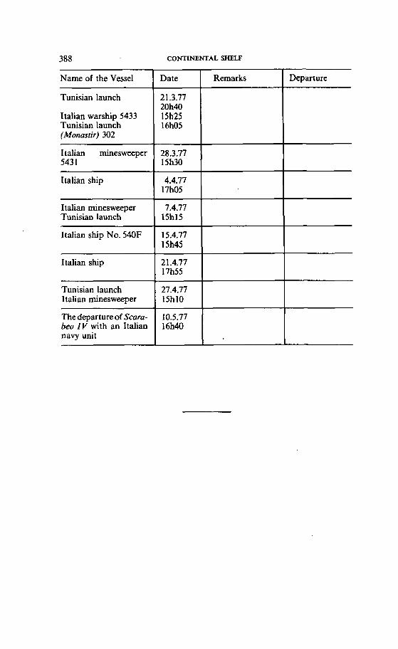
388 CONTINENTAL SHELF
Departure Name of the Vesse1
Tunisian launch
Italian warship 5433 Tunisian launch (Monastir) 302
Ilalian minesweeper 543 1
Italian ship
Italian minesweeper Tunisian launch
Italian ship No. 540F
Italian ship
Tunisian launch Italian rninesweeper
The departure of Scura- beo IV with an Italian navy unit
Date
21.3.77 20h40 15h25 16h05
, 28.3.77 15h30
4.4.77 17h05
7.4.77 15h15
15.4.77 15h45
2 1.4.77 13-155
27.4.77 15h10
10.5.77 16h40
Remarks
i
DOCVMENTARY ANNEXES TO COUNTER-MEMORIAL 389
Annex 14
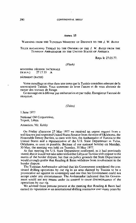
CONTINENTAL SHELF
Annex 15
TELEX REGARDING THREAT TO THE OWNERS OF THE J. W. BATES FROM THE TUN~SIAN AMBASSADOR T0 THE UNITED STATES OF AMERICA
Reçu le 27.05.77.
(Flash)
MINISTERE DEFENSE NATIONALE (M.D.N.) 27 17 55 .B.
Votre mouillage se situe dans une zone que la Tunisie considère relevant de la souveraineté Tunisie. Vous sommons de lever l'ancre et de vous abstenir de mener des travaux de forage.
Ce message est a délivrer par embarcation et par radio. Enregistrer l'accusé de réception.
(Telex)
1 June 1977
National Oil Corporation. Tripoli, Libya.
Attention: Mr. Kntly
On Friday afternoon 27 May 1977 we received an urgent request from a well-known and respected United StatesSenator from the stateof Oklahoma, the Honorable Dewey Bartlett, to meet with him, the Ambassador of Tunisia to the United States and a representative of the U.S. State Department in Tulsa, Oklahoma, as soon as possible. Because of our national holiday on Monday, 30 May, the meeting was held on Tuesday, 3 1 May 1977.
At that meeting the U.S. State Department confirmed, as it had previously stated, that it would not take sides with either Libya orTunisia withrespect to the merits of the border dispute, but that on policy grounds the State Department would strongly prefer that Reading & Bates withdraw from involvement in the border dispute.
The Tunisian Ambassador advised that his Government considered the con- tinued drilling operations by our rig in an area claimed by Tunisia to be a provocative act against its sovereignty and one that his Government could no1 accept under any circumstances. The Ambassador indicated that his Govern- ment would use any means under its control to cause'discontinuance of the operations by our rig.
We advised those persons present at the meeting that Reading & Bates had eamed its reptation as an international drilling contractor over many years by
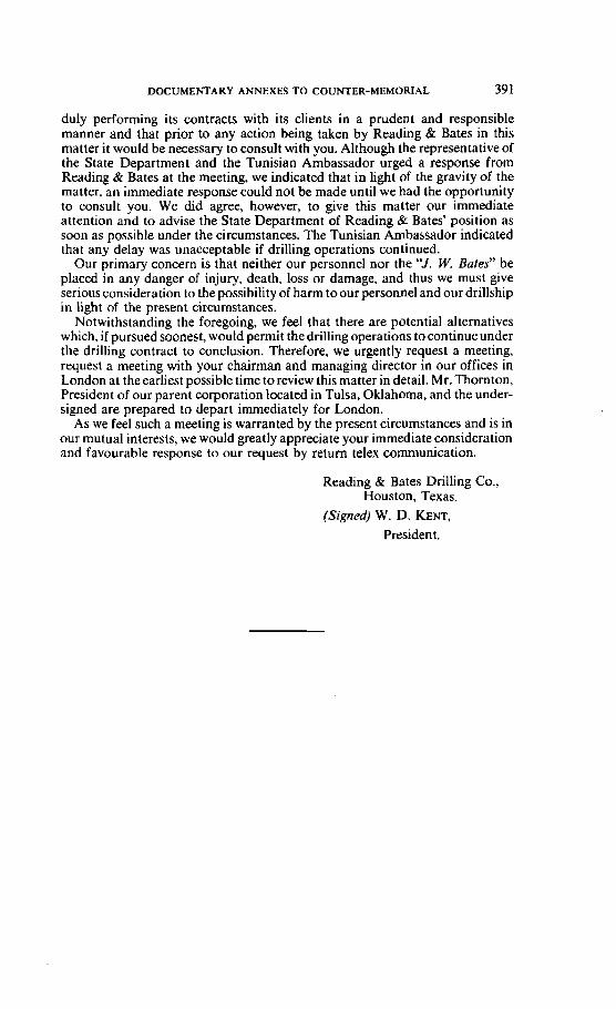
DOCUMENTARY ANNEXES TO COUNTER-MEMORIAL. 391
duly performing its contracts with its clients in a prudent and responsible manner and that prior to any action being taken by Reading & Bates in this matter it would be necessary to consult with you. Although the representative of the State Department and the Tunisian Ambassador urged a response from Reading & Bates at the meeting, we indicated that in light of the gravity of the matter, an immediate response could not be made until we had the opportunity to consult you. We did agree, however, to give this matter Our irnmediate attention and to advise the State Department of Reading & Bates' position as soon as possible under the circumstances. The Tunisian Ambassador indicated that any delay was unacceptable if drilling operations continued.
Our primary concern is that neither Our personnel nor the 'Y. W. Bates" be placed in any danger of injury, death, loss or damage, and thus we must give serious consideration to the possibiiity of harm to our personnel and Our drillship in light of the present circumstances.
Notwithstanding the foregoing, we feel that there are potential alternatives which, if pursued soonest, would permit the drilling operations to continue under the drilling contract to conclusion. Therefore, we urgently request a meeting, request a meeting with your chairman and managing director in Our offices in London at the earliest possible time toreview this matter in detail. Mr. Thornton, Ptesident of our parent corporation Iocated in Tulsa, Oklahoma, and the under- signed are prepared to depart immediately for London.
As we feel such a meeting is warranted by the present circumstances and is in our mutual interests, we would greatly appreciate your immediate consideration and favourable response to Our request by return telex communication.
Reading & Bates Drilling Co., Houston, Texas.
(Signed) W. D. KENT, Presiden t.
Annex 16
@ MMJ SHOW ON LIBYAN TELEVISION IN CONNECTION WITH A STATEMENT BY MR. A'ITEIGA
DOCUMENTARY ANNEXES TO COUNTER-MEMORIAL
Annex 17
[Arabie texr not reproduced]
The Continental Shelf
From the rnilitary point of view, we fear none. As to the purely administrative side of prospecting for oil and such other questions, this is an issue governed by other rules. So far, we are sure that current drilling falls within an area that cannot be subject for dispute between the Jarnahiriya and any other State. This is proved by facts. The line which the Libyan experts Say delimits our continental shelf with Tunisia is 45 kilometres to the West of the point where driIling is going on. The contract concluded by Tunisia in 1967 for prospectingfor oil actually lies to the West of this point where drilling is now carried out, 45 kilometres off the Libyan line to the north and the West up to the border of the field. In 1968, it became clear that there was oil to the west of that area, that is, to the West of the demarcation line between the Libyan and the Tunisian continental shelf zones. Then Tunisia pushed its line and submitted to Libya in 1968 a new line to the east of the first line. Even then, the new line was 10 kilometres to the West of the area of current drilling. In 1976- 1977, it became clear that there was an oil field to the east of this point. Tunisian experts pushed the line again so that it could cover part of the field and the Tunisian line could fall within the area where there was petroleum. If each time petroleum is açcertained you push the line towards the field, then the question is no longer one of your continental shelf but rather that you wanted that petroleum, and it means that you want to try your luck with the hope that this attempt brings you something. The drilling platform now stands45 kilometres to the east of the line separating the continental sheK zones of Libya and Tunisia. Bere we are sure that drilling is carried out in an area which is no1 at al1 subject to dispute. The dispute stands as to the area which lies 45 kilometres to the west, and relates to whether the line should be removed towards the east or the west.
That Tunisia needs oil, there is no doubt. Tunisian statements have always affirrned this fact, without any basis or ground, It is clear that Libya has oil and Tunisia has no oil, but this is no justification for Tunisia to search for oil even in the Libyan continental shelf.
Let Tunisia corne to unity with Libya tomorrow, a unity that ensures equality of Tunisia and Libya in sharing the oil, from the continental shelf to the field of Al-Serir. That is the correct historical solution.
If the question is that of the interests of the Tunisian people, let us establish unity. For it is in the interest of the Tunisian people to have unity between the Jamahiriya and Tunisia. It is in the interest of theTunisian people 10 be partners with the Libyan people in oil. If any one seeks the interests of the Tunisian people, this interest lies in unity between both wuntries. But those who refuse unity and claim that they defend the interest of the Tunisian people, speak in a
394 CONTINENTAL SHELF
suspicious manner ; and this must raise comments even arnong Tunisians them- selves.
1 Say that this is not the real problem of the Arab nation ; it is not the continental shelf. And we have no reason to display military force against Tunida.
1 am sorry to say that during the last two days there has been a widescale campaign to rnislead the Tunisian people, in the first place, and to rnislead the world public opinion, by claiming that Libya has installed a drilling platform in Gabes bay.
However, when the Libyan experts published the map to the world, it hecame clear that the platform was 120 kilometres to the north of El Zawyeh town, and was away from Gabes bay. It was said that if drilling was in Gabes, this constituted an aggression on Tunisia, but now that it is shown that drilling is to the north of El Zawyeh, then to claim this site means claiming the town of El Zawyeh itself.
Let Us Remove Borders
Instead of claiming El Zawyeh, let us achieve unity between the two countries and remove these borders. This we welcome. 1 do not believe that a site that lies 120 kilometres to the north of El Zawyeh and 220 kilometres off Gabes could be a subject for dispute between Tunisia and Libya if the matter was simply a dispute over the continental shelf, not over other things that could clairn victims. 1 do not believe it is possible to recognize the territorial concept that makes the conti- nental shelf of Tunisia, i f this line were extended, to the north of Al Khorns. The world would laugh at this idea and would refuse to discuss the issue, for this concept would mean that the Maltese-Libyan continental shelf shall become the Maltese-Tunisian continental shelf.
In any case, 1 reiterate that the battle is far more reaching, the battle of the Arab nation is far more reaching, and the tme solution of our problems lies in unity. AI1 Arabs should share their oil so that al1 potentialities are mobilized to achieve Arab progress and to destroy artificial borders. 1 Say there is a contra- diction which anses because of revolution. This contradiction cannot be solved from outside, as some claim. 1 Say for Our part that we exclude any manifestation of force or threats, or not even any publicity or propaganda in the case of an issue as simple as that of the continental shelf.
1 Say that a solution of this issue could be something like a message that cornes not later than yesterday from President Habib Bourguiba saying that he gives me thepower to search fora solution, that is to Say, heauthorizes Muarnmar to find a rnethod for arbitration and he accepts whatever solution cornes out.
1 Say that the logic prevailing between us does not justify fears of using force. Our force is to be used against the enemies of the Arab nation and not against another Arab, for that would not be justifiable. As I said in the above analysis, the outcome of these contradictions would be a revolution, and not a clash from behind the borders.
For Our part, we do not fear arbitration or negotiations, but rather seek them for this is the way to bring out the truth. 1 say now, to the Tunisian people as well as world public opinion, to pravide for any future developme~ts, 1 say that even if, for argument's sake, it turned out that the site where the platform is now operating appertained to Tunisia, 1 Say there will be no problem.
In such a case drilling would be in the interest of Tunisia ; but if it turns out that the site belongs to the Jamahiriya, then drilling should go on as it is, for the Jamahiriya.
DOCUMENTARY ANNEXES TO COUNTER-MEMORIAL 395
Ready for Arbitration
There is not a solution as reasonable and practical as the one 1 have mentioned. Let us go for arbitration and negotiations. And now 1 Say that if, although it is a remote possibility, the site turned out to belong 10 Tunisia, then the benefits of drillingwould accrue to Tunisia ; but if thesite ultimately turned out to belong to the Jamahiriya, then it should faIl to the Jamahiriya. Thus, there is nothing to be lest in continuing drilling ; on the contrary, it would be beneficial to man, who faces shortages of natural resources al1 over the world, if drilling continued to exploit natural resources.
Our brothers in Tunisia invited the secreiary of Foreign Affairs to visit Tunisia. We have no objection to this visit any time, provided the atmosphere is right, and cordial. He was about to go, but when I saw the information releases of Tunisia we detected a tone of threats and attacks, so we cancelled the visit. 1 still rnaintain that if the atmosphere is cordial and normal so that understanding would be promoted, then there would be no reservation on the visits between Tunisia and Libya on any level. However, if the atmosphere smells of threats or attacks or insolence, then we reject these methods and we also close al1 doors and keep the keys in our pockets and act in a rnanner that would be understood by those who only understand such a manner of conduct.
For Our part, history shall not say that we displayed rnilitary force against Tunisia. But 1 also Say that this is an issue that should bereferred to Libyans, for 1 alone cannot take a decision on it. My duty is to participate with the masses to enable the people to make their decision. 1 am nota president or king or prince to impose my decision on the masses. The decision will have to be made by the people's congresses. My task is to struggle with the masses so that the people's authority is asserted and the masses can always take the decision.
If someone opened al1 doors or closed al1 doors, or opened some doors and closed others telling us which way to go, wanting to impose on us a logic other than that of negotiation, then we Say no and we can also take a decision suitabIe to the situation.
Thus decision is left to the Tunisian Government ; if il creates the atmosphere for understanding, we Say welcome. But if it disturbed it, then it would bear the responsibility. The Foreign Secretary could go anytime to Tunisia and rnay agree to any formula. The Tunisian Foreign Minister came here twice and then they extended the invitation to the Secretary. He must go, even if it were only out of courtesy. But 1 refuse the visit if the atmosphere is full of insults and attacks or threats, or if there was anything to indicate that negotiations may be conducted under any condition that we do not accept. We are free to refuse and free to act according to the situation.
Understanding Possible 1 believe it is possible to reach a solution or an understanding in respect of this
issue, if the right circurnstances were provided. It is possible to do so with people who observe their national obligations and refuse to gel stuck in issues of territorial borders. We do not give much attention to those simple questions that may cause the Arab nation 10 suffer undue losses. The Libyan and Tunisian peoples need each other. There are tens of thousands of Tunisians working together with Libyan, Egyptian, Palestinian, Syrian, Lebanese, Iraqi, Sudanese, even Mauritanian, brothers. This proves that unity is a must, and there is no alternative to it. Borders have become very much weakened, due to the move- ment of the Arab people towards unity.
CONTINENTAL SHELF
Annex 18
REPRODUCTION OF A FRENCH MAP ENTITLED CARTE DES CBTESDE BARBARIE OU LES ROYAUMES DE MAROC, DE FEZ, D'ALGER,
DE TUNIS, ET DE TRIPOLI AVEC LES PAYS CIRCONVOISINS, M . BONNE, PARIS
Annex 19
PAGES 372, 373, 375 AND 377 OF ANDRB MARTEL, LES CONFINS SAHARO-TRIPOLITAINS DE LA TUNISIE,
TOME PREMIER, PARIS, PRESSES UNlVERSlTAIRES D E FRANCE, 1965
DOCUMENTARY ANNEXES TO COUNTER-MEMORIAL
Annex 20
EXTRACTS FROM PAGES 190 AND 191,242 AND 243,275,282,3 16,325,333,351, 372 AND 378 THROUGH 380 OF THE DOGUMENTI KUPLOMATICI IT*:LIANI, ND
SERIES, VOL. XXI
(English translations of the documents in Italian)
228 (pages 190 and 191)
PRESIDENT OF THE COUNCIL AND ACTING MIN~STER OF FOREION AFFAIRS, CRISPI, TO AMBASSADOR BLANC AT CONSTANTINOPLE
D. 334/ 11 5 (1). Rome, 15 October 1887.
The War Ministry has just communicated to me a memorandum from the General Staff Corps Headquarters concerning the machinations and aims of the French along the border of Tunisia and Tripolitania. 1 pass on to V.E. a surnmary of this mernorandum in order that he rnay ascertain the new information therein contained and make where they should prove true, the appropriate wmplaints, reporting back to me on what he has been able to gather and do in the rnatter. According to the news received from a good source at the General Staff Corps Headquarters, it now seems certain that Turkey, at first opposed, has now partly given in to the clairns of France and that a portion of the territory of Tripoli shall soon be united poiitically with Tunisia. Though considerable, this portion of tenitory will not be so ejrtensive. Giamila or Smila lkated not quite on the Coast but inland to the south of lake El Biban will be inwrporated into Tunisia through border adjustments. The French will establish, as s k n as possible, a garrison>t Zartis (Tunisial from which detachments will be suv~lied. These will have a total streng;h of 500ken more or lers at Giamila and ~ ; & a t . These two ppints will be fortified.
It is believed at Tripoli that if no power should take the French to pass for the above-mentioned adjustment, she will take advantage of this to push onward, and shall make a thnist above al1 toward Ghadames, a region which the French are yearning to reunite to Tunisia.
The frequent raids, arnong which some very serious ones like that perpetrated in the recent past on the tribe of the Uarghamna and Duirat, il seems, have been provoked by French agents, namely by General Allegro residing at Gabes. These raids tend to maintain a troubled atmosphere designed to serve the aims of French policy, as represented by Mr. Massicault. This is to Say, aims of new territorial conquests. These raids that keep the fire of discord burning between the tribes must be watched inasmuch as they may facilitate, as other examples cal1 to mind, new and more considerable annexations.
282 (pages 242 and 243)
D. 355/ 123 Rome, 6 November 1887.
With reference to the previous correspondence exchanged with that Embassy on the subject of French manoeuvres on the border between Tripolitania and
398 CONTINENTAL SHELF
Tunisia, 1 believe 1 ought to cal1 the attention of Your Excellency to another fact which my colleague, the Minister of War, has brought to my attention. This fact confirms the suspicions we have had on the intentions of the Govemment of the Republic (Note : France). The headquarters of General Staff Royal Corps, having had occasion to examine the maps of Africa on the scale of one-four million, of which the Perthes firm is publishing a second edition, has revealed that in the second edition, the border line between Tripoli and Tunisia was moved in such a way as to leave Tunisia with al1 of lake El Biban and Kasr Wassen in the direction of the Duirat mountains where they meet Gabel Nafusa. That is, the border of Oued of Mokta was marked. This is the border that Mr. Cambon. already the current resident in Tunis, considered to he the true one.
Froni the illustrative notes, indicating the various sources from which the corrections made on the original map have hecn obtained, it appears that the direction taken by the southeast border of Tunisia, established in agreement with the Pasha of p ri poli, was derived from the map es Itinéraires ae la Tunisie" published by the French Photographic Institute in January of this year.
Special attention is due to the circurnstance to which open reference is made of the agreement that has been reached with the Pasha-Governor of Tripoli. This could explain the repeated assertions of the Sublime Porte that no agreement had been reached between the French Govemment and that of the Sultan. The General Staff Corps Headquarters does not have sufficient intelligence to assert that the occupation of the territory hasactually taken place, the territory which in the Perthes map already appears as part of Tunisia; but at any event, the above-mentioned matter hasper se too much importance for Your Excellency to overlook. Your Excellency should try to find out what is known at the Sublime Porte concerning this significant border alteration and what the officia1 line is.
3 16 (page 275)
PRESIDENT OF THE COUNCIL AND ACTING MIN~STER OF FOREIGN AFFAIRS, CRISPI, TO AMBASSAWOR BLANC AT CONSTANTINOPLE
D. 377/ 133 Rome, 18 November 1887.
In my dispatch of this month, 1 requested Your Excellency to bring to the attention of the Subliine Porte the striking piece of information contained in a recent map of Perthes. According to this, with theconsent of the Pasha of Tripoli, the eastem border of Tunisia has been pushed back al1 the way to Wadi Mokta with a considerable expansion also inland.
Concerning this very same topic, 1 now received from the Royal Consul General in Tripoli, a report a copy of which 1 am enclosing. According to the intelligence gathered in this report the matter has even greater gravity. It is no longer a question of a simple notation on a map, bereft of any officia1 character, but it is now the confirmed design of the French to annex a considerable area of territory directly subject to the Sultan's sovereignty to their Tunisian protec- torate. Fortification operations at Gemila are now being prepared (Gemila is located in this zone) and every attempt on the part of the Tu~kish authorities to exercise administrative powers in this same area are being violently rejected. In the face of similar encroachments, the Pasha of Tripoli appears sufficiently aware of the duty that rests with him to safeguard with effective vigilance the prerogatives of his Lord. As far as we are concerned, and from the point of view of balance which we wish to maintain in the Mediterranean at al1 costs, we can do no less than to declare as of now that any attack on the part of other powers to
DOCUMENTARY ANNEXES TO COUNTER-MEMORIAL 399
alter the present territorial situation in Tripolitania is without legal force. How- ever, we do believe that for our part we owe it to friendshp, not to leave the Sublime Porte in ignorance of what is going on to its detriment and which it ought to energetically oppose, as is its undubitable right and duty before the French designs becorne French faits accompiis.
Your Excellency will probably, in so doing, have the consent of th: colleagues representing the powers which have with us a wmmon programme of peace and maintaining the status quo with regard to Mediterranean affairs.
327 (page 282)
THE PRESIDENT OF THE COUNCIL AND ACTING MINISTER OF FOREIGN AFFAIRS, CRISPI, TO THE CHARGE D'AFFAIRES AT LONDON, CATALANI
D. 483/475bis. Rome, 20 November 1887.
1 pass on to you herewith enclosed a dispatch which 1 am forwarding on this day to the Ambassador of His Majesty at Constantinople. A copy of a report by the Royal Council of Tripoli is appended to said dispatch. He will notice that we are faced with events which ment serious considerations. It is obvious that the French Government is pursuing an expansionistic programme also on the part of Tripolitania, This plan cannot be allowed by powers determined to maintain the status quo in the Mediterranean basin, powers bound together by reciprocal pledges to this effect. Please try to find out if Lord Salisbury is aware of what is going on and tell him that in Our eyes, theconduct of the Sublime Porte is equally reproachable whether the Porte is allowing things to go on by connivance and in the hope of other advantages to be obtained elsewhere or is giving in to pressure which is being placed on it and which it is making no attempt to avoid. 1 shall Say further comment in return to this important subject as soon as 1 have new intelligence in the matter.
369 (page 3 16)
THE AMBASSADOR BLANC AT CONSTANTINOPLE TO THE PRES~DENT OF THE COUNCIL A N D ACTING MINISTER OF FOREIGN AFFAIRS, CRISPI
R 147 Constantinople, 2 December 1887.
1 refer to my report No. 141 of the 29th of November last. The explanations requested by the Porte from the governor of Tripoli on the
Tunisian border adjustments not having yet arrived, 1 believed it opportune to enable the Porte to request once more by telegraph clarifications from that officia1 on basis of new information contained in the Ministenal dispatches Nos. 123 and 133 of this series. My three colleagues consented with me in so doing and in particular the Ambassador of Germany remarked to Gran Visir that the policy of startu quo affirmed by the Powers is based upon the supposition that the Porte, for its part, is able to preserve its own territorial integrity which, however, if it were diminished in Tripolitania by the doing of the French, could, as a natural consequence, also be gnawed away at by others. The Gran Visir has indicated his appreciation of the seriousness of events which have been brought to his attention and has renewed by telegraph his request to the governor of Tripoli for more precise clarifications. He has, moreover, ordered hm to enter- tain no communications on border matters with the local French commanaers, but rather with the high command in Tunisia. It seems to me doubtful that this
400 CONTINENTAL SHELF
order will have practical effects. 1 shall further insist a t the Porte on the necessity of avqiding further delays in providing clarifications requested.
384 (page 325)
AMBASSADOR BLANC AT CONSTANTINOPLE TO THE PRESIDENT OF THE COUNCIL AND ACTING MINISTER OF FOREIGN AFFAIRS, CRISPE
R 154 Constantinople, 6 Decernber 1887.
After the categorical and officia1 denial repeatediy put forward by the Porte . not only to me but to my Enghsh, German and Austro-Hungarian colleagues - these denials rule out any participation whatsoever by the Imperia1 Government in border alterations which supposedly are going on between Tunisia and Tn- politania - the new rnatenal published by the Geographic Society of Pans gives us every nght to demand further imrnediate explanations in the matter, Le., outright explanations of pnnciple. This isjustified by the fact that not only does i t appear that territories concerning which the Porte d w s not demonstrate having any exact geographic notion, have been taken away from Tripolitania, but also the distance of any agreement, even one reached only by the governor of Tripoli with the French authorities would be detrimental to the reçoive con- stantly manifested by the Porte to me and to my aforesaid three colleagues to refuse to recognize the French protectorate at Tunis. 1 am going now to the office of Gran Visir and am sending directly to the Sultan the information telegraphed to me by Your Excellency. 1 shall report on the outcome after this mail goes out.
396 (page 333)
R Confidential 155 Constantinople, 9 December 1887.
This is a sequel to my report No. 154 concerning the shifting of the border between Tripoli and Tunis. Having gone to see the Gran Visir on the sixth of this month, 1 pointed out to him, on the basis of two telegrarns from Your Exellency of the 5th, the affirmation published in the bulletin of the Geographic Society of Paris, which pursuant to a convention existing between France and Turkey, the border between Tunisia and the Turkish province of Tripoli has been fixed to the east Cape El Biban, 32 kilometres from the former border, the entire bay of El Biban now being under French protectorate. 1 provided myself with the map of Justice Perthes, and showed to His Highness on that map the territory of Tripoli that the Geographic Society of Pans claims has been reunited with Tunisia in accordance with the aforesaid .Franco-Turkish convention . . .
415 (page 351)
THE CHARGE D'AFFAIRES AT BERLIN, RIVA, TO THE PRESIDENT OF THE COUNCIL AND ACTING MINISTER OF FOREIGN AFFAIRS, CRISPI
R. 4565 Berlin, 13 Decernber 1887.
In today's interview, the Secretary of State was pleased to report to me the results of the investigation which he had prornised to rnake cancerning the
DOCUMENTARY ANNEXES TO COUNTER-MEMORIAL 401
French penetration from Tunisian temtory into Tripolitania, and relative.to the aforernentioned agreement which supposedly was reached between that power and Turkey in the matter of a boundary definition between the sarne temtories, advantageous to the former (R. 4552 of the Policy Senes, dated 27 November of this year). Count Bismarck told me that according to intelligence that has reached him the French Government denied emphatically both circumstances herein referred to. He believed then that negotiations were underway between Your Excellencv and the Endish Government to aupoint a commission for the purposes of veri*fying on the ;pot the tmth of these katters lying behind so rnany bits of circumstantial evidence and at the same time so onenlv contradicted both a - at Paris and Tunis, and at Constantinople.
444 (page 372)
L'AMBASCIATORE A COSTANTINOPOLI, BLANC, AL PRESIDENTE DEL CONSIGLIO
E MINISTRO DEGLI ESTER1 AD INTERIM, CRISPI
Costantinopoli, 20 dicernbre 1887, ore 22,5G (per. ore 8,40 del 2 1).
Je signale a la Porte toutes les nouvelles trop significatives touchant la fron- tière tripolitaine. Ni gouverneur de Tripoli ni l'ambassadeur de Turquie a Paris n'ont rien télégraphie sur les faits que nous signalons. Tout l'entourage franco- russedu Sultan les dément et s'écrie àchacune de mes communications appuyées par mes trois collègues : <( Voila les Italiens qui soulèvent la question de Tri- poli. o
La frontière étant incertaine à cela prés inconnue la Porte, et se compliquant par la protectiondes tribus, Porte croit ne pouvoir mieux, que confirmer à Tripoli et a Pans que toute invasion est inadmissible. Journaux français de la Colonie font comprendre que la France fera démarches convenables la Porte pour un arrangement, en tenant compte que la Porte, pour ne pas préjuger la question de Tunis, ne peut pas procéder d'accord avec la France à une délimitation qui n'a jamais été faite.
452 (pages 378-380)
AMBASSADOR BLANC AT CONSTANTINOPLE TO THE PRESIDENT OF THE COUNCIL AND AC~ING MINISTER OF FOREIGN AFFAIRS, CRISPI
R. 172 Constantinople, 24 December 1887.
Clarifications having been made between Sir William White and Count Mon- tebello concerning the Gran Visir's coming back to the idea of introducing in the Suez Canal convention a clause on canal clearance, it was made clear that the French Arnbassador has not seized pressing the Porte frorn accepting the con- vention without modifications. Sir W. White notified his Govemment thereof, that 1, Baron Calice and Mr. Radowitz who received the 22 instructions in the matter, are advising the Porte to support the convention draft without bringingin any questions of clearance,
Count Montebello's silence towards his English and Italian colleagues with respect to the Gran Visir's new insistence on a clearance clause is explained by
402 CONTINENTAL SHELF
the difficult position in which he has been placed by an unexpected aspect issuing recently from the clearance question in relation to the Pauncefote reserva- tion.
Your Excellency will remernber that in submitting the present draft conven- tion to the Porte, the French Ambassador had affirmed that he, along with his Government were maintaining their pledge, undertaken because of the aban- donment of the Drurnmond Wolff Convention, to help Turkey to obtain clear- ance from Egypt ; and that from the assertions of Count Montebello that the present convention will facilitate clearance, Mr. Nelidow took the floor to sug- gest that the clearance be expliciily stipulated in the same convenlion while Count Montebello, apprised by Sir W. White and by me, that this latter cam- plication scuttling the convention, spoke to us in the correct manner which 1 reported on the 13th current, the Sultan was taking into consideration the aforesaid assertion by Count Montebello and the suggestion of Mr. Nelidow ; and he has now authorized the Gran Visir to push for a resolution by the ministers on the appropriateness of proposing that the entire text of the Paun- cefote reservation, reconfirmed by Lord Salisbury in the note accompanying the draft convention from an article in the same convention. With such an amend- ment, it appears thai the Gran Visir would aim either to abandon the plan or to commit al1 the signatory Powers to bring about the actual clearance, without which the convention would end up being, by its very own terms bereft of any value. The Gran Visir, therefore, as well as Mr. Nelidow, but for opposite reasons, would not see any drawbacks to breaking the Franco-British agreement, of which the convention is the instrument ; Said Pasha does not disagree therein with His Highness, but considers that, al1 the maritime powers having rights in the Suez Canal, while Turkey alone has rights in Egypt, it is preferable for the Ottoman Govemrnent that the two matters be kept separate.
The situation, therefore, has rerurned to that of 1882 in the convention of Constantinople. France and England being on the way to agreement with the participation of Italy, and negotiatingfor the support of the Porte, Germany and Austro-Hungay are intervening either to prevent England f rom strengthening its commitments to France or to deprive the budding agreement of al1 practical political efficacy by transforming it into a European entente. The difference is that Russia, then united with the two Empires in an alliance which burdened Europe due to the partition of Poland, is now isolated from them and is nolonger associated with the Council Chambers of Vienna and of Berlin in order to stifle the western agreement by embracing it, but now . . . ostensibly fights il. Except for this difference, a certain latent solidarity has corne about by itself arnong the three Empires in opposition to the western agreement, with the advantage for Gerrnany of an accidental antagonism between Russia and France in the current Egyptian negotiations. In a situation such as this, it was not easy to maintain here strength in unity in Our group. Fortunately, the confidence now inspired by Italy in Berlin and also by England rules out any risk that Prince Bismarck will return to a show of force as he did in 1884 and 1885 in opposition to the solidanty established between France, England and Italy on Egypt. Meanwhile, my three wlleagues and I are making an even greater comrnitment to hasten a decision by the Porte in accordance with our instructions, in so far as we are convinced that it is desirable, in view of the current European situation that the negotiations in question corne to an end.
DOCUMENTARY ANNEXES TO COUNTER-MEMORIAL 403
Annex 21
PAGES 532 THROUGH 534, 538, 539 AND 540 OF JEAN DESPOIS, LA TUNISIE ORIENTALE : SAHEL ET BASSE STEPPE, PARIS,
SOCIÉTÉ "LES BELLES LETTRES", 1940
Annex 22
P A G E S ~ ~ , 63, 104 AND 105 OF ALEXANDRE PAPANDREOU, "LA SITUATION JURIDIQUE DES P&CHERIES
S~DENTAIRES EN HAUTE MER", REVLTE HELLÉNIQUE DE DROIT INTERNATIONAL,
ATHENS, 1958
[Nor reproduced]
Annex 23
[Nor reproduced]
Annex 24
SECTION 287 OF EMMERICH DE VATTEL, DRO~T DES GENS, VOL. 1, LONDON, 1958, CHAP. 23
(Nor reproduced]
CONTINENTAL SHELF
Annex 25
[Not reproduced]
Annex 26
[Not reproduced]
Annex 27
PAGE 446 OF PAUL GUGGENHEIM, TRAITÉ DE DROIT INTERNATIONAL PUBLIC,
VOL. 1, FRANCE, MINISTÈRE DES AFFAIRES ETRANG~RES, 1953
[Nor reproduced]
DOCUMENTARY ANNEXES TO COUNTER-MEMORIAL
Annex 28
PAGE 49 OF UN DOC. A/CN.4/60
pas posr ib le de p05er d e regle générale que R s E t a t s devra ien t sui*re t t il est p roba l i I t que les d i f f i cu l t i a surgiront. Par exemple. il se p e u t qu'aucune l i m i t e m'ait C t i i i xee en t re les mers Ierr i lor io lcs respectives dcs B t a t s in t i resds , e t aucune régie gén i ra tc n 'existe p o u r ces l imi tes.
D a n s fe mmnrenlaire d u projet. soumis a u x gouuernc- mtnls, l a Commission w a i l p r o p o r l d o b l i g r r les D!ofs de roumr l l r c hi dif/irends surg is ran i c n celle m a l i l r c L rarbî l rage ex =quo e t bono. E u i g a r d aux objcclions uiu!aiies p a r plusieurs gouurrncmrnls contre cei t t prop-3- sil ion. I o Commission r a mod i l i i e . Si u n accord n e peul Clrc r i o f i s i c l r i une prompte ru lu l ion impose. lu l?lols i n l i r e s s b rhrrchcronl la solut ion de cc c o n l l i l en can/ormi l i micc les r<g!cs ronuenuer entre euz p o u r Ir r l ~ l e r n e n l paci l ique dt leurs d i l l i rends . S i Ir d i l l i r c n d n'es1 p m soumir à u n règ l rmrn l j u d i c i a i r r o u arbi l ro l . il deura foire rob je l d u n e p roc idure de canci l ia l ion.
2. S i 1 s'agit des te r r i to i res d e d e u x E t a b rCparCs par u n hras de mer. l a d i l i m i t a t i o n en t re les p la teaux fon t incn t3ux coïncidera gCnCtatement avec Ünc cer- t a i n e l i gne m t d i a n e c n l r e tes d e u x cbles. D a n s ce cas, l a con f igu ra t ion des cd tes p o u r r a i t tou te lo is l a i t e su rg i r des d i l l i c u l t l s p o u r l e t rac4 d'une l i gne médiane. e t ces di l [ icul t ts d e v r a i c n t l t r c soumises i u n arbitrage.
SECOXOE PARTIE : SUJETS VOISINS IICILESSES DE L A MER
Uii E t a f d o i t lu m a o r t i u i i i t r rt liml 1 la p l c k be* un- rég ion qu t l conque de L. h i u t e m e r o ù ka w ~ s ~ r i i ~ s ~ n r s d'aurrer E t i l s n 'ue rc rn t pas h . @ c h pu1 r ig Iemente r et m u t r â l e r L p l c h c dLlll cene rég ion e n n i e d'en pro t fger hi r a i o u r c n c o n l n I ' r z tcnu inn t io i . S i lu m s i o r l i r u i i r i de plwknn Etn t9 H ümit hi 1 h p k h c ~ M S m e région. œs mesures l e r a i t prises de concert p a r cea E ï i r i . S i nue r r t i e ~ c l c o n q u c d 'me régi00 r h o u r c i m o i - de
O0 miUc. dr b mer terr i for iu le d ' a E t i t rire&, ce t E t a t m 12 dro i t de F i c i p r r i u r uir p ied d ' i g a l i t i 1 t o u t e réglemrnt i r ian, m ê m e m i s a r r i r o r t k u m r i nz me &-nt p i L p5cbc h =nt ré+i. Lcr mesurer piiru dans u n i crrraina r f s i o n zn i i par k r u 1 E i a t don i Lr ressort is lanu y exercent lo *ch, m i r pi p l u t i e u r r E t a i s S u n r a m m u n accord n e l i en t p k s rerrort i rsonir E a u t r r s Era ts q u i y w u d r a k i i r u r r c r r h + r h .
Article 2
G m p i i e a c c d c d t Ptre donnée i un o r p n u m e h t r r n i t i o i i m l p c m i n n e n t p o u r c l iectuer d u cliiyuçlei c e n t i r ~ i i s iur 1 s p k b e r i n d u m o n d e e t la m t t b o d u employ&i p u r l e u r r r p l o i r i t i o a &t o r g i n i r m e I e v r i t i v o k k pouvot k b e r du r+ PLU lu n i e i u n de p io tce t ioo 1 appl iquer p r In E t r b d o i t I c i r r s s o r t k n t ~ H l i v r e n t j h ~ k b r b u i ie zigion p r t i c u l i ~ r c puclconque. bquc km Etiis i n r i r c r a i i me parvieunent p u 1 i'eaicndrc c n t m e u .
1. L a qura t ion de l a p ro tec t ion des r i r l i i * rsrs di. l n mer a i t E jo in te a u x rercndicci t ions sur I c pl : i tcau
cont inental aue certain? E t a t s o n t nr<scntCts i r i cours de cesderniCrcsannfrs. i i i n i s l e s d e u x q i i ~ ~ I i i i n ~ i r n b l ~ n t e n t i l r e m e n t d i f f i ren tes ek p o u r cektr ra i ron r I l i , r on t L t é t r a i t i t s s iparémcnt.
2. Lr. pro tec t ion de l a faune mar ine contre I ' c r i r r - m i n a t i o n s'impose dans S i n l t r t t de la c o n 5 c r u t i o n d r s ressources al imentaires du mondc. Les E t ï t r dont I r s resnortissants se l i v r e n l A la pCche d s n ~ une r l g i o n doonCe ont. e n connéquence. une re rpo i i sab i l i t i part i - t u l i t r e e t i l s dev ra ien t convenir en t re e u x de l a r ig l c - rnentat ion II app l iquer dans cette région. Lorsque les ressortissants d 'un s t u l E t a t se l i v ren t ainsi l a ptlche dans une rggion. la responsabi l i té incombe h cet E i a t . Toutefoia. I'exercice du d r o i t de prescrire des n ie iu r ts de p ru tcc t ion n e devra i t pas exclure les nouveaus r t n u a de ia par t i c ipa t ion P la pEchc d a n ï une r i g i o i i quel- eonaue. Lorw iue la r i n i o n de nCcht se t rou \e ri o r i r d e i a cb t r (".une i(glrmeot;ilinn nu l'ahsencc' de réglementat ion pour ra i t a v o i r des ri-crcussion, sur I n ~ C c h e dans l u mcr lerr i lor io le d 'un k t d t r iverain. cet &tac devra i t a v o i r te d r o i t de par t i c ipe r P I ' i lnborat io i i d'une r ig len icn ts t ion P appt iquer mPnii* r i re r ressor-
3. Cc aystCme p o u r r a i t i c r i v i l e r inel l icace si tes e t a b in t t ress is n e parv iennen t pas I s'entendre. L e mei l leur m a y c n d'obvier i l a di ï ï icul t t : serai t d'insti- t u e r u n organisme permanent q u i scrai t eomyl:tcnt
i? u r pr6senttr . e n cas de désaccord. des r l g l r a que tes ta ta seraient tenus d 'avpl isuer I l a ~ l c h c ~ r a t i u u é e
p i r leurs reuorïissant; 'dans ces parages: Lc 'cas k h i a n l . on pourrai l . d u m o i n s p ro~~ i ro i rcmcn l . l n i r c usage Gorganiral ions q u i cr is lenl d i j d en celle mo l i l r r . E n car Gune p l u r a l i l i dc ces organirmrs. drs mesurrr de mord ina l ion de feurs l r a u a u i a'imporinl. Cc t te question semble r t n t r c r dans l a compétence gdn i ra le de I'Orga- n isa t ion der Na t ions Unies p o u r I 'aI imentat ion e t I ' igriculture.
4. La po l lu t ioo d i 5 eaux de l a haute m e r roulCve d e i p rob ldmts part icul iers en cc q u i concerne n o n sculc- m e n t ta p ro tec t ion des richesses de la nier mais encore celic d'autres i n t f r l t r . . L a Comii i iss ion a no tg que le Conseil i conon i ique e t social a v a i t p r i s une in i t i a t i ve e n l a mat iére [ résolut ion 298 C (SI) d u 12 ju i l let 19501.
L r é g l c m e i t i t i o n des pëcherics r i d c n t d w a d r u r k. r tg ioas de Ii h u i t m e r contipS i u mrr terr i - m r i a l r peu t être c a t r t p r k pu on Et.1 I o n q u e l e i m w h n i i de ce t E t i t entret ienoenl et e rp lo i i cn t ca p k h e r i e s depuis b n g t c m p s ; brrgu* r E t a f rire. rain a aurorisd jusqri'l p r f w n i Ls p r s o n n r s q u i ne r o i i l iu ses ressords~anfr h la i i v r i r d 1. @hr, i f n'a pi dra i i d. L Lur interdire d f'arrnir. Toutcloir, mnc régkmcmtmtioo n e por te ra p u a t t c k i r rii rcgiriie +&rd de m r i g i o s , c i tan t qui haute mer. Lrr pkheries d d e n e i r c s nr l i r e n i par a r o i r p u r cons€- quen,-t de g@ner ~ n s i b l c m t n f I. narigeiinn.
C o m m r n k i r r
1. L a Comniissiori est d'avis que I c i y tc t i s t i r s i l d e n - la i res devraicnt Etre r i . y l~1 i i~n t2es indt i~ i ï r i . Ia in i i , .nt d i i p rob l rn ic d u p la lcau ciui l i i ient l i f . LI, pii,i.. >ili.,r!; r r i n l i i i . n u pi:lli,aii c o n t i i i t ~ r i t l i conci.ri i,: it I'e\islr?i-

CONTINENTAL SHELF
Annex 29
DOCUMENTARY ANNEXES TO COUNTER-MEMORIAL
Règlement sut la Pêche des Eponges et des Poulpes (DCcrctr dci 1G juin 1892, 11 janvier 1895 r i 28 ~ o i i i 1897)
Artich Prurnier
I Io Mchc tnrlurivc &* paulffr in m u i r q i i
6i éwnpcs poulpci libn rompic? cornmc o m r r c i d. botmur innri tr toute réInduc boncl oui lo *hi miro e l Icr bateiiur de I'wc
ronditia\i it chorna ci-oprbr a~ I ' w t r l di cm catéawlos nc p a i r m t dons oucun cor comptcr t- anneici dr
TITRE PREMIER b t . o u ~ inscrits po(ir la o & ~ k blorsho.
Réai- 1 le t(k ük *LionChe-
M. Z
h i c m vaut mxarcw la Dbcha blonrha.
TITRE II1
I l l ~ i u m~plicoblo iun meuboi Ait . 1
Botmur pCchonl ou uophondm, . par ormanil ................... l.m LI? pah-mt i n l h m l ëe la lo*c &vm t i re
fait ou i ~ m r i t do l e d;.livroncc do la potmt*
Art.' 3
c'rit-A-din h &hi dm Cmn wi. lor6.s ot *Hcs la *-ri. apport& mur lu rnofcMs WI*~ ci!l* Dr*- ~ofotion. <. ou pr4olabls u munir Cu- patnta wi u m et i r r4e ro*anont k wlC- ml da toxm c i - m r b :
lorqucltcr m t ou II-t ditc konihb ............... .Fr, 100
Botcaui milos & h ~ t A la d*opuc dite p m y o w 3b0 ............
L'mm~loi dr b von)a+o et celui du Ica- phndrc sont lormellenwnt . intcrdilr dv I * membro ou 31 cikembr* ineluli-t.
La *hi des barmes ou mom d.r bo- temm mnolns au procadfs ou t rn QU ceux dbihrdr Pt Es pi6-t l'bgl.mart rrt D d d - b h r i t a r t t * n W
m. 4
&i,- -, Doui- PCS 0 . r ~ OU sons wnhor~ol im. doil. pdoloblo nidi mtents wi e r c e&liv,& micinni da jo io.,
: . . . . . . . . . . . . . . . Por borguc .Fr. 30
fi:Obl~% 20 f t œ t ~ f Ou mOmen1 da Io di.llvionco dc La wtente ot It % ~ ~ ~ l u r dam k a lrois mois wi- .rn,I.
Tout bo lmu orerwnl la dcha Wonrhi &vm portsr M tomct&rcs Ir& opporcnl,. rw .Io voilure c t sur chacun ds ses bord* orri&m, I'indicotion du n i d i a dc ro mtcntc.
i-3 ba lmur pkhnnt .3 hi nnmuuo ilcviiml m w t r r . potici cn ib ic du di ic d i r i *I@v&. wia lkmmo & iec-isvnrs rouoe. I mu blancha oyaiil ou g u i m h t wa Lat- Ou ininbno d. 50 c a n l i d l r & r - - - - --.
TITRE II -1- opplsabb I Li mkhc U l m -riin-
Ail. 5
Q ~ i c ~ ( q 4 wu1 .ZOICCT Io p k h c mire. c'rai-h-illm b pkha rlri Ç-er are I'm &%#quo 1 Wlo t brut, ou A b lois b &ha mirs i t Io *hi der poulmr. nnlt oi i pi&- dobi. u munlr d'uu polcnlc qui %cm <&- I ~ v r k movovnnt Io mimirmi dm Io 10x0 d - m r h w r trlmaitrc ffomruo '
Por b o w drhal au ~ r i à m t . .ri. 40 Art. 6
Dons aucun cos im hsi iaux Lnicrili m r
Po*ablcs cn enlier ou m-l de ia ddlirranci dc la m t m t i .
TITRE IV Dii Datante#
Ait. II
LOS PotmiCs wront &livreel dani lm por l i wriili au coinri~rcc. Leur durka m a d'un M i tanplar du 1.r jonwier dr. c M w - d a , &le 4~ amt 1.6- de la + m. Lw droit v t r d ai Th-r n ' i i t n r i i i w b l c
d m $ suri cor.
Ait. Y
Lcl dcmadc i rb polenier, davront i.tic nrlrc&% w prc& I la N i c i do lo no- vqniiuri ot d f r pfches
I llc'i i i icnliorriciuil Ici ixiiii. ui..iiiiiti% CI - - . - - -
cwoli lh c l i i dcmmndcur. sa m i i o r ~ ~ l ~ l ~ , lc i r im ihi tuilcou ipi rh i l sicrtcr l u i#i.?tr. vinri puc I'irklicolion & $on p<i i l #l'ulluttic c l i c w b49c fiIliciclla. Ic i i u n . pri'noirir c t wolitbs df ~'orino~cii;. I'OII~CI~.~: sir du cuniginloiic: 1 i nmihtc d'hnmnia; d'c. Iiiim?. Ir nm& rk! n@:iu q r i r Ic hOlcau coniplc unyilujct. *.cc. mi kr Kouhon dimi. le nuitthc d. c r i upuuto~l..
Twte drrimnle rcm nccnmm~g~re rlar rwtlilors du hord qui rcr lemit cnlre l m iminr du prh>od' .\ Io pnlico rl* l a i nu.ijo l *AI FI JCi J*-.IIc% h)u(ii'h l ~ a x ~ ~ i o l i m ~ da In vnlirlild ib III m~~e i i l c . uaiif la rus oii b
i c r l i lu t rm m =rail crriuuiiwlEe rni i l rr In te- ni*# Ope, ,+:II IV u* . l ~ l i w i . m &a vafint %
CONTINENTAL SHELF
ôa l m ienta dei t p w c s ii dr, o i r b t r Ar$. 10
Les POoripn Uaneh.i. Ics +ci WICI i t les paJWI seci ou tioir dawront &rra i n t b d t m a n t oppoit4r doni I'un das m l 6 wvarta OU CQ~IIICHKO.
Catie disposition n'cil po i qrplicobli aux pris m r les *Murs O pied.
A kur dtbarpumiinl, 1.r &man cl ICI parl$es r m n t pc¶cntcs ou Didmd; A l a w l ~ c & la m v i o a t i ~ a i d n pictes, mi ~ ~ m i s t i m m 1-1 m i d i ou lOYI nombi*.
Cotto twmolit& o c t ~ ~ i o . Ic i péchcurr ditposeront A leur arb du praiuit âe Imur ptcki. or wnr* ai Ouiremcri+.
Ait. II
Lo veni'c dos Lpon?os MnnChes, dm épm- qes noircl et des poolpcs Our mchCres pu- hlr-s nc pw i ro avoir lieu quo m r le mi- ristcm du m i s ~ i r e p r t s ~ .
En cas dc ic'us de celui-ci c l dans Irr I a o l i l b ob il n'erisle pos do commisioiib prirur, les r m t e l auront lieu pot les wins d'un crieur puhlit &Y& mi I'Mminirtm- t h
Art. 12 Le commissoiri-pimr ou la c i h i public
prclowrii siir Ic prix ric vCnie le* droi l i cic ctiéa uiironls qui ?eronl dant tous k s COL
par la vindnir : Pwr tes d mcl m i r c i et ICI -lm 2% Pan ki b l - h ........ 1%
k t . 13 Taite OW-iation Scc&to üu n)on<Currc
m i r i los mrckonds dUoon(lar ou outres tndont b w i i c aux rmMrc% I Ics trou: blar ou i obtenir Icr -ri et pouloe? .i plus bos W L X , dœunro II- A r ' ~ i i c o t i n n kr minci parlbn wi I'oriiCIo 41 2 du Codt p h a l f rnwoi i iep.ndommnt de t w r ~ m o g e s - i n t i i d t s .
TlTRE V I DlsrmJthri mLnCiaCi e& d a m U t C n
Art. 14 Les mvlres et tmhaicotiom Choraiss da to
ruivrillrima dc In pëche w t i r s n t en - le pavillon tunirien 11 hi tbia du mbt la ilommc mt lowla.
Ait. 15
T e t &hCit i &vt? -CHiC OU* r&- auir i l~oni 01 &rlfcotionr ovont r oblat * contibic d i I't.arclca d a la G. II ti-via EIie poitrur de ia tenir don1
b prbsrnioilm wro tnulair i i*P;~r. ApriPi. ury -matbon atmai& d'iin coi10
rlc connn t i f& & Mnnt. Ir* bntroux m n n t & to iCiirtance w r m t nrb A la iemortpn et coul i i l t i ou m i t luni*icn la Dlirs prothe du ri+ du l t i h i m l cnrnyiCtrrit mur ilnruor
w i In cantmrinllonr carnises.
.. -
trr*rn.iiili mr r * i i i l l r c*vifnim#mrnt n u i dis- naiitions dei orllclcr uiivonts.
Art. 16 5crn puni d'iim Omcnne oe 2w i, I.Oi8'i
i r iws cr n'un cmpitianncmcni da r i s mir II, müir rw dc 4'uM d l tes ilni* iri i ics $rd cnwmt.. quirwquc w liwicro. en hariw. A hi *chi dm dpfmjes ou, p ~ t m s rom% elrc miwi. i'unc petenla ddt i r rc~ dans Ics turuiilioa r * t i q i h aru oiticlcs 2. 5. c i 1 du prPwnl cglcmcnt.
Si. la pirk. a ,cu lieu I Io d imue ai w içopi?w~Ire. Ic miiiimum Jc I'omcnda 'ci0 r.r i i W ) .iancs el il mir.ri él ic r i ic*mb u i i em. r i l onnment do cuiiiri b r i A iiois mois.
Qdiconwe ae I1vw.o I Io &kc dei wulw L pied. sons d i r i muni da lo palenta d c l o l c b cette ~5cho. urn mi d'une ~ r n r l C ck ?O I M i r n " ~ s cf d'un enpriion+rmmt & cinq A d i x l w m ou & i 'un da crr dcur psmr scutcmmt.
Art. 17 h * o puni dis w im p r d ~ i Doi I'oitklc
16. ptagroph. le?, micorigue se l iv i i ro a Io occhc des 4-rn en lem03 nrokM ai L l'aide de Wim au htcovr m m nutoridi por te pk icn t r ~ t n n e n i .
Ait. II En coi da conlravcntiri a u 1 att ic~e% II.
et 17 ot olot i d r n i g w In *linouont,. wroimt r n t f i inconnus. tes ini tr i immh. le. crqini. la p i d u i t do la &kc *mnt uliri* et Io confiscation -rra, in i l r c ormonck por Ics tribunaux CoriUtiontirk. mi wdan- - n r r m t h dcr tw t ion der rnpini pmhiEr
Ait. IV !CIO puii Kum oma*ll & IOd A I ,Oai
l r o n u Ir &iconquc aum d b i w r d OU tenté &
ûdtwrrur n mer. m r I'erlrbdicr 1 l'Ciron- cci. loirt w r t f c da b pkh &un hicai:
2. Tout chcur comaineu d'ordi &bar- & ai rmdu dm M a t ou dm m l g e s ailieurs pui dams un m r t a i r o i t au corn- m c * .
Art. 20 'cro puni d'une amendi tic 5ïi i 7(n
ifonci. sons or&dica dm mne1 q~nIi foblc$ cn cos dc ciirnc au f i l i t dr dwit cwnmim. gtiitonqiic auto miind da Pdwa4et ta m. t m i s ni ir m m t r rlc I'Elnt ouont quililis rwur cmsiotei ter cmliawcntmn% mi <(.+- ti-~nt+r~r na~- &ti'ic~:Iirn% pt* m r l 'a~*. 15 ~ ~ i r h l m t .
Ait . 2 1 '.cm n i i m i d'4inr imcn 'c de la) a 50:'
I inw. 11 Tmdt *heur rl'iponrlcr m l o Q $ i:iii -CIO
ronràincu ai'nmi iiriç itrii EU millr i@ rn mkhc n un &heur Cici(nnt la ehf b l t i ~ h c ;
?* Tniit mi. n ' l tnn l ms miini il'rinc pofcnte mur ln PEChiR hianth. ovro A <rn h r r l i*.i C t m n q t r Ioder '
3. Tout ~hhnii ewrroni la d r h e ~ n n the rpil w r i ~ cnnvniirii rls s'Plie n i ~ ~ i i t C l n i t mi pnrtia iCi #ww.?i i tcudl l i rr mi i in d r h n i i d'lirvviasi w i r n
Ait. 77 5rrn ~ i i rn i rr'inna iiniiiuln SIE 16 .l lm.
Irniirr. Irnitc ni i l rr rmtrrivrnlinn ou pr6.m. ri.~lrll>c,ll.
DOCUMENTARY ANNEXES TO COUNTER-MEMORIAL
M. 23
E~ cw ,j, conviction & pludeuil -1- ou pr&unt t&l-l, la prin io plul fort4 uro wulb @W.
Ai#. 24
En m g r(cidiV& l i a p . 1 ~ d d i c t k pairiont 4trm LI- luicu'ai daibli.
11 v auta r ~ c ~ d i w loi-. b r tar dm* ann.01 pibcddrntn I c m tcr do la d o l i du k t inr imini. il aum A4 r d , -11. h dalinauont M IYOorMnt w d di chosa k 6 m . mi contiowniion ou or&- u n 1 rlulmrit.
M. 1
Fuuriml airs k.di #-mg bJ oiimdoi p r o m n d i i .
1. br ormotaurr. oiidtwis,, c w i p m t a i - br bot-* dm *ho, mi- da I m i i
4a potmm m1 h l p o g i i ; 2. Ln Mia. h i t w r 4 morts et moitriS. 1
ration dei l o i t i dm minwn. ,lcmm+ 0th- pars ct d-t nun r moirir pu'itr nr -*.ni qu'Ils n 'ml imp5rh.r la 1mt
d-48 INU 4 cmltm -lit&
TITRE VI1 P m h n r b o a s . uldn, ninrlks
cimP4ti*cr Art. 26
Les cnnirovtmtionr ou pifrani r ipl .mmt w i m t conitotcai par piocr~r-ucrhous i c% ~ii ici .rs do mafi- au moitias, commun- QDnts Ut$ b4tirncnls *I cmboicatians, gurdcs &ch. i n r p ~ t e v r r der pbzhel ogmls du ktv i rm de Io No* i~o t !m 4t dEs PutIIEs, agents 6 ia l o r u W t i q n . pr&padr 0tt0- t 9 b qux dlffbrantai odrninistroticnr et. rb- gi is IinonciOrcq i t tous opmis apkioux msormintbr I c i t i f A t .
Ln procdr-virhaux dmrdr I c m ! rd bw'A o!nm cmtroln. lh roront d i r rm- d r & l offirmolion.
A.&iout rirocbr-*r?iborin en suHiMe nctah les '"* Pr- pot movenr d d i ranmun.
hi. 21
Lm ob i i t i loisir en w r t u d i s e i i i c k 15 et II W t M t r-us i n &Mt por I'MfnMr
' i i o t i m il cmwrrbr fuw'ou i i w m n t . Caus aujctr A d&p&riwmcnt serant *.ndui
1 ro rcqdt* pa i las commismi in-p i lwa w c i i run publics, oimi qu'il e i t d i t A , l'or- t ic l i II. m i oidonnonca du M o dm ooia ou du ceid w l v m t 10 ~ t i o m l 1 1 4 dur dûth- quanti. k t h p r d v i t 6 b venta wro v i d
~:"r&&*UI~&~t""dm Oil
. . Art. 21
Les guui,wltas aiiuiil lieu A la d i l i p m i d i l'A miruitmtion des Flncnrcs. comma m nict i t ie 6. daionci et do r n m b h cn ce aJ c w c r m le8 c~ntrawcniians ou* o i t ~ l c b 16, 19 Ct 21, i t b I? dd19UbCi di 1'W4toiiid avant l',llm pibli<ioo n c i gui co r r i rn i hi L n f r q l i y ou* orticlas Il. 20 or 22. 'am iiidiudicu, riom ce cor. du nrmi do I '+~i i l !ot lm d.s & u #ri# portlm cin i .
Ait. 29
9 IC &lit a f l d commis hwi d'un mi. le? ) i~~na l i t os sor~nt oaircPCs ~ . + e w ï tribuml du port m u q w l appoittont Ir b e
W. A iUlart, c b m t ubi du wt L. O h n wDdw.
M. 30
Pour les inirocttoni rÇprindar m r Ir* arti* Cles 16. 19 et, 21, I'Administiatiwi oiiio Ir dinit ds immrycr avec Ic i i H i i u n t s hl t i o n ~ t i o r i intotvcnua est i m t i i i h
avant iwomcnt. rait ou Parquet. n i t I ïa b r id i t l i a i tuniiicnnc. sel-ri in nrrt.,nolitd ckr pr6vcnui, aura M u r e l l t l irn&,!ial. TI.6teindr0 I'mtion ~ ' ~ b t i ~ .
1- p r n ~ r d ~ t or-coi mi opiJirolian dm a r f i ~ l o i 16, 19 Ct 21 wr,onl altr ibulci commi niat l&rn dm darrnos 01 da ino- nopoli*
Ait. 31
font ohropdr !O +<!et du 23 moi 1897 r t ~ W ~ C S ouIrci d i rp~ r i t imr C~n~ra i re t ou mi&- rcnl rbglerncnt dont Ii Oircctcur qfni.rol de$ TrOvouir PubI;cl et Io D i i ~ c t w r <cc% F+no<ucr umt ctmrodr d'oiwrmr I ' i xkut ian c-un ir
CONTINENTAL SHELF
Annex 30
extérieure de la mer territoriale tunisienne est constituée :
- au nord de Ras Kapoudia et jusqu'à la frontière tuniso-algérienne par une ligne parallèle et à une distance de 6 milles de la ligne de base ;
- au sud de Ras Kapoudia etjusqu'à la frontière tuniso-libyenne ({( ligne partant de Ras Aghdi en direction du nord-est ZV 45O s) par l'isobathe 50 ; donc c'est une ligne ne tenant plus compte de la longueur de la distance séparant la ligne de base et la limite extérieure de la mer territoriale, mais s'attachant plutôt A la profondeur des eaux 64.
Si pour la partie au nord de Ras Kapoudia la limite de 6 milles peut être considérée comme conforme aux prises de position nationales antérieures et au droit international coutumier, il semble difficile dejustifier la Limite extérieure de la mer territoriale au sud de Ras Kapoudia.
En effet, depuis 1958, A la conférence de Genéve, la délégation tunisienne a fait constater
<i que chaque Etat est libre de fixer la limite de sa propre mer territoriale et qu'il se manifeste une tendance progressive à porter la largeur de la mer territonale au-delà de la limite des 3 milles qui, de toute façon, n'a jamais constitué un maximum. f i
Partant de cette constatation M. Abdessalam ajoute que
<( le Gouvernement tunisien considère qu'il doit être permis à chaque Etat riverain de fixer la largeur de sa mer territoriale dans la limite d'un maxi- mum de 12 milles 1) 65 .
A la conférence de Genève de 1960, en des termes semblables, la délégation tunisienne exposait cette position.
D'ailleurs, elle a été coauteur de deux propositions, allant dans ce sens 66.
Aussi, le législateur de 1962, maître de l'appréciation de l'étendue de la mer territoriale jusqu'h 12 milles, en choisissant pour la partie au nord de Ras Kapoudia la règle des 6 milles reste en harmonie avec les prises de position nationales au sein des conférences de Genève de 1958 et 1960.
Par contre, concernant la partie au sud de Ras Kapoudia, le désaccord des prises de position et de la loi de 1962 est total.
64 C'est ce qui justifie, A nos yeux, l'adjectif a bidimensionnel I) par lequel nous avons qualifié cette conception.
6S A/CONF.13/39, 16e séance. p. 50. 6b A/CONF.l9/C. 1 /L.2/Rev. 1 et A/CONF.19/C.I/L.6, selon l'article 1 de la
deuxiérne proposition: « U n Etat a le droit de fixer la largeur de sa mer territonale A un maximum de 12 milles. mesurés à partir de la ligne de base applicable. i>
DOCUMENTARY ANNEXES TO COUNTER-MEMORIAL 41 1
Annex 31
PAGES 639 AND 640 OF RELAZIONI INTERNAZIONALI, VOL. 1, N O . 21, 25 MAY 1963, "LE RELAZlONI
TRA ZTALIA E TUNISIA"
[Not reproduced]
Annex 32
ARRANGEMENT DEFINITIF DE LA DETTE GÉNÉRALE TUNISIENNE, ARR&TÉ LE 23 MARS 1870, PAR LA COMMISSION FINANCIERE
INSTITUEE PAR LE DBCREI DE 1869
[Nor reproduced See 1, Tunisian Mernorial, Annex 83. j
Annex 33
[Noi reproduced]
CONTINENTAL SHELF
Annex 34
PAGE 24 OF C . D. SERBETIS, REPORT TO THE GUVERNMENT OF LIBYA
ON THE FISHERIES OF LIBYA, F.A.O., REPORT NO. 18, ROME, 1952
[Not reproduced]
Annex 35
[Not reproduced]
Annex 36
PAGE 25 OF SOGREAH, STUDY FOR A GENERAL MASTER h N FOR THE DEVELOPMENT W
THE FISHING PORTS IN THE LIBYAN ARAB REPUBLIC, PART 1, GRENOBLE, 1973
[Nor reproduced]
DOCUMENTARY ANNEXES TO COUNï'ER-MEMORIAL 413
PAGES 557 AND 558 OF R~VISTA DI DIRITTO INTERNAZIONALE. 19 12
DICHIARAZIONI DI BLOCCO
Blocco della Tripolitania e della Cirenaica
Le ministre des affaires étrangéres d'Italie a l'honneur de signifier à ... la déclaration suivante :
-Le Gouvernement de Sa Majesté le roi d'Italie, vu l'état de guerre existant entre l'Italie et la Turquie, agissant en conformité des principes du droit des gens et particulièrement des rhgles formulées par la déclaration de Pans du 16 avril 1856 et par la déclaration de Londres du 26 février 1909 ;
déclare qu'A partir du 29 septembre courant le littoral de la Tripolitaine et de la Cyrénaïque, s'étendant de la frontière tunisienne jusqu'h la frontière de 1'Egyp te, avec ses ports, havres, rades, criques, etc., compris entre les degrés 1 1.32 et 27.54 de longitude orientale de Greenwich, sera tenu en état de blocus effectif par les forces navales du Royaume, Les bâtiments amis ou neutres auront un d8ai qui sera fixé par l'amiral commandant en chef les forces navales de Sa Majesté le roi d'Italie, a partir de la date du commencement du blocus, pour sortir librement des endroits bloques.
Il sera procédé contre tout bstiment qui tenterait de violer ledit blocus, conformément aux règles du droit international et aux traités en vigueur avec les Puissances neu très.
Le ministre des affaires étrangères d'Italie saura gré h ... de vouloir bien porter aussitôt que possible la déclaration susdite à la connaissance de son gouveme- ment.
(19 ottobre 191 1)
Faisant suite A sa note verbale du 29 septembre dernier, au sujet du blocus du littoral de la Tripolitaine et de la Cyrénaïque, le ministére royal des affaires étrangéres a l'honneur de signifier A ... que Ia limite orientale de la côte tenue en état de blocus effectif par les forces navales du Royaume a été rnodifée et fixée fi la longitude de 5" 1 1 ' est Greenwich.
Le 'ministère royal des affaires étrangéres saura gré, ...
CONTINENTAL SHELF
[Copy of the document in Italian no1 reproduced]
ROYAL DECREE NO. 85 OF 4 FEBRUARY 1913 PROVlDlNG ORDERS FOR CUSTOMS SURVEILLANCE ALONG THE COAST OF LIBYA
(Official Gazette, 19 February 1913, No. [illegible])
Victor Emanuel III by the grace of Cod and the will of the Nation King of Ituly
In view of Royal Decree No. 1217 of 5 November 191 1, which has becorne Law No. 83 of 25 February 1912 ;
In view of Law No. 719 of 6 July 1912 and Royal Decree No. 1205 of 20 November 1912 ;
In view of the unique text of the Customs Laws approved by Royal Decree No. 20 of 26 January 1896 ;
Upon the proposa1 of Our Minister and Secretary of State for the Colon- ies ;
Upon the advice of the Ministers ; We have decreed and do decree :
Article 1
Customs activities in the importation and exportation of goods in Tripolitania and Cyrenaica rnay be conducted only within the ports or landing-places of Buchamez, Zuara, Tripoli, Homs, Sliten, Misurata.(Buscheifa), Marsa Zafran (Syrte), Benghazi, Dama and Tobruk.
The Govemors of Tripolitania and Cyrenaica may at their discretion permit customs operations in other places on the coast in addition to or instead of the above or may prohibit them temporarily in sorne of them, upon informing the Minister for the Colonies in every case.
Article 2
For the purposes of custorns surveillance, the sea within 12 miles (22.224 metres) from the shore dong the coast of Tripolitania and Cyrenaica shall form part of the maritime customs zone, within the conlines of which every vessel, whether Italian or foreign, rnay be subject to inspection by the authorities in charge of said surveillance.
We do ordain that the present decree, furnished with the Seal of State, be inserted in the official body of laws and decrees of the Kingdom of Italy and do order al1 whom it behooves to observe it and cause it to be observed.
Rome, 4 February 19 13, Seen C. Finochiaro Aunle, Victor EMANUEL.
Keeper of the Seal. GIOLITTE-BERTOLINI.
DOCUMENTARY ANNEXES TO COUNTER-MEMORIAL
Annex 39
[Copy of the document in Italian not reprodueed] (Translation)
ROYAL DECREE NO. 402 OF 18 MARCH 19 15 APPROVING THE CUSTOMS REGULATIONS FOR TRIPOLI AND CYRENAICA
(Laws and Decrees, 1915, pp. 1014 and 1050-51)
Unique Article
The at tached customs regulations for Tripoli tania and Cyrenaica are ap- proved, seen, by Our order, by the proposing minister.
Article 1
The shore of the sea and the borders with the territory of the adjacent countries shall comprise the customs limit. . . . . . . . . . . . . . . . . . . . . . . . . . . . . . . . . . .
Article 26
For purposes of customs surveillance, the sea within 12 maritime miles from the shore along the coasts of Tripolitania and Cyrenaica shall constitute the maritime customs zone, within which al1 vessels, whether foreign or Italian, may be subject to inspection by the authorities in charge of said surveillance.
Within the confines of said zone, the custorns agents shall have the authority to board vessels of tonnage no greater than 200 tons and require them to produce their board manifest and other shipping documents.
Vessels bound for ports in the colony and that Iack a manifest or that are suspected of criminal activities within the zone of maitirne surveillance shall be escorted by the agents to thenearest customs house for thedrawing up of a record of preliminary investigation.
If a vessel of a tonnage not exceeding 200 tons and bound for a foreign port is found within the surveiilance zone without a manifest or with a manifest that lacks the prescribed information, the agents may escort her out of the limits of the zone or, in cases suggesting crirninal activities, escort her to the nearest customs house for the drawing up of a record of preliminary investigation.
The agents may, having drawn up such a record, sequester whatever goods of which the importation or exportation is prohibited and that are found on board ships whithersoever bound that, except in cases involving acts of God, have drop- ped anchor and are lying to within a radius of 12 maritime miles [rom shore.
In case of attempts to unload goods on to shore and also to unload on to or transship to a lighter vessel, the agents may require the ship to follow them to the nearest custorns house for the drawing up of a record of preliminary investiga- tion.
Cf. approval of Peace Treaty of Lausanne, 18 October 1912 with the [illegible] for Libya. (AP, CD, documents, [illegible] 1909-12 [illegible] 1200.)
CONTINENTAL SHELF
Annex 40
ITALIAN ROYAL DECREE OF 6 JUNE 1940, No. 595
[Copy of the document in Italian no! reproducedj
(Transiution)
BERTHING AND STAY, DURING WARTIME, OF NATIONAL MERCHANT SHIPS, WAR- SHIPS AND NEUTRAL MERCHANT SHIPS IN THE TERRITORIAL WATERS OF THE
KINGDOM AND ALBANIA, THE EMPIRE, ï ï i E COLONIES AND POSSESSIONS
(Royal Decree No. 595 of 6 June 1940 - XVIII)
Victor Ernanuel III by the grace of Cod and the wi[l oj the Narion
King of Iraiy and Albunia Emperor of Ethiopia
In view of Articles 1, 2 and 15 of law No. 969 of 8 June 1925 ; In view of Article 3, No. 1, of law No. 109 of 31 January 1926 ; Having heard the opinion of the Council of Ministers ; On the proposa1 of 11 Duce of Fascism, the Head of the Government, the Navy
Minister ; We have decreed and do decree :
Article 1
During wartime, it is forbidden for national merchant ships and warships and neutral merchant ships to approach the territorial waters of the Kingdom of ltaly and AIbania, of the Empire, of the Colonies and possessions unless they have received authonzation as specified in the following articles. The territorial waters are therefore to be considered as off tirnits to navigation.
Article 2
The following are considered to be zones dangerous to navigation
(O) metropolitan waters :
the 12-mile-wide band that surrounds the continental coast and those of the following islands : Sicily, Sardinia, Elba, Gorgona, Marittimo, San Pietro, S. Antioco, Asinara, Pantelleria, Lussino, Cherso :
(b) waters of Albania :
the 12-mile-wide band along the coasts from the Yugoslav boarder to the Greek border and those coasts of the island of Saseno ;
DOCUMENTARY ANNEXES TO COUNTER-MEMORIAL 41 7
(c) waters of North Aîrica :
the 12-mile-wide band along the coasts from the Tunisian border to the Egyptian border ;
(dl waters of the Aegean :
the 12-mile-wide band around the wasts of the islands of the Possession as far as the meeting point with the Turkish territorial waters.
CONTINENTAL SHELF
Annex 41
[Copy of the document in Italian not reproduced] (Translnrion) No. 31 2.
ROYAL DECREE OF MARCH 27, 1913, APPROVING THE REGULATION OF MARITIME FISHING OPERATIONS IN LIBYA
(Published in Official Gazette NO. 105 of 6 May 1913)
Victor Emmanuel III by the grace of Cod and by the will of the Nation
King of Italy
Having seen Royal Decree No. 1247 of 5 November 191 1, which was changed into law No. 83 of 25 February 1912 ;
Having also seen law No. 749 of 6 July 1912, and Royal Decree No. 1205 of 20 November 19 12 ;
Having heard the Council of Ministers ; On the proposa1 by Our minister, the Secretary of State for the colonies ; ,We have decreed and by these means decree that : The single regulation relating to maritime fishing operations for Tripolitania
and Cyrenaica, endorsed, on Our order, by the proposing minister, is hereby approved.
We order that this decree, with the State seal affixed thereto, become part of the official collection of laws and decrees of the Kingdom of Italy, with copies being sent to al1 those who rnust comply with il and insure compliance of sarne.
lssued in Rome on 27 March 191 3. Victor EMMANUEL.
G I O L I ~ I - B E R T O L I N I .
Recorded with the Court of accounts on 16 April 1913. Regulation No. 90 of Government Records on page 104. A. Coppi. Location of Seal. See The Keeper of the Seals C. Finocchiaro-April.
Regulation relating ro maritime fïshing operutions in Tripolitania *
and in Cyrenaica
TITLE I
General Provisions
Article 1
Maritime fishing operations in Tripolitania and Cyrenaica are governed by this regulation and by the rules that, to insure compliance with same,
DOCUMENTARY ANNBXES TO COUNTER-MEMORIAL 419
might be issued by the rninister for the colonies or by the governors by him delegated.
TITLE II
Organization o j Fishing Operations
Article 2
The operation of maritime fishing is entrusted to the authorities charged with maritime fishing operations in Tripolitania and Cyrenaica.
Article 3
The Royal Navy, al1 Customs Officials and ail other Police Officials will share, with the authorities indicated in Article 2, the responsibility for implementing the niles wntained in this regulation and to ascertain any infractions thereto.
Temporary officers with the title of fishing-guards may be hired to supervise maritime fishing.
Rules relating to such hiring will be determined by the rninister for the colonies.
Article 4
Al1 au thorities entrusted wi th the implementation of this regulation, al1 Royal Navy personnel and generally al1 officers charged with the supervision of mari- time fishing have the authority to inspect the ships or fishing boats as weii as the public warehouses and the places where the fish or other fishing products are sold to insure that the provisions of this decree have not been violated.
The authorities charged with the administration of fishing operations in Tri- politania and Cyrenaica will, through its governors, annuaily send a report to the Ministry of colonies on the fishing operations in the waters under its jurisdic- tion, showing the results attained and making proposals that they might deem appropnate in the interest of the (fishing) industry.
Article 6
The payment of duties, set forth for fishing operations by this regulation, will be made in accordance with the provisions contained in Articles 100 to 105, 107 and 108 of the regulation approved with Royal decree No. 584 of 27 December 1896, for the implementation of the law on measures in favour of the merchant marine navy,
Documents showing that the payrnent of duties has been made, must be shown to the authorities and to al1 officers assigned to fishing operations.
TITLE III
Regulations jor Fishing Bouts and Ships
Article 7
All fishing boats and ships owned by Italians residing in Tripolitania and Cyrenaica and owned by natives must be registered with the maritime port authorities.
420 CONTINENTAL SHELF
Article 8
No one can operate a fishing boat or ship in the waters of Tripolitania and Cyrenaica without having obtained the title of seaman authorized to fish.
Seamen authorized to operate fishing boats and ships fall under two cate- gories : those for coastal fishing, that is to Say operating within one mile of the Coast, and those for fishing on the high seas.
In order to obtain the title of seaman authorized to fish, one must :
(a) be deemed qualified by the maritime authorities ; (b) have 12 months of training on wastal fishing operations or on high sea
fishing operations, as the cases require ; (c) prove that he has been a resident of Tripolitania or Cyrenaica for five
years.
Italian citizens are exempted from the requirement indicated in letter (c), and for them, the permits obtained in Italy for this purpose, are valid in Tripolitania and Cyrenaica.
Al1 certificates proving that a seaman is authorized to fish are issued by the local maritime authorities.
Article 9
Ail fishing boats or ships of any carrying capacity must always display, and visible frorn a distance, in the centre of the master sail, its registration number and under it the badge of the maritime district. The number will be painted with indelible black i d and the figures be at least 50 centirnetres hi&.
The badge will consist of the initial capital letter of the chef town, of the district, at least 50 centimetres high, inscnbed in a circle with a diameter of at least 1 metre with a sideband at least 7 centimetres wide. The above badge will be painted red. During the night ail fishing boats and ships must have the lights L
prescribed by law.
Article 10
A11 persons operating ships or boats used for the fishing of sponges or of corals and al1 those fishing tuna or those that have obtained a concession to fish in salt lakes, must keep a "fishing log" which will indicate, for each fishing day, the hours of operation and the fishing locations, the quantities and qualities, depending on the various categories of fished products.
The sanitary condition of the crew must aiso be s h o w for ail sponge fish- ing.
All persons assigned to operate fishing boats or ships, their owners or man- aging owner as weIl as al1 other fishing operators must furnish to the maritime authorities al1 information that might be requested on fishing.
Article l l
Fishing boats or ships are prohibited from having on board :
(a] any firing weapons, except those for which a permit has been ob- tained ;
(b) any items indicated in Article 14.
DOCUMENTARY ANNEXES TO COUNTER-MEMORIAL
TITLE IV
Distances and General Fishing Bans
Article 12 All fishermen must keep at a suitable distance from each other in accordance
with local practice, the type of fishing carried out, the mode of operation and the type of equipment used.
Maritime authorities rnay even prescribe said distances, lirnit the number of permits and set up shifts among the fishermen for fishing operations, should there be locations that are especially sought and occupied as a preference due to their greater abundance of fish or other aquatic animals or due to other special conditions.
Article 13
Fishing is prohibited :
(a) in areas of the sea or in salt lakes which are directly being used by the State or of concessions or of exclusive duly recognized fishing rights ;
(b) in areas set aside for the operation of fishing-nets for tunny or of other permanent fishing ;
(c) inside ports, except by special permission'of the maritime authorities ; (d) in water areas, which in order to protect aquatic products, corne under
special bans set forth by this decree or by rules issued by the rninister for the colonies or by the governors ; .
(e) in areas indicated by the maritime authorities for military reasons, and in those areas where there are underwater telegraphic cables.
Article 14
I t is prohibited to fish with dynamite or with other explosives, and it is also prohibited to throw in the .water any .materials that might weaken, stun and kill the fish and the other aquatic animals.,
The collection and sale of animals that have thus b ~ n stunned or killed is also prohibited.
Fishing of Fish, of Mollurk and of Crustaceans
Article 15
Al1 Italian citizens, al1 natives and those who have been residing in Tripolitania and Cyrenaica for at least five years may fish during any part of the year for fish, mollusk or crustaceans in an area of three maritime miles from the shore, providing they abide by the rules set forth in this decree.
Article 16
Fishing operations in accordance with the preceding article are subordinated to the granting of a permit by the maritime authorities.
The folIowing duties must be paid in order to secure a permit :
2 lire for each hull with a net tonnage of not over one ton ; 5 lire for each hull with a net tonnage of more than one ton ;
422 CONTINENTAL SHELF
8 lire for each hull equipped for fishine with long-lines and rectaneular nets : 5 lire for each fishing device, set up ashore such as (scales, variable-length
measuring units, etc.).
The fishing permit is valid for the year in which it was issued.
Article 1 7
For fishing operations with trawls. even over the entire expanse of the sponge algas, the following provisions will be complied with :
First, that said nets be kept at a distance of not less than 1 kilornetre from boats that are carrying out sponge fishing operations, and that they abide by the rules reiating to fishing-nets for tunny and to coral banks ;
Second, that the sackcloth mesh of the nets be not less than 20 millimetres on its side ;
Third, that the ships or boats remain at a distance of 500 metres from the areas whereland-drawn trawl fishing nets are operating, and from areas where possible area fishing limitations in general might exist, including that of sponge fish- ing.
Fourth, that beyond the limit set forth by Article 15, a speciai permit with particular regard for the persons specified in it, be issued by the maritime authorities of Tripoli, Bengasi and Derna.
Even the land-drawn trawl nets must have a sackcloth mesh of not less than 20 millimetres on its side ; they must further remain 300 metres away from each other, except for special provisions of the maritime authorities.
A period of two years from the date of publication of the decree that approves this regulation is granted within which to comply with the provisions relating to the meshes of the nets.
Article 18
For fishing with trawl nets, with respect to Articles 15 and 17 (?), the maritime authorities will issue a permit subject to the payrnent of the following duties :
- for each hull, even if relating to sailboats with mechanical motors, 15 lire ;
- for each steamer with an engine not exceeding 30 indicated horse powers, 20 lire ;
- for each motor hull or steamer with an engine exceeding 30 indicated horse powers, 30 lire.
The permit is valid for the year in which it is issued.
TITLE V I
Specid Fishing Operations
CHAPTER l
Sponge Fishing
Article 19
Sponge fishing operations over the entire expanse of the sponge algas of Tripolitania and Cyrenaica by persons indicated in Article 15 are subject to a
DOCUMENTARY ANNEXES TO COUNTER-MEMORIAL 423
"permit" issued by the maritime authorities of Tripoli, Bengasi and Derna especially appointed for this purpose by the minister for colonies.
The validity of said permit cannot be of more than one year, and is subor- dinated to the payments of duties set forth by the following articles.
The holder of such a permit may freely fish during any period of the year ; the total number of ships or of boats of each class, of the hulls and of the other sponge fishing instruments will be specified by the minister for the colonies. The rninister for the colonies may, from time to time, decide the number of boats, of huiIs and of the fishing instruments that may be used by each individual com- l'any.
Article 20
The rninister for colonies, in agreement with the minister for foreign affairs, may authorize thegrantingof permits toshipsor boats of foreign flags forsponge fishing operations in the waters of Tripolitania and Cyrenaica, under the same conditions referred to in the preceding article.
Such authorization is by preference granted to the captains of those ships or boats that have Italian and native seamen among their crews, that belong to persons residing in Tripolitania or Cyrenaica, and that are rigged and equipped there.
Article 21
The minister for the colonies may suspend the fishing of sponges in certain areas, to protect said product, by the issuance of a decree that will indicate the duration of the suspension.
Article 22
A sponge fishing permit is subject to the payment of the following duties :
First for each ship or boat equipped for fishing with a harpoon (trident, kamakis), 50 lire ;
Second for each ship or boat, equipped with divers, 100 lire ; Third for each ship or boat, equipped for trawl fishing and with a tonnage
exceeding 5 net tons, 150 lire ; Fifth for each "apparatus" to which no more than five divers are assigned,
700 lire. Sixth for each diver over five on each "apparatus", 100 lire.
Article 23
The application to obtain a sponge fishing permit must be subrnitted to the maritime authority, that has been so delegated in Article 19, and must indi- cate :
First the name, last name and profession of the owner and of the managing owner of the ship or boat ;
Second the number, the name, the nationaHty and origin of the ship or boat ;
Third the fishing methods that one wishes to use ; Fourth a list of the names and general information of the persons that will
make up the crew and with special information regarding their respective jobs ;
424 CONTINENTAL SHELF
Fifth the number and the quality of the fishing instruments and tools ; Sixth the terms of the enlistment agreement.
All applications relating to fishing with diving apparatus rnay be submitted even if thev do not show al1 the reauired information : thiç information must however besubrnitted to within a suitable period of timé to be determined from time to time and in any case prior to theissuance of the "permit" to the respective ships or boats.
No ships, boats or equipment different from those reported may be used duringfishng, and ail changes in the make-up of the crew rnust be reported to the nearest maritime authorities, which must report this information to the authonty that granted the permit.
All applications submitted by foreigners must have the "approval" of their cbnsul.
A sponge fishing permit is valid from 1 March to the subsequent February inclusive, regardless of .the rnonth in which it is issued.
Article 24
Sponge fishing operations rnay be carried out only with the following methods :
with diving equipment (diver) ; by diving (performed by "skin divers") ; by trawl (gangave) ; with a h a r p o n (trident, "kamakis").
The minister for the coloniesor themaritime authority especially delegated for this purpose rnay authorize other fishing methods, including the use of motors attached to the various fishing boats and to their capstans.
Article 25
Fishing with a diver's suit and with a trawl is prohibited along the coastline of Tripolitania and Cyrenaica, in the area included between the shore and the 20-rnetre depth line.
Article 26
Fishermen carrying out fishing operations with diver's suits, by diving and with harpoons cannot fish, transport and sel1 sponges which, when irnrnersed in water, do not have a maximum diameter of :
8 centimetres for equine sponges ; 4 centimetres for fine (sort) sponges ; 4 centirnetres for zyrnoches sponges.
Fishermen who use the trawl method will not incur the penalties set forth by Article 56 for the fishing of sponges that are srnaller than the minimum dirnen- sion. These sponges must however be tumed over to the maritime authorities and sold for the benefit of the public treasury.
Article 27
Concessions for exclusive use rnay be granted for particular sea areas to individuals, to companies or associations, who intend to devote thernselves to the
DOCUMENTARY ANNEXES TO COUNTER-MEMORIAL 425
culture of sponges, and who are deemed qualified by the maritime authorities and who submit guarantees to carry out the experiment. The concession is granted by decree of the rninister for the colonies.
Article 28
Special provisions will regulate the work, the weekly compulsory rest for divers and for the other persons assigned to the fishing of sponges, and accident prevention rules will be set up for the use of fishing equiprnent.
The recognized cornpetence of divers, acquired in acwrdance with national law, will be considered valid.
Ail divers must prove that they have had at least two years of training in said fishing before being accepted IO carry out sponge fishing operations in the waters of Tnpolitania and Cyrenaica.
Article 29
The yield from the fishing of sponges must be taken into the ports of Tripoli, Bengasi and Derna for the registration set forth by the following article and for any commercial transaction. Anyone who violates such rule, by selling or atternpting to sel1 the fishing yield in other ports or at sea, is punished under the rules of Article 56, paragraph, and incurs the revocation of the permit.
Article 30
AI1 sponges that have been fished must be submitted for registration to the maritime authonties of the ports indicated in the preceding article.
Qualities that must be registered are :
first equine sponges ; second zymoches sponges ; third fine (soft) sponges ; fourth elephant ear sponges.
Ail fished sponges, except for those which are provided for in Artick 53, cannot be transported frorn one ship or boat to another ; they may only be loaded aboard the fishing boat which is designated for the exclusive storage.of the fishing yield of each ship or boat or group of ships or boats, that belong to the same wmpany.
Fisherrnen can leave the waters of Tripolitania and Cyrenaica only after having reported their fish yield and having completed its registration.
Article 31
"Black" sponges thai are collected on the beach will be registered with the nearest port authorities, and then sold at any public market in accordance with local practice. A tax of 25 lire per quintal will be collected on said sponges.
The respective registrations will be reported annually to the head of the respective maritime district.
Article 32
Al1 sponges exported from Tripolitania and Cyrenaica are subject to an export customs duty of 10 lire/quintal, for raw sponges and of 20 lire for those that are washed or finished.
CONTINENTAL SHELF
CHAPTER II
Fishing-Nets for Tunny
Article 33
To carry out fishing-nets for tunny operations in waters of Tripolitania and Cyrenaica, which are resewed for persons indicated in Article 15, authorization frorn the rninister for the colonies is required. The authorization rnust ensue from a decree accompanied by the contract of the individual who intends to set up the fishing-nets for tunny operation ; the decree itself wiU specify the period of validity of the concession, which cannot be of a duration of more than 30 years, the water area, the corresponding space ashore if available, resewed for the fishing-net for tunny operation and for the preparation of the fishing yield, including any other condition for the setting up of the fishing-net for tunny operation.
For concessions relating to fishing-net for tunny operations of a duration of more than six years and in cases relating to installations of special industrial importance, the concession, rather than being granted pursuant to a certificate of subrnission to authority, will be accordecl on the basis of contracts that will be stipulated in the manner and forms established by thecodeand by the regulation for the merchant marine navy.
As a guaranty for his contractual obligations, the licensee must put up a suitable bond, the amount of which shall be decided in each case by the maritime au thori ties.
Article 34
Should two or more persons or agencies request the granting of a cmcession to set up a fishing-net for tunny operation in the same space of water, the rninister for the colonies has the authority to grant the concession to the applicant that he deems preferentially more worthy by the nature of his financial and technical guarantees, unless the rninister deems it advisable to proceed to assign the concession on the basis of public auction among the cornpetitors or of private bidding, proclaimed by them based on an increase of the minimum rate set forth by the subsequent article.
If al1 of them meet the sarne conditions, in the case foreseen by the first part of this article, a preference may be given to the fishermen's CO-operative associa- tions, to the consortiums or to the syndicates of these same CO-operative groups, which have been legally set up, providing that the concession is used and operated for the benefit of the CO-operative groups.
For al1 the cases envisaged by this article no appeal can be lodged against the decision of the minister for the colonies.
Article 35
Each concession requires the payment of an annual fee. Theannual fee is established at a rate of 1 lireper each quintalof tuna or of any
other mackerel fished, up to 8,000 quintals and of five (5) lire per quintal for any quantity over (T.N. not legible).
After at least five years of operation the minister for the colonies may replace the proportional fee with a set fee, which, for the concessions granted as a result of a public auction or of a private bidding will be equal to the annual average of the previously paid fees and for the concessions granted subsequent to a private
DOCUMENTARY ANNEXES TO COUNTER-MEMORIAL 427
negotiation, based on the first paragraph of this article it cannot exceed by 50 per cent said average.
The fee thus set may be subject to a revision every five years on request by the administration or by the grantee. If an agreement cannot be reached, a decision on the application wiIl be made by a commission of arbitrators, consisting of three members one of which shall be appointed by the administration, the other by the grantee, and the third shall be appointed by the two arbitrators that have already been appointed. Should the two arbitrators not agree on the selection of the third, the latter shall beappointed by the president of the Court of Appeals of Tripoli.
The certificate granting the concession shall also contain the agreed minimum salary and the minimum profit shanng amount that the employees, utilized in the operation of the fishing-nets for tunny, can expect to share with the company. Any controversies relating to salaries and work agreements made between the Company and the employees will be decided without appeal, by a commission of arbitrators, consisting of a representative of the grantee, a workers' representa- tive and of the captain or other port official having jurisdiction, who will act as president.
Article 37
The grantee has the right to shirk his contractual obligations, if he can prove that within two fishing campaigns subsequent to theone in which the installation took place, the company operated by him has not given satisfactory results due to the insufficiency of the product.
The concession may be revoked with a justified decree by the rninister for the colonies without any right to compensation, should such a measure become necessary due to reasons of public interest. Theconcession shall be revoked in the event that the grantee has allowed two consecutive years to elapse without setting up the installation starting from the date on which he should have begun or by failing to operate the fishing-net for tunny installation, except for the provisions set forth in the following article.
Article 38
The grantee is given two years from the date of the concession decree within which to begin the installation.
During said period of time the grantee is obligated to conduct expenments to ascertain the passage of tuna.
Should the grantee fail to comply with said provision his concession will be revoked.
Article 39
Each fishing-net for tunny operation iç given, during the fishing penod, an exclusive area, which, in relation to other adjacent fishing-net for tunny oper- ations, will consist of an area of ten kilometres from the side of the mouth of the fishing-net for tunny operation and of one kilometre on the opposite side, starting from the centre of fishing-net for tunny installation.
With respect to al1 the other fishing operations, the exclusive area, will be of f ive kilometres from the side of the mouth of the fishing-net for lunny operation and of one kilometre on the opposite side.
428 CONTINENTAL SHELF
In the front of the fishing-net for tunny operation, the exclusive area, will be of six kilometres towards the high seas, over the entire length of the side exclusive area referred to in the preceding paragraph.
Any other type of fishing in the exclusive area referred to above or in any manner disturbing the passage of the tunny, is strictly prohibited.
The length of the tail cannot, in any event, exceed 1,000 metres,
CHAPTER III
Coral Fishing
Article 40
To search for coral banks a permit must be secured from the maritime authorities.
Anyone discovering a wral bank in the sea area of the sponge algas expanse must report said find to the above-mentioned authorities and may obtain a permit to exploit said find for two consecutive years.
Said authorization is subordinated to the payrnenî of a fee, the arnount of which will be one-tenth the value of the fished product, and on the conditions that shall be specified in tlie authorization itself.
Fishing Rights in Salty Ponds or in Lagoons
Article 41
Salty ponds or lagoons in Tripolitania and Cyrenaica rnay be given in con- cession through a decree of the minister for the colonies and for a period of time not to exceed 15 years.
The concession certificate may aiso specify :
(a) an obligation to re-populate the ponds with new fish ; (b) rules relating to mytilus-culture and ostriculture in cases where such
special cultivation is possible. (Translaror's note : Mytilus and ostriculrure are latin terms referring ro the culture of mussel and rnolfusk clam or shells.)
Until such time as a salt water pond or lagoon concession is given, no fishing operations can be conducted without a special permit from the maritime autho- rities, subject to the payrnent of a 5 lire duty-tax and to the niles that shall be specified by the maritime authonties.
CHAPTER V
Breeding of Aquatic Products
Article 42
The breeding of aquatic products at sea, or in salt water ponds or lagoons cannot be carried out without having obtained the corresponding concessions frorn the minister for the colonies.
Ali applications mus1 be submiîted to the maritime authorities together with the designs of the installations that are to be set up.
DOCUMENTARY ANNEXES TO COUNTER-MEMORIAL
TITLE VI1
Aid to the Industry and to Fishermen
Article 43
Ali co-operative organizations that may be set up between Italiar. and native fishermen in Tripolitania and Cyrenaica will be exempt, for a ten-year period, from any taxation relating to their certificates of incorporation and from any governmental taxation on the proceeds of the sale of their fished products or of the finished products, except for the duties provided by this regulation.
The same exemptions are given in Tnpolitania and Cyrenaica to co-operatives among fishermen set up in Italy, to syndicates and to consortiums, concerning the income obtained there from the sale or preparation of the fish and of the other aquatic products.
Article 44
Fishing colonies that rnight be set up in Tripolitania and Cyrenaica between ltalian and native fishermen may be granted free pieces of land for the con- struction of housing and of buildings that might be required for the operation of the supplementary fishing industries and also for gardens for domestic use.
Article 45
The minister for the coloniesmay gan t , even gratuitously, to the fishermen the use of buildings and shacks, which might be located along the Coast, and sub- sidize or promote the construction of housing for the fishermen.
Article 46
A decree issued by the minister for the colonies will specify the rules relating to the granting of good senice awards to the fishing industry and to that for the preparation of the related products either with respect to the economic nature of the industry's results or to the novelty and perfecting of the methods and of the various industrial applications.
Article 47
As a &ranty for the loans granted to the owners and to the managing owners of the ships and boats used in the fishing operations in Tripolitania and Cyren- aica a special privilege may be set up on the products of the fishing itself, in favour of institutions, syndicates and consortiums of fishing ceoperatives, co- operative companies and other commercial companies that might have been legally set up and which are expressly authorized by the rninister for the colonies to conduct credit transactions for the fishing industry.
Article 48
To validate and implement said privilege it is necessary :
first that i t ensues from a written document ; second that it have an effective date as a result of it having been recorded
with the port authorities of Tripoli. Bengasi and Derna.
Said privileges are freely recorded in a special register which is kept at the port
430 CONTINENTAL SHELF
authority offices of the colony, from which the ship or boat departs for its fishing and where it is obligated to store the product.
The registrations are published in the fishing journal. Certificates attesting to the existence or lack of registration are freely issued by
the port authorities.
Article 49
The privilege set up in connection with the preceding provision prevails over any other tha t might be claimed on the fishing product, except for possible State rights.
Article 50
Said privilege cannot be extended for a duration greater than 12 months and may be renewed, prior to its expiration, for the subsequent campaign.
The renewal is made free of charge.
Article 51
It is valid, starting from the date of registration, and for the entire amount recorded, regardless of the date of supply of the capital, said privilege beingvalid in accordance with the terms of Articles 47 and 48, as a guaranty for acwunts opened in favour of owners and of managing owners by the companies and by the subsidizing institutions.
Article 52
The interest on said loans cannot exceed the Lirnit that shall be specified by a governor's decree on recommendation of the maritime authorities.
The commercial loan institutions or companies may require that the fishing yield be kept aboard for safe-keeping, through one of their delegated represen- tatives, or remove the yield itself and store it in places set aside for such purpose by the port authorities, unless the debtor requests that the product, incases where it is not subject to deterioration, be stored in the public warehouses referred to in the following article.
Should the creditor remove the product, a special notation to this effect will be made in the fishing journal, duty signed both by the debtor and by the creditor.
Article 54
Al1 offices of the port of Tripoli, of Bengasi and of Derna have public warehouses for non-perishable fishing products. The warehouses are run by the local maritime authorities. The issuance of a certificate of storage and of a pledge note on the stored products is authorized.
A decree by the minister for the colonies will set forth the rules for $orage, for the preparation of titles and duplicates should they be.lost, for title transactions, for the withdrawal and actual sale of theproducts and for the duties that shall be owed to the warehouse.
Article 55
Subsequent provisions will provide for the expansion of assistance and aid to fishermen by institutions in Tripolitania and Cyrenaica.
DOCUMENTARY ANNEXES TO COUNTER-MEMORIAL
TITLE VlII
~nfractions, Penalties and Crirninal Proceedings
Article 56
Any violation of Articles 6, last paragraph, 7 to 10, 12, 14, paragrtph, 15.24, are punished with a fine of from 50 to 1,000 lire.
Any violations of Articles 13, 14, first part, 17, 19, second and third para- graphs, 23, second paragraph, 24,25,26,28 to 31,39, as well as any infraction of the bans referred to in Articles 21 and 40, are punished with a fine of from 200 to 5,000 lire.
Article 5 7
Anyone conducting fishing operations of fish, of rnullusk and of crustaceans without the required permit, in accordance with this regulation, is punished with a fine that will be not less than 5 times and not more than 20 times the duty specified for the permit itself.
Anyone carrying out sponge-fishing operations without the required permit is punished with-a fine equal to 3 times the duty specified for said permit.
Anyone who without any concession or declaration or authorization, in accordance with the provisions of thisdecree, fishes for coral, sets up fishing-nets for tunny, or carries out any aqua-culture operations, or fishes in salt lakes for which a concession is required, is punished with a fine of not less than 500 lire and of not more than 2,000 lire and by the confiscation of his nets and of the other toqls, including the fished yield.
Article 58
With respect to the infractions referred to in Article 11, concerning the pos- session of explosives or of firearms without permission, the person in charge of the ship or boat, is punished with a fine of up to 1,000 lire ; the person in possession of said explosives or weapons is punished with imprisonment of up to six months.
The explosives and weapons wiil be confiscated.
Article 59
Violators may lose or have their fishing permit suspended. The devices or tools that were used or destined to commit the infraction are
sequestered and stored with the maritime authorities, or in some other rnanner removed, until completion of the proceedings or transaction.
In case of a conviction, said authority rnay order their confiscation. Aquatic products, that are fished in violation of this regulation, are always
sequestered, and, if of a perishable nature, are sold imrnediately. In case of a conviction the products or their price are confiscated.
Those who have already been convicted,previously for one of the infractions referred to in this regulation, and who commit another, cannot be given the minimum penalty.
Article 61
' Officiais of the port of Tripolitania and Cyrenaica, each within the limits of their own jurisdiction, prepare cases, judge and settle al1 fishing violations

43 2 CONTINENTAL SHELF
referred to in this regulation, in accordance with the rules of procedure set forth for maritime crimes by the merchant marine code. Convictions for crimes referred to in Article 58 or for any fine exceeding 2,000 lire rnay be appealed before the Court of Appeals, within three days subsequent to the conviction.
Article 62
On infractions indicated in the first paragraph d Article 56 settlements are perrnitted, the purpose of which is to prevent a trial or to stop its course.
In addition to the assessed arnounts violators are also required to pay court costs.
Article 63
The port authorities, in judging or providing to settle the case in accordance with the preceding article, may grant to the officers that have ascertained the violation part of the sum, not exceeding the half belonging to the State for monetary penalties, for the settlements and for the proceeds from the sale of the confiscated goods.
TITLE I X
Transitory Provisions b
Article 64
During the first three years of application of this regulation the minister for colonies may regulate the flow of fishermen in the fishing areas of Tripolitania and Cyrenaica by setting up shifts for fishing operations of fish, mollusk and crustaceans for groups of fishermen corning from other maritime districts and issuing appropriate rules.
Seen, by order of His Majesty The Minister for the Colonies
DOCUMENTARY ANNEXES TO COUNTER-MEMORIAL 433
Annex 42
ITALIAN ROYAL DECREE OF 22 NOVEMBER 1925, No. 2273
[Copy of the document in Italian not reproduced]
(Translation)
(Royal Decree No. 2273 of 22 November 1925)
Modifications to R. decree No. 3 12 of 27 March 19 13, on the fishing of sponges in Tripolitania and Cyrenaica.
(Published in Oflicial Gazette, No. 303, of 31 December 1925)
Victor Emmanuel III by the grace of God and by the will of the Nation
King of Italy
Having seen R. decree No. 1 247 of 5 November 19 1 1, changed into law No. 83 of 25 Febniary 19 12 ;
Having seen R. decree No. 3 12 of 27 March 191 3 ; Having heard the supenor colonial council ; Having heard the council of rninisters ; On the proposa1 by Our Minister the Secretary of State for the Colonies ; We have decreed and by these means decree :
Article 1
The following replaces Chapter 1, title VI, of the regulation on maritime fishing in Tripolitania and Cyrenaica, approved with R. decree No. 312 of 27 March 1913 :
Chapter 1. Article 19. Sponge fishing operations over the entire sponge alga expanse of Tripolitania and Cyrenaica may be conducted only after having obtained a permit issued by the maritime authorities of Tripoli, Bengasi and Dema and will be valid for a period of one year starting 15 November.
Article 20. Sponge fishing operations must, as a rule, be carried out only with one of the following methods :
diving equipment (diver) ; diving (performed by skin divers) ; trawl (gangava) ; harpoon (trident - Kamakis).
The Governor may authorize other fishing methods. The total nurnber of ships or boats of each category of diving equipment and of the other sponge fishing tools rnay be limited by the Governor for single campaigns.
Article 21. For sponge fishing operations with diving equipment, the latter, even if located on a separate barge, is considered as an accessory part of the
434 CONTINENTAL SHELF
storage ship, on wgch al1 the employees of the Company will be listed. The . storage ship must be an ltalian flag ship. The fishing permit will be made out to
said ship. The diving equipment shall be rewrded in an appropriate register. Article 22. Enlistment for sponge fishing operations must be made by a con-
tract that will be stipulated in accordance with Article 522 of the commercial code regardless of the carrying capacity of the storage ship.
Any advances on the salaries agreed for the entire carnpaign must be made after enlistment and cannot exceed two months of salaries. All subsequent payments must not exceed a one-month salary for each month that has elapsed from the date of enlistment. Any advance must be accompanied by a regular receipt. At the end of each campaign a note indicating the number of sponges fished daily by each diver must be subhitted to the maritime authority.
Article 23. Persons enlisled to fish sponges with diving equipment shall be divided into two groups :
(a) storage ship personnel ; (b) work teams.
The former is entrusted with the navigational conduct of the storage ship. The latter is involved in the search and exploitation of the aigas with the aid of
the diving equipment. The administration of the storage ship will be entrusted to seamen whopossess
the rank of seamen authorized to operate in traffic or of owners, depending on the ship's tonnage. A seaman authorized to fish on the high seas will be put in charge of each diving apparatus. The rnembers of the work teams shall consist of first- and second-class seamen. Al1 divers, before being accepted for sponge fishing operations on algas in Libya, must prove that they have had at least two years of training in the same type of fishing.
A managing owner or a person designated by him, may corne aboard for tlie soIe purpose of CO-operating with the captain of the storage ship for the success of the carnpaign. These individuals may in no way interfere with the technical administration of the ship or with the service or discipiinary relationships between the captain and his crew.
Article 24. The maritime authorities of Tripoli, Bengasi and Derna, rnay, based on Article 72 of the merchant marine code of Libya, permit the enlisl- ment of divers of foreign nationality in excess of the number provided in said article.
Article 25. The fishing of sponges with the other methods indicated in Arti- cle 20 may be carried out by iso1ated boats, providing that they, taking their tonnage into consideration, are run by persons duly authorized in accordance with the merchant marine code and this regulation and providing that the members of the crew are first- and second-class seamen, depending on the type of fishing to which the boat is devoted.
Article 26. Sponge fishing operations by foreign boats will be permitted sub- ject to approval by the Minister for the colonies in agreement with the Minister for Foreign Affairs. Only foreign ships, in possession of ship's papers from their own country, who go from abroad to the sponge algas of Tripolitania and Cyrenaica and who depart upon completion of their campaign, are exempted from the obligation to join stoiage ships of Italian flag.
During fishing operations they must however abide by the overall require- ments that govern same such as the issuance of the permit, the payment of the related duties, the registration of the yield with the appropriate maritime author- ities, as well as to abide by the special rules referred to in Article 34 below.
DOCUMENTARY ANNEXES TO COUNTER-MEMORIAL 435
Article 27. Al1 storage ships with a net tonnage of less than 50 tons cannot take more than two divers aboard. The maritime authority will, from time to time, specify the maximum number of divers that can be taken aboard storage ships with a net tonnage that exceeds the one now indicated.
Article 28. To obtain a sponge iishing permit an application must be filed with the maritime authority having jurisdiction indicating :
first the name, last name and d o ~ c i l e of the owner and managing owner, if they are not one and the same, and a statement indicating whether the.mana- ging owner intends to Lake part in the campaign or designate someone to go aboard ;
second the name and the carrying capacity of the ship or boat ; third the fishing methods that will be used ; fourth the number and quantity of fishing equipment or tools, and if con-
cerning fi-shing with diving equipment, the naines and characteristics of the latter.
The appropriate maritime authority, pursuant to the request made, will pro- ceed to rnake enlistments, in accordance with the preceding Article 23 and will issue a permit.
Al1 applications by forèign ships or boats must be accornpanied by the seal of approval of their respective consul.
Article 29. During sponge fishing operations no ships, boats or equipment different from those reported may be used.
Any changes in the inake-up of the crew rnust be reported to the authority that issued the permit. The fished sponges must be stored on the storage ship to which the diving equiprnent belongs. It is forbidden to leave the seas of Libya without having registered the yield and paid the export duty referred to in the customs duty rate of Tripolitania and Cyrenaica approved by R. decree No. 1582 of 14 June 1913.
Article 30. Fishing with diving equipment and with the trawl (gangava) is prohibited along the Coast of Tripolitania and Cyrenaica, in the area included between the Coast and the 20-metre depth line.
Article 31. Fisherrnen that fish with diving equipment, by diving, and with harpoons cannot fish, transport and sel1 sponges that, immersed in water, do not reach the following maximum diameter :
equine sponges 8 cm. ; fine (soft) sponges 4 cm. ; zymoches sponges 4 cm.
Fishermen that use a trawl do not incur the penalties specified by Article 61 for the fishing of sponges of less than the minimum dimension but said sponges must be turned over to the maritime authorities and sold on behalf of the public treasury.
Article 32. Exclusive concessions for certain sea areas may be granted to individuals, to companies or associations, who intend to dedicate themselves to theculture of sponges, and who are deemedqualified by the maritime authorities and subrnit guarantees for the implementation of the experiment. The concession is made by means of a decree issued by the colonial Governments.
Article 33. The service, the weekly rest of the divers and of the other persons assigned to the sponge fishing operation as well as the rules relating to the prevention of accidents in the use of the fishing equipment, are governed by special rules that rnust be approved by decree of the rninister for the colonies.
436 CONTINENTAL SHELF
Article 34. The yield frorn the sponge fishing operation must be taken to the ports of Tripoli, Bengasi and Dema for the related registration with the customs office, which will report to the local mantime authorities the results of the registrations made as well as any infractions encountered.
Anyone who violates said provision, by selling or attempting to sel1 the fish yield at sea or in other ports, is punished in accordance with the provisions contained in title VI11 of this regulation and incurs the revocation of the permit. As soon as the registration formalities have been completed, the fishermen may freely dispose of their product.
Article 35. The sponges that must be registered are :
equine sponges ; zymoches sponges ; fine (soft) sponges ; elephant ears.
Article 36. Black sponges collected on the beach will be registered with the nearest custorns office and will be subject to a tax of 25 lire per quintal. After which those who have collected them may freely dispose of them. The relative registrations will be reported annually to the Harbour Master of the respective mantime district.
Article 37. A sponge fishng permit is subject to the payment of the following duties :
first, for every ship or boat assigned to fishing with a harpoon (trident or Kamakis). 100 lire ;
second, for every ship or boat that has divers, 200 Lire ; third, for every ship or boat that conducts trawl fishing operations (gangava)
and whose net tonnage does not exceed 5 tons, 200 lire ; fourth, for every ship or boat assigned to carry out above fishing and whose net
tonnage exceeds 5 tons, 300 lire ; fifth, for each apparatus to which no more than 5 divers are assigned,
1,400 lire ; sixth, for each diver over the nurnber five on each apparatus, 200 lire ; a
seventh, for each ship or boat that carries out fishing operations with special equipment, 2,000 lire.
Article 38. The rninister for the colonies may suspend the fishing of sponges in certain areas, for the protection of said product, by a decree indicating the duration of said suspension.
Article 2
Articles 54 and 55 of the regulation approved uith R. Decree No. 312 of 27 March 1913 are revoked, and the niimbering of the articles of the same regulation is changed, number 33 of Chapter II, title VI, bewmes number 39 ; number 53 of title VI1 becomes No. 59. The new Article 59, formerly Article 53, is modified as follows :
"The commercial loan companies and institutions rnay subject the fish yield to be kept on board for safe-keeping, through one of their represen- tatives, or remove the yield itself and store it in warehouses designated by the port authorities.
Should the creditor not rernove the yield a special notation will be made on the fishing log, signed by both the creditor and the debtor."
DOCUMENTARY ANNEXES TO COUNTER-MEMORIAL 437
Article 3
In title VI1 of the aforementioned regulation thefollowing new article is added which will become nurnber 60 :
"Any credit transaction by pledging the ship, its accessones or the fish yield, must be made by the managing owners and in their name, except for the consent of the ship owners, if different from the rnanaging owners. The powers of the captains, provided in Articles 507 and 509 of the commercial Code are safeguarded."
Article 4
The numbering of the articlesof title VI11 "lnfractions, penalties and criminal provisions" of the aforementioned regulations No. 312 of 27 March 1913 is changed, with number 56 becoming nurnber 61 and number 63 becoming nurn- ber 68.
The article that becomes number 61 is replaced by the following :
"Any violations of Articles 6, last paragraph, 7 to 10, 12, 14, paragraph, 15, 20, are punished with a fine of frorn 50 to 1,000 lire.
Any infractions of Articles 13, 14, first part, 17, 19, 20, first and second paragraphs, 30,31,33,34,36,45 and of the prohibitions that will be issued with Articles 38 and 40 are punished with a fine of from 200 lire to 5,000 lire."
Article 5
The transitory provision of title IX is revoked.
Article 6
The minister for the colonies is authorized to CO-ordinate into a single tex1 the regulation for maritime fishing operations in Tnpolitania and Cyrenaica, keep- ing in mind the changes that have been brought about by this decree and by previous Royal decrees No. 2391 of 27 Novernber 1919 ; No. 171 2 of 21 No- vember 1920, and No. 1778 of 15 July 1923.
We hereby order that this decree, with the seal of the State affixed thereto, be made a part of the official collection of Iaws and decrees of the Kingdom of Italy, with copies being sent to al1 those who must comply with it and who must insure cornpliance with same.
Issued in Rome on 22 November 1925.
Victor EMMANUEL.
MUSSOLINI - P. Lanza Di SCALEA.
Approved, The Keeper of the Seals : ROCCO. Recorded in the Court of accounts on 28 December 1925. Government Records, register 242, page 174 - Granata.

CONTINENTAL SHELF
Annex 43
ITALIAN INSTRUCTION FOR THE SURVEILLANCE OF MARITIME FISHING IN THE WATERS OF TRIPOLITANIA AND CYICENAICA DATED 16 APRIL 1919
[Copy of the document in Ztalian not reproduced]
(Translation)
N. 4735 General Secretariat
GOVERNMENT OF TRIPOLITANIA AND CYRENAlCA
Instruciions for the Surveillano of Maritime Fishing in the Waters of Tripolitania and Cyrenaica
All Royal Ships, Torpedo-boats, Vedette boats and Motorboats cruising or in navigation in the waters of the Libyan colonies have the obligation, under al1 circumstances, of performing the direct surveillance of the coast, particularly as concerns everything having to do with the practices of fishing and coastal trading.
The practice of both, in addition to being regulated by special concessions.or laws, and therefore not being public domain, lends i~self easily to any kind of smuggling activity, for which reason it will be necessary to exercise maximum interference in these respects and at any time there will anse the occasion of sighting small craft or sail boats along the coast or off shore. And since under any circumstances an inspection aboard shall be allowable to verify cornpliance with the laws regulating fishing, it shall therefore suffice to give her the instructions regarding fishing itself as a safeguard al50 against other infractions concerning illegal coastal trade and contraband. The instructions to be followed by the Commanding Officers of the Royal Ships are as follows :
1. The practice of fishing fish, molluscs, crustaceans, sponges and coral along the coasts of Tripolitania and Cyrenaica, and within the lirnits of the territorial waters, is subject to the concession of particular permits for each type of fishing by the Port Authorities of the two Colonies.
2. The limits of the territorial waters are to be intended as established at three marine miles from the coast. It is however an accepted principle that al1 sponge colonies frontine. the coast and extending without intemation even bevond the 3 miles limit cons&tute territorial waters Gd therefore sponge and coralf ishing on such sponge colonies, regardless of how far they extend from the'coast, must be subjected to the concession of the proper permit.
3. As far as the sea border between Tripolitania and.Tunisia is concemed, it was agreed to adopt as a line of delimitation the line perpendicular to the coast at -the border point. which is, in this case. the approximate bearing north-north-east from Ras Âdgir.
-
At the border between Cyrenaica and Egypt, for the purposes of fishing, the line starting from Cape Beacon, in the gulf of Solum, in direction east-narth-east will be considered as the border.
Regardless as to whether they are flying the national flag or a foreign one,
DOCUMENTARY ANNEXES TO COUNTER-MEMORIAL 439
fishing boats found engaged in one of the kinds of fishing mentioned above within the sea lirnits previously described without the necessary permit or with an expired permit will be considered as engaged in illegal fishing. The fishing boats themselves will therefore be seized, brought and delivered to the nearest Harbour Office for further legal action.
4. In order to avoid possible disputes which wouId aise, especially in regard to the actual position of the craft at the moment of the infraction, 1 establish that the lines of delimitation mentioned above be moved in a direction parallel to their own selves, until the first shail have as its point of origin Ras Makabez and the second Marsa Limreig(2 miles south-south-east of Port Bardia). In such way,
' there will be two areas of about 8 miles each, i.e., the one toward Tunisia, included within the two lines with a NNE direction, passing one througb Ras Adgir and the other through Ras Makabez ; and that toward Egypt, included within the two lines with an ENE direction, passing one through Cape Beacon and the other through Marsa Lirnreig. In these IWO areas, although the conditions for prohibition of fishing and the right to perform an on-board inspection are still standing, the boats flying a foreign flag and not in possession of the Italian Maritime Authorities permit shall not be seized, but rather ordered away, unless the position of the site within the borders where such boats were fishing illegally can be demonstrated in an irrefutable manner even afterward.
5. In a case such as the one in the preceding paragraph, the Cornmanding Officer who surprised the boat in the open act shall imrnediately wnte a detailed report, which shall wntain in detail al1 the particulars relating to the craft and its owners, as obtained from the boat's documents, and the reasons why the craft was declared in transgression of the law for fishing illegally. Such report shall then be sent to the Naval Station Command in Libya for further proceed- ings.
6. Fishing boats of any tonnage, be they national or foreign, shall always have in the centre of the main sail, visible from a distance, the number under which they are registered at the Port Offices, and below it the emblem of the Maritime District. Such number shall be painted in black and its digits shall be no less than 50 centimetres in height. The emblem shall be constituted by the initial capital letter of the district capital (T for Tripolitania, B for Cyrenaica), no less than 50 centimetres in height, inscribed in a circle of no less than 1 metre in diametre, with a 7 centimetre wide band. Said emblern sball be painted in red.
7. During the night the boats must have the prescribed lights. 8. Should a violation of the rules prescribed in paragraphs 6 and 7 be found,
the boat shall be allowed to continue fishing (provided it is in possession of the permit prescribed) but it will be fined and the necessary data for the report to the Port Authorities will be taken.
9. The persons in charge of boats engaged in sponge or coral fishing must keep a fishing log, in which will be recorded for each day of fishing the hours and the sites where the fishing took place, the quantities and the qualities according to the various categories of the product fished. For sponge fishing, the health conditions of the crew must also be recorded.
10. In the aforesaid fishing log there shall be also rewrded the date of the last unloading of the product fished and the place where it was effected and de- posited.
1 1. It is forbidden to keep aboard the fishing boats any firearms, except those for which an authorization was obtained.
12. Fishing with dynamite or with olher explosive materiais is prohibited, it is forbidden to throw in the water substances capable of clouding it , and of
440 CONTINENTAL SHELF
stunning or killing fish and other aquatic animals, and it is also forbidden to keep aboard the fishing boats the explosive materials rnentioned above.
13. In the violations of the niles of paragraphs 11 and 12, the arms and the explosives shall be seized and the boat shall be brought to the nearest Port Office for further measures.
14. Sponge fishing may be performed only in the following manner :
with diving suit (diver) ; diving (performed by skin divers) ; with dredge (gangava) ; with fishing spear (kamakis).
Fishing with a diving suit and with a dredge (gangava) is forbidden along the littoral of Tripolitania and Cyrenaicain the area included between the beach and the 20-metre depth line.
15. The product of sponge fishing rnust be brought up to the ports of Tripoli, Bengazi or Derna for the registration and to be deposited with the Italian Association for the Fishing and Commerce of Sponges.
16. The sponges fished cannot be transported by another boat ; they rnay be transferred only to the one assigned as exclusive deposit of the fishing of each boat or group of boats.
17. Fishermen cannot leave Libyan waters until after they declared the product of their fishing and registered and deposited it.
18. In the present S u m e r fishing campaign, the permit applies for Tripoli- tania from Cape Tajura to the Tunisian border, and for Cyrenaica to the entire coast, without delirnitation.
19. Boats flying the national or a foreign flag, with or without regular fishing permits issued by the Harbour Master's Office of Tripoli or Bengazi, caught in the act of fishing east of the meridian of Cape Tajura will be declared in violation of the fishing laws and therefore seized, brought and delivered to the nearest Port Office for further prosecution.
20. Any trade taking place dong the coast and out of port, be it by sail or steam boats, shall be definitely subject to inspection. Once an infraction is ascertained, the craft, the rnatenal unloaded and the persons involved shall be seized, and al1 shall be brought to the nearest port.
22. For ships suspected of being involved in smuggling operations, special instructions shall be given case by case.
Tripoli, 16 April 1919.
(Signed) GARIONI,
The Governor.
DOCUMENTARY ANNEXES TO COUNTER-MEMORIAL 44 1
Annex 44
[Copy of the document in Ilalion not reproduced]
IN THE NAME OF HIS MAJESTY VICTOR EMMANUEL III
BY THE GRACE OF GOD AND BY THE WILL OF THE NATION KING OF ITALY
On 2 September 1913 in Zuara the Officer of the Port, Cav. Attilio Maxera (Harbour Master), with the assistance of Mr. Pietro Codebo (Court Clerk)
in a penal case
has pronounced the following judgement in the trial against thos? herein named :
First. Andre Matzia son of Ciriaco, 45 years old, born and domiciled in Hydra, captain in command of the Greek boat Panaia in possession of a permit to fish for sponges with equipment in Tunisian waters, No. 8, issued in Sfax on 1 July 1913.
Second, Alessio Sarris son of the late Emmanuel, 47 years old, born and domiciled in Hydra, captain in command of the Greek boat Agnics Costanrinos fishing as above, in possession of permit No. 10 dated 1 June 191 3 for fishing i? Tunisia.
Third. Gregorio Moraibz son of the late Attanasio, 33 years old, born and domiciled in Hydra, commanding the Greek boat Taxiarchi fishing for sponges as above, in possession of permit No. 13 for fishing in Tunisia issued in Sfax on 1 June 1913.
Accwed
of violating Article 19 of the "Regulation on fishing operations in Tripolitania and Cyrenaica" approved by Royal Decree No. 3 12 of 27 March 191 3, for having been caught in the act while fishing for sponges on the sponge algas expanse of Tripolitania without the permit required by Article 19 of the aforementioned reguiation.
Consideringinfact : that with statement No. 613dated 26 August thecaptain of the Royal Torpedo-boat Orfeo reported to this Harbour Master's Office that he had overtaken, while coming out of the approach channel leading io the inner roadstead of Macabez, 9 miles away from said channel, the three boats ieferred to above in the process of fishing for sponges at latitude 33' 19' N and longitude 9' 22' East Paris, without being in possession of the permit required to fish in the waters of Tripolitania and Cyrenaica. That the point where said boats were overtaken by theTorpedo-boat is 11.7 miles from the Coast ; that this very point, while on this side of the line (not legible) that passes by Ras-Ashyir, which marks the border between Tripolitania and Tunisia, is included in the range of the alga sponge expanses of Tripolitania (referred to in Article 19 of the aforementioned
442 CONTINENTAL SHELF
fishing regulation) which expanse, in that area, extends over 25 miles from the beach. That it has been established that the boat cornmanded by Andre Matzis had a diver in the water, busy fishing when he was surprised by the Torpedebat Orfeo. That withrespect to the other two boats noneof wbich had any diver i n the water it can be presumed that they had been fishing in said alga expanse and the captain of the Torpedo-boat Orfeo cornes to said conclusion based on the fact that he located the boats over a bank on which they were not permitted to fish and based on the fact that they had a certain quantity of sponges aboard, while the witnesses who were heard under oath, unanimously stated that no diver was in the water except the one from the Panaia boat and that the boats were located on said alga sponge expanse, under calm seas with unfolded sails ready to proceed on their way from the Tunisian banks to the roadstead of Macabez where they intended to go to spend the next Feast of the Assumption (which according to the Greek religion occurs on August (?)) (not legible).
In View oj the A bove
The undersigned Officer of the Port declares the named Andre Matzis, son of Ciricco, guilty of the violation ascnbed to him and having read and applied Articles 19,20,22,57,59,6 1 relating to the Regulation on Fishing Operations in Tripolitania and Cyrenaica, and 562 of the Pend Proc. Code sentences the aforementioned Andre Matzis to a fine of 2,100 lire, to the payment of court costs and to the confiscation of the sponges contained in the Panaia boat - and absolves for lack of proof the named Alessio Sarris, son of the late Emmanuel, and Gregorio Moraibi, son of the late Attanasio.
So was it decided in Zuara at a public hearing on 2 September 1913.
The Captain of the Port, (Signed) MAXERA.
The Court Clerk, (Signed) P . CODEBO.
The Court Clerk, (Signed) Pietro CODEBO.
Seen by the Harbour Master, (Signed) MAXERA.
This iç a true copy of the original which is issued for administrative uses.
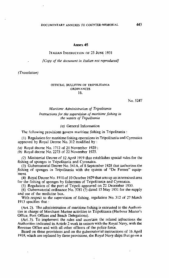
DOCUMENTARY ANNEXES TO COUNTER-MEMORIAL 443
JCopy of rhe document in Italian nor reproducedj
(Translation)
OFFICIAL BULLETIN OF TRIPOLITANIA ORDINANCES
16.
No. 5247
Maritime Administration O/ Tripolitania Insrmctions for the supervision of maritime fishing in
the waters of Tripolitania
(a) General Information
The following provisions govern maritime fishing in Tripolitania :
(1) Regulation for mantimefishing operations inTripolitania and Cyrenaica approved by Royal Decree No. 312 modified by :
(a) Royal decree No. 17 12 of 2 1 November 1920 ; (b) Royal decree No. 2273 of 22 November 1925.
(2) Ministerial Decree of 12 April 191 9 that establishes special rules for the fishing of sponges in Tripolitania and Cyrenaica.
(3) Gubernatorial Decree No. 541A, of 8 September 1928 that authorizes the fishing of sponges in Tripolitania with the system of "De Fernez" equip- ment.
(4) Royal Decree No. 191 0 of 10 October 1929 that sets up an intermixed area for the fishing of sponges by fishermen of Tripolitania and Cyrenaica.
(5) Regulation of the port of Tripoli approved on 22 December 1930. (6) Gubernatorial ordinance No. 3781 (?) dated 15 May 1931 for the supply
and use of the medicine box. With respect to the supervision d fishing, regulation No. 312 of 27 March
1913 specifies that :
(Art. 2). The administration of maritime fishing is entrusted to the Authori- ties in charge of Merchant Manne activities in Tripolitania (Harbour Master's Office, Port Offices and Beach Delegations).
(Art. 3). To implement the rules and ascertain the related infractions the Authorities indicated in Article 2 work in unison with the Royal Navy, with the Revenue Office and with al1 other officers of the police force.
Based on these provisions and on the gubernatorial instructions of 16 April 191 9, which are replaced by these provisions, the Royal Navy ships that go on a
444 CONTINENTAL SHELF
cruise or that are sailing in the waters of the Colony must carry on direct surveillance of fishing operations, keeping in mind that :
( 1 ) The validity of the fishing legislation extends to the very limit of the territorial waters, that is to Say up to 6 miles from the coast, but it is understood that al1 the sponge algas that face the coast and that extend without solution of continuity even past the lirnits of the territorial waters, ai whatever distance they might be from the coast, are consldered as being induded in the territorial waters.
(2) The sea border-line between Tripolitania and Tunisia is established by an approximate north-north east bearing from Ras Adgir, but in order to avoid any possible disputes, it has been agreed that the demarcation line originates with the same bearing from Ras Makabez in order to establish an area of approximately 8 miles in front of the Ras Adgir-Ras Makabez coast line, in which foreign flag boats that do not have a permit from the Italian mantimeauthorities must not be sequestered but asked to move on, unless the location in which they were spotted fishing illegally, can be established, without any doubt to fa11 within the boun- dary.
(3) In the case referred to in the preceding paragraph, the captain that has taken by surprise and caught the boat in the act, will immediately prepare a detailed report showing al1 the information relating to the craft, toits captain or owner as shown on the ship's papers, as well as the grounds for the infrac- tion.
(4) The border between Tripolitania and Cyrenaica is outlined by the me- ridian of Gasr el-Muktar, but with respect to the fishing of sponges, an inter- mixed area has been set up defined towards the sea north of the parallel of Buerat el-Hsun (31.25.00 N) to the east by the mendian of Agheila (19.13.00.E). Boats from Cyrenaica are permitted to cross the border line into waters of Tripolitania and vice versa in said area in the event of an act of God or to take on a supply of water and in any event for a period no1 to exceed IO days.
This information having been stated in advance we are surnrnarizing below the controls that must practically be exercised when encountering any fishing boats or ships.
(b) Controls that Apply Indiscriminately to al1 Ships or Boats
(1) Ascertain, whether at night the lights prescribed by Article 2 of R.D. No. 164 of 26 Apnl 1906 are kept on, which decree modifies regulation No. 577 of 13 December 1896 to avoid collisions at sea.
(2) Ascertain (if the fishing-net for tunny campaign is in progress) that the ship or boat is not fishing within the exclusive area of a fishing-net for tunny concession, Le., within 5 kilometres on the western side of the net, 1 kilometre from the eastern side and 6 kilometres in front of the fishing-net for tunny installation (Art. 45, regulation).
(3) Check that the fishing permit issued by the maritime authorities is on board (Art. 19 regulation).
(4) Check that the seaman in command to whom the permit was issued is aboard (Art. 23 regulation).
(5) Check that no firearms are on board which have not been authorized in writing by the maritime authorities and that there are no explosives (Art. 1 1 regulation).
DOCUMENTARY ANNEXES TO COUNTER-MEMORIAL 445
(c) Special Controls for the Fishing of Sponges with the "Diver's,Suit" Method
(6) Check that the ship does not carry on board a number of divers greater than that corresponding to the fishing duty paid (Art. 37 regulation), checking for this purpose the personnel roster issued by the Maritime Authorities which must be kept on board.
(7) Check, by the use of the diving equipment, the depth and make sure that fishing is not being conducted at a depth of less than 20 metres or more than 60 metres (Art. 3 of the special rules).
(8) Check to make sure that the fishing log is on board and that it is being kept in the prescribed mannes (Art. 10 regulation).
(9) Check to rnake sure that the fished sponges, immersed in water, are not smaller in diameter than was reported. Equine sponges 8 cm., fine sponges 4 cm., zymoches 4 cm. (Art. 3 1 of the regulation).
(10) Check for presence and contents of the medicine box in accordance with gubernatorial ordinance No. 3784 of 15 May 1931 (Art. 3 of the special rules).
(1 1) Check to make sure that the work shifts and the rest periods are being complied with (Arts. 5 and 6 special rules).
(12) Check to make sure that there are no sick or injured persons aboard, which might have been unduly kept aboard without having been immediately transported ashore and reported to the Maritime Authorities (Art. 8 of the special rules).
(d) Special Controls relating to Sponge Fishing Operations with the "De Fernez" Mask
(13) Check by means of diving equipment that fishing is not taking place in depths of less than 15 metres or of more than 50 metres (Art. 2 gubernatonal decree No. 541A).
(14) Venfy that the fished sponges, immersed in water, do not have a diameter less than the following :
equine sponges 8 cm., fine and zymoches sponges 6 cm. (Art. 3 of the afore- rnentioned decree).
(15) Check to make sure that at least six divers are on board and that each diver does not make more than six (6) dives per day (Art. 7 of the aforementioned decree).
(16) Check the fishing log as referred to in No. 8. (17) Check the medicine box as referred to in No. IO. (18) Check the sick and injured as referred to in No. 12.
(e) Special Controh for the Fishing of Sponges with the "Gangava" Method
(1 9) Check to make sure that the craft is not fishingdunng the periods of time and in the locations that are annually forbidden by appropriate decree of the Maritime Administration.
(20) Check with diving equipment that fishing is not taking place at depths of less than 20 metres (Art. 30 of the regulation).
(21) Check the dimension of the sponges as referred to in No. 9. If any are found with a smaller dimension than what is prescribed remove them and turn
446 CONTINENTAL SHELF
thern over to the maritime authorities at the first landing-place (Art. 31, last paragraph of the regulàtion).
(22) Check the ship's log as referred to in No. 8.
(f) Speciai Controls for Boats Assigned to Fishing
(23) Check to make sure that fishing is not being carried out by the use of material thrown in the water which will weaken, stun or kill the fish and other aquatic animals (Art. 14 of the regulation).
(24) Check if fishing with lurninous sources, that said fishing is not going on during pe r ids of tirne and in the locations that are annually prohibited by appropriate ordinance of the Maritime Administration of Tripolitania.
(25) Verify if trawi net fishing is taking place, that the rnesh of the sackcloth is not less than 20 mm. on the side (Art. 17 of the regulation).
(26) Venfy that inside the Port of Tripoli, no fishing is taking place in a water spacereserved for the Royal Navy or without a permit from the Harbour Master, in the space located south-west of the junction of the landing-stage of the Harbour Master and the head of the November IV landing-stage and that no nets or other floating equipment is being kept during the arriva1 or departure of the seaplanes (Arts. 116 and 118 of the regulation of the Port of Tripoli).
(g) Infractions
Any infraction. that is spotted must be reported by a written report to the nearest port Authority.
Part of the proceeds obtained from the pecuniary fines inflicted on the vio- lators as a result of a conviction or a settlement and from those derived from the eventual sale of the equipment or products sequestered, will be given by the Judging Authorities after deduction of the costs (as per Art. 68 of the fishing regulation) to the officers that have ascertained the infraction.
Should the infraction have been ascertained by seamen of the Royal Navy or by officers not assigned to port operations, the assigned sums of money wiil be turned over to their respective Corps Headquarters for distribution in accor- dance with particular regulations that rnight be in effect at the Corps level.
Should the infraction have been ascertained by officers assigned to the Har- bour Master's Office o i to Port or Beach Authority Offices, the proceeds will be split with half being given to the officers that signed the report of infraction and the other half being split equally among al1 the other non-wmmissioned officers and seamen on service on the day that said infraction was ascertained, except those that might be on report.
Should the infraction have been ascertained through a Royal Navy ship by persons not connected with the ship itself, one-third of the assigned sum will go to the ship with the balance being split up in accordance with the above rules.
Tripoli, 25 June 1931, Year IX. Seen and Approved.
for : The Governor, SINISCALCHI.
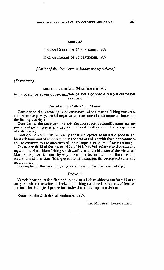
DOCUMENTARY ANNEXES TO COUNTER-MEMORIAL
Annex 46
(Copies of the documents in Italian not reproducedj
(Translation)
MINISTERIAL DECREE 24 ~EPTEMBER 1979
INSTITUTION OF ZONES OF PROTECTION OF THE BIOLOGlCAL RESOURCES IN THE FREE SEA
The Minisiiy of Merchant Marine
Considenng the increasing impoverishment of the marine fishing resources and the consequent potential negative repercussions of such irnpoverishment on the fishing activity ;
Considering the necessity to apply ihe moai receni scientific gains for the purpose of guaranteeing in large areas of sea rationally allotted the repopulation of fish fauna ;
Considering likewise the necessity, for said purposes, to maintain good neigh- bour relations and of CO-operation in the area of fishing with the other countries and to conform to the directives of the European Economic Communities ;
Given Article 32 of the law of 14 July 1965, No. 963, relative to the rules and regulations of maritime fishing which attributes to the Minister of the Merchant Marine the power to enact by way of suitable decree norms for the rules and regulations of maritime fishing even notwithstanding the prescribed rules and regulations ;
Having heard the central advisory commission for maritime fishing ;
Vessels bearing Italian flag and in any case Italian citizens are forbidden to carry out without specific authorization fishing activities in the areas of free sea destined for biological protection, individuated by separate decree.
Rome, on the 24th day of September 1979.
The Minister : EVANGELISTI.
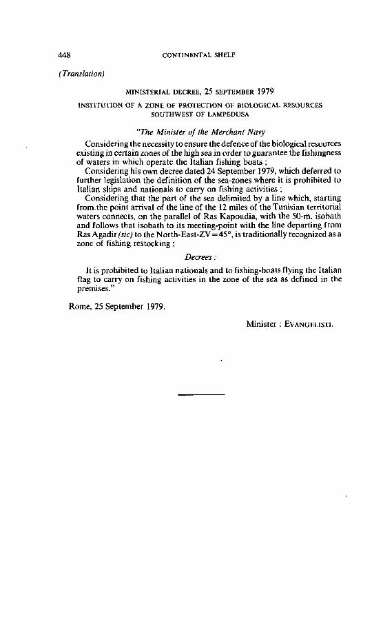
448 CONTINENTAL SHELF
(Translation)
MINISTERIAL DECREE, 25 SEPTEUBER 1979
INSTITUTION OF A ZONE OF PROTECTION OF BIOLOGICAL RESOURCES SOUTHWEST OF LAMPEDUSA
" n e Minisler of the Merchant Navy Considenng the necesçi ty to ensure the defence of the biological resources
existing in certain zones of the high seajn order to guarantee the fishjngness of waters in which operate the Italian fishing boats ;
Considering his own decree dated 24 Septernber 1979, which deferred to further legislation the definition of the sea-zones where it is prohibited to ltalian ships and nationals to carry on fishing activities ;
Considering that the'parl of the sea delimited by a line which, starting from.the point arnval of the line of the 12 miles of the Tunisian territorial waters connects, on the parallel of Ras Kapoudia, with the 50-m. isobath and follows that isobath to its meeting-point with the line departing from Ras Agadir (sic) to the North-East-ZV=45', is traditionally recognized as a zone of fishing restocking ;
Decrees :
It is prohibited to ltalian nationals and to fishing-boats flying the Xtalian Rag to carry on fishing activities in the zone of the sea as defined in the premises."
Rome, 25 Septernber 1979.
Minister : EVANGELISTI.
DOCUMENTARY ANNEXES TO COUNTER-MEMORIAL
Annex 47
LIBYAN LAW NO. 12 OF 1959
DECISION NO. I OF 1960
DECISION NO. 1 OF 1961
[Copies of the documents in Arabie nof reproducedj
(Translation)
STATUTE 12 FOR ïHE YEAR 1959 CONCERNING FISHING FOR SPONGE
i, Idris the Fim, King oflhe United Libyan Kingdom, have approved andpubfished thefollowingstatutepreviowly caneluded by both Houses of Representarives andrhe
Senate :
Section I . General Orders
Article 1
Fishing for sponge is permitted only in those areas specified by the chief of transportation in the district.
Article 2
No one is permitted to engage in fishing for sponge unless he has obtained a licence for that purpose. The licensing will be issued either in the forrn of a Special Licence or a comrnitment to fish in al1 or some marine areas.
The licence will be granted acwrding to the conditions set in this statute. The comrnitment wili be regulated by a Special Statute.
Article 3
The fees for issuance of fishing licences will be determined by the Minister of National Economy.
Article 4
Ship owners, seamen and divers may, according to law, form CO-operative organizations for the purpose of fishing for sponge. These organizations will be exempted from registration fees.
Article 5
1. Fishing in the areas specified is allowed only by ships registered in Libya according to the Libyan maritime law.
Foreign vessels are not allowed to fish in these areas unless in accord with a treaty in which Libya has entered, and then not before a fishing Licence has been obtajned.

450 CONT~NENTAL SHELF
2. Vessel means al1 boats, yachts and residence ships used in sponge fishing projects.
Libyan Official Gazette, Issue No. 15, 14 September 1959.
Section 2. On the Procedure and Conditions of Licensing
Article 6
Applications for a licence must be submitted to the proper officein the district concemed. The chef of transportation will issue at the beginning of every year, a statement in the official gazette of the district showing the following :
A. Date to submit applications. B. Specification for the number of licences to be issued during the season for the
different types of fishing stated in Article 22. This specification must be agreed to by the Minister of National Economy.
C. The date for granting licences to their new owners.
Article 7
Requirements of licence applicant :
A. He must be of Libyan naiionaliiy. B. He must not be convjcted of a felony or crime of dishonour or dishonesty
unless he was later completely exonerated. C. His name must be registered in the commercial register if he employs five or
more divers in the fishing project.
During the ten years following the enactment of this Statute, the nationality requirernent may be overlooked.
Article 8
The licence application form must contain the following information :
A. The name, title, nationality and place of residence of the applicant. B. The name and nationality of the ship and the name of the port at which it is
registered and its registration number and load data. C. The name of the captain of the ship the applicant intends to employ, his
nationality, the name of the port at which he is registered and his registration number.
D. The name of the storage ship, its nationality and load, the port at which it is registered and its registration number.
E. Thename of the captain of the storage ship, the port at which he is registered and his registration number.
F. A staternent on the methods requested for fishing on the condition that it is one of those specified in Article 22. .
G. The name of the foreman employed to supervise fishing, his title and nationality. If he hirnseïf is the applicant, he should mention this in the application.
H. A statement of knowledge of this statute must be made, copies of which must be given to the captain of this fishing ship and the captain of the residence ship.
DOCUMENTARY ANNEXES TO COUNTER-MEMORIAL 45 1
1. If the ship designated for fishing is owned by another Party, the applicant must submit a written statement from the owner allowing its use for this purpose. The owner's permission must show the period for using the ship and the fishing means intended for use.
One licence is granted per ship, and its granting by the Chief of Transportation will be the sole responsibility of the licensee, with no ensuing responsibility whatsoever on the part of the authority issuing it regardless of the acceptance by the crew, divers or any other person.
Article I O
The Chief of Transportation will specify in the statement mentioned in Ar- ticle 6 the number of licences to be granted to foreign ships whose govemments have signed agreements with the Libyan Government for sponge fishing in the Libyan territorial waters.
If such agreements do not exist, the Chief of Transportation may permit temporary issuance of a lirnited number of licences to other foreign ships if this is deemed economicaliy beneficial to the wuntry, on the condition that he obtains, in advance, the approval of both the Ministries of the Exterior and the National Economy, and subrnits the licence application through them.
Article I I
If the applicant fails to receive the Licence issued to him on the prescribed date the Chief of Transportation may cancei it and offer the lic-ence to another who meets the legal conditions required, taking into consideration the priority of applicants.
Article 12
In the absence of violations of mles set in this statute, foreign ships whose owners request licences to fish in territorial waters because of international agreements, are subject to the following mles :
1. The application must be subrnitted by theconsul or his deputy of the wuntry the ship is subject to, through the Ministries of the Exterior and National Economy.
2. Officia1 certificates, authenticated by the consul, must be subrnitted stating the following :
A. The fitness of the ship for navigation, the soundness of its engine and equipment, especially the diving equipment, if there was any.
B. The availability of heaith conditions on board, including the necessary medical aid supplies.
C. The availability of food supplies, and their storage in clean areas on board.
D. The application of medical examination procedure on al1 the crew and divers by the authorities concemed in the wuntry the ship is'subject to.
E. Accident insurance by in~urancea~encies approved by the foreign coun- try and whose responsibility extends to Libya.
452 CONTINENTAL SHELF
Article 13
Al1 ships, Libyan and foreign, must deposit, at the time of receiving the licences, al1 their papers and documents for safe keeping at the fishing office according to Libyan mahtime law.
These papers will be returned to the ship at the end of the fishing season after it submits to the office its licence and a full account of the amounts of sponge fished, their types, weight in kilograms, value in Libyan pounds, the areas at which each type was fished, and a statement from the Department of Customs or Ports indicating the payment of required fees.
There must be attached to this account a list of the type and weight of the amount fished by each diver, its value, the advance the diver received during the season ; this list must be signed by both the diver and the captain.
Article 14
Ali licenced ships that intend to fish outside the Libyan waters must obtain a special permit from the fishing office concerned before sailing. They must also state at that lime, the weight, type and value of the amounts fished in Libyan territorial waters.
Libyan ships must carry their licences when they sail for fishing in foreign waters.
Section 3. On Fishing Ships and their Inspection
Article 15
Ships which use mechanical equipment in their operation should have an engine.
Article 16
The person who is in charge of the operations should provide storage ships of the folIowing types :
1. One storage ship carrying no less than 10 tons for each fishing ship. 2. A residence ship whose load is not less than 20 tons for two fishing ships. 3. A residence ship whose load is not less than 30 tons for three fishing
ships. 4. A residence ship whose load is not less than 40 tons for four fishing ships. 5. A residence ship whose load is not less than 50 tons for five fishing ships.
Suppliers may agee to use one residence ship for a number of fishing ships not to exceed the number stated in this article. taking into consideration the close distance between the fishing zones licenced for Lach of them. This agreement must be written and presented to the authorities concemed before the issuance of a licence.
Article 17
The supplier must provide the fishing and residence ships with boats and sufficient eqvipment to use in saving the crew. A licence will not be issued until these have been inspected.
The ship-master must make sure of the presence of these boats and equipment before it sails.
DOCUMENTARY ANNEXES TO COUNTER-MEMORIAL
Article 18
Subject to inspection before the issuance of a licence are every residence ship or fishing ship in which divers use mechanical means. The inspection, after the ship has been prepared for fishing, will ensure the following conditions :
A. The good condition of the ship's engine, instruments and equipment. B. The good condition of diving instruments. C. The availability of fishing equipment and its fitness for use. D. The availabiiity of spare parts for fishing and diving instruments. E. The sufficiency of food supplies and their storage in clean areas. F. The healthy physical condition of members of the crew, ensuring in parti-
cular that divers are in condition good enough to allow them to dive or continue diving.
G. The first-aid box must contain the medicines and medical supplies that the divers may need.
Article 19
The ship's inspection is carried out in the following manner :
A. A marine engineer is to be in charge of inspecting the ship, navigation instruments, and lifeboats and their equipment.
B. A mechanical engineer will inspect the ship's engine and al1 its systems and instruments, also the divers' mechanical instruments and related gear such as clothing, pipes, the metallic head gear and other accessories.
C. The port's medical officer must examine the physical condition of al1 mem- bers of the ship's crew and make sure the first-aid box contains the necessary medicines and medical supplies.
Article 20
Fishing ships must be identified on both sides of the prow by the letter (S) to indicate they are designated sponge fishing ships. The letter (T) is to be added if the ship worksin thedistrict of Tripoli, or theletter (B)if it worksin thedistrict of Bargha.
These letters, together with other signs required by law, are to befixed with the knowledge of the fishing office wncerned. They must be wel1 maintained and clearly legible.
Section 4. On the Conditions and Rules. of Fishing
Article 21
Sponge fishing is prohibited if the sponge's diarneter is less than 8 centimetres in the Quina type, and if it is not more than 6 centimetres in al1 other types.
The fishing office is to designate the locations where the sponge already fished is to be unloaded under the supervision of the public authority men.
Article 22
Fishing for sponge is prohibited unless one of the following methods is followed :
A. Al-Scavendor (with swim suit and mechanical instrument). B. Al-Furness (with mask and mechanical instrument).
454 CONTINENTAL SHELF
C. Al-Saleeb (with mask and manual instrument). D. Al-Sibaha (without clothes or instmment). E. Al-Fusina (the spear).
The chief of transportation, with the approval of the Minister of National Economy, may issue orders for the use of other methods of fishing besides the methods mentioned, or for the prohibition of fishing by one of them in some areas or at certain times if it is deemed beneficial for fishing.
Article 23
It is prohibited to change the method of fishing indicated in the licence unless the issuing authority approves a request submitted and giving reasons for the change.
Article 24
It is not pennitted to exceed the following depths when using divers in fishing :
10 metres in the method of Al-Saleeb. 35 metres in the method of AI-Furness. 60 metres in the method of Al-Scavendor.
Article 25
Divers must not stay underwater from the time of diving to the time of surfacing beyond the following periods, and the ship-master must supervise that :
A. in the method of Al-Scavendor :
Depth Period undenvater Surfacing from time of diving period
from 10 to 20 metres 30 minutes 15 minutes from 21 to 30 metres 20 minutes 15 minutes from 3 1 tu 35 metres 15 minutes 15 minutes
B. In the method of Al-Furness :
from 10 to 20 metres from 21 to 30 metres from 3 1 to 35 rnetres from 36 to 40 rnetres
30 minutes 20 minutes 15 minutes 10 minu tes
Article 26
The diver is prohibited 10 dive two consecutive times ; he is also prohibited to repeat diving except after al1 other divers on board have taken their turns. At al1 times he is not permitted to dive more than four times in one single day.
Article 2 7
The diver must surface from the sea bottom to the water surface by rneans of the special rope known as the guide rope (Jwaida). In the method of Al- Scavendor he is prohibited to take off his diving gear before 30 minutes have passed from the time of his surfacing above water.
DOCUMEWARY ANNEXES TO COUNTER-MEMORIAL
Section 5. On the Ship's Crew
Part 1. On the Ship-master
Article 28
The rnaster of a fishing ship that employs five or more divers working with mechanical instruments, and the master of a residence ship are required to :
A. Be of Libyan nationality. B. He must not be convicted of a felony or a crime of dishonour or dishonesty
unless he is later exonerated. C . His name rnust be registered in the seamen's register. D. He must successfully pass the examination held before he is conferred the
status of master. E. He must have engaged in marine work for a period not less than three years
under the supervision of an approved master, and must submit a statement signed by him certifying that he worked under his supervision for the period mentioned. Dunng the ten years following the implementation of this Bill, the nationality condition may be overlooked.
Article 29
The examination mentioned in the preceding article will cover the following subjects :
A. Knowledge of using the mariner's compass. B. Duties of the ship-master acwrding to the orders of manne law. C. The prescribed directives for avoidance of collisions. D. Procedures to avoid accidents and injuries divers may faIl subject to. E. Measures of aiding divers when they are injured away from ports and the use
of medicines in emergencies.
Article 30
The exarnination will be adrninistered by a wmrnittee composed of the fol- lowing persons or their deputies in case of their absence :
Harbour Master Fishing Office Representative Port's Medical Officer
Chairman Member Member
If the applicant passes the examination the status of ship-master will be conferred on him.
Part Il . On the Duties of Ship-master
Article 31
The S~D-master is not authorized to order the ship to sail for fishing unless it has on board al1 seamen necessary for operating the machines, and for navigation and manoeuvres acwrdine to the ~rescribed orders : the shio must also have on board al1 the diiers and ;he perSon in charge of signais ixchanged with the diver while under water.
It is not permitted to make any changes in crew men unless a written permit has been obtained from the fishing office concerned.
456 CONTINENTAL SHELF
No one other than the ship-keeper or his representative, and other than the members of the crew, is pennitted to be on board the fishing ship during its operation in the areas it is licensed to fish in.
Article 32 The ship-master rnust, before sailing, rnake sure of the following :
A. Al1 machines, equipment and tools must be in good condition to ensure their protection against damage, and make them fit for immediate use. In partic- ular he must secure the safety of the diving equipment and its fitness for use during the season and inspect the diving suit and air pipes and provide al1 the. needs of the diver while operating under water.
3. Life boats and equipment in good condition. C. Spare parts sufficiently available to meet any breakdown in the ship or diving
operations. D. Food supplies sufficient for the ship men during the period of their absence,
and the storage of these supplies in places protective against spoilage and darnage.
Article 33
The rnaster of a ship that uses mechanical instruments of any kind in fishing rnust do the following before the start of daily operations :
A. Inspect these instruments, the air wmpressor, the rnetallic head gear, the air pipes and valves, the diving outfit to ensure their safety and fitness.
B. Measure the water depth where fishing will take place using the designated instrument to make sure it corresponds with the depth permitted for fishing and which is indicated in the licence.
Article 34
The ship-master rnust verify prior to the diving operation that the diver thoroughly knows the functions of the instruments he uses in his job, and the special signals he exchanges with the ship dunng his dive.
Article 35
The ship-master must maintain a record book in which he enters daily obser- vations on fishing, the areas in which it takes place, the depth of water, the weather conditions, the accidents and injuries that befall the ship or crew men, and other observations and information he considers necessary to record.
Arricle 36
The ship-rnaster is considered responsible for the ship from the tirne it sails till the time it returns. He is ta execute al1 the orders related to his job whether they are set in this Bill or any other Bill.
Neither the ship-keeper nor his representative, if he happens to beon board for fishing supervision, is to interfere in any of the ship's affairs.
Arricle 3 7
If the ship returned to port because of the terrnination of operations in the fishing season, its master or its supplier must notify the fishing office of that.
DOCUMENTARY ANNEXES TO COUNTER-MEMORIAL
Part III. On Seamen and Divers
Article 38
Two registers are to be established in the fishing office, one for the registration of divers licensed to engage in diving, and the other for the registration of seamen licensed to work in fishing ships.
Orders are to be issued regulating the conditions and requirements pertinent to this register.
Article 39
The age of a person who works as diver must not be less than 18 years and not more than 60. A person whose age is less than 21 years may not be registered in the divers register until a written consent by his guardian has been obtained.
Article 40
A diver or a seaman is not to be employed in the fishing profession unless his narne is registered in one of the two registers mentioned in Article (38), and unless he possesses a registration Eard.
Employment will be on the grounds of a written employment wntract signed by both parties and witnessed by the fishing officer.
Every contract not in compliance with the orders of this article is invalid.
Article 41
If the ship-keeper is an alien he must obtain a special permit to employ Libyan divers or seamen. The permit is to be issued by the transportation head office in the district that issues the licence ; and the contracting will not be valid until this permit has been obtained.
The orders of this Bill will apply to the contract.
Article 42
The contract between the contractor and the seamen, including the captain is based upon the monthly salary, or on the basis of this salary plus an agreed upon share of the sponge gathered by the sponge boat during the seasons.
The contract between the contractor and the divers is also based upon a share of the gathered sponge. Under al1 circumstances, the contractor is to bear al1 the feeding, supply and accommodation expenses and other aspects related to the sponge-gathering project.
Article 43
The sponge-gathering captain is to be sure that al1 divers' and other seamen's families are cared for during the sponge-gathering penod. If needed, the captain is perrnitted to force the boat's owner to pay a portion of the divers' or seamen's salary to their families.
Article 44
If one of the seamen or divers did not get on board the boat after he had been notified of its sailing date, the contractor has the right to breach the contract, request what had been advanced and ask to be compensated for - if it could be justified,
458 CONTINENTAL SHELF
Article 46
The seamanor diver cannot be asked toperform ajob not within his skill or not included in his employment contract unless he has been ordered to by the captain because of extraordinary circumstances, or a danger threatening the boat, the people on board or its cargo, the seamen or diver then will not be entitled for extra pay for these works.
The crew on board of the boat is considered to be united towards saving it and t hemselves.
Article 47
The seamen and divers are entitled for a paid rest period of 24 hours for every six working days. They are also entitled for a paid rest day on official holi- days.
If the need arises to ask them to work during the holidays they are entitled to another rest day at a later time or they could be compensated for by double pay for the duration of the time workedduring those holidays. In this case, the diver's salary is based upon the highest salary paid to a seaman.
Article 48
The port director is to settle any sponge gathering disputes arising between the boat's captain, seamen or divers. If the director cannot settle the dispute ami- cably, he is then to write a report and send it to the concerned court to take the necessary action. The court will not accept any cases unless this measure has been taken.
CHAITER SIX
Accidents and Injuries
Article 49
The contractor is to insure the lives of the searnen, divers and captain against work accidents and resulting injuries. The boat will be granted a permit after a letterpresentation by the Social Security Organization stating that thecontractor has paid his insurance fees and that the insurance covers the present employees as well as the new ones who are working during the same season. The Trans- portation Office is to mark that on the permit.
Article 50
At the end of the sponge gathering season, the contractor is to have his divers, seamen and captain inspected by the port's doctor after their return to port to be sure of their safety. If anyone is injured or sick, the doctor is to take the necessary medical measures and inform the sponge gathenng office. Under al1 circum- stances, the doctor is to register his results in their register book.
Article 51
The captain and the contractor are to inform the sponge gathering office of al1 accidents or injuries occurring on board or to the boat itself in order for it to be marked down in its register and permit.
DOCUMENTARY ANNEXES TO COUNTER-MEMORIAL 459
Article 52
The contractor is responsible for treating the captain, seamen and divers in case of their illness or injuries and is to pay their wages under the following conditions :
A. If the illness or injury is a result of the work, al1 medical expenses are to be paid by him during the treatment period, but not to exceed 120 days. He is to pay tfieir full w a g s during this period.
B. If the illness or injury is not the result of work, but not done on purpose or is not due to carelessness on the part of the patient, then the contractor is to pay his treatment expenses for a maximum period of 120 days ; yet, he is entitled to be reimbursed for expenses that exceed an 80-day period. He also has to pay the full wages during the treatment penod if it does not exceed 80 days.
C. if the sickness or injury is a result of misbehaviour, drunkenness or is done on purpose, the contractor is to pay the treatment expenses, as long as the patient is on board the boat ; but, he is not obliged to pay his wages during ihat tirne.
D. The diver's salary in A and B above is based upon the highest salary paid to a seaman.
E. The con tractor then could claim al1 expenses to the insurance Company which will reimburse him according to the terms of their contract.
Article 53
An illness or injury is to be proven by testimony from the doctor of the port. Those concerned could question the doctor's judgment by referring to the comrnittee stated in Article 55.
Article 54
The port's doctor is to observe the patient's injury or illness through his treatrnent period. The doctor is to prove whatever information or knowledge he gets in writing on the patient's or injured's card and special register. In case of death, the doctor is to write a report of its causes.
Article 55
The captain, seamen and divers could be prevented frorn carrying on their responsibilities when the port's doctor proves that they are not physically fit. Their permit would be cancelled.
They could question the doctor's judgment by presenting a petition to a comrnittee to be formed by authorization from the health supervisor. The con- tractor could also question the doctor's judgment, in front of the same cornmit- tee, if he determines that they can work.
Article 56
If the seaman or diver dies as a result of his accident the boat's captain is to carry the dead body to the nearest port where there is a g o v e m e n t authority.
The captain is ta present the authorities with a detailed report of the-causes and conditions of the accident. The police authorities have to detain the boat and its crew and guard its machines until al1 investigations are complete and the cause of death has been established.
The boat would be permitted to sail again after being granted a permission from the Public Defence. Al1 this has ta be done at utmost speed.
460 CONTINENTAL SHELF
Article 57
The contractor is to bear the bufial expenses of the boat's captain, one of its seamen or divers if they die while on duty. If it is decided that an indemnity be awarded to the family of the deceased, and the contractor does not pay it, the Transportation Supervisor could then withdraw the boat's permit. He will only regain i t after he presenls an officiai acknowledgement from the heirs that-he has executed the indernnity requirements according to Article 49.
CHAPTER SEVEN
Crimes and Punishments
Article 58
The contractor, captain, one of the divers or seamen could be sentecced to six months' imprisonment and the payment of a fine not exceeding 100 Guineas, or with either of the two if he does not abide by any of the clauses of this law or the published bulletin.
Article 59
The sponge gathering equipment and the gathered sponge would be confis- cated if the sponge gathering tmk place without a permit in the Libyan Terri- torial Waters. The confiscation ruling wuld also take place if the sponge gath- ering took place in an area other than the one that had been authorized.
The court could stop the boat's permit for no more than six months at the time of a guilty ruling. The authorities wncernedcouldconfiscate the boat during that time at the responsibility and expense of its owner.
Article 61
Whoever possesses, owns, selis, transfers, or deals in any way with sponges that do not meet the requirements stated in Article 21, would be sentenced according to the terms of Article 58 and the cargo confiscated.
Article 62
The employees appointed by the Communication Supervisor have the legal power to check for ail vioiations breaching this law and regulations.
Article 63
The Minister of National Econorny is to enforce this law after two months of its publication in the official paper.
IDRIS.
Issued at Dar El Yemen Palace on 9 Moharram, 1379 Hejreyah = 15 July 1959.
By order of the King
Ragab Ben KATO, Abdel Meguid KAABAR,
Minister of National Economy. Prime Minister.
DOCUMENTARY ANNEXES TO COUNTER-MEMORIAL 46 1
Royal Decree Law arnending some niles of Law 12 of year 1959 regarding fishing for
sponge.
We Idris the First, King of United Kingdom of Libya, After reviewing Article 64 in the Constitution, and Law 12 of year 1959
regarding fishing for sponge, and according to what is presented to us by the Minister of Industry, and the approval of the Council of Ministers,
We issue the following : Article One
The expressions "Minister of National Econorny" and "Ministry of National Economy", which appear within the paragraphs of Law 12 of year 1959 regarding fishing for sponge, are to be replaced by the expression "Minister of Indus- try".
Article Two
The Minister of Industry is toenforce this Decree, and to be effective frorn the date of its publication in the officiai paper.
IDRIS.
lssued in Al Beydaa on 8 Rabei El Awal,1382 Hejreyah = 8 August 1962.
By order of the King
Mohamed Osman El SEID, Prime Minister. Belkassem Al ELAKI, Minister of Industry.
5. Sponge
A. Tripoli 3 Legisl~~ion
Decision No. 1 for the year 1960 - Restricted Areas in which sponge could be gaiheredl, the Transporta- tion Supervisor for the Province of Tripoli (Tarablus Al Gharb) after reviewing Article 1 of Law No. 12 for the year 1959, with respect to sponge fishing,
It was decided
Tripoli's officia1 newspaper, NO. 9, dated 1 May 1961.
Decision No. 1 for the year 1961 - Restricted Areas in which sponge could be gathered', the Transporia- tion Supervisor for the Province of Tripoli (Tarablus Al Gharb) after reviewing Article 1 of Law No. 12 for the year 1959, with respect to the gathering of sponge and De- Cree No. l for the year 1960 For restricting the areas in which sponge could be gathered, published in the officia1 newspaper dated 1 May 1969. It was decided
' Tripoli's official newspaper, No. 5, dated 1 May 1961.
462 CONTINENTAL SHELF
Article 1 Article 1
The areas in which sponge fishing rnay be pennitted are situated along the Coast of the Province of Tripoli, as follows :
1. Localspongers : From the point of Ras Abi Kammash to the north- east, between lodgitudes 30°-22" east, and Afra Quarry which is located at longitudes 17'-14" east. This quarry is between Al Khums and Zlitan of the northern and eastem provinces.
2. Foreign spongers : Starting point is from Abi Kammash and along the same degrees mentioned in the above item, and to end at the port of Tripoli between longitudes 11'-13" east.
Article 2
This decision will be effective as of its published date in the officiai newspaper.
(Signed) Abdallah ALZIDAM. Transportation Supervisor.
The areas in which sponge gather- ing is permitted are along the coastal stRp of the Province of Tripoli, as follows :
1. Local spongers : from the Head (Ras) Aghdeer al the dernarca- tions of longitudes 30°-34O-1 I o east to Zliton Quay at the demar- cation of longitudes 00-34"-14" east and the water across.
2. Foreign spongers : foreign spon- gers are permitted to gather sponge in the Province of Tripoli from Head (Ras) Aghdeer. from the same demarcations mentioned in the above paragraph, to the area West of Tripoli's port light- house i.e., in the dernarcations of longitude 00-07°-130 east and the water across from it.
Article 2
This decision will be effective as of its published date in the official newspaper.
Transportation SupeMsor.
DOCUMENTARY ANNEXES TO COUNTER-MEMORIAL 463
Annex 48
PAGES 41 -47 OF T H E BULLETIN DE L'INSTITUT NATIONAL SCIENTIFIQUE ET TECHNIQUE DWANOGRAPHIE ET DES P ~ C H E S , SALAMMBB, 1971, VOL. 2, No. 1
CONTINENTAL SHELF
Annex 49
PAGE 2 OF LIBYAN WORKING PAPER ON AGENDA ITEM 6 FOR THE FORTHCOMING AFI KEGIONAL AIR NAVIGATION MEETING IN TANZANIA FROM 20 NOVEMBER
THROUGH 13 DECEMBER 1979
3. The Socialist People's Libyan Arab Jamahiriya considers and will continue to do so the creation of the new Malta FIR a i d the delineation of latitude 342" N as an interim measure which cannot attain permanent existence. The Socialist People's Libyan Arab Jamahiriya therefore, subrnits to the Sixth AFI RAN
. Meeting to consider amendment of PLAN as proposed herein. 4. The Socialist People's Libyan Arab Jamahiriya, purely in the spirit of regional
CO-operation in the field of international air navigation, delegated the upper airspace over its territory to Tunisia and Algeria and secondarily as a gesture of good neighbourly relations which Jamahiriya continues to harbour for them. Mendian 113' E intersecting latitude 363" N on the western side of Tripoli FIR is, therefore, the firm, inalienable and inviolable airspace lirnit for Tripoli FIR based solely on considerations of international air navigation and national territorial integrity. Any discussion or proposa1 short of this lirnit, the Socialist People's Libyan Arab Jamahiriya is constrained to view as detri- mental to the interests of international aviation and perpetuation of British military strategy and interests which caused the creation of an intervening new Malta FIR and which interests do not exist now.
5 . On the western side of Tripoli FIR, the Socialist People's Libyan Arab Jamahiriya has plans for the establishment of TMAs and CTRs supported by modern ground aids at Nalut, Ghadames and Ghat airports with the opening up of ATS route over, to and from these airports.
6. The Socialist People's Libyan Arab Jamahinya has already in operation VORs and DMEs within Tripoli TMA at Zawia, Tripoli, and Abu-Argub. Firm plans exist for the establishment of pnmary and secondary radars at Tripoli Airport with serni-automated data exchange Links in the very near future. Establishment of extended long range VHF to cover the western and southern parts of Tripoli FIR is also underway.
Annex 50
PAGES 73. 79, 123, 137 AND 140 OF MAHMOUD SEKLANI, ECONOMIE ET POPULATION DU SUD TUNISIEN, PARIS,
DITI IONS DU CENTRE NATIONAL DE LA RECHERCHE SCIENTIFIQUE, 1976
[Nor reproduced]
Annex 51
PAGES 99 AND 156 OF TUNISIAN SECRETARIAT OF STATE FOR INFORMATION, TUNISIA k FISHING PRO-
DUCTION AND VALUE ADDED 1971-1975
[Nor reproduced]
Annex 52
PAGE 250 OF ANNUAIRE STATISTIQUE DE LA TUNISIE, 1974-1975, SERVICE TUNISIEN DES STA-
TISTIQUES, TUNIS, 1975
[Nor reproduced]
Annes 53
ANNEX VI11 OF M I N I S T ~ ~ DU PLAN 1972-1976. 1976
[Nor reproduced]

CONTINENTAL SHELF
Annex 54
Policy of the United States With Respect to the Natural Resources of the Subsoil and Sea Bed of the Continental Shelf '
Whereas the Government of the United States of Arnerica, aware of the long range world-wide need for new sources of petroleurn and other minerals, holds the view that efforts to discover and make available new supplies of these resources should be encouraged ; and
Whereas its cornpetent experts are of the opinion that such resources underlie many parts of the continental shelf off the coasts of the United States of America, and that with modern technological progress their utilization is already prac- ticable or will become so at an early date ; and
Whereus recognized jurisdiction over these resources is required in the interest of their conservation and prudent utilization when and as developrnent is undertaken ; and
Whereas it is the view of the Government of the United States that the exercise of jurisdiction over the natural resources of the subsoil and sea bed of the continental shelf by the contiguous nation is reasonable and just, since the effectiveness of measures to utilize or conserve these resources would be con- tingent upon cooperation and protection from the shore, since the continental shelf may be regarded as an extension of the land-mass of the coastal nation and thus naturally appurtenant toit, since these resources frequently form a seaward extension of a pool or deposit lying within the terntory, and since self-protection compels the coastal nation to keep close watch over activities off its shores whch are of the nature necessary for utilization of these resources ; Now, iherefore, I , Harv S. Truman, President of the United States of Arnerica,
do hereby proclaim the following policy of the United States of America with respect to the natural resources of the subsoil and sea bed of the continental shelf.
Having concern for the urgency of conserving and prudently utilizing its natural resources, the Governrnent of the United States regards the natural resources of the subsoil and sea bed of the continen ta1 shelf beneath the high seas but contiguous to the coasts of the United States as appertaining to the United States, subject to itsjurisdiction and control. In cases where the continental shelf extends to the shores of another State, or is shared with an adjacent Staie, the boundary shall be determined by the United States and the State concerned in accordance with equitable principles. ,Re character as high seas of the waters above the continental shelf and the right to their free and unimpeded navigation are in no. way thus affected.
In Wirness Whereol; 1 have hereunto set my hand and caused the seal of the United States of America to be affixed.
See Executive Order 9633. i n h .
DOCUMENTARY ANNEXES TO COUNTER-MEMORIAL 467
Done at the City of Washington this 28th day of September, in the year of Our Lord nineteen hundred and forty-five, and of the Independence of the United States of Amenca the one hundred and seventieth.
Hany S. TRUMAN.
By the President :
Dean ACHESON, Acting Secrelary of Sfole.

CONTINENTAL SHELF
Annes 55
PAGES 151 AND 152 OF INTERNA TXONAL LA w &PORTS, 1951.
"ABU DHABI ARBITRATION"
il511 DOCUMENTARY ANNEXES TO COUNTER-MEMORIAL 469
addendum to something which has gone before. (1 discuss an alternative meaning suggested for i t below.) But if it simply means ' plus ', then the expression ' the whole of the lands which belong t6 the rule of the Ruler ' cannot be read literally ; for read literally that phrase would include in any case the islandç, and probabIy the temtor id waters, and it would not be necessary or sensible to rnake these items addenda. On this meaning of ' and ', the ' land ' must be limited to the mainland (no doubt not escliiding inland or landlocked waters in an indented coast), IPTiat, on tliis basis, does the second addendum rnean ? Viz. : ' tlie sea waters which belong to that area ' ? Placing oneself in the year 1939 and banishing from one's mind the subsequent emergence of the doctrine of the ' Shelf ' and everything to do with the negotiations, 1 diould have thought this expression could only have been intended to mean the temtorial maritime belt in the Persian Gulf, mhich is a three mile belt ; together with its bed and siib-soil, since oil is not won from salt water. In ~vliat other sense at that time could sea waters be said to ' belong ' to a littoral power or ta the ' rule of the Rtiler ' ? In point of fact, that is the meaning the Claimant Company were asserting for the expression as late ,as March 1949, ten whole years after the contract (see letter page 8 6 ~ of the Correspondence).
" Even if ' and ' had a different signification, not cumulative but epexegetic : such as ' and mark you, in case you are in doubt, 1 include in the " lands " the islands and sea waters which belong to the area ', 1 should stiU hold, in the absence of what 1 have termed the two complicating factors, that the Concession covered the sea-bed and subsoil of the temtorial belt. Nothing less. The only question would be mhether it covered more.
" C O ~ E C ~ U S ~ O ~ E as 10 lerrilorinl waters' srrbsoil. I therefore hold or find that the subsoil of the territorial be1t is included in the Concession. Neither the arnbiguity, if any, of the w-ord ' and ' nor anv of the considerations dealt with hereafter affect this conclusion. In particular 1 cannot accept the argument put fonvard for the Respondent that sea waters are merely ' in- cluded ' as a means of'access to dry land, whether mainIand or insular. To read the word ' included ', in the Concession. as meaning in the case of the rnainland and islands ' included as petroliferous areas ' : and. to read it in relation to the ' sea waters ' as ~ m e t h i n g totally difierent, namely, ' included as means of access to the petroliferous areas ', seems to me unjustifiable, if not perverse.
" 1 am not irnpressed by the argument that there was in 1939 no word for ' territorial waters ' in the language of Abu Dhabi, or that the Sheikh was quite unfamiliar with that conception. Jlr. Jourdain had none the less been talking ' prose ' aU his life because the fact was only brought to lus
470 CONTINENTAL SHELF [152]
Case notice sornewhat late. Every State is owner and sovereign in Ho. 37 respect of its temtorid waters, their bed and subsoil, whether Contd. the Ruler has read the workç of Bynkershoek or not. The
extent of the Ruler's Dominion cannot depend on his accom- plishrnents as an international jurist.
" So far affinnatively.. Negatively, (still leaving aside what 1 have calied the complicating factors) 1 should certainly in 1939 have read the expression ' the sea waters which be1ong to that area ' not only as including, but as l imi td to, the ,terri- torial belt and its subsoil. At that time neither contracting party had ever heard of the doctrine of the Continental Shelf, which as a iegal doctrine did not then exist. No thought of it entered their heads. None such entered that of the most sophisticated jurisconsult, let aione the ' understanding' per- haps strong, but ' simple and unschooled ' of Trucial Sheikhs,
" Directed, as 1 apprehend 1 am, to apply a simple and broad jurisprudence to the construction of this contract, i t seems 'to me that it would be a most artificial refinement to read back into the contract the im lications of a doctrine not mooted t a seven years later, and, i ! the view which 1 am about to express is sound, not even today admitted to the canon of internationai Law. How-ever, the time has now corne to con- sider the doctrine more narrowly. '
" (d ) The doctrine of the Continenfnl Shclf, iits substance and hislory. The expression ' Continental Shelf ' was first used by a geographer in 1898.1 The legal doctrine which later gathered round this geagraphical t e m was possibly foreshadowed when in 1942 England and Venezuela concluded a treaty about the Gulf of Paria providing for spheres of influence in respect of areas covered by the high seas and followed by certain annexa- tions coincident with these spheres. The doctrine was perhaps first explicitly asserted as a legal doctrine (in a very exaggerated f o m ) in a proclamation by the Argentine Republic in 19.44, but its classical enunciation in the form in which it has mainly to be considered in this case was the weli-known proclamation by President Truman of 28th September, r ~ g .
" The substance of the doctrine then proclairned. as 1 understand it, was this : A coastal poxver is not surrounded, even at low water, by a precipice leading verticaUy to the bottom of the ocean, perhaps two miles below. As a nile the sea-bed shelves very gently outwards and downwards for a considerable distance, a distance generally (but not invariably) exceeding the three mile temtoriai 1imit.Z Again. not always
1 It made a flcctiag appcarance on the Icgal stage in 1916 : but pa~sed over it with ' printltu leet '.
1 If 1 speak of the three mile Iirnit and of the Territorial Maritime Belt interchangcably. this is only for brevity. 1 am awarc that sçirne States ckim more than a thrtc mile ktt:,but about 80 per cent. of the merchant shi ping in the warld is registtred in three mile " countnts ; and ths il the wicfth of temtoriai waten on the Persian Gulf.

DOCUMENTARY ANNEXES TO COUNTER-MEMORIAL 47 1
Annex 56
PAGES 77 THROUGH 79 OF YEARBOOK OF THE INTERNATIONAL LA w COMMISSION 1953,
VOL. 11, UN DOCUMENT A/CN.4/6 1
COPJTlNENTAL SHELF
plusieurs ligiies de 10 milles peuvent étre tracées. ou choisira la ligne enfermant dans la baie la superlicie d'eau la plus grande.
L'article 10 a été modiIiC comme suit :
1. On peut tracer des . Lignes de base droites n entre plus de deux Ues situées A une distance de moins de 5 milles ies unes des autres. Dans ce cas. ces Iles cons- t i tuent un r groupe i. Les eaux renfermées par ces Lignes de base dei\-eut Ctre considérées comme t aux in térieures.
experts suivaiits se sont rCiinis a titre persanricl dans le Palais de In Paix A La Haye du 14 au 16 avril 1953 pour examiner certaines questioiis d'ordre technique soulevees pcndarit les discussions de la Comrnission :
Prolcsseur L. E. G. Asplund (DCpartenieiit d t Carto- graphie, Stockholin) ;
M. S. Whitteniorc Boggs (Spccial .4duiscr O n Gcography, Dcparlnient o f State, \Vashinglon [Tl. C.1) ; M. P. R. Y. Couillault (ingeniciir en chef du Service
central hydrographique. Paris) ; Commander R . H. Kennedy. O.B.E., R.N. (Rtld.)
(Hydrographic Department, Adniiralty. Londres) accom- pagnC de hl. R . C. Shawycr (Adminislrolivc Of/iccr. Admirïlty, Londres) ;
M. le vice-amiral A. S. P i n k (rttrditC) [Muinc royale 2. Es t reconnu comme cas spécial un groupe nCerlaiidaise, La d'Ilci dans lequel ces lignes entre les Ues n ont pas plus de 5 milles de longueur, sauf une pouvant atteindre Le ComitC d'=+perts fu t présidé par le rapporteur
10 mitles de longueur au ce cas pourrait a~tc ia l . e t le rapport fu t rCdigl par M. C. W. van Santen.
Ctre appelé une a baie fictive m. conseiller juridique adjoint du MinistCrc royal nterlandais des affaires t tr ïngtres, secrktaire du ComitC.
3. Une baie fictive de ce genre peut encore etre Un qucstionnairc dressC per le rapporteur spCclal lut formCe par un chapelet d'îles en conjonction avec une soumis aux esperts. Les queriioiis ainsi que les rtpbnses partie de la ligne cbtiére continentale, comme indiqué de' expert* Sont donntcs daris les pages suivantes. dans l'article 5. paragraphe 5. n convient de remarquer que ces rtponses ont Ctt
formulCcs en tenant compte du poiril de vue technlqut
Article 13 et en vue d'btre interpretkes tacllcnien~ par les navigateurs.
D?limilalion de la mtr territoriale de dcur E t a b 1
1. Ls frontiére internationale entre deux E b t s Si l'on accepte le principe que la mer territoriale mit don t les cabs s o n t si tutes en tace Y u n e dc l'autre P. ~ C S U T ~ C h partir de la laisse dc basse mer, quelle sera une distance de moins de 2 T milles (T .&tant la largeur do" la ligne serait de prtlércnce adoptte commc de la mer territoriale) devrait dtte comme rlgle générale ' la liene médiane d o n t chaaue oint es t eouidistant dcs-&nes de bass des Étab er; question. b u t e Ue doit étre prise en lors de I'çtabliJsement 1. Sauf dans le5 cas où d'autres dlspa9itians seront
de cette ligne. A moins que les É~~~ adjacents pctvuts, la ligne de base. partir de laquelle est niesurle In mer territoriale. devrait Ctre la laisse de basse mer
aient ddcidé autrement *'un commun accord-. De (longeant 1a cbte) ainsi qu'elle se trouve indiquge sur les méme. les londs affleurants A basse mer, i l tues A -tes a pande Ccheltc en scrvice, reconnues ollicieiiernent moins de T miIles d'un seul e t a t , devraient t i r e pris Dar l'etat cbticr. Si des cartes d4leilldt.s. indicruant la en considération ; par contre. ceux situés A moins de i a h t de basse mer, n'cxisteiit pas, c'est <a lisné c&ti.?rc T milles de l'un e t l 'autre E t a t ne devraient pas entrer Oignede niuCe haute) qui devrait servir de ligiie de depart. en ligne de conipte lors de I'établissemeot de la ligne 2, pas estillie y avait IlTu de médiane. Il peut'toutefois y avoir des a i s o n s Spéciales, wain,jre que I'ontissinri des dispositions arr6thes par la teIles que des intçret?! d e navigation OU de péche, ConlCrence de 1930. çonceriiant les indications soécialci Ccartant la RontiPre d e la Ligne médiane. La ligne en cette matibre. n; soit de nature P inciter tes ;ouver- devrait Ctre t r a c i r sur les cartes en service B grande ncments A dlplaccr les laisses de basse mer sur leurs Cchelle, surtout lorsqu'une partie quelconque de I'éten- cartes de façon exsgéree. due d'eau est étroite e t relativement tortueuse. 3. Toutclois, le Coniitc a ajout6 In restriction qu'oit ne
ne d e frontiére A travers ]a mer territorialc devrait pas tenir compte des iochers ou lands affieurants dCd&2hts - 1 pas niveau do ridudion dci sondes, choisi pour i a carte été fixée d'une au t r e maniéte - doit t t r e tracée selon (rMks awaShl' -~ - --~-.. - --. ---- - - -
Ie principe d'équidistance des lignes de c4te rcspectivei. La méthode la plus appropriée pour l'application de ce principe doi t t t r e Iixée par les É t a t s en cause, de commun accord. pour chaque cas séparé,
Rapport du Cornlü d'-%part. iur cer ta ines qua i t l on i d 'ordre tochnlque
aonca rnan t I i m e r t s r r l t o r l a l i
Se rendant P une invitation du priitesscur J. P. A. Franrai.. rapportc'r spfcinl de le Ciiriiiiiissio~i du druil inlrrncti.~iiat pot.: le rtgit~ir de In nier tcrriiiiri~lc, Irs
4. Si de i rochers ou londs. eouvrants et dCcouvrants. se trouvent dans la mer territoriale. ils peiivent Ctre pris comme points de depart pour mcrurer ta mer territoriale. En pareil cas ils formeront un saillant dans Ic trac4 de In limite extlrieure de ta mer territoriale.
5. En ce qui concerne les bancs de corsus, on considé- rera le rebord de ces bancs. Indlqut sur ces cartes, commc la laisse de basse nitr pour tracer la liinitt de la mer tcrritoridt.
SI I'ori acccptr le a~-alCiiie de Iï lois~c d? basse ntrr conimc rCglc gfiifrali. [ir~iir tr.tctr In liiiiiti, crttriuurc dl: la nier terrilnri~li.. t.ittilii que d 3 i i ~ Ics hiiivs unc ligne
DOCUMENTARY ANNEXES TO COUNTER-MEMORIAL 473
,truite b 1ravcrs I I baie doit circoiiscrirc Ics c3us inle- rieures i, <IUCIICI sant les abrervations d'ordrc technique SUS ICI questions suivantts :
A. La distinction entre une baie et toute autre tchan- crure 7 B. L'ttablissemenl d'un rapport cntre la longueur
rnvtirnum (B milles) de la ligne drolte susmentionnte e t L'&tendue de la m u territoriale ?
C. Les points entre lesquels tadite ligne drolle devrait Ctre t ir te 7 D. LI direction h donner h cette Hgne, ou les po inb
entre Icsquels cette ligne dolt Clre tirte. au car oh plusieun Hgnes de B milles peuvent €ire t r a c t u ?
ad. A.
1. Une baie est une baie fmidiquc lorsque sa superficie est tgale ou suptrieure I la superficie du deml-cercle ayant comme diamétre la ligne tirCe cntrc les points limitant I'enttte de la bale. (Sont cxcepltes 125 baies historiques, ainsi libelltes sur lei carles.)
2. Si la baie a plus d'une en t r t t -voir paragraphe B - le dtml-cercle devra Ctrc t rac t en prenant comme dia- métre la somme d w ligncs fermant toutw ces e n t r t a .
3. Si des nes existent dans une baie, leurs superficies seront comprises dans la superficie totale de la baie.
ad. B.
1. La ligne dtllmilant I'entrle d'une baie (au sens juridique) ne devrait pas dCpasser 10 miUet en largeur (deux fois l'horizon visuel par un temps clair pour un observ;iteur situ& sur une passerelle P une hauteur de 5 métres). Dans les cas de grand marnage. la laisse de basse intr sera consid4rCe comme ligne cbtiCre pour c d - culer la ligne d'enlrle.
2. SI par suite de la prtscnec d'flts une baie comporte plurieurs entrles, des lignes de dtmarcation peuvent Ltre tracees lcrinant ces ouvertures, pourvu qu'aucune d'dlCS ne dCpasse une longueur de 5 milles - sauf une pouvant atteindre 10 millu.
1. Au cas oh l'entrle d'une baie ne dtpasserail pas 10 milles, la ligne inter fauccr lcrrarum devrait constituer la l ime de démarcation cntrc les eaux inttrieures et la
U. 1.3 ! ( , I ~ ; I I < , I ~ de ws 17;rnu.s ?
C. 1.r.s ilcs, 1cs rocliirs, Ics h;.:. . i $e trouvant I moins de T iliilles clcv;itit la cdie 7 (T iz.!igie I'dlendue de mer territoriale).
1. Le Cornit4 t ta i t d'avis que la longueur m n r i r n ~ ~ admissible pour une ligne de brse droite . (au sens tcchdque "slroighl bac-linc") de\-rait étre flxte d'aborg Le ComitC s'est prononcC en faviur- d'une longum maximum de 10 milies (voh explication pu. II. BL
2. C u i ligncs de base a pourraient étre tracCe* - SI drolt intcrnatlonal le permet formellement - entre promontoire$ de la cbtt ou entre un promontoire et une ne, p o u m qu'elle soit situCe h moins de 5 miiles d t i i cbte, ou enfln entre des nes. p o u m que ces promontoira etlou ces iles ne soient pas s4parCs entre LUX par une distance de plus de 10 mille%
3. Le CoinitC a estlm4 que l'on pourrait tracer d a .lignes de base droites n entrc plus d e deux ne$ situtes 1 une dislance de moins de 5 milles les unes des autrea. Dans ce cas, ces iles wnrtilueraient un i groupe a. Lw t a u s renfermtes par ces lignes de base devraient Ctra considçr4es comme eaux Lnttricuru
4. Le ComitC a reconnu comme cas spCcia1 un a groupe i d'fies dans ltqucl ces lignes entre les fies n'ont pas plui d e 5 milles de longueur sauf une pouvant atteindre 10 milles de longueur au maximum. Ce u s pourrait Ctre appel& une t baie fictive S.
5. Une baic fictive de ce genre peut encore Ctre lorrnte par un chapelet d'iles en conjonction avec une pvrtie de la ligne cbtitre continentale. comme indiqud au p sn - graphe II. B.
6. Le Comitt t tait d'aoçord que les soi-disant r lignes de base droites . ne devraient pas etre tracéw vers d u fonds afflcurants (L basse mer ni h partir de ceux-ci. Ls r8le de ces fonds alflturants 1 basse mer dans le tract d i la limite de la mer Lerritorlale a 416 dtvelopp4 au pua- graphe 1, alinta 3.
9, comme règle gkntrale. le tract des lignes de hase ne peut s'écarter de façon apprCciable de la direction gtn& rale de la cbte. quclle sera I'ex4cution technique de CU systéme ?
mer -territoriale. 1. Le Comilt t tait d'accord que dans plusieurs caa,
2. Ail casoùl'entrtc de la baie scraitdeplusde 10millcs. pour une cbte quelconque, il impossible dm~,&l i r il faudrait tracer la ligne de dCmarcatlon h I'intçrieur de direction generale d e la cbte ,, el pris acte que ta baie, II où elle n'e.tclderalt pas 10 millu. Si plusicurr en cc sens entrdne des qucs i~ons de ligncs de 10 inilles peuvent Ctre tractes, on devrait choisIr ~ . i ~ h ~ l l ~ de la emp~oger dans ce but la d&,.ision l a ligne enfermant dans ta baic la superficie d'eau la plna arbitraire sur l*ttcndue de la cc,te I utiljscr grande. dans la recherche de la - direction gcnt rde .. ad. D.
Devenue supernue P cause de la r4ponre P la question C.
Si la laisse de basse mer peut Ctre remplac4c par des ligncs de base droites. aystCme reconnu p u la Cour internationale de Justice dans l'affaire des p€cheries onglo-tiorv6gicnne. quelles seront les questions d'ordre technique qui pourront surgir conccrnant :
A. Le choix dcs points cntrc lesquels ces lignes doivent étrc t i r t u ?
2. Tenant complc de cette rtstrve. le Camitt a repondn P la question IV en fixant talongueur maximum de toute
ligne de base droite m. 1 10 milles.
3. Dans des cas cxccptionnels. lorsque le droit inlerna- tional le permet spécinlcmcnt, on p e ~ t admettre de lracw des lignes plus longues sur une cble donnée. Toutefois. aucun point desdiles lignes ne devrait etre situl 1 plu9 de 5 milles de la cbte.
4. Le ComitC a rsiirné du point de vue technique qu'en principe Ic recours aux m ligncs de base droite B devrait t t rc tvilC, esccptl comme prCvu au paragraphe II pour la limite d'une baie. Ces l i~ncs . en elftt, Ctendenl de
474 CONTINENTAL SHELF [791
maniére injustifiée la superficie des eaux intCrieures. e l reportent par trop vers le large la lirnitc esifrieure de la mer territoriale.
5. Danr les cas où les c lignes de base droites * sont permises, I'Etat cdtitr sera tenu de publier le trace adoptC d'une maniere surlisante.
6. Le CornitC est opposC d I'CCabliss~menl de toute liaisan entre la longueur des . ligne5 de base droiles . c! I'dtcndue de la mer territoriale.
Comment taut-ü fixer la llmite exttricure de la mer territoriale.lonquc celle-ci aurait une largeur de T millts 7
La limite exttricure de la mer territoriale est cons t i tu t~ par La ligne dont tous les poInts.rrint C une distance dc T milles du point le plus proche de la ligne de base. Cette Ugnc es1 lorrnte par une strie continuelle d'arts de cercle qui s'entrecoupent, e t qui son1 lracts avec un rayon de T milles. ayant leurs centres tous les points de la ligne de baae.'La limite extCrIeure de la mer territoriale rat composte des PT= de cercle les plus avancts dans la mer. (Cette mmtthode P dCjh CtC utilisle avant 1930. mais les dtflnitions donnCts parfols comme 4 enveloppe des arcs de cercle B. puraissent Ctre lrtquemrnenl mal comprises.)
Comment faut-U dtterminer la frontilre intemationde entre deux pays dont les cbtea se trouvent vis-&-vis l'une de t'autre I une distance de moins de 2 T millu P
des Inlerets de n~vigat ion ou de plche, Ccartant l a ftori- tiCre de la tignc mldianc. La lignc devrait t t re lracee sur les cartes an service A grande Cche!la, siirtout iorrqu'uiie partie quelconque de I'ltendue d'eau est Ctroite et rtle- t ivcmtnl torlueusc.
Comment faut-il dktermincr la dbiimitalion des mers lerritorialts de d tux Éta ts adjacenl. 7 Est-ce que cela peut se taire par :
A. Le prolongemerit de la fronlilrc de trrrc ?
B. Une ligne perpendiculaire h la c8te P. l'endroit ou la lrontilre entre les deux territoires atteint la mer 7
C. Le tract d'une lignc perpmdiculaire partant du point mentlonnC mus B suivant la direction gtntrsle de la ligne de cblc 7
D. Une ligne mtdianc 7 Si oui. camnient taut-Il tracer cette ligne ?
Dans quelle mesure faut-il tenir compte de la prtsence des tles, des s&chcs. ainsi que des chenaux navigables 7
1. AprCs une discussion approloiidle le ComltC a dtclaré que la frontiCre (IatCrde) entre les mers tcrrilorialts res- pecllves de deux Eta ts adjacents, II où elle n'n pas dCjb Ctt lixCt d'une autre manitre. devrait t t re tracte selon le principe d'Cquidlstance de In cbtt de part e t d'nulre de I'iboull$scmcnt de In Irontltre.
a. Dans certains cas. cette mCthods ne permettra pas d'aboutir A une solution tquitablc. laquelle devra alors Ctrt recht tcbb dans des nCgociations.
La frontitre cnUe deux Eta t r dont les cblea w n t situtes Obwrvation sjr Y1 cl V I 1 ai>&c l'une dcI'autre # une distance de molni de 2 T milles deutalt Ctrc comme r*g!e gtnlrale la ligne mldiane C~mitC s'est efforct de trouver des lormules pour dont chawe point est tquldlrtant des deux &tes. Toutc 1raCer les frontilres InternatiOnales dans les mers ttrrito- Oe doil Ctre p r i x en considCratlon lors dél'ttablissernent rIbJe~ qui ~ 0 ~ r r B i e n t en m s m ~ temps scrvlr pour déliinitrr dc cette Hgne. 1 moins que les États adfacents n'en aient les lmntibrts rcspectives de a plateau continental: r wncer- dLcidC autremen1 d'un uimmua accord. De meme, les ""t Etats devant les d t e s dtspuel~er s'ttend cc
fonda aiIieurarits & basse mer. altuCs h rnolns de T milles plateau.
d'un seul État. devralent dtr;pris en wnsldCration ; par contre, les fonds d e ce genre qui n t sont par fournis B une Obseroalion giniralc aouverainetC dttermlnte e t qui se trouvent 1 moins de T milles de l'un et l'autre â t a t ne devraient pas entrer en Le Comitt tlent * wuligncr que le tract des limites ligne de compte lors de I'ttablissernent de la ligne mddiane. extCrieures de toute * zone coiitiguE . devra se baser sur n peut toutefois avoir des ralsonr spCcialcs. telles que la meme lignc que Celui des limiter de la mer GcrritorBlr.

DOCUMENTARY ANNEXES TO COUNTER-MEMORIAL 475
Annex 57
PAGE 6 OF YEARBOOK OF THE INTERNATIONAL LA w COMMISSION 1954,
VOL. 11, UN DOCUMENT A/CN.4/77
CONTINENTAL SHELF
Coriinicniairc La méthode. suivant laquclle c e principe sera appli- qué. fera. dans chaque cas spécial. l'objet d'un
Le rapporteur spGcial a crnpninti cet article à cclui accord entre les parties, de la Sous-Commission II de la Codércnce de 1930; mais, pour tenir compte des obscrvationr du ComiiC d'experts rdatives l'expression i suivant la direction Commcnfa~te
gfin&alc dc la cbtc w (vou le paragraphe 2 du cornmen- 1) ~ ~ r i f ~ ~ ~ , , ~ ~ de 1930 pas donne de rtgle taire I I'ariicle 6). il a r c m p k é les termes critiqu6 relative à ce qui Etrc résolu de plus;cun par de cap en cap B [inter fouces icrrarurn). rnanibm.
Article 16 2 ) En premier lieu, on pourrait envisager lc prolob
gcmcnt vers le larm de la frontitre de terre iusau'h
DiIimiiaiion de la mer iern'ioriah ?extr~me limite d c i a mer territoriale. Cette ligie r;'; de deux Eidr doni susetpiible d'être utilisée que si la frontière terrestre
en face Punr de ï'autre atteint la côte sous un angle droit; si l'angle est aim elle devra Ctrc écart&.
1. LI frontièra internationale entre deux Etart dont l e i c b t n sont situées e n face l'une d e l'autre i une distance d e moins d e 2 T milles (T étant Ir largeur d e la mer territoriale) est. en règle génhrale, la ligne médiane dont chaque point est équidistant des lignes de base des Etatr e n question. Toute île sera prise en considération I o n de l'établissement de cette ligne, I moins que les Etah adjacents n'en aient décidé autrement d'un commun accord, De même. les fonds affleurants I bassa nier. situés L moins d e T milles d'un seul Etat. seront pris en considération: par contre. ceux s i tu ls I moins de f milles d i I'un e t t'autre Etat n'entreront pas en ligna de compte lors d e l'établissement d e la ligne médiane.
2. Exceptionnellement. les intérêts d e navigation ou d e pêche pourront justifier un autre tracé de ta frontière. i fixer d'un commun accord entre les par- ties intéressées.
3. La ligne sera tracée sur les carter e n service i grande échelle,
1) ta CorifCrcnce pour la codification du droit international de 1930 ne s'était pas occupée de ccne qucstion. Le rapporteur spécial a cmpmoti cet article au rapport du Comité d'experts. La solution domée semble Eire ccUe qui, jusqu'h présent, a été acccptée pour dilimiter la frontière cnlre deux Eiats dont les côtes sont situées en face i'unt de l'autre une distance de moins de 2 T milles (voir la réponse du Gouvcme- ment danois, A/CN.4/71, p. 10; du Gouvemerncnt ntcrlandais, ibid.; du Gouvernement suédois, A/CN.4/ 71/Add. 1).
2) La Commission du droit international s'est déjà ralliée à l'application d'un sysièmc analogue pour la fixa- tion de la fronti8re sur un plaieau conlinental con t ig
. au icrritoire de deux Eiais situés I'un cn face de l'autre.
Article 17
Délimitation de mer ierriiorinb de deux Eiair odjacenlo
3) Une deuxitme solution x ra i t dc tirer une ligne perpendiculairement h la côtc au point où la frontitrt terrestre atteint la mer. Cetic rnithode est critiquablc ri la côte présente une courbe dans Ic voisinage du point où la fronti6re terrestre touche la mer. Dans ce cas, cctk ligne perpendiculaire pourrait rencontrer la cote A up autre point.
4) Unc iroisitmc solution cooristcrait h tirer la ligne perpendiculairement à la direction géntrale de la côte. L'adoption de cctte lignc a i t t rccommandée criire autres par lc Gouvernement belse dans sa rtponsc i ] p lettre circulaire du SccrCiairc général en date du 13 novembre 1952 (A/CN.4/71). Le Gauvcrncme~ norvégien a aitiré l'attention sur la sentence arbitrale du 23 octobre 1909 entre la Nowèst et la Sddc, dont l'exposé des motifs contient la phrase suivante : r Lc partage doit être fail en traçant une ligne pcrpendicw lairemcnt à la dircction ginCrale dc la côte w (A/CN,4/ 71). Lc Gouvcmcment suédois sc référe à la mEmc d M sion (A/CN.4/7 1 /Add.Z).
5) Lc Comité d'experis n'a pas c m devoir u rallict à cette méthode de diterminaiion de la frontière. Il était d'avis qu'il serait souvent impossible d'établir une
direction gCnCrale de la côte D; le résultat dfpcnd & I'échellt de la carte à employcr dans ce but ci & l'étendue de la côtc à utiliser dans la richcrchc i. Puisque, par consiqucnt. la miihodc de la ligne tirk perpendiculairement à la dircction gtnSralc de la car manque de précision juridique, la meilleure +olutioi semble i t rc celle de la ligne médiane, par k Comiti d'experts, et que Ic rapporteur spécial a lairc sicnne. Cette ligne dcvraii être tracée selon Ic p r inc i~ d'tquidistaoce de la côte de pan et d'autre de l'abouti* sement de la frontière (voir la réponse du Goubcrn:. ment français. A/CN.4/71/Add.2). En utilisant c c a méthode, la ligne dc frontière coïncidera, s'il s'agi1 d'uM côtc droite, avec la ligne tirée perpendiculairemeni à Ir côte à l'endroit où la frontiére terrestre aitcint la mcf. Si toutefois il s'agit d'une c6te courbée ou irr5gulitrc. l i g e ticnt compte du tracé dc la côte tout en Lviinni 19 difficultés du problème de la s direction gl:nsralc dc côte B.
CHAPITRE III
DROIT DE P.%CS\CE b ligne d e frontière i travers la mcr territoriale
de dcux Etati adjacents, l i où elle n'a pas encore 6th (Voir A/CY.4/61, art. 14 à 23. Le nurn6rot3fc fixée d'une autre manière. sera tracée selon le prin- ariiclcs periincnts dcvra Ctrc me i f i é pour les ml!!:. ' cipe d'équidistance des lignes de cDte rerpectires. ta suite dc ceux proposCs au p:ércnt rrippon.)
DOCUMENTARY ANNEXES iO COUNTER-MEMORIAL
Annex 58
PAGES 7 AND 8 OF YEARBOUK OF THE INTERNATIONAL LA w C O ~ I S S I O N 1956,
VOL. 1, UN DOCUMENT A/CN.4/97
DOCUMENTARY ANNEXES
ment U L ~ , C.E., ciakcs rriibeddcd in the sca-floor ".j'
l n the report on the work of iirr fihh ession, *e Com- nisaion staics:
"The Commission. however. came to the conclusion that the products of sedentary fisherics, in particular to the cxtcnt that they were natural resourcu permi. nrnily aitachcd to the bed of the xi, should not be ouisi& the xopc of the régime adoptcd and that this aim could bc achicved by using the term 'natural rtmurcn' . It is clearly undtrsiood, however. that the rights in question do not cover so.called botiom-fiah and other fish which, although living in the sea, occasionally havc thcir habitat a i the bottom of the sci or arc brcd thtre!' 41. It follows frorn the abovc that the producb of
'ishcrics rpgardcd as scdentary fisherics bccaux of the :quipmcnt used arc not includcd in the expression " natu- .d resourccs" and that such fishcries do noi fall within he scopc of draft article 2. The cquipment used, even if t is crnhdded in the xa-noor. is not dcvoted io the :xploration or cxploi!ation of the natural rcsources of the :ontinenta1 shclf. There i i conscqucntiy no provision in hc Commission's last draft conccrning fisherics of this iature.
42 The Rapporteur suggcsb that the original article I concerning xduitary filrheries should be rcintroduced n the chaptcr dealing with fishtries, subjcct to i n t x p r t u brccption with regard to naiural rcsourcw perrnanently ittachcd to the bed of the sta. The article would thus be vordcd as follows:
"1. The rcgulation of sedentary fiahcrics may be undertakcn by a Statc in areas of the high scas con- tiguoui to ib territorial waters. wherc such fiahtri- havc l o n ~ bcen rnaintaincd and conducted by nationals of that Statc, provided that non-nationals are permittcd to participate in the fishing aciivitie~ on an cqud footing wiih nationals.
" 2. R ic provisions of the prcccding paragraph shall not apply to fiahcrics on the high scas over the con- tinental lrhrlf, where the producli arc naturd resourcu pcrmancnily attachcd to the brd 01 the sea. These fichcries rhall bc govcrned by the provisions of article 2. subject to ihc provico that the cxisiing righb of natirrials of other States musi bc resptctcd."
iTl. Points on which discussion was defe r r ed at the seventh session
i. RIGHT OP P.tS5ACE Pi W.tTERS WHICH BECOYE IPiTERYAL VATERS KHEN THE STMICHT BASE-LtX SISTEM IS APPLIED
43. At the eeventh sc';sion, the question Prose whether n wsicrs which becomc intcrnal u*itcrs whcn the siraight iaw.Iine systcm is applied the righi of passage zhnuld iot be graiitcd in the Fame way a9 in thc territorial sea. The Cornmi=ion did not fcel callcd upon to tahe a dtci.
1. Olt ic id Rrcoidr of ihe Cenerd A~sernbll; Sirrh Srr~ion. :upyilrniroi So. 9, înnci. Pin II, iriirlc 3. firs; parifriph af emmrnr. " Ihid., Eishih Selsion, Sippletnen~ No. 9, p i r i . 70.
tion on this subject. and proposcd to rcfcr to it nt a later date.
44. 'ihe same qucstion had alrcady bren rai& by the United Kingdom Covcrnineni in its cnmmenis on the provisional articles concerning the rkgirnc of ihe ierrita rial sca as adopied by the Comniission,at its sixth scssion. Her Majesty's Governmcnt stated the following:
"The musurement of the territorial ses from base lin- has, even where juatifitd. two main conscquencm as compared with the mcasuremtnt of the territorial s t i from the low-watcr mark. The first i s that the interad waters of the coastal State arc extcndtd. l n other tiordi, a c r e i i a greaier arca of water frorn which it may bc a r y e d that, in principle. undtr present rulcr, the coastal State rnay exclude foreign chipping. The second conequence is that, though the actual area of tcrr i ior id waters is not incrrascd - the bclt of territorial iratera rrmains a threc.miIc bcli whcthcr it ic rneasurcd from the loiv-irriter mark or from blse lines -. ihe outu lirnit of tcrritoria1 waters ia pushtd furthcr oui ta xi than would oiherwise be the case. In othcr words, the iotai area of hiah seas is rtducrd. In these cirrurn- stanca, Her hlajcsty's Govcrnmcnt rrEnrd it as i tnprr i tive. in any ncw code which kould render Ipgitimatc the u r of base lines in proper circunirtanccs, il should be clearly stated lhat the right of innocent paszagc shill not be prejudiccd thereby, even thoueh this may involve that. in ccrfain cascrr, this right shatl k c o m e excrcisabk through intcrnal as wcll as through territorial waters. Her Majesty's Covcrnmcni concider ihat the Corn. mission would be perforrning a most u:eful function if it werc to give mature considcralion Io the problcm how the use of base lin- is io be reconcilcd witb cxirting rights of passage. Fur thcir pari, Her 3lajesty'i Governmcnt can only say at ihia stage that. in thcir vitw, in rase of conflict, ihc riyht of pazsagc, as a prior right and the righi of the international cominunity, mutt preveil over any alleged claim of individual coactal States to cxtend the areas rubjcct IO their esclusivc jurisdiction." 1'
45. At the Cornmi~cioo's 25'9th mee!ing, Sir Gerald Fitrrnauricc again raiscd lhis question. He rccalled the follouing:
" . . . ihat al the sisth ~ession >Ir. Lauierpacht had introduced a propocal conccrning the right of paccagc in intcrnal waters; a proposal which hc had rubw- qurntly wiîhdratin whilc rt:erving the right to rein. trotiuce it . He (Sir Cerald Firrrnaurice) naw tsi'had to p ropor the insertion of i sirnilar article, nhich could acll find its place aftcr article 21, and which would iead a5 follows:
" 'The principle of the fiecdorn of innoeent pacsage govrrning the tcrriiorial sca shall a150 apply 10 are- cncloxd bcti\-ecn the coa51linc and the siraight b a u linc draun in accordance ~ i t h article 5.'
" T h e judgtnirnt of thc International Court of lustict rcndercd on 10 Drccmber 1951 in the Fisheric. Ca- hetwccn the Ciiiicd Kingdom and Nortiay had recog- nized the right of a country soch as Sori>ay, lht cors1
$1 Ibid., Tcnrh 5 c ~ ~ i o i i , Supplimrnt Ko. 9, pp. $344.

CONTINENTAL SHELF
Annex 59
PAGE 103 OF ~ E ~ ~ R B O O K OF THE INTERNATIONAL LA w COMMISSION 1956,
VOL. 1, UN DOCUMENT A/CN.~/SER.A/ 1954
II031 DOCUMENTARY ANNEXES TO COUNTER-MEMORIAL 48 1
afiicte 7, paragraph 1, of the drah articles on the adopted al the Commission's fifth session for the delj- continental shcif adopted a l its,ftfth session. mitation of the continental shelf. The article should
accordingly be redrahed on the lines of article 7, para- 16. Mr. ZOUREK could not agree with that approach. graph 2, relating to the continental shelf 7 and the T h e x was no doubt that the question was one of phrase "in the absence of agreement htween those lex ferenda, as there was no law in force to cover States or unless ano? boundary Line is justified by the matters dcalt with in those paragraphs. Hc saw spcid circumstances added. no rcason for imposing on States a single method for delimiting their mantirne frontiers, pa,+ularly as 21. The question of arbitration could provisionally be the possible situations were so diverse that no single left open. method sufîïced to cover thern dl. The article before 22. M ~ . SCELLE djd agree the special R ~ ~ - the cases porteur's proposal that the question of arbitration should where States did not have the same breadth of territorial for the tirne h i n g be left open. ~ i f f ~ ~ ~ ~ ~ ~ ~ could sea. as it would not be realistic to expect agreement well arise fonceming the delimitation of the on a uniform breadth for the territorial sea. The most krritorial of adjacent states, particularly if a thal could be donc was to retain the Special Rappor- *ird interests were affected. tcur's draft article as a subsidiary rule and to say that the principle of equidistance applied to cases where 23, Mr. FRANÇOIS, Special Rapporteur, ~ p l i e d that the requirements of shipping, the configuration of there was no question of a third party as the Commis- the coastline or the interests of the States involved did sion was dealing wirh the delimitation of the territorial no1 cal1 for the application of another method. He also sea between two States ody. thought that if article 16 were replaced by paragraph 1 of 7 on the sj,elf, it wou~,j be tao 24. Mr. SCELLE ~oin led out that as 10% as no f k d rigid and would have little hope of being adopted by uniform breadth had been agreed for the territorial States. sea, two States, the coasts of which were separated
by twenty miles, could adopt territorial waters twelve 17. The CHAIRMAN pointed out that the adoption and eight miles in breadth, respectively. In that case, of article 7, paragraph 1, on the continental shelf as they would eliminate the hi& seas completely and a a basis for article 16 stiii left States a certain margin third State would be entitled to protest. for agreement as it stated expressly : " . . . the absence of agreement between those States or unless another 25. Mr. FRANç01S3 'pecial Rapporteur1 mid that the boundary is justified by special circurnstances . . . " case referred to by Mr. Scelle would not arise if agree-
ment was reached on a uniforrn breadth. 18. He put to the vote the proposal that pa.ragraphs 1 and 2 of article 16 as drafted by the special R~~~~~~~~ 26. Mr. PAL said that in certain cases the territorial should be replaced by an article drafted on the lines sea "ght be measured from the base lines and no1 from of article 7, paragraph 1, Telating to the continental the coastline, and suggested that the word "coast- shelf as contained in the commissionts report on the lines'' at the end of the first sentence of the article régime of the high seas.5 should be replaced by the words "base lines ".
The propos01 war adoptcd by 4 vote3 to I , with 8 27: He also suggested that the last sentence of the absicntiom. article beginning with die words "The methods
whereby . . . " should be entirely deleted. Puragraph 3 was adopred by IO votes to &one. with
3 absientionr. 28. Mr. FRANÇOIS, Special Rapporteur, recalled that
Ar,icle 16 a a aF adopted by he had already withdrawn his draft of article 17 in
6 votes io I , with 6 abs/enriom. favour of article 7, paragraph 2, on the continental shelf, which referred to base lines.
19. Mr. ZOUREK said he bad voted against article 16 for the reasons he had given during the discussion. 29. Mr. SCELLE hoped that a general arbitration clause
would be inscrted in the draft regulation to cover al1 possible disputes.
Article 17: Delimiration of rhe territorial sea of iwo adjacent Siaies (A /CN.4 /77)* 30. The CHAIRMAN put to the vote article 17 formu-
lated, in principle, by analogy with article 7, para- 20. Mr. FRANÇOIS, Special Rapporteur, said that for graph 2, of the draft articles on the continental shelf article 17 he now proposed the same method as that adopted by the Commission at its fifth ~ess ion .~
The article, Io be redrajfed on these liner, w m Vide supra. para. 2 and footnote 3. adopred in principle by 9 votes ro 1, with 3 absienriom. ' M c l c 17 rtad as followr :
" Excepl whlhcrc alrcady otbcrwix dcicrmiocd the boundary 31. said he had againsi the Linc lhrough the temtonal rcs of IWO adjacent States bc adoption of article 17, for the same reasons as he had drawn according to the principle of quidisiance frorn the given with regard to article 16. rt5pective coasiiiaes. The rneihods whcrtby l h i s pfinciple is to bc apptitd shall + a g r d upon betwten the parties concerncd in cach spccific use." Vide supru, footnotc 3.

CONTINENTAL SHELF
Annex 60
PAGES 257,258 AND 300 OF YEARBOOK OF THE INTERNATIONAL LA w COMMISSION 1956,
VOL. I I , UN DOCUMENT A/3159
DOCUMENTARY ANNEXES TO COUNTER-MEMORIAL 48 3
N o d boscline
Subjtct to he provisions or article 5 and to the pro. vinions regarding baya and islaads, the breadth of the territorial ma in mcasurtd from the low-water linc along the coiai, as marked on Iarge-smle charb officially recog- nimi by tbt c o ~ t d Statc.
1. m r e circurnaianees nceessitatt a special régirne becsuse the cobst ia datply indented or cut into or be- cruse tfierc are islands in it. immediate vicinity. the baseline may bc independent of the low-wakr mark. In these cwa, the method of itraight baselines joining a p propriate pointe rnay be employcd. The drawing of such baxlinm mus1 not depart to any apprcciable extent from the general direction of the coast, and the sea areas lying within the lin- must be sufficiently cloacly linked to the land domiin to bc subjcct to the régirnt of internal waters. Account mav neverthekss bc taken. where nece. M ~ P of economic interuts peculiar to a region, the realrty and importance of which are clearly evidenccd by a long usage. Basclines shall not be drawn to und from drying rocks and drying ahoals.
2. The coastal Stak shall give due publicity to the atraight baselinca drawn by it.
3. Whert the establishment of a straight bsseline iias Iht eIftct of eaclosing as internal watern are- which previoualy had been considered as part of the territorial sta or of the high seas, a right of innocent passage, as dcfined in article 15, through those waters shall be rtcog. nucd by thc coastal Stak in al1 those cases where the waters have normally been u d for international traffic.
Ou&r ümd 01 rht &rritoriaI rca
Artick 6
The outer b i t of the territorial sea is the line every point of which is ut a distance from the ncarcst point of the baseline wual to the breadth of the territorial sea.
Baya
Artick 7
1. For Lhe purpoats of thest articles, a bey is a wcll- marked indentation whose pcnctration is in such pro- portion to the width of its mouth as ta contain land- Iockcd waters and constitutt more than a mere curvature of the coask. An indentaiion i ha\\ noi, however, be re- garded as a bay unlcss its area is as large as, or largcr than, that of the semicircle drswn on the mouth of that indentation. If a bay has more than ohe mouth, this acmi-eircle shaU be drawn on a line as long M the sum total of the length of the different mouths. Islands within a bey shail bt includcd as if they werc part of the water area of the bay.
2. Tbe waters wirhin a bay, ilic coaats of which be-
long to a iingle State. shall bt considered internai watcm i f the line drawn acroas the mouth d m noi txcced fifteen mi la meaaured from the low.witer hne.
3. When the mouth of a bay e x d a fifteen milsa, a dming line of iuch lmgth shall k drrwn within the bay. When different lines of auch leu& can be driwn that line ihall be chosen which encloses the maximum watcr area within thé bay.
4. Tbe foregoing provisions shall not apply to no- called " historie '' bays or in any casni where the straight basclinc ayskm provided for in article 5 is applied.
For the purpose of delimiting the territorial ma, the outemost permanent harbour works which form i n integral part of the harbour system shall be regarded as forming part of the coaat.
Roadsteads which are normally u n d for the loading, unloading and anchoring of ships, and which would olfierwise be situated wholly or p s d y outside the outer limit of the territorial iea, are includcd in the territorial sea. The coastal Ststt must givc dut ~ublicity to the limits of such roadstesds.
Evtry island has i b own territorial nea. An ialand is an area of land, surrounded by water, which in normal circumstanm is pcrmanently abovc high-water mark.
Drying rocks and drying rbdr
Article I I
Drying rocks and drying ahoals which are wholly or partly within the territorial sea, as rneasured from the mainland or an island, may be taken as poinb of de- partun for mensuring the extension of the territorial sca.
Dcümi&on oJ the territorial aea in strnitr and O)! orher o p p s i t e cousa
Artick 12
1. The boundary of the territorial nta between two States, the coash of which arc opposite eiich other at a distanec lem than the extent of the hl& of territorial iea adjacent to the two coasb, ahail be f i e d by agree- ment between those States. Failing such agreement and unless another boundary line is justified by s p i a l cir. corntances, the boundary is the mcdisn line every point of which is quidistant from the nearest points on the baselines from which the breadths of the territorial ceas of the two States art measured.
2. If the distance Iniween the two States e x d s the
484 CONTINENTAL SHELF [2581
a-t of the wo bclts of territorial un, the watttcra lying bem=n thc two Mta h a l l f o m part of ht high mas. Neverthclw, if, an r consequenec of thii ddhitation, ,, e tc l of h c sts not more han i w ~ milm in breodih ihould be entirely mclomd withki the territorial =a, that u e a -y, by agreement betwacn tfie coamtal Statu, be d d to be part of the ttrritorial sea.
3. The f in t ïtntencc of the prectding paragraph 4hali bc a p p l i d l e 10 cases wbere both coasts bclong to one and ihe m e coaatal Ststc. If, as a corucqucnce of this deümitation, sn arcs of the hca not mort than two miles in brcadth should be entirely .tnclosed within the ter- ritorial ua. that a n a may bc dcclared by the coaatal Stite 10 form part of its t tmtonal =a.
4. The h c of dmarcation 8haIl bc marked on the officidly rtcognucd l a r g e - d e charts.
Dcümir<rrion O/ the territorial sea ai the mourh O/ a river
1. If a tivcr flows directly into the =a, the territorial =a shall be measured from a line drawn inter jauccs tcrrarum acrosa the mouth of the river.
2. If lbc river flow into an tstuary the coasts of which belong to a single Stste, article 7 shall spply.
Delimitasion of ihe k r r i r o d sea of iwa adjarcd Stuh
1. The boundary of the territorial sea betwoen two adjacent Statm shdl be determincd by agrament be- twcen hem. In the abwnm of such agreement, and un- less anohor boundar~ line is justified by s p ~ i a l circum- stances, the boundary is drawn by application af the principle of quidistance from the nearest poinis on the baseLne from which the breadth of the territorial ica of cach countty k rneasured.
2. The boundary line shall be marked on the olficially rccognizcd large-scale charts.
1. Subject to the provisions of the pnsent rults, ships of dl S t a ~ 6haU enjoy the right of innocent passage through th territorial wa.
2. Pimage meana navigation through the territorial sea for the purpose eithcr of traversing thet ses withour cntering internal waters, or of proaeding to internal watus. or of making for the high acarr from intemal waters.
3. Passage i n innocent i o long as the ihip doa, mot uat ihe territorial sea for comit t ing any acta prejudicial to the stcurity of the coastal State or contrary to the p r m t de s , or to oiher N~CS of international lew.
4. Passage includea stopping and anchoring, but only in so fax as the aame are incidental to ordinary navigation
or u e rendtred n-ry by iorct majeure or b distrtsa.
5. Subrnarints are required to navigati on the iui fm.
1. The coantal State must not hamper innocent pas sage througb Lhe territorial Ma. It i i requircd to us the means at ita disposa1 to etuurc respect for innocen pasaage through the territorial sca and muat not allov the maid am to be used for acb contrary to the right! of other States.
2. The coastal State in required to give due publicit] to any dangers to navigation of which it ha8 knowledge
Righrs of protection of the coarlol SW
1. The coastal State may take the ncccssary step in its territorial sen to protect i t d f against any act preju di-ial to its security or to such other of its inter- a! it 5a authorized to proiset under the present rulea anc other mlcs of international law.
2. In the c m of &ips proceeding to internal waters the coastaI State ihall also have tbe right to take the neoeruary ateps to prevent any breach of the conditions to which the admission of those ships to thone waters ia iubject.
3. The coastal S ~ a t e may suspend temporarily in definite artas of ita territorial sea the exercise of the right of passage if it should deem such suspension men. tial for the protection of the righta referred Io in para. graph 1. Should it take iuch action, it is bound to give due publiçity to the suspension.
A There must be no suspension of the innocent pas- sage of foreign ships through straib norrnally used for international navigation bctwaen two parts of the high
Foreign ahips tsercising the righi of passage shail comply with the I iwa and regulations enactcd by the coaslal $&te in conformity witb the p r m t ru la and other ml- of international Iaw and, in particular, with the lawa and regulalions rclating to Lransport and navi- gation.
Sub-acction B. Mtrchant ah ip
Churger <o bc h i e d upon foreign ships
Ar&& 19
1. No charge may bc lened upon foreign s h i p by reason only of their passage through the territorial sea.
2. Chargea may only be levicd upon a foreign ship passing through the territorial sea as payment for spkific wrvices rendered to the ahip.
CONTINENTAL SHELF
Annex 61
PAGE 93 OF YEARBOOK OF THE INTERNATIONAL LAW COMMISSION 1958,
UN DOCUMENT A/CONF. 13/42
i931 DOCUMENTARY ANNEXES TO COUNTER-MEMORIAL 487
pmpcd (A/CONF.f 3/C.4/L.42) untü Mr. Kennedy had made his explanatory statement.
21. Mr. KENNEDY (Unittd Kingdom), speaking O n paragraph 3 of the Unitcd Kingdom p r o p a l , said thaf once a bwndaty was fu td by agreement, it must bt cntirely independent of Ihc low-watcr h. That linc raried from ycar to year, paaidarly nt the mouths of rivers. The tumiog points of boundary lines should te rrlatcd to firtd points on land, such as a church, a bemn, or a lighthouse. Fuahermorc, latitude ~d longitude reprtsented a movable grid dependent on the timekacping methods cmployed. .Many charts wert extrcmcly old ; they wert b c i i brought up to date, but somc pars might elapsc k b r e that proces was compkted. That was why the Unitcd Kingdom proposal spccially provided lhat boundaries should te dched with rcfcrencc to cham as thcy enistcd at a parlicular date.
Thc meeting rose at 11.35 p.m.
w c d ~ s d ~ , 9 April 1958, ai 1020 a.m.
C h a i r m : Mr. A. B. PERERA (Ccylon)
Condàcriltion of the drnil irocles sdopted by the ~ o d Law Conuuission at its cighth sesdon (A/SIS9) (cantinucd)
A~TICLE 72 (A/CONF.13/C.4/1.16 and Add.1, L.23, L24/Rev.l, L.25/Rev.l, L:28. L.42, L.60) (con- tinutd)
1. Mr. KENNEDY (Uniîed Kingdom) raid that sca boundaries establihed by projection of a land boundary, by projeaion of a pardel of latitude or meridian, or by intemtion of the radii of two tixed points on the uiastlims of States which were adjacent or oppositt to cach other wcre not satisfactory in many cascs; such boundaries oftcn did not rcsult in a fair apportionment of ihc sca m a bttwcco the two States concerned, and might, indeed. m t across land tcmiory. Sidarly, tht iinc of decptst watcr was not, hc thought, a satisfactory criterion for establishing a boundary; in the prexnoe of a number of p l s of varying dtptb it would be difncult to establish the exact position of such a line. 2. The fairest method of cstablishing a ma boundary was that of the median üne every point of which was quidistant fmm the neartst points of Ihe baseLines fmm which the brcadth of the territorial se$ was m e a s u d , as statcd in the Unitcd Kingdom proposal (A/CONF.13/C.4/L.28), When propcrly drawn, the median line was a precise line consisting of a ries of short straight Lines. In agrecing upon a boundary, adjaccnt or opposite States might wcU decide to straightcn that series of h e s so as to avoid an excessive numbcr of angles, givir~g an qual sea arca to each Statc and aiso t a h g into account any special circumstancts. It had been suaestcd at the 31st meeting @ara. 9) that thc high-watcr Linc might be a more saMactory criterion; hc pointcd out, howcvcr, that
w u e thc high-water linc did not move as rapidly as the low-watcr linc, it was nevcrthcless Liabk to move, and in ce& places it had movd scaward by pcvcral miIes in the course of about 50 ycars. 3. Among the spccial circumstancts which might cxist thcm was, for example, Ihc prescna of a small or large island in the arca lo te apporiioned ; hc suggcskd that, for the purposes of drawing a boundary, islan& should bc treatcd on their mcriis, vtry small isiands or sand cays an a wntinuour conthentai shclf and outside Ihe klts of tcmtorial sca king neglceted as base points for measurement and having only their own appropriate tcmtorial sca. Other types of spcciaI circumstances werc the possession by one of the two States conceracd of sptcial mineral exploitation rights or fishery rights, or the presenm of a navigable channcl; in al1 such cascs, a Lviation from the median lino would bc jusad, but the mcdian Line would still provide the best starting point for ncgotiations. 4. ï h e Unitcd Kingdom proposai aiso stattd that bouadarics Ehould bc defined with rcfcrenœ to charts as they existed at a particular date, sincc a boundary linc, once drawn, shodd remain constant rtgardless of any subscqucnl changes in the coaslline. It was also essential that both the States involved should reach agreement on what chari was uscd, as charts differcd coasiderably, depeadiag on the date on which k y wcrc drawn, and those " officiaiiy rccognized " by lbe State migbt no1 cordom in evev detail.
5. Mr. GABRIEUl (Itaiy) said that, whilc the criterion of the median line proposed by the International Law Commission could not be contestcd in principle. it might, if rigidiy apptied, lead to inequitablt results and wnsiderable technical difficuliies. The International Law Commission had shown itself to be aware of that fact by providing for the possibitity of establishing other boundaries by agreement, and also by aliowing for spccial circumstanccs which might ncccssitate divergencies from the mcdian linc. So far as agreements werc mncerncd, it was unlikcly that a Statc wbich found tbc median h e advantag~us to itsclf would agree to depart h m it in the inttrests of another State. Adquate arrangements which wouïd satisfy the intcrests of both parties wuid only be reachcd by giving due consideration to special circurnstances. The most satisfactory solution, thenfore, was that proposed by the International Law Commission and by thc Nctherlands delegaiion (A/CONF. 13/C.4/L.23). The Italian delegation would be unable to vote in favour either of the. United Kingdom propasal or of the Yugoslav proposal (A/CONF. 13/C.4&. 16 and Add. l), which containcd no refemnce to special circumstanccs. 6. The ltaiian proposal (A/CONF. 13/C.4/L.25/Rcv. 1) dcalt with the special case of islands belonging to a continuous mntincntal shelf bctwcen two States which wcrc oppsite to cach othcr. The importance of that case was borne out by paragraph 12 of the mcrnorandum submincd by the suiretariat of the United Nations Educational, Scientific and Cuitural Organjzation (LMESCO) (A/CONF.13/2), and he wou1d quote a statcmcnt made by the rcpresentative of Chile in the Sixth Cornmittee of the Generai Asscmbly at its Eleventh Session (A/CONF.13/19, p. 397) to the cffcct ihat, in 19 16, the Russian Govemmcnt had " declarcd
CONTINENTAL SHELF
Annex 62
PAGE 558 OF INDIAN LA w REPORTS, MADRAS SERIES, 1903, VOL. XXVII
&nun=Arc the animal kingdom in the d d c a t i o n of Eaglisli -na] Rrmi , Law, they onght certninly to be frsntd as animob highly service-
MrtnuiiTAr. atilc to nian, thoagh othernke than na food, andeuch ~rviccablcnes~ mnat, aceording to tho principlo of tho nathorities, bo bcld to mnka thcm tho suhject of lnrceny, aoneidaing how tlio lnw riowa the m e of nnother animal prized not ae food, the nile ae to whiob i i cspreased qu~intiy enough th-: ' ' h l y of the fecfaimed hawk in respect of tho noblenesa of ib nataro and use for p~inces and grcat men, larccny mny be committcd" (IIale'a Pltrns of th0 Crown', p. 512). Eowevor tliia may bo, it Îs acarccly neccssary to nay tht, nnder our own oriininnl law, mbjcct only to the crcep . tioii pmvidcd for by aection 95 of the Iudian Pend Codc, nn animal whicL ie rsccgnised us property ie ipso facto csphle of Seing atolen.
Kow as to tho last brnneh of tho qtiestion I cannot Jee what dilTiculS thcrc cnri tic in holding thnt ahanLa and pcnrl optera wLilo still in th0 hcds Oro, within th0 mcnning of section 3'57 o l the Indinn Ponnl Codc, in the possesaion of pcriona who may show a tiilo thcrctii. Tlic circmntauco that the aubjccts of IIis M.ljcsty nnd others ni~;i' nsvigato the sateni coula not prccludo thu lircdi- ml~ility of p ~ ~ s i o n in tho lagest scnee of the t o m witli rcgnrd to beds forming tho aubject of thene fiahorka, on the part of thoso entitlcd esollirively to carry on tha fisherica. Tho riglit of ' siicli
peniona teinp ndmittcd, it follows that so long aa chnnko niid pcorl ojsters hure not actunlly becn manaally +ken liold of by al rangers, tlio aniiiin la, not~~ithstnnrling thcir conhurrnco in liicir nntural habitat, must, on the principlcthnt propcrty in pcrsonnl zh:iottola drawa a f t ~ r i& fhe POSS&O~" (888 Sfale V. ?by/w(l)): hc beld t o be in the possesaion of the owner ma of.none elsc. Sh:it, hcrn, the thing onmcd liea burieci under' the waters of the scn, operirtea rather as R ~eenrity 01 the owner'a possession than oothrr- wiae? an that in mnny wnys interposes a$ow ob&des in the w ~ y of nriobserred intrusion on th0 righta of the' p$prietor;i. Tho. i i d of tho sca being vcatcd in tho C r o m tho aoundncns of pnstii- I:iting posaersion in 1110 Crown in regard to ohnnks onil ogcta-rii b ~ l o i i g i n ~ to it is tnn obvioua to rcqniro furthcr dimssioti.
Aa rcgnrds tbc Ii'irnnrd proprietor alao tho mnic cniii-lui-ioii n*i)iiltl follow il hc hns tho immemorial right c~laimd. It'itltncit
-..-
(1) 52 Am. Dcc., 8481 8 Dnt,*r, 117.
DOCUMENTARY ANNEXES TO COUNTER-MEMORIAL 489
Annex 63
Annex 64
[Nor teproducedl
Annex 65
PAGES 7 AND 9 OF L I M ~ IN THE SEAS, NO. 87,20 AUG. 1979 ; TERR~TORIAL SEA AND CONTINENTAL
SHELF BOUNDARIES : AUSTRALIA AND PAPUA NEW GUINEA-INDONESIA
Annex 66

CONTINENTAL SHELF
Annex 67
EXTRACT FROM PAGE 185 AND PAGE 186 OF THE AMERICAN JOURNAL OF INTERNATIONAL LAW, VOL. 43, SUPP.
BAHRAIN GOVERNMENT
To whom if may concern : Whereas i t is desirable to encourage any efforts to facilitate the derivation of
greater benefi t from the natural resources of the earth, and Whereas valuable resources exist beneath parts of the Persian Gulf near the
shores of Bahrain, and it has become possible to derive increasing benefit from these submarine resources, and
WIrereas it is desirable, for the purposes of conservation, presemation, and orderly development, that extraction of these resources shall be regulated as necessity dictates, and
Whereas it is just that the sea bed and the subsoil extending a reasonable distance from the shore should belong to and be administered by the government of the adjacent Coast, and
Whereas the right of any wastal govemment to exercise its sovereignty over the natural resources of the sea bed and the subsoil in the vicinity of its shores has been established by international'practice through the action taken by other governments.
Accordingly, we, Salman Ibn Hamad al Khalifah, Ruler of Bahrain, by virtue of the powers vested in us in this respect, are pleased to issue hereby the following proclamation :
We, Salman Ibn Hamada1 Khalilah. Ruler of Bahrain, hereby declare that the sea bed and the subsoil of the high seas of the Persian Gulf bordering on the ter- ritorial waters of Bahrain and extendingseaward as far as Limits that we, after wn- sultation with the neighbouring governments, shall determine more accurately in accordance with the principles of justice, when the occasion so requires, belong to the country of Bahrain and are subject toits absolute authority and jcsdiction.
There is nothing in this proclamation that rnay be interpreted as affecting domiaion over the islands or the status of the sea bed and the subsoil underlying any territorial waters.
There is nothing in this proclamation that may be interpreted as affecting the character of the high seas in the waters of the Persian Gulf overlying the sea bed and beyond the limits of the territorial waters, or the status of the air space above the waters of the Persian Gulf beyond the territorial waters, or fishing, or the traditional 'rights of pearling in these waters.
Ruler of Bahrain. 8 Sha'ban 1368 June 5, 1949
Translation from the Arabic original.

DOCUMENTARY ANNEXES TO COUNTER-MEMORIAL 49 1
Annex 68
PAGES 3 13 AND 314 OF THE STATUTES AT LARGE OF THE UNITED STATES, VOL. XXXIV
PAGES 692 AND 693 OF T H E STATUTES AT LARGE OF THE UNITED STATES, VOL. XXXVIII
492 CONTINENTAL SHELF
,'(i.) Foi. iiistriiiiiriit~ :it 1il:rcc. sitiijitcd iit P I I C ~ di~itniic~s from tlic cciitint oiticiu of t l rca ï r i r i i p i r i - rcqiiii.ii:< iiii>riT th:in tivv inilex of icon- striictcd line, iiot I I I O ~ F : ttlnn sis iloll:rri :iriil twciitl-tire vent* liri' moiith: '' J)I-I>c~II,,,I. IL~),I.~.I-~:,*, 'l'iint iiothitig i i i this scction i:oiikrinc!il shiill
proliilrit ttic iii:il;ing of nny apci.i:il i.ontraiat for atiy ~prcinl svr\.icc. "SEC. 1s. 'rli(3 said .cjtaiid:ir<l Ti~lcplii>nr. C'aiiipiiiy stiull dtiring the
esistcrice of ttii- fi:incliirc hnvc :ilid iii:iiiit:iiii ::II ofiice for tlic ti:rtis:ii*- tion of hujinrss of the.cniiilr,tiiy nt conin ~ I I I C P in Honoli~lii c o i i ~ ~ n i ~ i i t of ni-vpss tu thc iil>lic. ntid a majority of ttic 1io:ti.d a€ dircctorc, of ssid minp:iiir niid oxi,r poisi>iir h:ivin- L e c h i r r ~ , inanagc~iiiit, and ron- ttol thcicof r!i:ill Iir rr.;iiliwt. of tEr 'I'ci.ritor.y of H:iw:iii. "SEC. 1% Ll~c ciitirc pl:itit. opi.i.;ttiirii, Iiritrka. :rnd ni.iloiiiits of sxirl l"'~c'L'n'~
St;iiidsi.cl 'ïelcptionc Coirili:iny sb:~ll rit iiiiy tiiiic bc ope11 antl siibjcct to the inipet:tiiin t i f t t i i a ti-riiqi~re~.of thc Territory of Iiawaii or ~ r i y pers011 np[~>iiitc!ù 1iy I i i i i i fair thc piirlwhil. "!!~Ec. 91). ~ i l l r ~ ~ l t ~ l ( i : OF FILASI.IIIBI.:. - -\\'h~l~t!vi-r %li(l CoIII11111.î' F"rreit"w'
refiires or f:iiia to do or larforiii or coiii il\ with ang wt. rrirtter. or thing requiaite u i irquircd to 1 4 doiiib iin<kilttie ternis nt tlii* act. uiid shrll continu0 so to rcfiise or fail ti do 0:. perform o r coinply thvrr- 6 t h :ifter rt1:i*oii:ililc ni>tice giviw \i!- tlie aiiperinti~iident of ~iiiiilii. works ur otlii!i. ~ > i . u r :rutlit;rity tii vi~rii~ily thcm\vittt, thc gcivc.i.iior and nttorney-nrnci&h~ cniise proç~iidiii~x to l ie iristitiitcri hcforp the proper tribiiii:il to hnvc tlii* fi~nii<.lii..r! gr:riitcd liy tliis act, :iiiil al1 rialits iind pi.irilcgrs grnnted h ~ r ~ i i n d v . fnrfcited niid iIrc1:iii~l i i i i I I
and vriid. " SEC. 21. E'I~ASCIIISE SOT I .SCLCSI~E. -It is herehr cspreasly pro- ,,l~~;;;tli*' n"t ""
ridrtl t h ~ t nathing lirrrin contaiiii-d a1i;ill lii. so constriicd as tii gnint to the coinpniiy tIi(. escliisivc riglit to i11';t:rll tir opc.rnte ir *elelihoiii, 9,l-+t~lii'i>i. sr-ti~iii~,.
S i . 2 l i s t t s i l i i l I I : I I I I I i . I I : ~ I I E"v''.
ttlo (:oiigrere~r nf ihir ïi1iti.i Statix': i i f ;\iiii.i.icii.
".ipprort.il thi.: tweiity-sisth d:iy i i f Aliril. :riiiiu I h i i i i i i i iiiiitnt~pii Liiiiidri~I :ititl iiri..
(+. lt. C,\I~TEI<. '' lii>vr!i.iicii. of tiic, 'lcrritiii.! i i f Il:r\vnii."
SEI*. 2. 'I'hnt C' Iiiprr.+. or tlii. tii:li.sl:itiii~i. <if ttic! 'I'i~ri~itory i r f 1 l:iw:iii .im~~l~"lnl ' iLi.
with I I I ~ ? :ipliriiv:iI 01' C I I I I ~ ~ I - . 111:i.v :it : I I I ~ tiiriv 11ltvr. : L I I I ~ , I I ~ . or riqi(~:~l aiil Act.
; i~>~~iovl~ l l . . l i l lai! ?la. l!l(lti.
CHAP. 3448.-.+II .\ct'Ti> riyii!att. tlit. I:i i i~lii ig. oli~livrry.~.iin~, ;iiul ~ : i l i . ~ i f u l ~ n i i p - s . J I I I I * ~ . 1"~:. . [<. lue', 1
;t t41~i,~!t,,r? th<, ,$#).~,~ft* , 7 ~ + ? 1&,,.&v,d ~ ~ ~ 7 f i t y ~ , ~ ~ : v c ~ t / , ! / ; ? ~ ~ w ,:f'th,> [ i,</< (/ ll,,~blte. 1.0%. ?:XI 1 .\'tllf*x 4:f .Lttl~.t.;,vr ;II ( ~ J ! ~ Y , ~ ~ . U a*..*,,t111)1..i1, T l ~ i t froili :ind nftcr .\IV e3L,nLp., tirst, iiniio D<>iriirii niiictron Iiiindri~I ;ii~tl si-vi:n. it sh:ill 1ip tiiilii\rfiil lai, !a~?djiir.cii. . I:#L..I~
Iniitl, deliver. iaiirc, or i>lfrr for nili. lit :i~iy ii:irt or place in the Unitivl ;;,.,2~;%!!:.~;;nlF:;! St.ites any spungw tnliiw hy iiic:rii.s of diviiig or diriiig n panitiis friiiii '4ii.
tir! waters trf r b ~ , Gulf .f licrico 1.. Srnit* of Fioriciï: fin<;,?,v?. Thnt E h . apnrigcs t:rkrii ni. =iitliercd Iiy .siicli Iirovcss hi%t.ween Octoln~i. tirst :tiii\ Mi. Brst of i~:ivIi yviir i i i :r gri>:rti-r ,II-lit11 ( I F ~r:iti~r tliiiii i i f tv fivt *liril! not be aiil>jer.t 10 ttiir lii.ovi..iuiis t i f t t i i - .\i.t: ;inil ),.,.I.NI;.,J .f,,t*/li,.,.. 'in.r3--4rw.1n.81. Tbnt' nc cpnngrs talceii fr<liii -:aiil \tP;iii:rs i;h:iIl f;iiidrd. dcliveirrl, ciired, or offc.i.t~il foi. *:tic :it :riiy piirt or 1iltii.c in thi! L'riitod Stntcs (IF 8 amaller qizr tliaii f u i ~ r itlclic* il! di:ri~icti-i..
SEC. 2. TIi:it crery pcr*iiii giiilty of :i i-iiit;itici!i i)t tlii.; .kt r;li:iIl f ~ t i . "t'".l:li'.- ~ l ~ c h offenil: lit! 1i:tlilc t i i a i i i i r ? of iirit II,+ tli:iii ijnn hiiriilriiil iItill,tr- a i l .
iliorc tti:iii iii.i! Iiiiiiiirivi doll:ir~. wlii(.li t i i i t . .;liaIl 1):- :r liibii :ig:iiiist ttrl.
DOCUMENTARY ANNEXES TO COUNTER-MEMORIAL 493
V I I I i l i I I o r : I I I I I I ~ ~ .\iiiI i,ribi.y i.(.-.i.I ilrtrl or I-~II~IIo~~I~(I i t i r i t i l ; i t i ( i i i 1 4 tlii. . \ ~ t t -11:iIl hi! l i ; i l i l l~ t i i :i titi(, t i f t i c i t le- i I i : i r i ( i t i v iiiii idi.i-(i d(111:ii.~ ci ! , ii.tri.t: l l i i i t i tir+* IIIIII~~~I~I~ diill:i~..- or f (~ r fe i - t i i i.tn. : i t i i l -li:ill I l i 5 - i ~ i z i ~ ~ t : i i i t l I i i i i i~(~i~(li~cl :ig:iiu-t Ii? 1)r0ccs- o f l i t r l iii :III! i.1iiii.t l i : i \ . i i i ~ j i i i , i - i l i~, i i~r t i irf tlii. ~ i t i i~ i i *~ . .
1'1<..11.111;1111. . . .si.:{.. :<. 1Ii:it :iti,. \ . i , ~ l : i ~ i u t~ 4)f 111i5 Act <li:iIl IIC* ~ i i ~ ~ i . . ~ ~ c i i t ~ ~ ~ l iii thi l (fi>- trii.t i.~i i i i . t of tliv I ' t i i t i il S t :~ t i \ i i l f th*. 1lidt1.ict ~ \ . I ~ ~ i . ( ~ i i i th*. i i t f~ t i# . ~vilr:
i .oti i i i i i t t~~rI. iiitiiri..mii.rii. $ ~ r . 4. 'I'hnt i t ~ 1 i : i l l lu . t l i t a t l i i i y <i f the 51~ci.rt:ii.?. of C'~ii i i i i iewc~ ;ilid
I.;~)ror t r i i~iifor(.t* t l lc ~~i.o\. i- i<i i ih 1 1 1 t l i is ;\CI. :iiiil ii1101i Ili:. rihtjue.-t the Cjecrct:iry c ~ f the 'lqie:i.,iriy :iiii1 t l i i . Si-i.irttti,y i ~ f t I i r . S:iv)- iii:iy ~ i i i l i l o y t l ie i-ps,+.ls of tlii. i i e v i ~ i i i t i ~ - ~ ' i i t t ~ ~ i ~ 5wi.i.ii.e : i i i r l if tlie Siii-y. rcipeih- tii-(II!. t o tIi:it i ~ t i i l .
. ~ ~ ' ~ > 1 ~ 1 1 ~ ~ ~ " 1 . .1 iiiii. 21 1. I iiiii;.
JIii1r.B. 1 ~ ' . C-P. 3443.-.iii .i<.i Ti, ,.I;~--iis #lit. iillii.i~ir~iiiil iiii.iiiln.r* 8 . f t l i v lirriIrl*irtiiirnt K.44 '" . I , b i !tic Ibistria.t ~iCC.~~I i i i i i tdu, ;iii#I taor ;irlivi. I~iirlvw-.
[Poblir. Sri. 251.1 B~ ;t t.lll~rtt~lz hY sr,,,~tC. , , I I , / r f i ) , ~ ~ ~ ~ ~ ~ ~ ~ ~ y ~ , ~ ~ ~ x ~ ~ l , t u t ; r ~ l ~ ~ ~ ~ ~ ~ ; , i t d
i i i x ~ r i ~ r - i l'ii11111111e. . ~ , , t i l ,!f...ll,,,.l.;<ll ( ;ll,,,l.l.l.l , ~ . * . w ~ ~ ~ ~ ~ h l ~ 11. 'j'liiif t l i t ' tire d ~ p t t r t ~ i i e i i t of Fiw iIrpiiini#.rii. KXI,~I. ,.tr.. tbc 1)irlrii.t of U~i1~111~lii:i ~II;III v i i i t i i ~ ~ t t ~ t l i i- IVIIOII~ vf t l ie .s:iid I>i:.trict.
wi(1 i t s pi~r.r:ciii:iI : i i i c I ~ i i t i \ . ; ~ I i l ~ ~ l ~ r o l ~ c ~ r t y .II:III l i t s :~.--igi~t,cl ; i i~d Iwated 15 tlii ' C ' r i ~ ~ ~ i i ~ i ~ * i i i ~ ~ i ~ ~ ~ ~ tif 5;iiiI I)i.tri~.t HI:^). ilii.1v.t \vit l i i i i t l l i \ :ilq)roprin- tii~ii': iii:iiIi. l i ~ ('~~II~I.I~.-..
l , l , , , , ; S.(.. 2. TIi:it tlii. (.'iiiiitiii--ilirii.t.. t i f l l ic Iii-t1.ir.t i d C:<iiiitiilii:~ *linIl :i{viiou~. : t ~ ~ ~ ~ ~ i i i t . : s - ~ ~ I I t ~ r - i ( v l t ( k t f t ? . (11. ( i i i t i c * ... ~II~IIIII,~~~. t,q~~Iiic<,. fit#(*. -II-~I!II~,
sritli o r \i-itliiiiit ~ s i y . ;ii~il l~ l~ i i i~ i \~ lh :il1 iiitii,a.i.. : i t i t i iiii~iiitiei..; c i F t l i i * 1ir.t.
i icl i ; i i~ti i i i~i i t irf l l i i h I)i..ti.ii.t if C ' ~ i l i r i i i l i i : i :ii~t~iii~iIiiig t i i *iii.Ii r i i lc* iiiid ra~giiI:itiuti> il.. .-:iid ( ' o i ~ ~ ~ ~ i i . - i i i ~ i i ~ r - iii t l i ~ i i * I~~(.III-I~~! j~~ r i . r l i c t i ~ i i ~ ziiid
Pr,,vi.W,. l,n.y. r,,l,,. j i idgti~t?iit iii:iy fri8111 t i ~ i i c 11, t i ~ i i v III:I~~I~. :iltt,t,. (11% : i ~ i ~ t > i i t i : / ' , - ~ t - ; t t ~ . d ,
iis*I. TIi:it t l ic i.iiltu :iiiil ri~giil:itioti. i i f tlii. ti1.i~ ~ I i ~~ i : i i ~ t i i i e i i t Iii.i.~tiifi,rt~ pio- i i i i i lg : i t~~ i l :ire Iici,ctq ~ i t i t i r i l :riid -1i:iIl i t ~ r t i : i i i i iii fr>i.e.c. iiiitil chaiigel I iy .;riil ( , ' i i i i i i i i i~ - io i i~~ i~ .
1 ~lli$-t.r- 1111.1 111i.11. SKI.. X. 'i'li;it t l ic tire ili-lririiiiriit of tlia* I r i - t r ic t of Cci1iiiiilii:i i l i r i l l i.oii-i.t of otic i1iii.f i.iigiiit~i*r. iiiii- iI i~1)i i ts i.liitaf i~ i ig . i i i i~ l~ i~ , I iotl i i i f W~I~IIII -11:iIl 11;ivt~ IIII~ :kt Ii=:i>t I i r v ylh:ir.. t i f ~ x l ~ i . i i ~ ~ i ~ e iii .-i i~iw nbgi i - Iüi,I? i ~ i . g : ~ i i i x ~ ~ ~ l t i i i i r i i ~ . i l i : i l tir.^ i I i~1i: i i~t1ii i~tit. .iii.Ii iiiiiiilii+r of Lattiiliuti t.11ii.i' i*iigi~~i-i>r% II+ .xiiiI < ' ~ ~ I ~ I I I I ~ . ~ ~ I ~ I I ~ ~ I ~ - tii;iy ~ i v i - i ~ i i i i~ccbs.-i~~y ~ I Y I I I ~ titile to tiiiiri ii.itliiii t i t i s ; i l i l i i.eilii.i:irioi~~ r i i : i ~ l i ~ l~y(' i i t igrc.r-: oiie tirc 111:ti.-.li?l: >iii.Ii i i i i i i i l ier of tlikl,iitY 1ii.i. iii:ii.-1i:iI-. iiislii.i.tiir-. :iiiiI i.li.i.k.. :i.i r:iiiI C' t~~i~i i~ i -~ iu i~ i~ l . ; 11t:iy iIi.i.111 ~ i ~ c i ' . - r i i i . ~ 11~11111 tiiiii, 1ii t i i iw \ ~ i t l i i i i t l iy ; i ~ i p~ .~ i~ r~ . i : i t i ~ i i i + t i i : i t l i~ li!- ('iiiig~trl-.: .-tic:li i i i i i i i l i t ~ i ~ t i f i.:ilit:iiiii : i t i t l l ieil- ti'ti;iiit- :i- - : h i i l I'iiiiitiii.-*iiiiii.i.r tii;i! i1i.t.111 i i is~~i~.- : i i~~. fi.iiiii t i i i i r t t i t iiiii. wi t l i i i i t lii. :i1i11ri>p'i:itiuii. i t i ; i t i ~ - l iy ( 'tirigi.ib- ..: oiitb ~ i i ( i i~ i i i i l i~i i( l i~i i t <i f riiai~liiiiihi.y: ':iii.Ii i i i i i i i l w ~ r ,if :i-..i*t;iiit . - i i ~ ~ c . r i i i i ~ ~ i i i l ~ ~ ~ ~ t i q t f t i i : i < . i i i ~ i t i i ~ !~ .
i~iigi~ii.i.r...:i-+i.i:t:iiit i~iigiiii~i-r~. ~)iliit.;. i i i : i r i t ic , i . i igit i i~i~i.-. ;i>-i:t:iiit iii:iriiii? ~ i i~ i i i i~ i~ i~- . clr'ii-1.r-. :is.ii-t:iiit dri\.i>i,.-. ~ii.ir:itt.-. t i f vl:i.-- I~IIIIII,~~~I~~I t n u : i i l t I ~it.i\.ii!t*.; i i f vI:L-. ~ i ~ i t t i I ~ . i ~ ~ ~ ( l 0111' :i- .-:ii(t t'iiiiiitii.+.iiiii~*r. III:I~ IIc'~:II~ i.--o,-.i.o-ir C--i.. *:in*. ri. ..,;tli;i% +lin n.\~.rn+\r;n+in... . iiiiwin 1.r t Inn.
{;;;,&, - ' rxisting linbiiitiei: Pniwitled, Ammuer, That no bank shnll nt nny
time malx new loans or shall pay anv diviilends unless and until the total rescrve required by law is fully rsstored.
Bulsornuttm. ."In'&timating the r m e s required by t h Act, the net bnlanco (if amounts due to and from o u e r b& shall be taken as the bask for ascertn+nv the ' bnnk deposita avainst which rsserves shail be iletenninea. &lances in -me b& due to rnember b a n h s l d l ,
.\l*U uid truulir to the extent herein rovided, bg.&Ünted as rasemes.
tank. "National baaks rocated in Aisska or outside the continental - Cnited States may temnin nonmember banks, and shall in thnt e tent
maintain resewas and comply with d l the conditions n o a r r i d d nlirs in philpplne hy 1aw reqlating them; or said bnnks, except in the P lipliine
wLI1ds*xN~l*. Tslands, may, with the consent of the Reserve Board, become mesiber bnnks of any one of the reservn districts, and shall, in that event, take stock, mtktnin resemes, and bo subject to al1 the other provisiou~ of this Act.
Approved, hugust 16,1914.
" ' 9 t -P. 253.-An Act To rcgulate the taking O; cakhing of apnpm in iha wntera - K:ni3'1 ot the Giili af BLekiw and tha Strnits of Florida outaide of Sbte jririsdiction; the hnd-
[IZibilc. Na. 172.1 ing delirering. curin seiiing, or ptweiaion of the surie: pmviding meam of enforce mehr of the srne; nn% for 0th- pu-.
Be il tnucted by the Sende and ITcwe o Repmentafoves O ihc Unilid s p o n ~ a . Taking ,,, States of Amenea in Congres8 aaaembhd, 4 Iiat on and rltrr t f ie approval
~axico,&e..undar r r of this Act ~t s h d be u n l y f u l for an citizen of the United States, or srrlcred rtra d s v t u l person o w h g du1 of obadieoce to d e lare of the Unitcd States, or
any boat or 7-fd the United States, a p e m n bclonging to or on any such boat or vessel, to take or catch, by any meons or method, in the waters of the GuU of &ïexico or the Straits of Flonda outside of State territorial Qmits, any commercial s onges mensuring whcn wet
rP"a1.g. .te.. U. less than five hches in their maximum Jarneter, or for nny person ~ W T U I. or vesse1 to land deliver cure, offer for d e , or hnre in p ~ e s s i o n
st an port or in the United States, or on any bont or vesse1 of the Jmteti statar, any such cornmerciai spongw.
r r i m n r~cha\-ldenca SEC. 2. That the resence of s onges of n diameter of 10-s thnn f i ie ot viobtlon. inches on ang r m e f o r bont of t& bnited Staka mg ed III iponging in the waters of the Gulf of llexico or the Straits o s l o r i d a outsido of Stat'e temtorial limits, or tho possession of hnv s p o n w of lcss thnn the snid dinrnctcr sold or ditlivercd hy siieh rt!ssi&, sliiill lic prima fiicio eridence of a violation of this Act. ..
P C ! ~ ~ I ~ J . SEC. 3. That every erson srtnership, or' association guilty of violation of t b Act s%nll b; %able to a fioe of not mon, than S m , and in addition such fine shall be a lien ngainst.t~ho,vcssel or bont on which the offense is cornrnitted, and said vc;sel or boat sh? be seized and p r ~ c e d e j against by process of Iibcl in nny court having juridic- tion of the ofïense.
J U W I C ~ ~ ~ . SEC. 4. That an violation of t h b Act shaU be r&ecuted in the dis- trict court of the 6r.hd States of the district wgerein the offender is found or into which he is h t brought.
Edamment. SEC. 5. Tha t it s h d be the duty of the Secretary-of Commerce to enforce the provisions of t h Act and ha is authonzed to empower such officers and ern loyees of the b e p r t m e n t of Commerce as he mRy d e s nate, or sueh okcers and emplo ew of othai departmenta as miy be Ztniled for the urpae, to m a i s mesta and seize v ~ e ù and apon es, and upoo &s r uat. the Secrekiry. of the Treasurj m a j cmp$ the rcssels of thegevenue Cutter Semee or the employrri of the Customs Service to t,hat end.
i6931 DOCUMENTARY ANNEXES TO COUNTER-MEMORIAL 495
SEC. 6. That the Act npproved June twentieth, nineteen hundred ~ ; ; y y , . ~ : ; ~ ~ . anrl six, entitled "An Act to re ulato the laiidin deliverr cure and s n b of spngesss.. and al1 othertaws in c o ~ c t k z a ~ i t h b k , - a n ~ tbo snme hereby are, repenled.
dpprovsd, August 15, 1914.
CRAP. a64.-An Act .4uthoiizin the B.oard of Tmde of Texuhiu, A r b - AuPt 15.'9".
Tcroq. ta cmstnict 3 bridge wrms ~u$hur River at or nmr Pace's ferry, betaeen tho Ls.bm''l
couiitiea of Borie anil I'wr. in the State of Texm. Il'ublk, $o. iS.1
Be it ena&d b y t t Sende and HWG of Repnitatieica of the o'niicd Statta o Amréeu i n Cmqre8s uuambkd, That the consent of Congress T ~ X W ~ S D O U ~ ~ is here d y nnted to the B o d of l'rade of Texarkana, Arkansas- " p , " , ~ ~ ~ ~ ~ Texsr, to &dl rniintnin, and o p a t e a bridge a ~ r o s s the Suiphur . River, a t a point suitnble to the interestaof na ation, a t or near Pace's ferry, betaeen the counties of B m i e andnems, i. the State ,lm, of Texas, in accordance witb the pmvisione of the Act entitled VOI. 34, p. M. ".in Act to' regdate the construction of bridges over navi able wnters," a m v d Y m h trenty-third, nineteen hFdraduiik si..
Sm. 2. '#ah the right to dm, amend, or repenl t h ~ s Act ir hereby "ndmmL
reserved. Approved, A u y s t 15, 1914.
W. 265.-An Act To tax the privilege of dealing on exchangea, board4 of "FA$.;"'. i d e , slid aimilu places in c o n h t a of d e of. cotlon for future delivery. and for 0 t h purpdaea. {Public, No. 174.1
Be it e n a d . b y the Senate and House of R t p r r ~ t e b i v e s a & United Stulea of Am- in Congren~-mbW, That this Act &a i be h o w n Ca"On'UIU'tlAC'
by the short htie of the "United States eotton futures Act." SEC. 2. That for the purpoees of this Act, the term "contract of ~ ~ s L r U C 1 l o n *
sale" shdl be heid to include sdas, T e m e n t a of saie,.rnd.agree- menta to seli. That tho word " r m n , whenver u a d ui thui Act, s h d be constnied to im ort t e plurd or sinplar, as the c m . demmds, and shdl induXe individu& associations, partnershiy~, and corporations. m l e n constniing and enforcing the provisions of f o ~ L ! ~ ~ " : ~ ~ tbiç Act, the act, omission, or failure of p y oEcial, agent, or other person'ncting for or employed b any m i a t i o n , partnershi or corporation rithin the s c o p of 6 s e m p l o p e n t or office, s h a in every case, a h be deemed the act, omission, or failure ul südh m ciatd;,~nrtneincrship, or corporation M well rs that of the pemon.
on mct9,t That upon each contract of d e of any cotton for futuro ,,,,,,,, ,.,, .,,, ,- delivery maàe at, on, or in any exchange board of trade, or similar rutursdellrrr~. institution or place of business, there ia herebp levied a tax in the nature of an excise of 2 cents for each pound of the cotton involved in any such contract.
~ E C . 4. That cacb contraet of sa10 of cotton for future tlelircry lyrittCn mntrrcP
mentioned in section t h of this Act s h d be in aritine rilainlv %%".i..
stating, or evidenced by written rnemorandum showing, the-&ma i f such contract, including the uantity of the w t b n involved and the names nnd addresses of the Be&r and buyer in such contract, and ~ h d be shed by , ~ e p e y to be chaFged, or b his nt in hk behaif. If the c o n k t or memorandum a qu.ntie d tha "lgbt * hl=.
cottan involvd, wîthoot givin ~:<&t,%% bale &di, for Ihe purposes of this Act, be deemef to raigh five h v n h d pudi. SEC, 5. That no ta* shail be leviai under this Act on any coiitrvt ,~:;~?~?~m,!!?w
of saie mentioned in section three hereof, if tbe contract comply m.itL errch of the follovïing conditions:
CONTINENTAL SHELF
Annex 69
EXTRACT FROM PAGE 166 AND PAGES 175 THROUGH 177 OF THE UNITED STATES REPORTS, VOL. 223
PAGES 672 THROUGH 675 OF HACKWORTH, DIGEST OF INTERNATIONAL LAW, VOL. I I
THE ABBY DODGE.'
APPEAL FROM !i'HE DISTRICT COURT OF THE UNITED 8TATEB FOR THE BOUTHEBN DISTRICT OF FLORIDA.
No. 41. Argud November 6, 7, 19lllDecided February 19, 1912.
Each State owns tlie beds of al1 tide waters withii its jurisdiction un- less they have been granted away; alm the tide waters themaelva and the h h in them so far as they are cspable of ownership whiie ninning. McCrPady v. Varginh, 94 U. S. 391.
Congress has no control over sponges growing on the lsnd beneath tide water within the jurisdiction of a State.
IVhere two interpretationa of a statute are admissible, one of whih makes the statute constitutional and the other unconstitutionai, the former must be adopted. United Slates v, Delaw~e & Hudson Co., 213 U. S. 366,407.
The act of J m e XI, 1906,34 Stst. 313, c. 3442, &thg the landing of sponges at ports of the United States, re~ateS &y b 8ponges takm outaide of the territory of any State.
The power of Congress over foreign commerce is cornplete; no one h a a vested right to carry on foreign commerce with the United Sta-, '
V. st~~nahan, 192 u. S. 470. Congreas cm, by exertion of ita power to regulate foreign commerce,
I The docket title of thii case is i'he vesse1 "Abby Dodge," A. Ealimeris, C b t , Appellant, o.' The United States.
i 1751 DOCUMENTARY ANNEXES TO COUNTER-MEMORIAL 497
223 U. S. Opinion of the Court.
States were subject to state ownership "so far as they are capable of ownership while so mnning," the question was ieserved as to whether or not Congress would have the right to contri1 the hienhaden fisheries. But here alao for the reason that the question arising relates only to sponges gronring on the soi1 covered by water we are not concerned wvith the subject of running fish and the extent of state and national power over such subject.
The obvious correctness of the deduction which the proposition embodies that the statute is repugnant to the Constitution when applied to sponges taken or gathered within state territorial limits, however, establishes the want of merit in the contention as a whole. I n other words, the prernise that the statute is to be construed as appljing to sponges taken vcithin the territorial jurisdic- tion of a tat te is demonstrated to be unfounded by the deduction of unconstitutionality to which such premise inevitably and plainly leads. This follows because of the elementary rule of construction that where two interpreta- tions of a statute are in reason admissible, one of whicli creates a repugnancy to the Const.itution and the other avoids such repugnancy, the one which makes the statute harmonize mith the Constitution must be adopted, United States v. Delaware & Hudson Co., 213 U. S. 366 407, and cases cited.
WhiIe it is true that i t would be possible to interpret the statute as applying to sponges taken in local waters, it is equally certain that it is susceptible of being confined to spopges t.aken outside of such waters. I n view of the clear distinction between state and national power .on the subject, long settled a t the time the act was passed and the rule of construction just stated, me are of opinion that its provisions must be construed as alone applicable to the subject within the authority of Congress to regu- late, and, therefore, be held not to embrace that which was not within such power.
498 CONTINENTAL SHELF
Opinion of the Coud. 253.U. 9.
In substance the argument is that this case does not come wit.hin the rule, since it is insisted to confine the statute to sponges taken or gathered outside of ;tate ter- ritorial Grnits would also, alt.hough for a difierent reason, cause it to be p l a d y unconstitutionnl. This but assumes that the second proposit.ion, denying a.11 power in Con- gres tqexert authority in respect to. the Ianding of sponges taken outside of the territorial jurisdiction of a State is weli founded, and me come therefore to the considerat.ion of that proposition. For the sake of brevity vie do not stop to review the general considerat.ions which the prop- osition involves for the purpose of demonstrating its in- herent inaccuracy, or to point out its confiict n-lth the law of nations, and its inconsistency with the practices of the Government from the beginning. We thus refrain since there is a. 'shpier and yet more comprehensive point of view disposing of the whole subject.
Undoubtedly, (Lord v. Sleamship Conzpany, 102 U. S. Ml), whether the Abby Dodge was a vessel of the United States or 0f.a foreign nat.ion, even alt'hough it be conceded that she was solely engaged in taking or gathering sponges in the waters which by the law of nations would be re- garded as the common property of al1 a d was transport- ing the sponges so gathered to the.United States, the vessel was engaged in foreign commerce, and was there- fore amenable to the regulating power of Congress over that subject. This beiqg not open to discussion, the want of meri t of the contention is shown, since the practices from the beginning, sanctioned by t'he decisions of this court, es- tablish that Congress by an exei'tion of its power to regu- late foreign commerce has the authority .to forbid rnerchnn- dise carried in such commerce from entering the United States. Buttjîeld v. Slranahan, 103 U. S. 470,492493, and authorities there coUected. Indeed, as pointed out in the BuUJield Case, so .complete is the authority of Congress over the subject that no one can be said to have a vested
il771 DOCUMENTARY ANNEXES TO COUNTER-MEMORIAL
223 U. S. Opinion of the Court.
right to carry on foreign commerce with the United States.
Although, for the reason stated, we think the statute, limited by the construction which me have given it, is not repugnant ta the Constitution, we are nevertheless of opinion that as thus construed the averments of the libel were not sufficient to authorize the imposition of the penalty ~vhich the court below decieed against the vessel. .4s*by the interpretation which we have given the statute its operation is confined to the Ianding of sponges taken outside of the territorial limits of a State, and the libel does not so charge-that is, its averments do not negative the fact that the sponges may have been taken from waters within the territorial limits of a S t a t e i t follows that the libel faiied to charge an element essential to be nlleged and proved, in order to establish a violation of the statute. United Stales v. Britlon, 107 U. S. 655, 661-662, and cases cited.
As we deem that it has no relel-ancy to the power of Congress to deal with a subject not within its constitu- tionaI authority, that is, the taking of sponges nitliin the exclusive jurisdic tion of a Stnte, we have no t conaidered it necessary to refer to a statement made by the district judge concerning legislation of the State of Florida making it unlalvful to gather or catch eponges "in and upon any of the grounds known as sponging grounds along the coast of Florida from Pensacola to Cape Florida by diving ei t her with or witliout a diving suit and armor." Equally, albo, have we refrained from attempting to reconcile the eiiactment of tliis state l h v with somc reference made by i he Governmcnt in argument to certain statements in testimony give~i before a committee of the House whcn tlic act which is before us was in process of adoption, to the effect thnt tIiere were no sponge beds within the juris- diction of Florida, because "the sponge beds mere from fifteen to sixty and risty-five miles out."
VOL* CCL~III-12
Portriz:rl, Ethiopia, Chile, Muscat, Fiii lai~il~ Yc~iit~zuala, Uri:g:r:ty, Uiilg:tria, an<l Iran.
3 Treaties, etc. (Redmond, ID'23) 3TX, .';7X<:;Gi.
Convention ,i cuiirention for the supervisio~i of tlie intcr.ii:tticiii:il trsclc iii nriiis z" nnd rminiiiiition md in irnplements of \\*;ir rigiiod n t Gcnurn oii
J~ine 17, 1025, I t contains pro\-ision iiint rr.htiii a ~varcliip Lcloiig- ing to oiie of the high contracting p:irties t~icoiiiitcrs 11-ii.liiii n speci- fiscl maritime zone (stated to incliiclc tlic Kc(l Sc3, the Giilf of Aden, the Persian Gulf, and tlie Gulf of Oninii) Imt iiiitsidc .of tcrriiorial vaters; a presumed native vessel of uncler 500 tniis' biirdcii, fluiiig the Rag of one of the higll contracting p:irticç or flyiiig 110 flng. niid :Tic
coiniiiaridiiig officer of tlie warsliili lins gooc1 rc:isori to bclicre tlist the ressel is flging the flag of n Iiigli contrnctirig \~irholit. b ~ i n g erit itlecl to do so or is illicitIy coi~~eyiiig iir!iclcs covcrcd by tlic con- veiition, ha nlny stop tlic vessel nncl coiiduct. lier to tlic iie::reit. jrni't, certain procedure in these respccts beii~g rccliiir~il. If tlic :iiirliority siibsequeiitly entrusted with the iiiqiiiry into tlic rilatter dccidcs thst tlie dctention and diversion of tlie vesscl or otlicr inensiires iriipoçed upoii lier were irregulnr, ha is to assess tlio nrnount of coinpensitioii mliicli he considers to be due.
Altlioirgli tIie convention was submittcd fo tlic Sc~inte of the Vliitcq States by Presidcnt Coolidge on Jnniiary 13, 1926, ttiat body did not fiiialIy gire its advice and coiiseiit thersto iiiitil Jiine 6, 1395, ldicn it &d so subjcct to a rcserration that tlic convciitioii slioiild not corne ii1t.o forcc as to tiic United States unti l it sliniilrl cunie iiito force ns to Belgium, the British Empirc, Czt.clinsIbrnbi:i, France, Geriiiany, Italy, .Jnlinri, S~~eden, aiid the Uiiioii of Snvict Socialist Ecpriblics.
III addition to the United States, the British Empirc, Dcii:ilarl;, Frniice, and S\veden have ratifiecl, mitIl rcscrvnt.ic~iis. R:rtifjcntions witliout rescrvations have been depositccl by L:rtvia, Caii;ida, Biil- garin., Spain, Egypt, Polnnd, Kelherlarids, 1-eiiczuclii, ancl CIiiiia. Since article 41 of the conveiition rcquires rnlifirntiaii by fourteen polrcra, and since oaly nine of tlie ratific:~ tioiis R YI^^.(: \\.itlioiit resvrvs- tion, the convention T a s not in force oii Blnrcli 31, 1329.
4 ~rent ies . etc. (Trenwith. 19%) 1WX91ï.
UTILIZATION OF JIARIKE RESOL'LECLS
$202
Tlie United Stntes contonded Lefore tlre tribiitinl csiablishcd by tlic United States and Great Britain pursiiant to the tcrins of the con-
W31 DOCUMENTARY ANNEXES TO COUNTER-MEMORIAL 50 1
vciiiioii siyiiitl , ~ : I I ~ I I : I I . J - 2;: l l~i13 for tLic :irbi(!.ü~iiiri (il' ilAr: .\'o,.ih
Llttqlltic t,',>,'~f k-Ï.v/t(~t-;t 3 c:l;e tll:~t.-
wliilc :r S[:it(. ii in\. iiriioiiiicc tlic tn!:it> rijlik t o fisIl i!i Toi.i'i:it ieii.itciri:il ~\:irl.i.s,~it i:;iiiiiiit rt:iiciiiiicc ilrc ii;itiir:il i.ight 10 !iAi 011 ilic Higli Scas.
iinable to npt-ce \rit11 tliis contciitjori. Bcc: i~ic tlioiigli :L St;itc l ~ i ~ i i t s . . c:itiiiot grniit riglits oii tlie Higli Setis it ccrtniiilv ciiii üb:riitloii :iilniii!nncd tlle. c s ~ r c i ~ c of ~ t s riqlit tu fis11 011 t i c High Scns mitliiii citriniii '"lt tlOt rrnnted ( I c l i~&l i i i i~ t~ ; Siicli :111 nb:iridoiiineiit \\-a?; in;rdc. witii i.i~~jirict t o ~licii:,,iisliiiig riglits iii llic ~v\-ntcrs iii c~iicstioii Iip Fi:iiicc :iiit l
Spniii' in 1TtiS; l%y :i. ~oii\.c!iit.ioii bct11--ceil tlir I ~ i i i t ~ i l l i i i~ploi t i aiicl tlic Uiiitcrl St:iica i r i 1S46, Ilic t1i.o coiiiitrics ;issiiiric(l i)ii-lier- sliip ovcr u-:i!ri.s iii Ipiicn Straits nt distünces fraiii tlic s1ioi.e :IS
grcnt. as 17 ~iiilcs.
T\TliiIe t.1ici.c ivoiiltl scpiii to bc no l e p l restrictioii iil)ciii t l i ~ riglit of :Inici.ican citi7.riis to t:ikc fisli 111 tlic liipli sras ntF tiii: cunsts of Irol:iiicI, tlic qiic?stion of tiicir riglit tu ~sr:~L)lisI~ a fis11~1.y oii tlic ~rinat. co:ist. of 1ml;itiiI aiit1 to tnko lis11 froiii tlic :idj:icci~t. w:itcrs witliiii tlic tci.i.itoi.i:il jiii.istlictioii of Great 13ritaiii. is orici i;iirïnce wliicli, in tlia abmicc t i f qn~cilic trr:ity pra~is io i i s O\\ t1i:i.t l)oiiit, f i " l~ l ' s
~ ~ o i t l t l appcar In 1)c gn\-rriivil by tlic Iaws of tliat coiiiitry, siibji.ct oiily to tlic g ~ ~ ; ~ r : i ~ i t t u ~ s roiit:iiiicrl i i i tlio nborc iiicnrioiierl Articli: 1 of lIio Trcnty of Jtily 3, 1515 . . .
Tlie Coiinsclnr o i tlie Dtpartmcnt of Stnte ( h n s l n g ) to 3Kcssrs. Corn- s~iicli & Wnslihiirn 2nd Cnrroll E. Pillsbury, Apr. 2'7, 1915. BIS. Depart- iiiciit of Stntc, flle S4ld628/2.
Sectioii 1 of tlio act of Congrccs npproved hugust 15,1914, provides ljeii of ses t l i n t
it s11:ill hr. iiril:t\vfiil for :iriy citizrri of the Vriitetl Sr:itc.i, or ~ ~ ~ i s o ~ i owiti: (11tiy o f c ~ l ~ t ~ ( l i ~ n ~ r 10 tlw l a ~ r s of tlic U I I ~ I ( I ~ Si;ltt>zi fis~icrics or niiy boat or i .~ss t t (11 1110 Ui~itc(1 St:ttcs, or I)L~I,WII 1 1 1 ~ i r ~ t i ~ i ~ i g to or OI I :lll)- sllcli I10:ii. 0 t m 1Y!.=s~~l, to t:tlïa or c;1tcIi. 1): :i!ly lii,~:hlls
tir in(-t iioil, iii tliri ïv:iti~rs of t Il(? GiiIf rif BIcsico or tilt: Sri.:iits o f I:loi.i<l:i oiit5i(l1. rrl Ftiitc t~rritor.i:tl liiiiitc, :itiy coiiiiiii~ri:i:il .~1x)ngcwnc:1~1r"iii~ ~\-licii 1ri.t Icss tlinti firr. iiiclics iii tlioii. i1i:isi- i i i i i i i i cli:iiiiciri., or fiir 211' l)iar~o11 or I-L'SSC~ to l:iiitl? tlihlii~ci., i:iii.c, offer for solc, or Ii:ivi! iii licisa~ssioii :it XIIF porL or pl:icn iii t l i ~ [Jnitetl Sliitrç. or oii :iiiy Lo:it or rcçsel of tlic Uiiitccl S tn i t .~ , :itiy siicli comincrcial sl)orgts.
:S Stot. 692. Ari cnrtivr acL of Jiitic 20. 1306 iii:iliiiii: i t iiril:icvfiil ; a i
I ~ I I ( I , etc., ' ' n r~y spc>~igt\s t~ikc!~ by ~iit~iitis of ( i i v i 1 1 ~ or d i t - i ~ ~ g : i l ! ~ ~ ; i i : ~ t ! ~ ~ fr01;1
502 CONTINENTAL SHELF 16741
t l iv \vaicsrs i>C tlic Gulf iii 31(.sicii or Siniits iif E'Ii-riil:iU ICI.; crin?triicil lis 111v SIII~TPI~IP Coi~rt as riot ~ ~ ~ p l i c a l ~ l c rn ~~1i1ri;cs i:iI<c11 or <:itlli-rt!tl frcml liiiiil ii1itlr.r !vater nilliin the terrilrvial fii i i i ts irf tlitn v;irii)iis i i :~ t c s c>f t l i r - Ciiiiin niid, a s $0 coiiotrircil. licl!l in lit! rritiirtitriliiirt:il . YI Fi:it. 312 (riqn.nli~d: ?cc 75 Stat. G!E. bY3'3) ;.TLr: "dlif,!~ Br~rlgrc', 223 U.S. (1912) la, 175-17'7,
For rrgiil:ition of sponzrs Iiy tlie Stnrc iiI L"t<iriil;i l i iyi~!i t l tlici r1irce.c-iiiile litnit biit within n belt of uinrr.in:il Taler': Q J ~ tlii'rc I~: i~ . i ics as lisctl in tlm Stnte coustitutlon. ~c Pope ct al. 1.. Rlti~itaii, 10 F. Sii~ir). IS IS.1). b'ln.. I K t ) : L;p,qv~#t~b, Sltcriff V. Gin10ttr~!ii8, 101 Fia. lIS0, 133 $0. 1f.U (1931).
Tlie priiiciple eiiirricintcd 1. Hnll is tli;it tlic tviia. kcy to the clcrcliqiinerit of tIic l a ~ r is to bci soiiglii; i i i tlic. ~~r.iiicililc tlint in:iritime occt:pntioii-iiiiist lic cfrccti~e iri ortlcr to iic l-nlirl. If it. is tlistiso niiii rlisiisc nlont! wliich 1t:is ItvI fo n rrsI~.ic~ii~ii of t1ic ri.~lits of tlie S o ~ c r c i g ~ iii tlir. \)ri1 of tlit? sr:\! it fol101-i-s tliat j i l c:iscs wlicrc therc lins bpcii eiEcctive occiil,nticin n i n portirni of flic lied of i!ie sen ~~ i t l i i i i tlic iiicaiiiiig of t l ~ c ~iriiicil~lp ~iiiii~cintcd hy Wnll, niid sticli occiip:itioii çt.ill toiitiiiiirs, t!:rrc lins bccii no nbniiiioiiiiig of tlic rizlits of n\riirr~liili, ni-111 ~ a ~ i i ! r i ~ t l u c ~ ~ l y t l ! ~ o\riiersIii~i çt.ill contiiiiics. r\rriiiniiig tli:it i lii5 lii.~>liori t i i l i i is striiiid. i t reinoves a dificulty nliicli 1i:is foiiiid cxslirrs~ion iii \\-rit- i n p on iiitcrnntioiinl lnm as rcr:irils scdeiitnry fi~liories caciirring nii(sir1c tlie tlircc-mile limit. Pnl t~I 's stntt~iiic.nt: "TPlio cnii tloiilit t1i;it. tlie pc:irl fidicrics of Bnliiciii niirl C F ~ ~ O I I ii1:1y l:i~\~iiilly bccoino prnpcrty?" ccnses to cniisr. nriy dificiilty t . 0 cvi:ii tlio stniiicst. iiphoIdcrs of tlic priiiciplc tli:it tlir: liiniis of tlic tcrri- torial bclt nrc not morc tlinn tlirec iiiilet; if it is vc:iliii~ii tliat flic cscliicivo ri,rriit to tlie penrlr to lie nl~t:iiiictl fi.liiii tlie bniilis f l n ~ ~ e d îrnni tlio on-izcrfliip of tlic I>c(l (if ilic SP:L X V J I ~ I V . tJic fini il;^ 1rPi.e sitiinted, niid iiot troiri aiiy claiin to iii:ii'itiiiic jiii.isilirtioii orcr t lit: wntcr~. Tl'licrc~cr it. caii lie s l i c ~ i i tlint p:ii.t iciilni. oyrter h~t l s , pcarl l~anlis, clinnlr f is l i~r i~s. SllOlIFC tisli~i~ics iii- \\-Iint~!rpr 11i:iy 1 ) ~ tlic 1)rtrticiiI:ir for111 of s~(Ielir:~ry ii.+ltt:ry i l i q~i(!stii~~i niit- s i 11~ ilic t l i r ~ e - ~ ~ ~ i l c linlit li:i\-c ~ I I J - ~ J - s I)CPII l<t!l~t, iii o ~ ~ ~ i i ~ ~ : i t i t ~ n iiy t1ic So\:Cipign of tlie niljnceiir. l:iiitl, 0~vi1~1~1iip of tlic soi1 of tlir Iwr1 of tlie sen mlicrr! tlic fisl;licr~+ \\-iis silii:itcrl iii:iy bc prc- c;iiiiictl. niitl tlic czcl~isirc riglit to tlir pr~iliicc. t o 1ic obt:iiiiciI Si-oiii t lirsc fislicrics ni:iy lie Lnwcl 011 1,licir beiiig n ~rroiliic~ {if tlic soil. Owiicrsliip of tlic snil I-IF Ific So\-ri.i-i,gii o f tliih r.oiiii~!-y iiiii1i.1- sii(.ii ci~.îiiiiislniiccs ii111.-t c;:i.i.y n.iili il. I I I ( ' i.ig;rlil. 1(1 Its=ic- h t ~ for 1 1 1 ~ snii so ov~irrl nri(1 foi- t l i t l pi*~)tri~l i i 1 1 1 of 4 1 1 ~ iv~!iltli 1 0 III? tIcrivc(1 from it, :t11(1 I I ~ doiilif itt>c<l IIP ft.11 3s 1 0 i l j i ; i~ii:iIi~ig i o r i ~ ni' tlic v:irioiis r ~ ~ : i c i i ~ ~ r ~ i l ~ ivl~i(:h li:i~.c II IV- I I i . : ~ i t b , l Y4tr tlic fwotrctiitii of tlircc ecdeiitai.y fislii.i.j~-s < i i ~ t : , i ~ l i * r l i ~ : JJijr*i~-iiiiii~ iilnjr. , . 1Iir: inciniicrs ,:vlirit niici~iir iir;:i.c~ jiisl itiib.2 :: r1:iiiii I O icvii\iit:iry (i'licrics oritsitlc tlic tlii~c-iiiilt~ liiiiit. ( I c i i i r i i si.~~iii t i , 1iit iiiitiii~i.~~ii.~~' : I I N ~ of tliosc ~vliicli are I~ i io~v~i SOIIIC ~ I I J I ) ~ ~ : I I . !O S I ~ I I : ~ I P I ~ il, II:LI.S or giilfs ~rliicli nre c1:iiiiierl nç part c i l tlii; ii:itiriii:il (rirritol-:: bs tlie Stntc ciintigiioiis to ~vliri~r: ~l:oi.c tlic'y lir. For ~II?~:I!I( :~! . t l ~ c cliniik lislirrics niitl tlic peni.1 f.~lir.i.ii~s i i i t l i i n (iirlf 0 1 ' JI:iii:inr lin\-r bccii ilie subjrct of rrgirlnriiiii I)y Iiii.:i1 cii~iliri:itici~s. pic., t l i r i ~ ~ ~ g l ~ o ~ i t tlw? n i i ivt~~ntl i ct!ii:~i~~y. 'l'li{- !i~;:i.I : i r i t I ~ ~ 1 ~ ~ 1 ~ ~ 1 ;
i6751 DOCUMENTARY ANNEXES TO COUNTER-MEMORIAL 503
lisliri-ic.s i i i t.lir. (;ilIf o i J1:iii:i:tr \\.c.ie clniiiii-11 fi.ciiii c:ii.l~ i i i i i c . . ~ tty t.11~ S ~ I C C C P S ~ ~ 1'o1'111~iit'.;r, DiitcIi nncl Uritisli iiinsiilr.~ nf flir rieiglibciiii.iiip. t ~i.ritr)ry, atid t licrv ciiii bc lit tlc tlri~i\it \);II t 1i:it. ;i
.goor1 tillc tii 1 lie ct\i.iit>rsIiili of t1ii.s~ 1)~1ls: C;I I I ~ I C I I I : I ~ I C i i i i i . Ii;i>~rl oii l ~ ~ i i ~ - c t ~ i i t i t i i i ~ tiîciipn~iriii. Ucitli (Iic tiii1E t i f .\I:iii:i:ir :tilt!
P:tll<'s l h y ; tlic t\\-o ~ r o : ~ t b:i~.s ~vliicli (livi11~ Iiitli:~ ~ ~ O I I I CV!I{III aiirl :irc sihl)nrnti~tl fi.iiiii c;icli otlirr 11y tlit: lriiig slic.ir.!i l i t ' is1ct.z kiiorii ns ~1cl : i i i i ' s 1Jt.irigc. ~ioiild probnbly bc cl:iiiriiltl :is 11ai.i of tlie n:it.ioiial tcrril.or-, aittl iiot pir t of tlic Iiigli .w:i~ ;it : I I I . l ' i i l l ~ ~ ~
Bay n t nny ratc lins iioir Iicilii liclrl by tlie 31:~dr:iij Lctiii~ts 10 lit. :iri
integral pcirtivii of tlio Uritisli Doiiiinicins, and if tlic <~iirsiii>ii al-ocr a siiiiil:ir tlrcisioii tniglit possibly bc givcii'ns to tlic Gtilf O : I EvPti if it wrrt. iiot, lio\r*e\.er, rlic clnim tn tlic ownrr- ship of tlie 1irni.l :ilid vlintik Iictls iii tlint yilf coiil(l Iic 1i:i:~il on long iisngc? ;ii i t l i~ric.ciiitrsfiiil ~iijtiyiiicrit; aiid tlic rigltt to Icgis- liitc witli rv,rr:ii-il tri tlicsc teds coyld be restctl oii tlic groiii!ct of their a\~ncrsliip. t
Biiollii?i. I I I S ~ ; I I I C ~ \rliic:li c;iii bc citecl, aiid oiic! w1ii.i.s t1ici.c ii; .' lin iloiil~t tli:it t l ip silit fc-irins p:ii.t of tlie liigli scns, is rfi:it ( i f t i i v
I d r i . 1)rtls nfi' t l i r ? c.;ist. co:ist. of Ii.rlnild. By tlip SC:L lii.+licrics Act O C lacis 1)owcr ~viis I:il:cii to issiic nl i Oi.cli?r iti Cotiiicil pli- nbliiig tlic Irish Coinn~i-- ',lnérs to rcgiilatc tlie c l r v d ~ i n ~ fiir
oystc1.s oii aiiy oysicr ) :itliiii s rlistnncc of t\:-chiitg iiiilri se~~rnr .<ls froiii :i sti.nrgtir. :iiio betwccn Lniii1i:iy I5Iaiiil :itid C:irnsom I'oiiit. Soiiic of tlicae Iiatilts wera bctwccii tcii üiid tmciity iiiiles bcyoiirl tlie thrco-mi10 limit.
Tlic aliore arc iiisi aiiccs \rlicrc tlic S t n t e iiitercstcrl lor.i:iccl part of tlic Uritisli Einpire. Tlic snmc priiiciplo itiiist of iicctis- sity npply n l ~ o to scilcii~nry fislicrits oii l-ianlcs cl:~i?iictl lis for~igri Cforcriitiit~iits. Tlic Bey of Tiinis 1i:is, for iiist:iiice, c1:liincrl the csc1iisi~-c riglit to tlie spoiigcs oii a bnnli oiitside tlic tlirci:-iiiile liiiiit iifi tlic const of 1 iiiiis by tlio coritiiitioiis :inil iinqitcstioiicd ciijoyiilcnt of tlic It.itct.us of tliczc 11;711lc~. . Si~cli ciijoj.iiiriit. n*oiilil coristitiitc n titlc to ' t I io liniik u-Iiicli fi)rcigi; Stnics \~oiil(l iio doiibt recnrnis+c and \voiilil oldigc tthrir ii:itioiinls to rrcogiiisc. Siiiiilnrly, Jlesiîo is anirl to Iisw Icgislnte(1 for rcgit1:itirig lw3i.l fislicricç off tlie Jlexicnii coast thotigli otitsidc tlit! t 1ii.c~-~iiilci liiiiil.
l'lir ~ii:iiiiti-ii;~~icc. of n Statc's property riglits in slirci;i! :ii.r:is oiitsiilrl tlic t lircr-iii ilc liiiiit. \\-licii iii0i.e cstciisivr, gciic~il c1;iiiii.i t o so~vr r ig i i t~ , jnrialictior\ ~ 1 ~ 1 pro1)crty \Tere ab:iiidiiicrl is iii t\o w:ig iiici>iisiciriit. \ v i t l ~ tlio I,riiiciplcs laicl dobvii Ly Olrl)~n~liriiii, tlint tlic. siil)-xoil Iit.iii~-~tli tlio h d of tlic olieii sen outsiilri iliu 111;1rgi1i;71 l ~ ~ l t o f tcrriI(wifi1 ~ \ ~ a t c i ~ s is :t )ln III:III?S ln11{1! p r o ~ ~ i ~ y
wliirli ci111 1~ :~r-q~iirctl 011 tlie p:1~1 of t h 1itIor:~l St:it(: l!ir~it~gI~ occiilt:itioii stnr-tiiig froiii tlio siili-mil bciiihnlli i.11~-liril t i f illa icrritorial ii~:iritji~it~ l~clt. ' ~ ' ~ i ~ ~ n c l l i i i ~ in tlic SIIL-soi1 î',~r 1)tir- I ~ O S P W I ~ iniililig 01' c o i i~~nu~~~c :~ t io i i s ucciiis tu lio tlic oii1y':iqicct nf tlir ~)r.d)lciii ~rliicli Oppciilicitn l i d i i i mjiicl, biii the prir?ciplc; Iio ]:\YS do1v11 arc in 110 wny iiicoi!s!strtit \\.il11 tlir, rc~:ogtii~ioii of :i rigtit of cscliisivc.o~i-nersl~ili qrisiiig fiwm loiig anil iiiii1is~)iitiuI oci-iip:itiiin ci€ srtlciitnry fislicries ]jing on tlic. kiirf;icc of tlie bcd of tlie sc:i. 1~77G11-4&1-01.. 1(-f4
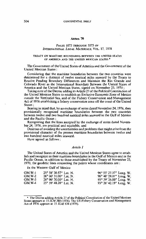
CONTINENTAL SHELF
Annex 70
PAGES 1073 THROUGH 1075 OF INTERNATIONAL LEGAL MATER~ALS, VOL. 17, 1978
TREATY ON MARITIME BOUNDARIES BETWEEN THE UNITED STATES OF AMERICA AND THE UNITED MEXICAN STATES .*
The Govemment of the United States of Amenca and the Government of the United Mexican States :
Considering that the maritime boundaries between the two countries were determined for a distance of twelve nautical miles seaward by the Treaty to Resolve Pending Boundary Differences and Maintain the Rio Grande and Colorado River as the International Boundary Between the United States of America and the United Mexican States, signed on November 23, 1970 ;
Taking note of the Decree adding to Article 27 of the Political Constitution of the United Mexican States to establish an Exclusive Economic Zone of Mexico outside the Territorial Sea, and of the Fishery Conservation and Management Act of 1976 establishing a fishery conservation zone off the Coast of the United States ;
Bearing in mind that, by an exchange of notes dated November 24,1976, they provisionally recognized maritime boundaries between the two countries between twelve and two hundred nautical miles seaward in the Gulf of Mexico and the Pacific Ocean ;
Recognizing that the lines accepted by the exchange of notes dated Novem- ber 24, 1976, are practical and equitable, and
Desirous of avoiding the uncertainties and problems that might arise from the provisional character of the present maritime boundaries between twelve and two hundred nautical miles seaward.
Have agreed as follows :
Article I
The United States of America and the United Mexican States agree to estab- lish and recognize as their maritime boundaries in the Gulf of Mexico and in the Pacific Ocean, in addition to those established by the Treaiy of November 23, 1970, the geodetic lines connecting the points whose coordinates are :
In the Western Gulf of Mexico
GM.W-1 25" 58' 30.57" Lat. N. GM.W-2 26" 00' 31.00" Lat. N. GM.W-3 26O 00' 30.00" Lat. N. GM.W-4 25' 59' 48.28" Lat. N.
96" 55' 27.37" Long. W. 96' 48' 29.0C" Long. W. 95" 39' 26.00" Long. W. 93' 26' 42.19" Long. W .
* The Decree adding Article 27 of the Political Constitution of the United Mexican States appears at 15 ILM 380 (1976). The US Fishery Conservation and Management Act of 1976 appears at 15 ILM 634 (1976).
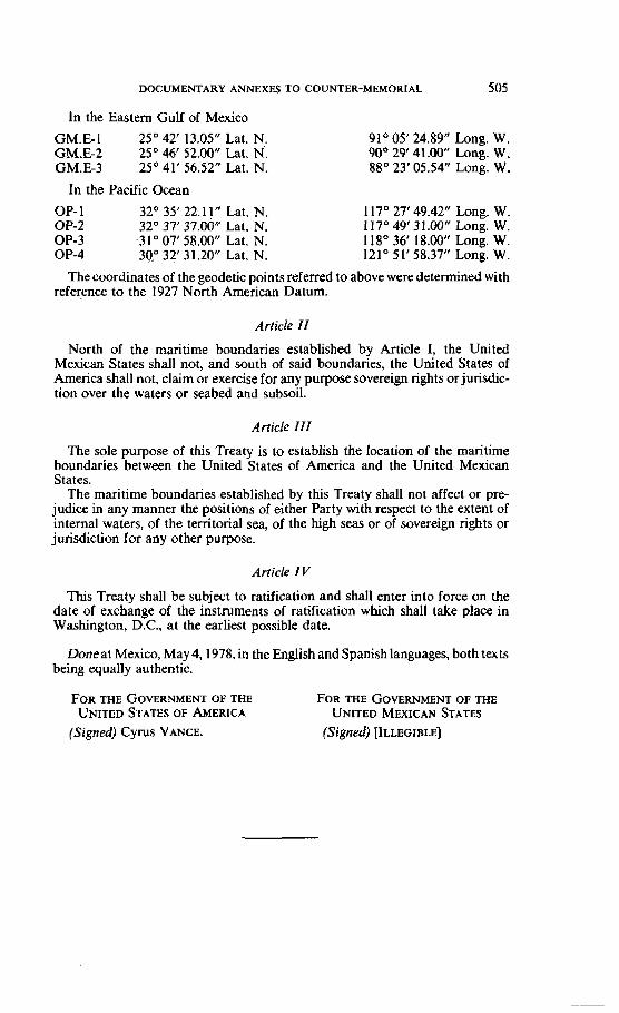
DOCUMENTARY ANNEXES TO COUNTER-MEMORIAL 505
In the Eastern Gulf of Mexico
GM.E-1 25" 42' 13.05" Lat. N. GM.E-2 25" 46' 52.00" Lat. N'. GM.E-3 25' 41' 56.52" Lat. N.
In the Pacific Ocean
OP- 1 32" 35' 22.11" Lat. N. OP-2 32" 37' 37.00'' Lat. N. OP-3 .31a 07' 58.00" Lat. N. OP-4 34" 32' 31.20" Lat. N.
91 05' 24.89" Long. W. 90" 29' 41.00" Long. W. 88" 23' 05.54" Long. W.
117" 27' 49.42" Long. W. 1 17" 49' 3 1.00" Long. W. 1 18" 36' 18.00'' Long. W. 121" 51'58.37" Long. W.
The coordinates of the geodetic points referred to above were determined with reference to the 1927 North American Datum.
Article II
North of the maritime boundanes established by Article 1, the United MeKican States shall not, and south of said boundaries, the United States of America shail not, claim or exercise for any purpose sovereign rights or jurisdic- tion over the waters or seabed and subsoil.
Article III
The sole purpose of this Treaty is to establish the location of the maritime boundaries between the United States of America and the United Mexican States.
The maritime boundaries established by this Treaty shall not affect or pre- judice in any manner the positions of either Party with respect to the extenl of interna1 waters, of the territorial sea, of the high seas or of sovereign rights or jurisdiction for any other purpose.
Article IV
This Treaty shall be subject to ratification and shall enter into force on the date of exchange of the instruments of ratification which shall take place in Washington, D.C., at the earliesî possible date.
Doneat Mexico, May 4,1978, in the English and Spanish languages, both texts being equally authentic.
FOR THE GOVERNMENT OF THE FOR T H E GOVERNMENT OF THE UNITED STATES OF AMERICA UNITED MEXICAN STATES
(Signed) Cyrus VANCE. (Signed) [ILLEGIBLE]
CONTINENTAL SHELF
Annex 71
[Nol reproduced]
Annex 72
PAGES 260 THROUGH 262 OF THE QUARTERLY JOURIV.~, 12û S, 1964 (PUBLISHED BY THE
GEOL~GICAL SOCIETY OF LONDON)
Annex 73
PAGES 9 AND 10 OF ARTHUR HOLMES, PRINCIPLES OF ~ F ~ S J C A L GEOGRAPHY, LONDON, NELSON,
1965
[Nor reproduced]
DOCUMENTARY ANNEXES TO COUNTER-MEMORIAL 507
Annex 74
PAGES 72, 73 AND 13 1 OF WILFRED G. MOORE, A D I ~ I O N A R Y OF GEOGRAPHY,
LONDON, NELSON, 1965
Annex 75
[Not reproduced]
Annex 76
PAGES 236, 17 AND 24 OF GEOGRAPHICAL HANDBOOK SERIES, TUNISIA, LONDON,
NAVAL INTELLIGENCE DIVISION, 1945
(Not reproduced]
CONTINENTAL SHELF
Annex 77
[Nol reproduced]
Annex 78
[Noi reproduced]
Annex 79
[Nor reproduced]
DOCUMENTARY ANNEXES TO COUNTER-MEMORIAL 509
Annex SO
PAGES 9 AND 10 OF RENATO BARTOCCINI, IL PORTO ROMANO DI LEPTIS MAGNA (BULL. CENTRO
STUDI STORIA ARCH., VOL. 13, 1958, SUPP.)
[Nol reproduced]
Annex 81
PAGE 99 OF SAMUEL FERDINAND-LOP, LA TUNISIE ET SES RJCNESTES, PARIS, P . ROGER ET ClE,
1921
(Not reproducedj
Annex 82
PAGE 38 OF CAMILLO CREMA. C. F. PARDNA AND SECONDO FRANCHI. "DESCRIZIONE FISICA E GEOLOGICA DELLA REGIONE", IN LA TRIPOLITANIA SEITENTRIONALE, VOL. 1,
ROME, 1913
[Not reproduced]
Annex 83
PAGES 246 AND 232 OF ROGER COQUE AND A. JAUZEIN, "THE GEOMORPHOLOGY AND QUATERNARY GEOLOGY OF TUNISIA", IN GUIDEBOOK TO THE GEOLOGY AND HISTORY OF
TUNISIA, TRIPOLI, PETROLEUM EXPLORATION SOCIETY OF LIBYA, 1967
[Nor reproduced]
Annex 84
[Not reproduced]
Annex 85
[Nor reproduced]
DOCUMENTARY ANNEXES TO COUNTER-MEMORIAL
Annex 86
[Nor reproduced]
Annex 87
PAGE 82 OF LOUIS FOUCHER, HADRUMETUM, PARIS, PRESSES UNIVERSITAIRES
DE FRANCE, 1964
[Nor reproduced]
Annex 88
PAGES 1 133 THROUGH 1 135 OF PIERRE FBLIX BUROLLET, MOUVEMENTS QUATERNAIRES ET RÉCENTS AUX P LES KERKENNAH-TUNISIE ORIENTALE, COMPTES RENDUS, ACADÉMTE DES SCIENCES,
PARIS, 1978
[Nor reproduced]
CONTINENTAL SHELF
Annex 89
[Nol reproduced]
Annex 90
[Not reproduced]
Annex 91
[Nor reproduced]
DOCUMENTARY ANNEXES TO COUNTER-MEMORIAL
Annex 92
BOOK V. 12. 1-4
the islands which lie on the other side '. For off the south of Sicily three islands lie out in the sea, and each of them possesses a city and harbours which can offer safety to ships which are in stress of weather. The first one is that called Melitê 2,
which lies about eight hundred stades from Syracuse, and it possesses many harbours which offer exceptional advantages, and its inhabitants are blest in their possessions ; for it has artisans skilled in every rnanner of craf*, the most important being those who weave linen, which is remarkably sheer and soft, and the dwellings on the island are worthy of note, being ambitiously constmcted with cornices and finished in stucco.with unusual workmanship. This island is a colony planted by the Phoenicians, who, as they extended their trade to the western ocean, found in it a place of safe retreat, since it was well supplied with harbours and lay out in the open sea ; and this is the reason why the inhabitants of ,this island, since they receïved assistance in many respects through the sea- merchants, 'shot up quickiy. in their manner of living and increased in renown.
After this island there is a second which bears the name of Gaulus lying out in the open sea and adorned with well-situated harbours, a Phoenician colony. Next cornes Cercina facing Ubya, which has a modest city and most serviceable harbours which have accommodations not only for merchant vessels but even for ships of war.
But now that we have spoken of the islands which are to the south of Sicily, we shall tum back to those
' Le., of Sicily. * Malta.
The modern Gozo. ' The modern Kerkenna or Kerkenah, at the West end of the Lesser Syrtis.
CONTINENTAL SHELF
Annex 93
[Not reproduced]
Annex 94
PAGE 1091 OF J -P. PERTHUISOT. "LAMBEAU DE w' ET LA STRUCTURE
NEOTE~ONIQUE DE L'PLE DE JERBA ( T ~ ~ I E ) , c o m s SNDUS DE L' AC AD^ DES SCIENCES, PARIS, 1977
[Not reproduced]
Annex 95
[Nat reprohcedj
DOCUMENTARY ANNEXES TO COUNTER-MEMORIAL 515
Annex %
[Not reproduced]
Annex 97
PAGE 757 OF FRANK H. FABRICIUS, DIETRICH BERDAU AND b l U OTTO MUNNICH, ' ' ~ R L Y HOLOCENE OOIDS IN MODERN L I ~ O R A L SANDS. ~ W O R K E D
FROM A COASTAL TERRACE, SQUTHERN TUNISIA", SCIENCE, VOL. 69, 1970
[Nor reproduced]
Annex 98 a
PAGE 307 OF G. BELLAICHE AND C. BLANPIED, "EVOLUTION S~DIMENTAIRE QUATERNAIRE DE LA PLATE-FORME P~LAGIENNE", IN PIERRE FÉLIX BUROLLET ET AL., LA MER P~LAGIENNE. GÉOLOGIEM~DITERRANÉENNE, VOL. VI, NO. 1, PARYS, BDITIONS DE
L'UNIVERSITB DE PROVENCE, 1979
[ h t reproduced]
CONTINENTAL SHELF
Annex 99
PAGE 19 OF C. BLANPIED, P. F. BUROLLET, P. CLAIREFOND AND MD SHIMI, "II. CADRE GEOGRAPHIQUE ET GÉOLOGIQUE. A. MORPHOLOGIE", IN BUROLLET ET AL., LA MER PÉLAGIENNE. G~OLOGIE M&DITERRANÉE~NE, VOL. VI, NO. 1, PARIS, &DI-
TiONS DE L'UNIVERSIT~~ DE PROVENCE, 1979
[Nor reproduced]
Annex 100 , '
PAGE 491 OF W. B. F. RYAN AND E. OLAUSSON, "MEDITERRANEAN SEA", IN RHODES
WHITMORE FAIRBRIDOE (ED.), ENCYCLOPEDIA OF GEOMORPHOLOGY, New YORK, REINHOLD, 1968
(Nor reprodüced]
Annex 101 , . . .
PAGES 450; 280, 221,258, 330 AND 615 OF ROBERT L. BATES AND JULIA A. JACKSON, GLOSSARY OF GEOLOGY, ND
EDITION, FALLS CHURCH, VIRGINIA, AMERICAN GEOLOGICAL INSTIWE, 1980
[Nor reproduced]
DOCUMENTARY ANNEXES TO COUNTER-MEMORIAL 517
Annex ,102
PAGES 1 THROUGH 23 OF . TERENCE G. CARTER ET AL., "A NEW BATHYMETRIC CHART AND PHYSIOGUPHY OF THE MEDITERRANEAN SEA", IN D. J. STANLEY (ED.), ï k ~ M E D ~ R ~ N E A N SEA : A NA= SEDIMENTATION LABORATORY, STROUDSBURY, ~ N N S Y L V A -
NIA, DOWDEN, HUTCHINSON AND ROSS, INC,, 1972
[Not reproduced]
I
Annex 103 .
[Nor reproducedj
Annex 104
PAGES 53 AND 57 OF G. BELLAICHE AND C. BLANPIED, "APERÇU NÉOTECTONIQUE", IN P. F. BUROL- LET ET AL., LA MER &AGIENNE, GGÉOLOGIE MÉDITERRANÉENNE, VOL. VI, NO. 1,
PARIS, BDITIONS DE L'UNIVERSITB DE PROVENCE, 1979
[Not reproducedj
CONTINENTAL SHELF
Annex 105
PAGE 20 OF E. F. K. ZARUDZKI, '%IE STRAIT OF SICILY-A GEOGRAPHICAL STUDY", &VUE DE G~OGRAPHIE PHYSJQUE ET DE GÉQLOGIE DYNPMIOUE, VOL. XIY, 1972
[Nor reproduced]
Annex 106
[Nor reproduced]
Annex I(Y7
PAGE 36 OF WINNOCK AND BEA, "STRUCTURE DE LA MER P~LAGIENNE", IN P. F. BUROLLET =.Al.., LA MER GIENNE NE. GGÉOLOGIE Mb-NNE. VOL. 1. NO. 1, PARIS,
~ D I T ~ O N S DE L'UNIVERSIT~ DE PROVENCE. 1974
[Not reproduced]
DOCUMENTARY ANNEXES TO COUNTER-MEMORIAL 519
Annex 108
PAGE 51 OF GOUDARZI, GEOLOGY AND MINERAL RESOURCES OF LIBYA - A RECONNAIS-
SANCE, UNITED STATES GEOLOGICAL SURVEY PAPER 660, 1970
[Nor reproduced]
Annex 109
P A G ~ 96 OF P. F. BUROLLET AND R, S. BYWE, "R.~FLEXIONS SUR LA TECTONIQUE
GLOBALE (EXEMPLES AFRICAINS ET M~+DITERRAN~~ENS)", NOTES MEN. COMP., VOL. 1974
[Not reproduced]
CONTINENTAL SHELF
Annex 110
TEX^ ~ S E N T E D BY THE CHAIRMAN OF THE SECOND C O M M I ~ E , UN W C U M E N ï A / C O N F . ~ Z / W P . ~ / P ~ T II (1975), ARTICLE 62
WORKING PAPER OF THE SECOND C O M M I ~ E :.MAIN TRENDS, UN DOCUMENI. A/CONF.62/L.8/ REV. 1 /APP. 1 (1974), PROVISION 68
JAPAN ~ V I S E D DRAFT ARTICLE ON THE CONTINENTAL SHELF, UN DOCUMENT A/CONF.62/C.2/L.31/REv.l (1974)
COMPROMISE SUGGESTIONS BY THE CHAIRMAN OF NEGOTIATING GROUP 6, UN DOCUMENT A/CONF.62/L.37 (1979)' ARTICLE 76
USSR : INFORMAL PROPOSAL. UN DOCUMENT NG.6/8 (1979)
INFORMAL SUGGESTION BY THE USSR, UN DOCUMENT C . ~ / ~ N F O R M A L MEETING/ 14 ( 1 978)
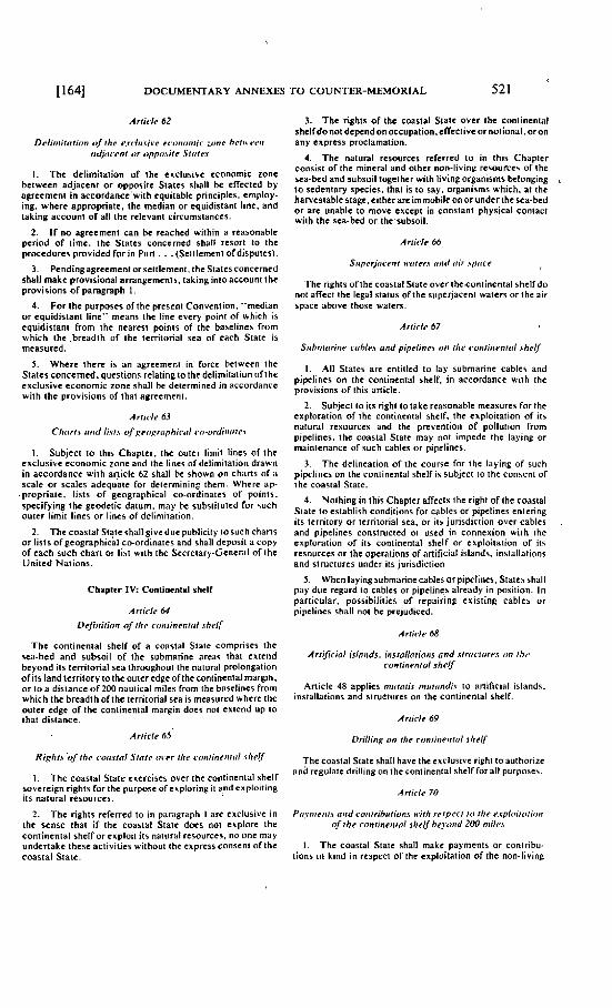
DOCUMENTARY ANNEXES TO COUNTER-MEMORIAL 521
Deliiriitrrtir~i~ d?f the e.r<.lii.vit~r er~riirinrir zoiie brtu t,i-i~ ndjricerii rrr ~rpptlbile Slritr.!
1. Thc dctimitation o f the cxclusivc cconomtc zone bctwccn adjacent or oppositc Statcs stiall be cIIectcd by agrccmcni in accordancc'with cquitablc principles. employ- ing. wherc appropriate, the mcdian or tquidistant linc. and iaking account of al1 the rclcvani circumsianccs.
2. I f no agreement can k rcachcd within a reasonablt pcriod o f lime. the States concerncd shall rcsort to thc procedures pmvidcd for i n Pan. . . (Scttlement ofdisputes).
3. Pendingagrecment orsettlcmeni,ihc Statcsconccrncd shall makc provisional arrangcmcnts. taking into account the provisions o f paragraph 1.
4. For the purposcs of the prcscni Convention. "median or cquidisiani line" mcans ihc linc cvcry point of which is cquidistani from the ncarcsi points o f the baselines from which ihc .brcadth o f ihc tcrritorial sca o f cach Staie is measured.
5 . Wherc thcrc is an agrccmcni in forcc bctwccn the States concemcd. questions rclatingto the dclimitation ofthe cxclusivc cconomic zone shall be dctcrmincd in accordance wilh ihc provisions of that agrcemcnt.
A rticle 63
Chiirir nrid li.!i.\ ofproprirphir.ri1 ro-orrliirrirc\
1. Subjcci IO this Chapicr. thc outcr limii lincs o f the cxclusivc cconomic zone and the lincs ofdclimitation drawn in accordancc with aniclc 62 shall be shown on charts of a scalc or scales adcquaic for delcrmining thcm. Where ap-
.propriate, lisis o f geographical CO-ordinates o f points. specifying the gcodetic daium. may hc sub~iiiutcd for ruch ouier limit lines or lines of delimitation.
2. Thc coasiat Siate shall givedue publiciiy to such chans or lists ofgeographical CO-ordinates and shall dcposii a copy of cach such chan or lis1 with the Sccreiary-General of the Unitcd Naiions.
Chapitr IV: Contintnlal sht l l
Article 64
Thc continenlal shclf of a coastal Siaie comprises thc sca-bcd and subsoil of the submarinc area5 ihat cxtcnd bcyond irs territorial sca throughoui the natural prolongation orits land territory IO thcoutcrcdgcofihecontinental margin. or i o a distance o f 200 nauiical miles from the basclines from which ihc brcadth ofthc territorial sea is mcasured whcrc the outcr cdge of the coniincntal margin does noi cxtend up Io that distance.
Article 65
1. The coasial State cxtrcisca ovcr the continental shelf sovcrcign rights for thc purposc ofexploring it and exploiting its naiural resourccs.
2. The rights rcferred to in paragraph I arc cxclusivc in ihc scnse that if the coasiat Statc docs not explore the contincntal shclf or crploii ils natural rcsourccr. no one may undcrtakc thcsc actiiities without the exorcss consent of the
3. The rights of the coastal Statc ovcr ihc coniinenial shelfdonot dcpcndonoccupation.c~ectiveor notional. oron any express proclamalion.
4. The natursl rcsourccs rcferred to in this Chapicr consist of thc mincral and oihcr non-living rcsoulccs of the sca-bcd and subsoil iogeiher with living organisms belonping IO iedcntary species. ihal i s to say. organisms which. at the harvesiablc stagc.cithcrare irnmobilconor under ihc sca-hed or arc unablc i o movc cxccpt in constant physical contact wiih thc sca-bcd or ihc'subsoil.
The rights of the coastal Statc ovcr ihceoniinental shelf do no1 affect the legal status of thc supcjaceni waters or the air space abovc those waters.
Ariirle 67
Sitbniriririe i.lihlc.\ nnd pipeliticr uii ilie ruiiiiiieiitril ~ h r d f
1. Al l States arc cntiifcd to lay submarinc cablci and pipclincs on thc continental shelf, in accordancc with thc provisions o f this anicle.
2. Subjeci to ils righi Io lakc rcasonable mcasures for the exploration o f the continental shclf. the crploitation o f its natural resources and the prcvention of polluiion from pipelines, the coastal Statc may not impede thc layinp or maintenance of such cables or pipclincs.
3. The delineation o f the course for the laying of such pipelincs on the continental shelf is subjcct Io thc consent of ihc coastal Siate.
4. Nothing in lhis Chaptcr affects the righi of the coasial Statc I o csiablish conditions for cable\ or pipclincs cnlcring ils territory or tcrnional sca. or its jurisdiction ovcr cablcs and pipclincs construcicd or urcd in connexion wiih the exploration o f ils coniincntal shelf or cxploilation of i l< resourccs or the operaiions of artificial islands, installations and structures under ils jurisdiction.
5 . Whcn layingsubmarine cablcs or pipelines. Statcs shall pay duc regard IO cablcs or pipelines alrcady in position. In particular. possibilitics of rcpairine cxisiing cablci or pipelines shall not bc prejudiccd.
Artirle 68
Arrifirial islrriids. insrolloiions nnd strrictiirrr uii ilic rontinrntril shelf
Anicle 48 applics mitroiir micriindi.% to artificial islands, installaiions and structures on the contincntal shelf.
Article 69
Thecoastal Statc shail have thc exclusive right Io authorirc and rcgulatc drilling onthccontinenaal shelf forall purposes.
coastal Statc. 1 . The coasial State shall makt paymcnts or coniribu-
tions in kind i n respect of the exploitation o f the non-living
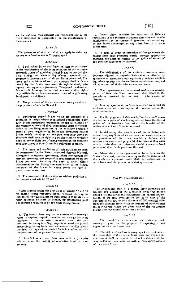
522 CONT~NENTAL SHELF [ 1621
species and cake into Jccount the respunsibilitics of rhe S ~ a t c mentioncd in parqraph 1 for the maintenance o f ihcsc spccics.
The provisions of t h h part shaU not apply to sedentan' s p c + s as dcf'ined in Micle 63. paryraph 4.
Arncle $ 7
1. Land-lockcd Staics h a l l have the right t o participate in thc cxploitation of the living resourccs of the erclusivc cconomic zones o f adjoining coastal Statcs o n an cquitable bas&, taking into account the relevant cconomic and gcographic circumstanccs of d l the States cnnctrncd. The tcms and conditions of such pariicipation s h d l be dctcr- mined by the States conccrncd through bilateral. sub- rcgional or regional agreements. Devcloped Iand.lockcd SIP~CS $halli howevfr, be cntitled to excrcjv thcir righls only wiihin thc exclusive cmnomic zones of ncighbouring dcvclopcd caastal Statcl.
1 2. The provision: of this articlc are without prtjudice ta
the provisions of articles 50 and S 1.
Article 58
1. Dcvcloping coasial States which arc situated in a subregion or region whov gcognphiczl pcculiarities mnkc ruch States particularly depcndcnt for the satisfaction of the nutritional needs of t h c u papulations upon the cxploi- tation of the living rcsourccs in the exclusive economic zrines of thcir neighbouring States and dwcloping coastal States which can c l am n o cxclusivc cconomic zones 0 1 theu own rhaU have thc right t o prrticipate, o n an cguitahlc basis. in the exploitation o f living rcsourccs in the exclusive cconomic zoncs of othcr States in a sub:egion ot region,
2. The t c m s and conditions 01 such participation shill be detcrmincd by the Siatcs conccrncd through bilatcral. subrcgional or rcgional agrccmcnts, taking into accouni the nlcvant cconomic and gcopaphic circurnstanccs of aU the States concerned. including ihc nced t o avoid cffccis detrimental t a the fishing communitics or to the lishing industries of thc States in whose zones the right of participation is exereircd.
3. The prwisions of Illis ariicle afe without prejudice ro the provisions of articles 50 and 5 1.
Righis grantcd undcr the provisions of a n i c k s 5 7 and 58 10 exploit living r tsourcts cannot without the c x p r c s conseni of the coastal s l a t c be transferrcd t o third States or thcir nationah by lcase or liccncc. b y dtablishing joint coiiaboraiion ventures or by any othcr arrangements.
1. The caastal State rnay. in lhe tx t r c iw of itr sovercign rfhts to explore. exploit. conserve and manage the livmg rrsourccs in the exclusive economic zone, takc such measures, including boarding. inspection. arrcst and jud iç~ l procccdings. as may be necessaw to cnsure cornpliancc wirli the laws and rcgulations rnacted by it in confonniiy with the provisions of Ihc p reun t Convention.
2 . hrr tr ied vcswls and iheii c r m rhdl be prompily rclcascd upon the posrtng of rtasonablc bond or othcr nt-urity.
3. Cmstal Statc penalties for viola1K)ni of fisixries regularions in ihc rxclusive economic zone may not indudc irnprisonmcnt, in the abvncc of agreement t o the wntrary by the Slaics concerned. o r any othcr form of corporal punishnicnt.
4. in cases of arrest or derenrion of foreign. versels the coastal Statc sliaU proniptly nolify. through appropriate ehannels. thc State o f rcgistry of the action takcn and Of any ptnaltics subscqucntly imposed.
1. The delimitaiion o f the cxclusivc cconomic zonc betwcen adjsçcnt or opposiic Statcs shaU k cffcctcd by agreemen t in accordanec with equitablc prmciplcs, cmploy- ing, whcrc appropriale. the mcdian o r equidistancc line. and taking acsoiint of al1 ihc relevant circumstanccs.
2. If no agreement can b6 fetchcd wiihin a reawinabie pcriod of tinic, the Slaics concïrncd shalt rcrori to the proçcdurrs providcd for in p a n . . . (Scttlement of disputes).
3. Pendinp. agreement. n o State is cntitled t o c l t end ils cxclusivc cconomic zone heyond the median line or the cquidisrancc lue.
4. For the purposcs of this article. "median lincm means the lint tvery point of which isoquidirtant from the neatest points of the basclines froni which ihc brcadth o f the territorial sca of each S ~ a i c IS rncasurcd.
5 . I n dclimiting the boundaries of the exclusive eco- nomic zonc, i n y lincs which arc drawn in accordancc widi thc provisions o f this article should k defincd with rcfercnce IO climts and popraphiçal fcaturcs as thcy cxisr al a particular date, and refcrence should be madc t o fixed permanent dcntifiable points o n the land.
6. Whcre rlierc is an agrcemeiit in forcc hetween the Stales conccrncd. questions rclnting t o Ihc delimitation Ol thc exclusive ccononiic zone shall be dt icnnined in accordance witli the provaions of lhat agreement.
P . x i I V : Conrinenial shelf
Thc contincntal.shelf of a coastai tat te c o m p n v s thr. rea-bcd and ~i ibsoi l of the riibniarinc arcss that sxtcnii bcyond its t e r r i i o n ~ l sca ihroughout tlie natucal proion- ~ a t i o n of its land tcrrilory 10 the oriter edge o f thc continental niargin. or to 3 distance of 300 nautical mile. from thc Liaseiincs froiii whish the hreadih of the territorial WP is incasurcd u.hcrc Ihc uulcr cdcc o f the conuncntal niargin does nui extcnd up In that distance.
I. The cnxral Statc cxitrciics ovcr (lie contmental shcli soverc1:n r i fhts lor the purpose o i cxploring it and evpiuitlig ils narural rcsources.
2. Tlic riplits rcicrrcd ro in paragraph L arc cncluiive ir thc sense that i f the ioastal Siare d o t $ not explore Ihv contlncnial shcil or cxploii its nalural rcsourccs. n o onr iiiav undcrralç these a~t ivir ics wirhuur rhc express conscrit of ihc c o ~ s i a l Siaii..
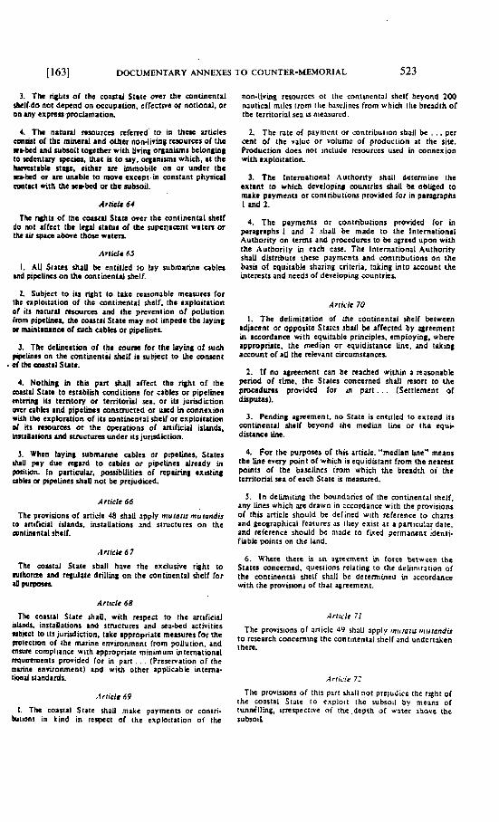
il631 DOCUMENTARY ANNEXES TO COUNTER-MEMORIAL 523
3. The rigiits of the coastd Stitc over the mntincntal Ibr1t.d~ no( d e p n d on occupation. effecuve ~t noriand, or on MY exprerr~proclamation
1. The naturd remurcu mlcmd' to in thoc uticles cm%isl of the mineril and other non-living ruourçes of thc wbkd mil rubroil t qe ihe r with t iviq ortmimis belowing 10 Icdentary ~pccisr, that u to u y . orpn*mr which, at the brrrcrtibk stage. tither ue immobile on or undtr the shed or ue m b l e to moie cxcept. in conslani p h y r i d m i i c i With the r,bd or the aibsoil.
The mir of the coaitil State over the mntibenlll rfielf do m i affect the I d $talus of the $upcnactnt w i t en or the iir Wace above thov witerr
1. All States shaU bc cniiiied Io Iiy submarine ublcs and pipelima on the wntinent.l &If.
2. Subjtct to i u nght to t e e relionable measuns for the cxploitaiion of thc aintinental rhelf. the exploitaiion of iis rwiurd rewrircu and the prcvcniion of pollution imm pipetines, the coaaul State rniy not impede the I i y u i ~ of mintirunce of aieh cnbka or pipelines
3. The delincation of the course for iha layuil of such piplinn on the continentil &If ir nibjcci to iht m w n i . ol ihr Wastil Siale.
4. Noihins in thu pari Ifid1 affect the m t of the coiriil Staie to ertiblish conditions for cables or pipeliner mterina ils territory or territoihl sea. or itr jurudiction a c r tables and pipeünes conrtnicred or u+d in connexion iilh the explonlion of i ts mniincnial S ieu o r exploitaiion 01 ils remurca or the opcrations of r n i f i c d irlrnb, imtaUaiionr md struciurea under its juridiction.
3. When hyms nibmarine a b l e s or pipelines, States JuU piy due w a r d to cabbs or pipelines llrcady in W i i o i In puiicular. polfibilitics of rcpairing exirting ubks,u pipetines diaU not be prejudiccd.
Article 66
The provisions of article 48 shaiî apply ttiutarn m u s n d u to artificial idin&. installation$ m d stn~ctuies on the mntknta l sbell.
The coirtal State shall hsvc the exclusive rœht to nith0rtZe md rqula t t dtiilLy on the continental rtictf for an pi-
Article 68
Thc masial Strte shaii, with respect to the artificial !dan&, instriiaiions and smictures and seaded activities rubitcl to its jurisdiction. takc appropriate memires for the pmtectwn of the marine cmuonrncnt from polluiion, and tilniie mmpliance wiih appropriale minimum intcmational nquiremcnts provided for in par t . . . (Prcscrvation of the mnne en+~onmentl i d with othtr applicable interna- liaiai stîndardr
1 . The masial Slatc shaU niake paymtnts or contri- buinml in kind in respect of the cxploitaiion of the
non-living rcrourca ot ltic contuicn~al shclf beyond ZQ3 na~itical rnilcs irom tlic bssclincs fmm which IIic brcadih of the territorial sep is nieasurcd.
2. The rate of paynicnt or canlritiulion shtU be . . . per cent of the Y ~ ~ U C o r votumc of prduciion ai the site, Pmduct,ion does not include rcaourccs UYJ in connexion m t h exploitation.
3. The Intcmational Authority shall dotermine the extcnt to which dcvcloping counirics shall be obliged to mke piymenis or coninbutions provided for in pinglaphs 1 and 2.
4. The payrnenis or conrnbutions provacd for in paragnphs 1 and 2 aliaU be made to the lnicrnationil Authority an l e m s and prwcdurcs to bc agrced upon wiih the Auihoriiy in csch case. Tlie Internalional Authority shaU distribute thesc payrncnts and coninbutions on ihc bru of equiiable sharing criteria. taking into account the intcrcsts and nctds of dcveloping countriea
Article 70
1. The delimitation of the continental shelf beiwcen adj innt or opposite Starcs shail be affectcd by Uttement in accordanoe with equirable principlcs. empioyins. whcre appropriate, the median o r equidistance lina. and t&mg account of aU the relevant circumstancc%
2. If no agreement can be reached within a %oronable priod of time, the States conccmcd shdl m o r t to the procedures providcd for in p u t . . . (Sctrkment of diiputar).
3. Pending agreement, no Stalc ir cnttiled to extend its continental shclf kyond the rncdian lule or Ihc equi- distance line.
4. For the purCloies of this artide, "mcdian Line" means the line evuy point of which is cquidisiant frorn the neamt points of the baselines irom which the brcrdih o i the temtoriai PP of each $inte ir mcaarred.
5. In dclimiting the boundarics of the wntinentat shell. any lines which ;us drawn in accordance wiih the provisions of this article should bç defined with rcftrcnce IO c h m s and gcographical fcaturcs as iliey exist at a particulru date, and refcrenct should bc niade ta lucd permanent idenii- fiable points on the land.
6. WiKre thcic is an asrctment in force bciwrsn the States mncerned. questions reiaiing io ihc drliinitation of the continental shelf shaP bc dciemincd in accorduice with the provision3 of thai agreement.
The provjsions o f anicic 49 rhaU apply rniiraiu riiirrandu to rcscarch concernuie thc continental shelf and undcriaken thert.
Tlie prwisions of this part shall not prejudicc rhc righi of ihc coastil State I o cxploti thc rubsoil bv means of runnilling. rmipcciivt o i the .depth of w t e r lhavc the subsoil
526 CONTINENTAL SHELF II
5. In thc a r c of aioils or of irlands having fringinp rccfs. B. T E H R I T ~ R I ~ . ~ I INDCR FIIPEIGN D<)MINATI~I \ riu the baxlinc for mcasuring the brcadih of the territorial rra c o l r ; ~ n o ~ shill k thc scaward cdgc of ihe rccr. as shown o n official charts.
provisionî arc intendcd bc without prcjudicc to ' In rcspcci ol a tcrriiory whose pcoplc have altaincd nciihcr
quesiion or dclimilation of island occsn Ipacc as bctwccn full indcpcndcncc nor somc olhcr ~clT-~nvcrning s'iaiu?. fol-
idjaccni or or in ipccial circumstancç,, lowing an aci or self-dcieminaiion undcr ihc auspices of ihc
Nor do thcy purport dcal with rigimr of iflands app,.i- United Nations. the righis to the raourccs of thc cconomic
an arEhipelaeic Statc or to prchipclaeo or zone crcatcd in respmt OI ihat tcrriiory and Io thc rcsourccr o l
a coastal çlaic. or ofa frinpc of islands alonsa in its coniincntal shclfarc vcsicd in the inhabiiants of thai vrri-
irnmcdiaic viciniiy tdcrrtd in 4. paragraph I. or tory to bc cxcrciscd by thcm for their bcncfii and in accordancc
thc 1958 G~~~~~ ~~~~~~~i~~ on thc T~~~~~~~~~~ Sca and the with ihcir nccds and rcquircmenis. Such righis may no1 bc
Contiguous Zone.]" assumcd. exrrcised or profilcd from or in any way irifrinpcd b) a mrtropolitan or forcign powcr adminisicring or occupyinp
"Unitcd h'aiionb. I'rraii Spritr. vol. 516. p. 206 ihat ierriiaq.
DOCUMENT A/CONF.62/C.2/L.JI /Rcr.l
Jspan: reviscd d r i f l i r t ic le o n the conlintntal shelf
[Original: English ] [16 Augusr 1974
1. The coastal Siatc cxcrciscs sovercign righis ovcr thccontincnial shelf (thecoasial sca- bed area) for the purposc of cxploring ii and cxploiiing iis rnincral raourccs.
2. Thc ouicr limii of the coritincntal shcll (thc coasial rca-bcd arca) shall noi txcccd a maximum distancc of 2W nautical miles rrom ihc hasclinc for rncasuring the brcadih of the icrrilorial sca as Sc1 oui in . . .
3. ( 0 ) Whcrc the coasis of I U O or more Sraics arc adiaceni or ouposiic Io cach othcr. t h t delimiiation of ihc boundary of the coniinrntal shelflihc cks iâ l sra-b;d area)appcrtsining la such Siatcs shall bc dctcrmincd by agrcemcnt bdwctn ihcm. iakinp inio account ihc principlc of cquidistancc.
( h ) Failing such agrecrncni. no Staic is cniiilcd io cxttnd its sovcrcign rights ovcr thc coniincntal shclf (Ihc coaslal sca-bcd arca) bcyond ihc mcdian linc. cvcry poini of which is cquidisiant Irom ihc neartsi poinis of the basclines. coniincntal or insular. from which ihc breadth of the territorial sta of cach Staie is mcasurcd.
4. Nothing providcd hcrcin shall prcjudicc thc cxistingagrccrncnts bciwccn the coasial Staics conccrncd rclating io thc delimitaiion of the boundary of thcir respective contincnial shclf (coasial sca-bed arca).
DOCUMENT A lCONF.62 /C.2/L.32
Greece: drnft articles o n t h e cxclucive cconomic zone beyond the tcrritoiiml sen
( Original: English ] [ J l Ju!! 19741
The provisions applicablcfor ihc dcicrmination of ihc cconomic zont o f a State are as a gcncral rulc applicable io its islands.
1. Whcrc iht coasts of IWO or more States are adjacent or opposiie to cach othcr and the distance bctucen ihem is les* ihan double ihc unifom hrcadih providcd in this Convcniion. the dtlimiiaiion of thcir cconomic zoncs and of ihcir sca-bed arcas shall bc dctcrmincd by agrccmtnt among thcmsclics.
2 . Failing such agrccmeni. no Staic is cniiilcd 10 exicnd its rights ovcran cconomic lon t and sca-bcd arca bcyond t h t limiis 01 thc mcdian linc cvcry poini of which is cquidistant from the ncarcst poinis of the basclina. coniincntal or insular. from which thc brcadth of thcabovc arcas of cach of ihc two Staics is mcasurcd.
DOCUMENïARY ANNEXES TO COUNTER-MEMORIAL ' 527
COMPROMISE SUGGESTIONS BY THE CHAIRMAN OF NEOOTIATING GROUP 6 AMBASSADOR ANDRES AGUILAR (VENEZUELA)
Article 76
Definition of the Continental ShelJ
1. The continental shelf of a coastal State comprises the sea-bed and subsoil of the submarine areas that extend beyond its territonal sea throughout the natufal prolongation of its land territory to the outer edge of the continental margin, or to a distance of 200 nautical miles frorn the baselines from which the breadth of the territorial sea is measured where the outer edge of the continental margin does not extend up to that distance.
1. bis. The continental shelf of a coastal State shall not extend beyond the lirnits vrovided for in varanravhs 3 and 3 bis of this article. - - .
2. The continental rnargin comprises the subrnerged prolongation of the land mass of the coastal State. and consists of the sea-bed and subsoil of the shelf, the slope and the rise. It does n i t include the deep ocean floor nor the subsoil thereof 1.
3. For the p;rpose of this Convention, the coastal State shall establish the outer edge of the continental margin wherever the rnargin extends beyond 200 nautical miles from the baselines frorn which the breadth of the territo'hl sea is measured, by either :
(a) A line delineated in accordance with paragraph 4 by reference to the outermost fixed points al each of which the thickness of sedimentaq rocks is at least 1 per cent of the shortest distance from such point to the foot of the continental slope ; or,
(6) A line delineated in accordance with paragraph 4 by reference to fixed points not more than 60 nautical miles from the foot of the continental slope 2.
In the absence of evidence to the wntrary, the foot of the continental slope shall be deterrnined as the point of maximum change in the gradient at its base.
3 bis The fixed points cornprising the line of the outer limits of the conti- nental shelf on the sea-bed, drawn in accordance with subparagraphs (a) and (b) of paragraph 3, shall not exceed 350 miles from the baseline from which the breadth of the territorial sea is measured, or, not to exceed 100 miles from the 2,500-metre isobath, which is a line, connecting the depth of 2,500 metres.
4: The coastal State shall delineate the seaward boundary of its continental shelf where that shelf extends beyond 200 nautical miles from the baselines from which the breadth of the territorial sea is measured by straight lines not exceed-
1 General understandin has been reached to the effect that on the question of undenvater oceanic ndges tfiere will bc additional discussion and a rnutually acceptable formulation to be included in Article 76 will be drawn up.
2 The suggestion of the delegation of Sri Lanka for an additional method of delirn- itation applicable to its geological and geomorphological conditions received wide- spread sympathy. However, the matter has been left for negotiation at the forthcomng session of the Conference.
528 CONTINENTAL SHELF
ing 60 nautical miles in length, connecting fixed points, such points to be defined by CO-ordinates of latitude and longitude.
5. Information on the limits of the continental shelf beyond the 200-miie econornic zone shall be submitted by the coastal State to the Commission on the Limits of the Continental Shelf set up under Annex on the basis of equitable geographic representation. The Commission shall make recommendations to coastal States on matters related to the establishment of the outer lirnits of their continental shelf. The limits of the shelf established by a coastal State taking into account these recommendations shall be final and binding.
6. The coastal State shall deposit with the Secretary-General of the United Nations charts and relevant information. induding geodetic data, permanently describing the outer limits of its continental shelf. The Secretary-General shall give due publicity thereto.
7. The provisions of this Article are without prejudice to the question of delimitation of the continental shelf between opposite or adjacent Staies.
Arricle 78 bis
Exercise of the Rights of the Coasta/ Store
The exercise of the rights of the coastal State over the continental shelf must not infringe, or result in any unjustifiable interference with navigation and other rights and freedoms of other States as provided for in the present Conven- tion.
Article 82
Payments and Conrribufions wirh Respect to the Exploitation of the Conzinenzal Sheif Beyond 200 Miles
1. Thecoastal State shall rnake payrnents or contributions in kind in respect of the exploitation of the non-living resources of the continental shelf beyond 200 nautich mites from the baselinesfrom which the breadth of the territorial sea is measured.
NG6/8 18 Apnl 1979.
USSR : INFORMAL PROPOSAL
Article 76
Definition of the Continental Shey
1. Thecontinental shelf of a coastal State comprises the sea-bed and subsoil of the submarine areas that extend beyond its territorial sea throughout the naturaI prolongation of its land territory to the outer edge of the continental margin, a distance of 200 nautical miles frorn the baselines frorn which the breadth of the territorial sea is measured where the outer edge of the continental margin does not extend up to that distance.
DOCUMENTARY ANNEXES TO COUNTER-MEMORIAL 529
1 bis. The continentalshelf ojcoas ta1 States may not in any circumstunces extend beyond the limits provided for in paragraphs 3 and 3 bis of this article.
2. The continental margin comprises the submerged prolongation of the land mass of the coastal State, and consists of the sea-bed and subsoil of the shelf, the slope and the rise. It does not include the deep ocean floor, the subsoil thereof, nor undenvater ocean ridges and the subsoil thereof:
3. For the purposes of this Convention the coastal State shall establish the outer edge of the continental margin wherever the margin extends beyond 200 nautical miles from the baselines from which the breadth of the territorial sea is rneasured, by either :
(a) a line drawn in acwrdance with paragraph 4 by reference to the outer fixed points at each of which the thickness of sedimentary rocks is at leastl% of the shortest distance from that point to the foot of the continental slope ; or
(6) a line drawn in accordance with paragraph 4 by reference to fixed points more than 60 nautical miles from the foot of the continental slope.
In the absence of evidence to the contrary, the foot of the continental dope shall be determined as the point of maximum change in the gradient at its base.
3 bis. The fixedpoints comprising the line of the outer Iimi! of the coniinental shelf on the sea-bed, drawn in accordance with subparagraphs (a) and (b) of paragraph 3, miat be situated ar a distance either not exceeding 100 nauricaf miles from the line on the sea-bed, corresponding to the outer limit of the 200-mile economic zone, or not exceeding 60 nautical miles from the 2,500-metre isoburh, is a line connecting depths of 2,500 metres.
4. The coastal State shall delineate the seaward boundary of its continental shelf where that shelf extends beyond 200 nautical miles from the baselines from which the breadth of the territorial sea is measured by straight lines not exceed- ing 60 nautical miles in length and connecting fixed points on the sea-bed ; such points shall be defined by CO-ordinates of latitude and longitude.
5. Information on the limits of the con tinentalshelf beyond the 200-mile economic zone shall be submirred by the coastal State to the Commission on the Limits of the Continental Shelf set up under Annex on the bmis of eqüituble geographic representation. The Commission sholl make recommendations ro coastal States on matters related to the establishment of the outer limits oftheir continentni shelf: The limits of the shelf estabIlshed by a coastal State taking into accouni ihese recom- mendations shall be jïnal and walterable.
6. The coastal State shall deposit with the Secretary-General of the United Nations charts and relevant information, including geodetic data, permanently describing the outer limits of its continental shelf. The Secretary-General shall duly publish them.
7. The provisions of this article are without prejudice to the question of delimitation of the continental shelf between opposite or adjacent States.
Article 80 (new wording)
1. The exerciseof therightsof the coastal State regarding the continental shelf must not infringe or result in any unjustifiable interference with the exercise of navigation and other rights and freedoms of other States; the exercise of navi- gation and other rights and freedorns of other States must not infringe or result in any unjustifiable interference with the exerciseof the rights of the coastal State regarding exploration and exploitation of the natural resources of the continen- tal shelf.
530 CONTINEN~AL SHELF
2. Without prejudice to the provisions of paragraph 1, Article 60 applies mutatis mutandis to artificial islands, installations and structures on the conti- nental shelf beyond the economic zone.
3. Any artificial islands, installations and structures constructed on the con- tinental shelf shall be used exclusively for peaceful purposes.
Article 82
2. The third sentenci of paragraph 2 should read as follows: 'The rate shall increase by one per cent for each subsequent year until the twelfth year and shall remain at seven per cent thereaf ter."
Articie 258 bis
Articles 247, 249, 250 and 255 apply mutatis mutandis to marine scientific research of direct significance for the exploration and exploitation of the natural resources of the continental shelf in areas beyond 200 nautical miles from the baselines from which the breadth of the territorial sea is measured. Articles 249, 250 and 255 apply mutaris mutandis to other scientific research on this part of the continental shelf.
NG6/ 1 1 May 1978.
INFORMAL SUGGESTION BY IRELAND
Article 76
Definition of the Continental Sheq
1. Same as ICNT, viz. :
The wntinental shelf of a coastal State comprises the sea~bed and subsoil of the submarine areas that extend beyond its temtorial sea throughout the natural prolongation of its land territory to the outer edge of the wntinental margin, or to a distance of 200 nautical miles from the baselines from which the breadth of the territorial sea is rneasured where the outer edge of the wntinental margin does not extend up to that distance.
2. The continental margin comprises the subrnerged prolongation of the land mass of the coastal State, and consists of the sea-bed and subsoil of the shelf, the slope and the nse. It does not include the deep ocean floor nor the subsoil thereof.
3. For the purpose of this Convention, the wastal State shall establish the outer edge. of the continental margin wherever the margin extends beyond 200 nautical miles from the baselines from which the breadth of the temtorial sea is measured, by either :
(a) A line delineated in accordan. with paragraph 4 by reference to the outermost fixed points at each of which the thickness of sedimentary rocks is at least 1 per cent of the shortest distance from such point to the foot of the wntinenta! slope ; or,
DOCUMENTARY ANNEXES TO COUNTER-MBMORIAL 531
(6) A line delineated in accordance with paragraph 4 by reference to fixed points not more than 60 nautical miles frorn the foot of the continental slope.
In the absence of evidence to the wntrary, the foot of the continental slope shall be determined as the point of maximum change in the gradient at its base.
4. The coastal State shall delineate the seaward boundary of its Continental Shelf where that Shelf extends beyond 200 nautical miles from the baselines from which the breadth of the territorial sea is measured by straight lines not exceed- ing 60 nautical miles in length, connecting fixed points, such points to be defined by CO-ordinates of latitude and longitude.
5. Every delineation pursuant to this Article shall be submitted to the Con- tinental Shelf Boundary Commission for certification in accordance with Annex . Acceptance by the Commission of a delineation so submitted in accordance with Annex and the seaward boundary so fixed, shall be final and binding.
6. The coastal State shall deposit with the Secretary-General of the United Nations charts and relevant information, including geodetic data, permanently descnbing the outer limit of its Continental Shelf. The Secretary-General shall give due publicity thereto. 7. The provisions of this Article are without prejudice to the question of
delimitation of the Continental Shelf between opposite or adjacent States.
NG6/2 11 May 1978.
iNFORMAL SUGGESTION BY THE ARAB GROUP
Article 76. Definirion of the Continental Shelf
The continental shelf of a coastal State comprises the sea-bed and subsoil of the submarine areas that extend beyond its territorial sea throughout the natural prolongation of its land territory to a distance of 200 nautical miles from the baselines from which the breadth of the territorial sea is measured.
INFORMAL SUGGESTlON BY THE USSR
Part Vf
Article 76
The continental shelf of a coastal State comprises the sea-bed and subsoil of the submarine areas that extend beyond its temtorial sea throughout the natural prolongation of its land terri tory to the outer edge of the continental margin, but not further thon 100 nautiral miles from the outer limit of the 200-mile economic
532 CONTINENTAL SHELF
zone, or to a distance of 200 nautical miles from the baselines from which the breadth of the territorial sea is measured where the outer edge of the continental margin does not extend beyond the outer limit of the 200-mile zone.
The Soviet delegation deems it necessary to propose that the outer edge of the continental shelf should be defined with reference to a precise distance criterion, by fixing a specific maximum distance of up to 100 miles beyond the limit of the 200-mile ewnomic zone. This would rnake it possible to determine exactly where the continental shelf of a particular State ends and where the international area, Le., the area proclaimed to be the comrnon heritage of mankind, begins.
For this reason it is suggested that the words "but noi further than 100 nautical miles from the outer iimit ofthe 2Oû-mile economic zone" should be inserted in the existing text of Articie 76 after the words "to the outer edge of the continental margin".
Within theindicated 100-mile strip beyond thelimit of the economic zone, any scientifically sound geological and geomorphological data could be used to determine the ~recise lirnits of the continental shelf of a varticular State, and in cases where such data are not available, paragraph 3 (b) of the Irish amendment submitted at the fourth session of the Conference wuld be applied.
Thus, according to the proposed formulation the outer edge of the continental shelf would bc determined in the following rnanner :
(1) Where the continental rnargin does not extend beyond the confines of the 200-mile economic zone, the edge of the continental shelf will lie dong the outer limit of the economic zone.
(2) In cases where the edge of the continental margin extends less than 100 miles beyond the outer Limit of the 200-miles economic zone, the continental shelf of the coastai State will be detennined on the basis of scientifically-sound geological and geomorphological data. If such data are not available, the outer
, edge of the continental shelf will be determined in acwrdance with paragraph 3 (6) of the Irish amendment ("not more than 60 nautical miles from thefoot of the continental slope"), on the understanding, however, that the edge of the conti- nental shelf shall not under any circumstances be fixed at more than 100 miles beyond the outer lirnit of the 200-mile economic zone.
(3) Where the continental margin extends beyond the 100-mile strip adjacent to the 200-mile economic zone, the edge of the continental shelf will be fixed at a distance of 100 miles from the outer Limit of the economic zone.
Consequently, according to the suggested formula the 100-mile extension of the continental shelf .beyond the outer lirnit of the 200-mile economic zone represents a maximum limit beyond which no State may exercise its sovereign rights over the continental shelf.
DOCUMENTARY ANNEXES TO COUNTER-MEMORIAL
Annex 111
REPORT OF THE CHAIRMAN ON THE WORK OF NEGOTIATING GROUP 7, UN DOCUMENT NG.7/39 (1979)
STATEMENT BY THE CHAIRMAN MADE AT THE ZXTH MEETING ON NG.7 PRE- PARED FOR THE LAST SERIES OF NEGOTIATIONS OF THE GROUP, UN DOCUMENT
NG.7/26 (1979)
MEXICO, INFORMAL PROPOSAL, UN DOCUMENT NG.7/29 (1979)
REPORT OF THE CHAIRMAN ON THE WORK OF NEGOTIATING GROUP 7
The Negotiating Group was established in abcordance with the decisions taken by the Plenary at its 90th meeting on 13rApril 1978 (document A/ CONF.62/62) to deal with the hard-wre issue of delimitation of maritime boundaries between adjacent and opposite States and settlemenl of disputes thereon. Accordingly the Group was to consider Articles 15,74,83 and 297 1 (a) of the ICNT. In its work the Group had to take into account that for the possible modification or revision of the ICNTonly such solutions could be suggested, as a result of the Group's deliberations, which could be found to offer a substantially irnproved prospect of a consensus. During the seventh and eighth sessions of the Conference the Group convened in a total of 41 meetings, with 39 working documents being distnbuted in the course of its discussions.
Article 15
As stated in my report of 17 May 1973 (document NC7/21), there would seem to be widespread support to the retention of the present formulation, in the ICNT, of Article 15 with two drafting amendments. Accordingly the text would read as follows :
Where the wasts of two States are opposite or a d j ~ e n t to each other, neither of the two States is entitled, fading agreement between them to the contrary, to extend its territorial sea beyond the median line every point of which is equidistant from the nearest points on the baselines from which the breadth of the temtorial seas of each of the two States is measured. The
534 CONTINENTAL SHELF
above provision does not apply, however, where it is necessary by reason of historic title or other special circumstances to delimit the territorial seas of the two States in a way which is at variance therewith.
From the outset the negotiations were characterized by the opposing positions of delegations supporting the equidistance rule and those specificaily empha- sizing delimitation in accordance with equitable principles.
At the end of the seventh session 1 stated in my report (document NG7/24) that during the discussions general understanding had seemed to emerge to the effect that. in broad terms, the final solution could contain the following four elements : (1) a reference to the effect that any measureof delimitation should be effected by agreement ; (2) a reference to the effect that al1 relevant or special circumstances are to be taken into account in the process of delirnitation ; (3) in some form, a reference to equity or equitable pnnciples ; (4) in sorne form, a reference to the median or equidistance line.
This scheme was further referred to in my statement at the beginning of the present session (document NG7/26), wherein I also expressed the view thal the necessary compromise rnight be within reach if the Group could agree upon a "neutral" formula avoiding any classification or hierarchy of the elements con- cerned.
During the present session a number of compromise proposals were made, particularly by the delegations of Mexico and Peru. At least one of them, that contained in document NG7/36, received a fair amount of interest as a possible b u i s for further negotiations. The proposal, as well as a revised version thereof (document NG7/36/Rev.l), was, however, later withdrawn by its sponsors.
Despite intensive negotiations, the Group did not succeed in reaching agree- ment on any of the texls before it, The reasons why the vanous compromise efforts made dunng the Group's work did not succeed have been clearly voiced by different delegations. 1 will not, of course, cnticize those reasons, being most important to the respective delegations, but personally I doubt, whether, in view of our lengthy deliberations and taking into acwunt the controversies still prevailing, the Conference may ever be in a position to produce a provision which would offer a precise and definite answer to the question of delimitation criteria. - - . . . . .
In the light of the various suggestions presented, and assuming that, in one form or another, negotiations on the issue of delirnitation are to be continued at the next stage of the Conference, the following text is offered as the Chair's assessment of a possible basis for a compromise :
The delirnitation of the exclusive econornic zone (or of the continental shelf) between States with opposite or adjacent coasts shaIl be effected by agreement between the parties concerned, taking into account al1 relevant criteria and special circumstances in order to arrive at a solution in accor- dance with quitable principles, applying the equidistance rule or such other means as are appropriate in each specific case.
Articles 74/83 13)
As pointed out in my before-mentioned statement at the beginning of the present session. the question of a rule on interim measures to be applied pending final delirnitation has been approached from different angles.
DOCUMENTARY ANNEXES TO COUNTER-MEMORIAL 535
Some delegations did not wnsider such a provision necessary at all. Others' advocated inclusion of provisions obliging or encouraging the parties, hav- ing a delimitation problem, to agree on provisional arrangements pending final delimitation. A number of delegations also found it necessary to suggest prohibitive mies against arbitrary exploitation of naturd resources or other unilateral rneasures within the disputed area.
In addition to previous proposals several new formulations were intro- duced at thepresent session. In this regard main interest was accorded to the proposa1 by India, Iraq and Morocco, contained in document NG7/32, as well as the proposal by the Chair (docùment NG7/38) presented after consultations in a private group composed of the three delegations men- tioned above and the delegations of the Union of Soviet Socialist Republics, and the Ukrainian Soviet Socialist Republic.
Though these proposals seemed to signify a step forward in the search for a compromise, they did not gain such widespread and sübstantial support that would justify a revision of the ICNT. In view of the cornrnents made, it would seem that the most serious difficulty with these proposals concerned the prohibitive references therein to activities or measures potentially to be taken dunng the transitional period. A number of delegations criticized the proposals of introducing what they felt to be a moratorium arguably pro- hibiting any economic activities in the disputed area.
NG 7/26 26 March 1979.
STATEMENT BY THE CHAIRMAN
MADE AT THE 2 8 ~ ~ MEETING OF NO 7 PREPARED FOR THE LAST SERIES OF NEGOTIATIONS
OF THE GROUP
At the outset of Our negotiations 1 would like togivea survey on the results and prospects of the work of NG 7 at its present stage. My statement will alsocontain - .
some comrnents and suggestions concerning possible ways and means to reach a final compromise.
The .following basic points of view are essential for estimating the present situation :
(1) The Group has held 27 meetings without being able ta find consensus with regard to the three main problems concerning delirnitation criteria, interim measures and settlement of delimitation disputes. Although a number of dele- gations could accept Articles 74 and 83, as well as subparagraph I (a) of Article 297, as they now stand in the ICNT, this position is rejected by many others. On the other hand, there appears, among the members of the Group, increasing willingness to strive for a compromise solution. It is understood that if consensus is not reached within the Group, there are hardly better possibilities to find it in the Plenary.
(2) During the work of the Group it has been repeatedly pointed out, that the three issues still pending solution are closely interrelated and should be treated as
536 CONTINENTAL SHELF
a "package". At'the same tirne, some stress has also been placed on the Link between the problem of delirnitation disputes and other unsolved questions relating to dispute settlement. The importance of this link should, however, not be overestirnated, nor the potential necessity of connecting the problems within the mandate of NG 7 with hard-core issues entrusted to other negotiating groups.
(3) The unofficial consultations which have taken place during and between the Conference sessions have proved to be useful. This is the case, in particular, as concerns the work of the group of.experts chaired by Professor L. B. Sohn as well as the intersessional consultations held at Geneva last February. Although attended by a limited number of delegations, the intersessional consultations brought forih some useful new approaches which are considered in the follow- ing.
Delimitation Criteria
The basic positions relating to the critena of delimitation are still rnaintained by the supporters of the equidistance line on the one hand and the advocates of equitable pnnciples, on the other. None of the proposals presented by the mernbers of these two groups, seems to offer a basis for a consensus. The same would also seern to apply to any other formula which rnay be considered to give preference to one or another of the proposed delimitation criterie.
On the other hand, ihere seems to prevail general understanding, that the four main elérnents reflected in the various proposals should be included in the definition, namely (1) that any rneasure of delirnitation should be effected by agreement ; (2) that al1 relevant or special circumstances should be taken into account ; that there shouid be (3) a reference to equitable principles ; as well as (4) a reference to the equidistance line.
As to the re-draftingof'paragraph 1 of Articles 74/83, it has been pointed out that the crucial problem is, how to avoid any classification or hierarchy of the elernents concerned which could rnake the definition unacceptable to some delegations. In this regard the following points of view would seem to have relevance.
The provision that the delimitation should beeffected by agreement, is as such, a procedural rule, but it also speaks out the principle that every (new) delimi- tation must be an agreed delimitation, and consequently, that neither the equi- distance line, nor any other line not effected by agreement (or by other settle- ment), can be substituted for an agreed (or otherwise settled) delimitation. Because of its "leading role" the provision concerning agreement might be mentioned first in the definition, but this does not rnean that the other elernents were of less importance.
The three other elernents emerge as material criteria which are to form the basis for the agreement. The special or relevant circumstances are, of course, of various kind and importance. It goes without saying that local conditions and circumstances usually render relevant to the conclusion of deIimitation as welI as other territorial agreements. Mentioned as one of the three "material" delimi- tation criteria, special circumstances should, however, be wnsidered in relation to the two others, partly as an independent critenon and partly as an element having an effect upon the application of the other criteria. In certain cases, special geographic or histarka1 circumstances may be given preference over the employment of the equidistance line. In some others, again, special circurn: stances rnay serve as a basis for the estimation of equitable principles. For these
DOCUMENTARY ANNEXES TO COUNTER-MEMORIAL 537
reasons special or relevant circumstances should be included in the definition together with the two other criteiia, but without priority over them.
One of the most difficult problerns the Negotiating Group has to solve refers to the relation between equitable pnnciples and the equidistance line (some prefer to speak of a method, others of a principle of equidistance) as elements of the definition of delimitation criteria. Although it is generally admitted that delimi- tation agreements should be wncluded with a view of reaching an equitable solution, and often the ernployment of the median or equidistance line appears in accordance with equitable principles, the question of "preference" has, so far, proved too hard to be soived. At this late stage of negotiations the necessary compromise rnight be within reach, if the Group wuld agree upon a neutral formula, taking into acwunt some suggestions made, i.e., dunng the interses- sional wnsultations in Geneva, as well as the observations mentioned above.
Inrerirn Me~ures/Provtrional Arrangements
The question of a rule on interim measures, to be applied pending final delirnitation, has been approached from different angles. Some delegations do not consider such a proiision necessary at al]. Some others advocate inclusion of provisions obliging or encouraging the parties, baving a delirnitation problem, to agree on provisional arrangements pending final delirnitation. Such arrange- rnents.might wntain, e.g., the establishment of so-called' "white" or "gray" zones.
Looking at the matter from the opposite direction, a number of delegations have found it necessary to suggest prohibitive rules against arbitrary exploitation of natural resources or other unilateral ineasures within the disputed area. Such rules are airned to prevent States from acting in a manner which could prejudge or irnpede the wmpletion of the final delimitation. While the concept of a moratorium has raised considerable criticism in this wnnection, many delega- tions seern to agree that the parties to a delimitation dispute should avoid activities which could aggravate the situation.
NG7/29 , . 30 March 1979.
MEXICO
lNFORMAL PROPOSAL
Articles 74 and 83
The delimitation of the exclusive econornic zone (or of the continental shelf) between adjacent or opposite States shall be effected by peaceful means through agreement between the parties concerned and taking into account, on an equal footing, the criteria of equidistance and special circumstances, with a view to their application as appropriate in each specific case, and always for the purpose of arnving at an equitable solution in ail cases.
CONTINENTAL SHELF
NG7/35 10 Apnl 1979.
IVORY COAST
INFORMAL PROPOSAL
Articles 74 and 83
1. The delimitation of the exclusive ewnomic zone (or of the continental shelf) between adjacent or opposite States shdl be effected by agreement between the States concerned on the basis of pnnciples which, in their view, are equitable and taking into account, without prejudgingin any way the preference or order of importance accorded to al1 these criteria or methods, the rnedian or equidistance line and any other relevant factors or circumstances which might contribute to the peaceful but final settlement of the question.
2. Notwithstanding the provisions of paragraph 1 of this artide, the States concerned may, if they so desire, resolve the question of delimitation on the basis of criteria or methods other than those described in the present Convention, provided that international peace and security are safeguarded.
NG7/35/Corr. 1 12 April 1979.
IVORY COAST
INFORMAL PROPOSAL
Corrigendürn
Document NG7/35 is hereby withdrawn.
DOCUMENTARY ANNEXES TO COUNTER-MEMORIAL
Annex 1 12
PAGES 691 AND 692 OF INTERNATIONAL LEGAL MATERIAU, VOL. 8, 1969
[Not reproduced]
CONTINENTAL SHELF
Annex 113
ARBITRATION - BOUNDARY COMMISSlONS - TECHNICAL EXPERTS - CHARACTER OF WHETHER ENDOWED WITH ARBITRAL POWERS
(Case No. 262)
COLOMBIA AND VENEZUELA (Swiss Federal Council as Arbitrator)
24 March, 1922 The Facfs - (See also Case No. 54 l . ) Article 3 of the Arbitration Agreement of 3 November, 1916, between CoIombia and Venezuela provided as foliowi:
"The High Contracting Parties agree to entrust the arbitrator with the task of Iaying down and delimiting the frontier, which task he will perform through experts immediately after the award has been given. The experts shall be of the same nationality as the arbitrator. They shall fulfil their. task within. the penod indicated by the arbitrator, and, they shall take into account, before or in the course of the delimitation, the cases, plans, and other documents subrnitted to them by the parties."
Subsequently the question arose as to the powers of the said commission of experts. Colombia maintained that the correct interpretation of the Arbitraiion Agreement was that the arbitrator (the Swiss Federal.Counci1) had no power to decide as to the details of the delimitation, that task having been reserved for the experts only and exclusively. Venezuela was of the opinion that by virtue of the special agreement the final decision as to laying down the frontier rested with the Swiss Federal Council ; that the experts were merely agents entnisted with the execution of the award ; and that the Federal Council was entitled to give instructions io the experts and to reserve ifs decision until after having received their report *.
Held: That the correct interpretation of Article 3 of the Arbitration Agree- ment was that the task of dwiding questions of boundary and their delimitations did not fall upon the Swiss Federal Council ; that this was the task to be fulfilled by experts norninated by the Federal Council ; and that the experts were to possess arbitral powers exercised as the result of delegation from the Federal
' On the question of occupation as provided in Article 1, see Case No. 54, Attention ought perhaps 10 be drawn to the practical consequences of the diver-
gency of views as outlined above. While the result of the adoption of the Colombian contention would be a definite settlement of the boundary controversies, the Venezue- lan view might have had the result of postponing the final seitlement until the receipt by the arbitrator of the report of theexperts or othenvise. It will be noted that in Venezuelun Reply. p. 270, the view was expressed that as a rule of international practice the findings of the experts are subject to approval on the part of the respective Governments.
DOCUMENTARY ANNEXES TO COUNTER-MEMORIAL 54 1
Council. I t was clear from the evidence that a long series of precedents in the relations between Colombia and Venezuela attributed to members of technical boundary commis'sions the character of arbitral tribunals. (See alço Case No. 54 ( 5 ) . ) [Report : Sentence Arbitrale, pp. 87-91, 113-1 16.1
CONTINENTAL SHELF
Annex 114
1, the undersigned, KAMEL H. EL MAGHUR, Agent of the Socialist People's Libyan Arab Jamahiriya, hereby certify that the copy of each document artached as a Documentary Annex in Volume II of the Counter-Mernorial subrnitted by the Socialist People's Libyan Arab Jamahiriya is an accurate copy ; and that al1 translations into English are accurate translations,
(Signed) Kamel H. EL MAGHUR Agent of the Sociulist People's
Libyan Arab Jarnahiriyu
INTERNATIONAL COURT OF JUSTICE
PLEADINGS. ORAL ARGUMENTS. DOCUMENTS
CASE CONCERNING THE CONTINENTAL, SHELF
VOLUME III
COUR INTERNATIONALE DE JUSTICE
MEMOIRES. PLAIDOIRIES ET DOCUMENTS
AFFAIRE DU PLATEAU CONTINENTAL
(TUNISIE/JAMAHIRIYA ARABE LIBYENNE)
VOLUME I I I
Abbreviated reference :
I.C J . Pleaditigs. Catifii~eii~al Shelf (Turiisial Libvail A ~ u b Jair~aliiri)>a), Vol . I I I
Référence abrégke :
C.I.J. MLi,rlairt.s, Plateau cojltiver7tal (Tti17isirlJar1ialtiri.~~~ arabe libveirile), vol. , 1 1 1
~.~.. ... b. 491 1 No de vente :
CASE CONCERNING THE CONTINENTAL SHELF (TUNISIA/LIBYAN ARAB JAMAHIRIYA)
A FFAIRE DU PLATEAU CONTINENTAL (TUNISIE/JAMAHIRIYA' ARABE LIBYENNE)
INTERNATION AI. COURT OF JUSTlCE
PLEADINGS. ORAL ARGUMENTS. DOCUMENTS
CASE CONCERNING THE CONTINENTAL SHELF
itOLUXIE I l l
COUR IXTERNATIOKALE DE JUSTICE
MI%IoIRES. PLAIDOIRIES ET DOCUXIENTS
AFFAIRE DU PLATEAU CONTINENTAL
\'OI,UXIE I I I
The case concerning the Coti~ii~eiiial Slielf(T~r~ii.viulLih~~a, Arah Ja~riolii- riyu). entered on the Court's General List on I December 1978 under number 63, was the subject of Judgments delivered on 14 April 198 1 (Co~r~iiinrtal S/rcff fT~riii.siu/Libj~uri Arub Ju~~iu/~irij lo), Appliculiori IO Iri~cri~eiie, Jl~d~yiner~l. I.C.J. Repor1.s 1981, p. 3) and 24 February 1982 (Co~iiittr.riful SlieJflT~riii .~ialLih~~ui~ A rab Jui~~uIiir[~~~r,J. Jird,yt?~ct~r, I.C.J. Rtporrs 1982, p. 1 8).
The pleadings and oral arguments in the case are being published in the following order:
Volume 1. Special Agreement ; Memorials of Tunisia and the Libyan Arab Jamahiriya.
Volume II . Counter-Mernorials of Tunisia and the Libyan Arab Jamahiriya. Volume III. Annexes to the Counter-Memorial of the Libyan Arab Jamahiriya
(concluded) : Application by Malta for Permission to Intervene. and consequent proceedings.
Volume IV. Replies of Tunisia and the Libyan Arab Jamahiriya ; commence- ment of Oral Arguments.
Volume V. Conclusion of Oral Arguments: Documents submitted to the Court aRer closure of the w ritten proceedings ; Correspondence.
Volume VI. Maps. charts and illustrations.
Certain pleadings and documents are reproduced photographically from the original printed text.
In addition 10 the normal continuous pagination: this edition features on the inner margin of pages a bracketed indication of the original pagination of the Memorials. the Counter-Memorials. the Replies and certain Annexes.
In interna1 references, bold Roman numerals lin the text or in the margin) are used to refer to Volumes of this edition : if they are irnmediately followed by a page referencc, this relates to the new pagination of the Volume in question. On the other hand, the page numbers which are preceded by a reference to one of the pleadings, relate to the original pagination of that document and accordingly refer, in the preseni edition, to the brackeled pagination of the document in question.
The main maps and charts will be reproduced in a separate volume (Vol. VI). with a renurnbering, indicated by ringed numerals, that will also be added in the margin in Volumes 1-V wherever corresponding references appear; the absence of such marginal reference means that the map or illustration is not reproduced in the present publication.
Neither the typographical presenlation nor the spelling of proper names may be used for the purpose of interpreiing the texts reproduced.
L'affaire du Plurculr ctrriiiiicrtiul (T~rii i .~i~./Juiriuli iri~~u urube /ib.yee~i,i), inscrite au rôle général de la Cour sous le numéro 63 le I c r décembre 1978, a fait l'objet d'arrêts rendus te 14 avril 198 i (Pluieuir coiiiirieriicil ~Ti~iii~iclJuinuliiriyo urahc~ libyc,firic>). rc>yirc;rc d ,/iii d'i i i ir~ri~c~r~~ioii. urrc;~, C.I.J. Rccrreil 1981. p. 3) et le 24 février 1982 (Plutcq~lr COI I I~ I IC~I I IL I / ~ T r i l i i . s i ~ ~ / J u ~ ~ i ü / ~ i r i ~ ~ u arabe /ibye/.ririr~). urrd, C.I.J. Reclreil 1982. p. 18).
VI11 CONTINENTAL SHELF - PLATEAU CONTlNENTN
Les pièces de procédure écrite et les plaidoiries relatives a cette affaire sont publiées dans l'ordre suivant :
Volume 1. Compromis : mémoires de la Tunisie et de la Jamahiriya arabe libyenne.
Volume II. Contre-mémoires de la Tunisie et de la Jamahiriya arabe libyenne. Volume III. Annexes au contre-mémoire de la Jamahiriya arabe libyenne (suite
et lin) : requête de Malte a fin d'intervention et procédure y relative. Volume IV. Répliques de la Tunisie et de la Jamahiriya arabe libyenne ; début
de la procédure orale. Volume V. Suite et fin de la procédure orale ; documents présentes a la Cour
après la fin de la procédure écrite ; correspondance. Volume VI. Cartes et iliustrations.
Certaines pièces sont photographiées d'après leur texte imprimé original. Outre leur pagination continue habituelle, les volumes de la presente édition
comportent. entre crochets sur le bord intérieur des pages, I'indication de la pagination originale des mémoires, des contre-mémoires, des répliques et de certaines de leurs annexes.
S'agissant des renvois. les chiffres romains gras (dans le texte ou dans la marge) indiquent le volume de la présente édition ; s'ils sont immédiatement suivis par une référence de page. cette référence renvoie a la nouvelle pagina- tion du volume concerne. En revanche. les numéros de page qui sont précédés de l'indication d'une pièce de procédure visent la pagination originale de ladite pièce et renvoient donc, dans la présente édition. a la pagination entre crochets de la pièce mentionnée.
Les principales cartes seront reproduites dans un volume séparé (VI ) ou elles recevront un numérotage nouveau indiqué par un chiffre cerclé. Dans les volumes I a V, les renvois aux cartes du volume VI sont portés en marge selon ce nouveau numérotage, et l'absence de tout renvoi a la présente édition dénote une carte ou illustration non reproduite.
Ni la présentation typographique ni l'orthographe des noms propres ne sauraient étre utilisées aux fins de l'interprétation des textes reproduits.
Counter-Mernorial of the 1. iliyan Arab Jamahiriya (concl.) . Contre- memoire de la Jamahiriya arabe libyenne (suite etfinl
Te~l~iricoi Airirexes to die Coiii~ler-Mernorio1 oJ ihe Libvari Aroh Jar~ia- hir(vu
Atiriex I . A review of the geographical features of the Gulf of Gabes . . . . . . . . . . . . . . . . . . . and the Jeffara Plain
. . . . . . . . . . . . . . . . . . . . . 1 . Introduction . . . . . . . . . . . . . . . . . . . . . . . 2 . The Sahel
. . . . . . . . . . . . . . . . . . . 3 . The Gulf of Cabes . . . . . . . . . . . . . . A . Detïning the Gulf of Cabes
. . . . . . . . . . . . . . . . B . Onshore environment
. . . . . . . . . . . . . . . . . ( i l Natural resources . . . . . . . . . . . . . . . . . . . . Climate
Groundwater . . . . . . . . . . . . . . . . . . . . . . . . . . . . . . . . . . . . . . Soils
. . . . . . . . . . . . . . . . . . Vegetation . . . . . . . . . . . . . . . ( i i ) Ecological systems
. . . . . . . . . . . . . . . . Livestock rearing Agriculture . . . . . . . . . . . . . . . . . .
. . . . . . . . . . . . . . . . . C Offshore environment
. . . . . . . . . . . . . . . . . (il Natural resources . . . . . . . . . . . . . . liil Ecological systerns
. . . . . . . . . . . . . . . . . . . . . Fishing . . . . . . . . . . . . D ~ c o n o m i c performance and planning
. . . . . . . . . . . . ( i ) Production and productivity . . . . . . The natural resourcesofthe GulfofCabes
. . . . . . . . . . Non-renewable natural resources Renewable natural resources - agriculture and fishing .
. . . . . . . . . . . . . . . . . . . Tourism . . . . . . . . ( i i ) Government investment and planning
. . . . . . . . . . . . 4 . The Jeffara Plain - a natural region . . . . . . . . . . . . . . . A . A definition of the region
B . The natural resources of the Jeffara Plain . . . . . . . . . . . . . . . . . . . . . . . . . . . . (il Climate
. . . . . . . . . . . . . . . . . (ii) Groundwater (iii) Soils . . . . . . . . . . . . . . . . . . . . .
. . . . . . . . . . . . . . . . . . (iv) Vegetation C . The problems of managing renewable natural resources in
. . . . . . . . . . . . . . . the Jeffara Plain region 5 . Conclusion - the major naturril divisions of the Gulf of Cabes
. . . . . . . . . . . . . . . . . . . - Jeffara region . . . . . . . . . . . . . . . . . . . . . . . . 6 . References
Page
X CONTINEhTAL SHELF . PLATEAU COWINENTAL
Annex 2 . The Mediterranean coastline of North Africa emphasizing the coasts of Tunisia and Libya . . . . . . . . . . . . . . . Part 1 . The Mediterranean coastline of North Africa from Ceuta in
. . . . . . . . . . . . . . . Morocco to El Arish in Egypt The coast of North Africa from Ceuta to El Arish . . . . . . .
. . . . . . . . . . . . . . . . . . . . . . Geology Salt marshes . . . . . . . . . . . . . . . . . . . . Contrast boundaries (Figure 11 . . . . . . . . . . . . . The northern coastline of Morocco . . . . . . . . . . . The coastline of Algeria . . . . . . . . . . . . . . . . The northern coastline oïTunisia . . . . . . . . . . . . The coastline of Tunisia frorn Cape Bon to Ras Ajdir . . . . The coastline of Libya . . . . . . . . . . . . . . . . The coastline of Egypt . . . . . . . . . . . . . . . .
Part 2 . The coasts of Tunisia and the Libyan Arab Jamahiriya frorn . . . . . . . . . . . . . . . . . Cape Bon to Ras Zomg
The Coast of Tunisia frorn Cape Bon to Ras Ajdir (Figure la) . . . The Cape Bon Peninsula . . . . . . . . . . . . . . . The Gulf of Hammamet . . . . . . . . . . . . . . .
. . . . . . . . . . . . . . . . .The Sahelian foreland . . . . . . . . . . . . . . . . . . The Gulf of Gabes
The lagoonal Coast of Bahiret El Biban . . . . . . . . . . The Coast of Libya from Ras Ajdir to Ras Zorug (Figure I b) . . .
R ~ S ~ j d i r to Marsa Sabratah . . . . . . . . . . . . . . . Marsa Sabratah to Ras Tajura . . . . . . . . . . . . . Ras Tajura to Ras Elmsel . . . . . . . . . . . . . . . Ras Elrnsel to Ras Zorug . . . . . . . . . . . . . . .
Coastline analysis : Cape Bon to Ras Zorug . . . . . . . . . . . . . . . . . . . . . . . . . . . . . Orientation
. . . . . . . . . . . . . . . . . . Offshore profiles The land boundary position . . . . . . . . . . . . . . .
. . . . . . . . . . . . . . . Land and sea relationships . . . . . . . . . . . . . . . . . . . . . . References
Aiiiiex 3 . The Libyan fishing industry . . . . . . . . . . . . . . . . . . . . . . . . . . . . . . . . . . . . . General
. . . . . . . . . . . . . . . . . . Historical perspective
. . . . . . . . . . . . . . . . . . (a) Pre-Italian period (hl The ltalian period 1 9 1 2- 1943 . . . . . . . . . . . . . 1c) Post-World War l i IO 1970 . . . . . . . . . . . . . . (d) 1970- 1980 . . . . . . . . . . . . . . . . . . . .
Marine productivity . . . . . . . . . . . . . . . . . . . . . . . . . . . . . . . . . . . . . . . . Types of fishing
. . . . . . . . . . . . . . . . . . . ( Il lnshore fishing ( 2 ) Lampara fishing . . . . . . . . . . . . . . . . . .
. . . . . . . . . . . . (3) Trawler fishing in Libyan waters . . . . . . . . . . . . . . . . . . . . (4) Tuna fishing
( 5 ) Deep-sea fishing . . . . . . . . . . . . . . . . . . . . . . . . . . . . . . . . . . . . 16) Sponge fishing
XI1 CONTINENTAL SHELF . PLATEAU CONTINENTAL
(iv) Gabes . . . . . . . . . . . . . . . . . . . . . . . . . . . . . . . . (VI Markets and rural exchange
. . . . . . . . . . . . . . . . . . . C The 20th century . . . . . . . . . . . . . . . . . . . . . D Conclusion
Section 4 . The ethnic uniqueness and complexity of the Jeffaia Plain . . . . . . . . . . . . . . . . . . . . . . . . A . Rural society at the start of the Islamic era . . . . . . . . B . The arriva1 of the Arabs . . . . . . . . . . . . . . . C . Later social developments in the Jeffara Plain . . . . . . . D . Tribes and central power . . . . . . . . . . . . . . . E . Jeffara society on the eve of French occupation . . . . . . F . Conclusion . . . . . . . . . . . . . . . . . . . .
Section 5 . The border between Libya and Tunisia . . . . . . . . A . The Classical and Byzantine periods . . . . . . . . . . B . The border in the seventeenth and eighteenth centuries . . . C . The French occupation begins . . . . . . . . . . . . . D . France continues the push east . . . . . . . . . . . . E . The 1893 Zouara Conference . . . . . . . . . . . . . F . The Border and the Saharan trade . . . . . . . . . . . G . The Zouara Agreement in 19 10 . . . . . . . . . . . . H . Conclusion . . . . . . . . . . . . . . . . . . . .
Section 6 . Territorial waters - concepts and disputes . . . . . . A . Concepts of territorial waters before 188 1 . . . . . . . . B . Disputes between Tunisia and Tripolitania after 1 88 1 . . . . C . Sovereignty and territorial waters . . . . . . . . . . . D . The Italian blockade in 19 12 . . . . . . . . . . . . . E . Fishing . . . . . . . . . . . . . . . . . . . . . .
. . . . . . . . . . . . . . . . . . . . . F Conclusion References . . . . . . . . . . . . . . . . . . . . . . . .
Afific>x 7 . Description of projections and base maps used in the . . . . . . . . . . . . . . . . . . . . . Counter-Mernorial
Selection of projections used in the Counter-hlemorial . . . . . . App~lrdix 1 . Cartographic autohatic rnapping program docurnen-
. iation - 5th edition . . . . . . . . . . . . . . . . . Appe~idix il . WDBIl General users guide . . . . . . . . . .
A i i ~ i ~ x 8 . Commentary on the two geometrical methods proposed by Tunisia . . . . . . . . . . . . . . . . . . . . . . . .
Allrr PX 9 . Chronological review of offshore licences in Tunisia . . . . . . (Petroconsultants. S.A., International Energy Services)
Altriex 10 . Hydrocarbon productive trends in and adjacent to the Pelagian Basin . . . . . . . . . . . . . . . . . . . . .
1 - Introduction . . . . . . . . . . . . . . . . . . . II - Major hydrocarbon systems . . . . . . . . . . . .
I I1 - Early paleozoic . . . . . . . . . . . . . . . . . . IV - hliddlepaleozoic . . . . . . . . . . . . . . . . . V - Early mesozoic . . . . . . . . . . . . . . . . . .
VI - Late mesozoic . . . . . . . . . . . . . . . . . .
Page
103 103 104 105
. . . . . . . . . . . . . . . . . . Vii . Early tertiary VI11 . Hydrocarbon productive trends . . . . . . . . . . .
. . . . . . . . . . . . . . . . . . . IX . References
Aiiiiex I I . Geology and geomorphology of the Pelagian Sea, Central Mediterranean Sea . . . . . . . . . . . . . . . . . . . .
. . . . . . . . . . . . . . . . . . . . . 1 . Introduction . . . . . . . . . . . . . . . I . Aimç of the investigation
. . . . . . . . . 2 . Outlines of the area under consideration . . . . . . . . . . . . . . . . . . . 3 . Previous work
4 . Acknowledgement . . . . . . . . . . . . . . . . . II . Outlines of geology of the Pelagian/North African area . . . .
1 . Introduction to the geology of the Central Mediterranean area Tethys Ocean and the Mediterranean area . . . . . . . .
. . . . . . . . . . . . . The Mediterranean revolution The formation of the Mediterranean Sea . . . : . . . . . The Pelagian Block - relict of pre-Mediterranean time . . .
2 . Recent sedimentation within the Pelagian area . . . . . . . . . . . . . . . . . . . . . . . . . . Ooid sands
Mud flats and Sabkhas . . . . . . . . . . . . . . . . 3 . Tectonic features . . . . . . . . . . . . . . . . . .
Western limits of the Pelagian Block . . . . . . . . . . . . . . . . . . . . Tectonic features of the Jeffara Plain
. . . . . . . . . . . . . . . LANDSAT photographs Continuous seisrnic profiles . . . . . . . . . . . . . .
. . . . . . . . . . . . . . . . . . . . 4 . Geophysics . . . . . . . . . Gravity anomalies of the Pelagian Block
Magnetic anomalies in the Central Mediterranean area . . . I l l . Geomorphology . . . . . . . . . . . . . . . . . . . .
. . . . . . . . . . . I . Accuracy of thè bathymetric charts . . . . . . . . . 2 Cornparison of selected bathymetric charts
3 . The Pelagian Block and its surrounding areas . . . . . . . Forces forming the relief of the land and under the sea . . . Large scale morphology of the Sirt embayment . . . . . . The Pelagian Block . . . . . . . . . . . . . . . . .
. . . . . . . . . . . . . . 4 . Geomorphological studies (a) The Kerkennah region . . . . . . . . . . . . . . (hl The Djerba region . . . . . . . . . . . . . . . .
. . . . . . . . . . . . . . . . . . . (c) Salt features IV . Results and Conclusions . . . . . . . . . . . . . . . . .
. . . . . . . . . . . . . . . . . . !f . Selected bibliography
Artrtex 12A . A report on structurai and sedimentological trends in the . . . . . . . . . . . Pelagian Basin and related onshore areas
. . . . . . . . . . . . . . . . . . . . . 1 . Introduction 2 . Geological trends as indicated by facies and isopach maps and
. . . . . . . . . . . . . . . . . stratigraphic sections A . Facies maps, isopach maps and stratigraphic sections -
. . . . . . . . . . . . . . . . . Tunisian Mernorial
Page
177 177 179
CONTINENTAL SHELF - PLATEAU CONTINENTAL
(il Tunisian aims . . . . . . . . . . . . . . . . . lii) Presentation of data . . . . . . . . . . . . . . . fiii) Facies maps . . . . . . . . . . . . . . . . . . . (iv) Isopach maps . . . . . . . . . . . . . . . . . .
. . . . . . . . . . . . . . . . . . . (VI Summary B . Facies maps and isopach maps of jurassic. cretaceous and
. . . . . tertiary sediments of Tunisia and northwest Libya (i) Facies maps . . . . . . . . . . . . . . . . . .
(ii) Isopach maps . . . . . . . . . . . . . . . . . . . . . . . . . . . . . . . . . . . . . (iii) Summary
3. Regional geological trends and possible interpretations A . Regional structural patterns . . . . . . . . . . . . .
(il Structural styles . . . . . . . . . . . . . . . . . (ii) Age relationships . . . . . . . . . . . . . . . .
. . . . . . . . . . . . . . . . . . . (iii) Summary B . Interpretation of the facies and structural patterns in the
Pelagian Basin on the basis of plate tectonic studies . . . . (il Structural patterns in the Mediterranean area . . . . .
(ii) The African plate . . . . . . . . . . . . . . . . (iii) Structural development in the area . . . . . . . . . (iv) Facies trends in relation to the plate rnargin . . . . . .
C . Postulated offshore alignment of the south atlasic lineament . . . . . . . . . . . . . . . . . . . D . Conclusions
Bibliography . . . . . . . . . . . . . . . . . . . . . .
Annex !2B . Addendum to report on structural and sedimentological trends in the Pelagian Basin and related onshore areas . . . . . . Introduction . . . . . . . . . . . . . . . . . . . . . .
Section 1 . Structural patterns . . . . . . . . . . . . . . Section 2 . Shoreline trends' . . . . . . . . . . . . . . . Section 3 . Salt walls . . . . . . . . . . . . . . . . . .
A . Genesis of salt domes and salt walls . . . . . . . . . . B . Salt walls in the Pelagian Basin region . . . . . . . . .
. . . . . . . . . . . . . . . . . . . . . Conclusions
Appeiidix . Riedel shear patterns . . . . . . . . . . . References . . . . . . . . . . . . . . . . . . . . . .
Aiiirex !3 . Comparison of the Libyan and Tunisian economies .
Puge
205 206 208 209 212
Application for permission to intervene . Requëte A fin d'intervention
APPLICATION FOR PERMISSION TO ~ N T E R V E N E BY THE GOVERNMENT OF THE REPUBLIC OF MALTA . . . . . . . . . . . . . . . . . . 257
Written observations on application for permission to intervene . Observations écrites sur la requête A fin d'intervention
OBSERVATIONS DU GOUVERNEMENT DE LA TUNISIE SUR LA REQUETE A FIN D'INTERVENTION DU GOUVERNEMENT DE MALTE . . . . . . 265
CONTENTS . TABLE DES MATIÈRES
OBSERVATIONS OF THE SOCIAL!ST PEOPLES LIBYAN ARAB JAMAHIRIYA ON MALTA'S 30 JANUARY 198 1 APPLICATION FOR PERMISSION TO
. . . . . . . . . . . . . . . . . . . . . . . INTERVENE
. . . . . . . . . . . . . . . . . . . . . . . Introduction . . . . . . . . . . . . . . . . 1 . No valid link ofjurisdiction . . . . . . . . . . . . . . . . . TI No interest of a legal nature
. . . . . . . . . . . . . . II1 . And no effect which could exist . . . . . . . . . . . . . . . . IV . Additional considerations
Oral arguments on the Applicaîion for permission to intervene . Plaidoiries relatives A la requête A An d'intervention
. . . . . . . . . . . . . OPENING OF THE ORAL PROCEEDINGS
. . . . . . . . . . . . . . Malta's status as a çmall island State . . . . . . . . . . . . . . . Timing ofapplication to intervene
. . . . . . . . . . . . . . . . Object of Malta's intervention . . . . . . . . . . . . . . . . . Nature of Malta's interest
Irrelevance of possible future proceedings between Malta and Libya Rationale and intention of Article 62 of Statute . . . . . . . . . . Relationship between Article 62 of Statute and Article 8 1 of Rules . . Article 8 1. paragraph 2 (cl : the question of basis ofjurisdiction . . .
. . . . . . . . . . . . Nature of Malta's concern with the case Overlap between Malta's contentions and those in the pleadings of
. . . . . . . . . . . . . . . . . . . . Tunisia and Libya . . . . . . . . . . . . . . Survey of the geographical situation
Coasts of Tunisia and Libya are not wholly adjacent but. at the . . . . . . . . . . . . . . . . . . extremes. also opposite
Continental shelf claims of Italy. Libya. Malta andTunisia . . . . . Legal significance of area of overïap of Libyan. Maltese and Tunisian
. . . . . . . . . . . . . . . . . . . . . . . . . claims Dipiornatic exchanges between Italy. Libya. Malta and Tunisia . . .
QUESTION BY THE: PRESIDENT (availabilityto Parties of documents re- . . . . . . . . . . . . . . . . . . . . . ferred to by Malta)
Dipiomatic exchanges between Italy. Libya. Malta and Tunisia (con[.) Malta's specific and unique interest in the proceedings . . . . . . . Potential impact upon Malta's position of Court's determination of
. . . . . . . . . . . . . . . . . . . . . issues in the case . . . . . . . . . . . . . . . . The equidistance approac!
. . . . . . . . . . . . The equitable circumstances approach . . . . . . . . . . . Authority of the Court's essential decision
Jurisdiction to deal with intervention conferred by the TunisiaILibya . . . . . . . . . . . . . . . . . . . . Special Agreement
. . . . . . . . . . . . . . . . Remarques préliminaires
xv
Page
XVI CONTINENTAL SHELF . PLATEAU CONTINENTAL
La notion d'intervention : éléments d'interprétation . . . . . . Les travaux préparatoires du Statut de la Cour permanente de
Justice internationale . . . . . . . . . . . . . . . . . . Les discussions au sein de la Cour permanente de Justice
. . . . . . internationale lors de l'élaboration de son Réglement La pratique des deux Cours . . . . . . . . . . . . . . . . La doctrine internationale . . . . . . . . . . . . . . . . .
. . . . . Conclusions quant à l'interprétation de l'article 62 du Statut . . . . . . . . . . . . Certains éléments esseritiels de l'article 62
. . . . . . . . . . . . . La notion d'intérêt d'ordre juridique . . . . . . . Les expressions t( étre en cause >> et <c be affected »
Le rôle et les pouvoirs de la Cour . . . . . . . . . . . . . . . . . . . . . . . . . . . Théorie générale du droit de procédure
t'étude comparative de l'intervention effectuée par le professeur Habscheid . . . . . . . . . . . . . . . . . . . . . . .
Application a la présente espèce des principes et des notions dégagés . . . . . L'objection tirée de l"« imprécision D de la requéte de Malte
. . . . . . . . . L'objection de l'absence de lien jurisdictionnel L'objection selon laquelle la requête serait une demande d'avis
consultatif déguisée . . . . . . . . . . . . . . . . . . . . . . . . . . . La nature procédurale de l'intervention de Malte . . . . . . . . L'objection tirée de la relativité de la chose jugée
Conclusion . . . . . . . .
ARGUMENT OF M K . hl . BATHURST . . . . . . . . . . . . . . . Intervention as of right under Article 63 of the Statute and
. . . . . . . . . . intervention with permission under Article 62
. . . . . . . . . History ofthe question ofthe jurisdictional link . . . . . . . Interpretation of Article 8 1 paragraph 2 (cl . of the Rules
. . . . . . . . Relevance ofthe nature of the intervention sought Purpose of h. Ialta's intervention . . . . . . . . . . . . . . . . Arguments of Tunisia and Libya on the question of the jurisdictional
link . . . . . . . . . . . . . . . . . . . . . . . . . . . . . State practice in intervention in judicial and arbitral proceedings
Minor points raised by Tunisia and Libya . . . . . . . . . . . .
STATELIENT BY H.E. M R . K . H . EL MAGHUR (LIBYA) . ARGUMENT OF SIR FRANCIS VALLAT (LIBYA) . . . . . . . . . .
The nature of the questions before the Court . . . . . . . . . . . Could any legal interest of Malta be affected by the Court's decision ? Has Xlalta shown an interest of a legal nature. within the meaning of
Anicle 6 2 of the Statute. which may be affected by the decision ? . . Nature of intervention under Article 62 . . . . . . . . . . . .
The " Wiitihledoi~ " case . . . . . . . . . . . . . . . . . Hq9o dc lu Turre and N~rclrar Tests cases . . . . . . . . . . . The rra vairs pr&paru~oirrs . . . . . . . . . . . . . . . . .
Concluding remarks . . . . . . . . . . . . . . . . . . . .
Page
320
Object of an intervention (Article 8 1 . paragraph 2 fh). of the Rules of Cdurt) . . . . . . . . . . . . . . . . . . . . . . . . .
CONTENTS . TABLE DES MATIÈRES
Cornparison with Article 63 of the Statute . . . . . . . . . . . . Intervention must be for substantive reason and concrete
. . . . . . . . . . . . . . . . . . . . . . purpose Malta is not asserting rights against Tunisia or Libya . . . . . Malta's argument as to the point of intersection of continental
shelf boundaries . . . . . . . . . . . . . . . . . . . Malta's desire to address the Court on the applicable principles and
rules of international law . . . . . . . . . . . . . . . . . PLAIDOIRIE DE M . MALINTOPPI (LIBYE) . . . . . . . . . . . . .
Remarques préliminaires . . . . . . . . . . . . . . . . . . L'interprétation de l'article 6 2 du 'Statut donnée par l'article 8 1. ali-
. . . . . . . . . . . . . . . . . . néa 2 cl. du Règlement Pertinence éventuelle des principes généraux communs aux
différents droits internes . . . . . . . . . . . . . . . . . En matière d'intervention. la compétence de la Cour reste régie par
. . . . . . . . . . . . . . . . . . l'article 36 du Statut Travaux préparatoires de l'article 62 du Statut . . . . . . . . . L'article 8 1. alinéa 2 c). du Règlement de 1 978 . . . . . . . . .
LRS arguments de Malte cherchant a écarter te principe qui exige l'existence d'un lien juridictionnel . . . . . . . . . . . . . .
L'argument selon lequel la juridiction découlerait du comportement des Parties initiales a la procédure . . . . . . . . . . . . . .
Acceptation par Malte de la juridiction obligatoire de la Cour . . . . DÉCLARATION DE S . EXC . M . BENGHAZI (TUNISIE) . . . . . . . .
. . . . . . . . . . ARGUMENT OF PROFESSOR JENNINGS (TUNISIA) Interpretation in this case of Article 6 2 of the Statute . . . . . . .
Meaning of "decision in the case" . . . . . . . . . . . . . . Scope of the decision to be taken in the present case . . . . . . . Maltais endeavours to show a concrete legai interest . . . . . . General interest of a State in the development of international law is
. . . . . . . . . . . . . . . . . . . . . not su fficient Basis of jurisdiction (Article 8 1 of the Rules of Court) . . . . . . .
Unhelpfulness of the 1920 and 1922 travaux prdparatoires . . . . Contrast between Articles 6 2 and 63 of the Statute . . . . . . . Lack of specificity in Malta's Application . . . . . . . . . . .
Object and purpose of the Application to intervene . . . . . . . . . . . . . . . . . . . . . . . . . . . . . . . Conclusions
PLAIDOIRIE DE M . BBLAÏD (TUNISIE) S . . . . . . . . . . . . . . Le caractère tardif du dépôt de la requête de Malte . . . . . . . . La demande de Malte. si elle était admise. pourrait cr&r des compli-
cations pour la procédure . . . . . . . . . . . . . . . . . La requête de Malte ne spécifie pas l'objet de l'intervention
(Règlement. art . 8 1. par . 2 6)) . . . . . . . . . . . . . . . . Le prétendu impact sur les intérêts maltais des principes et règles de
droit internatianal et les circonstances géographiques prises en considération par la Cour . . . . . . . . . . . . . . . . .
. . . . . . . . . . . . . . . . . . . . . . . Conclusions
Page
384
XVII l CONTlNENTAL SHELF . PLATEAU CONTINENTAL
ARGUMENT OF M R . E . LAUTERPACHT (MALTA) . . . . . . . . . The contention that Malta seeks 10 secure the advantage of
intervention without accepting a n obligation to be bound by a judgment . . . . . . . . . . . . . . . . . . . . . . . .
The object of the intervention . . . . . . . . . . . . . . . . The nature of Malta's interest . . . . . . . . . . . . . . . .
The 1922 discussions on the Court's Rules . . . . . . . . . . . The question of the jurisdictional link . . . . . . . . . . . . . Article 62 of the Statute . . . . . . . . . . . . . . . . . . . Discretion of the Court . . . . . . . . . . . . . . . . . . . Cornpulsory jurisdiction . . . . . . . . . . . . . . . . . .
CLOSINC OF THE ORAL PROCEEDINGS . . . . . . . . . . . . .
Iiocument sulimitted after the closure of the oral proceedings on the request for the indication of provisional measures . Document déposé ;i la fin de la procedure orale relative A la requête A fin d'intervention
LES CONDlTIONS DE L'INTERVENTION VOLONTAIRE DANS U N PROCES CIVIL. par WALTHER J . HABSCHEID . . . . . . . . . . . . . . Introduction . . . . . . . . . . . . . . . . . . . . . . .
La question posée . . . . . . . . . . . . . . . . . . . . Chapitre 1 . Les solutions des diffërents systèmes de procédure civile . .
. . . . . . . . . . . . . . . . . . . 1 Les pays romanistes 1 . France . . . . . . . . . . . . . . . . . . . . . . . . . . . . . . . . . . . . . . . . . . 2 Belgique
3 . Tunisie . . . . . . . . . . . . . . . . . . . . . 4 . Libye . . . . . . . . . . . . . . . . . . . . . 5 . Egypte . . . . . . . . . . . . . . . . . . . . . . . . . . . . . . . . . . . . . . . 6 Cantons suisses
7 . Italie . . . . . . . . . . . . . . . . . . . . . . 8 . Espagne . . . . . . . . . . . . . . . . . . . . 9 . Portugal . . . . . . . . . . . . . . . . . . . .
. . . . . . . . . . . . . . . . . . . . . . I O Brésil II . Les pays germaniques et le Japon . . . . . . . . . . . .
t . République fédérale d'Allemagne . . . . . . . . . . . . . . . . . . . . . . . . . . . . . . . . 2 Autriche
3 . Finlande . . . . . . . . . . . . . . . . . . . . . . . . . . . . . . . . . . . . . . . . 4 Danemark
5 . Grèce . . . . . . . . . . . . . . . . . . . . . . . . . . . . . . . . . . . . . . . . . . . 6 Suisse . . . . . . . . . . . . . . . . . . . . . . 7 Suède
8 . Japon . . . . . . . . . . . . . . . . . . . . .
XIX
Page
. . . . . . . . . . . . . . . . 111 . Les pays anglo-saxons . . . . . . . . . . . . . . . . . . . . 1 Angleterre
. . . . . . . . . . . . . . . 2 . Etats-Unis d'Amérique IV . Les pays socialistes . . . . . . . . .
1 . URSS . . . . . . . . . . . . 2 . République démocratique allemande 3 . Hongrie . . . . . . . . . . . 4 . Pologne . . . . . . . . . . .
. . . . . . . . . . . . 5 Roumanie
. . . . . . . . . . . . 6 Mongolie 7 . Bulgarie . . . . . . . . . . . 8 . Yougoslavie . . . . . . . . . .
. . . . . . . . . 9 Tchécosiovaquie . . . . . . . . . . . . . Chapitre II . Analyse de droit comparé
1 . Adrnisçion générale de l'institution dans tous les systèmes de . . . . . . . . . . . . . . . procédure civile considérés
2 . Admission générale de l'intervention principale (selon l'un ou . . . . . . . . . . . l'autre de ses deux grands « modèles >))
3 . Justification et fondement de t'intervention (principale ou . . . . . . . . . . . . . . . . . . . . . . accessoire)
. . . . . . . . . . . . . . . . . 4 Questions de competeiice Conclusions . . . . . . . . . . . . . . . . . . . . Annexe : Deux jugements américains en matière d'intervention
Maps and Illustrations in this volume . Cartes et illustrations contenues dans le prPsent volume
Commentary on Figure 9.03 of theTunisian Memorial . Cornrnentary on Figure 9.04 of the Tunisian Mernorial . Commentary on Figure 9.05 of the Tunisian Memorial . Cornmentary an Figure 9.06 of the Tunisian Memorial . Adaptation of Figure 9.06 by addition of parallelograms . Commentary on Figure 9.07 of the Tunisian Mernoriai . Commentary on Figure 9.08 of the Tunisian Mernorial . Comrnentary on Figure 9.09 ofthe Tunisian Mernorial . Commentary on Figure 9.1 O of the Tunisian Memorial . Figure 9.10 as adapted to complete parallelogram con:
. . . . . . . . . . . . . . . . . . . Figure 9 09 Comrnentary on Figure 9.1 1 of the Tunisian Memorial . Commentary on Figure 9.12 of the Tunisian Memorial . Comrnentary on Figure 9.13 of the Tunisian Memorial .
. . . . . :ently with . .
COUNTER-MEMORIAL OF THE LIBYAN ARAB JAMAHIRIYA
CONTRE-MEMOIRE DE LA JAMAHIRIYA ARABE LIBYENNE
(Suite)
VOLUME Il1
TECHNICAL ANNEXES TO THE COUNTER-MEMORIAL
Annex 1
A REVIEW OF THE GEOGRAPHICAL FEATURES OF THE GULF OF GABES AND THE JEFFARA PLAIN
SENIOR LECTURER I N GEOCRAPHY SCHOOL OF ORIENTAL AND AFRICAN STUDIES
UNIVERSITY OF LONDON
* B.A.. University of Durham ; Ph.D.. University of London.
4 CONTINENTAL SHELF [ I l
I . Introduction The coastline between Ras Kaboudia and Tripoli bounds a coastal tract
which Falls naturally into three major regions, one of which can according to geological and climatic data be divided into two further minor sub- rcgions. The regions are the Sahel of Tunisia, the Gulf of Gabes and the Jeffara Plain. It will be the purpose of this memorandum toshow that the definition of regions in the Tunisian Memorial was not in accord with the geographical evidence and that the alignrnent of the international bound- ary is also discordant with the criteria norrnally used t a define natural regions. Rathcr the international boundary cuts across and divides the most easterly of the regions.
Thc three natural regions can bedefined as follows: first the Sahel from Ras Kaboudia to Ras Yonga. second the Gulf of Gabes from Ras Yonga to Zarzis and third the Jeffara from Zarzis to beyond Tripoli. The second region, the Gulf of Gabes can be subdivided a t a point between Skhirra and Ghannouchi. Thus the major geographical divides in the embayment defined by Ras Kaboudia and Tripoli are a t Ras Yonga, and in the region of the Isle of Djerba in the Zarzis area between the eastern end of the Gulf of Cabes and the Jeffara Plain. Ras Ajdir, where the present frontier rneeis the coast, lies on a coastal plain marked by its uniformity of geology. landform, groundwater resources. vegetation, and land use.
2. The Sahel The Sahel forcland which extends frorn Sousse to Ras Yonga (or some
sources say to the Isle of Knciss which lies 10 kilometres to the southeast) cmbraces a tract both to the north and south of Ras Kaboudia. The Sahel is charactcrized by a uniformity in iw geology, by unduiating landforms of low relief, and by modest seasonal rainfall which supports settled farming of dryland tree and field crops a s well as \ivestock rearing.
The Sahel is a relatively well favoured region compared with the rest of the coasial iracl of the former Sirtis Minor. Mean annual rainfall of over 200 millimetres is the rule; elsewhere only the Tripoli region of Libya enjoys such rainfall. As a result the type and quality of the agricultural and livestock practices mark off the Sahel from the rest of the southern Tunisian coast.
3. The Gulf of Cabes A. Dejîning the Gulf of Gabes The authors of the Tunisian Mernorial sought to establish that the Gulf
of Gabes, defined as extending from Ras Kaboudia to Ras Ajdir, embraced a single ecological system (Tunisian Memorial', Volume 1. page 77) which had in turn engendered a uniform economic system for the region (Tunisian Memorial, Volume 1 . page 85). A t the oulset it is necessary to establish that the definition of the Gulf of Gabes by the coastal features of Ras Kaboudia and Ras Ajdir is both novel and unac- ceptable. That there was a feature known in antiquity as Sirtis Minor is uncontroversial. To claim that the modern equivalent is a Gulf of Gabes lying between Ras Kaboudia and Ras Ajdir is misleading and unscholarly.
' Refercnccs are to ihe Tunisian Memorial in the original French, except for English quota- lions. where references arc io the Engljsh translation of the Tunisian Memorial.
121 TECKNICAL ANNEXES TO COUNTER-MEMORIAL 5
Despois, for example, one of the major sources quoted i n the Tunisian Memorial, includes maps which label a coastal feature within the conven- tional definition of the waters lying within the line between Ras Yonga and Djerba ( Despois 1961, Map A-2 reproduced in Tunisian Memorial, Vol- ume 1, opposite page 150). Other figures in the Tunisian Memorial further reveal that the claim that the Gulf of Gabes extended to Ras Ajdir and beyond (see Tunisian Mernorial, Volume 1 ; Figures 3.03, 5.07 and 5.22) are figments of the imagination of cartographers who took up their pens ofter 1979 (see Tunisian Mernorial, Volume 1, Figures 1.04,4.02 and 5.13). Thus many Tunisian agencies, both current (Ministère de I'Economie Nationale, Tunis, 1977, map showing offshore concessions of Tunisia, quoted in Tunisian Memorial, Volume l , opposite page 23) and in the past (Compagnie des Chemins de Fer du PLM and shown in l'Atlas Tunisie have shown a limited Gulf of Gabes, and il must be emphasized that these were Tunisian government agencies. Arioiher rather unfortu- nate inconsislency in the Tunisian Memorial is their clairn that the Gulf of Gabes is generally used by "geographers to indicate the whole of Syrtis Minor, a s the ancients called it" (Tunisian Memorial, Volume 1, page 76, paragraph 4.18). with the map which is reproduced in their own mernorial which shows a very restricted Syrtis Minor within the Ras Yonga-Djerba embayment (Figure 4.02 in the Tunisian Memorial, Volume 1, opposite page 86).
The Gulf of Gabes to be discussed in this memorandurn is the Gulf of Gabes lying between Ras Yonga and Djerba ("Gutf of Gabes"). although reference will be made to an enlarged Gulf of Gabes as defined by the authors of the Tunisian Memorial ("Gulf of Gabes area") where it is necessary to draw attention to inconsistencies in the Tunisian argument.
B. Onshore Environment ( i ) Narural Resources .
ln the Tunisian Memorial i t is claimed that the physical conditions on the mainland of the Gulf of Gabes are uniform in being "difficult, ... unfavourable to human settlement and the development of viable eco- riomic activity" (Tunisian Memorial, Volume 1 , page 59, paragraph 4.20). The authors of the Tunisian Memorial recognize tha! there is a division between the coastal strip with lirnited rainfall. and the arid inte- rior (Tunisian Memorial. Volume 1 , page 78, paragraph 4.22). We are left then with the impression that there is a uniformity in the environment of the coastal strip of the whole of the Gulf of Gabes which endures unfavourable features such as "temperature, wind. aridity and evapora- lion". Unfartunately the Tunisian case also argues that the Gulf of Gabes extends frorn Ras Kaboudia (north of Sfax) to the Libyan frontier. By including the 60 or more kilometres of Coast between Sfax and Ras Kaboudia in the ecological region of the Gulf of Gabes, a very diîTerent clirnatic zone has been added to the more arid zone lying to the south of the 200 millimetre mean annual isohyet which runs just to the south of
6 CONTINENTAL SHELF [3 1
Sfax (see Figure 1 ) . The different clirnate to the north of Sfax makes possible reliable dryland farming of grain and olives. South of Sfax al1 agriculture, except that based on groundwater, has always proved to bf hazardous.
Even within the coastal strip south of Sfax, however, separate natural climatic zones are evident. On the basis of seasonal rainfall data there is a divide some 30 kilometres north of Gabes between Skhirra and Ghan- naiichi as a result of differing patterns of precipitation. North of this Iine 35-50 per cent. of rainfall falls in the autumn and 25-35 per cent. falls in winter. South of the line 35-50 per cent. falls in winter and 25-35 per cent. in autumn (the seasons being delimited as auturnn, September to November; winter December to February; spring March to May; summer June to August) (Naval Intelligence Division 1945, page 426; see Figure 4). The differing seasonal rainfall patterns are reflected in the semi- natural vegetation and agriculture of the coastal strip (see Figure 7) which also show discontinuities at a point some 20-30 kilometres north of Gabes (see Figures 6 and 7).
Groundwater Both the deep basement geology and the more recent Tertiary and
Quaternary formations contain geological discontinuities which affect the disposition of groundwater resources on the mainland of the Gulf of Gabes. The African Platform dominates the deeper geology south of the
@ chotts (see Figure 8). Overlying the Saharan basement rocks are Terti- ary deposits the structure of which by no means accords with the configur- ation of the Coast.
The most important hydrogeological divide lies beneath the uplands of the Ksour (see Figure 9). The upwarped strata divide the groundwater provinces to the West and to the east. To the West the strata are part of the western Saharan system which drains considerable volumes of water towards Gabes, although little into accessible aquifers (see UNESCO 1972). The deeper groundwater resources to the east of the Ksour uplands are poor, reducing further the already low agricultural potential of the Tunisian Jeffara.
The most accessible groundwater resources aredthose of the Quaternary deposits which overlie the whole of the Sahel in the north, the lowlands of the mainland Guif of Gabes area, and from Zarzis to the Libyan border and beyond. The recharge of these aquifers is very limited as precipita- tion is low throughout the recharge zone. It is possible that seepage from deeper reservoirs enhances the volume of water avaitable in Quaternary aquifers near the coasl especially to the north of Gabes. The Gabes area has always enjoyed abundant water resources and the abundance is rnainly explained by the seepage of groundwater from the neighbouring ground- water province to the West.
Soils As suggested in the Tunisian Mernorial the soi1 resources in the Gulf of
Gabes region are poor. The poverty rnainly arises from the low organic
141 TEcuFiIcAL ANNEXES T o CouNTER-MEMoRIAL 7
content of the soi1 (Despois 1961, page 2 7 ) . However, as proved by the level of production achieved in those areas with reliable groundwater, soi1 fertility is not a constraint on agricultural activity except in those tracts affectcd by saline conditions associated wjih the chott (saline lakes and saline water saturated tracts) environmcni. It is the shortage of water, both rainfall, surface run-off and groundwater, which restricts crop pro- duction. Where groundwater does exist useful crops have long been raised. for example the extensive palm gardens near Gabes which depend on waier [rom Cretaceous and Eocene limestone aquiiers. Groundwater also supplied the palm and olive groves at Zarzis. Likewise the Isle of Djerba has Quaternary water possibly supplemented by deeper aquifers which support a vigorous and specialized agriculture.
A soils map of the Gulf of Gabes shows important regional differences in soi1 quality (see Rgure 5). The most significant difference is between the sub-desert soils of the north and the saline soils of the coastal southern part of the region. Some 30 kilometres along the coast to the east ofcabes the soils have 3 suîliciently high salt content to affect both the natural vegeta- tion and the range of crops which can be raised. lsolated tracts of simi- Iarly inhibiting soils exist on the coast between Gabes and Sfax. Even with assurcd supplies of groundwater such tracts have extremely Iirnited agricultural potential.
The soi1 map does nor show the Gulf of Gabes region to be a uniform environment either in terms of soi1 quality or with respect to its potential for agriculturat or rangeland utilization.
Vegetarion The vegetation of southern Tunisia varies according to climate and soils.
In regions wiih more ihan 200 rnillirnetres of rainfall annually most of the land which is not barren or rocky is cultivated as olive groves or for grain. The two major vegetation types in the regions with lower rainfall near the coast Vary according to soil quality. wi th salt resistant vegetation on the saline tracts, while xerophytic shrubs and ephemeral herbs form the plant communities in the non-saline areas. The former are not able to support much livestock. but the latter provide an essential element in the livestock economy of the Tunisian Jeffara and the semi-arid tracts south and West of Gabes and souih of the saline coastal strip. These rangeland resources are an important complement to the better grazing resources of the steppe environment of the Ksour uplands.
The livestock of the Gulf of Cabes and its margins were and remain an important part of the region's economy and the Rocks of the south increased from the beginning of the century, and their contribution to regional iricome rose accordingly. In the 1930s. there was an export of sheep to Libya, for example, 65,000 in 1938 (Naval Intelligence Division. 1945. pages 305 and 469).
( i i ) Ecological Systems The environment of the coast of the Gulf of Gabes determines that
resource use must be at a low intensity if the resources of the region are not
8 CONTINENTAL SHELF [SI
to bc degraded. Viable resource sustaining strategies such as grazing and shifting cultivation have been the traditional ways to gain a livelihood in the region. More recently the shifting cultivation has declined but live- stock rearing has grown in importance partly as a result of the cultivation of fodder to provide feed during barren seasons or during a sequence of barren years.
Livesiock Rearing
I n semi-arid regions such as those of southern Tunisia the environment is extremety vulnerable to degradation. I t was esrirnated in the late 1960s that the productivity of the southern rangeland was approximately 300 million forage units per year, against the theoretical needs of 450,000 sheep and 400,000 goats, which were in the order of 450 million forage units. In such circumstances the rangeland was being overexploited and progressively reduced in productivity by overgrazing especially in low rainfall years (Seklani 1976, pages 66-67).
The governorate of Sfax with its higher rainfall, is better endowed agriculturally than any other region of the Gulf of Gabes area, and also sustains higher stocking tevels than elsewhere. This situation obtains in the Sfax governorate despite the cornpetition for land for settled farming. Nevertheless it is in the southern governorate that livestock play a rela- tively more important part in the economic life than they do in Sfax.
Agriculture
A wide range of crops is grown in the Sfax area and i t is the main area of the whole of Tunisia for the olive. Formerly the export of olive oil was one of the most important revenue earning activities with a very high propor- tion of total production being exported. ln 1938, the Gulf of Gabes region had 32 per cent. of Tunisia's olive bearing trees with 23 per cent. of the nation's total being in the Sfax governorate (cf. 2.5 percent. in Djerba and 0.8 per cent. in Gabes) (Naval Intelligence Division, 1945, page 463).
Further south the important crops are the vine and the date, although the best producing areas are away from the Coast. The best dates are grown at Djerid and Nefzaoua, but important production takes place at Gabes, Djerba and around Zarzis. The Medenine governorate is the vine raising region of the south and though total production is not high it'is a significant economic activity in the southern onshore area. The agri- culture of the south is characterized by specialization. I n the oases tree crops are the rule (dates, pomegranates) and vegetable growing, while in the semi-arid steppes grain and olives are raised. Two of these crops, the high quality dates and the olives, happen to be the most valuable agri- cultural products of the country and they remain important export earners (Seklani 1976, page 69). Exports of olive oil were in the order of 8 million dinars in the years 1968 and 1972.
The following tables indicate that a high proportion of Tunisian produc- tion of one particular crop, the olive, is raised on the shores of the Gulf of Gabes area, that is, on the shores of the Gulf of Gabes as defined in the
f61 TECHNICAL ANNEXES T O COUNTER-MEMORIAL 9
Tunisian Memorial'. The southern governorates of Tunisia have been responsible for between 44 per cent. and 65 per cent. of national produc- tion; this proportion varies according to the climatic conditions and other factors in particular years. Sfax governorate has always been the domi- nant producer of the region with appraxirnately 80 per cent. of the production.
TABLE 1 Southern Tunisia
Olive-Producing Areas '000 h i
Sfax Cefara 1971 1972 1973 1971 1972 1973 - - - - - A
OlivesaIone ...................... .. 244.3. 219.0 236.5 41.5 41.5 44.0 Olives in association with
other crops ...................... 68.6 143.5 115.5 77.8 78.0 75.5 ------
Source: Seklani 1976, page 7 3 . Some idea of the variation in olive production is evident in the following
table which shows the quantity of triturated (pressed) olives produced i n the south and in Tunisia between 1965 and 1973:
TABLE 2 Production of pressed olives in the South and in Tunisia
'000 Tonnes
South (per cent. of Tunisia's) ... 61 45 60 49 45 63 56 54
South ................. 166.7 41.2 160.5 135.0 55.0 250.0 450.0 201.1 Tunisia .............. 272.0 92.3 268.4 275.0 123.0 400.0 800.0 371.5
Source: Seklani 1976. page 74. The date is the other important crap of the south and the high value
varielies earn important export revenues. The main centres of the high value production are in the inland oases of Gafsa, and the coastal area yields only a small part of the region's date production. The value of date exports varies from year to year. In the period 1962 to 1973, the value of exports varied from 600,000 dinars ( 1967- 1968) to 2.4 million dinars ( 1972-1973).
C . ' Ofshore Environment ( i ) Narural Resources
The Tunisian Mernorial presents the Gulf of Cabes area as an extraordi- narily rich resource with respect to both the Mediterranean as a whole and in terms of Tunisia's food production and the livelihood of a significant
Includes Sfax.
10 CONTINENTAL SHELF [TI
nurnber of its coastal residents. The Pelagian Sea and especially the Gulf of Gabes area are certainly rich in fish species and Tunisia is well favoured in its coa.sta1 environment. This is well shown in the SOGREAH (1977) Study.
(ii) Ecological Sysrems Fishing
The fish resource, though important to the Tunisian econorny, is by no means a major element in the national economy and even in the south its place is declining compared with other econornic sectors, such as industry and tourism. Production has not risen significantly in the past 20 years in the south. and between 1968 and 1973 at 4.3 per cent. it rose much less quickly than in Tunisia as a whole which showed an increase of 15.2 per cent. (Seklani 1976, page 79).
It was observed in the section on agriculture that Sfax was the most. productive governorate of the Gulf of Gabes area because of its relatively favourable rainfall and soil resources. It is not just in agriculture that Sfax (which includes the Isles of Kerkennah) is more productive than the rest of the region. Sfax also fishes a much higher proportion of the fish caught in the Gulf of Gabes. Thus it is misleading to argue that fishing provides a livelihood for a significant proportion of the people who live on the southern margins of the Gulf, to such an extent that the region is "one of the most densely populated regions of the Mediterranean" (Tunisian Memorial, Volume 1, page 6 1 ) . The region is not heavily populated, and the population which does live in the southern governorates is only sup- ported to a limited extent by fishing. In the section on the economy of the region il is shown that the value of production from fishing was rnuch lower than frorn agriculture. and rnuch tower than frorn recently devel- oped contributors to the economy such as tourism'.
D. Economic Performance and Planning (i) Production and Productivity
The Narurol Resources of rhe G u l f o f Gabes The economy of the littoral of the Gulf of Gabes and the interior
depends, as we have seen, on a number of natural resources which Vary in availability. Tunisia's major non-renewable resources, phosphates and petroleum, lie within the region, but do not much benefit the residents of the Coast of the Gulf of Gabes. On the other hand the renewable resources, clirnate, soil and water and semi-natural vegetation, are the basis of a number of activities which Vary in their production according to the quality of the resuurce endowrnent.
Non-Renewable Narural Resources During the 1970s the extractive industries, phosphates and petroleurn.
mined in Gafsa and Medenine respectively, contributed 24 per cent. of total industrial production and almost al1 the production of Tunisia's
'See p. 9 below for estimates of the fishing population. See also Table 4, p. 10.
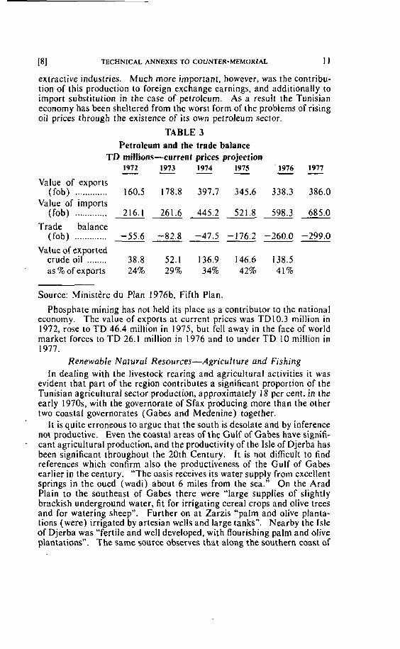
Pl TECHNICAL ANNEXES TO COUNTER-MEMORIAL 1 1
extractive industries. Much more important, however, was the contribu- tion of this production to foreign exchange earnings, and additionally to import substitution in the case of petroleurn. As a result the Tunisian economy has been sheltered from the worst form of the problems of rising oil prices through the existence of its own petroleum sector.
TABLE 3 Petroleum and the trade balance
TD millions-current prices projection 1972 1973 1974 1975 - - - - ' 1976 1977 - -
Value of exporks (fob) ............. 160.5 178.8 397.7 345.6 338.3 386.0
Value of imports ............. (fob) 216.1 261.6 445.2 521 .8 598.3 685.0 ------
Trade balance (lob) ............. -55.6 -82.8 -47.5 -176.2 -260.0 -299.0
Value of exported crude oil ........ 38.8 52.1 136.9 146.6 138.5 as % ofexports 24% 29% 34% 42% 41%
Source: Ministère du Plan 1976b, Fifth Plan.
Phosphate rnining has not held its place as a contributor to the national economy. The value of exports at current prices was TD10.3 million in 1972, rose to TD 46.4 million in 1975, but fell away in the face of world market forces to TD 26.1 million in 1976 and to under TD 10 million in 1977.
RenewabIe Nafural Resources-Agriculture und Fishing In dealing with the livestock rearing and agricultural activities it was
evident that part of the region contributes a significant proportion of the Tunisian agricultural sector production, approximately 18 per cent. in the early 1970s, with the governorate of Sfax producing more than the other two coastal governorates (Gabes and Medenine) together.
I t is quite erroneous to argue that the south is desolate and by inference not productive. Evert the coastal areas of the Gulf of Gabes have signifi- cant agricultural production, and the productivity of the Isle of Djerba has been significant throughout the 20th Century. It is not difficult to find references which confirm ülso the productiveness of the Gulf of Gabes earlier in the century. "The oasis receives its water supply from excellent springs in the oued (wadi) about 6 miles from the sea." On the Arad Plain to the southeast of Gabes there were "large supplies of slightly brackish underground water, fit for irrigating cereal crops and olive trees and for watering sheep". Further on at Zarzis "palm and olive planta- tions (were) irrigated by artesian wells and large tanks". Nearby the Isle of Djerba was "fertile and well developed, with flourishing palm and olive plantations". The same source observes that along the southern coast of
12 CONTINENTAL SHELF i9]
the Gulf of Gabes there were "small fishing villages and sponge-fishing comrnunities", certainly very srnall compared with the agricultural setlle- ments of Gabes and Djerba (al1 quotations from Naval Intelligence Divi- sion, 1945, page 44) . Djerba supported 50,000 people at this tirne, Zarzis over 1.000 and the total population of the coastal strip must have been in the region of 100,000 (excluding Sfax governorate). The total fishing population of Tunisia cauld not have been rnuch more than 10,000 of which under 1,000 operated from the southern shores of the Gulf. Assuming that each fisherman supported a family of five (a high figure), it would seem probable that an approximate breakdown of the economic activities of the population of the southern coastal strip was:
Agriculture 75% Fishing 5 % Urban 20%.
The balance has changed substantially since the 1930s but the proportion of those depending on fishing has certainly not risen.
I n dealing with the comparative importance of fishing and agriculture in terrns of employment, we have introduced the other renewable natural resource, that of fishing. We have shown already that only a small pro- portion of the population of the coastal strip and islands is engaged in fishing. I n terms of the region as a whole (including Sfax with the Kerkennah Isles) the fishing community was apparently 3 .3 per cent. of the total population in the 1940s, and about 1.6 percent. in the later 1970s. (Such figures are deduced from national census data ( 1946) and popula- tion estimates (1970s) and a fairly static fishing community of approxi- mately 50,000 people.) On the basis of similar estimates the figure for the country as a whole for the 1970s would be t .3 per cent.
The extent to which an economic sector generates ernployment is only one way to evaluate its importance and effectiveness in the economy as a whole. It is necessary also to look at its performance with respect to production, value added and the potential for future growth as refiected in government plans.
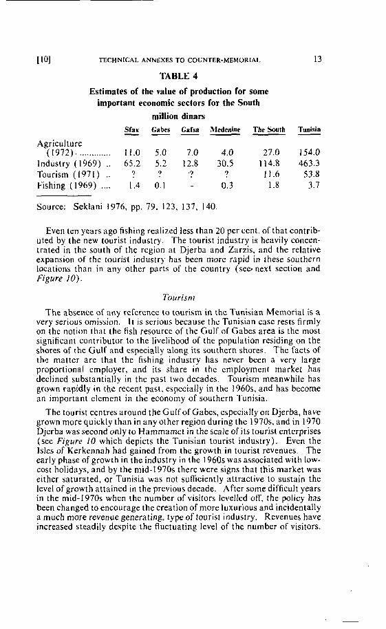
TECHNlCAL ANNEXES TO COUNTER-MEMORlAL
TABLE 4
Estimates of the value of production for some important econornic sectors for the South
million dinars Sfax Gabes Gafsa Mdenine The South Tunisia - --
Agriculture ( 1 9 7 2 ) , . . ........... 11.0 5.0 7.0 4.0 27.0 154.0
lndustry (1969) .. 65.2 5.2 12.8 30.5 114.8 463.3 Tourism (1971) .. ? ? ' ? ? 11.6 53.8 Fishing (1969) .... 1.4 0.1 0.3 1.8 3.7
Source: Seklani 1976, pp. 79, 123, 137, 140.
Even ten years ago fishing realized less than 20 percent. of that contrib- uted by the new tourist industry. The tourist industry is heavily concen- trated in the south of the region at Djerba and Zarzis, and the relative expansion of the tourist industry has been more rapid in these southern locations than in any other parts of the country (sebnexl section and Figure 1 O).
The absence of any reference ta tourism in the Tunisian Mernorial is a very serious omission. I I is serious because the Tunisian case rests firmly on the noiion that the fish resource of the Gulf of Gabes area is the most signifiant contributor to the livelihood of the population rcsiding on the shores af the Gulf and especially along its southern shores. The facts of thc rnatter are that the fishing industry has never been a very large proportional employer, and its share in the employment market has declined substantially in the past two decades. Tourism meanwhile has grown rapidly in the recent past, e s ~ c i a l l y in the 1960% and has become an important element in the economy of southern Tunisia.
The tourist centres around the Gulf of Gabes, especially on Djerba, have grown more quickly than in any other region during the 1970s, and in 1970 Djerba was second only to Hammamet in the scale of its tourist enterprises (see Figure 10 which depicts the Tunisian tourist industry). Even the lsles of Kerkennah had gained from the growth in tourist revenues. The early phase of growth in the industry in the 1960s was associated with low- cost holidays, and by the mid-1970s there were signs that this market was either saturated, or Tunisia was not sufficiently attractive to sustain the level of growth attained in the previous decade, After some difficult years in the mid- 1970s when the number of visitors levelled off, the policy has been changed to encourage the creation of more luxurious and incidentally a much more revenue generating, type of tourist industry. Revenues have increased steadily despite the fluctuating level of the number of visitors.
14 CONTINENTAL SHELF 11 11
TABLE 5 Some data on Tunisian tourism
Receipts TDmn 1963 3.7 1966 13.6 1969 26.1 1972 67.4 1964 5.4 1967 16.4 1 970* 1973 72.1 1965 9.2 1968 22.2 1971 53.8 1974 79.1
1975 115.2
* not available to author Source: Anntcaire Statisrique de la Tunisie 1974-1975 and Secretariat
of Stale for Information 1978
Tourism has attracted a high level of investment from boih public as well as private sources and from both Tunisian and international sources. Some idea of the level of investment achieved between 1962 and 1974 is provided in Figure I I . lnvestrnent never fell below !O million dinars per year after 1963 and in 1973 i t reached 23.9 million dinars. The south received a disproportionately larger share of this investment which has led to the rapid growth of the Djerba and Zarzis tourist amenities'.
Employment creation has already been mentioned with respect to tour- ism. Relatively small numbers were engaged in the industry in 1960. Official data of the Oftîce National du Tourism for 1965 suggested that there were 3,846 staff employed in hotels in Tunisia. The same source was suggesting that there were 12.676 in such employment by 1969. The number of Tunisians employed by the tourist industry as a whole rose further to 19.900 by 1973 and increased by 13,600 (68 per cent.) in the period 1973-1976 (Secretariat of State for Information 1978. page 99). I n value added terms the industry was rnaking a 45 million dinar contribu- tion to the national economy in 1974 (see Figure I I ) .
The contribution of the tourist industry to the national economy is important both because of the value of revenues generated and especially because most of the revenues corne in the form of hard currency. The 45 million dinar value added sum i n 1974 and arnounts of more than double that sum by 1977 were more important to the economy than other labour intensive manufacturing activities which did not figure in the export market.
To have ignored tourisrn as part of the economic system of the Gulf of Gabes region can only be interpreted as a serious attempt by the authors of the Tunisian Memoriai to distort the picture of the real economic circum- stances of southern Tunisia.
Tourism has for over 20 years been dynamic and expanding and has become a major feature of Tunisia's economic well-being. Meanwhile the fishing industry has expanded relatively little, and makes no equivalent contribution 10 the Tunisian economy whether measured in tetms of value
' After 1966 invcstment in the Djerba-Zarzis zone alone ran at the rate of 5-6 million dinars pcr year, and in 1973 was sti l l over 5 million dinars (Seklani 1976, p. 125).
I l 2 ] TECHNICAL ANNEXES TO COUNTER-MEMORIAL 15
added. employment creation and even more important with respect to the future. The prospects for fishing are that it will grow slowly, wilt employ progressively fewer people and will never contribute significantly to exports. Tourism, on the other hand, can consolidate its position by concentrating on the better value added performance derived from medium and high cost tourism, and thereby continue to make a major contribution.
A warning should be signalled concerning the tourist data for the second half of the 1970s. The number of visitors has fallen. The occupancy rates of hotels were already falling by 1975 and have continued to fall subsequently. although no recent data on this feature have so far been located. The position up ro 1975 is shown in Table 6 and reveals that occupancy was lower in the south than in resorts close to Tunis such as Hammamet. Also the potcntial of the inland south, the Gafsa region, for tourism had not been proven by the mid- 1970s. This last rends to confirrn the value of the coasta! resource, in this case the leisure amenities associ- ated wiih a shore line with a reliable clirnate, where bathing. sailing and aquatic pursuits are al1 readily available. But al1 of these activities are very specifically in-shore and depend in no way on the central and furlher parts of the Gulf. which i t is the purpose of the Tunisian authors to establish as an integral and essential part of t h e economy of the South; as part of their intent ro prove that an enlarged Gulf of Gabes is Tunisian.
TABLE 6 Tourist accommodation-levels of occupancy by region 1970-75
Zones - 1971 1972 1973 1974 1975 - - - - - % % % 9% %
Nabeul-Hammamet ...................... 58.3 61.1 44.3 39.8 54.1 Sousse-Monastir ............................ 65.3 66.7 57.1 47.8 61.4 Djerba-Zarzis .............................. 59.9 57.2 36.1 39.6 50.8 Gafsa-Tozeur .............................. - - - 25.6 32.3 Tunis et Banlieue ............................. 5 1.6 48.7 42.3 42.7 52.7 Tabarkea-Bizerte ........................... - - - 34.7 34.7
Source: Ministère du Plan 1975, Annuaire Statistique de la Tunisie. p. 248.
16 CONTINENTAL SHELF 1131
( i i ) Governmerlï lnv~sfnteni and Planning ~ h e performance of the econorny of the southhas depended to a consid-
erable extcnt on the perception of the central government about the region's resources. lnvestrnent in the south has been considerable. if selective, and Figure 12. showing the geographical distribution of invest- ment. and Figure 13 dernonstrate the special features of the econorny of the south.
The south attracted more gove.rnment investment per head than any other region. between 1962 and 1971. Most of this investment was directed into extractive industries. in oil and phosphate mining, with lirn- ited investment in manufacturing in Sfax and Gabes. Agriculture and fishing were virtually neglected in the south and emphasis was given to tourism as reflected i n the spending on services (sec Figure 13) . In ngricultrirc the rnajority of investment was directed towards soi1 and forest protection, water conservation and related research, and those activities accounted for 75 per cent. of the investments in this sector up to 1970. There was little left for fishing and as a result the policy towards fishing has becn to make loans available on favourable terms through the National Fisheries Board with a view io inodernizing the sector. But the "authorities counted on individual effort to incrcase the inadequate pro- duction froni the coastal waters rich in fish 3s ihey" were (Secretririar of Statc for Information 1978, page 156). This statement rcveals the per- ception of thosc in central government that there was a big potential for fishing in the mid-1970s and that reasonable returns could be achieved with only limited assistance to the industry.
The cffect of the pattern of investment in the south. and especiatly in the southern governorates of Gabcs and Medenine, has been 10 slimulate local (Mzabi 1978) and inter-regional immigration and urhanization. The resourccs or the rural areas have no1 bcen able to support the growing population and there has been a markzd move to the towns (Seklani 1976, pages 308-399). iMedenine was the governorate which lost most popula- tion through emigration. The net ernigration figure was 0.85 percent. per yelir, cornprired with 0.16 pcr cent. from Sfax, 0.65 per cent. from Glibcs and 0.12 per cent. from Gafsa (Scklani 1976, page 201). Other governorates in the north gained accordingly. Such are the pressures that even the growth of tourisrn has been quite inadequate to absorb the surplus rural population.
These signs of economic instability are reflected in the national arena. Tunisia's is a deficit econorny and at no time in the past two decadcs has sufficient incorne been generated to balance external payments or to finance r hc developmeni budget. Since independence Tunisia has been heavilg dependent on external aid and loans. In the late 1960s. for exam- ple, Tunisia received more United States aid per head than any other African country.
TECHN~CAL ANNEXES TO COUNTER-MEMORIAL 17
TABLE 7
Tunisia's projected external debt-1977-1981
( TDmn ) 1977 1978 1979 1980 1981 - . - II ................. Total external dcbt 774.9 1004.9 1233.9 1449.9 1639.9
Composition of external debt Government debt ................ 3 19.8 443.8 542.6 6 12.0 667.2 Debt of enterpriscs ............. 455.1 561.1 69 1.3 837.9 972.7
(including Sta te owned and privatc)
Debt service ........................ 77 94 123 159 211 Principal .............................. 45 50 60 80 115
................................ Intcrest 32 4 4 63 79 96 Debt service/current re-
ceipts ............................... 10.8%) I l 12.8% 14.6% 17.4%)
Source: Republjc of Tunisia Ffllh Plan for Economir and Social Bevelop- ment 1977-1981, Table IV-2-1.
By the late 1970s the total debt was cxpcctcd to rcach 1004.9 million dinars by which time gross domestic product had rcachcd 2426 million dinars. In the same year the debt scrvice/current receipts ratio would have risen to 1 1.5 per cent. and was cxpected to go as high as 17.4 per cent. by 1981.
The Tunisian economy. though somewhat proiected frorn the worst problems of imported inflation through the possession of oil and some to spare, is neverthelcss vulnerable to a number of economic draughts. First, its petroleum production has not proved to be reliable and there have been technical difficulties (Middle Eusr Annual Rrview, 1979, page 380). Second, commodity prices have fluctuated for the other major exports, phosphates and olives. Third, agricultural.production varies greatly from year to year a s a result of the country's semi-arid climate, leading to the purchase of costly imported food. The fluctuations in national revenues which these circumstances bring about have caused, and will continue to cause, balance of payments problems. especially as development spending has always been sustained and continues to be planned.
The level of investment has only been possible through external contri- butions. Government to government payments have been the major source of such funds but private foreign finance varied between 40 and 50 per cent. between 1966 and 1974 (see Figure f5 showing the evaluation of foreign contributions). A high proportion of the private foreign invest- ment has gone into tourism and manufacturing industry and there is some reasonable cynicism about the motives of foreign investors in these enter- prises (Middle East Annual Review, 1979, page 380). Some of the indusiries have proved to be vulnerable to trading quotas. Textiles for
18 CONTINENTAL sHELF 1151
instance sufîered grievously in 1977 when European Economic Commu- nity quotas were introduced. Textiles had shown the biggest rise in employment of any sector (see Figure 14) and the impact of the quotas was very powerful.
Deficient in capital resources, Tunisia has a labour surplus and much of this surplus is highly educated. Temporary emigration overseas for employrnent is common in Tunisia, and the numbers crossing to Libya have been substantial whenever political circumstances have permitted such movements. The complementarity between the economies of Tuni- sia and Libya is obvious with respect to iwo of the factors of production, labour and capital. Land the other factor of production is. unquestion- ably arranged in Tunisia's favour. Tunisia has more rainfed land per head and those tracts enjoy more rainfall than rainfed tracts in Libya. Thus the matter of the current relative economic positions, attributable to unequai factor endowment. to which attention is drawn in the Tunisian Mernorial (Volume 1 , page 69. paragraph 3.51 ) should be considered further.
4. The Jeffara Plain - A Natural Region A. A Definirion of the Region
The JeiTara Plain is a rcgion which is bounded by very distinctive geomorphological features. A change in relief marks out the boundary of the region very clearly. I t is reilected in a line of hills which in the West has a northerly orientation in the Ksour OC Tunisia; the escarpment swings to the east in the Jabal Nafusah and continues through the Jabal Tarhunah to meet the coast again in the Jabal Mslata to the West of Al Khums. The western part of the region lies in Tunisia; the eastern and major part of the Plain lies in Libya.
Because the Jeffara Plain is a relatively undisturbed geological feature the region has a natural uniformity. 1 t will be shown that this uniformity is reflected in the geomorphology, soils and groundwater of the region. The agriculturat potential of the Plain does Vary as a result of the disposi- tion of rainfall. The eastern part of the Plain is better favoured. and that part whiih enjoys over 200 rnillimeires of annual average rainfall, can support dryland fürming. Elsewhere settled agriculture depends on ~ h e groundwater resource.
B. The Narural Resuurces of the J e D r a Plain
( i ) Cliniafr The Jcfiàra Plain is a semi-arid area, with rainfall concentratcd in the
winter months. The important threshold determining the extent of rainfed agriculture is the 200 millimetres average annual isohyet. Less than one-third of the Libyan Jeffara and less than 20 percent. of the whole Jefiara Plain which includes the Tunisian element of the region erijoy more than 200 millimetres of annual rainfall. A further third of the Libyan JeKara Plain receives rainfall sulticient 10 provide grazing for livestock; approximately the same proportion of grazing land is available in the total JeRara region.
[161 TECHNICAL ANNEXES TO COUNTER-MEMORIAL 19
Low rainfall areas also endure sharply fluctuating levels of rainfall frorn year to year, and the proportional fluctuation increases as the average level of rainfall decreases. Thus the marginal grazing resources are subject to increases, and rapid declines, in production. Likewise the marginal dry- land farming areas show marked fluctuations in grain production which closely cotrelate with the levels of annual rainfâll (Ewing 1978).
(ii) Groundwarer The Jeffara Plain region, including the Libyan and Tunisian elements, is
a single groundwater province (Desio 1940, Hill 1960, Welsh 1979). The deep and shallow water bearing strata, the aquifers, are connected as a single system in the south of the region. but are separated by a clay layer in the northern coastal strip of the Plain.
The upper (Quaternary) and deeper (Miocene) aquifers slope gently coastwards. The generally undisturbed and coastward dipping aquifers are ideal media for transrnitting groundwater from the southern infiltra- tion zone to the coastal zone. Here it supplements infiltration frorn the higher rainfall at the coast where rnoçt water withdrawal and use have conventionally taken place.
The geology of the Jeffara Plain has determined the disposition of groundwater, the region's most precious natural resource. This lirnited resource has tended to accumulate in the coastal tract in the north of the Plain. Because population and settled farming have tended to concen- trate in the Tripoli atea which is best favoured in terms of annual rainfall, it has been in this zone that the groundwater has becn most heavily developed. Excessive groundwater withdrawal in the Tripoli area has led to a rapid decline in the groundwater resource. Withdrawals eight tirnes the rate of recharge have been observed in the worst affected areas of Tripoli, which in 1978 was a rate much higher than the estimated four times average for the Libyan Jeffara as a whole (Floegel 1978).
The Jefîara Plain is hydrogeologically a single unit. The disposition of the northward dripping sedirnents causes the groundwater to accumulate in the coastal zone. The international boundary traverses the single Jef- fara groundwater province which embraces both the Tunisian and Libyan elements.
(iii) Soils
The origin and development of the soils of the Jeffara Plain have tended to be uniform. Except for the sebkha deposits at the coast, and the water sorted materials of the wadi beds on the Plain irself, the soils are aeolian in origin. I n composition they reflect the Quaternary geology of the Plain and the limestones, sandstones, marls and clays of the Jabal Nafusah. Their mechanical character is sandy and their organic content is uni- formly low. Though everywhere poor in sail nutrients, they nevertheless can produce good yields of field and tree crops, but only with very high inputs of irrigation water because high infiltration rates characterize the sandy Jeffara soils. Unfortunately water is a scarce resource.
20 CONTINENTAL SAELF
(iv) Vegetafioti
Vegetntion varies according to the rcgional variation in rainfall. Like the water resource. the vcgetation resource upon which the grazing activi- lies dcpcnd has been very hard pressed in recent decades, and Cintzburger and Bayoumi ( 1977) have shown that the productivity of the range was nui equal in the mid- 1970s to the dcmands being placed upon it. At thc sarne timc dryland agricultural schcmes have been set up in many agricul- iuralty ver! marginal areas which were used alniost exclusively for grazing for rnany centuries. As a result the area of serni-natural vegetation of the J c f i r a Plain has dcclined by t O percent. in the past decade and by alrnost 50 per ccni. since ihe bcginning of the century.
The vegetation rèsources are not arranged cquallg over the JeKara Plain. The quality of the range changes with rainfall and the eastern part of the Plain enjoys miich more favourablc rains thcin does t h e western and the Tunisian Jeflara. I n the region traversed by the international bound- ary the vegetation resourccs are uniformly disposed from west to easl. Progressively poortr quality rangeland is found as one moves away from the Coast atong the international boundary.
C . The Problcms of Managing Renewahle h'atural Resources in the Jeflara Pluin Rcgiun.
Thc J c b r a Plain is Libya's richest agricultural resourcc. but as alreridy indicated its groundwater. upon which irrigated farming dcpends, is seri- ously depleted. Mcanwhile the grazing resources i n the areas of low rainfrtll are overgrazed and much disturbed by the attempts to grow cercals in places with less than 200 rnillimetres of average annual rainfall. Agricultural production rose steadily through the 1960s and into the rnid- 1970s. but wiih the realization that the groundwater rcsources were lim- ited. merisures wcrc taken to reduce withdrawal and the planting of crops such as citrus and tomatoes was controlled. As a result the levcls of rigricultural production for the Jefi'ara have not risen sincc the mid-1970s. Water shortages have also forced some farmers to reduce levels of cropping.
These unpleasant environmental facts give the lie to the claim i n thc Tunisian Mcmorial that Libya has an easy set of economic circumstanccs to manage. Even in Libya's most favoured area for agriculiural produc- tion the prospects for irrigated farming are poor. I n the west of the Libyan Jeffara on the border with Tunisia, there is furtlier evidence of resourcc management dificulties, in this case facing both governmcnts. On the 1-ibyan side of the border attempts have been made io cultivate low rainfrill arcas with supplementary irrigation. The absencc of success of these ventures. privately financcd (but indirectly funded by oil revenues to which farrii owners have gained access by other work), confirms the dericiencies of the natural resource base of the Jeffara Plain, and especially of the western Jeffara.
118) TECHNlCAL ANNEXES TO COUNTER-MEMORIAL 21
5. Conclusion - The Major Natural Divisions of the Gulf of Gabes - Jeffara Region.
On the basis of a number of naiural characteristics which affect the land utilization practices of the regions, the Gulf of Gabes can be shown to be non-uniform, while the Jefara Plain can be shown to be a uniform geologi- cal. geornorphological, and soils region.
The most important faclors which point to a nalural subdivision of the onshore Gulf of Gabes are the differences first in levels of rainfall between the northern part of the Gulf of Gabesarea and especially in the area north of Sfax (an area not usually included in the region defined as the Gulf of Gabes), and the southern shores of the Gulf of Gabes, as well as in the seasonal disposition of winter rains. Second, there are groundwater dividcs. one of which emerges at the Coast to the west of the Isle of Djerba, and the other just 10 the north of Gabes.
I t is the former of these groundwater divides which also has topographic expression in the upland of the Ksour and these bound the western margin of the Jeffara Plain. Unlike the Gulf of Gabes the Jeffara Plain is a geologically uniform region, and only rainfall variations cause there to be diKcrences in the pattern of land utilization on what are otherwise uniform soils and generaily uniform groundwater resources.
6. References
Commission for Technical Cooperation ...................
Floegel, H. .........................
de Fages. E. and Ponzevera, C. ................
1963 Cane des sols d'Afrique, Feuille 6. Institut Géographique Mili- taire. Bruxelles.
1960 "Sulla posizione geologica e sull'oragine delle falde equitere artesiano della Gefara" Istituto di Geologia di Milano. Publ. No. 13. Milan.
196 1 La Tunisie: ses regions, 2' édition, Armand Colin, Paris.
1978 "Report on the experience with ce- reals and medic pastures on the Cereals Project, Gefara Plain". Gefara Developrnent Authority. Tripoli (rnirneo).
1978 "lso-piezornetric map and iso- drawdown rnap for 1976/77 for the first reservoir in the Gefara", Secretariat of Dams and Water Resources, Tripoli, mimeo. 12pp.
1908 Les pèches nloririmes de la Tunisie. Edirions Bouslama, Tu- nis, 2d édition. 18 l pp.
22 CONTINENTAL SHELF 1\91
Gaussen, H. and Vernet, H .
Gintzburger, G . and Bayoumi, M. ..................
Hill. R.W. .........................
Middle East Annual Review ...........................
............. Ministère du Plan
............. Ministère du Plan
............. Ministère du Plan ' .
............. Ministère du Plan
Mzabi, H. ..........................
Naval Intelligence Division
Secretariat of State for Information ....................
........................ Seklani. M .
Carre Internationale du Tapis Végétal: Tunis-Sfax, Gouverne- ment Tunisien, Tunis.
Survey of present siruafion and production of the Libyun range- lands, Agricultural Research Centre. Tripoli, FAO-ARC TF9 197, 50pp. "Underground water resources of the jeiTara Plain" in Willimott, H.S. and Clarke, J . I . , Field Slud- ies in Libya, University of Dur- ham.
Middle East Annual Review, World Information, London. Annuaire statistique de la Tunisie 1969. Institut National de la Statistique, Tunis, 431 pp. Séries Sraristique-reirospective 1968-1973, Tunis. Travaux prépararoires du V Plan: l'agriculrure ei la pèche, Tunis, 51pp. and 19 annexes. Fvth plan for economic and social davelopment. Tunis. La croissance urbaine accélérée a Jerba et ses conséquences sur la vie des relarions vers l'éxrerieur, Université de Tunis, Faculté6 Let- tres et Sciences Humaines. Gé- ographie, Vol. VII, 178 pp. Tunisia: Geographical Hand- book. The Admiralty. London, 532 pp.
Tunisin nroves ahead, Ceres Pro- ductions, Tunis. Economir ef popularion du Sud Tunisien, Centres de Recherches et dlEtudes sur les Sociétés Méditerranéennes, Editions du Centre National de la Recherche Scientifique, Paris, 455pp. .
[201 TECBNICAL ANNEXES TO COUNTER-MEMORIAL 23
Servicc Tunisirn dcs Statis- tique ............................... 1947 Annttaire stcifisiiqire de la
Tunisie. Tunis. .......................... So<;~t:.nti 1977 Trawl fishing ground slrrvey (4'
the Tripoliranian const, Final Re- port, Grerioble, 30pp.
Tunisian Tourism Naiional .......... .............................. OHice 1975 Annual tourist data, Tunis
........................ Welsh J . L. 1979 "Critical warer problcmç of thc Gefara Plain and Suggested Ini- mediaie Actions", Gcfarü Plain Water Management Plan Project. Secrerariat of Agricuitural Rccla- mation and Land Developnient. Tripoli (mirneo), 17pp.
CONTINENTAL SHELF
Annex 2
THE MEDITERRANEAN COASTLINE OF NORTH AFRICA EMPHASIZING THE COASTS OF TUNISIA AND LIBYA
AND
DR. E. W. ANDERSON**
* M.A.. unGersity of Oxford ; Ph.D., University of Southampton. ** M.A., University of Oiford ; M.A., University of Manchester ; M.Ed., University of
Newcastle ; Ph.D., University of Durham ; Ph.D., University of Newcastle.
[ I l TECHNICAL ANNEXES TO COUNTER-MEMORIAL 25
Part 1. THE MEDITERRANEAN COASTLINE OF NORTH AFRICA FROM CEUTA IN MOROCCO TO EL ARISH IN ECYPT
Before considering the coastlines and coastal zones of eastern Tunisia and western Libya', it is necessary to view this particular stretch in the context of the entire North African coastline for two reasons:
( a ) Whatever geornorphological or geological criteria are used, the coastline from Cape Bon to Ras Zorug occurs at a zone of
'
major change.
(b) When the exact position of change in each case is identified, it is found that none coincides with the international land boundary between Tunisia and Libya.
The Coast of North Africa from Ceuta to El Arish
This coastline, some 4,340 kilornctres in length, includes the littorals of five States and, physically, presents extrerne contrasts. The overall trend is east/west and only the coastlines of Tunisia and Libya display any major departure from this. It is therefore broadly orientated northward allhough locally the struciural trends produce modifications.
The major morphological contrast is between the high rugged coastline of the western part, dominated by the Atlas Mountains, and the low coast of the east praduced by the Nile delta2. The former is a tecessional coastline on which the major processes are erosional while the latter is an accretional area in which deposition predominates. The character of one was produced basically by the forces of the land and the other by the forces of the sea. Between these iwo extremes lie the coasts of Eastern Tunisia and Libya displaying in a measure characteristics which owe something to each source. However, while the highlands in the West are high and folded, those in the east are low and plateau-like.
As a result of these différences, the West tends to be a highly indented, complex coastline with a large range of offshore islarids, reefs and shoals, while the east is very much mare regular with depositional features and sandbanks.
The inclination of the continental shelf out to. for example, the 200 metre isobath also varies considerably frorn one end of the coastline to the other. Along the western mountainous coast it is a narrow fringe averag- ing some six nautical miles to the 200 metre line. Along the east coast the mean width is some 20 nautical miles. The shetf to the 200 metre line is extensively developed in only two places, off the east coast of Tunisia and west coast of Libya, and seawards of the Nile delta.
Geology
A further marked distinction is provided by geology, since the sediments to the West have been intensively crushed and folded ta produce the various complex elements of the Atlas chain, whereas those of the east were laid on
26 CONTINENTAL SHELF 121
the stable African platform. The structure along the eastern coastal zone is therefore simple, whereas that of'the western end is highly cornplex.
The structural trend lines in the West are varied, and with few exceptions are between west/southwest to east/northeast and southwest to northeast. There is no such clear-cut pattern of trends on the African platform although the general tendency is towards the north and northwest. The pattern of faults in many ways parallels these fold trends. Major faults affecting the western end are aligned from southwest to northeast, while those in the African platform sediments are variously aligned tanging from southeast to northwest, to east ta West.
From the complicated geological record it is therefore possible to iden- tify key features which distinguish quite clearly the western part of the coastline from that to the east.
Sa1 t Marshes While climate and economic activities of the coastal zone, although they
also pravide a contrast, are not to be considered here, increasing aridity is also expressed in the prevaIence of major Iandforms, salt rnarshes. These features which greatly influence the rnorphology of the coastal area becorne prominent from the east coast of Tunisia eastward.
Frorn a consideration of the morphology and geotogy of the coastlines it is possible to establish a number of clearcut contrasts between the western end of the coast and the eastern end respectivety:
( a ) Highland: lowland (b) Complexity: simplicity (c) Land dominated: sea dominated (d) Rugged relief: smoolh relief (e) Erosion: deposition (f) Structural cornplexity: structural simplicity (g ) Fold trends - southwest to northeast: southeast to northwest (h) Fault trends - southwest to northeast: variable
These variations identified on the rnacro-scale are confirmed by the more detailed examination of the coastlines as follows:
(a ) The northern coastline of Morocco (b) The coastline of Algeria (c) The northern coastline of Tunisia ( d ) The eastern coastline of Tunisia (e ) The coastline of Libya (f) The coastline of Egypt
Contras? Boundaries (Figure 1 ) The eastern coastline of Tunisia and western coastline of Libya both
contain areas of highland and lowland but the boundary between the predominantly high areas and the predominantly low areas occurs at Ras
Pl TECHNICAL ANNEXES TO COUNTER-MEMORIAL 27
Kaboudia ( A ) . South and east of this, upland, and particularly rugged highland, is exceptional. North and West there are very few bays or lowlands.
Obviously morphological complexity, and the presence of erosional fea- tures, are more closely aligned with a highland coastline. However, Ras Mostefa ( B ) marks the commencement of the first major depositional area with its smooth coastline. In the West there are some five bays with predominantly northwest facing sand dune coastlines, but these are al1 of limited extent. To the south and east, indentations and erosional features occur on the northeasr orientated side of the Sahelian foreland and to a limited extent between the Gulf of Salum and Arabs Gulf. There are only two large scale shoreline ,accretional features before the Kerkennah banks but beyond is a well developed spit around the Isle of Kneiss, the tombolo linking the Isle of Djerba to the mainland, the çpits and bars on either side of the TunisianjLibyan frontier and a range of offshore banks before the major developments of the Nile delta.
The shelf width is extremely restricted along the whole of the west coast as far aç Cape Blanc (C) from which point the distance Io, for example, the 200 metre line becornes clearly more extensive. In one or two bays to the West and particularly on either side of Cape Tres Forcas the shelf is well developed. To the south and east of Cape Blanc it narrows noticeably near Misratah, in the neighbourhood of Ras el Hilal, and in Abu Hashaifa Bay.
Geologically the major boundary is lhat of the Saharan platea (D) which pravides the eastern hundary of the Alpine fald area. However, the Alpine domain proper includes the Cape Bon peninsula and the Sahe- lian foreland; the boundary separating it from the African platform occurs at Gabes (E) . This position also separates the fault line trends of the African platform from those of the Atlas system.
Finally, the development of coastal salt marshes commences in the neighbourhood of Sousse (F). There are occasional examples along the western part of the coast but south and east of Sousse they occur regularly and influence the morphology of the coast.
In conclusion, subdividing the coastline of North Africa clearly presents problems. However, using a number of clear-cut objective criteria it is possible to make a broad division between the west and the east. Although the eastern coastline of Tunisia and the western coastIine of Libya present in many ways a zone of change, it is possible to assign a number of well defined baundaries, al1 of them occurring within this stretch. Thus the significance and importance of this coastline morpho- logically and geologically are clearly illustrated.
The Northern Coastline of Morocco This coast stretching from Ceuta to Saidia, a distance of approximately
300 kilometres, has a scalloped appearance but no deeply inset bays (Fig- ure 2). The trend is broadly east/west and therefore the orientation is north with variations locally. It is a highland coastline with very limited
28 CONTINENTAL SHELF (41
coastal plain development and the main features are erosional. The shape is however governed more by the trend of the mountains than any coastal brocess.
South of Ceuta the coast is at first comparatively low and fringed with rocks and offshore banks. It becornes increasingly rugged with alternat- ing high rocky points and restricted sandy beacheç as far as Punta de Pescadores. From this point the coastal strip becomes increasingly arid. Eastward there are high rugged cliffs, particularly near Mestaza with little beach development and a nurnber of offshore islets. The Bay of Alhucemas has high prominent headlands and the coastline eastward is backed by high mountains, in some cases over 1,000 metres. There is only one beach of any size and the coastline is a succession of rocky points and smali islets as far as the rnost dominant promontory, the Cape Tres Forcas which reaches a height of over 400 metres This steep rocky peninsula gives way to the one major depositional feature on the entire Moroccan coastline, a bay bar enclosing a lagoon, Puerto Novo, which is backed by low sand dunes. The remaining length of the coastline is composed of low cliffs and islets with beaches and shoals.
The northern coastline of Morocco is thus mainly high and rugged and backed by mountains, with very few beaches of any size, almost no lowland coastline, and only one obvious depositional feature.
The Coastline of Algeria
Stretching from Marsa Ben Mehidi to Cape Roux, a distance of some 990 kilornetres. the coastline of Algeria is more than three times the length of the northern coast of Morocco (Figures 3 and 4). It is more obviously rectilinear with, for long stretches, no sizeable intets at al]. In fact there are only four bays of any extent: the Gulf of Arzew, the Gulf of Bejaia and the bays on eilher side of the Cape de Fer peninsula. The whole length describes a gentle convex curve with a basic northerly orientation. It is a highland coast dominated by the rnountain chains and displaying the effects of erosion with few depositional features.
From the border to Oran the coast is rocky and comparatively high, broken occasionally by deep river valleys. The peninsulas are fringed with offshore rocks and islets. Oran Bay itself displays offshore shoals but the Gulf of Arzew has a low shoreline although it rises steeply inland. From Cape Ivi the coastline increases in height with rocky headlands, deep river valleys, offshore reefs and rocky islands. Immediately inland the moun- tains rise to over 1,000 metres before the low sandy coastline of the Bay of Algiers is reached. The coastline then continues with high points, offshore shoals, rocky patches and occasional islands, to the Gulf of Bejaia which is dominated by mountains reaching over 400 metres The coast continues to be high and mountainous as far as Skikda, beyond which is the Oued el Kebir in a lowland depression with offshore shoals and wooded sand dunes. Beyond Cape de Fer the famiiiar pattern of promontories, shoals and
151 TECHNICAL ANNEXES TO COUNTER-MEMORIAL 29
offshore islands continues to Annaba from which stretches a lowland with rocky spits to Cape Rosa. From Cape Rosa to the border beyond Cape Roux the coastline is again rocky and backed by lakes.
The Algerian coastline is thus high and rocky with off- shore islands and shoals and virtually no lowland except in the neighbourhood of Oran, Algiers, Skikda and Annaba, where only limited areas exist. In these cases al1 clearly northwest facing. the coastline is smooth and backed by dunes.
The Northern Coasttine of Tunisia Frorn the border to Cape Bon, a distance of some 240 kilometres. the
coastline of Tunisia consists of two major promont~ries and one Iarge inlei, the Gulf of Tunis (Figure 7). It thus displays the most prominent fea- tureç on the whole north coast of the Maghreb. Furtherrnore, although a large part of the coastline is fringed by islands. the lsles of the Galite group are by far the most important. From the border the coast is high and indented with cliffs, narrow beaches and rocks offshore. Heights inland exceed 400 metres but aredistinctly lower than those of the Kabylie to the West. The Isles of the Galite display steep coasts and the main isiand rises io almost 400 metres. There are two smaller rock fringed islands, three other rocks and a succession of shoals and banks. From Cape Serrat the coast diminishes in height ta a number of sandy beaches although cliffs occur. Inland rather than fold mountains the main formation is a plateau of comparatively regular heighi. Beyond the cljffs of Cape Blanc there are sandy beaches with offshore rocks to Cape Farina, itself surrounded by rocks and shoals. lmmediately to the south is a delta and the coastline to the southeast is low and marshy. The southern and eastern sides of the Bay of Tunis are mountainous with summits of over 500 metres and rugged cliffs and islands extend as far as Cape Bon.
The Coasrline of Tunisia from Cape Bon to Ras Ajdir Cutting across the rnountain chains, this coastline, approximately 560
kilometres in length, is deeply indented with two major bays, the Gulf of Hammamet and the Gulf of Gabès. and two major promontories, Cape Bon and the Sahelian foreland (Figure 5). The most easterly part is a region of deposition in the area of the Isle of Djerba. Where the coastline parallels the mauntain trend, facing southeast, it tends to be low and depositional, where i t cuts sharply across, and is therefore orientated towards the northeast, it tends to be rugged with high promontories and offshore rocks. There is therefore a succession of coastal stretches dis- playing firstly erosional features and then those of deposition. Addition- ally there are several offshore islands and a major area of accretion around the Kerkennah Isles, Further large scale deposition occurs around the Isle of Kneiss and the Isle of Djerba.
The coastline of Tunisia is therefore one of comparatively major features with prominent headlands and deeply
30 CONTINENTAL SHELF [SI
indented bays. It possesses the most clearly differentiated features of the three coastlines described above and is the only one with major offshore islands and large stretches of deposition.
The Coastline of Libya The coastline of Libya from Ras Ajdir to Salum is by far the longest
possessed by a North African State, and while including the major inlet on the entire coast, lacks small scale indentations (Figures 6 and 7). The Libyan coastline also ofiers a sharp contrast in being basically lowland with sand dunes and a range of depositional features. The trend is east/west and the entire length, except locally in the Gulf of Sirt, is orientated northward. From Ras Ajdir to Ras Zorug there are several wide inlets but with the exception of stretches from Ras el Hallab to Ras el Msen, cliffs are either low or absent entirely. From Ras Zorug southward there are low sand dunes with occasional offshore rocks and thecoastline is backed by a series of sait lagoons. Beyond Es Sider there are rocky points, extensive salt marshes and shoal banks. The coastline continues low but increasingly rock fringed to Bengazi near which a number of spits have developed. The dunes and coastal salt lagoons continue northward, but beyond Tocra the coastline becomes increasingly rugged with offshore reefs and hills near the sea rising to 300 melres. From Tolemaide the coast is characterized by rugged steep cliffs and narrow sandy beaches as far as Derna while occasional islands occur and the cliffs are in places dissected by deep ravines. Beyond Derna the high tableland produces bold cliffs, but the Gulf of Bomba is low and sandy with islands and offshore shoals. Between Tobruch and Ras el Mreisa steep slopes of the tableland become lower though more rugged with a shoal fringe.
The coastline of Libya is therefore very largely low with sand dunes and offshore banks although in places coastal hills and offshore rocks also occur. There are only two stretches of highland and these are in sharp contrast to the rugged peaks of the Maghreb. However, although there is hilly relief in the Al Khums region, beyond Bengazi the upland is basically a plateau.
The Coustline of Egvpt The coastline of Egypt from SaIurn to El Arish, a distance of some 780
@ kilornetres, falls naturally into two distinct sectors (Figures 8 and 9). From the border to Arabs Gulf it is low but comparatively rugged with erosional features. Beyond, it consists of the major depositional area of the Nile delta. It is therefore mainty a low coastline orientated northward with only one major feature, the delta.
The western side of the Gulf of Salum has vertical clifîs but the southern side is low with salt marshes and a sandy coastline with occasional rocky points. From Sidi Barrani to Ras Alum el Rum the coast is almost rectilinear with a few sharp indentations. It is backed by the fiat summit
i71 TECHNICAL ANNEXES TO COUNTER-MEMORIAL 3 1
of the Libyan plateau and dissected by wadis, although there are acca- sional Salt lagoons inland and rocks offshore. Abu Hashaifa Bay is sandy and backed by hills and terminates in Ras el Kanayis, a promontory with offshore reefs. From Ras el Dab'a ta Arabs Gulf the coast is sandy with cliiTs and fringed with rocks and shoals. Beyond is the Nile delta, a very low sandy coastline with shifting offshore banks and occasional sandhills. The major characteristic is the classic array of accretional features includ- ing spits and bay bars, the latter enclosing a series of lakes. Beyand, the wast to El Arish continues to be extremely low lying with many shoals exlending far ofishore.
The coastline of Egypt considered is thus alrnost entirely low and largely dominated by major depositional features, It therefore contrasts strongly with the coasts of the Maghreb.
32 CONTINENTAL SHELF [81
References
(1) Part 2 to this Study: "The Coasts of Tunisia and the Libyan Arab Jamahiriya from Cape Bon to Ras Zorug".
(2 ) Fig. IA: Physiographic Diagram of the Mediterranean (Weezan and Tharp), 1970. Lamont-Doherty Observatory, set forth in An- nex-II to the Libyan Mernorial.
( 3 ) Castany, G.: "Le haut-bassin siculo-tunisien; étude de morpholo$ie et de géologie sous-marines", Bulletin de la Station Ocea- nographiqut* de Salammbo, Tunisie, No. 52 , September 1955, pp. 3- 18.
191 TECHNICAL ANNEXES TO COUNTER-MEMORIAL 33
Part 2. THE COASTS OF TUNISIA AND THE LIBYAN ARAB JAMAHIRIYA FROM CAPE BON TO RAS ZORUG
Consideration of the coastlines and coastal zones of eastern Tunisia and western Libya reveals four points of significance:
(a ) While the Libyan coast is virtually monodirectional, facing north, the coast of Tunisia exhibits a wide range of orientations with the basic component well north of east.
(b) A nurnber of distinct and contrasting physical, ecological and economic zones can be distinguished along the coastlines. One such broadly homogeneous unit is bisected by the Tuni- sian/Libyan land border.
(c) Libyan exploitation of the resources of and above the continental shelf to the north has been considerable. A separate rnemoran- dum on fisheries elaborates this point1. That this utilization of the sea-bed has extended westward up to a line due north from Ras Ajdir is illustrated in the memorandum on the Greco Bank2.
( d ) Contrary to impressions often given, Libya is a maritime State with a very high proportion of its population concentrated within 10 to 15 kilometres of the coast. This is particularly true of western Libya, the coastal zone of which has witnessed massive investment in a wide range of developments.
The Coast of Tunisia from Cape Bon to Ras Ajdir (Figure l a )
This length of coast comprising approxirnately 70 percent. of the entire Tunisian coastline, consists of five main elernents: the Cape Bon penin- sula. the Gulf of Hammamet, the Sahelian foreland, the Gulf of Gabès and the lagoonal coast of Bahiret el Biban. The whole area lies to the east of the Saharan plate boundary3 and has therefore been subjected to Alpine movements superimposed upon the basic African trends. The major trends as indicated by the Cape Bon peninsula are therefore from south- West to northeast and south/southwest to north/northeast, varying locally and being modified towards the south. The shape of the Gulfs of Ham- mamet and Gabès reinforces this general pattern. Coastlines parallel with the trend such as the north shore of the Gulf of Gabès tend to face southeast while those across the trend such as the souihern coastline of the same Gulf are orientated towards the northeast.
The Cape Bon Peninsula
From Cape Bon to Ras Mostefa, a distance of some 23 kilometres, the coast is cornparatively high and rocky with shoalç offshore. It increases in heighl southward to 142 metres inland from Ras Mostefa and displays a pattern of alternating beaches and cliffs. It is an erosional coastline shelving comparatively steeply, with the 20 fathom iine less than 1.5 nautical miles offshore.
There is one rninor coastal road and settlement is thin, with only one small anchorage off El Haouaria. Agriculture along this strip consists of
34 CONTINENTAL SHELF [Io]
extensive animal husbandry of generally low grade. However owing to the unspoiled beaches and cornparatively spectacular scenery, it can be considered a developing touristic area.
Frorn Ras Mostefa to Ras Maamoura, approximately 55 kilometres, the coastline is completely different, being low and sandy with offshore banks. It shelves more gently, the 20 fathom line being about thrce nautical miles offshore, the average width for the entire coastline as far south as Ras Kaboudia. It is backed by a weH watered plain containing numerous villages. Agriculture improves southwards from traditional subsistence animal husbandry to increasingly commercial farrning around Nabeul.
These two stretches of coastline illustrate clearly the relationship with the general trend of the relief in eastern Tunisia. The first cuts across the main grain of the highiands and is therefore rocky and faces approxi- mately northeast. The second is parallel with the highlands and is a depositional lowland coast orientated approximately towards the southeast.
The Gulf of Hammamet
From Nabeul to Hergla the coastline describes a gentle arc for a dis- tance of some 53 kilornetres. Low and sandy and backed by hills, it is a depositional coastline with minor constructional features and a number of perennial rivers. The orientation varies from southeast to east to Hergla, where rock outcrops occur. South of Hergla the whole coastline becomes more obviously arid with the occurrence of salt lakes and marshes a few kilometres inland. lmrnediately south of Hergia there is a spit and well developed coastal lagoon from which the coastline continues south for a further 20 kilornetres to Sousse. The sandy coastline is backed by dunes in this stretch until Ras Marsa, immediately north of Sousse, where a number of wadis reach the sea. From Ras Marsa the coastline becomes increasingly rocky with shoals offshore as again the orientation tends towards northeast, cutting across the structural trend. The offshore pro- file is similar to that of the southeast facing coast of the Cape Bon penin- sula. The 20 fathom line is approximately three nautical miles from the coastline.
Settlement along the shores of the Gulf of Hammamet is cornparatively dense and follows the line of the major trunk road from Tunis to the border. Therefore, in the central part where the road is inland, coastal settlement is relativety thin. Agriculture is commercial in the north around Hammamet itself, but changes to the typical extensive animal husbandry and olive plantations of the drier Mediterranean towards the south. With sandy beaches and easy road access, the complete coastline of the Gulf is of major importance for tourism.
The Sahelian Foreland
The Sahelian foretand stretching from Sousse to the Isle of Kneiss, a distance of approxirnately 225 kilometres, again falls naturafly into two distinct parts. From Sousse to Ras Kaboudia there is a series of rocky
[ I I ] TECHNICAL ANNEXES TO COUNTER-MEMORIAL 35
headlands fringed onshore with shoals. An undulating plateau gives way to the rugged cliffs of the Monastir peninsula behind which is a sheltered anchorage. To the sautheasl there are a number of sandy bays and a low depositional coastline with a shallow submerged spit linking the mainland to the lsle of Kuriate. From Thapsus a straight constructional coastline leads to Cape Afrique, a low rock fringed headland, again sheltering an anchorage. Ras Salakta, with cliffs and shoals, occurs to the south before a belt of sandstone hillocks, producing a lowish coastline culminating in Ras Kabaudia, a rocky plateau with an island fringe. The whole of this coastline is across the main trend of the relief and the general orientation is towards the north/northeast. It shelves away comparatively steeply of- shore in contrast to the southern half of the Sahelian coast. Again the 20 fathom line is abaut threc nautical miles affshore.
From Ras Kaboudia to the lsle of Kneiss, there is a low largely construc- tional coastline fringed with mudbanks. Offshore the shelf dips genlly to the Kerkennah Isles, aligned parallel with the coast from s~uthwest to northeast. Between the Islands and the southern Sahelian coast is a shallow, sandy area with rnud and weed. The total extent of islands and mudbanks together, reaches, at a maximum, 37 nautical miles from the shoreline, and this ,triangular depositional area terminates off Ras Burrnada.
The Sahelian coast is therefore in many ways similar to that of Cape Bon with clearly defined sectors. The northern part is densely populated with a fine network of roads although the main trunk road crosses the foreland inland, reaching the sea at Sfax. The southern sector is less densely populated until the main road follaws the coastline. There are harbours at Monastir, Madhia and Sfax, and the Kerkennah Isles shelter 'an anchorage. The shallows between thern and the mainland can be navigated with the aid of the Kerkennah Channel. The agriculture of the whole coastal strip is dominated by extensive traditional subsistence hus- bandry with olive growing particularly prominent. The northern sector of the coastline is an area of developing tourism, but the southern part is as yet little used.
The Guîf of Cabks
Accarding to the Mediterranean Pilot. Volume l', the Gulf of Gabès is entered between Ras Yonga and the lsle of Djerba, and these two points are traditionally accepted as ils boundaries. The southeast facing coast around Ras Yoriga is low and marshy with areas of rnud and weed offshore and a subrnerged spit. From Skhirra to Ghannouche, a distance of some 38 kilornetres, the shoreline is fronted by low mudbanks which dry for almost one nautical mile affshore. Sand dunes become more apparent around Gabès and from there to Zarat, a stretch of 35 kilornetres, there are occasional shoals offshore and low hills along the coastline. Again the northeast facing coast tends to be somewhat hilliei, while the southeast
36 CONTINENTAL SHELF il21
facing is basically constructional. The Isle of Djerba itself is low except in the centre, with shallow mudbanks and weed 10 the West and north and shoals off Sidi Garouz on the east coast.
The whole of the coastline of the Gulf of Gabès is semi-desert with occasional wadis reaching the shore and an agriculturai system based on extensive animai husbandry and the growing of some olives and fruit trees. The aridity is indicated not only by the development of large salt lakes but also by the ephemeral nature of al1 the rivers.
The Lagoonal Coast of Bahiret El Biban
Southeasiward from the lsle of Djerba is a very low coastline backed by salt lakes and lagoons. From Zarzis to Ras Ajdir, a distance of some 60 kilometres, the coastline is constructional and the climate arid with very lirnited possibilities for agriculture or arboriculture. However, the east- ern coast of the lsle of Djerba and the area round Zarzis are both impor- tant for tourism. In this region the major trunk road leaves the coast and a large part of the area is served by tracks.
The Coast of Libya from Ras Ajdir to Ras Zorug (Figure lb) The Tripolitanian coast, sorne 28 per cent. of the coastline of Libya,
lacks the major structural elements of the east coast of Tunisia. It there- fore does not exhibit the large bays and headlands and, as a result,' is clearly orientated in one direction, the north. While not rectilinear it is difficult to subdivide, although when the sections with a sandy shoreline are distinguished from those in which it is basically rocky, four broadly homogeneous stretches can be identified. The features providing bounda- ries to these lengths are: Ras Ajdir, Marsa Sabratah, Ras Tajura, Ras Elmsel and Ras Zorug.
Ras Ajdir to Marsa Sabratah From Ras Ajdir almost to Zuara, a distance of some 55 kilometres, the
coastline is actively constructional and in the same stage of development as that immediately to the West of the border. It is dorninated by a well developed spit culminating in Ras el Talga which shelters a lagoon some 20 kilometres long. To the east is an area of Salt lakes illustrating the aridity of the environment. From Zuara to Sabratah, approxirnately 43 kilometres, the coastline is still low and sandy, but at a sornewhat later stage in development, with a widish coastal sand dune beit separating a series of Salt lakes from the shoreline. The cornplete stretch is low and sandy and is, for most of its length, backed by dunes. The vegetation of the dunes i s sparse, consisting of occasional low shrubs and scrubby under- growth with large unvegetated areas. lmmediately inland the coastal strip is very flat with a scanty cover of resistant grasses and low woody plants which can withstand the saline soils.
The whole area is barren semi-desert presenting few opportunities for agriculture other than very low grade rough grazing. However, the farm- ers are able to engage in fishing to supplement their living. The main settlements, Zaltan and Zuara, are both situated in oases and as each is
i l3] TECHNICAL ANNEXES TO COUWER-MEMORIAL 37
approached, settled agriculture appears with at first widely spaced olive trees, gradually denser groves and then palm trees and irrigated areas. There are of course no rivers and no obvious wadis and therefore water is obtained from subterranean sources or desalination plants.
Theshelf dips comparatively gently with the 20 fathom line being about four nautical miles offshore, and fishing of al1 types is important. This includes the use of lines, nets, brinkali, and trawling together with the collection of spanges and the operation of land lines and tunny nets. Bu Kammash is important, with a cold store and approximately 100 boats using the facilities, but the main development is a l Zuara where a corn- pletely new fishing port is being established. With long sandy beaches there is also potential for tourist development and access is facilitated by the trunk road of Libya which is nowhere far from the Coast, The beaches are generally unpolluted except by weed although a few small globules of oil, probably from the Zawia terminal, were discovered. Settlement in general is comparatively thin and dispersed.
Marsa Snbrarah To Ras Tajüra
Marsa Sabratah marks the approximate start af the rocky coastline which stretches some 90 kilornetres to Ras Tajura, with highly weathered sandstone outcropping as shoals offshore and 10.w rugged cliffs along the coastline. A particularly resiçtant stratum is evident, and breaks in this determine the position of harbours and beaches. For exampfe, Marsa Sabratah itself is a large bay eastward of which are several srnall inlets sheltering additional tunny fishing boats. The low weathered sandstone cliffs continue from Sabratah with occasional beaches at, for example, Sorman and Zanzur, to Tripoli (Tarabulus). The coastal features on which Tripoli is built consist of low hills with some sandy beaches and offshore shoals. However the nature of the coastline, virtually from Zanzur to Ras Tajuia, is largely masked by urban development and port installations. Stretches of sandy beach occur particularly towards Tajura and, with easy acceçs from the major road, touriçm is important.
In contrast to the area to the West, this stretch is dominated by comrner- cial agriculture, particularly mixed farming and arboriculture. At Sabratah olive plantations initially widely spaced occur with, increasingly, palms, citrus trees, shelter belts of eucalyptus and irrigated areas. The actual shoreline is still comparatively bare and covered in scrub with widely spaced trees. At least as far as Sorman the coastal strip is flat with sandy soils and agriculture becoming richer towards Tripoli. Also towards the capital, jndustry including tunny processing, textiles and oil refining becomes more important. Dense plantations of palms with euca- lyptus and cypress trees cover the low cliffs to Ras Tajura. Settlement along the entire stretch is dense; the 40 kilometres from Zanzur to Tajura is aimost continuously built up. This development is facilitated by the main trunk road of Libya and a fine network of secondary roads.
38 CONTINENTAL SHELF i 141
Ras Tajura to RUS Elmsel
From Ras Tajura with its low cliffs and beaches the coastline gradually rises in height at Sidi Ben Nur to 20 metre clilïs which continue almost to Al Khums, a distance of some 95 kilometres. The complete coastline is north facing and the cliffs are comparatively steep with a resistant wavecut , platform at their base. As to the West of Tripoli, this persistent outcrop dictates the development of harbours and beaches. The shelf dips rather more steeply than to the west with the 20 fathom line some three nauiical miles offshore. Inland the cliffs are backed by an area of undulating dunal topography fixed by eucalyptus and pine trees.
There are occasional olive groves but agriculture consists mainly of low grade subsistence animal husbandry. There is little irrigation and only a few small oases such as at Qasr al Qarahbulli, where palms and citrus trees occur. Towards Al Khums the landscape becomes higher and more rug- ged with very sparse low vegetation, accentuated as the soils become more calcareous. The landscape is semi-desert with several weil defined wadis. A number of small harbours have been developed, particularly for tunny fishing and this provides a supplementary form of employment for the farmers. Settlernent is comparatively sparse and dispersed, but again the trunk road provides good communications. In general, the shoals offshore and rocky shoreline preclude any potential for tourist development.
Ras Elmsel to Ras Zorug
The cliffline ends at Ras Elrnsel immediately westwards of Al Khums and from there to Ras Zorug, a distance of about 105 kilometres, the coastline is lower and predominantly sandy. However, cliffs and rocky shores dominate between Marsa Dzeira and Ras Misratah while onshore rocks occur notably at Ras Sidi Magru and Ras Maeri. The complete section faces firstly north/northeast, then north for most of its length, and the Coast shelves uniformly to the 20 fathom line some three nautical miles offshore.
From AI Khums to Ziiten, agriculture is dominated by.palm plantations with occasional irrigated areas and, in one o r two drier parts, olive trees. At Zliten there is a greater variety of agriculture and the coastal dunes are bare or scrub covered. Eastward of Zliten the landscape becomes more arid and bare with occasional oases, the most notable being the Oasi di Zregh. Agriculture is based on subsistence animal husbandry supple- mented by fishing. Throughout the area settlement is rather denser than the section irnmediately to the West and it, with tourism, benefits frorri the new east/west highway. Harbour developments are taking place at Al Khums and Qasr Ahmed (Misratah).
Coastline Analysis: Cape Bon to Ras Zorug
From the description it is clear that the two coastlines are physically very different but have aspects of human geography in common.
I i5] TECHNlCAt ANNEXES TO COUNTER-MEMORlAL 39
Orientation The orientation of any coastline other than one that is rectilinear
presents problerns of assessment. If the coastal irregularities are smoothed to one straight line it can be seen that the Tunisian coast faces east/northeast and the Libyan coast a few degrees east of north (Figure 2) . To obtain a more realistic valnation, the bays and heacilands can be averaged to a limited number of çtraight lines. In this case (Figure 3) il can be seen that the Tunisian coast is dominated by a northeastern and a southeastern orientation with only the Gulf of Hammamet facingdueeast. The Libyan coastline is largely facing due north except for the eastern sector which is angled slightly to the east of north.
A more objective method is to subdivide the coastline regularly and aggregate the orientations of each point (Figure 4 ) . This produces two orientation diagrarns which illustrate clearly that the Libyan coast is predominantly north facing and almost exclusively orientated between narthjaorthweçt and north jnortheast. In the case of Tunisia there is a very wide spread of orientation with a distinct bias towards the narth of east.
These directions of course refiect the grain of the country as already ,
rnentioned. The main mountain trends throughout Tunisia are to the northeast and east/northeast. Furthermore al1 the erosion coastlines cut- king across the grain are orientated in those directions. The deposition coasilines parallelling the trend tend to face towards the southeast. In the case of Libya the erosional coasts are all north facing, while the areas of deposition are also orientated to the north or north/northeast.
Oflshurc Pruyîles I f the 20 fathom line is taken as a realistic seaward extension of contem-
porary and modern sedentary fishing activities, il can be seen that along the comptete lengih of coastline in question the width is comparatively restricted, averaging sorne three nautical miles except in five specific instances. Where offshore islands, the Isle of Kurate, the Kerkennah lsles and the Isle of Djerba occur, the extension to seaward from them is somewhat greater, averaging approximately 12 nautical miles. In the Gulf of Gabès the distance between the 20 fathom line and the actual coastline immediately southeast of Gabès is 35 nautical miles, while off Marset el Briga in Libya, the width is 30 nautical miles. However, these last two instances are exceptional and very lirnited in extent. Apart from the Kerkennah banks, where the actual value is difficult to measure, the greatest width of shelf to the 10 fathom line is off Ras Ajdir. Therefore, while the bathymetric pattern is complicated by the islands, the average width of shelf, whichever fathom line is used, is basically similar on the two coasts. These points are illustrated by profiles (Figure 5) .
The Land Boundary Position The land boundary can be easily traced on the ground since i t follows a
northerly valley and reaches the coast at Ras Ajdir, a clearly identified position. It nonetheless divides what is a geographically homogeneous
40 CONTINENTAL SHELF il6]
region. From approximately Gabès to Marsa Sabratah the coastline is low, sandy and depositional. It displays an array of accretional features, notably spits and offshore banks, together with coastal lagoons and imme- diately inland a series of salt lakes. There are no perennial rivets but a number of wadis debouch on to the shore and this illustrates the aridity of the climate which produces a semi-desert landscape.
Along the entire stretch of coast the vegetation is dominated by low scrub, sparse in places on the coastal dunes and behind these, saline vegetation on the flal salt areas. The agriculture is basically subsistence with low grade animal husbandry and the occasional cultivation of olives. This pattern is interrupted only by oases which tend 10 have developed into the major settlernents. The poverty inland and the comparative wealth to seaward and the seasonal nature of tunny fishing in particuiar, have allowed a type of rnixed economy to develop in which local farmers spend part of the year fishing. Methods of fishing also illustrate this relationship between land and sea, with, for example, the construction of tunny nets. However, since to be economical these need to be conslructed to a depth of no more than 45 metres (24 fathoms) they are more easily laid out on the Libyan side of the border. As a result of the local economy the density of settlement is similar on either side of the border and both areas are gradually developing local or international tourism aided by a road net- work largely parallel to the coast.
Land and Sea Relationships
The importance of the sea to Libya and indeed the designation of the country as a maritime state can be judged from the fact that the majority of the population lives within a few kilometres of the coastline and the main trunk road of the country follows it closely. In fact by 1973,92 per cent. of the total population, 14 of the 15 towns with a population of 10,000 or over, 86 per cent. of the country's agricultural production, 96 per cent. of al1 livestock and 95 per cent. of al1 electric power production capacity were within the coastal regions. This trend has been confirmed by modern developments. The concentration of economic activity and settlement within the narrow coastal zone results from a wide range of geographical factors.
Firstly, the coastal areas tend to receive a rather higher rainfall and temperatures are ameliorated by land and sea breezes. There are no permanent rivers in Tripolitania and nutrients are added to the sea, particularly towards the western end of the coast by the ghibli, a southerly wind which blows for approximately 12 to 14 days a year. A further consequence of the lack of rivers is of course the importance of desatina- tion plants to provide water. In September 1980, there were 14 major stations in operation and by the end of 1980 it is anticipated that al1 towns will be dependent upon desalinated water for drinking.
Apart from the areas of comparatively intensive commercial agricul- ture, most farming in Libya is subsistence and incomes are commonly
i 171 TECHNICAL ANNEXES T o coumER-uEuoRIAL 4 1
supplemented by fishing or working during the season in the tonnaras. Sedentary fishing from the shore and the collection of sponges and other bottom-dwelling organisms have also long been practised.
The importance of the fishing industry is discussed separately, but the modern developments particularly at Zuara highlight the significance of this sector of the economy in Libya. Industry, including refining, power stations and textile factories is also nearly al1 located along the coast, largely since communications both seaward and landward parallel the coastline. I n fact there are 17 power stations, including the largest, located along the coast (Figure 6).
A further aspect is recreation. which is again heavily orientated towards the coast although tourist activities are as yet comparatively little devel- oped. However. there has been a definite government emphasis upon the development of coastal sports.
During intensive fiefdwork in Libya in September 1980, we were able to gain a first-hand impression of the character of human activity dong the western coast of Libya, much of which we visited. We were impressed by the density of seulement along a narrow coastal belt, and by evidence of heavy capital investment in coastal projects-housing, power stations, factories, and ports. No information on coastal mililary activities was obtained, but we understood that coastal security is a matter of genuine national concern. At several locations (Marsa Sabratah, Zliten, Zuara, Marsa Sorrnan and Bu Karnmash) we encountered men whose livelihood on the land is supplemented by seasonal fishing. Parallel with this tradi- tional practice, we found many signs of a new national interest in the sea, for fishing, leisure, and residential preference.
42 CONTINENTAL SHELF [ 1 8 )
References
( 1 ) The Libyan Fishing Industry, a study by Dr. G.H. Blake and Dr. E.W. Anderson, 1980, contained in Annex 3, Vol. I I I .
(2) The Greco Bank, a study by Dr. G.H. Blake and Dr. E.W. Anderson, 1980, contained in Annex 4, Vol. III.
( 3 ) Castany, G.: "Le haut-bassin siculo-tunisien; étude de morphologie et de géologie sous-marines", Bulletin de la Station Océanographique de Salammbo, Tunisie, No. 52, September 1955, pp. 3-18.
( 4 ) Mediterranean Pilot: 10th edition. Hydrographer of the Navy, Taunton, England, 1978. Vol. 1 , p. 171.
( 5 ) El-Shakhs, Salah: "Urbanization and Spatial Development in Libya", published in Pan African Journal, Vol. 8, No. 4, p. 371.
TECHNICAL ANNEXES TO COUNTER-MEMOXIAL
Annex 3
AND
DR. E. W. ANDERSON**
M.A.. University of Oxford : Ph.D.. University of Southampton. ** M.A.. Universityof Oxford : M.A. University of Manchester : M.Ed.. University of
Newcastle : Ph.D., University of Durham : Ph.D., University of Newcastle.
44 CONTINENTAL SHELF [ il
General A detailed examination of the Libyan fishing industry shows the
following:
( a ) Although Libyan fisheries were relatively poorly developed until recently, fishing was more important than has been generally recognized;
(b) Certain traditional fishing techniques involve activity on the sea- bed itself, particularly fishing for tuna and sponges;
(c) Objective scientific surveys have indicated that Libyan waters are productive, and the Libyan Covernment is currently invest- ing large sums of money in developing the fishing industry; and
(d) Evidence concerning the Greco Bank sponge fisheries shows that Libyan live fishing activities extend as far West as the due north line frorn Ras Ajdir (see this separate study at Annex 4, Volume i i l ) .
Historical Perspective ( a ) Pre-ltalian Period There was very little indigenous fishing along the Libyan coast in the
early years of the 20th Century. With 1,685 kilornetres of coastline bordering some productive fishing grounds, particularly in western Libya. this neglect of fishing is surprising. Several reasons can be suggested including:
(i) Coastal waters noted for their frequent storms; (ii) Lack of natural harbours;
(iii) Absence of a seafaring tradition and indiuerence to fish eat- ing;
(iv). ignorance about the productivity of coastal waters;
(v) High price of fish compared with meat;
(vi) Small and scattered population. many of whom favoured the ,
hilly districts of the interior to the coast.
The last point deserves ernphasis; at the beginning of this century the population of Libya was probably around half a million, many of whom were nomads.
Details of fishing off Libya before the First World War are sketchy. A few small boats engaged in inshore fishing, notably in Tripolitanian waters. Traditional sponge fishing was already highly developed, largely by the Greeks, and sponge production increased during the 19th Century to reach an all-time peak of 7 1,883 kilograms in 191 1 . Foreign fishing boatç (Greek, Maltese and Italian) also fished in Libyan waters and visited Libyan ports from time to time.
(b) The Irnlian Period 1912-1 943 The Itatians had some knowledge of Libyan waters, and appear to have
been determined to exploit their potential for fisheries, sponges, corals, and the cultivation of pearls. As early as 191 2 fishing boats from Naples were
I21 TECHNICAL ANNEXES TO COUMER-MEMORIAL 45
sent to undertake fishing trials from Tripoli, and in the same year a scientific survey of fisheries was attempted by Professor Scolart, with inconclusive results. A further survey was conducted in 1923, and, in 1923 and 1927, the Italian naval ship "Tritone" carried out cruises in Libyan waters to collect data on sponge banks'. The Italian administra- tion was clearly anxious to regulate and control the exploitation of offshore resources, particularly the sponge banks. Several legislative measures were adopted (see below), and "illegal" fishing was actively prevented. An interesting aspect of the use of the seabed in ltalian times was the attempt from 1921 to cultivate pearls in Libyan coastal waters. The project does not appear to have gone beyond the experimentai stage, though one report mentions "harvesting" of pearls from the seabed in 1927. 00th tuna fishing and sponge fishing reached their peak production during the inter-war period. The record year for sponges was 1929 (66.740 kilograms) and for tuna it was probably 1940 when 20,497 tuna were caught2. The number of tuna stations or tonnara in use during these years varied from 6 to 12 ar 13.
(c) Post- World War II to 1970
I t is possible to put together a useful profile of Libyan fisheries during the post-war period because of two F.A.O. reportsa, and an International Bank survey of the economy of Libya4. Unfortunately, annual statistics of catches, apart from sponges, do not appear to have been systematically collected until the 1970s. Available figures tend to be ill-defined or unreli- able, but jt seerns certain that total catches were in the 2,000 to 2,500 tonne range through the 1950s, rising to 3,000 to 3,500 tonnes during the 1960s. ln addition, foreign boats from Italy, Malta, and Greece fished in Libyan waters. marketing their catches in their home ports. About hatf th: Libyan catch was tuna, and a high proportion of the other half was sardines (Sardinelin aurira) and anchovies (Engraulis encrasicholus). Two-thirds of the catch was canned or salted for domestic consurnption and export. The processing plants were generally poorly equipped, and confined to the Tripolitanian Coast. There plants, particularly the ton- nara, provided an important source of seasonal ernployment, the total labour force in the 1950s being over 1,000. The number of fishermen was probably around 200, including a number of foreigners resident in Libya. The annual value of the fish catch was put at £ 200,000 to £ 250,000 and of the sponge catch a t L 30,000 in 1958, or about 0.5 per cent. of Libya's gross national product. In general, fishing methods (other than sponge fishing) were regarded as rather primitive, the catch per man fishing day being as low as I O kilograms, compared with 100 kilograrns in many other Medi terranean countries5.
During the later years of this period, the sponge fishing industry virtu- ally disappeared, white the nurnber of tonnara in operation declined to five or six as a result of falling catches of tuna.
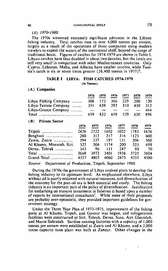
46 CONTINENTAL SHELF 131
(d) 1970-1980 The 1970s witnessed extremely significant advances in the Libyan
fishing industry. Total catches rose to over 4,000 tonnes per annum, largely as a result of the operations of three companies using modern trawlers to exploit the waters of the continental shelf, beyond the range of traditional boats. Figures of catches for 1974- 1979 are shown in Table 1. Libyan catches have thuç doubled in about two decades, but the totals are still very smali in cornparison with other Mediterranean countries. OnIy Cyprus, Lebanon, Malta, and Albania have smalier catches, while Tuni- sia's catch is six or seven times greater (38,400 ionnes in 1977)6.
TABLE 1 LIBYA: FISH CATCHES 1974-1979 (in Tonna)
1974 1975 1976 1977 1978 1979 - - - - - - Libya Fishing Company .......... 308 173 366 229 200 120 Libya-Tunisia Company .......... 351 659 293 310 430 3 12 Libya-Greece Company ........... - - - - - 464 Total ........................................ 659 832 659 539 630 896
( B ) Private Sector
Tripoli .............................. .......................... Benghazi
Zawia, Zuara .................. Al Khums. Misratah, Sirt
................. Derna, Tobruk Total ................................. Grand Total ..................... Source: Deparlrnent of Production, Tripoli. September 1980
During the 1970s the governrnent of Libya evolved plans to develop the fishing industry to its optimum level. As ernphasized elsewhere, Libya without oil is poorly endowed with natural resources, and diversification of the economy for the post-oil era is both essential and costly. The fishing industry i s an important part of the policy of diversification. Justification for embarking on massive investment in fisheries is based upona number of reports by international consultants7. Whiie some of their proposais are probably over-optimistic, they provided important guidelines for gov- ernment strategy.
Under the Three Year Plan of 1973-1975, improvement of the fishing ports at Al Khums, Tripoli, and Ganzur was begun, and refrigeration facilities were constructed at Sirt. Tobruk, Derna, Susa, Ayn Ghazalah, and Marsa Sabratah. Sardine canning factories with a capacity of 1.000 tonnes per annum were established at Zuara and Al Khums, and a 2,000 tonne capacity tuna plant was built at Zanzur. Other changes in the
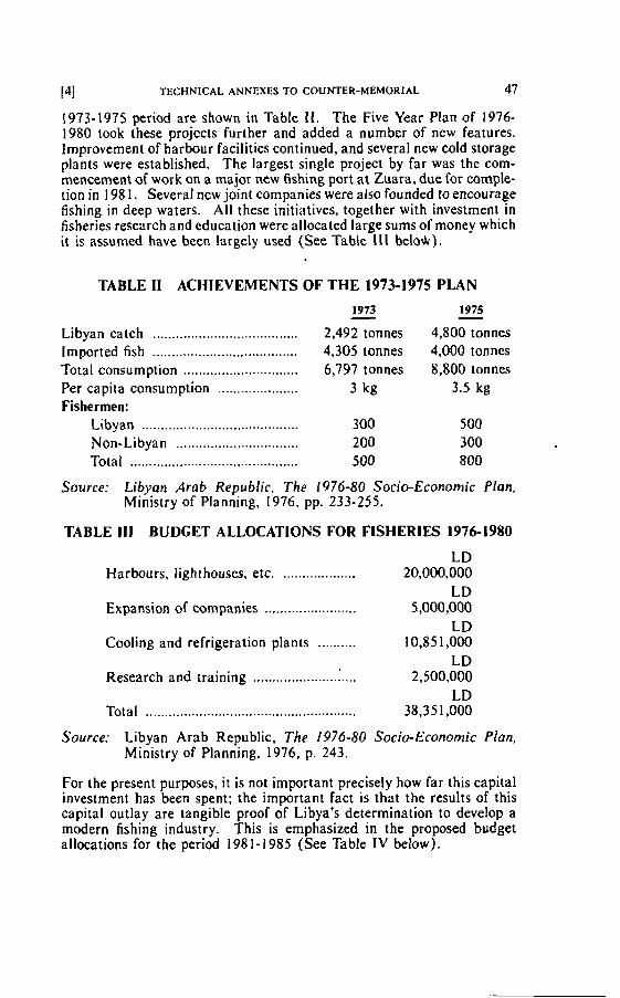
i41 TECHNICAL ANNEXES To CouNTER-MEMoRIAL 47
1973-1975 period are shown in Table I I . The Five Year Plan of 1976- 1980 took these projects further and added a number of new features. lmprovement of harbour facilities continued, and several new cold storage plants were established. The largest single project by far was the com- mencement of work on a major new fishing port at Zuara, due for comple- tion in 198 1. Several new joint companies were also founded to encourage fishing in deep waters. Al1 these initiatives, together with investment in fisherjes research and education were allocated large sums of money which it is assumed have been largely used (See Table I I I belo4).
TABLE II ACHIEVEMENTS OF THE 1973-1975 PLAN
................................... Libyan catch
.................................... lmported fish Total conçumption ..............................
..................... Per capita consumption Fisherrnen:
Libyan ....................................... ................................ Non-Libyan
Total ............................................
1973 - 1975 - 2,492 tonnes 4,800 tonnes 4,305 tonnes 4,000 tonnes 6,797 tonnes 8,800 tonnes
3 kg 3.5 kg
Source: Libyan Arab Repirblic, The 1976-80 Socio-Economic Plan, Ministry of Planning, 1976, pp. 233-255.
TABLE III BUDGET ALLOCATIONS FOR FlSHERlES 1976-1980
LD Harbours, lighthouses. etc. ................... 20,000,000
LD Expansion of companies ........................ 5,000,000
LD Cooling and refrigeration plants .......... 10,8S 1,000
LD Research and training ...................... 1.. 2,500,000
LD Total ....................................................... 38,35 1,000
Source: Libyan Arab Republic, The 1976-80 Socio-Economic Plan, Ministry of Planning, 1976, p. 243.
For the present purposes, i t is not important precisely how far this capital investment has been spent; the important fact is that the results of this capital outlay are tangible proof of Libya's determination to develop a modern fishing industry. This is emphasized in the proposed budget allocations for the period 198 1-1985 (See Table IV below).
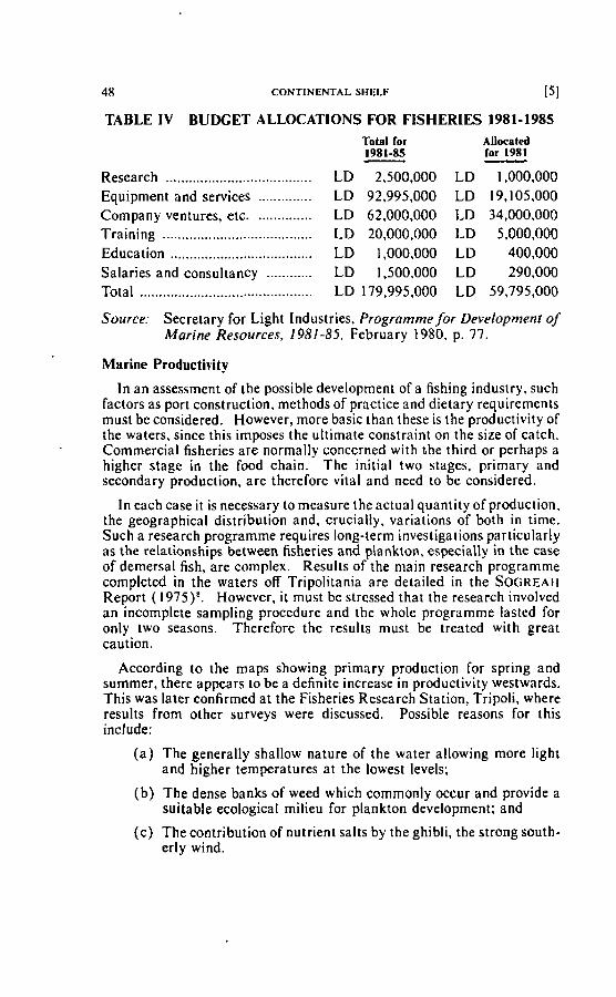
48 CONTINENTAL SHELF [SI
TABLE I V BUDGET ALLOCATIONS FOR FISHERlES 1981-1985 Total for Allocatd 1981-85 - for 1981 -
Research .................................... LD 2,500,000 LD 1,000,000 Equipment and services .............. LD 92,995,000 LD 19,105,000 Company ventures, etc. .............. LD 62,000,000 LD 34,000,000 . . Training ....................................... LD 20,000,000 LD 5,000,000 Education ..................................... LD 1,000,000 LD 400,000 Salaries and consultancy ............ LD 1.500,000 LD 290,000 Total ........................................... LD 179,995,000 LD 59,795,000
Source: Secretary for Light Industries, Programme for Development of Marine Resources, 1981-35, February 1980, p. 77.
Marine Productivity
In an assessrnent of the possible development of a fishing industry, such factors as port construction. methods of practice and dietary requirernents must be considered. However, more basic than these is the productivity of the waters. since this imposes the ultimate constraint on the size of catch. Commercial fisheries are normally concerned with the third or perhaps a higher stage in the food chain. The initial two stages. prirnary and secondary production, are therefore vital and need to be considered.
In each case it is necessary to measure the actual quantity of production, the geographical distribution and, crucially, variations of both in time. Such a research programme requires long-term investigations particularly as the relationships between fisheries and plankton, especially in the case of demersal fish, are complex. Results of the main research programme completed in the waters off Tripolitania are detailed in the SOGREAH Report (1975)'. However, i t must be stressed that the research involved an incomplete sampling procedure and the whole programme lasted for only two seasons. Therefore the results must be treated with great caution.
According to the maps showing primary production for spring and summer, there appears to be a definite increase in productivity westwards. This was later confirmed at the Fisheries Research Station, Tripoli, where results from other surveys were discussed. Possible reasons for this include:
( a ) The generally shallow nature of the water allowing more light and higher temperatures at the lowest levels;
(b ) The dense banks of weed which comrnonly occur and provide a suitable ecologicat milieu for plankton development; and
(c) The contribution of nutrient salts by the ghibli, the strong south- erly wind.
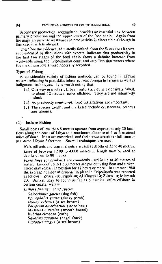
[61 TECHNICAL ANNEXES TO COUNTER-MEMORIAL 49
Secondary production, zooplankton, provides an essential link between primary production and the upper levels of the food chain. Again from the maps an increase westwards in productivjty is djscernible although in this case i t is less obvious.
Therefore the evidence, admittedly limited, from the SOGREAH Report, supplemented by discussions with experts, indicates that productivity in the first two stages of the food chain shows a definite increase from westwards dong the Tripolitanian coast and into Tunisian waters where the maximum levels were generally recorded.
Types of Fishing ,
A considerable variety of fishing methods can be found in Libyan waters, reflecting in part skills inherited from foreign fishermen as well as indigenous techniques. It is worth noting that:
( a ) One way or another, Libyan waiers are quite extensively fished, to about 12 nautical miles offshore. They are not intensively fished;
(b) As previously mentiand, fixed installations are important; (c) The species caught and rnarketed include crustaceans, octopus
and sponges.
( 1 ) Inshore Fishing
Small boats of less than 8 metres operate from approximately 30 loca- tions along the coast of Libya to a maximum distance of 5 or 6 nautical miles offshore. Most are motorized, and their crews are either full-tirne or part-time Libyan fishermen. Several techniques are used:
Nets: gill nets and trammel nets are used at depths of 35 to 40 metres. Lines of between 1,500 to 4,000 metres in length may be used at depths of up to 80 metres. Fixed lines (or brinkali) are commonly used in up to 40 metres of water. Lines of up to 1,500 metres are put out using float and sinker. These may remain in position for 12 hours or more. In summer 1980 the average number of brinkali in place in Tripolitania was reprred as follows: Zuara 20; Tripoli 30; Al Khums 10; Zliten 10; Misratah 20. Brinkali may be found as far as 6 nautical miles offshore in certain coastal waters. Inshore fishing: chie f species
Galeorhinus galeus (dog-fish) Epinephalus guaza (dusky perch) Dentex vulgaïis (a sea bream) Polyprion americarum (stone bass) Mustelus mustelus (smooth hound) Imbrina cirrhosa (corb) Squarina squatina (ange1 shark) Dipludus sargus (a sea bream)
50 CONTINENTAL SHELF
Diplodus vulgaris (a sea bream) Lithognatus mormyrus (a sea bream) Diplodus annularis (a sea bream) Oblada melanura (saddled bream)
The list of typical species is far from complete. The variety of fish in Libyan waters is remarkable. In particular, it is important to note that several types of crustaceans, molluscs, and other bottorn dwellers, are caught from time to time and soId in the fish markets. It would be rnisleading to clairn that they are a specialty of Libyan waters, but their regular appearance in the markets is evidence of Libyan exploitation of species living primarily on the continental shelf. ' Some examples are as foliows:
Lobsiers. prawns. erc.: Parapenaeus longiroirris Plesiopenaeus edwardsianus Homarus gammarus (lobster) Palaemon serratus (prawn )
Crabs and crayfsh: Scyllarides latus Polinurus vulgaris (crayfish) Maja squinndo (spiny spider crab)
Squids and octopuses Loligo vulgaris (common squid) Sepiola rondeleti Octopus vulgaris (common octopus)
( 2 ) Lampara Fishing
Fishing for sardines and anchovies is done in summer between May and October, at night, the best catches being in July and August. Boats of between 7 and 13 metres work in pairs, one boat cariying a lamp to attract the fish. Surface seine nets are used, with small sinkers. Most lampara fishing is within 6 nautical miles of the shore. During autumn and winter some lampara boats fish for bonito and mackerel.
Lampara jïshing: chief species Sardinelh aüriita (sardine) Engraulis encrasicholus (anchovy) Trachurus trachurus (horse-mackerel) Auxis thazard (frigate mackerel)
(3) Trawler Fishing in Libyan Waters
Small trawiers of 16 to 27 metres fish largely within 12 nautical miles of the Libyan Coast, and always within the continental shelf. There is little trawling in sumrner. Three companies are now active, with 22 trawlers in operation. The Libyan Fishing Company (seven trawlers) was founded
[BI TECHNICAL ANNEXES TO COUNTER-MEMORIAL 5 1
in 1970, the Libya-Tunisia Company was founded in 1972 and has four trawlers, and the Libya-Greece Company ( 1 1 trawlers) was founded in 1978. All three cornpanies also own a number of smaller fishing boats. In addition one or two groups of fishermen now own and operate smali trawlers. There are plans to expand the number of trawlers operating in Libyan waters very rapidly, to a total of 95 in 1985, with a combined potential catch of ùver 9,000 tonnesg. This target is thought to be too high, particularly in the light of manpower shortages.
Trnwling: chief species
Mullus barbalus (red mullet) Mullus surmeleius (striped mullet) Pagellus eryrhrinus ( pandora ) Merluccius merluccius (hake) Trachurus trachurus (horse mackerel) Pagellus cenrrodenius (Spanish brearn) Maena rnaena Balisres corolinensis (trigger fish) Boops boops (bogue) Boops solpu (saupe) Squoiina squarina (monkfish) Musfalus musrelus (smooth hound)
( 4 ) Tuna Fishing
Fishing for tuna has been practised along the Tripolitanian coasi for several decades. The rnethod depends on the use of a heavy "leader" net anchored firmly to the seabed and suspended from huge floats. extending seawards to a depth of about 45 metres. A large trap net to catch the tuna is sjmilarly anchored to the seabed at the seaward end of the leader net. The migrating tuna moving along the Coast from West to east are trapped as they try to evade the leader net. They are then lifted into boats and brought ashore for salting or canning. Tuna can weigh up to 500 kilo- grams and the whole installation (known as "tonnara") requires 100 tonnes of rope and net and a large quantity of heavy anchors and floats. Although the season fasts only about 40 days (mostly in June, depending on location) it takes three months to prepare the nets and anchor them to the seabed. Thus for several months the tonnara constitute a hazard to shipping, extending from 2 to 3 nautical miles offshore. Warnings to shipping are placed farthet out tosea, and the tonnara are noted in various pilots' handbookslO.
The nurnber of tonnara has declined from a peak of 15 before the Second World War to four in 1980 (Figure 1 ). Over 60 men are required to man the tuna nets of one tonnara during the catching season, and perhaps 250 more will be ernployed for two months ta process the tuna. Most of the temporary employees are local farmers for whom the tuna season is a welcome bonus. Clearly the cost of operating a tonnara is high, and unless a heavy crop of tuna is obtained, it is easy to lose money. Tuna
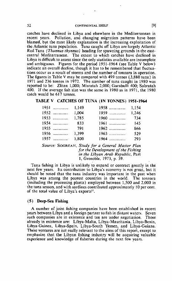
52 CONTINENTAL sHELF [91
catches have declined in Libya and elsewhere in the Mediterranean in recent years. Pollution, and changing migration patterns have been blarned, but the most iikely explanation is the increasing exploitation of the Atlantic tuna population. Tuna caught off Libya are largely Atlantic Red Tuna (Thunnus thynnus) heading for spawning grounds in the east- central Mediterranean. The extent to which catches have declined in Libya is difficult to assess since the only statistics available are incomplete and ambiguous. Figures for the period 195 1 - 1964 (see Table V below) indicate an overall decline, though it has to be remembered that fluctua- tions occur as a result of storms and the number of tonnara in operation. The figures in Table V may be compared with 499 tonnes (3,880 tuna) in 1971 and 236 tonnes in 1972. The number of tuna caught in 1980 was reported to be: Zliten 1,000; Misratah 2,000; Garabulli 400; Sabratah 400. I f the average fish size was the sarne in 1980 as in 197 1, the 1980 catch would be 6 17 tonnes.
TABLE V CATCHES OF TUNA (IN TONNES) 1951-1964
Source: SOGREAH, Study /or a General Master Plan for the Development of the Fishing in the Libyan Ara6 Republic. Part 1, Grenoble, 1973, p. 39.
Tuna fishing in Libya is unlikely to expand or contract greatly in the next few years. Its contribution to Libya's economy is not great, but it should be noted that the tuna industry was important in the past when Libya was among the poorest countries in the world. The tonnara (including the processing plants) employed between 1,500 and 2,000 in the tuna season, and with sardines contributed approxirnately 10 per cent. of the total value of Libya's exports".
(5 ) DeepSea Fishing
A number of joint fishing cornpanies have been established in recent years between Libya and a foreign partner to fish in distant waters. Seven such companies are in existence and ten are under negotiation. Those already in existence are: Libya-Malta, Libya-Mauritania, Libya-Benin, Libya-Guinea, Libya-Spain, Libya-South Yernen, and Libya-Guiana. These ventures are not really relevant to the airns of this report, except to ernphasize that the Libyan fishing industry will be acquiring valuable experience and knowledge of fisheries during the next few years.
(101 TECHNICAL ANNEXES TO COUNTER-MEMORIAL 53
( 6 ) Sponge Fishing
Sponge fishing was an important economic activity in Libya for many decades. Recent reports on Libya's marine resources have suggested its revival in response to rising demand for natural spongelP.
The map of sponge concentrations "in the Gulf of Gabes and along the coast of Libya" submitted with the Tunisian Memorial (Figure 5.26) is misleading. By choosing to map a species (Hippospongia equina) not notably common along the coast of Libya, the impression is given to the unwary that Libya has no important commercial sponge banks. This is far from the truth. Libyan waters have several types of commercial sponge including:
Euspongia oficinalis mollissima (fine Turkey cup) Euspongia oflcinalis larnella (elephant's ear) Euspongia zimocca (zimocca sponge)
In addition, Hippospongia equina is found in Libyan waters, particu- larly in the West.
Table V I summarizes sponge catches landed in Libya by local boats only, between 1920 and 1962. Since 1962 the decline has continued, and in 1980 only two sponge boats were operating in Libya. In the period 1920- 1960 approximately 100 to 200 sponge boats of various kinds fished in Libyan waters annually, about 10 per cent. being Libyan boats. The decline is largely due to competition with cheap sponge substitutes, and the dangers associated with sponge diving. Sponge production fl uctuated from year to year, total yields from Libyan waters ranging between 30 and 140 tonnes a year, the average being around 80 tonnes from 1900 to 1960. A considerable proportion of total production was by foreign boats, chiefly Greek. Table VI1 shows total production compared with local Libyan production from 1948 to 195 1 .
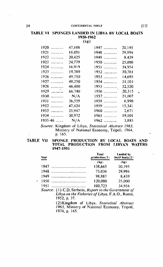
54 CONTINENTAL SHELF li I l
TABLE VI SPONGES LANDED IN LIBYA BY LOCAL BOATS 1920- 1962
(kg)
Source: Kingdom of Libya, Stalistical Absiract 1963, Ministry of National Economy, Tripoli, 1964, p. 165.
TABLE VI1 SPONGE PRODUCTION BY LOCAL BOATS AND TOTAL PRODUCTION FROM LIBYAN WATERS 1947-1951
Year Total Landed by
production( 1 ) local b a t s ( 2 i
(kg) (kg)
1947 .................................. 138.665 20,195 1948 ............... .... , .,........... 75,036 29,994 1949 .......... ........................ 98.887 8,439 1950 .................................. 1 20,000 25,000 195 1 ................... ............. .. 100,723 34,954 Source: ( 1 ) C.D. Serbetis, Reporr ro the Governmenr of
Libya on the Fisheries of Libya, F.A.O., Rome. 1952, p. 37. ( 2 ) Kingdom of Libya. Statistical Abstraci 1963, Ministry of National Economy, Tripoli, 1974, p. 165.
lit] TECHNICAL ANNEXES TO COUNTER-MEMORIAL 55
Although Libyan sponge banks have been intensively fished for genera- tions, they have shown no signs of exhaustion. The F.A.O. report attrib- utes this to the vast area of Libyan sponge grounds, estimated to be around 15,000 square kil~rneters'~. However, sponges rarely thrive in water depths of over 120 metres.
Scarcely a stretch of Libyan coast has not been fished for spoliges in the past (Figure 1), and some rich sponge banks have also been worked at great distances from the coast. The following, for example, were specified by C.D. Serbetis in the F.A.O. report of 1952:
( i ) The Lapsi bank-83 miles north-northeast of Zuara; (ii) The Trafili bank-17 miles east of the Lapsi bank;
(iii) The Fondazzo bank-75 miles north of Zuara; (iv) The Fora bank-22 miles north-northeast of Ras Makaber".
The best survey of sponge fishing was incorporated into the F.A.O. report of 1952, and this remains a standard source of scientific and historic detail on the subject.
Methods of Sponge Fishing
(a) Primitive diving Primitive diving in shallow waters (20 to 30 rnetres) without equipment had become very rare by 1950.
(b) Warerglass and sponge hook Having located spanges through a waterglass, they were re- moved using a harpoon which could be used, with skiil, in up to 25 metres of water.
( c ) Muchine diving The diver wore a rubber suit and received air pumped through a rubber pipe.
(ci) Fernez diving The method in which a rubber mask is used in lieu of the diving suit. A rubber pipe supplied air to the diver.
(e) Gangava system A dredge of 2 by 5 metres was dragged over the sponge bank by a motor-powered vessel. Sponges obtained were usually abun- dant, but of poor quality.
Since 1900, approximately two-thirds of sponge production has been from divers using rubber suits or the Fernez system. In 1950 for example 81 boats (chiefly Greek) operated divers, and 52 boats used other methods.
Fisheries Legislation The Italian administration and its successors in Libya clearly claimed
the right to control sponge fishing in Libyan waters, wherever sponge
56 CONTINENTAL SHELF
banks were found. Such control has been consistently exercised, with detailed regulations being prornulgated and Iegally enforced. The follow- ing are various of the texts related to fisheries regulations:
Royal Decree of 27th March 1913 ri. 312 (64 articles) The following features are noteworthy:
( a ) regulations about fishing included crustaceans and molluscs (article 15).
( b ) licences would be required on al1 sponge banks beyond territorial waters (article 17).
(c) sponge licenses may be granted to foreigners (article 20). ( d l dredge and diving suit fishing for sponges was prohibited sea-
ward to the 20 metre isobath (article 25). ( e ) coral fishing was submitted to the same rules as sponge fishing
(article 40). (f) regulations concerning tonnara concessions were included (arti-
cles 33-39).
Royal Decree of 22nd November 1925 n. 2273 This modified certain details of the 191 3 regulations.
Royal Decree of 9th January 1939 n. 1402 (33 articles)
New and comprehensive fishing regulations were introduced, but excepted al1 previous regulations concerning sponge fishing, which remained in force.
These laws. which may be taken as examples of a considerable number of laws. seem to establish beyond any doubt that fishing has been regarded as of crucial importance to the economy of Libya and the welfare of its inhabitants. This policy continued during the British administration, 1943- t 95 1, and after independence. Principles established during Itatian times have continued, with some modification tu specific regulations. A British Declaration (No. 179 of 17 May 1948) concerning sponge fishing,
.and the Libyan Law No. 12 of 1959, and a further Libyan Decree of 8 August 1962 on sponge fishing may be cited as examples. It might be useful to point out however, that with the exception of coral fishing which has never been practised commercially in Libyan waters, al1 fisheries legislation has been heaviiy utilized. and its provisions carefully enforced.
Number of Boats
The estimated number of fishing boats using certain ports in Libya in 1979 is given in Table VIII. I t will be noted that they are distributed throughout the Libyan Coast, with a marked concentration towards the West where the population is greatest and fisheries most productive.
The total number of boats is 338, excluding specialized boats associated wiih tuna fishing. About 90 per cent. a re rnotor powered boats. The
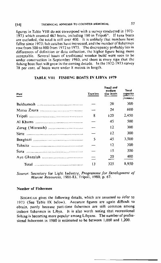
1\41 TECHNICAL ANNEXES TO COUNTER-MEMORIAL 57
figures in Table V l l l do not correspond with ri survcy conducted in 1972- 1973 which counted 467 boats, including 180 in Tripoli". I f tuna boats are excluded, the total is still over 400. It is unlikety that nurnbers have fallen sincc 1973; fish catches have increased, and the number of fishermen rose from 500 to 800 from 1972 to 1975. Thc discrepancy probably lies in diffcrences of dcfinition or data collection, thc highcr figure being more acceptable. Scvcrril boats of traditional wooden build were seen ta be under construction i n Scptcmber 1980, and there is every sign thal the fishing boat flect will grow in the comingdeciidc. In the 1972- 1973 survey 78 per cent. of boats were under 8 metrcs in length.
TABLE VlI l FISHINC BOATS IN LIBYA 1979
Port - .............................................. Bukharnesh
Marsa Zuara ...........................................
Tripoli ...................................................... Al Khums ................................................ Zorug (Misratah) ...................................
......................................................... Sirte
Benghazi .................................................. Talrnita .................................................... Susa ..................... .. .............................. Ayn Ghazalah .........................................
Total .................................................
' I 'rvwlcrs - Small and
medium sise boats
Total caparity - ( tonnes)
300
600
2,450
500
Source: Secretary for Light lndustry, Programme /or Development of Marine Resources, 198 1-83, Tripoli, 1 980. p. 67.
Nurnber of Fishermen
SOGREAH gives the following details, which are assumed to iefer to 1973 (See Table IX below). Accurate figures are again difficult to obtain, partly because part-time fishermen are still common among inshore fisherrnen in Libya. I t is also worth noting that recreational fishing is becoming more popular among Libyans. The number of profes- sional fishermen in 1980 is estimated to be between 1,000 and 1,200.
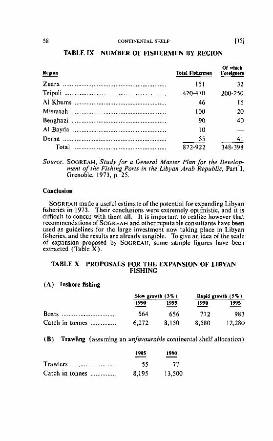
58 CONTINENTAL SHELF- 1151
TABLE I X NUMBER OF FISHERMEN BY REGION
Of whicb Total Fishermen Foreieners
Zuara ......................................................... 151 32 Tripoli .............................. .. ...................... 420-470 200-250 Al Khums .................................................... 46 15 Misratah ..................................................... 1 O0 20 Benghazi ........................................................ 90 40 Al Bayda ....................... .. ......................... 1 O - Derna ............................................................. 4 1 55 -
Total ....................................................... 872-922 348-398
Source: SOGREAH, Study for a General Master Plan for the Develop- ment of ~ h e Fishing Ports in the Libyan Arab Republic, Part 1, Grenoble, 1973, p. 25.
Conclusion
SOGREAH made a useful estimate of the potential for expanding Libyan fisheries in 1973. Their conclusions were extremely optimistic, and it is diflicult to concur with them all. It is important to realize however that recommendations of S ~ G R E A H and other reputable consultants have been used as guidelines for the large investment now taking place in Libyan fisheries, and the results are already tangible. To give an idea of the scale of expansion proposed by SOGREAH, some sample figures have been extracted (Table X ) .
TABLE X PROPOSALS FOR THE EXPANSION OF LIBYAN FISHING
( A ) Inshore fishing
Slow growth (3%) Rnpid growth ( 5 % ) 1990 - 1995 - 1990 - 1995 -
Boats ............................. 564 656 772 983 Catch in tonnes ............... 6,272 8,150 8,580 12,280
(B) TrawPng (assuming an unfavourable continental shelf allocation)
1985 - 1990 - Trawlers ........................... 55 77 Catch in tonnes ............... 8,195 13,500
116) TECHNJCAL ANNEXES TO COUNTER-MEMORIAL 59
(C) Spange fishing
Catches of 3,000 to 5,000 kilograms per annum from 32 teams working from 70 boats.
Captains and mates: trawlers,etc. .......................................................... 182 186 lamparos, inshore boats, etc. ...................................... 750 850
Mechanics ...................................................................... 5 18 553
....................................... Sailors, fisherrnen and divers -- 4,455 4,730 Total ....................................................................... 5,905 6,139
Source: SOGREAH, Study for a General Master Plan for the Develop- ment of the Fishing Ports in the Libyan Arab Republic, Part II, Grenoble, 1973, pp. 42-53.
While commercial fisheries in Libya could certainly be expanded con- siderably", it is doubtful whether such targets can be achieved, certainly in the period to 1990. The Libyan Government is however clearly commit- ted to a policy of fisheries expansion; probably the most spectacular evi- dence of this is the new port under construction at Zuara. The new fisheries complex at Zuara (Figure 2) which is scheduled to open in May 198 1, will be the most modern in the Mediterranean and, for its size, one of the most complete and efficient in the world. The harbour has 470 rnelres of quays for larger trawlers and 220 metres for smaller vessels. There are spacious fish handling facilities (6) linked to a 1,000 tonne freezing plant capable of producing 30 tonnes of ice per day. Nearby are two large maintenance blocks (16) to facilitate net mending, etc., a general store (5 ) and a gear store in which each ship will be allocated its own compart- ment (7). There is also a large ship repair a'rea, capable of handling 450 tonne trawlers, and a range of services for the fishermen, including a medical and residential centre (2). With its own generators and power plant, the whole complex will be virtually self-sufficient.
Such large scale investment reflects Libyan confidence in the develop- ment of its fisheries within and beyond home waters. The selection of Zuara for such a project illustrates confidence in the retention of access to local sources.
During an intensive field visit to Libya (25-30 September, 1980) we were able to assess the staie of the Libyan fishing industry for ourselves. We had consultations with officials at the Fishery Research Institute, and at the Ministry of Production, and we visited several small ports from Bu Kamrnash to AI Khums as well as the Zuara port project. We also spoke to many fishermen, and to officials in the fish market in Tripoli and at the
60 CONTINENTAL SHELF
tonnara stations at Marsa Sabratah and Zliten. We saw much evidence of investrnent in fishing, from new cold stores and ice factories to modern navigational aids and expanded harbour installations. O~ir overall con- clusions were that:
( a ) Libya has a maritime tradition which is by no means negligible, bearing in mind the total population, contrary to the assertion made in the Tunisian Mernorial, Volume 1, page 67;
(b) Libya's marine resources represent one of the most important opportunities for the diversification of the national economy, after oil runs out; and
(c) Libyan fishing can expand without prejudice to the interests of Tunisia's fisheries. It is in this connection that a brief comment @*a on Figures 5.26 to 5.30 in the Tunisian Memorial follows:
a-@ Comrnents on Figures 5.26 to 5.30 in the Tunisian Memorial
The maps are probably irrelevant to the continental shelf debate. They purport to show the ecological unity of the Gulf of Gabès, but the term is inappropriately applied throughout, to a vast area of the Mediter-
@@ ranean Sea. Figures 5.28 and 5.29 show nothing in the Gulf of Gabès proper. All these rnaps shouid be examined very critically as evidence. It has not been possible to find any record of the Thalassa's voyage, since no proper reference is cited in the Tunisian Memorial. It is quite likely that "Thalassa's" investigations are included in a Tunisian paperI7 on the southeast Tunisian seas; if so, it will be seen that no investigations were attempted in Libyan waters (Figure 3 ) . In any case, a month-long voy- age in November is no basis on which to draw such bold and detailed maps of the distribution of several species. Altogether, the rnaps must be called
@ into question. For example: Figure 5.26: Sponges; see comments under sponge Fishing. We heard no evidence from Libyan divers concerning Tunisian claims to sponge banks east of the land frontier (Tunisian
@ Memorial, page 180). Figure 5.27: Hake. Hake is more widçspread @ than the map suggests Figure 5.28: Mullet. The gap in the mullei
population off Tripoli is dubious; local fishermen land mullet regularly in Tripoli. The reference in the text of the Tunisian Memorial (page 182) to 85 per cent. of the mullet catch being derived from the eastern regions of Tunisia is ambiguous. The reference must be to Tunisian not Mediterra-
@ nean catches. Figure 5.29: Sea bream. None is shown in the Gulf of Gabès, but the text refers to the Gulf as a "veritable fishpond" (Tunisian
@ Memorial, page 183). Figure 5.30: Anchovy. Why only show the winter map? Anchovies are plentiful off Libya in summer. Again, the basis for this rnap would be of interest.
ii81 TECHNICAL ANNEXES TO COUNTER-MEMORIAL 6 1
References
(1) Mazarelli, G.: "La pesca sui banchi di spugne esplorati; con la R.N. 'Tritone' ", published in Societa Italiana Per Il Progresso Delle Scienze, NOV. 1936, pp. 4-15.
( 2 ) Kingdom of Libya: Statistical Abstract 1963, Ministry of National Econorny, Tripoli, 1964, p. 165; Serbetis, C.D. (1952), p. 52.
( 3 ) Serbetis, C. D.: Report ro the Governmenr of Libya on the Fisheries of Libya, F.A.O. Report No. 18, Rome, 1952; F. Bour- geois, Thepresenr situation of Libyanfisheries, F.A.O. Report No. 817. Rome, 1958.
(4 ) International Bank for Reconstruction and Development, The Ecomonic Development of Libya, John Hopkins Press, Baltimore, 1960, p. 205.
(5) lnternational Bank (1960), p. 204. (6) F.A.O. Yearbook oJjshingstatistics, 1977, Vol. 44, Rome, 1978,
Table A-1. ( 7 ) (a) SOGREAH, Study for a general masterplan for the develop-
ment of fhe fishing porrs in thé Libyan Arab Republic, Final report. April 1975
Part 1-Preseni sifuation. August 1973 Part 2-Generol development plan of jshing activit ies, Decem-
ber 1973 Part 3-Preliminary general masterplan, August 1974.
ln collaboration with Ministry of lndustry and Minerals, Depart- ment of Aquatic Wealth, SOGREAH, Grenoble, France, 1973. (SOGREAH recommended exploitation of available fish resources to the optimum by 1985, with special reference to harbour facilities). ( b ) SOGREAH, Trawlfishing ground surwy oJrhe Tripoliranian
cousr Part 1-Bathyrnetry and sedimentology Part 2-H ydrology Part 3-Nutrient salts and primary production Part 4-Secondary production Part 5-Fishery biology and trawling resaurces study
Final report: introduction and general conclusions, August 1977.
In çollhboration with Ministry of Food and Wealth, General Depart- ment of Marine Wealth, SOCREAH, Grenoble, France, 1977.
(SOGREAH began this work in 1977, and the scientific findings were of timited value; the report recommended the optimization of fish production in a favourable marine environment.)
62 CONTINENTAL sHELF 1191
(c ) CONTRANSIMEX (Rumania) Oceanographic survey in the east- ern rerriiorial waters of the Libyan Arob Republic berween Ras Azzaz and Ras Kar Kura. M a y 1975 - August 1976. Two volumes, 1977. (Contransimex reported that demersal stocks (bottom cornmuni- lies) are underexploited, though they are not abundant. Medium- size trawlers could be introduced to supply the local market.)
(d ) INSTRUPA (West Germany) Final report on results of the test jishing program. Gulf of Sirt, Libyan Arab Republic, Tan- nenwaldallec. F. R. Gerrnany. July 1975.
, (The prospects for commercial fisheries in the Gulf of Sirt were found to be good. Shrimp could be very abundant).
(8) SOGREAH (1975), Vols. 1-5. -
(9) Secretary for Light Indusiry, Plan for development of marine resources 1981-RS, Tripoli, February 1980, p. 63.
(10) See, for example, Mediterraneon Pilot, Hydrographer of the Navy. Taunton, England, 1976, Vol. V, 6th edition, p. 39, which warns that tonnara rnay extend 5 miles offshore.
( 1 1 ) Serbetis. op. cir. (1952), p. 52.
(12) SOGREAH (1973) Vol. 1 i , p. 53.
( 1 3) Serbelis, op. ci!. ( 1952), pp. 39-40.
(14) Serbetis, op. cir. (1952), p. 7.
(15) SOGREAH (1973), Vol. 1, p. 23.
( 16) See under (7) above.
(17) Ktari-Chakroun. F. et Azouz, A.: "Les fonds chalutables de la région sud-est de la Tunisie", published in, Bulletin de L'Institui Scientifîque et Technique d'Océanographie et de Pêche, Salammbo, Tunisie, Vo!. 2 No. 1, 1971, pp. 5-47.
Annex 4
THE GRECO BANK
AND
DR. E. W. ANDERSON**
* M.A.. University of Oxîord ; Ph.D.. University of Southampton. ** M.A., University of Oxford ; M.A., University of Manchester : M.Ed.. University of
Newcasile: Ph.D.. University of Durham ; Ph.D., University of Newcastle.
64 CONTINENTAL SHELF I l l
GENERAL POSITION AND DESCRIPTION
Immediately east of a line due north from Ras Ajdir (Figure 1 ), between the 5 and 10 fathom lines and at a distance of some 12 nautical miles is an area of shallows. This bank, which extends in an approxi- mately northeasterly direction causing a marked distension in the 20 fathom line, is commonly calleid the Greco Bank. The position and gen- eral alignment can be confirmed from a number of charts including:
( a ) Service Hydrographique de la Marine, Paris. 1878 (Figure 2) (b ) U.S. Navy Hydrographic Office, Washington, 1944 (Figure 3 ) (c ) Admiralty, London, 1957 (Figure 4).
The shallow westerly edge of the bank appears undulating and is in places submerged to a depth of less than 5 fathoms while to the northeast, greater depths of up to 18 fathoms are recorded. The shallow western part occupies an area of some 5 nautical miles (east to west) by 2 nautical miles (north to south). From the western to the eastern edga is a distance of approximately 23 nautical miles.
A further indication of the general position of the shallowest western area of the Greco Bank can be obtained from LANDSAT imagery (Envi- ronmental Research Institute of Michigan, 1979). For such interpreta- lion LANDSAT has a number of limitations, notably:
( a ) I t lacks precision since each square plotted represents an area of 80 rnetres square.
(b) Depth must be inferred from water surface measurements.
Thus sjnce such factors as suspended sediment provide the information from which water depth is calculated, coincidence with chart soundings would not be expected. However, since L A N D ~ A ~ survey results for the area are available, it was felt that they should be discussed, even though they cannot be presented as definitive evidence. The full extent of the Greco Bank lies between the line due north frorn Ras Ajdir and one at 45 degrees (Le., northeast) from the same point. Furthetmore the shal- lowesi area, most clearly seen on charts and detected at sea, abuts almost onto the due north line (Figure 5) .
NOMENCLATURE AND LEGISLATION
lndividual names of shoals and banks are rarely given on charts and indeed only those of vital importance to shipping would appear to acquire a name. Toward the end of the 19th Century this particular area was known as the Bank of Farwah, after the nearest Tripolitanian fishing village situated approximately half way along the spit culminating in Ras el Talga'. During the early part of this century it acquired the name Greco Bank possibly because of its popularity with Greek sponge divers. Thus, in protracted correspondence between the Governor of Tripolitania .
and the Captain of the Italian naval torpedo boat "Monfalcone" in July 1934 concerning the suppression of illegal sponge fishing in the area, the term "Banco Greco" is used throughout2. The locations given for the fishing position on the Bank were 349 degrees from Zuara at a distance of
121 TECHNICAL ANNEXES TO COUNTER-MEMORIAL 65
30 nautical miles by the "Governor", and 347 degrees from Ras Giogghig (a promontory immediately to the West of Zuara identified. for example, in the United States Sailing Directions3), at a distance of 35.5 nautical miles by the Captain of the "Monfalcone" (Position A on Figure 6) . I t will be seen that these points refer to the eastern area of the Bank. However the key issue is that the term "Greco Bank" was used in official correspon- dence. and that unlicensed sponge fishing in the area was considered illegal by the Italian authorities.
EVIDENCE FROM WITNESSES
To further establish the position and custornary usage of the Greco Bank i t was decided to locate Libyan fishermen who had been to the area. Five interviews were conducted, each with at least twa English-speaking Arabs present so that an effective commentary on proceedings could be maintained and our questions could be interpreted without ambiguity. The fishermen were interviewed one at a time so that,cornplicity was out of the question. The answers given were recorded, some i n English and some in Arabic, the latter being translated and checked the same day.
In each case the directions given were discussed so that there was complete agreement on what the interviewee intended. Distances were harder to assess but were calculated by the interviewee using the known speed of his vessel. The final positions are denoted on the chart (Figure 6 ) by the letters A to G , which are given in parentheses as appropriate in the text. It might be important to add, that as far as we are aware, none of these men knew the purpose of Our enquiries and, as can be seen (Figure 6) , al1 were able to give correct bearings to the Bank.
The following testirnonies were collected and are reported, as far as possible, exactly as they were received.
Testimony of Said El-Hezzabi
Zuara: 27 September 1980 1 fished for sponges on the Greco Bank between 1956 and 1368. The Bank is locatcd at approximately 10 degrees northwest of Farwah. The distance took between three and four hours sailing lime.
This gives a position (B) on the eastern edge of the main shallow part of the Bank. The distance is more difficult to calculate since in sailing from the lagoon there would be delays in negotiating the shallows. Said el-Hezzabi also stated that in depths of under about 10 fathoms, fishing for sponges was by harpoon.
Testimony of Suliman Ahmed El Azzabi
Zuara: 29 September f 980
66 CONTINENTAL SHELF 131
1 have worked on the Greco Bank as did rny father and grand- father. We have fished there over the period from 1939 until 1967. The Bank lies 5 degrees northeast from Ras Ajdir at a distance of approximately 20 miles and over 30 miles from Zuara.
This position is beyond the shallowest part in the centre of the northeastern extension of the Bank (C). This was confirmed when Suliman Ahmed el Azzabi stated that he worked in depths varying from 10 to over 20 fathorns. He also recalled that normally four Libyan boats worked the Bank, each with seven in the crew including four divers. Greek fishermen also worked the Bank, but Tunisians were precluded and used other banks west of Ras Ajdir.
Testimony of Mustapha Omran Ballouz
Zuara: 29 September 1980 1 fished for sponges from 1949 to 1956 on the Greco Bank in depths of 10 fathoms and less. The Greco Bank is 36 miles from Zuara and at 11 degrees east of north from Ras el Talga. (Mustapha Omran Ballouz is a boat owner and indicated the direction using bis boat's portable compass.)
This position is in the centre of the Bank ( D ) . Mustapha Ornran Ballouz also declared that there were seven "tops" of "heads" to the Bank, and in the shallow west- ern area these can be clearly seen (Figure 2 ) . Further- more, he confirmed that the Bank was actually identiiied a t sea, by its depth which characteristically increases very sharply at the edges. He also recalled watching spear spongers working the Bank.
Testimony of Bashir Yakhlif Abdul Sallam
Zuara: 29 September 1980 1 fished for sponges on the Greco Bank. The Bank extends a long way to the east from the shallowest part in the west. The depth varies from 6 to 15 fathoms. The Bank begins at 5 degrees northeast of Ras Ajdir.
This position indicates the main shallow area of the Bank, near its western edge ( E ) . Bashir Yakhlif Abdul Sallam also stressed that sponges were fished by Libyans and Greeks and no Tunisians were allowed on the Bank. When he had last fished there in 1953-1954, there were three boats, including one large one, from Zuara and three large boats from Tripoli. The Tripoli boats fre- quently stayed for a long time and, in rough weather,
Pl TECHNICAL ANNEXES TO COUNTER-MEMORIAL 67
sheltered in the small deeper water anchorage immedi- ately south of the main bank. This anchorage is described in the Mediterranean Pilot, Volume V4.
Testimony o f Ali Sallam
Tripoli: 30 Seplember 1980 The Greco Bank is especially important for sponges. The depth of the shallowest part of the Bank varies from 5 to 6 fat homs.
Ali Sallam, who is both a fisherman and a boat owner, States that his knowledge of the Bank exrended over the period from 1936 to 1955. The Bank was worked by Libyan, Greek and Italian vessels only, and large supply ships might stay in the vicinity for months, being replen- ished from Tripoli. The sponges were cleaned on the Bank.
In order 10 ob~ain a definite guide to the western edge of the Bank it was decided to use a large harbour tug, "Jado", captained by Abdul Rahman. The captain had experience of the Bank and stated from this experience in fixing the position of his ship, iha t the western edge lies approximately 247 degrees from El Biban and 156 degrees from Ras el Talga(F). Bashir Yakhlif Abdul Sallam, the fisherman interviewed earlier, directed the boat, the position of which was reguiarly plotted on a British Admiralty chart (Figure 6). When he had reached a position familiar ta him at precisely 11:35 (local time), he indicated the exact course to the western edge of the Greco Bank. The position of the tug al that tirne was fixed from Sidi Ali and the conspicuous building by the harbour at Zuara. The course indicated had a true bearing of 3 1 1 degrees ( G ) and it can be seen
. that t his passes through the shallow western area.
CONCLUSION AND TESTIMONY
I n the light of the evidence we have been able to collect concerning the location and customary use of the Greco Bank. i t is our belief thal: 1. The Greco Bank is clearly identified with the shdlows marked on
numerous charts and maps. The range of positions witnessed indicates the spread of the Bank from a westerly position immediately northward of Ras Ajdir to its nor~heasterly extension.
2. The Greco Bank lies precisely within those waters defined by Libya's norihern line daim and Tunisia's 45" daim (Fig. 5).
3. The Greco Bank has been fished by Libyan sponge divers at least for several decades, and Tunisians have not been perrnitted to fish there.
4. The ltalian administration taok active steps to protect Libyan interests on the Greco Bank.
68 CONTINENTAL SHELF 151
REFERENCES
( I ) Servonnet et Laffite, Le Gove de Gabès en 1888 (Challamel et cie. Paris).
(2 ) The archives of the Port Authority in Tripoli, to which we had access, contain many examples of documents relating to the control of illegal sponge fishing. The following are samples:
Document No. C (59c) Letter dated 51191 1934 addressed to the Port Captain of
Tripoli re abusive sponge fishing. D (59d) Letter dated June 1, 1934 to the Port Captain of Tripoli
re abusive sponge fishing. E (59e) Letter dated 511 211934 re ltalian Navy's gunboat "Alu-
la" mission. F (59f) Handwritten note, undated, alluding to a mission of the
Ita tian Navy vessel "Malocello". H (61) Letter dated 6/1/1934 [rom the "Commissary of the
Occidental Boundary" re the surveillance of sponge fish- ing.
J (63) Letter dated 6/24/ 1934 frorn the "Commissary of the Occidental Boundary" re the surveillance of sponge fish- ing vessels.
L ( 6 5 ) Letter dated 7/20/1934 re the eventual purchase of a vessel for the use of the Zuara district in the surveillance of sponge fishing.
N (67) Letter dated 6/2/1934 to the Port Captain from the government of Tripolitania re the abusive fishing of sponges by Tunisian and Greek vessels, and the dispatch- ing of the naval unit "Monfalcone" for surveillance pur- poses.
Q (69b) Letter dated 71141 1934 from the "Commissary of the Occidental Boundary" re the position of infringing fish- ing vessels.
R (6%) Letter dated 7/16/1934 frorn the naval corniand to the- Comrnand of the Tripoli district, and to the commander of the "Monfalcone" re repression of abusive fishing by the vessel "Monfalcone".
S (69d) Letter dated 7/ 16/ 1934 addressed to the Office of Eco- nomic & Colonial Anairs of Tripolitania, referring to the above-rnentioned letter dated 71141 1934 at pp. 291-292.
T (69e) Two telegrams dated 7 / 16 and 7/17/1934 re departure and arriva1 of torpedo-boat "Monfalcone".
V (71) Letter from torpedo-boat "Monfalcone" to the Tri- politanian government, dated 7/17/1934 indicating par-
V I TECHNICAL ANNEXES TO COUNTER-MEMORIAL 69
ticulars of a repressive mission against unauthorized sponge fishers. including navigational coordinates.
X (73) Letter dated 9/15/1934 #3630, drafted by the Port Captain, directed to the Economics and Colonial Aflairs of Tripolitania, demanding the authorisation for the purchase of an 8 metre patrol boat.
( 3 ) Sailing Directions in the Medirerranean : U . S . Navy Hydrographie Office, Washington, D.C., (H.O. No. 154A) 1942 Vol. IV, p. 58.
(4) Mediterrnnean Pilot: 6th edilion. Hydrographer of the Navy, Taunton, England, 1976, Vol. V, p. 39.
CONTINENTAL SHELF
Annex 5A
TECHNICAL DATA AS TO RELIEF MODEL OF TUE PELAGIAN BASIN AND SURROUNDING LAND
PROFESSOR OF GEOLOGY DIRECTOR OF THE MARINE GEOLOGICAL AND
SEDIMENTOLOGICAL DIVISION INSTITUTE OF GEOLOGY AND MINERALOGY
TECHNICAL UNIVERSITY MUNICH
[ I l TECHNICAL ANNEXES TO COUNTER-MEMORIAL 7 1
1. Base Map (to be furnished to the Court with the Relief Model)
Area covered:
Lat. 30°N to 370301N Long. 9"E to 18"E (of Greenwich)
Projection: Mercator (cylindrical) Scnle: 1 : 1,500,000 (at Lat. 38"N) Source rnaps:
( I ) Marine area: Mer Ionienne Carte No 2, Mémoire du Gouverne- ment de la République Tunisienne, Vol. III, Tunis, 1980.
Land areas:
(2) for Tunisia: 1 : 1,000,000, Ofiice de Topographie et de Cartographie, Ministère de I'Equipement, Tunis, 1975;
(3) for SE Tunisia, Libya and Sicily: Tunis, sheet 3 of Africa 1: 2,000,000; Edition 4-TPC; U.S. Army Topographie Command, Washington, D.C., 1969.
The land contours of (2 ) and (3) were photographically transferred to the scale and projection of the chart ( 1 ).
Land ~opography: in "f "contoursoJ100metresteps wirh omission of fines when contours are too cfosely spaced.
Coastaf l ine ("O"): bofd line.
Submarine ropography:
a ) In very shoal water depth contour linesat - 20 metres, - 50 metres;
b ) 100 rnetre interval where contour lines are separate (normal shelf and slope);
c) 200 metre interval where contour lines are very close together.
2. Relief Model (coloured, without vertical exaggeration)
Land ropography: ( yellow ) at 200 metre interval
Seo boirom ropography: (blue)
100 meire - 600 metre waier depth: 100 metre intervat 600 rnetre to deepest area: 200 rnetre interval
72 CONTINENTAL SHELF [Il
Sea colouration:
pale btue: below " 0 including the - 800 metre step; light blue: "surface" of the 1000 rnetre stepl including the
- 1800 metre step; medium blue: "surface" of the 2000 metre step' including the
-2800 metre step; deep blue: "surface" of the 3000 metre step' down to the
deepest area (-4074 metre, Messina Abyssal plain).
' Due to a technical mistake the "surface" of the 1000 mctrc, 2000 mette etc., stcps were paintcd with thc colour which was intcnded to symbolizt the waterdepth below 1OOO mctrcs. etc.
TECHNICAL ANNEXES TO COUNTER-MEMORIAL
Annex 5B
EXPLANATORY NOTE TO THE "THREE-DIMENSION AL" COMPUTER PRINTOUTS OF THE PELAGIAN SEA A N D SURROUNDING LAND
("LARGE AREA BLOCK DIAGRAMS")
PROFESSOR OF GEOLOGY DIRECTOR OF THE M A R ~ N E GEOLOGICAL A N D
SEDIMENTOLOGICAL DIVISION ~N~TITUTE OF GEOLOGY AND M~NERALOGY
TECHNICAL UNIVERSITY MUNICH
MEMBER, ED~TORIAL BOARD INTERNATIONAL BATHYMETRIC CHART OF THE MEDITERRANEAN SEA
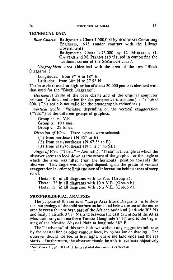
74 CONTINEMAL SHELF [ I l
TECHNICAL DATA Base Chnrts: Bathymetric Chart 1:500,000 by SOGREAH Consulting
Engineers, 1975 (under contract with the Libyan Government). Bathymetric Chart 1:75,000 by C. MORELLI. G. GANTAS and M. PISANI (1975)used in completing the northeast corner of the S~GREAH chart'.
Geographical Area (identical with the area of the two "Block Diagrams"):
Longitudes: from 9 O E to 18" E. Latitudes: from 30" N to 37.5" N.
The base chart used for digitisation of about 20,000 points is identical with that used for the "Block Diagrams".
Horizontal Scale of the base charts and of the original computer printout (without reduction for the perspective distortions) is 1 : 1,600 000. (This scale is not valid for the photographic reductions.)
Vertical Scale: Variable, depending on the vertical exaggeration ("V.E.") of the different groups of graphics.
Group a: no V.E. Group b: I O tjmes. Group c: 25 times.
Direaion of View: Three aspects were selected: (1 ) from northeast ( N 45" to E) (2 ) frorn east/northeast ( N 67.5" to E) (3) from east/southeast ( N 112.5" to SE).
Angleof View ("Theta" = Azirnuth): "Theta" is the angle at which the observer seems to look down at the centre of the graphic ; or the angle at which the area was tilted from the horizontal position towards the observer. This angle was changed depending on the grade of vertical exaggeration in order to lirnit the lack of information behind areas of steep relief:
Theta: 10" in al1 diagrams with no V.E. (Group a ) ; Theta: 12" in al1 diagrams with 10 x V.E. (Group b); Theta: 15" in al1 diagrams with 25 x V.E. (Group c).
MORPHOLOGICAL ANALYSIS The purpose of this series of "Large Area Block Diagrarns" is to show
the rnorphology of the sotid surface on land and below the sea of the entire area between the northern part of the African mainland (latitude 30" N) and Sicily (latitude 37.5" N) , and between the east extension of the Atlas Mountain ranges in northern Tunisia (longitude 9" E) and to the begin- ning of the Messina Abyssal Plain at longitude 18" E.
The "landscape" of this area is shown without any suggestive influence by the coastal line or other contour lines, by coloration or shading. The observer should not see, at first sight, where the land ends and the sea starts. Furthermore, the observer ghould be able to evaluate objectively
' Sec Annex I l , pp. 10 and 1 I for a detailed discussion of each chart.
[21 TECHNICAL ANNEXES TO COUNTER-MEMORIAL ' 75
the relief which can be seen (or could be seen below the sea) "with the naked eye". He also should be able to visualize those morphological features which can be detected only by an important vertical exaggeration. These differences in visability of features on the three Groups of diagrams (each Croup with a dimetent V.E.) can be used to evaluate the degree of importance of a given morphological feature:
Only a "gross feature" is visible without vertical exaggeration. Gross features are those of major morphological and tectonical importance (i.e., important geological changes).
The other featutes have to be considered either as "srnaIl features" or "features with low relief '. Gross Features
The rnorphological features which can be seen besi, i.e., without any vertical exaggeration are (in order of decreasing intensity):
1. The Malta Escarpment and the Medina Ridge with adjacent sea rnounts;
I I . The syslem of northwest/southeast running grabens (troughs) near the Pelagian Islands;
I I I . The cliff of the Djebel Nefusa - Dj. Duirat; IV. The spur of the Tell Atlas Mountain ranges t i l l Cape Bon; V. The slope northeast off Missurata.
Al1 other features are of a lower rank of intensity and cannot be detected on the diagrams without V.E. Small Features or Features of Low Relief
Contraçting to the few "gross features" there are rnany features show- ing a relief which can only be dernonstrated by a vertical exaggeration of 10 tirnes or even 25 tirnes. Their visihility on the different series of diagrams depends in part on the direction of view too.
The large number of single features cannot be named here; only the following ones seem to be worth rnenlioning:
1 . The depression West of Gabes connecting the Pelagian Basin with the area of the chotts;
2. The Kerkennah High, showing an approxirnately northeast/ south- West directed elevation;
3. Special features within and adjacent to the area of the Medina and Melita banks;
4. Features south off Sicily and around Malta.
Lack of Features
On the other hand, the consistency between the Jeffara Plain and the adjacent vast flat offshore area can be demonstrated by the lack of any feature. Especially on diagram 3c (view from east/southeast, V.E. 25 x) i t can be demonstrated that the natural border of the Pelagian Basin is the cliff (and its related fault zones) of the Nefusa-Duirat Mountains. Off
76 CONTINENTAL SHELF \ .
i31
the Jeffara Plain there are no depressions or troughs or slopes of impor- tance running West to east at all. To the contrary, the area between Tripoli - Gabes - Kerkennah Islands - up 10 the southeast/ northwest directed graben features, Le., the area under consideration, is uniform.
TECHNICAL ANNEXES TO COUNTER-MEMORIAL
Annex 6
SOVEREIGNTY, FRONTII~RS AND THE HISTORICAL BACKGROUND
RESEARCHED BY
E. G . H. JOFFE l
SCHOOL OF ORIENTAL AND AFRICAN STUDIES UNIVERSITY OF LONDON
A N D
A. ROSSITER AND N . G R ~ A V E S
SENIOR LECTURER IN GEOGKAPHY WITH REFERENCE TO 'THE
NEAR AND MIIIDLE EAST AND CHAIRMAN OF THE CENTRE FOR MIDDLE EAST STUD~ES
SCHOOL OF ORIENTAL A N D AFRICAN STUDIES UNIVERSITY OF LONDON, ENGLAND
' M.A., University of London ; M.A., University of Oxford. 2 B.A., University of Cambridge. B. Phil.. University of Birmingham.
' B.A., Ph.D., University of Durham.
78 CONTINENTAL SHELF 111
Introduction
This memorandum is intended to provide a background of historical evidence for an examination of the arguments put forward by each side in the dispute over the demarcation of the maritime border between the Republic of Tunisia and the Socialist People's Libyan Arab Jamahiriya.
Libya has argued that thepresent territorial demarcation is the result of a constant eastward push by the former colonial power in Tunisia, France. Before the French occupation of Tunisia in 1881, the border marches between the old Regency of Tripoli. the precursor of modern Libya. and the then Regency of Tunis lay well to the West. extending even as far as Gabes in the early 19th Century. When the present land boundary was delimited in 1910. no demarcation of the maritime boundary was made, beyond a general statemenl that it should be a projection of the land boundary at the coast-thus in a direction generally north/south.
Tunisia. on the other hand, has suggested that the Gulf of Gabes region, from Sfax down to the present land boundary, is a social and economic unity. a s well a s existing in a unique historical continuum. These features depend on the major economic activity there. fishing for edible fish and sponges-an activity which has been dominant ever since classical times. The consequence of this unity is that Tunisia has enjoyed sovereignty over the area since time irnmemoriat and this sovereignty has always been recognized by third parties.
One way in which this sovereignty has manifested itself has been in the recognition by the Tunisian State of public and private property rights in fishing and fishing banks there. as well as through the recourse by alleged owners of such rights to Tunisian courts in case of dispute. Public rights over sponge fishing have traditionally been accepted by third parties. particularly European powers. a s extending beyond the conventional lim- its set to territorial waters to cover sponge banks in the Gulf of Gabes and off the Kerkennah Isles. This recognition is the counterpart of the eco- nomic and social unity of the area and further reinforces Tunisia's sover- eign rights to the region both on land and on the seas.
ln view of these dekailed Tunisianarguments. the discussion that follows has necessarily concentrated on material dealing with Tunisia. so thnt the validity of these arguments can be considered objectively. The material covers the following areas:
( a ) Sovereignty, in relation to the Regency of Tunis's links to the Ottoman Empire before the French occupation in 1881. and to the attitudes adopted by European powers, as well as to domestic concepts of sovereignty used to define the extent of the Tunisian State at that tirne;
14 TECHNICAL ANNEXES TO COUNTER-MEMOIIAL 79
(b ) The maritime traditions of the Barbary States up 10 colo- nial limes. ta indicate what was the nature of maritime relations between the Barbary States and other Mediterranean and Euro- pean powers;
( c ) Historical unity of society and economy in the Jeflara Plain as compared with the Tunisian claims over the unity of the Gulf of Ci a bes;
( d ) Ethnic complexity in the JeKara Plain as a demonstration of the way in which local society was organized to maintain ils independence from central authority;
( e ) The history of the border between Libya and Tunisia where the fluid border marches were pushed steadily eastward, to Otto- man Libya's disadvanrage, and hardened into a n impenetrable frontier, interfering with traditional patterns of social and eco- nomic activity;
( f ) The development of the concept of territorial waters and maritime boundaries in the e u t h e r n Mediterranean since the end of the 18th Century; and
{g) The significance of fishing in the area and the disputes that occurred between colonial powers there. in view of their implica- tions for the delimitation of maritime frontiers.
80 CONTINENTAL SHELF (31
SECTION 1. SOVERE[C~TY 1 . The Tunisian Memoire has laid considerable emphasis on the con-
cept of "Sovereignty" in describing its clairn that the Gulf of Gabes region is an economic and social unit extending at least to the present border and forming part of an histaric continuum. Since this continuum has been accepted by third parties, so the argument runs, i t may be considered as contributing to the spatial sovereignty claimed by the Beys of Tunis or any successor government. Indeed, the Memoire seems to imply that such a daim is also retrospective.
A. Sovereignty in Ancient Times1
2. I t should go without saying that any ancient historical or historico- geographic evidence will be largely anachronistic in respect of modern legal definitions of sovereignty, territorial waters, fishery zones or use of the continental shelf. Not only was sovereignty over coastal waters in antiquity largely restricted to a few. ili-defined rights. such as the control of access to ports of trade, but the actual territories themselves were differently defined. The period of North African history occupied with Greeks. Phoenicians and Romans, although relatively well documented, provides only gcneral truths about the nature of the regions in question (see Section 5 for a detailed discussion of these points). Nonetheless, the "natural" frontier between Tunisia and Libya throughout antiquity was drawn along the line of the Tunisian chorrs. and the site of Gabes and the Jeffara Plain was an econornic and strategic unity. physically demarcated in Roman times by a frontier road.
3. The Tunisian Mernoire also States that Tripoli was founded as a Phoenician colony. ln fact. there is no real evidence of this. although there is no doubt of Punic influence. The only source to mention Oea (Tripoli) says the site was colonized by Africans and Sicilians, which is difficult to accept literally (Gsell 191 3-1928 1: 372-73). The point is perhaps trivial but it leads on to the broader question of what is rneant by colonization and sovereignty in the ancient world. Although the Tunisian Memoire irnplies that colonization meant loss of independence. actual colonization by Phoenicians in the sense of populations settled there by the Phoenician or later Carthaginian cities. was a relatively rare phenornenon. Colonization was not coupled with political subjection to a metropolitan power with the consequent extension of territorial sovereignty. Most of the cities of Tripolitania were independent enclaves of native communities, heavily influenced by and repularfy trading with Carthage (Whittaker 1974: 58-59). They were only briefly under direct Carthaginian control, and even that control was disputed by a native Betber king.
4. The one historical exampte which could be used to support the Tunisian contentions for sovereignty over the Gulf of Gabes does not in fact do so. The famous Carthaginian treaties with Rome, recorded by the
S e e Figure No, 1 . (The figures refcrred to in the texi have bccn placcd in numerical ordcr at the end of this Mcmorandum.)
i41 TECHNICAL ANNEXES T o CouNTER-MEMoRIAL 8 1
Greek hisiorian Polybius in the Second Cenkury BC but which date back to 509 BC (Polybius I I I : 22, 24) seem to state that Carthage forbade al1 foreign shipping in and out of ports along the eastern Tunisian coast anywhere beyond Cape Bon.
5 . However, this was not the case, for not only is there substantial evidence that foreign shipping operated along the Libyan coast without hindrance or permission from Carthage. but Carthage also positively encouraged long-distance trade in the ports it influenced. This influence was largely confined to spécial treaty rights in independent ports of trade extending down to the present-day Cyrenaican border, not unlike the grant of "Capitulations" in the mediaeval period to maritime States like Genoa.
6 . I n other words, Carthaginian "sovereignty" was limited to treaty (negotiated) rights, exercised in ports of trade and not on the high seas. No attempt was ever made to establish trade monopolies or blockades partly beceuse enforcement wauld have been beyond the technical capac- ity of ancient naval formations ( Whittaker 1978:80-85).
B. Pre-Protectorate Tunisian Sovereigntyl
7. The real thrust of the Tunisian argument, however, is concerned with the modern period. Specifically, the Tunisian Memoire implicitly rejects the idea that there was any substance in the daims by the Sublime Porte of the Ottoman Empire in lstanbul that it had residual but signifi- cant rights of sovereignty after control devolved on the hereditary Hus- sainid Beys of Tunis. By implication of course, the same arguments would apply to Tripolitania under the Qararnanli dynasty. However, in this case, the reimposition of Ottoman rule in 1835 neceçsarily gave reinstated Ottoman sovereignty, de facto and de jure. until the ltalian occupation of Libya after 191 3. The historical evidence indicates, however, that there were also residual rights of Ottoman sovereignty in the Regency of Tunis which were rccognized both by the Porte in Istanbul and the Bey in Tunis.
8. Tunisia had been sovereign and independent under the Hafsids ( 13th to 15th Centuries), with the Sultan referring to himself as "Amir al- Muminin" (Commander of the Faithful) in a treaty in 1270 (Silvestre de Sacy 1825). This ceased, however, once Tripoli and Tunis were wcupied by the Ottoman Turks during the 16th Century (Pitcher 1974: 121 ).
9. By the start of the 17th Century, both Tunis and Tripoli had evolved into autonornous units within the Ottoman Empire. The reality of their relationships to the Empire was very complicated. European powers certainly made agreements with both Tunis and Tripoli over enslaved nationals and mutual freedom of access (France: Treaties) but such agreements were always with the Beys and Deys of Tunis or Tripoli - in other words with the officiais appointeci by the Sublime Porte in Istanbul to fulfill the functions of military and civil leaders in the Regencies.
' See Figure No. 2 and Figure No. 3 .
82 CONTINENTAL SHELF i51
10. Even the 18th Century hereditary dynasties of the Qaramanlis in Tripoli and the Beys in Tunis retained strong links with Istanbul. Each received a firman of investiture from the Ottoman sultan: firmans expres- sing Ottoman wishes would be sent to them, money would be struck in the name of the Ottoman sultan and annual tribute was expected from them (Mantran 1961: xix).
I 1 . The Beys and Pashas werc also very concerned about the attitude taken io them by the Ottoman Sultan. Ahmad Bey, for instance, requcstcd in 1840 the titles of Marshal and Vizir, rather than the previous Govcrnor and Ferik (Mantran 1961: xv-xviii). In 1843, the Ottoman Sultan finally accorded the Bey of Tunis the highest rank available to a provincial goverrior by addressing him as "valisi hazretlcrine". In short, the Regency of Tunis was still considered to be a province of the Ottoman Empire, despite its very considerablc autonomy.
12. This formal dependence also had a certain reality. 'In 1835, when the Ottoman Empire decided to put an end to the chaotic regime of the Qaramanlis in Tripoli. Tunisia was expected to provide troops and/or financial aid and supplies (Mantran 1961: 108). A similar rcquest had bccn made in 1770, although the Khodja-basha sent from lstanbul had to act instead as a negotiator between the Bey and a French fee t which had attacked La Goulette (Broadley 1882: 2-349). During the Crimean War, Ahmad Bey alsosent a contingent of troops to the Ottoman sultan (Brown 1974: 305).
13. The relationship was cemcnted in other ways. The Bey main- tained a permanent representativc at the Ottoman court - appointed by the sultan and paid for by the Bcy - the Kapi Kethudan. There were perma- nent Tunisian consuls stationcd in Smyrna, Tripoli, Chio and Morea - areas from which militia wcre recruiied for service in Tunisia. Tribute continued to be paid up to 1845, when it was replaced by agreement by gifts to symbolize the basic sovcreignty of the Ottoman Empire aver Tunisia (Mantran 1961 : xix).
14. Neediess to Say, the retationship was often extremely uneasy, as the Ottoman Empire continually strove to reassert its control and the Beys and Pashas to limit it. In Tripoli, Ali Pasha Burghol forced out the Qaraman- lis in 1794 and threatened Djerba until he was repulsed by an army sent by the Bey. Burghol had claimed to hold a firman from the Sultan to recover control over both Tripoli and Tunis ( P R O 1 ).
15. The Ottoman re-occupation of Tripoli led to fears that the same might happen to Tunis. A 10,000-man Ottoman army which appeared in Tripoli harbour in September 1837 caused lively apprehension in Tunis. which seems to have been unfounded (Brown 1974: 217). The French Foreign Ministry was later to claim that it had prevented two other attempts (SHAT 1) . Again, in 1846 there were rumours that the Otto- man Pasha of Tripoli was planning to invade Djerba and was suborning local sheiks ( P R O 2) .
16. The Regencies were quite prepared to use European pressure to ensure their autonomy and to prevent direct Ottoman intervention - not
l61 TECHNICAL ANNEXES TO COUNTER-MEMORIAL 8 3
always successfully (Brown 1974: 240 K). The reverse was also true and France began to develop considerable cynicism towards Ottoman claims (MAE 1 ) . After the occupation of Algeria, for instance, Algerian dis- sidents received aid from Tunisian compatriots and the occupation of eastern Tunisia was considered. However, the Foreign Ministry was not prepared to destroy the Ottoman/Tunisian link, even though the rnilitary comrnanders in Algeria were anxious to raid offending Tunisian tribes (SHAT 2).
17. By 1851 France was less restrained and openly claimed the Otto- man link to be purety spiritual. Tunisia was now considered at least by the French an independent state ( M A E 2 and 3 ) . A military mission had been foisted on the Bey and French influence in Tuniçia was by then considerable.
18. It was left to Britain to maintain Ottoman suzerainty there after the French invasion of Algeria in 1830 (Marsden 1971: 3) . Britain warned France not to invade Tunisia on three separate occasions (Mars- den 1971: 27) and Consul-General Wood put constant-pr-sure on the Bey to reaffirm his links with the Ottoman Empire so as to bette? resist French pressure.
1 9. Eventually, in 187 1, Mohammed Sadiq Bey requested a firman re- stating the Ottoman Empire's suzerainty and sovereignty over Tunisia from Istanbul ('Marsden 1971 : 32; Caniage 1968: 342, 24). France was furious and refused point blank to recognize the validity of the firman, because i t considerably limited her freedom of action (Raymond and Poncer 1971: 22; Marsden 1971: 33) . I n fact, contemporary French sources claimed that it was this French refusal that preserved Tunisian independence by preventing the Ottoman Empire from reasserting its control (SHAT 3) .
20. Britain took great care to avoid treating Tunisia as an independent state. I n 1856 Ahmad Bey refused to visit Britain because the Govern- ment there would only accord him the status of an Ottoman ambassador (Ganiage 1968: 24). In 1875 the commercial treaty signed with Tunisia was closely patterried on similar arrangements made with the Ottoman Empire (England, Foreign Office 1876).
2 1 . Even after France had occupied Tunisia in 188 1, Great Britain still refused to relinquish its support for ultimate Ottoman sovereignty there. In fact, the views of the British Government over the status of Tunisia prior to the French occupation had been typical of those commonly held in the rest of Europe (Broadley 1882: 1-vii).
22. Ironically enough, the Treaties that France forced on the Bey of Tunis in 1881 (the Treaty of Bardo) and 1883 (Al Marsa Convention) both created genuine Tunisian sovereignty and then assimilated it into ihat of France. Under Article 4 of ihe Bardo Treaty, al1 agreements with European powers were to be maintained - those with the Ottoman Empire were, by implication, to fa11 (SHAT 4) . Under Article 1 of the Al Marsa
84 CONTINENTAL SHELF
Convention. the French Government iook the right to make whatever modifications it felt ncccssary in Tunisian institutions and the Bey was obliged to acccpt thern.
23. Thur;, despite thc lcgal fiction o f a Protectorate, afier 1883 Tunisia could no1 in any crise da im ony form of sovereignty. as France acted in her narne. Even thc territorial extent of France's new subject state was subject to this sort o f control-in 1882. the French War Ministry toyed with the idea of Limiting its pcnctraiion to Gabes and leaving ihe area to the south to its own devices (SI-I AT 5 ) .
24. By the 1890s, this hiid rudically changed, because the French authorities had been ovcrcorne by thc notion o f the "hinterland". Accord- ing i o rhis view, cach l i t toral strite in Nor th Africa hild a hinterland ihat ' lay duc south of i l . I n thc case of Tunisia. the easicrn lirnit o f its coastline had the fortunate conscquence that bath Ghadames and Ghat. major staging posts on the Saharan trltdc routcs. Iriy inside the claimcd Tunisirin hinterland. and thus rightfully undcr French control. This clairn had the advantagc that France could thus rernove control of the Saharan caravrin trade frorn Tripoli by cventually occupying these important oases (Vivien 1899: 260. 26 1 ).
25. lndecd, this concept played such a part i n the thinking of the Wrir Ministry that i t saw the Turco/ Tunisian Bordcr Conference o f 1893 as a danger to this hinterland (SHAT 6). Luckily for them. the conference broke down for quitc indcpendcnt rcrisons.
26. In any case. quitc apart rroin riotions of "hinterland" or the appli- cation of European concepts oT"sovercignty", France had consistently and deliberately ignorcd the corrcsponding Ottonian and Muslirn concepts. I t was in ihis way thai Francc could unil:itcra\ly rejcct Ottoman claims, using as evidencc thc inability o f t hc Ottonirin Empire to Tulfill the criteria ihrit France. as il Europciin pourcr. insisicd should be sotisfed for sover- eignty to be establishcd.
27. Ideaily. in Muslim eycs. sovcrcignty related not to territory but to consent. Muslims belungcd to a general comn-iunity which wils involved in a cornplcx series of interrelaiions between rulers and ruled. I n gencral. ihese interrelations, which took the lorm o f cxplicit contracts. requircd the rulers to preserve the integriiy o f thc overall cornrnunity as a primary requirernent for thc recognition by their subjccts o f their position.
28. Apart frorn these gencral considerlitions. scparate communities within ihe general cominuriiiy were granted considerable autonomy to handle their own affairs. Only when the integrity of individual comrnuni- lies-by threats froni Christendoni. and Iiiter froni European powers. for instance-and. by implication, the integrity of the overall Muslim cornrnu- niiy. were threatened. did the suprenie rule of that comrnunity beconie directly involved.
29. I n other words. the Ottoman Sultan-Caliph (by this tirne the Ottoman Sultan was the legal embodimcnt of the Sunni Caliphate) had an inescapable obligation to interest himself in the defence of a country l ike Tunisia when threatened, even ihough normally speaking. hc left Tunisia
181 TECHNICAL ANNEXES TO COUNTER-MEMORIAL 85
to look after its own aifairs. The large degree of local autonomy granted to Tunisia did noi, in Musiim eyes, imply any derogation of sovereignty, since such links became explicit only in times of threat.
30. It is this principle that explains Tunisian willingness in 1871 to turn to Istanbul for a firman of support, despite its long tradition of avoiding direct interference by the Porte in its affairs. In short, Muslim sover- eignty, as practised by the Ottoman Empire, involved contractual bonds between communities rather than control over territory.
31. This was the principle that France (and later other European powers) was to consider an irrelevance and an example of the impotent hypocrisy of the Ottoman Empire in claiming interests in areas where its territorial authority did not extend in terms that Europeans could recog- nize. I t was also the reason for Ottoman obstinacy over accepting French faifs accomplis in both Tunisia and Algeria.
32. Although the Sublime Porte was powerless to prevent the French occupation of Tunisia, the Ottoman authorities consistently refused to accept the Bardo Treaty. Even as lare as 19 10, when the border situation was so serious that it seemed as if France might actually invade Tripolita- nia, the negoliaiions that both sides recognized as essential were deiayed because of this "obstinacy" ( M A E 4) .
33 . Nonetheless, the Sublime Porte had not wanted to exacerbate French anger and had early on instructed the Vali in Tripoli to be as accommadating as possible. This, in turn, led to Italian anger over appar- ent French influence in a region over which she had designs. As a result, in 1904. France came to terms with Italian fears by according Italian interests in Tunisia special status. This agreement, which directly related to Tu~isian sovereignty, was signed without consulting the Bey of Tunis (SCIAT 7 ) .
34. I n fact. Italy had been extremely concerned, ever since 1881, with French activities in Tunisia, because of the large number of ltalians resi- dent there and because of her own considerable economic interests, partic- ularty in fishing. ltaly had also been alarmed by French threats to Tripolitania, as France increasingly encroached eastward. lnitially she had relied on British support in trying to maintain Ottoman control there, until it became clear rhat Britain too was prepared to see the Ottoman Empire collapse. It was ai this point that Italy came to secret terms with France.
35. Of course, after Italy's occupation of Libya, these considerations became irrelevant. The Ottoman Empire had disappeared, its successor state made na clairns on the Barbary States and decisians were made by European powers. By 1934, the only considerations that exercised French apprehensions were the dangers that conflicts within Europe might spi11 over into North Africa, particularly along the Libyan/Tunisian border.
C. Domestic Concepts of Sovereignty in Pre-Protectorate Tunisia
36. In pre-Protectorate Tunisia, these diplornatic considerations played little part in determining the exterit of the geographic control
86 CONTINENTAL SHELF 191
exercised by the central authority of the Bey. This was more usually defined by the Bey's government by its ability to collect taxes, appoint officials and exercise justice-both between Tunisians and between Tuni- sians and foreign nationals.
37. In the 19th Century juridical relations between foreign nationals resident in Tunisia and the Tunisian authorities were governed by the "Capitulations" system. This gave foreign consuls considerable influence in judicial rnatters which are normally the exclusive concern of a sovereign state, since they had rights of presence and even of participation in the legal process if their own nationals were involved. to the extent of actually trying cases t hemselves.
38. There was also an elaborate system for the administration of justice, particularly in the coastal ports (Braunschvig 1965: 64). Judicial officials were appointed as far south as Djerba (Kraiem 1973: 1-460) and, . in the 19th Cenlury. found themselves increasingly involved in disputes over fishing and trade. In such cases Europeans usually accepted indige- nous Tunisian tribunals.
39. As early as 1826, British nationals had started to cornplain to the British consul over decisions by the Bey or his officials. Often this involved questions of extent of jurisdiction and sovereignty-as with the case of the London Pearl and Coral Association. where the Bey was accused of having usurped the sovereign rights of Algeria by granting fishing rights to regions outside his authority (PRO 3).
40. Later on, in the 1870s. several cases of dispute over Tunisian fishing rights arose. The Beys clairned rights over fishing outside the three-mile timit, on the grounds that there were internationally recognized prescrip- tive rights there. In the case of the Kerkennah region, the fact that Iialian, Greek and Maltese fishetmen toterated Tunisian clairns was held to be suficient proof of these rights (PRO 4) . However, Sir Travers Twiss, in his opinion,(Tunisian Memoire Volume I I , Annex 81). pointed out that there was also the rnatter of how coastal features such as bays (conventionaily limited 10 a width of 10 miles), should be identified.
41. This opinion, of direct relrvance to the question of Tunisian sover- eignty in the Gulf of Gabes, was never tested, no doubt because most fishing of sponges and polyps was inshore and because the catch was landed at Tunisian ports for sale. Although this was required by Beylical law, it was in any case necessary for the sponges to be cleaned as soon as possible after removal. The disputes were really about whether foreigners could claim extra-territorial rights over catches they landed.
42. Arnongst the rural populations of Tunisia. justice was a commodity dispensed by a local oficial (Braunschvig 1965: 40) although this tended not to be the case in the south. There local tribes did their best to ignore the central authority of the Beys and their appointcd oficials. The nature of the administration in these regions facilitated this attempt (Fitzner 1895: 282).
43. In fact, sovereignty inside Tunisia itself was no1 a simple question of territorial control. lt related, as in the case of the Ottoman Empire to
[Io] TECHNICAL ANNEXES TO COUNTER-MEMORIAL 87
links bciwccn çoriiiiiunitics rathcr ihnn to control of tcrritory as such. It dependcd on thc riiutu:il but conditional recognition of complcrncnti~ry obligations bciwccn rulcr and rulcd. Hoih hiid dcfincd obligations towards thc Musl~til coniinuniiy ;it trirgc ofwhich cach forriicd an intcgrlil part. Oftcn, ol'coursc, such inutunl oblig:iiions wcrc rcduccd to simplc coercion, but this w:is only iolcratcd to the cxtcnt to which i l iiccordcd with n gcneral rccugniiiun uf ~ h c Icgiiimacy uf centr:il guvcrnmcnt-provided. OC course. thnt thosc sufl'cring [rom such cocrcion hsd suflicicnt power to make their vicws known.
44. Cicncr:illy. 'runisi* was controllcd by ri sct uf ollicials-the caids-appointcd by thc Hcy and answcriiblc io him. The appointmcnls wcre for spccific, lirnitcd duriitions and. during his pcriod of authority, the caid could not Icavc his caidnt wiihoui the Bcy's pcrriiission. Thccaid was not usually a local ninn, and. with thc rcally important caidats. such lis thai of Djerba, hc would normally bc a M;iiticlukc. ri mcmbcr of thc administr;itivc slavc crisic (Krriicm 1973: 1-32), or an irriportant notable (Kraicrn 1973: 1-169/170).
45. Howcvcr, in the case of al-'Aradh, ihc rcgion riinning down îrom Gabes along ihc JcfTiira Plain towards Tripolit;inia, this wiis not the case. Undcr Ahmad Bcy. Tor cxarnplc, thc cüid. boih of the 'Aradh and of Djerba, wns a mcmbcr of the powcrful Bin 'Ayad F~rnily, a locril îarnily from Djerba that miiy cven have had Tripolitanian origins (Brown 1974: 88).
46. Furthermorc, the 'Aradh caid (and thc Tarnbulsi caid who con- trolled Tripolitanian migrants scttled souih or Tunis), unlikc 311 the others, was not obligcd io rcsidc in his caidai. Instcad hc livcd i n Tunis, his duties being discharged by two khalifahs (assistants). one resident i n Tunis and the othcr i n Gabcs. The caid only visitcd his cnidat during the annual winter mahaLla to the Djerid i n the south ( Brown 1974: 1 19).
47. This wns because thc 'Aradh was almost uncontrollable. with constant tribal warrare bctween the Warraghmii and Nuwayl or between bath these nomadic groups and the sedentary Berber tribes of the Jabal. The relationships that did exist between the Warraghrna and the Bey had little to do with the exercise of his authority directly there. They were more requests for aid ta an outside and separate authority. than appeals to an institution which was considered inherently responsible Tor Warraghrna çecurity (TA 2 ) .
48. ~ h e isolation of the 'Aradh caid from those whorn he was supposed ta govern was best shown after the French occupation. The French authorities appointed Joseph Allegro, ex-consul in Bone. as caid for the 'Aradh. He was only able to assert his authority by negotiating in person with the local tribes-because of their inherent rcfusal to recognize the central authority in Tunis, be it French or Beylical (Cambon 1948: t 6 0 ) .
49. Apart from the appointment of officiais, the Bey could also claim sovereignty on the basis of the taxes he collected. To this end it was usual to send out the Tunisian Arrny as a mahalla twice a year. In summer it went to the Beja region and in winter 10 the Djerid. Its primary purpose
88 CONTINENTAL SHELF Ii II
was to collect taxes due, but, in reaiity. it attempted to demonstrate the extent of Beylicat power by its ability to extract taxes since the actual financial return was often hardly sufficient to cover its costs (Brown 1974: 131).
50. I n fact. the mahalla did not even go to the 'Aradh normally. Even in 1857, when there were complaints against the Hamrnama and the Beni Zid, just to the north of Gabes, no attempt was made to divert the mahalla frorn its usual course to the Djerid (SMAT 8). In later periods an annual tribute of 160.000 piastres was assessed on the Warraghma-it never seems to have been collected efectively and no majba (poll tax) was ever paid (Fitzner 1895: 279).
5 1. Although some taxes were apparently paid in the 1840s, these were only ashur on olives-mainly found around Gabes, Djerba and Zarzis, coastal ports of easy access. In any case, all these ports had regular maritime contact with Sfax and other urban centres in the north, where they sold manufactured and crafi goods. Taxation there was obviously quite a simple matter (TA 3, TA 4).
52. The ineffectiveness of Beylical authority is shown by the inability of his governors to catch rebels who settled in the Tripolitania marches of Tunisia in 1856 (PRO 5) . By effective use of the uncertain and unpatrol- led border marches, they were able to disturb the Tunisian and Tri- politanian authorities for considerable periods and it is clear that Tunisian authority at this time did not extend even as far south as Kebili (PRO 6).
D. Conclusion
53. The Regency of Tunis, despite its remoteness from Istanbul and despite the hereditary nature of the Hussainid Beys, was always consid- ered by the Ottoman Sultan to form an autonomous part of his Empire. This suzerainty was accepted by successive Beys, although they naturally attempted to maximize their autonorny. Nonetheless, the link with the Ottoman Empire was far more than simple spiritual respect due to the Sultan as Caliph. I t was the full recognition of being part of a Muslim body politic in which a contract of obligation and duty linked the constitu- ent parts.
54. European powers may or may not have respected this, for their policies were really conditioned by their desire to obtain commercial, and, later. political advantage. By the 1840s, France, because of her occupa- tion of Algeria, was no longer prepared to sustain the Ottoman thesis of sovereignty, but was opposed by Great Britain. This international stale- mate made it possible for the Sultan to grant the firman reaffirrning his suzerainty over Tunisia in 187 1.
5 5 . Within Tunisia itself, sovereignty was the ability of the central authority to control and tax its subjects with their implicit consent. How- ever, the country's southeastern extremity was governed by an official who, unlike similar oficials elsewhere, resided not in Gabes, the major town of the region, but in Tunis, the national capital. He was represented in Gabes by a khalifa. In fact, the only occasion when central authority
il21 TECHNICAL ANNEXES TO COUNTER-MEMORIAL 89
could have made its eiTect there was during the winter mahalla. Yet the mahalla never went to the 'Aradh, travelling instead to Djerid. As a result local power devolved on the tribes and local notables.
56. Equally, the central government rarely, if ever, successfully col- lected taxes there. Only taxes levied on agricultural produce, such as olives, were collected frorn the coastal oases which wete easily accessible from the sea. Although the Bey regularly received petitions from the region, these were appeals for aid from an external power rather than requests for protection from the subjects of a government they recognized and obeyed.
90 CONTINENTAL sHELF 1131
57. Although real links of sovereignty existed between the Sultan's government of the Ottoman Empire and the Regencies of Tunis and Tripoli (before 1835), both Regencies enjoyed considerable autonomy as well. This was true both under the hereditary dynasties of Qaramanli Pashas (Tripoli) and the Hussainid Beys (Tunis) in the 18th and 19th Centuries, and during the preceding period when pasha and bey were directly appointed by Istanbul. The reason was simple - jihad.
58. Jihad. as "holy war", was the obligation on every Muslirn to maintain (not extend) the "Community of the faithfulW-the Muslim unrma -pariicularly against ihreats from European Christendom. After the destruction of the Crusader Kingdoms and the growth of the Ottoman Empire. the main arena for this struggle was the Mediterranean and the Barbary States of North Africa were a specific creation for this purpose. Even after Ottoman attention turned towards Eastern and Central Europe, the Mediterranean continued to be a hostile frontier between two cornpeting ideologies, Christianity and Islam.
59. I n this confrontation, i t was usual for the Ottoman Sultan to voluntarily grant autonorny to local potentates who were prepared to prosecute the struggle. Tunis and Tripoli thus enjoyed considerable free- dom of action in relation to third powers without thereby weakening the Ottoman slale of residual sovereignty over thern. The means used for prosecuting this struggle was corsairing.
A. The Barbary Corsairs 60. The term "corsair" is defined as "... a private individual granied a
licence by his sovereign to fit out a ship to attack his sovereign's enemies. The prizes which he takes, if judged lawful by the courts of hiscountry, are his to dispose of as he sees fit, subject normally to a share being paid to his sovereign." (Earle 1970: 6).
61. This definition applies equally to both the Barbary States and rival Christian corsairs - generally subsumed under the title of the "Maltese Corso", because of the dominance of the Order of Malta. It also covers activities by national navies and private individuals, for there was little diflerence between the two. "ln fact the Corso among al1 civilized nations. until it was eventually abolished, represented a delegation of the righi of war ro individuals licensed for thir purpose by the State," (Caruana Curran 1973: 3) .
62. Until the end of the 15805, the western Mediterranean corsairs were active allies of the Ottoman Turks against Christendom. However, after the Knights of St. John were expelled from Rhodes and Tripoli and after the failure of the Great Siege of Malta in 1565, Selim the Magnifi- cent turned towards conquest on the European mainland. The Ottomans lost al1 interest in the Mediterranean theatre after their failure in the Battle of Lepanto in 1571 and thereafter the Barbary corsairs operated alone in srnall fleets, joining the Ottomans only for specific and limited purposes.
[ 14] TECHNICAL ANNEXES TO COUNTER-MEMORIAL 9 1
63 . As fat as the Barbary States were concerned, the sizes of the corsairing fleets underwent a general decline frorn the 1620s until the French Revolutionary Wars, when there was a last burst of activity before the Corso was finally suppressed. Actual fleet çizes are difficult to esti- mate because many ships were designed to be used both as corsair ships and for trade once their armament had been removed. In addition, there was a change in the late 17th and 18th Centuries from galleys towards the Mediterranean roundship, which was sail-powered, because of the pre- dominant influence of renegades with their greater technical competence, -within the Barbary Corso. Generally speaking Algiers had the largest fleet and Tripoli the smallest-at about 15 ships in the second hakf of the 17th Century.
64. The major forward bases, for the interception of Christian shipping were located around the Mediterranean islands. For the Barbary cor- sairs, the area of activily was confined to the Balearics, Sardinia, Strom- boli and the Lipari Islands off Sicily and the Lampedusa/Linosa region, while Turkish corsairs used the Aegean and Adriatic archipelagos in the eastern Mediterranean.
65. Raiding was seasonal, Dutch and British ships off Andalucia and Provence being raided in December when charged with raisins and wine, and the Levant trade in autumn, as it returned westward. Although convoy systems were developed by European trading nations-in which the order of Malta played a major part-these were never very effective. Attacks tended to concentrate in areas which ships could not avoid-Sapienza for the Levant trade and St. Pierre or the Cap de Catt for the western Mediterranean (Earle 1970: 55-58).
66. The Tripoli fleet tended to concentrate on the east Coast of Sicily and on ships returning from the Levant, in regions around Crete and Morea. In this respect, i t had to cornpete with the Tunis fleet, which also operated in Italy, Sardinia and Corsica, as well as making trips to Majorca. 'The Algiers fieet operated in the extreme West and the Atlantic.
67. For the Tripoli fleet, the Levant was a difficult area. Most trade was carried in Greek shipping which was under the protection of the Ottomans and thus untouchable. Later on, the other main trading nations. France, Britain and Holland, becamc too powerful to raid with impunity. As a result, Tripoli ships began to rnove into the Sardinia- Corsica region.
B. Relations with Foreign Powers
68. Once the period of generalized warfare was over, the Barbary States began to be more selective about their enemies. In the 17th Cen- tury they tended to concentrate on Catholics, particularly Spain, given Spanish traditions of intolerance after the Reconquista and attempts 10 fulfill, rather halfheartedly, Isabella's testament. Other States, such as France, Britain and Holland, with their greater technical competence and naval power, became "friendty powers", who were no longer subject to corsairing attacks.
92 CONTINENTAL SHELF [ 151
69. Treaiies were signed to regularize shipping and trade, irnrnunity being granted in return for tribute, if the state concerned was weak. However. with the three major maritime powers, this ceased to be paid by the mid-18th Century. However, new problerns arose. The first was to decide what was an enemy national. The second was how to apply the right of search-the "visitàV-to friendly ships. A third was the process to be applied to enemy goods carried on friendly ships (they were sold and the captain of the friendly ship reimbursed for the lost carriage costs). Friendly goods on enemy ships were confiscated and. most important of al], friendly nationals on enemy ships were enslaved-although this was only supposed to occur if they resisted. 70. I n short, there was a range of potential points of conflict with the
"friendly powers", during the 16th and 17th Centuries. Beyond that, the rais (corsair captains) were no saints and cynically exploited their advan- tages for commercial profit. In this way they were aided by the hypocrisy of northern European powers, for the ancient crusader tradition lingered - so that unprincipled attacks on Muslim shippingcould be made by British, French or Dutch raiders, while consuls insisted on immunity for their own merchant ships. Most Barbary States were very patient over these problems, but anger did riccur. Wars would break out. to be settled by bombardments of Tripoli, Tunis and Algiers which did little real damage but enabled the status quo to be restored.
7 1 . By the start of the 18th Century, a new system was developed to replace the old system of "right of search". Now passports were issued by "friendly" European powers, copies being sent to the Barbary rulers, so that their corsairs could check the pass of a particular ship against the copies held by their Bey. Of course the system was open to massive abuse for the many smaller nations but it still provided a workable system of control. This did not help the corsairs. who saw their returns diminish and thus became more unruh.
72. In fact, the very success of the pass/tribute system Iimited ils effect. The Bey, to ensure that he could control his corsairs, could not make peace with al\ possible applicants, as a certain proportion of legiti- mate targets were needed for his corsairs. The major powers of Britain, France and Holland were too powerful and States like Venice or Livorno too useful for trade purposes. Malta was too close and itself the centre of Christian corsairs (ultimately much more efficient than the Barbary cor- sairs). As a result, srnall powers, such as Sardinia, t h e Scandinavian States and the Baltic Ports, became the typical prey (Dearden 1976: 16).
73. In fact; the European powers encouraged this. Britain and France could easily have suppressed corsairing in the 18th Century, but did not choose to do so. In the case of Britain, there was no real interest in doing so since she suffered little frorn corsairs and in the case of France, the Marseilles merchants benefited far too heavily from their involvement in Maltese corsairing for thern to want to see ils justification - Barbary corsairing - being suppressed. For both sides the nice balance of partial but continual war was very convenient (Earle 1970: 36-45).
Il6] TECHNICM ANNEXES TO COUNTER-MEMORIAL 9 3
74 . It was precisely those Mcditerranean nations which were most subject to Barbary corsair depradations that forrned the Maltesc (Chris- tian) Corso. This posed a far greater threat to the maritime activities of the Barbary Statcs than their corsairs ever did to Christendom. Most important of al1 were the corsairs licensed by the Knights of St . John of Malta (Earle 1970: 1 1 ) .
75 . Nonetheless. relations between the Barbary States and European nations becarne more regularizcd. Consuls from the major powers became a regular feature of the capitals of the Barbary Stateç; in the 17th Century. France had been the first to estriblish diplornatic representation in Tripoli in the 16th Century, followed by Britain in 1658 (Dearden 1976: 23). A consul, Balthazar Seguier. responsible for both Tripoli and Tunis was appointed in 1591 from among the merchants of Marseilles with commercial interests there. replacing the previous consul who had become a "heretic" ( S H h4 1 )!
76. Surprisingly. some of the smaller Mediterranean States had antici- püted this developnicnt. Venice. for instance. had had sorne kind of consular presencc ever since the 14th Century, and other ltalian city states had an intermittent consular presence thereafter-mainly for commerce.
77. In fact the economies of the Barbary States encauraged this devel- opment. Basically they were self-sufficicnt and had a choice of dealing ciiher with sub-Saharan Africa and the Middle East, or of becorning Mediterranean powers. Europe was an excellent source for wood and war müterials. Although trade in these goods was forbidden to al1 Catholics. froni the 14th Century onwards there was regular trade in them. in return for wheat. particularly to France, Venice and Genoa. At both Tunis and Tripoli, the port was open to all-including the supposed nrch-enemy Malta.
78. Tripoli importcd wood from Anatolin and Egypt, iron from Thes- srilonika. cordage from Smyrna and Alexandria. Munitions and piich came [rom the Baltic states or Britain and. by the 18th Century. was supplied as a trcaty obligation. Within this pattern, corsairing was a secondary activity. not an economic necessi~y and, as it became more difficult, so i t becamc dorninated by the state. whereas earlier it had been conirolled by privrite interests (Earle 1970: 32-34) .
79. Nonetheless, thc ambivalence of major European powers towards corsairing and ihe problems of operating the complex treaties, not to speak of the frustration felt by corsairs, led to frequent disagreements. These could even result in war, particularly i f the interna1 strains of the Barbary States required a niorc rclüxed rein on their corsairs and the major Euro- pean nations wcrc no more immune [rom this than the rest, althaugh they were less often victimized.
80. I n 1692, for cxample, war brokc out between Tripoli and France. The situation was trcated in a very matter-of-fact manner by Paris. as i f such disruptions ta diplomütic relations were nothing ncw (SH M 2) . The Marseilles merchants were warned of the likely dangers to their activitics
94 CONTINENTAL SHELF 1171
(SHM 3 , 4 and 5) and everyone seems to have settled down to await the inevitable negotiations which took place one year later and resulted in a peace treaty (SHM 6, 7, 8, 9, IO), no doubt to everyone's relief.
8 1 . It should be remembered that this outbreak of hostilities took place only seven years after the 1685 d'Estrées expedition against al1 the Bar- bary States-an expedition that resulted in solemn treaties and the appar- ent subjugation of the Barbary rulers! In fact, the Barbary States had by this time been integrated into wider concerns of French policy, since Paris was anxious to encourage any possibility of disrupting relations between Tripoli and Britain in 1696 and 1697 (SHM 1 I and 12). Hence such minor disruptions in relations caused little disquiet in Paris.
82. The European powers were to wait a further 130 years before they finally forced Tripoli to desttoy its corsairing tradition - not because they were unable to do so earlier, but simply because they did not want to. It was only after France had transformed herself into a North African power, with the occupation of Algiers in 1830, that she finally required the penultimate Qararnanli Pasha of Tripoli to ban corsairing once and for all.
83. With the decline of the Barbary States smaller nations were able to threaten them with impunity (Micacchi 1936: 209). By this tirne, for instance, the only states unable to exploit the parlous state of Tripoli under the later Qaramanlis to their own advantage were the Scandinavian and Baltic states which still paid tribute for maritime security. It was they. rather than the poorer Mediterranean states or thegreat maritime powers. that really benefited from the final suppression of the Barbary Corso in 1830.
C. The Knights of the Order of Si. John of Malta and the Maltese Corso
84. I n fact the activities of Christian corsairs had corne to an end some 30 years previously in the western Mediterranean. The most important base for them had been Malta, then controlled by the Knights of the Order of St. John of Jerusalem. Indeed, in many respects the corsairing activi- ties of the Order paralleled those of the Barbary States. They stemmed from a Christian vision of "holy war" and, like the Barbary States, the Order in Malta, in the last analysis, was an appendage of a greater power, the Papacy, with the Pope as its suzerain. The "Maltese Corso", pene- trated deep into the coastal waters along the Barbary Coast. just as the Barbary corsairs infested the coastlines of ltaly and Spain up to the mid- 18th Century.
85. The Order of St. John of Jerusalem was founded by pious citizens of Amalfi in 1070. Unti! the collapse of the Kingdom of Jerusalem in 1291, the Order specialized in defending the Christian pilgrimage centres in Palestine and in treating wounded soldiers and il1 pilgrims in their massive hospitals in Acre and Jerusalem (Runcirnan 1952: 156/7).
86. The Order then moved to Rhodes to become a seaïaring branch of the generalized defence of Christendom against Muslim advance in the Mediterranean. However, the Ottoman capture of Istanbul in 1453 made .
[18] TECHNICAL ANNEXES TO COUNTER-MEMORIAL 95
i t clear thrit Rhodes would be the next target. The Ottoman attack on Rhodes took place 70 years later and by 1 January 1523, the Order of St. John was obliged to leave.
87. I n 1530 the Order reluctantly accepted Charles V's offer of the rocky and inhospitable island of Malta as iis future base together wiih the defence of the Spanish outpost of Tripoli in Barbary. In 155 1, the Order left Tripoli and devoted iiself exclusivly to seaborne warfare, particularly after the unsuccesçful Ottoman seige of Malta in 1565 (Hess 978: 76; Bradford 1961: 135). It was during this seige that the great Tripoline corsair Dragut died.
88. The seige made both Europe and the Order realize the strategic imporiance of- Malta and the Order's Beet was reorganized io escort merchant vessels, ensure communications with Europe, guard Malta and search out Barbary corsairs (Mizzi 1968: Intro). The Order's navy also took part in every major battle in the Mediterranean. frorn Lepanto ( 157 1 ) onwards and only declined in srrategic importance when Ottoman interests turned away from the Mediterranean and towards Europe.
89. From the latter part of the 17th Century the Order's navy turned more and more towards corsairing. lts Beet. recognized as the best in the Mediterranean and leading the change from galleys to roundships. num- bered eight galleys in 1685. but by 1740 had six ships-of-the-line (three of thern with 60 guns each) and only four galleys (Earle 1970: 104). The fleet's main duty was ofiicially to control the Turkish Levant corsairs and, more importantly, the Barbary corsairs. Even thisactivity declined in the 18th Century. The Levant cruise stopped after 1716, and the Barbary cruises ceased in 1796, just two years before Napoleon suppressed the Order's activiiies in Valetta forever.
90. The Order'ç corsairing activities had begun in the early part of the 17th Century and its navy behaved just like al1 other corsairs although the Knights of St. John were never able ro make a profit ftom corsairing. The Order also made a distinction between private and state corsairs (Earle 1970: k06 f f ) .
91. In 1605, the Order had set up a special tribunal to control the activity of the corsairs it licensed, both state and private-the Tribunale degli Armamenti. This was necessary because the Order's corsairs had begun to offend Christian opinion by attacking Christian shipping as well as its more legitimate target, the shipping of the Muslim world. The major cause for this sudden change in European attitudes towards the Order was the persistent habit of its corsairs of attacking Greek shipping which carried Muîlim trade, but was organized by Christians who corn: plained to the Pope. France was also a major conveyor of Ottoman trade From the late 17th Century onwards and the Order lost the right to inspect French ships in 1673 (Earle 1970: 1 1 1 ).
96 CONTINENTAL SHELF
92. By the 1750s the Christian world-specifically the Pope (as head of the Order) and France whose commerce with the Muslim world suf- fered-had had enough. The official Maltese Corso effectively came to an end. beirig left only with the restricted area of the Barbary coast-from Cape Misurata to the Straits of Gibraltar-in which to operate.
93. Private corsairing from Malta still flourished because, although the Grand Master was prevented from ticensing his own ships by the Pope, he could still license private individuals as a sovereign prince. When Euro- pean protest made even this concession to commercial greed impossible, elaborate devices, such as the use of the flag of Monaco, were used instead (Earle 1970: 267). However, the Maltese corsairs had becorne unviable and in fact, the Maltese Corso was destroyed by Christian, not Muslim, opposition (Earle 1970: 269).
94. The efïects of the Maltese Corso on the Barbary coast during the latter part of the 18th Century were not severe. "Al1 in al], it rnay be said that ... corsairs operating annually off the Barbary coast did not in any year cause irreparable damage to the cities of Barbary. Nevertheless, up to the end of the Corso in 1798. they were a permanent thorn in the side of Barbary. not only by holding up their cargo ships but also by raiding the Muslim fishing boats and fishing villages inland, taking fisherrnen as slaves" (Caruana Curran 1973: 222).
95. On the Barbary coast, the favorite area for the Maltese corsairs patrolling the shipping routes of the Muslirn Mediterranean was between Tripoli and Tunis, usually close to Djerba, in the "Sechi di Palo" - the fishing banks (Earle 1970: 144). In the 17th Century, the biannual Barbary patrol was regularly based on Lampedusa and operated in the region frorn there towards Djerba ( 1629 AOM 1 ) or to Sfax as well ( 1630 AOM 2 ) . Two years after this, the patrol was based on Pantellaria and ventured into the Gulf of Gabes, touching on the Kerkennah lsles as well as Djerba and even approaching Gabes (AOM 3) . The same happened in 1640 (AOM 4).
96. The patrol continued throughout the 17th and 18th Centuries, involving convoy protection in 1635, for example (AOM 5) , raiding from bases in Lampedusa in 1638 (AOM 6) , and from 1739 to 1742 constant cruising from Lampedusa to the Sfax, Kerkennah, Djerba region. By this lime, however, most ships were French and Dutch, even though they were carrying Muslim cargo and passengers and could not be taken as prizes (Earle 1970: 248).
97. However, there were regular seizures of Tripoli corsairs. as on 19 July 1634 (Nasalli Rocca di Corneliano 1937) for example, or raiding on the Tunisian coast in 1640 at Bizerta, Porto Farina and the Gulf of Gabes (AOM 7). Major battles could also occur, as in 1699 off Cape Passero with Tripoli corsairs (AOM 8, 9 and 10). Raids and seizures were a common feature of relations with Tripoli (Rossi 1924: 53/54; 72/84) in the 17th Century, although this was to change when the Qaramanli dynasty appeared.
I2Oj TECHNICAL ANNEXES TO COUNTER-MEMORIAL 97
98. Towards the end of the Corso, from 1787 to 1797 the private corsairs licensed by the Grand Master werestill very active, looting fishing vessels, capturing slaves, bringing back large vessels as prizes and bringing back valuable cargoes, particularly in the peak years of 1795 and 1796. Battles regularly occurred and the Maltese corsairs penetrated right into the Gulf of Gabes as late as 1797 (Caruana Curran 1973: 233-255).
99. French-backed merchants were involved in every stage of the Corso and were its main source of encouragement. In Peter Earle's words. "Everywhere we see the busy hand of capital helping the corsair to dispose of his booty" (Earle 1970: 169). This situation continued right up to the end of the Corso in 1798 (Clissold 1977: 160-1 62). However, the activi- ties of the Corso formed only one aspect of the relations of the Order of St. John with the Barbary States and particularly with Tripoli.
D. Correspondence Between Malta and the Barbary States
100. Surprisingly, in view of the constant warfare and corsairing that characterized the relations between Malta and the Barbary States. the Grand Master of the Order of St. John of Jerusalem maintained corre- spondence with Barbary rulers from the late 16th Century onwards. This grew out of the profitable possibilities of ransoming slaves and extending trade with Europe. The Grand Master was ideally placed, given the international characteristics of the Order of St. John, to help in the com- plicated and protracted negotiations that ransams required. In any case. the Order itself had many members enslaved in Barbary and, conversely, field many important Muslim slaves in its own galleys.
101. By the mid-18th Century, Malta had also corne to depend on the Barbary States for food-mainly grain and meat. A selection of letters written by the Grand Master toTunis in the year 1737 gives a good idea of the sort of subjects that the correspondence dealt with from requests for improved treatment for Christian slaves (AOM I I ), warnings ofa tartana on its way to collect meat and fiour (AOM 12), the provision of passport indentures for the Bey. at the latter's request ( A O M 13), to cornplaints about a rogue Tunisian corsair who was disturbing the peace needed for successful commerce (AOM 14).
102. The major correspondence was with the Qaramanliç in Tripoli during the 18th Century. From 171 1 to 1754 the correspondence was regular and marked by a certain intirnacy. I t was not confined just to the Qaramanli Bey; i t also involved members of the taifa (the guild of corsair captains) and other officiais outside Tripoli, such as the Bey of Benghazi.
103. EarIy on, the correspondence dealt with the usual issues of treat- ment of slaves, contacts with Apostolic Missions in Tripoli, ransoms and exchanges, Europeans i n Tripoli-usually French merchants-and other forma1 marters, such as aid for Jewish merchants from Livorna. How- ever, by the late 1720s the [one was changing. The Grand Master was advising the Pasha-in the most cautious te rms-on the dangers of war with France (1729 A O M 15-19), recommending an Egyptian visitor to hirn (AOM 6) and exchanging gifts as well as slaves (1726 AOM 20-24;
98 CONTINENTAL SHELF [21j
1727 AOM 25-28). The tisual activities of returning ships and sla;es continued, as did the Maltese support for the Apostolic Missions lhat frequently went to Tripoli to obtain the release of slaves. In 1737. the two rukrs decided that they should rnaintain their correspondence as a matter of policy (AOM 29) and the letters continued throughout the 1740s. However. as the century wore on and the relative powers of the Order and the Qaramanlis declined, so their correspondence seems also to have corne to an end.
E. Conclusions 104. It is clear that. up to the end of the Barbary and Maltese Corsos,
there was little concept of maritime territoriality in the southern Mediter- ranean. Tripoli corsairs ranged over the western Mediterranean as far north as Sicily and as far West as Formentara. They were recognized as a separate entity within the complex array of Barbary corsairs and. altfiough less numerous than those of Algiers, pursued their own pattern of raiding.
105. The early appearance of consuls in Tripoli, specifically dealing with matters of corsairing, indicates the importance placed on Tripoli as a corsairing centre by European powers. In fact. Tripoli had perhaps the longest history of al1 the corsairing States on the North African Coast. The treaty relations between European powers and Tripoli from the 17th Century onwards related specifically to corsairing and slaves held there. To this extent such treaties mirrored the degree of autonomy granted to Tripoli and other Barbary States as a resulr of their involvement in the jihad of which corsairing formed a part.
[22] TECHNICAL ANNEXES TO COUNTER-MEMORIAL 99
106. The Tunisian Memoire has argued that archaeological evidence demonstrates that there used to be a complex settlement pattern in regions of the Gulf of Gabes which is now submerged by slow encroachment of coastal waters into the Tunisian land mass over the past 2000 years. This ancient settlement pattern. it is suggested. only emphasizes the social and economic unity of ihc Gulf of Gabes even in classical times. In addition. it is claimed that some parts of the region were far more fertile and prosper- ous than they are roday, chief among them being the Kerkennah Isles. These arguments are used to reinforce the major thrust of the Tunisian clairn that the Gulf OC Gabes is a single economic unit where the mosi important resource has been fishing. However this does not correspond to the picture provided by historical sources.
A. The Gulf of Gabes in Classical Times
107. Underwater archaeology does not offer clear evidence of a consis- tent. "one-way" and uniform change in sea levels since anliquity. The Cambridge expedition to Sabratha in 1966 (Yorke 1966: 6, 9, 13), which exümined a nurnber of sites on the Tunisian and Libyan coast came to the conclusion at Sabratha harbour itself that. "submersion may have been caused by wave action and erosion. local tectonic change. subsidence or a rise in the sea level"; at another mainland site, "The drainage channels from the ruins of the baths was still above sea level implying that there can have been littlc change in ihe sea level since Roman times." Elsewhere along the coast of the Gulf of Gabes the expedition could find little evidence of a change in sea-tevel.
108. Thc data does not generally support claims of a general rise in sea- levels of approximatcly one rnillirnetrc per year. which the Tunisian Memoire suggests io be the case at Kerkennah. Not only is this figure a considerable exaggeration of the evidence from other points along the coast. but no consideration has bcen given to purely local conditions of erosion and subsidence or oî Ruciuatians in the rise and lall o l the sea. Despois. for instancc. describes the site a( Kerkennah in terrns of "la falaisc argileuse quc la mer attaque mollement" (Despois 1937: 43). Delano Smiih says, "There are what rnight be called 'one-way' changes ... But probably by far the greater proportion of the plains and coastlands of Mediterranean Europe have altzred periodically ... The level of the sea, i n relation io thc land docs Vary ... continuously" (Delano Smith 1978: 32).
109. Therc has been some gencral rise in the sea-level since the Third Ccntury HC but this has had little effect on the size or agrarian prosperity of the islands or coastal settlernents of the Gulf of Gabes, as is alleged by the Tunisian Mernoire, for the lsles of Kerkennah and Djerba. Herodo- tus, for instance. says that in the Fifth Ccntury BC the island of Kyraunis (Kerkennah) was 200 Greek stades long and very narrow (Herodotus IV: 195). Since a Greck stade was L 82 mctrcs. the island according to this (very generril) description was 36.4 kilometres long. which compares to the present distance of approximatcly 36 kilometres from Sidi Youssef to
1 O0 CONTINENTAL SHELF 1231
Rmadia on each end of the islands. For Djerba in Roman times the dimensions given by the learned Pliny in the First Centiiry A D are 25 times 22 Roman miles (Pliny V: 41), which the Tunisian Memoire incorrectly states to be far greater than the preçent day dimensions of approximately 35 times 32 kilornetres. But i f a Roman mile is 1.478 kilometres, the dimensions provided by Pliny work out as 36.95 kilometres times 32.51 kilometres, which is almost precisely a s it is today. Pliny also states that the lsle of Djerba was one and a half miles from the mainland which almost exactly corresponds to the width of the Straits of Adjim today.
110. The other figures quoted by the Tunisian Memoire, which are drawn from the Greek mariner's manual attributed (wrongly) to Scylax, have long been considered corrupl and worthlesç (Muller 1: 87) . N o great reliance can be placed on any of these figures, since numerals in ancient texts were peculiarly liable to copyists' errors. But the evidence, such as it is. suggests that actual change in the shape of the terrain has been remarkably small.
1 1 1. Nor do the ancient texts corroborate the view that the wealth of the islands was once far greater than it is today. Herodotus makes no statement about Kerkennah's prosperity but merely that it was covered with olive trees and vines-both of which still grow on the island today (Herodotus : 195). ln 46 BC Jutius Caesar sent his agent to the islands to collect corn, but this does not mean that local crops were necessarily prolific, only that grain was stored on the islands in time of civil war or for transshipment to trading vessels. For the islands had a port of some importance which served as an entrepot for long distance trade ships. Nevertheless, the town itself is described by the Sicilian historian, Diodorus, as "only of modest size, with excellent harbours"! There is therefore no reason to think Kerkennah was an agriculturally rich region in antiquity. By contrast the lsle of Djerba and the adjacent mainland had a reputation for fertility in the ancient world which continues today. In fact, there is an inconsistency in an argument which states that prosper- ous agrarian states have disappeared into the sea. and at the same time that fishing had always been an essential part of the existence of these communities because of the poverty of the land.
B. Unity and Economy in lslamic Times
, 112. While it rnay be true that the northern part of the Gulf of Gabes-the Sfax, Mahares, Kerkennah and Kneiss regions-does and has depended on fishing for survival, i t does not correspond to the situation further south. In faci, the 'Aradh comprises a separate region of consid- erable econornic diversity and wealth. Three clear zones of activity can be distinguished; the narrow coastal belt, where sea-induced humidity makes intensive garden agriculture possible and where subterranean water pro- vides the basis for irrigated agriculture as well (Raymond and Poncet 1971: 12); the Jefïara Plain, given over to sparse cereal cultivation and grazing for sheep and goats; and the edge of the Jabal, which is the zone
P4I TECHNICAL ANNEXES TO COUNTER-MEMORIAL 101
for arboriculture (Louis 1975). AI1 three zones are complementary to each other and al1 are linked through craft activities into the wider Tuni- sian and Mediterranean world.
(il The lsle of Djerba 113. Nor is this economic activity of recent date. As long ago as the
15th Century al-Tijani had noted that the 'Aradh region produced garden produce, dates and olives (Breti 1976: 43). Leon Africanus, writing in the middle of the 16th Century, noted that "Gerbo" was a profusion of vines. dates, figs, olives and other fruit. He went on to point out that il was also a n important market for neighbourinp nomads, who brought in large quaritities of aniinals and wool and that, as a result, i t was a major centre for the manufacture and export of woollen blankets as far afield as Alexan- dria. Laler Christian authors noted the same (Monchicault 1913: 75- 77).
1 14. French consuls in 1670 and 1777 were struck by the comparative wealth of Djerba. noting how important weaving and commerce were to the island and its relatively large population (MAE 5 and 6) . By 1777 too, Djerba had becorne renowned for the production of silk textiles, a tradition that continued ihrough io the 19th Centiiry (Valensi 1977: 21 1; Kraieni 1973: 37,62, 70). The island was also well known for its potteries (Kraiem 1973: 1-47/2-62) and had acquired the honour of supplying the Bey with its textiles, as had the Matmata region to the south, at the edge of the Jabal (Valensi 1917: 2\4-21 5).
115. Djerba waç also well-known for the industry of its indigenous Jewish population. a legacy from pre-lslamic days, who specialized in farnilq-based sraft activities. and for the dominant lbadi lslamic sect of thc hlusiim population (Kraiem 1973: 1-53). Like iheir CO-religionists in the ii-lzab. the Djerbi had also, by the 19th Century, gained a reputation for retail commerce that still persists today (Brown 1974: 184, 187). As a result of this interest in trade, up to 10 per cent. of Djerbi in the 18th Ceniury had migrated elsewhere, a iradition ihat was mirrored elsewhere in the 'Aradh and even in the Kerkennah lsles (Valensi 1977: 25-26). I n the latter case, however, it was the paucity of alternative resources that had caused the migrations, involving up to 20 per cent. of the total population.
116. The same sort of descriptions of the Djerba econorny appear in late 19th Century sources, at a time when Europeans had already begun to settle there (L'Univers 1850: Etats Tripolitains 2; SHAT 9, 23; Fitzner 1895: 282). Surprisingly, fishing plays a very srnall part in these descrip- tions-it is mentioned in the 1777 report and cases of disputes between ltalian and Maltese fishermen for sponges in Djerba were not uncommon (TAI ). The 1884 rnilitary report (SHAT 9 ) does mention fishing, both for sponges and for food, as a relatively minor resource.
( i i J Zarzis 1 17. Jusi south of Djerba lies the coastal oasis of Zarzis. This, by the
end of the 18th Century, had become the preserve of the Akkara tribe. They tended the gardens of the transhumant Tuazin and cultivated the
102 CONTINENTAL SHELF i251
olives, palms and fruit trees that made up the oasis. The 380 hectares of gardens in 1890 supplemented 62,000 palrns there, producing mediocre dates for local consumption and the 400 hectares of olives- sorne 200,000 trees (SHAT IO). Admittedly, by this date, many of the trees were recently planted under European supervision, but the olives of Zarzis were famous even i n the 18th Century (Valensi 1977: 163).
118. Under French control, Zarzis prospered, the numbers of olives rising from 40,000 in 1881 to 453,000 in 1924 and 600,000 in 1930. Palms had increased from 20,000 to 130,000 and the oasis contained some 13 European faims on 20,000 hectares. The population of the five villages had grown from the 1888 estimate of about 7,000 in 2,500 houses to 16,58 I by 1926 of whom 6,305 actually lived in Zarzis and 10,276 in the countryside. Tax revenues had increased correspondingly; from 44,808 francs in 1881 to 253,695.50 francs in 1929, most of it from the kanoun on olives (88.552.56 francs), the achour (33,445.76 francs) and the animal tax (23,l 1 1.18 francs) (Tunis, Service des Renseignements 193 1 (a): 15, 19, 32-33).
( i i i } Fishing 1 19. Fishing entered into this picture in a relatively minor way. lt was
an activity mainly confined to the Walad bu Ali fraction of the Akkara who concentrated on Bahiret al-Biban for edibte fish and had two seasons for sponge fishing. From June to September, they fished off Kerkennah and Sfax, while, during November to February they fished off Ras Ajdir and Zouara-where the best sponges were to be found-in areas clearly outside the control of Tunisia. ln 1930 sponge fishing involved 190 boats
' while edible fishing involved only ten! Some 40 years before, in 1888, there had only been 130 boats in ioro at Zarzis. The sponges were sold in Sfax, Djerba and Zarzis, where in 1929, 3,700 kilograms were sold (unwashed) for a total of 370.422 francs-an annual turnover of little more than the monthly turnover in the two weekly markets i n Zarzis (300,000 francs) (Ibid: 21-22. 34)!
120. I n fact, fishing, sponge fishing particularly, in the 19th Century was mainly a European consideration-at least in the Zarzis region-undertaken by Greeks, Italians, Maltese and locals. Even the local tax collector was a European in 187l,' (PRO 7 and 8) . In the 20th Century, fishing becarne a major consideration for the local Akkara only after the Second IVorld War. Since 1948. up to 1 I per cent. of Djerbi and 2,500 Akkara have taken up fishing. Of them 200 to 250 Djerbi and about 800 Akkara gather sponges. Al1 told, in 1971, there were about 600 boats involved. However. this is al1 of very recent origin (Despois 1961: 84-85) and involves no more people in Djerba, for instance, than take part in migrant retail commerce outside the island ( Despois 196 1: 85).
121. The relatively recent date for large-çcale fishing-mainly for edible fish-in the Djerba-Zarzis region is further dernonsirated by the fact that in Djerba the fishers come mainly from one village around Adjim and that the boats used are manufactured exclusively by Kerkennians who come to Adjim specifically for the purpose (Despois 1955: 462, 464). I n
[261 TECHNICAL ANNEXES TO COUNTER-MEMORIAL 103
fact, the trade is still dominated by Italian and Greek fishermen who use Sfax as their base. l n Gabes. fishing is even Less important an eoonomic activity, being confined to the village of Sidi Abdesselem (Despois 1961 : 84).
122. One final point about fishing needs to be made. Although i t is clearly the major activity for the northern part of the Gulf of Gabes and the Kerkennah Isles, the assumptions made in the Tunisian Mernoire over the continuity of proprietary deeds over fishing grounds are open to ques- tion. In the first place, the Siala concessions, on which certain of the titles were based, were round by tribunals during the Protectorate period to have been insecure and had, in any case been revoked by the Bey before the Protectorate was instituted (Raymond and Poncet 1971: 30; Poncet 1962: 59-6 1 ) . Furthermore, the French authorities were never prepared to confirm private title. lnstead they provided a ternporary absolute license, on the grounds that coastal fishing had to be available to the community and could not become the subject of private property ( Despois 1955: 465- 467). In any case, as Despois points oui, any Gsherman who could escape from dependence on fishing did so as rapidly as he could!
( i v ) Gabes
123. Gabes is very similaî to Zarzis in its economic activity. l n the 1840s for example. the group of villages that made up Gabes-Djara. Menzel, Chenini and Mahal-based their economy on some 200,000 trees, 80.000 owned by the population of Djara alone. The trees were largely privately owned in a series of minifundia. either by individuals, farnilies in division or as habus. In addition to olives, palms ( 190.000 in the Gabes region iri the 1850s-out of a total of one million in Tunisia and second in importance alter the Tozeur region) and fruit trees, Gabes had an active industrial agriculture based on henna, madder and, at the end of the 19th Century, cotton. Of vegetable products depending on irrigation from the Gabes River, peppers from Gabes were much prized elsewhere (Valensi 1977: 154- 156, 170).
(v) Morkers and rural exchange 124. The agriçultural economy of Gabes, did not provide cereals. The
oasis depended on its hinterland for grain supplies and it wa's in canse- quence. a very important market for the Hazam, Beni Zid, Matmata and western Warraghma. The Mareth and Hamma areas provided wheat, large quantities of barley, maize-and beans (Valensi 1977: 174; SHAT 1 I and 12).
125. The major market took place every day. except Saturday, at Djara and provided a rneans of exchange for rural goods-butter, animals, cereals and woollen cloth -against the oasis products of vegetables, fruit, henna, cotton and imported goods and manufactures. Pottery from Djerba, charcoal from Sfax and dates from the Nefzaoua, together with locally-made shoes, were particularly important. In fact, Gabes was a pole for the Beni Zid and Matmata as Djerba and Zarzis were for the Warraghma and Udarna (SHAT 1 1 and 12; MAE 7; Zaccone 1875: 30,
104 CONTINENTAL SHELF 1271
154; Vivien 1899: 215). It is interesting to note that fishing plays no significant part in this economic structure that is typical of the interchange between transhumant and sedentary populations.
C. The 20th Century 126. The 20th Century has seen little change in the main features of
this economic structure and, certainly up to 1930, similar considerations applied to the Jeffara Plain area as well. In Medenine, for example, the local Annexe des Affaires indigènes regularly reported in detail on the economic situation. Medenine was the central ksar for the Warraghma and the population of the Annexe had risen from the estimated 5,000 in 1881 (alrnost certainly an under-estimate) to 25,000 by 1929. Drarnatic changes had taken place in agriculture-as nomads becarne transhumants and then finally began to settle. Cereals now covered 45,000 hectares, teri times the area that they had covered in 1909. Olive trees had increased fivefold over the 1909 figure to 77,308 trees, palrns had increased in nurnber by 50 per cent. and fig trees by a factor of four. Livestock too had undergone a dramatic increase since 1885, sheep increasing fourfold to 28,000 and goats threefold to 25,000. No doubt these dramatic increases in a cereal and animal based economy in an inhospitable environment owed a lot to earlier under-estimates and to migrations into the new town that had begun to grow up around the French administrative centre, yet, nonetheless it gives a clear picture of an economy ideally suited to comple- ment the coastal garden agriculture and arboriculture (Tunis, Service des Renseignements 193 1 (b) : 14-28).
127. At Ben Gardane the situation was similar. A population of 9,000 in 1880 had swollen by 1926 to 21,706. The old Ksar at Ben Gardane, built originally by the Nuwayl before their expulsion in the 18th Century, had become a town of 754 houses. The Tuazin around Ben Gardane, although still transhumant with an econorny based on animals and cereals, supported by the fees paid by the Jabalia, were now settling into sedentary agriculture in the plantations the French had created-40,000 olives, 100,000 fig trees and almonds, 32,000 palms and 2,300 vines. Even more important, a market had been started in 1895 and opened to merchants from Djerba in 1901. In the same year, Tripolitanians were allowed to use it and' the result was that Ben Gardane took away trade from Zouara-to the immense anger of the Zouari. The market also enjoyed a certain amount of caravan trade (Tunis: Service des Renseignements 1931 (c): 13-15, 26).
128. The interpenetration of the Jeffara with the Jabal and Dahar regions to the south is well illustrated by the way in which cereals were moved from the plains markets into the interior and how, in consequence, prices for wheat and barley showed steady increases. I n 19 10, for exam- ple, wheat which sold at Zarzis or Ben Gardane for between 23.25 and 22.05 francs a quintal, cost 28.25 francs at Medinine and as much as 34.50 francs at Dahibat and 36 francs i n the Matmata ( M A E 8, 412-414). Caravans arrived regularly at Ben Gardane to exchange Tripolitanian sheep against Tunisian grain.
P81 TECHNICAL ANNEXES TO COUNTER-MEMORIAL 105
129. The one feature that France had expected to be of considerable importance turned out to have no relevance at ail. This was the trans- Saharan caravan trade. Despite al1 the atternpts made in the 1890s to divert the trade away from Tripoli, there was no noticeable increase in caravans coming to Gabes or Tunis. One major reason was that the trade was dying in any case because slaving had finally been stopped in the 1890s. and France had itself diverted trade westward from the Sudan. Finally, the Kano-to-Lagos railway dealt the deathblow to an activity that had persisted for over a thousand years (Naji 1969: 80; SHAT 13 and 14; PRO 9).
D. Conclusion 130. The 'Aradh has been a region of complementary economic zones
for at least 600 years, where the humid littoral, with ils coastal oases, palms, olives and irrigated gardens, supporied the nomadic tribes with arboreoculture, vegetable produce and manufactures and received in return the cereals that it could not provide. In the Jabal further south a sirnilar symbiosis existed. Gabes served as the market for the Beni Zid and the western Warraghma, Djerba and Zarzis for the Udarna and the rest of the Warraghma.
131. Within this integrated economic situation, the export of grain to the south and east (Sahara and Tripolitania) was the rural complement to the export of textiles and pottery from Djerba and the Matmata, and the export of olive oil from Zarzis, Djerba and Gabes. Fishing in the Gulf of Gabes played a minor part in the overall economic pattern, being restricted to a minority of the Akkara around Zarzis and I I pet cent. of the popdation of Djerba. It is only since the Second World War that fishing has played a larger role in the region. I n this respect, the economy of the southeast of Tunisia is quite unlike that of the Sfax-Kerkennah region.
106 CONTINENTAL SHELF
SECTION 4. THE ETHNIC UNIQUENESS AND COMPI.EXITY OF THE JEFFARA PLAIN
132. The economic unity of the 'Aradh in southern Tunisia-which sets i t apart frorn the rest of the Gulf of Gabes-is only one aspect of those specific features that characterize the wider geographic and social unit of the Jefara Plain from Khums in Tripolitania to Gabes in Tunisia. The ethnic structures of the Jeffara Plain have a long history, stretching back to pre-lslamic times, and the western edge of the Plain formed a natural divide with the direrent social systems found in the rest of Tunisia. It acted as one extreme of the natural border marches between the two Regencies until the deliberate eastward expansion of Tunisia began in the 1770s. The move towards the east was 10 be accelerated by France after 188 1 , when these marches also hardened into a formal frontier.
133. The tribal structures of the 'Aradh region are in large part dic- taled by its geography. Essentially the area consists of a narrow coastal strip behind which lies the Jeffara Plain varying in width from about 130 kilometres in the region of Wad al-Mukta down ta about 30 kilometres by Gabes and meeting the sea close to Khums to the east. The region has always been an area of migration and the major thoroughfare between the Maghreb and the Mashrig. The traditional caravan of pilgrims from the Maghreb 10 Mecca passed through it annually (Brett 1976: 4 1 /42).
A. Rural Society at the Start of the lslarnic Era
134. Indeed, the inter-weaving of tribes acrass northwest Tripolitania and southern Tunisia was considerable and of great antiquity. Before the Seventh Century two major Berber groups inhabited the area, making up the base levels of the modern ethnic mixtures (British Admiralty (1945: 145-147)). The first group, the Branes, are represented by no less than ten tribes in modern Tripolitania, several with counterparts in Tunisia south of Chott al-Djerid (at-Tijani, Rihlah). The second group the Madghis, were al1 but absorbed by the Hawara, originally part of the Branes, but were the origin of four major tribal families in Western Libya, including the Nefusah of the Jabal Nefusah in both Tunisia and Tripolitania (Ibn Khaldun, Kirab ni -'ibn).
135. The origin of these Berbers provided a further sense of organic unity throughout the Jeffara. The Hawara moved into Tripolitania from western Tunisia and Algeria as did the majority of other Branes branches, probably quite late in the reign of the earliest Arab rulers of eastern North Africa, Hassan ibn Nu'man and Musah ibn Nasayr, in the Seventh Cen- tury. It was only in the Ninth or Tenth Century that Katamah and the Lema'a moved into Western Libya from Algeria (Chemali 1916: 1 1 ) . There was also movement westward frorn Ljbya as the Berbers there participated in the invasion of the Iberian peninsula in the early Eighth Century. Over rime the original Berber inhabitants of al1 but the Jabal Nefusah were to be absorbed into Arab society, though in the Zouara and Zavia areas of the Tripolitanian Jefiara the Berber strain remained strong (De Agostini 191 7: 227-265).
I301 TECHNICAL ANNEXES TO CQUNTER-MEMORIAL 107
B. The Arriva1 of the Arabs
136. The initial Arab incursion into Berber lands in the Seventh Cen- tury was essentially military in nalure and had little eKect upon the population. The Hilalian invasion of 1049-1050 and the subsequent attacks of the Beni Sulaim, were the paramount factors in determining the cthnic character of western Libya and much of southern Tunisia (Deam- broggio 1902: 1 1 3-1 33,266-276). The Hilalian and Sulaimian incursions had profound results, bringing up to one million Arabs into North Africa and changing the ethnic and linguistic map of Libya and Tunisia in two dimensions (Despois. J., p. 43). The Beni Hilal were forced to the west by the Sulaim and the Berbers retreated to the mountain refuges of the Jabal. At the same time, intermingling of racial elements brought a gerieral Arabization of the Berbers and. in some places, a Berberization of the Arabs. Hence. boundaries between Arab and Berber groups were rarely precise-one tended merely to shade into the other'.
137. The Beni Hilal and Beni Sulaim represented a varied range of tribal origins. The Atbeg, the Riyah and Zoghbah of the Beni Hilal were Arab tribes and the Ma'aqel and the Beni Ghushem were of mixed origins. The Atbeg and the Riyah preceded the Beni Zoghbah and the Beni Ghushem by several years. Then came the las! groups to move into North Africa from Egypr - the al-Ma'aqel and a nurnber of smaller tribes such as the Tarud. Udwan, Beni Gatafan and Fazara (BMA 1947:28).
138. Tudüy, only the Ulad bn Hemayra of Zavia and the UIad Shebel of the Shakshuk area of the Jeffara are descended from the Beni Hilal, whereas most of Libya is now occupied by descendants of the Beni Sulaim. The Beni Sulaim cornprised five main branches with Beni Auf, the Debbab and the Zeghb moving inta Western Libya, the Beni Hebayb rnoving towards eastern Libya and the Lebid ben 'Amer tribe gravitating towards the Libyan-Egypcian border. In the 12th Century the Beni Auf spread westward in10 Tunisia while the Nuwayt and part of the Ulad Ahmed of the Beni Debbab took aver the Gabes area. The al-Jiwari tribes occupied the western paris of the Tripolitanian JeKara and together with the Deb- bab Mahamid tribe controlled western Libya's coastal areas. The Nuwayl and the Si'an were crushed between them and the Berber Tuazin and Akkara of southern Tunisia.
139. There were several other social groups-the Sherif claiming ori- gins in Fez; Marabouts, who claimed to have infiltrated from Saquiat al- Hamra in southern Morocco although they were probably of local Besber origin; and the Cologhli, descendants from the Janissaries who accornpa- nied the Ottoman Turkish occupation after 155 1. The Sherif constituted a religious hierarchy claiinjng direct descent from the Prophet Moham- med and they controlled extensive tracts of land in al1 the oases of western Libya. Maraboutic tribes claimed a sirnilar descent, although with little clear evidencc to justify it. Their maraboutic ancestors founded
' See Figure h'o. 4.
108 CONTINENTAL SHELF [ J i ]
marabouticdynasties pledged tocontinue their ascetic traditions. Arnong the major maraboutic aggregations of the Libyan/Tunisian border area was the Si'an tribe (Clarke 1963).
C. Later Social Developments in the Jefïara Plain 140. In the Jeffara Plain region, the results of the Hilalian and
Sulaimian invasions were extrerne. The indigenous Berber inhabitants were either exterminated or forced to flee into the hills and mountains of the Jabal for protection from the superior military skill of the Arab invaders. The JefTara Plain itself became a region of period migrations by the transhumant and nomadic Arabs, particularly the Mahammid and Jawari in the east and the Beni Debbab in the West. Over the coastal oases of Zarzis, Djerba, Zouara and Gabes the nomadic overlords exer- cised a burdensome control, ensuring the major benefits from the produce of the oases went to them. The Berbers in the Jabal. needing access to the fertile land on the edge of the Plain, found themselves in a similar position of servitude (Martel 1965: 1-40144).
141. I t was only in the 15th Century that the mountain Berbers were able to redress the batance. The exhaustion of the plains nomads in their incessant wars allowed Berbers from the southern Jabal around Ghurnras- san and Jabal Abiudh to re-enter the plains. The Arab nomads were forced northwest towards Gabes and the Sahel, and east into the Tri- politanian Jeffara'.
142. Locaiiy, it is claimed that it was at this rime that marabouts from the Saquiat al-Hamra first appeared in the Jabal and led the Rerber population there against the Arab nomads in the Jeffara Plain. In reality, the probable cause of the descent of the Berbers from the Jabal was one of population pressure, given the very poor resource base there and the need of mountain populations for access to agricultural lands in the plains. The mountain economy was necessarily based on arboriculture and garden produce, but was very limited by the lack of water. On the plains, rain-fed cereal agriculture was possible (Martel 1965: 1-5 1 ).
143. By the 17th Century, the social organization of the region was substantially that which was to remain until the 19th Century. The major part of the Tunisian Jeffara was now occupied by a Berber confederation - the Warraghma-consisting of the Hararaza, the Khazur, the Tuazin and the Taghuna. To the south of them was another large Berber grouping, ihe Udarna, busily involved in assimilating the Arab populations around the Jabal Abiudh. To the north of the Udarna and to the south of the Djerba was the Nuwayl, now under pressure from two sides, and alotig the coasr was a unified coastal population which was to become the Akkara and which joined the Warraghma confederation. Around Gabes was the small tribe of the Hazam allied to the much larger Beni Zid.
144. In Tripolitania, the Nuwayl spread across the plain, corning into contact with the Zouara tribes on the Coast, and the Mahammid. The Si'an noted for their pacificism did not participate in the constant struggle
' See Figure No. 5.
i321 TECHNICAL ANNEXES TO COUNTER-MEMORIAL 109
ior land. Instead they migrated right across the Jeffara into the Sahel. Further south, in the Jabal, were the Naluti and the Wazzani, Berber sedentary groups (SHAT 14). Basically, al1 these dispositions of tribal power and location were established as the result of interactions between local tribal groups and owed nothing to intervention by central govern- ment, either in Tunis or in Tripoli.
D. Tribes and Central Power
145. From the 17th Century onwards the situation in the Jefiara followed the fortunes of the Regencies themselves'. Both the Beys of Tunis and the Pashas of Tripoli sought the support of the tribes in the region to extend their respective areas of power. From 1598 to 1638, the Tunisian Beys were engaged in a continuous series of wars to impose their authority down as far as Djerba.
146. Although the Beni Zid had tried to resist the Ottoman pressure southward, the Warraghma accepted the Ottoman presence and used their support to bring pressure on their Arab rivals, the Nuwayl. By 1638 the Nuwayl had been pushed back ta the Ben Gardane region. By the begin- ning of the 18th Century, the southern Nuwayl had been expelled from the Wad al-Mukta region and by the 1770s, the Warraghma factions of Akkara and Tuazin expelled the remainder frorn Ben Gardane (SHAT 15 and MAE 14). Further south, under direct encouragement from the Bey of Tunis, the Udarna had attempted to expand into the Dahar-the pla- teau leading down to the desert-but had bumped into the Tripolitanian Qararnanlis who were determined to retain control of the caravan trade across the Sahara (Martel 1965: 1-63/64).
147. Added to these complexities came a further one. The traditional local rivalries integrated into the formal rivalries of Tripoli and Tunis to create a form of alliance pattern known as the soff. The soff alliances divided the Jeffara and Jabal tribes into two groups, the Bashia and i-iassinia. In reality, the sofs became another traditional alliance pattern which bore no relationship to wider political events, but codified patterns of warfare. They extended into Tripolitania, providing a sense of cohe- sion to balance the division caused by the constant eastwards expansion of the Warraghrna (Martel 1965: 1-60/63, SHAT 16) who were simply concerned only with expanding their own territory, not with increasing the control of the Ottoman or Hussainid rulers of Tunis, despite their support.
E. Jeffara Society on the Eve of French Occupation
148. By 188 1 the location of tribes in the JeKara Plain demonstrated clearly that the Nuwayl, to the great advantage of the Tuazin and Akkara and Udarna, had been forced consistently eastward and now occupied land from close to Zarzis to south of Zouara2. There were ten tribes around
' Sec Figure No. 6 . ' Sec Figure No. 7 .
110 CONTINENTAL SHELF 1331
Zouara itsell owning oases and lands under grazing and shifting cultiva- tion. the major one being the al-Atatsha with iis affiliated tribe, the Ulad 'Isa. The ibn Jebarah faction of the al-Azzabah claimed to originale from the Island of Djerba.
149. The Nuwayl tribe was made up of two main groups, the Manan' ah and the al-A'rash. The latter was warlike and contained fractions originating frorn Tunisian maraboutic groups. Despite the use of land around Zarzis (Deambroggio 1902: 127), the Nuwayl had rnoved their tribal centre easl frorn Ben Gardane towards Wad al-Mukta although cereai cultivation coniinued in the west. The Nuwayi were released from capitation taxes by the Turkish authorities in Tripoli since they were designated as protectors of the border marches. The privilege indicated that the border region was still indeterminaie and rivairy between the Nuwayl and elements of the Warraghma confederation continued, espe- cially in years of poor rainfall. when pasturc was in short supply and the lirnits of grain cultivation were constrained.
150. lmposed on top of this static picturc were thc migratory patterns of the Si'an right across the Plain. The Si'an like the Nuwayl survived in
;i ism a harsh environnient by exploiting limited opportuniiies for nom d' across a wide geographicül area westward from ccrcal growing arcas in the Jabal Nefusah in the south across the pastoral Libyan and 'runisian Jeffara'.
151. In addiiion to such migrations. the old tradition of razzia still continued. As laie as 1902 French resources still considercd the Hauamad, a Tripalitanian tribe. a potcntial source of danger and recnlled how this tribe used io range a s far norlh as Gabes in its raids (Revue Tunisienne 1902: 275). In 1884 there were still extensive contacts between tribes along the border. involving ihe use of common markets and social contacts stretching as far afield as the Mrihammid and the Udarna (SHAT 17), and even irivolving the Nuwayl usirig Ben G:irdane market rather than Zouara (Revue Tunisienne 1902: 1 2 7 ) .
152. The relationships between adjacent noinad groups on the one hand and between nornads and sedentary populritions on the other werc complex. Between the Warraghma, or the Udarna, and ihe sedentary populations of the Jabal there existed a rclationship oîservitude. Knuwn as a sahab it involved the payment by each Jabslia cultivaior of fixed quantities of wheat, barley. oil and wool io his Udarni or Warraghmi protector. The relationship was personal and permanent. In reiurn the Jabali had acccss to plains land in the region adjacent to his ksar (fortified village) and had-in theory-a guarantee of protection frotn raiders. In reality. of course, the relationship was one of vassalage (Louis 1975: 93).
1 53. Between nomadic tribes. relationships were governed by soflalle- giance. The Warraghma confederation in which the Udarna rightfully belonged, although their size made thern count as a separate tribe in rnost ways-confronted their traditional enemies of the Nuwayl to the east and
' See Figure No. 8.
1341 TECHNICAL ANNEXES TO COUNTER-MEMORIAL 111
the Bcni Zid to the north. The 1:itrer playcd little part since they had long ccased to migrale south. lnstead their main centre was north of Gabes, around the oasis of Al-Hamma (Zaccone 1875: 155).
154. The Beni Zid were, howcver, a constant thorn to the local admin- istration in Gabcs. They were extremcly bellicose. forming part of the Bashia . C < I ~ . and periadically rose in rcvolt. In 1867 they revolted against the authority of Ali ben Khalifat. thcn khalifah in Gabes. In 188 I lhey rose ügüin, this timc against the French invasion of Tunisia and found thernselvcs undcr thc command of the very official against whom 14 years bcfore thcy had rcvotted (Dearnbroggio 1902: 278).
F. Conclusion
155. Quitc eprirt [rom the sirnilariiies i n social orgünizütion and life- styles. thc Jetrara and Jabal tribes showed a common sense of political organization. They wcre basically acephalous segmcntary societies, organized 3s kin gioups claiming dcsccnt from eponyrnous ancestors. Their interactions werc a conseyuence of their nomadic or sedentary lifestgles and thc central authority of the Beys of Tunis or the Pashas of Tripoli played littlc or no part in thcir activities. Basically their lives and struggle to survive in a harsh environment dictated their settlernent pat- terns, and their relationships to Tunis and ?'ripoli were mcrely an exten- sion of these local considerations. Conversely, they certainly did not see ihemselves as primarily the guarantors of Tunisian or Tripolitanian con- trol over the indeterminate border marches between the iwo Regencies, however much the central governrnenl in either capital would like to have claimed their allegiance.
112 CONTINENTAL SHELF 1351
SECTION 5. THE BORDER BKTWEEN LIBYA A N D TUNISIA 156. The Tunisian Memoire has argued for the unity of the Gulf of
Gabes region as a means of reinforcing the present delimitation of the territorial boundary between Tunisia and Libya at Ras Ajdir. Although this has been fixed by treaty in 1910, and is not, in itself, an object of litigation. i t may not beassumed that its location, of itself, can support any argument for the historical extent of Tunisia.
157. Certainly, in classical tirnes, the evidence strongly suggests that the border, insofar as one existed, ran just to the north of Tacape (the original setilement at Gabes). Even in the early lslamic period the border ran well to the north of Gabes and for short periods Tripolitania extended north ofSfax. A Venetian consular treaty between Ibn Ahmed ibn Mekki and Bernabo Geraldo on 9 June 1356 for instance, çtated, inter olia. ihat Tripoli "... comprenait expressément. outre la ville de Tripoli, les villes de Gabès et Sfax et les îles de Gerba et Kerkeni. c'est-à-dire la Tripolitaine et la Petite-Syrte. ou pays des lotophages" (Mas-Latrie 1886: 387).
158. Once Ottoman control of Libya and Tunisia had been actiieved by the rnid-16th Ccntury, there was at first. no real border. Only when the local administrations were given a certain degree of autonomy did one begin to develop. lnsofar as it existed after 1587 in any formal sense (Pitcher 197 1 : 143), it was ill-dcfined and consisted of a region of border marches. I n fact these extended at Ieast 50 kilometres to the West of the present border position until 1770 (Tunis, Service de Renseignements, 1931 (a) : 7) . when Ali Bey urged the Akkara and Warraghma to push the nomadic Nuwayl eastward and thus increase the tribal territory under their control. Although the Hussainid Beys of Tunis in consequence claimed sovereignty and control over the Warraghma tribes-giving thern certain tax advantages in return-the reality was that the Warraghma who in any case refused to pay taxes to, or recognize the authority of, the Bey's government, merely increased their local control in the Jeffara region for reasons of their own economic and political benefit. I n fact the border marches merely became wider and less determinate as Warraghma influence increased.
159. One of the main reasons for this was that the marches represented social divisions-beiween two or more contiguous and mobile communi- lies. In fact, the "border" was no more than the division between the lands used and controlled by two adjacent tribes, aile claimed as subjects by the Bey and the other by the Qaramanli Pasha in Tripoli. or the Ottoman Vali who succeeded hirn after 1835. Since tribes in this region were largely nomadic or transhumant across the JeKara Plain, and in the Jabal to the sout h in vassalage to nomads, the border tended to follow the fortunes of control over traditional Pasture and agricultural lands. The antagonism between neighboring tribes made these divisions Vary as theit fortunes varied in the endemic petty wars they fought. The only feature that showed any constancy was the constant eastward move of the eastern edge of the border marches as the Warraghma increased their control
[361 TECHFIICA~ ANNEXES TO COUNTER-MEMORIAL 113
160. In fact, the division chosen as the "border" was only one of many possibilities. The choice had to be made in terms of which particular group of tribes the Bey or Vali could claim to cantrol. Control existed only insofar as the central power (Bey or Vali) could collect taxes and appoint its own officials to administer the tribes rhere-a function that neither central government was able to daim with regularity. It was only when France had completed her occupation of Tunisia that the eastward expansion of her new Protectorate was completed with the creation of a defined and permanent border which bore little relation to any previous political or social division in the region.
A. The Classical and Byzantine Periods
161. It is not correct that the coastal strip from Ras Kaboudia to El Biban formed a single economic or political region for our earliest source, the Greek historian Herodotus, in the FiFth Century BC distinguished between the sedentary cultivators "west" of Lake Triton and nomadic herdsmen to the east (Gsell 1915: 77-84). Lake Triton, it is generally agreed, corresponds with the Chott el-Djerid/Chott el-Fedjadj region just io the east of Gabes. II is this line which thereafter. throughout ancient history, has been regarded as the natural dividing boundary of the mari- time region.
162. The maximum boundaries of Carthaginian territory proper, did not extend beyond the so-called fossa regia (the King's Ditch), which terminated just south of Sfax at Thyna. There is no evidence whatsoever that the Carthaginians ever unified the entire littoral from Ras Kaboudia to Tripolitania under a single political administration. The territory extending from Gabes to the Cyrenaican border at Arae Philaenorum (Ras el .Aali) on the Gulf of Sidra, though partially colonized by the Phoenicians and recognized from time to time as being a Carthaginian sphere of influence, was only very briefly under direct Carthaginian con- trol. Even this claim was bitterly disputed by the Berber king, Masinissa, who demanded the entire district of Emporia as his ancestral heri- tage-the region from the Gulf of Gabes, south of the King's Ditch at Sfax, as Far as the eastern Tripolitanian border.
163. Even when the district was briefly under Carthaginian control, it was still adrninistered as a separate district from Leptis Magna (Lebda) in Tripolitania, not from Carthage. As the Roman historian Livy says, "They cal\ that district Emporia; il is the coastland of the'syrtis Minor (Gulf of Gabes) and rich land; it has one city-state, Leptis; il produced each day one talent in tax for the Carthaginians" (Livy X X X l V 62.3). When finally annexed by Rome the regio Tripditana continued as a separate administrarive and tax district-separate, that is, from the main province of Africa, whose boundaries fallowed those of the earlier Cartha- ginian territory and were defined by the fossa regio. In the period af the Roman Empire this boundary was extended by a rnilitary road which ran from Gabes to Haidra, near Tebessa, but not beyond Gabes. By the Third Century A D the regio Tripoliiana was forrnally defined by the limes
114 CONTINENTAL SHELF [371
Tripoliranus. an inner escnrpment of the Jebel Dahar and Jebel Nefusa as far as Leptis Magna, which remained the administrative centre of the region ( Reynolds 1976: 17-45).
164. The reforms of Diocletian at the end of the Third Century AD finally detached Tripolitania as a separate province. which. although i t fell within the diocese of Africa. was nonetheless regarded as too distant to be ruled from Carthage and was therefore given a governar (proeses) who (unusually) had independent military powers. Despite the name "Tripo- lis", which strictly meant the three cities of Leptis Magna, Sabratha and Oea. the province also included the cities of Tacape (Gabes) and Gightis (Bou Grara) in the Gulf of Gabes. The ecclesiastical region of Tripolita- nia in the Fifth Century likcwise was composed of the five bishoprics of Leptis Magna. Sabratha. Oea. Tacape and Girba (Djerba). When the rest of the African diocese was subject to Vanda1 rule in the Sixth Century, Tripolitania broke away on its own in 533 to rejoin the Byzantine Empire (Jones 1968: 289-297),
165. The historical record of antiquity, therefore, makes it quite clear thal the "natural" frontier on the Gulf of Gabes lies at the point where the Matmata Mountains comc down to the coastal plain of the 'Aradh and that the natural territorial u n i t in ancient history was no[ the whole Gulf of Gabes, as alleged by the Tunisian Memoire "depuis le fond des ages". On the contrary. the southern half of the Gulf, as far as the region of the Chotts, was often regarded as nomadic no-man's land and the coastal strip was often associated with the regio Tripolitana to the east rather than with the old African province to the north. This was the situation thaf persisted right up to 188 1 and the French occupation.
B. The Border in the Seventeenth and Eighteenth Centuries'
- 166. Given the hisiory of the 'Aradh region, as described above. i t is hardly surprising that early European attempts to describe a "border" between Tunisia and Tripolitania should be imprecise and conîused. In a note to the King of France in 1670, the Consul of France in Tunis sug- gested that the border was ai the fortress of "Gerba" ( M A E 6 ) . In Anthony Knecht's Guidebook IO Tripoli, probably written in 1767, the border is said to be at Gabes (PRO 10). A Spanish map in the British Museum, dated 1775, places the border between Gabes and "Gerba" (BM 1 ). A "Mémoire sur Tunis", dated 1777, held by the Ministry of Foreign Affairs in France, suggests the border was located at Djerba ( M A E 5) . Ali Bey, in 1816, suggested again that the border point was Djerba (Badia y Leyblich 1816: 1-242).
167. Most European maps drawn before the 1880s show the border between the two Regencies. In al1 cases it is described as being far to the West of the present position at the Wad al-Mukta. The first effective map of Tunisia was drawn by Captain de Sainte-Marie, a cartographer sent by
' Sec Figure No. 9.
1381 TECHNICAL ANNEXES TO COUNTER-MEMORIAL 115
King Louis Phillipe of France (Marty 1935: 186-192) between 1842 and 1849. A year later French encyctopaedia articles on Tunisia and Tripoli- tania claimed that Djerba was the border point (L'Univers 1859: 1,39).
C. The French Occupation Begins
168. Even by 188 1, after the occupation of Tunisia had begun, the confusion continued. A military itinerary of that year suggested that the border was somewhere south of Biban (SHAT i 8). A map accompany- ing a consular report from Tripoli claimed that the border was at Biban (SHAT 19). A sirnilar report at the end of 1881 from a military attache in Istanbul also claimed that the border was at Biban (SHAT 20). The initial French advances into southern Tunisia in 1882 stopped on Wad Fassi, because the French army believed that the border was at Bahiret al- Biban (SHAT 20 and 18). It was only in 1887 that advances were made up towards the present border and the necessary diplornatic justification was provided.
169. At the end of June 1882, the French army had moved in force to Zarzis and thence up the Wad Fassi. Zarzis had been invested from the sea the previous year but this was the first major landward occupation. The Wad Fassi seemed an appropriate line for the army to control the border tribes of the Warraghma (SHAT 21). I r had been suggesled that the Warraghma should undenake the defence of the frontier as a Makhzen (government) tribe (SHAT 22).
170. The uncertainty of the border situation led Capitaine Rebillet, who was in charge of the 6e Compagnie mixte at Metameur to investigate. In his report, dated 1 1 February 1883, he clearly and unambiguously placed the border at Wad al-Mukta (SHAT 23). This isperhaps the rnost important investigation that the French army carried out, for al1 subse- quent argument was based on the Rebillet report and on the sketch he provided. Rebillet's information came frorn Tuazin and Udarna infor- mants. It is quite clear that the border he claimed was, for his informants, no more than a tribal demarcation. He noted that the Tuazin did not pay taxes to the Tripolitanian authorities, whereas the Si'an paid to bath the Tripolitanian and the Tunisian authorities, depending on their seasonal migrations. Furthermore, the Udarna lands were clearly recognized by ail, as the Si'an actually requested permission from the Udarna to pass through them. The actual Iine that Rebillet suggested, also had the advantage of being along a physical feature, the valley of the Wad al- Mukta, and thus militarily desirable.
D. France Continues the Push East
17 1. Once this report had been made, the sole problem was how to get the Turks and the local tribesmen to admit that the border was where Rebillet said it was. As a result, the manoeuvres of the next four years, when the French unilaterally occupied the region they claimed up to the border, were designed to force the tribes and the Turkish authorities in
116 CONTINENTAL SHELF i391
Tripoli to admit that the Wad al-Mukta really was a border in the Euro- pean sense of the word. French troops now began pushing into the region up to the Wad al-Mukta. By 1885 this had so provoked the Ottoman authorities that they protested at these incursions into what they consid- ered to be their tcrritory (SHAT 24). The French replied that the units in question Swere not violating any frontier and, in any case. they were engaged in mapping the region.
172. in 1886 a French survey vessel, the Linois. deliberately provoked an Ottoman response at Ras Ajdir. Once again the French authorities did not accept Ottoman protests (SHAT 25 ) and privately considered that the Tripoli authorities had been forced to concede French claims to Ras Ajdir as the coastal border point (SHAT 51). The Resident-General Paul Cambon, was also anxious to settle the border issue (MAE 15 and 16). He objected to the Army's zone neurre along the Wad Fassi, believing that this would become the border unless aggressive policies were followed. In May 1886 he visited the border and made his own investigation into where the border should lie (Cambon 1948: 190). Not surprisingly, he also decided that the Wad al-Mukta should become the actual border.
173. in fact, the army authorities were not standing still for they had realized that the zone neutre had allowed the border tribes to relapse into a state of ünarchy and become a haven for dissidents. On occasion this spilled over into settled zones. or provoked a response from the Turkish authorities. The army felt that occupation of the border area was irnpera- tive to ensure that the Udarna and Warraghma should be properly con- trolled (SHAT 26, 27, 28 and 29). With the start of 1887, pressure mounted for the border occupation, the army in Tunisia repeatedly asking the Ministry of Foreign Affairs in Paris for its agreement and support. Cross border raiding in March (SHAT 29 and 30) was followed in May by marauding tribesmen penetrating as far as Gabes (SHAT 3 1 ). The army now got agreement for three new posts at Zarzis, Duirat and Metameur (SHAT 3 1 ) and, dtspite Ottoman rumblings of reprisals (SHAT 33), the occupations had been completed by the start of 1888 (SHAT 34, 35 and 36). The Ministry of Foreign Affairs was anxious not to provokr: the Ottoman authorities by blatant occupation up to the border and insisted that patrols should keep to the line of posts recently created. The army pointed out that this was merely to narrow the zone neurre, not to remove it, and that the problems of the past would continue (SHAT 3 7 ) . In fact, raiding continued up to 1894 (SHAT 38).
174. The next move to tighten up the border came in August 189 1 from the Vali of Tripoli who decided to prevent Tunisian tribes frorn pasturing their fiocks in Tripolitania since most of them caused trouble. The French authorities decided to take similar action. The first and rnost important victims were the Si'an who suddenty found that they could no longer harvest their crops along the Wad al-Mukta (SHAT 39 and 40). This incident passed, but was revived in the following November when the Si'an tried to plough the land under French control that they had traditionally used for crops. The French authorities, standing on the earlier agreement by the Ottoman authorities to close the border, refused even though the
i401 TECHNICAL ANNEXES TO COUNTER-MEMORIAL 117
Si'an had never caused any trouble. They pointed out that others, such as the Wazzani and the Naluti who used to plough the land in what was now Tunisia had also been prevented (SHAT 41, 42). Now, however, Si'an migration patterns were permanently disrupted and the new frontier had begun to become impermeable and permanent.
175. The French also claimed that, since they had prevented the tradi- tional payment of fees to the Udarna and the Tuazin for the use of their land by others, the nature of land control had changed. The Udarna were encouraged to stay on their summer pastures, rather than migrate, and plough the land which traditionally had been the preserve of the Si'an in winter. Commander Rebillet in July 1891 hnd explained that the rights '
that the Si'an, Naluti and Wazzani claimed, on the basis of land deeds over areas now controlled by the Udarna and hence in Tunisia, were invalidated by their payment of a usage fee to the Udarna for a l least 100 years. Once payments of this fee were stopped (as they had been by the French authorilies) then so did the implied right to use the land.
176. French firmness over the new border was to cause another inci- dent the foHowing year when, in August 1892, some 300 Naluti and Wazzani attacked an Udarna patrol a t Umm Zuggar. The reason was simple-for over 60 years they had had orchards in what so recently had become Tunisia and now were unable to harvest what they considered to be their rightful crop (SHAT 43). The French authorities had wanted to force the Wazzani to ask permission-and thereby recognize their sover- eignty over the orchards. Soon the incident escalated, troops were moved up to the border and major confrontation seemed likely. Diplomats of the Foreign Ministry in Paris soon persuaded the army to relent and the Wazzani were eventually allowed to harvest what remained of their figs-the resi had already been harvested on French orders by the Udarna (SHAT 44, 45 and 46).
E. The 1893 Zouara Conference
177. It was by now obvious that a formal delimitation of the border was essential and i t was decided to hold a conference at Zouara in 1893. Amongst the Tunisian delegates was to be Commander Rebillet. Evi- dence was collected although the French army was now strangely reluc- tant to go through with the conference, since they reaiized that any final decision would fundamentaljy limit their freedom of action (MAE 18, 19 and 21).
178. It was also obvious that land deeds were a dangerous basis for clairns of sovereignty. The Nuwayl, for instance, were known to have deeds in areas that were indisputably Tunisian (MAE 22 and 23). How- ever, since they referred back to a period when the Nuwayl were installed around Ben Gardane, from wbich they had been expelled in 1770, the French claimed that the deeds had no validity. Ownership of land by private parties did not affect national sovereignty; if it did, then France could equally well claim parts of Nalut and Wazzan, where Tunisians also owned property. The French argument was based on whether or not
i 18 CONTINENTAL SHELF [411
appropriate authorities had collected taxes from the populations they claimed to control. French attitudes had clearly changed frorn the 1891 Rebillet report over the Si'an and Dahibat land claims to the arguments used in the Zouara Conference.
179. The conference opened in March 1893, but by May had broken up in disagreement. Tripoli had claimed a line running south from Biban, and Tunisia of course claimed the Wad al-Mukta line (MAE 24). The Ottoman evidence of private property deeds had been rejected, as had Beylical decrees and tax evidence, the latter on the grounds that the taxes were collected at place of residence and thus showed nothing ofwhere the material taxed had originated and thus where sovereignty lay (SHAT 47).
180. In August the French Army decided to move its garrisons forward to Ksar Ben Gardane, Sidi Toui, Moghri and Dehibat-almost on the de facto frontier that Rebillet was certain the Ottoman authorities would implicitly accept despite the failures of the Conference (SHAT 48; Mars- den 1971: 142). The Army was anxious not to cause any unnecessary provocation and very careful instructions were issued to French patrols (SHAT 49). Nonetheless, incidents continued to occur and in April 1896 a group of Warraghma crossed into Tripolitania near Nalut to illegally Pasture their animals. In the resultant fighting seven were killed and in a further incident at the beginning of May another five died (PRO I I ) .
F. The Border and the Saharan Trade 18 1. By now French interests had moved southward, for the Tunis
administration believed that the Saharan trade routes were sources of vast potential wealth. Frorn 1894 to 1901. French efforts in southern Tunisia were devoted to trying to gain control of Ghadames and Ghat, or at least to ensuring preferential access to these two desert markets. The aim was to divert caravans from Tripoli towards Zarzis or Gabes and Tunis (Marsden 197 1: 162-168; 171-176; 233-238). I t was an illusion, but i t provided the impetus to the occupation of Djeneien in February 1898 (SHAT 50 and 51).
182. Italy-which hoped to occupy Libya-was reduced to watching these French moves which threatened Libyan trade and territory from the sidelines. In August 1984. the ltalian consul in Tunis reported a meeting with Rebillet, in which Rebillet said that France had no intentions for Tripolitania as a whole but did believe that there should be some border adjustments-in particular that France should control Ghadames. While these were supposed to be Rebillet's own views, the consul believed that they refiected those of officia1 circles as well (AME 1).
183.. The general ltalian view was that the French and the British were trying to fix the land boundaries of North Africa to their own advantage, before the Italians could occupy their portion-Libya. The ltalians were particularly annoyed by a Franco/British agreement in 1894 in which Wadai, in the Sudan, was "ceded" to France (AME 2) .
184. The French rnanoeuverings over the Tripoline/Tunisian land frontier in 1893-1894 were, therefore, no more in Italian eyes than the
id21 TECHNICAL ANNEXES TO COUNTER-MEMORIAL lis continuation of this proccss. In 1895 the ltalian arnbassador in Constan- tinople reported that the negotiations over the frontier had not begun again, and thai it might be no bad thing if ihey did not do so, as on each occasion the French won more territory a i the expense of Tripolitania ( A M E 3) .
G . -The Zouara Agreement In 1910
185. 11 was not until 1909 that French attention was dragged back to the northern edge of the Tunisian/Tripolitanian border. In December. a French patrol at Dehibat was fired on from Wazzan. The incident esca- lated, as both sides rushed troops up to the frontier and, although the danger of open war rapidly receded i t was clear to both France and the new Turkish authorities in Istanbul that the question of the border had to be settled definitively. By the end of January 1910. the Young Turks had finally accepted the Treaty of Bardo implicitly by entering into the nego- tiations. By May, the negotiations had been completed and the matter was effectively settled, apart frorn certain details that were settled that auturnn on the ground. France had now formally ratified the de facto border that she had claimed firsi some 20 years before ( M A E 25-33).
186. Although shortly after the cornpletion of the survey down to Ghadames and the definitive fixing of the border there, the Italo/Libyan War broke out. this did no1 affect the border situation. There is a neat irony in this in that it seems that the Young Turks had capituiated over the border issue in the hope of persuading France to suppart their claims 10 Tripolitanian sovereignty against Italian annexation. Presurnably they were unaware of the 1904 Italo/French agreement. In any case, their hopes were disappointed as France did not interfere in the war at al]. France continued to make advances south of Ghadames and. although a further conference was proposed for 19 14, the outbreak of the First World War seems to have prevented this (SHAT 52).
H. Conclusion
187. The social basis of human groups in the border zones developed from a tribal system of some complexity. and tribal structure was of utmost importance even at the time of the Franco/Turkish Accord of 1910. Land ownership, administration and, in the important serni- nomadic and nomadic areas, economy related directly to the tribal situa- tion. in fact, local çociety had functioned very well without interference from Bey or Pasha. The sedentary oasis and Jabalia societies lived in uneasy and vassal-like symbiosis with the nomadic confederations of the Warraghma and the Udarna - the links being based on complementary economic interests and control of agricultural land. The nomadic socie- ties had pushed their neighbours eastward over the previous centuries as the result of population pressure in the Jabal, and the Beys of Tunis associated thernselves with this eastward rnove. I t provided them with a greater freedom of action in the face of the Qaramanlis or Ottoman Pashas in
120 CONTINENTAL SHELF [43]
Tripoli and also relieved them of the need to maintain a standing army in the southeast. However, the Beylik exercised little meaningful sover- eignty there, particularly since it could not collect taxes.
188. With the French occupation of Tunisia in 1881, the border issue was bound to become acute. However, it was only after Rebillet had made detailed investigations into local tribal structures that he was able to daim khat the border was a tribal border between areas controlled by the Tuazin and Udarna on the Tunisian side and those controlled by the Nuwayl on the Tripolitanian side. Once stated, this principle became the basis of French policy. By 1910 the present borderline had been estab- lished de facro and nomadic migrations-the Si'an-and traditional usage . of Pasture and gardens in Tunisia by Tripolitanian populations had been suppressed.
189. The border as defined represented the success of a French policy of slow encroachment, based on a biased interpretation of the significance of tribal boundaries. It was also the consequence of the French "hinter- land" policy and their desire to capture the caravan trade from Chat and Ghadames. The finalization of the border was ko define southeastern Tunisia as an autonomous sociological and econornic region, cut off from its natural eastward extension in the Libyan Jeffara Plain.
Pd] TECHNICAL ANNEXES TO COUNTER-MEMORIAL 121
SECTION 6. TERRITORIAL WATERS-CONCEPT'S AND DISPUTES. 190. As with tracts of desert or virgin land Muslim law had no interest
in assigning ownership of stretches of open water to anyone: certainly the corsair Bashaws of Tripoli regarded the Mediterranean as open for the use-peaceful or otherwise-f anyone who possessed the ships! Even the British Admiralty's dealings with the Barbary States before the period of European colonization did not provide adequate definitions beyond the "gunshot" or "24 hourç" rule. It is altogether appropriate that the first clear indication of an international consensus on the question of territorial waters around Libya and Tunisia should be the occasion of a colonial war waged by a European power, Italy, on Ottoman Turkey in 191 1. When disputes did arise, they were nearly always at the instigation of a European power, whether Italy because of fishing interests or France because of her occupation of Algeria.
A. Concepts of Territorial Waters Before 1881 191. The Tunisian Memoire claims that "Les pêcheries sédentaires
tunisiennes sont très souvent prises par les auteurs comme l'exemple type de possession immémoriale' détenue par un Etat sur des eaux adjacentes à ses côtes." This does not seem to be correct, given the example of a coral fishery off the Tunisian coast araund the Island of Tabarca. In 1770, French fishermen were given sole rights by the Bey to fish in Tunisian waters. In 1784, the French complained that Italian boats were usurping their rights in the area af a small island, La Galite, 40 kilometres from the mainland. The Suprerno Magistro di Commercio of the Kingdom of the Two Sicilies considered that as Italian activity was always more than 12 miles offshore it was no1 being carried oui in Tunisian waiers, and so did not impinge on French rights. The definition of Tunisian waters was those waters within cannon-$hot of the land (Tescione, 1940: 1 39- 142).
192. In fact, the definition of territorial waters as those waters within cannon-shot of land was widely accepted. The Qaramanlis accepted it in a Treaty with Austria-Hungary in 1749. Clause I I I stated:
"Tripoline Privateer Ships are absolutely forbid (sic) to hover and cruize, and do dammage within sight of the Ports and Country subject to their Imperia! Majestys, that the security of commerce may not be disturbed."
They might, however, put into port to take shelter and pick up water: "And then they shall be i n Safety within Cannon-shot, but when they have been received therein, they shall not be suffered to pursue any ship of their Enemys, till 24 hours after the going out of the same."
A similiar treaty between Tunis and Austria-Hungary in 1748 forbade Tunisian warships to cruise within sight of the coast:
"The Tunisian Corsair-ships shall not cruize in the neighborhood of the Ports Roads and Islands subject to their Imperia1 Majestys, they being forbid to cruize in sight of the said Ports."
122 CONTINENTAL SHELF 1451
193. The earliest reference to territorial lirnits in the British records is Article 8 of the 5 March 1675 Treaty, between "Halil Bashaw. lbraim Deay. Aga Divan and Governors of the noble City and Kingdom of Tripoli in Barbary", and Admirat Sir John Narborough: "That none of the Ships or other Smaller Vessells of Tripoly shall rernaine near his said Majesty's City and Garrison of Tangier, or in sight of it, nor in any other way disturb the peace and commerce of the place" (PR012) . What can be surmised from this article is that where a special relationship existed between ihem, one state could require privateering ships of another not to frequent waters within eyesight of her dominions.
194. By the 19th Century, the more normal gunshot rule had corne into operation. The Treaties beiween Tripoli and the Kingdom of the Two Sicilies and of Sardinia, both concluded on 29 April 1816 by the British Admira1 Lord Exmouth on behalf of the ltalian Kingdoms (PRO 13) state:
"No Ship of War or Privateer of either party shall take a station in sight of any particular Port in each others Dominions with theview to intercept any Enemy. nor shall they capture or take any Enemy's vessel within gunshot of the Coast of a Friendly Power, or attack any Ship or vessel laying at anchor 'in any ... of the Bays within Gunshot, although there may not be any Battery or Guns to defend her".
Here we shall note that the claim is even more circumscribed: only stretch- es of water within eyesight of a port are barred to privateers, and the distance from land within which they may not attack is only that of gunshot distance-onsiderably less than eyesight in 18 16. The treaty alsocontained a declaration of the 24 hour rule that allowed a vessel of the favoured nation to take shelter in the ports of the contracting power i f chased by an enerny, and if "she should wish to prosecute her voyage. the Enerny's vessel shall not be permitted to get under weigh until 24 hours after the departure of the first, and that shc is out of sight".
195. I n short. such legal control as existed over territorial waters until the early 19th Century was onty by virtue of treaties contracted between two consentirig powers; treaties would generally give special rights to the - shipping of certain nations; but the clairning of "territorial waters" as a way of protecting neutral trade was exceptional, limited and only intro- duced as a result of European pressure during a major continental war. The situation changed little until the French Protectorate was creatkd.
B. Disputes Between Tunisia and Tripolitania After 1881 196. In 1893, the Ministère des Affaires Etrangères suddenly asked ils
representatives in Tunis about the relations between the Vilayat of Tripoli and Tunisia over fishing. The Minister particularly wanted to know whether the Ottoman authorilies allowed Tunisians to fish in their waters or not (MAE 34). The answer was, essentially, that Tunisians did not need to rnove outside Tunisian waters, so there was no problem there. However, although Tripoline fishermen did not normally use Tunisian
lu] TECHNICAL ANNEXES TO COUNTER-MEMORIAL 123
waters, there were frequent incursions into Biban and simiiar raids on Tunisian sponge banks, particularly by people from Zouara. The writer felt too that some sort of convention should be established over rnutual fishing rights with the Tripoli Government, since, "Aucun acte officiel réglementant l'éxercice réciproque de la pêche dans les eaux des deux pays n'existe dans les archives du Gouvernement Tunisien" ( M A E 3 1 ).
197. The rnatter stayed there until the decrees governing fishing and navigation in Tunisian waters were issued in 1897. On 14 March 1899, the Foreign Ministry wrote to the French consul in Tripoli to see how the Ottoman authorities treated Tunisians appearing in their ports, particu- larly in view of the new fiag that Tunisian ships were now obliged to fly. The answer showed that such maritime visits were very restricted-there were only four ships from Djerba in 1898 and then a few small ships involved in tramp trading along the Tripoline Coast. They were treated in exactly the same way as Ottoman or French boats (MAE 35). The Tunisian authorities pointed out. that the Ottoman authorities usually treated Tunisians as Ottoman subjects when they came to Tripoline ports and that there waç no reason for this to change. Ottoman ships coming into the ports of Tunisia were treated in exactly the same way as any other foreign boat. Their interests in Tunisia were under the control of the Greek consul, since there was no Ottoman consul. Trade was extremely limited, with only ten vessels coming to Tunisia in 1898.
198. Once ltaly had taken over control of the Tripoline littoral, the situation began to change. In 1913, there was the affair of the Greek fishermen arrested and tried at Zouara in September. This case aroused no imrnediate interest in Tunisia, since it did not involve Tunisian nationals or Frenchmen and did not appear to have occurred in Tunisian territorial waters. However, the French authorities decided that the case did raise questions of general practice, particularly over whether or not Italy had the right to exerciçe fishing control over areas outside the Tripoline territo- rial waters. The issue became even more acute when the French realized that the Greek boats arrested had Tunisian fishing licences and that the Italians apparently wanted to force fishermen in the border region to take out ltalian fishing licences and seIl their produce to an Italian sponge Company ( M A E 36, 37 and 38).
199. The French then realized that the ltalian authorities in Zouara were using a north/northeast extension of the 19 10 land border to define the sea-lirnits between Tunis and Tripolitania (MAE 30). As far as the three-mile limit to territorial waters was concerned, the Italians were also using precisely the same arguments as Italian fishermen had been forced to accept by France in the 1890s. As a result, France did not feel that she could push the issue very far. Luckily, at this precise moment, the British Government, alarmed at the implications of Italian actions for Maltese fishermen, decided to protest. France was delighted to hang on British coat-tails (MAE 39 to 43). The issue never seems to have been satisfac- torily resolved, the First World War intervening.
124 CONTINENTAL SHELF 1471
200. The following year, the ltalian border patrols trapped several lccal boats from Zarzis which had run for cover from bad weather into the Tripoline port of Faroua. The boats were seized and the fishermen obliged to pay 200 francs to redeem them ( M A E 44). There seems to have been some confusion over whether the- boats were caught at sea or seized in port (MAE 46), but there was no doubt about local ill-feeling at Zarzis and Djerba over the incident ( M A E 47) . At the same time France wondered whether to renew cornplaints about the ltalian sponge purchas- ing monopofy at Zouara, and the claims for both sidcs were carefiilly outlined in reports to Paris (MAE 45,48 and 49). However, in July, a further arrest of two Greek boats intervened (MAE 50) and then, in the commencement of the First World War, the matter was forgotten by the Ministry in Paris. as it turned to rnatters of greater moment.
201. Behind these incidents lay the problem of delimitation of the maritime frontier. The issue had never been resolvcd with the Ottoman Porte or the Pasha in Tripoli, nor did it prove possible for France to resolve the matter with Libya's new ruler, Italy.
C. Sovereignty and Territorial Waters
202. France's representatives in Tunisia foiind thernselves confronted by two important problems that had never been resolved by the Govern- ment of the Bey of Tunis. The first of these related to the extent of Tunisia's territorial waters and the second to the actual delimitation of maritime borders. both with Algeria in the north and Tripolitania in the east. Despite the rnany fishing agreements and treaties made during the 19th Century by the Bey's Government with foreign powers, there never seems to have been an explicit staternent of the extent of Tunisia's territo- rial waters.
203. In a note to his colleague at the Quai d'Orsay, the Minister of Colonies and the Marine pointed out in 1887 that, as far as the 1832 treaty was concerned. there was no statement of territorial lirnits "... mais il me parait évident que le Bey de Tunis. par le traite de 24 octobre 1832. a entendu nous céder l'exploitation de tous les bancs situes en vue des côtes sans tenir compte de la distance, c'est-à-dire la limite de trois milles assignée conventionnellement dans certain cas aux eaux territoriales."
204. The issue of boundary delimitation had raised its head the previ- ous year in the Linois incident. At the start of 1886, it was decided to carry out hydrographic work around the Ras Ajdir area. The relevant ministries in Paris clearly expected that this would upset the Ottoman authorities in Tripoli and, on 27 March, the Ministère des Affaires Etrangères asked the Ministère de la Marine to request the Porte in Istanbul to ensure that its local representatives should not interfere with the work ( M A E 51 and 52). The Porte refused to help (MAE 54). However, the French authorities did not hesitate to profit from the inci- dent, since they forced the Ottoman authorities in Tripoli to back down after their initial threatening moves against the survey vessel. The final
[dg) TECHNICAL ANNEXES TO COUNTER-MEMORIAL 125
report on the incident in October 1886 notes with satisfaction: "Comme vous le verrez. ces faits ont amené la fixation définitive de la frontière Tunisienne au Mokta" (MAE 54).
205. In the same year, the issue of territorial waters came up again, as a footnote to the disturbances in the Balkans, wbere the Ottoman Empire and Greece were at war. The French feared that Greek boats seeking safety in Tunisian territorial waters from pursuit by Ottoman warships would not be accorded the normal privileges of safety. The reason was that the Ottoman Government did not recognize the Treaty of Bardo and thus rejected the idea that Tunisian waters were sovereign to Tunisia, rather than to the Ottoman province of Tunisia. The French authorities decided that, should such incidents occur, they would remain neu- tral-hardly a defence of sovereignty! Luckily, i t does not appear that the issue was ever put to the test ( M A E 5 5 ) .
206. The issue of territorial limits, raised by the 1832 treaty, continued to exercise the ministerial minds in Paris, and advice was sought from the authorities on the spot in Algiers and Tunis. A series of reports from the French navy in the Mediterranean and from officials in Algeria and Tuni- sia argued ttiat a three-mile limit would be inadequate (MAE 56 to 620). By November 1888, the Tunisian authorities had begun to plan out regula- lions tocover navigation in Tunisian waters. In fact, it tooka further nine years before the relevant decrees were actually issued. Righi up to the last minute the Paris authorities were agonizing whether or not they should mention specific territorial limits to Tunisia" territorial waters (MAE 63). Should they "... indiquer à l'art. 1, dans un premier paragraphe, la zone d'eaux territoriales à laquelle s'applique la régle- mentation ... "?
207. The Résident Général in Tunis had no doubts. In July 1897, he wrote:
"11 serait particuliZrement dangereux de parler dans le décret sur la pêche de la délimitation des eaux territoriales. Ce serait remettre en discussion la question des bancs tunisiens où s'exerce la pèche des éponges et qui s'étendent à une trentaine de milles au large de la cbte, c'est-à-dire bien au-delà de tout ce qu'onpourrait indiquer comme limite des eaux territoriales, II est en effet admis générale- ment qu'elles finissent à trois milles au large de la basse mer. Dans toutes les instructions données aux garde-pêche,on a toujours soigneusement évité de parier de la limite des eaux territoriales et il convient de ne pas départir de cette prudente réserve."
208. The rernainirig problem was the actual location of the maritime border off Ras Ajdir. The dispute here was very simple. In the "Instruc- tions" that the French authorities adopted in December 1904, the border was to be considered to be a line running northeast from the shore at Ras Ajdir to the 50 rnetre isobath. The Italians, in the 1913 court case at Zouara, clearly considered it to be a line running north/northeast from Ras Ajdir. The Ministère des Affaires Etrangères commented on the
CONTINENTAL SHELF 1491
implications of this in a letter to the Résident-Général in Tunis on 2 February 1914. Although the Ministry officials accepted that they could not cornplain about Italian practice of controlling sponge banks beyond the three-mile limit (ai; formally laid down in the Instructions for Surveil- lance of Maritime Fishing in 1919 by the Government of Tripolitania and Cyrenaica), since this merely repeated French practice, they were not so sure about the Italian practice on the location of the border (MAE 64).
209. The officials pointed ou1 that there was a difference of 23" between the two lines and that this meant that French vessels could no longer take advantage of the sheltered anchorage at Ras Ajdir in times of bad weather. However, they went on to state that, although it was desir- able that ltaly should accept the French claim over the border delimita- tion, it was not vital. Tunis. in reply, pointed out that Tunisia had never had to make a formal claim over the border before and that it had first appeared on an ofiîcal map, issued to French fishery protection vessels, on 22 June 1903. The rnatter had only been mentioned once to ltaly offi- cially, il appeared, in connection with the French arrest of Italian and Greek fishing vessels on 8 November 1910. At that tirne, !taly had not reacted (MAE 65).
210. The interesting point is that, in their 1919 regulations. the Italian authorities in Tripoli clearly wanted to avoid friction over the border issue, since they decreed a zone between Ras Ajdir and Ras Makabez and running north/northeast from these two points where, although al1 rights were reserved, seizures of offending vessels would not occur. I t seems therefore that both European governments were anxious not to corne to a confrontation over the issue and i t was never clearly resolved. In fact, each government maintained up to 1940 its own particular vision of what the maritime border should be and neither was prepared to be rulcd by the unilateral actions of the other. Little that has occurred since seems to have altered that situat.ion.
D. The Italian Blockade in 1912
21 1. The Tunisian Mernoire States that the Tunisian-Libyan maritime frontier is:
"...déjà internationalement établie et consacrée par la législation tunisienne sur la pêche, de façon continue depuis 1904. La ligne qui la réprésente, dite ZV-45". part de la frontière terrestre tuniso- libyenne à Ras Ajdir et s'oriente suivant une direction nord-est a 45 degrés pour rejoindre l'isobathe de 50 mètres."
However. this boundary was not recognized by the Italian navy during the invasion of Tripolitania in 1912. An order was transmitted to vessels operating in waters off the Tunisian/Libyan frontier area no; to impinge on Tunisian territorial waters, which meant that "boats must not go West
1501 TECHNICAL ANNEXES TO COUNTER-MEMORlAL 127
of the boundaries established at Cape Ajadir" ( A M D M . 1 ). This implies a directly north/south boundary. Similar information is contained in the British Records (PRO 14).
2 12. Of course. behind al1 these obscure disputes over precise locations of maritime boundaries and limits of territorial waters lay very real con- siderritions. Thc sezs of the southetn Mediterranean are very rich in ediblc fish and, off the Tunisian and Libyan coasts. are large sponge banks. lndeed, the Tunisian Memoire makes the economic importance of those maritime rcsources a central point of ils argument. As has been shown earlicr (Section 3) its claims are not founded on historical fact, for fishing has generally had a far lrss important role to play in the local economy than it suggests. This was also the case in classical times.
213. Classical references to fishing secm to be limited to just four examples. An early Greek mariner's manual mentions a site called Tarichiae ("the Saltings"), one day's sailing east of Djerba and which probably refers to the salting of fish at El Biban. also mentioned by the First Century AD geographer. Strabo (Muller 1885: 1. 87). Strabo tells how the inhabitants of Gabes used to rush out to catch the. fish on the tide. The Roman natural historian, Pliny, records the catching of purple shell fish at Djerba and sponge fishing in the Lesser Syrtis (Pliny: 1X 127, X X X 1 149). Finally Strabo describes Ras Kapoudia as a look-out point for the arriva1 of tunny lish off the Sahel coast (Strabo XVII: 3, 17).
-
214. There is no justification for the assertion that al1 the settlements along the Gulf of Gabes-erroneously described as Phoenician "comptoirs"-either practiced fishing or depended upon it for their main source of wealth. As we have seen, the reputation which Emporia had for prosperity was based upon its land. The very term Emporia, meaning "trading posts" in Greek. proves that the sites depended partly upon their trading activity, much of it generated from the desert hinterland in the shape of precious stones (e.g., carbuncles. etc.). animals and animal skins. etc., though doubtless fish was included.
215. The administrative centre of the fishing and trading aclivity of the Emporia was located in Tripolitania, especially at Leptis Magna. The purple dye manufacture of Djerba in the Iater Roman Empire. for instance, was listed under the heading of the Provincia Tripolitana. Nor is this ail; ancient ciries. which are- today in modern Libya, practised fishing on their own account. Thus, for instance, sailing manuals record a site on the Tripolitanian coast which was also called "The Saltings" (Greek Tarichiae), probabiy on the Sabkhat Tawsrgha. Leptis rnanufac- tured a salted fish sauce (garum), a staple product of the Roman world. which was highly thought of, and she exported salted fish. Amphorae from Leptis, which are thought to have contained this fish sauce. have been found al1 over the Roman world. The existence of purple fishing from
' See Figure No. 10.
128 CONTINENTAL SHELF [511
Leptis is proved by the considerable quantities of shells of murex truncu- lus found in the cement filling of a Byzantine building on the east side of the harbour. Pliny also mentions sponge fishing in the Greater Syrtis.
216. Even in the modern period, once France's Proteclorate had been created, fishing does not seem to have played a major role. Indeed, most of the fishing was carried on, not by Tunisian fishermen, but by foreigners, mainly Greeks, Italians and Maltese. France was anxious to develop Tunisia's potential for fishing, both as a means of feeding the domestic population and for satisfying the European market. One recurrent plan designed to counterbalance foreign fishers and to encourage Tunisian fisherman by example, was the idea of introducing Breton and other French fishermen into Tunisia, either on a permanent or seasonal basis. In 1892 the Tabarca sardine fisheries were exploited in this fashion. How- ever, the idea never really caught on (MAE 66). The problem was simply that foreign fisherrnen provided too strong a cornpetition and the prospect of life in Tunisia does not seern to have been very attractive to the French fishermen.
217. In the 1890s, it was quite clear that foreign fisherrnen were to predominate in the fishing patterns of Tunisia, particularly over the ques- tion of sponge fishing. An 1892 report, dealing with the 1887-1891 period, showed how sponge fishing had begun in 1887 by accident when major new banks were discovered ( M A E 67). Within two years there were 19 Italian and 58 Greek boats involved and by 1890 the numbers had risen to 49 Italian, 11 5 Greek, 13 "Ottoman", three Tunisian and three boats of varied origin-a total of 182 boats which landed 74,236 kilograms of sponges, 59,901 kilograms of them at Lampedusa and the balance at Sfax-hardly a recognition of Tunisian sovereignty or immemorial rights.
218. In the same year, it was pointed out that in the Gulf of Gabes although the state was supposed to benefit to the extent of one-third of the catch of uncleaned sponges and a quarter of cleaned sponges as dues, the reality was that most of the catch was smuggled out by Sicilian and Greek boats to Lampedusa (MAE 68). In fact, there was no effective legislation to control the sponge fishing dominated by foreigners or even by native Tunisians. The foreign predominance is emphasized by the frequency with which foreign boats found thernselves in conflict with the authorities in the 1890s. The first major incident occurred on 1 I December 1892, when seven Greek fishing boats raided sponge beds off the Kerkennah Islands. This was not the first time that such raids had occurred, but it was one of the most serious, because the fishermen compounded their offence by firing rifles at local fishermen who tried to intervene (MAE 69 and 70).
219. On 29 December, the boats in question called in at Sfax for provisions. They were recognized and arrested, particularly as, after the first incidents, French officials, accompanied by the local Greek consul, had tried to board vessets, but the consul had refused to agree ( M A E 71 and 72) . High-level messages passed between Paris and Aihens and
TECHNICAL ANNEXES TO COUNTER-MEMORIAL 129
eventually the amair was hushed up, with sentences against two of the Greek captains being reduced and another two being released (MAE 74- 76).
220. The most striking aspect of the incident was not that eventually the matter was hushed up at ministerial level, but that France was ço ill- equipped to deal with the situation. There was no recognized code of marine practice in Tunisia that she could apply, nor was one to be devel- oped for several years. In fact, the files of the Ministère des Affaires Etrangères blilge with complaints from Tunis on thts score, particularly over the lack of any regulations dating from the pre-Protectorate period (MAE: Tunisia NS 275 contains much correspondence on this subject). By 1896 the general volume of complaints from local officials and from marine surveillance vessels about the lack of organization of off-shore fishing was considerable(MAE 77). The villains of the piece were, as usual, Greeks and ltalians and at Sfax local Tunisian and Maltese fishermen complained to the Contrôleur Civil over Italian poaching. There were 34 boats from Italy and Sicily, using narrow mesh lines that were destroying eggs and small fish. Once again, the lack of proper regulations made it very difficult to act against such boats ( M A E 78 and 79).
221. The problem lay in the treaties drawn up between ltaly and France over fishing in Tunisian and ltalian waters. The main treaty was that drawn up in 1868 which gave ltalians rights of free access to Tunisian waters, a right repeated by the 1896 treaty-which remained in force until 1940. Both treaties were based on the earlier 1832 Tunisian-French treaty and France had used earlier treaties dating back to 1770 in drawing up her agreements with ltaly ( M A E 80 and 81). The existence of these treaty obligations made the French concentrate much more on Italian misbehaviour than on incidents of Greek exploitation, although there were generally more Greek boats involved in sponge fishing ( M A E 82). The French authorities feared that the Italian quasi-monopoly in fishing woutd extend frorn Tunisia into Algeria, unless it was checked in time.
222. Eventually, regulations for off-shore Gshing were published on 28 September 1897 in the Official Tunisian Journal. The arrest of an Italian boat, the "Letizia", was to become a test case under them. She was seized outside territorial limits for not having the correct licences. The captain protested and the case was passed to the ltalian Ministry of Foreign Affairs ( M A E 83 and 84). France rejected the Italian cornplaint for two basic reasons. First, there were no sponges inside territorial waters in the Gulf of Gabes (where the incident had occurred). Hence, if France could legislate over matters pertaining to sponge fishing cfearly such legislation would apply outside territorial lirnits. Second, such legislation was valid because in the 1870 Agreement between Tunisia and France, Italy and Great Britain, over the Tunisian debt, the income from sponge fishing was included in Tunisiais assets. Hence Tunisia-and by implication France-could and did control the sponge banks off the Gulf of Gabes, even though they lay outside the territorial waters of Tunisia (MAE 83).
130 CONTINENTAL SHELF [53]
223. The affair rumbled on from 1900 to 1903, with repeated French justifications of its claim to control the sponge beds outside Tunisia's territorial waters ( M A E 84 to 91). ItaIy. strangely anxious to appease her irate neighbour, but perhaps more concerned to establish her claims to the beds on a better international footing, suggested that a delimitation commission shoutd be set up but the French were reluctant.
224. For several years, the issue was left undisturbed. Italian boats apparently obtained the necessary licences, or smuggled surreptitiously to Lampedusa, and the French seerned to have made rio real effort to extend their control. The new regulations had certainly reduced the annoyance caused to Tunisian fisherman and there were no more protests from the Maltese and Sfaxi, as in 1896.
225. In 1910, the problem erupted again. On 3 September 1910, 50 fishing boats off the Kerkennah Isles were inspected and two were found to have no licences for sponge fishing. They were raken to Sfax, where the captains protested that they had been fishing in international waters, recognized as such since 1891. The IWO boats, the Unione and the Torino, had been seized 38 nautical miles off Kerkennah and came from Lampe- dusa. They were fishing in waters about 37 to 50 metres in depth and were 25 kilometres northeast of "buoys 2 and 3" ( M A E 9 5 ) .
226. The Italian ernbassy in Paris became involved and, in an aide- mémoire in 191 1, strongly attacked the French action-it pointed out that ltaly had never signed any fishing agreement and, " ... qu'aussi les droits de propriété de la Régence de Tunis sur cette partie de mer ne peuvent trouver un appui quelconque sur un traité international signé par le Gouvernement du Roi." Al1 documents involved were unilateral decrees by the Tunisian administration: " ... actes unilatéraux d'administration intérieure n'engageant que la partie qui les a émis, et ne pouvant même pas, par reconnaissance tacite, constituer un rapport juridique d'obligation internationale." ( M A E 96).
227. Throughout May 191 1 the accusations and justifications multi- plied. There were anti-French demonstrations in Lampedusa. The French Government claimed it was only acting as in the past and as the Bey's Government had acted from 1832. Further, Italy had not protested, during the Leiizia case in i 899, or on 8 November 1910, when two ltalian and two Greek boats were seized 18 nautical miles off Ras Ajdir, on a line N 20" E from Ras Ajdir. Furthermore, the 1896 treaty had now expired and France might not renew it if the protests continued, particularly over an area where even the Beys of Tunis had had recognized rights over sponges found off the Kerkennah Islands and the Gulf of Gabes within the 50 metre isobath. Italy had suggested some time before that the limit should be set at the 30 metre isobath-a proposai that France had rejected outright ( M A E 97 and 98) . The Tunisian Government pointed out that in 1875 even the French consul had accepted the rejection of the "high
1541 TECHNICAL ANNEXES TO COUNTER-MEMORIAL 131
seas" argument. There was an "... usage immémorial reconnu solennelle- ment par les puissances européennes" which "... a attribué à la Tunisie l'exploitation des bancs situés sur son littoral." even when they extended up to 22 kilometres from the coast (MAE 100 and 101).
228. The matter was finally settled by a further atternpt a t creating an arbitration commission. The commission never met, although in 191 3 the Tunisian Government wanted to limit discussion to technical matters only, so that the basic question of whether or not Tunisia had rights to control the sponge banks was never to be raised (MAE 102 and 103). The Italo/Libyan war prevented the matter from being taken any further, particularly after the Italian Government in Tripolitania began to take unilateral action against Tunisian fishermen ( M A E 104).
F. Conclusion 229. France was anxious to bring offshore fishing off the Tunisian
coast, under her control, despite the limitations imposed on her freedom of action by the 1896 convention with Italy. As a result once fishing regula- tions were issued in 1897, they were enforced, despite Italian objections, and proposals for arbitration betwecn the two countries over the conten- tious rnatter of sponge beds were never acted upon.
230. Before the ltalian occupation, there were no real disputes between Tripolitania and Tunisia, mainly because sea-borne commerce between the two countries was very limited and because there was little compte- mentary fishing in each others waters. There were, however, raids on Biban and the sponge beds by fishermen from Zouara. It was only with the start of Italian control in Libya that disputes began. To the extent that the ltalians imitated French practice over control of sponge fishing beyond the accepted limit of territorial waters, the French were unable to protest without calling their own practices into question.
231. The arriva1 of the Italians in Tripoli alîo brought up the question of the location of the maritime boundary between Tripolitania and Tuni- sia. The French northeast line was opposed by the Italians who proposed a north/no~theast line instead. In fact, the rnatter was never resolved, both sides maintaining their positions, but avoiding situations that would precipitate the issue.
232. In fact. the claims made by Tunisia in her Memoire over the importance of fishing to the economy of the Gulf of Gabes region even in classical tirnes, do not find support in the historical record. Although fishing was always a complernentary resource, it was dominated by for- eigners. I n fact, until the French occupation in 1881, the fishing and sponge banks were open to anybody, for the concept of territorial waters was il!-defined and largely irrelevant. As a result, disputes ovei the control of fishing were exclusively a European concern and came to domi- nate Tunisia's foreign relations only after the Protectorate was installed.
CONTINENTAL SHELF
REFERENCES
Agostini, Enrico de: Lo Popoluzioni della Tripolitania. Governo della Tripolitania, Tripoli, 19 17. Ahmad, Naji Abbas: Die Lündliche Lebensformen und die Agrurentwick- lung in Tripolitanien. lm Selbstverlag des Geographischen. Instituts der Universitat. Heidelberg. 1969, Heft 25, Heidelberger Geographische Arbeiten. Anonymous: "Notes sur les tribus de la Régence." La Revue Tunisienne. Tunis. 1902. Badis y Leyblich: Travels of Ali Bey. 2 vois. Longman, Hurst, Rees, Orme & Brown, London. 18 15. Bradford. Ernle Dusgate Selby: The Great Seige. Penguin, London, 1961. Brett, M.: "The Journey of al-Tijani to Tripoli at the Beginning of the Fifteenth Century A.D./ Eighth Century A.H." Sevenfh Annual Report, The Society for Libyan Studies, London, 1976-77. Breti, M.: "The Zughba at Tripoli". Eighrh Annual Report, The Society for Libyan Studies, London, 1976-77. British Admiralty. (1945) Tunisiu: Handbook Series. British Military Admin. (BMA): Handbook on Tripolirania, Tripoli, 1947. British Museum 1A Spanish Map, dated 1775 A.D. Broadley. Alexander Meyrick: The L a s [ Punic War: Tunis Pasf und Pres- enr. Wm. Biackwood & Sons, London, 1882. Brown. C.L.: The Tunisiu of Ahmad Bey (1837-1855). Princeton, New Jersey, 1974. Brunschvig, Robert: Justice religieuse el justice laïque dans la Tunisie des deys et des beysjusqu'ou milieu ciu XIXe siècle. Studia lslamica 23, Paris, 1965. Cambon, Henri Paul: Histoire de la Régence de Tunis. Berger-Levrault, Paris. 1948. Cavaliero. Roderick: The Decline of the Maltese Corso in the XVIII Cen- rury. Melita Historica II , Valletta. Malta, 1959. Caruana, Curran P.: The Losf Yeursof the Maltese Corso 1787-1 798. (Ph.D. Thesis) Old University, Msida, Malta, 1973. Chavanne, Leon (Capitaine): Historique du bureau des A ffiires indigènes de Tunisie 1881 -1931. Bourg Berthod, Paris. 193 1. Chemali, 1.: Gli Abiranti della Tripolitania. Governo della Tripolitania, Tripoli, 19 16. Clarke. John Innes: "The Si'an". Economic Geogruphy, Vol. 39, No. 1. London, 1963.
[561 TECHNICAL ANNEXES TO COUNTER-MEMORIAL 133
Clissold, Stephen: The Barbas. Slaves. Paul Elek. Ltd., London, 1977. Curmi, Giovanni: Unu intirnaziune di unu squadra turca a Maliu ne1 1722. Edizioni "Malta Letteraria" n.s. IIi.9, Valletta, Malta. Deambroggio. Kaddour: "Notes succinctes sur les tribus tripolitaines situées entre la frontière tunisienne et le méridien de Tripoli", La Revue Tunisienne, Tunis. 1902. Dearden. Setan: The Nesr of Corsairs - The Figltiing Karamanlis of Tripoli. John Murray, London, 1976. Delano. Smith C.: Papers on lrolian arc hue log^ 1. The Lancaster Serni- nar. 1978 B.A.R. Supplement Part 1. Series 41(i). Despois, Jean: "Les îles Kerkennah et leurs bancs", La Revue Tunisienne, No. 29, Tunis. 1937. Despois, Jean: Lu Tunisie orienrule: Sahel el busse steppe, Presses univer- sitaires de France, Paris. 1955. Despois, Jean: Lu Tunisie. Armand Colin, Paris, 1961. Earle. Peter: Corsairs ofMalta and Barbary. Sidgwick &Jackson, London, 1970. England. Foreign Office: General Convention Between the Governments of Great Britain and Tunis. H.M.S.O., London, 1876. Fitzner. Rudolf von: Die Regenrschafi Tunis: Strevzuge und Srudien, 2nd ed. Allegerneiner Verein fü r deutsche Literatur. Berlin, 1895. France, ministère des Affaires étrangères: Documents diplomatiques: Afjaires de Tunisie. Supplément, avril-mai 188 1. France. ministère des Affaires étrangères: Treaties 1665-1685 n.d. Freund, Wolfgang: Die Djerbi in Tunesien: soziologische Analyse einer nordujrikutrischen Minderheit. Anton Hain, Meisenheim am Glan, 1970. Ganinge, Jean: Les origines du prorectorat français en Tunisie, 1861 -18.81. Société tunisienne de diffusion, Tunis, 1968. Gsell, Stéphane: Hérodore. A. Jourdan, Algiers, 1315. Gsell, Stéphane: Nisroire ancienne de I'Ajrique du Nord. Hachette et Cie, Paris, 1928- 1929. Hesse, A.C.: The Forgolfen Fronlier: A Histoty oJ the 16rh Cenrury ibero- A frican Froniier. Chicago Universiiy Press, Chicago, 1978.
"Histoire et description de tous les peuples: Algérie. In L'Univers: Eiars rripolirains. Didot Frères, Paris. 1850. Jones. Arnold Hugh Martin: "Frontier Defence in Byzantine Libya". Libya in Hisroty. Beirut. 1968. Kraiem. Mustapha: La Tunisie précoloniale. Elai. Gouvernemenr, Admi- nistra~ion, Société tunisienne de diffusion. Tunis, 1973. Livy. Vol. XXXIV, Loeb Classical Library, Heinemann, Harvard.
134 CONTINENTAL SHELF P T ]
Louis, André: Tunisie du Sud: Ksars er villages des crêtes. Centre national de la recherche scientifique, Paris. 1975. Mantran, Robert: Invenraire des documents d'archives rurcs du Bar el-Bey (Tunis). Presses universitaires de France, Paris, 196 I . Marsden. Arthur: British Diplomacy and Tunis 1875-1902: A case study in Medirerranean policy. Chatto and Windus, London, 197 1. Martel. André: Les confins saharo-tripolitains de la Tunisie. 2 vols. Presses universitaires de France, Paris, 1965. Mas-Latrie, Louis, Comte de: Relafions et commerce de lVA/rique sepren- rrionale (oud Maghreb) avec les nations chrétiennes au Moyen Age. Firmin- Didot et Cie, Pans, 1886. . Micacchi, R.: La Tripolitania sot10 il dominio dei Caramanli, A. Airoldi, Editore. Rome. Mizzi. Giuseppe (Rev.): Caralogue of the records of the Order of Sr. John of Jerusulem in the Royal Malta Library. Volume X I I , Archives 1759-1934a. Valletta, Malta, 1968. Monchicault, Charles: L'expédition espagnole de 1560contre l'île de Djerba. E. Leroux. Paris, 191 3. Müller. Car1 (ed.): Géographie Graeci Minores. Vol. 1. A. Firmin Didot, Pans. 1855-56. Naji, Ahmad Abbas: Die Lündliche Lebensformen und die Agrareniwick- lung in Tripolitanien. lm Selbstverlag des Geographischen Instituts der Universitat, Heft 25, Heidelberger Geographische Arbeiten, Heidelberg, 1969. Nasalli Rocca di Corneliano, Emilio: Un'impreso delle Galere di Malta a Tripoli in una relazione contemporanea (1634). Archivio storico di Malta, Valletta, Malta, 1937. Neuville. D.: Etat sommaire des archives de la marine antérieures à la Révolufion. L. Baudoin, Paris, 1893. Naval Intelligence Division : Handbook on Tripolitania. Tripoli, 1947. Pliny: NaruralHistory. Vol. V, Vol. XXXI. Vol. IX, Loeb Classical Library, Heinemann, Harvard. Pitcher, D.E.: An Historicul Geography of the Ottoman Empire. Brill, Leyden, 197 1. Poncet, Jean: La colonisation er I'agriculrure européennes en Tunisie depuis
, 1881. Erude de géographie historique et économique. Mouton & CO., Paris, 1962. Qatamanlis: Treaty with Austria-Hungary 1749. Clause I I I . Raymond. André and Poncet, Jean: La Tunisie. Que sais-je? Presses uni- versi taires de France, Paris, 196 1. Reynolds. Joyce (ed.): Libynn Srudi~s. London, 1976. Rossi. Ettore: "11 dominio dei cavalieri di Malta a Tripoli (1530-1 55 1) e i
[ssl TECHNICAL ANNEXES TO COUNTER-MEMORIAL 135
rapporti dell'ordine con Tripoli nei secoli seguenti ( 155 1 - 1798)", Archi- vum Mefilense (Journal of the Molru Historical and Scienr$c Society), Vol. VI, No. 2, 1924. Rouard de Card. Edgar: Lu Turquie et ie prorectorai francais en Tunisie. 1881-1913. A: Pedone et Camber. Paris, 1916. Runciman, Steven: A Hisrory oljrhe Crusades. Vol. I I - The Kingdom o j Jerusaleni und the Frunkish Easr, 1100-1187. Penguin, London, 1952. Service des A f faireç indigènes: Historique de l'annexe des A fJuires indigènes du Zarzis. Bourg Berthod, Paris. 193 1. Service des Affaires indigènes: Historique de l'annexe des Afiires indigènes de Médenine. Bourg Berthod, Paris. 193 1. Service des Affaires indigènes: Historique de l'annexe des ANaires indigènes de Ben-Gardane. Bourg Berthod, Paris, 1931. Service des Affaires indigènes: Historique de l'Annexe des aflaires indigènes de Tataouine. Bourg Berthod. Paris, 193 1. Silvestre de Sacy. baron Antoine Issac de: "Mémoire sur le traité fait entre Philippe le Hardi et le roi de Tunis. en 1270, pour !'évacuation du territoire de Tunis par les croisés." Extract from Journal usiutique, Vol. VII. 1825. Strabo. Vol. XVIII, Loeb Classical Library, Heinemann, Harvard. Tescione, Giovanni : Ira fiani allu pesca del coraflo ed egemonie muriltirne n d medi~erraneo saggio di uua sroria della pesca del corullo con speciale referi- menro cïl/'ltalia meridionale. Reale Deputazione Napolitana di Storia Patria, Napoli, 1940. at-Tijani: Rihlah. Miss Tully: Narrarive of a !en year 's residence ai Tripoli in Africa; from the origi»al correspondenre in ihe possession oj the fami& of rhe lare Richard Tullv, Esq.. ihe British Consul. .. Colburn. London. 18 16. L'Univers: "Histoire et description de tous les peuples: Algérie, Etats Tripolitains. Tunis." Didot Frères, Paris, 1850. Valensi. Lucette: Fellahs tunisiens: L'économie rurale et la vie des cam- pagnes aux X V l l l ~ e! XIXe siècles. Mouton. Paris, 1977. Vivian. W.: Tmisia and the Modern Barbuq Pirares. C. Arthur Pearson, London. 1899. York. R. et ul.: Cambridge Expedirion ro Sabrutha. Typescript, 1966. W hit taker. C. R. : The Western Phoenicians: colonisarion and assimilation. Cambridge Philological Society. Cambridge. 1974. Whittaker. C.R.: "Carthaginian Imperialism in the fifth and fourth cen- turies". In Garnsey. P.D.A., and Whittaker, C.R. (eds.): Imperialism in the Ancieni World. Cambridge, 1978. Zaccone. P. F.: Noies sur fa Régence de Tunis. Tanera, Paris, 1875.
136 CONTINENTAL SHELF
Archives-Brirain Public Records Office, Kew
FO 161/10 FO 335/93/4/24-2 FO 83/2384 FO 102/91 F O 335/108/4 No.6 FO 102/56 FO 102/91 FO 339/108 FO 335/93/4/24-1 FO 161/9 FO 101/86 FO 951519 ADM 1/433 A D M 116/1153
Archives-Malra Knights of Sr. John of Jerusulem al Malra, Valetta Marine - Volume 1768
K. 109-1 1 3 ~ K. 176-1 7 8 ~ ff. 241-242r Volume 1769 8. 3-4 Volume 176s ff. 235-240 ff. 263 267 Volume 1769 ff. 5-7v Volume 1771 K. 129~-132 ff. 132-133 ff. 133-134
Corrispondenza Volume 1496 15.10.1737 to Bej di Tunisi 25.1 1.1737 to Bej di Tunisi 17.1 1.1737 to Bej di Tunisi 19.6.1737 to Bej di Tunisi Volume 1490 4.4.1729 to Mehmet Bascia di Tripoli di Barba 4.4.1729 to Mehmet Bey Zerches 28.5.1729 ta Ali Bey di Tripolo 7.6.1 729 to Bej di Tripoli 23.6.1729 to Bej di Tripoli Volume 1487
PRO 1 2 3 4 5 6 7 8 9
1 O 1 1 12 13 14
AOM
TECHNICAL ANNEXES TO COUNTER-MEMORIAL 137
5.8.1726 to Andrea di Vignolo Cappuccino 20 5.8.1726 to Sig. Bascia Tripoli 2 1 3.10.1726 to Luca de Parrano Cappuccino 22 3.1 0.1726 to Mahamed Bascia- Tripoli 2 3 23.10.1726 to Sig. Mahamet Bascia - Tripoli 24 Volume 1488 17.1.1 727 to Bafsa Carameli Tripoli 2 5 17.2.1 727 to Sig. Bafsa Carameli Tripoli 26 24.3.1727 to Sig. Carameli Bafsa Tripoli 27 29.10.1727 to Sig. Hamet Bafsa Carameli 28 Volume 1469 2 1.10.1737 to Bej di Tunisi 29
Archives - Fronce Service Historique de l'Armée de Terre, Vincennes SHAT
Cartons cansulted: 2 H 1 - Tunisie, Documents de 1830 a 1881 2H3 - Tunisie, Renseignements et Rapports 1878 avril 1888 2H6 - Tunisie, Reconnaissances et Rapports 1885-1 888 2H23 - Tunisie, Organisation générale du Protectorat 188 1 -
1900 2H32 - Tunisie, EMA Section d'Afrique: Organisation du
Sud 2H34 - Tunisie, EMA Section d'Afrique: Italie en Tri-
politaine 2H36 - Tunisie. Itinéraires 2H52 - Tunisie, E M A Section d'Afrique; Tripolitaine 2H53 - Tunisie, E M A Section d'Afrique: Tripolitaine 2H54 - Tunisie, E M A Section d'Afrique: Tripolitaine 1908-
16 2H55 - Tunisie, EMA Section d'Afrique: Tripolitaine
References: 2 H 1 Dossier 1 1 2 H 1 Dossier 1 2 23-136 Dossier 1 3 2H28 Dossier 1 4 2H40 Dossier 4 5 2H32 Dossier 1 6 2H23 Dossier 2 7 2HI Dossier 1 8 2HI Dossier l 9 2H53 Dossier 7 1 O 2H3 Dossier 1 1 1 2H3 Dossier 2 12 2H32 Dossier 1 13 2H52 Dossier 2 14 2H52 Dossier 1 15 2H52 Dossier 2 16
138 CONTINENTAL SHELF
2H52 Dossier 3 2 H 4 0 Dossier 2 2H52 Dossier 3 2H52 Dossier 2 2H32 Dossier I 2H52 Dossier 3 2H52 Dossier 3 2 H 5 4 Dossier 3 2H55 Dossier I 2H32 Dossier I 2 H 6 Dossier 32 2H32 Dossier I 2 H 3 2 Dossier 1 2 H 3 2 Dossier 1 2 H 5 2 Dossier 1 2 H 3 2 Dossier 1 2H32 Dossier 1 2 H 3 2 Dossier 1 2 H 3 2 Dossier 1 2 H 5 2 Dossier 3 2 H 5 2 Dossier 3 2 H 5 2 Dossier 4 2 H 5 2 Dossier 1 2 H 5 2 Dossier 1 2 H 53 Dossier 1 2H53 Dossier 1 2H53 Dossier 1 2H53 Dossier 1 2H53 Dossier 1 2H53 Dossier 1 2H53 Dossier 1 2H53 Dossier 1 2H53 Dossier 1 2H53 Dossier 5
. - 2H53 Dossier 5 2 H 3 4 Dossier 4
Ministère des Affaires Errangères. Paris Collections consulted:
Papiers Paul Cambon-Lettres à Jusserand (Cambon) Afrique 7 M.D. Fonds divers (7 M.D.) Afrique 8 M.D. Fonds divers (8 M.D. ) Afrique 14M.D. Fonds divers ( 14M.D.) Correspondence commerciale e t politique 1897-1916 (NS)
References: 14 M.D. 14 M.D.
1611
17 18 19 20 2 1 22 23 2 4 25 2 6 2 7 2 8 29 3 O 3 1 32 3 3 34 3 5 36 37 38 39 40 4 1 42 43 44 45 46 47 48 49 5 O 5 1 52
M A E
[b2j TECHNICAL ANNEXES TO COUNTER-MEMORIAL
14 M.D. NS 71 (1910) 7 M.D. 8 M.D. 14 M.D. N S 71 (1910) N S 71 (1910) NS 71 (1910) NS 71 (!910) NS 71 (1910) NS 71 (1910) Cambon-volume 18 ( 12.4.1886) Cambon-volume 18 (26.4.1886) NS 42 (1891-1893) NS 42 (1891-1893) NS 42 (1891-1893) NS 42 (1891-1893) NS 42 (1891-1893) NS 42 (1891-1893) NS 42 (1891-1893) NS 42 (1891-1893) NS 70 (1910) NS 70 (1910) NS 70 (1910) NS 71 (1910) NS 71 (1910) NS 71 (1910) NS 71 (1910) NS 71 (1910) NS 71 (1910) N S 276 ( 1890-1 893) N S 278 ( 1898-1902) N S 280 (191 1-1916) N S 280 (191 1-1916) N S 280 (191 1-1916) NS 280 (1961-1916) NS 280 (191 1-1916) NS 280 (1911-1916) N S 280 (191 1-1916) NS 280 (191 1-1916) N S 280 (1911-1916) N S 280 (1911-1916) N S 280 (1911-1916) N S 280 (1911-1916) N S 280 (191 1-1916) NS 280 (1911-1916) N S 280 (1911-1916) NS 274 (1883-1890)
140 CONTINENTAL SHELF
[641 TECHNICAL ANNEXES To CouNTER-MEMoRIAL 141
NS 280 (191 1-1916)
Service Historique de la Marine - Vincennes Série B7 Commerce de Levant el Barbarie ( 1564-1 755)
Volume 49 p.6 14.6.1591
Volume 61 f . 4 4 9 ~ 18.6.1692 f . 4 5 2 ~ 25.6.1692 f.454 9.7.1692 f.498 19.1 1.1692 r . 5 6 4 ~ 13.5.1692 F.569~ 20.5.1693 f . 5 7 2 ~ 3.6.1693 f.587 15.7.1693 f.587~ 15.7.169
Volume 64 f,216v 8.8.1696 f.377 17.4.1697
1 04
S H M
Archives- Tunisiu
Nuiional Archives, Dur el-Bey, Tunis TA Carton 233, Dossier 547 1 Carton 232, Dossier.448, documents 57, 77 2 Carton 232. Dossier 448, document 104 3 Register 166 4
Archivio del Ministero dellu Dyesu dellu Marina, Rome AMDM Fiie 271/4 Naviglio Stato Maggiore to Commando della
Divisione d'instruzione 6.7.19 12 1
Archivio del Ministero degli Afluri Esteri, Rome AME Archivio del Soppresso Ministero dell'Africa Italiana Fasc.
101/1-5 Consul Tunis to Ministero Rome 7.8.1894 I Blanc to Lanza (Berlin) 28.6.1894 2 Catalani (Constantinople) to Blanc 1 1.2.1895 3
CONTINENTAL SHELF
Annex 7
DISCRIPT~ON OF PROJECTIONS AND BASE MAPS USED IN THE COUNTER- MEMORIAL
by Scorr B. EDMONDS*
Director of Cartographic Services University of Maryland Baltimore County
Washington. D.C., 1980
B.A., University of Maryland Baltimore County; M.A., University of Maryland, College Park.
TECHNICAL ANNEXES TO COUNTER-MEMORIAL
SELECTlON OF PROJECTIONS USED IN THE COUNTER-MEMORIAL
Whenever cartographers set out to project the surface of the earth ont0 a flat surface, there is always some degree of stretching or tearing of the spherical surface. With this stretching, distortions in direction, distance, area, and shape will occur. Any projection will usually maintain one or two of these properties with some degree of accuracy, but i t will sacrifice olher properties. The selection of projections is generally based on the properties of the earth that are most important to maintain. No projec- tion can accurately maintain al1 of these properties.
Often the availability of projections showing the desired area at the correct scale presents a problem. Today, the rnost accurate projections available are obtained from the Cartographie Automatic Mappjng Pro- gram ("CAM")', utilizing World Data Bank II ("WDB II")' inforrna- tion. This program provides cartographers with a variety of useful projections at scales ranging from approximately 1:3,000,000 to 1 :l0,000,000. The coastlines and political boundaries of the world were digitized onto magnetic tapes at a scale of approxirnately 1:3.000.000 and can be retrieved at a desired scale and on a number of different projections. The computer autornatically alters the coastlines and political boundaries to fit the projection. With this source of data available we need only define the coordinates of the study area and select the property of the earth which is most important to maintain.
In terms of plotting bearings or direction at sea, the projection best suited to perform this function is the mercator projection. On this projec- tion rhumb lines or lines of constant compass direction are plotted as straight lines. The rnercator projection is a mathematical derivative of the cylindrical slereographic projection. - All lines of longitude are shown as evenly spaced parallel lines and at right angles to the lines of latitude, which are also parallet but increase in spacing towards the poles. The only area on a mercator projection which accurately illustrates distances (correct scale) is along the cquator or where the cylinder was tangent to the globe. Since the study area lies between 30°N and 38"N there is a slight amount of north-south stretching, thus creating some distortion in distances or scale (see next page). The distortion in scalc, when put in quan~itative terms, is called scale factor. The scale factor can be calcu- lated at any line of latitude by using the following formula:
SF= denominalor of the principal sca te enominator of the actual scale
' See Appendix 1. See Appendix 2.

1 44 CONTINENTAL SHELF Pl
A scale factor of 3 would mean that the actuaI scale is 3 times larger than the principal scale or the stated scale of the map. The scale factor of a rnercator projection at the equator is 1.0 representing unity between the actual and the principal scales, at 30°N it is 1.15 and at 3S0N it is 1.27. If the principal scale of a map was 1 :lL,000,000 at the equator then the scale of the map at 30°N wouid be
1 L,000,000= 1:9,565,217 and at 38ON i .15
it would be 1 1,000,000= 1 :8,661,417. 1.27
A scale of 1 :9,565,217 is a larger scale than 1: 11,000,000 which means that areas distant from the line of tangency are shown larger than their actual relative size on the earth. Hence, this projection is il1 suited to show areas and distances accurately.
Another projection, similiar to the mercator, is the equirectangular. On a equirectangular projection the increasingly rectangular shape of the grid cells of the mercator projection is shown as squares (see Appendix 1 ). With the equirectangular projection there are negligible amounts of dis- tortion in area and direction.
The mercator and the equirectangular projections are both conforma1 projections meaning lines of latitude cross lines of longitude at right angles as on a globe. The property of conformality means that even though the relative sizes of the landmasses may be distorted the shape of the land- masses is maintained.
The following projections were received from the CAM prograrn:
1. Mercator Projection Scale accurate at 34"N 1 :7,028,600 Coverage: North 45"N East 40°E
South 23"N West 30°W Image size: 13.5" X 36'
2. Mercator Projection Scale accurate a t 34"N 1 : 3,006,000 Coverage: North 40°N East 17"E
South 2S0N West 7"W Image size: 17.5' X 29"
3. Equirectangular Projection ,
Scale accurate at 34ON 1 :4,149,000 Coverage: North 40" N East 27"E
South Ig0N West iOoW
141 TEcHNrcAL ANNEXES To CouNTER-MEMoRIAL 145
From these projections the following maps have been drafted and appear in the Counter- Mernorial':
A. Norrh Africa, equirectangular projection. B. Libya/Tunisia, equirectangular projection. C. Basir niup ofstirdy orea. mercalor projection.
The southern political boundary of Libya on Mops 1 . 2.3 and 16 of the Countcr-Mernorial has been taken from the National Alias oJthe Socialist People> Libyan Arab Jamahiriya. firsi cdition, Tripoli, 1978. In accordance wiih art. 50, para. 2 of the Rulcs of Court. a copy of that atlas was perviously depositcd with the Registrar.
CONTINENTAL SHELF
CAM
PREFACE
tbt Cutopiphic Aiiinnitic Ili- (CAM) h q p m b tbc aitpit d AVfOMAP. m rutmmtk rmpping V e m drrrbpd by the Centrai titeilfsmct Ayncy. CAM h ui IBM System/Sû F&nn H a C ud Arrmbly Luipyc Code (fus nrhratilm) -am whlch pcifoimr i ~ d e u t o p i p h i E h m a i a n f b t p m p i m ~ ~ t b n c h m t t l o n r 0 i u i y m o d d ; ~ ~ ~ pro- ud b eî-up to p n r n l e pbi corn& fm Cdwmp 1136. Caild -tic. Ve- . k e h o a i U ~ C t r b c r d n r m d C a b t r b i b t d p b ' l & ~ d t h r p o g r m b ÿ i o d u h r m r h t rdditidmippro~ribarilirabmdtieeaymbol&hhrufaufonn*kmbrailfnafa d e r futures and diffutnt plotter dtwut an k d d t d Tbt yrtem operitcr ondcr tbc D M Systmi/$€û o.ad 370 OpriUn; Syncmi md uilli+a i p p c o ~ t c f y SOOk bytm d,mt rions* An keOO potnt IVorld rirrüne b ladudcd m tk CAM tap. World Dita h k 1 (input rrk 1:12,O(Xi,00Q) a d World Dati BrnL il (ivtragc h p u i ri le 1:3.[i00.000) ut i n i t r b l e wpritdy Imm the N d Tcchnld Infmmrth Suvlec. U.S Dcprtmcnt d -œ Carcctbm ud mgsikm m wtlmme and ibould bt r n t 0 (bt Cl& OIfla d uid &togrrphic Rnairh Washington, D.C PLWI5.
7 à e ~ f a d b b i ~ d u r d m i p p r o j e u i a t ~ B ~ r ~ y 1 a g diads~tbc~t~aridlltirighLbemoppcllt~,iachilcbroaa-
ao bc &c4 wh u s p d dkbce the a n t a (Azimuthl EpuI- distant). +dm= ( h u m - - k a ) . d d i t y (Stmogrtphic), ippaniwa d -g bom rpia (-phlc and Pmptctke), d gat d& awhuc m Lbc m p w t c d by sfnight lirm (Cnmonic). Chumn~ ~ h i m d u i m u t h n l p r o l e c t ( o l r t u e o P m e t u L m u t h r t o i a d b t b s o m t a . (rhlch mi bu butal ugwbat) a d qmmwrid àeforrm~ba
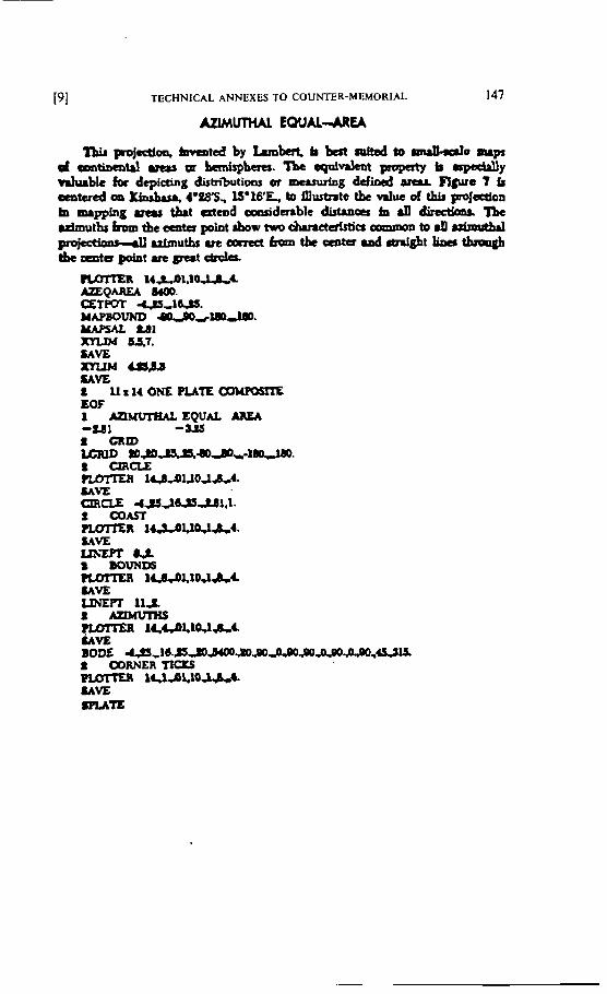
[SI TECHNICAL ANNEXES TO COUNTER-MEMORIAL 147
I h i i p r o j r d l o s h i v m t s d b y k m k r t b b e s t n r f t s d t o ~ e m i p d umtibmuI utu m bmJsphaer, 'Lbc sgddeot propaty b W y hhuble f a drpiaing dishibutions or w*nirkig d d i d srtrr Flpre 7 fi mitued oo Ylni)i.ci 1 ~ ~ 8 5 , 1S916'E, b~ m-te tbe d u e d Lhii pmjdoa b mrpplig mas t&t a tmd omsiderable dirtrnca im 9 dlatloa* Jbe * d m u t h r f r w i t b e c m t a p o i a t r b o w ~ c h r n a ~ a l r a n m a n t 0 d ~ ~ u f m u t b s u e o a r a t ~ t b t c m t u i n d ~ t ~ ~ tbc oeiits point uc @ u t etreta.
H L P l . I U A A rrnQAmu m. ETPOT 4 $ 5 , S a s . MAPBOUNO ULmdrndm. YAPSAL t d l nULW -7. SAVE -Capa SAVE 1 L L L ~ ~ O N E P U ' I E . ~ ~ EOF 1 msnrréw. EQUAL AREA -us -us t CUID C ID n i s s s a a * - m a . I a e L E harrrri i c d 3 1 . 1 0 ~ ~ 4 . SAVE WCiE -ISJbP..Ul,l. 2 COAST rrxrrrr~ 1 w u w ~ 4 . UVE mzPT 0 s
bOUNIn rwY"mn 1 1 4 , 0 L t O J & ~ SAVE UNEPT 11s. t -
14CbLlW&& UVE BODE I MRNHR
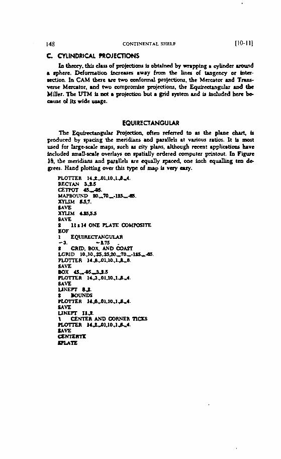
148 CONTINENTAL SHELF [IO-111
C CYLINDRICAL PROJECnONS h th-, t h &SS of prowonr ir obtrfned by nripping r ylindcr rround
sphere. Deformation hausa i w i y fmm the lines of tangcncy or tnter- Rction. in CAM tbur ue two d o m i d projections, the M a u t o r and Tnns- varc Mercator, and hvo compromist projections. tbc Equirsduiguiu uid the Miiitr. The VTM ir mt m projecikm but rn grid ryrtem rnd ir hiciudcd b u t be ciuse d its vide usage.
EQUIRECTANGULAR The Equkeftragulu Projsetion. ohen dared to as tbe pluie chut, b
produccd by vacimg tbc m e r i b and prrallels at variou ratios. 1t is mort used for l u g e - d e mnps, ruch as city plam. dtbough m c ~ i t applications have includcd misll--le weriays bn ~ p a t i d y ordered cornputu -tout. Ln Figure 18. the mcridiuir md paraltels ut t q d l y r p p 4 one in& equnlling tm dt grm. Hmd plotting ova t h type of mop t v a y ary.
PLOTTER 14 f .~l.lO.14,4. REffAN IZTPM *,a. MAPBOUXD tO,70,-105,~. mrrM W. LAVE m u c e s p s SAVE D 11 a 14 ONE PUTE OOMPOiSITE EOF i EQVIRECïANCVIAA - 3. -L75 1 CRiD. BOX, AND &UT LCWD 10..10..3S.S~,70,-iPJ-45. PLOlXR 14.B.Jl.10 .,l..&..l. SAVE BOX 15,-95-Iis F i D ï E R 14J7.01,10.1d~4. SAVE UKEm ô.S t ROUND5 P L D ï i E R 14~.,.0L10,1~4. SAVE UNEPï II*
CENTER AND WRNER ncrs E O ï ï E R 1 4 ~ 1 . 1 0 , 1 ~ . J . LAYE
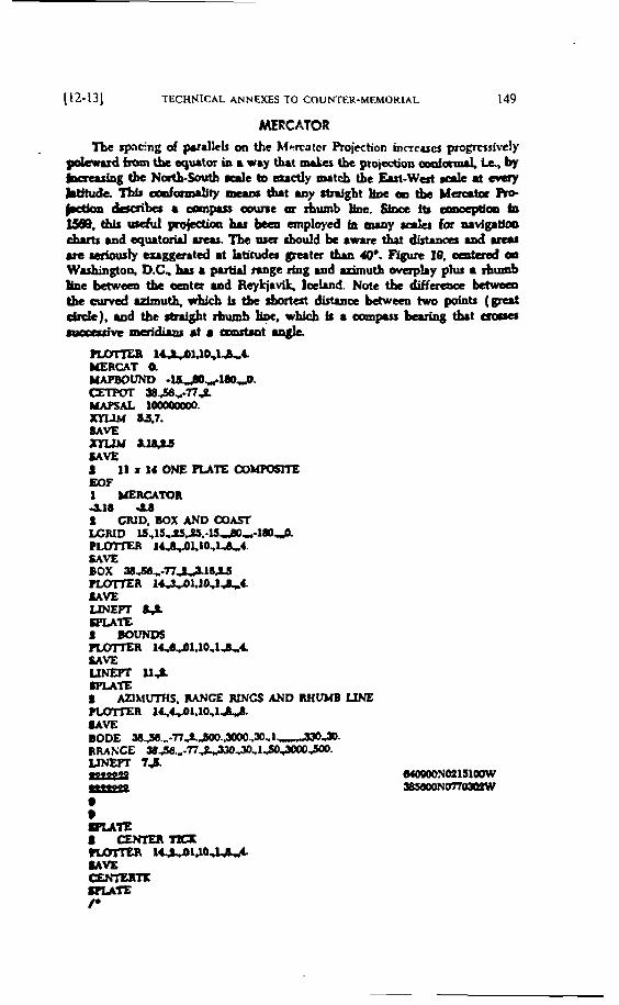
(12-131 TECHNICAL ANNEXES TO COUNTER-MEMORIAL 149
MERCATOR The spiicng d p.nllck on the Myrtatcr Roiection incrcirei pmpmsivcly
pkmd fmm tk sgmtor in a wry that n u k h c projection d m d , ir, by berruIng tbe N&butb d e to m d y mtcb tbt Eui-Wat rrlc at avay Mtude. Thir d d t y nrurr t h t iny W g b t b 0 the M u u t a Ao
W b e s 8 mpirt aiune aï JhUllb b. 6fDa ft i w m k m. this uçdul pojecciœl bu bmi mployed tzl mroy d e l for iuvlgitkm r b u t r u r d s p u . t o n i i u t u . T b a t r r c r r b a d d k i w u e t b u ~ d u a i ut -)y cri~uitd i t ktituder grata t h W. Figure 10, oentersd m Wishiagton, D.C. bu 4 putW trrige rfng and uimutb o v u ~ I i y plu m rhumb h e bawsm tbt mitu and Rylciiv3k Iceknd. Note th differcaœ bchvsni tbeNmdidmu~whicbt i tbctbortest~œbaweentwopoints ( p t d i c k ) . r r i d t b e ~ t r b u m b k , w h i E b t i a w p r s r ~ h t e r o r i a m v c mddiw rt a Qlÿistint
nmnm lCIPU0&4- MERCAT Q YAPBOUND - u 4 i m 2 . - ses,*na -AL 100004000. XrUM a5,7* MVE nzw u.4u UVE 1 1 1 r 1 4 O N E R A T E C O ~ rnF 1 MERCATOR 418 4.0 L GRID. BûX mDOûA5i LCRID ~S,~~.PSS,-WAO,-~~~. P m Jl..ô.,.ûLlO,tk4. SAVE BOX aa,-nu~aw PLQTfER I4,,3..ûl.IOJI,C UVE m E l T kt SF'LAtG I WUNDS m n 1~1.10.1~4. LAVE LlN.&PT 11s m m 1 AZIMüTHS. W C E RWCS AND RHUMB LINE m a iu.ai,io,im. &tvE BODE S s , S a . . . - 7 7 S ~ . ~ . , ~ - ~ I 2 - v RRAX'CE W & . , - n ~ ~ - 1 ~ 3 # K , ~ - Umm 74. - - * lRAR 8 milb m 14.&31.mL8."4- lAYE a.rmmTK LIUW P
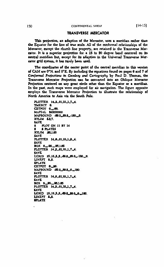
CONTINENTAL SHELF 114-151
TRANSVERSE MERCATOR
7Ms ~ j c c t l o n , an adipiioa of the Mricitor, usa r meridiui ntha than tbe Eguitor for tbt line of m e l c a l ~ AU of the confornial tclntionrhips of the Mercator, aEcpt tbe rhumb LUie propcrty. arc mtnlncd in the Tmsverse Mer- ator. It ir 8 mpaia projeaion for i 15 to 80 degrce band ceatered on b 0p1biI meridirii but, accpt for itr idaption ln the U n i m d T m a w Ma- citargridryrtcm,fthsrudybteawed
'Zbe &ter d the œnta point of the cait~il muidinri in thir vmim of CAM u e 04N. and O0E. By including tbe equitibiu found on pages 6 and 7 of C o n f d Ptofeaions tn Ccodcry od Carlogrophy by Paul D. Tbomlrt, tk T~U~SVQK M m t o r Projection an be amvatcd into an Oblique Mercator Rojocîiori a a t d on i a y grut drde othu thia tbe Eqpator or i meridian. ln the past, mcb maps were employcù for air navigation. I h e figure oppbsite tmploys the Tmrvcïst Mercator Projection to fflust~ate the mlationship of Nortb Am& to AU. via the Çwth hic,
P ~ R ~LL,III.IO.I,~,I. mERm O. CImPoT 0.AQ. MAPSAL U-. MAPBOUND -.û-.B,*l6D.,$. m L I M m.7. SAVE O P U r r O N l l ~ Y l 4 1 8 PLATES mLIM W l d S SAVE - P L m m R 1 4 ~ 1 , l O . l d , 4 . SAVE Box 0.,"-eD..",es,1.85 P L o ï ï E R 1 4 . ~ I , l O , l . 7 ~ . SAVE LCRlD l S . , I S ~ . , ~ d ~ . O , - l 6 0 ~ 0 . UNEPT be SPLATE cmmT 0 3 . HAPBOLRc'V h9~ .8 ,"0 -~89 . SAVE PLOTTER 1 ~ 1 . 1 0 , 1 , 7 , 4 . SAVE Box o,oo,w.1.W? PiDiïEI llMl,lû.l ,7. .4. SAVE WRtD IJ,IS~Ab06d0.u'I11m. UhEPi k$ WUTE
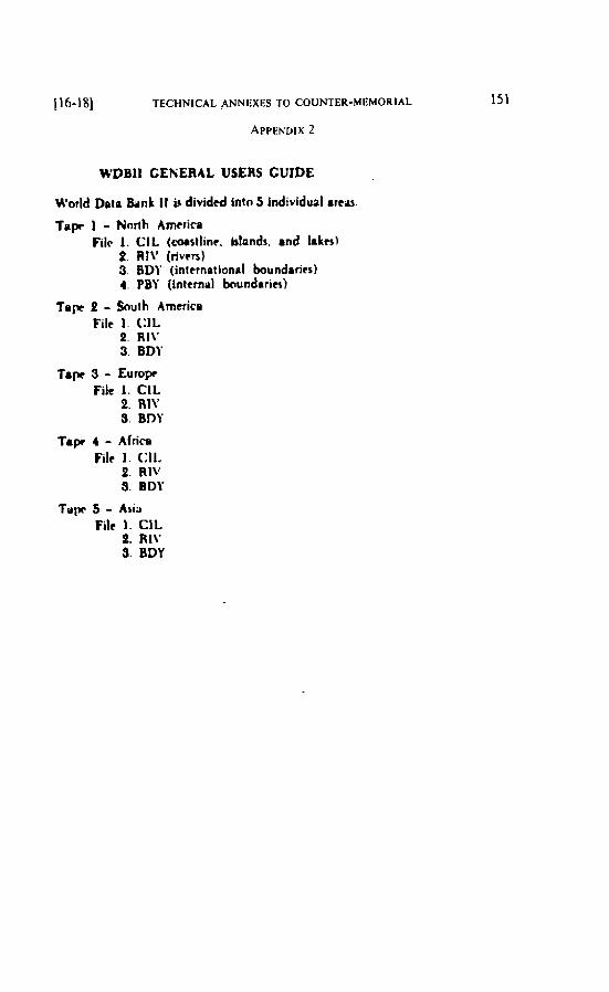
1i6-18] TECHNICAL ANNEXES TO COUNTER-MEMORIAL 151
APPKNDIX 2
WDBII CEKERAL USERS GUIDE
H'otld Data 8unk if ir dividtd into 5 individual i r e u
f u p 1 - Nnrth Arn~r ira Filr 1. CIL (mstl inr . ~rlonds. i n d Inter)
2. RI\' ( r lv~r5 ) 3. BDI' (international boundarirs 1 4. PM ( intern~l kiundarier)
Tapc 2 - &uth Amcrica File 1 . CIL
4. RI\' 3. 801'
T4p 3 - Europr File 1. CIL
2. RlV S. BDY
Tape 4 - Africe File 1. (:Il.
2. RlV S. BDY
T q w 5 - Asiï File 1. CIL
2. RIV 3. BDY
152 CONTINENTAL SHELF
C~SSIFICATIOS/RANK Guide. The dita hrnk h i s a mnk r ~ a i i t e d 4 t h esch bnt. CAM. lot nimplt . h r s npttans for pbting i n y a il1 nnks and the mnk can br ~mbo!ized.
1. Irtrmational boundarlrr or limits of mvmignty 01 Drmatated or detirnitrd 01 lndcfinite or in disputr Cû Mhcr Une of ceparation or ipmcignty an knd
II. Thart. blonds. and bkrr 01 h s t . irlandr. irid I ikrr . ih~t ippnt on aII mapr M Additional major idvnds ind 1 i k e 03 Intrmrdiotc jslands and lnkcs 131 Minrit hlandr and bkts
Intrmittrnt major lakrr U ï Irii.t-rrnittvnt miiiiii 1.iki.s OH Rwh OH S ï h ~ w ~ ~ + ~ t u j ~ t t 10 Siih pns-mincir 13 lm shrlvn-maior li Ir? sh~lvccrniniir 15 CIar5rrb
Ill. Rivrn 01 Petminent major r ivm û2 Additional majnr rivtrr &3 Additionil riven CU Minm rlvm 05 Douhle-lintd dvcn LX Inlemittent rivers-mrjm 07 Intermittent dvm-idditirna! 08 Intemittent rlvcrs-mlnor 10 MiPr r i r u l s 11 Canal, of k u r r jmpartinm 12 Gnals-irrigation typc
IV . lntcmal boundPrie 01 Fini. d e r admin
[20-2 11 TECHNICAL ANNEXES TO COUNTER-MEMORIAL 153
NT lS n i i r n h kir CAM. CAM D<mimcnta~liin, nnd If'DRI I arru 1 throiigh 5
WDB I I .......................... t ip r 1. North Amrrico .CiA!DF-ff/001 .......................... Tapr P. b u t h Amtrica. .GIA /DF-TI/OM
................................. fOpe S. Eump .CJ,â/DF-Z/iX)3 .................................. T i p 4. Afr ici .CIA/DF-77/004
.................................... Tip S. A ~ l i .CIA.IDF-n/aEi ........................ CAM hogram. 5th Edition :. .CIA/DF-n/lX%
.................... CAM Documrntition. 5th Edition .CIA/DF-7;/006A
Hfmld &ta Rank ft (\rnnRIl) w s dwtizrd and riritcd tn a ntattilrr that firlfilh ihf mopl>ing wquircmrnir of flic Cintrai I n f t / / i ~ n e e &W. Thctr nvrhods m o y no1 nrcrmdly mtitJiI thr nteds of orhcr ucm.
CIA dort moi haoc w m m i CO P d c cprdnl pmgmmniing: in cliatt~rm to mtirlq ~ h r q ~ r f a l nrcdr oj orlier M n .
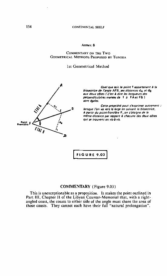
CONTINENTAL SHELF
Annes 8
1st Geometricai Method
Que/ que rait te point f appartenant B /a biis~trice ok /'ar>g/e AFB. ses distancer dA cf de aux deux côtes 1 c'est i dire les longueurs des per~endiculaires men& de f d FA et F B l wint kales.
Cetre.propridr.4 peut s'exprimer autrement : & lorsqui B partir Ibn du point-frontière va vers te brge F . en on suivant sëloigne la bissectrice, de ta
m€me distance par rapport B chacune des deux cdtes qui so rrouvent en vis-P-vis.
Po;nl ~ i o n i i a r i F /'da
COMMENTARY (Figure 9.03)
This is unexceptionable as a proposition. It makes the point outlined in Part I I I , Chapter I I of the Libyan Counter-Mernorial that, with a right- angled Coast, the coasts to either side of the angle must share the area of those coasts. They cannot each have their full "natural prolongation".
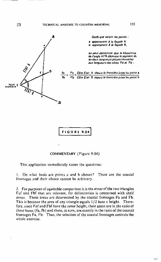
Queb que mient /es points :
a apmrtenani B la façade A b eppwrenanr B.b façade B,
on peut dPmonrrer que la bissectrice de IPngle AF6 d4mupe le xgment ab en deux longueurs proportionnelles aux longueurs des &es f a et Fb :
fa Fa Cdte Erar A depuis /a fmntiPrc iusqu'au point a -= -= fb Fb Cdte Etai B depuis la frontière jusqu'au point b
Poipt F Frontinin
B
COMiMENTARY (Figure 9.04)
This application immediately raises the questions:
1 . On what basis are points a and b chosen? These are the coastal frontages and their choice cannot bc arbitrary.
2. For purposes of equitable cornparison i t is the oreos of the two triangles Far and Fbf that are relevant, Far delimitation is concerned with shelf areas. These areas are determiried by the coastal frontages Fa and Fb. This is because the area of any triangle equals 1/2 base x height. There- fore, since Faf and Fbf have the some height, their areas are in the ratio of these bases (fa, fb) and these. in turn, are exactly in the ratio of the coastal frontages Fa, Fb. Thus, the selection of the coastal frontages controls the whole exercise.
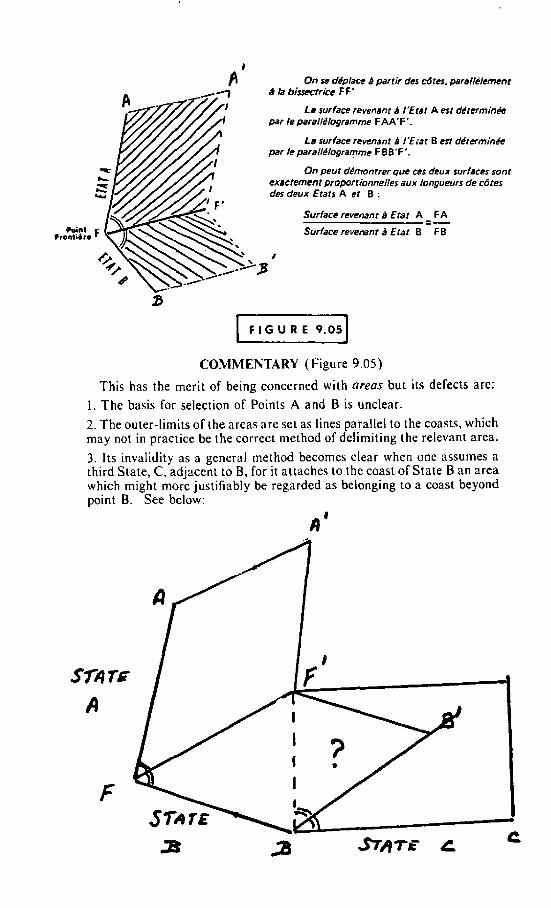
On se dr'placo d partir des côtes, parallèlement B ta biffcccrice F F '
La surface revenant d I'Erar A est d$termin& par le paral/4logramme F AA'F '.
La surface revenant el I'Erat B est déterminée par le parallPlogramme F BB'F'.
On peut dhontrer que ces deux suriaces sont exactement proportionneIles aux longueurs de cdtes des deux Erars A et B :
Surface revenant i) Etat A - FA -- Surface revemnt d Erat B F B
I
COMMENTARY (Figure 9.05)
This has the merit of being concerned with areas but its defects are: 1. The basis for selection of Points A and B is unclear.
2. The outer-limits of the areas are set as lines parallel to the coasts. which may not in practice be the correct method of delimiting the relevant area. 3. Its invalidity as a general method becornes clear when one assumes a third State, C, adjacent to B, for it attaches to the coast of State B an area which might more justifiably be regarded as belonging to a coast beyond point B. See below:
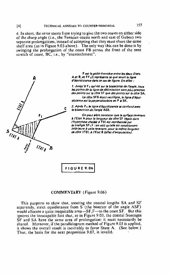
141 TECHNICAL ANNEXES TO COUNTER-MEMORIAL 157
4. In short, the error stems from trying to give the two toasts on either side of the sharp angle (i.e., the Tunisian coasts north and east of Gabes) two separate prolongations, instead of accepting that they must share the same shelf area (as in Figure 9.03 above). The only way this can be done is by swinging the prolongation of the coast FB across the front of the next stretch of coast, BC, i.e., by "encroachment".
F est ie point-fmnriilce entre les deux Erre A et B, et F F 1 C représente de que serait ia le d'équidisiwnm dcm cc ws k figure. En tffct :
1. Jusqu'd F 1 qvi est ~ u r k b i ~ e ~ h i i x de I'.ngle, rous /CS points de le l4ne de d4limitation sont plus proches des points sur la cdre S F que dm points sur la &te SA.
La cbte S FB Crant rectiligne, ia ligne dëqui- distance est le perpcndinr8ira m F b SB.
2. Aprts f 1 lu lane d'&~idisrrnce se confond a m 5 b biucctrice de 1'8ngle ASB,
On peut alors constarer que b surface revenant 9 i'Ebr A pour la longueur de &te SF (égaie dans 1% yprhèsc a F 19 I esr rrprdsentée pdr k triahg~e sF1 F :on mit uu'slk est notablement inferiuÏre B celle rrwnant; pour Ir m€me longueur de cdte (FB). 4 I'Etat B kffer d'amputation/.
COMMENTARY (Figure 9.06)
This purports to show that, treating the coastal lengths SA and SF separately, strict equidistance from S (the bisector of the angle ASF) would allocate a quite inequitable area-SF,F-to the coast SF. But this ignores the inescapable fact that, as in Figure 9.03, the coastal frontages SF and SA have the same area of prolongation: it must necessarily be shared. Moreover, if the parallelogram method of Figure 9.05 is applied, it shows the overall result is inevitably to favor State A. (See below.) Thus, the basis for the next proposition 9.07, is invalid. b
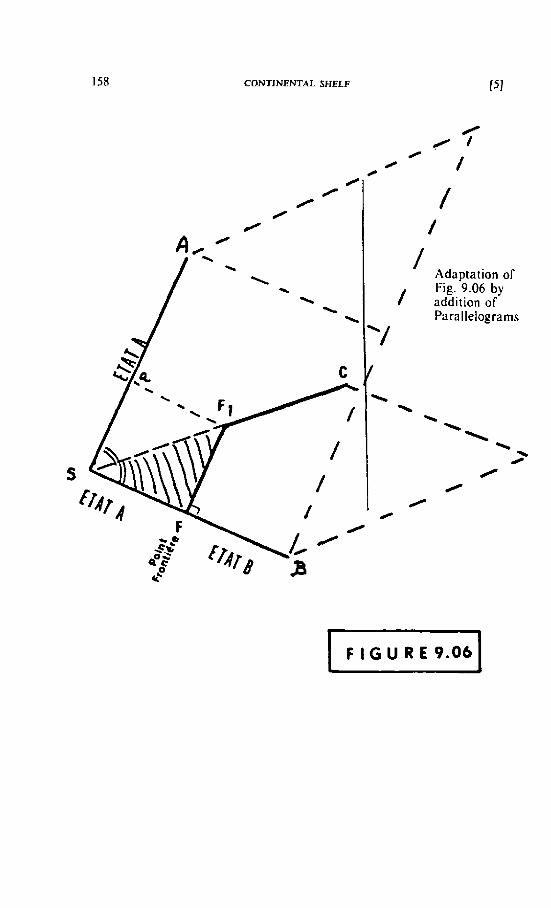
CONTlNENTAL SHELF
/ Adaptation of Fig. 9.06 by addition of Parallelograms
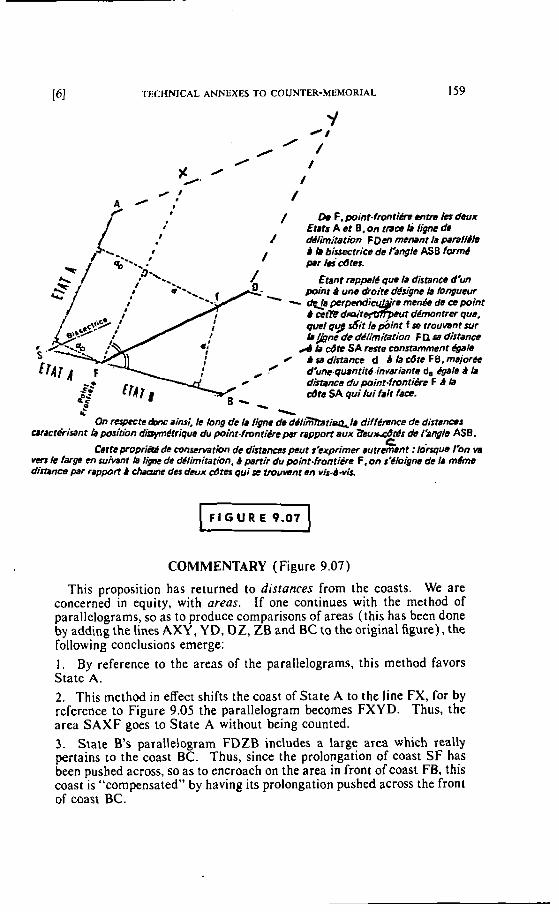
TECHNICAL ANNEXES TO COUNTER-MEMORIAL
Y =/
0 0 ' /
% ' /
0' / d / /
/ Da F. point-frontiks antm Ics deux Etats A et 8, on tmw I j ligne de
/ rWlirnitatkm FDen menant t pmll&h & lp bissectrice de I'angle ASB fwmb ' P r lei~ates.
€&nt rappel6 que 1s distance d'un p i i t 9 une dzoite dgsqne la loqqucur
quel qg di t le point f se trouvant sur L&ne de dOlimicarion F D se distancc
A b Cdh SA reste constamment @le b sa distance d la côte F B. majorCe d'unc.quantit6 invariants d, &le d Ir distance du point-ffvntjh F d b &te SA qui h i fr i t fa@- -
On rctpeete & m ~ ainsi. le long de la ligne de dtlimbrie&lr diffémtce de disrsnrrt metPrirant fa position dr'pymétriqus du point-fmntiéve psr rapport aux abudtéS de I'ongls ASB.
C Cette proprj* de conservation de distances peut s'exprimer autrement : l h q u ~ I'on w
m 1s larp en suinni b ljTK de d4/imitatian, d pertir du point.fronti&e F, on $'Cloigne de /A mdms distance par rapport B des deux cd* qui rc trouwnt en vis-à-vis.
COMMENTARY (Figure 9.07)
This proposition has returned to distances from the coasts. We are concerned in equity, with areas. If one continues with the method of parallelograms, so as to produce comparisons of areas (this has been done by adding the lines AXY, Y D, DZ, ZB and BC to the original figure), the following conclusions emerge: 1 . By reference ta the areas of the parallelograms, this rnethod favors State A.
2. This method in efiect shifts the coast of State A to the line FX, for by reference to Figure 9.05 the parallelograrn becomes FXYD. Thus, the area SAXF goes to State A without being counted. 3. State B's parallelogram FDZB includes a large area which really pertains to the coast BC. Thus, since the prolongation of coast SF has been pushed across. so as to encroach on the area in front of coast FB, this coast is "compensated" by having its prolongation pushed across the front of coast BC.
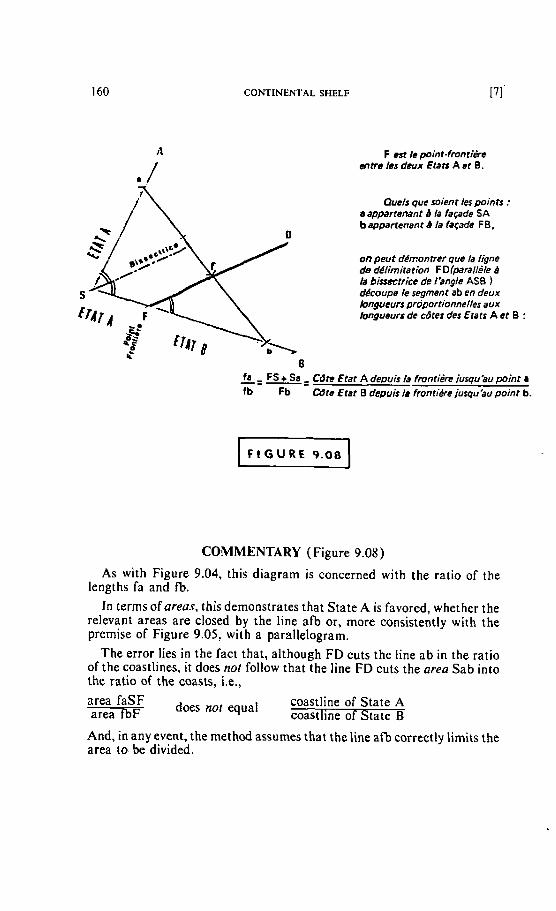
CONTINENTAL SHELF
F est Ie point-fmnfiérs atre les deux Etari A et B .
Quels que soient les points : a appartenant B la façade SA b appartenant B /a façade FB,
on peut dhontrer que la ligne de délitniration F Diparallèle ti la bisseetrice de l'angle AS8 1 dècoupe le segment ab en deux longueurs proportionnelles aux longueurs de dtes des Etats A et 0 :
&= -+ Cdte Etat A depuis /a frontière iusqu'au point a fb Fb Cdte Etat B depuis /a Fronti#ejusqu'au poinr b.
COMMENTARY (Figure 9.08)
As with Figure 9.04, this diagram is concerned with the ratio of the lengths fa and fb.
In terms ofareas, this demonstrates that State A is favored, whether the relevant areas are closed by the line afb or, more consistently with the premise of Figure 9.05, with a parallelogram.
The error lies in the fact that, although FD cuts the fine ab in the ratio of the coastlines, it does not follow that the line FD cuts the area Sab into the ratio of the coasts, i.e., area faSF areafb~ does not equal coastline of State A coastline of State B
And, in any event, the method assumes that the line aîb correctly limits the area to be divided.
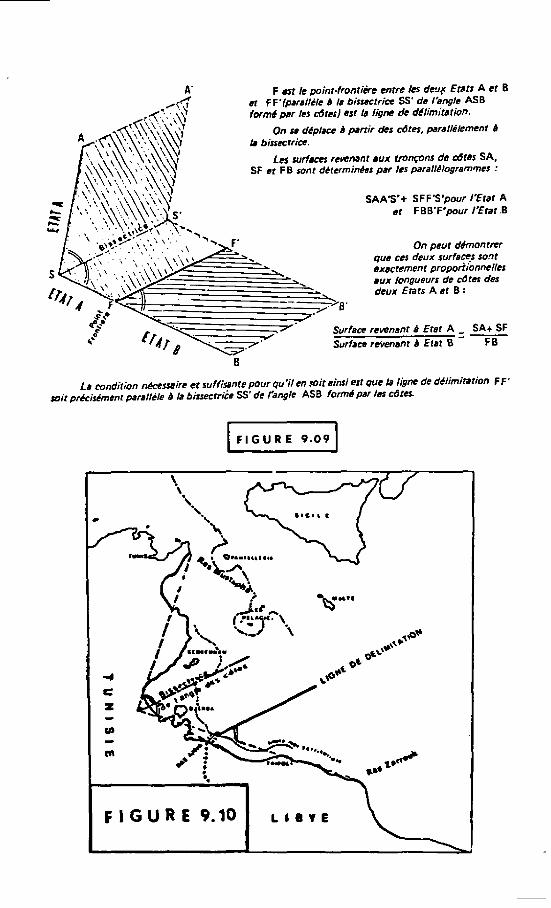
A' F est le point- front ik entre /es d e q Etse A et 8 A? eï F F'(.Wf~l/de b la bissutrim SS' de I'engle ASB
fwmd s r les cdrcs] est 1s lignc de délimitation.
On se déplace b psnir d e s dtes, parsl/e&ment B I. biucctrie.
Les sudaces remnant aux tronçons de &tes SA, SF et F B sont d6terminêrs par les parallilogrammes :
- - aux deux lonOue"rs Etars A et de B d i e s : des
. . que ces deil* surfa* sont . exacrament propodionnelles
-- -/ ,y 0'
Surfam reionanf d Eret A = SA+ SF Surface ruvertani B Etat 8 FE
La mndition nPccssirt et sufiisante pour qu'il en s i r sinsi est que ki ligne de dClimimiion FF' soit prCcisCmenr perallèle B la bissectri& SS' de rangle ASB formC par /es cûrer.
C
F I G U R E 9.10 ~ i e r ~
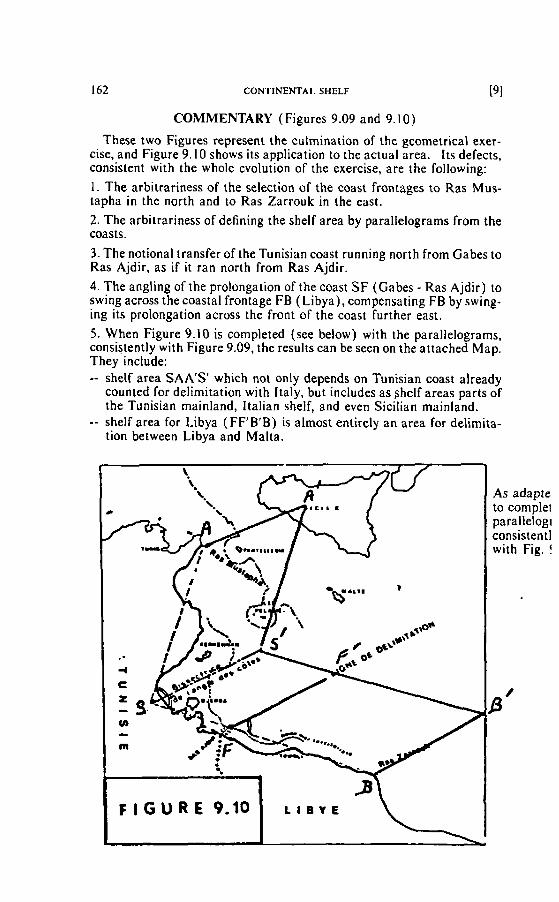
162 CONTINENTAL snELF [91
COMMENTARY (Figures 9.09 and 9.10)
These two Figures represent the culmination of the geometrical exer- cise, and Figure 9. I O shows its application to the actual area. I t s defects, consistent with the whole evolution of the exercise, are the following:
1. The arbitrariness of the selection of the coast frontages to Ras Mus- tapha in the north and to Ras Zarrouk in the east.
2. The arbitrariness of defining the shelf area by parallelograms frorn the coasts.
3. The notional transfer of the Tunisian coast running north from Gabes to Ras Ajdir, as if it ran north frorn Ras Ajdir.
4. The angling of the prolongation of the coast S F (Gabes - Ras Ajdir) to swing across the coastal frontage FB ( Libya) , compensating FB by swing- ing its prolongation across the front of the coast further east. 5 . When Figure 9.10 is completed (see below) with the parallelograrns, consistently with Figure 9.09, the resultscan be seen on the attached Map. They include: -- shelf area SAA'S' which no1 only depends on Tunisian coast already
counted for delimitation with Italy, but includes as ~ h e l f areas parts of the Tunisian mainland, Italian shelf, and even Sicilian mainland.
-- shetf area for Libya (FF'B'B) is almost entirely an area for delimita- tion between Libya and Malta.
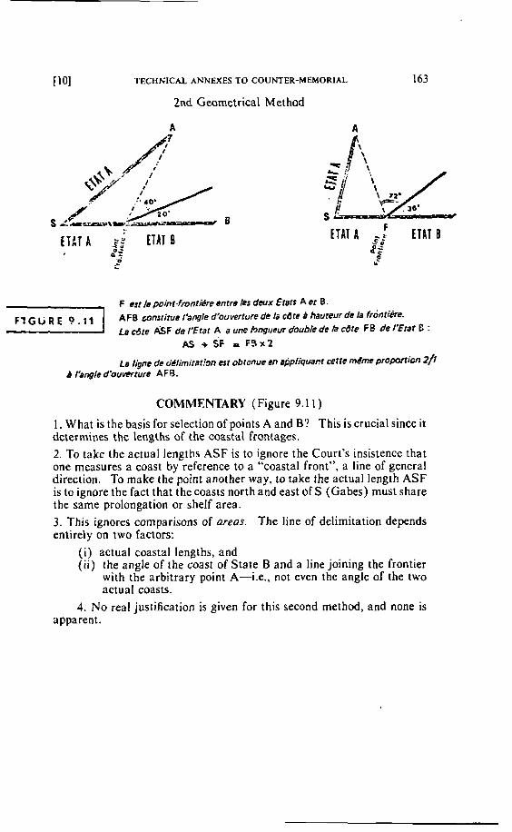
TECHNICAL ANNEXES TO COUNTER-MEMORIAL
2nd Geometrical Method
ETLT A .$; 0 z
ETAT fi a i
F esr Ie point-fmntiére enrre Xes deux Eters A et B .
AFB constitue l'angle d'ouverture de Io cdte B hauteur de la frontiére. La d t e &F de E t a t A a une hngi~sur double de la cbre FB de I'Etat E :
AS + SF r F 3 ~ 2
La ligne de o'tIimitat!~n est obtcnue en uppliqwnr cette mPme p r o p a i ~ n 2) d I'angle d'ouverrure AFB.
COMMENTARY ( Figure 9.1 1 )
1. What is the basis for selection of points A and B? This is crucial since it determines the lengths of the coastal frontaga. 2. To take the actual lengths ASF is to ignore the Court's insistence that one measures a coast t y reference to a "coastal front", a line of general direction. To make the point another way, to take the actual length ASF is to ignore the fact that the coasts north and east of S (Gabes) must share the same prolongation or shelf area. 3. This ignores cornparisons of areas. The line of delimitation depends entirely on Iwo factors:
( i ) actual coastal lengths, and ( i i ) the angle of the coast of State B and a line joining the frontier
with the arbitrary point A-Le., no1 even the angle of the two actual coasts.
4. No real justification is given for this second rnethod, and none is apparent.
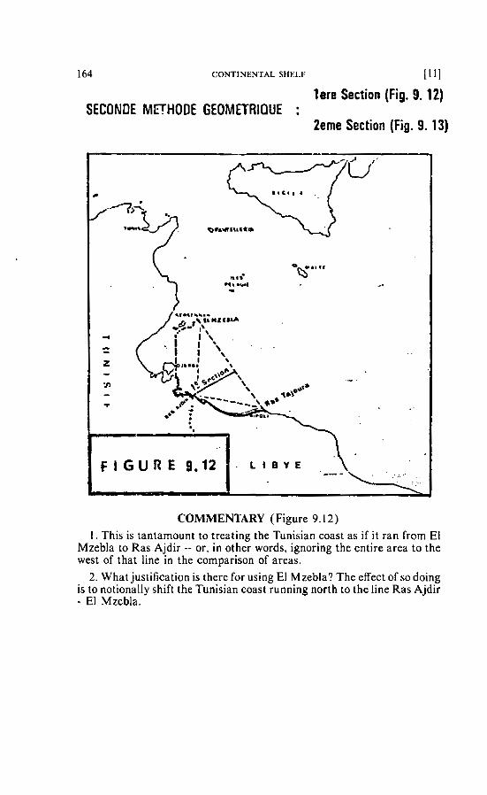
164 CONTINENTAL SHELF 11 11
lere Section (Fig. 9.12) SECONDE MFHODE GEOMETRIQUE :
2eme Section (Fig. 9. 13)
COMMENTARY (Figure 9.12) 1. This is tantamount to treating the Tunisian coast as if it ran from EI
Mzebla to Ras Ajdir -- or, in other words, ignoring the entire area to the west of that line in the cornparison of areas.
2. What justification is there for using El Mzebla? The effect of so doing is to notionally shift the Tunisian coast running north to the line Ras Ajdir - El Mzebla.
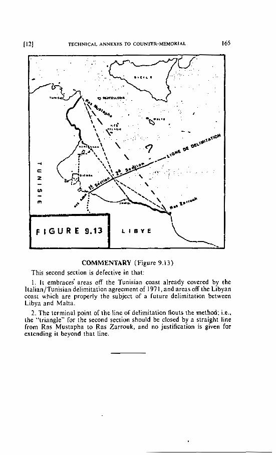
[ 12] TECHNICAL ANNEXES TO COUKCER-MEMORTAL 165
COMMENTARY (Figure 9.1 3 ) This second section is defective in that:
1. I t embrace; areas off the Tunisian coast already covered by the ltalian/Tunisian delimitation agreement of 197 1, and areas off the Libyan coast which are properly the subject of a future delimitation between Libya and Malta.
2. The terminal poini of the line of delimitation Aouts the method; i.e., the "triangle" for the second section should be closed by a straight line from Ras Mustapha to Ras Zarrouk, and no justification is given for extending i t beyond that line.
CONTINENTAL SHELF
CHRONOLOGICAL REVIEW OF OFFSHORE LICENCES IN TUNISIA (PBTROCONSULTANTS, S.A., INTERNATIONAL ENERGY SERVICES)
Pre- 1965 Petroletrm Exploration
Petroleum exploration in Tunisia started in 1894 when the first exploration permit wai awarded. Exploration activity was limited 10 geological mapping in the northern part of the country and some shallow wells drilled in the Mio- Pliocene area of Medjerba (1919). The first deep test was dnlled by the old Standard Oil Co. on the Abd el Rahmane anticline in 1926. This well was abandoned as dry above the formation which proved as gas beanng 23 years later (Cap Bon field).
From 193 1 to 1948, activity was mainly conducted by the French and Tunisian Governments. Interrupted during the Second World War, activity resumed in 1945 and the general mapping and geophysical surveys conducted over thecentral part of the country were extended further to the south into the Sahara.
From 1949 to 1964, geological and geophysical investigations were also con- ducted in the southern Chotts area and extended to the most southern part of the Sahara.
In 1949, Serept (Société de Recherches et d'Exploitation des Pétroles en Tunisie) formed by Elf, CFP, Repfrance, Cofirep and the Tunisian Government started drilling in the Cap Bon Peninsula and discovered the Cap Bon gas field in the Lower Cretaceous. Gas produced is still used in the city of Tunis. From 195 1 to 1964, about 65 wells were drilled mainly by Serept alone or with foreign partners. Of these 65 wells, several found oil and/or gas shows (Bahloul, Ktitir, Mansour, Chorbane, Ktifa, Kebir, Bir Ben Tartar, etc.. . .) but the first com- mercial discovery was only reported in 1964 when Sitep (Société Italo-Tuni- sienne d'Exploration Pétrolière) held by Eni and the Tunisian Government found oil at El Borma in the Lawer Triassic sandstones.
In the same year Serept in association with the French S~\IPA started seismic exploration over the offshore Gulf of Gabès area. Following the El Borma success, increased activity was recorded during the subsequent years as indicated below for offshore :
1965
Rights - Offshore. four permits were held respectively by :
Petropar (Société de Participations Pétrolières) a Company controlled by the French Government which received the 8,812 sq km Golfe d'Hammamet permit in 1964. SNPA/RAP - A joint venture between the two French Société Nationale des Pétroles d'Aquitaine and Rkgie Autonome des Pétroles which received the Golfe de Gabès permit (8,852 sq km) also in 1964. Husky Group formed by Tunisian Husky and several other cornpanies (Signal, Helis, United Overseas and Colorado Oil) which was the rightholder over a 14,252 sq km block in the Gulf of Gabès. Rimrock - which was the rightholder for the Cap Bon ExtrOme (awarded in 1958) and Iles Kerkennah permits (324 sq km).
TECHNICAL ANNEXES TO COUNTER-MEMORIAL 167
Exploration - Offshore seismic activity was conducted by SNPA and Signal (Husky group) in the Gulf of Gabès area.
Explorato~y Drilling - Firsr offshore drilling was started in May when Signal spudded the Barani well (abandoned as dry) ; the well was followed by Ras Zira 1 and Kerkennah 1 which were also both abandoned as dry.
1966
Rights - In July, Husky and its four American partners released their Golfe de Gabès permit. Rimrock also released its offshore rights. SNPA received additional acreage io the i~ large offshore permit (Golfe de Gabès).
Several American, French and German companies showed interest in acquiring exploration rights over the area released by Husky et al. and Rim- rock.
Explorarion - Seismic activity was conducted by Serept (in joint venture with Petropar and/or SNPA and Erap) in the Golfe d'Hammamet and Golfe de Gabés areas. No offshore drilling was conducted during the year.
1967
Rights - No new awards were reported but Shell announced an application for two blocks in the Golfe de Gabés area.
Explorarion - No offshore seismic activity was reported. Drilling - The SereptlSNPAIErap venture drilled the Gabés 1 well and aban-
doned it after encountering important gas shows in the Mesozoic. Further to the north off the Cap Bon, Petropar drilled the Hammamet West 1 well to the Upper Creiaceous without positive results.
1968 Rights - In November 1968, the French CFP received the 14,864 sq km Sfax-
Kerkennah permit while Aquitaine Tunisie was awarded the on- and offshore Kairouan permit.
Exploration - Sofratep ran 170 km of seismic lines in the Golfe de Gabès. Drilling - After an interruption of several rnonths, the French companies (So-
fratep) drilled two wells using the Neptune Gascogne in the Gulf of Gabès. Both wells. Tanit I and Echnoun 1 were abandoned as dry.
1969
Righrs - Sofratep was granted an extension to the Golfe de Gabès permit. Explorarion - Sofratep, Sorek and CFTP conducted offshore seismic surveys
(using CGC vessels) in respectively Golfe de Gabés, Kairouan and Sfax- Kerkennah offshore permits.
Exploraroty Drilling - No offshore drilling was conducted during the year.
1970
Rights - CFP received an additional area io ils Sfax-Kerkennah permit. The Austrian State Oil Company (OMV) acquired 49% in the Petropar's Golfe d'Hammamet permit.
Explorarion - PetroparlOMV conducted a 5-day offshore seismic survey in the Golfe d'Hammamet permit.
CFTP recorded shallow water seismic lines in the Sfax-Kerkennah per- mit.
Exploratuty Drilling - No offshore drilling was conducted.
168 CONTINENTAL SHELF
Rights - Four offshore permits were awarded during the year as follows :
Murphy/Cigo : Gulf of Tunis (2,924 sq km) Gulf of Gabès (6,564 sq km)
Transworld : Tunis/Bizerte (5.160 sq km) Buttes et al. : Tabarka-Bizerte (4,128 sq km)
Cap Bon Goifed'Hammamet (5,148 sq km) On 20 August, Itaty and Tunisia agreed on their common boundary in the Mediterranean sea. However, the accord was ratified by both Governments in 1978. Exploralion - Petropar/OMV shot seismic lines in the Golfe de Gabés permit.
Aquitaine/Elf recorded 2,300 km of seismic lines in the Golfe de Gabès permit.
ButteslSlR ran a seismic survey in the Tabarka-Bizerte permit. CFTP conducted shallow water seismic operations in the Sfax-Kerkennah permit.
Murphy/Cigo completed about hall a crew-month of marine seismic survey in the Gulf of Tunis.
Exploratoy Drilling - Aquitaine Tunisie/Erap spudded the Ashtart 1 well at some 80 km SE of Sfax and completed it as an oil discovery after reaching 3,018 metres. The reservoir is the Nummulite limestone of Ypresian age (Eocene).
1972
Rights.- Three offshore permits were granted during the year :
Sepeg was awarded the Golfe de Gabès Oriental permit CFP/Agip/Amoco received the Permit Marin Centre Orientai Sunningdale/Bow Valley/Pan Ocean received the small Kuriate permit.
Exploration - Buttes, CFTP, Murphy, Sofratep and Sunningdale recorded seis- mic lines in the Mediterranean for a total of about 3 party months.
Exp~oratory Drilling - Three offshore wells were spudded during the year and two of them were completed, both of them abandoned as dry (Aquitaine/ Erap's Melquart 1 and Erap/OMV's Teboulba 1). The Sofratep's Salambo 1 was drilling at the end of the year.
An outposr well io the Ashtart 1 discovery was drilled 6 km N of the Ashtart 1 well and abandoned as dry.
Rights - The offshore exploitation concession covering the Ashtart field was awarded to the AquitaineIErap group for a 50-year period.
Sunningdale, Total, and Sheli were granted the Golfe d'Hammamet, Marin Centre Oriental and Hammamet Grands Fonds permits respectively.
Exploration - Buttes, CFTP, Murphy, Sunningdale, Erap. Aquitaine and Total recorded seisrnic lines for about 3.5 crew-months.
Exploraroty Drilling - Five offshore wells were completed during the year but no discovery was reported. In the Gulf of Gabés, Salambo 1, Hamon 1, and Reshef 1 were drilled by respectively Sofratep, Aquitaine and Erap. In the Gulf of Tunis, Murphy abandoned the MGT 1. Buttes was still active in the Gulf of Hammamet 1 weil at the end of the year.
Field Drilling - Aquitaine/Erap started development of the Ashtart field spud- ding four new wells and cornpleting three.
TECHNICAL ANNEXES TO COUNTER-MEMORIAL 169
1974
Righrs - The Cigol group received an extension to the Golfe de Gabes Djerba Ben Gardane permit.
Explora~ion - A total of 5.9 crew-months of marine seismic surveying was conducted by Aquitaine/Erap, Buttes, CFTP, Cigol, Erap/OMV, Murphy, Sepeg, Shell, Socept, Sunningdale and Total.
Exp/orarory Drilling - Offshore drilling activity again increased with six wells completed and one drilling at the end of the year.
In the Marin Centre Oriental permit, Total cornpleted the Isis 1 well as an oil discovery after testing about 2,700 BOPD from the Lower Cretaceous Zebbag dolomite.
Aquitaine/Erap found oil in the Athirat 1 well (Ashtart concession) from the same b e n e nummulites limestones producing in ihe nearby Ashtart field.
The Sofratep's Elyssa I tested wet-gas from Lower Eocene (Golfe de Gabès Complémentaire).
Wells abandoned as dry were Aquitaine/Eïap's Miskar 1, Buttes' Golfe d'Hammamet 1 and Erap/OMC's Mahdia 1.
Field Drilling - ln the Ashtart field, development drilling continued and five wells were completed during the year. In the Isis discovery, Total drilled 2 developrnent wells.
Production - First commercial production was reported from the Ashtart field in March. Production for that year averaged 24,094 BOPD.
1975
Righrs - No offshore awards were reported during the year. Exploration - Six different operators (Aquitaine, CFTP, Murphy, Sepeg. Sun-
ningdde and Total) recorded seismic lines (8.1 crew-months). An Aeromag survey was flown in the Golfe de Gabés.
Exploraroy Drilling - Five wells were drilled during the year. The Total's Jarrafa 1 (Marin Centre Oriental permit) was abandoned as dry. Aqui[aine/Erap plugged Hasdrubal 1 (Golfe de Gabès Complémentaire) after testing wet gas in the Lower Eocene (Tertiary). The same group tested gas in the Miskar 2 well (Golfe de GaMs) and tested up to 3,ûûO BOPD in the Didon 1 well (Golfe de Gabès Complémentaire) frorn Cretaceous formation.
Field Drilling - Drilling of producing and injector wells in the Ashtart field continued.
Production - Production from the Ashtart field increased to 45,028 BOPD as compared to 24,094 BOPD during the previaus year.
1976
Rights - Etap, the State-owned Company was awarded the Permis Sud Oriental du Golfe de Gabés southeast of the Ashtart oil field.
E.xploration - A total of 1.1 crew-month of marine seisrnic lines was recorded by Elf Aquitaine, Buttes, CFTP and Marathon.
Exploratoy Drilling - No less than ien offshore wells were spudded during the year resulting in one .new discovery (Butte's et al.'s Golfe d'Hammamet 2 which tested 1.790 BOPD of 39' API cnide) and one confirmation test (Elf- Aquitaine's Miskar 3).
Reld Drilling - Three new wells were dnlled in the Ashtart field. Producrion - Production from the Ashtart field decreased to 35,607 BOPD
(45.028 in 1975).
170 CONTINENTAL SHELF
1977
Rights - No offshore permits were awarded dunng the year. Exploration - Marine seismic recording totalled 4,700 kilornetres in the Sfax-
Kerkennah, Golfe d'Hammamet and Marin Centre Oriental permits where CFTP, SNEA and Total were active.
Explorarory Drilling - Nine different operators were active during the year drilling 10 wells. Of this total, three were new discoveries and one was a successful appraisal. In the Cap Bon GolfedlHammarnet permit, Buttes tested 23' API oil drilling the Yasrnin 2 deeper pool test. Flow was from the Sabri sandstone of Miocene age but also from sandy limestone in the Lower Tertiary Ain Grab formation.
Marathon's Bregat 1 well in the Golfe de Gabès-Djerba Ben Gardane permit flowed dry gas at a rate exceeding 30,000 MCFD most probably from the Cretaceous.
The SNEA's Halk el Menzel 1 well (Golfe d'Hammamet permit) found oil in the Miocene. In the Miskar 4 appraisal, SNEA struck wet gas in the Abiod formation (carbonate rocks) of Campanian-Maestrichtian age.
Field Drilling - SNEA continued field drilling in the Ashtart field drilling two new wells during the year.
Total Exploration and the Tunisian Government announced their intention to develop the Isis oil discovery.
Production - Production from the Ashtart field averaged 43,089 BOPD, a 21% increase versus the 1976 output.
1978
Rights - The Buttes/Etap group was granted the Enfida permit which covers both on and offshore areas in the Gulf of Hammamet. Houston Oil and Minerals alongwith Etap were awarded the Kerkennah West permit (also both on and offshore). Sorek was granted extension to its Kairouan permit.
Exploration - Buttes, CFTP, Elf Aquitaine, ShelI and Total recorded a total of almost 10,000 km of marine seismic lines.
Explora to~ Drilling - Five different groups drilIed a total of 9 offshore wells during the year. Of this total, Buttes' Mimosa 1 and Shell's Oudna 1 confirmed the interest of the Miocene prospects in the Gulf of Hammamet.
Sofratep's Salambo 2 also in the Gulf of Gabès found gas shows probably in the Lower Eocene Metlaoui formation (carbonate).
Field Drilling - No offshore field development drilling was conducted during the year.
Production - Production of oil frorn the Ashtart field averaged 45,183 BOPD.
1979
Rights - Marathon/Etap was granted the offshore Gabès Septentrional: Ouest permit while the Cities/Etap group received the Gabès Septentrional Est permit.
Exploration - CFTP, Houston Oil, Marathon, Shell and Elf recorded a total of 6,580 km of offshore seismic lines during the year.
Explora to~ Drilling - Buttes, Shell, SNEA and Total were drilling offshore during the year. Eight wells were drilled. Of this total, three wells struck oil. Shell's Birsa 3 tested oil in the Ain Grab Miocene formation and Shell's Tazerka 3 and Oudna N 1 yielded oil probably from Upper Cretaceous limestones.
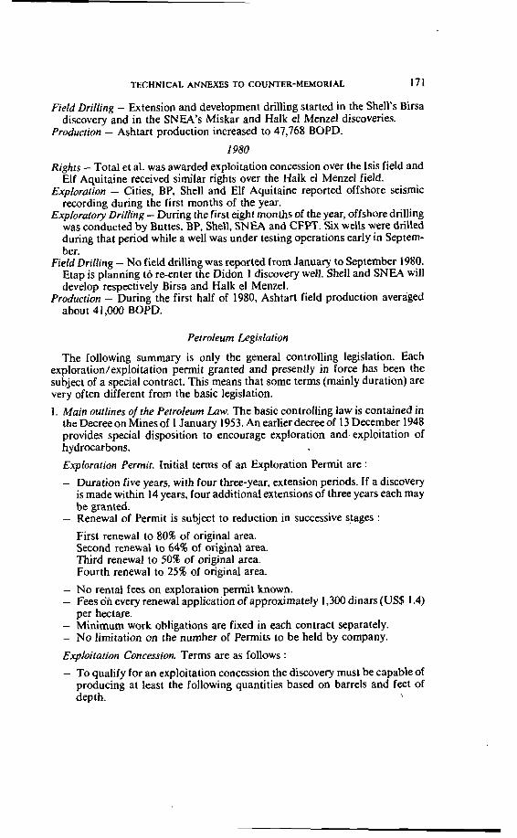
TECHNICAL ANNEXES TO COUNTER-MEMORIAL 171
FieM Drilling - Extension and development drilling started in the Shell's Birsa discovery and in the SNEA's Miskar and Halk el Menzel discoveries.
Production - Ashtart production increased to 47,768 BOPD. 1980
Rights - Total et al. was awarded exploitation concession over the Isis field and Elf Aquitaine received similar rights over the Halk el Menzel field.
Explorarion - Cities, BP, Shell and Elf Aquitaine reported offshore seismic recording during the first rnonths of the year.
Explorotory Drilling - During the first eight months of the year, offshorednlling was wnducted by Buttes. BP, Shell, SNEA and CFPT. Six wells were diillecl during that period while a well was under testing operations early in Septem- ber.
Field Drilling - N a field drilling was reported [rom January to September 1980. Etap is planning to re-enter the Didon 1 diswvery well. Shell and SNEA will develop respatively Birsa and Halk el Menzel.
Production - During the first half of 1980, Ashtart field production averaged about 4 1,000 BOPD.
The following summary is only the general controlling legislalion. Each exploration/exploitation permit granted and presently in force has been the subject of a special wntract. This means that some terms (mainly duration) are very of ten different from the basic legislation.
1. Main ourlines ojihe Petroleum Law. The basic controlling law is contained in the Decreeon Mines of 1 January 1953. An earlitr decree of 13 December 1948 provides special disposition to encourage exploration and. exploitation of hydrocarbons.
Expt'orarion Permit. Initial terrns of an Exploration Permit are :
- Duration five years, with four three-year. extension periods. If a discovery is made within 14 years, four additional extensions of three years each may be granted.
- Renewal of Permit is subject to reduction in successive stages :
First renewal to 80% of original area. Second rmewal to 64% of original area. Third renewal to 50% of original area. Fourth renewal to 25% of original area.
- No rental fees on exploration permil luiown. - Fees on every renewal application of approximately 1,300 dinars (US$ 1.4)
per hectare. - Minimum work obligations are fixed in each wntract separaiely. - No limitation on ihe number of Permis to be held by Company.
Exploitarion Concession. Terms are as follows :
- To qualify for an exploitation concession the discovery mus1 be capable of producing at least the following quantities based on barrels and feet of depth. i
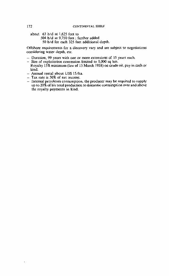
172 CONTINENTAL SHELF
about 63 b/d at 1,625 feet to 504 b/d at 9,750 feet ; further added 50 b/d for each 325 feet additional depth.
Offshore requirements for a discovery Vary and are subject to negotiations considering water depth, etc.
- Duration, 99 years with one or more extensions of 15 years each. - Size of exploitation concession limited to 1,000 sq km.
Royalty 15% minimum (law of 15 March 1958) oi! crude oit, pay in cash or kind.
- Annual rental about US$15/ha. - Tax rate is 50% of net income. - Interna1 petroleurn consumption, the producer may be required to supply
up io 20% of his total production to domestic consumption over and above the royalty payments in kind.
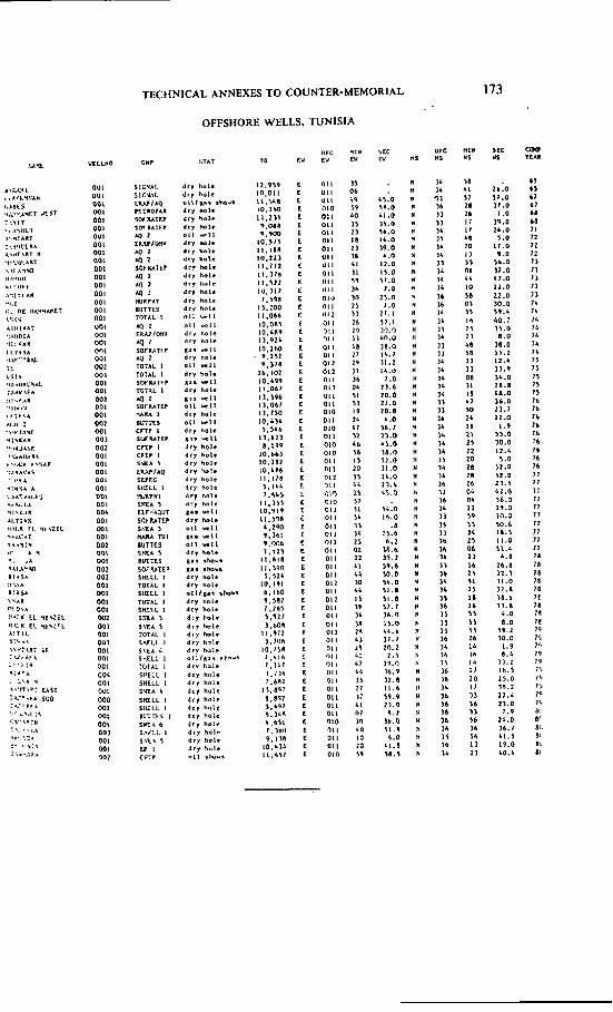
CONTINENTAL SHELF
Annew 10
ASSOCIATE PROFESSOR OF GEOLOGY A L - F X ~ I ~ H UNIVERSITY. TRIPOLI
* B.Sc. (Geology and Chemistry). University of Libya: M.A. (Economic Geology). Columbia University: Ph.D. (konomic Geology). Stanford University.
[ 11 TECHNICAL ANNEXES TO COUNTER-MEMORIAL 175
1 - INTRODUCTION At present, commercial hydrocarbon production in the entire region
of northweçt Africa comes only from the onshore oil fields of Libya, Algeria and Tunisia. Libyan hydrocarbon production cornes entirely from the Sirt Basin. Minor discoveries have been made in the Ghadamis Basin and recently offshore discoveries have been made in the Pelagian Basin. Neither of these, however, has yet produced oil or gas commer- cially. By world standards, the Sirt Basin is in a mature stage of exploration.
The purpose of this Report is ta give a brief account of the different parameters controlling hydrocarbon occurrences in and adjacent to the Pelagian Basin in an atlempt to reveal the relationships between the various hydrocarbon occurrences and to define hydrocarbon trends in the area.
The geology of the study area as well as the parameters controlling the various hydrocarbon occurrences, especially onshore, are documented fairly well. This paper is entirely derived from this literature.
II - MAJOR HYDROCARBON SYSTEMS 'The major hydrocarbon systems in and adjacent to the Pelagian
Basin are shown on Plate 1 , according to their geographic location and age of major reservoirs. These hydrocarbon systems can be classified into two provinces:
1. Erg Oriental, Ghadamis Basins Province, with major reservoirs ranging in age from Early Paleozoic to Early Mesozoic and consisting of the following systems:
A . Cambro-Ordoviciari System B. Devonian-Silurian and Carboniferous Syslem C. Triassic System.
2. Sirt - Pelagian Basins Province, with major reservoirs ranging in age from Late Mesozoic to Early Tertiary and consisting of the following systems:
A. Lower ~ re t aceou i Systern B. Upper Cretaceous System C. Paleucene-Eocene System.
Detailed descriptions of these systems comprising the two provinces have been given by Green, et al. ( 1977), Bishop ( 1975), Fischer ( 1976) and Parsons, el al. ( 1978). Only a brief description of each system will be given here. I I I - EARLY PALEOZOIC Cambro-Ordovician System
It is an important system only in Algeria. The giant Hassi Messâoud oil field has produced from this inierval at a rate of about 375,000 b/d or about 40 per cent. of Algeria's production in the late 1960s (Green, et al. (1977)) .
' "Systern" is used in this Report specially to denote a hydrocarbon systern.
176 CONTINENTAL SHELF Pl
The oil is produced from Cambrian sand. Hercynian folding forrned the structure, and unconformity a i the base of the Triassic forms a combi- nation irap. Other Algerian fields producing from this interval are Cassi Agreb and Rhourde El-Boquel, but they cannot be compared with Hassi Messaoud in terms of production.
In Libya and Tunisia the Carnbro-Ordovician system is of no signifi- cance. N o oil shows in Tunisia at ali, and only minor oil shows in a number of oil wells within the Carnbro-Ordovician system are reported in Libya. I V - MIDDLE PALEOZOIC Dcvonian-Silurian and Carboniferous Systern
Again. ihis systern has no great signifcance in Libya or Tunisia; it is more important in Algeria.
The Iate Paleozoic (Hercynian) orogeny that affected northwest Africa rcsulted in moderate deformaiion of the Paleozoic basins and differeniial crosion of Middle Paleozoic sediments. As ri result. the Middle Paleozoic has an erratic distribution, especially in Libya. Only a few wells i n northwest Libya have penetrated ihis section and encountered oil shows, but no production has been established.
V - EARLI' hlESOZOlC Triassic Systein
The cxtrciiicly varied facies composed of sandstones, evaporites and shallow-water carbonates relating to the coniinental breakup are wide- spread throughout the area of Erg Oriental Ghadamis basins.
In Algcrin, Lower Triassic sandsiones sourced by Silurian shnle and scülcd by Middlc and Upper Triassic evaporites constitute a major pro- ducing interval in Hassi R'mil gas tield, Rhourde Nouss gas field and Güssi Touil oil and gas field. The Hlissi R'mii gas tield is another giant ils i t produccs from Triassic sand on top of a structure that has an aerial extcnt of 1 .O00 square miles.
I n Tunisin, Lower Triassic sandstonrs sourced by Middle and Upper Triassic evnporites have produccd at the El-Borma oil field. The Triassic sand rescrvoirs at the El Borma tield form a faulted anticline with thc following average statisiics: depth to top of pay 2.400m; net priy 15m; porosity 18%; pcrmeabilily 2OOmd; gravit? 40"; cumulative production to 1973 wris 175,094.000 bbl. from the Tunisian side and 27.674.000 bbl. frorn the Algerian side: recent daily averages werr 75.600 and 25,000 bbl. rcspectively ( Bishop ( 1975) ).
In Libya the same section has been penetrated but production is negligible.
As shown in Plate 2. generotion of gas rather than oil is prevalent in this system.
VI - LATE MESOZOIC Lower Cretaceous Systern
In Tunisia, Apiian-Albian sandstones produced in the Djebel Abder- rhaman Cape Bon gas fietd. Shelf carbonates of the same age produced in
i31 TECHNICAL ANNEXES TO COUNTER-MEMORIAL 177
a number of small oil fields, rnainly Douleb and Sernmnma (average daily production of 4,344 b/d) as well as in Djebel Onk oil ticld in Algeria. These shelf carbonates arc mostly bioclastic. Detailcd information is not available but these hydrocarbon accumulations and shows are in shureline facies which arc structurally controlled. They are associatcd with the series of northeast trending anticlines of a foothills belt which is less disturbed than the main Allas ranges.
I n Libya the Sarir oïl field of thc Sirt Basin produccs from the subun- eonformity (Nubian) sands in a horst block. The reservoir sands are sourced and sealed by younger ovcrlying socna shale and fine-grained clastjcs i n the adjacent grabens. No lower Crctaceousoil shows have been reportcd in the Pelagian Basin. Upper Cretaceous Syslem
Upper Cretaceous wedgc-basc Bahi and Waha sandstoncs produce in a number of Sirt Basin fields. namcly the Ruguba, Jcbcl, 1-ahib, Zelien Waha. Defa. Hateiba (gas) Amal, Nafora Augila. t-l:irarn and Dahra. Thcse sands occur near the top of horst blocks and probably represent reworking of older sand units.
In the offshore area of the Pelagian Basin. Upper Crctiiccous carbonate seciion produces at Isis (avcraging 2.700 bbl. daily). Misknr. Elyssia and KI wells (Plate 1 ). VI1 - EARLY TERTIARY Paleoccne-Eocenc Systcm
Paleocene-Eoccne shelf and rccf nummalitic carbonritcs sourccd and scaled by Maastrichian to Paleocene shales and marls, makc up the major poriion aî the produciion in the Sirt Basin. namcly in Zcltcn, Inlisar. Defa, Zaggut. Dhara, Mabruk. Hufra, Ora, Bahi and Gialo oil fields (Plate 1) .
The same Maastrichian io Paleocene shales and marls are potcntial source and seal beds in the Pclagian Basin. Also the same nurnmalitic facies producing in the Sirt Basin are the reservoir for niost oil discovered in the offshore area of the Pelagian Basin. namely in Ashtart oil field (with production poiential of 40,000 b/d and estimatcd rcscrvc of 292 million bbl.) ,and A l 137, B l a 137, Didon 1 , J I , H 1 . G I . FI. F2, Gabesand Hastrubal oil and gas wells (Sce Plate 1 ).
Sidi El ltayem onshore Tunisia ilowing at a rate of 9,000 b/d is another significant discovery in this system.
VI11 - HYDROCARBON PRODUCTIVE TRENDS As previously diseussed. we may conclude that the major hydrocarbon
systems comprising the two hydrocarbon provinces contain sand and car- bonate reservoirs varying in age from Early Paleozoic to Early Teriiary. The sand reservoirs consist of tight Cambro-Ordovician sandstones, high quality Lower Cretaceous sand and thin Middle Cretaceous transgressive sands ranging in age from Early Paleozoic to Early Mesozoic or Triassic time. The carbonate reservoirs a re of varied facies ranging in age from Late Mesozoic to Early Tertiary or from Upper Cretaceous to Lower Eocene.
178 CONTINENTAL SHELF Pl
Without including the hydrocarbon systems of the Sir1 Basin, Bishop ( 1 97 5 ) rccognizcd thrce hydrocarbon trends in the onshore/offshore of northwcst Libya and onshore/offshorc of Tunisia and onshore Algeria. Thesc arc dcsignatcd by Bishop ( 1975) as:
1. Ypresian Carbonate in ofTshore area of the Pelagian Baçin; 2. Carnbrian-Ordovician and Triassic sandstones. in the Erg Oriental
Ghadümis basins (Libya, Tunisia and Algeria); and 3. Crctaccous shore lincs in onshorc Tunisia. Although Bishop's study
did not includc the Sirt Basin, the close similarity betwren the off- shore discovcrics (Ypresian Carbonate trend) and the Sirt Basin major oil fields is very striking.
In the Sirt Rasin as wcll as in the offshore area of the Pelagian Basin hydrocnrbons have becn trapped in structural highs or in stratigraphie wcdgcouis againsi structural highs and in carbonaie buildups. T w o of the threc conlnion oil systcms in the Sirt Bnsin are present in the Pclagian Brisin and can bc identiticd by the samc parrimeiers. i.e.. the age of the rcscrvoir rocks and the iypc of sourcc and scal bcds. Thcse are Upper Crctaceous and Palcoccnc-Eoccne syslcms. In brief. hydrocarbon gener- aiion i n both the Sirt and Pclagian Basins is characterizcd by the com- bined cfTcct of abundant structural rclicf and rcscrvoir dcvelopment in the semc hydrocarbon systcrns of the same agç. They provide an excellent cxatnplc of hgdrociirbon traps in sedinizntary basins that have undergone catcnsivc icnsionril fracturing in a shallow marine cnvironnicnt. with ade- quatc gcncration and pooling of oil from al1 sourcc systcms. wdth Paleo- i~erro-Eoct~ttt~ p rob t lh~ ! I A P richpst i t ~ the Prlagiati Bnsiri atid Upper CTetrr(.roirs iti rhr S i r i Basiti.
Potcniial play niiips of thrcc major hydrociirbon systcms of the Sirt Basin cxtendinp to the offshore area of the Pcliigian Basin were prepared by Grccn. al. (1977). Thcse maps, wiih only rninor modification. Lire
@ reproduccd and included in this Report (Plates 3 to 5 ) . - Thcsc plnics clciirly dcmonstriiic the sirnilariiy bctwccn the two basins.
Bj. showlitig the e~ t~ t i s io t r oJthr niajor h!8drocnrhori qmster?is of ;he Sirt Basirr itiro tlir Prlagian Busin. r hg. s ~ c g g ~ s r n riefitiit P relnriotrsh ip bi#tii.~wi I ~ P t i t * ~ hn .~ i t t~ ojid a rlosr) rrffiriirj. of rhe o j ihore disrnileries to the trilrjor hj+rirocarbori .Tj.stpr>is of the Sirt Brrsitr.
Plnie 3 (Lowcr Cret:iccous pliiy itirip) indicrites thüt the same high quality rcscrvoir sand (green) of the Sarir oil ficld in the Sirt Basin (Plate I ) cxicnds into the Pclügian Büsin. These siind and shale beds are good potcntial iargets i n the oîTshorc areil. The Bahi type sand (blue). which is ii rcscrvoir for ninny oil Ficlds in the Sirt Rasin (P1:ite I ), iilso constitutes ünothcr possible large1 otYshore.
Thc Uppcr Crciaceous play niap (Pl~i tc 4 ) shows that the Upper Creta- ceous shallow-marine carbonates and sandsiones (blue). reservoir for many oil fields in ihc Sirt Basin. is continuing into the Pelagiün Basin. These carbonates and sands are adjacent to thicker shale zones (orange) and constitute a major offshore target.
i51 TECHNICAL ANNEXES TU COUNTER-MEMORIAL 179
The Eocene nummilitic carbonates trend shown in Plate 5 is the reser- voir for many oil fields in the Sirt Basin a s well as for most oil discovered in the offshore area of the Pelagian Basin (Plate 1 ) .
Following moderate Late Cretaceous tectonic activity. widespread Pale- ocene and Eocene carbonates and shales were deposited in a stable but subsiding complex of sub-baçins and banks. These sediments are prospec- tive only where the shallow water nummilitic facies has developed adja- cent to deeper marine shales and rnarlç, similar to their development in the
@ Sirt Basin where they form a major hydrocarbon system (Plates 1 and 5). The development of such seciion is controlled by the approximity of the
earty Eocene shore lines.
@ As shown in Plate 5 . this trend is of good potential only in the Sirt Basin and in the offshore area. To the northwest in onshore Turiisia beyond Sidi El Itayem oil field. this trend has been deformed and çtrongly afiected by the Atlas Mountain folding. Also'lack of shale development. burial and maturation, as well as the flood of clastic material derived from the Atlas uplifting to the north which interrupted the pure carbonate decomposition. prevents this trend from being a major target in this area, i.e., in its northwest section in onshore Tunisia.
Finally, considering heat flow in the Pelagian Basin, Erickson, et al. f 1977) observed 3 regional difference between the heat flow through the floor of the Eastern Mediterrancan and the Western Mcditerranean. They attributed this difference to the prcsenceof hotter mantle matcrial a t shallower depths bencath the Western Mediterranean than beneath the Eastern Mediterranean. As indicated by the prevelcnce of gas discaveries in thc the areas of Cape Bon and the Gulf of Hammamet as well as the northwcst end of the Gabes-Sabratha Basin. it seems ihat the Pelagian Basin is being affected by the high heat flow characterizing the Weslern Mediterranean.
This fact again presents a major problem in the northern and northwest- ern parts of the Pclagian Basin and makes the southern and southeastern parts more attractive.
I X - REFERENCES Bishop, W.F. 1975. Geology of Tlrnisia and adjacent parts of Algeria and Libya. The American Association of Petroleum Geologists Bulletin. Vol.59. No. 3, pp. 41 3-450. Byramjee. et al. Perroleunr potenrial of deep warer area of rhe Medirer- ranean and Curibbean Seu. DD5 (dA) Compagnie Française des PEtrales and Institut Français du Pétrole. Erickson et al. 1977. Review of heat flow data from the Mediterranean and Aegian Seas. In: Inrernational Symposium of the S/rucrural His- rory of ~ h e Medilerranean Basin Splir (Yugoslavia) . 25-29 Ocr. ( 1976). B. Biju-Duval and L. Montaderi, Editions Technip, Paris. 1977. pp. 263- 279. Fischer, J . 1976. Geology of the Gobes Basin. Mobil Oil Open File Report. 24 pages.
180 CONTINENTAL SHELF FI
Green A.R. er al. 1977. Regional Geology of the Pelagian Basin (Of- shore Libya). Technical Service Report. Exxon Production Research Co., 15 pages. Parsons et al. 1977. Hydrocarbon Occurrences in the Sirt Basin. Libya. Esso Libya Report. 14 pages.
TECHNICAL ANNEXES T 0 COUNTER-MEMORIAL 181
Annex 11
PROFESSOR OF GEOLOGY DIRECTOR OF THE MANNE GEOLOGICAL AND
SEDIMENTOLOGICAL DIVISION AT THE
INSTITUTE OF GEOLOGY AND MINERALOGY TECHNICAL UNIVERSITY MUNICH
182 CONTINENTAL SHELF [II
1. INTRODUCTION
1. Aims of the Investigrnition The scope of this Scientific Report is to examine the connection between
the submarine area covered by the Pelagian Sea and its surrounding land rnass, the North African continent.
To scrutinize this connection it is necessary to know -the geology of the Pelagian Block' and of the adjacent African
mainland;' -The morpholagy of the area under consideration and its sur-
roundings on land as well as under the sea. The geologicai part of this Report is rnainly devoted to the conclusions
sel forth in modern scientific publications relating to the geological evolu- tion of the central Mediterranean area.
This Report is to be regarded as the persona1 opinion of the author based on the literature as well as on his own investigations in the Mediterranean area on land and under the sea2. 2. Outlines of the Area under Consideration
The Mediterranean Sea is subdivided into two parts, the Eastern Medi- terranean and the Western Mediterranean. The natural limits between these two sets of oceanographic basins are the Strait of Sicily and the Strait of Messina. Within the Eastern Mediterranean Sea the Mediterru- nean Pilor and other handbooks for sailors distinguish the following subdi- visions (frorn West to east): The Ionian Sea with the Sirt Embayment to the south, the Adriatic Sea situated to the northwest of the Strait of Otranto, the Levantine Sea and the Aegean Sea to the north of Crete. The lirnit between the Ionian Sea and the Levantine Sea is not very obvious; il is based mainly on underwater topography.
The Ionian Sea as an oceanographic unit is very complex in its sea bottom topography and geological history. It consists of several sub- basins, of ridges, rises, escarpments, platforms, trenches, troughs. and seamounts. Each of these features has been given a name (or even several ones by different authors). These names, used by oceanographers, geog- raphers, geologists and geomorphologists, are sometimes conflicting.
To avoid unnecessary complications, the term "Central Mediterranean Sea" is generally used in this reportvn lieu of the "lonian Sea". Some authors have used "Central Mediterranean Sea" in a more restricted sense for the area covering the sea above the platform lying to the West of a line connecting the southeast corner of Sicily and Misratah, generally known as the Pelagian Sea. It is the Pelagian Sea which is the main focus of this Report. 'Thc tcrms 'Pclagian Block" and 'Pclagian Basin" are used hcrc intcrchangcably. ' Although in certain areas of this Report ihere may exist diffcrcnccs of opinion arnong scientists, no cfïort has becn made hcrc to discuss thesc difierences in detail. 'Onicial charts and handbooks do not distinguish a "Central Mcditcrrancan Sca".
121 TECHNICAL ANNEXES TO COUNTER-MEMORIAL 183
- There are many underwater features which bear more than one name. Being mainly of scientific interest these names are not recognized interna- tionally. Some of them by implying a certain geographical connection rnay influence one's mind: cg., the slight doming east ofT the Kerkennah Islands is named by some authors the "Kerkennah uplift". while, as will be shown later, the structures of the Kerkennah Islands run more in a north- east direction. Hence, through the use of names certain connections may be suggested which may, in facl, not exist.
3. Previous Work In connection with oil explorations there have been many modern geo-
logical investigations dealing with this part of the Mediterranean area.
Besides many unpublished and classified reports, some recent published papers give excellent and comprehensive descriptions of the Pelagian Sea with its surrounding land:
The rnost modern and cornprehensive one is edited by BUROLLET, CLAIREFOND and W INNOCK, 1979: La Mer Pilagienne. Other sources worth mentioning are: The "Second Symposium on the Geology of Libya" ( 1978); and the Guidebook to the Gealogy and Hisrory of Tuni- sio. edited by L. MARTIN (1967).
In addition, perhaps the best introduction to the geology and geophysics of the Mediterranean Sea in general, with valuable information on the Central Mediterranean region, is the work of MORELL~ (1975)'.
4. Acknowledgement The author is indebted to his colleagues Dr. W. Hieke, Dipl. Geol. W.
Kretzler, Dr. J. Müller, Dipl. lng. Reiss, Dipl. Geol. J . Schmolin and Dipl. Geol. U. Zeh for discussing scientific questions relating to this Report, as well as helping with the construction of bathymetric maps, seismic profiles, block diagrams, digitization; and processing of datae. The author's discussions with Prof. Dr. Missallati from Al Fateh University, Tripoli, and Prof. Dr. R. Nicolich from O.G.S.,Trieste, on questions of the geology of Libya and the geophysics of the Pelagian Block and Sicily, respectively, were most stimulating and informative. Their ideas are acknowledged most gratefully. The responsibility of this Report is, never- theless, exclusively thai of the author.
' For other bibliographie sources, sec Chap. V below. containing a short bibliography. 'This material has been specially prepared for Libya in connection with xhe case before the International Court of Justice concerning delimitation of the continental shelf between Libya and Tuniçia.
184 CONTINENTAL SHELF 131
II. OUTLINES OF GEOLOCY OF THE PELACIANjNORTH AFRICAN AREA
1. Introduction to the Ceology of the Central Mediterranean Area For an understanding of the geological history of the Central Mediter-
ranean Sea and adjacent areas, including al1 the movements of the earth's crust in this region during geological times (known as "geodynamics"), a brief look must be taken at the broad outlines of the geology of the entire Mediterranean area. Furthermore, such a broad perspective is necessary for an understanding of the complex status of the geomorphology of the sea-bed of the Central Mediterranean Sea in general and its southwesterly part in particular
Terhys Ocean and the Mediterranean Area The area between the Eurasian Continent on the one side and the
African Continent on the other has been called Mediterraneum. During a geologically long time, this area was covered by an ocean named Tethys, which was rnuch larger than the present Mediterranean Sea and had a size perhaps comparable to the present Atlantic Ocean.
The main feature of the Tethys Ocean was ils long east/west extension. There are traces today of this oceanic belt in Central America. The mountain ranges of the Mediterranean area between Gibraltar and Tur- key and from Sicily to the Alps were formed by rocks which were depos- ited within this former ocean. To the east, this Ocean extended to the Himalaya area and southeastward to Timor. By studying the rocks, we know fairly well the outlines of the Tethys Ocean, its paleooceanography. from its beginning more than 200 million years ago (Triassic time) until its end between 60 and 20 million years ago (Tertiary time).
During Tertiary time, the Tethys Ocean underwent a series of severe transformations into a geographic feature which is now the Mediterranean Sea. This transformation is far from over today, as can be shown frorn the many earthquakes within this area and its surrounding land.
o n e major reason for the restlessness of this part of the world is the conflicting situation of two large continental masses, namely, Eurasia and Africa. Each of them is floating separately on a mobile layer below the earth crust, like two gigantic icebergs which are colliding in some areas. drifting apart in others. Although this is a simplified picture of a complex situation, it is obvious that such a situation is highly unstable.
Results,of this instability have been, on the one hand, the piling up of mountain ranges by compressional forces (Atlas mountain ranges, Bethic cordillieras, the Apennines, the Alps, the Balkan ranges, mountain belts in Anatolia)'. On the other hand, deep depressions have been formed by tensiona1 forces.
The Mediterranean Revoluiion During the bulk of the Mesozoic Era (about 230 to about 100 million
years before present) the northern limit of the African landmass was
' See Fig. 2 .
[dl TECHNICAL ANNEXES TO COUNTER-MEMORIAL 185
situated generally more to the south of the present Libyan coastline. The general trend of this former Coast was east/west. The area of the Atlas Mountains was open sea. This general situation lasted until the Lower Tertiary (Paleocerie). During Eocene tirne (53 to 38 million years before present), the sea off North Alrica began to shallow. Later on, unril about 15 to I O million years before present (Fig. 3 ) , we find within the Mediter- ranean area a complicated situation of land and sea, probably much difierent from the situation befare and from the present. The coastal line had shifted into the presenl oRshore area of Libya, and in the Maghreb area the Atlas Mountains had been forrned.
The Tethys Ocean had degenerated into a sea of minor importance, a t times restricting its connections to some of the world oceans. This situa- tion culminated during the Upper Miocene ( 1 I to 5 million years before present) when the Mediterranean area turned into a set of salt lakes (sabkhas) and newly emerged islands. The coastal line was. perhaps some hundreds of rneters below the present sea-level.
AIthough the connections to the oceans outside of the Mediterranean area were never completely cut off, the influx of sea water was restricted to such a degree that i t could not keep up with the evaporation of water within this area. The result was the formation of thick layers of salt and gypsurn and other related rninerals. O n Libya and Tunisia the Pelagian Block was an area barely covered with water and only in the north- west/southeast running graben linearnents could gypsum accumulate in elongated strips. The Malta-Misurata Escarpment had not been devel- oped morphologically at that rime and the area to the north of the present Gulf of Sirt was as Rat and shallow as the present Pelagian Block around Matta. This, most probably. was true for the entire area of the present Ionian Sea. This situation within the Mediterranean area. only outlined here in general, was very différent from that of the Tethys Ocean before and, of course, from thai of the presenr Mediterranean Sea. which irnme- diately began to develop after this "Salinity Crisis".
The Formarion of the Medirerranean Sen
At about 5 million years ago (the beginning of the Pliocene Epoch), the Strait of Gibraltar opened allawing water frarn the Atlantic to flow into the now established Mediterranean Sea. Nevertheless, the dynarnic pro- cess of formation of such features as the Ionian Basin, the Sirt Basin and the Malta Escarpment continued, increased or started, respectively.
The Pelagian Blorkl-Relirr of Pre-Mediferranean Time The only lasting feature which rernained almost unchanged was the
Pelagian Block. The coastal areas of Libya and the area to the east of the @ "north/south dorsale" (Fig. 4) in Tunisia, Le., the extensions of the Pela-
gian Block on the land, were exposed to the changing sea-level during the last 5 million yean. Therefore. onshore we find deposits of the sea as well as of the land environment intercalated with each other (c.f. Figure 12).
' The term Pelagian Basin is used i n the Libyan Mernorial IO covtr ihc samc area.
186 CONTINENTAL SHELF Pl
The shore line between the African continent and the Mediterranean Sea was shified by oscillalions of the level of the world oceans (eustatic changes), or more local tectonic events. e.g.. regional uplifts of coastal areas.
Eustatic changes are well known during the Quaternary time, when about 14,000 years before present the last drop of the sea-level ( a t least 120, perhaps 1 50, metres below present sea-level) occurred.
At that time, the area to the norrh of northwest Libya ;as dry land and most likely occupied by settlements of Late Paleolithic men. 2. Recent Sedimentation within the Pelagian Area
Cornpared to many areas of the present Mediterranean Sea, sedi- mentology of the present Pelagian area is unusual by virtue of its high content in carbonate'. Similar sediments can be found only along the Libyan and Egyptian coasts. In most other shallow water areas of the Mediterranean, detritic constituents, derived from the land via rivers, are more typical than carbonates. Starting a t t h e shore line and proceeding into deeper water we find the following general succession of sediments:
( 1 ) Shore line: a mixture of terrigenous quartz sand (derived from the deserts in the hinterland) and marine calcareous sand grains (derived from small organisms or fragments of shells, al1 of them living in the marine near-shore environment).
( 2 ) Shallow waier deposiis: as above, but in gerieral with a higher percentage of fragments of marine organisms. In areas with quiet water (embayments, shelter of islands, etc.) the seafioor is rather muddy and frequently stabilized by meadows of sea grass.
( 3 ) M u d j i a ~ s : At a waier depih of about 10 to 25 metres d o m to about 100 metres the seafloor is mainly muddy. The percentage of calcareous constituents is still high.
( 4 ) Troughs and on the slopes: The usual sedinient is a rnarly mud (clay with varying arnounts of l ime). Shallow water materiai, too, may be transported into deeper water by density fl0w.s.
Ooid sands Most remarkable is the occurrence of so-called "ooids" in the Gulf of
Gabes and near the Libyan and Egyptian shore. Ooids are calcareous sand grains of an origin typical for warrn water comparable to the Persian Gulf or the Bahama Banks.
Mud Flals and Snbkhns Areas of coastal subsidence d o not expose the pure shore-sand men-
tioned above but typically show sandy and muddy salt marshes. e.g.. in the Kneiss region. or in protected areas near the Kerkennah Islands or the Island of Djerba. In near-shore areas off the Gulf of Gabes and to the east a s far as Zuara. the accumulation of Sand is important. This sand, to a large part derived from the African deserts, forms dune-covered spits and
' See Fig . 5 .
i61 TECHNICAL ANNEXES TO COUNTER-MEMORIAL 187
underwater sand bars. Thesc fcatures slowly are cutting off ernbayments from t h e sea, thus initiating the formation or inland sabkhas. In these areas the land is prograding into the sea.
From the foregoing, the following may be concludcd:
1. I n contrasi to other areas of the Mediterrancan. thc recent sedi- menis from the Gulf of Gabes alang the Libyan coast as far as Alexandria are of a typical North African (warm ctimate) appearance.
2. The sediments which can be found northeast off Djerba Island (e.g., ooids) can be related better to other ooid-bearing sedirnents off the Libyan and Egyptian coast than to any recent sedirnents of the northeast Tunisian Coast.
3. Tectonic Features
Western Lirnirs oJ the Pelagian Block
@ On Figures 4, 6 and 7 the structural settings or the Pelagian Block and the Ailas Mountains are illustrated. each by a dinerent author. Figure 6 particularly emphasizes the diflcrences in the tectonic style between the areas.
@ The so-called "N/S Dorsale" f Figure 4) seerns IO be the important barrier between the alpine tectonics to the West and the block tectonics to the east. Nevertheless, there are sevcral features typical to one side, which also appear on the other, but are of minor importance and, in general. are near to this tectonic Iinearnent; for iristance. fold structures (sec Figure 7, syrnbols 5 and 6, i.e., anticlincs and synclines) on the western Pelagian BIock and faults running in a northeast/southwest diiec- lion. In rhe Atlas Mountain range, grabens and other fault structures appear which are oriented i n the northwest/southeast direction, typical for
@ the Pelagian Block (Figures 4 and 6 ) .
Frorn these observations, we conclude:
a ) To the West and the east of the N / S Dorsale we find two different tectonic styles as dominant structural features, thus underlining the geological individuality of both the Atlas area and the Pela- gian Block.
b) Nevertheless, in the vicinity of the N / S Dorsale ihere is some tectonic influence crossing this line in both directions.
The tectoniçs of the Pelagian Block have a more "cratonic" style, Le., structures typical for a siable and massive continental block ("craton") like the African plate; while inost of the Tunisian mainland (with the exception of the East Tunisian coastal plain which is part of the Pelagian Black) reveals typical alpine tectonics.
Tecronic Feaiurm of the JeNara Plain The investigation by GHELLALI (1977) established the existence of a
series of block movements with fault planes running mainly east/west, i.e., more or less parallel to the Libyan coast (see cross-sections, Figure 12).
188 CONTINENTAL SHELF [Tl
Generally speaking, the top of the mosaic of dissected blocks is higher in the south and deeper (near or even below sea-level) in the north of the Jeffara Plain.
Although there is a gap in information between the drilling-controlled land sections and the start of the seismic profile MS-20 offshore, it is safe to assume that the tectonic style of the Jeffara Plain continues offshore.
Tectonic Feat ures 00 the Libyan Coast There are several hints and/or evidence of the existence of eastlwest
trending faults within the Libyan offshore area: -interpretation of LANDSAT photographs; -steps in bathymetry; -tectonic features shown by seismic profiles; -the existence of the so-callcd "Salt Wall".
LANDSAT Photographs On the LANDSAT photographs (ERIM Report, chapter 4.3, Fig. 4-1) a
linear feature extending some 20 kilometres in length a t a maximum distance of about 3 kilometres offshore east of Zuwarah was discovered by ROGERS et al. (1979). Their interpretation-"possibly caused by the growth of vegetation along a linear geological featuren-leaves open whether i t is a tectonic or sedimentary feature.
From the illustration given in the above-mentioned report, the nature of this feature cannot be determined. The three following explanations seem to be the most iikely ones:
( 1 ) a fault scarp (2 ) a linear ridge of outcropping rocks ( 3 ) a submerged sand spit.
( 1 ) and ( 2 ) may be identical, although not necessarily. A fault scarp may be covered by a thin veneer of sand, thus producing only a more or less accentuated morphological step.
On rocks outcropping in shailow water (due to a harder sequence of sedimentary banks with or without any tectonical imprint), underwater vegetalion rnay form a more dense cover of the sea bottom than on mobile sand.
The third possibility, a submerged sand spit, cannot be excfuded either. Nevertheless, the very straight coastal line near Zuara is not the typical place for such features; sand spits generally develop at the point where a straight coast is interrupted or ends by an ernbayment.
In other words, the spits are an extension of the coast produced by sand- transporting currents.
Continuous Seismic Profiles The following seismic profiles, recorded by the O ~ S E R V A T O R I ~
GEOFISICA SEPERIMENTALE (OGS) at Trieste, were exarnined for their structural and geological but also geomorphological bearing (see Figure 8) :
Pl TECHNICAL ANNEXES TO COUNTER-MEMORIAL
insestigrted pait berween the shof points (S.P.) No.
Plate No. Profile No. i = total distance in km)
III MS-15 3780-1 (=379km.) IV MS-17 7070-1 (=708 km.) V MS-19 2060-1 (=IO7 km.) VI MS-20 6150-2530 (=363 km.) VI1 MS-21 4800-16660 ( = 3 1 5 km.)
VI11 MS-22 3360-1 ( = 3 3 6 km.)
For location of profiles see Figure 8.
general direction of
profile
( a ) Profîles Parallel to the Libyon Coast (MS-17 and MS-15) Profile MS-17 extends from about latitude 13" E ( o f Zuara) to the
southern part of the Gulf of Sirt (latitude 19" E). From the western end of this profile to the change in direction (west/northwest-east/southeast changing to northwest/southeast) the profile crosses the southern part of the Pelagian Block. There are only a few faults in this area (from West to' east: at about S.P. 6540,6460 and 4100) al1 dipping eastward. The most eastern fault, probably, can be related to the Malta-Misurata fault line.
The subsurface (Tertiary and pre-Tertiary sediments) is rather irregu- lar. Horizon "A", probably the base below the Pliocene sequence, shows some relief.
Entering the Gulf of Sirt (at about S.P. 4300) the profile is rather uniform; only at its southeast end the subsurface appears ta be similar to the West end of the profile. Profile MS-15 runs alrnost parallel to MS-17, extending from Lampedusa Island in a southeast direction. l t shows faults, horst and graben structures, and it crosses (near S.P. 1000) the Malta-Misurata fault line, which here is more pronounced than in MS-17.
Sorne of the faults of the subsurface end near the base of the Pliocene, others reach to the surface of the sea bottom. These latter features frequentty cause a step-like relief, thus indicating that they are still active.
The general character of the subsurface record is the same as shown in the western part of profile MS-17.
(b) Proj les Running About Souihwest/IVortheast (MS-19, MS-20, MS-21, M-22)
Starting wirh the mosr easiern profile MS-22 which ends at about latitude 17" E, some 60 nautical miles off the Libyan Coast, and extends into the Ionian Basin, it shows only one fault plane (S.P. 980). The sea bottom gently slopes down into the deep Sirtis/Ionian Basin.
This profile illustrates very well the gentle down-warping of the African plate, almost without any tectonic disturbance.
MS-21, situated parallel to the West of profile MS-22, shows more tectonization. At its southwest end, the base of the Pliocene/top of the Upper Miocene/evaporites seems to be sculptured. At its northeast end the profile reaches the foot of a submarine ridge.
MS-20 crasses the Pelagian platform, an almost horizontal area which, nevertheless, is intersected by many faults forming, in part, horst and
190 CONTINENTAL sHELF [91
graben features. At its northeast end (S.P. 2800-2530) the series drop down some 4,000 mettes to the depth of the lonian Basin, thus formjng Ihc Malta Escarpment, the more pronounced northern part of the Malta- Misurata fault line. Here the features clearly show very young to recent rnovements.
Projile MS-19 starts southeast off Lampedusa Island or. the Lampedusa High, crosses the vigorously tectonized zone of the Malta Graben-Horst system and reaches at its northeast end almost to Sicily. (The interpreta- tions indicated on Plate V are by FINETTI and MORELLI. ) This profile clearly proves the general distensional rnovernents which pull apart the Pelagian platform from the Malta-Sicily unit, a motion which is rather young and still active today.
4. Geophysics ~ ! t h & h i t is not the aim of this Report to discuss geophysical data in
detail, some information can be gained from the gravimetric and magnetic anomalies of the Central Mediterranean Area.
Gravity Anomalies of the Pelagian Block Figure 9 clearly shows the limit between the Pelagian Block and the
areas to the West (Atlas Mountains) and to the south (Sahara plate) : The Pelagian Block shows positive values (white) which indicate a slight tendency to sink. The areas to the West and south show negative anorna- lies (hatched pattern) indicating a tendency of uplifting.
Magneric Anomalies in the Central Mediterranean Area Figure 10 shows the total magnetic field. The anomalies in it are
characterized by an irregular pattern produced by the specific rnagnetic character of sorne rocks and sediments i n the underground.
The entire Central Mediterranean Area contrasts with the area of the lonian Sea (and the continuation into the Eastern Mediterranean basin) by its irregularities, namely high positive values (probably due to volcanic rocks) and only a few negative ones (probably salt diapirs).
Two important features are uriderlined by the magnetic anomalies: -The Malta-Missurata fault line (roughly between the 14" and 15" E
meridians); and -the volcanic rocks of the Pantelleria area between Sicily and the
Tunisian main land. Both features are related to faulting of the cratonic north extension of
the North African block. These geophysical observations, the gravirnetric as well as the magnetic
ones, clearly indicate, too, that the Pelagian Block is ( a ) a part of the cratonic block of North Africa, and (b) in a stage of subsidence, faster in the east, slower in the West.
[ 101 TECHNICAL ANNEXES TO COUNTER-MEMORIAL 191
III . GEOMORPHOLOCY
1. Accuracy of the Bathymetric Charts Any geornorphological anrilysis of subrnarine areas has to be based
either on original bathymetric data or on a bathyrnetric chart. The sources of bathymetric data are:
( a ) Isolated soundings printed on nautical charts or in other nautical publications. While reliability is good in near-shore areas, the accuracy of this data is still rather poor in areas without position- ing by means of visibility or radar.
( b) Original echographs (sounding records, fa thographs, etc.). Original echographs give a perfect (but linear) and continuous picture of the sea botiom topography. Nevertheless, ihe relia- bility of the positioning plays an important role in the accuracy of its incorporation into a bathymetric chart.
(c) Modern restarch vessels equipped with electronic devices for high accuracy positioning by radio waves or satellites. They yield the most reliable base data. At present. the spacing between sounding tracks is stiIl insuficient in certain areas or the data are unpublished or not yet transformed into detailed bathy- rnetric charts.
For the Pelagian Sea. our sources of information are': ( 1 ) Carte Bathymetrique de la mer Mediterranée, by the late M.
PFANNI:NSTIEL, G. GIERMANN, and CO-worker which appeared in the early 1960s in Monaco. These charts, printed as nisnuscript maps. are based only on those data described above under ( a ) .
( 7 ) Bathymetric Chart t:75,000 by C. MORELLI, G. CANTAR and M. PISANI ( 1975). Based on the means described above under ( b ) and (c), the riccuracy must be considered as optimum. However. for the Pelagian Sea the density of information and the intervals of the isobath contours ( 100 metres) are insuffi- cient for a detailed morphological siudy, especially for the shal- low water areas off the Tunisian and Libyan coasls. Nevertheless. in rernote deep waier rireas rhis is still one of the best sources of data. Therefore, i t was used in cornpleting the norlheast corner of the SOGREAH chart.
( 3 ) Bathyrneiric Chart 1:500,000 by SOCREAH Consulting Engi- neers, 1975 (under contract with the Libyan Government). These data were provided to the author in the form of blueprints and a photocopy ai reduced scale. As mentioned a b v e this chart does not covcr the entire area: at its northeast corner it shows no data. The methods used are those described above under ( a ) and ( b ) .
See Fig. 13 ior a grrtphic example of how different balhymetric charts may vary.
192 CONTINENTAL SHELF [ I l l
The accuracy is described by the authors of this chart as reliable in near-shore waters (within a zone of land control by radar). but rather poor in remote areas. Nevertheless. this chart, being based on continuous echo sounding, gives a dense spacing of isobaths and appears to be homogeneous in itself. In fact, i t is the most homogeneous and detailed of the more recent charts and is likely to show the most detailed rnorphology. The topo- graphie features are reported to be rather realistic. Its accuracy is suflicient to about 15 nautical miles off the land or islands; it is less precise in more remote areas.
For the construction of a btock diagram this map seerns to be more appropriate than the PFANNENSTIEL-GIERMANN issue. The lack of information in the northeast corner was dealt with by using the Italian map (see ( 2 ) above). From some concession areas off the Libyan Coast other bathy- metric maps were also studied. As these maps do not cover the entire area under consideration, it would have been necessary to combine this source of information with other data coming from other sources. The result would have been homogeneity which might have produced artificial features, and was hence inappro- priate for morphological interpretations. I t cannot be denied that for the areas covered by these other maps the bathymetric information is likely to be the most precise and most valuable for geomorphological interpretations.
( 5 ) International Bathymetric Chart of the Mediterranean Sea ("IBCM")': The most modern data on bathymetry and high precision positioning methods (cf. ( c ) ) are used in the IBCM. The present author (member of the Editorial Board of IBCM and responsible for some of the sheers of the lonian Sea) is rather familiar with this issue. As the aims of IBCM are of a more general nature, and hence the spacing of isobaths is inap- propriate for the present investigation, these data, still unpub- lished, were only consulted for comparison.
2. Comparison of Selected Bathymetric Charts
The existing problem on the accuracy of bathymetric charts can be demonstrated by a compilation of the five following charts (cf. F~gure 13):
( 1 ) PFANNENST~EL and G ~ E R M A N N {Monaco 1961)
(2 ) MORELLI, GANTAR and PISANI (Trieçte 1975)
( 3 ) WINNOCK and BEA (Paris 1979) ( 4 ) SOGREAH CONSULTING ENGINEERS, unpublished report,
(S.P.L.A.J. 1975)
'Not yet pubtished. .
1121 TECHNICAL ANNEXES TO COUNTER-UEMORIAL 193
( 5 ) INTERNATIONAL BATHYMETRIC CH ART OF THE MEDITER- RANEAN 1 :100,000 (in print)
Aftcr reduction ro a uniform scale of 1:100,000 (Mercator projection) the 100 metre and 200 rnetre isobaths were selected for comparing the relief of an area between Tripolis and Linosa.
The divergencies of both sets of isobaths (100 rnetre=red; 200 metre=blue) are obvious. They correiate fairly well near the land, Le., off Tripolis and near Lampedusa but show rather a large area of scattering between the latitudes 34" to 35" N .
As a result it may be stated that only the general trend can be regarded as being correct. Especially in the middle area, minor details cannot be approved by the narrowness of each set of lines. Nevertheless, such details probably do exist but we cannot be sure of their exact location.
Also i t is not possible to discard any of these charts either on the base of the methodç used in constructing thern, or by the year of publication. In some regions the oldest chart (PFANNENSTIEL et al. 1961 ) fits rather perfect with younger ones, or the most modern IBCM chart less well to the rest.
For the purpose of a geomorphological interpretation, the confirmed existence of a given feature and ils outlines are more important than its exact location. Therefore, each of these maps may serve as a base map, provided the isobaths are narrow enough ( 10 metres to 20 metres distance of water depth) to show any relief being within this order of magnitude.
A combination of two or more maps does not yield better results.
3. The Pelagian Block and its Surrounding Areas Forces Fornting the RelieJ of the Land und Under the Sea
The forces forming the rnorphology of the sea-bed differ to a certain degree from those which form the landscape. In both realms, the type of rock thai crops out at the surface, as a result of the tectonic deformation of the strata. dictates the topographic forms. This relief has been sculptured largely by erosion. a force which works principally under subaerial condi- tions, but also at the shore line, and. to a minor degree, under water. The latter case is especially irue in areas of strong lidal and other currents.
As s~a ted above. the present shelf area under consideration has been dry land several limes at the various low sea-level stages during the last one million years. Hence, much of the morphology lying in this offshore zone is land-derived.
I n contrast to this. accumulation or sedimentation has mainly an equal- izing effect to the landscape or sea bottom. Especially in an offshore environment without steep relief any preexisting sculpture is levelled by recent sedimentation. Therefore, in an area geologically comparable above and below sea-level, small scale features are generally more pro- nounced on land than under the sea. Tectonic features of major extent can be detected under the sea mainly by constructing a bathymetric rnap,
194 CONTINENTAL SHELF il31
similar to an air photograph of the land. Yet one has to keep in mind that, even today, the accuracy of bathyrnetric charts is still much lower than that of a topographic map on land, a t comparable scales.
Large Scale Morphology oJ the Sirt Ernbayrnent
Off Libya we can distinguish two large areas of different rnorphology. The dividing line is forrned by the Malta-Misurata Escarpment. To the east of this line, i.e., the Gulf of Sirt. the sea bottorn slopes down rather continuously into the Sirt Basin. The shelf area down to about 200 metres does not extend very far to the north. A distinct shelf break does not exist. Therefore. merely from this situation, one is tempted to postulate a very recent subsidence of an extended former shelf. In fact, the Malta-Mis- urala Escarpment is interpreted by most investigators as a very young feature, probably less than 5 million years old.
The Pelagian Block To the West of the Malta-Misurata Escarpment the area is conspicu-
ously less deep, forming the so-called Pelagian Block. I t extends to Sicily in the north. The only feature of importance is the Pantelleria-Malta Trench system dissecting the Pelagian Block into two shelf areas. the smaller Sicily-Malta platform to the northeast and the larger Libyan- Tunisian shelf sea.
The southern and western limit of the Pelagian Block extends somewhat into the land areas of Libya and Tunisia, respectively. The Jeffara Plain to the south as well as its continuation to the north (i.e., the east Tunisian plain to the east of the Atlas Mountains) is an integral part of the Pelagian Block. hence a part of the Saharan platforrn, which is due to the African plate.
The Atlas ranges extending to the West and northwest of the mentioned Plain, belong to a different unit by their geology and morphology, namely, to the Alpine Mountain range of Tethyan origin.
By morphological reasoning one can interpret the depression (below the sea-level) west of Gabes as the natural continuation of the Tripolitanian Coast line to the west.
This understanding coincides with the general geological trends of North Africa during Mesozoic time. Furthermore, the Atlas Mountain ranges are, as a matter of fact, an accretion pushed from the north (Tethys area) on to the African continent.
The morphology of the Pelagian Sea shows the foilowing major features (from south towards north):
( a ) An east/west running depression (forming the Gulf of Gabes) which slopes very gently towards east to east/southeast (Gabes- Sabratha Basin; Tripoli Basin; etc.). 0fT the coastal sector between Zuara and Tripoli the sea bottom slopes alrnost invisibly in a north to northeast direction (merely
1141 TECHNICAL ANNEXES TO COUNTER-MEMORIAL 195
0.08-0.3"). The slope of the talweg at the center of the depres- sion is 0.03" at the West end of the Gulf; it increases more to the east (north of Tripoli) to values of about a tenth of a degree
@ (0.1 O ). (See Figure 1 1 .)
This morphology is so gentle that it is very difficult to demon- strate without any vertical exaggeration. Hence, al1 graphics have to exaggerate i t more or less, a fact which must be kept in mind.
(b) The Pelagian Platform situated east of ihe Kerkennah Islands slopes gently to the east, reaching a water depth of only 100 rnetres at an east/west distance from the coast of about 160 kilometres (i.e., a t an angle of only 0.036"). To the north the Pelagian Platform drops rather steeply ( 3" ) off Lampedusa Island into the Pantelleria-Linosa graben system. The rnorphology of both features, the Tripoli Basin as well as the Pelagian Platform, is so extremely gentle thal, rnorphologically speaking, both areas can be considered as almost peifect plains. Therefore, to demonstrate these features graphically one has to exaggerate the vertical scale. considerably.
( c ) Graben-like Depressions Within the PIaqorm There are several large notches or indentations on the platform running in a northwest/southeast direction. They have k e n called by French Geologists "Fosse de Zohre" and "Fosse de Jarrafa." I n general they start at a water depth between 100 and 150 metres. They are rather straight, dipping with an angle of about 0.1 " to 0.3" toward the southeast. They are filled by a thick sequence of unconsolidated and consolidated sediments. These feeble structures have been termed "submarine canyons". This term seems inappropriate because of their unanimously accepted tectonic nature, thus contrasting to submarine canyons which are considered to be mainly of erosional origin. As a matter of fact, these grabens cannot be compared with such submarine canyons as those off the Ligurian coast of France and Italy.
(d ) The Sysiem of the Large Sourheasf/NorrRwes~ Grabens Belween the Pelagian Platform in the southwest and the shelf of ,the
Malta-Sicily-Adventurebank platform the sea bottom iscut by a system of grabens produced by faults running parallel in a southeast/northwest direction. They belong to the large graben-horst system which extends Far into Africa via the Sirt basin.
The entire system is a tectonic feature of major importance. Its tec- tonic style is typical of a fracturing continental block, thus underlining the extension of the African plate to the north, at least as far as Sicily.
The geological reason for this tectonic feature is thought to be a drifting apart of both sides: the Sicilian-Malta fragment of this formerly united
196 CONTINENTAL SHELF il51
block moves in a northeast direction, while the Libyan/Tunisian southwest part stays with Africa. This (lateral) distension causes the breaking down of the grabens, a movement which in detail is very complicated.
4. Geomorphological Studies The geomorphological studies are based on:
-Bathymetric charts of various sources, in part especially con- structed for the present study after nautical charts.
-So-called block diagrams (based on the information on the SOGREAH bathymetric chart).
(a ) The Kerkennah Region
Kerkennah Islands The most striking feature of the Kerkennah Islands is their straight
southeast coast running in an approximate southwest/northeast direction. This direction is almost paralleled by the isobaths lying to the southeast off Kerkennah.
The smaller island of Kerkennah has a southwest coast which trends rather straight running from southeast to northwest. But here, the isobaths do not follow this direction. Nevertheless, this south- eastjnorthwest direction is repeated by several embayments and promontories.
In conlrast to these straight coastal lines, al1 other coasts of Kerkennah are deeply indented, showing promontories and other irregularities, proba- bly due to a less uniform resistance against erosional attacks.
The Kerkennah Chanrtel, lying between Sfax and Kerkennah, is a linear depression (formed by several small depressions) slightly curved to the east at its north end. These "holes", frequently 10 to 20 metres below the general surface of this shoal area, are very conspicuous. Their Formation must be due to a tectonic line of some importance. The "holes" them- selves are, perhaps, a sort of doline formation, thus implying a soluble rock (lirnestone or even evaporites) in the subsurface. This hypothesis also implies a young age with some activity of dissolution still going on.
The so-called Kerkennah High or Kerkennah Uplift is a very ambiguous name. Some authors use it for the large updoming feature to the east of
@ the Kerkennah Islands (cf. BUROLLET, 1967: see Fig. 4). Others, Mrs- SALLATJ et al. ( 1979) as well as WINNOCK and BEA ( 1979), considering mainly the isobath contours, extend i t in a northeast direction more or less parallel lo the direction of the Kerkennah southeast coast.
From this point of view it is possible to combine both the Kerkennah channel depression and this northeast extending Kerkennah uplift, as related tectonic features. The indented valley-like features running more or less normal to the isobaths at the southeast to northeast side of the Kerkennah uplift probably are submerged valleys formed subaerially, when this part of the shelf was dry land during the stages of low water level during Quaternary time.
[ l61 TECHNICAL ANNEXES TO COUNTER-MEMORIAL 197
The age of the separation of the Kerkennah Islands from the main land is not clear. It is possible that the feature of the Kerkennah channel is an old one. On the block diagrams, even at a vertical exaggeration of 50, the morphology is not conspicuous. Here, the dominant feature is the gentle doming to the east of Kerkennah, a feature which is called by WINNOCK and BEA (1 979) the "Plateau Tunisien".
(b ) The Djerba Region While the region of Kerkennah seems to pose few problems, the situa-
tion of Djerba appears more complicated. To the east/southeast off Djerba, i.e., north of Zuara, we find the so-
called "Salt Walls", diapiric structures running more or l e s ~ in an east/west direction. In its prolongation to the West (southeast off Zarzis) we find some contours which protrude into this general direction (see also tectonic lines on Figure 6, crossirig the peninsula of Zarzis and the adja- cent promontory to the northwest ).
As drilling on Djerba did not prove Triassic salt, a direct connection with salt-diapirism carinot be substantiated. On the other hand, the exis- tence of the "Salt Walls" in east/west prolongation of Djerba prove impor- tant tectonic features (which are used by the salt to migrate upwards).
Therefare, the morpho-tectonical situation around Djerba and the adja- cent mainland seems to be influenced by structural factors.
It i s safe to state thai -Djerba is an erosional relict of the African mainland; a sinking of
the sea level of merely 10 metres would transforrn the entire area into a peninsula;
-the general direction of the coast line between Tripoli and Gabes is interrupted by the Djerba complex.
( c ) Salt Features Near the Tripolitanian coast, there are some local features with a relief
still very gentle but nevertheless somewhat more accentuated than described above. These features are due to salt-tectonics which result from existing Salt layers in the underground and fault systems crossing this salt.
198 CONTINENTAL snELF 1171
IV. RESULTS AND CONCLUSIONS
1 . ~Va iure of the Pelagian Sheif As regards geolagy and geomorphology, the area under consideration
covered by the Pelagian Sea is one single shelf area which teaches -io the east to the Malta-Misurata fault line; -10 the northeast 10 the depressions formed by the rift system
(Malta trough. Linosa trough, Pantelleria trough. etc.) running in a southeast/northwest direction.
On this shelf area, there are no morphological features of major impor- tance (i.e.. of large extension and of pronounced and steep relief) which could form natural boundaries. Hence, there are no morphological rea- sons to connect this shelf area exclusively to the western (i.e., Tunisian) Coast.
This staterncrit is not only true for the present tirne, but has to be considered correct for the geological past, at least about 5 million years ago (end of Miocene time), when the uniformity extended even farther to the north and the east.
2. The shelf area to the north of the Libyan mainland is the nalural prolongarion of the Libyan mainland (i.e., of North Africa). This can be proved by the ( a ) patterns of sedimentaiion (cf. Chapter I I , 2) : (b) patterns and style of faults identical to those on thc Jeffara Plain
(cf. Chapter 11. 3 ) and the North African plate in general; ( c ) uniformity of morphology of the shelf area to the no r~h of the
Libyan Coast. On the other hand. il cannot be denied that geological relations between
the Tunisian coastal plain (Sahel) and the Pelagian shelf area exist. They are in respect to ( b ) and (c ) of similar nature as the relations between the Jcffara Plain and the Pelagian shelf.
Nevertheless, if the influence by (weak) tectonism coming from the Atlas Mountains could be called a typical "Tunisian" fealure, one can safely argue that most parts of the Pelagian area-being not tectonized in this way-have a more "Libyan" or typical North African style. 3. The important influence of the southeast/northwest trending North Africa~t r$ system, coming from the central Libyan mainland via the Sirt Basin and extending into the Pelagian Block, is another strong argument For the connection of geology and structural patterns between Libya and the Pelagian Block. Reasons for the Sirt rift system being a typical North African tectonic feature are:
-This rift systeni, composed of grabens and horsts with its associated faults, is the result of a cratonic (i.e., continental) block being split up into two neighbouring units. It is not the style of either an oceanic crus1 rifting apart, or of a rnountain range of Alpine tec- tonic style, as is the Atlas.
[ l g ] TECHNICAL ANNEXES TO COUNTER-MEMORIAL 199
-This rift syçtem originates in the central areas of Africa and extends to the end of this plate, samewhere in the vicinity of the Strait of Sicily.
-Geologically seen. this effect is not a "Mediterranean" rifting syç- tem originating in the north and influencing the African plate.
4. In respect to baihymetry and morphology, the sea bottom of this part of the Pelagian Sea has to be considered more as a vast plain than a sculptured submarine "landscape". As a matter of fact, in this area, even for very large distances, the vertical differences are so srnall that they can only be demonstrated by important vertical exaggerations. 5 . On the Pelagian platform there are, nevertheless, areas which show some extended but jeeble updomings, depressions and linear norches. They are known as banks or shoals, a s basins or troughs, and as valleys, respectively. The origin of these features is mainly due to tectonic move- ments of the subsurface, and only to a lesser degree also to sedirnentation or erosion.
In areas where sedimentation is slower than subsidence a depression of the sea bottom will develop; in areas of uplifting only erosional forces could prevent the formation of a positive relief. 6. The relation berween the shelfarea and the Libyan laadmass immedi- ately io the south (JefTara Plain) is substantiated by rectonic and sedi- mentological facts:
(a) in both tireas the tectonization is identical (block faulting with a predoniinant east/west extension and a general sinking, faster in the north and slower in the south);
(b) at certain periods. the sea covered the coastal land area as well as the sea, and a t other timcs withdrew from the present near shore area into regions now covered by more than 100 metres of water.
At each episode of sea levcl fluctuation the coast line of the Arrican continent changed to some extent duc to its morphology. Nevertheless, considering the geological history a s a whole, the shelf of North Africa was niainly exposed to the north of the African plate. 7 . . During geological history the present Easr Ttrnision coasr did no1 always exist (cf . Figure 3). Tunisia as a whole is much influenced by the rather Young formation of the Atlas Mountains and with it the east coast is regnrded as 3 rather young formation. too.
It is safc to say: -The easi-southeast/west-northwest direction of the western Lib-
yan coast is older than the norih/south trend of the Tuoisian coast; and
-a continuation of an cast-southeast/west-northwest running coast into the Tunisian land has not been merely an unusual local and/or temporary feature.
8. The gentle sfoping ro rhe Ea.v of rhe Pelagian Block is also a young feature. AS indicated by geophysical data, the present Gulf of Sirt must
200 CONTINENTAL SHELF
have been.a shallow sea some 5 million years ago, a situation comparable to that of the present Pelagian Sea. At that time the deep basin of the lonian Sea subsided, dragging down the Sirt basin and the eastern rnargin of the Pelagian Platform. The latter could not keep Pace with the subsi: dence of the lonian Sea and reacted by fracturing, thus forming the Malta-Misurata fault line.
9. The reartion of rhe adjacent main lands tu the strbsidence of large basins was different in difierent places: In the Sirt area, the Gulf of Sirt sloped down forming now a ramp between the lonian basin and the African continent. To the West and south of the Pelagian Block (i.e.. Libya and Tunisia) there was (and still is) a tendency for an uplifting of the continental area at the fringe of this block, thus compensating the masses subsiding within the marine realrn.
10. Concerning the connecrion between the Tunisiam landmass and the Pelagian Block the following relations exist:
(a) The Sahel plain is, like the JeKara Plain, a part of the Pelagian Block. To this extent, there are close connections between the eastern Tunisian landmass and the Pelagian area.
(b) The landmass to the West of the Pelagian Block, i.e., the Allas Mountains of the central Tunisian territory and their foot hills (to the West of the north/south running fault line "N/S dorsale"). are geologically different. Both show diflerent tectonic styles connected with the origin of the rnountain ranges which have been pushed from the north to their present situation. Before the formation of this alpine belt, the area to the West of the Pelagian Block was-al least most of the tirne-a shelf area to the north of the African plate, too. There was no north/south trending Coast of the main land in the Tunisian area. In contrast to this, the area to the south of the Pelagian Block (i.e.. the Saharan platform) has always played the role of the south continent in respect to its adjacent north shelf, now the Pelagian Sea area.
(c) The north/south fault axis ("N/S dorsale") dividing Tunisia into two geologically different regions is a feature which had already played an important rolc before the formation of the Atlas Moun- tains. This feature crossed the east/west running African shelf in about a north/south direction, forming an area of low subsidence and small accumulation of sediments.
AI1 these facts underline, on the one hand. a loose Iink between the Pelagian Block and the Tunisian central main land and, on the other hand, a close connection between the Pelagian Block and the Saharan platform to the south.
I l . The Pelagian Block was a shallow woter area at least for about 7 to I O million years. Before this time i t was also flooded by the sea most of the time, but even then, it never was a deep sea in total.
Po] TECHNICAL ANNEXES TO COUNTER-MEMORIAL 20 1
Ai the present lime we can distinguish on the Pelagian Block areas of slower and of faster subsidence, the heights or banks and the depressions, basins and valleys, respectively. The Islands of Djerba and Kerkennah are part of tectonic features with no or only very slow subsidence. Low sedimentation due to tidal currents (important in the area of the Gulf of Gabes) and caastat abrasion, on the one hand, and silting up in protected areas, on the other hand, are responsible for the actual form of those islands and shoals.
12. Djerba and the Kerkennah Islands are both unique features in regard to the entire North Africao coast, which elsewhere is lacking any near-shore islands. Their existence can be attributed to the coincidence and superimposition of several geological features favourable to the for- mation of promontories and near-shore islands: in the Djerba area for instance. the combination of fault lines and salt deposits in the under- ground form regional rising areas; the Kerkennah Islands are situated at the cross point of the northeast/souihwest oriented "Kerkennah Upliftn and the more westleast trending gentle uplift between the area to the north of Sfax and the Medina Bank. 13. The Gabes-Sabrarha basin is a gentle depression to the north of the Tripolitanian coast. At the western end this basin forms the actual Gulf of Gabes. West of Gabes the depression of the chorrs separates the Saharan platform from the Atlas Mountains. Although near Gabes the geological situation does not direcily form a conneciion between both depressions. both features are similar or analogous in respect to their situation to the Saharan platforrn and their tectonic style as shallow but extended basins with altitudes below sea tevel.

202 CONTINENTAL SHELF Pi]
V. ' SELECTED BIBLIOCRAPHY .
BELLAICHE, Ci. and BLANPIED, C. ( 1979): Apercu néotectonique. In: BUROLLET et al. (eds.) (see below). 1979, pp. 50-59.
BIELY, A., BUROLLET, P. F. and LADIMI , T. (1973): Etude géo- dynamique de la Tunisie et des secteurs voisins de la Méditerranée. Notes du Service géologique de Tunisie, 1973.
BOLTENHAGEN, C . , CHENNAUX, G. and ESQUEVIK, J . (1979): t e s constituants lithologiques. In: BUROLLET el al. (eds.) (see below); pp. 111-115.
BORSETTI, A. M., COLANTONI, P. and ZARUDZKI , F. K. (1974): Note strutturali e stratigrafiche su1 Canale di Sicilia. Mem. So.Geol.lt., Vol. 13 (9) , pp. 221-252.
-( 1975): Seaward extension of some North African and Sicilian struc- tures and sediments. Rapp.Comm.int.Mer.Médit., Vol. 23 (4a), pp. 105- 106, Monaco.
BUROLLET, P. F. (1967): General Geology of Tunisia. In: MARTIN (ed.) (see below), pp. 5 1-58.
BUROLLET, P. F. (1979): Résumé sur la géologie des régions voisins. In: BUROLLET et al. (eds.) (see below), 1979, pp. 23-27.
BUROLLET, P. F., CLAIREFOND, P. and WINNOCK, E. (eds.) (1979): Géologie méditerranéenne. La mer pélagienne. Annal de l'université de Provence, tome V1, No. 1, Marseille.
CASTANY, G . ( 1955): Le haut-basin Siculo-Tunisien-étude de rnorpho- logie et de géologie sous-marines. Bull.Stat. Oceanogr. Salarnrnbô (Tunisie) Nr. 52, pp. 3-17.
F A B R I C ~ U S , F. H., BERDAU, D. and M ~ N N I C H , K.-O. (1970): Early Holocene ooids in modern littoral sands Reworked from coastal ter- race, Southern Tunisia. Science, Vol. 169, pp. 757-760.
FABRICIUS, F. and SCHMIDT-THOME, P. ( 1972): Contribution to Recent sedimentation on the shelves of the southern Adriatic, lonian and Syrtis Sea. In: D. J. STANLEY (ed.): pp. 333-343.
FINETTI, 1. and MORELLI , G . (1973): Geophysical exploration of the Mediterranean Seas. Boll.Geofis.Teor.AppI., Vol. 15 (60), pp. 261- 341. Trieste, Udine.
GHELLALI , S. M. ( 1977): On the Geology of the Eastern Yeffara Plain, North West Libya; Ph.D. thesis, Victoria University. Manchester ( unpublished ) .
LACOMBE, H. ( 1975): Apercus sur l'apport à I'océanographysique des recherches récentes en Méditerranée. Newsletter of Coop.Invest. in the Mediterranean. Spec.Issue Nr. 7, pp. 27-1 11, Monaco.
MARTIN, L. (ed.) (1967): Guidebook to the Geology and History of Tunisia. Petrol. Explor.Soc.of Libya; 9th annual field conference.
MISSALLATI, A. A. and HAMMUDA, O. S. et al. ( 1979): A study of the Libyan-Tunisian continental shelf. Unpubl.technical Report Nr. 1.
MORELLI, C. (1975): Ceophysics of the Mediterranean. Newsletter Coop.1nvest.Mediterranean. Spec. Issue Nr. 7, pp. 3-25, Monaco.
v2] TECHNICAL ANNEXES TO COUNTER-MEMORIAL 203
MOKI~LI-1, C.. GANTAR. C . and PISANI. M. ( 1975): Bathymetr~ Grav- ity (and Magnctism) in the Strait of Sicily and in the lonian Sea. Boll.Geofis.Teorica ed Applicata, Vol. XVII, Nr. 65, pp. 39-58, Trieste.
ROGERS, R. H., LYZENL~A. D., W A ~ . S ~ I , M.. OTT, J. and MORRIS- JONCS, D. (1979). LANDSAT off S I L O ~ C studies alang the western Coast of Libya. Report Nt. IF 30 700, Environmental Research Insti- tute of Michigan (ERIM), unpublishcd.
RUL;C;I~~REI, G. (1967): The distribution of land around the Tethys sea and its bearingon modern plant distribution. In: C. G . ADAMS and D. V. AGER (eds):'Aspects of Tethyan Biography. The Systematics Assoc.. public. Nr.7, London.
SCIIUSTEK. J.-M. ( 1977): Essai de reconstitution de l'histoire géo- logique et structurale de la Méditerranée ccniralc. Rev.1.F.P.. Vol. XXXII . Nt . 4, pp. 527-543.
STANLEY, D. J . (cd.) (1972): The Mediierrancan Sea. Dowden, Hutchinson &. Ross. Stroudsburg, Pa.
SYMPOSIUM (1978): Second symposium on thc Gcology a[ Libya (Sept. 16-2 1, 1978, Tripolis). Abstracts, University of Al-Fateh. Fnculty of Science. Geology Departmeni.
WISNOCK. E.-iind BL:.A, F. ( (979): Struçturc dc la nier Pélagienne. In: BUROI-LET et al. {rds.) . 1979, pp. 34-40.
CONTINENTAL SHELF
* B.Sc.. Ph.D.. Queens University. Belfast.
[ I I TECHNICAL ANNEXES TO COUNTIR-MEMORIAL 205
1 . Introduction T h e validity of Tunisian clninis that an east/wcst geological trend, as
defined by structural and sedinicntological phenomena within Tunisia, rnay bc projcctcd far out into thc Pctagian Basin is examincd. The geological data as presented in the Tunisian Memorial arc assessed as such and then compared with data of ri similar nature from other parts of the geological column. The results of this study are thcn evajuated on a rcgional basis with particular cniphasis being placcd on the teciono/sedimeniological cvolution of thc rclcvant area of North Africa sinc:: Triassic iimes.
2. (;I<oI.~(;IcAI. THENI)S AS INI)IC~\'~'C:I) BY FACIES ANI) ISOPAC~I ~IAF'S ANI) S.I.RA'I'I(;RA I'IIIC SE^-IONS
A. Facics Maps, Isopach Maps and Stratigraphie Sections - Tunisian Mcmorial
( i ) Tl~riisiari Aitjrr Thc purpose of the Tunisian Mcinoire is to cstnblish thai the offshore
geology of the Pclagian Basin i s ü "nalurai prolongation" of thc gcological situiition pertnining onshorc. P;iriicul:ir stress is pliiccd on the csistence
I er- onshore of cast/wcst trcnding soncs which, i t is maintaincd. arc char.1-t izcd and ciisily rccognized by a conibination or both structural and scdi- mcniological phcnonicna. Thc zuncs arc:
1 . Northcrn Tunisia. cxtcnding (rom thc ivcstcrn Mcditcrriinean to around Iiititude 36"N, chrirtictcrizcd by scdimcntary dcposits of "extraordinary thickncss".
2. Ccritral and castcrn Tunisia, lying roughly bctwccn thc Irititudcs of 36" and 34" 15'N. çharactcrizcd by a series of "riiolcs" or uplifts. Thcse uplifls arc considered to have rin c;ist/wcst aligntiicnt and are iypically ;ireas of rcduccd or non-scdimcntation.
3. Souihcrn Tunisia. lyirig roughly betwcen thc Irititudcs of 34" 15' and 33"iV. charactcrizcd by ii scrics of dcprcssions or basins which arc again considercd to trcnd to cast/wesr and to bc sitcs of thick scdimcntary dcposiis.
3. Saharan Tunisia. which lies to t hc south of thc 33rd parallel and which is charactcrizcd by thinncr and "quasi-horizontal" scdimentary deposits.
In addition to the easi/wcst trcnding 7.oncs. ihc presence of ri
north/souih trcnding axis of uplift is rilso rccordcd but, in cantrast to the stress laid on the aforcmentioncd structures, this axis is apparently consid- cred to have only a minimal effeci in controlling cither the tectonic styles or sedimentaiion patterns in the arcn.
The whole approach of the Tunisian Memorial is. therefore. one which strongly advocates the overwhelming irnportancc of thc east/west trend and the "case" with which it can be traced offshore far into the .Pelagian Basin. lri addition, ii is staicd that this trend is recognizable, not only a t the prcscnt tirne, but that it has playcd an important role in the geological development of the region even since "rernote times".
206 CONTINENTAL SHELF (21 1
It should be made clear that the present author does not dispute that an "cast/westn trend exists. What is in dispute is that the importance of the trend in terms of the teçtonic and scdimentary history of the region, both past and present. appears to the present author to have been overstressed. It wilI be shown that the "east/westW trend occurs only locally on mainland Tunisia and changes direction markedly when followed westward and offshore. As such. the following paragraphs analyse the Tunisian thesis on the significance of the "eastjwest" zonation, not only in terms of on- shore interpretations but also in terms of presumed projections off-shore. It will be shown that there are other trends of equal and often greater importance, trends which are clear frorn the data as presented in the Tunisian Memorial. Recognition of these can be substantiated from examination of additional data from other parts of the stratigraphic col- umn in Tunisia and northwest Libya.
(ii) Presrntation of Data The data which the Tunisian authors maintain strongly indicate the
east/west "natural prolongation" of Tunisia into and onto the Pelagian Basin area are presented in the form of:
Isopach or equal thickness maps: Cartes 4. 5 , 6;
8 Ceological/structuraI/cross-sections: Carte 7 and Figure 5.21; , Facies maps: Cartes 8 and 9.
With the exception of the cross-sections which. a s presented in the Tuni- sian Memorial. are almost incapable of interprctation (sec below for comments), the present author has re-drawn Cartes 4. 5, and 6 (sce Figures 2. 3, and 4 ) as an aid IO illustration of alternative interpretations.
Before proceeding to a structural and sedimentological analysis of the Tunisian maps in the sense of what thcy are meant to represent in terms of the Tunisian interpretation, some general points on the presentation of these diagrams are worthy of comment.
( a ) %ontouring of diagrams With regard to Cartes 4, 5, and 6 which make use of contouring to
illustrate variations in thickness of the sediments. several points are apparent:
( i ) The contour interval is not noted in the legend (ii) Although most of the contours are given a value. some are not,
e.g., Carte 5. Here. although it is likely that the unnurnbered contours have values which are progressive, this is not necessarily the case.
(iii) In Cartes 4 and 6 the contour intervals are not constant, e.g.. Carte 4 - contours are spaced 0, 50. 100. and 200, and in Carte 6 - 0.100 through to 600 from where the intervals increase in the order of 200.
The sum effect of these points is to make the maps difficult to read and, in respect of point (iii), to rninirnize the significance of some features. The density of contouring serves to bring out the importance of thick and thin deposits as is illustrated by a simple if extreme example such as Figure 1 , which shows the same area contoured at varying intervals. In A.
[3] TECHNICAL ANNEXES TO COUNTER-MEMORIAL 207
the thick area X is not so apparent to the eye as it is in B, where constant contour intervals are used. This effect is even more obvious when Cartes 4, 5, and 6 are re-contoured as shown in Figures 2, 3, and 4.
(b ) Locations of boreholes
I In respect of Tunisian Carte 7 and Figure 5.21, which purport to
represent the same section of the offshore area, the following points should be considered: In the offshore section, the borehole KSAR 1 as shown in the cross-section is not recorded on the locality map. The position of this borehole is important since i t is placed on the peak of the "moles", a major point in the Tunisian argument. The position of the borehole can of course be "estimated" and examination of Cartes 4, 5 , 6 , and 7 shows that there is a borehole at .or near the estimated locality; however, here i t is labelled XSAR 1 . While this may be a cartographical error-a pmsibil- ity. considering that in the series of boreholes shown in "detail" in Carte 7, KSAR 1 would appear to be synonymous with XSAR 1 as shown on the locality map-care should be taken in accepting i t as such. For example, in an area which has been aRected by block faulting of the horst-graben type such as the Petagian Basin has been (Winnock el al. (1979)- Bel-. laiche et al. ( 1979) ), a few tens of metres variation in the siting of a borehole can make the difference between passing through vastly different thicknesses of sedirnent, thus affecting the geological interpretation of the area.
I t is also worthy of note that, although al1 other boreholes are recorded on the locality map in Figure 5.21, the positions of neither borehole SEMI, which lacates the positian of the "mole" axis in the onshore section, or borehole ALY 1 , which locates the deepest point of the "zone des dépressions" in the offshore section, is recorded in Cartes 4, 5,6. or 8. ( N o borehole locations appear at al1 on Carte 9.) It would seem that the "confusion" in location and naming of boreholes might be signifi- cant. particularly when it is considered that those in question are of prime importance in defining the "axes" of the highs and lows so critical to the Tunisian argument of east/west trending structures. Indeed, the signifi- cance of the locations is even more clearly brought out in the Nota to Figure 5.21 where the boreholes mentioned above are specifically recorded as central to the establishment of the structural pattern.
(c ) Depiction of stratigraphical and structural relationships A second point involving Figure 5.21 is the fact that the manner in
which it is drawn makes i t difficult to read, even to the degree that at first appraisal it is in many senses misleading. This iç due to the following reasons:
( 1 ) The two cross-sections, one onshore and one offshore, are pre- sented as a means to show that the overall situation of alternating struc- tural "highs" and "lows" is closely comparable. (It has already been noted above that the positions of the boreholes which delineate the posi- tions of both "highs" and "lows" are not recorded on the location maps.)
208 CONTINENTAL SHELF Pl
In the diagrams the authors have selected the top of particular geological formations as a basis on which to establish the structures. These forma- lions are:
a. Top of the Ain Grab Formation. Miocene. ( 1 ) b. Top of the Abiod Formation. Upper Cretaceous. ( 2 ) c. Top of the Zebbag Formation. Lower Cretaceous. ( 3 ) d. Top of the Serdj Formation. Lower Cretaceous. ( 4 )
They also record the base of the Serdj Formation as horizon 5. The problems involved in interpreting the diagrams are as follows: In the onshore section as shown in Figure 5.21, the shading pattern used
below horizon 5, i.e., the base of the Serdj Formation, is the same as that used to indicate the interval to the top of the Serdj Formation in the olfshore section. As such. the pattern as used in the offshore section obviously includes the Serdj Formation. The point which cornes to mind is, why leave out the Serdj Formation boundaries in the offshore section when it can be seen from Carte 7 that both the top and the basc of the formation have been recorded in offshore wells? Although the develop-
@ ment is thin and therefore not easy to depict on the scale of Figure 5.21, there would appear to be no good reason to confuse the rcader in terms of interpretation of the diagram by not indicaiing this fact, if only by use of an explanatory note to Figure 5.21.
A comparable problern involved in interpretation of these diagrams is the fact that, whereas the top of the Zebbag Formation is clearly deline- ated in Figure 5.21, the formation is not denoted in the detailed borehole sections, Riccio 1 to ALY 1 . in Carte 7.
While it is accepted that recognition of particular formations can be difficult in boreholes, due to paucity of data and problems of identification inherent in facies changes, sediinentary breaks, etc., i t is strangc that the linè shown with such authority in the "sketch" section of Figure 5.21, i.e.. top of the Zebbag Formation, is not easily determined in the detailed sections of Carte 7, and that the top and base of the Serdj Formation, clearly depicted in Carte 7, should not be shown in Figure 5.21.
( 2 ) I t should be made clear a t this point that the confining horizons 1- 5, used in the construction of Figure 5.2 1 . involve the grouping of geologi- cal formations. Horizons 1 and 2 enclose a nurnber of formations, or equivalents of those formations, which have been recognized in various areas of onshore Tunisia (Bishop 1975). As such it should be realized that the attitudes of the defining horizons a s selected for the construction
@ of Figure 5.21 display the structural relationships of those horizons one to the other only. There is no information as to the complex interplay which could occur in the relationships between each of these horizons and inter- vening ones. related to other formations, in response to variations in the intensity of structural movement and sedimentation rates.
(iii) Facies Maps The facies maps, Cartes 8 and 9, do show a general east/west trend in
thefacies patterns. This is to be expected, since it is this trend which the
TECHNICAL ANNEXES TO COUNTER-MEMORIAL 209
Tunisian Memorial seeks tocstablish. I t is, however, possible to show that the facips patterns are more sophisticated than proposed. First of all, it is quite clear that the patterns in both maps are the rcsult of at least two major conirols. The generul rasf/wesr f rcnd i s rentiy onr in which an east/norrhaast t o w~st/southwrst orientation "~swings" in10 un east/ southeast to wrst/northwesr trend acr».ss a (ine whirh is rquivalent IO the trend of ihe "north/soufh axis". The presence o r this axis of uplift has also had ü profound c k c t in causing the northerly progression of shallow water facic.~. This is an important fcature in ihat it causcs the fLcirs boundaries to assume an arcuurr pattern. Whilc i t is admitted that Carte 9 shows that the axis has played only a minor role in controlling facies patterns (in conlrast ro Carte 8 where the effects are more obvious), it will be shown below that the Jucirs pattcrns as presented in the Tunisian Mernorial a rc not typical of the Mcsozoic succession in Tunisin a s a whole. I r would seem to the prcscnt author that these two maps were carefully selectcd as examples which would bcst display "the eastlwest trend".
A n additional point involving the presentation of the data in Cartes 8 and 9 is that thcrc arc no details on Carte 9 as to the criteria on which the various sub-divisions of the sediments have been bascd. In contrüst, Carte 8 involves the use of the ''jaciu.~. triangle" and shows clcürly the rela~ion- ships between the end membcrs of that particular triangle. Hcre can bc sccn a pattern in which ihere is an overall increase in clay content and a concomitant decrease in carbonatc and evaporite i n a northerly direction. The overall pallcrn is in~erruplcd by rcpetition of carbonate rich sediinent along a line raughly equivalent to the southern edge of the "zone des Moles". I n effect, although one t an read hcre the emccts of structural control on sedimentation, the data are valid only in a compositional sense and in Fact tell the relider little beyond this. A meaningful analysis of such a diagrarn would only be possible if one could assess the lype of carbonate, clay, etc,, in terms of environments of deposition. Neverthe- less, the repetition of carbonate rich sedirnents across the area does sug- gest a return ro shallow waier environments, a reversal which may well be structurally significant.
( iv) lsopach Maps
( a ) Northern Tunisia
It is staied in the Tunisian Memorial that northern Tunisja is the site of sedimentary deposits "characterized by their extraordinary thickness, which lends them an afinity with sedimentary basins of the deep-sea or geosynclinal type" (paragraph 5.65).
Scveral points are a t question in this statement, namely:
D e e p sea deposits are not necessarily thick.
-Gcosynclinal deposits are not necessarily thick.
-Thick sedimentary deposits can occur in depositional regimes which are not necessarily "geosynclinal" in origin.
210 CONTINENTAL SHELF 161
The statement is very much oversimplified and a detailed refutation of it would demand a lengthy report. Nevertheless, a few examples should amply indicate the simplicity of the statement.
The term "geosyncline" is a rnatter of some dispute in terms of modern theories on plate tectonics; however, the concept of "rapidly" subsiding Iineor basins which may act as sediment traps is a valid approach. What must be taken into consideration, however, is that rapid subsidence must beviewed in relation to the rate of supply of sediment into the sedimentary basin. A rapidly subsiding basin which has little supply of sediment can develop very deep water but only a very thin sediment veneer. In contrast, a rapidly subsiding basin which has an ample supply of sedirnent may accumulate a thick sedimentary prism under only a shallow water depth.
On the other hand, a deep hollow, such as rnay occur in inter-montane basins or ocean basin lows, provides already existing sediment traps which depend little, if any, on active structural down-warp. These "hollows" can fi11 up with sediment to form lhick sedimentary prisrns and in the case of inter-montane basins, pariicularly so if associaled with faulting.
The concept of faulting in association with thick sedimentary deposits illustrates a point not elaborated on in the Tunisian Memorial. This is the fact that the term "geosyncline" is often used with prefixes to distinguish between various types in which the facitity to allow thick sedimentary accumulation is due to different structural processes, proceeding at difer- ent rates and in varying tectonic settings. There is extensive literature on this subject, e.g., Kay (1951 ), Aubouin (1965). Krurnbein el al. (1963).
In addition, the recognition of any sediment as geosynclinal. fluvial, etc., demands a concerted approach involving rnany geological disciplines, the whole coming together to arrive at "Basin Analyses" in terms of sedi- meniary models, e.g., Potter ei al. ( 1963), Selley ( 1970).
Thus, in order to substantiate the authors' clairn to deep sea and geosyn- clinal environs with regard to the northern Tunisian sedirnents, the authors should have presented precise detail of such geological phenomena as thickness, the tectonic regime, the sedirnentary facies, dispersal patterns, etc.-al1 points which would allow a sedimentary rnodel and a valid inter- pretation to be established.
The absence of such data in the Tunisian Mernorial, even in the form of isopach and facies maps, is "unusual". Therc is evidence from Cartes 4. 5, and 6 that ample borehole data arc available for analysis - data which are ternptingly referred to in paragraph 5.64 as having been analysed and kept in Tunisian Government archives.
If such data are "available" then why have they not been used to substantiate the Tunisian interpretation? The answer to this possibly lies in the fact that publications such lis that of Burollet ( 1978) display clearly that the structural trends in northern Tunisia are markedly different from those proposed in the Tunisian Memorial.
I n addition to this, it is stated that the "thick sedimentary series" rneet along an axis "broadly" oriented west/east and this situation is compared with "the sedimentary trenches of 'northern Tunisia' on Carte
VI TECHNICAL ANNEXES TO COUNTER-MEMORIAL 21 1
6...". In respect of this staternent, not only can it be shown that the eastjwest orientation of the "northern trenches" on Carte 6 is, in reality, slightly suspect, but:
a. According ta the authors' own definition of norihern Tunisia, this zone lies north of the 36th parallel. As such, the greater part of the "northern" basin in Carte 6 falls outside the zone as i t is so defined.
b. Trenches are linear structures. The basins in the northern part of central Tunisia are "equant" in shape and nat linear. The stress on linearity is interesting since it can impose on the reader a concept which is then expaoded into an acceptance of a "linear" eastjwest rrend.
(b) Central, Eastern and Southern Tunisia - Zones 2 and 3
Both these zones are considered together since this approach allows a concerted analysis of the interpretation of the isopach maps as presented by the authors of the Tunisian Mernorial. As already noted above, Cartes 4, 5 , and 6 have been re-drawn following both the contouring of the authors and their interprelation of the major structural andfacies trends, i.e., Figures 2, 3. and 4. These figures include the present author's inter- pretation of the datai In Carte 6 the north/south axis of uplift and two east/west trending axes, the Axe des Moles and the Axe des Dépressions, are delinea~ed, although the latter is not named nor indeed well defined. The pattern of "lows" versus "highs" is well brought out in the diagram but not in the manner which is so strongly stressed by the Tunisian authors. Even without the addition of the relevant contour lines in the subsiding basins, there would most certainly appear to be a strongly devel- aped orthogonal pattern in the regiori with a series of roughly equant "lows" dispersed between "highs" in a raugh grid pattern. When low and high axes are drawn to correspond with the orientations of the lowest and highesr elemenis of each geological structure such as is shown in Figure 2, it is immediately apparent that to say the isopach patterns define a pre- dominant east to West trend is inadmissable. The pattern is best described as having developed from the inter-digitation of a north/northeast to souih/souihwest trend of uplifts and depressions with a n eastJsoutheast to west/northwest trending set. It is significant that the east/northeasr to west/sourhwesf trend is best developed West of the major line of the 'Inorth/ south axis" and that the trends east of this axis are typified by a marked wesr/norfhwesr lo easi/southeasr trend. This, in the more east- erly areas covercd by the map, swings gradually into a marked northwest to southeast trend.
Cartes 4 and 5, analyzed in Figures 3 and 4, show a distinct change in pattern. It is to the Tunisian authors' credit that they did not attempt to draw east to West trending axes on these maps such as they did on Carte 6, even though they do maintain in the text that an east to West trend is recognizable.
212 CONTINENTAL SHELF Pl
Both maps show very well the role of the "moles" a s areas ~f uplift resulting in reduced and non-deposition; however, they do not display an eastjwest trend. The pattern is made up from a combination of three major trends:
( i ) The east/west trend of the Sillon sédimentaire de Gafsa, an impor- tant feature of southern Tunisia.
(ii) A distinct northeast to southwest trend and a distinct northwest to southeast trend which meet and intermingle d o n g a zone which runs northeast to southwest from the region of Monastir to and beyond the region between Oreata and Gabes. This zone possibly corre- sponds to the trend of the north/south axis.
There is no doubr in the author's mind, given this data, that despite the difficulty in evaluating the data as given in the Tunisian Memorial in the first instance, there is certainly an east to west trend in the south a s is shown by the Gafsa Trough but this trend is much less obvious in the north. if indeed it exists at all. Here, the dominant pattern is one of northeast to southwest and northwest to southeast trends which develop to the West and east of the north/south axis respectively.
Al1 in all, it would appeür that to maintain that Cartes 4 and 5 display definitc evidcnce of a predominant east/west trend from the data on thickness variation as given is no[ tenable. To say that there is an east/west trend in Carte 6 is certainly feasible. but it should certainly be teinpered by the recognition of the niarked north/south trend due to the presence of the "north/south axis" and, in the rcgion eüst of Sfax. a swing from the "east/westW trend to a mnrked west/northwest trend.
( v ) Sumniary
As already stated, the airn of the Tunisian Mernorial is to establish in the reader's mind the validity of an east/west trend to the geological phenomena of on-shore Tunisia and to propet these into the Pelagian Basin. I t is the opinion of the author that the data uszd to support such a thesis are inadequate. In addition, the thesis is certainly given Little support in "errors" of representation such as lack of data and omissions in denoting the siting of boreholes. Furthermore it would seem that selec- tion of data has played an important part in the Memorial. An attempt seems to have been made to select only those data which "best" support the "east/westV thcsis. Examination of data of similar types from other parts of the geological succession in Tunisia would appear to show that this is so. These additional data also illustrate that interpretation of the Tunisian data in terms of interplay between various structural trends has a firm basis.
TECHNICAL ANNEXES TO COUNTER-MEMORIAL 213
B. Facies Maps and Isopach Maps of Jurassic, Cretaceous and Terri- ary Sedimenrs of Tunisia and Northwest Libya
( i) Facies Maps The maps discussed in this seclion are based on the facies studies of
Bonnefous ( 1967); and Salaj (1978). The work of Bonnefous on the Jurassic is shown in Figures 5A-E, and that of Salaj on Cretaceous and Tertiary deposits is shown in Figures 6A-K.
A detailed analysis of maps demands time frir beyond that available for preparation of this report; howcver, even a brief study of data indicates that the structural and facies trends have varied throughout the major part of the Mesozoic and that one or other trend has, by dint of periods of reactivation or quiescence, played a part in the development of the chang- ing pattern.
. Jt is clear frorn Figures SA-E that during Jurassic times, the north/south axis played a major part in controlling the scdimcntation pattern. In addition. it should be noted that thcrc are distinct norrhea~t lo southwest trends in northwestern Tunisia and a strong west/northwesl IO
enst/southeast trend in the area of southern Tunisia and Libya east of the axis and an east/northeast to west/southwest trend wesi o f t h e axis.
A change takes place i n thc lower and middle Creiaceous (F ig i r r~s 6 A - F ) . Here. although there is again a well developcd east/west trend in the southern part of Tunisia, the areas to the north show a marked north- east to southwest trending pattern; nevertheless, the influence of the north/south axis is still recognizable. Thc only time that the influence of the north/south axis is minimal is in thc Albian Figure 6E. where a facies pattern very similar ro tha t shown in Carte 9 is developed. i.e., dominant clist/west trend over the whole region. 1t is perhaps significant that Carte 9 is based on the previous stage of thc Cretaceous period, i.c., the Aptian. However, the facies rnap for the Aptian. Figure hi?, based on the work of Salaj (1978), disp1ay.ç yuitr diJorrnl patirrns. It shows that the north/south axis appears to have played a major role in controlling the furies distribuiion, a "fact" which is not obvious in the Tunisian presenta- tion. The role of the north/south axis is even more pronounced in those maps which illusiraie the facies patterns for thc late Cretaceous and into the Tcrtiary period (Figures 6G-K). In these i t is clear that the axis has been important in delinçating two distinct areas. To the West of the axis it is possible to clearly recognize the east/west trending Gafsa Basin but to the north, from the region of Thala. the facies trends are markedly north- east to southwest. To the east of the north/south axis, the facies trends swing rapidly into a northwest la sourheasl trend, albeit occasionally interrupted by local norrhrast to southwest trending structures.
The changes in f u c i ~ s patterns are important, and may be summa- rized as follows: -During Jurassic times the pattern of sedimentation in southern Tunisia
and northwest Libya was undoubtedly disposed in an arcuate pattern with cast/northeast trends West of the north/çouth axis, and west/northwest trends to the east. True east/west trends are developed
214 CONTINENTAL SHELF [ IO1
only across the axis. At the same time well developed northeast to southwest trends are common in the north of the country to the West of the norih/south axis.
-This situation is also evident in the earlier part of the Cretaceous period.
-In the middle Cretaceous east/west trends tend to dominate throughout the area although control by the north/south axis is obvious in the Cenomanian-Turonian.
-In the late Cretaceous and the Tertiary period, the "east/westV and northeast to southwest trends are developed tu a marked degree and they are joined by a strong northwest to southcast trend to the east of the north/south axis in areas to the north.
( i i ) Isopach Maps
The isopach maps are based on the work of Bishop (1975) (see Figures 7A-1). The maps for the Cretaceous and the Tertiary indicate thàt the Tunisian approach is vastly over-simplified. and analysis shows clearly that:
i n the lower Cretaceous, northwest to southeast and northeast to south- West trends are dominant;
-in the middle Cretaceous. "east/westV trends become apparent;
i n the late middle Cretaceous and into the Tertiary period northeast to southwest trends are very obvious. particularly in the north and north- eastern parts of Tunisia.
(iii l Sutnrtiary
It can be seen frorn the study of facies and isopach maps that through- out late Mesozoic and Tertiary times, a "true" east/west trend occurs only in the region of the Gafsa rough, which lies to the West of the north/south structural axis. Elsewheie in Tunisia the "east/west" trend is only locally developed across the line of the north/south axis as part of a regional swing in facies and structural trends from approximately west/northwest alignments east of the north/south axis to east/southeast alignments west of the north/south axis.
A t the same time. it is clear that the role of the north/south axis in controlling facies varsus isopach patterns is variable. While il would certainly seem to be the line across~which the swing in facies trends takes place, structural trends as suggested by isopach maps cross the axis, particutarly in the Tertiary (see Figure 8 ) .
The origin of the various trends is obviously of importance. since both the facies and the isopach patterns have developed in response to tectonic and environmental controis. l n order to relate these patterns to such controls, it is necessary to study the structure of the area and to identify features which display sirnilar or reIated trends to those outlined above and to examine the processes which led t o their formation.
[ I l l TECHNICAL ANNEXES TO COUNTER-MEMORIAL 215
3. Regiorial Geological Trends and Possible Interpretations A. Regional Srrucrural Patterns
( i ) Srrucrural Sryles
@ F i g u r ~ 9 shows the structurai features of the Pelagian Basin region. Three major types of structures can be rccognized:
1 . Broad anriclinal and synclinal warps. Two trends are obvious:
-A "north/south" trend. cg . , the north/south anticlinal axis of Tunisia and, the Garian "high" which is offset from the Jeffara-Malta high across the ljne of the Jeffara fauli system.
-An "east/west" trend, e.g..'the Nafusa "uplift" which overall describes an arcuate pattern with north/nort heast facing concavity in the Jefîara area. The Gargaf "uplift" which trends east/rprtheast to west/ southwest. These uplifts intersect to form basinal areas such as the Homra Basin. 2. Tighr folds
Thcse occur mainly in Tunisia and Sicily north and northwestward of a line which trends southeastward across sourhern Tunisia to the Coast at Gabes. Frorn here the line swings northeastward to cross Sicily in the southwest corner. The folds display a marked over-al1 northeast to south- West trend although in the vicinity of the north/south axis the fold trends swing into more easifnoriheast ro wesi/southwest alignmenls. In addi- tion, i t can beseen that east/west trends occur both in the straits of Sicily and onshore in western Sicily fcillowing the trend of the Miocene foredeep.
3. Faulis Faults are of several types and trends. 1 . Strike slip fau11s. These are mainly associated with the areas of
tight fofding and display similar northeast IO southwest trends. They disptay both sinistral and dextrai senses of movement. A major strike slip fault displaying an arcuate pattern corresponds to the line delineating the area of tight folds noted above (Caire ( 1970, 1975)).
2 . Bip slip faulrs. These exhibit four trends: -Wes~/northwest to east/southeast trends. This is a major trend, weil
dcveloped in horst-graben systems in both the Sirt and the Pelagian Basins. In these two areas the systerns display very similar patterns as is shown by Figure 10. The area of greatest downthrow is seen to lie iowards the north/northeast rnargins of the fault zones - the Augila trough in the Sirt Basin and the Malta-Pantelleria trough in the Pela- gian Basin. They would thus appear to be geometrically and probably genetically very closely related.
-Northeast to southwest trend. Faults of this trend are rarely recorded in the offshore area of the Basin: however, they are commonly developed onshore in southwest Sicily and particularly in Malta where they define a horst-graben system with an.overall down~hrow towards the northwest (Pedley et al. (1978)) .

216 CONTINENTAL SHELF [ 121
-An arcuate northjsouth trend. This pattern is typical of the eastern edge of the Pelagian Basin and of faults in the Ionian Basin further to the east. The major direction of downthrow is to the east.
-An arcuate east/southeast to west/northwest trending system, concave to the north/northeast, parallel to the Nefusa uplift and developed along its northern margin. This, the Jeffara fault system, runs west/northwestward into the "Gafsa Accident" (Castany ( 1955)). Major downthrow is to the north and northjnortheast.
(ii) Age relarionships -Klitsch ( 197 1 ) shows that the northjsouth trending uplifts are of Cale-
donian age and that the eastjwest trending uplifts are of Hercynian age. -The northeast to southwest trending tight folds and strike slip faults are
middle to late Tertiary in age and related to Alpine orogenic movements.
-The east/southeast to west/southwest horst-graben system of the Sirt Basin is known to have been initiated in the late Cretaceous times (Kl i t sch ( 197 1 ) ), while the syçtern of the same trend and pattern in the Pelagian Basin was initiated in the late Tertiary (Burollet (1978)).
-The arcuate north/south system was active in the Plio Quaternary, probably as recently as 4 million years ago (Burollet ( 1978) ). I t may, however, have a more ancient history.
-The east/west trending Jeffara fault system, certainly active in late Tertiary tirnes, rnay also have a much more complex history. It is probable that this system. related to an Hercynian uplift, was active in the middle Mesozoic.
(iii) Summary The structural features of the area display a set of trends comparable to
those apparent frorn the study of facies and isopach maps. These are: -north/south; -east/west; -northeast to southwest and eact/northeast to west/southwest; -southeast to northwest and eastjsoutheast to west/northwest. As such it would appear that the facies and thickness patterns are closely related to the regional structural patterns.
B. Interpreration of the Facies and Strucrirral Patterns in the Pelagian Basin on the Basis of Plate Tectonic Studios ( i ) Srrucrural Patterns in rhe Mediterranean Area
A convenient starting point is the situation which prevailed in Triassic times 200 million years ago. Figure 11 shows the distribution of the continental masses at this tirne. Africa, the Americas and Europe were linked together to form the western margin of a wedge shaped ocean, Teihys. The structural history of the Mediterranean region since Triassic times is intimately related to the processes involved in the eventual closure of this ancient ocean. Movements of the African plate relative to the European plate, and of both relative to the North and South American
il31 TECHNICAL ANNEXES TO COUNTER-MEMORIAL 217
plates, have resulted in the structural pattern of the Mediterrancan area as i t is seen today' (Biju-Duval er ai. ( 1977)). Plate 1 shows how cornplex these patterns arc. The structure of the Alpine orogenic zone, as indi- cated by major suture zoncs. follows an east/west trending path frorn the Maghrebins of North Africa, northwcstward into Sicily from where i t sweeps around into ~ h c northwcst to southeast trend of thc Apcnnines. From thc Apennincs, this suturc thcn swings to follow a northeast trcnd into the curve of the Carputhians and Balkans. The Maghrebin-Apcn- nines curve effectively dividcs the Mcditerrancan into an castern and a wcstcrn basin across thc straits of Sicily. The western Meditcrritnean basin is also characterizcd by an active subduction zonc which trcnds roughly eastjwesi to conrinuc on land to the south oï Tiauridcs and the Caucasus Mountain chains. This subduction zone connects with the major Maghrebin-Apcnninc suturc zone to the southwcst of Calabria. These Alpine folded zones are bounded to the north and souih by the staple platforms of the European and African plales.
( i i) The Africatt PIafe ( a ) Shape of margin Of particular note in Plate I is the broad area of epicontincntal sea
which forms a distinctive featurc of the northern mnrgin af thc African plate bciween Siciiy and thc African coast. This makcs iip thc Pclagian Basin and the southern part of thc lonian Basin. The mrirgin of this sea trends northeastward from Tunis to Sicily. From thc southcasl of S icily it trends.south/southeastward in a siraight line following the Malta escarp- ment to the area of the Medina Banks. From here i t swings sharply castward to Cyrenaica whcre it dcfincs a narrow strip parallel to the coast. M'est of Tunis the orogcnic zonc of the Tell drops rapidly into the wcskern Mediterranean and no cpicontincntal sea exists. The wedge shape of the rnargin along the Tunis-Sicily-Medina Bank line is a vcry charaetcristic feature of the area and would appcar to have its origins in the Mesozoic period. It is suggestcd by Biju Duval et ai. ( 1 977) that the North African cpicontinental sea i n this arca has more or less maintaincd the same shape since Triassic timcs to the prescnt day (see Plates 2-8). The only major changes are those related to the coastline due 10 transgression and regres- sion of the sca in responsc (O epeirogenic movements. ( b ) "Rclict" structures
Although the present structure of the North African plate has its origins in thc early Mesozoic, older structural trends related to previous tectonic phases can be recognized. These structures have played a part in control- ling subsequent sedimentation patterns and structural styles. The relict structures are of Caledonian and Armorican age. In the Tunisian-Libyan rcgion they are typically epeirogenic in nature taking the form of gentle uplifts and depressions. It can be seen from Figure 1 I that the Pan African trend of early Palaeozoic age is aligned essentially north to south with regard to the present North African coastline, but south it swings into a more northeast to southwest trend into the Gulf of Guinea. On theother
'AI1 plate numbers refer to Biju-Duval, J. et 01. (1977).
218 CONTLNENTAL SHELF (141
hand, the Armorican trend is essentially east/northeast to west/southwest relative to the North African margin. Klitsch (1 97 1, Figure 3) docu- mented both sets of structures in Libya showing rhar intersection of the two resulted in basins such as the Homra and Kufra. Thus, in the area under discussion it can be seen thal the north/south axis and the north/south trending Garian high would appear to have been initiated in Caledonian times. The former may be the northward extension of the Tihemboka uplift, the latter comprises the continuation of the Tripoli- Tibesti uplift. This structure, although slightly offset to the east, finds its further continuation in the Jeffara-Malta axis. Armorican structures in the area are the Gargaf uplift and the Nefusô uplift. These define the
@ Homra basin (see Figure 9 ) . The Nefusa uplift is of particular impor- tance. Trending parallel to the coast of northwest Libya, its continuation to the West is found in the Algerian anticlinorium (Bishop (1975)) . The uplift formed an effective barrier to marine incursions in Permian and early Mesozoic tirnes so that sedirnents to the south tend to be continental i n nature. It also had a major effect on the distribution of earlier formed sediments due to erosion following uplift, a fact which is clearly illustrated by isopach maps for the Devonian and Carboniferous systems (see Figures 12 and 13). There would seern little doubt that the Nefusa uplift, trend- ing as it does parallel to the coast, is one of the most important features in the area. The control it exerted on sedimentation in Mesozoic tirnes was further enhanced by the deveiopment of a major fracture systern parallei to its northern margin. This, the JefTara fault system, downthrows to the north and should be considered as forrning the southern margin of the Pelagian Basin. The age of the system is difficult to deterrnine but it was possibly initiated in the middle Mesozoic.
(iii) Srrucrural Bevelopmenr of the Area ( a ) Plate 2 shows the Mediterranean region during Triassic times in
more detail. The area of continental crust to the west of Tethys was made up from a number of microplates defined by fractures which were latcr to become the zones along which rnovements took place. Two fracture zones are of particular importance. These can be seen on Plate 2 (Biju Duval, J . et al. (1977)). The first, henceforth called A-A'. trends approximately east/west separating the African plate from the European plate. This zone terminates to the east against a major fracture zone which curves southeastward, and ihen swings northeastward into Tethys. This zone will henceforth be referred to as 0-3' . The two zones largely define the northern margin of the African plate (see Figure I I ) . The area of crust 10 the north of zone B-B' was Jater to play a major part in the structural development of the Mediterranean region. Known as the African prornontory, this portion of the crust migrated northward to eventually form the floor of the Adriatic epicontinental sea (see Plate 1 ).
The period from lower Jurassic to early Cretaceous was the period when break up of the western blocks occurred with the opening of the south Atlantic. the formation of Mesogea and the gradua1 closure of Tethys (see Plates 3 and 4 ) . During the lower Jurassic the African promontory
1151 TECHNlCAL ANNEXES TO COUNTER-MEMORIAL 219
separated from the north African-lberian area, moving east and north jsee Plate 3 ) . At the same time a narrow seaway developed between the African and lberian plates along the line of a fault with sinistral move- ment. These movements continued during the late Jurassic and early Cretaceous with the south Atlantic increasing i n size (see Plate 4 ) . Tethys was gradually consumed and the gap between the lberian and North African blocks widened. At the same time a subduction zone, heralding the movement of the Arabian plate northward developed south of the African promontory in the exireme east of the region. The late Cretaceous waç a period which saw major changes. At this time the north Atlantic opened wjth thé separalion of North America from Europe while the sauth Atlantic increased greatly in width (see Plate 5 ) . In the Medi- terranean region, as the' African promontory rnoved northwestward toward the Alpine region, the subduction of the Tethyan Ocean floor continued. Folding was initiated along the northern margin of the Afri- can prornontory with a pattern very similar to that seen at the present time. In the western region the gap between the Iberian block and North Africa began toclose. A t the sarne time the lberian plate moved dextrally relative to Africa, a process largely responsible for the S-shape of the subduction zone. Although the late Cretaceous, throughout the grealer part of the region. was a time of cornpressional tectonism, rensional forces were operative in the African plate. The horst-graben fault system of the '
Sirt Basin developed a t this time following closely the trend of the Pan African folds. I I is suggested that the fault system had a more northerly trend than that seen at the present day and that its continuation can be found along the well-defined northlnorthwest trending edge of the Pela- gian Basin southwest of Sicily. Although the present-day observable trend of the faults in the Sirt Basin tends to be west/northwest to east/southeast it can be seen that the faults of the western part of the Sirt Basin have more northerly trends than those in the east. An example is the Hun Graben syslem, which, although ending "abruptly" near the Jeffara fault system, has a trend closely comparable to the northern part of the scarp bounding the easterri edge of the Pelagian Basin. The subse- quent history of the area is one of progressive closure of Mesogea and Tethys (see Plates 6-8). During Paleocene, Eocene, Oligocene and Mio- cene times the western part of Mesogea continued closing along a north- east to southwest irending subduction zone with the formation of the Taurides and Hetlenides. The African promontory continued to move northwestward into a position occupied by the Adriatic Sea today. CIO- sure of the western part of Mesogea was more cornplex and is a matter of rnuch discussion. It is, however, generally agreed that movement of the African plate relative to the European plate was accompanied by fragmen- tation of the eastern margins of the Iberian plate. Migration of these fragments. eastward and southeastward in concert with sediments associ- ated with the subduction zone, forrned the islandç of Corsica and Sardinia. parts of Sicily, Italy, and the North African Tel! (Caire (1978), Boc- caletti et al. (1978)).
220 CON'rINENTAL SHELF I l61
Ocean basins, such as the Balearic and Tyrhennian Basins, were formed at this time, and the characteristic fold patterns of the Apennines, and those of the North African ranges, were also initiated. A final stage of movement across suture A-A' took place in the middle Miocene with the formation of the Migcene foredeeps of the Algero-Tunisian Tell and north- ern Sicily. While compressional forces were active in the Mediterranean region. important movements were taking place in the African plate, particularly in Eocene tirnes. There is evidence to show that a phase of sinistral strike slip faulting recurred in the Sirt Basin a l the end of middle Eocene times (Anketell and Kumati ( 1977) ) . This movement took place along faults formed during the late Cretaceous event noted above. I t can be seen from Plates 6 to 8 that the closure of Tcthys and the opening of the south Atlantic Ocean demanded that the entire African plate rotate in a dextral sense with respect to the European plate. Much of t his rnovement woutd have been taken u p along the suture A-A' and by subduction along B-B'. However, it would seem frorn the work of Duval et al. (1975) (see
@ Figure 14) that the African plate should be considered to have consistcd of a t least three blocks: -West Africa or a Saharan nucleus bounded by the Atlantic margin and
the western edge of the Pan African zone; -The zone of the Pan African fold system; -An east Africa block.
It is suggested that, although the whole plate was in rotation, C moved more rapidly than A by virtue of subduction in the western Mediterra- nean, and that the rnovernent was taken up by, and concentrated in, zone B. Thus, whereas the total movement of the plate was in a dextral sense relative to Europe, the variation in speed of movement of zones B and C around A, resulted in a sinistral sense of rnovement of the three zones
@ relative to each other (see Figure 14). I t is possible that such a situation may well have allowed the re-orienta-
tion of the eastern part of the Sirt Basin fault systern, originally charactcr- ized by a north/northwest fault alignment, into a more west/northwcst to cast/southeast trend. Reactivation of these faults in Miocene times could thus have imposed the characteristic pattern of the Sirt Basin fault system onto the northern Pelagian Basin. It is furiher suggcsted that, not only was the dextral rnovement relative to Europe taken u p along the suture A- A', but that a similar sense of movement took place along the structural zone represented by the Jeffara fault system which would almost certainly have been a line of weakness. Such a movement, parallel to that of the main suture zone, would help explain the "displacement" in trend of the north/south trending Garian high frorn the JefTiira-Malta axis. In addi- tion, the major fault system represented by the Hun Graben, which appar- ently does not continue north of the Jeffara fault system, would find its continuation in these faults which mark the edge of the Jeffara-Malta scarp. Although the faults along this margin are known to have been active in Plio-Quaternary tirnes, causing the easterly downthrow of the epicontinental margin to form the lonian basin. it is suggested firstly, that
1171 TECHNICAL ANNEXES TO COUNTER-MEMORIAL 22 1
the fault phase is due io reactivation along an oldet fault system of late Cretaceous age and secondly, that downthrow is greater to the north. i.e., a scissor rnovement. This would explain the present day bathymetry of the Sirt Gulf where the water dcepens rapidly away from the coast.
I n summary, i t is proposed that during the Alpine orogeny, the epicon- tincntal area suffered two types of tectonism. In the western arca. bounded to the north by suture A-A', compression tectonics producing cast/northeast to west/southwest trending folds were active. These folds cross the tiortlr/soiirh axis of Tuniçia to give the patterns seen in eastern
@ Tunisia and such features as the Kerkennah axis (see Figure 9 ) . The weslcrn area underwent, at least twice during its post-Paleozoie history. two phases of block faulting, one in late Cretaceous and, following a period of cornplex rotation of the African plate in late Eocene times, reactivation of the Sirt Basin fault system i n the Miocene to form the horst-graben sysiem of the Pelagian Basin. These Miocene faults are also found in the folded areas nlesr of the norrlr/.~o~rrh u . ~ i s of Tunisia. The north/south rixis would thus appear to have played only a minor role i n delineating rolded from non-folded or fautted areas-an "Alpine fold-African plate margin". Insiead. it will bc shown below that a line running from Gabes northeastward to the lbleo P1:itform area of southwest Sicily probably rcprcsents the "truc" niargin, one which has its origins in the proccsscs involved in the Alpine orogenic movemenis.
( iv) F U L ~ ~ P S TTPI~[J.Y it) KaIrrion IO the Plate Margin
Fucips trends and, to a lesser cxtent. recognizable coastlines show a niiirked rclaiionship to the shapc of the epicontinental ninrgin and to structures cxisting or devcloped on the crustal area. The major pattern is again onc which allows sub-division into a western area and an zastcrn ares. In thç western area trends run cast/northeast to west/southwest parriilcl to suture zone A-A' with deeper water furies to the nort h/northwcst. whilc in the easicrn arca trends are rr+est/northwcst to clist/siiutheast with dreper watcr f ~ c i e s to the north/noriheast (see Piales 2-8). Thc zone where thc swing from one trend to the othcr occurs coincides closely with thc position of the north/south axis. The efïect of thc north/south axis is plirticularly niiirked in the Trias whcre it appcars io have formed a barricr betwcen open marine limestone furirs to the ~ ~ 1 s t and rcstricted marine to continental facies in the West (see Plate 2 ) . Throughoui the rcrnainder of thr: MCSOZO~C and Tertiary, h o ~ ~ e v c r , the clTccis of the :ixis on fa rie^ iypc, whilc iniportant, are essentially local (sec Plritcs 3-8). Structural elenients othcr than the north/south axis have also c:iused local variation in facics. I n the eastern area, while there is an ovcrall north/northeastwürd deepening, local highs. possibly related to incipicnt horst-graben systeins. allow repeiition of shallow \vater facies at sonic distance from shore. The prittern of Eocene sedimentation in the Pcliigian Büsin is one such cxample (Hammuda & Missallltti (1980) Platc 4). Other examples are secn in the f irt Basin in late Cretaceous and Palcoccnc times. Whcreas shales were deposited in graben zones, reefs
222 CONTINENTAL SHELF [l81
and shallow water limestones developed on the horsts. A similar relation- ship in the western area during Jurassic and late Cretaceous times occurred in association with east/northeast to west/southwest trending inter-cratonic basins (see Plates 3-5). The change in facies trends from the western to the eastern areas is fundamental and easily explains the east/west trend so strongly put forward in the Tunisian Memorial.
As far a s the region as a whole is concerned, it is only in southern and central Tunisia chat an easr/west trend can develop since it is herc, across the north/south axis, that the swing from regional east/northeast to west/southwest trends occurs (see Figures 5 and 6 ) . In addition, the eastlwest trend will be best developed in this area during periods when the effect of the north/south axis, either passive or active, was a l a minimum. Such an example would seem to have occurred in the Albian (see Figure 6 E ) . In contrast, during periods of activity the east/west trend would have been greatly minirnized. This is clearly the case in late Tertiary (see Figures 6 J - K J where a swing from northeast to southwest and northwest to southeast trends across the axis from west to east is very marked.
In summary, it would appear obvious that facies trends in the Pelagian Basin area were parallel to the line of the present Jeffara Coast during the Mesozoic and Twtiary and that the east/west trend while "true" ofsouth- ern Tunisia is simpty part of a major regional westerly sweep from an east/southeast to west/northwest area across the line of the north/south axis.
C. Posrulated Offshore Alignmenr of the Sourh Atlasic Lineament --
This line. which, on land, separates the folded sedirnents of the Atlas Mountains from the quasi-horizontal strata of Saharan Tunisia is postu- lated by Caire (1970; 1978) to trend northeastward from the Coast in the vicinity of Gabes to southwest Sicily where it forms the junction between the essentially flat-lying sedirnents of the Ragusa Plateau-Ibleo Platform area from the folded successions of the Alpine belt to the northwest. It is thus considered to represent the junction between the "Africano-Raguso" foreland of the African plate characterized by tectonism of epeirogenic type, and the Atlas-Apennine chains characterized by folding of Alpine orogenic type (Caire (1978)) . Caire further interprets the line as a fault which has a dextral-slip component and relates this movement to the processes involved in the development of the Tyrhennian Basin and west- ern Mediterranean during the Alpine orogeny. Support for the existence of such a line across the Pelagian Basin is as follows:
1. As noted in Section 2A, the line does separate an area characterized by strong folding and minor faulting from one characterized only by faulting.
2. Although faults of northeast to southwest trend are rarely recorded in the PeIagian sea floor, faults of this trend occur on the Ragusa platform and more importantly in Malta, where horst-graben structures with an eastlnortheast to west/southwest alignment constitute a major structural feature of the island (Pedley et al. (1978) ) . These faults have a net downthrow to the northwest.
[191 TECHNICAL ANNEXES TO COUNTER-MEMORIAL 223
3. Strike slip faults of similar trend are recorded in Tunisia (see @ Figure 9) . The Zaghouan fault is a major exarnple.
4. While there is undoubtedly thickening of the Mesozoic and Tertiary successions northjnartheastward across the Jeffara fault zone in the Jef- fara coastal area (Harnmuda and Missallati (1980)), it has been shown that thcre is also a very rapid increase in thickness across an cast/northeast to west/southwest trending line in the Gabes region (Bus- son (1967)). This rapid increase in thickness, accompanied by a change in fold styles across the line from gently warped in the south to tightly foldcd in the north, is cxpressed as a sharp drop in the Mesozoic basement
@ over a very short lateral distance from -500 to 2500 (see Figure 9 and Busson (1967) Figure 13). There seems little doubt that, given the rapidity of the drop in such a short distance, the feature is best explained by a fault with an east/northeast to west/southwest trend.
5 . Further evidence of an east/nartheast ta west/sauthwest structural alignment is found in the Djebel Tebaga region of Medenine in southern Tunisia where the Sidi Stout unconformity is deseloped over an uplift of this trend (Busson (1967); see Figure 12). Activity on this uptift has a history ranging from middle Triassic to early Cretaceous.
6. Indirect evidence for the trend is found in the work of Boccaletti et al . ( 1975) (see Figure 3 ) and Boccaletti el al. ( 1978) (see Figure 26) , on studies of the origin of the western Mediterranean in terms of plate tcctonics. The sequence of events proposed in Figure 3 and Figure 26 is sumrnrtrized in Figure 15. In contrast to Biju Duval el al. ( 1977), the authors suggest thal the development of the western Mediterranean involvcd reversal of polarity of the subduction zone, a much more complex concept. This need not be discussed here. The point of imrnediate impor- tance is tha t they suggest the initial subduction process jnvolved tensional fracturing of the African plate margin in late Cretaceous times. This resulted in the deselopment of a siable platform area, i.e., an African foreland and an unstable platform cornprised of fragments of the hitherto stable plate which were separated from each other by shallow intracratonic basins characterized by pelagic sedimentation. It can be secn from Figtire 15 that the authors postulate the stable platform edge to run southwestward from the Raguso plateau area. This "feature" corres- ponds closely with the' trend of the fault line proposed by Caire ( 1978).
I I is proposed that the points outlined above provide evidence for the existence of a major structural feature trending northeast to southwest betwcen southwest Sicily and the Gabes region and, that in the Pelagian Basin. it represents the junction betwecn two major tectonic zones of the North African continental crust.
D. C'onrlusions Study of facies maps for Mesozoic and Tertiary sediments i n Tunisia
arid adjacent parts of Libya show that the credo of an east/west geological trend is true but only with respecr ro rhcse areas in the inln~ediare vicinity of the norrhlsouth axis of u p l w in Tunisia. The trend is. in fact, the local expression of a regional North African trend which east of the axis has an
224 CONTINENTAL SHELF [201
eastjsoutheast alignment and West of the axis has a west/southwest align- ment. These alignments can be related to the trends of the niargin of the North African ulate.
Structural coisiderations based on the çtudy of isopach and tectonic maps show that a comparable sub-division exists. Here, however, struc- tural patterns and styles, related to Alpine orogenesis, intermingle across the north/south axis so that, in the Pelagian Basin, a more realistic bound- ary between a "typically faulted tectonic style of Libya" and "a typically folded tectonic style of Tunisia" is a line trending northeastward from Gabes to southeast Sicily. This line is proposed to represent the junctian between the African foreland and the Alpine "mobile" belt, and to be a "Mediterranean" continuation of the south Atlasic Lineament of the Sahara. I f the Pelagian Basin were to be subdivided purely on a basis of structural phenornena then it is the Gabes-Raguso line which is the most important feature.
Older structural patterns, both Caledanian and Armorican in age, underline the identity of the Pelagian Basin with Libya and southeast Tunisia. This is particularly true of the Nefusa uplift initiated in Armorician times.
As fur os the Libyan-Tunisian coastlinrfrom the Gulf of Sirr to Gahes is concerned, there is a consistenr conformity between the present east/southeast to west/norrhwest coastal rrend and geological fearures developed since early Triassic times. The projection of un eusl/west trend from "Tunisia" fur ou f onto the PeIagian Basin has nojirm busis in geological fact. To projecr a west/northwest to easz/soirtheasr rrerzd paraIlel to the existing coastline of the Jefora Plain most c~rrnin'v h0.7.
[2 11 TECHNICAL ANNEXES TO COUNTER-MEMORIAL 225
Bibliography
Anketell, J .M. el al. ( 1978) Faidlt Patterns in the' Western Sirre Basin. An address given to the Second Symposium on the Geology of Libya. Tripoli (unpublished). Aubouin. J. (1965) Géosynclines. Elsevier. p. 335. Bellaiche, G . et al. ( 1979) In: Géologie mediterranéene, La Mer Pélagienne. Tome V I , Numéro 1 . Editions de l'Université de Provence, pp. 51 -59. Biju Duval, J. et ai. ( 1 975) Sfructure and evolution of the Mediterra- nean Basin. Initial Reports of lhe Deep Sra Drillingproject. Vol. XLI 1 , part L, pp. 95 1-984. Biju Duval, J . er al. ( 1977) From the Terhys Ocean ro the Medirerra- nean Seas: A plate tecionic model of the western Alpine sysleni. S y m- posium on the Geological History of the Mediterranean Basins: Technip, pp. 143-144. Bishop, W. F, ( 1975) Geology of Tunisia und Adjacenr Parts of Atgeria and Libya. The American Association of Petroleiim Geologists Bulletin. Vol. 59, NO. 3, pp. 413-450. Bocaletti, M . et al. (1975) "Plate Tectonics in the Mediterranean Region." In : Geology of ltaljl. Vol. 1 . Fifteenth Annual Field Confer- ence, Earth Sciences Society of the Libyan Arab Republic. Bocaletti, M . et al. f f 9 7 8 ) "The Tyrhennian Sea and Adjoining Mar- gins." In: The Ocean Basins and Margins: The Western Medirerra- nean. ' Vol. 48, New York, Plenum, pp. 149-200. Bonnefous, J . ( 1967) "Jurassic Straiigraphy of Tunisia. A Tentative Synthesis (Northern and Central Tunisia, Sahel and Chotts Areas)." In: Giiidebook to the Gealogy and History of Tunisia. Ninth Annual Field Conference, Perroleum Exploration Society of Libya, pp. 109-130. Burollet, P. F. (1969) "Petroleum Geology of the Western Mediterra- nean Basin". In: The Exploration of Perroletrrn in Europe and North Africa. Proc. of Joint Meeting. Inst. of Petroleurn and Amer. Assoc. Petr. Geol. Brighton, England. pp. 19-30. Burollet, P. F. (1978) "The Geology of the Pelagian Block: The Mar- gins and Basins Off Southern Tunisia and Tripolitania." ln: The Ocean Basins and Margins: The Western Mediterranean. Vol. 48, New York, Plenum, pp. 331-359. Burollet, P. F. (1979) In: Géologie Méditeranéenne, La Mer Pélagienne. Tome VI. Numéro I . Editions de l'université de Provence, pp. 23-25. Busson, G . ( 1967) "Mesozoic of southern Tunisia." In: Guidebook to the Geology und Nisrory of Tunisia. Ninth Annual Field Conference. Petroleum Exploration Society of Libya, pp. 131-151. Caire, A. (1970) "Sicily in its Mediterranean Setting." In: Geology and History of Sicily. Twelfth Annual Field Conference, Petroleum Exploration Society of Libya, pp. 145- 170.
226 CONT~NENTAL SHELF 1221
Caire, A. (1975) "Italy in its Mediterranean Settings." In: Geology of Italy. Vol. 1 . Fifteenth Annual Field Conference. Earth Sciences Soci- ety of the Libyan Arab Republic, pp. 11-74. Caire, A. (1978) "The Central Mediterranean mountain chains in the Alpine Orogenic Environment." In: The Ocean Basins and Margins: The Western Mediterranean. Vol. 48, New York, Plenum, pp. 201-256. Castany, G. ( 1954) L'accident sud-tunisien, son âge et ses relations avec l'accident sud-atlasique d'Algérie. Vol. 238. Paris, C.R. Acad. Sci., pp. 916ff. Goudarzi, G.H. et al. (1979) Struclure of Libya "Abstract". In: The Second Symposium of the Geology of Libya, September 1978, University of the Al Fateh, Tripoli, Libya. Hammuda, O.S. and Missallati, A.A. (1980) A Srudy of the Libyan- Tunisian Shelf . Annex I I to the Libyan Mernorial. Kay, M . ( 1951 ) "North Arnerican Geocynclines." Geological Society of America, Memoir 48. Klitsch, E. (197 1 ) "The Structural Developinent of Parts of North Africa Since Cambrian Time." In: Symposium on the Geology of Libyn. Faculty of Science - University of Libya, pp. 253-262. Krumbein et al. (1963) "Stratigraphy and Sedimentation." W. H. Freeman and Company, p. 637. Pedley, H.M. et al. (1978) "The Geology of the Pelagian Block. The Maltese Islands." In: The Ocean Basins and Margins: The Western Mediterranean. Vol. 48, New York, Plenum, pp. 417-433. Potter, E. et al. (1963) Puleocurrents and Basin Analysis. Berlin- Gottingen-Heidelberg, Springer, p. 296. Salaj, J. (1978) "The Geology of the Pelagian Block: The Eastern Tunisian Platform." ln: The Ocean Basins and Margins: The Western Mediierranean. Vol. 48, New York, Plenum, pp. 361-412. Selley, R. C. j 1970) Ancien1 Sedimentary Environrnents. London, Chapman & Hall, Ltd., p. 237. Winnock, E. et al. (1979) In: Géologie Mediterranéene: Lu Mer Pélagienne. Tome V 1, Numéro 1. Editions de l'Université de Provence, pp. 35-40.
TECHNICAL ANNEXES TO COUNTER-MEMORIAL 227
Annex 12B
* B.Sc, aad Ph.D., Queens University. Belfast.
228 CONTINENTAL SHELF
INTRODUCTION: The following report is divided into three sections:
1. Structural patterns 2. Shoreline trends 3. Salt walls
Analysis of strucrural patterns lays a basis for interpretation of shore- line trends, particularly in the sense that it goes some way towards show- ing that sait walls, which throughout Mesozoic and Tertiary tirnes afTected shoreline trends, can be related closely to the tectonic events which were involved in producing those structural patterns and styles at present seen in the area. It is the author's opinion that these various geological features display a much closer affinity to geologic events initi- ated within the African platform than with any initiated by Alpine- Atlasaic style tectonism.
SEC~ION 1 Structural Patterns
My report of 4 October 1980, "A Report on Structural and Sedimento- logical Trends in the Pelagian Basin and Related Onshore Areas'", dealt, in part, with the regional structural pattern of the Pelagian Basin area on the basis of data then available. It was suggested that the region could- usefully be divided into two major areas, one characterised mainly by ' faulting and one characterised mainly by foldirig, and that a line running from the Gabes region northeastward to southeast Sicily, the Gabes- Raguso line, could serve as a boundary between the two regions. It was also suggested that, while the overall pattern of faulting in the area is a continuation of the Sirt Basin fault system and while it displays both a comparable trend and horst-graben style of faulting, some of the fault patterns could well be explained in terrns of lateral shear, largely as a resutt of older dip-slip faults. The Jeffara Fault systern in particular was interpreted in this way. It was proposed that the systein displays a right- lateral shear component and that this resulted in the displacement of the Tripoli-Tibesti high from the Malta-Medina axis and possibly also of the Hun Graben system from the faults bordering the eastern edge of the Pelagian platform. Lateral shear rnovernents, first postulated to explain fault patterns in the western Sirt Basin by Anketell et of. (1978), were interpreted in terms of rotation of the African plate relative to the Euro- pean piate. As an extension of this concept it was suggested that the shape of the north African coast from the Gulf of Gabes to Cyrenaica and beyond, across the Sirt Gulf, is explicable in terms of varying rates of rotation of segments of the African plate. I n simple, i t was proposed that development of this shape involved the more rapid movement of an "East African section" around a "Saharan nucleus" along a zone of weakness which the author proposed as corresponding to an arcuate fault zone stretching from the Sirt Basin to the Gulf of Guinea. In addition, the author employed the concept of variable rates of rotation within the Afri- can plate to explain an apparent discrepancy in age of the faults in the Pelagian Basin as cornpared with those of the Sirt Basin. While it is
' See Annex I2A. Vol. 111.
l21 TECHNICAL ANNEXES TO COUNTER-MEMORIAL 229
generally accepted that the Sirt Basin faults were initiated in mid to late Cretaceous times, Burollet ( 1978, p. 352) implies a much later age for the Pelagian Basin faults in the statement. "In late Miocene or post-Miocene times impressive graben subsidence occurred (in the Pelagian Platform) with the development of a thick Plio-Quaternary sequence which in places reaches as much as 1000 m."
This present section serves both to amplify and in part to modify the conclusions reached in that study, and is based on additional data supplied by Professor Missallati. The rnost important piece of work is that of Ziegler ( 1 978) which provides the most detailed tectonic maps of the region so far available to the author. This data is amplified in part by the tectonic maps of Mazzone ( 1976) and Choignard ( 1979).
Ziegler subdivides the Central Mediterranean area into six principal elements:
- The Eastern Mediterranean Basin - The Cyrenaica platform - The Sirt Basin to Hun Graben Rifted Complex - The Djefarra - Sirtica Platforrn - The Libyan Trough and Gulf of Gabes Basins - The Malta-Medina (Central Mediterranean) Platform The latter four of these elements are shown in Figure 1. The structural
pattern of the Sirt Basin is well displayed by Goudarzi and Smith (19771, Mikbel (1979), Missallati and Hammuda (1980. Plate 5) and Anketell ( 1980, Figure 9 ) . Ziegler interprets the region as having been formed by a phase of extensional rifting which was initiated in Neocornian times with further phases of faulting and subsidence in Mid-Cretaceous and Tertiary times. An important feature of Ziegler's work is recognition of the right- lateral shear system trending west/northwest to east/southeast parallel to the Libyan Coast, also discussed by Anketell (1980). This, the "Djefarra" fault system, "tails out" in the Sarir trough of the Sirt Basin and Ziegler considers the complex tectonics of the region to result from the interaclion of this system with the Sirt fault system.
The right-lateral shear zone forms the northern boundary of the "Djefarra-Sirtica" or African platform, an area affected mainly by "eustatic tectonic" events.
North of the dextral shear zone lies the Libyan Trough - Gulf of Gabes Basin characterised by "numerous subparallel. anastomosing fault seg- ments" (Ziegler, 1978, p. 3 and Plate 1 ). The shear zone underlies a deep narrow basinal area with a west/ northwest to east/southeast trend. This basi-1 area, bounded on the north by the Malta-Medina platform, is clearly shown in Ziegler's cross sections (Plates 10 and 1 1 ) . The basin dates frorn late Palaeozoic times with a major phase of subsidence in Mid- Cenornanian times corresponding to the main rift-fault phase of the Sirte Basin. Minor phases of subsidence occurred in the late Cretaceous and Tertiary. Ziegler maintains that the area is still subsiding and that this shows up as a "marked sea- flmr depression" (Ziegler, 1978, p. 3 ) . Between the Gabes-Tripoli Basin and the Malta-Medina platforrn lies a
230 CONTINENTAL SHELF i31
narrow area comprised of tilted fault blocks which, as will be seen, corre- sponds to a zone within which "islands" were developed at various times during the Mesozoic and Tertiary. (Figure 1.) This zone follows a west/northwest to east/southeast trend parallel to the southern edge of the Malta-Medina platform, which is interpreted by Ziegler as an area which remained relatively "high" throughout its geological history. Borehold data appear to indicate that it was the site of shallow water carbonate sedimentation since Triassic limes. The platform is strongly faulted and contains "young rifts". (Ziegler, 1978, Plate 1 .)
In summary, Ziegler contrasts the platform areas with the basinal areas in terms of areas underlain by thick continental crust (platforms) as opposed to those underlain by faulted, thinned, and modified crust (basins).
The term "young rifts" used todescribe the faultsof the platform area is very reminiscent of Burollet's thesis of late Tertiary "impressive graben subsidence" and there would thus seem to be some basis for considering the faults of the Malta-Medina platform to be "young" relative to the Sirt Basin system. Neither Ziegler nor Burollet give any indication of this "young phase" of faulting being due to reactivation of existing older faults in the platform basement. What is clear, however, is that the faults of the Gabes-Tripoli Basin, as far out as the edge of the platform, do appear to have a history of Cretaceous to Tertiary rifting similar to the Sirt Basin. a feature which is particularly clear in the case of the JeKara Fault system. Thus, it would seern thal rift fault phases of the Pelagian Basin have affected different regions at different times, and that the present author's contention that the faults of the northern part of the Basin, i.e.. the Malta- Medina platform. owe their origin to reactivation along the Siri Basin trend following plate rotation is possible. Work in progress on analysis of the Sirt Basin fault patterns and the relative ages of the fault should lead to a better understanding of the relationships.
Of more immediate interest to the present study is, however, the Gabes- Tripoli Basin. Fig. IA shows this basin sandwiched between the two major platform areas white Fig. 1B shows details of the fault patterns based on Choignard ( 1979). This synthesis of the fault trends appears to be the most detailed at present available and is more cornprehensive than that shown either by Ziegler (1978, Plate 1 ) or by Mazzone (1976, Enclosure 1 ), although the overall patterns are closely comparable.
A major point of inieresi involves the relationship of the minor faults within the basin to the major faults which border the basinal area. i.e., the Jeffara fault systern and fault zone at the edge of the Malta-Medina platform. The minor faults subtend an acute angle to thè major Jeffara trend and are cornmonly arranged en-echelon in east/southeast to west/northwest trending zones, i.e., parallel to the major fault trend. I t is the author's contention that this pattern can be interpreted in terms of Riedel shear systems and that the pattern is such as to conform to dextral strike-slip on the major faults (see Appendix for a brief discussion of Riedel shear formation). The east/northeast to west/southwest trending
i41 TECHNICAL ANNEXES T o C o u m E R - M E M o R r A L 23 1
faults, while not cornmon, rnay well be conjugale Riedels (see Figure 2 ) . The occurrence of Riedel shear systems associated with strike-slip reacti- vation on deep seated and major deep seated dip-slip faults in the Sirt Basin was discussed by Anketell et al. ( 1978).
A second point of interest is the structural relationship between the two fault systerns which border the basin area. The northeast trending system at the edge of the Malta-Medina platform can, in the author's opinion, also be interpreted in terms of dextral strike-slip movement. As such, i t is seen that the two major fault systems, diverginggentl~ one frorn the other in the offshore region north of Misuratah, delimit a zone on either side of which the bordering platforrns move dextrally relative one to the other. This structural relationship is very similar to those which comrnonly occur in the San Andreas fault system and which result in the production of "pull apart" basins (Crowell. 1974a. 1974b). It is proposed that the Gabes-Tripoli Basin is a basin of this type and that it owes its origin to rotation of the African plate relative to the European plate along dextral strike-slip zones. Much of the Sirt Basin fault systern would appear to have a closely comparable origin.
There would appear to be little doubt that the tectonic styles of the Pelagian region immediately offshore from the African platform. and in particular the Gabes-Tripoli Basin, owe their origin to movemenls of the African plate. The "rninor" faults within the basin are, in the main, Riedel shears resulting from dextral strike-slip reactivation of deep seated basernent faults. while the basin itself is the result of interaction between those major faultç, i.e., a "pull apart" basin. The establishment of the tectonic style of the offshore region as "African platform" in type and origin has important implications on the origin of sali wolls which played a marked, if only local, role in controlling coastline trends during parts of the Mcsozoic and Tertiary.
SEC~ION 2
Shorelirte Trends Analyses of the sediments in the Pelagian Basin region have been based
largely on analyses of both lithostratigraphic and chrono-stratigraphie units. These analyses generally take the form of evaluation of thickness variation- illustrateci by isopach rnaps, and studies of lithological varia- tions-illustrated by lithofacies maps. Such studies allow the recognition and delineation of:
a. Zero lines. i.e., lines delineating areas where a particular unit is Dresent from areas where i t is absent.
b. Shorelines, i.e., lines delineating areas of marine deposits from continental deposits. This is essentially a facies line and it denotes average sea level at the tirne of deposition.
The two types of line may in some instances follow identical paths. -For instance. the shoreline rnay also constitute a "feather edge" to a particular unit, i.e.. i t separates a n area of marine depositional environments from an area of non-depositional environments. e.g., cliff Coast. More commonly,
232 C O N T ~ N E N T A L SHELF 151
however, the two types of lines are independeni one of the other and may describe very different trends. I n such instances the zero line delineates areas where erosion has caused rernoval of the sediment unit under study from areas where it is still preserved. Erosion and preservation in this sense is, on the large scale, a function of tectonism with, in general, erosion occurring on areas of uplift and sediment preservation occurring in areas of downwarp. The interplay between sedimentation, erosion, preserva- tion. and tectonism is complex, and useful sumrnaries on the various interrelationships which can devetop are found in Krumbein and Sloss ( 1963), Reading et al. ( 1978), and Selley ( 1970).
Of particular importance in the evaluation of sedimentary prisms in terms of tectonic processes is an appreciation of the timing of events relative IO each other. It is accepted that the major controlling factor governing the preservation of sediments during deposition is tectonic downwarp, Le., syn-sedinienrary tectonism. Here, continuous or periodic subsidence due to downwarping allows a sediment "sink" or basin to develop. (In contrast, though less common, particularly on a large scale, is the pre-existence of a topographic hollow which can also allow accumu- lation of sediment.) Where syn-sedimentary downwarp is active, it is most common to find that the tectonic "grain". often expressed in terms of thicknesç variation, closely parallels the sedimentary grain, expressed in terms of facies trends. However, it should be noted that the rare of sedimentation relative to the rate of downwarp must also be taken in10 consideration in evaluation of syn-sedirnentary tectonic patterns. The variety of relationships in these terms is very cornplex but a simple exam- ple may illustrate the care which should be taken in any study of sedimen- tary prisrns. For instance, in situaiians where rates af sedirnentation are very high and rates of subsidence low, it is quite possible that the facies trends are widely at variance with the tectonic trends and may entirely mask such trends. A concise summary of such effects is found in Krurnbein & Sloss (1963).
So far, only syn-sedirnentary tectonism has been discussed. Where post-sedimentary tectonism comes into play greater complexities may arise. Two extremes serve to illustrate these. In instances where post- sedimentary tectonics develop along the same trends as the syn-sedimen- tary grain either by re-activation or independently, lines of erosion/non- erosion may weli trend closely parallel to the original facies trends. How- ever, in instances where the post-~edirnenta~y tectonic grain is developed at, for exarnple, right angles to the original sedimentary trend, then the zero lines will tend to cut across the facies trends. Obviously a wide variety of relationships is possible depending on the re1ati;e orientations of the originallacies trends and the superimposed tectonic trends. Criteria - for recognition of original depositional feather edges, shorelines and ero- sional zero lines are noted by Krumbein and SIoss (1963). Al1 types appear to occur in the Mesozoic and Tertiary sediments of the Pelagian Basin area as described in the various publications on the offshore region, aithough it is not always clear from the authors' reports which are present.
161 TECHNICAL ANNEXES TO COUNTER-MEMORIAL 233
In the following discussion the sources used are: Ziegler ( 1978), Maz- .<one ( 1976), Mazzone (19771, Mazzone and Mazzola ( 1978), Mazzola (19771, Poggiagliolmi (19791, Salaj (1978), Bismuth et al. (1967), ~Zhoignard ( 1979), Bonnefous ( 1 967) and Harnmuda and Missallati (1980).
It is convenient to subdivide the region into three sections as a basis for ihe discussion on coastline trends:
(a ) Tripoli to the Sirt Basin Area;
(b) Tripoli to the region of Zouara; and
(c ) Westward from Zouara to the Gulf of Gabes and across mainland Tunisia.
Ziegler (1978) shows, in his analysis, that shorelines and "zero" lines werall confarm very closdy to the present day shoreline trend, particu- larly in the region between theGulfofGabes and Misuratah (Figure 1A). (Shorelines as opposed to erosional zero lines are not distinguished one Frorn the other in Figure 1 A.) In the section east of Tripoli ( a ) he shows that al1 theshore/zero lines trend paratlel to the present coast but also that 111, when followed eastward. display an abrupt southward swing. It is notable that the point where the shore/zero line swings abruptly south- ward shifis with time so that, whereas in Neocornian-Aptian times the point of shift is near Tripoli, through the rest of the Cretaceous and into the Tertiary period, the point where the trends change occurs progressively Further to the east, reaching the vicinity of Misuratah and beyond. Although the southward shift iri trend of the shore/zero lines is almost undoubtedly related to the development of the Sirt Basin and follows the western rnargin of this fault controlled depression. it is clear that the distinctly arcuate trend of the shore/zero lines, when followed further southward, owes much to periodic movement on the Nefusa uplift (Figure ]A). (Indeed, Ziegler depicts most of the lines in this area as being :rosional rather than depositional, with tectonism having caused modifica- tion of the original sediment distribution.)
Westward (rom Tripoli to Zouara (Zone b), the various shore/zero lines display, through tirne, a remarkably close conformity to the present day coastal trend although in almost al1 instances slightly northward frorn il. From Zouara westward (Zone c ) , shorelines diverge from the present day coast and trend across the present day gulf to cut the Tunisian coast in the Gabes region. With the exception of the Campanian-Maestrichtian and Neocornian-Aptian coastlines, Ziegler's data stops just inland of the present Tunisian coastline. The Campanian-Maestrichtian coastline is shown to arc around a narrow north/northwest to east/southeast trending promontory, whereas the Neocomian-Aptian coastline is seen to take a more wesrerly trend from the region of Djerba and also to define an "island" in the area dominated by the Matmata "high" during the Juras- sic (Bonnefous. 1967). Data from Bonnefous and Salaj (1978) already discussed in Anketell (1980) indicates that during the Mesozoic, island
234 CONTINENTAL SHELF
areas were periodically developed on this "high" and along the line of the north/south axis line due to reactivation of both the Nefusa and north/south uplifts.
Two other major points are apparent from Ziegler's synthesis of the Pelagian Basin. The first is one which shows local "islands" or land areas developed within a west/northwest to east/southeast trending zone bor- dering the Malta-Medina platforrn during Palaeocene-lower Eocene times (Figure 1 ) . This would appear to be the zone identified by Mazzone ( 1976) as the Isis "platforrn" and i t is also the zone of "tilted fault blocks" referred 10 in Section 1 . The occurrence of "highs" such as this along the edges of "stable" blocks (in this instance the Malta-Medina platform) are well documented in studies of modern strikeslip tectonic systems. The processes which control the development of such structures are in some senses still no1 clearly understood, even in land based situations. Observa- tions show, nevertheless, that in "pull apart" basins they do exist. Even so, analysis of the present situation in these terms must retain a sense of suggestion rather than of conclusion. I n addition to the "island" areas, which rnust reflect periodic uplift of the marginal zone to the Malta- Medina platform or a faIl in sea level, an "island" area was also developed during Oligocene tirnes around Pantelleria. This, developed on the plat- forrn, is probably a reflection of vulcanicity in the area with the build-up of a volcanic island. The second major feature discernible from Ziegler's studies, even though it is not so obvious from his maps as it is in those of Mazzone and others (see below), is a "sharp" divergence from the general conformity of older coastal trends with the present coastal trend in the region of Zouara. In Ziegler's maps, see Figure !A, during Albian and, to a lesser extent, Neocomian-Aptian times, the shorelines exhibit a distinct northeasterly trending bulge away from the overall west/northwesterly to east/southeasterly coastal trend. However, before further discussion of this particular feature, several other points arising from study of the shoreline trends deserve comment, points which have some bearing on the interpretation of the coastline bulge in the Zouara region.
As far as the present day sea area is concerned, i.e., east of the generally north trending part of the Tunisian coastline, the patterns shown in Figure 1A and particularly Figures 3A and 4A are closely comparable to the present coastal trend. Addition, however, of the interpretations on coastal trends after Salaj ( 1978), Bonnefous ( 1967) a'nd Bismuth et al. (1967), in respect of mainland Tunisia (Figures 2 and 3) , brings out clearly the fact thal a marked change in shoreline trends took place at the end of Cretaceous-early Tertiary time. Prior to this time, continuation of both Jurassic and Cretaceous seas westward from the Pelagian Sea area fol- lowed a coastline which swung gently from a predominantly east/southeast to west/northwest trend in the area between Tripoli and the Gulf of Gabes, into and through a gentle arc across southern Tunisia where it eventually attained an overall east/northeast 10 west/southwest trend. This gentle swing, more or less following the trend of the continen- tal margins. took place across the line of the north/south axis along which
?] TECHNICAL ANNEXES TO COUNTER-MEMORIAL 235
island arcas periodically appeared (see above). This pattern is also :xpressed in the offshore marine facies and was discussed in sorne detail in 1 previous report (Anketell, 1980). ln ail, it can be seen that during the Jurassic and Cretaceous periods the area in question was covered by sea to the north of a line more or less parallel to the present Jefîara coast and zontinued across southern Tunisia. The greater part of the Tunisian mainland was, therefore, at this tirne a "westward" continuation of the marine Pelagian Basin bordering the northern margin of an African landmass.
During Campanian-Maestrichtian times, however, the coastline trend rrom the Gulf of Gabes region changed (Figure 4) . Here, instead of trending parallel to the edge of the "stable" African platform. the coast- lines followed a more northwesterly trend from the Gulf of Gabes across jouthern Tunisia, hugging the northeasterly facing shores of a "land area", the Kasserine "high", continuous from the Nefusa uplifi. Only in the area of Gafsa on the southwestern flanks of the Kasserine "high" was the older shoreline trend preserved. Here the east/west trending Gafsa Trough apparently remained a site of.rnarine sedimentation through the rertiary up to Upper Eocene times (Figure 4 A ) . Throughout the Terti- ary, the northwest trend of the shorelines across eastern Tunisia continued up to the region of the north/south axis across which it is seen to swing abruptly into a predominantly northeast ro southwest trend (Figure 4). (See also Anketell, 1980, Figure 5 for comparable trends in facies).
In detail, the northwesterly trending sections of the shorelines across mainland Tunisia are complex in shape. It can be seen from Figure 4A that although the overall trend is to the northwesi, there are many instances of local and very abrupt swings into narrow northeasterly trend- ing bulges. This particular pattern is closely parallel to the fold trends which occur in the area and which are the result of the Alpine orogcnic tvent. The question, however, is whether the noriheasttrly swings in coastal trends are:
a. Due to syn-sedimentary uplift parallel to the Alpine structural grain. uplift which would have caused formation of local ridges and basins and, by virtue of shallowing or deepening the seas, have caused local migration of the shoreline facies; or
b. Due to post-depositional uplift along the Alpine trend followed by erosion, in which case the northeastward directed portions of the shorelines really resulted from erosional modification of the sedirnen- tary prism and only those parts of the shoreline with a northwest trend would roughly delimit the original coastal trend.
The solution as to which situation has prevailed is difFicult, and reçalu- tion of the problem from data to hand is rather inconclusive. It is of interest, however, to consider Figure 8 (Anketell, 1980). Here it can be jeen that the facies lines (after Bishop. W.F., 1975) trend sensibly north- westward, whereas the isopach contours trend tery much at right angles ta those. I r would seern to the presenl author that such a relationship is best zxplained in terms of post-depositional folding allowing erosion, rather
235 CONTINENTAL SHELF
than in terms of northeast trending sedimentary basins and highs since. Had such occurred, the facies patterns would have almost certainly reflected changing depths/ environments in the sedimentary basins and as such, partially if not wholly, rnimicked the isopach patterns.
It should be remembered, however. as noted above, that in areas of higher rates of sedimentation. the downwarping zones might well have been masked by rapid supply of sediment keeping the sediment floor level even though the sedimentary basement was subsiding. Even so, consider- ation of the types of facies involved in this instance makes this unlikely. The author therefore suggests, but cannot easily prove, that many if not ail of the abrupt facies/shoreline swings shown in lirhofacies and shoreline maps of central and northern Tunisia may not be syn-sedimentary in origin but are in al1 probability superimposed, post-depositional struc- tural-erosional trends.
However, no matter which of these situations prevailed, it is obvious that even with the change in shoreline trends in Tertiary times across Tunisia, much of the central and northern part of the country was still underneath the sea and it was not until the "final" phases of the Alpine orogeny were completed that i t attained its present configuration.
Returning to the northeast trending "bulge" in the coastline in the Zouara area one is faced with a slightly more cornplex problem. Figures 3A and 4A show that this bulge is of importance at various tirnes, particu- larly in Neocomian-Barremian. Aptian-Albian. Eocene and Palaeocene times. Figures 4B and 4C further illustrate that more detailed surveys of the area refine the bulges to narrow east/northeast to west/southwest trending zones. Al1 authors concerned in the study of the region relate these swings to the presence of sale walls (see Section 3 below) and there is little doubt. when the detailed maps of Choignard ( 1979) and Poggiag- liolmi (1979) are studied, that this is probably so. What is of immediate interest is that this "salt trend" cuts across the general east/southeast to west/northwest Sirtic structural trend, displaying a close affinity with the trends of folds in southern Tunisia. I t is significant perhaps that Poggiag- liolmi (1979) refers to it as a "Tunisian trend" although he does modify the terrn with a query. It is also important to note that salt walls do occur in northern Tunisia in close association with, and parallel to the trends of, Alpinestyle folds. It would seem to theauthor that any claim that the salt walls can be interpreted as typically "Tunisian style" structures should be examined in some detail.
The following section thus involves a brief discussion of the genesis of salt domes and salt walls and evaluates those of the Pelagian Basin in terms of regional tectonic events.
SECTION 3 Salt Walls A. Genesis of salt domes and salr walls
Salt domes/plugs and salt walls are intrusive features resulting from the injection of evaporite deposits, mainly halite, into overlying sediments by
Il01 TECHNICAL ANNEXES TO COUNTER-MEMORIAL 237
plastic Flow. They are, respectively, columnar and sheet-like in shape and cut across the overlying sediment succession, often causing deformation of that succession by drag-folding and faulting. Such features as rim syn- clines and circular faults are common expressions of such salt tectonics.
The following conditions are necessary for the formation of salt domes and salt walls:
i) The deposition of an evaporite layer; ii) Burial of this layer under other sediments such as sands, shales,
limestones etc.; and iii) The eventuat creation of a reversed density systern, i.e., a situation
where the salts have a lower density than the overlying sediment pile. In such an unstable situation the salt will tend to rise in order that equilibrium be established. Reversed density çystems are cornmon in gealogy and range in magnitude from major granitic intrusions many kilometres in extent, to small scale soft sediment deformation structures such as load casts where scale is measured in terms of centimetres. The processes involved are discussed in detail by Anketell et al. ( 1968 and 1970), Ramberg ( 1967), and Artyushkov ( 1965).
Formation of salt domes as opposed to salt walls is largely a function of patterns ofweakness in the sedimentary overburden. I f the sediments of the overburden and the salt layer are homogeneous, the pattern of defor- mation of the inter-face between them takes the form of regularly spaced diapirs (see Anketell et al., 1968, 1968, 1970). The shape of the diapirs depends on the relative kinematjc vjscosities of the two layers. Where the system is heterogeneous. the regular pattern of the diapirs breaks down. Should the overburden display linear zones of weakness such as joints, faults, or axial planes of folds, particularly anticlines, the salt will tend (O exploit these zones and thus display an "inherited" shape (Anketell el al., 1968, 1970). It is also possjble that, should either the overburden or the salt layer itself display any heterogeneity such as thickness variation, this too will be inherited by, and control the pattern of, the uprising salts. The variety of conirols on "inherited" shape of the structures is numerous and the reader should refer to the above mentioned papers for more details.
Accepting that the basic requirement for salt diaprism is the production of a reverse density gradient two other points should be considered.
(a ) Wow is the reverse density gradient produced? (b) How is deformation iniliated? ( a ) A widely accepted view is discussed by Levorsen ( 1967). The
sediments of the overburden, sands, silts, etc., are of lower density than salt and in the initial stages of formation the sysiern of salt plus overburden thus displays a normal density gradient. However, temperature and preî- sure increases, consequent upon burial, cause the sediments of the over- burden to increase in density whereas the density of the salt layer is little altered by such effects. A situation is eventually reached where the overburden attains a higher density than the salt and a reversed density system is generated.
238 CONTINENTAL SHELF I i l ]
(b ) A reversed density system having been formed, the next step is initiation of movement. Anketell et 01. (1970) chose to cal1 the process which initiates deformation in such systems a "trigger mechanism" and showed that in soft sediment systems this mechanism can be any process which causes failure of the bearing capacity of the less dense layer. It was shown, in a series of experiments, that a wide variety of mechanisms may be operative but that once movernent was initiated, deformation of the interface followed the same pattern (controlled by the various degrees of hornogeneity of the system) no matter what the trigger mechanism hap- pened to be. Literature on the initiation of salt diapirs shows. not surpris- ingly, lhat a similar situation pertains. A useful cornmentary on the problem of "trigger mechanisms" in this particular field is that of Chris- tian ( 1969) who lists as possibilities:
1 . Irregularities in the upper surface of the salt. 2. Variations in the density of the overburden. 3. Progressive plasticization of the salt by heat. 4. Initiation of one or more salt features by another (salt structure
"families"). 5. Tectonic (faulting and folding). 6. Regional dip. I t should be noted that here faulting and folding are invoked as initiat-
ing deformation. i.e., they play an active role in contrast to a passive role in which salt injections exploit fold and fault trends but are not caused by them, i.e., inherited patterns.
In addition to the above mechanisms. which were presented as a means to explain the pattern of sait walls in the southern British North Sea, Sorgenfrei in the Christian (1969) Discussion, suggested that the pattern displayed by the salt walls in the area. Le., an en-echelon arrangement, might well be explained in terms of horizontal shear movements.
Once movernent of the salt is initiated, no matter what the trigger mechanism. the structure grows spontaneously until equilibrium is re- established. This is often brought about by resistance due to weight of overburden or by an "evening-out" of bulk densities resulting from the injection of "low density" salt into the higher density levels. Further addition of overburden following continued sedimentation, may re-start the process sa that salt plugs. walls. etc.. can often be seen to have moved repeatedly (cf. Anketell er al.. 1970).
In summary, i t would appear that salt injections demand the production of a reversed density system and that rnovement of the salt may be initi- ated in a variety of ways. Of importance is the fact that once deformation is initiated, the pattern of salt deformation is controlled by the homogene- ity of thesystem. lnherent in this control is the possibility that ihe pattern of salt deformation may, in the case where folding or faulting comprise the trigger mechanism, mimic the pattern of the folds or faults. The resulting structures are in al1 probability indistinguishable from those salt struc- tures which have made use of existing folds and faults as zones of weak- ness which allow passage of the salt through the overburden.
11 21 TECHNICAL ANNEXES TO COUNTER-MEMORIAL 239
B. Salt walls in the Pelagian Bnsin Region The brief discuçsion above on the genesis of salt domes and sait walls
would appear to show that initiation of upward movement of the salt may arise from a variety of "trigger mechanisms". However, the response in homogeneous systems is esçentially similar no matter which mechanism was operative in initiating the process. l t is also clear that the production of Salt walls as opposed to salt domes demands that the uprising salt shoutd expjoit linear zones of weakness in the overlying sedimentary pile and that common among such zones are joints, faults and the axial plane sections of folds. It would appear reasonable, considering the tectonics of the Pela- gian Basin area, to assume that the salt walls in the region might be related to such structures particularly since there is ample evidence to show that the region is heavily faulted, jointed and also, as far as the Tunisian mainland is concerned, folded. It should be remembered that such struc- tures may be produced in the sediment pile ( i ) before salt deformation is initiated and thus later exploited, (ii) be coincident with the salt deforma- tion, (iii) be cauçed by the salt intrusion.
The following section examines briefly the possible relationships between salt wall formation in the area to the presence of:
( a ) Folds. (b ) Faults and joints.
( a ) Folds I t was noted a bove that the salt wall trend is closely parallel to the trend
of folds in southern Tunisia and also that salt walls and diapirs do occur in association with folds in northern Tunisia where they display trends paral- le1 to those of fold axis. I n the Pelagian Basin area, however, there is no evidence in any of the geographical cross sections such as those of Ziegler (1978, plates 10 and I I ) that the sediments associated with the salt walls have suffered folding independently of salt wall intrusion. Any folding which does occur would appear to be interpreted as having been caused by the intrusion process (iii), rather than having becn the cause of, or having controlled the shape of the intrusion ( i ) , (i i) . Choignard (1979, plate 20) notes quite clearly that the folding associated with the salt walls should be interpreted as rim synclines. Anyother dips in the stratigraphie succession are seen to be Iargely the result of syn-sedimentary downwarp of the basin coupled with faulting. (b) .Fuults
There would, on the other hand, certainly appear to be a close relation- ship between salt wall trends and faulting within the area, while it can be seen from almost al1 structural maps related to the region that the west/northwest to east/southeast "Sirtic" trend is by far the mast com- mon (Ziegier, 1978, plate 1). Mazzone (1976, Enclosure 1 ) records several faults with a trend similar to that of the salt walls and in close association with them. (It should be noted here that the paucity of obser-vable faults of salt wall trend may well be due to the salt walls as such masking evidence of the presence of such structures.)
240 CONTINENTAL SHELF il31
While i t is true that the salt walls display a marked east/northeast to west/southwest trend. a feature very strongly stressed by Poggiagliolmi ( 1979), see Figure 3C, it can be seen frorn Choignard ( 1979), see Figure 3C. and Mazzone (1976), see Figure 3B, that the pattern is less simple than that shown by Paggiagliolmi. Both Choignard and Mazzone show that the "major" salt walls have the form of an inverted T . ln other words, the structures, while undoubtedly displaying an east/northeast to west/southwest trend also have a major west/northwest to east/southeast componeni, i.e., a Sirtic trend. (In general, this feature received little comment by either of the authors.) There would appear little doubt that such portions of the salt walls are controlled by faults of the Sirt Basin system such as are shown in the structural maps of Ziegler (1978, Plate 1 ). Mazzone ( 1976. Enclosure I ) and Choignard ( 1979), Figure 3C.
Thus, i t is suggested that the salt walls in the Pelagian Basin are best related to faults in the area and that they were injected into the sedimen- tary overburden along these lines of weakness, taking up a predominant east/northeast 10 west/southwest trend but with a strong west/northwest to east/southeast component.
Accepting that the salt walls are best explained i n relationship to the fault patterns and not to "Tunisian style" folding, it follows that they are intimately related to the tectonic events which led to the formation of the Gabes-Tripoli Basin. In Section 1 above it was proposed that these tec- tonic events involve rotation of the African plate in relation to the Euro- pean plate. In this respect it is interesting to speculate again on the suggestion of Sorgenfrei (in Christian (1969) Discussion) with regard to the origin of salt walls in the North Sea Basin. He suggested that the en- echelon arrangement of these walls might indicate that their origiri should be considered in terms of lateral shear. Since there appears little doubt that the fault patterns in the Gabes-Sabratha Basin can be interpreted in terms of major dextral shcar movements on the Jeffara fault system and in the offshore area, it is interesting to speculate that, noi only have the salt wolls ojihe area exploiied ihe faulis so forrned, but movement of ihesolt muy well have been initiared by rhe shear movements. Substantiation of such an hypothesis would. however. demand careful dating of the variaus phases of fault generation in relationship to sait movement.
It appears to the author that the salt walls have a veryclose affinity with the structural style of the Gabes-Tripoli Basin and, since this structure style owes much more to rnovements generated within the African plate than to Alpine style tectonics, then the origin of the salt walls is. best regarded as an integral part of "Libyan style" tectonics.
CONCLUSIONS From the brief study of new data on the Pelagian Basin it would appear
to the author that: a ) Offshore structure trends, b) Shoreline trends, c) Salt wall trends,
[ 141 TECHNICAL ANNEXES TO COUNTER-MEMORIAL 24 1
in the region of the Gabes-Tripoli Basin area al1 owe their origin to tectonic events generated within the "stable" African plate and owe little or nothing to Alpine style tectonism. Also, study of shoreline trends indicates clearly that the greater part of mainland Tunisia is the result of AlpineJAtlasaic uplift and has in geological terms only "recently" arisen from the sea!
242 CONTINENTAL SHELF il51
Riedel Shéar Patterns it is generally accepted that shear zones of a particular scale are them-
selves made up of systems of shears of a lower scale. These patterns are known as shear zone structures. Investigation of such structures experi- mentally involves the use of various devices, one of which is the shear box, and one of the most frequently used experiments is the "Riedel experi- ment" (Riedel, 1929). Here. a slab of plastic material is laid horizontally on top of two adjoining boards which can be displaced horizontally one past the other. The shearing motion caused by horizontal displacernent of the boards, to which the cfay sticks. is propagated upward from the shear plane through the clay in a wedge shaped zone which widens toward the surface. This zone contains a number of shears which display a charac- teristic en-echelon arrangement on the top surface of the clay layer and which subtend angles of up to 12 to the direction of the shear plane. They are accompanied by conjugate shears or conjugate "Riedels" (Tchalenko, 1970). see Figure 2. Tchalenko has also shown that as deformation proceeds. a variety of patterns develops in relationship to peak shear strength. (i) The first shears, Riedels and conjugate Riedels, develop jus1 before penk shear sJrength inclined at approximately 12 for Riedels and 70 for conjugate Riedels. The latter are not always developed. Furthermore, due to the large angli they subtend to the main direction of shear, they become passive and distort into S shapes. They do no! affect the major pattern of the Riedel shears. (ii) Further deformation to and through post peak shear strength i s accornpanied by the two following phases:
(a ) rotation and extension of the Riedels into a more horizontal direc- tion, together with development of new shears at angles of 8 to the nrain shear trend.
(b) the rotation of the Riedel shears is accompanied in the later stages of post peak strength by the production of shears formed at an average inclination of - 10, Le., approximately symmetrical to the Riedels around the shear direction. These form interconnections between the Riedels, thus forming "bull nose" structures (see Tchalenko, 1970, Figure 1 OA-D) . Such shears are called P shears by Tchalenko, and he suggests that their production involves the following processes: "( 1 ) A reduction of the shearing resistance along the Riedel shears toward the residual'strength value and (2 ) a local increase and rotation of the principal stresses in the sense opposite to that of the general movement" (Tchalenko, 1970, P. 1634).
(iii) Pre-Residual structures are developed by Further shearing stress. Here. continuous shears begin to farm, i.e., "principal displacement shears". These are isolate lenses of essentially passive material and trend at 0-4 to the main shear line. This tendency to interconnect individual shears reaches a maximum in:

[161 TECHNICAL ANNEXES TO COUNTER-MEMORIAL 243
(iv) Residual shear structure where nearly al1 displacernent takes place along a major single shear which is superimposed on the interface between the two boards, i.e., above the main fault line.
It is clear that the major characteristic of Riedel shears is their arrange- ment en-echelon with respect to the major controlling shear, For left- handed or sinistral movement of the shear the Riedels are also left-handed or anti-clockwise; the opposite is true for right-handed rnovement. A useful rule of thumb is that the acute angle subtended by the Riedel shear to the main shear direction points in the direction of movement for that side of the main fault at which it occurs. Note that the minor faults in the Pelagian Basin display just such a relationship to the major Jeffara fault system.
An important aspect of the work of Tchalenko is ihat he compares experimental studies with naturally occurring phenornena, drawing close parallels between shear box patterns and those fault patterns produced by earthquakes. He also stresses that major Riedel shear patterns in nature are made up of a nurnber af minor Riedel shear patterns. Indeed, in shear box experiments he points out that "Riedels within Riedels" can be recognised down to microscopic scale. Others who have interpreted fault patterns in terms of Riedel shear structure are Lawrence (1976) and Webster (1980). Both authors interpret sets of shears along major fault zones on the basis of Riedel shear .mechanics.
The present author considers that much of the fault pattern in the Sirt Basin and from the Pelagian Basin, can be explained in terms of Riedel Shear systems caused by strike-slip reaciivation of deep-seated faults on which original movement was primarily dip-slip. Analysis of the Sirt Basin fault pattern an this basis is at present in progress.
244 CONTINENTAL SHELF [ 171
References Anketell, J.M. et al. .(1968a) Transverse deformational patlerns in
unstable sedirncnts. Ann. Soc. Geol. Pol., Vol. 38, pp. 41 1-416. AnketelI, J.S. et al, ( 1968) Patterns of density controlled convolutions
involving statistically homogeneous and heterogeneous layers. Ann. Soc. Geol. Pol.. Vol. 38. pp. 401-409.
Anketell. J .M. et al. (1970) On the deformational structures in sys- tems with reversed density gradients. Ann. Soc. Geol. Pol., Vol. 40, pp. 3- 29.
Anketell, J .M. el al. (1978) "Fault patterns in the Western Sirte Basin." An address given to the Second Symposium on the Geology of Libya - Tripoli (unpublished).
Anketell. J .M. ( f 980) A Report on structural and sedimentological trends in the Pelagian Basin and related onshore areas. Annex 12A to this report.
Artyiishkov, E.V. (1965) Convcctive deformations developed in feebly lithificd sedimentary rocks. Izviest. Akad. Nauk USSR, S. geol., No. 12. p. 1 18 (in Russian).
Bisniuth. H . et al. ( 1967) Mesozoic rnicrofacies of Tunisia. In: Guidebook of the Geology and History of Tunisia. Martin (Editor) PESL 9th Conference. pp. 159-2 t 4.
Bonnefous. J . (1967) Jurassic stratigraphy of Tunisia: a tentative synthcsis. In: Guidebook of the Geology and History of Tunisia. Mar- t in (Editor) PESL 9th Conference. pp. 109-130.
Crowell, J.C. (1974b) Origin of late Cenozoic basins in southern Californi;i. In: Tectonics and Sedimentation. W.R. Dickinson (Editor) Spcç. Publ. Soc. econ. Palaeont. Miner., 23 Tulsa. pp. 190-204
Goudarzi. G.H. and Smith. J.P. (1977) "Preliminary structure con- tour map of Libyan Arab Republic and adjacent areas." Published by the U.S.G.S.. M'ashington, D.C.
~:ir i imuda. O.S. and Missallati, A.A. ( t 980) "A study of the Libyan- Tunisian Continental Shel f ' - subrnitted by the Socialist People's Libyan Arab Jarnahiriya. In: International Court of Justice. Continental Shelf. (Tunisia/Libyan Arab Jamahiriya). Annex I I . Krumbein. W.C. and Sloss. L.L. ( 1963). Stratigraphy and sedirnentation. Second Edition. W. H. Freenian and Company. 660pp.
Burollel. P.F. et al. (1978) The geotogy of the Pelagian Block: the niargins and basins off Southern Tunisia and Tripolitania. In: The Ocean' Brisins and Margins. The Western Mediterranean. Vol. 4B. pp. 331-359.
Choignard, J . (1979) Concession 137. Main Exploration Results, Aquitaine Libye. 23 pages.
Christian, H.E., J r . (1969) Some observations on the initiation of salt structures of the Southern British North Sea. In: The Exploration for Pelrolcuni in Europe and North Africa. Inst. of Petroleum.
[ l x ] TECHNICAL ANNEXES TO COUNTER-MEMORIAL 245
Crowell, J.C. (1974a) Sedirnentation along the San Andreas Fault, California. In: Modern and Ancient Ceosynclinal Sedimentation. R.H. Dott Jr. and R.H. Shaver (Editors) Spec. Publ. Soc. econ. Palaeont. Miner., 19 Tuisa, pp. 191-303.
Lawrence, R.D. ( 1976) Strike-slip faulting terminates the Basins and Range Province Oregon. Geel. Soc. Am. Bull, Vol. 87, pp. 846-850.
Levorsen, A.]. ( 1954) Geology of Petroleum. W.H. Freeman and Company. 724 pages.
Mazzola, G. (1977) Facies Analysis of the Libyan ORshore Area (from the Cenomanian to the U. Eocene). AGIP Open File Report. 12 Pages.
Mazzone,,G. ( 1976) The Palaeogene of Tripolitania. AGIP Open File Report. 7 pages.
Mauone, G. (1976) The Palaeogene or Tripolitaniri.. AGIP Open of Tripolitania Offshore. AGIP Open File Report. 8 pages.
Mazzone, G. and Mazzola, G. ( 1978) Palae-Geographic Evolution and Target Evaluatian. AGlP Status Report. 7 pages.
Mikbel, S.R. (1977) Basement ConFiguration and Structure of West Libya. Libyan Journal of Science 7A, pp. 19-34.
Mikbel, S.R. (1979) Structural and Configuration Map of the Base- ment of East and Central Libya. In N.Jb.Geol. Palaeont. ABH. 158 No. 2, Stuttgart, pp. 209-220.
Poggiagliolrni, P. ( 1979) An approach to the Geological Evolution of the NC-41 and the General Surrounding Area Through the lntegrated Use of Geophysical and Geological Data. AGIP Open File Report. 18 pages.
Ramberg, H. (1967) The Scandinavian Caledonides as studied by centrifrigid dynamic models. Bull. Geol. Inst. Univ. Uppsala, Vol. 43, NO. 4-5, p.p 1-72.
Reading, H.G. (1978) "Sedimentary Environments and Facies'." Blackwell Scientific Publications. 557 pages.
Riedel, W. (1929) Zur Mechanik geologischer Brucherscheinungen Centralbl. f. Mineral. Geol. u. Pal., Vol. 1929 B., pp. 354-368.
Salaj, J . (1968) The Geology of the Pelagian Block: The Eastern Tunisian Platform. In: The Ocean Basins and Margins, The Western Mediterranean. Vol. 48, pp. 36 1-4 16.
Selley, R.C. (1970) Ancient Sedimentary Environments. Chapman and Wall; Landon. 237 pages.
Sorgenfrei, T. ( 1969) In: Christian, H.E. Jr. ( 1979). Some Obser- vations on the Initiation of Salt Structure of the Southern British North Sea. (Discussion). In: The Exploration for Petroleum in Europe and North Africa, Inst. of Petroleum.
Tchalenko, J.S. ( 1970) Similarities between Shear Zones of Different Magnitudes. Geol. Soc. of America Bull., Vol. 81, pp. 1625-1640.
246 CONTINENTAL SHELF
Webster, R.W. (1980) Structural Analysis of Devil's River Uplift Southern Val Verde Basin, Southwesl Texas. Amer. Assoc. Petr. Geol., Vol. 64, No. 2.
Ziegler, W.H. (1978) Regional Geology of the Western Offshore of Libya. - ESSO-Libya Open File Report. 17 pages.
TECHNICAL ANNEXES TO COUNTER-MEKORI A L
Annex 13
COMPARISON OF THE LIBYAN AND TUNISIAN ECONOMIES
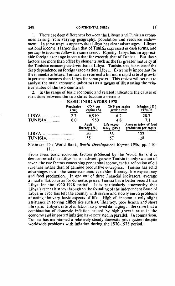
248 CONTINENTAL SHELF [ 11
1. There are deep differences between the Libyan and Tunisian econo- mies arising frorn varying geography, population and resource endow- ment. In sorne ways it appears that Libya has clear advantages. Libyan national income is larger than that of Tunisia expressed in cash terms, and per capita incornes follow the same trend. Equaliy, Libya has an appreci- able foreign exchange income that far exceeds that of Tunisia. But these factors are more than offset by elements such as the far greater maturity of the Tunisian economy vis-à-vis that of Libya. Tunisia, too, has none of the deep dependence on foreign trade as does Libya. Extremely important for the immediate future, Tunisia has returned a far more rapid rate of growth in personal incomes than Libya for some years. This review will set out to analyse the main economic indicators as a means of illustrating the rela- tive status of the two countries.
2. In the range of basic economic and related indicators the causes of variations between the two states become apparent:
. BASIC INDICATORS 1978 Population GNP per CNP per capita Inflation ( 46 )
(mu) capita (S) growtb rate - 1970-78 - LI BYA ................ 2.7 6,910 6.2 20.7 TUNlSlA ........... 6.0 950 4.8 7.1
Adult Life expec- Average index of food literacy ( % ) tancy (yrs.) production per capita
LIBYA .......................... 50 5 5 123 TUNISIA .................... ... 55 5 7 128
SOURCE: The Wortd Bank, World Development Report 1980, pp. 110- 11 1.
From these basic economic factors produced by the World Bank it is demonstrated that Libya has an advantage over Tunisia in only two out of seven: the tao factors concerning per capita income, each a reflection of oil revenues rather than of genuine productive enterprise. Tunisia has solid advantages in al1 the socio-economic variables: literacy, life expectancy and food production. In one out of three financial indicators, average annual inflation rates for dornestic prices, Tunisia has a better record than Libya for the 1970-1978 period. l t is particularly noteworthy that Libya's recenl history through to the founding of the independent State of Libya in 1951 has left the country with severe and slowly cured problems affecting the very basic aspects of life. High ail income is only slight assistance in solving difficulties such as, illiteracy, poor health and short life span. Libya's rate of inflation has proved damaging in the sense that a combination of dornestic inflation caused by high growth rates in the economy and imported inflation have persisted in parallel. In cornparison, Tunisia has maintained a relatively steady domestic price system despite worldwide problems with inflation during the 1970- 1978 period.
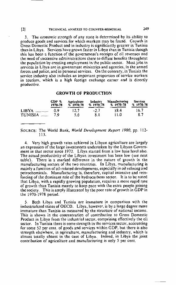
121 TECHNICAL ANNEXES TO COUNTER-MEMORIAL 249
3 . The economic strength of any state is determined by its ability to produce goods and services for which markets may be found. Growth in Gross Domestic Product and in industry is significantly greater in Tunisia than in Libya. Services have grown faster in Libya than in Tunisia though this has been a function of the government's receipts of oil revenues and the need of successive administrations there to diffuse benefits throughout the population by creating employment in the public sector. Most jobs in services in Libya are in government ministries and agencies, in the armed forces and police, and in persona1 services. On thecontrary, in Tunisia the service industry also includes an important proportion of service workers in tourism, which is a high foreign exchange earner and is directly productive.
GROWTH OF PRODUCTION
GDP % Agriculture Induçtry ~nnufacturin~ Services 1970-78 % 1970-78 % 1970-78 % 1970-78 96 1970-78 -
LIBYA ............ 0.9 12.7 -2.7 18.4 16.7 TUNISIA ....... 7.9 5.6 8.1 11.0 8.7
SOURCE: The World Bank, World Development Report 1980, pp. 112- 113.
4. Very high growth rates achieved in Libyan agriculture are largely an expression of the large investments undertaken by the Libyan Govern- ment in that sector since 1972. Libya started from a low base level also. The actual productivity of the Libyan investment has been low (see next table). There is a marked diflerence in the nature of growth in the manufacturing sectors of the two countries. In Libya, manufacturing is mainly a function of oil-related developments, especially in oil refining and petrochemicals. Manufacturing is, therefore, capital intensive and rein- forcing of the dominant role of the hydrocarbons sector. lt is to be noted that Libya, with a rapidly growing population, requires a more rapid rate of growth than Tunisia merely to keep pace with the extra people joining the society. This is amply illustrated by the poor rate of growth in GDP in the 1970-1978 period.
5 . Both Libya and Tunisia are immature in comparison with the industrialized States of OECD. Libya, however, is by a large degree more immature than Tunisia as measured by the structure of national income. This is shown in the concentration of contribution to Gross Domestic Product in Libya from the industrial sector, cornprising effectively the oil sector. In Tunisia there is some çtrength in the services sector, accounting for some 52 per cent. of goods and services within GDP, but there is also strength elsewhere, in agriculture, manufacturing and industry, which is almost totally absent in the case of Libya. Indeed, in Libya the joint contribution of agriculture and manufacturing is only 5 per cent.
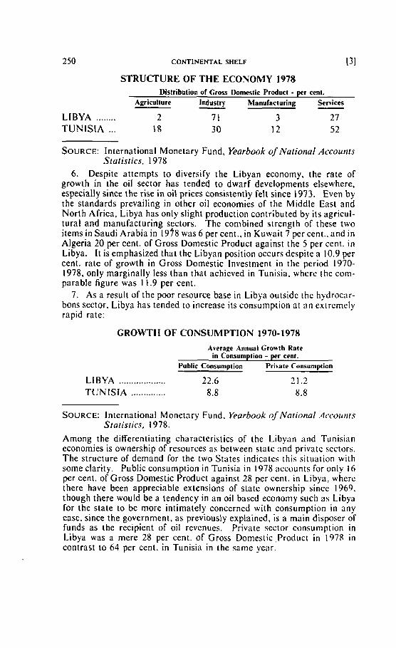
250 CONTINENTAL SHELF i31
STRUCTURE OF THE ECONOMY 1978 Distribution of Cross Domestic Product - per cent.
Agriculture lndustry Manufaciuring Services - ........ LIBYA 2 7 1 3 27
TUNlSIA ... IS 3 O 12 52
SOURCE: International Monetary Fund, Yearbook of National Accounrs Staiisrics. 1978
6 . Despite attempts to diversify the Libyan economy, the rate of growth in the oil sector has tended to dwarf developments elsewhere, especially since the rise in oil prices consistently felt since 1973. Even by the standards prevailing in other oil economies of the Middle East and North Africa, Libya has only slight production contributed by its agricul- tural and manufacturing sectors. The combined strength of these two items in Saudi Arabia in 1938 was 6 per cent.. in Kuwait 7 percent., and in Algeria 20 per cent. of Gross Domestic Product against the 5 per cent. in Libya. I t is emphasized that the Libyan position occurs dcspite a 10.9 per cent. rate of growth in Gross Domestic lnvestment in the period 1970- 1978, only marginally less than that achieved in Tunisia. wherr the coni- parable figure was 11.9 per cent.
7 . As a result of the poor resource base in Libya outsidc the hydrocar- bons sector, Libya has tended to increasc its consumption nt an cxtremely rapid rate:
GROWTH OF CONSUMPTlON 1970-1978
Average Annual Growth Rate in Consumpiion - p r cent.
Public Consumption Pritate Cunsumptian
LI BYA ................... 22.6 21.2 TUNISIA .............. 8.8 8.8
SOURCE: International Monetary Fund. fiarbook of firational .4rc.oir11r.v Siatisrics, 1978.
Among the difïerentiating charactcrisiics of the Libyan and Tunisian economies is ownership of resources as between state and private sectors. The structure of demand for the two States indicatcs this situation with some clarity. Public consumption in Tunisia in 1978 accounts for only 16 per cent. of Gross Domestic Product against 28 percent. in Libya, wherc there have been appreciable extensions of state ownership since 1969. though there would be a tendency in an oil based economy such as Libya for the state to be more intimately concerned with consumption in any case, since the government, as previously explained, is a main disposer of funds as the recipient of oil revcnues. Private sector consurnption in Libya was a mere 28 per cent. of Gross Domestic,Product in 1978 in contrast to 64 per cent. in Tunisia in the same year.
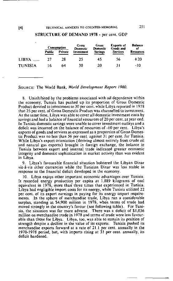
Pl TECHNICAL ANNEXES TO COUNTER-MEMORIAL 25 1
STRUCTURE OF DEMAND 1978 - per cent. GDP
Gross Cross Exports of Balance ConsumpiiOn Domatir Domestic C d s and of
Public Private lnvestment Savings Sewices Reuiurces -- - - - LIBYA ...... 27 28 2 5 45 5 6 + 20
SOURCE: The World Bank, World Developrnent Report 1980.
8. Uninhibited by the problems associated with oil dependence within the economy, Tunisia has pushed up its proportion of Gross Domestic Product devoted to inlestment to 30 pet cent. while Libya reported in 1978 that 25 per cent. of Gross Domesiic Product was channelled to investment. At the same time, Libya was able to cover al1 domestic investment costs by savings and had a balance of financial resources of 20 percent. at year end. In Tunisia domestic savings were unable to cover investment outlays and a deficit was incurred on the balance of resources of - 1 O per cent. Libya's exports of goods and services as expressed as a proportion of Gross Domes- tic Product was no less than 56 per cent. against 31 percent. for Tunisia. While Libya's export orientation (deriving almost enlirely from crude oil and natural gas exports) brought in foreign exchange, the balance in Tunisia between export and interna1 trade indicated greater economic integrity and domestic sophistication in market activity than was evident in Libya.
9. Libya's favourable financial situation bolstered the Libyan Dinar vis-à-vis other currencies while the Tunisian Dinar was less stable in response to the financial deficit developed in the economy.
10. Libya enjoys other important economic advantages over Tunisia. It recorded energy production per capita at 1,889 kilograms of coal equivalent in 1978, more than' three times that experienced in Tunisia. Libya had negligible import costs for its energy, while Tunisia utilized 22 per cent. of its export earnings in paying for its energy import require- ments. In the sphere of merchandise trade, Libya ran a considerable surphs, standing at $4,900 million in 1978, when tetms of trade had moved strongly in the country's favour (see following table). For Tuni- sia, the situation was far more adverse. There was a deficit of $1,036 million on merchandise trade in 1978 and terms of trade were less favour- able than those for Libya. Libya, too, was able to sustain its position of strength despite a decline in the value of its exports. Tunisia pushed its merchandise exports forward at a rate of 21.1 per cent. annually in the 1970-1978 period, but, with irnports rising at 31 pet cent. annually, its deficit hardened.
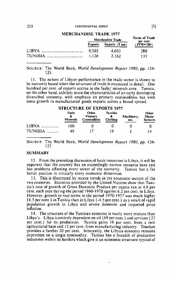
252 CONTINENTAL SHELF i51
MERCHANDISE TRADE 1977 Merchandise Trade
Terms of Trmde per cent
Exports lmports (% mn) (1970=100)
LIBYA ...................................... 9,503 4,603 280 TUNlSIA ................................. 1,126 2,162 133
SOURCE: The World Bank, World Development Report 1980. pp. 124- 125.
11. The nature of Libyan performance in the trade sector is shown to be narrowly based when the structure of trade is examined in detail. One hundred per cent. of exports accrue in the fuels/ minerals area. Tunisia, on the other hand, exhibits more the characteristics of an early developing diversified economy, with emphasis on primary commodities but with some growth in manufactured goods exports across a broad spread.
STRUCTURE OF EXPORTS 1977 Fuels Other Textiles Other
& Primary % Mrrchinery. Manu- Minerals Commodities Clothing etc. lacturm - -
LlBYA ................ 100 O O O O TUN lSl A ........... 49 17 19 I 14
SOURCE: The World Bank, World Development Report 1980, pp. 126- 127.
SUMMARY
12. From the preceding discussion of basic resources in Libya, i r will be apparent that the country has an exceedingly narrow resource base and has problems affecting every sector of the econorny. Tunisia has a fat better position in virtually every economic dimension.
13. This is illustrated by recent trends in the economic sectors of the two countries. Statistics provided by the United Nations show that Tuni- sia's rate of growth of Gross Domestic Product per capita ran at 4.8 per cent. each year during the period 1960- 1978 against 6.2 percent. in Libya. Hoivever, growth in real terms in the period 1970-1977 was much higher (6.5 percent.) in Tunisia than in Libya (-4.5 percent.) a s a result of rapid population growth in Libya and severe domestic and imported price inflation.
14. The structure of the Tunisian economy is vastly more mature than Libya's. Libya is entirely dependent on oil (69 percent.) and services (27 per cent.) for its production. Tunisia gains 18 per cent. from a rich agricultural base and 12 pet cent. from rnanufacturing industry. Tourism provides a further 20 per cent. Inherently, the Libyan economy remains dependent on a single commodity. Tunisia has a breadth of productive industries within its borders which give it an econornic structure typical of
161 TECHNICAL ANNEXES TO COUNTER-MEMORIAL 253
an intermediate developing country as a result of the existence of tourisrn, phosphate mining, oil and gas extraction and a widely based agricultural cropping pattern. While,Tunisia's productive sectors grew al an annual average rate of 7.9 per cent. in the years 1970-1978, Libya managed only 0.9 per cent. The discrepancy between the two was tending in most sectors to increase over that period.
15. Libya's dependence on oil causes deep structural problems in the economy. Estirnates of Libyan oil reserves Vary from an optimistic maxi- mum of 23,000 million barrels to 5,500 million barrels of recoverable crude oil. At most Libya's ability to produce and export oil will run until approximately the year 2000. Libya will have to conserve every barre1 of oil as a national necessity and will need to increase its reserves by discover- ing new oil if it is not to slump back into great poverty in the comparatively near future.
16.' Tunisia, meanwhile, with its rich agricultural and industrial manu- facturing base has a csntinuing future in these fields based on self- renewing resources. It iç so far unhampered by the economic legacy of a one product ecanomy - inflation, urbanization, immigrant labour, high wages and a distorted econornic structure.