cornwall beach & dune management plans – praa sands
TRANSCRIPT

R E P O R T ( F I N A L )
Cornwall Beach & Dune Management Plans – Praa Sands
Prepared for
Cornwall Council
October 2016
CH2M Ash House Falcon Road Sowton, Exeter EX2 7LB

III
Contents Section Page
Executive Summary ...................................................................................................................... v
Introduction ................................................................................................................................ 1 1.1 Project Background ....................................................................................................... 1 1.2 Project Aims .................................................................................................................. 3 1.3 Dune Management Plan ............................................................................................... 3 1.4 Key Contacts ................................................................................................................. 3
Site Description ........................................................................................................................... 5 2.1 Location......................................................................................................................... 5 2.2 Setting ........................................................................................................................... 7 2.3 Key Characteristics ........................................................................................................ 7
2.3.1 Present Site ...................................................................................................... 7 2.4 Natural and Historic Environment ................................................................................ 8
2.4.1 Ecology ........................................................................................................... 10 2.4.2 Designated Geological Conservation Sites .................................................... 13 2.4.3 Landscape Setting .......................................................................................... 13 2.4.4 Archaeology and Cultural Heritage ................................................................ 13
2.5 Land Use ...................................................................................................................... 14 2.6 Value of the Dunes ...................................................................................................... 14 2.7 Key Problems Experienced.......................................................................................... 14 2.8 Other Studies .............................................................................................................. 14
2.8.1 Shoreline Management Plan (SMP) Policy .................................................... 14
Factors Affecting the Beach Dune System .................................................................................. 17 3.1 Wind, Wave Climate and Tides ................................................................................... 17
3.1.1 Wave Climate ................................................................................................. 17 3.1.2 Storm Waves .................................................................................................. 18 3.1.3 Tides ............................................................................................................... 20 3.1.4 Climate Change and Sea Level Rise ................................................................ 22
3.2 Sediment Budget and Linkages ................................................................................... 22 3.3 Historical Changes ....................................................................................................... 23
3.3.1 General Description ....................................................................................... 23 3.3.2 Long Term Evolution ...................................................................................... 24
3.4 Summary of Site Influences ........................................................................................ 30 3.5 Future Changes ........................................................................................................... 30
Beach & Dune Management Plan .............................................................................................. 32 4.1 Key Issues .................................................................................................................... 32 4.2 Management Techniques to Apply at Praa Sands ...................................................... 32
4.2.1 Dune Stabilisation .......................................................................................... 32 4.2.2 Morphological Modification .......................................................................... 34 4.2.3 Ecological Modification .................................................................................. 36 4.2.4 Adapt Backshore ............................................................................................ 36 4.2.5 Access Management ...................................................................................... 37 4.2.6 Public Awareness ........................................................................................... 38 4.2.7 Monitoring ..................................................................................................... 40 4.2.8 Funding .......................................................................................................... 41
4.3 Plan of Action .............................................................................................................. 43 4.4 Monitoring and Response ........................................................................................... 48
4.4.1 Survey Requirements ..................................................................................... 48
CONTENTS
Section Page
IV
4.4.2 Trigger Conditions .......................................................................................... 49
References ................................................................................................................................ 52
Appendices
Appendix A Sand Dune Management Techniques & Preliminary Decision Support Tool v2.0
Appendix B An Overview of Coastal Sand Dunes
Appendix C Baseline Report
Appendix D Options Appraisal
Appendix E Site Actions Summary Map
Appendix F Summary Leaflet
Document history This document has been issued and amended as follows:
Version Date Description Created by Verified by Approved by
0.1 08-03-16 Initial Draft for CC, EA and NE comment
AF, SB, EH JR JR
0.2 14-06-16 Draft for stakeholder comment AF, SB, EH JR JR
1.0 07-10-16 Final AF, SB, EH JR JR

EXECUTIVE SUMMARY
V
Executive Summary This Beach & Dune Management Plan (BDMP) for Praa Sands has been produced as part of the Cornwall Beach & Sand Dune Management Project commissioned by Cornwall Council in 2015. The BDMP has two purposes:
1. Identify the best management approach; in terms of monitoring and intervention (when trigger levels are reached) requirements for the beach and dune system at Praa Sands; based upon the best practice framework developed as part of the Cornwall Sand Dune and Beach Management Strategy produced by Halcrow in 2009, and updated as part of developing the new BDMPs by CH2M in 2015 (see Appendix A).
2. Provide a long-term (50 year) approach to beach and dune management at Praa Sands that is based upon an up-to-date understanding of the beach-dune system and coastal processes at the site, as well as predictions of future coastal evolution. For background information, Appendix B provides an overview of how beach-dune systems work.
This BDMP report provides:
• An introduction to the project and BDMP (Section 1);
• A summary of the characteristics (Section 2) and coastal process drivers at Praa Sands (Section 3); and
• Discussion and definition of suitable management techniques to apply at Praa Sands, including a plan of action and the recommended monitoring and response programme (Section 4).
The key issues to be addressed by beach and dune management activities include:
• Erosion of the dunes increasing erosion risk to paths and backshore assets.
• Uncontrolled public access within the dunes resulting in dune erosion and littering.
• Access issues onto the beach and public safety with low beach levels.
• Planning for management realignment.
• Unfavourable BAP habitats and control of non-native invasive species within dune vegetation.
• Consideration of environmental impacts on designated features.
• Lack of information / data relating to beach and dune levels to inform management.
• Limited funding to undertake management activities.
Key recommendations in this BDMP focus on managing the erosion pressures and access issues by a combination of dune stabilisation and access management measures.


SECTION 1 – INTRODUCTION
1
Introduction 1.1 Project Background Many of the sand dunes and beaches around Cornwall’s coast are currently experiencing erosion and sediment loss. This is a pressing concern as these sand dunes and their associated sandy beaches are one of the most important resources in Cornwall due to:
1. Their role in providing protection against the risk of coastal flooding due to the dynamic nature of beach-dune interactions and their sheer size preventing the sea from impacting upon the hinterland behind the dune systems.
2. Their role in providing important biologically diverse habitats that cannot be easily recreated elsewhere if it were to be lost to coastal erosion or inappropriate development.
3. Their role in providing access to the sea for residents and visitors alike, which is vital to the holiday industry upon which a significant proportion of Cornwall’s economy depends.
It is vital therefore that the sand dunes and beaches around Cornwall’s coast, that represent some 15% of the total sand dune habitat in Britain, are managed in a holistic, sustainable way over the long-term that balances the needs of each of the three distinct functions of sand dunes and beaches that combined make up the beach-dune system.
To ensure that these vital resources are managed in such a way, in 2009 the Cornwall Sand Dune and Beach Management Strategy was developed by Halcrow (now CH2M) for the Cornwall & Isles of Scilly Coastal Group. The main focus of the strategy is the management of flood and coastal erosion, although the habitat and tourism value of the dunes will also be considered. This project delivered an Inventory of Beaches and Dunes; a Best Practice Management Guide and two pilot Beach and Dune Management Plans (BDMPs) for Fistral Beach and Harvey’s Towans (Hayle).
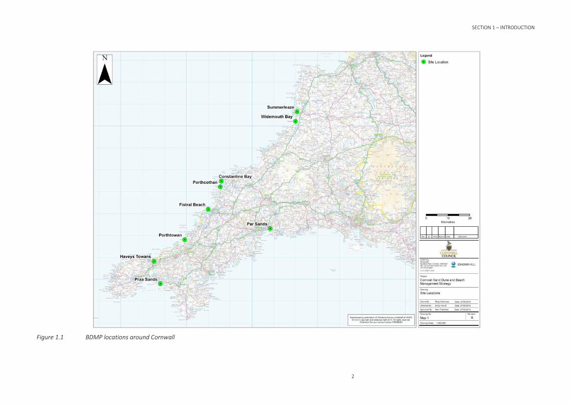
To build on this previous work, Cornwall Council commissioned CH2M to work with them and local communities to (a) produce seven new BDMPs for locations at Constantine Bay, Porthcothan, Porthtowan, Par Sands, Praa Sands, Summerleaze and Widemouth Bay; and (b) review and update the two pilot BDMPs for Harvey’s Towans and Fistral Beach produced in 2009. Figure 1.1 shows each of these locations.
This document is the BDMP for Praa Sands and sets out sustainable management practices for the sand dunes and beach in this area. It should be reviewed every 5-10 years unless significant, rapid changes occur that warrant an earlier review.
SECTION 1 – INTRODUCTION
2
Figure 1.1 BDMP locations around Cornwall
SECTION 1 – INTRODUCTION
3
1.2 Project Aims Beaches and Sand Dunes have many uses and functions. These include amenity, recreation, commercial and community uses, and coast defence, habitat and earth science functions; all of which have social, environmental and economic value. In this case, the main focus of the BDMP is the management of the dunes and beach to ensure they fulfil their flood and coastal defence function to help protect communities around the coast of Cornwall from coastal flooding and erosion by the sea; whilst also considering the needs for management of habitat and amenity use in the area.
BDMPs are a non-statutory method of providing a coastal defence plan for managing a beach and dune system at a local level that takes into account and, where possible, promotes or enhances the other uses and functions of a beach. BDMPs provide a framework for more cohesive management of a beach and dune system that may be regulated and used by different parties, all with their own agendas. They establish a means to control the physical form of beaches and sand dunes and the general beach and dune environment, and to promote good practice within the environment.
BDMP production is often led by Local Authorities with support from the Environment Agency and is usually done in collaboration with relevant stakeholders, as will be the case here. Assistance is available to the authorities to undertake appropriate management and to maintain the coastal defence function provided by the beach and dune system and any associated hard defence structures, as well as other requirements both now and in the future.
Given this, the aim of this BDMP is to provide a new long-term strategic BDMP for Praa Sands. This will be achieved by delivering the following objectives:
1. Identify the best management approach; in terms of monitoring and intervention (when trigger levels are reached) requirements for the beach and dune system at Praa Sands; based upon the best practice framework developed as part of the Cornwall Sand Dune and Beach Management Strategy produced by Halcrow in 2009, and updated as part of developing the new BDMPs by CH2M in 2015 (see Appendix A).
2. Provide a long-term (50 year) approach to beach and dune management at Praa Sands that is based upon an up-to-date understanding of the beach-dune system and coastal processes at the site, as well as predictions of future coastal evolution. For background information, Appendix B provides an overview of how beach-dune systems work.
1.3 Dune Management Plan To achieve the aim and objectives defined in Section 1.2, the BDMP for Praa Sands is structured as follows:
• Section 1 – Introduction (this section).
• Section 2 – Site Description.
• Section 3 – Factors Affecting the Beach Dune System.
• Section 4 – Beach & Dune Management Plan.
1.4 Key Contacts The BDMP and its implementation is led by Cornwall Council. The key contact for this work is:
Name: Mr Martin Clemo
Job Title: Flood and Drainage Team Leader, Contracts and Commissioning Service
Postal Address: South Building, Central Group Centre, Castle Canyke Road, Bodmin, Cornwall, PL31 1DZ.


5
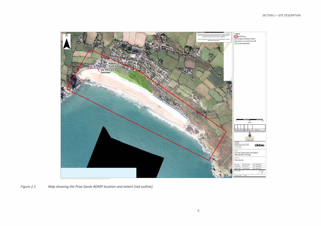
Site Description 2.1 Location Praa Sands is located on the south coast of Cornwall, bounded by Hoe Point in the west and Rinsey Head in the east (refer to Figure 2.1).
SECTION 2 – SITE DESCRIPTION
6
Figure 2.1 Map showing the Praa Sands BDMP location and extent (red outline).
SECTION 2 – SITE DESCRIPTION
7
2.2 Setting Praa Sands consists of a long sandy beach popular with tourists, backed by low head cliffs and climbing dunes. To the west, sea defence structures front properties, in the middle, the dunes extend down to the beach and to the east, the dunes are relict, being separated from the beach by higher cliffs. In places, dune slumping and cliffing of the beach has occurred, exposing a distinct peat layer, indicating dune and cliff retreat. This erosion is the result of a combination of natural processes (storm events) and human impacts (trampling). Beach levels have also lowered, exposing the base of steps and slipway access to the beach. Cornwall Council manage the beach and dune systems at Praa Sands.
Dune management has taken place in the past with the installation of access control fencing, designated pathways and boardwalks and planting of marram grass as part of a school’s education programme. Although some of the fencing has been damaged by storm events, dense vegetation cover in the dunes demonstrates that the access path is successful at preventing visitors straying off the path.
2.3 Key Characteristics 2.3.1 Present Site The principal characteristics of the present beach system are as follows:
• Praa Sands is bounded by Hoe Point in the west and Rinsey Head in the east.
• Between the headlands, is a wide, shallow plan shape bay with sandy beach backed by sand dunes and low coastal cliffs.
• There are a series of discrete sections along the coast of Praa Sands, which are well-defined by their geomorphology and coastal defences and they are described below:
o At the western end of the bay, Hoe Point is composed of more resistant Mylor Slates (LG Mouchel & Partners Ltd, 1995). The cliff toe along Sydney Cove is protected from erosion by a rock revetment and sheet piling. The beach is sandy, although there are some cobbles and boulders.
o A small section of developed shoreline at Stones Reef. The beach is sandy, although there are some cobbles and boulders. A stream also discharges across the beach at the western end of the bay.
o Low coastal cliffs (that are largely undeveloped), underlain by a clay/peat layer, over which climbing dunes have evolved, fronted by wide sandy beach.
o Steep cliffs, comprised of head (periglacial) deposits, fronted by a wide sandy beach.
o Rock armour defended steep cliffs, comprised of head (periglacial) deposits, fronted by a wide sandy beach.
o At the eastern end of the bay, Rinsey Head is composed of more resistant Lithium Mica Granite (LG Mouchel & Partners Ltd, 1995).
• The cliffs, dunes and beach along the length of this coast are eroding. Actual rates of cliff erosion are dependent upon local geology (Royal Haskoning, 2011b) and residents note that the beach is very dynamic with levels regularly changing.
• The process of erosion has been ongoing for some time. Erosion rates of 0.1m to 0.2m/year are recorded for the coastline to the west of Sydney Cove and 0.7m/year to the east of Sydney Cove (Halcrow, 1999b).
• Estimates of cliff erosion made for the coastline opposite Little Cottage (at the southern of Praa Sands) are 0.036m/year for the time between 1880 and 2005 (Cornwall Consultants
8
Ltd, 2014) and between 2.5m and 5m over the last 5 years (0.5m to 1.0m/year) (Philip Desmonde Partnership Ltd, 2014). Halcrow (2009b) suggest that cliff erosion may occur during major failure events rather than as a gradual erosion process, and in a more recent report, Cornwall Consultants Ltd (2010) concurred with this, and concluded that the cliff erosion is episodic with the occurrence of slumping.
• Following the recent unusual and prolonged 2013/2014 storms, significant erosion occurred along the coast at Praa:
o At the western end there was erosion of the cliff and a significant drop in beach level.
o A landslip also took place immediately to the east of the Stones Reef development. Stabilisation works were soon implemented.
o Beach levels dropped substantially.
o Along the centre of the bay, the dune face was also eroded.
o At the eastern end of Praa Sands, the cliffs were eroded by wave action but were also made less stable by flooding from the road behind, which resulted in saturation of the cliffs.
o At one property trees were lost from the garden and a buried electrical cable became exposed, so that one end hangs down the face of the eroded cliff to just above beach level.
The principal characteristics of the dune system are:
• In 2009, the climbing dunes were estimated to cover an area of 4ha (Halcrow, 2009a).
• The dunes along with the cliff and beach along the length of this coast are eroding.
• In 1983 Marram grass was planted on the dunes, and again post 1989/19990 storms when the dunes at Praa Green were mechanically regraded and Marram grass was planted with seeds and fertilizer in an attempt to stabilise the slope (Board, 2015). However, attempts failed and the dune face did not stabilise.
• Following the recent unusual and prolonged 2013/2014 storms the dune face significantly eroded exposing underlying peat beds.
• Human interventions, both historically and current has adversely affected the behavior of the dunes and beach.
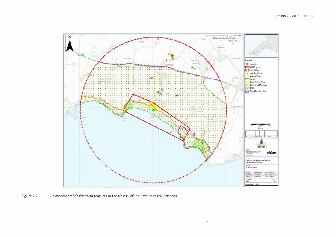
2.4 Natural and Historic Environment The Study Area contains the following nature conservation designations. These are central in the consideration of options for the beach and dune management plan:
• Folly Rocks Cove and Porthkew geological SSSI sites and GCR sites.
• Cornwall and West Devon Mining Landscape (UNESCO) World Heritage Site.
• The Cornwall Area of Outstanding Natural Beauty.
• Archaeological and Cultural Heritage designated features.
These features are shown on Figure 2.2 and discussed in further detail below.
SECTION 2 – SITE DESCRIPTION
9
Figure 2.2 Environmental designation features in the vicinity of the Praa Sands BDMP area.
SECTION 2 – SITE DESCRIPTION
10
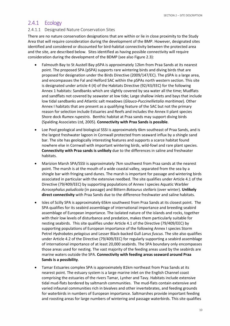
2.4.1 Ecology 2.4.1.1 Designated Nature Conservation Sites There are no nature conservation designations that are within or lie in close proximity to the Study Area that will require consideration during the development of the BMP. However, designated sites identified and considered or discounted for bird-habitat connectivity between the protected area and the site, are described below. Sites identified as having possible connectivity will require consideration during the development of the BDMP (see also Figure 2.3):
• Falmouth Bay to St Austell Bay pSPA is approximately 12km from Praa Sands at its nearest point. The proposed SPA (pSPA) supports rare wintering birds and diving birds that are proposed for designation under the Birds Directive (2009/147/EC). The pSPA is a large area, and encompasses the Fal and Helford SAC within the pSPAs north western section. This site is designated under article 4 (4) of the Habitats Directive (92/43/EEC) for the following Annex 1 habitats: Sandbanks which are slightly covered by sea water all the time; Mudflats and sandflats not covered by seawater at low tide; Large shallow inlets and bays that include low tidal sandbanks and Atlantic salt meadows (Glauco-Puccinellietalia maritimae). Other Annex I habitats that are present as a qualifying feature of the SAC but not the primary reason for selection include Estuaries and Reefs and includes the Annex II plant species Shore dock Rumex rupestris. Benthic habitat at Praa sands may support diving birds (Spalding Associates Ltd, 2005). Connectivity with Praa Sands is possible.
• Loe Pool geological and biological SSSI is approximately 6km southeast of Praa Sands, and is the largest freshwater lagoon in Cornwall protected from seaward influx by a shingle sand bar. The site has geologically interesting features and supports a scarce habitat found nowhere else in Cornwall with important wintering birds, wild-fowl and rare plant species. Connectivity with Praa sands is unlikely due to the differences in saline and freshwater habitats.
• Marizion Marsh SPA/SSSI is approximately 7km southwest from Praa sands at the nearest point. The marsh is at the mouth of a wide coastal valley, separated from the sea by a shingle bar with fringing sand dunes. The marsh is important for passage and wintering birds associated in particular with the extensive reedbed. The site qualifies under Article 4.1 of the Directive (79/409/EEC) by supporting populations of Annex I species Aquatic Warbler Acrocephalus paludicola (in passage) and Bittern Botaurus stellaris (over winter). Unlikely direct connectivity with Praa Sands due to the difference freshwater and saline habitats.
• Isles of Scilly SPA is approximately 65km southwest from Praa Sands at its closest point. The SPA qualifies for its seabird assemblage of international importance and breeding seabird assemblage of European importance. The isolated nature of the islands and rocks, together with their low levels of disturbance and predation, makes them particularly suitable for nesting seabirds. This site qualifies under Article 4.1 of the Directive (79/409/EEC) by supporting populations of European importance of the following Annex I species Storm Petrel Hydrobates pelagicus and Lesser Black-backed Gull Larus fuscus. The site also qualifies under Article 4.2 of the Directive (79/409/EEC) for regularly supporting a seabird assemblage of international importance of at least 20,000 seabirds. The SPA boundary only encompasses those areas used for nesting. The vast majority of the feeding areas used by the seabirds are marine waters outside the SPA. Connectivity with feeding areas seaward around Praa Sands is a possibility.
• Tamar Estuaries complex SPA is approximately 81km northeast from Praa Sands at its nearest point. The estuary system is a large marine inlet on the English Channel coast comprising the estuaries of the rivers Tamar, Lynher and Tavy. Habitats include extensive tidal mud-flats bordered by saltmarsh communities. The mud-flats contain extensive and varied infaunal communities rich in bivalves and other invertebrates, and feeding grounds for waterbirds in numbers of European importance. Saltmarshes provide important feeding and roosting areas for large numbers of wintering and passage waterbirds. This site qualifies

11
under Article 4.1 of the Directive (79/409/EEC) by supporting populations of Little Egret Egretta garzetta (on passage, and a population over winter) and Avocet Recurvirostra avosetta (over winter). Connectivity is likely to be low due to a lack of estuarine mudflat and saltmarsh habitat at Praa Sands.
• The Exe Estuary SPA (approximately 150km from Praa sands) is a complex of coastal habitats waters, foreshore, low-lying land, three saltmarshes and an unusual double spit across the mouth of the estuary, and the sand dunes of Dawlish Warren. The mud and sandflats support Eelgrass Zostera spp. and Enteromorpha beds, and contain an abundance of invertebrates including extensive Mussel Mytilus edulis beds, which together provide rich feeding habitats for wintering waders and wildfowl. The site qualifies under Article 4.1 of the Directive (79/409/EEC) by supporting populations of Annex I species Avocet Recurvirostra avosetta and Slavonian Grebe Podiceps auritus (over winter) and qualifies under Article 4.2 of the Directive (79/409/EEC) as a wetland of international importance for regularly supporting at least 20,000 waterfowl. Unlikely to be any connectivity with Praa Sands due to the lack of estuarine influence.
SECTION 2 – SITE DESCRIPTION
12
Figure 2.3 Potential bird-habitat connectivity between the protected area and the BDMP site.

SECTION 2 – SITE DESCRIPTION
13
2.4.1.2 Biodiversity Action Plan (BAP) Habitats The following are listed as UK priority BAP habitats and are either represented in the Study Area or are within 1km as identified in the Cornwall County Council report: Ecological Assessment of Coastal Zone Management Issues at Praa Sands (Spalding Associates Ltd, 2005). Only habitats that are considered relevant to the Study Area, i.e. they are likely to be impacted upon or are likely to have an influence on the proposed scheme, have been described. The associated targets are quoted under them:
• Coastal Sand Dunes:
o Strandline and mobile dunes (open dune) (Quality assessment: Unfavourable, occasional damage):
Reduce trampling erosion at pressure points.
o Fixed dune grassland (Quality assessment: Unfavourable, Lack of zonation and non-native species presence):
Restore areas of grey dune and dune grassland.
Reduce and control non-native cover.
• Maritime Cliffs and Slopes (Quality assessment: Unfavourable, presence of non-native species and fly tipping):
o Remove/control non-native cover.
o Remove and control fly tipping.
o Minimise loss of habitat to sea defence.
• Littoral rock: Reef (Probably favourable although non-native species are present, trampling may impact biotopes and no baseline data exists):
o Monitor trampling effects.
o Monitor non-native presence.
2.4.2 Designated Geological Conservation Sites Folly Rocks Cove geological SSSI is situated in the north western corner of Praa Sands, whilst Porthkew SSSI lies southeast of Praa Sands at Rinsey Head (see Figure 2.2 above). Both sites are designated for their individually unique exposed geological features. Praa Sands also holds further national importance as a Geological Conservation Review site and is additionally as a County Geology Site due to Praa Sands features of interest for its composite raised beach and Head sequence overlain by Holocene peat and coastal dunes (ERCCIS and Cornwall Wildlife Trust (2010)).
2.4.3 Landscape Setting The importance of landscape to the Praa Sands area is recognised by the following nationally and regionally important designations (see Figure 2.2 above):
• Cornwall Area of Outstanding Natural Beauty (The South Coast Western section) is characterised by granite outcrops, steep rugged cliffs, a freshwater habitat held back from the sea by a shingle bar and sandy beaches.
• The south easterly corner of the site and continuing around the headland is part of the internationally designated Cornwall and West Devon Mining Landscape (UNESCO) World Heritage Site.
2.4.4 Archaeology and Cultural Heritage There are a number of historic sites, including the nationally important Scheduled Monuments Pengersick Castle behind Praa sands beach and the town, and also Wheal Trewavas copper mine south east. Listed buildings are also located within the area (see Figure 2.2 above).

14
2.5 Land Use The southern section of Praa Sands is comprised of soft cliffs topped by private properties. Sand dunes are located in the central to northern part of the frontage, and these are backed by developed land including residential and commercial property.
2.6 Value of the Dunes The management of the dunes needs to acknowledge the benefit of the sand dunes for their aesthetic value, and thus attractiveness to local residents and visitors, as well as acknowledging the coastal defence function of the dunes. The specific values of the dunes at Praa Sands include:
• Coastal erosion buffer for properties behind the sand dunes.
• Local recreational value.
• Providing a store of sand that can naturally feed the beach to compensate for seasonal erosion.
• To form an aesthetically attractive backdrop to the beach, providing sheltered areas and viewing points for beach users.
• Significant environmental habitat value.
2.7 Key Problems Experienced They key issue at Praa Sands is that the cliffs, dunes and beach are eroding, putting houses and assets at risk. The current defences at the western end of the site are insufficient to protect against this erosion, whilst the rest of the frontage is undefended.
In addition, the following observations made by Spalding Associates Ltd (2005) are still relevant following the site visit in March 2015 (refer to Appendix C):
• The need for coastal defence structures.
• Localised trampling erosion at access points on the dune and soft cliff.
• Restriction of dune habitat.
• Potential for trampling erosion on the beach and intertidal rocky shore habitats.
• Presence of invasive non-native plant species.
• Localised pollution and fly-tipping in the coastal cliff.
Also, further observations made during site visit in March 2015 include (refer Appendix C):
• There is considerable storm damage and erosion of cliff at the western end (during the 2013/2014 storms), together with a considerable landslip and loss of land from private property as well as loss of part of the coastal path.
• At the western end, it was noted that there is less or no vegetation cover on the cliff face where there have been cliff falls.
• The dune face has been eroded (during the 2013/2014 storms).
2.8 Other Studies 2.8.1 Shoreline Management Plan (SMP) Policy Praa Sands lies within two Policy Units defined by the Cornwall & Isles of Scilly Shoreline Management Plan Review (SMP2), adopted in 2011 (Royal Haskoning, 2011b). These Policy Units,

15
and the policy for flood and coastal erosion risk management defined in the SMP2 for each over the next 100 year, are summarized in Table 2.1.

SECTION 2 – SITE DESCRIPTION
16
Table 2.1 SMP2 Policy Units and Policies (from Royal Haskoning, 2011b).
Policy Unit Policy (Short Term, to 2025)
Policy (Medium Term, to 2055)
Policy (Long Term, to 2105)
Policy Intent
Policy Unit 18.2 (Praa Sands east)
Managed Realignment
Managed Realignment
No Active Intervention
“Managed realignment approach should allow control over the rate of erosion without creating an unsustainable frontage. This needs to be linked in with the approach for Sydney Cove and the whole frontage can be managed under the same management scheme/approach.”
Policy Unit 18.3 (Praa Sands west (Sydney Cove))
Managed Realignment
Managed Realignment
Managed Realignment
“Managed realignment approach is preferred which links in with the Praa Sands East frontage. It is anticipated that residual life of defences would provide defence to the assets during epoch 1 [short term] if required as part of the overall MR approach.”
SECTION 3 – FACTORS AFFECTING THE BEACH DUNE SYSTEM
17
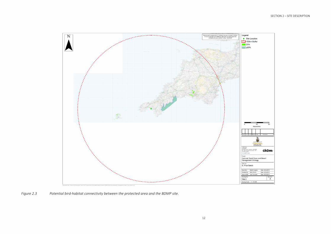
Factors Affecting the Beach Dune System 3.1 Wind, Wave Climate and Tides 3.1.1 Wave Climate The coastline at Praa Sands is orientated north-west to south-east, with the beach and dunes facing approximately 230 degrees (south-west). The predominant wave direction along the south coast of Cornwall is reported to be from the south-west (approaching from 180o – 270o) and the coastline is exposed to open Atlantic swell waves (Royal Haskoning, 2011b).
The Porthleven and Penzance Directional Waverider Buoys, operated as part of the South West Regional Coastal Monitoring Programme (SWRCMP), are the nearest wave buoys to Praa Sands, and have been reviewed for this study.
The Porthleven Directional Waverider Buoy is located approximately 5 miles south-east of Praa Sands, and provides a record off wave height for a three year period between 17th October 2011 and 30th June 2014. The Penzance Directional Waverider Buoy is located approximately 10 miles north-west of Praa Sands, and provides a record of wave height for a three year period between 6th April 2007 and 30th June 2014. A plot of wave heights in Figure 3.1a and Figure 3.1b shows that the predominant wave direction in this area is from the south/south-west. The data set also indicates significant wave heights frequently exceed 5m during the winter months and that wave periods of 15 seconds and higher (i.e. powerful well waves generated by storms offshore) are not uncommon (Royal Haskoning, 2011b).
Figure 3.1a Offshore wave height recorded by the Porthleven Directional Waverider Buoy between 17th October 2011 and 30th June 2014 (PCO, 2014a).

18
Figure 3.1b Offshore wave height recorded by the Penzance Directional Waverider Buoy between 6th April 2007 2011 and 30th June 2014 (PCO, 2014a).
3.1.2 Storm Waves Storm analysis undertaken by PCO (2014b) provides an overview of the storm conditions recorded by the Porthleven and Penzance Directional Waverider Buoys since 2007.
For each wave buoy in the SWRCMP, an individual storm threshold is set. A storm event is defined when significant wave heights equivalent to the 0.25 year return period (i.e. the threshold wave height (Hs) for 2 to 4 storms in an average year) occurs for set period of time (i.e. 16 hours). The significant wave height is calculated when a 5 year time series of data becomes available for the wave buoy and is then reset each year. Prior to that, the height is based on an educated conservative guess from looking at the wave data available. The reason that the 0.25 year return period is used is because the SWRCMP have found that in general there are 3 to 4 storms in any one year that result in the movement significant amounts of sediment.
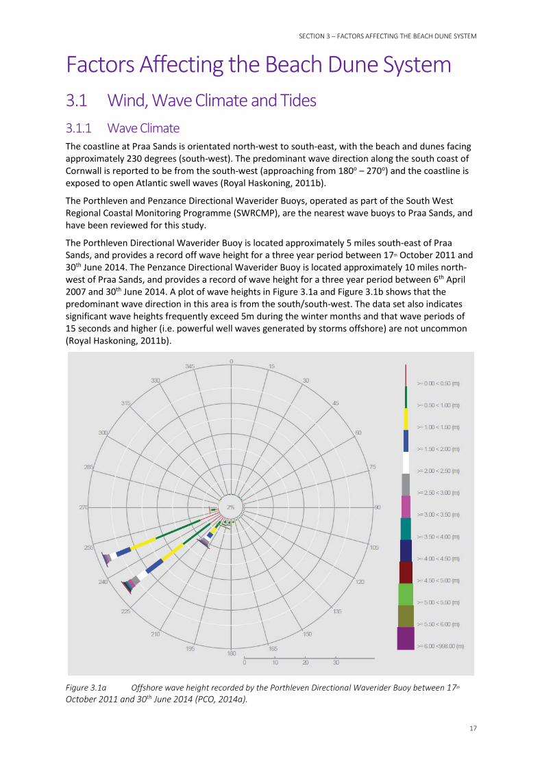
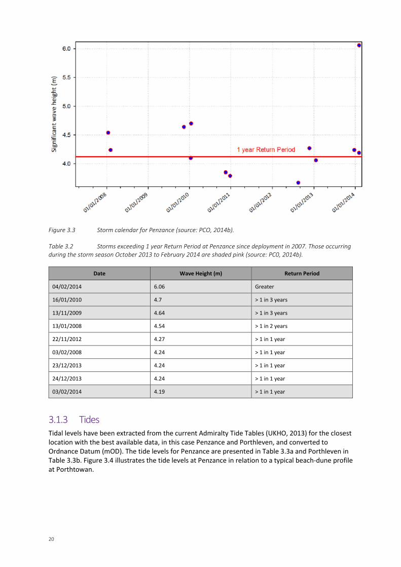
For their reporting, PCO produce a storm calendar. The calendar includes a graph, where each dot represents a storm (i.e. where the Hs exceeds the storm threshold) and shows the Hs for that particular storm. PCO plot the significant wave height for the 1 year return period for that particular buoy on the graph (calculated in the same way as significant wave height for the 0.25 year return period) as a red line. Where storms plot above the red line they are considered to be more severe/extreme and are listed in a separate table. The storm calendar and table for the Porthleven Directional Waverider Buoy are presented in Figure 3.2 and Table 3.1 respectively and the storm calendar and table for the Penzance Directional Waverider Buoy are presented in Figure 3.3 and Table 3.2 respectively.
The storm calendar for the Porthleven Directional Waverider Buoy shows that five storms have exceeded the 1 year Return Period since 2011; four of those storms (80 %) occurred between
19
October 2013 and February 2014. Note that the buoy was badly damaged and ceased working during the 5th February 2014 storm.
The storm calendar for the Penzance Directional Waverider Buoy shows that seven individual storms have exceeded the 1 year Return Period since 2007. Three of those storms (43 %) occurred between October 2013 and February 2014.
The impact of these storms on beach change is described in Section 3.3.
Figure 3.2 Storm calendar for Porthleven (source: PCO, 2014b).
Table 3.1 Storms exceeding 1 year Return Period at Porthleven since deployment in 2007. Those occurring during the storm season October 2013 to February 2014 are shaded pink (source: PC0, 2014b).
Date Wave Height (m) Return Period
03/01/2014 6.99 Greater than 1 in 10
06/01/2014 6.79 > 1 in 5 years
05/02/2014 6.46 > 1 in 3 years
23/12/2013 6.43 > 1 in 3 years
15/08/2012 5.95 > 1 in 1 year
20
Figure 3.3 Storm calendar for Penzance (source: PCO, 2014b).
Table 3.2 Storms exceeding 1 year Return Period at Penzance since deployment in 2007. Those occurring during the storm season October 2013 to February 2014 are shaded pink (source: PC0, 2014b).
Date Wave Height (m) Return Period
04/02/2014 6.06 Greater
16/01/2010 4.7 > 1 in 3 years
13/11/2009 4.64 > 1 in 3 years
13/01/2008 4.54 > 1 in 2 years
22/11/2012 4.27 > 1 in 1 year
03/02/2008 4.24 > 1 in 1 year
23/12/2013 4.24 > 1 in 1 year
24/12/2013 4.24 > 1 in 1 year
03/02/2014 4.19 > 1 in 1 year
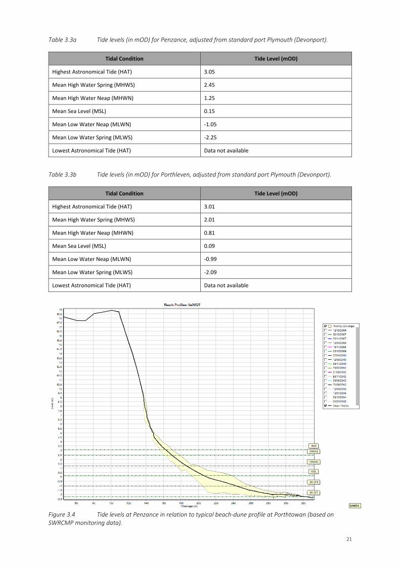
3.1.3 Tides Tidal levels have been extracted from the current Admiralty Tide Tables (UKHO, 2013) for the closest location with the best available data, in this case Penzance and Porthleven, and converted to Ordnance Datum (mOD). The tide levels for Penzance are presented in Table 3.3a and Porthleven in Table 3.3b. Figure 3.4 illustrates the tide levels at Penzance in relation to a typical beach-dune profile at Porthtowan.
21
Table 3.3a Tide levels (in mOD) for Penzance, adjusted from standard port Plymouth (Devonport).
Tidal Condition Tide Level (mOD)
Highest Astronomical Tide (HAT) 3.05
Mean High Water Spring (MHWS) 2.45
Mean High Water Neap (MHWN) 1.25
Mean Sea Level (MSL) 0.15
Mean Low Water Neap (MLWN) -1.05
Mean Low Water Spring (MLWS) -2.25
Lowest Astronomical Tide (HAT) Data not available
Table 3.3b Tide levels (in mOD) for Porthleven, adjusted from standard port Plymouth (Devonport).
Tidal Condition Tide Level (mOD)
Highest Astronomical Tide (HAT) 3.01
Mean High Water Spring (MHWS) 2.01
Mean High Water Neap (MHWN) 0.81
Mean Sea Level (MSL) 0.09
Mean Low Water Neap (MLWN) -0.99
Mean Low Water Spring (MLWS) -2.09
Lowest Astronomical Tide (HAT) Data not available
Figure 3.4 Tide levels at Penzance in relation to typical beach-dune profile at Porthtowan (based on SWRCMP monitoring data).

22
3.1.4 Climate Change and Sea Level Rise Information on the impacts of climate change is available from ‘Advice for Flood and Coastal Erosion Risk Management Authorities’ (Environment Agency, 2011). This guidance highlights that the main risk of climate change in relation to beach management is from sea level rise.
The guidance (Environment Agency, 2011) suggests that predictions of the future rate of sea level rise for the UK coastline should be taken from UKCP09. Data downloaded from UKCP09 provides sea level rise from 1990. Anticipated rates of relative sea level rise and surge estimates over three time periods are presented in Table 3.4. The following estimates are presented in the table:
• Lower End Estimate: this is the low emissions scenario, 50% frequency, taken from the UKCP09 User Interface.
• Change Factor: this is the medium emissions scenario, 95% frequency, taken from the UKCP09 User Interface.
• Upper End Estimate: these are generic values of sea level rise provided in the climate change guidance; they are 4mm (up to 2025), 7mm (2026 to 2050), 11mm (2051 to 2080), and 15mm (2081 to 2115).
• H++ Scenario: these are generic values of sea level rise provided in the climate change guidance; they are 6mm (up to 2025), 12.5mm (2026 to 2050), 24mm (2051 to 2080), and 33mm (2081 to 2115).
• Upper End Estimate + Surge Estimate: This is the upper end estimate plus the upper end surge estimate. The surge estimate are generic values provided in the climate change guidance; they are 20cm (up to the year 2020’s), 35cm (up to the year 2050’s), and 70cm (up to the year 2080’s). With regard to the surge increase, the uncertainty with surge increase is even greater than for sea level rise.
The climate change guidance (Environment Agency, 2011) recommends that in planning future coastal management options, the Change Factor (medium 95% frequency scenario) be used as the preferred scenario. All other scenarios are included to demonstrate the sensitivity of decision making through time, and can be used to refine the options to prepare for a wider range of future change.
Table 3.4 Relative sea level rise estimates for Praa Sands (see text above for explanation of terms used in this table).
Time period Various estimates of relative sea level rise and surge (mm/year)
Lower End Estimate
Change Factor
Upper End Estimate
H++ Scenario
Upper End Estimate +
Surge Estimate
2015 to 2025 0.04 0.06 0.04 0.24 0.06
2015 to 2055 0.15 0.26 0.27 0.62 0.49
2015 to 2115 0.44 0.77 0.92 1.62 1.92
3.2 Sediment Budget and Linkages The alignment of the coast at Praa Sands to the incident wave direction results in the potential for both longshore and cross shore transport (Halcrow, 2009). As observed from recent beach change, sand-grade material moves along the shore from east to west under easterly storm conditions and is returned under more common westerly wave conditions. Sediment is also transported cross-shore
23
from the beach and onto the dunes by wind-blown transport, however the current eroded status of the dunes suggest that supply of sand is week and not sufficient for the dunes to stabilise or accrete.
Due to the bounding rock headlands little sediment is lost or gained through longshore transport, rather through cross-shore transport. Sediment is supplied to the beach via cliff and dune face erosion and potentially via the discharge of sediment from the freshwater stream although it is unlikely to supply significant volume of sediment to the beach/dune system. Philip Desmonde Partnership Ltd (2014) identified three key processes which contribute to cliff erosion at the eastern end of Praa Sands (specifically opposite Little Cottage):
• Wave erosion at the base of the cliff.
• Sea spray and wind borne sea water onto the cliff face.
• Rain water run-off from the coastal slopes and sea spray blown onto the higher ground.
From the beach, sediment can be transported offshore to the nearshore zone or further afield, for example to sediment sinks within Mounts Bay, or returned to the dune system during calmer periods.
3.3 Historical Changes 3.3.1 General Description Praa Sands is located on the south coast of Cornwall. Praa Sands is bounded by Hoe Point in the west and Rinsey Head in the east. Between the headlands, is a wide, shallow plan shape bay with sandy beach backed by sand dunes and low coastal cliffs. There are a series of discrete sections along the coast of Praa Sands, which are well-defined by their geomorphology and coastal defences and they are described below:
• At the western end of the bay, Hoe Point is composed of more resistant Mylor Slates (LG Mouchel & Partners Ltd, 1995). The cliff toe along Sydney Cove is protected from erosion by a rock revetment and sheet piling. The beach is sandy, although there are some cobbles and boulders.
• A small section of developed shoreline at Stones Reef. The beach is sandy, although there are some cobbles and boulders. A stream also discharges across the beach at the western end of the bay.
• Low coastal cliffs (that are largely undeveloped), underlain by a clay/peat layer, over which climbing dunes have evolved, fronted by wide sandy beach. In 2009, the dunes were estimated to cover an area of 4ha (Halcrow, 2009a).
• Steep cliffs, comprised of head (periglacial) deposits, fronted by a wide sandy beach.
• Defended steep cliffs, comprised of head (periglacial) deposits, fronted by a wide sandy beach.
• At the eastern end of the bay, Rinsey Head is composed of more resistant Lithium Mica Granite (LG Mouchel & Partners Ltd, 1995).
The cliffs, dunes and beach along the length of this coast are eroding. Actual rates of cliff erosion are dependent upon local geology (Royal Haskoning, 2011b) and residents note that the beach is very dynamic with levels regularly changing. The process of erosion has been ongoing for some time. Erosion rates of 0.2m to 0.1m are recorded for the coastline to the west of Sydney Cove and 0.7m to the east of Sydney Cove (Halcrow, 1999b). Estimates of cliff erosion made for the coastline opposite Little Cottage (at the southern of Praa Sands) are 0.036m/year for the time between 1880 and 2005 (Cornwall Consultants Ltd, 2014) and between 2.5m and 5m over the last 5 years (0.5m to 1.0m/yr) (Philip Desmonde Partnership Ltd, 2014). Halcrow (2009b) suggest that cliff erosion may occur during major failure events rather than as a gradual erosion process, and in a more recent report,
24
Cornwall Consultants Ltd (2010) concurred with this, and concluded that the cliff erosion is episodic with the occurrence of slumping.
Today, the dunes are also subject to ongoing erosion as a result of beach users climbing, sliding down and dig into the sand on the dune face. There are steps, although they have become difficult to use since beach levels have fallen forming a large drop from the bottom step to the beach. To the east, there is evidence of erosion by the presence of the pill box on the beach, which used to be located on the cliff top and which in the 1970’s lay near the cliff edge (Board, 2015). Once the cliff had eroded, the box was lowered onto the beach following concerns for public health and safety (Board, 2015). In 1985 it was not possible to walk behind the pill box as it was too close to the cliff, however, this has now changed and there is some distance between the cliff and the pill box. As result of this cliff erosion, the coast path has been forced to move from the cliff edge to the beach and at Little Cottage new garden fences have had to be constructed along the cliff edge as previous ones were lost.
Board (2015) notes how winter storms in 1989/1990 significantly eroded the sand dunes and cliffs at Praa, describing the process like a ‘knife through butter’. Underlying peat beds are sometimes exposed when beach levels are low and this is clear from a number of photographs taken between 2011 and 2014 (refer to Appendix C, which shows a timeline of photos taken at the location of the beach access steps located east of Praa Common).
Following the recent unusual and prolonged 2013/2014 storms, significant erosion occurred along the coast at Praa. At the western end there was erosion of the cliff and a significant drop in beach level. A landslip also took place immediately to the east of the Stones Reef development. Stabilisation works were soon implemented and are described in more detail below. Beach levels dropped substantially and the historical photographs in Appendix A, show the difference in beach level at the location of the access steps east of the Praa Common from 2013 to 2014. Along the centre of the bay, the dune face was also eroded. At the eastern end of Praa Sands, the cliffs were eroded by wave action but were also made less stable by flooding from the road behind, which resulted in saturation of the cliffs. At one property trees were lost from the garden and a buried electrical cable became exposed, so that one end hangs down the face of the eroded cliff to just above beach level.
At the time of the site visit in March 2015, it was noted that over a period of three weeks prior, a band of boulders had accumulated along the toe of the revetment and at the bottom of the slipway. Beach levels at the western end of Praa Sands were very low (4m in the vicinity of the slipway) and there were areas of peat exposed. At the same time, beach levels at the eastern end of the beach had increased and there is evidence of this where sand has accumulated around a tree that has fallen from an eroded garden and beach levels have increased around the pill box. It was suggested that this was the result of recent westerly winds and waves moving material along the beach, from the western end to the eastern end.
Appendix C provides further information.
3.3.2 Long Term Evolution 3.3.2.1 Comparison of Ordnance Survey Mapping A comparison of 1888/1889 and 2000 editions of Ordnance Survey Mapping shows:
• The High Water Mark retreated at the south eastern end of Praa Sands but advanced at the north western end, while the mid-point remained constant.
• The Low Water Mark retreated at the south eastern end of Praa Sands but advanced at the north western end, while the mid-point remained constant.
3.3.2.2 Analysis of Aerial Photographs Using historical aerial photographs, the dune toe was digitised and compared (refer to Figure 3.5). The analysis shows that the between 2001 and 2007:

25
• There was no significant change in the position of the beach toe over the period of analysis, other than a small amount of movement near the river channel.
• The dunes in front of the car park (north-west of the photograph) stabilised and vegetation advanced seaward over the analysis period. A small tongue of vegetation immediately to the east of this area disappeared over the same period.
Figure 3.5 Dune toe positon at Praa Sands in 2001 and 2007 (source: Halcrow, 2009c).
3.3.2.3 Beach Profile Analysis Analysis of the beach profile data collected by the SWRCMP was undertaken to identify changes in the dunes and beach, including cross-sectional area (CSA), between December 2006 and March 2008 for four locations: 6a00536, 6a00532, 6a00527 and 6a00517 (refer to Figure 3.6). The study concluded the following:
• Dunes: no profiles extend into the dune system at this site therefore no conclusions could be drawn from the analysis.
• Beach: the two profiles at the north-western end of the beach show the beach to have suffered erosion of between 5 – 10% of the baseline CSA over the winter 2006 to winter 2007 period. In both cases material seems to have been lost from the inter-tidal area, with some of that material re-distributed higher up the beach. The two southerly profiles experienced strong accretion over the winter 2006/2007 period. The beach profile charts show the beach level raised by up to 1.5m over that period; the March 2008 survey shows a large drop in Cross Sectional Area (CSA) at both profiles (returning the beach to the same level as previously recorded) which may be attributed to the large storm in March 2008. Both these findings contradict the trends of erosion of the south-eastern end and accretion at the north-western end of the beach determined by the historical mapping analysis.
26
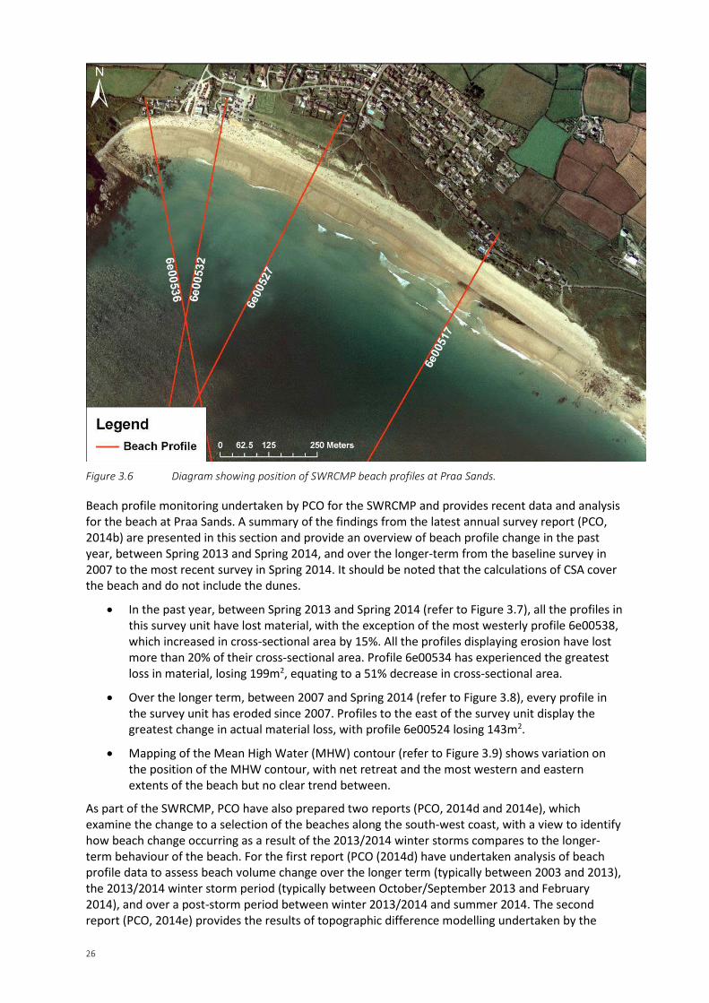
Figure 3.6 Diagram showing position of SWRCMP beach profiles at Praa Sands.
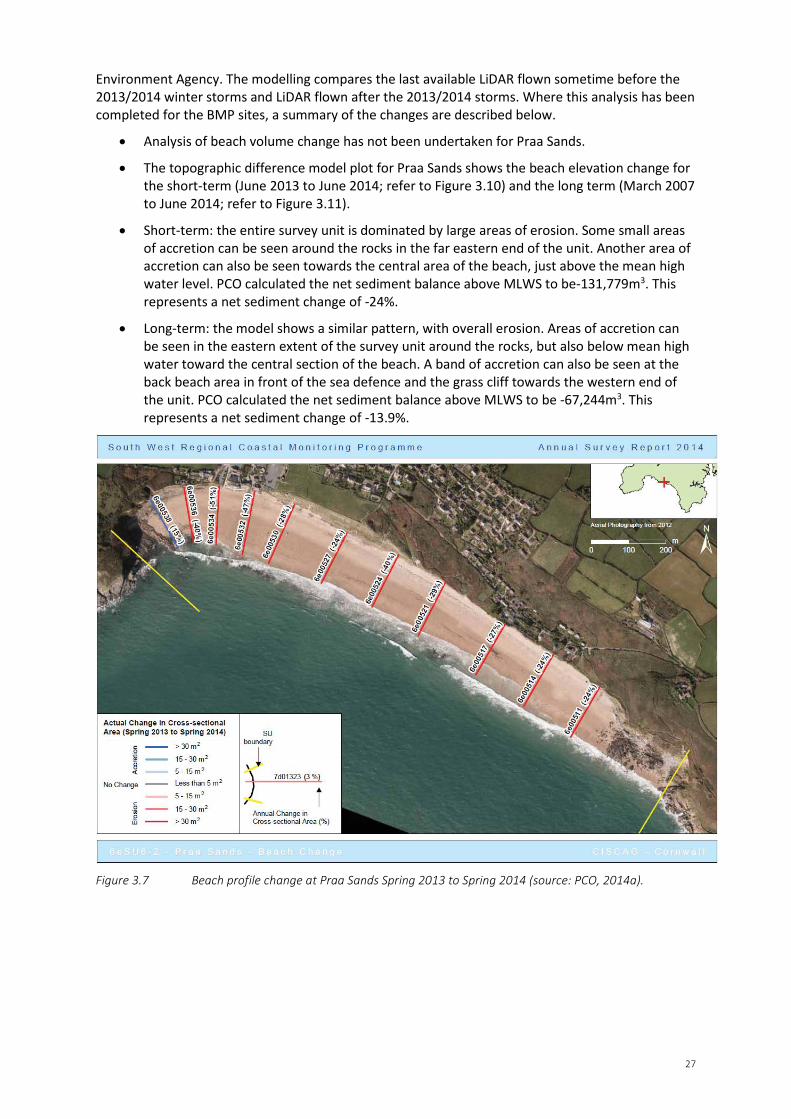
Beach profile monitoring undertaken by PCO for the SWRCMP and provides recent data and analysis for the beach at Praa Sands. A summary of the findings from the latest annual survey report (PCO, 2014b) are presented in this section and provide an overview of beach profile change in the past year, between Spring 2013 and Spring 2014, and over the longer-term from the baseline survey in 2007 to the most recent survey in Spring 2014. It should be noted that the calculations of CSA cover the beach and do not include the dunes.
• In the past year, between Spring 2013 and Spring 2014 (refer to Figure 3.7), all the profiles in this survey unit have lost material, with the exception of the most westerly profile 6e00538, which increased in cross-sectional area by 15%. All the profiles displaying erosion have lost more than 20% of their cross-sectional area. Profile 6e00534 has experienced the greatest loss in material, losing 199m2, equating to a 51% decrease in cross-sectional area.
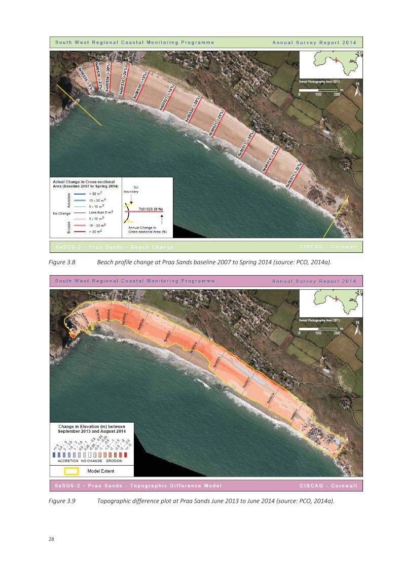
• Over the longer term, between 2007 and Spring 2014 (refer to Figure 3.8), every profile in the survey unit has eroded since 2007. Profiles to the east of the survey unit display the greatest change in actual material loss, with profile 6e00524 losing 143m2.
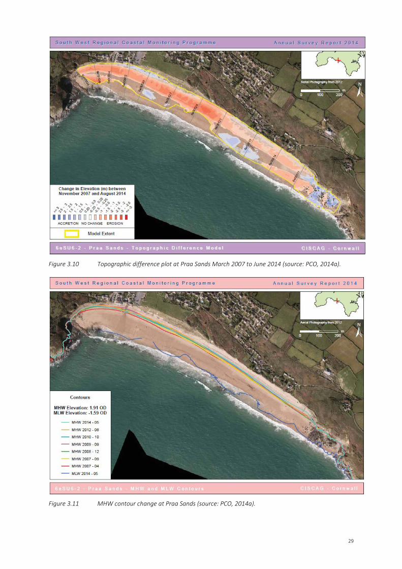
• Mapping of the Mean High Water (MHW) contour (refer to Figure 3.9) shows variation on the position of the MHW contour, with net retreat and the most western and eastern extents of the beach but no clear trend between.
As part of the SWRCMP, PCO have also prepared two reports (PCO, 2014d and 2014e), which examine the change to a selection of the beaches along the south-west coast, with a view to identify how beach change occurring as a result of the 2013/2014 winter storms compares to the longer-term behaviour of the beach. For the first report (PCO (2014d) have undertaken analysis of beach profile data to assess beach volume change over the longer term (typically between 2003 and 2013), the 2013/2014 winter storm period (typically between October/September 2013 and February 2014), and over a post-storm period between winter 2013/2014 and summer 2014. The second report (PCO, 2014e) provides the results of topographic difference modelling undertaken by the
27
Environment Agency. The modelling compares the last available LiDAR flown sometime before the 2013/2014 winter storms and LiDAR flown after the 2013/2014 storms. Where this analysis has been completed for the BMP sites, a summary of the changes are described below.
• Analysis of beach volume change has not been undertaken for Praa Sands.
• The topographic difference model plot for Praa Sands shows the beach elevation change for the short-term (June 2013 to June 2014; refer to Figure 3.10) and the long term (March 2007 to June 2014; refer to Figure 3.11).
• Short-term: the entire survey unit is dominated by large areas of erosion. Some small areas of accretion can be seen around the rocks in the far eastern end of the unit. Another area of accretion can also be seen towards the central area of the beach, just above the mean high water level. PCO calculated the net sediment balance above MLWS to be-131,779m3. This represents a net sediment change of -24%.
• Long-term: the model shows a similar pattern, with overall erosion. Areas of accretion can be seen in the eastern extent of the survey unit around the rocks, but also below mean high water toward the central section of the beach. A band of accretion can also be seen at the back beach area in front of the sea defence and the grass cliff towards the western end of the unit. PCO calculated the net sediment balance above MLWS to be -67,244m3. This represents a net sediment change of -13.9%.
Figure 3.7 Beach profile change at Praa Sands Spring 2013 to Spring 2014 (source: PCO, 2014a).
28
Figure 3.8 Beach profile change at Praa Sands baseline 2007 to Spring 2014 (source: PCO, 2014a).
Figure 3.9 Topographic difference plot at Praa Sands June 2013 to June 2014 (source: PCO, 2014a).
29
Figure 3.10 Topographic difference plot at Praa Sands March 2007 to June 2014 (source: PCO, 2014a).
Figure 3.11 MHW contour change at Praa Sands (source: PCO, 2014a).
30
3.4 Summary of Site Influences Praa Sands is located on the south coast of Cornwall and is exposed to Atlantic swell waves. The coastline is unique in that the coastal cliffs are comprised of head (periglacial) deposits, which are not common in Cornwall. The way in which the coastline is eroding a greater rate to the west and the overall shape of the bay suggest that the coastline is heading towards a crenulated bay, made possible by the presence of the soft cliff deposits. The combination of the south-west facing coastline and exposure to Atlantic swell waves from the south and south-west, means that material is moved alongshore as well as cross-shore, with wind-blown sand transported onto the cliffs to form climbing dunes.
Sediment is supplied to the beach via cliff and dune face erosion, however, the exposed nature of the coastline is resulting in the net erosion of the cliffs, dunes and beach. Dune face erosion is exacerbated by beach users accessing the beach via the dune face rather than the designated access routes.
A number of homes located on the cliff tops are at risk due to cliff erosion. The local residents are willing to fund private defences where presently there is no government funding and have commissioned a design for a new coastal defence. Therefore, consideration should be given to hard defences as well as soft solutions when developing the BDMP for Praa Sands.
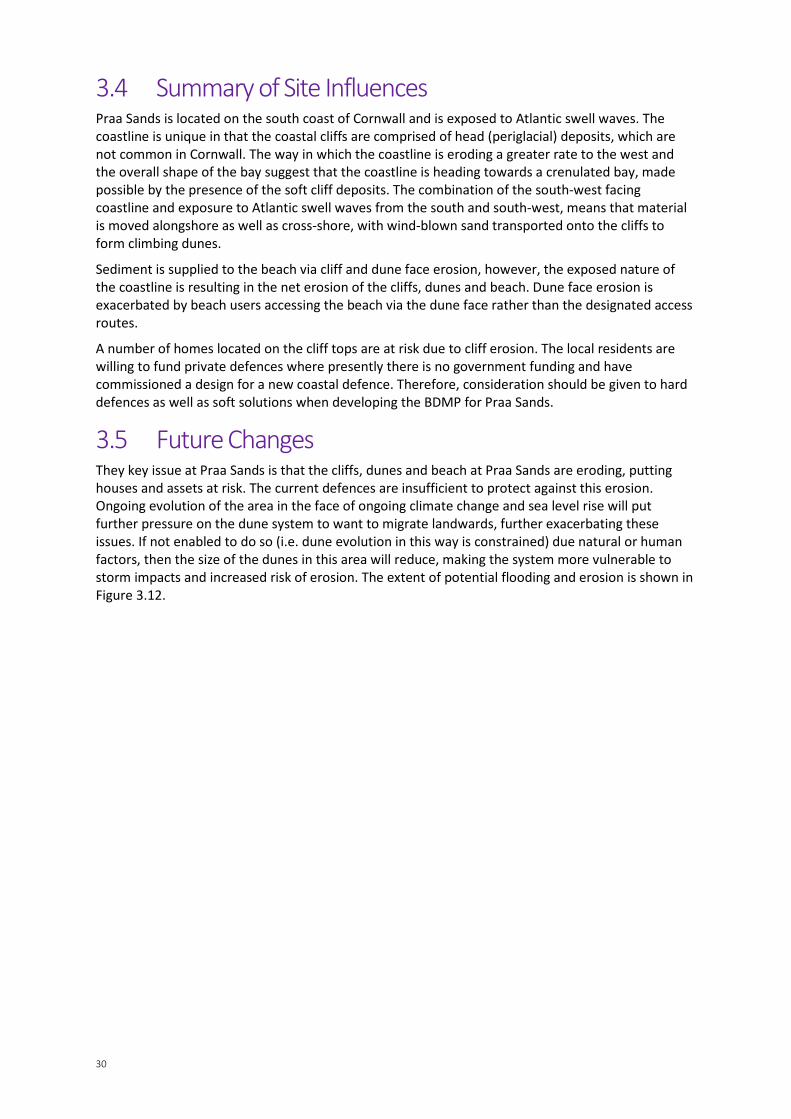
3.5 Future Changes They key issue at Praa Sands is that the cliffs, dunes and beach at Praa Sands are eroding, putting houses and assets at risk. The current defences are insufficient to protect against this erosion. Ongoing evolution of the area in the face of ongoing climate change and sea level rise will put further pressure on the dune system to want to migrate landwards, further exacerbating these issues. If not enabled to do so (i.e. dune evolution in this way is constrained) due natural or human factors, then the size of the dunes in this area will reduce, making the system more vulnerable to storm impacts and increased risk of erosion. The extent of potential flooding and erosion is shown in Figure 3.12.
SECTION 3 – FACTORS AFFECTING THE BEACH DUNE SYSTEM
31
Figure 3.12 Flood and erosion risk projections for Praa Sands.

SECTION 4 – BEACH & DUNE MANAGEMENT PLAN
32
Beach & Dune Management Plan This section covers the development of the Beach & Dune Management Plan and is divided into three sections:
1. Key Issues.
2. Management techniques to apply at Praa Sands.
3. Plan of Action.
4.1 Key Issues The key issues to be addressed by beach and dune management activities include:
• Erosion of the dunes increasing erosion risk to paths and backshore assets.
• Uncontrolled public access within the dunes resulting in dune erosion and littering.
• Access issues onto the beach and public safety with low beach levels.
• Planning for management realignment.
• Unfavourable BAP habitats and control of non-native invasive species within dune vegetation.
• Consideration of environmental impacts on designated features.
• Lack of information / data relating to beach and dune levels to inform management.
• Limited funding to undertake management activities.
4.2 Management Techniques to Apply at Praa Sands This section discusses the management techniques to be applied at Praa Sands to manage the beach and sand dune system in a sustainable way for the next 50 years. These techniques have been identified from the Sand Dune Management Techniques Preliminary Decision Support Tool (see Appendix A) and determined to be appropriate for this location following detailed appraisal (see Appendix D).
A key issue at Praa Sands is dune erosion as a result of a combination of natural processes (storm events) and human impacts (trampling). Beach levels have also lowered, exposing the base of steps and slipway access to the beach. Key recommendations in this BDMP therefore focus on managing these erosion pressures by a combination of dune stabilisation and access management measures.
Cornwall Council manage the beach and dune systems at Praa Sands.
4.2.1 Dune Stabilisation Dune stabilisation in the past has incorporated the planting of marram grass as part of a school’s education programme.
Fencing, combined with natural forms of stabilisation, such as planting, thatching, mulching, matting or sand binders, combined with fencing and signage, would allow natural processes to continue, help retain sand on the dune system, and assuming native plants are used, could have long term positive effects on BAP habitats. Over stabilisation of the dunes would however, not be desirable for habitats and risk of the dunes becoming un-dynamic and unable to react to pressures.
If stabilisation measures are required, access management and signage will be needed to prevent beach visitors trampling any establishing vegetation and hindering stabilisation of the dunes. Although these are relatively low cost measures, they would require ongoing commitment to
33
management and maintenance, with the expectation being that storms will periodically erode stabilised areas and thus re-stabilisation will be needed to encourage post-storm recovery.
Any planned stabilisation measures should be discussed with Natural England prior to implementation, unless it is an emergency situation.
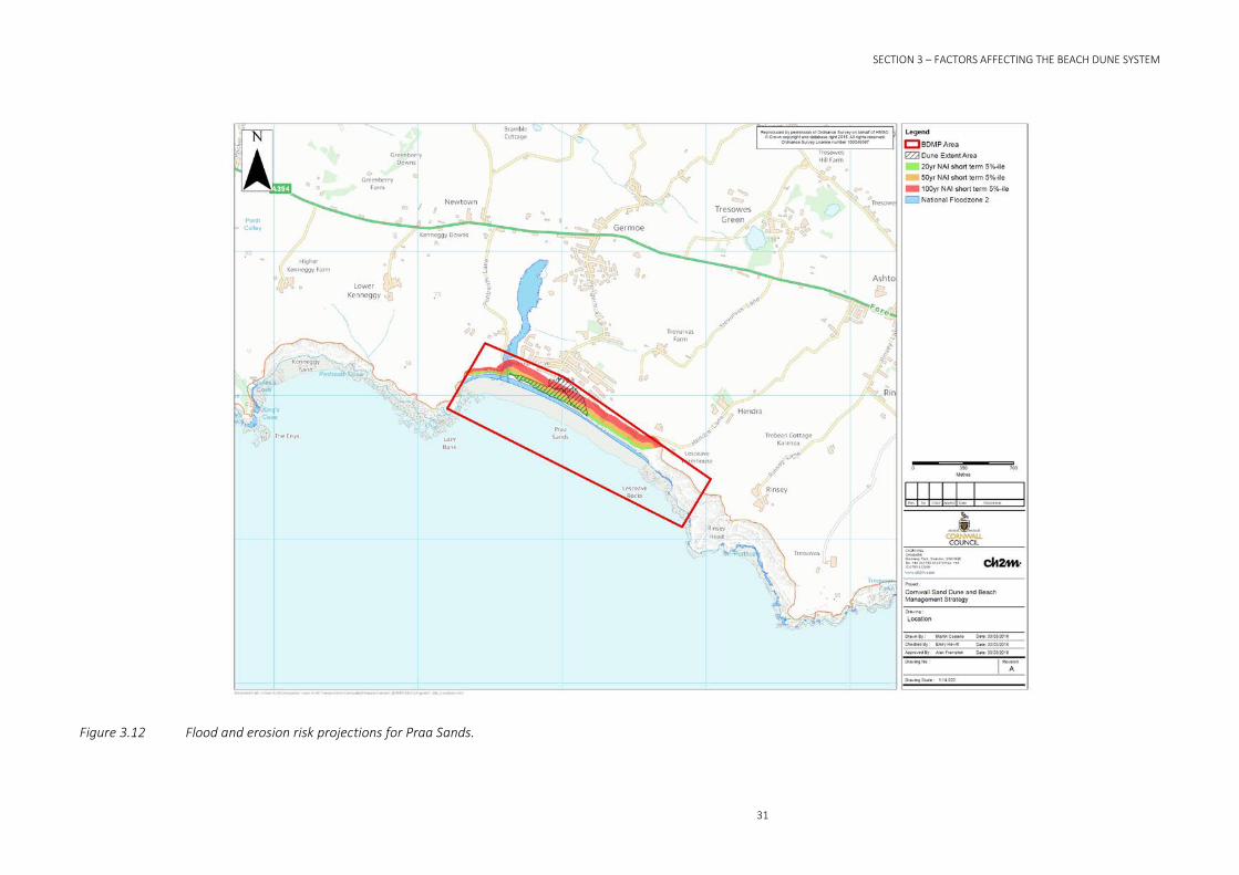
BOX 1 and BOX 2 provide specific guidance on dune planting and dune thatching respectively.
BOX 1: Dune planting guidance
• Planting should only include those speciesthat are indigenous to the site to maintainthe natural ecosystem.
• Plant marram grass (Ammophila arenaria)on the face of eroding dunes above thelimit of direct wave attack.
• Plant sand couchgrass (Elymus farctus) orlyme grass (Leymus arenarius) along thetoe of existing dunes to encourage thegrowth of new foredunes, as these speciesare tolerant to occasional inundation by seawater.
• Planting grasses from seed is not recommended in the very active foredune environment.
• Planting should be undertaken in the spring to maximise potential growth and minimise the riskof storm erosion.
• Dune planting schemes must be continuously managed to establish a vigorous growth and torepair natural or human damage.
• Re-profiling, thatching or fencing are normally required in association with planting to enhancedune recovery and to restrict public access or damage.
• Educational signage at backshore car parking areas or along footpaths should be used to explainmanagement schemes and encourage public interest and support for the managementobjectives.
Example of dune planting
34
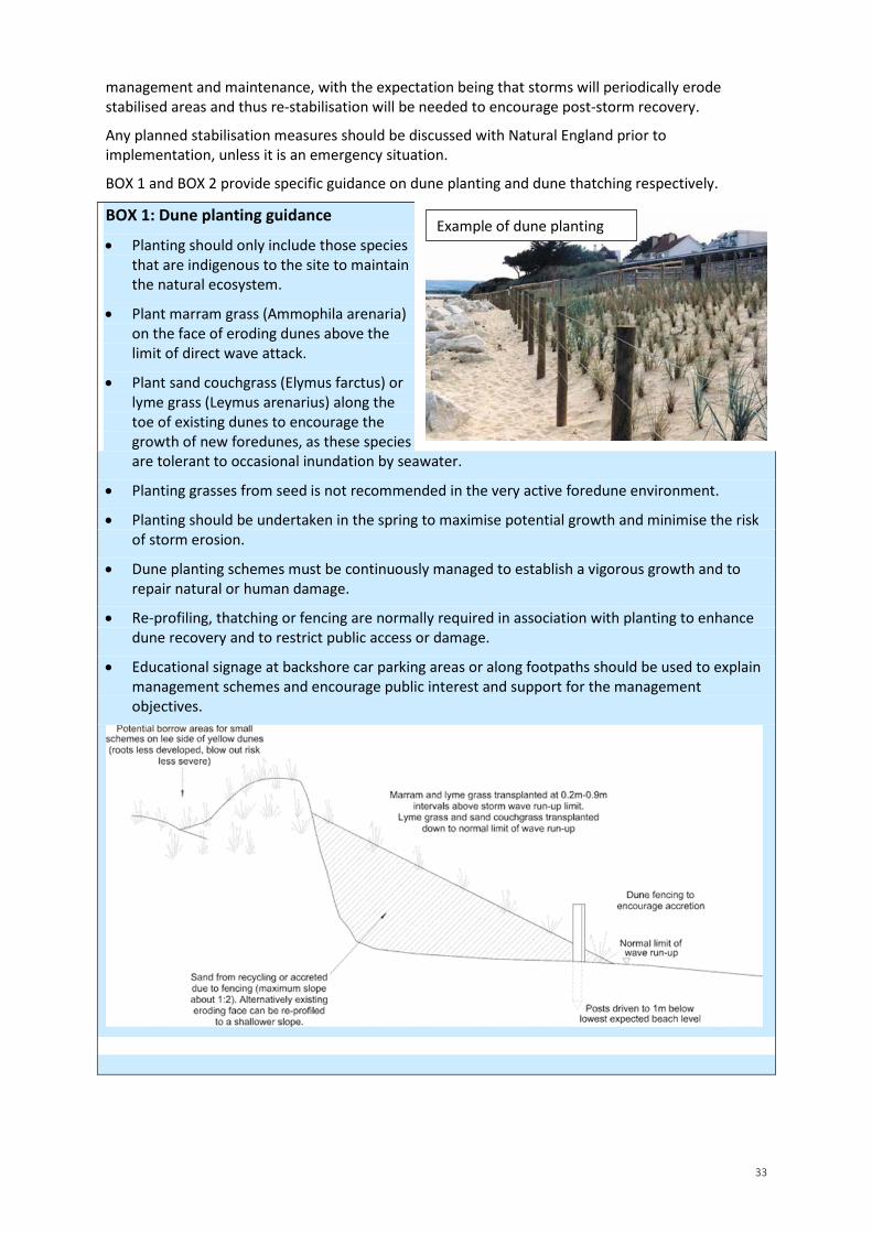
BOX 2: Dune thatching guidance
• Materials can include timber or brushwood cuttings, must be degradable and should notintroduce foreign seeds, live cuttings or pollutants that may damage the dune ecology.
• Conifer brashings (lower branches) from spruce or fir are preferred for their flat, fan shapes.
• Thatch should be laid to cover 20% - 30% of the exposed sand surface.
• Dune grasses should be transplanted through the thatch to promote sand retention andrestoration of natural habitats.
• Thatching should not be undertaken on steep, freshly eroded slopes. The dune face should beregraded or built out with recycled sand prior to further works. A maximum slope of 1:2 isrecommended.
• Thatching should not extend seaward of the line of normal wave run-up.
• Thatch must be regularly maintained to maximise effectiveness and to minimise impact onpublic use and visual amenity.
4.2.2 Morphological Modification Repair and maintenance of current fencing to prevent access to vulnerable dune areas help minimise dune erosion by trampling. Dune management has taken place in the past with the installation of access control fencing, designated pathways and boardwalks and planting of marram grass as part of a school’s education programme. Although some of the fencing has been damaged by storm events, dense vegetation cover in the dunes demonstrates that the access path is successful at preventing visitors straying off the path.
BOX 3 provides specific guidance on dune fencing.
BOX 3: Dune fencing guidance
• Fencing materials can include chestnut palings, brushwood, wooden slats or synthetic fabrics,dependent on required life, length of frontage, commitment to maintenance and vandalismpotential.
• Brushwood is normally the cheapest material but has a life expectancy of less than one year.
• Synthetics can be low cost (strawberry netting), or expensive (polyproplylene, nylon orcomposite wire/synthetic webs) and life expectancies vary from one year to decades.
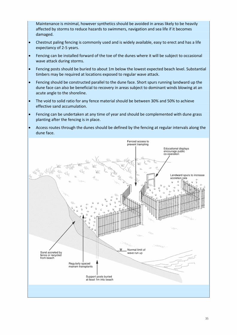
35
Maintenance is minimal, however synthetics should be avoided in areas likely to be heavily affected by storms to reduce hazards to swimmers, navigation and sea life if it becomes damaged.
• Chestnut paling fencing is commonly used and is widely available, easy to erect and has a lifeexpectancy of 2-5 years.
• Fencing can be installed forward of the toe of the dunes where it will be subject to occasionalwave attack during storms.
• Fencing posts should be buried to about 1m below the lowest expected beach level. Substantialtimbers may be required at locations exposed to regular wave attack.
• Fencing should be constructed parallel to the dune face. Short spurs running landward up thedune face can also be beneficial to recovery in areas subject to dominant winds blowing at anacute angle to the shoreline.
• The void to solid ratio for any fence material should be between 30% and 50% to achieveeffective sand accumulation.
• Fencing can be undertaken at any time of year and should be complemented with dune grassplanting after the fencing is in place.
• Access routes through the dunes should be defined by the fencing at regular intervals along thedune face.
36
4.2.3 Ecological Modification Currently, BAP habitat is in unfavourable condition and within the dunes, invasive, non-native species, such as Japanese knotweed, montbretia, and sea buckthorn, can threaten the native dune wildlife. Removal of these non-native species by pulling up by hand or mechanically and treating with a biodegradable herbicide is required to have a positive long term impact on the improvement of designated features and BAP habitat.
In addition, it is suggested that these efforts to control invasive species should form part of a new dune habitat management plan for Praa Sands that sets out wider habitat management to maximise ecological gains in the area. Such a habitat management plan should be developed in partnership with Natural England.
4.2.4 Adapt Backshore The SMP policy for Praa Sands is Managed Realignment (MR) in the short to medium term, transitioning to No Active Intervention (NAI) in the long term. In the west, properties hinder the natural roll back of the dunes. Maintenance of hard defences in this area reduces risk to built assets, but would inhibit natural interaction between the beach and backshore, resulting in ongoing undermining of the defences. In the east, as the cliff retreats, the relict cliff top dunes are eroding and are unable to roll back at a fast enough rate due to the high land and development behind.
Coastal adaptation involving relocation of assets and the coastal path would allow reinstatement of natural processes and lead to potential positive benefits to designated features and BAP habitat, while avoiding any impact on features elsewhere. Future coastal adaptation such as this will require longer term land use planning with relevant land owners and authorities. To guide coastal adaptation efforts, Cornwall Council, as the local planning authority, should develop a Coastal Change Management Area (CCMA) at Praa Sands in line with National Planning Policy Framework (DCLG, 2012) and drawing upon the predictions for future coastal change described in Section 3.5 of this BDMP. To aid Cornwall Council in leading on this activity, use should be made of the Coastal Change Adaptation Planning Guidance for England (CCAPG) published in 2015 (Halcrow, 2015), which highlights a number of coastal adaptation options for beach and dune systems including:
Rollback or relocate property, community facilities and infrastructure.
• Ensure new development does not cause adverse effects/ transfer coastal change risks toother areas.
• Use area action plans/neighbourhood plans to manage future development in coastalcommunities.
• Implement managed realignment to manage coastal change, working with natural processesand restoring habitat.
• Remove defences to restore natural processes, making use of the natural environment.
• Explore other ways to conserve historical assets in situ but also record assets to secure theevidence.
The ultimate trigger for implementation of rollback (or other adaptation measures) will be when assets are assessed as being at imminent risk of loss to erosion (Halcrow, 2015), guided by ongoing monitoring (see BOX 4). However, a more pro-active approach to implementation would see assets relocated before they become exposed to such a level of risk.
BOX 4: “Imminent Risk”
Imminent Risk is defined in the Coastal Change Adaptation Planning Guidance for England (Halcrow, 2015) as being when an asset is within the maximum extent of erosion that has historically occurred at a specific location. This needs to be determined on a site by site basis and informed by analysis of longer term data records, for which ongoing coastal monitoring delivered by the South West Regional Coastal Monitoring Programme (refer to Section 4.4.1) is essential.

37
4.2.5 Access Management Dune management has taken place in the past with the installation of access control fencing, designated pathways, ramps and steps. Although some of the fencing has been damaged by storm events, dense vegetation cover in the dunes demonstrates that the access path is successful at preventing visitors straying off the path.
Restricting access to certain areas, for example with the use of posts and rope or removable structures which have the benefit of easy removal, and signage / information boards, could help allow natural processes to continue, help minimise dune erosion and aid recovery of trampled areas. Redirection of existing routes would need to be considered carefully so as to not impact designated features. The implementation of specific route ways can however lead to a concentration of foot traffic in these areas, and focus trampling. Therefore, careful design of post and rope walkways would be required at appropriate locations and monitoring of erosion along pathways should be carried out regularly.
Safety issues at the base of access tracks and steps caused by beach lowering could be addressed by extending the steps or rerouting paths/tracks down to the beach. However, as this is not an FCERM issue, funding would need to come from other sources to enable those investigations (and any subsequent implementation) to occur.
BOX 5 provides further specific guidance on access walkways.
BOX 5: Access walkway guidelines
• Access routes should be clearly visible and defined.
• In general, construction of excessively wide access routes on coastal dunes limits the amount ofvegetation that can grow. In general, they should be no wider than 4 feet (and preferablynarrower) and extend no longer than necessary to provide access to the beach.
• Paths should follow the natural contours of the dunes rather than cutting straight linessusceptible to wind erosion.
• Rollout structures used on a seasonal basis are a good option. These temporary structures arenot fixed to the ground and can be removed during the off-season to reduce the potential forstorm debris and to allow the dune to function unimpeded when wind-driven sedimenttransport is generally higher and the demand for beach access is reduced.
• Construction activities should be timed to minimise or avoid impacts if they are in or adjacent toendangered or threatened species habitat.
• Construction that will remove plant cover and expose areas to erosion during the storm season(winter) is not recommended.
• For removable options non-wood materials such as bark chips or matting are low cost and havelow impact on the environment.
38
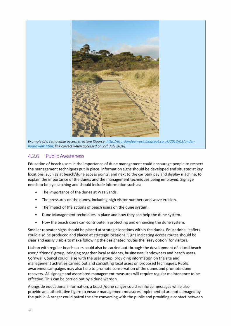
Example of a removable access structure (Source: http://lizardandpenrose.blogspot.co.uk/2012/03/under-boardwalk.html; link correct when accessed on 29th July 2016).
4.2.6 Public Awareness Education of beach users in the importance of dune management could encourage people to respect the management techniques put in place. Information signs should be developed and situated at key locations, such as at beach/dune access points, and next to the car park pay and display machine, to explain the importance of the dunes and the management techniques being employed. Signage needs to be eye catching and should include information such as:
• The importance of the dunes at Praa Sands.
• The pressures on the dunes, including high visitor numbers and wave erosion.
• The impact of the actions of beach users on the dune system.
• Dune Management techniques in place and how they can help the dune system.
• How the beach users can contribute in protecting and enhancing the dune system.
Smaller repeater signs should be placed at strategic locations within the dunes. Educational leaflets could also be produced and placed at strategic locations. Signs indicating access routes should be clear and easily visible to make following the designated routes the ‘easy option’ for visitors.
Liaison with regular beach users could also be carried out through the development of a local beach user / ‘friends’ group, bringing together local residents, businesses, landowners and beach users. Cornwall Council could liaise with the user group, providing information on the site and management activities carried out and consulting local users on proposed techniques. Public awareness campaigns may also help to promote conservation of the dunes and promote dune recovery. All signage and associated management measures will require regular maintenance to be effective. This can be carried out by a dune warden.
Alongside educational information, a beach/dune ranger could reinforce messages while also provide an authoritative figure to ensure management measures implemented are not damaged by the public. A ranger could patrol the site conversing with the public and providing a contact between
39
the beach/dune users and the beach/dune managers as an effective way of providing information to visitors during the summer months.
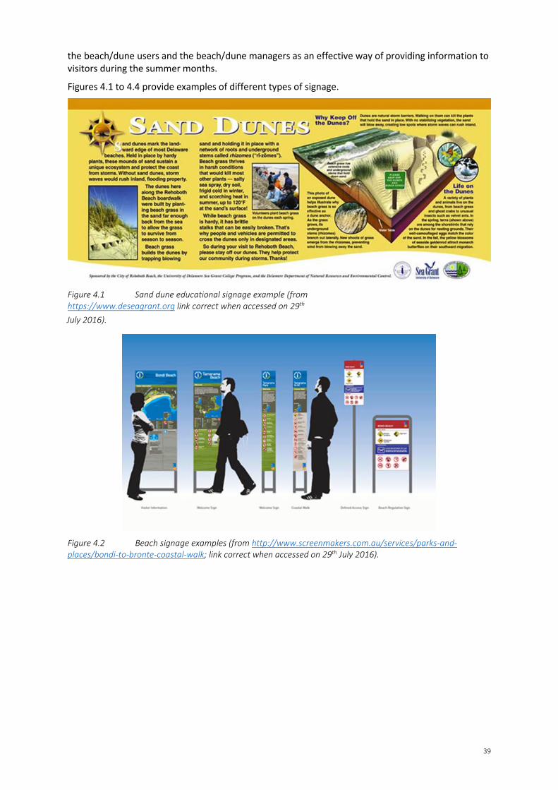
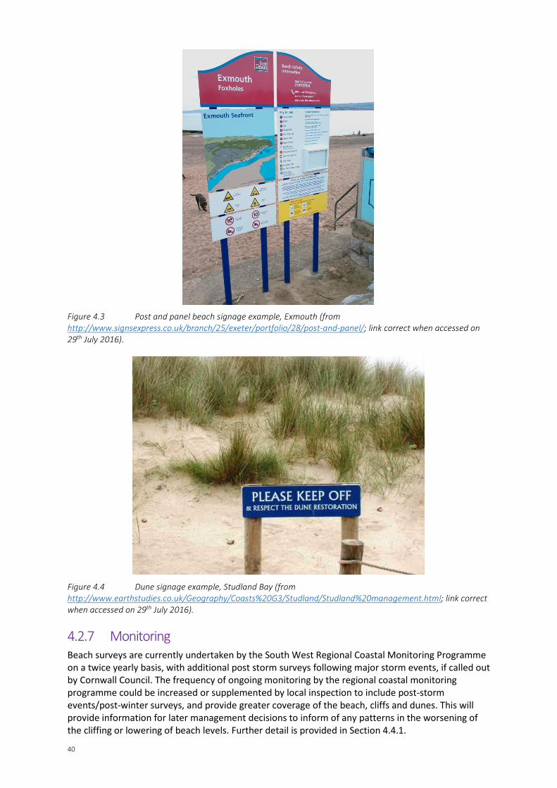
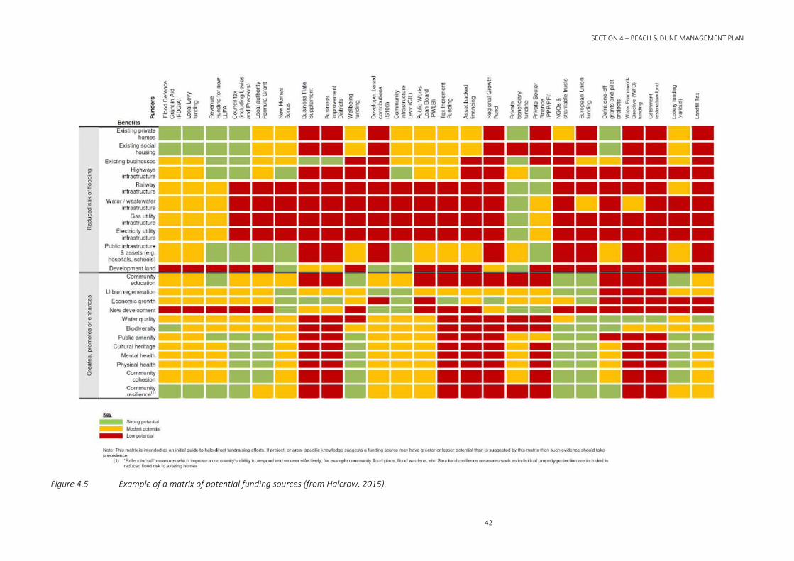
Figures 4.1 to 4.4 provide examples of different types of signage.
Figure 4.1 Sand dune educational signage example (from https://www.deseagrant.org link correct when accessed on 29th July 2016).
Figure 4.2 Beach signage examples (from http://www.screenmakers.com.au/services/parks-and-places/bondi-to-bronte-coastal-walk; link correct when accessed on 29th July 2016).
40
Figure 4.3 Post and panel beach signage example, Exmouth (from http://www.signsexpress.co.uk/branch/25/exeter/portfolio/28/post-and-panel/; link correct when accessed on 29th July 2016).
Figure 4.4 Dune signage example, Studland Bay (from http://www.earthstudies.co.uk/Geography/Coasts%20G3/Studland/Studland%20management.html; link correct when accessed on 29th July 2016).
4.2.7 Monitoring Beach surveys are currently undertaken by the South West Regional Coastal Monitoring Programme on a twice yearly basis, with additional post storm surveys following major storm events, if called out by Cornwall Council. The frequency of ongoing monitoring by the regional coastal monitoring programme could be increased or supplemented by local inspection to include post-storm events/post-winter surveys, and provide greater coverage of the beach, cliffs and dunes. This will provide information for later management decisions to inform of any patterns in the worsening of the cliffing or lowering of beach levels. Further detail is provided in Section 4.4.1.

41
Monitoring of dune vegetation by visual inspection should be undertaken regularly to assess the abundance and extent of vegetation, to inform revised assessment of the BAP habitat condition and determine if it is necessary to take action to further remove non-native, invasive species; giving consideration to whether or not doing so will adversely impact the stability of the dunes in the areas where vegetation clearance is proposed. Refer also to Section 4.4.1.2.
4.2.8 Funding Under a MR policy, some funding for beach or dune management activities related to managing coastal flood/erosion risk is likely to be available from FCERM Grant in Aid (GiA) sources. However, funding for activities beyond FCERM (or indeed funding of FCERM activities along privately owned frontages) will need to be derived from other non-FCERM-GiA sources (i.e. private/non-FCERM-GiA sources).
By way of example, the CCAPG (Halcrow, 2015) includes a matrix to aid and guide consideration of funding efforts when developing locally-specific adaptation approaches (Figure 4.5). Cornwall Council should actively seek partnerships with developers/businesses/communities to raise funds to adaptation measures.
SECTION 4 – BEACH & DUNE MANAGEMENT PLAN
42
Figure 4.5 Example of a matrix of potential funding sources (from Halcrow, 2015).

43
4.3 Plan of Action Table 4.1 provides a summary of the recommended actions at Praa Sands discussed in Section 4.2. Reference should also be made to the site actions summary map (see Figure 4.6 or Appendix E) that indicates where on the site specific actions relate to.
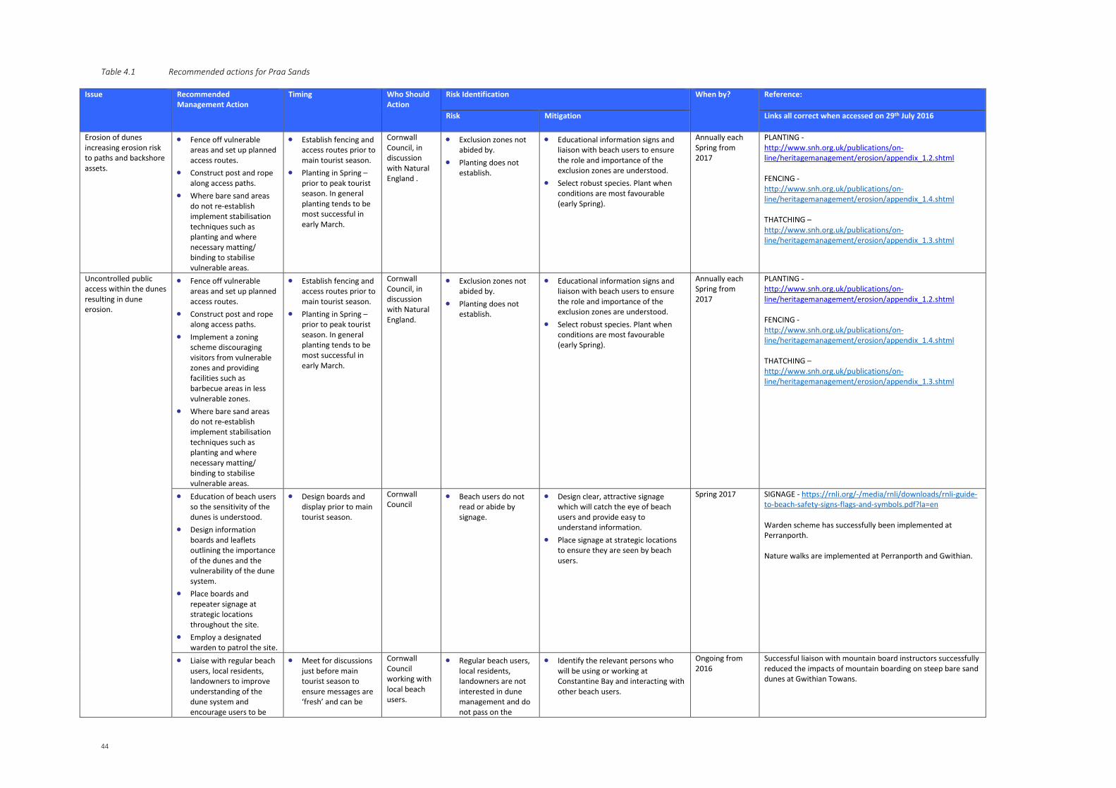
44
Table 4.1 Recommended actions for Praa Sands
Issue Recommended Management Action
Timing Who Should Action
Risk Identification When by? Reference:
Risk Mitigation Links all correct when accessed on 29th July 2016
Erosion of dunes increasing erosion risk to paths and backshore assets.
• Fence off vulnerable areas and set up planned access routes.
• Construct post and rope along access paths.
• Where bare sand areas do not re-establish implement stabilisation techniques such as planting and where necessary matting/ binding to stabilise vulnerable areas.
• Establish fencing and access routes prior to main tourist season.
• Planting in Spring – prior to peak tourist season. In general planting tends to be most successful in early March.
Cornwall Council, in discussion with Natural England .
• Exclusion zones not abided by.
• Planting does not establish.
• Educational information signs and liaison with beach users to ensure the role and importance of the exclusion zones are understood.
• Select robust species. Plant when conditions are most favourable (early Spring).
Annually each Spring from 2017
PLANTING - http://www.snh.org.uk/publications/on-line/heritagemanagement/erosion/appendix_1.2.shtml FENCING - http://www.snh.org.uk/publications/on-line/heritagemanagement/erosion/appendix_1.4.shtml THATCHING – http://www.snh.org.uk/publications/on-line/heritagemanagement/erosion/appendix_1.3.shtml
Uncontrolled public access within the dunes resulting in dune erosion.
• Fence off vulnerable areas and set up planned access routes.
• Construct post and rope along access paths.
• Implement a zoning scheme discouraging visitors from vulnerable zones and providing facilities such as barbecue areas in less vulnerable zones.
• Where bare sand areas do not re-establish implement stabilisation techniques such as planting and where necessary matting/ binding to stabilise vulnerable areas.
• Establish fencing and access routes prior to main tourist season.
• Planting in Spring – prior to peak tourist season. In general planting tends to be most successful in early March.
Cornwall Council, in discussion with Natural England.
• Exclusion zones not abided by.
• Planting does not establish.
• Educational information signs and liaison with beach users to ensure the role and importance of the exclusion zones are understood.
• Select robust species. Plant when conditions are most favourable (early Spring).
Annually each Spring from 2017
PLANTING - http://www.snh.org.uk/publications/on-line/heritagemanagement/erosion/appendix_1.2.shtml FENCING - http://www.snh.org.uk/publications/on-line/heritagemanagement/erosion/appendix_1.4.shtml THATCHING – http://www.snh.org.uk/publications/on-line/heritagemanagement/erosion/appendix_1.3.shtml
• Education of beach users so the sensitivity of the dunes is understood.
• Design information boards and leaflets outlining the importance of the dunes and the vulnerability of the dune system.
• Place boards and repeater signage at strategic locations throughout the site.
• Employ a designated warden to patrol the site.
• Design boards and display prior to main tourist season.
Cornwall Council
• Beach users do not read or abide by signage.
• Design clear, attractive signage which will catch the eye of beach users and provide easy to understand information.
• Place signage at strategic locations to ensure they are seen by beach users.
Spring 2017 SIGNAGE - https://rnli.org/-/media/rnli/downloads/rnli-guide-to-beach-safety-signs-flags-and-symbols.pdf?la=en Warden scheme has successfully been implemented at Perranporth. Nature walks are implemented at Perranporth and Gwithian.
• Liaise with regular beach users, local residents, landowners to improve understanding of the dune system and encourage users to be
• Meet for discussions just before main tourist season to ensure messages are ‘fresh’ and can be
Cornwall Council working with local beach users.
• Regular beach users, local residents, landowners are not interested in dune management and do not pass on the
• Identify the relevant persons who will be using or working at Constantine Bay and interacting with other beach users.
Ongoing from 2016
Successful liaison with mountain board instructors successfully reduced the impacts of mountain boarding on steep bare sand dunes at Gwithian Towans.
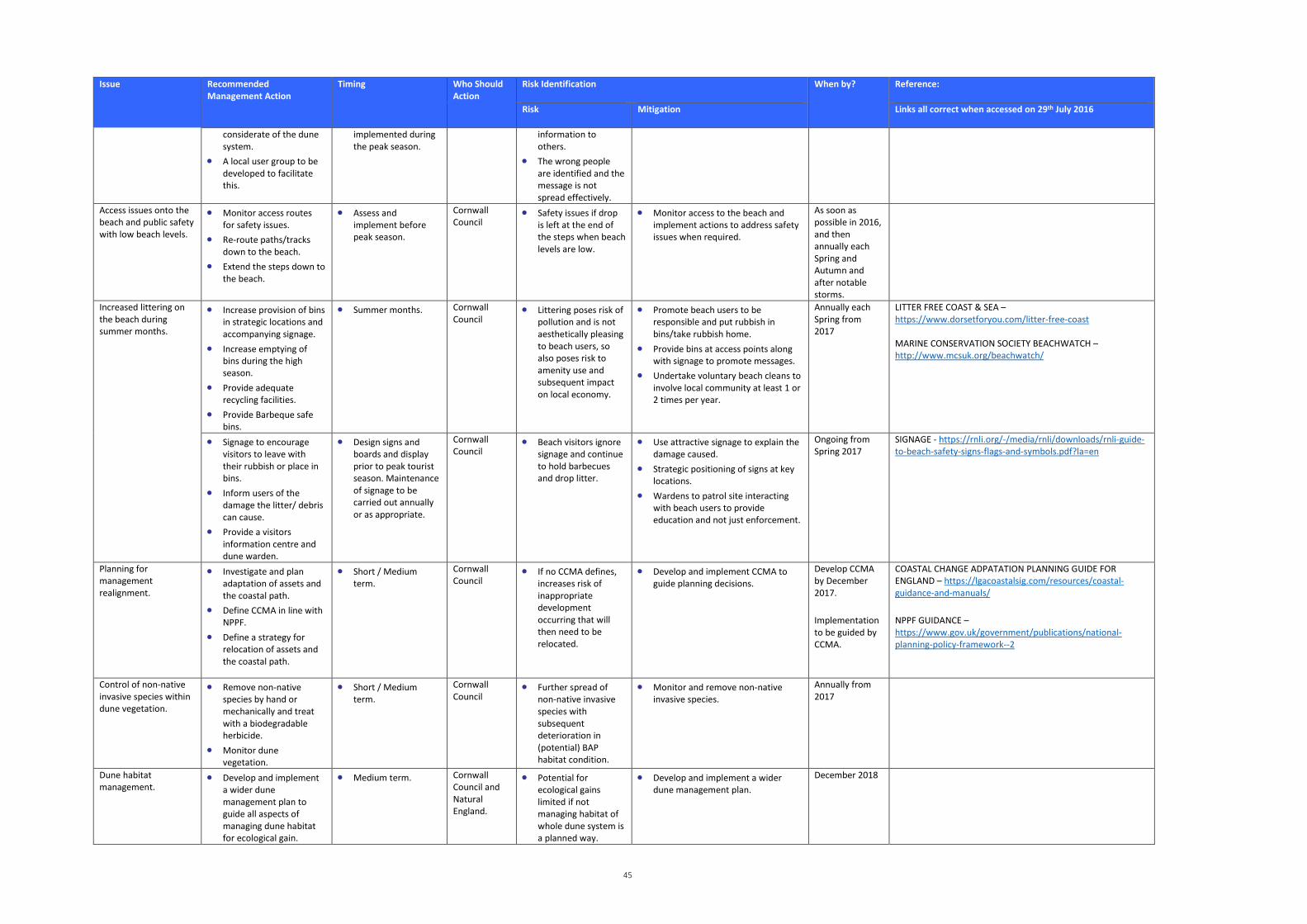
45
Issue Recommended Management Action
Timing Who Should Action
Risk Identification When by? Reference:
Risk Mitigation Links all correct when accessed on 29th July 2016
considerate of the dune system.
• A local user group to be developed to facilitate this.
implemented during the peak season.
information to others.
• The wrong people are identified and the message is not spread effectively.
Access issues onto the beach and public safety with low beach levels.
• Monitor access routes for safety issues.
• Re-route paths/tracks down to the beach.
• Extend the steps down to the beach.
• Assess and implement before peak season.
Cornwall Council
• Safety issues if drop is left at the end of the steps when beach levels are low.
• Monitor access to the beach and implement actions to address safety issues when required.
As soon as possible in 2016, and then annually each Spring and Autumn and after notable storms.
Increased littering on the beach during summer months.
• Increase provision of bins in strategic locations and accompanying signage.
• Increase emptying of bins during the high season.
• Provide adequate recycling facilities.
• Provide Barbeque safe bins.
• Summer months. Cornwall Council
• Littering poses risk of pollution and is not aesthetically pleasing to beach users, so also poses risk to amenity use and subsequent impact on local economy.
• Promote beach users to be responsible and put rubbish in bins/take rubbish home.
• Provide bins at access points along with signage to promote messages.
• Undertake voluntary beach cleans to involve local community at least 1 or 2 times per year.
Annually each Spring from 2017
LITTER FREE COAST & SEA – https://www.dorsetforyou.com/litter-free-coast MARINE CONSERVATION SOCIETY BEACHWATCH – http://www.mcsuk.org/beachwatch/
• Signage to encourage visitors to leave with their rubbish or place in bins.
• Inform users of the damage the litter/ debris can cause.
• Provide a visitors information centre and dune warden.
• Design signs and boards and display prior to peak tourist season. Maintenance of signage to be carried out annually or as appropriate.
Cornwall Council
• Beach visitors ignore signage and continue to hold barbecues and drop litter.
• Use attractive signage to explain the damage caused.
• Strategic positioning of signs at key locations.
• Wardens to patrol site interacting with beach users to provide education and not just enforcement.
Ongoing from Spring 2017
SIGNAGE - https://rnli.org/-/media/rnli/downloads/rnli-guide-to-beach-safety-signs-flags-and-symbols.pdf?la=en
Planning for management realignment.
• Investigate and plan adaptation of assets and the coastal path.
• Define CCMA in line with NPPF.
• Define a strategy for relocation of assets and the coastal path.
• Short / Medium term.
Cornwall Council
• If no CCMA defines, increases risk of inappropriate development occurring that will then need to be relocated.
• Develop and implement CCMA to guide planning decisions.
Develop CCMA by December 2017.
Implementation to be guided by CCMA.
COASTAL CHANGE ADPATATION PLANNING GUIDE FOR ENGLAND – https://lgacoastalsig.com/resources/coastal-guidance-and-manuals/
NPPF GUIDANCE – https://www.gov.uk/government/publications/national-planning-policy-framework--2
Control of non-native invasive species within dune vegetation.
• Remove non-native species by hand or mechanically and treat with a biodegradable herbicide.
• Monitor dune vegetation.
• Short / Medium term.
Cornwall Council
• Further spread of non-native invasive species with subsequent deterioration in (potential) BAP habitat condition.
• Monitor and remove non-native invasive species.
Annually from 2017
Dune habitat management.
• Develop and implement a wider dune management plan to guide all aspects of managing dune habitat for ecological gain.
• Medium term. Cornwall Council and Natural England.
• Potential for ecological gains limited if not managing habitat of whole dune system is a planned way.
• Develop and implement a wider dune management plan.
December 2018
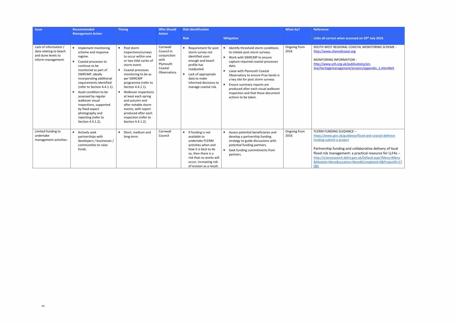
46
Issue Recommended Management Action
Timing Who Should Action
Risk Identification When by? Reference:
Risk Mitigation Links all correct when accessed on 29th July 2016
Lack of information / data relating to beach and dune levels to inform management.
• Implement monitoring scheme and response regime.
• Coastal processes to continue to be monitored as part of SWRCMP, ideally incorporating additional requirements identified (refer to Section 4.4.1.1).
• Asset condition to be assessed by regular walkover visual inspections, supported by fixed aspect photography and reporting (refer to Section 4.4.1.2).
• Post storm inspections/surveys to occur within one or two tidal cycles of storm event.
• Coastal processes monitoring to be as per SWRCMP programme (refer to Section 4.4.1.1).
• Walkover inspections at least each spring and autumn and after notable storm events, with report produced after each inspection (refer to Section 4.4.1.2).
Cornwall Council in conjunction with Plymouth Coastal Observatory.
• Requirement for post storm survey not identified soon enough and beach profile has readjusted.
• Lack of appropriate data to make informed decisions to manage coastal risk.
• Identify threshold storm conditions to initiate post storm surveys.
• Work with SWRCMP to ensure capture required coastal processes data.
• Liaise with Plymouth Coastal Observatory to ensure Praa Sands is a key site for post storm surveys.
• Ensure summary reports are produced after each visual walkover inspection and that these document actions to be taken.
Ongoing from 2016
SOUTH WEST REGIONAL COASTAL MONITORING SCHEME - http://www.channelcoast.org MONITORING INFORMATION - http://www.snh.org.uk/publications/on-line/heritagemanagement/erosion/appendix_2.shtml#a5
Limited funding to undertake management activities.
• Actively seek partnerships with developers / businesses / communities to raise funds.
• Short, medium and long-term.
Cornwall Council
• If funding is not available to undertake FCERM activities when and how it is best to do so, then there is a risk that no works will occur, increasing risk of erosion as a result.
• Assess potential beneficiaries and develop a partnership funding strategy to guide discussions with potential funding partners.
• Seek funding commitments from partners.
Ongoing from 2016
FCERM FUNDING GUIDANCE – https://www.gov.uk/guidance/flood-and-coastal-defence-funding-submit-a-project Partnership funding and collaborative delivery of local flood risk management: a practical resource for LLFAs – http://sciencesearch.defra.gov.uk/Default.aspx?Menu=Menu&Module=More&Location=None&Completed=0&ProjectID=17085
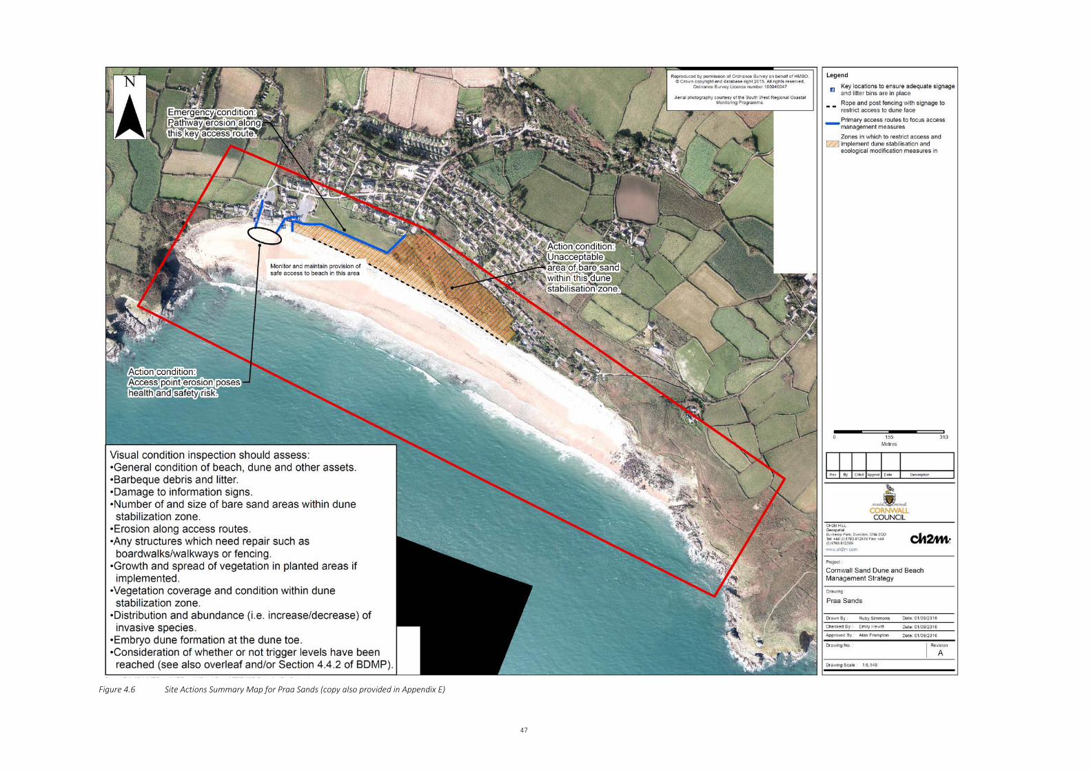
47
Figure 4.6 Site Actions Summary Map for Praa Sands (copy also provided in Appendix E)
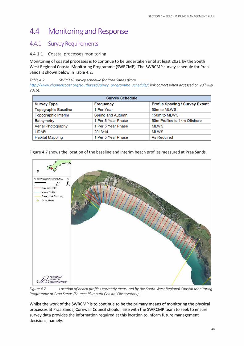
SECTION 4 – BEACH & DUNE MANAGEMENT PLAN
48
4.4 Monitoring and Response 4.4.1 Survey Requirements 4.4.1.1 Coastal processes monitoring Monitoring of coastal processes is to continue to be undertaken until at least 2021 by the South West Regional Coastal Monitoring Programme (SWRCMP). The SWRCMP survey schedule for Praa Sands is shown below in Table 4.2.
Table 4.2 SWRCMP survey schedule for Praa Sands (from http://www.channelcoast.org/southwest/survey_programme_schedule/; link correct when accessed on 29th July 2016).
Figure 4.7 shows the location of the baseline and interim beach profiles measured at Praa Sands.
Figure 4.7 Location of beach profiles currently measured by the South West Regional Coastal Monitoring Programme at Praa Sands (Source: Plymouth Coastal Observatory).
Whilst the work of the SWRCMP is to continue to be the primary means of monitoring the physical processes at Praa Sands, Cornwall Council should liaise with the SWRCMP team to seek to ensure survey data provides the information required at this location to inform future management decisions, namely:
49
• A photograph should be taken of the dune face at the time of each profile survey. The photograph will provide information on vegetation cover and dune face characteristics such as slumping or cliffing.
This additional monitoring data will provide further information on aspects including the beach level, position of the dune front, and the dune shape which will aid future reviews of this BDMP.
4.4.1.2 Asset condition monitoring In addition to the coastal processes monitoring data collected by the SWRCMP described in Section 4.4.1.1, Cornwall Council should undertake regular walkover surveys to monitor the issues identified in this report, and the success of any management measures implemented. This should include a visual assessment of aspects such as:
• General condition of beach, dunes and other assets.
• Barbeque debris and litter.
• Damage to information signs.
• Number of and size of bare sand areas.
• Erosion along access routes.
• Any structures which need repair such as boardwalks/walkways or fencing.
• Growth and spread of vegetation in planted areas.
• Vegetation coverage and condition.
• Distribution and abundance (i.e. increase/decrease) of invasive species.
• Embryo dune formation at the dune toe.
• Consideration of whether or not trigger levels, as defined in Section 4.4.2, have been reached.
These visual condition inspections should be undertaken at least each spring and autumn, and following notable storm events.
The condition of fencing should be monitored on a regular basis, particularly after storms, busy summer periods, and public events on the beaches.
These visual inspections should also include fixed aspect photography at key problem areas including access routes subject to erosion and also bare sand areas (i.e. take photos at the same location of the same view on each inspection).
Regular monitoring of implemented management techniques should be carried. Dunes are dynamic systems and the effectiveness of management techniques may not be consistent. Through monitoring, the dune management techniques in place can be regularly assessed and adapted to improve effectiveness and prevent the continuation of unsuccessful techniques that do not benefit the dune system.
A brief inspection report, including photos and summary of findings and actions to be taken, should be produced after each inspection and copies retained alongside this BDMP.
4.4.2 Trigger Conditions Trigger conditions enable operating authorities to quickly assess whether intervention is required to maintain the existing dune system. The actions required when the trigger conditions are reached should be considered in light of the conditions immediately prior to, during and predicted to follow the assessment.
The beach and dunes will be inspected following a storm event. However, the dune system will typically experience erosion during a storm event and usually recover to near the pre-storm level following a period of calmer conditions. It is therefore recommended that unless further storm
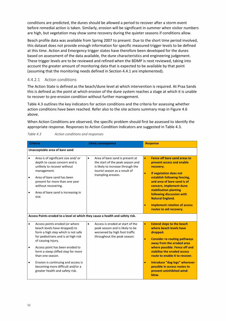
50
conditions are predicted, the dunes should be allowed a period to recover after a storm event before remedial action is taken. Similarly, erosion will be significant in summer when visitor numbers are high, but vegetation may show some recovery during the quieter seasons if conditions allow.
Beach profile data was available from Spring 2007 to present. Due to the short time period involved, this dataset does not provide enough information for specific measured trigger levels to be defined at this time. Action and Emergency trigger states have therefore been developed for the dunes based on assessment of the data available, the dune characteristics and engineering judgement. These trigger levels are to be reviewed and refined when the BDMP is next reviewed, taking into account the greater amount of monitoring data that is expected to be available by that point (assuming that the monitoring needs defined in Section 4.4.1 are implemented).
4.4.2.1 Action conditions The Action State is defined as the beach/dune level at which intervention is required. At Praa Sands this is defined as the point at which erosion of the dune system reaches a stage at which it is unable to recover to pre-erosion condition without further management.
Table 4.3 outlines the key indicators for action conditions and the criteria for assessing whether action conditions have been reached. Refer also to the site actions summary map in Figure 4.6 above.
When Action Conditions are observed, the specific problem should first be assessed to identify the appropriate response. Responses to Action Condition Indicators are suggested in Table 4.3.
Table 4.3 Action conditions and responses
Criteria Likely consequence Response
Unacceptable area of bare sand
• Area is of significant size and/ or depth to cause concern and is unlikely to recover without management.
• Area of bare sand has been present for more than one year without recovering.
• Area of bare sand is increasing in size.
• Area of bare sand is present at the start of the peak season and is likely to increase through the tourist season as a result of trampling erosion.
• Fence off bare sand areas to prevent access and enable recovery.
• If vegetation does not establish following fencing, and area of bare sand is of concern, implement dune stabilisation planting following discussion with Natural England.
• Implement rotation of access routes to aid recovery.
Access Points eroded to a level at which they cause a health and safety risk.
• Access points eroded (or where beach levels have dropped) to form a high step which is not safe for pedestrians and is at high risk of causing injury.
• Access point has been eroded to form a steep cliffed step for more than one season.
• Erosion is continuing and access is becoming more difficult and/or a greater health and safety risk.
• Access is eroded at start of the peak season and is likely to be worsened by high foot traffic throughout the peak season.
• Extend steps to the beach where beach levels have dropped.
• Consider re-routing pathways away from the eroded area where possible. Fence off and stabilise the eroded access route to enable it to recover.
• Introduce “dog legs” wherever possible in access routes to prevent uninhibited wind-blow.
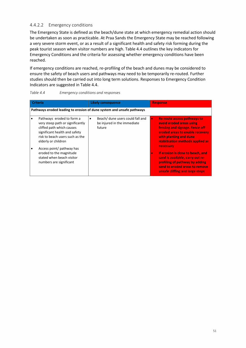
51
4.4.2.2 Emergency conditions The Emergency State is defined as the beach/dune state at which emergency remedial action should be undertaken as soon as practicable. At Praa Sands the Emergency State may be reached following a very severe storm event, or as a result of a significant health and safety risk forming during the peak tourist season when visitor numbers are high. Table 4.4 outlines the key indicators for Emergency Conditions and the criteria for assessing whether emergency conditions have been reached.
If emergency conditions are reached, re-profiling of the beach and dunes may be considered to ensure the safety of beach users and pathways may need to be temporarily re-routed. Further studies should then be carried out into long term solutions. Responses to Emergency Condition Indicators are suggested in Table 4.4.
Table 4.4 Emergency conditions and responses
Criteria Likely consequence Response
Pathways eroded leading to erosion of dune system and unsafe pathways
• Pathways eroded to form a very steep path or significantly cliffed path which causes significant health and safety risk to beach users such as the elderly or children
• Access point/ pathway has eroded to the magnitude stated when beach visitor numbers are significant
• Beach/ dune users could fall and be injured in the immediate future
• Re-route access pathways to avoid eroded areas using fencing and signage. Fence off eroded areas to enable recovery with planting and dune stabilisation methods applied as necessary
• If erosion is close to beach, and sand is available, carry out re-profiling of pathway by adding sand to eroded areas to remove unsafe cliffing and large steps
SECTION 5 – REFERENCES
52
References • BCTV (2005). Sand Dunes – a practical handbook. Complied Brooks, A. Revised Agate, E. BCTV,
Doncaster, 109pp.
• Board, T.H. (2015). Letter from Mrs Tanis Helen Board, Breage Parish Councillor and local resident, addressed to CH2MHill regarding site visit at Praa Sands on Monday 9th March 2015.
• Cornwall Consultants Ltd (2010). Environmental Survey: Coastal Erosion Report. Report Reference DB/DJC/GF/721.a.T. Report prepared by Cornwall Consultants Ltd for Mr Alex Michaelis, September 2010.
• Environment Agency (2011). Adapting to Climate Change: Advice for Flood and Coastal Erosion Risk Management Authorities. Report by the Environment Agency, 2011, pp. 29.
• ERCCIS and Cornwall Wildlife Trust (2010). County Geology Site Criteria for Cornwall and the Isles of Scilly.
• DCLG (2012). National Planning Policy Framework. Available online: https://www.gov.uk/government/uploads/system/uploads/attachment_data/file/6077/2116950.pdf. Date accessed: 29th July 2016.
• Halcrow (2015). Coastal Change Adaptation Planning Guidance for England (CCAPG). Available online: http://lgacoastalsig.com/resources/coastal-guidance-and-manuals/. Date accessed: 29th July 2016.
• Halcrow (2009a). Cornwall Sand Dune and Beach Management Strategy. Report produced by Halcrow Group Limited for the Cornwall and Isles of Scilly Coastal Advisory Group, September 2009.
• Halcrow (2009b). Sand Dune Inventory. Cornwall Sand Dune and Beach Management Strategy. Report produced by Halcrow Group Limited for the Cornwall and Isles of Scilly Coastal Advisory Group, September 2009.
• Halcrow (2009c). Sediment Budget Report. Cornwall Sand Dune and Beach Management Strategy. Report produced by Halcrow Group Limited for the Cornwall and Isles of Scilly Coastal Advisory Group, September 2009.
• Halcrow (2002). Futurecoast CD. Produced by Halcrow Group Ltd for Defra.
• Halcrow (1999). Land’s End to Hartland Point Shoreline Management Plan. Volumes 1 to 4. Report produced by Halcrow Group Limited for Cornwall and Isles of Scilly Coastal Group.
• L.G. Mouchel & Partners Limited (1995). Lizard Point to Land’s End Strategic Coastline Study. Volumes 1 to 7.
• Philip Desmonde Partnership Ltd (2014). ‘Little Cottage’, Praa Sands, Cliff Erosion Remediation. Design Study and Concept. Final. Report Number 2105-01 Rev 0. Prepared by Philip Desmonde Partnership Ltd for Mr Alex Michaelis, September 2014.
• Plymouth Coastal Observatory (PCO) (2014a). Annual Survey Report. Land’s End to Hartland Point. Report Number AR43. Report produced for the South West Regional Monitoring Programme, September 2014.
• Plymouth Coastal Observatory (PCO) (2014b). Review of South West Coast Beach Response to Wave Conditions During the Winter of 2013-2014. Report Number SW SR01. Report produced for the South West Regional Monitoring Programme, June 2014.
• Royal Haskoning (2011a). Cornwall and Isles of Scilly Shoreline Management Plan Review (SMP2). Report for the Cornwall and Isles of Scilly Coastal Group. February 2011.

53
• Royal Haskoning (2011b). Cornwall and Isles of Scilly SMP2. Main Report, Final. Report produced by Royal Haskoning for the Cornwall and Isles of Scilly Coastal Advisory Group, February 2011.
• Royal Haskoning (2011c). Cornwall and Isles of Scilly SMP2. Appendix C, Review of Coastal Processes and Geomorphology, Final Report. Report produced by Royal Haskoning for the Cornwall and Isles of Scilly Coastal Advisory Group, February 2011. Report reference 9T8801.
• Spalding Associates Ltd (2005). Ecological Assessment of Coastal Zone Management Issues at Praa Sands, Cornwall. Report for Cornwall County Council.
• United Kingdom Hydrographic Office, UKHO (2013). Admiralty Tide Tables. Volume 1. United Kingdom and Ireland. Reference NP201-13.


Appendix A Sand Dune Management Techniques & Preliminary Decision Support Tool
v2.0
(NB: See accompanying CD to access the tool, which is only provided in digital format)
Appendix B An Overview of Coastal Sand Dunes
Appendix C Baseline Report
Appendix D Options Appraisal
Appendix E Site Actions Summary Map

Appendix F Summary Leaflet