the relationship between the cuatrociénegas gypsum dune
TRANSCRIPT
N e w M e x i c o B u r e a u o f G e o l o G y a N d M i N e r a l r e s o u r c e s
The Relationship Between the Cuatrocienegas Gypsum Dune Field and the Regional Hydrogeology, Coahuila, Mexico
open-file report 589 february 2017
Ethan Mamer and Talon B. Newton

New Mexico Bureau of Geology and Mineral Resources A division of New Mexico Institute of Mining and Technology Socorro, NM 87801(575) 835 5490 Fax (575) 835 6333geoinfo.nmt.edu
open-file report 589 february 2017
The Relationship Between the Cuatrocienegas Gypsum Dune Field and the Regional Hydrogeology, Coahuila, Mexico
Ethan Mamer and Talon B. Newton
New Mexico Bureau of Geology and Mineral resources

P r o j e c t f u N d i N G
Funding for this work came from the National Park Service, through the International Boarder Park Program.
The views and conclusions are those of the authors, and should not be interpreted as necessarily representing the official policies, either expressed or implied, of the State of New Mexico.
N E W M E X I C O B U R E A U O F G E O L O G Y A N D M I N E R A L R E S O U R C E S C U A t R O C I é N E G A S B A S I N , M E X I C O
executive summary ............................................................. 1
i. introduction ....................................................................... 3 Purpose and scope .............................................................. 5
ii. Background ....................................................................... 7 Gypsum dunes ....................................................................... 7 Study area ................................................................................ 8 Cuatrociénegas climate .................................................... 9 Cuatrociénegas geologic setting and structure ....10 Hydrostratigraphy ............................................................10 Surface water .......................................................................11 Intrabasin surface water flow paths .............11 Surface water sources ...........................................15 Hydrogeologic conceptual model ............................15
iii. Methods ................................................................................17 Water sampling ...................................................................17 Water level monitoring ..................................................18 Gypsum sediment samples ...........................................19 Landsat imagery .................................................................19
iV. results ...................................................................................21 Geochemical components of groundwater .........21 General field parameters .....................................21 Piper diagram analysis .........................................21 PHREEQC modeling ............................................22 Stable isotopes of hydrogen and oxygen ...22 Water level and temperature hydrographs .........23 Gypsum sediment analysis ...........................................25 Laguna Grande decline ..................................................26
V. discussion and conclusion ...............................27 Regional hydrogeology ..................................................27 Cuatrociénegas dune processes .................................27 Cuatrociénegas: balance tipped ................................28 Gypsum mining ........................................................28 Draining of wetlands ............................................29 Decline of Laguna Grande level .......................29 High-capacity agricultural pumping ............30 Long-term drought .................................................30
Cuatrociénegas: an analog for White Sands National Monument? ..................31
Vi. future work .....................................................................32
Project staff & acknowledgments ......................33
references ....................................................................................34
figures1. Location map highlighting the White Sands National Monument, and the Cuatrociénegas Dune field ............................. 42. Satellite image of Cuatrociénegas Basin and surrounding mountain ranges and valleys ............ 53. Examples of gypsum dune fields ................................ 64. Map showing the location of the four basins that contain gypsum dune fields in the Chihuahuan Desert .............................................. 75. Simplified schematic of a gypsum dune found at White Sands ......................................................... 86. Flow chart describing the processes that support a gypsum dune field ......................................... 87. Simplified geologic map showing grouped geologic units, faults, and structure ......................... 98. Average monthly precipitation measured in the town of Cuatrociénegas from 1944–2003 ...109. Map showing the different surface water flow paths with arrows, along with their principle springs ................................................. 12 & 1310. Regional conceptual model showing the groundwater flow paths that support the three main water types in the basin, and their recharge areas ................................................15 11. Three-dimensional conceptual model of groundwater flow to the Cuatrociénegas Basin 1512. Site map of Cuatrociénegas, and surrounding basins ...........................................................1713. Example of a spring pool instrumented with a data logger .............................................................1914. Partially cemented crust sample found in the gypsum field ...........................................................2015. Piper diagram showing the three main water types found in the basin ..................................21
c o N t e N t s
C u a t r o C i é n e g a s B a s i n , m e x i C on e W m e x i C o B u r e a u o F g e o L o g Y a n D m i n e r a L r e s o u r C e s
Intentionally blank
16. Stable isotope data collected from springs in the Cuatrociénegas Basin during January 2015 .......................................................2217. Hydrographs showing water level changes at six of the measured pools .......................................2318. Temperature records collected in six spring pools as well as the average daily temperature recorded at the Pronatura station ............................2519. Microprobe analysis of crust sample .....................2520. The surface area of Laguna Grande measured from a series of satellite pictures dating from 1973 to present .......................................2621. Conceptual model of the processes that controlled the transport, precipitation, and accumulation of gypsum sand dunes in the Cuatrociénegas Basin ........................................2822. Examples of lithified dunes .........................................2923. Examples of gypsum mining in 1989 ....................2924. Evidence of increased agriculture in Hundido Valley .............................................................30
tables1. Generalized hydrostratigraphic column ...............112. Basic field parameters, properties, and characteristics of the water sources visited during the January 2015 sampling period ..........18
appendixA Water chemistry and stable isotope data ...2 pages
1
C u a t r o C i é n e g a s B a s i n , m e x i C o
white Sands National Monument and its sister park, the Área de Protección de Flora y Fauna Cuatrociénegas, are linked by their unique gypsum dune fields. Gypsum is a
common mineral, but it is extremely rare in the form of sand dunes. While gypsum dune fields unite the parks, at present, there are stark morphological differences between the two dune fields. The White Sands dune field is considered to be a “wet” system due to a very shallow water table that helps anchor the dunes, providing a degree of cohesion between the fine grains that prevents the sand from blowing away. A significant decline in the water table would likely have a profound effect on the overall morphology of the dune field. Where White Sands is considered an active system, dominated by tall dunes that migrate across its dune field, the Cuatrociénegas dune field is dominated by lithified blocks of gypsum. Preserved in these cemented blocks are bedding planes, which indicate that large dunes once dominated the area. At present, there is not a shallow water table found beneath the Cuatrociénegas dune field. Concerned for the long term preservation of its gypsum dune field, the National Park service sought to determine the cause of the apparent change in morphology of the Cuatrociénegas dune field, and whether a similar fate awaits the White Sands dune field. To understand what lead to the deflation of the Cuatrociénegas dune field a hydrologic investigation of the basin was conducted by the New Mexico Bureau of Geology. This study developed a conceptual model for the Cuatrociénegas dune system to understand the processes that formed and main-tained the gypsum dune field in the past. The conceptual model helps our understanding of the effects that anthropogenic activities and natural processes had on the Cuatrociénegas dune field. This insight may help us to predict how similar activities, such as large groundwater diversions, may affect the White Sands dune field. Geochemical and stable isotope analysis was performed on spring pool samples. From our analysis of recently collected data, as well as reanalysis of previously published data, there is a significant body of evidence that suggests a large regional flow system supports the ground-water flow to the basin. Water is transported to the basin via confined karstic aquifers, rich in evaporites. The ion-rich water that is discharged from springs collects in terminal lakes in the closed basin. PHREEQC modeling found that as the water in the terminal lakes evaporates it becomes saturated with respect to gypsum and begins to precipitate from solution. Now a dry playa, Laguna Grande was a large terminal lake where water would pool near the dune field. Satellite records show the lake had been steadily decreasing in surface area since the 1970s until 2010, when it went dry. Microprobe analysis of gypsum samples collected from the dune field suggests there was likely a shallow water table beneath them in the past. While it is difficult to determine when the balance was tipped, it is likely that the shift started within the past 100 years, as the water resources in the basin began to be exploited. Possible impacts to the dunes include gypsum mining, draining of the wetlands and the decline of Laguna Grande, high-capacity agricultural water extraction, and long-term drought.
e x e c u t i V e s u M M a r y

N E W M E X I C O B U R E A U O F G E O L O G Y A N D M I N E R A L R E S O U R C E S
2
3
C u a t r o C i é n e g a s B a s i n , m e x i C o
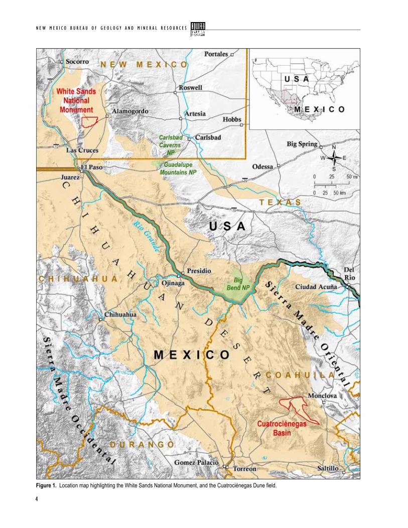
the Cuatrociénegas Basin is located in the in the Chihuahuan Desert, 160 miles (260 km)
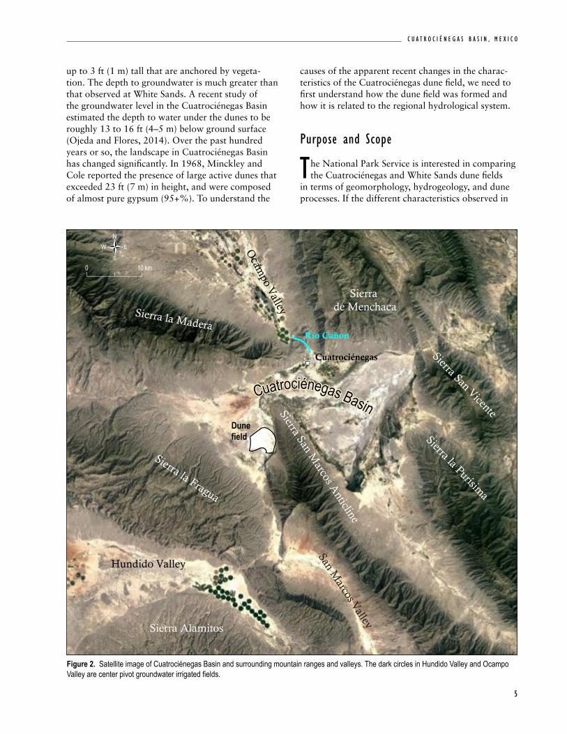
southeast of Big Bend National Park, TX, in the Mexican state of Coahuila (Fig. 1). Surrounded by sharply rising mountains with significant topo-graphic relief, the valley floor is dotted by more than 500 springs supported by a complex hydrogeologic flow system (Wolaver, 2008). The abundant water resources help maintain the unique habitats that support more than 70 endemic species, ranging from snails to stromatolites. This remarkably high level of endemism in such a small basin (335 mi2, 870 km2) has lead researchers to compare Cuatrociénegas with the Galápagos Islands (Taylor and Minckley, 1966). In the 1960s, there was a flurry of papers published describing the unique flora and fauna found in the Cuatrociénegas Basin. The Desert Fishes website (desertfishes.org/cuatroc), a webpage dedicated to curating a citation database of work done in the Cuatrociénegas Basin, has a bibliography of more than 900 citations that reference the Cuatrociénegas Basin, the vast majority of which pertain to the basins high level of endemism. To protect the basin’s endemic and endangered fauna that depend on the consistent spring-water flow, the Cuatrociénegas Basin was declared a National Protected Area in 1994 by the Mexican government. Prior to development, there are reports of extensive marshes covering much of the eastern sub-basin of Cuatrociénegas (Contreras-Balderas, 1984). Historic photographs show Laguna Grande, a large spring fed lake, dominating the western sub-basin (Minckley, 1992). In the 1970s, groundwater levels were close to ground surface in upgradient val-leys to the north (Ocampo Valley) and to the south (Hundido Valley; Fig.2; Wolaver, 2008). The basin was first artificially opened in 1898 to allow a canal to drain water to basins east of Cuatrociénegas to support agriculture. Today, the wetlands have been largely been interconnected with canals and drained with only a few sparse patches remaining near springs and terminal lakes. In the Ocampo Valley industrial scale agricultural development (approximately 44,000 acre-ft/yr; Lesser y Asociados, 2001) for alfalfa began in the mid-1980s, which has led to groundwater
i . i N t r o d u c t i o N
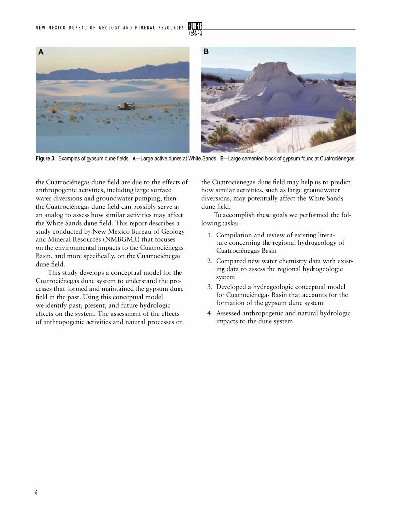
levels declining by ~3 ft/yr (1 m/yr). The Río Cañon spring-fed river, which used to flow from the Ocampo Valley and supported irrigated agriculture near the town of Cuatrociénegas, no longer flow (Wolaver et al., 2008). Large center pivot agriculture wells were installed in Hundido Valley to the south in the early 2000’s. The valley has since experienced more than 65 ft (20 m) of drawdown (Wolaver, 2008). Laguna Grande entirely dried up in 2010, leaving an empty playa lake bed. One of the most unique and least studied features in the basin is the gypsum dune field, located in the southwestern corner of the basin. The Cuatrociénegas dune field is one of only a handful of gypsum dune fields in the world, and is the second largest behind only White Sands National Monument in NM, USA (Fig.1). Linked by the common landscape, the Área de Protección de Flora y Fauna Cuatrociénegas became a sister park with White Sands National Monument in 2006. This partnership allows for shared research and resource management techniques (https://www.nps.gov/whsa/learn/nature/cuatrocienegas.htm). While gypsum dune fields link the parks, at present there are stark morphological difference between the two dune fields (Fig. 3). The dune field at White Sands occupies an area of roughly 270 mi2 (700 km2) in the Tularosa Basin of southern New Mexico. The White Sands dune field is considered to be a “wet” system due to a very shallow water table that is less than 3 ft (1 m) below the ground surface in the interdunal areas between dune crests (Kocurek and Havholm, 1994). The dune field is composed of dome, barchanoid/ transverse ridge, barchan, and parabolic dunes that reach as tall as 60 ft (18 m) (Fig. 3A). The White Sands dune field is an active system, with dunes slowly migrating northeast across the dune field at approximately 4–5 ft (~1.5 m) per year (Fryberger, 2001). The Cuatrociénegas gypsum field is significantly smaller than White Sands, occupying roughly 3 mi2 (8 km2). At present, the Cuatrociénegas dune field is dominated by lithified blocks of gypsum. Preserved in these cemented relics are bedding planes which indicate that large dunes once dominated the area (Fig. 3B). Today there are only small active dunes
N E W M E X I C O B U R E A U O F G E O L O G Y A N D M I N E R A L R E S O U R C E S
4
Figure 1. Location map highlighting the White Sands National Monument, and the Cuatrociénegas Dune field.
5
C u a t r o C i é n e g a s B a s i n , m e x i C o
up to 3 ft (1 m) tall that are anchored by vegeta-tion. The depth to groundwater is much greater than that observed at White Sands. A recent study of the groundwater level in the Cuatrociénegas Basin estimated the depth to water under the dunes to be roughly 13 to 16 ft (4–5 m) below ground surface (Ojeda and Flores, 2014). Over the past hundred years or so, the landscape in Cuatrociénegas Basin has changed significantly. In 1968, Minckley and Cole reported the presence of large active dunes that exceeded 23 ft (7 m) in height, and were composed of almost pure gypsum (95+%). To understand the
causes of the apparent recent changes in the charac-teristics of the Cuatrociénegas dune field, we need to first understand how the dune field was formed and how it is related to the regional hydrological system.
Purpose and scope
the National Park Service is interested in comparing the Cuatrociénegas and White Sands dune fields
in terms of geomorphology, hydrogeology, and dune processes. If the different characteristics observed in
Figure 2. Satellite image of Cuatrociénegas Basin and surrounding mountain ranges and valleys. The dark circles in Hundido Valley and Ocampo Valley are center pivot groundwater irrigated fields.
Río Cañon
Sierra la Madera
Sierra de Menchaca
Sierra San Marcos A
nticline
Sierra la Purísima
Sierra la Fragua
Sierra San Vicente
Sierra Alamitos
San Marcos Valley
Ocam
po Valley
Hundido Valley
Dunefield
Cuatrociénegas
Cuatrociénegas BasinCuatrociénegas Basin
0 10 km
N E W M E X I C O B U R E A U O F G E O L O G Y A N D M I N E R A L R E S O U R C E S
6
Figure 3. Examples of gypsum dune fields. A—Large active dunes at White Sands. B—Large cemented block of gypsum found at Cuatrociénegas.
A B
the Cuatrociénegas dune field are due to the effects of anthropogenic activities, including large surface water diversions and groundwater pumping, then the Cuatrociénegas dune field can possibly serve as an analog to assess how similar activities may affect the White Sands dune field. This report describes a study conducted by New Mexico Bureau of Geology and Mineral Resources (NMBGMR) that focuses on the environmental impacts to the Cuatrociénegas Basin, and more specifically, on the Cuatrociénegas dune field. This study develops a conceptual model for the Cuatrociénegas dune system to understand the pro-cesses that formed and maintained the gypsum dune field in the past. Using this conceptual model we identify past, present, and future hydrologic effects on the system. The assessment of the effects of anthropogenic activities and natural processes on
the Cuatrociénegas dune field may help us to predict how similar activities, such as large groundwater diversions, may potentially affect the White Sands dune field. To accomplish these goals we performed the fol-lowing tasks:
1. Compilation and review of existing litera-ture concerning the regional hydrogeology of Cuatrociénegas Basin
2. Compared new water chemistry data with exist-ing data to assess the regional hydrogeologic system
3. Developed a hydrogeologic conceptual model for Cuatrociénegas Basin that accounts for the formation of the gypsum dune system
4. Assessed anthropogenic and natural hydrologic impacts to the dune system

7
C u a t r o C i é n e g a s B a s i n , m e x i C o
Gypsum dunes
dune fields are typically composed of silica and a mix of other minerals of low solubility that are
eroded by fluvial, alluvial, coastal or lacustrine sys-tems. Less common are dunes that are formed by the deflation of evaporite deposits. Dune fields composed of evaporite deposits are dependent on a variety of factors at a local and regional scale. Evaporites are water- soluble mineral sediments that result from the concentration of salt-rich waters. As these waters evaporate, dissolved ions are concentrated to the point of saturation, at which point minerals begin to precipitate and come out of solution. These minerals are often preserved in place, however, in the case of dune fields, the minerals are then broken down, and transported by wind. In the Persian Gulf area, and a few other coastal marine settings, there are dune deposits composed of evaporated seawater deposits that form on salt flats called sabkhas, (Fryberger, S.G., 2001). In the southwest region of North America, mostly within the Chihuahuan Desert, there are four known accumulations of gypsum sediment from the deflation of lacustrine evaporites. Figure 4 shows the four different basins in the southwestern North America (U.S. and Mexico) that contain gyp-sum dune fields. This region is one of the only places in the world that has the unique balance of geologic, hydrologic and climatic conditions required to build and support gypsum dune fields. Almost all of what we know about gypsum sand dunes has been learned from the White Sands National Monument gypsum dune field. White Sands is by far the most studied and well understood gypsum dune system in the world, and as result, we use it as the primary point of refer-ence from which Cuatrociénegas is studied. A delicate balance of environmental factors is required for gypsum to accumulate as sand. For gyp-sum to form, a source of calcium and sulfate (the con-stituents of gypsum) is required. In the case of all four gypsum fields in the southwest, the mineral elements are derived from the surrounding mountains that are made of Paleozoic and Mesozoic age marine sedimen-tary rocks (Szynkiewicz et al., 2010). Calcium and sulfate are transported to the basin by water. Water
i i . B a c k G r o u N d
slowly flows down gradient through the aquifers, dis-solving ions from the mountain aquifers. This water must remain in contact with the aquifers long enough to dissolve calcium and sulfate from the rock units. Another source of calcium and sulfate is possibly the basin fill sediments that cover the valley floor, which was eroded from the surrounding mountains. The water is eventually discharged from springs or streams that flow into closed basins before collect-ing in terminal lakes. A closed basin, also known as
Figure 4. Map showing the location of the four basins that contain gypsum dune fields in Southwestern North America.
N E W M E X I C O B U R E A U O F G E O L O G Y A N D M I N E R A L R E S O U R C E S
8
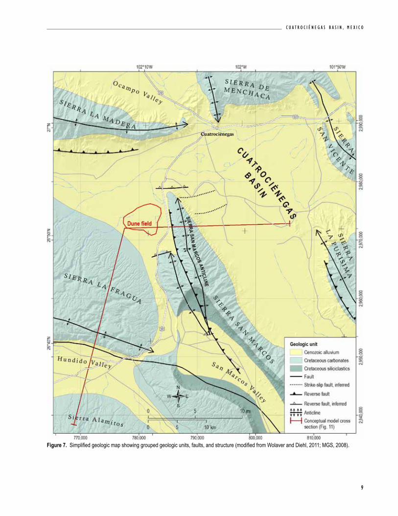
(740 m) asl, and is dotted with more than 500 spring pools. The entire basin is surrounded by sharply ris-ing anticlinal mountains, reaching 9840 ft (3000 m) asl (Fig. 7). To the north, the basin is bounded by the Sierra la Madera and the Sierra de Menchaca. The Sierra San Marcos is a north plunging anticline that divides the basin into eastern and western sub-valleys. Sierra la Purísima and Sierra San Vicente comprise the eastern and northeastern boundaries, while Sierra la Fragua forms the western boundary.
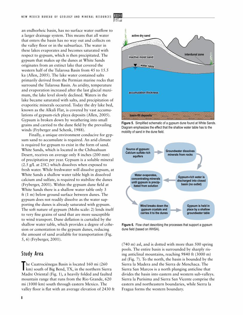
an endhorheic basin, has no surface water outflow to a larger drainage system. This means that all water that enters the basin has no way out and collects on the valley floor or in the subsurface. The water in these lakes evaporates and becomes saturated with respect to gypsum, which is then precipitated. The gypsum that makes up the dunes at White Sands originates from an extinct lake that covered the western half of the Tularosa Basin from 45 to 15.5 ka (Allen, 2005). The lake water contained salts primarily derived from the Permian marine rocks that surround the Tularosa Basin. As aridity, temperature and evaporation increased after the last glacial maxi-mum, the lake level slowly declined. Waters in the lake became saturated with salts, and precipitation of evaporitic minerals occurred. Today the dry lake bed, known as the Alkali Flat, is covered by vast accumu-lations of gypsum-rich playa deposits (Allen, 2005). Gypsum is broken down by weathering into small grains and carried to the dune field by the prevailing winds (Fryberger and Schenk, 1988). Finally, a unique environment conducive for gyp-sum sand to accumulate is required. An arid climate is required for gypsum to exist in the form of sand. White Sands, which is located in the Chihuahuan Desert, receives on average only 8 inches (200 mm) of precipitation per year. Gypsum is a soluble mineral (2.5 g/L at 25C) which dissolves when exposed to fresh water. While freshwater will dissolve gypsum, at White Sands a shallow water table high in dissolved calcium and sulfate, is required to stabilize the dunes (Fryberger, 2001). Within the gypsum dune field at White Sands there is a shallow water table only 3 ft (1 m) below ground surface between dunes. The gypsum does not readily dissolve as the water sup-porting the dunes is already saturated with gypsum. The soft nature of gypsum (Mohs scale: 2) lends itself to very fine grains of sand that are more susceptible to wind transport. Dune deflation is curtailed by the shallow water table, which provides a degree of cohe-sion or cementation to the gypsum dunes, reducing the amount of sand available for transportation (Fig. 5, 6) (Fryberger, 2001).
study area
the Cuatrociénegas Basin is located 160 mi (260 km) south of Big Bend, TX, in the northern Sierra
Madre Oriental (Fig. 1), a heavily folded and faulted mountain range that runs from the Rio Grande, 620 mi (1000 km) south through eastern Mexico. The valley floor is flat with an average elevation of 2430 ft
interdunal zone
active dry sand
water tablewater table
accumulation thicknessaccumulation thickness
inactive moist sandinactive moist sand
basin-fill depositsbasin-fill deposits
Figure 5. Simplified schematic of a gypsum dune found at White Sands. Diagram emphasizes the effect that the shallow water table has to the mobility of sand in the dune field.
Figure 6. Flow chart describing the processes that support a gypsum dune field (based on WHSA).
Source of gypsum: Calcium sulfate rich
aquifers
Water evaporates, concentrating minerals until gypsum is precip-
itated from solution
Groundwater dissolves minerals from rocks
Gypsum-rich water is discharged into closed
basin (no outlet)
Gypsum is held in place by a shallow groundwater table
Wind breaks down the gypsum crystals and carries it to the dunes
9
C u a t r o C i é n e g a s B a s i n , m e x i C o
Figure 7. Simplified geologic map showing grouped geologic units, faults, and structure (modified from Wolaver and Diehl, 2011; MGS, 2008).
N E W M E X I C O B U R E A U O F G E O L O G Y A N D M I N E R A L R E S O U R C E S
10
3.00
2.50
1.50
2.00
1.00
0.5
0
Prec
ipitat
ion (in
ches
)Jan Feb Mar Apr May Jun Jul Aug Sep Oct Nov Dec
0.38 0.36 0.350.50
1.241.40 1.38
1.28
2.98
0.96
0.590.40
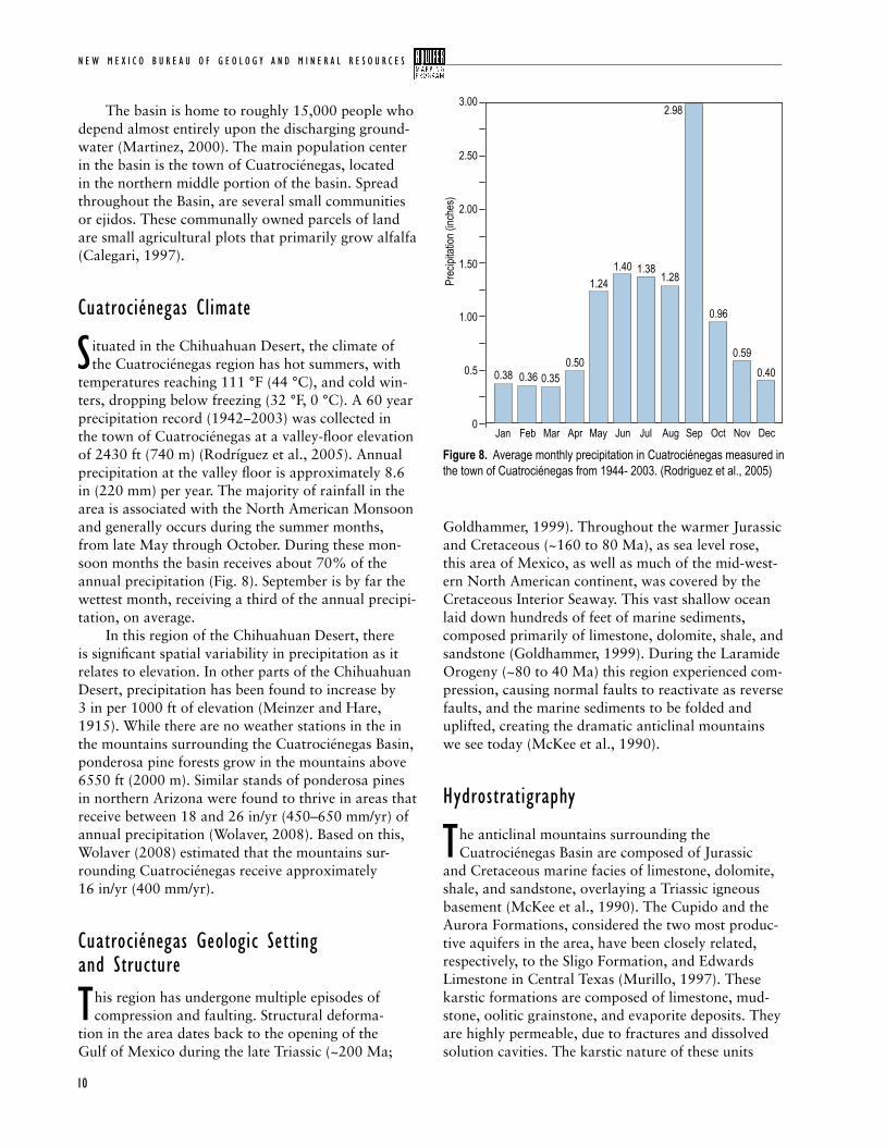
Figure 8. Average monthly precipitation in Cuatrociénegas measured in the town of Cuatrociénegas from 1944- 2003. (Rodriguez et al., 2005)
The basin is home to roughly 15,000 people who depend almost entirely upon the discharging ground-water (Martinez, 2000). The main population center in the basin is the town of Cuatrociénegas, located in the northern middle portion of the basin. Spread throughout the Basin, are several small communities or ejidos. These communally owned parcels of land are small agricultural plots that primarily grow alfalfa (Calegari, 1997).
cuatrociénegas climate
s ituated in the Chihuahuan Desert, the climate of the Cuatrociénegas region has hot summers, with
temperatures reaching 111 °F (44 °C), and cold win-ters, dropping below freezing (32 °F, 0 °C). A 60 year precipitation record (1942–2003) was collected in the town of Cuatrociénegas at a valley-floor elevation of 2430 ft (740 m) (Rodríguez et al., 2005). Annual precipitation at the valley floor is approximately 8.6 in (220 mm) per year. The majority of rainfall in the area is associated with the North American Monsoon and generally occurs during the summer months, from late May through October. During these mon-soon months the basin receives about 70% of the annual precipitation (Fig. 8). September is by far the wettest month, receiving a third of the annual precipi-tation, on average. In this region of the Chihuahuan Desert, there is significant spatial variability in precipitation as it relates to elevation. In other parts of the Chihuahuan Desert, precipitation has been found to increase by 3 in per 1000 ft of elevation (Meinzer and Hare, 1915). While there are no weather stations in the in the mountains surrounding the Cuatrociénegas Basin, ponderosa pine forests grow in the mountains above 6550 ft (2000 m). Similar stands of ponderosa pines in northern Arizona were found to thrive in areas that receive between 18 and 26 in/yr (450–650 mm/yr) of annual precipitation (Wolaver, 2008). Based on this, Wolaver (2008) estimated that the mountains sur-rounding Cuatrociénegas receive approximately 16 in/yr (400 mm/yr).
cuatrociénegas Geologic setting and structure
this region has undergone multiple episodes of compression and faulting. Structural deforma-
tion in the area dates back to the opening of the Gulf of Mexico during the late Triassic (~200 Ma;
Goldhammer, 1999). Throughout the warmer Jurassic and Cretaceous (~160 to 80 Ma), as sea level rose, this area of Mexico, as well as much of the mid-west-ern North American continent, was covered by the Cretaceous Interior Seaway. This vast shallow ocean laid down hundreds of feet of marine sediments, composed primarily of limestone, dolomite, shale, and sandstone (Goldhammer, 1999). During the Laramide Orogeny (~80 to 40 Ma) this region experienced com-pression, causing normal faults to reactivate as reverse faults, and the marine sediments to be folded and uplifted, creating the dramatic anticlinal mountains we see today (McKee et al., 1990).
Hydrostratigraphy
the anticlinal mountains surrounding the Cuatrociénegas Basin are composed of Jurassic
and Cretaceous marine facies of limestone, dolomite, shale, and sandstone, overlaying a Triassic igneous basement (McKee et al., 1990). The Cupido and the Aurora Formations, considered the two most produc-tive aquifers in the area, have been closely related, respectively, to the Sligo Formation, and Edwards Limestone in Central Texas (Murillo, 1997). These karstic formations are composed of limestone, mud-stone, oolitic grainstone, and evaporite deposits. They are highly permeable, due to fractures and dissolved solution cavities. The karstic nature of these units
11
C u a t r o C i é n e g a s B a s i n , m e x i C o
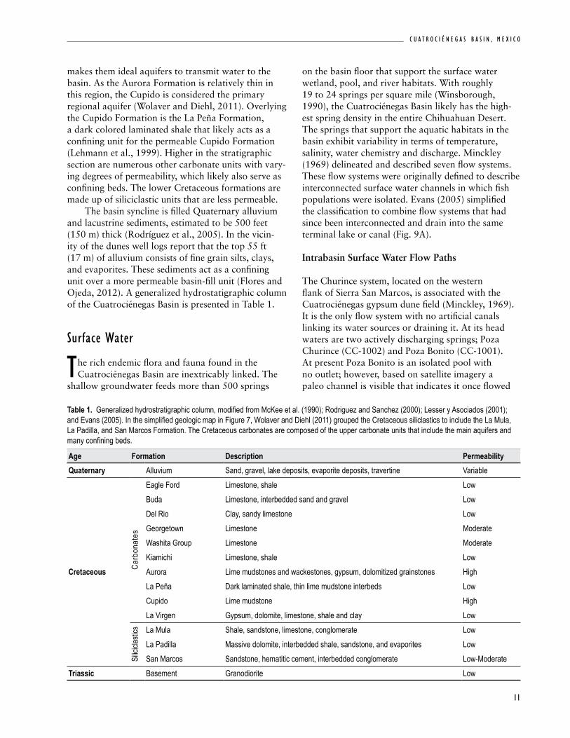
Table 1. Generalized hydrostratigraphic column, modified from McKee et al. (1990); Rodriguez and Sanchez (2000); Lesser y Asociados (2001); and Evans (2005). In the simplified geologic map in Figure 7, Wolaver and Diehl (2011) grouped the Cretaceous siliclastics to include the La Mula, La Padilla, and San Marcos Formation. The Cretaceous carbonates are composed of the upper carbonate units that include the main aquifers and many confining beds.
Age Formation Description PermeabilityQuaternary Alluvium Sand, gravel, lake deposits, evaporite deposits, travertine Variable
Cretaceous Carb
onat
es
Eagle Ford Limestone, shale LowBuda Limestone, interbedded sand and gravel LowDel Rio Clay, sandy limestone LowGeorgetown Limestone ModerateWashita Group Limestone ModerateKiamichi Limestone, shale LowAurora Lime mudstones and wackestones, gypsum, dolomitized grainstones HighLa Peña Dark laminated shale, thin lime mudstone interbeds LowCupido Lime mudstone HighLa Virgen Gypsum, dolomite, limestone, shale and clay Low
Silici
clasti
cs La Mula Shale, sandstone, limestone, conglomerate LowLa Padilla Massive dolomite, interbedded shale, sandstone, and evaporites LowSan Marcos Sandstone, hematitic cement, interbedded conglomerate Low-Moderate
Triassic Basement Granodiorite Low
makes them ideal aquifers to transmit water to the basin. As the Aurora Formation is relatively thin in this region, the Cupido is considered the primary regional aquifer (Wolaver and Diehl, 2011). Overlying the Cupido Formation is the La Peña Formation, a dark colored laminated shale that likely acts as a confining unit for the permeable Cupido Formation (Lehmann et al., 1999). Higher in the stratigraphic section are numerous other carbonate units with vary-ing degrees of permeability, which likely also serve as confining beds. The lower Cretaceous formations are made up of siliciclastic units that are less permeable. The basin syncline is filled Quaternary alluvium and lacustrine sediments, estimated to be 500 feet (150 m) thick (Rodríguez et al., 2005). In the vicin-ity of the dunes well logs report that the top 55 ft (17 m) of alluvium consists of fine grain silts, clays, and evaporites. These sediments act as a confining unit over a more permeable basin-fill unit (Flores and Ojeda, 2012). A generalized hydrostatigraphic column of the Cuatrociénegas Basin is presented in Table 1.
surface water
the rich endemic flora and fauna found in the Cuatrociénegas Basin are inextricably linked. The
shallow groundwater feeds more than 500 springs
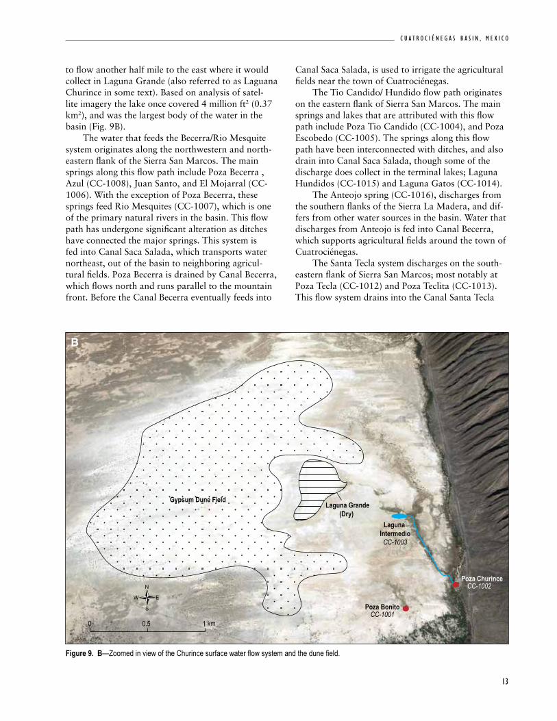
on the basin floor that support the surface water wetland, pool, and river habitats. With roughly 19 to 24 springs per square mile (Winsborough, 1990), the Cuatrociénegas Basin likely has the high-est spring density in the entire Chihuahuan Desert. The springs that support the aquatic habitats in the basin exhibit variability in terms of temperature, salinity, water chemistry and discharge. Minckley (1969) delineated and described seven flow systems. These flow systems were originally defined to describe interconnected surface water channels in which fish populations were isolated. Evans (2005) simplified the classification to combine flow systems that had since been interconnected and drain into the same terminal lake or canal (Fig. 9A).
Intrabasin Surface Water Flow Paths
The Churince system, located on the western flank of Sierra San Marcos, is associated with the Cuatrociénegas gypsum dune field (Minckley, 1969). It is the only flow system with no artificial canals linking its water sources or draining it. At its head waters are two actively discharging springs; Poza Churince (CC-1002) and Poza Bonito (CC-1001). At present Poza Bonito is an isolated pool with no outlet; however, based on satellite imagery a paleo channel is visible that indicates it once flowed

N E W M E X I C O B U R E A U O F G E O L O G Y A N D M I N E R A L R E S O U R C E S
12
Figure 9. A—Map showing the different surface water flow paths with arrows, along with their principle springs. Overlaid on the map are the three different groundwater type discharge areas.
Rio Mezuites CC-1007
Poza TeclaCC-1012
Pozas AzulesCC-1010
Poza Tio CandidoCC-1004
Poza EscobedoCC-1005
Pozo San Marcos (well)
CC-0002
Poza BonitoCC-1001
Poza ChurinceCC-1002
Laguna IntermedioCC-1003
Poza Becerra
Poza Juan Santo
Poza AzulCC-1008
Poza AnteojoCC-1016
Rio Mezuites CC-1007
Poza TeclaCC-1012
Poza TeclitaCC-1013
Pozas AzulesCC-1010
Poza Tio CandidoCC-1004
Poza EscobedoCC-1005
Pozo San Marcos (well)
CC-0002
Poza BonitoCC-1001
Poza ChurinceCC-1002
Laguna IntermedioCC-1003
Poza Becerra
Poza Juan Santo
Poza AzulCC-1008
Poza AnteojoCC-1016
0 10 5 km
Becerra/Rio Mesquite systemChurince systemTio Candido/Hundido systemSanta Tecla systemAnteojo system
River/canalTerminal lake (laguna)Surface water flow directionPrinciple contributing spring
Surface water flow systemPrimary discharge areaSanta Tecla discharge areaAnteojo discharge area
Groundwater type discharge area
CuatrocienegasCuatrocienegas
Sierra San Marcos
Sierra la Madera
Laguna GatosCC-1014
Laguna HundidoCC-1015
Laguna Grande
Figure 9b
(dry)
Poza MojarraCC-1006
Canal Saca
Salada
Canal B
ecerra
Canal Saca
Salada
Canal B
ecerra
northwest, and connected to the rest of the Churince system. The primary Churince system flows north-west from Poza Churince in a meandering channel. This stream first feeds Laguna Intermedio, a shallow lake with an area of roughly 161,000 ft2
(15,000 m2). To the northeast of the lake there are several dry pools that appear to have once fed into the system. At present Laguana Intermedio (CC-1003) is the terminal lake in this flow system, however, until quite recently (2010), water continued
Rio Mezuites CC-1007
Poza TeclaCC-1012
Pozas AzulesCC-1010
Poza Tio CandidoCC-1004
Poza EscobedoCC-1005
Pozo San Marcos (well)
CC-0002
Poza BonitoCC-1001
Poza ChurinceCC-1002
Laguna IntermedioCC-1003
Poza Becerra
Poza Juan Santo
Poza AzulCC-1008
Poza AnteojoCC-1016
Rio Mezuites CC-1007
Poza TeclaCC-1012
Poza TeclitaCC-1013
Pozas AzulesCC-1010
Poza Tio CandidoCC-1004
Poza EscobedoCC-1005
Pozo San Marcos (well)
CC-0002
Poza BonitoCC-1001
Poza ChurinceCC-1002
Laguna IntermedioCC-1003
Poza Becerra
Poza Juan Santo
Poza AzulCC-1008
Poza AnteojoCC-1016
0 10 5 km
Becerra/Rio Mesquite systemChurince systemTio Candido/Hundido systemSanta Tecla systemAnteojo system
River/canalTerminal lake (laguna)Surface water flow directionPrinciple contributing spring
Surface water flow systemPrimary discharge areaSanta Tecla discharge areaAnteojo discharge area
Groundwater type discharge area
CuatrocienegasCuatrocienegas
Sierra San Marcos
Sierra la Madera
Laguna GatosCC-1014
Laguna HundidoCC-1015
Laguna Grande
Figure 9b
(dry)
Poza MojarraCC-1006
Canal Saca
Salada
Canal B
ecerra
Canal Saca
Salada
Canal B
ecerra
A
13
C u a t r o C i é n e g a s B a s i n , m e x i C o
to flow another half mile to the east where it would collect in Laguna Grande (also referred to as Laguana Churince in some text). Based on analysis of satel-lite imagery the lake once covered 4 million ft2 (0.37 km2), and was the largest body of the water in the basin (Fig. 9B). The water that feeds the Becerra/Rio Mesquite system originates along the northwestern and north-eastern flank of the Sierra San Marcos. The main springs along this flow path include Poza Becerra , Azul (CC-1008), Juan Santo, and El Mojarral (CC-1006). With the exception of Poza Becerra, these springs feed Rio Mesquites (CC-1007), which is one of the primary natural rivers in the basin. This flow path has undergone significant alteration as ditches have connected the major springs. This system is fed into Canal Saca Salada, which transports water northeast, out of the basin to neighboring agricul-tural fields. Poza Becerra is drained by Canal Becerra, which flows north and runs parallel to the mountain front. Before the Canal Becerra eventually feeds into
Canal Saca Salada, is used to irrigate the agricultural fields near the town of Cuatrociénegas. The Tio Candido/ Hundido flow path originates on the eastern flank of Sierra San Marcos. The main springs and lakes that are attributed with this flow path include Poza Tio Candido (CC-1004), and Poza Escobedo (CC-1005). The springs along this flow path have been interconnected with ditches, and also drain into Canal Saca Salada, though some of the discharge does collect in the terminal lakes; Laguna Hundidos (CC-1015) and Laguna Gatos (CC-1014). The Anteojo spring (CC-1016), discharges from the southern flanks of the Sierra La Madera, and dif-fers from other water sources in the basin. Water that discharges from Anteojo is fed into Canal Becerra, which supports agricultural fields around the town of Cuatrociénegas. The Santa Tecla system discharges on the south-eastern flank of Sierra San Marcos; most notably at Poza Tecla (CC-1012) and Poza Teclita (CC-1013). This flow system drains into the Canal Santa Tecla
Figure 9. B—Zoomed in view of the Churince surface water flow system and the dune field.
Laguna Grande(Dry)
Gypsum Dune Field
Laguna Intermedio
CC-1003
0 1 0.5 km
Poza BonitoCC-1001
Poza ChurinceCC-1002
B
N E W M E X I C O B U R E A U O F G E O L O G Y A N D M I N E R A L R E S O U R C E S
14
and carries water northeast out of the basin where it combines with Canal Saca Salada and is used for agri-cultural purposes outside of the basin. Pozas Azules (CC-1010) and several other small pools discharge to the north of Poza Tecla and are connected via canals to the Santa Tecla system. In total, the canals drain roughly 28,400 acre-ft/yr (35,000,000 m3/yr) from the Cuatrociénegas Basin. The vast majority (23,500 acre-ft/yr, 29,000,000 m3/ year) of the water originates from the Becerra/ Rio Mesquite system, and the Candido/Hundidos system, which is routed through the Seca Salada Canal. The Santa Tecla Canal that drains much of the southeast-ern portion of the basin accounts for 4800 acre-ft/yr (6,000,000 m3/yr) of water that leaves the basin. Canal flow rates do not include water leaving the basin via evaporation or leakage through the canal bottom. Most of the canals are neither lined, nor covered. Estimates of water lost to evaporation and leakage are significant, ranging from 10 to 80 percent of the water drained from the pools.
Surface Water Sources
Of the five flow systems within the basin there are three different water types, which are inferred to have different groundwater sources (Fig. 9A; Evans, 2005). The primary groundwater type that feeds the basin, and accounts for 85% of flow (Wolaver, 2008), occurs on the western and northeastern flanks of Sierra San Marcos (Evans, 2005). This primary groundwater type provides water to the Churince system, the Becerra/Rio Mesquite system, and the Candido/Hundidos system (Fig. 9A). These calcium-sulfate rich waters generally have a higher total dissolved solids (TDS) (~2250 mg/L) and elevated temperatures. The Anteojo system discharges from the southern flanks of the Sierra La Madera, in the north-central area of the basin and differs from other water in the basin (Fig. 9A). The predominant geochemical water type was also calcium-sulfate, however it has lower TDS (1740 mg/L) (Evans, 2005). Stable isotopic anal-ysis by Johannesson et al. (2004) suggests that the recharge elevation to Anteojo is significantly higher than other sources that are discharging to the basin. Recharge likely originates from Sierra la Madera, which is the highest peak in the area. The third water type, found in the Santa Tecla system, discharges on the southeastern flank of Sierra San Marcos (Fig. 9A); most notably at Poza Tecla (CC-1012) and Teclita (CC-1012), and also has a
distinct chemical signature. The water feeding this flow system is less evolved as it has a significantly lower TDS (625 mg/L) and is richer in calcium-bicarbonate. It has been suggested that this system is a mix of both regionally and locally-derived flow (Johannesson et al., 2004; Evans, 2005; Wolaver et al., 2008).
Hydrogeologic conceptual Model
in 2001, as agricultural demand for water in neighboring Hundido Valley increased, concern
arose that the addition of numerous high-capacity wells may have an impact on the groundwater flow that supports the unique biomes present in the Cuatrociénegas Basin. This initial interest in the groundwater led to several studies that attempted to understand the complex hydrogeologic system that supports the wetlands. An initial cooperative study was carried out by several Mexican govern-ment agencies: The Secretary of Environmental and Natural Resources (SEMARNAT), the Mexican Institute of Water Technology (IMTA), the National Water Commission (CNA), and the National insti-tute of Ecology (INE) (Rodríguez et al., 2005). This first major study initially determined that the springs that discharge in the Cuatrociénegas Basin are supported primarily by recharge that occurs locally in the mountains immediately surround-ing the Cuatrociénegas Basin. This accounts for a relatively small recharge area, covering only 1550 mi2 (4000 km2) of mountains. The report goes on to suggest that Cuatrociénegas is not hydrologically connected to the neighboring valleys, specifically Hundido Valley. A doctoral study published by Wolaver (2008) re-examined the initial hydrologic conceptual model; performing several additional analyses to test some of the assumptions made by Rodríguez et al. (2005), and to better characterize the groundwa-ter flow system. This second study determined that the water discharging in the Cuatrociénegas Basin was instead associated with a much larger regional groundwater flow system that better accounts for the remarkable volume of water found in the basin. The larger regional conceptual model assumes a much larger recharge area of approximately 7000 mi2 (18,000 km2). The larger regional conceptual model is grounded on a basic water balance calculation: the volume of water that enters the system as recharge should be equal to or more than the volume of water

15
C u a t r o C i é n e g a s B a s i n , m e x i C o
leaving the basin via the canal system. The recharge area confined to the 1550 mi2 (4000 km2) drainage basin surrounding the Cuatrociénegas Basin, (Lesser y Asociados, 2001; Rodríguez et al., 2005), accounts for only 174 acre-ft/yr (215,000 m3/year). The recharge estimate for the local drainage basin is two orders of magnitude less than the measured discharge of 28,400 acre-ft (35,000,000 m3) per year leaving the basin via the canals (Wolaver et al., 2008). From this central point, it is argued that the basin is fed by a much larger regional groundwater flow
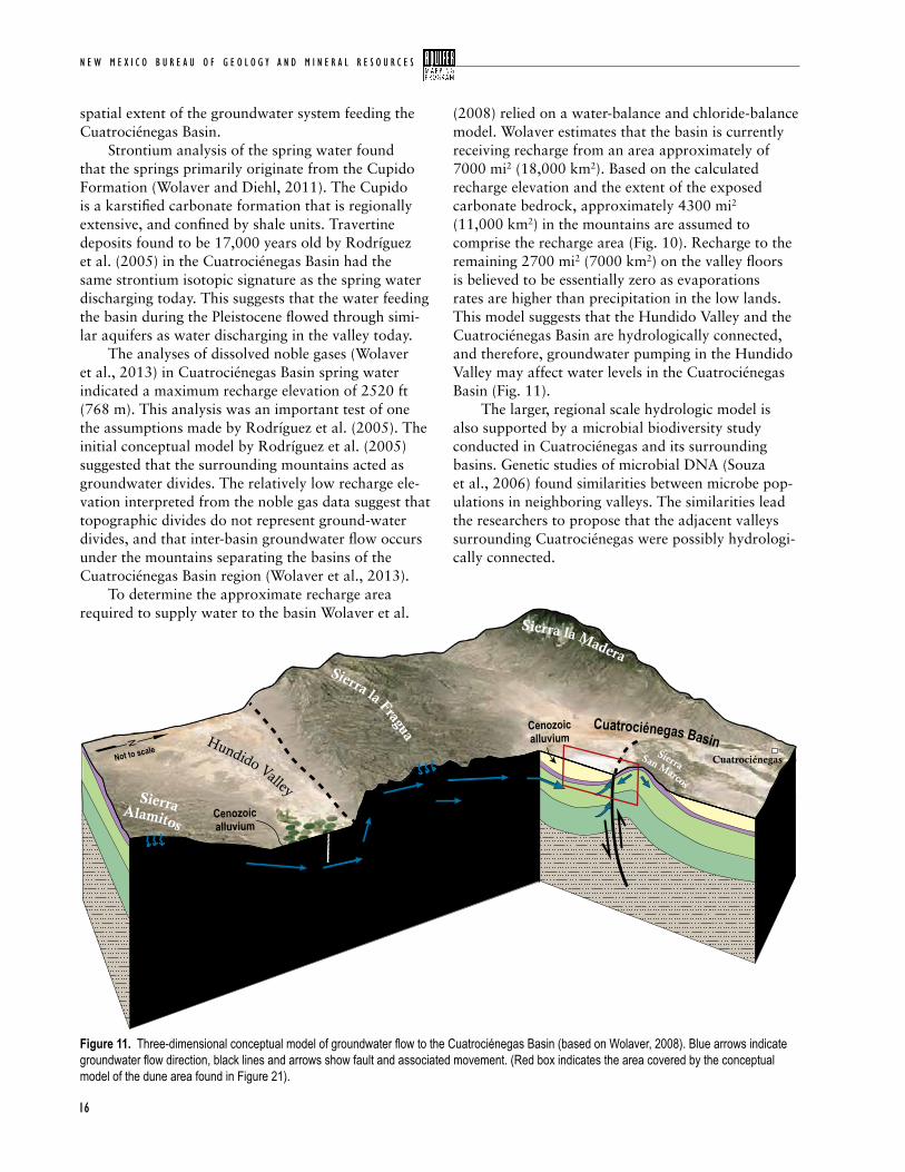
system, beyond the drainage basin immediately surrounding the Cuatrociénegas Basin. The regional conceptual model suggests that water is able to be transmitted between basins via the confined karstic aquifers in the area (Fig. 10). To support this con-ceptual model, Wolaver et al. (2008) re-evaluated the existing data from Rodríguez et al. (2005). Wolaver also conducted additional analysis of the water sources; preforming strontium isotope and noble gas analysis, as well as chloride mass balance analysis to evaluate recharge processes, residence times, and the
Figure 10. Regional conceptual model showing the groundwater flow paths that support the three main water types in the basin, and their recharge areas (based on Wolaver, 2008).
N E W M E X I C O B U R E A U O F G E O L O G Y A N D M I N E R A L R E S O U R C E S
16
spatial extent of the groundwater system feeding the Cuatrociénegas Basin. Strontium analysis of the spring water found that the springs primarily originate from the Cupido Formation (Wolaver and Diehl, 2011). The Cupido is a karstified carbonate formation that is regionally extensive, and confined by shale units. Travertine deposits found to be 17,000 years old by Rodríguez et al. (2005) in the Cuatrociénegas Basin had the same strontium isotopic signature as the spring water discharging today. This suggests that the water feeding the basin during the Pleistocene flowed through simi-lar aquifers as water discharging in the valley today. The analyses of dissolved noble gases (Wolaver et al., 2013) in Cuatrociénegas Basin spring water indicated a maximum recharge elevation of 2520 ft (768 m). This analysis was an important test of one the assumptions made by Rodríguez et al. (2005). The initial conceptual model by Rodríguez et al. (2005) suggested that the surrounding mountains acted as groundwater divides. The relatively low recharge ele-vation interpreted from the noble gas data suggest that topographic divides do not represent ground-water divides, and that inter-basin groundwater flow occurs under the mountains separating the basins of the Cuatrociénegas Basin region (Wolaver et al., 2013). To determine the approximate recharge area required to supply water to the basin Wolaver et al.
(2008) relied on a water-balance and chloride-balance model. Wolaver estimates that the basin is currently receiving recharge from an area approximately of 7000 mi2 (18,000 km2). Based on the calculated recharge elevation and the extent of the exposed carbonate bedrock, approximately 4300 mi2 (11,000 km2) in the mountains are assumed to comprise the recharge area (Fig. 10). Recharge to the remaining 2700 mi2 (7000 km2) on the valley floors is believed to be essentially zero as evaporations rates are higher than precipitation in the low lands. This model suggests that the Hundido Valley and the Cuatrociénegas Basin are hydrologically connected, and therefore, groundwater pumping in the Hundido Valley may affect water levels in the Cuatrociénegas Basin (Fig. 11). The larger, regional scale hydrologic model is also supported by a microbial biodiversity study conducted in Cuatrociénegas and its surrounding basins. Genetic studies of microbial DNA (Souza et al., 2006) found similarities between microbe pop-ulations in neighboring valleys. The similarities lead the researchers to propose that the adjacent valleys surrounding Cuatrociénegas were possibly hydrologi-cally connected.
Figure 11. Three-dimensional conceptual model of groundwater flow to the Cuatrociénegas Basin (based on Wolaver, 2008). Blue arrows indicate groundwater flow direction, black lines and arrows show fault and associated movement. (Red box indicates the area covered by the conceptual model of the dune area found in Figure 21).
Cretaceous siliciclastic
Triassic granodiorite
Cretaceous carbonates
Hundido Valley
Cuatrociénegas Basin
Sierra Alamitos
Sierra San Marcos
Sierra la Fragua
Sierra la Madera
Cuatrociénegas
Well
Not to scale
17
C u a t r o C i é n e g a s B a s i n , m e x i C o
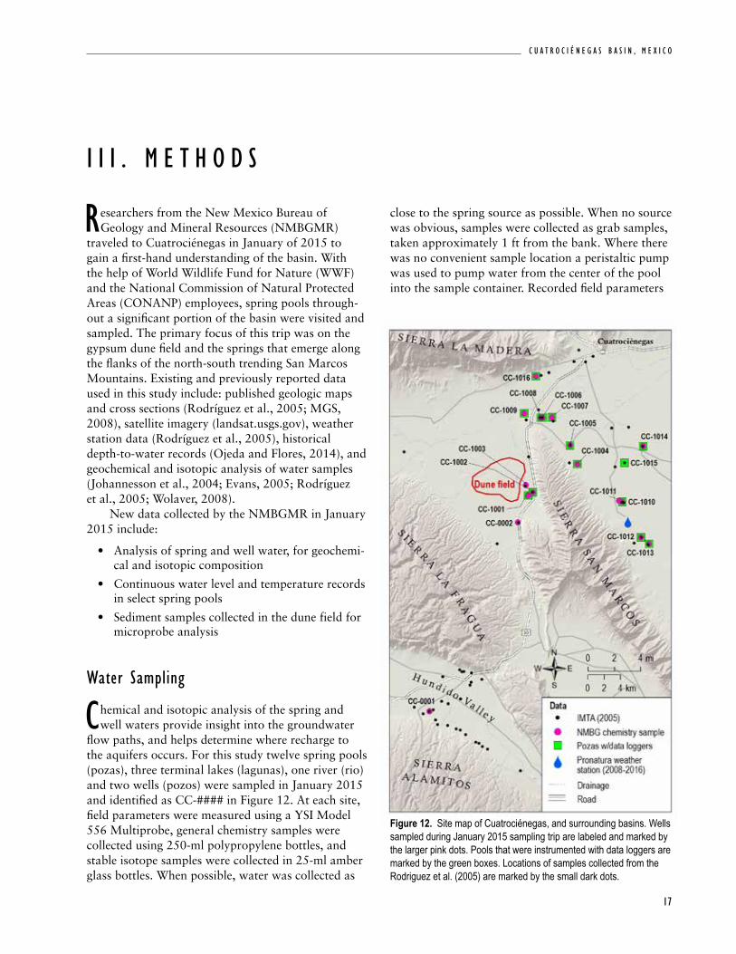
close to the spring source as possible. When no source was obvious, samples were collected as grab samples, taken approximately 1 ft from the bank. Where there was no convenient sample location a peristaltic pump was used to pump water from the center of the pool into the sample container. Recorded field parameters
researchers from the New Mexico Bureau of Geology and Mineral Resources (NMBGMR)
traveled to Cuatrociénegas in January of 2015 to gain a first-hand understanding of the basin. With the help of World Wildlife Fund for Nature (WWF) and the National Commission of Natural Protected Areas (CONANP) employees, spring pools through-out a significant portion of the basin were visited and sampled. The primary focus of this trip was on the gypsum dune field and the springs that emerge along the flanks of the north-south trending San Marcos Mountains. Existing and previously reported data used in this study include: published geologic maps and cross sections (Rodríguez et al., 2005; MGS, 2008), satellite imagery (landsat.usgs.gov), weather station data (Rodríguez et al., 2005), historical depth-to-water records (Ojeda and Flores, 2014), and geochemical and isotopic analysis of water samples (Johannesson et al., 2004; Evans, 2005; Rodríguez et al., 2005; Wolaver, 2008). New data collected by the NMBGMR in January 2015 include:
• Analysis of spring and well water, for geochemi-cal and isotopic composition
• Continuous water level and temperature records in select spring pools
• Sediment samples collected in the dune field for microprobe analysis
water sampling
chemical and isotopic analysis of the spring and well waters provide insight into the groundwater
flow paths, and helps determine where recharge to the aquifers occurs. For this study twelve spring pools (pozas), three terminal lakes (lagunas), one river (rio) and two wells (pozos) were sampled in January 2015 and identified as CC-#### in Figure 12. At each site, field parameters were measured using a YSI Model 556 Multiprobe, general chemistry samples were collected using 250-ml polypropylene bottles, and stable isotope samples were collected in 25-ml amber glass bottles. When possible, water was collected as
i i i . M e t H o d s
Figure 12. Site map of Cuatrociénegas, and surrounding basins. Wells sampled during January 2015 sampling trip are labeled and marked by the larger pink dots. Pools that were instrumented with data loggers are marked by the green boxes. Locations of samples collected from the Rodriguez et al. (2005) are marked by the small dark dots.
N E W M E X I C O B U R E A U O F G E O L O G Y A N D M I N E R A L R E S O U R C E S
18
Table 2. Basic field parameters and characteristic of the water sources visited during the January, 2015 sampling period. Surface area measured using Google Earth. Annual average temperature recorded by the data loggers. Gypsum saturation index values above saturation are denoted in bold. (Site type: GW- groundwater well; SP- spring pool; L- terminal lake; R- river)
include temperature, conductivity, total dissolved solids, pH, resistivity, oxidation reduction potential, and dissolved oxygen. Samples to be analyzed for trace metals were collected at select sites in 125-ml polypropylene bottles. Samples were filtered through an inline 0.45 μm filter. The major ion, trace metals, and stable isotopic analysis were performed by the NMBG Analytical Chemistry Laboratory (Appendix 1) (Timmons et al., 2013). The majority of the spring pools that were sampled during this collection interval had previously been sampled by Rodríguez et al. (2005) or Evans (2005). Comparing the results from the geochemical analysis conducted 10 years ago to our 2015 sam-pling allows us to determine if any changes to the hydrogeologic system have occurred.
To further analyze the water chemistry results, geochemical modeling was conducted using PHREEQC (Parkhurst and Appelo, 1999). PHREEQC is based on equilibrium chemistry of aqueous solutions interacting with minerals. The program was used to calculate saturation indices of the mineral species in the waters, to understand the reactions that take place as the spring water is evaporated.
water level Monitoring
data loggers were installed by the WWF consultants in 15 of the pools. Each data logger recorded
pressure and temperature every hour. The records
ID Name UTM
east
ing
NAD8
3, zo
ne 13
UTM
north
ing
NAD8
3, zo
ne 13
Site
type
Surfa
ce ar
ea (f
t2 )
Avg.
tem
pera
ture
(F)
Spec
ific c
ondu
ctan
ce
(μS/
cm)
Gyps
um sa
tura
tion
inde
x
Grou
ndwa
ter t
ype
Surface water flow systemCC-0001 CNA24 772097 2945108 GW -- 43.7** 3059 -- -- --CC-0002 Pozo San Marcos 782968 2968295 GW -- 83.8** 2737 -0.32 Primary ChurinceCC-1001 Poza Bonito 784185 2971594 SP 1830 79.2 2585 -0.3 Primary ChurinceCC-1002 Poza Churince 784807 2971975 SP 11840 79.3 2501 -0.32 Primary ChurinceCC-1003 Laguna Intermedio 783951 2972842 L 161459 49.3** 3397 0.02 Primary Churince (Terminal Lake)CC-1004 Poza Tio Candido 790252 2975435 SP 23681 83.5 2487 -0.34 Primary Tio Candido/ Hundido CC-1005 Poza Escobedo 789384 2977758 SP 15069 90.3 2612 -0.29 Primary Tio Candido/ Hundido CC-1006 Poza Mojarral 785987 2981124 SP 130243 87.8 2698 -0.3 Primary Becerra/ Rio Mesquite
systemCC-1007 Rio Mezquites 787128 2981164 R -- 77.0 2979 -0.23 Primary Becerra/ Rio MesquiteCC-1008 Poza Azul 785738 2981119 SP 11840 90.0 2687 -0.3 Primary Becerra/ Rio MesquiteCC-1009 Poza la Angostura 783736 2981665 SP 904 86.2** 2384 -0.31 Primary Becerra/ Rio MesquiteCC-1010 Pozas Azules 795758 2970811 SP 19375 78.4 2667 -0.3 Primary Santa Tecla CC-1011 Poza Chevrolet 795360 2970943 SP 6458 67.1** 2797 -- Primary Santa Tecla CC-1012 Poza Tecla 798067 2966444 SP 15069 83.7 1403 -- Santa Tecla Santa Tecla CC-1013 Poza Teclita 202462* 2965638 SP 6351 81.5 945 -1.22 Santa Tecla Santa Tecla CC-1014 Laguna Gatos 202324* 2977625 L 683508 67.8 5716 0.07 Primary Tio Candido/ Hundido
(Terminal Lake)CC-1015 Laguna Hundidos 796042 2975585 L 33368 69.6 4575 -- Primary Tio Candido/ Hundido CC-1016 Poza Anteojo 785143 2986221 SP 5382 82.9 2074 -0.29 Anteojo Anteojo * UTM 14** No data logger record. Temperature recorded near chemistry sample site during January 2015 collection.
19
C u a t r o C i é n e g a s B a s i n , m e x i C o
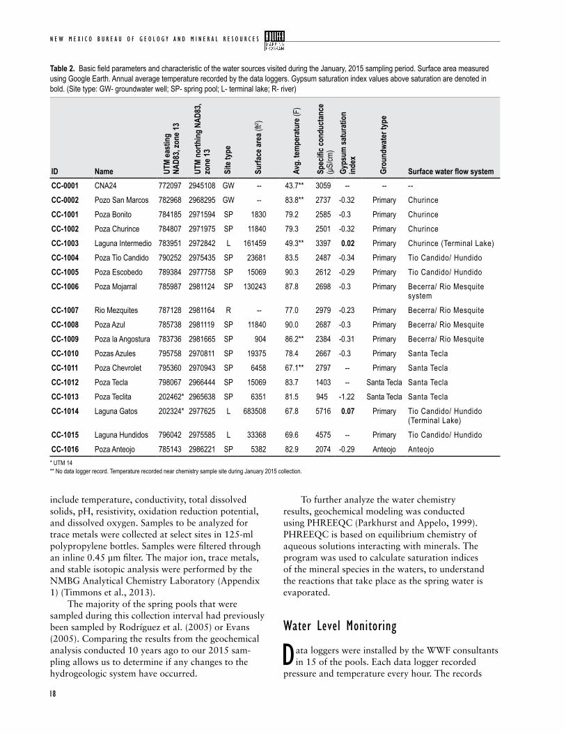
Figure 13. Example of a spring pool instrumented with a data logger. The white cage near the bottom of the photograph is a protective measure to prevent the instrument from being removed from the piezometer.
were corrected for barometric pressure as to capture water level fluctuations in the pools. While some of the spring pools were only recently instrumented with new data loggers some have records extending back to 2007, collected for a previous IMTA study (Ojeda and Flores, 2014). Data loggers were downloaded and maintained with the help of the WWF (Figs. 12, 13).
Gypsum sediment samples
a shallow 1.6 ft (0.5 m) deep sample hole was dug in the gypsum field with a hand auger. Samples
were collected every ~4 in (10 cm). Additionally, a 1 in (~3 cm) thick crust sample was collected from the gypsum dune field. It has a 0.04 in (0.1 cm) dark grey top layer, over a moderately well cemented white gyp-sum layer (Fig. 14). The hole was dug a short distance from the site where the crust was found, at a lower elevation in the dune field. Electron microprobe analysis was performed on the sediment samples collected in the dune field. The
electron microprobe can quantitatively determine the chemical composition of a 1 micron wide site on a sample surface. Samples are epoxied, and polished to expose a clean surface. Four samples from different depths were prepared from the shallow auger hole. Two samples were prepared from the crust sample to analyze the surface in different orientations; one from the top, and another from the side, in profile.
landsat imagery
when NMBG researchers visited the Cuatrociénegas basin in January of 2015
Laguna Grande was completely dry. As there were only anecdotal reports of its decline, Landsat satellite imagery was used to measure the decline in lake surface area (landsat.usgs.gov). Landsat is a satellite remote sensing program that is main- tained by NASA and the USGS, and has been in operation since the early 1970s. Now with its 8th satellite in orbit, the Landsat program collects
N E W M E X I C O B U R E A U O F G E O L O G Y A N D M I N E R A L R E S O U R C E S
20
Figure 14. Partially cemented crust sample found in the gypsum field.
spectral data across 8 bands covering the majority of the earth’s surface, every 16 days. Landsat images collected over the past 40 years, with a clear view of Laguna Grande, were extracted from the online archive. Because the lake is surrounded by
white gypsum, the lake surface area is easily distin-guished. An image processing program (ImageJ) was used to convert imagery into binary and batch calcu-late lake surface area. This ensured consistent, nonbi-ased measurements.
21
C u a t r o C i é n e g a s B a s i n , m e x i C o
Geochemical components of Groundwater
General field parameters
the field parameters collected during the January 2015 fieldwork revealed general water chemistry
and geochemical conditions in the basin. The pH measurements of the pools are typically around neutral with a mean value of 7.3 and no significant spatial trend. The specific conductance ranged from 945 μS/cm to 5716 μS/cm, and emphasized the different groundwater flow paths feeding the basin described by Evans (2005). The springs discharging on the western and northeastern flank of Sierra San Marcos (the primary, CaSO4 high TDS, groundwater type) generally had an elevated specific conductance (mean of 2649 μS/cm), indicating prolonged water/mineral interaction. Specific conductance of the terminal lakes fed by these springs was typically significantly higher (mean of 4563 μS/cm), likely as result of evaporation. Poza Anteojo (CC-1016), discharging from the flank of Sierra La Madera had slightly lower specific conductance (2074 μS/cm). Two springs in the southwest, Poza Tecla (CC-1012) and Teclita(CC-1013), had lower specific conduc-tance (1403 μS/cm, and 945 μS/cm respectively), suggesting shorter or mixed flow paths (Appendix 1).
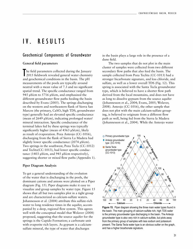
Piper Diagram Analysis
To get a general understanding of the evolution of the water that is discharging in the pools, the dominant cations and anions were plotted on a Piper diagram (Fig. 15). Piper diagrams make it easy to visualize and group samples by water type. Figure 15 shows that all but two samples plot in a tight group and are characterized as calcium-sulfate waters. Johannesson et al. (2004) attribute this sulfate-rich water to long residence times in the aquifer, accom-panied by a deep, regional flow system. This agrees well with the conceptual model that Wolaver (2008) proposed, suggesting that the source aquifer for the springs is the Cupido Formation; a carbonate unit with evaporite rich layers. As gypsum is a calcium-sulfate mineral, the type of water that discharges
in the basin plays a large role in the presence of a dune field. The two samples that do not plot in the main cluster of samples were collected from two different secondary flow paths that also feed the basin. The sample collected from Poza Teclita (CC-1013) had a stronger bicarbonate signature, and less chloride, and sulfate, as well as a lower overall TDS (Fig. 12). This spring is associated with the Santa Tecla groundwater type, which is believed to have a shorter flow path derived from the local mountains, and does not have as long to dissolve gypsum from the source aquifer (Johannesson et al., 2004; Evans, 2005; Wolaver, 2008). Anteojo (CC-1016), the other sample that does not plot with the main calcium-sulfate group-ing, is believed to originate from a different flow path as well, being fed from the Sierra la Madera (Johannesson et al., 2004). While the Anteojo water
i V . r e s u l t s
Figure 15. Piper diagram showing the three main water types found in the basin. The main grouping of calcium-sulfate rich, high TDS water is the primary groundwater type discharging in the basin. The Anteojo groundwater type is also very rich in calcium-sulfate, but plots away from the primary group of samples with less sodium and potassium present. The Santa Tecla water type is an obvious outlier on the graph, and has a higher bicarbonate signature.
Primary groundwater typeAnteojo groundwater type (CC-1016)Santa Teclagroundwater type(CC-1013)
20
40
40 40
60
80
20
40
60
80 80
Calcium Chloride
Magn
esium
Chlor
ide +
Sulfa
te
Carb
onate
+ Bi
carb
onate
Calcium + Magnesium
Sodium + Potassium
Sulfate
20
20 20
40
60
6060
80
80 80
20
00
0 0
40
60
100
10000100
0100
100 0100
N E W M E X I C O B U R E A U O F G E O L O G Y A N D M I N E R A L R E S O U R C E S
22
chemistry is also calcium-sulfate rich, is has less chlo-ride, sodium, and potassium (Appendix 1).
PHREEQC Modeling
The saturation indices of the mineral species in the spring waters were modeled to understand the evolu-tion of the water as it moves through the basin. The water discharging in all of the spring pools is below the saturation index for the gypsum mineral phases, though the springs are typically at equilibrium or saturated with respect to calcite, aragonite, celestite and dolomite. The exceptions, however, are the two terminal lakes that were sampled; Laguna Intermedio (CC-1003), which is fed by Poza Churince (CC-1002), and Laguna Gatos(CC-1014), fed by Poza Tio Candido (CC-1004) (Fig. 9). As there are no outlets to these lakes, their waters are highly evapo-rated and as result, their ion concentration is greatly increased. Both lakes approach, and even exceed the saturation index of gypsum allowing for the mineral to precipitate (Table 2). These results agree with work done by Evans (2005), though at the time the study was conducted Laguna Intermedio was not the terminal lake for the water discharging from Poza Churince. Instead, water would flow through Laguna Intermedio and collect in Laguna Grande. Today,
there is no longer enough discharge to support the flow to Laguna Grande, which is now an empty playa covered by extensive evaporite deposits. The chemi-cal composition of the water collected from Laguana Intermedio now closely resembles the chemistry of Laguna Grande, reported by Evans in 2005.
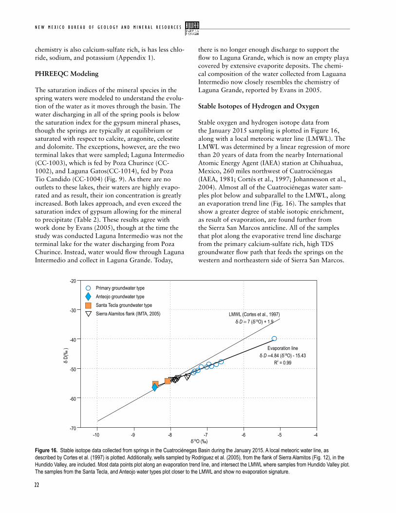
Stable Isotopes of Hydrogen and Oxygen
Stable oxygen and hydrogen isotope data from the January 2015 sampling is plotted in Figure 16, along with a local meteoric water line (LMWL). The LMWL was determined by a linear regression of more than 20 years of data from the nearby International Atomic Energy Agent (IAEA) station at Chihuahua, Mexico, 260 miles northwest of Cuatrociénegas (IAEA, 1981; Cortés et al., 1997; Johannesson et al., 2004). Almost all of the Cuatrociénegas water sam-ples plot below and subparallel to the LMWL, along an evaporation trend line (Fig. 16). The samples that show a greater degree of stable isotopic enrichment, as result of evaporation, are found further from the Sierra San Marcos anticline. All of the samples that plot along the evaporative trend line discharge from the primary calcium-sulfate rich, high TDS groundwater flow path that feeds the springs on the western and northeastern side of Sierra San Marcos.
Figure 16. Stable isotope data collected from springs in the Cuatrociénegas Basin during the January 2015. A local meteoric water line, as described by Cortes et al. (1997) is plotted. Additionally, wells sampled by Rodriguez et al. (2005), from the flank of Sierra Alamitos (Fig. 12), in the Hundido Valley, are included. Most data points plot along an evaporation trend line, and intersect the LMWL where samples from Hundido Valley plot. The samples from the Santa Tecla, and Anteojo water types plot closer to the LMWL and show no evaporation signature.
Primary groundwater type
Sierra Alamitos flank (IMTA, 2005)
-20
-30
-40
-50
-60
-70-10 -9 -8 -7 -6 -4-5
δ18O (‰)
δ D(
‰ )
Santa Tecla groundwater typeAnteojo groundwater type
LMWL (Cortes et al., 1997)δ D = 7 (δ18O) + 1.9
Evaporation lineδ D =4.84 (δ18O) - 15.43
R = 0.992
23
C u a t r o C i é n e g a s B a s i n , m e x i C o
Figure 17. Hydrographs showing water level changes at six of the measured pools (Fig. 12). The daily precipitation record from the Pronatura Station is plotted on the right axis. Each pool hydrograph is normalized as to better visualize the data; the trends do not represent the depth of the pool, only the relative change in water level. Pools at the top of the graph have a higher average temperature than those near the bottom.
This suggests they originate from the same isotopic source, where the evaporation trend line intersects the LMWL (δD=-54‰). Samples collected at the flank of Sierra Alamitos in Hundido Valley (reported my IMTA, Rodríguez et al., 2005) have an isotopic signa-ture that plots where the evaporation trend line inter-sects the LMWL (Fig. 16). This implies that recharge feeding Hundido Valley has similar isotopic origins to the water found in Cuatrociénegas. The three samples that plot on or slightly above the LMWL discharge are from the two secondary flow paths that feed the basin. To the north: Poza Anteojo (CC-1016), and to the southeast: Poza Tecla (CC-1012) and Teclita (CC-1013; Appendix 1).
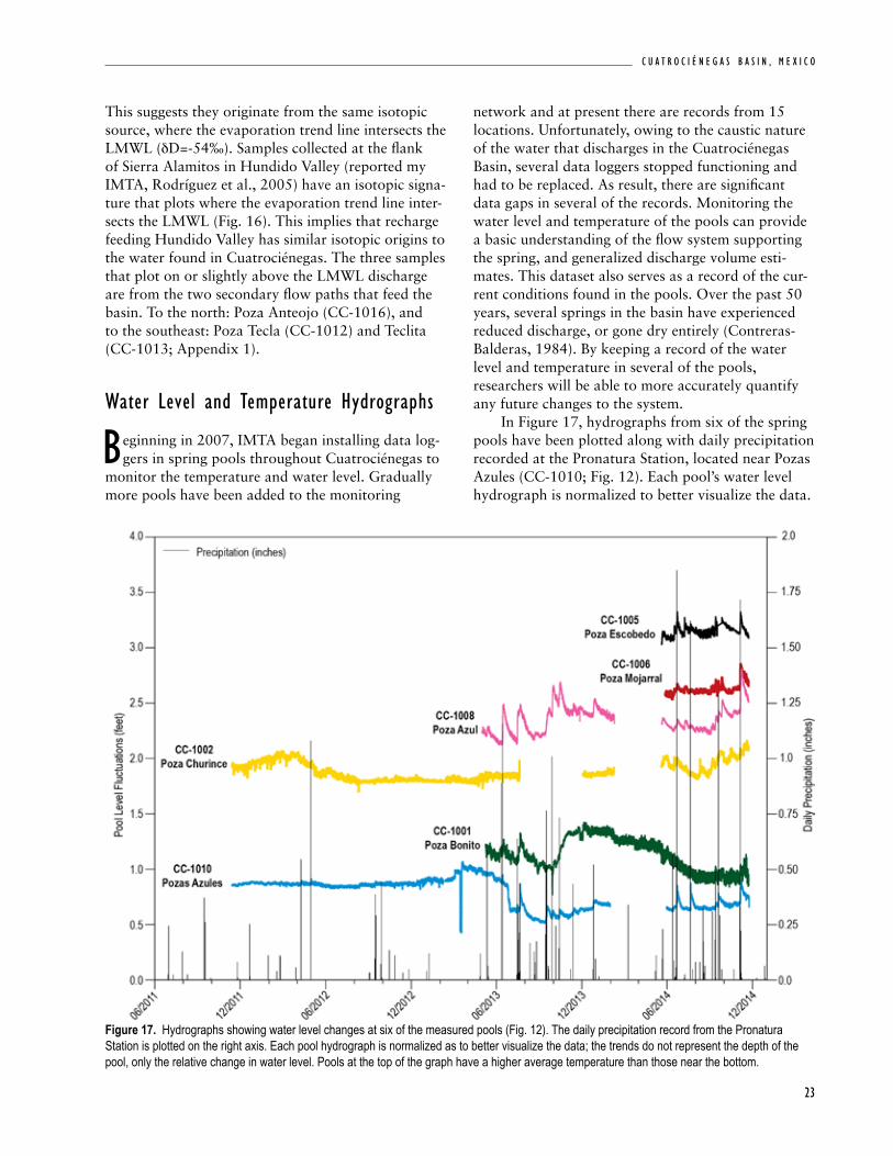
water level and temperature Hydrographs
Beginning in 2007, IMTA began installing data log-gers in spring pools throughout Cuatrociénegas to
monitor the temperature and water level. Gradually more pools have been added to the monitoring
network and at present there are records from 15 locations. Unfortunately, owing to the caustic nature of the water that discharges in the Cuatrociénegas Basin, several data loggers stopped functioning and had to be replaced. As result, there are significant data gaps in several of the records. Monitoring the water level and temperature of the pools can provide a basic understanding of the flow system supporting the spring, and generalized discharge volume esti-mates. This dataset also serves as a record of the cur-rent conditions found in the pools. Over the past 50 years, several springs in the basin have experienced reduced discharge, or gone dry entirely (Contreras-Balderas, 1984). By keeping a record of the water level and temperature in several of the pools, researchers will be able to more accurately quantify any future changes to the system. In Figure 17, hydrographs from six of the spring pools have been plotted along with daily precipitation recorded at the Pronatura Station, located near Pozas Azules (CC-1010; Fig. 12). Each pool’s water level hydrograph is normalized to better visualize the data.

N E W M E X I C O B U R E A U O F G E O L O G Y A N D M I N E R A L R E S O U R C E S
24
The trends do not represent the depth of the pool, only the relative change in water level. For the most part the water level in the pools remains relatively steady, fluctuating no more than 6 inches throughout the study period. In several pools we see brief spikes in water levels that correspond with significant pre-cipitation events. Following these rapid spikes, pool levels slowly taper back to equilibrium levels over the course of one to two months. Pools that show the largest response to precipitation are generally located in the eastern basin. Spring pools on this side of the basin have been interconnected via canals, which may account for the more significant response to precipi-tation events. With the exception of the short term water level rises caused by precipitation events, the pool levels remain steady. This may indicate a long regional flow path that is not affected by sea-sonal variations in precipitation. Temperature records were collected by the data loggers in addition to pressure. In Figure 18, the temperature records from six of the spring pools
are plotted along with the average daily temperature recorded at the Pronatura station. Using these ther-mal records we can infer the general magnitude of discharge. Records that show large daily or annual fluctuation in temperature suggest that spring dis-charge is not high enough to overcome the ambient air temperature signal. The surface area and depth of the pools have an impact on the temperature, as well as the depth of the measuring point; larger pools have more surface area and require greater discharge to maintain a constant temperature above the median air temperature. Pool surface area was measured with Google Earth and can be found in Table 2. Poza Azul (CC-1008) has an average annual temperature of 90.0 °F (32.2 °C) and experiences only slight seasonal fluctuations (± 2.2 °F, 1.2 °C) in temperature through-out the year. Daily temperature fluctuations in the pool were ±0.7 °F (±0.4 °C) on average. Based on the very small daily and annual temperature fluctuations we infer that Poza Azul has the highest discharge of the springs we measured. Poza Churince (CC-1002)
Figure 18. Temperature records collected in six spring pools as well as the average daily temperature recorded at the Pronatura station.
25
C u a t r o C i é n e g a s B a s i n , m e x i C o
and Poza Bonito (CC-1001) are significantly cooler, and likely have a lower discharge rate. Poza Churince and Bonito both average ~79 °F (~26 °C) annually, fluctuating ±9 °F (±5 °C) seasonally, and ±10.6 °F (±6 °C) daily. With the absence of volcanic activity in the basin, elevated spring temperatures, with respect to ambient air temperature, are likely the result of deep groundwater flow along a regional flow system (Wolaver, 2008).
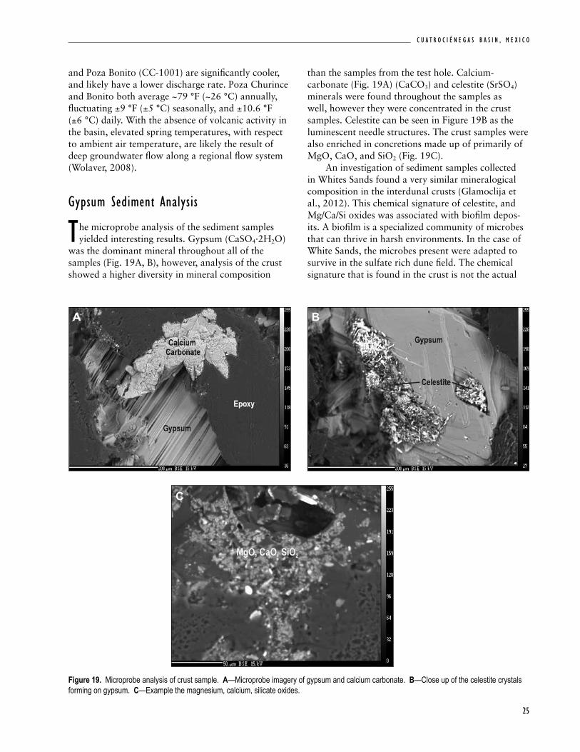
Gypsum sediment analysis
the microprobe analysis of the sediment samples yielded interesting results. Gypsum (CaSO4·2H2O)
was the dominant mineral throughout all of the samples (Fig. 19A, B), however, analysis of the crust showed a higher diversity in mineral composition
Figure 19. Microprobe analysis of crust sample. A—Microprobe imagery of gypsum and calcium carbonate. B—Close up of the celestite crystals forming on gypsum. C—Example the magnesium, calcium, silicate oxides.
A B
C
than the samples from the test hole. Calcium-carbonate (Fig. 19A) (CaCO3) and celestite (SrSO4) minerals were found throughout the samples as well, however they were concentrated in the crust samples. Celestite can be seen in Figure 19B as the luminescent needle structures. The crust samples were also enriched in concretions made up of primarily of MgO, CaO, and SiO2 (Fig. 19C). An investigation of sediment samples collected in Whites Sands found a very similar mineralogical composition in the interdunal crusts (Glamoclija et al., 2012). This chemical signature of celestite, and Mg/Ca/Si oxides was associated with biofilm depos-its. A biofilm is a specialized community of microbes that can thrive in harsh environments. In the case of White Sands, the microbes present were adapted to survive in the sulfate rich dune field. The chemical signature that is found in the crust is not the actual
N E W M E X I C O B U R E A U O F G E O L O G Y A N D M I N E R A L R E S O U R C E S
26
biofilm, but rather it represents the minerals that are precipitated due to the microbial presence and/or activity (Glamoclija et al., 2012). The only loca-tion in the dunes that Glamoclija et al. (2012) found active microbial communities was in interdunal areas, where moisture was being wicked to the surface from the shallow water table (>3 weight percentage of water content (wt. %)). Other parts of the dunes were determined to be too dry to support the biofilms (<0.2 wt. %). These crusts imply that at some point the Cuatrociénegas dune field may have been a wet system, similar to White Sands.
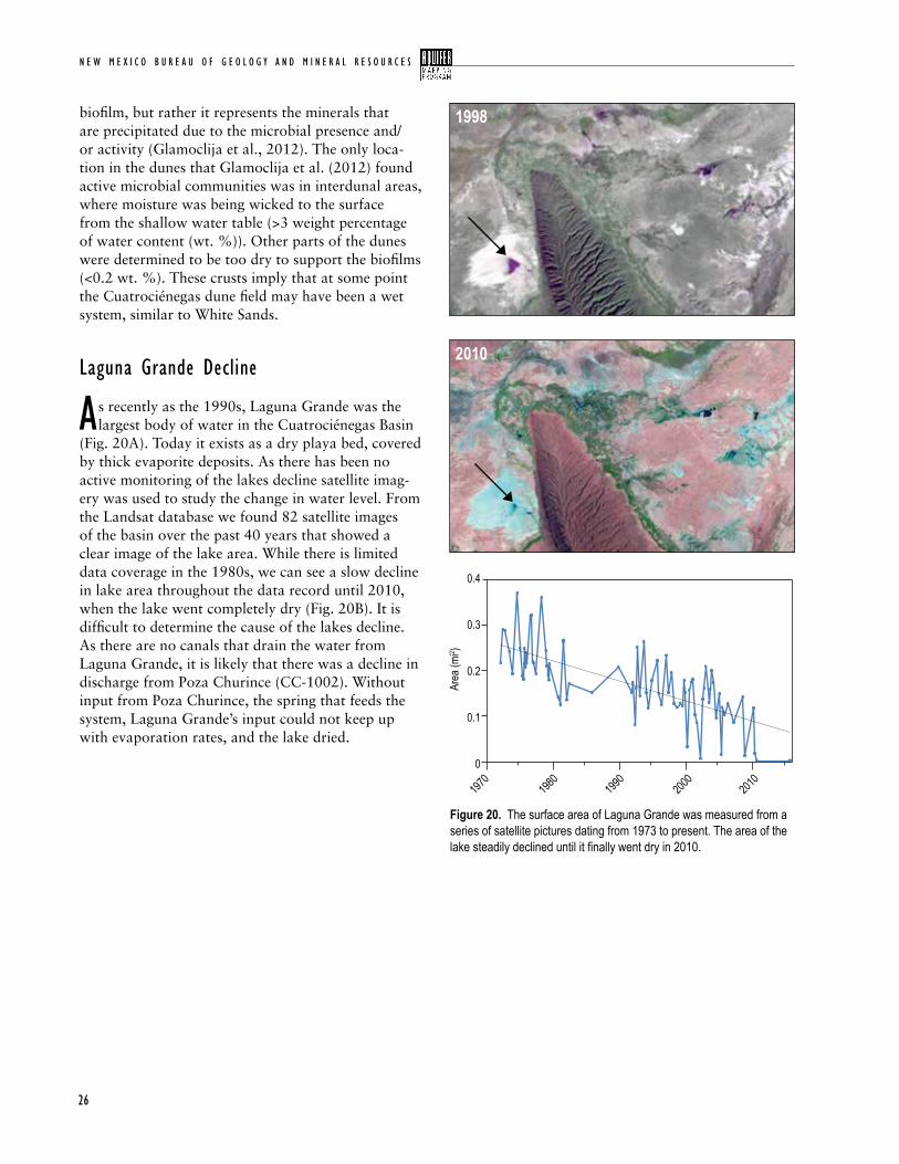
laguna Grande decline
as recently as the 1990s, Laguna Grande was the largest body of water in the Cuatrociénegas Basin
(Fig. 20A). Today it exists as a dry playa bed, covered by thick evaporite deposits. As there has been no active monitoring of the lakes decline satellite imag-ery was used to study the change in water level. From the Landsat database we found 82 satellite images of the basin over the past 40 years that showed a clear image of the lake area. While there is limited data coverage in the 1980s, we can see a slow decline in lake area throughout the data record until 2010, when the lake went completely dry (Fig. 20B). It is difficult to determine the cause of the lakes decline. As there are no canals that drain the water from Laguna Grande, it is likely that there was a decline in discharge from Poza Churince (CC-1002). Without input from Poza Churince, the spring that feeds the system, Laguna Grande’s input could not keep up with evaporation rates, and the lake dried.
Figure 20. The surface area of Laguna Grande was measured from a series of satellite pictures dating from 1973 to present. The area of the lake steadily declined until it finally went dry in 2010.
0.4
0.3
0.1
0.2
1970
1980
1990
2000
2010
0
Area
(mi2 )
1998
2010
27
C u a t r o C i é n e g a s B a s i n , m e x i C o
regional Hydrogeology
from our analysis of recently collected data, as well as reanalysis of data reported by IMTA
(Rodríguez et al., 2005), we strongly agree with Wolaver’s conceptual model (Wolaver et al., 2008). There is a significant body of evidence that suggests a large scale regional flow system supports ground-water flow to the basin. In addition to the evidence presented by Wolaver et al. (2008), Wolaver and Diehl (2011), Wolaver et al. (2013), several of the analyses performed for this study agree with the previously reported work. Geochemical analysis of groundwater discharging in the basin suggests the Cupido aquifer is responsible for the majority of flow (Wolaver and Diehl, 2011). The Cupido aquifer is a karstic lime-mudstone rich in gypsum. The high TDS and concentration of dissolved miner-als found in water samples suggests long residence times as water moves through the regional system. Analysis of the temperature and water levels in the pools supports the hypothesis that long regional flow paths are responsible for providing water to the basin. With the exception of the short term water level rises caused by precipitation events, the pool levels remain quite steady. This may indicate a long regional flow path that is not affected by seasonal variations in precipitation. With the absence of vol-canic activity in the basin elevated spring tempera-tures are likely the result of deep groundwater flow along a regional flow system.
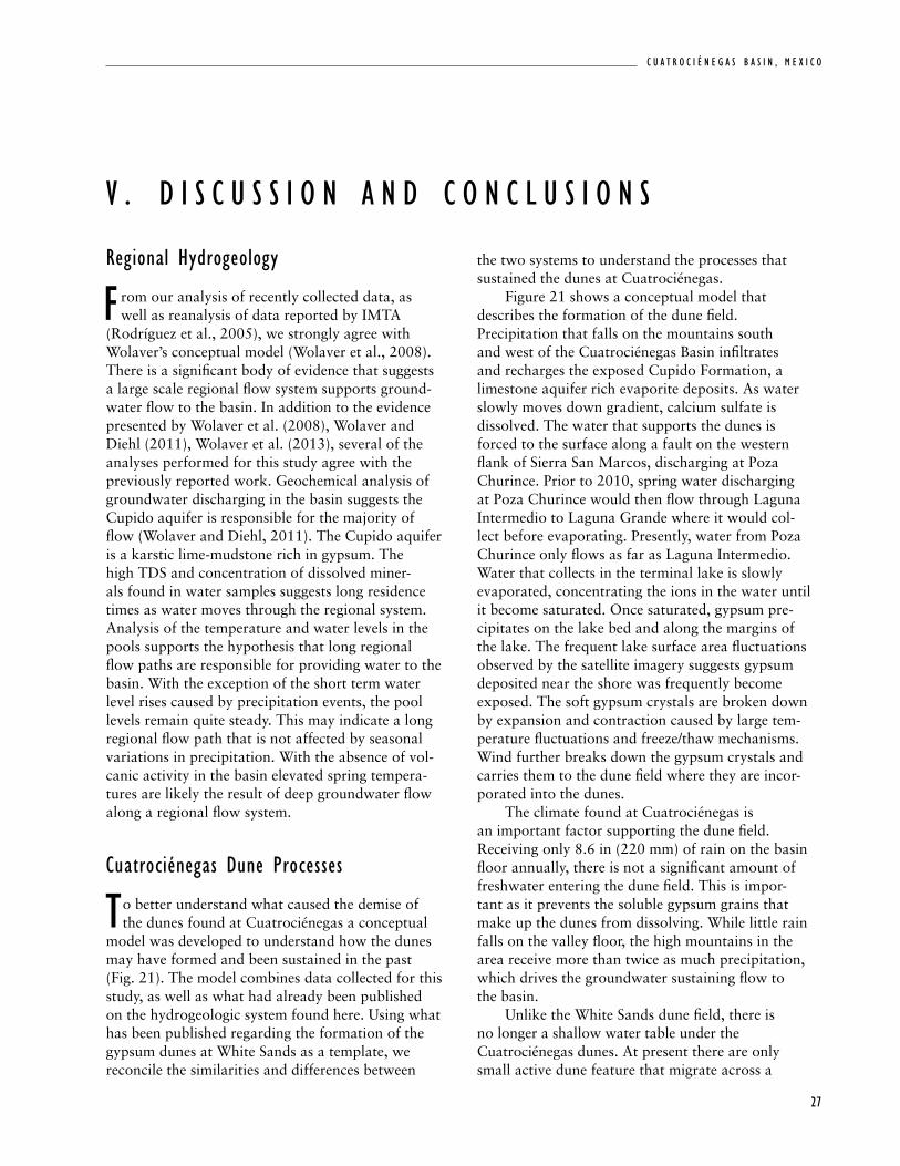
cuatrociénegas dune Processes
to better understand what caused the demise of the dunes found at Cuatrociénegas a conceptual
model was developed to understand how the dunes may have formed and been sustained in the past (Fig. 21). The model combines data collected for this study, as well as what had already been published on the hydrogeologic system found here. Using what has been published regarding the formation of the gypsum dunes at White Sands as a template, we reconcile the similarities and differences between
V . d i s c u s s i o N a N d c o N c l u s i o N s
the two systems to understand the processes that sustained the dunes at Cuatrociénegas. Figure 21 shows a conceptual model that describes the formation of the dune field. Precipitation that falls on the mountains south and west of the Cuatrociénegas Basin infiltrates and recharges the exposed Cupido Formation, a limestone aquifer rich evaporite deposits. As water slowly moves down gradient, calcium sulfate is dissolved. The water that supports the dunes is forced to the surface along a fault on the western flank of Sierra San Marcos, discharging at Poza Churince. Prior to 2010, spring water discharging at Poza Churince would then flow through Laguna Intermedio to Laguna Grande where it would col-lect before evaporating. Presently, water from Poza Churince only flows as far as Laguna Intermedio. Water that collects in the terminal lake is slowly evaporated, concentrating the ions in the water until it become saturated. Once saturated, gypsum pre-cipitates on the lake bed and along the margins of the lake. The frequent lake surface area fluctuations observed by the satellite imagery suggests gypsum deposited near the shore was frequently become exposed. The soft gypsum crystals are broken down by expansion and contraction caused by large tem-perature fluctuations and freeze/thaw mechanisms. Wind further breaks down the gypsum crystals and carries them to the dune field where they are incor-porated into the dunes. The climate found at Cuatrociénegas is an important factor supporting the dune field. Receiving only 8.6 in (220 mm) of rain on the basin floor annually, there is not a significant amount of freshwater entering the dune field. This is impor-tant as it prevents the soluble gypsum grains that make up the dunes from dissolving. While little rain falls on the valley floor, the high mountains in the area receive more than twice as much precipitation, which drives the groundwater sustaining flow to the basin. Unlike the White Sands dune field, there is no longer a shallow water table under the Cuatrociénegas dunes. At present there are only small active dune feature that migrate across a
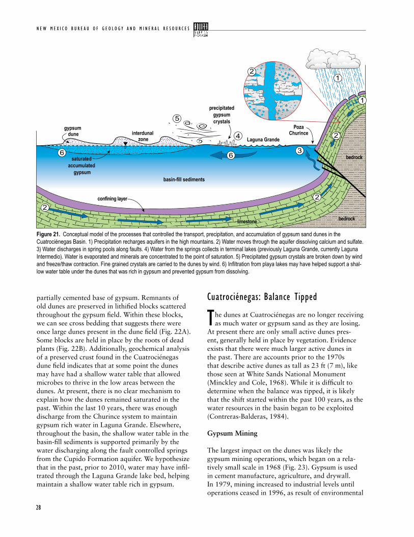
N E W M E X I C O B U R E A U O F G E O L O G Y A N D M I N E R A L R E S O U R C E S
28
partially cemented base of gypsum. Remnants of old dunes are preserved in lithified blocks scattered throughout the gypsum field. Within these blocks, we can see cross bedding that suggests there were once large dunes present in the dune field (Fig. 22A). Some blocks are held in place by the roots of dead plants (Fig. 22B). Additionally, geochemical analysis of a preserved crust found in the Cuatrociénegas dune field indicates that at some point the dunes may have had a shallow water table that allowed microbes to thrive in the low areas between the dunes. At present, there is no clear mechanism to explain how the dunes remained saturated in the past. Within the last 10 years, there was enough discharge from the Churince system to maintain gypsum rich water in Laguna Grande. Elsewhere, throughout the basin, the shallow water table in the basin-fill sediments is supported primarily by the water discharging along the fault controlled springs from the Cupido Formation aquifer. We hypothesize that in the past, prior to 2010, water may have infil-trated through the Laguna Grande lake bed, helping maintain a shallow water table rich in gypsum.
cuatrociénegas: Balance tipped
the dunes at Cuatrociénegas are no longer receiving as much water or gypsum sand as they are losing.
At present there are only small active dunes pres-ent, generally held in place by vegetation. Evidence exists that there were much larger active dunes in the past. There are accounts prior to the 1970s that describe active dunes as tall as 23 ft (7 m), like those seen at White Sands National Monument (Minckley and Cole, 1968). While it is difficult to determine when the balance was tipped, it is likely that the shift started within the past 100 years, as the water resources in the basin began to be exploited (Contreras-Balderas, 1984).
Gypsum Mining
The largest impact on the dunes was likely the gypsum mining operations, which began on a rela-tively small scale in 1968 (Fig. 23). Gypsum is used in cement manufacture, agriculture, and drywall. In 1979, mining increased to industrial levels until operations ceased in 1996, as result of environmental
Figure 21. Conceptual model of the processes that controlled the transport, precipitation, and accumulation of gypsum sand dunes in the Cuatrociénegas Basin. 1) Precipitation recharges aquifers in the high mountains. 2) Water moves through the aquifer dissolving calcium and sulfate. 3) Water discharges in spring pools along faults. 4) Water from the springs collects in terminal lakes (previously Laguna Grande, currently Laguna Intermedio). Water is evaporated and minerals are concentrated to the point of saturation. 5) Precipitated gypsum crystals are broken down by wind and freeze/thaw contraction. Fine grained crystals are carried to the dunes by wind. 6) Infiltration from playa lakes may have helped support a shal-low water table under the dunes that was rich in gypsum and prevented gypsum from dissolving.
Laguna Grande
PozaChurince
gypsum dune interdunal
zone
precipitatedgypsumcrystals
saturated accumulated
gypsumbasin-fill sediments
confining layer
limestonelimestone bedrock
bedrock
2
22
2
1
1
3
4
5
66
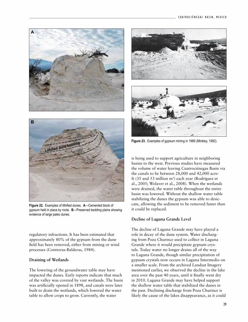
29
C u a t r o C i é n e g a s B a s i n , m e x i C o
Figure 22. Examples of lithified dunes. A—Cemented block of gypsum held in place by roots. B—Preserved bedding plains showing evidence of large paleo dunes.
A
B
Lithifi ed dune bedding
regulatory infractions. It has been estimated that approximately 80% of the gypsum from the dune field has been removed, either from mining or wind processes (Contreras-Balderas, 1984).
Draining of Wetlands
The lowering of the groundwater table may have impacted the dunes. Early reports indicate that much of the valley was covered by vast wetlands. The basin was artificially opened in 1898, and canals were later built to drain the wetlands, which lowered the water table to allow crops to grow. Currently, the water
is being used to support agriculture in neighboring basins to the west. Previous studies have measured the volume of water leaving Cuatrociénegas Basin via the canals to be between 28,000 and 42,000 acre-ft (35 and 53 million m3) each year (Rodríguez et al., 2005; Wolaver et al., 2008). When the wetlands were drained, the water table throughout the entire basin was lowered. Without the shallow water table stabilizing the dunes the gypsum was able to desic-cate, allowing the sediment to be removed faster than it could be replaced.
Decline of Laguna Grande Level
The decline of Laguna Grande may have played a role in decay of the dune system. Water discharg-ing from Poza Churince used to collect in Laguna Grande where it would precipitate gypsum crys-tals. Today water no longer drains all of the way to Laguna Grande, though similar precipitation of gypsum crystals now occurs in Laguna Intermedio on a smaller scale. From the archived Landsat Imagery mentioned earlier, we observed the decline in the lake area over the past 40 years, until it finally went dry in 2010. Laguna Grande may have helped support the shallow water table that stabilized the dunes in the past. Declining discharge from Poza Churince is likely the cause of the lakes disappearance, as it could
Figure 23. Examples of gypsum mining in 1989 (Minkley, 1992).
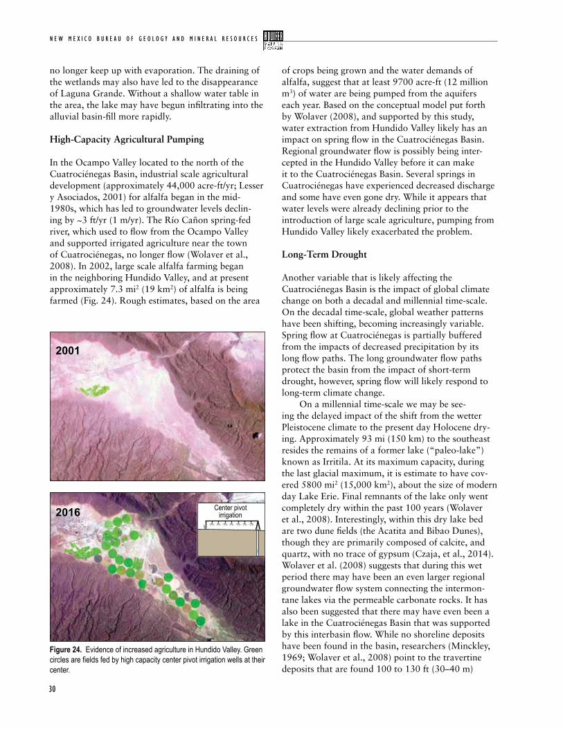
N E W M E X I C O B U R E A U O F G E O L O G Y A N D M I N E R A L R E S O U R C E S
30
no longer keep up with evaporation. The draining of the wetlands may also have led to the disappearance of Laguna Grande. Without a shallow water table in the area, the lake may have begun infiltrating into the alluvial basin-fill more rapidly.
High-Capacity Agricultural Pumping
In the Ocampo Valley located to the north of the Cuatrociénegas Basin, industrial scale agricultural development (approximately 44,000 acre-ft/yr; Lesser y Asociados, 2001) for alfalfa began in the mid-1980s, which has led to groundwater levels declin-ing by ~3 ft/yr (1 m/yr). The Río Cañon spring-fed river, which used to flow from the Ocampo Valley and supported irrigated agriculture near the town of Cuatrociénegas, no longer flow (Wolaver et al., 2008). In 2002, large scale alfalfa farming began in the neighboring Hundido Valley, and at present approximately 7.3 mi2 (19 km2) of alfalfa is being farmed (Fig. 24). Rough estimates, based on the area
of crops being grown and the water demands of alfalfa, suggest that at least 9700 acre-ft (12 million m3) of water are being pumped from the aquifers each year. Based on the conceptual model put forth by Wolaver (2008), and supported by this study, water extraction from Hundido Valley likely has an impact on spring flow in the Cuatrociénegas Basin. Regional groundwater flow is possibly being inter-cepted in the Hundido Valley before it can make it to the Cuatrociénegas Basin. Several springs in Cuatrociénegas have experienced decreased discharge and some have even gone dry. While it appears that water levels were already declining prior to the introduction of large scale agriculture, pumping from Hundido Valley likely exacerbated the problem.
Long-Term Drought
Another variable that is likely affecting the Cuatrociénegas Basin is the impact of global climate change on both a decadal and millennial time-scale. On the decadal time-scale, global weather patterns have been shifting, becoming increasingly variable. Spring flow at Cuatrociénegas is partially buffered from the impacts of decreased precipitation by its long flow paths. The long groundwater flow paths protect the basin from the impact of short-term drought, however, spring flow will likely respond to long-term climate change. On a millennial time-scale we may be see-ing the delayed impact of the shift from the wetter Pleistocene climate to the present day Holocene dry-ing. Approximately 93 mi (150 km) to the southeast resides the remains of a former lake (“paleo-lake”) known as Irritila. At its maximum capacity, during the last glacial maximum, it is estimate to have cov-ered 5800 mi2 (15,000 km2), about the size of modern day Lake Erie. Final remnants of the lake only went completely dry within the past 100 years (Wolaver et al., 2008). Interestingly, within this dry lake bed are two dune fields (the Acatita and Bibao Dunes), though they are primarily composed of calcite, and quartz, with no trace of gypsum (Czaja, et al., 2014). Wolaver et al. (2008) suggests that during this wet period there may have been an even larger regional groundwater flow system connecting the intermon-tane lakes via the permeable carbonate rocks. It has also been suggested that there may have even been a lake in the Cuatrociénegas Basin that was supported by this interbasin flow. While no shoreline deposits have been found in the basin, researchers (Minckley, 1969; Wolaver et al., 2008) point to the travertine deposits that are found 100 to 130 ft (30–40 m)
Figure 24. Evidence of increased agriculture in Hundido Valley. Green circles are fields fed by high capacity center pivot irrigation wells at their center.
2001
2016 Center pivotirrigation
31
C u a t r o C i é n e g a s B a s i n , m e x i C o
above the southwestern valley floor as evidence that a large lake may have covered the valley floor.
cuatrociénegas: an analog for white sands National Monument?
as population in the Tularosa Basin of New Mexico expands, and existing water sources are depleted,
White Sands National Monument has begun to receive frequent notices for large scale water removal projects from the lands surrounding the monument. At present a new well field has been installed to help support the City of Alamogordo. This has raised concern that changes in the regional environment due to climate change and groundwater pumping may adversely affect the shallow groundwater in the White Sands dune field. One of the overarch-ing motivations for this research was to determine whether or not White Sands would suffer a similar fate as Cuatrociénegas, as result of increased water diversions. Large-scale water extraction is a significant concern for the sustained presence of a shallow water table at both systems. Bourret (2015) used groundwa-ter flow models to understand the impact to the water table at White Sands as result of increased pumping by nearby population centers. It was determined that the effect of pumping near White Sands National Monument would result in roughly 3 ft (1 m) of draw
down after 100 years, however only a total of 5 ft (1.5m) after 1000 years. This was primarily due to the tight hydrologic units that compose the basin fill (hydraulic conductivity = 0.32–3.2 ft/day) near White Sands that supports the water table. Additionally, the proposed well field in the Tularosa Basin intercepts recharge along a relatively small portion of the broad mountain-front recharge area. At Cuatrociénegas, the hydrologic units that supply water to the basin consist of karstic units that have considerably higher hydraulic permeability (~65 ft/day, Rodríguez et al., 2005). This makes comparing the vulnerability of the two systems very difficult. At present, the decrease in water discharging in Cuatrociénegas is the most significant threat to the basin. Unfortunately there is no single explanation for this decline, but rather a culmination of multiple factors including mining of gypsum, draining the wet-lands, water table declines, and long-term drought. Water levels in Laguna Grande, linked to discharge from Poza Churince, have been declining since the beginning of the satellite imagery record in the 1970s. This was significant before 2002, when industrial scale agricultural pumping began in Hundido Valley. While pumping in Hundido Valley cannot be directly linked to decline in discharge rates, it is likely a con-tributing factor that will further exacerbate the water shortage. The water diversions via the canals may have also had an impact, leading to a lower regional water table.
N E W M E X I C O B U R E A U O F G E O L O G Y A N D M I N E R A L R E S O U R C E S
32
w ith so little known about the Cuatrociénegas dune field there are numerous research paths
to investigate. While geologic maps for the area do exist more detailed geologic mapping would greatly improve the understanding of the karstic flow paths that feed the basin. An important first step regard-ing the preservation of the dune field is to determine how rapidly the gypsum is deflating. We recommend collecting a high resolution elevation model of the dune field. Future studies can resample the elevation and calculate the change in volume from the initial baseline measurement. Ideally the dune field would have a LiDAR mission flown; however, there are other more cost effective methods, such as creating a surface mesh with aerial drone photography. It may be possible to better estimate the volume of gypsum that has been removed previously. By assuming the cemented interdunal surface that was sampled represents the elevation of the water table it may be possible extrapolate laterally out and estimate how much sand would have existed above this elevation. Mapping of similar crusts found throughout the dune field would also aid in this process. Analysis of the cross-bedding preserved within the lithified gypsum blocks could provide an interest-ing line of research. By analyzing the preserved cross-bedding it may be possible to understand more about
V i . f u t u r e w o r k
the dune field such as the direction of migration, and the original size of the dunes, predevelopment. This study found that Poza Churince (CC-1002) plays an important role in gypsum precipitation process. In the past, the spring used to support Laguna Grande, where gypsum was precipitated from ion rich water that collected there. As water from Poza Churince no longer flows all the way to Laguna Grande it would interesting to add a flow gauge to the stream draining from Poza Churince. This would help determine if the drying of the lake was the result of decreased flow from Poza Churince. In addition to the monitoring the flow in the stream, it would be helpful to monitor the groundwater/surface water interactions along the streambed. An alternative hypothesis for the drying of Laguna Grande suggests that the water in the stream is infiltrating into the shallow alluvium more rapidly, preventing water from flowing all the way to the lake. Increased infiltration of the stream may have occurred as the water table in the shallow alluvium declined. Better characteriza-tion of the shallow water table throughout the dune field and surrounding area would also be beneficial. This would be best accomplished by installing additional wells in the dune field, in the bed of Laguna Grande, and along the stream. Streambed temperature modeling would also be effective to monitor the groundwater/surface water interactions.
33
C u a t r o C i é n e g a s B a s i n , m e x i C o
New Mexico Bureau of Geology and Mineral Resources -
Aquifer Mapping Program Manager
Stacy Timmons, M.S. Hydrogeologist, [email protected]
Project Personnel
Ethan Mamer, M.S., Hydrogeologist [email protected]
B. Talon Newton, Ph.D., Hydrogeologist [email protected]
Support Personnel
Brigitte Felix, Report Production Coordinator, GIS Specialist, [email protected]
Bonnie Frey, Chemistry Lab Manager, Geochemist, [email protected]
Lynn Heizler, Electron Microprobe Lab Manager, Geochemist, [email protected]
David Bustos, of the White Sands National Monument, is largely to thank for pursuing this research. Seeing the necessity of the study, he was able to secure the funding required to conduct this research. This project would not have been pos-sible without the help, cooperation, and guidance lent by the sister park, Área de Protección de Flora y Fauna Cuatrociénegas. Without the help of Juan Carlos Ibarra Flores and the Comisión Nacional de Áreas Naturales Protegidas (CONANP) staff in Cuatrociénegas the sampling trip would not have been possible. Additionally, Mark Briggs and Carlos Areal, from the World Wildlife Fund (WWF) provided input and advice, as well as assistance in the data collection. Lab analysis and assistance in interpretation were conducted at the New Mexico Bureau of Geology by the Stable Isotope Laboratory, Analytical Chemistry Laboratory, and the Electron Microprobe Laboratory. In addition, we would like to thank Jonathan Knapp from the White Sands National Monument for his review pertaining to gyp-sum dune formation.
P r o j e c t s t a f f & a c k N o w l e d G M e N t s
N E W M E X I C O B U R E A U O F G E O L O G Y A N D M I N E R A L R E S O U R C E S
34
r e f e r e N c e s
Allen, B. D., 2005, Ice age lakes in New Mexico: New Mexico Museum of Natural History and Science, Bulletin 28, p. 107–114.
Bourret, S. M., 2015, Stabilization of the White Sands gypsum dune field, New Mexico, by groundwater seepage: hydrological modeling study: Masters of Science Thesis, New Mexico Institute of Mining and Technology, 136 p.
Calegari, V. R., 1997, Environmental per-ceptions and local conservation efforts in Cuatro Ciénegas, Coahuila, México: Masters of Science thesis, University of Texas at Austin, 103 p.
Contreras-Balderas, S., 1984, Environmental impacts in Cuatro Ciénegas, Coahuila, Mexico: A commentary: Journal of the Arizona-Nevada Academy of Science, v. 19, p. 85–88.
Cortés, A., Durazo, J., and Farvolden, R.N., 1997, Studies of isotopic hydrol-ogy of the basin of Mexico and vicinity: annotated bibliography and interpreta-tion: Journal of Hydrology, v. 198, p. 346–376.
Czaja, A. Palacious-Fest, M. R., Estrada-Rodríguez, J. L., Mendez, U. R., and Avila, J.A., 2014, Inland dunes fauna and flora from Paleolake Irritila in the Laguna region, Coahuila, Northern Mexico: Bulletin of the Geology Society of Mexico, v. 66, p. 541–551.
http://www.desertfishes.org/cuatroc/litera-ture/cc_bib.php
Evans, S. B., 2005, Using geochemi-cal data to define flow systems in Cuatrociénegas, Coahuila, Mexico: Masters of Science Thesis, The University of Texas at Austin, 127 p.
Flores, G. O., and Ojeda, C. G., 2012, Evolucion de la profundidad del nivel estatico en la porcion poniente del acuifero Cuatrocienegas, Coahuila, Mexico: XXII Congreso Nacional de Hidraulica Acapulco, Guerrero, 64 p.
Fryberger, S. G., 2001, Geological Overview of White Sands National Monument: http://www.nps.gov/whsa/Geology%20of%20White%20Sands/GeoHome.html.
Fryberger, S. G., and Schenk, C. J., 1988, Eolian Sediments Pin stripe lamination: A distinctive feature of modern and ancient eolian sediments: Sedimentary Geology, v. 55-1, p. 1–15.
Glamoclija, M., Fogel, M. L., Steele, A., and Kish, A., 2012, Microbial nitrogen and sulfur cycles at the gypsum dunes of White Sands National Monument, New Mexico: Geomicrobiology Journal, v. 29, p. 733–751.
Goldhammer, R. K., 1999, Mesozoic sequence stratigraphy and paleogeo-graphic evolution of northeast Mexico: Geological Society of America Special Paper 340, 54 p.
Google Inc. (2013). Google Earth (Version 7.1.2.2041) [Software]
IAEA, 1981, Statistical Treatment of Environmental Isotopes in Precipitation: Technical Report Series No. 206, International Atomic Energy Agency (IAEA), Vienna.
Johannesson, K. H., Cortés, A., and Kilroy, K. C., 2004, Reconnaissance isotopic and hydrochemical study of Cuatrociénegas groundwater, Coahuila, México: Journal of South American Earth Sciences, v. 17, p. 171–180.
Kocurek, G., and Havholm, K. G., 1994, Eolian sequence stratigraphy—a conceptual frame- work; in Weimer, P., Posamentier, H.W. (eds.), Siliciclastic Sequence Stratigraphy: American Association of Petroleum Geologists Memoir, v. 58, p. 393–409.
Kocurek, G., and Lancaster, N., 1999, Aeolian system sediment state: theory and Mojave Desert Kelso Dune Field example: Sedimentology, v. 46, p. 505–515.
landsatlook.usgs.gov
Lehmann C., Osleger D. A., Montanez I. P., Sliter W. V., Arnaud-Vanneau A., and Banner J. L., 1999, Evolution of Cupido and Coahuila carbonate platforms early cretaceous, northeastern Mexico: Geological Society of America Bulletin, v. 111, p. 1010–1029.
Lesser y Asociados S.A.de C.V. & Comisión Nacional de Agua, 2001, Sinopsis del estudio hidrogeológico en los valles del Hundido, Cuatrociénegas y Ocampo, Coah.: Comisión Nacional de Agua, México, D.F., 40 p.
McKee, J. W., Jones, N., and Long, L. E., 1990, Stratigraphy and provenance of strata along the San Marcos fault, central Coahuila, Mexico: Geological Society of America Bulletin, v. 102, p. 593–614.
Meinzer, O. E., and Hare, R. E., 1915, Geology and water resources of the Tularosa Basin, New Mexico: U.S. Geological Survey Water-Supply Paper 489, 317 p.
Mexican Geological Service, 2008, Geological-mining charter G13-B59 Cuatro Cienegas, Coahuila, ESC 1:50,000: Mineral Resources Counil, MGS
Minckley, W. L., and Cole, G. A., 1968, Speocirolana thermydronis (Crustacea: Isopoda) from Northeast Mexico, re-discovery, habitat, and supplemental description: Tulane Studies in Zoology and Botany, v. 15(1), p. 2–4.
Minckley, W. L., 1969, Environments of the bolson of Cuatrociénegas, Coahuila, Mexico, with special reference to the aquatic biota: University of Texas El Paso Sci Ser, v. 2, p. 1–65.
Minckley, W. L., 1992, Three decades near Cuatrociénegas, Mexico: photographic documentation and a plea for area con-servation: Journal of Arizona-Nevada Academy of Science, v. 29, p. 89–118.
Murillo, G., 1997, Sequence stratigraphy and diagenesis of the lower Cretaceous Cupido carbonate platform mar-gin, northeastern Mexico: American Association of Petroleum Geologists Foundation Grants-In-Aid Abstracts, v. 81, p. 1779.
https://www.nps.gov/whsa/learn/nature/cuatrocienegas.htm
Ojeda, C. G., and Flores, G. O., 2014, Red de monitoreo automatic del acuifero de Cuatrociénegas, Coahuilla: Subcoordinacion Hidrologia Subterranean Coordinacion de Hidrologia, Fl.CO.4.40.1
C u a t r o C i é n e g a s B a s i n , m e x i C o
35
Parkhurst, D. L., and Appelo, C. A. J., 1999, User’s guide to PHREEQC (Version 2)- A computer program for speciation, batch reaction, one-dimen-sional transport, and inverse geochemi-cal calculations: U.S. Geological Survey Water- Resources Investigations Report 99-4259, 312 p.
Rodríguez, A. A. A., Mijares, F. J. A., Ojeda, C. G., Morales, M. M., Hita, L. G., Zamarrón, G. H., Arellano, I. M., González, M. A. M., Flores, G. O., Almanza, P. G., Sánchez, R. L., López, J. L. P., Arzate, G. R., Fritz, P., and Espinoza, J. R., 2005, Hydrogeologic study of the Hundido and Cuatrociénegas aquifers, Coahuila: National Water Commission, Mexico City.
Souza, V., Espinosa-Asuar, L., Escalante, A. E., Eguiarte, L. E., Farmer, J. D., Forney, L., Lloret, L., Rodríguez-Martinez, J. M., Soberon, X., Dirzo, R. and Elser, J. J., 2006, An endangered oasis of aquatic microbial biodiversity in the Chihuahuan desert: Proceedings of the National Academy of Sciences, U.S.A., v. 103, p. 6565–6570
Szynkiewicz, A., Ewing, R. C., Moore, C. H., and Glamoclija, M., 2010, Origin of terrestrial gypsum dunes- Implication for Martian gypsum-rich dunes of Olympia Undae: Geomorphology, v. 121, p. 69–83.
Taylor, D. W., and Minckley, W. L., 1966, New world for biologists: Pacific Discovery, v. 19, p. 18–22.
Timmons, S. S., Land, L., Newton, B. T., and Frey, B., 2013, Aquifer Mapping Program technical documents: water sampling procedures, analysis and systematics: NMBGMR, Open-file Report 558.
Winsborough, B., 1990, Some ecological aspects of modern fresh-water stro-matolites in lakes and streams of the Cuatro Cienegas Basin, Coahuila, Mexico: The University of Texas- Austin Dissertation, 341 p.
Wolaver, B. D., 2008, Hydrogeology of the Cuatrociénegas Basin, Coahuila, Mexico: an integrative approach to arid karst aquifer delineation, Phd. Dissertation, The University of Texas at Austin.
Wolaver, B. D., Sharp, J. M., Jr., Rodríguez, J. M., and Flores, J. C. I., 2008, Delineation of regional arid karstic aquifers: An integrative data approach: Ground Water, v. 46, p. 396–413, doi:10.1111/j.1745-6584.2007.00405.x.
Wolaver, B. D., and Diehl, T. M., 2011, Control of regional structural styles and faulting on northeast Mexico spring distribution: Environmental Earth Sciences, v. 62, p. 1535–1549, doi:10.1007/s12665-010-0639-7.
Wolaver, B. D., Crossey, L. J., Karlstrom, K. E., Banner, J. L., Cardenas, M. B., Ojeda, C. G., and Sharp, J. M., 2013, Identifying origins of and pathways for spring waters in a semiarid basin using He, Sr, and C isotopes: Cuatrociénegas Basin, Mexico: Geosphere, v. 9-1, p. 113–125; doi:10.1130/GES0084
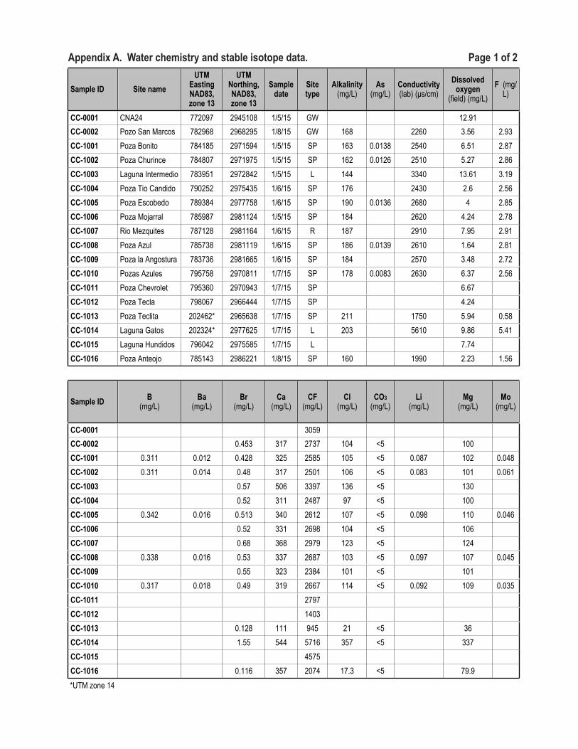
Appendix A. Water chemistry and stable isotope data. Page 1 of 2
Sample ID Site nameUTM
Easting NAD83, zone 13
UTM Northing, NAD83, zone 13
Sample date
Site type
Alkalinity (mg/L)
As (mg/L)
Conductivity (lab) (µs/cm)
Dissolved oxygen
(field) (mg/L)F (mg/
L)
CC-0001 CNA24 772097 2945108 1/5/15 GW 12.91CC-0002 Pozo San Marcos 782968 2968295 1/8/15 GW 168 2260 3.56 2.93CC-1001 Poza Bonito 784185 2971594 1/5/15 SP 163 0.0138 2540 6.51 2.87CC-1002 Poza Churince 784807 2971975 1/5/15 SP 162 0.0126 2510 5.27 2.86CC-1003 Laguna Intermedio 783951 2972842 1/5/15 L 144 3340 13.61 3.19CC-1004 Poza Tio Candido 790252 2975435 1/6/15 SP 176 2430 2.6 2.56CC-1005 Poza Escobedo 789384 2977758 1/6/15 SP 190 0.0136 2680 4 2.85CC-1006 Poza Mojarral 785987 2981124 1/5/15 SP 184 2620 4.24 2.78CC-1007 Rio Mezquites 787128 2981164 1/6/15 R 187 2910 7.95 2.91CC-1008 Poza Azul 785738 2981119 1/6/15 SP 186 0.0139 2610 1.64 2.81CC-1009 Poza la Angostura 783736 2981665 1/6/15 SP 184 2570 3.48 2.72CC-1010 Pozas Azules 795758 2970811 1/7/15 SP 178 0.0083 2630 6.37 2.56CC-1011 Poza Chevrolet 795360 2970943 1/7/15 SP 6.67CC-1012 Poza Tecla 798067 2966444 1/7/15 SP 4.24CC-1013 Poza Teclita 202462* 2965638 1/7/15 SP 211 1750 5.94 0.58CC-1014 Laguna Gatos 202324* 2977625 1/7/15 L 203 5610 9.86 5.41CC-1015 Laguna Hundidos 796042 2975585 1/7/15 L 7.74CC-1016 Poza Anteojo 785143 2986221 1/8/15 SP 160 1990 2.23 1.56
Sample ID B (mg/L)
Ba (mg/L)
Br (mg/L)
Ca (mg/L)
CF (mg/L)
Cl (mg/L)
CO3 (mg/L)
Li (mg/L)
Mg (mg/L)
Mo (mg/L)
CC-0001 3059CC-0002 0.453 317 2737 104 <5 100CC-1001 0.311 0.012 0.428 325 2585 105 <5 0.087 102 0.048CC-1002 0.311 0.014 0.48 317 2501 106 <5 0.083 101 0.061CC-1003 0.57 506 3397 136 <5 130CC-1004 0.52 311 2487 97 <5 100CC-1005 0.342 0.016 0.513 340 2612 107 <5 0.098 110 0.046CC-1006 0.52 331 2698 104 <5 106CC-1007 0.68 368 2979 123 <5 124CC-1008 0.338 0.016 0.53 337 2687 103 <5 0.097 107 0.045CC-1009 0.55 323 2384 101 <5 101CC-1010 0.317 0.018 0.49 319 2667 114 <5 0.092 109 0.035CC-1011 2797CC-1012 1403CC-1013 0.128 111 945 21 <5 36CC-1014 1.55 544 5716 357 <5 337CC-1015 4575CC-1016 0.116 357 2074 17.3 <5 79.9*UTM zone 14
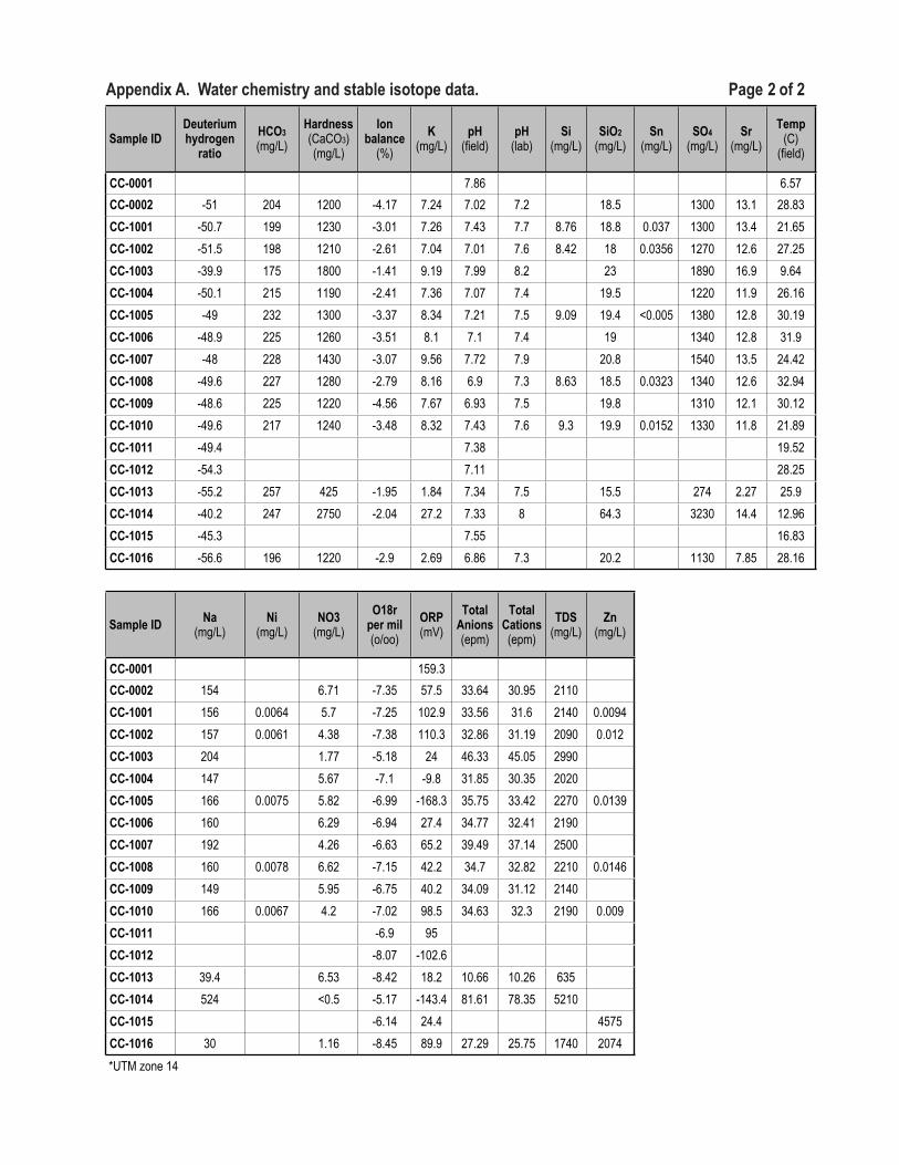
Appendix A. Water chemistry and stable isotope data. Page 2 of 2
Sample IDDeuterium hydrogen
ratioHCO3 (mg/L)
Hardness (CaCO3) (mg/L)
Ion balance
(%)K
(mg/L)pH
(field)pH
(lab)Si
(mg/L)SiO2
(mg/L)Sn
(mg/L)SO4
(mg/L)Sr
(mg/L)Temp
(C) (field)
CC-0001 7.86 6.57CC-0002 -51 204 1200 -4.17 7.24 7.02 7.2 18.5 1300 13.1 28.83CC-1001 -50.7 199 1230 -3.01 7.26 7.43 7.7 8.76 18.8 0.037 1300 13.4 21.65CC-1002 -51.5 198 1210 -2.61 7.04 7.01 7.6 8.42 18 0.0356 1270 12.6 27.25CC-1003 -39.9 175 1800 -1.41 9.19 7.99 8.2 23 1890 16.9 9.64CC-1004 -50.1 215 1190 -2.41 7.36 7.07 7.4 19.5 1220 11.9 26.16CC-1005 -49 232 1300 -3.37 8.34 7.21 7.5 9.09 19.4 <0.005 1380 12.8 30.19CC-1006 -48.9 225 1260 -3.51 8.1 7.1 7.4 19 1340 12.8 31.9CC-1007 -48 228 1430 -3.07 9.56 7.72 7.9 20.8 1540 13.5 24.42CC-1008 -49.6 227 1280 -2.79 8.16 6.9 7.3 8.63 18.5 0.0323 1340 12.6 32.94CC-1009 -48.6 225 1220 -4.56 7.67 6.93 7.5 19.8 1310 12.1 30.12CC-1010 -49.6 217 1240 -3.48 8.32 7.43 7.6 9.3 19.9 0.0152 1330 11.8 21.89CC-1011 -49.4 7.38 19.52CC-1012 -54.3 7.11 28.25CC-1013 -55.2 257 425 -1.95 1.84 7.34 7.5 15.5 274 2.27 25.9CC-1014 -40.2 247 2750 -2.04 27.2 7.33 8 64.3 3230 14.4 12.96CC-1015 -45.3 7.55 16.83CC-1016 -56.6 196 1220 -2.9 2.69 6.86 7.3 20.2 1130 7.85 28.16
Sample ID Na (mg/L)
Ni (mg/L)
NO3 (mg/L)
O18r per mil (o/oo)
ORP (mV)
Total Anions (epm)
Total Cations (epm)
TDS (mg/L)
Zn (mg/L)
CC-0001 159.3CC-0002 154 6.71 -7.35 57.5 33.64 30.95 2110CC-1001 156 0.0064 5.7 -7.25 102.9 33.56 31.6 2140 0.0094CC-1002 157 0.0061 4.38 -7.38 110.3 32.86 31.19 2090 0.012CC-1003 204 1.77 -5.18 24 46.33 45.05 2990CC-1004 147 5.67 -7.1 -9.8 31.85 30.35 2020CC-1005 166 0.0075 5.82 -6.99 -168.3 35.75 33.42 2270 0.0139CC-1006 160 6.29 -6.94 27.4 34.77 32.41 2190CC-1007 192 4.26 -6.63 65.2 39.49 37.14 2500CC-1008 160 0.0078 6.62 -7.15 42.2 34.7 32.82 2210 0.0146CC-1009 149 5.95 -6.75 40.2 34.09 31.12 2140CC-1010 166 0.0067 4.2 -7.02 98.5 34.63 32.3 2190 0.009CC-1011 -6.9 95CC-1012 -8.07 -102.6CC-1013 39.4 6.53 -8.42 18.2 10.66 10.26 635CC-1014 524 <0.5 -5.17 -143.4 81.61 78.35 5210CC-1015 -6.14 24.4 4575CC-1016 30 1.16 -8.45 89.9 27.29 25.75 1740 2074*UTM zone 14*UTM zone 14

New Mexico Bureau of Geology and Mineral Resources A division of New Mexico Institute of Mining and Technology Socorro, NM 87801(575) 835 5490 Fax (575) 835 6333geoinfo.nmt.edu