controls of decadal scale shoreline changes along the west
TRANSCRIPT
Bulletin of Pure and Applied Sciences. Vol.40F, Geology (Geological Science), No.2, July-December 2021: P.205-218
Print version ISSN 0970 4639 Online version ISSN 2320 3234
DOI: 10.5958/2320-3234.2021.00018.4 Original Article Available online at www.bpasjournals.com
Controls of Decadal Scale Shoreline Changes along the West Coast of India: An example from the Sindhudurg District, Maharashtra, India Praveen Gawali1,2, *Milind Herlekar2, Sainath Aher3,4, Satish Sangode2, Prafull Kamble2
Author’s Affiliations: 1Indian Institute of Geomagnetism, Navi Mumbai, Maharashtra 410218, India 2Department of Geology, Savitribai Phule Pune University, Pune, Maharashtra 411007, India 3S.N. Arts, D.J.M. Commerce and B.N.S. Science College, Sangamner, Maharashtra 422605, India 4Universal Geotechnica, Nashik 422011, India *Corresponding Author: Milind Herlekar, Department of Geology, Savitribai Phule Pune University, Pune, Maharashtra 411007, India E-mail: [email protected], [email protected] (Received on 17.07.2021, Accepted on 21.10.2021) How to cite this article: Gawali, P., Herlekar, M., Aher, S., Sangode, S., & Kamble, P. (2021). Controls of Decadal Scale Shoreline Changes along the West Coast of India: An example from the Sindhudurg District, Maharashtra, India. Bulletin of Pure and Applied Sciences- Geology, 40F(2), 205-218. INTRODUCTION Delineation of the shoreline changes has become an important topic of research since the extant climatic changes have been correlated with effect of global warming on sea levels. The recent IPCC Working Group I 2021 report released on 9 August 2021 directly implicates anthropogenic activity to climate change and is wary of continued acceleration in sea level rise. Ahmed (1972) reckons the
coastline of India that comprises 55% beaches, of them 25% is prograding and the remaining are either receding or stable. According to him this coastline is emergent, though there are instances of subsidence in places in West Bengal, Telangana, Kerala, Karnataka, Maharashtra and Gujarat. Kankara et al., (2018), on the other hand, revealed 34% coastline of India is eroding, 28% depositing and the rest is stable. They found this to be the case between 1990 and 2016 and inferred close
ABSTRACT
Time lapsed Satellite Imagery data for the years 2003 to 2019 along the Sindhudurg coastal tract have been used to decipher the decadal scale shoreline changes along the Indian West Coast margin. The sea level changes marked by shoreline are the artifacts of meteo-marine processes including the long duration changes in tidal and wind currents, longshore currents and the beach sedimentary/erosional processes. The sedimentary processes further include detrital pathways and coastal drainage patterns that are in turn governed by the morphotectonic features such as lineaments and faults in the area. The erosive and depositional activity is also implicated by the monsoonal variability. A collective assessment of all these factors for the northern sector from Devgad to Katvan beach observed for the period can be subdivided into two temporal zones of 2003 to 2011 as most dynamic activity, being reduced from 2011 till 2019. The southern sector from Tambaldeg to Tarkarli beaches is seen to have moderate to low dynamic changes. It is finally observed that the interaction of longshore currents with beach morphology is the chief mechanism that governs the decadal scale shoreline changes in the West coast of India. KEYWORDS: Shoreline changes, Indian West Coast, Beach, Sindhudurg, Maharashtra

Praveen Gawali, Milind Herlekar, Sainath Aher, Satish Sangode, Prafull Kamble / Controls of Decadal Scale Shoreline Changes along the West Coast of India: An example from the Sindhudurg District, Maharashtra, India
206
to 40% of the total erosion takes place along West Bengal (63%), Puducherry (57%), Kerala (45%) and Tamil Nadu (41%). The deposition is more at Odisha (51%) and Andhra Pradesh (42%). This is almost 40% of the total deposition that takes place at Indian coastline. Kankara et al., (2018) have also unraveled that the west coast of India is stable, Kerala being an exception, though there are isolated pockets that are eroding.
The coastal regions are sensitive and respond to sea level changes manifested by climate change. They also are a vital link to human settlement. Hence, the study of coastal regions is essential to understand sea level interaction at coasts in the past in response to climate change and tectonically controlled dynamics. This is also essential to decipher the current dynamics between the coast and climate. Understanding of precise changes in the coastal landforms and the consequent land and sea relationship can help forecast future changes. The objective of the present effort is to understand the geomorphological changes to Sindhudurg coastline from 2003 till 2019 as expressed in the shorelines by combining the imagery and field data.
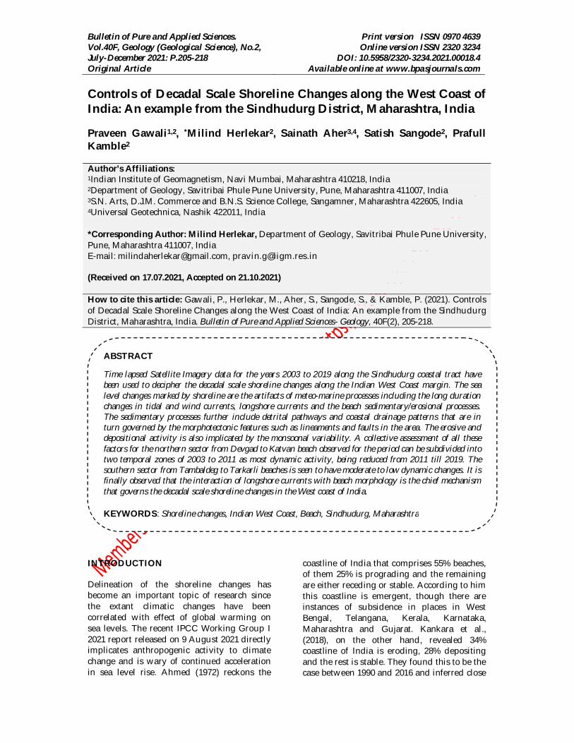
STUDY AREA The 720 km long coastline of Maharashtra state is marked by a spectrum of geomorphological features associated with sea water dynamics like the presence of promontories and sandy beaches or creek and estuarine complexes. Shoreline terraces, beach ridges and sand dunes delineate sea level fluctuations. The Sindhudurg district has a coastline of ~145 km and forms the study area (Fig. 1). The meteorological impact on the coastal dynamics is variable and is controlled by fair weather (February to May), south west monsoon (June to September) and northeast monsoon (October to January) proceedings. The SW monsoon is a dominant force along
India's western coastal terrain because of the arrest of moisture laden winds by the Ghat escarpment leading to average annual heavy rainfall of about 3000 mm. Other meteorological events that impact coasts in general are the cyclones and storm surges, apart from local winds like the storm waves. The ocean swell is generated by winds blown by distant storms and tides generated by astronomical forces. The coastal outline is the handiwork of all these forces as also the longshore drift of coastal currents and sediments. The waves that break on the shore can move sediment shoreward. This activity can be construed as constructive. The destructive is the one that causes erosion. The significant wave height, considered to be the average height of the highest 1/3rd of a group of waves, defines the intensity of wave energy. Kumar et al., (2006) reveal high wave activity is present along the western coastal region during SW monsoon.
The riverine system prevalent in this district is young and covers moderate to small basinal area, are westerly flowing, seasonal and in spate during monsoon months. Thus, the ability to erode and weather is substantially variable throughout the year. The Sindhudurg Rivers originate in the Sahyadri Hills and debouch into the Arabian Sea. The length of every river is variable wherein Gad River has a flow length of ~84km, Tillari 53km, Karli 92km, Deogad 48km, Terekhol 69km, and Wagothan 24km. The area between Vaghotan creek and Devbagh creek is lacerated by many rivulets and streams. The rapid erosion of Sahyadris due to intense seasonal rain has led to large deposition of sediments at the river mouths. The drainage pattern in the study area is mostly dendritic in the NE part and in the remaining areas it is mostly rectangular and parallel.
BPAS / Vol. 40-F, Geology (Geological Science), No. 2 / July-December 2021
Figure 1: Location map of the study area MATERIALS AND METHODOLOGY Multi-temporal true color satellite imageries from 2003 to 2019 for the entire Sindhudurg district coastline were downloaded from Google Earth to detect shoreline changes. The estimation or mapping of shoreline change using true color satellite images is found to be a very effective method (Gawali et al., 2017), since the coastline is highly dynamic and susceptible to changes. Satellite images from Google Earth can be used for time series analysis of shoreline changes after appropriate monitoring and corrections (Warnasuriya et al., 2020). In the present study, time elapsed images from the years 2003 to 2019, have been used and digitization carried of various shorelines using line feature. This exercise has been carried out on multiple years’ images.
The extracted digitized lines were then superimposed in Geographical Information System (GIS) software and morphological changes were mapped along the Sindhudurg coastline. Advanced GIS software allows us to map access and analyze the changes using orthorectified or georeferenced satellite images (Deshmukh et al., 2018). Using this satellite-derived Remote Sensing (RS) data and its integration in GIS software, an overall spatial mapping was
carried out, and temporal change detection and shoreline change assessment were carried out for arbitrarily created 9 divisions of Sindhudurg district from north to south as follows: (1) Devgad to Kunkeshwar (Fig. 2A) (2) Kunkeshwar to Tambaldeg (Fig. 2B) (3) Tambaldeg to Aadbandar (Fig. 4A) (4) Aadbandar to Achara (Fig. 4B) (5) Achara to Kolamb (Fig. 5A) (6) Kolamb to Tarkarli (Fig. 5B) (7) Tarkarli to Bhogwa (Fig. 7A) (8) Bhogwa to Kelus (Fig. 7B) and (9) Kelus to Varachemad (Fig. 9). The study area and overall locations can be seen on Fig. 1.
RESULTS The Devgad to Kunkeshwar sector (Fig. 2A) forms the northernmost part of the district. The coastal stretch containing a beach at north of Devgad is seen to have transgressed to maximum extent in 2011, from its 2003 level, which is seen to be accumulating sand. However, in the later years this beach is seen to be losing sand. Regression of land is seen in 2019. The terrain depicted in figure 1 is quite distinct and does not show any long linear beaches, though a few isolated beaches can be made out. The beach below Taramumbari (Fig. 2A) reveals characteristics of both erosion and deposition. This beach area increased in 2011 with respect to 2003, and decreased in 2019.

Praveen Gawali, Milind Herlekar, Sainath Aher, Satish Sangode, Prafull Kamble / Controls of Decadal Scale Shoreline Changes along the West Coast of India: An example from the Sindhudurg District, Maharashtra, India The accumulation and erosion can be related to longshore currents, waves, tides and processes of river debouching into the Sea that are reworking the sediments. The headland between Devgad and Taramumbari is likely obstructing longshore currents and tides that have formed a thin beach close to Taramumbari and an elongated beach away from it (Fig. 2A).
The beach nestled between Kunkeshwar and Katvan (Fig. 2B) has more
width in north compared to south with the central part exhibiting protruding landmass, which is undergoing erosion from 2011 to 2019, though it grew from 2003 to 2011 and can be clearly made out from Fig. 2B.The headland within this stretch has punctuated this beach creating sheltered beach at its north (Fig. 2B). It can also be inferred that from Katvan to Tambaldeg (Fig. 2B) full development of beaches has not taken place and the headlands seem to be resistant to weathering.
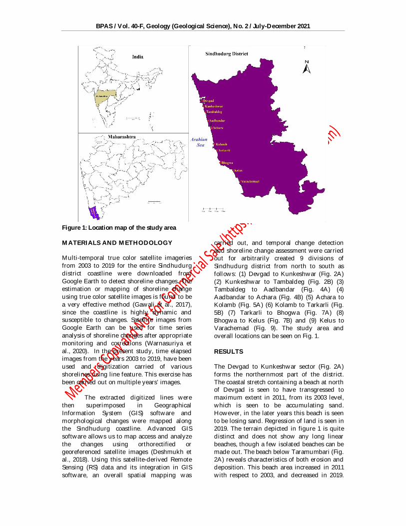
Figure 2: Geocoastal changes deciphered from Devgad to Kunkeshwar (A) and Kunkeshwar to Tambaldeg (B) Some of the more prominent features seen in Fig. 2A, B are described in photographs depicted in Fig. 3a-h. The linear beach at Kunkeshwar is oriented in N-S direction (a) and a closer look at this beach reveals berm formed by 2007-Kyar cyclone (b). High tide has reduced the width of the beach (c) at the time of photography in December 2019 and a
wide concentric beach at Mithmumbari (d) with Kyar influenced berm is seen, wherein hummocky sands are seen to have spread over a long distance (e). These hummocks are formed by the action of tides and currents implying marine transgression. A close up of the hummocky sands can be seen (f and g), which are spread a few kms inland.
BPAS / Vol. 40-F, Geology (Geological Science), No. 2 / July-December 2021
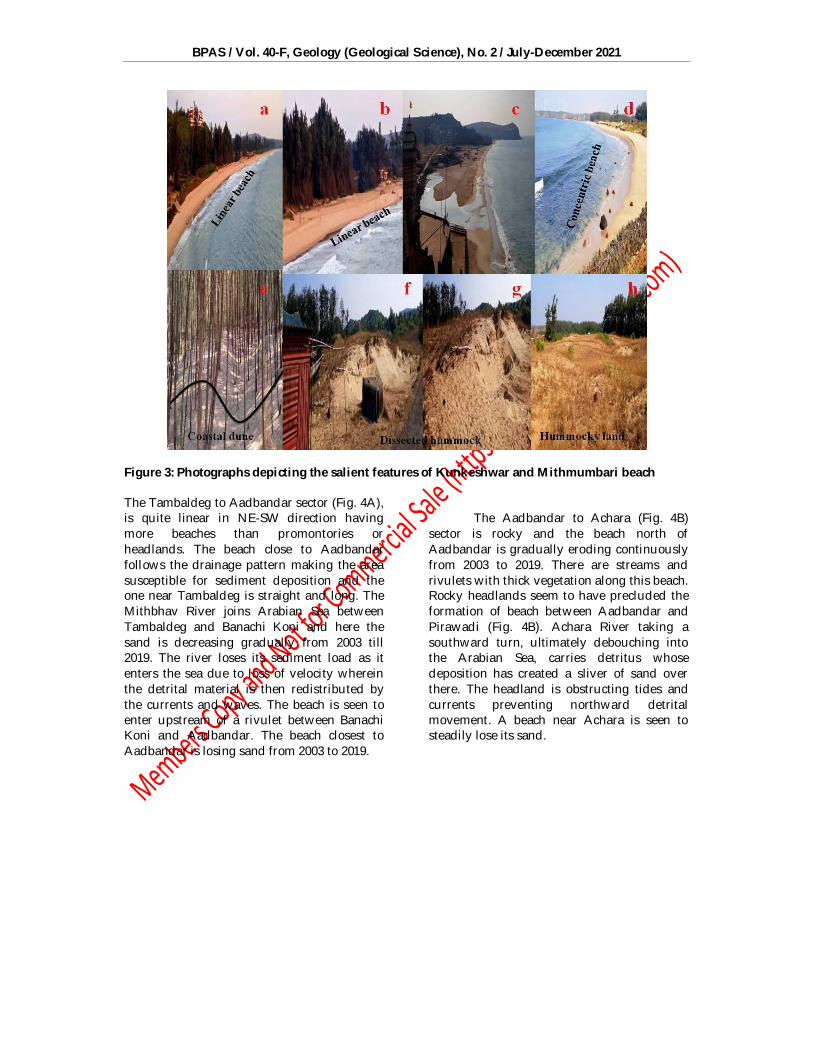
Figure 3: Photographs depicting the salient features of Kunkeshwar and Mithmumbari beach The Tambaldeg to Aadbandar sector (Fig. 4A), is quite linear in NE-SW direction having more beaches than promontories or headlands. The beach close to Aadbandar follows the drainage pattern making the area susceptible for sediment deposition and the one near Tambaldeg is straight and long. The Mithbhav River joins Arabian Sea between Tambaldeg and Banachi Koni and here the sand is decreasing gradually from 2003 till 2019. The river loses its sediment load as it enters the sea due to loss of velocity wherein the detrital material is then redistributed by the currents and waves. The beach is seen to enter upstream of a rivulet between Banachi Koni and Aadbandar. The beach closest to Aadbandar is losing sand from 2003 to 2019.
The Aadbandar to Achara (Fig. 4B)
sector is rocky and the beach north of Aadbandar is gradually eroding continuously from 2003 to 2019. There are streams and rivulets with thick vegetation along this beach. Rocky headlands seem to have precluded the formation of beach between Aadbandar and Pirawadi (Fig. 4B). Achara River taking a southward turn, ultimately debouching into the Arabian Sea, carries detritus whose deposition has created a sliver of sand over there. The headland is obstructing tides and currents preventing northward detrital movement. A beach near Achara is seen to steadily lose its sand.
Praveen Gawali, Milind Herlekar, Sainath Aher, Satish Sangode, Prafull Kamble / Controls of Decadal Scale Shoreline Changes along the West Coast of India: An example from the Sindhudurg District, Maharashtra, India
Figure 4: Geocoastal changes from Tambaldeg to Aadbandar (A) and Aadbandar to Achara (B)
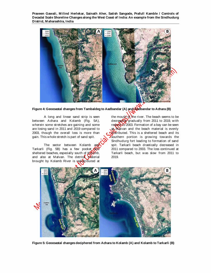
A long and linear sand strip is seen between Achara and Kolamb (Fig. 5A), wherein some stretches are gaining and some are losing sand in 2011 and 2019 compared to 2003, though the overall loss is more than gain. This whole stretch is part of sand spit.
The sector between Kolamb and Tarkarli (Fig. 5B) has a few pocket and sheltered beaches, especially south of Kolamb, and also at Malvan. The detrital material brought by Kolamb River is redistributed at
the mouth of the river. The beach seems to be decreasing gradually from 2011 to 2019, with respect to 2003. Formation of a bay can be seen at Malvan and the beach material is evenly distributed. This is a sheltered beach and its southern portion is growing towards the Sindhudurg fort leading to formation of sand spit. Tarkarli beach drastically decreased in 2011 compared to 2003. The loss continued at Tarkarli beach, but was slow from 2011 to 2019.
Figure 5: Geocoastal changes deciphered from Achara to Kolamb (A) and Kolamb to Tarkarli (B)
BPAS / Vol. 40-F, Geology (Geological Science), No. 2 / July-December 2021
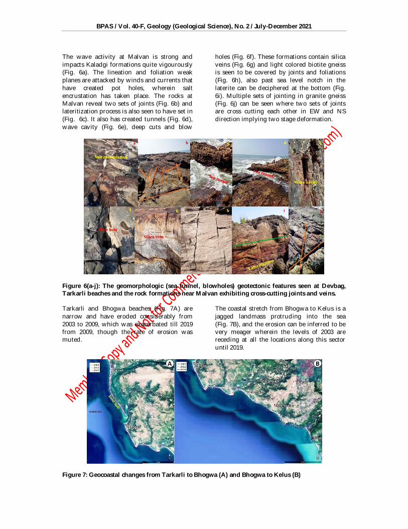
The wave activity at Malvan is strong and impacts Kaladgi formations quite vigourously (Fig. 6a). The lineation and foliation weak planes are attacked by winds and currents that have created pot holes, wherein salt encrustation has taken place. The rocks at Malvan reveal two sets of joints (Fig. 6b) and lateritization process is also seen to have set in (Fig. 6c). It also has created tunnels (Fig. 6d), wave cavity (Fig. 6e), deep cuts and blow
holes (Fig. 6f). These formations contain silica veins (Fig. 6g) and light colored biotite gneiss is seen to be covered by joints and foliations (Fig. 6h), also past sea level notch in the laterite can be deciphered at the bottom (Fig. 6i). Multiple sets of jointing in granite gneiss (Fig. 6j) can be seen where two sets of joints are cross cutting each other in EW and NS direction implying two stage deformation.
Figure 6(a-j): The geomorphologic (sea tunnel, blowholes) geotectonic features seen at Devbag, Tarkarli beaches and the rock formations near Malvan exhibiting cross-cutting joints and veins. Tarkarli and Bhogwa beaches (Fig. 7A) are narrow and have eroded considerably from 2003 to 2009, which was exacerbated till 2019 from 2009, though the rate of erosion was muted.
The coastal stretch from Bhogwa to Kelus is a jagged landmass protruding into the sea (Fig. 7B), and the erosion can be inferred to be very meager wherein the levels of 2003 are receding at all the locations along this sector until 2019.
Figure 7: Geocoastal changes from Tarkarli to Bhogwa (A) and Bhogwa to Kelus (B)
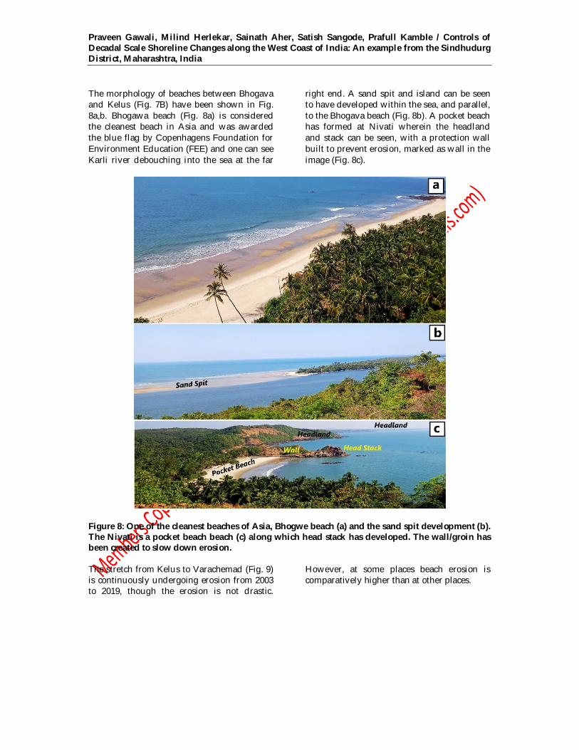
Praveen Gawali, Milind Herlekar, Sainath Aher, Satish Sangode, Prafull Kamble / Controls of Decadal Scale Shoreline Changes along the West Coast of India: An example from the Sindhudurg District, Maharashtra, India The morphology of beaches between Bhogava and Kelus (Fig. 7B) have been shown in Fig. 8a,b. Bhogawa beach (Fig. 8a) is considered the cleanest beach in Asia and was awarded the blue flag by Copenhagens Foundation for Environment Education (FEE) and one can see Karli river debouching into the sea at the far
right end. A sand spit and island can be seen to have developed within the sea, and parallel, to the Bhogava beach (Fig. 8b). A pocket beach has formed at Nivati wherein the headland and stack can be seen, with a protection wall built to prevent erosion, marked as wall in the image (Fig. 8c).
Figure 8: One of the cleanest beaches of Asia, Bhogwe beach (a) and the sand spit development (b). The Nivati is a pocket beach beach (c) along which head stack has developed. The wall/groin has been created to slow down erosion. The stretch from Kelus to Varachemad (Fig. 9) is continuously undergoing erosion from 2003 to 2019, though the erosion is not drastic.
However, at some places beach erosion is comparatively higher than at other places.
BPAS / Vol. 40-F, Geology (Geological Science), No. 2 / July-December 2021
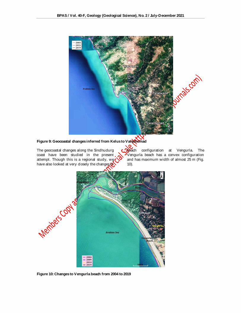
Figure 9: Geocoastal changes inferred from Kelus to Varachemad The geocoastal changes along the Sindhudurg coast have been studied in the present attempt. Though this is a regional study, we have also looked at very closely the changes in
beach configuration at Vengurla. The Vengurla beach has a convex configuration and has maximum width of almost 25 m (Fig. 10).
Figure 10: Changes to Vengurla beach from 2004 to 2019

Praveen Gawali, Milind Herlekar, Sainath Aher, Satish Sangode, Prafull Kamble / Controls of Decadal Scale Shoreline Changes along the West Coast of India: An example from the Sindhudurg District, Maharashtra, India
214
At the NE end of the beach Mandavi
River enters the Arabian Sea depositing detrital material at the confluence. Substantial physical changes are seen to occur at the mouth where Mandavi enters the Arabian Sea and these changes are seen to be quite substantial from 2003 onwards. In 2003 the beach had a narrow opening at its western end (Fig. 10), which is seen to open up appreciably in 2009. At 2009 the mouth can be seen to have widened. However, from 2015 onwards the placer material has been reducing fast because of erosion which has continued till 2019. The remaining part of the beach expanded in size from 2003 onwards, which is seen to have attained maximum width by 2009. The beach reduced in size in 2015 back to the limit set in at 2003, which reduced further down in 2019. DISCUSSION From the foregoing it can be said that the coastal Sindhudurg is in a dynamic flux where short term and long term changes in its morphology are taking place. Shoreline changes occur on a range of time scales. These changes can never be uniform because of which it is quite difficult to model them on real time terms (Short, 1999). These changes are dependent on scores of factors like seasonal changes in wave dynamics due to different controls (Masselink and Pattiaratchi, 2001; Shand et al., 2001), and the variable sediment supply (Orford et al., 2002). The coastline morphology is also seen to change with the stream power, storm surges intensity and the wave conditions present in the area apart from the sea level fluctuations (Ranasinghe, 2016). Tsunamis also impact the shoreline and the berm generated by Kyarr has been documented in the present study.
Hinkel et al., (2013) assessed global sea level rise and the resultant erosion of sandy beaches, directly or indirectly, due to climate change. They estimated beach nourishment costs and inferred about 6000-17,000 km2 land could be lost to sea level rise and bring about increased rate of erosion affecting about 1.6 to 5.3 million people. The costs for carrying out mitigation could be from US$ 300-1000 billion. Li et al (2002) found direction of sediment transport and magnitude changed with the direction of
winds. The intensity of longshore currents was found to be more at Vengurla and Aravali, but less along Redi beach (Gawali et al., 2010) and in addition to cyclic changes in wind and wave pattern, the morphological setting of these beaches influences the rate of erosion or accumulation (Gawali et al, 2010).
Overall it can be said that the geomorphological features observed in the study area indicate neotectonic processes have sculpted these landforms. The variability in sea level can be inferred from the presence of wave cut platforms and sea stacks in the coastal stretch of Sindhudurg. The beach ridges and raised dunes, on the other hand, are indicators of sea level fall in the present times. The fall in level can be inferred to be a few meters. The coastal landforms of the area reveal complex evolutionary and geotectonic history of the times when Indian subcontinent separated from Gondwanaland. The linear morphology of the beaches present in this coastal terrain in an almost N-S direction having en-echelon disposition can be attributed to counter clockwise rotation of Indian subcontinent (Herlekar and Sukhtankar, 2008). Also, almost E-W lineament configuration suggests rifting caused differential displacement.
As can be seen from figures 2 to 5 and 7 to 9 one can identify various depositional and erosional features in the study area. Quite a few estuaries can be identified from the figures. Estuaries are partially enclosed flowing water bodies that are connected to the open sea allowing mixing of seawater with riverine freshwater. The terminal phase marine transgression of Holocene invaded lowlands and valley mouths forming inlets and embayments. The hydrodynamic processes influence largely the morphology of an estuary and can be observed at Vaghotan, Kharda, Pyali, Achra, Gad and Karli rivers in the study area. The tidal effects can be seen at estuary mouth that develop unique features that can be seen at the mouth of Vaghotan River (near Vijaydurg), Kharda River (Devgarh), Pyali River (Morvewadi), Achra River (Pirwadi), Gad River (Talashi) and Karli River (Devbag). One can observe mudflats, marshy land and swamps at these estuaries.

BPAS / Vol. 40-F, Geology (Geological Science), No. 2 / July-December 2021
215
The beach configuration, as seen in the
images, at some places is long and straight, or short and curved. The curved ones are called pocket beaches formed along bays and coves. Such types of beach are generally formed between rocky headlands, and are found at many places between Vijaydurg and Devbag creeks in the study area. Curiously, pocket beaches have formed in northern Sindhudurg and linear beaches in southern sector, being both sandy and rocky. Pocket beaches of varying width between 20 m to 100 m have formed at Vijaydurg, Ghariwadi, Kolwadi, Mithmumbri, Kunkeshwar and Katvan areas covering the northern zone of the study area. Long and linear beaches can be seen from Malvan to Aravali. Such beaches can be easily made out at Achra, Vayangani, Tondavali, Talashi and Tarakarli in southern part of the study area. Such beaches are also present at Girye, Phanase, Mithbav and Munge in the northern sector as well.
Many steep sea cliffs can be identified in the study area and these are formed by undercutting action of the sea waves. The repeated wave and wind energy onslaughts on the steep walls, made of laterites and basalts in the study area, are gradually cut because of which they recede back forming a basal abrasion notch. The notch is typically seen at a height of 1-2 m and keeps on growing, leading to instability and eventual collapse of the cliff. Such notches are found to be present on resistant rocks, since weak outcrops are unable to sustain for long. The cliffs are topped by laterites in the study area and their height varies from 15 m to 25 m. Sea cliffs of about 35 m can be seen at Kunkeshwar and Devgarh. The Vijaydurg sea cliff is basaltic and is about 25 m high. These are also observed at Kolwadi and Rameshwarwadi having steep slopes and are situated in the southern part of the study area. Girye and Kalambai cliff are inferred to have receded, due to basal erosion, resultant slumping, occurrence of landslides and collapsed debris removal from the cliff base. These cliffs are postulated to have formed around 6k years during the Late Pleistocene and Holocene, when the sea remained or was close to its present level.
The projections of land into sea are called as headlands that have been sculpted by sea water through various dynamical
processes. The erosion of headland creates features that are distinctive like caves, arches, stacks and stumps. Basaltic headlands are seen at Kolwadi and Kotharwadi, and those at Kunkeshwar, Katwan and Achra are made of laterite and quartzite. Sea stacks are formed close to Girye, and at Nivati beach. Wave-cut platforms that are horizontal or structural are formed at Girye and Malvan.
Sand bars are depositional features
that form elongated ridges of sand or gravel. These are typically a few meters wide and are deposited by waves and currents approximately parallel to the coastline. These are usually submerged during high tide. Sand bars have developed along Girye, Kolwadi, Kothar and Tambaldegwadi that runs for a distance of about 50 m with an average width of about 20 m. Along the south of the study area sand bars are seen at Phansewadi, Achra, Vayangani, Tondavali and Tarkarli extending for a long distance of around 1 to 2 km having an average width of 52 m. Sand spits are essentially sand bars, but they differ on one count. They usually diverge away from coasts and recurve or attain hook-like configuration. Though their growth is predominantly in the longshore direction and oblique to the coast, their development of shape is largely brought about by wave action pattern. One can find an elongated sand ridge that extends from land to the mouth of Phanase River near Phanase. The end of the spit hook has developed landward over here due to wave-generated currents. The length of this sand spit ranges from 210 to 250 m with width of 70 to 80 m. Spits can also be seen to have formed near Morvewadi, Munge, Talashi and Devbag of 290 to 300 m length and width between 20 to 50 m.
Raised marine terraces are found adjacent to the beach in the study area paralleling the shoreline at places like Girye, Phanase and Padavane. These are stable ones and are inferred from the lush growth of vegetation. Raised marine stable terraces are also seen at Kunkeshwar, Morve, Mungae, Achra, Tondovali, Talashi and Tarkarli coastline. These raised beaches are seen to be about 2-3 m in height, made of carbonate sands.
Aeolian processes are seen to be an important agent of geomorphological feature formation giving rise to sand or coastal dunes.
Praveen Gawali, Milind Herlekar, Sainath Aher, Satish Sangode, Prafull Kamble / Controls of Decadal Scale Shoreline Changes along the West Coast of India: An example from the Sindhudurg District, Maharashtra, India
216
Sand dunes are associated with flat beach that have large tidal range, large supply of dry sand to enable carrying onshore by wind action. It is also necessary for this transporting sand to lose its energy against an obstacle and settle down. This aeolian transport has been observed to take place through suspension, saltation and creep. Also, for sand dunes to form, the windward side needs to have a gentle slope, and the leeward side steep slope. Sand dune formation can be seen at Girye, Kolwadi and Phanase, Mithmumbari, Tambaldegwadi, Morvewadi, Kunkeshwar, Achra, Vayangani, Tondovali, Talashi and Tarkarli.
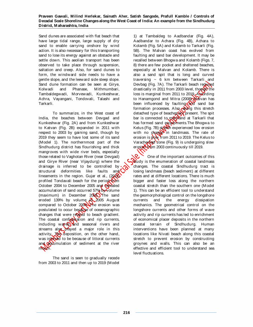
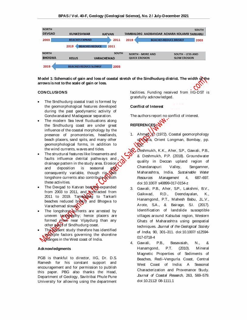
To summarize, in the West coast of India, the beaches between Devgad and Kunkeshwar (Fig. 2A) and from Kunkeshwar to Katvan (Fig. 2B) expanded in 2011 with respect to 2003 by gaining sand, though by 2019 they seem to have lost some of its sand (Model 1). The northernmost part of the Sindhudurg district has flourishing and thick mangroves with wide river beds, especially those related to Vaghotan River (near Devgad) and Girye River (near Vijaydurg) where the drainage is inferred to be controlled by structural deformities like faults and lineaments in the region. Gujar et al., (2011) profiled Tondavali beach for the period from October 2004 to December 2005 and revealed accumulation of sand occurred 57% by volume (maximum) in December 2005. The sand eroded 139% by volume in 2005 August compared to October 2004. The erosion was postulated to occur because of oceanographic changes that were related to beach gradient. The coastal configuration and rip currents, including waves and seasonal rivers and streams also played a major role in this activity. The deposition, on the other hand, was inferred to be because of littoral currents and accumulation of sediment at the river mouth.
The sand is seen to gradually recede from 2003 to 2011 and then up to 2019 (Model
1) at Tambaldeg to Aadbandar (Fig. 4A), Aadbandar to Achara (Fig. 4B), Achara to Kolamb (Fig. 5A) and Kolamb to Tarkarli (Fig. 5B). The Malvan coast has evolved from faulting and sand bar development. It may be recalled between Bhogwa and Kolamb (Figs. 7, 8) there are few pocket and sheltered beaches, especially at Malvan and Kolamb. There is also a sand spit that is long and curved traversing ~ 6 km between Tarkarli and Devbag (Fig. 7A). The Tarkarli beach reduced drastically in 2011 from 2003 level, though the loss is marginal from 2011 to 2019. According to Hanamgond and Mitra (2008) Malvan has been influenced by faulting and sand bar formation processes. Also, along this stretch detached type of beaches are present. The spit bar is connected to mainland at Tarkarli that has formed sand escarpments.The Bhogwa to Kelus (Fig. 7B) stretch experienced low erosion with no change in landmass. The rate of erosion is slow from 2011 to 2019. The Kelus to Varachemad zone (Fig. 9) is undergoing slow erosion from 2003 continuously till 2019.
One of the important outcomes of this
study is the enumeration of coastal landmass changes. The coastal Sindhudurg tract is losing landmass (beach sediment) at different rates and at different locations. There is much bigger and faster loss along the northern coastal stretch than the southern one (Model 1). This can be an efficient tool to understand the geomorphological control on the longshore currents and the energy dissipation mechanics. The geometrical control on the longshore currents and other forms of wave activity and rip currents has led to enrichment of economical placer deposits in the northern coastal terrain of Sindhudurg. Human interventions have been planned at many locations like Nivati beach along this coastal stretch to prevent erosion by constructing groynes and walls. This can also be an effective and efficient tool to understand sea level fluctuations.
BPAS / Vol. 40-F, Geology (Geological Science), No. 2 / July-December 2021
Model 1: Schematic of gain and loss of coastal stretch of the Sindhudurg district. The width of the arrows is not to the scale of gain or loss. CONCLUSIONS The Sindhudurg coastal tract is formed by
the geomorphological features developed during the past geodynamic activity of Gondwanaland Madagascar separation.
The modern Sea level fluctuations along the Sindhudurg coast are under great influence of the coastal morphology by the presence of promontories, headlands, beach placers, sand spits, and many other geomorphological forms, in addition to the wind currents, waves and tides.
The structural features like lineaments and faults influence detrital pathways and drainage pattern in the study area. Erosion and deposition is seasonal and consequently variable, though rip and longshore currents also contribute in both these activities.
The Devgad to Katvan beaches expanded from 2003 to 2011, and contracted from 2011 to 2019. Tambaldeg to Tarkarli beaches reduced briskly and Bhogwa to Varachemad slowly.
The longshore currents are arrested by uneven topography; hence placers are formed more near Vijaydurg than any other parts of Sindhudurg coast.
The present study therefore has identified multiple factors governing the shoreline changes in the West coast of India.
Acknowledgments PGB is thankful to director, IIG, Dr. D.S. Ramesh for his constant support and encouragement and for permission to publish this paper. PBG also thanks the Head, Department of Geology, Savitribai Phule Pune University for allowing using the department
facilities. Funding received from IIG-DST is gratefully acknowledged. Conflict of Interest The authors report no conflict of interest. REFERENCES 1. Ahmed, E. (1972). Coastal geomorphology
of India, Orient Longman, Bombay, pp. 222.
2. Deshmukh, K.K., Aher, S.P., Gawali, P.B., & Deshmukh, P.P. (2018). Groundwater quality in Deccan upland region of Chandanapuri Valley, Sangamner, Maharashtra, India. Sustainable Water Resources Management 4, 687–697. doi:10.1007/s40899-017-0154-z
3. Gawali, P.B., Aher, S.P., Lakshmi, B.V., Gaikwad, R.D., Deendayalan, K., Hanamgond, P.T., Mahesh Babu, J.L.V., Arote, S.A., & Bairage, S.I. (2017). Identification of landslide susceptible villages around Kalsubai region, Western Ghats of Maharashtra using geospatial techniques. Journal of the Geological Society of India, 90, 301–311. doi:10.1007/s12594-017-0718-4
4. Gawali, P.B., Basavaiah, N., & Hanamgond, P.T. (2010). Mineral Magnetic Properties of Sediments of Beaches, Redi–Vengurla Coast, Central West Coast of India: A Seasonal Characterization and Provenance Study. Journal of Coastal Research, 263, 569–579. doi:10.2112/08-1111.1
Praveen Gawali, Milind Herlekar, Sainath Aher, Satish Sangode, Prafull Kamble / Controls of Decadal Scale Shoreline Changes along the West Coast of India: An example from the Sindhudurg District, Maharashtra, India
218
5. Gujar, A.R., Ganesan, P., Iyer, S.D., Gaonkar, S.S., Ambre, N.V., Loveson, V.J., & Mislankar, P.G. (2011). Influence of morphodynamic variability over seasonal beach sediments and its probable effect on coastal development. Ocean & Coastal Management, 54, 514–523. doi:10.1016/j.ocecoaman.2011.03.007
6. Hanamgond, P.T., & Mitra, D. (2008). Evolution of Malvan Coast, Konkan, West Coast of India—A Case Study Using Remote Sensing Data. Journal of Coastal Research, 243, 672–678. doi:10.2112/06-0692.1
7. Herlekar, M.A., & Sukhtankar, R.K. (2008). Dynamic evolution of Maharashtra coast. National Seminar Konkan Coast DEED (Dynamics, Evolution, Ecosystem and Development), 12-13 Sept, 2008, pp.78-83.
8. Hinkel, J., Nicholls, R.J., Tol, R.S.J., Wang, Z.B., Hamilton, J.M., Boot, G., Vafeidis, A.T., McFadden, L., Ganopolski, A., & Klein, R.J.T. (2013). A global analysis of erosion of sandy beaches and sea-level rise: An application of DIVA. Global and Planetary Change, 111, 150–158. doi:10.1016/j.gloplacha.2013.09.002
9. Kankara, R.S., Ramana, M.M.V., & Rajeevan, M. (2018). National Assessment of shoreline changes along Indian coast: Status report for 26 years (1990–2006). NCCR Publication. http:// www.nccr.gov.in
10. Kumar V.S., Pathak K.C., Pednekar P., Raju N.S.N. & Gowthaman R. (2006). Coastal processes along the Indian coastline; Curr. Sci. 91(4) 530–536
11. Li, L., Barry, D.A., Pattiaratchi, C.B., & Masselink, G. (2002). BeachWin: modelling groundwater effects on swash sediment transport and beach profile changes. Environmental Modelling & Software, 17, 313–320. doi:10.1016/S1364-8152(01)00066-4
12. Masselink, G., & Pattiaratchi, C.B. (2001). Seasonal changes in beach morphology along the sheltered coastline of Perth, Western Australia. Marine Geology, 172, 243–263. doi:10.1016/S0025-3227(00)00128-6
13. Orford, J.D., Forbes, D.L., & Jennings, S.C. (2002). Organisational controls, typologies and time scales of paraglacial gravel-dominated coastal systems. Geomorphology, 48, 51–85. doi:10.1016/S0169-555X(02)00175-7
14. Ranasinghe, R. (2016). Assessing climate change impacts on open sandy coasts: A review. Earth-Science Reviews 160, 320–332. doi:10.1016/j.earscirev.2016.07.011
15. Shand, R.D., Bailey, D.G., & Shepherd, M.J. (2001). Longshore realignment of shore-parallel sand-bars at Wanganui, New Zealand. Marine Geology, 179, 147–161. doi:10.1016/S0025-3227(01)00223-7
16. Short, A.D., (ed)., (1999). Handbook of Beach and Shorefacemorphodynamics. Wiley, NY.
17. Warnasuriya, T.W.S., Kumara, M.P., Gunasekara, S.S., Gunaalan, K., & Jayathilaka, R.M.R.M. (2020). An Improved Method to Detect Shoreline Changes in Small-Scale Beaches Using Google Earth Pro. Marine Geodesy, 43, 541–572. doi:10.1080/01490419.2020.1822478
**********