context-aware location prediction
TRANSCRIPT
Context-Aware Location Prediction
Roni Bar-David and Mark Last
Department of Information Systems Engineering
Ben-Gurion University of the Negev
[email protected], [email protected]
Abstract. Over the past few years, predicting the future location of mobile ob-
jects has become an important and challenging problem. With the widespread use
of mobile devices, applications of location prediction include location-based ser-
vices, resource allocation, smooth handoffs in cellular networks, animal migra-
tion research, and weather forecasting. Most current techniques try to predict the
next location of moving objects such as vehicles, people or animals, based on
their movement history alone. However, ignoring the dynamic nature of mobile
behavior and trying to repeatedly exploit the same common patterns, may yield
wrong results, at least part of the time. Analyzing movement in its context and
choosing the best movement pattern by the current situation, can reduce some of
the errors and improve prediction accuracy. In this paper, we present a context-
aware location prediction algorithm that utilizes various types of context infor-
mation to predict future location of vehicles. We use five contextual features re-
lated to either the object environment or its current movement data: current loca-
tion; object velocity; day of the week; weather conditions; and traffic congestion
in the area. Our algorithm incorporates these context features into the trajectory-
clustering phase as well as in the location prediction phase. We evaluate our al-
gorithm using two real-world GPS trajectory datasets. The experimental results
demonstrate that the context-aware approach can significantly improve the accu-
racy of location predictions.
1 Introduction
In recent years, ever more data is available about the location of moving objects and
their usage context. Playing no small part in this growth is the increasing popularity of
mobile devices equipped with GPS receivers that enable users to track their current
locations. These devices have now emerged as computing platforms enabling users to
consume location-aware services from Internet websites dedicated to life logging,
sports activities, travel experiences, geo-tagged photos, etc. In addition, many users
have started sharing their outdoor movements using social networks. The interaction of
users with such services inevitably leaves some digital traces about their movements in
device logs and on various web servers, which provide a rich source of information
about people's preferences and activities with regard to their location. This provides the
opportunity to collect both spatio-temporal and contextual data, and in turn, to develop
innovative methods for analyzing the movement of mobile objects.
We assume that the behavior of moving objects can be learned from their historical
data. In any particular environment, people do not move randomly but rather tend to
follow common paths, specific repetitive trajectories that correspond to their intentions.
Thus, predicting their future location is possible by analyzing their movement history.
Location prediction models can enhance many different applications, such as location-
aware services [1], mobile recommendation systems [2], animal migration research,
weather forecasting [3], handoff management in mobile networks [4], mobile user
roaming [5], etc. While a substantial amount of research has already been performed in
the area of location prediction, most existing approaches focus on using the most com-
mon movement patterns for prediction without taking into account any additional con-
textual information. This severely limits their applicability since in practice the move-
ment is usually free and uncertain. In many situations, it may not be sufficient to con-
sider only the movement history, since the probability of a future location does not only
depend on the number of times it was visited before but also on the object’s current
context. For example, in different situations, a driver may choose different routes lead-
ing to the same destination.
The importance of contextual information has been recognized by researchers and
practitioners in many disciplines. Context-aware applications are able to identify and
react to real world situations better than applications that do not consider this sort of
information. Context information can help systems to ease the interaction with the user
and sometimes even allow a device to be used in a way that was not intended by design.
In this paper, we argue that relevant contextual information does matter in location
prediction and that it is important to consider this information when providing predic-
tions.
The goal of this work is use context to improve the accuracy of predicting movement
of mobile objects such as vehicles. We represent movement patterns as sequences of
spatio-temporal intervals, where each interval is a minimal bounding box (MBB). We
enhance the standard MBB-based representation of movement patterns described in [6]
with a context profile. The extended MBB represents a geographic area traversed by an
object at a certain time, which also has a semantic meaning. The context profile turns
an MBB into a segment that represents a set of data points not only close in time and
space, but also having the same or similar values of contextual features. We extract
contextual features for each MBB from its summarized data points. We calculate the
average velocity, separate weekends from regular workdays, fetch weather conditions
for the area where the object is moving and mark traffic congestion areas. We use a
context-aware similarity measure to cluster similar trajectories with different types of
contextual data. We present a new algorithm for location prediction that utilizes several
context information features and overcomes the limitation mentioned above by choos-
ing the relevant movement pattern according to the context. Finally, we compare the
prediction performance and show that our context-aware prediction model can provide
more accurate predictions than the existing context-free model. The main contribution
of this work is the use of spatio-temporal data mining techniques in combination with
context information in order to achieve a higher prediction accuracy than a state-of-the-
art context-free method. We build an integrated model of context information and we
use several context features in the location prediction domain. The algorithm we de-
velop simultaneously considers several types of contextual information from external
and internal data sources, and incorporates them in the location prediction model.
2 Related Work
2.1 Location Prediction Methods
Predicting the future location of a given mobile object is an interesting and challenging
problem in data mining. In [7], the authors propose the WhereNext system that is based
on association rules, and define a trajectory as an ordered sequence of locations. Given
a trajectory of a moving object, it selects the best matching association rule and uses it
for prediction. Trajectory patterns are sequences of spatial regions that emerge as fre-
quently visited in a given order. Motion functions represent the trajectory of an object
based on its recent movements, and indicate location changes by updating the function
parameters, instead of recording object locations at individual timestamps. The most
common functions are linear models that assume an object follows linear movements
[8]. Given an object’s current location, time and velocity the object’s future location is
estimated at a future time. Although this simple formula avoids many complications, it
has limited applicability due to the enormous diversity of motion types. There are non-
linear models that capture the object’s movements by more sophisticated mathematical
formulas. Thus, their prediction accuracies are higher than those of the linear models
[9]. The recursive motion function is the most accurate prediction method among mo-
tion functions. It predicts an object’s location at a specific time in relation to those of
the recent past. It can express unknown complex movements that cannot be represented
in an obvious manner. In [10] authors propose a hybrid prediction algorithm that takes
advantage of an object’s pattern information, as well as its motion function. This algo-
rithm mines an object's trajectory patterns that follow the same routes over regular time
intervals. When there is no pattern candidate in the prediction process, it calls a recur-
sive motion function to answer the query.
The common Markov Chain models are used to address the problem of short-term
location prediction [11]. This paper describes a hidden Markov model for routing man-
agement in mobile networks. A Markov model is one in which the current model state
is conditionally dependent on the previous k states of the model. Each movement be-
tween locations corresponds to a transition between states and it is assigned a certain
probability. In a hidden Markov model, the underlying states are not directly observa-
ble, and there is only access to an observable set of symbols that are probabilistically
related to the hidden states.
Clustering is an unsupervised method of learning, which reveals the overall distri-
bution pattern and interesting correlations in datasets. A cluster is a set of data objects
with similar characteristics that can be collectively treated as one group. In [12] the
authors introduced the concept of moving micro-clusters. A micro-cluster indicates a
group of objects that are not only close to each other in a specific time, but also likely
to move together for a while. In order to keep the high quality of clustering, these micro-
clusters may split and get reorganized. A moving micro-cluster can be viewed as one
moving object, and the center of it can be treated as its location. In [13] the authors
propose a segmentation algorithm for representing a periodic spatio-temporal trajec-
tory, as a compact set of MBBs. An MBB represents a spatio-temporal interval bounded
by limits of time and location. This structure enables summarizing close data-points,
such that only the minimum and maximum values of the spatial coordinates and time
are recorded. The authors define data-amount-based similarity between trajectories ac-
cording to proximity of trajectories in time and space.
2.2 Spatio-Temporal Context Models
Context awareness is defined as the ability to identify and react to situations in the real
world by taking advantage of contextual information [14]. Making use of relevant con-
text information from a variety of sources to provide suitable services or task-dependent
information is one of the main challenges in ubiquitous computing. In [15] ubiquitous
computing defined as a paradigm shift where technologies become virtually invisible
or transparent and yet pervasively affect every aspect of our lives. The authors proposed
a reference framework to identify key functionalities of context-awareness, and assist-
ing ubiquitous media applications in discovering contextual information and adapting
their behavior accordingly. Another context-aware model that supports managing of
ubiquitous applications is described in [16]. It includes modules for context acquisition
from distributed sources, context storage and actuation in the environment, and context
processing for notifying the current state.
Context is a general concept describing the conditions where a process occurs. Sev-
eral definitions of the term can be found in the literature, and it can be seen that the
scope of definitions has expanded over the years. The earliest definition of context per-
ceive it mostly related to location [17] as the user location, the identity of people near
the user, the object around, and the changes in these elements. In [18] the authors en-
riched context definition to include additional user and environment information, such
as habits, emotional state, shared position with others and social interactions. Context
definition was further extended in [14] to distinguish between active context that influ-
ences the behavior of an application, and passive context that can be relevant but not
critical to the application.
Context information is used in the location prediction literature mostly with respect
to identity, location and time. In [19] authors demonstrated the use of user location as
context in their supervised learning approach for detecting spatial trajectory patterns.
They mined travel sequences of multiple users from GPS trajectories, and found inter-
esting places in a certain region from the location history. An interesting location is
defined using a stay point, a geographic region where the user stayed over a certain
time interval. This model uses other people's travel experiences in order to improve
travel recommendations. In [20] the authors propose to capture the spatio-temporal con-
text of user check-in behavior in order to improve a location prediction model. They
consider temporal periodic patterns in addition to spatial historical trajectories for com-
puting the next visit probability in a location during a certain time interval. The location
and time probabilities restrain and complement each other in the form of spatio-tem-
poral context. Appling smoothing techniques they found that a user mostly checks-in
at a location during a specific time interval and rarely visits during other time intervals.
In [21] authors propose incorporating temporal context dimensions such as time of the
day in a route recognition system. They designed a real-time personal route recognition
system that uses context information to predict the route destination. Instead of com-
paring the current driving trajectory against the trajectories observed in the past and
select the most similar route, they incorporated the time of day as context, and adjusted
the route recognition output accordingly. They found that the trajectories depend on the
time of day feature, even at the beginning of a trip, that typically starts at the same
departure point (e.g., home) and creates overlapping trajectories.
In our literature survey, we could not find any location prediction solutions that uti-
lize context information from different data sources. Current techniques often focusing
on only one type of spatial or temporal context, and do not consider sudden changes in
the movement and the environment. The attempts to integrate both spatial and temporal
context information suffer from the overfitting problem due to the large number of spa-
tio-temporal trajectory patterns. In order to cope with the dynamic nature of movement,
we are interested in context features that affect the choice of a movement pattern. Ex-
isting context-aware models have not considered how to incorporate the context infor-
mation in the task model in an efficient way, but separated the context model from the
task. We try to find a convenient representation of the context information, in order to
incorporate it in the movement pattern representation. In our work, we try to integrate
into one prediction model both the context features generated from the historical move-
ment data and the context features available from external sources, like web services.
3 Proposed Methodology
Our approach consists of three main steps: (1) extracting periodic trajectories together
with the context information of the mobile object; (2) inducing context-aware models
that describe the object's movement patterns; and (3) predicting the future location of
an object based on the two previous steps and the current context.
3.1 Extracting Contextual Information
We introduce a unique representation of an area and its contextual features, as a com-
bination of a minimal bounding box (MBB) and a context profile. The extended MBB
represents a spatio-temporal interval as well as its related context features. It can be
regarded as a geographic area traversed by an object at a certain time, which also has a
semantic meaning. Formally, MBB has the following properties:
𝑖. 𝑡𝑚𝑖𝑛 = min(∀𝑝 ∈ 𝑖, 𝑝. 𝑡𝑚𝑖𝑛) , 𝑖. 𝑡𝑚𝑎𝑥 = max(∀𝑝 ∈ 𝑖, 𝑝. 𝑡𝑚𝑎𝑥)
𝑖. 𝑥𝑚𝑖𝑛 = min(∀𝑝 ∈ 𝑖, 𝑝. 𝑥𝑚𝑖𝑛) , 𝑖. 𝑥𝑚𝑎𝑥 = max(∀𝑝 ∈ 𝑖, 𝑝. 𝑥𝑚𝑎𝑥)
𝑖. 𝑦𝑚𝑖𝑛 = min(∀𝑝 ∈ 𝑖, 𝑝. 𝑦𝑚𝑖𝑛) , 𝑖. 𝑦𝑚𝑎𝑥 = max(∀𝑝 ∈ 𝑖, 𝑝. 𝑦𝑚𝑎𝑥)
where i represents an MBB; p represents a data point in a box; x and y are spatial
coordinates; and tmin and tmax are the object's minimum and maximum times in the area.
This allows us to summarize close data points into one MBB, and represent it by these
six elements rather than by the multiple original data points. We consider context to be
represented by a context profile related to both an area and a mobile object’s current
state. Context features may be related to the environment surrounding a mobile object
or to the mobile object movement itself. A context profile turns an MBB into a segment
that represents a set of data points not only close in time and space, but also having the
same or similar values of contextual features. A context feature has an identifier, a type
and a value. Formally:
𝐶𝑜𝑛𝑡𝑒𝑥𝑡𝑃𝑟𝑜𝑓𝑖𝑙𝑒 =
{𝑖, 𝑎𝑚𝑜𝑢𝑛𝑡, 𝑙𝑜𝑐𝑎𝑡𝑖𝑜𝑛, 𝑣𝑒𝑙𝑜𝑐𝑖𝑡𝑦, 𝑑𝑎𝑦𝑜𝑓𝑡ℎ𝑒𝑤𝑒𝑒𝑘, 𝑤𝑒𝑎𝑡ℎ𝑒𝑟, 𝑡𝑟𝑎𝑓𝑓𝑖𝑐𝑐𝑜𝑛𝑔𝑒𝑠𝑡𝑖𝑜𝑛) where i identifies the MBB; and the other properties represent the aggregated feature
values. We enhance the MBB representation to support additional context features with
the following method:
𝑀𝐵𝐵. 𝑐𝑓 = aggregation(∀𝑝 ∈ 𝑀𝐵𝐵, 𝑝. 𝑐𝑓)
where cf stands for a context feature that is being aggregated; and p represents a
point member in an MBB. In case of a discrete feature, such as the day of the week, all
data points will have the same contextual value. In case of a numeric feature, all sum-
marized data points will be restricted to a certain interval. For example, a movement
pattern may be characterized by a predefined velocity range.
This compact and unique representation of an MBB allows us to obtain quality and
time efficient results in subsequent mining stages, and to incorporate the context infor-
mation in the trajectory-clustering phase. Several context features may influence the
mobile object movement. We are looking for occurrences of certain context character-
istics that change the movement habits. Awareness of such events can help us choose
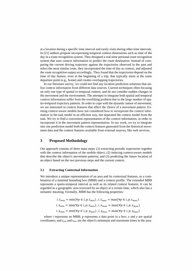
the right movement pattern, and help to improve future location predictions. A diagram
describing the different types of context is described in Fig. 1.
Fig. 1. Different Context Types
Amount. This is the baseline property that represents the number of data points that
are summarized by a given MBB. It is calculated as the number of times the area has
been accessed. The more times an object visits a particular MBB, the more important
it becomes. The algorithm chooses the most common MBB within the time bounds with
the maximal data amount property to be the prediction result. Formally:
𝑀𝐵𝐵. 𝑎𝑚𝑜𝑢𝑛𝑡 = count(∀𝑝 ∈ 𝑀𝐵𝐵, 1)
Current location. The current location of every point is recorded in the dataset using
Cartesian coordinates. Though it is the simplest feature to extract, it is very powerful
because it allows us to discard common, yet infeasible, patterns. We can correct unrea-
sonable predictions by choosing other movement patterns. For instance, if a mobile
object usually travels from home to work every morning, and we find it near the other
side of town, we should change our prediction. We calculate the center point of each
candidate MBB, and choose the closest one to the current object position. We use the
Haversine distance formula [22] to calculate the distance between two points.
Velocity. Moving at a certain velocity may imply the next destination of the object. We
assume that different velocities can represent different contexts, and if an object's ve-
locity is higher than average, it is an indication that its destination is different than the
usual one and vice versa. For example, driving at a high velocity near the work area
may imply that the destination is not the office. We assume that each mobile object has
its actual velocity recorded at every data point. If it is missing, we can compute it from
the spatio-temporal trajectory by dividing the vector travelled between two consecutive
points by the time between the two measurements. We estimate the average velocity at
each data point as the average velocity over the last five points. The average velocity
of each MBB is calculated by the sum velocities of points included in it divided by the
number of data points. The algorithm chooses only MBBs with same velocity as the
object current velocity.
Day of the week. The current time is recorded as a timestamp for each entry in the
dataset. Thus, we know the current weekday and try to find typical routes for the week-
end and regular weekdays. In order to model this contextual feature, the week is divided
into two periods: the regular weekdays and the weekend. Each point or MBB is associ-
ated with one of these periods, according to the trajectory time. We assume that the
mobile object movement depends on the day of the week context. For instance, on a
regular weekday a person may go to work in the morning and choose to drive on a
specific route, while on the weekend he will probably choose a different recreation
destination. The algorithm chooses MBBs according to the object current day.
Weather. Weather conditions may affect every object’s movement. For example, snow
can prevent drivers from accessing certain areas from driving while downpours can
cause people to gather in the mall instead of the public open park. Since the movement
data does not contain information about weather, we get this information from external
online weather Web service called Weather Underground. This site publishes weather
data on an hourly basis and describes weather conditions with different numeric and
binary variables. We divide the object movement area into a grid, consisting of squares
with a certain parameter size. We then query the site for each new point, and save the
weather information in order to reuse it as long as the location does not exceed a thresh-
old value. We refer only to weather conditions that may influence mobile object move-
ment namely foggy, rain, and snow. Any other type of weather condition, such as clear,
cloudy, hot, cold, etc. is ignored and labeled as "other" category. We retrieve the
weather conditions in an MBB by using the mean coordinates and median timestamp.
An MBB weather is defined as the most frequent category in its area and within its data
points time bounds.
Traffic congestion. Traffic congestion affects every mobile object movement by
slowing its normal tempo and causing a change in routine movement habits. Since the
movement data does not contain explicit information about traffic congestion, we im-
plicitly infer this data. Using an external Web service to locate areas that are prone to
traffic congestion, we search for a certain events of decreasing velocity near them. Traf-
fic congestion is characterized by a significant difference between the current speed
and the permitted speed on the road. When an object is moving much slower than the
allowed speed in the area, we infer that a traffic congestion event takes place. In the
case when we do not have access to the permitted velocity on the road, we look for
areas in which the velocity decreases for a certain distance and certain time. We use the
segmentation algorithm described in section 3.2 to extract traffic congestion areas con-
taining the mentioned events, with duration above 5 minutes and distance above 100
meters. We mark these MBBs with a traffic congestion marker accordingly. The clus-
tering algorithm described in section 3.3 find areas where these kinds of events occur
repeatedly. Not every decreasing velocity event corresponds to traffic congestion. Very
possibly the decreased velocity may be due to an intersection with a fueling or parking
area. The marked MBBs are areas containing decrease velocity events that occur
closely, both in space and in time. Thus, occasional low velocity events that occur
closely in space but at different times will be regarded as noise.
In order to verify our traffic congestion findings, we use an external web service
called Google Places that suggests points of interest that are close to a given location.
Points of interest are interesting locations such as culturally important places and com-
monly frequented public areas, like shopping malls and restaurants. Google Places sup-
ports 126 metadata types to describe points of interest. We refer only to those in the
following three categories: institutions (including religious, health and services), enter-
tainment (including shopping, parks and food) and transportation (including bus/train
stations and intersections). We search points of interest in the one-kilometer radius of
every MBB center point. If an MBB is located near highway intersections around the
city, or on major streets, it is more likely that traffic congestion can be expected. In the
prediction phase, when we detect a traffic slowdown event, we adjust the time bounds
respectively. Thus, the algorithm can choose only close and feasible MBBs relative to
the current object location with the same velocity.
Combined context. This method integrates all the above context features together into
one model. We calculate the context similarities for each possible MBB candidate
within the time bounds. The final similarity measurement assigns the same weight to
all five context features, and utilizes their overall influence on the movement trajectory.
3.2 Building MBB-based Trajectory
We present an incremental segmentation algorithm that summarizes the movements
of each mobile object into periodic trajectories while extracting the desirable context
features. We are looking for trajectories that continually reoccur according to some
temporal pattern in a certain context. The algorithm inputs are a spatio-temporal dataset
that contains GPS log entries, the available context feature, and a scaling parameter to
determine MBB bounds. The threshold values are calculated by multiplying the data-
points standard deviation in each dimension, with the scaling parameter. The larger the
threshold is, the more summarized the trajectories are. The outputs of this phase are an
object’s periodic trajectories represented as a list of MBBs. These segmented trajecto-
ries become the input of the next clustering phase.
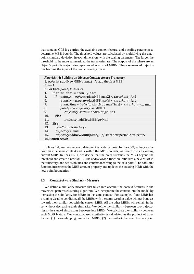
AlgorithmI:BuildinganObject’sContext-Aware Trajectory 1. trajectory.addNewMBB(𝑝𝑜𝑖𝑛𝑡0) // add the first MBB 2. i ← 1 3. For Each 𝑝𝑜𝑖𝑛𝑡𝑖 ∈dataset 4. If 𝑝𝑜𝑖𝑛𝑡𝑖 . 𝑑𝑎𝑡𝑒 = 𝑝𝑜𝑖𝑛𝑡𝑖−1. 𝑑𝑎𝑡𝑒 5. If |𝑝𝑜𝑖𝑛𝑡𝑖 .x – trajectory.lastMBB.maxX| < 𝑡ℎ𝑟𝑒𝑠ℎ𝑜𝑙𝑑𝑋 And 6. |𝑝𝑜𝑖𝑛𝑡𝑖 .y – trajectory.lastMBB.maxY| < 𝑡ℎ𝑟𝑒𝑠ℎ𝑜𝑙𝑑𝑌 And 7. |𝑝𝑜𝑖𝑛𝑡𝑖 .time – trajectory.lastMBB.maxTime| < 𝑡ℎ𝑟𝑒𝑠ℎ𝑜𝑙𝑑𝑇𝑖𝑚𝑒 And 8. 𝑝𝑜𝑖𝑛𝑡𝑖 .cf = trajectory.lastMBB.cf 9. trajectory.lastMBB.addPoint(𝑝𝑜𝑖𝑛𝑡𝑖) 10. Else 11. trajectory.addNewMBB(𝑝𝑜𝑖𝑛𝑡𝑖) 12. Else 13. result.add(trajectory) 14. trajectory ← null 15. trajectory.addNewMBB(𝑝𝑜𝑖𝑛𝑡𝑖) // start new periodic trajectory 16. Return result
In lines 1-4, we process each data point on a daily basis. In lines 5-9, as long as the
point has the same context and is within the MBB bounds, we insert it to an existing
current MBB. In lines 10-11, we decide that the point stretches the MBB beyond the
threshold and create a new MBB. The addNewMbb function initializes a new MBB in
the trajectory, and set its bounds and context according to the data point. The addPoint
function increments the MBB amount property and updates the existing MBB with the
new point boundaries.
3.3 Context-Aware Similarity Measure
We define a similarity measure that takes into account the context features in the
movement patterns clustering algorithm. We incorporate the context into the model by
increasing the similarity for MBBs in the same context. For example, if one MBB has
a raining weather condition, all the MBBs with the same weather value will get bonuses
towards their similarities with the current MBB. All the other MBBs will remain in the
set without decreasing their similarity. We define the similarity between two trajecto-
ries as the sum of similarities between their MBBs. We calculate the similarity between
each MBB feature. Our context-based similarity is calculated as the product of three
factors: (1) the overlapping time of two MBBs; (2) the similarity between the data point
amounts summarized within the two MBBs; and (3) the minimal distance between the
two MBB properties. Formally:
𝑀𝐵𝐵𝑠𝑖𝑚(𝑀𝐵𝐵1, 𝑀𝐵𝐵2) =
|𝑡𝑚 −𝑡𝑛| × #𝑝𝑜𝑖𝑛𝑡𝑠 × 𝑚𝑖𝑛𝐶𝑜𝑛𝑡𝑒𝑥𝑡𝐷𝑖𝑠𝑡(𝑀𝐵𝐵1, 𝑀𝐵𝐵2)
where 𝑡𝑚 is the time when the two MBBs start to overlap; and 𝑡𝑛 is the time when
its overlapping ends. The greater the overlapping time between two MBBs, the larger
the similarity between them. The #points parameter is the minimum amount of data
points within the two compared MBBs. The more data points are included in both of
the compared MBBs, the stronger support we have for their similarity. The minimal
context distance between two MBBs, consists of the sum of minimal distances of every
feature in the MBBs. The minimal distance between two features is defined as the dis-
tance in that dimension or as zero if the two MBBs overlap. Formally:
𝑚𝑖𝑛𝐶𝑜𝑛𝑡𝑒𝑥𝑡𝐷𝑖𝑠𝑡(𝑀𝐵𝐵1 , 𝑀𝐵𝐵2) = ∑min𝐶𝐹Dist(𝑀𝐵𝐵1. 𝑐𝑓𝑖 , 𝑀𝐵𝐵2. 𝑐𝑓𝑖 )
𝑛
𝑖=1
𝑚𝑖𝑛𝐶𝐹𝐷𝑖𝑠𝑡(𝑀𝐵𝐵1, 𝑀𝐵𝐵2) =
max(0,max(𝑀𝐵𝐵1 . 𝑐𝑓𝑚𝑖𝑛 , 𝑀𝐵𝐵2. 𝑐𝑓𝑚𝑖𝑛) − min(𝑀𝐵𝐵1. 𝑐𝑓𝑚𝑎𝑥 , 𝑀𝐵𝐵2. 𝑐𝑓𝑚𝑎𝑥))
where n is the number of context features we are measuring; and cf is the value of
the feature i. We combine two distance values: a spatial distance and a context distance
using a weighted average approach. For numeric features such as velocity, the distance
is defined using this formula: |𝑣1 − 𝑣2|/(𝑣1 + 𝑣2) where 𝑣1, 𝑣2 are feature values.
When there is no difference between the values, the distance is zero, otherwise it is the
normalized distance between the values, so the distances have a comparable scale. For
nominal features such as weather and day of the week, the distance is defined as zero
if the context values are the same and as one, otherwise.
We enhanced the k-means incremental clustering algorithm described in [6] to use
this similarity measurement in order to mine context-aware movement patterns from
the periodic trajectories. The algorithm gets as an input a set of periodic trajectories, a
number of clusters, iteration bound, and a context feature. It initializes the centroids
with the trajectories that are first to arrive. Then, each subsequent trajectory is inserted
into its nearest centroid cluster. We update the centroids by adding each MBB into the
trajectory that represents the cluster's centroid. We stop the clustering when there is no
change or when we reach the iteration bound. The algorithm output is the trajectory
cluster’s centroids which are the movement patterns.
3.4 Context-Aware Location Prediction
The algorithm for predicting the future location of mobile objects uses the context-
aware movement patterns we mined from the trajectories history, along with the current
contextual features. The prediction algorithm filters MBBs by context, leaving only
those that have the same context as the currently observed instance. For example, if it
is currently raining, only the MBBs that are marked as raining will be left in the candi-
date set. The algorithm inputs are a specific future time, a set of cluster centroids that
are the movement patterns, and a context profile that contains any of the current context
features mentioned. The algorithm returns the MBB's maximal and minimal coordi-
nates as the prediction result.
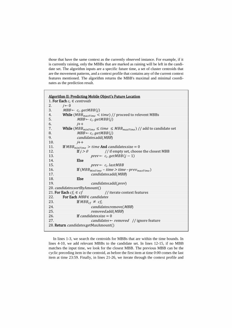
Algorithm II: Predicting Mobile Object's Future Location 1. For Each 𝑐𝑖 ∈ centroids 2. j ←0 3. MBB ←𝑐𝑖 . 𝑔𝑒𝑡𝑀𝐵𝐵(𝑗) 4. While (𝑀𝐵𝐵𝑚𝑎𝑥𝑇𝑖𝑚𝑒 < 𝑡𝑖𝑚𝑒) // proceed to relevent MBBs 5. MBB ← 𝑐𝑖 . 𝑔𝑒𝑡𝑀𝐵𝐵(𝑗) 6. j++ 7. While (𝑀𝐵𝐵𝑚𝑖𝑛𝑇𝑖𝑚𝑒 ≤ 𝑡𝑖𝑚𝑒 ≤ 𝑀𝐵𝐵𝑚𝑎𝑥𝑇𝑖𝑚𝑒) // add to candidate set 8. MBB ← 𝑐𝑖 . 𝑔𝑒𝑡𝑀𝐵𝐵(𝑗) 9. candidates.add(MBB) 10. j++ 11. If 𝑀𝐵𝐵𝑚𝑖𝑛𝑇𝑖𝑚𝑒 > 𝑡𝑖𝑚𝑒 And candidates.size = 0 12. If j > 0 // if empty set, choose the closest MBB 13. prev ←𝑐𝑖 . 𝑔𝑒𝑡𝑀𝐵𝐵(𝑗 − 1) 14. Else 15. prev ←𝑐𝑖 . 𝑙𝑎𝑠𝑡𝑀𝐵𝐵 16. If (𝑀𝐵𝐵𝑀𝑖𝑛𝑇𝑖𝑚𝑒 – time > time – 𝑝𝑟𝑒𝑣𝑚𝑎𝑥𝑇𝑖𝑚𝑒) 17. candidates.add(MBB) 18. Else 19. candidates.add(prev) 20. candidates.sortByAmount() 21. For Each 𝑐𝑓𝑖 ∈ 𝑐𝑓 // iterate context features 22. For Each MBB ∈ candidates 23. If 𝑀𝐵𝐵𝑐𝑓 𝑐𝑓𝑖
24. candidates.remove(MBB) 25. removed.add(MBB) 26. If candidates.size = 0 27. candidates ← removed // ignore feature 28. Return candidates.getMaxAmount()
In lines 1-3, we search the centroids for MBBs that are within the time bounds. In
lines 4-10, we add relevant MBBs to the candidate set. In lines 12-15, if no MBB
matches the input time, we look for the closest MBB. The previous MBB can be the
cyclic preceding item in the centroid, as before the first item at time 0:00 comes the last
item at time 23:59. Finally, in lines 21-26, we iterate through the context profile and
filter the candidates by the required features. The feature is ignored if none of the can-
didates is left in the set. In lines 28, we choose the one with the highest amount score
and return it as the prediction result.
4 Empirical Evaluation
We evaluated our context-aware prediction algorithm on real-world datasets com-
prised of spatio-temporal trajectories of mobile objects and data from external web ser-
vices. Our hypothesis was that the context-aware algorithm should be able to predict
future locations in a more accurate manner than a context-free method. Our algorithm
predicts future location results in the form of MBBs rather than raw data points. In order
to assess the prediction capability, we used two performance measures. The first meas-
ure is the prediction accuracy, which is the probability that the actual future location is
found within the predicted MBB. Accuracy is defined as:
𝐴𝑐𝑐𝑢𝑟𝑎𝑐𝑦 =ℎ𝑖𝑡𝑠
ℎ𝑖𝑡𝑠 + 𝑚𝑖𝑠𝑠𝑒𝑠
According to this measure, larger MBBs should have better prediction accuracy than
smaller MBBs. For example, if the clustering phase produces only one large MBB,
which includes all predicted locations, we will have 100% accuracy but the prediction
will not be useful for any practical purpose. On the other hand, it will be hard to build
a useful general model using very small MBBs. The second measure is the Mean Av-
erage Error (MAE), or the spatial distance between the real location of the object at the
predicted time and the borders of the predicted area. We calculate minimal, average and
maximal Euclidean distance between the object and the MBB’s boundaries. The maxi-
mal distance is as an upper boundary to the prediction error. MAE is defined as:
𝑀𝐴𝐸 =∑𝑚𝑎𝑥𝐷𝑖𝑠𝑡𝑎𝑛𝑐𝑒(𝑜𝑏𝑗𝑒𝑐𝑡𝑋,𝑌 −𝑀𝐵𝐵𝑋,𝑌)
𝑁
where objectX,Y represents the real position of the object, MBB is the prediction re-
sult, maxDistance is the maximal Euclidean distance function, and N stands for the total
number of predictions.
We performed experiments on two real-world spatio-temporal datasets. The INFATI
dataset [23] consists of GPS log-data from 20 cars driving by family members in Aal-
borg, Denmark. The movement of each car was recorded for periods of between 3
weeks to 2 months. The dataset contains a total of 1.9 million records. The GEOLIFE
dataset [24] is a trajectory dataset that was collected mostly in Beijing, China, from 182
users, during a five-year period. We referred only to object trajectories traversed by
vehicles, which were based on data collected for more than a one-month period.
In the algorithm empirical evaluation, we tried to predict the future location of mo-
bile objects with and without each context feature. The evaluation of each context
method was conducted as follows. We used all the data from every object as an inde-
pendent dataset. We divided the dataset into training and testing sets, using the leave-
one-out cross-validation method. In every iteration, we selected two dates as the testing
set while keeping the rest of the dates as a training set. The clustering algorithm mined
context-aware movement patterns from the spatio-temporal trajectories in the training
set. Afterwards, we iterated the data points from the two-day testing set, updated the
context profile and predicted their future location. We used the one-tailed distribution
t-test, to test for significant difference between the compared methods. The results of
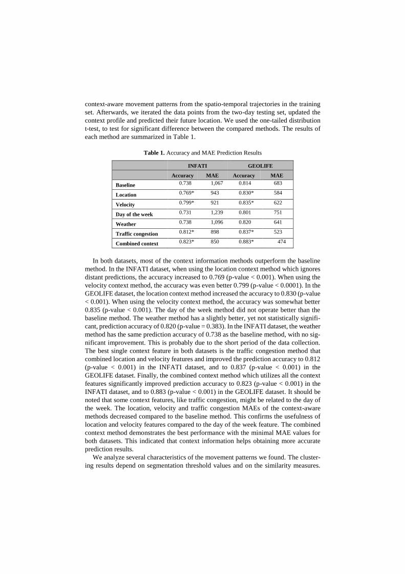
each method are summarized in Table 1.
Table 1. Accuracy and MAE Prediction Results
INFATI GEOLIFE
Accuracy MAE Accuracy MAE
Baseline 0.738 1,067 0.814 683
Location 0.769* 943 0.830* 584
Velocity 0.799* 921 0.835* 622
Day of the week 0.731 1,239 0.801 751
Weather 0.738 1,096 0.820 641
Traffic congestion 0.812* 898 0.837* 523
Combined context 0.823* 850 0.883* 474
In both datasets, most of the context information methods outperform the baseline
method. In the INFATI dataset, when using the location context method which ignores
distant predictions, the accuracy increased to 0.769 (p-value < 0.001). When using the
velocity context method, the accuracy was even better 0.799 (p-value < 0.0001). In the
GEOLIFE dataset, the location context method increased the accuracy to 0.830 (p-value
< 0.001). When using the velocity context method, the accuracy was somewhat better
0.835 (p-value < 0.001). The day of the week method did not operate better than the
baseline method. The weather method has a slightly better, yet not statistically signifi-
cant, prediction accuracy of 0.820 (p-value = 0.383). In the INFATI dataset, the weather
method has the same prediction accuracy of 0.738 as the baseline method, with no sig-
nificant improvement. This is probably due to the short period of the data collection.
The best single context feature in both datasets is the traffic congestion method that
combined location and velocity features and improved the prediction accuracy to 0.812
(p-value < 0.001) in the INFATI dataset, and to 0.837 (p-value < 0.001) in the
GEOLIFE dataset. Finally, the combined context method which utilizes all the context
features significantly improved prediction accuracy to 0.823 (p-value < 0.001) in the
INFATI dataset, and to 0.883 (p-value < 0.001) in the GEOLIFE dataset. It should be
noted that some context features, like traffic congestion, might be related to the day of
the week. The location, velocity and traffic congestion MAEs of the context-aware
methods decreased compared to the baseline method. This confirms the usefulness of
location and velocity features compared to the day of the week feature. The combined
context method demonstrates the best performance with the minimal MAE values for
both datasets. This indicated that context information helps obtaining more accurate
prediction results.
We analyze several characteristics of the movement patterns we found. The cluster-
ing results depend on segmentation threshold values and on the similarity measures.
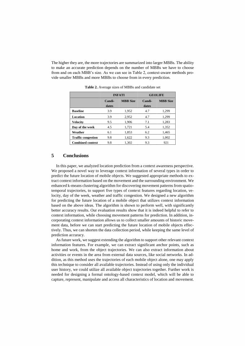
The higher they are, the more trajectories are summarized into larger MBBs. The ability
to make an accurate prediction depends on the number of MBBs we have to choose
from and on each MBB’s size. As we can see in Table 2, context-aware methods pro-
vide smaller MBBs and more MBBs to choose from in every prediction.
Table 2. Average sizes of MBBs and candidate set
INFATI GEOLIFE
Candi-
dates
MBB Size Candi-
dates
MBB Size
Baseline 3.9 1,952 4.7 1,299
Location 3.9 2,952 4.7 1,299
Velocity 9.5 1,906 7.1 1,283
Day of the week 4.5 1,721 5.4 1,352
Weather 6.1 1,853 6.2 1,465
Traffic congestion 9.8 1,622 9.3 1,002
Combined context 9.8 1,302 9.3 921
5 Conclusions
In this paper, we analyzed location prediction from a context awareness perspective.
We proposed a novel way to leverage context information of several types in order to
predict the future location of mobile objects. We suggested appropriate methods to ex-
tract context information based on the movement and the surrounding environment. We
enhanced k-means clustering algorithm for discovering movement patterns from spatio-
temporal trajectories, to support five types of context features regarding location, ve-
locity, day of the week, weather and traffic congestion. We designed a new algorithm
for predicting the future location of a mobile object that utilizes context information
based on the above ideas. The algorithm is shown to perform well, with significantly
better accuracy results. Our evaluation results show that it is indeed helpful to refer to
context information, while choosing movement patterns for prediction. In addition, in-
corporating context information allows us to collect smaller amounts of historic move-
ment data, before we can start predicting the future location of mobile objects effec-
tively. Thus, we can shorten the data collection period, while keeping the same level of
prediction accuracy.
As future work, we suggest extending the algorithm to support other relevant context
information features. For example, we can extract significant anchor points, such as
home and work, from the object trajectories. We can also extract information about
activities or events in the area from external data sources, like social networks. In ad-
dition, as this method uses the trajectories of each mobile object alone, one may apply
this technique to consider all available trajectories. Instead of using only the individual
user history, we could utilize all available object trajectories together. Further work is
needed for designing a formal ontology-based context model, which will be able to
capture, represent, manipulate and access all characteristics of location and movement.
Ontology should address such issues as semantic context representation, context de-
pendency, and context reasoning.
References
[1] S. Amini, A. J. Brush, J. Krumm and J. Teevan, "Trajectory-aware mobile
search," In Proceedings of the 2012 ACM annual conference on Human
Factors in Computing Systems, pp. (pp. 2561-2564, 2012.
[2] . L. Kuang, Y. Xia and Y. Mao, "Personalized Services Recommendation
Based on Context-Aware QoS Prediction," IEEE 19th International
Conference In Web Services, pp. pp. 400-406, 2012.
[3] J. Lee, J. Han and K. Whang, "Trajectory clustering: a partition-and-group
framework," Proceedings of the 2007 ACM SIGMOD international
conference on Management of data, 2007.
[4] L. Zhang, N. Seta, H. Miyajima and H. Hayashi, "Fast Authentication
Based on Heuristic Movement Prediction for Seamless Handover in Wireless
Access Environment," In IEEE WCNC, Wireless Communications and
Networking Conference, pp. pp 2889-2893, 2007.
[5] S. Akoush and A. Sameh, "Mobile user movement prediction using
bayesian learning for neural networks," In ACM IWCMC, p. 191–196, 2007.
[6] S. Elnekave, M. Last and O. Maimon, "Predicting Future Locations Using
Clusters Centroids," In the Proceedings of the 15th annual ACM international
symposium on Advances in geographic information systems, 2008.
[7] A. Monreale, F. Pinelli, R. Trasarti and F. Giannotti, "WhereNext: a
Location Predictor on Trajectory Pattern Mining," 15th ACM SIGKDD, pp.
pages 637-646, 2009.
[8] J. Patel, Y. Chen and V. Chakka, "Stripes: an efficient index for predicted
trajectories," in SIGMOD, p. pp. 635–646, 2004.
[9] Y. Tao, C. Faloutsos, D. Papadias and B. Liu, "Prediction and indexing of
moving objects with unknown motion patterns," In SIGMOD Conference.
ACM Press , pp. 611-622, 2004.
[10] H. Jeung, Q. Liu, H. Shen and X. Zhou, "A hybrid prediction model for
moving objects," IEEE 24th International Conference on Data Engineering,
pp. p.70-79, 2009.
[11] I. Nizetic, K. Fertalj and D. Kalpic, "A Prototype for the Short-term
Prediction of Moving Object's Movement using Markov Chains," In
Proceedings of the ITI, pp. 559-564, 2009.
[12] Y. Han and J. Yang, "Clustering moving objects," In KDD, p. pages 617–
622, 2004.
[13] S. Elnekave, M. Last and O. Maimon, "Incremental Clustering of mobile
objects," STDM07, IEEE, 2007.
[14] G. Chen and D. Kotz, "A survey of context-aware mobile computing
research," Technical Report TR2000-381, DartmouthCollege,
ComputerScience, 2000.
[15] D. Zhang, H. Huang, C. F. Lai and X. Liang, "Survey on context-awareness
in ubiquitous media," Multimedia Tools and Applications, 67(1), pp. 179-211,
2013.
[16] J. Lopes, M. Gusmão, C. Duarte and P. Davet, "Toward a distributed
architecture for context awareness in ubiquitous computing," Journal of
Applied Computing Research, pp. 19-33, 2014.
[17] B. Schilit, N. Adams and R. Want, "Context-aware computing
applications," Proceedings of theWorkshop onMobile Computing Systems and
Applications, MD: IEEE Computer Society, 1994.
[18] A. Schmidt, M. Beigl and H. Gellersen, "There is more to context than
location," Procof the Intl.Workshop on Interactive Applications of Mobile
Computing, 1998.
[19] Y. Zheng, L. Zhang, X. Xie and W. Ma, "Mining interesting locations and
travel sequences from GPS trajectories," Proceedings of the 18th
international conference on World wide web, ACM, 2009.
[20] H. Gao, J. Tang and H. Liu, "Mobile location prediction in spatio-temporal
context," In Nokia mobile data challenge workshop, 2012.
[21] O. Mazhelis, I. Zliobaite and M. Pechenizkiy, "Context-aware personal
route recognition," In Discovery Science. Springer Berlin Heidelberg, pp. (pp.
221-235), 2011.
[22] C. Veness, "Calculate distance, bearing and more between points," 2002.
[Online]. Available: http://www.movable-type.co.uk/scripts/latlong.html..
[23] C. Jensen, H. Lahrmann, S. Pakalnis and J. Runge, "The INFATI Data,"
TimeCenter Technical Report, pp. pp. 1-10, 2004.
[24] Y. Zheng, X. Xing and W. Ma, "GeoLife: A Collaborative Social
Networking Service among User, location and trajectory," in IEEE Data
Engineering Bulletin. 33, 2, pp. pp. 32-40, 2010.