d e mol #4 - amazon simple storage service · 2 2 dents pay a reduced fee, however kivi geotechniek...
TRANSCRIPT
Main sponsor of “De Ondergrondse”:
DE MOL #4December 2016
Newsletter of Dispuut Geo-Engineering “De Ondergrondse”

2
2
dents pay a reduced fee, however KIVI geotechniek offers students of the Geo section a special offer: the first 10 registration don’t have to pay any fee! If you would like to become a member of KIVI Geotechniek, send an email to
Furthermore I would like to inform you about the best graduate price, this price is handed to the best graduate every year, students can also nominate each other by sending an email to [email protected] or you can contact us for more information.
Upcoming KIVI activities can be found in the agenda of this Mol and even more at https://afdelingen.kiviniria.net/geotechniek/
De Ondergrondse has been working together with the Dutch engineering association “KIVI Geotechniek” for quite some time now. In order to make his cooperation even better, KIVI Geotechniek is offering the students of the Geo-Engineering section the possibility to join the activities hosted by KIVI Geotechniek. These activities vary from excursions to conferences and more, for most activities you need to be a member of KIVI Geotechniek and most are organized in Dutch language. In order to become a member stu-

3
3
Table of contents
Table of contents
From the Board
Recent Activities
GPR survey in the hinterland of Petra (Jordan)
Multidisciplinary Project Dodanduwa
The full picture by Fugro
Column football team De Ondergrondse
Upcoming Activities
4
5
8
10
11
14
15
ColophonContact
“De Ondergrondse”p/a Stevinweg 1, kamer 0.0.432628 CN Delft
T | 015-278 2778E | [email protected] | www.ondergrondse.nl
ColophonCirculation: 200Editor: Loys Vermeijden, Herbert Polinder
CoverFugro’s RILA and RILA 360 systems in operation in the UK
Next editionDeadline: 29th of January 2017
4
From
the
Boa
rd
From the Board
Together with the start of the second period of this study year, the new board also started. With a lot of tips and tricks from the old board, we are convinced that we will continue with all the good work of the previous years. I would like to thank the old board for all their effort and time they put in De Ondergrondse!
To keep ourselves busy this year, we set a few goals. The main focus points will be (1) maintain-ing and further improving the quality of education and (2) connecting students and companies.
To improve the quality of the education, we would like to increase the feedback of students. To achieve this we will organize evaluation lunch-es, during which we will discuss the courses of that period. We would like to ask all the students to at-tend these lunches, so we will have a clear view of all the good parts of the courses, but also the parts that could use some improvement.
To get students and companies in contact with each other, we will continue organizing activi-ties with companies during the year. To inform everyone about this activities we will send a digi-
tal newsletter every month with all the upcoming events. Further, we would like to emphasize that your input will be appreciated, whether it’s an idea or a remark!
And of course we will continue with organizing the GeoDrinks so all the student and staff can have a beer together. Also the SWA (Short Weekend Abroad) is back this year! Block your agenda for the weekend of the 22th and 23th of April. During the SWA we will visit a project somewhere in the Benelux or Germany. The precise location will be presented in the new year!
To finish we would like to wish everyone a Merry Christmas and a Happy New Year!
Just before Christmas, the last ‘Mol’ of this year arrives. In this Mol there is an overview of the activities of the last few weeks. It also contains an article from our main sponsor Fugro which is related to the pic-ture on the cover. Another article is about a GPR survey in Jordan which is written with the contribution of Dominique Ngan-Tillard. The treasurer of last year describes his multidisciplinary project in Sri Lanka.

5
Recent A
ctivities
Recent Activities
GeodrinkLoys Vermeijden
On the 15th of November, KIVI Geotechniek and De Ondergrondse teamed up and organised a geotechnical lectures evening. The aim of the event was to exchange developments within Geotechnical Engineering, both from scientific and engineering point of view. The lectures evening took place at the faculty of CEG and was attended by a group of almost 80 people, mainly consisting of stu-dents and KIVI members.
As professor Gavin made sure the evening would go by fluently, Dr. Amin Askarinejad kicked-off the evening with an explanation about the application of physical model-ling in geotechnics. This was followed by a presentation by Ing. Alexander van Duinen about the assessment of slope stability of Dutch dikes. After the first two presenta-tions, the whole group enjoyed a welcome dinner. Now, when everyone was full of energy again, three interesting lectures were given by Dr. Luke Prendergast, Dr. Ronald Brinkgreve (in absence of Ir. Manuel Aukenthaler) and Ir. Jasper Winkes. Topics varied from scour on offshore wind turbines to properties of frozen ground for FEM and driving piles using water. All presentations were followed by mo-ments of interesting discussions. Afterwards, the evening was closed with some drinks at PSOR. The event can be summarized as a successful collaboration between KIVI Geotechniek and De Ondergrondse which was interesting for both KIVI members and geo-engineering students!
Lecture Evening Kivi-GeoKjell Dedecker
In the first week of the second period it was time to get together and chat about the past period, exams and new courses during the geodrink. Lots of first, second and even some third year students attended and enjoyed the beers. Also some staff members and PhD’ers joined. From Witte-veen+Bos Alex came by to promote their businesscourse. As always, the geodrink lasted longer than planned and after the beers some people went into the city centre to continue the evening.

6
Rec
ent A
ctiv
itie
s
Ingeokring Symposium: Geotechnical Earthquake EngineeringGustav Andrag
On the 18th of November, the Ingeokring in partnership with TU Delft, held their yearly autumn symposi-um on the hot topic of Earthquake Engineering. Three groups of topics were covered: Natural Earthquakes, Induced Earthquakes and Engineering Studies (modelling for engineering design and subsoil-structure in-teraction studies). The choice of topics attracted the regular engineering geologist, as well as scientists and engineers.
The session was opened by Nick Rengers on the lessons learnt for geotechnical earthquake engineering from the 2008 Wenchuan Earthquake (Ms. 8.0) in China, which led to many towns near the epicentre to be uninhabited at present day. The origin was indicated and the immediate, as well as extended consequences were discussed. Landslides and damming of rivers were major concerns. Stabilisation projects for vast slopes were covered and how existing infrastructure withheld the earthquake.
The next presentation was delivered by a representative of TEC on the difficulties faced in executing the New International Airport Mexico City project on the challenging local subsurface conditions. The airport will be built on an old marsh area. Large subsidence of 20cm/yr. are recorded due to groundwater extraction. The task is made even more difficult with the knowledge that an Ms. 8.1 earthquake occurred in 1985.
Anita Laera from PLAXIS presented her paper on the comparison between the semi-empirical simplified procedure for liquefaction with a FEM analysis implemented in 2D PLAXIS. Parameter calibration and mod-elling is significantly different between the two methods. The FEM model is validated using the semi-empir-ical method.
Further presentations in this session included experiences and outcomes of the Ms. 5.8 Roermond Earth-quake in 1992, which was presented by Michiel Maurenbrecher, a video presentation by Dr Jose Abell Mena (University of California Davis, USA) covered Physics-based Earthquake-Soil-Structure Interaction for Near-field induced Seismic Events. His work on a state-of-the-art coupled 3D model on a nuclear power plant was presented and how this model could help understand the Groningen induced earthquakes better.
Hans Roets, former research scientist and rock mechanics lecturer at TU Delft and currently part of the State Supervision of Mines, opened the second session with a presentation on his Personal view on 30 years induced seismicity in the Netherlands. His work includes refining the huge true triaxial rock testing frame and the development of acoustic sensors to monitor fracture process in underground mining. His experience in reservoir modelling in the early 90’s delivered some of the first results that showed that the earthquakes in the north of the Netherlands could indeed be because of gas extraction.
Research on the time-domain nonlinear site response analyses due to dynamic loading, and the influence the soil stratigraphy has on this, was presented by Vasileios Drosos (Fugro, Turkey). Through these analyses, the kinematic and inertial forces are determined for the design of foundational elements.
The last three speakers include Ger de Lange (Deltares) on the micro zonation of site effects for the Gro-ningen gas field, Onno Walta (Sweco) on the analysis for earthquake resistance of underground pipeline structures, and John Adrichem (RHDHV) on the recent advances in the modelling of soil-structure interac-tion in DIANA, the road towards fully coupled non-linear earthquake foundation design.
More information on the Autumn Symposium, what the Ingeokring do and how to become a member is available on ingeokring.nl
7
Recent A
ctivities
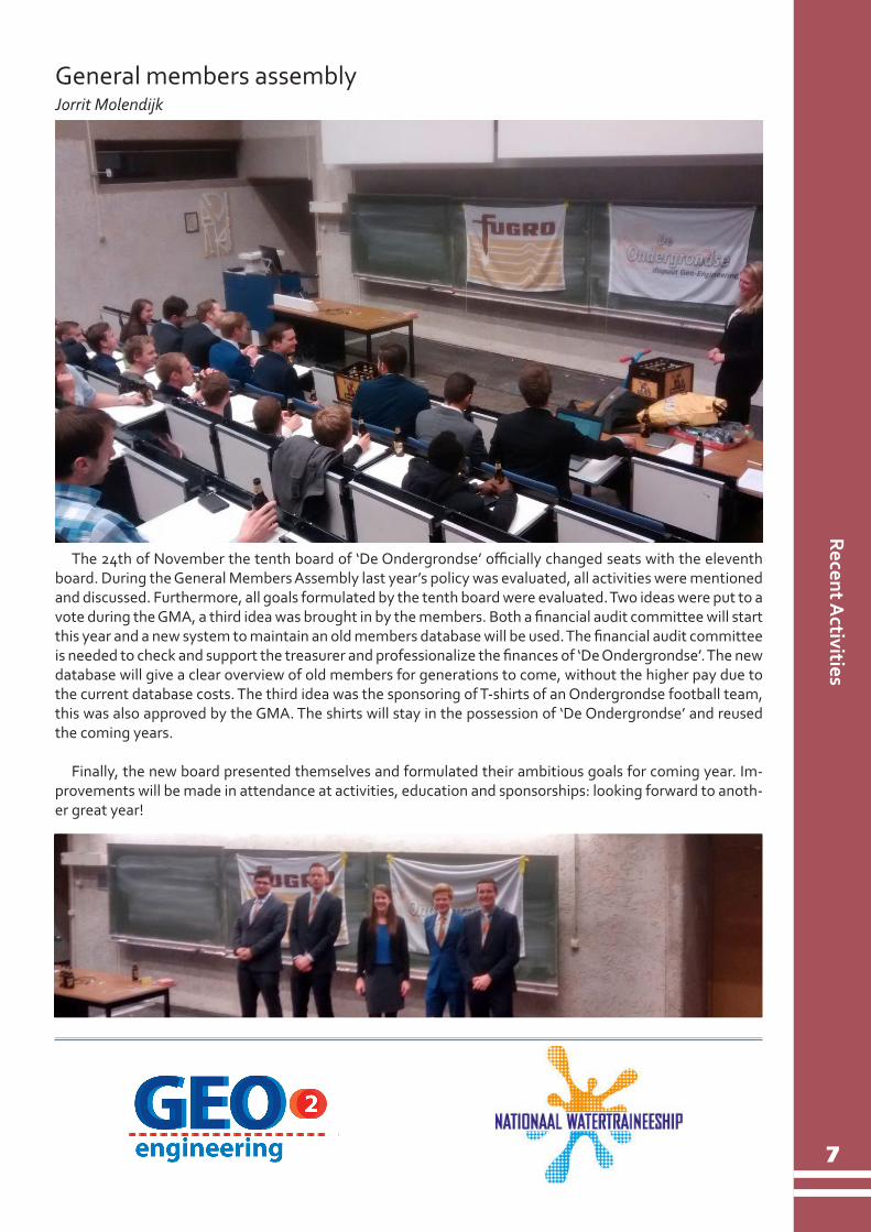
General members assemblyJorrit Molendijk
The 24th of November the tenth board of ‘De Ondergrondse’ officially changed seats with the eleventh board. During the General Members Assembly last year’s policy was evaluated, all activities were mentioned and discussed. Furthermore, all goals formulated by the tenth board were evaluated. Two ideas were put to a vote during the GMA, a third idea was brought in by the members. Both a financial audit committee will start this year and a new system to maintain an old members database will be used. The financial audit committee is needed to check and support the treasurer and professionalize the finances of ‘De Ondergrondse’. The new database will give a clear overview of old members for generations to come, without the higher pay due to the current database costs. The third idea was the sponsoring of T-shirts of an Ondergrondse football team, this was also approved by the GMA. The shirts will stay in the possession of ‘De Ondergrondse’ and reused the coming years.
Finally, the new board presented themselves and formulated their ambitious goals for coming year. Im-provements will be made in attendance at activities, education and sponsorships: looking forward to anoth-er great year!

8
GPR
surv
ey Jo
rdan
GPR survey in the hinterland of Petra (Jordan) for reconstructing the manmade landscape which turned parts of the desert into green oases in the antiquity.
Dominique Ngan-Tillard & Martijn Warnaar (Faculty of Civil Engineering and Geosciences, TUDelft) and Mark Driessen (Faculty of Archaeology, Leiden University)
Since 2011 the sophisticated dry land farming tech-niques that the Nabataeans developed in the hinterland of Petra, Jordan from the 2nd century BC are being in-vestigated by Driessen and Abudanah (2013 and 2015). Research is focussed on the surroundings of Udhruh, 15 km eastward from Petra where a Roman legionary fortress was erected to control exchange and trade on the border of the desert. Afterwards the Nabateans, the Romans, then the Byzantine and later on the Islamic ex-ploited the irrigation system. Run-off and flooding wa-ters were harvested and transported to shallow earth dammed reservoirs via sturdily built aqueducts and ma-sonry channels (Figure 1). From the reservoirs lined with watertight mortar, water was distributed to agricultural fields. Ground water was also exploited with the qanat technology, a technology adapted to the arid climate of the region. Kilometers of subhorizontal tunnels were dug from hundreds of vertical shafts to gently drain aq-uifers or temporary ground water levels under the hills of Udhruh towards the flooding plain of the wadi el Fiqay.
Figure 1- Mark Driessen in between two irrigation channels exposed by surface water erosion in Wadi El Fiqay.
Today the region is not cultivated. Sheep and goats graze on arid land. Every day during the hot season, herds converge to points where water is delivered by lorry. The antic water system is not used anymore. Why not reactivating it and turning Udhruh to a green desert for the benefit of the local population (Driessen, 2014)? As the antic system is masked by up to 2 m thick post-roman wadi deposits, understanding its de-tailed functioning in relation to the local geomorphology is challenging.
During the course of five fieldworks of two months each, the 48 km2 of the area have been classified in geomorphological units (wadi, eroding gully, flood plain, hill side and top, saddle, plateau,…) based on aerial images and detailed walk along surveys (Driessen, 2014). Outcropping remains of man-made constructions have also been geo-referenced using a GPS. All data have been integrated in a Geographic Information Sys-tem (GIS) from the start of the project.
This is to demonstrate that it is possible to complete with a Ground Penetrating Radar (GPR) the map of Udhruh’s buried and underground irrigation water complex that the GPR survey was conducted in May 2016 (Figure 2). Ground proving the GPR data has been possible. In area 1, looters have exposed locally struc-tures of the ancient irrigation sys-tem. The GPR survey established the continuity between these structures and those that are still buried under about half meter or so of post roman wadi deposits (Figure 3).Figure 2- GPR antennas on starting line of area 1 in the wadi El Fiqay.

9
9
GPR survey Jordan
Figure 3 The walls and floor of a buried reservoir in area 1 have a clear signature on radargrams (top left). Ex-trapolation of strong reflections coming from the same depth (right) to the looted zone (bottom left) allowed to ground prove the GPR data in the reservoir area.
Only 4 areas have been surveyed in May 2016 due to a breakdown of the GPR transmitter. Despite this, auspicious GPR results have been obtained and already validated with observations made in looted zones, erosion gullies or excavation pits dug by Leiden University after the GPR campaign.
The Udhruh project is an example of a successful collaboration between TU Delft and Leiden University. It is embedded within the Centre for Global Heritage and Development (CGHD) created by Leiden, Delft and Erasmus universities (http://www.globalheritage.nl/). The CGHD promotes the use of science-based techniques in modern research in the field of archaeology. The Udhruh project is also well aligned with the main objective of the CDHG: investigating “ the role of the past in the present, with the future in mind”. The Udhruh project aims at studying the antique agrohydrological remains to reconstruct the manmade land-scape which turned parts of the desert into green oases in antiquity. One of the sidekicks of this archaeolog-ical project could be that the antique techniques might be helpful for nowadays and future agricultural and water management issues/problems. The Udhruh’s project also links the three poles of interest of the CDHG: Heritage and Environment, Heritage and Identity and Heritage under threat. Threats to the Udhruh’s antic irrigation system are natural erosion by wadi waters following intense rainfalls and looting. Looting succeed-ing archaeological prospection is notorious in Petra and its hinterland (Vella et al, 2015).
AcknowledgmentsThanks to the department of Antiquities of Jordan for delivering the authorisation to enter and leave Jor-
dan with the equipment and survey Wadi El Fiqey. Thanks to dr. Fawzi Abudanah ( Petra School of Archaeol-ogy and Tourism of Al-Hussein Bin Talal University, Jordan) for facilitating the fieldwork. Thanks to all partic-ipants of the 2016 Udhruh fieldwork.
Driessen, M.J. & Abudanah, F. 2013. The Udhruh lines of sight: connectivity in the hinterland of Petra., Tijdschrift voor Mediterrane
Archeologie 50: 45-52.
Driessen, M.J. & Abudanah, F. 2015. The Udhruh Archaeological Project – the 2011-2012 Field Survey. In: Vagalinski L., Sharankov, N.
(Eds.) Limes XXII Proceedings of the 22nd International Conress of Roman Frontier Studies, Ruse, Bulgaria, September 2012. no. Bulletin
of the National Archaeological Institute. Sofia: Bulgarian Academy of Sciences. 297-306.
Driessen, M.J. 2014. Udhruh Archaeological Project. What transformations can be observed in the hinterland of Petra (South Jordan).
https://www.universiteitleiden.nl/en/research/research-projects/archaeology/udhruh-archaeological-project
Vella, C., Bocancea, E., Urban, T.M., Knodell, A.R., Tuttle, C.A. & Alcock, S.E. 2015. Looting and vandalism around a World Heritage
Site: Documenting modern damage to archaeological heritage in Petra’s hinterland. Journal of Field archaeology, 40:2.
References
10
Comm
itteesM
ulti
disc
iplin
ary
proj
ect
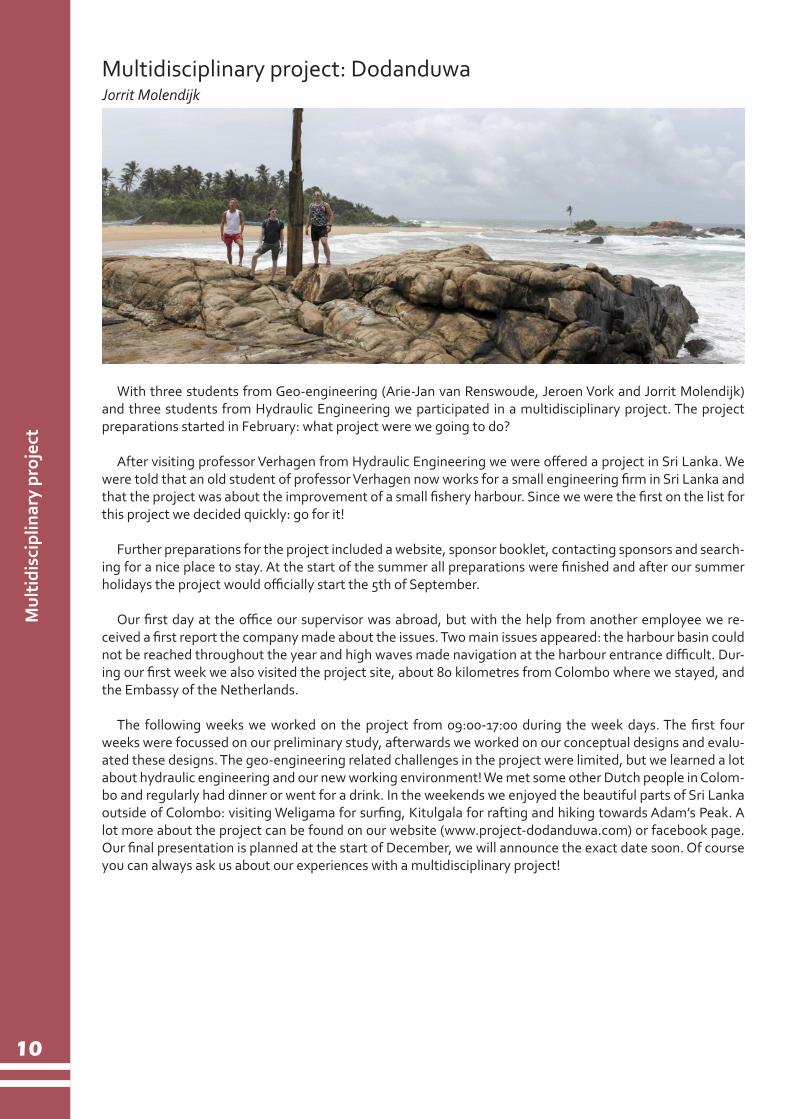
Multidisciplinary project: DodanduwaJorrit Molendijk
With three students from Geo-engineering (Arie-Jan van Renswoude, Jeroen Vork and Jorrit Molendijk) and three students from Hydraulic Engineering we participated in a multidisciplinary project. The project preparations started in February: what project were we going to do?
After visiting professor Verhagen from Hydraulic Engineering we were offered a project in Sri Lanka. We were told that an old student of professor Verhagen now works for a small engineering firm in Sri Lanka and that the project was about the improvement of a small fishery harbour. Since we were the first on the list for this project we decided quickly: go for it!
Further preparations for the project included a website, sponsor booklet, contacting sponsors and search-ing for a nice place to stay. At the start of the summer all preparations were finished and after our summer holidays the project would officially start the 5th of September.
Our first day at the office our supervisor was abroad, but with the help from another employee we re-ceived a first report the company made about the issues. Two main issues appeared: the harbour basin could not be reached throughout the year and high waves made navigation at the harbour entrance difficult. Dur-ing our first week we also visited the project site, about 80 kilometres from Colombo where we stayed, and the Embassy of the Netherlands.
The following weeks we worked on the project from 09:00-17:00 during the week days. The first four weeks were focussed on our preliminary study, afterwards we worked on our conceptual designs and evalu-ated these designs. The geo-engineering related challenges in the project were limited, but we learned a lot about hydraulic engineering and our new working environment! We met some other Dutch people in Colom-bo and regularly had dinner or went for a drink. In the weekends we enjoyed the beautiful parts of Sri Lanka outside of Colombo: visiting Weligama for surfing, Kitulgala for rafting and hiking towards Adam’s Peak. A lot more about the project can be found on our website (www.project-dodanduwa.com) or facebook page. Our final presentation is planned at the start of December, we will announce the exact date soon. Of course you can always ask us about our experiences with a multidisciplinary project!

11
Comm
ittees
The full picture
The full picture
Jasper Hellemons, project manager asset information and BIM coordinator, Fugro GeoServices NL
Fugro shows how its surveying products – from linear datasets to 3D/4D information models – can accurately determine the life cycle of rail assets
Network Rail recently awarded a contract to Fugro for survey and design works to support its high output track renewal programme in Scotland. The deal saw Fugro use its train-mounted RILA and RILA 360 laser scanner to deliver critical rail infrastructure information; a new technology and approach to data collection that fits perfectly into the building information modelling (BIM) way of thinking.
Building information modellingBIM is the means by which everyone can understand a building or asset through the use of a model.
Fugro’s approach to the collection of essential rail information is based on a similar philosophy enabling users to share information on assets over their entire life cycle. Fugro RailData director, Nick van den Hurk, explained the concept of BIM by comparing survey information with LEGO blocks. ‘In the conceptual and feasibility stages of a project, engineers may use airborne survey techniques represented by the larger DUP-LO blocks. These rough blocks enable us to make a basic model, quickly and cost-effectively over long linear distances.’
As the project enters the detailed design and engineering stage, a more detailed model is required. In this case, normal and technical LEGO is used. ‘The technical LEGO creates the form and function of the structure and so the process continues throughout the life cycle of the asset, from whole-life maintenance to renewal,’ added van den Hurk. ‘We can apply this analogy to the rail industry, where Fugro’s innovative technologies act like LEGO blocks, enabling us to choose the right RILA sensors and products for the appro-priate phase in the railway asset life cycle.’
Figure 1- Concept of BIM during the life cycle of assets
12
12
The
full
pict
ure
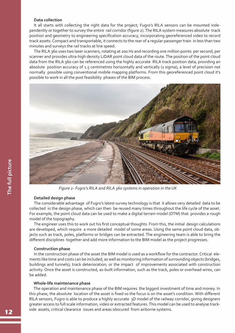
Figure 2- Fugro’s RILA and RILA 360 systems in operation in the UK
Data collectionIt all starts with collecting the right data for the project; Fugro’s RILA sensors can be mounted inde-
pendently or together to survey the entire rail corridor (figure 2). The RILA system measures absolute track position and geometry to engineering specification accuracy, incorporating georeferenced video to record track assets. Compact and transportable, it connects to the rear of a regular passenger train in less than two minutes and surveys the rail tracks at line speed.
The RILA 360 uses two laser scanners, rotating at 200 Hz and recording one million points per second, per scanner and provides ultra-high density LiDAR point cloud data of the route. The position of the point cloud data from the RILA 360 can be referenced using the highly accurate RILA track position data, providing an absolute position accuracy of 1.5 centimetres horizontally and vertically (1 sigma), a level of precision not normally possible using conventional mobile mapping platforms. From this georeferenced point cloud it’s possible to work in all the post feasibility phases of the BIM process.
Detailed design phaseThe considerable advantage of Fugro’s latest survey technology is that it allows very detailed data to be
collected in the design phase, which can then be reused many times throughout the life cycle of the asset. For example, the point cloud data can be used to make a digital terrain model (DTM) that provides a rough model of the topography.
The engineer uses this to work out his first conceptual thoughts. From this, the initial design calculations are developed, which require a more detailed model of some areas. Using the same point cloud data, ob-jects such as track, poles, platforms or bridges can be extracted. The engineering team is able to bring the different disciplines together and add more information to the BIM model as the project progresses.
Construction phaseIn the construction phase of the asset the BIM model is used as a workflow for the contractor. Critical ele-
ments like time and costs can be included, as well as monitoring information of surrounding objects (bridges, buildings and tunnels); track deterioration; or the impact of improvements associated with construction activity. Once the asset is constructed, as-built information, such as the track, poles or overhead wires, can be added.
Whole-life maintenance phaseThe operation and maintenance phase of the BIM requires the biggest investment of time and money. In
this phase, the absolute location of the asset is fixed so the focus is on the asset’s condition. With different RILA sensors, Fugro is able to produce a highly accurate 3D model of the railway corridor, giving designers greater access to full scale information, video or extracted features. This model can be used to analyse track-side assets, critical clearance issues and areas obscured from airborne systems.

13
13
The full picture
Subsurface informationThe whole model becomes more valuable to the cli-
ent if subsurface information, such as drilling and cone penetration information, cables or other objects, is added. Fugro’s ground penetrating radar (GPR) tech-nologyprovides a complementary view of track infra-structure.
Imaging the subsurface to about a metre below the rails, GPR scanning is becoming a routine element in the asset data collection mix and technology is getting quicker and more modular for use on a wide range of locomotives. Common applications of GPR scanning are the assessment of trackbed thickness and condi-tion and the detection of buried services. Figure 3 shows how subsurface objects can be added to the complete BIM model, making it possible to evaluate subsurface clash detection prior to the construction phase.
Figure 3- Visualisation of subsurface objects based on GPR measurementseration in the UK
The next stepHaving met demands for more integrated solutions, the next step is to share this information via a cloud-
based platform. Fugro is in the process of developing the RILA web service, through which engineers and managers can remotely investigate and monitor their network, bringing the real world to their desktop.
Becoming an integral part of the BIM process, Fugro can also act as geo-information manager, taking responsibility for the life cycle of clients’ assets. The integrated solution is not just about putting data sets together, it’s about adding asset information to the model – for example, knowing where assets are by using their coordinates to create the model.
Fugro’s RILA solution means that all stakeholders can rely on one platform for sharing information, col-lecting data once, using it multiple times to support the integrity of assets, and driving future efficiencies.
Figure 4- Screenshot of 3D point cloud data in the cloud-bases viewer, RILA Portal
Authored by Jasper Hellemons, project manager asset information and BIM coordinatorFugro GeoServices NetherlandsTel: +31 6 1019 4236Email: [email protected] www.fugro.com/rail
Pre-renewal, RILA can be used to screen for any anomalies or stability issues with the existing track that can be addressed during reconstruction. Post- renewal, it can deliver high accuracy data for all-important quality assurance – to check that any pre-existing issues with the trackbed or geometry have been resolved, and to troubleshoot any non- alignment or non-conformities.
14
14
Colu
mn
foot
ball
team
To be part of the competition, someone had to register the team at Sports & Culture at 9 o’clock in the morning. Unfortunately this was the morning after the ‘start of the year’ barbeque. Most of the team mem-bers enjoyed quite some food and beer that day, but when the sun started to set it had to be decided who had to go to the Sports Center to enroll the Geo-team the next morning. Max and Jeroen K. were brave enough to do that. Previous teams told us that we had to be there at least one hour in advance to have a fair chance on a nice timeslot to play in; so Max and Jeroen K. decided to be there at 8 am. The next morning they immediately regretted it. With only a few hours of sleep and a hangover they added themselves to the line. After waiting for 1.5 hours they were able to subscribe the GeoDudes to the competition.
The first match played was against the CH Owl ll. Even though the team did not play in proper formation, they were still able to strike a glorious 2-8 victory against CH Owls II. One week later however, De Tamme Eik washed the victorious feeling away. The 3-4 loss against the Tamme Eik resulted in some positive discussions about tactics and roles in the field. After that, the gameplay started to improve and resulted it more victories for the team. But not all matches until now were decided in favor of the GeoDudes. The team seems to miss some kind of sparkle. Maybe it needed more supporters, or maybe similar clothing would increase the team spirit.
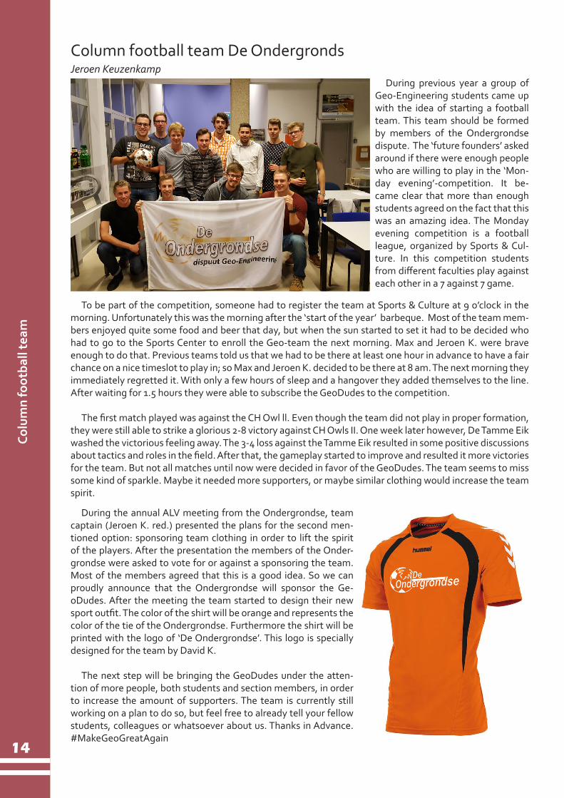
Column football team De OndergrondsJeroen Keuzenkamp
During the annual ALV meeting from the Ondergrondse, team captain (Jeroen K. red.) presented the plans for the second men-tioned option: sponsoring team clothing in order to lift the spirit of the players. After the presentation the members of the Onder-grondse were asked to vote for or against a sponsoring the team. Most of the members agreed that this is a good idea. So we can proudly announce that the Ondergrondse will sponsor the Ge-oDudes. After the meeting the team started to design their new sport outfit. The color of the shirt will be orange and represents the color of the tie of the Ondergrondse. Furthermore the shirt will be printed with the logo of ‘De Ondergrondse’. This logo is specially designed for the team by David K.
The next step will be bringing the GeoDudes under the atten-tion of more people, both students and section members, in order to increase the amount of supporters. The team is currently still working on a plan to do so, but feel free to already tell your fellow students, colleagues or whatsoever about us. Thanks in Advance. #MakeGeoGreatAgain
During previous year a group of Geo-Engineering students came up with the idea of starting a football team. This team should be formed by members of the Ondergrondse dispute. The ‘future founders’ asked around if there were enough people who are willing to play in the ‘Mon-day evening’-competition. It be-came clear that more than enough students agreed on the fact that this was an amazing idea. The Monday evening competition is a football league, organized by Sports & Cul-ture. In this competition students from different faculties play against each other in a 7 against 7 game.
15
Upcom
ing Activities
Upcoming ActivitiesDecember20 Christmas drinks GSE department
January12 New Year’s Dinner
February16 GeoDrink
April21 - 23 Short Weekend Abroad (SWA)
