crossing creeks - water.wa.gov.au€¦ · this booklet provides general advice on the construction...
TRANSCRIPT

Looking after all ourwater needs
Crossing creeksStream crossings on farms


Crossing creeksStream crossings on farms
Looking after all ourwater needs

Department of Water 168 St Georges Terrace Perth Western Australia 6000 Telephone +61 8 6364 7600 Facsimile +61 8 6364 7601 www.water.wa.gov.au
© Government of Western Australia 2008
February 2008
This work is copyright. You may download, display, print and reproduce this material in unaltered form only (retaining this notice) for your personal, non-commercial use or use within your organisation. Apart from any use as permitted under the Copyright Act 1968, all other rights are reserved. Requests and inquiries concerning reproduction and rights should be addressed to the Department of Water.
A cataloguing in publication record is available for this document from the National Library of Australia.
ISBN 978-1-921468-28-5 (pbk) ISBN 978-1-921468-29-2 (pdf)
Acknowledgements
The Department of Water would like to thank Steve Janicke and Kirsten Murray who prepared this report.
For more information about this report, contact Department of Water South Coast regional office 5 Bevan Street Albany Western Australia 6330 Telephone +61 8 9842 5760 Facsimile +61 8 9842 1204
Cover photograph: Steve Janicke surveying a south coast river

Department of Water iii
Contents
Preface .................................................................................... iv
Introduction ............................................................................... v
Stream behaviour .....................................................................1
Meandering .........................................................................2
Constricted flow...................................................................4
Obstacles ............................................................................6
Channel deepening (incision)..............................................8
Channel widening................................................................9
Principles of good crossing design .........................................10
Types of crossings ..................................................................12
Fords .................................................................................14
Culverts ............................................................................20
Bridges ..............................................................................28
Avoid building a dam ..............................................................32
Final thoughts .........................................................................34
Glossary .................................................................................36
Further references ..................................................................38
Crossing creeks

iv Department of Water
Crossing creeks
Preface
This booklet provides general advice on the construction of stream crossings on farms in southern Western Australia and is intended to be used as a guide for farmers, natural resource management officers and other land managers.
It aims to explain the design issues that may need to be dealt with when designing a successful crossing. The crossings shown in this booklet are typical of a wide variety of situations. They have been included to illustrate the basic principles of water flow in channels and how this behaviour may affect your own design.
A well-designed crossing will be long lasting, require minimal maintenance and have a negligible impact on the aquatic and riparian environment. To achieve the most suitable crossing design it is recommended that a suitably qualified engineer is consulted. Further advice can be obtained from your local Department of Water office.
It is important to note that there may be legal requirements when constructing a crossing. Consideration must be given to any local government building regulations, state government legislation that protects native vegetation (Environmental Protection Act, 1986) and proclaimed watercourses (Rights in Water and Irrigation Act, 1914).

Department of Water v
Introduction
A good crossing is one that serves the purpose for a long time and requires minimal maintenance. The design must allow for a range of flow conditions and sustain as little damage as possible when rare floods occur. It is also essential to ensure that the crossing will have negligible environmental impact upstream or downstream.
Other than providing access across a stream for people, vehicles and stock when required, a well-designed crossing can have environmental benefits. Restricting crossings to one point that does not allow direct access to the stream bed will greatly reduce local erosion. It will also protect riparian vegetation from stock, which will further stabilise the stream banks and can greatly assist in managing nutrient input to the stream system. The overall benefits can include reduced sedimentation, improved water quality, the creation of a shelter belt for stock and habitat for native wildlife.
Every stream reach has its own collection of features; therefore, knowledge of how flowing water behaves and experience of local flood patterns is needed to design and construct a successful crossing.
Crossing creeks

vi Department of Water
Crossing creeks

Department of Water 1
Stream behaviour
Flowing water behaves in predictable ways and this behaviour needs to be taken into account when designing, constructing or modifying a stream crossing.
In the 1880s, Robert Manning showed that average stream velocity, flow depth, slope and channel ‘roughness’ work together to create the stream channel. If one factor is altered, the others will adjust to maintain the overall channel discharge. Manning’s equation is still widely used by drainage engineers.
The following five types of stream behaviour are important considerations when choosing a crossing site and a suitable design.
Stream behaviour

1
2 Department of Water
Crossing creeks
MeanderingWater does not flow in a straight line but meanders through the landscape. The meandering of a waterway is characterised by a single snake-like main channel. Meander bends form as a result of the non-uniform nature of flowing water. Water velocity in a stream is fastest towards the outside of a bend and this is where erosion is the greatest. Sediment deposits are most likely to occur on the inside bank of a bend to form a point bar, although floods may erode this area (photo 1). Due to the continuous shifting of sediments at a bend, it is not a suitable position for a crossing.

2
Department of Water 3
The meandering nature of flow (photo 2) means that channels are rarely straight or remain straight for any great distance. If a meandering channel is straightened, water velocity will increase and re-create bends in the channel through erosion and sedimentation. Trying to straighten a channel can increase the risk of damage to associated infrastructure, such as crossings and fences. Where possible, it is better to work with existing channel curvature rather than trying to modify it.
Stream behaviour

3
4 Department of Water
Crossing creeks
Constricted flow If the width of a channel is reduced, the constriction to flow will result in an increased upstream water depth (photo 3). The water will increase velocity at the point of constriction to maintain the overall flow rate. Greater water velocity increases the risk of bed and bank erosion.
If any part of a channel is roughened, for example by placing rocks or logs in the channel, then water passage will be restricted. As the depth increases upstream, water may find an easier path around the partial obstruction by eroding the banks and perhaps eventually shifting the position of the active channel (photo 4). This will greatly increase the risk of crossing failure. If a crossing is constructed so that it constricts flow, then it is likely that the flow will find an easier path around the point of constriction, which is likely to result in bypass erosion.
4
Department of Water 5
Stream behaviour

6 Department of Water
Crossing creeks
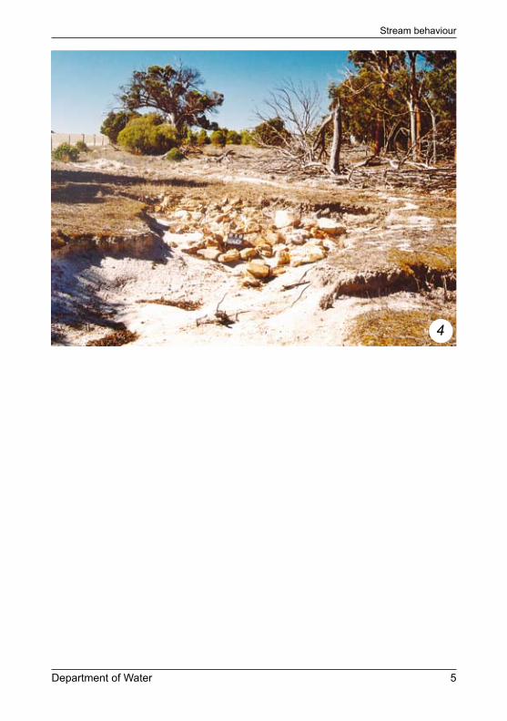
ObstaclesAn obstacle in a stream channel may redirect the flow locally, causing bank or bed erosion. This is not the same process as meandering, as sedimentation is not working simultaneously with erosion. As a result, an obstacle can cause an unstable bend in a river.
If a log, branch or rock is redirecting flow and causing significant local erosion then the preferred action is to simply rearrange the obstacle; for example, by shifting a protruding log to more closely align with the bank. However, if rearranging the obstacle does not reduce the erosion then it may need to be removed and relocated elsewhere in the channel. It is important not to remove the obstacle from the stream entirely as you should aim to maintain the overall channel roughness and to preserve the character of the stream environment.
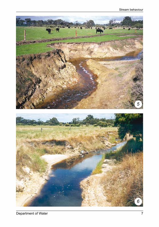
The clay bar shown in photo 5 created an obstacle that was redirecting the flow and resulting in the active erosion of the adjacent bank. The bar was removed, which straightened the channel. To prevent increased water velocity due to the alteration to the channel, a small, rocky riffle was created immediately downstream (photo 6).
Poorly designed crossings can be obstacles to flow; therefore, it is important that their features do not deflect water into the banks.
6
5
Department of Water 7
Stream behaviour
7
8 Department of Water
Crossing creeks
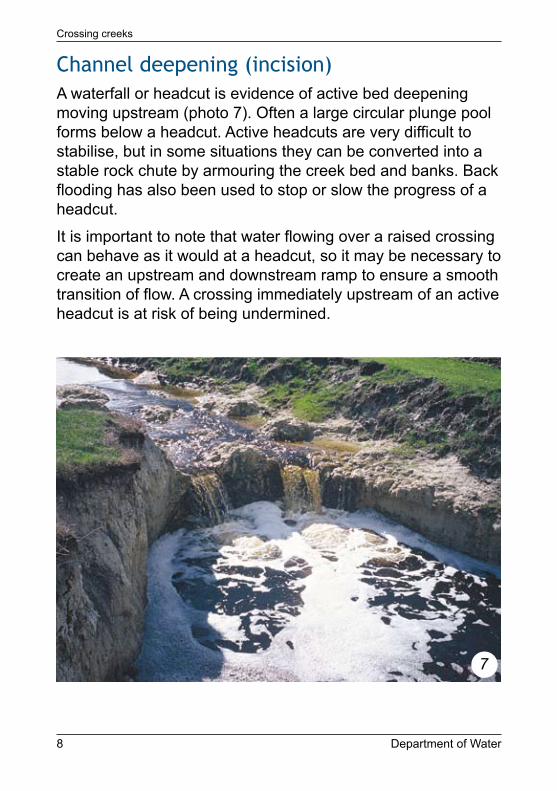
Channel deepening (incision)A waterfall or headcut is evidence of active bed deepening moving upstream (photo 7). Often a large circular plunge pool forms below a headcut. Active headcuts are very difficult to stabilise, but in some situations they can be converted into a stable rock chute by armouring the creek bed and banks. Back flooding has also been used to stop or slow the progress of a headcut.
It is important to note that water flowing over a raised crossing can behave as it would at a headcut, so it may be necessary to create an upstream and downstream ramp to ensure a smooth transition of flow. A crossing immediately upstream of an active headcut is at risk of being undermined.

8
Department of Water 9
Channel wideningAs a channel deepens, the banks become prone to collapse and the channel widens. Riparian vegetation helps to hold stream banks together and tends to maintain narrower, deeper and faster flowing channels. As an illustration, photo 8 shows a small stream emerging onto a beach where the loose sand has little strength to confine water flow. As a result, the width of the channel increases rapidly and the water depth decreases. Native riparian vegetation provides an important tool for controlling channel location and shape.
Stream behaviour

10 Department of Water
Crossing creeks
Principles of good crossing design
Rivers and creeks are dynamic systems that respond to natural forces. The following principles of crossing design should be used as a guide when deciding on a suitable stream crossing.
Principle 1 Minimise interference with the natural channel form and capacity
The channel is influenced by flows that work to maintain or rebuild the channel in a way that suits the long-term pattern of rainfall runoff from the catchment. The nature of stream behaviour must be taken into consideration.
The flow capacity requirements of the waterway must be maintained. A well-designed crossing maintains the natural cross-sectional area and shape of the channel so that flows are not obstructed or constrained, including during large floods. The crossing should not significantly change the bank slope or bed level of the channel.
Principle 2 Select the best location
Crossings should be located along existing straight reaches of the stream and away from bends and active or erosive parts of the channel. When selecting a location for ford or culvert crossings, naturally high points of the creek bed should be taken into consideration.

Department of Water 11
Principle 3 Design for service demand
The type of crossing will be determined by the level of access that will be required. For example, if permanent access is required, even in rare floods, then a structure that is built above the flood level will be required. Alternatively, if stream flow is seasonal and wetting of vehicles or stock is acceptable then a ford may be the best type of crossing. The number of crossings should be minimised and multi-purpose crossings used.
Principle 4 Maintain passage for wildlife
The design of the creek crossing should enable passage of fauna through the waterway and riparian zone and not form a barrier. Wildlife may return to the area with better management of the creek. Further advice on good crossing design that enables passage for wildlife is available from the Department of Water.
Principles of good crossing design
12 Department of Water
Crossing creeks
Types of crossings
There are three common types of creek crossings, each of which caters to a different set of crossing purposes and flow conditions.
A useful aid when choosing a crossing type is to have a look at other local crossings with a similar stream environment. Take note of the type of crossing used, the design features that have worked and those that have caused a problem. For example, the narrow log crossing shown in photo 9 had enough cross-sectional area to maintain the flow requirements and sufficient bank protection to have remained serviceable for many years. However, the bed has gradually been deepening and undermined the support timbers and steep rock walls and, as a result, it is finally at the point of collapse. The solution might be to keep the essential design but increase the span, batter the banks, rearrange the bank’s rock armour and create an even, rocky ramp on the stream bed (less than 1:10 slope).
The three common categories of crossing are fords, culverts and bridges.
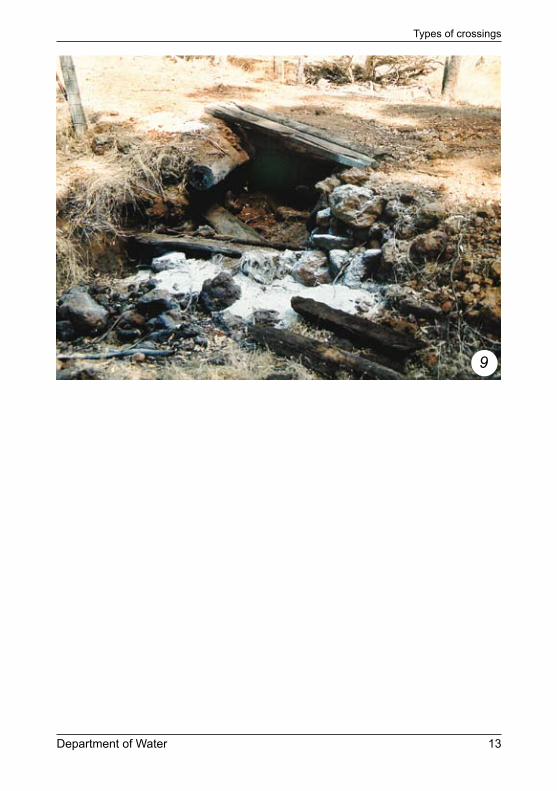
9
Department of Water 13
Types of crossings

14 Department of Water
Crossing creeks
FordsA ford (photo 10) is a shallow part of a natural or artificial stream channel, where people, vehicles or animals may cross with relative ease. All surface flow moves over a ford. A rock ford allows stock to have access to the stream for crossing or watering, but deters them from spending too much time there.
10
Location
A ford should be in a straight stretch of the stream or at the crossover point of a meander where flow is directed through the centre of the channel. Taking advantage of naturally high points in the creek bed will reduce the height to which the crossing will need to be built.

Department of Water 15
Construction
To create a ford, the stream bed is paved or armoured so that the natural cross-sectional area and shape of the channel is preserved as much as possible. As a rule of thumb, when the cross-sectional area of the channel flow is reduced by more than 10 per cent, the effects may start to become significant and result in increased erosion.
A constructed ford should be kept as low as possible (a height less than 300 mm is often recommended) to reduce the risk of headcut processes undermining the crossing.
Rocks are commonly used to armour the stream bed and banks, and should consist of a range of sizes that can form an interlocking paving. If a ford is properly designed and a suitable mix of rock sizes is selected, rock movement should be minimal. The armour should extend across the stream to above the highest flood level to avoid the possibility of floods scouring a bypass around the crossing or, in some cases, creating a new channel.
Design notes
Water flowing across uneven surfaces is turbulent and can ‘jet’ through gaps in the surface, removing soil between rocks and undermining the foundations of the crossing. For this reason a barrier layer between the crossing construction materials and the underlying soil should be considered. This could consist of a coarse, compactible material with the larger rock matrix sitting on top, or a dense fabric known as geo-textile. If the only site available for the crossing has a boggy stream bed, consider excavating the crossing site, laying geo-textile on the base of the excavation and backfilling it with a compactible fill to form a stable foundation for the raised crossing surface. A minimum foundation depth of 500 mm may be required.
Types of crossings

11
16 Department of Water
Crossing creeks
It is possible that a ford crossing will slightly increase water depth upstream. It is important that the bank is protected where the access track enters the floodway to reduce the risk of high flows eroding these points. Inadequate placement and continuity of bed armouring material along the upstream and downstream edges of a crossing is common and creates weaknesses in the overall structure.
Photo 11 shows a crossing with adequate rocky ramps and more extensive rocky armour to handle a range of flood levels. The riparian vegetation on the far bank also helps to stabilise that area.
If the cross-sectional area of a channel is reduced by more than 10 per cent, flow will be considerably restricted. Water approaching the crossing will be dammed upstream, which will exert unnecessary pressure on the embankments. This
12
Department of Water 17
could result in the pooling of water upstream or erosion of the banks supporting the crossing. Creating a rocky riffle on either side of the ford will allow for a smoother transition of the water over the crossing. The riffle extending downstream should be sloped no steeper than 1:10 (1:20 to enable fish passage). The gradient of the ramp on the upstream side should be no steeper than 1:4.
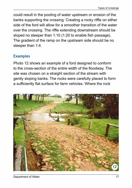
Examples
Photo 12 shows an example of a ford designed to conform to the cross-section of the entire width of the floodway. The site was chosen on a straight section of the stream with gently sloping banks. The rocks were carefully placed to form a sufficiently flat surface for farm vehicles. Where the rock
Types of crossings

13
18 Department of Water
Crossing creeks
paving has finished short of the fence line, stock have worn a preferred path; however, this can be easily infilled.
The crossing shown in photo 13 is simple, well-situated and easy to maintain; however, the cobbled surface could be extended further up the approach banks to reduce the risk of bypass erosion. Higher flows have moved some of the rocks downstream, but keeping the central area flat may lessen this tendency. Stock exclusion and riparian revegetation would assist with stabilising the adjacent bed and banks.
Scattered larger rocks, like those shown in photo 14, serve little stabilising purpose and can cause local erosion at the crossing site by concentrating flow around their edges. A common way to determine the best rock sizes for a stream crossing is to observe how floods have moved various sizes of rocks in other parts of the stream or on similarly sized streams.

14
Department of Water 19
Types of crossings

20 Department of Water
Crossing creeks
CulvertsA culvert crossing (photo 15) is a raised thoroughfare that uses round or rectangular conduits to allow low to medium flows to pass and keeps the track dry and firm. The effectiveness of culverts is determined by how much water they allow through. The design goal is to ensure that the majority of flows are catered to and that during rare floods the flow of water over and around the crossing is gentle and an even depth is maintained across its width. The relative simplicity of construction makes these a popular choice.
15
Location
A culvert crossing should be located in a straight stretch of the stream or between meander bends where flow is directed though the centre of the channel. Wherever possible, the
Department of Water 21
culverts should be at right angles to the stream floodway, aligned with the natural slope of the stream bed and sitting at the natural level of the bed on a firm base.
Construction
Box culverts are preferable to round pipes as they reduce the water jetting out of the culverts due to the change in channel shape. Multi-cell box culverts can be used to easily replicate the shape and area of the natural channel. By using multiple culverts the height of the crossing and the potential for obstruction can be minimised. For small incised stream channels it is often possible to use a single culvert to match the cross-sectional area of the natural stable channel.
Bedding material can be used to anchor culverts but it should not lift the bottom of the culvert more than 50 mm. If extra supporting material is required, for example in boggy conditions, it can be recessed into the bed to avoid lifting the culvert.
The quality of backfill around all culverts is important. Backfill around culverts should be compactible and not consist solely of material such as sand or soil that can be easily washed away. A coarse, compactible gravel or blue-metal bedding material, perhaps stabilised with cement, can be used to ensure that the culvert is well-supported along its entire length. The maximum size of gravel or rubble backfill around a culvert is generally 40 mm in diameter. Alternatively, a compactible mix, such as coarse gravel with some clay content, could be used. The clay content of the fill should be no more than 18 per cent. If the mix is too rich in clay it loses strength. The addition of up to 5 per cent by weight of cement for well-graded soils and up to 14 per cent for clay soils is known to improve the stiffness of the mix and, therefore, its resistance to erosion.
Types of crossings

16
22 Department of Water
Crossing creeks
Design notes
If care is taken to protect the approaches and corners of the crossing from erosion, then the pressure on the main structure can be substantially reduced as floods pass over the top and spread out across a floodplain. Flared wing walls can be used to guide water through a culvert to protect the adjacent banks. Pipe and box culverts require a clear inlet and outfall, and provision should be made to prevent sediment blocking these points. Photo 16 shows flared wing walls for a pipe outlet that was constructed using locally available materials. The stability of the walls may have been further improved by battering the walls at a lesser slope and using a compactible backfill.
Bare soil along the bypass route above the culvert should be avoided to reduce the risk of an erosion scour forming

17
Department of Water 23
and possibly leaving the culvert high and dry. However, rigid armouring such as concrete or cemented rock may shift the points of erosion to the edges of the structure rather than providing adequate armouring against flood flow. Photo 17 shows a new structure that is already showing a tendency to collapse along the downstream edges. The use of flexible rather than rigid material is preferable and can also provide opportunities for vegetation to establish in the gaps. If loose rock is used to protect the crossing, the main requirements are an appropriate mix of rock sizes and proper placement. Gabions, which are wire mesh baskets containing rocks, combine flexibility and resistance to movement that enables them to conform to irregular surfaces and to settle without falling apart. Gabions (photo 18) dissipate stream energy and slow the flow, so it is important that they extend to above the high flow level.
Types of crossings

18
24 Department of Water
Crossing creeks
Establishing suitable riparian vegetation can also help to stabilise the stream bed and the banks near a crossing. If vegetation, particularly native vegetation, already exists at the crossing site, consider leaving as much of it intact as possible. It is a cost-effective way to help protect the crossing.

19
Department of Water 25
Examples
Photo 19 shows a culvert crossing with banks that have been protected using rock paving. The paving has been placed in a continuous, interlocking fashion. No concrete was used. The crossing is probably higher than it needs to be and ramps on the upstream and downstream sides are much steeper than the ideal 1:20. Surface scouring can be seen in the middle of the crossing where recent floods have flowed over the structure. The value of dense native vegetation can be seen and this has served to protect the crossing’s end points.
Photo 20 shows the result of a poorly designed culvert where the cross-sectional area of the pipe has not closely matched the stream channel. Rock and concrete have been repeatedly added to try to deal with the resulting erosion as water has poured over the top and across the corners. There is one
Types of crossings

20
26 Department of Water
Crossing creeks
small culvert pipe, which ensured that the ‘dam’ was regularly overflowing. After many years and quick-fix repairs, the entire crossing was removed and rebuilt using box culverts with a capacity near that of the natural channel.
The round pipe seen in photo 21 has a reasonable cross-sectional area capable of carrying a good portion of the maximum channel flow. The adjacent floodplain would also relieve flood pressure on the crossing. However, the base of the pipe sits too high above the bed and the crossing sides are steep and minimally armoured. As a result, the risk that the crossing will be damaged is greater than necessary.
The pipe shown in photo 22 has been installed too high above the natural bed level, creating a waterfall at the outlet and forming a deep plunge pool that is eroding material from the surrounding backfill.

22
21
Department of Water 27
Types of crossings

28 Department of Water
Crossing creeks
BridgesA bridge (photo 23) is designed to raise the thoroughfare above the level of most floods. Support structures are designed for minimum stream-bed interference, but they must be able to carry the required load and resist the impact of flood waters and debris. Bridges are often the most expensive type of stream crossing and, therefore, choosing the correct site is particularly important.
23
Location
As a bridge is long lasting, it is very important that the dynamics of the river system are thoroughly understood to ensure its long-term success. It may be necessary to use the

Department of Water 29
current flow behaviour to predict the future meanderings and channel size of the stream to ensure that the bridge supports are not undermined over time.
A bridge is most suited to a location where the channel is narrow, deep and confines most floods, or where there is a broad floodplain that can allow flood waters to evenly disperse around the crossing.
Construction
Erecting a bridge involves spanning a channel on a straight reach of a stream. The banks beneath the bridge need to be well supported and armoured, without reducing the cross-sectional area of the channel. The basic bridge-style crossing shown in photo 24 clearly illustrates the principles of good
Types of crossings
24

30 Department of Water
Crossing creeks
bridge design. The height of the bridge maintains the cross-sectional area of the channel and concrete supports are winged, which assists in guiding the flow under the bridge. The winged supports also help armour the banks.
In situations where the bridge will be used by the public or heavy vehicles, it should be designed by a qualified engineer and meet the Australian bridge design standards, which are available from Austroads.
Examples
Photo 25 shows a small log bridge on a disused forest track. Testifying to its solid foundation, it has withstood the test of time. The bridge has been well designed as the cross-sectional area matches that of the active channel and the log supports of the bridge do not restrict flow. The vegetation has also acted to support and stabilise the banks.
25

26
Department of Water 31
Photo 26 is an example of where a bridge might have been better. A number of factors have contributed to the collapse of the culvert. First, it lies on the downstream end of a tight bend. Second, the backfill consists of large rocks and fine sand and has allowed much of the stream flow to leak beneath and around the two pipes. Third, the capacity of the pipes is too small to handle moderate to high flows, which results in the crossing acting as dam. Since the channel is relatively narrow it might have been better to span the channel in full, on a straight reach, further downstream of the bend. The banks beneath the bridge would need to be well supported, due to the sandy soil, and armoured without reducing the cross-sectional area of the channel.
Types of crossings

32 Department of Water
Crossing creeks
Avoid building a dam
It cannot be stressed too much that any crossing that raises the bed level or reduces the capacity of flow can partly act as a dam. If a crossing obstructs the flow and if there is a weakness in the embankment, the deepening water upstream will exploit this and start eroding at those points. The two logical design options are to keep ford crossings as low as possible or to ensure that the culverts and bridges have adequate capacity to let flood waters pass through.
The culvert crossing in photo 27 shows the effect of many large boulders placed mid-channel to create a high wall across the channel. The large rocks have certainly resisted movement by flood waters, although the loose backfill between them has
27

Department of Water 33
been washed out. However, the weaker foundations of the channel banks have suffered the full impact of the redirected flow, resulting in a new channel.
Photo 28 illustrates the effect of poor crossing design resulting in the damming of the stream. The culvert crossing has trapped sediment and raised the bed level, which has virtually turned the crossing into a high ford and increased the risk of bank erosion downstream. To correct this crossing, larger box culverts need to be installed. However, the upstream bed and banks will require urgent stabilisation to control the excessive amount of sediment entering the stream.
Avoid building a dam
28

34 Department of Water
Crossing creeks
Final thoughts
Choosing a design• Do I have to build a crossing? Are there any alternatives?
• Will the crossing meet my requirements? (e.g. vehicle crossing, stock crossing, stock watering, firebreak)
• Is the water flow permanent or seasonal?
• Will the crossing allow access for the period of time that I require? (e.g. throughout the year or seasonally)
• Do I have a good understanding of the stream features and past floods, and has this been incorporated into the design?
• Has best practice been incorporated into the design to ensure negligible environmental effects either upstream or downstream?

Department of Water 35
Choosing a locationWhen choosing a location, remember to check that:
• the site is not on a bend
• the site is a natural high point in the stream bed (for ford and culvert crossings)
• the stream bed and banks are stable
• the track approaches are not too steep (no steeper than 1:4)
• the crossing can be built at right angles to the overall direction of flow
• the waterway is not actively deepening (check the reach downstream)
• access to the crossing is convenient for all the farm operations
• the channel is not overly widened.
Final thoughts
36 Department of Water
Crossing creeks
Glossary
batter to reduce steep waterway banks to a stable slope of no more than 45 degrees
channel roughness the frictional effect of the channel in slowing the flow; the rougher the channel the greater the frictional effect (the roughness effect can be described by a number known as Manning’s ‘n’)
channel discharge the volumetric outflow rate of water, typically measured in cubic metres per second (m3/s)
cross-sectional the depth and width of the channel at onearea particular point, cutting across at right
angles to the direction of flow
flow depth the depth of the water
flood water overflowing the defined channel onto land that is normally dry
gabion wire mesh baskets containing rocks
headcut an overhanging vertical face with water falling into a deep hole called a plunge pool; it is an erosion process that moves upstream (also known as a water fall)
Manning’s ‘n’ the unit that is used to measure channel roughness (see channel roughness)
riffle a reach of a stream that is characterised by shallow, quickly moving water broken by the presence of rocks and other minor obstructions

Department of Water 37
riparian vegetation native vegetation growing near waterways, including in the channels, on banks and on flood plains
rock chute the armouring of the bed and banks of a waterway
slope the gradient of the channel bed
wing walls a type of armouring that flares out upstream from a culvert or bridge and is used to guide the flow of water through or under a crossing
Glossary

38 Department of Water
Crossing creeks
Further references
The following River restoration manual and Water notes are available from your local Department of Water office or online at <www.water.wa.gov.au>.
Water and Rivers Commission 2002, River restoration manual, Water and Rivers Commission, Perth.
Water and Rivers Commission 2000, Water notes, ‘Livestock management: construction of livestock crossings’, Water note no. 6, Water and Rivers Commission, Perth.
Water and Rivers Commission 2000, Water notes, ‘Identifying the riparian zone’, Water note no. 11, Water and Rivers Commission, Perth.
Water and Rivers Commission 2000, Water notes, ‘Sediment in streams Livestock management: construction of livestock crossings’, Water note no. 17, Water and Rivers Commission, Perth.
Water and Rivers Commission 2002, Water notes, ‘Simple fishways’, Water note no. 26, Water and Rivers Commission, Perth.
Water and Rivers Commission 2002, Water notes, ‘Safeguarding Aboriginal Heritage’, Water note no. 30, Water and Rivers Commission, Perth.


www.water.wa.gov.au ISBN 978-1-921468-28-5 (pbk) ISBN 978-1-921468-29-2 (pdf)