atlasi i burimeve të energjisë gjeotermale në shqipëri
TRANSCRIPT
125
ATLAS OF GEOTHERMAL RESOURCES IN ALBANIA
REPUBLIKA E SHQIPËRISË
UNIVERSITETI POLITEKNIK I TIRANËS FAKULTETI I GJEOLOGJISË DHE I MINIERAVE
TIRANE, 2004
ATLAS OF THE GEOTHERMALRESOURCES IN ALBANIA
ATLAS OF THE GEOTHERMALRESOURCES IN ALBANIA
ATLASI I BURIMEVE TË ENERGJISËGJEOTERMALE NË SHQIPËRI
ATLASI I BURIMEVE TË ENERGJISËGJEOTERMALE NË SHQIPËRI

1
ATLAS OF GEOTHERMAL RESOURCES IN ALBANIA
REPUBLIKA E SHQIPËRISËUNIVERSITETI POLITEKNIK I TIRANËS
FAKULTETI I GJEOLOGJISË DHE I MINIERAVE
ATLASI I BURIMEVE TË ENERGJISËGJEOTERMALE NË SHQIPËRI
MONOGRAFI
ATLAS OF GEOTHERMAL RESOURCESIN ALBANIA
Tiranë, 2004

2
ATLASI I BURIMEVE TË ENERGJISË GJEOTERMALE NË SHQIPËRI
* Fakulteti i Gjeologjisë dhe i Minierave, Universiteti Politeknik i Tiranës.** Instituti i Gjeofizikës, Akademia e Shkencave, Pragë, Republika Çeke.*** Instituti Gjeologjik i Naftës dhe i Gazit, Fier.
* Faculty 0f Geology and Mining, Polytechnic University of Tirana.** Geophysical Institute, Academy of Sciences, Praha, Czech Republic.*** Gjeological Institute of Oil and Gas, Fier.
Redaktore e gjuhës shqipe:
Tatjana CenkoPërgatitur grafikët për botim:
Informatikan Dashamir HoxhaArt GRAFIK:
Ing. Agron Pullumbi
Prof. Dr.Prof. Dr.
Dr.Dr.Dr.Dr.Dr.Dr.
Ing.Ing.Ing.Ing.Ing.
Muhamet Doracaj*Rushan Liço*Jan Safanda**Fiqiri Bakalli*Milan Kresl**Nazif Kapedani***Peter Stulc**Esat Malasi*Burhan Çanga*Hilmi Halimi*Edlir Vokopola*Lenka Kuçerova**Enkeleida Jareci*
Prof. Dr.Dr.
Prof. Dr.Prof. Dr.Prof. Dr.Prof. Dr.Prof. Dr.
Prof. As. Dr.Inxh.
Rushan LiçoFiqiri BakalliNeki FrashëriNiko PanoSalvatore BushatiBashkim ÇelaËngjell PrenjasiHajri HaskaBurhan Çanga
GRUPI SHKENCOR I PËRGATITJES SË ATLASIT PËR BOTIMEDITORING TEAM
Prof. Dr. Alfred Frashëri(Kryeredaktor, Editor-in-chief),
AUTORËTAUTHORS
Prof. Dr. Alfred Frashëri* & Dr. Vladimir Çermak**.(Bashkëdrejtues të projekteve – Co-coordinators of the Projects),

3
ATLAS OF GEOTHERMAL RESOURCES IN ALBANIA
“Ne dëshirojmë të theksojmë se duhet të realizohet qëllimi përdyfishimin e kontributit të energjive të rinovueshme në dhjetëvitet e ardhëshme, duke kërkuar impaktin e plotë të energjisëgjeotermale, si për gjenerimin e energjisë elektrike ashtu edhe përngrohje.... Burimet gjeotermale mund të përbëjnë një kontributtë rëndësishëm për të reduktuar varësinë nga importi i lëndëvedjegëse, si edhe ngarkesën e mjedisit në disa vende tëEvropës.....”
(Rezolucioni i Reykiavikut, 17 Nëntor1998, Programi i Pestë Kuadër i Bashkimit Europian)
“Mjedisi ynë na ofron dy burime për të plotësuar nevojat tona,Diellin dhe Tokën, tërësisht të ndryshëm. Dielli na jepenergjinë drejtpërsëdrejti ose tërthorazi: energjinë e erës, të ujitdhe të biomasës. Por Dielli është lozonjar; ai na bën të varurnga koha e ditës dhe e natës, nga moti dhe klima. Toka paraqetvështirësi, por është e sigurt: potenciali i saj është i gjendur nëçdo kohë, ai vetëm duhet shfrytëzuar me teknologjinë epërshtatshme.”
(Deklarata e Ferrarës, Itali, 29-30 Prill 1999, Këshilli Europian i Energjisë Gjeotermale)

4
ATLASI I BURIMEVE TË ENERGJISË GJEOTERMALE NË SHQIPËRI
© FAKULTETI I GJEOLOGJISË DHE I MINIERAVEFAKULTETI I GJEOLOGJISË DHE I MINIERAVEFAKULTETI I GJEOLOGJISË DHE I MINIERAVEFAKULTETI I GJEOLOGJISË DHE I MINIERAVEFAKULTETI I GJEOLOGJISË DHE I MINIERAVE• Të gjitha të drejtat janë të rezervuara.• Asnjë pjesë e këtij botimi nuk mund të riprodhohet ose të transmetohet në forma a mënyra të ndryshme
elektronike, mekanike, fotokopje, incizime ose të tjera të ngjashme me këto, pa lejen e autorëve.• Libri nuk mund të jetë objekt i ribotimit ose t’i nënshtrohet ndonjë ndryshimi, pa pëlqimin e autorëve.

5
ATLAS OF GEOTHERMAL RESOURCES IN ALBANIA
TREGUESI I LËNDËSTREGUESI I LËNDËSTREGUESI I LËNDËSTREGUESI I LËNDËSTREGUESI I LËNDËS
FAQE
Hyrje ............................................................................................................................................................................. 9
I. STUDIMI GJEOTERMAL I SHQIPËRISË
1. Studimet gjeotermale paraprijëse të atlasit ............................................................................................................. 112. Të dhënat bazë fiziko-gjeologjike të studimit gjeotermal të Albanideve .................................................................... 132.1. Vështrim mbi gjeologjinë e Albanideve ................................................................................................................ 132.2. Modelet gjeotermale të Albanideve ...................................................................................................................... 182.3. Vetitë termike të shkëmbinjve ............................................................................................................................... 193. Metodika e vrojtimit, përpunimit dhe e interpretimit të rezultateve të studimeve gjeotermike ................................... 21
II. GJEOTERMIA E ALBANIDEVE
4. Energjia Gjeotermale në Shqipëri ........................................................................................................................... 264.1. Regjimi Gjeotermal i Albanideve .......................................................................................................................... 264.1.1. Temperatura ....................................................................................................................................................... 264.1.2. Gradienti gjeotermal ........................................................................................................................................... 284.1.3. Dendësia e fluksit të nxehtësisë ....................................................................................................................... 304.2. Burimet ujore të energjisë gjeotermale ................................................................................................................ 314.2.1. Burimet dhe puset gjeotermale ....................................................................................................................... 314.2.2. Zonat gjeotermale .............................................................................................................................................. 324.2.3. Rezervat e burimeve të energjisë gjeotermale .................................................................................................. 37
III. SHFRYTËZIMI I ENERGJISË GJEOTERMALE
5. Drejtimet e shfrytëzimit kompleks dhe kaskadë të energjisë gjeotermale në Shqipëri .............................................. 405.1. Ngrohja e godinave publike dhe e shtëpive private me anën e nxehtësisë së shtresës
pranësipërfaqësore të tokës ..................................................................................................................................... 405.2. Përdorimi kompleks dhe kaskadë i ujërave .......................................................................................................... 435.3. Ngrohja dhe freskimi i serave .............................................................................................................................. 436.Impakti mjedisor gjatë shfrytëzimit të ujërave termale ............................................................................................. 44
IV. BIBLIOGRAFIA ................................................................................................................................... 73
V. PASQYRAT ......................................................................................................................................................... 81
VI. MATERIALI GRAFIK ........................................................................................................................... 85 - 121Kredite për ilustrimet .................................................................................................................................................... 86Katalogu i numrit të puseve që janë përshirë në Altas ................................................................................................. 88
Fig. 1. Harta skematike e subduksionit të pllakës afrikane nën atë të Evroazisë. [Sipas Ricou, E.L.. 1986].1-kontinenti evro-aziatik; 2- Kontinenti afrikan; 3- Blloku i Kishir-it; 4-Basenet Oqeanike të sotme; 5- Kufijtë e

6
ATLASI I BURIMEVE TË ENERGJISË GJEOTERMALE NË SHQIPËRI
oqeanit mesozoik; 6- Kufijtë e oqeanit mesozoik Ocean dhe napës kryesore ofiolitike; 7- Hullitë e subduksionittë sotëm dhe të kaluar. ............................................................................................................. Faqe 86-116
Fleta 1-a. Struktura e Kores së Tokës dhe e Mantelit të sipërm, sipas studimeve sizmologjike [Të dhënat sipasKoçiu S., 1989].
Fleta 1-b. Skema tektonike e Shqipërisë. [Harta Tektonike e Shqipërisë, Shkalla 1:200 000, 1985].
Fleta 2. Harta e anomalive të gravitacionit, në reduksionin Buge. (Bushati S., 1988)
Fleta 3. Harta e fushës magnetike totale. (Bushati S., 1997)
Fleta 4-a. Profili gjeologo-gjeofizik Albanid-1: Falco në detin Adriatik-Durrës-Tiranë- Peshkopi. [Të dhënat egravitacionit për detin Adriatik sipas Richetti, 1980]. 1. Pliocen (N
2), 2- Miocen i poshtëm (N
1)-flishi i paleogjenit
(Pg3); 3- Gëlqerorë mesozoikë (Mz); 4- Shkëmbinj ultrabazikë; 5- Kripëra; 6- Bazamenti kristalin; 7- Kore
bazaltike; 8- Kufiri MOHO; 9- Thyerje e thellë; 10- Dendësia, g/cm3; 11- Temperatura, oC; 12- Pus i thellë;
∆ GB- Anomalia Bouguer; T- Anomalia e fushës totale magnetike; q-Dendësia e fluksit të nxehtësisë.
Fleta 4-b. Profili gjeologo-gjeofizik Shkodër-Kukës. 1. Shkëmbinj efuzivë; 2- Shkëmbinj ultrabazikë; 3- Gabro;4- Formacion sedimentar; 5- Tektonikë shkëputëse.
Fleta. 5. Prerje sizmike në zonën Jonike dhe në Ultësirën Pranadriatike. [Frasheri A., Bushati S., Bare V., 2003].
Fleta 6. Harta e puseve me matje temperature.
Fleta 7. Harta e temperaturës në thellësinë 100 m.
Fleta 8-a. Termograma të pusit Rinasi-1.
Fleta 8-b. Termograma e liqenit të Ohrit, zona Piskupat.
Fleta 8-c. Termograma e liqenit të Ohrit, zona Guri i Kuq.
Fleta 9. Harta e temperaturës në thellësinë 500 m.
Fleta 10. Harta e temperaturës në thellësinë 1000 m.
Fleta 11. Harta e temperaturës në thellësinë 2000 m.
Fleta 12. Harta e temperaturës në thellësinë 3000 m.
Fleta 13. Harta e gradientit gjeotermal mesatar.
Fleta 14-a. Profili gjeotermal Divjakë.
Fleta 14-b. Profili gjeotermal Kolonjë.
Fleta 14-c. Profili gjeotermal Ballsh.
Fleta 15-a. Profili gjeotermal Papër. Legjenda si në Fletën 14.
Fleta 15-b. Profili gjeotermal Kalcat. Legjenda si në Fletën 14.
Fleta 15-c. Kolonë gjeotermale Povelçë.

7
ATLAS OF GEOTHERMAL RESOURCES IN ALBANIA
Fleta 15-d. Ndikimi i trysnisë mbinormale në fushën e temperaturës.[Liço R. etj. 1998]. 1. Temperatura, oC; 2-Resistenca e dukshme, x10-1 Omm; 3- Presioni, Mpa; 4- Ndryshimi i diametrit të pusit, %; TM- tavani i zonësme trysni mbinormale.
Fleta 16. Harta e dendësisë së fluksit të nxehtësisë.
Fleta 17. Harta tematike gjeotermale.
Fleta 18. Harta e burimeve gjeotermale dhe e epiqendrave të tërmeteve. [Të dhënat sizmologjike sipas SulstarovaE. etj. 1972].
Fleta 19. Harta e burimeve gjeotermale dhe e izoseisteve të tërmeteve. [Të dhënat sizmologjike sipas SulstarovaE. etj. 1972].
Fleta 20. Harta e Zonës Gjeotermale Kruja, (Pjesa veriore).
Fleta 21-a. Foto: Pusi gjeotermal Ishmi 1/b.
Fleta 21-b. Foto: Pusi gjeotermal Kozani-8. (Foto Arjan Gaçe)
Fleta 22-a. Skemë topografike, zona e burimeve gjeotermale Llixha Elbasan. (Avgustinsky V.L. 1957) 1. Olistolitgëlqeror; 2- Argjila; 3- konglomerate; 4- Shkëmbinj të kaolinitizuar; 5. Burim termal
Fleta 22-b. Foto: Zona e burimeve gjeotermale, Llixha Elbasan.
Fleta 23-a. Harta tektonike e zonës së burimeve gjeotermale Bënjë-Postenan- Sarandaporo. [Harta Tektonike eShqipërisë, Shkalla 1:200 000, 1985]. 1. Depozitime kuaternare (Q
1 - Q
3); 2- Depozitime flishore oligocenike,
tektonogjeneza e burdigalian-tortonianit; 3- Depozitime flishore oligocenike, tektonogjeneza e mbarimit tëoligocenit të mesëm; 4- Gëlqerorë neritikë eocenike; 5- Depozitime flishore, tekonogjeneza e eocenit tëvonshem; 6- Gëlqerorë të Kretakut të poshtwm, tektonogjeneza e kretakut të vonshëm; 7- Depozitimekarbonatike të pa padiferencuara të triasikut të sipëm-jurasikut të poshtëm, tektonogjeneza e jurasikut tëvonshëm; 8- Serpentinite; 9- kufi tektonik mbihipës; 10- Aks sinklinali; 11- Aks antiklinali; 12- Burim ujërashtermale; 13- Burim avulli.
Fleta 23-b. Foto: Burimet gjeotermale Bënjë, lumi i Langaricës, Përmet.
Fleta 24-a. Foto: Tektonika në zonën e burimit të avullit, Mali i Postenanit, Leskovik.
Fleta 24-b. Foto: Thyerja tektonike nga buron avulli, Postenan.
Fleta 24-c. Foto:Zona e burimevet gjeotermale, Sarandaporo, Leskovik.
Fleta 25. Harta e zonës gjeotermale Ardenica. 1. Dalje e ujit të nxehtë; 2- Kufi moshor gjeologjik; 3- Kufi sizmik; 4. Tektonikë shkëputëse; 5- Sipërfaqja e shplarjes; 6- Molasa neogjenike (N
13-N
2); 7- Mergel e burdigalianit
(N1b) – Flishoid i akuitanianit (N
1a); 8- Flish oligocenik (Pg
3); 9- Gëlqerorë kretakë-eocenikë (Cr
2-Pg
12).
Fleta 26-a. Harta gjeologjike e zonës gjeotermale Peshkopia. [Sipas Harta Tektonike e Shqipërisë, Shkalla1:200 000, 1985]. 1- Sedimente terrigjene të metamorfizuar, me ndërthurje vullkanogjenësh, të moshësordovician-devonian; 2- Depozitime evaporitike triasike; 3- Formacione të tektonogjenezës të jurasikut tëvonshëm: karbonate (T
1 dhe T
2-J) dhe konglomerate të serisë verukano (P-T
1); 4- Formacioni efuziv-
sedimentar (T1-2
); 5- Flishi i hershëm (J1-Cr
2cen); 6- Formacioni flishor i eocenit të sipërm-oligocenit të poshtëm
(Pg23-Pg
31); 7- Ranorë-konglometate-mergele të pliocenit të vonshëm-kuaternarit (N
2-Q
1-3); 8- Burime termale;
9- Kufiri i diapirit evaporitik.
Fleta 26-b. Foto: Zona Gjeotermale Peshkopia, Përroi i Banjës, Peshkopi.

8
ATLASI I BURIMEVE TË ENERGJISË GJEOTERMALE NË SHQIPËRI
Fleta 27-a. Sistemi këmbyes vertikal nxehtësie-pus-pompë gjeotermale nxehtësie për ngrohjen e godinave.
Fleta 27-b. Ngarkesa vjetore e energjisë elektrike me dhe pa ngrohjen, 1999. (Agjencia Kombëtare e Energjisë).
Fleta 2. Foto: Qendrat Balneologjike Hotel Park dhe Hotel Hydrat në Elbasan Qendra Peshkopi, Sarandaporo(në rikonstruksion).
Fleta 29. Foto: Qendrat Balneologjike: Hotel Hydrat në Elbasan dhe e Sarandaporos (në rikonstruksion).
Fleta 30. Foto: Impakti mjedisor nga derdhja e ujërave termalë, Llixha Elbasan dhe Pusi Kozani-8 (b).

9
ATLAS OF GEOTHERMAL RESOURCES IN ALBANIA
ATLASI I BURIMEVETË ENERGJISË GJEOTERMALE
NË SHQIPËRI
HYRJEHYRJEHYRJEHYRJEHYRJE
Monografia “ATLASI I BURIMEVE TË ENERGJISË GJEOTERMALE NË SHQIPËRI” botohetnë kuadrin e Programit Kombëtar të Kërkim-Zhvillimit, Pasuri Natyrore, 2003-2005. Ai ështëpërgjithësim i studimeve monografike të pabotuara ose të botuara pjesërisht, në kuadrin e Projektevetë Komitetit të Shkencës dhe Teknologjisë të Shqipërisë, të Komisionit Ndërkombëtar të Fluksit tëNxehtësisë dhe të Komisionit Europian, UNDP-GEF SMP Tiranë [1, 2, 3, 4, 5, 6].
Studimet-Atlase [2, 3, 4] janë rezultat i punës intensive disa vjeçare kërkimore shkencore tëekipit të përbashkët të Seksionit të Gjeofizikës në Fakultetin e Gjeologjisë dhe të Minierave,Universitetit Politeknik të Tiranës, të Institutit të Gjeofizikës së Akademisë së Shkencave të RepublikësÇeke, dhe të Institutit Gjeologjik të Naftës dhe të Gazit, Fier. Ekipi përbëhej nga shkencëtarë dhespecialistë shqiptarë e çekë, të profesioneve të lidhur me gjeoterminë, si: gjeofizikë e gjeotermistë,gjeologë dhe hidrogjeologë, fizikanë dhe gjeodetë.
Përgatitja e monografisë për botim është bërë nga grupi shkencor: Prof. Dr. Alfred Frashëri(kryeredaktor), Prof. Dr. Rushan Liço, Dr. Fiqiri Bakalli, Prof. Dr. Neki Frashëri, Prof. Dr. Niko Pano,Prof. Dr. Salvatore Bushati, Prof. Dr. Bashkim Çela, Prof. Dr. Ëngjëll Prenjasi, Prof. As. Dr. HajriHaska, Inxh. Burhan Çanga, informatikan Dashamir Hoxha.
Atlasi do të krijojë bazën shkencore të përdorimit dhe shfrytëzimit kompleks dhe kaskadë tëenergjisë gjeotermale në Shqipëri, si dhe do të japë ndihmesë modeste në bilancin energjetik të vendit.
FalënderimeJanë bërë konsultime dhe janë zgjidhur probleme të veçanta edhe në bashkëpunim me ekipin
gjeotermik të Universitetit Lorand Etvesh të Budapestit Dr. Luiza Bodri, të Universita degli Studi diBari, Dipartimento di Geologia e Geofisica Prof. Francesco Mongelli dhe Prof. Gianmaria Zito dheme Prof. Michail Fytikas i Universitetit Aristoteli i Thesselanikut. Të gjithëve atyre u shprehimfalënderimet më të përzemërta. Për realizimin e studimeve të gjeotermisë kemi patur mbështetjendhe ndihmën e pakursyer, si edhe bashkëpunim të frytshëm me Institutin e Informatikës dhe tëMatematikës së Aplikuar (INIMA), dhe veçanërisht të Prof. Dr. Akademik Gudar Beqiraj dhe Prof.Dr. Neki Frashëri, të cilëve u shprehim mirënjohjen tonë. Falënderojmë Prof. Dr. Geys Mebu A. nëNiedersachsisches Landesamt Fur Bodenforschung, Hannover, për analizat e tritiumit dhe tëOksigjenit 18 dhe Dr. Jovan Zoto, Instituti i Fizikës Bërthamore në Akademinë e Shkencave tëRepublikës së Shqipërisë, për analizat e izotopit të Oksigjenit 18.

10
ATLASI I BURIMEVE TË ENERGJISË GJEOTERMALE NË SHQIPËRI
I jemi mirënjohës botuesve Dr. E. Hurtig, Dr. Vladimir Çermak, Dr. Ralf Haenel. dhe Dr. VladimirZui of the GEOTHERMAL ATLAS OF EUROPE, si edhe Dr. Suzanne Hurter dhe Dr. Ralph Haenel të“ATLAS OF GEOTHERMAL RESOUCES IN EUROPE” për konsultimin dhe udhëzimet me shumëvlerë që na ka dhënë në procesin e hartimit të Atlasit. Falënderojmë Dr. Andrew Green, Drejtor iManaxhimit i CSMA Ltd. për ndihmën dhe kujdesin e vazhduar, si edhe BSc DMS Haydn Scholes,ITG Manaxher i CSMA Ltd. për diskutimin dhe vlerësimin që i bëri punës sonë gjatë paraqitjes sëhartave gjeotermale të Shqipërisë.
Ne u shprehim falënderimet tona Zotit Arjan Gace, UNDP-GEF SGP Zyra e Tiranës,Prof. Dr. Kiril Popovski, Universiteti St. Kliment Ohridski, Bitola dhe Prof. John V. Lund,Instituti i Teknologjisë, Oregon USA për kontributin e tyre dhe ndihmën lidhur me studiminpër rrugët e shfrytëzimit të energjisë gjeotermale, miqësore me mjedisin, në Shqipëri, qëkemi relizuar vitet e fundit.
Në mënyrë të veçantë falënderojmë Drejtorinë e Zbatimit të Programeve dhe Projektevetë Komitetit të Shkencës dhe të Teknologjisë, Dekanatin e Fakultetit të Gjeologjisë dhe tëMinierave të Universitetit Politeknik të Tiranës, Zyrën e GEF-UNDP në Tiranë, Drejtorinë eInstitutit Gjeofizik të Akademisë së Shkencave të Republikës Çeke në Pragë dhe të InstitutitGjeologjik të Naftës dhe të Gazit, të Albpetrol në Fier, Departamentin e Gjeotermisë dheLaboratorin e Kimisë së Institutit Leibniz për Gjeoshkencat e Zbatuara (GGA), Hannover,Gjermani, UNDP-GEF SGP Zyra e Tiranës Drejtorinë e Institutit të Informatikës dhe tëMatematikës së Aplikuar (INIMA) për ndihmën e vazhdueshme të dhënë gjatë hartimit tëAtlaseve dhe kushtet e krijuara për realizimin e projekteve përkatës të fushës së gjeotermisë.
Përzemërsisht falënderojmë Zotin Andrew McLeish për korrigjimin gjuhësor tëpërmbledhjes në gjuhën angleze, si edhe Zonjën Tatjana Cenko për redaktimin gjuhësor tëtekstit në gjuhën shqipe. I shprehim mirënjohjen Ing. Agron Pullumbi për punën e kualifikuarqë ka bërë në përgatitjen për shtyp të monografisë.
Autorët falenderojnë recenzentët Prof.Dr. Gjergji Foto dhe Prof.As.Dr. Pirro Leka për vlerësiminqë i bënë monografisë dhe ndihmesën që ata dhanë me sugjerimet e bëra.
I shprehim mirënjohjen Drejtorisë së Shkencës së Ministrisë së Arsimit dhe Shkencave,Kryesisë së Akademisë së Shkencave të Republikës së Shqipërisë dhe Dekanatit të Fakultetittë Gjeologjisë dhe të Minierave të Universitetit Politeknik të Tiranës, për krijimin e kushtevepër botimin e “Atlasi i Burimeve të Energjisë Gjeotermale të Shqipërisë”.

11
ATLAS OF GEOTHERMAL RESOURCES IN ALBANIA
I. STUDIMI GJEOTERMAL I SHQIPËRISË
1. STUDIMET GJEOTERMALE PARAPRIJËSE TË ATLASIT
Studimet gjeotermale të kryera në kuadrin e realizimit të projekteve “Atlasi Gjeotermal iAlbanideve” [1995] dhe “Atlas of the Geothermal Resources in Albania” [1996], janë paraprirë ngamatje të temperatures në puse të thellë të naftës dhe të gazit. Këto matje janë kryera qysh nga viti1951, nga operatorët e parë të karotazhit, si: Hamdi Bejtja, Alfred Frashëri, Agim Luari, Pertef Nishani,Kadri Zalla etj., të Ekipit të Karotazhit të Ndërmarjes së Shpimit në Patos dhe më pas nga operatorëtFatmir Luari, Zylal Mahmutaj etj., të Ndërmarrjes së Gjeofizikës Kantierale të Patosit. Nga këtoinstitucione, temperatura është regjistruar me termometra elektrikë në qindra puse të thellë naftedhe gazi për të përcaktuar nivelin e ngritjes së unazës së çimentos pas kolonës dhe për të zgjedhurdetyra të tjera të ndryshme të karakterit teknik. Në 85 puse është regjistruar temperatura përpërcaktimin e gradientit gjeotermal. Gjatë viteve, specialistë të ndryshëm të Ndërmarrjes së GjeofizikësKantierale të Patosit, Vladimir Dodbiba, Fejzi Kafexhiu, Daver Çano etj., kanë studiuar dhepërgjithësuar regjistrimet e kryera të temperaturës.
Në disa puse në vendburime të naftës dhe të gazit është matur temperatura edhe me termometramaksimale në disa thellësi, nga specialistë të ndërmarrjeve të nxjerrjes së naftës dhe të gazit dhe tëInstitutit Teknologjik të Naftës dhe Gazit në Patos.
Në vitin 1990, u krye studimi “Gjeotermia e Albanideve” [A.Frashëri], i cili u përfshi në AtlasinGjeotermal të Europës, 1992, i botuar nga Geographisch-Kartographische Anstalt Gotha në Gjermani.Hartat gjeotermale të Shqipërisë në këtë Atlas janë dhënë në shkallën 1:2500000 dhe janë ndërtuarsipas analizës së 38 termogramave.
Në gjashtëmujorin e dytë të vitit 1992, filloi realizimi i Projektit “Gjeotermia e Albanideve”, fryti të cilit është Atlasi Gjeotermal i Shqipërisë (1995) me të dy pjesët e tij, atë tërësor për Shqipërinë, meharta në shkallën 1:1000000 dhe tjetrin për zonën tektonike Jonike dhe Ultësirën Pranadriatike kundodhen vendburimet e naftës dhe të gazit [1993] me harta në shkallën 1:1500000.
Atlasi është hartuar duke patur në dispozicion termogramat:- E 84 puseve të regjistruara nga ekipet e Ndërmarrjes Gjeofizike Kantierale të Patosit, për
periudhën 1952-1993.- E 59 puseve të regjistruara nga ekipi i Seksionit të Gjeofizikës të Fakultetit të Gjeologjisë dhe të
Minierave, si edhe në bashkëpunim me shkencetarët çekë në periudhën 1993-1995.

12
ATLASI I BURIMEVE TË ENERGJISË GJEOTERMALE NË SHQIPËRI
Vetitë termike të shkëmbinjve, sipas mostrave të mbledhura në vitet 1993-1995 në Shqipëri, janëpërcaktuar nga ekipi shqiptar në Laboratorin e Institutit Gjeofizik të Pragës dhe disa në Departamentine Gjeologjisë dhe të Gjeofizikës në Universitetin e Barit.
Matjet në miniera, në Bulqizë, etj. janë kryer nga Doc. Hajredin Shtino.
Studimi “Atlas of Geothermal Resources of Albania” u hartua gjatë viteve 1994-1996 nga i njëjtiekip i përbashkët shqiptaro-çek në kuadrin e “Atlas of Geothermal Resources in Europe”, i cili ubotua në vitin 2002.
Platforma mbi parimet e përdorimit kompleks dhe kaskadë të energjisë gjeotermale të entalpisësë ulët në Shqipëri, e përgatitur nga Alfred Frashëri gjeti vlerësim nga Workshopi 26-të mbiInxhinjerinë e Rezervuarëve Gjeotermalë (29-31 janar 2001) Universiteti Stanford California, USAdhe u botua në materialet e tij.
Vrojtimet, studimet dhe analizat e burimeve dhe të puseve të ujërave termale janë kryer ngashërbimet hidrogjeologjike e gjeofizike të Shërbimit Gjeologjik Shqiptar dhe të Qendrës KombëtareShkencore të Kërkimeve të Hidrokarbureve [Avgustinskij V.L. etj., 1957, Avxhiu R. Etj. 1999, DakoliH. etj. 1981, 2000, Dhima K. etj. 2000, Harta Hidrogjeologjike e Shqipërisë në shkallë 1: 200 000 , 1985,Eftimi R. etj., 1989, Reçi H. etj., 2001, Tartari M. etj., 1999, Velaj T. 1995].
Në vitin 2003, nga një ekip i gjerë i Shoqatës së Ruajtjes dhe Mbrojtjes së Ujërave Bregdetare dhetë Ëmbla të Shqipërisë, u realizua Projekti sensibilizues “Përdorimi i energjisë gjeoteormale miqësoreme mjedisin në Shqipëri”, UNDP-GEF, SGP. Ky Projekt u realizua së bashku me Institutin eInformatikës dhe të Matematikës së Aplikuar (INIMA).
Në kuadrin e këtij projekti u botua një broshurë, u përgatit një videokasetë mbi energjinëgjeotermale të Shqipërisë, u hatuan tre projekte ide mbi përdorimin e nxehtësisë së Tokës për ngrohjene banesave dhe të serave, mbi përdorimin kompleks dhe kaskadë të energjisë së ujërave termale[Frashëri A etj., 2003], si edhe u organizuan katër workshope sensibilizuese. Broshura është përfshirëedhe në një faqe të internetit të INIMA, si bashkautore e projektit, me adresë:
http://www.inima.al/~nfra/geothermal
Me kërkesën e Institucionit Gjerman Geothermische-Vereinigung, kjo broshurë është futur edhenë faqen e tyre të Internetit: EGEC’s GEOTHERNET:
http://www.Geothermie.de
Në kuadrin e këtij projekti u përgatit edhe drafti shqiptar i “Ligji i Energjisë Gjeotermale” [FrashëriE., 2003].
Periodikisht, rezultatet e studimeve gjeotermale kanë gjetur vlerësim pozitiv në artikujt e botuar,si edhe janë të referuar në simpoziume, workshope dhe në kongrese shkencore në Shqipëri dhendërkombëtare [Çermak V. etj., 1994, 1999, Frashëri A. 1991, 1992, 1993, 1993, 1993, 1993, 1994, 1995,1996, 1997, 1998, 2001, Frashëri A. et al., 1995, 1996, 1996, 2002, 2003].

13
ATLAS OF GEOTHERMAL RESOURCES IN ALBANIA
2. TË DHËNAT BAZË FIZIKO-GJEOLOGJIKETË STUDIMIT GJEOTERMAL TË ALBANIDEVE
2.1. Vështrim mbi gjeologjinë e Albanideve
Albanidet përfaqësojnë strukturat gjeologjike që shtrihen në territorin e Republikës së Shqipërisë.Ato shtrihen midis Dinarideve dhe Helenideve dhe së bashku formojnë harkun Dinarid-Albanid-Helenid të rrudhosjes së brezit alpin mesdhetar (Fig. 1) [Aubouen I. dhe Ndoja I., 1964, Biçoku T. dhePapa A. 1981, 1965, Bushati S. 1998, Frashëri A. etj., 1993, 1996, Harta Gjeologjike e Shqipërisë 1984,Harta Tektonike e Shqipërisë 1985, Meço S. dhe Aliaj Sh, 2000, Melo V., 1986, Papa A, 1993, Prenjasi E,1999, Ricou E.L. et al., 1998].
Albanidet filluan zhvillimin e tyre qysh në triasik, mbi një nënshtrat hercinik dhe u formuannga orogjeneza alpine. Në tektonogjenezat kryesore veçohen, ato: paleotektonike (jurasike dhejurasiko-kretake), tektonike (kretake e vonshme dhe paleogjenike), tarditektonike (oligocenike dhemiocenike) dhe neotektonike (pliocenike-pleistocenike).
Në Shqipëri përhapen shkëmbinjtë e moshës më të vjetër ordovikiane e deri tek ata më të rinj,Antropogjenë. Albanidet i karakterizojnë dy treva paleogjeografike të mëdha, Albanidet e jashtmedhe Albanidet e brendshme. Albanidet e brendshme janë prekur vetëm nga etapa paleotektonike etektonike, që solli daljen e ofioliteve, si ashkla të kores oqeanike, gjatë zhytjes së Adrias, pjesës sëpllakës afrikane nën atë euroaziatike. Albanidet e jashtme janë prekur vetëm nga etapat e mëvonshmetektonike, tarditektonike dhe neotektonike. Fazat orogjenike kanë mërguar në hapësirë dhe në kohë,nga Albanidet e brendshme në lindje drejt perëndimit, Albanideve të jashtme.
Albanidet e brendshme karakterizohen nga prania e brezit ofiolitik madhor dhe të tektonizuarintensivisht, i cili vendoset si napë nga lindja në perëndim. Ka dy pikëpamje mbi vendosjen e ofioliteve:karakteri allokton i napës ofiolitike [Aubouin I. 1973, Cadet J.P. etj., 1980, Frashëri A. 2000, Hoxha L.2000, Langora Ll. etj., 1983, Qirinxhi A. 1970] dhe vendosje aloktone relative me gjenezë në zonën eMirditës. [Beçaluva L. etl. 1994, Bushati S. 1988, Gjata K. dhe Kodra A., 2000, Kodra A. 1993, 1998,Shallo M. etj., 1989]. Albanidet e jashtme janë zhvilluar anash skajit pasiv të pllakës adriatike [AliajSh. 1987, Bare V. etj., 1996, Dalipi H. 1985, Frashëri A. etj., 1996, Mëhillka L. etj., 1999, Prenjasi E. 1999,Xhaçka P. etj., 1985, Xhufi C. dhe Canaj B., 1999].
2.1.1. Konfiguracioni i Kores së Tokës në Albanidet
Studimet sizmologjike dhe vrojtimet krahinore gravimetrike e magnetometrike kanë dhënëinformacion për koren e Tokës në Albanidet [Arapi S., 1982, Bushati S. 1982, 1997, 1998, Frashëri A.etj., 1996, Koçiu S., 1989, Lubonja L. etj., 1968, Sulstarova E., 1987, Veizaj V. dhe Frashëri A. 1996].Struktura e Kores së Tokës, sipas të dhënave të vrojtimeve sizmologjike të valëve të thyera, fillon të

14
ATLASI I BURIMEVE TË ENERGJISË GJEOTERMALE NË SHQIPËRI
bëhet më e trashë, duke filluar nga rajonet qendrore të detit Adriatik drejt steresë së Albanideve(Fleta 1-a) [Koçiu S., 1989]. Korja sedimentare ka trashësi rreth 10 km në hapësirat e Adriatikut dherritet deri në 15 km në bregdetin e Shqipërisë (Fleta 1-a), [Frashëri A., etj. 1996, Koçiu S. 1986, VeizajV. dhe Frashëri A. 1996]. Shkëmbinj që kanë shpejtësi të valëve sizmike 5.9- 6.2-km/sek përfaqësojnështresën e poshtme të kores sedimentare. Këta shkëmbinj kanë strukturë shumë kompakte. NëAlbanidet janë fiksuar katër anomali Buge krahinore të forcës së gravitacionit [Bushati S. 1988]: dymaksimume dhe dy minimume (Fleta 2). Maksimumi gravitativ kryesor shtrihet mbi skajin veri-lindor të brezit ofiolitik. Maksimumi i dytë ndodhet në rajonin e Vlorës, i cili shtrihet pothuajsetërthor me shtrirjen e strukturave të Albanideve të jashtme. Këto maksimume gravitative lidhen merritjen e trashësisë së kores në brezin ofiolitik si dhe në rajonin e Vlorës (Fleta 2, 4-a). Minimumigravitativ kryesor shtrihet nga juglindja e Shqipërisë drejt bregdetit, në veri-perëndim të saj. Minimumii dytë ndodhet në zonën e Alpeve Shqiptare [Dragashevic D. 1983, Bushati S. 1988]. Kufiri MOHOzhytet nga 25 km në Adriatikun qendror, në (43-45)km në pjesën lindore të Albanideve [Morelli C.etj., 1969, Finetti I. dhe Morreli C. 1972, Frashëri A. etj., 1993, 1996, Richetti G. 1980].
Në hapësirën e shelfit shqiptar të detit Adriatik drejt lindjes së Albanideve vërehet zmadhim iamplitudës së anomalisë Buge (Fleta 4-a). Në profilin gjeologo-gjeofizik Albanid-1 paraqitet zvogëlimii thellësisë së kufirit MOHO në hapësirat e detit Adriatik (Fleta 4-a). Anomalitë krahinore tëgravitacionit janë shkaktuar nga ndërtimi bllokor i kores, çka përputhet edhe me rezultatet e studimevesizmologjike. Ndërtimi tektonik i niveleve të poshtme të kores së Tokës në Albanidet reflektohetedhe në përhapjen e fushës magnetike (Fleta 3). Sipas interpretimit të anomalive magnetike krahinorerezulton se tavani i bazamentit kristalin zhytet drejt litoralit shqiptar (Fleta 4-a).
Albanidet janë breza të rrudhosur tipike alpine që shtrihen në drejtim JJL-VVP. Strukturat e tyrejanë asimetrike, me anim tektonik nga perëndimi, por takohen edhe struktura të shtrira e tëpërmbysura dhe të komplikuara me shkëputje në krahët perëndimorë, si rezultat i mbulesave tektoniketë një zone mbi tjetrën, d.m.th. si pasojë e alloktonisë së plotë të Albanideve të brendshme, si edhembihipje e branisje të mëdha drejt perëndimit të disa strukturave antiklinale të Albanideve të jashtme;të shkaktuar nga kolizioni midis pllakës së Adrias e asaj Euroaziatike.
Albanidet ndërpriten nga thyerje të thella gjatësore; nga disa prej të cilave kanë shpërthyerevaporite. Krahas tyre, evidentohen edhe thyerje tërthore si ajo Shkodër-Pejë, Vlorë-Elbasan-Dibëretj. Këto thyerje përshkojnë të gjithë koren e Tokës dhe janë sizmogjene. Me thyerjet e thella lidhenedhe burimet e energjisë gjeotermale të Shqipërisë.
Ndërtimi tektonik i niveleve të thella të kores së Tokës dhe dinamika e saj, gjejnë pasqyrim edhenë strukturat gjeologjike të Albanideve dhe në stilin e tyre tektonik.
Studimet gjeologjike dhe gjeofizike krahinore kanë veçuar disa zona tektonike (Fleta 1-b):
Albanidet e brendshme: Zonat tektonike Korabi, Mirdita, Gashi,
Albanidet e jashtme: Zonat tektonike Alpet Shqiptare, Krasta-Cukali, Kruja, Jonike, Sazani dheUltësira Pranadriatike.
2.1.2. Albanidet e brendshme
2.1.2.1 Zona Korabi (Ko), e cila vazhdon tej kufijve të Shqipërisë me zonën Pelagoniane. Në këtëzonë dalin në sipërfaqe formacionet me moshë më të vjetër në vend, të cilat përfaqësohen nga rreshpe,ranorë, konglomeratë dhe gëlqerorë të metamorfizuar të silurianit - devonianit, shkëmbinj me pamjeflishore të karboniferit, ranorë e konglomeratë të permianit-triasikut të poshtëm. Gjipset dhe anhidritete rajonit të Peshkopisë janë të moshës triasike [Muhameti P. dhe Pajo I.].
Nga disa studiues pranohen si të zonës së Korabit, ndërsa nga studiues të tjerë interpretohen sidritare tektonike e zonave Albanideve të jashtme në thellësi të Albanideve të brendshme [Melo V.

15
ATLAS OF GEOTHERMAL RESOURCES IN ALBANIA
1986, Velaj T. 2002]. Vende-vende takohen trupa të vegjël shkëmbinjsh vullkanikë e subvullkanikë,me përbërje bazike dhe acido-alkalinore. Shkëmbinjtë më të rinj janë gëlqerorët triasikë e jurasikë,flishet jurasiko-kretakë dhe eocen i sipërm-oligocen i poshtëm, si edhe molasat neogjenike. Zona eKorabit ka strukturë të ndërlikuar, me rrudha, shkëputje dhe mbulesa tektonike.
2.1.2.2. Zona Mirdita (M), e cila tej kufijve vazhdon me zonën Subpelagoniane në Greqi. Kjozonë shtrihet si brez i gjerë gjatë gjithë territorit te vendit nga veriu në jug. Tre kate strukturore uformuan gjatë etapave të ndryshme orogjenike në zonën Mirdita. Kati i poshtëm përbëhet nga ofiolitetdhe formacionet kontinentale në periferi të tyre. Ofiolitet përfaqësojnë ashkla të kores oqeanike.Brezi ofiolitik jurasik rrethohet nga një bordurë e formacionit vullkano-sedimentar dhe gëlqerorëpelagjikë të moshës së triasikut të sipërm-jurasikut të mesëm. Mbi këta vazhdon melanzhi tektonik ijurasikut të sipërm-kretakut të poshtëm (flishi i hershëm) me olistrostrome të shumta gëlqerorëshneritikë [Prenjas E. etj., 1982].
Brezi ofiolitik përbëhet nga masivë ultrabazikë në të dy pjesët anësore dhe nga gabro,plagjiogranite-diorite kuarcore dhe vullkanogjenë në pjesën qendrore.
Ofiolitet janë formuar në trevën oqeanike të Tetisit dhe kanë dalë e kanë filluar të zënë vend ngafundi i jurasikut, duke u zhvendosur gradualisht drejt perëndimit mbi formacionet e buzinëskontinentale. Mbi ofiolitet vende-vende shtrihen gëlqerorë të kretakut që përbëjnë katin e dytëstrukturor.
Gjatë etapave tardi-tektonike, veçanërisht neotektonike, në zonën Mirdita u formuan gropatmolasike të brendshme, të tre gjeneracioneve: më të vjetra të oligocen-miocen i poshtëm, të tortonianitdhe të pliocenit. Depozitimet e molasave pas-orogjenike kanë mbuluar transgresivisht pjesë të zonësMirdita dhe pjesërisht të zonës së Krasta-Cukali në basenet e Korçës dhe të Burrelit.
Anomali Buge intensive dhe fushë magnetike e turbullt karakterizojnë brezin ofiolitik (Fleta 2,3) [Bushati S. 1997, 1998, Frashëri A. etj. 1996]. Brezi ofiolitik ka trashësi deri në 14 km në masivinultrabazik të Kukësit. Drejt perëndimit dhe juglindjes së vendit, kjo trashësi reduktohet deri në 2 km(Fleta 4-a, 4-b). Ky interpretim vërteton karakterin allokton të ofioliteve dhe atë mbulesor të kontaktitperëndimor të zonës Mirdita mbi formacionet e zonës Krasta-Cukali. Ndarja e anomalive tëgravitacionit dhe magnetike në rajonet qendrore të Albanideve të brendshme, në korridorin flishortë Shëngjergjit vërtetojnë gjithashtu karakterin mbulesor të ofioliteve dhe praninë e tërthores Dibër-Elbasan-Vlorë (Fleta 2, 3).
2.1.1.3. Zona e Gashit (G), e cila tej kufijve, në veri, vazhdon me zonën e Durmitorit në Dinaridet.Në këtë zonë përhapen shkëmbinjtë terrigjenë dhe gëlqerorë pak të metamorfizuar të silurian-devonianit, si edhe shkëmbinjtë vullkanogjenë të metamorfizuar me përbërje bazike, mesatare acidedhe rrallë shkëmbinjtë pikritikë. Shkëmbinjtë terrigjenë e vullkanikë i ndan masivi granodiorit iTrokusit.
2.1.3. Albanidet e jashtme
2.1.3.1. Zona e Alpeve (A), e cila vazhdon me zonën e Karstit të Lartë në Dinaridet. Ranorët dhekonglomeratët e moshës permiane, janë shkëmbinjtë më të vjetër të kësaj zone. Mbi këta shtrihenshkëmbinj karbonatikë me ndërshtresa të tufeve vullkanike të triasikut të mesëm, gëlqerorë e dolomitetë triasikut të sipërm dhe gëlqerorë neritikë organogjenë të jurasikut-kretakut, me disa ndërshtresastralli, si edhe flishe të majës të kretakut të poshtëm-eocenit. Kjo zonë i është nënshtruar fillimishttektonogjenezës së eocenit të vonë. Strukturat e Alpeve përfaqësohen nga monoklinale të kombinuarme antiklinale të vogla.
2.1.3.2. Zona Krasta-Cukali (KC), vazhdon tej kufijve shtetërorë shqiptarë me zonën e Pindit nëHelenidet dhe të Budvës në Dinaridet. Kjo është një zonë ndërmjetëse midis Albanideve të brendshme

16
ATLASI I BURIMEVE TË ENERGJISË GJEOTERMALE NË SHQIPËRI
dhe Albanideve të jashtme. Zona Krasta-Cukali është nënshtruar fillimisht tektonogjenezës së eocenittë vonë. Kjo zonë ndahet në dy nënzona:
Nënzona Cukali, e cila shtrihet në pjesën veriore, midis Alpeve Shqiptare dhe zonës Mirdita.Ajo ndërtohet nga shkëmbinj karbonatikë të mesozoit (nga triasiku deri në kretak), disa shkëmbinjvullkanogjenë të trisikut të mesëm dhe pak radiolarite në tavanin e jurasikut të sipërm. Mbi këtashkëmbinj vendoset flishi i paleocenit-eocenit. Këta shkëmbinj formojnë një antiklinal të madh, medisa rrudha të vogla në sfondin e tij. Zona e Alpeve Shqiptare dhe ajo e Mirditës janë të mbihedhurmbi nënzonën e Cukalit.
Nënzona Krasta, e cila shtrihet si një brez i ngushtë nga Shkodra në veri deri në skajin juglindortë Shqipërisë, në Leskovik. Në këtë brez përhapen tre formacione: flishi i albian-cenomanianit, seriae gëlqerorëve të senonianit dhe flishi i maastriktian-eocenit. Flishi i nënzonës Krasta shfaqet edhe nëkorridorin e Shëngjergjit, duke ndarë brezin ofiolitik në dy pjesë. Kjo zonë mbihipën drejt perëndimitnë formë nape mbi zonën Kruja.
2.1.3.3. Zona Kruja (Kr), e cila tej kufijve vijon me zonën Dalmate në Dinaridet dhe në jug me atëtë Gavrovës në Helenidet.
Në pjesën e poshtme të prerjes së zhveshur të saj shtrihen shkëmbinj karbonatikë neritiko-pelagjikë të kretak-paleogjenit dhe mbi ta vendoset flishi oligocenik, i cili ka trashësi deri në 5km.Rrudhosja kryesore e kësaj zone u bë në oligocenin e mesëm dhe në miocenin e poshtëm e të mesëm,prandaj, vende-vende takohen edhe vendosje transgresive të depozitimeve të oligocenit të sipërmdhe sidomos të miocenit mbi ato më të vjetrat [Nishani P. 1985]. Në zonën e Krujës ekziston pushimistratigrafik në nivelin e paleocen-eocenit, diapazoni i të cilit lëviz nga një varg antiklinal në tjetrin.Kjo zonë ndërtohet nga disa vargje antiklinale dhe sinklinale, me vendosje shkallore ulëse drejtperëndimit. Këto struktura janë lineare dhe kanë gjatësi disa dhjetëra kilometra. Antiklinalet, nëpërgjithësi kanë krah perëndimor të këputur nga tektonika mbihipëse, prandaj ato shpeshherëvrojtohen vetëm si monoklinale me rënie lindore, siç është ai i vargut Dajti-Krujë. Përgjatë mbihipjeve,gëlqerorët dhe dolomitet e kretakut kontaktojnë tektonikisht me flishet oligocenikë të sinklinalevenë perëndim.
2.1.3.4. Zona Jonike (J), e cila vazhdon me të njëjtin emër, tej kufijve në Helenidet. Kjo ështëzona më e madhe e Albanideve të jashtme dhe është zhvilluar si hulli e thellë pelagjike, qysh ngaliasiku i sipërm.
Evaporitet e triasikut të sipërm janë shkëmbinjtë më të vjetër të kësaj zone. Mbi ta shtrihetformacioni i trashë i gelqerorëve neritikë dhe dolomiteve të triasikut të sipërm-jurasikut të poshtëm,gëlqerorët pelagjikë me ndërshtresa stralli të jurasikut-kretakut-paleogjenit. Gëlqerorët vijojnë meflishin oligocenik, dhe me formacionin flishoidal të akuitanianit. Shliret e burdigalianit-langhinianitdhe pjesërisht të serravalian-tortonianit mbushin kryesisht brezat sinklinalë.
Veprimet e tektogjenezës, që janë shfaqur një pas një në zonën Jonike, kanë shkaktuar rrudhosjene strukturave. Rrudhosjet kryesore janë ato të miocenit të poshtëm dhe të mesëm.
Janë formuar tre breza antiklinalë, të cilët janë të ndarë nga breza sinklinalë:
a) Brezi antiklinal i Beratit, në anën lindore të zonës.
b) Brezi antiklinal i Kurveleshit, në pjesën qendrore të zonës.
c) Brezi antiklinal i Çikës, që përfaqëson anën perëndimor të zonës Jonike.
Këta breza, në përgjithësi, kufizohen midis tyre me mbihipje tektonike krahinore. Brezatantiklinale janë të përbërë nga vargje antiklinale, me bërthama gëlqerore. Vargje sinklinale ndajnë

17
ATLAS OF GEOTHERMAL RESOURCES IN ALBANIA
antiklinalet njëri nga tjetri. Strukturat janë me asimetri perëndimore dhe kanë shtrirje të përgjithshmejuglindje-veriperëndim. Ato kanë amplitudë disa kilometra. Drejt perëndimit strukturat bëhen mëasimetrike dhe rrafshet aksialë bien drejt verilindjes. Në të shumtat e rasteve, krahët perëndimorë tëantiklinaleve janë ndërprerë nga tektonika shkëputëse, deri në mbihipëse me amplitudë 5-10 km[Prenjasi E., 1992]. Shkëputjet mbihipëse regjionale si ajo midis zonës Jonike dhe plaatformës Pre-Apuliane (Sazani) kanë amplitudë disa kilometra dhe depërtojnë në thellësi të mëdha, duke prekurtë gjithë Koren e Tokës. Në to vendosen vatra tërmetesh. Tektonikat mbihipëse të kundërta janëshkaktuar nga dukuritë tektonike zbrapëse.
Dy stile tektonike janë dalluar në zonën Jonike: stili i tektonikës së dyfishtë dhe ai tjegullor.Gjeodinamika e zonës Jonike është lidhur me evolucionin e prishjeve tektonike tërthore. Këto prishjee kanë ndarë basenin jonian në disa blloqe, qysh nga koha e riftimit në jurasikun e poshtëm dhe tëmesëm. Riaktivizimi periodik i prishjeve tërthore kanë luajtur gjithashtu, një rol të rëndësishëm nëdukurinë e mbihipjes. Në profilin krahinor sizmik, që kalon nëpër zonën Jonike, duket qartë se gjatëprocesit të strukturimit të zonës Jonike, nga oligoceni i sipërm deri në langhian, kanë ndikuargëlqerorët e nënshtruar të basenit të Adriatikut dhe të zonës së Sazanit (Fleta 5).
Karakteristikë e përbashkët e brezave strukturorë të zonës Jonike dhe Kruja janë ndërlikimettektonike dhe mbihipja e tyre perëndimore [Aliaj Sh. 1987, Bare V. etj., 1996, Mëhillka Ll. etj., 1999,Prenjasi E., 1999, Xhufi C. dhe Canaj B, 1999]. Procesi i mbihipjes ndihmohet edhe nga prania etrashësisë evaporitike triasike nën prerjen karbonatike.
Si rrjedhojë e lëvizjeve tektonike të njëpasnjëshme, depozitimet e Miocenit të poshtëm, të mesëme të sipërm janë të vendosur me diskordancë mbi brezat antiklinalë dhe ata kalimtarë për në brezatsinklinalë. Këta të fundit janë rrudhosur në tortonian-pliocen. Kjo dukuri ka çuar në ndërtim dykatësor(Fleta 5). Strukturat zhyten drejt veriut, ku mbulohen nga molasa e Ultësirës Pranadriatike.
2.1.3.5. Zona Sazani (S), është vazhdim i platformës Apuliane. Ajo ndërtohet nga një prerje etrashë gëlqerorësh e dolomitesh kretako-oligocenike. Transgresisht mbi formacionin karbonatik,vendosen depozitimet mergelore të burdigalianit.
2.1.3.6. Ultësira Pranadriatike (UPA), është ultësirë paramalore e mbushur me molasa miocenikedhe pliocenike, të cilat përgjithësisht janë të mbuluara nga depozitimet kuaternare (Fleta 5).Depozitimet e saj janë vendosur mbi pjesën veri-perëndimore të zonës Jonike dhe pjesërisht mbizonat Kruja dhe Sazani. Ultësira Pranadriatike filloi të zhvillohet në fazën tektogjene të seravalian-mesinianit, e cila kish filluar në oligocen dhe shkaktoi rrudhosjen e zonave Kruja, Jonike dhe Sazani.Trashësia e molasave zmadhohet nga juglindja në veriperëndim, duke arritur në 5000m.
Depozitimet ranorike-argjilore të serravalianit, të tortonianit dhe mesinianit vendosentrasgresivisht mbi depozitimet më të vjetra, deri te gëlqerorët, duke krijuar një ndërtim strukturordykatësor. Depozitimet e pliocenit janë argjilore dhe ranoro-konglomeratike.
Në periferinë lindore të saj, depozitimet e Ultësirës vendosen transgresivisht mbi vargjetantiklinale dhe sinklinale të zonës Jonike dhe Kruja, duke filluar që mbi shliret dhe flishin deri tegëlqerorët.
Molasa e Ultësirës është e rrudhosur dhe formon disa antiklinale, brahiantiklinale dhe sinklinale.Në verilindje shtrihet sinklinali i Tiranës. Ai ka krah lindor relativisht të qetë, ndërsa krahu perëndimorka rënie shumë të madhe deri i përmbysur. Ky krah, në veri të sinklinalit komplikohet me shkëputjetektonike. Mjaft i gjerë është edhe sinklinali i Myzeqesë. Në perëndim të tij shtrihet vargu iantiklinaleve Ardenicë-Divjakë-Kryevidh-Durrës.
Baseni sedimentar shqiptar vazhdon dhe në shelfin shqiptar të detit Adriatik, si me formacioninterrigjen ashtu edhe atë karbonatik.

18
ATLASI I BURIMEVE TË ENERGJISË GJEOTERMALE NË SHQIPËRI
Zonat tektonike të Albanideve të jashtme ndodhen në regjim tektonik shtypës qysh nga periudhae jurasikut të sipërm-kretakut [Aliaj Sh., 1987, Meço S. dhe Aliaj Sh, 2000, Sulstarova E., 1987]. Vetëmnë pjesën perëndimore, zona Apuliane dhe baseni i Adriatikut jugor ndodhen në regjim tektonik tëvazhdueshëm në tërheqje.
Tektonika mbihipëse e kundërt në zonën Jonike dhe Sazani është dukuri neotektonike. Modelete formuara strukturore-tektonike paraqiten, si rezultat i interferencës të dy efekteve, të mbihipjesjugperëndimore dhe efektit të mbihipjes dytësore të re veriperëndimore. Gjatë ciklit molasik, strukturatdhe vargjet strukturore të zonave Kruja, Jonike dhe Sazani kanë zmadhuar shkallën e mbihipjes dhetë mbihipjes së kundërt, si rezultat i zhvillimeve tektonike të fuqishme. Kjo dukuri shpeshherë luanrol kryesor në formimin e blloqeve tektonikë me natyre tjegullore.
2.2. Modelet gjeotermale të Albanideve
Studimet gjeotermale, të klasifikuara sipas parametrave të temperaturës në nivele thellësiore tëndryshme, si edhe të gradientit gjeotermal, krahas njohjes së përhapjes së fushës termale të Tokës, siobjektiv përfundimtar kanë patur edhe vlerësimin e dendësisë së fluksit të nxehtësisë.
Njohja e fluksit të nxehtësisë krijon mundësitë për të vlerësuar:
- Nxehtësinë dhe shkallën e maturimit të lëndës organike gjatë llogaritjeve gjeologo-gjeokimiketë rezervave të naftës dhe të gazit në fazat prognozë dhe në ato më të detajuara të kërkimit tëvendburimeve të naftës dhe të gazit.
- Burimet e energjisë gjeotermale ekzistuese dhe të kërkimin e burimeve të reja.
- Gjendjen termale të masivëve shkëmbore në fushat e minierave të thella, për zgjidhjen eproblemeve të ndryshme teknike, në radhë të parë të ajrimit të minierave.
- Paleoklimën dhe ekstrapolimin e të dhënave të parashikimeve, në kuadrin problemeve tëmjedisit.
Nisur nga kjo rëndësi, vlerësimi i fluksit të nxehtësisë është bërë me të dhënat më të sigurta tëtemperaturës, të regjistruara në kushte të qëndrueshmërisë termike të puseve dhe me termogramatë padeformuara nga procese gjeomorfologjike, litologo-strukturore dhe hidrodinamike sipërfaqësoredhe të thellësisë. Për këto arsye është analizuar me imtësi ndikimi i përbërjes litologjike dhestrukturore, si edhe dukuritë e hidrodinamikës në madhësinë e gradientit gjeotermal.
Vlerësimi i dendësisë së fluksit të nxehtësisë bëhet duke klasifikuar puset sipas modeleve gjeotermale, nëpajtim me kriterin që madhësia e dendësisë së fluksit të përcaktohet për pjesën relativisht më homogjene tëprerjes gjeologjike të shpuar nga puset:
1. Modeli i suites argjilore Helmësi të pliocenit, për Ultësirën Pranadriatike.
2. Modeli i prerjes molasike të serravalian - tortonianit, për rajonet Durrës, Tiranë, Kuçovë eMemaliaj.
3. Modeli i prerjes mergelore të burdigalianit, për rajonin e Vlorës.

19
ATLAS OF GEOTHERMAL RESOURCES IN ALBANIA
4. Modeli i prerjes flishore të oligocenit, për rajonet Ballsh-Cakran-Gorisht-Kocul, Kreshpan,Lanabregas, Prishtë, Sasaj dhe Vurg.
5. Modeli i prerjeve halogjene, në diapiret e Xarës dhe të Dumresë, ku bëjnë pjesë pusi i Butrintitdhe puset e Dumresë.
6. Modeli i prerjes ultrabazike për rajonet e masivit ultrabazik të Bulqizes, të Kukësit, dhe tëTropojës.
7. Modeli i prerjes së shkëmbinjve vullkanogjenë të pakove të poshtme dhe të sipërme, për rajonete Mirditës dhe Rehovës në Korçë.
8. Modeli i prerjes karbonatike në Alpet Shqiptare.
Për rritjen e saktësisë së modelimit në pjesën e prerjes gjeologjike të studiuar u vlerësuan vetitëtermike të ponderuara në varësi të litologjisë faktike të prerjes. Deshifrimi litologjik u bë në diagramate karrotazhit, sipas rezistencës së dukshme dhe të polarizimit spontan.
2.3. Vetitë termike të shkëmbinjve
Vetitë termike janë studiuar për një diapazon të gjerë dhe për lloje të ndryshme shkëmbinjsh, qëndërtojnë prerjet e puseve, ku u llogarit dendësia e fluksit termik [Hanel R. etj., 1996, Mongelli 1981,Mongelli F. dhe Zito G. 1993]. Mostrat janë marrë në puset ose në zhveshje natyrore për moshat dhellojet litologjike të ndryshme. Në pasqyrën 1 (faqe 82) jepen rezultatet e përcaktimeve tëpërcjellshmërise termike, të kapacitetit termik dhe të difuzionit termik. Këto rezultate janë shfrytëzuarpër të llogaritur dendësinë e fluksit të nxehtësisë. Analiza e përcjellshmërisë termike, e cila ështëparametër që nevojitet për të llogaritur dendësinë e fluksit të nxehtësisë, për lehtësi shtjellimi në këtëtekst, është bërë duke analizuar rezultatet e përgjithësimit të të dhënave petrotermike, të cilat paraqitennë pasqyrën 2 (faqe 82).
Nga të dhënat e kësaj pasqyre, duket se ranorët e tortonianit dhe të oligocenit, po kështu edheargjilat e tortonianit kanë vlerën më të madhe të përcjellshmërisë termike, duke arritur përkatësishtderi në 5.707 dhe 5.034 W.K-1.m-1. Vlera të larta të përcjellshmerisë termike janë fiksuar edhe teshkëmbinjtë magmatikë, veçanërisht tek ultrabazikët, të cilët kanë përcjellshmërinë termike deri në3.828 W.K-1.m-1. Shmangia mesatare kuadratike arrin vlera absolute të rendit nga 0.101 deri në 1.218W.K-1.m-1, vlera relative e të cilit arrin në 5.6 deri në 38.6%, ose mesatarisht 14.5 %. Këto shpërndarjetë vlerave të përcjellshmërisë termike janë patur parasysh në vlerësimin e ndikimit të tyre gjatëllogaritjes së dendësisë së fluksit termal.
Vlerësimi i analizave për përcjellshmërinë termike në drejtim vertikal është bërë në dy rrugë:
a) Duke kryer matje të përcjellshmërisë në mostra të marrë në të njejtin pus të thellë të naftës e tëgazit (Pasqyra 2). Nga sa duket nga prerja gjeotermale e paraqitur në këtë pasqyrë,përcjellshmëria termike luhatet nga 1.040 deri në 2.900W.K-1.m-1 për një prerje të molasaveneogenike, me trashësi 5100m. Flishi oligocenit të poshtëm ka përcjellshmëri termike që luhatetnga 2.097 deri në 3.573W.k-1.m-1.

20
ATLASI I BURIMEVE TË ENERGJISË GJEOTERMALE NË SHQIPËRI
b) Duke llogaritur dendësinë e fluksit të nxehtësisë, sipas inversionit për prerjen gjeotermale tëpusit Kolonja-10, nisur nga prerja argjilore e suites Helmesi të pliocenit, me përcjellshmëritermike të njohur. Sipas madhësisë së këtij fluksi, duke patur të njohur gradientin gjeotermal,është vlerësuar përcjellshmëria termike e prerjes së suitave të ndryshme. Në pasqyrën 3 (faqe83) jepen rezultatet e inversionit dhe krahasimi i vlerave të gjetura nga inversioni me mesatarete matura. Siç duket, përputhja është e mirë dhe ndryshimi është më i vogël se sa gabimi imatjes.

21
ATLAS OF GEOTHERMAL RESOURCES IN ALBANIA
( )∑⋅
+
∆⋅⋅−=
12
1 23
2
01
1 ii
ii
rrz
rhGGG
3. METODIKA E VROJTIMIT, E PERPUNIMITDHE INTERPRETIMIT TË REZULTATEVE TË
STUDIMEVE GJEOTERMALE
Studimet gjeotermale në Shqipëri, janë orientuar në disa drejtime:
1. Matja e temperaturës në puse dhe në miniera të thella. Temperatura është regjistruar në 120puse të thellë nafte e gazi të vendosur në pjesën jugperëndimore të Shqipërisë dhe në 25 puse tëcekët në rajonet lindore të vendit, të ndodhur në nivele hipsometrike të ndryshme. Në puset e thellëtemperatura është regjistruar në mënyrë të vazhdueshme. Matja e temperaturës në puset e cekët dhematjet e kontrollit të temperaturës në puset e thellë janë kryer me hap (5–10)m. Temperatura ështëmatur me termometra elektrikë me rezistencë dhe me termistor. Gabimi mesatar absolut i matjesështë 0.3oC. Në përgjithësi, regjistrimi i temperaturës është bërë në puse me regjim termik të vendosurdhe të mbushur me solucion argjile ose me ujë, gjatë uljes të termometrit në pus. Gabimi mesatarkuadratik i matjeve të kontrollit ka rezultuar ±0.14oC, çka tregon për saktësinë e lartë të matjes.
Në disa raste, kur nuk ka qenë e mundur të regjistrohej temperatura në regjim termik të vendosur,gjatë procesit të shpimit, u përdor metoda e Drury (Drury, 1984) dhe nomograma e Horner-it, përllogaritjen e gradientit gjeotermal. Matjet e temperaturës me termometra elektrikë u kontrolluan nëdisa puse edhe me matje me termometër maksimal me zhivë në thellësi. Ka patur përputhje të mirëmidis dy mënyrave të matjes: shmangia standarde mesatare kuadratike ishte 1.6oC dhe gabimi mesatarrelativ, më i vogël se 5%. Të dhënat e dy-tre puseve, ku gabimi mesatar relativ ka qenë më i madh se5%, nuk janë marrë parasysh për llogaritjen e dendësisë së fluksit termal.
Të dhënat e regjistruara u përpunuan me analizën e trendit të rendit të parë dhe të dytë.
Termogramat e të gjithë puseve të thellë e të cekët, që ndodheshin në zona me reliev të thyer janë korrigjuarpër ndikimin e relievit:
, [në °C/m] (1)
ku: hi – lartësia relative lokale e unazës me rreze mesatare ri dhe megjerësi ri, në m.
G, G0-gradienti mesatar dhe në sipërfaqe i temperaturës në pus, në °C/m
Ga - gradienti mesatar i temperaturës së ajrit, i marrë [Ga=0.006 °C/m]z - thellësia ku bëhet korigjimi

22
ATLASI I BURIMEVE TË ENERGJISË GJEOTERMALE NË SHQIPËRI
U vlerësua edhe deformimi lokal i gradientit në thellësinë Z:
, [në °C/m] (2)
Për pusin më karakteristik në Ultësirën Pranadriatike (Kolonja-10) është bërë edhe korrigjimipër sedimentimin deri në dyshemenë e moshës së serravalianit.
Me rezultatet e përpunimit shifror u ndërtuan hartat, duke përdorur programin Surfer. Undërtuan hartat e temperaturës për thellësinë 100, 500, 1000, 2000 dhe 3000m dhe harta e gradientitgjeotermal mesatar. Për Albanidet e jashtme, ku ndodhen puset e naftës dhe të gazit, hartat janëndërtuar në shkallën 1: 500000, kurse për të gjithë territorin Shqiptar në shkallën 1: 1000000, në pajtimme kërkesat teknike për dendësinë e pikave të vrojtimit.
Për Atlasin, hartat janë zvogëluar në shkallën 1: 1 500000, për ti përfshirë në formatin e Altasit tëmiratuar nga Projekti. Mbi bazën e modeleve gjeotermale dhe të modelimit matematikor është kryeredhe ekstrapolimi për vlerësimin e temperaturës në thellësitë e mëdha në zonat e Albanideve tëbrendshme, ku puset janë të cekët. Janë zgjedhur vetëm puse ku gradienti gjeotermal është ipadeformuar nga faktorët e ndryshëm gjeologjikë e morfologjike, informacioni i të cilëve shërbeuedhe për llogaritjen e dendësisë së fluksit termal. Për këtë arsye janë ndërtuar dy lloj harta për këtothellësi të mëdha: Harta për të gjithë Shqipërinë dhe harta vetëm për territorin e Albanideve të jashtmeku ndodhen puset e thellë të naftës dhe të gazit dhe ku temperatura është matur deri në thellësitë(3000–4000)m. Këto vlera të temperaturës janë krahasuar edhe me temperaturat e ekstrapoluara, tëdhëna në Atlasin Gjeotermal të Europës. Nga ky ballafaqim rezulton se temperaturat për të dyjarastet janë të afërta dhe kanë ndryshime të pranueshme.
2. Matja e vetive termale të shkëmbinjve. U përcaktuan 392 mostra, sipas modeleve gjeotermaletë ndryshme. Përcaktimet janë kryer me metodën krahasuese të qëndrueshme, me aparaturat tipISOMET Model 4 dhe “Shotherm” QTM-2, me anën e të cilave maten të gjitha vetitë termike të treguaramë lart. Saktësia e matjes së mostrave ishte e lartë. Gabimi mesatar kuadratik i përcaktimit tëpërcjellshmërise termike është +/- 0.29 Wk-1m-1.
3. Llogaritja e dendësisë së fluksit të nxehtësisë, sipas modeleve gjeotermale të treguara nëparagrafin 2.2, me formulën:
, [në mW/m2] (3)
ku: - përcjellshmëria termale e shkëmbinjve - gradienti gjeotermal
Dendësia e fluksi të nxehtësisë për Ultësirën Pranadriatike u llogarit për prerjen e suitës pliocenikeHelmësi, vetëm me termogramat me cilësinë më të lartë. Për këtë vlerësim është përcaktuar madhësia
( )∑
⋅
+
∆⋅⋅−⋅
−
=12
1
22
32
2
2
1
21
ii
iiai
rr
z
rhGGr
z
G
dh
dtq ⋅= λ

23
ATLAS OF GEOTHERMAL RESOURCES IN ALBANIA
mesatare (1.94±0.07)Wm-1K-1 e përcjellshmërisë termike të argjilave të kësaj suite. Shmangia mesatarekuadratike është: ±0.078 Wm-1K-1. Gabimi i mundshëm në vlerësimin e madhësisë mesatare të tijështë shumë i vogël, ±3.6%, për shkallën e sigurisë 95%, për numrin e mostrave të përcaktuar.
Shpërndarja faktike e vlerave të përcjellshmërisë termike të shkëmbinjve sjell luhatjen edhe tëdendësisë së llogaritur të fluksit të nxehtësisë. Nga llogaritja rezulton se mesatarisht, dendësia efluksit të nxehtësisë mund të luhatet deri në masën 10mW/m2, për prerjen flishore të oligocenit dhe14mW/m2 për ofiolitet, në krahasim me vlerat e paraqitura në pasqyrën 5, me të cilat është ndërtuarharta. Ky vlerësim është bërë për masën e shmangies mesatare kuadratike të përcjellshmërisë termiketë komplekseve të mësipërme të shkëmbinjve.
4. Studimi nga pikëpamja gjeologjike, hidrogjeologjike, kimike dhe gjeotermale e tetë burime tëujërave termale, një burim avulli gjeotermal dhe tetë puse gjeotermalë që ndodhen në Shqipëri.
5. Vlerësimi i ëresurseve të energjisë gjeotermale dhe veçimi i zonave potenciale, në të cilatmund të shfrytëzohet energjia gjeotermale në Shqipëri. Për këto burime u llogaritën edhe rezervat eenergjisë gjeotermale.
6. Përvijimi i rrugëve të shfrytëzimit kompleks dhe kaskadë të energjisë gjeotermale në Shqipëri.
Studimet gjeotermale janë shtrirë në të gjithë territorin shqiptar dhe në brezin ndërkufitarShqipëri-Greqi dhe Shqipëri-Maqedoni.
Të dhënat e puseve në territorin e Republikës së Shqipërisë janë lidhur me të dhënat e dy puseveqë ndodhen pranë kufirit Shqiptaro-Grek, njëri Greqi-8 në Jug te Butrintit, si edhe tjetri Napoli-2 nëlindje të Malit të Gramozit, në dy puset e shpuara në Adriatik, njëri në veriperëndim të Durrësit dhetjetri në veriperëndim të Vlorës. Kësisoj, hartat e temperaturave, të gradientit gjeotermal dhe tëdendësisë së fluksit të nxehtësisë të Republikës së Shqipërisë janë të lidhura me ato të Greqisë dhe tëShelfit të Adriatikut.
Llogaritja e rezervave të fushave gjeotermale potenciale është bërë në pajtim me “Udhëzuesin eRekomandimeve të Komisionit Ndërkombëtar të Fluksit Termal” të botuar në “Manual përpërcaktimin e dendësisë së fluksit të nxehtësisë së Tokës”, nga botuesi Haenel R., Rybach L.,Stegena1996, si edhe Rach Golf van T.D. 1982, Doracaj M. 1986.
Nxehtësia në vend (Qo), që ka një akuifer i dhënë, përcaktohet duke shfrytëzuar modelin vëllimor të nxjerrjessë nxehtësisë:
(4)ku:
P - poroziteti efektivg - dendësia mesatare e shkëmbinjve ose e kolonës së ujit.c - kapaciteti i nxehtësisë specifike të shkëmbinjve ose të ujit.Tt - temperatura në tavanin e akuiferitT0 - temperatura në sipërfaqen e TokësA - sipërfaqja e zonës së studiuar - trashësia reale e akuiferitm - indeksi për matriksi i shkëmbitw - indeksi për ujë
( ) ( ) ZATTcgPcgPQ twwmm ∆⋅⋅−⋅⋅⋅+⋅⋅−= 01
z∆

24
ATLASI I BURIMEVE TË ENERGJISË GJEOTERMALE NË SHQIPËRI
00 RQQi ⋅=
00 33.0
TTTTR
t
rt
−−
⋅=
112 QRQ ⋅=
11 Q
IER −=
( ) tcgTTQE wwrtv ∆⋅⋅⋅−⋅=
rPCI
I⋅
= $
∆
Rezervat e identifikuara në grykën e pusit të vetmuar (Qi), llogaritet me funksionin:
(5)
ku: Ro është faktor i rikuperimit, i ndryshëm për puset me dhe pa ri-injektim:
(6)
ku: Tr- temperatura e ujit të ri - injektuar, oC
Rezervat e provuara në grykën e pusit (Q2), u llogaritën me ekuacionin:
(7)
Faktori i rikuperimit (R1), përcaktohet nga madhësia e energjisë së nxjerrshme, kostos së instalimeve (I),dhe rezervave të identifikuara (Q1):
(8)
(9)
(10)
ku:I – kosto e instalimeve të pusit të vetëm ose të sistemit me dy puse, e shprehur në nxehtësi,Is - kosto e instalimeve ku përfshihet kosto e shpimit dhe kompletimit të pusit,C – përmbajtja e nxehtësisë specifike të naftës,Pr – çmimi i naftës në kohën e dhënë, t- afati i shërbimit të instalimitQv – prurja e ujit nga akuifer i kufizuar
Duke konsideruar regjimin e qëndrueshëm të prurjes së ujit nga akuiferi, dhe faktin se ka vetëm luhatjeshumë të vogla të prurjes dhe të presionit në grykën e pusit për një periudhë të gjatë kohe, (afërsisht 30 vjeçare)parametrat fizike, si përshkueshmëria (k), përçueshmëria hidraulike (kf) dhe transmetueshmëria (Tv), u vlerësuanme ekuacionet:
(11)
dhe
(12)
Q
=
rR
STQ vv
ln
π2

25
ATLAS OF GEOTHERMAL RESOURCES IN ALBANIA
dhe
(12)
Për rastin e burimeve gjeotermale të zonës Kruja është supozuar karakteri homogjen anizotropi kolektorit karbonatik me çarje lidhur me rrjedhjen e ujit.
Në këtë rast është përcaktuar tenzori i përshkueshmërisë, d.m.th. është përllogaritur përshkueshmëria eçarshmërisë sipas dy drejtimeve, si edhe dendësia e tyre lineare:
(13)
(14)
ku:N - numri i sistemeve të çarjevebi – gjerësia mesatare e sistemit të çarjeve i – poroziteti i sistemit të çarjeveDi – dendësia lineare e sistemit
Është vlerësuar fuqia termale e mundshme për instalim (Lund J. W, 1996, Rybach L. et al. 2000):
energjia vjetore e përdorur:
si edhe faktori i kapacitetit termik:
∑=
⋅=
N
i
iibk1
2
12φ
∑=
⋅=N
iii Db
1
φ
φ
MWtne0.004184C)odalje(temper.C)ohyrje(temper.k)max.(kg/sePrurjatermaleFuqia ×
−×=
[ ] TJ/vitne0.03154C)dalje(temper.C)hyrje(temper.k)mes.(kg/sePrurjaperdorurevjetoreEnergjia oo ×−×=
0.03171(MWt)instaluaretermikeFuqia
J/vit)perdorur(TevjetoreEnergjiatermiktkapacitetiiFaktori ×=
152 1K
rzQv π=

26
ATLASI I BURIMEVE TË ENERGJISË GJEOTERMALE NË SHQIPËRI
II. GJEOTERMIA E ALBANIDEVE
4. ENERGJIA GJEOTERMALE NË SHQIPËRI
Energjia gjeotermale është energji e rinovueshme, miqësore me mjedisin, që lidhet me:
· Fluksin e nxehtësisë së Tokës
· Ujërat e nxehtë që burojnë nga nëntoka ose fontanojnë nga puset.
4.1. Regjimi Gjeotermal i Albanideve
Gjendja gjeotermale e Albanideve kushtëzohet nga shpërndarja e fushës së temperaturave nëthellësi të ndryshme, gradienti gjeotermal dhe dendësia e fluksit të nxehtësisë, në lidhje të ngushtëme litologjinë, me tektonikën dhe hidrodinamikën e ujërave nëntokësore.
4.1.1. Temperatura
Shpërndarja e fushës së temperaturës në Atlas është bërë për thellësitë (100, 500, 1000, 2000, dhe3000)m (Fleta 7, 9, 10, 11, 12).
Sasia e nxehtësisë dhe temperatura në sipërfaqen e Tokës, si edhe ndryshimi i temperaturës methellësinë në prerjen pranësipërfaqësore dhe brezin e temperaturës konstante i përcaktojmë ngapozicioni gjeografik, kushtet gjeomorfologjike, si pjerrësia e tokës dhe pozicioni i saj ndaj diellit,përbërja litologjike dhe nxehtësia specifike e mbulesës së shkrifët dhe e shkëmbinjve rrënjësorë nënta, lagështia e tyre, si edhe stina e moti. Sipas studimeve hidrometeorologjike shumë vjeçare rezultonse gjatë stinës së verës, zonat fushore dhe jugperëndimore marrin mesatarisht 140,000 kalori.cm-2
nga rrezatimi diellor, ndërsa në zonat verilindore, si në Peshkopi, sasia e nxehtësisë arrin 120,000kalori.cm-2. Në pjesën pranësipërfaqësore, me rritjen e thellësisë zvogëlohet temperatura. Kjo uljearrin deri në 9°C nga thellësia 5cm në 80cm [Gjoka L., 1990, Klima e Shqipërisë 1978].
Në rajonin fushor të vëndit, si në fushën e Tiranës (Rinas), në prerjen e depozitimeve kuaternare,në brezin e temperaturës konstante, të paktën deri në thellësinë 31m, ku është kryer regjistrimi,temperatura është rreth 15.5 °C (Fleta 8-a). Në këtë rajon ky brez ruan të njëjtën temperaturë gjatë tëgjithë vitit. Ndryshime anësore të temperaturës, deri në masën 0.5°C, janë regjistruar edhe në largësi500m, në të njëjtën ditë dhe orë. Kjo lidhet me ndryshimin e përbërjes litologjike të depozitimeve tëshkrifta kuaternare. Në rajonet malore verilindore të Shqipërisë, është vrojtuar se brezi i temperaturës
27
ATLAS OF GEOTHERMAL RESOURCES IN ALBANIA
konstante vijon deri në thellësinë 50m, siç është rasti në prerjen e shkëmbinjve vullkanogjenë nëzonën e Fushë-Arrëzit.
Në puse të ndryshme në zonat fushore dhe ato malore është vërejtur një zvogëlim i gradientit tëtemperaturës në krahasim me vlerën normale në pjesën pranësipërfaqësore të prerjes. Ky ndryshimshpreh ndikimet e paleoklimës.
Në gjysmën e parë e shekullit të XX-të, përgjithësisht është vrojtuar ngrohja e klimës, me rreth1°C. Çereku i tretë e këtij shekulli u karakterizua nga një ftohje prej 0.6°C, dhe më pas deri në ditëttona është prezent ngrohja me rreth 1.2°C. Ndryshimi i klimës dhe prirja e ngrohjes kanë histori tëtemperaturës së truallit (HTT) të ndryshme në rajonet malore dhe fushore të vendit, madje edhemidis rajoneve fushore, në varësi të shpyllëzimeve dhe të gjendjes kënetore të trevës. Kjo ngrohjeështë pjesë e ngrohjes globale që po vrojtohet aktualisht në rruzullin e Tokës. Periudha e ngrohjes nëShqipëri është e shoqëruar edhe me ndryshime të regjimit të reshjeve atmosferike, të lagështisë dhetë shpejtësisë së erës. Është pakësuar për rreth (200-400)mm sasia vjetore e reshjeve. Këto ndryshimekanë patur impakt në pyjet, në sistemin ujor të vendit dhe në regjimin hidrografik të detit Adriatik[Frashëri A., 2001, Frashëri A. dhe Pano N. 2003, 2003]. Rritja e temperaturës ka filluar të ndikojëedhe në pjesë të pyjeve të vendit në zonat bregdetare dhe në brendësi të vendit. Në këto kushte,ndryshimet e llojeve bimore vihen re me shtimin e atyre llojeve që kërkojnë më pak ujë dhe durojnëmë shumë thatësirën, si përshembull shkurret gjethevogla, marina, murrizi, gjineshtra etj. në zonëne Kuçovës, të Ballshit etj. Në zona të tjera, si në Divjakë, instalohen drurët halorë [Hasko H. 2003]. Nëkuadrin e ngrohjes globale është e dukshme edhe prirja për zvogëlimin e sipërfaqeve të pyjeve.
Tabloja e fushës termale të Tokës në sipërfaqe, si edhe gradientet gjeotermale të vegjël në Albanide,kanë sjell që në thellësinë 100m temperaturat të jenë të ulëta nga 16°C deri në 18.8°C në zonën Jonikedhe në Ultësirën Pranadriatike (Fleta 7). Sektorët me temperaturë midis 18°C dhe 19°C ndodhen nëKolonjë-Divjakë-Kryevidh, Vlorë dhe Sarandë-Delvinë.
Duke analizuar hartën e temperaturës në thellësinë 100m, vihen re disa veçori:
Së pari, temperatura rritet drejt jugperëndimit dhe perëndimit, në ndryshim nga gradientigjeotermal, i cili rritet drejt lindjes.
Së dyti, izotermat kanë në përgjithësi përvijëzim sipas shtrirjes së strukturave dhe të zonavetektonike të Albanideve, me drejtim veriperëndim-juglindje. Bën përjashtim nga kjoecuri, përvijëzimi i izotermave në zonën e Alpeve Shqiptare, ku ato kanë drejtim pothuajseparalel me tërthoren Shkodër-Pejë.
Së treti, izoterma me vlerë të temperaturës 18°C, ashtu si edhe izogradientet, mbetet e hapurdrejt veriperëndimit në shelfin e detit Adriatik. Edhe izoterma 16°C mbetet e hapur nëkëtë drejtim.
Fusha gjeotermale në thellësinë e Albanideve të jashtme karakterizohet nga vlera relativisht tëulëta të temperaturës, siç është karakteristikë e baseneve sedimentare me trashësi të madhe tëdepozitimeve. Në thellësinë 500m, temperaturat rriten deri në (21-25.7)°C (Fleta 9). Në UltësirënPranadriatike dhe në zonën Jonike temperatura arrin deri në 32.9°C në thellësinë 1000m (Fleta 10),54°C në thellësinë 2000m (Fleta 11) dhe 71.8°C në thellësinë 3000m (Fleta 12).
Më thellë, temperatura rritet gradualisht, derisa arrin 105.8°C në thellësinë 6000m, të matur nëstrukturën e Ardenicës (Fleta 25).

28
ATLASI I BURIMEVE TË ENERGJISË GJEOTERMALE NË SHQIPËRI
Siç duket nga hartat e temperaturës së paraqitura në fletët 7, 9, 10, 11, 12, ecuria e izotermave,me përafrimin e parë, ruan drejtimin hapësinor të strukturave të Albanideve. Këto izoterma mbetentë hapura drejt veriperëndimit, në shelfin e detit Adriatik.
Në hartat e temperaturës vihet re që epiqendrat e temperaturave më të larta zhvendosen drejtverilindjes.
Krahas ndryshimeve krahinore të temperaturës, ekzistojnë edhe luhatje lokale anësore edhe nëlargësi 7-8km. Në Ultësirën Pranadriatike, në thellësinë 3000m janë fiksuar ndryshime të temperaturësderi në (8-9)°C në të tilla largësi. Ndryshimet më të mëdha anësore të temperaturës për nivelet, derinë 500m, janë fiksuar në rajonet e zonës tektonike Mirdita, duke filluar nga Rehova deri në Tropojë.Ky ndryshim i fundit shkaktohet kryesisht nga lëvizjet e ujërave të ftohta nëntokësore.
Shumë interes paraqet fusha e temperaturës në liqenin e Ohrit. Në profilin verior me drejtimlindje-perëndim në Piskopat, temperatura e matur në datën 4 shtator 1994, në thellësi 10m ka qenë23.8°C dhe në drejtimin horizontal ndryshon në kufij të vegjël, deri në 0.5°C (Fleta 8-b). Temperaturandryshon, madje me gradient të madh, në drejtim vertikal deri në thellësinë 40 m. Më thellë, praktikishtajo ruhet konstante, në vlerën (7-8)°C. Në profilin e Gurit të Kuq, ku janë kryer sondime gjeotermalevihet re se izotermat, me përjashtim të ndonjë turbullimi të vogël, janë pothuajse horizontale dheparalele me njera-tjetrën (Fleta 8-c). Përvijëzimi i tyre nuk kushtëzohet nga pjerrësia e fundit të liqenit.
4.1.2. Gradienti gjeotermal
Përhapja e fushës së gradientit gjeotermal të Albanideve në tërësi dhe e atyre të jashtme nëveçanti, është e kushtëzuar plotësisht nga gjeologjia e zonave tektonike në plan krahinor dhe ngasituacioni litologo-strukturor lokal (Fleta 13).
Në hartën e gradientit gjeotermal dallohen qartë disa rajone gjeotermale:
a) Baseni Sedimentar Shqiptar, i cili karakaterizohet me vlerë më të madhe të gradientitgjeotermal. Kështu, në pjesën argjilore të suitës Helmësi të pliocenit në qendrën e UltësirësPranadriatike, gradienti arrin në 21.3mK·m-1 (Fleta 14-a, 14-b). Gradienti gjeotermal, mesatarisht, kamadhësi rreth 15mK·m-1. Izolinja me vlerën e gradientit 15mK·m-1 ka përvijëzim pothuajse të ngjashëmme kufirin e Ultësirës dhe mbetet e hapur në drejtim të veriperëndimit, drejt shelfit të detit Adriatik.Ky gradient i vogël shpjegohet me trashësinë shumë të madhe, mbi 12000 m, të depozitimeve tëBasenit Sedimentar Shqiptar.
b) Brezi ofiolitik karakterizohet nga gradiente gjeotermale, që luhaten në kufij të gjerë, nga (2 -23.5)mk/m. Gradientet e vegjël shpjegohen me qarkullimin intensiv të ujërave nëntokësore, veçanerishtnë masivet ultrabazike, çka vërtetohet me temperaturat e ulëta, në nivelin (7.0)°C deri në thellësirreth 200m.
Duke analizuar në tërësi hartën e gradientit mesatar për brezin ofiolitik, vihet re rritje e gradientitdrejt lindjes. Kjo rritje është e madhe, veçanërisht, drejt verilindjes në rajonin e Kukësit dhe juglindjes,në rajonin e Korçës. Gradienti më i madh 23.5mK·m-1 është regjistruar në masivin ultrabazik të Kukësitdhe Tropojës. Eshtë e rëndësishme të theksohet, se izolinja e gradientit me vlerë 20mK·m-1 këputet nësektorin e gjuhës flishore të Shën-Gjergjit, ashtu si edhe brezi ofiolitik, duke dëshmuar me këtë ndarjene këtij brezi, të shprehur edhe në përhapjen e fushës së gravitacionit dhe atë magnetike. Vazhdimijugperëndimor i tërthores Dibër-Elbasan-Vlorë, shprehet edhe në përvijëzimin e izolinjave të gradientitnë zonën Jonike dhe në Ultësirën Pranadriatike.

29
ATLAS OF GEOTHERMAL RESOURCES IN ALBANIA
c) Zonat e gradienteve të vegjël, me madhësi nga 5mKm-1 në zero ose madje negative, që janëAlpet shqiptare, rajoni Gjirokastrës dhe jug-lindja e Sarandës. Ndikim të fuqishëm në turbullimin epërhapjes së fushës termike dhe në ecurinë e temperaturës me thellësinë, ka lëvizja intensive e ujëravetë ftohta sipërfaqësore deri në thellësitë e mëdha, (1000-2000)m, në prerjet gëlqerore në strukturat qëkanë bërthama të zhveshura në sipërfaqen e tokës ose që shtrihen në thellësi të vogël. Kjo dukuriështë fiksuar në strukturën e Kalcatit (Fleta 15-b), Erindit dhe Nokovës. Kështu, ndodh edhe nëprerjet gëlqerore të Alpeve Shqiptare, ku deri në thellësinë 500m, ku është regjistruar temperatura,gradienti gjeotermal ka madhësi pothuajse zero mK·m-1. Por, për të dy këta rajone vërehet se izolinjate gradienti gjeotermal në jug të zonës Jonike kanë përvijëzim që përputhet me shtrirjen e brezavestrukturorë. Në veri, në zonën e Alpeve dhe në atë të Krasta-Cukalit izolinjat janë pothuajse paraleleme tërthoren Shkodër-Pejë.
d) Rajoni Fushë - Krujë - Tiranë - Elbasan - Gramsh, ku gradienti gjeotermal është relativisht ivogël, i nivelit rreth 10mk/m, që ka mundësi të kushtëzohet me praninë e diapireve kripore, qëdeformojnë përhapjen e fushës termike të Tokës. Në fletën 15-a tregohet profili gjeotermal i pusit nëzonën e Paprit, ku nën prerjen flishore të oligocenit shtrihen kripërat e diapirit të Dumresë. Nëintervalin (1600-3000)m, pusi ka kaluar nëpër kripë, e cila ka përcjellshmëri termike të lartë, prandajedhe gradienti gjeotermal është më i vogël, sesa në pjesën tjetër të prerjes.
Në pjesën veriore të zonës Kruja, gradienti gjeotermal është më i vogël, ai ka madhësi rreth12.5mK·m-1. E kundërta ndodh në sektorin jugor ku gradienti rritet deri në 20mK·m-1. Kjo rritje lidhetme ndikimin e fluksit gjeotermal të rritur në jugun e brezit ofiolitik.
Gradienti gjeotermal kushtëzohet nga tektonika dhe litologjia e prerjes gjeologjike të rajonit.
Vlera më të larta të gradientit gjeotermal janë fiksuar në strukturat antiklinale molasike të katittë sipërm strukturor, si në Divjakë (Fleta 14-a, 14-b). Në vargjet antiklinale me bërthama gëlqerore kuka qarkullim të ujërave nëntokësore, gradientet gjeotermale kanë madhësi më të vogël në krahasimme pjesën e prerjes flishoidale. Gradienti gjeotermal zvogëlohet mesatarisht në masën (10-20)%, madjeedhe më shumë, deri në 24%, siç është rasti i strukturës së Ballshit, ku gradienti në thellësinë (700-800)m karshi prerjes flishore të oligocenit ka vlerë 13.5mK·m-1. Në prerjen gëlqerore të jurasikut derinë eocen, gradienti zvogëlohet deri në 11.5mK·m-1 (Fleta 14-c). Gradienti merr vlera të vogla, (7-10)mK·m-1, në brezat e thellë sinklinale të zonës Jonike dhe zonës Kruja.
Litologjia e prerjes gjeologjike kushtëzon ecurinë anomale lokale të gradientit gjeotermal. Kjolidhet me faktin se shkëmbinjtë me përbërje të ndryshme litologjike kanë përcjellshmëri termike tëndryshme. Tipike për këtë dukuri është prerja Pliocenike e pusit Povelça-3 (Fleta 15-c). Siç duket ngakjo figurë pjesa konglomeratiko-ranorike e suitës Rrogozhina, ku ranorët zënë 65% të prerjes, kagradient gjeotermal mbi dy herë më të vogël se prerja argjilore e suitës Helmësi.
Albanidet e jashtme kanë gradient gjeotermal të ngjashëm edhe me të Dinarideve, të cilatgjithashtu, karakterizohen nga gradient relativisht i vogël, mesatarisht 15 mK·m-1 [Ibrahimpasic. J1983, Milivojeviç G. M. 1993, Ravik D. dhe Rajner D. 1993], dhe me të pjesës veriore të Helenideve, kugradienti gjeotermal është rreth 12 mK·m-1 [Fytikas M, Kolios N.P.], si edhe me shelfin shqiptar tëAdriatikut (18.4-19.7)mK·m-1 [Atlasi Gjeotermal i Europës 1992]. Përputhje e mirë konstatohet edheme të dhënat gjeotermale të Maqedonisë [Georgievna M. 2003, Micevsky E. 2003].
Në madhësinë e gradientit gjeotermal ndikon edhe shfaqja e trysnive të larta anomale. Dukefilluar nga zona kalimtare deri në thellësinë e shfaqjes së trysnive të larta anomale, ekzistojnë anomalitermike lokale të qarta. Temperatura rritet me hop në masën (5-10)°C (Fleta 15-d) [Hoxha Xh. 1984,Liço R. etj., 1998].

30
ATLASI I BURIMEVE TË ENERGJISË GJEOTERMALE NË SHQIPËRI
Në përhapjen e fushës termale ekzistojnë ndikime anësore, të cilat janë të mëdha veçanërishtkur në afërsi me pusin ku regjistrohet temperatura shtrihen struktura karbonatike ku qarkullojnëujëra nëntokësore. Kështu, në pusin e thellë Ardenica-18, deri në thellësinë 2500m, gradienti gjeotermalmesatar ka madhësi 15.4mK·m-1. Nën nivelin 3000m gradienti zvogëlohet deri në 13.1mK·m-1; kjondodh sepse në lindje të këtij pusi, në të njejtën thellësi shtrihet struktura karbonatike e Patos-Verbasit(Fleta 25).
Modelimet gjeotermale kanë treguar se në Albanidet e jashtme, vlerat e gradientit gjeotermal(15-21.3)mK·m-1 ruhen deri në thellësinë 20km. Më thellë, gradienti zvogëlohet. Ky ndryshim imadhësisë së gradientit gjeotermal përputhet me tavanin e bazamentit kristalik. Ndërsa në Albanidete brendshme gradienti gjeotermal zvogëlohet më thellë se 12000 m, me tavanin e evaporiteve triasike(Fleta 4-a).
4.1.3. Dendësia e fluksit të nxehtësisë
Fusha e dendësisë së fluksit të nxehtësisë, ashtu si edhe ajo e gradientit gjeotermal, paraqet disakarakteristika, që lejojnë të veçohen disa zona (Fleta 16).
Baseni Sedimentar Shqiptar, në qendrën e Ultësirës Pranadriatike, dendësia e fluksit të nxehtësisëështë deri në 41.3mW/m2. Izoterma 30mW/m2 mbetet e hapur drejt shelfit shqiptar të detit Adriatik,ku dendësia e fluksit arrin deri në 35.7 dhe 38.2mW/m2, në largësi 50km nga Durrësi dhe 35km ngaVlora, ku janë shpuar dy puse të thellë nafte e gazi. Në veriperëndim të Durrësit, në shpatin kontinentaltë Adriatikut lokalizohet një anomali e dendësisë së fluksit të nxehtësisë me amplitudë 100mW/m2
[Geothermal Atlas of Europe, 1992].
Në diapirin kripor të Dumresë dhe të Xarës në Sarandë, dendësia e fluksit të nxehtësisë ka,përkatësisht, madhësi 37 mW/m2 dhe 27 mW/m2.
Brezi ofiolitik karakterizohet nga dendësi më e lartë e fluksit të nxehtësisë, që luhatet nga 40mW/m2 në Rehovë të Korçës, 48.3mW/m2 në Bulqizë dhe deri në 61.8mW/m2 në Keçël të masivit ultrabaziktë Kukësit. Edhe në masivin ultrabazik të Tropojës, dendësia e fluksit arrin 47.2mW/m2. Deri në47mW/m2 arrin dendësia e fluksit të nxehtësisë edhe në Mirditën Qendrore, në venburimin e bakrittë Perlatit. Izotermat me vlera (35; 40; 45)mW/m2 përvijojnë mirë brezin ofiolitik. Izotermat me vlera45mW/m2 në verilindje dhe me vlerë 40mW/m2 në juglindje mbeten të hapura në drejtim të vazhdimittë brezit ofiolitik tej kufijve shtetërore të Republikës së Shqipërisë. Vlerat më të larta të dendësisë sëfluksit të nxehtësisë në brezin ofiolitik, në krahasim me Albanidet e jashtme, shpjegohen me vendosjenmë cekët të tavanit të bazamentit kristalin, ku shtrihen shkëmbinj që gjenerojnë nxehtësi si rrjedhojëe zbërthimit të elementeve radioaktivë [Frashëri A. 2000].
Në brezin ofiolitik janë fiksuar disa vatra me vlera të larta të dendësisë së fluksit të nxehtësisë.Këto anomali të fluksit të lartë lidhen me transmetimin intensiv të nxehtësisë nëpër thyerjet e thellatërthore, dhe veçanërisht në nyjet e ndërprejes së tyre me thyerjet e thella gjatësore. Këto thyerjekushtëzojnë edhe burimet e energjisë gjeotermale. Kjo tablo e përhapjes së fushës gjeotermale, ashtusi edhe ato të fushës së gravitacionit dhe magnetike, argumentojnë ndërtimin bllokor të bazamentitkristalin në Albanidet. Thellësia e tavanit të këtyre blloqeve është më e vogël në zonën tektonikeMirdita.
Në Alpet Shqiptare, dendësia e fluksit të nxehtësisë është shumë e vogël. Ajo ka madhësi qëarrijnë deri në 10mW/m2, çka shpjegohet me thellësinë e madhe, (50-60)km, të kufirit MOHO, si edheme prerjen e trashë karbonatike, e cila gjeneron pak nxehtësi, në mungesë të përmbajtjes së elementeveradioaktive.

31
ATLAS OF GEOTHERMAL RESOURCES IN ALBANIA
4.2. Burimet ujore të energjisë gjeotermale
4.2.1. Burimet dhe puset gjeotermale
Shqipëria ka shumë burime të ujërave termale (Pasqyra 4, Fleta 17). Këto burime njihen qysh nëlashtësi. Në fshatin Bënjë të Përmetit ka burime termale në shtratin e lumit të Langaricës, tëmirënjohura qysh në kohën e Perandorisë Romake, dhe vetë fshati emrin e ka marrë nga fjala “banjë”(Fleta 23-b).
Burimet termale të Llixhave të Elbasanit, gjithashtu janë të njohura qysh në atë kohë dhe në vitin1932 atje është ndërtuar një qendër balneologjike moderne për kohën “Hotel Park”, që funksiononedhe në ditët tona me të njëjtën teknologji (Fleta 22-b, 28-a).
Në malin e Postenanit, në veri të Leskovikut, shfaqen burime avulli. Edhe këto burime janëshfrytëzuar nga banorët vendas për të bërë banja dhe për të mjekuar sëmundje të ndryshme.
Edit’h Durham, në librin “The Burden of the Balkans”, botuar në vitin 1905, shkruan: “Përgjatënjë shkëmbi, jo larg nga fshati, gjendet një burim sulfidrik, ..... Burimi vlerësohet shumë për mjekime tëreomatizmit…”.
Që nga ajo kohë, burimet unikale të avullit në Shqipëri, mbetën jashtë vëmendjes së specialistëvedhe nuk janë pasqyruar në literaturën gjeologjike. Në verën e vitit 2003, Alfred Frashëri, Neki Frashëridhe Ilir Mati, vajtën në Postenan dhe kryen vrojtime e fotografime [N. Frashëri, I. Mati, 2003] (Fleta24-a, 24-b). Për këto burime avulli ka shkrojtur edhe gjeografi Meçaj N. në librin e tij (2003). Janë tëmirënjohura burimet termale të Vromonerit në bregun e lumit Sarandaporo në Leskovik (Fleta 24-c)dhe të Peshkopisë (Fleta 26-b).
Gjatë gjysmës së dytë të shekullit të kaluar ka fontanuar ujë i nxehtë edhe nga disa puse të thellëtë shpuar për kërkimin e naftës e të gazit (Pasqyra 5, Fleta 17).
Potenciali ujor nëntokësor i Shqipërisë dallon nga këto karakteristika kryesore:
· Volumi i përgjithshëm i potencialit ujor nëntokësor është i barabartë me WN = 12.8km3.
· Shtresa ujore e rrjedhjes nëntokësore si mesatare për të gjithë territorin arrin në YN = 295mm.
· Moduli i rrjedhjes ujore nëntokësore si mesatare për të gjithë territorin ka madhësi qN = 9,5 l/sek.km2.
Potenciali ujor nëntokësor përbën 31% të potencialit të përgjithshëm ujor të Shqipërisë.
Rrjedhja ujore gjatë shpërndarjes së saj gjeografike në territorin e vendit përfaqëson përkatësisht(10–60)% të rrjedhjes totale. Natyra e kësaj shpërndarje përcaktohet kryesisht nga kushtet fiziko-gjeografike të territorit dhe përkatësisht nga sasitë e rreshjeve atmosferike të rëna, nga evotraspiracionisi dhe nga struktura litologjike e territorit.
Deri sot, ujërat termale janë shfrytëzuar vetëm për qëllime kurative të sëmundjeve të ndryshme.
Në Shqipëri, njihen vetëm burime dhe puse të ujërave termale të entalpisë së ulët, temperaturate disa prej tyre janë pothuajse në kufijtë e sipërm të entalpisë së ulët, duke arritur në 60°C në llixhat

32
ATLASI I BURIMEVE TË ENERGJISË GJEOTERMALE NË SHQIPËRI
e Elbasanit dhe në pusin Ishmi-1/b, dhe 65.5°C, në pusin Kozani-8 (Fleta 21-a, 21-b). Prania e burimittë avullit, duket se janë premisat gjeologjike që të gjenden edhe burime gjeotermale të entalpisë sëmesme, me temperaturë mbi 80°C.
4.2.2. Zonat gjeotermale
Burimet dhe puset e ujërave termale në Shqipëri janë të lokalizuar në tri zona gjeotermale (Fleta 17):
1. Zona Gjeotermale Kruja
2. Zona Gjeotermale Ardenica
3. Zona Gjeotermale Peshkopia
Tri zonat gjeotermale kanë veçori gjeologjike dhe termo-hidrogjeologjike të ndryshme.
Përveç këtyre, ka edhe burime të veçanta në zona të tjera si: në fshatin Kapaj në Mallakastër, nëSelenicë të Vlorës dhe në Krane në lindje të qytetit të Sarandës; por ujërat e këtyre burimeve kanëtemperatura relativisht të ulëta (Pasqyra 4).
KATALOGU I BURIMEVE TERMALE NË SHQIPËRIPasqyra 4
Nr
Emri i burimit dhe rajonit
Temp. °C
Koordinatat Gjeografike Debiti l/sek
Gjeresi V Gjatesi L 1 Mamuras 1 dhe 2 21-22 41°35'24" 19°42'48" 11.7 2 Shupal 29.5 41°26'9" 19°55'24” <10 3 Llixha Elbasan 60 41°02' 20°04'20" 15 4 Hydrat, Elbasan 55 41o1’20" 20o05’15" 18 5 Peshkopi 43.5 41°42'10" 20°27'15" 14 6 Ura e Katiut Langaricë, Permet 30 40°14'36" 20°26’ >160 7 Vromoneri, Sarandoporo, Leskovik 26.7 40°5'54" 20°40'18" >10 8 Finiq, Sarande 34 39°52'54" 20°03’ <10 9 Përroi i Holtes, Gramsh 24 40°55'30" 20°09'24" >10 10 Postenan, Leskovik Burim avulli 40o10’24" 20o33’36" 11 Kapaj, Mallakastër 16.9-17.9 40o32’30" 19o48’42" 12 12 Selenicë, Vlorë 35.3 40o32’18" 19o39’30" <10
Zonat gjeotermale lidhen me tektonikën shkëputëse krahinore dhe me brezat sizmologjikë aktive
(Fleta 18, 19).
4.2.2.1. Zona Gjeotermale Kruja
Zona gjeotermale Kruja është një zonë e madhe që shtrihet në rreth 180km dhe ka një gjerësi (4-5)km (Fleta 17, 20). Ajo fillon në bregdetin e Adriatikut, në veri të Kepit të Rodonit, vazhdon mestrukturat e Ishmit, të Kozanit në veri të Elbasanit, të Llixhave të Elbasanit, të Holtës, të Bënjës nëpërroin e Langaricës të Postenanit në Leskovik dhe të Sarandaporos në afërsi të kufirit shqiptaro-

33
ATLAS OF GEOTHERMAL RESOURCES IN ALBANIA
KATALOGU I PUSEVE TERMALE NË SHQIPËRIPasqyra 5
Nr. Temp. Koordinatat Debiti
Pusi në °C Gjerësi V Gjatësi L l/sek
1 Kozani 8 65.5 41°06' 20°01'6” 10.3 2 Ishmi 1/b 60 41°29.2' 19°40.4' 3.5 3 Letan 50 41007’9” 20o22’49” 5.5 4 Galigati 2 45-50 40°57'6” 20°09'24” 0.9 5 Bubullima 5 48-50 41°19'18” 19°40'36” 6 Ardenica 3 38 40°48'48” 19°35'36” 15-18 7 Semani 1 35 40°50' 19°26 5 8 Semani 3 67 40o 46’12” 19o22’24” 30 9 Ardenica 12 32 40°48'42” 19°35'42”
10 Verbasi 2 29.3 1-3
grek. Përtej kufirit, zona Kruja vazhdon më në jug me burimet e Kavasilës në zonën e Konicës nëGreqi [Frashëri A. et., 2003, Fytikas M. D. etj. Taktikos S. 1993].
Zona Gjeotermale Kruja përfaqëson një varg strukturash antiklinale, me bërthama karbonatiketë moshës së kretakut - eocenit. Gelqerorët vazhdojnë me flishin oligocenik. Prerja flishore ka trashësideri në 5km. Në disa struktura në veri të zonës, si në atë të Ishmit, drejtpërsëdrejti mbi gëlqerorët eshplarë vendosen transgresivisht molasat e tortonianit. Në struktura të tjera, si në Kozan, mbi prerjenflishore, transgresivisht shtrihen mergelet e burdigalianit.
Formacioni karbonatik përfaqësohet nga gëlqerorë neritikë, gëlqerorë dolomitikë dhe dolomite.Gëlqerorët janë me çarje dhe mikroçarje të shumta dhe të karstëzuar. Antiklinalet janë lineare, megjatësi deri në (20-30)km. Ato janë asimetrike dhe krahët e tyre perëndimore janë të këputur ngatektonika disjunktive. Ka edhe antiklinale të përmbysur dhe të mbihedhur drejt perëndimit. Vargu istrukturave me ujëra të nxehta përfaqëson, kryesisht, buzinën perëndimore të zonës tektonike Kruja.Strukturat e buzës perëndimore të zonës Kruja vendosen mbi strukturat e zonës Jonike, nëpërmjettektonikës mbihipëse krahinore (Fleta 4-a).
Tektonikat mbihipëse krahinore të Albanideve, nga thellësi të mëdha, arrijnë e zhvishen nësipërfaqe. Disa prej tyre prekin të gjithë koren sedimentare. E tillë është edhe tektonika mëperëndimore e zonës tektonike Kruja. Në plan krahinor, gëlqerorët dhe flishi i zones Kruja zhytenderi në thellësi rreth 10km, ku ato vendosen mbi formacionin evaporitik triasik. Në këto nivele,temperatura arrin (120-150)°C (Fleta 4-a). Në këtë brez, është e rëndësishme edhe prania e tektonikësqë lidhet me formacion evaporitik.
Temperaturat e akuiferit, të vlerësuara sipas përbërjes kimike të ujërave termale të disa burimeve,me anën e gjeotermometrave Fournier, Truesdell dhe Na+K+Ca jepen në pasqyrën 6.

34
ATLASI I BURIMEVE TË ENERGJISË GJEOTERMALE NË SHQIPËRI
TEMPERATURA E AKUIFERIT E VLERËSUAR SIPAS GJEOTERMOMETRAVE(në gradë Celsius)
Pasqyra 6
Burimet ne Mamurras Gjeotermometri Burimi “NOSI” Llixha Elbasan Burimi 1 Burimi 2 Fournier 254 214 220 Truesdell 235 184 191 Na+K+Ca 143 130 132
Këto rezultate tregojnë se uji vjen nga thellësi të mëdha, ku mjedisi ka temperaturë të lartë, (150-200)°C. Uji i nxehtë ngjitet lart, kryesisht, nëpërmjet shkëmbinjve të shkatërruar të zonave tektonikedhe ngop çarjet e kolektorit karbonatik në Ishëm, po ashtu në Kozan, kur krijohet depresion në puspër përvetësim dhe gjatë fontanimit, ose buron si në Llixhat e Elbasanit, në Holtë, Bënjë, Postenandhe Sarandaporo.
Në Fletën 20 paraqiten karakteristikat gjeologo-gjeofizike për strukturën dhe pusin Ishmi-1/b, ecila është struktura gjeotermale më veriore. Pusi Ishmi-1/b, ndodhet rreth 20km në veriperendim tëTiranës (Fleta 21-a). Uji nga pusi del me temperaturë 60°C dhe ka mineralizim 19.3g/l. Uji termalpërmban <1.2TU tritium (3H) dhe -6.73%o SMOW të d18O. Mungesa e tritiumit tregon se uji termalështë formuar më tepër se shumë shekuj më parë (Mebus A. Geys, 1996). Ai fontanon nga një intervalme trashësi prej 5m, në thellësinë (2200 – 2205)m. Sipas diagramës të rezistencës së dukshme, kyinterval përfaqësohet nga gelqerorë me rezistencë elektrike specifike të vogël, që tregon se ata janë tëshkatërruar nga dukuritë tektonike dhe karstike. Sipas regjistrimit të temperaturës në pus, temperaturaështë 42°C në thellësinë ku shtrihen gëlqerorët. Ky ndryshim midis temperaturës së ujit termal qëfontanon në sipërfaqe dhe prerjes së gëlqerorëve në thellësi, tregon se fontanon përzierje uji ngathellësi dhe me temperaturë të ndryshme. Uji i nxehtë rrjedh drejt sipërfaqes nëpër tektonikënshkëputëse të krahut perëndimor të strukturës dhe nëpër çarjet e gelqerorëve rrjedh në pus. Debiti ikëtij pusi, 3.5l/sek, është i qëndrueshëm gjatë një periudhë tridhjetë vjeçare, qysh nga viti 1964, kuruji i nxehtë fontanoi për herë të parë. Në Ishmi-1/b, fuqia e mundshme për tu instaluar është 644kW.
Një pjesë e këtij uji, përmes sipërfaqes së shplarë të tortonianit dhe tektonikës, buron në Mamuras,me temperaturë 21°C, i përzierë edhe me ujëra meteorite. Mineralizimi i ujit është 5.4g/l, TDS 6.8 g/l, dhe përmban 330mg/l H2S dhe 0.18g/l C2O të lirë (Avgustinskij V.L., 1957). Uji i burimit Nr. 2 përmban6.4TU tritium (3H), rrjedhimisht është formuar pas vitit 1963 [Mebus A. Geys, 1996].
Në grykën e pusit Kozani-8, që është një ndër puset e shpuar në strukturën e Kozanit (Fleta 20,21-b) uji ka temperaturë të lartë (65.5°C). Pusi ndodhet në juglindje të Tiranës, rreth 35km. Ai ndodhetvetem 8km në veriperendim të Elbasanit. Uji del nga një horizont në thellësinë (1816-1837)m.Temperatura e ujit është 80°C, kurse trysnia 191 atmosferë në tavanin e gëlqerorëve në fund të pusit,si dhe 12 atmosferë në grykën e tij. Mineralizimi i ujit 4.6g/l. Debiti është i qëndrueshëm, 10.3l/sek.Fuqia e mundshme për tu instaluar është 2070kW. Faktori i kapacitetit termik 1.93MWt. Sipasdiagramës së rezistencës së dukshme, në intervalin (1816-1837)m, shtrihen gëlqerorë kompaktë, merezistencë elektrike specifike të lartë.
Në jug të pusit Kozani-8 dhe të qytetit të Elbasanit, në luginën e Shirjanit, ndodhen shtatë burimettermale të mirënjohura të Llixhave të Elbasanit dhe të Hydratit (Fleta 22-a, 22-b). Uji i tyre katemperaturë dhe debite të larta, (55-60)°C dhe prurje të përgjithshme përkatësisht 15 dhe 18 l/sek,

35
ATLAS OF GEOTHERMAL RESOURCES IN ALBANIA
(Pasqyra 6). Uji i nxehtë ka mineralizim të përgjithshëm 7.2 g/l, TDS 6.8 g/l, H2S 410 mg/l dhe 180 mg/lCO2 të lirë.
Uji i burimit Nosi ka formule [Avgustinskij V.L. 1957]:
Ashtu si uji termal i pusit Ishmi-1, edhe uji termal i burimit Nosi përmban <1.2 TU tritium (3H)dhe -7.66%o SMOW të d18O. Mungesa e tritiumit tregon se edhe ky ujë termal është formuar më tepërse shumë shekuj më parë [Mebus A. Geys, 1996]. Të dy këta ujëra kanë origjinë të njëjtë.
Ujërat termale të rajonit Elbasan-Tiranë janë të tipit kloro-magnezial. Përmbajnë katione Ca_,Mg_, Na+ dhe K+, anione Cl-, SO4
_, HCO3- etj., kanë pH=6.7-8 dhe dendësi 1.001 deri në 1.006g/cm3.
Tablo e ngjashme gjeologjike është edhe në strukturën ku ndodhet pusi Galigati- 2, që ndodhetrreth 18km në juglindje të Elbasanit. Nga balli i gëlqerorëve në thellësi 2900m, ka fontanuar ujë metemperaturë (45-50)°C. Në këto thellësi, temperatura e gëlqerorëve është 46.4°C, që tregon se edheatje, uji vjen nga thellësitë. Pusi Galigati-2 është i likuiduar. Më në jug të pusit Galigati-2, ndodhenburime termale në Përroin e Holtës, ku temperatura është 24°C.
Në pjesën jugore të zonës gjeotermale Kruja ndodhen burimet termale të Urës së Katiut, nëpërroin e Langaricës (Fleta 23-a, 23-b), burimet e avullit në malin e Postenanit në veri të Leskovikut[Fleta 24-b, 24-c] dhe burimi i ujit në shpatin verior të lumit Sarandaporo në grykën e Vromonerit, nëjug të Leskovikut, pranë kufirit shqiptaro-grek [Fleta 24-c]. Në vazhdim të këtij brezi, në Kavasila tëGreqisë, uji termal buron në shpatin e majtë të lumit Sarandaporo.
Në Bënjë, ka tetë burime me temperaturë nga 23 deri në 30°C dhe me prurje (8 deri >40)l/sek,secili. Burimet që ndodhen në anën e djathtë të lumit kanë temperaturë më të ulët, (23-26)°C dhemineralizim 1.3g/l, ndërsa burimet që burojnë në shpatin e majtë të lumit kanë temperaturë më tëlartë, 30°C dhe mineralizim 1.65g/l. Mesatarisht, ujërat e Bënjës kanë TDS 1.568 g/l, dhe nuk përmbajnëose përmbajnë shumë pak H2S (burimi Nr.5 përmban 0.0042 g/l), CO2 të lirë (0.0384 g/l) dhe H2SiO3(0.0163 g/l).
Uji ka fomulë (Avgustinskij V.L. 1957):
Uji i disa burimeve është i pijshëm dhe me efekte kurative.
Avulli në malin e Postenanit del në një çarje tektonike, me temperaturë (47-54)°C, në varësi tëvendit ku matet. Avulli kondenson në bulëza uji. Analizat mungojnë.
Në kodrat e shpatit të djathtë të lumit Sarandaporo, në Gryklën e Vromonerit, uji termal buronme temperaturë 27.6°C dhe me mineralizim të ulët, si uji i Bënjës. Ky ujë mineral është i pijshëm dheme efekte kurative.
Ujërat vijnë nga thellësia, nëpër tektonikën shkëputëse, përkatësisht të antiklinalit me bërthamëgëlqerore eocenike të Langaricës, atë të Leskovikut dhe antiklinalit të Kavasilës. Këta antiklinalëpërfaqësojnë pjesën më të jashtme të zonës Kruja, në vargun antiklinal të Tomorit. Antiklinali iKavasilës në territorin shqiptar ka vetëm periklinalin verior, ku ndodhet edhe burimi i Sarandaporos.Temperaturat e burimeve të trevës Përmet-Konicë janë më të ulëta, sesa të burimeve të llixhave
3546
43859
71.
04.02 CaNa
SOClMSH Pergj
( )( )
2465
756765.13.1 CaNa
ClM
⋅⋅ −
−

36
ATLASI I BURIMEVE TË ENERGJISË GJEOTERMALE NË SHQIPËRI
Elbasan-Ishëm, në pjesën veriore të zonës Gjeotermale Kruja, pasi në jug të Shqipërisë bërthamat estrukturave gëlqerore janë pranë sipërfaqes së tokës ose madje të zhveshura. Nëpër gëlqerorëtkavernozë dhe me çarje qarkullojnë ujërat e ftohta nëntokësore, të cilat futen edhe në thellësi tëmëdha, siç tregohet për pusin Kalcat (Fleta 14-d). Këto ujëra ftohin ujërat termale dhe zvogëlojnëkripshmërinë e tyre. Kjo hipotezë mbështetet edhe nga prania e burimeve të avullit në antiklinalin eLeskovikut, në malin e Postenanit.
4.2.2.2. Zona Gjeotermale Ardenica
Zona Gjeotermale Ardenica ndodhet në rajonin e Myzeqesë, në lindje, veri dhe perëndim tëqytetit të Fierit (Fleta 17, 25). Ajo shtrihet në skajin jugperëndimor të tërthores Vlorë-Elbasan-Dibër.Në këtë zonë bën pjesë struktura molasike neogjenike brakiantiklinale e Ardenicës, antiklinali iSemanit, periklinali verior i strukturës karbonatike të Patos-Verbasit dhe mbi të molasat neogjenike,në sektorin e Verbasit të monoklinalit të Patosit.
Rezervuaret gjeotermale janë kolektorë ujëmbajtës që i përkasin formacionit molasik neogjenik.Ata përfaqësohen nga një seri shtresash ranore të moshës së serravalian-tortonian-mesinianit, tëcilat ndahen nga shtresa argjilash e alevrolitesh. Në pusin Bubullima-5, uji vjen në sipërfaqe ngagëlqerorët e strukturës së Patos-Verbasit. Në brakiantiklinalin e Ardenicës kanë fontanuar ujë tënxehtë puset e thellë; Ardenica-3 dhe Ardenica-12; në antiklinalin e Semanit kanë fontanuar pusetSemani-1 dhe Seman-3 dhe pusi Verbas-2 në monoklinalin e Patosit. Këto struktura janë të prekuranga tektonika shkëputëse.
Në strukturën e Ardenicës, prerja ranorike ka trashësi nga (445-1165)m dhe përhapet në të gjithëstrukturën. Trashësia e prerjes ujëmbajtëse është rreth 900m, e cila në pusin Ardenica-12 fillon nga1095 deri në 1955m. Shtresat e ranorëve ujëmbajtës kanë trashësi nga disa deri në (15-20)m. Vetëmnga thellësia (1870-1950)m, trashësia e përgjithshme e shtresave ranore arrin 55m. Nga gryka e këtijpusi ka fontanuar ujë i nxehtë me temperaturë 32°C. Uji ka ardhur nga dy shtresa: e sipërmja metrashësi 7m me tavan në thellësinë 1935 dhe e poshtmja me trashësi 5m me tavan në thellësinë 1951m.
Uji termal është i tipit kloro-kalcium dhe ka formulë:
Uji i fontanuar nga pusi Ard-3 përmban 21.2mg/l jodium, 110mg/l bromium dhe 71mg/l acidborik. Uji nuk përmban H2S. Temperatura e tij është 45.8oC në thellësinë 1940m të strukturës sëArdenicës, ku ndodhet shtresa e sipërme ujëmbajtëse e pusit Ardenica 12 (Fleta 25). Por, në sipërfaqeuji ka fontanuar me temperaturë 32°C. Duke ditur se uji ftohet me një gradient rreth (1-1.4)°C/100m,gjatë ngjitjes së tij për në grykën e pusit, rezulton se uji në shtresë duhet të ketë patur temperaturërreth 59 )°C.
Pusi Semani-1 ka dhënë ujë me temperaturë 35°C nga shtresa ranore ujëmbajtëse, me trashësi10m dhe 5m, në thellësinë (2052–2075)m. Në këto thellësi, temperatura e strukturës është rreth 48°C.Duke patur parasysh ftohjen gjatë fontanimit, ujërat kanë afërsisht temperaturën 63°C në shtresë.
Pusi Semani-3 ka fontanuar ujë me temperaturë 38°C në grykë, me prurje 7l/sek dhe trysni457atm. nga intervali (2698-2704)m; ndërsa nga thellësia 3758m ka fontanuar ujë me temperaturë67°C, prurje 30l/sek, trysni të shtresës 770atm. dhe trysni 200atm në tubing. Duke patur parasyshftohjen e ujit gjatë fontanimit, ujërat kanë afërsisht temperaturën 100°C në shtresën e poshtme.
86
988.58 Na
ClM

37
ATLAS OF GEOTHERMAL RESOURCES IN ALBANIA
Këta puse, të ndodhur, në zonën e tërthores krahinore Vlorë - Elbasan-Dibër, kanë ndikimin eujit të nxehtë që qarkullon nga thellësitë e mëdha. Kjo, si edhe temperaturat më të larta në tavanin ezonës me trysni mbinormale, lejojnë që të prognozohet ekzistenca edhe e shtresave të tjera ujëmbajtësenë Ultësirën Pranadriatike, në të cilat ujërat kanë temperatura më të larta.
4.2.2.3. Zona Gjeotermale Peshkopia
Zona Gjeotermale Peshkopia ndodhet në verilindje të Shqipërisë, në zonën hidrogjeologjike tëKorabit. Dy kilometra në lindje të qytetit të Peshkopisë, në përroin e Banjës ndodhen katër burimepranë njëri-tjetrit (Fleta 17, 26-a, b) [Çollaku A. etj. 1992]. Këto burime lidhen me tektoniken e diapiritgjipsor triasik, i cili rrethohet nga një unazë e flisheve të eocenit të sipërm-oligocenit të poshtëm.Burimet lidhen me brezin tektonik sizmoaktiv Liqeni i Ohrit-Dibër. Me këtë brez tektonik lidhenedhe burimet termale të Banjishtes dhe të Kosovrastit në veriperëndim të Dibrës në Maqedoni [FrashëriA dhe Pano N. 2003, Micevsky E. 2003].
Disa prej burimeve në Peshkopi japin ujë të nxehtë me temperaturë 43.5°C, ujrërat e burimeve tëtjerëve janë më të ftohtë, deri në 12°C. Burimet kanë prurje të madhe; midis tyre, ai që ka temperaturëne lartë ka prurje 14 l/sec. Ujërat termale burojnë aty ku gjipset zhyten nën nivelin e zonës së qarkullimittë lirë të ujit, duke qenë të lidhur me zonën e qarkullimit të ulët, kudo nën presionin e ujit. Kurgjipset zhyten nën nivelin e zonës së qarkullimit të lirë të ujit, vërehet prania e H2S.
Mineralizimi i përgjithshëm i ujit të burimit me temperaturë 43.5 °C është 4.3677 g/l, TDS 4.05 g/l,përmban 495 mg/l H2S, 540 mg/l CO2 të lirë dhe ka formulë [Avgustinskij V.L. 1957]:
Ai përmban katione Ca, Mg, Na dhe K, anione Cl, SO4, HCO3 dhe sasi shumë të vogla F, Br,HCO3 etj. Uji i burimit të dytë përmban shumë pak H2S, 32 mg/l. Për ujin e burimit me temperaturë43.5°C, sipas gjeotermometrave të Fournier, Truesdell dhe Na+K+Cl, temperatura e përllogaritur eakuiferit është 220°C, 270°C dhe 144°C. Mbështetur në madhësinë e gradientit gjeotermal të rajonit,mund të pranohet që ujërat termale vijnë nga thellësia (8-12)km, ku temperatura arrin deri në 220°C.Por, duke supozuar se diapiri evaporitik ka trashësi (3-4)km dhe shkëmbinjtë halogjenë janë përcjellëstë mirë të nxehtësisë, dendësia e fluksit të nxehtësisë duhet të jetë më e madhe në thellësi më tëvogla. Në këto kushte, mund të supozohet që ujërat mund të nxehen edhe në thellësi më të vogla.
4.2.3. Rezervat e burimeve të energjisë gjeotermale
Zonat Gjeotermale të Shqipërisë përfaqësojnë territore të gjera, me rezerva të mëdha të energjisëgjeotermale. Këtë e vërtetojnë burimet e shumta termale dhe puset e thellë të naftës që fontanojnë ujëtë nxehtë, si dhe rezervat gjeotermale të llogaritura.
4.2.3.1. Zona Gjeotermale Kruja
Struktura më veriore e zonës gjeotermale Kruja, antiklinali i Ishmit, ka prerje karbonatike qëkarakterizohet nga një rezistencë elektrike specifike e dukshme e vogël, që luhatet në kufijtë 50 deri20 Omm (Fleta 20). Kjo tregon për veti të mira kolektore, si dhe për ngopjen e kolektorit me ujë tëmineralizuar. Në këtë prerje ndërthuren gëlqerorët kompaktë me ato që janë kolektore. Këtondërshtresa kanë trashësi 5-10m. Poroziteti efektiv i tyre ka madhësi 5.8-7.10-3 dhe përshkueshmëri
65
456
4.40495.02 Ca
SOMSH

38
ATLASI I BURIMEVE TË ENERGJISË GJEOTERMALE NË SHQIPËRI
(0.05-3.5)mDarsi. Gëlqerorët kanë përcjellshmëri hidraulike 8.6.10-10 deri në 8.5.10-8m/s, si dhetransmetueshmëri 8.6.10-7 deri në 8.5.10-5m2/s. Sipas të dhënave sizmike, struktura e Ishmit ka gjerësirreth 4 km, sipas izobatit 3600m. Rreth kësaj madhësie janë edhe gjerësitë e strukturës së Kozanit dhetë Galigatit. Për këtë arsye, gjerësia 4 km është pranuar për të karakterizuar rezervuarin në rajoninTiranë-Elbasan. Kjo madhësi është pranuar edhe për ekstrapolinim e gjerësisë së rezervuarit drejtjugut, deri në kufirin shqiptaro-grek. Pusi Ishmi-1/b ka përshkuar një prerje karbonatike me trashësi1016m. Të dhënat sizmike dhe ato gjeologjike krahinore tregojnë se gelqëroret shtrihen në thellësi tëmëdha. Sipas rënies ata vazhdojne rreth 15km. Për siguri të llogaritjes së burimeve të energjisëgjeotermale, trashësia e rezervuarit është marrë 2000m. Kufiri perëndimor i rezervuarit ështëpërcaktuar sipas tektonikës shkëputëse të buzës perëndimore të zonës tektonike Kruja. Kufiri lindor,në plan horizontal është hequr 4km në lindje të kufirit perëndimor.
Siç u tregua më lart, temperatura e ujit në sipërfaqe në rajonin Tiranë-Elbasan, luhatet nga 60°Cderi në 65.5°C. Temperatura e ujit në trungun e pusit Kozan-8, në thellësinë e tavanit të rezervuaritujëmbajtës është matur 80°C. Sipas termogramave në puset Ishmi-1/b dhe Galigati-2, të kryer parafontanimit të ujit, temperatura e prerjes karbonatike ka qënë, përkatësisht, 42.2°C dhe 52.8°C nëfundet e puseve. Kjo diferencë e temperaturave të ujit dhe e gëlqerorëve tregon se në kolektorin erezervuarit ka një përzierje ujërash, me temperaturën përkatëse të thellësisë ku ndodhet rezervuarime ujin termal që vjen nga thellësi të mëdha. Heterogjeniteti i prerjes kolektore bën që uji i nxehtë tëqarkullojë nëpër të çarat. Prandaj në prerje ekzistojnë intervale me temperaturë më të madhe ose mëtë vogël, se sa u tregua më lart.
Burimet e Llixhave të Elbasanit dhe puset Ishmi-1/b e Kozani-8 kanë prurje konstante për periudhatë gjata, nga 3.5 deri në 15 l/sec respektivisht mbi 50 vjet, 32 vjet dhe 10 vjet (Pasqyra 7). E stabilizuarështe edhe temperatura e ujit. Këto fakte dëshmojnë për regjim termo-hidrodinamik të qëndrueshëmtë rezervuarit.
Përllogaritjet e rezervave të energjisë gjeotermale për zonën Tiranë-Elbasan treguan se nxehtësianë vend ka madhësi (5.87.109-5.08.1010)GJ, resurset e energjisë gjeotermale (5.87.108-5.08.109)GJ, ndërsarezervat specifike janë (38.5-39.63)GJ/m2. Kjo është edhe pjesa më e pasur me rezerva gjeotermale tënjohura deri tani e zonës gjeotermale Kruja.
Llixhat në Elbasan kanë fuqinë e mundshme për t’u instaluar 2760 kW, më të madhe se burimete tjerë. Pusi gjeotermal Kozani-8 ka fuqi të mundshme për tu instaluar 2070kW dhe faktor kapacitiv1.93MWt. Pusi Ishmi-1/b, ka fuqi të mundshme për t’u instaluar 644kW.
Në sektorin e Galigatit, rezervat specifike janë më të vogla, 0.63GJ/m2, ndërsa resurset e energjisëgjeotermale 6.5.108GJ.
Meqenëse për zonën nga Galigati deri në kufirin shqiptaro-grek, në juglindje të Shqipërisë, nukka studime sizmike dhe puse të shpuar në fushën gjeotermale, rezervat specifike të energjisëgjeotermale të Galigatit janë ekstrapoluar për gjithë këtë zonë, deri në Sarandaporo.
Në Zonën Gjeotermale Kruja, mbështetur në qëndrueshmërinë dhjetëravjeçare të prurjeve tëburimeve, mund të pritet që puset Ishmi dhe Kozani, me remont dhe me pajisjen e tyre të përshtatshme,të fontanojnë ujë me prurje dhe temperatura më të larta. Kolektori heterogjen i rezervuarit, si edheregjimi termo-hidrodinamik i qëndrueshëm, lejon të prognozohet, që në zonën gjeotermale Kruja,mund të gjenden burime të reja me rezerva gjeotermale më të mëdha. Për këtë duhet të kryhenkërkime hidrogjeologjike e gjeofizike të detajuara. Në Llixhat e Elbasanit duhet të shpohen puse, qëuji të kaptohet në thellësi më të mëdha, ku temperatura është më e lartë.

39
ATLAS OF GEOTHERMAL RESOURCES IN ALBANIA
4.2.3.2. Zona Gjeotermale Ardenica
Në zonën gjeotermale Ardenica, ranorët e akuiferit gjeotermal janë masive deri në shtresë hollë(Fleta 25). Granulometria e tyre është me kokrriza të imëta, mesatare deri në të trasha. Ata kanëporozitet efektiv rreth 0.155 dhe përshkueshmëri të rendit 283mDarsi. Përçueshmëria hidraulikeështë 4.98m.sek-1 dhe transmetueshmëria 8.9. 10-5m2sec-1. Këto veti të mira të kolektorit të rezervuaritkanë çuar në prurje të mëdha , nga (5-18) l/sek.
Rezervuari i Ardenicës ka nxehtësi në vend 8.19·108 GJ dhe resurse të energjisë gjeotermale8.19·106 GJ. Rezervat e provuara janë 1.30·105 GJ dhe rezervat specifike më të vogla se 0.39·GJ/m2.Sektorët midis strukturave antiklinale janë vlerësuar me rezerva specifike më të vogla se 0.39GJ/m2.Të gjitha puset e treguar më lart, tashmë janë të likuiduar. Zona Gjeotermale Ardenica, aktualishtështë vetëm një zonë gjeotermale potenciale. Për të shfrytëzuar energjinë gjeotermale duhet bërëremonti i puseve që kanë fontanuar ujë të nxehtë, nëse është teknikisht e mundshme. Krahas kësaj, tëvlerësohen puse të tjerë që janë në gjendje teknike të mirë për marrjen e ujërave termale, pa përjashtuarmundësinë e shpimit të puseve të thellë të rinj, për kushte ekonomike të leverdishme.
4.2.3.3. Zona Gjeotermale Peshkopia
Temperatura e ujit, prurja e madhe, qëndrueshmëria e këtyre dy parametrave, si dhe temperaturae akuiferit të zonës gjeotermale të Peshkopisë janë të ngjashme me ato të Zonës Gjeotermale Kruja.Për këto arsye resurset e energjisë gjeotermale për zonën Peshkopia vlerësohen si ato të zonës Tiranë-Elbasan. Burimet termale të Peshkopisë kanë fuqi të mundshme për tu instaluar të barabartë me 1610kW.
* * *
Për katër burimet më të mëdha: Llixhat e Elbasanit, të Peshkopisë, të pusit Kozani-8 dhe Ishmi-1/b rezulton se prurja e përgjithshme e ujit termal është 44.8l/sek. Kapaciteti i energjisë gjeotermale6.64MWt dhe fuqia e mundshme për tu instaluar 7084kW. Por, aktualisht, fluksi i ujit gjeotermal qëpërdoret është vetëm 10.0 l/sek, përdorimi i energjisë 49.12TJ/vit dhe faktori kapacitiv 0.38MWt.
Këto shifra tregojnë jo vetëm për shfrytëzim shumë të vogël të energjisë gjeotermale, por edhepër përdorim joefektiv. Uji i pusit Kozani-8 me temperaturë 65.5oC, prurje 10.3 l/sek, derdhet nëpërrua për shumë vite. Për rendiment 60%, energjia e humbur vlerësohet në 253 milionë kWh, afërsisht20 milionë USD.

40
ATLASI I BURIMEVE TË ENERGJISË GJEOTERMALE NË SHQIPËRI
III. SHFRYTËZIMI I ENERGJISË GJEOTERMALE
5. DREJTIMET E SHFRYTËZIMI KOMPLEKSDHE KASKADE TË ENERGJISËGJEOTERMALE NË SHQIPËRI
Shqipëria përfaqëson një vend me potencial real të energjisë gjeotermale të entalpisë së ulët, qëmund të shfrytëzohet për qëllime ekonomike. Shfrytëzimi i ujërave termale të burimeve ose të pusevelehtësohet nga fakti se ato përgjithësisht ndodhen në zona të zhvilluara nga ana urbane [Frashëri A.dhe Bakalli F. 1995, 1996, 1997, 1998, Frashëri A. 1998, 1999, 2000, 2001, 2002, Frashëri A etj. 2003]
Situata gjeotermale në Shqipëri ofron tre drejtime të shfrytëzimit të energjisë gjeotermale, qëaktualisht janë pothuajse të pa lëvruara.
5.1. Ngrohja e godinave publike dhe shtëpive të banimit me anën e nxehtësisë së shtresave pranësipërfaqësore të tokës
Rëndom, kur bëhet fjalë për energjinë gjeotermale, njerëzit mendojnë vetëm ujërat e ngrohta tëburimeve. Kjo është një pjesë e të vërtetës. Por, këto ujëra janë zakonisht të rralla dhe të pakta. Ajo qëgjendet kudo dhe me sasi të mëdha është nxehtësia e shtresave të tokës. Prandaj edhe drejtimi kryesori përdorimit të energjisë gjeotermale është shfrytëzimi i nxehtësisë së shtresave pranësipërfaqësoretë Tokës për të ngrohur dhe freskuar banesat private dhe godinat publike, duke përdorur sistemetmoderne këmbyes nxehtësie-pus-pompë gjeotermale nxehtësie (Fleta 27-a).
Nxehtësia nxirret me një këmbyes vertikal të nxehtësisë, i cili futet në një pus të cekët (100-150)m të thellë). Ky këmbyes është i ndërtuar nga një tub në formë U-je, ose nga dy tuba bashkëksial.Uji i pompuar ngrohet duke u futur në thellësi dhe rikthehet në sipërfaqen e tokës me temperaturëmë të lartë. Për godina shumë të mëdha nevojitet sistem pusesh.
Sot në botë ka mbi 570000 instalime të tilla për ngrohjen e shtëpive private të banimit por edhegodinave me sipërfaqe deri në 160000 m2, duke kursyer deri në tre herë energjinë.
Në Svicër ka mbi 21000 instalime të tilla, nga të cilat prodhohen 365 milion kilovat-orë në vit.
Sistemet Këmbyes Nxehtësie-Pus (KNP)-Pompë Gjeotermale Nxehtësie (PGjN) për ngrohjen ebanesave janë sistemet më moderne, me teknologji më të përparuar, miqësore me mjedisin dhe pobëhen gjithënjë e më shumë popullore.
Në shumë vende të Komunitetit Europian bëhen përpjekje të mëdha për të reduktuar përdorimine karburantit për ngrohje dhe për të kursyer energjinë elektrike. Burimet vendore të energjisë, siç

41
ATLAS OF GEOTHERMAL RESOURCES IN ALBANIA
është nxehtësia e shtresave pranësipërfaqësore janë veçanërisht në fokus, edhe për përparësitë e tyrepër mbrojtjen e mjedisit, që lidhen me efektin serë [Chuanshan D etj. 1995, Clauser Ch. 1997, HofmanF etj. 1993, Lund J.W. 1996, Rybach L etj. 2000].
Kriza energjetike e vendit, po shoqërohet edhe me kërkesën gjithnjë e në rritje të sasisë së energjisëpër ngrohjen dhe freskimin e banesave, çka e bën edhe më aktuale përdorimin e energjisë gjeotermale(Fleta 27-b).
Ashtu si kudo, edhe në Shqipëri, shtresat pranësipërfaqesore të Tokës kanë nxehtësi. Temperaturae këtyre shtresave përcaktohet nga dendësia e fluksit termik, relievi i zonës, pozicioni gjeografik isaj, përbërja litologjike e depozitimeve të shkrifta dhe shtresave të shkëmbinjve rrënjësorë në këtothellësi, si edhe nga kushtet klimatike.
Nga të dhënat e hartës së temperaturës në thellësinë 100m për të gjithe territorin shqiptar (Fleta 7) rezultonse temperatura në këto thellësi luhatet prej 6.7 deri në 18.8oC në krahinat e ndryshme të vendit (Pasqyra 7):
TEMPERATURA NË THELLËSINË 100m SIPAS KRAHINAVE TË SHQIPËRISËPasqyra 7
Shtresat që shtrihen në thellësitë nga (0-8-10)m kanë temperaturë që kushtëzohet nga fluksi inxehtësisë së rrezatimit diellor. Në dimër, temperatura e tyre është më e vogël sesa në periudhen everës. Nën këto thellësi, temperaturat e shtresave nuk varen më nga rrezatimi diellor. Por jo kudojanë këto limite të thellësisë së ndikimit të rrezatimit diellor. Në varësi të litologjisë së shtresave dhetë klimës, thellësia e ndikimit të rrezatimit diellor është e ndryshme.
Në fleten 8-a paraqitet termograma e një pusi në Rinas-Tiranë, ku duket se gjatë verës ndikimi irrezatimit diellor arrin deri në 20m. Nën këtë thellësi, temperatura mbetet e pandryshuar në stinë tëndryshme.
Nga analiza e mësipërme rezulton se gjendja e regjimit gjeotermal të prerjes pranësipërfaqësoreështë e niveleve të tilla që lejon të shfrytëzohet nxehtësia e tyre për të ngrohur ose freskuar zyra,spitale, biblioteka, shkolla, teatro e kinema, godina aeroporti, si edhe blloqe banesash e vila përbanim duke përdorur sistemet moderne këmbyes nxehtësie pus-pompë gjeotermale nxehtësie[Frashëri A. etj., 2003].
Nxehtësia e këtyre shtresave ka shkaktuar edhe ngrohjen e ujërave të truallit në rezervuarinnëntokësor. Në pasqyrën 8 (faqe 84), paraqiten të dhëna për puse në qytetin e Tiranës. Krahastemperaturës tregohen edhe karakteristika të tjera, si litologjia e rezervuarit ujëmbajtës, debiti, thellësiae vendosjes se pompës, lartësia e ngritjes së ujit dhe fuqia e elektropompës zhytëse të montuar nëpuset. Nga të dhënat e kësaj pasqyre duket së uji i pellgut të ujërave nëntokësore të qytetit të Tiranës,pasi është i ngrohur nga nxehtësia shtresave të tokës, mund të shërbejë si burim për pompatgjeotermale të nxehtësisë. Nga ky basen mund të merren sasi uji të duhura për të realizuar furniziminme ujë të pompës gjeotermale të nxehtësisë në shumë lagje të qytetit.
Krahina Temperatura minimale, në oC
Temperatura maksimale, në oC
Temperatura mesatare, në oC
Bregdetare 16.60 18.80 17.80 Fushore perëndimore 17.15 18.41 18.0 Kodrinore- malore 6.70 18.60 14.75

42
ATLASI I BURIMEVE TË ENERGJISË GJEOTERMALE NË SHQIPËRI
Furnizimi me ujë i pompës gjeotermale të nxehtësisë realizohet nëpërmjet një pusi të cekët (100-150m të thellë) të shpuar për këtë qëllim në oborrin e godinës. Për godina shumë të mëdha nevojitetsistem pusesh. Në mënyrë që elektropompa zhytëse të punojë normalisht duhet të zhytet më thellëse 1.5m nën nivelin dinamik të ujit në pus. Sa më thellë të zhytet pompa aq më pak probleme do tëketë gjatë shfrytëzimit dhe uji do të jetë me temperaturë më konstante. Uji i nxjerrë nga elektropompazhytëse, nëpërmjet linjës së ushqimit dërgohet në impiantin e pompës gjeotermale të nxehtësisë.Mbas daljes së ujit nga pompa e nxehtësisë, ai injektohet në shtesën ujëmbajtëse nëpërmjet një pusitjetër. Me këtë injektim stabilizohet ekuilibri në shtresën ujëmbajtëse, si edhe niveli statik dhe aidinamik i ujit në pusin e marrjes.
Sistemi KN-P-PGjN ka marrë zhvillim të madh në vendet e përparuara, për ngrohjen dhefreskimin e godinave megjithëse ka kosto ndërtimi (30-40)% më të lartë se sa kostua e sistemevengrohëse konvencionale, me kaldajë nafte.
Ka disa arsye për këtë:
1. Konsiderata ekonomike. Kostua vjetore e “karburantit” të sistemit KN-P-PGjN (energjiaelektrike për pompën e nxehtësisë dhe pompën e qarkullimit) është në mënyrë tëkonsiderueshme më të ulët se karburanti i një ngrohësi konvencional me naftë ose gaz. Përkoeficient performance KSP = 3, kursehet deri në 66% e energjisë elektrike. Kështu, koha ekthimit të shpenzimeve të KNP është më e shkurtër se koha e punës së vetë sistemit ngrohës.
2. Konsiderata mjedisore. KNP-pompë nxehtësie është një sistem mjedisor i pastër që nuk emetongaze CO2, që shkaktojnë “efektin serë”, kështu që do të evitohet për pronarin e shtëpisë pagesae taksës për emisionin e gazeve CO2, e cila është në diskutim në vendet e Komunitetit Europian.
3. Mbështetje qeveritare. Për instalimin e sistemit KN-P-PGjN, qeveritë e vendeve te ndryshmejapin investime për çdo kWe të pompës gjeotermale të nxehtësisë.
5.2. Përdorimi kompleks dhe kaskadë i energjisë së ujërave gjeotermale
Përdorimi klasik i ujërave termale në të kaluarën ka qenë i kufizuar. Ato shfrytëzohen vetëm përkurimin e sëmundjeve të ndryshme në qendra balneologjike, të ashtuquajturat “llixha” (Fleta 28, 29).
Por, në çerek shekullin e fundit u bë një ndryshim në koncept. Sot, ujërat termale konsiderohense janë të dobishme për tu përdorur gjerësisht për ripërtritjen e shëndetit të njerëzve të shëndetshëmdhe për dëfrimin e tyre, që janë edhe shumica e popullsisë, krahas klinikave për kurimin e sëmundjeve.Prandaj ndërtohen edhe hotele, madje organizohen fshatra turistike, me pishina dhe banja me ujë tëngrohtë, [Arpasi S dhe Szabo G. 1999, Bojadgieva K etj., 1999, Kowski W. 2000, Krajl P. 1999, FumadzievaS. etj., 1999]. Në qendrat gjeotermale të Italisë, bëhen rreth një milion ditë vizita në vit nga turistët.
Zona gjeotermale Ishëm-Elbasan ndodhet pranë aeroportit “Nënë Tereza” të Tiranës, qytetithistorik të Krujës dhe plazheve të Adriatikut, liqenit të Ohrit, perlës së Ballkanit dhe qendrës klimatikemalore në pyjet e famshëm të Gjinarit në jug-lindje të Elbasanit. Burimet e Llixhave të Elbasanit, pusigjeotermal Kozani-8, që ndodhet pranë manastirit Shën Gjon Vladimirit në Shijon të Elbasanit, dhepusi Ishmi-1/b kanë mundësi për zhvillim me teknologji moderne, duke u kthyer në qendra turistikerigjenerimi dhe pushimi, krahas veprimtarisë mjekësore kurative. Burimet e Urës së Katiut në Bënjëtë Përmetit, burimi i avullit në Postenan dhe burimi i Sarandaporos, krahas veprimtarisë mjekësore,

43
ATLAS OF GEOTHERMAL RESOURCES IN ALBANIA
kanë gjithashtu mundësi të mëdha për t’u kthyer në qendra turistike shumë tërheqëse, në kushtetedhe të natyrës jashtëzakonisht të bukur të trevës dhe të popullit mikpritës, në fshatrat që mund tëkthehen në pritëse të turistave. Fshatrat Bënja në Përmet, Postenani në Leksovik, Shijoni në Elbasanetj. pranë burimeve e puseve termale, mund të kthehen në fshatra turistike shumë të bukur. QendraBalneologjike e Peshkopisë, me vlerat e saj të mira kurative, me ndërtimin si dhe me pishinën me ujëtermal, e ndodhur pranë liqeneve piktoreskë të Lurës dhe në këmbë të Korabit, malit më të lartë tëvendit dhe me bjeshkët shumë të bukura, i ka kapacitetet energjetike dhe vlerat estetike të mjedisit etë natyrës për t’u kthyer në qendër kurative dhe turistike e rëndësishme jo vetëm për Shqipërinëveri-lindore.
Përparimi më i madh teknologjik i shfrytëzimit të energjisë së ujërave termale është përdoriminë mënyrë kaskadë për shumë procese, nga temperaturat më të larta, derisa uji merr temperaturën emjedisit. Kjo është mënyra më kursimtare e shfrytëzimit të kësaj energjie alternative [Frashëri A. etj.,2003]. Për të realizuar përdorimin kaskadë për një varg sa më të gjatë veprimtarisht, në çdo stinë,shfrytëzimi i energjisë gjeotermale bëhet në kombinim me energjinë diellore dhe energjinë e erës. Nëkëtë skemë përfshihen edhe koncepti i shfrytëzimit kompleks, sepse përdoren teknologjitë modernesi pompat gjeotermale të nxehtësisë dhe panelet diellore.
Ngrohja e fshatrave, e hoteleve turistike dhe e pishinave të tyre, e klinikave, ngrohja e serave për prodhimine luleve dhe perimeve janë nga drejtimet e rëndësishme të përdorimit të energjisë së ujërave gjeotermale në këtëkaskadë, që duhet të zbatojnë edhe të gjitha qendrat ekzistuese balneologjike në vendin tonë.
Pasi është shfrytëzuar në nyjet e mësipërme, uji përdoret për zhvillimin e akuakulturës, sipas dy drejtimeve:
- Rritjen e rasateve të peshqve etj.
- Kultivimin e algave, me të cilat prodhohen pomada nga më efektivet për shumë sëmundje tëlëkurës dhe kremra për kozmetikë.
Procesi i fundit në këtë kaskadë është nxjerrja e mikroelementeve dhe kripërave natyrore ngaujërat termale minerale. Gjatë proceseve të ndryshme të kaskadës, nxirren edhe gazet e lirë CO2 dheH2S, që përdoren përkatësisht për konservimin e produkteve ushqimore dhe për procedura të posaçmemjekimi të rrugëve të frymëmarrjes.
Vetëm pas kësaj, uji mund të përdoret për ujitje, ose të injektohet në rezervuarin gjeotermal.
Ujërat e pijshëm minerale mund të industrializohen për tu përdorur nga popullsia. Edhe nëShqipëri ka ujëra të tillë, si ato të Bënjës në Përmet, të Sarandaporos në Leskovik, të Ardenicës etj.
5.3. Ngrohja dhe freskimi i serave
Energjia gjeotermale e shtresave në thellësi të Tokës, si edhe uji i nxehtë që përmbajnë rezervuarëtgjeotermale po përdoren gjithnjë e më tepër edhe për ngrohjen e serave për prodhimin e perimevedhe luleve, si edhe për tharjen e frutave dhe perimeve. Janë të famshme serat në Lardarelo të Italisë,ku prodhohen lule ekzotike dhome. Sipërfaqet e serave të ngrohura me energjinë gjeotermale janënjë investim me përfitime të mëdha, prandaj ato po shtohen nga viti në vit në vende të ndryshme tëbotës. Në shtetet përreth Shqipërisë, aktualisht funksionojnë mjaft sera, si: në Greqi (34ha), Bullgari(22 ha), Maqedoni (62.4ha), Serbi (10.13ha), Kroaci (0.25ha) [Andrejevski B dhe Armanski S. 1999,

44
ATLASI I BURIMEVE TË ENERGJISË GJEOTERMALE NË SHQIPËRI
Campioti C. etj. 1999, Koreneos C.J. etj., 1999, Bojadgieva K. etj., 1999, Kralj P. 1999, Arpasi M. etj.,1999, Popovski K. 2003, Popovska S etj., 1999, 2003, Rafferty K dhe Boyd D., 1997]:.
Në vitet e fundit në Itali, në veri të Romës, janë ndërtuar një seri serash demonstrative moderneme përmasa (8x30x3.70)m dhe (24x20x3.40)m, të cilat ngrohen me energjinë e ujit gjeotermal metemperaturë 40oC dhe prurje 10 l/sek.
Energjia gjeotermale për ngrohjen e serave përftohet në dy rrugë:
1. Nga ujërat gjeotermalë që fontanojnë nga puse të thellë ose nga burimet natyrore,
2. Duke përdorur sisteme moderne Këmbyes Nxehtësie Vertikal në puse të thellë, duke i kthyerato në Burime Vertikale Nxehtësie [Clauser Ch. 1997, Chuanshan D etj., 1995, Lund J.W. 1996].
Në Ultësirën Prandariatike, si edhe në Zonën Jonike, në një territor të gjerë nga Durrësi e deri nëVurg, nga Semani e deri në Kuçovë ka puse që kanë fontanuar ujë gjeotermal, të cilët mund tëriaktivizohen për të marrë përsëri ujë të nxehtë. Ka edhe qindra puse të thellë të naftës e të gazit tëbraktisur, të cilët mund të ketë shtresa kolektore me ujë me temperaturë të lartë, që mund të shërbejnëedhe si burime vertikale nxehtësie. Në kompleks edhe me pompat e nxehtësisë, uji i këtyre pusevemund të shërbejë për ngrohjen e serave [Frashëri A. etj., 2003].
* * *
Burimet e energjisë gjeotermale të entalpisë së ulët në Shqipëri, disa prej të cilëve janë njëkohësishtedhe burime ujërash shumë elementëshe, përbëjnë bazën për përdorim të suksesshëm të teknologjivemoderne për përdorim kompleks dhe kaskadë të kësaj energjie, miqësore me mjedisin, duke paturefektivitet ekonomik të mirë. Zhvillime të tilla janë të dobishme edhe për krijimin e vendeve të reja tëpunës dhe përmirësimin e jetës së komuniteve lokalë pranë këtyre burimeve termale.

45
ATLAS OF GEOTHERMAL RESOURCES IN ALBANIA
6. IMPAKTI MJEDISORNGA SHFRYTEZIMI I UJERAVE TERMALE
Shfrytëzimi i ujërave termale lidhet edhe me problemet e mbrojtjes dhe të ruajtjes së mjedisit.Sot, ujërat termale që burojnë në vendin tonë derdhen në natyrë, në sipërfaqen e tokës dhe në përrenjtëpërreth burimeve (Fleta 30). Në zonën e Elbasanit, ujërat termale përmbajnë rreth 6.8 g/l mbeturinatë ngurta. Në sasi të mëdha janë kationet e Na+ 1.19 g/l, Ca2+ 0.79 g/l, Mg2+ 0.20 g/l, K+ 0.17 g/l, NH4
+
0.02 g/l, gjurmë kationesh Fe, Cu, Al, si edhe anione Cl- 2.36 g/l, SO42- 1.78 g/l, HCO3
- 0.43 g/l etj. Atopërmbajnë edhe gazra H2S në total 6.8 g/l, CO2 të lirë 0.16g/l etj.
Ujërat termale që derdhen në natyrë kanë impakt negativ mbi mjedisin [Frasheri A. etj., 2003, PopovskaVasilevska S. 1999]:
· Ndotja e ujërave sipërfaqësore, që përdoren për ujitje etj. Përdorimi këtyre ujërave të ndoturame elemente kimike dhe kripëra të ndryshme për ujitje sjell edhe ndotjen dhe pasurimin etokës bujqësore me kripëra të ndryshme, në mënyrë të veçantë me kripëra të klorurit të natriumit,të sulfateve dhe të karbonateve të kalciumit dhe magneziumit.
· Ndotja e ujërave të truallit, që përdoren si ujë i pijshëm, industrial etj., me kripërat e treguaramë lart.
· Ndotja e ajrit me gazin sulfhidrik dhe karbonik, duke i dhënë aromën e pakëndshme të vezëssë prishur.
· Varfërim të biodiversitetit.
Prandaj është e domosdoshme që këto ujëra të pastrohen përpara se të dërgohen në sistemin edrenimit dhe në përrenj e lumenj, ose të ri injektohen në nëntokë në rezervuarët gjeotermalë.

46
ATLASI I BURIMEVE TË ENERGJISË GJEOTERMALE NË SHQIPËRI

47
ATLAS OF GEOTHERMAL RESOURCES IN ALBANIA
ATLASOF GEOTHERMAL RESOURCES
IN ALBANIAExtended Summary

48
ATLASI I BURIMEVE TË ENERGJISË GJEOTERMALE NË SHQIPËRI

49
ATLAS OF GEOTHERMAL RESOURCES IN ALBANIA
TABLE OF CONTENTSTABLE OF CONTENTSTABLE OF CONTENTSTABLE OF CONTENTSTABLE OF CONTENTS(Extended English Summary)
Introduction ................................................................................................................................................................... 53
I. AREA DESCRIPTIONS, METHODS AND MATERIAL STUDIES
1.1. Outlook on Geological setting of Albania ............................................................................................................. 551.2. Methods and study materials ............................................................................................................................... 60
II. GEOTHERMY OF THE ALBANIDES
2. Geothermal Energy in Albania ................................................................................................................................. 632.1. Geothermal Regime ............................................................................................................................................. 632.1.1. Temperature ....................................................................................................................................................... 632.1.2. Geothermal Gradient .......................................................................................................................................... 632.1.3. Heat Flow Density ............................................................................................................................................ 642.2. Water Resources of Geothermal Energy ............................................................................................................. 652.2.1. Geothermal springs and wells .......................................................................................................................... 652.2.2. Geothermal Zones ............................................................................................................................................. 662.2.3. Geothermal Resources ...................................................................................................................................... 693. Integrated and cascade direct use of geothermal energy ........................................................................................ 704. Environmental impact during the direct use of thermal waters ................................................................................. 72
IV. BIBLIOGRAPHY ............................................................................................................ 73
V. TABLES .......................................................................................................................... 81
VI LIST OF CAPTIONS .............................................................................................. 85 - 122Illustration Credists ....................................................................................................................................................... 86Catalog of the number of the wells and boreholes involved in Atlas. ............................................................................ 88
Pig. 1. Schematic Map of African Plate Subduction under the Euroasiatic one [After Ricou, E.L. 1986]. 1-Euro-AsiaticContinent; 2- African continent; 3- Kishir block; 4- Presents Oceanic Basins; 5- Boundaries of Mesozoic Oceans;6- Boundaries of Mesozoic Ocean and the Main Ophiolitic Nappes; 7- Troughs of present and past subduction.
Pages 86-121
Plate 1-a. Geologic structure of Earth’s Crust and Upper Mantle based on seismological studies [data taken fromKoçiu S. 1989].
Plate 1-b. Tectonic Scheme of Albania. [The Tectonic Map of Albania, Scale 1:200 000, 1985].
Plate 2. Bouguer Gravity Anomalies Map. (Bushati S., 1988)
Plate 4-a. Geological -geophysical profile Albanid-1: Falco Adriatic Sea- Durrës-Tirana - Peshkopi (The gravity data forthe Adriatic Sea after Richetti, 1980). 1-Pliocene(N2), 2- Lower Miocene (N1) - Paleogenic flysch section (Pg3); 2-Mesozoic limestone (Mz); 4- Ultrabasic rocks; 5- Salt; 6- Crystal Basement; 7- Basalt Crust; 8- MOHO Discontinuity;9- Depth up - disjunctive tectonic; 10- Density, g/cm3; 11- Temperature, oC; 12- Deep well; ∆ GB- Bouguer Anomaly;T- Total Magnetic Field Anomaly; q- Heat Flow Density.

50
ATLASI I BURIMEVE TË ENERGJISË GJEOTERMALE NË SHQIPËRI
Plate 4-b. Geological-geophysical Shkodër-Kukës profile.1. Effusive rocks; 2- Ultrabasic rocks; 3- Gabbro;4- Sedimentary formation;5- Disjunctive tectonic.
Plate 5. Reflection seismic line in Ionian and Peri-Adriatic Depression. [Frasheri A., Bushati S., Bare V.,2003].
Plate 6. Map of Wells & Boreholes with Temperature Logging.
Plate 7. Temperature Map at the depth 100 m.
Plate 8-a. Thermolog of Rinasi-1 borehole.
Plate 8-b. Termolog of the Ohrit Lake, Piskupat zone.
Plate 8-c. Termolog of the Ohrit Lake, Guri Kuq zone.
Plate 9. Temperature Map at the depth 500 m.
Plate 10. Temperature Map at the depth 1000 m.
Plate 11. Temperature Map at the depth 2000 m.
Plate 12. Temperature Map at the depth 3000 m.
Plate 13. Average Geothermal Gradient Map.
Plate 14-a. Geothermal Profile Divjakë.
Plate 14-b. Geothermal Profile Kolonjë.
Plate 14-c. Geothermal Profile Ballsh.
Plate 15-a. Geothermal Profile Papër.Legend: See Plate 14.
Plate 15-b. Geothermal Profile Kalcat.Legend: See Plate 14.
Plate 15-c. Geothermal Column Povelça.
Plate 15-d. Overnormal pressure influence on temperature field. (Liço R. et al. 1998). 1. Temperature, oC; 2-Resistivity, x10-1 Ohmm; 3- Pressure, Mpa; 3- Change of the well diameter, in %; TM- Top of theovernormal pressure zone.
Plate 16. Heat Flow Density Map.
Plate 17. Geothermal Thematic Map.
Plate 18. Geothermal Springs and Earthquakes Epicentres Map. [Sejsmological data after Sulstarova E. at al.1972].
Plate 19. Geothermal Springs and Earthquake Isoseistes Map. [Sejsmological data after Sulstarova E. at al.1972].
Plate 20. Kruja Geothermal Zone Map (Northern part).
Plate 21-a. Photo: Geothermal Well Ishmi 1/b.

51
ATLAS OF GEOTHERMAL RESOURCES IN ALBANIA
Plate 21-b. Photo: Geothermal Well Kozani-8. (Foto Arjan Gaçe)
Plate 22-a. Topographic Sketch, Water place of Llixha Elbasani. (Avgustinsky V.L. 1957) 1- Calcolistoth; 2-Shale; 3- Conglomerate; 4 Kaolinized rocks; 5- Thermal sorce.
Plate 22-b. Photo: Llixha Elbasani Geothermal Area.
Plate 23-a. Tectonic Map, Geothermal Sources field Bënjë-Postenan-Sarandaporo. [The Tectonic Map ofAlbania, Scale 1:200 000, 1985]. 1- Quaternary deposits (Q
1 - Q
3); 2- Oligocene flysch deposists,
Burdigalian-Tortonian tectonogenesis; 3- Oligocene flysch deposists, Late Middle Oligocenetectonogenesis; 4- Eocene neritic limestones; 5- Flysch deposists, Late Eocene tectonogenesis; 6- LowerCretaceous limestone, Late Cretaceous tectonogenesis; 7- Upper Triassic-Lower Jurassicundifferentiaded carbonate deposists, Late Jurassic tectonogenesis; 8- Serpentinite; 9- Nappe boundary;10- Synclinal axis; 11- Anticlinal axis; 12- Thermal water springs; 13- Steam springs.
Plate 23-b. Photo: Geothermal Springs Bënjë, Langarica River, Përmet.
Plate 24-a. Photo: Tectonic Fault at Steam Springs Area, Postenani Mountain, Leskovik.
Plate 24-b. Photo: Steam Discharge Tectonic Fault, Postenan.
Plate 24-c: Photo: Geothermal Springs Area, Sarandaporo, Leskovik.
Plate 25. Ardenica Geothermal Zone Map.1 .Hot water inflow; 2- Geological age boundary; 3- Seismicboundary; 4 -Disjunctive tectonics; 5-Unconformity surface; 6- Neogene Molasse (N
13- N
2); 7-
Burdigalian Marlstone (N1
b) – Aquitanian Flyschoid (N1
a); 8- Oligocene Flysch (Pg3) ; 9- Upper
Cretaceous-Eocene Limestone (Cr2-Pg
12).
Plate 26-a. Geological Map, Peshkopia Geothermal Zone. [After Tectonic Map of Albania, scale 1:200 000,1985]. 1 -Ordovician-Devonian metamorphosed terrigenous sediments with volcanic intercalations;2-Evaporite deposits (T); 3- Late Jurassic tectogenesis formation: Carbonate (T
1 and T
2-J) and
Conglomerate of Verucano Serie (P-T1) ; 4- Volcanosedimentary formation (T
1-2); 5- Early Flysch (J1-
Cr2cen); 6- Upper Eocene - Lower Oligocene (Pg2
3-Pg31) Flysch; 7- Late Pliocene-Quaternary sandstone-
conglomerate-marls etc. Deposits; 8- Thermal water springs;9- Boundaries of salt domal structures(evaporites).
Plate 26-b. Photo: Peshkopia Geothermal Zone, Banja Torrent, Peshkopi.
Plate 27-a. Space heating Borehole Vertical Heat Exchanger-Geothermal Heat Pump System.
Plate 27-b. Annual Electric Power with and without heating, 1999. (National Agency of Energy].
Plate 28. Photo: Balneological Centres Park and Hydrat Hotels-Elbasan, Peshkopi, and Sarandaporo (inreconstruction).
Plate 29. Photo: Balneological Centres: Hydrat Hotel-Elbasan, and Sarandaporo SPA (in reconstruction).
Plate 30. Photo: Environmental impact from thermal water discharge, Llixha Elbasan [a], and Kozani-8 well (b).

52
ATLASI I BURIMEVE TË ENERGJISË GJEOTERMALE NË SHQIPËRI

53
ATLAS OF GEOTHERMAL RESOURCES IN ALBANIA
ATLASOF GEOTHERMAL RESOURCES
IN ALBANIA
Introduction
The Monograph “ATLAS OF GEOTHERMAL RESOURCES IN ALBANIA” is published in theframework of the National Program for Research and Developing- Natural Resources, 2003-2005.This Atlas represents the publication of the results of studies which were performed in the frameworkof the Committee for Sciences and Technology of Albania Projects and agreement between the Facultyof Geology and Mining, and the Geophysical Institute, Czech Acad. Sci., Prague, European Commision-International Heat Flow Commission and UNDP-GEF/SGP Tirana Office projects [1, 2, 3, 4, 5, 6].
Studies- Atlases [2, 3, 4], are the results of the intensive work carried out by a joint team of theGeophysical Section of the Faculty of Geology and Mining of the Polytechnic University of Tirana,the Department of Geothermics of Geophysical Institute of Czech Republic, Prague, and of the Oiland Gas Geological Institute, Fier Albania. The joint team of Albanian and Czech researchers andprofessionals comprised of geophysicists and geothermists, geologists, hydrogeologists, physicistsand geodesists.
Preparation for the monograph publication is realized by a scientific team: Prof. Dr. AlfredFrashëri (Editor- in- Chief), Prof. Dr. Rushan Liço, Dr. Fiqiri Bakalli, Prof. Dr. Neki Frashëri, Prof. Dr.Niko Pano, Prof. Dr. Salvatore Bushati, Prof. Dr. Bashkim Çela, Prof. Dr. Ëngjëll Prenjasi, Prof. As. Dr.Hajri Haska, Inxh. Burhan Çanga, informatics Dashamir Hoxha.
Th Atlas will create the scientific base for the direct use of geothermal energy in Albania, andpresents a modest contribution to the country’s energy balance system.
AcknowledgementsConsultations have been carried out and specific issues have been resolved in cooperation with
geothermics team of Budapest Eotvos University, Dr. Luiza Bodri, Study University of Bari Italy,Department of Geology and Geophysics, Prof. Francesco Mongelli and Prof. Gianmaria Zito as wellas with Prof. Michael Fytikas from Aristotle University of Thessaloniki. We greatly appreciate theircontribution. Geothermal studies and projects are performed by scientific collaboration with Instituteof Informatics and Applied Mathematics (INIMA) Tirana. We are grateful to Prof. Dr. Acad. GudarBeqiraj and Prof. Dr. Neki Frashëri for very good collaboration, contribution and help. Also we expressour thanks to Prof. Dr. Geys Mebu A. Niedersachsisches Landesamt Fur Bodenforschung, Hannover,

54
ATLASI I BURIMEVE TË ENERGJISË GJEOTERMALE NË SHQIPËRI
for cayrring out the analyses of tritium and Oxygen 18, and Dr. Jovan Zoto, Institute of NuclearPhysics of Albanian Academy of Sciences for Oxygen 18 analysis.
We express our gratitude to the editors Dr. E. Hurtig, Dr. Vladimir Çermak, Dr. Ralf Haenel. andDr. Vladimir Zui of the GEOTHERMAL ATLAS OF EUROPE, 1992, as well as editors Dr. SuzanneHurter and Dr. Ralph Haenel of the ATLAS OF GEOTHERMAL RESOUCES IN EUROPE for theirsupervision during preparation of the Atlases. We would like also to thanks Dr. Andrew Green,CSMA Ltd., coordinator of the ATLAS OF GEOTHERMAL RESOUCES IN EUROPE and B.Sc. DMSHydn Scholes, CSMA Ltd., for their continuous support and consideration towards our work duringthe presentation of the Atlas.
We express our gratitude to Arjan Gaçe, of the UNDP-GEF Tirana Office, Prof. Dr. Kiril Popovski,St. Kliment Ohridski University, Bitola and Prof. John V. Lund, Oregon Institute of Technology fortheir contribution and help to our study and investigations for the directions of the use ofenvironmentaly friendly geothermal energy in Albania.
Cordial thanks to Mr. Andrew McLeish for the correction of the English Summary of the Atlas.
We are grateful to Project Department in the Committee for Science and Technology of Republicof Albania, the Deanship of the Faculty of Geology and Mining of the Polytechnic University ofTirana, the Directory of Geophysical Institute of Academy of Sciences Czech Republic, Prague, theDirectory of Institute of Informatics and Applied mathematiks (INIMA) Tirana, the Directory of Oiland Gas Geological Institute, Fier Albania, the Directory of Leibniz Institute for Applied Geosciences(GGA), Hannover, Germany, and to the UNDP-GEF Tirana Office for their continuous support andhelp for the realization of the geothermal projects,
We are thankful to the Ministry of Education and Sciences of Republic of Albania, Chairmanshipof the Academy of Sciences of Republic of Albania, and the Deanship of the Faculty of Geology andMining in Polytechnic University of Tirana, for their understanding and creating of the conditionsfor publishing of the “Atlas of Geothermal Energy Resources in Albania”.

55
ATLAS OF GEOTHERMAL RESOURCES IN ALBANIA
I. AREA DESCRIPTIONS, METHODS ANDMATERIAL STUDIES
1.1. Outlook on Geological setting of Albania
Integrated onshore and offshore regional geophysical studies have been performed for theexploration of the Albanides. Seismological studies, gravity and magnetic surveys, reflection seismiclines, geothermal studies, radiometric investigations, vertical electrical soundings and integratedwell loggings represent the applied complex of the geophysical investigation. The structural analysisof the Albanides açording to the seismological studies, reflection seismic, gravity, magnetic, electrical,and geothermal surveys, in the framework of the integrated interpretation with geological studiesresults are presented.
The Albanides represent the assemblage of the geological structures in the territory of Albania,and together with the Dinarides at the North and the Hellenides at the South, have formed thesouthern branch of the Mediterranean Alpine Belt (Fig. 1) [Aubouen I. & Ndoja I., 1964, Biçoku T. &Papa A. 1965, Bushati S. 1998, Frashëri et al. 1996, Meço S. & Aliaj Sh. 2000, Melo V. 1986, Papa A. 1993,Prenjasi E. 1999, Tectonic map of Albania 1985, Ricou E.L. et al. 1998]. Two major peleogeographicdomains form the Albanides: the Internal Albanides in the eastern part and the External Albanidesin the western part of Albania.
The Internal Albanides are characterized by the presence of the immense and intensive tectonisedophiolitic belt, which is displaced from east to west as an overthrust nappe. There are two viewpointsabout the tectonic setting of the ophiolites: Allochtone character of the ophiolitic nape [Abouin I.1973, Cadet J.P. et al. 1980, Frashëri A. et al. 2000, Hoxha L. 2000, Langora et al. 1983] and the autochthonophiolitic belt [Becaluva L. et al. 1994, Bushati S. 1998, Gjata K. & Kodra A. 2000, Kodra A. 1998,Shallo M. et al. 1989]. The External Albanides were developed beside the western passive marginand continental shelf of the Adriatic plate [Aliaj Sh. 1987, Bare V. et al. 1986, Dalipi H. 1985, Frashëriet al. 1996, Mëhillka L. et al. 1999, Xhufi C. & Canaj B. 1999]. The External Albanides are affected onlyby the later paleotectonic stages, and are characterized by regular structural belts, which are associatedwith thrust and over tectonic.
1.1.1. Earth Crust configuration
Seismological studies, regional gravity and magnetic survey data reflect the Earth Crustconfiguration (Plate 1-a, 2, 3, 4), [Arapi S. 1982, Bushati S. 1982, 1997, 1998, Frashëri A. et al. 1996,Koçiu S. 1989, Lubonja L. et al. 1968, Sulstarova E. 1987, Veizaj V. & Frashëri A. 1986]. The structure ofthe Earth Crust açording to the refraction seismic data is presented in Plate 1-a. Geophysical datareveal that the Earth crust becomes thicker from the central regions of the Adriatic towards Albanides

56
ATLASI I BURIMEVE TË ENERGJISË GJEOTERMALE NË SHQIPËRI
inland. The sedimentary crust has about 10 km thickness in Adriatic seashore and reaches up to 15km in northwestern regions of Albania (Plate 1-a, 4-a), [Frashëri A. et al. 1996, Koçiu S. 1989, Veizaj V.& Frashëri A. 1986]. Rocks, with a seismic wave velocity of (5.9-6.2)km/sec, present the lower part ofthe sedimentary crust. These rocks have a very consolidated structure. In the Albanides are fixedfour of third order trends of the Bouguer anomalies: two maximums two minimums (Plate 2). Themain gravity maximum is extended on the northeastern part of the Mirdita tectonic zone and on theKorabi one. The second maximum, which is located in the Vlora district, in the southwestern part ofAlbania, has a sub-transversal strike with geological structures of the Ionian tectonic zone. Theseregional gravity maximums are attributed to a crust thinning toward the Mirdita tectonic zone andin Vlora district (Plate 1-a, 2). The main gravity minimum is extended from the southeastern regionof Albania to the northwestern littoral of Albania. The second minimum is located in the Alps tectoniczone, by a strike in the SE-NW direction. Generally, the Bouguer anomaly increases from the AdriaticSea Shelf to the Eastern part of the Albanides, (Plate 2, 4-a). The geological-geophysical profile Albanid1 presents the decreasing of the depth of roof of the Moho discontinuity in Adriatic Sea region (Plate4-a). The Moho discontinuity plunges from 25 km in the central part of the Adriatic Sea [Finetti, I.and Morelli, C.; 1972] to (43- 52)km at eastern part of Albanides. Regional gravity anomalies arecaused by a block construction of the crust, which comes out from the results of seismological studies.This tectonic setting of the deep levels of the earth crust in the Albanides finds its reflection even inthe distribution of the magnetic fields (Plate 3). The interpretation of the regional magnetic anomaliesshows that the top of the crystal basement plunges toward the littoral of the Albanides up to theircentral areas (Plate 4-a).
The Earth crust in the Albanides is interrupted by a system of longitudinal fractures in NW-SEdirection and transversal fractures that touch the mantel (Plate 4-a). The geothermal energy of theAlbanides is linked with these deep fractures.
The tectonic setting of the deep levels of the Albanides Earth Crust and their dynamics hasconditioned the geology and tectoniuc style Albanides.
1.1.2. Tectonic Zones
Geological and geophysical regional studies, based on facial-structural criteria, have distinguished thefollowing tectonic zones (Plate 1-b):
A) Internal Albanides: Korabi, Mirdita, Gashi tectonic zones,
B) External Albanides Albanian Alps, Krasta-Cukali, Kruja, Ionian,
Sazani tectonic zones, and Peri Adriatic Depression.
Intensive Bouguer anomalies and very turbulent magnetic field, with weak anomalies (Plate 2,3), characterize the ophiolitic belt of the Mirdita tectonic zone in the Internal Albanides. The ophioliticbelt has its biggest thickness about 14 km at its northeastern extreme, in the ultrabasic massif ofKukes. This thickness is reduced up to 2 km towards the west and the southeast (Plate 4-a, 4-b). Thisinterpretation is demonstrated a allochton character of ophiolite belt and the covering character ofthe western contact of ophiolites with the formation of Krasta-Cukal zone of External Albanides. Therelations between the Internal and the External Albanides have a nappe character. The separation ofthe gravity and the magnetic anomalous belts in the central region of the Internal Albanides, atShengjergji flysch corridor, arguments the presence of Diber-Elbasan-Vlora transversal fault (Plate 2,3).
57
ATLAS OF GEOTHERMAL RESOURCES IN ALBANIA
A joint characteristic of structural belt of Ionian and Kruja zones in the External Albanides istheir westward thrusting, too. The thrusting process is helped by the presence of the Triassic evaporitesheet under the carbonate section. Açording to the integrated geological-geophysical studies anddeep well data results that two tectonic styles are observed in the Ionian tectonic zone: duplex andimbricate tectonic. Traversal faults have separated the Ionian basin in several blocks. Followinglimestone top of the south Adriatic basin and Sazani, Ionian and Kruja zones are observed that thelimestones of the southern Adriatic basin are extended under the last units. Peri-Adriatic Mioceneand Pliocene molasses deposits cover partly the Sazani, Ionian and the Kruja tectonic zones. They areplaced trangressively over the older section down to the limestone of the Eocene, creating a two-stage tectonic stage (Plate 5). The molasses post-orogenic deposits have covered transgressively Mirditaand partially Krasta–Cukali tectonic zones in Korça and Burreli basins.
Internal Albanides
The tectonic zones of the Internal Albanides extend to the eastern part of Albania.
Korabi zone (K) continues as the Pelagonian zone in Hellenides and as the Golia zone in Dinarides.In the Korabi zone the field of Bouguer anomaly is normal and this reveals that the structures are oflow orders (Plate 2). The quiet gravitational zone of Korabi in the west is in contact with the anomalouszone on the ophiolites of Mirdita tectonic zone. The contact between Korabi and Mirdita zone coincideswith the deep seismogene structure Ohrid-Qarishtë-Qafë Murrë-Kukës [Sulstarova, E.; 1987]. In thiszone outcrops the oldest formations of Albania.
Mirdita zone (M) represents a wide belt along the whole length of the country, from northwestto southeast. The ophiolitic belt is characterized by intensive anomalies of the Bouguer anomaly andby a magnetic field with weak anomalies, which are very turbulent (Plate 1-b, 2, 3, 4).
There are three characteristics of this anomalous belt:
- Firstly, they are divided in two parts, at the north and at the south of Shengjergji flysch’s corridor;
- Secondly, there are five gravity maximums, with epicenters set one after the other in ananomalous chain from Tropoja-Kukesi ultrabasic massifs in the northeast part of Albania to theMorava massif, at southeastern area. The anomalies have maximal amplitude up to 105mgaland strong gradients separate them one from the other. The anomalous belt undergoes apowerful turn of 60o-70o toward the direction of the Dinarides ophiolitic belt in the northernpart of Albania,
- Thirdly, the biggest amplitudes of the anomalies came from the northern part of ultrabasicmassifs of the eastern belt. While the southern part of the Albanides ophiolitic belt has a morelimited thickness and it keeps developing southwards in Hellenides.
The ophiolite belt has its biggest thickness about 14 km in its northeastern edge, in the Kukesiultramaphic massif (Plate 4-b). The northwestern sector of the ophiolitic belt is extended in the eastof Shkodra town (fig. Plate 4-b). The amplitude of Bouguer anomaly on the Gomsiqe ultrabasic massifis 12mgal. Decreasing of the Bouguer anomaly amplitude correspond with small thickness of westernpart of the ophiolitic belt, down to 2km. The graphic of the magnetic anomaly presented in the profile,shows that the ophiolite contact has eastern dips with an angle about 45o. This interpretationdemonstrates the covering character of the ophiolite belt in Mirdita zone, under which lie directly anappe composed of volcano-sedimentary and tectonic melange formations, as well as the nappe ofthe Krasta-Cukali zone below (Prenjasi E. et al. 1982). Such geological setting of the nappe character

58
ATLASI I BURIMEVE TË ENERGJISË GJEOTERMALE NË SHQIPËRI
of the ophiolite belt comes from the fact that, the seismological studies have not proved the presenceof any deep fracture between Mirdita and the Krasta-Cukali zones.
The separation of the gravity and the magnetic anomalous belts in the Shengjergji flysch’s corridor,present another argument in favour of nappe character of ophiolites and the presence of Diber-Elbasan-Vlora transversal fracture. In the Shengjergji flysch corridor no magnetic anomalies are fixed,which would testify to the absence of ultrabasic rocks beyond the east of massif’s margins and underthe flysch deposits. The Bouguer anomaly in this region is due to the presence of a limestone anticlineunder the flysch. Vertical electrical soundings have revealed that the flysch deposits have a thicknessof (2000–2500)m.
Gashi zone (G). This zone continues into the Durmitory zone of the Dinarides beyond theAlbanides. It consists of metamorphic rocks, terrigeneous rocks, limestone, metamorphic volcanites,and basic intermediate and acidic rocks.
External Albanides
The tectonic zones of the External Albanides outcrop chiefly in the western part of Albania.
Alps zone (A) is analogue with the Parnas zone in Hellenides and it continues with High Karstin Dinarides. Sandstone and the conglomerates of Permian are the oldest rocks, which outcrop inthis zone. In general, the Alps represent limestone monoclines, as well as smaller anticlines in theirbackground. A regional gravity minimum extends on the Alps zone.
Krasta-Cukali zone (KC), continues in the Pindos zone in Helenides and in Budva zone of theDinarides. It is divided into two subzones:
Cukali subzone: extends in the north of the zone question. It is composed of Triassic-Cretaouscarbonate rocks, some middle Triassic effusive rocks and few radiolarites on the top of Upper Jurassic.These rocks are covered by the Maastrichtian-Paleocene-Eocene flysch. The Cukali subzone representsa big anticline, with small folds. The Alps and Mirdita zones overthrust this subzone.
Krasta subzone: which lies from Shkodra in the North to Leskoviku in the south-east. In thissubzone three formations are outcroped: the Albian-Cenomanian early flysch, Senonian limestoneserie and Maastrichtian – Eocene flysch. The flysch of Krasta subzone appears as a tectonic windowweven in Shen Gjergji corridor, between two ophiolitic belt parts.
Kruja zone (Kr), continues into the Dalmate zone in Dinarides and in to the Gavroro one inHellenides. The Kruja zone consists of a series of anticline structures with Cretaceous-Eocene carbonatecores of neritic limestones; dolomitic limestones and dolomites covered with Eocene to Oligoceneflysch deposits. In some of the structures, Tortonian molasses overlies transgressively the carbonaterocks, while in other structures; the Burdigalian marls transgresses over the flysch section. The flyschand limestone section plunge down to 10 km, where they are underlain by the Triassic evaporiteformations. The main folding of this zone took place in Middle Oligocene and Lower-Middle Miocene.Anticlines are linear with a length of (20-30)km. Anticlines are asymmetric and their western flanksare separated from disjunctive tectonics.
Ionian zone (Io) extends in the southwestern part of Albania. This is the biggest zone of theExternal Albanides and has been developed as a deep pelagic trough since the upper Liassic. Theupper Triassic evaporites are the oldest rocks of this zone. Over this formation lies a thick sequencecomposed of upper Triassic- lower Jurassic dolomite limestone and Jurassic-Cretaceous-Paleogene

59
ATLAS OF GEOTHERMAL RESOURCES IN ALBANIA
pelagic cherty limestone. The limestones are covered by Paleogene flysch, Aquitanian flyschoidalformation, section of Burdigalian-Langhian and partially of Serravalian-Tortonian that mainly fillthe synclinal belts. Burdigalian deposits often lie unconformly on anticline belts. This has broughtabout a setting of a two tectonic stages architecture.
The Liassic rifting and later folding phases have affected the External Albanides including the Ionianzone, where have formed the three following structural belts:
a) The Berati anticline belt, in the eastern part of the zone.
b) The Kurveleshi anticline belt, in the central part of the zone.
c) The Çika anticline belt, which represents the western edge of the Ionian zone.
Integrated geological-geophysical data show the presence of many anticline carbonate structuresoften seated with flysch deposits inside these tectonic belts (Plate 5). These structures are fracturedby longitudinal tectonic faults along their western flanks, which go up to thrusting of 5-6 km horizontaldisplacement [Prenjasi E. 1992]. Two main tectonic styles are distinguished in the Ionian zone: Duplextectonics and imbricate one. The backthrust faults have happened owing to retrotectonic phenomenon.The regional tectonic faults condition the geodynamic evolution of the Ionian zone. These faultshave separated the Ionian basin in several units, since rifting time of lower and middle Jurassic. Theperiodical tectonic revitalizations of the regional faults have played an important role on overthrustingphenomenon, too. The regional reflection seismic lines across the Ionian zone show that the underlyinglimestones of the southern Adriatic basin and Sazani Zone has taken place during the structuringprocess of the Ionian zone, from upper Oligocene to Langhian (Plate 5).
Sazani zone is the eastern continuation of Apulian platform. A thick Cretaceous-Oligocenedolomite and limestone section build up this zone. Marl deposits of Burdigalian lay trangressivelyon the carbonate formation.
Peri-Adriatic Depression. This unit covers transgresively considerable part of the Ionian, Sazaniand Kruja tectonic zones. This is a foredeep depression filled with middle Miocene to Pliocenemolasses, mainly covered by Quaternary deposits (Plate 5). The thickness of the molasses increasesfrom southeast to northwest, reaching 5000m. Sandstone-clay deposits of Serravalian and Tortonianare placed trangressively over the older ones, down to the limestone creating a two-stage structure(Plate 5).
The interpretations of the geological geophysical data lead to a new structural model and tectonicstyle of the External Albanides [Alias Sh. 1987, Bare V. et al. 1996, Dalipi H. 1985, Mëhillka, Ll. et al.1999, Prenjasi E. 1992, Xhufi C. et Canaj B. 1999]. Tectonic zones of the External Albanides have beenin compression tectonic regime since upper Jurassic-Cretaceous. Whereas, western part, of Apulianzone and South Adriatic basin, it happens in continuous extension tectonic regime. Overthrustingstyle of the southeastern part of the External Albanides, with a great southwestward overthrust ofthe anticline chains, and the presence of the old transversal faults already are well known. Evaporitedeposits have been the lubrication substratum during the over thrusting movement. A regionalneotectonic phenomenon is also the back thrusting tectonics in the Ionian and Sazani zones. Theformed structural-tectonic models have come out owing to interference of two main effects,southwestward over thrusting and newly northwestwards back thrusting. The structure and structuralchains of the Ionian, Kruja and Sazani zones have increased the thrusting and back thrustingamplitude, as result of a powerful tectonics development during the molasses cycle. This phenomenonled to the formation of tectonic blocks of imbrication nature, within the carbonate section of western
60
ATLASI I BURIMEVE TË ENERGJISË GJEOTERMALE NË SHQIPËRI
flanks of some anticline structures and sometimes to the partial or completes covering of the expectedanticline structures with the evaporites of the adjacent eastern eroded structures.
The Albanian sedimentary basin continues even in Adriatic shelf with carbonate and terrigeneformations. In the different profiles (Plate 4-a) it is noticed that there exist some local Bouguer andmagnetic anomalies in Adriatic shelf [Richeti G. 1980].
1.2. Methods and study materials
The studies on the geothermal field and evaluation of the geothermal energy in Albania, in theframework of the preparation of “Geothermal Atlas of Albania” and “Atlas of Geothermal EnergyResources in Albania” [Frashëri A., Çermak V. et al. 1993-1996], were performed on the basis oftemperature logs in the 84 deep oil and gas wells and in 59 shallow boreholes (Plate 1-a) [84 Thermologsof deep oil and gas wells, 1952-1993. Well-Logging Enterprise, Patos, Dodbiba V. & Kafexhiu F., 1989-1990; and 59 Thermologs of boreholes, 1993-1995. Albanian-Czech Team]. The deep wells are locatedin the Ionian tectonic zone, Kruja zone and in the Peri Adriatic Depression. The shallow boreholesare located in the ophiolitic belt of Mirdita zone and Alps one. These wells and shallow boreholes,with a depth of 50-6700 m, are situated in different geological conditions, in the External and in theInternal Albanides.
The temperature was measured with either resistance or thermistor thermometers. The thermalinertia of these thermometers is (5-6)seconds and 3.5seconds, respectively. In the oil and gas deepwells, the temperature was logged continuously with depth [Borehole-loging Enterprise, Patos, 1952-1993]. For field temperature logging of shallow boreholes, the reading was taken point by point atintervals of 5 or 10 meters, by light portable thermistor thermometer (Kresl 1981) [Frashëri A. andÇermak V.- Thermologs 1993-1995]. The basic configuration of this probe is a Wheatstone bridgecircuit, with the temperature sensitive thermistor. Calibration of the sensor was performed by a setof precise mercury-in-glass thermometers. The absolute açuracy is better than ±-0.05% K and relativeprecision of the temperature readings better than+/-0.01 K. The temperature was recorded bydownhole during lowering of the thermometer. Generally, temperature logging was carried out in asteady-state regime of the wells filled with mud or water. In some cases, when measuring in a steadystate regime was not possible, have been recorded borehole temperatures three times at differentintervals. The proper value of temperature was obtained by Druly’s (1994) method.
The average absolute error of the temperature recording was ± 0.3oC. The temperature measuredwith an electrical thermometer was checked by means of a set of precise mercury-in-glass maximumthermometers in selected boreholes. Average standard deviation was ± 1.6oC between both methods.
Processing of the recorded data was performed by trend analysis of first and second orders. Thedata from (3000- 6700)m deep wells were divided into several groups and each of them was processedseparately using trend analysis to calculate the average temperature’s gradient.
Laboratory of Department of Geothermics of the Geophysical Institute, Czech Academy ofSciences, Prague the thermal conductivity of the rocks was determined. The determination of thecoefficient of thermal conductivity of collected rock samples were made by a steady-state comparativemethod on an automated divided-bar apparatus (Kresl and Vesely, 1972) with crystalline quartz as areference material. As rock samples dried out, the conductivity was measured twice, on dry samplesand on samples saturated by water in a vacuum pump. The experimental relation between “dry” and“wet” conductivity (Çermak, 1967) was used to correct the laboratory results for the in-situ conditions.

61
ATLAS OF GEOTHERMAL RESOURCES IN ALBANIA
For some loose unconsolidated sediment, which could not be re-saturated without being disintegrated,the thermal conductivity was measured by transient-line heat-source methods using the commercial“Shotherm” QTM-2 device.
Thermal conductivity, capacity and diffuzivity of the analysed rocks are presented in the Tab.1.Generalized petrothermal data are presented in the Tab. 2. Açording to theese data result thatOligocene and Tortonian sandstone, and Tortonian clays have a thermal conductivity reaching 5.707dhe 5.034 W.K-1.m-1. Magmatic rocks, in the particularly ultrabasic ones have a thermal conductiovityup to 3.828 W.K-1.m-1. Average quadratic deviation has an absolute values which varies from 0.101 upto 1.218 W.K-1.m1, while relative values are 5.6 up to 38.6%, averagely 14.5 %. Have been evaluatedinfluence of these distribution of thermal conductivity values during calculation of the heat flowdensity.
The thermal conductivity of the geological section and vertical change there have been evaluated. Theevaluation was performed by two ways:
a) Sampling in the deep oil and gas wells (Table 2).
b) Inversion of the geothermal section of the deep well Kolonja10 to evaluate heat flow density,started from Pliocene clay section with known value of the thermal conductivity (Tab. 3).
The heat-flow density was calculated. Heat-flow density calculations were made for homogenous lithologypart of geological sections, açording to several models:
1. Pliocene clay suite, for Preadriatic Depresion.
2. Serravalian-Tortonianit Molasse section, for Durrës, Tirana, Kuçova and Memaliaj regions.
3. Burdigalian marly section, for Vlora region.
4. Oligocene flysch section, for Ballsh-Cakran-Gorisht-Kocul, Kreshpan, Lanabregas, Prishtë, Sasajdhe Vurgu regions.
5. Evaporite section, in the Xara and Dumrea diapirs.
6. Ultrabasic section, for Albanian ophiolite belt.
7. Volcanic section, for Mirdita and Korca regions.
8. Carbonate section, for Albanian Alps.
The temperature maps at 100, 500, 1000, 2000, 3000 meters depths, average geothermal gradientmap, heat flow density map and geothermal zones map, by the processed data were compiled [FrashëriA., 1992, Frashëri A., Çermak V. et al., 1995, 1996, Çermak et al., 1996]. The maps of the Albanianterritory have been linked with Greek and Adriatic space ones.
Estimation of the geothermal resources of the thermal zones has been performed açording tothe instructions from editor Haenel R of the Geothermal Atlas in Europe. After these instructions,quantification of geothermal resources is based on a volumetric heat content of the model assumingexploitation of geothermal energy by a doublet or a singled wells system [Muffer and Cataldi, 1976].Lavgine, 1978 equation, determines the fraction of heat capable of being extracted. Installed capacity(thermal capacity), annual capacity used and capacity factor have been calculated [Frashëri A., ÇermakV.et al. 1996, Lund J.W. 1996, Rybach L et al. 2000].

62
ATLASI I BURIMEVE TË ENERGJISË GJEOTERMALE NË SHQIPËRI
Energetic study of the geothermal water sources and deep wells has been performed during thepreparation of Geothermal Atlas of Albania and Atlas of Geothermal Energy Resources in Albania[Frashëri A., Çermak V. et al. 1993-1996]. Investigation and exploration of the thermal water springsand water analysis have been carried out by Hydrogeological and Geophysical Services of GeologicalSurvey of Albania, Tirana, and Oil and Gas Geological Institute, Fier, [Avgustinskij V.L. et al. 1957,Avxhiu R. et al. 1999, Dakoli H. et al. 1981, 2000, Dhima K. et al. 2000, Hydrogeological Map ofAlbania at scale 1: 200 000, 1985, Eftimi R. et el. 1989, Reçi H. et al. 2001, Tartari M. et al. 1999, Velaj T.1995].
“Use of environmental friendly geothermal energy”, UNDP-GEF SGP Tirana Office sensitizingproject, has been realized during the 2003 year, by “Association of Albanian Inland and CoastalWaters Protection and Preservation” [Frashëri A. et al. 2003]. During realization of the Project havebeen designed three project ideas for direct use of Geothermal Energy [Frashëri A. et al. 2003].
Videocassette and Sensitizing Brochure, prepared by the Project and Institute of Informatics and AppliedMathematics INIMA Tirana, is presented in Internet homepage [Frashëri A et al. 2003]:
htt [://www.inima.al/~nfra/geothermal
and Geothermische-Vereinigung, EGEC’s GEOTHERNET, Germany homepage:
http://www.Geothermie.de
Albanian Geothermal Energy Low Draft was prepared in the framework of this Project (FrashëriE., 2003).
Periodically, results of the geothermal energy studies in Albania have been published andpresented in International Symposiums, Conferences and Workshops [Çermak V. et al. 1994, 1999,Frashëri A. 1992-2003, Frashëri A. et al. 1995-2003].

63
ATLAS OF GEOTHERMAL RESOURCES IN ALBANIA
II. GEOTHERMY OF ALBANIDES
2. Geothermal Energy in Albania
2.1.Geothermal Regime
The Geothermal Regime of the Albanides is conditioned by tectonics of the region, lithology ofgeological section, local thermal properties of the rocks and geological location.
2.1.1. Temperature
The geothermal field is characterized by a relatively low value of temperature. The temperatureat 100 meters depth vary from less than 10 to almost 20°C, with lowest values in the mountain regionsof Mirdita zone, as well as in the Albanian Alps. In these areas, there is intensive circulation ofunderground cold water, of (5-6)°C temperature. Highest temperature values at 100m characterizethe Adriatic coastline and the southern part of the country (Plate 7). The characteristic temperaturesat 500 meters depth ranges from (21–20)°C (Plate 9). The highest temperatures, up to 36°C, have beenmeasured at 1000 meters depths in Peri-Adriatic Depression wells (Plate 10). The temperature is105.8°C at 6000 meters depth, in the central part of the Peri-Adriatic Depression (Plate 25). The isothermruns parallel the Albanides strike. The configuration of the isotherm doesn’t change down to a depthof 6000m. Going deeper and deeper the zones of highest temperature move from southeast tonorthwest, towards the center of the Peri-Adriatic Depression and even further towards thenorthwestern coast. The described geothermal field, with relatively low values of temperature, is acharacteristic of the sedimentary basins with a great thickness of sediments.
The temperatures in the ophiolitic belt are higher than in sedimentary basin, at the same depth(Plate 4-a).
2.1.2. Geothermal Gradient
In the External Albanides the geothermal gradient is relatively higher (Plate 13). The geothermalgradient displays the highest value of about 21.3 mK.m-1 in the Pliocene clay section in the center ofPeri-Adriatic Depression. The largest gradients are detected in the anticline molasses structures ofthe center of Pre-Adriatic Depression (Plate 14-a, 14-b). The gradient decreases about (10-29)% wherethe core of anticlines in Ionic zone contains limestone (Plate 15-b). Elsewhere in Ionian zone, the
64
ATLASI I BURIMEVE TË ENERGJISË GJEOTERMALE NË SHQIPËRI
gradient is mostly 15mK.m-1. The modeling results show that deeper than 20km is observed decreasingof the gradient (Plate 4-a). This change of the gradient is coincided with the top of the crystal basement.
The lowest values of (7-11)mK.m-1 of the gradient are observed in the deep synclinal belts ofIonic and Kruja tectonic zones.
Low gradient values (5 mK.m-1) were also observed in the southern part of Albanides and in theAlbanian Alps. In these cases, the gradient decreases towards the zero or becomes negative (Plate 15-b). It decreases even more when the cold surface waters flow through a limestone anticline.
In the Albanian Sedimentary Basin, geothermal gradient changes from one formation to theothers. The geothermal gradient greatest values were observed in the clay sections. Whereas decreasesof geothermal gradient are observed with increasing of sand content at geological section (Plate 15-c). In the conglomerate-sandstone part of Rrogozhina suite of Pliocene, the geothermal gradient isalmost two times lower than in the Helmesi clay suite of Pliocene. The sandstone reaches up to 65%of the section in the conglomerate-sandstone section.
Local variations of the temperature and their geothermal gradient values are observed on adistances of (7-8)km. For example, at a depth of 3000m on these distances the temperature may varyfrom 8-9°C. The geothermal gradient values changes from 10.5 to 17.5 mK.m-1, even in vertical direction,
There oçur deviations from the normal trend of the above-mentioned phenomenon in case oflateral influences. Plate 14-c show that gradient reaches its smaller values in the lower part of thesection, apart of that the limestone structure lies nearly east of the well Ard. 18.
Over-pressure in the molasses of the Albanian Sedimentary Basin has a great influence on thevalues of geothermal gradient (Hoxha Xh. 1984, Liço R. et al. 1998).
It is also obvious the influence of salt diapir in the gradient values (Plate 15-a). The rocks havehigh thermal conductivity in the salt’s part of the geological section. These deposits explain why thegeothermal gradient is lower than in other parts of section.
In the ophiolitic belt of the Mirdita tectonic zone, the geothermal gradient values increase up to36mK.m-1 at northeastern and southeastern part of the Albania (Plate 13). In this belt is also observedthe existence of a lower gradient section, up to 10 mK.m-1. This gradient decrease is explained by theconvection influence that is related to cold underground water’s circulation. In the mountainousarea this circulation is very intensive, especially in disjunctive tectonic zones. After the geothermalmodeling, decreasing of the gradient is observed also deeper than 12000 meters in this part of Albania,at the top of the Triassic salt deposits.
2.1.3. Heat Flow Density
The regional pattern of heat flow density in Albanian territory is presented in the Heat FlowMap (Plate 16). There are observed two particularities of the scattering of the thermal field in Albanides:
Firstly, the maximal value of the heat flow is equal to 42mW/m2 in the center of Peri-AdriaticDepression of External Albanides. The 30mW/m2 value isotherm is open towards the Adriatic SeaShelf. Heat flow density values are lower than (25-30)mWm-2 in Albanian Alps area. This phenomenonhas taken place owing to the great thickness of sedimentary crust, mainly carbonatic one in this zone.
Secondly, in the ophiolitic belt at eastern part of Albania, the heat flow density values are up to60mW/m2. The contours of Heat Flow Density give a clear configuration of ophiolitic belt. The contoursof 45mW.m-2 in Northeast and 40mW.m-2 in South-East of Albania remain open toward the ophioliticbelt continuation beyond the Albanian border. Radiogene heat generation of the ophiolites is very

65
ATLAS OF GEOTHERMAL RESOURCES IN ALBANIA
low. In these conditions, increasing of the heat flow in the ophiolitic belt is linked with heat flowtransmitting from the depth. Ophiolitic belt Heat Flow Density highest value can be explained by thesmall thickness of the geological section down to the top of crystalline basement, and MOHOdiscontinuity (Plate 4-a). The granites of the crystalline basement, with the radiogenic heat generation,represent the heat source. In the ophiolitic belt there are some hearths observed of higher heat flowdensity. Heat flow anomalies are conditioned by intensive heat transmitting through deep andtransversal fractures.
2.2. Water Resources of Geothermal Energy
2.2.1. Geothermal springs and wells
Large numbers of geothermal energy of low enthalpy resources are located in different areas ofAlbania. Thermal waters with a temperature that reach values of up to 65.5°C are sulphate, sulphide,methane, and iodinate-bromide types (Tab. 1, Tab. 2, Plate 17).
THE THERMAL WATER SPRINGS IN ALBANIATab. 1
No. spring
Spring and region Temp °C
Geographic coordinates
Yield l/sec
Latitude N LE 1 Mamurras 1 & 2 21-22 41°35'24" 19°42'48’’ 11.7 2 Shupal, Tirana 29.5 41°26'9" 19°55'24’’ <10
3-a Llixha Elbasan 60 41°02' 20°04'18’’ 15 3-b Hydrat, Elbasan 55 41o1’18’’ 20o05’15” 18 4 Peshkopi 43.5 41°42'.10’’ 20°27'15’’ 14 5 Katiu Bridge Langaricë, Permet 30 40°14'36’’ 20°26’ >160 6 Vromoneri, Sarandoporo, Leskovik 26.7 40°5'54’’ 20°40’ 18’’ >10 7 Finiq, Sarande 34 39°52'54’’ 20°03' <10 8 Holta River, Gramsh 24 40°55'30’’ 20°09'24’’ >10 9 Postenan, Leskovik Steam Springs 40o10’24’’ 20o33’36’’
10 Kapaj, Mallakastër 16.9-17.9 40o32’30’’ 19o48’18’’ 12 11 Selenicë, Vlorë 35.3 40o32’18’’ 19o39’30’’ <10
In many deep oil and gas wells there are thermal water fountain outputs with a temperaturethat varies from 32 to 65.5°C (table 2, Plate 17)
Until now only thermal waters of the springs 1, 2, 4, and 6 and wells 1, 2, 3 in Albania are usedonly for health purposes by old technologies of the SPA (Plate 28).
Albanian geothermal areas have different geologic and termo-hydrogeologic features.Geothermal areas are linked with disjunctive tectonics and seismological active belts (Plate 18, 19).

66
ATLASI I BURIMEVE TË ENERGJISË GJEOTERMALE NË SHQIPËRI
THERMAL WELLS IN ALBANIATab. 2
2.2.2. Geothermal Zones
Thermal sources are located in three geothermal zones [Plate 17]:
Kruja geothermal zone represents a zone with large geothermal resources (Plate 20). The Krujazone has a length of 180km. The Kruja Geothermal Zone extends from the Adriatic Sea in the Northand continues down to the South - Eastern area of Albania and to the Konitza area in Greece [FrashëriA. et al. 2003, Fytikas M.D. and Taktikos S. 1993]. Geothermal aquifer is represented by a karstifiedneritic carbonatic formation with numerous fissures and micro fissures.
Three boreholes produce hot and mineralized water: Ishmi-1/b (Ishm-1/b), Kozani-8 (Ko-8) andGaligati-2 (Ga - 2) (Plate 21-a, b). Thermal springs of the Llixha Elbasani spa are located about 12 kmS of Elbasani city (Plate 22-b).
The Ishmi-1/b is the northernmost borehole of Kruja geothermal field, about 20 km NW of Tirana.Ishmi 1-b well has been drilled in 1964. It was drilled in the upper part of the fissured and karstifiedlimestone. The borehole intercepts the limestone section at 1300 m depth and continues throughmore than 1000m of carbonatic strata. Effective porosity is less than 1% and the permeability rangesfrom (0.05-3.5)mD. The hydraulic conductivity of the limestone section varies between (8.6 x 10⁻¹⁰ -8.8 x 10⁻⁸)m/s and the transmissivity ranges from (8.6 x 10⁻⁷ – 8.5 x 10⁻⁵)m2/s.
Kozani-8 well has been drilled in 1989. Borehole is located on hills 26km SE of Tirana. It encounterslimestone strata at 1819m, penetrating 10m into the section. Hot water has continuously dischargedfrom the Ishmi-1/b and Kozani-8 boreholes at rates of 3.5 l/s and 10.3 l/s, respectively, since the end ofdrilling operations (1964 and 1988, respectively).
Galigati-2 borehole is located on a hill, about 50km SE of Tirana. At depth of 2800m, is disclosesan 85m thick limestone section.
Elbasani Llixha watering place is about 12km South of Elbasani (Plate 22-b). There are sevenspring groups that extend like a belt with 320o azimuth. All of them are connected with the main
No. Well Temp. Geographical Coordinates Yield in °C Latitude
N. Longitude
E. l/sec
1 Kozani 8 65.5 41°06' 20°01'6’’ 10.3 2 Ishmi 1/b 60 41°29.2' 19°40.4' 3.5 3 Galigati 2 45-50 40°57'6’’ 20°09'24” 0.9 4 Letan 50 41o07’9” 20022’49” 5.5 5 Bubullima 5 48-50 41°19'18” 19°40'36” <10 6 Ardenica 3 38 40°48'48” 19°35'36” 15-18 7 Semani 1 35 40°50' 19°26 5 8 Semani 3 67 40o 46’12” 19o22’24” 30 9 Ardenica 12 32 40°48'42” '19°35'42” <10 10 Verbasi 2 29.3 1-3

67
ATLAS OF GEOTHERMAL RESOURCES IN ALBANIA
regional disjunctive tectonics of Kruja zone. Thermal waters flow out through the contact ofconglomerate layer with calcolistolith (Plate 22-a, 22-b). In this area too, the reservoir is representedby the Llixha limestone structure. These springs have been known before Second World War. Surfacewater temperatures in the Tirana-Elbasani zone vary from 60° to 65.5°. In the aquifer top in the welltrunk of Kozani-8 temperature is 80°C. Hot water has a salinity of (4.6-19.3)g/l. Elbasani Llixha watercontains Ca, Na, Cl, SO4, and H2S [Avgustinsky et al., 1957] while in the Tirana-Elbasani, thermalwaters are of Mg-Cl type. They contain the cations Ca, Mg, Na and K, as well as the anions Cl, SO4,and HCO3 with pH to 6.7-8 and density of 1.001-1.006 g/cm3.
Elbasani Nosi Llixha water has the following formula [Avgustinsky V.L. 1957]:
Wellhead temperatures in the Tirana-Elbasani zone vary from (60-65.5)oC. The temperature atthe top of aquifer reaches 80oC in the Kozani-8 hole. Açording to the temperature logs in Ishmi-1/band Galigati-2, temperatures at depth in the carbonatic section are 42.2oC and 52.8oC, respectively.The difference between the temperature of thermal water discharging at the surface and of thelimestone section at depth shows that a mixture of waters from different depths and temperatureshas oçurred.
The Langarica river thermal springs, near of the very beautiful Vjosa River valley (Plate 23-b),Postenani steam springs (Plate 24-a) and the Sarandaporo springs (Plate 24-c) can be found in the S ofthe Kruja geothermal area (Plate 23-a). Thermal water flows out from the contact between the Eocenefissured and karstified limestones and the flysch section. The steam flows from tectonic fault (Plate24-a-b).
On both shores of the Langarica River shores are located Bënja thermal springs, well know fromthe Roman era. These waters are much different. They do not contain H2S, CO2 and are a factor of 7-9 times less mineralized than waters from the Tirana-Elbasani zone. Mineral water of these springs isdrinkable. Water temperature is 29 oC. Yield is (30-40)liters/sec.
Near of Albanian-Greek border is located Sarandaporos thermal and mineral drinkable watersprings. The temperature is 27.6oC. Yield more 40 liters/sec. Geothermal springs at Kavasila in Greeceare located in southern Sarandaporo riverside. Kavasila thermal springs and Sarandaporo in Albanianside are springs are presented the single geothermal system, which at northern direction is continuedwith steam springs in Postenan Mountain in Leskovik and Bënja geothermal springs in Përmeti.
Ardenica geothermal zone is located in the coastal area of Albania, in sandstone reservoirs(Plate 25). The Ardenica geothermal area is situated 40km N of Vlora within the Peri-AdriaticDepression. It comprises the molasses Neogene brachyanticline Ardenica, the Semani anticline, thenorthern pericline of Patos-Verbasi carbonate structure and the overlying Neogene molasses. TheArdenica geothermal area is intercepted by the Vlora-Elbasan-Dibra transversal fault. The Ardenicageothermal reservoir comprises sandstone sections of Serravalian, Tortonian and Pliocene age. Thesesandstone layers are composed of coarse, medium and fine grains. Effective porosity of the aquifersis about 15.5% and the permeability reaches 283mD. Hydraulic conductivity is 4.98m/s andtransmissivity has a value (8.9 x 10⁻⁵)m2/s. These reservoir properties translate into an output of 5-18l/s. Hot water discharges from the boreholes Ardenica-3 (Ard-3) and Ardenica-12 (Ard-12), bothsituated in the Ardenica brachyanticline, Semani–1 (Sem-1) and Semani-3 (Sem-3) boreholes in theSemani anticline structure, in the Verbasi-2 (Ver-2) drilled in the Patosi monocline and the Bubullima-5 (Bub - 5) borehole that intercepts the carbonatic section of the Patos-Verbasi structure. At the surface,
3546
43859
1.7403.02 CaNa
SOClMSH

68
ATLASI I BURIMEVE TË ENERGJISË GJEOTERMALE NË SHQIPËRI
the boreholes discharge waters at temperatures of (32-67)oC (Tab. 2). Water flows into these boreholesat depth intervals of (1200-1700)m (Ard-3), (1935-1955)m (Ard-12) [Plate 26-a-b], (2250-2275)m (Sem-1), (2698-2704)m and 3758m (Sem-3) (875-1935)m (Ver-2) and (2385-2425)m (Bub-5).
Ardenica thermal water is Ca-Cl type, with 21.2mg/l iodine, 110mg/l bromide and 71mg/l boric acid, andhas a formula:
Electrical resistivity and SP logs in the Ardenica–12 and Semani-1 boreholes, show that thesandstone section has a thickness of (445-1165)m. As an example, these geophysical logs for theArdenina-12 borehole are show together with the temperature log and lithologicic column [Plate 26-a-b]. It is clearly demonstrated that the aquifer temperatures are higher in sandstone layer thanabove or beneath them. At the wellhead, temperatures are 32oC for Ardenica-12, 35oC for Semani-1,38oC for Ardenica-3 and 67oC for Semani-3. However, the temperature in the aquifers at depth of(1935-1955)m is 45.8 oC.
Peshkopia geothermal zone is located in the Northeast of Albania, in the Korabi hydrogeologiczone (Plate 26-a) [Çollaku A. et. al 1992]. At distance of two kilometers east of Peshkopia, water at43.5oC flows out of a group of thermal springs on a river slope composed of flysch deposits (Plate 26-b). Some of the springs yield flow rates up to 14 l/s. The occurrence of these springs is associated witha deep fault at the periphery of a gypsum diapir of Triassic age that has penetrated Eocene flysch,which surround it like a ring. These springs are linked with the disjunctive tectonic of seismic-activebelt Ohrid Lake-Diber, at periphery of the gypsum diapir. With this tectonic belt are linked the Banjishteand Kosovrasti thermal springs, which are located at Macedonian territory, close to the Albanian-Macedonian border [Frashëri A. et Pano N. 2003, Micevsky E. 2003].
Evaporite diapir extends vertically over (3-4)km [Kodra A. et al. 1993] and comprises the mainaquifer of this geothermal system. The oçurrence of thermal waters is connected with the lowcirculation zone always under water pressure. Where gypsum plunges, under the level of freecirculation zone, the presence of H2S can be detected in the water. The thermal waters are of sulphate-calcium type, with a mineralization of up to 4.4g/l, containing 50mg/l H2S.
Their chemical formula is [Avgustinsky V. L. 1957]:
On riverbed, outcrops of anhydrides and gypsum are located also, with big yield of coldmineralized water springs, of sulphate-calcium type. Their water temperature is 12°C.
Different geothermometers indicate the reservoir temperatures are (140-270)oC. Consideringthe regional geothermal gradient, temperatures of 220oC would be found at depth of (8-12)km.However, the gypsum diapir represents e high thermal conductivity body focusing heat from itssurroundings. Therefore, water could become warmer at shallow depths that suggested by thegeothermal gradient.
86
988.58 Na
ClM
65
456
4.40495.02 Ca
SOMSH

69
ATLAS OF GEOTHERMAL RESOURCES IN ALBANIA
2.2.3. Geothermal Resources
Kruja Zone (Plate 20). This area extends from the Adriatic coast to the Ishmi region (N of Tirana)to the SE, penetrating into Greece, along a total length of 180km and a width of (4-5)km. Two subzonesare recognized: the Tirana-Elbasani (northern) and the Galigati-Sarandaporo (southern) zones.
The Elbasani Llixha springs and Ishmi-1/b and Kozani-8 boreholes have exhibited constant yieldwith stable temperatures for decades. The springs have been discharging at the rate of (15-18)l/sduring the last 50 years, while the boreholes have maintained an output of (3.5-10.3)l/s for (10-40)years.
The Kruja geothermal area concentrates most geothermal resources in Albania. The mostimportant resources, explored until now, are located in the Northern half of Kruja Geothermal Area,from Llixha-Elbasan in the South to Ishmi, in the North of Tirana. For the Tirana-Elbasani subzoneheat in place (Ho) is (5.87 x 10¹⁸ – 50.8 x 10¹⁸)J, identified resources (Hi) are (0.59 x 10¹⁸ – 5.08 x 10¹⁸)J,while the specific reserves ranges between values of 38.5-39.6 GJ/m2.
The second subzone, Galigati, has lower concentration of resources 20.63GJ/m2, while geothermalresources amount to 0.65 x 10¹⁸J. These reserves have been extrapolated for this whole subzone up tothe Albanian-Greek border.
Ardenica Zone (Plate 25). Ardenica reservoir has (0.82 x 10¹⁸)J. Resources density varies from(0.25-0.39)GJ/m2. The boreholes have been abandoned and await renewed investment into geothermalexploration.
Peshkopia zone (Plate 26). Water temperature and big yield, stability, and also aquifer temperatureof Peshkopia Geothermal Area are similar with those of Kruja Geothermal Area. For this reason thegeothermal resources of Peshkopia Area have been estimated to be similar to those of Tirana- Elbasaniarea.

70
ATLASI I BURIMEVE TË ENERGJISË GJEOTERMALE NË SHQIPËRI
3. Integrated and Cascade DirectUse of Geothermal Energy
Large numbers of geothermal energy of high and low enthalpy resources, a lot of mineral watersources represent the base for suçessfully application of modern technologies in Albania, to achieveeconomic effectively. There are many thermal springs and wells. Their water has temperatures thatreach values of up to 65.5°C.
At the present, the thermal waters of some springs and wells are used only for health purposes.
The geothermal situation of low enthalpy in Albania offers three directions for the exploitationof geothermal energy. Direct use of the environmental friendly geothermal energy must be realizedby integrated scheme of geothermal energy-heat pumps and solar energy, and cascade use of thisenergy].
- Firstly, the Earth Heat can be use for space heating and cooling by modern systems BoreholeHeat Exchanger-Geothermal Heat Pumps (Plate 27-b).
The energy crisis prevailing in the country, the increased demand in energy for heating andcooling of premises (Plate 27-a), the gradual implementation of European standards of premises’heating, are all decisive factors raising the awareness in order to contribute in finding optimal solutionsto this critical situation. The situation becomes more problematic because the use of natural gas forheating emits large quantities of CO2 in the atmosphere.
In the developed countries such as the Member States of the European Union, in the UnitedStates, Japan etc., particular attention is given to the use of renewable energies, among them thegeothermal energy. The Earth’s heat is a great source of energy, not only renewable and friendly tothe environment, but widely used in different walks of life. Among them is the heating and coolingof public and private premises.
Two major Ground-source heat pumps system types exist: ground-couplet (closed loop) or watersystem (open loop). The ground couplet uses a buried earth coil with circulating fluid in a closedloop of vertical pipes to transfer thermal energy to and from the earth. Ground-couplet systems havebeen used in Northern Europe for many years (Plate 27-b). Ground coupling is used where insufficientwell water is available, where quality of the well water is a problem, or disposal of well water isrestricted. Multiple Heat Exchangers are installed in large public premises.
Actually, these modern systems in use, highly effective and with low consume of electric energy,technologically advanced and environmental friendly, are gaining huge popularity.
Alike elsewhere in the world, in Albania the subsurface ground layers contain heat. This energycan be suçessfully exploited in heating the public premises (offices, hospitals, libraries, theatres,airports etc.) as well as private premises (houses and apartment buildings), using the modern systemsof Borehole-Heat Exchanger-Geothermal Heat Pumps.

71
ATLAS OF GEOTHERMAL RESOURCES IN ALBANIA
Borehole-Heat Exchanger-Geothermal Heat Pump systems are developed even though has aconstruction cost (30-40)% higher than the conventional heating by gas. There are several reasons forthis (Rybach L. et al., 1995, 2000):
Economical considerations. Actually, the cost of installing the Borehole-Heat Exchanger-Geothermal Heat Pump is higher than the conventional fuel installations. Nonetheless, the annualcost of “fuel” of the Borehole-Heat Exchanger-Geothermal Heat Pump (Electric energy for the heatpump and circulating pump) are considerably lower than the fuel of the conventional heating by gas.For the coefficient of performance 3, is saved up to 66% of the electrical energy. Consequently, thepayback of the Borehole-Heat Exchanger-Geothermal Heat Pump system is shorter than the durabilityof using the other heating system.
Environmental considerations. Borehole-Heat Exchanger-Geothermal Heat Pump is anenvironmental system that does not emits CO2 (“greenhouse effect”), therefore the proprietor avoidpaying the tax on emittance of CO2 gas, which is under discussion in the countries of the EuropeanUnion.
Actually, in some countries has been applied a governmental support. The Japanese Governmenthas invested 200 USD for every kW of the Pump of Geothermal Energy, with an upper limit of 5200USD.
- Secondly, thermal sources of low enthalpy and of maximal temperature up to 65.5°C.
Thermal waters of springs and wells may be used in several ways:
1. Modern SPA clinics for treatment of different diseases, and hotels, with thermal pools, fordevelopment of eco-tourism. Such centers may attract a lot of clients not only from Albania, becausethe good curative properties of waters and springs are situated at nice places, near seaside, mountainsor Ohrid Lake.
The oldest and most important is Elbasani Llixha SPA, which is located in Central Albania (Plate28, 29). By national road communication, Llixha area is connected with Elbasani. These thermal springsfrom about 2000 years ago are known, near of the old road “Via Egnatia” that has passed from Durresi-Ohrid- to Constantinople. All seven groups of the springs in Llixha Elbasani and Kozani-8 well, nearof Saint John Vladimir Monastery at Elbasani, geothermal area will have the possibilities for moderncomplex exploitation. These area are located near of the very know Ohrid Lake pearl or mountainsGjinari, with their fantastic forests and nice climate. Ishmi 1/b geothermal well is located in beautifulTirana field, near of Mother Theresa-Tirana Airport, near of the Adriatic beaches and Kruja-SkenderbegMountain.
2. The hot water can be used also for heating of hotels, SPA and tourist centers, as well as for thepreparation of sanitary hot water used there. Near these medical and tourist centers it is possible tobuilt the greenhouses for flowers and vegetables, and aquaculture installations. Peshkopia SPA wasconstructed by modern concepts as geothermal balneological center. There are also the thermal pool,for medical treatment and recreation. Construction of the Peshkopia SPA must be a good example fornew SPA constructions in Albania (Plate 28-b).
3. From thermal mineral waters it is possible to extract very useful chemical microelements asiodine, bromine, chlorine etc. and other natural salts, so necessary for preparation of pomades forthe treatment of many skin diseases as well as for beauty treatments. From these waters it is possibleto extract sulphidric and carbonic gas.
72
ATLASI I BURIMEVE TË ENERGJISË GJEOTERMALE NË SHQIPËRI
- Thirdly, Greenhouses heating by use of the thermal waters of the springs and wells and verticalheat exchangers in the deep oil and gas wells, in the complex with heat pumps and solar energysystems, and.
Consequently, the sources of low enthalpy geothermal energy in Albania, which are at the sametime the sources of multi-element mineral waters, they represent the basis for a suçessful use ofmodern technologies for a complex and cascade exploitation of this environmental friendly renewableenergy, achieving a economical effectiveness. Such developments are useful also for the creation ofnew working places and improvement of the level of life for local communities near thermal sources.
4. Environmental Impact during the Direct Use ofThermal Waters
Thermal waters, actually in Albania, are discharged directly at the ground surface and in thesurrounding hydrographical system (Plate 30). Elbasani geothermal area waters have a salinity 4.6-19.3g/l and contain 6.825g/l dry residual-180oC. Cations of Na+ 1.19g/l, Ca2+ 0.79g/l, Mg2+ 0.20g/l, K+
0.17g/l, NH4+ 0.02g/l, trass of the cations of Fe, Cu, Al, and anions Cl- 2.36g/l, SO4
2- 1.78g/l, HCO3-
0.43g/l etc. are presented. It is very high content of H2S in total 6.8g/l, free CO2 0.16g/l etc. Consequenltly,these waters have great negative environmental impact (Plate 29) [Frashëri A. etj. 2003, PopovskaVasilevska S. 1999]:
· Surface waters pollution, which are used for irrigation purposes etc. Used for the irrigationpurposes these waters with chemical elements and natural salts caused the popution of agriculturalsoils, in the particularly with NaCl, MgSO4, CaCO3, MgCO3 etc.
· Ground drinkable and industrial waters pollution.
· Air pollution by sulphidric gas H2S and carbonic gas CO2.
· Poor biodiversity.
Processing and cleaning of the thermal waters, before their discharge in the drainage system orreinjecion in the underground reservoirs are necessary.

73
ATLAS OF GEOTHERMAL RESOURCES IN ALBANIA
IV. BIBLIOGRAFIAIV. BIBLIOGRAPHY
IV – 1. Bibliografia e energjisë gjeotermale për ShqipërinëIV – 1. Bibliography of Geothermal Energy in Albania
[1 – 6] Studimet dhe projektet bazë për monografinë[1 – 6] Base studies and projects for the monograph
1. Frashëri A. 1992. ALBANIA. In GEOTHERMAL ATLAS OF EUROPE, [Eds. Hurtig E., Çermak V., Haenel R. and ZuiV.], International Heat Flow Commission, Herman Haak Vertagsgesellschaft mbH, Germany.
2. Frashëri A. and Çermak V. (Project leaders), Liço R., Çanga B., Jareci E., Kresl M., Safanda J., Kuçerova L., Stulc P.,1994. GEOTERMAL ATLAS OF EXTERNAL ALBANIDES. Project of Committee for Sciences and Technology ofAlbania, and agreement between the Faculty of Geology and Mining in Polytechnic University of Tirana, and theGeophysical Institute, Czech Acad. Sci., Prague.
3. Frashëri A. and Çermak V. (Project leaders), Liço R., Çanga B., Jareci E., Kresl M., Safanda J., Kuçerova L., Stulc P.,1995. GEOTERMAL ATLAS OF ALBANIDES. Project of Committee for Sciences and Technology of Albania, andagreement between the Faculty of Geology and Mining in Polytechnic University of Tirana, and the GeophysicalInstitute, Czech Acad. Sci., Prague.
4. Frashëri A. and Çermak V. (Project leaders), Doracaj M., Kapedani N., Liço R., Bakalli F., Halimi H., Kresl M, SafandaJ., Vokopola E., Jareci E, Çanga B., Kucerova K, Malasi E. 1996. ALBANIA. In “ATLAS OF GEOTHERMAL RESOUCESIN EUROPE”. (Eds. Heanel R. and Hurter S.), Hanover, European Commission, International Heat Flow Commission.
5. Frasheri A. 2001. OUTLOOK ON PRINCIPLES OF INTEGRATED AND CASCADE USE OF GEOTHERMAL ENERGYOF LOW ENTHALPY IN ALBANIA. 26th Stanford Workshop on Geothermal Reservoir Engineering. 29-31 January,2001, California, USA.
6. Frashëri A., Pano N., Bushati S., 2003. USE OF ENVIRONMENTAL FRIENDLY GEOTHERMAL ENERGY”. UNDP-GEF/SGP, Tirana Office Project.
* * *
Avgustinsky V. L., Astashkina A. A. Shukeviç L. I., 1957: Mineral Springs and Health Centers in Albania. Ministry of Health, Tirana,Albania.
Avxhiu R., Eftimi R., Leka P., Kasapi S., Nenaj S., Nalkuci I., 1999: Thermomineral waters exploration by geophysical methods inAlbania. National Program for Research and Development, Geology, Exploitation and Mineral Processing, Ministryof Economy and Privatization, Tirana, December 1999.
Bodri L., Çermak V., Frasheri A., 1998: Thermo-hydraulic modelling in montainous and hilly areas: applications to Albania. AlbanianJournal of Natural & Technical Sciences, Nr. 5, pp. 45-69, Academy of Sciences, Tirana, Albania.

74
ATLASI I BURIMEVE TË ENERGJISË GJEOTERMALE NË SHQIPËRI
Çermak V., Kresl M., Kucerova L., Frashëri A., Kapedani L., Lico R., Çano D., 1994: Heat flow data from Albania. XIX GeneralAssembly of European Geophysical Society, Grenoble, France, April 25-29,1994.
Çermak V., Safanda J., Bodri L., Frashëri A., 1999: Heat Flow in Albania in a broader context of Geothermal mapping in Pancardiregion. Dobrogea-the interface between the Carpathians and the Trans-European Suture Zone, Joint MeetingEuroprobe. Bucharest.
Dakoli H., Dhima K., Tartari M., Melonashi G., 2000: Sulphidric thermomineral watres in Albania. (In Albanian, summary in English),Bulletin of Geological Sciences, XVII (XXXVI), pp.81-89.
Dhima K., Dakoli H., Tartari M. 2000: Mineral and thermomineral waters in Albania. (In Albanian). 8-th Albanian Congress ofGeosciences, Tirana.
Dodbiba V., Kafexhiu F., 1989-1990: Thermologs of the Ioniand tectonic zone and Preadriatic Depression. (In Albanian), TechnicalReport. Well-Logging Enterprise, Patos.
Eftimi R., Tafilaj I., Bisha G., 1989: Hydrogeologic Division of Albanides. (In Albanian, summary in English), Bulletin of GeologicalStudies, Nr. 4, pp.303- 315.
Frashëri A., 1991 Geothermy of Albanides. International Meeting on Terrestrial Heat Flow and the Structure of Lithosphere,September 1991, Bechyne, Czechoslovakia.
Frashëri A., 1992: Geothermics of Albanides (Geothermal Atlas of Europe), International Heat Flow Commission, Geo ForschungZentrum, Potsdam, Germany.
Frashëri A., 1993: Outlook on the influence of Geological structures in the scattering of Geothermal field in Albania. XVIII GeneralAssembly of European Geophysical Society, Wiesbaden, Germany.
Frashëri A., 1993: “Outlook on Geothermal characteristics of the Albanian Sedimentary Basins”. The 55th Conference and TechnicalExhibition of European Association of Geoscientists and Engineers Stavanger, Norway.
Frashëri A., 1993: Geothermal Phenomena detected in the thermologs of Albanides. New developments in geothermalmeasurements in boreholes 1993. International Symposium, Klein Koris, Germany.
Frashëri A., 1993: Geothermics of Albanides. Studia Geophysica et Geodaetica. Geophysical Institute of Academy of Sciences ofCzech Republic. Praha. 3, pp 293-301.
Frashëri A. and Çermak V. (Co-editors-in-Chiefs), Liço R., Çanga B., Jareci E., Kresl M., Safanda J., Kuçerova L., Stulc P., 1994:Geothermal Atlas of External Albanides. Project of the Committee for Science and Technology, Tirana, and agreementbetween Faculty of Geology and Mining Polytechnic University of Tirana and Geophysical Institute of Czech Acad.Sci,Prague.
Frashëri A., 1994: Outlook on the influence Geological structures in the Geothermal Regime in Albania. 7-th Congress of GeologicalSociety of Greece. Thessaloniki.
Frashëri A., Bakalli F., 1995: Geothermal Resources in Albania. World Geothermal Congress 1995, Florence, Italy.Frashëri A., Kapedani N., Lico R., Canga B., Jareci E., 1995: Geothermics of the Albanides. (In Albanian), Symposium ALBPETROL
1995, Fier, Albania.Frashëri A., 1995: Boreholes temperature and climate changes in Albania. IASPEI Meeting, International Union of Geology and
Geophysics, XXI General Assembly, Colorado, USA.Frashëri A. and Çermak V. (Co-editors-in chiefs), Liço R., Çanga B., Jareci E., Kresl M., Safanda J., Kuçerova L., Stulc P., 1995:
Geothermal Atlas of Albania. Project of the Committee for Science and Technology, Tirana, and agreement betweenFaculty of Geology and Mining Polytechnic University of Tirana, and Geophysical Institute of Czhech Acad.Sci,Prague.
Frashëri A., Bakalli F., 1996: Geothermal Energy Sources in Albania. Stanford Geothermal Program, Workshop, January 22-24,1996, U.S.A.
Frashëri A., Bakalli F., Doracaj M., 1996: The sources of Geothermal Energy in Albania, First Congress of the Balkan GeophysicalSociety, 23-27 September 1996, Athens, Greece.
Frashëri A. Bakalli F. Xinxo E., 1996: The sources of Geothermal Energy in Albania. 3rd International HDR Forum, May 13-16,1996, Santa Fe, New Mexico, U.S.A.
Frashëri A., 1996: Heat Flow in Albania. Heat Flow and the Structure of the Lithosphere, June 9-15, 1996, Trest Castle, CzechRepublic.
Frashëri A., 1997: Heat Flow in Albania. 29th General Assembly of the IASPEI, August 18-28, 1997, Thessaloniki, Greece.Frashëri A., Doracaj M., Bakalli F., 1997, Proposal for the use of geothermal energy in Albania. Workshop: Raising funds for the
commercialization of R & D achievements, Sofia, 6-7 November 1997.

75
ATLAS OF GEOTHERMAL RESOURCES IN ALBANIA
Frashëri A., 1998: Tectonics of the Albanides in relation to the geothermal conditions. Micro temperature Signals of the Earth’sCrust, 192 WE-Heraeus-Seminar, 25-27 March 1998 at Physikzentrum Bad Honnef, Germany.
Frashëri A., Bakalli F., 1998: Geothermal Areas in Albania. International Conference “The Earth’s Thermal Field and RelatedResearch Methods”, Moscow 19-21 May 1998.
Frashëri A., 1998: Geothermal Energy Resources in Albania. European Union Thermie B Action. Seminar on transfer of GeothermalTechnology and Knowledge, Reykjavik, Iceland, November 15-17, 1998.
Frashëri A., 1999: Geothermal energy areas in Albania. International Summer School on Direct Application of Geothermal Energy.University of Bitola, Makedonia, pp.23-35.
Frashëri A., 1999: Geothermal Energy Areas in Albania. Inernational Geothermal days “OREGON ‘ 99". Klamath Falls, 10-16October 1999. Oregon, USA.
Frashëri A., Liço R., Kapedani N., 1999: An outlook on the influence of geological structures in geothermal regime in Albania.Albanian Journal of Natural & Technical Sciences, No. VI. pp. 129-139, Academy of Sciences of Albania.
Frashëri A., 2000: The source of Geothermal Energy in Albania. World Geothermal Congress 2000. Kyushu-Tohoku, Japan, May28-June 10, 2000.
Frashëri A., 2000: Outlook on principles for design integrated and cascade use of low enthalpy geothermal energy in Albania.International Symposium on “Heating and Cogenerative Systems in Urban Settlements and industry”. Ohrid,October, 2000.
Frashëri A., 2000: Temperature signals from the Albanides depth. 2000 Bulletin of Geological Sciences. (In Albanian, Abstract inEnglish), pp.57-67, Albanian Geological Survey, XVII (XXVIII).
Frashëri A., 2001: Outlook on Principles of Integrated and Cascade Use of Geothermal Energy of Low Enthalpy in Albania. 26th
Stanford Workshop on Geothermal Reservoir Engineering. 29-31 January, 2001, California, USA.Frashëri A., 2001: Outlook on paleoclimate changes in Albania. (In English), Albanian Journal of Natural & Technical Sciences.
Academy of Sciences. No.2, VI (11), pp. 108-117, Tirana.Frashëri A. dhe Çermak V. (Co-editors-in-chiefs), Doracaj M., Kapedani N., Liço R., Bakalli F., Halimi H., Kresl M, Safanda J.,
Vokopola E., Jareci E, Çanga B., Kucerova K, Malasi E. 1996: Atlas of Geothermal Resources of the Republic ofAlbania. Geothermal resources of Albania. Published in “Atlas of Geothermal Resources in Europe”. EuropeanCommission, International Heat Flow Commission, Hannover 2002.
Frashëri A., Pano N., 2002: Temperature signals from Albanides depth. International Conference “The Earth’s Thermal Field andRelated Research Methods”. 16-20 June, Moscow.Frashëri A., 2002: Direction of integrated and cascade use ofgeothermal energy in Albania. International Seminar: Strategy of sustainable development options for scientific,technologic and cultural collaboration: Renewable energy and energy saving. Embassy of Italy in Albania, Ministryof Education and Sciences of Republic of Albania. Shkodër 18-19 October 2002.
Frashëri A., 2002: Petroleum prezence in the conditions of the Geothermal regime of the Albanides. (In English), Bulletin ofgeological Sciences. XIX (XXXVIII), pp.43-55, Albanian Geological Survey, Tirana.
Frashëri A., Pano N., Bushati S., 2003: Use of environmental friendly geothermal energy. UNDP-GEF SGP Project, Tirana.Frashëri A., Pano N., 2003: Outlook on platform for integrated and cascade direct use of the geothermal energy in Albania. EAGE
Conference Stavanger 2003. 2-6 June 2003, Stavanger, Norvay.Frashëri A., Pano N., 2003: Evaluation of the transborder geothermal field Bënja – Përmet -Postenan - Sarandaporo Leskovik -
Konitza. International Conference Water Paths-Communication Ways Amongst People. Lakes & Rivers of theBalkans. Thessaloniki, Greece.
Frashëri A., Pano N. 2003: Geothermal Energy in Central/Eastern part of Albania. Geothermal Potential of South-Western part ofMacedonia Workshop, Ohrid 29 November 2003. Macedonian Geothermal Association.
Frashëri A., Frashëri N., Pano N., Bushati S. 2003: “Earth Heat – an alternative energy in Albania”, a Brochure, UNDP, GEF/SGPTirana Office Project, Internet site http://www.inima.al/~nfra/geothermal, and http://www.Geothermie.de.
Frashëri A., Beqiraj G., Frashëri N., Pano N., Bushati S. 2003. “Earth Heat – an alternative energy in Albania”, a Videocassette,UNDP, GEF/SGP, Tirana Office Frashëri A., Pano N., Bushati S., Malasi E., 2003. “Integrate and cascade use ofGeothermal Waters Energy. Project idea. UNDP, GEF/SGP, Tirana Office Project.
Frashëri A., Simaku Gj., Pano N., Bushati S., Çela B., Frashëri S., 2003. “Direct use of the Borehole Heat Exchanger - GeothermalHeat Pump System of space heating and cooling”, Project idea, UNDP, GEF/SGP, Tirana Office Project.
Frashëri A., Islami B., Pano N., Bushati S., Çela B., Malasi E., 2003: “Direct use of Geothermal Energy for Greenhouses heatingand cooling”, Project idea, UNDP, GEF/SGP, Tirana Office Project.
Frashëri E. 2003: Geothermal Energy Low, Republic of Albania. Draft. UNDP, GEF/SGP, Tirana Office Project.Frashëri N., Mati I., 2003: Pictures of the steam springs, Postenani Mountain, Leskovik. UNDP, GEF/SGP, Tirana Office Project.Gjoka L. 1990: Ground temperatures features in Albania.1990. M.Sc. Thesis, (In Albanian), Hydrometeorological Institute of
Academy of Sciences, Tirana.
76
ATLASI I BURIMEVE TË ENERGJISË GJEOTERMALE NË SHQIPËRI
Reci H., Tsokas G., Papazachos C.B., Thanassoulas C., Bushati S., Avxhiu R., 2001: Study of the crossborder geothermal fieldin the Sarandaporos-Konitza area by electrical soundings. (In English). Albanian Journal of Natural & TechnicalSciences, 2001 2 (VI) (11), Academy of Sciences of Albania. Pp. 98-108.
Tartari M., Dakoli H., Melonashi G., 1999: Study of mineral and thermomineral springs in Albania. Technical Report, (In Albanian).Central Geological Archive, Tirana.
Thermologs of deep oil and Gas wells, 1952-1993. Well-Logging Enterprise, Patos, Thermologs of boreholes, 1993-1995. Albanian-Czech Team, Faculty of Geology and Mining, Polytechnic University of Tirana.
Velaj T., 1995: Thermomineral waters in Albania. (In Albanian) M.Sc. Thessis. Polytechnc University of Tirana.
IV – 2. Referime të tjeraIV – 2. References- addendum
Aliaj Sh., 1987: On some fundamental aspects of the structural evaluation of Outer Zones of the Albanides. (In Albanian, abstractin English). Bulletin of Geological Sciences, No. 4, pp. 3-21.
Andrejevsky B., Armenski S., 1999: Drying Agricultural Products with Geothermal Energy. International Geothermal days “OREGON‘99", 10-16 October 1999. Geo-Heat Center, Oregon Institute of Technology, Klamath Falls, Oregon, USA.
Arapi S.. 1982: Study of the distribution of gravity field of the External Tectonic Zones Ionian, Kruja and Sazani, in framework ofthe geological-geophysical exploration of the oil and gas bearing structures. (In Albanian). M.Sc. thesis. PolytechnicUniversity of Tirana.
Arpasi M., Szabo G., 1999: Role of the oil industry on geothermal energy developments in Hungary. International Geothermaldays “OREGON ‘99", 10-16 October 1999. Geo-Heat Center, Oregon Institute of Technology, Klamath Falls, Oregon,USA.
Aubouen, J., Ndojaj, I.. 1964: Regards sur la géologie de l’Albanie e sa place dans la géologie des Dinarides. Bull. Soc. France(97) VI, pp. 593-625.
Auboin I., 1973: Overthrust tectonic and their signification in the relation to geophysical models: on example of Dinarides, paleo-tectonic, past-tectonic, neo-tectonic. B.S.G.F. (7th), 1, XIX, Paris.
Bare V., Mëhillka Ll., Skrame J., Çobo L., 1996: The contribution of flattering for structural balancing in External Albanides. FirstCongress of the Balkan Geophysical Society, September 2-27, 1996, Athens, Greece.
Beçaluva L., Coltorti M., Premti I., Sacanni E., Siena F., Zeda O., Bernoulli D.,
Laubscher H., 1994: Mid-ocean ridge and supra-subduction affinities in ophiolitic belts from Albania. Ofioliti, 19 (1), pp. 77- 96.
Biçoku T., Papa A., 1965: Reflection on tectonic zoning of the Albania. (In Albanian, abstract in English). Përmbledhje Studimesh,No.1. pp. 7- 22.
Bojadgieva K., Hristov H., Hristov V., 1999. Use of low enthalpy geothermal energy in Bulgaria. International Geothermal days“OREGON ‘99". Klamath Falls, 10-16 October 1999, USA.
Bushati S., 1988: Regional study of the distribution of gravity field of the Internal Albanides, for tectonics and metallogenic zoning.(In Albanian). M.Sc. thesis. Polytechnic University of Tirana.
Bushati S., 1997: Geomagnetic Field of Albania, Magnetic Map. A Monograph, (In Albanian), Center of Geophysical andGeochemical Investigation, Albanian Geological Survey, 1997.
Cadet J.P., Boneau M., Charvet J., Durr S., Elter P., Ferriere P., Scandone P. and Thiebault F., 1980: Les chaines de la Mediterranéemoyenne et orientale. 26 G.I., Coll. C-S Mem B.R.G.M., p.115.
Campioti C., Ginuchi L., Popovska S., 1999: Low-cost geothermal heating technologies heat climatization for protected cultivationin agriculture. International Geothermal days “OREGON ‘99", 10-16 October 1999. Geo-Heat Center, OregonInstitute of Technology, Klamath Falls, Oregon, USA.
Chuanshan D., Jun L. W., 1995: Combined effects of conduction and convection on downhole heat exchanger performancemodeling. World Geothermal Congress 1995, Florence- Italy, May 18-June 31, 1995.
Clauser Ch., 1997: Geothermal Energy use in Germany - Status and Potential. Geothermics, vol. 26, No. 2, pp. 203-220.

77
ATLAS OF GEOTHERMAL RESOURCES IN ALBANIA
Climate of Albania. 1976: (In Albanian). Institute of Hydrometeorology Academy ofSciences, Tirana.
Çela R., 1991: On the presence of caolinite clays at the Llixha region in Elbasan. (In Albanian, summary in English), Bulletin Oiland Gas, Nr. 3, pp 41-46.
Dakoli H., Eftimi R., Tafilaj I., Shterpi P., 1981: “Applied hydrogeolgy”. (In Albanian) University of Tirana Publishing House.
Çollaku A., Bonneau M., Cadet J.P., Polived L.: 1992. L’ediffice structurale de l;Albanie septentrionale: des elements de reponsesur le modalites de la mise en place. Bull. Soc. Geol. Fr. 1964 (2), 150-165.
Dalipi H., 1985: The main phases of the geologic evaluation history of Outer Albanides. (In Albanian). Oil and Gas Journal, No. 2,pp. 33-54.
Doracaj M., 1986: Mechanics of Fluids in Porous Media. (In Albanian), University of Tirana Publishing House.
Finetti, I. and Morelli, C., 1972: Wide scale digital seismic exploration of the Mediterranean Sea. Boll. Geof. Teor. Appl., 14,pp.291 - 342.
Frashëri A., Nishani P., Bushati S., Hyseni A., 1993: The relation between tectonic zones of Albanides on the basins of results ofGeophysical studies. Workshops “Transetto crostale della piataforma Appula alle Albanidi” University of Bari,Department of Geology and Geophysics.
Frashëri A., Nishani P., Bushati S., Hyseni A., 1996: Relationship between tectonic zones of the Albanides, based on results ofgeophysical studies. Peri Tethys Memoir 2: Structure and Prospects of Alpine Basins and Forelands. Mém. Mus.Natn. Hist.nat., 170, 485-511, Paris ISBN: 2-85653-507-0.
Frashëri A., Bushati S., Bare V., 2003: Geophysical outlook on structure of the Albanides. (In English), Albanian Journal ofNatural & Technical Sciences. Academy of Sciences. No.2, Tirana.
Frashëri N., 1994: “The Actual State of Albanian Energetic System and it’s Perspective”, Workshop on the use of IAEA PlanningModels, Budapest, 18-22 July 1994, Budapest.
Furnadzieva S., Petkov G., Pilarski P., Andreeva R., 1999: Use of geothermal fluids and energy for mass micro algal cultivation(Results from Bulgaria and Greece). International Geothermal days “OREGON’ 99". Klamath Falls, 10-16 October1999. USA.
Fytikas M. D., Kolios N.P. Preliminary Heat Flow Map of Greece.pp. 197 - 205. Institute of Geophysical and Mining Research.Athens, Greece
Fytikas M. D. et al. Inventary of Low enthalpy geothermal resources discovered through deep oil and gas exploration wells.
Geological Map of Albania, scale 1:200,000, (1984): Tirana, Institute of Geological Studies of Tirana, Faculty of Geology andMining of Polytechnic University of Tirana, Geological Institute of Oil and Gas in Fier.
Georgievna M., 2003: Summary of fundamentals for evaluation of the geothermal Potential of the Vardarian zone and Serbian-Macedonian at the territory of the Republic of Macedonia. Geothermal Potential of South-Western part of MacedoniaWorkshop, Ohrid 29 November 2003. Macedonian Geothermal Association.
Golf Racht van T.D., 1982: Fundamentals of fractured reservoir engineering. Elsevier, New York.
Gjata, K. and Kodra, A.: 2000 Diversity of Mirdita ophiolites. Alternative for their formation. (In Albanian) 8th Albanian Congress ofGeosciences Tirana 2000 “Position of Albanides in Alpine Mediterranean Folded System”.
Haenel R., Rybach L., Stegena L., 1996: Handbook of Terrestrial heat-flow density determination. Kluwer Academic Publishers ,Dordrecht, Boston, London.
Haska H., 2003: Forestry ecosystems and climate change. (In Albanian), Technical Relation. Institute of Forestry and Pastures,Tirana.
Hoffman F., Poppei, J., Seibt P., 1993: “Utilization of Deep Single Wells for
Geothermal Energy. Symposium “New development Geothermal Measurements in Boreholes”, Klein Koris, Germany, October18-23, 1993.
Hoxha Xh., 1984: Features of the anomalous over presures in the Peri Adriatic Depression, according to the well logging data. (InAlbanian), Well Logging Enterprise, Patos, Albania.

78
ATLASI I BURIMEVE TË ENERGJISË GJEOTERMALE NË SHQIPËRI
Hoxha, L.; 2000: The Jurassic-Cretaceous orogenic event and its effects in the exploration of sulphide ores, Albanian ophiolites,Albania. Eclogae geol. Helv. 94 (2001).
Hydrogeological Map of Albania, scale 1:200 000, 1985: Hydrogeological Enterprise Tirana.
Ibrahim Pasic I., 1983: Hydrocarbon exploration and exploration in Yugoslavia with special survey of Ina-Naftaplin’s activities.Nafta. 34 (7-8), pp. 417-428.
Climate of Albania, 1978: (In Albanian), Hydrometeorological Institute, Academy of Sciences of Albania.
Kodra A., Gjata K., Bakalli F., 1993 : Les principales etape de l’évolution paleogeographique et geodynamique des AlbanidesInternes au cours du Mesozoique. Bull. Soc. Geol. France, p. 69-77.
Kodra, A., 1998: Rifting of the Mirdita’s continental crust and the first stages of the oceanic opening during the Triassic andJurassic. (In Albanian, abstract in English). Bull. of Geological Sciences, No. 4, pp. 3- 14.
Koçiu, S., 1989: On the construction of the Earth Crust in Albania açording to the first onset of P waves in the seismologicstations. (In Albanian, abstract in English). Bull. of the Geological Sciences, No. 1, pp. 137-159,
Koreneos C.J., Andritsos N., Fytikas M., 1999: The State of Geothermal Energy in Greece. Recent Development. InternationalGeothermal days “OREGON ‘ 99". Geo-Heat Center, Oregon Institute of Technology, Klamath Falls, Oregon, USA.
Kowski W., 2000: The pilot project of a geothermal heat recuperation cascade system for fish and vegetable breeding, the PasMeeri Geothermal Laboratory (Podhale Region, Poland). World Geothermal Congress 2000, Kyushu-Tohoku Japan,29 May-10 June 2000.
Kralj P., 1999: Multi-cascade utilization of geothermal energy in the town of Murska Sobota. A case study. International Geothermaldays “OREGON ‘99". Geo-Heat Center, Oregon Institute of Technology, Klamath Falls, Oregon, USA.
Langora, Ll., Bushati, S., Likaj, N., 1983: Some objections on setting of the ophiolites in Albania. (In Albanian, abstract in English).Bull. of the Geological Sciences, No. 3, pp. 51-63.
Liço R., Kafexhiu F., 1983: Use of spontaneous potential thermologs and natural gamma rays for the prediction of oil and gasreservoirs. (In Albanian), Geophysical Entreprise, Patos.
Liço R., Foto Gj., Shehu A., Hoxha XH.,1998: Evaluation of the anomalous over presures and layers thickness restauration in theArdenica-Divjaka-Kryevidhi gas bearing structures. (In Albanian). National Program for Research and Development,1995-2000. Faculty of Geology and Mining, Polytechnic University of Tirana.
Lubonja, L., Frasheri, A., Spiro, A., 1968: Application of the regional gravity and magnetic
Surveys in Albania. (In Albanian, abstract in English). Përmbledhje Studimesh, No. 7, pp. 49-63.
Lund J. W. 1996: Lectures on Direct Utilization of Geothermal Energy. United Nation University. Geothermal Training Programme.Geo-Heat Center, Oregon Institute of Technology, Klamath Falls, Oregon, USA.
Meçaj N. 2003: Vjosa River Basin. Natural Wealth and geomorphological features. Publishing House TOENA, Tirana.
Meço, S. and Aliaj, Sh., 2000: Geology of Albania. Gebruder Borntrager Berlin. Stuttgard.
Melo V. ,1986. The Structural Geology and Geotectonic (Geology of Albanides), (In Albanian). University Publishing House.
Mëhillka, L., Dore, P., Gjika, A., 1999: New structural styles and independent petroleum systems in Outer Albanides. SecondCongress of the Balkan
Geophysical Society, July 5-9, 1999, Istanbul, Turkey.
Micevsky E., 2003: Geothermal potential of Southwestern part of Macedonia. Geothermal Potential of South-Western part ofMacedonia Workshop, Ohrid 29 November 2003. Macedonian Geothermal Association.
Milivojeviç M. G., 1993: Geothermal Model of Earth crust and lithosphere for the territory of Yugoslavia: Some tectonic implications.Studia Geophysica et Geodaetica, Geophysical Institute of Czech Academy of Sciences, Praha, Nr. 3.
Mongelli F., 1981: Elementi di prospezione per l’energia geotermica. Adriatica Editrice, Bari, Italy.
Mongelli F., Zito G., 1993:The contemporary effect of erosion, sedimentation and post climate on the geothermal gradient. StudiaGeophysica et Geodaetica, Geophysical Institute of Czech Academy of Sciences, Praha, Nr. 3.

79
ATLAS OF GEOTHERMAL RESOURCES IN ALBANIA
Morelli, C., Carrozzo, M.T., Cecherini, P., Finetti, I., Gantar, C. and Schmid di Freindberg, 1969: Regional Geophysical study ofAdriatic sea. Boll. Geof. Teor. Appl., 11, pp. 3-55.
Muhameti P., Pejo I., 1974: Geological age of the evaporitic deposits in Ionian zone.in framework of the palinological analysis. (InAlbanian, abstrcatc in English), Përmbledhje Studimesh, Nr. 3, pp. 60-65
Myslil V., Stibitz M, 2000: Present situation and further needs for the promotion of geothermal energy in European Countries:Czech Republic. Geothermal Energy in Europe. IGA&EGEC Questionnaire 2000. Editors: Kiril Popovski, PeterSeibt, Ioan Cohut.
National Strategy of Energy. 2003. National Agency of Energy, Tirana, Albania.
Nishani, P., 1985: The analyse of the results of geophysical prospecting for the beter knowledge of the geology of the central partof the tectonic zone Kruja and their neighbor zone. (In Albanian). M. Sc. thesis. Polytechnic University of Tirana.
Papa A., 1981: The interpretation of the structure of the Albanides on the base of the plate tectonic. Oil and Gas journal, Nr. 4, pp3-24 , (In Albanian).
Papa A., 1993:Les Albanides dans la Chaine Alpine. Structure et evolution geodynamique. Conference au Depart. Sciences dela terre et de l’Univers. Universite de Sciences et Technique du Languedoc. Montpellier II.
Popovska-Vasilevska S. Popovski K., 1999: State of the art geothermal energy use for heating greenhouses in Macedonia.International Geothermal days “OREGON ‘ 99". Geo-Heat Center, Oregon Institute of Technology, Klamath Falls,Oregon, USA.
Popovski K. Popovska-Vasilevska S., 1999: Basis of Grenhouse’s Design. Direct
Utilization of Geothermal Energy. International Geothermal days “OREGON ‘99". Geo-Heat Center, Oregon Institute of Technology,Klamath Falls, Oregon, USA.
Popovski K. Popovska-Vasilevska S., 1999: Design of Geothermal Heating Systems for Grenhouses. International Geothermaldays “OREGON ‘ 99". Geo-Heat Center, Oregon Institute of Technology, Klamath Falls, Oregon, USA.
Popovska Vasilevska Sania, 1999: Environ impact of direct application of geothermal energy. Geothermal Energy in Macedonia.Bitola & Klamath Falls USA, 1999. International Geothermal days “OREGON ‘ 99". Geo-Heat Center, OregonInstitute of Technology, Klamath Falls, Oregon, USA.
Popovski K., 2003: Geothermal energy for agriculture-experiences with different aplications in South/Eastern Europe. GeothermalPotential of South-Western part of Macedonia Workshop, Ohrid 29 November 2003. Macedonian GeothermalAssociation.
Popovska Vasilevska S., 2003: Introduction to the design of Geothermal heatingsystems greenhouses. Geothermal Potential ofSouth-Western part of Macedonia Workshop, Ohrid 29 November 2003. Macedonian Geothermal Association.
Prenjasi E., Ndoni J., Agalliu L., 1982: Geological setting and oil gas bearing perspective of the Elbasan-Labinot region. (InAlbanian), Detailed Geological Survey Report. Central Geological Archive, Tirana.
Prenjasi E., 1992: Tectonic style and present setting of the carbonate structures overlain by flysch in the Kurveleshi anticline belt.M.Sc. Thesis, (in Albanian). Polytechnic University of Tirana.
Prenjasi E, 1999: Tectonic relationship between the Kruja and the Ionian Thrust Belt. Second Balkan Geophysical Congress andExhibition, Istanbul Turkey, 5-9 July 1999.
Prenjasi E., Rakipi N., 2000: Burdigalian transgression and buried hydrocarbon prospects in Outer Albanides. (In Albanian), 8-thAlbanian Congress on Geosciences.
Qirinxhi, A.S.; 1970: On problems of the space location of ultrabasic rocks of Dinarido- Taurid folded Alpine Belt in Albanidesexample. (In Albanian, abstract in English).Përmbledhje Studimesh, No. 2, pp. 79- 98.
Rafferty K., Boyd T. ,1997: Geothermal Greenhouse information package. Oregon Institute of Technology. Klamath Falls, Oregon,USA.
Ravik D., Rajner D., 1993: Geothermal field in the area between Alps, Dinarides and Pannonian Basin in Slovenia. InternationalSymposium “New developments in Geothermal Measurements in Borehole”. Klein Koris, Germany.

80
ATLASI I BURIMEVE TË ENERGJISË GJEOTERMALE NË SHQIPËRI
Richetti, G.; 1980: Flessione e campo gravimetrico della micropiastra Apula. Boll. Soc. Geol. It., 99, pp. 431-436.
Ricou E.L., Burg J.P., Gorfriaux I. & Ivanov Z., 1998. Rhoddope and Vardar: the metamorphic and olistodtromic paired beltsrelated to the Cretaceous subduction ubder Europe. Geodun. Acta II (6), pp. 285-309.
Robertson, A., Shallo, M., 2000: Mesozoic-Tertiary tectonic evolution of Albania in its regional Eastern Mediterranean context.Tectonophysics, 316 (2000), pp. 197-254.
Rybach L., Brunner M., Gorhan H., 2000: Present situation and further needs for the promotion of geothermal energy in EuropeanCountries: Switzerland. Geothermal Energy in Europe. IGA&EGEC Questionnaire 2000. Editors: Kiril Popovski,Peter Seibt, Ioan Cohut.
Rybach L. and Derek H. Fresston, 2000: World-wide direct use of Geothermal Energy 2000. Proceedings of the World GeothermalCongress, 2000. Kyushu-Tohoku, Japan May 28-June 10, 2000.
Sulstarova E., Koçiu S., Aliaj Sh., 1972. Seismic Map of Republic of Albania. (In Albanian). University of Tirana, Faculty ofGeology and Mining. University Publishing House.
Sulstarova E., 1987: Focal mechanism of the Earthquakes in Albania, and neotectonic stress field. (In Albanian, abstract inEnglish). Bull. of Geological Sciences, No. 4, pp. 133-170.
Shallo M., Kote Dh., Vranaj A. and Prendi I., 1989: Some petrologic features of the ophiolite of Albanides. (In Albanian, abstractin English). Bull. of Geological Sciences, No. 2, pp. 9- 27.
Taktikos S., 1993: Geothermal field in Greece. International Symposium “New developments in Geothermal Measurements inBorehole”. Klein Koris, Germany.
The Tectonic Map of Republic of Albania at scale 1:200 000. 1985. Institute of Geological Studies and Design, Tirana.
Veizaj V., Frasheri A., 1996: Relations between Albanide’s Orogen and Appulian Platform açording to the gravity data. FirstCongress of the Balkan Geophysical Society, September 2-27, 1996, Athens, Greece.
Velaj T.: 2002. Evaporite and its role in the features of tectonic style of the Albanides. (In Albanian), Bulletin of GeologicalSciences, pp. 19 - 28.
Xhaçka P., Mezini D., Cenko H., Mertiri N., Halimi H., 1989: Geology and oil and gas possibilities of the territory of Albania and thegeneral direction of exploitation. (In Albanian), National Geological Conference, November 1985.
Xhufi C., Canaj B., 1999: Some aspects of seismic-geologic interpretation in thrusting belts, Albania. Second Congress of theBalkan Geophysical Society, Istanbul, Turkey.

81
ATLAS OF GEOTHERMAL RESOURCES IN ALBANIA
V. PASQYRATV. TABLES

82
ATLASI I BURIMEVE TË ENERGJISË GJEOTERMALE NË SHQIPËRI
PËRCJELLSHMËRIA TERMIKENE PRERJEN GJEOLOGJIKE TË DISA PUSEVE
Pasqyra 2
Përcjellshmëria termike (në w.k-1.m.-1)
Lloji dhe mosha e shkëmbit
Sasi
a e
kam
pion
eve
Min. Max. Mes. ose moda
Shmangia mesatare kuadratike
Suita Helmësi e pliocenit. Argjila 18 1.388 1.44 1.78 Molasa tortonian-serravalian. Ranore 24 0.533 4.618 2.020 Alevrolite 3 1.348 2.422 2.034 Argjila 18 1.040 5.034 2.783 Gelqerore lithotamnike 3 1.440 2.915 2.242 Burdigalian. Mergele 21 1.428 2.795 2.547 Oligocen, flish: Ranor 25 1.775 5.707 3.156 Mergel 10 0.404 2.970 1.140 Argjilë-alevrolit 24 1.637 4.367 2.50 Kretak, Gëlqerorë 13 2.08 Triasik i sipërm, Gëlqerorë 13 1.91 Triasik i poshtëm dhe i mesem. Reshpe 2 2.70 2.94 2.82 Bazalte 62 1.112 3.668 2.188 Andezite-dacite 14 2.061 3.288 2.368 Ultrabazikë 44 1.117 3.828 2.630
PËRCJELLSHMËRIA TERMIKE E SHKËMBINJVEPasqyra 1
Pusi Thellësia në m.
Mosha Litologjia Përcjellshmëria termike
në w.m-1.k-1 1155 1.446 1165
Suita Helmësi e pliocenit
Argjila 1.645
1480 Ranor 2.444 1600 2.436 1685
Argjila 2.058
2200 2.500 2210 1.078 2500 1.040
Ardenica 19
2810 2.168 3440 1.540 4150 2.520 4700 2.900
Ardenica 18
5100
Tortonian-serravalian
Ranor
2.200 585 Flish-argjila 2.378
1040 Flish-ranor 2.097 1280 Flish -ranor 2.927 1378 Flish-
alevrolite 2.673
Lanabregasi 1
2400
Oligocen i poshtëm
Flish-ranor 3.573
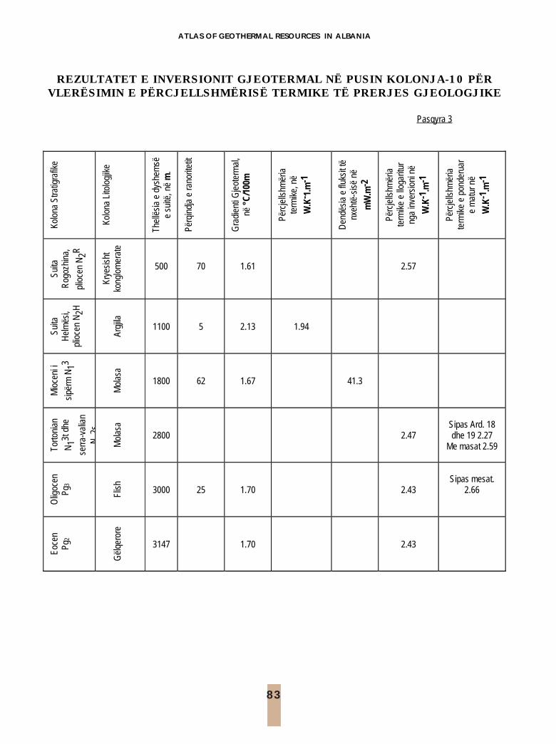
83
ATLAS OF GEOTHERMAL RESOURCES IN ALBANIA
REZULTATET E INVERSIONIT GJEOTERMAL NË PUSIN KOLONJA-10 PËRVLERËSIMIN E PËRCJELLSHMËRISË TERMIKE TË PRERJES GJEOLOGJIKE
Pasqyra 3
Kolo
na S
tratig
rafik
e
Kolo
na L
itolo
gjik
e
Thel
lësi
a e
dysh
emsë
e
suitë
, në
m.
Përq
indj
a e
rano
ritet
it
Gra
dien
ti G
jeot
erm
al,
në °
C/10
0m
Përc
jells
hmër
ia
term
ike,
në
W.K
- 1.m
-1
Den
dësi
a e
fluks
it të
nx
ehtë
-sis
ë në
mW
.m-2
Përc
jells
hmër
ia
term
ike
e llo
garit
ur
nga
inve
rsio
ni n
ë
W.K
-1.m
-1
Përc
jells
hmër
ia
term
ike
e po
nder
uar
e m
atur
në
W.K
-1.m
-1
Suita
R
ogoz
hina
,
plio
cen
N2R
Krye
sish
t ko
nglo
mer
ate
500
70
1.61
2.57
Suita
H
elm
ësi,
plio
cen
N2H
Ar
gjila
1100
5
2.13
1.94
Mio
ceni
i
sipë
rm N
13
M
olas
a
1800
62
1.67
41.3
Torto
nian
N13t
dhe
serra
-val
ian
N2s
Mol
asa
2800
2.47
Sipas Ard. 18 dhe 19 2.27
Me masat 2.59
Olig
ocen
Pg
3 Fl
ish
3000
25
1.70
2.43
Sipas mesat.
2.66
Eoce
n Pg
2 G
ëlqe
rore
3147
1.70
2.43

84
ATLASI I BURIMEVE TË ENERGJISË GJEOTERMALE NË SHQIPËRI
TE
MPE
RA
TU
RA
E U
JIT
, LIT
OLO
GJIA
E R
EZE
RV
UA
RIT
UJE
MB
AJT
ES D
HE
TË
DH
ËN
A T
EK
NIK
E T
Ë D
ISA
SH
PIM
EV
E N
Ë T
IRA
NË Pa
sqyr
a 8
Deb
iti i
ujit
N r. Zo
na k
u nd
odhe
t shp
imi
Thel
lësi
a e
shpi
mit,
në
m
Tem
pera
-tu
ra e
ujit
, o C
lit
ra/m
in
litra
/sek
H
oriz
onti
ujëm
bajtë
s
1 La
vazh
i në
rrugë
n Va
so
Pash
a 27
14
.0
21.4
0.
35
Zhav
orr
2 La
vazh
i në
jug
të
Stad
ium
it “Q
emal
Sta
fa”
82
15.8
22
.5
0.38
R
anor
ë rrë
njës
orë
ne
thel
lësi
40-
60m
3
Hot
el S
hera
ton,
pra
në
Uni
vers
itetit
16
0 16
.0
31.0
0.
52
Ran
orë
rrënj
ësor
ë
D
ebiti
i uj
it në
var
ësi t
ë la
rtësi
ë së
ng
ritje
s së
ujit
nga
pom
pa,
përk
atës
isht
Lartë
sia
e ng
ritje
s së
uj
it, n
ë m
etro
litra
/min
lit
ra/s
ek
Fu
q
4 Pi
shin
at
Pusi
1
Pusi
2
70
-35
90-4
5
15
.0
15.0
13
20-2
700
1200
-270
0
22
-45
20-4
5
Zhav
orr
5
Kroi
i Sh
ëngj
init
90-4
5 15
.0
1200
-270
0 20
-45
Zhav
orr
6 Pe
ma
dhe
Fabr
ika
e Bu
kës
105-
76
14.0
15
00-2
700
22-4
5 Zh
avor
r
7 Bë
rxul
lë
Puse
t 1, 2
, 3
Puse
t 4, 5
, 6
40
-30
50-4
0
15
.0
15.0
15
00-2
700
1800
-360
0
25
-45
30-6
0
Zhav
orr
8 La
knas
Pu
set 1
, 2, 3
Pu
set 6
, 7, 8
35
-18
90-4
5
15
.0
15.0
12
00-2
700
1200
-270
0
22
-45
20-4
5
Zhav
orr
9 Pr
anë
Fabr
ikës
“Co
caCo
la”
250-
130
1500
-270
0 25
-45
110
Zhav
orr

85
ATLAS OF GEOTHERMAL RESOURCES IN ALBANIA
VI. HARTAT DHE GRAFIKETVI. MAPS AND GRAPHICS

86
ATLASI I BURIMEVE TË ENERGJISË GJEOTERMALE NË SHQIPËRI
LEGJENDELEGEND
Kredite për ilustrimetIllustration Credists
Fleta1-a. Harta skematike e subduksionit të pllakës afrikane nën atë të Euroazisë.(Sipas Ricou, El. 1986).Plate 1-a. Schematic Map of African Plate Subduction under the Euroasiatic one. (After Ricou, El. 1986).
Fleta 1-b. Struktura e Kores së Tokës dhe e Mantelit të sipërm, sipas studimeve sizmologjike (Të dhënatsipas Koçiu S., 1989).
Plate 1-b. Geologic structure of Earth’s Crust and Upper Mantle based on seismological studies (data takenfrom Koçiu S. 1989).
Fleta 1-c. Skema tektonike e Shqipërisë. [sipas Hartës Tektonike të Shqipërisë, Shkalla 1:200 000, 1985].Plate 1-c. Tectonic Scheme of Albania. [After Tectonic Map of Albania, Scale 1:200 000, 1985].
Fleta 2. Harta e anomalive të gravitacionit, në reduksionin Buge. (Bushati S., 1988)Plate 2. Bouguer Gravity Anomalies Map. (Bushati S., 1988)
Fleta 3. Harta e fushës magnetike totale. (Bushati S., 1997)Plate 3. Total Magnetic Field Map. (Bushati S., 1997)
Fleta 4-a. Profili gjeologo-gjeofizik Albanid-1: Falco në detin Adriatik-Durres-Tiranë- Peshkopi. (Të dhënat egravitacionit për detin Adriatik sipas Richetti, 1980).
Plate 4-a. Geological-geophysical profile Albanid-1: Falco Adriatic Sea- Durrës-Tirana- Peshkopi. (The gravitydata for the Adriatic Sea after Richetti, 1980).
Fleta. 5. Prerje sizmike në zonën Jonike dhe në Ultësirën Pranadriatike. [Frasheri A., Bushati S., Bare V.,2003].
Plate 5. Reflection seismic line in Ionian and Peri-Adriatic Depression. [Frasheri A., Bushati S., Bare V.,2003].
Fleta 15-d. Ndikimi i trysnisë mbinormale në fushën e temperaturës. (Liço R. etj. 1998).Plate 15-d. Overnormal pressure influence on temperature field. (Liço R. et al. 1998).
Fleta 18. Harta e burimeve gjeotermale dhe e epiqendrave të tërmeteve. (Të dhënat sizmologjike sipasSulstarova E. etj. 1972).
Plate 18. Geothermal Springs and Earthquakes Epicentres Map. (Sejsmological data after Sulstarova E. at al.1972).
Fleta 19. Harta e burimeve gjeotermale dhe e izoseisteve të tërmeteve. (Të dhënat sizmologjike sipasSulstarova E. etj. 1972).
Plate 19. Geothermal Springs and Earthquakes Isoseistes Map. (Sejsmological data after Sulstarova E. at al.1972).

87
ATLAS OF GEOTHERMAL RESOURCES IN ALBANIA
Fleta 21-b. Foto: Pusi gjeotermal Kozani-8. (Arjan Gaçe).Plate 21-b. Photo: Geothermal Well Kozani-8. (Arjan Gaçe).
Fleta 22-a. Skemë topografike, zona e burimeve gjeotermale Llixha Elbasan. (Avgustinsky V.L. 1957)Plate 22-a. Topographic Sketch, Water place of Llixha Elbasani. (Avgustinsky V.L. 1957)
Fleta 23-a. Harta tektonike e zonës së burimeve gjeotermale Bënjë-Postenan- Sarandaporo. [Harta Tektonikee Shqipërisë, Shkalla 1:200 000, 1985].
Plate 23-a. Tectonic Map, Geothermal Sources field Bënjë-Postenan-Sarandaporo. [The Tectonic Map ofAlbania, Scale 1:200 000, 1985].
Fleta 26-a. Harta gjeologjike e zonës gjeotermale Peshkopia. [Harta Tektonike e Shqipërisë, Shkalla 1:200000, 1985].
Plate 26-a. Geological Map, Peshkopia Geothermal Zone. [The Tectonic Map of Albania, Scale 1:200 000,1985].
Fleta 27-b.Ngarkesa vjetore e energjise elektrike me dhe pa ngrohjen, 1999. (Agjencia Kombëtare eEnergjisë).
Plate 27-b.Yarly Electric Power with or withou heating, 1999. (National Agency of Energy].
88
ATLASI I BURIMEVE TË ENERGJISË GJEOTERMALE NË SHQIPËRI
Numri i pusit në
hartë Marks of
the well in the map
Emri i pusit Well name
Thellësia
Depth (m)
Shënime Remarks
1 Vermoshi 1 500 2 Ragam 168 268 3 Pacaj 25 155 4 Kepenik 30 5 Zogaj 179 6 Vlahne 1127 300 7 Qafe Morine 2 Vrojtuar për studimin e ndikimit të klimës
It is measured only for the clime influence study 8 Gjegjan 2/90 290 9 Tarabosh 1 490
10 Palaj 967 340 11 Palaj 1007 355 12 Bicaj 1 178 13 Bicaj 2 85 14 Gojanas 194 155 15 Fushearez 50 Vrojtuar për studimin e ndikimit të klimës
It is measured only for the clime influence study 16 Kecel 839 242 17 Dajci 3 30 Vrojtuar për studimin e ndikimit të klimës
It is measured only for the clime influence study 18 Dajci 2 45 Vrojtuar për studimin e ndikimit të klimës
It is measured only for the clime influence study 19 Pulaj 2 70 20 Gurth 595 85 21 Rubik 560 22 Gjazhda 48 295 23 Tuturiq 13 130 24 Perlat 598 450 25 Patok 18 Vrojtuar për studimin e ndikimit të klimës
It is measured only for the clime influence study 26 Ishmi 12 2000 27 Ishmi 1/b 2300 28 Shkoza 1 3300 29 Durres 15 1900 30 Rinas 1 31 Vrojtuar për studimin e ndikimit të klimës
It is measured only for the clime influence study 31 Lanabregas 2 1900 32 Rinas 2 27 Vrojtuar për studimin e ndikimit të klimës
It is measured only for the clime influence study 33 Qafebuall 19 Vrojtuar për studimin e ndikimit të klimës
It is measured only for the clime influence study 34 Bulqize 810 35 Krasta 1 150 36 Krasta 2 110 37 Thekna 547 380 38 Fushe lop 413 90 39 Kryevidh 5 2800 40 Kryevidh 2 2600 41 Kr 18 1510 42 Kr 16 1570 43 Kozan 8 1800 44 Ballaj 33 1400 45 Ballaj 50 1200
KATALOGU U NUMRIT TË PUSEVE QË JANË PËRSHIRË NË ALTASCATALOG OF THE NUMBER OF THE WELLS & BOREHOLES INVOLVED IN ATLAS
89
ATLAS OF GEOTHERMAL RESOURCES IN ALBANIA
46 Ballaj 14 1000 47 Ballaj 111 1000 48 Ballaj 4 3300 49 Peqini 2 2600 50 Papri 1 3000 51 Divjaka 6/b 2900 52 Divjake 265 640 53 Divjake 11 3400 54 Divjake 21 3200 55 Divjake 33 2800 56 Kemishtaj 1 3500 57 Garrunjas 1 3100 58 Pekisht 30 1500 59 Dumre 7 6000 60 Grekan 4 3500 61 Galigat 2 2900 62 Plashnik 86 180 63 Ardenice 3 2500 64 Ardenice 12 3000 65 Ardenice 18 6700 66 Seman 1 2100 67 Kolonje 10 3200 68 Bubullime 5 2420 69 Bubullime 6 2600 70 Bubullime 559 2900 71 Arza 31 820 72 Kucova 5 2200 73 Kucova 8 1500 74 Kucova 554 1500 75 Gorraj 1 2200 76 Blin 1 2800 77 Poshnja 7 1000 78 Povelca 3 2000 79 Povelca 6 2500 80 Povelca 33 1940 81 Krapsi 7 1800 82 Marinza 1 1600 83 Koqar 660 1600 84 Pat 79 750 85 Visoke 101 1900 86 Visoke 661 1400 87 Visoke 89 1400 88 Frakull 40 1800 89 Frakull 41 2600 90 Frakull 44 2700

90
ATLASI I BURIMEVE TË ENERGJISË GJEOTERMALE NË SHQIPËRI
91 Frakull 55 4000 92 Kreshpan 3 3780 93 Cakran 12 3220 94 Ballsh 3 2100 95 Ballsh 4 1800 96 Cakran 17 3900 97 Cakran 29 2000 98 Bregas 4 3100 99 Ballaj 131 1340 100 Ballsh 27 3300 101 Mollas 13 3400 102 Mollas 17 3200 103 Mollas 31 3340 104 Mollas 6 2900 105 Mollas 8 3500 106 Grekan 6 1700 107 Selishte 4 2900 108 Palshnik 1 3500 109 Prishta 1 210 110 Prishta 14 1700 111 Zvernec 3 4100 112 Vlora 2 2300 113 Vlora 9 2400 114 Vlora 10 5000 115 Koculi 1 1900 116 Goraj 11 1200 117 Gorisht 103 1000 118 Kushtaj 2 1400 119 Gernec 7 2000 120 Gernec 16 2100 121 Rexhepaj 4 2000 122 Hysoverdhe 1 3400 123 Amonice 8 2700 124 Golimbas 1/b 3010 125 Amantia 1 3900 126 Memaliaj 2b 2900 127 Rehove 308 100 128 Rehove 348 50 129 Rehove 736 187 130 Oprenje 140 131 Nokova 1 2000 132 Erindi 2 1200 133 Sasaj 1 3100 134 Delvine 4 3600 135 Vana 2 3400 136 Vurgu 30 470 137 Vurgu 31 2100 138 Vurgu 57 1700 139 Vurgu 67 2000 140 Vurgu 14 2100 141 Kalcat 3 2100 142 Butrinti 1 3900 143 Palaj 6 1200

91
ATLAS OF GEOTHERMAL RESOURCES IN ALBANIA
Harta skematike e subduksionit të pllakës afrikane nën atë të Evroazisë.1- Kontinenti evro-aziatik; 2- Kontinenti afrikan; 3- Blloku i Kishir-it; 4- Basenet Oqeanike tësotme; 5- Kufinjtë e oqeanit mesozoik; 6- Kufinjtë e oqeanit mesozoik Ocean dhe napëskryesore ofiolitike; 7- Hullitë e subduksionit të sotëm dhe të kaluar.
Schematic Map of African Plate Subduction under the Euroasiatic one1- Euro-Asiatic Continent; 2- African continent; 3- Kishir block; 4- PresentsOceanic Basins; 5- Boundaries of Mesozoic Oceans; 6- Boundaries ofMesozoic Ocean and the Main Ophiolitic Nappes; 7- Troughs of present andpast subduction.
Figura 1

92
AT
LASI I BU
RIM
EVE T
Ë ENER
GJISË G
JEOT
ERM
ALE N
Ë SHQ
IPËRI
Fleta 1-a. Struktura e Kores së Tokës dhe e Mantelit të sipërm, sipasstudimeve sizmologjike.
Plate 1-a. Geologic structure of Earth’s Crust andUpper Mantle based on seismological studies.
Fleta 1/Plate 1
Fleta 1-b. Skema tektonike eShqipërisë.Plate 1-b. Tectonic Sketch of Albania.

93
ATLAS OF GEOTHERMAL RESOURCES IN ALBANIA
Fleta 2/Plate 2

94
ATLASI I BURIMEVE TË ENERGJISË GJEOTERMALE NË SHQIPËRI
Fleta 3/Plate 3

95
ATLAS OF GEOTHERMAL RESOURCES IN ALBANIA
Plate 4-a. Geological-geophysical profile Albanid-1: Falco Adriatic Sea- Durrës-Tirana-Peshkopi
1. Pliocen, 2- Miocen i poshtëm-flishi i paleogjenit; 3- Gelqerorë mesozoikë Mz; 4- Shkëmbinj ultrabazikë;5- Kripëra; 6- Bazamenti kristalin; 7- Kore bazaltike; 8 - Manteli 9- Kufiri MOHO; 10- Thyerje e thellë; 11- Dendësia, g/cm3; 12- Temperatura, oC; 13-Pus i thellë; D GB-Anomalia Buge; DT-Anomalia e fushës totale magnetike; q- Dendësia efluksit të nehtësisë.
Fleta 4-a. Profili gjeologo-gjeofizik Albanid-1: Falco në detin Adriatik-Durres-Tiranë-Peshkopi
1-Pliocene, 2- Lower Miocene - Paleogenic flysch section; 3- Mesozoic limestone Mz;4- Ultrabasic rocks; 5-Salt; 6- Crystal Basement; 7- Basalt Crust; 8 - Mantle 9- MOHO Discontinuity; 10- Depth up - disjunctivetectonic; 11- Density, g/cm3; 12- Temperature, oC; 13- Deep well; DGB- Bouguer Anomaly; DT- Total MagneticField Anomaly; q- Heat Flow Density.
Fleta 4-b. Profili gjeologo-gjeofizikShkodër-Kukës.1. Shkëmbinj efuzivë; 2- Shkëmbinjultrabazikë; 3- Gabro; 4- Formacionsedimentar; 5- Tektonikë shkëputëse.
Plate 4-b. Geological-geophysicalShkodër-Kukës profile.1. Effusive rocks; 2- Ultrabasicrocks; 3- Gabbro; 4- Sedimentaryformation; 5- Disjunctive tectonics.
Fleta 4/Plate 4

96
AT
LASI I BU
RIM
EVE T
Ë ENER
GJISË G
JEOT
ERM
ALE N
Ë SHQ
IPËRI
Prerje sizmike në zonën Jonike dhe në Ultësirën Pranadriatike.Reflection seismic line in Ionian and Peri-Adriatic Depression.
Fleta 5/Plate 5

97
ATLAS OF GEOTHERMAL RESOURCES IN ALBANIA
Fleta 6Plate 6

98
ATLASI I BURIMEVE TË ENERGJISË GJEOTERMALE NË SHQIPËRI
Fleta 7Plate 7

99
AT
LAS O
F GEO
TH
ERM
AL R
ESOU
RC
ES IN A
LBAN
IA
Fleta 8-a. Termograma të pusit Rinasi-1.Plate 8-a. Thermolog of Rinasi-1 borehole.
Fleta 8-b. Termograma e liqenit të Ohrit, zona Piskupat.Plate 8-b. Termolog of the Ohrit Lake, Piskupat zone.
Fleta 8-c. Termograma e liqenit të Ohrit, zona Guri i Kuq.Plate 8-c. Termolog of the Ohrit Lake, Guri Kuq zone.
Fleta 8/Plate 8

100
ATLASI I BURIMEVE TË ENERGJISË GJEOTERMALE NË SHQIPËRI
Fleta 9Plate 9

101
ATLAS OF GEOTHERMAL RESOURCES IN ALBANIA
Fleta 10Plate 10

102
ATLASI I BURIMEVE TË ENERGJISË GJEOTERMALE NË SHQIPËRI
Fleta 11Plate 11

103
ATLAS OF GEOTHERMAL RESOURCES IN ALBANIA
Fleta 12Plate 12

104
ATLASI I BURIMEVE TË ENERGJISË GJEOTERMALE NË SHQIPËRI
Fleta 13Plate 13

105
ATLAS OF GEOTHERMAL RESOURCES IN ALBANIA
Fleta 14-a. Profili gjeotermal Divjakë.
Plate 14-a. Geothermal Profile Divjakë.
Fleta 14-b. Profili gjeotermal Kolonjë.
Plate 14-b. Geothermal Profile Kolonjë.
Fleta 14-c. Profili gjeotermal Ballsh.
Plate 14-c. Geothermal Profile Ballsh.
Legjende
Molasë, Molasse N12, N1
3, N2
Flish, Flysch Pg3
Gëlqerorë, Limestones T3, J, Cr. Pg1-2
Tektonikë, Disjuctive tectonics
Kripëra, Salt
Fleta 14\ Plate 14

106
ATLASI I BURIMEVE TË ENERGJISË GJEOTERMALE NË SHQIPËRI
Fleta 15-c. Kolonë gjeotermale Povelçë.
Plate 15-c. Geothermal Column Povelça
Fleta 15-d. Ndikimi i trysnisë mbinormale nëfushën e temperaturës*.1. Temperatura, oC; 2- Resistenca e dukshme, x10-1 Ohmm;3- Presioni, Mpa; 4- Ndryshimi i diametrit të pusit, %;TM- tavani i zonës me trysni mbinormale.
Plate 15-d. Overnormal pressure influence ontemperature field*.1. Temperature, oC; 2- Resistivity, x10-1 Ohmm; 3- Pressure,Mpa; 4- Change of the well diameter, in %; TM- Top of theovernormal pressure zone.
Fleta 15-b. Profili gjeotermal Kalcat. Legjenda si në Fletën 14.
Plate 15-b. Geothermal Profile Kalcat. Legend: See Plate 14.
Fleta 15-a. Profili gjeotermal Papër. Legjenda si në Fletën 14.
Plate 15-a. Geothermal Profile Papër. Legend: See Plate 14.
Fleta 15\ Plate 15

107
ATLAS OF GEOTHERMAL RESOURCES IN ALBANIA
Fleta 16Plate 16

108
ATLASI I BURIMEVE TË ENERGJISË GJEOTERMALE NË SHQIPËRI
Fleta 17Plate 17

109
ATLAS OF GEOTHERMAL RESOURCES IN ALBANIA
Fleta 18Plate 18

110
ATLASI I BURIMEVE TË ENERGJISË GJEOTERMALE NË SHQIPËRI
Fleta 19Plate 19

111
ATLAS OF GEOTHERMAL RESOURCES IN ALBANIA
Fleta 20Plate 20

113
ATLAS OF GEOTHERMAL RESOURCES IN ALBANIA
Fleta 21-a. Foto: Pusigjeotermal Ishmi 1/b.
Plate 21-a. Photo:Geothermal Well Ishmi 1/b.
Fleta 21-b. Foto: Pusi gjeotermalKozani-8.
Plate 21-b. Photo: Geothermal WellKozani-8.
Fleta 21\ Plate 21

113
ATLAS OF GEOTHERMAL RESOURCES IN ALBANIA
Fleta 22\ Plate 22
Fleta 22-a. Skemë topografike, zona eburimeve gjeotermale Llixha Elbasan.1- Olistolit gëlqeror; 2- Argjila; 3- Konglomerate; 4-Shkëmbinj të kaolinizuar ;5- Burim termal.
Plate 22-a. Topographic Sketch, LlixhaElbasani Geothermal Area.1- Calcolistolith; 2- Shale; 3- Conglomerate; 4- ; Kaolinizedrocks 5- Thermal source.
Fleta 22-b. Foto: Zona e burimevegjeotermale, Llixha Elbasan.
Plate 22-b. Photo: Llixha ElbasaniGeothermal Area.

114
ATLASI I BURIMEVE TË ENERGJISË GJEOTERMALE NË SHQIPËRI
Fleta 23\ Plate 23
Fleta 23-a. Harta tektonike e zonës së burimeve gjeotermale Bënjë-Postenan-Sarandaporo.Plate 23-a. Tectonic Map, Geothermal Sources field Bënjë-Postenan- Sarandaporo.
Fleta 23-b. Foto: Burimet gjeotermale Bënjë, lumi iLangaricës, Përmet
Plate 23-b. Photo: Geothermal Springs Bënjë, LangaricaRiver, Përmet

116
ATLASI I BURIMEVE TË ENERGJISË GJEOTERMALE NË SHQIPËRI
Fleta 24\ Plate 24
Fleta 24-a. Foto: Tektonika në zonën e burimit të avullit, Mali iPostenanit, Leskovik.Plate 24-a. Photo: Tectonic Fault at Steam Springs Area, PostenaniMountain, Leskovik.
Fleta 24-b. Foto: Thyerja tektonike nga buron avulli, Postenan.Plate 24-b. Photo: Steam Discharge Tectonic Fault, Postenan.
Fleta 24-c. Foto:Zona e burimevetgjeotermale, Sarandaporo, Leskovik.
Plate 24-c: Photo: Geothermal SpringsArea, Sarandaporo, Leskovik.
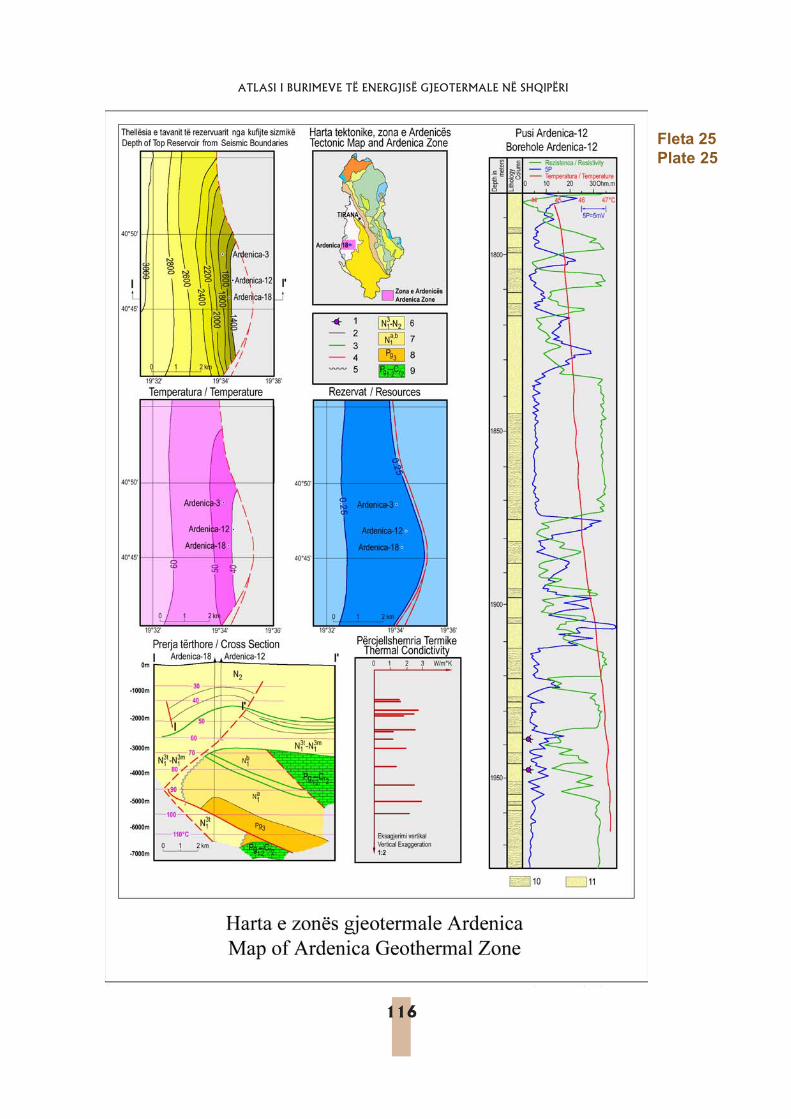
116
ATLASI I BURIMEVE TË ENERGJISË GJEOTERMALE NË SHQIPËRI
Fleta 25Plate 25
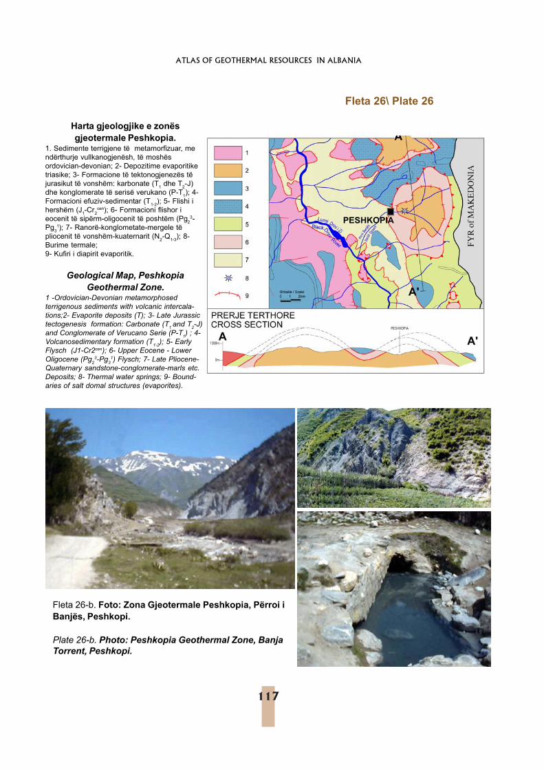
117
ATLAS OF GEOTHERMAL RESOURCES IN ALBANIA
Fleta 26-b. Foto: Zona Gjeotermale Peshkopia, Përroi iBanjës, Peshkopi.
Plate 26-b. Photo: Peshkopia Geothermal Zone, BanjaTorrent, Peshkopi.
Harta gjeologjike e zonësgjeotermale Peshkopia.
1. Sedimente terrigjene të metamorfizuar, mendërthurje vullkanogjenësh, të moshësordovician-devonian; 2- Depozitime evaporitiketriasike; 3- Formacione të tektonogjenezës tëjurasikut të vonshëm: karbonate (T1 dhe T2-J)dhe konglomerate të serisë verukano (P-T1); 4-Formacioni efuziv-sedimentar (T1-2); 5- Flishi ihershëm (J1-Cr2
cen); 6- Formacioni flishor ieocenit të sipërm-oligocenit të poshtëm (Pg2
3-Pg3
1); 7- Ranorë-konglometate-mergele tëpliocenit të vonshëm-kuaternarit (N2-Q1-3); 8-Burime termale;9- Kufiri i diapirit evaporitik.
Geological Map, PeshkopiaGeothermal Zone.
1 -Ordovician-Devonian metamorphosedterrigenous sediments with volcanic intercala-tions;2- Evaporite deposits (T); 3- Late Jurassictectogenesis formation: Carbonate (T1 and T2-J)and Conglomerate of Verucano Serie (P-T1) ; 4-Volcanosedimentary formation (T1-2); 5- EarlyFlysch (J1-Cr2cen); 6- Upper Eocene - LowerOligocene (Pg2
3-Pg31) Flysch; 7- Late Pliocene-
Quaternary sandstone-conglomerate-marls etc.Deposits; 8- Thermal water springs; 9- Bound-aries of salt domal structures (evaporites).
Fleta 26\ Plate 26

119
ATLAS OF GEOTHERMAL RESOURCES IN ALBANIA
Fleta 27-a. Sistemi këmbyes vertikal nxehtësie-pus- pompë gjeotermale nxehtësie për ngrohjene godinave.
Plate 27-a. Space heating Borehole Vertical HeatExchanger-Geothermal Heat Pump System.
Fleta 27-b. Ngarkesa vjetore e energjise elektrike me dhe pa ngrohjen, 1999. (Agjencia Kombëtare e Energjisë).
Plate 27-b. Yarly Electric Power with or withou heating, 1999. (National Agency of Energy].
Heating Power, 1375 GWh, 23.8% of the total Average Power without heating, 4400 GWh
0 100 200 300 400 500 600 700 800 900
1000 1100 1200 1300 1400
Hours
MW
Ngarkesa e ngrohjes: (1375 GWh ose 23.8% e totalit) Ngarkesa mesatare pa ngrohje: (4400 GWh ose 76.2% e totalit)
Fleta 27\ Plate 27
pompë nxehtësie
ngrohje nën dysheme
këmbyesnxehtësievertikal

120
ATLASI I BURIMEVE TË ENERGJISË GJEOTERMALE NË SHQIPËRI
Qendrat Balneologjike, Balneological Center, Peshkopi.
Qendrat Balneologjike Hotel Park, Balneological Center Park Hotel , Elbasan
Fle
ta 2
8\ P
late
28

121
ATLAS OF GEOTHERMAL RESOURCES IN ALBANIA
Qendrat Balneologjike Hydrat në Elbasan dhe Sarandaporo (në rikonstruksion).Balneological Centres Hydrat Hotel-Elbasan and Sarandaporo SPA (in reconstruction).
Hotel Hydrat në Elbasan
Sarandaporo (në rikonstruksion).
Fleta 29\ Plate 29

122
ATLASI I BURIMEVE TË ENERGJISË GJEOTERMALE NË SHQIPËRI
Llixhat Elbasan
Kozan
Impakti mjedisor nga derdhja e ujerave termaleEnvironmental impact from thermal waters discharge
Fleta 30Plate 30

122
ATLASI I BURIMEVE TË ENERGJISË GJEOTERMALE NË SHQIPËRI
CIP Katalogimi në botim BK Tiranë
Atlasi i burimeve të energjisë gjeotermale në Shqipëri:monografi = Atlas of the geotermal resources in Albania /Alfred Frashëri, Vladimir Çermak, etj. : red. Tatiana Cenko.Tiranë; Akademia e Shkencave, 2004.122 f. : me il. ; 20,7x27,7 cm. - (R SH Akad. e Shkencave)ISBN 99943-630-2-6I. Frashëri, Alfred etj.
551.23(496.5) (084.42)553.7(496.5) (084.42)912.44 :551.23 (496.5)
Tirazhi: 160 Kompakt Disqe (CD), 15 kopje të printuaraRegjistroi CD: Sinteza Shpk, Tiranë 2004

124
ATLASI I BURIMEVE TË ENERGJISË GJEOTERMALE NË SHQIPËRI