application of gis in solid waste management in … of gis in solid waste management in ......
TRANSCRIPT
IOSR Journal of Environmental Science, Toxicology and Food Technology (IOSR-JESTFT)
e-ISSN: 2319-2402,p- ISSN: 2319-2399.Volume 8, Issue 9 Ver. II (Sep. 2014), PP 17-21 www.iosrjournals.org
www.iosrjournals.org 17 | Page
Application of GIS in Solid Waste Management in Chanchaga Local
Government Area of Niger State, Nigeria
Sule, J. O.1, Aliyu, Y. A.
2 and Umar, M. S.
3
1,2,3Department of Geomatics, Faculty of Environmental Design Ahmadu Bello University, Zaria – Nigeria.
Abstract: This study aims at developing a decision support tool for solid waste management in Chanchaga Local
Government Area of Niger State using Geo-information Technology. Waste management is a global environment
issue, which constitutes a very significant problem in today’s world. There is a considerable amount of waste
disposal without proper segregation, which is leading to both economic and environmental problems. There is
tremendous amount of loss in terms of environmental degradation and health hazards, due to direct disposal of
waste. There has to be appropriate planning for good waste management by assessing the waste situation of the
area. The method employed was to acquire attribute and spatial information using handheld Global Positioning
System receiver (GPS) and satellite imagery. The image was geo-referenced and digitized showing the location of
existing waste disposal unit and the final dumpsite. A database was created using ArcGIS 9.3 software. Queries and
analysis of results were carried out. The results show primary, secondary disposal units and the condition of the
disposal units.
Key words: Solid Waste Management, Environmental Hazard, GIS, GPS, Spatial Information
I. Introduction In developing countries such as Nigeria, the international policy that the generator of waste is responsible
for the proper management, treatment and disposal of waste has remained on paper and is yet to be implemented[1].
Solid waste is the term used to describe non–liquid waste materials arising from domestic, trade,
commercial, agricultural, industrial activities and from public services. Eight major activities generate solid waste.
These are residential, industrial, commercial, institutional, construction, municipal services, process and agricultural.
It comprises of different materials: dust, food waste, packaging in form of paper, metal, plastic or glass, discarded
clothing, garden waste, hazardous waste and radioactive waste[2].
“The „Municipal Solid Waste‟ includes commercial and residential wastes generated in municipal or notified areas in either solid or semi-solid form excluding industrial hazardous wastes but including treated bio-
medical wastes.” [3].
Urban solid waste management is one of the most immediate and serious environmental problems
confronting authorities in developing countries. Waste management practices differ for developed and developing
nations, for urban and rural areas, and for residential and industrial producers. Management of non-hazardous waste,
residential and industrial waste in metropolitan areas is usually the responsibility of local government authorities,
while management of non-hazardous commercial and industrial waste is usually the responsibility of the generator [1]
.
Waste management is a global environmental issue which constitutes a very significant problem in today‟s
world. The most common problems associated with improper management of solid waste include diseases
transmission, fire hazards, odor nuisance, atmospheric and waterPollution, aesthetic nuisance and economic losses[4]. The environment is heading towards a potential risk due to unsustainable waste disposal. It is a sensitive issue,
which concerns serious environmental problems in today‟s world. The present situation of direct dumping of the
waste without proper inspection and separation leaves a serious impact of environmental pollution causing a
tremendous growth in health related problems. “Domestic, industrial and other wastes, whether they are of low or
medium level wastes, are causing environmental pollution and have become perennial problems for mankind” [5].
A study conducted by [6] on problems of solid waste management in Minna, using GIS showed that there
are lapses or inefficiency on the part of the body responsible for solid waste management in the towns and cities of
Niger State. It also provides solution to the problems by suggesting an enforcement of sanitation laws, intensified
public enlightenment campaign on solid waste management and provision of refuse bins at strategic locations. [7] investigated the use of GIS ideal for the selection of optimum location of transfer stations by combining
relevant dataset of satellite imagery, land use map, identification of existing locations of municipal bins through

Application of GIS in Solid Waste Management in Chanchaga Local Government Area of Niger State,
www.iosrjournals.org 18 | Page
GPS coordinates, and map showing road network. GIS provides an efficient and effective means of analyzing the
best location for waste transfer stations. [8] enumerated that GIS support a formal process of optimum location of community waste bins based on
buffer electronic maps. The process enables an analyst to consider a variety of geographic factors essential for the
planned facility and others merely desirable.However, GIS is an appealing strategy for an agency seeking a rational
unbiased location for a local facility such as an incinerator or dumpsite. [9]used GIS for preliminary disposal sites around Ranchi urban complex. From this study it was possible to
relate the ground water of a site with health parameters of its inhabitants and that once a GIS database is developed,
it can provide efficient means of analyzing the best site for disposal of solid waste while the manual method of
selection is very tedious.
As a result, this paper aims at studying solid waste management in Chanchaga Local Government Area,
Minna, Niger State, Nigeria, using Geographic Information System (GIS).
II. The Study Area Chanchaga local government area is one of the 25 local government areas in Niger State with its
headquarters in Minna the state capital as shown in Fig. 1 below. It lies between latitude 9°35‟ 00” to 9° 41‟ 00” and
longitude 6° 25‟ 00” to 6° 37‟ 00”. It covers an area of 72km² with a total population of 201,429.
Chanchaga local government area is located within the basement complex area of the country, which is
characterized, by different forms of sedimentary rocks and alluvial deposit. It has a tolerable climate, immense
opportunities for socio-economic and agricultural activities. It has a dry and wet season. Rainfall occurs between
April and November with high concentration in August.
Figure 1: Map of Niger State showing Chanchaga Local Government Area.
The most predominant type of soil found in Chanchaga local government area is ferruginous tropical soils
derived from the basement complex rocks and old sedimentary rocks.Data used in this study include, satellite
imagery, road network map of the study area, existing location of waste transfer stations of the study area and
location of the disposal sites of the area.
III. Methodology Reconnaissance survey was carried-out, in order to identify the existing locations of the dumpsites within
the study area. During the reconnaissance, it was observed that, most of the existing locations of the dumpsites are
along the major road for proper monitoring and effective collection of the waste by Niger State Environmental
Protection Agency (NSEPA). The reconnaissance survey also helped to identify areas where illegal dumping sites
are located. The final disposal site is located along Minna - Zungeru road that is 15km away from the metropolis and
it is an open land.
3.1.Method of Data Collection
The satellite imagery of the study area was obtained from Google earth software at a high resolution. The
map was geo-referenced using ArcGIS 9.3. The location of the existing waste transfer station within the study area

Application of GIS in Solid Waste Management in Chanchaga Local Government Area of Niger State,
www.iosrjournals.org 19 | Page
was obtained from the Niger State Environmental Protection Agency (NSEPA) and the x and y coordinates of each
station was collected using a handheld GPS (Garmin 76S) receiver. Snapshots of some waste transfer locations were
taken. The coordinate of the final dumping site was obtained with the hand held GPS receiver, which is the only
approved dumping site. The amount of waste generated on daily basis was also obtained from NSEPA.
The second phase consists of preparation of thematic maps, which include digitization of spatial data. The
map layers created from the ArcCatalog were Stream, Railway, Major road, Minor road, Waste disposal units, Open
space, Agricultural areas, Administrative buildings, Commercial area, and Residential areas. Some of these layers
were created as points, lines and polygons layers.
IV. Results and Discussion The figures below display pictures of waste units, results of queries for satisfactory and unsatisfactory disposal units.
Figure 2: Illegal Dumping of Refuse within the Metropolis
Figure 3: Query Result Showing the Primary Disposal Units.
Fig. 3shows the query result of primary disposal units within the study area. It reveals that there are 41
primary disposal units within the study area. These waste disposal units are inadequate to make the city clean and
bring the aesthetic view of the town. In Fig. 4, it can be seen that the secondary disposal unit situated 15km from the
residential area is the only approved final disposal unit.

Application of GIS in Solid Waste Management in Chanchaga Local Government Area of Niger State,
www.iosrjournals.org 20 | Page
Figure 4: Query Result Showing the Secondary Disposal Units
4.1Analysis of Results of Queries/Bufferings
The analyses were based on the suitable distance to disposal unit for all users and environmentally sensitive
areas.
4.1.1 Suitable Distance to Disposal Unit for All Users
The first assessment is meant to check for the suitable and convenient distance from the disposal unit to the
users within the study area. Therefore, a buffer of 30m was created round the disposal units to check proximity to
main roads as proffered by decision makers [10].
. Figure 5: Buffer Operation Indicating Waste Disposal Units within 30m to Road
From the Fig. 5 above, the only two (2) waste disposal units that didn‟t fall within the 30m buffer between
roads and waste disposal units can be clearly seen at Gidan Matasa road off Okada road.
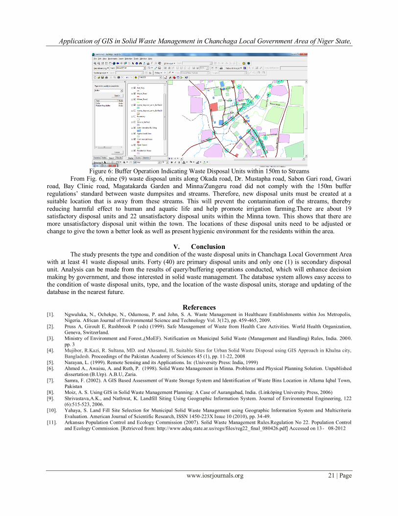
4.1.2 Environmentally Sensitive Areas
Buffer operation of 150m was also carried out to check for the proximity of the disposal units to
environmentally sensitive areas such as streams that are used as source of water for irrigation [11].
Application of GIS in Solid Waste Management in Chanchaga Local Government Area of Niger State,
www.iosrjournals.org 21 | Page
Figure 6: Buffer Operation Indicating Waste Disposal Units within 150m to Streams
From Fig. 6, nine (9) waste disposal units along Okada road, Dr. Mustapha road, Sabon Gari road, Gwari
road, Bay Clinic road, Magatakarda Garden and Minna/Zungeru road did not comply with the 150m buffer
regulations‟ standard between waste dumpsites and streams. Therefore, new disposal units must be created at a
suitable location that is away from these streams. This will prevent the contamination of the streams, thereby
reducing harmful effect to human and aquatic life and help promote irrigation farming.There are about 19
satisfactory disposal units and 22 unsatisfactory disposal units within the Minna town. This shows that there are
more unsatisfactory disposal unit within the town. The locations of these disposal units need to be adjusted or
change to give the town a better look as well as present hygienic environment for the residents within the area.
V. Conclusion
The study presents the type and condition of the waste disposal units in Chanchaga Local Government Area
with at least 41 waste disposal units. Forty (40) are primary disposal units and only one (1) is secondary disposal
unit. Analysis can be made from the results of query/buffering operations conducted, which will enhance decision
making by government, and those interested in solid waste management. The database system allows easy access to
the condition of waste disposal units, type, and the location of the waste disposal units, storage and updating of the
database in the nearest future.
References [1]. Ngwuluka, N., Ochekpe, N., Odumosu, P. and John, S. A. Waste Management in Healthcare Establishments within Jos Metropolis,
Nigeria. African Journal of Environmental Science and Technology Vol. 3(12), pp. 459-465, 2009.
[2]. Pruss A, Giroult E, Rushbrook P (eds) (1999). Safe Management of Waste from Health Care Activities. World Health Organization,
Geneva, Switzerland.
[3]. Ministry of Environment and Forest.,(MoEF). Notification on Municipal Solid Waste (Management and Handling) Rules, India. 2000.
pp. 3
[4]. Mujibor, R.Kazi, R. Sultana, MD. and Ahasanul, H. Suitable Sites for Urban Solid Waste Disposal using GIS Approach in Khulna city,
Bangladesh. Proceedings of the Pakistan Academy of Sciences 45 (1), pp. 11-22, 2008
[5]. Narayan, L. (1999). Remote Sensing and its Applications. In: (University Press: India, 1999)
[6]. Ahmed A., Awaisu, A. and Ruth, P. (1998). Solid Waste Management in Minna. Problems and Physical Planning Solution. Unpublished
dissertation (B.Urp). A.B.U, Zaria.
[7]. Samra, F. (2002). A GIS Based Assessment of Waste Storage System and Identification of Waste Bins Location in Allama Iqbal Town,
Pakistan
[8]. Moiz, A. S. Using GIS in Solid Waste Management Planning: A Case of Aurangabad, India. (Linköping University Press, 2006)
[9]. Shrivastava,A.K., and Nathwat, K. Landfill Siting Using Geographic Information System. Journal of Environmental Engineering, 122
(6):515-523, 2006.
[10]. Yahaya, S. Land Fill Site Selection for Municipal Solid Waste Management using Geographic Information System and Multicriteria
Evaluation. American Journal of Scientific Research, ISSN 1450-223X Issue 10 (2010), pp. 34-49.
[11]. Arkansas Population Control and Ecology Commission (2007). Solid Waste Management Rules.Regulation No 22. Population Control
and Ecology Commission. [Retrieved from: http://www.adeq.state.ar.us/regs/files/reg22_final_080426.pdf] Accessed on 13 - 08-2012