your use of this ontario geological survey document (the
TRANSCRIPT

THESE TERMS GOVERN YOUR USE OF THIS DOCUMENT
Your use of this Ontario Geological Survey document (the “Content”) is governed by the terms set out on this page (“Terms of Use”). By downloading this Content, you (the
“User”) have accepted, and have agreed to be bound by, the Terms of Use.
Content: This Content is offered by the Province of Ontario’s Ministry of Northern Development and Mines (MNDM) as a public service, on an “as-is” basis. Recommendations and statements of opinion expressed in the Content are those of the author or authors and are not to be construed as statement of government policy. You are solely responsible for your use of the Content. You should not rely on the Content for legal advice nor as authoritative in your particular circumstances. Users should verify the accuracy and applicability of any Content before acting on it. MNDM does not guarantee, or make any warranty express or implied, that the Content is current, accurate, complete or reliable. MNDM is not responsible for any damage however caused, which results, directly or indirectly, from your use of the Content. MNDM assumes no legal liability or responsibility for the Content whatsoever. Links to Other Web Sites: This Content may contain links, to Web sites that are not operated by MNDM. Linked Web sites may not be available in French. MNDM neither endorses nor assumes any responsibility for the safety, accuracy or availability of linked Web sites or the information contained on them. The linked Web sites, their operation and content are the responsibility of the person or entity for which they were created or maintained (the “Owner”). Both your use of a linked Web site, and your right to use or reproduce information or materials from a linked Web site, are subject to the terms of use governing that particular Web site. Any comments or inquiries regarding a linked Web site must be directed to its Owner. Copyright: Canadian and international intellectual property laws protect the Content. Unless otherwise indicated, copyright is held by the Queen’s Printer for Ontario. It is recommended that reference to the Content be made in the following form: <Author’s last name>, <Initials> <year of publication>. <Content title>; Ontario Geological Survey, <Content publication series and number>, <total number of pages>p. Use and Reproduction of Content: The Content may be used and reproduced only in accordance with applicable intellectual property laws. Non-commercial use of unsubstantial excerpts of the Content is permitted provided that appropriate credit is given and Crown copyright is acknowledged. Any substantial reproduction of the Content or any commercial use of all or part of the Content is prohibited without the prior written permission of MNDM. Substantial reproduction includes the reproduction of any illustration or figure, such as, but not limited to graphs, charts and maps. Commercial use includes commercial distribution of the Content, the reproduction of multiple copies of the Content for any purpose whether or not commercial, use of the Content in commercial publications, and the creation of value-added products using the Content. Contact:
FOR FURTHER INFORMATION ON PLEASE CONTACT: BY TELEPHONE: BY E-MAIL:
The Reproduction of Content
MNDM Publication Services
Local: (705) 670-5691 Toll Free: 1-888-415-9845, ext.
5691 (inside Canada, United States)
The Purchase of MNDM Publications
MNDM Publication Sales
Local: (705) 670-5691 Toll Free: 1-888-415-9845, ext.
5691 (inside Canada, United States)
Crown Copyright Queen’s Printer Local: (416) 326-2678 Toll Free: 1-800-668-9938
(inside Canada, United States)

LES CONDITIONS CI-DESSOUS RÉGISSENT L'UTILISATION DU PRÉSENT DOCUMENT.
Votre utilisation de ce document de la Commission géologique de l'Ontario (le « contenu ») est régie par les conditions décrites sur cette page (« conditions d'utilisation »). En
téléchargeant ce contenu, vous (l'« utilisateur ») signifiez que vous avez accepté d'être lié par les présentes conditions d'utilisation.
Contenu : Ce contenu est offert en l'état comme service public par le ministère du Développement du Nord et des Mines (MDNM) de la province de l'Ontario. Les recommandations et les opinions exprimées dans le contenu sont celles de l'auteur ou des auteurs et ne doivent pas être interprétées comme des énoncés officiels de politique gouvernementale. Vous êtes entièrement responsable de l'utilisation que vous en faites. Le contenu ne constitue pas une source fiable de conseils juridiques et ne peut en aucun cas faire autorité dans votre situation particulière. Les utilisateurs sont tenus de vérifier l'exactitude et l'applicabilité de tout contenu avant de l'utiliser. Le MDNM n'offre aucune garantie expresse ou implicite relativement à la mise à jour, à l'exactitude, à l'intégralité ou à la fiabilité du contenu. Le MDNM ne peut être tenu responsable de tout dommage, quelle qu'en soit la cause, résultant directement ou indirectement de l'utilisation du contenu. Le MDNM n'assume aucune responsabilité légale de quelque nature que ce soit en ce qui a trait au contenu. Liens vers d'autres sites Web : Ce contenu peut comporter des liens vers des sites Web qui ne sont pas exploités par le MDNM. Certains de ces sites pourraient ne pas être offerts en français. Le MDNM se dégage de toute responsabilité quant à la sûreté, à l'exactitude ou à la disponibilité des sites Web ainsi reliés ou à l'information qu'ils contiennent. La responsabilité des sites Web ainsi reliés, de leur exploitation et de leur contenu incombe à la personne ou à l'entité pour lesquelles ils ont été créés ou sont entretenus (le « propriétaire »). Votre utilisation de ces sites Web ainsi que votre droit d'utiliser ou de reproduire leur contenu sont assujettis aux conditions d'utilisation propres à chacun de ces sites. Tout commentaire ou toute question concernant l'un de ces sites doivent être adressés au propriétaire du site. Droits d'auteur : Le contenu est protégé par les lois canadiennes et internationales sur la propriété intellectuelle. Sauf indication contraire, les droits d'auteurs appartiennent à l'Imprimeur de la Reine pour l'Ontario. Nous recommandons de faire paraître ainsi toute référence au contenu : nom de famille de l'auteur, initiales, année de publication, titre du document, Commission géologique de l'Ontario, série et numéro de publication, nombre de pages. Utilisation et reproduction du contenu : Le contenu ne peut être utilisé et reproduit qu'en conformité avec les lois sur la propriété intellectuelle applicables. L'utilisation de courts extraits du contenu à des fins non commerciales est autorisé, à condition de faire une mention de source appropriée reconnaissant les droits d'auteurs de la Couronne. Toute reproduction importante du contenu ou toute utilisation, en tout ou en partie, du contenu à des fins commerciales est interdite sans l'autorisation écrite préalable du MDNM. Une reproduction jugée importante comprend la reproduction de toute illustration ou figure comme les graphiques, les diagrammes, les cartes, etc. L'utilisation commerciale comprend la distribution du contenu à des fins commerciales, la reproduction de copies multiples du contenu à des fins commerciales ou non, l'utilisation du contenu dans des publications commerciales et la création de produits à valeur ajoutée à l'aide du contenu. Renseignements :
POUR PLUS DE RENSEIGNEMENTS SUR VEUILLEZ VOUS
ADRESSER À : PAR TÉLÉPHONE : PAR COURRIEL :
la reproduction du contenu
Services de publication du MDNM
Local : (705) 670-5691 Numéro sans frais : 1 888 415-9845,
poste 5691 (au Canada et aux États-Unis)
l'achat des publications du MDNM
Vente de publications du MDNM
Local : (705) 670-5691 Numéro sans frais : 1 888 415-9845,
poste 5691 (au Canada et aux États-Unis)
les droits d'auteurs de la Couronne
Imprimeur de la Reine
Local : 416 326-2678 Numéro sans frais : 1 800 668-9938
(au Canada et aux États-Unis)

ONTARIO DEPARTMENT OF MINES
Hon. G. C. Wardrope, Minister D. P. Douglass, Deputy Minister
M. E. Hurst, Director of Geological Branch
Fluorspar in Ontario
By
G. R. GUILLET
Industrial Mineral Report No. 12
TORONTOPrinted and Published by Frank Fogg, Printer to the Queen's Most Excellent Majesty
1964

Publications of the Ontario Department of Mines are obtainable through the Publications Office, Department of Mines, Parliament Buildings, Toronto 5, Ontario, Canada.
Industrial Mineral Report No. 12, paper-bound only: 31.00
Orders for publications should be accompanied by cheque, money order, or postal note, payable in Canadian funds to Provincial Treasurer, Ontario. Stamps are not acceptable.

TABLE OF CONTENTS
Industrial Mineral Report No. 12
PageINTRODUCTION ................................................................ lACKNOWLEDGMENTS .................................................... 2COMPOSITION AND PROPERTIES .................................... 2USES AND SPECIFICATIONS ........................................ 2
Acid .......................................................................... 2Ceramic .................................................................... 3Metallurgical .......................................................... 3Other Uses ............................................................ 4
MODE OF OCCURRENCE .................................................. 4Vein Deposits ........................................................ 4Replacement Deposits ............................................ 5Residual Deposits .................................................... 5
FLUORSPAR IN HALIBURTON COUNTY ........................ 5Descriptions of Properties .................................... 6
Cardiff Fluorite ................................................ 6Clark .................................................................... 13Dwyer .................................................................. 15Montgomery ........................................................ 16RichardsonSchickler .................................Tripp .......................................Other Occurrences ...............
FLUORSPAR IN HASTINGS COUNTY
1619192121
General Geology .................................................... 21Table of Formations ........................................ 21
Structure .................................................................. 21Character of the Veins ........................................ 23Products .................................................................... 24Water Problem ........................................................ 25Government Assistance Program .................... 25Further Reserves and Favourable Areas ........ 26Summary List of Deposits ................................ 26Descriptions of Deposits .................................... 28
Bailey .................................................................. 28Blakely ................................................................ 29Coe ........................................................................ 30Herrington (South) ........................................ 31Hill ...................................................................... 31Howard (Hill) .................................................. 31Johnston .............................................................. 33Jones .................................................................... 35
PageKeene .................................................................... 35Kilpatrick (Detomac) ...................................... 37Lee Junior .......................................................... 39Lee Senior .......................................................... 39McBeath .............................................................. 39Mcllroy ...........................,.................................... 40Miller .................................................................. 41North Reynolds .................................................. 41Noyes .................................................................. 41Palmateer .......................,.................................... 43Perry .................................................................... 45Perry Lake ........................................................ 46Plain .................................................................... 47Ponton .................................................................. 47Rogers .............................................,.................... 49Rooks .................................................................. 50South Reynolds .................................................. 50Stewart ................................................................ 50Wallbridge (and Herrington) ........................ 50William Reynolds .............................................. 53Williams .............................................................. 53Wright ................................................................ 53Other Occurrences ............................................ 53
OTHER FLUORITE OCCURRENCES ................................. 54Southern Ontario .................................................... 54
Carleton county ................................................ 54Frontenac county .............................................. 54Leeds county ...................................................... 54Renfrew county ................................................ 54Peterborough county ........................................ 54
Northern Ontario .................................................... 54District of Kenora ............................................ 54District of Thunder Bay ................................ 55
GRADE AND EVALUATION OF FLUORITE DEPOSITS .... 55Mining, Milling, and Beneficiation .................... 56Marketing ................................................................ 57Production and Consumption ............................ 59Other Sources of Fluoi'ine .................................... 60
Cryolite ................................................................ 60Phosphate Rock ................................................ 61
Bibliography ................................................................ 62Index .............................................................................. 66
PHOTOGRAPHS
Cover, Fluorite specimen, courtesy Royal Ontario Museum
Page Crystal fluorite from the Madoc area .................. viCardiff Uranium Mines Limited, 1956 .................... 9Adit entrance on the Clark property, 1963 ............ 13Fluorite lenticles on weathered surface, Dwyer
property .................................................................... 15The Blakely mine, 1943 ............................................ 29Headframe on the Coe property, 1962 .................... 30
PageThe Howard (Hill) mine, 1941 ................................ 31The Johnston mine, 1963 ............................................ 33The Kilpatrick (Detomac) mine, 1962 .................... 37The Noyes mine, No. 2 shaft, 1941 ........................ 43The Perry mine, 1942 ................................................ 45The Perry Lake mine, 1962 .................................... 47The Rogers mine, No. l shaft, 1962 ........................ 49The Rogers mine, No. 4 shaft, 1947 .................... 49

FIGURES
Page Page1—Fluorite occurrences in Haliburton county .... 7 12—Howard (Hill) mine ............................................ 322—Principal showings, Cardiff Fluorite property 8 13—Johnston mine ...................................................... 343—C zone, Cardiff Fluorite property ................ 10 14—Keene mine ............................................................ 364—A zone, Cardiff Fluorite property .................. 12 15—Kilpatrick (Detomac) mine ............................ 385—Geology of the Clark property ........................ 14 16—Mcllroy mine ...................................................... 406—Main workings on the Richardson property .... 17 17—Noyes mine ............................................................ 427—No. 3 zone, Richardson property .................... 18 18—Perry mine ............................................................ 448—Main fluorite showing on the Tripp pro- 19—Perry Lake mine ................................................ 46
perty .............................................................. 20 20—Rogers mine ........................................................ 489—Fluorite occurrences in the Madoc area ........ 22 21—Wallbridge mine ................................................ 51
10—Bailey mine ........................................................ 27 22—Wallbridge, Herrington and Lee Senior pro-11—Blakely mine ........................................................ 28 perties ............................................................ 52
CHARTS
(Back Pocket)
A—Drilling Results on the Keene, Perry, and Coe C—Drilling Results on the Kilpatrick Property.Properties,
B—Drilling Results on the Rogers, Bailey, Johnston,and Mcllroy Properties.
IV


Courtesy, W. J. Symon
Crystal fluorite from the Madoc area.

FLUORSPAR IN ONTARIO
By
G. R. Guillet 1
Fluorite is one of the most beautiful of the industrial minerals; transparent crystals in nearly all colours have been used as gemstones from early times. Today, clear, colourless cry stals are still made into components for high- quality optical systems for microscopes and telescopes. Fluorspar, the commercial fluorite product, is used as a flux in the making of steel, as a constituent in the electrolytic process of making aluminium, and as an additive to the batch in the manufacture of opalescent glass and enamel. Increased research in the use of hydrofluoric acid in organic and inorganic chemical products is causing an abnormally high growth-rate in over-all fluorspar consump tion.
Ontario's fluorite deposits have produced 121,919 tons of metallurgical-grade fluorspar valued at 33,421,825, from the commencement of mining in 1905 to the last recorded activity in 1961. The bulk of production has come from vein deposits in the vicinity of Madoc, south eastern Ontario. A few small shipments have also been made from veins near Harcourt, in Haliburton county. No important occurrences of fluorite are known in Ontario beyond these two areas.
The mining of fluorite from veins near Madoc has been accomplished in the face of numerous difficulties. The narrow, discontin uous deposits have failed to attract large mining companies with adequate funds to carry on the exploration and development necessary for effi cient operations. The presence of barite as a vein constituent has hindered the product's ac ceptance for metallurgical uses, and has pre vented the development of a suitable process for making a fluorspar product of acid grade. In common with other major fluorite veins, the large inflow of water has necessitated the aban-
1 Geologist, Ontario Department of Mines.
donment of mines at comparatively shallow depths. Pumping rates in excess of 2,000 gal lons per minute were recorded in several of the Madoc mines.
Fluorspar is a strategic mineral product in time of war. During World War II, a Canadian Government assistance program, in the form of loans and drillhole explorations, stimulated development of the Madoc deposits. The immediate result was the production of 25,000 tons of fluorspar during the period 1943- 45.
There has been considerable optimism in some circles concerning the potential market for domestic fluorspar. This has been based to a large extent on rapid increase in the con sumption of hydrofluoric acid and on esti mates of dwindling world reserves, stemming from the Paley investigations in 1952 (Paley Report 1952, pp. 89-90). However, the import ance of Mexico, as the major world source of fluorspar, was not fully appreciated in the 1950's; Mexican producers enjoy the advan tages of high-quality, large, uniform deposits, and low-cost labour. It seems likely, therefore, that in spite of rapidly increasing fluorspar consumption, there will be little benefit to domestic producers in the near future.
There are only two important fluorine min erals, fluorite and cryolite. Cryolite is essential for the manufacture of aluminium by the Hall process. Declining production from the only commercial source of natural cryolite, at Ivigtut in southwest Greenland, has increasingly neces sitated the manufacture of synthetic cryolite from fluorspar. Fluorine, as a constituent of the mineral apatite, comprises 3-4 percent of commercial phosphate rock in the United States. Some of the fluorine is evolved in the processing of the rock, but technological pro blems have not encouraged its large-scale re covery and conversion to usable fluorine pro ducts.

ACKNOWLEDGMENTSThe author is especially indebted to W. J.
Symon, President of Huntingdon Fluorspar Mines Limited, for providing considerable in formation on the Madoc deposits, and for read ing the section pertaining to the Madoc properties. The author has had the benefit of Mr. Symon's reminiscences, as well as those of W. E. Bawden of the Mines Inspection Branch, Ontario Department of Mines, and Pat Keller of Madoc; he appreciates the time freely given by these men. Much of the credit for the suc cessful exploitation of the Madoc deposits is due to the practical knowledge of men like Pat Keller, who have spent most of their working years in the Madoc mines. The author is also indebted to many residents of the Madoc area for various kindnesses extended during the field work.
In the preparation of this report the author has relied extensively on the work of M. E. Wilson (1929) for the early history of the Madoc fluorite deposits. Descriptions of the geology and occurrences in Haliburton county have been taken largely from reports by J. Satterly (1943; 1957) and D. F. Hewitt (1959). The author wishes to record his indebtedness to these authors.
COMPOSITION AND PROPERTIESFluorite is the only common mineral that
contains important amounts of the element fluorine. Fluorine, the active part of the fluorite molecule, is a gas at normal temperature and pressure. In its pure form, fluorite contains 51.1 percent calcium and 48.9 percent fluorine. Commercial products are marketed under the name Fluorspar and are designated acid-, cer amic-, or metallurerical-grade, depending prin cipally on the CaF, (fluorite) content.
Fluorite is a glassy, non-metallic mineral exhibiting a wide range of colours; a green or amber variety, translucent to transparent, is common in the Madoc area of southeastern Ontario, while a deep-purple colour is typical of the mineral in the Wilberforce occurrences. The colour is sensitive to light, heat, and pres sure, and fluorite exposed to sunlight over periods of a few months to several years is bleached grey or colourless. Some varieties exhibit a mild fluorescence. Fluorite occurs in fine-grained to massive crystalline forms, some times banded in colour and frequently inter- banded with calcite, barite, and quartz. Fluorite crystallizes in the isometric system, and crystals
of cubic and octahedral habit are common as a lining in rock cavities. Coarsely crystalline varieties have a specific gravity of 3.2, while massive forms are 3.0-3.6. Fluorite has perfect octahedral cleavage; it is brittle and occupies the number 4 position in Mohs' scale of hard ness.
Fluorite melts at about 2,400 0 F.; it forms eutectics with siliceous and other refractory materials, promoting earlier melting and great er fluidity to glass batches, and to the slags in steel-making processes. Fluorite is readily de composed by sulphuric acid, liberating gaseous hydrogen fluoride, the basis of the fluorine chemical industry. High-quality optical equip ment makes use of clear crystal fluorite because of its low refractive index, low dispersion, iso tropic character, and unusual ability to trans mit ultraviolet light.
USES AND SPECIFICATIONSThe value of fluorspar in industry is due
to its fluxing power in metallurgical and cer amic batches, and to the activity of its acid in the aluminium and chemical industries. For these uses, fluorspar is sold in three principal grades: acid, ceramic, and metallurgical.
AcidHydrofluoric acid (HF) is made by the ac
tion of sulphuric acid-on fluorite according to the following reaction:
CaF2 -f- H2SO, -* CaS04 -\- 2HF.About l ton of hydrofluoric acid can be
produced from 2 tons of acid-grade fluorspar. Hydrofluoric acid has long been known to analy tical chemists as the only common acid that will decompose the silicate minerals and glass. In industry the acid is essential in the production of the aluminium fluoride electrolyte necessary in the manufacture of aluminium metal. It is also the primary raw material in the manufac ture of certain organic refrigerants, pressurized gases for aerosol containers, and fluorocarbon plastics and fibres. Inorganic fluorides are used as insecticides, preservatives, antiseptics, and many minor uses. Other applications for hydro fluoric acid or its derivatives include: the commercial separation of the isotopes of uran ium; the production of high-octane gasoline; the preparation of high-energy missile fuels; and the fluoridation of public water supplies. A breakdown of the uses for hydrofluoric acid in the United States during 1957 is given by Stuewe (1958, p. 36) and summarized as fol lows:

UNITED STATES CONSUMPTION OF HYDRO FLUORIC ACID IN SPECIFIED
INDUSTRIES, 1957
Industry
"R p-f -pi orp-pji -n f G
Fluorine salts
Others
Consumption of Acid
tons 53,000 13,000 40,000
38,500 15,700 15,700 7,100
43,500 16,000 7,500 7,000 6,000 3,000 2,000 2,000
percent of total
39.2 9.6
29.6
28.5 11.6 11.6
5.3
32.3 11.8
5.6 5.2 4.5 2.2 1.5 1.5
The aluminium industry is the largest single consumer of hydrofluoric acid, and hence of acid-grade fluorspar. It consumed an estimated 25 percent, some 170,000 tons, of all the fluor spar used in the United States in 1961. Alumin ium metal is produced by the Hall process, in which an electric current is passed through a mixture of molten cryolite and aluminium fluoride containing dissolved alumina. The ox ide, alumina, is dissociated by the current, and molten aluminium and oxygen are produced at the carbon electrodes. Because the only com mercial source of natural cryolite is inadequate for the demand, both cryolite and aluminium fluoride are made from hydrofluoric acid. Be tween 150 and 200 pounds of acid-grade fluor spar are consumed for each ton of aluminium produced.
It is in the field of organic chemistry that the consumption of fluorspar is showing its most rapid growth. Practically non-existent before 1940, the manufacture of fluorocarbon compounds accounted for about 15 percent, or about 100,000 tons, of the total fluorspar con sumption in the United States in 1961. Fluoro carbon gases are made by the reaction of hydro fluoric acid with carbon tetrachloride. They are stable, odourless, non-toxic, non-corrosive, and non-flammable (Bartley 1962a, p. 688), and are used as refrigerants for air conditioning purposes and as propellants in aerosol contain ers. Fluorinated hydrocarbons are finding in creasing importance in polymer research, which has already resulted in the commercial develop ment of fluorocarbon plastics and fibres.
Specifications for acid-grade fluorspar are the most critical of the three general classes. A minimum of 97 percent CaF2 is necessary, and the content of silica (SiO) 2 must not exceed 1.5 percent. Most consumers also require that sulphur does not exceed 0.10 percent. In some cases, limits of l percent each of alumina (A1 203 ), calcium carbonate (CaC03 ), and iron oxides are specified. Some consumers also spec ify a limit of l percent moisture and a certain fineness of the ground material.
CeramicFluorspar is used in some glass and enamel
batches; it promotes crystallization around abundant centres producing an attractive, opalescent appearance. Opal glasses are used in containers for food, drugs, and toiletries, and in artware. Enamels are used over steel on various appliances, cooking ware, and bathroom fixtures. Fluorspar may also be a glaze consti tuent for face-brick, and can be used to control vanadium-efflorescence (Ceramic Age 1961, p. 16) on ceramic products. Fluorspar is used in amounts varying from 5 to 30 percent of the batch in the manufacture of opal glasses, and may constitute 15 percent of the enamel batch (Grogan 1960, p. 378).
Specifications for ceramic-grade fluorspar are usually established individually between consumer and producer. In general, a tenor of 93-95 percent CaF2 is required, with limits of about 3 percent on each of silica and calcium carbonate. Total iron (as Fe203 ) should be less than 0.1 percent, and presence of lead and zinc sulphides in more than trace amounts are unacceptable. Because most fluorspar products for ceramic use are flotation concentrates, they will be finely-ground; consumers may specify further grinding or sizing.
MetallurgicalIn the steel industry fluorspar is used as a
flux, where it promotes melting and fluidity of the slag facilitating the elimination of sulphur and phosphorus from the steel. In the basic open-hearth process, fluorspar consumption is about 4 pounds per ton of steel produced; in the electric furnace, fluorspar consumption is 9-12 pounds per ton of steel produced (Kuster and Schreck 1962, p. 6).
Three steel mills in Ontario list specifica tions for metallurgical-grade fluorspar (per sonal communication) as follows:

Effective CaF, (minimum) . . . . .
SiOa (maximum)CaCOs
S (maximum)Pb (maximum)
Plant 1
percent
802
0
0.01unspecified
Plant 2
percent
756.0
o o
t VQfft
0.02
Plant 3
percent
805.0
u ns D G cifi GO.
1.00.25
SIZE GRADING Plant l—At least 75 percent ^4-2 inches; not more
than 15 percent finer than }4 inch; not more than5 percent coarser than 2 inch.
Plant 2—V^-IVz inches; not more than 3 percent finerthan ^ inch.
Plant 3—48 mesh to 2Vz inches; not more than 15 per cent finer than 48 mesh.
In some cases limitations are also specified for the amounts of: barite, alumina, iron, zinc, phosphorus, and moisture.
The principal requirement for metallurgic al-grade fluorspar is the content of "effective CaF, units." The effective CaF2 is calculated by subtracting 2y2 times the silica content from the total CaF, content. Some steel com panies have a premium-penalty price structure, by which they increase or decrease the price per ton of fluorspar by 50 cents for each unit above or below an 80 percent effective grade. However, most companies prefer not to accept material grading substantially less than 80 effective units.
Finely-ground fluorspar is undesirable be cause it tends to float on the melt or is carried up the stack with the gases. Most fluorspar for metallurgical purposes is obtained from ores that are easily hand-sorted to the required grade without the need for fine grinding. How ever, as suitable deposits are becoming scarce there is a trend towards the use of pelletized flotation concentrates and fluorspar brick. In 1963, Huntingdon Fluorspar Mines Limited commenced production of a 5-pound corrugated fluorspar brick in a new plant near Northbrook, Ontario. The brick is manufactured for Foseco Canada Limited, Guelph, and is especially suited for use in small foundries because of its ease of handling. Using fluorspar from Mexico's Las Cuevas mine, in which Noranda Mines Limited has a substantial interest, three types of brick are made using small amounts of a suitable binder. One consists almost entirely of fluorspar, the other two contain various additives. The fluorspar is ground to Vs inch and formed into bricks in a 6-brick press. The bricks are dried for 24 hours before shipping in 50-pound cartons or 400-brick pallets.
Other UsesThe addition of 1-3 percent fluorspar to
the portland cement batch has been shown (Moore 1960, p. 108) to have several beneficial effects. Fluorspar acts as a mineralizer, pro moting the assimilation of free lime at lower kiln temperatures. It should result in increased production and lower fuel costs, but there is a danger of damage to the kiln linings over prolonged periods. Moore (1960, p. 112) es timates the cost of the fluorspar addition at 7.5 cents per barrel of finished cement.
Although synthetic fluorite has largely replaced natural fluorite crystals for optical uses, a small market remains for unusually pure and colourless fluorite for use as seed crystals in the synthetic process. Small quan tities of optical-grade fluorite have been shipped from the Madoc mines.
MODE OF OCCURRENCEFluorite occurs in vein, replacement, and
more rarely pegmatite and residual deposits. Fluorite deposits have commonly formed at low temperatures and pressures from solutions of hydrothermal or meteoric origin. The occur rence of fluorite in pegmatites of the Wilber force area, and its occasional presence as a minor constituent of the associated granite bodies themselves, indicates that it can also be a feature of late (pre-hydrothermal) gran itic activity. Residual deposits, the unconsoli dated products of weathering of fluorite-bearing rocks, are economically unimportant in Ontario but have been worked on a small scale in the United States.
Vein DepositsVein deposits have been the most impor
tant sources of fluorite in North America. However, replacement deposits in Mexico are the reasons for that country's recent emergence as a leading world producer. Fluorite deposits in the vicinity of Madoc in southeastern On tario, the Burin Peninsula in Newfoundland, and the Rosiclare district of southern Illinois are vein occurrences of marked similarity. All occupy cavities formed mainly by small hori zontal displacements along fault planes. De posits are discontinuous, irregularly shaped, nearly vertical bodies distributed in line or en echelon over distances sometimes exceeding several miles. Mineable deposits are lenticular in shape and commonly are up to 30 feet wide and several hundred feet long. Below the zone of weathering the walls are strong and sharp, the vein typically occupying a single break. The limits of individual deposits are sometimes marked by zones of fractured rock; but in most cases fracturing is unrelated to jointing.

The dominant vein-forming process ap pears to have been one of repeated faulting and fissure-filling, resulting in banded and brec ciated vein-material. Both colour-banding of the fluorite itself and interbanding of the various vein minerals are typical, the latter apparently indicating cyclic cretification from one wall to the other or from both walls to the centre. Vein minerals in addition to fluorite include calcite, barite, quartz, celestite, and sulphide minerals. Brecciated fragments of wallrock are locally common. Proportions of the individual vein minerals vary greatly, even within a single deposit, and fluorite, barite, or calcite may locally predominate. Regional zon ing of barite is pronounced in the Newfound land deposits (Van Alstine 1944, p. 124) and is also apparent at Madoc. Bleaching of gran itic wallrocks is also a feature of both areas. Crystal-lined cavities are common in the veins. Underground workings in vein deposits are us ually very wet.
The origin of the solutions from which the fluorite crystallized is the subject of a consider able discussion in Wilson's report (1929, pp. 5-18). The lack of evidence of post-Ordovician igneous activity, with which the Madoc deposits might be related, has resulted in a lack of unanimity in favour of either the meteoric or hydrothermal origin. Likewise the origin of deposits in the Illinois-Kentucky region is ob scure; faulting and mineralization took place between the Pennsylvanian and Cretaceous periods, but related igneous activity appears to be lacking (Bates 1960, p. 280). Van Alstine (1944, p. 124) and Howse (1951, p. 483) con clude that the Newfoundland deposits were formed by epithermal solutions genetically re lated to the post-Ordovician granitic rocks in which the deposits occur.
Replacement DepositsThe major deposits in Mexico, and those
of the Cave-in-Rock area of southern Illinois, are deposits formed by the replacement of a pre-existing rock by calcium fluoride solutions. Sedimentary rocks, especially limestone, sand stone, and shale are particularly susceptible to replacement; in the Mexican deposits rhyolite breccia is also an important host rock. Since the process requires both permeation and solu tion of the host rock, adequate porosity and suitable chemical composition are prerequisites of the host formation. Bedded sedimentary rocks in many cases give rise to banded fluorite deposits, due either to incomplete replacement or to the persistence of sedimentary textures. Minerals commonly associated with fluorite in clude calcite, quartz, galena, sphalerite, pyrite, marcasite, barite, celestite, strontianite, and
witherite (Grogan 1960, p. 364). Replacement deposits are typically irregular in shape, in many cases tabular, and commonly contain numerous small cavities partly filled with later crystalline fluorite.
Deposits near Cave-in-Rock, 10 miles north east of the Rosiclare vein deposits in south ern Illinois, are replacements in Mississippian limestone, associated with minor fractures thought to have been the channelways for the calcium fluoride solutions. The deposits have been formed by the preferential replacement of four beds distributed through a vertical range of 180 feet. Individual deposits may be up to 20 feet thick, 200 feet wide, and several thou sand feet long (Grogan 1960, p. 364). The replacement deposits of central Mexico occur along or near the contacts between Tertiary rhyolitic rocks and Cretaceous limestone. They are irregular, pipe-shaped, masses of high purity, containing only minor amounts of quartz and calcite, and are up to 250 feet wide and 600 feet long. According to Frohberg (1962, p. 17) the wall zones grade from massive fluo rite to unaltered limestone or rhyolite breccia over widths up to 30 feet. The mineralizing solutions are considered by Frohberg (1962, p. 18) to be hydrothermal emanations related to the Tertiary volcanism.
Replacement deposits of fluorite are un known in Ontario, but it is surprising that some occurrences have not been found in the lime stones, or along the Precambrian-Paleozoic contact, in the Madoc area.
Residual DepositsAlthough fluorite is readily broken down
by mechanical weathering, it resists chemical decomposition, and therefore is sometimes pre served as fragments in residual soils. Residual fluorite, known as "gravel spar," has been mined from soil blankets up to 30 feet thick lying directly above vein occurrences in the Rosiclare district of southern Illinois (Bates 1960, p. 282).
In the Madoc area of Ontario the term "gravel spar" or "sugar spar" has been used in reference to a friable-granular aggregate of fluorite and calcite formed in the zone between high- and low-groundwater levels. The feature is especially common in veins of the Lee-Miller group. The friable-granular texture is the re sult principally of the partial leaching of calcite in a calcite-fluorite mosaic, but post-ore move ments along the fault fractures may also have contributed to it.
FLUORSPAR IN HALIBURTON COUNTYFluorite is a major constituent of narrow,
lenticular veins, and a minor constituent of syenite pegmatites occurring in the gneiss

complex of northwestern Cardiff township. Sev eral deposits were opened in the early 1920's, and these and others were developed on a small scale during and following1 World War II. Total shipments of hand-cobbed fluorspar amount to less than 200 tons. Most of the deposits were re-examined in the late 1940's and early 1950's because of their content of radioactive minerals. Although attempts were made to develop some of the properties as combined fluorspar-uranium producers, none were successful in getting past the pilot-plant stage. Flotation studies proved in theory that acid-grade fluorspar concentrates and uranium concentrates could be produced, but in practice the costs have been too high for the limited and low-grade reserves avail able.
The principal fluorite occurrences are uraninite-bearing, calcite-fluorite-apatite veins lying on the northwest flank of the Cardiff plutonic complex (see Figure 1). The veins are hydrothermal fissure-fillings occurring in syenitized gneisses, amphibolite, and less com monly silicated marble. Pegmatitic and meta somatic stages often preceded the hydrothermal activity but sometimes were lacking. Deposits on the Richardson property are examples of closely related pegmatitic and hydrothermal activity. They are described by Hewitt (1959, p. 67) as follows:
These deposits are of a complex type and appear to have been emplaced in two overlapping stages, an initial pegmatitic stage and a later hydrothermal stage. During the pegmatitic stage, which may be related in age to the intrusion of the Cardiff plutonic complex and the regional syenitization of the gneiss, pyroxene syenite pegmatite dikes of the replacement type were emplaced in the syenitized gneiss. These pegmatites were characterized by abundant calcite and fluorite; uraninite and uranothorite accompanied this stage. Closely associated in origin and genesis were the calcite- fluorite veins, which were emplaced as fissure-filling lenses towards the end of, or after, the pegmatitic stage.
The calcite-fluorite-apatite veins are irreg ular, discontinuous bodies from a few inches to 12 feet in width and up to 300 feet in length. They are characterized by extreme variability in size and composition, both along strike and down dip. Fluorite normally averages 20-30 percent of the vein-material. The fluorite is a photo-sensitive, dark-purple variety that bleaches to grey or colourless on exposure to the sunlight over a period of a year or so. Uran ium-bearing minerals are associated with the veins on the Cardiff Fluorite, Richardson, and Tripp properties, and to a minor extent on the Clark and Montgomery properties, but the Dwyer, Schickler, and the south (No. 3) zone on the Richardson properties are barren of radioactive minerals.
Satterly (1957, pp. 11-12) describes the mineralogy and structure of the calcite-fluorite- apatite veins as follows:
The veins sometimes contain significant amounts of hornblende, biotite, pyroxene, feldspar, scapolite, and magnetite. Accessory minerals include titanite, zircon, allanite, pyrite, pyrrhotite, molybdenite, uranin ite, uranothorite or thorite, pyrochlore (ellsworthite) or betafite. The minerals hornblende, biotite, feldspar, apatite, titanite, and scapolite often occur as well- terminated crystals on the vein walls. . . .
The veins often show a well-banded structure, dark-purple fluorite alternating with grey, to cream, to pale-pink calcite. Later movement along the fissure results in shearing; flowage of the calcite and fluorite vein material around crystals of apatite, hornblende, biotite, feldspar, or uraninite; or the incorporation of brecciated, wall-rock fragments in the vein forming a mylonite breccia. The milling of the fluorite in extreme cases incorporates it with the calcite to produce an aphanitic or porcelainic-mauve matrix to the other minerals and rock fragments. Although these sheared or mylonite zones are usually confined to the outer parts of a vein, they sometimes cross from wall to wall in narrower veins.
The small production of fluorspar recorded for these deposits was obtained from surface cuts and adits. The occurrence of vein deposits on the steep gneiss ridges was ideally suited to underground development from adits, and deposits on the Cardiff Fluorite, Richardson, Dwyer, and Clark properties were explored in this manner. Later interest in uranium resulted in the sinking of shafts on the Cardiff Fluorite and Tripp properties.
The principal fluorite occurrences in the table that follows are shown on the location map, Figure 1. Detailed descriptions of the properties are given alphabetically in the sec tion that follows.
FLUORITE OCCURRENCES IN CARDIFF TOWNSHIP, HALIBURTON COUNTY
Concession
XVII
XVIII XIX
XX
XXI
XXI ......XXIXXII .....
XXIIXXII
Lot
A 1 "NT 14of 2
L4
3, S.V2 of1 and 2
S W. M of3
4, 5, 6
898913
Name
CardiffFluorite
Richardson
Tripp
SchicklerClark
Production
onlyNil Nil
Nil
only
97 tons(?)30 tons
Descriptions of Properties CARDIFF FLUORITE
Cardiff Township: Concession XVII, Lots A, l, andN.i/2 of 2
Concession XVIII, Lot 2 Concession XIX, Lot 3, and S.'/z
of Lot l and 2 Concession XX, SWJ/4 of Lot 3
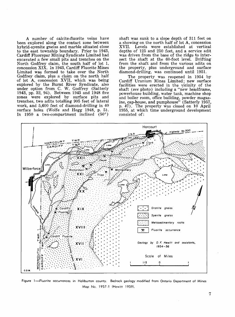
A number of calcite-fluorite veins have been explored along the contact zone between hybrid-syenite gneiss and marble situated close to the east township boundary. Prior to 1943, Cardiff Fluorspar Mining Syndicate Limited had excavated a few small pits and trenches on the North Godfrey claim, the south half of lot l, concession XIX. In 1943, Cardiff Fluorite Mines Limited was formed to take over the North Godfrey claim, plus a claim on the north half of lot A, concession XVII, which was being explored by the Burnt River Syndicate, also under option from C. W. Godfrey (Satterly 1943, pp. 32, 94). Between 1943 and 1948 five zones were explored by surface pits and trenches, two adits totalling 905 feet of lateral work, and 5,600 feet of diamond-drilling in 40 surface holes (Wolfe and Hogg 1948, p. 5). In 1950 a two-compartment inclined (50 0 )
shaft was sunk to a slope depth of 311 feet on a showing on the north half of lot A, concession XVII. Levels were established at vertical depths of 125 and 250 feet, and a service adit was driven from the base of the ridge to inter sect the shaft at the 60-foot level. Drifting from the shaft and from the various adits on the property, plus underground and surface diamond-drilling, was continued until 1951.
The property was reopened in 1954 by Cardiff Uranium Mines Limited; new surface facilities were erected in the vicinity of the shaft (see photo) including a "new headframe, powerhouse building, water tank, machine shop and boiler room, office building, powder magaz ine, cap-house, and pumphouse" (Satterly 1957, p. 47). The property was closed on 10 April 1955, at which time underground development consisted of:
C.N.R.
Harcourt
Clark
Highway No. 500. i_ . ——
|; ••^^^^ff^(
"XXII' Dwyer
Wilberforce If'-- '.,',- - - :"' ^Richardson ', •^•'.v.i^-"- - ' .'j! W. Montgomery ! - . - . ' . - - ! ^-^ V ' '^^j^s.x * . *
gneiss
L-VV 4'''! Syenite gneiss
'.'•.'••'•'.I Metasedimentary rocks
5^ Fluorite occurrence
g^-; v^-v':'.v.fe..v-: ;:;-:----'V----:
Geology by D. F. Hewitt and assistants, 1954-56
Scale of Miles1/20 l
Figure l—Fluorite occurrences in Haliburton county. Bedrock geology modified from Ontario Deportment of Mines
Map No. 1957-1 (Hewitt 1959).

Figure 2—Principal showings on the Cardiff Fluorite property. After Wolfe and Hogg (1948).

Cardiff Uranium Mines Limited, 1956.
Location
Shaft: 125-foot level250-foot level
C adit (N.V2 , lot A, con. XVII)
E adit (S.y2 , lot 1 con. XIX)
Drifting
feet 873460
14785
Crosscutting
feet 4050
205617
Exploration on the property was concen trated in five zones designated from south to north as B, C, A, E, and F (see Figure 2). The south area (B and C zones) is described by Satterly (1943, p. 94), Wolfe and Hogg (1948, pp. 5-6), MacKenzie (Satterly 1957, pp. 48, 49), and Hewitt (1959, pp. 64-65). Early work in the north area (A, E, and F zones) is described by Satterly (1943, pp. 32 and 94-95) ; later work is described in detail by Wolfe and Hogg (1948, pp. 6-8). The property was developed first as a fluorspar prospect, but latterly as a combined fluorspar-uranium pro spect. Some calcite-fluorite-uraninite vein-ma terial was stockpiled, but no commercial ship ments were made.
In 1951 a series of flotation tests were
conducted on calcite-fluorite-uraninite vein material from the Cardiff Fluorite mine (Bur eau of Mines 1951). Lab-scale tests on a 150- pound sample of the tailing from the concentration of uranium oxide were particular ly successful, providing recoveries of fluorite up to 66 percent, the products grading about 98 percent CaF,. The head-feed for these tests analysed:
Percent CaF2 ............................................................13.79CaCO3 ..........................................................45.40SiO, ............................................................20.10P,05 ............................................................ 0.65Pilot plant runs using a 21/^-ton sample
with a calculated fluorite content of 15.12 per cent were, however, very poor; largely due to excessive mica in the flotation circuit, only 52 percent of the fluorite was recovered, the product grading 73 percent CaF2 . Mica had been screened-out at 65-mesh prior to flotation in the small-scale laboratory work, but had not been so removed in the pilot plant tests.
The general geology of the Cardiff Fluorite property is described by Hewitt (1959, pp. 63, 64) as follows:
The calcite-fluorite-uraninite veins on the Cardiff Uranium property lie within a band of limy paragneiss and amphibolite near its' contact with marble. Marble underlies the western part of the property. These
9

Calcite-fluorite, exposed at surf ate
Calcite-fluorite, projected verticallyfrom underground workings and drillholes
Poragneisses intruded by numerous narrow pegmatites
Crystalline limestone
Diamond drillhole, projected vertically
N 1/2 LOT A
D. D. H. 14 -44'
EI. 140
"C" Aditi/32
Elevation of track * O'
LOT l
Figure 3—C zone, Cardiff Fluorite property. Modified from Wolfe and Hogg (1948) and a plan from Cardiff Uranium Mines Ltd. (Satterly 1957).
10

metasediments strike N.10 0 E. and dip 40"-60 0 E. The marble is overlain by scapolite amphibolite, biotite amphibolite, and biotite paragneiss in a band 300-500 feet wide. These gneisses are syenitized and grade into hybrid syenite gneiss to the east. The amphibo- lite-syenite gneiss zone is intruded by granitic and syenitic pegmatites.
The calcite-fluorite-uraninite veins occur mainly in the syenitized amphibolite band, but one vein . . . cuts marble.
B Zone: Concession XVII, Lot A
B zone constitutes the most southerly showing of the group; it was also one of the first exposed, having been examined by the Burnt River Syndicate in 1943. The showings extend around three sides of a steep rock ridge standing about 200 feet above the Irondale (Burnt) River, which flanks its west side. Wolfe and Hogg (1948, pp. 5, 6) describes the follows:
On the east side of the hill two large strappings have uncovered a few pods of calcite-fluorite material of small dimensions in coarse pink pegmatite, which is dipping with the slope of the hill.
On the top of the hill, two lenticular bodies of calcite-fluorite are exposed in paragneiss. One strikes N.30 0 E. and dips east parallel to the gneisses, whereas the other strikes S.55 0 E., almost at right angles to the gneisses, and dips north. The former is about 2 feet wide and of undetermined length, and the latter is a lenticular mass about 12 feet wide at its widest point and 30 feet long.
Along the west edge of the knoll a sharp ridge drops abruptly for 80 to 100 feet, and along the edge of this ridge several calcite-fluorite vein-dikes are exposed in a wall rock of hybrid gneiss, near its con tact with crystalline limestones. These veins strike N.10 0 E., and dip about 50 0 E., and are conformable with the gneisses.
Thirteen diamond-drillholes contained in tersections of calcite-fluorite material V2~15 feet wide, confirming the erratic distribution exposed in the surface strippings.
C Zone: Concession XVII, Lot A
Early work on the C zone consisted of two surface trenches and an adit on the west side of the ridge of dark paragneiss. The trenches expose two parallel calcite-fluorite bodies, 30 feet apart, striking N.10 0 E. and dipping 50 0 E. conformable with the biotite- paragneiss wall rock. The adit is driven from the base of the hill and intersects the main vein 140 feet from the portal and about 65 feet below the surface showing.
On surface the main vein is 4-5 feet wide over a length of 110 feet; it passes beneath overburden to the south, and splits into two veinlets to the north. The vein is exposed for 70 feet in the south drift and is 3-6 feet wide; in the north drift it is represented by narrow veinlets as on the surface. A. G. Mac- Kenzie, resident engineer for Cardiff Fluorite Mines in 1953, reported (Satterly 1957, p. 49)
that samples, taken from the south drift, "averaged 22.35 percent CaF2 over an average width of 6 feet, and the last sample taken from the south face ran 25.42 percent CaF2." The vein-material is described by Wolfe and Hogg (1948, p. 6) as follows:
The calcite-fluorite has a banded structure and contains a considerable amount of green apatite in crystals as much as 2 inches in diameter, biotite in books from 3 to 4 inches in diameter, and some horn blende. A character sample of the calcite-fluorite material weighing about 20 pounds was analysed by the Provincial Assayer and returned 25.96 percent CaF2 and radioactivity equivalent to 0.008 percent U308.
The second vein is exposed for a length of 35 feet in a trench east of the main vein. It has a lower content of fluorite and is not intersected in the adit.
Major development on the Cardiff Fluorite property has taken place about 250 feet south of the workings described above (see Figure 3). Here a calcite-fluorite vein 2-4 feet wide is exposed south of the shaft for a length of 200 feet. In addition to calcite and fluorite the vein- material includes minor amounts of biotite, apatite, scapolite, pyroxene, uraninite, and molybdenite. MacKenzie describes (Satterly 1957, p. 49) the underground development and grade of the vein-material as follows:
In 1950 another adit was driven for a total of 181 feet as the haulageway for a 50-degree inclined two- compartment shaft, which was then raised to collar on the surface, a distance of 52 feet, and sunk to a depth of 275 feet below the adit horizon. A first level, 125 feet, and a second level, 250 feet below the adit, were opened up.
On the first, or 125-foot level, 39 feet of cross cutting and 520 feet of drifting have been completed, of which 395 feet are in ore. To the north of the crosscut an ore shoot having a length of 175 feet, an average width of 44 inches, and an average 0.052 percent U308 (radiometric) and 13.88 percent CaF2 has been exposed. To the south of the crosscut, three ore shoots have been developed, as follows: the first, having a length of 60 feet and an average width of 33 inches, averaged 0.113 percent U3 O8 (radiometric) and 19.57 percent CaF2 ; the second having a length of 75 feet and an average width of 37 inches, averaged 0.03 percent U3O8 (radiometric) and 24.07 percent CaF;.; the third shoot, which is still open at the face, having a length of- 85 feet and an average width of 40 inches, averaged 0.20 percent U308 (radiometric) and 15.70 percent CaF2 . A diamond-drill hole, located 70 feet ahead of the present south face, indicates that mineralization continues, and it is thought to be a continuation of the 85-foot ore shoot.
On the second or 250-foot level, 51 feet of cross cutting and 177 feet of drifting were done. The ore shoot developed at this horizon has a length of 113 feet, an average width of 48 inches, and an average
11

Calcite - fluorite
Pegmatite
Gneiss, and contact phases of limestone and pegmatite
Crystalline limestone
Strike and dip of calcite-fluorite
Contours, approximate
5' f/5% FI) Exposed vein width and fluorite content
Scale of Feet o so
Figure 4—A zone, Cardiff Fluorite property. After Wolfe and Hogg (1948), withslight modification.
12

value of 0.14 percent UaOs (radiometric) and 16.17 percent CaF*. Both faces are open.
A tabulation of the above-mentioned oreshoots follows:
Level
Adit125-foot125-foot125-foot125-foot250-foot
Length
feet 80
175607585
113
Width
inches 604433384048
44
U 308 (radiometric)
percent 0.0520.0520.1130.0300.2000.140
0.095
CaF2
percent 20.00213.8819.5724.0715.7016.17
18.10
A Zone: Concession XIX, Lot l
Seventeeen trenches were described and sketched (see Figure 4) by Wolfe and Hogg (1948, pp. 6, 7) ; the showings are scattered over a length of 450 feet in a 200-foot zone adjacent to the paragneiss-marble contact. The zone contains a number of narrow discontinuous pods and streaks of calcite-fluorite vein-mat erial. Wolfe and Hogg conclude that "the greatest true width observed is in the order of 5 feet, and the average fluorite content would not be greater than 15 percent." They state further, however, that "a character sample of good-gxade calcite-fluorite from the most east erly excavation was analysed by the Provincial Assayer and 'reported to contain 31.60 percent CaF2 , 2.77 percent apatite, and radioactivity equivalent to 0.014 percent U308.' "
Adit entrance on the Clark property, 1963.
F Zone: Concession XX, Lot 3
According to Wolfe and Hogg (1948, p. 8), the F zone, known as the Joiner Property, was under option to Cardiff Fluorite Mines. Several narrow irregular dikes of pink pegmatite con tain minor amounts of purple fluorite.
E Zone: Concession XIX, Lots l and 2
Stripping and trenching over a length of 350 feet near the top of a north-south ridge has revealed a "flatly dipping calcite-fluorite vein over 200 feet long and up to 6 feet wide" (Satterly 1957, p. 49). A 617-foot adit driven northeasterly from the base of the hill passed 170 feet below the surface trenches but did not encounter significant amounts of vein-mat erial. Fluorite averages about 15 percent of the calcite-fluorite vein-material in the surface showings. Wolfe and Hogg (1948, pp. 7, 8) give a detailed description of the geology as exposed in the surface and underground work, including a plan of the property.
CLARK Cardiff Township, Concession XXII, Lot 13
Purple fluorite occurs in a syenite pegma tite 14 mile southwest of Harcourt. Wilson (1929, p. 40) mentions a pit, 10 feet square and 3 feet deep, but no production was recorded until 1940 when W. E. Clark recovered a small amount of fluorite from a number of pits and trenches. Tops Mining Syndicate Limited operated the property from 1943 to 1946, and transferred it to Topspar Fluorite Mines Limit ed in 1950. The Ball Prospecting Syndicate acquired the property in 1961. A total of 30 tons of acid-grade fluorspar was shipped in 1940 and 1942.
13

L v v Syenite pegmatite with patches of lime-silicate rock
M" ^ "M Granite pegmatite-, graphic granite
Rxxxx] Lime-silicate rock, diopside-phlogopite gneiss
^SSS^j Hornblende-plagioclase gneiss
~*25 Strike and dip of gneissosity
Geology by G. R. Guillet, 1962
Scale of Feet50 25 O 50i
Figure 5—Geology of the Clark property.
14

Fluorite lenticles standing out on the weathered surface of a vein on the Dwyer property.
The workings consist of an open-cut, 9 feet wide and 80 feet long, cut into the steep north side of a hill in a direction S.20 0 E., and an adit driven a further 90 feet from the south end of the open-cut (see Figure 5). At a point 50 feet south of the adit entrance, a 30- foot raise has been taken through to surface. A number of shallow pits and trenches are scatter ed over the surface above the underground workings. A little underground mining was carried on in 1962 on a westerly heading in the vicinity of the raise; a narrow-gauge track was laid from the adit face to an ore stockpile, and a small mill-building was equipped.
The adit (see photo) is driven along the lower contact of a large syenite pegmatite lying within a band of hornblende-plagioclase gneiss. The pegmatite is pod-shaped and dips to the south at a low angle; it is comfortable with the enclosing hornblende gneiss which strikes N.65 0 E. and dips 10-25 0 S. Patches of dark-green, diopside-phlogopite rock are scattered through the pegmatite, and a large tongue of pink graphic granite occupies the hangingwall con tact west of the raise. The syenite pegmatite is coarse tp massively crystallized, and consists of microcline, pyroxene, calcite, scapolite, and fluorite, with minor amounts of apatite and phlogopite, and traces of molybdenite and uran othorite. Satterly (1957, p. 75) describes the principal constituents of the pegmatite as fol lows:
The pink-to-buff feldspar is in crystals from a few inches to 2 feet across, and the pyroxene also is in large crystals from a few inches to as much as 3 feet in diameter. The calcite is salmon-pink in colour and is present as a filling around euhedral pyroxene and feldspar or as veins with pyroxene from Vz-3 feet in width. The largest vein of purple fluorite now exposed in the workings may be seen on the south face of the open cut. It is a lens Vfc-l foot thick. W. E. Clark advised the author in 1942 that the largest fluorite lens removed was 5 feet thick and 16 feet long.
The fluorite is deep purple in colour, but it bleaches white or colourless on lengthy expos ure to the sun. It is disseminated in small patches throughout the syenite pegmatite, showing an association preference for pyroxene and calcite, and more rarely occurs in narrow lenses as mentioned above. It comprises less than 10 percent of the pegmatite as a whole.
DWYER Cardiff Township, Concession XXII, Lot 8
An open-cut in a calcite-fluorite-apatite vein is located on the north slope of a ridge of hornblende syenite gneiss 125 feet south of old highway No. 500. The cut is 30 feet long with a 15-foot face. An adit has been driven at a depth of about 40 feet beneath the open-cut from a point at the base of the ridge 75 feet south of the road. P. J. Dwyer opened the deposit in 1918 and shipped 37 tons of fluorspar from the open-cut. During the period 1919-20 he drove the adit about 80 feet into the hill to intersect the southerly dipping vein. In
15

1943, F. K. Montgomery, J. K. MacFarlane, and R. M. Clarke optioned the property and drilled 22 short (50-100 feet) vertical holes at 25-foot centres on the side of the ridge above the open cut. Vein intersections were said to average 3 feet thick and 43 percent CaF2 (personal communication). Fluorspar shipments of 37 tons and 23 tons were made in 1943 and 1944 respectively, at an average price of $26.80 per ton (Statistician, Ontario Dept. Mines).
The open-cut exposes an enlargement of the vein, 10 feet thick and dipping 30 0 S. On the west wall of the cut the vein is split by a horse of syenite gneiss, and the two vein segments are reduced to thicknesses of 1-2 feet. At least one vein segment can be traced intermit tently along the flank of the ridge, and in an old pit 200 feet west of the open-cut a narrow vein is associated with syenite pegmatite. On the east wall of the open-cut, purple fluorite, bleached to colourless on the surface, comprises 20-30 percent of the vein-material. Ribs of fluorite to l inch thick are in sharp relief again st calcite on the weathered surface. Unoriented crystals of brown and green apatite, up to 4 inches thick and 12 inches long, form 5-10 percent of the vein-material. Occasional crys tals of black hornblende up to 12 inches in length are also present.
MONTGOMERY Cardiff Township, Concession XXI, Lot 9
In 1942, F. K. Montgomery opened several irregular calcite-fluorite veins in the west-cen tral part of the lot, 250 feet east of the road. Hewitt (1959, p. 43) describes the occurrence as follows:
The calcite-fluorite veins cut hybrid syenite gneiss. One vein strikes N.70 0 W. and dips south. It is irreg ular in size and shape and does not exceed 2 feet in width. A second vein was worked by an open cut 60 feet long, 4-20 feet wide, and 6 feet deep, trending N.25 0 E.; very little of the vein material can now be seen, and the size and shape of the vein is unknown.
The vein-material is described by Satterly (1943, p. 33) as follows:
The minerals present in the vein are creamy calcite, purple fluorspar, and green apatite. The latter occurs as crystals from less than an inch to 6 inches in diameter. The fluorspar content is about 30 percent but much richer material occurs in places. The walls of the vein show large hornblende crystals, and some red apatite crystals.
RICHARDSON Cardiff Township, Concession XXI, Lots 4-6
W. M. Richardson discovered uraninite in 1922 in what is known as the "Baycroft pit" in lot 4, concession XXI. Subsequent interest
was concentrated on the next two lots to the east, the principal workings being in lot 5, concession XXI. The Ontario Radium Corpora tion Limited acquired the property in 1929, followed in turn by International Radium and Resources Limited in 1931, Wilberforce Min erals Limited in 1937, and Fission Mines Limit ed in 1946.
Development of the property has been centred around the "Richardson pit" in lot 5, concession XXI. The Richardson pit is a nar row, irregular northeasterly-trending, open-cut 380 feet long and up to 20 feet wide and 20 feet deep. In places it is connected by raises and stopes to the main drift from an adit driven to the southeast from the north slope of the ridge. The adit is 470 feet long and connects with a 50-foot shaft at its southeast end. Nearly 400 feet of drifting has been done on the adit level. Most of the underground development was done in 1929-31; a 50-ton mill was subsequently built and trial runs were made to recover the radium-bearing minerals. Previously, in 1929, a 36-ton ore sample from the Richardson pit had been tested at the Mines Branch, Ottawa, by a combination of tabling and magnetic separation; it yielded 2.557 pounds U308 per ton of ore (Ellsworth 1932, p. 224).
Surface trenching and diamond-drilling has traced uranium and fluorite mineralization in termittently for more than 2,000 feet north easterly from the Richardson pit. Interest has been concentrated on the radioactive minerals, but from 1946 to 1948, Fission Mines Limited carried out some exploration for fluorite on the No. 3 zone, 700 feet southeast of the Richardson pit. A total of 12,000 feet of diamond-drilling is recorded by this company for the period 1946- 48, and 2,545 feet in 1955. The property was inactive from 1948 to 1954 and has been idle since 1955.. No commercial shipments of fluor spar or radioactive minerals have been made.
The Richardson deposit has been the sub ject of a number of excellent reports and the reader is referred to the following works for further details: Spence and Carnochan (1930, pp. 34-73) ; Ellsworth (1932, pp. 213-27) ; Wolfe and Hogg (1948, pp. 8-10) ; Rowe (1952). Hewitt (1959, p. 66) summarizes the regional geology as follows:
The calcite-fluorite-apatite veins cut a series of syenitized metasediments, which form the northwest flank of the Cardiff plutonic complex in Cardiff town ship. These rocks consist predominantly of amphibolite, biotite scapolite granulite, and syenitized gneisses de veloped by feldspathization of amphibolite. They strike
16

in a northeasterly direction and dip 20 0- 50" S.E. These gneisses are cut and replaced by granitic and syenitic pegmatites carrying fluorite and calcite.
Figure 6 shows the surface and under ground workings of the main Richardson de posit in lot 5, concession XXI. The calcite-fluor- ite-apatite vein-material consists "mainly of white to grey calcite, deep-purple fluorite, and green or brown apatite. Post-mineralization shearing movements have caused granulation and banding of the calcite and fluorite; whereas the apatite and magnetite are undeformed and occur as euhedral crystals in the centres of augen-like lenticles" (Rowe 1952, p. 16). Fluor ite constitutes about 20 percent of the vein- material; apatite about 2 percent.
Hewitt (1959, p. 66) describes the main deposit as follows:
The original showings, No. l zone, where the underground workings are located, consist of pyroxene- syenite pegmatite carrying calcite, fluorite, hornblende,
biotite, and uraninite. These pegmatites, which intrude and replace amphibolite and syenitized gneiss, are cut by later calcite-fluorite-apatite veins containing uraninite. The main vein has a length of 200 feet, a maximum width of 8 -12 feet, and pinches out between the surface and the adit level. These veins are lentic ular to pod-shaped and frequently split and pinch out. The veins strike N.50 0 E. and dip about 30 0 -40 0 S.W., cutting the country rock gneisses at a low angle.
No. 3 zone (see Figure 7) is parallel to No. l zone and 600-700 feet to the southeast. Several lenses of calcite-fluorite vein-material are exposed in trenches and test pits over a length of 600 feet. The main pit has been sunk to a depth of 20 feet on the widest lens; the lens is 25 feet wide at this point but drill hole intersections 30-50 feet below the bottom of the pit indicate a width of only 3-5 feet. According to Wolfe and Hogg (1948, p. 9), "The calcite-fluorite material in the pit is of relatively good grade and would probably carry more than 25 percent of fluorite. Large green
(K Calcite-fluorite on surface
Calcite-fluorite on adit level
Pit or trench on surface
Workings on adit level
Strike and dip of vein
Strike and dip of gneissosity
2.5' (30'/. FI), True thickness of vein and estimated fluorite content
X^N //Raise at 35'Pinches above floor level
2.5' OOVoFI)
Scale of Feet o so
Shaft
Figure 6—Main workings on the Richardson property. After Wolfe and Hogg (1948), with slight modification.
17

-O
co^ o
•I lQ)O O
CO
gr-*
18

crystals of apatite are prominent. About 2 feet of very coarse pegmatite, containing large feld spar and apatite crystals, and hornblende crystals more than 6 inches in diameter, occur along the north wall. The south wall of the vein is gneiss." A similar grade of fluorite is seen in adjacent pits and trenches. "This vein- material is unsheared and contains little or no uraninite" (Hewitt 1959, p. 67). The lenses dip to the south at a moderate angle.
In 1955 a considerable amount of diamond- drilling, trenching, and stripping was carried out on a pyroxene-syenite pegmatite 14 mile northeast of the Richardson adit. The dike trends N.72 0 E. and ranges from 10 to 50 feet wide on the surface, due to a shallow southerly dip; it is continuously exposed over a length of 200 feet just west of the road to No. 3 zone. The fluorite content averages about 10 percent but locally approaches 25 percent. The showing is described by Hewitt (1959, p. 67) as follows:
Patchy fluorite and pyroxene are scattered irreg ularly throughout the dike. Apatite occurs in a few places. Sheared calcite-fluorite vein-material occurs in two lenses, 6 inches wide and 4 feet long, near the footwall of the dike. Calcite-fluorite vein-material occurs also as lenses and fillings in brecciated sections of the pegmatite 2-3 feet wide. This filling is itself mylonitized in places. Zircon, titanite, apatite, pyrite, molybdenite, uranothorite, and uraninite occur as acces sories in the pegmatite.
Diamond-drilling indicates that the dike ranges from 7 to 30 feet thick and dips 15 0-50 0 S.E.
East of the road, near the boundary be tween lot 6 and lot 7, a number of pits expose syenite pegmatite and a few narrow calcite- fluorite veins.
SCHICKLER Cardiff Township, Concession XXII, Lot 9
A calcite-fluorite vein, located in an open field 600 feet north of the junction of old high way No. 500 and the lot 8-9 road, is described by Satterly (1943, p. 34) as follows:
The deposit has been opened up by a trench 110 feet long, 6 feet wide, and from 6 to 10 feet deep. The country rock is a medium-grained fluorspar-hornblende granite. The trench is now partly filled with debris and contains trees 2 to 3 inches in diameter. From an examination of the walls of the trench and material on the dump, it appears that the trench was put down on a vein 5 feet wide composed of a banded aggregate of apatite, purple fluorspar, and calcite. Some of the fluorspar forms veinlets as much as 2 inches in width. The walls of the vein consist of crystals of hornblende, feldspar, scapolite, and apatite.
No production has been recorded, and the workings are now almost obscured by soil and vegetation.
TRIPP Cardiff Township, Concession XXI, Lot 8
Several narrow irregular calcite-fluorite lenses have been explored on this property. In 1924 the Industrial Minerals Corporation ship ped 2 tons of fluorspar hand-picked from mater ial taken from an 18-foot drift at the bottom of a 22-foot shaft (Satterly 1943, p. 33). The property was optioned by Nu-Age Uranium Mines Limited in 1954, and four radioactive zones were indicated by a scintillometer survey. The zones were stripped or trenched by bull dozer and explored by eight drillholes totalling 1,551 feet. In 1955 an inclined (45 0 ) shaft was sunk on No. 4 zone and 274 feet of crosscut ting and 192 feet of drifting was done on the 125-foot level. In 1956 drilling from the under ground workings amounted to 13 holes totalling 3,150 feet. The company's name was changed to Haitian Copper Mining Corporation Limited in July 1956.
The radioactive anomalies are associated with narrow calcite-fluorite-apatite veins in a belt of amphibolite and syenitized gneiss. The country rocks strike N.60 0 E. and dip 30 0-50 0 SE. The largest calcite-fluorite vein is exposed in the original (No. 3) pit from which fluor spar was taken in 1924. The workings consist of a stripped area 160 feet long and 10 feet wide near the middle of the lot, and a 5- by 7-foot shaft sunk to a 22-foot depth midway along the exposure. The workings expose a dike of syenite pegmatite and coarse horn blendite, and a vein of calcite-fluorite-apatite 110 feet long and up to 7 feet wide (see Figure 8). The vein strikes N.45 0 E. and dips steeply southeast. According to Hewitt (1959, p. 70): "The calcite-fluorite shows a coarse banding parallel to the walls, which is accentuated near the vein walls by shearing. The walls of the vein are usually coated with crystals of red apatite and, less commonly, hornblende."
The fluorite content of the vein-material averages 20-30 percent, and the small hand- picked shipments made in 1924, graded 98.5 percent CaF2 (Satterly 1943, p. 33).
Fluorite also occurs in stringers in syenite pegmatite north of the shaft on No. 4 zone, *4 mile north of the main fluorite showing (No. 3 zone). Midway between these two zones, and somewhat to the west, a series of pits and strip- pings, constituting Nos. l and 2 zones, expose minor amounts of a sheared fine-grained aggre gate of calcite and fluorite associated with syenite pegmatite in biotite-syenite gneiss.
19

20
Scale of Feet o 20 40
Fluorite
Fraclure, l"-3", with fluorite
Fracture in red syenite with apatite crystals
N Red apatite crystals along contact
Fluorite vein, l"-4", on contact
Uraninite crystals on wall of vein
- Overburden
Calcite - fluorite - apatite vein
Hornblende
Syenite pegmatite
Biotite syenite, biotite-hornblende syenite, leucosyenite
Amphibolite
Geology by J. Satterly, 1954Stripping and trenching as of July 9, 1954
Figure 8—Main fluorite showing on the Tripp property. After Satterly (1957).
20

OTHER OCCURRENCESMinor occurrences of fluorite in calcite-
fluorite-apatite veins have been reported in lot 9, concession XII, Cardiff township, and in lot 35, concessions XII and XIII, Monmouth town ship. A small pit has been opened on the occur rence in lot 9, concession XII, Cardiff township, the property of Canada Radium Corporation Limited (Hewitt 1959, p. 43).
FLUORSPAR IN HASTINGS COUNTYFrom the first recorded mining of fluorspar
in Ontario in 1905, deposits in the Madoc dis trict have produced the bulk of Ontario's production of 121,919 tons of fluorspar concen trates valued at 33,421,825. About 150,000 tons of fluorspar ore have been taken from the Madoc mines, the most active periods being during and immediately following the two World Wars. Shipments totalling 20,000 tons were made during the period 1916-20; 86,500 tons during the period 1940-51.
General GeologyThe fluorite occurs in fracture-fillings
along a zone of faulting in rocks of Paleozoic and Precambrian age. Deposits occurring along the main break are collectively referred to as the Moira Lake group; those occupying sub sidiary fractures belong to the Lee-Miller group (Wilson 1929, p. 42). The bedrock geology is indicated on the Marmora and Madoc map- sheets (Wilson 1940) and in Figure 9 of this report.
CenozoicTABLE OF FORMATIONS
Pleistocene: Sand, gravel, clay, till. Great Unconformity
Precambrian
PaleozoicOrdovician: Limestone, dolomitic lime
stone.Sandy limestone, shale, con
glomerate.Great Unconformity
Granite, syenite. Intrusive Contact
Marble, argillite, conglomer ate.
Andesite, rhyolite, agglomer ate.
The physiography of the region is domin ated by the partially resurrected Deloro-granite batholith which is exposed over a wide area north of Highway No. 7 in Madoc and Marmora townships. The smaller Moira-granite batholith in the northeast corner of Huntingdon town ship underlies the east half of Moira Lake and is exposed at one- point on the south shore as a monadnock in the Paleozoic plain. The general slope of the land surface is to the southeast, and volcanic and metasedimentary
rocks underlie much of the area between the two granite masses. Remnants of a cover of Paleozoic limestone, which underlie almost all of Huntingdon township south of Moria Lake, form outliers and embayments in the Precam brian areas.
Wallrocks for the fluorite veins in order of importance include marble, granite, Paleozoic limestone, and andesite. The marble is a grey- blue or more rarely buff, finely-banded, fine-to medium-grained, crystalline limestone of the Grenville series; it trends N.20 0-60 0 E. and dips 40 0-60 0 NW., and occasionally is inter bedded with fine-grained grey-black argillite. The granite is a massive, medium-grained, pink rock, typical of the Moria batholith and intru sive into the metasedimentary rocks; it is bleached to grey over several inches in contact with vein-material at the Noyes (Wilson 1929, p. 56) and Perry mines. The Paleozoic lime stone is a light-grey-weathering, medium-to thick-bedded, fine-grained to lithographic stone belonging to the Middle, Lower, and Basal Clastic formations of the Black River group. The andesite is a fine-grained, black, massive, vesicular volcanic rock in which the amphibole is recrystallized in some cases to coarse "feather" laths, and the vesicles are calcite- filled.
Thicknesses of the Paleozoic Black River group up to 180 feet occur along the fault south of Moira Lake, but northwest of the Lake in the Lee-Miller area, 125 feet is more normal. On the Howard property the Basal Clastic beds consist of 20 feet of calcareous sandstone, arkose, conglomerate, and shale, resting on the Precambrian surface (Craigie 1941). Examination of the waste dumps at the Blakely, South Reynolds, Mcllroy, and Wall bridge mines indicates that the lower workings at these mines are in the basal green beds of the Lower Black River formation; the green beds consist of a 20- to 30-foot thickness of sandy or shaly limestone immediately above the Basal Clastic rocks.
StructureThe veins occupy fractures along or assoc
iated with the Moira fault, a northwest-south east fracture zone that crosses the Precambrian- Paleozoic contact in the vicinity of Moira Lake. The main break has been traced by intermittent diamond-drilling for a distance of 2^ miles northwest of the lake and l mile southeast; it is conspicuous on aerial photographs for a further 4 miles southeast of the last drilling. The most important fluorite deposits have been found along the Moira fault, but a number of smaller deposits (the Lee-Miller group) occupy parallel, subsidiary fractures to the west.
21

z i

The Moira fault is a slightly sinuous, nearly vertical fracture or fracture zone, mark ed by little topographic relief, except at its southeastern end. Here it is traced by the out line of swamp and bog- southeast from the Howard and Wright properties, emerging l mile south in open pasture land where it is marked by a shallow depression in the Paleozoic plain. North of the road in lot 17, concession X, Huntingdon township, the fault is indicated by a depression 300 feet wide and 15-30 feet deep. It crosses the north half of the lot diagonally and passes into lot 18 of the same concession south of the road; the depression deepens and narrows in lot 18, but is less pronounced along the northeast side of Drag Lake in concession IX. The fault is again marked by a prominent depression crossing the junction of the roads 14 mile south of Buller Siding in Hungerford township. It disappears finally in lots 2 and 3, concession VIII, Hunger ford township.
The fluorite deposits occupy lenticular fault cavities apparently caused by horizontal displacement of the walls on an undulating fault surface. That the movement was essent ially horizontal is indicated by the lateral dis placement of recognizable rock units, the preponderance of horizontal or nearly horizontal striations on the fault surface (Wilson 1929, pp. 46-47), and the lateral elongation of the ore lenses. Striations on, and granulation of the vein-material itself, indicates some post-ore movement as well. Wilson (1929, pp. 46-47) suggests displacement of the walls of about 100 feet, northeast side southeastwards, based on observations in the Noyes and Perry mines. Hewitt (1948a) recognized late cross-tension fractures, 3 feet long and calcite-filled, cutting the vein and the walls in the Rogers mine.
The fault is represented either by a single break or a zone of narrow, closely-spaced frac tures. The largest fluorite bodies are found where the rock has failed along a single frac ture; the walls are invariably smooth, strong and unbroken. Limits of the principal orebodies are characterized by narrow zones of vein stringers in highly fractured rock. Sometimes the trend of fracturing is fan-shaped outwards from the ends of the ore lenses, the zone eventually dissipating into the countryrock. Continuation of the fault in these cases may be offset, frequently resulting in an en echelon distribution of fault segments. Craigie (1941, p. 3) points out the economic significance of this feature and suggests the likely direction of offset:.
It is probable that the main vein occurs en echelon and that if it pinches out along its length a new stretch commences to one side. The vein on the Wright property seems to occur 100 feet to the northeast
and that on the Noyes over 200 feet to the southwest of the general strike of the Hill [Howard] vein. From the known occurrences of the mineralization over such a length and lying so nearly in a straight line, one may expect a vein of some width along the whole course of the strike; and where the mineralization shows definite signs of pinching out along one vein drilling should be done to coyer the ground to the sides as well as ahead. On going southeast the likely side appears to be the northeast, and on going north west the likely side would be the southwest.
In most cases the trends of the vein fissures are not parallel to any recognizable system of jointing. The most prominent joint direction common to all the rocks has a trend in the range N.20 0-60 0 W., sometimes locally parallel to the vein fissures but usually inter secting them at a small angle. The spacing of joints is commonly 1-4 feet but there are wide variations. A second joint system having a northeasterly trend is less perfectly develop ed. The dip of the jointing in both cases is vertical.
Character of the VeinsThe fluorite deposits are lenticular bodies
of vein-material along the Moira fault or its associated fractures. They occur either as connected lenses, disconnected en echelon lenses or isolated occurrences sometimes considerably removed from others of their kind. Individual lenses of the Moira Lake group are up to 18 feet in width, and several hundred feet in length. Their long axes commonly rake to the southeast at a low angle; only the Rogers de posit appears to rake to the northwest.
The Lee-Miller deposits occupy narrow, iso lated, vertical fissures west of the Moira fault. The principal ones are grouped in the southwest corner of Madoc township, most of them lying within 2V2 miles of the northwest end of the main break. Individually the veins trend N.40 0 -70 0 W., parallel to the Moira fault. They are mineralogically similar to those of the Moira Lake group, and most are in Paleozoic lime stone. Widths of individual lenses rarely exceed 3 feet, but in one case a breccia zone with a maximum width of 7 feet and a length of sev eral hundred feet is recorded.
The vein-material consists essentially of fluorite, calcite, and barite, and minor amounts of celestite, quartz, marcasite, pyrite, sphaler ite, and other sulphide minerals. There is no consistent order of crystallization; quartz, sul phide minerals, and celestite show preference for the wall zone, while the banded distribution of fluorite, calcite, and barite suggests rythmic deposition. Brecciated wallrock fragments, sometimes slightly replaced by fluorite, are also common. Fluorite is translucent green, colour less, or amber, and less commonly purple or smoky; cubic and octahedral crystals are com-
23
mon. Calcite is coarsely crystallized and white to pink in colour. Barite forms nodular radiat ing growths of fine platy crystals in typical crustiform habit, often intimately banded with fluorite. Colour of the barite is white to pink or buff, sometimes exhibiting a cross-oriented colour-banding due to bleaching against fluorite. Celestite occurs in radiating, bladed or fibrous masses, white to pale blue or grey in colour. Quartz is rare and occurs only as thin encrusta tions of small crystals, usually restricted to the wall zone. Marcasite occurs in nodular and reniform growths often as a crust on fluorite and calcite or as an insulating skin between them. Weathering of marcasite and pyrite probably accounts for a rusty staining locally common in "gravel spar" of the Lee-Miller deposits. Sphalerite is rare except in the Blakely deposit where it occurs as a skin on breccia fragments of wallrock, and as fine vein- lets lacing the wallrock. Wilson (1929, pp. 45- 46) also mentions traces of copper minerals and a dark-brown, hydrocarbon substance.
The veins are typical low-temperature de posits, well-banded, vuggy, and exhibiting crustiform, rimming, and comb structures. Crystals of most of the minerals have been found in the vugs. Interbanded fluorite, calcite,, and barite is especially common; individual bands range from less than 1/4 inch to several feet. Pure bands of fluorite l to 2 feet thick and up to 80 feet long are mentioned by Satter ly (1945a), as appearing along either wall in the Bailey deposit. Thin-banded fluorite-barite rendered much of the Johnston ore unsuitable for hand-cobbing. Typical vein structure in cludes a band of practically pure massive fluorite along one wall, banded vein-material occupying the remainder (Craigie 1941, p. 3). There is no constancy in the relative widths of the massive and banded portions or in their preference for either wall, even within a single deposit. A friable, granular aggregate of fluor ite and calcite, termed "gravel-spar" or "sugar- spar," is common in deposits of the Lee-Miller group. It is apparently the result of weathering above the summer ground-water level, and hence is confined to the near-surface portion of the vein (Wilson 1929, pp. 47-48).
Composition of the vein-material is ex tremely variable, but run-of-mine averages in dicate a fluorite content between 50 and 75 per cent. Calcite is the next most common mineral often approaching 50 percent of the ore but normally averaging perhaps 25 percent. Calcite tends to increase both with depth and with narrowing vein width at the Howard, Keene, and Bailey mines. Barite is present in amounts from 5 to 40 percent but averages perhaps 15 percent. Barite increases markedly to the south constituting perhaps one-third of the vein-mat-24
erial in the Noyes, Howard, and Johnston deposits; it is common also in small isolated occurrences along the Moira River, south of the main group of Lee-Miller deposits. The amount of celestite, quartz, and sulphide minerals rare ly exceeds 5 percent in total.
ProductsTwo fluorspar products were shipped from
the Madoc mines. The main one was a hand- cobbed metallurgical-grade, but small amounts of high-quality optical spar were also recovered from a few of the mines. Metallurgical-grades prior to 1950 normally ranged between 70 and 75 percent CaF2 . The average composition of sixteen shipments from the Noyes mine during the period 1918-20 is given by Wilson (1929, p. 43 (analysis by Algoma Steel Corporation) :
Percent CaF2 . ... ...... ... .... . .. .. ... ... . 76.61BaSO* . ... ... .... .. ... ... . ... . .. .. 8.13CaCOa ... . .. ... ... ... .... .... .... . 9.11R2O3 ..... ....... .. ... .. .. ... ... .. . 3.07SiO2 . ... ... . .. ...... ... .. .. ... .. .. 2.74
99.66
In 1945 the run-of-mine ore at the Bailey mine averaged 62-67 percent CaF2 ; it was up-graded by hand-cobbing to a product analyz ing in the range (Satterly 1945a):
Percent CaF, ... ... . .. ... ... . .. ... ... . .. .. 70-75BaS04 ... ... ... ... .. ... ...... .. 2.4-4.5SiO, .. .. ...... ...... . .. .. .. . less than l
In 1948 shipments from the Bailey mine were averaging 76 percent CaF2 and up to 7 percent BaS04 (Hewitt 1948b).
Ore grade at the Rogers mine averaged 77 percent CaF2 and l percent SiO, before hand-cobbing (W. J. Symon, personal communi cation). Shipments from the Rogers and Kil patrick mines averaged:
PercentCaF, . ... . .. ............... . .. .. . 82-85SiO, . . .. ... ... ... ... ... ............. 2S . .. .. .. ... 0.5 (up to 5 percent BaSO4 )
Some of the Lee-Miller veins, although narrow, were high-grade; shipments averaging 80 to 90 percent CaF2 were made by C. A. Stoklosar from the Lee Junior mine (W.. J. Symon, personal communication).
Clear, colourless, fluorite crystals suitable for optical uses were shipped principally from the Keene mine (Wilson 1929, p. 65).

Water ProblemThe heavy flow of water along the Moira
fault north of Moira Lake seriously hampered operations in some of the area's most productive mines. Ore was left in the Kilpatrick, Rogers, and Perry Lake mines when the inflow exceeded the pumping capacity of 2,000 gallons per min ute. Wet, open channelways along fault fissures are typical of many vein deposits; Carr (1958, p. 62) mentions a flow of 2,800 gpm. at the Director Mine in Newfoundland, and Holtzinger (1956, p. 289) refers to a flow of 7,000 gpm. at the Rosiclare Mine in Illinois.
The source of the water at the Madoc mines is from the north, not from Moira Lake as is popularly believed. Neighbouring opera tors sometimes took advantage of this fact; renewing operations in the spring, following the normal winter shut-down, the northernmost operator would wait for the other to pump-out his underground workings, when the water level in his own mine would also be considerably lowered.
The water problem was not simply a pro blem of pump capacity—the Rogers and Kil patrick mines each had two 1,000-gpm. deep- well pumps, which were normally capable of handling the flow during the summer months; it was also a problem of considerable personal discomfort to the miners, who often work ed in a continuous downpour. Broken ore was left in the stopes on the bottom level of the Kilpatrick mine in 1959 when rising water forced the abandonment of the mine; attempts to seal off a sudden increase in water that fol lowed a routine blast were finally abandoned when the water reached waist depth (W. J. Symon, personal communication).
South of Moira Lake and in the Lee-Miller deposits, water has never been a serious prob lem. The Noyes mine was practically dry to a depth of 80 feet, and although the mine was developed to a depth of 275 feet with five working levels, one over a length of 1,025 feet, a 300-gpm. pump was adequate in all seasons. Water was likewise negligible in both the Howard and Johnston mines. The water-table in the Lee-Miller area normally drops to a depth of 30-40 feet during the summer; most of the narrow open-cuts were worked without pumping equipment.
Government Assistance ProgramDue to the increased demand for steel
during World War II, a serious shortage of metallurgical-grade fluorspar was forecast. To stimulate domestic production the Canadian government established an emergency assist ance program, which was developed along three lines: direct financial assistance in the form
of loans to operators, diamond-drilling and geo physical surveys, and the consideration of a custom flotation plant in the Madoc area.
In 1942 loans totalling more than 3100,000 were made to four fluorspar producers in the Madoc area. Repayment was made out of earnings, and the debt was substantially retired within several years.
In 1943 a report was prepared summarizing the fluorspar ore reserves of the Madoc district (Butterfield and Fawcett 1943). It recommend ed a systematic diamond-drilling program along the Moira fault. The program was undertaken during the same year, and 18,608 feet of drilling was recorded in 110 holes. The percentage of fluorite in the vein intersections was estimated visually, and the results were recorded on eight drilling sheets, which have been reproduced for this report (Charts A, B, C, back pocket). Core recovery was not generally good in the vein-material; however W. J. Symon told the author that it was safe to consider "lost core" as an indication of the vein if traces of vein- material were associated with it. The program was designed primarily to outline near-surface deposits in the vicinity of known occurrences. Most of the holes were drilled at intervals of about 100 feet with inclinations of 45 degrees. The drilling was restricted to the upper 250 feet of the Moira fault at five locations, and covered an aggregate length of 10,000 feet of the fault zone.
The Ontario Department of Mines assisted the drilling program by a geophysical survey along the Moira fault (Brant 1944). Electrical resistivity methods were chiefly employed, but a few self-potential and vertical magnetometer observations were also made. The veins could not be indicated directly by the resistivity measurements, but the fault itself showed up as a broad (50-300 feet) zone of higher conduc tivity usually coincident with a bedrock depres sion. Where deposits of fluorspar were found by subsequent drilling, they were usually asso ciated with one or other of the margins of the conducting zone. Magnetic and self-potential measurements proved of little value.
As well as being of direct value to fluorspar producers in the area, the exploration program was intended to determine whether sufficient ore was available to warrant construction of a custom mill. Milling tests by the Bureau of Mines, Ottawa, in 1944 had demonstrated that a flotation concentrate grading more than 85 per cent CaF2 , and representing a recovery of 90 percent of the available fluorite, could be made from ore containing 35 percent fluorite, 14 per cent barite, and up to 50 percent calcite. How ever, the idea appears to have been abandoned on the basis of insufficient ore reserves.
25

Further Reserves and Favourable AreasFurther exploration in the Madoc area will
undoubtedly uncover new deposits of fluorite. Gaps in the drilling between the Perry and Rogers, the Rogers and Kilpatrick, and the Bailey and Mcllroy mines, warrant several widely spaced drillholes, drilled at flat angles to check for possible offsets in the vein struc ture. Government drilling has already indicated a deposit between the Keene and Kilpatrick mines (see Chart A) ; widths of vein-material up to 7 feet are indicated over a length of about 300 feet, and other interesting vein intersec tions may extend the favourable zone to a length of 1,000 feet. Similarly the Johnston deposit has been indicated to extend 300 feet southeast of the present workings, with widths of vein-material to 7 feet (see Chart B). Effi cient exploitation of both these deposits may require a more elaborate method of beneficia tion than is possible by hand-sorting; the Keene ore has a high calcite content, and much of the Johnston ore consists of finely interbanded fluorite, barite, and calcite.
Perhaps the most interesting area for further fluorspar exploration is the southeast ward extension of the Moira fault beyond the Noyes-Johnston-Howard mines. The fault is clearly marked on air photographs where it can be seen to cross diagonally from northwest to southeast through lots 15 to 20, concessions XI to IX, Huntingdon township, disappearing finally south of Buller Siding in Hungerford township. Much of the fault is easily traced on the ground by a shallow depression up to 300 feet wide, in the Paleozoic plain. Overbur den is light in lots 17 and 18, concession X, Huntingdon township, but although numerous angular limestone blocks attest to the presence of a fracture zone, the author knows of no reports of vein-material in this area. That fluorite mineralization did extend this far south, however, is indicated by the Jones and Pal- mateer occurrences in parallel fractures to the west.
A heavy flow of water in some of the mines, especially those north of Moira Lake, in some cases caused the abandonment of the deposits before the ore had been exhausted. Some ore remains in the lower workings of the Rogers, Kilpatrick, and Perry Lake mines, and the de posits also appear to extend below the lowest levels in these and the Perry and Blakely mines. The vein on the bottom level (240-foot level) of the Rogers mine averages 5.5 feet wide over a length of 365 feet, and drilling in the vicinity of No. 4 shaft indicates a vein width of 6 feet at a depth of 360 feet (W. J. Symon, personal communication). The vein on the bottom level (130-foot level) of the Kilpatrick mine averages
3 feet wide over a length of 350 feet (W. J. Symon, personal communication). On the bot tom level (165-foot) of the Perry Lake mine the vein appears to average 3 feet wide over a length of 170 feet. In the Perry mine the vein is 175 feet long on the bottom level (190- foot level). The vein in the Blakely mine is 300 feet long on the bottom level (75-foot level) ; a single drillhole in the vicinity of the shaft indicates a 4-foot vein at a depth of 114 feet (Wilson 1929, p. 59).
Summary List of DepositsFluorspar mines or occurrences in the
Madoc area are listed geographically in accom panying table. Detailed descriptions of the properties are given in alphabetical order in the section that follows. The properties are located on Figure 9.
FLUORITE OCCURRENCES IN THE MADOC AREA, HASTINGS COUNTY
HUNTINGDON TOWNSHIP
Concession
VIIIIXXIXIXIXI
XII ......XIIXII
XIIIXIIIXIII ......XIIIXIV XIV
XIVXIV
Lot
1815
114, E.y214, W.y215
21013
7101111
89, E.y29, w.y2
10
Name
WilliamsHoward (Hill)
WrightHerrington S.Blakely
South ReynoldsCoePerryPerry LakeNorth Reynolds
(Detomac)
Approximate Production
tons 44
T\ ITfc G Y\ O f* i"
2,500T"lY*riGT\pp4-
iq5,026
25,000100114
8,0004,000
10
11,566 5,000
45,000
MADOC TOWNSHIP
II ......I ......I ......I ......I ......I ......I ......IIIIII
IV ......IVV ......
i, E.y2i, 2 w.y22, E.y234, w.y256q23, E.y212, w.y2i
Herrington StewartPontonMiller
Plain
MrRpntVi
Hill
1,600
6,600TIVA dTlPPi"
1,500460
88100
902,000
Yivr\ct"iopi~25,000
540Y^vrkCTippi"
26

f .c
(f)
27

Description of DepositsBAILEY
Madoc Township, Concession IV, Lot l
In 1905, Stephen Wellington optioned the Bailey property from its earlier owner, Nicholas Fleming. According to Wilson (1929, p. 66), Fleming had first encountered fluorite some years before, while excavating a cellar for his house. Wellington renewed work on the vein in 1907, this time optioning it from its new owner, William Bailey. About iy^ carloads of fluorspar ore were recovered from an open-cut and shallow shaft. The property was worked by H. B. Hungerford in 1916 and 1917, and 60 tons of ore were recovered by stoping from the bottom of a 40-foot shaft. From 1944 to 1950, Millwood Fluorspar Mines Limited recovered 25,000 tons of ore from both surface and underground workings. The vein was first mined from an open-cut 80 feet long, 15 feet wide, and 44 feet deep; then from underground levels at 100, and 179 feet, connected to a shaft sunk at a point 60 feet east of the open-cut. The deposit is largely mined-out over a length of 375 feet to the bottom level of the mine (see Figure 10). In 1950 the bottom level was driven southeast along the vein into the Keene property, but the amount of ore encountered was disappointing, and the workings of the two mines were not connected.
The vein strikes N.45 0 W., and is contin uous with the Keene deposit across the town ship boundary to the south. Widths of vein- material range to 12 feet (see Chart B); vein-material exposed in the drift on the 100- foot level averaged 6.5 feet (Satterly 1945a, p. 1) over a length of 230 feet. The vein has been stoped out for a distance of 375 feet on both the 100- and 179-foot levels, but the
lower level is displaced about 90 feet to the southeast, suggesting a rake in this direction of 45 0 . The vein-material consists of fluorite, calcite, and barite, with minor amounts of nodular marcasite. Interbanded fluorite-barite was common in the upper part, but calcite was predominant in the lower levels and in the narrower parts of the vein. On the 100-foot level Satterly (1945a, p. 1) observed l-to 2-foot bands of almost pure fluorite along either wall for lengths up to 80 feet. The country rock is grey-black argillite and banded marble of the Grenville series.
In 1946 the Bureau of Mines in Ottawa conducted jigging tests on Bailey fluorspar ore (Investigation No. 1989). The 2,680-pound sample of minus 11,4-inch ore was taken from a bin of undersized material ahead of the picking belt. An analysis of the head sample and of the best fluorspar concentrate gave the following:
CaF2 . . . . .BaSO* CaCOs . . . . Si02 ......
Head Sample
percent 62.042.86
30.19 1.44
Best Concentrate
percent 73.6
3.1 19.9 0.5
The concentrate represents a recovery of 71.7 percent of the available fluorite. Although the tests resulted in a slightly reduced content of calcite and silica, the advantage was partly offset by increased barite, a condition undesir able for metallurgical flux.
Main Shaft
Wollrock with or without vein material
Ore mined out
4' l True vein width indicated by drillhole
Scale of FeetFigure l l—The Blakely mine. Longitudinal section looking northeast. From closing plan by R. H. Binch, 1948.
28

Photo by M. E. Wilson; courtesy, Mrs. C. A. Stocklosar
The Blokely mine, 1943.
BLAKELY Huntingdon Township, Concession XII, Lot 10
The vein was discovered in 1916 by James O'Reilly. It was mined by Stephen Wellington (1918-20), Canada Fluorspar Company (1928), and C. A. Stoklosar (1941-47). Early mining was from open-cuts, adits, and a 25-foot shaft. The shaft was subsequently deepened to 95 feet, and mining was carried out on the 25-, 45-, and 75-foot levels. The vein has largely been mined-out above the 75-foot level over a length of 300 feet (see Figure 11). Total production is recorded as 5,026 tons of ore.
The workings are located along the base of a northeasterly-facing escarpment of Black River limestone, which rises 60 feet above the shaft collar and 75 feet above Moira Lake. The vein strikes N.45 0 W. along the base of the limestone bluff, but finally passes under it to the northwest where two adits about 750 feet from the shaft show its persistence in widths from V2 to 2 feet (Wilson 1929, p. 57). The vein has been removed from surface to a depth of 75 feet over a 200-foot length from 50 feet southeast of the shaft to 150 feet northwest. A further 100 feet of vein-material northwest of the shaft has been removed between the 45- and 75-foot levels. The vein is believed to
have been 2-6 feet wide in the underground workings. A hole, drilled from surface in the vicinity of the shaft, cut 7 feet of vein-material at a vertical depth of 114 feet, indicating a vein width of about 4 feet (Wilson 1929, p. 59).
A second vein located on open ground near a farmhouse 14 mile south of the shaft has been mined by open-cut to a depth of 25 feet. It strikes N.15 0 W., ranges from 1/2 to 6 feet wide, and is about 100 feet long. The different strike of this vein, and the lack of any vein intersection in a single intervening drillhole, suggests that it is not continuous with the principal occurrence to the north.
The vein-material at the northern occur rence consists of pale yellow to green fluorite, pink to white calcite, and creamy-white barite. An examination of the mine dump indicates that grey-brown sphalerite is common in the wall zone, where it often occurs as a thin skin, coating breccia fragments of the Black River limestone wallrock. White to pale blue celestite is also present in minor amounts. Banding in the vein-material is not especially obvious, although one sequence that appears common is a 3-inch calcite-sphalerite zone ad jacent to the walls, followed by coarse fluorite containing minor amounts of barite in scattered
29

Headframe on the Coe property, 1962.
patches. Elsewhere the three principal min erals, fluorite, calcite, barite, are distributed without apparent order. Brecciation of the wallrock is common. The presence of pale-green limestone on the mine dump indicates that the deepest workings are in the basal beds of the Black River group. According to Wilson (1929, p. 58), barite predominates in the southern occurrence.
and did 45 feet of drifting on this level. Results were discouraging, and the mine was closed in February 1961. The only production recorded for the property was 114 tons in 1941-42. The vein on the Rogers property on the lot to the north is shown by diamond-drilling to pinch out in the northeast corner of the Coe property.
The two veins are exposed at the water's edge near the tip of the southernmost peninsula on the north side of the lake. They are about 200 feet apart and have parallel strikes of N.50 0 W. The country rock is a banded cream, grey, or buff Grenville marble with quartzitic interbeds, trending northeasterly to easterly with steep northerly dip. Jointing in the Gren ville rocks is closely spaced in a direction parallel to the veins. Strong hematite staining is locally developed in areas of intense jointing.
The easternmost vein has been opened from the water's edge by a cut 120 feet long, 2-6 feet wide, and 4-15 feet deep. An old timbered shaft is located in the cut about 40 feet north of the lake. Wilson (1929, p. 63) describes the vein-material as being mainly fluorspar and barite, in a vein ranging from ^ to 11/2 feet in width. The second vein is obscured by the headframe and buildings associated with the new shaft. Wilson (1929, p. 63) describes it as a calcite-fluorite-barite vein 4-18 inches wide, exposed in a cut 40 feet long, 3 feet wide, and 5 feet deep^
Five holes are shown as having been drilled by the Canadian Government in 1943 on an extension of the Rogers vein in the northeast corner of the Coe property. However, a re- survey of the lot (W. J. Symon, personal com munication) showed that only one hole cut the vein structure on the Coe lot. Hole Co-5 (see Chart A) intersected a highly fractured zone containing minor fluorite veinlets.
The Bureau of Mines (1941) performed concentration tests on a small sample of Coe ore. The 49-pound sample consisted of lumps, 3^ inch to 2 inch in size, with the following bulk com position :
COE Huntingdon Township, Concession XIII, Lot 10
Two narrow veins on the north shore of Moira Lake have been developed by shafts and open-cuts. History of the property has not been fully recorded but it is known that some mining was being carried on in 1941-42. Wilson (1929, p. 63) mentions the existence of pits and trenches of an earlier period of activity. In 1960-61, Huntingdon Fluorspar Mines Limited sank a shaft to 40 feet on the westernmost vein30
CaCOa . .. ... ...... ...... . . .... ... . 1.69SiO. . ... ... . .. . .. . .. ..... ... . .. .. . 6.11BaSO, . .. .. ... ...... ..... . .. . .. ... 12.52CaF, . .. ... ... ... . .. ...... ... . .. . . 73.86
94.18
The sample was ground to 3-mesh and sub jected to combined jig and table concentration. A fluorite concentrate representing a 77.5 per cent recovery of the available fluorite, analysed 91.11 percent CaF,.

Ctwrtetty, W. J. Symon
The Howard (Hill) mine, 1941.
HERRINGTON (SOUTH)
Huntingdon Township, Concession XII, Lot 2
A narrow vein in the northwest corner of the lot was discovered by H. S. Herrington. In 1917 the property was leased by Charles Henrotin, and 13 tons of fluorspar was shipped from open-cuts. The occurrence is described by Wilson (1929, p. 71) as an en echelon arrange ment of vein segments with a general strike of N.40 0 W. The principal segments cut the band ing of the Grenville marble almost at right angles and are joined one to another by vein- material filling narrow fractures parallel to the marble banding. Calcite predominates in the calcite-fluorite vein-material and widths range from Vz-^Vz feet- The occurrence has been mined by open-cuts to a depth of 10 feet and over a length of 250 feet.
HILL Madoc Township, Concession Y, Lot l
A few old pits and trenches are scattered over a low ridge of banded-grey Grenville marble, 200 yards south of highway No. 7 and on the east side of the railway on the western edge of Madoc village. A few fragments of fluorite-calcite-barite vein-material were visible in 1962, but the shallow excavations have long since caved. According to Wilson (1929, p. 67-68) several veinlets from less than an inch to a maximum of 2 feet wide were exposed in 1920. The principal vein consists of a series of sections 25-50 feet in length arranged in en echelon pattern, each section trending
northeasterly parallel to the banding in the marble. Several tons of fluorspar had been accumulated next to the main trench as a re sult of exploratory work carried on prior to 1920.
HOWARD (HILL) Huntingdon Township, Concession XI, Lot 14, East Half
Fluorspar was discovered on the Howard farm by Stephen Wellington in 1917. Welling ton and Munro opened the deposit in 1918 and continued operations in 1920 after an option to Canadian Industrial Minerals Limited was not exercised. The vein was mined by open-cuts to depths of 10 to 15 feet over a length of about 200 feet, and two 25-foot shafts were sunk. The shafts were deepened by W. H. Johnston in 1929.
In 1940 Reliance Fluorspar Mining Syn dicate Limited optioned the property from Fred Hill, and during 1940 and 1941 they did con siderable drifting and stoping on the 36-foot level. In 1942, Wood Land Mineral Company operated the mine. In 1944, Fluoroc Mines Limited deepened the shaft to 60 feet and did 30 feet of drifting at this level. A total pro duction of about 2,500 tons of ore has been recorded, the major portion during the period 1940-41.
The vein is parallel to, but displaced 300 feet northeast of, the trend of the Noyes- Johnston vein. It strikes N.65 0 W., dips 75 0 SW., and pinches and swells from l to 3 feet over its length of 425 feet. Striations both on
31

-to
0)'g) o U
cs0)
3 O)

The Johnston mine, 1963.
the vein walls and within the vein-material rake 15 0 NW.; those within the vein-material itself are commonly associated with a gran ulated zone ("sugar-spar") of fluorite-barite- calcite (Craigie 1941, p. 2), suggesting minor post-ore movement. The banded vein-material consists of about 40 percent each of fluorite, and barite, and 20 percent calcite. The wall- rock, as indicated by drilling, is Black River limestone to a depth of 180 feet; below this depth the vein is represented by a fracture zone in pink and grey granite in which the narrow vein stringers are predominantly calcite.
The vein is largely mined-out above the 36-foot level (see Figure 12). Below this depth, mining was not profitable because of diminish ing vein widths, increasing content of calcite at the expense of fluorite, and the persistence of fine-banding in the vein-material. Water was never a problem, but fine-banding made benefi ciation by hand-cobbing difficult.
In 1941 the Bureau of Mines in Ottawa carried out beneficiation tests on samples of Howard ore (Investigation No. 4151).
One sample, weighing 136 pounds, consist ed of minus %-inch mine-run ore; a second sample, weighing 118 pounds, consisted of %- inch to 2-inch lumps. The samples before treat ment analysed as follows:
CaC03 . . . . . . . . . . . . . . . . . . .
Si0 2 . . . . . . . . . . . . . . . . . . . .
BaSO, . . . . . . . . . . . . . . . . . . .4
PnP
Total
136-pound Sample
99 14
1.24
25.52
4Q ^4
98 44
118-pound Sample
14.19
0.58
17.42
67.02
99.21
Both samples were ground to 3 mesh and subjected to combined jig and table separations. The results of a number of tests performed under slightly varying conditions were as follows:
Sample
136-pound . . . . . . . . . . . . ,\l
l
L
Fluorite Concentrate
percent
66.02
66.87
76.09
75.05
78.22
76.97
Fluorite Recovery
percent
57.95
54.51
63.38
82.23
60.22
77.59
JOHNSTONHuntingdon Township, Concession, XI, Lot 14,
West Half
R. T. Oilman located a southeastward ex tension of the Noyes vein by diamond-drilling on the Johnston property to the south. In 1943 he sank a 2-compartment shaft to 55 feet on a wide part of the vein, recovering several hun dred tons of ore. Fluoroc Mines Limited operated the property from 1944 to 1947, deep ening the shaft to 62 feet, and drifting for 280 feet on the 55-foot level. In 1949, Reliance Fluorspar Mining Syndicate Limited deepened the shaft to 78 feet, and a concrete collar was poured to replace the original timbered shaft to bedrock. Only 187 tons of hand-cobbed fluor spar is known to have been shipped.
33

34
The vein is not exposed, and there are no rock exposures in the vicinity of the shaft. Figure 13 shows the extent of the underground workings, and Chart B gives the results of the Canadian Government drilling program of 1943. The occurrence is described by Guillet (1963, p. 30) as follows:
The vein strikes northwest across the north half of the property; it is in line with the Noyes vein, but is offset several hundred feet west of the strike of the Howard vein. Ordovician limestone is the country rock to a depth of 175 feet, and granite lies below. The drilling' program carried out by the Can adian Government in 1943 outlined a vein up to 7 feet wide, and averaging about 3 feet over an 800-foot length (Fawcett and Wilson 1943) [see Chart B]. The vein-material consists of about 50 percent grey-green fluorite, 35 percent pink barite, and 15 percent white calcite. The three minerals are typically interbanded, and much of the banding is too fine to permit effective hand-cobbing.
The Bureau of Mines Ottawa (1947) con ducted gravity-beneficiation tests on a 1,600- pound sample (Investigation No. 2235) analys ing: 60.30 percent CaF2 ; 21.12 percent BaSO4 ; and 16.29 percent CaC03 . Best results were obtained using a combined jigging and tabling process. The fluorspar concentrate represented 86.4 percent of the available fluorite, and an alysed: 71.1 percent CaF2 ; 5.4 percent BaS04 ; and 20.4 percent CaC03 .
JONES Huntingdon Township, Concession IX, Lot 15According to Wilson (1929, p. 49), Quinlan
and Robertson sank a shaft in 1917 on a vein discovered by the owner, A. Jones. The vein- material, consisting of "white calcite and white to honey-yellow fluorspar," is said to occupy a brecciated fracture zone 3 feet wide, trending about N.75 0 W. The occurrence is ^ mile south of the road near the centre of the north half of the lot. There appear to be two adjacent timbered shafts, 6 by 6 feet, and 6 by 10 feet, separated by a 3-foot wall. There is no infor mation on their depth. The dumps are com posed of Black River limestone and traces of vein-material.
KEENEHuntingdon Township, Concession, XIV, Lot 9,
West HalfRinaldo McConnell sank a 10-foot pit on
a vein discovered by the owner, Mr. Keene, in 1917. The property was developed by: Can adian Fluorite Limited (1918-19) ; H. C. Miller(1943) ; and Millwood Fluorspar Mines Limited(1944). In 1950, Millwood also drifted south into the Keene property on the 179-foot level of the adjoining Bailey mine. The workings consist of a 2-compartment shaft to a depth of 91 feet, with levels at 57 and 87 feet. Both levels have been driven about 310 feet north west of the shaft ancl 130 feet southeast, and
the vein has been mined-out over much of this distance (see Figure 14). Near the north end of the workings, an inclined raise has been pushed through to surface. The bottom level of the Bailey mine was driven southeast into the Keene property at a depth of 138 feet below the collar of the Keene shaft. The main vein was followed for 140 feet. A cross-cut was driven 125 feet in a northeasterly direction to investigate several wide vein intersections in drillholes K4 and K6 (see Chart A). A small amount of stoping was done on both of these headings.
Total production prior td 1942 was esti mated by Butterfleld and Fawcett (1943, p. 2) at 1,000 tons. Later production is recorded at 2,976 tons, not including ore taken from the south end of the Bailey drift in 1950. Produc tion by Millwood Fluorspar Mines during 1950 was 1,100 tons, and it is likely that most of this came from the Keene area. Total produc tion of ore from the Keene property was there fore about 5,000 tons.
The Keene vein strikes diagonally across lot 9 in a direction N.45 0 W. Although the vein is not exposed, it was traced by the Canadian Government's drilling program (1943) through the Keene and adjoining Kilpatrick properties. It has been worked over a length of 450 feet, but is traced a further 1,100 feet before pinching to stringers near the Kilpatrick line (see Chart A). Widths of vein-material up to 9 feet were encountered in the mine workings (Wilson 1929, p. 65), but the drilling indicates that widths of less than 3 feet are usual below a depth of 150 feet. Drilling information is scarce for the shallower part of the vein south east of the mine workings, but a true width of 8 feet is indicated in one hole. Faulting in the northwest corner of the lot is associated with some unusual vein intersections in drill holes K4 and K6. Widths of vein-material up to 8 or 9 feet, in a zone 50-100 feet east of the main vein, were investigated from the Bailey mine on the 138-foot level. The wallrock is finely-banded dark-grey Grenville marble hav ing a northeasterly strike and a vertical dip. The vein-material consists of calcite, fluorite, and barite; calcite predominates (Wilson 1929, p. 65). The mine was also a source of optical- grade fluorspar (Wilson 1929, p. 4), most of which was obtained in large clear crystals en closed in masses of grey fibrous celestite.
Wilson (1929, p. 65) also describes a fluorite showing near the southwest corner of the property. Three narrow fluorite veins are exposed in a shallow pit, 12 feet long. The vein-material consists of "zones of minute crys tals of quartz overlain by pale-green crystals of fluorspar, ranging from yl(-t inch to over l inch in diameter."
35

PLAN
SECTION
Ve/'n vv/dfh recorded visually by M. E. Hurst, 1943
Wallrock with or without vein material
Ore mined out
Scale of Feet
so o so
Figure 14—The Keene mine. Modified from sections by R. H. Binch (1944), and N. B. Davis (1950), for Millwood FluorsparMines Limited.
36

The Kilpatrick (Detomac) mine, 1963.
In 1944 the Industrial Minerals Milling Laboratory of the Bureau of Mines, Ottawa, conducted an extensive series of flotation studies on a 46-ton sample of Keene ore (Bur eau of Mines 1944). The sample was composed entirely of the minus 1-inch washed screenings, which were rejected ahead of the hand-sorting operation performed on the coarser lump. The head sample analysed: 30.71 percent CaF2 ; 12.30 percent BaS04 ; 50.98 percent CaC03 ; and 1.00 percent SiO 2 . The best results were ob tained by grinding to 65-mesh, washing and thickening the ground feed, notation of barite, thickening again, and finally, flotation of fluor ite. The fluorspar concentrate represented a recovery of 91.7 percent of the available fluorite and gave on analysis:
Percent CaF2 . ... ... ... . .. . .. .. . .. .. ... .. 86.19BaSOi .......................... 1.37SiO, . .... .. ...... .. .. ........ .. .. 0.11CaCOa .. ........ ... .... .. ... .. ... 7.48P .....Total S FeS2 . .. Pb .... Zn ....
0.038 0.83 0.13
nil nil
Other tests indicated the possibility of recovering 80 percent of the fluorite in a con centrate, containing 90 percent CaF2 , but it proved impractical to make an acid-grade product. The barite-float could not be sufficient ly cleaned to produce a commercial barite pro duct.
KILPATRICK (DETOMAC)Huntingdon Township, Concession XIV, Lot 9,
East Half.
A vein on the Kilpatrick property was discovered during the 1943 drilling program. The vein structure is continuous with the Keene vein, which lies to the northwest. The deposit was opened in 1944 by Detomac Mines Limited; a shaft was sunk to 14 feet, and 12 tons of ore was recovered. Huntingdon Fluorspar Mines Limited operated the mine from 1953 to 1959, producing a total of 11,554 tons of ore. The mine was idle in 1955 and 1956, but ship ments were made from stockpile. Excessive water forced the abandonment of the mine on 31 August 1959. The workings consist of: two shafts, one 80, the other 130 feet deep; and four working levels at 50, 80, 110, and 130 feet. Mining was carried on over a length of 580 feet on the 80-foot level, and 350 feet on the 130- foot level (see Figure 15).
The vein strikes N.65 0 W. Based on the drilling results (see Chart C), it may be from 6 inches to more than 6 feet wide and up to 600 feet long. The shape of the mine workings in longitudinal section indicates that the econ omic portion of the vein is lenticular. The long axis of the lens has a shallow (about 15-degree) southeasterly rake. The wallrock is finely-band ed, blue-grey Grenville marble containing scat tered metacrysts of actinolite, now more or less altered to a soft secondary mineral. The vein-material consists of fluorite, calcite, quartz, tourmaline, sulphides, and hematite.
37

o-D O)
O i/)O 4)— c
0)
K
38

According to W. J. Symon (personal com munication), the mine was abandoned because of a strong flow of water from the northwest. The heaviest flow entered the mine along the vein-fracture on the 80-foot level. Pumps on the lowest level were finally unable to cope with the problem, and the mine flooded. The vein is said to average 3 feet wide on the lowest level. Mr. Symon believes the mine could not be re-opened without extensive grouting north west of the workings.
LEE JUNIOR Madoc Township, Concession III, Lot 2
The first reference to mining activity on this property dates from 1917 when Mineral Products Limited is reported (Wilson 1929, p. 69) to have produced three carloads of fluorspar from the property of George Lee Jr. About 1940, C. A. Stoklosar mined the deposit from open-cuts and shallow shafts, accounting for most of the 1,100 tons estimated (Butterfield and Fawcett 1943, p. 2) to have been produced to the end of 1941. The mine was operated by Bassett Fluorspar Mining Syndicate Limited from 1943-45, during which time a further production of 684 tons is recorded. Total pro duction from the property seems, therefore, to be about 2,000 tons of fluorspar of shipping grade.
The workings consist of open-cuts and shallow underground workings in two areas, i/4 mile apart, near the east shore of Banker Lake. Two shafts 336 feet apart are located in the northern zone, and are 40 and 50 feet deep. Drifts have been driven 138 and 40 feet, respec tively, from the bottom of the two shafts; and some stoping has been carried through to surface. The vein has been mined by open-cut over a distance of 600 feet in the vicinity of the two shafts.
A third shaft is located about Vi mile southeast on a vein approximately on strike with the northern deposit. This shaft is 47 feet deep, and 15 feet of drifting has been done. The vein has been mined from a surface cut 200 feet long, 3 feet wide, and 5-30 feet deep.
The vein strikes N.50 0-60 0 W., cutting black rhyolite in the northern zone and Black River limestone in the southern zone. Jointing in the rhyolite is in a direction of N.35 0 W.; in limestone two directions are prominent: N.35 0 W. and N.45 0 E. The vein is up to 22 inches in width, and consists of fluorite, barite, and cal cite, with minor amounts of pyrite and quartz (Satterly 1945b). In 1945 about half the vein- material was being discarded as waste from the sorting operation.
LEE SENIOR Madoc Township, Concession I, Lot l, East Half
Wilson (1929, p. 72) lists five veins on the property of George Lee Sr.; all have been worked to a greater or less extent, but the min ing history for any one deposit is not clear. Probably the most important vein was one on the west boundary, a southerly continuation of the Wallbridge deposit. It was worked by Stephen Wellington and Gordon Munro in 1916, Charles Henrotin in 1917, and H. L. Osborne in 1918. The workings consist of- an open-cut, 50 feet long and 8 feet deep, and drifts on the 60-foot level for distances of 30 feet north and 70 feet south of the shaft. About 1,200 tons of fluorspar ore is known to have been produced. In the north-central part of the property, a second vein had been mined from open-cut over a length of 200 feet. In 1942 and 1943, Trent Mining Syndicate Limited re covered additional ore from this cut and from underground operations. Development consists of the open-cut, worked to a maximum depth of 40 feet, and drifts at depths of 20 and 30 feet for distances of 104 feet south and 54 feet north of the 50-foot shaft, respectively. About 400 tons of fluorspar ore was produced by Trent Mining Syndicate. At the south side of a beaver pond near the east side of the property, there are a number of old pits up to 15 feet deep in Black River limestone. No vein-mater ial could be seen on the dumps, and no reference to the activity was found in the literature.
The main deposit is a "lenticular mass of fragmental or 'gravel' fluorspar, 90 feet in length and 8 feet wide at its middle" (Wilson 1929, p. 72). It cuts Black River limestone in a direction of N.50 0 W. The vein in the north- central part of the property strikes N.37 0 W.; the Black River limestone country rock is jointed at l- to 2-foot intervals parallel to the vein, and at l- to 3-foot intervals in a direction of N.60 0 E. The vein-material in both deposits is principally fluorite and calcite with only traces of barite.
McBEATH Madoc Township, Concession HI, Lot 3, East Half
Wilson (1929, p. 71) mentions a fluorite- barite vein l foot wide, exposed in a trench near the south boundary of the property of D. McBeath. This vein may be a continuation of the Mcllroy deposit.
39

McILROY Madoc Township, Concession IV, Lot 2, West Half
Mining on the Mcllroy farm was commenc ed in 1916 by C. R. Ross. During 1917, 1918, and 1923, Mr. Ross continued operations as manager of Mineral Products Limited. The vein was mined by open-cut to a maximum depth of 50 feet over a length of 200 feet, and by a 2-compartment vertical shaft 78 feet deep (see Figure 16). Much of the vein was stoped- out to surface for 30 or 40 feet on both sides of the shaft above the 50-foot level. Production of fluorspar was estimated at 400 tons (Butter-
field and Fawcett 1943, p. 2). In 1944, Detomac Mines Limited deepened the shaft to 112 feet, and produced 140 tons from 50 feet of drifting and stoping at the 110-foot level.
The vein strikes N.60 0 W. along the brow of a northeasterly-facing scarp of Black River limestone. According to Wilson (1929, p. 68'): "The vein is exposed almost continuously in pits and trenches across the southwest corner of the lot, but throughout the greater part of this distance the vein-material is only a few inches wide, so that the most of the fluorspar has been obtained from a single lens approxi-
PLAN
Old Madoc Road
.2.7' True vein width indicated by drillhole
Ore mined out
Waste-rock fill
Wallrock with or without vein material
Veinlets
2.7'
0.0Scale of Feet
Figure 16—The Mcllroy mine. Modified from sketches by T. C. Fawcett (1953), and C. Fisher (1944), for DetomacMines Limited.
40

mately 70 feet in length." Hole Mc3 (see Chart B) indicates a true vein width of 2.7 feet in Grenville marble at a depth of about 120 feet below the shaft collar. Examination of the mine dumps indicates that the lowest workings are in the basal green beds of the Black River limestone. Much of the vein-material is of the "gravel spar" variety, consisting mainly of fluorite and calcite with minor barite.
The shaft is collared on the north shoulder of the old Marmora-Madoc wagon road, and an open-cut along the vein extends for 150 feet northwest and 250 feet southeast of the shaft. Locally the limestone wallrock is jointed paral lel to the vein, but over much of its length the break is not parallel to any recognizable struc ture; the walls are straight and unfractured. The workings were filled in by bulldozers in September 1962.
MILLER Madoc Township, Concession I, Lot 4, West Half
G. M. Wallbridge discovered two veins on the Miller property and mined them by open-cut during 1917. One of the veins was worked by open-cut and underground methods in 1918 and 1919 by H. L. Osborne. Workings on the principal vein include an open-cut, 400 feet long, 5 feet wide, and up to 10 feet deep, and a 75-foot vertical shaft with a 40-foot drift south from the shaft on the 75-foot level. High way No. 7 now crosses the deposit just south of the shaft. The smaller vein lies 200 yards west of the main deposit; a narrow open-cut on the vein extends southeastwards from high way No. 7. About 100 feet of this vein is ex posed on the Miller property, the rest extending south into the adjoining Ponton property. Ship ments totalling 460 tons are recorded.
The veins trend N.40 0-50 0 W. and cut Black River limestone. The main vein is up to 3 feet wide and over 400 feet long on the surface, but according to Wilson (1929, p. 75) averages only y^ foot at the bottom of the shaft. Vein-material is predominantly fluorite and calcite.
NORTH REYNOLDS Huntingdon Township, Concession XIV, Lot 8
A fluorspar occurrence west of the Keene vein is described by Wilson (1929, p. 66) near the east boundary in the north half of the lot. A 10-foot length of vein-material, ^-5 feet wide, was said to be exposed in a pit 12 feet long and up to 12 feet deep. The vein-material is composed of massive, white fluorite and cal cite with fragments of the banded, grey Gren ville marble wallrock. Cavities in the vein are lined with "honey-yellow crystals of fluorspar on which tabular crystals of barite projecting edgewise from the cavity-wall are present in places." A few tons of fluorspar is said to have been produced.
A shallow trench 75 feet northeast of the main pit is said to expose a 1-or 2-foot width of similar vein-material (Wilson 1929, p. 66).
The Bailey-Keene vein-structure crosses the extreme northeast corner of the lot. A drift along the vein from the Bailey mine south eastwards onto the Keene property included a 135-foot length on the North Reynolds proper ty plus a 47-foot crosscut to the south (see Figure 14). Widths of vein-material were nar row and consisted predominantly of calcite. The region is interesting because of a zone of heavy cross-fracturing along which pockets of vein-material are associated, east of the main vein on the Keene property.
NOTES Huntingdon Township, Concession XII, Lot 13
Fluorite was discovered by Donald Hender son in 1916. During 1917-18, Messrs. Welling ton and Munro recovered fluorspar and a little barite from surface cuts. Between 1918 and 1920, Canadian Industrial Minerals Limited operated from extensive underground workings. The mine was dormant from 1920 to 1940, dur ing which time it was either owned by Noyes Mining Company Limited or leased to Moira Fluorspar Mining Syndicate Limited. R. T. Gilman operated the Noyes mine from 1941 to 1943, recovering about 9,000 tons of ore mostly from the old stopes. Production to the end of 1941 is estimated at 15,500 tons (Butterfield and Fawcett 1943, p. 2). Total production of fluorspar ore from the Noyes property is about 25,000 tons.
The underground workings consist of two 2-compartment shafts, 110 and 235 feet deep, three winzes, sixteen raises, and five working levels. Development work on the three main levels is summarized as follows (Tremblay 1946b, p. 70):
Level
125-foot225-foot275-foot
Drifts
feet 1,025
750400
Crosscuts
feet 4510
Raises
feet 345400
50
Figure 17 shows the extent of underground development as of June 1943, but the outline of the stoped areas is pre-1941. A detailed sketch following the subsequent recovery of 9,000 tons is, unfortunately, not available, but according to R. H. Binch, mine superintendent in 1943, no fluorspar ore remains above the 225-foot level (personal communication). The main area of underground mining is continuous
41

2 dto
o.5
o
TDc o
xo
42

Courtesy, Clarence Farrow
The Noyes mine, No. 2 Shaft, 1941.
with a surface cut, 80 feet long and 10 feet wide, which contains the inclined No. l shaft near its southeast end. Another open-cut northwest of No. 2 shaft is 150 feet long, 2-6 feet wide, and up to 25 feet deep, but is not connected to the underground workings.
The deposits occupy lenticular fault cavi ties along a single break, which trends N. 50 0 W. According to Wilson (1929, p. 52): "These lenses range from a few feet to over 200 feet in length and from a few inches to 17 feet in width. They consist mainly of fluorspar and barite in varying proportions, fluorspar be ing predominant in some lenses and barite in others." The principal fluorite pod averaged 8 feet in width over a length of 200 feet on the 125-foot level. It raked 30 0- 40 0 SE., and showed a gradual increase in the proportion of barite with depth. The wallrock is pink granite, often bleached to grey in a narrow zone in contact with the vein. At the southeast end of the workings, Black River limestone laps the granite ridge. Displacement of the granite- limestone contact on opposing vein walls, and the predominance of nearly horizontal striations on the walls, indicate a horizontal movement along the fault of 75-100 feet, northeast side towards the southeast.
In contrast to conditions encountered north of Moira Lake, water was never a serious pro
blem in the southernmost mines, R. H. Binch told the author that the pumping capacity of 300 gallons per minute was adequate in all seasons at the Noyes mine; the flow rarely exceeded 200 gallons per minute.
PALMATEER Huntingdon Township, Concession VIII, Lot 18
In 1942, R. T. Oilman sank a shaft to a depth of about 30 feet on a farm owned by Don Palmateer. The shaft is located near the west end of a low knoll of Black River lime stone, 14 mile south of the farmhouse. Six shallow trenches up to 15 feet in length have been made along the vein, or on a parallel frac ture 25 feet south, in the vicinity of the shaft. About 100 feet west of the shaft, the vein has been traced 100 feet farther by trenching, the largest trench being 50 feet long, 6 feet wide, and 5 feet deep. Traces of older trenching as described by Wilson (1929, p. 48) can be seen over the next 800 feet towards the south end of Drag Lake. Fluorspar shipments total ling 44 tons are recorded for 1942.
The vein striking N.70 0 W. is a few inches to 2 feet wide. The vein-material is well banded and consists of fluorite, calcite, and barite. Jointing is poorly developed in the Black River limestone country rock, and the vein walls are unusually compact.
43

PLAN
SECTION
Wallrock with or without vein material
Ore mined out
Scale of Feet50 100
Figure 18—The Perry mine. Final closing plan for Reliance Fluorspar Mining Syndicate Limited, 1943.
44
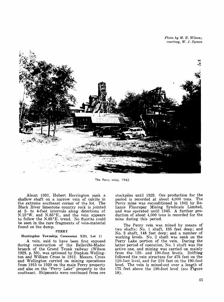
Photo by M. E. Wilson; courtesy, W. J. Symon
The Perry mine, 1942.
About 1957, Hubert Herrington sank a shallow shaft on a narrow vein of calcite in the extreme southeast corner of the lot. The Black River limestone country rock is jointed at 2- to 4-foot intervals along directions of N.15 0 W. and N.65 0 E., and the vein appears to follow the N.65 0 E. trend. No fluorite could be seen in the rare fragments of vein-material found on the dump.
PERRY Huntingdon Township, Concession XIII, Lot 11
A vein, said to have been first exposed during construction of the Belleville-Madoc branch of the Grand Trunk railway (Wilson 1929, p. 59), was optioned by Stephen Welling ton and William Cross in 1912. Messrs. Cross and Wellington carried on mining operations from 1915 to 1920 on the main Perry property and also on the "Perry Lake" property to the southeast. Shipments were continued from ore
stockpiles until 1923. Ore production for the period is recorded at about 4,000 tons. The Perry mine was reconditioned in 1941 by Re liance Fluorspar Mining Syndicate Limited, and was operated until 1943. A further pro duction of about 4,000 tons is recorded for the mine during this period.
The Perry vein was mined by means of two shafts: No. l shaft, 195 feet deep; and No. 3 shaft, 148 feet deep; and a number of working levels. No. 2 shaft was sunk on the Perry Lake portion of the vein. During the latter period of operation, No. l shaft was the active one, and mining was carried on mainly from the 120- and 190-foot levels. Drifting followed the vein structure for 475 feet on the 120-foot level, and for 210 feet on the 190-foot level. The vein is mined-out over a length of 175 feet above the 190-foot level (see Figure 18).
45

The economic part of the vein is a lens striking N.60 0W., raking 650 SE. The small axis of the lens is 160 feet, and the maximum width of vein-material is 6 feet (Wilson 1929, p. 61). The vein-material is banded and consists of fluorite, barite, and calcite, with minor celestite and pyrite; fluorite predominates. The wallrocks are banded Grenville marble, and pink or grey quartz syenite or granite. Results of the Canadian Government's drilling program of 1943 are shown in Chart A.
PERRY LAKEHuntingdon Township, Concession XIII, Lot 11 Although it forms part of the original
Perry property, the "Perry Lake" mine was never connected to the main Perry workings to the northwest. The vein was mined from surface cuts by: G. H. Gillespie and Stephen Wellington in 1910; C. Bowman in 1913; and William Cross and Stephen Wellington in 1915. Several hundred tons of ore was produced from these cuts near the shore of Moira Lake, the
Vein material
Figure 19—The Perry Lake mine. Modified from plans by E. W. Dafoe (1952—53), for Reliance Fluorspar MiningSyndicate Limited.
46

The vein strikes N.60 0 W., and is in line with the main Perry deposit 700 feet to the northwest. The vein fracture is continuous between the two mines, but the amount of vein-material is negligible (see Chart A). Fig ure 19 is a plan of the mine area showing also a plan of the three working levels. The distri bution of vein-material is taken from a sketch by Eric Dafoe in 1953 (private company re cords). The vein-material can be seen to increase from a stockwork of stringers in the upper level to a series of lenticular enlargements on the lower levels. The ore consists of fluorite, calcite, celestite, barite, pyrite, and minor amounts of other sulphide minerals. The host rocks are banded grey Grenville marble, and pink or grey syenite or granite.
According to W. J. Symon, manager of Huntingdon Fluorspar Mines Limited, the vein is largely mined-out to a depth of 120 feet, but some ore remains between the 120- and 165-foot levels. The heavy flow of water in the lower workings restricted the recovery of ore.
PLAIN Madoc Township, Concession I, Lot 9
The most northerly fluorite occurrence in the Madoc area is located at the north end of Jarvis Lake. According to Wilson (1929, p. 77), a number of prospect-pits expose a narrow fluorite-barite vein cutting red granite. About 20 tons of fluorspar vein-material was taken from a surface cut in 1942 (Butterfield and Fawcett 1943, p. 3).
The Perry Lake mine, 1962.
largest of which was 80 feet long, 5 feet wide, and 15-25 feet deep. In 1917, Messrs. Cross and Wellington sank a shaft (known as the No. 2 shaft on the Perry property) to a depth of 35 feet, and drifted northwest along the vein for 30 feet. The main development on the property was in 1952, when Reliance Fluor spar Mining Syndicate Limited sank a new shaft to 170 feet at a point just west of the old Belleville-Madoc highway, and 100 feet west of the old shaft. Mining was carried on in 1952 and 1960 from levels established at 75-, 120-, and 165-foot depths. Drifts were driven for 130, 270, and 175 feet on these levels, respectively. Operations in 1960 were under the new company name of Huntingdon Fluorspar Mines Limited. Production of 3,780 tons of fluorspar ore is recorded for 1952 and 1960.
PONTON Madoc Township, Concession I, Lot 3
A vein, extending southeast from highway No. 7 and the adjoining Miller property, was discovered and worked by G. M. Ponton in 1917. Intermittent activity is recorded up to 1925. From 1929 to 1942, C. A. Stoklosar worked the deposit under lease from W. N. Ponton, shipping 1,200 tons of fluorspar during the period. The ore was recovered from a series of open-cuts over a length of 400 feet and up to 20 feet deep; some ore was taken from a shallow shaft near the mid-point of the vein. The workings had been filled in by bulldozer at the time of the author's visit in 1962. Total production from the property was about 1,500 tons.
The vein trends N.45 0 W. and cuts Black River limestone. It is up to 2V2 feet in width (Wilson 1929, p. 75) and consists mainly of fluorite and calcite.
47

O) O
Oi
I
48

The Rogers mine, No. l Shaft, 1962.
Courtesy, W. J. Symon
The Rogers mine, No. 4 Shaft, 1947.
ROGERS Huntingdon Township, Concession XIV, Lot 10
The Rogers mine was the most productive fluorspar operation in the Madoc area. In a nine-year period it produced over 40,000 tons of ore. The vein was discovered by Donald Henderson and Chesley Pitt about 1909, and was mined by open-cut by G. H. Gillespie, William Cross, and Stephen Wellington in 1910; L. L. Battle in 1911; and C. M. Bowman from 1911 to 1914. According- to Wilson (1929, p. 64), the open-cut was 100 feet long- and 5-10 feet wide. In 1914, Mr. Bowman sank a shaft to 65 feet and drove a crosscut 40 feet to intersect the vein. The deposit was mined by Reliance Fluorspar Mining Syndicate Limited from 1943 to 1951, and a production of 43,244 tons of ore is recorded for the period.
The mine was worked from four shafts (see Figure 20): No. l shaft is vertical and 123 feet deep; No. 2 is inclined in the plane of the vein at 57 degrees, and is 87 feet deep; No. 3 is vertical and 120 feet deep; and No. 4 is vertical and 240 feet deep. Mining was mostly carried on from five levels at depths of 70, 120, 155, 200, and 240 feet. Over-all length of the work ings is 750 feet.
The vein has a general strike of N.65 0 W., but minor undulations in dip and strike are common. In mining the deposit, a vein width of 1.5 feet was considered the economic limit; the orebody within this limit is lenticular,
49

raking to the northwest at 40 decrees. Its short dimension is 340 feet, and its thickness ranges up to 18 feet; the body continues for an un known distance below the 240-foot level. The vein-material consists of fluorite, barite, calcite, celestite, and minor sulphide minerals. Hewitt (1948a) noted a rough zoning "in some portions of the vein, with celestite (rare) on the vein walls, then banded barite and fluorite, massive fluorite, and then calcite in the centre." The country rock is banded Grenville marble and argillite intruded by granite.
The deposit is largely mined-out above the 240-foot level, although some ore remains below 155 feet at the northwest end of the workings. According to W. J. Symon, mine manager from 1943 to 1951, the vein averages 5.5 feet in width over a length of 365 feet on the 240-foot level. He says also that a drillhole near No. 4 shaft indicated a vein width of 6 feet at a vertical depth of 360 feet (personal communica tion) . The Canadian Government's drilling pro gram did not indicate the potential of the Rogers orebody (see Chart B).
As with most of the mines north of Moira Lake the water problem was severe on the lower levels. Several deep-well pumps were used to control a flow, which normally exceeded 1,200 gallons per minute and sometimes was in excess of 2,000 gallons per minute in spite of grouting operations. Excessive water was a major factor in the decision to forego any attempt at deeper mining.
ROOKS Madoc Township, Concession I, Lot 6
A vein near the southeast end of Jarvis Lake was worked by James O'Reilly from 1916 to 1918. According to Wilson (1929, p. 77) several carloads of fluorspar were shipped from an open-cut over 300 feet long and up to 20 feet deep. The vein strikes N.55 0 W., cutting Black River limestone near the brow of a north- facing scarp. Maximum width of vein-material is 21/2 feet.
SOUTH REYNOLDS Huntingdon Township, Concession XIII, Lot 7During 1917 and 1918, Charles Henrotin
shipped several carloads of fluorspar from an open-cut on a vein optioned from Messrs. Gillen and Henderson. According to Wilson (1929, p. 63), the open-cut is 200 feet long, 2-6 feet wide,
50
and 20 feet deep. In 1943, Wood Land Mineral Company sank a shaft on the vein to 30 feet and recovered a small amount of ore. Reliance Fluorspar Mining Syndicate Limited also in vestigated the deposit; several drillholes were put down, but little mining was undertaken.
The vein is exposed on an east-facing slope of Paleozoic limestone, which forms the western shore of Moira Lake. It strikes into the hill at N.60 0 W., and is from a few inches to 2 feet in width; sometimes it is represented by two narrow, parallel stringers separated by several feet of rock. The vein-material is fluorite, bar ite, and calcite. The country rocks are the lower green beds of Black River limestone, at least to the bottom of the shaft. Drilling in dicates Grenville marble is the country rock, a few feet below the base of the hill.
Two drillholes collared 200 feet apart, each encountered 1.3 feet of vein-material containing about 55 percent fluorite. Hole No. l was drilled near the top of the hill and intersected the vein in Black River limestone at a vertical depth of 50 feet. Hole No. 2 was collared near the base of the hill; it intersected the vein at a depth of 55 feet in Grenville marble.
STEWART Madoc Township, Concession I, Lot 2, East Half
Wilson (1929, p. 75) mentions a narrow vein near the northeast corner of the lot. D. E. K. Stewart exposed the vein in several prospect pits, but no mining was undertaken. The occur rence trends northwesterly, cutting Black River limestone. The barite-fluorite vein-material in cludes traces of chalcopyrite and malachite.
WALLBRIDGE (AND HERRINGTON) Madoc Township, Concession I, Lots l and 2, West Half
In 1918, G. M. Wallbridge explored the continuation of the main vein from the Lee Senior property, and discovered a new vein on the northern part of lot 1. Fluorspar was produced from open-cuts and shafts on both veins, from 1920 to 1922. No. l shaft is on the south vein and is 55 feet deep; No. 2 shaft is on the north vein and is 50 feet deep. The north vein was further explored on the Herring- ton property to the north (west half of lot 2, concession 1) by a 20-foot shaft and a number of trenches (see Figure 21). From 1941 to 1943, Dominion Fluorspar Company Limited mined the north vein on the Wallbridge and Herrington properties. A new shaft was sunk to 125 feet, and levels were established at 50-, 85-, and 100-foot depths. The extent of the underground development is indicated by the following summary based on several inspection reports (Tremblay 1946a, p. 65, and 1946b, p. 69):

100-foot level
Total
Drifts
feet 540165310
1,015
Crosscuts
feet 404540
125
A longitudinal section is shown in Figure 22. Total shipments of fluorspar from the pro perty is estimated at 6,600 tons (Butterfield and Fawcett 1943, p. 3).
The south vein is a lenticular enlargement on the same vein structure as the main deposit
i on the adjoining Lee Senior property. It strikes N.50 0 W. and has a maximum width of 6 feet. The north vein strikes N.20 0 W. It has been traced more than 500 feet by both surface and underground exploration; widths of vein breccia to 7 feet are recorded (Wilson 1929, p. 74). Much of both veins consists of wallrock frag ments cemented by fluorite-calcite-barite vein- material. Fluorite and calcite predominate, and the soft "gravel spar" variety is common. The country rock is Black River limestone; out crops in the area exhibit two-directional joint ing, N.20 0 W. and N.65 0 W., at 2- to 4-foot inter vals. The lower workings of the north deposit are in the basal green beds of the Black River Formation.
In 1919 the Ore Dressing Division of the Mines Branch in Ottawa conducted beneficia tion tests on a sample of Wallbridge ore (Bur eau of Mines 1920). The 280-pound sample analyzed as follows:
Percent CaF, . . ..... .. . .. ... .. ... .. .... . . . 48.35CaCO 3 . ... .. . ... . . .. .... . .. ..... . . 40.00BaS04 . . ..... . .. .. ... .. . .. .. ... . . . 4.40Si0 2 . . .. ... .... .... .. .. ... . ... . .. 3.10A1 2 O3 and Fe2 03 . .. .. .. .. .. . ... .. .. 1.60
Optimum results were obtained using a Wilfley table on an 80-mesh feed. Concentrates for each of the three major minerals were indicated as follows:
Percent Fluorspar concentrate .. ......... . . . 74.8Barite concentrate . . .. ... ... .. .. . .. . 81.8Calcite concentrate . . .. .. . .. .. ... ... 59.2
These concentrates represented recoveries of 65 percent of the available fluorite, 75 per cent of the available barite, and 64 percent of the available calcite, respectively.
Further tests to improve the tenor of fluorspar in the concentrate were made in 1922 (Bureau of Mines 1924). Two further samples were obtained for this work: one of 505 pounds, the other weighing 1,368 pounds. They were closely similar to each other, giving the follow ing analyses:
HERRINGTON
Vein width recorded visually by M. E. Hurst, 1943
Ore mined out
Wallrock with or without vein material
Scale of Feet
100 100
Figure 21—The Wallbridge mine. Longitudinal section (approximate) based on notes by M. E. Hurst (1943).
51

HERRINGTON PROPERTY
WALLBRIDGE
Scale of Feet
100 50 O 100 200
Figure 22—The Wallbridge, Herrington, and Lee Senior properties. From a survey plan by J. W. Pierce forDominion Fluorspar Company Limited, 1943.
52

Sample
505-pound1,368-pound . . . . . . .
BaSO 4
percent 6.006.00
CaF2
percent79 80
76.40
CaC03
percent 15.6015.50
Si02
percent 1 ^5
A 4-mesh feed was calcined at l,400 0 F. to convert calcite to lime (CaO), after which the lime was removed by slaking the sinter in boiling water and washing the residue. With most of the calcite so removed, portions of the fluorite-barite residue were ground to 40-mesh and 80-mesh, and tabled to produce the follow ing concentrates:
CaF2
percent 91.393.1
Fluorite Recovery
percent7777
The process did not produce clean bypro ducts of either barite or calcite.
WILLIAM REYNOLDS Madoc Township, Concession I, Lot 5
Donald Henderson and James O'Reilly dis covered a vein on this property in 1920. In 1940, D. E. Craigie examined the property for Reliance Fluorspar Mining Syndicate Limited. His descriptions (Craigie 1940) of the six test pits along the vein are summarized as follows: the vein cuts Black River limestone in a direc tion of N.40 0 W., and the pits are spaced at intervals of 90, 55, 90, 55, and 80 feet, respec tively, from north to south.
These observations suggest the average composition of the vein-material is 30 percent fluorite, 20 percent barite, and 50 percent cal cite. Butterfield and Fawcett (1943, p, 3) re cord a production of 88 tons (shipped) in 1941-42.
WILLIAMS Huntingdon Township, Concession XI, Lot l
Several narrow veins up to about a foot in width are exposed in a lot owned by George Williams. In addition to fluorite, the vein- material includes much barite and calcite.
Immediately north, in lot l, concession XII, Huntingdon township, and westward along the south bank of the Moira River in Rawdon township, there are several similar veins, which have been mined on a small scale for barite. Several tons of hand-cobbed barite containing minor fluorite and calcite remain (1962) in a stockpile along the road, two-thirds of a mile south of the bridge over the Moira River.
WRIGHT Huntingdon Township, Concession XI, Lot 15
According to Wilson (1929, p. 49), Stephen Wellington and Gordon Munro excavated ten prospect pits near the centre of the lot in an attempt to find a continuation of the vein from the adjoining Howard property. Vein-material was uncovered in one of the pits, but no further work was recorded.
OTHER OCCURRENCES
Minor fluorite occurrences are recorded by Wilson (1929, pp. 66, 74, 75, 77), in lot 11, concession XIV, Huntingdon township; in Madoc township in the west half of lot l, conces sion II; in the west half of lot 3, concession II; and in lot 14, concession IV.
SUMMARY DESCRIPTION OF WORKINGS—WILLIAM REYNOLDS PROPERTY
Distances from Pit No. 1 ............ feet southPit, depth .................................................. feetGlacial drift, thickness ........................ feetLimestone, thickness ................................ feet
Pit No. 1
07.76.01.7nilnilnilnil
Pit No. 2
QOQ 06.03.0nilnilnilnil
Pit No. 3
14512.3
1.55.02.7351055
Pit No. 4
23516.0
5.09 02.7403030
Pit No. 5
29011.0
5.72.01.7202555
Pit No. 6
37011.0
i S*f o.o
1.0302050
53

OTHER FLUORITE OCCURRENCES Southern Ontario
CARLETON COUNTY Fitzroy Township, Concession VI, Lot 22
A small amount of fluorite occurs in a calcite-galena vein at the Kingdon mine (Wil son 1929, p. 78).
FRONTENAC COUNTY Barrie Township, Concession IX, Lot 23
A barite-fluorite vein, 4-12 inches wide, is exposed in several shallow pits. The vein contains traces of chalcopyrite and malchite and cuts Grenville marble (Meen 1944, p. 34).
Kingston Township, Concession IV, Lot 17
Fluorite occurs in trace amounts along the wall of a barite vein, 2-4 feet wide, in Ordovi cian limestone (Wilson 1929, p. 78).
Oso Township, Concession I, Lot 25
A few crystals of green fluorite occur in barite-calcite veins (Wilson 1929, p. 78).
LEEDS COUNTY Bastard Township, Concession I, Lot 28
Fluorite veinlets, up to 11/2 inches wide and a few feet long, occur in granite (Wilson 1929, p. 78).
RENFREW COUNTY Ross Township, Concession II, Lots 12 and 13
Several calcite-fluorite veins were discover ed by Eric Johnston in 1944 and were subse quently examined by Dominion Magnesium Limited. Vein-material is exposed in three stripped areas in lot 13. The showings were examined by D. F. Hewitt of the Ontario Department of Mines in 1949, and the following descriptions are taken from his notes.
One showing exposes a 6-foot vein over a distance of 35 feet, striking N.55-70 0 E. and dip ping 50 0 N., in a north-striking band of horn blende paragneiss. The vein-material consists of a coarse aggregate of pink calcite and purple or white fluorite; fluorite comprises 20-30 percent and occurs in patches 1-4 inches in diameter. Large crystals of biotite and feldspar, and some scapolite and apatite, are present in the wall zone. A pit, 6 feet square and 5 feet deep, was sunk on the vein at the west end of the exposure.
A second showing, 100 feet northwest of the first, exposes an irregular calcite-fluorite vein in a stripped area, 20 by 40 feet. The vein-material consists of 20-30 percent pale green to white fluorite. The vein is enclosed by a syenite pegmatite that intrudes the horn blende paragneiss country rock. Large books of biotite are common, with apatite, in the wall zone.
The southernmost showing is an irregular calcite-fluorite pod associated with syenite peg matite in hornblende paragneiss. The pod is 30 feet long and up to 8 feet wide and consists of pink calcite, purple fluorite, and red and green apatite, in order of importance.
A number of shallow diamond-drillholes were put down in the vicinity of the showings. Five of them intersected vein-material as fol lows:
Drillhole
No. 1No. 2No. 3No. 4No. 6
Vein Intersection
feet 1923134
14.7
Fluorite Content
percent 2817273220.9
Ross Township, Concession V, Lot 14
A shallow pit, 4 by 5 and 2 feet deep, known as the "Cole mine," is located on an outcrop of pink hybrid gneiss, striking N.70 0 W. and dipping 20 0 N., in the northeast corner of the lot. A pod of calcite-fluorite vein-material, 6 feet long and up to l foot wide, is parallel to the foliation of the gneiss. It consists of salmon-pink calcite and purple fluorite, with accessory pyroxene and scapolite (Satterly 1945c, p. 40).
Ross Township, Concession VI, Lot 4 Ross Township, Concession XI, Lot 7
Fluorite is present in subordinate amounts in calcite-fluorite-apatite veins (Satterly 1945c, p. 40).
PETERBOROUGH COUNTY Galway Township, Concession II, Lot 21
Fragments of green, grey, and reddish fluorite up to 12 inches are reported to be scat tered over a small area in the vicinity of syenite pegmatites in granite-gneiss terrain on the north shore of De Gaulle Lake (Paul Cziraky, Nogies Creek, personal communication).
Northern Ontario
DISTRICT OF KENORA Fort Hope Albany River Area
Fluorite is a minor constituent of three granite pegmatites located north of the Lily Pad lakes. The fluorite is associated with "appreciable quantities" of lepidolite, spodu mene, and pink tourmaline (Prest 1944, p. 27).
54

DISTRICT OF THUNDER BAY
Fluorite is a minor constituent in some of the many silver-bearing calcite veins that are found along the north shore of Lake Superior between Nipigon Bay and the International Boundary. Associated minerals include calcite, barite, white and amethystine quartz, with or without minor amounts of galena, sphalerite, chalcopyrite, and pyrite. The veins occupy fault-fissures in dikes and sills of Keweenawan diabase and older Precambrian rocks. They are of the simple, composite, or shatter-zone type; simple veins rarely attain widths of 60 feet but are usually less than 10 feet. Where fluor ite is present, it usually occurs in thin crusts, or narrow pods a few feet in length, in or near the wall zone. Both purple and green fluorite have been observed in translucent crystals and masses, but the mineral is not known to exceed 5-10 percent of the vein-material.
Only a few fluorite showings are mentioned in the following section. For a complete in ventory of occurrences, the reader is referred to Tanton (1931, pp. 102-94).
Township 87On highway No. 17, 21/2 miles west
of Pays Plat River, purple, amber, and colourless crystals of fluorite are encrusted on the walls of granite fractures; they are also as sociated with barite, marcasite, and siderite in narrow veins and stringers of quartz. The fluorite showings occur intermittently over a distance of more than Vis mile in rock-cuts through hybrid granite and syenite gneiss.
Lybster Township (Mining Locations R.55, R.56, R.57)
In reference to the calcite-barite-quartz- fluorite veins at the East End Silver Mountain Mine, Tanton (1931, p. 117) describes the occurrence of fluorite as follows:
Fluorite occurs along the walls of veins as dis continuous seams of irregular width, commonly a few feet or yards long and an inch or so wide. The seams are more abundant along the walls of veins less than a foot wide than in wider veins, and fluorite is absent from most of the wide veins. In some veins green and purple varieties of fluorite are interbanded, in bands averaging one-tenth inch in width and roughly paralleling the walls of the vein, but in some seams one or other variety is present alone.
Flotation tests were conducted on a 500- pound sample of "fluorite ore" by the Bureau of Mines (1948) in Ottawa. The sample was a fine granular aggregate of quartz and fluorite analyzing as follows:
Silver . ... ... . .. . .. .. .. . oz. per ton 0.07CaF2 ..... ... ... .. .. . .. .... percent 20.53Sulphur . . .. ... . .. .. . .. .. . percent 0.26
By slight modifications to the flotation circuit, various fluorspar concentrates could be made on material ground to 200-mesh:
CaF-
Over-all fluorite recovery . . .
Ipercent
84.600.10
91
IIpercent
Q2 07
84
It would be necessary to briquette the fluorspar products for use as metallurgical flux.
Port Arthur
Fine, granular, green fluorite is associated with quartz in narrow veins and stringers cutting diabase, near the Current River water- tower, in the northeastern part of the city of Port Arthur.GRADE AND EVALUATION OF FLUORITE
DEPOSITSAccording to Bates (1960, p. 277) a deposit
must contain at least 30 percent fluorite to be of economic value. The nature of the impurities is also of prime importance in establishing the economic limit; some impurities, such as barite and apatite, are not only undesirable in the product, but are difficult to remove by conven tional methods of beneficiation. In general the small, high-grade, coarsely-crystallized fluorite veins, readily amenable to hand-cobbing, have been the source of metallurgical-grade lump fluorspar; the large, and in many cases lower- grade and finer-grained, disseminated deposits, have required more elaborate systems of benefi ciation and have been the source of acid-grade fluorspar.
Vein deposits in southern Illinois range to more than 30 feet in width and several hundred feet in length; they have been mined to depths of 900 feet. The vein-material consists of cal cite and fluorite, calcite normally predominating, and minor amounts of sphalerite, galena, quartz, and barite. Some of the mines recover the zinc and lead sulphides as well as the fluor ite, by combinations of gravity and flotation processes. The Director Mine of Newfoundland Fluorspar Limited has been developed on three lenses, one as much as 70 feet thick, distributed along a vein fissure, 6,000 feet long. The fluor- ite-quartz-calcite vein-material does not make a metallurgical-grade product by hand-cobbing because of the high silica content, but it is easily concentrated by a combined heavy-media and flotation process to an acid-grade product. The ore averages 70 percent fluorite (Carr 1958, p. 61). Vein deposits along the Moira Lake fault, south of Madoc, average 3-6 feet wide, with a maximum of 18 feet, over lengths of several hundred feet. The fluorite-calcite-
55

barite vein-material averages about 60 percent fluorite, and in most cases it can be hand-cobbed to metallurgical-grade. No practical beneficia tion system has been developed to produce acid-grade concentrates from Madoc ores.
The flat-lying replacement deposits in southern Illinois are 200-1,500 feet long, 50- 200 feet wide, and 3-15 feet thick (Bates 1960, p. 281). Composition of the ore is similar to the nearby vein deposits. The irregularly-shaped replacement deposits at the La Consentida and Las Cuevas mines in Mexico are up to 600 feet in length, and in width to 250 feet. The crude ore contains only minor amounts of quartz and calcite, and can be shipped directly as metal lurgical-grade fluorspar, having a minimum of 72 effective CaF9 units (Frohberg 1962, pp. 15- 17).
Fluorite deposits are readily evaluated by normal methods of testing. Samples should be analysed chemically for CaF2 , Si0 2 , CaC03 , Ba- S04, S, Pb, Zn, and Fe203 . Petrographic exam inations of the vein-material are important to determine the grain size and distribution of the principal minerals, as this may have a bearing on the method of beneficiation to be used and the fineness of grind required. Bulk sampling and pilot-plant testing is essential for the evaluation of complex ores.
Preliminary examination of deposits should include stripping or trenching, and channel sampling at intervals not exceeding 50 feet. Veins must be carefully sampled from wall to wall because of the banded character of most deposits and the normal increase in impurities in the wall zone. Closely-spaced diamond-dril ling is essential because of the variable charac ter of the deposits.
Mining, Milling, and BeneficiationFluorspar deposits are mined by conven
tional underground methods. Exposed high- grade veins may first be worked by open-cut
to depths of 20-30 feet, then from underground levels developed from shafts or adits. In most cases vein deposits are characterized by steeply- dipping, strong, clean walls, and are most easily mined by shrinkage stoping. Horizontal replacement deposits are commonly mined by room-and-pillar methods, by which ore-extrac tion may average 80-90 percent (A.LM.E. 1958, p. 66). Access to near-surface replacement bodies may be facilitated by inclined truck adits or conventional shaft-development. Exposed deposits in Mexico have first been mined by open-pit (Frohberg 1962, p. 10). Track-haulage of ore from the stopes to the production shaft is customary.
Coarse, crystalline fluorite, typical of the veins at Madoc, can be concentrated to metal lurgical-grade by hand-sorting augmented by crushing, screening, and washing. Milling plants in the Rosiclare fluorspar district of Illi nois commonly treat material coarser than 8- mesh in a heavy-media circuit to obtain metal lurgical-grade products; material finer than 8- mesh is floated to acid-grade specifications. Newfoundland Fluorspar Limited concentrates ore from its Director Mine to 75 percent CaR, by heavy-media; the heavy-media product is shipped to Arvida, Que., for flotation concentra tion to 97 percent CaF 2 . Ferrosilicon, galena, and magnetite are the common heavy constitu ents used with water in heavy-media circuits.
Flotation of fluorite is normally carried out on material ground to 200-mesh or finer. In a typical case the sulphide minerals are floated first, then the fluorite is floated from silica, calcite, and other impurities. At one plant in the Cave-in-Rock district of Illinois, three flota tion circuits are used to recover lead sulphide, zinc sulphide, and fluorspar, respectively; both acid- and metallurgical-grades are produced, the latter requiring pelletizing before shipment. The normal reagent combinations used in fluor spar flotation plants is summarized by Thorn and Gisler (1954, p. 241) as follows:
BENEFICIATION TESTS ON MADOC FLUORSPAR ORES
Year
1919 1922
1941 1941 1944 1946 1947
Test No.
115 166
4151 4151 4402 1989 2235
Property
Wallbridge Wallbridge
Howard Coe Keene Bailey Johnston
Process
table calcine, table jig, table jig, table flotationjig jig, table
Best Fluorspar Concentrate
CaF2
percent 74.8
93.1 75.1 91.1 86.2 73.6 71.1
BaS04
percent
1.4 3.1 5.4
CaCO3
percent
7.5 19.9 20.4
Si0 2
percent
0.1 0.5
Fluorite Recoverypercent
6577 82 78 92 72 86
56

Oleic acid or various mixtures of oleic and linoleic acids with soda ash and sodium silicate as silica depressant and slime controller, and quebracho to de press calcite, are the common reagents for fluorspar flotation. Sometimes pre-sulphide flotation with xanthate and a frother is necessary to remove sulphides, and, often, heating the pulp to boiling temperature is advantageous in effectively depressing the silica, calcite, and other associated minerals in the cleaning stages.
Fluorite ores containing appreciable (more than 10 percent) amounts of barite are especial ly difficult to treat because of the voluminous barite froth produced in an all-flotation circuit. Some success was achieved in the pilot-plant testing of a barite-fluorite-calcite ore, contain ing up to 50 percent barite, from the Lake Ainslie district of Nova Scotia. Much of the barite was first removed by tabling at 65-mesh ; the remaining barite was then removed by a flotation stage prior to the flotation of the fluorite itself. Concentrates of drilling-mud- grade barite and metallurgical-grade fluorspar were made, the latter requiring pelletizing be fore shipment (Cameron 1945, p. 584). In practice however the process is a difficult one, and it is significant that few barite-fluorite mixtures have been successfully treated by other than hand-cobbing methods.
The removal of barite is a problem common also to the Madoc ores, especially those from the veins south of Moira Lake. To date, all pro duction has been by selective mining and hand- cobbing, facilitated by crushing, screening, and washing. However, beneficiation tests have been conducted on a number of samples of Madoc ores; the principal results are included in the accompanying table. The tests were performed in the Mineral Dressing Laboratories in Ottawa; more detailed descriptions of the test work are included under the property description in each case.
The tests indicate that Madoc ores are generally not amenable to gravity concentra tion alone. Metallurgical-grade fluorspar can be produced by flotation, or by combined grav ity and flotation methods where barite is troublesome. Perhaps the combined calcination and tabling process is of most interest for treating the fluorite-barite-calcite veins south of Moira Lake. Beneficiation methods, other than hand-cobbing and heavy-media, necessi tate pelletizing of the concentrate prior to its use for metallurgical purposes.
A few small, hand-cobbed, shipments of acid-grade fluorspar have been made from de posits in Cardiff township. Flotation tests on ore from the Cardiff Fluorite property and the East End Silver Mountain mine at the Lakehead indicate that fluorite concentrates grading more than 90 percent CaF 2 are possible with fair to good recoveries of the available fluorite. How ever, the low tenor of fluorite (15-25 percent)
in the vein-material has prevented these de posits reaching commercial production. The presence of apatite in the calcite-fluorite veins of Cardiff township is a further problem be cause phosphorus cannot be tolerated in metal lurgical-grade fluorspar. Satterly (1943, pp. SI- 32) points out that simple gravity separation would not be effective on these ores because of the similar specific gravities of apatite and fluorite.
Fine-grained, fluorspar concentrates must be pelletized or briquetted for metallurgical use; consumers normally specify a ,-product within the size range of i/ft-2 inches. Organic binders, in the form of asphalts or oils from the petroleum or wood-pulp industries, are usually used. The forming procedures have been out lined by Kenworthy (1951) and Cameron (1945, pp. 581-82). A 5-pound fluorspar brick made by Huntingdon Fluorspar Mines Limited, near Northbrook, Ontario, by a dry-press method, is especially suited for use in small foundries.
Small shipments of optical-grade fluorite crystals have been made from the Madoc area. In hand-cobbing processes, it may be in the company's interest to set aside clear, colourless material for this restricted market. A photo electric sorting system has been developed (Turrall and Porter 1952, pp. 803-6) to disting uish optical-grade from near-optical fluorite; it might operate as a separate circuit on feed selected from the picking belt.
Marketing
The major Canadian fluorspar markets are for acid- and metallurgical-grade products. Acid-grade fluorspar is used principally in the manufacture of cryolite and aluminium fluoride for the aluminium industry. However, most of the market is not available to other fluorspar producers because the Aluminum Company of Canada operates its own mine under the name of a subsidiary company, Newfoundland Fluor spar Limited. Ontario fluorspar has been used almost exclusively for metallurgical purposes, partly because of its proximity to the major steel plants.
In eastern Canada, fluorspar is marketed by five companies:
Aluminum Company of Canada Limited. St. Lawrence Corporation of Newfoundland
Limited.Noranda Sales Corporation Limited. Huntingdon Fluorspar Mines Limited. Foseco Canada Limited (briquetted fluor
spar fluxes only).57

Fluorspar from Aluminum Company of Canada Limited's Director Mine in Newfound land is consumed almost entirely for the com pany's production of aluminium. They do, how ever, offer a ceramic-grade product for outside consumption.
St. Lawrence Corporation of Newfoundland Limited has, until recently, operated a mine in the Burin Peninsula adjacent to the operations of Newfoundland Fluorspar Limited. The mine was a major producer of acid- and metallurgic al-grade fluorspar until the expiration of a con tract with the United States government in 1957; it has operated on a much reduced scale since, shipping mainly to markets in United States. The mine was idle in 1963.
Noranda Sales Corporation Limited is the Canadian sales adviser for Mexican fluorspar from the Las Cuevas mine of Empresa Fluor spar Mines Limited. Most of the steel plants and foundries in eastern Canada use fluorspar from this source.
Huntingdon Fluorspar Mines Limited, the successor of Reliance Fluorspar Mining Syndi cate Limited, and the largest producer of fluorspar from the Madoc area, ceased mining operations in 1961. However, the company continues to supply some Ontario consumers
with fluorspar obtained from Mexico's Las Cuevas mine. In 1963 the company also com menced the manufacture of a fluorspar brick, especially designed for use as a flux in small foundry operations. Huntingdon Fluorspar Mines Limited has the exclusive rights under contract from Foseco Canada Limited, a wholly owned subsidiary of Foseco International Limit ed, Birmingham, England, for the briquetting of "Brix Cupola Fluxes" in Canada.
Fluorspar producers in Ontario have usual ly sold their products by direct negotiation with the consumers. Mine-run ore was crushed, washed, and screened to remove material finer than 14 inch; large waste fragments were re moved by hand-cobbing, and the lump fluorspar product was shipped in bulk carload lots.
Prices quoted by the E. & M. J. Metal and Mineral Markets for 14 Oct. 1963, are shown in the accompanying table.
The CaF2 contents shown for the various metallurgical-grades in the table of prices are for effective CaF2 units. The effective CaF2 content is calculated by subtracting 21/2 times the silica content from the total CaF2 content. Some Ontario consumers pay a premium of 50 cents per ton for each unit above an 80 percent effective grade.
FLUORSPAR PRICES—U.S. FUNDS—14 OCTOBER 1963ILLINOIS AND KENTUCKY (F.O.B., BULK) :
Metallurgical-grade:
Per Short Ton 72y2 percent CaF, .............................................................................. $37.00-$39.0070 percent CaF, .................................................................................. 335.00-337.0060 percent CaF2 .................................................................................. 332.00-334.00
Acid-grade, dry basis:97 percent CaF2—carloads .............................................................................. 345.00
—less than carloads .......................................................... 350.00—bags extra .......................................................................... 33.00
Wet filter cake, 8-10 percent moisture (sold dry content)subtract approximately .............................................................................. 32.50
Pellets—carloads ................................................................................................ 355.00—less than carloads .............................................................................. 360.00
Ceramic-grade, calcite and silica variable, Fe,O3 maxima 0.14 percent:88-90 percent CaF2 .............................................................................................. 341.0093-94 percent CaF. .......................................................................................... 342.0095-96 percent CaF, .........................................................................................: 343.00100-pound paper bags, extra .............................................................................. 33.00
EUROPEAN (C.I.F. UNITED STATES PORTS, DUTY PAID) : Metallurgical-grade:
72V2 percent CaF, .................................................................................. 330.00-333.00Acid-grade, wet filter cake, 8-10 percent moisture, sold dry content 336.00-340.00
MEXICAN (F.O.B. THE FOLLOWING POINTS) :Metallurgical-grade (72^ percent CaF,) :
Border, all rail and duty paid ............................................................ 324.50-326.00Brownsville, barge, duty paid ............................................................ 327.00-328.50Tampico, vessel, cargo lots .................................................................. 317.00-319.00U.S. Atlantic ports, cars, duty paid .................................................... 331.00-334.00
58

In addition to the accompanying price list, the E. & M. J. Metal and Mineral Markets for 11 March 1963, quotes a price of ^37-^39.50 per short ton for Mexican 721/2 percent metal lurgical-grade, duty paid in carload lots at U.S. Lake Erie ports.
Bartley (1962b, p. 7) gives the following Canadian prices, valid in December 1961 :
Ceramic-grade, 94 percent CaF^, coarse, Aluminum Company of Canada Limited, per net ton (f.o.b.) Arvida, Que. . . . . . . . . . . . . . . . . . . . . . . . . . . $61.50
Acid-grade, Mexican, per ton, Canadian funds approximately . . . . . . . . . . . . . . . . . . . . . . . . 336.00
There are no tariffs on fluorspar entering Canada. Tariffs on fluorspar entering United States are:
HISTORY OF ONTARIO FLUORSPAR PRODUCTION
Fluorspar containing less than 97 percentper long ton . . . . . . . . . . . . . . . . . . . . . . . . . . ? 8.40
Fluorspar containing more than 97 percent CaFi*, per long ton . . . . . . . . . . . . . . . . . . . . . . . . . 3 2.10
Production and ConsumptionStatistics on the fluorspar industry in
United States, and a general summary of the world situation, are given by Kuster and Schreck (1962). World production of fluorspar in 1961 was 2.3 million short tons, a 5 percent increase over the previous year and an all-time high. Leading producing countries in order of importance were: Mexico, China, U.S.S.R., France, and United States. All were estimated to have produced more than 200,000 tons of finished-grade fluorspar, the total from Mexico being almost double the production of any other country. Shipments of fluorspar from mines in United States in 1961 were 205,083 tons, a de crease of 11 percent from 1960, consistent with a general downward trend since 1958. Illinois was the top producing state, followed by Ken tucky, Nevada, and Montana. Imports of fluor spar into United States in 1961 were 505,759 tons, down 5 percent from 1960 but generally maintaining the high level of recent years; Mexico, Spain, and Italy were the major sources.
Statistics on the fluorspar industry in Can ada are given by Bartley (1962b). Fluorspar shipments from Canadian mines in 1961 were valued at 31,961,620, and were estimated by the U.S. Bureau of Mines at 76,200 tons. Production originated almost entirely from Newfoundland Fluorspar Limited, the sub sidiary of Aluminum Company of Canada Limited; producers in Ontario and British Col umbia were idle throughout the year.
Year
1905191019111916191719181919192019211922 .......1923192419251929 .......193019311932193319341935193619371938193919401Q41194219431944 . . . . . . .1945194619471948 . . . . . . .194.Q195019511952195319541955195619571958195919601961
Total
Shipmentstons
122
301,2834,3327,1923,4253,7041162846476127080403273
1507575
150217240
4,4375,2344,340
10,3856,9067,3698,0427,186
11,3406,4008,6186,286804876904730970
2,4301,2562,5942,818960
121,919
Value
| 8415
20011,52266,474
151,35960,38967,381
1 7443,905597
1,343200
1,1201,240620464
1,0642,100900900
2,5503,9064,995
58,95293,867113,957301,434217,031233,708237 491209,886344,834187,875262,643223,39838,46538,88740,13099 7Qfi12,25194,23957,834
100,594100,81138,400
3 3,421,825
Exports in 1961 were confined to United States and comprised 2,048 tons, two-thirds of which was of acid-grade. Imports totalled 32,769 tons, 97 percent of which was Mexican fluorspar; imports were substantially lower than the 59,690 tons recorded for 1960.
The history of fluorspar production in Ontario is traced in the accompanying table (Statistician, Ontario Dept. Mines). All but a few small shipments were of metallurgical- grade and came from the Madoc mines. Ship ments of about 100 tons of metallurgical-grade fluorspar, and 30 tons of acid-grade, are record ed during the two World Wars from mines near Harcourt in Cardiff township.
59

CONSUMPTION OF FLUORSPAR IN CANADA
Grade
Acid-Metallurgical- Ceramic-
Total
1940tons 3,400
21,200 447
25.095
1950tons
29,60021,800
71352.137
1955tons
68,62818,600
68987.927
1956tons
76,47819,000
66996,126
1957tons
53,19816,935
62870,761
1958tons
74,93914,539
45589,933
1959tons
72,14820,752 3,116
96,016
1960tons 85,42325,784
628111,835
Fluorspar consumption in Canada in 1960 was 111,835 tons, a 16-percent increase over 1959. Consumption appears to have dropped in 1961, although final figures are not available. The history of fluorspar consumption in recent years is given by Bartley (1961, p. 11); it is reproduced in the accompanying table with re visions from Bartley (1963, p. 249). Acid-grade fluorspar is almost entirely consumed by the aluminium industry.
The following companies are the major consumers of fluorspar in Ontario:
Steel Company of
Dominion Foundries and Steel Ltd.
Algoma Steel Corpora tion Ltd.
Dominion Magnesium Ltd. ...............
Plant Location
Sault Ste. Marie
Near Renfrew
Annual Fluorspar
Consumption (approximate)
tons 15 20,000
3 0 cr\f\
3,000
1.200
Consumption of fluorspar in United States in 1961 was 681,883 tons, an increase over 1960 and the previous record year, 1957, of about 6 percent. A record of consumption (in short tons) in recent years, as reported by the U.S. Bureau of Mines, is shown in the accompanying table:
CONSUMPTION OF FLUORSPAR IN UNITED STATES
Grade
Acid-Metallurgical- . . . Ceramic-
Total
1959tons
331,935218,709 39,335
589.979
1960tons
379,576229,929
34,254643.759
1961tons
418,113228,181
35,589681.883
Producers of hydrofluoric acid in United States consumed 11 percent more fluorspar in 1961 than in 1960. A breakdown of uses for the acid in United States in 1957 is shown on page 3. Growth trends continue to be above
60
average for fluorspar consumption in the alum inium and chemical industries. Consumption for metallurgical and ceramic uses is relatively stationary.
According to a report by the United States Tariff Commission (E. fe M. J. Metal and Min eral Markets 1962, p. 7), the National Stockpile in United States contains "some 820,000 tons of acid-grade fluorspar in excess of defense objec tive needs — nearly four times the amount needed for defense."
The Commission recommends against im posing import quotas or higher tariffs to protect the faltering domestic fluorspar in dustry.
Other Sources of FluorineFor most of its uses no suitable substitute
for fluorspar is known. However, there are two alternative sources of fluorine of economic im portance : cryolite (or sodium aluminium fluor- ide) is a valuable fluorine mineral for which there is only one commercial deposit. Phosphate rock, used in large quantities in the preparation of fertilizers, contains small amounts of fluor ine, some of which is wasted to the atmosphere under present methods of treatment.
CRYOLITECryolite, Na:!AlF6 , is a rare, colourless
mineral with a hardness of 2.5 and a specific gravity of about 3.0. It is a monoclinic mineral, but its crystals are usually cubic in aspect. Because of its low index of refraction, small fragments of the mineral become practically invisible in water. Cryolite is brittle, and has a pronounced parting that resembles a cubic cleavage.
The major use of cryolite is in the alum inium industry, where molten cryolite and aluminium fluoride together form the electrolyte in the Hall process for reducing aluminium oxide to aluminium metal. Cryolite is also used in minor amount as a whitener for enamels, an opacifier in glass, and as a bonding material for abrasives (Grogan 1960, p. 381).

The only commercial deposit of cryolite is at Ivigtut, West Greenland. Cryolite is associat ed with fluorite, siderite, and pyrite in a massive pegmatite in porphyritic granite. It is quarried by a Danish company, and the crude cryolite is shipped to Denmark and the United States for processing. The Natrona, Penn., plant of Pennsalt Chemicals Corporation makes a flota tion concentrate from the crude, grading 99 percent cryolite.
Production from the Greenland deposit has shown a gradual decline in recent years, pos sibly due to depleting reserves. Imports by the United States have shown a marked decline in the past decade, as indicated in the accompany ing table (from statistics published by the U.S. Bureau of Mines) :UNITED STATES IMPORTS OF CRUDE NATURAL CRYOLITE
Tons1951 ... ... ... . .. .. ..... .... ..... . 38,6751952 . ..... ... .. ..... .. .. .. .. ... . . 36,9221953 . . . .. ........ ..... ... ....... . 19,3981954 .. ... .. .. ........... ......... 13,6521955 . . .. .. ..... ... ..... .. .. .. .... 9,7721956 .. ... ... ..... ..... . . .. .. .. ... 12,2121957 . . .... ... . . ... .... ... .. ..... . 14,3981958 . . . ... ..... .. .... ... .... .... . 14,7541959 . .. .. ..... ... .. . .... ... .. .... 14,3081960 . ..... ... .... ..... .. . .. .. ... . 9,7331961 .. .. .. .. .. ... . ...... ...... .. .. 9,391The price for flotation concentrates of
natural cryolite was quoted by the Oil Paint and Drug Reporter in 1961 at 313 per 100- pound bag in carload lots (f.o.b.) Natron, Penn.; the price has not been changed since 1954.
Synthetic cryolite is made by the action of hydrofluoric acid on aluminium hydroxide in the presence of soda. In 1961, synthetic cryo lite was being made by Reynolds Metals Com pany at Bauxite, Arkansas; Aluminum Com pany of America at Point Comfort, Texas; and Kaiser Aluminum and Chemical Corporation at Chalmette, Louisiana (Kuster and Schreck 1962, p. 15). Aluminum Company of Canada Limited makes cryolite for its own use at Ar- vida, Quebec.
PHOSPHATE ROCK
In its forecast for greatly increased con sumption of fluorspar, the Paley Report (1952) anticipated the large-scale recovery of fluorine from phosphate rock to augment the production of natural fluorspar. The average fluorine con tent of phosphate rock in United States is 3.5 percent (Ladoo 1959, p. 1125). Consumption of domestic phosphate rock in United States in 1961 was 14,058,000 long tons (Lewis and
Tucker 1962, p. 1). The fluorine content of this amount of rock is about 500,000 tons, equivalent to 1,000,000 tons of fluorspar. However, only a small fraction of this fluorine was recovered.
"Phosphate rock" is a general name for any rock containing phosphate minerals in suffi cient quantity to be useful in the manufacture of phosphate products. The rocks are common ly limy, sandy, or shaly sediments containing minerals of the apatite group. Reserves in United States are extensive; the major produc ing states are Florida and Tennessee, and lesser amounts are produced frorti various west ern states. There is no Canadian production, and known reserves in eastern Canada are restricted to apatite-magnetite zones associated with some of the intrusive alkaline complexes of Ontario and Quebec.
The use of phosphate rock in United States in 1961 was 75 percent agricultural and 25 per cent industrial. A small part of the total rock production is used in its natural form, but most fertilizers are prepared from beneficiated rock by acid or thermal treatment. The simplest and most commonly used process is the decom position of phosphate rock by sulphuric acid, producing either superphosphate or phosphoric acid, depending on the amount of sulphuric acid used (Ruhlman 1956, p. 686). Ordinary super phosphate (monocalcium phosphate) is water- soluble and hence is readily available for assimilation by plants. Phosphoric acid is used in the manufacture of organic and inorganic chemicals for a variety of industrial applica tions, and in the manufacture of fertilizers, feed-supplements, beverages, and ceramics.
In the processing of phosphate rock less than one-third of the contained fluorine is evolved under existing conditions, and major changes in plants and processes may be neces sary to substantially increase the volume (Ladoo 1959, p. 1125). Only a few of the phosphate producers have attempted to recover fluorine from the waste gases, mainly because of the cost of recovery equipment and the relatively low recoveries. Furthermore, the fluorine is recovered as silicofluoride or fluosil- icic acid, forms not easily converted to hydro fluoric acid. However, they have been used successfully in the manufacture of synthetic cryolite and aluminium fluoride, and in the fluoridation of public water supplies. Phosphate rock remains an important potential source of fluorine when, and if, the economics of the fluorine industry justify its recovery.
61

BIBLIOGRAPHY
A.I.M.E.1958: Fluorspar mining in Hardin county, Illinois; Mining Engineer
ing, American Inst. Min. Eng., New York, U.S.A., January 1958, pp. 65-67.
Bartley, C, M.1961: Fluorspar; Mines Branch Info. Circ. IC127, Dept. Mines and
Tech. Surveys, Ottawa, April 1961. 1962a: Fluorspar—flux to fluorcarbon; Canadian Min. and Met. Bull.,
Canadian Inst. of Min. and Met., October 1962, pp. 685-90. 1962b: Fluorspar; preprint for The Canadian mineral industry, 1961;
Dept. Mines and Tech. Surv., Ottawa. 1963: Fluorspar; from The Canadian mineral industry, 1960, Dept.
Mines and Tech. Surv., Mineral Kept. No. 7, pp. 248-57.Bates, R. L.
1960: Fluorspar; Geology of the industrial rocks and minerals, Harper's Geoscience Series, Harper and Bros., New York, U.S.A., pp. 276-87.
Brant, A. A.1944: Preliminary report on the geophysical work in the Madoc fluor
spar area; unpublished repi, of the Ontario Dept. Mines.
Bureau of Mines1920: Test No. 115; Mines Branch Summ. Kept, for 1919, No. 542,
pp. 71-73. 1924: Test No. 166; Mines Branch Summ. Rept. for 1922, No. 605,
pp. 124-27.1941: Investigation No. 4151; unpublished rept., 8 Aug. 1941. 1944: Investigation No. 4402; unpublished rept., 25 Aug. 1944. 1946: Investigation No. 1989; unpublished rept., 2 Feb. 1946. 1947: Investigation No. 2235; unpublished rept., 26 May 1947. 1948: Investigation No. 2412; unpublished rept., 24 Apr. 1948. 1951: Investigation No. MD2829; unpublished rept., l Sept. 1951.
Butterfield, H. M. and Fawcett, T. C.1943: Potential fluorspar production of the Madoc area; joint report
(unpublished) to the Metals Controller and Dept. of Mines, Ottawa, 28 July 1943.
Cameron, E. L.1945: The concentration of barite-fluorite ores from the Lake Ainslie
district, Nova Scotia; Canadian Inst. Min. and Met. Trans., Vol. XLVIII, pp. 567-87.
Carr, G. F.1958: Fluorspar; Chapter W of The Industrial minerals of New
foundland ; Mines Branch, Rept. No. 855, Dept. Mines and Tech. Surv., Ottawa, pp. 51-65.
Ceramic Age1961: Fluorspar; Ceramic Age, Vol. 77, No. 11, November 1961, p. 16.
Craigie, D. E.1940: Reynolds property; unpublished rept. for Reliance Fluorspar
Mining Syndicate Ltd., 13 Sept. 1940.1941: Hill Mine; unpublished rept. for Reliance Fluorspar Mining
Syndicate Ltd., 6 Aug. 1941.
62

Ellsworth, H. V.1932: Rare-element minerals of Canada; Geol. Surv. Canada, Econ
omic Geol. Series, No. 11.E A MJ
1962: E. & MJ metal and mineral markets, Vol. 33, No. 19, Eng. and Min. Jour., New York, U.S.A., 10 May 1962.
Frohberg, M. H.1962: Geological features of some fluorite deposits in the state of
San Luis Potosi, Mexico; Geol. Assoc. Canada Proc., Vol. 14, pp. 9-19.
Grogan, R. M.1960: Fluorspar and cryolite; Chapter 17 in Industrial minerals and
rocks (3rd edition) ; American Inst. Min. Eng., pp. 363-82.Guillet, G. R.
1963: Barite in Ontario; Ontario Dept. Mines, Industrial Mineral Rept. No. 10.
Hewitt, D. F.1948a: Reliance Fluorspar Mining Syndicate; unpublished inspection
rept. for Ontario Dept. Mines, 22 Oct. 1948. 1948b: Millwood Fluorspar Mines Limited; unpublished inspection
rept. for Ontario Dept. Mines, 22 Oct. 1948. 1959: Geology of Cardiff and Faraday townships; Ontario Dept.
Mines, Vol. LXVI, 1957, pt. 3.Holtzinger, J. E.
1956: Fluorine; from Mineral facts and problems (1956 edition) United States Bur. Mines, Bull. 556, pp. 279-90.
Howes, C. K.1951: Geology of the St. Lawrence fluorspar deposits, Newfoundland;
The Canadian Min. and Met. Bull.; Canadian Inst. Min. and Met., July 1951, pp. 478-84.
Kenworthy, H.1951: Nodulization and pelletization of fluorite flotation concentrates;
United States Bur. Mines, Rept. of Investigations 4829.Kuster, W. V. and Schreck, V. R.
1962: Fluorspar and cryolite; preprint for The minerals yearbook, 1961; United States Bur. Mines.
Ladoo, R. B.1959: Fluorspar and the industrial minerals; Min. Eng., American
Inst. Min. Eng., Vol II, No. 11, Nov. 1959, pp. 1123-29.Lewis, R. W. and Tucker, G. E.
1962: Phosphate rock; preprint for The minerals yearbook, 1961; United States Bur. Mines.
Meen, V. B.1944: Geology of the Grimsthorpe-Barrie area; Ontario Dept. Mines,
Vol. LI, 1942, pt. 4, pp. 1-50.Moore, R. E.
1960: Fluorspar boosts kiln efficiency; Rock Products; Maclean-Hun- ter, Chicago, U.S.A., Dec. 1960, pp. 108-12.
63

Paley Report1952: President's materials policy committee; Resources for freedom,
Vol. 2, United States Government printing office, Washing- ton B.C., U.S.A., June 1952, pp. 89-90.
Prest, V. K.1944: Geology of the Fort Hope area; Ontario Dept. Mines, Vol. LI,
1942, pt. 3, pp. 1-28.
Rowe, R. B.1952: Petrology of the Richardson radioactive deposit, Wilberforce,
Ontario; Geol. Surv. Canada, Bull. 23.
Ruhlman, E. R.1956: Phosphate rock; from Mineral facts and problems (1956 edi
tion), United States Bur. Mines, Bull. 556, pp. 681-93.
Satterly, J.1943: Mineral occurrences in the Haliburton area; Ontario Dept.
Mines, Vol. Lil, pt. 2. 1945a: Millwood Flourspar Mines, Limited; unpublished inspection
repi, for Ontario Dept. Mines, 18 Oct. 1945. 1945b: Bassett Fluorspar Mines, Limited; unpublished inspection
rept. for Ontario Dept. Mines, 18 Oct. 1945. 1945c: Mineral occurrences in the Renfrew area; Ontario Dept. Mines,
Vol. LIII, 1944, pt. 3. 1957: Radioactive mineral occurrences in the Bancroft area; Ontario
Dept. Mines, Vol. LXV, 1956, pt. 6.
Spence, H. S. and Carnochan, R. K.1930: The Wilberforce radium occurrence; Canadian Inst. Min. Met.
Trans. Vol. XXXIII, pp. 43-48.Stuewe, A. H.
1958: Hydrogen fluoride; Chemical and Engineering News, Vol. 36, No. 51, 22 Dec. 1958, pp. 34-38, 57.
Tanton, T. L.1931: Fort William and Port Arthur, and Thunder Cape map areas,
Thunder Bay district, Ontario; Geol. Surv. Canada, Mem oir 167.
Thorn, C. and Gisler, H. J.1954: Flotation of non-metallics; Canadian Min. and Met. Bull.,
Canadian Inst. of Min. and Met., April 1954, pp. 240-50.Tremblay, M.
1946a: Statistical review of the mineral industry of Ontario for1941; Ontario Dept. Mines, Vol. LI, 1942, pt. 1.
1946b: Statistical review of the mineral industry of Ontario for 1943;Ontario Dept. Mines, Vol. LIII, 1944, pt. 1.
Turall, W. T. and Porter, D.1952: Photoelectric sorting of optical fluorspar; Mining Engineering,
American Inst. Min. Eng., New York, U.S.A., August 1952, pp. 803-6.
Van Alstine, R. E.1944: The fluorspar deposits of St. Lawrence, Newfoundland; Econ
omic Geol., Vol. XXXIX, No. 2, pp. 109-32.
64

Wilson, M. E.1929: Fluorspar deposits of Canada; Geol. Surv. Canada, Economic
Geol. Series, No. 6. 1940: Geological maps: Madoc sheet, map No. 559A; Marmora sheet,
map No. 560A; Geol. Surv. Canada.Wolfe, S.. E. and Hogg, N.
1948: Geology of some radioactive mineral occurrences in Cardiff and Monmouth townships, Haliburton county; Ontario Dept. Mines, P.R. 1948-8.
65

INDEX
Industrial Mineral Report No. 12
A PageAcid-grade fluorspar ....................................2, 3, 13, 56-60Acknowledgments ........................................................ 2Ainslie Lake, N.S. .................................................... 57Albany River area ........................................................ 54Algoma Steel Corp. Ltd. ............................................ 60Aluminium fluoride ............................................2, 3, 57, 60Aluminium industry ................................................57, 60Aluminum Co. of America ........................................ 61Aluminum Co. of Canada Ltd. ....................57, 58, 59, 61Apatite ..........................................................................16, 61Arvida, Que. ................................................................56, 59
BBailey mine ........................................24, 26, 27-28, 35, 41Bailey, William ............................................................ 28Ball Prospecting Synd. ............................................ 13Banker Lake .................................................................. 39Barite ........................................................l, 24, 43, 53, 57Barrie twp. .................................................................... 54Bassett Fluorspar Mining Synd. Ltd. .................... 39Bastard twp. ................................................................ 54Battle, L. L. ................................................................ 49Bawden, W. E. ............................................................ 2Baycroft pit ................................................................ 16Beneficiation ....................................................26, 55, 56-57
Flotation ..............................4, 6, 9, 25, 37, 55, 56-57Gravity ............................16, 28, 30, 33, 35, 51, 56-57Hand-cobbing ..........................................4, 6, 24, 56-57
Binch, R. H. ................................................................41, 43Blakely mine ............................................21, 24, 26, 28-30Bowman, C. M. ............................................................46, 49Briquettes, fluorspar ............................................4, 57, 58Buller Siding ................................................................23, 26Bureau of Mines, Ottawa 25, 28, 30, 33, 35, 37, 51, 55, 57 Burin Peninsula ........................................................ 4, 58Burnt River Synd. ........................................................ 7, 11
Canada Fluorspar Co. ................................................ 29Canada Radium Corp. Ltd. .................................... 21Canadian Fluorite Ltd. ................................................ 35Canadian Industrial Minerals Ltd. ....................31, 41Cardiff Fluorite deposit ........................................6-13, 57Cardiff Fluorspar Mining Synd. Ltd. .................... 7Cardiff twp., deposits ....................................6-21, 57, 59Cardiff Uranium Mines Ltd. .................................... 7Carleton county ............................................................ 54Cave-in-Rock district, 111. ........................................ 5, 56Ceramic-grade fluorspar ....................................2, 3, 58, 60Clark deposit ............................................................6, 13-15Clarke, R. M. ............................................................ 16Clark, W. E. ................................................................ 13Coe mine ........................................................................ 30Cole mine ........................................................................ 54Composition:
Fluorite .................................................................... 2Fluorite veins .......................................................... 6, 24
Consumption ............................................................3, 59-60Cross, William ....................................................45, 46, 49Cryolite ..........................................................l, 3, 57, 60-61Current River ............................................................ 55Custom mill ................................................................ 25
D PageDe Gaulle Lake ............................................................ 54Detomac (Kilpatrick) mine .................................... 37Detomac Mines Ltd. ................................................37, 40Diamond-drilling .......................................................... 25Director mine ............................................25, 55, 56, 58Dominion Fluorspar Co. Ltd. .................................... 50Dominion Foundries and Steel Ltd. ........................ 60Dominion Magnesium Ltd. ........................................54, 60Drag Lake ....................................................................23, 43Dwyer deposit ..........................................................6, 15-16Dwyer, P. J. ................................................................ 15
EEast End Silver Mountain Mine ........................55, 57Effective CaF2 units .................................................... 4, 58Electrical resistivity survey .................................... 25Empresa Fluorspar Mines Ltd. ................................ 58Enamels, use of fluorspar in .................................... 3Evaluation, methods of ............................................ 55-56Exports .......................................................................... 59
Fault, Moira ................................................................ 21-23Fission Mines Ltd. .................................................... 16Fitzroy twp. ................................................................ 54Fleming, Nicholas ........................................................ 28Flotation beneficiation ................4, 6, 9, 25, 37, 55, 56-57Fluorine ....................................................................l, 2, 61Fluorite, composition and properties of ................ 2Fluoroc Mines Ltd. ....................................................31, 33Fluorocarbons .............................................................. 2, 3Fluorspar
Acid-grade ..........................................2, 3, 13, 56-60Ceramic-grade ................................................2, 3, 58, 60Metallurgical-grade ............................3, 24, 25, 56-60Optical-grade ................................................2, 4, 24, 57
Flux .............................................................................. 2, 3Fort Hope area ............................................................ 54Foseco Canada Ltd. .................................................... 4, 57Frontenac county ........................................................ 54
G Galway twp. ................................................................ 54Geophysical survey .................................................... 25Gillen and Henderson, Messrs. ................................ 50Gillespie, G. H. ............................................................46, 49Gilman, R. T. ........................................................33, 41, 43Glass, use of fluorspar in ........................................ 3Godfrey, C. W. ...............,........................................... 7Government assistance ................................................ l, 25Gravel spar ........................................................5, 24, 41, 51Gravity beneficiation ............16, 28, 30, 33, 35, 51, 56-57Greenland ...................................................................... l,- 61
H Haitian Copper Mining Corp. Ltd. ........................ 19Haliburton county, deposits ........................................ 5-21Hall process, for aluminium ................................l, 3, 60Hand-cobbing ................................................4, 6, 24, 56-57Harcourt ..................................................................l, 13, 59Hastings county, deposits ........................................ 21-53Henderson, Donald ........................................41, 49, 50, 53Henrotin, Charles ................................................31, 39, 50Herrington deposit .................................................... 50Herrington (South) deposit .................................... 31
66

PageHerrington, H. S. ........................................................ 31Hewitt, D. F. ................................................................ 2Hill deposit .................................................................... 31Hill, Fred .................................................................... 31Howard (Hill) mine ...... 21, 23, 24, 25, 26, 31-33, 53Hungerford, H. B. .................................................... 28Hungerford twp. ..........................................................23, 26Huntingdon Fluorspar Mines Ltd. 2, 4, 30, 37, 47, 57, 58Huntingdon twp. ........................................................ 21Hydrofluoric acid ....................................................2, 3, 60
Illinois ....................................................4, 5, 25, 55, 56, 58Imports .......................................................................... 59Industrial Minerals Corp. ........................................ 19Inorganic fluorides ...................................................... 2International Radium and Resources Ltd. ............ 16Ivigtut, Greenland .................................................... l, 61
Jarvis Lake ................................................................47, 50Johnston, Eric ............................................................ 54Johnston deposit ....................................24, 25, 26, 33-35Johnston, W. H. ............................................................ 31Joiner property ............................................................ 13Jones, A. ........................................................................ 35Jones deposit ................................................................26, 35
KKaiser Aluminum and Chemical Corp. .........,.......... 61Keene deposit ....................................24, 26, 28, 35-37, 41Keller, Pat .................................................................... 2Kenora district ............................................................ 54Kentucky ........................................................................ 5, 58Kilpatrick deposit ..................................25, 26, 35, 37-39Kingdon mine ............................................................ 54Kingston twp. ............................................................ 54
La Consentida mine .................................................... 56Lake Superior deposits ............................................ 55Las Cuevas mine ....................................................4, 56, 58Leeds county ................................................................ 54Lee, George Jr. ............................................................ 39Lee, George Sr. ............................................................ 39Lee Junior deposit ....................................................24, 39Lee-Miller group, deposits ....................5, 21, 23, 24, 25Lee Senior deposit ................................................39, 50, 51Light sensitivity ........................................................ 2, 6Lily Pad lakes . ........................................................ 54Loans, government .................................................... 25Lybster twp. ................................................................ 55
MMacFarlane, J. K. .................................................... 16MacKenzie, A. G. ........................................................ 11Madoc deposits ................................................21-53, 55, 57Marmora twp. ............................................................ 21Marketing ......................................................................57-59McBeath, D. ................................................................ 39McBeath deposit .......................................................... 39McConnell, Rinaldo .................................................... 35Mclllroy deposit ........................................21, 26, 39, 40-41Metallurgical-grade fluorspar ................3, 24, 25, 56-60Mexico ............................................................l, 5, 56, 58, 59Miller deposit ................................................................41, 47Miller, H. C. ..........................................,.................... 35Milling methods .......................................................... 56Millwood Fluorspar Mines Ltd. ................................28, 35Mineral Products Ltd. ................................................39, 40
PageMining methods .......................................................... 56Moira fault .............................................21-23, 25, 26, 55Moira Fluorspar Mining Synd. Ltd. ........................ 41Moira Lake group, deposits ....................................21, 23Moira River ................................................................ 53Monmouth twp. ............................................................ 21Montgomery deposit .................................................... 6, 16Montgomery, F. K. .................................................... 16Munro, Gordon ................................................31, 39, 41, 53
N Newfoundland ..............................................................25, 58Newfoundland Fluorspar Ltd. ................55, 56, 57, 58, 59Noranda Mines Ltd. ...................~............................... 4Noranda Sales Corp. Ltd. ........................................57, 58North Godfrey claim ................................................ 7North Reynolds ............................................................ 41Noyes deposit ........................21, 23, 24, 25, 26, 33, 41-43Noyes Mining Co. Ltd. ............................................ 41Nu-Age Uranium Mines Ltd. .................................... 19
OOntario Department of Mines ................................25, 54Ontario Radium Corp. Ltd. .................................... 16Optical-grade fluorite ....................................2, 4, 24, 57O'Reilly, James ................................................29, 50, 53Organic chemical products ........................................ 2, 3Osborne, H. L. ............................................................39, 41Oso twp. ........................................................................ 54
Paley Report ................................................................ l, 61Palmateer deposit ................................................26, 43, 45Palmateer, Donald .................................................... 43Pays Plat River ........................................................ 55Pennsalt Chemical Corp. ............................................ 61Perry Lake deposit ................................25, 26, 45, 46-47Perry deposit ............................................21, 23, 26, 44-46Peterborough county ................................................ 54Phosphate rock ........................................................l, 60, 61Pitt, Chesley ................................................................ 49Plain deposit ................................................................ 47Ponton deposit ............................................................41, 47Ponton, G. M. ................................................................ 47Ponton, W. N. ............................................................ 47Port Arthur ................................................................ 55Portland cement, use of fluorspar in ........................ 4Prices ......................................................................58-59, 61Production .................................................................... 59Products ........................................................................ 24Properties, of fluorite ................................................ 2
QQuinlan, H. .................................................................... 35
R53Rawdon twp. ..............................................................
Reliance Fluorspar Mining Synd.Ltd. ....................................31, 33, 45, 47, 49, 50, 53, 58
Renfrew county ............................................................ 54Replacement deposits ................................................ 5, 56Residual deposits ........................................................ 5Reynolds Metals Co. ................................................ 61Reynolds, William, deposit .................................... 51Richardson deposit ................................................6, 16-19Richardson pit ............................................................ 16Richardson, W. M. ...................................................... 16Robertson, A. W. ........................................................ 35Rogers deposit ............................23, 24, 25, 26, 30, 48-50Rooks deposit .............................................................. 50Rosiclare district ....................................................4, 25, 56Ross, C. R. .................................................................... 40Ross twp. ...................................................................... 54
67
S PageSt. Lawrence Corp. of Newfoundland Ltd. ............57, 58Satterly, J. .................................................................... 2Schickler deposit ........................................................ 6, 19Silver veins .................................................................. 55South Reynolds deposit ............................................21, 50Specifications ................................................................ 2-4Sphalerite ...................................................................... 24Steel Co. of Canada .................................................... 60Steel industry, use of fluorspar in ..................... .3, 4, 60Stewart, D. E. K. ........................................................ 50Stewart deposit ............................................................ 50Stoklosar, C. A. ................................................24, 29, 39, 47Structural geology, Madoc area ................................21-23Symon, W. J. ................................................................ 2
Table of formations, Madoc area ............................ 21Tariffs ............................................................................ 59Thunder Bay, District of ............................................ 55Tops Mining Synd. Ltd. ............................................ 13Topspar Fluorite Mines Ltd. .................................... 13
PageTownship 87, Thunder Bay District ........................ 55Trent Mining Synd. Ltd. ............................................ 39Tripp deposit ................................................................ 6, 19
U United States National Stockpile ............................ 60Uranium ....................................................................6, 11, 16Uses, for fluorspar .................................................... 2-4
Vein deposits ................................................4, 6, 23-24, 55W
Wallbridge deposit ........................................ 21, 39, 50-53Wallbridge, G. M. ......,..,............................................41, 50Water problem ....................................l, 25, 26, 39, 43, 50Wellington, Stephen ........28, 29, 31, 39, 41, 45, 46, 49, 53Wilberforce Minerals Ltd. ........................................ 16Williams deposit ........................................................ 53Williams, George ........................................................ 53Wilson, M. E. ................................................................ 2Wood Land Mineral Co. ............................................31, 50Wright deposit ............................................................23, 53
1500-1964-3472-gp
68


CA**DA
PARTMENT Of MINES AND RESOURCES
INCS AND OCOLOCT BRANCH
MttAU of wotwr MD loroeuntv
SECTIONS
Z79,
.inlet 7O*ACaF,
f'4"sand,inucl. rock raiments
einle.ts /o"-"A" ride, 3O-60r-Cafi
"veintet lO'ACaF, "400ACaF,
i" 95%, l" 3(^ CaF, ts, 5*"- K'vvide. lO-ISV- CaF,
' 34 36*4 CaF,' 30* CaF,
[Z' 55?. CaF, '5'-{5"abundant veil
(JO* calcite and5"calcite, i " calcite. 5*A Caf;
"2" l" lost corenlet ZO'I- CaF,
ilets 54 'wide. 5O*A CaF, quartz, no CaF",
A* veinlet 5O*4 CaF,
J' 2 Vi" lost core 4 17' 7O*A CaF, veinlet ION CaF,
5' lost core
A' vemUst. 25V. Ga
LEGEND
H
f/uorjctar-bearmg veins Or vein/vfi (obtened. interred) ........
ry.-75-ACaF.l, '8* lost core/1 8A
inlet 957t CaF, y*.' 55*4 CaF, Tveinlet IDOTACaFj
3'fo" 60*A CaF,3'10-35*4 CaF, f.' l" tost core
Z veinlets. feO'A CaF,.4'i4y*'wide fyg veinlets. 20*A CaF,. 3" S.4' wide
"/m." 55* CaF,* 6O*A CaF,
3/- lost core
2 veinlets. 3V4*4 2". 3O-
45*A CaFt in4 veinlets
" CaFz - bearing veinlet.
y** CaF,-bearing veinlet
Dumond drill hole
Suiltt tnd d-o of beds
Outcrop ...............
Geologv by M. B. Vfihon. 1943
E^einlets. '/a" 95*A.I"30*A CaF, }4 veinlets Ve,"- Vi' wide. IQ-15% CaF,
7 4 sand, mud, rock i i /fragments.lO'ACaF,
J ~ —
m
i 2
122'
'S'/i" 34.36% CaF,
o*x.*J2' 2 '/z" lost core 9/4 I?" 70*A CaF,
I'veinlet '"' ~ ~
IfcO'
End of Ke- 279'
i* veinlet 5O CaF,
-^" 3'4"
5' lost core%'veiolet ^5 A C
O Ke-5 45*
K* 12
Q| Ke-9 *5'
P370
353
T 2Sy. CaF,
End of Ke-9 170'
O
End of Ke-IO. 147' 183'
/ ""le'los^core
9' 35*A CaF, "" lost core
'A" veinlat 25V CaF,
17* lost.
I0'9* tost core f some fragments of
iein material 65 "A CaF.
CaF,- bearingveinlat
•"•"••".•••"•a"" ""aa.aaai aa f 10 CaF,-bearing vein
'in material and limeston L5' l' lost core
stone fragments
lost core mainly barite, 57. CaF,
O'Ke-13 45-
KEENE FLUORSPAR MINE
HASTINGS COUNTY
ONTARIOSeal* In feat
O M 80 120 ISO
Reproduced directly from microfilm.
2veinlets 6O7- Cap, /f 4'and-4'/a" w ' '
GEOLOGICAL SURVEY
Chart A Fluorspar Report
Keene Fluorspar Mine Perry Fluorspar Mine Coe Fluorspar Mine
Published with the permission of the Geological Survey of Canada.
OBOLOOICAt. SURVEYemail
DEPARTMENT OF MINKS
3'IOVi'Jeir, C.F,
vein CaF,
96'
195'4'
ti 183rio-j [ Fractured '1 l and bleachedg l
P.T-338*30'
Fractured and hlaachad
39'5*
i Highly d—si— —
Venite af CaF,
P.r-1 45'
LEGEND
fbonpar ( Ca F!)-btviaf rta
fhmnov (C* ft) -beariflf vein. TW Owl ............................
Crytttllinm limeilone
Outcrop ..................................
Horinmlaf projeclion o/ O. O. Hole .
Fauft ^y^
fW...........................................
M.E.V/ibon. IMJ
Highly fractured
6 ' Pe 549-
PERRY FLUORSPAR MIN
UOT It. COItCCMIOM M. HWHTHMDOH TOWNVJHtr
HASTINGS COUNTY
ONTARIO
200
Reproduced directly from microfilm
OltOO
PANTMKNT OP MINES AND RESOURCES
COE FLUORSPAR MINE
LOT 10, COHCCSSION 13. HUnTIMOOON TOWNSHIP
HASTINGS COUNTY
ONTARIO
127'CaF.-t.Wf-.ntf vainlct l*wide
%'vamlet fcOT* CaF3* vein 80-ACa
Reproduced directly from microfilm.

MI.**DVAJTTMCNT Of MINIS AND RESOURCE*
tf]^Jitf*™zft™tf * "'.' TV mi7Crfi...rlMf v,
l4CaF,-aearinf vainlau i**-2* wide
Vh'vefcilet 4O** C.F. l'l* lost corel., 8 CaF, in ca.inf cere J
CeF.-beerliie; inlet. IK*and ft" wide
'/i* CjFt -bear!n* velnlat
B& Vein rf /If 7 ' to*t core
'/a'Car,-bearinff velr at
Fluenetr-bttrint nini or vtlnlel Cotnrvtrf, itltmd) .
ROGERS FLUORSPAR MINE
LOT 10, CONCCSBION 14. NUNTINMON TOWNSHIP
HASTINGS COUNTY
ONTARIOScale la feat
40 20 O 40 80 120
Reproduced directly from microfilm
GEOLOGICAL SURVEY
DEPARTMENT OP MINES AND RESOURCES
MINKS AND atOLOQV BRANCH
IUKMI O) UOIOIV MD TOfOWUm
SECTION
l Car. - bearine veinlet
Fractured and cut by C* FI-bear ing vein eta
r so'/'3" lost cor l' 25V- CaF
l'7"45'Ar,F /V veinlet 357. l 7 45 A CaF, 9 " feov.einlet CaF, and barite
J-960 IO" 35*A Ca
/•'veinlet 957- Car", ^140voinlef* X." Vi
ide,40-45 CaF,
"8'4"457
3 'l l-f 3'1-40* CaF. (JO lost core
I'/i'veinle* 30'ACaF,l /Cinlet mainly barite
veinlet mainly barite "" ' ' t mainly barite
'/t veinlet 9O*/* CaF,
Vt'veinlet SOV.CaF, l" veinlet5O7.CaFj.
7 vsinleta feO-70% CaF,, K^'-l /."wide
Yt. veinlet feOV-CaF,
P l-A N
/VO Y E S
O Jo-4 45'
l'7"45V.CaF,T veinlet CaF, and barit
CaF,
Sveinleta 35*A CaF, V*'-1'wide
veinlet 50*A CaF, l* veinlet 507" CaF,
Z veinlet*40-60 7- CaFj C'-3" wide
1'velnlet IOO* CaF,
•H'fl'5 1/." 45-ACaF, \5Yt" leat core
Fractured and cut by CaF,-bearing veinlets
140'
3'A" SO*/. CeF, l'fey**45r.CaF.
Z'g'/t" 357* CaF. —
2'l" 35*ACaF,*-Vi" veinlet 90*ACaF,
veinlet 25 *A CaF,Jo-13 45*
24'
|*veinlet mainly barite2" veinlets mainly barite
fe" 50-A CaF,
Jo-1445*
Jo-15 45*
I'veinlet ^0%CaF.
'A* veinlet 20*A CaF,
40'
6O*
JOHNSTON FLUORSPAR PROPERTY
LOT 14. WIDT NALf CONCCBSIOM 11, HUNTINGDON TOWNSHIP
HASTINGS COUNTY
ONTARIO
. W*M. 1943 50 100
Reproduced directly from microfilm.
Ctl.ll ]
DEPARTMENT OF MINES AND RESOURCES
febrrceU. \OV- CaF, .V-tt", 10-70'/i C 2
ORDOVICIANPAMtUA
limtitoni. itndy or ihtlr limiiant. nndnont
BAILEY FLUORS
LOT1. OONOUIION 4,
H AST l NO* COUNTY
ONTARIO
Vein mmriil(obltrvtd, inlirnd).........
Diimond drill holt
Boundary ol Ptlttoiok
Pit
Chart B Fluorspar Report
Rogers Fluorspar Mine Bailey Fluorspar Property Johnston Fluorspar Property Mcllroy Fluorspar Property
Published with the permission of the Geological Survey of Canada.
GEOLOGICAL SURVEY
C*K 10 k
DEPARTMENT OP MINES AND RESOURCES
HIIUU OF euiMv MO T
SECTIONS
wide, 80-25V-CaF,
einlet 6O?o CaF,
L.EOEND
7v,lnl*te '/i'-l)t"wide, ID-45% CaF,
3veinl*t* V,"-V*' ide,^5-40%CaF, \,Xj\ ,Z veinlet. l"- 3" wide, X^?
•veinlet 957. CaF,
l'vainlet 707. CaF,
PLAN
Vab MtanW, Ca H (etam* MvrW)
Wkwi, lt4S
Ife2'
Q Mc-4 50*
2 veinlet ^5% CaF, T veinlet 2OV. CaF, 2 veinlets '/V and 4" wi
40 20
MCILROY FLUORSPAR PROPERTY
LOT l. CONCKSSION 4, MADOC TOWNSHIP
HASTINGS COUNTY
ONTARIOScale In feat
O jo 120 ISO 200
NORTH BAILEY
PROPERTY
Reproduced directly from microfilm.

Chart C Fluorspar Report
Kilpatrick Fluorspar Property
GEOLOGICAL SURVEY
Published with the permission of the Geological Survey of Canada.
DEPARTMENT OF MINES AND RESOURCES
•uiuu OF GC0106V mo TOf*6iuriiY
Kil 3***
SECTIONS
IO*t" lost core
'/b'vefnlet 60*A CaF, '/s'veinlet dO"k CaF,
f8/E" lost cor* l'/s" 75% CaFz
einlet 60-*. CaF,
a !45'
'/g' veinlet 2O*A CaF,
S-a-fr":"*'. CaF, |4 9 lost core
45*
/s" veinlet feOVo CaF,
*" veimet 90-^ CaF,
13 veinlets 1*'- 3' wide. IS-50% CaF, l Vi* veinlet 2O"/- CaF, i'/o* veinlet 50^. CaF, 'l ^^'A'vsinlet 40-A CaF,
ft-j2'3" 85V- CaF, 13' b" lost core
3'A veinlet 7O% CaF, 2* veinlet aS'ACa ' veinlet 3OTo CaF,
/*' veinlet TOIfc CaF, " ainlet roit CaFl
3 veinlets Ko"- Vs wide, 3O- feOlfc CaF, 7'4* sand.mud.rock fragments ID1*. CaFz
\
K E E N E MINE
LEGEND
KKT-MSVNGS
VM .KiMrM, Co F2 fob-rvW, Mbrarf)
MoiMnd DnB Mm . .. ..... .
Grofogr by M. f. Wihm, 1943
PLAN
Kil-5 45*
einlet 30* Ca.F, ilets Vt"-3tt* wide, total width """.grade IO-70TfcCafi
einlet 207- CaF,Ml" fe5V. CaF,
14'9* lost core
' veinlet 9O% CaF,
veinlets X*'- 3* wide. I5-5O% CaF, veinlet SOIf* CaF, " veinlet 5O7oCaF,
veinlet 4O ~o CaF,
KILPATRICK FLUORSPAR PROPERTY
LOT *, CAST HALF CONCESSION M. HUNTINGDON TOWNSHIP
HASTINGS COUNTY
ONTARIO
3Vi" veinlet 7O"A Cap 2" veinlet 25*A CaF, 'A' veinlet 301". CaF.
Kil-IO
ilets '/t"-Vi" wide. 7O% CaF,
* vetnlet 7OVo CaF, ' veinlet 7O* CaF.
5 veinlets Vb"- Xi* wide, IO-feO*. CaF,
x yScale in feet
40 80 120 160 200
Reproduced directly from microfilm.