ontario geological survey open file report 6122 · ontario geological survey open file report 6122...
TRANSCRIPT

Ontario Geological SurveyOpen File Report 6122
Toward a New MetamorphicFramework for GoldExploration in theRed Lake Greenstone Belt
2003


ONTARIO GEOLOGICAL SURVEY
Open File Report 6122
Toward a New Metamorphic Framework for Gold Exploration in theRed Lake Greenstone Belt
by
P.H. Thompson
2003
Parts of this publication may be quoted if credit is given. It is recommended thatreference to this publication be made in the following form:
Thompson, P.H. 2003. Toward a newmetamorphic framework for gold exploration in theRed Lake greenstone belt; Ontario Geological Survey, Open F ile Report 6122, 52p.
e Queen’s Printer for Ontario, 2003


iii
e Queen’s Printer for Ontario, 2003.
Open File Reports of the Ontario Geological Survey are available for viewing at the Mines Library in Sudbury, at theMines andMinerals InformationCentre in Toronto, and at the regionalMines andMinerals officewhose district includesthe area covered by the report (see below).
Copies can be purchased at Publication Sales and the office whose district includes the area covered by the report. Al-though a particular report may not be in stock at locations other than the Publication Sales office in Sudbury, they cangenerally be obtainedwithin 3working days.All telephone, fax, mail and e-mail orders should be directed to the Publica-tion Sales office in Sudbury. Use of VISA or MasterCard ensures the fastest possible service. Cheques or money ordersshould be made payable to the Minister of Finance.
Mines and Minerals Information Centre (MMIC) Tel: (416) 314-3800Macdonald Block, Room M2-17900 Bay St.Toronto, Ontario M7A 1C3
Mines Library Tel: (705) 670-5615933 Ramsey Lake Road, Level A3Sudbury, Ontario P3E 6B5
Publication Sales Tel: (705) 670-5691(local)933 Ramsey Lake Rd., Level A3 1-888-415-9845(toll-free)Sudbury, Ontario P3E 6B5 Fax: (705) 670-5770
E-mail: [email protected]
Regional Mines and Minerals Offices:
Kenora - Suite 104, 810 Robertson St., Kenora P9N 4J2
Kirkland Lake - 10 Government Rd. E., Kirkland Lake P2N 1A8
Red Lake - Box 324, Ontario Government Building, Red Lake P0V 2M0
Sault Ste. Marie - 70 Foster Dr., Ste. 200, Sault Ste. Marie P6A 6V8
Southern Ontario - P.O. Bag Service 43, 126 Old Troy Rd., Tweed K0K 3J0
Sudbury - Level B3, 933 Ramsey Lake Rd., Sudbury P3E 6B5
Thunder Bay - Suite B002, 435 James St. S., Thunder Bay P7E 6S7
Timmins - Ontario Government Complex, P.O. Bag 3060, Hwy. 101 East, South Porcupine P0N 1H0
Toronto - MMIC, Macdonald Block, Room M2-17, 900 Bay St., Toronto M7A 1C3
This report has not received a technical edit. Discrepanciesmay occur for which the OntarioMinistry ofNorthernDevel-opment andMines does not assume any liability. Source references are included in the report andusers are urged to verifycritical information. Recommendations and statements of opinions expressed are those of the author or authors and arenot to be construed as statements of government policy.
If you wish to reproduce any of the text, tables or illustrations in this report, please write for permission to the TeamLeader, Publication Services, Ministry of Northern Development and Mines, 933 Ramsey Lake Road, Level B4,Sudbury, Ontario P3E 6B5.
Cette publication est disponible en anglais seulement.
Parts of this report may be quoted if credit is given. It is recommended that reference be made in the following form:
Thompson, P.H. 2003. Toward a new metamorphic framework for gold exploration in the Red Lake greenstonebe l t; O ntar i o G e ol ogi c al Sur ve y, O pe n F i l e Re por t 6122, 52p.


v
Contents
Abstract............................................................................................................................................................. ix
Introduction ....................................................................................................................................................... 1
Terminology ...................................................................................................................................................... 2
Acknowledgements ........................................................................................................................................... 4
Methodology...................................................................................................................................................... 4Petrography ............................................................................................................................................... 4Rock Associations..................................................................................................................................... 4Metamorphic Grade .................................................................................................................................. 5Rock Associations and Metamorphic Grade ............................................................................................. 5Metamorphic Zones .................................................................................................................................. 7Deformation and Alteration ...................................................................................................................... 8
Metamorphic Map ............................................................................................................................................. 9Metamorphic Zone Boundaries................................................................................................................. 9Metamorphic Anomalies........................................................................................................................... 9
Hot Spots .......................................................................................................................................... 9Cold Spots ...................................................................................................................................... 10Steep Metamorphic Gradients ........................................................................................................ 10
Metamorphism and Geological Setting ........................................................................................................... 10Metamorphic Temperatures and Pressures.............................................................................................. 10Metamorphism and Granitoids................................................................................................................ 12Metamorphism and Major Structures...................................................................................................... 12Metamorphic History and the Age of the Austin �Tuff�......................................................................... 13
Metamorphism and Alteration......................................................................................................................... 14
Metamorphism and Gold Exploration ............................................................................................................. 15Lower/Upper Greenstone Zone Boundary (Biotite Isograd)................................................................... 15Transition Zone (Greenschist/Amphibolite Facies Boundary)................................................................ 15Metamorphic Anomalies......................................................................................................................... 16Low Grade, Low Pressure Metamorphism and Gold.............................................................................. 17
Recommendations for Future Work ................................................................................................................ 17
References ....................................................................................................................................................... 18
Appendix 1 ...................................................................................................................................................... 23Table 1 .................................................................................................................................................... 24Table 2 .................................................................................................................................................... 40
Metric Conversion Table ................................................................................................................................. 52


vii
FIGURES
1. Rock association, metamorphic grade, and metamorphic zones on map ............................... back pocket
2. Metamorphic map�Red Lake greenstone belt...................................................................... back pocket
3. Depth�time diagram for Red Lake greenstone belt. ............................................................................. 11
TABLES
1. Sample number, location, grade, deformation, alteration, 781 thin sections ........................................ 24
2. Sample number, location, grade, 598 thin sections � basis for Figure 2 ............................................... 40
3. Codes for deformation and alteration in Table 1. ................................................................................... 8


ix
Abstract
This report summarizes results of the first phase of a project designed to produce a new, belt-scale,metamorphic framework for gold exploration in the Red Lake greenstone belt. Initiated by Yuri Dobrotin(Placer Dome – Campbell Mine), Jack Parker (Ontario Geological Survey), and the author, the first phaseis financed by Placer Dome and Ontario Geological Survey (OGS). OGS also provided archived thinsections and sample locations and covered costs of publication. Tom Skulski and Mary Sanborn-Barrie ofthe Geological Survey of Canada contributed thin sections and sample location data. Peter H. ThompsonGeological Consulting Ltd. provided in kind support. Metamorphism has long been recognized as a factorworth considering in the search for new gold deposits in the Red Lake Belt, but comparatively little isknown about the regional metamorphic framework and the potential to use metamorphic features asexploration tools. Integrated with the history of deformation, intrusion, alteration and mineralization thathas transformed the Red Lake belt, the new metamorphic framework will assist in the evaluation of therelative importance of pre-, syn-, and post-metamorphic gold mineralization and of the possible sources ofheat and mineralizing fluids. Metamorphic zones and metamorphic anomalies revealed by this work arein themselves potential exploration targets.
The project area covers all or parts of 14 townships with the majority of the 781 thin sections locatedin Bateman, McDonough, Balmer, Dome, Fairlie, Todd, Ball, Heyson, and Baird townships. Samplesfrom Graves (1), Willans (1), Byshe (2), Killala (2), and Mulcahy (9) townships are also included. Thethin sections were grouped into eight rock associations: 1) metabasites, 2) meta-quartzofeldspathic rocks,3) meta-ultramafic rocks, 4) metamorphosed aluminum-rich rocks, 5) metamorphosed iron formation,6) metagranitoids, 7) metamorphosed carbonate-rich rocks, 8) unmetamorphosed granitoids.Documentation of metamorphic grade in a range of compositions ensures that some measure ofmetamorphic grade is determined for most parts of the study area. The approach permits a more refinedbreakdown of metamorphic grade at localities where several compositions are present and helps to pindown the grade in areas where only one rock association is present.
Two metamorphic zone boundaries and three types of metamorphic anomaly are prospective forgold. Mapped for the first time in the Red Lake area, the biotite isograd as defined in quartzofeldspathicrocks is close to more than half of the current and past gold mines. A similar spatial relation occurs in theKalgoorlie region of Western Australia. Linked to gold mineralization at Campbell-Goldcorp by previousworkers, the location of the transition from greenstone to amphibolite zones has been modified, therebyoutlining new areas of interest. In spite of the wide variation in the density of data constraining themetamorphic zone boundaries across the map area, there is no doubt that three kinds of metamorphicanomaly are evident. There are isolated occurrences of relatively high metamorphic grade rocks in lowgrade zones and low metamorphic grade rocks in high grade zones and, in some areas, the metamorphiczones narrow dramatically. The apparent spatial relation between previous gold producers and the “hotspot” near Cochenour suggests that the other high grade anomalies should be evaluated for their goldpotential. Low grade anomalies are prospective for both intrusive- and deformation zone-related golddeposits. High geothermal gradients evident from closely-spaced zone boundaries can be indicators ofhigh rates of heat and fluid flow and may be conducive to gold mineralization.
This study builds on and enhances the important contributions of previous workers. Furthersampling and petrography are required to improve the definition of metamorphic zones outlined in thisreport and to further test the utility of metamorphic data and concepts as exploration tools.

xi
Toward a New Metamorphic Framework forGold Exploration in the Red Lake GreenstoneBelt
P.H. Thompson 1
Ontario Geological SurveyOpen File Report 61222003
1 Peter H. Thompson Geological Consulting Ltd., 75 Fairmont Avenue, Ottawa ON Canada K1Y 1X4 Tel/Fax: 1-613-722-8219, e-mail: [email protected]


1
IntroductionThe Red Lake greenstone belt is an important gold camp that has produced approximately 20 millionounces of gold from 1930 to the end of 2002 (Lichtblau et al. 2003). Two mines are currently inproduction: the Placer Dome North America–Campbell Mine which has been in continuous productionsince 1949; and the Goldcorp Inc.–Red Lake Mine. The Red Lake gold camp is famous for very highgrade gold mineralization such as the High Grade Zone at the Goldcorp Mine where diamond drillintersections of 17.46 ounces gold per ton across 16.4 feet have been reported (Hinz et al. 2000). Thegold deposits at Red Lake are similar to quartz-carbonate vein deposits (Robert 1995) associated withdeformation and folding in metamorphosed volcanic, sedimentary and granitoid rocks. Deposits at theCampbell and Goldcorp mines may represent shallow-level Archean lode-gold deposits which Gebre-Mariam, Hagemann and Groves (1995) suggest are upper crustal equivalents to deeper "mesothermal"deposits. The past-producing Madsen gold deposit, however, is interpreted by Dubé et al. (2000) as ahigh temperature gold deposit similar to gold skarns in mafic metavolcanic rocks (Mueller and Groves1991).
This report and map summarize results of the first phase of a project designed to produce a new,greenstone belt-scale, metamorphic framework for gold exploration in the Red Lake greenstone belt.Initiated by Yuri Dobrotin (Placer Dome – Campbell Mine), Jack Parker (Ontario Geological Survey),and the author, the project is financed by Placer Dome and the Ontario Geological Survey (OGS). OGSalso provided archived thin sections and sample locations and covered costs of publication. In the latterstages of the project Peter H. Thompson Geological Consulting Ltd. contributed in kind support. TomSkulski and Mary Sanborn-Barrie of the Geological Survey of Canada contributed thin sections andsample location data. The methodology applied and the collaboration between industry and governmentfollow from a pilot project completed for Placer Dome (Richard Keele) and the OGS (John Ayer) in theTimmins area of the Abitibi greenstone belt (Thompson 2002b).
Mapping of metamorphic zones and application of concepts derived from metamorphic petrologycontribute to the development of gold exploration models in four key areas. First, metamorphic mineralassemblages and textures constrain the timing, duration and depth of deformation and plutonism, twoimportant factors in the formation of many gold deposits. Second, mapping and petrography provide away of identifying original rock types, stratigraphy, and halos related to pre-metamorphic synvolcanic,porphyry-related gold mineralization. Third, the distribution and intensity of “background” metamorphicgrade defines the limits and nature of alteration associated with syn- and post-metamorphic mineralizationin deformation zones and in contact metamorphic aureoles of syn-orogenic plutons. Fourth, metamorphicanomalies are prospective because they develop in zones where high heat flow occurs and where thevolume of hydrous fluids rich in CO2 is relatively high. The updated metamorphic data base and district-scale metamorphic zone map, together with the application of metamorphic petrologic concepts, willenhance exploration of known gold deposits and help to define new gold exploration targets in the RedLake greenstone belt.
Metamorphism has long been recognized as a factor worth considering in the search for new golddeposits in the Red Lake greenstone belt. A pre-metamorphic origin for the gold (Ferguson et al. 1972;Kusmirski and Crocket 1980; Crocket et al. 1981; Kerrich et al. 1981; Penczak 1996; Penczak and Mason1997) requires metamorphic data and concepts in order to identify the original alteration and mode andstyle of mineralization. Similarly, given that granitoid plutons in and around the belt range in age from2734 to 2699 Ma (Corfu and Wallace 1986; Corfu and Andrews 1987; McMaster 1987; Noble 1989;Corfu and Stone 1998), metamorphic data provide constraints on the timing of gold deposits formeddirectly from magmatic fluids (Bruce 1924; Bruce and Hawley 1927; Horwood 1945). Rigg (1980) andRigg and Helmstaedt (1981) emphasized structural control on formation of the Campbell/Goldcorp gold
2
deposits but invoked syn-deformational metamorphism as the source of the mineralizing fluids thatdeposited gold in the vicinity of the transition from greenschist to amphibolite facies metamorphism.Numerous studies have linked gold mineralization to regional metamorphism and belt-scale deformationand assumed that these processes are caused by intrusion of plutons around and within the Red Lakegreenstone belt (Mathieson 1982; Pirie 1982; Andrews and Wallace 1983; Durocher and Burchell 1983;Durocher and Hugon 1983; Lavigne 1983; Andrews 1984; Mathieson and Hodgson 1984; Andrews andHugon 1985; Christie 1986; Andrews et al. 1986; Colvine et al. 1988; Tarnocai and Hattori 1996; Damer1997; Menard and Pattison 1998; Tarnocai 2000; and Dubé et al. 2000). The model proposed byMacGeehan and Hodgson (1982; Hodgson and MacGeehan 1981) involving the deposition of goldbefore, during and after the attainment of peak metamorphic conditions also depends on documentation ofthe metamorphic history of the deposits. Which hypothesis or combination of hypotheses should beincorporated into current gold exploration models remains controversial.
Important questions have yet to be answered. Most of the references cited in the previous paragraphrefer to work in and around the Campbell, Goldcorp and past-producing Madsen mines. To what extentare these studies relevant to exploration elsewhere in the belt? Comparatively little is known about thebelt-scale distribution of metamorphic zones and about the potential use of metamorphic features asexploration tools. Previous workers invoke granitoids as the principal source of heat for metamorphism,but some plutons are too old and others too young to explain the regional metamorphic pattern.Alternatively, both granitoids and regional metamorphism may be products of crustal extension (volcano-sedimentary basin formation) followed by crustal shortening and thickening (orogenesis) as proposed forlow pressure metamorphic terranes elsewhere (Thompson 1989a; 1989b). That is, heat from the mantleand from radiogenic decay in a thicker than normal crust caused metamorphism and syn-orogenicgranitoids. The geometry and age of the metamorphic zones is critical for determination of sources ofmineralizing fluids and of the configuration of fluid flow. Integrated with the history of deformation,intrusion, alteration and mineralization that has transformed the Red Lake greenstone belt, the newmetamorphic framework will assist in the evaluation of the relative importance of pre-, syn-, and post-metamorphic gold mineralization and of the possible sources of heat and mineralizing fluids.Furthermore, metamorphic zone boundaries and metamorphic anomalies revealed by this work are inthemselves potential exploration targets.
Terminology
Metamorphism refers to the changes of mineralogy and texture that occur when a sedimentary,igneous or metamorphic rock is subjected to physical conditions (temperature, pressure, fluidcomposition) that are different from those when the rock first formed.
Metamorphic grade is a relative measure of the intensity or completeness of metamorphism. Thechanges occur in minerals making up the rock (mineral assemblages), in textures (grain size and shape,relationships between mineral grains), and in structures (planar and linear aggregates of minerals such ascleavage, foliations, folds, veins, compositional layering that are pervasive throughout the rock).Variations in grade are evident at the scale of the map, outcrop or thin section.
An isograd is a line or surface of constant metamorphic grade. It is commonly mapped as the firstappearance of a mineral or mineral assemblage in rocks of similar composition.
In general, and neglecting the addition or subtraction of small amounts of water or carbon dioxide,rock composition does not change during metamorphism. Rocks of different composition such as shales,basalt, and tonalite respond differently to increasing metamorphic grade. This means that specific
3
stratigraphic markers or pre-metamorphic hydrothermal alteration zones can be mapped from the lowestto highest grades in metamorphic terranes. Furthermore, variations of mineral assemblage withcomposition at constant grade mean each rock type develops a distinctive set of isograds. Although fluidcomposition variations may complicate the picture, in general, isograds in different compositions areconcordant.
Regional metamorphism occurs across thousands of square kilometres and lasts tens of millions ofyears. It is caused by the heating and deformation of rocks during events that shorten and thicken thecrust beyond a normal value of 35 km (orogenesis).
Contact metamorphism is the result of heating near an igneous intrusion. Duration is in the rangeof thousands to hundreds of thousands of years. Contact metamorphic zones are typically centimetres to akilometre or two thick.
Hydrothermal metamorphism (metasomatism/alteration) involves the movement of volatile andnon-volatile elements in and out of a rock. Typically structurally-controlled and of limited distribution(centimetres to hundreds of metres), the time frame of alteration is likely to be similar to that for contactmetamorphism, but could be of long duration as well.
Metamorphic zones are descriptive features mapped on the basis of characteristic minerals ormineral assemblages in rocks of similar composition (e.g., greenstone zone in metabasalt/gabbro, knottedschist zone in aluminous metasedimentary rocks).
A metamorphic facies refers to a range of temperature and pressure that has produced characteristicmineral assemblages in a variety of rock compositions. For example, upper greenschist facies is definedby the occurrence of chlorite-epidote-actinolite-albite in mafic rocks, chlorite-muscovite-biotite inaluminous metasedimentary rocks, talc-calcite in siliceous dolomitic metacarbonates.
Temperature increasing with depth in the crust or with proximity to an igneous body causes themost obvious changes observed in metamorphic rocks. Pressure on solid components of rocks increaseswith depth in the crust at a rate dependent on the average density of overlying rocks (crustal average -2.80 g/cm3, ~ 0.34 GPa/km, ~ 0.34 kbar/km). For most natural systems, pressure on the intergranularfluid phase (Pfluid ) during regional and contact metamorphism is assumed to equal Psolid .
P-T diagrams are orthogonal plots of T and P that incorporate the above assumptions about fluidpressure and generally include the assumption that metamorphic fluids are 100 percent water. Plotted onsuch a diagram, stability fields for key metamorphic mineral assemblages constrain estimates of the P-Tconditions of metamorphism. A traverse perpendicular to isograds in a metamorphic terrane isrepresented on a P-T diagram by an erosion surface P-T array (metamorphic field gradient of Turner1981).
Geothermal gradients are the increase of temperature with depth in the crust. Making anassumption about the average density of the crust, it is possible to relate lithostatic pressure (Psolid) todepth and calculate the geothermal gradients implied by metamorphic grade and the magnitude of post-metamorphic exhumation (uplift and erosion).
Depth-time diagrams (Thompson 1989a; 1989b, 1999, 2001) illustrate the evolution ofmetamorphic rocks with respect to changes in temperature and depth (pressure) during deposition,deformation, mineralization, metamorphism and exhumation of greenstone belts.
4
The “gold deposition zone” (Thompson 1999, 2001, 2002a) is derived from the conclusion ofLoucks and Mavrogenes (1999) (they cite Hodgson et al. 1993 and Phillips et al. 1997) that 90 percent ofthe gold mined from metamorphic terranes around the world was deposited between temperatures of 250ºand 450º C and pressures of 1 and 3 kilobars.
Acknowledgements
This project would not have happened without the interest, enthusiasm and support provided by YuriDobrotin (Placer Dome Campbell Mine) and Jack Parker (Ontario Geological Survey). In addition to thinsections and sample locations assembled by Jack Parker, those located and passed on to me by AndreasLichtblau and Carmen Storey (Resident Geologist Office, Ontario Geological Survey, Red Lake) andTom Skulski and Mary Sanborn-Barrie of the Geological Survey of Canada (Ottawa) are muchappreciated. Sara Jane McIlraith and Marg Rutka, of the Ontario Geological Survey and PublicationsServices Section applied their cartographic and editorial skills, respectively, to improving the quality ofthis report. Thanks to Jack Parker for reviewing the manuscript.
Methodology
The project area covers all or parts of 14 townships in the Red Lake District with the majority of 781 thinsections collected from outcrops in Bateman, McDonough, Balmer, Dome, Fairlie, Todd, Ball, Heyson,and Baird townships. Samples from Graves (1), Willans (1), Byshe (2), Killala (2) and Mulcahy (9)townships are also included. This study is the first systematic analysis of the metamorphic grade of thesesamples and, where possible, of the intensity of deformation and the type and intensity of alteration.
PETROGRAPHY
Reconnaissance petrography of 781 thin sections is the basis for a) determination of eight rockassociations (generalized rock types); b) estimates of the grade of the predominant metamorphic event;c) qualitative measure of the intensity of deformation; d) where possible, qualitative comments, on type,intensity, and timing of alteration with respect to metamorphism. All samples observed are compiled inTable 1 (Appendix 1). A map reference number is included in Table 1 so that users without access to theArcMap® files can link a data point on the map to Table 1.
ROCK ASSOCIATIONS
Reconnaissance petrography revealed that metamorphic rocks can be divided into seven rock associations(Numbers 1-7 on Figure 1, in back pocket; Table 1) with each one representing a particular range of rockcomposition. Thin sections of unmetamorphosed granitoid rocks (Number 8 on Figure 1, in back pocket;Table 1) were examined as well. Number 9 on Figure 1 (in back pocket) in the Metamorphic Gradecolumn indicates that the rock association is uncertain. The sequence and spacing of zones on themetamorphic map (Figure 2, in back pocket) are defined on the basis of metamorphic mineralassemblages observed in thin section that change with increasing metamorphic grade in each rockassociation and from one association to the next. For example, the transition from greenschist toamphibolite facies is, typically, sharp in pelitic rocks (Rock Association 4, see Figure 1, in back pocket);however, in metamorphosed basalts (Rock Association 1) the transition is gradational and the greenschistand amphibolite facies are separated by a transitional zone. Also, the first appearance of biotite occurs at
5
somewhat lower metamorphic grade in potassium feldspar-chlorite-bearing rocks such as felsic metatuffand quartz-feldspar metaporphyry (Rock Association 2) than it does in classic pelitic (aluminous)metasedimentary rocks (Rock Association 4). Documentation of metamorphic grade in a range ofcompositions, therefore, insures that some measure of metamorphic grade is determined for most parts ofthe study area. The approach permits a more refined breakdown of metamorphic grade at localities whereseveral compositions are present. The numbers designating each rock association on Figure 1 are alsoincluded in Tables 1 and 2, Appendix 1).
METAMORPHIC GRADE
With respect to documentation of variations in metamorphic grade, it is convenient to distinguishmetamorphic zone, a descriptive term for a mappable feature defined for a particular rock association,from metamorphic facies, a particular range of temperature and pressure that is characterized bydiagnostic mineral assemblages in a number of rock associations. The increase of metamorphic grade foreach rock association is represented by a two digit number with the first digit (1 to 9) indicating the rockassociation. The second number indicates the relative grade of metamorphism (see Figure 1, in backpocket). For example, the number ‘62’ in Figure 1 indicates that the rock association is metamorphosedgranitoid (6) with a relative metamorphic grade of ‘2’. The number zero in the second digit indicates arock association that is not metamorphosed. In the comprehensive data table (781 samples, see Table 1,Appendix 1), the first digit is a nine if the rock association is uncertain and the second digit is a nine if themetamorphic grade is uncertain. The metamorphic map (see Figure 2, in back pocket) is based on asmaller number of data points (598 samples, see Table 2, Appendix 1) that represent the metamorphicgrade at each locality. Only the rock association that best constrains the metamorphic zone boundaries isincluded on the map to reduce clutter at stations on the map face (i.e., in cases where more than one thinsection exists for a single rock association and more than one rock association may be present at astation). Samples for which the rock association and/or metamorphic grade are uncertain (see Table 1,Appendix 1) are omitted from Table 2 (see Appendix 1).
ROCK ASSOCIATIONS AND METAMORPHIC GRADE
The metamorphic zones that outline increasing grade in the seven metamorphic rock associations aredefined by a series of characteristic metamorphic mineral assemblages. These are described below.
1) Metabasites. Metamorphosed basalt, andesitic basalt, leucogabbro, and gabbro are included inthis rock association. Depending on their metamorphic mineral assemblages these rocks are, in fact,greenstones, greenschists, or amphibolites. The assemblage actinolite-epidote-chlorite-albite (see Zone11, Figure 1, in back pocket) is diagnostic of the greenstones (massive to weakly-foliated) andgreenschists (intensely foliated) that are typical of the greenstone zone in metabasalts and metagabbros.On the metamorphic map, the distribution of green circles (see Figure 2, in back pocket) representingthese mineral assemblages defines the greenstone zone. With increasing grade, metamorphic hornblendeappears in metabasites. Rocks with both hornblende and actinolite and lesser amounts of chlorite and/orepidote are diagnostic of the transition zone in this rock association (see Zone 12, Figure 1, in backpocket). Yellow circles mark the localities where these assemblages occur (see Figure 2, in back pocket).Prograde chlorite and epidote are absent from the lower amphibolite zone metabasites where thecharacteristic assemblage is hornblende-calcic plagioclase (see Zone 13, Figure 1, in back pocket). Thedistribution of orange circles outlines the extent of the lower amphibolite zone (see Figure 2, in backpocket). Based on the Horwood’s (1945) map in the southernmost part of the project area east of HatchetLake, quartz-feldspar leucosomes derived from partial melting of amphibolites under upper amphibolite

6
zone conditions (see Zone 14, Figure 1; red zone, Figure 2, in back pocket) are inferred to be present.This was not confirmed, however, as no thin sections were obtained from these rocks.
2) Meta-Quartzofeldspathic Rocks. This association consists of metamorphosed sandstone,conglomerate, quartz-feldspar porphyry, rhyolite, and felsic volcaniclastic rocks. The appearance ofbiotite as a result of reaction between chlorite and potassic white mica and/or potassium feldspar is thekey metamorphic boundary in these rocks. It separates chlorite-muscovite/K-feldspar assemblages (seeZone 21, Figure 1, in back pocket) from biotite-bearing rocks (see Zone 22, Figure 1, in back pocket).On the metamorphic map (see Figure 2, in back pocket), pale blue and dark blue squares represent biotite-absent and biotite-present mineral assemblages, respectively. Petrography of these widely distributedrocks is the basis for this new subdivision of the greenstone zone in the Red Lake greenstone belt intolower and upper greenstone zones (see Figures 1 and 2, in back pocket). The division correspondsapproximately to the boundary between lower and upper greenschist facies. In many cases, theoccurrence of sub-biotite metamorphic grade in rock association 2 is supported by the low-grade mineralassemblages in associations 3 to 7 (see below). Carbonate and white mica can be prominent minerals inthe sub-biotite zone (see Zone 21, Figure 1 in back pocket) and lower part of the biotite zone (see Zone22, Figure 1, in back pocket). Calcium-bearing mineral phases such as epidote and hornblende, that arealso present in biotite-bearing quartzofeldspathic rocks, may be the high grade equivalents of thecarbonate, white mica, and chlorite. With further work it may be possible to subdivide Zone 22 with anisograd separating lower grade carbonate-white mica-chlorite assemblages (with and without biotite) fromhigher grade biotite-epidote-hornblende assemblages.
3) Meta-Ultramafic Rocks. More restricted in distribution, metamorphosed ultramafic igneous rocks(meta-komatiite, meta-peridotite) are clearly divided into low grade assemblages (see Zone 31, Figure 1,in back pocket) made up of talc, chlorite, carbonate and opaque minerals and higher grade assemblages(see Zone 32, in back pocket) dominated by amphibole and lacking talc and chlorite. Pale violet andmedium violet triangles represent these mineral assemblages on Figure 2 (in back pocket).
4) Metamorphosed Aluminum-Rich Rocks. Classic muscovite-rich pelitic rocks are relatively rare inthe sample collection used for this study. Many of the aluminum-rich assemblages are mafic and felsicmetavolcanic rocks that were enriched in aluminum during pre-metamorphic, possibly syn-volcanic,hydrothermal alteration (e.g., Penczak and Mason 1997; Dubé et al. 2000). During subsequent regionalmetamorphism and deformation these rocks were transformed to mineral assemblages ranging fromchlorite-white mica (see Zone 41, Figure 1, in back pocket), chloritoid-chlorite-white mica, and biotite-white mica-chlorite, and biotite-garnet-chlorite (Zone 42), staurolite-biotite-garnet, cordierite-orthoamphibole-biotite, and cordierite-biotite-andalusite (Zone 43). Sillimanite was not observed in thethin sections used for this study but is present in the northeastern part of the belt (Parker, personalcommunication, 2003). Furthermore, it is likely, that partially melted aluminous rocks (Zone 44) occuralong the southern and northern limits of the study area. Stars of variable shades of grey to blackrepresent rock association 4 on the metamorphic map (see Figure 2, in back pocket).
5) Metamorphosed Chemical Sedimentary Rocks/Iron Formation. Although volumetrically limited,metamorphosed iron formation is distributed throughout the Red Lake greenstone belt. Some carbonate-rich rocks included in rock association 7 (see below) may also be derived from chemical metasediments.In rock association 5, low grade chlorite-carbonate-quartz-magnetite/sulphide rocks (see Zone 51, Figure1, in back pocket ) can be separated from rocks that contain abundant grunerite/cummingtonite with andwithout garnet and hornblende (Zone 52). Beige and brown pentagons indicate the occurrence ofamphibole-absent and amphibole-bearing metamorphosed iron formation on Figure 2 (in back pocket).
6) Metagranitoid Rocks. Metamorphosed plutonic rocks (granite to tonalite) are present in the studyarea. At lower grade (Zone 61), fine-grained aggregates of metamorphic chlorite and white mica and

7
epidote replace igneous biotite, hornblende and calcic plagioclase. At higher grade (Zone 62) fine-grained aggregates of metamorphic biotite (with and without tiny beads of titanite) and epidote occur.Grain size reduction and other evidence of syn-metamorphic deformation are typical in themetagranitoids. Pale and dark pink diamonds represent lower and higher metamorphic grade,respectively, on the metamorphic map (see Figure 2, in back pocket).
7) Metamorphosed Carbonate-Rich Rocks. A number of samples are rich in carbonate or in thehigher grade equivalent, calc-silicate minerals (amphibole, clinopyroxene, garnet). The lowest gradeassemblages (see Zone 71, Figure 1; pale yellow-green crosses, Figure 2, in back pocket) are made up ofvariable proportions of chlorite, carbonate, and plagioclase with or without white mica. Commonly theserocks are intensely foliated similar to the chlorite-carbonate schist and phyllite that are characteristic ofthe high strain/alteration zones associated with Archean gold deposits that occur in deformation zones. Inother examples, the rocks look like carbonate veins. At somewhat higher grade (Zone 72, see Figure 1;medium yellow green crosses, see Figure 2, in back pocket), biotite coexists with chlorite and carbonate.Diopside-grossularite-amphibole assemblages represent the highest grades observed (Zone 73, darkyellow-green crosses). Working with a single thin section, it is not easy to determine the protolith ofthese rocks. Metamorphosed carbonate alteration of metabasalt/gabbro, interpillow material, andcarbonate-rich clastic metasedimentary rocks are all possible protoliths.
8) Unmetamorphosed Granitoid Rocks. Several samples included in this study represent theyounger, late syn-orogenic granitoids. Biotite, hornblende, and plagioclase in these rocks are essentiallyunaltered and igneous textures are prominent due to a lack of deformation and recrystallization. Evidenceof deformation is rare. The Killala-Baird batholith appears to cut across metamorphic zonation to thewest and southeast but elsewhere imposes a contact metamorphic aureole. For these reasons these rocksare designated 80 indicating that they are younger than the main metamorphic event in the Red Lakegreenstone belt (see below).
9) Rock Association and Metamorphic Grade Uncertain. There are a small number of samplesincluded in Table 1 (see Appendix 1) with textures and/or mineral assemblages that are sufficientlyambiguous that a rock association and/or metamorphic grade were not determined.
In both cases, the number nine is used to tag these rocks (e.g., 99 indicates neither the association northe grade have been attributed).
At this point, the relative positions of isograds (metamorphic zone boundaries) as defined in differentrock associations in the greenschist facies (see Figure 1, in back pocket) are known only in a qualitativesense. More detailed sampling is required to calibrate these features more precisely. However, therelationships illustrated in Figure 1 are consistent across the greenstone belt.
METAMORPHIC ZONES
The metamorphic zonation (see Figure 2, in back pocket) is inferred from the distribution of variably-coloured symbols that indicate the rock association and corresponding grade for 598 of the thin sectionsstudied (Table 2, Appendix 1). Metamorphic grade and rock association for the other samples areincluded in Table 1 (see Appendix 1). Boundaries between greenstone, transition and amphibolite zones(see Figure 2, in back pocket) are determined by mineral assemblages in metamorphosed basalt andgabbro (Rock Association 1). The greenstone zone is divided in two by a line marking the appearance ofbiotite in meta-quartzofeldspathic rocks (Rock Association 2). The upper limit of the greenstone zone(lower limit of the transition zone) is defined by the appearance of hornblende in metabasites containing

8
the assemblage actinolite-epidote-chlorite-albite. Transition zone metabasites contain both actinolite andhornblende, commonly along with small amounts of chlorite and/or epidote. Amphibolite zonemetabasites are made up essentially of hornblende and calcic plagioclase. Metamorphic zones are drawnon the basis of mineral assemblages in the most widely distributed rock associations, metabasites (RockAssociation 1) and metamorphosed quartzofeldspathic rocks (Rock Association 2). Wherever possible,metamorphic mineral assemblages in the less widely distributed rock associations were used to furtherconstrain the zone boundaries. Metamorphic zone boundaries are drawn as solid lines on the map (seeFigure 2), but it is evident from the variations in data density that the boundaries are only approximate orinferred in some areas. The lower greenstone (blue) and upper greenstone (green), transition (yellow),and lower amphibolite (orange) zones are based on petrographic data (see Figures 1 and 2). The upperamphibolite zone (red) is inferred from Horwood’s (1945) geological map. With respect to metamorphicfacies, lower and upper greenstone zones correspond approximately to the lower and upper greenschistfacies. The greenschist-amphibolite facies boundary occurs within the upper part of the transition zone.
DEFORMATION AND ALTERATION
An attempt was made to include a qualitative record of the degree to which the thin sectioned sampleshave been deformed and/or changed by hydrothermal alteration (see Table 1, Appendix 1). Even thougha single thin section may not be representative of the outcrop from which it came, belt-scale variations inthese parameters may be of interest. With respect to deformation, in most cases, weak, moderate andintense (Table 3; see also Table 1, Appendix 1) refer to the extent to which a preferred orientation ofminerals and/or mineral aggregates are present in the slide. Generally, the fabric is assumed to be apenetrative planar feature. The possibility that linear fabrics are present cannot be determined with asingle thin section. In a small number of rocks, the style of deformation was one dominated by grain sizereduction or folding of layering or a pre-existing fabric. The attempt to make qualitative comments on thetype, intensity and timing of alteration with respect to metamorphism of these rocks was done with sometrepidation. Once again, however, to ignore this aspect of the samples is not appropriate. Table 3explains the codes used in Table 1 (Appendix 1). Assessment of the regional variation of these featuresand interpretation of their significance with respect to gold mineralization have not yet been done. Itwould be useful to compare the distribution of alteration as defined with this data with regional alterationpatterns mapped by Parker (2000). Chloritic alteration that postdates main phase metamorphism may be asecond retrograde metamorphic event. Abundant weak tourmaline alteration in metasedimentary rocksmay be a product of primary sedimentary boron deposition.
Table 3. Legend for deformation and alteration columns in Table 1 (Appendix 1).DEFORMATIONw - weak m – moderate i - intense
ALTERATION Type Intensity TimingChloritic Potassic Carbonate tourmaline quartz weak moderate intense pre-meta syn- to
post-meta post-meta uncertain
1 2 3 4 5 w m I I II III u

9
Metamorphic MapThe new belt-scale metamorphic zonation in the Red Lake greenstone belt (see Figure 2, in back pocket)is consistent with the subprovince-scale metamorphic map of Thurston and Breaks (1978). The zonationin the Red Lake greenstone belt outlines an irregular concentric pattern with grade increasing outwardfrom the lower greenstone zone through the upper greenstone, transition, lower amphibolite and upperamphibolite zones. On Figure 2, upper amphibolite zone grade rocks containing evidence of partialmelting are inferred toward the south only. The southern limit of such rocks north of the map area is notknown.
METAMORPHIC ZONE BOUNDARIES
The boundaries between metamorphic zones (isograds) contribute to estimates of the temperatures andpressures of metamorphism, to reconstruction of the thermal regime (thermal gradients, orientation ofisothermal surfaces) when the zones formed, and thereby, to the geometry of fluid flow duringmetamorphism. Of particular interest to gold exploration in the Red Lake greenstone belt are the biotiteisograd that defines the boundary between the lower and upper greenstone zones and the transition zonethat separates the upper greenstone and lower amphibolite zones (see Figure 2, in back pocket). In theKalgoorlie region of Western Australia (Mikucki and Roberts 2003; Hall 1998) and in the Timmins areaof the Abitibi Greenstone Belt (Thompson 2002b), there appears to be a spatial relationship between theappearance of biotite in quartzofeldspathic rocks and gold mines. The present study uses the biotiteisograd to subdivide, for the first time, low-grade rocks in the Red Lake greenstone belt. The lowerboundary of the transition zone at Red Lake corresponds quite well with a blue-green hornblende isogradthat is prospective for gold in the Kalgoorlie area (Mikucki and Roberts 2003). The boundary betweenthe greenschist and amphibolite metamorphic facies occurs within the transition zone on Figure 2 (seeFigure 1, in back pocket). Previous workers (e.g., Andrews et al. 1986; Lavigne et al. 1986; Damer 1997)noted the proximity of the Campbell and Goldcorp mines to this metamorphic facies boundary.Furthermore, significant changes in the position of the greenschist/amphibolite facies boundary in theeastern part of the belt and previously unrecognized metamorphic anomalies within zones are evident onthe new metamorphic map (Figure 2). For example, south of the Campbell-Goldcorp Mines, theboundary, which occurs within the upper part of the transition zone, turns southward within twokilometres and crosses the Chukuni River well to the west of the position indicated by Andrews et al.(1986) and Lavigne et al. (1986, p.176). Furthermore, the current data set (see Figure 2, in back pocket)does not indicate the presence of a tongue of amphibolite facies rocks following the strike of the Austin“Tuff” northeast of Madsen as indicated by Durocher and Hugon (in Lavigne et al. 1986).
METAMORPHIC ANOMALIES
In spite of the wide variation in the density of data constraining the zone boundaries across the map area,there is no doubt that three kinds of metamorphic anomaly are evident (see Figure 2, in back pocket).Isolated occurrences of relatively high grade rocks are present in low grade zones and low grade rocks inhigh grade zones and, in some areas the metamorphic zones narrow dramatically (i.e., isograds are closelyspaced).
Hot Spots. The current data set outlines four prominent and two minor hot spots in the eastern halfof the greenstone belt and one small hot spot near the northern edge of the low grade zone in the west halfof the belt (see Figure 2, in back pocket). The proximity of the past producing gold mines to theCochenour high grade anomaly suggests that the others may be highly prospective. The metamorphicanomaly that is located in close proximity to the Cochenour, McKenzie and Gold Eagle mines is

10
associated with the McKenzie Island pluton. This suggests that the high grade rocks within the anomalyare relicts of the contact aureole that formed around the pluton prior to the peak of low grade regionalmetamorphism. The prominent anomaly located eight kilometres to the west-southwest, close to thecontact of the Dome Stock, may also be explained this way. However, a granitoid is not exposed in thevicinity of the anomalies located east of Slate Bay, at the southwest end of Hoyles Bay, or north ofCochenour (see Figure 2, in back pocket). Alternatively, these hot spots may be related to a structuralconduit that focussed upward flow of heat and fluids during regional metamorphism. That is, there ispotential for both intrusive-related and metamorphism related gold mineralization.
Cold Spots. Lower to upper greenstone zone anomalies occur along the southern and northeasternparts of the metamorphic zonation in the upper greenstone, transition, and lower amphibolite zones (seeFigure 2, in back pocket). In the southeast corner of Hoyles Bay, it is possible that two small anomaliesform a linear array related to the north-northeast trending promontory of the lower greenstone zone that islocated to the south. The trend and location of these anomalies is close to the Post Narrows deformationzone mapped by Andrews et al. (1986) and Lavigne et al. (1986). The low grade anomalies west andnorth of Madsen (see Figure 2, in back pocket) can be connected as a curving linear trend. Southeast ofMadsen two low metamorphic grade anomalies parallel the main structural trend. Linear arrays ofrelatively low grade anomalies could result from localized retrograde conditions along planar structuresformed during post-metamorphic peak cooling as the rocks were exhumed to the Earth’s surface.Alternatively, during peak metamorphic conditions planar structures acted as conduits for CO2-rich fluidsthat produced what looks like retrograde mineral assemblages. In this case, prograde metamorphicreactions are reversed near peak temperatures because the lower grade assemblages are stabilized by thehigh CO2 content of mineralizing fluids. Isolated “cold spots” such as the one associated with the pastproducing Buffalo mine (see Figure 2, in back pocket, gold occurrence 15) and the low grade anomalieseast of East Bay and east of Balmer Lake may indicate the presence of linear fluid conduits.
Steep Metamorphic Gradients. Changes in the width of metamorphic zones on Figure 2 may berelated to changes in the dip of isograds, to increases or decreases in thermal gradients (spacing ofisothermal surfaces), or to telescoping of metamorphic grade across faults trending parallel to themetamorphic zones. The absence of data constraining the isograds is also a factor in some areas.However, the Campbell/Goldcorp ore bodies occur near steep metamorphic gradients as do the pastproducing mines in the vicinity of the high grade anomaly west of Cochenour. Perhaps the relatively highheat and fluid flow is conducive to concentration and deposition of gold. If so, other examples of narrowmetamorphic zones in the Red Lake greenstone belt may be prospective for gold.
Metamorphism and Geological SettingThe pressures and temperatures that caused metamorphism, together with the spatial relationshipsbetween metamorphic zones and granitoid rocks and major deformation zones contribute to thereconstruction of the geological setting of gold mineralization in the Red Lake greenstone belt.Relationships between rocks, pressure (depth), temperature, metamorphism, plutonism and deformationare illustrated schematically in Figure 3.
METAMORPHIC TEMPERATURES AND PRESSURES
Estimates of the physical conditions prevailing at the time metamorphic zones formed in rocks that arenow at the Earth’s surface are a means of determining the depth at which metamorphism occurred; thegeothermal gradients prevailing at that time; and the magnitude of post-metamorphic uplift and erosion
11
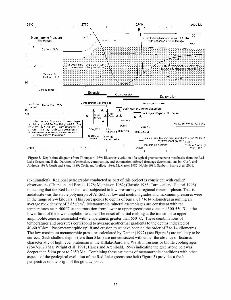
Figure 3. Depth-time diagram (from Thompson 1989) illustrates evolution of a typical greenstone zone metabasite from the RedLake Greenstone Belt. Duration of extension, compression, and exhumation inferred from age determinations by: Corfu andAndrews 1987; Corfu and Stone 1989; Corfu and Wallace 1986; McMaster 1987; Noble 1989; Sanborn-Barrie et al. 2001.
(exhumation). Regional petrography conducted as part of this project is consistent with earlierobservations (Thurston and Breaks 1978; Mathieson 1982; Christie 1986; Tarnocai and Hattori 1996)indicating that the Red Lake belt was subjected to low pressure type regional metamorphism. That is,andalusite was the stable polymorph of Al2SiO5 at low and medium grades and maximum pressures werein the range of 2-4 kilobars. This corresponds to depths of burial of 7 to14 kilometres assuming anaverage rock density of 2.85g/cm3. Metamorphic mineral assemblages are consistent with thetemperatures near 400 ºC at the transition from lower to upper greenstone zone and 500-550 ºC at thelower limit of the lower amphibolite zone. The onset of partial melting at the transition to upperamphibolite zone is associated with temperatures greater than 650 ºC. These combinations oftemperatures and pressures correspond to average geothermal gradients to the depths indicated of40-60 ºC/km. Post-metamorphic uplift and erosion must have been on the order of 7 to 14 kilometres.The low maximum metamorphic pressures calculated by Damer (1997) (see Figure 3) are unlikely to becorrect. Such shallow depths (less than 5 km) are not consistent with either the absence of featurescharacteristic of high level plutonism in the Killala-Baird and Walsh intrusions or biotite cooling ages(2647-2620 Ma; Wright et al. 1991; Hanes and Archibald, 1998) indicating the greenstone belt wasdeeper than 5 km prior to 2650 Ma. Combining these estimates of metamorphic conditions with otheraspects of the geological evolution of the Red Lake greenstone belt (Figure 3) provides a freshperspective on the origin of the gold deposits.
12
METAMORPHISM AND GRANITOIDS
As in many low pressure metamorphic terranes around the world, the abundance of granitoid intrusionshas led to the assumption that the metamorphic pattern in the Red Lake greenstone belt is a contact effectof the intrusions (Andrews et al. 1986; Menard and Pattison 1998; Tarnocai 2000). Similar to thesituation in the Archean Slave Province (Thompson et al. 1995), however, the Red Lake metamorphicdata are consistent with geological and geochronological relationships indicating that at least somegranitoid intrusions are too old or too young to be the heat source for regional metamorphism. Forexample, plutons overlapping in time with deposition of the Confederation assemblage (Douglas Lake –2734 Ma, Corfu and Stone 1998; Red Crest - 2729 Ma, Little Vermillon - 2729 Ma, Corfu and Andrews1987) are clearly too old to be a heat source for belt-scale metamorphic zones that cut across majorstructures in the belt. Furthermore, regional petrography (see Figure 2, in back pocket) indicates that,whereas the Howey metadiorite and the Dome and McKenzie Island stocks (2718 Ma and 2720 Ma,respectively, Corfu and Andrews 1987) have been overprinted by carbonate alteration (Parker 2000) andmetamorphic zonation (see Figure 2, in back pocket). However, some components of the Killala-Bairdbatholith (2704 Ma, Corfu and Andrews 1987) post-date and cut across the metamorphic zones (seeFigure 2, in back pocket). The amphibolite zone rocks east of the Campbell/Goldcorp mines, have beenattributed to contact metamorphism (Andrews et al. 1986) related to the intrusion of the Walsh Lakepluton (2699 Ma, Noble 1989). This pluton is a relatively young component of the Trout Lake batholithand similar in age to the youngest phases of the Killala-Baird batholith. In this report (see Figure 3),granitoids are grouped into three main associations: a) late syn-Confederation assemblage age, pre-orogenic plutons, greater than 2730 Ma; b) early syn-orogenic plutons, 2720-2717 Ma; c) late syn-orogenic plutons, 2704-2699 Ma. Although there is no doubt that these intrusions caused localizedcontact metamorphism in different parts of the belt at different times, it is likely that the Red Lakesupracrustal rocks were already undergoing greenschist grade regional metamorphism when intrusion ofsyn-orogenic granitoids occurred (see Figure 3). Soon after intrusion, early synorogenic granitoids andrelated contact aureoles cooled off and were overtaken by the ongoing low to medium grade regionalmetamorphism (see Figure 2, in back pocket). 15 to 20 million years later contact aureoles related to latesynorogenic intrusions overprinted adjacent regionally metamorphosed supracrustal rocks and earlysynorogenic granitoids that were still quite close to peak metamorphic conditions.
The fact that early syn-orogenic granitoids were probably more competent than surroundingmetamorphosed supracrustal rocks during regional compressional deformation under maximummetamorphic conditions (see Figure 3) may explain the relatively high number of gold mines andoccurrences in and around metagranitoids in the lower greenstone zone (see Figure 2, in back pocket) andthe prominence of carbonate alteration in these rocks (Parker 2000). Presumably, the early synorogenicgranitoids were more likely to develop the fracture systems that formed conduits for mineralizing fluidsgenerated by regional metamorphism and, subsequently, by intrusion of late synorogenic granitoids.
METAMORPHISM AND MAJOR STRUCTURES
This report focuses on the part of the deformational history that began with deposition of theConfederation assemblage in an extensional, presumably ensialic, tectonic setting; followed by horizontalcompression and crustal thickening (orogenesis); and ending with exhumation of metamorphic rocks tothe Earth’s surface (see Figure 3). Hydrothermal metamorphism (alteration) associated with volcanismand synvolcanic felsic porphyries occurred at least twice, once during deposition of pre-ConfederationBalmer, and a second time during deposition of the Confederation assemblage. This type of alterationmay have occurred during other pre-Conferation assemblage volcanic events. The major unconformity at

13
the base of the Confederation assemblage (Sanborn-Barrie et al. 2000) may comprise, in part, fault scarpsformed during extension of underlying crust. Extensional faults would be a likely source conduit for thefluids that caused the hydrothermal metamorphism (alteration) considered by Dubé et al. (2000) andSanborn-Barrie et al. (2000) to be focussed along the unconformity at the Madsen Mine. These earlyrelatively localized hydrothermal metamorphic events provide an explanation for the unusual aluminousmineral assemblages that formed in mafic metavolcanic rocks at Campbell/Goldcorp (Crocket et al. 1981;Penczak 1996) and Madsen (Lavigne et al. 1986) during the much younger, main phase ofmetamorphism.
There is abundant petrographic evidence indicating that main phase metamorphism overlapped intime and space with ductile deformation associated with crustal shortening and thickening (orogenesis).Though relatively rare in the samples used for this study, textural relations between porphyroblasts andplanar/linear fabrics in thin section are consistent with peak metamorphic conditions outlasting the secondphase of ductile deformation described by Dubé et al. (2000) and Sanborn-Barrie et al. (2000). Parker(2000) and Menard and Pattison (1998) came to similar conclusions. These observations are consistentwith the fact that the metamorphic zones cut across the trends of the main foliation (S2) in the west, east,and northeast segments of the greenstone belt (see Figure 2, in back pocket). Orogenesis provides amechanism for transporting and burying volcanic and sedimentary rocks and related intrusions from at ornear the Earth’s surface down to the depths (pressures) and temperatures that produced the observedmetamorphic mineral assemblages in these rocks (see Figure 3). The resulting thickening of the crust tothicknesses of 7 to 14 km greater than normal drives the uplift and erosion that exhumes themetamorphosed greenstone belt back to the surface.
Evidently, Sanborn-Barrie et al. (2000) are not convinced of the existence of the network ofprominent linear deformation zones outlined by previous workers (Lavigne and Crocket 1983; Durocherand Hugon 1983; Andrews et al. 1986). The fact the metamorphic zones cut across these features asillustrated in Andrews et al. (1986) implies that the deformation zones would have formed before orduring the time when peak metamorphic conditions prevailed. Relatively narrow high strain zones mayhave formed in the latter part of D2 when the compressional strain regime changed from homogeneous toheterogeneous and deformation became concentrated in narrow zones. One of the proposed linear arraysof low grade metamorphic anomalies (Hoyles Bay, see Figure 2, in back pocket) coincides with the PostNarrows deformation zone. The northwest-striking “mine trend” which hosts the Cochenour pastproducing and Campbell and Goldcorp mines parallels the upper limit of the lower greenstone zone andlinks the anomalously high metamorphic gradients at Campbell/Goldcorp with the high metamorphicgrade anomaly at Couchenour (see Figure 2, in back pocket). In these areas at least, it appears that alinear/planar feature localized fluid flow relatively late in the regional metamorphic history. Clearly,there is a spatial relation between metamorphic grade, major structures and gold.
METAMORPHIC HISTORY AND THE AGE OF THE AUSTIN “TUFF”
Sanborn-Barrie et al. (2002) conclude that zircons from a pebble metaconglomerate (Austin “Tuff”horizon) at the Madsen Mine (see Figure 2, in back pocket) previously interpreted as “hydrothermalzircons” (Sanborn-Barrie et al. 2001) are, in fact, dating the maximum age of deposition of the rock unitat 2700±6 Ma. The authors suggested further that gold mineralization occurred after this date. Lookingat the problem from the metamorphic perspective provided by this report (see Figure 3), it is more likelythat these young ages are dating the metamorphism of the pebble metaconglomerate. Integration ofmetamorphic data and concepts with evidence of the history of deposition, deformation and plutonism inthe Red Lake greenstone belt, indicates that the rock unit was buried to depths greater than 8 to 10 km atthe time of intrusion of the Killala-Baird and Walsh batholiths (see path a, Figure 3). Cooling ages(Wright et al., 1991; Hanes and Archibald 1998) are consistent with the rocks being deeper than 5 km

14
2640 Ma ago. A special form of elevator tectonics is required to exhume the rocks beneath the pebblemetaconglomerate to the surface, deposit a conglomerate, and rebury the rock units to depths consistentwith its upper transition zone/lower amphibolite zone metamorphic assemblages, and subsequent coolingto 300º C approximately 60 million years later (see path b, Figure 3). Further work is required to evaluatethe potential effects of regional metamorphism on detrital zircons in greenstone belts.
Metamorphism and AlterationMapping and chemical analysis of the products of alteration/hydrothermal metamorphism is widely usedas an exploration tool for gold mineralization in greenstone belts. Metamorphic data and conceptsprovide constraints on the origin, timing, and distribution of altered rocks. Preliminary observations andcomments are presented in this report. Further study of this issue is required.
There is general acceptance of the idea that the hydrothermal alteration event that transformed maficand ultramafic metavolcanic rocks at Campbell/Goldcorp and Madsen into anomalously aluminous rocksoccurred long before the metamorphism that caused the nucleation and growth of chloritoid, staurolite,andalusite, cordierite, and anthophyllite. Under metamorphic temperatures and pressures, these mineralsreplaced the chlorite and clay minerals produced by what was probably a syn-volcanic hydrothermalsystem on or near the sea floor.
Carbonate alteration is more problematic since the origin of the carbonate is uncertain. Rock unitscontaining primary sedimentary or exhalative carbonate occur throughout the belt. The syn-volcanichydrothermal alteration events noted above likely were associated with some carbonate deposition. Lowgrade regional metamorphism of mafic metavolcanic rocks in the presence of a CO2-bearing hydrous fluidproduces carbonate when calcium in igneous plagioclase and clinopyroxene combines with CO2 in thefluid as basalt is transformed to greenstone. Alteration of mafic metamorphic rocks by CO2-bearinghydrous fluids during or soon after the time when peak metamorphic conditions prevailed is common ingreenstone belts. The timing of carbonate alteration of early synorogenic granitoids like the Dome Stockdescribed by Parker (2000) may have occurred at this time in the metarmorphic history of the Red Lakegreenstone belt (see Figure 3). Discrimination between these various possible origins requires detailedmapping and petrographic analysis. Ten percent of the 598 samples used to create the metamorphic mapare included in the rock association that comprises carbonate-rich rocks and their higher grade calc-silicate mineral-rich equivalents (see Rock Association 7, Figure 1, in back pocket). On the basis ofpetrographic observations alone, it appears that carbonate formed by primary, metamorphic, and late syn-metamorphic CO2 alteration processes. In all cases, the carbonate has been recrystallized and variablydeformed. These rocks show a range of metamorphic grade that is consistent with metamorphic zonesbased on other rock associations (see Figure 2, in back pocket). The highest grade diopside-grossulariteassemblages correspond to the occurrences of “skarn” described by Parker (2000). Low grade, intenselydeformed chlorite-carbonate phyllite in the Red Lake greenstone belt is essentially identical to the rocksfound in gold-bearing deformation/alteration zones that occur in many greenstone belts. Regionalpetrography indicates that the belt-scale carbonate alteration zones mapped mainly on the basis of outcropobservations by Parker (2000) are not pervasive through all rock units at outcrop scale. That is, samplesof rock associations adjacent to Rock Association 7 (see Table 1, Appendix 1) are not necessarily affectedby the process. To some extent this reflects the variable reactivity of different rock types and the fact thatalteration may be limited to narrow zones within any given outcrop. Petrography supports Parker’scontention that most of the carbonate alteration is the same age or older than the relatively long periodduring which peak metamorphic conditions persisted (see Figure 3).
15
With respect to biotite alteration, it is interesting that the “biotite domains” outlined by Andrews etal. (Figure 7b, 1986) in the vicinity of East Bay on Red Lake and Balmer Lake occur upgrade of thebiotite isograd (see Figure 2, in back pocket). The biotite observed in carbonate alteration zonesassociated with gold mineralization (Andrews et al. 1986) may be the higher grade metamorphicequivalent of the “sericite”-chlorite carbonate alteration commonly associated with gold mineralization.The question is: is the biotite a product of metamorphism of pre-existing chlorite-“sericite” alteration ordid it form at the same time as the latter but at higher temperatures? Clearly, more work is needed todetermine the origin, timing, and distribution of all types of alteration in the belt.
Metamorphism and Gold ExplorationTwo zone boundaries and the metamorphic anomalies that occur within zones outlined on the newmetamorphic map of the Red Lake greenstone belt (see Figure 2, in back pocket) are prospective for gold.Sample density controlling the location of zone boundaries and the shape and size of metamorphicanomalies, varies considerably across the map area (see Figure 2, in back pocket). More sampling andfurther petrography is required to verify and refine the following observations and comments.
LOWER/UPPER GREENSTONE ZONE BOUNDARY (BIOTITEISOGRAD)
Regional petrographic work in the Eastern Goldfields, Western Australia (Mikucki and Roberts 2003;Hall 1998) and in the Timmins area, Abitibi greenstone belt (Thompson 2002b) indicates that major goldmines occur on or near the boundary between the upper and lower greenstone zone (upper and lowergreenschist facies). In both terranes, the boundary corresponds to the biotite isograd as defined inquartzofeldspathic rocks. The reconnaissance petrographic data presented in this report (see Figures 1and 2 in back pocket; see Tables 1 and 2, in Appendix 1) indicate that of 22 current and past producers inthe Red Lake greenstone belt, 12 occur within 900 m of the biotite isograd (see Figure 2, in back pocket)which is the boundary between the lower and upper greenstone zones. In the absence of knowledge of thedip of the metamorphic zone boundary, true distance is not known. Of these, the two most productivemines, Campbell and Goldcorp are less than 200 m from the isograd. Improving the constraints on thebiotite isograd is a priority for future work. This first attempt to map the feature, however, does indicatethat the biotite isograd is a valid gold exploration target in the Red Lake greenstone belt.
TRANSITION ZONE (GREENSCHIST/AMPHIBOLITE FACIESBOUNDARY)
The boundary between the greenschist and amphibolite facies occurs in the upper part of the transitionzone as defined in metamorphosed basalt/gabbro (see Figure 1 and yellow zone on Figure 2, in backpocket). Four of the past and current producers in the Red Lake greenstone belt occur in or within 200 mof the transition zone as defined in metabasites. The Madsen No. 1 and Red Summit mines occur inlower amphibolite zone rocks close to the boundary with the transition zone. The Gold Corp-Red LakeMine is located on the low-grade side of the lower boundary of the zone. The Madsen ore zones 1 to 8occur in the transition zone (see Figure 2, in back pocket). In the Yellowknife Greenstone Belt (SlaveProvince, northwestern Canadian Shield), the Con-Giant gold deposit straddles the lower boundary of thetransition zone (Thompson, in preparation). In the Eastern Goldfields of Western Australia, severalimportant gold mines are located near a blue-green hornblende isograd (Mikucki and Roberts 2003) that

16
is analogous to the lower grade part of the transition zone in the Red Lake greenstone belt. Once again,keeping in mind the variable quality of control on the location of the transition zone in Figure 2, there isenough evidence from this study to support the idea that this metamorphic zone is prospective for gold.Of particular interest is the new evidence that, east of Madsen, the boundary between the greenschist andamphibolite facies which falls in the upper part of the transition zone (see Figure 1, in back pocket) doesnot trend to the southeast as indicated by Andrews et al. (1986). Rather, the isograd continues northeastand north of Madsen before bending to the northwest about 2000 m southeast of the Goldcorp-Red LakeMine (see Figure 2, in back pocket). This new segment of the transition zone is prospective for gold.Given that major structural zones like the “mine trend” that links Campbell/Goldcorp to Cochenour areprospective for gold, the intersections of deformation zones with either the transition zone or theboundary between the lower and upper greenstone zones (biotite isograd) also merit further attention.
METAMORPHIC ANOMALIES
Isolated occurrences of low metamorphic grade rocks in higher metamorphic grade zones (cold spots), ofhigher metamorphic grade rocks in low grade zones (hot spots), and of steep metamorphic gradients(closely spaced metamorphic zone boundaries) (see Figure 2, in back pocket) are relevant to goldexploration models because they may correspond to zones affected by focussed flow of heat andhydrothermal fluids. “Hot spots” may be related to buried plutons; structural conduits such asintersecting deformation zones or fold hinges; or litho-structural conduits that form at or near contactsbetween rock units of differing competency. Relatively high fluid flow rates and steep temperaturegradients associated with such features are conducive to formation of gold mineralization. The cluster ofgold deposits around the high grade anomaly west of Cochenour (see Figure 2 in back pocket) should bere-evaluated with this concept in mind. High metamorphic grade anomalies should be targeted forintrusive-related and deformation zone-hosted gold deposits.
“Cold spots” develop where the temperature and/or CO2 content of the fluid are not in equilibriumwith the mineral assemblages in adjacent greenstone, transition or amphibolite zone rocks. Commonly,low grade metamorphic anomalies (carbonate-chlorite, carbonate-chlorite-white mica) are attributed torock-fluid interactions that occur along structural conduits after the peak of metamorphism, duringcooling and exhumation. However, the same “low grade” mineral assemblages can form under peakmetamorphic conditions, if the proportion of CO2 in the hot hydrothermal fluid is high enough. The latterexplanation is more likely in geological settings, where hydrothermal fluid production is related to contactor regional metamorphism or to synorogenic intrusions themselves. Low grade metamorphic anomaliessuch as those east and north of Balmer Lake, in the south part of Heyson township and northwest andnorth of Madsen (see Figure 2 in back pocket), therefore, are also prospective for both intrusive- anddeformation zone-related gold deposits.
In the absence of faults extending parallel to metamorphic zonation, closely spaced metamorphiczone boundaries are the products of steep temperature gradients. Rapid changes in temperature and highrates of fluid flow anticipated in such an environment could have significant impact on the composition ofgold mineralizing fluids. In addition to the steep metamorphic gradients associated with metamorphicanomalies, there are segments of the regional metamorphic zonation characterized by closely spacedmetamorphic zone boundaries (see Figure 2 in back pocket). Allowing for the fact that the degree ofcontrol on the locations of the boundaries is variable, the association of the Campbell and Goldcorp mineswith closely spaced isograds indicates further exploration of other areas with steep metamorphic gradientsis worth doing. Of course, if the biotite isograd (lower/upper greenstone zone boundary) and thetransition from greenstone to amphibolite zones are prospective, areas where these features are closetogether are of high interest.

17
LOW GRADE, LOW PRESSURE METAMORPHISM AND GOLD
The Red Lake greenstone belt is another example of the apparent link between low grade, low pressuremetamorphism and gold deposits. Citing Hodgson et al. (1993) and Phillips et al. (1997), Loucks andMavrogenes (1999) suggested that ninety percent of the gold mined from metamorphic terranes aroundthe world was deposited at temperatures and pressures in the range 250-450º C and 1-3 kilobars. That is,deposition occurred under low pressure subgreenschist to greenschist facies metamorphism. The highvalue of ninety percent likely includes gold deposits formed at or near the Earth’s surface during pre-metamorphic synvolcanic magmatic and exhalative processes. Referring to this set of P-T conditions asthe “gold deposition zone” Thompson (1999; in press; 2002b) has explored the potential significance ofthis idea within a dynamic geological setting represented schematically by depth-time diagrams similar toFigure 3. By definition, low pressure type metamorphic terranes (andalusite at medium grade, Miyashiro,1961) are less deeply eroded than medium pressure terranes (kyanite stable at medium grade). Hencegold deposits that formed at relatively shallow depths in the crust during orogenesis are more likely to bepreserved in low pressure metamorphic terranes such as the Red Lake greenstone belt and others exposedin the Archean Superior and Slave provinces of the Canadian Shield and Eastern Goldfields of WesternAustralia. Furthermore, the high average geothermal gradients (40-75º C/km) to depths of 10-15 km thatare characteristic of low pressure regional metamorphic terranes create a relatively thick gold depositionzone in the crust (see Figure 3). Therefore, in a low pressure metamorphic setting such as that preservedin the Red Lake greenstone belt, rocks that end up at or within a kilometre or two of the Earth’s surfacelikely spent tens of millions of years within the P-T range conducive to gold deposition.
Recommendations for Future Work
Based entirely on thin sections obtained from the archives of the Ontario Geological Survey and theGeological Survey of Canada, this study is the first step toward a comprehensive metamorphic frameworkfor gold exploration in the Red Lake greenstone belt. This study builds on and enhances the importantcontributions of previous workers. Further sampling and petrography are required to improve thedefinition of metamorphic zones outlined in this report and to further test the utility of metamorphic dataand concepts as gold exploration tools. Below is a list of outstanding problems that need to be addressed.
• Use sampling and petrography to improve and refine definition of the lower/upper greenstonezone boundary (biotite isograd) in the eastern half of the Red Lake greenstone belt, with emphasison the area northwest and southwest of Cochenour that lies between the three high grademetamorphic anomalies and in the area south and southeast of Campbell/Goldcorp.
• Investigate further the origins of high and low grade metamorphic anomalies and their relation intime and space to gold mineralization.
• Improve definition of the transition zone between the upper greenstone and amphibolite zonesalong the segment between the Madsen and Campbell-Goldcorp mines.
• Integrate the new metamorphic data and concepts presented here with other data sets with theobjective of defining new multi-parameter gold exploration targets.
18
References
Andrews, A.J., 1984, Alteration, metamorphism, and structure associated with Archean volcanic-hosted golddeposits, Red Lake district; In, eds, J. Wood, O.L. White, R.B. Barlow and A.C. Colvine, Summary of FieldWork, 1984, Ontario Geological Survey, Miscellaneous Paper 118, p.162-166.
Andrews, A.J. and Hugon, H., 1985, Alteration, metamorphism and structure associated with Archean volcanic-hosted gold deposits: preliminary observations in the Red Lake district; In, eds, J. Wood, O.L. White, R.B.Barlow and A.C. Colvine, Summary of Field Work and other activities, 1985, Ontario Geological Survey,Miscellaneous Paper 126, p.193-200.
Andrews, A.J., Hugon, H., Durocher, M, Corfu, F., and Lavigne, M.J., 1986, The anatomy of a gold-bearinggreenstone belt, Red Lake, northwestern Ontario, Canada; In, Proceedings of Gold ’86, an InternationalSymposium on the Geology of Gold Deposits, Konsult International Inc., Toronto, p.3-22.
Andrews, A.J. and Wallace, H., 1983, Alteration, metamorphism and structural patterns associated with Archeangold deposits: preliminary observations in the Red Lake area; In The geology of gold in Ontario; OntarioGeological Survey, Miscellaneous Paper 110, p.111-122.
Bruce, E.L., 1924, Geology of the basin of Red Lake, District of Kenora (Patricia portion); Ontario Department ofMines, v.33, pt.4, 43p. Accompanied by map 33e, scale one inch to 1.5 miles.
Bruce, E.L. and Hawley, J.E., 1927, Geology of the basin of Red Lake, District of Kenora (Patricia portion); OntarioDepartment of Mines, v.36, pt.3, p.1-72.
Colvine, A.C., Fyon, J.A., Heather, K.B., Marmont, S., Smith, P.M., and Troop, D.G., 1988, Archean lode golddeposits in Ontario; Ontario Geological Survey, Miscellaneous Paper 139, 136p.
Christie, B.J., 1986, Alteration and gold mineralization associated with a sheeted veinlet zone at the Campbell RedLake Mine; unpublished M.Sc. thesis, Queen’s University, Kingston, Ontario, Canada, 334p.
Corfu, F. and Andrews, A.J., 1987, Geochronological constraints on the timing of magmatism, deformation and goldmineralization in the Red Lake greenstone belt, northwestern Ontario; Canadian Journal of Earth Sciences,v.24, p.1302-1320.
Corfu, F. and Stone, D., 1998, Age, structure and orogenic significance of the Berens River composite batholiths,western Superior Province, Canada; Canadian Journal of Earth Sciences, v. 35, p.1089-1109.
Corfu, F. and Wallace, H., 1986, U-Pb ages for magmatism in the Red Lake greenstone belt, northwestern Ontario,Canadian Journal of Earth Sciences, v. 23, p.27-42.
Crocket, J.H., Cowan, P. and Kusmirski, R.T.M., 1981, Gold content of volcanic-hosted interflow sedimentary rocksin the Red Lake area: implication for ore genesis at the Dickenson Mine; In Genesis of Archean, volcanic-hosted gold deposits; eds., E.G. Pye and R.T. Roberts, Ontario Geological Survey, Miscellaneous Paper 97,p.128-143.
Damer, G.C., 1997, Metamorphism of hydrothermal alteration at the Red Lake Mine, Balmertown, Ontario;unpublished M.Sc. thesis, Queen’s University, Kingston Ontario, Canada, 195p.
Dubé, B., Balmer, W., Sanborn-Barrie, M., Skulski, T., and Parker, J., 2000, A preliminary report on amphibolitefacies, disseminated-replacement-style mineralization at the Madsen gold mine, Red Lake, Ontario; GeologicalSurvey of Canada, Current Research 2000-C17, 12p.
19
Durocher, M. and Burchell, P., 1983, Structural geology, hydrothermal alteration, metamorphism and goldmineralization in the Pipestone Bay–St. Paul deformation zone, Red Lake; In, eds, J. Wood, O.L. White, R.B.Barlow and A.C. Colvine, Summary of Field Work, 1983, Ontario Geological Survey, Miscellaneous Paper116, p.220-223.
Durocher, M. and Hugon, H., 1983, Structural geology and hydrothermal alteration in the Flat Lake–Howey Baydeformation zone, Red Lake area; In, eds., J. Wood, O.L. White, R.B. Barlow and A.C. Colvine, Summary ofField Work, 1983, Ontario Geological Survey, Miscellaneous Paper 116, p.216-219.
Ferguson, S.A., Jarvis, W.L., Hutton, D.A., Watt, A., Delany, J.F., Jefferies, J.D., Riley, R.A., and Grant, F.S., 1972,Some papers on the geology of the Red lake area, District of Kenora, Patricia portion; Ontario Division ofMines, Open File Report 5078, 106p.
Gebre-Mariam, M., Hagemann, S.G. and Groves, D.I. 1995. A classification scheme for epigenetic Archean lode-gold deposits; Mineralium Deposita, Mineral Deposit Letter, v.30, p.408-410.
Hall, G.C., 1998. Autochthonous model for gold metallogenesis and exploration in the Yilgarn; Geodynamics andGold Exploration in the Yilgarn, Workshop Abstracts, Australian Geodynamics Cooperative Research Centre,p.32-35.
Hinz, P., Storey, C.C., Gosselin, S., Blackburn, C.E. and Kosloski, L. 2000. Report of Activities 1999, ResidentGeologist Program, Red Lake Regional Resident Geologist Report: Red Lake and Kenora districts; OntarioGeological Survey, Open File Report 6003, 66p.
Hanes, J.A. and Archibald, D.A. 1998. Post-orogenic tectonothermal history of the Archean Western SuperiorProvince of the Canadian Shield as determined by conventional and laser Ar-Ar dating; In Western SuperiorLithoprobe 1998 Annual Meeting Progress Reports, Technical Communications, and Abstracts, LithoprobeReport #65, p.12-16.
Hodgson, C.J. and MacGeehan, P.J., 1981, Gold ore formation at Campbell and Dickenson mines, Red Lake area;Geoscience Research Grant Program, Summary of Research 1980-81, ed., E.G. Pye, Ontario GeologicalSurvey, Miscellaneous Paper 98, p.132-143.
Hodgson, C.H., Love, D.A., Hamilton, J.V., 1993, Giant mesothermal gold deposits; descriptive characteristics,genetic model, and exploration area selection criteria; In, Whiting, B.H., Hodgson, C.H., and Mason, R. (eds),Giant ore deposits; Special Publication 2, Society of Economic Geologists, p.157-211.
Horwood, H.C., 1945, Geology and mineral deposits of the Red Lake area; Ontario Department of Mines, AnnualReport, 1940, v.49, pt.2, 231p., accompanied by 8 maps.
Kerrich, R., Fryer, B.J., Milner, K.J. and Pierce, M.G., 1981, The geochemistry of gold-bearing chemical sediments,Dickenson Mine, Red Lake, Ontario: a reconnaissance study; Canadian Journal of Earth Sciences, v.18,p.624-637.
Kusmirski, R.T.M., and Crocket, J.H., 1980, Metallogeny of the gold deposits in the Dickenson Mine, Red Lake,north-western Ontario – a preliminary report; In, Current Research, Part B, Geological Survey of Canada,Paper 80-1B, p.135-144.,
Lavigne, M.J. Jr., 1983, Geological, geochemical, and sulphur isotopic investigations of gold mineralization andsulphide facies iron formation at the Dickenson and Campbell Red Lake mines, Red Lake District, Ontario;unpublished M.Sc. thesis, McMaster University, Hamilton Ontario, 282p.
Lavigne, M.J., Hugon, H., Andrews, A.J., and Durocher, M.E., 1986, Gold deposits of the Red Lake district:relationships of gold mineralization to regional deformation and alteration in the Red Lake greenstone belt,Ontario; Gold “86” Symposium, Toronto, Geological Excursions Guidebook, p.167-211.

20
Lichtblau, A., Ravnaas, C., Storey, C. C., Raoul, A., Kosloski, L. and Wilson, S. 2003. Report of Activities 2002,Resident Geologist Program, Red Lake Regional Resident Geologist Report: Red Lake and Kenora Districts;Ontario Geological Survey, Open File Report 6110, 122p.
Loucks, R.R. and Mavrogenes, J.A., 1999, Gold solubility in supercritical hydrothermal brines measured insynthetic fluid inclusions; Science, v.284, p.2159-2163.
MacGeehan, P.J. and Hodgson, C.J., 1982, Environments of gold mineralization in the Campbell Red Lake andDickenson mines, Red Lake district, Ontario; In Geology of Canadian Gold Deposits; eds., R.W. Hodder andW. Petruk, Canadian Institute of Mining and Metallurgy Special Volume 24, p.184-207.
Mathieson, N.A., 1982, Geology and mineralization in the area of the East South “C” ore zone, Dickenson Mine,Red Lake district, northwestern Ontario; unpublished M.Sc. thesis, Queen’s University, Kingston, Ontario,155p.
Mathieson, N.A. and Hodgson, C.J., 1984, Alteration, mineralization and metamorphism in the area of the EastSouth “C” ore zone, 24th level of the Dickenson Mine, Red Lake, northwestern Ontario; Canadian Journal ofEarth Sciences, v.21, p.35-52.
McMaster, N.D., 1987, A preliminary 40Ar/39Ar study of the thermal history and age of gold in the Red Lakegreenstone belt; M.Sc. thesis, University of Toronto, Toronto, Ontario.
Menard, T. and Pattison, D., 1998, Correlation of multiple alteration events with successive tectonic andmetamorphic events in the Red Lake gold belt, northwestern Ontario; In 1998 Western Superior TransectFourth Annual Workshop, Lithoprobe Report 65, Lithoprobe Secretariat, University of British Columbia,Vancouver, British Columbia, p.63-69.
Mikucki, E. J., and Roberts, F. I., 2003, Metamorphic petrography of the Kalgoorlie region, Eastern GoldfieldsGranite-Greenstone Terrane: METPET database: Western Australia Geological Survey, Record 2003/12.
Miyashiro, A., 1961, Evolution of metamorphic belts; Journal of Petrology, v.2, p.277-311.
Mueller, A.G. and Groves, D.I. 1991. The classification of Western Australia greenstone-hosted gold depositsaccording to wall-rock alteration mineral assemblages; Ore Geology Reviews, v.6, p.291-331.
Noble, S.R., 1989, Geology, geochemistry and isotope geology of the Trout Lake Batholith and the Uchi-Confederation Lakes greenstone belt, northwestern Ontario, Canada; unpublished Ph.D. thesis, Universty ofToronto, Toronto, Ontario, 288p.
Panagapko, D.A., Valade, L., Harris, J.R. and Brown, N., 2000, Preliminary release of geoscience data Red Lakegreenstone belt, northwestern Ontario; Geological Survey of Canada, Open File D3751, Ontario GeologicalSurvey Miscellaneous Release—Data 62.
Parker, J.R., 2000, Gold mineralization and wall rock alteration in the Red Lake greenstone belt: a regionalperspective; In Summary of Field Work and Other Activities, Ontario Geological Survey, Open File Report,6032, p.22-1 to 22-27.
Penczak, R.S., 1996, The geological context of alteration and gold mineralization at the Campbell Mine, Red LakeDistrict, Ontario; unpublished M.Sc. thesis, Queen’s University, Kingston, Ontario, 334p.
Penczak, R. S. and Mason, R., 1997, Metamorphosed Archean epithermal gold (Au-As-Sb-Zn-Hg) veinmineralization at the Campbell Mine, northwestern Ontario; Economic Geology, v.92, p.696-719.
Phillips, G.N., Zhou, T., and Powell, R., 1997, Metamorphic temperature variations among Witwatersrandgoldfields; evidence from the pyrophyllite-chloritoid-chlorite mineral assemblage; South African Journal ofGeology, v.100, p.393-404.

21
Pirie, J., 1982, Regional geological setting of gold deposits, eastern Red Lake area, northwestern Ontario; Inproceedings of the CIM Gold Symposium, September 1980, Canadian Institute of Mining and Metallurgy,Special Volume 24, p.171-183.
Rigg, D.M., 1980, Relationships between structure and gold mineralization in Campbell Red Lake and Dickensonmines, Red Lake district, Ontario; unpublished M.Sc. thesis, Queen’s University, Kingston, Ontario, 153p.
Rigg, D.M. and Helmstaedt, H., 1981, Relationships between structure and gold mineralization in Campbell Redlake and Dickenson mines, Red lake area, Ontario; In Genesis of Archean, volcanic-hosted gold deposits; eds.E.G. Pye and R.G. Roberts, Ontario Geological Survey, Miscellaneous Paper 97, p.111-127.
Robert, F. 1995. Quartz-carbonate vein gold; In Geology of Canadian Mineral Deposit Types, Geological Survey ofCanada, Geology of Canada, no.8, p.350-366.
Sanborn-Barrie, M., Skulski, T., and Parker, J.R., 2001, Three hundred million years of tectonic history recorded bythe Red Lake greenstone belt, Ontario; Geological Survey of Canada, Current Research 2001-C19, 14p.
Sanborn-Barrie, M., Skulski, T., Parker, J. and Dubé, B., 2000, Integrated regional analysis of the Red Lakegreenstone belt and its mineral deposits, western Superior Province, Ontario; Geological Survey of Canada,Current Research 2000-C18, 16p.
Sanborn-Barrie, M., Skulski, T., Rayner, N. and Parker, J.R. 2002. 300 my evolution of the Red Lake greenstonebelt, western Superior Province, Ontario: a synthesis of current constraints on volcanism, sedimentation,deformation, metamorphism and gold mineralization; Extended abstract In Institute on Lake Superior Geology48th Annual Meeting, May 12-16, 2002, Kenora Ontario. Proceedings Volume 48, Part 1 – Program andAbstracts, p.43-45.
Tarnocai, C.A., 2000, Gold mineralization at the Campbell Mine, Red Lake greenstone belt, Uchi Subprovince,Ontario; unpublished Ph.D.thesis, University of Ottawa, Ontario, 240p.
Tarnocai, C.A. and Hattori, K., 1996, Gold introduction during peak metamorphism of greenschist-amphibolitegrade at the Campbell Mine, Red Lake greenstone belt, Superior Province of Canada; In Programs andAbstracts, International Geological Congress, Beijing, China, v.2, p.765.
Thompson, P.H., 1989a, An empirical model for metamorphic evolution of the Archean Slave Province andadjacent Thelon Tectonic Zone, northwestern Canadian Shield; In, Daly, J.S., Cliff, R.A., and Yardley, B.W.D.(eds), Evolution of Metamorphic Belts, Geological Society Special Publication 43, p.245-263.
———1989b, Moderate overthickening of thinned sialic crust and the origin of granitic magmatism and regionalmetamorphism in low-pressure/high-temperature terranes; Geology, v.17, p.520-523.
———1999, Metamorphism and the origin of gold deposits in the Yellowknife Greenstone Belt, Interim Report 1 -the first step; unpublished report to Advisory Committee, EXTECH III, 20p., (map, 1:77 519).
———2001, Metamorphism and the origin of gold deposits in the Yellowknife Greenstone Belt, interim progressreport 3, unpublished, EXTECH III Yellowknife Greenstone Belt Project, 63p., 1:50 000 scale map.
———2002a, Metamorphism and the origin of gold deposits in the Yellowknife Greenstone Belt; Interim ProgressReport 4 - Highlights of office and laboratory work to March 2002, report to Advisory Committee, EXTECHIII, 56p., (1:50,000 scale, preliminary metamorphic zone map; mineral assemblage data set).
———2002b, Toward a new metamorphic framework for gold exploration in the Timmins area, Central AbitibiGreenstone Belt; Ontario Geological Survey, Open File, Report 6101, 51 p. (1:50 000 scale map).
Thompson, P.H., Russell, I., Paul, D., Kerswill, J.A., and Froese, E., 1995, Regional geology and mineral potentialof the Winter Lake–Lac de Gras area, central Slave Province, Northwest Territories; In Current Research,1995-C; Geological Survey of Canada., p.107-119.

22
Thurston, P.C. and Breaks, F.W., 1978, Metamorphic and tectonic evolution of the Uchi-English River Subprovince;In Metamorphism in the Canadian Shield, Geological Survey of Canada, Paper 78-10, p.49-62.
Turner, F.J., 1981, Metamorphic Petrology; McGraw-Hill, Toronto, 524p.
Wright, N., Layer, P.W., and York, D., 1991, New insights into thermal history from single grain 40Ar/39Aranalysis of biotite; Earth and Planetary Science Letters, v. 104, p.70-79.

23
Appendix 1
Table 1
Comprehensive data table, showing sample number, location (UTM datum NAD 1927), metamorphicgrade, deformation and alteration of 781 thin sections examined.
Table 2
List of 598 samples depicted on Figure 2 (Metamorphic Map, Red Lake Greenstone Belt, see backpocket), showing sample number, location (UTM datum NAD 1927), and metamorphic grade.

Easting Northing type intensity timing1 76-16-29 438900 5662140 2 22 w2 76-16-36 439245 5662525 1 13 m3 76-16-39 439495 5662760 2 22 m4 76-16-41 439660 5662975 7 72 m5 76-16-49 440830 5662125 1 11 m6 76-16-54 440850 5661965 2 22 n7 76-16-65 445000 5664735 2 22 m8 76-16-68 444885 5665065 5 52 n9 76-16-75 445000 5666000 2 22 m
10 76-16-98 437545 5662150 2 21 m11 76-16-124 442705 5663770 1 12 n12 76-16-126 442670 5663865 1 11 w13 76-16-137 443455 5663890 6 62 w14 76-16-209 437105 5662745 1 12 w15 76-16-212 440830 5664830 1 11 n16 76-16-218 439885 5665060 2 22 w17 76-16-220 440305 5665070 2 22 n18 76-16-222 440450 5665030 5 52 n19 76-16-233 445930 5664685 4 42 m20 76-16-236 446005 5664440 7 72 m21 76-16-238 446165 5664665 2 21 m22 76-16-239 446185 5664570 2 22 m23 76-16-240 446300 5664840 5 52 m24 76-16-242 446350 5664885 4 42 m25 76-16-250 446525 5667270 4 42 i26 76-16-255 446265 5665345 1 11 n27 76-16-257 446210 5665310 1 11 n28 76-16-259 446290 5665230 1 12 n29 76-16-259B 446290 5665230 1 12 n30 76-16-262 438195 5663565 2 22 m31 76-16-272 437150 5664485 2 22 m32 76-16-278 437710 5665150 2 22 m33 76-16-281 437175 5664850 6 62 m34 76-16-284 439355 5664890 2 22 m35 76-16-286 439235 5665485 4 42 m36 76-16-287 439290 5665525 4 42 m37 76-16-293 438610 5666335 4 42 m38 76-16-294 438060 5666725 2 22 m39 76-16-297 437445 5667300 6 62 m40 76-16-319 440610 5664350 1 13 n41 76-16-365 439075 5664435 6 62 n42 76-16-401 438615 5667415 2 22 n43 76-16-402 438550 5667455 2 22 m44 76-16-408 441000 5663920 2 22 w45 76-16-603 437600 5670000 6 62 m46 76-16-609 446590 5669130 2 22 m47 76-16-610 446685 5669475 6 62 m
Table 1. Sample number, location (UTM datum NAD 1927), grade, deformation, alteration, 781 thin sections. See Figure 1 and 2 in back pocket for legend for rock association and metamorphic grade.
AlterationReference Number
Metamorphic Grade
Sample Number
UTM Zone 15 Rock Association Deformation
24

Easting Northing type intensity timingAlterationReference
NumberMetamorphic
GradeSample Number
UTM Zone 15 Rock Association Deformation
48 76-16-611 446685 5669930 6 62 m49 76-16-615 445370 5664520 3 32 n50 76-16-616 445370 5664520 3 32 n51 76-16-617 445370 5664520 3 32 n52 76-16-618 445370 5664520 3 32 w53 76-16-618B 445370 5664520 3 32 w54 76-16-619 445370 5664520 3 32 n55 76-16-620 445370 5664520 3 32 n56 76-16-621 445370 5664520 3 32 n57 76-16-637 443275 5662105 2 21 m58 76-16-638 443245 5662060 7 71 m59 76-16-654 439555 5667505 2 22 m60 76-16-656 439665 5667705 2 22 m61 76-16-659 440210 5667950 2 22 m62 76-16-676 442460 5662045 1 11 n63 76-16-680 443290 5665590 1 12 n64 76-16-683 446420 5666550 1 12 n65 76-16-693 445430 5663645 2 22 m66 76-16-696 446000 5663635 3 31 n67 76-16-723 440070 5665910 4 42 i68 76-16-730 441090 5667275 4 42 i69 76-16-746 440260 5669115 1 13 m70 76-16-771 445070 5661910 3 31 n71 76-16-803 445925 5664940 1 12 w 3 w II72 76-16-817 444785 5661845 1 11 n73 76-16-821 446465 5663950 2 21 w74 76-16-822 446600 5663935 2 22 w75 76-16-825 443910 5662045 7 71 i76 76-16-827 447045 5665095 2 22 m77 76-16-833 445725 5667880 1 12 n78 76-16-911 443550 5662575 4 42 m79 76-16-1002 446850 5665450 2 21 m80 76-16-1004 446965 5665580 2 22 m81 76-16-1005 446970 5665585 2 22 m82 76-16-1006 447365 5666115 2 22 m83 76-16-1007 447455 5666120 2 22 m84 76-16-1008 447525 5666115 4 42 m85 76-16-1009 447525 5666080 5 52 w86 76-16-1011 451130 5665665 1 13 n87 76-16-1014 451920 5664990 7 72 w88 76-16-1015 451885 5664615 1 11 n89 76-16-1017 454035 5669475 1 13 w90 76-16-1022 447795 5666165 2 22 m91 76-16-1023 447720 5666285 5 52 n92 76-16-1024 447725 5666345 2 22 m93 76-16-1026 448245 5666250 1 12 w94 76-16-1027 448740 5666190 1 11 w95 76-16-1029 449405 5656595 5 59 n96 76-16-1031 453375 5657405 1 11 n97 76-16-1035 453605 5657585 7 72 m98 76-16-1036 453885 5658730 3 32 m
25

Easting Northing type intensity timingAlterationReference
NumberMetamorphic
GradeSample Number
UTM Zone 15 Rock Association Deformation
99 76-16-1041 455150 5668225 8 80 n100 76-16-1047 455540 5667785 6 62 n101 76-16-1060 447120 5664895 2 22 m102 76-16-1062 447205 5665270 2 29 m103 76-16-1063 447195 5665245 2 22 m104 76-16-1065 449875 5665945 6 62 w105 76-16-1069 447895 5668905 7 73 m106 76-16-1070 448235 5669695 7 73 n107 76-16-1071 448350 5670160 2 22 m108 76-16-1073 453620 5663955 7 73 m109 76-16-1078 452395 5666135 2 22 m110 76-16-1085 453635 5661495 1 13 m111 76-16-1086 453645 5661575 5 52 n112 76-16-1087 453605 5661895 1 13 n113 76-16-1091 453590 5660650 1 13 m114 76-16-1095 447530 5663800 2 22 m115 76-16-1098 447740 5663925 1 12 w116 76-16-1101 449705 5664040 1 13 w117 76-16-1107 449285 5664150 3 32 n118 76-16-1128 454955 5669145 8 80 n119 76-16-1138 450915 5663270 2 22 w120 76-16-1144 447905 5667730 2 22 w121 76-16-1145 447040 5668150 2 22 w122 76-16-1153 453210 5663265 1 13 w123 76-16-1154 453350 5663305 1 13 n124 76-16-1175 454285 5664995 1 13 m125 76-16-1181 455735 5663400 8 80 n126 76-16-1187 448145 5667005 2 22 m127 76-16-1191 447735 5666790 3 32 n128 76-16-1193 448065 5666735 5 52 w129 76-16-1194 449240 5666135 1 12 w130 76-16-1202 448345 5664220 7 72 w131 76-16-1203 448365 5664055 1 12 w132 76-16-1206 455895 5657335 1 12 w133 76-16-1207 455900 5657335 1 12 w134 76-16-1210 448275 5663740 7 72 m135 76-16-1211 448255 5663625 3 32 n136 76-16-1213 448035 5663410 1 12 m137 76-16-1215 450245 5656165 1 12 n138 76-16-1218 451220 5655505 1 12 w139 76-16-1219 451105 5655430 1 11 n140 76-16-1226 450310 5653735 7 72 w141 76-16-1233 447245 5654710 7 71 w142 76-16-1234 447245 5654710 7 71 n143 76-16-1235 453875 5658590 1 11 w144 76-16-1241 455090 5660345 1 12 n145 76-16-1242 454960 5660190 1 13 w146 76-16-1244 453090 5660175 1 12 n147 76-16-1252 449945 5657630 2 22 w148 76-16-1253 450810 5657770 4 43 w149 76-16-1307 449345 5666320 2 22 m
26

Easting Northing type intensity timingAlterationReference
NumberMetamorphic
GradeSample Number
UTM Zone 15 Rock Association Deformation
150 76-16-1314 449645 5655990 2 21 w151 76-16-1323 449360 5653935 2 22 m152 76-16-1328 453305 5659445 1 13 m153 76-16-1337 455110 5653365 1 13 w154 76-16-1345 453855 5652965 1 12 m155 76-16-1353 452880 5657395 1 12 n156 76-16-1379 451225 5667800 1 13 m157 76-16-1385 449245 5658040 1 13 m158 76-16-1395 448170 5656560 4 42 m159 76-16-1403 448630 5665200 5 52 w160 76-16-1408 451670 5654815 1 13 m161 76-16-1415 450625 5657815 1 13 w162 76-16-1424 448325 5657765 3 31 n163 76-16-1426 448610 5657180 7 72 m164 76-16-1431 449040 5657625 1 11 w165 76-16-1432 449100 5658215 2 22 n166 76-16-1437 448485 5656935 2 21 w167 76-16-1438 448475 5656670 7 72 m168 76-16-1446 447290 5655430 7 71 n 3 m II169 76-16-1448 447505 5655430 2 21 n170 76-16-1458 446765 5652765 1 11 m171 76-16-1477 448005 5656500 1 11 m172 76-16-1478 447030 5656190 2 21 i173 76-16-1485 454890 5652320 1 12 m174 76-16-1508 449510 5656960 1 12 w175 76-16-1604A 446870 5664995 1 12 n176 76-16-1638 446980 5665565 2 29 i177 79-PR-01 440685 5649340 1 13 w178 79-PR-02 441720 5649105 2 22 m179 79-PR-04 440830 5648910 2 22 m180 79-PR-06 440710 5649480 1 11 n181 79-PR-07 441090 5649315 2 22 m182 79-PR-11 439165 5647120 2 22 m183 79-PR-13 438805 5647000 2 22 m184 79-PR-15 440110 5651320 6 62 i185 79-PR-19 439485 5646820 2 22 m186 79-PR-22 439890 5646235 7 73 m187 79-PR-24 440810 5646480 1 13 m188 79-PR-25 440115 5646255 1 13 w189 79-PR-28 441300 5648510 2 22 m190 79-PR-29A 441665 5648420 2 22 m191 79-PR-30 437370 5648000 7 72 m192 79-PR-31 437645 5648010 1 13 m193 79-PR-35 437240 5647290 6 62 m194 79-PR-37 445620 5643240 2 22 w195 79-PR-38 445419 5643220 1 13 i196 79-PR-46 438880 5642885 2 21 m197 79-PR-52 439560 5648890 2 22 w198 79-PR-54 439840 5649195 1 11 n199 79-PR-55 440325 5649790 2 22 m200 79-PR-56 440410 5649885 2 22 i
27

Easting Northing type intensity timingAlterationReference
NumberMetamorphic
GradeSample Number
UTM Zone 15 Rock Association Deformation
201 79-PR-58 440680 5650195 2 22 m202 79-PR-59 440910 5650470 2 29 m203 79-PR-63 438420 5643000 7 72 i204 79-PR-64 438390 5643620 2 22 m205 79-PR-65 438275 5643340 1 13 w206 79-PR-69 442955 5642815 7 73 m207 79-PR-70 442915 5642965 2 22 m208 79-PR-72 442950 5643125 1 11 n209 79-PR-77 442815 5648215 7 73 m210 79-PR-79 442000 5648145 2 22 w211 79-PR-83 437020 5645090 6 62 w212 79-PR-87 444490 5648970 1 11 n213 79-PR-88 444495 5649220 2 22 w214 79-PR-89 444540 5649165 2 22 w215 79-PR-91 440475 5648580 2 22 m216 79-PR-93 440710 5648380 1 12 n217 79-PR-94 440845 5647870 2 22 m218 79-PR-112 437845 5646775 2 22 m219 79-PR-117 437620 5645845 6 62 n220 79-PR-137A 438755 5649020 1 12 n221 79-PR-140A 439250 5648630 1 12 n222 79-PR-140B 439250 5648630 2 22 n223 79-PR-149 440820 5647430 2 22 n224 79-PR-161 437695 5648790 1 12 n225 79-PR-170 438225 5646795 2 22 m226 79-PR-172 438265 5646580 2 22 m227 98JRP0007 414961 5650574 4 43 m 1 i I228 98JRP0007B 414961 5650574 4 43 m 1 i I229 98JRP0007D 414961 5650574 5 52 i230 98JRP0007E 414961 5650574 5 52231 98JRP0007G 414961 5650574 4 43 1 i I232 98JRP0007K 414961 5650574 9 99233 98JRP0007L 414961 5650574 9 99234 98JRP0007N 414961 5650574 1 13235 98JRP0007Q 414961 5650574 1 13236 98JRP0007Y 414961 5650574 1 13237 98JRP0011A 415195 5650607 1 13 m238 98JRP0011J 415195 5650607 1 13239 98JRP0011N 415195 5650607 1 13240 98JRP0011Q 415195 5650607 4 43 1 i I241 98JRP0011U 415195 5650607 4 43 1 i I242 98JRP0011V 415195 5650607 4 43243 98JRP0027B 444450 5649131 2 22244 98JRP0037B 440373 5649758 2 22245 98JRP0042B 440785 5650285 2 22246 98JRP0053B 440184 5648480 2 22247 98JRP0057B 440538 5648092 2 22 m248 98JRP0074B 449533 5647186 2 22249 98JRP0075B 452948 5647040 2 22250 98JRP0078B 411602 5658849 2 22251 98JRP0084B 413623 5658122 2 21
28

Easting Northing type intensity timingAlterationReference
NumberMetamorphic
GradeSample Number
UTM Zone 15 Rock Association Deformation
252 98JRP0086B 413237 5657627 2 22253 98JRP0087B 413769 5656655 2 21254 98JRP0089B 416547 5654893 2 22 i255 98JRP0090B 416817 5654643 2 22257 98JRP0111B 445513 5642805 2 22278 99JRP9188C 444632 5646161 2 22279 99JRP9192B 444235 5646901 2 22280 99JRP9194B 444081 5647166 2 22281 99JRP9195B 444057 5647231 2 22 w282 99JRP9196C 444010 5647316 2 22283 99JRP9198B 443838 5647636 1 13284 99JRP9279C 415899 5648248 7 73 3 i u285 99JRP9294B 416259 5650098 2 22286 99JRP9295B 415664 5649375 1 11287 99JRP9298B 415161 5649249 1 11288 99JRP9306B 414837 5650034 2 22 1 w I289 99JRP9315C 414334 5650570 1 13290 99JRP9320C 415378 5650437 1 12291 99JRP9321B 415312 5650452 1 11292 99JRP9352B 415166 5650288 1 12293 99JRP9356C 415465 5650300 1 11294 99JRP9363B 415458 5649640 4 43295 99JRP9366B 415185 5649640 1 12296 99JRP9371B 435453 5645793 2 22 i297 99JRP9371D 435453 5645793 2 22 m298 99JRP9395B 413701 5651372 2 22299 99JRP9399B 414969 5650571 2 21 m300 99JRP9399C 414969 5650571 1 11 m301 99JRP9411B 426527 5655828 1 11302 99JRP9417B 429068 5655169 7 71 i 3 i III303 99JRP9429B 423779 5654710 1 12304 99JRP9437B 423267 5653189 2 22305 99JRP9444B 423423 5654492 1 13306 99JRP9444D 423423 5654492 2 22 m307 99JRP9480B 426970 5654040 1 13308 99JRP9482B 427000 5654353 1 13309 99JRP9484C 426997 5654171 1 13310 99JRP9485C 427088 5654253 1 22 2 m I311 99JRP9505C 423870 5653493 7 73 3 i I312 99JRP9522D 413525 5656639 1 12313 99JRP9526B 426201 5656094 1 11314 99JRP9537B 424696 5657314 2 22315 99JRP9537F 424696 5657314 6 62 23 m III316 99JRP9551B 421392 5657600 6 61 12 w III317 99JRP9556C 426037 5656411 1 11318 99JRP9557B 426081 5656358 1 11319 99JRP9558B 426263 5656367 1 11320 99JRP9564B 425358 5656604 1 11321 99JRP9584C 420590 5657851 1 12322 99JRP9586B 420525 5657947 1 12 23 w ll323 99JRP9587B 420417 5657940 1 11 2 m i
29

Easting Northing type intensity timingAlterationReference
NumberMetamorphic
GradeSample Number
UTM Zone 15 Rock Association Deformation
324 99JRP9592C 418976 5657592 1 11 i325 99JRP9593D 419328 5657523 2 29 4 w I326 99JRP9611 421526 5657398 2 22 2 w II327 99JRP9613B 419902 5657848 2 22328 99JRP9621B 419847 5657956 2 22 m 2 w II329 99JRP9622B 419814 5657878 2 22330 97JRP9624B 419857 5658073 6 62331 99JRP9627B 419317 5658439 1 13332 99JRP9627D 419317 5658439 4 43 12 m III333 99JRP9627E 419317 5658439 7 71334 99JRP9629B 419808 5658244 1 11335 99JRP9629D 419808 5658244 2 29336 99JRP9629F 419808 5658244 2 22337 99JRP9629L 419808 5658244 7 72338 99JRP9634B 420618 5657441 2 29 m339 99JRP9642B 419519 5655807 2 21340 99JRP9642D 419519 5655807 3 31341 99JRP9644B 421193 5656240 2 21342 99JRP9649C 421078 5656153 2 21343 99JRP9650B 421029 5656060 2 21344 99JRP9663B 430205 5658252 2 22 m345 99JRP9669B 431180 5657897 1 12346 99JRP9671E 431309 5657904 1 13347 99JRP9682B 414487 5653964 7 71 m 3 m II348 99JRP9689B 417358 5654180 2 29 m349 99JRP9689D 417358 5654180 2 29350 99JRP9690B 417521 5654290 6 62 2 m II351 99JRP9696D 433567 5658820 2 22352 99JRP9696F 433567 5658820 2 22353 99JRP9700B 433597 5658956 2 22354 99JRP9701B 437048 5661410 2 22355 99JRP9702C 436531 5660415 2 22356 99JRP9708B 411655 5656013 2 22 m357 99JRP9736B 412782 5655025 1 12 m358 00JRP8020B 435903 5651021 7 71 w 3 i u359 00JRP8028B 436339 5650937 7 72 i 23 i u360 00JRP8035B 444825 5657929 7 71 i 2 i u361 00JRP8036B 444864 5658116 6 62362 00JRP8038B 444952 5658086 1 11 w 12 i u363 00JRP8058B 445293 5659748 7 71 i 13 i u364 00JRP8060B 445338 5659799 2 21 i 4 w I365 00JRP8060D 445338 5659799 7 71 3 m u366 00JRP8064B 445036 5660224 1 11 13 i II367 00JRP8068B 444538 5660423 7 71 m 13 i u368 00JRP8071B 443640 5658461 7 71 m 13 i u369 00JRP8072B 443703 5658411 2 29370 00JRP8072D 443703 5658411 2 21 m 245 i u371 00JRP8072F 443703 5658411 2 21 245 i u372 00JRP8072H 443703 5658411 7 71 m 123 i u373 00JRP8073B 443737 5658394 7 71 m 123 i u374 00JRP8073D 443737 5658394 2 21 25 i u
30

Easting Northing type intensity timingAlterationReference
NumberMetamorphic
GradeSample Number
UTM Zone 15 Rock Association Deformation
375 00JRP8076B 443890 5658513 7 71 235 i u376 00JRP8077B 444017 5658554 7 71 i 125 i u377 00JRP8092B 444495 5661078 1 12378 00JRP8093B 446297 5652424 1 13379 00JRP8097B 446435 5652858 1 12380 00JRP8105B 446420 5653117 2 22 i381 00JRP8107B 446145 5653457 1 12 m382 00JRP8108B 445996 5653009 2 22383 00JRP8108D 445912 5653113 2 22384 00JRP8111B 434029 5647419 1 12 i385 00JRP8135B 445764 5661019 2 29 m 4 w i386 00JRP8157B 447723 5663943 1 12 m387 00JRP8164B 446602 5662214 7 72 13 i u388 00JRP8168B 447010 5659422 7 72389 00JRP8174B 448844 5660444 2 22 i 123 m II390 00JRP8176B 449365 5660655 1 13391 00JRP8182B 450871 5663043 2 22392 00JRP8199A 455412 5659897 1 13393 00JRP8199B 455412 5659897 1 13394 00JRP8201B 456208 5659938 8 80395 00JRP8202B 456763 5661908 8 80396 00JRP8204B 456763 5662980 8 80397 00JRP8205B 451113 5658445 1 13398 00JRP8213B 452055 5659175 4 43399 00JRP8214B 452114 5659125 4 43400 00JRP8214C 452114 5659125 4 43 i401 00JRP8218B 451356 5665712 1 13 m402 00JRP8220B 451329 5665845 3 32403 00JRP8220C 451329 5665845 7 73 34 i I404 00JRP8220D 451329 5665845 7 73 3 i I405 00JRP8227B 455324 5670180 4 43 m 1 i I406 00JRP8227C 455324 5670180 5 52407 00JRP8230A 456049 5671017 5 52408 00JRP8232A 450972 5654802 2 22409 00JRP8232B 450972 5654802 2 22410 00JRP8243B 452613 5654126 1 13 i411 00JRP8246B 445264 5654297 1 11 123 m u412 00JRP8247B 445481 5654269 5 22 m413 00JRP8248B 446417 5654392 1 11 13 m u414 00JRP8249B 449363 5663965 7 79 m 3 i u415 00JRP8250B 449426 5664088 5 52416 00JRP8251B 449552 5664091 7 72 3 i I417 00JRP8252B 449319 5663952 7 72418 00JRP8252D 449319 5663952 7 72 3 m u419 00JRP8256B 447173 5664982 7 72 m 23 m u420 00JRP8257B 446177 5664632 2 21421 00JRP8259B 445456 5664771 7 72 23 m u422 00JRP8276B 441798 5661042 1 11423 00JRP8284B 440865 5660402 2 21 m424 00JRP8286B 440491 5660529 7 71 m 3 i u425 00JRP8287B 440425 5660628 5 22 i 13 i u
31

Easting Northing type intensity timingAlterationReference
NumberMetamorphic
GradeSample Number
UTM Zone 15 Rock Association Deformation
426 00JRP8288B 439930 5660316 2 21 i 13 i u427 00JPR8291B 441509 5660379 2 21428 00JRP8291D 441509 5660379 2 22 i 13 i u429 00JRP8292B 441605 5660289 2 21430 00JRP8306B 447995 5653149 2 21431 00JRP8307B 447854 5652906 1 12432 00JRP8308B 447784 5652787 1 13433 00JRP8320C 442057 5660187 7 72 3 i u434 00JRP8322C 442274 5660276 2 29435 00JRP8322F 442274 5660276 2 22436 00JRP8334B 443576 5659687 2 29437 00JRP8346B 443391 5658751 4 43 1 m I438 00JRP8348B 443088 5658674 4 43 5 m u439 00JRP8355B 446171 5653635 7 71 13 m u440 00JRP8358B 442883 5654250 6 29 i441 00JRP8358D 442883 5654250 6 61 i 123 w u442 00JRP8370B 433882 5655139 7 73 3 i u443 00JRP8371B 434027 5655246 7 73 3 i u444 00JRP8372B 434146 5654572 6 62445 00JRP8376B 428911 5653504 2 22446 00JRP8378 428179 5653689 7 72 3 i u447 00JRP8379 430848 5653410 1 11 cb cht448 00JRP8391B 427580 5653583 8 80449 00JRP8392B 428113 5653688 1 12 3 m u450 00JRP8392C 428113 5653688 1 12 3 i u451 00JRP8397B 428919 5653582 7 72 3 i u452 00JRP8401B 421156 5652913 8 80453 00JRP8402 419694 5653256 1 12 2 w I454 00JRP8406C 422322 5655459 5 52455 00JRP8408B 421083 5653316 7 73 3 i u456 00JRP8417B 438119 5663016 2 22457 00JRP8426B 446942 5654463 1 11 m458 00JRP8427D 415310 5650466 3 32459 00JRP8427F 415310 5650466 3 32460 00JRP8427H 415310 5650466 3 32461 00JRP8427J 415310 5650466 1 12462 00JRP8428B 415378 5650637 3 32463 00JRP8428D 415378 5650637 3 32464 00JRP8429B 414844 5651034 3 32 i465 00JRP8429D 414844 5651034 3 32466 00JRP8429F 414844 5651034 1 12467 00JRP8429H 414844 5651034 1 12468 00JRP8431 447275 5655352 7 71 m 13 i u469 00JRP8431B 447275 5655352 7 71 123 i u470 00JRP8431D 447275 5655352 7 71 23 i u471 00JRP8432B 443567 5656683 4 41 1 m I472 00JRP8432D 443567 5656683 4 41 14 m I473 00JRP8434B 443648 5657384 2 21474 00JRP8434C 443648 5657384 2 29475 00JRP8455B 448057 5657348 2 21476 00JRP8455D 448057 5657348 2 21
32

Easting Northing type intensity timingAlterationReference
NumberMetamorphic
GradeSample Number
UTM Zone 15 Rock Association Deformation
477 00JRP8455F 448057 5657348 2 22 m478 00JRP8455H 448057 5657348 1 11479 00JRP8455J 448057 5657348 1 11480 00JRP8455L 448057 5657348 1 11481 00JRP8455N 448057 5657348 1 11482 00JRP8455P 448057 5657348 2 22483 00JRP8456B 448156 5656542 4 41 1 i I484 00JRP8456C 448156 5656542 4 41 1 i I485 00JRP8457B 448531 5655290 7 72 3 i u486 00JRP8459B 448643 5655240 1 11 3 w u487 00JRP8461B 448472 5656729 7 72 i 123 i u488 00JRP8461D 448472 5656729 7 71 m 123 i u489 00JRP8462B 448487 5656864 2 21 12 w u490 00JRP8462E 448487 5656864 4 41 m cb491 00JRP8462G 448487 5656864 4 41492 00JRP8462I 448487 5656864 7 72 i 13 i u493 00JRP8468B 449332 5658263 2 22 m494 00JRP8477B 450372 5657621 2 22 m495 00JRP8477C 450372 5657621 1 13 m496 00JRP8481B 450276 5657569 2 22497 00JRP8485B 448789 5661247 2 22 m498 00JRP8485D 448789 5661247 7 72 m 23 i u499 00JRP8485F 448789 5661247 7 79 3 i u500 00JRP8485G 448789 5661247 7 72 23 i u501 00JRP8485H 448789 5661247 7 72 3 i u502 00JRP8485I 448789 5661247 7 72 23 i u503 00JRP8485J 448789 5661247 7 72 23 i u504 00JRP8486B 447350 5655480 2 21505 00JRP8486D 447350 5655480 2 21506 00JRP8492B 442814 5657353 2 21507 00JRP8492D 442814 5657353 5 51508 00JRP8492E 442814 5657353 5 51509 00JRP9265 416328 5648723 6 62510 00JRP9279A 415899 5648248 7 73 3 i I511 00JRP9279B 415899 5648248 7 73 3 i I512 00JRP9280A 416382 5648778 7 73 3 i I513 00JRP9280B 416382 5648778 7 73 3 i I514 00JRP9280C 416382 5648778 1 13515 00JRP9438 423252 5653131 1 12 3 m I516 00JRP9453B 422899 5652596 7 43 3 i I517 00JRP9742B 430632 564445 6 62518 00JRP9743B 430588 5646744 6 69519 00JRP9746B 428808 5646673 6 62520 00JRP9748B 428818 5644499 8 80521 00JRP9749B 425794 5646477 8 80522 00JRP9750B 421805 5647862 8 80523 00JRP9751B 419812 5649498 8 80524 00JRP9752B 415352 5646347 8 80525 00JRP9756B 439805 5650612 2 29 i 4 m I526 00JRP9756D 439805 5650612 2 29 4 m I527 00JRP9756F 439805 5650612 6 62 12 w II
33

Easting Northing type intensity timingAlterationReference
NumberMetamorphic
GradeSample Number
UTM Zone 15 Rock Association Deformation
528 00JRP9756H 439805 5650612 7 71 i 13 i u529 00JRP9756J 439805 5650612 7 71 i 13 i u530 00JRP9758B 440346 5650457 7 71 13 i u531 00JRP9759B 434674 5645258 1 13532 00JRP9761B 434254 5645076 1 13533 00JRP9766B 434491 5644403 6 62 1 w III534 00JRP9767B 434473 5644527 1 13535 00JRP9768B 434330 5644375 1 13 1 w III536 00JRP9771B 439862 5652414 2 21537 00JRP9772B 439689 5652323 2 22538 00JRP9772C 439689 5652323 2 22539 00JRP9773B 439520 5652450 6 61540 00JRP9774B 439262 5652204 6 61541 00JRP9775B 439166 5652101 6 62542 00JRP9776B 438925 5651865 6 62543 00JRP9776D 438925 5651865 6 62544 00JRP9781B 437552 5645905 6 62545 00JRP9782B 436981 5645871 1 13546 00JRP9786B 436246 5645133 8 80547 00JRP9789B 436228 5644386 6 22548 00JRP9790B 436560 5645088 8 80549 00JRP9793B 434160 5644892 1 12550 00JRP9793D 434160 5644892 1 13551 00JRP9793I 434160 5644892 2 22552 00JRP9793J 434160 5644892 7 72553 00JRP9793K 434160 5644892 9 92 4 i u554 00JRP9794B 434734 5646158 3 32555 00JRP9794D 434734 5646158 1 13 m556 00JRP9794F 434734 5646158 4 43557 00JRP9794H 434734 5646158 7 73 3 i I558 00JRP9794K 434734 5646158 1 13559 00JRP9794L 434734 5646158 7 43 3 i I560 00JRP9794M 434734 5646158 1 13 3 i I561 00JRP9794N 434734 5646158 1 12562 00JRP9794O 434734 5646158 7 73 3 i I563 00JRP9794P 434734 5646158 1 13 3 i I564 00JRP9796B 434767 5646232 1 13565 00JRP9797B 434779 5646449 3 32566 00JRP9800B 433512 5644246 7 73 3 i I567 00JRP9801B 435837 5645517 2 22568 00JRP9813B 438177 5649338 1 12 m569 00JRP9815B 438470 5649500 1 12 i570 00JRP9837B 434050 5645506 3 32571 00JRP9839B 433138 5646329 8 80572 00JRP9842B 432599 5646092 8 80573 00JRP9847B 434337 5646469 3 32574 00JRP9848B 434529 5646606 3 31575 00JRP9850B 434589 5647019 3 32576 00JRP9853B 433996 5646934 1 13577 00JRP9853C 433996 5646934 1 13 m 4 w I578 00JRP9853D 433996 5646934 1 13 4 w 1
34

Easting Northing type intensity timingAlterationReference
NumberMetamorphic
GradeSample Number
UTM Zone 15 Rock Association Deformation
579 00JRP9857B 435105 5645822 1 43 1 i I580 00JRP9860B 435262 5645987 1 43 1 i I581 00JRP9862B 435371 5646217 3 32 i 1 m III582 00JRP9867B 444243 5650454 1 11583 00JRP9869B 445246 5650711 1 12584 00JRP9870B 446066 5650979 6 61 i 12 w II585 00JRP9871B 446200 5651090 6 61 i 12 w II586 00JRP9874B 446259 5651345 6 61 12 w II587 00JRP9874C 446259 5651345 9 99 45 i u588 00JRP9884B 454167 5670897 2 22589 00JRP9888B 451896 5666632 1 13 i590 00JRP9892 434886 5647929 3 32591 00JRP9898B 433952 5646876 1 13 m592 00JRP9899B 434075 5646920 3 31593 00JRP9901B 433848 5647564 1 13 m594 00JRP9915B 433784 5647305 1 13595 00JRP9929B 435014 5649548 2 22596 00JRP9929C 435014 5649548 2 22 45 i III597 00JRP9934B 435529 5649811 2 22598 00JRP9935D 435598 5649908 2 29599 00JRP9939B 435914 5650089 1 12600 00JRP9943B 434683 5649164 3 31601 00JRP9945B 433232 5651045 2 21602 00JRP9945D 433232 5651045 4 42 1 i I603 00JRP9946 433168 5650957 7 72 3 i u604 00JRP9969B 448937 5661178 1 12 m605 00JRP9969D 448937 5661178 1 12606 00JRP9970C 448709 5661276 2 12607 00JRP9970E 448709 5661276 1 12608 00JRP9970F 448709 5661276 1 12609 00JRP9970G 448709 5661276 5 52610 00JRP9970H 448709 5661276 5 52611 00JRP9970I 448709 5661276 5 12612 00JRP9970J 448709 5661276 5 12613 00JRP9978 448713 5662066 1 13614 00JRP9988B 447566 5661452 1 11 i 1 m u615 00JRP9988D 447566 5661452 2 22616 00JRP9998B 433248 5651687 1 11617 SNB-99-1001 433274 5654316 3 31618 SNB-99-1002 430626 5654389 3 31619 SNB-99-1003 427507 5655386 2 21 m620 SNB-99-1007B 445087 5664309 1 11621 SNB-99-1008H 445389 5664482 1 11622 SNB-99-1008L-1A 445389 5664482 3 32623 SNB-99-1008L-1B 445389 5664482 3 32624 SNB-99-1008L-2B 445389 5664482 3 32625 SNB-99-1008L-3A 445389 5664482 3 32626 SNB-99-1008L-3B 445389 5664482 3 32 i627 SNB-99-1008L-4A 445389 5664482 3 32628 SNB-99-1008L-5B 445389 5664482 3 32629 SNB-99-1010 432605 5654554 1 11
35

Easting Northing type intensity timingAlterationReference
NumberMetamorphic
GradeSample Number
UTM Zone 15 Rock Association Deformation
630 SNB-99-1021B 433960 5657523 1 12 w631 SNB-99-1022 434672 5656233 2 21 m632 SNB-99-1038A 440054 5649505 2 22 i 4 w I633 SNB-99-1039A 440146 5649335 1 13 2 w I634 SNB-99-1041 436019 5646040 1 13 w635 SNB-99-1045 436212 5646290 1 13 m 3 w I636 SNB-99-1047 434751 5647059 3 32637 SNB-99-1048 434612 5646812 3 32638 SNB-99-1049 434328 5646513 3 32639 SNB-99-1051 433909 5646975 1 13 m640 SNB-99-1055 417586 5653917 1 12641 SNB-99-1056 417240 5654269 4 41 4 w I642 SNB-99-1060 416804 5659306 1 13643 SNB-99-1073 418983 5654376 2 29644 SNB-99-1082 416558 5658579 3 31645 SNB-99-1083B 416381 5657450 3 31646 SNB-99-1086 437789 5651357 1 12 647 SNB-99-1087 435367 5651134 7 72 m 123 m u648 SNB-99-1091 434278 5650158 1 11 3 w u649 SNB-99-1097 439742 5654916 6 62650 SNB-99-1106 444118 5654588 1 11651 SNB-99-1110A 446917 5654474 1 11 3 m u652 SNB-99-1110C 446917 5654474 1 11653 SNB-99-1113 451129 5658453 2 22 m564 SNB-99-1119A 448117 5670329 2 22 m655 SNB-99-1123 443639 5668763 6 62 i656 SNB-99-1128 438717 5667592 6 62657 SNB-99-1134 429330 5657872 1 13658 SNB-99-1139 424106 5657569 1 13659 SNB-99-1141 446179 5665224 1 13660 SNB-99-1142A 445903 5664918 1 13661 SNB-99-1143A 445410 5664533 3 32662 SNB-99-1144 446267 5664723 7 72 i 23 m u663 SNB-99-1146A 447008 5665567 2 29 i664 SNB-99-1151A 448754 5666175 1 13 m665 SNB-99-1153 449076 5666205 1 13 i 3 w II666 SNB-99-1156 449588 5666856 1 13 i667 SNB-99-1160 452998 5669293 2 22 m668 SNB-99-1166 443621 5656729 2 21 m669 SNB-99-1169C 442763 5657372 1 11670 SNB-99-1169D 442763 5657372 1 11671 SNB-99-1169E 442763 5657372 2 21 m672 SNB-99-1175 444582 5656393 1 11673 SNB-99-1176 444497 5656475 2 21674 SNB-99-1180 451011 5658331 1 11 m675 SNB-99-1181 453102 5660340 1 12 m676 SNB-99-1184 415036 5651913 1 11677 SNB-99-1187B 414652 5651579 2 21678 SNB-99-1188 414529 5651514 1 12679 SNB-99-1190 447550 5655250 2 29680 SNB-99-1192 410606 5658672 1 12 i
36
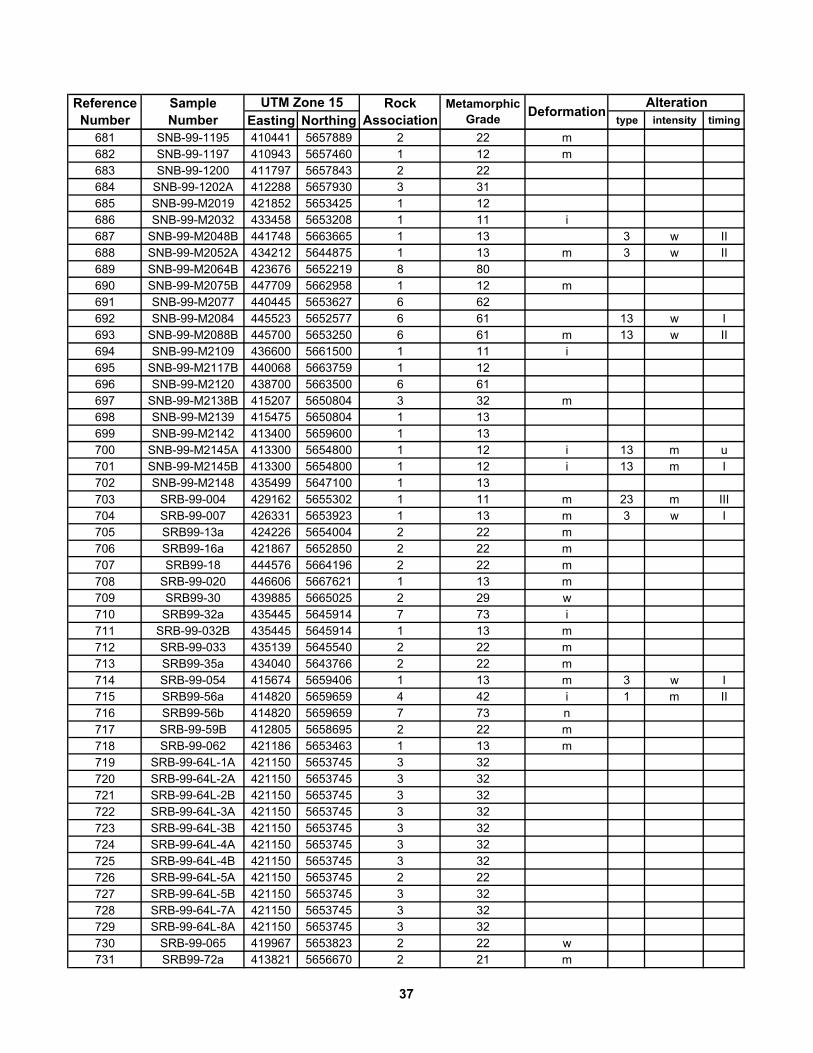
Easting Northing type intensity timingAlterationReference
NumberMetamorphic
GradeSample Number
UTM Zone 15 Rock Association Deformation
681 SNB-99-1195 410441 5657889 2 22 m682 SNB-99-1197 410943 5657460 1 12 m683 SNB-99-1200 411797 5657843 2 22684 SNB-99-1202A 412288 5657930 3 31685 SNB-99-M2019 421852 5653425 1 12686 SNB-99-M2032 433458 5653208 1 11 i687 SNB-99-M2048B 441748 5663665 1 13 3 w II688 SNB-99-M2052A 434212 5644875 1 13 m 3 w II689 SNB-99-M2064B 423676 5652219 8 80690 SNB-99-M2075B 447709 5662958 1 12 m691 SNB-99-M2077 440445 5653627 6 62692 SNB-99-M2084 445523 5652577 6 61 13 w I693 SNB-99-M2088B 445700 5653250 6 61 m 13 w II694 SNB-99-M2109 436600 5661500 1 11 i695 SNB-99-M2117B 440068 5663759 1 12696 SNB-99-M2120 438700 5663500 6 61697 SNB-99-M2138B 415207 5650804 3 32 m698 SNB-99-M2139 415475 5650804 1 13699 SNB-99-M2142 413400 5659600 1 13700 SNB-99-M2145A 413300 5654800 1 12 i 13 m u701 SNB-99-M2145B 413300 5654800 1 12 i 13 m I702 SNB-99-M2148 435499 5647100 1 13703 SRB-99-004 429162 5655302 1 11 m 23 m III704 SRB-99-007 426331 5653923 1 13 m 3 w I705 SRB99-13a 424226 5654004 2 22 m706 SRB99-16a 421867 5652850 2 22 m707 SRB99-18 444576 5664196 2 22 m708 SRB-99-020 446606 5667621 1 13 m709 SRB99-30 439885 5665025 2 29 w710 SRB99-32a 435445 5645914 7 73 i711 SRB-99-032B 435445 5645914 1 13 m712 SRB-99-033 435139 5645540 2 22 m713 SRB99-35a 434040 5643766 2 22 m714 SRB-99-054 415674 5659406 1 13 m 3 w I715 SRB99-56a 414820 5659659 4 42 i 1 m II716 SRB99-56b 414820 5659659 7 73 n717 SRB-99-59B 412805 5658695 2 22 m718 SRB-99-062 421186 5653463 1 13 m719 SRB-99-64L-1A 421150 5653745 3 32720 SRB-99-64L-2A 421150 5653745 3 32721 SRB-99-64L-2B 421150 5653745 3 32722 SRB-99-64L-3A 421150 5653745 3 32723 SRB-99-64L-3B 421150 5653745 3 32724 SRB-99-64L-4A 421150 5653745 3 32725 SRB-99-64L-4B 421150 5653745 3 32726 SRB-99-64L-5A 421150 5653745 2 22727 SRB-99-64L-5B 421150 5653745 3 32728 SRB-99-64L-7A 421150 5653745 3 32729 SRB-99-64L-8A 421150 5653745 3 32730 SRB-99-065 419967 5653823 2 22 w731 SRB99-72a 413821 5656670 2 21 m
37
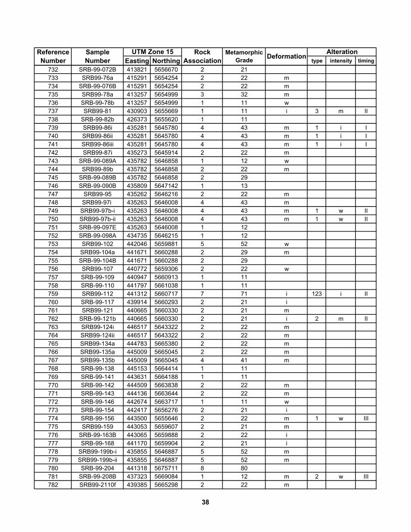
Easting Northing type intensity timingAlterationReference
NumberMetamorphic
GradeSample Number
UTM Zone 15 Rock Association Deformation
732 SRB-99-072B 413821 5656670 2 21733 SRB99-76a 415291 5654254 2 22 m734 SRB-99-076B 415291 5654254 2 22 m735 SRB99-78a 413257 5654999 3 32 m736 SRB-99-78b 413257 5654999 1 11 w737 SRB99-81 430903 5655669 1 11 i 3 m II738 SRB-99-82b 426373 5655620 1 11739 SRB99-86i 435281 5645780 4 43 m 1 i I740 SRB99-86ii 435281 5645780 4 43 m 1 i I741 SRB99-86iii 435281 5645780 4 43 m 1 i I742 SRB99-87i 435273 5645914 2 22 m743 SRB-99-089A 435782 5646858 1 12 w744 SRB99-89b 435782 5646858 2 22 m745 SRB-99-089B 435782 5646858 2 29746 SRB-99-090B 435809 5647142 1 13747 SRB99-95 435262 5646216 2 22 m748 SRB99-97i 435263 5646008 4 43 m749 SRB99-97b-i 435263 5646008 4 43 m 1 w II750 SRB99-97b-ii 435263 5646008 4 43 m 1 w II751 SRB-99-097E 435263 5646008 1 12752 SRB-99-098A 434735 5646215 1 12753 SRB99-102 442046 5659881 5 52 w754 SRB99-104a 441671 5660288 2 29 m755 SRB-99-104B 441671 5660288 2 29756 SRB99-107 440772 5659306 2 22 w757 SRB-99-109 440947 5660913 1 11758 SRB-99-110 441797 5661038 1 11759 SRB99-112 441312 5660717 7 71 i 123 i II760 SRB-99-117 439914 5660293 2 21 i761 SRB99-121 440665 5660330 2 21 m762 SRB-99-121b 440665 5660330 2 21 i 2 m II763 SRB99-124i 446517 5643322 2 22 m764 SRB99-124ii 446517 5643322 2 22 m765 SRB99-134a 444783 5665380 2 22 m766 SRB99-135a 445009 5665045 2 22 m767 SRB99-135b 445009 5665045 4 41 m768 SRB-99-138 445153 5664414 1 11769 SRB-99-141 443631 5664188 1 11770 SRB-99-142 444509 5663838 2 22 m771 SRB-99-143 444136 5663644 2 22 m772 SRB-99-146 442674 5663717 1 11 w773 SRB-99-154 442417 5656276 2 21 i774 SRB-99-156 443500 5655646 2 22 m 1 w III775 SRB99-159 443053 5659607 2 21 m776 SRB-99-163B 443065 5659888 2 22 i777 SRB-99-168 441170 5659904 2 21 i778 SRB99-199b-i 435855 5646887 5 52 m779 SRB99-199b-ii 435855 5646887 5 52 m780 SRB-99-204 441318 5675711 8 80781 SRB-99-208B 437323 5669084 1 12 m 2 w III782 SRB99-2110f 439385 5665298 2 22 m
38

Easting Northing type intensity timingAlterationReference
NumberMetamorphic
GradeSample Number
UTM Zone 15 Rock Association Deformation
783 SRB99-2110g 439385 5665298 2 22 m784 SRB00-4006i 416083 5649028 5 52 w785 SRB00-4006ii 416083 5649028 5 52 m786 SRB00-4037b 459291 5648378 2 22 m787 SRB00-4067f 449836 5653482 2 22 m788 SRB00-4065L-1A 419967 5653823 2 21789 SRB00-4065L-2A 419967 5653823 2 21790 SRB00-4065L-3A 419967 5653823 2 22791 SRB00-4065L-3B 419967 5653823 7 71 13 i u792 SRB00-4065L-4A 419967 5653823 2 22793 SRB00-4089 419814 5657942 7 73 m794 SRB00-4092 423149 5657802 1 12 n795 SRB00-4101b 443491 5659351 2 21 m796 SRB00-4116c 441525 5660464 7 71 i797 SRB00-4123 415803 5651825 1 11 n798 SRB00-4124b 415559 5651953 7 72 m799 SRB00-4129b 424560 5654688 1 11 m800 SRB00-4134a 421393 5655104 2 21 w801 SRB00-4134b 421393 5655104 2 21 m802 SRB00-4136 417403 5654183 2 29 m
39

Easting Northing1 76-16-29 438900 5662140 2 222 76-16-36 439245 5662525 1 133 76-16-39 439495 5662760 2 224 76-16-41 439660 5662975 7 725 76-16-49 440830 5662125 1 116 76-16-54 440850 5661965 2 227 76-16-65 445000 5664735 2 228 76-16-68 444885 5665065 5 529 76-16-75 445000 5666000 2 2210 76-16-98 437545 5662150 2 2111 76-16-124 442705 5663770 1 1212 76-16-126 442670 5663865 1 1113 76-16-137 443455 5663890 6 6214 76-16-209 437105 5662745 1 1215 76-16-212 440830 5664830 1 1116 76-16-218 439885 5665060 2 2217 76-16-220 440305 5665070 2 2218 76-16-222 440450 5665030 5 5219 76-16-233 445930 5664685 4 4220 76-16-236 446005 5664440 7 7221 76-16-238 446165 5664665 2 2122 76-16-239 446185 5664570 2 2223 76-16-240 446300 5664840 5 5224 76-16-242 446350 5664885 4 4225 76-16-250 446525 5667270 4 4226 76-16-255 446265 5665345 1 1127 76-16-257 446210 5665310 1 1128 76-16-259 446290 5665230 1 1230 76-16-262 438195 5663565 2 2231 76-16-272 437150 5664485 2 2232 76-16-278 437710 5665150 2 2233 76-16-281 437175 5664850 6 6234 76-16-284 439355 5664890 2 2235 76-16-286 439235 5665485 4 4236 76-16-287 439290 5665525 4 4237 76-16-293 438610 5666335 4 4238 76-16-294 438060 5666725 2 2239 76-16-297 437445 5667300 6 6240 76-16-319 440610 5664350 1 1341 76-16-365 439075 5664435 6 6242 76-16-401 438615 5667415 2 2243 76-16-402 438550 5667455 2 2244 76-16-408 441000 5663920 2 2245 76-16-603 437600 5670000 6 6246 76-16-609 446590 5669130 2 2247 76-16-610 446685 5669475 6 6248 76-16-611 446685 5669930 6 62
Table 2. Sample number, location (UTM datum NAD 1927), grade, 598 thin sections (indicated in Figure 2, back pocket). Gaps in reference numbers represent samples listed in Table 1 that were omitted from this table to remove duplication and simplify data on Figure 2.
Reference Number
Metamorphic Grade
UTM Zone 15 NAD27 Rock AssociationSample Number
40

Easting NorthingReference Number
Metamorphic Grade
UTM Zone 15 NAD27 Rock AssociationSample Number
49 76-16-615 445370 5664520 3 3257 76-16-637 443275 5662105 2 2158 76-16-638 443245 5662060 7 7159 76-16-654 439555 5667505 2 2260 76-16-656 439665 5667705 2 2261 76-16-659 440210 5667950 2 2262 76-16-676 442460 5662045 1 1163 76-16-680 443290 5665590 1 1264 76-16-683 446420 5666550 1 1265 76-16-693 445430 5663645 2 2266 76-16-696 446000 5663635 3 3167 76-16-723 440070 5665910 4 4268 76-16-730 441090 5667275 4 4269 76-16-746 440260 5669115 1 1370 76-16-771 445070 5661910 3 3171 76-16-803 445925 5664940 1 1272 76-16-817 444785 5661845 1 1173 76-16-821 446465 5663950 2 2174 76-16-822 446600 5663935 2 2275 76-16-825 443910 5662045 7 7176 76-16-827 447045 5665095 2 2277 76-16-833 445725 5667880 1 1278 76-16-911 443550 5662575 4 4279 76-16-1002 446850 5665450 2 2180 76-16-1004 446965 5665580 2 2281 76-16-1005 446970 5665585 2 2282 76-16-1006 447365 5666115 2 2283 76-16-1007 447455 5666120 2 2284 76-16-1008 447525 5666115 4 4286 76-16-1011 451130 5665665 1 1387 76-16-1014 451920 5664990 7 7288 76-16-1015 451885 5664615 1 1189 76-16-1017 454035 5669475 1 1390 76-16-1022 447795 5666165 2 2291 76-16-1023 447720 5666285 5 5292 76-16-1024 447725 5666345 2 2293 76-16-1026 448245 5666250 1 1294 76-16-1027 448740 5666190 1 1196 76-16-1031 453375 5657405 1 1197 76-16-1035 453605 5657585 7 7298 76-16-1036 453885 5658730 3 3299 76-16-1041 455150 5668225 8 80100 76-16-1047 455540 5667785 6 62101 76-16-1060 447120 5664895 2 22103 76-16-1063 447195 5665245 2 22104 76-16-1065 449875 5665945 6 62105 76-16-1069 447895 5668905 7 73106 76-16-1070 448235 5669695 7 73107 76-16-1071 448350 5670160 2 22108 76-16-1073 453620 5663955 7 73109 76-16-1078 452395 5666135 2 22
41
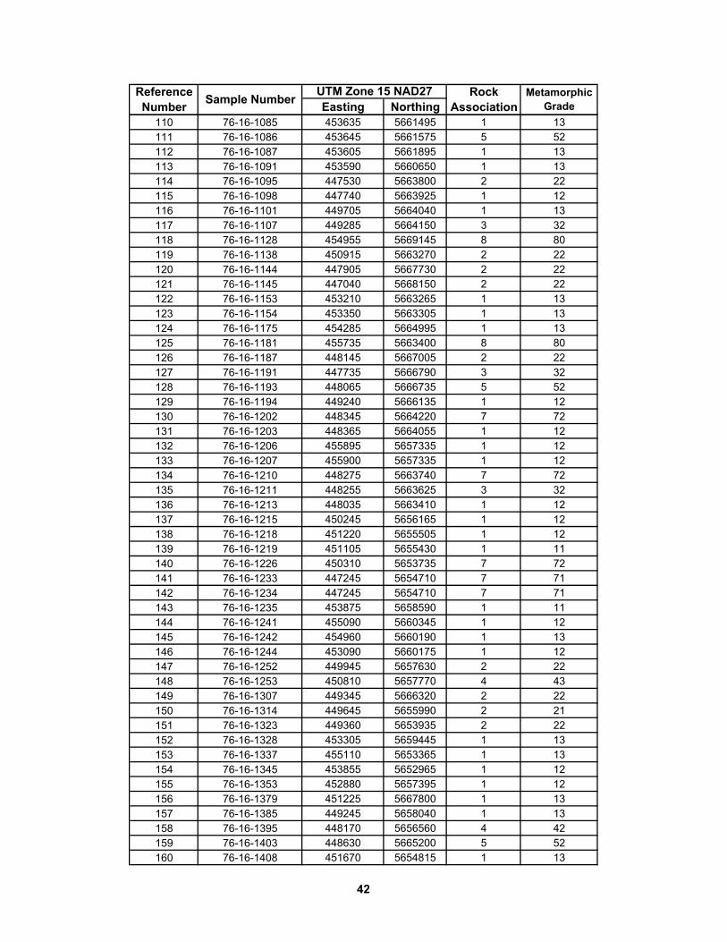
Easting NorthingReference Number
Metamorphic Grade
UTM Zone 15 NAD27 Rock AssociationSample Number
110 76-16-1085 453635 5661495 1 13111 76-16-1086 453645 5661575 5 52112 76-16-1087 453605 5661895 1 13113 76-16-1091 453590 5660650 1 13114 76-16-1095 447530 5663800 2 22115 76-16-1098 447740 5663925 1 12116 76-16-1101 449705 5664040 1 13117 76-16-1107 449285 5664150 3 32118 76-16-1128 454955 5669145 8 80119 76-16-1138 450915 5663270 2 22120 76-16-1144 447905 5667730 2 22121 76-16-1145 447040 5668150 2 22122 76-16-1153 453210 5663265 1 13123 76-16-1154 453350 5663305 1 13124 76-16-1175 454285 5664995 1 13125 76-16-1181 455735 5663400 8 80126 76-16-1187 448145 5667005 2 22127 76-16-1191 447735 5666790 3 32128 76-16-1193 448065 5666735 5 52129 76-16-1194 449240 5666135 1 12130 76-16-1202 448345 5664220 7 72131 76-16-1203 448365 5664055 1 12132 76-16-1206 455895 5657335 1 12133 76-16-1207 455900 5657335 1 12134 76-16-1210 448275 5663740 7 72135 76-16-1211 448255 5663625 3 32136 76-16-1213 448035 5663410 1 12137 76-16-1215 450245 5656165 1 12138 76-16-1218 451220 5655505 1 12139 76-16-1219 451105 5655430 1 11140 76-16-1226 450310 5653735 7 72141 76-16-1233 447245 5654710 7 71142 76-16-1234 447245 5654710 7 71143 76-16-1235 453875 5658590 1 11144 76-16-1241 455090 5660345 1 12145 76-16-1242 454960 5660190 1 13146 76-16-1244 453090 5660175 1 12147 76-16-1252 449945 5657630 2 22148 76-16-1253 450810 5657770 4 43149 76-16-1307 449345 5666320 2 22150 76-16-1314 449645 5655990 2 21151 76-16-1323 449360 5653935 2 22152 76-16-1328 453305 5659445 1 13153 76-16-1337 455110 5653365 1 13154 76-16-1345 453855 5652965 1 12155 76-16-1353 452880 5657395 1 12156 76-16-1379 451225 5667800 1 13157 76-16-1385 449245 5658040 1 13158 76-16-1395 448170 5656560 4 42159 76-16-1403 448630 5665200 5 52160 76-16-1408 451670 5654815 1 13
42
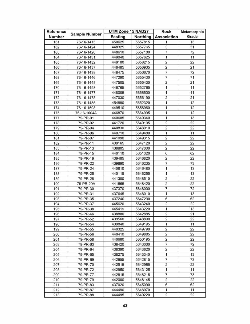
Easting NorthingReference Number
Metamorphic Grade
UTM Zone 15 NAD27 Rock AssociationSample Number
161 76-16-1415 450625 5657815 1 13162 76-16-1424 448325 5657765 3 31163 76-16-1426 448610 5657180 7 72164 76-16-1431 449040 5657625 1 11165 76-16-1432 449100 5658215 2 22166 76-16-1437 448485 5656935 2 21167 76-16-1438 448475 5656670 7 72168 76-16-1446 447290 5655430 7 71169 76-16-1448 447505 5655430 2 21170 76-16-1458 446765 5652765 1 11171 76-16-1477 448005 5656500 1 11172 76-16-1478 447030 5656190 2 21173 76-16-1485 454890 5652320 1 12174 76-16-1508 449510 5656960 1 12175 76-16-1604A 446870 5664995 1 12177 79-PR-01 440685 5649340 1 13178 79-PR-02 441720 5649105 2 22179 79-PR-04 440830 5648910 2 22180 79-PR-06 440710 5649480 1 11181 79-PR-07 441090 5649315 2 22182 79-PR-11 439165 5647120 2 22183 79-PR-13 438805 5647000 2 22184 79-PR-15 440110 5651320 6 62185 79-PR-19 439485 5646820 2 22186 79-PR-22 439890 5646235 7 73187 79-PR-24 440810 5646480 1 13188 79-PR-25 440115 5646255 1 13189 79-PR-28 441300 5648510 2 22190 79-PR-29A 441665 5648420 2 22191 79-PR-30 437370 5648000 7 72192 79-PR-31 437645 5648010 1 13193 79-PR-35 437240 5647290 6 62194 79-PR-37 445620 5643240 2 22195 79-PR-38 445419 5643220 1 13196 79-PR-46 438880 5642885 2 21197 79-PR-52 439560 5648890 2 22198 79-PR-54 439840 5649195 1 11199 79-PR-55 440325 5649790 2 22200 79-PR-56 440410 5649885 2 22201 79-PR-58 440680 5650195 2 22203 79-PR-63 438420 5643000 7 72204 79-PR-64 438390 5643620 2 22205 79-PR-65 438275 5643340 1 13206 79-PR-69 442955 5642815 7 73207 79-PR-70 442915 5642965 2 22208 79-PR-72 442950 5643125 1 11209 79-PR-77 442815 5648215 7 73210 79-PR-79 442000 5648145 2 22211 79-PR-83 437020 5645090 6 62212 79-PR-87 444490 5648970 1 11213 79-PR-88 444495 5649220 2 22
43
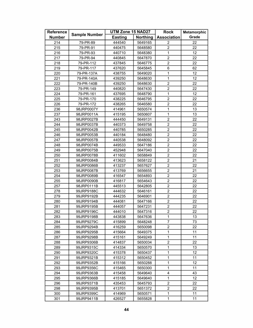
Easting NorthingReference Number
Metamorphic Grade
UTM Zone 15 NAD27 Rock AssociationSample Number
214 79-PR-89 444540 5649165 2 22215 79-PR-91 440475 5648580 2 22216 79-PR-93 440710 5648380 1 12217 79-PR-94 440845 5647870 2 22218 79-PR-112 437845 5646775 2 22219 79-PR-117 437620 5645845 6 62220 79-PR-137A 438755 5649020 1 12221 79-PR-140A 439250 5648630 1 12222 79-PR-140B 439250 5648630 2 22223 79-PR-149 440820 5647430 2 22224 79-PR-161 437695 5648790 1 12225 79-PR-170 438225 5646795 2 22226 79-PR-172 438265 5646580 2 22236 98JRP0007Y 414961 5650574 1 13237 98JRP0011A 415195 5650607 1 13243 98JRP0027B 444450 5649131 2 22244 98JRP0037B 440373 5649758 2 22245 98JRP0042B 440785 5650285 2 22246 98JRP0053B 440184 5648480 2 22247 98JRP0057B 440538 5648092 2 22248 98JRP0074B 449533 5647186 2 22249 98JRP0075B 452948 5647040 2 22250 98JRP0078B 411602 5658849 2 22251 98JRP0084B 413623 5658122 2 21252 98JRP0086B 413237 5657627 2 22253 98JRP0087B 413769 5656655 2 21254 98JRP0089B 416547 5654893 2 22255 98JRP0090B 416817 5654643 2 22257 98JRP0111B 445513 5642805 2 22278 99JRP9188C 444632 5646161 2 22279 99JRP9192B 444235 5646901 2 22280 99JRP9194B 444081 5647166 2 22281 99JRP9195B 444057 5647231 2 22282 99JRP9196C 444010 5647316 2 22283 99JRP9198B 443838 5647636 1 13284 99JRP9279C 415899 5648248 7 73285 99JRP9294B 416259 5650098 2 22286 99JRP9295B 415664 5649375 1 11287 99JRP9298B 415161 5649249 1 11288 99JRP9306B 414837 5650034 2 22289 99JRP9315C 414334 5650570 1 13290 99JRP9320C 415378 5650437 1 12291 99JRP9321B 415312 5650452 1 11292 99JRP9352B 415166 5650288 1 12293 99JRP9356C 415465 5650300 1 11294 99JRP9363B 415458 5649640 4 43295 99JRP9366B 415185 5649640 1 12296 99JRP9371B 435453 5645793 2 22298 99JRP9395B 413701 5651372 2 22300 99JRP9399C 414969 5650571 1 11301 99JRP9411B 426527 5655828 1 11
44

Easting NorthingReference Number
Metamorphic Grade
UTM Zone 15 NAD27 Rock AssociationSample Number
302 99JRP9417B 429068 5655169 7 71303 99JRP9429B 423779 5654710 1 12304 99JRP9437B 423267 5653189 2 22305 99JRP9444B 423423 5654492 1 13307 99JRP9480B 426970 5654040 1 13308 99JRP9482B 427000 5654353 1 13309 99JRP9484C 426997 5654171 1 13310 99JRP9485C 427088 5654253 1 22311 99JRP9505C 423870 5653493 7 73312 99JRP9522D 413525 5656639 1 12313 99JRP9526B 426201 5656094 1 11314 99JRP9537B 424696 5657314 2 22316 99JRP9551B 421392 5657600 6 61317 99JRP9556C 426037 5656411 1 11318 99JRP9557B 426081 5656358 1 11319 99JRP9558B 426263 5656367 1 11320 99JRP9564B 425358 5656604 1 11321 99JRP9584C 420590 5657851 1 12322 99JRP9586B 420525 5657947 1 12323 99JRP9587B 420417 5657940 1 11324 99JRP9592C 418976 5657592 1 11326 99JRP9611 421526 5657398 2 22327 99JRP9613B 419902 5657848 2 22328 99JRP9621B 419847 5657956 2 22329 99JRP9622B 419814 5657878 2 22330 97JRP9624B 419857 5658073 6 62331 99JRP9627B 419317 5658439 1 13334 99JRP9629B 419808 5658244 1 11339 99JRP9642B 419519 5655807 2 21341 99JRP9644B 421193 5656240 2 21342 99JRP9649C 421078 5656153 2 21343 99JRP9650B 421029 5656060 2 21344 99JRP9663B 430205 5658252 2 22345 99JRP9669B 431180 5657897 1 12346 99JRP9671E 431309 5657904 1 13347 99JRP9682B 414487 5653964 7 71350 99JRP9690B 417521 5654290 6 62351 99JRP9696D 433567 5658820 2 22352 99JRP9696F 433567 5658820 2 22353 99JRP9700B 433597 5658956 2 22354 99JRP9701B 437048 5661410 2 22355 99JRP9702C 436531 5660415 2 22356 99JRP9708B 411655 5656013 2 22357 99JRP9736B 412782 5655025 1 12358 00JRP8020B 435903 5651021 7 71359 00JRP8028B 436339 5650937 7 72360 00JRP8035B 444825 5657929 7 71361 00JRP8036B 444864 5658116 6 62362 00JRP8038B 444952 5658086 1 11363 00JRP8058B 445293 5659748 7 71364 00JRP8060B 445338 5659799 2 21
45

Easting NorthingReference Number
Metamorphic Grade
UTM Zone 15 NAD27 Rock AssociationSample Number
366 00JRP8064B 445036 5660224 1 11367 00JRP8068B 444538 5660423 7 71368 00JRP8071B 443640 5658461 7 71371 00JRP8072F 443703 5658411 2 21375 00JRP8076B 443890 5658513 7 71376 00JRP8077B 444017 5658554 7 71377 00JRP8092B 444495 5661078 1 12378 00JRP8093B 446297 5652424 1 13379 00JRP8097B 446435 5652858 1 12380 00JRP8105B 446420 5653117 2 22381 00JRP8107B 446145 5653457 1 12382 00JRP8108B 445996 5653009 2 22383 00JRP8108D 445912 5653113 2 22384 00JRP8111B 434029 5647419 1 12386 00JRP8157B 447723 5663943 1 12387 00JRP8164B 446602 5662214 7 72388 00JRP8168B 447010 5659422 7 72389 00JRP8174B 448844 5660444 2 22390 00JRP8176B 449365 5660655 1 13391 00JRP8182B 450871 5663043 2 22392 00JRP8199A 455412 5659897 1 13394 00JRP8201B 456208 5659938 8 80395 00JRP8202B 456763 5661908 8 80396 00JRP8204B 456763 5662980 8 80397 00JRP8205B 451113 5658445 1 13398 00JRP8213B 452055 5659175 4 43400 00JRP8214C 452114 5659125 4 43401 00JRP8218B 451356 5665712 1 13402 00JRP8220B 451329 5665845 3 32405 00JRP8227B 455324 5670180 4 43407 00JRP8230A 456049 5671017 5 52408 00JRP8232A 450972 5654802 2 22410 00JRP8243B 452613 5654126 1 13411 00JRP8246B 445264 5654297 1 11412 00JRP8247B 445481 5654269 5 52413 00JRP8248B 446417 5654392 1 11415 00JRP8250B 449426 5664088 5 52416 00JRP8251B 449552 5664091 7 72417 00JRP8252B 449319 5663952 7 72419 00JRP8256B 447173 5664982 7 72420 00JRP8257B 446177 5664632 2 21421 00JRP8259B 445456 5664771 7 72422 00JRP8276B 441798 5661042 1 11423 00JRP8284B 440865 5660402 2 21424 00JRP8286B 440491 5660529 7 71425 00JRP8287B 440425 5660628 5 22426 00JRP8288B 439930 5660316 2 21427 00JRP8291B 441509 5660379 2 21429 00JRP8292B 441605 5660289 2 21430 00JRP8306B 447995 5653149 2 21431 00JRP8307B 447854 5652906 1 12
46

Easting NorthingReference Number
Metamorphic Grade
UTM Zone 15 NAD27 Rock AssociationSample Number
432 00JRP8308B 447784 5652787 1 13433 00JRP8320C 442057 5660187 7 72435 00JRP8322F 442274 5660276 2 22437 00JRP8346B 443391 5658751 4 43438 00JRP8348B 443088 5658674 4 43439 00JRP8355B 446171 5653635 7 71441 00JRP8358D 442883 5654250 6 61442 00JRP8370B 433882 5655139 7 73443 00JRP8371B 434027 5655246 7 73444 00JRP8372B 434146 5654572 6 62445 00JRP8376B 428911 5653504 2 22446 00JRP8378 428179 5653689 7 72447 00JRP8379 430848 5653410 1 11448 00JRP8391B 427580 5653583 8 80449 00JRP8392B 428113 5653688 1 12451 00JRP8397B 428919 5653582 7 72452 00JRP8401B 421156 5652913 8 80453 00JRP8402 419694 5653256 1 12454 00JRP8406C 422322 5655459 5 52455 00JRP8408B 421083 5653316 7 73456 00JRP8417B 438119 5663016 2 22457 00JRP8426B 446942 5654463 1 11461 00JRP8427J 415310 5650466 1 12463 00JRP8428D 415378 5650637 3 32466 00JRP8429F 414844 5651034 1 12470 00JRP8431D 447275 5655352 7 71471 00JRP8432B 443567 5656683 4 41473 00JRP8434B 443648 5657384 2 21478 00JRP8455H 448057 5657348 1 11483 00JRP8456B 448156 5656542 4 41484 00JRP8456C 448156 5656542 4 41485 00JRP8457B 448531 5655290 7 72486 00JRP8459B 448643 5655240 1 11487 00JRP8461B 448472 5656729 7 72489 00JRP8462B 448487 5656864 2 21493 00JRP8468B 449332 5658263 2 22495 00JRP8477C 450372 5657621 1 13496 00JRP8481B 450276 5657569 2 22497 00JRP8485B 448789 5661247 2 22504 00JRP8486B 447350 5655480 2 21506 00JRP8492B 442814 5657353 2 21509 00JRP9265 416328 5648723 6 62510 00JRP9279A 415899 5648248 7 73514 00JRP9280C 416382 5648778 1 13515 00JRP9438 423252 5653131 1 12516 00JRP9453B 422899 5652596 7 43517 00JRP9742B 430632 564445 6 62519 00JRP9746B 428808 5646673 6 62520 00JRP9748B 428818 5644499 8 80521 00JRP9749B 425794 5646477 8 80522 00JRP9750B 421805 5647862 8 80
47

Easting NorthingReference Number
Metamorphic Grade
UTM Zone 15 NAD27 Rock AssociationSample Number
523 00JRP9751B 419812 5649498 8 80524 00JRP9752B 415352 5646347 8 80528 00JRP9756H 439805 5650612 7 71530 00JRP9758B 440346 5650457 7 71531 00JRP9759B 434674 5645258 1 13532 00JRP9761B 434254 5645076 1 13533 00JRP9766B 434491 5644403 6 62534 00JRP9767B 434473 5644527 1 13535 00JRP9768B 434330 5644375 1 13536 00JRP9771B 439862 5652414 2 21537 00JRP9772B 439689 5652323 2 22539 00JRP9773B 439520 5652450 6 61540 00JRP9774B 439262 5652204 6 61541 00JRP9775B 439166 5652101 6 62542 00JRP9776B 438925 5651865 6 62544 00JRP9781B 437552 5645905 6 62545 00JRP9782B 436981 5645871 1 13546 00JRP9786B 436246 5645133 8 89547 00JRP9789B 436228 5644386 6 22548 00JRP9790B 436560 5645088 8 80550 00JRP9793D 434160 5644892 1 13555 00JRP9794D 434734 5646158 1 13564 00JRP9796B 434767 5646232 1 13566 00JRP9800B 433512 5644246 7 73567 00JRP9801B 435837 5645517 2 22568 00JRP9813B 438177 5649338 1 12569 00JRP9815B 438470 5649500 1 12570 00JRP9837B 434050 5645506 3 32571 00JRP9839B 433138 5646329 8 80572 00JRP9842B 432599 5646092 8 80573 00JRP9847B 434337 5646469 3 32574 00JRP9848B 434529 5646606 3 31575 00JRP9850B 434589 5647019 3 32576 00JRP9853B 433996 5646934 1 13579 00JRP9857B 435105 5645822 1 43580 00JRP9860B 435262 5645987 1 43581 00JRP9862B 435371 5646217 3 32582 00JRP9867B 444243 5650454 1 11583 00JRP9869B 445246 5650711 1 12584 00JRP9870B 446066 5650979 6 61585 00JRP9871B 446200 5651090 6 61586 00JRP9874B 446259 5651345 6 61588 00JRP9884B 454167 5670897 2 22589 00JRP9888B 451896 5666632 1 13590 00JRP9892 434886 5647929 3 32591 00JRP9898B 433952 5646876 1 13592 00JRP9899B 434075 5646920 3 31593 00JRP9901B 433848 5647564 1 13594 00JRP9915B 433784 5647305 1 13595 00JRP9929B 435014 5649548 2 22597 00JRP9934B 435529 5649811 2 22
48

Easting NorthingReference Number
Metamorphic Grade
UTM Zone 15 NAD27 Rock AssociationSample Number
599 00JRP9939B 435914 5650089 1 12600 00JRP9943B 434683 5649164 3 31602 00JRP9945D 433232 5651045 4 42603 00JRP9946 433168 5650957 7 72604 00JRP9969B 448937 5661178 1 12608 00JRP9970F 448709 5661276 1 12613 00JRP9978 448713 5662066 1 13614 00JRP9988B 447566 5661452 1 11617 SNB-99-1001 433274 5654316 3 31618 SNB-99-1002 430626 5654389 3 31619 SNB-99-1003 427507 5655386 2 21620 SNB-99-1007B 445087 5664309 1 11621 SNB-99-1008H 445389 5664482 1 11629 SNB-99-1010 432605 5654554 1 11630 SNB-99-1021B 433960 5657523 1 12631 SNB-99-1022 434672 5656233 2 21632 SNB-99-1038A 440054 5649505 2 22633 SNB-99-1039A 440146 5649335 1 13634 SNB-99-1041 436019 5646040 1 13635 SNB-99-1045 436212 5646290 1 13636 SNB-99-1047 434751 5647059 3 32637 SNB-99-1048 434612 5646812 3 32638 SNB-99-1049 434328 5646513 3 32639 SNB-99-1051 433909 5646975 1 13640 SNB-99-1055 417586 5653917 1 12641 SNB-99-1056 417240 5654269 4 41642 SNB-99-1060 416804 5659306 1 13644 SNB-99-1082 416558 5658579 3 31645 SNB-99-1083B 416381 5657450 3 31646 SNB-99-1086 437789 5651357 1 12647 SNB-99-1087 435367 5651134 7 72648 SNB-99-1091 434278 5650158 1 11649 SNB-99-1097 439742 5654916 6 62650 SNB-99-1106 444118 5654588 1 11651 SNB-99-1110A 446917 5654474 1 11653 SNB-99-1113 451129 5658453 2 22654 SNB-99-1119A 448117 5670329 2 22655 SNB-99-1123 443639 5668763 6 62656 SNB-99-1128 438717 5667592 6 62657 SNB-99-1134 429330 5657872 1 13658 SNB-99-1139 424106 5657569 1 13659 SNB-99-1141 446179 5665224 1 13660 SNB-99-1142A 445903 5664918 1 13661 SNB-99-1143A 445410 5664533 3 32662 SNB-99-1144 446267 5664723 7 72664 SNB-99-1151A 448754 5666175 1 13665 SNB-99-1153 449076 5666205 1 13666 SNB-99-1156 449588 5666856 1 13667 SNB-99-1160 452998 5669293 2 22668 SNB-99-1166 443621 5656729 2 21669 SNB-99-1169C 442763 5657372 1 11
49

Easting NorthingReference Number
Metamorphic Grade
UTM Zone 15 NAD27 Rock AssociationSample Number
672 SNB-99-1175 444582 5656393 1 11673 SNB-99-1176 444497 5656475 2 21674 SNB-99-1180 451011 5658331 1 11675 SNB-99-1181 453102 5660340 1 12676 SNB-99-1184 415036 5651913 1 11677 SNB-99-1187B 414652 5651579 2 21678 SNB-99-1188 414529 5651514 1 12680 SNB-99-1192 410606 5658672 1 12681 SNB-99-1195 410441 5657889 2 22682 SNB-99-1197 410943 5657460 1 12683 SNB-99-1200 411797 5657843 2 22684 SNB-99-1202A 412288 5657930 3 31685 SNB-99-M2019 421852 5653425 1 12686 SNB-99-M2032 433458 5653208 1 11687 SNB-99-M2048B 441748 5663665 1 13688 SNB-99-M2052A 434212 5644875 1 13689 SNB-99-M2064B 423676 5652219 8 80690 SNB-99-M2075B 447709 5662958 1 12691 SNB-99-M2077 440445 5653627 6 62692 SNB-99-M2084 445523 5652577 6 61693 SNB-99-M2088B 445700 5653250 6 61694 SNB-99-M2109 436600 5661500 1 11695 SNB-99-M2117B 440068 5663759 1 12696 SNB-99-M2120 438700 5663500 6 61697 SNB-99-M2138B 415207 5650804 3 32698 SNB-99-M2139 415475 5650804 1 13699 SNB-99-M2142 413400 5659600 1 13700 SNB-99-M2145A 413300 5654800 1 12702 SNB-99-M2148 435499 5647100 1 13703 SRB-99-004 429162 5655302 1 11704 SRB-99-007 426331 5653923 1 13705 SRB99-13a 424226 5654004 2 22706 SRB99-16a 421867 5652850 2 22707 SRB99-18 444576 5664196 2 22708 SRB-99-020 446606 5667621 1 13711 SRB-99-032B 435445 5645914 1 13712 SRB-99-033 435139 5645540 2 22713 SRB99-35a 434040 5643766 2 22714 SRB-99-054 415674 5659406 1 13715 SRB99-56a 414820 5659659 4 42717 SRB-99-59B 412805 5658695 2 22718 SRB-99-062 421186 5653463 1 13726 SRB-99-64L-5A 421150 5653745 2 22730 SRB-99-065 419967 5653823 2 22731 SRB99-72a 413821 5656670 2 21733 SRB99-76a 415291 5654254 2 22736 SRB-99-78b 413257 5654999 1 11737 SRB99-81 430903 5655669 1 11738 SRB-99-82b 426373 5655620 1 11739 SRB99-86i 435281 5645780 4 43742 SRB99-87i 435273 5645914 2 22
50

Easting NorthingReference Number
Metamorphic Grade
UTM Zone 15 NAD27 Rock AssociationSample Number
743 SRB-99-089A 435782 5646858 1 12746 SRB-99-090B 435809 5647142 1 13747 SRB99-95 435262 5646216 2 22751 SRB-99-097E 435263 5646008 1 12752 SRB-99-098A 434735 5646215 1 12753 SRB99-102 442046 5659881 5 52756 SRB99-107 440772 5659306 2 22757 SRB-99-109 440947 5660913 1 11758 SRB-99-110 441797 5661038 1 11759 SRB99-112 441312 5660717 7 71760 SRB-99-117 439914 5660293 2 21761 SRB99-121 440665 5660330 2 21763 SRB99-124i 446517 5643322 2 22765 SRB99-134a 444783 5665380 2 22766 SRB99-135a 445009 5665045 2 22768 SRB-99-138 445153 5664414 1 11769 SRB-99-141 443631 5664188 1 11770 SRB-99-142 444509 5663838 2 22771 SRB-99-143 444136 5663644 2 22772 SRB-99-146 442674 5663717 1 11773 SRB-99-154 442417 5656276 2 21774 SRB-99-156 443500 5655646 2 22775 SRB99-159 443053 5659607 2 21776 SRB-99-163B 443065 5659888 2 22777 SRB-99-168 441170 5659904 2 21778 SRB99-199b-i 435855 5646887 5 52780 SRB-99-204 441318 5675711 8 80781 SRB-99-208B 437323 5669084 1 12782 SRB99-2110f 439385 5665298 2 22784 SRB00-4006i 416083 5649028 5 52786 SRB00-4037b 459291 5648378 2 22787 SRB00-4067f 449836 5653482 2 22790 SRB00-4065L-3A 419967 5653823 2 22793 SRB00-4089 419814 5657942 7 73794 SRB00-4092 423149 5657802 1 12795 SRB00-4101b 443491 5659351 2 21796 SRB00-4116c 441525 5660464 7 71797 SRB00-4123 415803 5651825 1 11798 SRB00-4124b 415559 5651953 7 72799 SRB00-4129b 424560 5654688 1 11800 SRB00-4134a 421393 5655104 2 21
51

52
Metric Conversion Table
Conversion from SI to Imperial Conversion from Imperial to SI
SI Unit Multiplied by Gives Imperial Unit Multiplied by Gives
LENGTH1 mm 0.039 37 inches 1 inch 25.4 mm1 cm 0.393 70 inches 1 inch 2.54 cm1 m 3.280 84 feet 1 foot 0.304 8 m1 m 0.049 709 chains 1 chain 20.116 8 m1 km 0.621 371 miles (statute) 1 mile (statute) 1.609 344 km
AREA1 cm@ 0.155 0 square inches 1 square inch 6.451 6 cm@1 m@ 10.763 9 square feet 1 square foot 0.092 903 04 m@1 km@ 0.386 10 square miles 1 square mile 2.589 988 km@1 ha 2.471 054 acres 1 acre 0.404 685 6 ha
VOLUME1 cm# 0.061 023 cubic inches 1 cubic inch 16.387 064 cm#1 m# 35.314 7 cubic feet 1 cubic foot 0.028 316 85 m#1 m# 1.307 951 cubic yards 1 cubic yard 0.764 554 86 m#
CAPACITY1 L 1.759 755 pints 1 pint 0.568 261 L1 L 0.879 877 quarts 1 quart 1.136 522 L1 L 0.219 969 gallons 1 gallon 4.546 090 L
MASS1 g 0.035 273 962 ounces (avdp) 1 ounce (avdp) 28.349 523 g1 g 0.032 150 747 ounces (troy) 1 ounce (troy) 31.103 476 8 g1 kg 2.204 622 6 pounds (avdp) 1 pound (avdp) 0.453 592 37 kg1 kg 0.001 102 3 tons (short) 1 ton (short) 907.184 74 kg1 t 1.102 311 3 tons (short) 1 ton (short) 0.907 184 74 t1 kg 0.000 984 21 tons (long) 1 ton (long) 1016.046 908 8 kg1 t 0.984 206 5 tons (long) 1 ton (long) 1.016 046 90 t
CONCENTRATION1 g/t 0.029 166 6 ounce (troy)/ 1 ounce (troy)/ 34.285 714 2 g/t
ton (short) ton (short)1 g/t 0.583 333 33 pennyweights/ 1 pennyweight/ 1.714 285 7 g/t
ton (short) ton (short)
OTHER USEFUL CONVERSION FACTORS
Multiplied by1 ounce (troy) per ton (short) 31.103 477 grams per ton (short)1 gram per ton (short) 0.032 151 ounces (troy) per ton (short)1 ounce (troy) per ton (short) 20.0 pennyweights per ton (short)1 pennyweight per ton (short) 0.05 ounces (troy) per ton (short)
Note:Conversion factorswhich are in boldtype areexact. Theconversion factorshave been taken fromor havebeenderived from factors given in theMetric PracticeGuide for the CanadianMining andMetallurgical Industries, pub-lished by the Mining Association of Canada in co-operation with the Coal Association of Canada.


ISSN 0826--9580ISBN 0--7794--5509--6
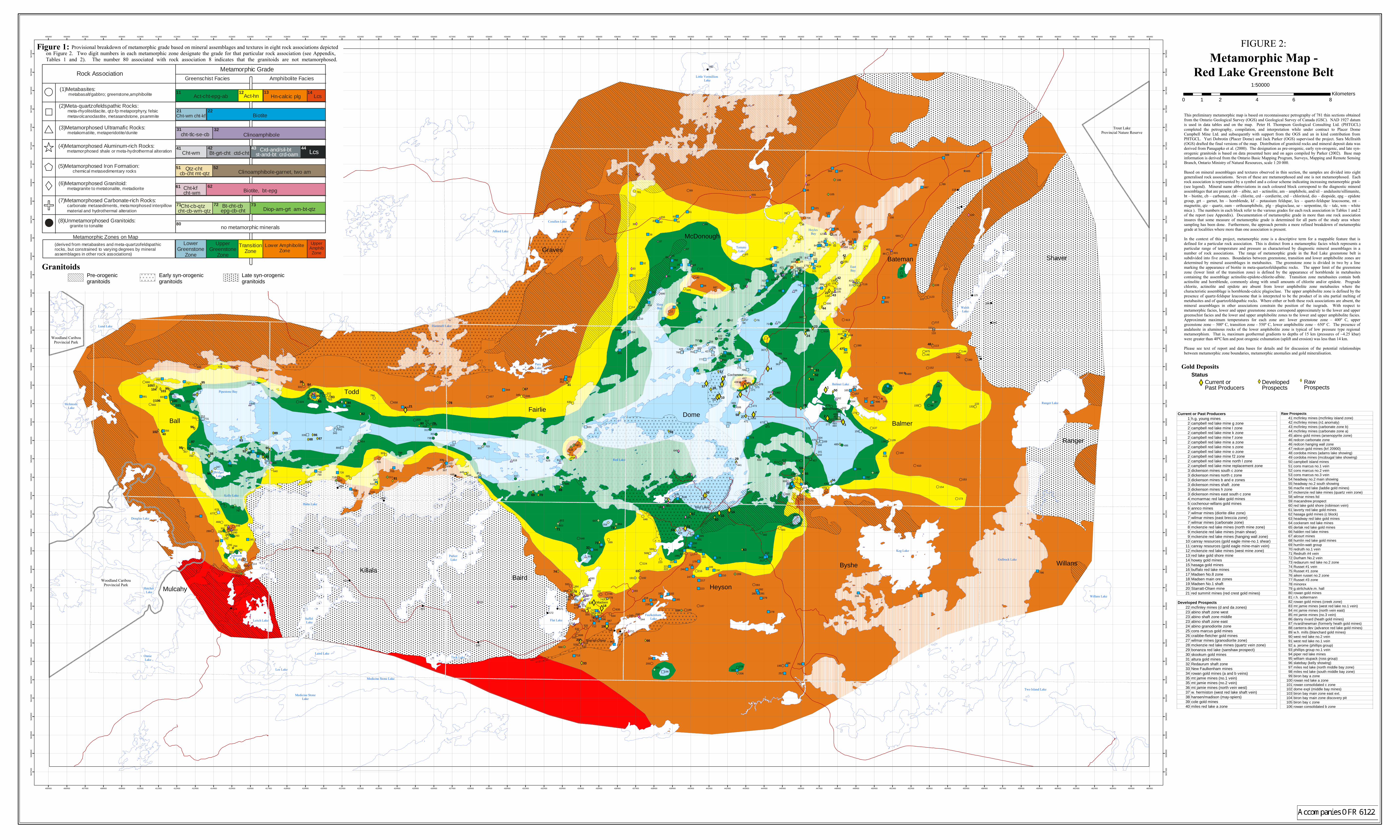
9
8
7
6
5
4
32
1
99
98
9796
94
93
9291
90
89
88
87
86
8584 83
8281
80
79
78
77
76
7574
73
72
70
69
68
67
6665
64
63
62
61
60
59
5857
49
48
47
46
45
44
43 42
41 40
39
38
37
3635
3433
32
31
30
2827
26
25
2423
22
21
20
19
1817
16
15
14
1312
11
10
800
799
798797
796
795
794793
790787
786
784
782
781
780
778
777 776
775
774
773
772771
770
769
768
766765
763
761760
759758
757
756
753
752
751
747
746
743
742
739
738737
736
733
731
730 726
718
717
715 714
713
712
708
707
706
705704
703
702
700
699
698697
696695
694
693
692
691
690
689
688
687
686
685
684683
682
681
680
678
677
676
675
674
673
672
669
668
667
666
665
664
662661
660
659
658
657
656
655
564
653
651650
649
648
647 646
645
644
642
641
640
639
638
637
636
635
634
633632
631
630
629
621620
619
618 617
614
613
608604
603
602
600
599
597595
594
593
592
591
590
589
588
586
585584
583
582
581580
579
576
575
574573
572
571
570
569
568
567
566
564
555
550
548
547
546
545
544
542 541540
539
537
536
535534
533
532531
530528
524
523
522
521
520
519
517
516
515
514
510
509
506
504
497
496
495
493
489487
486485
484483
478473
471
470
466
463461
457
456
455
454
453
452
451449448
447446445
444
443
442
441
439
438437
435433
432
431
430
429
427426
425
424 423
422
421 419
417
416
415
413412411
410
408
407
405
402401
400398
397
396
395
394392
391
390
389
388
387
386
384
383382
381
380
379
378
377
376375
371
368
367366
364
363
362361
360
359358
357
356
355
354
353
352351
350
347
346345
344
343342
341
339
334331
330
329
328
327
326
324
323 322
321
320
319318
317
316
314
313
312
311
310309
308
307
305
304
303
302
301
300
298
296
295 294
293292
291290289
288
287286
285
284
283
282
281280
279
278
257
255254
253
252
251
250
249248
247
246
245
244
243
236
226
225
224
223
222221
220
219
218
217
216
215
214
213
212
211
210 209
208
207206
205
204
203
201
200
199
198
197
196
195194
193
192191
190189
188
187
186
185
184
183 182
181
180
179
178177
175
174
173
172
171
170
169168
167
166
165
164
163
162 161
160
159
157
156
155
154
153
152
151
150
149
148147
146145
144
143
142141
140
139138
137
136
135134
133132
131130
129
128127
126
125
124
123122
121
120
119
118
117 116115
114
113
112
111
110
109
108
107
106
105
104
103
101
100
711
420
237
158
Bateman
6
5
4
7
8
9
3
2
1
81
78
7980
21
89
8886
87
82
34
8385
35
8436
65
63
1664
61
66
6215
14
68
7069
6731
26
25
58 27
57
2812
1011
29
59
30
60
13
22
42
41
43
44
49
45
48
5352
50
56
55
46
51
23
47
24
54
94
90
9137
92
93
38
40
97
98
95
96
99
39
76
73
33
72
19
71
74
7775
32
20
1718
102
100106101
105
103104
Little Vermillion Lake
Hoyles Bay
EastBay
SlateBay
Todd
DomeBall
Byshe
Baird
Shaver
Ranger
Madsen
Heyson
Graves
Balmer
Fairlie
Mulcahy
WillansKillala
Red Lake
Lee Lake
Keg Lake
McDonough
Para Lake
Tack Lake
Lund Lake
Hahn Lake
Flat Lake
Onnie Lake
Walsh Lake
Laird Lake
Kelly Lake
Balmertown
Parker Lake
Tomato Lake
Suffel Lake
Ranger Lake
Leitch Lake
Balmer Lake
Alford Lake
Willans Lake
Red Lake
Johnson Lake
Hatchet Lake
Hammell Lake
Douglas Lake
Bridget Lake
Pipestone Bay
McIntosh Lake
Gullrock Lake
Corallen Lake
Starratt-Olsen
Cochenour
Two Island Lake
Faulkenham Lake
Medicine Stone Lake
Medicine StoneLake
Woodland CaribouProvincial Park
Trout LakeProvincial Nature Reserve
Woodland CaribouProvincial Park
Woodland CaribouProvincial Park
405400
405400
406400
406400
407400
407400
408400
408400
409400
409400
410400
410400
411400
411400
412400
412400
413400
413400
414400
414400
415400
415400
416400
416400
417400
417400
418400
418400
419400
419400
420400
420400
421400
421400
422400
422400
423400
423400
424400
424400
425400
425400
426400
426400
427400
427400
428400
428400
429400
429400
430400
430400
431400
431400
432400
432400
433400
433400
434400
434400
435400
435400
436400
436400
437400
437400
438400
438400
439400
439400
440400
440400
441400
441400
442400
442400
443400
443400
444400
444400
445400
445400
446400
446400
447400
447400
448400
448400
449400
449400
450400
450400
451400
451400
452400
452400
453400
453400
454400
454400
455400
455400
456400
456400
457400
457400
458400
458400
459400
459400
460400
460400
461400
461400
462400
462400
463400
463400
464400
464400
465400
465400
5637
500
5637
500
5638
500
5638
500
5639
500
5639
500
5640
500
5640
500
5641
500
5641
500
5642
500
5642
500
5643
500
5643
500
5644
500
5644
500
5645
500
5645
500
5646
500
5646
500
5647
500
5647
500
5648
500
5648
500
5649
500
5649
500
5650
500
5650
500
5651
500
5651
500
5652
500
5652
500
5653
500
5653
500
5654
500
5654
500
5655
500
5655
500
5656
500
5656
500
5657
500
5657
500
5658
500
5658
500
5659
500
5659
500
5660
500
5660
500
5661
500
5661
500
5662
500
5662
500
5663
500
5663
500
5664
500
5664
500
5665
500
5665
500
5666
500
5666
500
5667
500
5667
500
5668
500
5668
500
5669
500
5669
500
5670
500
5670
500
5671
500
5671
500
5672
500
5672
500
5673
500
5673
500
5674
500
5674
500
5675
500
5675
500
5676
500
5676
500
Metamorphic Map -Red Lake Greenstone Belt
0 2 4 6 81Kilometers
1:50000
Gold Deposits
FIGURE 2:
Current or Past Producers1 h.g. young mines2 campbell red lake mine g zone2 campbell red lake mine l zone2 campbell red lake mine k zone2 campbell red lake mine f zone2 campbell red lake mine a zone2 campbell red lake mine s zone2 campbell red lake mine o zone2 campbell red lake mine f2 zone2 campbell red lake mine north l zone2 campbell red lake mine replacement zone3 dickenson mines south c zone3 dickenson mines north c zone3 dickenson mines b and e zones3 dickenson mines shaft zone3 dickenson mines h zone3 dickenson mines east south c zone4 mcmarmac red lake gold mines5 cochenour-willans gold mines6 annco mines7 wilmar mines (diorite dike zone)7 wilmar mines (east breccia zone)7 wilmar mines (carbonate zone)8 mckenzie red lake mines (north mine zone)9 mckenzie red lake mines (main shear)9 mckenzie red lake mines (hanging wall zone)
10 canray resources (gold eagle mine-no.1 shear)11 canray resources (gold eagle mine-main vein)12 mckenzie red lake mines (west mine zone)13 red lake gold shore mine14 howey gold mines15 hasaga gold mines16 buffalo red lake mines17 Madsen No.8 zone18 Madsen main ore zones19 Madsen No.1 shaft20 Starratt-Olsen mine21 red summit mines (red crest gold mines)
Developed Prospects22 mcfinley mines (d and da zones)23 abino shaft zone west23 abino shaft zone middle23 abino shaft zone east24 abino granodiorite zone25 cons marcus gold mines26 craibbe-fletcher gold mines27 wilmar mines (granodiorite zone)28 mckenzie red lake mines (quartz vein zone)29 bonanza red lake (sanshaw prospect)30 skookum gold mines31 altura gold mines32 Redaurum shaft zone33 New Faulkenham mines34 rowan gold mines (a and b veins)35 mt jamie mines (no.1 vein)35 mt jamie mines (no.2 vein)36 mt jamie mines (north vein west)37 w. hermiston (west red lake shaft vein)38 hansen/madison (may-spiers)39 cole gold mines40 miles red lake a zone
Raw Prospects41 mcfinley mines (mcfinley island zone)42 mcfinley mines (n1 anomaly)43 mcfinley mines (carbonate zone b)44 mcfinley mines (carbonate zone a)45 abino gold mines (arsenopyrite zone)46 redcon carbonate zone46 redcon hanging wall zone47 redcon gold mines (krl 20900)48 cordoba mines (adams lake showing)49 cordoba mines (mcdougal lake showing)50 campbell island mines51 cons marcus no.1 vein52 cons marcus no.2 vein53 cons marcus no.3 vein54 headway no.2 main showing55 headway no.2 south showing56 macfie red lake (laddie gold mines)57 mckenzie red lake mines (quartz vein zone)58 wilmar mines ltd59 macandrew prospect60 red lake gold shore (robinson vein)61 laverty red lake gold mines62 hasaga gold mines (c block)63 headway red lake gold mines64 cockeram red lake mines65 derlak red lake gold mines66 halden red lake mines67 alcourt mines68 humlin red lake gold mines69 humlin-watt group70 redruth no.1 vein71 Redruth #4 vein72 Durham No.2 vein73 redaurum red lake no.2 zone74 Russet #1 vein75 Russet #1 zone76 aiken russet no.2 zone77 Russet #3 zone78 minorex79 g.strilchuk/e.m. hall80 rowan gold mines81 r.h. soltermann82 rowan gold mines (creek zone)83 mt jamie mines (west red lake no.1 vein)84 mt jamie mines (north vein east)85 mt jamie mines (no.3 vein)86 danny rivard (heath gold mines)87 rivard/newman (formerly heath gold mines)88 canterra dev (advance red lake gold mines)89 w.h. mills (blanchard gold mines)90 west red lake no.2 vein91 west red lake no.1 vein92 a. jerome (phillips group)93 phillips group no.1 vein94 piper red lake mines95 william stupack (ross group)96 slatebay (kelly showing)97 miles red lake (north middle bay zone)98 miles red lake (south middle bay zone)99 biron bay a zone
100 rowan red lake a zone101 rowan consolidated c zone102 dome expl (middle bay mines)103 biron bay main zone east ext.104 biron bay main zone discovery pit105 biron bay c zone106 rowan consolidated b zone
StatusDeveloped Prospects
Raw Prospects
Current or Past Producers
GranitoidsPre-orogenic granitoids
Early syn-orogenic granitoids
Late syn-orogenic granitoids
Rock AssociationMetamorphic Grade
Greenschist Facies Amphibolite Facies
(1)Metabasites: metabasalt/gabbro; greenstone,amphibolite
(2)Meta-quartzofeldspathic Rocks: meta-rhyolite/dacite, qtz-fp metaporphyry, felsic metavolcanoclastite, metasandstone, psammite
(4)Metamorphosed Aluminum-rich Rocks: metamorphosed shale or meta-hydrothermal alteration
(3)Metamorphosed Ultramafic Rocks: metakomatiite, metaperidotite/dunite
(7)Metamorphosed Carbonate-rich Rocks: carbonate metasediments, metamorphosed interpillow material and hydrothermal alteration
(6)Metamorphosed Granitoid: metagranite to metatonalite, metadiorite
(derived from metabasites and meta-quartzofeldspathic rocks, but constrained to varying degrees by mineral assemblages in other rock associations)
Metamorphic Zones on MapUpper
Greenstone Zone
TransitionZone
Lower Amphibolite Zone
Upper Amphib Zone
LowerGreenstone
Zone
(5)Metamorphosed Iron Formation:
chemical metasedimentary rocks
(8)Unmetamorphosed Granitoids: granite to tonalite
Act-hnAct-cht-epg-ab Hn-calcic plg Lcs
Cht-wm cht-kf Biotite
cht-tlc-se-cb Clinoamphibole
Cht-wm Bt-grt-cht ctd-cht Crd-and/sil-bt st-and-bt crd-oam Lcs
Qtz-cht cb-cht mt-qtz Clinoamphibole-garnet, two am
Cht-kfcht-wm Biotite, bt-epg
Cht-cb-qtzcht-cb-wm-qtz
Bt-cht-cbepg-cb-cht Diop-am-grt am-bt-qtz
no metamorphic minerals
11 12 13 14
21 22
31 32
41 42 43 44
51 52
61 62
71 72 73
80
Provisional breakdown of metamorphic grade based on mineral assemblages and textures in eight rock associations depictedon Figure 2. Two digit numbers in each metamorphic zone designate the grade for that particular rock association (see Appendix, Tables 1 and 2). The number 80 associated with rock association 8 indicates that the granitoids are not metamorphosed.
Figure 1:
This preliminary metamorphic map is based on reconnaissance petrography of 781 thin sections obtainedfrom the Ontario Geological Survey (OGS) and Geological Survey of Canada (GSC). NAD 1927 datumis used in data tables and on the map. Peter H. Thompson Geological Consulting Ltd. (PHTGCL)completed the petrography, compilation, and interpretation while under contract to Placer DomeCampbell Mine Ltd. and subsequently with support from the OGS and an in kind contribution fromPHTGCL. Yuri Dobrotin (Placer Dome) and Jack Parker (OGS) supervised the project. Sara McIlraith(OGS) drafted the final versions of the map. Distribution of granitoid rocks and mineral deposit data wasderived from Panagapko et al. (2000). The designation as pre-orogenic, early syn-orogenic, and late syn-orogenic granitoids is based on data presented here and on ages compiled by Parker (2002). Base mapinformation is derived from the Ontario Basic Mapping Program, Surveys, Mapping and Remote SensingBranch, Ontario Ministry of Natural Resources, scale 1:20 000.
Based on mineral assemblages and textures observed in thin section, the samples are divided into eightgeneralised rock associations. Seven of these are metamorphosed and one is not metamorphosed. Eachrock association is represented by a symbol and a colour scheme indicating increasing metamorphic grade(see legend). Mineral name abbreviations in each coloured block correspond to the diagnostic mineralassemblages that are present (ab � albite, act � actinolite, am � amphibole, and/sil � andalusite/sillimanite,bt � biotite, cb � carbonate, cht � chlorite, crd � cordierite, ctd � chloritoid, dio � diopside, epg � epidotegroup, grt � garnet, hn � hornblende, kf � potassium feldspar, lcs � quartz-feldspar leucosome, mt �magnetite, qtz � quartz, oam � orthoamphibole, plg � plagioclase, se � serpentine, tlc � talc, wm � whitemica,). The numbers in each block refer to the various grades for each rock association in Tables 1 and 2of the report (see Appendix). Documentation of metamorphic grade in more than one rock associationinsures that some measure of metamorphic grade is determined for all parts of the study area wheresampling has been done. Furthermore, the approach permits a more refined breakdown of metamorphicgrade at localities where more than one association is present.
In the context of this project, metamorphic zone is a descriptive term for a mappable feature that isdefined for a particular rock association. This is distinct from a metamorphic facies which represents aparticular range of temperature and pressure as characterised by diagnostic mineral assemblages in anumber of rock associations. The range of metamorphic grade in the Red Lake greenstone belt issubdivided into five zones. Boundaries between greenstone, transition and lower amphibolite zones aredetermined by mineral assemblages in metabasites. The greenstone zone is divided in two by a linemarking the appearance of biotite in meta-quartzofeldspathic rocks. The upper limit of the greenstonezone (lower limit of the transition zone) is defined by the appearance of hornblende in metabasitescontaining the assemblage actinolite-epidote-chlorite-albite. Transition zone metabasites contain bothactinolite and hornblende, commonly along with small amounts of chlorite and/or epidote. Progradechlorite, actinolite and epidote are absent from lower amphibolite zone metabasites where thecharacteristic assemblage is hornblende-calcic plagioclase. The upper amphibolite zone is defined by thepresence of quartz-feldspar leucosome that is interpreted to be the product of in situ partial melting ofmetabasites and of quartzofeldspathic rocks. Where either or both these rock associations are absent, themineral assemblages in other associations constrain the position of the isograds. With respect tometamorphic facies, lower and upper greenstone zones correspond approximately to the lower and uppergreenschist facies and the lower and upper amphibolite zones to the lower and upper amphibolite facies.Approximate maximum temperatures for each zone are: lower greenstone zone � 400º C, uppergreenstone zone � 500º C, transition zone - 550º C, lower amphibolite zone � 650º C. The presence ofandalusite in aluminous rocks of the lower amphibolite zone is typical of low pressure type regionalmetamorphism. That is, maximum geothermal gradients to depths of 15 km (pressures of ~4.25 kbar)were greater than 40ºC/km and post orogenic exhumation (uplift and erosion) was less than 14 km.
Please see text of report and data bases for details and for discussion of the potential relationshipsbetween metamorphic zone boundaries, metamorphic anomalies and gold mineralisation.