white column, serra do rio do rastro, sc -...
TRANSCRIPT

SIGEPGeological and Paleontological Sites of Brazil
SIGEP 024
White Column, Serra do Rio do Rastro, SC Classic Geologic Section of the Gondwana Continent in Brazil
Vitório Orlandi Filho *1
Antonio Sílvio Jornada Krebs*2
Luís Edmundo Giffoni*3
(*) CPRM - Serviço Geológico do Brasil 1 - [email protected] 2 - [email protected] 3 - [email protected]
© Orlandi Filho,V.; Krebs,A.S.J.; Giffoni,L.E. 2006. White Column, Serra do Rio do Rastro, SC - Classic Geologic Section of the Gondwana Continent in Brazil. In: Winge,M.; Schobbenhaus,C.; Berbert-Born,M.; Queiroz,E.T.; Campos,D.A.; Souza,C.R.G. ; Fernandes,A.C.S. (Edit.) Geological and Palaeontological Sites of Brazil. Available on line 22/12/2006 at the address http://www.unb.br/ig/sigep/sitio024/sitio024english.pdf [ Actually http://www.sigep.cprm.gov.br/sitio024/sitio024english.pdf ]
(The above bibliographic reference of author copy right is required for any use of this article in any media, being forbidden the use for any commercial purpose)

White Column, Serra do Rio do Rastro, SC Classic Geologic Section of the Gondwana Continent in Brazil
SIGEP 024 Vitório Orlandi Filho *1
Antonio Sílvio Jornada Krebs*2 Luís Edmundo Giffoni*3
The White Column certainly is one of the most classic stratigraphic columns ever elaborated in Brazil. Its origin comes from the
Comissão de Estudos das Minas de Carvão de Pedra no Brasil (Commission for Studies on the Mineral Coal Mines in Brazil) report that was presented by the distinguished geologist Israel Charles White in 1908 to the former Brazilian Ministro da Indústria, Viação e Obras Públicas (Minister of Industry, Road System and Public Works), Dr. Lauro Severiano Müller. By the way, Lauro Müller is the present name of the municipality where this worldwide Gondwana type section was defined. By that time White was already an internationally acclaimed geologist who primarily defined the formation and the resources of the Pennsylvania and Ohio coal and who was, back in 1897, the first president of the West Virginia Geological and Economic Survey – USA. The work done by White and collaborators between 1904 and 1906 in the Serra do Rio do Rastro region, Santa Catarina state, is highly relevant to the Paraná Basin stratigraphy, since it created a scientific basement that still keeps up-to-date. In the eve of the centennial of this work, the authors pay homage to the memory of this eminent geologist who so significantly contributed to the science of our country. The Serra do Rio do Rastro is one unique landscape in the Brazilian geomorphology. Through the SC-438 road one rides from the crystalline basement at about 200 meters in altitude, crosses the whole gondwanic sedimentary sequence along the S-curves of the mountains and reaches the basaltic lava flows at the top, 1,467 meters high, enjoying a wonderful panorama all the way long. The geologic itinerary illustrated in this work presents the rare peculiarity that it is directly marked on the very terrain, along the SC-438 road, by a set of 17 concrete posts where the main characteristics of the local geology are described. More than this, it offers an exceptional geotourist route for the national and international interest due to the exuberance of its landscape and natural resources and to its very handy access and lodging conditions. This section constitutes one of the best worldwide records of the gondwanic sequence which lithostratigraphically supports the continental displacement theory – a fundamental event in the evolutions of our Planet – through the comparison with the chrono-correlative units of the southern African continent, as did White in 1908, when he correlated the Sistema de Santa Catarina (Santa Catarina System) to the Karroo System of South Africa. Keywords: Paraná Basin; White Column; stratigraphy; Gondwana; Serra do Rio do Rastro. INTRODUCTION
Figure 01 - Geologist Israel Charles White (1848-1927).
Along the SC-438 road, in the Serra do Rio do Rastro, southern region of the Santa Catarina state, near to the town of Lauro Müller, it occurs one of the
best sets of outcrops in the southeastern border of the Paraná Basin, representing one of the classical sections for the worldwide Gondwana stratigraphy.
This section was firstly described by the American geologist Israel C. White (Fig. 01) in 1908, when it was published the Final Report of a work carried out from 1904 to 1906 for
the Comissão de Estudos das Minas de Carvão de Pedra do Brasil (Commission for Studies on the Mineral Coal Mines of Brazil). John H. Mac Gregor and David White collaborated in the work, supported by a Brazilian team of technicians and workers.
The field study resulted in a very big lot of
information on the southern Brazilian coal and on the stratigraphy and paleontology of the Paraná Sedimentary Basin. This stratigraphic column was named White Column, in honor to that pioneer.
The White’s work unquestionably is a very useful referential mark to any study on the Paraná Sedimentary Basin geology and its sedimentary units. From the notes taken along the Serra do Rio do Rastro (Fig. 02), all the stratigraphic units were defined, firstly designated as “series” (Tubarão, Passa Dois and São Bento), and subdivided into minor units. According to the ACNS rules, they now are classified as “groups”, “formations” and “members”. The names introduced by White for these units remained and little was changed in their conceptions till today, what confirms the large knowledge on the geologic science, the sagacity and the right methodology of the author.
The White Final Report was re-edited by the Departamento Nacional da Produção Mineral – DNPM (National Department of the Mineral Production) in 1988 to celebrate the 80.th anniversary of its first publication, by the initiative of this governmental Department.
____________________________________________________________Geological and Paleontological sites of Brazil 1

Figure 02 - Serra do Rio do Rastro (photo by Varlei Mariot)
The geologic itinerary of the Serra do Rio do
Rastro was carefully settled along the SC-438 road and it is staked by a set of 17 concrete posts, where the main characteristics of the local geology are described. This action was sponsored by a local mining company (Mineração Brandão, from Pomerode, Santa Catarina state) and the detailed geologic description was provided by Joel Carneiro Castro, Carlos Alfredo Bortoluzzi (former director of the DNPM’s 11.th District), Francisco Caruso Junior and Antonio Silvio J. Krebs (Castro et al., 1994), who treated each one of the marked outcrops and the aspects of the regional stratigraphy.
In 2002 the authors prepared a “virtual excursion” to this itinerary (Orlandi F.o et al., 2002) that may be accessed through the site http://www.cprm.gov.br/coluna/index.html. LOCALIZATION The Serra do Rio do Rastro is linked to many
historical, economic and tourist aspects of the Orleães - Lauro Müller region, whose several toponyms became very familiar to the Brazilian geologists since they designate widespread stratigraphic units in the Paraná Basin. So are the Rio do Rasto Formation itself, the toponyms of the Bonito and Passa Dois rivers, the Guatá and Palermo villages and others like Tubarão and Estrada Nova..
It must be remarked that in 1908 the toponym was referred as “Rasto river”, differently of the present “Rastro river”. This is why it seems to be a discrepancy between the name “Rio do Rasto Formation” and the present toponym. The road that runs through the Serra do Rio do Rastro is a part of the SC-438 road that starts in Tubarão, near the Santa Catarina coast, crosses Orleães, Lauro Müller, Bom Jardim da Serra, São Joaquim and reaches Lages, in the Santa Catarina plateau (Figs. 03, 04 e 05) .
____________________________________________________________Geological and Paleontological sites of Brazil 2

Figure 03 - Santa Catarina state Figure 04 – Situation of the detailed área.120
Figure 05 - Geologic itinerary of the Serra do Rio do Rastro with indication of the marked outcrops.
The relationship of this region to the Brazilian mineral sector started back in 1841, when the occurrence of mineral coal was detected by Brazilian and foreigner scientists and technicians in a Brazilian government mission. In 1903 the former Governor Vidal Ramos inaugurated a road that started in the present town of Lauro Müller and reached São Joaquim and Lages (the “Estrada Nova” – the new road). In the beginning of the 80’s this road was paved and illuminated in the most spectacular uphill portion (Fig. 07). SITE DESCRIPTION
The geologic type section proposed by White and named after him extends along 17 km of the SC-438
road, in the Serra do Rio do Rastro (Figs. 06, 07 and 08). It starts in the elevation of 200 meters at the Point 1, in the town of Lauro Müller, and climbs up to 780 meters at its final point (Point 17), and from there to the top of the basaltic lava flows, about 1,470 meters of elevation, in the Bom Jardim da Serra municipality. Stratigraphic Column The first stratigraphic column of the Paraná Sedimentary Basin was settled by White (1908), who defined the constitution of the São Bento, Passa Dois and Tubarão Series (Fig. 09). Many propositions have been made to group or name these facies, members, formations and groups, ever since.
____________________________________________________________ Geological and Paleontological sites of Brazil
3
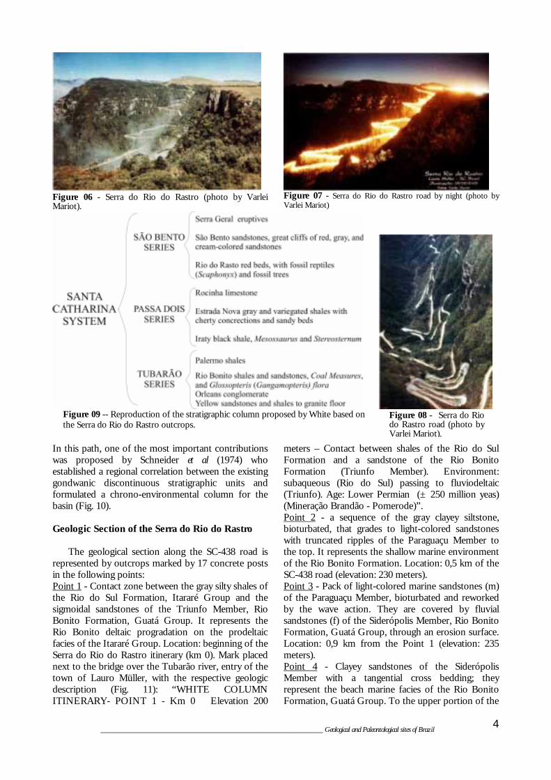
Figure 06 - Serra do Rio do Rastro (photo by Varlei Mariot).
Figure 07 - Serra do Rio do Rastro road by night (photo by Varlei Mariot)
Figure 08 - Serra do Rio do Rastro road (photo by Varlei Mariot).
Figure 09 -- Reproduction of the stratigraphic column proposed by White based on the Serra do Rio do Rastro outcrops.
In this path, one of the most important contributions was proposed by Schneider et al (1974) who established a regional correlation between the existing gondwanic discontinuous stratigraphic units and formulated a chrono-environmental column for the basin (Fig. 10). Geologic Section of the Serra do Rio do Rastro The geological section along the SC-438 road is represented by outcrops marked by 17 concrete posts in the following points: Point 1 - Contact zone between the gray silty shales of the Rio do Sul Formation, Itararé Group and the sigmoidal sandstones of the Triunfo Member, Rio Bonito Formation, Guatá Group. It represents the Rio Bonito deltaic progradation on the prodeltaic facies of the Itararé Group. Location: beginning of the Serra do Rio do Rastro itinerary (km 0). Mark placed next to the bridge over the Tubarão river, entry of the town of Lauro Müller, with the respective geologic description (Fig. 11): “WHITE COLUMN ITINERARY- POINT 1 - Km 0 Elevation 200
meters – Contact between shales of the Rio do Sul Formation and a sandstone of the Rio Bonito Formation (Triunfo Member). Environment: subaqueous (Rio do Sul) passing to fluviodeltaic (Triunfo). Age: Lower Permian (± 250 million yeas) (Mineração Brandão - Pomerode)”. Point 2 - a sequence of the gray clayey siltstone, bioturbated, that grades to light-colored sandstones with truncated ripples of the Paraguaçu Member to the top. It represents the shallow marine environment of the Rio Bonito Formation. Location: 0,5 km of the SC-438 road (elevation: 230 meters). Point 3 - Pack of light-colored marine sandstones (m) of the Paraguaçu Member, bioturbated and reworked by the wave action. They are covered by fluvial sandstones (f) of the Siderópolis Member, Rio Bonito Formation, Guatá Group, through an erosion surface. Location: 0,9 km from the Point 1 (elevation: 235 meters). Point 4 - Clayey sandstones of the Siderópolis Member with a tangential cross bedding; they represent the beach marine facies of the Rio Bonito Formation, Guatá Group. To the upper portion of the
____________________________________________________________ Geological and Paleontological sites of Brazil
4

section a part of the “Bonito coal bed” can be seen; it is intensely mined in the region and represents the peat deposits associated to coastal barriers. Location: 1.9 km from the initial point (elevation: 280 meters). Point 5 - The original outcrop of the Point 5 exposed the Barro Branco coal bed. As it was completely
mined, there is no chance to see it. Point 6 - Pack of yellowish sandy shales and siltstones, bioturbated, representing the shallow marine environment of the Palermo Formation, Guatá Group, transgressive over the Rio Bonito Formation. Location: km 8.1 (elevation: 400 meters).
Figure 10 - Stratigraphic column of the Paraná Basin adapted from Schneider et al. (1974) by Aboarrage and Lopes (1986)
and graphically correlated by using Milani (1977) and Assine (1994) modernizations, from Lopes et al (2003).
____________________________________________________________ Geological and Paleontological sites of Brazil
5

Figure 11 -. Point 1 plate with the site description.
Figure 12 - Point 9 concrete post where it is printed the
outcrop description.
Figura 13 – Section of the road by the 14 and 15 points (photo by Wilson Wildner).
Point 7 - Dark-colored bituminous shales of the Irati Formation – Assistência Member, Passa Dois Group that represent a restricted sub aqueous environment of calm water, below the wave base. Location: km 9.2 (elevation: 420 meters). Point 8 - Nowadays this outcrop is weathered and covered; the features described by Castro et al. (1994) no more can be seen. It marked the “fault contact between sandstones and siltstones (dipping against the fault) of the Teresina Formation (?) and the dark-colored (horizontal) shales of the Serra Alta Formation”. Location: km 10.7 (elevation: 475 meters).
____________________________________________________________ Geological and Paleontological sites of Brazil
6
Point 9 - Thick sequence of dark gray shales and siltstones with a parallel lamination and scarce carbonate concretions of the Serra Alta Formation, Passa Dois Group. They represent, such as the Irati Formation, a deposition in a calm water environment, below the wave base (Fig. 12). Location: km 11.6
(elevation: 520 meters). Point 10 - Transitional contact zone between the purple shales and siltstones with carbonate concretions of the Teresina Formation (T), Passa Dois Group, and the reddish sandstones of the Morro Pelado Member of the Rio do Rasto Formation (RR), Passa Dois Group, representing the beginning of the progradation cycle of the sedimentary basin. Location: km 13.5 (elevation: 590 meters). Points 11 and 12 - sequence of dark-colored shales intercalated to thick sandstone beds, Serrinha Member, Rio do Rasto Formation, Passa Dois Group, representing the progradation of the sigmoidal lobes over the clayey deposits. Location: point 12 at the km 14.7 (elevation: 660 meters). Point 13 - Sigmoidal lobes represented by sandstone bodies of the Morro Pelado Member, on top, prograding on clayey siltstones (base) of the Serrinha Member, Rio do Rasto Formation, Passa Dois Group.

____________________________________________________________ Geological and Paleontological sites of Brazil
7
Location: km 14.8 (elevation: 680 meters). Points 14 e 15 - A flattened contact – at the road level – between the Botucatu Formation (scarp) and the Morro Pelado Member of the Rio do Rasto Formation (Fig. 13). Location: point 14 at the km15.0 (elevation: 685 meters) and point 15 at the km 16.0 (elevation: 720 meters). Point 16 - Sandstones with large trough cross-beddings of the Botucatu Formation, São Bento Group, representing the implanting of a broad desertic environment in the Paraná Basin. Contact between the eolian sandstones of the Botucatu Formation and the basic volcanic rocks of the Serra Geral Formation, both included in the São Bento Group. Location: km 16.6 (elevation: 760 meters). Point 17 - Final point of the itinerary. Outcrop of basic volcanic rocks of the Serra Geral Formation, São Bento Group, next to the former Serra do Rio do Rastro Geologic Museum, also known as “Santinho” Museum. Location: at the concrete post of the point 17, km 17.0; elevation: 780 meters. Besides of these points marked along the SC-438 road, starting bu the town of Lauro Muller, can be considered as a extra-itinerary point (Point 0) a former cutout slope of the Dona Tereza Cristina railroad, along the left margin of the Tubarão river, close to the town of Orleans, where biblical scenes were carved on the rocks by the artist named Zeca Diabo. The outcrop is constituted by a pack of sandstones of the Rio do Sul Formation, Itararé Group, displaying characteristic sigmoidal structures with ripple marks in the top of the beds and subordinated climbing ripples. SYNOPSIS OF THE STRATIGRAPHIC UNITS The stratigraphy of the Paraná Basin in the Santa Catarina state, represented in athe White Column, comprehends the following units (whose main characteristics are enhanced by Castro et al - 1994, Krebs and Menezes Filho -1984 and Krebs - 2002): Itararé Group White (1908) described thick packs of conglomerates in the Serra do Rio do Rastro region, naming them Orleans Conglomerate and considering them as glacial in origin. Later on these conglomerates were supposed to belong to the Itararé Group (Oliveira, 1916 and Maack, 1947) and to be spread all over the Paraná Sedimentary Basin. For Schneider et al. (1974) this lithostratigraphic unit comprehends contemporaneous sedimentary packs formed in different depositional environments. The lower part of the group is composed by the Campo do Tenente Formation, the middle part by the Mafra Formation and the upper part by the Rio do Sul Formation. The whole set seems to represent
a fluviolacustrine and marine depositional system under the influence of glaciers. CAMPO DO TENENTE FORMATION The Campo do Tenente Formation, the lower portion of the Itararé Group, is mainly composed by brown-reddish pelites and subordinately by rhythmites and diamictites. In this case, the diamictites would be tillites and the sandstones and conglomerates would be the fluvioglacial deposits. A glaciolacustrine origin is assigned to the clayey and rhythmic portions (probably varvites). MAFRA FORMATION The Mafra Formation is the middle portion of the Itararé Group and it is composed by white and yellow-reddish sandstones with a poor sorting and subordinate diamictites, conglomerates and claystones. Its deposition occurred under marine and continental environmental conditions with a glacial influence. RIO DO SUL FORMATION The Rio do Sul Formation is the upper part of the Itararé Group. Its basal portion is composed by a thick pack of black shale (Lontras Shale) that represents a deep marine or prodeltaic deposit. It is overlain by a pack of sandy pelitic turbidites that represent a submarine fan sedimentation associated to diamictites and fluidized sandstones that are the slope facies. Over these deposits there are varved and deltaic front fringe deposits that point to the beginning of the progradation of the Rio Bonito Formation fluviodeltaic system. Daemon and Quadros (1969) placed the Campo do Tenente Formation in the Upper Carboniferous, the Mafra Formation in the Lower Permian and the Rio do Sul Formation in the Middle Permian, based on a palynomorph study. Guatá Group The name was proposed by Gordon Jr. (1947) to group the siltstones and sandstones that outcrop near to the Guatá village, in the southern region of the state of Santa Catarina. It comprehends the White (1908) Rio Bonito and Palermo “layers”. RIO BONITO FORMATION White (1908) proposed “Rio Bonito layers” to characterize the set of sandstones associated to pelites and coal beds described in the type section between the towns of Lauro Müller, Guatá and São Joaquim, Santa Catarina state. Schneider et al. (1974) proposed

the formalization of the Triunfo, Paraguaçu and Siderópolis names to the stratigraphic members of this formation, which were totally adopted for the whole Paraná Sedimentary Basin. The Triunfo Member is the basal portion of the Rio Bonito Formation. It is composed by light-grayish sandstones and conglomerates and its main sedimentary structures are parallel beddings and tabular- and trough cross-beddings. Dark grayish to black carbonaceous shales, claystones and siltstones, layers and coal beds (Bonito Coal bed) are subordinated. The coal beds are exploited in the Coal Region of Santa Catarina. The complete lithologic set represents the deltaic system with the prevalence of the progradational fluvial over the prodelta mudstones, which are represented by the Itararé Group. The Paraguaçu Member abruptly overlays the Triunfo Member and it is the middle portion of the Rio Bonito Formation. It is characterized by a mostly pelitic sedimentation represented by gray to greenish siltstones and shales displaying parallel and undulated lamination and bioturbation. It stands for a transgressive marine facies over the fluviodeltaic sandstones of the Triunfo Member that completely drowned the previous deltaic system. The Siderópolis Member covers the Paraguaçu Member; it forms the upper third of the Rio Bonito Formation and it is characterized by a thick pack of sandstones intercalated to siltstones, carbonaceous shales and coal (Barro Branco Coal bed), which is largely exploited in the Santa Catarina Coal Region. It commonly presents a parallel lamination truncated by waves, climbing ripples, flaser structure, clay drapes, bioturbation and fluidization, wavy, linsen and hummocky structures. For Medeiros and Thomaz (1973) this sequence was deposed in a coastal environment that progradated over the marine sedimentation of the Paraguaçu Member. The sandstones represent bar and barrier deposits interdigitated with fluviodeltaic sediments; the carbonaceous sediments were originated in coastal lagoons and marshes that were covered by littoral sands. The fossiliferous content of the Rio Bonito Formation is characterized by the abundance of vegetal remains (plant impressions – Glossopteris flora) and palynomorphs found both in coal and associated rocks, what allowed to place this formation in the Lower Permian period, between the Artinskian and the base of the Kungurian stages. Mineral Coal The largest coalfields of the country are placed in the Rio Grande do Sul and Santa Catarina states; the smallest ones in the Paraná and São Paulo states. The
Brazilian reserves amount 32 billion tons of in situ coal, shared by the states of Rio Grande do Sul (89.25%), Santa Catarina (10.41%), Paraná (0.32%) and São Paulo (0.02%). One only deposit, the Candiota Deposit, placed in the southwestern portion of the Rio Grande do Sul state, bears 38% of the total national coal resources. In this deposit there are 17 coal beds. The most important is the Candiota coal bed, composed by two coal banks with a total average thickness of 4.5 meters.
Figure 14 - Main coal beds in Rio Grande do Sul and Santa Catarina states (adapted from: Brasil. CPRM – Pesquisa de Carvão no Brasil, 1972).
In all these states the mineral coal beds are associated to the lithologies of the Rio Bonito Formation. These beds have local names in each deposit, such as: Candiota coal bed, in the homonymous mine; S2 and I in the Leão mine;CL4 in the Chico Lomã deposit, in the Rio Grande do Sul state. In Santa Catarina the best known are the Barro Branco, Bonito and Irapuá coal beds. In Paraná, the Figueira/Sapopema coal bed is the best one. Most of the Rio Grande do Sul coal is a “C” high volatile bituminous coal, whereas in Santa Catarina it is a “A” high volatile bituminous coal, which has a better quality. The Brazilian coal was first discovered in 1827, in Guatá, a village belonging to the municipality of Lauro Müller, Santa Catarina state. It was initially exploited by an English company that constructed a railway between Lauro Müller and the port of Laguna. As the Santa Catarina coal was considered a low-quality product, the English businessmen lost their interest in
____________________________________________________________ Geological and Paleontological sites of Brazil
8

____________________________________________________________ Geological and Paleontological sites of Brazil
9
it and the Brazilian Government had to transfer the mining claims to Brazilian industries.. In the Rio Grande do Sul state the coal production started in 1855, in the municipality of Arroio dos Ratos. The coal mining in the villages of Candiota and Hulha Negra, to the southwest of the state, started in 1863. In 1904 the Brazilian Government created the Comissão de Estudos das Minas de Carvão de Pedra do Brasil (Commission for Studies on the Mineral Coal Mines of Brazil) to evaluate the potential of the coal occurrences in the south of the country. In this same year the Minister of Industry, Dr. Lauro Müller, designated the American geologist Dr. Israel C. White as the chief of the Commission. White and his team carried out several studies in Brazil from 1904 to 1906 and the result of this work was presented in the Final Report of the Commission, in 1908. When the I World War started the Brazilian coal had its first exploitation outbreak. By this time the railways were enlarged and new mining companies were created. The second outbreak came during the Getúlio Vargas presidential period, when the Companhia Siderúrgica Nacional – CSN (National Steel Company) was created, in 1946 and when it was edited a decree determining the use of 20% of the national coal to compose the coke for the steel industry. This was followed by the installation of thermoelectric power plants that pushed the coal consumption. The oil crisis in the 70’s allowed a new drive for the national coal consumption. In the beginning of the 90’s the sector was deregulated by a federal decree, what generated a deep recessive crisis. (Source of information: Gomes, 2002). PALERMO FORMATION White (1908) used for the first time the term “Palermo schists” to describe a sequence of gray-yellowish siltstones intensively bioturbated and scarce lenses of fine to conglomeratic sandstones that outcrop in the southeastern region of the Santa Catarina state. In the region of the coal basin, where it was defined, it shows its most typical features.. For Aboarrage and Lopes (1986) the basal interval of the Palermo Formation in some portions of the Paraná Basin is predominantly formed by an interlamination of silt and fine to very fine sand with an undulated lamination and wavy, linsen and local flaser structures. They compose a set of intercalated layers and lenses of fine to medium orthoquartzitic sandstones with ripple marks. In this set, hummocky structures and small lenses of granule conglomerates with abundant carbonate cement may be found. The contact with the coastal sediments of the Rio
Bonito Formation is normally concordant but abrupt, frequently erosive. The fossiliferous content of the Palermo Formation is represented by the frequent occurrence of silicified fossil logs (Dadoxylon) and by the abundance of palynomorphs, mainly sporomorphs. Gordon Jr. (1947) detected the presence of pelecypods in Santa Catarina and Putzer (1954) reported the occurrence of the Loxomma genus in the Criciúma region. Lopes et al. (1986) and Lavina and Lopes (1986) admit that the Palermo Formation sediments were deposed in a transgressive platformal marine environment under the influence of waves and tides, covering the deltaic/lagoonal sediments of the Rio Bonito Formation. This caused the retreat of the coastline in successive pulses, from the west to the east. This formation is considered Permian in age, between the Kungurian and Kazanian stages. Passa Dois Group This group comprehends the Irati, Serra Alta, Teresina and Rio do Rasto formations, all of them presenting good outcrops in the Santa Catarina state. IRATI FORMATION White (1908) used the term “Iraty” to name the “schists, sandy layers and limestones” that outcrop by the Passa Dois river, in the Serra do Rio do Rastro region. For Schneider et al (1974) this formation may be subdivided in two members: Taquaral and Assistência, names used by Barbosa and Gomes (1958) for the Irati Formation in the state of São Paulo. This subdivision fits for almost the whole Paraná Basin (Aboarrage and Lopes, 1986). The Taquaral Member is composed by light-gray and bluish siltstones and shales that represent a deposition in a calm water marine environment, below the wave level, for Schneider et al (op.cit.). The Assistência Member is formed by dark gray shales with intercalations of black pyrobituminous shales associated to cream-colored and dark gray dolomitic limestones. Its fossiliferous content includes the Mesosaurus brasiliensis and Stereosternum tumidium reptiles and vegetal, fish and crustaceous remains, as well as palynomorphs. For Schneider et al (op.cit.) these lithologies represent a calm water marine environment; Petri and Fúlfaro (1983) do not agree, due to the lack of typical marine fossils: they think this member was deposed in a lagoonal environment. Mesosaurus Brasiliensis The Mesosaurus brasiliensis was named by Mac Gregor (1908) when he studied the reptile fossils found into the black shales of the Irati Formation and

collected near the Irati station of the São Paulo – Rio Grande railroad, in the Paraná state. It is a small reptile that has a slim body and a long tail which is laterally depressed; it may reach about 1 meter, when an adult animal (Fig. 15). Its triangular skull has a very considerable number of thin teeth that are proper to a carnivorous feeding. The anterior and posterior members have the shape of flippers that allow its rapid movement in the water of the seas that existed 250 million years ago in the southern region of South America (Brazil, Uruguay and Paraguay) and in the south-southeastern region of Africa (South Africa). It was a very efficient predator.
Figure 15 - Mesosaurus brasiliensis - Mac Gregor, 1908
Figure 16 - Stereosternum tunidum - photo by Instituto Geológico, SP (www.igeologico.sp.gov.br).
The first Mesosaurus was found in Griquas, south of the African continent. It was studied by the scientist Paul Gervais in 1864, who named it Mesosaurus tenuidens. In 1886 Cope, based in fossils collected by Prof. Derby in different locations of the São Paulo state (Rio Claro, Limeira, Itapetinga and Tietê), described the Stereosternum tumidium (Fig. 16). In 1966, Shikama and Osaki described new genus and species, named Brazilosaurus sanpauloensis. Although it is an accepted name, recent studies on the Mesosaurus
brasiliensis species described by Mac Gregor in 1908 seem to point it as the same species of the Mesosaurus tenuidens described by Paul Gervais in 1864. The presence of this fossil in both American and African continents, in equivalent chronostratigraphic units, has been expressively used as a solid ground for the existence of the continental displacement. (source of information: Barberena & Timm, 2000). The Irati Formation normally has a transitional contact with the overlying Serra Alta Formation and with the underlying Palermo Formation. The contact between its members is concordant. This formation is chronostratigraphically placed in the Upper Permian period, Kazanian stage. SERRA ALTA FORMATION White (1908) included part of the sediments that compose the modern Serra Alta Formation in the unit named “Iraty schist”. Gordon Jr. (1947) proposed the name Serra Alta to designate a pack of dark gray shales placed between the present Irati and Teresina formations, as a member of the Estrada Nova Formation. Sanford and Lange (1960) ranked this unit as a formation, which is now the common usage. The Serra Alta Formation comprehends a sequence of dark gray to black shales and siltstones that characteristically present a conchoidal fracture. When weathered they become light- to greenish gray and yellowish in color. They are normally massive or have an incipient parallel lamination and sometimes they are micaceous. They locally contain ellipsoidal carbonate lenses and concretions that may be 1.5 m long and reach 0.5 m in width. The contacts of the Serra Alta Formation with both the overlying Teresina Formation and the underlying Irati Formation are transitional. Its fossiliferous content is represented by fish, pelecypod, conchostracan and palynomorph remains, what dates it as Upper Permian, between the top of the Kazanian and the base of the Tatarian stages. TERESINA FORMATION White (1908) named “Estrada Nova layers” a sequence of gray and variegated shales and sandstones, including the Teresina formation sediments. Moraes Rego (1930) firstly used the name Teresina, as Teresina Group, to indicate the sediments of the type section exposed in the right margin of the Ivaí river, near to the village of Teresa Cristina (former Teresina), in the Paraná state. Schneider at al. (1974) classified this sequence as Teresina Formation. The Teresina Formation is composed by dark gray and greenish mudstones, shales and siltstones that are rhythmically intercalated to light-gray very fine sandstones. When altered this unit shows varied
____________________________________________________________ Geological and Paleontological sites of Brazil
10

colors: cream, purple, reddish. It commonly has ellipsoidal carbonate lenses and concretions that may reach 2m in length and 80 cm in width. The main sedimentary structures found in this unit are: flaser, planar parallel, wavy and convolute laminations, hummocky stratification, ripple marks and mudcracks. The lithological characteristics and the sedimentary structures present in this formation point to a deposition in a marine system with shallow and troubled waters, wave- and tide-dominated (subtidal to supratidal) environment. The contacts of the Teresina Formation with both the overlying Rio do Rasto Formation and the underlying Serra Alta Formation are transitional. Its fossiliferous content is represented by plant, lamellibranch and palynomorph remains, what places it in the Upper Permian period, Tatarian stage. RIO DO RASTO FORMATION White (1908) used the term Rio do Rasto for the first time to define a succession of red beds exposed in the headwaters of the Rastro river, along the Lauro Müller – São Joaquim road, Santa Catarina state, as the type section of this formation. Gordon Jr. (1947) raised the Rio do Rasto unit to the formation status and divided it in two members: Serrinha (inferior) and Morro Pelado (superior). This is the concept that is used by most of the modern authors. The Serrinha Member is composed by well-sorted fine sandstones intercalated to gray-greenish, brownish, purple and reddish sandstones and mudstones. Marl lenses or layers may locally occur. The sandstones and siltstones have cross, ripple, climbing and flaser laminations and sometimes they may be massive. The silty-clayey layers display planar parallel lamination, wavy and linsen structures. The siltstones and mudstones have a well-developed spheroidal disintegration that is a useful criterion to identify this unit. Schneider et al (1974) refer that the lithologies of this member resulted from the progradational advance of the tidal flat clastics, what characterizes a transitional environment between the shallow water deposits of the Teresina Formation and the continental ones of the Morro Pelado Member. Aboarrage and Lopes (1986) assigns a transitional marine environment for the deposition of this member. The progressively more reddish colors of the Serrinha Member clearly point to more oxidant environmental conditions from the bottom to the top of the unit. The Morro Pelado Member is formed by lenses of reddish fine sandstones intercalated to purple siltstones and mudstones. The set also shows green, brown, yellowish and whitish colors. Its main sedimentary structures are the trough cross bedding, parallel and cross lamination and cut and fill. The beds
have sigmoidal or tabular geometry. The depositional environment for this member is considered by Schneider et al (1974) as strictly continental, where the lake and alluvial plain sediments are covered by sand dunes under arid climatic conditions. Aboarrage and Lopes (1986) ascribe a fluviodeltaic depositional environment for this member. The deposition of the Rio do Rasto Formation is initially attributed to a shallow marine environment (supra- to sub-tidal) that progressively changes to coastal plain deposits (Serrinha Member) and then to the setting of a fluviodeltaic sedimentation (Morro Pelado Member). The contact of the Rio do Rasto Formation with the overlying Botucatu Formation is an erosive discordance, whereas it is transitional with the underlying Teresina Formation. The contact between its Serrinha and Morro Pelado members is concordant and gradational. The fossiliferous content of this formation is mainly represented by pelecypods, conchostracan, palynomorphs, plant remains and by the amphibian Labirintodonte. Leaf and stem prints were described by Bortoluzzi (1975), who identified the Dichophyllites and Paracalamites specimens and by Klepzig (1978), who described Schizoneura, Paracalamides, Dizeugotheca, Pecotperis, Neoggerathiopsis and Glossopteris specimens. White (1908) refers the presence of Scaphonyx in the Rio do Rasto sediments, discovered by Dr. Jango Fischer in 1902 in Santa Maria, Rio Grande do Sul state. These fossils allow placing this formation between the Upper Permian (top of the Tatarian stage) and the Lower Triassic (Anisian stage).
Figure 17 - Reconstitution of the Scaphonyx fischeri Smith-Woodward, 1907 (illustration by M. C. Barberena) (http://acd.ufrj.br/mndgp/rincoss.htm).
Scaphonix fischeri The Scaphonyx fischeri is a typical representative for the rhynchosaur group. The biggest specimens found in Brazil reached 2.5 meters in length and 0.55 meters in the maximum height (Fig. 17). The rhynchosaur is one of the most abundant reptile groups, although they had a temporal distribution limited to the Triassic period. The first specimens arose in the Scythian (EoTriassic) of the South Africa and the whole group was extinct in the transition of the Carnian – Norian stages (NeoTriassic). In Brazil, rhyncosaurs may be
____________________________________________________________ Geological and Paleontological sites of Brazil
11

found only in the outcropping sedimentary rocks near to the town of Santa Maria, Rio Grande do Sul state. The Scaphonyx fischeri was the first vertebrate described to the Brazilian Mesozoic and the first Triassic reptile described in South America. Due to its historical importance or to the representativeness of the species, the Rio Grande do Sul rhyncosaurs are one of the most important groups of Brazilian fossils (Fig. 18). (source of information: Barberena, 1987; Langer and Schultz, 2000).
Figure 18 - Skull of the Scaphonyx sulcognathus measuring 35 cm, from the NeoTriassic epoch (Carnian age - about 228 to 224 million years) of the Rio Grande do Sul state. UFRGS, Departamento de Paleontologia e Estratigrafia - Setor de Paleovertebrados (http://www.ufrgs.br/geociencias/paleo).
São Bento Group White (1908) used this term to group the volcanic and eolian rocks that occur in the Serra do Rio do Rasto, south of Santa Catarina state. The Botucatu and Serra Geral formations compose this group. BOTUCATU FORMATION Gonzaga de Campos (1889) described as “Gres de Botucatu” a pack of red sandstones that outcrop in the Serra do Botucatu, between the city of São Paulo and the town of Botucatu, São Paulo state. White (1908) named “Gres de São Bento” the sequence that nowadays is designated as Botucatu Formation. It is lithologically formed by bimodal (medium to fine) sandstones that may locally be coarse and conglomeratic, with well-sorted rounded or sub-rounded grains. They display a reddish gray color and the presence of siliceous or ferruginous cement is frequent. They compose an expressive sandy pack which has thick tabular or lenticular beds that extend for long distances.
____________________________________________________________ Geological and Paleontological sites of Brazil
12
Its lower third shows thin intercalations of pelites with common sand-silt-clay interlaminations and frequent lateral variation of facies. To the middle third of the pack the pelitic intercalations disappear and
thick beds of bimodal sandstones domain. These present a very large trough cross bedding, an indication that the climatic conditions became gradually more arid till the definitive setting of a desert environment. The persistence of sedimentary structures such as the very large trough cross bedding, the tabular cross bedding, tangential at the base and the planar parallel bedding, the bimodality of the sandstones which is remarked by the grain fall and grain flow processes and the frequent pelitic intercalations, the adhesion ripples, the low-relief ripple marks suggest a desert environment with dune and interdune deposits. The contacts of the Botucatu Formation with both the basaltic rocks of the overlying Serra Geral Formation and with the underlying Rio do Rasto Formation are discordant. This formation, together with other gondwanic units, compose the biggest South American aquifer, known as the “Guarani Aquifer”.
Figure 19 - SC-438 road from Lauro Muller to- São Joaquim and the top of the Serra do Rio do Rastro.
SERRA GERAL FORMATION White (1908) used for the first time the name “eruptives of the Serra Geral” to indicate as a type section the outcrop of the volcanic rocks that occur in the Serra Geral, along the road that links the towns of Lauro Müller and São Joaquim (SC-438 road), in Santa Catarina (Fig. 19). Leinz (1949), in the same Lauro Müller – São Joaquim state road (Serra do Rio do

____________________________________________________________ Geological and Paleontological sites of Brazil
13
Rastro) established a classical section and characterized the internal parts of a lava flow as: basal vitreous zone with horizontal disjunction; intermediate zone with vertical joints; superior zone with both vertical and horizontal disjunction; and vesicular basalt, at the top. Gordon Jr. (1943) classified this sequence as the Serra Geral Formation. It is lithologically composed by a thick succession of predominantly basic lava flows that contains subordinate intermediate and acid domains, mainly in the middle and superior thirds of the pile. The rocks are frequently much fractured, displaying characteristic conchoidal fractures. This formation is a consequence of an intensive fissural magmatism that corresponds to the closing of the gondwanic evolution of the Paraná Basin. The contact of the Serra Geral Formation with the older sedimentary rocks of the Paraná Basin is discordant. The intrusion of diabases into the gondwanic sedimentary rocks is very frequent. In the Treviso region (Santa Catarina state) these intrusions mainly occur in the Rio Bonito and Irati formations. Mühlmann et al. (1974) place the Serra Geral Formation in the Lower Cretaceous (between 120 and 130 million years) based on radiometric data obtained by several authors. Undifferentiated Basement In the Lauro Müller – Orleães region the basement of the Paraná Sedimentary Basin is represented by granitoid rocks included in the Pedras Grandes Suite, which is a part of the lithostructural domain of the Pelotas Batholith. They are reddish pink granites whose composition ranges from syeno- to monzogranitic. They normally do not present tectonic deformation and are NeoProterozoic in age. The only place where these granitoids occur, in the Excursion Itinerary, is the Point 0, where sedimentary rocks of the Itararé Group discordantly lie on isotropic granites of the Pedras Grandes Suite. PROTECTING PROCEDURES
The region is in good environmental and
landscape conditions. The tourist potential of the mountainous part of this region has been properly exploited in São Joaquim, Urubici, Bom Jardim da Serra and other places, and it is increasing. Its infrastructure is quite considerable; although the conventional hotels are somewhat deficient, there are many lodgings with qualified services. The local tourism is inclined to the wintertide, when it happens to snow, but it has potential for any season.
The standard of living in this region has a good quality. It is remarkable the fact that the concrete posts fixed in 1994 are still complete, without any sign
of vandalism, a common practice in our roads. Even if it is surrounded by several official
preservation areas such as state and national parks (Parque Nacional de São Joaquim, Reserva Biológica Estadual do Aguaí and Parque Estadual da Serra Furada), there are no studies to adopt special protective procedures for this region. That would be very advisable to avoid an eventual spoiling of this exceptional tourist area.. REFERENCES Aboarrage,A.M. ; Lopes,R.C. 1986. Projeto a Borda Leste
da Bacia do Paraná: integração geológica e avaliação econômica. DNPM/CPRM ,Porto Alegre. 18 v. (Unpublished).
Assine,M.L .; Soares,P.C. ; Milani,E.J. 1994. Seqüências tectono-sedimentares mesopaleozóicas da Bacia do Paraná, sul do Brasil. Revista Brasileira de Geociências, 24(2) : 77-89.
Barberena,D.C.A.; Timm,L.L. 2000. Características dos mesosaurus e suas adaptações ao meio aquático. In: Holz,M. ; Ros,L.F. Paleontologia do Rio Grande do Sul. UFRGS/CIGO , Porto Alegre, pp.:194-209.
Barberena,M. 1987. Cinodontes e rincossauros no sul do Brasil. Ciência Hoje, Porto Alegre v.6, n.34 p.44- 60.
Barbosa,O ; Gomes,F.A. 1958. Pesquisa de petróleo na bacia do rio Corumbataí, estado de São Paulo. DNPM/DGM, Rio de Janeiro, 40pp.(Bol. nº 171)
Bortoluzzi,C.A. 1975. Étude de quelques empreintes de la flore gonwanienne du Brézil, Reims, France, In: Cong. Nat. Soc. Savantes, 95, Actes, v. 3 p.171-187.
Brasil. Ministério de Minas e Energia. Companhia de Pesquisa de Recursos Minerais – CPRM. 1972. Pesquisa de Carvão no Brasil. Rio de Janeiro , 1 v. (Unpublished)
Castro,J.C. ; Bortoluzzi,C.A. ; Caruso Jr.,F. ; Krebs,A.S.J. 1994. Coluna White: estratigrafia da Bacia do Paraná no sul do estado de Santa Catarina - Brasil. Secretaria de Estado de Tecnologia, Energia e Meio Ambiente, Florianópolis, 1 v. (Série Textos Básicos de Geologia e Recursos Minerais de Santa Catarina, 4).
Daemon,R.F. ; Quadros,L.P. 1969. Bioestratigrafia e Palinologia do Paleozóico Superior da Bacia do Paraná. PETROBRÁS/DESUL, Ponta Grossa, 1 v. (Relatório Interno nº 384).
Gomes,A.J. 2002. Carvão do Brasil Turfa agrícola: geologia, meio ambiente, e participação estratégica na produção de eletricidade no sul do Brasil. EST, Porto Alegre, 164 p.
Gonzaga de Campos,L.F. 1889. Secção geológica. In: São Paulo, Comissão Geographica e Geológica. Relatório, São Paulo, pp. 21-34.

Gordon Jr.,M. 1947. Classificação das formações gondwânicas do Paraná, Santa Catarina e Rio Grande do Sul. Notas Preliminares e Estudos, DNPM/DGM, Rio de Janeiro, (38):1-20.
Klepzig,M.C. 1978. Estudo da tafoflora do Membro Morro Pelado na sua localidade-tipo. Pesquisas, Porto Alegre, (11):225-303.
Krebs,A.S.J.; Menezes Fº,N.R. 1984. Projeto Mapeamento Geológico para Carvão área de Taió-Rio do Sul, SC ; relatório final. DNPM/CPRM ,Porto Alegre, 1 v. (Unpublished) .
Krebs,A.S.J. 2004. Contribuição ao conhecimento dos recursos hídricos subterrâneos da área correspondente à bacia Hidrográfica do Rio Araranguá, SC. 1 v. Tese de Doutorado, Universidade Federal de Santa Catarina, 2 v.
Langer,M.C.; Schultz, C.L. 2000. Rincossauros - herbívoros cosmopolitas do Triássico. In: Holz, M. ; Ros, L. F. Paleontologia do Rio Grande do Sul. UFRGS/CIGO , Porto Alegre, pp:246-272.
Lavina,E.L. ; Lopes,R.C. 1986. A transgressão marinha do Permiano Inferior e a evolução paleogeográfica do Supergrupo Tubarão no Estado do Rio Grande do Sul. Paula Coutiana, Porto Alegre, (1):51-103.
Leinz, V. 1949. Contribuição à geologia dos derrames basálticos do sul do Brasil. DNPM ,Rio de Janeiro, 52 pp. (Boletim DFPM, n. 21).
Lopes,R.C.; Lavina,E.L.; Faccini,U.F.; Milani,E.J.; Wildner,W. 2003. Geologia da Província Paraná. CPRM, Porto Alegre. (Unpublished)
Lopes,R.C.; Lavina,E.L. ; Signorelli,N. 1986. Fácies sedimentares e evolução paleoambiental do Supergrupo Tubarão na Borda Leste da Bacia do Paraná; uma seção regional nos estados do Rio Grande do Sul e Santa Catarina. In: Cong. Bras. Geol. 34, Anais,. v.1, pp.206-218.
Maack,R. 1949. Die Gondwanaschichten - Breves noticias sobre a geologia dos estados do Paraná e Santa Catarina. Arq. Inst. Biol. Pesq., Curitiba, 1 (9 ):129-176.
Mac Gregor,J.H. 1908 Mesosaurus brasiliensis nov. sp., Parte II. In: White, I.C. 1908. Relatório final da Comissão de Estudos das Minas de Carvão de Pedra do Brasil. DNPM , Rio de Janeiro, Parte II, p. 303-617. (Fac-similar edition, 1988)
____________________________________________________________ Geological and Paleontological sites of Brazil
14
Mariot,V. s.d. Serra do Rio do Rastro; photographies. (photographer and responsible for the former “Museu Geológico da Serra do Rio do Rastro” (Museu da Santinha) - SC-438 road, next to the point 17).
Medeiros,R.A. ; Thomaz Fº,A. 1973. Fácies e ambientes deposicionais da Formação Rio Bonito. In: Cong. Bras. Geol., 27, Aracaju. Anais, Aracaju : SBG , v.3, p.3-11.
Milani,E.J. 1997. Evolução tectono-estratigráfica da Bacia do Paraná e seu relacionamento com a geodinâmica fanerozóica
do Gonduana Sul-Ocidental. Tese de Doutorado, Instituto de Geociências, Universidade Federal do Rio Grande do Sul, 2 v.
Moraes Rego, L.F. 1930. A geologia do petróleo no Estado de São Paulo. B. Serv. Geol. Mineral Bras. Rio de Janeiro : Serv. Geol. Mineral. Brasil. 110 p. (Boletim nº 46).
Mühlmann,H. ; Schneider,R.L. ; Tommasi,E. ; Medeiros,R.A. ; Daemon,R.F. ; Nogueira,A.A. 1974. Revisão Estratigráfica da Bacia do Paraná. PETROBRÁS/DESUL, Ponta Grossa, 186 pp. (Relatório DESUL, 444).
Oliveira,E.P. 1916. Geologia do Estado do Paraná. Minist. Agric. Indúst. Com., Rio de Janeiro, p. 67- 143.
Orlandi Fº,V. ; Krebs,A.S.J. ; Giffoni,L.E. 2002. Coluna White - Excursão virtual pela Serra do Rio do Rastro, SC : seção padrão das unidades do Gondwana no sul do Brasil. CPRM, Porto Alegre, 55 pp. Available in http://www.cprm.gov.br/coluna/index.html.
Petri,S. ; Fúlfaro,V.J. 1983. Geologia do Brasil (Fanerozóico). USP , São Paulo, 631 pp.
Putzer,H. 1954. Divisão da Formação Palermo no sul de Santa Catarina e tentativa de interpretação genética. Boletim SBG , v. 3, n. 1.
Sanford,R.M. ; Lange,F.W. 1960. Basin-study approach to oil evaluation of Paraná miogeosyncline, south Brazil. AAPG Buletin, 44:1316-1370.
Schneider,R.L. ; Mühlmann,H. ; Tommasi,E. ; Medeiros,R.A. ; Daemon,R.F. ; Nogueira,A.A. 1974. Revisão estratigráfica da Bacia do Paraná. In: Cong. Brasil. Geol., 28, Anais, p.41-65.
West Virginia Geological and Economic Survey. [Geol. Israel Charles White’s photo] Available in <http://www.wvgs.wvnet.edu>
White, I.C. 1908. Relatório final da Comissão de Estudos das Minas de Carvão de Pedra do Brasil. DNPM , Rio de Janeiro, Parte I, p.1-300 ; Parte II, p. 301-617. (Fac-similar edition, 1988)
(*) CPRM - Serviço Geológico do Brasil 1 - [email protected] 2 - [email protected] 3 - [email protected]