the neolithic and early bronze age: resource assessment early bronze age that does not depend on the...
TRANSCRIPT

Introduction
The nature of the evidence
It is often claimed that linear projects such as pipelinesor major roads provide a novel perspective on the past.They cannot represent a ‘random sample’ of archaeolog-ical observations because each element does not havethe same chance of being selected. Instead, their courseis essentially arbitrary and bears no obvious relationshipto the geography of any particular period. For thatreason the results of monitoring these developments areoften surprising, and it is those surprises that provide astimulus for rethinking archaeological orthodoxies.Regions prove to have been settled where few sites hadbeen known before; rich burials are found outside thesmall concentrations on which the literature had beenbased; new kinds of monument are revealed and familiarforms occur in unfamiliar settings. It is not the mostobvious way of conducting research, but sometimes theresults of this work offer a perspective out of which newapproaches to the past can develop. The same should be true of the Regional Research
Assessments, of which this publication is an example.They are concerned with regions of the country whichhave been selected on the basis of modern administra-tive arrangements. They lack any real geographicalunity, and the relationships between their componentparts may well have changed over time. On the otherhand, like the road schemes that have done so much towiden the scope of prehistoric archaeology, theprocess of bringing together what is known aboutthese areas of land can be remarkably productive. Adistribution of key sites and other selected sites isshown in Figure 7.1.As it happens, the area selected for the Solent-
Thames Research Assessment has many of theseadvantages. Like the building of pipelines, it makesarchaeologists think harder about some areas that havenot played a major part in writings about prehistory –the Isle of Wight, for example, or the BuckinghamshireChilterns. Quite by chance, it also avoids a regionwhose monuments have been over-emphasised inaccounts of prehistoric Britain. It is an importantchallenge to write about the Neolithic period withoutdiscussing Hambledon Hill, Stonehenge, Avebury and
Durrington Walls, just as it is important to think aboutan early Bronze Age that does not depend on the richburials found on the Dorset and Wiltshire chalk. Notonly does the Solent-Thames corridor avoid thesefamous groups of monuments, it covers an area inwhich certain kinds of structure seem to be rare orabsent. Causewayed enclosures are unusual outsidethe Thames Valley and southern Cotswolds; longbarrows of classic form are not represented across theentire study area; henges are uncommon or takeunusual forms, and rich early Bronze Age cemeteriesare the exception rather than the norm. That may notbe an impediment to research, for it can be arguedthat, within the wider context of British prehistory,developments in the heart of earlier prehistoric Wessexwere altogether exceptional. A framework of moregeneral application may depend on fieldwork in otherregions, in particular the major river valleys and theNorth Sea coast. A few basic points need to be made at the outset.
Some of these observations apply to the entire prehis-toric sequence; others are specific to the period between4000 and 1500 BC that provides the subject of thischapter.
Inherited landscapes and Neolithic and earlyBronze Age land use
It is no longer satisfactory to suppose that the earlierprehistoric landscape was covered by a continuouscanopy of trees (Allen and Gardiner 2009). By thebeginning of the Neolithic period some areas had beenmodified by burning – both deliberate and accidental –and others by natural events, especially storms (Brown1997). The vegetation cover will also have beenaffected by the activities of wild animals, by the ecolog-ical preferences of different kinds of woodland, andduring the Neolithic period by such practices ascoppicing and pollarding. There was greater variationthan is generally supposed, and recent research inCranborne Chase and on the Yorkshire Wolds suggeststhat certain areas of chalk downland may never havebeen covered by primary forest in the way that iscommonly supposed (French et al. 2007; Allen andScaife 2007). That is especially important because boththese regions contain an unusual concentration of
87
Chapter 7
The Neolithic and Early Bronze Age: Resource Assessment
by Richard Bradley(County contributions by Kim Biddulph, Steve Ford, Julie Gardiner, Gill Hey
and Ruth Waller; palaeoenvironmental contribution by Mike Allen)

88 Solent-Thames Research Framework for the Historic Environment
Figure 7.1 Neolithic and Early Bronze Age sites mentioned in the text

Chapter 7 The Neolithic and Early Bronze Age: Resource Assessment 89
Neolithic monuments. By contrast, there is little tosuggest the existence of comparable environments inthe study area (Robinson 1992a and b; Hey et al. 2011b; Field 2004; 2008).The pattern of prehistoric activity cannot be
reconstructed on the basis of modern land use. Thereare areas that provide evidence of continuous occupa-tion, for example the Thames gravels (Barclay et al.1996), while there are others that show signs of intensiveactivity in certain phases and little evidence of occupa-tion in others. The character of the local soils haschanged significantly. The clay-with-flints which capsthe chalk was intensively used in the Mesolithic andNeolithic periods but was less densely settled duringlater phases. Similarly, the heathland soils of the NewForest and perhaps the Hampshire Greensand saw apeak of activity during the Bronze Age, but since thenthey seem to have been regarded as marginal land (Field2008). The increase in the number of palaeo-environmental
datasets has improved the resolution at which we canlook at landscapes and land-use, whether for individualsites or across whole regions (Allen 1997a and b; Allenand Gardiner 2009). We can now start to re-addresssome key questions surrounding the presence and useof ‘farmed’ produce, and whether this indicates a whollyfarming economy. The Neolithic may partly be definedby the presence of farming activities, but Neolithiccommunities may have had a risk-averse strategy whichinvolved hunting and gathering as well as farming(Jones 2000; Moffett et al. 1989; Robinson 2000). Inaddition, the use of domesticated resources does notrequire a sedentary lifestyle. The issue as to whether theeconomy of these communities becomes largely, orwholly, based around a domesticated food supplyrequires further study.While there may be some relationship between the
extent of open ground and the choice of certain regionsfor monument building, it is not correct to use thefrequency of earthwork structures to estimate theintensity of occupation in any part of the study area. Theconstruction of such monuments certainly required asignificant labour force, but its members could havebeen drawn from a wider region. Elsewhere in England,some monument complexes are associated withevidence of nearby settlement, but there are otherswhere it is absent (Bradley 2006). In the same way, it isincorrect to suppose that areas that lack large concentra-tions of field monuments were less intensively occupied.Within the Solent-Thames corridor, some of thegreatest concentrations of worked flints come from thechalk downland around Basingstoke and from theChilterns, where the density of monuments is unusuallylow (Gardiner 1984; 1988; Holgate 1988a; Field 2004).Moreover, current work on the dating of Neolithic longbarrows and enclosures suggests that they could havebeen constructed during quite specific phases, and thatthey were often short-lived (Whittle, Barclay et al. 2007).Thus their occurrence may prove to be the exceptionrather than the rule.
Some of the changes to the natural environment thattook place during or after this period have severelybiased the archaeological record. In the valleys of majorrivers like that of the Thames, occupation sites and someof the smaller monuments have been buried beneathlater deposits of alluvium (Robinson 1992b; Evans1992a; Parker and Robinson 2003). Others werepreserved because they occupied the hollows left byformer channels and escaped destruction by the plough.On the chalk there is another source of bias, for not onlyhas much of the original topsoil been lost by erosion, thisprocess had led to the accumulation of deep deposits ofhill wash on the valley floors. Recent work in Sussex andKent has shown that these had buried some of theelusive living sites of the Neolithic and Early Bronze Age(Allen and Scaife 2007). Similar evidence has beenidentified on the Chilterns and it is probable that thesame process happened in other parts of the study area(Evans 1972; Evans and Valentine 1974). Archaeologists still assign a special status to the
archaeology of the chalk. That needs careful considera-tion. It is true that it is an area with an unusual density offield monuments, but this is only partly due to develop-ments during the prehistoric period. To a large extent theprominence of chalkland monuments is the result of laterland use. These structures escaped some of the destruc-tive activities that affected their lowland counterparts.For example, it is often supposed that early Bronze Ageburial mounds were sited in prominent positions, yettheir overall distribution is most obviously related toimportant valleys, as it is on the Isle of Wight (Allen andScaife 2007). The earthworks on the hills have escapedthe damage experienced by barrows on the lower ground,and yet it is often the case that a distribution of standingmounds gives way to one of ring ditches. They are discov-ered by different methods and sometimes they are treatedas different kinds of monuments. The survival of so many earthworks on the high
downland introduces yet another bias, for it is oftensupposed that they were located along ‘ridgeways’: longdistance paths extending between major groups ofmonuments. The antiquity of these routes is verydoubtful. Their course is not reflected by later prehis-toric field systems and land boundaries, suggesting thatsuch features as the Berkshire Ridgeway or the IcknieldWay did not exist until long after the period discussedhere (Harrison 2003). Instead it seems as if the maincommunications were along the valleys and around thecoast. It is likely that rivers were often more significantthan land routes. That would certainly help to explainthe distribution of major monument complexes besidethe Thames, for they are often at confluences (Barclay etal. 1996). One interpretation of this evidence is thesestructures were built where they were particularlyaccessible. (Plate 7.1)The traditional emphasis on the Wessex chalk has
overlooked the possibility that it was simply the uplandcomponent of an enormous territory (or territories),extending along the river valleys to the Channel coast. Theimportance of the river gravels is widely accepted – and

has been since the development of archaeological airphotography. In addition to their obvious attraction asplaces of animal aggregation, valleys would have providedresources such as reeds, coppice carr woodland, muds,clays, sands and gavels used for potting clays and temper,flooring, walling, roofing and lining features, matting andbasketry, and a number of these items would probablyhave been removed and utilised elsewhere. On the otherhand, the significance of the Hampshire Basin has beenlargely overlooked. Not only does it contain concentra-tions of earlier prehistoric finds, recent research hasshown that many of the most distinctive artefacts of the
Neolithic period have been discovered near to the coast ofHampshire, Dorset and West Sussex (Field 2004; 2008).The same applies to some exceptional early Bronze Ageburials. Their distribution is not limited to the riversdischarging into the English Channel, but there areproblems in investigating parts of the surrounding area,for it is difficult to identify subsoil features in the localbrickearths, nor do they respond well to aerial reconnais-sance. It is worth remembering that this is the part of thestudy area with the easiest access to the monuments onthe chalk. The same was surely true of the Isle of Wightwhere too much fieldwork remains unpublished.
90 Solent-Thames Research Framework for the Historic Environment
Plate 7.1 Henge monuments and major barrow groups on the Thames, copyright OA

Recent work in Langstone Harbour, and at BouldnerCliff and Wootton-Quarr on the Isle of Wight (Allen andGardiner 2000; Momber 2000; Tomalin et al. 2012), hasprovided further examples of deeply buried peatsequences like those known in Southampton andPortsmouth harbours (Godwin and Godwin 1940;Everard 1954). The Mesolithic rapid sea-level rise of c.100 m had a profound effect on the landscape and theavailability of resources, and subsequent coastal attritionhas removed or submerged parts of the Neolithiclandscape, some of which survive in the current sub-tidal and submarine landscape. Just as work on theSevern Estuary and the South Wales coastline hasdemonstrated the presence of important and uniquearchae ological evidence (structures, economic andlandscape development evidence and very humanhistories including the presence of the footprints ofchildren), there is good reason to believe thatcomparable data exist on the Solent fringes.Questions of prehistoric geography suggest another
observation. For a long time the prehistory of southernEngland was been written using models devised for thearchaeology of Wessex. But where did Wessex end? Was itsnorthern limit along the Berkshire Downs, where theBronze Age barrow cemetery at Lambourn is very similarto those on Salisbury Plain, or did it reach as far as theRiver Thames, where the monuments at Radley BarrowHills also share similar characteristics? It is worth consid-ering whether such monuments were typical orexceptional. In the same way, it is certainly tempting tocompare the major groups of sites at Dorchester-on-Thames and Stanton Harcourt with similar concentra-tions of henges and round barrows on the Wessex chalk,but this is to overlook a vital difference. Enclosures likeDurrington Walls, Marden or Mount Pleasant are associ-ated with enormous numbers of artefacts and animalbones. In the superficially similar monuments of theThames Valley they do not occur. Nor are they found atAvebury. Although the latter site is located on the chalk,it is at the headwaters of the River Kennet and directlylinked to the Thames by this major tributary. Perhaps itmight be wiser to think in terms of two related but largelyautonomous areas, and to study each in its own terms.The archaeology of the Chilterns raises a similar
problem. To the south this area is obviously related tothe archaeology of the Middle Thames, but to the northit overlooks an extensive tract of lower ground whichextends beyond the county of Buckingham shire, andthus outside the study area. In some phases its archae-ology has close connections with that of the EastMidlands (Bradley 2006). As in many other cases, it isimpossible to discuss the earlier prehistory of the Solent-Thames region without transgressing its boundaries.
Chronology
Finally, it is essential to make proper use of currentchronologies. Unfortunately, the most detailedsequence applies to only one area: the Upper Thamesand the Cotswolds (Whittle, Barclay et al. 2007). No
doubt it will play a part in future research, but atpresent this model should not be used across a largerregion; indeed, a different phasing is already proposedfor the Avebury area. Otherwise the period labelsapplied to earlier prehistory are rather unsatisfactoryand say more about the development of the disciplinethan they do about the material being studied (Whittleand Bayliss 2007). It is not quite clear when the Neolithic period began
or when the Mesolithic ended. Nor has it beendemonstrated that the artefact assemblages to whichthese terms refer were ever actually used together. Atpresent the Mesolithic/Neolithic transition may havehappened by 4000 BC or as late as 3800 BC (Whittle2007). That has important implications for the rate ofchange. Early Neolithic ceramics were undecorated, andcertain styles of pottery and monuments can be assignedto a Middle Neolithic phase, but that scheme does notextend to surface flintwork which provides one of themain clues to the distribution of settlement. There have been changes in the dating of Neolithic
pottery and it is now known that Peterborough Ware wasused during the Middle Neolithic period; before it hadbeen assigned to the Late Neolithic. That has importantimplications for the classification and chronology of fieldmonuments. The Late Neolithic period saw the end ofthat ceramic tradition and its gradual replacement byGrooved Ware. It is possible to identify the flint artefactsof the Late Neolithic but the same technology continuedwith little modification into the early metal age, so thatonce again different categories of material cannot bedated with the same amount of precision. The problem does not end with the first use of
metalwork. It would be logical (and consistent withContinental usage) to talk of a Copper Age associatedwith the first use of Beaker pottery, but British archae-ologists have taken a different course, writing either ofa ‘metal-using Neolithic’ or assigning this phase, quiteinappropriately, to an ‘Early Bronze Age’. Finer subdivi-sions have been suggested on the basis of Beakerpottery and the classification of the oldest metalartefacts, but these schemes need finer resolutionthrough radiocarbon dating. The first use of bronzefollowed at about 2200 BC, and the period betweenthen and the beginning of the middle Bronze Age issubdivided on the basis of the artefacts found in burialsand hoards. Such work requires further refinement, asthere is practically no absolute dating evidence for thegraves of the Wessex Early Bronze Age. In any case it ishard to apply such schemes to surface finds or todiscoveries of domestic sites. As a result of these difficulties, the account that
follows must be expressed in very general terms. Exceptwhere more exact information is available it will distin-guish between just three periods: an earlier Neolithicwhich combines the early and middle phases and ranfrom about 4000 to 3000 BC or a little later; a late (herelater) Neolithic period extending to about 2200 BC; andan early Bronze Age which lasted until the middle of the2nd millennium BC.
Chapter 7 The Neolithic and Early Bronze Age: Resource Assessment 91

The Earlier Neolithic
Landscape, settlement and land use
The earliest Neolithic settlement: transitions
Although the study area extends down to the EnglishChannel coast, there is little evidence for how theNeolithic period began or for the respective roles ofindigenous hunter gatherers and immigrants from theContinent. Even so, enough is known to establish thatcereals, domesticated livestock and fine pottery had allbeen introduced from the European mainland (Whittleand Cummings 2007). The remains of cereals are mostlyfound towards the beginning of the Neolithic period,and wild plant foods, particularly hazelnuts, are morecommon during subsequent phases (Hey et al. 2011b;Plate 7.2). Wild animals, however, contributed little tothe diet, and some species may have been hunted fortheir pelts (Serjeantson 2006, 119-21).There are certain areas in which it is possible to
compare the distributions of artefacts belonging to bothMesolithic and Neolithic traditions. The clearestevidence probably comes from the Kennet Valley wherethere is evidence for a long Mesolithic sequence (Hey etal. 2011b). The local environment had been modifiedby burning, and it seems possible that salmon fishingwas important as well as the hunting of large game.Although the river rises in the heart of the Aveburycomplex, the distributions of diagnostic Mesolithic andNeolithic material only partially overlap (Richards1978; Whittle 1990). In particular, there is lessNeolithic evidence than one might expect from thevalley between Hungerford and the confluence of theKennet and the Thames (Ford 1987a). This may formpart of a wider pattern as fieldwork across the Dorsetborder in Cranborne Chase suggests that the distribu-tion of earlier Neolithic artefacts and monumentscomplemented that of late Mesolithic rod microliths. Asimilar pattern has been postulated in the WindrushValley and part of the middle Thames Valley (Barclay2000; 2007).
In other cases artefacts belonging to both traditionsare found together, but it is impossible to tell whetherthey were used simultaneously. That is true on the clay-with-flints which mantles areas of the Hampshire chalk,and the same applies to the evidence from sites in someof the major river valleys, such as the Eton RowingCourse on the Thames or Chesham on the Colne(Gardiner 1988; Holgate 1988; Hey and Barclay 2007;Allen et al. 2013). Unless deeply stratified deposits likethose in the Fenland can be found it will be difficult tomake much use of this evidence. A suitable site wasrecorded in the 1930s in the Newtown Estuary on theIsle of Wight (IWCAHES 2000). In any case aradiocarbon chronology is essential. One site where thishas been achieved is the chambered cairn at Ascott-under-Wychwood, which had been built over a landsurface with successive episodes of Mesolithic andNeolithic occupation (Benson and Whittle 2007).
Resource exploitation
It is clear that land was being cleared from the beginningof this period, although there is insufficient environ-mental evidence from the study area to shed much lighton this process. On the other hand, small-scale excava-tions on the Hampshire/Wiltshire border have locatedextensive groups of flint mines at Easton Down andMartin’s Clump (Fowler 1986). They were producingaxes suitable for felling trees. Much less is known aboutthese complexes than their well-known equivalents onthe South Downs where the main period of productionwas during the earlier Neolithic. Martin’s Clump hasone radiocarbon date from the very beginning of thisperiod, but the only date from Easton Down spans themiddle and late Neolithic periods and its reliability hasbeen questioned (Barber et al. 1999). There is notenough evidence to establish the chronology of thecomplex as a whole. It has been claimed that there wereother flint mines at Peppard Common in southOxfordshire (Peake 1913), but here it seems more likelythat a medieval chalk quarry had been dug through asurface scatter of Neolithic artefacts.
Occupation sites and structures
It is commonly supposed that evidence of earlierNeolithic settlement is difficult to identify. To some extentthis is true, as some of the excavated assemblages are verysmall. Moreover, much of the relevant material may havebeen deposited in pits when a living site was abandoned,making it particularly difficult to locate from surfacefinds; that was particularly true during the middleNeolithic phase (J Thomas 1999; Pollard 1999; Lamdin-Whymark 2008). Such pits can be found in isolation or asclearly-defined clusters. They may also be scattered overan extensive area of land. It is hard to interpret thesepatterns, which presumably reflect differences in theduration and intensity of occupation, although it is clearfrom radiocarbon dating that certain preferred locationswere returned to several times. On the other hand, largescale field survey has been quite successful in establishingthe extent of Neolithic settlement in a number of different
92 Solent-Thames Research Framework for the Historic Environment
Plate 7.2 Lump of Early Neolithic bread from Yarnton,Oxfordshire, copyright OA

areas. That is particularly true around the Goring Gap inthe Thames Valley where the mapping of artefacts in themodern ploughsoil has documented a progressiveexpansion in the settled area, extending from the landbeside the river onto the lower slopes of the Chilterns(Ford 1987b). More evidence has been recovered bysurface collection around the confluence of the Thamesand the Ock, in East Berkshire, the Avon and Meonvalleys and again on the west Berkshire Downs (informa-tion from Abingdon Area Archaeological Society; Ford1987a; Richards 1978; Field 2008). They are consistentwith the broader patterns identified in studies ofprovenanced museum and private collections by JulieGardiner and Robin Holgate (Gardiner 1988; Holgate1988). Recent fieldwork in two areas has added a new
dimension to these studies. The first is the MiddleThames near to Eton (Plate 7.3). At the Eton RowingCourse it seems that earlier Neolithic settlement tookplace close to the river, but in this case the evidence wasnot a small flint scatter or a group of pits, but extensivemiddens that included large quantities of artefacts andfaunal remains (Allen et al. 2004; 2013). Smaller fociwere certainly identified nearby, one of them wherearrowheads were being made (Lamdin-Whymark 2008).Again such discoveries raise the question of whethercertain places were occupied more intensively, or forlonger periods, than others. It may be significant thatuntil these deposits were found by excavation, thedensest surface scatters of earlier Neolithic artefactscame from the sites of causewayed enclosures. There is atleast one such monument near to the middens at the
Eton Rowing Course, so the similarity between suchdeposits may be more than a coincidence (Plate 7.4).Indeed, given the dating evidence from such monuments,the activities associated with the earliest middens may bethe precursors of those associated with enclosures (Brad -ley 2006; Lamdin-Whymark 2008). Another impor tantfield project took place on Quarr Beach on the Isle ofWight where ephemeral timber structures are stillpreserved in the intertidal zone. They probably resultfrom specialised activities rather than sedentary occupa-tion, and include the remains of three timber trackwaysand those of a possible fish trap located in apalaeochannel (Tomalin et al. 2012). Such evidence is exceptional. In discussing earlier
Neolithic settlement it is usual to distinguish betweenthree widespread phenomena: occupation sites charac-terised by pits; those where occupation debris hadaccumulated on a land surface; and the few exampleswhere traces of buildings survive. That may be inappro-priate, for it is clear that even where pits or tree holeswere filled with a carefully selected group of material ithad probably been collected from a midden (Evans et al.1999; Lamdin-Whymark 2008). In an initial phase thesedeposits were usually placed in the hollows left by fallentrees, but in later phases pits were used in a similar way.They may have been dug for the purpose. It is importantto establish why some middens were left intact whilstothers were dispersed. Guttmann (2005) has suggestedthat this happened because they were reused as cultiva-tion plots. In the same way, the striking absence ofhouses from settlement sites in the study area can beinterpreted in more than one way. It may provide
Chapter 7 The Neolithic and Early Bronze Age: Resource Assessment 93
Plate 7.3 Uncovering the early Neolithic midden at the Eton Rowing Course, Dorney, Buckinghamshire, copyright OA

evidence of a mobile pattern of settlement in which fewplaces were occupied continuously or for long, but it isalso possible that the domestic buildings did not makeuse of uprights bedded in the subsoil. The discovery of aplank-built trackway in Somerset which dates from thebeginning of this phase may be relevant here (Coles andColes 1986). The structural evidence from the study area is meagre,
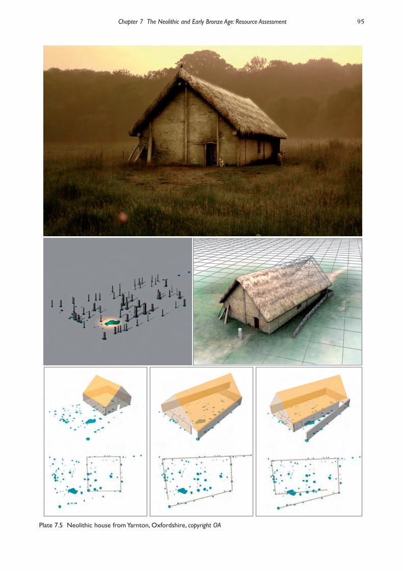
but it gives the same impression of diversity. There was atleast one timber structure beneath the cairn at Ascott-under-Wychwood on the Cotswolds (Benson and Whittle2007), as there was at the comparable site of HazletonNorth in Gloucestershire (Saville 1990). These wereaccompanied by middens. The excavated features atAscott allow more than one interpretation. They mayeither represent two small buildings with a hearth inbetween them, or the excavated postholes might mark thepositions of the end walls of a rectangular structure 9 mlong and 4 m wide; that is suggested by the distributionof artefacts on the site. On the other hand, traces of alarger building of a kind more familiar in Ireland andWestern Britain have been found on the Thamesfloodplain at Yarnton (Hey et al. in prep.; Plate 7.5). Itwas so substantial – it measured about 20 m by 14 m –that similar features would have been recognised on othersites if they had occurred. The Yarnton ‘house’ may havebeen a domestic dwelling, but, like the large timber hallsof this phase in Scotland, it was associated with a limitednumber of artefacts. It also included a small amount ofcremated bone. A slightly later structure, perhaps
belonging to the end of the 4th millennium cal BC, hasrecently been identified at Horton, Berkshire. It was c. 8m by 5 m, and defined by a wall trench in which uprightsand the traces of plank walling could be discerned(Alistair Barclay pers. comm.; Hey et al. 2011b, Figs 11.8and 11.11)
Ceremony, ritual and religion
The domestic site at Ascott-under-Wychwood wasburied beneath a chambered cairn (Benson and Whittle2007). That connection is important, for the monumentsof earlier Neolithic date are complex structures. Thereare three kinds to consider. They probably appeared inthe study area in the following order: first, long barrowsand related monuments, then causewayed enclosures,and, finally, cursuses. Their distributions are not thesame. The mounds are found across most parts of theSolent-Thames region, but causewayed enclosures andcursuses are mainly a feature of the Thames, itstributaries and the southern edge of the Cotswolds. Thecontrast should not be exaggerated, as causewayedenclosures are common in Sussex, Wiltshire and Dorset,and cursuses and related monuments occur on theWessex chalk.
Funerary monuments
The long mounds show considerable diversity. Properlyspeaking, they can be divided between barrows on thechalk and the river gravels, and cairns on the Oxfordshire
94 Solent-Thames Research Framework for the Historic Environment
Plate 7.4 Aerial view of the Thames showing gravel terraces, floodplain and palaeochannels at Dorney, Buckinghamshire
Chapter 7 The Neolithic and Early Bronze Age: Resource Assessment 95
Plate 7.5 Neolithic house from Yarnton, Oxfordshire, copyright OA
96 Solent-Thames Research Framework for the Historic Environment
Cotswolds. Other structures, like that at Holdenhurst onthe Channel coast, were partly built out of turf. Althoughthe forms of the mounds range from sub-ovalmonuments to long rectangular structures, their buildingwas often the last event in a lengthy sequence (Field2006). The wooden structures concealed beneath themare very varied, and the same is true to a lesser extent ofthe megalithic chambers identified on the Cotswolds andthe Berkshire Downs (Darvill 2004). Some of the best-excavated structures are actually the
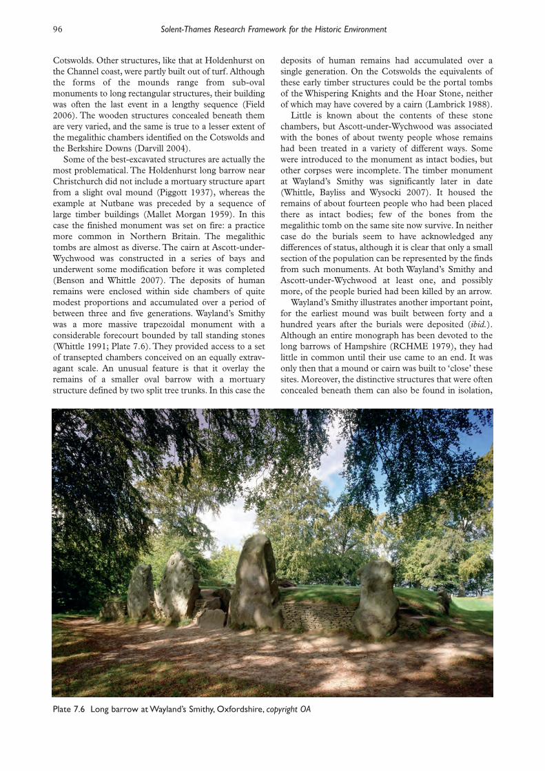
most problematical. The Holdenhurst long barrow nearChristchurch did not include a mortuary structure apartfrom a slight oval mound (Piggott 1937), whereas theexample at Nutbane was preceded by a sequence oflarge timber buildings (Mallet Morgan 1959). In thiscase the finished monument was set on fire: a practicemore common in Northern Britain. The megalithictombs are almost as diverse. The cairn at Ascott-under-Wychwood was con structed in a series of bays andunderwent some modification before it was completed(Benson and Whittle 2007). The deposits of humanremains were enclosed within side chambers of quitemodest proportions and accumulated over a period ofbetween three and five generations. Wayland’s Smithywas a more massive trapezoidal monument with aconsiderable forecourt bounded by tall standing stones(Whittle 1991; Plate 7.6). They provided access to a setof transepted chambers conceived on an equally extrav-agant scale. An unusual feature is that it overlay theremains of a smaller oval barrow with a mortuarystructure defined by two split tree trunks. In this case the
deposits of human remains had accumulated over asingle generation. On the Cotswolds the equivalents ofthese early timber structures could be the portal tombsof the Whispering Knights and the Hoar Stone, neitherof which may have covered by a cairn (Lambrick 1988). Little is known about the contents of these stone
chambers, but Ascott-under-Wychwood was associatedwith the bones of about twenty people whose remainshad been treated in a variety of different ways. Somewere introduced to the monument as intact bodies, butother corpses were incomplete. The timber monumentat Wayland’s Smithy was significantly later in date(Whittle, Bayliss and Wysocki 2007). It housed theremains of about fourteen people who had been placedthere as intact bodies; few of the bones from themegalithic tomb on the same site now survive. In neithercase do the burials seem to have acknowledged anydifferences of status, although it is clear that only a smallsection of the population can be represented by the findsfrom such monuments. At both Wayland’s Smithy andAscott-under-Wychwood at least one, and possiblymore, of the people buried had been killed by an arrow. Wayland’s Smithy illustrates another important point,
for the earliest mound was built between forty and ahundred years after the burials were deposited (ibid.).Although an entire monograph has been devoted to thelong barrows of Hampshire (RCHME 1979), they hadlittle in common until their use came to an end. It wasonly then that a mound or cairn was built to ‘close’ thesesites. Moreover, the distinctive structures that were oftenconcealed beneath them can also be found in isolation,
Plate 7.6 Long barrow at Wayland’s Smithy, Oxfordshire, copyright OA

although this is rarely acknowledged. It is probably trueof rectangular ditched enclosures, like the example atDorchester-on-Thames which was associated with ahuman jaw, and of the distinctive structures in whichother human remains were deposited (Whittle et al.1992). An isolated example was identified at RadleyBarrow Hills (Bradley 1992), and another was inside aninsubstantial enclosure at New Wintles Farm in theUpper Thames (Kenward 1982). There were Neolithicgraves that may never have been accompanied by amound, like the small cemetery outside the Abingdoncausewayed enclosure (Barclay and Halpin 1999) or twoother flat graves found during excavation at the EtonRowing Course (Allen et al. 2000; 2013). Not all the mortuary monuments were long barrows
or long cairns. Oval barrows were at least as importantand may have had a wider distribution than is apparentwithout excavation. Such structures had a lengthy historyand were often defined on three sides by a ditch whichwas later extended to close off access to the monument.Again they occur in a variety of different sizes, from theephemeral oval mounds found at sites like Radley BarrowHills to more considerable earthworks. An U-ditchedbarrow at Horton in the Middle Thames was laterenclosed by a ring ditch associated with PeterboroughWare (Ford and Pine 2003), whilst the recently re-excavated site at Whiteleaf on the Chilterns was probablyassociated with a timber structure comparable to that atWayland’s Smithy (Hey et al. 2007). Again it was notburied immediately, and the barrow was not built over itfor another hundred years. That earthwork was rebuiltseveral centuries later towards the end of the middleNeolithic period. Other monuments of this type coveredshallow graves, some times those of intact bodiesaccompanied by distinctive artefacts. A variant of the ovalbarrow is an earthwork enclosure at Freshwater on theIsle of Wight (Tomalin 1980). It shares its characteristicground plan but in this case no mound was constructed.The study area also contains the sites of a number of
Neolithic round barrows. The best known example is atLinch Hill Corner near Stanton Harcourt in the UpperThames, where a single body was accompanied by gravegoods similar to those from the oval mound at BarrowHills (Grimes 1960). Other examples are recorded atMount Farm, Berinsfield and at Newnham Murren,Wallingford in Oxfordshire, at Park Farm, Lambourn inBerkshire and Five Knolls nearby in Bedfordshire(Lambrick 2010; Moorey 1982; Richards 1986-90; JDyer 1991). There may have been another example atWinnall Down in Hampshire (Fasham 1985). It is likelythat similar monuments once existed across most of thestudy area, although they have seldom been recognised.That has happened for two reasons. Some exampleshave been wrongly identified as ‘hengiform enclosures’:the sites of circular earthworks allied to the hengemonuments of the later Neolithic period. In some casesit seems more likely that the ditch enclosed a mound.Sites have also been dated to that phase because they areassociated with Peterborough Ware, a style of potterywhich is now known to have developed during the later
4th millennium BC. Neolithic round barrows had ashorter history than was once supposed, and in Englandthere is no convincing evidence that they were employedfor burials between about 3000 BC and the Beakerperiod (Bradley 2006). It is likely that round and ovalbarrows originated at much the same time as the classiclong mounds and long cairns, but it remains a possibilitythat in southern England they were used after thebuilding of the larger mortuary monuments had lapsed. How were all these structures related to other features
of the landscape? Their relationship to the settlementevidence is very varied. There are certainly cases in whichsubstantial monuments were created within the domesticlandscape. If the chambered cairn at Ascott-under-Wychwood was built over an earlier occupation site, theold land surface beneath Wayland’s Smithy had beentilled (Benson and Whittle 2007; Whittle 1991, 92).There are also cases in which prominent mounds, like therecently identified example at Uffington in Oxfordshire(Miles et al. 2003), may have overlooked more distantareas of settlement (see also Plate 7.7). On the chalkindividual monuments were often situated along theheads or flanks of valleys overlooking lower ground. Theirdistribution sometimes follows the springline. But allthese examples relate to the ‘classic’ forms of monumentsthat are still preserved on the downland and theCotswolds. They are massive structures associated withsubstantial ditches or quarries. The remains of suchmonuments would be easy to identify from the air or bygeophysical survey, and yet their distribution rarelyextends down into the river valleys. There are a fewexamples in the Upper Thames (Hey et al. 2011b), butthey are quite exceptional. Otherwise the lower groundcontains a much wider variety of monuments, includingsmaller mounds and enclosures, oval or U-ditchedbarrows, round barrows and ring ditches (Bradley 2006).Most of them have been identified as a result of excava-tion on the gravels, and it is likely that they were morecommon than presently appears. It seems quite possiblethat they were also more closely integrated into thesettled landscape – perhaps it was only the largerstructures that had to be viewed from a distanceIt is often suggested that the distribution of long
barrows was closely allied to that of causewayedenclosures, but this is another case in which the evidencefrom the Wessex chalk has been treated as the norm. It iscertainly true that there are such enclosures around theedges of the main concentrations of long barrows inSussex, Dorset and Wiltshire, but this does not seem tohave happened in Hampshire or on the Chilterns. Nor isa similar pattern clearly recognisable on the Cotswolds.Instead, the distribution of causewayed enclosuresextends along the Thames and its tributaries (Plate 7.8),with significant gaps between the main concentrations ofmonuments (Oswald et al. 2001). If these enclosures areconnected with mortuary monuments, then they areprobably the small oval and circular structures associatedwith inhumation burials. The closest connection betweenthe two types is probably at Abingdon where the Radleyoval barrow was one of a pair built alongside an older
Chapter 7 The Neolithic and Early Bronze Age: Resource Assessment 97

98 Solent-Thames Research Framework for the Historic Environment
Plate 7.8 Cropmark of the causewayed enclosure at Buckland, Oxfordshire, copyright English Heritage NationalMonuments Record
Plate 7.7 Long barrow at Inkpen Beacon, Combe Gibbet, copyright West Berkshire Council

causewayed enclosure. Like that enclosure, the excavatedmonument was associated with carefully placed depositsof antler and human bone (Bradley 1992). The primaryburials were of two adults associated with an arrowhead,a polished knife and a belt ornament.
Ceremonial monuments
In fact the Abingdon causewayed enclosure is the onlyexample in the Solent-Thames corridor to have beenexcavated on any scale. Even this work poses problems,for none of the excavations took place recently. Leeds(1927a; 1928) examined the site before it was generallyaccepted that the distribution of such monumentsextended beyond the chalk, and Avery’s work wasconducted and published on the premise that this was anoccupation site (Avery 1982). It is possible to recognisesome features that Abingdon shares with more recentlyinvestigated sites – the presence of inhumation burialsand disarticulated human bones, the lavish consumptionof meat, the deposition of considerable deposits ofcultural material in its inner ditch – but the work was noton a sufficient scale to permit a fuller discussion. At onetime it seemed possible that its earthworks wereconstructed in sequence – first a causewayed ditchassociated with deposits of cultural material, and then acontinuous defensive barrier enclosing a larger area(Case 1956a) – but this hypothesis was based on analogywith monuments in other regions and is not supportedby radiocarbon dating (Bradley 1986). Still less can besaid about similar enclosures at Gatehampton (T Allenet al.1995) and Eton Wick (Ford 1991-3) where theexcavation merely confirmed the Neolithic character ofthe monuments. The latter site is chiefly of interestbecause of its proximity to the middens at Eton RowingLake. The small scale of the fieldwork carried out atthese sites needs to be redressed in the future. Both long barrows and causewayed enclosures form
parts of broader traditions with their origins in Contin -ental Europe. That is not true of cursus monu ments orbank barrows, which were first built in Scotland. Theearliest examples were contemporary with causewayedenclosures in the south, but those found in the studyarea are significantly later in date (Barclay and Bayliss1999). In some parts of the country cursuses or bankbarrows cut across the sites of older causewayedenclosures, but in the Solent-Thames corridor thesedifferent kinds of earthwork were generally located indifferent areas (Barclay et al. 2003; Loveday 2006).Although both groups could be close to the Thames andits tributaries, cursuses seem to have been built in thegaps in the distribution of existing enclosures. The classi-fication of these earthworks has created difficulties. Allare elongated monuments which generally take the formof long rectangular or oval enclosures with an internalbank, but the unusually narrow example at North Stoke(Case 1982a) was probably a bank barrow with a centralspine of excavated gravel – there would not have beenenough room for an open space within it. In fact theremains of an axial bank can be recognised on aerialphotographs of the site.
The cursus monuments of the study area tend to befound in groups, although it is not clear whether theywere all used at the same time. At Drayton it seemspossible that two of these monuments were built end toend on either side of a stream (Barclay et al. 2003), butin other cases they ran roughly parallel to a majorwatercourse or approached it at right angles. Thus theDorchester-on-Thames cursus approaches the RiverThame but it may also be aligned on the midwintersunrise (Bradley and Chambers 1988). None of themonuments attains the exceptional length of the Dorsetor Rudston cursuses, nor is the modest bank barrow atNorth Stoke of similar length to the recently excavatedexample at Stanwell in the Middle Thames. Rather than causewayed enclosures, cursuses are
associated with oval barrows, with U-ditched barrows orenclosures and with smaller rectangular earthworks, allof which seem to be related to the tradition of longmounds. The Drayton cursus is found with one of thefew conventional long barrows on the river gravels andpoints towards an excavated site associated with earlierNeolithic pottery at Corporation Farm, Abingdon(Barclay et al. 2003). This has been interpreted as anearly henge but may have been another oval barrow. Infact the precise relationship between these featuresvaries from site to site. An individual monument may bealigned on an older enclosure, as happened atDorchester-on-Thames and North Stoke (Whittle et al.1992; Case 1982a); it may incorporate existing monu -ments in its path, for example at Dorchester-on-Thamesand perhaps the nearby site at Stadhampton; or othermounds may be built beside it, reflecting its long axis.The clearest examples of this pattern are found atDrayton and Benson (Barclay et al. 2003).It is difficult to say much about the roles played by
these extraordinary structures even though a substantiallength of the Dorchester-on-Thames cursus has beenstripped and smaller excavations have taken place atDrayton and at Lechlade just outside the region inGloucestershire. Few artefacts have been found on thesesites and until comparatively recently it was assumed,quite wrongly, that they were built during the laterNeolithic period. That was partly because it had beendifficult to find suitable samples for radiocarbon dating.Bank barrows may be interpreted as massively extendedlong mounds, and cursuses perhaps stood in a similarrelationship to the elongated enclosures associated withmortuary monuments. It is certainly true that their mainassociation is with human remains. Few of these havebeen found, and even fewer have been directly dated, butdisarticulated fragments of human bone are associatedwith the monuments at Dorchester-on-Thames andDrayton (Whittle et al. 1992; Barclay et al. 2003). Stillmore important is the way in which these structuresseem to be integrated with Neolithic funerarymonuments of kinds described earlier in this chapter.Although cursuses are often described as processionalavenues, not all of them are provided with entrances andthis interpretation may be incorrect. Alternatively, theymay originally have been open, and the terminals were
Chapter 7 The Neolithic and Early Bronze Age: Resource Assessment 99

added later to ‘close’ these monuments (Barclay andHarding 1999 and papers therein). The problem needsinvestigating by targeted excavation. The areas around the causewayed enclosures and
cursuses include a number of pits, some containingwhole vessels, as at Lake End Road West, Dorney,Buckinghamshire (Plates 7.9; 7.10), others whosecontents had apparently been selected from middens.The Middle Thames Valley, however, also has evidencefor the purposeful deposition of artefacts in the riveritself, some of which may have accompanied humanremains (Bradley 1990). The main artefacts selected forthis purpose were axeheads, often of non-local origin,
and vessels of Peterborough Ware. This practicecontinued during the later Neolithic period.
The Later Neolithic
Landscape, settlement and land use
It is not always easy to synchronise the chronology ofNeolithic monuments with that of flintwork. Still morerarely is it possible to harmonise the dating of thismaterial with the currency of particular pottery styles.Nevertheless the results of fieldwalking still providesome indications of the changing pattern of settlement.Field surveys and studies of older collections show
that a greater area of the landscape was occupied duringthis phase (Holgate 1988; Gardiner 1988). Recent workin Langstone Harbour suggests that more use was alsobeing made of specialised environments (Allen andGardiner 2000), and the same may be true on the Isle ofWight where ephemeral wooden structures were stillbeing built in the intertidal zone at Quarr and atPelhamfields Beach (Tomalin et al. 2012). At the sametime, there are indications that certain areas were beingmore intensively occupied during this phase. One wasalmost certainly the clay-with-flints, which was both animportant focus of settlement and a significant source oflithic raw material. The density of surface finds increasedand so did their diversity. No longer are settlementsmarked by small scatters of worked flints. Insteaddomestic debris spreads over a more extensive area. Tosome extent this is due to different cultural practices as
100 Solent-Thames Research Framework for the Historic Environment
Plate 7.9 Peterborough Ware pit from Dorney,Buckinghamshire, copyright OA
Plate 7.10 Peterborough Ware bowl from Dorney, Buckinhamshire, copyright OA

there is less reason to believe that the remains ofmiddens were buried when occupation ceased (Lamdin-Whymark 2008). Even so it seems likely that occupationsites were larger and that settlement was more sustained.
Occupation sites and structures
Unfortunately, there is little structural evidence to relateto these general trends. The main information is stillprovided by the contents of pits, some of which werecarefully organised on their deposition in the ground (JThomas 1999). This is a particular feature of thoseassociated with Grooved Ware and is most apparent inthe vicinity of monuments (Barclay 1999; Bradley2006), although the distribution of later Neolithic pitsextends into areas like the Vale of Aylesbury where suchearthworks have yet to be found. Few intact surfaceshave been preserved, although it did happen at a numberof sites on the Isle of Wight where a large number ofartefacts were preserved beneath later mounds (Grinselland Sherwin 1940; Tomalin 1980). There is similarevidence from the Bronze Age round barrow at Bishop’sWaltham in Hampshire and from similar sites on theBerkshire Down (Ashbee 1957; Richards 1986-90).Only one domestic building can be attributed to thisphase. This is a sub-rectangular structure at Yarnton inthe Upper Thames that was associated with GroovedWare (Hey et al. 2011b, Fig. 11.28). There is comparableevidence from recent excavations at Durrington Walls,but in Cranborne Chase the buildings of this same dateare small and circular (Barrett et al. 1991). It is not clearwhether the use of round houses was a new develop-ment, as a group of post holes at Yarnton dating fromabout 3600 BC is interpreted as a small circular building(Hey et al. 2011b, Fig. 11.12). Later Neolithic buildingswere often insubstantial, and the same applies to thoseof the Beaker ceramic phase which seem to have beenequally ephemeral. Their remains are usually marked bysmall concentrations of stake holes, like those at SnailDown in Wiltshire. None is recorded from the Solent-Thames corridor, but pits associated with Beakerpottery are widely distributed.
Ceremony, ritual and religion
The archaeology of this period is characterised bydiscontinuity. The forms of the major monuments donot seem to be directly related to those of the previousphase, nor are they always found in the same areas.Moreover, the Grooved Ware tradition which is usuallyassociated with the construction and use of hengesseems to have originated in Northern Britain andpossibly in Ireland (Harding 2003; Bradley 2006).The significance of these points is not always appreci-
ated, perhaps because the field archaeology of theWessex chalk has distorted prehistorians’ perceptions ofits wider context. For example, it is often asserted thatcausewayed enclosures were the direct precursors ofhenge monuments. That seems most unlikely as there isan interval of perhaps five hundred years between the
uses of these traditions in the south. Moreover, the twokinds of enclosures actually have little in common apartfrom an approximately circular outline. The last diminu-tive earthworks in the older tradition seem to be exactlycircular, but they still possessed internal banks and wereemployed in the same ways as their predecessors. Oneexample was the earthwork at Stonehenge, which haslent its name to a style of prehistoric architecture towhich it does not belong. In the Solent-Thames corridorits closest counterpart may be a small enclosure atRadley (Oswald et al. 2001). This is known only fromcrop marks and remains unexcavated.There seems no reason to postulate the continuous
development of enclosures in southern England whenthe earliest henges have been identified in NorthernBritain, where they developed together with GroovedWare. Both were adopted in lowland England at a laterdate, although it is unlikely that enormous monumentssuch as Mount Pleasant and Durrington Walls wereamong the first to be built there (Bradley 2006). Even inWessex it is clear that smaller henges predate thesemassive structures. So do the earliest deposits ofGrooved Ware.The evidence from the Wessex chalk is deceptive in
yet another way, for it has been used to emphasise thespatial continuity between causewayed enclosures andmajor henges. There are problems with this scheme, forthe distances between supposedly successive monu -ments actually vary greatly, and this interpretation wasput forward before it was recognised that cursuses wereused in between the latest causewayed enclosures andthe construction of henges. Nevertheless it had beentempting to postulate a process of social evolutionextending throughout the Neolithic period and even intothe Early Bronze Age. That attractive notion must beabandoned.There is no such evidence from the study area. Here
there are four major henges, all of them in the UpperThames (Barclay et al. 1996), the last only recentlyidentified by Ford beneath the city of Oxford (Plate7.11; Hey et al. 2011b). None corresponds to the site ofa causewayed enclosure, but one is located beside anolder cursus. Moreover even these henges are smallerthan the well known examples on the Wessex chalk, theonly exception being the group of earthwork enclosuresat Knowlton. Moreover, the henges identified in theThames Valley lack some of the principal associations ofthe well known examples on the downland. They are notaccompanied by large circular mounds like those atKnowlton, Marden or Silbury Hill, nor is there anyevidence of nearby palisaded enclosures such as those atWest Kennet or Greyhound Yard, Dorchester, Dorset.Two of the sites in the study area have been excavated ona large scale and did not enclose enormous timberstructures of the type found in Dorset, Wiltshire orsouth-west England (Whittle et al. 1992; Barclay et al.1995). Not only are these monuments of a ratherdifferent kind, none has been discovered in theremaining parts of the Solent-Thames corridor, wherelater Neolithic monuments appear to be rare or absent.
Chapter 7 The Neolithic and Early Bronze Age: Resource Assessment 101

The same applies to the region east of the study area.Possible henges have been suggested on the SouthDowns in Sussex, but none is convincing, and only asingle example is clearly documented in Kent.One of the Oxfordshire monuments, Big Rings at
Dorchester-on-Thames, is even more distinctive(Whittle et al. 1992; Loveday 1999). Like Condicote onthe Gloucestershire Cotswolds, it was defined not by oneditch but by two, and in this case the earthworks werewidely spaced. This unusual procedure can only beparalleled among the henge monuments of north-eastEngland, again emphasising the point that this traditionwas not of local origin (Harding 2003). The sequence ofmonuments at Dorchester-on-Thames has furtherimplications, for the enclosure of Big Rings was builtalongside a major cursus. There is no evidence of acausewayed enclosure in the vicinity. The Dorchester-on-Thames cursus had led between
a series of pre-existing earthworks, including an ovalditched enclosure and the likely remains of a roundbarrow. This alignment faced the midwinter sunrise andseems to have retained its importance for severalhundred years (Bradley and Chambers 1988). Duringthe later Neolithic period a series of small circularmonuments was built in its path and others wereconstructed just outside it. Despite the lapse of time,they shared its orientation. Most of these structures hada single entrance, but their perimeters were defined in avariety of different ways. Some were surrounded byditches; some were probably circles of pits, although thishas been questioned (Gibson 1992); and in at least onecase there was a ring of massive upright posts. Individualexamples were rebuilt, but it is not clear how many ofthem were used simultaneously. Even so, it is probably
correct to compare them with the features of a henge.There was a similar pit circle on the nearby site atMount Farm (Lambrick 2010). When the monuments at Dorchester-on-Thames
went out of out use they provided the focus for depositsof cremated human bone (Atkinson et al. 1951). Thatevidence has been misunderstood in an attempt to relatethese sites to the archaeological sequence at Stonehenge.The cremations were located in the upper fillings of theditches and post sockets, and do not appear to haveoccurred in primary contexts. For that reason it isillogical to describe the monuments as ‘enclosedcremation cemeteries’. The major henge at Dorchester-on-Thames is the site
of Big Rings, excavated in the 1950s and published afteran almost unprecedented delay in 1992 (Whittle et al.1992). This site poses problems, for the excavationreport claims that it was of Beaker date. Of course thatmight be correct, but the section drawings of ditch raisethe possibility that only the secondary filling of thisearthwork was excavated; the primary levels may nothave been identified – a common occurrence on the rivergravels. This monument incorporated a smaller circularenclosure in one of its entrances and instituted a newalignment for the complex. There was no sign of anypost or stone setting inside it.The Big Rings has some features in common with the
other extensively excavated henge, the Devil’s Quoits atStanton Harcourt (Barclay et al. 1995). Again the firstexcavator did not recognise the lower filling of the ditch,although he did identify the sockets for a single ring ofmonoliths inside the enclosure (Grimes 1960).Subsequent work by Margaret Gray not only establishedthe true scale of the earthwork perimeter, it also found a
102 Solent-Thames Research Framework for the Historic Environment
Plate 7.11 Henge monument ditch at Keble College, Oxford, copyright TVAS

small circular post setting in the centre of themonument. In this case, it was possible to suggest thatthe earthwork predated the adoption of Beakerceramics. There is nothing to show whether the banksand ditch were the first structures on this site. Whilstthat sequence is widely assumed, it has been questionedby recent research and in some cases it is demonstrablyincorrect (Bradley 2006). In the same way, it is usuallysupposed that timber structures were earlier than thoseof stone, but it is perfectly possible that both theseelements were combined in a single architecturalscheme. Close to Devil’s Quoits there were other monu -ments, whose dating remains uncertain, but one of themwas a post circle not unlike the Later Neolithicstructures associated with the cursus at Dorchester-on-Thames (Barclay 1995). There was also a circularditched enclosure comparable to a small henge, and aseries of pits containing Peterborough Ware andGrooved Ware.Similar features are found at another site, Radley
Barrow Hills, which was first used during the earlierNeolithic period. Here two oval barrows and a series ofNeolithic burials had been located close to a causewayedenclosure (Barclay and Halpin 1999). Their historiesmay have overlapped, but in this case the earliest pitdeposits are those associated with Grooved Ware,suggesting a hiatus of several hundred years between thefirst generations of monuments at Radley and those ofthe later Neolithic. When activity resumed, at least onenew structure was built there. This was another smallcircular enclosure. It was associated with deposits ofantler and with pottery in the Grooved Ware tradition,and in many respects it compares with the miniaturehenges at Stanton Harcourt and Dorchester-on-Thames. Perhaps their distribution will extend intoother regions of the study area, but apart from anundated timber setting at Rockbourne on the edge ofCranborne Chase, a segmented ring ditch at GreenPark, Reading, and a few examples on the Wessex chalk,this has yet to happen (Barrett et al. 1991; Brossler et al.2004). Such monuments are difficult to identify – stillless, to date – without total excavation, but it is possiblethat they really were more common in the north of thestudy area. Small monuments of similar character areoften found in the Midlands and East Anglia and it isconceivable that they belong to a regional tradition thatrarely extended far into the Solent-Thames corridor.That remains to be established in future work. One of the pits at Barrow Hills included a bone point
made from the ulna of a white-tailed eagle, and part of aGrooved Ware vessel decorated with two opposed spirals(Barclay and Halpin 1999). That provides anotherindication of the cultural connections between the studyarea and Northern Britain, for the same design has beenidentified in a variety of other media in the west ofScotland, Orkney, Anglesey and even in the Boyne Valleynorth of Dublin (Barclay 1999). A further set of longdistance connections is illustrated by the movement ofnon-local artefacts to different parts of the study area.They consist of axeheads, most of them originating from
quarries in highland Britain (Bradley and Edmonds1993). They are quite common in the study area,although there are larger concentrations of such materialaround the major ceremonial centres of Wessex. In thestudy area they come from three different contexts. Asmall number have been discovered in pits together withlater Neolithic artefacts, but others are chance finds. Asignificant proportion of the imported objects comefrom the River Thames in Berkshire and Buckingham -shire (Holgate 1988; Bradley 1990). The latter grouplacks much dating evidence, but it does seem as if suchartefacts were distributed over greater distances duringthe later Neolithic period. The areas where they hadbeen made include Cornwall, Cumbria, North Walesand the East Midlands.Yet another long distance connection may also be
relevant here. This concerns the Rollright Stones on theOxfordshire Cotswolds (Lambrick 1988). The form ofthis monument is unusual as the monoliths are closelyspaced and define a circular enclosure with a singleclearly defined entrance. In both respects this site is verydifferent from the Devil’s Quoits (Plate 7.12). Thedistinctive configuration of the Rollright Stones hasfeatures in common with a number of monuments innorthern England which are assumed to be of laterNeolithic date. This has not be been demonstrated byexcavation, but one reason for stressing the exoticcharacter of the Cotswold monument is that is its layoutis very similar to that of the Swinside stone circle inCumbria. Just as the henges at Dorchester-on-Thamesand Condicote may refer to structures found in north-east England, the Rollright Stones represent anothermonument of exotic type.
Chapter 7 The Neolithic and Early Bronze Age: Resource Assessment 103
Plate 7.12 Rollright Stones, Oxfordshire – view fromthe air, copyright Rollright Trust

Beaker settlement and the end of the Neolithic
Such long distance connections anticipate a still moredrastic development. This was the appearance of Beakerpottery and the earliest metalwork: an assemblage withits origins in Continental Europe (Clarke 1970).This is not the place to rehearse the complex argu -
ments concerning the interpretation of Beakers and theirassociations, for that is a problem that extends far beyondthe confines of the study area. It is quite possible that thismaterial was first introduced by immigrants, but the onlyway of showing this unambiguously is through theisotopic analysis of human teeth. This method hascertainly suggested the ‘Amesbury Archer’ was one suchmigrant, but it is necessary to take this approach to a largesample of human remains before any conclusion can bereached. Fortunately, this work is now in progress (TheBeaker Isotope Project, University of Sheffield). Similaranalysis of isotopes can also address the issue of thedistance over which animals were grazed, traded andbrought to ceremonial sites. In any case, the movement ofpeople often forms only part of a more complex patternof alliance and exchange and it seems improbable that theintroduction of Beakers was any exception; if portableartefacts were moving over longer distances, that mayhave been true of marriage partners as well. Somecombination of these different ideas might explain whythe new kinds of material culture are so often associatedwith regions and even monuments that were importantduring the Grooved Ware phase. It does not follow thatthese developments were entirely peaceful. One of thepeople buried at Barrow Hills had probably been killed byan arrow, and archery equipment and daggers oftenfeature among the grave goods of this period. In the Solent-Thames corridor the earliest Beakers
can be associated with copper artefacts and goldornaments. Their appearance marks the inception of anew tradition of inhumation burial associated with smallround barrows and with flat graves, but some of thesewere close to existing monuments (Bradley 2006;Garwood 2007). It may be no accident that the richlyfurnished burial at Amesbury was near to a GroovedWare pit circle and not far from Woodhenge andDurrington Walls. In the same way, the earliest metal -work in the Upper Thames was associated with burials atRadley Barrow Hills, whilst there were others near to theDevils’ Quoits (Barclay and Halpin 1999; Barclay et al.1995). Yet another rich grave was associated with around barrow immediately outside the north entrance ofBig Rings, Dorchester-on-Thames (Whittle et al. 1992).Of course that simple equation does not apply to everycase. A burial at Chilbolton in the Test valley containedgold ornaments like those at Barrow Hills but it was notassociated with an older monument (Russel 1990). Infact there may have been considerable regional variation.Whilst the early Beaker graves in the Upper Thamescould be located close to structures with an establishedsignificance, their counterparts in the Stonehenge areaseem to have been set apart from the monument itself(Bradley 2006).
That is very striking, as Beaker pottery was perhapsassociated with the first stone building on that famoussite (Cleal et al. 1995). Its occurrence there forms partof a more general pattern, for ceramics of this kind werenot only deposited in a number of Wessex henges, theirdistribution could even echo that of the existing depositsof Grooved Ware and other artefacts within thesemonuments. The same idea may be relevant to theinterpretation of Big Rings, where a significant depositof Beaker material was found in the enclosure ditch(Whittle et al. 1992). As suggested earlier, it may notdate the original construction of the monument andcould have been placed there during a later phase. Thesame was perhaps the case at Condicote on theGloucestershire Cotswolds (Saville 1983).
The Early Bronze Age
As mentioned earlier, the definition of this periodpresents certain difficulties, if only because metalartefacts are found in such a limited number of contexts.Copper was alloyed with tin from approximately 2200BC and from that period onwards other parts of thearchaeological record began to change significantly.Although Beaker pottery remained in use, it was supple-mented, and eventually replaced, by new ceramic styles.Round barrows became much more conspicuousfeatures of the landscape and sometimes developed intoentire cemeteries. At the same time, henge monumentsgradually went out of use.
Landscape, settlement and land use
Few of these changes are clearly reflected in the settle-ment evidence from this phase, which is remarkablymeagre. Beaker pits are quite widely distributed butprovide less evidence of structured deposition than thoseassociated with Grooved Ware. There are comparativelyfew pits associated with other early Bronze Age ceramicstyles, and only occasionally can the lithic scatters of thisperiod be distinguished from those of the later Neolithic,the main difference being the presence of small thumbnailscrapers and the use of barbed and tanged arrowheads(Gardiner 1988; Barclay et al. 1996). The greatestconcentration of the latter type is in the area aroundBournemouth and Christchurch that was formerly inHampshire but now forms part of Dorset (Field 2008).There is little structural evidence from this period.
Excavation at Yarnton has identified the position of asmall round house associated with sherds of BiconicalUrn, and there was a series of post holes of similar dateat Easton Lane, Winchester on the Hampshire chalk(Hey et al. 2011b, Fig. 13.9; Fasham et al. 1989). Anothersettlement associated with round houses was at GoreDown, Chale on the Isle of Wight (Currie 2002). Onereason why such settlements have been so difficult to findis because the remains of domestic buildings wererelatively slight. This is certainly suggested by a smallstake-built structure preserved beneath an early Bronze
104 Solent-Thames Research Framework for the Historic Environment

Age round barrow at Shrewton in Wiltshire (Green andRollo-Smith 1984). Another possibility is that settle-ments were increasingly located in valleys where theirremains might be buried beneath substantial deposits ofhill wash. This has been demonstrated at a series of siteson the South Downs (Allen 2005a), and there is noreason why a similar situation could not have occurredmore widely. Early Bronze Age deposits were preserved atCharnham Lane, Hungerford, in the Kennet Valley, andan early Bronze Age house was found at Yarnton beneatha layer of alluvium (Ford 2002; Hey et al. in prep.). In three cases there are suggestions of more special -
ised activities. Recent fieldwork has recorded theremains of ephemeral timber structures on the foreshoreof the Isle of Wight (Tomalin et al. 2012). Those atFishbourne Beach and Quarr Beach have radiocarbondates during this period. So do the burnt mounds atLittle Marlow in Buckinghamshire which belong to anenigmatic class of field monument that is usually datedto the Later Bronze Age (Richmond et al. 2006). Otherexamples with similar dates are now known at the EtonRowing Course and at Yarnton. Their function is still indoubt, and they may have been employed for cooking, asopen air saunas or for a variety of industrial activities.The last of these specialised activities was the depositionof elaborate artefacts in the Thames and its tributaries.This continued during the early Bronze Age, but nowthe offerings included metalwork that might otherwisehave been placed in graves (Bradley 1990). That is aspecial feature of the closing years of this period.
Ceremony, ritual and religion
The rarity of domestic sites is especially frustrating sinceso many burial mounds survive from this period, eitheras standing mounds or as ring ditches in cultivated land.Even so, it is clear that the settled area expanded. Thereare large numbers of round barrows in the New Forest,a region where there is little indication of sustainedNeolithic activity (Field 2008). The same is true of theHampshire Greensand. Both regions had been occupiedduring the Mesolithic period, but may have been usedless intensively since that time. There are indications thatthe sites of some of these barrows had recently beencleared of woodland and that the local soils were unableto sustain a long period of settlement. One example wasAscot in Berkshire where a bell barrow sealed a series ofspade furrows associated with cereal pollen (Bradley andKeith-Lucas 1975). Again the site had not been used forlong before the monument was built. With the exceptionof a mound on Beaulieu Heath in Hampshire whichcontained an amber necklace, few artefacts are associ-ated with these earthworks.As the evidence from these two areas shows, the
distribution of burial mounds is by no mean confined tothe uplands, although few mounds remain intact on thelower ground. For example, all the standing mounds onthe Isle of Wight are on the higher down land, but evenhere their distribution emphasises the importance oflowland areas – they are most often found around theheads of coombes close to the spring line (Tomalin
Chapter 7 The Neolithic and Early Bronze Age: Resource Assessment 105
Plate 7.13 Aerial view of the Lambourn Seven Barrows, Berkshire, English Heritage Photo Library

1996). Air photography suggests that in the Solent-Thames corridor other barrows were built in the valleysbut have since been destroyed. The large groups of burialmounds at Lambourn on the Berkshire Downs or atBurghclere on the Hampshire chalk occupy just thisposition. They are probably chance survivals of what wasonce a more general pattern. (Plate 7.13)At one time it was supposed that the main groups of
early Bronze Age barrows were located in ‘ritual land -scapes’ from which everyday activities were excluded.There is no evidence for this proposition which isinfluenced by an outmoded conception of ritual. Fieldsurvey on the West Berkshire Downs provides no supportfor this assumption (Richards 1978; 1986-90). The greatbarrow cemetery at Lambourn is not only located closeto a spring, it is found in an area with a considerablequantity of worked flint. The same is true of other majorcemeteries. Large scale gravel extraction in the UpperThames suggests a similar pattern in which pitscontaining domestic artefacts are found near to majorgroups of burials, but do not extend right up to them(Barclay et al. 1996). The distribution of these monuments has other
implications that are not always recognised. This isbecause the contents of early Bronze Age graves areanalysed for evidence of social status. While notnecessarily wrong, this procedure often takes place atthe expense of spatial analysis. It is easy enough tosuppose that graves containing metalwork are indica-tions of high status, but the spacing of the individualbarrow groups does not support the suggestion of anoverarching social hierarchy of the kind associated witha ‘chiefdom’. Some mounds do seem to have beengenuinely isolated and others have been found in pairs,but just as often they occur in groups which may beregarded as cemeteries (Bradley 2006). These clustersof funerary monuments are usually located not far fromone another. This point was originally made in a studyof the ring ditches along the River Ouse, but its implica-tions have still to be taken seriously. The spacing ofthese groups of monuments suggests that most of thembelonged to local communities of no great size (Case1986). Any distinctions between them may have beenminor and quite short-lived. There are two important exceptions to this
argument, and both concern burial mounds that wereeither particularly elaborate or covered exceptionalgroups of artefacts. They are particularly common inthe vicinity of older monuments. That has long beenaccepted for the great concentrations of round barrowsnear to Stone henge, Avebury, Knowlton and MountPleasant, but it is just as true of examples in the Thamesvalley and on the Berkshire Downs. The small areaaround Stone henge contained a particular concentra-tion of linear cemeteries which seem to have developedtowards the end of this period (Woodward andWoodward 1996). There are at least two furtherexamples in the study area, the first at Radley BarrowHills, where it was aligned on the position of theAbingdon causewayed enclosure, and the other at
Lambourn, where the cemetery was orientated on anolder long barrow (Barclay and Halpin 1999; Richards1986-90; Woodward 2000). The Lambourn cemeterywas excavated many years ago and the results aredifficult to interpret (Case 1956b), but it is clear thatthe cemetery at Radley had an exceptional range ofcontents. Not only did it begin with the early Beaker flatgraves mentioned earlier, the burials were associatedwith more metalwork than any other group recorded onthe Thames gravels (Garwood 1999). A large barrowcemetery may also have formed around the Oxfordhenge. Another complex burial was found at Stanton
Harcourt, where it was associated with the largest of theround barrows that developed around the Devil’s Quoits(Harden and Treweeks 1945). Again this site was usedover a lengthy period and its role as a cemetery may havestarted with a series of Beaker graves, one of them ofexceptional complexity. Such finds emphasise anotherimportant point. There do seem to have been significantvariations in the sizes of different mounds. This haswider implications. The richer burial mounds aroundStonehenge tend to be larger than the others, and wereusually constructed on higher ground (Woodward andWoodward 1996). There are hints of a similar distinctionamong the excavated ring ditches on the Upper Thamesgravels. The same idea may also help to explain thedistinctive ridgetop siting of some of the round barrowson the Chilterns and of others on isolated hilltopsoverlooking the Vale of Aylesbury (Dyer 1961). Theprominent positions of such monuments may haveadded to their visual impact. If these arguments are correct, the study area may
contain not one series of early Bronze Age burials buttwo (Bradley 2006). The simpler and smaller moundsappear in clusters that may have formed the cemeteriesof local communities. These were fairly regularly spacedacross the chalk and the river gravels, and their construc-tion does not seem to have made extravagant demandson human labour. Nor were the offerings provided forthe dead exceptionally elaborate ones. That was notalways the case with the second group of burials. Theyinvolved a variety of different types of mounds and wereoften located, not in relation to nearby settlement areas,but to the ceremonial centres of the recent past. Theycan include a wider variety of grave goods, and it seemslikely that they were the burial places of people who didnot live in the immediate area. If there was a social eliteduring the early Bronze Age, this is where evidence forits existence should be sought. Unfortunately, this outline over-simplifies a number
of issues. Few of the barrows were the burial places of asingle individual. Where the remains of a mound surviveit often contains a number of separate graves, some ofwhich may even have been reused; an outstandingexample is a recently excavated barrow at GayhurstQuarry in Buckinghamshire (Chapman 2007). Therecould be further burials outside the monumentsaltogether. In the linear cemetery at Radley Barrow Hillsthe axis of the cemetery was reflected by a row of urned
106 Solent-Thames Research Framework for the Historic Environment

cremation burials that would never have been discoveredin a less ambitious excavation (Barclay and Halpin1999). The investigation of ring ditches often obscuresthese points simply because so many deposits have beenlost. That can also happen because the barrow ditchesare only sampled. Still more evidence is overlookedwhen barrows are excavated piecemeal and the areas inbetween them are neglected. The potential of these areasis amply demonstrated by work on the gravels of thestudy area which is locating an increasing number of flatgraves. The first to be identified were associated withBeaker pottery, but now it is becoming clear that theyextend throughout this period. They can also be foundon the chalk. For example, at Easton Lane, Winchesterin Hampshire there were several pits containing inhuma-tions and cremations associated with Collared Urns(Fasham et al. 1989). Where mounds have been well preserved and well
excavated – a rare occurrence in the Solent-Thamescorridor – it is clear that some of them developed incre -mentally, so that their outward appearance is no guide totheir internal structure. The largest barrows canencapsulate the remains of smaller monuments, andoften the earthworks cover the site of what was once aflat cemetery. In one sense the building of barrows wasreally a process that was undertaken intermittently; the‘finished’ form of the monument was simply the statethat it had reached when that process was discontinued(Woodward 2000). In another sense, like the longbarrows considered earlier, the building of a roundbarrow was sometimes a way of ‘closing’ activity on aparticular site. It is as important to work out the detailsof those processes as it is to classify the end results.Again that can only happen in those instances where
monuments survive above ground, as at Arreton Downon the Isle of Wight (Plate 7.14). Even where there is evidence that the people who
built these barrows had a particular design in view, it isimportant to acknowledge the evidence for regionalvariation. In practice most studies of these earthworkshave been influenced by the typology developed byGrinsell for well preserved monuments on the Wessexchalk, but he himself acknowledged that this schemedoes not work well among the neighbouring barrows ofthe New Forest (Grinsell 1938-40). Case (1963) hasalso attempted to classify the monuments of the UpperThames on the basis of their ground plans and thepatterns of silting in their ditches. His scheme differsfrom that of Grinsell, but that is no reason to rejecteither of these classifications. What is perhaps moresignificant is the way in which specialised types ofbarrow that are a special feature of the Wessex chalk areoccasionally found in more distant areas. That certainlyapplies to the cemetery at Lambourn on the WestBerkshire Downs, and it probably applies to the levelledmonuments at Radley Barrow Hills. In such cases theforms of the mounds might have signified long distanceconnections as effectively as the objects buried in thegrave. It is surely significant that such monumentsshould be a particular feature of these sites, for there arenot many others in the study area. In Hampshire,however, Tomalin has suggested that there were smallerconcentrations between the Beaulieu and LymingtonRivers and in the headwaters of the Test and the Meon(Tomalin 1996). There are a few indications of other sources of
variation among what might seem to be a homogeneousdistribution of earthwork mounds. Sometimes the grave
Chapter 7 The Neolithic and Early Bronze Age: Resource Assessment 107
Plate 7.14 Barrow on Arreton Down, Isle of Wight, copyright P Page
itself was incorporated in an elaborate timber structure,as happened at two sites on Beaulieu Heath and on theearlier site at Chilbolton (Russel 1990). The body mighthave been placed in an elaborate tree-trunk coffin likethat at Bishop’s Waltham (Ashbee 1957). Other coffinshave been identified at Barrow Hills, and possible tracesof biers have been recognised there and at Dorchester-on-Thames (Barclay and Halpin 1999; Whittle et al.1992). Corpses could also have been cremated on a pyrethat made extravagant demands on fuel. This was aparticular feature of the later early Bronze Age, and theremains of pyres were probably found in the excavationof Cassington Barrow 6 near to Yarnton in the UpperThames valley (Leeds 1936) – an unusual monumentthat can perhaps be compared with the disc barrowsfound on the chalk. Round barrows were not only places where the dead
were buried; they were also where they were commemo-rated. This is often difficult to document, but there aresome important exceptions. Many sites were originallyenclosed by a ring of wooden posts or stakes, and therewere sometimes several concentric circles of uprights.They have been identified during excavations on the WestBerkshire Downs (Richards 1986-90), but such featureshave a much wider distribution. Two of the most convin -cing were at Arreton Down and Newbarn Down on theIsle of Wight (Alexander et al. 1960). At Charnham Lane,Hunger ford, a related monument was defined by a circleof pits with a burnt area at its centre (Ford 2002). In thiscase no barrow had been built, but this structure wasassociated with an Aldbourne Cup, a kind of potterywhich is otherwise peculiar to burials. Even wherebarrows were built they were not just for the dead. AtBuckskin in Hampshire one of those monu ments wasconstructed over a low platform of turf (M J Allen et al.1995). It was enclosed by a setting of stakes and seems tohave provided a kind of stage on which food could beprepared and consumed. Here there was evidence ofbonfires and placed deposits of animal bones. AtGayhurst Quarry in Buckinghamshire it is clear thatmassive feasts took place, as a barrow ditch was filled withcattle bones (Chapman 2007). Again such evidence mightbe missing in levelled monuments, or might not berecognised in only partial excavation. There are two broader issues that must also be
considered here: the chronology of these monumentsand their connections with other areas (Bradley 2006). There were three main trends on the development
of these mounds over time. The first has beenmentioned already and is undoubtedly the simplest:certain barrows increased in size. Beaker graves werecovered only by a small circular mound, if they werecovered at all, whereas some of the barrows builttowards the end of the early Bronze Age wereenormous. The second trend is a change in the burialrite, from an initial emphasis on inhumation to agreater use of cremation. That has important implica-tions for the interpretation of the objects found withthe dead. Inhumation burials usually contain a seriesof intact offerings; some of the items deposited with a
cremation burial may have passed through the pyre,and others could have been totally destroyed. The finalpoint is apparent from the analysis of Barrow Hills andcomparable studies in Wessex and Sussex. The linearcemeteries at Lambourn and Radley are exceptional ina region with much less structured groups of burialmounds (although a third example may be partlyburied beneath modern houses in North Oxford), butthey are also unusual in relation to a wider region, forthis rather rigid design is mainly found close toStonehenge. It may have facilitated processionsthrough the burial ground (Garwood 1999), but it isclear that it was one of the last developments to takeplace before the construction of round barrows sloweddown in the later second millennium BC. That introduces a further question. How far is it
appropriate to compare the round barrows of the studyarea with the famous examples on the Wessex chalk? It isall too easy to focus on the richly furnished graves at theexpense of their wider context. Perhaps it is the very factthat there are so few precise equivalents for practice inWessex that lends those few examples their specialcharacter. Otherwise the smaller, less formal cluster ofmonuments, with their rather stereotyped graveassemblage, have more in common with sites in theMidlands and East Anglia than with the areas further tothe south. Indeed, the great deposit of cattle bonesaround the barrow at Gayhurst Quarry recalls a similarfind from a mound at Irthlingborough in Northampton -shire rather than any example in Wiltshire or Dorset. Inthat respect the evidence of early Bronze Age roundbarrows recalls the evidence of later Neolithic monu -ments in the study area.Two important points remain to be considered: the
absolute chronology of early Bronze Age artefacts inthe study area; and the evidence they provide for longdistance contacts. The first topic requires much moreresearch, for despite the prominent part played byburials in central southern England in generalaccounts of this period, their dating is not particularlysecure. It depends very largely on comparison with thearchaeology of other regions, some of them in Britainand Ireland, and others in Continental Europe(Garwood 2007). To some extend the problem wouldbe resolved through the direct dating of crematedbone: a method which has revolutionised the study ofprehistoric Scotland but which has hardly beenattempted in southern England. A reluctance toemploy this method has held back studies of the localBronze Age.We do not have to look as far as Continental Europe,
which lies outside the scope of this volume, for longdistance contacts, for there is evidence of the growingimportance of contact along the south coast of Britainduring this period. This seems to have been far morethan the lowland periphery of Wessex, and isolated findsfrom barrows and metalwork hoards along the EnglishChannel suggest that yet another important axis mayhave been forming at this time. It extended well beyondthe Solent-Thames corridor to run from Cornwall to
108 Solent-Thames Research Framework for the Historic Environment

Kent and certainly incorporated the Isle of Wight, wheretwo important hoards have been found (Sherwin 1936;Piggott 1947). The burials themselves extend fromRillaton in south-west England to Ringlemere in Kent,but only the burials from Portsdown Hill overlookingPortsmouth in Hampshire fall within the artificial limits
of the present study area. In a recent monograph StuartNeedham (2006) has referred to this network as thebeginnings of a ‘Channel Bronze Age’. It was an axis that would increase in importance during later phases,but even in its early beginnings its significance must notbe underestimated.
Chapter 7 The Neolithic and Early Bronze Age: Resource Assessment 109