t l recommendations for i soil and water management...
TRANSCRIPT

-ï C ^\.*\. ikk-c-Cic**
MINISTRY OF AGRICULTURE
WESTERN REGION
\
t
L RECOMMENDATIONS FOR
I SOIL AND WATER MANAGEMENT
OF THE MEYLERSFIELD WEST POLDER WESTMORELAND
RURAL PHYSICAL PLANNING. UNIT
MONTEGO BAY, OCTOBER «980.
3RRRY ' f I
1.03

Scanned from original by ISRIC - World Soil Information, as ICSU World Data Centre for Soils. The purpose is to make a safe depository for endangered documents and to make the accrued information available for consultation, following Fair Use Guidelines. Every effort is taken to respect Copyright of the materials within the archives where the identification of the Copyright holder is clear and, where feasible, to contact the originators. For questions please contact soil.isric(5)wur.nl indicating the item reference number concerned.
RECOMMENDATIONS
FOR
SOIL AND WATER MANAGEMENT
OF THE
MEYLERSFIELD WEST POLDER
WESTMORELAND
Ministry of Agriculture Rural Physical Planning Unit Montego Bay October 1980
a.
11 —
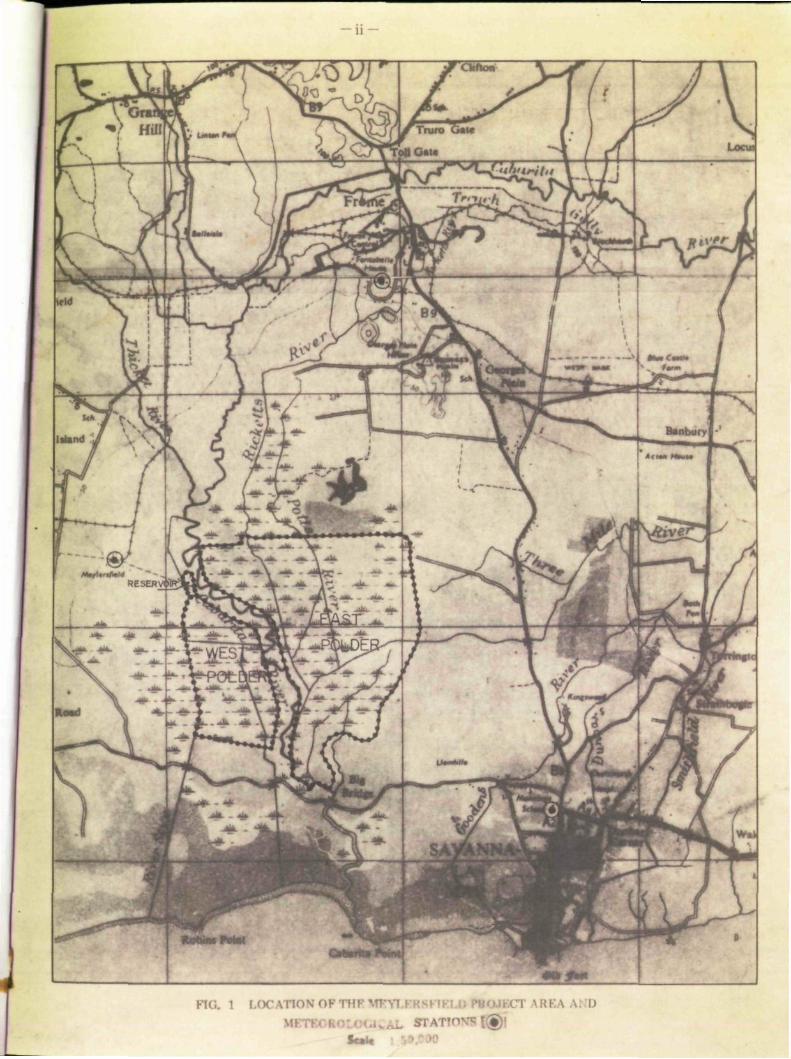
FIG. 1 LOCATION OF THF V I) »r ATOTVS | «
Scat*

• > •
— ui -
TABLE OF CONTENTS
Background and Summary v.
SECTION I :
n 1.2 1.3
RESOURCES INVENTORY Climatology Physiography Soils
1.4 Hydrology
SECTION n LAND RECLAMATION ACTIVITIES
SECTION ra LAND MANAGEMENT CONSIDERATIONS
m.i Desalinization
HI.2 Soil Management Considerations
SECTION IV LAND CAPABILITY ASSESSMENT
IV.l Introduction IV.2 Land Utilization Types IV.3 Quantitative Land Capability Assessment per
SECTION
ANNEX
ANNEX
MAPS
V
I
II
1.
2.
Possible Land Utilization Type
CONCLUSIONS AND RECOMMENDATIONS
FARM INCOME ACCOUNT ACCORDING TO FACTOR SHARES
SOIL DESCRIPTIONS AND SOIL ANALYTICAL DATA (Separate Volume)
SOILS OF THE MEYLERSFIELD WEST POLDER
ELECTRICAL CONDUCTIVITY OF GROUNDWATER IN THE MEYLERSFIELD WEST POLDER.
Page
iv
1 2 4 5
10
13
16
17 24
26
27 28 35
41
46
s

— w —
BACKGROUND AND SUMMARY
The Meylersfield project area (total aretf approximately 1,980 acres, or 801 ha)* located in the Parish of Westmoreland, was proposed for development by the Government of Jamaica in 1975, as one of two areas that were to be reclaimed under the Hague and Meylersfield Drainage Project.** The implementation of this project started in April 1977 by the Agricultural Engineering Division of the Ministry of Agriculture. Financial and technical assistance to the project was provided under the Netherlands Bilateral Assistance Programme. In the course of the project its aim, which originally included flood protection and drainage works only, was widened to include the construction óf an irrigation system and farm roads in the area with a view to its proposed development for irrigated rice cultivation.
la September 1979, when the implementation phase of the West Polder of Meylersfield was almost completed, the Western Region Rural Physical Planning Unit was requested by the. Regional Director of the Ministry of Agriculture, to prepare a development plan for the Meylersfield Polders. Thé areas would have to be developed along the lines as set out in Government's Project Land Lease Phase III, under which programme full-time farmers are provided with farm land sufficient to earn a certain minimum farm income. The farm land is leased to the farmers on a 49 years contract. In deviation of the actual PLL III programme, under which farmer-settlers are also provided with farm houses, housing would not be a component in the development of the Meylersfield Polders, as prospective rice farmers would be selected amongst those presently living in the surroundings of the project area.
As part of the preparation of the development plan for the West Polder, the Planning Unit conducted a detailed soil survey from which it appeared, amongst others, that the entire area is affected by salinity through the intrusion of seawater through rivers and seepage. Detailed studies however have shown that the salinity levels may be reduced to acceptable levels for rice growth through the combined effects of irrigation with fresh water from the Cabarita River and drainage. More serious adverse soil conditions exist in part of the area affecting its suitability for the originally envisaged land use: mechanized rice cultivation in small holdings. So-called potential acid sulphate soils occur in about 30 percent of the area. These soils contain high contents of sulphides that upon oxidation (e.g. through drainage) turn into sulphates and even free sulphuric acid, rendering the soils extremely acid and unsuitable to any kind of cultivation. Drainage of these soils would be required if they were to be used for mechanized (rice) cultivation, as under natural, somewhat poorly drained conditions, their relatively low bearing capacity will not support farm machinery.
Peat soils occupy approximately 15 percent of the area of the West Polder. Apart from their natural low productivity under rice cultivation, these soils have very low bearing capacity and in addition, they are also potentially acid. Small areas in the West Polder (3.5 percent) consist of moderately deep and shallow soils that overlay limestone rock. About 0.5 percent of the area consists of limestone outcrops.
* The Meyiertfield project area includes: West Polder (grow 426 acres of 172 ha). East Polder (gross 1384 acres or 560 ha.) -and Cabarita river bed (170 acres or 69 ha,).
** The Hague swamp (total area approximately 560 acres, or 226 ha.) is located in the Parish of Tretawny. Soil and Water Management recommendation» for this area will be discussed in a separate report by the Rural Physical Planning Unit, Western Region.

I
— v
A suitable alternative to mechanized rice cultivation on potential acid sulphate soils with low bearing capacity would be the traditional method of rice cultivation which is presently practised by the rice fanners in the area, using hand labour for land preparation (bushing of weeds and grasses), transplanting and harvesting. For the peat areas a possible alternative land use would be cattle farming. Under both kinds of land use a relatively high groundwater table could be maintained, thus eliminating the risk of acidification.
Fish farming and vegetable cultivation are other alternative land uses that have been considered by the Planning Unit as for their suitability to the problem areas in the Meylersfield West Polder. Fish farming seems unattractive because of a number of problems. Not only will it be difficult to construct fish ponds in the soft peat or in the half-ripe to unripe clays, but also will the dug-out peat and clay material, once deposited on the pond sides, oxidize and turn acid. Through rainfall these acids will wash into the ponds and may cause acute fish-Mils. Further, the high concentrations in aluminium and iron that occur under acid sulphate conditions, limit through fixation, the availability of nutrients (phosphorus a.o.) and trace elements (molybdenum, cobalt, boron) which are essential for the growth of organisms (algae etc.) on which the fish feed.*
Likewise, cultivation of vegetables on the potential acid sulphate soils and peats is not considered a good alternative. Apart from slight salinity problems, the high groundwater table required in order to prevent acidification will restrict root development too much to allow attractive yields.
In March 1980, the Black liver Upper Morass Development Corporation (BRUMDEC), by order of the Ministry of Agriculture, was entrusted with the agricultural management of the Meylersfield Polders. At the same time, a Netherlands Review Team consisting of Messrs. Kortenhorst and Slabbers studied the project. The summary of findings and recommendations of the Review Mission (which also included the views of Mr. M. Shaw, the then General Manager of BRUMDEC) stated in relation to the Planning Unit that it should produce a soil survey report and salinity study and that it would assist BRUMDEC'in drawing up a tentative development plan for the West Polder. Subsequently, dated June 23,1980 BRUMDEC submitted their proposal for the management of rice development and production in the West Polder which takes into account the tentative results of the soil and water studies by the Planning Unit. The proposal is for BRUMDEC to farm the land for an initial period of up to three years, after which the land will be handed over to selected farmer-workers under the umbrella of BRUMDEC, which will provide financing, marketing and necessary agricultural and technical services. During the initial three years BRUMDEC will establish a pilot area to investigate various methods and aspects of rice production under the prevailing adverse soil conditions.
* Tha information on fish production is extracted from: T. Potter (1976): The Problem* to Fish Culture Associated with Acid Sulphate Soil* and Methods for their Improvement. Twelfth National Conference of the Philippine Federation of Fish Farm Producers.lloij C' 'y; The Philippines.
**
i l
— vi —
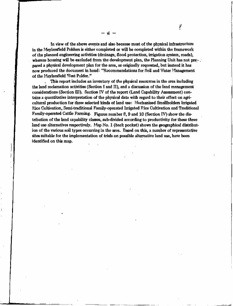
In view of the above events and also because most of the physical infrastructure in the Meylersfield Polders is either completed or will be completed within the framework of the planned engineering activities (drainage, flood protection, irrigation system, roads), whereas housing will be excluded from the development plan, the Planning Unit has not pre;-. pared a physical development plan for the area, as originally requested, but instead it has now produced the document in hand: "Recommendations for Sou and Water Management of the Meylersfield West Polder."
. This report includes an inventory of the physical resources in the area including the land reclamation activities (Section I and II), and a discussion of the land management considerations (Section III). Section IV of the report (Land Capability Assessment) contains a quantitative interpretation of the physical data with regard to their effect on agricultural production for three selected kinds of land use: Mechanized Smallholders Irrigated Bice Cultivation, Semi-traditional Family-operated Irrigated Rice Cultivation and Traditional Family-operated Cattle Fanning. Figures number 8,9 and 10 (Section IV) show the distribution of the land capability classes, sub-divided according to productivity for these three land use alternatives respectively. Map No. 1 (back pocket) shows the geographical distribution of the various soil types occurring in the area. Based on this, a number of representative sites suitable for the implementation of trials on possible alternative land use, have been identified on this map.

SECTION I
RESOURCES INVENTORY
I

- 2 -
1 CLIMATOLOGY
The climate in the Meylersfield project area is humid tropical, with rainfall being the main variable. In and around the area, several rainfall recording stations are in operation. A study of the 30 years-average yearly rainfall of these stations reveals a clear pattern of rainfall distribution over the area. The lowest yearly rainfall occurs along the coast, for instance Savanna-la-Mar where total yearly rainfall amounts to only 58.8 inches. Going in northern direction to the hills, average yearly rainfall gradually increases and reaches 88.8 inches at Frome. For the project area the data available from Meylersfield - sugar estate, situated about a mile west-north-west from the area, can be considered representative. They are presented in Table 1
Table 1
MEAN MONTHLY AND ANNUAL RAINFALL (INCHES) FOR
MEYLERSFIELD, WESTMORELAND (1938 -1977)
Jan Feb Mar Apr May Jun Jul Aug Sept Oct Nov Dec Annual
1.79 1.94 _ „ , ,
2.94 4.62 9.00 6.96 6.91 7.40 •' 7.41 8.80 3.74 2.34 63.85
Evaporation data are available for Frome and consist of 8 years of measurement of Class A pan evaporation. Although the climatic features, governing this evaporation could differ somewhat in Meylersfield from those prevailing in Frome., the 3ata from Frome have been used because they are the only data available. They are presented in Table 2.
Table 2
MEAN MONTHLY CLASS A PAN-EVAPORATION (INCHES)
FOR FROME • WESTMORELAND (1970 i 1977)
Jan Feb Mar Apr May Jun J Jul Aug Sept Oct Nov Dec Annual
5.49 5.77 6.70 6.84 6.36 6.06 J6.45 6.42 5.43 5.46 5.04 5.67 71.69

r
Millimetre»
400 -
300 .
200 H
100 .
/ /
/ /
. / /
Inche»
- 16
. 14
. 12
. 10
... \
v.'-^
JAN FEB MAR APR MAY JUN JUL AUG SEP OCT NOV DEC
FIG. 2 RAINFALL AT THREE DIFFERENT CHANCES OF OCCURRENCE AND ESTIMATED CONSUMPTIVE WATER
USE FOR MEYLERSFIELD (WESTMORELANDI.
Contumartive Water use lETPo • P): refer to taxi
Rainfall at 50% Chance of Occurrence (Meylenfield 1938 19771
Rainfall at 75% Chance of Occurrence (MeylersfiekJ 1938 19771
Rainfall at 90% Chance of Occurrence (Meylersf ie<d 1938 19771

J*
- 4 -
To assess thé reliability of the rainfall in the area a probability analysis has been carried out, the results of which are presented in Figure 2. This figure shows the monthly amounts of rainfall, that can be expected at 50%, 75% and 190% chance of occurrence respectively. In other words: actual monthly rainfall is at least equal to the amount indicated in the graph for each month, in every 1 out of 2 years (i.e. probability 50%), 3 out of 4 years (probability 75%),or 9 out of 10 years (probability 90%) respectively. *
III the same graph the estimated consumptive water use of rice is plotted. This water use consists of two components^
.1. The optimal evapotranspiration of rice (ETP.). For this the Class A pan evaporation figures for Frome are used. A factor of 1 is used to convert this evaporation into optimal crop evapotranspiration for rice.**
2. Continuous water percolation (P) to the subsoil, Because rice is grown under submerged conditions, there is a steady downward movement of water from the rice fields to the subsoil. The amount of water moving down is estimated to be 0.0014 m/day. (2 inch/month; refer to section IIÏ.1.)
From Figure 2 it can be concluded that in order to meet the water demand of wetland rice, even at a rainfall with a 50% chance of occurrence, irrigation will be needed during at least 10 months per year. In this calculation the effectiveness of the rainfall is supposed to be 100% which overestimates the real effectiveness.
PHYSIOGRAPHY
The Meylersfield project area is located in a large coastal plain that has formed a lagoon-like depression between the limestone uplands of the northern part of the Parish of Westmoreland, and a low natural barrier consisting of limestone outcrops near the southern coastline, west of Savanna-la-Mar. V
The limestone mountains in the north, as well as the outcrops in the south mainly belong to the so-called White Limestone Formation, which are of Upper Oligocene to Middle Miocene age.
In recent times (Holocene) the basin has filled up through different sedimentation processes. Clayey alluvial deposits formed the present Georges Plain, which is at an elevation of 1 to 8 ft above mean sea level. Inflow of seawater at high tide into the basin along small streams and probably also by seepage through the porous limestone barrier, in combination with inflow of freshwater from the surrounding uplands, has created a poorly drained, brackish environment in which a swampy mangrove vegetation (Rhizophora and Avicennia Spp) could establish. This gave rise to the formation of peats and peaty deposits over large areas, mainly in the southern part of the plain, which is at elevations of only 0 to 4 ft above mean sea level.
The Cabarita River, flowing through the coastal plain has developed a system of levees on both banks and abandoned river channels. Sfc * *
Figure 2 clearly shows the low reliability of rainfall during the period November to May.
This value Is commonly used for crops, growing under marshy conditions.

- .• '
•
• •
•
•
•
•
•
• •
• *
•

- 5 -
The basin is believed to be underlain entirely, at varying depths, by limestone of the White Limestone Formations, evidence of which form the numerous limestone outcrops that occur throughout the plain.
Summarizing, the following landforms can be observed in the Meylersfield area of the coastal plain :
Clayey levees on both banks of the Cabarita River, with oxbow lakes
Basins filled with peat in the deepest parts and clayey deposits in less depressed portions.
Limestone outcrops and areas with limestone at shallow depth below the surface^scattered all over the area.
SOILS
The soils in the Meylersfield West Polder were investigated in the field and in the laboratory. Initially the field survey was done by means of brief descriptions of soil augerings carried out in a grid system of 75 x 100m. After 48 observations were completed in this grid, the relatively limited variations in soil conditions observed warranted enlargement of the grid to 100 x 100m. In total 178 observations were made.
Based on the augerhole descriptions, suitable sites were selected for the detailed description of 4 soil pits representing the major soil types in the area. A total of 27 samples was taken from the genetic horizons of these profiles for further chemical and physical character-rization in the laboratory.
In total 7 map units are distinguished on the soil map of the West Polder. Six map units represent soil families according to the USDA Soil Taxonomy, one map unit comprises the rock outcrops that occur scattered over the area. The soils in the Meylersfield West Polder belong to two Soil Orders of the Soil Taxonomy: Entisols and Histosols. The Entisols in the survey area are alluvial heavy clay soils, that have been further differentiated based on differences in drainage conditions, the occurrence of peaty layers, and on the potential hazard of some of the soils to turn highly acidic upon aeration. The Histosols comprise the real peat soils of the area. They have not been further differentiated.
The geographic distribution of the different soils is shown on Map No. 1 Soil Map of the Meylersfield West Polder. A description of the significant characteristics of the various map units is given below. Descriptions of soil pits and augerholes, as well as the results of the laboratory analyses are compiled in Annex II to this report
Simultaneously with the soil observations, salinity levels of groundwater and, where applicable, surface water were measured. The results of these measurements are discussed in Chapter 1.4 Hydrology.
ENTISOLS These are mineral soils of recent depositional nature that are characterized by poorly
structured topsoils overlying structureless subsoils (AC profile). Organic carbon contents decrease irregularly with depth.

- 6 -
Map Unit 1. Tropofluvent, very fine, mixed, calcareous, isohyperthermic (12.3 acres)
The sous of this map unit are deep, well drained, brown clay soils that occur in small relatively higher areas scattered oyer the polder, associated to outcrops of limestone rocks. pH levels are constant and high throughout the profile (pH 8), and free carbonate usually occurs in the subsoils due to the presence of gravelly limestone. Due to the relatively high position in which these soils occur, groundwater is usually not encountered within 200 cm from the surface. Consequently, conductivity levels are relatively low (less than 10.0 mmho). Locally these soils overly the limestone at shallow or moderate depth. On the soil map, the shallow phase within this map unit indicates the presence of limestone within 50 cm from the soil surface, whereas the moderately deep phase indicates the presence of limestone within 50 -100 cm from the surface. Auger observation 48 describes a good example of these soils, whereas observation. 31 and 65 present descriptions of the moderately deep and shallow phases respectively.
Map Unit 2. Aerie Tropic Fhavaqnent, vary fine, mi-xasi, nnn-arid, isnhyporthermin (118.8 acres)
The soils of this mapping unit are deep, somewhat poorly drained, heavy clay soils with dark coloured (dark gray to very dark grayish brown) topsoils over grayish brown and/or mottled gray and brown subsoils. The dark colour of the topsoils is due to the high content in organic matter. They occur on the slightly elevated levees along the Cabarita Eiver and on other relatively higher parts, in the northern portion of the area. Thin layers (less than 20 cm thick) of clayey peat or peat may occur in these soils at varying depth. The pH throughout the profile is 7.5 to 8.0. Occassionally fine to large gypsum crystals occur in the lower horizons of these soils. Groundwater at the time of survey was mainly below 150 cm from the surface and is usually saline (EC ranges from 3.3 to 18.0 mmho).
Also included in this mapping unit are minor areas adjacent to limestone outcrops where soils are shallow or moderately deep. This is indicated by means of shallow and moderately deep soil depth phases on the sou map.
Soil pit 2 presents a good example of the soils of this mapping unit.

- 7 -
Map Unit 3. Tropic Fluvaquent. very fine, mixed, non-acid, isohyaerthermic (57.2 acres)
The soils of this mapping unit are deep, poorly drained, heavy clay soils with dark coloured (dark gray to very dark grayish brown) topsoils overlying gray to very dark gray and greenish gray subsoils which are usually half ripe to almost; ripe * The dark colours are due to high contents in organic matter. Drainage condition, colours and unripeness of these soils reflect their occurrence in relatively low positions in the landscape. A major portion of these soils occurs in a depression in the northern part of the polder. Smaller areas occur to the southwest. Thin layers (less than 20 cm thick) of clayey peat or peat may occur throughout the profile. The pH of these soils is about 7.5 - 8.0 throughout. Gypsum crystals varying in size from very fine to large (up to 2 cm) may occur especially in the lower horizons of these sous. Groundwater at the time of survey was mainly at about 100 cm below the soil surface, conductivity levels range between 11.0 and 20.0 mmhos.
Minor parts of this mapping unit in the north and in the extreme southwestern corner of the area, comprise simüar soils which overly limestone rock at moderate depths. This is indicated on the soil rono as a moderately deep phase of this mapping unit.
Map Unit 4. Aerie Sulfic Tropic Fluvaquent. very fine, mixed, non-acid, isohyperthermic
(78.7 acres)
The soils of this mapping unit are deep, somewhat poorly drained, heavy clay soils with dark coloured topsoils (dark gray to very dark grayish brown) and (dark) grayish brown and/ or mottled gray and brown subsoils. The dark colour in the topsoils is mainly due to organic matter. Thin layers of clayey peat or peat (less than 20 cm thick) may occur in the profile. These soils are characterized by a high content in sulphides below 50 cm from the surface. The sulphides have accumulated during the formation of these soils in bracMsh conditions in combination with the dense fibrous rooting system of certain mangrove species.
'Physical ripeness of soil material has been tested in the field by means of a simple method of squeezing the soil In the hand. If the soil does not flow between the fingers when squeezed, the soil Is called ripe. I f the soil flows with difficulty between the fingers, the soil Is called nearly ripe. If the soil flows easily between the fingers, the soil material Is called unripe. Half ripe refers to the condition between nearly ripe and unripe. In the text only nearly ripe to unripe conditions are described.
Where no details are given soil materials are ripe. Physical ripeness conditions indicate a direct relation to the bearing capacity of the soils for machinery and cattle.

- 8. -
Under: natural, poorly to somewhat poorly drained conditions these sulphides occur in reduced form (e.g. H^S, FeSjg). However* upon aeration of the soil (for example through drainage) the sulphides oxidize into sulphates: ferric sulphates and even free sulphuric acid, thus dramatically increasing soil acidity to about pH 3 to 3.5. The soils are therefore called potential acid sulphate soils. During the survey they were recognized fey their strong smell of hydrogen sulphide (HgS), and by the slightly lower pH's in the (aerated) topsoils (pH 5.0 - 5.5) as compared to the pH in topsoils of non-potentially acid soils. The pE in the - subsoil.' is about 7.5 - 8.0. Gypsum crystals (fine to large in size) may occur m the lower horizon of these soils. During the survey, groundwater levels were at 120 - 200 cm from the surface and conductivity of the groundwater ranged from 5.8 -13.0 mmho.
The soils of this mapping unit mainly occur adjacent' to the soils of mapping unit 2 to which they are related. However, slight differences in microrelief during the formation of the sous have resulted in their present characteristics and adverse potential.
Soil pit 3 describes a representative soil of this mapping unit.
Map Unit 5. Aerie Sulfic Thapto-Histic Tropic Fluvaauent, ^ery fine, mixed, non-acid, isohyper-
thermic (22.9 acres)
The soils of this map unit are deep, somewhat poorly drained, heavy clay soils with distinct layers of peat (20 - 40 cm thick) occurring at varying depth in the profile. Top soil colours are mainly dark gray to very dark grayish brown while subsoils are dark grayish brown and/or mottled gray and brown. The dark colours are due to high organic matter con-tents. These soils are genetically related to the soils of map unit 4, with which they have the potential acidity in common, due to high contents of sulphides below 50 cm from the surface.
The distinct peat layers which differentiate these soils from those of map unit 4 have developed during periods of stagnating mineral sedimentation. In these periods luxuriant vegetation growth (mangroves etc.) resulted in the formation of the organic layers and at the same time in accumulation of sulphides.
The pH in the topsoils ranges from 5.0 to 5.5, whereas the reduced subsoils have a neutral to slightly alkaline pH (7.5 - B.0). Fine to large gypsum crystals may occur, especially in the lower clayey horizons. Groundwater at the time of survey was mainly between 100 and 200 cm, and conductivity levels ranged betoveen 5.1 and 18.0 mmho .
This map unit occupies small areas only, which occur scattered over the area. Auger observations 95,9S, 137 and 170 are good examples of these soils.

•1
- 9 -
HISTOSOLS
These soils are dominantly organic in composition (more that half of the upper 80 cm consists of organic materials containing more than IS percent organic carbon). They are saturated or nearly saturated with water for most of the year under natural conditions.
Map Unit 8. Typic Sulfihemist. euic, isohyperthermic (53.6 acres) -
The soils of this map unit are the real peat soils which have thiek peat layers (more than 40 cm thick) which upper horizons occur within 40 cm from the soil surface. The topsoils which have a high organic matter content, generally consist of dark coloured clays or heavy clays. The peat mainly consists of dark coloured organic matter composed of decaying plant remnants that can be largely destroyed by rubbing between the fingers. Thé peat may overlay heavy clay at depths of more than 80 cm from the surface. These gray, greenish gray and bluish gray clayey layers are mostly unripe to half ripe. These soils have low bearing capacity as long as they are saturated with watet When drained they would be subject to strong subsidence. In addition to these adverse characteristics, they are also potentially acid due to the accumulation of sulphides in the profile.
At present, pH levels in the clayey topsoils range from 4.5 to 5.5. In the subsoils pH levels are high : 7.5 to 8.0. Due to their low position in the landscape, me groundwater level in the peat soils is fairly high. At the time of survey it ranged between 0 and 40 cm from the surface. Salinity levels were high too,as expressed by EC between 5.5 and 19.0 mmho.
Soil profile 4 is typical for the peat soils.
MISCELLANEOUS LAND TYPE
Map Unit 7. Limestone Outcrops (1.5 acres) >
This map unit comprises all small areas where the limestone rock that underlines the whole area appears at the surface. Recent land levelling operations have knocked over some of these outcrops and spread gravel and stones over much wider areas than the original outcrop area.

>J
- 10
HYDROLOGY
The entire Meylersfield project is situated in a coastal plain. The area mainly has a flat topography with altitudes between 0 and 4 ft a.m.s.
"Bordering; the coastal plain limestone outcrops occur. Several rivers traverse the plain, i.e. the Cabarita, the Styx, the Potte, the Eicketts, the Three Mües and some smaller streams (see Fig. 1). Of these rivers the Cabarita is the most important. Due to its origin from karst spring in the limestone hills it has a constant and reliable base flow. This river will be used to supply irrigation water to the project. The course of the Cabarita is meandering due to the low seaward gradient of the plain. On both sides of the river slightly elevated levees occur, consisting of clayey deposits. The central parts of the backswamps on either side of the river consist of peat deposits while transitional zones are composed of peat and clay. The swamps have a high watertable, at or above field level during most of the year, as expressed by the poor. and somewhat poor drainage (conditions of the soils in the coastal plain.
During rainfall, the discharges of the mentioned rivers can rise so sharply that the levees are riot able to contain these peak floods and consequently the entire area is flooded.
flnSrSateiy, n ° d i s c h a r g é fi8ures are available for the rivers affecting the project. Although a flood bed is constructed for the Cabarita with a minimum width of 210 metres, the clearance under the new bridge in the road Savannah-la-Mar to Little London is not yet sufficient to discharge peak floods rapidly enough, causing backing-up of water in the floodbed.
r m e r*y ' W^8n p a r t s o{ t^ie sxea w e r e i m ^ e r sugarcane cultivation, efforts were made to drain the cane fields and drains were excavated. These fields are now .abandoned, and a new drainage system is presently being completed in the West Polder.Theold drainage system can snu be recognized in the East Polder but drains have deteriorated and are filled with vegetation and seaiment. Therefore, the old drainage system has become ineffective and after heavy rainfall, ground water in the East Polder rises up to field level or above, particularly in the peat areas.
Concerning the new drainage system in the West Polder, some of the field drains still await connection with the .main drains. In those sections of the West Polder where all drains are complete, the ground water table remains fairly constant at about 60 - 80 cm below field level
Z\Z ? ï ? , m ! - r t o d SeCt l0nS ' f o I I o w i n g rainfalI> ®ound w a t e r s t m m a y rise t o Iei* than 20 cm below field level due to insufficient drainage.
PoW e ?T°th P ° I d S I S a r e a f f e c t e d entirely by saline or brackish ground water. Ë the West levll / ^ m N o v e r a b e r 1 9 7 8 t m M*rch 1980 during the execution of the soil survey, the salinity J T ^ T T W a t e r W e r e m e a s u r e d in auger holes (178 sites). This was done by means of an instrument which measures the electrical conductivity of water in mmhos/cm. The results of Z r ^ T 1 ? f*?0"* o n **P No. 2. The general pattern of salinity distribution tends to i n t Z f o f r m ?e W 8 S t 6 r n P a r t s o f toe Wss* F o l d e r " ™ » " * » « t o °e bought about by the S o w f j t 1 6 ? t e ? U P t h G S t y x E i v e r ' T»e Styx River has a straight alignment and a low
river ZuTlf e ? u T ' * Ï ™ 8 a dÜreCt a p p r 0 a c h c h a n n a l f o r Sahne w a t e r w h i c h m o v e s «P « * S T h k * ÏÏ ? * P ° l d e r t h r ° U g h * e r v i o u s P 0 ^ I a y e r s < * " * * * * i n *«» P«t of the polder.
c o n t o t h t T e X C t * h V e U W W c h ^ m e a S U r S d * t h e S t y X R i V 6 r ( U P t o 2 0 r a m h o / c m >

- 11
Another source of salinisation in the West Polder can be found in intrusion of saline water through the karstic limestone underlying the area. Average electrical conductivity of the ground water is about 12 mmho/cm*.
For the irrigation of the future rice fields water wül be drawn from the Cabarita River. In order to assess the quality of Cabarita River water, samples were taken at the pump intake site on the north end of the reservoh1. Analysis was carried out by the Laboratory of the National Water Authority in Montego Bay. The results are presented in TableS
Table 3
RESULTS OF CHEMICAL ANALYSIS OF TWO WATER SAMPLES FROM
THE CABARITA RIVER AT THE PUMP INTAKE SITE AT THE
NORTH END OF THE RESERVÏOR
(All values in mg/Itr except pH and EC levels)
Date 17/6/80 27/6/80 Date 17/6/80 27/6/80
Calcium (as Ca) n.m. 59.0 Nitrates (as N0g) n.m. 0.2 Magnesium (as Mg) n.m. 3.9 Sulphates (as S0^) 8.3 6.0 Iron (as Fe) 1.2 0.29 Alkalinity Bicarbonate n.m. 164.0 Sodium (ss Na) n.m. 16.0 Alkalinity Carbonate n.m. 0.0 pH n.m. 7.25 EC mmho/cm at 25°C
•
0.39 0.42
n.m. •> not measured
The Cabarita River water has been classified as to its suitability for irrigation purposes in terms of three important characteristics* t
1. total concentration of soluble salts
2. relative proportion of sodium to other cations
3. concentration of bicarbonate
*It mutt be noted that the observations were drawn out over a period of five months (November 1978 - March 1980).
** Refer to: US Department of Agriculture; Handbook 60: Diagnosis aid Improvement of Saline and Alkali Sous (1964)

f - 12 -
The total concentration of soluble salts can be adequately expressed in terms of electrical conductivity. According to the US Department of Agriculture Classification, the Cabarita River water conductivity level between 0.39 and 0.42 mmho/ cm indicates a medium salinity hazard. Such water can be used for irrigation if a moderate amount of leaching occurs.
The relative proportion of sodium ions compared to calcium and mangnesium concentrations in irrigation water will eventually upset the composition of the ions in the soil solution and at the exchange complex of the soil. Dominance of sodium ions, which are relatively unimportant as plant nutrients, will affect the uptake by plants of other more useful ions. Also, high adsorption ratios of Na will affect the physical properties (e.g. percolation) of the soil through deterioration of the soil structure. The relative proportion of sodium to other cations is expressed by the Sodium Absorption Rate.-(SAR) :
SAR = Na+ —f- \|W(Ca"H' + Mg ++)~
in which Na ,,Ca++ and Mg:++ represent the concentration of these cations expressed in rhilliequiyalentiliter (meq/I). The SAR value of the Cabarita river water is 0.54 (sample of 27/6/80), which, also according to the USDA Classification, reflects a low sodium hazard and this water can be used for irrigation on most soils with little risk for development of harmful levels of exchangeable sodium.
In water containing high bicarbonate (HCQg '••) levels there is a tendency for calcium and magnesium to precipitate as carbonates. This in turn, gives way to a relative rise in the proportion of sodium which could harm plant growth and adversely affect soil structure (refer to text above). A term used to qualify irrigation water in this respect is "Residual Sodium Carbonate" which is calculated as follows;
Residual Na2 CO$ = ( C 0 3 " +HC0.3* ) * (Ca++ + Mg++)
in which COg"" , HCOg " Ca + + and Mg+ + are the concentrations of these ions , expressed in miHiequivalent^/liter (meq/1). Residual Na2 COg of the Cabarita river water is — 0.50 meq/1 (sample of 27/6/80), which classifies the water safe for irrigation use (USDA).

SECTION II
LAND RECLAMATION ACTIVITIES
V

- 14 -
Land reclamation activities in the project area are presently in various stages of implementation. They include flood protection and river training, and the construction of a drainage system, access jroads and an irrigation system. In the following, a summary is presented of these activities in both, the I Isylersfield West and 3ast Polders. By September 1980 ms>st of the land reclamation activities in the West Polder were completed.
FLOOD ÊROTECTION AND RIVER TRAINING (refer to Fie. 1)
Along both sides of the Cabarita River, which flows between the Wert and East Polders, a flood control embankment is constructed up to a designed flood level The flood bed in between these dikes is at least 700 ft (210 m) wide, enabling peak flows of the Cabarita River to be discharged without danger of flooding. Several loops in: tJ.se Cabarita River have been cut off in order to shorten the length of the river course.
On the western side of the West Polder a similar embankment prevents flooding of the polder by the Styx River. This embankment is connected with the limestone outcrops in the south, whereas in the north it joins with the Cabarita embankment
On the eastern and northern side of the East Polder a SO ft (20 m) wide interception canal is presently being constructed. This canal will collect the water flowing through the Potts, Ricketts, and Three I foles Rivers, that formerly traversed the East Polder. The' spoil from the interception canal is being used to construct a flood protection embankment in between this canal and the polder. This embankment will join with the one constructed along the east bank of the Cabarita River, thus safe-guarding the East Polder against floods.
MAIN AND FIELD DRAINAGE SYSTEM (refer to Map No. 2)
Both the West and East Polders will have a main and a field drainage system, complete with a pumping station.
fcSain drams will be excavated on the inner sides of the flood protection embankments, mainly to convey subsurface inflow from outside the polder, to the pumping station (so-called seepage collectors). In each polder another main'drain traverses in approximately north-south direction through the centre of the area. Field drains which drain the individual plots discharge into this main drain.

! ' I
.
; ( I .

UT'
15
ROADS (refer to Map No. 2)
In order to enable access into the area, a main and field road system consisting of marl topped roads of 16 ft width, is designed, giving access to each individual plot.
IRRIGATION SYSTEM (refer to Map No. 2)
In both polders double crop irrigated rice cultivation is planned (refer to "Background and Summary"). An irrigation system will be constructed to provide water to the individual plots during periods in which rainfall is insufficient to sustain wetland rice cultivation (refer to Chapter Li Climatology). At present, only the design for the irrigation system in £he West Polder is completed.
A pump is installed to the northwest of the West Polder, pumping water from the Cabarita River into an especially constructed reservoir which serves as a silt-trap and as a storage-reservoir of irrigation water (surface 7.9 acres with an effective storage capacity of 24,000 cubic meters or 5,700,000 gallons). A double Constant Head Orifice enables regulation of the waterflow from the reservoir into two irrigation main canals which run along either side of the polder. Laterals taking off from the main canals bring irrigation water to the individual irrigation units. In total, there are 69 of these units in the West Polder having a size of 5 acres each. All water flow is gravity-fed. The irrigation canals are built up of clay and are unlined. At intake and bifurcation points concrete structures are installed to control the flow at every point of the irrigation network.
Along the field drain side of the plots, small concrete structures will control the water level in the fields. They can be opened to drain the fields when necessary.
All plots win be levelled to a calculated plot level with a margin of plus ör minus 4 inches.
I

;/\r
SECTION in
LAND MANAGEMENT CONSIDERATIONS

DESALINISATION
In Section 1.4 a description is given of the ground water conductivity (salinity) levels of 132 auger holes in the West Polder. These levels are used here to assess the process of desalinisation of soils once the irrigation and drainage system has become fully operational in the West Polder.*
The installation and careful management of the irrigation and drainage system will contribute to the desalinisation in the following ways.
Two main drains excavated on the polder's site of the embankments will act as seepage collectors preventing water of poor quality to enter the polder by conveying it directly to the pumping station from where it is removed from the polder. The use of the integrated irrigation - drainage system will result m a continuous leaching process of the soils. Good quality Caharita River water (refer to Section 1.4) will be used to flush out the more saline ground water which will be discharged by the drainage system.
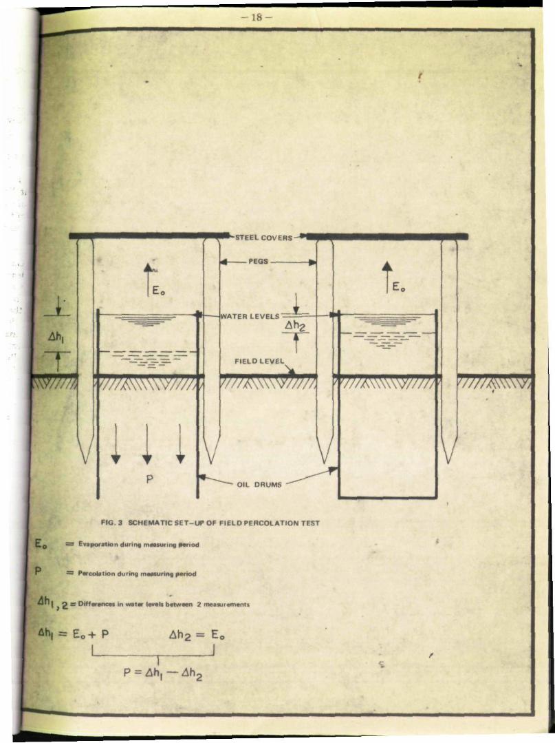
The larger part of the West Polder consists of fine clay soils (refer to Chapter 1.3 on Soils). Vertical downward movement of percolating water in these fine clay soils is slow, thus hampering the leaching process. In order to assess the degree of leaching in the clay soils of the West Polder an experiment was conducted. It included two oil drums which were buried into a clay soil in the northern part of the West Polder (see Map No. 2 for precise location) down to two thirds of their length. From one of the drums the bottom was removed before placement. Both drums were filled carefully with the original soil and topped up with water. Then, pegs were placed around the drums and steel plates were put on top to prevent disturbance of the measurements by cattle and rainfall (Fig. 3). After two weeks during which the soil in the drums was allowed to settle and to become saturated, measurements of the water levels began. They showed that average downward movement of water (hydraulic conductivity) in the fine clay soil amounts to 0.0014 m per day,
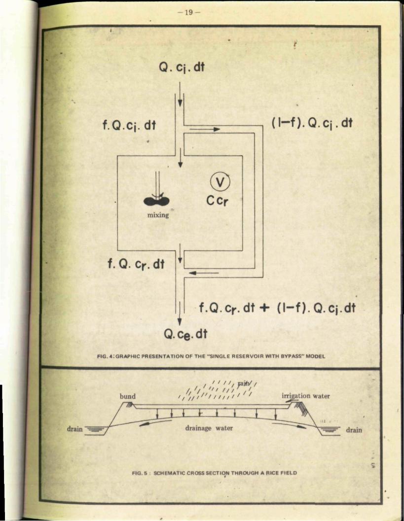
In order to carry out calculations about the required leaching time for proper desalinisation of soils in x leylersfield a simple model is used called "the single reservoir with bypass". A graphical presentation of this model is shown in Fig. 4.
In the model, water stored in the root zone is considered as a 'reservoir.' A certain quantity of water, consisting of rainfall and irrigation water enters the 'reservoir' carrying a certain a:~ :>unt of salt. At the same time, water is leaving the 'reservoir' thereby removing salt from the "reservoir. V
* Usually, conductivity (salinity) levels within the soil profile increase with depth. Therefore, it can be assumed that root zone conductivities are less than those that were measured in the ground water. Nevertheless, the measured values are applied in order to keep on the safe side in predicting changes in salinity in the future.
- 1 8 -
i
y//A\\\ \ \V/// /y <
11 1
WATER LEVELS
• - S T E E L COVERS - • • • • •
PEGS
i T
FIELD LEVEL
WJ/AWW^/JM
OIL DRUMS
t.
y//A\\\\\v/////
FIG. 3 SCHEMATIC S E T - U P OF FIELD PERCOLATION TEST
C.0 = Evaporation during measuring pariod
V// /AWWV/
dh
— Parcoblion during maasuring partod
| g — Dttfarenca» in watar lavals batwaan 2 maaajramants
4h, = E0+ p Ab2 = E0
I P = 4h ,— ^ h 2
' i
- 1 9 -
Q.q.dt
1 f.Q.cj. dt
1 mixing
J
f. Q. cr. dt i
® Ccr
I
( l - f ) . Q.q.dt
f.Q.c r .dt+ ( l - f ) . Q.q.dt
Q.ce.dt FIG. 41 GRAPHIC PRESENTATION OF THE "SINGLE RESERVOIR WITH BYPASS" MOOEL
" / / , sai
drain
/,' ' / irrigation water
drainage water drain
FIG. 5 SCHEMATIC CROSS SECTION THROUGH A RICE F I E L D

- 20 -
If calculations are based on a long period (more than a year) it can be assumed that the volume of the 'reservoir' remains constant over this period. Hence, the amount of water entering the 'reservoir' is equal to the amount of water leaving the 'reservoir/
The amount of salts however in the 'reservoir' is not constant over this period, as leaching will decrease the salinity. The change in salt storage in the 'reservoir' can be calculated from the difference between the quantity of salts entering the reservoir, and the amount of salts leaving the reservoir. In general the salt balance of the model can be described as:
Amount of salts entering reservoir
Amount of salts leaving reservoir
Change in salt storage in reservoir
or (Formula 1) : Q.c-.dt Q.ce.dt V.dcr
in which Q = amount of water entering and leaving the 'reservoir' cj = average salt concentration of the in-flowing water c e = average salt concentration of the effluent water Cr = average salt concentration of the 'reservoir' dcr = change in salt concentration of the 'reservoir' dt - time period over which the calculations are carried out V = volume of the 'reservoir'
Only that part (f) of the inflowing water that mixes with the water in the 'reservoir' is efficient in the leaching process. The factor 'f' represents the leaching efficiency. The rest of the inflowing water moves directly to the subsoil through cracks etc. This amount of water, 'bypassing' the system is represented by : (1 - f).Q
The salt concentration in the effluent water (which is the total of the leaching water leaving the reservoir, and the bypassing water) can be calculated as follows :
(Formula 2) Q.ce.dt = f.Q. cr.dt + (1 • f) Q. cj. dt
or simplified :
(Formula 3) ce = f.cr + (I • f). cj
Combination of formulas Ï and 3 gives
d.cr
cr-ci V dt

- 2 1 -
Integration between the limits cr = cQ at t = o, and cr = Cj at t = t (in which 'c ' is the salt concentration in the soil water at the start of the leaching process, and 'c t ' is the concentration of salt that will foe reached at time 't' during the leaching process) yields:
(Formula 4.) c t = cj + (cQ - cj) e
or:
f.Q.t = V.h ir ' C ° • c i •s f.Q.t = V.h 1 [ ^ " c i J
or:
V . l n f
c o " c i
t — f.Q In i c t ci
(Formula 5)
(Formula 6)
The salt concentration of the soil water solution at any given ti me can he calculated from formula 4. The quantity of percolation water that is needed to reach a certain salt concentration of the soil water solution can he arrived at bymeans of formula 5. Lastly, the time span required to reach a certain salt concentration of the soil water solution can be calculated through formula 6.
In the lueylersfield West Polder the following data and assumptions have been used for inclusion in formulas 4, 5 and 6.
Reservoir 'V' is the moisture stored in the root zone of soils. The average rooting depth of rice plants is about 50 cm, while roots reach a maximum depth of 60 cm. The average moisture content at field capacity of fine clay (which is the dominant texture for most soils) is about 50 percent. Therefore, the total quantity of water in the 'reservoir' is S00 mm x 0.5 = 800 mm.
Average salt concentration of the inflowing water 'cj' is determined by the salt concentrations of the Cabarita River water (which will be used for irrigation) and precipitation water. The salt concentration óf Cabarita river water expressed in mmho/cm electrical conductivity averaged 0.6 mmho/cm during the period December 1879 - I/ïarch 1980. Salt concentration of precipitation water is negligible. If it is assumed that two thirds of the inflowing water consists of irrigation water and one third of rainfall, then the average electrical conductivity of the inflowing water is about 0.4 mmho/cm.

ï
Leaching efficiency 'f'. Fo* clay soils the average leaching efficiency is 0,85. In these calculations A valüë oï Ö.8 is used, allowing aimallsafety margin
The salt concentration of the soil water it present' c0 ' From the 132 salinity observations in the West Polder, the average electrical conductivity of the groundwater has been calculated as 12 mmho/cm. This calculation excludes the 43 observations at which groundwater was not encountered; also refer to Map No. 2.
The salt concentration of the sou water after leaching during a period t: *è£ From an agricultural point of view a final salinity level of less than 5 mmho/cm should be aimed at. This value represents the maximum level at which rice can be cultivated without yield reduction due to salinity.
The total amount of water entering and leaving the reservoir: 'Q'. From the field percolation test this amount is estimated at 1 mm/day.
Substitution of the above mentioned values for 'V', f V«0* and 'Q', and an assumed value for the leaching period V, in equation 4, indicates that, for example after a 50 day leaching period, the salt concentration in the soil water will be reduced to 10.6 mmho/cm. Similarly, substitution of higher values for V (longer leaching period) gives :
length of leaching period (days)
salt concentration in soil water (mmho/cm)
0 12,0 50 10.S
100 9.3 150 8.2 200 7.2 250 6,4 300 5.6 350 ^ 6.0
From these figures it can be concluded that after about 1 year (350 days) of leaching, the average «Unity in the root zone will be reduced to a satisfactory low level (i.e. less than 5 mmho/cm).
As is shown on Map No. 2 Electrical Conductivity of the Groundwater in the Meylers-field West Polder, salinity levels as measured in the area, range from about 8 to 20 mmho/cm. Using equation 6, the leaching periods required to reach a salinity level of 5 mmho/cm, from different initial salt concentrations^* " have been calculated as follows :

•
•-• t o l • " " •' ••'• • '" ' ' • • - : '••
•
•
". ' 1
•
. . .
. . . - . . ' . • , : ' •
• •
i

- 23 -
Initial Salt concentration length of leaching period (tarnho/cm) (days)
9 188 10 276 12 346 14 407 16 458 18 503 20 544
From these figures it appears that in the most saline parts of the area, a leaching period of at least 544 days (about IVt year) is needed to reach a satisfactorily low level of salinity in the root zone for successful rice cultivation.
From June till September 1980, salinity levels of the groundwater in 18 observation holes in the West Folder were monitored weekly. In this period average conductivity levels in the three augerholes in the northern most Section of the polder dropped from 8.8 mmho/cm (24/6/80) to 7.5 mmho/cm (27/8/80). Salinity levels in the southern part of the polder also decreased during this period, but not to such a clear extent as in the northern section. This can be explained by the fact that in the northern section the field drainage system was already completed during the monitoring period, whereas in the southern part many of the field drains were not yet connected to the main drains.
Once completed, maintenance of the drainage system is af great importance for successful leaching. Neglecting the drains will result in a rising water table and upward movement of saltsj especially during fallow periods.
An additional improvement of the water quality in the West Polder could be gained by the installation of so-called f Japgate culverts in the Styx river (e.g. at the intersection of this river with the main road.) Such culverts only allow water flow in one (outward) direction, thus preventing salt water from the sea to intrude into the Styx river, and subsequently into the polder.

SOIL MANAGEMENT CONSIDERATIONS
The various soil types occurring in the Lleylersfield West Polder vary widely in their characteristics * The soils of map units 1,2 and 3 (Tropofluvents, Aerie Tropic Fluvaquents and Tropic Fluvaquents,refer to Chapter 1.3) have generally favourable characteristics for rice cultivation, in that they are deep, fine clay soils of high to medium fertility. In small parts of these mapping units, the soils overly limestone rock at moderate (50 -100 cm) or even shallow (25-50 cm) depth, implying an increasingly more difficult water management if used for irrigated cultivation, a restricted rooting volume and therefore, limited availability of plant nutrients and, in the case of the shallow soils, impeded tillage properties.
The soils of map unit 4 (Aerie Sulfic Tropic Fluvaquents) have favourable physical properties (deep, fine clay soils). They are however potentially acid, and will upon drainage (oxidation) develop extremely acid characteristics, rendering them unsuitable for agricultural use. Liming, which is normally an efficient practice on soils with slightly acidic characteristics, will not be a practical solution to the problem of strong potential acidity. Experiments in several countries* have shown that, in order to neutralize acid sulphate soils quantities of lime of up to 100 tons/acre could be needed. Also, since usually the subsoils are more acid than the topsoils, the lime should be introduced into the subsurface horizons. Such an activity can only be undertaken with heavy machinery. Apart from iiming,oxuy a very careful water management, i.e. maintaining the ground water at a depth of not less than 30 cm, will prevent the acidification of these soils. Therefore, they are rated moderately suited for rice cultivation or for pastures. Under natural drainage conditions these soils have medium fertility.
The soils of map unit 5 (Aerie Sulfic Thapto-Histic Tropic Fluvaquents) have the same properties as those of map unit 4, but in addition to the potential acidity problem, they have a limited bearing capacity due to the occurrence of distinct layers of peat (20-40 cm thick) within 100 cm from the soil surface. They are therefore, less suited to mechanized cultivation.
. Drainage of these soils in order to increase their bearing capacity, would result in acidification.
The peats of map unit 6 (Typic Sulfihemists) have several serious management problems. Under natural, poorly drained, conditions they have low bearing capacity, rendering them unsuitable for ^mechanized cultivation. Upon drainage, which would increase the bearing capacity, they will develop strongly acid characteristics and in addition, subsidence will take place. Furthermore, experience, in other countries indicates low productivity of rice growing on peat soils due to sterility problems which are probably caused.by deficiencies in certain minor plant nutrients like copper. The peats are therefore considered unsuitable for mechanized rice cultivation and marginally suited for hand cultivation of rice.
The outcrops of limestone rock that occur in a few places in the West Polder (map unit 7) are at present not suited to any land of cultivation. They may however, be dug out and refilled with clay from the surrounding areas.
• C. Bloomfield and J. K. Coulter (1973>: Genesis and Management of Acid Sulphate Soils. Advance» in Agronomy 25:265 - 326

- 25
In the characteristic flat topography of the polder, slopes do not form a limitation to cultivation. Moreover present engineering activities in the area include a coarse levelling of plus or minus 4 inches per irrigation unit of 5 acres. Final levelling however, is required in order to obtain a constant water depth throughout the lots upon irrigation.
Throughout the area the soils are affected by salinity. As explained however in Chapter III.l, it is expected that drainage of the saline groundwater, in combination with irrigation with fresh water from the Cabarita River can leach the salts from the soils and reduce soil salinity to acceptable levels, within a period of 2 years.

SECTION IV
LAND CAPABILITY ASSESSMENT
L

INTRODUCTION
The preceding chapters provide basic information about the various physical factors that make up the environment of thé Ï leylersfield West Polder and about their effect on agricultural use and management of the area, in the öohtext öf lend reclamation activities that are presently being completed hi the polder.
This section on land capability assessment) presents a quantitative interpretation of the physical data with regard to their effect oh agr&ültuM production. Since specific lands of land use put specific requirements on their physical environment, land capability in the Meylersfield West Polder has been classified specifically for three different types of agricultural use (Land Utilization Types). Each Land Utilization Type (LUT) is narrowiy defined and characterized according to its produce, its level of management and related inputs. Two of the LUT's centre around the production of irrigated rice (but at different levels of management), the third LUT centres around cattle farming.
In the process of land capability classification, the specific requirements of the attributes of the LUT's (produce, level of management and related inputs) are matched with the physical land conditions occurring in the area. Tracts of land are. grouped into units of land capability classes and subclasses, according to the physical limitations relevant to the respective LUT. Land capability classes group tracts of land pertinent to increasing degree of limitation (e.g. slight, moderate, severe, etc.), whereas land capability subclasses group tracts of land according to kinds of limitations (i.e. soil depth to hard limestone, half-ripe and unripe sulphidic layers, and peat layers).
Land capability classes and subclasses are characterized in their absolute and relative value for agricultural production by means of assignment of Productivity Units. ?7ithin Land Utilization Types productivity units are measures of productivity in terms of Added Value per acre per year:
Added Value ~ Total Value of Output - Total Value of Non-factor Input. One Productivity Unit (P.U.) corresponds to J$100.00 of Added Value, adjusted to price and income levels of February 1977 (=standard reference dateline). This adjustment allows direct comparison of the productivity of the different LUT's.
The relationship between farm added value and the other factor shares, e.g. value of output, non-factor inputs etc. is explained in Annex I to this report: "Farm Income Account according to Factor Shares".
All elements of the land classification are explained in the following chapters. The geographic distribution of the land classes and subclasses per Land Utilization Type is shown on Figures 8,8 and 10.

LAND UTILIZATION TYPES
The original plans for development of the Lleylersfield Polders call for rice oroduction on smallholdings in the framework of Government's Project Land Lease Phase III, under a fairly high level of management, including mechanized farm operations (ploughing and harvesting/threshing). However, the physical conditions in part of the area severely affect the possibility Of mechanization. Ploughing and harvesting with heavy machines will be difficult on the half-ripe to unripe mud clays and peat soils occurring mainly in the southern part of the polder. Drainage of these soils in order to improve their bearing capacity will enhance oxidation of thé sulphideé that occur in the profiles and subsequently the formation of free sulphuric aeid> lowering the pH to toxic levels. Therefore, a clear differentiation is made in the land classification assessment between two LUT's centered aróuiid rice cultivation:
Rm Mechanized Smallholders Irrigated Eice Cultivation Et Semi-traditional Family-operated Irrigated Rice Cultivation
The assumed level of management for the second LUT is based on the cultural practices currently prevailing among the traditional rice-growing farmers in the surroundings of the ï'ïeylersfield Polder. Land preparation under this traditional management consists of land clearing (bushing) by hand, only. Harvesting is done by hand and sickle. Under such management, low bearing capacity is not a limiting factor in rice cultivation. The soils can remain wet, and the danger of acidification is minimal.
As an alternative to rice cultivation in the Meylersfield Polder, the area has also been classified for its capability for cattle farming:
Ct Traditional Family-operated Cattle Farming Cattle farming does not put very high requirements on the bearing capacity of a soil, and therefore minimal drainage of the area would be necessary, thus reducing the danger of acidification upon oxidation. Also, pastures provide a good alternative to the sterility problems and resulting low yields associated with rice cultivation on peat soils. In line with paresent conditions in the Meylersfield area, a traditional (relatively low) level of management has been assumed for this Land Utilization Type.
Urn Mechanized Smallholders Irrigated Rice Cultivation
This land utilization type concentrates on cultivation of irrigated rice, using hired machinery for land preparation, harvesting and threshing. The following assumptions are made:
- Two crops of irrigated rice are grown per year, in a cultivation c ycle as set out in Figure 6.
Land preparation consists of ploughing and harrowing (1 passing each) with crawler-tractors, or wheel-tractors with cage wheels, which are hired at J$ï50.00 per acre.

- 2 9 -
200 -
«00 J
's
/ v
f
/ y
Ratal 'ii u Ml percent
V
. 8
. 6
. 4
- 2
FIRST CHOP
SECOND
CHOP
• u i n j
Land is • paraUon
S- - . I n i t Harvi
FIG 6 CROPPING CALENDAR FOR MECHANIZED SMALLHOLDERS IRRIGATED RICE CULT IVAT ION UNDER ROTATIONAL IRRIGATION IN THE MEYLERSFIELD WEST POLDER (land preparation and harvesting ara carried out by hired machinery, time required tor leaking of fieldt before leading n included in land preparation).
•-••'
200 -
100
/
/ x
/
/
s\ /
\ •roenl r*ni m
• •
. 6
• 4
. 2
SECOND CROP
Laad ration
1 Sr«x»llg ~) HarveftiBf
F | G 7 CROPPING CALENDAR FOR SEMI TRADITIONAL F A M I I Y OPE RATEO IRRIGATED RICE C U L T I V A T I O N UNDER ROTATIONAL IRRIGATION IN THE MEYLERSFIE I D WEST POL DE R (AM farm act...tie. art earned out by hand .about land preparation include» preparation ol . and wading in nuratryl.

- 30 -
. High yielding rice varieties are used: Gica 4 or Cica 9 (Price: J$0.30/lb).
- Before seeding, the fields are soaked and then drained.
- The 'seeds are pre-germinated and then broadcasted by hand, at a rate of 100 lbs/acre.
- Modest amounts of fertilizer (2 bags/acre of Sulphate of Ammonia at J$20.00/bag, and 1 bag/acre of complete fertilizer at J$25.00/bag) are applied, in three gifts: 50 percent at broadcasting, 25 percent after about 7 weeks (tillering stage) and 25 percent after about about 70 days (Panicle initiation). When fertilizer is applied, the fields are drained temporarily.
- Weeds are controlled chemically by application of Stam at a rate of 5 lbs/acre at J$5.00/lb.
Harvesting/Threshing is carried out by hired combine at a cost of J$100.00 per acre.
Cost of irrigation and drainage of the fields is calculated at J$100.00 per acre per crop. This calculation is based on the cost of running the irrigation and drainage pumps in the polder.
- in the added value calculations, the f armgate price of rice is taken at the official ADC level of J$0.25/lb (January 1980).
Added Value Calculations, based on full production under this land utilization type, are given below. All figures are expressed on a crop/acre basis, and price levels are from January 1980;
Value of Output Rice 2500 lbs @J$0.25/lb J$625
Cost of Non-factor Inputs
Added Value per crop per acre
Seed 100 lbs @J$0.30/lfo J$ 30 Ploughing/harrowing 80 Irrigation/drainage 100 Fertilizer 65 Weedicide 25 Harvesting/threshing 100
J$400 J$400
J$225
Added Value for 2 crops/year : 2 x 225 = J$450 per acre/year, at January 1980 price levels.

- 31
l>hnur Inputs
Based on the above assumptiohs, labour inputs by the farmer in this land utilization type will include :
1 manday/acre/crop soak and drain field pregerminate seeds; broadcasting; first fertilizer application; submerge apply weedicide drain; second fertilizer application; submerge drain; third fertilizer application; submerge drain
Total 8 mandays/acre/crop
Labour input for 2 crops/year : 2 x 8 = 16 mandays per acre/year.
Rt Semi-traditional Family-operated Irritated Pace Cultivation
This land utilization type centres around rice cultivation, applying some of the traditional cultivation practices which are common to the rice farmers in the area. Major improvements are assumed however :
Two crops of irrigated rice are grown per year, in a cultivation cycle as shown in Figure 7.
High yielding varieties of rice are used : Cica 4 or Cica 9 (Price J$0.30/lb).
Modest amounts of fertilizer (2 bags/acre of Sulphate of Ammonia <§> J$20/bag; and 1 bag/acre of complete fertilizer @ J$25/bag) are applied in three gifts: 50 percent after transplanting, 25 percent after about 3 weeks (tillering stage), and 25 percent after about 10 weeks (panicle initiation). When fertilizer is applied, the fields are drained temporarily.
Other assumptions for this land utilization type include :
Land preparation consists of clearing (bushing) with machete only
Seeds are seeded in a nursery at a rate of 40 lbs per planting acre. The seedlings remain in the nursery for about 4 weeks.

- Before transplanting the fields are soaked and then drained, after which the seedlings are transplanted by hand into the soft wet soil,3 - 4 plants per hill in rows ( 1 x 1 ft). The fields are then submerged again.
• About 3 weeks before harvesting the fields are drained again.
- Harvesting is done by hand and sickle.
• Drying, threshing and winnowing is done at the small mills existing in the area.
- Cost of irrigation and drainage of the fields is calculated at J$100/acre per crop. This calculation is based on the cost of running the irrigation and drainage pumps ir. the polders.
In the Added Value calculations the farmgate price of rice is taken at the official ADC Jevel of J$0.25/lb (January 1980).
Added Value calculations, based on full production under this land utilization type, at© given below. All figures are expressiéd on a crop/acre basis, and price levels are from January 1980.
Value of Output Rice 2500 lbs @ J$0.25/lb J$625
Cost of Non-factor Inputs Seed 40 lbs @ J$0.30/lb J$ 12 Irrigation water 100 Fertilizer 65 +
J$177 J$177
Added Value per crop per acre J$448
Added Value for 2 crops/year: 2 x 448 = J$896 or rounded off at J$900.- per acre/year at January 1980 price levels.

33 -
Labour Inputs
Based on the above assumptions, labour inputs by the fanner in this land utilization type will include;
prepare nursery + seeding land clearing, soak and drain transplanting; first fertilizer application; submerge weeding drain; second fertilizer application; submerge drain; third fertilizer application; submerge drain; harvesting harvestingjdrying; threshing; winnowing
Total
2 mandays/acre/crop 5 »»
20 > » •
1 » 1 J»
1 »» 15 >» 10
- +
55 mandays/acre/crop
Labour input for 2 crops/year: 2 x 55 = 110 mandays per acre/year.
Ct: Traditional Family-operated jCattle Farming
This land utilization type is centered around beef production in smallholdings of irrigated grazing pastures. The sale of milk fonns an additional source of farm income. The following assumptions are made:
Grazing intensity is one animal per 2 acres of pasture, on land, without physical limitations. One animal unit comprises a mature cow plus young stock. The farm is subdivided into 10 enclosures, each of which is grazed by the herd for approximately 2 days (grazing period). The grazing interval is 20 days. The enclosures ars formed by bunds on which a fence is placed (e.g. quickstick with barbed wire).
After each grazing period during the dry period of the year (November through xvïarch), and during dry spells, the enclosures are submerged for one day up to a water depth of 2 - 3 inches. Submergence is done by flooding from a small canal that is to be constructed by the farmers in each irrigation unit of 5 acres, parallel and next to the irrigation canal. This small canal, which can be kept filled constantly, will also provide drinking water to the cattle.
After 2 - 3 grazing periods, grass tufts and weeds occurring in the pasture enclosures have to be bush cut.

- 3 4 -
ïn the cows life-fee four calves are bom and raised. One heifer is kept for replacement of the cow. The other three calves are sold at an age of about 18 months (estimated live weight 550 lbs). After dropping her first cal f, a cow will stay in the herd for five years and is then sold (estimated live weight 900 lbs).
The cows are milked daily in the morning by hand, and produce an average of 2 quarts (Grade B) milk per day- during 280 days per year.
Cost of irrigation and drainage of the fields is estimated at $40 per acre per year.
Cost of veterinary service is J$20 per year for a cow of more than 2 years and J$15 per year for younger animals. Pastures are not fertilized, concentrate feed is not given to the animals. The animals are sprayed and drenched against ticks and worms, once per month.
Added Value calculations, based on full production under this land utilization type, are given below. Output and input calculations are first made per aabnal unit per year, and then they are reduced to values per acre. All price levels are from January 1980.
Value of Output: Sale of young cattle: 3 calves in 5 years, 550 lbs each @J$1.85/lb Sale of eld cow: 900 lbs @ J$1.20; once in 5 years Sale of milk: 560 quarts @ J$0.55/quart
JS610
228 309
J$1147 J$1147
Cost of non-factor input:
Added Value per animal unit per year
Veterinary service J$ 35 Tick spray (Bercotex); worm drench (Milvera) 30 Irrigation/Drainage 40 Others (Fencing) 20
J$125
J$ 125
J$1022
Added value per acre per year (1 animal unit per 2 acre): lA x J$1021 = J$510 (rounded off),at January 1980 price levels.

- 35 -f
f̂ hour inputs
Based on the above assumptions, labour inputs by the fanner in this land utilization type will include (figures, expressed in mandays per year, refer to complete farms; 4 animal muts/8 • 10 acres):
milking 4 cowsj once per day, 1 hr/day, 280 days/yr 35 md/yr bush-cutting M md/acre, once every 40 days 40 spray cattle 2 hr/month 4 maintain bunds, fences, irrigation canal 12
Total 91 md/yr
If farms under this land utilization type would have a size of 8 -10 acres, the per acre labour requirement would be 9 -11 mandays per year.
QUANTITATIVE LAND CAPABILITY ASSESSMENT PER POSSIBLE LAND UTILIZATION TYPE
In this Chapter, the variable physical factors that occur in the Meylersfield West Polder are quantified relative to the land utilization types discussed in Chapter ÏV.2. This must be done since these physical factors may have specific, dissimilar effects on agricultural production in different land utilization types; for example : low bearing capacity is more restrictive to farm machinery than to hand labour; limited soil depth is more restrictive to rice plants than to grass; etc.
In Tables 4,5 and 6 under each land utilization type six land capability classes (Roman numerals I - VI) are distinguished according to increasing degree of limitations that occur in the project area and that are relevant to the respective land utilization types i.e.: soil depth to hard limestone; half-ripe and unripe sulphidic layers; and peat layers. It should be noted that, although at present differences exist in the drainage condition of the various soils in the West Polder, drainage is not included as a possible limitation for any of the land uses considered, because it can be assumed that upon completion of the drainage system, drainage conditions will be the same throughout the area. Similarly salinity is not included as a factor in the land capability assessment, as it is assumed that through irrigation and drainage, the salinity of the soils in the project area will be reduced to acceptable levels within 1 to VA years from the start of full-scale irrigation (refer to Chapter II J).
Individual land capability classes are assigned productivity units (P.U.'s) which decrease proportionally from a maximum of 100 percent for Class I (no limitation to the envisaged land use), 30 percent for Class II (slight limitation to the envisaged land use) etc., to less than 50 percent for Class VI (extreme limitations precluding the economic use of such land under the envisaged land use). Absolute values of productivity units are expressed in dollars of added value per acre per year at February 1977 price and income levels : 1 P.U. = J$100.00*.
'February 1977 is chosen by the Rural Physical Planning Unit as standard reference dateline for all calculations of added value in order to aHow direct comparison of productivity Figures, increases in prices, labour costs, interest on capital from February 1977 to January 1980 are estimated at about 50 percent.

- 36 -
Explanation of the Classification Formulae :
Land capability classification formulae as used in the text and on the Land Capability Maps (Figs. 8,9 and 10) are composed of the following elements in order of placement:
• - ~ a symbol for the land utilization type consisting of a capital and a lower case letter: Rm, Rt and Ct.
- a symbol for the land capability class i.e. Roman numerals I through VI
- one or more lower case letters symbolizing the limitation(s) occurring under the land capability class for the particular land utilization type, i.e. 'd' for limited soil depth to hard limestone, V for limited depth to half-ripe and unripe sulphidic layers, and 'p' for limited depth to peat layers (refer to Tables 4,5 and 6).
land utilization
type
land capability
combination of two equally intensive limitations (n and p), each of which is of Class II intensity, but that together add up to Class in
, combination of one major limitation (p) of Class VI intensity and a minor limitation (n)
Concerning the limitations, the following situations may occur:
Land capability classes I have no limitations, formulae thus include only symbols for the land utilization types, followed by Roman numeral Ï, e.g. Rt I.
Land capability classes II have one limitation only, na, ct iin
Land capability classes III through VI may either have only a major limitation (e.g. St lïïd); or a combination of a major limitation and a minor limitation (e.g. Rm VI p(n)fcor a combination of two equally intensive limitations (e.g. Rt HI n/p). In the latter example, both the n and p limitations are of Class II intensity. Their combined occurrence results in classification at Class III intensity.

- 37 -

. ' . • I
II VNIZEDSMAL1 HOLDERS IRRH VTED RICE CULTIVATION rRmi
I \ \ ML I I ^ ' PRODI < l III M'
J Un«i Capability
! mm
I P r o d u c t s i \
(P I K i t i >
h c p ' h l m • m i Io
I
Marti Linn
;
I pi and 1 n -npr
•yen P 4)
Prat Laven
1
h
10 90 100 more ihan i on i in more than 100 i m
mote ihan 10(1 cm. or
than
20 era Stick at variable
depth within 100 cm
from the soi! surface.
III
l \
2.7; 80-90 >u 100 n.a
0-HO n.a. 100
n.a.
murr ihan 10 im, or prat la\ m of 20 - 40 cm
able depth wi th in 100 cm from the surface
1 ! tHJ-70 ii .a n ,i
1 - .0-60 i
25 50 n a
r I iss ihan M i percent ol imum. no pro ' ductrvits. uni ts '
I
n.a
VI I ess than 25 c m w i t h m i k n u l l rope
| . - . s I ;
assigned
layers more than 11) c m l a i d tha i start w i t h i n -10 i ni I r o m the soil surf*
i.wl ,s m—I I I Sri in Un-flM ..' Added V MfKaaMd n IS aciei which tor Ihta Land Ut i l i lanucy 1980 p. i t n i i m
Tins adinv Mm d.-eo companion ot tha p'odi>cti».ty o l d i l h " u " v * Units IP i j S l O Ü O O a ' ,nd income levels In addit ion productive d hwe as a pe.rentage ol ' l ie maximum p ,,,d
2 '
31
Umipe soil materials art material! that have an n value ol m o ' f 'han 1 Hal* rqi -.iels Have n values between 0 7 and 1 0 . The n value can be calculated '. A 0 2R > 4 » ' l * 3HI in which
centage o ' walet in the so.' m he'd . mm i age of clay, and H i t rii naliai orgai '241
ilue o! ii II in.- MUI f low* wi th d i l l ' i i l t » between the fingers UM .veen 0 / ..• . s*.d to be haft " p e If the soil Hows easily : has fingers the n value .« 1 0 n mora, a. innpa
ils are watn. logged mmeial o. organic Id I ma «•'ffh MS than ih.ee turns as
rtaM as sulphtu
' lain more than 30 p.
N 0 B T M
H G . 8 LAND CAPABILITY FOR MECHANIZED SMALL
HOLDERS IRRIGATED RICE CULTIVATION IN THE
MEYLERSFIELD WEST POLDER
r\
\ 0 IOO 2 0 0 300 4 0 0 M
• : i 10,000
900 1000 Ft

- 38

HKD IRRIGATED NON
I \ M M -.PAB11 GS WD I
\ 111 Ml : I RSI IELD POLDERS
1 Land ' Pmihictu u\ Depth to
Cap.bH.lv i IP I acre;%) | H a | f a n d • n . , \
, , ^ j d H a r d l ' , w s , , , n « | 2 )n
3 ) | su.phTo.cl .^ J Peat Layers
I 1 i more than 100 cm; or peil I j layer- of less than 20 fin
1 6.0; 9 0 1 0 0 more than 100 cm more than 100 cm [ ihn k at ariablc depth «Ufa- | 1 i in 100 cm tram ti •
1 i s U I
i 1 mora than 10 em; <>r m l 1 II 1 5.4; 80 -90 r>(l 100 50 100 rs of 20 •-40 cm thick, | j • at variable depth with in 100 1 j | cm from the soil surt"a< c'
III 1 8 71) 80 2 5 - 5 0 n.a. n.a
1\ t 2; 60 70 n.a. [ "•*• n - a '
1 | . pe«l Uvers more than 40 cm l rn l 1 p̂ rn | thick, that start within 40 cm*
v J b . D O h O „ a 2 5 - 5 0 ! fr(,m th , s„,l surface
km than 50 levs than 25 cm with , than 25 cm n a 1 \ | percent of max j rock outcrops I imum.no pro
ductivity units assigned.
1' Productivity i>> ldnd is measured m larmi ol Added Value si Prodoca 'expressed m JS.'acrei which 'v tli -. Land Utih ration Type i» calculated trom January I M 0 pne* level», and adfusted 'o those o' February 19? •..mdaid reference datel This ad|us-meni allow» direct comparison o' the pioduc M L U I ' i Productivity hat been given • elative value by e»p•••.-. ng m P'oduc'iviiy Units ' P U JS'OOOOat February 1977 pr.ee and ncoma levels In addition, p-oductiv.ry is expressed here as a percentage o' the maximum productivity ••! Class I Land
21 Unripe *oil in I materials that have an n value of moie than 1 Halt -ripe soil maie-.als have n .alue» between 0.7 and 1 0 I he n value can be calculated tot numeral soil materials by the foimula n A 0 ^B >^" I L • 3Hi in which A is the percentage o' WSU lit he. soil Ml 'ield condition. R i» the percentage ol silt p'us sand. I. is the percentage o' clay, and H i\ the iv .e inage of oigamc mi iM i lOrgamc carbon x 1 '241. A simple field lev o' squeezing -he soil in the hand can di'icimmr 'he approximate value o' n It The soil flow» with difficulty between the 'mgers the n value is batwatin 0 I and 1 0. and Ihe soil is said •<> be half • -oil flow» easily ; i - » « n the linger» Ihe n value •» I 0 or more and the soil •» called unripe
31
41
Sulphidic material! an- wate' logged iruneial or Organic soil ma'-rials thai contain 0 78 peicent or mo-e sulphur Idry weight I mostly m the 'orm o' sulphides hydrogen and •••nous sulphides I and that have leu than -hree times a» much carbonate as su'phui
Pea» matenaH comam m,n> than 30 percen- mgenu .game cwbonl
FIG.9: LAND CAPABILITY FOR SEMI -TRADITIONAL FAMILY-
OPERATED IRRIGATED RICE CULTIVATION IN THE
MEYLERSF1ELD WEST POLDER
NORTH
Scale . I 10,000
1000 Ft
100 2 0 0 300 4 OOM
1»

- 39
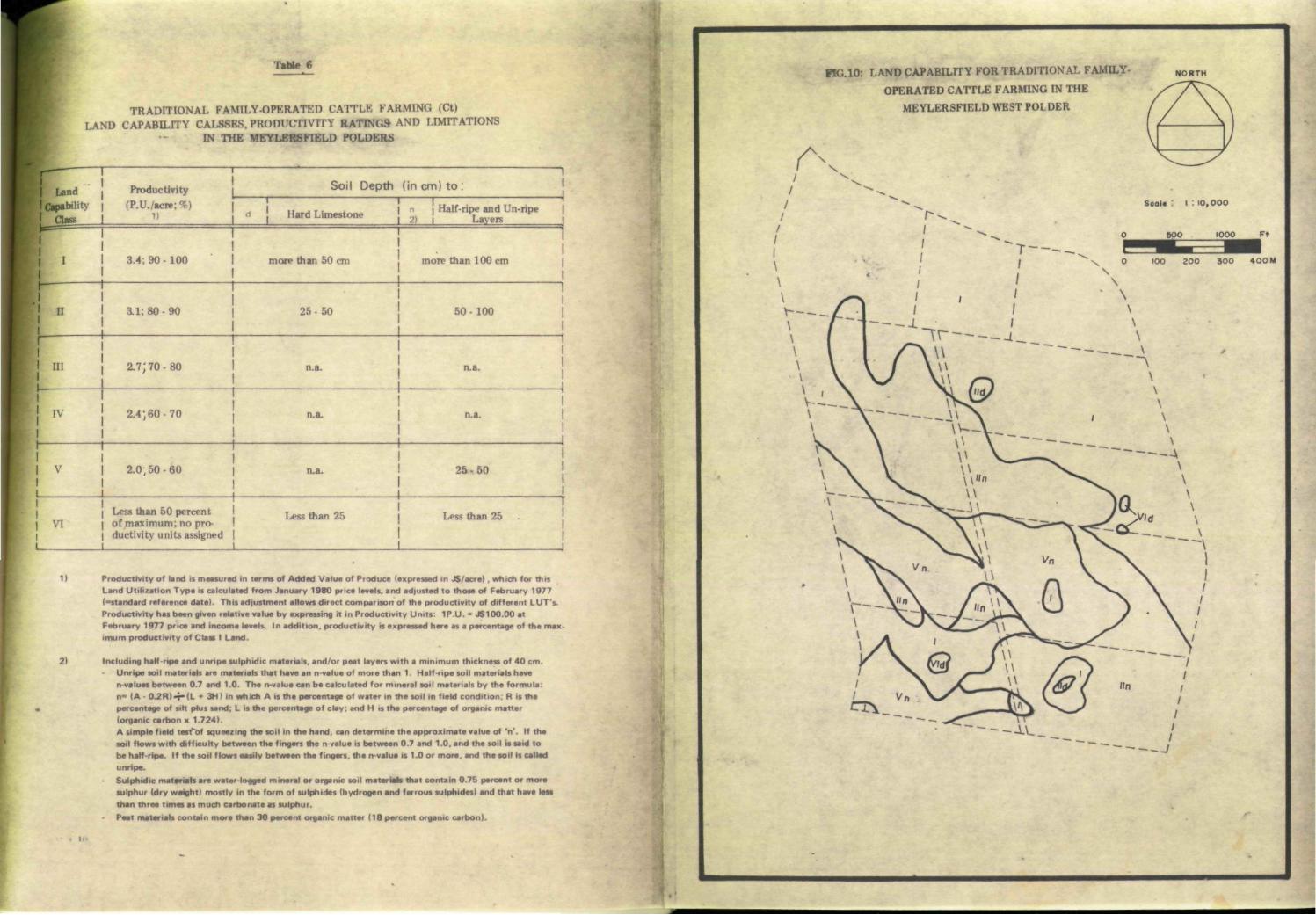
Table 6
TRADITIONAL FAMILY-OPERATED CATTLE FARMING (Ct) LAND CAPABILITY CALSSES, PRODUCTIVITY RATINGS AND LIMITATIONS
IN THE MEYLERSFIELD POLDERS
[Land Productivity Soil Depth (in cm) to :
Jcpab i l iU | rP.U./acn ! Half-ripe and Un-ripe 1 Class « Hard Limestone | ^ a v e R
V-— j I ' • I
I 3.4; 9 0 - 1 0 0 1 more than 50 cm more than 100 cm
I I 3 . 1 : 8 0 - 9 0 2 5 - 5 0 5 0 - 1 0 0
I I I 2 .7; 7 0 - 8 0 n.a. n.a.
IV 2 . 4 , 6 0 - 7 0 n.a. n.a. |
| V 2 . 0 , 5 0 - 6 0 n.a. 2 5 - 5 0
1 Less than 50 percent Less than 25 Less than 25 . | V I | o f max imum; no pro-
1 duct ivi ty units assigned | |
11 Productivity of land is maasutad in terms of Added Value of Produce (expressed in JS/acre). which for this Land Utilization Type is calculatad from January 1980 price levels, and adjusted to those of February 1977 (•standard reference date). This adjustment allows direct comparison of tha productivity of different LUT's. Productivity has been given relative value by expressing it in Productivity Units: 1P.U. • JS100.00 at February 1977 price and income levels. In addition, productivity is expressed here as a percentage of the max-imum productivity of Class I Land.
2) Including half-ripe and unripe sulphidic materials, and/or peat layers with a minimum thickness of 40 cm. Unripe soil materials are materials that have an n-value of more than 1. Half-ripe soil materials have n values between 0.7 and 1.0. The n-value can be calculated for mineral soil materials by the formula: n= (A - 0 - 2 R ) - T " ( L • 3HI in which A is the percentage of water in the soil in field condition: R is tha percentage of sift phis sand: L is the percentage of clay: and H is the percentage of organic matter (organic carbon x 1.724). A simple field test'of squeezing the soil In the hand, can determine the approximate value of 'n'. If the soil flows with difficulty between the fingers the n-value is between 0.7 and 1.0. and tha soil it said to be half-ripe. If the soil flows easily between the fingers, the n-value is 1.0 or more, and tha soil is called unripe.
Sulphidic materials are water-logged mineral or organic soil mater M i that contain 0.75 percent or more sulphur (dry weight) mostly in the form of sulphides (hydrogen and ferrous sulphides) and that have less than three times as much carbonate as sulphur. Peat materials contain more than 30 percent organic matter (18 percent organic carbon).
FIG.10: LAND CAPABILITY FOR TRADITIONAL FAMILY-
OPERATED CATTLE FARMING IN THE
MEYLERSFIELD WEST POLDER
NORTH
Scale : I . 10 ,000

Table 7 shows the land capability subclass acreages and corresponding potential productivity, expressed in productivity units, for the three land utilization types distinguished in this report.
Table 7
Land Capability Classes and Subclasses
Acreages per Land Utilization Type and Related Potential Productivity Units
1 Rm: Mechanized Smallholders r litigated Rice Cultivation
Rt. Semi-traditional Family-operated Irrigated Rice Cultivation
Ct: Traditional Family-operated Cattle Farming
Class & Subclass
Acreage Productivity Units
Class & Subclass
Acreage Productivity Units
; Class & I Subclass
Acreage Productivity Units
Rml
Subtotal
177.5 532.5 Rtl 177.5 1065.0 ; Q I i
183.8 624.9 Rml
Subtotal 177.5 532.5
Rtl
177.5 1065.0
; Q I i 183.8 624.9
Rm lid
Subtotal
6.3 17.0 Rtnd Rtlln
6.3 78.7
34.0 425.0
h" -j Rtnd
Rtlln 4.5
101.6 14.0
315.0 Rm lid
Subtotal 6.3 17.0 '
Rtnd Rtlln
85.0 459.0
h" -j Rtnd
Rtlln 106.1 329.0
Rm nin
Subtotal
78.7 , 188.9 Rtlld Rtmn/p
4.5 22.9
21.6 109.9
ctm 0.0 0.0 Rm nin
Subtotal 78.7 18a9
Rtlld Rtmn/p
27.4 131.5
ctm
0.0 0.0
Rm IVn/p
Subtotal
22.9 4ai RtIV 0.0 0.0 a iv 0.0 0.0 Rm IVn/p
Subtotal 22.9 4ai
RtIV
0.0 0.0
a iv 0.0 0.0
RmVd
Subtotal
4.5 8.1 RtVp/n 53.6 193.0 CtVn 53.6 101.8 RmVd
Subtotal 4.5 a i
RtVp/n
53.6 193.0
CtVn
53.6 101.8
RmVId
Rm VIp/n
Subtotal
1.5
53.6
no product vity units assigned
RtVld 1.5 no productivity units assigned
CtVId 1.5 no product-vity units assigned
RmVId
Rm VIp/n
Subtotal 55.1 -
RtVld
1.5 -
CtVId
1.5 -
TOTAL 345.0 79UB 345.0 184a5 345.0 1055.7

. 1
t
w
SECTION V
CONCLUSIONS AND RECOI.2 JENDATIONS

- 4 2 -
CONCLUSIONS AND RECOMMENDATIONS
From the foregoing, it has become clear that thé soil conditions in the Meylersfield West Polder are not uniform. Soils include clays with and without a potential acidification hazard and peats with a potential acidity hazard. All soils are saline to variable degrees but this salinity problem can be solved by leaching with irrigation water and proper drainage. AU soils have low bearing capacity when wet.
The Meylérsfield Polders are slated for development in irrigated rice cultivation in the framework of the Project Land Lease Phase III Land Rètbïm programme. The possible land utilization types and their related farming systems and degrees \if mechanization as well as their utilization öf thé farmer's and his/her family's labour in the production process have been the subject of many discussions between BRUMDEC, the Ministry of Agriculture and visiting Netherlands consultants (Messrs. L. F. Kbrtenhorst, P. J. Slabbers and W. Baarveld).
In Chapter Iy óf this report two forrns of smallholder1-?,irrigated rice cultivation are observed in more detail. They represent two extreme systems, i.e. "Mechanized Smallholders Irrigated Rice Cultivation" and "Semi-traditional Family-operated Irrigated Rice Cultivation."
In the case of "Mechanized Smallholders Irrigated Rice Cultivation" considerable use is assumed of mechanization in most farm cultural practices, whereas the labour inputs of the farmer and his/her family are at a minimum. The related added value per acre per year is calculated to be JS450 with a labour input of only 16 mandays per acre per year. If the First Rural Development Project* (FRDP) target farm added value of $3200 (at February 1977 price and income levels) would be used in the determination of the required minimum farm size, and if an adjustment factor of 0.66 is used here to relate January 1980 price and income levels to February 1977 price and income levels, then the minimum farm size for "Mechanized Smallholders Irrigated Rice Cultivation" would be :
3200 + (0.66 x 450) = 10.7 acres
for Class I land having no limitations to the envisaged use for 'Mechanized Smallholders Irrigated Rice Cultivation? Tracts of land of Classes II through V having limitation(s) of increasing degree to this land utilization type would require farm sizes ranging from 11.3 acres for Class II land up to 15.0 acres for Class V land. The related labour input of 10.7 x 16 = 171 farm mandays (at a minimum) would pose no problem for the farmer and his/her family. It even would leave the farmer sufficient time to supplement his/her income in other ways.
In the calculation of the value of the various farm factor shares, the current low rice price (J$0.25 per lb at farm gate) determines the relatively low total value of output and thus the modest level of added value per acre per year. This in turn, determines the minimum farm size considerably. If, for instance, the rice price would be raised to J$0.30 per lb then this would increase the total value of output and also the added value per acre per year with J$250 to J$700.
•The Fint Rural Development Project is a joint Jamaican Government - World Bank Project which in ana of its three com-pantnts - aims at the agricultural development of nine settlement schemes in the western region in the framework of
•: the Project Land Lease programme.

- 43 -
Required minimum farm size for Class I land under this land utilization type would then be: 3200 -f- (0.66 x 700) - 6.9 acres
Likewise, minimum farm sizes for tracts of land pertaining to Classes II through V in this case would range from 7.6 acres up to 8i7 acres.
In the case of the second land utilization type "Semi-traditional Family-operated Irrigated Rice Cultivation" it is assumed that ho use is made of any form of farm mechanization and that all cultural practices are carried out with labour of the farmer and his/her family. This system of rice cultivation is common in the area of Westmoreland. It includes zero-tillage, transplanting and hand harvesting. However, certain major improvements are assumed, i.e. irrigation/drainage or water control, improved rice varieties, cultivation of 2 crops per year, and fertilizer use. In this land utilization type, added value per acre per year is J$900 and the labour input is approximated to he 110 mandays per acre per year. The added value is so much higher than the added value for the "Mechanized Smallholders Irrigated Rice Cultivation" due to inclusion of the farmer's and his/her family's labour in this factor share. If the FRDP target farm added value of J$3200 (at February 1977 price and income levels) also would be used to determine the required minimum farm size, then this would Tesult in:
3200 -r (0.66 x 900)« 5.3 acres
for Class I land having no limitations to the envisaged use under "Semi - traditional Family operated Irrigated Rice Cultivation." Tracts of land pertaining to Classes II through V having limitation(s) of increasing degree to this land utilization type would require minimum farm sizes ranging from 5.8 acres for Class II land up to 7.4 acres for Class V land. The related labour inputs for the farmer and his/her family would amount to:
5.3 x 110 = 583 mandays per year
at a minimum, whereas only about 330 mandays per year of family labour would be available at the most. This implies that under this land utilization type a farmer and his/her family would be able to cultivate and manage not more than:
330 -4-110 = 3 acres of land.
This figure is confirmed by many farmers in the region who have stated that they are able to manage 3 acres of land in the traditional way of rice cultivation (Le. bushing, zero-tillage, transplanting, harvesting by hand).
If the argument concerning the low rice price would be repeated here assuming that it could be raised from J$0.25 to J$0.30 per lb then the total value of output and the added value per acre per year would increase with $250. This would bring the added value per acre per year to J$1150 for Class I land under ".Semi-traditional Family-operated Irrigated Rice Cultivation". A maximum area of 3 acres which can be fanned "Semi-traditionally" would result in a farm added value of :
(0.66xll50)x3 = J$2277

- 44 -
This figure still falls short of the February 1S77 FRDP target farm added value of $3200. la order to meet this target the added value per acre at January 19S0 price levels would need to be :
(3200 -i- 0.66) -T- 3 = J$1600peryear This in turn, can only be achieved under this land utilization type if the farm gate rice price would be raised with J$0.14 to J$0.33 per lb. At the moment, traditional rice farmers in Westmoreland can earn sufficient income from only 1 - 3 acres under rice cultivation with a single crop per year due to the existence of a local black market for rice with prices up to J$1.00 per lb.
A form of rice cultivation intermediate between the two above-mentioned land utilization types that would include some mechanization (e.g. land preparation with light machinery followed by broadcasting instead of transplanting to avoid the large labour requirement involved in the transplanting method) would decrease the labour requirement but it also would decrease the added value per acre per year. Such an "intermediate" form of rice cultivation between the two extremes of mechanized and semi-traditional rice farming would result in a m ihimum farm size (on Class I land) smaller than 10.6 acres but larger than 5.3 acres. In this connection, it should be noted that, the peat soils and the potential strongly acid clay soils in the Lleylersfield environment pose special requirements to the use of farm machinery because these soils must be kept as wet as possible and thus will have low bearing capacities. However, such requirements can be met by special machinery An associated complication would be that such machinery requires special operation skills and maintenance.
In order to investigate feasibilities of the various possibilities in growing irrigated rice (including variable degrees and types of mechanization) experiments should be carried out in particular on the peat and potential strongly acid soils. Representative sites for experimentation are indicated on Map No. 1 Soils of Keylersfieid West Polder.
In addition to the models for irrigated rice cultivation, a third land utilization type is discussed in Chapter IV, i.e. "Traditional Family-operated Cattle Farming" as an alternative use possibility on peat and potential strongly acid clay soils in the Meylersfieid area. The related added value per acre per year is $520 at January 1960 price and income levels, whereas the required labour input is 10 mandays per acre per year. If again, the FRDP target farm added value of $3200 would be adopted in calculating the required minimum farm size related to this land utilization type, then an adjustment factor of 0.66 must be used to relate Jan. 1900 price and income levels to those of February 1977. This would result in a minimum farm size of :
3200 ^-(0.66x510 )'= 9.5 acres for Class I land having no limitations to the envisaged use for "Traditional Family-operated Cattle Farming." Tracts of land pertaining to Classes II through V having limitations of increasing degree to this land utilization type would require minimum farm sizes ranging from 10.4 acres for Class II land to 13.3 acres for Class V land. The related farm labour would be leave ample room for intensification of farm activities.

Apart from the above "pure" farming systems, i.e. either one form or another of irrigated rice cultivation or cattle farming combinations of irrigated rice cultivation and cattle farming in one fanning system also could be conceived, e.g. a combination of mechanized irrigated rice cultivation and cattle farming or semi-traditional rice cultivation combined with cattle farming.
Such combinations have the advantage that they spread the farmer's risk in case of possible failure in one of the components. For this reason, traditionally most farmers in the Meylersfield setting do keep some cattle or goats. These animals however are generally kept on a subsistence basis.
In Table 7 acreages of land capability classes and subclasses and their related potential productivity units are compared for the three land utilization types that are discussed in detail in Chapter IV. From this Table, it appears that the cultivable area is smallest for mechanized irrigated rice cultivation (289.9 acres on a total of 345.0 acres) because this form of land use is precluded from the shallow soils with rock outcrops and the potentially acid peat soils that have a low bearing capacity for farm machinery. Under the other land utilization types only the very shallow soils with rock outcrops, are precluded from the cultivable area which includes 343.5 acres of a total of 345.0 acres. In the tabulation of the potential productivity units per land utilization type it appears that the "Semi- traditional Family-operated Irrigated Rice Cultivation" has the highest potential. This can be explained if it is realized that the productivity units are expressed in terms of added value (1 P.U. equals J$100 added value at February 1977 price and income levels) which include the value of the farmer's and his/her family's labour. In this approach the "Mechanized Smallholders Irrigated ïlice Cultivation" which has the lowest farmer's labour input of the three land utilization types, scores the lowest potential productivity.
Fish farming has been mentioned as another alternative. The Inland Fisheries Department of the Ministry of Agriculture is carrying out a programme aiming at the introduction of fish farming as a commercial form of food production in the Western Region. An area for the ^construction of breeding ponds for African Perch (Tilapia Messambica) is reserved to the south;, of the V/est Polder between the '//est Polder and the main road Savanna-la-Mar Little London. The Inland Fisheries Department has no experience, however in the feasibility bf commercial fish farming in poorly drained peat and potentially strongly acid clay soils of coastal plains. In order to investigate the technical performance as well as the related economics for this form of food production, the Inland Fisheries Department has agreed to the usefulness of setting up an experimental pond in the area, of the West Polder A representative site for experimentation has been marked on Map No. 1.
Experimentation with fish farming as well as with various systems of rice cultivation on the peat and potential strongly acid soils of the Meylersfield West Polder has the advantage that results also can be applied to the East Polder, and other coastal swamp areas slated for reclamation (e.g. Hague, Trelawny).
A policy decision as to these experiments is urgently required.

- 46 - f
ANNEX I FARM INCOME ACCOUNT ACCORDING TO FACTOR SHARES*
In the preparation of physical development plans for settlement areas in the framework of the First Rural Development Project **. the Rural Physical Planning Unit has planned various farm types for implementation under the Government's Project Land Lease programme Phase III (e.g. dairy farms, citrus farms, banana farms, .mixed crop and cattle farms etc.). These so-called PLL III farms are by definition small in size.
The Meylersfield West Polder is also Mated for development under PLL Phase III. Therefore, in this report, the farm income account for the various farm types proposed in the Meylersfield area has followed the same principles as for the FRDP settlement schemes. There, the PLL III farms are designed to generate a minimum net farm income of J$2750 per year, calculated at February 1977 price and income levels. Such income is assumed to be the minimum required to support an average farm family of 5 persons. Net farm income includes cost of family labour (calculated at rep lacement cost), produce consumed on farm, and residual. If the produce consumed on farm is estimated at J$750 per year, than the farmer's net cash income would be J$2000 at minimum.
The level of management on the fanns is low to intermediate, including family labour ** use of simple hand tools, moderate applications of fertilizer and chemicals etc. Under these conditions, fixed costs like depreciation and interest are relatively low. Total fixed costs (including land rent) are estimated at J$450 per year.
Net farm income and fixed costs together constitute the added value of produce, Based on the above, the required minimum added value per farm is J$2750+ 450 = J$820Q per year (February 1977).
Added value plus non-factor costs (costs of current inputs such as fertilizers, chemicals, feed, planting material, expendables etc.) are to foe covered by the total value of output -(=farm produce).
• Refer to 'Figure II • ,
* * The First Rural Development Programme is a joint Jamaican G overnment - World Bank project which, in one of its three components aims at the agricultural development of nine settlement schemes in the Western Region, in the framework of
\ the Project Land Lease programme.
Cost of mechanized farm operations, such a» land preparation and harvesting in one of the designed Land Utilization Types (refer to Chapter I V.2) are included as non-factor cost.
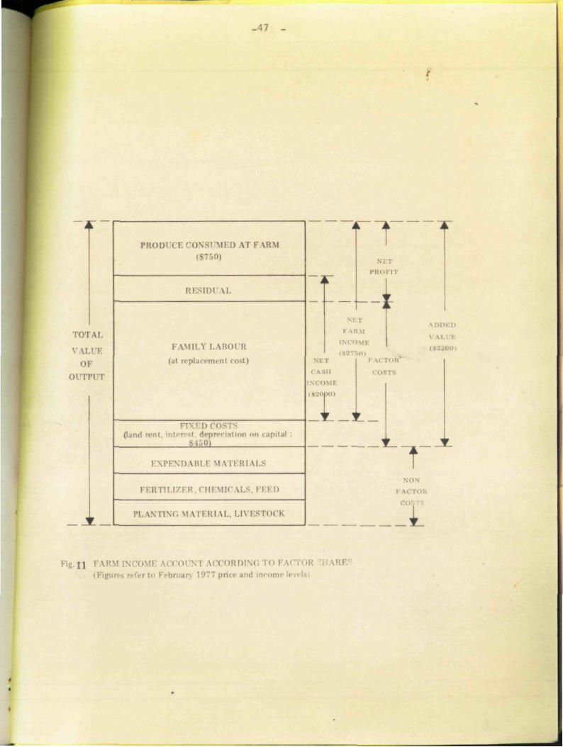
-47 -
TOTAL
V U 01
o n |
PH()I)i( i; CONSUMED AT F \K\I
RI'.SIDl \ I .
FAMILY LABOUR (at replacement cost i
rs apital
ï±m I \IM"\I) MU I \1 \ l I Rl MS
R I I ! I / I R . C I U M M M.S. I I I I)
IM. \ \ nNC \1 \ l F.RI M.. I.l\ ESTOCK
fT 1
i iRM
INCOME
I \ s l l
topoi
i M :
"T no
I j ] V0CORD1 ir\ 1977 priel- and inrora i

2 21-01 h
NORTH
c-z«
L E G E N D
I i i 1 I I I I 1 1 1 1 1 1
Embankment
: = = Road
m mm Main Drain
. — Field Drain
6.b
G N.E
XV
'.N
.: ""*»*& i+r.
7-6 4 3 , f
""lift 14-
15-0 (So
» B J J,
• / aoo • / , . ƒ .
'JV&. Vo-
wo 'o-o
% .9-0
?i
A',
fa «w.e?
/9-0 »»4
»"• ' \VvV'
m
^ s * a _ ««
5-;
. GN.e*
/O -
Main Irrigation Canal
Lateral/Escape Drain
Observation Site and Corresponding Electrical Conductivity of Groundwater In mmho/cm
Groundwater Not Encountered
' \
r*<*^£> i ' » ~ •*P-'»fi ' 4« %
r ..••
'8?///7
*t*3k. v
\ / PORMER
\ \
QUARRY \
N ^ — - w
J
E G Y P T ' * «*•
C
#
K £ J.
•y vr-
« 7 ISR10 LUifUKY j • - • ' • • •—•— — • W V . i u M M i t a i » *
«Mae* m I É M P l% j»P"Ml ig* i l^
3g?Vf
MINISTRY OF AGRICULTURE
WESTERN REGION
Rl RAL PHYSICAL PLANNING UNIT
Map No. 2
ELECTRICAL CONDUCTIVITY OF GROUNUWATER
IN THE MEYLERSFIELD WEST POLDER
Scale 1 5,000 200 313
400 800
Approved By Date:

Ifiöl o.
DESCRIPTIVE SOIL LEGEND FOR THE SOIL MAP OF THE MEYLERSFIELD WEST POLDER
Map Unit Jini Name Description of Characteristics
Extent
Acres
ENTISOLS
ind
channels; also slightly
around
ons on
Depressions on
plain
Depressions on coastal plain wi th peaty layers
Trot" "•••!y fine, mixed, calcareous.
As I, moderately deep phase
As I, shallow phase
Tiopic Fluvaquent, very fine, mixed, id. isohypertheimic
As 2. moderately deep phase
As 2, shallow phase
Tiopic Fluvaquent, wary fine, mixed, non-acid, isohyperthermic
Z A As 3. moderately deep phase
Aerie Sulfic Tropic Fluvaquent. veiy fine.
mixed, non-acid, isohyperthermic
Aerie Sulfic Thapto Histic Tropic Fluvaquent, very fine, mixed, nonacid, isohyperthermic
Deep, well drained brown clay soils formed by deposition around limestone outcrops. Free calcium carbonate occurs in the subsoil due to presence of limestone gravels and fiayments. pH is neutral to slightiy alkaline throughout. Salinity is telatively low as expressed by EC levels of the ground wate i . which are mainly below 10 mmho.
As above but wi th limestone between 50 and 100 cm f rom the surface
As above bin wi th limestone between 25 and 50 cm from the surface
Deep, somewhat poorly drained heavy clay soils with dark gray to very dark grayish brown topsoils overlying grayish brown and/or mottled gray and brown subsoils. Thin peaty layers may form inclusions in the subsoil pH is neutral to slightly alkaline throughout. EC levels of the ground water range from 3 - 1 8 mmho.
As above, but w i th limestone between 50 and 100 cm from the surface
As above, but wi th limestone between 25 and 50 cm from the surface
Deep, poorly drained heavy clay soils w i th dark gray to very dark grayish brown topsoils overlying gray to very gray and greenish gray half ripe to nearly ripe subsoils. Thin peaty layers may form inclusions in the subsoil. pH is neutial to slightly alkaline throughout. Salinity of the ground water is high, as expressed by EC levels ranging f rom 1 1 - 2 0 mmho.
As above, but wi th limestone between 50 and 100 cm from the surface
Deep, somewhat poorly drained, heavy clay soils wi th dark gray to very dark grayish brown topsoils overlying (dark) grayish brown and/or mottled gray and brown nearly npe subsoils. Thin peaty layers may occur in the subsoil High contents of sulphides occur below 50 cm from the surface which can be noted by a strong smell of hydrogen sulphide (H_S) Topsoils are medium to strongly acid (pH 5 5.5). Subsoils have slightly alkaline (pH 7.5 8) reaction under reduced conditions that wi l l turn extiemely acid (pH less than 4) upon aeration (potential acid sulphate soils). Salinity is medium to high and EC of the ground-
angesf iom6 18 mmho.
Soils similar to those of map unit 4 but wi th distinci layers o l peat 20 40 cm thick at variable depth wi th in 100 cm from the surface. They are also high in sulphides below 50 cm f rom the surface that wi l l turn into extremely acid ferric sulphates upon deep aeration. Salinity levels are in the same 'ange as those of the soils of map unit 4.
7.7
2 .3
2 .3
115.6
1.0
2 2
54.2
3.0
78.7
22 J
HISTOSOLS
Depressions on coastal plain fi l led wi th peat deposits
Typic Sulfihemist, euic, isohyperthermic Deep, poorly drained peat soils which have peat layers of more than 40 cm that start wi th in 40 cm from the soil surface Topsoils are dark coloured clays. The peat may be underlain wi th in 100 cm from the soil surface by gray, bluish gray oi greenish gray unripe to half ripe clays. These soils have high contents of sulphidic materials wi th in 100 cm (distinct to sfiong smell of hydrogen sulphide). pH in topsoils ianges from medium to strongly acid (pH 5 - 5.5). Under reduced conditions subsoils are slightly alkaline (pH 7.5 8) Upon aeration these soils wil l turn extiemely acid (pH less than 4). Salinity of the ground water is medium to strong (EC between 5 and 19 mmho).
53.6
MISCELLANEOUS LAND TYPE
Outcrops of White Limestone Formation on coastal plain
Limestone Outcrops Outciops of weathering limestone with pockets of soils in between.
TOTAL AREA West Polder
1.5
345.0
Percent of
Total Area
2 .2
0 7
0.7
33.5
0 .3
0 .6
15.7
0.9
22.8
6.6
15.5
0 .5
100.0
NORTH
• L E G E N D
J E m b a n k m e n t
Road
Ma in Dra in
Fie ld D r a m
M a m I n iga t ion Canal
So i l Pit and Pro f i le No
Soi l A iMie inx j and Obse iva t ion N o .
Dsed Site fo r Rice E x p e r i m e n t s
Proposed Site fo r F ish Fa rm ing
Expenman
ISR1C LIBRARY
m. /3io.g,a.
Waganingon, Trt« W«ffl#flflf1(l«
MINISTRY OF AGRICULTURE
WESTERN REGION
RURAL PHYSICAL PLANNING UNIT
Map No. 1
SOILS OF THE MEYLERSFIELD
WEST POLDER
100 S c a U : 5 - 0 0 0 300
« .'
Approved by. . Date: