guidelines for soil survey and land evaluation in...
TRANSCRIPT

Technical Guide No. 9b
GUIDELINES FOR SOIL SURVEY AND LAND EVALUATION
IN JAMAICA
(Semi-detailed surveys)
VOLUME II: REPORT COMPILATION
MINISTRY OF AGRICULTURE RURAL PHYSICAL PLANNING DIVISION JAMAICA SOIL SURVEY PROJECT

Technical Guide No. 9b ISRIC l.ier?ARY
l~ J ^ l7\
GUIDELINES FOR SOIL SURVEY AND LAND EVALUATION
IN JAMAICA
(Semi-detailed surveys)
VOLUME II: REPORT COMPILATION
Scanned from original by ISRIC - World Soil Information, as ICSU World Data Centre for Soils. The purpose is to make a safe depository for endangered documents and to make the accrued information available for consultation, following Fair Use Guidelines. Every effort is taken to respect Copyright of the materials within the archives where the identification of the Copyright holder is clear and, where feasible, to contact the originators. For questions please contact [email protected] indicating the item reference number concerned.
MINISTRY OF AGRICULTURE RURAL PHYSICAL PLANNING DIVISION JAMAICA SOIL SURVEY PROJECT
1111

EEEEACE
The Soil and Land Use Surveys of Jamaica (RRC 1958-1970), carried out during the period 1951-1970, provided valuable information for planning and development. However, in recent times, increased de mand for more up-to-date data, has created the need to re-inventorize this very important natural resource, land, and to document changes in its use. To this end the Soil Survey Project, which is jointly funded by the Governments of the Netherlands and Jamaica, was designed and initiated in 1983 to establish a modern Soil Survey Capability in the Ministry of Agriculture.
During the surveys it became abundantly clear that the newly recruited staff members need to have proper guidelines, adapted to Jamaican conditions, to effectively implement the re-inventory. The local and international team of soil surveyors and land evaluation experts, recognizing this need, compiled the "Guidelines for Soil Survey and Land Evaluation in Jamaica" in two volumes. Volume I (Technical Guide No. 9a) provides general guidelines for planning and executing soil surveys and land evaluation at the semi-detailed level.
Volume II, this document, describes a standardized format for writing soil survey reports. Soil survey data, which are not properly documented, are of little value to users. And since soil survey reports usually are rather dull technical dócuments, special attention has to be given to the presentation of. the survey data, results and recommendations.
It is hoped that both Volumes will prove useful to all users and will assist considerably in reducing the time required for updating the soil and land use data base.
Vincent A. Campbell Deputy Director Rural Physical Planning Division
Kingston, November 1989.
a

CQNTRIBUTORS:
This is the ninth Technical Guide issued by the Soil Survey Project, a bi-lateral undertaking of the Governments of Jamaica and the Netherlands (JAM/81/03, JM/86/008 and JM/89/001). The main contributors to Volume II of the Guidelines for Soil Survey and Land Evaluation in Jamaica are listed below in alphabetical order:
- Petrie A.M. van Gent: Chapters 1, 2, 3, 4, 5 and Appendices. - Peter H. Oideman: Compilation of glossary.
Niels H. Batjes and Frank R. Westerhout prepared the basic format for Chapter 5 resp. the basic descriptions of the soil analyses. Editorial and technical comments by Mr. Wim Andriesse of the Winand Staring Centre, the Netherlands, and staff members of the Rural Physical Planning Division are gratefully acknowledged.
Mrs. Petrie van Gent made the final draft print-ready.
b

INTRODUCTIQN
This Technical Guide (No. 9b) provides the standardized format for writing a soil survey report of semi-detailed soil surveys. Proper documentation of soil survey data, the results and the recommendations in a survey report is a must: if this is not done, the survey was made in vain.
Soil survey reports are usually rather dull technical documents; therefore the way of presenting a soil survey report plays a critical role in the ultimate use of the report. If possible, lengthy soil descriptions should be put in appendices and more attention should be paid to agricultural use of soils and the possibilities for improvement. A pleasant style of writing can add a lot to the readability.
The foilowing pages show the complete lay-out (as a minimum package) of a soil survey report as it has to be prepared at the Soil Survey Unit, indicating the contents as well as the way the contents have to be presented.
The main body of the soil survey report is formed by the Chapters 1 to 5. The tab Ie of contents shows all titles of the different chapters and sub-chapters. The tables, figures, appendices and enclosures that have to be prepared within the frame work of each chapter are listed under the heading Refer to:", foliowed by their correct titles. Under 'Text:" the main ingredients are indicated, which are to be discussed in the text of the report under preparation. For mats and eiamples: gives additional information on presentation of
the text (whenever possible, standardized texts are given) and on how to present tables and figures. For mats are printed in between two doublé lines ( i to separate them from the remaining text. Formats for and examples of appendices are given within the appendices.
General information on the preface, summary, ref erencês-and glossary is given under the corresponding headings, where they should be included in the final soil survey report.
The pages and chapters are numbered with Arabic numbers, as well as the tables and figures. If extra information is available, additional tables, figures or sections can be prepared and the numbering as given in this format should be adapted. The format should also be adapted when there are not sufficiënt data to prepare all proposed chapters, tables and figures.
c

All soil survey reports are word-processed using the Macintosh. The Standard format for the typography is as follows: word processing system Micro-Soft, letter type New York, letter size 12, line distance 1, line width 6 inches, left-right justifying. The use of capitals and small letters in headings isasfollows: l.CHAPTER.
1.1 SUB-CHAPTER, 1.1.1 Section.
Underlining, which should be kept to a minimum to ensure readability, is used to emphasize certain aspects in the text.
Further readine:
Dent and Young, 1981. Soil Survey and Land Evaluation: Chapter 13.
FAO, 1970. The Preparation of Soil Survey Reports.
d

Soil Survey Report No....
[logol
Semi-detailed Soil Survey of the X Area, Y, Jamaica with X - the oaxne of the area, Y - the parish name
(l:25,Q00or 1:50,000).
(month and year of publication)
MINISTRY OF AGRICULTURE Rural Physical Planning Division Soil Survey Unit (starting January 1990)

P_BEEA£E
The following text is to be used:
This report is the in a series of soil survey and land evaluation publications prepared by the Soil Survey Unit of the Ministry of Agriculture. These surveys started in 1983 under the auspices of the Jamaica Soil Survey Project, a bi-lateral undertaking between the Governments of Jamaica and The Netherlands; the project was finalized in December 1989 after which the Soil Survey Unit continued the islandwide soil survey program me.
The ultimate aims and objectives of the surveys are to improve the role of the agricultural sector as part of the overall economy of Jamaica by optimizing land use through re-inventory of the soils of the island according to modern, international standards. This will provide full characterization and evaluation of the soils and permits correlation with soils of other tropical and subtropical regions, as well as exchange and comparison of agricultural production and research statistics.
In this report the data and information obtained have been automated and applied in the Rural Physical Planning Division's Land Evaluation System (JAMPLES), which is an integral part of the Jamaican Geographic Information System (JAMGIS).
This publication is a result of the team effort by the Rural Physical Planning Division's Soil Survey Staff under the direction of
The field work was done by Soil chemical and physical analyses were carried out by the Division's Soil Laboratory, headed by Soil classification and correlation was donê by Cartography was done by Climatic analyses and land evaluation tables were prepared by Report and maps were prepared by
Director, Rural Physical Planning Division
Kingston, [month, year]
i

SUMMARY
The summary should be both concise and informative. Independently of the body of the report, it should give a good overview of the subjects discussed in the survey report.
Discuss the location of the survey area and the occurrence of the major physiographic units and their soils and land use under current and (possible) improved conditions. Indicate the acreages (in ha) of the different soil map units.
An example of a good summary can be found in Soil Survey Report No. 3 (SSU 1989a, p.ü).
ii

CONTENTS page
Preface i Summary ii Tab Ie of contents iii List of tables v List of figures vi
1. INTRODUCTION 1
2. DESCRIPTIONOFTHESURVEYAREA 2 2.1 General characteristics 2 2.2 Climate 2
2.2.1 Rainfall and potential evapo-transpiration 2 2.2.2 Daily air temperature 4 2.2.3 Sunshine duration 5 2.2.4 Relative humidity 5 2.2.5 Wind 6
2.3 Landforms 6 2.4 Geology 7 2.5 Hydrology 7 2.6 Land cover 8
3. MATERIALS AND METHODS 9 3.1 Office preparations 9 3.2 Field procedures 9 3.3 Map compilation 9 3.4 Laboratory procedures 10
4. THESOILS 15 4.1 Previouswork 15 4.2 Classif ication of the soils 15
4.2.1 General 15 4.2.2 The use of USDA Soil Taxonomy in Jamaica 16
4.3 Compilation of the map legend 18 4.4 General characteristics of the soils 19
4.4.1 - 4.4.x Soils of the [specify land form] 19 4.5 Aspects of soil genesis 21 4.6 Dèscription of the soil mapping units 21
4.6.1 General 21 4.6.2 - 4.6.x Mapping units of the [specify land form] 22"
iii

5. AGRONOMIC INTERPRETATION OF THE SURVEY DATA 25 5.1 Introduction 25 5.2 Methods 25 5.3 Land utilization types 25 5.4 Land use requirements 25 55 Land qualities 26 5.6 Matching of land qualities with land use requirements 26 57 Land suitability classification 26 58 Main assumptions 26 5.9 Results and recommendations 27
References 29 Glossary 33
APPENDICES
I. Agro-climatic analyses. 40 II. Soil profile descriptions and analytical data sheets. 42 III. USDA Soil Taxonomy classification of the major soil
series and related mapping units. 46 IV. Correlation of the present soil mapping units with
those of the Green Books. 47 V. Legend to the soil map. 48 VI. Agro-ecological limitations of the major soils for selected
crops. 53 VII. Recommended soil cohservatioïTpractices for specified
land uses.. 56 VIII. Conversion table. 57
(Depending on the size of the report, appendices are presented immediately after the main bódy of the report or in a separate volume. The appendices are given Roman numbers.)
ENCLOSURES
1. Soil map (title and scale).
(At least one enciosure should be added, viz. the soil map. Because of the scale, some of the figures may have to be presented as enciosure. Enclosures should be given Arabic numbers.)
iv

LIST OF TABLES
1. Mean monthly rainfall, dependable rainfall in 75% of the years and mean monthly potential evapo-transpiration for [stations] (years of observation). 3
2. Minimum length of the dependable growth period in 75% of the years for [stations] (years of observation). 4
3 Daily air temperature for [stations] (years of observation). 4 4. Sunshine duration for [stations] (years of observation). 5 5. Relative humidity for [stations] (years of observation). 6 6. Geological Groups, Formations, lithology and time periods. 7 7. Landforms in the area. 18 8. Lithology of the area. 18 9. Selected phases for the map units. 18 10. Summarized overview of the soil series characteristics. 21 11. Land Utilization Types considered relevant for the
area. 25 12. Land qualities and associated characteristics as
considered in JAMPLES. 26 13. Agro-ecological land suitability classes determined
with the land evaluation module. 26 14. Agro-ecological suitability of land units for specific
land utilization types. 28 15. Key to the suitability classification of the different soils
for selected crops within specific MLUs (optional). 28
(Tables are numbered with Arabic numbers.)

LIST OF FIfiURES
1. Location of the study area, [parish(es)], Jamaica. 2 2. Rainfall-PET histograms (optional). 4 3- Overall cross-section of the area (optional). 6 4. Geologyofthe area. 7 5. Land cover map of the area. 8 6. Cross-sections through the area. 19 7. Land suitability maps (optional). 27 8. Erosion hazard map (optional). 27 9. Triangle of textural classes. 50 10. Triangle of partiele size classes (USDA Soil Taxonomy). 51 11. Format of map logo. 52
(Only a few maps are usually put in the report itself, as long as the map size allows for it in which case they gare given Arabic numbers. If the size does not allow for presentation in the report, the maps are presented as enclosures.)
In case photographs are added to the report, a list of plates should be added to the contents, after the list of figures.
vi

INTRODUCTION
1. INTRODUCTION
Text: Explain the status and the scope of the report in the introduction.
Refer to former surveys (e.g. "The Green Books", RRC 1958-1970) and this particular survey. Indicate the time period in which the field work was carried out and the report was written.
Give the objective for carrying out this survey (e.g. planning for alternative agricultural uses).
Give an overview of the different chapters of the report, as well as a specification of the enclosures and appendices. Makc rcfcrcncc to the Glossary, so that optimal use can be made of it.
1

DESCRIPTION OF THE SURVEY AREA
2. DESCRIPTION OF THE SURVEY AREA
2.1 GENERAL CHARACTERISTICS
Ref er to: Figure 1. Location of the study area in [parish(es)J, Jamaica.
Teit: Describe the location, indicating the boundaries and the location in N and W-coordinates (in o ' "). Give the acreage (in ha). Mention the numbers of the corresponding 1:12,500 toposheets from the survey department. Name the main towns and villages. Indicate the presence, location and condition of the primary and secondary roads and whether the secondary roads are asphalted. Mention the roads to major towns, harbours and airports in- and outside the survey area. Refer to the major industries/agro-industries. Describe whether electricity, piped water and telephone are present and to what extent. Indicate the presence of post offices, markets, agricultural shops, schools, hospitals and police stations. Give relevant census data on the population.
For mats and eiamples: The location of the study area within the parish and on the island should be indicated in Figure 1. The main roads, villages, waterways, weather stations, and the location of the sample areas in the survey area should be enumerated. When the map allows for it, the major contour lines should be. drawn.
2.2CLIMATE
2.2.1 Rainfall and potential evapo-transpiration
Refer to: Appendix 1. Agro-climatic analyses. Tab Ie 1. Mean monthly rainfall, dependable monthiy rainfall in 75% of the
years and mean monthly potential evapo-transpiration for (stations] (years of observation).
Table 2. Minimum length of the dependable growth period in 75% of the years [stations] (years of observation).
Figure 2. Rainfall-PET histograms (optional).
2
DESCRIPTION OF THE SURVEY AREA .
Text: Give ranges of rainfall in 80% of the years (i.e. R90-R10) as well as the 75%-dependable rainfall. Give the mean potential evapo-transpiration (PET) values. Highlight the minimum and maximum values as well as the distribution of the monthly rainfall within the year (e.g. dry periods, periods of excessive rainfall). Mention the dependable growing periods, following from the "dependable growing period" table. Describe the so-called dry, moist and humid months (see also Appendix I for the definitions of these abbreviations). If rainfall intensities are known, give them.
For mats and examples: For Table 1, only for one or two (most representative) stations, rainfall data are presented. The rough data can be collected from the National Meteorological Office (NMO). Processing of the data is done with the Jamaica Land Evaluation System (JAMPLES). The following format should be used:
Table 1 . Mean monthly rainfall (mm), dependable monthly rainfall in 75% of the years (R75 in mm) and mean monthly potential evapo-transpiration (PET in mm) for [stations! (years of observation).
J F M A M J J A S 0 N D Year
Mean R75 PET
R75/PET
In Table 2, data of all relevant stations are entered; the following format should be used:
3

DESCRIPTION OF THE SURVEY AREA
Table 2. Minimum length of the dependable growth period years for [stations] (years of observation).
in 75% of the
J F M A M J J A S 0 N D Year
Station 1
Station i
u — _ p M u - - p H H M 0.78
Note: p- planting/sowing possible if foliowed by at least two M or H; M-moist; H= humid; u- usè of soil moisture; -: dry month.
Eiamples of rainfall/PET histograms are given in Technical Bulletin No. 11 (SSU 1988a, p. 17-23).
2.2.2 Dailv air temperature
Refer to: Table 3- Daily air temperature [stations] (years of observation).
Text: Discuss briefly which are the coolest/warmest months and indicate the range in temperature, mean as well as the extremes. Check whether the temperature decreases with aititude, in case the data come from NMO.
For mats and eiamples: Table 3 is compiled from data of the NMO or is interpolated with linear regression (Miscellaneous Paper No. 5, SSU 1988c). Only the representative stations are mentioned; the foliowing format is used:
Table 3. Daily air temperature (in öC) for [stations] (years of observation).
J F M A M J J A S O N D Year
T min T mean T max
4

DESCRIPTION OF THE SURVEY AREA
2.2.3 Sunshine duration
Refer to: Table 4. Sunshine duration (stations] (years of observation).
Teit: Discuss briefly the range in sunshine hours and try to relate sunshine duration with PET resp, temperature. The ratio n/N is a measure for the degree of cloudiness.
For mats and ezamples: Use the following format, when data are available from.NMO:
Table 4. Actual sunshine duration (n in hours), potential sunshine duration (N in hours) and actual sunshine duration as percentage of maximum possible sunshine (n/N) for [stations] (years of observation).
J F M A M J J A S 0 N D Year
n N
n/N •
2.2.4 Relative humiditv
Refer to: Table 5. Relative humidity [stations] (years of observation).
Teit: Discuss briefly the ranges in relative humidity throughout the year and compare the morning and afternoon data. See if there is a relation with the temperature, rainfall regime and cloudiness. Mention the occurrence of fog, if present.
5

DESCRIPTION OF THE SURVEY AREA
For mats and examples: Table 5 can be prepared when data are availabie from NMO; usuaily both morning and afternoon figures are presented.
Table 5. Relative humidity in the morning (years of observation).
and afternoon ( in %) for [stations]
J F M A M J J A S 0 N D year
a.m. p.m.
' — ^ ^ • ^ — " • — " — ^ — » ^ ~ " • • ' • i . • - — p n — p — — — r r . r
2.2.5 S M
Text: Few wind data are availabie for Jamaica, but if possible, indicate wind velocities, prevailing wind directions and the probability of the occurrence of hurricanes.
2.3 LANDFORMS
Refer to: Figure 3. Overall cross-section of the area (optional, but strongly recommended).
Text: Describe the main landforms in the survey area in terms of nature (erosional, depositional, solutional) and general characteristics (altitude, relief intensity, degree of dissection, steepness of slopes, slope- and valley-forms). Terminology is described in Technical Bulletin no. 12 (SSU 1988b. p. 2.)
For mats and examples: A good example of Figure 3 (overall cross-section) is included in Soil Survey Report No. 2 as Enclosure No. 2. The cross-section must show the major parent rocks/materials and major soil mapping units in relation to (prevailing) landforms (see also Technical Guide 9a, Figure 3.2).
6

DESCRIPTION OF THE SURVEY AREA
2.4 GEOLOGY
Refer to: Tab Ie 6. Geology of the area. Figure 4. Geological map of the area.
Text: Describe the occurrence and distribution of the different geological units, starting with the youngest deposits. Mention the Formation and lithology within each Group and characterize nature, colour, degree of crystallization, purity and bedding of deposits. Make reference to geological survey reports and give the data of rock analyses, when available and where relevant.
Formats and eiamples:
Table 6. Geological Groups, Formations, lithology and time periods.
Geological Group Formation Lithology Period
Old Alluvium alluvium Pleistocene
White Limestone Somerset
Yellow Limestone Chapleton
Hard limestone
Soft limestone
Mid Eocene Oligocene Mid Eocene
Granodiorite - Granodiorite Cretaceous
Figure 4 (Geological map of the area) can be derived from the geological sheets 1:50,000 from the Mines and Geology Division of the Ministry of Mining and Natural Resources. Always indicate the map sheet number as well as the year of publication. Refer also to Figure 3 (overall cross-section).
2.5HYDROLOGY
Text: Indicate the main rivers (seasonal/perennial), the direction of flow and the presence and type of drainage pattern(s). Indicate the occurrence and the location of ponds, lakes, swamps and sub-surface streams. Mention the
7

DESCRIPT10N OF THE SURVEY AREA
probability of occurrence and duration of f looding, in relation to landform/physiography as well as rainfall.
2.6 LAND COVER
Ref er to: Figure 5. Land cover map of the area.
Text: Describe the legend of the "present land cover" map: indicate the major forms of land use in pure/mixed stands, the acreage, location, and if possible the management level, market orientation and cultural practices. Indicate also the occurrence of miscellaneous land types (i.e. urban areas, beaches, rockland, quarries, ponds and wetlands). If relevant, the former land use should be mentioned. In that case, divide Sub-chapter 2.6 in a paragraph on "Past land cover" and a paragraph on "Present land cover". If there is information on the natural (original) vegetation, this should be indicated under "Past land cover".
Formats and examples: The land cover map (Figure 5) can be derived from the hand-drawn CRIES/RPPD-map (1982), based on aerial-photo interpretation of 1981/82 black & white photographs, or from the computerized JAMGIS-map (1984) based on interpretation of false colour infra-red aerial-photographs (1983/84). Where possible, refine the map based on field observations.
8

MATERIALS AND METHODS
3. MATERIALS AND METHODS
3.1 OFFICE PREPARATIONS
Text: Indicate which topographic maps (number, scale, year of publication, publisher), geological sheets (number, scale, year of publication, publisher), relevant soil maps (number, scale, year of publication, author), land use maps (number. scale, year of publication. author) and aerial-photographs (number, flight line, scale, year of flying, black & white or false colour) have been used. Mention the main sources of information (i.e. literature, research results and other relevant sources). Expiain the criteria considered for selection of the sample areas. Describe how the boundaries from the API map are transferred onto the field map.
3.2 FIELD PROCEDURES
Text: Indicate which kind of field checks have been used in sample areas and afterwards (see Technical Guide 9a, Sub-chapter 33). Mention the number and depth of auger borings, minipits and pits and which of these have been sampled. Calculate the number of observations per 100 hectare (when necessary, indicate differences in observation density between e.g. plains and hills) as well as the number of pits per major soil series (at least two minipits and two f uil size pits per major series, see Technical Guide 9 a, i.e. SSU 1989g). Mention the for mat that has been used for describing the profiles in the field (SSUT989ë~anr/öfFA(rr977t ~ " ": : ; . . : — — " If relevant, reference can be made to external surveyors who provided additional information.
3.3 MAP COMPILATION
Text: Expiain how the soil boundaries are transferred from the field maps to the final maps (e.g. f ree hand, Zoom Transfer scope) and whether a separate slope map has been prepared. Indicate whether (reduced) maps of the Survey Department or Xerox copies, sepia copies or blue prints were used. Indicate the location of the profile pits and cross-sections on the soil map.
9

MATERIALS AND METH0DS
3.4 LABORATORY PROCEDURES
Teit: The lab procedures (routine and special-purpose), as carried out since 1988, are described below. Descriptions of the relevant analyses for a particular survey should be incorporated in the Soil Survey Report under preparation. The units and number of decimals in which the results have to be expressed, are given here, so that the lab data sheets can be filled out properly; the units and decimal places are not copied into the report. Calculations of the derived values should be presented under this heading as well; copy only the relevant ones from the descriptions below. Always mention that chemical analyses are done on air-dry samples.
Analytical procedures for routine analyses of soil samples:
Available K Potassium is extracted with 0.5 M acetic acid. In the extract K is determined flame-photometrically. (Unit: ppm K2O. Decimals: 0]
Available P (according to Truog). Phosphate is extracted with 0.002 M sulphuric acid, buffered at pH 3.0 with ammonium sulphate. The phosphate in the extract is determined spectro-photometrically. [Unit: ppm P2O5. Decimals: 0)
Bulk density
Calcium carbonate
Bulk density is determined by drying a known volume (100 cc) of undisturbed soil at 105 ^ after which the oven-dry weight of the soil is divided by the volume of the soil. [Unit: g/cubic cm. Decimals: 11
(according to Van Wesemael; only in samples with pH(H20) > 6.5). Gravimetric determination of the loss of weight, after treatment with diluted HC1. [Unit: %. Decimals: 1 or write < 0.5 for traces]
CEC(-NH40Ac) .For the cation exchange capacity, the sample is leached subsequently with 1 M ammonium acetate at pH 7.0, 80% ethanol to wash out the excess of ammonium, and 10% tCCl at pH 2.5 to replace the absorbed ammonium. In the leachate, ammonium is determined by distillation and titration. [Unit: me/100 g. Decimals: 1]
10

MATERIALS AND METÜODS
EC (1:2.5)
Ezchangeable acidity/ aluminium
Ezchangeable bases
Organic carbon
Partiele size analysis
pH(H20)
pH (KC1)
Total N
The electrical conductivity is measured in a 1:2.5 soil-water eztract. [Unit mS/cm. Decimals: 2]
(only in samples with pH < 5.5). The soil is leached with 1 M KC1. Ezchangeable acidity (Al + H) and aluminium are determined titrimetrically. [Unit: me/100 g. Decimals: 2]
Na and K are determined flame-photometrically in the leachate of the CEC-determination. Ca and Mg are determined using an atomic absorption spectro-photometer. [Unit: me/100 g. Decimals: 2 for ezch. Mg, Na and K; only 1 decimal for ezch. Ca].
(according to Walkley and Black). Organic matter is ozidized with an ezcess of potassium dichromate in an acid medium. The ezcess is back-titrated with ferrous ammonium sulphate. [Unit: %. Decimals: 1]
(pipette method). The sample is pre-treated with H2O2 and sodium acetate, in order to remove organic matter and CaC03. After dispersing with Na-hezametaphosphate, the clay and silt fractions are calculated for samples, taken from the suspension with a pipette. The total sand fraction is determined by wet sieving; different sand fractions are determined after dry sieving. [Unit: %. Decimals: 0)
Potentiometric determination in a 1:2.5 soil-water suspension. [Unit: -. Decimals: Il
Potentiometric determination in a 1:2.5 soil-1 M KC1 suspension. [Unit: -. Decimals: 1]
(according to Kjeldahl). Digestion of the sample with sulphuric acid, potassium sulphate and selenium, is foliowed by distillation of the ammonium obtained and subsequent titration. [Unit: %. Decimals: 2]
11

MATERIALS AND METHODS
Water holding capacity After the sample is saturated with water, it is brought to different moisture tensions (pF-values). When the moisture content in the sample is in equilibrium with the tension set, the sample is weighed. After that it is brought to a higher tension (maximum pF 2.7). At last the dry weight is determined. The moisture content is calculated from the weight at a specific tension and the dry weight. At pF 3.0 to 4.2, the moisture content is determined from soil clods. (Unit: vol.%. Decimals:0]
Analytical procedures for special analyses of soil samples:
Available P (according to Olsen). Phosphate is extracted with 0.5 M sodium bicarbonate at pH 8.5. The phosphate in the extract is determined spectro-photo-metrically. [Unit: ppm P2O5. Decimals: 0]
Ca and Mg (water sample)
In the saturation extract, calcium and magnesium are titrated in Na2EDTA at pH 10; after that Ca is titrated with the same agent at pH 12. [Unit: me/l. Decimals: 2]
Chloride (if ECe > 1 mS/cm). Titration with 0.1000M silver nitrate to bond the Cl present; when pH > 6, the determination is done according to Mohr; otherwise it is done according to Volhard. [Unit: ppm G. Decimals: 0]
ECe The electrical conductivity is measured in saturated soil extract. [Unit: mS/cm. Decimals: 21
Extractable tracé elements
The tracé elements (Fe, Mn, Cu, Zn) are extracted with 0.1 M hydrochloric acid and determined using an atomic absorption spectro-photometer. [Unit: ppm FeO, Mn02, CuO, ZnO. Decimals: 0]
Sulphate Gravimetric determination of sulphate, precipitated as barium sulphate. [Unit: %. Decimals: 21
12

MATERIALS AND METHODS
Water dispersible clay (natural clay)
As clay determinat ion for partiele size analysis, bu t without p re - t r ea tment (i.e. no adding of H202, sodium acetate and Na-hexametaphospnate bef ore dispersing). [Unit: % . Decimals: 0]
Derived values:
Al-saturation
Available moisture
BSP
CEC-clay
Dispersion rat io
C/N
ECEC
Aluminium saturat ion is calculated as the exchangeable Al divided by the sum of the exchangeable bases and exchangeable acidity; the quotiënt is multiplied b y 100%. [Unit: %. Decimals: 0]
Moisture content at pF 2.0 minus moisture content at pF 4.2. [Unit: vol.%. Decimals: 0]
The base saturat ion percentage is calculated as the sum of the exchangeable bases divided by the CEC (NH40Ac); the quotiënt is multiplied by 100%. [Unit: %. Decimals: 0]
CEC(-NH40Ac) divided by the clay percentage; the quotiënt is multiplied by 100%. CEC-clay is not corrected for organic carbon.. [Unit: m e / 1 0 0 g clay. Decimals: 1]
Water dispersible clay divided by the clay percentage obtained using the dispersing agent; the quotiënt is multiplied by 100%. [Unit: %. Decimals: 0]
Organic carbon divided by total nitrogen. [Unit: -. Decimals: 0]
Effective CEC is the sum of exchangeable bases (in NH40Ac) and exchangeable acidity (in 1 M KC1). [Unit: m e / 1 0 0 g. Decimals: 1]
13
MATERIALS AND METHODS
ECEC-clay ECEC divided by the clay percentage; the quotiënt is multiplied by 100%. ECEC-clay is not corrected for organic carbon. [Unit: me/100 g clay. Decimals: 0]
ESP The exchangeable sodium percentage is calculated as the exchangeable Na divided by the CEC (NH40Ac); the quotiënt is multiplied by 100%. If there is soluble Na, it must be subtracted from the exchangeable sodium, before calculating the ESP. (Unit: %. Decimals: 0)
Exchangeable Ca Only in CaC03-rich, non-saline soils the exchangeable Ca is estimated by CEC(-NH40Ac) minus the sum of exchangeable (Mg + Na + K). [Unit: me/100 g. Decimals: 0]
Organic matter Estimated as 1.72 x O.C.% [Unit: %. Decimals: 1]
Sum of exchangeable bases
Sum of exchangeable (Ca + Mg + Na + K) [Unit: me/100 g. Decimals: 1]
14

THE SOILS
4. THE SQÏIS
4.1 PREVIOUS WORK
Text: Give a review of existing literature (in general) and previous soil survey work in the study area.
4.2 CLASSIFICATION OF THE SOILS
4.2.1 General
Text: The Standard text is given under formats and examples, based on Soil Survey Report No. 4, p. 27.
Formats and examples:
In order to fully comprehend the soils of Jamaica, they have to be grouped in a classification system. A soil taxonomie classification system is a creation of man in which each class or taxonomie unit has a central concept, which is used as a basis for classification. A permissible range in characteristics deviating from the central concept, defines the domain of the taxonomie unit. KM* instancë the concept of a certain taxonomie unit may require shallow soils over limestone rock. Thëh the range in soil depth allowed within that taxonomie unit is from 25 to 50 cm.
The most comprehensive taxonomie classification system available to date is the USDA Soil Taxonomy (Soil Survey Staff 1975 and 1987). This system has been used by the staff of the RPPD since 1978.
The USDA Soil Taxonomy presents the following advantages: - it enables an understanding of thé relationships between soils and their
environment, thus allowing for the comparison or transfer of knowledge between similar geographical locations, both nationally and internationally
- it can be used to distinguish well defined map units during the survey - it provides a basis for the interpretation of sóils data for selected kinds of
land use (i.e. land evaluation).
15

THE SOILS
4.2.2 The use of USDA Soil Taxonomy in Jamaica
Text: The Standard text is given under formats and examples, based on Soil Survey Report No. 4 (SSU 1989b, p. 28) and Soil Survey Report No. 2 (SSU 1987a, p. 21). At each classification level the characteristics of the soils occurring in the Soil Survey Report under preparation should be listed. Where necessary, additions should be given or the text should be adapted.
Formats and examples:
The USDA Soil Taxonomy is a hierarchical system in that units at the highest level of generalization are subdivided into more detailed sub-units, which are in turn further subdivided and so on. The hierarchical sequence in the successive categories from high to low is as follows: ORDERS-SUBORDERS-GREATGROUPS-SUBGROUPS-FAMILIES-SERIES.
The grouping of soils in a specific unit at each level is based on combinations of relatively permanent diagnostic soil characteristics, whose occurrence and range can be estabüshed by relatively simple measurements and observations in the field and laboratory (e.g. texture, colour, soil reaction, depth to bedrock, soil temperature, cation exchange capacity, organic carbon content). From the level of the orders down to that of the series the diagnostic characteristics become more narrowly defined.
ORDERS consist of soils with similar properties, resulting from the same spil forming processes, which acted to the same degree on the parent material or rock. #... out of the ten orders that are recognized by Soil Taxonomy have been identified in the survey area. The dominant characteristics of these orders are briefly discussed so as to enhance the user's understanding of the technical classification which is used in Sub-chapter 4.6. [Describe the orders, that occur in the survey area. See Soil Survey Report No. 2 (SSU 1987a, p. 21)1
SUBORDERS are subdivisions of orders, based on characteristics that produce classes with the greatest genetic similarity. These characteristics are mainly soil temperature and soil moisture regime.
GREAT GROUPS are subdivisions of suborders based on uniformity of type and sequence of major horizons and their features. At this stage of classification, horizons are considered with the following features: - clay, iron and/or humus have accumulated - thin, hard pans interfere with root growth and the movement of water
16

THESOILS
- similar temperature and soil moisture regimes are observed - the base saturation is similar. [Describe the characteristics of the great groups, which occur in the survey area. See Soil Survey Report No. 2 (SSU 1987a, p. 22).]
SUBGROUPS are divisions of great groups. The constituents of the "Typic" subgroup have characteristics that are representing the central segment of the group. The other subgroups have the properties of one great group and also one or more properties of another great group, suborder or order and are known as "intergrades".
FAMILIES are members of a subgroup. Each family has physical .and chemical properties that affect management in a similar way. Families in the survey area are predominantly distinguished on the basis of: - partiele size class of the control section - mineralogy of the corresponding horizons - soil temperature regime - other properties that are needed to group soils in homogeneous units.
The SERIES is the lowest category in Soil Taxonomy. A series may have virtually the whole range in characteristics that is permitted for a specific family, but it must have one or more specific properties that have a restricted range and can be deduced with reasonable accuracy while mapping. Series mainly are of pragmatic nature; series in a specific family have similar suitability for agriculture. In Jamaica Series are used for naming soil mapping units. These names are partly based on the Green Book soil concepts (RRC 1958-1970), but with a more narrowly defined range of characteristics than in the original concepts. Some of the Green Book soil concepts were omitted and for some soils, series had to be defined, not related to any of the Green Soil soil concepts.
An example of the use of the nomenclature is Diamonds (Jamaican Series level); at family level these soils are classified as a loamy skeletal, mixed, isohyperthermic Typic Eutropepts.
The hierarchical nature of the system is reflected in the name of the taxonomie unit as well. For instance, the Typic Eutropept at subgroup level consists of the following contributions at the different levels:
-pept stands for the order of Inceptisol -tro- stands for the suborder of Tropept
-Eu- stands for the great group of Eutropept Typic stands for the Typic subgroup of this Eutropept.
17

THE SOILS
4.3 C0MPILAT10N OF THE LEGEND
Refer to: Tab Ie 7. Landforms in the area. Tab Ie 8. Lithology of the area. Table 9. Selected phases for the map units (e.g. slope, salinity, sodicity, gra-
velliness, stoniness, rockiness).
Text: The text of this Sub-chapter is mainly based on Technical Bulletin No. 12 (SSU 1988b). Indicate which land forms (physiography) are used for the first entry to the legend. Refer, if possible, to Figure 3 (overall cross-section) and Figure 6 in Sub-chapter 4.4 (specific cross-sections). Indicate which parent rocks respectively parent materials occur at the second entry level. Explain the definition (refer to the Glossary as well) and use of the terms consociation, association and complex, and the selection of relevant phases and their classes for the particular map under preparation.
Soils are delineated within each physiographic-lithologic unit entry, using Arabic numbers. Phases of map units are not mentioned in the legend per soil mapping unit description, but only in the key to the phases (see Appendix V). Using the abbreviations from Technical Bulletin No. 12 (SSU 1988b), mapping units are given the following codes:
Uandforml flitholoeyl f- or x or yl f Arabic no.1 [phase a] [phase bl [phase f]
Always an example should be given, e.g. BOx3 e-cl
At the end of this chapter, give an overview of soil depth classes, soil texture classes and partiele size classes (see also Appendix V).
For mats and examples: Table 7 (Landforms in the area), Table 8 (Lithology of the area ) and Table 9 (Selected phases for the map units) are all to be based on the information of Technical Bulletin No. 12 (SSU 1988b). Examples are given in Soil Survey Report No. 4 (SSU 1989b, p. 29-32).
18

THESOILS
4.4 GENERAL CHARACTERISTICS OF THE SOILS
4.4.1 - 4.4.x Soils of the fsoecifv landforml
Refer tof Table 10. Summarized overview of the soil series characteristics. Figure 6. Cross-sections through the area.
Text: Characterizè shortlv the different soil series as occurring within every lithological group of the different landforms, using a separate section for each landform. This Sub-chapter is not meant to give extensive series descriptions, but should provide an overview of the different soils (series) and their inter-relationship and how they are geographically related.
Describe per physiographic unit (landform), the geological deposit or parent material, foliowed by the moisture regime and general relief.
Describe in general terms the different soil series for all occurring parent materials/rocks, onlv if relevant i.e. where one soil differs from the others: range in depth, drainage, colour-mottling, texture-gravelliness, slope-parent material, structure, organic matter content, calcareousness, acidity-alkalinity, mineralogy, inherent fertility-CEC, swell/shrink properties, available water capacity, permeability, droughtiness, susceptibility to erosion and possibilities for mechanization.
It should be emphasized that especially in this part of the report it is necessary to change the wording for each series description as to make reading more enjoyable. However, the order in which the characteristics are described should not be changed.
For mats and examples: Figure 6 (Cross-sections through the area) indicates the topographical relations between the different soil series and parent materials/rocks. Good examples can be found in Soil Survey Report No. 3 (SSU 1989a, p. 37a and 38a).
An example of how to describe the soils in general terms, per physiographic unit is given below (from Soil Survey Report No. 2, i.e. SSU 1987a, p.19):
19

THESOILS
Soils of the inland basin.
Linstead, Pennants and Rosemere soils are formed from Old Alluvium which occurs in the St. Thomas-Ye-Vale inland basin. They are predominantly on gently undulating to rolling slopes.
Linstead soils are deep, moderately well drained to imperfectly drained, fine textured and have prominent red and white mottles in their sub soil. They have a mixed mineraiogy with about 17% of montmorillonite and 40% of kaolinite. The occurrencé of montmorillonite is reflected in shrink-swell properties of the soils. The kaolinite results in soils with a low CEC and a low available water capacity. Linstead soils have a strongly acid subsoil and a low inherent fertility. Typically, they have a high content of organic carbon to great depth.
Pennants soils etc „
It is recommended to make a "summarizing table" of the main characteristics of the soils series. Depending on the number of soils, the table can be put in the main text or in a separate appendix. The general format for the table is being developed. The following aspects should be considered to be described in the table: Series name, depth of the soil, drainage class, main topsoil and subsoil colour resp. texture, pH, calcareousness, moisture holding capacity, fertility status according to Buol et al. (1975) and Buol and Couto (1980), susceptibility to erosion, stoniness and major management problems. Classes for the different characteristics should be according to Technical Guide No. 5 (SSU 1989e) and JAMPLES (Technical Bulletin No. 10, i.e. SSU 1987b).
Examples of summarizing tables can be found in the Green Books (RRC 1958-1970), e.g. in Soil and Land Use Surveys No. 1 - St. Catherine (p. 29-31). The format proposed for a Soil Survey Report under preparation, is shown in Table 10.
20

THESOILS
Tabie 10. Summarized overview of the soil series characteristics.
Series Depth Drain Colour Texture pH Calca- Moisture Fertility Erosion Stoni- Major name of soil -age topsoil topsoil range reous- holding ace. to suscep- ness managefflent
(cm) class subsoil subsoil ness capacity Buol tibility class problems
Mack field
Mt. Horeb
4.5 ASPECTS OF SOIL GENESIS
Teit: Indicate and discuss the main soil forming factors and processes for the major soils. Examples can be found in Soil Survey Reports No. 3 and No. 4 (SSU 1989a and SSU 1989b, both p. 41).
4.6 DESCRIPTION OF THE SOIL MAPPING UNITS
4.6.1 General
Refer to: Enclosure 1. Soil map and legend Appendix II. Soil profile descriptions and analytical data. Appendix III. USDA Soil Taxonomy classification of the major soil series and
related map units. Appendix IV. Correlation of the present soil mapping units with those of the
Green Books. Appendix V. Legend to the soil map.
Text: Mention the number and kind of mapping units and the occurrence of consociations, associations and complexes. Refer to the above mentioned Enclosure and Appendices.
21

THESOILS
4.6.2- 4.6.x Mappine units of the fsoecifv landforml
Text: In case there are many (e.g. > 15-20) mapping units to describe, it is advised to place these descriptions in a separate Appendix of the Soil Survey Report under preparation.
Mapping unit descriptions have the following heading for consociations: [code] [series name] [texture topsoil] [(... ha)].
In case of associations and complexes, in the code the texture of the topsoil is omitted and x or y is added, as follows: [code] [major series names in order of importance] [x or y] [(... ha)]. In the description, the characteristics of each constituent series are described one after the other.
Per soil series give a general description of the major soil characteristics including depth, drainage, colour-mottles, textural group, parent materiai/rock, weathering stage of the parent rock, slope, physiographic position, location and acreage (in %) in the survey area. Finally the USDA Soil Taxonomy classification is given at family level and the representative profile in the appendix is indicated.
Brief orofile characteristics: describe the depth of the profile, parent material and the degree of profile development. Per major horizon indicate the major characteristics: colour (moist/dry), texture and range of thickness, mottles, clay-skins, gravels, concretions and bioiogical activity. The names or symbois of the diagnostic epipedons and subsurface horizons are put in the description, usually in between brackets. Features like weathering and depth/width of cracks should also be mentioned.
Soil orooerties affectine management: discuss the following factors, but only when relevant: calcareousness, acidity, alkalinity, sodicity. salinity, natural (inherent) fertility and capacity to store nutrients, nutriënt imbalances, presence of low/high activity clays, depth for root penetration, moisture retention capacity, permeability/saturation/flooding/run-off, porosity, stoniness, properties of topsoil, slope/susceptibility to erosion, workability and ease of mechanization, response to fertilizer.
Included soils: describe, in the same wording as the description of the major soil series in the legend, the minor series or unnamed soils included in this mapping unit as well as the estimated extent within this map unit.
22

THESOILS
Present land use: give a short description of the present land use. •
It should be re-emphasized that changes in wording are very important to make reading enjoyable.
Formats and examples: (From Soil Survey Report No. 4, i.e SSU 1989b, p. 51)
HLxl MACKFIELD - MOUNT PETO complex (237 ha)
The HLxl complex consists of two intricately associated components, viz: a) moderateiy deep, well drained, dark brown to yellowish brown, fine
textured Mackfield soils (about 50%) and b) very shallow, somewhat excessively drained, (very) dark brown, fine
textured Mount Peto soils (about 30%). The complex mainly occurs on moderateiy steep and steep slopes of hard white limestone hills.
Mackfield soils are members of the clayey-skeletal, mixed, isohyperthermic f amily of Typic Hapludolls.
Mount Peto soils belong to the clayey-skeletal, montmorillonitic, isohyperthermic f amily of the Lithic Hapludolls.
Representative soil profiles are given in Appendix 2 (resp. profile 17 and 21).
Brief profile characteristics: The solum of Mackfield soils is moderateiy deep. The topsoil (A horizon) is a humus rich, dark brown, graveily and stony clay and 15-25 cm thick (mollic epipedon). The subsoil (Bw horizon) is a yellowish brown, graveily and stony clay and 30-40 cm thick. In most pedons the Bw horizon is underlain by hard white limestone. In some pedons a deep layer of mostly weathered and unweathered limestone and flint occurs in the substratum. Locally, the Bw horizon extends deep through joints into the limestone rock.
The range of characteristics of Mount Peto soils is described under mapping unitHLl.
Soil prooerties affectine management: Mackfield soils are slightly calcareous, have a low natural fertility and medium soil moisture retention. The
23

THE SOILS
permeability of Mackfield soils is rapid because of the highly fractured underlying limestone rock. The high level of stoniness makes mechanized agriculture impracticable. On the steeper slopes erosion is a potential hazard. Therefore, Mackfield soils should be kept under a vegetation cover.
The properties of Mount Peto soils are discussed under the heading of mapping unit HL 1.
Included soils: a) about 15% of Mackfield Variant soils that have a humus rich (very) dark
brown topsoil over a (dark) yellowish brown subsoil with a considerable increase in clay percentage (Bt horizon). These soils are members of the clayey-skeletal, mixed, isohyperthermic family of the Typic Argiudolls, and
b) about 5% of moderateiy deep, moderateiy well drained, brownish yeliow to yellowish brown, slightly stony, very fine textured Belvedère soils. These soils are members of the very fine, montmorillonitic, isohyperthermic family of the Vertic Eutropepts.
Present land use: The soils of the HLxl mapping unit are covered by natural (secondary) forest with several areas being used for small scale cultivation or improved pasture.
24

ACRONOMIC 1NTERPRETATION OF SURVEY DATA
5 AGRONOMIC INTERPRETATION OF SURVEY DATA
This Chapter is based on Technical Guide No. 7 (SSU 1989f).
5.1 INTRODUCTION
Text: Copy Standard format for this Sub-chapter from Technical Guide No. 7. p. 1.
5.2 METHODS
Text: Copy Standard format for this Sub-chapter from Technical Guide No. 7, p. 1.
5.3 LAND UTILIZATION TYPES
Ref er to: Table 11. Land utilization types (MLU/ erop systems) considered relevant for the survey area.
Text: Adapt the Standard format for this Sub-chapter from Technical Guide No. 7, P.2. In the description of the technical and socio-economic settings (MLU), the specific characteristics occurring in the area should be incorporated, but the main assumptions may not be modified (see Technical Bulletin No. 15, i.e. SSU 1989c), since they are programmed in the JAMPLES software.
For mats and eiamples: Copy Table 11 from Technical Guide No. 7 (5.1).
5.4 LAND USE REQUIREMENTS.
Text: Copy Standard format for this Sub-chapter from Technical Guide No. 7, p. 5.
25

AGR0N0M1C INTERPRETATION OF SURVEY DATA
5.5 LAND QUALITIES
Text: Copy Standard format for this Sub-chapter from Technical Guide No. 7, p. 6.
5.6 MATCHING OF LAND QUALITIES WITH LAND USE REQUIREMENTS
Refer to: Appendix VI. Agro-ecological limitations of the major soils for selected crops. Table 12. Land qualities and associated land charaaeristics as considered in JAMPLES.
Teit: Copy Standard format for this Sub-chapter from Technical Guide No. 7, p. 6. The JAMPLES output, i.e. the agro-ecological limitations for the different crops under current conditions, is specific for the area considered.
For mats and eiamples: Copy Table 12 from Technical Guide No. 7 (5.2).
5.7 LAND SUITABILITY CLASSIFICATION
Refer to: Table 13. Agrö-ecological land suitability classes determined with the land evaluation module.
Teit: Copy Standard format for this Sub-chapter from Technical Guide No. 7, p. 8. Give an example that is relevant f of thestgdyjtrea.^
For mats and examples: Copy Table 13 from Technical Guide No. 7 (5.3).
5.8 MAIN ASSUMPTIONS
Text: Adapt Standard format for this Sub-chapter from Technical Guide No. 7, p. 10. Select only those assumptions relevant for the survey area; the main assumptions may not be modified. Add (non-technical) assumptions, when necessary.
26

AGRONOMIC INTERPRETATION OF SURVEY DATA
5.9 RESULTS AND RECOMMENDATIONS
Refer to: Appendix VII. Recommended soil conservation practices for specified crops. Table 14. Agro-ecological suitability of land units for specific land utilization
types, or: Table 15. Key to the suitability classification of the different soils for selected
crops within specific MLUs (optional). Figure 7. Land suitability maps (optional). Figure 8. Erosion hazard map (optional).
Text: An outline for this Sub-chapter is given in Technical Guide No. 7, p. 11. A good example, showing how the agro-ecological suitability of the different land units can be described, is given in Miscellaneous Paper No. 6 (SSU 1988d,p. 16-19). It is important that the suitability ratings are given for LUTs (crop/MLU systems) on one side and land units (- mapping units) on the other side. For that reason the below mentioned for mat is developed, which is better readable than the format used in Miscellaneous Paper No. 6 (SSU 1988d). Land suitability maps can be derived from Table 14 for the main land utilization types.
Soil conservation practices for specific uses should be described, after interpretation of the SOMOMOD-data. An example is given in Soil Survey Report No. 2 (SSU 1987a).
For mats and examples: Figure 7 (Land suitability maps) can be made for specific crops or groups of crops (e.g. vegetables, tree crops, pasture). Examples are Enclosures 2-4 in Soil Survey Report No. 4 (SSU 1989b). ^ ~ " ~ " Figure 8 ( Erosion hazard map) should be based on SOMOMOD output.
For Table 14, the format is suggested as shown on the next page (data from Soil Survey Report No. 4, i.e. SSU 1989b, p. 115, 120 and 121).
In case many soils and many crops are evaluated, Table 14 can be replaced by a key to the "Suitability of soils for selected crops within specific MLUs", as shown in Table 15. Table 15 should be accompanied by the validated JAMPLES output for "all major soils for the selected crops within the specific MLUs.
27
AGR0N0MIC INTERPKETATION OF SURVEY DATA
Table 14. Agro-ecological suitability of land units (for instance of the Hills and Foothills on hard white limestone) for specific LUTs.
Map unit: Soil series: slope(%):
HLS HL4 HLxl Mount-Horeb Windsor Mackfield Mount-Peto
16-30 30-50 >50
HLx2 etc.
erop MLÜ
N N N N N N N N N N N N
sugarcane A B C D
nat. forest A SI S2p S2p B . . . C . . -D -
unim. pasture A S2f N N B _ - - -C . . . D . . .
impr. pasture A -B S2p N N C N N N' D N N N
Month of sowing/planting as used in the model: Maren
Table 15. Key to the suitability classification of the different soils for selected crops within specific MLUs.
Map unit Phase Major soils series Suitability table
HL3 HL4 d Windsor 13Z' HLxl e Mackfield 13Q
f.g MountPeto 13U HLx2 etc.
28
REFERENCES
REFERENCES (of Technical Guide No. 9b)
Buol, S.W., P.A. Sanchez, R.B. Cate Jr. and M.A. Granger 1975. Soil fertility capability classification: a technical soil classification for soil fertility management, in: E. Bornemisza and A. Alvarado (Eds.) 1975. Soil management in Tropical America. North Carolina State University, Raleigh, U.S.A.
Buol, S.W. and W. Couto 1980. Soil fertility capability assessment for use in the humid tropics. In; DJ. Greenland (Ed.) 1980. Characterization of soils in relation to their classification and management for erop production: examples from some area of the humid tropics. Oxford University Press.
CRIES/RPPD 1982. Jamaica Resource Assessment. Prepared for the Jamaican Ministry of Agriculture. Resource Inventory and Evaluation and Evaluation System, Michigan State University/Soil Conservation Service/Ohio State University, U.S.A.
Dent, D. and A. Young 1981. Soil Survey and Land Evaluation. George Allen and Unwin Ltd., London, U.K.
FAO 1970. The Preparation of Soil Survey Reports. Soils Bulletin No. 9, Food and Agricultural Organization, Rome, Italy.
FAO 1976. A Framework for Land Evaluation. Soils Bulletin No. 32, Food and Agricultural Organization, Rome, Italy.
FAO 1977. Guidelines for Soil Profile Description (second edition). Food and Agricultural Organization, Rome, Italy.
RRC 1958-1970. Soil and Land Use Surveys, Jamaica. (13 parishes, scale 1:50.000). Regional Research Centre, Imperial College of Tropical Agriculture, Trinidad.
Soil Survey Staff 1975. Soil Taxonomy: A Basic System of Soil Classification for Making and Interpreting Soil Surveys. Handbook No. 436, United States Department of Agriculture / Soil Conservation Service, Washington D.C., U.S.A.
Soil Survey Staff 1984. Glossary of Soil Science Terms. Soil Science Society of America.
29
REFERENCES
Soil Survey Staff 1987. Keys to Soil Taxonomy (Third printing). SMSS Technical Monograph No. 6, Ithaca, New York, U.S.A.
Soil Survey Project/Unit (SSU) 1987a. Semi-detailed Soil Survey of the Linstead-Bog Walk Area, St. Catherine, Jamaica (1:25,000). Soil Survey Report No. 2, N.H. Batjes, A.F. Bouwman and CS. Clarke, Soil Survey Project/Unit, Rural Physical Planning Division, Ministry of Agriculture, Kingston, Jamaica.
SSU 1987b. List of ratings for land qualities used in the Jamaica Land Evaluation System (Second Approximation). Technical Soils Bulletin No. 10, N.H. Batjes, Soil Survey Project/Unit, Rural Physical Planning Division, Ministry of Agriculture, Kingston, Jamaica.
SSU 1988a. Agro-climatic characterization of the parish of Clarendon, Jamaica. Technical Soils Bulletin No. 11, N.H. Batjes, Soil Survey Project/Unit, Rural Physical Planning Division, Ministry of Agriculture, Kingston, Jamaica.
SSU 1988b. Soil Legend Framework for Jamaica (3rd Approximation). Technical Soils Bulletin No. 12, Soil Survey Staff, Soil Survey Project/Unit, Rural Physical Planning Division, Ministry of Agriculture, Kingston, Jamaica.
SSU 1988c. The application of transfer functions in creating a climatic data layer of the Jamaica Geographical Information System. Miscellaneous Paper No. 5, N.H. Batjes, Soil Survey Project/Unit, Rural Physical Planning Division, Ministry of Agriculture, Kingston, Jamaica.
SSU 1988d. Land evaluation of the St. Catherine Coastal Plains, Jamaica, using the computerized JAMPLES system. Miscellaneous Paper No. 6, N.H. Batjes, Soil Survey Project/Unit, Rural Physical Planning Division, Ministry of Agriculture, Kingston, Jamaica.
SSU 1989a. Semi-detailed Soil Survey of the Pedro Plain Area (1:25,000). Soil Survey Report No. 3, M. Ahmed and G.R. Hennemann, Soil Survey Project/Unit, Rural Physical Planning Division, Ministry of Agriculture, Kingston, Jamaica.
SSU 19£9b. Semi-detailed Soil Survey of the Montpelier Area (1:25,000). Soil Survey Report No. 4, P.H. Oldeman and R.L. Wilks, Soil Survey Project/Unit, Rural Physical Planning Division. Ministry of Agriculture. Montego Bay, Jamaica.
30

REFERENCES
SSU 1989c. Matching of Land Use Requirements with Land Quaiities using the Jamaica Physical Land Evaluation System. Technical Soils Bulletin No. 15, N.H. Batjes, Soil Survey Project/Unit, Rural Physical Planning Division, Ministry of Agriculture, Kingston, Jamaica.
SSU 1989d. User's Guide to the Computerized Jamaica Physical Land. Evaluation System (version 3.0 for IBM-PC compatibles). Technical Soils Bulletin No. 16, N.H. Batjes, Soil Survey Project/Unit, Rural Physical Planning Division, Ministry of Agriculture, Kingston. Jamaica.
SSU 1989e. Guidelines for Soil Description. Technical Guide No. 5, P.H. Oldeman, Soil Survey Project/Unit, Rural Physical Planning Division, Ministry of Agriculture, Montego Bay, Jamaica. (For internal use only]
SSU 1989f. Guidelines for Writing the Chapter on Land Evaluation in Soil Survey Reports. Technical Guide No. 7. N.H. Batjes, Soil Survey Project/Unit, Rural Physical Planning Division, Ministry of Agriculture, Kingston, Jamaica. [For internal use only]
SSU 1989g. Guidelines for Soil Survey and Land Evaluation in Jamaica (semi-detailed surveys). Volume I. Procedures. Technical Guide No. 9a, Soil Survey Staff, Soil Survey Project/Unit, Rural Physical Planning Division, Ministry of Agriculture, Kingston, Jamaica. [For internal use only]
Vernon, K.C. 1958. Soil and Land Use Surveys No.1 - St. Catherine, Jamaica. Regional Research Centre, Imperial College of Tropical Agriculture, Trinidad, W.I.
(Mention all books and articles to which is referred as follows: in alphabetical order, name of the first author, foliowed by the initials and the year of publication. After this comes the title of the book or article, publication number, publisher and residence of the publisher (city and/or country). When there is more than one author, only the first name has the initials behind the name; the foUowing authors have the initials before their surname. If several publications have the same author, they are listed in order of year of publication. An a, b, c etc. is added to the year of pjjblication, in case one author wrote more than one publication in a particular year. When there are articles in the list of publication, the originating journal is mentioned too. The name of the journal is underlined.)
31
REFERENCES
For mats and examples: Examples for books are given in the above References. For articles from journals, see the following format:
Andriesse, W. and J.J. Scholten, 1983. Land capability assessment for a smallholders settlement scheme in Jamaica. Geoderma. 29:195-214.
32

GLOSSARY
GLOSSARY
(adapted from FAO 1976 and Soil Survey Staff 1984)
Aeration. soil: The exchange of air in soil with air from the atmosphere. The air in a veil aerated soil is similar to that in the atmosphere; the air in a poorly aerated soil is considerably higher in carbon dioxide and lover in oxygen.
AlloTium: Material, such as sand, silt or clay, deposited on land by streams.
Association. soil: A map unit of two or more kinds of soils occurring in a clear but intricate geographical pattern so that it is not practical to map them separately at the selected map scale. The soils of an association can be mapped separately on a larger map scale.
Available vater capacity (available moisture capacity): The capacity of soils to hold water available for use by most plants. It is commonly defined as the difference betveen the amount of soil water at field moisture capacity and the amount at wilting point. It is commonly expressed as mm of vater per meter of soil. The capacity, in mm, in a 100 mm profile or to a limiting layer is expressed as: very low: 50-100 mm; low: 50-100 mm; moderate: 100-150 mm; high:150-200 mm; very high: more than 200 mm.
Base Saturation: The degree to which material, having cation exchange properties, is saturated with exchangeable bases (sum of Ca, Mg, Na, K), expressed as a percentage of the total cation exchange capacity
Bedrock: Solid rock that underlies the soil and other unconsolidated material, or that is exposed at the surf ace.
Benen terrace: A raised, level, nr neacly level strip of earth constructed on or nearly on the contour, supported by a barrier of rock or similar material, and designed to make the soil suitable for tillage and to prevent accelerated erosion.
Boulders: Rock fragments larger than 25 cm (10 inches) in diameter.
Calcareoos soil: A soil containing enough calcium carbonate (commonly combined with magnesium carbonate) to effervesce visibly when treated with cold, diluted hydrochloric acid.
Cation: An ion carrying a positive charge of electricity. The common soil cations in Jamaican soils are calcium, potassium, magnesium, sodium, hydrogen and aluminium.
Cation exchange capacity (CEO: The total amount of exchangeable cations that can be held by the soil, expressed in terms of milli-equivalents per 100 grams of soil at neutrality (pH 7, NH4OAC method). The term, as applied to soils, is synonymous with base-exchange capacity, but is more precise in meaning.
Clay: As a soil separate, the mineral soil particles less than 0.002 millimeters (2 microns) in diameter. As a soil textural class soil material that is 40 percent or more clay, less than 45 percent sand, and less than 40 percent silt.
33

GLOSSARY
Clay skin: A thin coating of oriented clay on the surface of a soil aggregate or lining of pores or root channels. Synonym: clay coating.
Coarse textured soil: Sand or loamy sand.
Colluvium: Soil material, rock fragments or both moved by creep, slide, or local wash and deposited at the base of steep slopes.
Complex, soil: A map unit of two or more kinds of soils occurring in such an intricate pattern that they cannot be mapped separately at the selected scale of mapping.
Concretions: Grains, pellets or nodules of various sizes, shapes and colours consisting of concentrated or cemented soil grains. The composition of most concretions is unüke that of the surrounding soil. Calcium carbonate and iron oxide are common compounds in concretions.
Conservation tillage: A tillage system that does not invert the soil and that leaves a protective amount of erop residue on the surface throughout the year.
Consistence. soil: The feel of the soil and the ease with which a lump can be crushed by the fingers. Terms commonly used to describe the consistence are:
Loose: non coherent when dry or moist; does not hold together in a mass.
Friable: when moist, crushes easily under gentle pressure betveen thumb and forefinger and can be pressed together in a lump.
Firm: when moist, crushes under moderate pressure between thumb and forefinger, but resistance is distinctly noticeable.
Plastic: when wet, rapidly deformed by moderate pressure but can be pressed^ into a lump; will form a "wire" when rolled between thumb and forefinger.
Stickv: when wet, adheres to other material and tends to stretch somewhat and pull apart rather than to pull free from other material.
Hard: when dry, moderate ly resistant to pressure; can be broken with difficulty between thumb and forefinger.
Soft: when dry, breaks into powder or individual grains under very slight pressure.
Cemented: hard; little affected by moistening.
Consociation: A map unit with 73 percent of one kind of soil (series) and 23 percent inclusions of other (minor) soils.
Contour, strip-cropping: Growing crops in strips that follow the contour. Strips of grass or close-growing crops are alternated with strips of clean tilled crops or summer follow.
34
GLOSSARY
Control section: The part of the soil on vhich classification is based. The thickness varies among different kinds of soil, but for many it is that part of the soil profile betveen depths of 23 and 100/200 cm.
Crotovinas: Old burrovs that are filled in vith humus-rich materials from the A horizon.
Diversion. terrace: A ridge of earth, generally a terrace, built to protect dovn slope areas by diverting runoff from its natural course.
Doline: A depression in the landscape vhere limestone has been dissolved (synonym: sinkhole).
Effective cation exchange capacity (ECEC): The total amount of exchangeable cations that is held by the soil (Ca, Mg, Na, K, H and Al), expressed in terms of milli-equivalents per 100 grams of soil at the pH value of the soil. Except for calcareous soils, the ECEC is lover than the CEC value determined vith the NH4OAC method atpH 7.
Erosion: The vearing avay of the land surface by water, vind, ice or other geological agents and by such processes as gravitational creep.
Erosion, accelerated: Erosion much more rapid than geologie erosion (synonym: natural erosion), mainly as a result of the activiUes of man or other animals or of a catastrophe in nature, for example, fire that exposes the surface.
Fertility. soil: The quality that enables a soil to provide plant nutrients, in adequate amounts and in proper balance, for the grovth of the specified plants vhen light, moisture, temperature, tilth and other grovth factors are favourable.
Fine textured: Sandy clay, silty clay and clay.
Grassed vatervay: A natural or constructed vatervay, typically broad and shallov, seeded to grass as protection against erosion. Conducts surface vater avay from cropland.
Gravel: Rounded or angular fragments of rock from 2 mm up to 7.5 cm.
Gravelly soil material. Material that is 15 to 50 percent, by volume, rounded or angular rock fragments, not prominently flattened, up to 7.5 cm in diameter.
Ground vater: Water filling all the unblocked pores and underlying material belov the vater table.
Horizon, soil: A layer of soil approximately parallel to the surface, having distinct characteristics produced by soil-forming processes. In the identification of soil horizons, an uppercase letter represents the major horizons. Numbers or lovercase letters that follov represent subdivisions of the major horizons. The major horizons in the survey area are as follovs:
A horizon: The mineral horizon at or near the surface in vhich an accumulation of humified organic matter is mixed with mineral material. Also, any ploughed or disturbed surface layer.
35

GLOSSARY
B horizon: The mineral horizon below an A horizon. The B horizon is in part a layer of transition from the overlying horizon to the underlying C horizon. The B horizon also has distinctive characteristics, such as: a) accumulation of clay, sesquioxides, humus or a combination of these, b) granular. prismatic or blocky structure;
* c) redder or browner colours than those of the A horizon; or d) a combination of these.
C horizon: The mineral horizon or layer, excluding indurated bedrock, that is little affected by soil-forming processes and does not have the properties typical of the overlying horizon. The material of a C horizon may be either like or unlike that in which the solum formed. If the material is knovn to differ from that in the solum.an Arabic numeral, commonly a '2', precedes the letter C.
R layer: Hard, Consolidated bedrock beneath the soil. The bedrock commonly underlines a C horizon but can be directly below an A or a B horizon.
Inclusion/Included soil: A soil that comprises less than 25 % of a mapping unit.
Infiltration: The downward entry of water into the immediate surf ace of the soil or other material, as contrasted with percolation, which is movement of water through soil layers or material.
Land characteristics: An attribute of land that can be measured or estimated, and which can be employed as a means of describing land qualities or distinguishing between land units of differ ing suitabilities for use.
Land evaluation: The process of assessment of land performance when used for specified purposes in order to identify and make a comparison of promising kinds of land use.
Land improvement: An alteration in the qualities of land which improves its potentialforuse.
Land qualities: A complex attribute of land vhich acts in a manner distinct from the actions of other land qualities in its influence on the suitability of land for a specified kindof use.
Land suitability: The fitness of a given type of land for a specified kind of land use.
Land suitability classification: An appraisal and grouping of specific types of land in terms of their absolute or relative suitability for a specified kind of use.
Land use requirement: The conditions of land necessary or desirable for the successfui and sustained practice of a given land utilization type (subdivided in erop requirements and management requirements).
Land utilization type (LÜT): A kind of land use described or defined in a degree of detail greater than that of a major kind of land use. In the context of rainfed agriculture, a land utilization type refers to a erop, erop combination or cropping system within a specified technical and socio-economic setting.
36

GLOSSARY
Loam: Mineral soil material that is 7 to 27 percent clay particles, 28 to 30 percent silt particles and less than 52 percent sand particles.
Major kind of land use (MLU): A major subdivision of rural land use, such as low technology rainfed f ar min g or high technology rainfed f ar min g with supplementary irrigaüon. In JAMPLES, MLUs are defined as erop/management systems: a particular erop is grown within a veil defined technological and socio-economical setting.
Medium textured soil: Very fine sandy loam, silt loam or loam.
Metamorphic rock: Rock of any origin altered in mineralogical composition, chemical composition or structure by heat, pressure and movement. Nearly all metamorphic rocks are crystalline.
Mineral soil: Soil that is mainly mineral material and low in organic material. lts bulk density (kg/m3)is more than that of organic material.
Minimum tillage: Only the tillage essential to erop production and prevention of soil damage.
Moderately coarse textured soil: Coarse sandy loam, sandy loam and fine sandy loam.
Moderately fine textured soil: Clay loam, sandy clay loam and silty clay loam.
Mottling: Irregular spots of different colours that vary in number and size. Mottling generally indicates poor aeration and impeded drainage.
Munsell notation: A designation of colour by degrees of the three simple variables hue. value and chroma. For example, a notation of 5 YR 5/4 is a colour hue of 5 YR. value of 5 and chroma of 4. Each code corresponds with a specific name for the colour (5 YR 5/4 is reddish brown).
Parent material: The unConsolidated organic and mineral material in which soil forms.
Partiele size class: Classes which refer to the grain size distribution of the whole soil, not only the fine earth. These classes are: fragmental, sandy-skeletal, loamy-skeletal, clayey-skeletal, sandy, loamy and clayey. The latter three classes can be read from a partiele size triangle. .
Permeability: The quality of the soil that enables water to move downward through the profile. Permeability is measured as the number of centimeters per hour that water moves downward through the saturated soil. Terms describing permeability are: very siow - less than 15 mm/hr.; slow - 5-15 mm/hr; moderate - 15-50 mm/hr; moderately rapid - 50-150 mm/hr; rapid -150-500 mm/hr; very rapid - more than 500 mm/hr.
Phase, soil: A subdivision of a soil series based on features that affect its use and management, For example, slope, stoniness and rockiness.
Profile. soil: A vertical section of the soil extending through all its horizons and into the parent material.
37

GLOSSARY
Reaction, soil: A measure of acidity or alkalinity, expressed in pH values. A soil that tests to pH 7.0 is described as precisely neutral in reaction because it is neither acid nor alkaline. The degree of acidic or alkalinity is expressed as: extremely acid (pH < 4.5), very strongly acid (4.5 < pH < 50), strongly acid (5.1 < pH < 5-5), medium acid (56 < pH < 6.0) slightly acid (6.1 < pH < 6.5), neutral (6.6 < pH < 7.3), mildly alkaline (7.4 < pH < 7.8), moderately alkaline (7.9 < pH < 8.4), strongly alkaline (8.5 < pH < 9.0) and very strongly alkaline (pH > 9.0).
Relief: The elevations or inequalities of a land surf ace, considered collectively.
Relief, intensity: The range betveen the average lowest and average highest point in a specific landscape as seen in relation to the horizontal distance (synonym: amplitude).
Rock fragments: Rock or mineral fragments having a diameter of 2 mm or more.
Root zone: The part of the soil that can be penetrated by plant roots.
Run-of f: The water that flows off the surf ace of the land without sinking into the soil is called surface runoff.
Sand: As a soil separate, individual rock or mineral fragments from 0.05 mm to 2.0 mm in diameter. As a soil textural class, a soil that is 85% or more sand and not more than 10% clay.
Sedimentary rock: Rock made up of particles deposited from suspensions in water which have been hardened. The chief kinds of sedimentary rocks are conglomerate, formed from gravel; shale, formed from clay; and limestone, formed from soft masses of calcium carbonate. There are many intermediate types.
Series, soil: A group of soils that have profiles that are almost alike, except for differences in texture of the surface layer or the underlying material. All soils of a series have horizons that are similar in composition, thickness, and arrangement.
Shrink-swell: The shrinking of usually montmorillonitic soils when dry and the swelling when wet. Shrinking and swelling can damage roads, dams, building foundations, and other structures. It can also damage plant roots.
Silt: As a soil separate, individual mineral particles that range in diameter from 0.002 mm to 0.05 mm. As a soil textural class, soil that is 80 percent or more silt and less than 12 percent clay.
Slope: The inclination of the land surface from the horizontal. Percentage of slope is the vertical distance divided by horizontal distance,then multiplied by 100. Thus a slope of 30 percent is a drop of 30 meters in 100 meters of horizontal distance.
Soil: A natural, three-dimensional body at the earth's surface. It is capable of supporting plants and has properties resul tin g in the integrated effect of climate and living matter on earthy parent material, as conditioned by relief over periods of time.
Solum: The upper part of a soil profile, above the C horizon, in which the process of soil formation is active. The solum generally consists of the A, E, and B horizons. The living roots and plant and animal activities are largely confined to the solum.
38

GLOSSARY
Stones: Rock fragments 7.5-25 cm in diameter.
Stony: Refers to asoil containing stones in numbers that interfere or prevent tillage.
Structure. soil: The arrangement of primary soil particles into compound particles or aggregates.
Sobsoil: Technically the B horizon; roughly the part of the solum belov the plough layer.
Substratum: The part of the soil belov the solum (C and R horizons).
Subsurface layer: Any surface soil horizon (A, AE, AB or EB) belov the surface layer.
Surface layer: The soil ordinarily moved in tillage, or its equivalent in uncultivated soil, ranging in depth from about 10-25 cm. Frequently designated as plough layer or "Ap horizon".
Texture: The relative proportion of sand, silt and clay particles in a mass of soil. The textural class can be read from a textural triangle.
Textaral group: (USDA) indication for a group of textural classes of part of the pedon (the control section, usually 25-100 cm) and comprises only the fine earth fracüon. The groups are: fine -, moderately fine -, medium -, moderately course - and course textured and strongly contrasting.
Textural group: (FAO/UNESCO) indication for a group of textural classes of the upper 30 cm of the profile. The classes are: coarse -, medium - and fine textured.
Tuf f: A compacted deposit that is 50 percent or more volcanic ash and dust.
Variant, soil series: A soil largely similar to existing soil series, yet significantly different from it in some minor properties.
39

APPENDICES
APPENDIX I Agro-climatic analyses.
Bef ore the tables of the different stations are given, the explanation of the tables is given, as shown below. This is foliowed by the computer out-put of the various rainfall stations. An example is given below for the rainfall station of Worthy Park:
Explanation of the tables:
N number of records for the month/year shown R mean mean rainfall (mm) for the month/year shown CV (%) coëfficiënt of variance, a measure for the variability of the rainfall R min lowest amount of rainfall (mm) recorded for the period shown R90 amount of rainfall (mm) that will be reached or exceeded in 90% of
the years R75 amount of rainfall (mm) that will be reached or exceeded in 75% of
the years R50 amount of rainfall (mm) that will be reached or exceeded in 50% of
the years R25 amount of rainfall (mm) that will be reached or exceeded in 25% of
the years R10 amount of rainfall (mm) that will be reached or exceeded in 25% of
the years Rmax highest amount of rainfall (mm) recorded for the period shown PET potential evapo-transpiration (calculated with linear regression
afterIICA.1983)
DGP-75% dependable growing period in 75% of the years p 0.3 <R75/PET<0.5 M 0.5 <R75/PET< 1.0 H R75/PET>=1.0 u use of soil moisture reserve at the end of the rainy season
Tmin mean minimum daily air temperature calculated with linear . regression (Miscellaneous Paper No. 5, SSU 1988a)
Tmean mean daily air temperature calculated with linear regression (Miscellaneous Paper No. 5, SSU 1988a)
Tmax mean maximum daily air temperature calculated with linear regression (Miscellaneous Paper No. 5, SSU 1988a)
P(R > x mm) probability of receivihg more than x mm of rainfall in the specified month
40
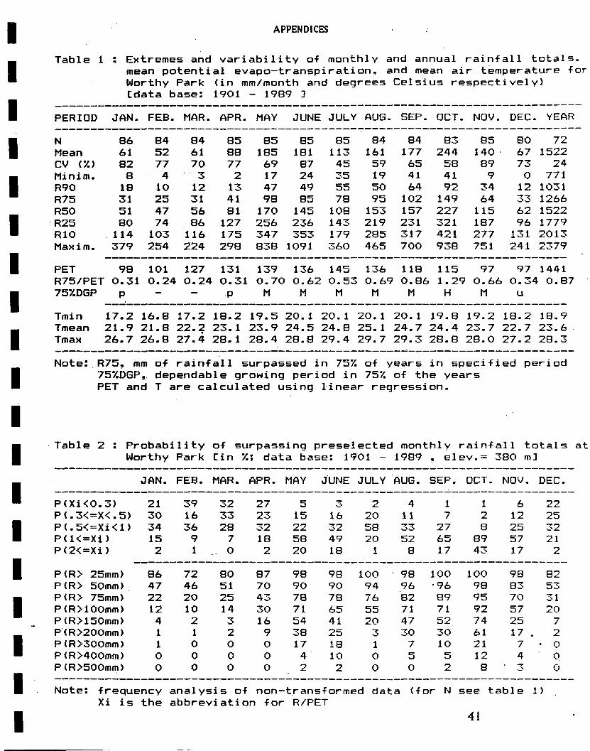
APPENDICES
Table 1 : Extremes and variability o-f monthly and annual rain-fall totale. mean potential evapo-transpiration, and mean air temperature -fo Worthy Park (in mm/month and degrees Celsius respectively) Cdata base: 1901 - 1989 1
PERIOD JAN. FEB. MAR. APR. MAY JUNE JULY AUG. SEP. DCT. N0V. DEC. YEAR
N 86 84 84 85 85 85 85 84 84 83 85 80 72 Mean 61 52 61 88 185 181 113 161 177 244 140 67 1522 CV (%> 82 77 70 77 69 87 45 59 65 58 89 73 24 Minim. 8 4 3 2 17 24 35 19 41 41 9 0 771 R90 18 10 12 13 47 49 55 50 64 92 34 12 1031 R75 31 25 31 41 98 85 78 95 102 149 64 33 1266 R50 51 47 56 81 170 145 108 153 157 227 115 62 1522 R25 80 74 86 127 256 236 143 219 231 321 187 96 1779 R10 114 103 116 175 347 353 179 285 317 421 277 131 2013 Maxim. 379 254 224 298 838 1091 360 465 700 938 751 241 2379
PET 98 101 127 131 139 136 145 136 118 115 97 97 1441 R75/PET 0.31 0.24 0.24 0.31 0.70 0.62 0.53 0.69 0.86 1.29 0.66 0.34 0.87 757.DGP p - - p M M M M M H M u
Tmin 17.2 16.8 17.2 18.2 19.5 20.1 20.1 20.1 20.1 19.8 19.2 18.2 18.9 Tmean 21.9 21.8 22.2 23.1 23.9 24.5 24.8 25.1 24.7 24.4 23.7 22.7 23.6 Tmax 26.7 26.8 27.4 28.1 28.4 28.8 29.4 29.7 29.3 28.8 28.0 27.2 28.3
Note: R75, mm o-f rain-fall surpassed in 75% o-f years in speci-fied period 75%DGP, dependable growing period in 75% o-f the years PET and T are calculated using linear regression.
Table 2 : Probability of surpassing preselected monthly rain-fall totals a Worthy Park Cin %; data base: 1901 - 1989 , elev.= 380 m]
JAN. FEB. MAR. APR. MAY JUNE JULY AUG. SEP. DCT. NDV. DEC.
P<Xi<0.3) 21 39 32 27 5 >̂ 2 4 1 1 6 22 P(.3<=X<.5) 30 16 33 23 15 16 20 11 7 2 12 25 P(.5<=Xi<l) 34 36 28 32 22 32 58 33 27 8 25 32 P(K=Xi) 15 9 7 18 58 49 20 52 65 89 57 21 P(2<=Xi) 2 1 .. 0 2 20 18 1 8 17 43 17 2
P<R> 25mm> 86 72 80 87 98 98 100 98 100 100 98 82 P(R> 50mm) 47 46 51 70 90 90 94 96 •96 98 83 53 P(R> 75mm) 22 20 25 43 78 78 76 82 89 95 70 31 P(R>100mm) 12 10 14 30 71 65 55 71 71 92 57 20 P(R>150mm) 4 2 3 16 54 41 20 47 52 74 25 7 P(R>200mm) 1 1 2 9 38 25 3 30 30 61 17 . 2 P(R>300mm) 1 0 0 0 17 18 1 7 10 21 7 • 0 P<R>400mm) 0 0 0 0 4 10 0 5 5 12 4 0 P(R>500mm> 0 0 0 0 2 2 0 0 2 8 ^ i 0
Note: -frequency analysis o-f non-trans-f ormed data (-for N see table 1) Xi is the abbreviation for R/PET
41

APPENDICES
APPENDIX II Soil profile descriptions and analytical data sheets.
The profile descriptions are made according to the terminology of Technical Guide No. 5 (SSU 1989e). Always print the profile description and analytical data sheet next to each other, so that they can be read at one time.
Format for soil profile descriptions sheets (letter size 9 and 10):
Profile no. (year/toposheet no./pilno.) Map unit USDAU987) Family Series FAO/UNESCO (1988) RRC (Green Book) mapping unit Location [village] [parish]
toposheet N E Parent material/rock Physiographic position Topography Elevation about m above MSL Land use Drainage class Moisture condition Surface stoniness/rock outcrop Described by Date Remarks
(All colours are for moist conditions, ualess otherwise stated; auger boring from cm onwards)
(horizon symbol] (upper-lower boundary in cm), describe the following characteristics of each horizon (when relevant): moist and dry colour (in vords and in Munsell notation in between brackets); texture; mottling; structure; consistence (wet, dry); cutans; slickensides/pressure faces; pores; roots; biologie activity; concretions; field pH; calcareousness; boundary
It is suggested that, when profile descriptions are longer than one page, it is tried to get it on one page, by reducing the letter size of the horizon descriptions from 10 to 9. In letter size 9 letter-type Geneva is better readable than type New York. But whenever possible, it should be typed in letter size 10 to enhance the readability.
An example is given on page 44-45 of the profile description and the accompanying analytical data sheet of Tydixon soils.
42
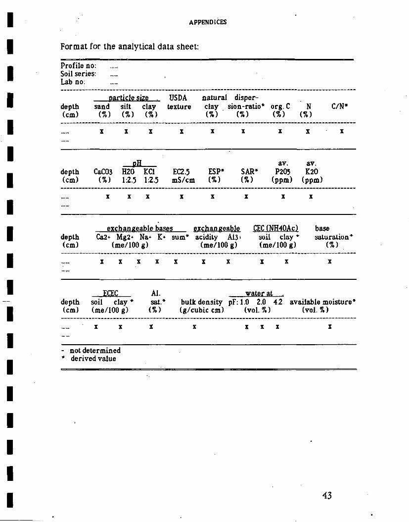
APPENDICES
Format for the analytical data sheet:
Profile no: Soil series: Lab no:
partiele size . USDA natural disper-depth sand silt clay texture clay sion-ratio* org.C N C/N* (cm) (%) (%) (%) (%) (%) (%) (%)
Z Z Z Z Z X X X X
pH av. av. depth CaC03 H20 KC1 EC2.5 ESP* SAR* P205 K20 (cm) (%) 1:2.5 1:2.5 mS/cm (%) (%) (ppm) (ppm)
Z Z Z Z Z Z Z Z
ezchangeable bases exchangeable CEC (NH40Ac) base depth Ca2* Mg2+ Na+ K+ sum* acidity A13' soil clay* saturalion* (cm) (me/lOOg) (me/lOOg) (me/100 g) (%)
X X Z Z Z Z Z Z Z Z
ECEC Al. water at . depth soil c l a y * sat.* b u l k d e n s i t y pF: 1.0 2.0 4.2 avaüable moisture* (cm) (me/100 g) (%) (g/cubic cm) (vol. %) (vol. %)
Z Z Z Z Z Z Z Z
- not determined * derived value
43

APPENDICES
Proflleno. 88/84C/110 Map unit B01 USDA(1987) Aeric Albaquult Family coarse loamy over clayey, mixed, isohyperthermic Series Tydixon FAO/UNESCO (1988) Dystric Planosol, medium textured RRC (Green Book) mapping unit Tydixon loamy sand (66) Location Worthy Park Estate (Tydixon park), St. Catherine;
toposheet 84C, 453820 N, 493.360 E Parent material/rock old alluvium of lacustrine origin Physiographic position straight slope in inland basin Topography undulating (4% slope) Elevation about 375 m above MSL Land use citrus plantation on former pasture land Drainage class poorly to imperfectly drained Moisture condition moist throughout below the topsoil Surface stoniness/rock outcrop nil Described by L.L.T. Dawkins and P. van Gent Date 06-12-88 Remarks the day after digging, the pit was filled up with water to 40
cm from the surface; pit is described on original site of Green Book description of Tydixon
(AU colours are for moist conditions, unless otherwise stated)
Ap 0-23 cm dark brown (10YR 3/3), light brownish grey (10YR 7/2) when dry, sandy loam: moderately weak fine, medium and coarse granular structure; non sticky and slightly plastic when wet, friable when moist, slightly hard when dry; common fine, medium and coarse pores; frequent worm-activity and worm-casts; field pH 4.5; non calcareous; abrupt broken boundary to
E 23-39cm—ügbtgrey O0YR7/2) sandv loam with faint brownish yellow (10YR 6/8) mottles; very weak structure, non sticky and slightly pjastjc when wet, firm when moist; very many very fine, fine and medium tubular pores; very few very fine and fine roots; little worm-activity; field pH 5; non calcareous; clear wavy boundary to
Btgl 39-72cm mixed light yellowish brown and brownish yellow (10YR 6/4 and 6/8) clay: moderately weak fine and medium (sub) angular blocky structure; sticky and slightly plastic when wet, firm when
- moist; big pressure faces; many very fine pores; few fine, medium and coarse roots; very little worm-activity; very few (quartz) gravels; field pH 4.5; non calcareous; gradual wavy boundary to
Btg2 72-120cm mixed light grey and brownish yellow (10YR 7/2 and 6/8) clay with common medium distinct red and dark red (10R 5/8 and 3/6) mottles; moderately weak medium, coarse and very coarse (sub)angular blocky structure; sticky and slightly plastic when wet, firm when moist; big continuous pressure faces; common very fine and fine pores; few fine and medium roots; very few small gravels of different origin; field pH 4.5; non calcareous; gradual wavy boundary to
Btg3 120-150 cm light grey (10YRI11) cjay. with many coarse distinct to prominent brownish yellow (10YR 6/8) and red (10R 4/6) mottles; moderately weak medium, coarse and very coarse (sub)angular blocky structure, slightly sticky to sticky and slightly plastic when wet, firm when moist; big pressure faces but less than in the third and fourth horizon; common very fine and fine pores; common fine and medium roots; field pH 4.5; non calcareous
44

APPENDICES
Profileno:88/84C/110 Soil series. Tydixon Labno: 220/88
partiele size 1 USDA exture
natura] clay
disper-sion-ratio* org.C N depth sand silt clay V
USDA exture
natura] clay
disper-sion-ratio* org.C N C/N*
(cm) (%) (%) (%) (%) (%) (%) (%)
0-23 62 27 10 .SL 1 10 1.3 0.08 16 23-39 57 31 14 SL 10 71 0.1 0.01 10 39-72 18 5 74 C 11 15 0.5 0.05 10 72-120 27 10 63 C 8 29 0.3 0.03 10 120-150 28 13 61 C 8 13 0.2 0.03 7
CaC03 oH .
EC2.5 ESP* SAR av.
P205 av.
K20 depth CaC03 H20 KC1 EC2.5 ESP* SAR av.
P205 av.
K20 (cm) (%) 1:2.5 1:2.5 mS/cm (%) (ppm) (ppm )
0-23 _ 4.9 4.0 0.04 0 _ 17 24 23-39 - 6.5 52 0.04 1 - 12 14 39-72 - 4.7 3.7 0.04 0 - 2 40 72-120 • - 4.8 3.7 0.03 0 - 4 55 120-150 - 4.6 36 0.03 0 - 2 60
exchangeable bases exchanceable CEC(NH40Ac) base depth Ca2* Mg2+ Na+ K+ sum acidity A13+ soil clay saturation (cm) (me/100 g) (me/100 g*=— (mo/100 g) - (me/100 g)
0-23 0.6 0.14 0.01 0.06 0.8 0.68 0.47 2.7 27 30 23-39 0.6 0.10 0.01 0.02 0.7 - - 0.7 5 100 39-72 1.8 035 0.03 0.09 2.3 9.08 9.08 135 18 17 72-120 1.5 0.19 0.01 0.12 1.8 9.19 9.19 13.1 21 14 120-150 0.1 0.12 0.06 0.13 0.4 10.99 10.99 134 22 3
ECEC» Al. soil clay sat.* bulk density
pF . ailable depth
ECEC» Al. soil clay sat.* bulk density 1.0 2.0 4.2 av ailable t moisture*
(cm) me/100 g) (%) (g/cubic cm) (vol.%) (vol.%)
0-23 15 15 31 1.4 40 30 ? ?
23-39 0.7 5 1.6 38 28 13 15 39-72 11.4 15 80 1.3? 49 45 34 11 72-120 11.0 17 84 - - - -120-150 11.4 19 96 - - - -
- not determined * derived value
45

APPENDICES
APPENDIX III USDA Soil Taxonomy classification
of the major soil series and related map units.
An example of the format of Appendix III is given from Soil Survey Report No. 4(SSU1989b,p.A72).
soil series subgroup family map unit(s)
Bickersteth Typic Tropudalf v. fine. mixed, isohy per ther mie HVl Bundo Aquic Tropudult clayey, mixed, isohyperther mie UV1 Mount Peto Lithic HapludoU clayey-skeletal, montmorillonitic HLl, HLxl
isohyperther mie
46

APPENDICES
APPENDIX IV Correlation of the soil mapping units with
those of the Green Books.
An example of the format of Appendix IV is given from Soil Survey Report no. 4(SSU 1989b. p.A73):
Soil maooins units "Green Book" maooine units code hectares Major components Main inclusions
HJl 249 HJyl 1205 HLl 10321 HL2 362
75 94.75 77 75
74 94 77.74
47

APPENDICES
APPENDIX V Legend to the soil map.
The legend, as presented on the soil map and in the Appendix of the Soil Survey Report under preparation, should contain the following:
Title: The Standard heading is; Legend.
Maoping units: The legend is structured according to physiographic unit and parent rock/material. Per physiographic unit, the overall characteristics are mentioned (relief intensity, slopes, elevation) and then the kind of parent rock/material is specified (see Technical Bulletin No. 12, i.e. SSU 1988b).
All mapping units are described, according to the following format for consociations: [map code] [series name] [texture of the topsoil] and for complexes/associations: [map code] [series names] [complex or association].
This is foliowed by a description of the depth, drainage, colour range and mottling of the control section, textural class (in case of dominant texture) or textural group (in case of ranging in textural class, e.g. in stratified young alluvial soils) of the control section, underlying parent rock and specification of the epipedon. Other relevant features should be mentioned as well e.g. weathering of parent rock, cracking of the soil and degree of cracking. Terminology to be used in preparing the legend is given in Section 3.6.2. The descriptions always end with the USDA Soil Taxonomy classification at family level in ItaJJc. Two examples from Soil Survey Report No. 2 (SSU 1987a) iilustrate the above mentioned format:
B: INLAND BASIN (Overall characteristics: relief intensity 10-25 m, slopes 2-16%, elevation 100-150 m)
BO: SOILS FORMED ON OLD ALLUVIUM
BOx3: Rosemere-Linstead complex: complex of a) deep, moderately well drained red and yellowish red, prominently mottled clay, and of b) deep, moderately well drained to imperfectly drained, red and
48
APPENDICES
yellowish red, prominently mottled clay and in places with a weakly cracking topsoil. Clayey, mixed, isohyperthermic Oxic Paleustults and fine, mixed, isohyperthermic Oxic Humic Paieustaifs
R: RIVER PLAINS AND VALLEYS (Overall characteristics: relief intensity .5-10 m, slopes 2-8%, elevation variable)
RR: SOILS FORMED ON RECENT ALLUVIUM
RR1: Prospect sandv loam: deep well drained, dark yellowish brown to dark greyish brown, stratüfied, fine loamy soils with a humic topsoil. Fineioamy, mixed, isohyperthermic Typic Hapiudoüs
Miscellaneous land tyoes: Following the soil mapping unit descriptions, the miscellaneous land types as occurring on the map are mentioned, using the abbreviations of Technical Bulletin No. 12 (SSU 1988b). The presently defined miscellaneous land types are: Urban areas, Beaches, Rockland, Quarries, Ponds and Wetlands
Kev to deoth classes: indicate the relevant depth classes, occurring on the map. The different depth classes, that can be distinguished, are:
very shallow less than 25 cm shallow 25 - 50 cm moderately deep 50 - 100 cm deep over 100 cm
Kev to textural classes: the textural triangle and the partiele size triangle are presented. The following Figures (9 and 10) are taken from Technical Guide No. 5 (SSU 1989e).
49
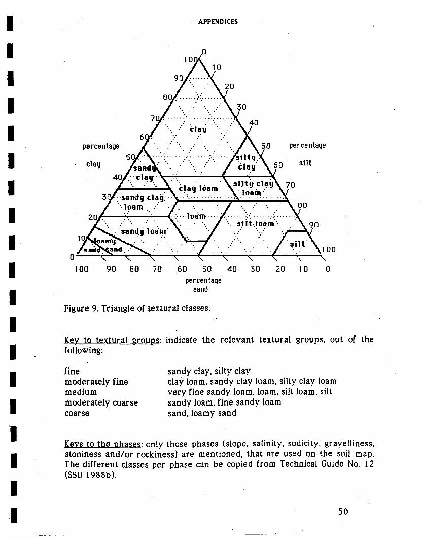
APPENDICES
10Q\
90/-...-Y / "• ••' \ 20
7 / \ 30 V Y, Y. X 40 ƒ \ clay V
percentage / \ '.. / \ 50 percentage
50/ -V- ' : ysiltgX clay ySahdiK ƒ •' ' • / ölay \J0 *lt
40/V-clayV-TT r. -\ * V / . . \ , /,"•• \ s i j t y c l a y \ 70
3yr .• iar^fydag. • y • ••: • -. • - \ •• \ ïoam . / ' • / / •-. . '• / •.. ••' \ / \ 80
2 0 / '.•'. ir t v • • loéro • • • •/• V •V. \ / ••. siit.loam-. . \ 90
sand.g loain' \ • ' • / > \l
\ Q ^ * > 0 /"•, >T7\ /«l*\i„„ rsartd?^an*. '^N<. •• / j / \ 1 0 0
o- O v—^ ^—^ ̂ \ ^ ^ \ 100 90 80 70 60 50 40 30 20 10 0
percentage sand
Figure 9. Triangle of textural classes.
Key to textural eroups: indicate the relevant textural groups, out of the following:
fine moderately fine medium moderately coarse coarse
sandy clay, silty clay clay ioam, sandy clay loam, silty clay loam very fine sandy loam. loam, silt loam, silt sandy loam, fine sandy loam sand, loamy sand
Kevs to the phases: only those phases (slope, salinity, sodicity, gravelliness, stoniness and/or rockiness) are mentioned, that are used on the soii map. The different classes per phase can be copied from Technical Guide No. 12 (SSU 1988b).
50

APPENDICES
percentage
90 80 70 60 50 40 30 20 10
percentage sand
Fig. 10. Triangie of partiele s.ize classes (USDA Soil Taxonomy).
Location: a small map of Jamaica is included to show the location of the survey area within the island.
Construction of the mapping unit codes: an example is given to illustrate, how the codes on the map should be read: B0x.3: B represents physiography e-cl 0 represents parent rock/material
x indicates the map unit is a complex 3 represents code for mapping unit composition e represents the slope class
cl represents stoniness class
51

APPENDICES
Legend of the tooograohical features: depending on the base map used, reference is made to the original topographic map (usually the 1:12,500 toposheets)
Location: a small map of Jamaica is included to show the location of the survey area within the island.
CoTistruction of the maooing unit codes: an example is given to illustrate. how the codes on the map should be read: B0x3 B represents physiography e-cl O represents parent rock/material
x indicates the map unit is a complex 3 represents code for mapping unit composition e represents the slope class
cl represents stoniness class
Logo of the Ministrv: in the logo-box (see Figure 11), it is indicated, who carried out the field work (and when), who did the correlation and classification, who compiled the map and who did the cartography and when. The. logo should also be used on the derived maps, as f ar as they are developed.
MINISTRY OF AGRICULTURE RURAL PHYSICAL PLANNING DIVISION JAMAICA SOIL SURVEY PROJECT
Fieldvork by: Correlation and classification by:
Prepared by: Date dravn: Dravn by:
Figure 11. Format of map logo.
52

APPENDICES
APPENDIX VI Agro-ecological limitations of the different soil series
for selected crops.
Bef ore the tables of the agro-ecological limitations are given, the explanation of the tables is given, as shown below. This is foliowed by the computer output for the different crops on a particular soil.
An example is given for Tydixon soils, using all crops which are presently stored in JAMPLES (except from ginger). As can be seen from this example, the majority of the crops is not relevant to be considered for this soil; for regular land evaluation they should not have been incorporated in the process. Only for the sake of showing the list of crops, they are entered in this table.
It should be noted that data of other crops can be entered in the JAMPLES-data base, to increase the possibilities of land evaluation. If new data become avaüable for crops already entered in the system, the existing data base can be updated (WRITECR-module).
53

APPENDICES
J A M P L E S : M a t c h i n g m CD cd i_i 1 «E? _
The Jamaica Land Evaluation System (JAMPLES) is an interactive software pack-age designed for the appraisal of the physical suitability of land units for specific erop/management systems (land utilization types).
For technical documentation pleasë refer to Technical Soi1s Bulletins No. 16 of the Soi1 Survey Project (RPPD, Ministry of Agriculture, Jamaica.).
Land qualities of a given soi1 map unit are matched with requirements of selected annual and perennial crops using MATMOD.
Results of the matching process are presented in tables showing the degree of limitation of the land qualities for specific crops. Land qualities are given a letter code as follows:
PH: Adequacy of soi1 pH for crops (0-30,30-50cm) 0X: Availability of oxygen for crops in rootable soi1 zone RC: Adequacy of rooting conditions for crops SA: Soil salinity toxicity (0-100cm) S0: Sodium toxicity (0-50cm) CC: Occurrence of toxic levels of finely divided lime (0-50cm) Al: Occurrence of toxic levels of exchangeable aluminium (0-50cm) NR: Nutriënt retention (ECEC) (0-30cm) NA: Avail. nutrients (DM7., av.P, Exch Ca, Mg 2< K) (0-30cm) WH/WM: Workability manual resp. mechanized (Excl. slope effect which
is assessed using LANDEV). MR: Adequacy of soil moisture supply for crops (determined with LANDEV) TR: Thermal limitations for crops at highest (HT) resp. lowest (LT) point
of land unit. E: Long-term erosion 'hazard', which is shown for slope classes, viz:
a(0-27.) , b (2-57.) , c (2-87.) , d (8-167.) , e (16-307.) , f (30-507.) . and g( = > 507.).
Thé_Jle.qr-&e._.to which a land quality is limiting for a specific erop is indicated"by a-number viz:
0: no limitations (e.g. AL0, exchang. aluminium is not limiting) 1: slight limitations (e.g. RC1, rooting conditions are slightly limiting) 2: strong limitations (e.g. SA2, salinity is stronglv limiting)
(e.g. d2, strong erosion on 'd' slopes)
The final suitability of a soil map unit for a particular crop/manaqement system is determined using LANDEV, which accounts for the fact that identical land units may have different suitability for a particular erop when it is produced under different levels of management.
*N0TE: The MATMOD and LANDEV modules of Jamples are only validated for use in Jamaica!!
54

0)
XI H . C 0/ 3 3 "O U H-
T 3 13 "1
13 • 0> UI 13 rt 0) C UI i n-ra c
i ra
i n - 0 " D D - 3 - t . n ! l ) T 3 3 0) Dl Q Oi < •* Oi
U 1 3 0 i 3 r + T i n a 3 3 0 i r a 3 0 i c r a 3 ' n r a i X 3 r a t - o i r + S T u i r a o i s o r a
13 XJ »- 3 ra
» » » rt I a i+ - ~ o o
13 ra O)
-h O -1 ra ui n-
oi n er n H. i ?r r*- m
T O» c a ui +•
i c H. r+
n n 0 0 •+» -h - f i -h
ra ra ra ra • * - > . «*"\ n a> O) T 3 Oi
ra CT
o o o o o o o o
o o o o o o o o
M O O W W M M H»
M O O M M K) M Hk
M •- O O »- • - M O
W W M H M M W w
o o o o o o o o
o o o o o o o o M M N N N N M N
r O t O M M M M W N J
K J M W M W K J W N J M
O • -
; n n 3 i 3 i n u i r t T j n n n M . m r» >< n o o c c a i c ï o o i o i a i o i i s o f l i a i n n « + 3 r t n r a 3 J r c t T H « M . u i n 3 u i o o s ' a r a c r a o i n i - o ' a i u i r a o ui
r+rt-3" M-aiH-3"f+-< DJ 0 O -+tiO O 0i <
< H Q o 1313 3 0» O O O £ r+ rt ra DJ .ai "1 r t r t
O O
C iO r t
_ _ _ _ C 0) 3 ITI 5T T 3
o-ra "o i ra
• - 13 O X3 3 ra
-i
3 ra
o 3 13
ra
1 f l B i Ü ra o •-. a 3 >a
3 ra o o 3 3
ui n rt 1 0 0 0 o -< r+ er C CT r t 0) 3 ra o n
ai er xi ra ra Of 0) 3
a.ai 3 3 c r t
n o
3 in ui o* o c N iD 0) ra T i
c 3 n
Oi 3 ra
V
•O
ra rt-
!f O O O o o o o o o o o o o o o o
W M W W M W W r J M M W W M r O h J M
o O o o o o o o o o o o o o o o
O O O o o o o o o o o o o o o o
O o O o o o o o o o o o o o o o
O o o o o o o o o o o o o o o o
Oi a< o
01
o O)
o 0i
o 0i
o 0" ai ai oi o o o o o
0i 0i 0i
o o o 01
o 0i
o
O ^ O O O O O O O N O O ' - O O O O O O O O O O O O O O O O O
0 * - : o * - O O O O O O O W O O ' - 0 0 0 0 0 0 0 0 0 0 0 0 0 0 0 0 0 I
M K ] I M M M W W W M W W M M M K ) M O M M M K J K ) M W W M . K J H * W M . H - O
'i
M . M W M M I O M M M M r J I O N M M M O M r J M W N M M M H N K M K H O
WjKJ h J O N ^ t - M M t O M W M ^ M N N J t - O t - h * M O ^ M M M O M i - M W
W h J t O W W W W ' I O W W W M M M M r O r O N M I O W W I O t O M I O M I O M M
Oj O O O O O O O O O O O O O O O O O O O O O O O O O O O O O O O
N N M M M M h O N M W W N N M W N M N M M M N N N M N M N N N K l M
O O O O O O O O O O O O O O O O O O O O O O O O O O O O O O O O
O O O O O O O O O O O O O O O O O O O O O O O O O O O O O O O O
O O O O O O O O O O O O O O O O O O O O O O O O O O O O O O O O
O O O O O O O O O O O O O O O O O O O O O O O O O O O O O O O O
0) 0) QJ 0) O O O O
a i a i a i o i o i a i a i a i o t o i a i o i a i o i a i a i o i a i a i o i a i o i o i o i a i a i at oi O O O O O O O O O O O O O O O O O O O O O O O O O O O O
n
o 13
r
o X
n
z 33
Z I>
T) I n n
i> r en i» en o
z. X
m
o ui
o 3
0) 3 a
J3 C 0)
ra ui
O .CT Ö ^ CL o
O O a o M o •—-oo c / i ï i o <">
- 1 r *
a sr. 9. a
CA
"5 o 9-^ 5 ' *~* o
sS o
co 2. aT o
Q .
Cl •-» O
•o co c a o. n •-»
o
a
m z a

APPENDICES
APPENDIX VII Recommended soil conservation practices
for specified land uses.
The description of the conservation options is to be copied from Soil Survey Report No. 2 (SSU 1987a, p. 121 and 122).
For presentation of the data, the format shown in Technical Bulletin No. 16 (SSU 1989d, p. 41) must be used.
56

APPENDICES
1 inch - 2.54 cm 1 foot - 30.48 cm 1 mile - 1.61 kilometer
1 acre = 0.41 hectare
1 QC = 5/9 (ÖF - 32)
APPENDIX VIII Conversion table.
1 centimeter - 0.39 inch 1 meter- 100 cm - 3.28 feet 1 kilometer - 1000 m - 0.62 mile
1 hectare = 2.47 acres
1 ÖF - 9/5 Q C + 32
1 mS/cm - 1 mmho/cm
57

List of oublications issued bv the Jaaaica Soil Survev Proleet
SR-i (Julv 1986). SR-2 iHav 1987). SR-3 (Feb. 1989). SR-4 iftug. 1989). SR-5 (Nov. 1939),
Soil Survev Reports
Soii and iand UEe survev of the Coastal Plains of St. Catherine. Jaaaica iscaie i:5ö.öö(') Sesi-detailed soil survev of the Linstead-Boa Hal f; area. St. Catherine. Jaaaica iscaie 1:25.000) Seai-detailed soil survev of the Pedro area, St. Elizabeth, Jamaica iscaie 1:25.000) Seai-detailed soil survev of the Hontpelier area. Western Jamaica iscaie 1:25.000)
iNov. 1939), Se*i-detailed soil survev of Northern-Manchester. Jaaaica (1:50.000.1
TBchn_ica_i Soils Bulletins
T8-1 iNov. 1985). Lecends tor seai-detailed soil aans: the entries oroposed tor Jaaaica Mst Approxiaatiori). TB-2 iDec. 1985). Assessaent of the resistance of land to erosion for land evaluation. TB-3 iAor. 1986). Jaaaica Phvsical Land Evaluation Svstea iJAHPLES). TB-4 iftug. 1936). Hethodoloqv and BASIC proqraaaes for the statisticai anaivsis of rainfai i orobabilitv. TB-5 (Sep. 1986). Hatchina sodel iHATHODi, Jaaaica Phvsical Land Evaluation Svsteis. TB-6 (Sep. 1936). General teaoerature zones for land evaluation in Jamaica. TB-7 iApr. 1987). CROF'RISK, a 'josputerized procedure io assess the aqro-ecolocicai suitabi l i tv of iand for rainfed
annuai croos. TB-B iJune 1987). JAHPLES u'sers Guide: A cosputerized land evaluation svstea tor Jamaica. TB-9 iDec. 1986). A seai-detailed soil leoend: a fraaework for Jaaaica (2nd Aporoxiaation». TB-10 iNov. 1987). Revised rating svsteiB for land quaiities used in the Jamaica Phvsical Land Evaluation Svstes. TB-il (Julv 1988). Agro-clisatic characterization of the oarish of Clarendon. laaaica. TB-12 iJulv 1988). Soil Legend Fraaework for Jamaica i3rd Approxiffiation), TB-13 (Dec. 1988). Review of agro-cliaatic aodules of JAHPLES. TB-14 (Jan, 1989). SOHOHDD: a coaputerized orocedure for rating the iand auaiitv adequacv of. water supply to annuai
crops under rainfed conditions. TB-15 (Feb. 1989). Hatchino of land use reguireaents with land quaiities using the coisputerizeri iand evaluation
noduie. TB-16 iJulv 1989). User's Buide to the Jaaaica Phvsical Land Evaluation Svstea (Version 3,0).
HisceHaneous Papers
Seneraliz'ed soil map of Jaaaica: eüplanatorv note to the f i r s t drafi iscaie: 1:250.00Ö). General land capability aap of Jaaaica iscaie: 1:500.000). Soil and water quaiitv for ornaaental horticulture. An anaivsis of rainfai i variabil i tv in St. Catherine for aarieultural nlannino. The appiication of transfer-functions in creatinq the cliaate data base of the Jamaica Geopraohical Inforaation Svsteis (JAHGIS).
HP-6 iJune 1933). Land evaluation of the Coastal Plains of St. Catherine. Jaaaica. usino the coaputerized JAHPLES svstes. Soil salinitv Survev of the Southern Clarendon Plains. Apro-ciiaatic zones of the oarish of Hanchester. Jaaaica. Agro-cliaatic zones of the oarish of St. Harv, Jamaica. Tables of nonthlv rainfaii probabilities. potential evapc-transoiration and air teaoerature tor aaricuitural planning in Jaaaica.
MP-i 1 (Nov. 1989). Aoro-cliaatic zones raap of Jaaaica ii:250.000).
HP-1 iHav 1985). HP-2 (Oct. 1986). HP-3 (Dec. 1986). HP-4 (Feb. 1987). HP-5 (Feb. 1968).
HP-7 (Julv 1988) HP-8 (Sep. 1989) HP-9 (Oct. 1939) HP-lö (Oct. 1989!

Lis t of oubl icat ions issued bv the Jamaica Soü Survev Project
(November 1989)
?9Ü §ÜCJ?§y Fjeportf
SR-1 (Julv 1986}. Soil and land use survev of the Coastal Plains of St. Catherine. Jamaica iscale 1:50.000)
SR-2 (May 1987). Seai-detailed soi l survev of the Linstead-Boo Walk area. St, Catherine. Jasaica iscaie 1:25.000)
Sfi-3 (Feb. 1989). Seai-detailed so i l survev of the Pedro area, St. Elizabeth, Jamaica iscaie 1:25,000)
SR-4 (Auq. 1989). Sesii-detailed so i l survev of the Hontpelier area. Western Jamaica iscaie 1:25,000)
SR-5 (Nov. 1989), Seoi-detailed so i l survev of Northern-Manchester. Jasaica \i:50.000.<
T?chnical Soils Bul let ins
TB-1 (Nov. 1985). Lecends tor sesii-detailed soi l iiians: the entries oroposed tor Jasaica i'lst Approximaticn).
TB-2 (Dec. 1985). Assesssent of the resistance of land to erosion for land evaluation.
TB-3 (Aor. 1986). Jamaica Phvsical Land Evaluation System (JANPLESi.
TB-4 (AUQ. 1986), Mhodoloqy and BASIC proqrasaes for the s t a t i s t i c a l analvsis of r a i n f a l i p robab i i i t v .
TB-5 (Sep, 1986). Natchino model (HATH0D), Jamaica Phvsical Land Evaluation System.
TB-6 (Sep. 1984). General teaoerature zones for land evaluation in Jasaica.
TB-7 (ftpr. 1987). CROF'RISK, a ';oaputerized procedure to assess the apro-ecoloaicai s u i t a b i l i t v of land for rainfed
annual cross.
TB-8 (June 1987). JAMPLES u'sers Guide: A computerized land evaluation svsteif: tor Jamaica.
TB-9 (Dec. 1986). A semi-detailed soi l leoend: a fraieworfc for Jasaica <2nd Aporoxiaatiori.i.
TB-10 iNov. 1987). Revised rat ing svsteiB for land qual i t ies useö in the Jamaica Phvsical Land Evaluation Svstea.
TE—1i (Julv 1988). Aqro-climatic characterization of the oarish of Ciarendon. Jasaica.
TB-12 (Julv 1988), Soil Leoend Framework for Jamaica (3rd Approximationi.
TB-13 (Dec. 1988). Review of aqro-c l iaat ic modules of JAHPLES,
TB-14 (Jan. 1989), SÜNÜMGD: a coaputerized orocedure for rat inq the land qual i tv adequacy cf. water supply to annual
crops under rainfed condit ions.
TB-15 (Feb. 1989). Hatchinq of land use requirements with land qual i t ies usinq the co/iputerized land evaluation
noduie.
TB-16 (Julv 1989). üser's Guide to the Jasaica Phvsical Land Evaluation System (Version 3,0).
fiiscellaneous Paoers
HP-1 (Hav 1985). HP-2 (Oct. 198ÓS. HP-3 (Dec. 1986). HP-i •Feb. 1937/. HP-5 (Feb. 1988).
HP-6 (June 1983).
HP-7 (Julv 1988). HP-8 (Sep. 1989). HP-9 (Oct. 1989). HP-lö (Qct. 1989).
HP-11 (Nov. 1989;.
Generaliz'ed soi l map of Jamaica: explanatorv note to the f i r s t draft iscaie: 1:250.000).
General land capabi l i ty map of Jasaica iscaie: 1:500.000).
Soil and water qual i tv for ornamental hor t i cu l tu re .
An analvsis of r a i n f a i i va r i ab i l i t v in St. Catherine for aar icu i tura l Diannino.
The application of transfer-funct ions in creatino the climate data base of the Jamaica
Geooraohical Information Svsteis (JAHGISi.
Land evaluation of the Coastal Plains of St. Ca tWine . Jamaica, usinq the coaputerized JAHFLES
svstea.
Soil sa l i n i t y Survev of the Southern Ciarendon F'Iairü.
Acro-ci iaat ic zones of the oarish of Manchester. Jamaica.
Aqro-climatic zones of the oarish of St. tlarv, Jamaica.
Tables of sonthlv r a i n f a l i p robab i l i t ies . ootentiai evapc-transoiration and air temperature for
aar icu i tura l planninq ir. Jamaica.
Apro-c l isat ic zones raap of Jamaica (i :25ö.ööö).