dp/mlw/85/011 field document no. 16 land resources...
TRANSCRIPT
DP/MLW/85/011 Field Document No. 16
LAND RESOURCES EVALUATION PROJECT
MALAWI
A DESCRIPTION AND LAND SUITABILITY ASSESSMENT OF MOPANOSOLS
IN LIWONDE AGRICULTURAL DEVELOPMENT DIVISION
by
J.H. Venema
ISRIC LIBRARY
MALAWI GOVERNMENT MINISTRY OF AGRICULTURE LAND HUSBANDRY BRANCH
UNITED NATIONS DEVELOPMENT PROGRAMME
FOOD AND AGRICULTURE ORGANIZATION OF THE UNITED NATIONS
M W 1 9 8 9 0 1 Lilongwe, November 1989
Wageningen The Netherlands

DP/MLW/85/011 Field Document No. 16
ifs-^-awatssB-**
LAND RESOURCES EVALUATION PROJECT l—CLü!
- T W S S ^
H*™1 SixdLl Wageiiingen, Th# N«ttwl«0df
A DESCRIPTION AND LAND SUITABILITY ASSESSMENT OF MOPANOSOLS
IN LIWONDE AGRICULTURAL DEVELOPMENT DIVISION
by
J.H. Venema
Scanned from original by ISRIC - World Soil Information, as ICSU World Data Centre for Soils. The purpose is to make a safe depository for endangered documents and to make the accrued nformation available for consultation, following Fair Use Suideiines. Every effort is taken to respect Copyright of the naterials within the archives where the identification of the Zopyright holder is clear and, where feasible, to contact the originators. For questions please contact [email protected] ndicating the item reference number concerned.
MALAWI GOVERNMENT MINISTRY OF AGRICULTURE LAND HUSBANDRY BRANCH
UNITED NATIONS DEVELOPMENT PROGRAMME
FOOD AND AGRICULTURE ORGANIZATION OF THE UNITED NATIONS
Lilongwe, November 1989
l l l ^
- 1 -
1. INTRODUCTION
The Mangochi Lakeshore Plain and the Upper Shire Valley of Liwonde Agricultural Development Division (Liwonde ADD) have a considerable area of soils of alluvial and/or lacustrine origin which have a very hard consistence when dry and a very low permeability. These soils are known as mopanosols* because they often carry a vegetation or remnants of a vegetation characterised by Colophospermum mopane (locally known as Xs.any_a). Traditionally these soils are not favoured for cultivation, but recent demands for land for both traditional and estate farming have raised the question of their suitability.
2. DESCRIPTION AND CLASSIFICATION
The description below of mopanosols in Liwonde ADD is based on the study of seventeen soil profiles in Machinga and Mangochi Districts.
2.1 Description of an average profile
horizon depth description symbol
Ah (+E) (0-20 cm) Very dark greyish brown (10YR3/2) moist,_sandy loam; weak coarse subangular blocky; hard dry, friable moist; abrupt wavy boundary; pH 6.5
Bt (20-80 cm) Dark brown (10YR3/3) moist, sandy clay; massive; extremely hard dry, extremely firm moist; gradual irregular boundary; pH 7.3
Btck (80-150+ cm) Dark yellowish brown (10YR3/4) moist, sandy clay; massive; extremely hard dry, extremely firm moist; common lime concretions; pH 8.3
Typical is the presence of a very hard to extremely hard subsoil (Bt) horizon with high bulk density (1.8 - 1.9 g/cu.cm and very low permeability. Because of gentle slope and low subsoil permeability, drainage is moderate to imperfect.
2.2 Variations
Certain soil characteristics of the mopanosols vary considerably. One of the most significant is the depth of the upper boundary of the compact Bt horizon. This may vary from 0 cm to more than 50 cm, with an average of 21 cm for the 17 profiles studied. Soil reaction may also vary, ranging from slightly acid to strongly alkaline. Some, but not all have free calcium carbonate. These and other variations are summarised in the Tables on page 8 and 9.
* Mopanosols have been described as "compact, alkaline, dark grey sandy clays, with free calcium carbonate, low permeability and a coarse sand fraction" (National Atlas, 1983). In the present study mopanosols are defined as soils which have within 50 cm of the surface a horizon with high bulk density, extremely hard consistence (dry) and very low permeability

2.3 Clarification (FAO, 1988)
There is no single equivalent for mopanosols in the FAO classification. In cases where the leached, permeable topsoil is still present and shows signs of impeded drainage ("stagnic" properties), mopanosols can be classified as Mollic or Eutric Planosols. If the E horizon is missing but a deep, dark A horizon is present which is not both massive and very hard ("mollic" A horizon) they classify as Stagnic or Luvic Phaeozems. Otherwise mopanosols key out as Stagnic, Calcic or Haplic Luvisols. The Land Resources Evaluation Project distinguishes a mopanic soil group, defined by the presence of a horizon within 50 cm from the surface with high bulk density, extremely hard consistence (dry) and very low permeability (Venema, 1988).
3. DISTRIBUTION
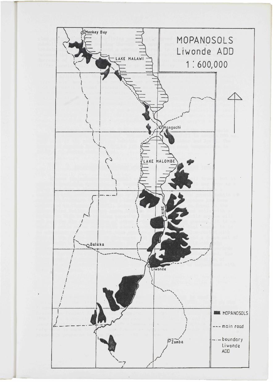
Mopanosols are known to occur in Vwaza Marsh Game Reserve (Rumphi and Mzimba Districts), the coastal plains of the southern end of Lake Malawi and Lake Malombe (Mangochi District), the Upper Shire Valley (Mangochi, Machinga and Zomba Districts) and in Mwabwe Game Reserve (Nsanje District). They take up approximately 1% of the land area of Malawi. Mopanosols are of particular importance in Liwonde ADD, where they cover an area of approximately 70,000 ha or almost 5% of the total of the ADD. The occurrence of mopanosols in Liwonde ADD is shown on the Map (page 3).
The mopanosols of the Upper Shire Valley occupy nearly level lowland plains and have developed in sub-recent alluvial and lacustrine deposits at an altitude of 480-580 m above mean sea level. Locally they are overlain by recent alluvial sediments, particularly along drainage lines and at the foot of surrounding hills.
4. GENESIS
No in-depth study has been made of the genesis of mopanosols in Malawi and the following explanation should be considered a hypothesis of the genesis of the mopanosols of the Upper Shire Valley only.
Within Liwonde ADD mopanosols are found in the lowlands of the Upper Shire Valley and the coastal plains of the southern end of Lake Malawi which were once part of a larger Lake Malawi. Tectonic movements and climatic changes caused the lake to shrink and the shallow southern end to develop slowly from open water into a marsh and finally into dry land. Because of continuous evaporation of nearly stagnant water, an accumulation of salts occurred and saline soils were formed. Further lowering of the (ground)water table caused leaching of the topsoil and initially a strong increase of the pH *. Under these alkaline conditions strong dispersion of
* Originally the exchange complex is saturated with sodium cations (Na+), but when sodium is removed from the soil solution by leaching, part of the sodium bound to the exchange complex will be exchanged by hydrogen (H+) from the water and OH- ions will be formed. High concentrations of OH- ions create a very high pH.

- 4 -
clay occurred and clay particles were easily moved from the topsoil to the subsoil by rainwater seeping through the upper part of the profile. The translocation of clay caused a strong contrast in texture and bulk density between the topsoil and the subsoil. Further leaching caused a gradual decrease of the pH. Mopanosols are now in various stages of leaching and differ considerably with respect to pH and sodicity.
In addition to the process of downward clay movement described above, "ferrolysis" may also have occurred and still occur in the topsoil. Under this process a perched seasonal water table situated on top of the slowly permeable subsoil causes reduction of iron oxides and degradation of 2:1 clay minerals in the topsoil. An "albic" horizon may form in the topsoil which is bleached and impoverished in clay.
5. CLIMATE
The climate of the Upper Shire Valley where most of the mopanosols occur is relatively dry and hot. The mean annual rainfall is around 800 mm, with most of the rain falling between the months November and April. The Length of Growing Period (LGP) is 120-140 days. The mean temperature is 25-27.5 °C during that period.
6. RELATIONSHIP BETWEEN MOPANOSOLS AND THE MOPANE TREE
Mopane (Colophospermum mopane) can be found on may soil types, but it almost invariably dominates the vegetation of mopanosols. It may grow as a shrub and form a thicket or grow as a tree up to 15 m high and form a woodland with semi-closed canopy or stand in clusters. The growth habits of mopane in relation to soil and climatic conditions in Zimbabwe has been described by Thompson (1960). Under climatic conditions as found in the Upper Shire Valley, mopane grows best on deep, well drained soils with a medium to high water-holding capacity. However, on such soils mopane will not survive the competition of other tree species and of grasses. It is on shallow soils or on soils with slowly permeable subsoil that mopane is in an advantage over many other tree species. Mopane is shallow-rooted with most of the larger roots in the upper 120 cm of the soil and a dense mat of finer roots close to the surface. Unlike many other trees it can make optimum use of the moisture stored in the topsoil and survive dry periods without having to rely on moisture stored at depth. Once established, the large number of roots close to the surface deprive other vegetation of moisture and nutrients, creating a vegetation dominated by mopane and with very little grass.
7. LAND SUITABILITY
For land suitability evaluation the FAO methodology is used as explained in the "Framework for Land Evaluation" (FAO, 1976). Based on the Framework land evaluation systems have been developed by the Land Resources Evaluation Project for rainfed cropping, forestry and grazing (Eschweilier, 1988). For a description of the various types of land use and a quantification of the suitability classes mentioned in chapters 7.2 and 7.3 reference is made to the "Land Resources Appraisal of Liwonde ADD", presently prepared by the Project (FA0, in prep.).
- 5 -
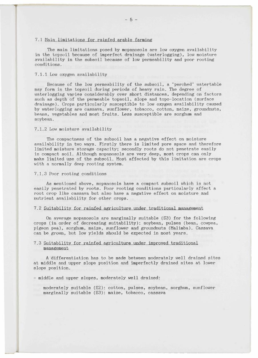
7.1 Main limitations for rainfed arable farming
The main limitations posed by mopanosols are low oxygen availability in the topsoil because of imperfect drainage (waterlogging), low moisture availability in the subsoil because of low permeability and poor rooting conditions.
7.1.1 Low oxygen availability
Because of the low permeability of the subsoil, a "perched" watertable may form in the topsoil during periods of heavy rain. The degree of waterlogging varies considerably over short distances, depending on factors such as depth of the permeable topsoil, slope and topo-location (surface drainage). Crops particularly susceptible to low oxygen availability caused by waterlogging are cassava, sunflower, tobacco, cotton, maize, groundnuts, beans, vegetables and most fruits. Less susceptible are sorghum and soybean.
7.1.2 Low moisture availability
The compactness of the subsoil has a negative effect on moisture availability in two ways. Firstly there is limited pore space and therefore limited moisture storage capacity; secondly roots do not penetrate easily in compact soil. Although mopanosols are very deep, most crops can only make limited use of the subsoil. Most affected by this limitation are crops with a normally deep rooting system.
7.1.3 Poor rooting conditions
As mentioned above, mopanosols have a compact subsoil which is not easily penetrated by roots. Poor rooting conditions particularly affect a root crop like cassava but also have a negative effect on moisture and nutrient availability for other crops.
7.2 Suitability for rainfed agriculture under traditional management
On average mopanosols are marginally suitable (S3) for the following crops (in order of decreasing suitability): soybean, pulses (bean, cowpea, pigeon pea), sorghum, maize, sunflower and groundnuts (Malimba). Cassava can be grown, but low yields should be expected in most years.
7.3 Suitability for rainfed agriculture under improved traditional management
A differentiation has to be made between moderately well drained sites at middle and upper slope position and imperfectly drained sites at lower slope position.
- middle and upper slopes, moderately well drained:
moderately suitable (S2): cotton, pulses, soybean, sorghum, sunflower marginally suitable (S3): maize, tobacco, cassava
- 6 -
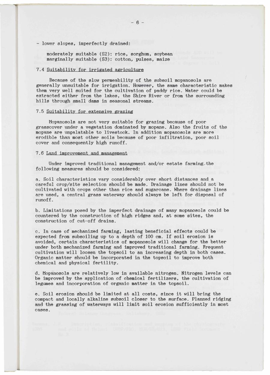
- lower slopes, imperfectly drained:
moderately suitable (S2): rice, sorghum, soybean marginally suitable (S3): cotton, pulses, maize
7.4 Suitability for irrigated agriculture
Because of the slow permeability of the subsoil mopanosols are generally unsuitable for irrigation. However, the same characteristic makes them very well suited for the cultivation of paddy rice. Water could be extracted either from the lakes, the Shire River or from the surrounding hills through small dams in seasonal streams.
7.5 Suitability for extensive grazing
Mopanosols are not very suitable for grazing because of poor grasscover under a vegetation dominated by mopane. Also the fruits of the mopane are unpalatable to livestock. In addition mopanosols are more erodible than most other soils because of poor infiltration, poor soil cover and consequently high runoff.
7.6 Land improvement and management
Under improved traditional management and/or estate farming-the following measures should be considered:
a. Soil characteristics vary considerably over short distances and a careful crop/site selection should be made. Drainage lines should not be cultivated with crops other than rice and sugarcane. Where drainage lines are used, a central grass waterway should always be left for disposal of runoff.
b. Limitations posed by the imperfect drainage of many mopanosols could be countered by the construction of high ridges and, at some sites, the construction of cut-off drains.
c. In case of mechanized farming, lasting beneficial effects could be expected from subsoiling up to a depth of 100 cm. If soil erosion is avoided, certain characteristics of mopanosols will change for the better under both mechanized farming and improved traditional farming. Frequent cultivation will loosen the topsoil to an increasing depth in both cases. Organic matter should be incorporated in the topsoil to improve both chemical and physical fertility.
d. Mopanosols are relatively low in available nitrogen. Nitrogen levels can be improved by the application of chemical fertilizers, the cultivation of legumes and incorporation of organic matter in the topsoil.
e. Soil erosion should be limited at all costs, since it will bring the compact and locally alkaline subsoil closer to the surface. Planned ridging and the grassing of waterways will limit soil erosion sufficiently in most cases.
- 7 -
8. FURTHER STUDY
The properties and suitability of mopanosols in Liwonde ADD will be the subject of the thesis of one of the fellows of the Land Resources Evaluation Project presently studying for their Master's degree in Soil Survey and Land Evaluation.
ACKNOWLEDGEMENT
Thanks are due to Mr S. Paris of the Land Resources Evaluation Project who carried out a substantial part of the soil survey of Liwonde ADD and made some useful comments on an earlier draft of this paper.
LITERATURE
De Coninck, F. Physico-chemical aspects of pedogenesis. International 1978 Training Centre for Post-graduate Soil Scientists, State
University Gent, Belgium
Duchaufour, P. Pedology. George Allen & Unwin, London (english edition) 1982
Eschweiler, J.A. Land evaluation in Malawi; preliminary guidelines for 1988 rainfed cropping. UNDP/FAO, MLW/85/011, LREP, Field Document No.5
FAO. A framework for land evaluation. Soils Bulletin 32, FAO, Rome 1976
FAO. Land resources appraisal of Liwonde Agricultural Development in prep. Division. UNDP/FAO, MLW/85/011, LREP, Technical Document No.3
FAO-Unesco. Soil map of the world. Revised Legend. FAO, Rome 1988
Mitchell, A.J.B. and E.M. Ntokotha. Reconnaissance of the Shire valley 1974 between Liwonde and Matope. In: Soil Surveys 1969/70, Govt.
Printer, Zomba
Mitchell, A.J.B. and E.M. Ntokotha. Reconnaissance of the Shire east 1974 bank north of Liwonde. In: Soil Surveys 1969/70, Govt. Printer,
Zomba
National Atlas Co-ordiantion Committee. The national atlas of Malawi. 1983 Dept. of Surveys
Stobbs, A.R. The physical environment of Southern Malawi (map, scale 1971 1:500,000)
Thompson, J.G. A description of the growth habits of mopani in relation 1960 to soil and climatic conditions. In: Proceedings of the First
Federal Science Congress, Salisbury, 1960
Venema, J.H. Description, classification and mapping of the physiography 1988 and soils of Malawi. UNDP/FAO, MLW/85/011, LREP Field Document
No.3
- 8 -
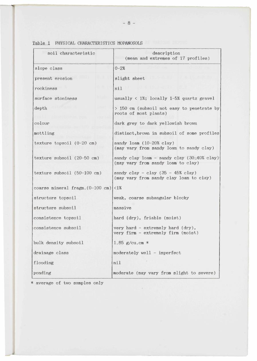
Tabls_l PHYSICAL CHARACTERISTICS MOPANOSOLS
soil characteristic description (mean and extremes of 17 profiles)
slope class
present erosion
rockiness
surface stoniness
depth
colour
mottling
texture topsoil (0-20 cm)
texture subsoil (20-50 cm)
texture subsoil (50-100 cm)
coarse mineral fragm.(0-100 cm)
structure topsoil
structure subsoil
consistence topsoil
consistence subsoil
bulk density subsoil
drainage class
flooding
ponding
0-2%
slight sheet
nil
usually < 1%; locally 1-5% quartz gravel
> 150 cm (subsoil not easy to penetrate by roots of most plants)
dark grey to dark yellowish brown
distinct,brown in subsoil of some profiles
sandy loam (10-20% clay) (may vary from sandy loam to sandy clay)
sandy clay loam - sandy clay (30-40% clay) (may vary from sandy loam to clay)
sandy clay - clay (35 - 45% clay)
(may vary from sandy clay loam to clay)
<1%
weak, coarse subangular blocky
massive
hard (dry), friable (moist) very hard - extremely hard (dry), very firm - extremely firm (moist)
1.85 g/cu.cm *
moderately well - imperfect
nil
moderate (may vary from slight to severe)
* average of two samples only
- 9 -
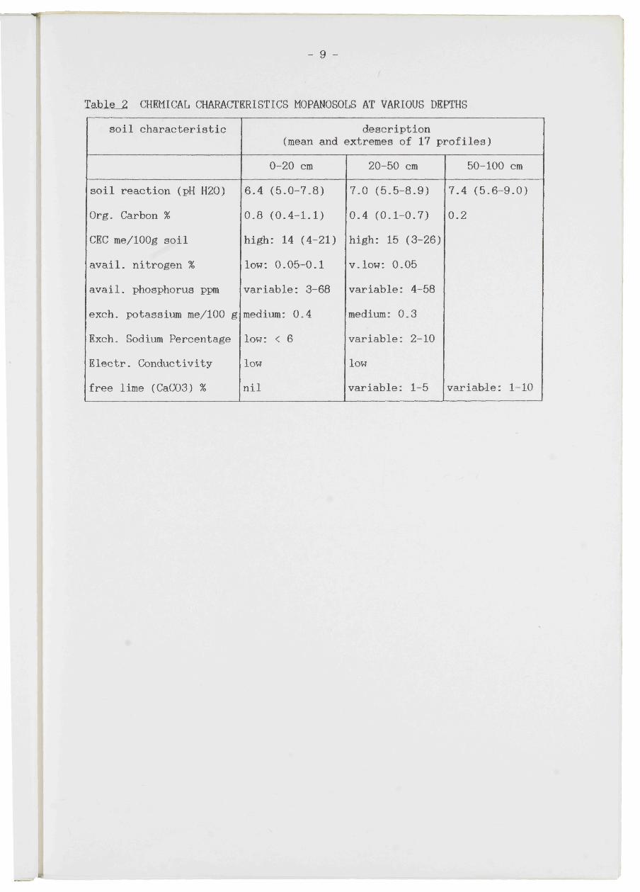
TabJLe_2 CHEMICAL CHARACTERISTICS MOPANOSOLS AT VARIOUS DEPTHS
soil characteristic
soil reaction (pH H20)
Org. Carbon %
CEC me/100g soil
avail, nitrogen %
avail, phosphorus ppm
exch. potassium me/100 g
Exch. Sodium Percentage
Electr. Conductivity
free lime (CaC03) %
description (mean and extremes of 17 profiles)
0-20 cm
6.4 (5.0-7.8)
0.8 (0.4-1.1)
high: 14 (4-21)
low: 0.05-0.1
variable: 3-68
medium: 0.4
low: < 6
low
nil
20-50 cm
7.0 (5.5-8.9)
0.4 (0.1-0.7)
high: 15 (3-26)
v.low: 0.05
variable: 4-58
medium: 0.3
variable: 2-10
low
variable: 1-5
50-100 cm
7.4 (5.6-9.0)
0.2
variable: 1-10