stage 2 archaeological assessment proposed white pines...
TRANSCRIPT
Stage 2 Archaeological AssessmentProposed White Pines Wind Project
and Stage 1 & 2 Transmission Line and SubstationPrince Edward County, Ontario
(for Lots and Concessions, see Appendix 4)
Licensee: Nick Adams MA
Prepared by: Nick Adams
Date: January 11, 2012 revised December 13, 2013
License # P003CIF# P003-327-2011
(ST2 FIT F-000675-WIN-130-601) and PIF # P003-329-2011 (Transmission Line and Substation)
(Stage 1 and 2 FIT - F-000675-WIN-130-601)
ADAMS HERITAGE3783 Maple Crest Court,
Inverary, Ontario K0H 1X0Phone / Fax (613) 353-1463email: [email protected]
White Pines Wind Project Stage 2 Archaeological AssessmentPrince Edward County Adams Heritage
EXECUTIVE SUMMARY AND RECOMMENDATIONS
Between October and December 2011, Adams Heritage conducted a Stage 2 archaeologicalassessment of lands with the potential to be affected by the proposed White Pines WindProject (ST2 FIT F-000675-WIN-130-601), primarily within the Townships of Athol andSouth Marysburgh, Prince Edward County, Ontario. This work was conducted underarchaeological licence / PIF P003-327-2011 granted to Nick Adams by the Ministry ofTourism and Culture and under contract to wpd Canada Corporation (hereafter - wpd1
Canada) in advance of a Renewable Energy Approval application. Concurrently with thiswork a related Stage 1 and 2 archaeological assessment was also conducted of sections of aproposed power transmission line along May and Fry Roads and a substation at GorslineRoad, north of Picton. This work was conducted under archaeological licence / PIF P003-329-2011.
At the time of the Stage 2 archaeological assessment, Stantec Consulting Ltd. (Stantec)were in the final stages of report completion of a Stage 1 archaeological assessment underarchaeological licence / PIF CIF # P002-205-2010, a draft of which was made available toAdams Heritage. Stantec’s Stage 1 assessment indicated that while only two prehistoricarchaeological sites, a single prehistoric findspot and a 19 century domestic archaeologicalth
site had been registered within the study area, that virtually the whole study area had somearchaeological potential. Specifically they reported that:
“Based on the results of the assessment, the entire Study Area has been identified ashaving elevated archaeological potential. Given the elevated potential for bothpre-contact and historic period resources it is recommended that the Study Areaundergo Stage 2 Archaeological Assessment prior to the commencement of anyconstruction activities. Stage 2 Archaeological Assessment should occur within zonesof elevated archaeological potential for the location of any Project relatedinfrastructure construction, including all turbine pads, access roads, undergroundcable links, construction offices, laydowns and temporary storage areas and anyother areas where soil disturbances into the below the topsoil may occur.” (Stantec2011b: i).
Accordingly, Stage 2 archaeological assessment was conducted on all lands where there wasthe likelihood that project development could affect the integrity of the ground surface andpotentially disturb or destroy archaeological sites.
Access to each portion of the study area had been arranged in advance by wpd Canada andhad been provided by the property owners. Where the anticipated disturbance areas wouldaffect active farm land, the land was ploughed in advance of the archaeological assessment,then subject to surface survey once conditions were appropriate. Those areas which wereunsuitable for ploughing were assessed using test pit survey techniques. All archaeologicalsurvey and testing was conducted in accordance with the Ministry of Tourism and Culture’s“Standards and Guidelines for Consultant Archaeologists (2011)” as required under theOntario Heritage Act, R.S.O. 1990, c. O.18.
The Ministry regulating the practice of archaeology in Ontario has had many names over the past decades:1
Ministry of Culture and Recreation, Ministry of Tourism and Culture, Ministry of Tourism, Culture and Recreation,Ministry of Tourism, Culture and Sport (current).
White Pines Wind Project Stage 2 Archaeological AssessmentPrince Edward County Adams Heritage
No evidence of archaeological sites was encountered during the Stage 2 archaeologicalassessment. It is therefore recommended that clearance of any archaeological conditionsaffecting the White Pines Wind Project be provided. A Letter of Review and Acceptance intothe Provincial Register of Reports, as provided for in Section 65.1 of the Ontario HeritageAct, is requested.
Project PersonnelProject Archaeologist / Field Director: Nick AdamsHistorical Background Christine AdamsReport Author and Preparation: Nick AdamsField Technicians: Doug Kirk, Steve Errington, Chris
Cadue, John Errington, Sam Adams,Graham Scheidt
Security Casey Adams
Dates of Field TestingOctober 13-14th, 17-21th, 24-27th 2011November 2nd, 4th, 11th, 14-19th, 21st 2011December 5th, 7th, 9th, 12th, 15th 27th 2011
Weather ConditionsVaried: Generally fine, cool, dry
Permission for AccessProvide by the landowners through wpd Canada
4
White Pines Wind Project Stage 2 Archaeological AssessmentPrince Edward County Adams Heritage
Advice on compliance with legislation
1. Advice on compliance with legislation is not part of the archaeological record.However, for the benefit of the proponent and approval authority in the land useplanning and development process, the report must include the following standardstatements:
a. This report is submitted to the Minister of Tourism and Culture as a condition oflicensing in accordance with Part VI of the Ontario Heritage Act, R.S.O. 1990, c 0.18. Thereport is reviewed to ensure that it complies with the standards and guidelines that areissued by the Minister, and that the archaeological fieldwork and report recommendationsensure the conservation, protection and preservation of the cultural heritage of Ontario.When all matters relating to archaeological sites within the project area of a developmentproposal have been addressed to the satisfaction of the Ministry of Tourism and Culture,a letter will be issued by the ministry stating that there are no further concerns withregard to alterations to archaeological sites by the proposed development.
b. It is an offence under Sections 48 and 69 of the Ontario Heritage Act for any partyother than a licensed archaeologist to make any alteration to a known archaeological siteor to remove any artifact or other physical evidence of past human use or activity fromthe site, until such time as a licensed archaeologist has completed archaeologicalfieldwork on the site, submitted a report to the Minister stating that the site has nofurther cultural heritage value or interest , and the report has been filed in the OntarioPublic Register of Archaeology Reports referred to inSection 65.1 of the Ontario Heritage Act.
c. Should previously undocumented archaeological resources be discovered, they may bea new archaeological site and therefore subject to Section 48 (1) of the Ontario HeritageAct. The proponent or person discovering the archaeological resources must ceasealteration of the site immediately and engage a licensed consultant archaeologist to carryout archaeological fieldwork, in compliance with Section 48 (1) of the Ontario HeritageAct.
d. The Cemeteries Act, R.S.O. 1990 c. C.4 and the Funeral, Burial and CremationServices Act, 2002, S.O. 2002, c.33 (when proclaimed in force) require that any persondiscovering human remains must notify the police or coroner and the Registrar ofCemeteries at the Ministry ofConsumer Services.
2. Reports recommending further archaeological fieldwork or protection for one or morearchaeological sites must include the following standard statement:
“Archaeological sites recommended for further archaeological fieldwork or protectionremain subject to Section 48 (1) of the Ontario Heritage Act and may not be altered, orhave artifacts removed from them, except by a person holding an archaeological licence.”
CONTENTS
EXECUTIVE SUMMARY
1.0 PROJECT CONTEXT - DEVELOPMENT CONTEXT. . . . . . . . . . . . . . . . . . . . . . . . . . . 1
2.0 PROJECT CONTEXT - ARCHAEOLOGICAL CONTEXT. . . . . . . . . . . . . . . . . . . . . . . . 72.1 Topography and Environment. . . . . . . . . . . . . . . . . . . . . . . . . . . . . . . . . 72.2 Archaeological Summary. . . . . . . . . . . . . . . . . . . . . . . . . . . . . . . . . . . . . 82.3 Registered Archaeological Sites.. . . . . . . . . . . . . . . . . . . . . . . . . . . . . . . 10
3.0 PROJECT CONTEXT - HISTORICAL CONTEXT . . . . . . . . . . . . . . . . . . . . . . . . . 12
4.0 FIELD METHODS - ARCHAEOLOGICAL TESTING . . . . . . . . . . . . . . . . . . . . . 194.1 Turbine Location T01, Substation and Access Road / Utilities . . . . . . . . . . 194.2 Turbine Location T02, Road and Utilities . . . . . . . . . . . . . . . . . . . . . . . . 204.3 Turbine Location T03, Road and Utilities to T02 . . . . . . . . . . . . . . . . . . . 214.4 Turbine Location T04, Road and Utilities . . . . . . . . . . . . . . . . . . . . . . . . 234.5 Turbine Location T05, Road and Utilities . . . . . . . . . . . . . . . . . . . . . . . . 254.6 Turbine Location T06, Road and Utilities. . . . . . . . . . . . . . . . . . . . . . . . 274.7 Turbine Location T07, Substation, Road and Utilities . . . . . . . . . . . . . . . . 294.8 Turbine Location T08, Road and Utilities . . . . . . . . . . . . . . . . . . . . . . . . . 314.9 Turbine Location T09, Road and Utilities . . . . . . . . . . . . . . . . . . . . . . . . 324.10 Turbine Location T10, Road and Utilities . . . . . . . . . . . . . . . . . . . . . . . . 334.11 Turbine Location T11, Road and Utilities . . . . . . . . . . . . . . . . . . . . . . . . 354.12 Turbine Location T12, Road and Utilities . . . . . . . . . . . . . . . . . . . . . . . . 374.13 Turbine Location T13, Road and Utilities . . . . . . . . . . . . . . . . . . . . . . . . 384.14 Turbine Location T14, Road and Utilities . . . . . . . . . . . . . . . . . . . . . . . . 394.15 Turbine Location T15, Road and Utilities . . . . . . . . . . . . . . . . . . . . . . . . 404.16 Turbine Location T16, Road and Utilities . . . . . . . . . . . . . . . . . . . . . . . . 414.17 Turbine Location T17, Road and Utilities . . . . . . . . . . . . . . . . . . . . . . . . 434.18 Turbine Location T18, Road and Utilities . . . . . . . . . . . . . . . . . . . . . . . . 454.19 Turbine Location T19, Road and Utilities . . . . . . . . . . . . . . . . . . . . . . . . 464.20 Turbine Location T20, Road and Utilities . . . . . . . . . . . . . . . . . . . . . . . . 474.21 Turbine Location T21, Road and Utilities . . . . . . . . . . . . . . . . . . . . . . . . 494.22 Turbine Location T22, Road and Utilities . . . . . . . . . . . . . . . . . . . . . . . . 504.23 Turbine Location T23, Road and Utilities . . . . . . . . . . . . . . . . . . . . . . . . 524.24 Turbine Location T24, Road and Utilities . . . . . . . . . . . . . . . . . . . . . . . . 534.25 Turbine Location T25, Road and Utilities . . . . . . . . . . . . . . . . . . . . . . . . 554.26 Turbine Location T26, Road and Utilities . . . . . . . . . . . . . . . . . . . . . . . . 564.27 Turbine Location T27, Road and Utilities . . . . . . . . . . . . . . . . . . . . . . . . 584.28 Turbine Location T28, Road and Utilities . . . . . . . . . . . . . . . . . . . . . . . . 594.29 Turbine Location T29, Road and Utilities . . . . . . . . . . . . . . . . . . . . . . . . 604.30 Infrastructure - Connector system along Roads, Turning Areas .. . . . . . . . 624.31 Substation - Gorsline Road . . . . . . . . . . . . . . . . . . . . . . . . . . . . . . . . . 644.32 Fry Road Transmission Line . . . . . . . . . . . . . . . . . . . . . . . . . . . . . . . . . 664.33 May Road Transmission Line . . . . . . . . . . . . . . . . . . . . . . . . . . . . . . . . . 68
5.0 RECORD OF FINDS.. . . . . . . . . . . . . . . . . . . . . . . . . . . . . . . . . . . . . . . . . . . . . 70
6.0 RESULTS AND CONCLUSIONS. . . . . . . . . . . . . . . . . . . . . . . . . . . . . . . . . . . . . . 70
7.0 RECOMMENDATIONS. . . . . . . . . . . . . . . . . . . . . . . . . . . . . . . . . . . . . . . . . . . 70
White Pines Wind Project Stage 2 Archaeological AssessmentPrince Edward County Adams Heritage
8.0 BIBLIOGRAPHY (sources). . . . . . . . . . . . . . . . . . . . . . . . . . . . . . . . . . . . . . . . . 71
9.0 MAPS. . . . . . . . . . . . . . . . . . . . . . . . . . . . . . . . . . . . . . . . . . . . . . . . . . . . . . . 72
10.0 IMAGESPlate A: Typical ground surface, Gravelly Road / Babylon Road . . . . . . . . . . . . . . 15Plate B: Limestone gravel (Alvar) lies over bedrock. . . . . . . . . . . . . . . . . . . . . . . 16Plate C: Ditch - Hilltop Road . . . . . . . . . . . . . . . . . . . . . . . . . . . . . . . . . . . . . . 17Plates 1 - 115 .. . . . . . . . . . . . . . . . . . . . . . . . . . . . . . . . . . . . . following page 72
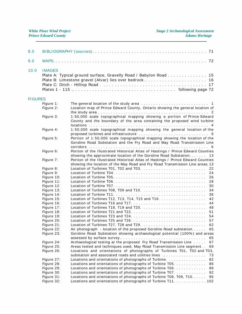
FIGURESFigure 1: The general location of the study area . . . . . . . . . . . . . . . . . . . . . . . . . . . 1Figure 2: Location map of Prince Edward County, Ontario showing the general location of
the study area . . . . . . . . . . . . . . . . . . . . . . . . . . . . . . . . . . . . . . . . . . . . 2Figure 3: 1:50,000 scale topographical mapping showing a portion of Prince Edward
County and the boundary of the area containing the proposed wind turbinelocations . . . . . . . . . . . . . . . . . . . . . . . . . . . . . . . . . . . . . . . . . . . . . . . . 4
Figure 4: 1:50,000 scale topographical mapping showing the general location of theproposed turbines and infrastructure . . . . . . . . . . . . . . . . . . . . . . . . . . . . 5
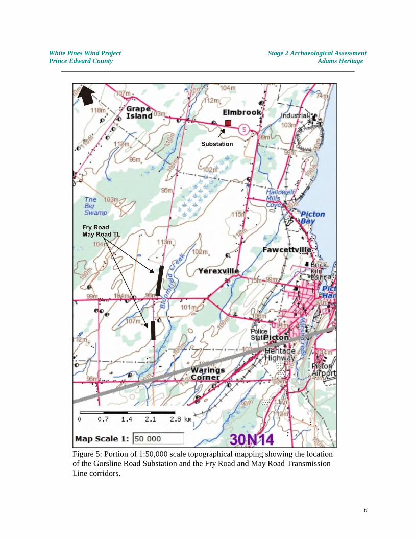
Figure 5: Portion of 1:50,000 scale topographical mapping showing the location of theGorsline Road Substation and the Fry Road and May Road Transmission Linecorridors . . . . . . . . . . . . . . . . . . . . . . . . . . . . . . . . . . . . . . . . . . . . . . . . 6
Figure 6: Portion of the Illustrated Historical Atlas of Hastings / Prince Edward Countiesshowing the approximate location of the Gorsline Road Substation. . . . . . . 13
Figure 7: Portion of the Illustrated Historical Atlas of Hastings / Prince Edward Countiesshowing the location of the May Road and Fry Road Transmission Line areas . 13
Figure 8: Location of Turbines T01, T02 and T03. . . . . . . . . . . . . . . . . . . . . . . . . . 22Figure 9: Location of Turbine T04. . . . . . . . . . . . . . . . . . . . . . . . . . . . . . . . . . . . . 24Figure 10: Location of Turbine T05. . . . . . . . . . . . . . . . . . . . . . . . . . . . . . . . . . . . . 26Figure 11: Location of Turbine T06. . . . . . . . . . . . . . . . . . . . . . . . . . . . . . . . . . . . . 28Figure 12: Location of Turbine T07. . . . . . . . . . . . . . . . . . . . . . . . . . . . . . . . . . . . . 30Figure 13: Location of Turbines T08, T09 and T10. . . . . . . . . . . . . . . . . . . . . . . . . . 34Figure 14: Location of Turbine T11. . . . . . . . . . . . . . . . . . . . . . . . . . . . . . . . . . . . . 36Figure 15: Location of Turbines T12, T13, T14, T15 and T16. . . . . . . . . . . . . . . . . . . 42Figure 16: Location of Turbines T16 and T17. . . . . . . . . . . . . . . . . . . . . . . . . . . . . . 44Figure 17: Location of Turbines T18, T19 and T20. . . . . . . . . . . . . . . . . . . . . . . . . . 48Figure 18: Location of Turbines T21 and T22. . . . . . . . . . . . . . . . . . . . . . . . . . . . . . 51Figure 19: Location of Turbines T23 and T24. . . . . . . . . . . . . . . . . . . . . . . . . . . . . . 54Figure 20: Location of Turbines T25 and T26. . . . . . . . . . . . . . . . . . . . . . . . . . . . . . 57Figure 21: Location of Turbines T27, T28 and T29. . . . . . . . . . . . . . . . . . . . . . . . . . 62Figure 22: Air photograph - location of the proposed Gorsline Road substation. . . . . . 65Figure 23: Gorsline Road Substation showing archaeological potential (100%) and areas
assessed by surface survey.. . . . . . . . . . . . . . . . . . . . . . . . . . . . . . . . . . 65Figure 24: Archaeological testing at the proposed Fry Road Transmission Line . . . . . 67Figure 25: Areas tested and techniques used, May Road Transmission Line segment. . 69Figure 26: Locations and orientations of photographs of Turbines T01, T02 and T03,
substation and associated roads and utilities lines .. . . . . . . . . . . . . . . . . 73Figure 27: Locations and orientations of photographs of Turbine. . . . . . . . . . . . . . . . 82Figure 28: Locations and orientations of photographs of Turbine T05. . . . . . . . . . . . . 86Figure 29: Locations and orientations of photographs of Turbine T06. . . . . . . . . . . . . 89Figure 30: Locations and orientations of photographs of Turbine T07. . . . . . . . . . . . . 92Figure 31: Locations and orientations of photographs of Turbine T08, T09, T10. . . . . . 95Figure 32: Locations and orientations of photographs of Turbine T11. . . . . . . . . . . . . 102
White Pines Wind Project Stage 2 Archaeological AssessmentPrince Edward County Adams Heritage
Figure 33: Locations and orientations of photographs of Turbines T12, T13, T14, T15 &T16 . . . . . . . . . . . . . . . . . . . . . . . . . . . . . . . . . . . . . . . . . . . . . . . . . . . 104
Figure 34: Locations and orientations of photographs of Turbine T16 & T17. . . . . . . . 111Figure 35: Locations and orientations of photographs of Turbine T18, T19 & T20. . . . . 114Figure 36: Locations and orientations of photographs of Turbine T21& T22. . . . . . . . . 119Figure 37: Locations and orientations of photographs of Turbine T23& T24 . . . . . . . . 123Figure 38: Locations and orientations of photographs of Turbine T25& T26. . . . . . . . . 127Figure 39: Locations and orientations of photographs of Turbine T27, T28 & T29. . . . . 131Figure 40: Locations and orientations of photographs - connector system. . . . . . . . . . 136
TABLESTable 1 Generalized Cultural Chronology of Prince Edward County. . . . . . . . . . . . . 11
SUPPLIMENTARY INFORMATIONAPPENDIX 1: White Pines Wind Project - Turbine Locations .. . . . . . . . . . . . . . . . . . . . . 150APPENDIX 2: First Nations Consultation . . . . . . . . . . . . . . . . . . . . . . . . . . . . . . . . . . . 151APPENDIX 3: MOE Director’s Aboriginal Communities List (letter) . . . . . . . . . . . . . . . . . 152APPENDIX 4: Lots and Concessions . . . . . . . . . . . . . . . . . . . . . . . . . . . . . . . . . . . . . . 155
2
White Pines Wind Project Stage 2 Archaeological AssessmentPrince Edward County Adams Heritage
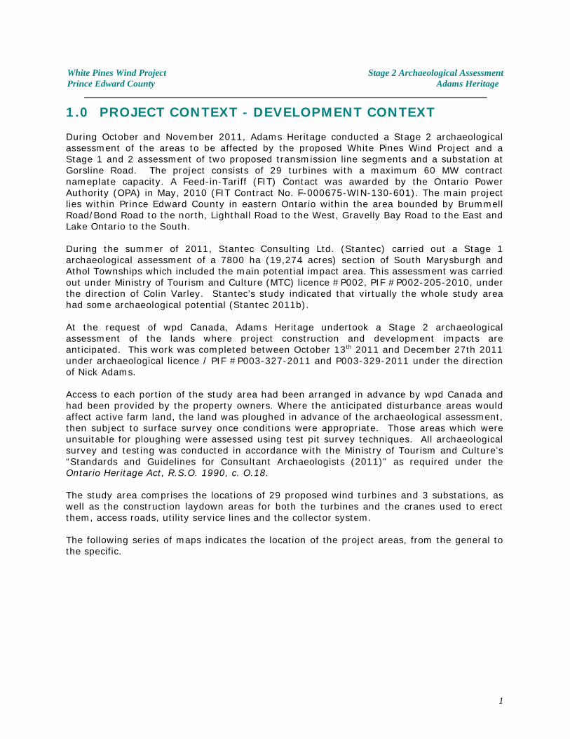
1.0 PROJECT CONTEXT - DEVELOPMENT CONTEXT
During October and November 2011, Adams Heritage conducted a Stage 2 archaeologicalassessment of the areas to be affected by the proposed White Pines Wind Project and aStage 1 and 2 assessment of two proposed transmission line segments and a substation atGorsline Road. The project consists of 29 turbines with a maximum 60 MW contractnameplate capacity. A Feed-in-Tariff (FIT) Contact was awarded by the Ontario PowerAuthority (OPA) in May, 2010 (FIT Contract No. F-000675-WIN-130-601). The main projectlies within Prince Edward County in eastern Ontario within the area bounded by BrummellRoad/Bond Road to the north, Lighthall Road to the West, Gravelly Bay Road to the East andLake Ontario to the South.
During the summer of 2011, Stantec Consulting Ltd. (Stantec) carried out a Stage 1archaeological assessment of a 7800 ha (19,274 acres) section of South Marysburgh andAthol Townships which included the main potential impact area. This assessment was carriedout under Ministry of Tourism and Culture (MTC) licence #P002, PIF #P002-205-2010, underthe direction of Colin Varley. Stantec’s study indicated that virtually the whole study areahad some archaeological potential (Stantec 2011b).
At the request of wpd Canada, Adams Heritage undertook a Stage 2 archaeologicalassessment of the lands where project construction and development impacts areanticipated. This work was completed between October 13 2011 and December 27th 2011th
under archaeological licence / PIF #P003-327-2011 and P003-329-2011 under the directionof Nick Adams.
Access to each portion of the study area had been arranged in advance by wpd Canada andhad been provided by the property owners. Where the anticipated disturbance areas wouldaffect active farm land, the land was ploughed in advance of the archaeological assessment,then subject to surface survey once conditions were appropriate. Those areas which wereunsuitable for ploughing were assessed using test pit survey techniques. All archaeologicalsurvey and testing was conducted in accordance with the Ministry of Tourism and Culture’s“Standards and Guidelines for Consultant Archaeologists (2011)” as required under theOntario Heritage Act, R.S.O. 1990, c. O.18.
The study area comprises the locations of 29 proposed wind turbines and 3 substations, aswell as the construction laydown areas for both the turbines and the cranes used to erectthem, access roads, utility service lines and the collector system.
The following series of maps indicates the location of the project areas, from the general tothe specific.
1
White Pines Wind Project Stage 2 Archaeological AssessmentPrince Edward County Adams Heritage
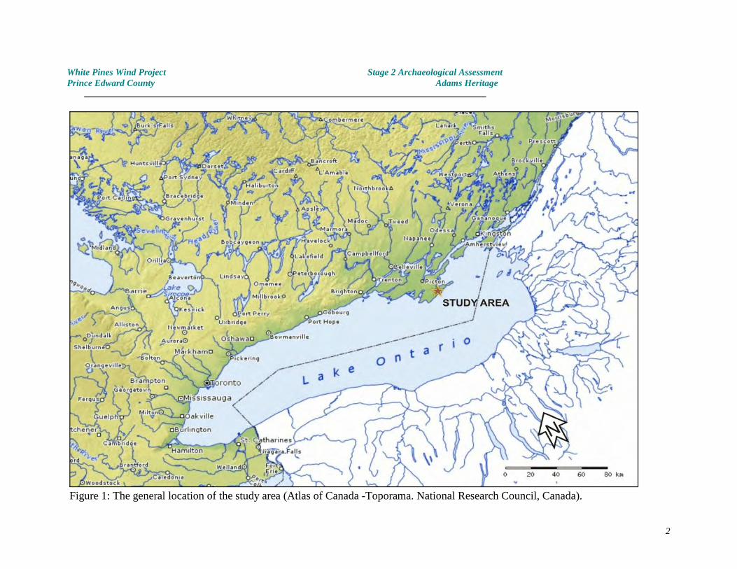
Figure 1: The general location of the study area (Atlas of Canada -Toporama. National Research Council, Canada).
2
White Pines Wind Project Stage 2 Archaeological AssessmentPrince Edward County Adams Heritage
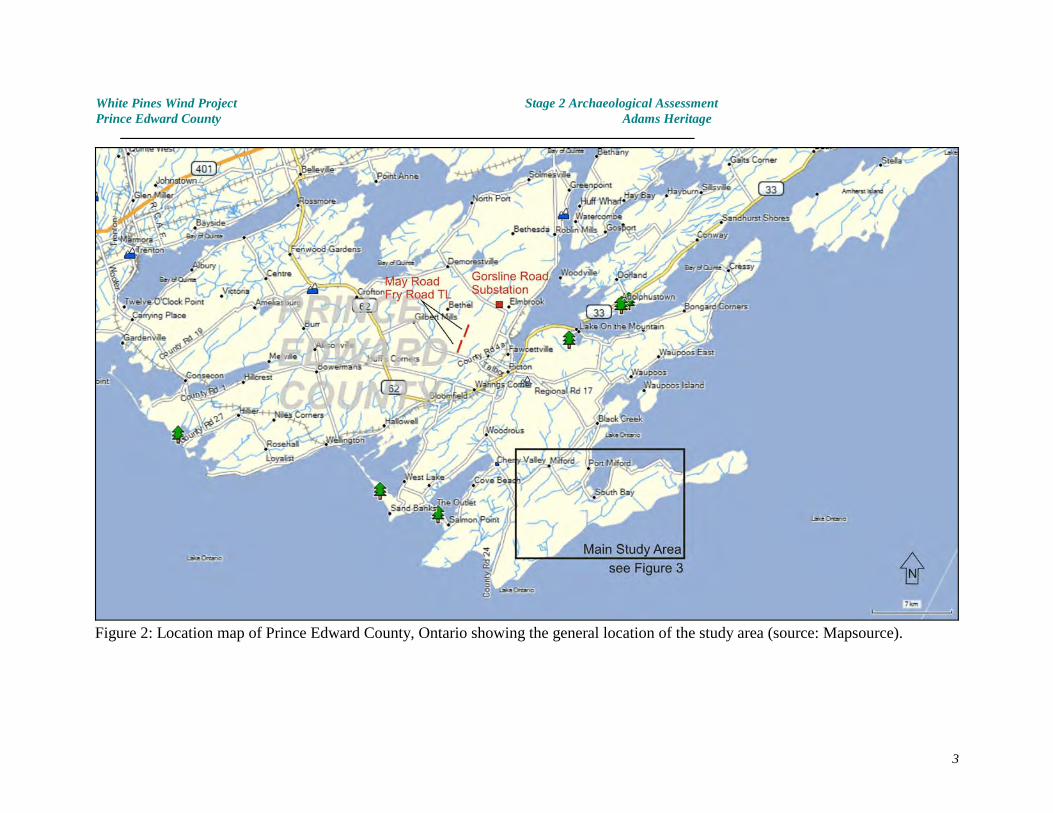
Figure 2: Location map of Prince Edward County, Ontario showing the general location of the study area (source: Mapsource).
3
White Pines Wind Project Stage 2 Archaeological AssessmentPrince Edward County Adams Heritage
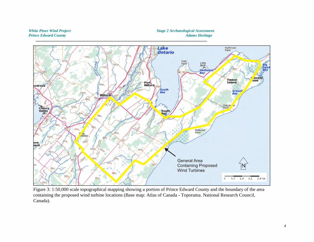
Figure 3: 1:50,000 scale topographical mapping showing a portion of Prince Edward County and the boundary of the areacontaining the proposed wind turbine locations (Base map: Atlas of Canada - Toporama. National Research Council,Canada).
4
White Pines Wind Project Stage 2 Archaeological AssessmentPrince Edward County Adams Heritage
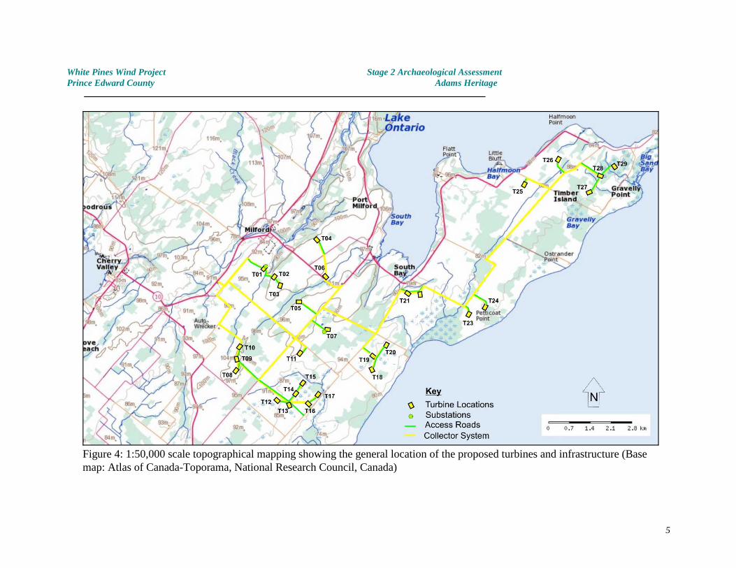
Figure 4: 1:50,000 scale topographical mapping showing the general location of the proposed turbines and infrastructure (Basemap: Atlas of Canada-Toporama, National Research Council, Canada)
5
White Pines Wind Project Stage 2 Archaeological AssessmentPrince Edward County Adams Heritage
Figure 5: Portion of 1:50,000 scale topographical mapping showing the locationof the Gorsline Road Substation and the Fry Road and May Road TransmissionLine corridors.
6
White Pines Wind Project Stage 2 Archaeological AssessmentPrince Edward County Adams Heritage
2.0 PROJECT CONTEXT - ARCHAEOLOGICAL CONTEXT
A general description of the environment, topography, soils and culture history of a broadarea surrounding the specific study areas described in this report has been provided inStantec’s Stage 1 archaeological assessment. The summary below is provided as an overall context for the Stage 2 investigations. Details specific to each of the turbine locations isprovided within section 4.0.
2.1 Topography and Environment
Prince Edward County is virtually an island in Lake Ontario, joined only by a thin neck ofland near Carrying Place. The general topography of the county is flat, being dominated by alevel limestone plain which, because of its flatness and size, does not give rise to anysignificant watercourses.
DrainageBlack Creek is the largest waterway in southern Prince Edward County, draining the northernportion of the study area and entering Lake Ontario east of Milford. Although topographicalmaps of South Marysburgh and Athol townships show abundant watercourses drainingsouthern part of the study area, in practice the majority of these are little more thanseasonal or irregular creeks, with variable flow patterns and indiscriminate channels.
Because of the flatness of the terrain, the shallowness of the soils and the difficulty withwhich the limestone plain sheds rainfall, many of the smaller watercourses display braided,irregular channels, loosely linking broad areas of uniformly poor drainage, rather than thewell defined courses indicated on maps of the area.
No watercourses lie within close proximity to the proposed Gorsline Road substation whereasthe upper reaches of Bloomfield Creek lie close to the Fry and May Road transmission linesegments. VegetationThe vegetation of Prince Edward County has been significantly altered by the rapiddeforestation which immediately followed Loyalist settlement beginning in the lateeighteenth century. The original forest cover in most areas would probably have consistedof hardwood forest of the Great-Lakes St. Lawrence association where the soils were deepenough to support it, and sparse coniferous forest cover of a Red Cedar, White Cedar,Juniper association on the thin soils of the southern portion of the limestone plateau(Richards and Morwick 1948).
SoilsThe main study area can be divided into two broad zones, largely on the basis of the depthof soil and the corresponding suitability of the land for cultivation. In the southern half of thestudy area Farmington Loam predominates, consisting of a shallow veneer of soil directlyoverlying bedrock. In virtually the whole of this area soils are less than 30 centimetresthick, and often much less.
The northern half of the main study area is characterised by areas of deeper soil derivedprimarily from outwash deposits, particularly Percy Fine Sandy Loam while Athol SandyLoam, Ameliasburg Clay and Gerow Clay are present as shallow soils over bedrock (Richards
7

White Pines Wind Project Stage 2 Archaeological AssessmentPrince Edward County Adams Heritage
and Morwick 1948, Soils Map). The Gorsline Road substation and May and Fry Road TLareas occupy areas of Dalhousie and Wapous clay.
2.2 Archaeological SummaryPalaeo-Indian Period
Archaeologists have called Ontario's first people Palaeo-Indians (meaning 'old' or 'ancient'Indians). The Palaeo-Indian Period is estimated to have begun (in Ontario) about 11,000years ago, and lasted for approximately 1,500 years (longer in northern Ontario). Thesepeople may have hunted migrating herds of caribou along the shores of vast glacial lakes,moving north into Ontario as the ice of the last glaciation receded. They have left littleevidence of their passing, except for a few beautifully made lance-shaped spear-points, andsome campsites and places where they made their tools. Although the remains left byPalaeo-Indian people are quite sparse, through careful analysis of what has been foundarchaeologists are beginning to understand something about the way these ancient peoplelived. Palaeo-Indian people depended on hunting gathering and probably fishing for theirsubsistence. They did not raise crops. In order to gain a living from the sub-arcticenvironment in which they lived, Palaeo-Indian people had to exploit large territories. It islikely that they used toboggans, sleds and possibly watercraft in order to aid them movefrom one area to the next.
The Palaeo-Indian period has been divided into two subdivisions: the Early Palaeo-Indianperiod (11,000 - 10,400 B.P.) and the Late Palaeo-Indian period (10,400-9,500 B.P.) basedon changes in tool technology. No Palaeo-Indian sites are known in the vicinity of the studyarea.
The Archaic Period
As the glacial ice continued to recede, the climate gradually became milder and more landbecame available for exploration and occupation. The Archaic Period spans the long timebetween the end of the Palaeo-Indian Period and the beginning of the use of pottery inOntario (about 2900 years ago). During the 6,500 years of the Archaic Period the exquisitestone tool workmanship of the Palaeo-Indian period was slowly abandoned. Archaic spear-points rarely reach the quality of workmanship of those of their forebears and are made froma greater variety of rocks. The Archaic period was one of long and gradual change. Thelong seasonal migratory movements of the Palaeo-Indians seem to have been abandoned asArchaic people focussed more closely on local food resources. They modified the equipmentthey made to cope with the transition from an open sub-arctic landscape to a moretemperate, forested one. Archaic people began to make a axes, hammers and other toolsby pecking and grinding rocks to the desired shape.
A single Archaic point is reported to have been found near Bond Road and has beenregistered as archaeological site AlGg-6. It is probably a casual hunting loss. No otherArchaic period sites have been recorded in the vicinity of the study area.
Early Woodland Period
Some time around 1000 B.C. the idea of using fired clay to make pottery containers beganto spread into Ontario. This technology probably had little impact on the people of this
8
White Pines Wind Project Stage 2 Archaeological AssessmentPrince Edward County Adams Heritage
province, however it is of enormous importance to archaeologists because although potsreadily break in use, the broken pieces tend to last extremely well in the ground.
All over the world potters have found the semi-hard clay surface of freshly shaped pots (ie.before firing) to be an irresistible canvas for decoration and art. Since fashions and designpreferences gradually change through time and from one people to another, the patterns ofpottery decoration, and even the shape of the pots themselves provide valuable andaccurate clues to the age and culture of the people who made them.
The Early Woodland people of Ontario were the first to use pottery in this province. In mayother respects, people of the Early Woodland Period (c. 900 B.C. - 300 B.C.) continued tolive in much the same way as their predecessors of the Late Archaic. Like the Late Archaicpeople, they buried their dead with great ceremony, often including attractive and exoticartifacts in the graves. The Early Woodland people of Ontario appear to have been incontact with, or at least heavily influenced by their neighbours to the south - particularly theAdena people of the Ohio Valley. To date, no Early Woodland archaeological sites have beenrecorded in the immediate vicinity of the study area.
The Middle Woodland Period
The most distinctive way in which the Middle Woodland period (2300 B.P. - 1100 B.P.)differs from the Early Woodland is in the way the people of Ontario had broadened themethods they used to decorate their pots. Changes in the shapes and types of tools used,the raw materials chosen and the ways in which these were acquired and traded are alsoapparent. However, these subtle technological changes mask more fundamental differences. Evidence from numerous archaeological sites indicate that by the Middle Woodland Periodthe people of Ontario began to identify with specific regions of the province. For the firsttime it is possible to distinguish regional cultural traditions - sets of characteristics which areunique to a part of the province. Archaeologists have named these cultural traditionsLAUREL (throughout northern Ontario), POINT PENINSULA (in eastern and south-centralOntario), SAUGEEN (in much of southwestern Ontario) and COUTURE (in extremesouthwestern Ontario).
Archaeologists have developed a picture of the seasonal patterns these people used in orderto exploit the wide variety of resources in their home territories. During the spring, summerand fall groups of people congregated at lakeshore sites to fish, collect shellfish (in thesouth) and hunt in the surrounding forests. As the seasons progressed the emphasisprobably shifted away from fishing and more towards hunting, as the need to store up largequantities of food for the winter became more pressing. By late fall, or early winter, thecommunity would split into small family hunting groups and each would return to a 'family'hunting area inland to await the return of spring. The Late Woodland Period
The easiest way for archaeologists to distinguish Late Woodland period archaeological sitesfrom earlier Middle Woodland sites is by looking at the pottery. During the Middle Woodlandperiod the people made conical based pottery vessels by the coil method and decoratedthem with various forms of stamps. By the beginning of the Late Woodland (ie. by A.D.900) period the coil method had been abandoned in favour of the paddle and anvil method,and the vessels were decorated with 'cord-wrapped stick' decoration. While these
9
White Pines Wind Project Stage 2 Archaeological AssessmentPrince Edward County Adams Heritage
transitions are useful to archaeologists they provide only a hint to the more fundamentalchanges which were occurring at this time.
Sometime after A.D. 500, maize (corn) was introduced into southern Ontario from the south. Initially this cultivated plant had little effect on the lives of people living in Ontario, but asthe centuries past, cultivation of corn, beans, squash, sunflowers and tobacco gainedincreasingly in importance. Not surprisingly, this transition from an economy based on theproducts of the lake and forest, to one in which the sowing, tending and harvesting of cropswas important, also hastened cultural and technological changes.
Initially at least, the changes were small. People were naturally conservative, and the risksof crop failure must have been too high to allow for too much reliance on the products of thefield. Some re-orientation of the seasonal movements of these people must have occurredat this time. Fishing and hunting sites continued to be used although the pattern ofsummer gathering along the shores of the major lakes of the region probably diminished asthe small plots of cultigens needed to be tended and harvested during the summer.Gradually however, the settlements adjacent to the corn fields began to take on a greaterpermanency as cultigens became more of a staple food. The best quality, light, and easilytillable farmland was sought out for cultivation, with village sites located nearby, near areliable source of water.
As agricultural success increased, it became possible to store a supply of food for the winter. For the first time it was possible to stay in and around the village all year (in southernOntario at least) instead of dispersing into family winter hunting camps. Villages becamelarger and more heavily populated. Hostilities erupted between neighbouring peoples, sothat by A.D. 1000, some people found it necessary to defend their villages with stockadesand ditch defences. By the end of the Late Woodland period, the people of southern Ontariohad grouped themselves into distinct regional populations separated by vast, unoccupiedareas of 'no-mans-land'.
Late Woodland archaeological sites and settlements have been documented in many parts ofPrince Edward County, however no archaeological sites dating to the Late Woodland periodhave been recorded in the immediate vicinity of the study area.
2.3 Registered Archaeological Sites2
As indicated in Stantec’s Stage 1 archaeological assessment, three locations have beenregistered with the Ministry of Tourism and Culture as pre-contact archaeological sites,although one (AlGg-6) is a findspot, one (AlGg-13) is of undetermined age and nature, whileone (AlGg-3) is interpreted as a Mid-Late Woodland Campsite. Although none of theselocations has been subject to extensive investigation they do not lie in close proximity to theproposed project infrastructure and consequently will be affected by the proposed WhitePines Wind Project. A single historic site (AlGg-25) is located near Babylon Road. Thisproximity of this site to the White Pines Wind Project is discussed below.
No registered archaeological sites are present within 3 kilometres of the Gorsline Roadsubstation or the May Road and Fry Road transmission line study areas.
Information courtesy of the Ontario Ministry of Tourism, Culture and Sport.2
10
White Pines Wind Project Stage 2 Archaeological AssessmentPrince Edward County Adams Heritage
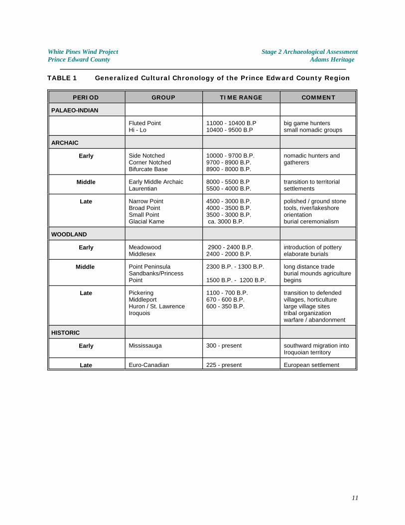
TABLE 1 Generalized Cultural Chronology of the Prince Edward County Region
PERIOD GROUP TIME RANGE COMMENT
PALAEO-INDIAN
Fluted PointHi - Lo
11000 - 10400 B.P10400 - 9500 B.P
big game hunterssmall nomadic groups
ARCHAIC
Early Side NotchedCorner NotchedBifurcate Base
10000 - 9700 B.P.9700 - 8900 B.P.8900 - 8000 B.P.
nomadic hunters andgatherers
Middle Early Middle ArchaicLaurentian
8000 - 5500 B.P5500 - 4000 B.P.
transition to territorialsettlements
Late Narrow PointBroad PointSmall PointGlacial Kame
4500 - 3000 B.P.4000 - 3500 B.P.3500 - 3000 B.P. ca. 3000 B.P.
polished / ground stonetools, river/lakeshoreorientationburial ceremonialism
WOODLAND
Early MeadowoodMiddlesex
2900 - 2400 B.P.2400 - 2000 B.P.
introduction of potteryelaborate burials
Middle Point PeninsulaSandbanks/PrincessPoint
2300 B.P. - 1300 B.P.
1500 B.P. - 1200 B.P.
long distance tradeburial mounds agriculturebegins
Late PickeringMiddleportHuron / St. LawrenceIroquois
1100 - 700 B.P.670 - 600 B.P.600 - 350 B.P.
transition to defendedvillages, horticulturelarge village sitestribal organizationwarfare / abandonment
HISTORIC
Early Mississauga 300 - present southward migration intoIroquoian territory
Late Euro-Canadian 225 - present European settlement
11
White Pines Wind Project Stage 2 Archaeological AssessmentPrince Edward County Adams Heritage
3.0 PROJECT CONTEXT - HISTORICAL CONTEXT
In the early years of European Colonization, Prince Edward County lay well beyond the limitsof settlement. Samuel de Champlain may have seen the county on his 1615 expedition butit was not until 1668, when French priests Trouve and Fenelon came to set up a mission atthe Cayuga village of Kente somewhere near Lake Consecon, that it came to be a part ofEuropean consciousness. The Kente mission was shortlived, and was abandoned in 1680 .3
When the British assumed control of the area in 1763, the Treaty of Paris prohibitedsettlement west of the Province of Quebec, reserving these lands for First Nations peoples .4
But when the American Revolution began, they realized that they would have to find landsto compensate Loyalists who had been expelled from the Thirteen Colonies to the south. Lands were purchased from the Mississaugas in 1783 , and subsequently, several townships5
were laid out in what is today Eastern Ontario. The area was surveyed between 1784 and1786. Initially, the peninsula was divided initially into three townships, with the lands in thestudy area being part of Marysburgh and Sophiasburgh. Hallowell township was later takenout of Marysburgh and Sophiasburgh and Marysburgh itself was divided into North andSouth Marysburgh.
As indicated in Stantec’s Stage 1 archaeological assessment of the main study area, by thelate 1800's, virtually all of the lots affected by the proposed wind turbine project had beensettled and were in active farming use. Please refer to section 3.3 and Figures 3-1 to 3-3 inStantec’s Stage 1 report (Stantec 2011b) for additional details.
As Prince Edward County grew, and the quality of some of its produce, particularly barley,became known, some of the farms, especially in the southern half of the peninsula, becamemore commercial farms. The lands which lie adjacent to May Road and Fry Road and thelocation of the Gorsline substation were part of active farmsteads during the historic period.
Examination of the 1878 Historical Atlas and Census records from 1861 show that many6 7
Prince Edward County farms were still in the hands of the original Loyalist families in the late19 century, a hundred years after the initial settlement of the area. In some instances, thisth
pattern has continued to this day.
Archives and Collections Society,“Settlers to Prince Edward County”;3
http://www.aandc.org/research/settlers/set_page2.html 11 11 2007
Tanner, Helen Hornbeck ed. Atlas of Great Lakes Indian History; Newberry Library, University of4
Oklahoma Press, 1987: pp. 54-55.
Washburn, Wilcomb E, and William C. Sturtevant Handbook of North American Indian History:5
Indian-White Relations. Vol 4. U.S. Government Printing Office 1988: p. 204
Illustrated historical atlas of the counties of Hastings and Prince Edward, Ont. Toronto : H. Belden6
& Co., 1878.
1861 Census of Canada; database and facsimiles online at 7 www.ancestry.com
12
White Pines Wind Project Stage 2 Archaeological AssessmentPrince Edward County Adams Heritage
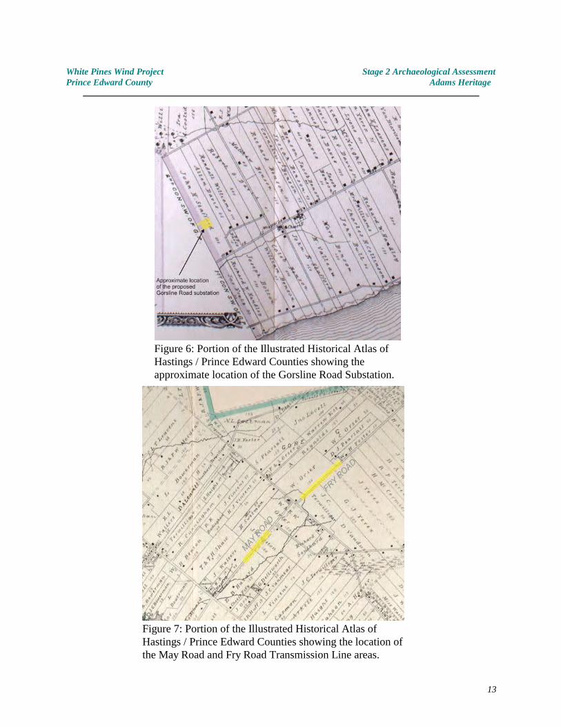
Figure 6: Portion of the Illustrated Historical Atlas ofHastings / Prince Edward Counties showing theapproximate location of the Gorsline Road Substation.
Figure 7: Portion of the Illustrated Historical Atlas ofHastings / Prince Edward Counties showing the location ofthe May Road and Fry Road Transmission Line areas.
13
White Pines Wind Project Stage 2 Archaeological AssessmentPrince Edward County Adams Heritage
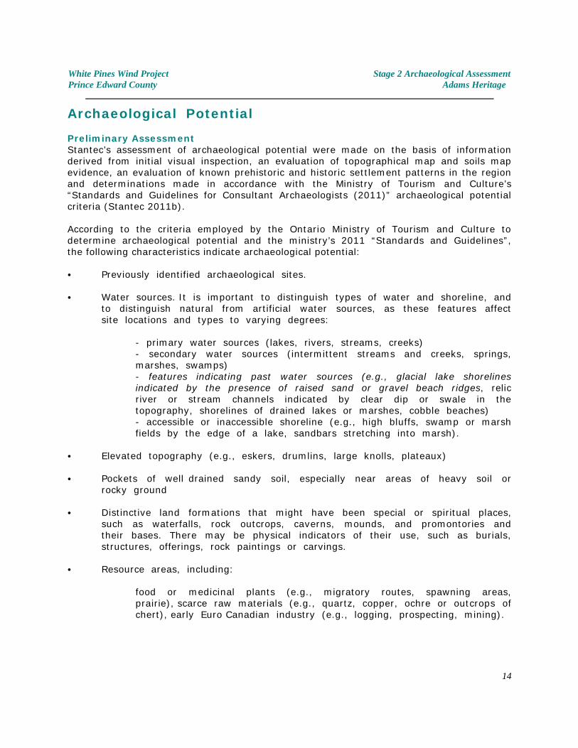
Archaeological Potential
Preliminary AssessmentStantec’s assessment of archaeological potential were made on the basis of informationderived from initial visual inspection, an evaluation of topographical map and soils mapevidence, an evaluation of known prehistoric and historic settlement patterns in the regionand determinations made in accordance with the Ministry of Tourism and Culture’s“Standards and Guidelines for Consultant Archaeologists (2011)” archaeological potentialcriteria (Stantec 2011b).
According to the criteria employed by the Ontario Ministry of Tourism and Culture todetermine archaeological potential and the ministry’s 2011 “Standards and Guidelines”,the following characteristics indicate archaeological potential:
C Previously identified archaeological sites. C Water sources. It is important to distinguish types of water and shoreline, and
to distinguish natural from artificial water sources, as these features affect site locations and types to varying degrees:
- primary water sources (lakes, rivers, streams, creeks) - secondary water sources (intermittent streams and creeks, springs, marshes, swamps) - features indicating past water sources (e.g., glacial lake shorelines indicated by the presence of raised sand or gravel beach ridges, relic river or stream channels indicated by clear dip or swale in the topography, shorelines of drained lakes or marshes, cobble beaches) - accessible or inaccessible shoreline (e.g., high bluffs, swamp or marsh fields by the edge of a lake, sandbars stretching into marsh).
C Elevated topography (e.g., eskers, drumlins, large knolls, plateaux)
C Pockets of well drained sandy soil, especially near areas of heavy soil or rocky ground
C Distinctive land formations that might have been special or spiritual places,
such as waterfalls, rock outcrops, caverns, mounds, and promontories and their bases. There may be physical indicators of their use, such as burials, structures, offerings, rock paintings or carvings.
C Resource areas, including:
food or medicinal plants (e.g., migratory routes, spawning areas, prairie), scarce raw materials (e.g., quartz, copper, ochre or outcrops of chert), early Euro Canadian industry (e.g., logging, prospecting, mining).
14
White Pines Wind Project Stage 2 Archaeological AssessmentPrince Edward County Adams Heritage
C Areas of early Euro Canadian settlement. These include places of early military or pioneer settlement (e.g., pioneer homesteads, isolated cabins, farmstead complexes), early wharf or dock complexes, pioneer churches and early cemeteries. There may be commemorative markers of their history, such as local, provincial, or federal monuments or heritage parks.
C Early historical transportation routes (e.g., trails, passes, roads, railways, portage routes)
C Property listed on a municipal register or designated under the Ontario Heritage Act or is a federal, provincial or municipal historic landmark or site Property that local histories or informants have identified with possible archaeological sites, historical events, activities, or occupations.
MTC Standards and Guidelines forConsultant Archaeologists (2011)
Based on these criteria, and as indicated by Stantec, the archaeological potential for pre-Contact and historic archaeological sites exists over much of the region.
Detailed Assessment / Constraints to Field TestingDetailed evaluations of each of the specific areas under study (ie. Turbine locations, laydownareas, roads and utility corridors) have shown that while the overall topographical andhistorical criteria might suggest archaeological potential, at the specific level ofinvestigation, this is not always the case. For instance, many of the turbine locations in theeastern portion of the study area lie within areas defined as having ‘archaeological potential’because they fall within 300 metres of a creek mapped at 1:10,000 scale.
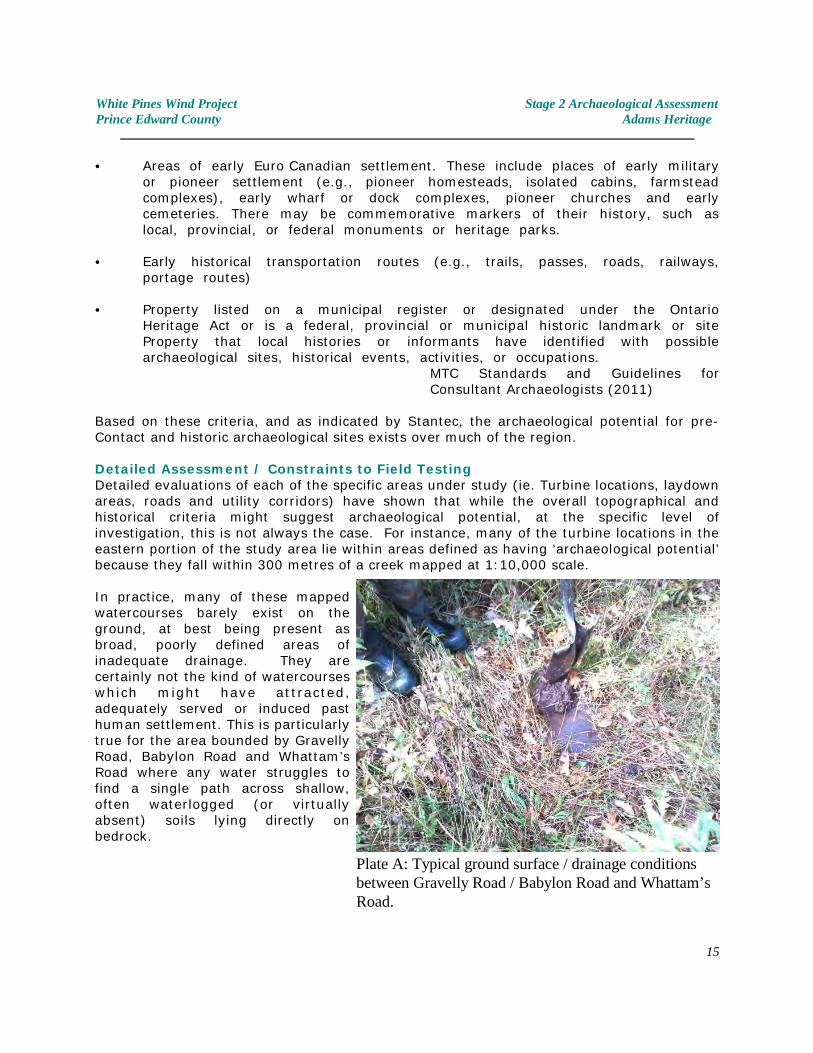
In practice, many of these mappedwatercourses barely exist on theground, at best being present asbroad, poorly defined areas ofinadequate drainage. They arecertainly not the kind of watercourseswhich might have attracted,adequately served or induced pasthuman settlement. This is particularlytrue for the area bounded by GravellyRoad, Babylon Road and Whattam’sRoad where any water struggles tofind a single path across shallow,often waterlogged (or virtuallyabsent) soils lying directly onbedrock.
Plate A: Typical ground surface / drainage conditionsbetween Gravelly Road / Babylon Road and Whattam’sRoad.
15
White Pines Wind Project Stage 2 Archaeological AssessmentPrince Edward County Adams Heritage
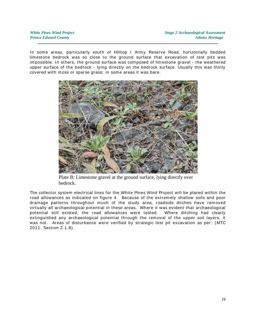
In some areas, particularly south of Hilltop / Army Reserve Road, horizontally beddedlimestone bedrock was so close to the ground surface that excavation of test pits wasimpossible. In others, the ground surface was composed of limestone gravel - the weatheredupper surface of the bedrock - lying directly on the bedrock surface. Usually this was thinlycovered with moss or sparse grass; in some areas it was bare.
The collector system electrical lines for the White Pines Wind Project will be placed within theroad allowances as indicated on figure 4. Because of the extremely shallow soils and poordrainage patterns throughout much of the study area, roadside ditches have removedvirtually all archaeological potential in these areas. Where it was evident that archaeologicalpotential still existed, the road allowances were tested. Where ditching had clearlyextinguished any archaeological potential through the removal of the upper soil layers, itwas not. Areas of disturbance were verified by strategic test pit excavation as per: (MTC2011, Section 2.1.8).
Plate B: Limestone gravel at the ground surface, lying directly overbedrock.
16

White Pines Wind Project Stage 2 Archaeological AssessmentPrince Edward County Adams Heritage
Plate C: Ditching has removed all soils down to bedrock along many of the road allowances. This relatively fresh ditching on HilltopRoad shows the extent of the impacts. Other roadsides have become overgrown, but the extent of the disturbances was generallycomparable.
17
White Pines Wind Project Stage 2 Archaeological AssessmentPrince Edward County Adams Heritage
In summary, although according to the MTC archaeological potential criteria much of thestudy area exhibited some theoretical potential for archaeological sites, in practice, for someareas, conditions on the ground indicated otherwise. Areas of low or extinguishedarchaeological potential consisted of:
C poorly drained level limestone plains
C level former pasture fields with shallow soils and/or poor drainage, distantfrom any other features of archaeological potential
C areas of exposed bedrock or where the upper surface of the bedrock wasthinly covered with frost shattered limestone gravel
C disturbed areas, where modern ditching and road construction had removedsoils within the road allowances or the prior placement of utilities within theroad allowance had created extensive disturbance.
Nevertheless, despite the considerations cited above, and regardless of the actualarchaeological potential identified in the field, archaeological testing was conducted for eachof the proposed impact areas as far as conditions allowed.
18
White Pines Wind Project Stage 2 Archaeological AssessmentPrince Edward County Adams Heritage
4.0 FIELD METHODS - ARCHAEOLOGICAL TESTING
A detailed description of each of the proposed turbine locations, with their associated roadsand utilities service corridors is provided below. Please refer to Figures 4 & 5 for the generallocation of each study area. All archaeological fieldwork was completed according to therequirements of the Ministry of Tourism and Culture’s “Standards and Guidelines forConsultant Archaeologists (2011)”. Specifically, hand dug test pits were at least 30cm indiameter and excavated at least 5cm into subsoil (in the rare instances where subsoilexisted). Soils from test pits were screened through 6mm. hardware cloth screen. Test pitswere spaced on a 5m grid basis. Where surface survey was possible, survey transects werespaced at 5m.
4.1 Turbine Location T01, Substation and Access Road / Utilities
LocationTurbine T01 and the adjacent Substation are located south of Bond Road and east of MaypulLayn Road (Figures 4 & 8), approximately 1.2 kilometres southwest of Milford. Theproposed access road / collector system extends from the turbine area, north to meet BondRoad.
EnvironmentThe proposed main impact area is situated on a level terrace field, just north of Black Creek.The road traverses a low ridge of farmland before gradually descending towards Bond Road.The whole area is active farmland with light, easily tillable soils of Percy Fine Sandy Loam. Prior to the archaeological assessment, the limits of the proposed impact areas had beenstaked, ploughed, disked and weathered so that they were in perfect condition forarchaeological surface survey.
Archaeological PotentialThe archaeological potential was determined to be high. An Archaic point (AlGg- 6) isrecorded as having been discovered in the vicinity. The study area occupies well drained,easily tillable land immediately adjacent to the upper reaches of Black Creek. No constraintsto past human settlement were identified. At the time of the assessment no water waspresent within Black Creek although, according to local sources, it is usually a reliable sourceof water.
Archaeological TestingBecause of the perceived high archaeological potential of this area, the proposed turbine,crane laydown, substation, and road access areas were carefully subject to surface survey ona number of occasions - both before and after they had weathered through some frosts andrain.
ResultsNo evidence of archaeological sites was identified. No artifacts were found.
Photographs - see Plates 1-5
19
White Pines Wind Project Stage 2 Archaeological AssessmentPrince Edward County Adams Heritage
4.2 Turbine Location T02 and Access Road / Utilities
LocationTurbine T02 is located south of Bond Road and east of Maypul Layn Road (Figures 4 & 8),approximately 1.2 kilometres southwest of Milford. It lies southeast of T01, between T01 andT03. The proposed access road / collector system extends from the turbine area, north pastT01 to meet Bond Road.
EnvironmentThe proposed main impact area is situated on a slightly sloping terrace field, just south ofBlack Creek. The access road proceeds from the turbine area, following an existing farmtrack, crossing the creek before reaching T01.
The whole area is active farmland with light, easily tillable soils of Percy Fine Sandy Loam. Prior to the archaeological assessment, the field containing the proposed impact area hadbeen ploughed, disked and weathered so that it was in perfect condition for archaeologicalsurface survey.
Archaeological PotentialThe archaeological potential was determined to be high. An Archaic point (AlGg- 6) isrecorded as having been discovered in the vicinity although the precise location is unknown. The study area occupies well drained, easily tillable land immediately adjacent to the upperreaches of Black Creek. No constraints to past human settlement were identified. At thetime of the assessment no water was present within Black Creek although, according to localsources, it is usually a reliable source of water. Subsequent discussions with the landowner,Mr. Bond, indicated that before local drainage patterns were changed, the creek had been aspawning area for White Sucker (Catostomus commersonii).
Archaeological TestingBecause of the perceived high archaeological potential of this area, the proposed turbine,crane laydown area was carefully subject to intensive surface survey (ie. Less than 5minterval) once the ground had been well washed down following some heavy rains.
Since this area had yet to be staked at the time of the assessment, the limits were identifiedusing gps coordinates provided by the client and a 50 metre buffer zone around theproposed turbine and laydown areas was assessed.
ResultsNo evidence of archaeological sites was identified. No artifacts were found.
Photographs - see Plates 6-10
20
White Pines Wind Project Stage 2 Archaeological AssessmentPrince Edward County Adams Heritage
4.3 Turbine Location T03 and Access Road / Utilities to T02
LocationTurbine T03 is located southeast of Bond Road and east of Maypul Layn Road (Figures 4 &8), approximately 1.8 kilometres southwest of Milford and approximately 700 metressoutheast of Turbine/Substation T01. The proposed access road / collector system extendssouth from T01, past T02 to T03, only the latter section of which is described here.
EnvironmentThe proposed main impact area is situated partly with a small belt of forest and partly withinan actively cultivated field. This study area occupies high ground approximately 600 metresfrom Black Creek and 500 metres from a small creek to the south. From the main impactarea, the road traverses the edge of a small woodlot, then follows an existing farm tracknorth to T02.
Most of the impact area lies within a bush lot consisting predominately of maple trees, withsome ironwood and beech. However a portion extends on to cultivated lands consisting ofeasily tillable soils of Percy Fine Sandy Loam. Prior to the archaeological assessment, theportions of the study area which affect cultivatable land had been staked, ploughed, diskedand weathered so that they were in perfect condition for archaeological surface survey.
Archaeological PotentialThe archaeological potential was determined to be moderate, primarily because of thesubstantial distance to any viable source of water. No other constraints to past humansettlement were identified.
Archaeological TestingThe portions of the proposed impact areas which lie within the bush lots were tested by testpit survey methods. The cultivatable lands were subject to surface survey after they hadweathered through some frosts and rain. The proposed access road route was tested by testpit survey along the length of the existing farm track, and by conducting surface surveyalong the route where the impact area impinges on the adjacent field.
ResultsNo evidence of archaeological sites was identified. No artifacts were found.
Photographs - see Plates 11-14
21
White Pines Wind Project Stage 2 Archaeological AssessmentPrince Edward County Adams Heritage
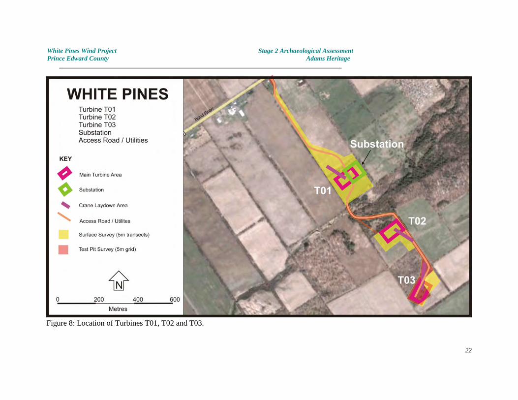
Figure 8: Location of Turbines T01, T02 and T03.
22
White Pines Wind Project Stage 2 Archaeological AssessmentPrince Edward County Adams Heritage
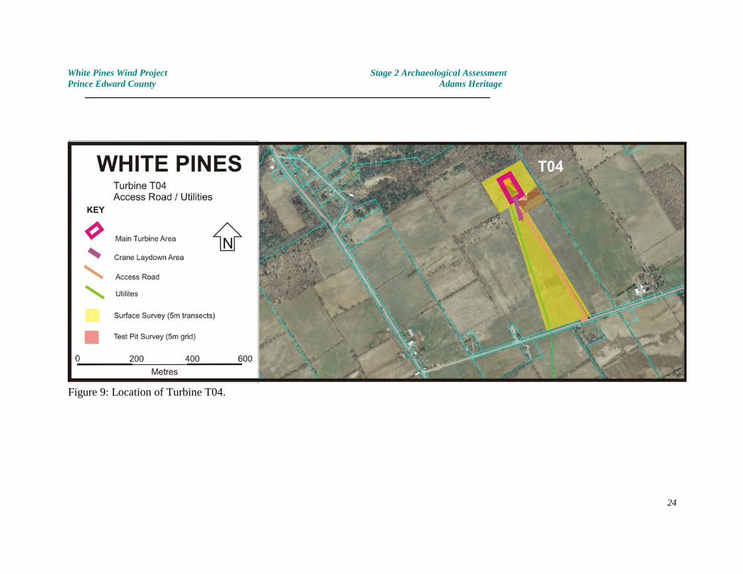
4.4 Turbine Location T04
LocationTurbine T04 is located to the north of Murphy Road and east of County Road 10 (Figures 4 &9), approximately 1.4 kilometres southeast of Milford. The proposed turbine and cranelaydown areas lie on a valley edge terrace.
EnvironmentThe proposed impact area occupies a level, cultivated field which forms part of the terracelands above Black Creek - one of the more prominent streams in this part of Prince EdwardCounty. Unlike many of the eastern turbine locations, soils in this area consisted ofmoderately light sandy loam (Percy Fine Sandy Loam).
Archaeological PotentialThe archaeological potential of this area is moderate to high. No constraints to settlementor use of the area were noted.
Archaeological TestingThe proposed turbine location, activity and laydown areas will affect a small cultivated fieldabove the Black Creek valley edge. During an initial visit, the ground between the standingcorn was found to be in perfect condition for surface survey which was conducted using afive-row spacing for survey transects. Subsequently, following corn removal, ploughing andadequate weathering, this area was surface surveyed again using a 5 metre test pit interval.
With the exception of a narrow uncultivatable strip, the road access and utilities corridor forturbine T04 traverse cultivated land. This was bare and freshly seeded with winter wheat,thus the whole area could be effectively assessed by surface survey. Transects were spacedat 5 metre intervals across the proposed impact areas. No evidence of archaeological siteswas noted.
A small part of the access road and utilities corridor will cross a terrace with shallow soilsabove bedrock. This area is not ploughed because of the proximity of rock to the surface,and part of it is wooded. This area was subject to test pit survey using a 5 metre interval.
ResultsNo evidence of archaeological sites was identified. No artifacts were found.
Photographs - see Plates 15-20
23
White Pines Wind Project Stage 2 Archaeological AssessmentPrince Edward County Adams Heritage
Figure 9: Location of Turbine T04.
24
White Pines Wind Project Stage 2 Archaeological AssessmentPrince Edward County Adams Heritage
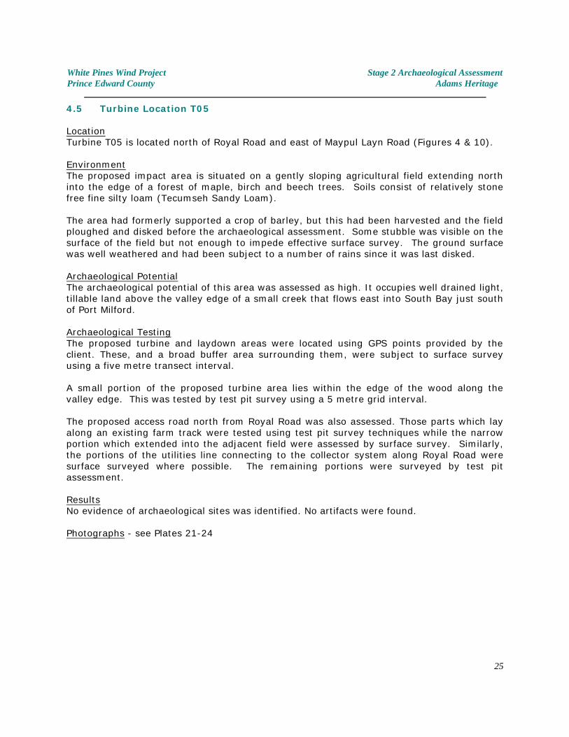
4.5 Turbine Location T05
LocationTurbine T05 is located north of Royal Road and east of Maypul Layn Road (Figures 4 & 10).
EnvironmentThe proposed impact area is situated on a gently sloping agricultural field extending northinto the edge of a forest of maple, birch and beech trees. Soils consist of relatively stonefree fine silty loam (Tecumseh Sandy Loam).
The area had formerly supported a crop of barley, but this had been harvested and the fieldploughed and disked before the archaeological assessment. Some stubble was visible on thesurface of the field but not enough to impede effective surface survey. The ground surfacewas well weathered and had been subject to a number of rains since it was last disked.
Archaeological PotentialThe archaeological potential of this area was assessed as high. It occupies well drained light,tillable land above the valley edge of a small creek that flows east into South Bay just southof Port Milford.
Archaeological TestingThe proposed turbine and laydown areas were located using GPS points provided by theclient. These, and a broad buffer area surrounding them, were subject to surface surveyusing a five metre transect interval.
A small portion of the proposed turbine area lies within the edge of the wood along thevalley edge. This was tested by test pit survey using a 5 metre grid interval.
The proposed access road north from Royal Road was also assessed. Those parts which layalong an existing farm track were tested using test pit survey techniques while the narrowportion which extended into the adjacent field were assessed by surface survey. Similarly,the portions of the utilities line connecting to the collector system along Royal Road weresurface surveyed where possible. The remaining portions were surveyed by test pitassessment.
ResultsNo evidence of archaeological sites was identified. No artifacts were found.
Photographs - see Plates 21-24
25
White Pines Wind Project Stage 2 Archaeological AssessmentPrince Edward County Adams Heritage
Figure 10: Location of Turbine T05.
26
White Pines Wind Project Stage 2 Archaeological AssessmentPrince Edward County Adams Heritage
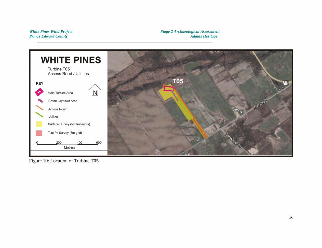
4.6 Turbine Location T06 and utilities corridor
LocationTurbine T06 is located on the east side of County Road #10, approximately 3 kilometressouth of Milford (Figures 4 & 11). The proposed crane laydown area lies parallel to the roadwhile the main laydown and installation area extends from approximately 20 metres fromthe edge of the field, east for 100 metres.
EnvironmentThe proposed impact area lies to the north of a small creek on flat permanent pasture land.Soils in this area consist of shallow, moderately light Tecumseh Sandy Loam lying directlyover bedrock. This area is not cultivated because of the extreme shallowness of the soils.
Archaeological PotentialThe archaeological potential of this area is moderate to high. No constraints to settlementor use of the area were noted. The adjacent creek did not contain much flowing water at thetime of the archaeological testing, although it is usually flowing and connects directly toLake Ontario at South Bay.
Archaeological TestingThe proposed turbine and laydown areas had been staked to facilitate the archaeologicalassessment. The whole proposed impact area was tested using a 5 metre test pit interval.
ResultsNo evidence of archaeological sites was identified. No artifacts were found.
The utilities corridor (for a buried electrical line) extends north to Murphy Road. Althoughthe actual impact area of this feature is less than 5 metres wide, a 10 metre wide linear areawas tested for archaeological sites. No evidence of cultural occupation was identified.
Photographs - see Plates 25-28
27

White Pines Wind Project Stage 2 Archaeological AssessmentPrince Edward County Adams Heritage
Figure 11: Location of Turbine T06.
28
White Pines Wind Project Stage 2 Archaeological AssessmentPrince Edward County Adams Heritage
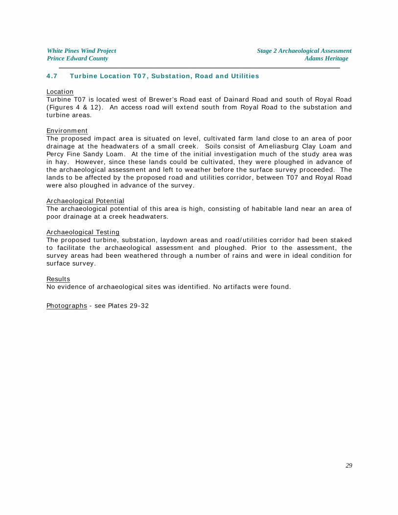
4.7 Turbine Location T07, Substation, Road and Utilities
LocationTurbine T07 is located west of Brewer’s Road east of Dainard Road and south of Royal Road(Figures 4 & 12). An access road will extend south from Royal Road to the substation andturbine areas.
EnvironmentThe proposed impact area is situated on level, cultivated farm land close to an area of poordrainage at the headwaters of a small creek. Soils consist of Ameliasburg Clay Loam andPercy Fine Sandy Loam. At the time of the initial investigation much of the study area wasin hay. However, since these lands could be cultivated, they were ploughed in advance ofthe archaeological assessment and left to weather before the surface survey proceeded. Thelands to be affected by the proposed road and utilities corridor, between T07 and Royal Roadwere also ploughed in advance of the survey.
Archaeological PotentialThe archaeological potential of this area is high, consisting of habitable land near an area ofpoor drainage at a creek headwaters.
Archaeological TestingThe proposed turbine, substation, laydown areas and road/utilities corridor had been stakedto facilitate the archaeological assessment and ploughed. Prior to the assessment, thesurvey areas had been weathered through a number of rains and were in ideal condition forsurface survey.
ResultsNo evidence of archaeological sites was identified. No artifacts were found.
Photographs - see Plates 29-32
29
White Pines Wind Project Stage 2 Archaeological AssessmentPrince Edward County Adams Heritage
Figure 12: Location of Turbine T07.
30
White Pines Wind Project Stage 2 Archaeological AssessmentPrince Edward County Adams Heritage
4.8 Turbine Location T08, Road and Utilities
LocationTurbine T08 is located north of Royal Road and east of Lighthall Road (Figures 4 & 13).
EnvironmentThe proposed impact area is situated on two level agricultural fields. Soils of the westernfield consist of relatively stone free fine silty loam whereas the more easterly field isconsiderably more stoney. Both are identified on soils maps as lying within an area of PercyFine Sandy Loam.
Both fields had formerly been in hay, but had been ploughed and disked before thearchaeological assessment. The ground was well weathered and in ideal condition forsurface survey.
Archaeological PotentialThe archaeological potential of this area is moderate to low. While the area contains light,easily tillable soils, it lies distant from any other features of archaeological potential such ascreeks, rivers etc. which might have made the area an attractive location for pastsettlement. Archaeological TestingThe proposed turbine and laydown areas had been staked prior to the archaeologicalassessment and were subject to surface survey using a five metre transect interval.
The proposed roadway / utilities corridor extends from the turbine area, east to a roadshared with T09 & T10. The route traverses thick bush which has grown over former pasturefields. It is composed of prickly ash, ash and stunted red cedar. Although the whole routehad a low archaeological site potential, it was tested using a 5 metre test pit interval.
ResultsNo evidence of archaeological sites was identified. No artifacts were found.
Photographs - see Plates 33-36
31
White Pines Wind Project Stage 2 Archaeological AssessmentPrince Edward County Adams Heritage
4.9 Turbine Location T09, Road and Utilities
LocationTurbine T09 is located north of Royal Road and east of Lighthall Road (Figures 4 & 13). Itlies between the proposed T08 and T10 turbines. An access road / utilities corridor isplanned from Royal Road to serve all three turbines (ie. T08, T09, T10).
EnvironmentThe proposed T09 impact area is situated within thick bush which has overgrown a formerfield. The area is now dominated by prickly ash and red cedar. Ploughing was not an option.
Archaeological PotentialThe archaeological potential of this area is low. It lies distant from any other features ofarchaeological potential such as creeks, rivers etc. which might have made the area anattractive location for past settlement. Archaeological TestingThe proposed turbine area (including a 5m buffer zone) had been flagged prior to thearchaeological assessment. This area was subject to test pit survey using a 5 metre grid.
Access Road - Royal Road to Turbine T09The proposed access road proceeds north from Royal Road, parallel to, and west of anexisting farm track. The whole route as far as T09 (approximately 830 metres) is acrossformer pasture fields which have become a heavily overgrown tangle of prickly ash, ash andcedar trees. The area has a low archaeological site potential, nevertheless the whole routewas subject to test pit survey using a 5 metre grid interval.
A stone lined cattle well was noted on the edge of the proposed roadway. Archaeologicaltesting was intensified in the vicinity of this feature but no artifacts were recovered thus it iscertain that this is a feature (of indeterminate antiquity) for livestock and not a domesticwater supply. At the time of the assessment a small amount of water was present in thewell, directly overlying its limestone bedrock base. No additional archaeological work wasconducted or warranted at this feature.
No evidence of archaeological sites was encountered and no artifacts were recovered. ResultsNo evidence of archaeological sites was identified at the turbine T09 location, nor along theproposed road serving T08, T09 and T10 from Royal Road. No artifacts were found.
Photographs - see Plates 37-42
32
White Pines Wind Project Stage 2 Archaeological AssessmentPrince Edward County Adams Heritage
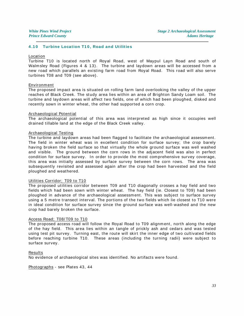
4.10 Turbine Location T10, Road and Utilities
LocationTurbine T10 is located north of Royal Road, west of Maypul Layn Road and south ofWalmsley Road (Figures 4 & 13). The turbine and laydown areas will be accessed from anew road which parallels an existing farm road from Royal Road. This road will also serveturbines T08 and T09 (see above).
EnvironmentThe proposed impact area is situated on rolling farm land overlooking the valley of the upperreaches of Black Creek. The study area lies within an area of Brighton Sandy Loam soil. Theturbine and laydown areas will affect two fields, one of which had been ploughed, disked andrecently sown in winter wheat, the other had supported a corn crop.
Archaeological PotentialThe archaeological potential of this area was interpreted as high since it occupies welldrained tillable land at the edge of the Black Creek valley.
Archaeological TestingThe turbine and laydown areas had been flagged to facilitate the archaeological assessment. The field in winter wheat was in excellent condition for surface survey; the crop barelyhaving broken the field surface so that virtually the whole ground surface was well washedand visible. The ground between the corn rows in the adjacent field was also in perfectcondition for surface survey. In order to provide the most comprehensive survey coverage,this area was initially assessed by surface survey between the corn rows. The area wassubsequently revisited and assessed again after the crop had been harvested and the fieldploughed and weathered.
Utilities Corridor; T09 to T10The proposed utilities corridor between T09 and T10 diagonally crosses a hay field and twofields which had been sown with winter wheat. The hay field (ie. Closest to T09) had beenploughed in advance of the archaeological assessment. This was subject to surface surveyusing a 5 metre transect interval. The portions of the two fields which lie closest to T10 werein ideal condition for surface survey since the ground surface was well-washed and the newcrop had barely broken the surface.
Access Road; T08/T09 to T10The proposed access road will follow the Royal Road to T09 alignment, north along the edgeof the hay field. This area lies within an tangle of prickly ash and cedars and was testedusing test pit survey. Turning east, the route will skirt the inner edge of two cultivated fieldsbefore reaching turbine T10. These areas (including the turning radii) were subject tosurface survey.
ResultsNo evidence of archaeological sites was identified. No artifacts were found.
Photographs - see Plates 43, 44
33
White Pines Wind Project Stage 2 Archaeological AssessmentPrince Edward County Adams Heritage
Figure 13: Location of Turbines T08, T09 and T10.
34
White Pines Wind Project Stage 2 Archaeological AssessmentPrince Edward County Adams Heritage
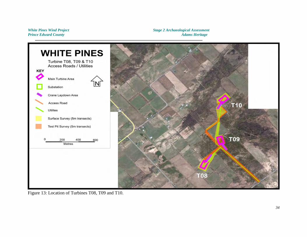
4.11 Turbine Location T11, Road and Utilities
LocationTurbine 11 is located just west Dainard Road, south of Royal Road and north of ArmyReserve Road (Figures 4 & 14). The proposed access road and utilities corridor will extendin to the turbine location from Dainard Road. All portions of the study area had been stakedin advance of the archaeological assessment.
EnvironmentThe proposed impact area lies just south of a microwave tower. Land near the frontage onto Drainard Road have been extensively disturbed, presumably as a result of vegetationclearing associated with the construction of the tower.
The area of the proposed turbine and laydown areas consists of a level limestone plain witha thin covering of soil and vegetation. Much of the study area is open pasture withoccasional stunted cedars. Soils are extremely thin with gravel present at the ground surfacein some areas. The impact area is poorly drained. This land is not suitable for cultivation.
Archaeological PotentialThe archaeological potential of this area is extremely low.
Archaeological TestingThe proposed turbine and laydown areas had been flagged to facilitate the archaeologicalassessment. Despite the low archaeological potential and the high water table an attemptwas made to test the whole area using a 5 metre test pit interval. Only those areas whichwere waterlogged were omitted.
ResultsNo evidence of archaeological sites was identified. No artifacts were found.
Photographs - see Plates 45, 46
35
White Pines Wind Project Stage 2 Archaeological AssessmentPrince Edward County Adams Heritage
Figure 14: Location of Turbine T11.
36
White Pines Wind Project Stage 2 Archaeological AssessmentPrince Edward County Adams Heritage
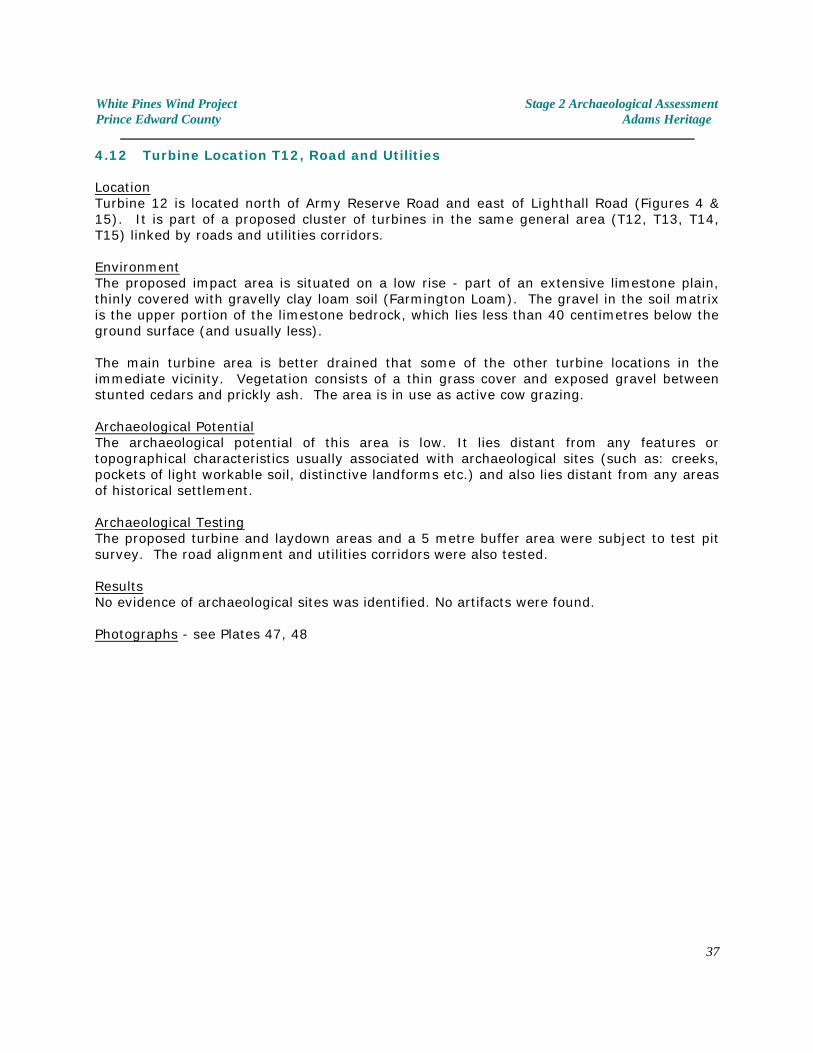
4.12 Turbine Location T12, Road and Utilities
LocationTurbine 12 is located north of Army Reserve Road and east of Lighthall Road (Figures 4 &15). It is part of a proposed cluster of turbines in the same general area (T12, T13, T14,T15) linked by roads and utilities corridors.
EnvironmentThe proposed impact area is situated on a low rise - part of an extensive limestone plain,thinly covered with gravelly clay loam soil (Farmington Loam). The gravel in the soil matrixis the upper portion of the limestone bedrock, which lies less than 40 centimetres below theground surface (and usually less).
The main turbine area is better drained that some of the other turbine locations in theimmediate vicinity. Vegetation consists of a thin grass cover and exposed gravel betweenstunted cedars and prickly ash. The area is in use as active cow grazing.
Archaeological PotentialThe archaeological potential of this area is low. It lies distant from any features ortopographical characteristics usually associated with archaeological sites (such as: creeks,pockets of light workable soil, distinctive landforms etc.) and also lies distant from any areasof historical settlement.
Archaeological TestingThe proposed turbine and laydown areas and a 5 metre buffer area were subject to test pitsurvey. The road alignment and utilities corridors were also tested.
ResultsNo evidence of archaeological sites was identified. No artifacts were found.
Photographs - see Plates 47, 48
37
White Pines Wind Project Stage 2 Archaeological AssessmentPrince Edward County Adams Heritage
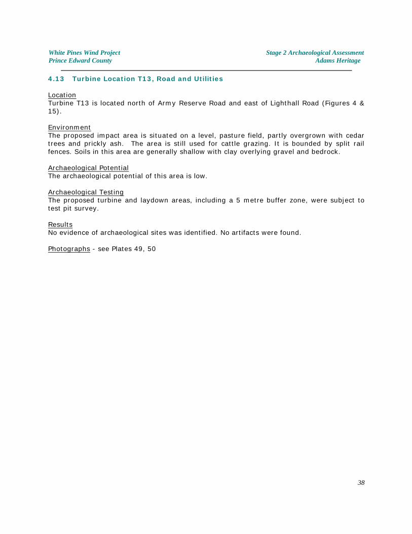
4.13 Turbine Location T13, Road and Utilities
LocationTurbine T13 is located north of Army Reserve Road and east of Lighthall Road (Figures 4 &15).
EnvironmentThe proposed impact area is situated on a level, pasture field, partly overgrown with cedartrees and prickly ash. The area is still used for cattle grazing. It is bounded by split railfences. Soils in this area are generally shallow with clay overlying gravel and bedrock.
Archaeological PotentialThe archaeological potential of this area is low.
Archaeological TestingThe proposed turbine and laydown areas, including a 5 metre buffer zone, were subject totest pit survey.
ResultsNo evidence of archaeological sites was identified. No artifacts were found.
Photographs - see Plates 49, 50
38
White Pines Wind Project Stage 2 Archaeological AssessmentPrince Edward County Adams Heritage
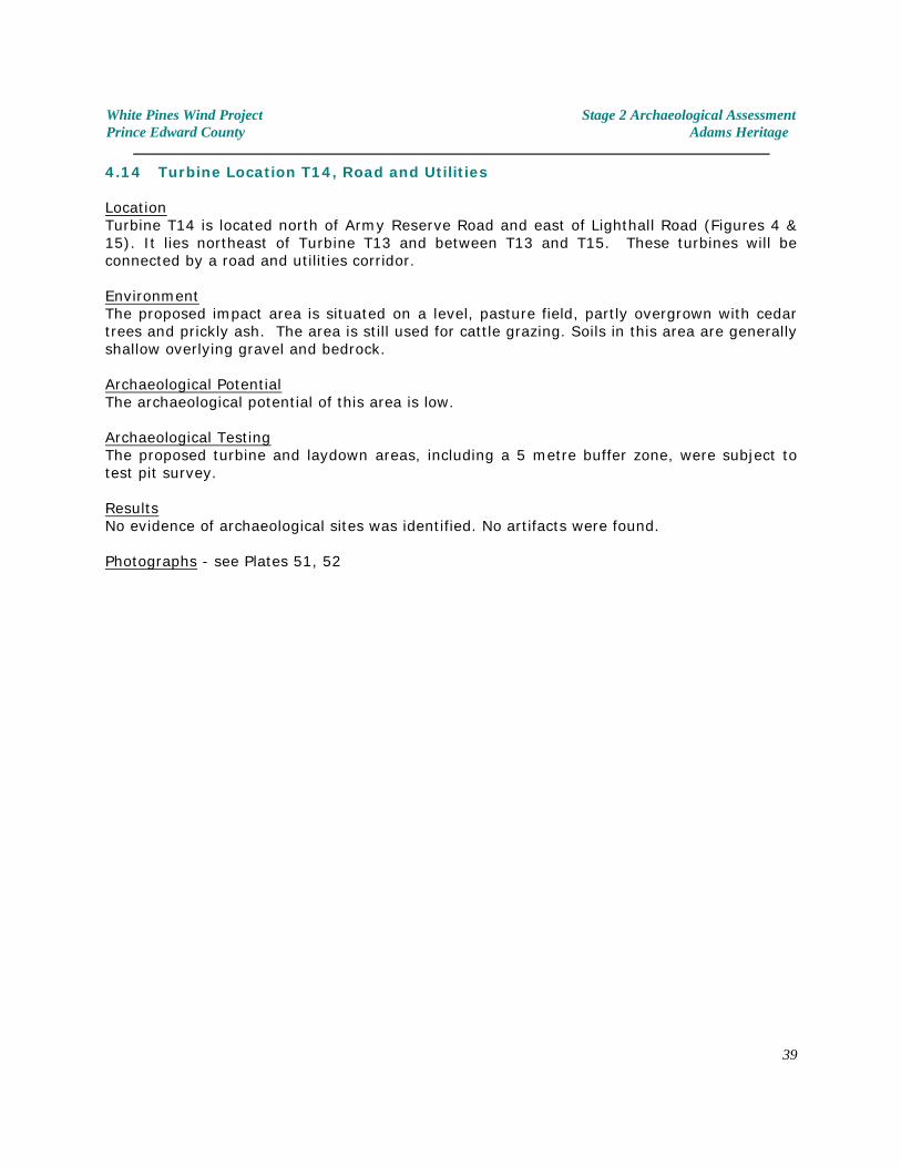
4.14 Turbine Location T14, Road and Utilities
LocationTurbine T14 is located north of Army Reserve Road and east of Lighthall Road (Figures 4 &15). It lies northeast of Turbine T13 and between T13 and T15. These turbines will beconnected by a road and utilities corridor.
EnvironmentThe proposed impact area is situated on a level, pasture field, partly overgrown with cedartrees and prickly ash. The area is still used for cattle grazing. Soils in this area are generallyshallow overlying gravel and bedrock.
Archaeological PotentialThe archaeological potential of this area is low.
Archaeological TestingThe proposed turbine and laydown areas, including a 5 metre buffer zone, were subject totest pit survey.
ResultsNo evidence of archaeological sites was identified. No artifacts were found.
Photographs - see Plates 51, 52
39
White Pines Wind Project Stage 2 Archaeological AssessmentPrince Edward County Adams Heritage
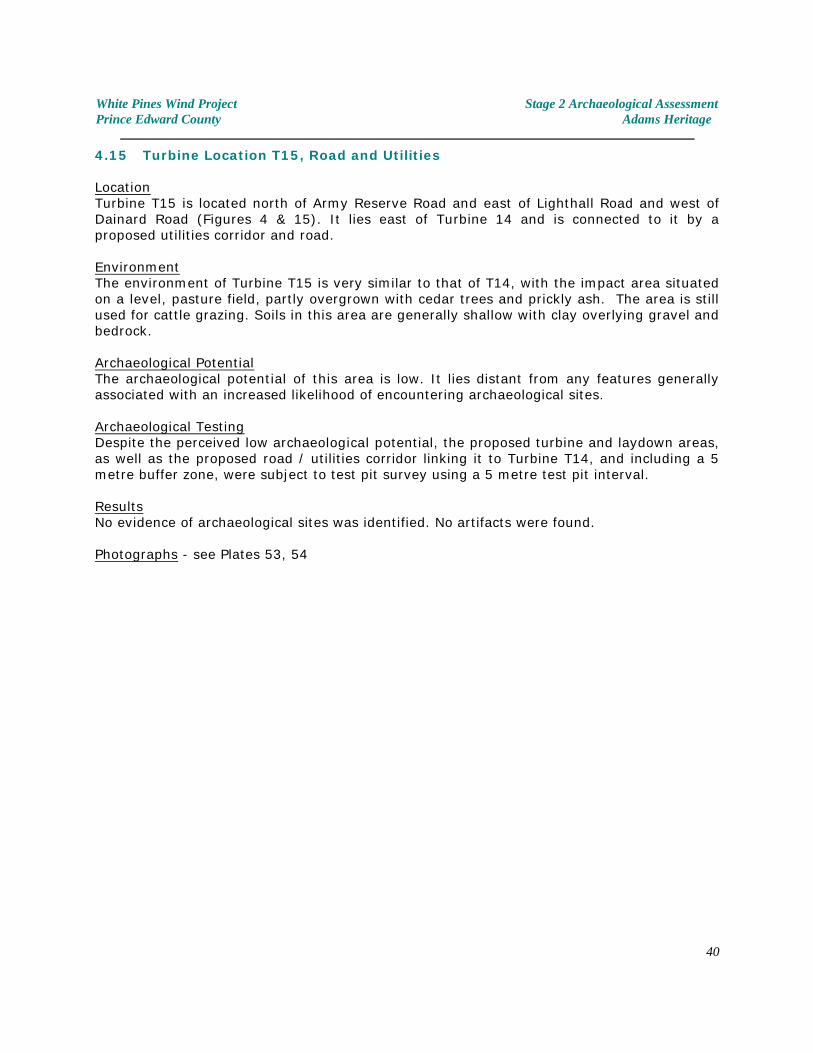
4.15 Turbine Location T15, Road and Utilities
LocationTurbine T15 is located north of Army Reserve Road and east of Lighthall Road and west ofDainard Road (Figures 4 & 15). It lies east of Turbine 14 and is connected to it by aproposed utilities corridor and road.
EnvironmentThe environment of Turbine T15 is very similar to that of T14, with the impact area situatedon a level, pasture field, partly overgrown with cedar trees and prickly ash. The area is stillused for cattle grazing. Soils in this area are generally shallow with clay overlying gravel andbedrock.
Archaeological PotentialThe archaeological potential of this area is low. It lies distant from any features generallyassociated with an increased likelihood of encountering archaeological sites.
Archaeological TestingDespite the perceived low archaeological potential, the proposed turbine and laydown areas,as well as the proposed road / utilities corridor linking it to Turbine T14, and including a 5metre buffer zone, were subject to test pit survey using a 5 metre test pit interval.
ResultsNo evidence of archaeological sites was identified. No artifacts were found.
Photographs - see Plates 53, 54
40
White Pines Wind Project Stage 2 Archaeological AssessmentPrince Edward County Adams Heritage
4.16 Turbine Location T16, Road and Utilities
LocationTurbine T16 is located just north of Army Reserve Road, between Dainard and LighthallRoads (Figures 4, 15 & 16). It lies to the west of proposed turbine location T17 andsoutheast of in a area of level, thick cedar bush and prickly ash bush.
EnvironmentThis location is better drained than T17, but as with the other turbine locations in theeastern section of the broad study area, soils are extremely thin, consisting of gravelly clayloam overlying bedrock.
The study area is covered with stunted cedars, prickly ash and small ash trees, punctuatedby the occasional small oak tree. Soils are extremely thin and in many areas gravel (theeroded upper surface of bedrock) is present at the ground surface.
Archaeological PotentialThe archaeological potential of this area is low.
Archaeological TestingThe proposed turbine and laydown areas had been flagged to facilitate the archaeologicalassessment. The whole area was tested using a 5 metre test pit interval. The road andutilities corridor between T16 and T17 was also tested using a five metre test pit interval.
ResultsNo evidence of archaeological sites was identified. No artifacts were found.
Photographs - see Plates 55-58
41
White Pines Wind Project Stage 2 Archaeological AssessmentPrince Edward County Adams Heritage
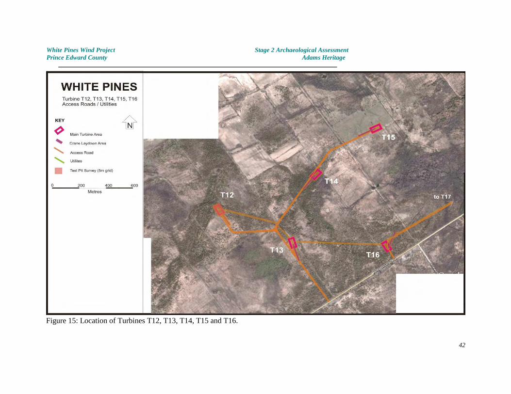
Figure 15: Location of Turbines T12, T13, T14, T15 and T16.
42
White Pines Wind Project Stage 2 Archaeological AssessmentPrince Edward County Adams Heritage
4.17 Turbine Location T17, Road and Utilities
LocationTurbine T17 is located just north of Army Reserve Road, between Dainard and LighthallRoads (Figures 4 & 16). It lies immediately east of T16, in close proximity to an extensivearea of poor drainage which, while shown as a creek on some maps, has no navigable orreliable course.
EnvironmentThe proposed impact area is extremely poorly drained with standing water and small rivuletsin many locations. As with the other turbine locations in the eastern section of the broadstudy area, soils are extremely thin, consisting of gravelly silty loam overlying bedrock.
The study area is covered with stunted cedars, prickly ash, dogwood and small ash trees. Soils are extremely thin or missing entirely in this area. Gravel is present at the groundsurface.
Archaeological PotentialThe archaeological potential of this area is extremely low.
Archaeological TestingThe proposed turbine and laydown areas had been flagged to facilitate the archaeologicalassessment. Despite to low archaeological potential and the high water table an attemptwas made to test the whole area using a 5 metre test pit interval. Only those areas whichwere waterlogged were omitted. They were too pervasive and irregular to warrant mapping.
ResultsNo evidence of archaeological sites was identified. No artifacts were found.
Photographs - see Plates 59-62
43
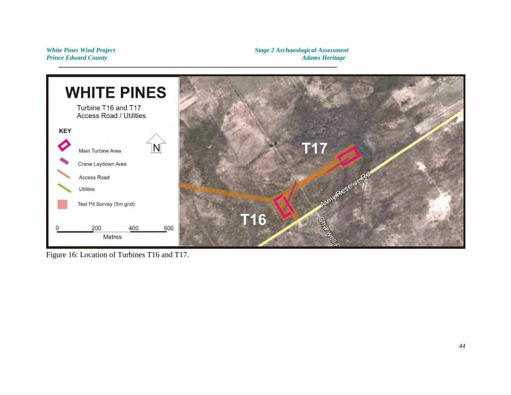
White Pines Wind Project Stage 2 Archaeological AssessmentPrince Edward County Adams Heritage
Figure 16: Location of Turbines T16 and T17.
44
White Pines Wind Project Stage 2 Archaeological AssessmentPrince Edward County Adams Heritage
4.18 Turbine Location T18, Road and Utilities
LocationTurbine T18 is located south of Hilltop Road, between Duetta and Brewer’s Roads (Figures 4& 17). A new road will be used to connect T18 to T19 and T20.
EnvironmentThe proposed impact area is situated on a flat limestone plain, thinly covered with gravellyclay loam soil. It lies in an area of old pasture land which has been abandoned foragricultural use and which is now covered with stunted cedars and prickly ash.
The water table is particularly high throughout most of this portion of the study area.
Archaeological PotentialThe archaeological potential of this area is low.
Archaeological TestingThe turbine and laydown areas had been flagged to facilitate the archaeological assessment. These were subject to test pit survey. The access road from T18 through T19 to T20 wasalso tested.
ResultsNo evidence of archaeological sites was identified. No artifacts were found.
Photographs - see Plates 63-66
45
White Pines Wind Project Stage 2 Archaeological AssessmentPrince Edward County Adams Heritage
4.19 Turbine Location T19, Road and Utilities
LocationTurbine R19 is located west of Brewer’s Road and south of Hilltop Road, between locationsT18 and T20 (Figures 4 & 17). A new road will be used extending south from Hilltop Road toT19 then east and west to the turbine and laydown areas of T18 and T20.
EnvironmentThe proposed impact area is situated on a level section of a flat limestone plain. Thisportion of the study area has mixed drainage with portions of land with a high water table. As with the other turbine locations in the eastern section of the broad study area, soils areextremely thin, consisting of gravelly clay loam overlying bedrock.
The study area is covered with rough pasture grass and stunted cedars, prickly ash andsmall ash trees. Soils are extremely thin or missing entirely in this area. Gravel is present atthe ground surface. This area supports a sparse forest of stunted cedars.
Archaeological PotentialThe archaeological potential of this area is generally low.
Archaeological TestingThe proposed turbine and laydown areas had been staked to facilitate the archaeologicalassessment. Despite to generally low archaeological potential and the high water tableencountered in some areas, the whole area was tested using a 5 metre test pit interval.
ResultsNo evidence of archaeological sites was identified. No artifacts were found.
Photographs - see Plates 67,68
46
White Pines Wind Project Stage 2 Archaeological AssessmentPrince Edward County Adams Heritage
4.20 Turbine Location T20, Road and Utilities
LocationTurbine T20 is located just west of Brewer’s Road and south of Hilltop Road (Figures 4 & 17). Although a new road will be used extending south from Hilltop Road to T19 then east to theturbine and laydown areas of T18 (see above), access was gained from Brewer’s Road.
EnvironmentThe proposed impact area is situated on a level section of a flat limestone plain. Thisportion of the study area has mixed drainage with portions of land with a high water table. As with the other turbine locations in the eastern section of the broad study area, soils areextremely thin, consisting of gravelly clay loam overlying bedrock.
The study area is covered with rough pasture grass and stunted cedars, prickly ash andsmall ash trees. A low gravel ridge lies along the southeastern edge of the study area. Soilsare extremely thin or missing entirely in this area. Gravel is present at the ground surface. This area supports a sparse forest of stunted cedars.
Archaeological PotentialThe archaeological potential of this area is generally low. The only habitable area occursalong the gravel ridge and this is unlikely to have been sought out for settlement and use.
Archaeological TestingThe proposed turbine and laydown areas had been staked to facilitate the archaeologicalassessment. Despite to generally low archaeological potential and the high water tableencountered in some areas, the whole area was tested using a 5 metre test pit interval.
ResultsNo evidence of archaeological sites was identified. No artifacts were found.
Photographs - see Plates 69,70
47
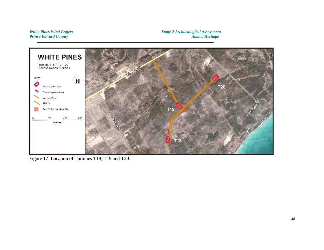
White Pines Wind Project Stage 2 Archaeological AssessmentPrince Edward County Adams Heritage
Figure 17: Location of Turbines T18, T19 and T20.
48
White Pines Wind Project Stage 2 Archaeological AssessmentPrince Edward County Adams Heritage
4.21 Turbine Location T21, Road and Utilities
LocationTurbine T21 is located west of Helmer Road and south of Hilltop Road (Figures 4 & 18). Anew road will be used extending southeast from Hilltop Road to the turbine and laydownareas then continuing at a slight angle to turbine T22.
EnvironmentThe proposed impact area is situated on a low lying section of a flat limestone plain. Thisportion of the study area is poorly drained and was wet throughout. Lands closest to HilltopRoad consist of a well drained cow pasture with gravelly clay loam soil overlying bedrock.
Although the water table is high in the central portion of the study area, the lands at eitherend are better drained that some of the other turbine locations in the immediate vicinity. Vegetation consists of a thin grass cover between stunted cedars. The road passes througha cow pasture where the cedar trees are reasonably sparse. The extreme southeastern endof the proposed turbine and laydown areas and the road connecting T21 and T22 occupies awell drained terrace with some cedars.
Archaeological PotentialThe archaeological potential of this area is generally low. The areas of level, drier pasture ateach end of the road access to T21, and between T21 and T22 have a low to moderatearchaeological potential based on the observation that unlike many portions of the studyarea, they are at least habitable.
Archaeological TestingThe access road had been staked and the proposed turbine and laydown areas had beenflagged to facilitate the archaeological assessment. These were subject to test pit survey inthe areas where ground conditions (water table, presence of rock at or near the surface)permitted.
ResultsNo evidence of archaeological sites was identified. No artifacts were found.
Photographs - see Plates 71-74
49
White Pines Wind Project Stage 2 Archaeological AssessmentPrince Edward County Adams Heritage
4.22 Turbine Location T22, Road and Utilities
LocationTurbine T22 is located west of Helmer Road and south of Hilltop Road (Figures 4 & 18). Anew road will be used extending southeast from Helmer Road to the turbine and laydownareas, then continuing northwest to turbine T21 (see above) and Hilltop Road.
EnvironmentThe proposed impact area is situated on a flat limestone plain, thinly covered with gravellyclay loam soil. The gravel in the soil matrix is the upper portion of the limestone bedrock,which lies less than 40 centimetres below the ground surface (and often less).
The majority of the study area is moderately well drained. Vegetation consists of a thingrass cover between stunted cedars. From Helmer Road, the road passes through a cowpasture with some cedar trees. In the vicinity of the proposed turbine and laydown areas,the cedar bush is much more dense.
Archaeological PotentialThe archaeological potential of this area is low.
Archaeological TestingThe access road had been staked and the proposed turbine and laydown areas had beenflagged to facilitate the archaeological assessment. All areas were subject to test pit surveyexcept for the few small areas where ground conditions (water table, presence of rock at ornear the surface) prevented effective testing.
ResultsNo evidence of archaeological sites was identified. No artifacts were found.
Photographs - see Plates 75, 76
50
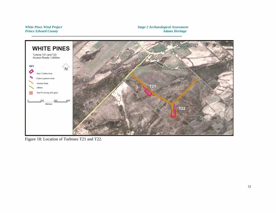
White Pines Wind Project Stage 2 Archaeological AssessmentPrince Edward County Adams Heritage
Figure 18: Location of Turbines T21 and T22.
51
White Pines Wind Project Stage 2 Archaeological AssessmentPrince Edward County Adams Heritage
4.23 Turbine Location T23, Road and Utilities
LocationTurbine T23 is located just to the southeast of the corner of Helmer Road near an unadoptedroad allowance near the southern coast of Prince Edward County (Figures 4 & 19). Theexisting farm road along the road allowance will be used for access to the turbine andlaydown areas.
EnvironmentThe proposed impact area is situated within a flat limestone plain, thinly covered withgravelly clay loam soil. The gravel in the soil matrix is the upper portion of the limestonebedrock, which lies less than 40 centimetres below the ground surface (and often less).
The water table is high throughout most of this portion of the study area. Vegetation islimited to a thin grass cover between stands of prickly ash. Dwarf cedar trees are present onthe few drier areas.
Archaeological PotentialThe archaeological potential of this area is low.
Archaeological TestingThe turbine and laydown areas had been flagged to facilitate the archaeological assessment. These were subject to test pit survey wherever ground conditions (water table, presence ofrock at or near the surface) permitted.
ResultsNo evidence of archaeological sites was identified. No artifacts were found.
Photographs - see Plates 77-79
52
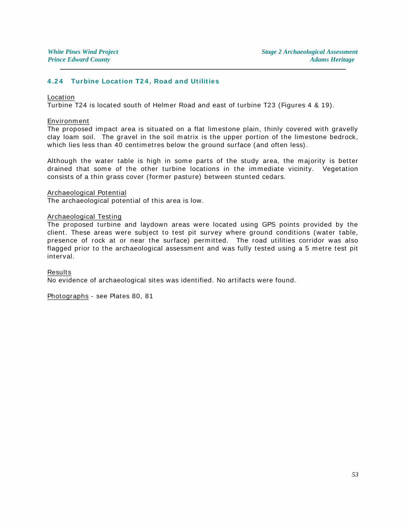
White Pines Wind Project Stage 2 Archaeological AssessmentPrince Edward County Adams Heritage
4.24 Turbine Location T24, Road and Utilities
LocationTurbine T24 is located south of Helmer Road and east of turbine T23 (Figures 4 & 19).
EnvironmentThe proposed impact area is situated on a flat limestone plain, thinly covered with gravellyclay loam soil. The gravel in the soil matrix is the upper portion of the limestone bedrock,which lies less than 40 centimetres below the ground surface (and often less).
Although the water table is high in some parts of the study area, the majority is betterdrained that some of the other turbine locations in the immediate vicinity. Vegetationconsists of a thin grass cover (former pasture) between stunted cedars.
Archaeological PotentialThe archaeological potential of this area is low.
Archaeological TestingThe proposed turbine and laydown areas were located using GPS points provided by theclient. These areas were subject to test pit survey where ground conditions (water table,presence of rock at or near the surface) permitted. The road utilities corridor was alsoflagged prior to the archaeological assessment and was fully tested using a 5 metre test pitinterval.
ResultsNo evidence of archaeological sites was identified. No artifacts were found.
Photographs - see Plates 80, 81
53
White Pines Wind Project Stage 2 Archaeological AssessmentPrince Edward County Adams Heritage
Figure 19: Location of Turbines T23 and T24.
54
White Pines Wind Project Stage 2 Archaeological AssessmentPrince Edward County Adams Heritage
4.25 Turbine Location T25, Road and Utilities
LocationTurbine T25 is located to the west of Whattam’s Road, between Babylon and County Road 13(Figures 4 & 20).
EnvironmentThe proposed impact area is situated on a flat pasture land, covered with clay loam soil. Theimpact area extends through a forested field boundary and into a former field which,because of poor drainage has been abandoned and has become overgrown.
Archaeological PotentialThe archaeological potential of this area is low. It lies distant from any features ofarchaeological potential which might have induced past human settlement or use.
Archaeological TestingThe proposed turbine, laydown areas, roadway and utilities line had been surveyed andstaked prior to the archaeological assessment. These areas were all subject to test pit surveyand fully tested using a 5 metre test pit interval.
ResultsNo evidence of archaeological sites was identified. No artifacts were found.
Photographs - see Plates 82, 83
55
White Pines Wind Project Stage 2 Archaeological AssessmentPrince Edward County Adams Heritage
4.26 Turbine Location T26, Road and Utilities
LocationTurbine T26 is located to the north of Babylon Road and east of Whattams Road (Figures 4 &20). A new access road alignment will be used for access to the turbine and laydown areas,extending north from Babylon Road. This then joins an existing track from which has beenscraped to bedrock to provide a firm base of the roadway. The last leg of the road traversespoorly drained terrain.
EnvironmentThe proposed impact area is situated within a flat limestone plain, thinly covered withgravelly clay loam soil. The gravel in the soil matrix is the upper portion of the limestonebedrock, which lies less than 40 centimetres below the ground surface (and often less).
The water table is high throughout most of this portion of the study area. Vegetation islimited to a thin pasture grass cover between stands of prickly ash and stunted ash trees.Dwarf cedar trees are present on the few drier areas.
Between Babylon Road and the existing farm track, the access road traverses an areacontaining some low gravel ridges, virtually devoid of soil but supporting a thin stand ofstunted cedar trees. Areas of poor drainage exist between the gravel ridges.
Archaeological PotentialThe archaeological potential of this area is low.
Archaeological TestingThe turbine, laydown areas and road / utilities corridor had been flagged and staked tofacilitate the archaeological assessment. These were subject to test pit survey whereverground conditions (water table, presence of rock at or near the surface) permitted.
ResultsNo evidence of archaeological sites was identified. No artifacts were found.
Photographs - see Plates 84a, 84b, 85, 86
56
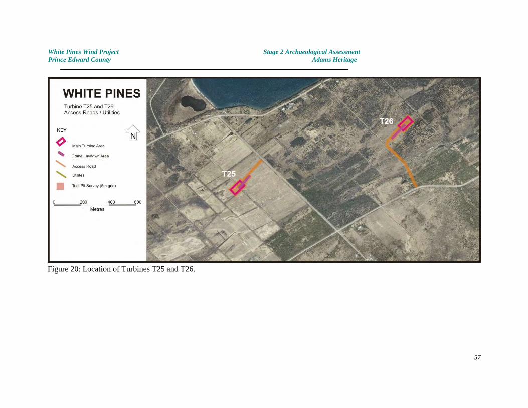
White Pines Wind Project Stage 2 Archaeological AssessmentPrince Edward County Adams Heritage
Figure 20: Location of Turbines T25 and T26.
57
White Pines Wind Project Stage 2 Archaeological AssessmentPrince Edward County Adams Heritage
4.27 Turbine Location T27, Road and Utilities
LocationTurbine T27 is located just to the south of Babylon Road, east of Whattam’s Road and northof Gravelly Bay Road, approximately 1 kilometre from the southern coast of Prince EdwardCounty (Figures 4 & 21). A new road will be used for access to the turbine and laydownareas. It shares the first part of this road with proposed Turbines T28 and T29 and will beconnected to T28 by a road / utilities corridor.
EnvironmentThe proposed impact area is situated within a flat limestone plain, thinly covered withgravelly clay loam soil. The gravel in the soil matrix is the upper portion of the limestonebedrock, which lies less than 40 centimetres below the ground surface (and often less).
The water table is high throughout most of this portion of the study area. Over most of thearea vegetation consists of thin grass cover punctuated by low cedar trees and stands ofprickly ash. Some small oak and ash trees are also present along an old fence line.
Archaeological PotentialThe archaeological potential of this area is low.
Archaeological TestingThe turbine, laydown areas and road / utilities corridor had been flagged to facilitate thearchaeological assessment. Since the area to affected by the proposed Turbine installation atT27 was slightly drier than those encountered at T28 and T29, it proved possible to testvirtually the whole area. Testing was conducted by test pit survey using a 5 metre gridinterval.
ResultsNo evidence of archaeological sites was identified. No artifacts were found.
Photographs - see Plates 87, 88
58
White Pines Wind Project Stage 2 Archaeological AssessmentPrince Edward County Adams Heritage
4.28 Turbine Location T28, Road and Utilities
LocationTurbine T28 is located south of Babylon Road, north of Gravelly Bay Road and east ofWhattam’s Road (Figures 4 & 21). A new road will be used for access to the turbine andlaydown areas. The first portion of this road is shared with T27 and T29. Some maps of thestudy area indicate the presence of a creek in the vicinity of the proposed turbine location. This is a misinterpretation of reality. The whole area is low lying and acts as a seasonalcatch basin which drains south into Gravelly Bay without benefit of a well defined channel.
EnvironmentThe proposed impact area is situated within a flat limestone plain, thinly covered withgravelly clay loam soil. The gravel in the soil matrix is the upper portion of the limestonebedrock, which lies less than 40 centimetres below the ground surface (and often less).
The water table is particularly high throughout most of this portion of the study area. Vegetation is limited to a thin grass cover between stands of ash and prickly ash.
Archaeological PotentialThe archaeological potential of this area is low.
Archaeological TestingThe turbine and laydown areas had been flagged to facilitate the archaeological assessment. These were subject to test pit survey in the few areas where ground conditions (water table,presence of rock at or near the surface) permitted.
The access road and part of the study area had been cleared of vegetation with the intentionof providing a better access for the archaeological assessment. Unfortunately, because ofthe shallow soils this had resulted in some disturbance to the ground surface. These areaswere all carefully examined for any evidence of archaeological materials. None were located.
ResultsNo evidence of archaeological sites was identified. No artifacts were found.
Photographs - see Plates 89, 90
59
White Pines Wind Project Stage 2 Archaeological AssessmentPrince Edward County Adams Heritage
4.29 Turbine Location T29, Road and Utilities
LocationTurbine T29 is located south of Babylon Road, north of Gravelly Bay Road and east ofWhattam’s Road (Figures 4 & 21). A new road will be used for access to the turbine andlaydown areas. Some maps of the study area indicate the presence of a creek in the vicinityof the proposed turbine location. This is a misinterpretation of reality. The whole area islow lying and acts as a seasonal catch basin which drains south into Gravelly Bay withoutbenefit of a well defined channel.
EnvironmentThe proposed impact area is situated within a flat limestone plain, thinly covered withgravelly clay loam soil. The gravel in the soil matrix is the upper portion of the limestonebedrock, which lies less than 40 centimetres below the ground surface (and often less).
The water table is particularly high throughout most of this portion of the study area. Vegetation is limited to a thin grass cover between stands of ash and prickly ash.
Archaeological PotentialThe archaeological potential of this area is low.
Archaeological TestingThe turbine and laydown areas had been flagged to facilitate the archaeological assessment. These were subject to test pit survey in the few areas where ground conditions (water table,presence of rock at or near the surface) permitted.
The access road and part of the study area had been cleared of vegetation with the intentionof providing a better access for the archaeological assessment. Unfortunately, because ofthe shallow soils this had resulted in some disturbance to the ground surface. These areaswere all carefully examined for any evidence of archaeological materials. None were located.
ResultsNo evidence of archaeological sites was identified. No artifacts were found.
Photographs - see Plates 91-93
60
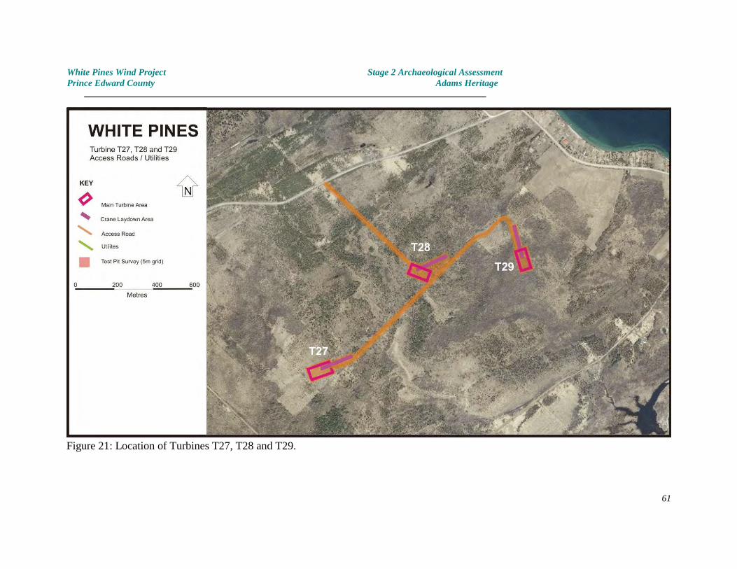
White Pines Wind Project Stage 2 Archaeological AssessmentPrince Edward County Adams Heritage
Figure 21: Location of Turbines T27, T28 and T29.
61
White Pines Wind Project Stage 2 Archaeological AssessmentPrince Edward County Adams Heritage
4.30 Infrastructure - Connector system along Roads, Turning Areas
The previous section described the archaeological testing of the proposed turbine areas,laydown areas, roads and utilities lines which will be constructed on private land or alongexisting unadopted road allowances.
In order to distribute power generated by the wind turbines, a system of electrical connectorlines will also be constructed. These will lie within the existing road allowances along theroads which connect the various turbine areas (Figure 4).
Furthermore, because of the size of the wind turbines, some small additional areas were alsoassessed at abrupt corners and proposed truck turn areas.
This section describes the archaeological testing associated with these portions of the WhitePines Wind Project. Because of the nature of the extensive disturbances along the roadallowances, Stage 2 test pit excavation was only conducted wherever practical (ie. where soildeposits still existed) as per Standard 2.1.8 (MTC 2011). Please refer to the Images sectionfor additional documentation.
4.30.1 Babylon Road, Whattams Road, Helmer Road
A transmission line route is proposed within the Babylon Road road allowance, extendingfrom the access road to turbines T27, T28 and T29 as far west as the access road to turbineT22. A short section of line will also traverse Whattam’s Road, extending south from turbineT25.
The land traversed by this proposed utilities route consists of very shallow soils lying directlyon bedrock. For virtually the whole route, modern ditching has removed all vestiges oftopsoil, exposing bedrock for the full width of the road allowance. Archaeological testingwas conducted wherever practical.
A single archaeological site AlGg-25 was discovered by Stantec near where Babylon Roadintersects with Helmer Road (Stantec 2011a: Figure 4-1). No evidence was discovered toindicate that archaeological remains from this historic dwelling site extend in to the roadallowance. The lands at the junction of the two roads have been heavily disturbed by roadconstruction.
No evidence of archaeological sites was encountered. No artifacts were recovered.
see Plates 94-96
62
White Pines Wind Project Stage 2 Archaeological AssessmentPrince Edward County Adams Heritage
4.30.2 Hilltop Road and Brewers Road
The proposed utilities corridor will be placed along the Hilltop Road and Brewers Road roadallowances. Along Hilltop Road, recent ditching within the road allowance has removed allarchaeological potential, along with any soils which once existed above bedrock. AlongBrewers Road ditching has had a less comprehensive impact. Testing was completedwherever practical.
see Plates 97,98
4.30.3 Dainard Road and Royal Road
The west side of Dainard Road has a broad, shallow ditch which has removed or significantlydisturbed soils down to bedrock in most areas. The few remaining undisturbed areas weretested for archaeological sites. None were identified.
The proposed utilities route will occur within the road allowances of Royal Road as far asDainard Road and the access to Turbines T12 to T17. As with so many other road sides inthis portion of Prince Edward County, ditching and road maintenance has disturbed much ofthe road allowance. Testing occurred where past ditching hadn’t obviously removed allarchaeological potential.
see Plates 99, 100
4.30.4 Walmsley and Bond Roads
The proposed utilities connector system will traverse parts of Walmsley and Bond Roadswithin the road allowance. Testing was conducted wherever native soils were present andditching, road maintenance and other disturbances had not removed archaeologicalpotential.
see Plates 101, 102
4.30.5 County Road 10 and turn areas
Between Royal Road and proposed Turbine T06, the proposed collector system will follow theexisting road allowance north. Disturbances associated with the construction and expansionof County Road 10, and revisions to the intersection with Royal Road have virtuallyeliminated archaeological potential in this area. Testing was conducted wherever anyundisturbed soils were present. In addition, a small section of land to the north of CountyRoad 10, comprising approximately 0.3Ha. was tested within the adjacent cow pasture. Thisarea will be used as a turn-around area for vehicles. Because of the extreme shallowness ofsoils over bedrock, this area has remained as pasture and is not cultivated. The whole area
63
White Pines Wind Project Stage 2 Archaeological AssessmentPrince Edward County Adams Heritage
was test pitted using a five metre grid interval. No evidence of archaeological sites wasnoted.Lands within the road allowance at the intersection of Royal Road and County Road 10 werealso tested, since manipulation of vehicles may require an expansion of the roadway in thisarea. No archaeological sites were discovered.
see Plates 103-105
4.30.6 Maypul Layn Road (Royal Road to Bond Road)
Part of the proposed collector system will utilize the road allowance along Maypul Layn Roadbetween Royal Road and Bond Road. Maypul Layn Road passes through farm fields andsome small areas of bush. The road bed is at, or slightly above the level of the surroundingground, except in one small area where the soil has been scraped to bedrock. Portions ofthe road allowance exist as uncultivated land bordering the road bed. These areas werehand tested using a five metre grid test interval. The sections of woodlot adjacent to theroad bed were also tested using test pit survey. The portions of the road allowance whichhave been incorporated into the cultivated areas of the adjacent fields were subject tosurface survey using a 5 metre transect interval. Where ditching and/ other disturbanceshad limited archaeological potential, testing was completed wherever practical.
see Plates 106-108
4.31 Substation - Gorsline Road
Although part of the same FIT project, this work was conducted under PIF # P003-329-2011since it was added to the project at a later stage and the Stage 1 archaeological assessmentconducted for the main turbines area by Stantec (Stantec 2011) had not considered thisportion of Prince Edward County. Stage 1 background research pertinent to this portion ofthe project has been included in section 2.0 of this report.
The proposed substation at Gorsline Road lies on agricultural land on the north side ofGorsline Road, almost opposite the Hydro One Networks Inc. installation. The study areaconsists of a rectangular substation area and an access road connecting to Gorsline Road,comprising 0.7Ha. It lies adjacent to an existing Hydro transmission line. The propertyforms part of a low rise consisting of Darlington Loam soils; a stony, till derived calcareoussoil with good drainage which is easily tillable and suitable for a variety of crops (Richardsand Morwick 1948: 29).
At the time of the archaeological assessment the subject property had been ploughed,disked and well washed by rain. It was in perfect condition for archaeological surfacesurvey. Survey was undertaken by examining the surface of the field using a 5 metresurvey transect. The subject area and a 10 metre buffer area surrounding the proposedimpact area were assessed.
No archaeological sites were encountered and no artifacts were recovered. Please refer toPlates 109 and 110 for photographs of the project area.
64
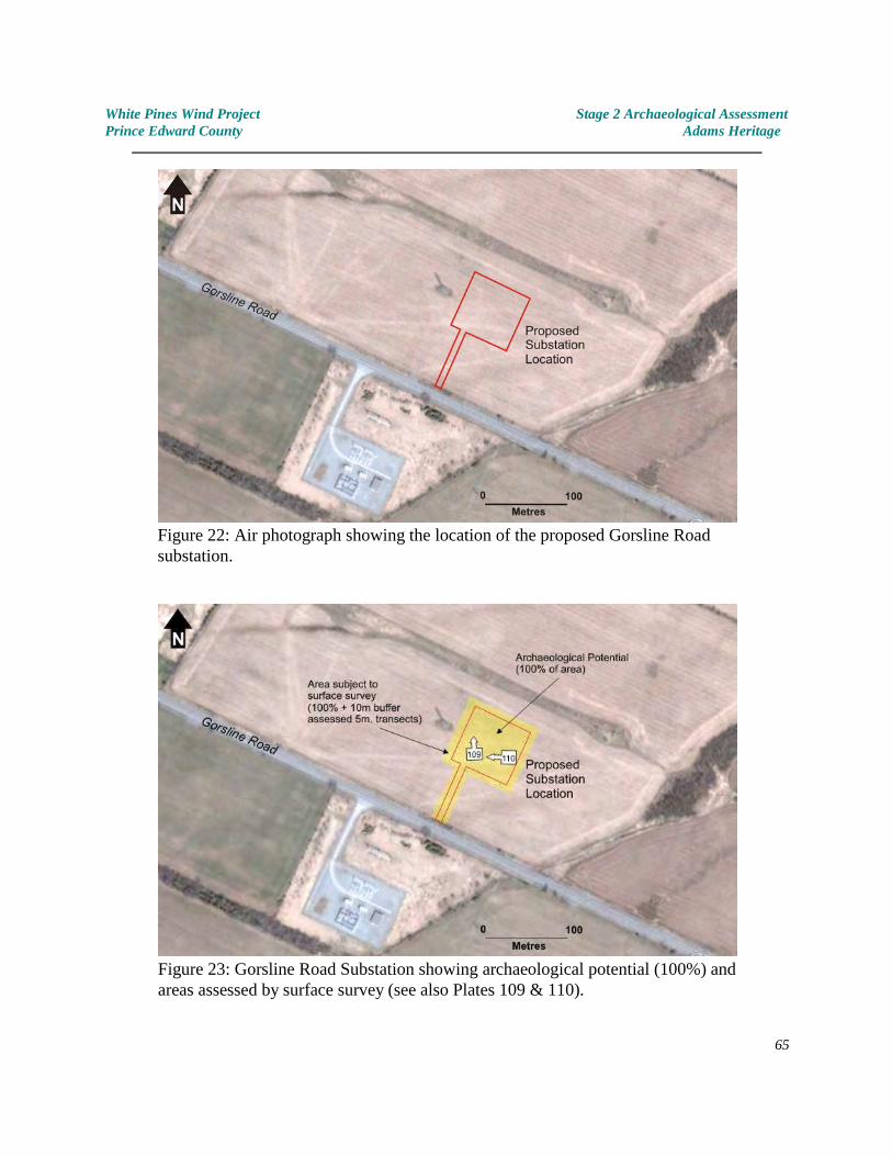
White Pines Wind Project Stage 2 Archaeological AssessmentPrince Edward County Adams Heritage
Figure 22: Air photograph showing the location of the proposed Gorsline Roadsubstation.
Figure 23: Gorsline Road Substation showing archaeological potential (100%) andareas assessed by surface survey (see also Plates 109 & 110).
65
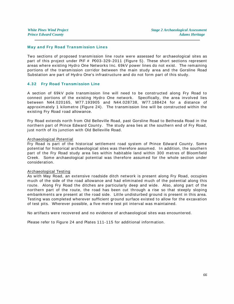
White Pines Wind Project Stage 2 Archaeological AssessmentPrince Edward County Adams Heritage
May and Fry Road Transmission Lines
Two sections of proposed transmission line route were assessed for archaeological sites aspart of this project under PIF # P003-329-2011 (Figure 5). These short sections representareas where existing Hydro One Networks Inc. 69kV power lines do not exist. The remainingportions of the transmission corridor between the main study area and the Gorsline RoadSubstation are part of Hydro One’s infrastructure and do not form part of this study.
4.32 Fry Road Transmission Line
A section of 69kV pole transmission line will need to be constructed along Fry Road toconnect portions of the existing Hydro One network. Specifically, the area involved liesbetween N44.020165, W77.193905 and N44.028738, W77.188424 for a distance ofapproximately 1 kilometre (Figure 24). The transmission line will be constructed within theexisting Fry Road road allowance.
Fry Road extends north from Old Belleville Road, past Gorsline Road to Bethesda Road in thenorthern part of Prince Edward County. The study area lies at the southern end of Fry Road,just north of its junction with Old Belleville Road.
Archaeological PotentialFry Road is part of the historical settlement road system of Prince Edward County. Somepotential for historical archaeological sites was therefore assumed. In addition, the southernpart of the Fry Road study area lies within habitable land within 300 metres of BloomfieldCreek. Some archaeological potential was therefore assumed for the whole section underconsideration.
Archaeological TestingAs with May Road, an extensive roadside ditch network is present along Fry Road, occupiesmuch of the side of the road allowance and had eliminated much of the potential along thisroute. Along Fry Road the ditches are particularly deep and wide. Also, along part of the northern part of the route, the road has been cut through a rise so that steeply slopingembankments are present at the road side. Little undisturbed ground is present in this area. Testing was completed wherever sufficient ground surface existed to allow for the excavationof test pits. Wherever possible, a five metre test pit interval was maintained.
No artifacts were recovered and no evidence of archaeological sites was encountered.
Please refer to Figure 24 and Plates 111-115 for additional information.
66
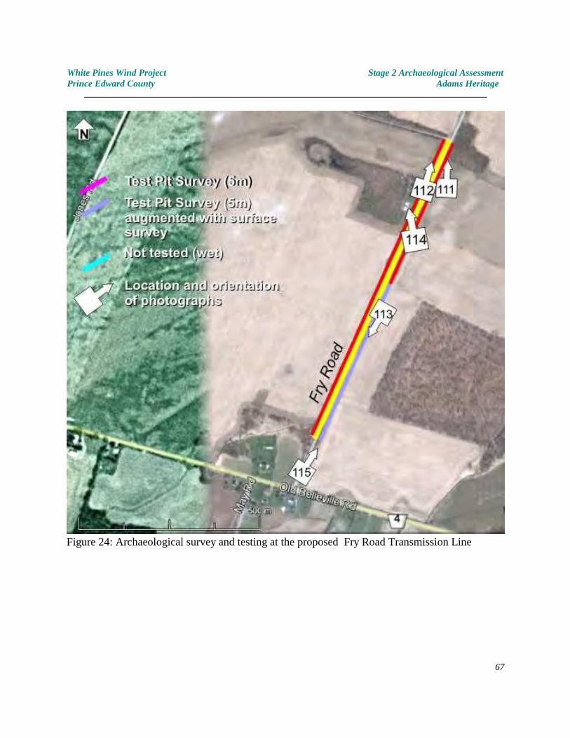
White Pines Wind Project Stage 2 Archaeological AssessmentPrince Edward County Adams Heritage
Figure 24: Archaeological survey and testing at the proposed Fry Road Transmission Line
67
White Pines Wind Project Stage 2 Archaeological AssessmentPrince Edward County Adams Heritage
4.33 May Road Transmission Line
A section of 69kV pole transmission line will need to be constructed along May Road toconnect portions of the existing Hydro One network. Specifically, the area involved liesbetween N44.008227, W77.199755 and N44.013819, W77.197728 for a distance ofapproximately 750 metres (Figure 25). The transmission line will be constructed within theexisting May Road road allowance.
May Road lies between County Road 13 and the Old Belleville Road, about 3.5 kilometreswest of Picton.
Archaeological PotentialSince May Road is part of the early system of settlement roads in Prince Edward County,some archaeological potential for historic sites was therefore assumed. It also passesthrough habitable land, parts of which lie less than 300 metres from Bloomfield Creek. Archaeological potential for pre-contact sites was also assumed.
Archaeological Testing Archaeological testing was conducted wherever prior disturbances such as ditching, roaddown-cutting and existing driveways / farm entrances had not resulted in complete orsubstantial disturbance to lands within the road allowance. Since the precise route of theproposed transmission line had not been determined at the time of the assessment, bothsides of the road allowance were assessed and tested.
As with many other parts of Prince Edward County, extensive ditching had occurred alongthis portion of May Road, resulting in disturbances to the natural ground surface. Inaddition, linear embankments consisting of stones from field clearing were present along theeast side of part of the route which made comprehensive testing awkward, though notimpossible. Nevertheless, both sides of the road allowance were tested using a 5 metre testpit interval as far as prevailing conditions permitted.
No artifacts were recovered and no evidence of archaeological sites was encountered.
Please refer to Figure 25 and Plates 116-118 for additional information.
68
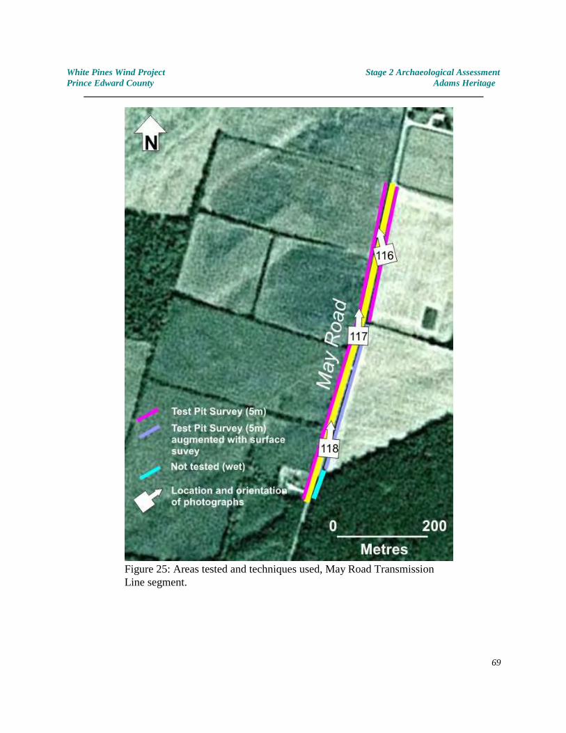
White Pines Wind Project Stage 2 Archaeological AssessmentPrince Edward County Adams Heritage
Figure 25: Areas tested and techniques used, May Road TransmissionLine segment.
69
White Pines Wind Project Stage 2 Archaeological AssessmentPrince Edward County Adams Heritage
5.0 RECORD OF FINDS
No archaeological sites were discovered. No artifacts were recovered.
6.0 RESULTS AND CONCLUSIONS
Comprehensive testing of all areas to be affected by the proposed White Pines Wind Projectwas conducted by an experienced archaeological team. Although many of the areas affectedhave low real-world archaeological potential, all areas were tested using techniquesappropriate to the situation and in accordance with the Ministry of Tourism and Culture’s“Standards and Guidelines for Archaeological Consultants 2011" (MTC 2011).
Where appropriate, the impact areas were ploughed and allowed to weather beforearchaeological surface survey was completed (usually on more than one occasion). Whereploughing could not be completed, test pit survey techniques were employed. As per theministry’s Standards and Guidelines, test pits were approximately 30 centimetres indiameter and excavated through the topsoil and into the upper few centimetres of subsoil -although it should be noted that subsoil was absent over a large proportion of the studyarea, with bedrock underlying the topsoil in many areas. Soils from test pits were siftedthrough 6mm hardware cloth screen and scrutinized for any evidence of cultural activity.
Where comprehensive test pit survey could not be completed (ie. within road allowanceswhere ditching had removed or extensively removed all soils, and in areas of poor drainage)testing was completed as conditions would allow, in accordance with MTC standard 2.1.8(MTC 2011).
7.0 RECOMMENDATIONS
1. Since no archaeological sites were identified on any of the properties affectedby this project, it is recommended that the Ministry of Tourism, Culture andSport provide a letter of concurrence indicating that its concerns forarchaeological heritage as defined in the Ontario Heritage Act, R.S.O. 1990 c.0.18 have been met.
2. That if during the process of development additional (deeply buried /
undetected) archaeological remains be uncovered, the proponent shouldimmediately notify the Archaeology Section of the Ontario Ministry of Tourism.Culture and Sport (416) 314-7132.
3. In the event that human remains are encountered during construction, theproponent should immediately contact both MTCS, and the Registrar orDeputy Registrar of the Cemeteries Regulation Unit of the Ministry ofConsumer Services, (416) 326-8393.
70
White Pines Wind Project Stage 2 Archaeological AssessmentPrince Edward County Adams Heritage
8.0 BIBLIOGRAPHY (Sources Consulted, other cited as footnotes in the text)
Anderson, T.W., Mathewes, R.W., and C.E. Schweger1989 Holocene climatic trends in Canada with special reference to the Hypsithermal
interval; in Chapter 7 of Quaternary Geology of Canada and Greenland. R.J.Fulton (ed.); Geological Survey of Canada, Geology of Canada, no. 1 (also GeologicalSociety of America, The Geology of North America,v K-1).
Chapman, L.J., and Putnam, D.F.1984 The Physiography of Southern Ontario. 3rd ed.
Ontario Ministry of Natural Resources. Toronto, Ontario.
Ellis, C.J. and Neal Ferris,1990 The Archaeology of Southern Ontario to A.D. 1650. Occasional Publication of
the London Chapter of the Ontario Archaeological Society. Number 5. London.
Esler, James G.1993 Archaeological Survey of Prince Edward County, September - November 1993.
Report prepared under archaeological licence 93-052.
Harris, R. Cole (ed.) and Geoffrey J. Matthews1987 Historical Atlas of Canada Volume I: From the Beginning to 1800. University
of Toronto Press. Toronto.
Jackson 2011 Stage 1 and 2 Archaeological Assessment of the Scotts Mill Bridge Reconstruction
Project, Lot 26, Concession 1, Marysburg Township, Prince Edward County, Ontario
Mason, Ronald1980 Great Lakes Archaeology. Academic Press
MCZCR1997 Conserving Ontario’s Archaeological Heritage: An Educational Primer and
Comprehensive Guide for Non-Specialists. Ministry of Citizenship, Culture andRecreation, Cultural Programs Branch, Archaeology & Heritage Planning Unit.
MTC2011 Standards and Guidelines for Archaeological Consultants. Queens Printer for Ontario,
Toronto.
Richards N.R. and F.F. Morwick1948 Soil Survey of Prince Edward County. Report No. 10 of the Ontario Soil Survey.
Experimental Farm Service, Dominion Department of Agriculture and the OntarioAgricultural College. Guelph.
71
White Pines Wind Project Stage 2 Archaeological AssessmentPrince Edward County Adams Heritage
Sanford, B.V. and A.J. Baer,1971 Map 1335 A, Southern Ontario, 1:1,000,000 Geological Atlas Sheet 30S, Geological
Survey of Canada.
Spence, Michael W, and Robert H. Pihl1984 "The Early and Middle Woodland Occupations of Southern Ontario: Past, Present, and
Future Research." in Arch Notes, March/ April, 1984.
Stantec,2011a Stage 2 Archaeological Assessment, Ostrander Point Wind Energy Park, Prince Edward
County, ON. Report prepared for Gilead Power Corporation.
2011b Stage 1 Archaeological Assessment, White Pines Wind Project, Prince Edward County,Ontario. Draft report prepared for wpd-Canada Corporation under licence P005-210-2010.
Swayze, K.1976 Inventory of Prince Edward County. Conservation Archaeology Report. Ontario
Ministry of Culture and Recreation. Historical Planning and Research Branch. Toronto.
1973 Archaeological research in Prince Edward County: January to March 1973. Report onFile. Ministry of Culture and Communications. Toronto.
Trigger, Bruce (editor)1978 Handbook of North American Indians, Vol 15, Northeast. Smithsonian Institution,
Washington.1979 "Sixteenth Century Ontario: History, Ethnohistory and Archaeology" in Ontario
History LXXI, pp. 205-223.
9.0 MAPS
Included in the body of the report as appropriate.
10.0 IMAGES
See following pages.
Stage 2 Archaeological Report Additions and Modifications
Adams Heritage
Dated: June 20, 2012
ADAMS HERITAGE3783 Maple Crest Court,
RR#1 Inverary, Ontario K0H 1X0Phone (613) 353 1463 Fax (613) 353 1463
email: [email protected]
Stage 2 Archaeological AssessmentWhite Pines Wind Project
and Stage 1 and 2 White Pines Wind Project -
Transmission Line and Substation
Additions and Modifications Prince Edward County, Ontario
Prepared for:
wpd Canada Corporation 2233 Argentia Road, Unit 102
Mississauga, ON L5N 2X7 Tel: (905) 813-8400 Fax: (905) 813-7487
contact: Khlaire Parré, Dir. of Renewable Energy Approvals&
The Ontario Ministry of Tourism and Culture
Licensee: Nick Adams MAReport Prepared by: Nick Adams
report type: RevisedJune 20, 2012
PIF # P003 CIF# P003-338-2012 associated relevant project numbers:
PIF# P003-327-2011 (ST2 FIT F-000675-WIN-130-601) andPIF # P003-329-2011 (Stage 1 and 2 FIT - F-000675-WIN-130-601)
Approval Authority:Regulatory Process: The Environmental Assessment Act
Supplementary Documentation: T15, T29 Access Road Descriptions
“I the undersigned hereby declare that, to the best of my knowledge, the information in thisreport and submitted in support of this report is complete and accurate in every way, and Iam aware of the penalties against providing false information under section 69 of theOntario Heritage Act.”
Stage 2 Archaeological AssessmentProposed White Pines Wind Project
and Stage 1 & 2 Transmission Line and SubstationAdditions and Modifications Prince Edward County, Ontario
Licensee: Nick Adams MA
Prepared by: Nick Adams
Date: June 20, 2012
PIF # P003 CIF# P003-338-2012 associated relevant project numbers:
PIF# P003-327-2011 (ST2 FIT F-000675-WIN-130-601) andPIF # P003-329-2011 (Stage 1 and 2 FIT - F-000675-WIN-130-601)
report type: Revised
ADAMS HERITAGE3783 Maple Crest Court,
Inverary, Ontario K0H 1X0Phone / Fax (613) 353-1463email: [email protected]
White Pines Wind Project - Additions and Modifications Stage 2 Archaeological AssessmentPrince Edward County Adams Heritage
EXECUTIVE SUMMARY AND RECOMMENDATIONS
White Pines Project BackgroundBetween October and December 2011, Adams Heritage conducted a Stage 2 archaeologicalassessment of lands with the potential to be affected by the proposed White Pines WindProject (ST2 FIT F-000675-WIN-130-601), primarily within the Townships of Athol andSouth Marysburgh, Prince Edward County, Ontario. This work was conducted underarchaeological licence / PIF P003-327-2011 granted to Nick Adams by the Ministry ofTourism and Culture and under contract to wpd Canada Corporation (hereafter - wpd1
Canada) in advance of a Renewable Energy Approval application. Concurrently with thiswork a related Stage 1 and 2 archaeological assessment was also conducted of sections of aproposed power transmission line along May and Fry Roads and a substation at GorslineRoad, north of Picton. This work was conducted under archaeological licence / PIF P003-329-2011.
At the time of the Stage 2 archaeological assessment, Stantec Consulting Ltd. (Stantec)were in the final stages of report completion of a Stage 1 archaeological assessment underarchaeological licence / PIF CIF # P002-205-2010, a draft of which was made available toAdams Heritage. Stantec’s Stage 1 assessment indicated that while only two prehistoricarchaeological sites, a single prehistoric findspot and a 19 century domestic archaeologicalth
site had been registered within the study area, that virtually the whole study area had somearchaeological potential. Specifically they reported that:
“Based on the results of the assessment, the entire Study Area has been identified ashaving elevated archaeological potential. Given the elevated potential for bothpre-contact and historic period resources it is recommended that the Study Areaundergo Stage 2 Archaeological Assessment prior to the commencement of anyconstruction activities. Stage 2 Archaeological Assessment should occur within zonesof elevated archaeological potential for the location of any Project relatedinfrastructure construction, including all turbine pads, access roads, undergroundcable links, construction offices, laydowns and temporary storage areas and anyother areas where soil disturbances into the below the topsoil may occur.” (Stantec2011b: i).
Accordingly, Stage 2 archaeological assessment was conducted on all lands where there wasthe likelihood that project development could affect the integrity of the ground surface andpotentially disturb or destroy archaeological sites. No evidence of archaeological sites wasencountered during the Stage 2 archaeological assessment. A Letter of Review andAcceptance into the Provincial Register of Reports, as provided for in Section 65.1 of theOntario Heritage Act, was requested and provided by the ministry (MTC RIMS NumberHD00676 - February 6 2012).th
The Ministry regulating the practice of archaeology in Ontario has had many names over the past decades:1
Ministry of Culture and Recreation, Ministry of Tourism and Culture, Ministry of Tourism, Culture and Recreation,Ministry of Tourism, Culture and Sport (current).
White Pines Wind Project - Additions and Modifications Stage 2 Archaeological AssessmentPrince Edward County Adams Heritage
White Pines Project - Current Work At the request of wpd Canada, a number of small changes and additions to the existingproject were investigated for their potential impact on archaeological resources. Specificallythese included minor shifts in the proposed turbine footprint, a proposed storage area, and aslight expansion of a proposed sub-station footprint. The locations of these additional areasand the archaeological work conducted at each location is documented in this report.
In addition two areas were investigated as possible road access routes. Since both havebeen eliminated from the wpd Canada project, they are reported in Supplementarydocumentation.
Archaeological field testing was conducted under ideal conditions by essentially the sameteam that conducted the initial study. All work was conducted in accordance with theMinistry of Tourism, Culture and Sport’s “Standards and Guidelines for ConsultantArchaeologists (2011)”.
No evidence of archaeological sites was encountered within any of the areas investigated. Itis therefore recommended that clearance of any archaeological conditions affecting theseadditional portions of the White Pines Wind Project be provided. A Letter of Review andAcceptance into the Provincial Register of Reports, as provided for in Section 65.1 of theOntario Heritage Act, is requested.
Project PersonnelProject Archaeologist / Field Director: Nick AdamsReport Author and Preparation: Nick AdamsField Technicians: Doug Kirk, Steve Errington, Chris
Cadue, John ErringtonDates of Field Testing
April 25 , 26 , 27 2012th th th
Weather ConditionsVaried: Generally fine, cool, dry
Permission for AccessProvide by the landowners through wpd Canada
First Nations MonitoringTracy Yeo, Aboriginal Archaeological Liaison, Williams Treaty First Nations,
Alderville First Nation. April 26 , 27 2012th th
White Pines Wind Project - Additions and Modifications Stage 2 Archaeological AssessmentPrince Edward County Adams Heritage
Advice on compliance with legislation
1. Advice on compliance with legislation is not part of the archaeological record.However, for the benefit of the proponent and approval authority in the land useplanning and development process, the report must include the following standardstatements:
a. This report is submitted to the Minister of Tourism and Culture as a condition oflicensing in accordance with Part VI of the Ontario Heritage Act, R.S.O. 1990, c 0.18. Thereport is reviewed to ensure that it complies with the standards and guidelines that areissued by the Minister, and that the archaeological fieldwork and report recommendationsensure the conservation, protection and preservation of the cultural heritage of Ontario.When all matters relating to archaeological sites within the project area of a developmentproposal have been addressed to the satisfaction of the Ministry of Tourism and Culture,a letter will be issued by the ministry stating that there are no further concerns withregard to alterations to archaeological sites by the proposed development.
b. It is an offence under Sections 48 and 69 of the Ontario Heritage Act for any partyother than a licensed archaeologist to make any alteration to a known archaeological siteor to remove any artifact or other physical evidence of past human use or activity fromthe site, until such time as a licensed archaeologist has completed archaeologicalfieldwork on the site, submitted a report to the Minister stating that the site has nofurther cultural heritage value or interest , and the report has been filed in the OntarioPublic Register of Archaeology Reports referred to inSection 65.1 of the Ontario Heritage Act.
c. Should previously undocumented archaeological resources be discovered, they may bea new archaeological site and therefore subject to Section 48 (1) of the Ontario HeritageAct. The proponent or person discovering the archaeological resources must ceasealteration of the site immediately and engage a licensed consultant archaeologist to carryout archaeological fieldwork, in compliance with Section 48 (1) of the Ontario HeritageAct.
d. The Cemeteries Act, R.S.O. 1990 c. C.4 and the Funeral, Burial and CremationServices Act, 2002, S.O. 2002, c.33 (when proclaimed in force) require that any persondiscovering human remains must notify the police or coroner and the Registrar ofCemeteries at the Ministry ofConsumer Services.
2. Reports recommending further archaeological fieldwork or protection for one or morearchaeological sites must include the following standard statement:
“Archaeological sites recommended for further archaeological fieldwork or protectionremain subject to Section 48 (1) of the Ontario Heritage Act and may not be altered, orhave artifacts removed from them, except by a person holding an archaeological licence.”
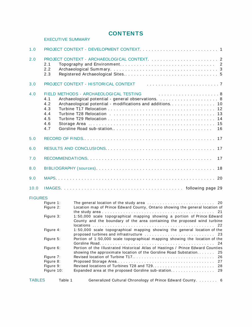
CONTENTSEXECUTIVE SUMMARY
1.0 PROJECT CONTEXT - DEVELOPMENT CONTEXT. . . . . . . . . . . . . . . . . . . . . . . . . . . 1
2.0 PROJECT CONTEXT - ARCHAEOLOGICAL CONTEXT. . . . . . . . . . . . . . . . . . . . . . . . 22.1 Topography and Environment. . . . . . . . . . . . . . . . . . . . . . . . . . . . . . . . . 22.2 Archaeological Summary. . . . . . . . . . . . . . . . . . . . . . . . . . . . . . . . . . . . . 32.3 Registered Archaeological Sites.. . . . . . . . . . . . . . . . . . . . . . . . . . . . . . . . 5
3.0 PROJECT CONTEXT - HISTORICAL CONTEXT . . . . . . . . . . . . . . . . . . . . . . . . . 7
4.0 FIELD METHODS - ARCHAEOLOGICAL TESTING . . . . . . . . . . . . . . . . . . . . . 84.1 Archaeological potential - general observations. . . . . . . . . . . . . . . . . . . . . 84.2 Archaeological potential - modifications and additions. . . . . . . . . . . . . . . . 104.3 Turbine T17 Relocation . . . . . . . . . . . . . . . . . . . . . . . . . . . . . . . . . . . . . 124.4 Turbine T28 Relocation . . . . . . . . . . . . . . . . . . . . . . . . . . . . . . . . . . . . 134.5 Turbine T29 Relocation . . . . . . . . . . . . . . . . . . . . . . . . . . . . . . . . . . . . . 144.6 Storage Area .. . . . . . . . . . . . . . . . . . . . . . . . . . . . . . . . . . . . . . . . . . . 154.7 Gorsline Road sub-station.. . . . . . . . . . . . . . . . . . . . . . . . . . . . . . . . . . 16
5.0 RECORD OF FINDS.. . . . . . . . . . . . . . . . . . . . . . . . . . . . . . . . . . . . . . . . . . . . . 17
6.0 RESULTS AND CONCLUSIONS. . . . . . . . . . . . . . . . . . . . . . . . . . . . . . . . . . . . . . 17
7.0 RECOMMENDATIONS. . . . . . . . . . . . . . . . . . . . . . . . . . . . . . . . . . . . . . . . . . . 17
8.0 BIBLIOGRAPHY (sources). . . . . . . . . . . . . . . . . . . . . . . . . . . . . . . . . . . . . . . . . 18
9.0 MAPS. . . . . . . . . . . . . . . . . . . . . . . . . . . . . . . . . . . . . . . . . . . . . . . . . . . . . . . 20
10.0 IMAGES. . . . . . . . . . . . . . . . . . . . . . . . . . . . . . . . . . . . . . . . . . following page 29
FIGURESFigure 1: The general location of the study area . . . . . . . . . . . . . . . . . . . . . . . . . . 20Figure 2: Location map of Prince Edward County, Ontario showing the general location of
the study area . . . . . . . . . . . . . . . . . . . . . . . . . . . . . . . . . . . . . . . . . . . 21Figure 3: 1:50,000 scale topographical mapping showing a portion of Prince Edward
County and the boundary of the area containing the proposed wind turbinelocations . . . . . . . . . . . . . . . . . . . . . . . . . . . . . . . . . . . . . . . . . . . . . . . 22
Figure 4: 1:50,000 scale topographical mapping showing the general location of theproposed turbines and infrastructure . . . . . . . . . . . . . . . . . . . . . . . . . . . 23
Figure 5: Portion of 1:50,000 scale topographical mapping showing the location of theGorsline Road. . . . . . . . . . . . . . . . . . . . . . . . . . . . . . . . . . . . . . . . . . . . 24
Figure 6: Portion of the Illustrated Historical Atlas of Hastings / Prince Edward Countiesshowing the approximate location of the Gorsline Road Substation. . . . . . . 25
Figure 7: Revised location of Turbine T17.. . . . . . . . . . . . . . . . . . . . . . . . . . . . . . . 26Figure 8: Proposed Storage Area.. . . . . . . . . . . . . . . . . . . . . . . . . . . . . . . . . . . . . 27Figure 9: Revised locations of Turbines T28 and T29. . . . . . . . . . . . . . . . . . . . . . . . 28Figure 10: Expanded area at the proposed Gorsline sub-station. . . . . . . . . . . . . . . . . 29
TABLES Table 1 Generalized Cultural Chronology of Prince Edward County. . . . . . . . 6
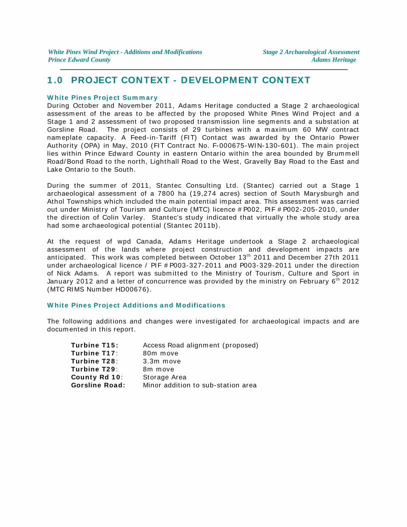
White Pines Wind Project - Additions and Modifications Stage 2 Archaeological AssessmentPrince Edward County Adams Heritage
1.0 PROJECT CONTEXT - DEVELOPMENT CONTEXT
White Pines Project SummaryDuring October and November 2011, Adams Heritage conducted a Stage 2 archaeologicalassessment of the areas to be affected by the proposed White Pines Wind Project and aStage 1 and 2 assessment of two proposed transmission line segments and a substation atGorsline Road. The project consists of 29 turbines with a maximum 60 MW contractnameplate capacity. A Feed-in-Tariff (FIT) Contact was awarded by the Ontario PowerAuthority (OPA) in May, 2010 (FIT Contract No. F-000675-WIN-130-601). The main projectlies within Prince Edward County in eastern Ontario within the area bounded by BrummellRoad/Bond Road to the north, Lighthall Road to the West, Gravelly Bay Road to the East andLake Ontario to the South.
During the summer of 2011, Stantec Consulting Ltd. (Stantec) carried out a Stage 1archaeological assessment of a 7800 ha (19,274 acres) section of South Marysburgh andAthol Townships which included the main potential impact area. This assessment was carriedout under Ministry of Tourism and Culture (MTC) licence #P002, PIF #P002-205-2010, underthe direction of Colin Varley. Stantec’s study indicated that virtually the whole study areahad some archaeological potential (Stantec 2011b).
At the request of wpd Canada, Adams Heritage undertook a Stage 2 archaeologicalassessment of the lands where project construction and development impacts areanticipated. This work was completed between October 13 2011 and December 27th 2011th
under archaeological licence / PIF #P003-327-2011 and P003-329-2011 under the directionof Nick Adams. A report was submitted to the Ministry of Tourism, Culture and Sport inJanuary 2012 and a letter of concurrence was provided by the ministry on February 6 2012th
(MTC RIMS Number HD00676).
White Pines Project Additions and Modifications
The following additions and changes were investigated for archaeological impacts and aredocumented in this report.
Turbine T15: Access Road alignment (proposed)Turbine T17: 80m move Turbine T28: 3.3m moveTurbine T29: 8m moveCounty Rd 10: Storage AreaGorsline Road: Minor addition to sub-station area
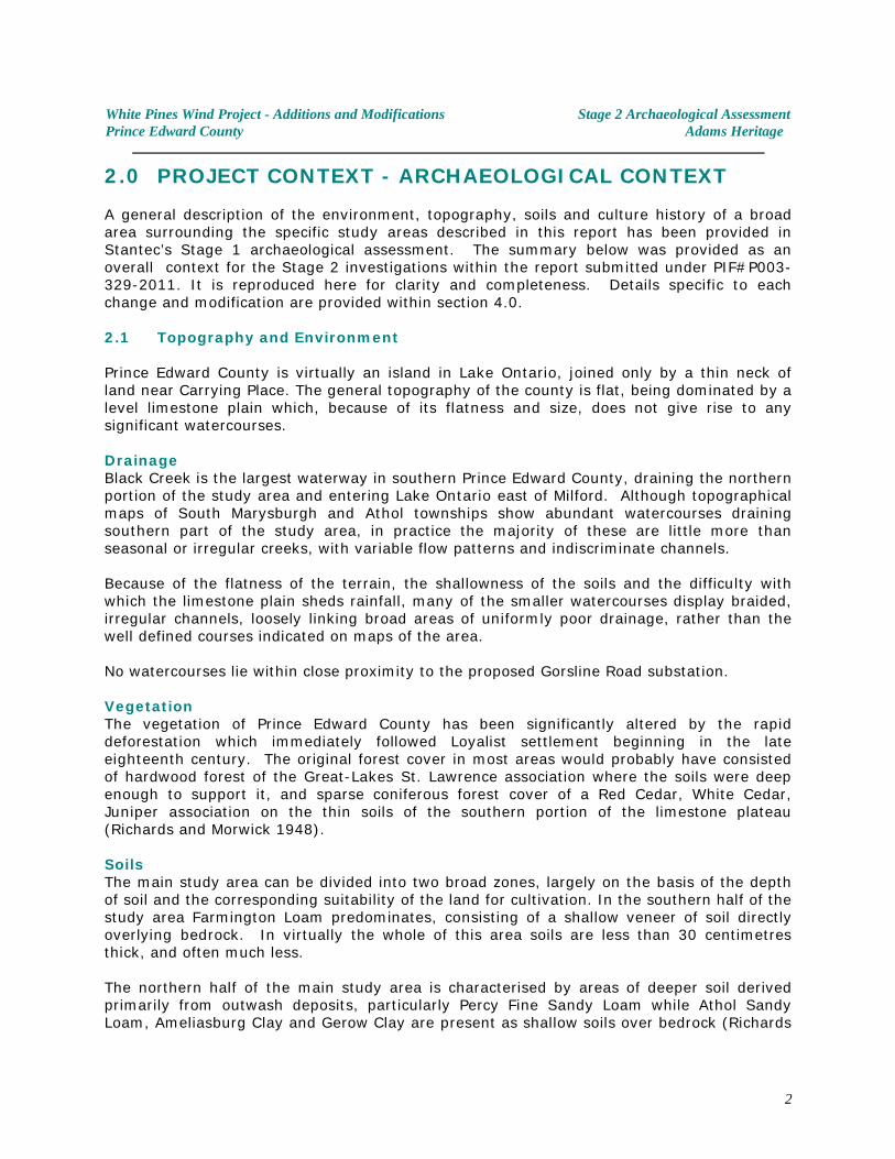
White Pines Wind Project - Additions and Modifications Stage 2 Archaeological AssessmentPrince Edward County Adams Heritage
2.0 PROJECT CONTEXT - ARCHAEOLOGICAL CONTEXT
A general description of the environment, topography, soils and culture history of a broadarea surrounding the specific study areas described in this report has been provided inStantec’s Stage 1 archaeological assessment. The summary below was provided as anoverall context for the Stage 2 investigations within the report submitted under PIF#P003-329-2011. It is reproduced here for clarity and completeness. Details specific to eachchange and modification are provided within section 4.0.
2.1 Topography and Environment
Prince Edward County is virtually an island in Lake Ontario, joined only by a thin neck ofland near Carrying Place. The general topography of the county is flat, being dominated by alevel limestone plain which, because of its flatness and size, does not give rise to anysignificant watercourses.
DrainageBlack Creek is the largest waterway in southern Prince Edward County, draining the northernportion of the study area and entering Lake Ontario east of Milford. Although topographicalmaps of South Marysburgh and Athol townships show abundant watercourses drainingsouthern part of the study area, in practice the majority of these are little more thanseasonal or irregular creeks, with variable flow patterns and indiscriminate channels.
Because of the flatness of the terrain, the shallowness of the soils and the difficulty withwhich the limestone plain sheds rainfall, many of the smaller watercourses display braided,irregular channels, loosely linking broad areas of uniformly poor drainage, rather than thewell defined courses indicated on maps of the area.
No watercourses lie within close proximity to the proposed Gorsline Road substation.
VegetationThe vegetation of Prince Edward County has been significantly altered by the rapiddeforestation which immediately followed Loyalist settlement beginning in the lateeighteenth century. The original forest cover in most areas would probably have consistedof hardwood forest of the Great-Lakes St. Lawrence association where the soils were deepenough to support it, and sparse coniferous forest cover of a Red Cedar, White Cedar,Juniper association on the thin soils of the southern portion of the limestone plateau(Richards and Morwick 1948).
SoilsThe main study area can be divided into two broad zones, largely on the basis of the depthof soil and the corresponding suitability of the land for cultivation. In the southern half of thestudy area Farmington Loam predominates, consisting of a shallow veneer of soil directlyoverlying bedrock. In virtually the whole of this area soils are less than 30 centimetresthick, and often much less.
The northern half of the main study area is characterised by areas of deeper soil derivedprimarily from outwash deposits, particularly Percy Fine Sandy Loam while Athol SandyLoam, Ameliasburg Clay and Gerow Clay are present as shallow soils over bedrock (Richards
2
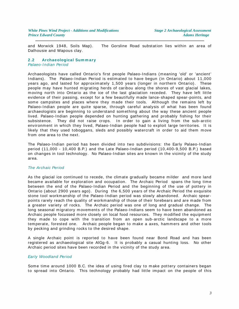
White Pines Wind Project - Additions and Modifications Stage 2 Archaeological AssessmentPrince Edward County Adams Heritage
and Morwick 1948, Soils Map). The Gorsline Road substation lies within an area ofDalhousie and Wapous clay.
2.2 Archaeological SummaryPalaeo-Indian Period
Archaeologists have called Ontario's first people Palaeo-Indians (meaning 'old' or 'ancient'Indians). The Palaeo-Indian Period is estimated to have begun (in Ontario) about 11,000years ago, and lasted for approximately 1,500 years (longer in northern Ontario). Thesepeople may have hunted migrating herds of caribou along the shores of vast glacial lakes,moving north into Ontario as the ice of the last glaciation receded. They have left littleevidence of their passing, except for a few beautifully made lance-shaped spear-points, andsome campsites and places where they made their tools. Although the remains left byPalaeo-Indian people are quite sparse, through careful analysis of what has been foundarchaeologists are beginning to understand something about the way these ancient peoplelived. Palaeo-Indian people depended on hunting gathering and probably fishing for theirsubsistence. They did not raise crops. In order to gain a living from the sub-arcticenvironment in which they lived, Palaeo-Indian people had to exploit large territories. It islikely that they used toboggans, sleds and possibly watercraft in order to aid them movefrom one area to the next.
The Palaeo-Indian period has been divided into two subdivisions: the Early Palaeo-Indianperiod (11,000 - 10,400 B.P.) and the Late Palaeo-Indian period (10,400-9,500 B.P.) basedon changes in tool technology. No Palaeo-Indian sites are known in the vicinity of the studyarea.
The Archaic Period
As the glacial ice continued to recede, the climate gradually became milder and more landbecame available for exploration and occupation. The Archaic Period spans the long timebetween the end of the Palaeo-Indian Period and the beginning of the use of pottery inOntario (about 2900 years ago). During the 6,500 years of the Archaic Period the exquisitestone tool workmanship of the Palaeo-Indian period was slowly abandoned. Archaic spear-points rarely reach the quality of workmanship of those of their forebears and are made froma greater variety of rocks. The Archaic period was one of long and gradual change. Thelong seasonal migratory movements of the Palaeo-Indians seem to have been abandoned asArchaic people focussed more closely on local food resources. They modified the equipmentthey made to cope with the transition from an open sub-arctic landscape to a moretemperate, forested one. Archaic people began to make a axes, hammers and other toolsby pecking and grinding rocks to the desired shape.
A single Archaic point is reported to have been found near Bond Road and has beenregistered as archaeological site AlGg-6. It is probably a casual hunting loss. No otherArchaic period sites have been recorded in the vicinity of the study area.
Early Woodland Period
Some time around 1000 B.C. the idea of using fired clay to make pottery containers beganto spread into Ontario. This technology probably had little impact on the people of this
3
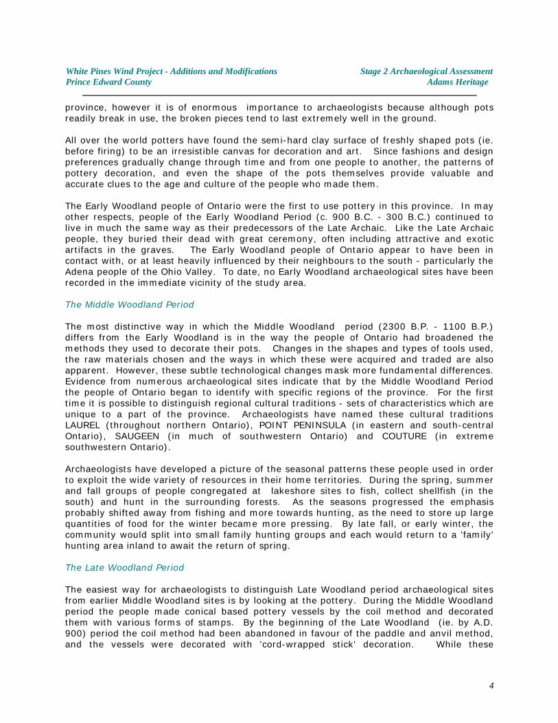
White Pines Wind Project - Additions and Modifications Stage 2 Archaeological AssessmentPrince Edward County Adams Heritage
province, however it is of enormous importance to archaeologists because although potsreadily break in use, the broken pieces tend to last extremely well in the ground.
All over the world potters have found the semi-hard clay surface of freshly shaped pots (ie.before firing) to be an irresistible canvas for decoration and art. Since fashions and designpreferences gradually change through time and from one people to another, the patterns ofpottery decoration, and even the shape of the pots themselves provide valuable andaccurate clues to the age and culture of the people who made them.
The Early Woodland people of Ontario were the first to use pottery in this province. In mayother respects, people of the Early Woodland Period (c. 900 B.C. - 300 B.C.) continued tolive in much the same way as their predecessors of the Late Archaic. Like the Late Archaicpeople, they buried their dead with great ceremony, often including attractive and exoticartifacts in the graves. The Early Woodland people of Ontario appear to have been incontact with, or at least heavily influenced by their neighbours to the south - particularly theAdena people of the Ohio Valley. To date, no Early Woodland archaeological sites have beenrecorded in the immediate vicinity of the study area.
The Middle Woodland Period
The most distinctive way in which the Middle Woodland period (2300 B.P. - 1100 B.P.)differs from the Early Woodland is in the way the people of Ontario had broadened themethods they used to decorate their pots. Changes in the shapes and types of tools used,the raw materials chosen and the ways in which these were acquired and traded are alsoapparent. However, these subtle technological changes mask more fundamental differences. Evidence from numerous archaeological sites indicate that by the Middle Woodland Periodthe people of Ontario began to identify with specific regions of the province. For the firsttime it is possible to distinguish regional cultural traditions - sets of characteristics which areunique to a part of the province. Archaeologists have named these cultural traditionsLAUREL (throughout northern Ontario), POINT PENINSULA (in eastern and south-centralOntario), SAUGEEN (in much of southwestern Ontario) and COUTURE (in extremesouthwestern Ontario).
Archaeologists have developed a picture of the seasonal patterns these people used in orderto exploit the wide variety of resources in their home territories. During the spring, summerand fall groups of people congregated at lakeshore sites to fish, collect shellfish (in thesouth) and hunt in the surrounding forests. As the seasons progressed the emphasisprobably shifted away from fishing and more towards hunting, as the need to store up largequantities of food for the winter became more pressing. By late fall, or early winter, thecommunity would split into small family hunting groups and each would return to a 'family'hunting area inland to await the return of spring. The Late Woodland Period
The easiest way for archaeologists to distinguish Late Woodland period archaeological sitesfrom earlier Middle Woodland sites is by looking at the pottery. During the Middle Woodlandperiod the people made conical based pottery vessels by the coil method and decoratedthem with various forms of stamps. By the beginning of the Late Woodland (ie. by A.D.900) period the coil method had been abandoned in favour of the paddle and anvil method,and the vessels were decorated with 'cord-wrapped stick' decoration. While these
4
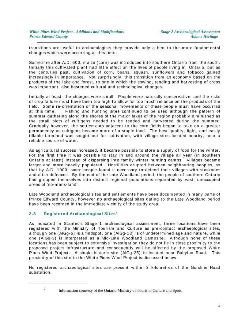
White Pines Wind Project - Additions and Modifications Stage 2 Archaeological AssessmentPrince Edward County Adams Heritage
transitions are useful to archaeologists they provide only a hint to the more fundamentalchanges which were occurring at this time.
Sometime after A.D. 500, maize (corn) was introduced into southern Ontario from the south. Initially this cultivated plant had little effect on the lives of people living in Ontario, but asthe centuries past, cultivation of corn, beans, squash, sunflowers and tobacco gainedincreasingly in importance. Not surprisingly, this transition from an economy based on theproducts of the lake and forest, to one in which the sowing, tending and harvesting of cropswas important, also hastened cultural and technological changes.
Initially at least, the changes were small. People were naturally conservative, and the risksof crop failure must have been too high to allow for too much reliance on the products of thefield. Some re-orientation of the seasonal movements of these people must have occurredat this time. Fishing and hunting sites continued to be used although the pattern ofsummer gathering along the shores of the major lakes of the region probably diminished asthe small plots of cultigens needed to be tended and harvested during the summer.Gradually however, the settlements adjacent to the corn fields began to take on a greaterpermanency as cultigens became more of a staple food. The best quality, light, and easilytillable farmland was sought out for cultivation, with village sites located nearby, near areliable source of water.
As agricultural success increased, it became possible to store a supply of food for the winter. For the first time it was possible to stay in and around the village all year (in southernOntario at least) instead of dispersing into family winter hunting camps. Villages becamelarger and more heavily populated. Hostilities erupted between neighbouring peoples, sothat by A.D. 1000, some people found it necessary to defend their villages with stockadesand ditch defences. By the end of the Late Woodland period, the people of southern Ontariohad grouped themselves into distinct regional populations separated by vast, unoccupiedareas of 'no-mans-land'.
Late Woodland archaeological sites and settlements have been documented in many parts ofPrince Edward County, however no archaeological sites dating to the Late Woodland periodhave been recorded in the immediate vicinity of the study area.
2.3 Registered Archaeological Sites2
As indicated in Stantec’s Stage 1 archaeological assessment, three locations have beenregistered with the Ministry of Tourism and Culture as pre-contact archaeological sites,although one (AlGg-6) is a findspot, one (AlGg-13) is of undetermined age and nature, whileone (AlGg-3) is interpreted as a Mid-Late Woodland Campsite. Although none of theselocations has been subject to extensive investigation they do not lie in close proximity to theproposed project infrastructure and consequently will be affected by the proposed WhitePines Wind Project. A single historic site (AlGg-25) is located near Babylon Road. Thisproximity of this site to the White Pines Wind Project is discussed below.
No registered archaeological sites are present within 3 kilometres of the Gorsline Roadsubstation.
Information courtesy of the Ontario Ministry of Tourism, Culture and Sport.2
5
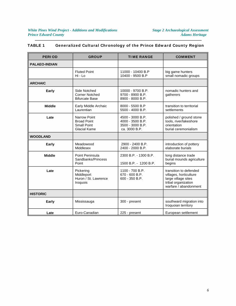
White Pines Wind Project - Additions and Modifications Stage 2 Archaeological AssessmentPrince Edward County Adams Heritage
TABLE 1 Generalized Cultural Chronology of the Prince Edward County Region
PERIOD GROUP TIME RANGE COMMENT
PALAEO-INDIAN
Fluted PointHi - Lo
11000 - 10400 B.P10400 - 9500 B.P
big game hunterssmall nomadic groups
ARCHAIC
Early Side NotchedCorner NotchedBifurcate Base
10000 - 9700 B.P.9700 - 8900 B.P.8900 - 8000 B.P.
nomadic hunters andgatherers
Middle Early Middle ArchaicLaurentian
8000 - 5500 B.P5500 - 4000 B.P.
transition to territorialsettlements
Late Narrow PointBroad PointSmall PointGlacial Kame
4500 - 3000 B.P.4000 - 3500 B.P.3500 - 3000 B.P. ca. 3000 B.P.
polished / ground stonetools, river/lakeshoreorientationburial ceremonialism
WOODLAND
Early MeadowoodMiddlesex
2900 - 2400 B.P.2400 - 2000 B.P.
introduction of potteryelaborate burials
Middle Point PeninsulaSandbanks/PrincessPoint
2300 B.P. - 1300 B.P.
1500 B.P. - 1200 B.P.
long distance tradeburial mounds agriculturebegins
Late PickeringMiddleportHuron / St. LawrenceIroquois
1100 - 700 B.P.670 - 600 B.P.600 - 350 B.P.
transition to defendedvillages, horticulturelarge village sitestribal organizationwarfare / abandonment
HISTORIC
Early Mississauga 300 - present southward migration intoIroquoian territory
Late Euro-Canadian 225 - present European settlement
6
White Pines Wind Project - Additions and Modifications Stage 2 Archaeological AssessmentPrince Edward County Adams Heritage
3.0 PROJECT CONTEXT - HISTORICAL CONTEXT
In the early years of European Colonization, Prince Edward County lay well beyond the limitsof settlement. Samuel de Champlain may have seen the county on his 1615 expedition butit was not until 1668, when French priests Trouve and Fenelon came to set up a mission atthe Cayuga village of Kente somewhere near Lake Consecon, that it came to be a part ofEuropean consciousness. The Kente mission was shortlived, and was abandoned in 1680 .3
When the British assumed control of the area in 1763, the Treaty of Paris prohibitedsettlement west of the Province of Quebec, reserving these lands for First Nations peoples .4
But when the American Revolution began, they realized that they would have to find landsto compensate Loyalists who had been expelled from the Thirteen Colonies to the south. Lands were purchased from the Mississaugas in 1783 , and subsequently, several townships5
were laid out in what is today Eastern Ontario. The area was surveyed between 1784 and1786. Initially, the peninsula was divided initially into three townships, with the lands in thestudy area being part of Marysburgh and Sophiasburgh. Hallowell township was later takenout of Marysburgh and Sophiasburgh and Marysburgh itself was divided into North andSouth Marysburgh.
As indicated in Stantec’s Stage 1 archaeological assessment of the main study area, by thelate 1800's, virtually all of the lots affected by the proposed wind turbine project had beensettled and were in active farming use. Please refer to section 3.3 and Figures 3-1 to 3-3 inStantec’s Stage 1 report (Stantec 2011b) for additional details.
As Prince Edward County grew, and the quality of some of its produce, particularly barley,became known, some of the farms, especially in the southern half of the peninsula, becamemore commercial farms. The lands which lie adjacent to May Road and Fry Road and thelocation of the Gorsline substation were part of active farmsteads during the historic period.
Examination of the 1878 Historical Atlas and Census records from 1861 show that many6 7
Prince Edward County farms were still in the hands of the original Loyalist families in the late19 century, a hundred years after the initial settlement of the area. In some instances, thisth
pattern has continued to this day.
Archives and Collections Society,“Settlers to Prince Edward County”;3
http://www.aandc.org/research/settlers/set_page2.html 11 11 2007
Tanner, Helen Hornbeck ed. Atlas of Great Lakes Indian History; Newberry Library, University of4
Oklahoma Press, 1987: pp. 54-55.
Washburn, Wilcomb E, and William C. Sturtevant Handbook of North American Indian History:5
Indian-White Relations. Vol 4. U.S. Government Printing Office 1988: p. 204
Illustrated historical atlas of the counties of Hastings and Prince Edward, Ont. Toronto : H. Belden6
& Co., 1878.
1861 Census of Canada; database and facsimiles online at 7 www.ancestry.com
7
White Pines Wind Project - Additions and Modifications Stage 2 Archaeological AssessmentPrince Edward County Adams Heritage
4.0 FIELD METHODS - ARCHAEOLOGICAL TESTING
4.1 Archaeological Potential - General observations
Stantec’s assessment of archaeological potential were made on the basis of informationderived from initial visual inspection, an evaluation of topographical map and soils mapevidence, an evaluation of known prehistoric and historic settlement patterns in the regionand determinations made in accordance with the Ministry of Tourism and Culture’s“Standards and Guidelines for Consultant Archaeologists (2011)” archaeological potentialcriteria (Stantec 2011b).
According to the criteria employed by the Ontario Ministry of Tourism and Culture todetermine archaeological potential and the ministry’s 2011 “Standards and Guidelines”,the following characteristics indicate archaeological potential:
C Previously identified archaeological sites. C Water sources. It is important to distinguish types of water and shoreline, and
to distinguish natural from artificial water sources, as these features affect site locations and types to varying degrees:
- primary water sources (lakes, rivers, streams, creeks) - secondary water sources (intermittent streams and creeks, springs, marshes, swamps) - features indicating past water sources (e.g., glacial lake shorelines indicated by the presence of raised sand or gravel beach ridges, relic river or stream channels indicated by clear dip or swale in the topography, shorelines of drained lakes or marshes, cobble beaches) - accessible or inaccessible shoreline (e.g., high bluffs, swamp or marsh fields by the edge of a lake, sandbars stretching into marsh).
C Elevated topography (e.g., eskers, drumlins, large knolls, plateaux)
C Pockets of well drained sandy soil, especially near areas of heavy soil or rocky ground
C Distinctive land formations that might have been special or spiritual places,
such as waterfalls, rock outcrops, caverns, mounds, and promontories and their bases. There may be physical indicators of their use, such as burials, structures, offerings, rock paintings or carvings.
C Resource areas, including:
food or medicinal plants (e.g., migratory routes, spawning areas, prairie), scarce raw materials (e.g., quartz, copper, ochre or outcrops of chert), early Euro Canadian industry (e.g., logging, prospecting, mining).
8
White Pines Wind Project - Additions and Modifications Stage 2 Archaeological AssessmentPrince Edward County Adams Heritage
C Areas of early Euro Canadian settlement. These include places of early military or pioneer settlement (e.g., pioneer homesteads, isolated cabins, farmstead complexes), early wharf or dock complexes, pioneer churches and early cemeteries. There may be commemorative markers of their history, such as local, provincial, or federal monuments or heritage parks.
C Early historical transportation routes (e.g., trails, passes, roads, railways, portage routes)
C Property listed on a municipal register or designated under the Ontario Heritage Act or is a federal, provincial or municipal historic landmark or site Property that local histories or informants have identified with possible archaeological sites, historical events, activities, or occupations.
MTC Standards and Guidelines forConsultant Archaeologists (2011)
In practice, during the detailed field testing for the proposed turbines, laydown areas, accessroads and service corridors, many areas were found to be devoid of archaeological potential(Adams 2011). Since the additions and modifications described in this report, for the mostpart involve minor alterations to areas already assessed, the same general conditions andobservations apply.
The following describes the archaeological potential of the proposed additions andmodifications areas, based on detailed field reconnaissance and comprehensive testing inadjacent areas.
9
White Pines Wind Project - Additions and Modifications Stage 2 Archaeological AssessmentPrince Edward County Adams Heritage
4.2 Archaeological Potential - Additions and Modifications
Turbine T17:The proposed 80m. move will affect lands with the same characteristics as the areaoriginally tested (ie. generally level, low, seasonally swampy and with poorly drainedshallow soils lying directly on bedrock). The archaeological potential of this area islow.
Turbine T28:The proposed 3.3m move of the turbine location lies within the same poorly drainedlow lying area as originally assessed in 2011. No areas of archaeological potential arepresent in this vicinity.
Turbine T29: The proposed 8m move of the turbine location lies within the same poorly drainedlow lying area as originally assessed in 2011. No areas of archaeological potential arepresent in this vicinity.
County Rd 10:The proposed Storage Area occupies approximately 0.4Ha. adjacent to County Road10. Although distant from any topographical features which might have attractedpast settlement, it does lie adjacent to an early road. For this reason, thearchaeological potential was assumed to be moderate.
Gorsline Road:The minor addition to the Gorsline Road sub-station areawill occur along the westernside of the area already assessed. Because this area lies on well drained, activelyfarmed land between the headwaters of a number of small creeks, and adjacent tothe boundary separating Sophiasburgh and Hallowell townships, it was assumed tohave moderate archaeological potential.
-------------------------------------------------------------------------------------------------------
Turbine T15 Access Route to Royal Road:At the request of wpd Canada, a potential road alignment between Turbine T15 andRoyal Road was tested for archaeological sites. Subsequently, this alignment waseliminated from the project because it traverses part of a wetland. Since thearchaeological work was completed, but does not form part of the wpd Canadaproject, it is reported in the Supplementary Documentation section.
Turbine T29 Access RouteAt the request of wpd Canada, a potential road alignment from Turbine T29 wastested for archaeological sites. Subsequently, this alignment was eliminated from theproject. Since the archaeological work was completed, but does not form part of thewpd Canada project, it is reported in the Supplementary Documentation section.
10
White Pines Wind Project - Additions and Modifications Stage 2 Archaeological AssessmentPrince Edward County Adams Heritage
In summary, although according to the MTC archaeological potential criteria much of thestudy area exhibited some theoretical potential for archaeological sites, in practice, for someareas, conditions on the ground indicated otherwise. Areas of low or extinguishedarchaeological potential consisted of:
C poorly drained level limestone plains
C level former pasture fields with shallow soils and/or poor drainage, distantfrom any other features of archaeological potential
C areas of exposed bedrock or where the upper surface of the bedrock wasthinly covered with frost shattered limestone gravel
C disturbed areas, where modern ditching and road construction had removedsoils within the road allowances or the prior placement of utilities within theroad allowance had created extensive disturbance.
Nevertheless, despite the considerations cited above, and regardless of the actualarchaeological potential identified in the field, archaeological testing was conducted for eachof the proposed impact areas as far as conditions allowed.
A detailed description of each of the proposed modifications and additions to the White PinesProject is provided below. Please refer to Figures 1 to 4 for the general location of eachstudy area.
All archaeological fieldwork was completed according to the requirements of the Ministry ofTourism, Culture and Sport’s “Standards and Guidelines for Consultant Archaeologists(2010)”. Specifically, hand dug test pits were at least 30cm in diameter and excavated atleast 5cm into subsoil (in the rare instances where subsoil existed). Soils from test pits werescreened through 6mm. hardware cloth screen. Test pits were spaced on a 5m grid basis.Where surface survey was possible, survey transects were spaced at a minimum of 5m.
11
White Pines Wind Project - Additions and Modifications Stage 2 Archaeological AssessmentPrince Edward County Adams Heritage
4.3 Turbine Location T017, 80 metre move west
LocationTurbine T17 is located just north of Army Reserve Road, between Dainard and LighthallRoads (Figures 4 & 7). It lies immediately east of T16, in close proximity to an extensivearea of poor drainage which, while shown as a creek on some maps, has no navigable orreliable course.
EnvironmentThe proposed impact area is extremely poorly drained with standing water and small rivuletsin many locations. As with the other turbine locations in the eastern section of the broadstudy area, soils are extremely thin, consisting of gravelly silty loam overlying bedrock.
The study area is covered with stunted cedars, prickly ash, dogwood and small ash trees. Soils are extremely thin or missing entirely in this area. Gravel is present at the groundsurface.
Archaeological PotentialThe archaeological potential of this area is extremely low.
Archaeological TestingThe original proposed turbine and laydown areas had been flagged to facilitate thearchaeological assessment. These were used as orientation points for the 80 metre shift tothe west of the proposed impact area. In addition wpd Canada provided GPS tracks definingthe boundaries of the proposed impact area. These were used in the field to ensurecomplete coverage of the study section. Despite to low archaeological potential and the highwater table an attempt was made to test the whole area using a 5 metre test pit interval.Only those areas which were waterlogged were omitted. They were too pervasive andirregular to warrant mapping.
ResultsNo evidence of archaeological sites was identified. No artifacts were found.
Photographs - see Plates 1 & 2
12
White Pines Wind Project - Additions and Modifications Stage 2 Archaeological AssessmentPrince Edward County Adams Heritage
4.4 Turbine Location T28
LocationTurbine T28 is located south of Babylon Road, north of Gravelly Bay Road and east ofWhattam’s Road (Figure 4). Some maps of the study area indicate the presence of a creekin the vicinity of the proposed turbine location. This is a misinterpretation of reality. Thewhole area is low lying and acts as a seasonal catch basin which drains south into GravellyBay without benefit of a well defined channel.
The proposed change involves a 3.3 metre shift in the proposed turbine location to reflectmore accurate placement of the impact zone in relation to legal survey boundaries.
EnvironmentThe proposed impact area is situated within a flat limestone plain, thinly covered withgravelly clay loam soil. The gravel in the soil matrix is the upper portion of the limestonebedrock, which lies less than 40 centimetres below the ground surface (and often less).
The water table is particularly high throughout most of this portion of the study area. Vegetation is limited to a thin grass cover between stands of ash and prickly ash.
Archaeological PotentialThe archaeological potential of this area is low.
Archaeological TestingTurbine T28 lies within an area of very low archaeological potential. The 3.3 metre shift inlocation will not affect any areas of archaeological potential. No additional testing wasconducted.
ResultsNo evidence of archaeological sites was identified. No artifacts were found.
Photographs: None recorded.
13
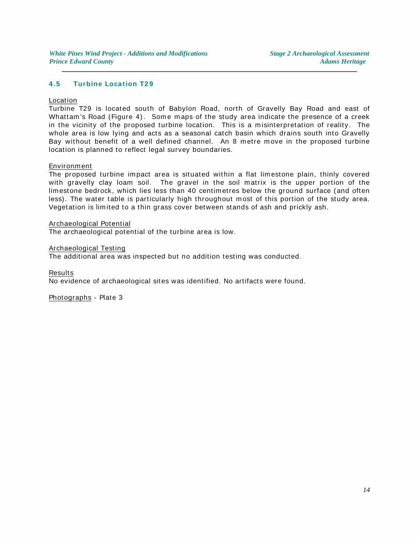
White Pines Wind Project - Additions and Modifications Stage 2 Archaeological AssessmentPrince Edward County Adams Heritage
4.5 Turbine Location T29
LocationTurbine T29 is located south of Babylon Road, north of Gravelly Bay Road and east ofWhattam’s Road (Figure 4). Some maps of the study area indicate the presence of a creekin the vicinity of the proposed turbine location. This is a misinterpretation of reality. Thewhole area is low lying and acts as a seasonal catch basin which drains south into GravellyBay without benefit of a well defined channel. An 8 metre move in the proposed turbinelocation is planned to reflect legal survey boundaries.
EnvironmentThe proposed turbine impact area is situated within a flat limestone plain, thinly coveredwith gravelly clay loam soil. The gravel in the soil matrix is the upper portion of thelimestone bedrock, which lies less than 40 centimetres below the ground surface (and oftenless). The water table is particularly high throughout most of this portion of the study area. Vegetation is limited to a thin grass cover between stands of ash and prickly ash.
Archaeological PotentialThe archaeological potential of the turbine area is low.
Archaeological TestingThe additional area was inspected but no addition testing was conducted.
ResultsNo evidence of archaeological sites was identified. No artifacts were found.
Photographs - Plate 3
14
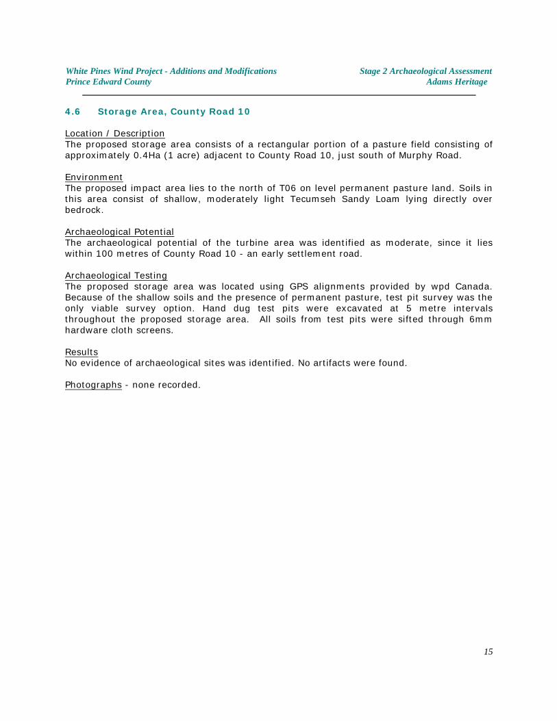
White Pines Wind Project - Additions and Modifications Stage 2 Archaeological AssessmentPrince Edward County Adams Heritage
4.6 Storage Area, County Road 10
Location / DescriptionThe proposed storage area consists of a rectangular portion of a pasture field consisting ofapproximately 0.4Ha (1 acre) adjacent to County Road 10, just south of Murphy Road.
EnvironmentThe proposed impact area lies to the north of T06 on level permanent pasture land. Soils inthis area consist of shallow, moderately light Tecumseh Sandy Loam lying directly overbedrock.
Archaeological PotentialThe archaeological potential of the turbine area was identified as moderate, since it lieswithin 100 metres of County Road 10 - an early settlement road.
Archaeological TestingThe proposed storage area was located using GPS alignments provided by wpd Canada. Because of the shallow soils and the presence of permanent pasture, test pit survey was theonly viable survey option. Hand dug test pits were excavated at 5 metre intervalsthroughout the proposed storage area. All soils from test pits were sifted through 6mmhardware cloth screens.
ResultsNo evidence of archaeological sites was identified. No artifacts were found.
Photographs - none recorded.
15
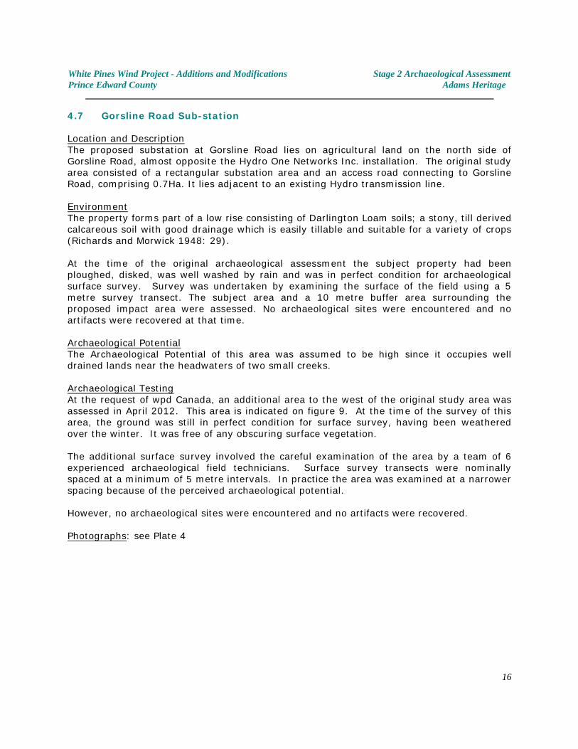
White Pines Wind Project - Additions and Modifications Stage 2 Archaeological AssessmentPrince Edward County Adams Heritage
4.7 Gorsline Road Sub-station
Location and DescriptionThe proposed substation at Gorsline Road lies on agricultural land on the north side ofGorsline Road, almost opposite the Hydro One Networks Inc. installation. The original studyarea consisted of a rectangular substation area and an access road connecting to GorslineRoad, comprising 0.7Ha. It lies adjacent to an existing Hydro transmission line.
EnvironmentThe property forms part of a low rise consisting of Darlington Loam soils; a stony, till derivedcalcareous soil with good drainage which is easily tillable and suitable for a variety of crops(Richards and Morwick 1948: 29).
At the time of the original archaeological assessment the subject property had beenploughed, disked, was well washed by rain and was in perfect condition for archaeologicalsurface survey. Survey was undertaken by examining the surface of the field using a 5metre survey transect. The subject area and a 10 metre buffer area surrounding theproposed impact area were assessed. No archaeological sites were encountered and noartifacts were recovered at that time.
Archaeological PotentialThe Archaeological Potential of this area was assumed to be high since it occupies welldrained lands near the headwaters of two small creeks.
Archaeological TestingAt the request of wpd Canada, an additional area to the west of the original study area wasassessed in April 2012. This area is indicated on figure 9. At the time of the survey of thisarea, the ground was still in perfect condition for surface survey, having been weatheredover the winter. It was free of any obscuring surface vegetation.
The additional surface survey involved the careful examination of the area by a team of 6experienced archaeological field technicians. Surface survey transects were nominallyspaced at a minimum of 5 metre intervals. In practice the area was examined at a narrowerspacing because of the perceived archaeological potential.
However, no archaeological sites were encountered and no artifacts were recovered.
Photographs: see Plate 4
16
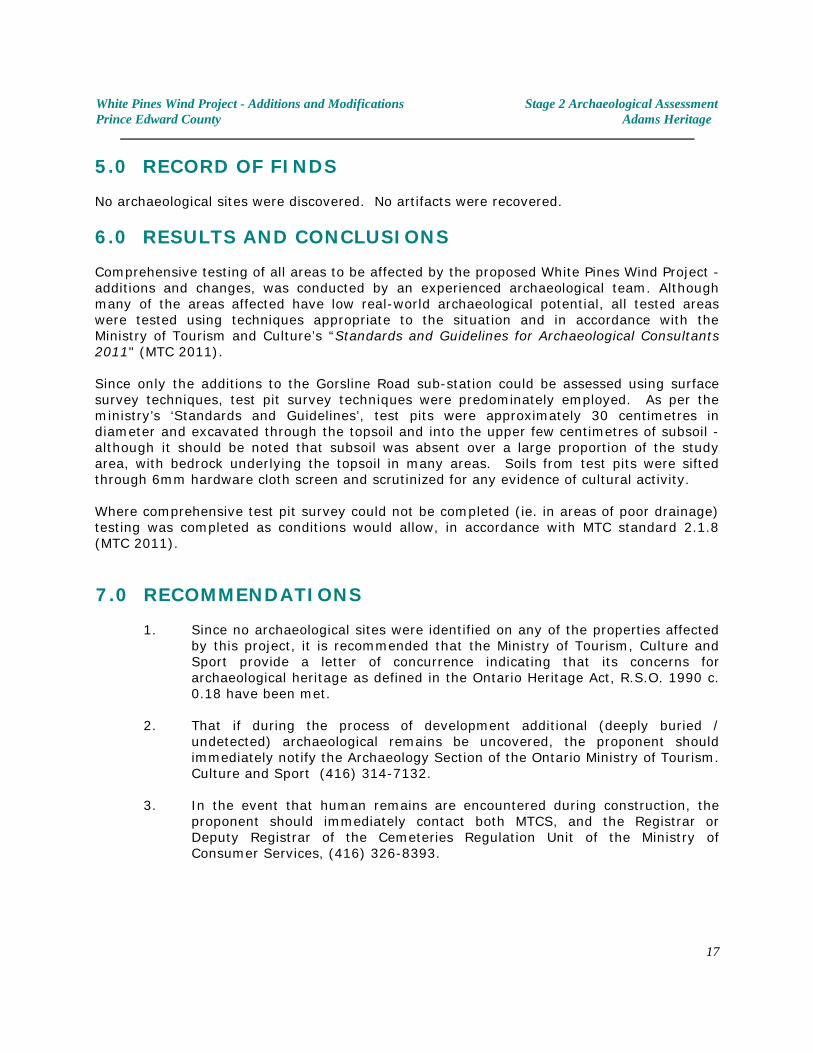
White Pines Wind Project - Additions and Modifications Stage 2 Archaeological AssessmentPrince Edward County Adams Heritage
5.0 RECORD OF FINDS
No archaeological sites were discovered. No artifacts were recovered.
6.0 RESULTS AND CONCLUSIONS
Comprehensive testing of all areas to be affected by the proposed White Pines Wind Project -additions and changes, was conducted by an experienced archaeological team. Althoughmany of the areas affected have low real-world archaeological potential, all tested areaswere tested using techniques appropriate to the situation and in accordance with theMinistry of Tourism and Culture’s “Standards and Guidelines for Archaeological Consultants2011" (MTC 2011).
Since only the additions to the Gorsline Road sub-station could be assessed using surfacesurvey techniques, test pit survey techniques were predominately employed. As per theministry’s ‘Standards and Guidelines’, test pits were approximately 30 centimetres indiameter and excavated through the topsoil and into the upper few centimetres of subsoil -although it should be noted that subsoil was absent over a large proportion of the studyarea, with bedrock underlying the topsoil in many areas. Soils from test pits were siftedthrough 6mm hardware cloth screen and scrutinized for any evidence of cultural activity.
Where comprehensive test pit survey could not be completed (ie. in areas of poor drainage)testing was completed as conditions would allow, in accordance with MTC standard 2.1.8(MTC 2011).
7.0 RECOMMENDATIONS
1. Since no archaeological sites were identified on any of the properties affectedby this project, it is recommended that the Ministry of Tourism, Culture andSport provide a letter of concurrence indicating that its concerns forarchaeological heritage as defined in the Ontario Heritage Act, R.S.O. 1990 c.0.18 have been met.
2. That if during the process of development additional (deeply buried /
undetected) archaeological remains be uncovered, the proponent shouldimmediately notify the Archaeology Section of the Ontario Ministry of Tourism.Culture and Sport (416) 314-7132.
3. In the event that human remains are encountered during construction, theproponent should immediately contact both MTCS, and the Registrar orDeputy Registrar of the Cemeteries Regulation Unit of the Ministry ofConsumer Services, (416) 326-8393.
17
White Pines Wind Project - Additions and Modifications Stage 2 Archaeological AssessmentPrince Edward County Adams Heritage
8.0 BIBLIOGRAPHY (Sources Consulted, other cited as footnotes in the text)
Adams, Nick2011 Stage 2 Archaeological Assessment of the Proposed White Pines Wind Project and
Stage 1 & 2 White Pines Wind Project Transmission Line and Substation PrinceEdward County, Ontario. Report prepared for wpd Canada Ltd. under archaeologicallicence / PIF: P003-327-2011 and P003-329-2011.
Anderson, T.W., Mathewes, R.W., and C.E. Schweger1989 Holocene climatic trends in Canada with special reference to the Hypsithermal
interval; in Chapter 7 of Quaternary Geology of Canada and Greenland. R.J.Fulton (ed.); Geological Survey of Canada, Geology of Canada, no. 1 (also GeologicalSociety of America, The Geology of North America,v K-1).
Chapman, L.J., and Putnam, D.F.1984 The Physiography of Southern Ontario. 3rd ed.
Ontario Ministry of Natural Resources. Toronto, Ontario.
Ellis, C.J. and Neal Ferris,1990 The Archaeology of Southern Ontario to A.D. 1650. Occasional Publication of
the London Chapter of the Ontario Archaeological Society. Number 5. London.
Esler, James G.1993 Archaeological Survey of Prince Edward County, September - November 1993.
Report prepared under archaeological licence 93-052.
Harris, R. Cole (ed.) and Geoffrey J. Matthews1987 Historical Atlas of Canada Volume I: From the Beginning to 1800. University
of Toronto Press. Toronto.
Jackson 2011 Stage 1 and 2 Archaeological Assessment of the Scotts Mill Bridge Reconstruction
Project, Lot 26, Concession 1, Marysburg Township, Prince Edward County, Ontario
Mason, Ronald1980 Great Lakes Archaeology. Academic Press
MCZCR1997 Conserving Ontario’s Archaeological Heritage: An Educational Primer and
Comprehensive Guide for Non-Specialists. Ministry of Citizenship, Culture andRecreation, Cultural Programs Branch, Archaeology & Heritage Planning Unit.
MTC2011 Standards and Guidelines for Archaeological Consultants. Queens Printer for Ontario,
Toronto.
18
White Pines Wind Project - Additions and Modifications Stage 2 Archaeological AssessmentPrince Edward County Adams Heritage
Richards N.R. and F.F. Morwick1948 Soil Survey of Prince Edward County. Report No. 10 of the Ontario Soil Survey.
Experimental Farm Service, Dominion Department of Agriculture and the OntarioAgricultural College. Guelph.
Sanford, B.V. and A.J. Baer,1971 Map 1335 A, Southern Ontario, 1:1,000,000 Geological Atlas Sheet 30S, Geological
Survey of Canada.
Spence, Michael W, and Robert H. Pihl1984 "The Early and Middle Woodland Occupations of Southern Ontario: Past, Present, and
Future Research." in Arch Notes, March/ April, 1984.
Stantec,2011a Stage 2 Archaeological Assessment, Ostrander Point Wind Energy Park, Prince Edward
County, ON. Report prepared for Gilead Power Corporation.
2011b Stage 1 Archaeological Assessment, White Pines Wind Project, Prince Edward County,Ontario. Draft report prepared for wpd-Canada Corporation under licence P005-210-2010.
Swayze, K.1976 Inventory of Prince Edward County. Conservation Archaeology Report. Ontario
Ministry of Culture and Recreation. Historical Planning and Research Branch. Toronto.
1973 Archaeological research in Prince Edward County: January to March 1973. Report onFile. Ministry of Culture and Communications. Toronto.
Trigger, Bruce (editor)1978 Handbook of North American Indians, Vol 15, Northeast. Smithsonian Institution,
Washington.1979 "Sixteenth Century Ontario: History, Ethnohistory and Archaeology" in Ontario
History LXXI, pp. 205-223.
19
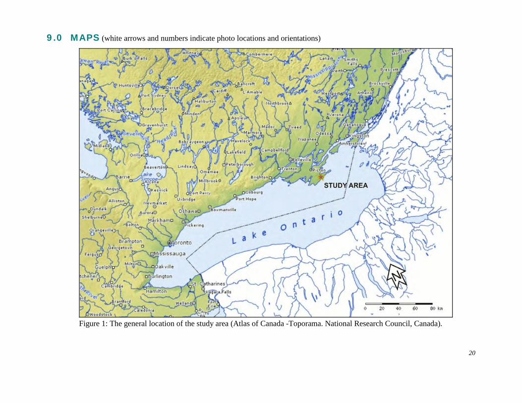
9.0 MAPS (white arrows and numbers indicate photo locations and orientations)
Figure 1: The general location of the study area (Atlas of Canada -Toporama. National Research Council, Canada).
20
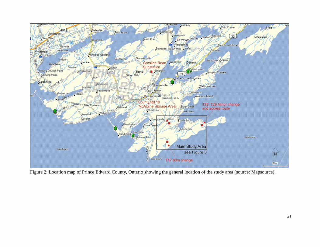
Figure 2: Location map of Prince Edward County, Ontario showing the general location of the study area (source: Mapsource).
21
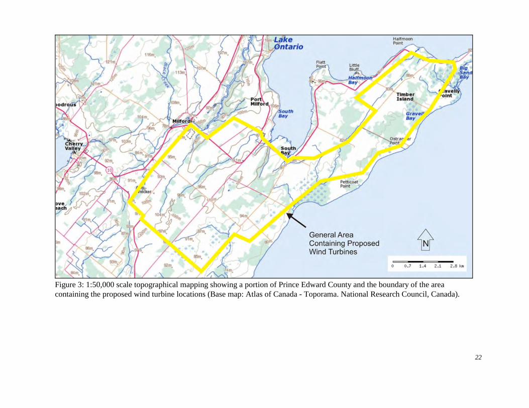
Figure 3: 1:50,000 scale topographical mapping showing a portion of Prince Edward County and the boundary of the areacontaining the proposed wind turbine locations (Base map: Atlas of Canada - Toporama. National Research Council, Canada).
22
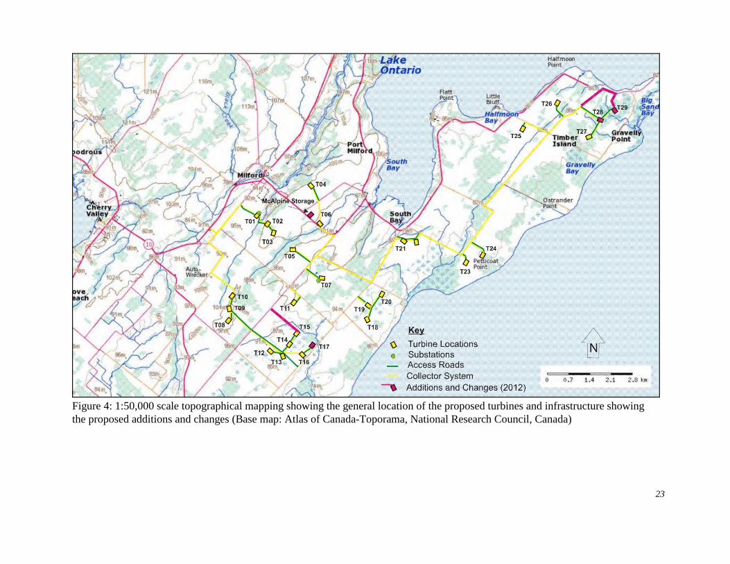
Figure 4: 1:50,000 scale topographical mapping showing the general location of the proposed turbines and infrastructure showingthe proposed additions and changes (Base map: Atlas of Canada-Toporama, National Research Council, Canada)
23
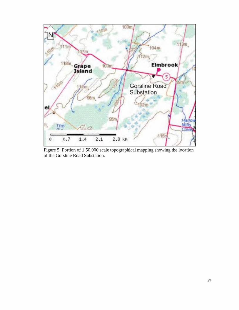
Figure 5: Portion of 1:50,000 scale topographical mapping showing the locationof the Gorsline Road Substation.
24
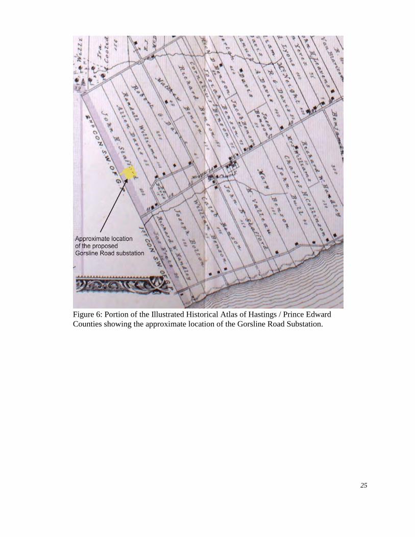
Figure 6: Portion of the Illustrated Historical Atlas of Hastings / Prince EdwardCounties showing the approximate location of the Gorsline Road Substation.
25
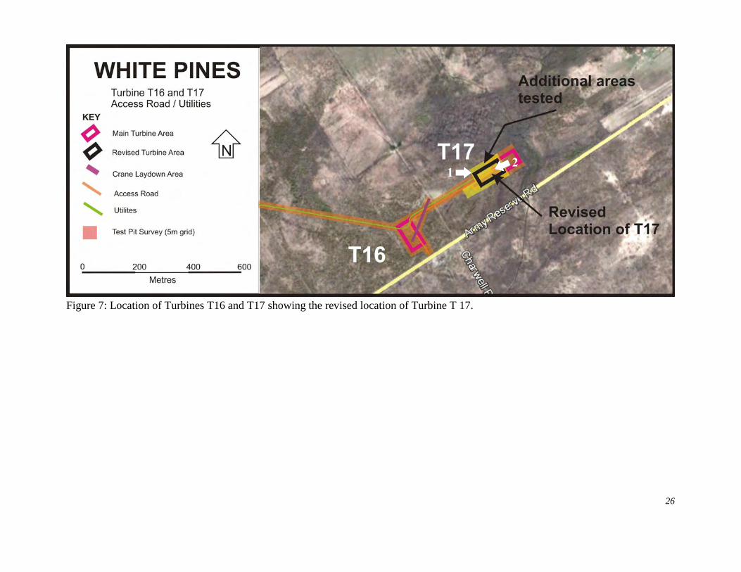
Figure 7: Location of Turbines T16 and T17 showing the revised location of Turbine T 17.
26
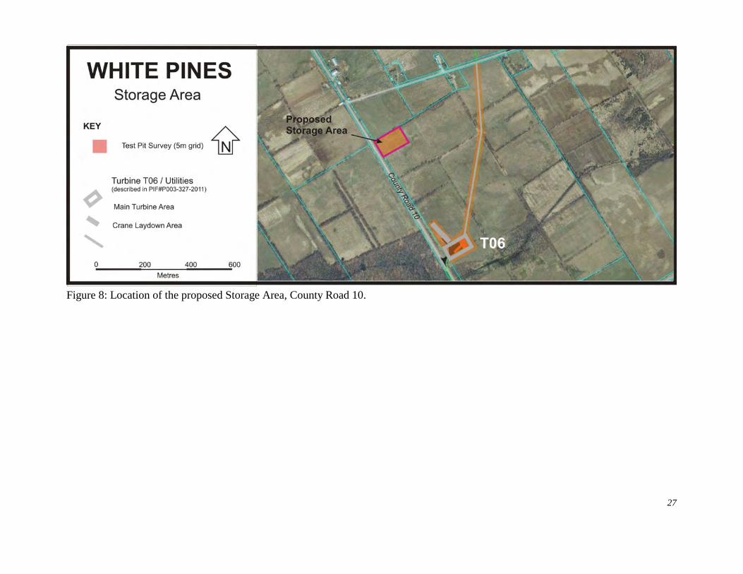
Figure 8: Location of the proposed Storage Area, County Road 10.
27
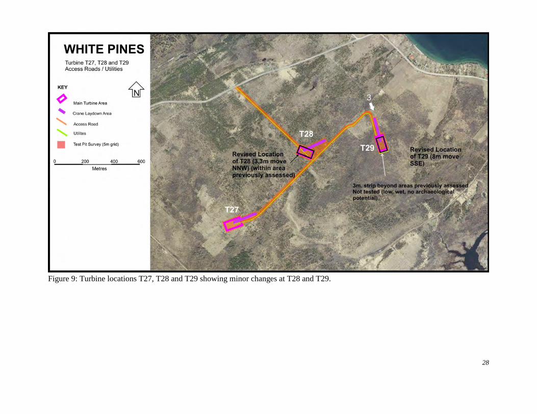
Figure 9: Turbine locations T27, T28 and T29 showing minor changes at T28 and T29.
28
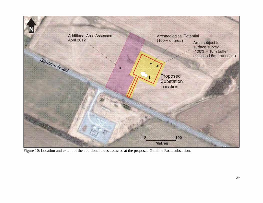
Figure 10: Location and extent of the additional areas assessed at the proposed Gorsline Road substation.
29
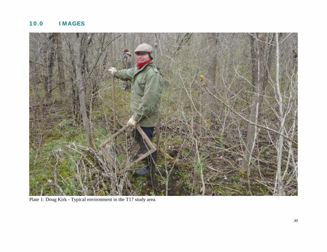
10.0 IMAGES
Plate 1: Doug Kirk - Typical environment in the T17 study area.
30
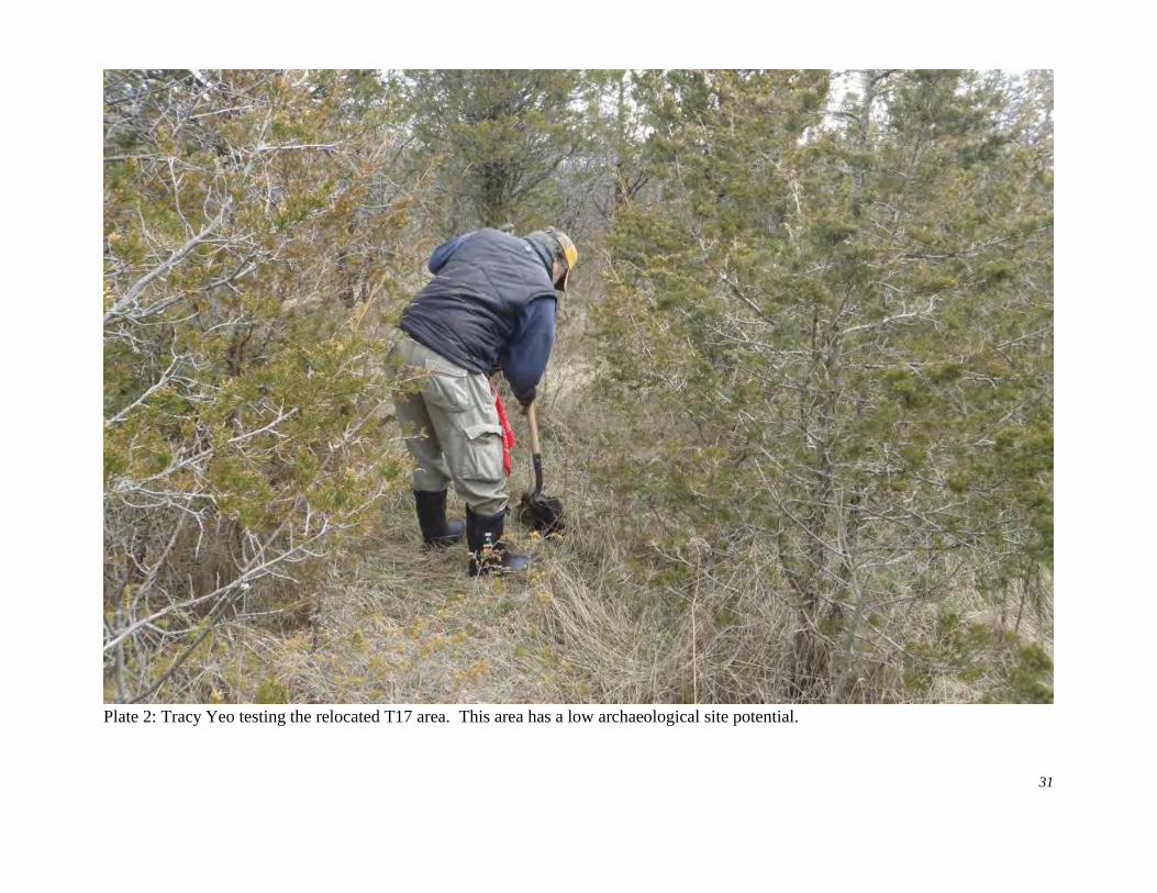
Plate 2: Tracy Yeo testing the relocated T17 area. This area has a low archaeological site potential.
31
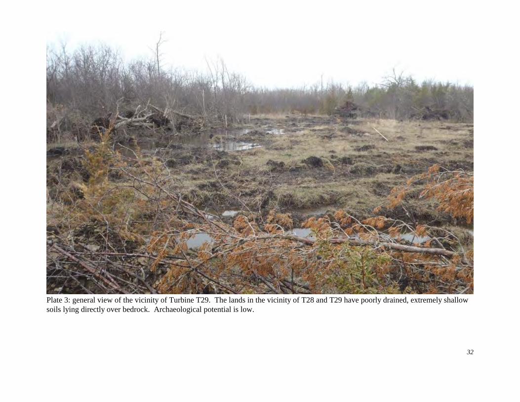
Plate 3: general view of the vicinity of Turbine T29. The lands in the vicinity of T28 and T29 have poorly drained, extremely shallowsoils lying directly over bedrock. Archaeological potential is low.
32
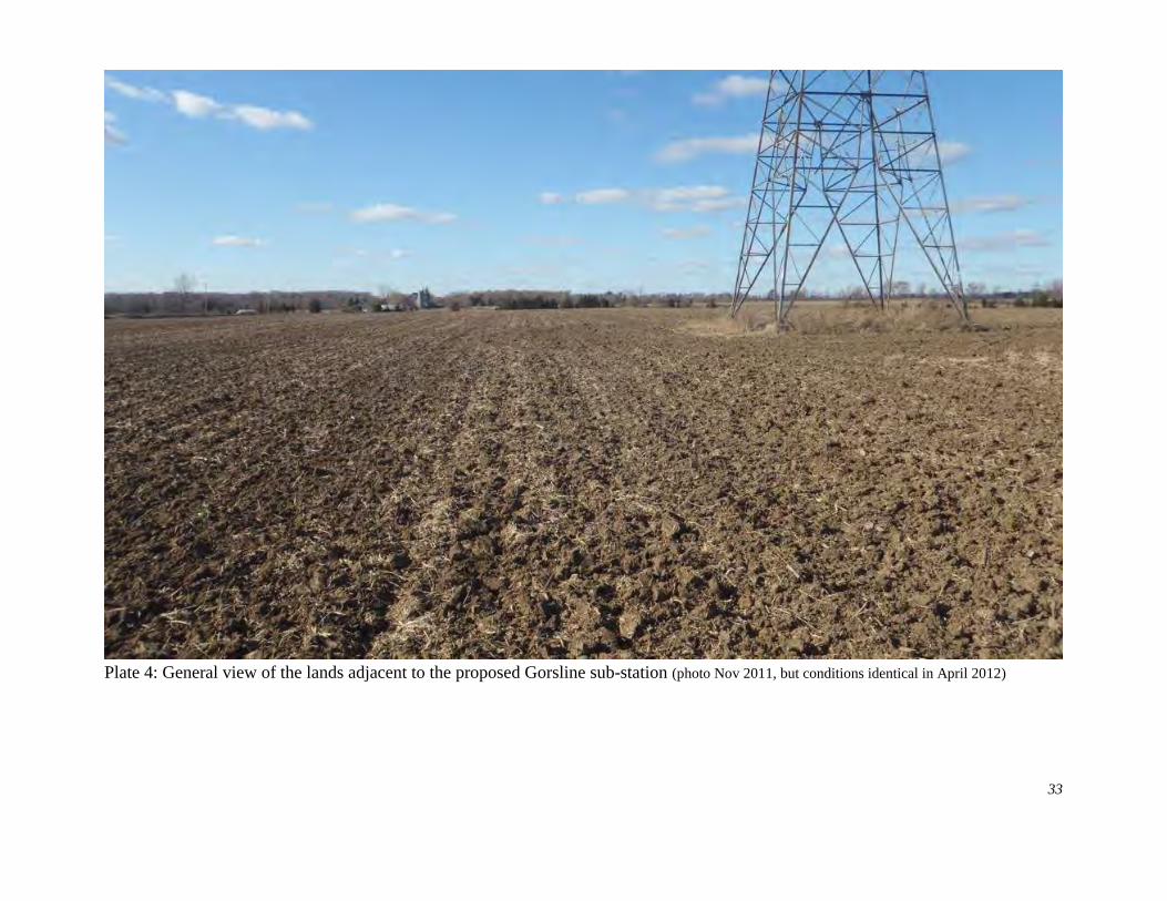
Plate 4: General view of the lands adjacent to the proposed Gorsline sub-station (photo Nov 2011, but conditions identical in April 2012)
33
SUPPLEMENTARY DOCUMENTATION
CONTENTS
S.1 Turbine Location T15 - Access Road to Royal Road. . . . . . . . . . . . . . . . . . . 34
S.2 Turbine Location T29, Access Road. . . . . . . . . . . . . . . . . . . . . . . . . . . . . . . 39
FIGURES
Figure S1: Location, T15 access road. . . . . . . . . . . . . . . . . . . . . . . . . . . . . . . . 35
Figure S2: Location, T29 access road. . . . . . . . . . . . . . . . . . . . . . . . . . . . . . . 40
PLATES
Plate S1: T15 access road - south end.. . . . . . . . . . . . . . . . . . . . . . . . . . . . 41Plate S2: T15 access road - central area. . . . . . . . . . . . . . . . . . . . . . . . . . . 42Plate S3: T15 access road - north end. . . . . . . . . . . . . . . . . . . . . . . . . . . . . 43Plate S4: T29 access road - testing near Babylon Road. . . . . . . . . . . . . . . . . 46Plate S5: T29 access road - testing along route. . . . . . . . . . . . . . . . . . . . . . 47
33
S.1 Turbine Location T15 - Access Road to Royal Road
Turbine T15 is located north of Army Reserve Road and east of Lighthall Road and west ofDainard Road (Figures 8). The proposed access road follows an intermittent fence line northto Royal Road. This area was examined as a possible route alternative. It wassubsequently withdrawn from wpd Canada’s plans, however since the archaeological testingwas completed, it is reported here.
EnvironmentThe Turbine T15 study area is situated on a level, pasture field, partly overgrown with cedartrees and prickly ash. The area is still used for cattle grazing. Soils in this area aregenerally shallow with clay overlying gravel and bedrock. The proposed road route proceedsnorth from T15, along a legal boundary which lies approximately 24 metres east of anexisting boundary fence. The southern end of the alignment traverses level pasture landwith shallow clay soils over bedrock. The central portion of the route consists of anextensive area of waterlogged forest, while the northern portion traverses level to rollingpasture extending to Royal Road.
Archaeological PotentialThe archaeological potential of this area is generally low with small areas of slightly higherpotential near the wetland and close to Royal Road.
Archaeological TestingDespite the relatively low archaeological potential of much of the route, all areas which weretestable (ie. not below water level), were subject to test pit survey using a 5 metre test pitinterval. Three transects were laid out across the proposed road alignment, with test pitsexcavated every 5 metres along the transects.
ResultsNo evidence of archaeological sites was identified. No artifacts were found.
Photographs - see Plates S1-3
34
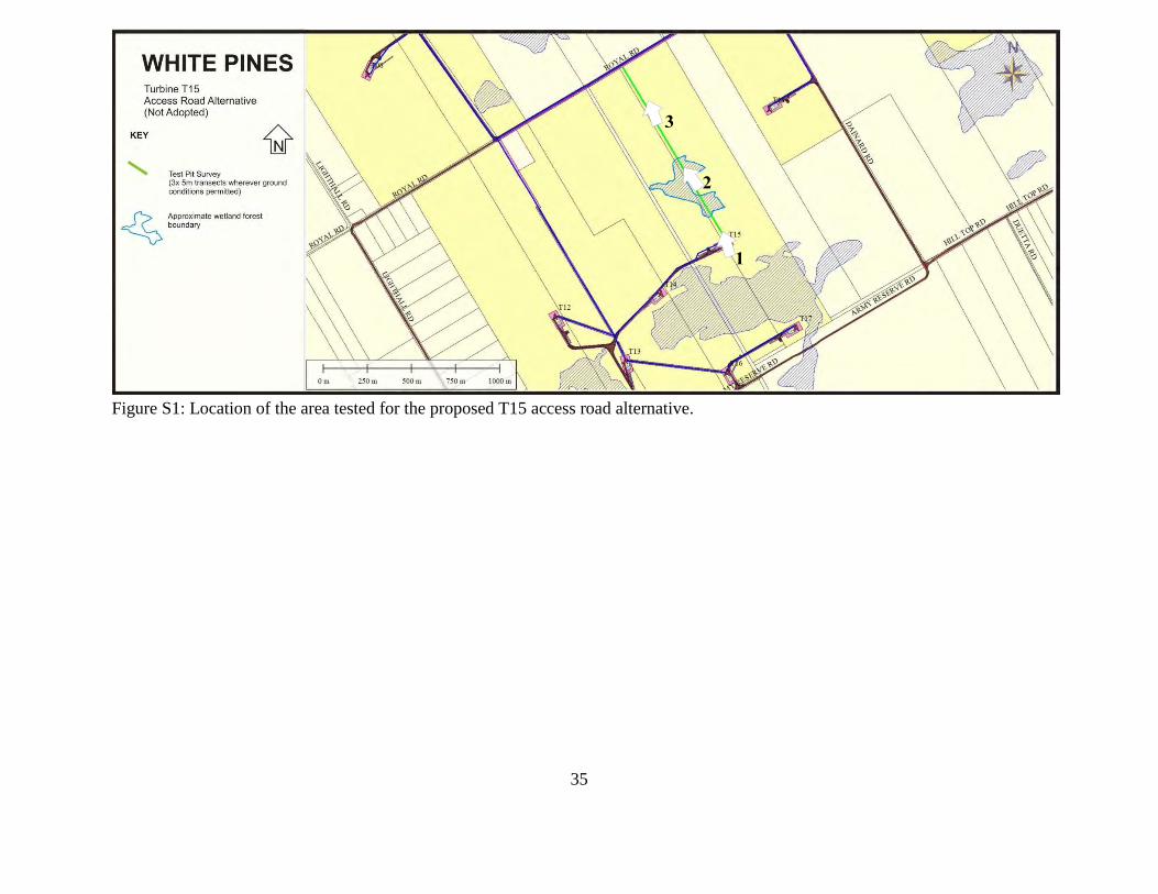
Figure S1: Location of the area tested for the proposed T15 access road alternative.
35
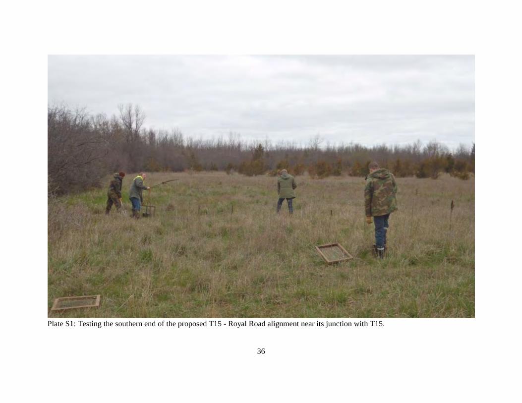
Plate S1: Testing the southern end of the proposed T15 - Royal Road alignment near its junction with T15.
36
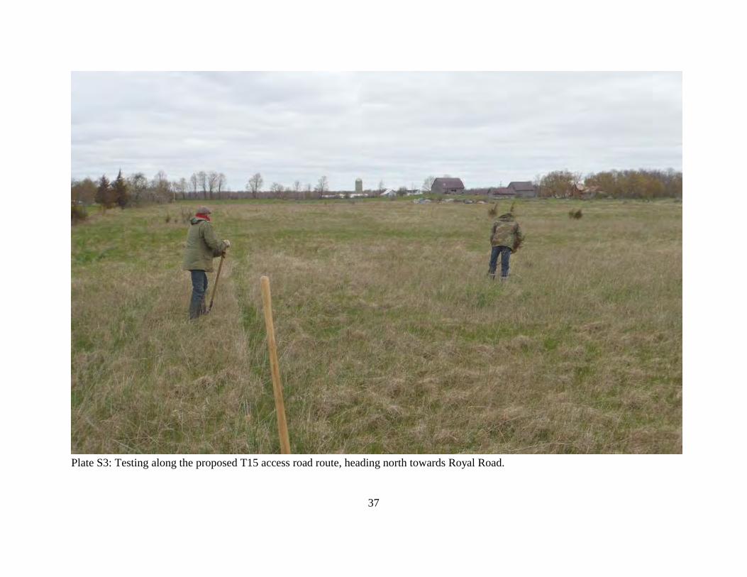
Plate S3: Testing along the proposed T15 access road route, heading north towards Royal Road.
37
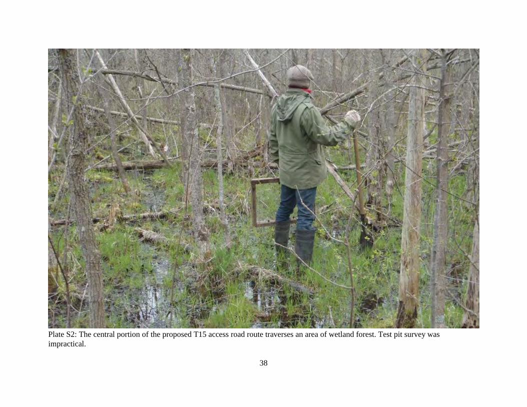
Plate S2: The central portion of the proposed T15 access road route traverses an area of wetland forest. Test pit survey wasimpractical.
38
S.2 Turbine Location T29, Access Road
At the request of wpd Canada, a proposed access road for T29 was tested for archaeologicalsites. Subsequently, this potential access road was eliminated from the project because ofnumerous environmental challenges and less impact to the local area than the previouslydefined route. Since the archaeological work was completed, it is reported below.
LocationA potential access road route connecting the Turbine T29 to County Road 13 (Long PointRoad) and Babylon Road was examined. This follows a field boundary east from the turbine,then lies within the existing road allowance along County Road 13 and Babylon Road.
EnvironmentThe proposed access road route extends northeast from Turbine T29 through poorly drainedformer pasture, now overgrown with prickly ash and cedar. It then proceeds northeastalong the southern edge of a fenceline through a pasture field until County Road 13 is met. From there the route will follow the road, occupying the road allowance on the southern sideof the road.
Archaeological PotentialA portion of the proposed road alignment has archaeological potential since it lies within 300metres of the Lake Ontario shore. Where the alignment follows the existing road allowancesof County Road 13 and Babylon Road, archaeological potential has been removed throughditching.
Archaeological TestingThe access road route was located using GPS alignments provided by wpd Canada. Becauseof the shallow soils, test pit survey along the proposed route was the only viable surveyoption. Three transects were established across the width of the proposed road alignment. Hand dug test pits were excavated at 5 metre intervals along the length of the transects. All soils from test pits were sifted through 6mm hardware cloth screens.
ResultsNo evidence of archaeological sites was identified. No artifacts were found.
Photographs - see Plates S4,5
39
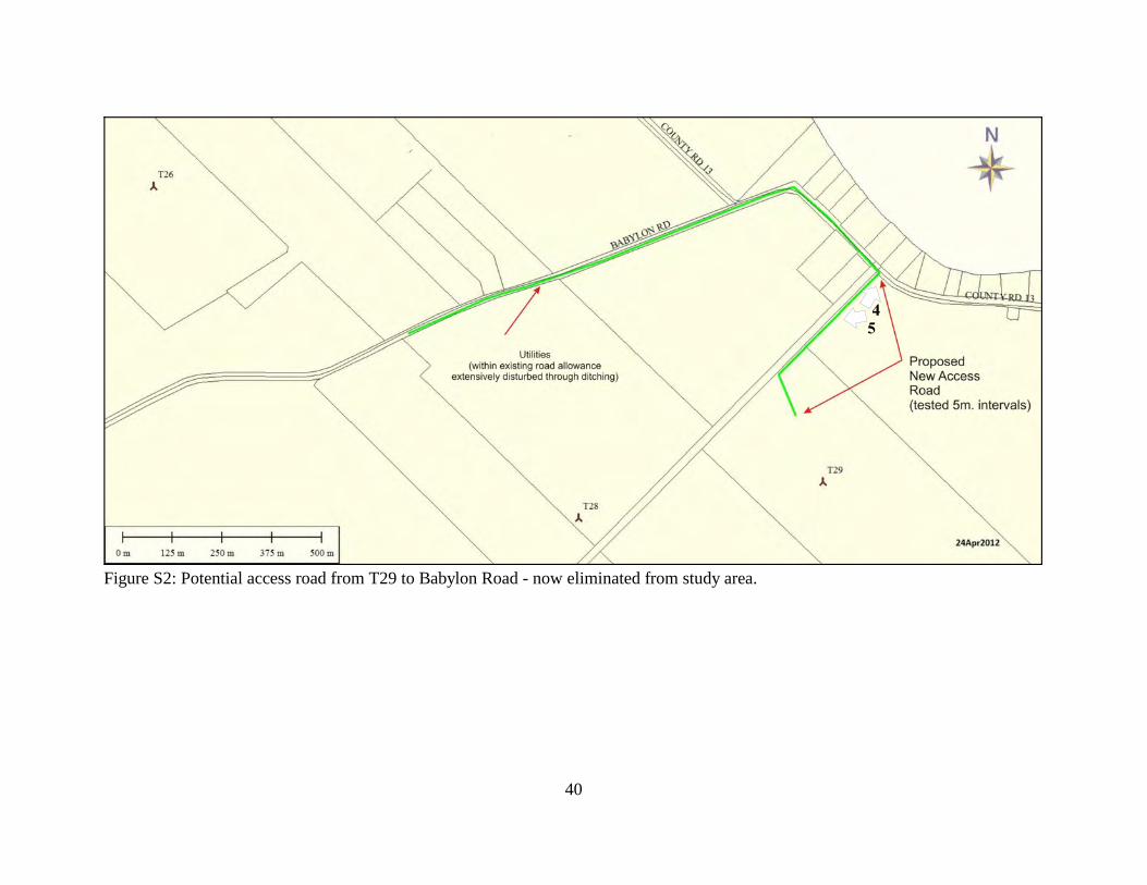
Figure S2: Potential access road from T29 to Babylon Road - now eliminated from study area.
40
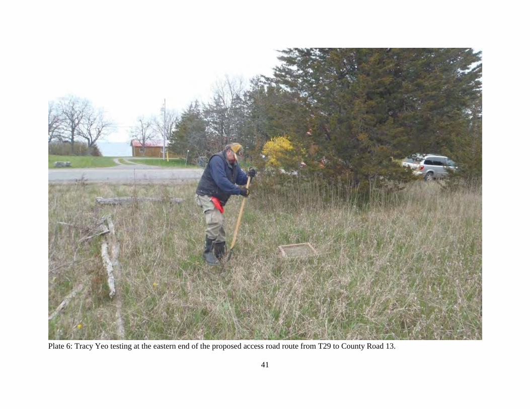
Plate 6: Tracy Yeo testing at the eastern end of the proposed access road route from T29 to County Road 13.
41
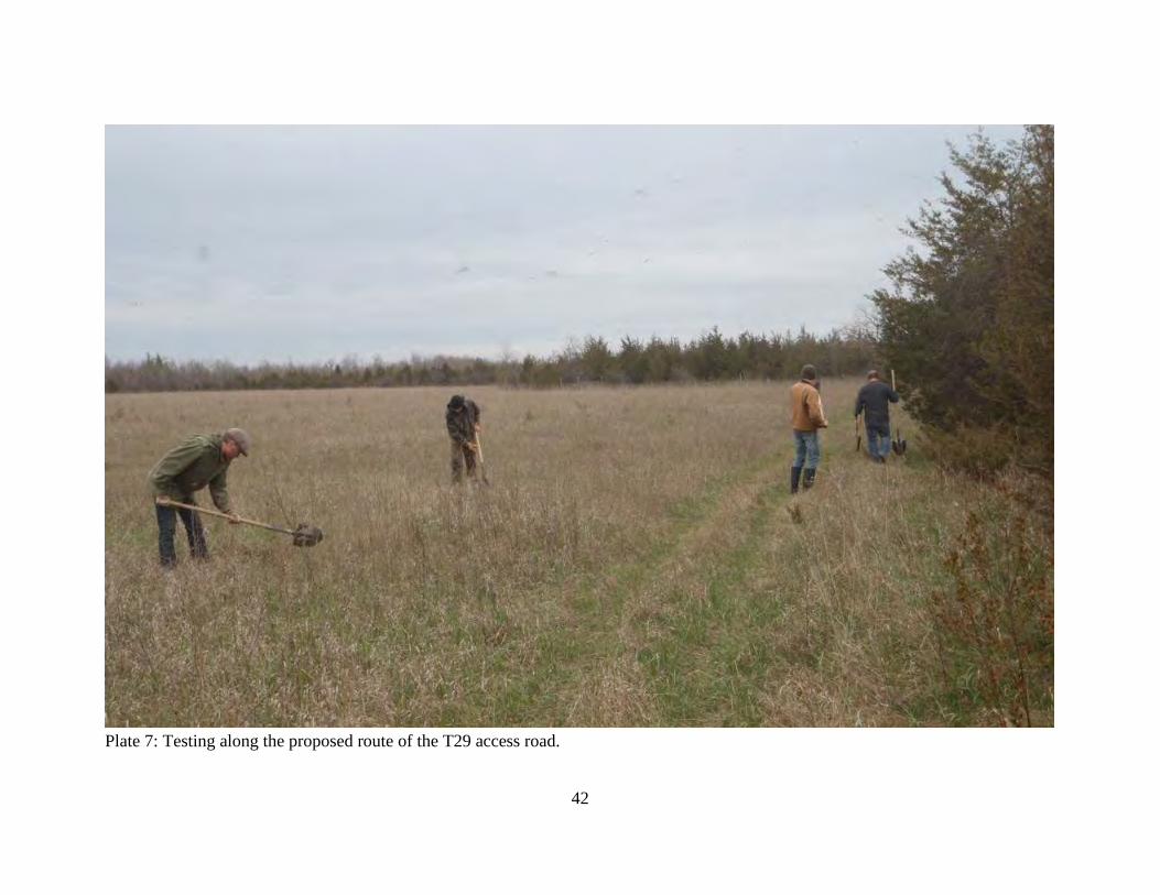
Plate 7: Testing along the proposed route of the T29 access road.
42