recent evolution of a mediterranean deltaic coastal zone...
TRANSCRIPT

Journal of the Geological Society, London, Vol. 162, 2005, pp. 897–908. Printed in Great Britain.
897
Recent evolution of a Mediterranean deltaic coastal zone: human impacts on the
Inner Thermaikos Gulf, NWAegean Sea
VASILIOS KAPSIMALIS 1, SERAFIM E. POULOS 2, ARISTOMENIS P. KARAGEORGIS 1,
PETROS PAVLAKIS 1 & MICHAEL COLLINS 3
1Hellenic Centre for Marine Research, Institute of Oceanography, P.O. Box 712, 19013, Anavyssos, Greece
(e-mail: [email protected])2University of Athens, Faculty of Geology & Geoenvironment, Department of Geography & Climatology,
Panepistimiopolis, Zografou 157 84, Athens, Greece3School of Ocean and Earth Science, Southampton Oceanography Centre, University of Southampton,
European Way, Southampton SO14 3ZH, UK
Abstract: The Inner Thermaikos Gulf is located in the northwestern Aegean Sea, receiving water and
sediment fluxes from the Axios, Aliakmon, Gallikos and Loudias Rivers. The geomorphological and
sedimentological evolution of the system is reconstructed for the last 150 years (1850–2000), on the basis of
detailed analysis of historical bathymetric charts. Late Holocene history is considered within the context of
changing riverine sediment supply and human activities. Three evolutionary stages are identified. Stage I
(1850–1916) corresponds to a natural phase of rapid deltaic progradation and sea-floor deposition, with an
average sediment accumulation rate of 6.5 3 106 m3 a�1. During Stage II (1916–1956), human interference
(e.g. artificial changes in river delta plains, realignment of channels and land reclamation schemes) to the
deltaic system increased sediment delivery to the coastal waters by a factor of three; this, in turn, enhanced
the progradation of the active river mouth areas. In contrast, Stage III (1956–2000) is characterized by
significant coastline (deltaic) retreat and erosion of the adjacent sea floor (net loss of 2.5 3 106 m3 a�1); this
was as a result of extensive river damming, which trapped a significant part of the sediment moving seaward.
Furthermore, these human impacts have affected the character of the surficial sea-bed sediments of the Gulf,
by reducing the proportion of mud. The response of the deltaic margin of the Inner Thermaikos Gulf to
various anthropogenic interventions seems to be analogous to that of other deltas in the Mediterranean region
where large drainage projects, the development of irrigation networks and dam construction have taken place
within their river basins.
Keywords: Thermaikos Gulf, Aegean Sea, delta evolution, human impact, sediment budget.
Deltaic coastal systems form a complex interface between
continental and marine environments, with high levels of spatial
and temporal variability in the prevailing natural processes
(Wright & Coleman 1973). Superimposed upon the natural
evolution, deltaic coasts have undergone considerable develop-
ment, such as intensive agriculture, industrialization and urbani-
zation. Thus, human interference incorporates: (1) changes in
fluvial freshwater and sediment fluxes; (2) canalization and flood
control works; (3) land reclamation schemes; (4) channel dred-
ging for aggregates; (5) more recently, structures for coastal
protection. Within this context and against a background of
minimal tidal range (in the case of the Mediterranean Basin),
within the Holocene, the two principal factors controlling the
morphological and sedimentary evolution of any deltaic coastal
system are the fluvial water and sediment supply and the wave-
derived longshore drift (McManus 2002).
Globally, riverine sediment fluxes have been modified by
various anthropogenic activities (Vorosmarty et al. 2003). Since
late prehistoric times, long periods (centuries to millennia) of
increased sediment delivery to the coast have been attributed to
changes in land use of the catchment area (mainly as a result of
deforestation and crop farming) (Van Andel et al. 1990; Walling
1999), whereas short periods (over the order of a few decades) of
significant increase in the detrital sediment discharge have been
attributed to the canalization and straightening of lower river
reaches. The former situation has been documented by Wood-
ward (1995), in the case of the Mediterranean rivers, where
human impact upon the Ebro, Po and Axios rivers, for example,
extended back to 2500 years bp (Milliman 2001). The latter
situation has been reported for the River Axios (Poulos et al.
1996). Since the beginning of the 20th century, a dramatic
reduction in sediment supply to the coastal zone has occurred
globally, following the construction of dams for irrigation and
hydroelectric power schemes (Vorosmarty et al. 2003). In addi-
tion, a further reduction in sediment supply has been attributed
to sand and gravel extraction along river channels (Marchetti
2002). This dramatic reduction has not only stopped delta-front
progradation, but has initiated coastal erosion, which includes
coastline retreat and/or the removal of nearshore sediments
(McManus 2002; Yang et al. 2003), together with the landward
intrusion of saline groundwaters (Oueslati 1995; Zalidis 1998).
In the case of the Mediterranean Basin, it has been estimated
that the potential (natural) sediment supply has been reduced by
almost 50% since the middle of the 20th century (Poulos &
Collins 2002). Such sediment reduction, exceeding 90% in the
case of the larger river systems, has already initiated annual rates
of coastal erosion ranging from tens of metres (e.g. Ebro River,
Jimenez et al. 1997; Rhone River, Bird 1988; Po River, Simeoni
& Bondesan 1997), to hundreds of metres (e.g. Nile River, Fanos
1995; Stanley 1996).

This study examines the geomorphological and sedimentologi-
cal evolution of the deltaic coastal zone of the Inner Thermaikos
Gulf, NW Aegean Sea, located between 408259 and 408409N and
228359 and 238009E. Although a preliminary analysis of changes
in the deltaic coastline has been presented previously by Poulos
et al. (1994, 2000), the present study, with the use of appropriate
geographic information system (GIS) tools, not only examines
coastal changes, but extends this investigation to the adjacent sea
bed. Such an approach aims to provide: (1) a detailed description
(qualitatively and quantitatively) of the overall pattern of deltaic
coastal zone evolution during historical times (from 1850 to
2000) in relation to human-induced changes in freshwater and
sediment supply, in response to various anthropogenic construc-
tions and interventions either within the upstream basin (i.e. dam
construction) and/or on the coastal deltaic plain (canalization,
land reclamation etc); (2) an estimation of nearshore and off-
shore (extending to the southern limit of the Inner Thermaikos
Gulf) changes in bathymetry, defining areas of accretion or
erosion; (3) a volumetric assessment of sediments that have
entered the Gulf over the last 150 years; (4) the identification of
changes in the sedimentary (grain-size) character of the surficial
sea-bed sediments, providing an indication of their mobility.
The study area: the Inner Thermaikos Gulf
Physical geographical setting
The Inner Thermaikos Gulf is located in the southern Balkan
Peninsula and incorporates the mouths of the Axios, Aliakmon
and Gallikos Rivers (Fig. 1a). The subaerial deltaic plains of
these rivers (Table 1), together with the artificially drained lake
of Yiannitsa and the River Loudias (operating now as a drainage
canal for the Yiannitsa Lake), form the Plain of Thessaloniki, c.
1500 km2 in area (Fig. 1b). Today, the Plain hosts a population
in excess of 1 million; it is one of the most important socio-
economic areas of the southern Balkans and the second most
important zone in Greece. The seaward boundary of the Inner
Thermaikos Gulf is taken here as an imaginary west–east line,
some 20 km in length, connecting the promontories of Atheris
and Epanomi (Fig. 1b). Water depths vary from a few metres,
Fig. 1. Location maps: (a) the Inner Thermaikos Gulf catchment; (b) the Yiannitsa–Thessaloniki Plain and its coastal system. F.Y.R.O.M., Former
Yugoslav Republic of Macedonia.
Table 1. General characteristics of the main rivers discharging along thecoastline of the Inner Thermaikos Gulf deltaic coast (after Poulos et al.2000)
Axios Aliakmon Gallikos
GeomorphologyCatchment area (km2) 23747 9250 1230Maximum relief (m) 2800 2200 2180Relief ratio (10�2) 1.15 1.7 0.25Deltaic plain (km2) ~1500LithologyAcid þ mafic (%) 51.2 23.7 57.5Carbonates (%) 11.3 15.7 1.0Clastic deposits (%) 37.5 60.6 41.5ClimateMean annual temperature (8C) 14.5 16.5 16.5Mean annual rainfall (mm) 650 750 480Type Terrestrial MediterraneanLand useForest (%) 16.9 19.0 3.4Uncultivated area (%) 5.9 40.0 38.9Arable land (%) 75.4 39.3 55.6Urban area (%) 1.7 1.3 1.7Wetland (%) 0.1 0.4 0.4
V. KAPSIMALIS ET AL .898

adjacent to the delta fronts, to c. 35 m at the southerly limit (Fig.
2). At the northeastern extension of the Gulf lies the Bay of
Thessaloniki, where the harbour of Thessaloniki is located (Fig.
1b).
The morphology of the deltaic coastline, in the essentially
tideless environment of Greek waters (Tsimplis 1994), results
mainly from interaction between the fluvial water and sediment
discharge and the prevailing wave activity; the latter is relatively
low (mean monthly wave power approaching the Inner Gulf
is ,30 W m�2), when compared with other Greek deltas (i.e.
70–1454 W m�2 for the Pinios River (Poulos et al. 1993) and
.25 000 W m�2 for the Alfios River (Poulos et al. 2002)). This
pattern is related to the restricted wave fetches, caused by the
semi-enclosed and shallow character of the Inner Thermaikos
Gulf, leading to the formation of a birdfoot-type delta (Galloway
1975).
Fluvial water and sediment fluxes
Most of the freshwater inputs to the Inner Thermaikos Gulf
coastline originate from the Axios, Aliakmon and Gallikos
Rivers (Table 2), which together have been shown to represent an
overall annual mean discharge of 276 m3 s�1, between 1926 and
1970 (Therianos 1974). However, recent flow measurements
(1997-1998) have identified a substantial decrease in the fresh-
water supply (to some 130 m3 s�1), attributed mainly to the
increasing consumption of freshwater because of agricultural and
urban development (Karageorgis & Anagnostou 2001).
The principal rivers (Axios, Aliakmon and Gallikos) supply
annually some 28 3 106 tonnes of total sediment load (Table 2).
This sediment flux, associated with high sediment yields
(.500 t km�2), results from intensive weathering processes
induced by: (1) highly variable climatic conditions (i.e. large
daily and seasonal air temperature fluctuations and relatively
high precipitation levels); (2) erodible lithologies; (3) the
mountainous terrain of the region, with high relief ratios (Table
1); (4) sparse vegetation cover (Woodward 1995). During the
second half of the 20th century, such high sediment discharges
have not reached the coastal zone, as they accumulate behind a
number of irrigation and hydroelectric dams (Poulos & Collins
2002; Karageorgis et al. 2004).
Delta evolution
The rapid progradation of the deltaic complex since the 5th
century bc (Fig. 3) has been established (Sturck, 1908) from
archaeological data and historical records from ancient travellers.
At that time, the ancient towns of Skydra (to the west) and Pella
(to the north) were located adjacent to the sea; today they are
located some 30 km from the coast. During the second half of
the 20th century, the evolution of the deltaic coast of the Inner
Thermaikos Gulf has been investigated by Evmorphopoulos
(1961), Kotoulas (1984), Poulos et al. (1994) and Albanakis et
al. (1993). An assessment of the observed subsidence rates of the
plain (10 cm a�1), for the period 1960–1999, has been provided
by Stiros (2001).
Marine sediments
Modern sedimentary processes in the Thermaikos Gulf have been
studied extensively in recent decades by Lykousis et al. (1981),
Lykousis & Chronis (1989), Poulos et al. (1996) and Karageorgis
& Anagnostou (2001, 2003). Similarly, Georgas & Perissoratis
Fig. 2. Recent bathymetric chart of the Thermaikos Gulf (Hydrographic
Service of the Greek Navy 2000), based upon the Greek Geodetic
Reference System (1987). Water depths in metres.
Table 2. Freshwater and sediment fluxes of the main rivers discharginginto the Inner Thermaikos Gulf
Axios Aliakmon Gallikos
Freshwater discharge (106 m3 a�1)*Mean annual 5030 2292 1.2†
Monthly maximum 8800 4320 ?Monthly minimum 1545 662 ?Overall total 7323High water period (months) Dec.– Jan. Dec.– May ?Low water period (months) Jul.– Nov. Jun.– Nov. ?Sediment fluxes (106 t a�1)a. Suspended load 13.2‡ 6.2§ 1.0‡
b. Dissolved load† 1.7 1.2 0.6c. Bed loadk 2.6 1.3 0.3Total sediment load (a þ b þ c) 17.5 8.7 1.9Overall total 28.1
*Measured values (after Therianos 1974).†Measured values (after Skoulikidis 1993).‡Estimated value (after Poulos et al. 1996).§Extrapolated value, from the total catchment area and based upon in situ
measurements over part of the drainage basin.kEstimated value, based upon the assumption that bed load represents some 15% ofthe total sediment load (after Poulos & Chronis 1997).
Fig. 3. Palaeogeographical evolution of the Thessaloniki Plain during
historical time, based upon information provided by ancient Greek
writers (modified from Sturck 1908).
HUMAN IMPACT ON A DELTAIC COASTAL ZONE 899

(1992) and Poulos et al. (1994) have provided a socio-economic
appraisal of the ranges of human activities over the area. In
general, the bottom sediments consist mainly of silt- and clay-
sized particles, with increasing amounts of clay occurring off-
shore. Sand is abundant near the coastlines, adjacent to the river
mouths and, particularly, over the eastern part of the Gulf (as
relict deposits). Furthermore, Lykousis & Chronis (1989), inter-
preting high-resolution (3.5 kHz) seismic profiles taken from the
Inner Thermaikos Gulf, have indicated that the thickness of the
Holocene sedimentary cover exceeds 20 m near the river mouths
and decreases to ,4 m over the eastern part of the Gulf (Fig. 4).
Materials and methods
A series of bathymetric charts were obtained from the UK Hydrographic
Office (Taunton), dated 1850, 1916, 1947 and 1956, and the Hydrogra-
phical Service of the Greek Navy (Athens, Greece), published in 2000.
All the charts were projected onto the Greek Geodetic Reference System
(1987) and processed with the use of the ArcView GIS (Version 3.2).
Quantitative estimates of the volumetric changes in the offshore water
depths between the time periods of the available charts were derived
using the SURFER# software package. The weight of the sediments
accumulated in front of the river mouths was extrapolated from the
sediment volume and bulk density; the latter is equal to c. 1.5 g cm�3,
according to Lykousis et al. (2002).
Comparison between the various charts requires consideration of
various potential errors, which include: (1) vertical and horizontal datum
inconsistencies; (2) the absence or use of different georeference systems;
(3) computer-gridding errors. To minimize such errors, standard terres-
trial reference points (such as churches, capes, lighthouses), were
selected; these were used for an intercomparison of shoreline position
and offshore bathymetric contours, for all of the charts. Furthermore, a
�0.5 m range in sea-floor change was designated as a ‘moderate’ degree
of error in the bathymetric comparisons; as such, this has been
characterized as a zone of ‘no significant’ change (List et al. 1997).
The datasets used for the study of the grain-size characteristics of the
surficial sea-bed sediments were collected in 1978 (Chronis 1986) and
1997–1998 (Karageorgis & Anagnostou 2003).
Results and discussion
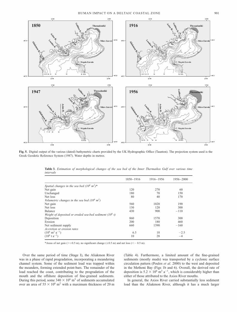
The reconstruction of the historical charts (Fig. 5) has revealed
major changes in the evolution of the coastline and the
associated bathymetry of the Inner Thermaikos Gulf. These
include significant spatial trends in erosion and accretion
dynamics over the past 150 years. Three evolutionary stages have
been identified: an early stage, from 1850 to 1916 (Stage I); an
intermediate stage, from 1916 to 1956 (Stage II); and a late
stage, from 1956 to 2000 (Stage III). Spatial changes in the sea-
bed elevations, accompanied by a volumetric estimation of the
sediment deposited and/or eroded from the sea floor of the Inner
Thermaikos Gulf, are presented in Table 3. The thickness of the
deposits and the areas affected by river mouth evolution are
summarized, on the basis of the earlier evolutionary stages (see
above), in Table 4.
Stage I
The coastal and bathymetric changes shown between the 1850
and 1916 charts reveal progradation of the deltaic coast and, in
particular, the area incorporating the active mouths of the Axios
and Aliakmon Rivers. Over this period, the position of the active
mouth of the Axios River varied. In particular, before the 1890s,
the river mouth was located at the Kavoura Cape, opposite the
Megalo Emvolo Cape. Subsequently and until 1934, the mouth
was located near Palaiomana, opposite the Mikro Emvolo Cape,
some 10 km to the NE (Konstantinidis 1989). However, it can be
assumed that these mouths (Kavoura and Palaiomana) were
active concurrently, especially during high freshwater discharges.
During high river discharges, overbank flows flooded extensive
areas of the delta plain, creating swamps, coastal lakes and
ephemeral channels. Conversely, under the influence of southerly
winds, the sea invaded the coastal zone of the deltaic platform,
infilling the salt marshes and lagoons.
Although some of the sediment load transported by the Axios
River was deposited on the deltaic plain during floods, the
greater proportion was discharged into the Thermaikos Gulf.
Most of the coarse-grained riverine sediments are likely to have
been trapped on the seaward side of the mouth, forming a
prodeltaic lobe. The fine-grained suspended sediment load would
have been dispersed offshore, covering almost the whole of the
sea bed over the inner part of the Gulf (including the navigation
channel to the port of Thessaloniki).
Sediment deposited during Stage I (Fig. 6), over the Kavoura
mouth of the Axios River, covered an area of 25 3 106 m2, with
a maximum thickness of 22 m; this corresponds to a sediment
volume of 85 3 106 m3. Similarly, at the Palaiomana mouth, the
new prodeltaic deposit covered an area of 23 3 106 m2, with a
maximum thickness of 16 m and a total volume of 60 3 106 m3
(Table 4).
The two main river mouths were active simultaneously during
Stage I (over 66 years), when the accumulation rates for the
Kavoura and Palaiomana mouths were of the order of
1.3 3 106 m3 a�1 and 0.9 3 106 m3 a�1, respectively (Table 4).
However, Konstantinidis (1989) has mentioned that the active
mouth of the Axios River was located near the Kavoura Cape
from 1850 to 1900 (50 years) and for the following 16 years
(1900–1916) in Palaiomana. If this is correct, then the accumula-
tion rates for the Kavoura and Palaiomana mouths become
1.7 3 106 m3 a�1 and 3.8 3 106 m3 a�1, respectively (Fig. 6b).
The much lower accumulation rate at the Kavoura mouth could
be attributed to the entrapment of large water and sediment
fluxes within the Loudias Swamps (some 80 km2).
Along the deltaic coast, between the Axios River mouths, no
significant deposition is observed (Fig. 6a), and this implies that
the secondary drainage networks played only a minor role in
sediment dispersion, except during extreme floods.
Fig. 4. Thickness of the Holocene sedimentary cover in the Inner
Thermaikos Gulf, in milliseconds (where 10 ms is equivalent to c. 8 m),
based upon the interpretation of geophysical data (after Lykousis &
Chronis 1989).
V. KAPSIMALIS ET AL .900
Over the same period of time (Stage I), the Aliakmon River
was in a phase of rapid progradation, incorporating a meandering
channel system. Some of the sediment load was trapped within
the meanders, forming extended point-bars. The remainder of the
load reached the coast, contributing to the progradation of the
mouth and the offshore deposition of fine-grained sediments.
During this period, some 340 3 106 m3 of sediments accumulated
over an area of 55 3 106 m2 with a maximum thickness of 20 m
(Table 4). Furthermore, a limited amount of the fine-grained
sediments (mostly muds) was transported by a cyclonic surface
circulation pattern (Poulos et al. 2000) to the west and deposited
in the Methoni Bay (Figs 1b and 6). Overall, the derived rate of
deposition is 5.2 3 106 m3 a�1, which is considerably higher than
either of those attributed to the Axios River mouths.
In general, the Axios River carried substantially less sediment
load than the Aliakmon River, although it has a much larger
Fig. 5. Digital output of the various (dated) bathymetric charts provided by the UK Hydrographic Office (Taunton). The projection system used is the
Greek Geodetic Reference System (1987). Water depths in metres.
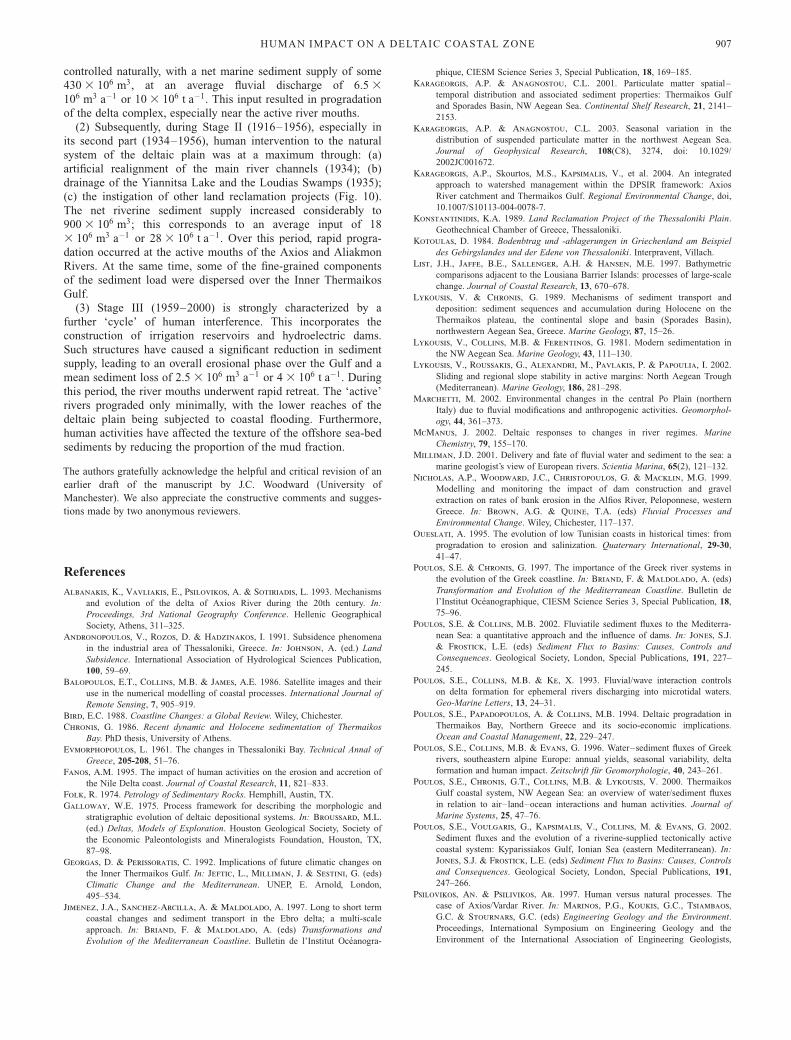
Table 3. Estimation of morphological changes of the sea bed of the Inner Thermaikos Gulf over various timeintervals
1850–1916 1916–1956 1956–2000
Spatial changes in the sea bed (106 m2)*Net gain 120 270 60Unchanged 180 70 150Net loss 80 40 170Volumetric changes in the sea bed (106 m3)Net gain 560 1020 190Net loss 130 120 300Balance 430 900 �110Weight of deposited or eroded sea-bed sediment (106 t)Deposition 860 1570 300Erosion 200 180 460Net sediment supply 660 1390 �160Accretion or erosion rates(106 m3 a�1) 6.5 18 �2.5(106 t a�1) 10 28 �4
*Areas of net gain (.þ0.5 m), no significant change (�0.5 m) and net loss (,� 0.5 m).
HUMAN IMPACT ON A DELTAIC COASTAL ZONE 901

Table 4. Estimates of morphological changes of the subaqueous deltaic wedges in front of the active river mouths
1850–1916 1916–1956 1956–2000
Maximum thickness of the subaqueous deltaic wedges (m)Axios (Kavoura) mouth 22 20 16Axios (Palaiomana) mouth 16 21 5Aliakmon mouth 20 22 10Accretional areas, in front of the active river mouths (106 m2)Axios (Kavoura) mouth 25 39 18Axios (Palaiomana) mouth 23 30 7Aliakmon mouth 55 59 24Volume of deposits at the active river mouth (106 m3)Axios (Kavoura) mouth 85 220 60Axios (Palaiomana) mouth 60 140 10Aliakmon mouth 340 270 35Accretion rates of the subaqueous deltaic wedges (106 m3 a�1)Axios (Kavoura) mouth 1.3 5.5 1.4Axios (Palaiomana) mouth 0.9 3.5 0.2Aliakmon mouth 5.2 6.8 0.8Sediment budget, in front of the active river mouth (106 t)Axios (Kavoura) mouth 130 340 90Axios (Palaiomana) mouth 90 215 15Aliakmon mouth 520 415 55Accretion rates of the subaqueous deltaic wedges (106 t a�1)Axios (Kavoura) mouth 2.0 6.8 1.3Axios (Palaiomana) mouth 1.4 4.3 0.2Aliakmon mouth 7.8 8.3 1.2
Fig. 6. (a) Spatial distribution of
accretional and erosional patterns in the
Inner Thermaikos Gulf during Stage I
(1850–1916), derived from the comparison
of bathymetric charts; (b) schematic
representation of the estimated sediment
influx, at the active river mouths.
V. KAPSIMALIS ET AL .902

drainage basin (Table 2). According to Poulos et al. (2000), this
difference in sediment yield could be attributed to: (1) differ-
ences in lithology, with the Axios River draining mostly resistant
mafic and acidic rocks whereas the Aliakmon River drains
mostly weaker clastic formations (Table 1); (2) the geomorpholo-
gical characteristics of the two catchments, with the Axios River
having a much lower relief ratio (1.1) than the Aliakmon River
(1.7), incorporating a drainage network with a large number of
primary and secondary branches and meanders, together with a
more gentle slope to its deltaic plain; (3) soil degradation,
associated with land use changes.
Over this period, the Loudias River drained the Yiannitsa Lake
and Loudias Swamps to the west of the Kavoura mouth (Fig. 1b).
These systems discharged into the Thermaikos Gulf either
directly, as an independent river with its mouth located between
those of the Axios (Kavoura) and Aliakmon, or indirectly, as a
tributary of the western channel of the Axios River (Konstantini-
dis 1989). Finally, the Gallikos River, although its mouth was
located very close to the Palaiomana mouth of the Axios River
(Fig. 6), was active independently. The Gallikos River drains a
much smaller catchment area (1230 km2) and is characterized by
ephemeral (seasonal) flows.
During Stage I, the sea floor of the Inner Thermaikos Gulf,
excluding the areas of active deltaic progradation, does not
appear to have undergone any significant changes (Fig. 6a).
Limited sediment accumulation can be observed over the north-
eastern part of the Gulf and close to the port of Thessaloniki;
this could be associated with the Palaiomana mouth of the Axios
River. Over some parts of the central area of the Gulf, the sea
bed appears to have undergone erosion (.0.5 m) and this is
probably related to near-bed current activity.
Stage II
Within this period (1916–1956), two substages can be identified:
the first (1916–1930) is characterized by natural coastal evolu-
tion, and the second (1931–1956) by increasing human interven-
tions on the deltaic plain in the form of canalization and land
reclamation.
During the first sub-period (1916–1930), the deltaic plain was
evolving naturally. The active mouth of the Axios River was that
of Palaiomana (Fig. 7a), causing siltation of the port of
Thessaloniki. Such siltation led to rerouting of the Axios River,
diverting its active mouth to its previous location near the
Fig. 7. (a) Spatial distribution of
accretional and erosional patterns in the
Inner Thermaikos Gulf during Stage II
(1916–1956), derived on the basis of the
comparison of bathymetric charts; (b)
schematic representation of the estimated
sediment influx, at the active river mouths.
HUMAN IMPACT ON A DELTAIC COASTAL ZONE 903

Kavoura Cape (Fig. 7a). Construction commenced in 1930 and
was finalized in 1934. Accompanying works, undertaken within
the deltaic plain, were: (1) the artificial drainage of the Yiannitsa
Lake; (2) associated construction of the Loudias drainage
channel (39 km long, 50 m wide and 5 m deep, along the former
route of the Loudias River); (3) land reclamation works on the
Loudias Swamps (1933–1935), located to the NW of the
Kavoura mouth (Fig. 1b). Following diversion of the main
tributary of the Axios River (1934), an extended birdfoot delta
developed near the Kavoura mouth. During the second sub-
period (1931–1956), the Axios River delta developed farther to
the south and SW. Erosion occurred over the eastern part of its
active mouth, affecting the earlier deposits of the abandoned
Kaboura mouth (Fig. 7). At this time, the old route of the Axios
River, ending at the Palaiomana mouth, functioned episodically
during floods.
Over the same sub-period, the lower meandering course of the
Aliakmon River was aligned artificially; this decreased its length
from 52.2 km to 30.4 km (Konstantinidis 1989), leading to
further progradation of its mouth area to the NE and to the
development of an extended birdfoot delta. Similarly, works were
carried out along the lower course of the Gallikos River, focusing
upon the protection of its subaerial delta from flood events
(Konstantinidis 1989). Overall, Stage II (1916–1956) was char-
acterized by substantial sediment deposition within the Inner
Thermaikos Gulf and this is estimated to be of the order of
900 3 106 m3 (Table 3). Although sediments were deposited over
the adjacent sea floor, the highest rates of accretion occurred in
front of the active river mouths (Fig. 7b). Thus, at the
Palaiomana mouth, some 140 3 106 m3 of sediments settled over
an area of 30 3 106 m2 corresponding to a maximum thickness
of 21 m and an accumulation rate of 3.5 3 106 m3 a�1 (Table 4).
However, on the basis of the assumption that the majority of
these sediments had been deposited before the artificial diversion
of the main Axios River channel (i.e. from 1916 to 1934), the
accumulation rate could be increased to 7.8 3 106 m3 a�1. At the
Kavoura mouth during Stage II, if only a small amount of
sediment was deposited prior to 1934, then sediment volume
of 220 3 106 m3 was associated with an accumulation rate of
10.0 3 106 m3 a�1 (between 1934 and 1956).
A general increase in sediment supply can be attributed,
mainly, to alignment of the Axios River and straightening of its
lower course; this caused elevated flow velocities and (possible)
erosion of older terrestrial deposits (Konstantinidis 1989). Like-
wise, the bulk of the sediment load was transported directly to
the sea, limiting the deposition of sediment on the deltaic plain.
Furthermore, such high sediment discharge rates also reflect the
absence of any major dams along the river channel. However, a
small reservoir (capacity 3.6 3 106 m3) was constructed, in
1938, on a tributary of the Axios River (the Treska River) some
300 km upstream of the river mouth.
Artificial cut-off of meanders in the Aliakmon River deltaic
plain would also have increased sediment supply into Methoni
Bay (Fig. 1a). The volume of the deposits that accumulated in
front of the Aliakmon River mouth was 270 3 106 m3, corre-
sponding to an average accumulation rate of 5.4 3 106 m3 a�1.
Over the same period, it proved impossible to estimate the
progradation rate of the Gallikos River, especially following
the engineering works. This is due primarily to its proximity to
the Paliomana mouth of the Axios River, but also to its low
sediment discharge.
Earlier investigations of sediment supply, based upon changes
in the coastline (from 1850 to 1952), have revealed an annual
sediment input of 16 3 106 m3 a�1 (Evmorphopoulos 1961) or
16.4 3 106 m3 a�1 (Kotoulas 1984). Calculations undertaken
here, on the basis of comparison of the 1850 and 1956
bathymetric charts, show a net sediment accumulation of
1350 3 106 m3 or 12.8 3 106 m3 a�1. This difference between
the results of the present study and the abovementioned investi-
gations can be attributed, mainly, to: (1) the different approaches
used, and especially to the fact that the present investigation
takes into account not only coastline displacements but also
changes in offshore water depths; (2) the escape seawards of part
of the very fine-grained suspended and dissolved material (c.
10–15% of the total sediment load), which does not contribute
to long-term coastal change.
In general, sea-floor changes in the Inner Thermaikos Gulf
reveal an accretional pattern, associated with high river sediment
discharges. Net sediment deposition is of the order of
900 3 106 m3 (Table 3), with the impact of such sedimentation
being most pronounced at the river mouths. In some places
erosion has also taken place, including, for example, to the east
of the Kavoura Cape, from both sides of the Mikro Emvolo
Cape, and to the south of the Megalo Emvolo Cape. These
erosional areas are related to near-bed currents and the overall
water circulation pattern within the Inner Thermaikos Gulf
(Balopoulos et al. 1986).
For the whole of the Inner Thermaikos Gulf, the overall
accretion of sediment (1020 3 106 m3) (Table 3), in comparison
with that deposited in front of the river mouths (630 3 106 m3),
implies that some 40% of the terrestrial sediment inputs were
dispersed seawards.
Stage III
The period between 1956 and 2000 witnessed an intensification
of human intervention, resulting in substantial alterations to the
natural systems. This followed, in turn, the construction of dams
in the various catchments, for irrigation and/or hydroelectric
power generation. Two irrigation dams were constructed along
main channels of the rivers Axios (Prochoma) and Aliakmon
(near Verroia), in 1958; these were located some 30 km and
50 km inland from their river mouths, respectively (Fig. 1b).
Such construction was followed by the development of an
extensive irrigation network over the Thessaloniki Plain, from
1958 to the end of the 1960s, associated with intensive
agricultural activities such as rice cultivation. This development
caused a significant reduction in the area of wetlands, together
with massive consumption of river water. Furthermore, 11 dams
have been constructed over the last 50 years along the Axios
River, within the part of the catchment that belongs to FYROM
(Former Yugoslav Republic of Macedonia), with a total capacity
of 803 3 106 m3 (Psilovikos & Psilivikos 1997). This develop-
ment has resulted in a considerable reduction in the volumes of
freshwater reaching the Gulf. Mean annual water discharge,
estimated from historical data, is 5.0 3 109 m3 a�1 (Therianos
1974). This contrasts with recent (1995–2000) measurements,
which have revealed a considerable decrease to around
3.4 3 109 m3 a�1 (Karageorgis et al. 2004). In addition, three
more hydroelectric dams were constructed along the Aliakmon
River between 1974 and 1989.
Entrapment of the bed load and the majority of the suspended
material, within the reservoirs, has resulted in a dramatic
reduction in sediment supply to the deltaic coastal plain. The
mean annual sediment discharges were estimated from historical
data (1970–1987) to be (1–2) 3 106 t a�1. Recent (1995–2000)
estimates are 10- to 20-fold lower (0.1 3 106 t a�1) (Karageorgis
& Anagnostou 2001). Initially, such a reduction in sediment
V. KAPSIMALIS ET AL .904

supply inhibited deltaic progradation, causing coastline retreat.
Furthermore, reduction in the natural freshwater flow levels,
through the retention of large quantities of water within the
reservoirs and/or increasing consumption, has caused: (1) saline
intrusion into the coastal deltaic areas (Stiros 2001); (2) dete-
rioration of the wetlands; (3) seawater intrusion along the lower
courses of the rivers, during storm surges (Konstatinidis 1989).
To control coastal erosion, especially along the abandoned
Palaiomana mouth of the Axios River, coastal protection meas-
ures have been undertaken (from 1960 to 1974). These include
the construction of 22 km of seawall (2.5 m in height) and five
pumping stations that drain the agricultural plain. Parts of the
seawall have been destroyed by rapid subsidence of the deltaic
plain, which in some places reaches 10 cm a�1 (Stiros 2001).
This subsidence is related to the decomposition of organic matter
and compaction of fine-grained material accompanied by syn-
sedimentary deformation. Such an effect has been enhanced by
the extended, often illegal, overpumping of the deltaic aquifers
(Andronopoulos et al. 1991). Coastal erosion has also been
caused by the extraction (not always appropriately licensed) of
aggregates (sand and gravel), from the lower courses of the
rivers. Such activity has reduced bed load transport rates and,
consequently, the process of deltaic infilling and progradation.
This is a common situation in many Greek rivers and deltas,
such as has been reported for the lower reaches Alfios River in
the Peloponnese (Nicholas et al. 1999).
Since 1956, the Inner Thermaikos Gulf has entered into an
erosional phase, at an annual rate of c. 2.5 3 106 m3 (Table 3).
However, in front of the active river mouths and near the port of
Thessaloniki, limited amounts of sediment are still deposited
(Fig. 8).
Sediment deposited seawards of the Axios River mouth has
accumulated at a rate of 1.4 3 106 m3 a�1; this compares with
an estimated sediment load for the Aliakmon River of
0.8 3 106 m3 a�1 (Table 4). Such rates are approximately four
(Axios River) and eight (Aliakmon River) times less than those
estimated during Stage II (Tables 3 and 4). Most of the ‘missing’
sediment load has been retained behind the dams. Moreover, the
remainder of the load that eventually reaches the sea could
represent: (1) dissolved load; (2) very fine-grained suspended
sediment; (3) material originating from the erosion of the deltaic
plain. Furthermore, it is likely that a significant amount of
suspended particulate matter and the majority of the dissolved
load are transported farther offshore, extending even to the
Fig. 8. (a) Spatial distribution of
accretional and erosional patterns in the
Inner Thermaikos Gulf during Stage III
(1956–2000), derived on the basis of the
comparison of bathymetric charts; (b)
schematic presentation of the estimated
sediment influx at the active river mouths.
HUMAN IMPACT ON A DELTAIC COASTAL ZONE 905

continental shelf edge of the Outer Thermaikos Gulf (Lykousis
& Chronis 1989; Karageorgis & Anagnostou, 2001, 2003).
Sediment discharges associated with the Loudias drainage chan-
nel (with average discharges ranging from 0 to ,10 m3 s�1) and
the Gallikos River (dry during most of the year, but undergoing
subsidence over the coastal part of the deltaic plain) are consid-
ered to be minimal. A comparison of the surficial sediment
distributions within the Inner Thermaikos Gulf in 1978 (Fig. 9a)
and 1997–1998 (Fig. 9b) reveals that they are essentially similar,
but that there is a distinct change in the northeastern part of the
Gulf, where muds have been replaced by sandy muds and muddy
sands. Hence, the percentage of sand has increased in places up
to 15%, where it was previously minimal (,1%). Such a change
is likely to be the result of: (1) a decline in sediment supply (i.e.
eventual cessation of supply from the Axios River mouth
(Palaiomana) and the Gallikos River); (2) sea-bed erosion,
induced by local near-bed current activity, and probably en-
hanced by the navigation activities related to the port of
Thessaloniki. This change in the sedimentary facies of the sea
bed has also led to alteration of the associated benthic habitat
(Voutsinou-Taliadouri & Varnavas 1995).
Conclusions
The recent sedimentary evolution of the Inner Thermaikos Gulf
reflects anthropogenic impact on the natural evolution of the
coastal system, through human-induced modifications to the
sediment supply and water discharge (Fig. 10). This influence is
most pronounced along the deltaic coastal zone, where two main
rivers (Axios and Aliakmon) and two smaller rivers (Gallikos
and Loudias) discharge into the marine waters.
In general terms, over the past 150 years, the Gulf has
accumulated a net sediment volume of 1230 3 106 m3, at an
average rate of accretion of 8 3 106 m3 a�1 or 12 3 106 t a�1.
Some 85% of this load has been deposited around the active
river mouths, with approximately 15% being dispersed offshore.
Over this period of time, three evolutionary ‘stages’ have been
identified on the basis of changes in sediment supply and
associated human interference.
(1) From the middle of the 19th century to the early 20th
century (Stage I: 1850–1916), the coastal system of the Gulf was
Fig. 9. Distribution patterns of the sedimentary facies on the sea bed of
the Inner Thermaikos Gulf: (a) in 1978 (modified from Chronis 1986);
(b) in 1997–1998 (modified from Karageorgis & Anagnostou 2001).
Sampling stations are shown in both parts of the figure. Sedimentary
facies are defined according to the classification of Folk (1974).
Fig. 10. A summary of the human activities
affecting the evolution of the deltaic system
of the Inner Thermaikos Gulf in relation to
sediment supply between 1850 and 2000.
Horizontal bars indicate the duration of
each activity; lighter and darker shading
indicates lower and higher impact of human
activities, respectively. (For details, see
text.)
V. KAPSIMALIS ET AL .906
controlled naturally, with a net marine sediment supply of some
430 3 106 m3, at an average fluvial discharge of 6.5 3
106 m3 a�1 or 10 3 106 t a�1. This input resulted in progradation
of the delta complex, especially near the active river mouths.
(2) Subsequently, during Stage II (1916–1956), especially in
its second part (1934–1956), human intervention to the natural
system of the deltaic plain was at a maximum through: (a)
artificial realignment of the main river channels (1934); (b)
drainage of the Yiannitsa Lake and the Loudias Swamps (1935);
(c) the instigation of other land reclamation projects (Fig. 10).
The net riverine sediment supply increased considerably to
900 3 106 m3; this corresponds to an average input of 18
3 106 m3 a�1 or 28 3 106 t a�1. Over this period, rapid progra-
dation occurred at the active mouths of the Axios and Aliakmon
Rivers. At the same time, some of the fine-grained components
of the sediment load were dispersed over the Inner Thermaikos
Gulf.
(3) Stage III (1959–2000) is strongly characterized by a
further ‘cycle’ of human interference. This incorporates the
construction of irrigation reservoirs and hydroelectric dams.
Such structures have caused a significant reduction in sediment
supply, leading to an overall erosional phase over the Gulf and a
mean sediment loss of 2.5 3 106 m3 a�1 or 4 3 106 t a�1. During
this period, the river mouths underwent rapid retreat. The ‘active’
rivers prograded only minimally, with the lower reaches of the
deltaic plain being subjected to coastal flooding. Furthermore,
human activities have affected the texture of the offshore sea-bed
sediments by reducing the proportion of the mud fraction.
The authors gratefully acknowledge the helpful and critical revision of an
earlier draft of the manuscript by J.C. Woodward (University of
Manchester). We also appreciate the constructive comments and sugges-
tions made by two anonymous reviewers.
References
Albanakis, K., Vavliakis, E., Psilovikos, A. & Sotiriadis, L. 1993. Mechanisms
and evolution of the delta of Axios River during the 20th century. In:
Proceedings, 3rd National Geography Conference. Hellenic Geographical
Society, Athens, 311–325.
Andronopoulos, V., Rozos, D. & Hadzinakos, I. 1991. Subsidence phenomena
in the industrial area of Thessaloniki, Greece. In: Johnson, A. (ed.) Land
Subsidence. International Association of Hydrological Sciences Publication,
100, 59–69.
Balopoulos, E.T., Collins, M.B. & James, A.E. 1986. Satellite images and their
use in the numerical modelling of coastal processes. International Journal of
Remote Sensing, 7, 905–919.
Bird, E.C. 1988. Coastline Changes: a Global Review. Wiley, Chichester.
Chronis, G. 1986. Recent dynamic and Holocene sedimentation of Thermaikos
Bay. PhD thesis, University of Athens.
Evmorphopoulos, L. 1961. The changes in Thessaloniki Bay. Technical Annal of
Greece, 205-208, 51–76.
Fanos, A.M. 1995. The impact of human activities on the erosion and accretion of
the Nile Delta coast. Journal of Coastal Research, 11, 821–833.
Folk, R. 1974. Petrology of Sedimentary Rocks. Hemphill, Austin, TX.
Galloway, W.E. 1975. Process framework for describing the morphologic and
stratigraphic evolution of deltaic depositional systems. In: Broussard, M.L.
(ed.) Deltas, Models of Exploration. Houston Geological Society, Society of
the Economic Paleontologists and Mineralogists Foundation, Houston, TX,
87–98.
Georgas, D. & Perissoratis, C. 1992. Implications of future climatic changes on
the Inner Thermaikos Gulf. In: Jeftic, L., Milliman, J. & Sestini, G. (eds)
Climatic Change and the Mediterranean. UNEP, E. Arnold, London,
495–534.
Jimenez, J.A., Sanchez-Arcilla, A. & Maldolado, A. 1997. Long to short term
coastal changes and sediment transport in the Ebro delta; a multi-scale
approach. In: Briand, F. & Maldolado, A. (eds) Transformations and
Evolution of the Mediterranean Coastline. Bulletin de l’Institut Oceanogra-
phique, CIESM Science Series 3, Special Publication, 18, 169–185.
Karageorgis, A.P. & Anagnostou, C.L. 2001. Particulate matter spatial–
temporal distribution and associated sediment properties: Thermaikos Gulf
and Sporades Basin, NW Aegean Sea. Continental Shelf Research, 21, 2141–
2153.
Karageorgis, A.P. & Anagnostou, C.L. 2003. Seasonal variation in the
distribution of suspended particulate matter in the northwest Aegean Sea.
Journal of Geophysical Research, 108(C8), 3274, doi: 10.1029/
2002JC001672.
Karageorgis, A.P., Skourtos, M.S., Kapsimalis, V., et al. 2004. An integrated
approach to watershed management within the DPSIR framework: Axios
River catchment and Thermaikos Gulf. Regional Environmental Change, doi,
10.1007/S10113-004-0078-7.
Konstantinidis, K.A. 1989. Land Reclamation Project of the Thessaloniki Plain.
Geothechnical Chamber of Greece, Thessaloniki.
Kotoulas, D. 1984. Bodenbtrag und -ablagerungen in Griechenland am Beispiel
des Gebirgslandes und der Edene von Thessaloniki. Interpravent, Villach.
List, J.H., Jaffe, B.E., Sallenger, A.H. & Hansen, M.E. 1997. Bathymetric
comparisons adjacent to the Lousiana Barrier Islands: processes of large-scale
change. Journal of Coastal Research, 13, 670–678.
Lykousis, V. & Chronis, G. 1989. Mechanisms of sediment transport and
deposition: sediment sequences and accumulation during Holocene on the
Thermaikos plateau, the continental slope and basin (Sporades Basin),
northwestern Aegean Sea, Greece. Marine Geology, 87, 15–26.
Lykousis, V., Collins, M.B. & Ferentinos, G. 1981. Modern sedimentation in
the NW Aegean Sea. Marine Geology, 43, 111–130.
Lykousis, V., Roussakis, G., Alexandri, M., Pavlakis, P. & Papoulia, I. 2002.
Sliding and regional slope stability in active margins: North Aegean Trough
(Mediterranean). Marine Geology, 186, 281–298.
Marchetti, M. 2002. Environmental changes in the central Po Plain (northern
Italy) due to fluvial modifications and anthropogenic activities. Geomorphol-
ogy, 44, 361–373.
McManus, J. 2002. Deltaic responses to changes in river regimes. Marine
Chemistry, 79, 155–170.
Milliman, J.D. 2001. Delivery and fate of fluvial water and sediment to the sea: a
marine geologist’s view of European rivers. Scientia Marina, 65(2), 121–132.
Nicholas, A.P., Woodward, J.C., Christopoulos, G. & Macklin, M.G. 1999.
Modelling and monitoring the impact of dam construction and gravel
extraction on rates of bank erosion in the Alfios River, Peloponnese, western
Greece. In: Brown, A.G. & Quine, T.A. (eds) Fluvial Processes and
Environmental Change. Wiley, Chichester, 117–137.
Oueslati, A. 1995. The evolution of low Tunisian coasts in historical times: from
progradation to erosion and salinization. Quaternary International, 29-30,
41–47.
Poulos, S.E. & Chronis, G. 1997. The importance of the Greek river systems in
the evolution of the Greek coastline. In: Briand, F. & Maldolado, A. (eds)
Transformation and Evolution of the Mediterranean Coastline. Bulletin de
l’Institut Oceanographique, CIESM Science Series 3, Special Publication, 18,
75–96.
Poulos, S.E. & Collins, M.B. 2002. Fluviatile sediment fluxes to the Mediterra-
nean Sea: a quantitative approach and the influence of dams. In: Jones, S.J.
& Frostick, L.E. (eds) Sediment Flux to Basins: Causes, Controls and
Consequences. Geological Society, London, Special Publications, 191, 227–
245.
Poulos, S.E., Collins, M.B. & Ke, X. 1993. Fluvial/wave interaction controls
on delta formation for ephemeral rivers discharging into microtidal waters.
Geo-Marine Letters, 13, 24–31.
Poulos, S.E., Papadopoulos, A. & Collins, M.B. 1994. Deltaic progradation in
Thermaikos Bay, Northern Greece and its socio-economic implications.
Ocean and Coastal Management, 22, 229–247.
Poulos, S.E., Collins, M.B. & Evans, G. 1996. Water–sediment fluxes of Greek
rivers, southeastern alpine Europe: annual yields, seasonal variability, delta
formation and human impact. Zeitschrift fur Geomorphologie, 40, 243–261.
Poulos, S.E., Chronis, G.T., Collins, M.B. & Lykousis, V. 2000. Thermaikos
Gulf coastal system, NW Aegean Sea: an overview of water/sediment fluxes
in relation to air–land–ocean interactions and human activities. Journal of
Marine Systems, 25, 47–76.
Poulos, S.E., Voulgaris, G., Kapsimalis, V., Collins, M. & Evans, G. 2002.
Sediment fluxes and the evolution of a riverine-supplied tectonically active
coastal system: Kyparissiakos Gulf, Ionian Sea (eastern Mediterranean). In:
Jones, S.J. & Frostick, L.E. (eds) Sediment Flux to Basins: Causes, Controls
and Consequences. Geological Society, London, Special Publications, 191,
247–266.
Psilovikos, An. & Psilivikos, Ar. 1997. Human versus natural processes. The
case of Axios/Vardar River. In: Marinos, P.G., Koukis, G.C., Tsiambaos,
G.C. & Stournars, G.C. (eds) Engineering Geology and the Environment.
Proceedings, International Symposium on Engineering Geology and the
Environment of the International Association of Engineering Geologists,
HUMAN IMPACT ON A DELTAIC COASTAL ZONE 907

IAEG, 23–27 June 1997, Athens, Greece. Balkema, Rotterdam, 2859–2864.
Simeoni, U. & Bondesan, M. 1997. The role and responsibility of man in the
evolution of the Italian Adriatic coast. In: Briand, F. & Maldolado, A.
(eds) Transformations and Evolution of the Mediterranean Coastline. Bulletin
de l’Institut Oceanographique, CIESM Science Series 3, Special Publication,
18, 75–96.
Skoulikidis, N. 1993. Significance evaluation of factors controlling river water
composition. Environmental Geology, 22, 178–185.
Stanley, D.J. 1996. Nile Delta: extreme case of sediment entrapment on a delta
plain and consequent coastal land loss. Marine Geology, 129, 189–195.
Stiros, S.C. 2001. Subsidence of the Thessaloniki (northern Greece) coastal plain,
1960–1999. Engineering Geology, 61, 243–256.
Sturck, J. 1908. Mazedonisch Fahrten II, Die Mazedonischen Niederlaender.
University of Serjevo, Serjevo.
Therianos, A.D. 1974. Rainfall and geographical distribution of river runoff in
Greece. Bulletin of the Geological Society of Greece, 11, 28–58 (in Greek).
Tsimplis, M.N. 1994. Tidal oscillations in the Aegean and Ionian Seas. Estuarine
Coastal and Shelf Science, 3, 201–208.
Van Andel, T.H., Zangger, E. & Demitrack, A. 1990. Land use and soil erosion
in prehistoric and historical Greece. Journal of Field Archaeology, 17, 379–
396.
Vorosmarty, C.J., Meybeck, M., Fekete, B., Sharma, K., Green, P. & Syvitski,
P.M. 2003. Anthropogenic sediment retention: major global impact from
registered river impoundments. Global and Planetary Change, 39, 169–190.
Voutsinou-Taliadouri, F. & Varnavas, S.P. 1995. Geochemical and sedimento-
logical patterns in the Thermaikos Gulf, North-west Aegean Sea, formed
from a multisource of elements. Estuarine and Coastal Shelf Science, 40,
295–320.
Walling, D.E. 1999. Linking land use, erosion and sediment yields in river basins.
Hydrobiologia, 410, 223–240.
Woodward, J.C. 1995. Patterns of erosion and suspended sediment yield in
Mediterranean river basins. In: Forster, I.D.L., Gurnell, A.M. & Webb,
B.W. (eds) Sediment and Water Quality in River Catchments. Wiley,
Chichester, 365–389.
Wright, L.D. & Coleman, J.M. 1973. Variations in morphology of major river
deltas as functions of ocean wave and river discharge regimes. AAPG
Bulletin, 57, 370–398.
Yang, S.L., Belkin, I.M., Belkina, A.I., Zhao, Q.Y., Zhu, J. & Ding, P.X.
2003. Delta response to decline in sediment supply from the Yangtze River:
evidence of the recent four decades and expectations for the next half-century.
Estuarine Coastal and Shelf Science, 57, 689–699.
Zalidis, G. 1998. Management of river water for irrigation to mitigate soil
salinization on a coastal wetland. Journal of Environmental Management, 54,
161–167.
Received 9 February 2004; revised typescript accepted 27 May 2005.
Scientific editing by Jamie Woodward
V. KAPSIMALIS ET AL .908